
Desert and the Nile. Prehistory of the Nile Basin and the ...
742
Desert and the Nile. Prehistory of the Nile Basin and the Sahara Papers in honour of Fred Wendorf Edited by Jacek Kabaciński, Marek Chłodnicki, Michał Kobusiewicz and Małgorzata Winiarska-Kabacińska POZNAŃ ARCHAEOLOGICAL MUSEUM
-
Upload
khangminh22 -
Category
Documents
-
view
1 -
download
0
Transcript of Desert and the Nile. Prehistory of the Nile Basin and the ...
Desert and the Nile. Prehistory of the Nile Basin
and the Sahara Papers in honour of Fred Wendorf
Edited by Jacek Kabaciński, Marek Chłodnicki, Michał Kobusiewicz
and Małgorzata Winiarska-Kabacińska
POZNAŃ ARCHAEOLOGICAL MUSEUM
15
Desert and the N
ile. Prehistory of the Nile Basin and the Sahara
Papers in honour of Fred Wendorf
PL ISSN 0866-9244ISBN 978-83-60109-60-1
PREVIOUSLY RELEASED VOLUMES IN SERIES„STUDIES IN AFRICAN ARCHAEOLOGY”
vol. 1. Lech Krzyżaniak and Michał Kobusiewicz (eds.), Origin and Early Development of Food-Producing Cultures in North-Eastern Africa. Poznań 1984.
vol. 2. Lech Krzyżaniak and Michał Kobusiewicz (eds.), Late Prehistory of the Nile Basin and the Sahara. Poznań 1989.
vol. 3. Lech Krzyżaniak, Late Prehistory of the Central Sudan (in Polish, with English sum-mary). Poznań 1992.
vol. 4. Lech Krzyżaniak, Michał Kobusiewicz and John Alexander (eds.), Environmental Change and Human Culture in the Nile Basin and Northern Africa until the Second Millenium BC. Poznań 1993.
vol. 5. Lech Krzyżaniak, Karla Kroeper and Michał Kobusiewicz (eds.), Interregional Con-tacts in the Later Prehistory of Northeastern Africa. Poznań 1996.
vol. 6. Marek Chłodnicki, Pottery in the Neolithic Societies of the Central Sudan (in preparation).
vol. 7. Lech Krzyżaniak, Karla Kroeper and Michał Kobusiewicz (eds.), Recent Research into the Stone Age of Northeastern Africa. Poznań 2000.
vol. 8. Lech Krzyżaniak, Karla Kroeper and Michał Kobusiewicz (eds.), Cultural Markers in the Later Prehistory of Northeastern Africa and Recent Research. Poznań 2003.
vol. 9. Karla Kroeper, Marek Chłodnicki and Michał Kobusiewicz (eds.), Archaeology of the Earliest Northeastern Africa. In Memory of Lech Krzyżaniak. Poznań 2006.
vol. 10. Marek Chłodnicki, Michał Kobusiewicz and Karla Kroeper (eds.), Kadero: the Lech Krzyżaniak excavations in the Sudan. Poznań 2011.
vol. 11. Jacek Kabaciński, Marek Chłodnicki and Michał Kobusiewicz (eds.), Prehistory of Northeastern Africa. New Ideas and Discoveries. Poznań 2012.
vol. 12. Agnieszka Mączyńska, Lower Egyptian communities and their interactions with Southern Levant in the 4th millennium BC. Poznań 2013.
vol. 13. Agnieszka Mączyńska (ed.), The Nile Delta as a centre of cultural interactions be-tween Upper Egypt and the Southern Levant in the 4th millennium BC. Poznań 2014.
vol. 14. Jacek Kabaciński, Marek Chłodnicki and Michał Kobusiewicz (eds.), Hunter-Gatherers and Early Food Producing Societies in Northeastern Africa. Poznań 2015.
SAA
Desert and the Nile. Prehistory of the Nile Basin
and the Sahara
Papers in honour of Fred Wendorf
Studies in African ArchaeologyVol. 15
Poznań Archaeological Museum
Desert and the Nile. Prehistory of the Nile Basin
and the Sahara
Papers in honour of Fred Wendorf
Edited by Jacek Kabaciński
Marek Chłodnicki Michał Kobusiewicz and
Małgorzata Winiarska-Kabacińska
Poznań 2018
Studies in African ArchaeologyVol. 15
Proceedings of the International Symposium organized by the Poznań Archaeological Museum and Institute of Archaeology and Ethnology, Polish
Academy of Sciences for the International Commission of the Later Prehistory of Northeastern Africa, Poznań, 1-4 July 2015.
Reviewer of volumeKrzysztof M. Ciałowicz
Editor-in-chief of Poznań Archaeological Museum publicationsMarzena Szmyt
Cover designEwa Wąsowska
Typeset byJustyna Nowaczyk
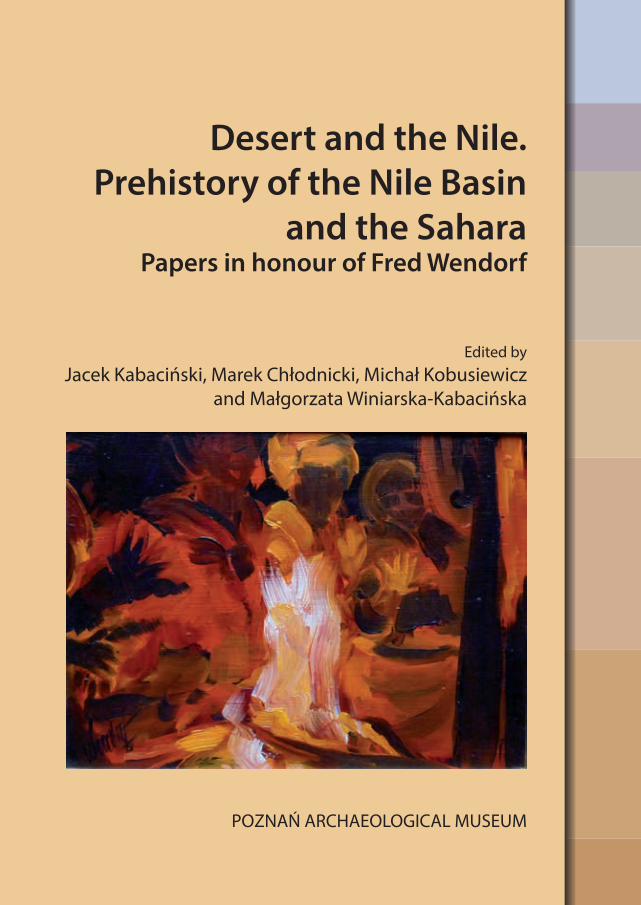
CoverGail Wendorf, Mariffs Around the Fire, 9 X 12 in., oil on board
PL ISSN 0866-9244ISBN 978-83-60109-60-1
© Copyright by Poznań Archaeological Museum61-781 Poznań, ul. Wodna 27
Tel. +48 61 852 82 51, fax +48 61 853 10 10e-mail: [email protected]
www. muzarp.pl
Printed byTOTEM.COM.PL sp. z o.o. sp. kom.ul. Jacewska 89, 88-100 Inowrocław
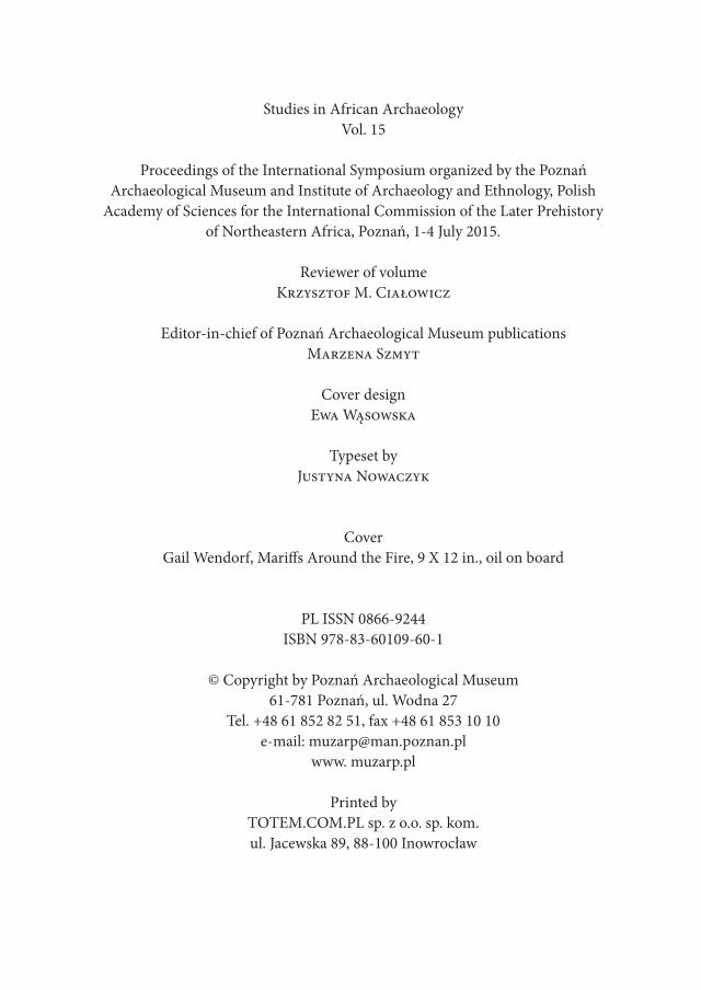
Table of Contents
Preface .................................................................................................................................. 11
I. Tribute to Fred Wendorf· Romuald SchildFred Wendorf, Jr. 31 July 1924 – 15 July 2015. The Founder of the Combined Prehistoric Expedition and for Several Decades its Guiding Spirit .................... 15· Scott Wendorf, Elizabeth Alexander and Anna Christine BednarThe Combined Prehistoric Expedition Foundation: a Model for PrivateSupport of Archaeological Research ....................................................................... 27· Gail Wendorf and Jacek KabacińskiFred Wendorf ’s Life in Sixteen Photos .................................................................... 35
II. The Nile Valley· Ahmed Hammid NassrEarly Stone Age Tools Variability in the Nile Basin: a New Investigation inthe Eastern Desert of Lower Atbara River, Sudan ................................................ 47· Sandro Salvatori, Donatella Usai and Andrea ZerboniNew Evidence from the Prehistoric Sites at Al Khiday and Al Jamrab, Cen-tral Sudan .................................................................................................................... 71· Kimball M. Banks, Donatella Usai, J. Signe Snortland, Linda Scott Cum-mings and Maria C. GattoFood for Thought: the Late Paleolithic of WK26 Site, Wadi Kubbaniya, Egypt ..... 95· Annett DittrichBetween Two Rivers – Early Holocene Landscapes on Mograt Island (Sudan) 109· Elena A.A. Garcea and Giulia D’ErcoleWhat Do We See When We See a Decoration? An Overview on the Potteryfrom Sai Island and Esh Shaheinab ........................................................................ 153· Mohammed Alfatih HayatiThe Technical Characteristics of the Mesolithic Pottery in El Goz Sites(Central Sudan) ......................................................................................................... 183

Table of Contents6
· Lenka Varadzinová, Ladislav Varadzin, Lenka Lisá, Jan Pacina and Petr Pokorný Exploration of the Site of Sphinx (SBK.W-60), Jebel Sabaloka (West Bank):
Findings of the 2014 Campaign .............................................................................. 193· Attila Király Digital Data and Holocene Lithic Industries in the Sudanese Nile Valley:
a Case Study ............................................................................................................... 207· Louis Chaix and Jacques Reinold Animals in Neolithic Graves: Kadruka and Kadada (Northern and Central
Sudan) ..................................................................................................................... 233· Hassan Mustafa Alkhidir Jebel El-Khazna – a Late Prehistoric Site in the Fifth Cataract Area ................. 251· Agnieszka Mączyńska On the Transition Between the Neolithic and Chalcolithic in Lower Egypt
and the Origins of the Lower Egyptian Culture: a Pottery Study ....................... 261· Dorian Vanhulle Preliminary Observations on Some Naqadian Boat Models. A Glimpse
of a Discrete Ideological Process in Pre-pharaonic Arts ..................................... 289· Ulrich Hartung Emetery U at Umm el-Qaab and the Funeral Landscape of the Abydos Re-
gion in the 4th Millennium BC ................................................................................ 313· Taichi Kuronuma Goods Placement in Predynastic Burials: A Case Study from the Cemeter-
ies in the Naqada Region ......................................................................................... 339· Grazia A. Di Pietro Investigating Intra- and Inter-site Variability of Late Predynastic – Protody-
nastic Settlements of Egypt ...................................................................................... 365· Wojciech Ejsmond Gebelein in the Predynastic Period: Capital or Provincial Centre? Review
of Evidence ................................................................................................................. 387· Robert Kuhn A Wooden Statue and Early Bronze Objects? A Critical Review of Tomb
1052 in the Necropolis of Abusir el-Meleq ............................................................ 407· Natalia Małecka-Drozd The Old Kingdom Upcountry Settlement Architecture in the Nile Delta – the
case of the 3rd-4th Dynasty Building at Tell el-Murra ................................................ 419· Marek Chłodnicki and Krzysztof Grzymski Kerma Culture in Letti Basin (Dongola Reach) .................................................... 437
Table of Contents 7
· Maira Torcia Towards Upper Egypt: Items and Cultural Elements on Trade Routes ............. 451· Bashier Negood Hassan The Nile as the Main Traffic Artery in the Ancient Sudan .................................. 469· Ikram Madani, Petr Pokorný, Yahia F. Tahir, Hamad M. Hamdeen and Adéla
Pokorná Vegetation Mounds in El-Ga’ab Depression (Sudan): Their Significance
in Archaeology and Archeaobotany ........................................................................ 473
III. Oases and the Desert· Michał Kobusiewicz, Przemysław Bobrowski, Maciej Jórdeczka and Marek Chłodnicki
Gebel Karaiweb and Bir Nurayet (Sudan). The Oldest Settlement in the Red Sea Mountains ................................................................................................................... 483· Agnieszka Czekaj-Zastawny, Joel D. Irish, Jacek Kabaciński and Jakub Mugaj
The Neolithic Settlements by a Paleo-lake of Gebel Ramlah, Western Desert of Egypt ...................................................................................................................... 515· Hebatallah A. A. Ibrahim
Neolithic Aspects of the Western Desert and its Possible Role During the Following Time Periods in Egypt ........................................................................... 539· Maria Lityńska-Zając and Krystyna Wasylikowa
The Role of Ziziphus in the Economy of Neolithic Nomadic Societies of the Sahara (S Egypt) ........................................................................................................ 551· Friederike Jesse, Hubert Berke, Nader El-Hassanin and Nadja Pöllath
First Insights into the Prehistory of Selima Oasis, Northern Sudan – Exca-vations at Site SOP 1024 ........................................................................................... 561· Simon Holdaway, Rebecca Phillipps, Joshua Emmitt, Willeke Wendrich
E29G1 Revisited: the Current State of the Surface Archaeology of Western Regions of the Fayum North Shore, Egypt ............................................................ 583· Noriyuki Shirai
New Light on The Desert Fayum: Restudying Gertrude Caton-Thompson’s Fayum Lithic Collections in London ..................................................................... 603· Friederike Jesse and Mirosław Masojć
Early to Mid-Holocene Pottery from Two Sites in the Bayuda Desert, Sudan .... 621· Alain Anselin Archaeology of the images and the words of the Ancient Egyptian World:
from Pools of Gone Saharan Cultures to Current Sociological Parallels .......... 635

Table of Contents8
· Miroslav Bárta The Birth of Supernatural. On the Genesis of Some Later Ancient Egyptian
Concepts ..................................................................................................................... 669· Paweł Lech Polkowski A Giraffe’s Tale. On Enigmatic Composition from Site 04/08 in the Central
Dakhleh Oasis, Egypt ............................................................................................... 687· András Zboray The Petroglyphs of Jebel Uweinat. Many Questions and a Few Answers
................................................................................................................................... 707
List of volume contributors ...................................................................................... 735

The
Sym
posiu
m 2
015


Desert and the Nile. Prehistory of the Nile Basin and the Sahara.
Papers in honour of Fred Wendorf Studies in African Archaeology 15
Poznań Archaeological Museum 2018
Preface
Between the 1st and 5th of July 2015 the tenth African Conference was held in Poznań. During the opening ceremony a letter from Professor Fred Wendorf, President of the International Commission of the Later Prehistory of Northeast-ern Africa, was read. Several days later, on July 15th, Fred passed away. This news was both unexpected and very sad, even though we knew he was not in the best of health. Still, hope is the last to die.
Fred Wendorf was like the Godfather to several generations of archeologists working in Northeastern Africa. Most of us had the privilege to know him, and some had the pleasure to work with him—getting to know him on both a profes-sional and private basis. Therefore, it was obvious for us that another volume of proceedings of the Symposium had to be devoted to Fred Wendorf, to honour one of the most distinguished scholars to have ever worked on the prehistory of Northeastern Africa.
Members of the LPNEA Commissionand Editorial Board


I
Tribute to Fred Wendorf


Desert and the Nile. Prehistory of the Nile Basin and the Sahara.
Papers in honour of Fred Wendorf Studies in African Archaeology 15
Poznań Archaeological Museum 2018
Romuald Schild
FRED WENDORF, Jr. 31 July 1924 – 15 July 2015 The Founder of the Combined Prehistoric Expedition and for Several Decades its Guiding Spirit1
PrologueFred’s curiosity in archaeology commenced in 1932 when walking over a cot-
ton field near his home in Terrell, in East Texas, where he found an old Indian camp and collected a handful of stone arrowheads. This first discovery lead to further cotton fields reconnaissances and more or less systematic surface collec-tions and recording of sites. Fred planned to study archaeology at the University of Arizona at Tuscon, a dream that he began to fulfill. At the age of eighteen, however, in 1942, he enlisted in the army and two months later was ordered to report for active duty. Early in 1944, Fred was commissioned a second Lieutenant in the infantry and came forward to join the 10th Mountain Division in the Ital-
1 This obituary also draws on some opinions expressed by the author in the introduction to the Desert Days by Fred Wendorf, Dallas 2008, Brothers in Archaeology by Fred Wendorf and Romuald Schild (Before Farming 2005/1: article 9:1-28) and Obituary, Fred wendorf , Jr. (1924-2015), Sudan end Nubia 19 (2015):181-184. The author wishes to express his deep gratitude to Ms Anna Christine Bednar, a dear friend and his late brother’s wife, who helped him to overcome several intricacies of written English.
Romuald Schild16
ian front. A few months later, in early March 1944, while fighting the Germans in Northern Italy, near Bologna, he was critically injured by a shell fragment that entered his upper chest. As a result, he spent almost two years in army hospitals. Before leaving the hospital, though, he made arrangements to return to Tuscon. Thus, in early 1947, Fred returned to the University of Arizona at Tuscon and in mid 1948 received a BA degree with a major in anthropology and almost straight away entered graduate school in the Department of Anthropology at Harvard. In June 1949, Fred initiated his Ph.D. dissertation research project at the Petrified Forest National Monument in Eastern Arizona excavating the Flattop Site dated to mid Ist
millennium AD. In March 1953, he defended the dissertation, which was published, also in 1953, by the Museum of Northern Arizona. However, already in July 1950, after concluding the Flattop Site field project, Fred became the Field Director for the first-ever salvage archaeology project carried out during the con-struction of a gas pipeline in New Mexico.
1. American antiquitiesFred Wendorf always believed that the most intellectually challenging re-
search in his early professional years was the study, begun in November 1953 with Claude Albritton, Alex Krieger, and T. Dale Stewart, of a Final Pleistocene Pa-leoindian human burial at Midland, Texas, one of the oldest Early Man remains in the Americas. The associated extinct fauna certainly preceded the Folsom Pa-leoindian event (see the leading publication by Wendorf et al. 1955). The work at Midland led in 1956 to the five year Llano Estacado (Staked Plains) Project in the Southern High Plains of West Texas, which was devoted to the reconstruction of the Late Pleistocene and early recent vegetation and climatic history of the area (Wendorf 1961).
In the same year, Fred met Ralph Rounds, the owner of a large timber com-pany operating in the mountains of New Mexico, near Taos, where the First US Dragoons’ Cantonment Burgwin (1852-1860) had been originally located and whose remains Fred was able to pinpoint. The ensuing research eventually led to the reconstruction of the fort, the formation of the Fort Burgwin Research Center and finally to the setting up of the western campus of Southern Methodist Uni-versity (Wendorf with Brooks 2007), where the Fred wendorf information Center was created in July 2004.
In 1970, the underwater exploration of a Spanish shipwreck near Padre Island concluded Wendorf ’s fieldwork on American antiquities. Several legal problems
The Founder of the Combined Prehistoric Expedition and... 17
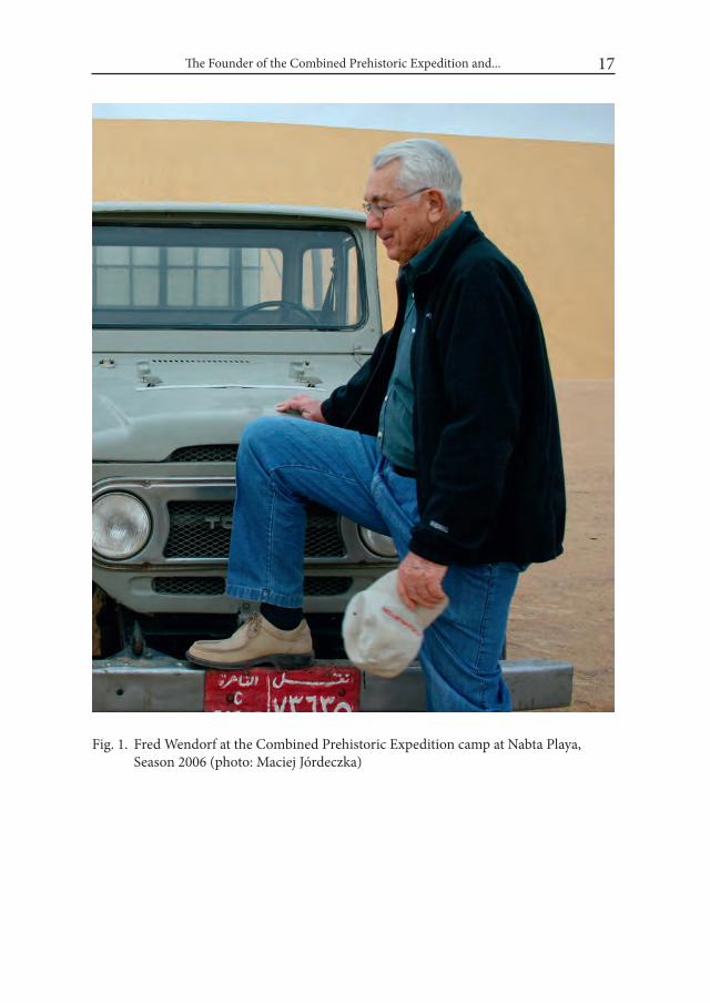
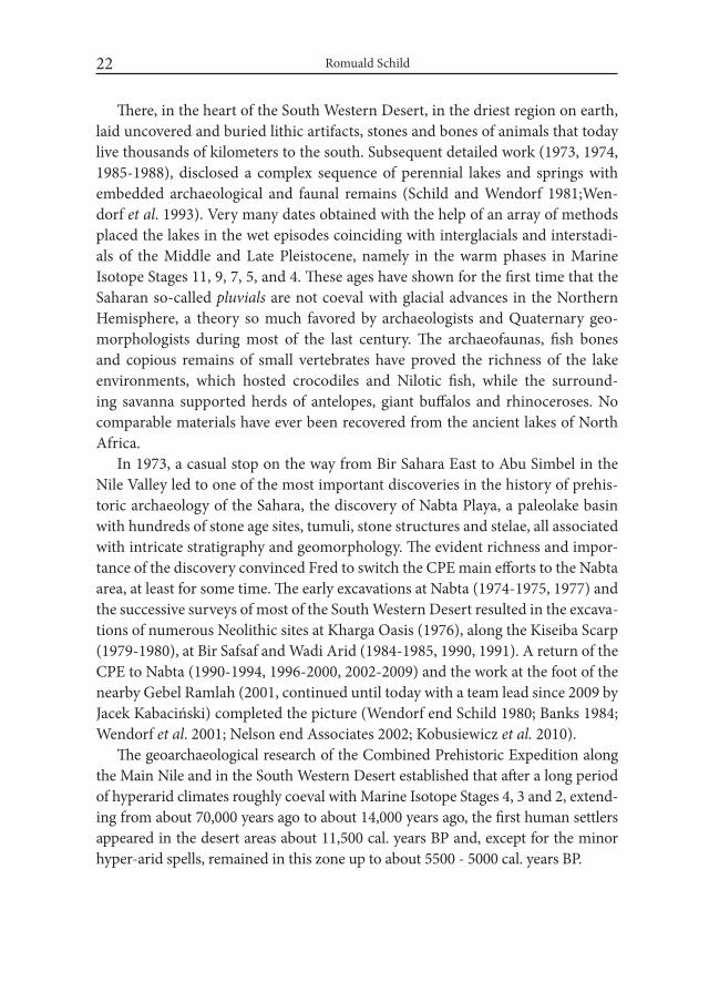
Fig. 1. Fred Wendorf at the Combined Prehistoric Expedition camp at Nabta Playa, Season 2006 (photo: Maciej Jórdeczka)
Romuald Schild18
resulting from this research led directly to the Abandoned Shipwreck Act of 1987 which protects historical shipwrecks in US waters.
2. The Combined Prehistoric Expedition
2.1. Nubian salvage campaign1961 was the year that Fred Wendorf ’s Great African Scientific Adventure was
set in motion. It changed his entire life, both private and professional. From this point on almost nothing was the same. The new Fred Wendorf was born again. It began quite innocently in the summer of 1961 with the reading of a newspaper story about UNESCO’s plans to save the archaeological remains, located where the Aswan Reservoir would be created, from annihilation and the earmarking by the US Congress of considerable funds to assist American involvement in the ven-ture. Jim Hester, a colleague of Fred’s in the Museum of New Mexico in Santa Fe, suggested to him that their experience in managing large-scale salvage projects in the US would be a great asset in applying for the funds and suggested that the prehistoric occurrences along the Nile in Lower Nubia would be the goal of their involvement in the project.
In November 1961, Fred contacted J. O. Brew, his Ph.D. adviser at Harvard and then a member of the UNESCO Commission responsible for preparation of the Nubian Salvage undertaking. Professor Brew was willing to help; however, he pointed out that several prehistorians whom he had contacted were very skeptical about the presence of valuable stone age sites in the Nubian section of the Nile Valley and/or had cast doubt on the scientific interest that those sites may stimu-late if found. Fred, however, was not discouraged by these negative opinions and convinced Brew that he would accept the challenge. Finally, Brew asked Fred to write two grant proposals: one concerning Egypt and the other for the Sudanese part of the future reservoir. The first would be addressed to the Foreign Currency Program at the U. S. State Department, acting under Public Law 87-332 voted by the Congress, and the second to the National Science Foundation. In June 1962, the funds were awarded. These were the first of a very long sequence of grants awarded to Fred Wendorf in the course of dozens consecutive years.
In the intervening time, in the winter season of 1961/1962, a group of very experienced prehistorians and Quaternary geologists directed by Ralph Solecki and Rhodes Fairbridge made an initial reconnaissance around Wadi Halfa, in the Sudanese section of the reservoir area. However, the leaders of the group, having
The Founder of the Combined Prehistoric Expedition and... 19
important scientific interests in other parts of the world, decided not to pursue fieldwork in the area, and Solecki left the discovered Paleolithic sites at Fred’s disposal. He also suggested that some of the members of the survey group might join the missions being organized by Fred, then director of research and associate director of the Museum of New Mexico in Santa Fe.
Finally, three expeditions were allotted for work on the Paleolithic in the As-wan Reservoir area: the Combined Prehistoric Expedition (CPE), until September 1965 officially called the New Mexico Museum Expedition; the Yale Expedition, conjointly supported by the Peabody Museum of Natural History, Yale University, and the Department of Geography, University of Wisconsin; and the third formed by the National Museum of Canada and the University of Toronto. A small group composed of three prehistorians on the staff of the University of Colorado also worked on the Paleolithic and Epipaleolithic localities on the west bank of the Nile in Wadi Halfa, Sudan.
The field concessions assigned to the CPE in Egypt extended on the west bank of the Nile from the New (High) Dam in Aswan to a point opposite Korosko and from Aniba to the Sudanese border. In Sudan, the concession on the east bank reached out from the Second Cataract to the Dal Cataract. On the opposite bank, it ran from the frontier to the head of the reservoir, close to the Dal Cataract.
At the invitation of Fred Wendorf, several scientists from seven countries (Bel-gium, Egypt, France, Poland, Sudan, United Kingdom and the United States) took part in the expedition. After the Lake Como conference in 1965 on the Prehistory in Aswan Reservoir, the mission began to be called the Combined Prehistoric Expedi-tion (CPE). In 1964, Fred Wendorf left the Museum of New Mexico and joined the staff of Southern Methodist University. Later, in the late 60s, the American, Polish and Egyptian scientists formed the core of the Expedition; however, a score of re-searchers from around the world still participated in the venture, both in the field-work and the resulting laboratory studies. Respectively, three institutions: Southern Methodist University, Institute of Archaeology and Ethnology, Polish Academy of Sciences, and Geological Survey of Egypt, jointly sponsored the work of the CPE. Essentially, the NSF and US State Department provided financial support in the field throughout most of the seasons till 1999. In recent years, up until 2016, con-siderable support has come from the Combined Prehistoric Expedition Foundation, a private body of donors. In 1972, Romuald Schild became the Associate Director of the Expedition, serving in this role until the retirement of Fred Wendorf in 1999, who then assumed the Honorary Directorship of CPE, while Romuald Schild began to serve as the Director of the Expedition up to his retirement in 2007.
Romuald Schild20
The CPE Nubia Campaign extended from the field season of 1962/1963 to the short season of 1967 at Jebel Sahaba, Sudan. The resulting two volumes, a monu-mental account of the CPE mission in the reservoir published in 1968 (Wendorf ed. 1968), is the first summary of the earliest prehistory of the Nile Valley between the High Dam, in the north, and the IId Cataract, in the south. Until the research of the Nubia Salvage Campaign, the area was considered to be developmental boondocks. On the contrary, the study of numerous sites of various stylistic and technological affiliations, extending in time from the middle Holocene all the way back to the Lower Paleolithic, helped to define entirely new time/space en-tities with a distinctive approach to the surrounding ecological niches. On the other hand, a profound study of the local geomorphology helped to outline the chronological and environmental places of the prehistoric units. In addition to the studies in the Nubian Nile Valley, a few Middle Paleolithic and several early Neo-lithic occurrences were investigated, under the direction of Jim Hester (Hester and Hoebler 1969) in the small oases of Dungul and Kurkur in the South Western Desert of Egypt (1962-1965).
2.2. Upper Egypt and FayumAfter the Campaign, Fred Wendorf decided to continue the work in the Nile
Valley downstream from Aswan. At the very beginning of the 1967 field season and on the very first day of the survey, the CPE found extremely numerous Paleo-lithic sites, partially buried in the Nilotic and eolian deposits in the lower Wadi Kubbaniya, a structural left bank tributary of the Nile Valley, located some 20 km downstream from Aswan. The sites contained frequent and large intriguing grinding stones. Fred decided to return to the wadi at a later time. However, the outbreak of war in June 1967 and the subsequent setting up of military installa-tions in the vicinity of Wadi Kubbaniya closed the area to excavations until 1977. In 1978, the first field season was completed. The season appeared very promis-ing and discoveries of supposed barley grains in Paleolithic beds seemed to be sensational (Wendorf et al. 1979; assembled by Wendorf and Schild, Close, ed. 1980) A later, direct AMS radiometric aging of the grains indicated that they were intrusive (Wendorf et al. 1984) and, at two standard deviations, early Predynastic to Dynasty I in age (about 4050 to 3000 calibrated years BCE). Obviously, a con-tinuation of the work in the wadi was strongly advised. The CPE returned to Wadi Kubbaniya in the field seasons of 1981-1984.
Meanwhile, the CPE spent four field seasons in Upper Egypt, near Edfu and Esna (1967) and north of Luxor, at Dandara, Makhatma and Dishna (1968). A year

The Founder of the Combined Prehistoric Expedition and... 21
later the CPE Mission carried out two field seasons on the northern ancient Lake Fayum shores (1969). Here, the CPE, for the first time in the Egyptian Stone Age research, reconstructed the Holocene fluctuations of the Holocene Lake Qarun and correlated them with human presence. The results of the Upper Egypt and Fayum research were published in 1976 (Wendorf and Schild).
Particularly, the CPE studies in stratigraphy and absolute chronology of the Late Paleolithic sites embedded in Nilotic sediments and the associated desert deposits in the Wadi Kubbaniya and Esna areas, north of Aswan, brought about new chronological placement of several Late Paleolithic entities and reversed our understanding of the Late Pleistocene Nile dynamics. On the other hand, the dis-covery of abundant charred floral macro-remains, and fossil faunas in the mouth of Wadi Kubbanniya have opened up exciting new vistas of Late Paleolithic econ-omies. Results of the research conducted in the Esna and Wadi Kubbaniya ar-eas were presented in several detailed reports (assembled by Wendorf and Schild 1986; 1989a; 1989b; Wendorf et al. 1997).
2.3. The Western DesertPolitical circumstances developed in the aftermath of the six-day war between
Israel and some of the Arab countries in June 1967 closed off most of the areas in the Nile Valley to foreign archaeological expeditions. The South Western Desert, however, was more or less open to work and except for brief excavations (1930-1932) in the Oasis of Kharga by Caton-Thompson and Gardner and in Kurkur and Dungul by Hester, it was still an unchartered territory as far as the Stone Age archaeology was concerned. Fred Wendorf decided to take the chance.
At the beginning, in 1972, only a few signs suggested that a new archaeological dreamland was buried there in the sands, spring vents, lacustrine carbonaceous deposits and clays of perennial and seasonal lakes. The Oasis of Dakhla was the first shot, promising, but not so exciting to us. Although the bases of two ancient, eroded spring vents yielded a huge, the largest in Egypt, lithic assemblages of the Late Acheulean stylistics (Schild end Wendorf 1977), that was not very unusual in Africa. A brief reconnaissance trip from Dakhla to the high, real desert south of Dakhla, led to the discovery of exposed numerous Early to Middle Paleolithic and Holocene sites. A trip to Bir Sahara East and Bir Tarfawi, which are small, uninhabitable oases, found a year or so earlier by one of the first desert geologists, our friend and co-worker Bahay Issawi, unveiled archaeological riches glittering in the sun on the exposed shores of ancient deep-water lakes in the Br Sahara and Bir Tarfawi areas.
Romuald Schild22
There, in the heart of the South Western Desert, in the driest region on earth, laid uncovered and buried lithic artifacts, stones and bones of animals that today live thousands of kilometers to the south. Subsequent detailed work (1973, 1974, 1985-1988), disclosed a complex sequence of perennial lakes and springs with embedded archaeological and faunal remains (Schild and Wendorf 1981;Wen-dorf et al. 1993). Very many dates obtained with the help of an array of methods placed the lakes in the wet episodes coinciding with interglacials and interstadi-als of the Middle and Late Pleistocene, namely in the warm phases in Marine Isotope Stages 11, 9, 7, 5, and 4. These ages have shown for the first time that the Saharan so-called pluvials are not coeval with glacial advances in the Northern Hemisphere, a theory so much favored by archaeologists and Quaternary geo-morphologists during most of the last century. The archaeofaunas, fish bones and copious remains of small vertebrates have proved the richness of the lake environments, which hosted crocodiles and Nilotic fish, while the surround-ing savanna supported herds of antelopes, giant buffalos and rhinoceroses. No comparable materials have ever been recovered from the ancient lakes of North Africa.
In 1973, a casual stop on the way from Bir Sahara East to Abu Simbel in the Nile Valley led to one of the most important discoveries in the history of prehis-toric archaeology of the Sahara, the discovery of Nabta Playa, a paleolake basin with hundreds of stone age sites, tumuli, stone structures and stelae, all associated with intricate stratigraphy and geomorphology. The evident richness and impor-tance of the discovery convinced Fred to switch the CPE main efforts to the Nabta area, at least for some time. The early excavations at Nabta (1974-1975, 1977) and the successive surveys of most of the South Western Desert resulted in the excava-tions of numerous Neolithic sites at Kharga Oasis (1976), along the Kiseiba Scarp (1979-1980), at Bir Safsaf and Wadi Arid (1984-1985, 1990, 1991). A return of the CPE to Nabta (1990-1994, 1996-2000, 2002-2009) and the work at the foot of the nearby Gebel Ramlah (2001, continued until today with a team lead since 2009 by Jacek Kabaciński) completed the picture (Wendorf end Schild 1980; Banks 1984; Wendorf et al. 2001; Nelson end Associates 2002; Kobusiewicz et al. 2010).
The geoarchaeological research of the Combined Prehistoric Expedition along the Main Nile and in the South Western Desert established that after a long period of hyperarid climates roughly coeval with Marine Isotope Stages 4, 3 and 2, extend-ing from about 70,000 years ago to about 14,000 years ago, the first human settlers appeared in the desert areas about 11,500 cal. years BP and, except for the minor hyper-arid spells, remained in this zone up to about 5500 - 5000 cal. years BP.
The Founder of the Combined Prehistoric Expedition and... 23
Perhaps the most important discoveries of the CPE in the Eastern Sahara are the ones linked to the prehistoric sacred places: astronomic installations as well as fields of offering and remembrance with various tumuli, groups of stelae and lines of menhirs. All of these extend in time from about 9000 cal. years BP to about 5000 cal. years BP and are concentrated in the area of Nabta Playa, the largest inland drainage basin in southeastern Egypt.
It is also the work in the South Western Desert that brought about a hotly debated hypothesis regarding the early domestication of wild cattle in the Early Holocene (e.g., Gautier 2007). In this vein, the CPE research has also led botanists working with the CPE teams to propose that the intensive collection, and per-haps the early domestication, of sorghum occurred in the upper Early Holocene (Wasylikowa et al 2001).
2.4. Ethiopia and Sinai It seems obvious that in the account of various scientific achievements of
Fred’s and the CPE one cannot omit the investigations in East Africa and the studies of a multilayered Middle Stone Age sites in the Ethiopian Central Rift Valley, near Lake Ziway, which disclosed a long sequence of Middle Stone Age camps, the oldest of which, at Gademotta and Kulkuleti (1971-1973 sea-sons), dated to about 300,000 years ago, and are amongst the few most ancient Middle Stone Age occupations in the world. The report on these works (Mid-dle Stone Age Sequence from the Central Rift Valley, Ethiopia) was published in 1974 (Wendorf and Schild). One also should remember Fred’s initiatives lead-ing to a two-season (1995-1996) salvage project in eastern Sinai, focused on Middle Paleolithic sites as well as Neolithic and Bronze Age villages and sacred constructions. A detailed report of these efforts was published in 1999 (Eddy and Wendorf, eds.).
3. Teaching, administration and honorsNearing retirement, Fred Wendorf generously donated his vast collection of
prehistoric artifacts from Sudan and Egypt to the British Museum. Besides the materials stored in facilities in Sudan and Egypt, the Fred Wendorf Collection is the world’s largest assortment of Stone Age relics and human remains from the upper Nile Valley, the Aswan Lake reservoir, the Northern Fayum Depression, and the Eastern Sahara. In most cases, these archaeological areas have been al-most completely wiped out by the ever-expanding reclamation.
Romuald Schild24
Beyond the field and scientific writing, Fred Wendorf was a talented teacher and administrator. From 1956 to June 1976 he served as director of the Fort Burg-win Research Center as well as associate director of the museum and associate professor of anthropology at Texas Technological University at Lubbock (1956-1958). In September 1958, he accepted the position of director of research and as-sociate director of the Museum of New Mexico in Santa Fe (1958-1964). In August 1964, Fred commenced his teaching and administrative employment at Southern Methodist University in Dallas, Texas, which ended with his retirement in 2002, when he became the Henderson-Morrison Professor of Prehistory, Emeritus. He is widely acknowledged as the founder of SMU’s Anthropology Department.
In 1974, Fred was elected treasurer for the Society for American Archaeology and in 1978 became its president. From 1983 to 1987 and by appointment by Pres-ident Ronald Reagan, he became a member of the Secretary of the Interior’s Board for the National Park Service; in 1985-1987 he served as its chair. A year later he was appointed, again by President Reagan, to the Cultural Properties Advisory Committee (1988-1989). From 1995 to 1997 Fred served as president of the So-ciety of Professional Archaeologists. In 1980, Fred was voted into the presidency of the International Commission of the Later Prehistory of North Eastern Africa.
The archaeological world has acknowledged Fred’s outstanding ability for do-ing archaeology and bestowed upon him several numbers of its honors of great magnitude. Of all these, Fred was always proudest of his membership in the Na-tional Academy of Sciences of the United States of America. For my part, I am delighted with his membership in the Polish Academy of Arts and Sciences. One needs to also add to this record the Lucy Wharton Drexel Medal for Archaeo-logical Achievements; an honorary Doctor of Sciences presented by SMU; and the Egyptian Geological Survey Award; to list but a few.
4. Closing remarks As early as the 1980s, the renowned late African archaeologist Desmond
Clark, enumerating Fred’s archaeological accomplishments in the prehistoric ar-chaeology of Africa, wrote that: ‘There are few who can match his achievements’ (Clark 1987). Twenty-eight years later another eminent prehistorian, John Yellen, founder and president of the Paleoanthropology Society and program director for archaeology at the National Science Foundation, stated that Fred Wendorf stands as a giant in his contributions to Northeast African archaeology and that “his contributions and insights also constitute a guiding framework.” Fred’s scien-

The Founder of the Combined Prehistoric Expedition and... 25
tific approach to fieldwork, involving the support of many disciplines in order to understand the human settlement in the deserts and savannas of North Eastern Africa will continue to strongly inspire the methods of doing Stone Age archaeol-ogy for a long time to come.
REFERENCESBANKS, K. M. 1984. Climates, Cultures and Cattle: The Holocene Archaeology of
the Eastern Sahara. Dallas.CLARK, J. D. 1987. Fred Wendorf: A critical assessment of His Career in and
contribution to North African prehistory In: A. E. Close (ed.), Prehistory of Arid North Africa. Essays in Honor to Fred wendorf. Dallas.
EDDY, F. W. and F. WENDORF (eds.). 1999. An Archaeological investigation of the Central Sinai, Egypt. Boulder.
GAUTIER, A. 2007. Animal domestication in North Africa. In: M. Bollig, O. Buben-zer, R. Vogelsang, and H.-P. Wotzka (eds.), Aridity, Change and Conflict in Africa: 75-90. Köln.
HESTER, J. J. and P. M. HOEBLER. 1969. Prehistoric Settlement Patterns in the Libyan Desert. University of Utah Anthropological Papers no. 92, Nubia Series 4. Salt Lake City.
KOBUSIEWICZ, M., KABACIŃSKI, J., SCHILD R., IRISH, J. D., GATTO, M. C. and F. WENDORF. 2010. Gebel Ramlah, Final Neolithic Cemetries from the western Desert of Egypt. Poznań.
NELSON, K. and ASSOCIATES. 2002. Holocene Settlement of the Egyptian Sa-hara, Vol. 2. The Pottery of Nabta Playa. New York.
SCHILD, R. and F. WENDORF. 1977. The Prehistory of Dakhla Oasis and Adja-cent Desert. Wrocław.
SCHILD, R. and F. WENDORF. 1981. The Prehistory of an Egyptian Oasis. Wrocław.WASYLIKOWA, K. with contribution of BARAKAT, H. N., BOULOS, L., BUT-
LER, A., DAHLBERG, J. A., HATHER, J. and J. MITKA. 2001. In: F. Wen-dorf, R. Schild and Associates. 2001. Holocene Settlement of the Egyptian Sahara, Vol. 1.The Archaeology of Nabta Playa: 544-591. New York.
WENDORF, F. 1961. Paleoecology of the Llano Estacado. Santa Fe.WENDORF, F. (ed.). 1968. The Prehistory of Nubia, Vols I and II. Dallas.WENDORF, F. 2008. Desert Days. Dallas.WENDORF, F. with J. E. BROOKS. 2007. The Fort Burgwin Research Center. Dallas.
Romuald Schild26
WENDORF, F., KRIEGER, A. D., ALBRITTON, C. C. and T. D. STEWART. 1955. The Midland Discovery. A Report on the Pleistocene Human Remains from Midland, Texas. Austin.
WENDORF, F. and R. SCHILD. 1974. A Middle Stone Age Sequence from the Cen-tral Rift Valley, Ethiopia. Wrocław.
WENDORF, F. and R. SCHILD. 1976. Prehistory of the Nile Valley. New York.WENDORF, F. and R. SCHILD. 1980. Prehistory of the Eastern Sahara. New York.WENDORF, F. and R. SCHILD. 2005. Brothers in Archaeology. Before Farming
2005/1: article 9:1-26.WENDORF, F., SCHILD, R. and ASSOCIATES. 2001. Holocene Settlement of the
Egyptian Sahara. Vol. 1. The Archaeology of Nabta Playa. New York.WENDORF, F., SCHILD, R., BAKER, P., GAUTIER, A., LONGO, L. and A. MO-
HAMED. 1997. A Late Paleolithic Kill-Butchery-Camp in Upper Egypt. Warsaw.WENDORF, F., SCHILD, R. (assemblers), A. E. CLOSE (ed.). 1980. Loaves and
Fishes: The Prehistory of wadi Kubbaniya. New Delhi.WENDORF, F., SCHILD, R. (assemblers), A. E. CLOSE (ed.). 1984. The Kattle-
Keepers of the Eastern Sahara. The Neolithic of Bir Kiseiba. New Delhi.WENDORF, F., SCHILD, R. (assemblers), A. E. CLOSE (ed.) 1986. The Prehistory
of wadi Kubbaniya, Vol. 1. The wadi Kubbaniya Skeleton: A Late Paleolithic Burial from Southern Egypt. Dallas.
WENDORF, F., SCHILD, R. (assemblers), A. E. CLOSE (ed.). 1989a. The Prehis-tory of wadi Kubbaniya, Vol. 2. Stratigraphy, Paleoeconomy, and Environ-ment. Dallas.
WENDORF, F., SCHILD, R. (assemblers), A. E. CLOSE (ed.). 1989b. The Prehis-tory of wadi Kubbaniya, Vol. 3. Late Paleolithic Archaeology. Dallas.
WENDORF, F., SCHILD, R., CLOSE, A. E. and ASSOCIATES. 1993. Egypt During the Last interglacial. The Middle Paleolithic of Bir Tarfawi and Bir Sahara East. New York.
WENDORF, F., SCHILD, R., CLOSE, A. E., DONAHUE, D. J., JULL, A. J. T., ZA-BEL, T. H., WIĘCKOWSKA, H., KOBUSIEWICZ, M., ISSAWI, B. and N. EL HADIDI. 1984. New radiocarbon dates on the cereals from Wadi Kub-baniya. Science 225:645-646.
WENDORF, F., SCHILD, R., EL HADIDI, N., CLOSE, A., KOBUSIEWICZ, M., WIĘCKOWSKA, H., ISSAWI, B. and H. HAAS. 1979. Use of barley in the Egyptian Late Paleolithic. Science 205:1341-1347.

Desert and the Nile. Prehistory of the Nile Basin and the Sahara.
Papers in honour of Fred Wendorf Studies in African Archaeology 15
Poznań Archaeological Museum 2018
Scott Wendorf, Elizabeth Alexander and Anna Christine Bednar
The Combined Prehistoric Expedition Foundation: a Model for Private Support of Archaeological Research
In the early 2000s, as the Combined Prehistoric Expedition (CPE) entered its fifth decade, the original directors of the CPE (Dr. Fred Wendorf of Southern Methodist University and Dr. Romuald Schild of the Polish Academy of Sciences) began to make arrangements to continue the legacy of the CPE. These arrange-ments included not only appointing successors to lead the CPE itself, but also creating a new means for financial support for archaeological research in the Neolithic and Paleolithic of North Africa. Together with a group of like-mind-ed supporters, Dr. Wendorf and Dr. Schild created a small 503(c)(3) charitable fund-raising organization, the Combined Prehistoric Expedition Foundation (CPEF).
In some ways, the formation of the CPEF was part of a larger trend. In 2006, the wall Street Journal noted “new players” in the world of archaeology: private individuals and foundations. Noting dwindling support from universities and government funds, the Journal recognized a “growing number of bankers, entrepre-neurs, and philanthropists who are playing a crucial role in archaeology” by providing funding “to study and preserve the relics of ancient civilizations from Latin Amer-ican to italy and Turkey, giving life to projects that would otherwise die.” (Knecht 2006).
Scott Wendorf, Elizabeth Alexander and Anna Christine Bednar 28
The CPEF can be viewed as a model of how a small private fundraising organi-zation can succeed in supporting important archeological goals. In the years since its founding, the CPEF provided funding for:
• Theexcavationof themegaliths fromNabtaPlaya,and theirmovement,permanent installation, and public display at the Nubian Museum in As-wan. This project saved one of the world’s earliest known archaeo-astro-nomical devices from almost certain looting or other destruction (Fig. 1-2). In addition, the CPEF provided grants to a number of graduate students to work at the site as part of their on academic studies
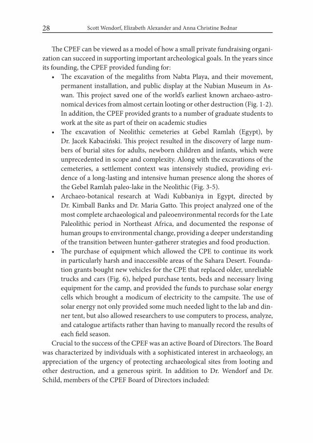
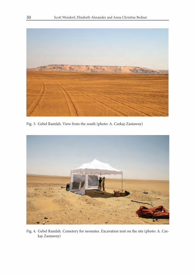
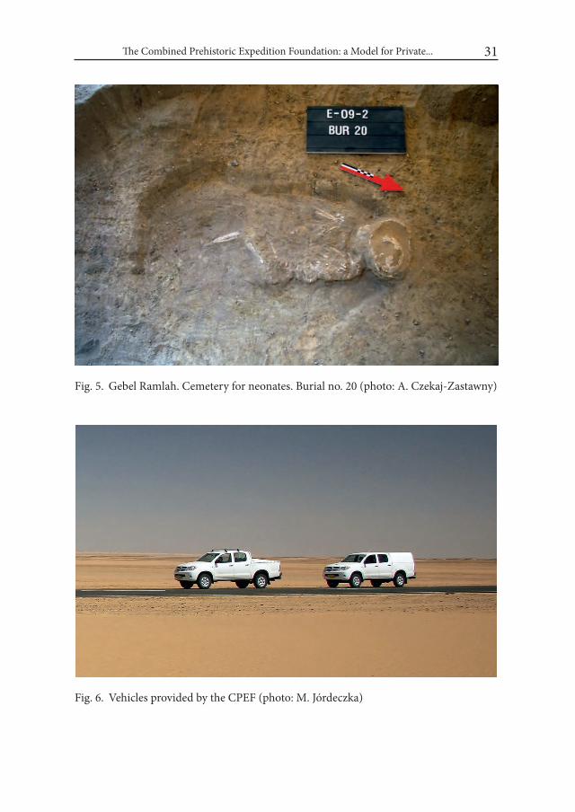
• The excavation of Neolithic cemeteries at Gebel Ramlah (Egypt), by Dr. Jacek Kabaciński. This project resulted in the discovery of large num-bers of burial sites for adults, newborn children and infants, which were unprecedented in scope and complexity. Along with the excavations of the cemeteries, a settlement context was intensively studied, providing evi-dence of a long-lasting and intensive human presence along the shores of the Gebel Ramlah paleo-lake in the Neolithic (Fig. 3-5).
• Archaeo-botanical research at Wadi Kubbaniya in Egypt, directed by Dr. Kimball Banks and Dr. Maria Gatto. This project analyzed one of the most complete archaeological and paleoenvironmental records for the Late Paleolithic period in Northeast Africa, and documented the response of human groups to environmental change, providing a deeper understanding of the transition between hunter-gatherer strategies and food production.
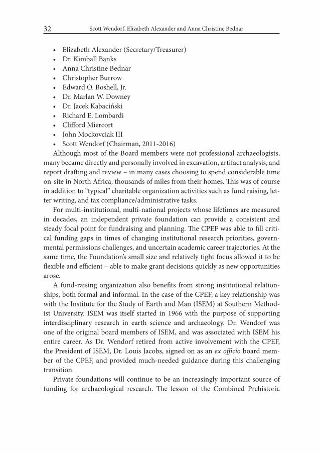
• ThepurchaseofequipmentwhichallowedtheCPEtocontinue itsworkin particularly harsh and inaccessible areas of the Sahara Desert. Founda-tion grants bought new vehicles for the CPE that replaced older, unreliable trucks and cars (Fig. 6), helped purchase tents, beds and necessary living equipment for the camp, and provided the funds to purchase solar energy cells which brought a modicum of electricity to the campsite. The use of solar energy not only provided some much needed light to the lab and din-ner tent, but also allowed researchers to use computers to process, analyze, and catalogue artifacts rather than having to manually record the results of each field season.
Crucial to the success of the CPEF was an active Board of Directors. The Board was characterized by individuals with a sophisticated interest in archaeology, an appreciation of the urgency of protecting archaeological sites from looting and other destruction, and a generous spirit. In addition to Dr. Wendorf and Dr. Schild, members of the CPEF Board of Directors included:

The Combined Prehistoric Expedition Foundation: a Model for Private... 29
Fig. 1. Nabta Playa. Neolithic calendar circle in situ (photo: M. Jórdeczka)
Fig. 2. Calendar circle and stelae after installation at the Nubian Museum in Aswan (photo: M. Jórdeczka)
Scott Wendorf, Elizabeth Alexander and Anna Christine Bednar 30
Fig. 3. Gebel Ramlah. View from the south (photo: A. Czekaj-Zastawny)
Fig. 4. Gebel Ramlah. Cemetery for neonates. Excavation tent on the site (photo: A. Cze-kaj-Zastawny)
The Combined Prehistoric Expedition Foundation: a Model for Private... 31
Fig. 5. Gebel Ramlah. Cemetery for neonates. Burial no. 20 (photo: A. Czekaj-Zastawny)
Fig. 6. Vehicles provided by the CPEF (photo: M. Jórdeczka)
Scott Wendorf, Elizabeth Alexander and Anna Christine Bednar 32
• ElizabethAlexander(Secretary/Treasurer)• Dr.KimballBanks• AnnaChristineBednar• ChristopherBurrow• EdwardO.Boshell,Jr.• Dr.MarlanW.Downey• Dr.JacekKabaciński• RichardE.Lombardi• CliffordMiercort• JohnMockovciakIII• ScottWendorf(Chairman,2011-2016)Although most of the Board members were not professional archaeologists,
many became directly and personally involved in excavation, artifact analysis, and report drafting and review – in many cases choosing to spend considerable time on-site in North Africa, thousands of miles from their homes. This was of course in addition to “typical” charitable organization activities such as fund raising, let-ter writing, and tax compliance/administrative tasks.
For multi-institutional, multi-national projects whose lifetimes are measured in decades, an independent private foundation can provide a consistent and steady focal point for fundraising and planning. The CPEF was able to fill criti-cal funding gaps in times of changing institutional research priorities, govern-mental permissions challenges, and uncertain academic career trajectories. At the same time, the Foundation’s small size and relatively tight focus allowed it to be flexible and efficient – able to make grant decisions quickly as new opportunities arose.
A fund-raising organization also benefits from strong institutional relation-ships, both formal and informal. In the case of the CPEF, a key relationship was with the Institute for the Study of Earth and Man (ISEM) at Southern Method-ist University. ISEM was itself started in 1966 with the purpose of supporting interdisciplinary research in earth science and archaeology. Dr. Wendorf was one of the original board members of ISEM, and was associated with ISEM his entire career. As Dr. Wendorf retired from active involvement with the CPEF, the President of ISEM, Dr. Louis Jacobs, signed on as an ex officio board mem-ber of the CPEF, and provided much-needed guidance during this challenging transition.
Private foundations will continue to be an increasingly important source of funding for archaeological research. The lesson of the Combined Prehistoric

The Combined Prehistoric Expedition Foundation: a Model for Private... 33
Expedition Foundation is that a small circle of supporters can form and main-tain a modestly-sized, independent, focused fundraising organization to make a significant contribution to archaeological research, publication, and preser- vation.
REFERENCESKNECHT BRUCE, G. 2006. The Rich Dig Deep: Archaeology’s New Players; As
traditional funds for excavations fall short, wealthy benefactors are bolster-ing the hunt for antiquities. The wall Street Journal, Sat., May 13, 2006.

Desert and the Nile. Prehistory of the Nile Basin and the Sahara.
Papers in honour of Fred Wendorf Studies in African Archaeology 15
Poznań Archaeological Museum 2018
Fred Wendorf ’s Life in Sixteen Photos (assembled by Gail Wendorf and Jacek Kabaciński)
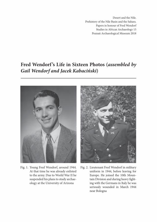
Fig. 1. Young Fred Wendorf, around 1944. At that time he was already enlisted to the army. Due to World War II he suspended his plans to study archae-ology at the University of Arizona
Fig. 2. Lieutenant Fred Wendorf in military uniform in 1944, before leaving for Europe. He joined the 10th Moun-tain Division and during heavy fight-ing with the Germans in Italy he was seriously wounded in March 1944 near Bologna

Gail Wendorf and Jacek Kabaciński36
Fig. 3. US Senate Memo re 1958 photo
Fig. 4. Fred Wendorf, Rep. John Dempsey, Dr. Wayne Grover, Rep George Mahon, US Senate, 1958
Fred Wendorf ’s Life in Sixteen Photos 37
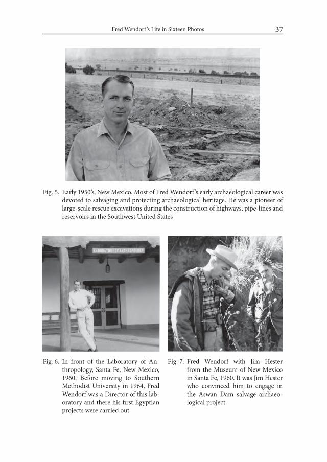
Fig. 5. Early 1950’s, New Mexico. Most of Fred Wendorf ’s early archaeological career was devoted to salvaging and protecting archaeological heritage. He was a pioneer of large-scale rescue excavations during the construction of highways, pipe-lines and reservoirs in the Southwest United States
Fig. 6. In front of the Laboratory of An-thropology, Santa Fe, New Mexico, 1960. Before moving to Southern Methodist University in 1964, Fred Wendorf was a Director of this lab-oratory and there his first Egyptian projects were carried out
Fig. 7. Fred Wendorf with Jim Hester from the Museum of New Mexico in Santa Fe, 1960. It was Jim Hester who convinced him to engage in the Aswan Dam salvage archaeo-logical project
Gail Wendorf and Jacek Kabaciński38
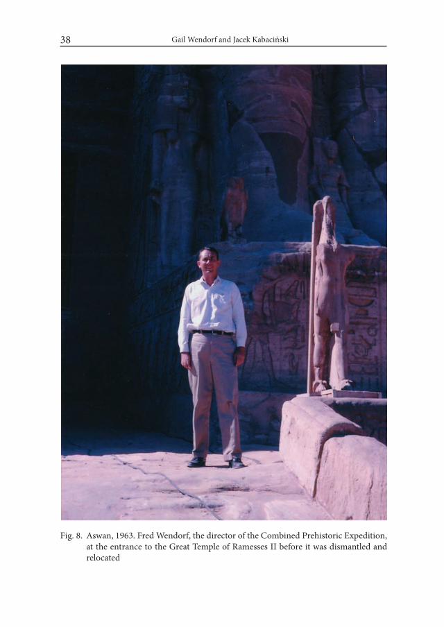
Fig. 8. Aswan, 1963. Fred Wendorf, the director of the Combined Prehistoric Expedition, at the entrance to the Great Temple of Ramesses II before it was dismantled and relocated
Fred Wendorf ’s Life in Sixteen Photos 39
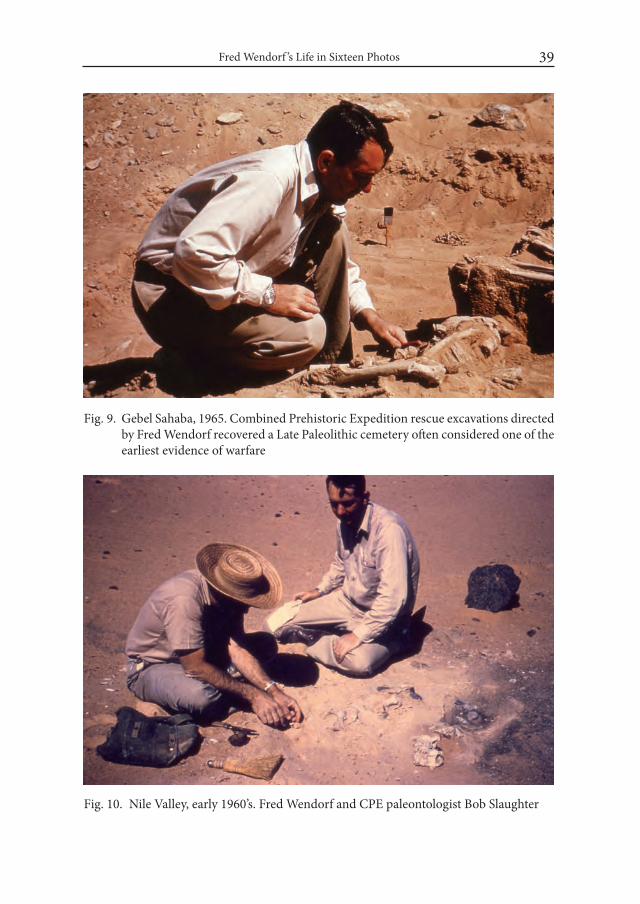
Fig. 9. Gebel Sahaba, 1965. Combined Prehistoric Expedition rescue excavations directed by Fred Wendorf recovered a Late Paleolithic cemetery often considered one of the earliest evidence of warfare
Fig. 10. Nile Valley, early 1960’s. Fred Wendorf and CPE paleontologist Bob Slaughter

Gail Wendorf and Jacek Kabaciński40
Fig. 11. Fred Wendorf and Egyptian geologist Dr. Rushdi Said. 1967
Fig. 12. Fred Wendorf and Eide Mariff, 2003. Members of Mariff ’s family from Asjut worked for decades for the Combined Prehistoric Expedition in the Nile Valley and the Western Desert
Fred Wendorf ’s Life in Sixteen Photos 41
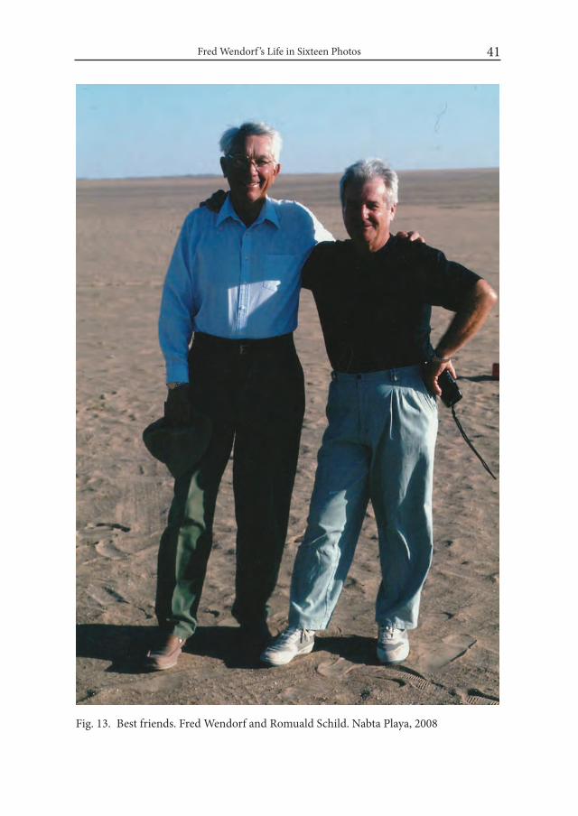
Fig. 13. Best friends. Fred Wendorf and Romuald Schild. Nabta Playa, 2008
Gail Wendorf and Jacek Kabaciński42
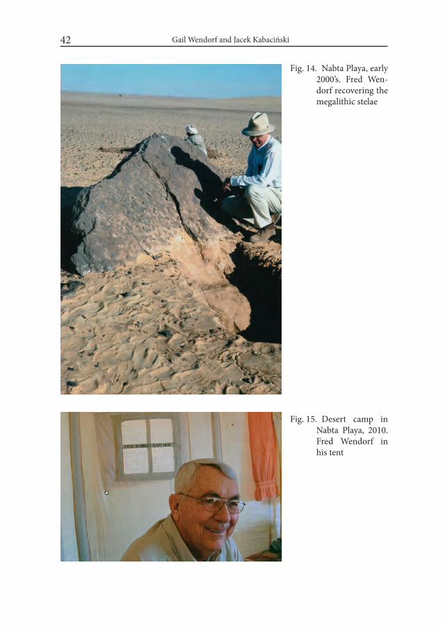
Fig. 14. Nabta Playa, early 2000’s. Fred Wen-dorf recovering the megalithic stelae
Fig. 15. Desert camp in Nabta Playa, 2010. Fred Wendorf in his tent
Fred Wendorf ’s Life in Sixteen Photos 43
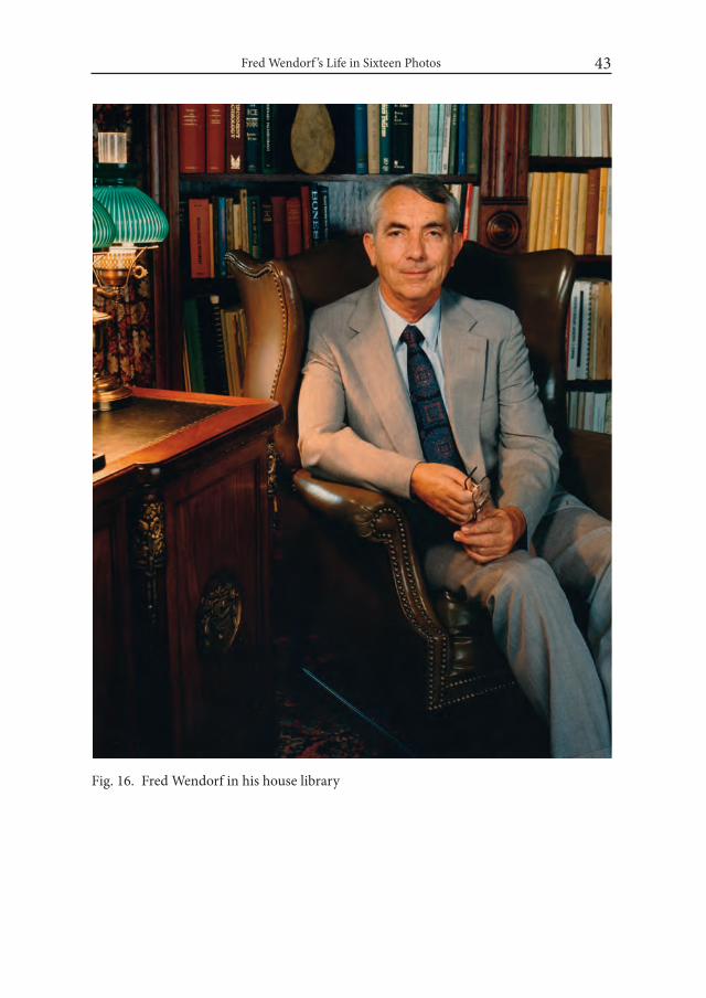
Fig. 16. Fred Wendorf in his house library


II
The Nile Valley

Desert and the Nile.Prehistory of the Nile Basin and the Sahara.
Papers in honour of Fred WendorfStudies in African Archaeology 15
Poznań Archaeological Museum 2018
Ahmed Hamid Nassr
Early Stone Age Tools Variability in the Nile Basin: a New Investigation in the Eastern Desert of Lower Atbara River, Sudan
IntroductionIt is widely accepted that the Early Stone Age (ESA) stone tools in the Nile
Basin belong to the Large Cutting Tool tradition (i.e. bifacial flakes), of which the handaxes and cleavers are the main types. However, their technological develop-ment and dispersal across the Nile and the Sahara from southeast Africa remain controversial including when and where? The lack of Developed Oldowan and Early Acheulean technology make the situation complex to understand. Given that the Acheulean large bifacial stone tools (including choppers, cleavers and handaxes) discoveries at Olduvai Gorge, Olorgesailie, Koobi Fora, Omo, Awash, Hadar and Gona in Tanzania, Kenya and Ethiopia, respectively, suggest clear dis-tribution and transition of early stone tools in the Upper part of the Nile basin. However the Acheulean assemblages in the lower part of the Nile Basin are differ-ent as they contain small hand axes at selected sites such as Arkin-8, Bir Sahara, Kharga Oasis and Dakhla Oasis.
The middle part of the Nile Basin is lacking evidence due to lack of research, with the exception of single discoveries from Khor Abu Anga and Abu Hugar. The combination of the discoveries of these three parts in the Nile basin is very infor-mative and make it easy to understand the ESA of the Nile basin.
Ahmed Hamid Nassr48
This paper presents results of recent archaeological investigations of ESA sites in the Lower Atbara River (Eastern Desert) region of the Republic of Sudan, which shed light on a new corridor that links earlier sites of southeast Africa with those in northern Africa. Sites were recorded from a variety of landscape settings and with different densities of artifacts. The central goal of this paper is to report the techno-typological characteristics of stone tools. The assemblages present two main cultural entities: Early Acheulean (large flakes cleavers, hand axes, and bifa-cial points) and Middle and Late Acheulean with MSA (characterized by lanceo-lates, prepared core products and Levallois flakes). Miscellaneous large cutting flakes are well represented, and flint and quartz are the dominant raw materials.
1. An overview of ESA in the Nile basinThe Nile basin is here defined by the territory encompassed by the Nile valley
from the southern lake complexes in Tanzania and Kenya to the Mediterranean area in the north and the eastern and western deserts. The Upper part includes Tanzania, Kenya, Ethiopia, Uganda and South Sudan), the middle part of the val-ley is in central and eastern Sudan, and the lower part includes the Western Desert of northern Sudan, south Egypt, up to the Mediterranean Sea.
Fossil and archaeological discoveries from African prehistoric sites continue to improve our understanding of the geographic, chronological and environmen-tal contexts of human evolution (Semaw 2000; Klein 2009; White et al. 2009). There is now a broader consensus on origin of modern humans in Africa and their subsequent colonization of the rest of the world at different time-periods (Klein 2009). The oldest records of culture (in the form of stone tools) have been known from East African sites (Upper Nile Basin); and Africa holds a continuous record of Paleolithic cultures starting with the earliest Oldovan tradition up to the Later Stone Age (Klein 2009; Semaw 2000; Rots and Van Peer 2006; Abbate et al. 2010). The invention and gradual diversification of stone tools are believed to have greatly contributed to the survival of early hominin and the emergence of complex cultures over time.
Despite the Nile basin is important place of our understanding the emergence and dispersal of early human, not all regions of the Nile basin have seen adequate Paleolithic research, nor were they exposed to similar field approaches and clas-sification methods (Kleindienst 2006), hindering a balanced assessment of the contribution of each region to the study of human evolution. One of the leading theoretical issues in this study is the transition from ESA (mainly characterized
Early Stone Age Tools Variability in the Nile Basin... 49
by Acheulean stone tools, such as cleavers and hand axes) to Middle Paleolithic or Middle Stone Age traditions (characterized by the production of points and prepared core products). The timing and geographic contexts of this transition have not been resolved, but the answer is vital to assessing broader evolutionary issues, such as whether this transition was associated with the emergence of a new hominin lineage from upper Nile basin or if it was a result of climatic changes that compelled hominin in different regions of the Nile basin to employ new techno-logical innovations (Clark 1988; Yellen et al. 2005; Shea 2008; Beyin 2013).
The very widespread distribution of Middle Paleolithic sites in the lower part of the Nile basin, across the western Desert, suggest that there were a long contact between the Nile basin and the Sahara, besides that the differentiation among the stone tools technology implies the existence of separate migration along routes across the Sahara as far as west of the Nile basin borders, with differences in adap-tation. The main evidences of that comes from Dakhla Oasis, Kharga and Kurkur and other sites at ElGa’ab depression, Sai Island and Arkin-8 in northern Sudan (Chmielewski 1968; Wendorf and Schild 1980; Rose and Van Peer 2006; Tahir and Nassr 2015; Osypiński and Osypińska 2016).
In the Middle Nile basin the discoveries of central and eastern Sudan show some contacts with Eritrea and the Red Sea coastal zones, that is identified from the assemblage related to the Late Acheulean and MSA assemblages (Chmielews-ki 1987; Marks et al. 1987; Abbate et al. 2010; Beyin 2013), however the earlier objects show very few differences and their emergence was undertaken as the fo-cal research target.
In his publication, Arkell (1949) indicated that the Acheulean stone tools in Khor Abu Anga were similar to the Kenya collections in southeast Africa (Upper Nile basin). The discoveries of ESA in northern Sudan (Kadanarti and Arkin-8) compared with central Sudan, which have been already compared with Kenyan sites (Chmielewski 1968; Chaix et al. 2000 ; Van Peer et al. 2003).
This study attempts to establish cultural contacts with the southeast Africa also, but from the eastern desert of Lower Atbara River. That is chosen from two reasons: firstly geographical location of the Atbara River is in open land with Er-itrea and Ethiopia, both of which contain entry points to southeast and northern Africa, respectively. Secondly, the area remained largely untouched, with some rescue studies conducted on the upper parts of Atbara River (Khashm el Girba) revealed surface occurrences of Middle Paleolithic stone tools, which are different from the other Sudanese finds (Marks et al. 1987, Chmielewski 1987; Shinner and Chmielewski 1971; Abbate et al. 2010).

Ahmed Hamid Nassr50
There are two potential factors confounding the question of ESA stone tools transition in the Nile basin: a) Taxonomic problems – different parts of the Nile basin have been exposed to different and inconsistent taxonomic terms, hinder-ing systematic comparison of regional assemblages across the Early and Middle Paleolithic transition, and b) Absence of direct spatial association of ESA sites (sometimes far apart in space) making it difficult to develop regional culture-his-tories that represent all Paleolithic facets. Moreover, new taxonomic and analytic questions are constantly emerging with every new discovery (Stout et al. 2010), further complicating regional comparisons of Paleolithic assemblages and the large gaps of ESA sites in the middle and upper Nile basin.
2. ESA research in the Nile basinOne clear pattern from Paleolithic records in the Nile basin is that the archaeo-
logical sites presenting the ESA are rare, if they are compared to the Middle and Upper Paleolithic. The main sites in Tanzania, Kenya and Ethiopia regarded as the standard evidence of ESA development and change. The comparative research be-tween Upper and Lower Nile basin are lacking, although some of the studies have concentrated on the Nile and the Sahara (Leakey 1951; Arkell 1949; Clark 1966; Wendorf 1968; Isaac 1977; Gowlett 1982; Stout et al. 2010).
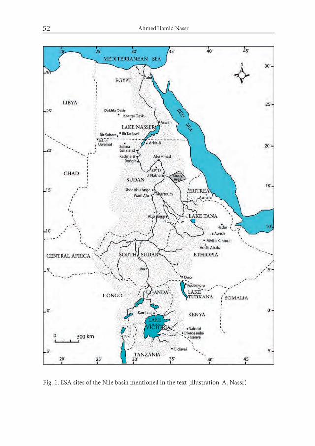
Leakey (1931) started his research on East African paleoanthropology, which resulted in comprehensive archaeological discoveries at Olduvai Gorge, Isenya, Olorgesailie, Koobi Fora, Omo, Melka Kunture, Awash and Hadar. (Fig. 1). Many of technological terms and classification methods have been cited through work in the upper part of the Nile basin.
These are main references sources to be consulted in respect to the early pioneer investigations and they provide invaluable bibliographies and summa-ries of early explorations in the southeast Africa (Isaac 1977; Leakey et al. 1969, McBrearty 1988; Rote and Van Peer 2006). The discoveries of the Rivet Valley, Turkana basin, Wadi Awash, Afar, Hadar and Gona (Fig. 1) shed light on Acheu-lean technological development and associated stratigraphy (Clark 1982:238).
The early exploration survey by Sandford and Arkell (1928) in Sudan shed light on some important elements of the Paleolithic to the north. This was later supplemented by many Paleolithic sites discovered by Arkell (1949) in central Su-dan. The surface collections of early stone tools described from the Upper Atbara River were very promising for the Sudanese Paleolithic, however there are no con-tinued investigations. Numerous Acheulean assemblages were recorded from the rescue fieldwork by Chmielewski (1967), The oldest sites do not reveal hand axes, however; choppers were dominant (Chmielewski 1987:7). This revealed impor-
Early Stone Age Tools Variability in the Nile Basin... 51
tant information on area which was investigated by an Italian mission and some ESA with Pleistocene deposits recorded in the Middle Atbara River (Abbate et al. 2010). Likewise, Paleolithic sites were discovered on the Blue Nile such as Abu Hugar, which yielded a Homo sapiens skull from Singa, animal bones and MSA stone tools (Stringer 1979:82). The last was discovered on the Upper and Middle Atbara River and in the Bayuda Desert; the Affad depression makes the research necessary in the Eastern Desert of Lower Atbara River (Abbate et al. 2010; Masojć 2010; Osypiński and Osypińska 2016).
The question of the scarcity of Paleolithic sites and robust chronologies in Su-dan archaeological records has not been satisfactorily answered. Moreover, the absence of ample ESA sites made it difficult to trace the origins of the MSA. The discovery of Early and Middle Stone Age assemblages from the Atbara region pro-vides us a rare opportunity to investigate this important transition in one distinct region.
In lower part of the Nile basin, the work on prehistory began by 1890s, through general notes of single stone artifacts. More significant research discoveries start-ed in late 1940s. In the late 1930s, stone tools were identified by Caton-Thompson (1952), and assigned an upper stage of the Acheulean from Kharga Oasis. The main Acheulean hand axes found in situ near Cairo, contain pointed hand axes with cortical butts (Huzzayin 1941:182). The Combined Prehistoric Expedition (CPE) located numerous Middle and Late Stone Age sites in the northern Sudan and western desert (Wendorf 1968; Klees and Kuper 1992). Renewed Paleolithic archaeological research began with the rescue operations prior to the construc-tion of the Aswan High Dam, where Acheulean stone tools are abundant. Their technology and typology were described as Upper Acheulean, with hand axes and chopping tools as the main types, while cleavers were lacking (Wendorf 1968; Chmielewski 1968; Guichard and Guichard 1965).
Wendorf and Schild (1980) classified many Upper Acheulean and MSA assem-blage from Dakhla and Kharga Oasis and Bir Sahara (Fig. 1). Also, Upper Acheu-lean and MSA sites were reported near the Radar River on a small paleo-lake at Bir Sahara and Bir Tarfawi (Wendorf et al. 1987). Moreover, the recent field works in the second cataract, Dongla Reach, El-Ga’ab depression, Fourth Cataract and Bayuda desert have reported several find-spots of MSA stone tool types (Rots and Van Peer 2006:364; Masojć 2010:66; Maier 2012:112; Osypińska 2012:219; Tahir and Nassr 2015:105).
The Cologne symposium in 1990 included presentations and publications on northeast African prehistory (Klees and Kuper 1992). The ESA stone tools were
Ahmed Hamid Nassr52
Fig. 1. ESA sites of the Nile basin mentioned in the text (illustration: A. Nassr)

Early Stone Age Tools Variability in the Nile Basin... 53
described from regional similarities and connections between north and east Af-rica. The main problems of regional prehistory were discussed in the symposium and resulted in publications. Unfortunately the ESA evidence was sparse from the Western desert Oasis and the Nile in northern Sudan.
I am underscoring here that previous Paleolithic research in Sudan focused on later time periods and most of the assemblages were described by taxonomic terms borrowed from other regions of Africa. The Eastern Desert of Lower At-bara River remained largely unexplored. Therefore, the first step in our project in the Atbara region was to located new sites through systematic survey with the ultimate goal of filling existing gaps in chronology and geographic distribution of Paleolithic sites. The location of the Lower Atbara outside of the Nile valley makes it an ideal region to investigate local developments in Paleolithic technology and broader regional connections among the different prehistoric cultures and their makers.
3. Archaeological survey in the Eastern Desert of Lower Atbara RiverThis study is an updated version of my doctoral research, completed in the
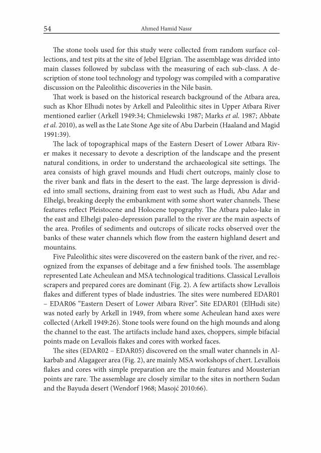
Department of Archaeology, University of Khartoum, in 2016. The area of study is located on the eastern bank of the Atbara River upstream and south of Atbara town to the Seidon province, about 60 km along the river and following the Abu Adar depression to the east at about 80 km (Fig. 2).
During late 2013, the area was visited by the author and his colleagues from Sudan and in winter 2014, archaeological survey was carried out along the right bank of Atbara River and the deeper water channels were explored 10 km into the eastern desert. Wadi Abu Adar was investigated up to 80 km to the east (Nassr 2014:107). In late 2014, sites were revisited by the author and his colleagues from Poland for a future join project (EDAR project).
A methodology was established from geological description, archaeologi-cal survey and test excavation to achieve the general goals of the study (Nassr 2014:108-120). Several methodological approaches have been applied in previ-ous Paleolithic researches in the Nile basin. One common approach used here was to document and investigate the ESA sites and sampling stone tools for tech-nological and typological classification. An overview of the literature and reclas-sification of Khor Abu Anga assemblages was done first. Stone tools were col-lected from six sites and the site of Jebel Elgrian (EDAR06) was studied as a case study.
Ahmed Hamid Nassr54
The stone tools used for this study were collected from random surface col-lections, and test pits at the site of Jebel Elgrian. The assemblage was divided into main classes followed by subclass with the measuring of each sub-class. A de-scription of stone tool technology and typology was compiled with a comparative discussion on the Paleolithic discoveries in the Nile basin.
That work is based on the historical research background of the Atbara area, such as Khor Elhudi notes by Arkell and Paleolithic sites in Upper Atbara River mentioned earlier (Arkell 1949:34; Chmielewski 1987; Marks et al. 1987; Abbate et al. 2010), as well as the Late Stone Age site of Abu Darbein (Haaland and Magid 1991:39).
The lack of topographical maps of the Eastern Desert of Lower Atbara Riv-er makes it necessary to devote a description of the landscape and the present natural conditions, in order to understand the archaeological site settings. The area consists of high gravel mounds and Hudi chert outcrops, mainly close to the river bank and flats in the desert to the east. The large depression is divid-ed into small sections, draining from east to west such as Hudi, Abu Adar and Elhelgi, breaking deeply the embankment with some short water channels. These features reflect Pleistocene and Holocene topography. The Atbara paleo-lake in the east and Elhelgi paleo-depression parallel to the river are the main aspects of the area. Profiles of sediments and outcrops of silicate rocks observed over the banks of these water channels which flow from the eastern highland desert and mountains.
Five Paleolithic sites were discovered on the eastern bank of the river, and rec-ognized from the expanses of debitage and a few finished tools. The assemblage represented Late Acheulean and MSA technological traditions. Classical Levallois scrapers and prepared cores are dominant (Fig. 2). A few artifacts show Levallois flakes and different types of blade industries. The sites were numbered EDAR01 – EDAR06 “Eastern Desert of Lower Atbara River”. Site EDAR01 (ElHudi site) was noted early by Arkell in 1949, from where some Acheulean hand axes were collected (Arkell 1949:26). Stone tools were found on the high mounds and along the channel to the east. The artifacts include hand axes, choppers, simple bifacial points made on Levallois flakes and cores with worked faces.
The sites (EDAR02 – EDAR05) discovered on the small water channels in Al-karbab and Alagageer area (Fig. 2), are mainly MSA workshops of chert. Levallois flakes and cores with simple preparation are the main features and Mousterian points are rare. The assemblage are closely similar to the sites in northern Sudan and the Bayuda desert (Wendorf 1968; Masojć 2010:66).
Early Stone Age Tools Variability in the Nile Basin... 55
Fig. 2. Paleolithic sites discovered from the survey in the Eastern Desert of Lower Atbara River (illustration: A. Nassr)
The largest site discovered in the desert is the site of Jebel Elgrian (EDAR06), which shows an extraordinary number of large bifacial stone tools in surface context and extended over the one km from east to west and 600 m from south to north. The artifacts concentrated in multiple spaces overlooking the site, and among outcrops of quartz and chert rock in the eastern and northern parts of the site. In fact, this area may preserve evidence of groups of Acheulean camps extending from the mountains in the east to the depression in the west, stretching more than 10 km. Today, most of them were destroyed by gold mining trenches as evident from the trenches profiles and digging heaps.
Our methodological focus on the site (EDAR06) was from its location, setting and stone tools accumulated on the surface. The site is quite remarkable from the sheer amount of stone tools and debitage on the surface and with outcrops of quartz and chert. The landscape around the site seems to have been a beach on the

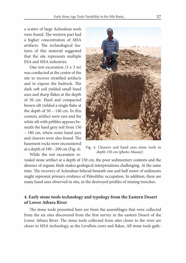
Ahmed Hamid Nassr56
margin of the paleo-depression, which is different from the sites on the riverbank. The presence of such a site so far away from the river channel was in agreement with the main hypothesis of the study, during the general survey in the area.
The primary result of the archaeological survey of the site revealed several ma-jor concentrations of choppers, cleavers, hand axes, picks; discs and other deb-itage were deposited over long successive Paleolithic periods, owing to the envi-ronmental conditions which allowed successive habitation. The diversity of stone tools suggest that the place most favored for settlement was either on a low rocky promontory, or on patches of sand, which generally occurred in the channel of seasonal streams draining into the depression. Such large accumulations of lithics are rare in Sudan, and seem to be similar to the Olorgesailie site in the Kenya Rift Valley (Isaac 1977; McHugh et al. 1988), based on the location, size and concen-tration of stone tools on the surface (Fig. 3).
Our method involved a systematic survey with two surface cleanings of a grid of 20 x 20 m and a test excavation. The collected assemblages included stone tools, core, flakes, blades, debitage and waste in large amounts. The surface clean-ings were made in different parts of the site, starting from the eastern part where
Fig. 3. Stone tools concentration on the surface, looking from the west (photo: A. Nassr)
Early Stone Age Tools Variability in the Nile Basin... 57
a scatter of large Acheulean tools were found. The western part had a higher concentration of MSA artifacts. The technological fea-tures of this material suggested that the site represents multiple ESA and MSA industries.
One test excavation (3 x 3 m) was conducted at the centre of the site to recover stratified artifacts and to expose the bedrock. The dark soft soil yielded small hand axes and sharp flakes at the depth of 50 cm. Hard and compacted brown silt yielded a single flake at the depth of 50 – 140 cm. In this context, artifact were rare and the white silt with pebbles appears be-neath the hard grey soil from 150 – 180 cm, where some hand axes and cleavers were also found. The basement rocks were encountered at a depth of 190 – 200 cm (Fig. 4).
While the test excavation re-vealed stone artifact at a depth of 150 cm, the poor sedimentary contexts and the absence of organic finds makes geological interpretations challenging. At the same time. The recovery of Acheulean bifacial beneath one and half meter of sediments might represent primary evidence of Paleolithic occupation. In addition, there are many hand axes observed in situ, in the destroyed profiles of mining trenches.
4. Early stone tools technology and typology from the Eastern Desert of Lower Atbara River
The stone tools presented here are from the assemblages that were collected from the six sites discovered from the first survey in the eastern Desert of the Lower Atbara River. The stone tools collected from sites closer to the river are closer to MSA technology, as the Levallois cores and flakes. All stone tools gath-
Fig. 4. Cleavers and hand axes stone tools in depth 150 cm (photo: Masojć)
Ahmed Hamid Nassr58
ered from the site EDAR06 represent Acheulean and MSA technologies and have multiple cutting edges, indicating different activities, specially the bifaces.
The area preserves ample raw material which served as local sources for stone tool production, since different rock types were identified around the site. Green chert was exposed in the banks of the water channels and the mountain, which is massive and shows moderate to weak mineral foliation, dark, coarse, grained and highly sheared. The felsites rock is common also, and has a very dark tarnish in high green and concave, fine texture and very hard. Quartz and quartzite are dominant, and have linear shapes, are fine to medium texture and very hard.
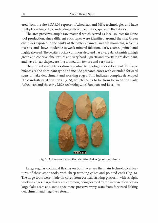
The studied assemblages show a gradual technological development. The large bifaces are the dominant type and include prepared cores with extended forward scars of flake detachment and working edges. This indicates complex developed lithic industries at the site (Fig. 5), which seems to be from between the Early Acheulean and the early MSA technology, i.e. Sangoan and Levallois.
Fig. 5. Acheulean Large bifacial cutting flakes (photo: A. Nassr)
Large regular continual flaking on both faces are the main technological fea-tures of these stone tools, with sharp working edges and pointed ends (Fig. 6). The large tools were made on cores from cortical striking platform with straight working edges. Large flakes are common, being formed by the inter-section of two large flake scars and some specimens preserve wavy scars from foreword flaking detachment and negative retouch.
Early Stone Age Tools Variability in the Nile Basin... 59
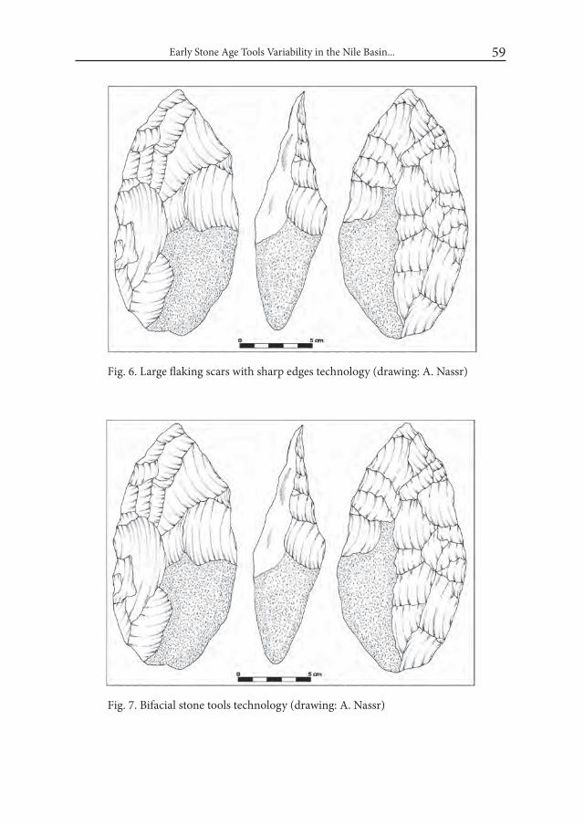
Fig. 6. Large flaking scars with sharp edges technology (drawing: A. Nassr)
Fig. 7. Bifacial stone tools technology (drawing: A. Nassr)

Ahmed Hamid Nassr60
Fig. 8. Scars flaking detachment technology of cleaver (drawing: A. Nassr)
The finishing of stone tools is affected by the texture of the stone raw material, i.e. fine vs. coarse. Some of the stone tools have a half cortical striking platform as evident on some of the hand axes, choppers and cleavers. The medium and small sized hand axes, cleavers and bifacial points are usually completely devoid of the striking platform and bifacial flaking (Fig. 7).
The main Acheulean stone tools are characterized by a typical large flake blanks for the production of choppers, cleavers, hand axes, and point. There are a few large tools made on cores. Moreover, some of the choppers, picks and hand axes are dihedral and have a flat striking platform and sharp elongated edges from the single removal. The number of flake scars are visibly greater on tools made of basalt and chert (Fig. 8).
Some of the Late Acheulean and MSA stone tools were made on small flakes, which include bifacial points and Sangoan type hand axes. Others are made on Levallois flakes, prepared cores, blades and debitage such as small points and scrapers.
Unifacial stone tools are very rare. They are identified from large choppers, some flakes and small chips. The small points and picks indicate the use of spe-

Early Stone Age Tools Variability in the Nile Basin... 61
cial techniques for special functions. The cleavers and knives are distinguished by a butt worked as a handle and the tip ending with sharp edges and a dorsal face, which also indicates heavy duty usages (Fig. 9).
The main technological observation is that the large Acheulean tools were targeted for their cutting edges and preparation of pointed ends. The variability observed from the artifact size and raw materials unfamiliar in the known Sudan archaeological record. The large flake production, primary core preparations are similar to the sites from the Omo Valley and Bed II in Olduvai Gorge (Howell 1976; Leakey et al. 1969). The sharp cutting edges, the worked butt and sloping ends are closely matched with the evidence from Olorgesailie (Isaac 1977).
From a typological point of view, the assemblages show a large variation from the Acheulean to the MSA. From the typological classification based on the assemblage description, it shows different sizes and forms of choppers, while cleavers is the dominant type with different shape and edges. The hand axes are also a dominant stone tool, and which possess many subclasses: hand axes with
Fig. 9. Cleavers different size made on sharp curve end and flaking edges (photo: A. Nassr)
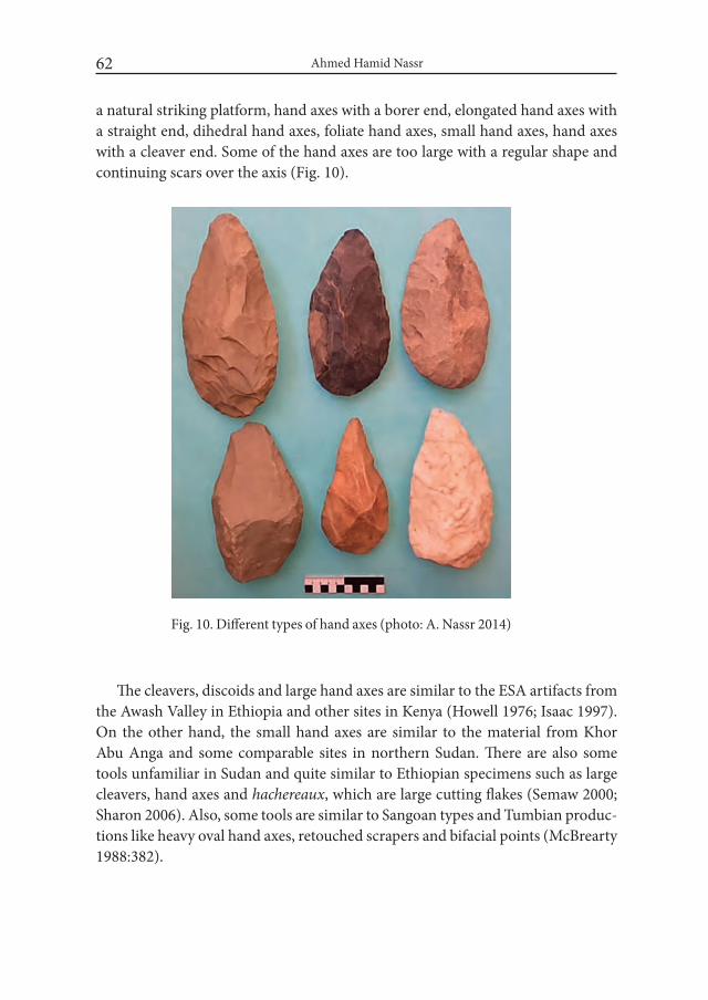
Ahmed Hamid Nassr62
a natural striking platform, hand axes with a borer end, elongated hand axes with a straight end, dihedral hand axes, foliate hand axes, small hand axes, hand axes with a cleaver end. Some of the hand axes are too large with a regular shape and continuing scars over the axis (Fig. 10).
Fig. 10. Different types of hand axes (photo: A. Nassr 2014)
The cleavers, discoids and large hand axes are similar to the ESA artifacts from the Awash Valley in Ethiopia and other sites in Kenya (Howell 1976; Isaac 1997). On the other hand, the small hand axes are similar to the material from Khor Abu Anga and some comparable sites in northern Sudan. There are also some tools unfamiliar in Sudan and quite similar to Ethiopian specimens such as large cleavers, hand axes and hachereaux, which are large cutting flakes (Semaw 2000; Sharon 2006). Also, some tools are similar to Sangoan types and Tumbian produc-tions like heavy oval hand axes, retouched scrapers and bifacial points (McBrearty 1988:382).
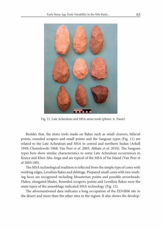
Early Stone Age Tools Variability in the Nile Basin... 63
Besides that, the stone tools made on flakes such as small cleavers, bifacial points, rounded scrapers and small points and the Sangoan types (Fig. 11) are related to the Late Acheulean and MSA in central and northern Sudan (Arkell 1949; Chmielewski 1968; Van Peer et al. 2003; Abbate et al. 2010). The Sangoan types here show similar characteristics to some Late Acheulean occurrences in Kenya and Khor Abu Anga and are typical of the MSA of Sai Island (Van Peer et al 2003:189).
The MSA technological tradition is reflected from the simple type of cores with working edges, Levallois flakes and debitage. Prepared small cores with two work-ing faces are recognized including Mousterian points and possible arrowheads. Flakes, elongated blades, Rounded scrapers, points and Levallois flakes were the main types of the assemblage indicated MSA technology (Fig. 12).
The aforementioned data indicates a long occupation of the EDAR06 site in the desert and more than the other sites in the region. It also shows the develop-
Fig. 11. Late Acheulean and MSA stone tools (photo: A. Nassr)
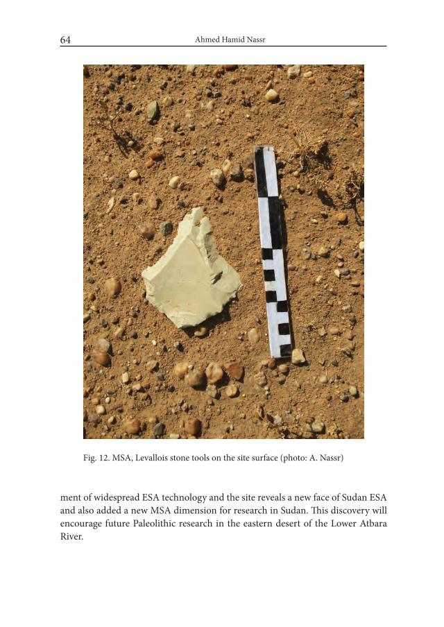
Ahmed Hamid Nassr64
ment of widespread ESA technology and the site reveals a new face of Sudan ESA and also added a new MSA dimension for research in Sudan. This discovery will encourage future Paleolithic research in the eastern desert of the Lower Atbara River.
Fig. 12. MSA, Levallois stone tools on the site surface (photo: A. Nassr)
Early Stone Age Tools Variability in the Nile Basin... 65
Conclusions Archaeological survey and test pits in the eastern desert of the Lower Atbara
River yielded new prehistoric evidence in Sudan Paleolithic and added an impor-tant assemblage to the known ESA sites in the Nile basin. The sites close to the Atbara river channel (EDAR01- 5) are quite similar to the MSA evidence from northern Sudan. However, the site EDAR06 is comparatively more different than the known Sudan Paleolithic. These Acheulean and MSA stone tools, which are difficult to compare with the Sudan record, are more or less similar to the south-east African Paleolithic.
This study of ESA stone tools revealed the following observations:1. Our knowledge of Sudan ESA is minimal, evidence of which is primarily
known from central and northern Sudan and from the surface and eroded Acheulean bifaces stone tools types.
2. The archaeological survey and test excavation in the eastern desert of the Lower Atbara River has shed light on a new region for Sudan Paleolithic research, where Acheulean and MSA stone tools are dominant.
3. The archaeological sites discovered close to the eastern bank of the Atbara River are mainly represented by MSA stone tools, which also reflects the age and channel location of the river.
4. The site of Jebel Elgrian (EDAR06) in the eastern desert of the Lower At-bara River has added a new dimension of ESA stone tools in Sudan. The materials are similar to other Sudanese sites in some aspects but differ in the main characteristics.
5. The attributes of stone tools classified from the eastern desert of the Lower Atbara River are very informative regarding the regional diversity of ESA in the Nile basin. They are similar to the early ESA found in Ethiopia and Kenya and at the same time indicate how Sudan is important for the “Out of Africa” debate.
6. The hand axes are regarded as the most common ESA stone tools of in cen-tral Sudan and the choppers are the main types in northern Sudan. In both regions, there is a lack of cleavers. Central and northern Sudan presented characteristics similar to the Upper part of the Nile basin (such as the Ke-nyan sites). However, the eastern desert of the Lower Atbara River revealed different Paleolithic attributes from the site of Jebel Elgrian (EDAR06). Cleavers, hand axes and choppers are the most common types, and which allow us to make a reliable comparison with ESA sites in Ethiopia and Ke-nya. This is indicative of the variability within the ESA of the Nile basin.

Ahmed Hamid Nassr66
7. The variation of stone tools technology and typology from the site (EDAR06) indicates developed stone tool productions and a long occupa-tion far from the river during the Middle and Late Pleistocene.
8. The similarities of the site’s (EDAR06) assemblage with other sites along the river indicate human movement and environment change from the desert to the river in later Pleistocene. It also shows possible cultural interaction with central and northern Sudan. Sites representing such cultural entities were thus far unknown in Sudan, resulting in inadequate knowledge of the regions Paleolithic potential. In addition, the work has helped fill major gap in the Paleolithic record of the Atbara region. In its initial stage, the study has made an important contribution to ascertaining the potential of the area for future systematic field investigations and extensive systematic surveys, and excavations and dating of the Sudan Paleolithic.
AcknowledgementI am grateful to my colleagues Adballah, Mozamil, Hassan and my friend
Amgad who passed away in 2014 for helping in the survey. Many thanks to my colleague Professor M. Masojć from Wrocław University and colleagues from Co-logne University and Nairobi National Museum for their help in collecting lit-erature and discussions. I also would like to express my thanks to my supervisor, Professor Mohammed-Ali and Dr. Parth for text revision.
REFERENCESABBATE, A. E., ALBIANELLI, A., AWAD, A., BILLI, P., BRUNI, P., DEL-
FINO, M., FLIPPI, O., GALLAI, G., GHINASSI, M., LAURITZEN, S., VETRO, D., NAVARRO, B., MARTINI, F., NAPOLEONE, G., BEDRI, O., PAPINI, M., ROOK L. and S. MABBATE. 2010. Pleistocene envi-ronments and human presence in the middle Atbara valley (Khashm El Girba, Eastern Sudan). Palaeogeography, Palaeoclimatology, Palaeoecology 292: 12-34.
ARKELL, A. J. 1949. The Old Stone Age in the Anglo-Egyptian Sudan. Khartoum.BEYIN, A. 2013. A surface Middle Stone Age assemblage from the Red Sea coast
of Eritrea: Implications for Upper Pleistocene human dispersals out of Af-rica. Quaternary international 300: 195-212.

Early Stone Age Tools Variability in the Nile Basin... 67
CATON-THOMPSON, G. 1952. Kharga Oasis in Prehistory, with a Physiographic introduction by E. w. Gardner. London.
CHAIX, L. MARTINE, F., GUERIN, C. and M. HONEGGER. 2000. Kaddanarti: a Lower Pleistocene assemblage from Northern Sudan. In: L. Krzyżaniak, K. Kroeper and M. Kobusiewicz (eds.), Recent Research into the Stone Age of Northeastern Africa. (= Studies in African Archaeology 7): 33– 46. Poznań.
CHMIELEWSKI, W. 1968. Early and Middle Paleolithic sites near Arkin, Sudan. In: F. Wendorf (ed.), The Prehistory of Nubia: 110–147. Dallas.
CHMIELEWSKI, W. 1987. The Pleistocene and Early Holocene Archaeological Sites on the Atbara and Blue Nile in Eastern Sudan. Przegląd Archeologiczny 34: 5 – 48.
CLARK, J. D. 1966. Acheulian occupation sites in the Middle East and Africa: a study in cultural variability. American Anthropologist 68(2): 202–237.
CLARK, J. D. 1982. The transition from Lower to Middle Paleolithic in the Africa continent. In: R. Ronen (ed.), The Transition from Lower to Middle Paleo-lithic and the Origins of Modern Man. (= BAR International Series 151): 235-256. Oxford.
CLARK, J. D. 1988. The Middle Stone Age of East Africa and the Beginnings of Regional Identity. Journal of world Prehistory 2: 235-305.
CLARK, J. D. 1992. The Earlier Stone Age/Lower Paleolithic in Northern Africa and the Sahara. In: F. Klees and R. Kuper (eds.), New Light on the Northeast African Past: 17-38. Köln.
GOWLETT, J. A. J. 1982. Procedure and form in a Lower Palaeolithic industry: stone working at Kilombe, Kenya. Studia Praehistorica Belgica 2: 101–109
GUICHARD, J. and G. GUICHARD. 1965. The Early and Middle Paleolithic of Nubia. In: F. Wendorf (ed.), Contributions to the Prehistory of Nubia: 57-116. Dallas.
HAALAND, R. and A. A. MAGID. 1991. Atbara research project: The field sea-sons of 1985, 1987, 1989, and 1990. Nyame Akuma: 36–43.
HOWELL, F. C. 1976. An overview of the Pliocene and earlier Pleistocene of the lower Omo Basin, southern Ethiopia. In: G. L. Isaac and E. McCownm (eds.), Human Origins: Louis Leakey and the East African Evidence: 227–268. Benjamin.
HUZZAYIN, S. A. 1941. The place of Egypt in prehistory. Cairo. ISAAC, G. L. 1977. Olorgesailie: Archaeological Studies of a Middle Pleistocene
Lake Basin in Kenya. Chicago.ISAAC, G. L. 1997. Koobi Fora Research Project. 3: The Archaeology. Oxford.
Ahmed Hamid Nassr68
KLEIN, R. G. 2009. The Human Career: Human Biological and Cultural Origins (3rd ed.). Chicago.
KLEINDIENST, M. R. 2006. On Naming Things: Behavioral Changes in the Late Middle to Earlier Late Pleistocene, View from the Eastern Sahara. In: E. Hovers and S. L. Kuhn (eds.), Transitions before the Transition: Evolution and Stability in the Middle Paleolithic and Middle Stone Age: 13-28. New York.
KLEES, F and R. KUPER. (eds.). 1992. New light on the North east Africa past. Current research. Köln.
LEAKEY, L. S. B., 1951. Olduvai Gorge. Cambridge.LEAKEY, M. D., TOBIAS, P. V., MARTYN, J. E., and R. E. F. LEAKEY. 1969. An
Acheulean industry with prepared core technique and the discovery if a contemporary hominid mandible at Lake Baringo, Kenya, Proceedings of the Prehistoric Society 35 (3): 48– 76.
MAIER, A. 2012. The stone artifacts from the 2004 on Boni Island: Technology and typology. In: Proceeding of the third international conference on the ar-chaeology of the Fourth Nile Cataract: 107–116. Köln.
MARKS, A. E., PETERS, J. and W. VAN NEER. 1987. Late Pleistocene and Early Holocene occupations in the Upper Atbara River valley, Sudan. In: A. E. Close (ed.) Prehistory of Arid North Africa .Essays in Honor of Fred wen-dorf: 137-61. Dallas.
MASOJĆ, M. 2010. First note on the discovery of a stratified Paleolithic site from the Bayuda Desert (N-Sudan) within MAG concession. Der Antike Sudan. MittSAG2: 63-70. Berlin.
MCBREARTY, S. 1988. The Sangoan-Lupemban and Middle Stone Age sequence at the Muguruk site, western Kenya. world Archaeology 19: 379–420.
MCHUGH, W., BREED, C., SCHABER, G., MCCAULEY, J. and M. J. SZABO. 1988. Acheulian Sites along the “Radar Rivers”, Southern Egyptian Sahara. Journal of Field Archaeology 15 (4): 361–379.
NASSR, A. 2014. Large Cutting Tools Variations of Early Sudan Paleolithic from site of Jebel Elgrian, East of Lower Atbara. Der Antike Sudan. MittSAG 25: 105-123. Berlin.
OSYPIŃSKI, P. 2012. The lithic tradition of late-Pleistocene settlement at Affad, Sudan. In: J. Kabaciński, M. Chłodnicki and M. Kobusiewicz (eds.), Prehis-tory of North eastern Africa. New ideas and discoveries. (= Studies in African Archaeology 11): 213-221. Poznań.
Early Stone Age Tools Variability in the Nile Basin... 69
OSYPIŃSKI, P. and M. OSYPIŃSKA. 2016. Animal Exploitation and Behavior of the Latest Middle Stone Age Societies in the Middle Nile Valley: Archaeo-zoological and Taphonomic Analysis of Late Pleistocene Fauna from the Affad Basin, Sudan. African Archaeological Review 33: 107-127.
ROTS, V. and P. VAN PEER. 2006. Early evidence of complexity in lithic econo-my: Core-axe production - hafting and use at late Middle Pleistocene site 8-B-11, Sai Island (Sudan). Journal of Archaeological Science 33: 360–371.
SANDFORD, K. S. and W. J. ARKELL. 1928. First Report of the prehistoric survey expedition. Oriental institute Communications 3. Chicago.
SEMAW, S. 2000. The World’s Oldest Stone Artifacts from Gona, Ethiopia: Their Implications for Understanding Stone Technology and Patterns of Human Evolution Between 2.6-1.5 Million Years Ago. Journal of Archaeological Sci-ence 27: 1197–1214.
SHARON, G. 2006. Acheulian Large Flake industries Technology, Chronology, Dis-tribution and Significance. Ph.D. thesis. Jerusalem.
SHEA, J. J. 2008. The Middle Stone Age Archaeology of the Lower Omo Valley Kibish Formation: Excavations, Lithic Assemblages, and Inferred Patterns of early Homo sapiens Behavior. Journal of Human Evolution 55: 448-485.
SHINER, L. and W. CHMIELEWSKI. 1971. The Khashm el Girba area. In: L. Shiner (ed.), The prehistory and geology of Northern Sudan. Parts 1 and 11. Report to the National Science Foundation Grant GS 1192: 293–305.
STOUT, D., SEMAW, S., ROGERS, M., and D. CAUCHE. 2010. Technological variation in the earliest Oldowan from Gona, Afar, Ethiopia. Journal of Hu-man Evolution 58: 474–491.
STRINGER, C. B. 1979. A reevaluation of the fossil human calvaria from Singa, Sudan. Bulletin of the British Museum of Natural History (Geology) 32: 77-93. London.
TAHIR, Y. and A. NASSR. 2015. Paleolithic stone tools of El-Ga’ab depression, a techno- typological study from the surface collection. Der Antike Sudan. MittSAG 26: 95–107. Berlin.
VAN PEER, P., FULLAGAR, R., STOKES, S., BAILEY, R. M., MOEYERSONS, J., STEENHOUDT, F., GEERTS, A., VANDERBEKEN, T., DE DAPPER, M. and F. GEUS. 2003. The Early to Middle Stone Age Transition and the Emergence of Modern Human Behaviour at site 8-B-11, Sai Island, Sudan. Journal of Human Evolution 45: 187–193.
WENDORF, F. 1968. (ed.). Prehistory of Nubia. Volume i. Dallas.WENDORF, F. and R. Schild. 1980. Prehistory of the Eastern Sahara. New York.
Ahmed Hamid Nassr70
WENDORF, F., A. E. CLOSE and R. SCHILD. 1987. A Survey of the Egyptian Radar Channels: An Example of Applied Archaeology. Journal of Field Archaeology 14: 43–63.
WHITE, T. D., ASFAW, B., BEYENE, Y., HAILE-SELASSIE, Y., LOVEJOY, C. O., SUWA, G. and G. WOLDE. 2009. Ardipithecus ramidus and the Paleobiol-ogy of Early Hominids. SCIENCE 326 (5949): 75–86.
YELLEN, J., BROOKS, A., HELGREN, D,. TAPPEN, M., AMBROSE, S., BON-NEFILLE, R., FEATHERS, J., GOODFRIEND, G., LUDWIG, K., RENNE, P. and K. STEWART. 2005. The archaeology of Aduma Middle Stone Age Sites in the Awash Valley, Ethiopia. Paleoanthropology 10: 25–100.
Desert and the Nile. Prehistory of the Nile Basin and the Sahara.
Papers in honour of Fred Wendorf Studies in African Archaeology 15
Poznań Archaeological Museum 2018
Sandro Salvatori, Donatella Usai and Andrea Zerboni
New Evidence from the Prehistoric Sites at Al Khiday and Al Jamrab, Central Sudan
IntroductionThe relatively large Mesolithic mound named Al Khiday 3 (16-D-3; Fig. 1) has
been often visited in the past years for surface survey, but only in the 2013 field season it was considered for a stratigraphic text excavation. This had the first aim of understanding its preservation condition, depth of deposit and archaeologi-cal potentialities. Apart for the upper part of the stratigraphy that resulted to be a colluvial deposit, as in other contemporaneous mounds along the White Nile and at Al Khiday 1 (16-D-5; Salvatori et al. 2011), an interesting anthropogenic stratification is here preserved.
A thick deposit of burned to fresh Pila sp. shells and intermixed ashy ground-mass, a proper shell midden, and some other features related to firing activities were identified. A first geoarchaeological study of the sequence including thin sections analysis has also been done to confirm preliminary archaeological inter-pretation of the good state of preservation of the stratigraphy and the functional interpretation of excavated layers.
Few dozen of meters to the south of Al Khiday 3, is a vast scatter of Neolithic material pertaining to a single phase. A systematic investigation was forwarded at this site in order to understand whether, even if eroded, features of the Neolithic
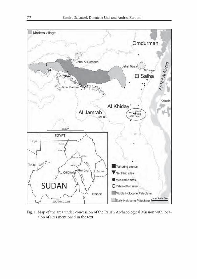
Sandro Salvatori, Donatella Usai and Andrea Zerboni72
Fig. 1. Map of the area under concession of the Italian Archaeological Mission with loca-tion of sites mentioned in the text
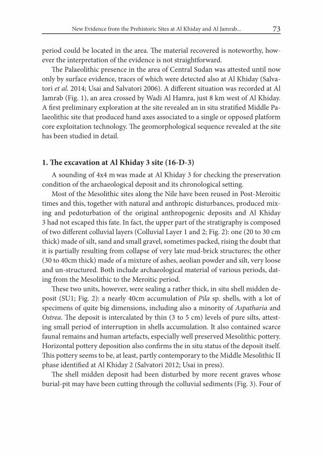
New Evidence from the Prehistoric Sites at Al Khiday and Al Jamrab... 73
period could be located in the area. The material recovered is noteworthy, how-ever the interpretation of the evidence is not straightforward.
The Palaeolithic presence in the area of Central Sudan was attested until now only by surface evidence, traces of which were detected also at Al Khiday (Salva-tori et al. 2014; Usai and Salvatori 2006). A different situation was recorded at Al Jamrab (Fig. 1), an area crossed by Wadi Al Hamra, just 8 km west of Al Khiday. A first preliminary exploration at the site revealed an in situ stratified Middle Pa-laeolithic site that produced hand axes associated to a single or opposed platform core exploitation technology. The geomorphological sequence revealed at the site has been studied in detail.
1. The excavation at Al Khiday 3 site (16-D-3)A sounding of 4x4 m was made at Al Khiday 3 for checking the preservation
condition of the archaeological deposit and its chronological setting. Most of the Mesolithic sites along the Nile have been reused in Post-Meroitic
times and this, together with natural and anthropic disturbances, produced mix-ing and pedoturbation of the original anthropogenic deposits and Al Khiday 3 had not escaped this fate. In fact, the upper part of the stratigraphy is composed of two different colluvial layers (Colluvial Layer 1 and 2; Fig. 2): one (20 to 30 cm thick) made of silt, sand and small gravel, sometimes packed, rising the doubt that it is partially resulting from collapse of very late mud-brick structures; the other (30 to 40cm thick) made of a mixture of ashes, aeolian powder and silt, very loose and un-structured. Both include archaeological material of various periods, dat-ing from the Mesolithic to the Meroitic period.
These two units, however, were sealing a rather thick, in situ shell midden de-posit (SU1; Fig. 2): a nearly 40cm accumulation of Pila sp. shells, with a lot of specimens of quite big dimensions, including also a minority of Aspatharia and Ostrea. The deposit is intercalated by thin (3 to 5 cm) levels of pure silts, attest-ing small period of interruption in shells accumulation. It also contained scarce faunal remains and human artefacts, especially well preserved Mesolithic pottery. Horizontal pottery deposition also confirms the in situ status of the deposit itself. This pottery seems to be, at least, partly contemporary to the Middle Mesolithic II phase identified at Al Khiday 2 (Salvatori 2012; Usai in press).
The shell midden deposit had been disturbed by more recent graves whose burial-pit may have been cutting through the colluvial sediments (Fig. 3). Four of

Sandro Salvatori, Donatella Usai and Andrea Zerboni74
them were located but only two excavated, it is supposed they may be even Chris-tian in age but this would need to be ascertained.
The shell midden deposit was overlapping a series of in situ deposits; among them a layer of silt mixed to small gravel that has certainly undergone heating (SU6; Fig. 2). Pinkish silt, often agglomerated and hardened, was found con-centrated in the north-eastern corner of the trench. This included thin layers of burned silt and chunks of charcoal that have been sampled for 14C dating. This soil concentration corresponds to a small depression whose interpretation is made arduous by the limits of the trench itself. However, few things were noticed that seem to suggest that the area could have been linked to some specific activities associated to pottery production: big nodules of yellow and red ochre, and a con-
Fig. 2. North-south stratigraphic sequence at site 16-D-3
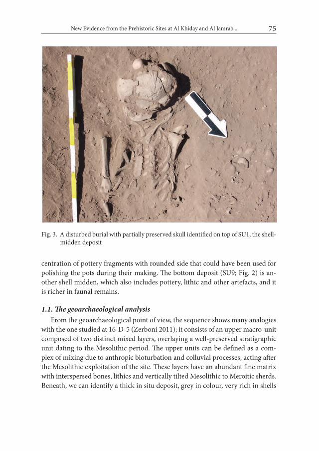
New Evidence from the Prehistoric Sites at Al Khiday and Al Jamrab... 75
centration of pottery fragments with rounded side that could have been used for polishing the pots during their making. The bottom deposit (SU9; Fig. 2) is an-other shell midden, which also includes pottery, lithic and other artefacts, and it is richer in faunal remains.
1.1. The geoarchaeological analysisFrom the geoarchaeological point of view, the sequence shows many analogies
with the one studied at 16-D-5 (Zerboni 2011); it consists of an upper macro-unit composed of two distinct mixed layers, overlaying a well-preserved stratigraphic unit dating to the Mesolithic period. The upper units can be defined as a com-plex of mixing due to anthropic bioturbation and colluvial processes, acting after the Mesolithic exploitation of the site. These layers have an abundant fine matrix with interspersed bones, lithics and vertically tilted Mesolithic to Meroitic sherds. Beneath, we can identify a thick in situ deposit, grey in colour, very rich in shells
Fig. 3. A disturbed burial with partially preserved skull identified on top of SU1, the shell-midden deposit

Sandro Salvatori, Donatella Usai and Andrea Zerboni76
and bone fragments; this layer is generally clast-supported, as the fine ashy matrix is generally poorly represented; it can be interpreted as a shell midden with fish bone fragments. The lowermost part of the sequence includes some layers display-ing evidence for fire activity (calcitic ash and heated sediments) interlayered with lenses of clast-supported accumulation of Pila sp. shells.
Some samples for micromorphological analysis have been collected from the well-preserved Mesolithic layers; in particular, very interesting is the observation under the microscope of the shell midden (SU1). The deposit of SU1 consists of a huge concentration of shell fragments and few large and small bone fragments (mostly fish), included in a poor fine matrix. The latter consists of two differ-ent materials (Fig. 4): a less represented, very loose, clay+amorphous organics matrix and a dominant micritic (micro-calcite) matrix. The first corresponds to
Fig. 4. Photomicrographs of the shell midden of SU1: A – wood ash-rich matrix; B – clayey micromass with abundant amorphous organic matter; C – detail of a shells ac-cumulation (shells occasionally show in situ breakage); D – concentration of bone fragments
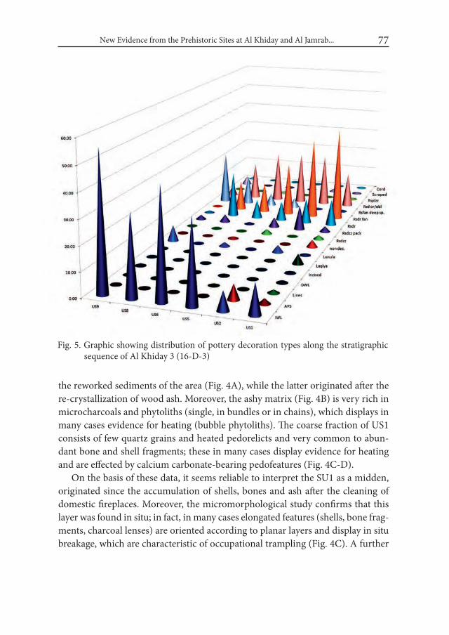
New Evidence from the Prehistoric Sites at Al Khiday and Al Jamrab... 77
the reworked sediments of the area (Fig. 4A), while the latter originated after the re-crystallization of wood ash. Moreover, the ashy matrix (Fig. 4B) is very rich in microcharcoals and phytoliths (single, in bundles or in chains), which displays in many cases evidence for heating (bubble phytoliths). The coarse fraction of US1 consists of few quartz grains and heated pedorelicts and very common to abun-dant bone and shell fragments; these in many cases display evidence for heating and are effected by calcium carbonate-bearing pedofeatures (Fig. 4C-D).
On the basis of these data, it seems reliable to interpret the SU1 as a midden, originated since the accumulation of shells, bones and ash after the cleaning of domestic fireplaces. Moreover, the micromorphological study confirms that this layer was found in situ; in fact, in many cases elongated features (shells, bone frag-ments, charcoal lenses) are oriented according to planar layers and display in situ breakage, which are characteristic of occupational trampling (Fig. 4C). A further
Fig. 5. Graphic showing distribution of pottery decoration types along the stratigraphic sequence of Al Khiday 3 (16-D-3)
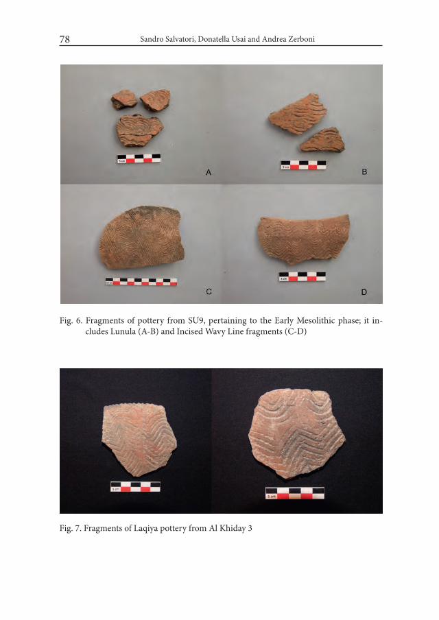
Sandro Salvatori, Donatella Usai and Andrea Zerboni78
Fig. 6. Fragments of pottery from SU9, pertaining to the Early Mesolithic phase; it in-cludes Lunula (A-B) and Incised Wavy Line fragments (C-D)
Fig. 7. Fragments of Laqiya pottery from Al Khiday 3
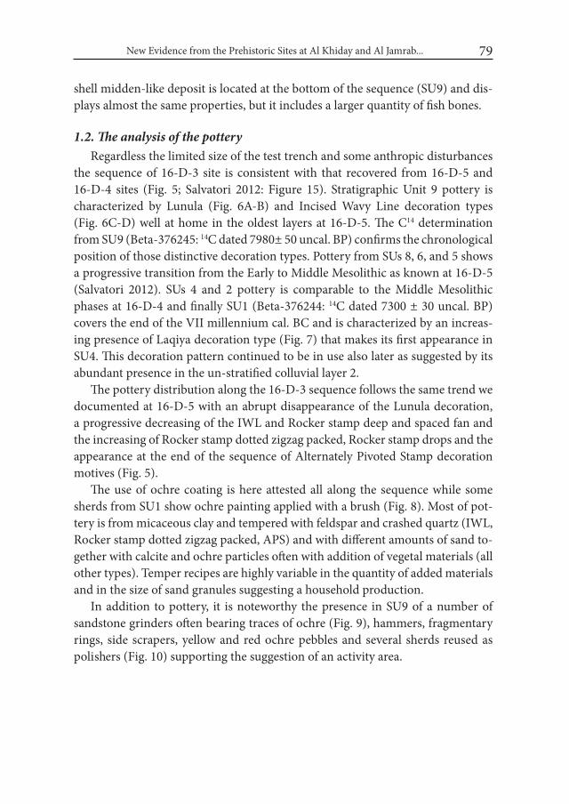
New Evidence from the Prehistoric Sites at Al Khiday and Al Jamrab... 79
shell midden-like deposit is located at the bottom of the sequence (SU9) and dis-plays almost the same properties, but it includes a larger quantity of fish bones.
1.2. The analysis of the potteryRegardless the limited size of the test trench and some anthropic disturbances
the sequence of 16-D-3 site is consistent with that recovered from 16-D-5 and 16-D-4 sites (Fig. 5; Salvatori 2012: Figure 15). Stratigraphic Unit 9 pottery is characterized by Lunula (Fig. 6A-B) and Incised Wavy Line decoration types (Fig. 6C-D) well at home in the oldest layers at 16-D-5. The C14 determination from SU9 (Beta-376245: 14C dated 7980± 50 uncal. BP) confirms the chronological position of those distinctive decoration types. Pottery from SUs 8, 6, and 5 shows a progressive transition from the Early to Middle Mesolithic as known at 16-D-5 (Salvatori 2012). SUs 4 and 2 pottery is comparable to the Middle Mesolithic phases at 16-D-4 and finally SU1 (Beta-376244: 14C dated 7300 ± 30 uncal. BP) covers the end of the VII millennium cal. BC and is characterized by an increas-ing presence of Laqiya decoration type (Fig. 7) that makes its first appearance in SU4. This decoration pattern continued to be in use also later as suggested by its abundant presence in the un-stratified colluvial layer 2.
The pottery distribution along the 16-D-3 sequence follows the same trend we documented at 16-D-5 with an abrupt disappearance of the Lunula decoration, a progressive decreasing of the IWL and Rocker stamp deep and spaced fan and the increasing of Rocker stamp dotted zigzag packed, Rocker stamp drops and the appearance at the end of the sequence of Alternately Pivoted Stamp decoration motives (Fig. 5).
The use of ochre coating is here attested all along the sequence while some sherds from SU1 show ochre painting applied with a brush (Fig. 8). Most of pot-tery is from micaceous clay and tempered with feldspar and crashed quartz (IWL, Rocker stamp dotted zigzag packed, APS) and with different amounts of sand to-gether with calcite and ochre particles often with addition of vegetal materials (all other types). Temper recipes are highly variable in the quantity of added materials and in the size of sand granules suggesting a household production.
In addition to pottery, it is noteworthy the presence in SU9 of a number of sandstone grinders often bearing traces of ochre (Fig. 9), hammers, fragmentary rings, side scrapers, yellow and red ochre pebbles and several sherds reused as polishers (Fig. 10) supporting the suggestion of an activity area.

Sandro Salvatori, Donatella Usai and Andrea Zerboni80
Fig. 8. A – fragments of pottery decorated with a rocker stamp pattern showing in the internal surface a sort of painting, or red colour applied with brush strokes (see contrasted Photo B)
Fig. 9. Sandstone grinding stone bearing traces of red ochre
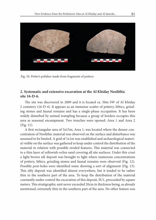
New Evidence from the Prehistoric Sites at Al Khiday and Al Jamrab... 81
2. Systematic and extensive excavation at the Al Khiday Neolithic site 16-D-6.
The site was discovered in 2009 and it is located ca. 50m SW of Al Khiday 2 cemetery (16-D-4). It appears as an immense scatter of pottery, lithics, grind-ing stones and faunal remains and has a single-phase occupation. It has been widely disturbed by animal trampling because a group of herders occupies this area as seasonal encampment. Two trenches were opened: Area 1 and Area 2 (Fig. 11).
A first rectangular area of 5x15m, Area 1, was located where the denser con-centration of Neolithic material was observed on the surface and disturbance was assumed to be limited. A grid of 1x1m was established and archaeological materi-al visible on the surface was gathered to keep under control the distribution of the material in relation with possible eroded features. This material was connected to a thin layer of yellowish-ochre sand covering all site surfaces. Under this crust a light-brown silt deposit was brought to light where numerous concentrations of pottery, lithics, grinding stones and faunal remains were observed (Fig. 12). Possible post-holes were identified some showing a sort of alignment (Fig. 13). This silty deposit was identified almost everywhere, but it tended to be rather thin in the southern part of the area. To keep the distribution of the material constantly under control the excavation of this deposit, SU1, proceeded by square meters. This stratigraphic unit never exceeded 20cm in thickness being, as already mentioned, extremely thin in the southern part of the area. No other feature was
Fig. 10. Potter’s polisher made from fragments of pottery
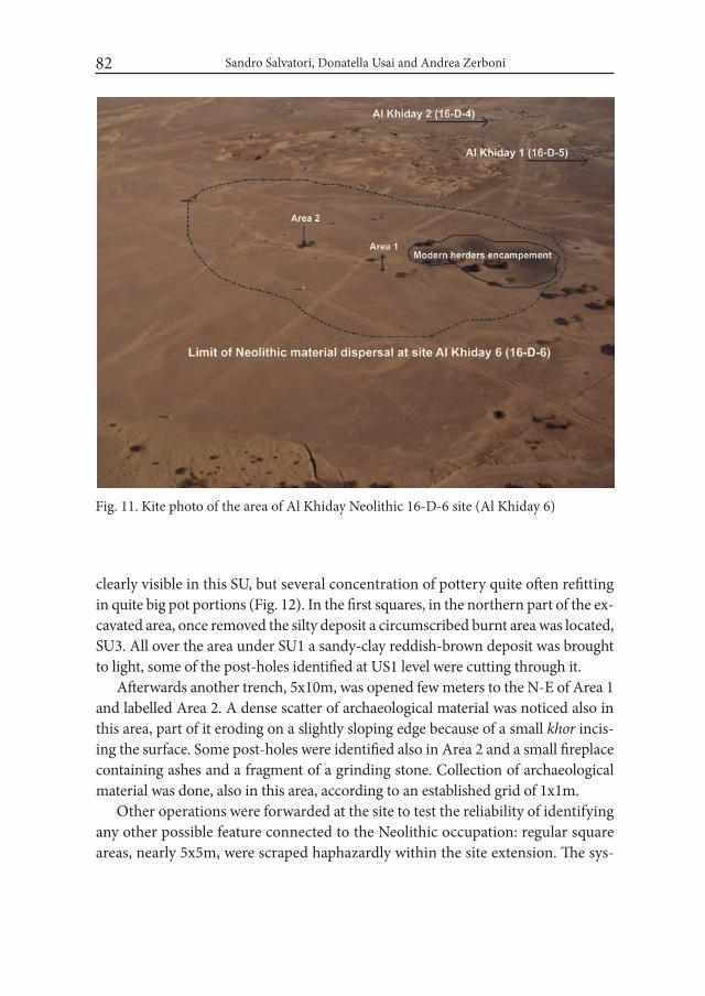
Sandro Salvatori, Donatella Usai and Andrea Zerboni82
clearly visible in this SU, but several concentration of pottery quite often refitting in quite big pot portions (Fig. 12). In the first squares, in the northern part of the ex-cavated area, once removed the silty deposit a circumscribed burnt area was located, SU3. All over the area under SU1 a sandy-clay reddish-brown deposit was brought to light, some of the post-holes identified at US1 level were cutting through it.
Afterwards another trench, 5x10m, was opened few meters to the N-E of Area 1 and labelled Area 2. A dense scatter of archaeological material was noticed also in this area, part of it eroding on a slightly sloping edge because of a small khor incis-ing the surface. Some post-holes were identified also in Area 2 and a small fireplace containing ashes and a fragment of a grinding stone. Collection of archaeological material was done, also in this area, according to an established grid of 1x1m.
Other operations were forwarded at the site to test the reliability of identifying any other possible feature connected to the Neolithic occupation: regular square areas, nearly 5x5m, were scraped haphazardly within the site extension. The sys-
Fig. 11. Kite photo of the area of Al Khiday Neolithic 16-D-6 site (Al Khiday 6)
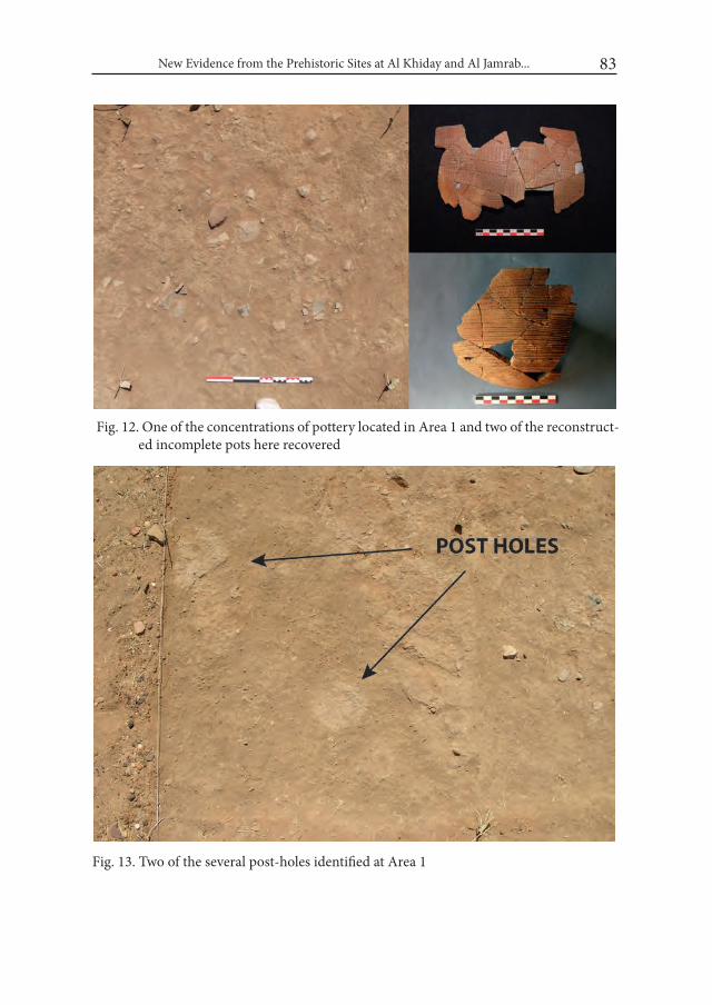
New Evidence from the Prehistoric Sites at Al Khiday and Al Jamrab... 83
Fig. 12. One of the concentrations of pottery located in Area 1 and two of the reconstruct-ed incomplete pots here recovered
Fig. 13. Two of the several post-holes identified at Area 1
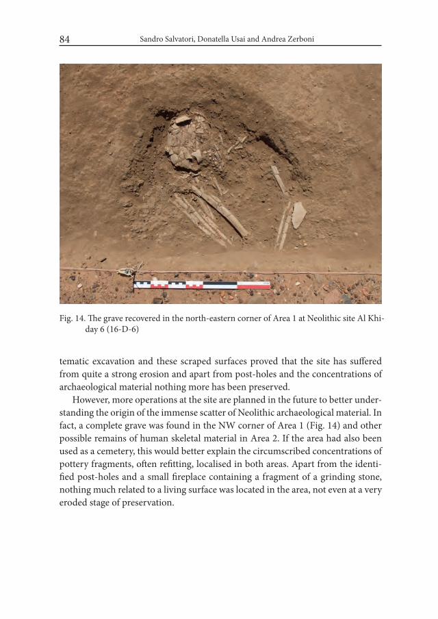
Sandro Salvatori, Donatella Usai and Andrea Zerboni84
tematic excavation and these scraped surfaces proved that the site has suffered from quite a strong erosion and apart from post-holes and the concentrations of archaeological material nothing more has been preserved.
However, more operations at the site are planned in the future to better under-standing the origin of the immense scatter of Neolithic archaeological material. In fact, a complete grave was found in the NW corner of Area 1 (Fig. 14) and other possible remains of human skeletal material in Area 2. If the area had also been used as a cemetery, this would better explain the circumscribed concentrations of pottery fragments, often refitting, localised in both areas. Apart from the identi-fied post-holes and a small fireplace containing a fragment of a grinding stone, nothing much related to a living surface was located in the area, not even at a very eroded stage of preservation.
Fig. 14. The grave recovered in the north-eastern corner of Area 1 at Neolithic site Al Khi-day 6 (16-D-6)

New Evidence from the Prehistoric Sites at Al Khiday and Al Jamrab... 85
3. Geoarchaeological investigation at Palaeolithic site 16-B-3, Al Jamrab
3.1. The stratigraphic contextSome in situ Palaeolithic artefacts were identified during the geoarchaeologi-
cal survey carried out in 2012 in the area west of the Al Khiday sites. This very surprising evidence, at moment unique for central Sudan, was discovered along the Wadi Al Hamra (Fig. 15). Therein, the wadi cut exposes a very interesting stratigraphic section of the pediment east of the Jebel Maddaha in the vicinity of the Hillat Al Jamrab (Fig. 16A-B). The abundance of lithic artefacts dotting the exposed surface suggested planning a more detailed investigation, including the opening of a test trench to check the archaeological potential of the deposit.
During the 2014 field season, a long part of the Wadi Al Hamra was surveyed in detail and the bed of the river and the banks were both checked by foot to locate the main concentrations of Palaeolithic artefacts. The most indicative have been photographed and in some cases collected for drawing and studying. The geologi-
Fig. 15. View of the area of Wadi Al Hamra; dashed line indicates dispersal of lithic material

Sandro Salvatori, Donatella Usai and Andrea Zerboni86
cal formations outcropping along the wadi have also been observed, in order to identify the layers or strata displaying the highest concentration of archaeological remains.
The stratigraphic sequence appears discontinuous as along the wadi recent fluvial activity have removed part of the sedimentary sequence. A second fea-ture, which made difficult the interpretation of the geological context hosting Palaeolithic artefacts, is represented by the many discontinuities in the stratigra-phy and the recent cover of fluvial sand. The latter made impossible to follow the stratigraphic record along the wadi, while the occurrence of stratigraphic discon-tinuities put in contact sedimentary units, which are not in continuity. The strati-graphic sequence, reconstructed on the basis of many field observations, consists at the top of a layer of laminated aeolian sand. Below, we notice a thick and well-cemented layer (up to 1 m) of red fluvial/alluvial sand, showing a high degree of weathering at its top, which is richer in clay and manganese nodules. An erosional surface represents the boundary to the subsequent layer of grey fluvial silt and sand; this sediment is moderately to weakly cemented and displays evidence for a long standing of the water table. A layer of greenish, hydromorphic silt and clay follows; it is deeply cemented by the occurrence of calcium carbonate nodules, locally greater than 1 cm. This kind of sediment was formed in a low-energy envi-ronment, possibly by decantation in a marsh or lake; it has many analogies with the Upper Pleistocene lacustrine formation described in the region by Williams et al. (2015). The lower boundary of this layer is wavy, possibly due to an erosive event affecting the following deposit, which includes at its top the Palaeolithic artefacts. This unit consists of fluvial sediments displaying an upward fining trend; in the lower part a gravel-bearing (clast to matrix supported) deposit is present, becom-ing sandy to clay toward the top. This unit has to be considered as originating by the same fluvial process, with progressive decreasing energy. Moreover, the upper part of the layer, where artefacts are entombed, is represented by a concentration of calcium carbonate and Fe/Mn-rich concretions, cemented by calcium carbon-ate (Fig. 16C-D-E). The upper part of this layer consists of a paleosol, developed under environmental conditions wetter than today and it can be interpreted as the topographic/occupational surface at the time of the Palaeolithic occupation of the region. The lower boundary of this unit is also wavy, due to the occurrence of an erosive surface at the top of the following deposit, which is represented by deeply weathered sandstones. This unit possibly corresponds to an Early Quaternary (or earlier?) paleosols developed on the sandstone outcropping in the region due to pedogenesis under pluvial environmental conditions.
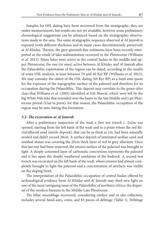
New Evidence from the Prehistoric Sites at Al Khiday and Al Jamrab... 87
Samples for OSL dating have been recovered from the stratigraphy; they are under measurements, but results are not yet available, however some preliminary chronological suggestions can be advanced based on the stratigraphic observa-tions made in the area. The same stratigraphic sequence observed at Al Jamrab is exposed (with different thickness and in many cases discontinuously preserved) at Al Khiday. Therein, the grey-greenish fine sediments have been recently inter-preted as the result of lake sedimentation occurred in the Pleistocene (Williams et al. 2015). Many lakes were active in the central Sudan in the middle and up-per Pleistocene; the one (or ones) active between Al Khiday and Al Jamrab after the Palaeolithic exploitation of the region can be dated, according to the results of some OSL analysis, at least between 70 and 40 Kyr BP (Williams et al. 2015). We may consider the oldest of the OSL dating (69 Kyr BP) as a limit ante quem for the exposure of the topographic surface of the paleosol and therefore for its occupation during the Palaeolithic. This deposit may correlate to the green olive clays that Williams et al. (2003) identified at Esh Shawal, which were left by the big White Nile lake that extended over the basin in the late Middle and Late Pleis-tocene period (Usai in press); for that reason, the Palaeolithic occupation of the region may be ante-dating this formation.
3.2. The excavation at Al JamrabAfter a preliminary inspection of the wadi a first test trench c. 2x2m was
opened, starting from the left bank of the wadi and in a point where the red flu-vial/alluvial sand (sterile deposit), that can be as thick as 1m, had been naturally eroded and didn’t exceed 20cm. A surface deposit of laminated aeolian sand and residual stones was covering the 20cm thick layer of red to grey alluvium. Once this last one had been removed, the erosive surface of the paleosol was brought to light. A deeply cemented layer of carbonatic concretions represents the paleosol and it lies upon the deeply weathered sandstone of the bedrock. A second test trench was excavated on the left bank of the wadi, where erosion had almost com-pletely brought to light the paleosol and a concentration of artefacts was visible on the sloping front.
The interpretation of the Palaeolithic occupation of central Sudan offered by archaeological evidence form Al Khiday and Al Jamrab may shed new light on one of the most intriguing issue of the Palaeolithic of northern Africa: the disper-sal of the modern humans in the Middle-Late Pleistocene.
The lithic assemblage recovered, considering surface and in situ collection, includes several hand-axes, cores, and 83 pieces of débitage (Table 1). Débitage
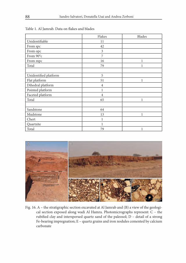
Sandro Salvatori, Donatella Usai and Andrea Zerboni88
Table 1. Al Jamrab. Data on flakes and blades
Flakes BladesUnidentifiable 11From spc 42From opc 3From 90°c 7From mpc 16 1Total 79 1
Unidentified platform 5Flat platform 51 1Dihedral platform 4Pointed platform 1Faceted platform 4Total 65 1
Sandstone 64Mudstone 13 1Chert 1Quartzite 1Total 79 1
Fig. 16. A – the stratigraphic section excavated at Al Jamrab and (B) a view of the geologi-cal section exposed along wadi Al Hamra. Photomicrographs represent: C – the rubified clay and interspersed quartz sand of the paleosol; D – detail of a strong Fe-bearing impregnation; E – quartz grains and iron nodules cemented by calcium carbonate
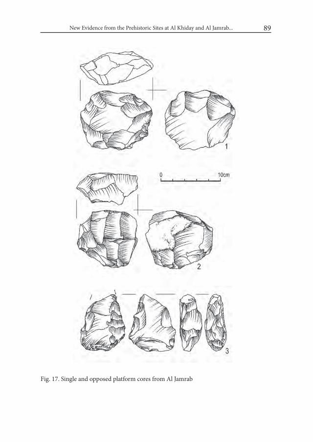
New Evidence from the Prehistoric Sites at Al Khiday and Al Jamrab... 89
Fig. 17. Single and opposed platform cores from Al Jamrab
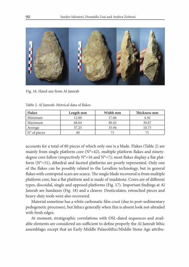
Sandro Salvatori, Donatella Usai and Andrea Zerboni90
accounts for a total of 80 pieces of which only one is a blade. Flakes (Table 2) are mainly from single platform core (N°=42), multiple platform flakes and ninety-degree core follow (respectively N°=16 and N°=7); most flakes display a flat plat-form (N°=51), dihedral and faceted platforms are poorly represented. Only one of the flakes can be possibly related to the Levallois technology, but in general flakes with centripetal scars are scarce. The single blade recovered is from multiple platform core, has a flat platform and is made of mudstone. Cores are of different types, discoidal, single and opposed platforms (Fig. 17). Important findings at Al Jamrab are handaxes (Fig. 18) and a cleaver. Denticulates, retouched pieces and heavy-duty tools were also recovered.
Material sometime has a white carbonatic film crust (due to post-sedimentary pedogenetic processes), but lithics generally when this is absent look not-abraded with fresh edges.
At moment, stratigraphic correlations with OSL-dated sequences and avail-able elements are considered un-sufficient to define properly the Al Jamrab lithic assemblage; except that an Early Middle Palaeolithic/Middle Stone Age attribu-
Fig. 18. Hand-axe from Al Jamrab
Table 2. Al Jamrab. Metrical data of flakes
Flakes Length mm Width mm Thickness mmMinimum 12.00 17.06 4.36Maximum 68.64 80.42 30.87Average 37.25 35.94 10.73N° of pieces 40 71 71
New Evidence from the Prehistoric Sites at Al Khiday and Al Jamrab... 91
tion seems the most probable if observations on stratigraphic relationships are considered together with the presence of hand-axes and apparent absence of strict Levallois technology. Relevant well preserved Palaeolithic contexts were recently recovered in the north of Sudan at Sai site 8-B-11 (Rots and Van Peer 2006; Van Peer 2004; Van Peer et al. 2003) and in the Atbara, in the Kashm El Girba Synthem (Abbate et al. 2010), with late Acheulean to Middle Stone Age artefacts in clear chronological sequence.
4. Concluding remarksThe work at Al Khiday is providing continuous updates on the Mesolithic pe-
riod of Central Sudan. Among the important results, widely illustrated in previous papers, some are: the discover of a Mesolithic structured village, with “houses” and other features, i.e. pits of different functional destination (Salvatori et al. 2011, 2014; Usai in press); the recovery of data regarding plant gathering, one of the activity fre-quently associated with these populations, but until now attested only by the pres-ence of grinding equipment or at best by seeds’pottery impressions (Buckley et al. 2014); an internal evolution stigmatised by the pottery production (Salvatori 2012).
Characteristic elements in the earliest pottery production of this location in Central Sudan is the Lunula type pottery and associated types which are basically unknown in other sites explored until now1.
The excavation at the Mesolithic Al Khiday 3 mound has incremented our knowledge of the general sequence with a phase, dating to the end of the VII mil-lennium BC, characterised by the Laqiya type pottery, firstly recognised in the Wadi Howar region (Jesse 2000, 2003). The work at this site has also implemented our knowledge of the subsistence economy. In fact the identification of the shell midden deposit enlarged our perception of the importance of molluscs as an el-ement of the diet of Mesolithic people. Phytoliths present in the shell midden deposit hopefully will provide a wider insight on the vegetation and eventually on the plant consumed in that period.
The meagre results of the investigation at the Neolithic site 16-D-6 need care-ful interpretation and we do not think it is yet time to afford any conclusive state-ment. At moment we can just affirm that it provided and interesting set of ar-chaeological material to be studied. The faunal remains, in particular, will serve to
1 Some examples of Lunula type pottery were found by Arkell at Khartoum Hospital (Arkell 1949: Pl. 77.2)
Sandro Salvatori, Donatella Usai and Andrea Zerboni92
complete the sequence of animal exploitation from the Mesolithic to the Neolithic that can be reconstructed thanks to the exceptional well preserved sequence re-vealed at Al Khiday sites.
Among the positive recent results of the work in the region we can certainly includes the discovery of Al Jamrab (16-B-3) Palaeolithic site. Cultural and chron-ological interpretation of the site are left pending until OSL dates will be available as well as other materials from continuation of the archaeological activity. In fact, our impression now is different from that gathered from preliminary observations based only on surface collections. The overall material is not enough for associ-ating the lithic assemblage to any of the specific cultural facies of the late Early Palaeolithic or Early Middle Palaeolithic; moreover, the exploration at the site has been too limited for fully understanding the formation processes and chronology of the paleosol preserved at Al Jamrab.
AcknowledgmentsWe gratefully acknowledge the Sudanese Department of Antiquity and the
Italian Embassy in Khartoum for their continuous support in organizing our re-search. The field project has been supported by Ministero degli Affari Esteri (Con-tributi per le Missioni Archeologiche all’Estero) entrusted to DU, and University of Milano (Fondi Speciali per le Ricerche Archeologiche 2015) entrusted to AZ. University of Padova (G. Artioli, L. Maritan, I. Angelini, G. Dal Sasso) and Parma (P. Iacumin) greatly contributed to the analytical processing of materials and data.
REFERENCESABBATE, E., ALBIANELLI, A., AWAD., A., BILLI, P., BRUNI, P., DELFINO, M.,
FERRETTI, M., FILIPPI, O., GALLAI, G., GHINASSI, M., LAURITZEN, S.-E., LO VETRO, D., MARTíNEZ-NAVARRO, B., MARTINI, F., NA-POLEONE, G., BEDRI, O., PAPINI, M., ROOK, L. and M. SAGRI. 2010. Pleistocene environments and human presence in the middle Atbara val-ley (Khashm El Girba, Eastern Sudan). Palaeogeography, Palaeoclimatology, Palaeoecology 292: 12-34.
ARKELL, A. J. 1949. Early Khartoum. An Account of the Excavation of an Early Occupation Site carried out by the Sudan Government Antiquities service in 1944-5. London.
New Evidence from the Prehistoric Sites at Al Khiday and Al Jamrab... 93
BUCKLEY, S., USAI, D., JAKOB, T., RADINI, A. and K. HARDY. 2014. Dental Calculus Reveals Unique Insights into Food Items, Cooking and Plant Pro-cessing in Prehistoric Central Sudan. PLoS ONE 9(7): e100808. doi:10.1371/journal.pone.0100808
JESSE, F. 2000. Early Khartoum ceramics in the Wadi Howar, Northwest Sudan. In: L. Krzyżaniak, K. Kroeper and M. Kobusiewicz (eds.), Recent research into the Stone Age of Northeastern Africa. (= Studies in African Archaeology 7): 77–87. Poznań.
JESSE, F. 2003. Rahib 80/87. Ein wavy-line-fundplatz im wadi Howar und die früheste Keramik in Nordafrika. (= Africa Praehistorica 16). Köln.
ROTS, V. and P. VAN PEER. 2006. Early evidence of complexity in lithic econ-omy: core-axe production, hafting and use at Late Middle Pleistocene site 8-B-11, Sai Island (Sudan). Journal of Archaeological Science 33: 360-371.
SALVATORI, S. 2012. Disclosing Archaeological Complexity of the Khartoum Mesolithic. New Data at the Site and Regional Level. African Archaeological Review 29: 399-472.
SALVATORI, S., USAI, D. and A. ZERBONI. 2011. Mesolithic site formation and palaeoenvironment along the White Nile (Central Sudan). African Ar-chaeological Review 28: 177-211.
SALVATORI, S., USAI, D., FAROUG, M. A., DI MATTEO, A., IACUMIN, P., LIN-SEELE, V. and M. KHALID MAGZOUB. 2014. Archaeological evidence at Al Khiday. New insight on the prehistory and History of Central Sudan. In: J. R. Anderson and D. A. Welsby (eds.), The Fourth Cataract and Beyond. Pro-ceedings of the 12th international Conference of Nubian Studies: 243-257. Leuven.
USAI, D. in press. Prehistory in Central Sudan. Paper presented at The 13th Inter-national Conference for Nubian Studies, Neuchâtel, September 2014.
USAI, D. and S. SALVATORI. 2006. The el Salha Project. In: I. Caneva and A. Roccati (eds.), Acta Nubica. Proceedings of the X international Confer-ence of Nubian Studies Rome 10-14 September 2002: 117-126. Rome.
VAN PEER, P. 2004. Did Middle Stone Age Moderns of Sub-Saharan African de-scent trigger an Upper Palaeolithic Revolution in the Lower Nile Valley? Anthropologie XLII (3): 241-251.
VAN PEER, P., FULLAGAR, R., STOKES, S., BAILEY, R. M., MOEYERSONS, J., STEENHOUDT, F., GEERTS, A., VANDERBEKEN, T., DE PAPPER, M. and F. GEUS. 2003. The Early to Middle Stone Age transition and the emergence of modern human behaviour at site 8-B-11, Saï Island, Sudan. Journal of Human Evolution 45 (2): 187-193.

Sandro Salvatori, Donatella Usai and Andrea Zerboni94
WILLIAMS, M. A. J., ADAMSON, D., PRESCOTT, J. R. and F. M. WILLIAMS. 2003. New light on the age of the White Nile. Geology 31 (11): 1001-1004.
WILLIAMS, M. A. J., USAI, D., SALVATORI, S., WILLIAMS, F. M., ZERBONI, A., MARITAN, L. and V. LINSEELE. 2015. Late Quaternary environments and prehistoric occupation in the lower White Nile valley, central Sudan. Quaternary Science Reviews 130: 72-88.
ZERBONI, A. 2011. Micromorphology reveals in situ Mesolithic living floors and archaeological features in multiphase sites in central Sudan. Geoarchaeol-ogy: an international journal 26: 365-391.
Desert and the Nile. Prehistory of the Nile Basin and the Sahara.
Papers in honour of Fred Wendorf Studies in African Archaeology 15
Poznań Archaeological Museum 2018
Kimball M. Banks, Donatella Usai, J. Signe Snortland, Linda Scott Cummings and Maria C. Gatto
Food for Thought: the Late Paleolithic of WK26 Site, Wadi Kubbaniya, Egypt
IntroductionWadi Kubbaniya, about 15 km north of Aswan, Egypt, is the largest wadi in
Upper Egypt flowing out of the Western Desert. Archaeologically, the wadi is unique as it is probably one of the most intensively investigated prehistoric ar-eas in Upper Egypt (Fig. 1). The Combined Prehistoric Expedition (CPE) spent four field seasons here between 1978 and 1983, documenting the late Pleistocene environments and human occupations. The CPE investigated 27 locales, most of which date to the Late Paleolithic, between 20,000 and 12,000 BP, and are distin-guished by the presence of numerous grinding implements; the remaining locales date to the Middle Paleolithic (Wendorf et al. 1980; 1986; 1989a; 1989b).
In 2014 the Combined Prehistoric Expedition Foundation and the Aswan-Kom Ombo Archaeological Project (CPEF/AKAP) investigated WK26, another Late Paleolithic occupation in the wadi. Like the other sites WK26 consists of a lithic accumulation but what distinguishes it is the presence of hearths, post-holes, storage features and a possible living floor. Based on radiocarbon dates and stratigraphy, WK26 dates to the end of the Late Paleolithic Kubbaniya sequence and few sites of this period have been investigated in this area of Upper Egypt. The composition of the site provides an insight into settlement and subsistence at the end of the Late Paleolithic.
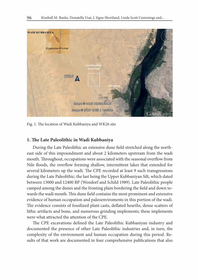
Kimball M. Banks, Donatella Usai, J. Signe Shortland, Linda Scott Cummings and...96
1. The Late Paleolithic in Wadi KubbaniyaDuring the Late Paleolithic an extensive dune field stretched along the north-
east side of this impoundment and about 2 kilometers upstream from the wadi mouth. Throughout, occupations were associated with the seasonal overflow from Nile floods, the overflow forming shallow, intermittent lakes that extended for several kilometers up the wadi. The CPE recorded at least 9 such transgressions during the Late Paleolithic; the last being the Upper Kubbaniyan Silt, which dated between 13000 and 12400 BP (Wendorf and Schild 1989). Late Paleolithic people camped among the dunes and the fronting plain bordering the field and down to-wards the wadi mouth. This dune field contains the most prominent and extensive evidence of human occupation and paleoenviroments in this portion of the wadi. The evidence consists of fossilized plant casts, deflated hearths, dense scatters of lithic artifacts and bone, and numerous grinding implements; these implements were what attracted the attention of the CPE.
The CPE excavations defined the Late Paleolithic Kubbaniyan industry and documented the presence of other Late Paleolithic industries and, in turn, the complexity of the environment and human occupation during this period. Re-sults of that work are documented in four comprehensive publications that also
Fig. 1. The location of Wadi Kubbaniya and WK26 site
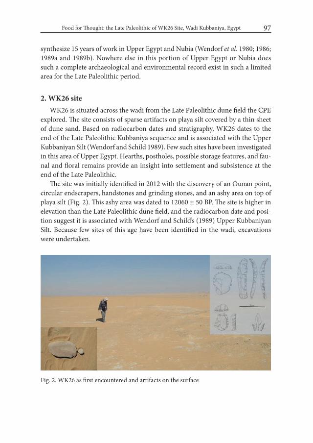
Food for Thought: the Late Paleolithic of WK26 Site, Wadi Kubbaniya, Egypt 97
synthesize 15 years of work in Upper Egypt and Nubia (Wendorf et al. 1980; 1986; 1989a and 1989b). Nowhere else in this portion of Upper Egypt or Nubia does such a complete archaeological and environmental record exist in such a limited area for the Late Paleolithic period.
2. WK26 siteWK26 is situated across the wadi from the Late Paleolithic dune field the CPE
explored. The site consists of sparse artifacts on playa silt covered by a thin sheet of dune sand. Based on radiocarbon dates and stratigraphy, WK26 dates to the end of the Late Paleolithic Kubbaniya sequence and is associated with the Upper Kubbaniyan Silt (Wendorf and Schild 1989). Few such sites have been investigated in this area of Upper Egypt. Hearths, postholes, possible storage features, and fau-nal and floral remains provide an insight into settlement and subsistence at the end of the Late Paleolithic.
The site was initially identified in 2012 with the discovery of an Ounan point, circular endscrapers, handstones and grinding stones, and an ashy area on top of playa silt (Fig. 2). This ashy area was dated to 12060 ± 50 BP. The site is higher in elevation than the Late Paleolithic dune field, and the radiocarbon date and posi-tion suggest it is associated with Wendorf and Schild’s (1989) Upper Kubbaniyan Silt. Because few sites of this age have been identified in the wadi, excavations were undertaken.
Fig. 2. WK26 as first encountered and artifacts on the surface

Kimball M. Banks, Donatella Usai, J. Signe Shortland, Linda Scott Cummings and...98
Two areas – A and B/C – were excavated (Fig. 3). Area A measured 10 x 10 meters and was centered on the ashy area found in 2012. Area B/C was located north-northeast of Area A and measured 10 x 17 meters, oriented east-west. Both areas were excavated to a depth of approximately 30 centimeters and, to the ex-tent possible, by stratigraphic layer. With respect to elevation, Area A was slightly higher than Area B/C
Two trenches were excavated to understand the stratigraphy. Trench 1, which was 20 meters long and 1 meter wide, connected these areas; it began at the south-east corner of Area A and extended down the north side of Area B/C. This trench was dug to identify the stratigraphic relationship between areas A and B/C. Trench 2 spanned the 10 meters at the north end of Area A and was also 1 meter wide. This trench was placed to examine the stratigraphic relationship of the playa silt and the dune sand in Area A.
Fig. 3. Excavation units at WK26; Area A in the foreground
2.1. Stratigraphy
Area AThe stratigraphy begins with a coarse, 10YR7/2, dune sand, designated Layer
1, which varies from 5 to 10 centimeters thick and overlay playa silt across most of the block. Artifacts were sparse and consisted mostly of debitage, including microflakes. The rare faunal remains consist almost exclusively of fish with rare
Food for Thought: the Late Paleolithic of WK26 Site, Wadi Kubbaniya, Egypt 99
small mammal remains, probably rodent. Layer 2 comprises unconsolidated playa silt. This silt is up to 20 cm thick and, given the elevation of the site, probably cor-responds to Wendorf and Schild’s Upper Kubbaniyan Silt (Wendorf and Schild 1989). The silt is light gray, varying in color from 10YR5/1 to 10YR8/1 and in-creases in thickness to the north; the silt is barely discernable at the south end of the block. The increase to the north indicates the silt extends north of Area A; an ash lens and a fire-cracked rock at the same level as the hearths in the pro-file in the profile of north side of Trench 2 suggest that the site also continues to the north.
The silt is thicker in the northeast quadrant of the block and contains numer-ous fossil shell casts, probably from Corbicula and/or Pisidium, root casts, and krotovina; the profile at the east end of Trench 2 indicates that these items extend to a depth of 40 cm. The top of the silt in the northwest quadrant is distinguished by orange-red, 5YR7/6-6/6, irregularly-shaped patches of loosely consolidated silt that appears to have been burned. The sediments here also lack shell casts, root casts, and krotovina. The difference between the northeast and northwest end of Block A suggest that occupation here was adjacent to a body of shallow water.
Because of time constraints, the excavations in Area A did not extend below the playa silt except for Trench 2 at the north end of the block. The stratigraphy in Trench 2 shows the silt is underlain by sterile dune sand that is at least 80 cm thick. This dune sand is broken by two bands of more organic-rich sandy silt that are less than 10 cm thick and contain rare charcoal flecks. The upper band is between 40 and 50 cm and the lower is at 60 cm below surface. Charcoal was collected from both but neither sample was large enough for AMS dating. No artifacts were found in either.
Area B/CLike Area A, Area B/C is covered by the same yellow sand, Layer 1, character-
ized by larger grains of sand that give way to sands of much finer texture. This layer produced abundant lithic material, scant faunal remains, and a few grinding implements. Layer 2 is a white dune containing the remnants of several features. In the central portion of the area, a thin sheet of remnant playa silt separates the two layers. Features appear to have been excavated through this silt. Area B/C is slightly lower than Area A and this remnant silt suggest that any silt originally present for the most part have since eroded away.
The profile of Trench 1, which bordered the north side of Area B/C and ex-tended to the southeast corner of Area A lacked evidence of the playa deposit

Kimball M. Banks, Donatella Usai, J. Signe Shortland, Linda Scott Cummings and...100
noted in Area A and the underlying thin layers of more organically rich sand observed in Trench 2. Instead, the profile consisted of unconsolidated dune sand. The absence of playa silt here and the sparseness in Area B/C intimate that any silt that was present in this area of the site have eroded away except for thin remnants. Conversely, given the complexity of the profile at the east end of Trench 2 and the thickness of the playa silt here, the playa may have been situated to the north of Area B/C and only occasionally covered this area.
2.2. FeaturesWK26 is distinguished by the presence of numerous features – hearths, pits,
postholes, and ashy and organic stains – in both areas A and B/C. The number and variety was greater than that among the Late Paleolithic sites in the dune field across the wadi. Features identified there included ash stains and hearth rem-nants but nowhere in the number, variety, and density as at WK26. The features at WK26 suggest a level of occupation and site use different from that observed across the wadi.
Surface FeaturesSurface features consisted exclusively of hearths, noted as dispersed scatters of
fire-cracked rock, 2 to 3 meters in diameter. Some were inverted mounds but the majority were distinguished as single, scattered layers of rock. Ash was not evident in any and associated artifacts were sparse to non-existent.
Area AArea A contained 27 features: two hearths, three ashy areas, one stained area
possibly organic in origin, one natural depression, the remnants of a pit, and 19 postholes (Fig. 4). The pit was in the southeast quadrant, extended through the playa silt, and had an ashy fill but lacked artifacts. The ashy areas were irregular smears in the sand containing rare charcoal flecks.
The two hearths consisted of adjacent clusters of mounded fire-cracked rock that measured 1.5 x 2 meters, two to three layers high, irregular in plan view, and intermixed with ashy sediments and charcoal flecks. The hearths were embedded in the playa silt, just above the underlying dune sand, and surrounded by a large black, ashy stain. Within this stain and just southeast of the hearths is a brown stain, possibly organic in origin. An ash lens and at least one fire-cracked rock in the north wall of Area A at the same level as the hearths, suggest the presence of a third hearth to the north.
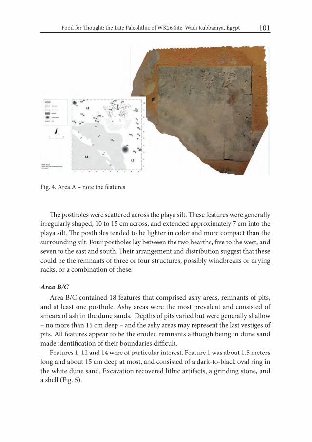
Food for Thought: the Late Paleolithic of WK26 Site, Wadi Kubbaniya, Egypt 101
The postholes were scattered across the playa silt. These features were generally irregularly shaped, 10 to 15 cm across, and extended approximately 7 cm into the playa silt. The postholes tended to be lighter in color and more compact than the surrounding silt. Four postholes lay between the two hearths, five to the west, and seven to the east and south. Their arrangement and distribution suggest that these could be the remnants of three or four structures, possibly windbreaks or drying racks, or a combination of these.
Area B/CArea B/C contained 18 features that comprised ashy areas, remnants of pits,
and at least one posthole. Ashy areas were the most prevalent and consisted of smears of ash in the dune sands. Depths of pits varied but were generally shallow – no more than 15 cm deep – and the ashy areas may represent the last vestiges of pits. All features appear to be the eroded remnants although being in dune sand made identification of their boundaries difficult.
Features 1, 12 and 14 were of particular interest. Feature 1 was about 1.5 meters long and about 15 cm deep at most, and consisted of a dark-to-black oval ring in the white dune sand. Excavation recovered lithic artifacts, a grinding stone, and a shell (Fig. 5).
Fig. 4. Area A – note the features

Kimball M. Banks, Donatella Usai, J. Signe Shortland, Linda Scott Cummings and...102
Feature 12 was located adjacent to the southern edge of Area B/C where wind erosion had partially exposed a grinding stone. The stone sat in a circular area of dark-to-black sands rich in charcoal flecks and lithic material. The deposit was ephemeral and 5 cm thick at its maximum.
Feature 14 exhibited two small circular posthole-like depressions side-by-side. One depression was deeper than the other and filled with an organically-rich brown deposit. A flat piece of sandstone was found inside the smaller depression; it may have been used as a wedge.
Most of the other features in Area B/C were more or less circular areas of dark brown to black thin ashy deposits that were archaeologically unproductive. As Feature 1 and these ashy areas demonstrate Area B/C has suffered erosion that has removed much of these features. Erosion has affected Area B/C more so than Area A and determining the function of most of the features is difficult as is whether the features reflect one or multiple occupations.
Fig. 5. Area B – excavated feature with broken grinding stone
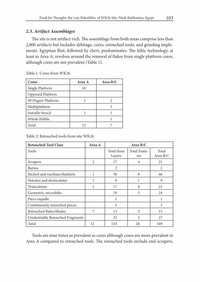
Food for Thought: the Late Paleolithic of WK26 Site, Wadi Kubbaniya, Egypt 103
2.3. Artifact AssemblagesThe site is not artifact-rich. The assemblage from both areas comprise less than
2,000 artifacts but includes debitage, cores, retouched tools, and grinding imple-ments. Egyptian flint, followed by chert, predominates. The lithic technology, at least in Area A, revolves around the removal of flakes from single platform cores, although cores are not prevalent (Table 1).
Table 1. Cores from WK26
Cores Area A Area B/CSingle Platform 10Opposed Platform90 Degree Platform 1 2Multiplatform 3Initially Struck 1 1Whole Pebble 1Total 12 7
Table 2: Retouched tools from site WK26
Retouched Tool Class Area A Area B/CTools Total from
LayersTotal Featu-
resTotal
Area B/CScrapers 2 17 4 21Burins 2 2Backed and ouchtata bladelets 1 38 8 46Notches and denticulates 1 8 1 9Truncations 1 17 4 21Geometric microliths 19 5 24Piece esquille 1 1Continuously retouched pieces 3 3Retouched flakes/blades 7 13 2 15Unidentiable Retouched Fragments 25 2 27Total 12 143 26 169
Tools are nine times as prevalent as cores although cores are more prevalent in Area A compared to retouched tools. The retouched tools include end-scrapers,
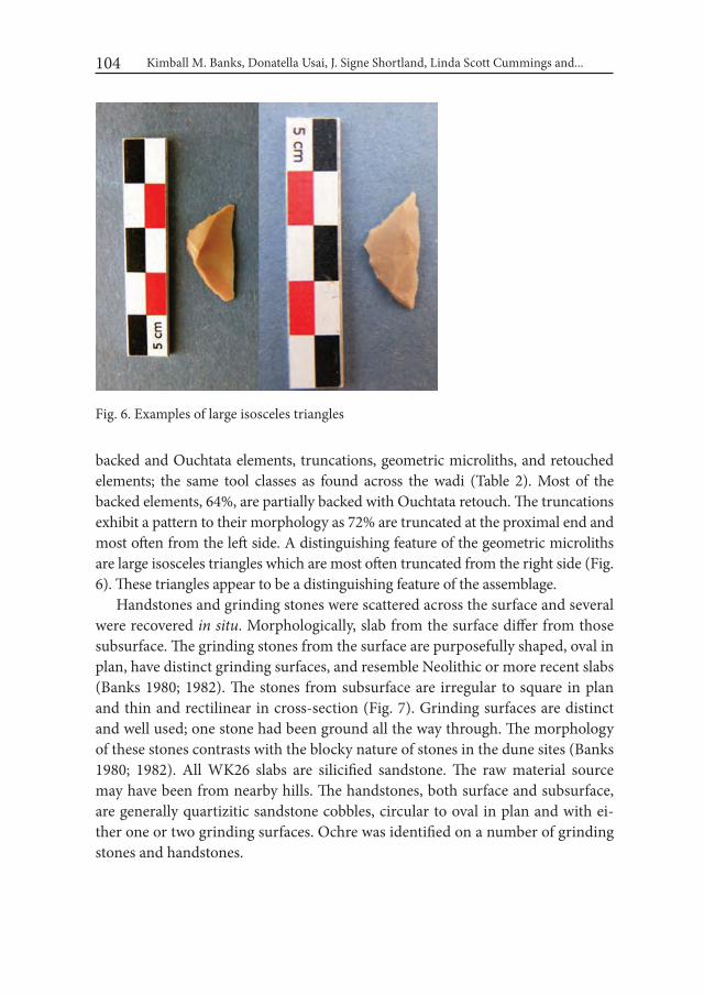
Kimball M. Banks, Donatella Usai, J. Signe Shortland, Linda Scott Cummings and...104
backed and Ouchtata elements, truncations, geometric microliths, and retouched elements; the same tool classes as found across the wadi (Table 2). Most of the backed elements, 64%, are partially backed with Ouchtata retouch. The truncations exhibit a pattern to their morphology as 72% are truncated at the proximal end and most often from the left side. A distinguishing feature of the geometric microliths are large isosceles triangles which are most often truncated from the right side (Fig. 6). These triangles appear to be a distinguishing feature of the assemblage.
Handstones and grinding stones were scattered across the surface and several were recovered in situ. Morphologically, slab from the surface differ from those subsurface. The grinding stones from the surface are purposefully shaped, oval in plan, have distinct grinding surfaces, and resemble Neolithic or more recent slabs (Banks 1980; 1982). The stones from subsurface are irregular to square in plan and thin and rectilinear in cross-section (Fig. 7). Grinding surfaces are distinct and well used; one stone had been ground all the way through. The morphology of these stones contrasts with the blocky nature of stones in the dune sites (Banks 1980; 1982). All WK26 slabs are silicified sandstone. The raw material source may have been from nearby hills. The handstones, both surface and subsurface, are generally quartizitic sandstone cobbles, circular to oval in plan and with ei-ther one or two grinding surfaces. Ochre was identified on a number of grinding stones and handstones.
Fig. 6. Examples of large isosceles triangles

Food for Thought: the Late Paleolithic of WK26 Site, Wadi Kubbaniya, Egypt 105
Fig. 7. Example of a grinding stone
2.4. Faunal RemainsMention has been made of the possible Corbicula and/or Pisidium shell in Area
A. Overall, faunal remains were sparse and consisted mostly of small slivers and bone fragments. A cursory field examination indicates that most are fish remains, with identifiable fragments being Nile catfish (Clarias). Other remains appear to be from small rodents; a lagomorph, and some birds, including the remnants of a bird bead, and a fragment of an ostrich eggshell bead. No large mammal remains were identified.
2.5. Floral RemainsGrinding faces of six implements were washed to recover phytoliths, pollen,
and starch (Scott Cummings 2014). This was the first use of a pollen wash tech-nique in investigating sites at Wadi Kubbaniya. Four implements were found “face down” on the surface at WK26 and two were subsurface. Pollen from members
Kimball M. Banks, Donatella Usai, J. Signe Shortland, Linda Scott Cummings and...106
of the mustard and amaranth families suggest seed processing. Phytoliths typical of festucoid grasses predominate followed by a few chloridoid and panicoid phy-toliths. Identified charcoal remains include Tamarix and a broad-leaved flower-ing tree or shrub. Two of the four stones from the surface yielded phytoliths that indicate cutting by a threshing sledge or trampling. These surface stones could not be dated. Several “modified” sheet phytoliths had been burned, indicated parching grass seed or cereal prior to grinding. One surface grinding stone also contained a phytolith with torn edges, typical of stems cut with sickles. Another surface grinding stone without dendritic phytoliths exhibited a phytolith from a palm suggesting processing dates.
One of the subsurface handstones recovered from Area B yielded phytolith sheet elements exhibiting cuts suggesting post-harvest processing. These sheet elements are still under study. The second subsurface grinding stone from Area B had ochre, few phytoliths, but pollen from the mustard family (Brassicaceae) goosefoot (Chenopodium), and marshelder (Low-spine Asteraceae).
2.6. Radiocarbon DatesIn addition to the date of 12060 ± 50 BP recovered in 2012 from an ashy area,
charcoal from the hearths in Area A and two features in Area B recovered in 2014 was dated to 13,100 BP ± 35, 13478 BP ± 35, and 13553 BP ± 34, respectively. That the dates from Area B are slightly older than that from Area A is consistent with the almost complete absence of silt in Area B. Area A appears to have been occu-pied a bit later than Area B. Combined with the 2012 date, the site dates to the end of the Late Paleolithic sequence and the Upper Kubbaniyan Silt and associated with high stands of the “wild Nile” (Paulissen and Vermeersch 1987; 1989; Butzer 1997; Vermeersch and Van Neer 2015).
ConclusionsSeveral factors distinguish WK26 site from the dune field sites across the wadi.
One was predominance of fish over other faunal remains, particularly larger her-bivores. Although fish predominate at the sites across the wadi, the almost com-plete lack of evidence for large herbivores further distinguishes WK26 from the majority of the other sites (Gautier and Van Neer 1989). Second were the num-ber and variety of features; a few features were identified across the wadi but no-where comparable to the number and variety at WK26. Third were the distinctive
Food for Thought: the Late Paleolithic of WK26 Site, Wadi Kubbaniya, Egypt 107
large backed and truncated isosceles triangles. Fourth was the morphology of the grinding stones; those at WK26 were thin and rectangular, with shallow grinding surfaces, while those across the wadi were blocky with more distinct surfaces. The stones in the dune field sites were quarried from the valley edge overlooking the dune field; those from WK26 probably came from nearby outcrops. Finally, plant remains at WK26 were recovered via a pollen wash, which is the first use of this technique at Wadi Kubbaniya.
The presence of hearths and post molds embedded in playa silt along with fish remains, suggest WK26 was occupied during drier seasons. The variation in the depth and composition of the silt between the northwest and northeast end of the block suggests that occupation at Block A was at the edge of a shallow body of water. The profile at the east end of Trench 2 – the krotovina and Corbicula and/or Pisidium – suggest a marsh environment. The occupation appears to have been located so its occupants could harvest fish from this pool. The apparent paucity of contemporary sites elsewhere in the wadi may reflect that occupation was pos-sibly sporadic and as part of a settlement round that extended outside the wadi.
WK26 underscores the settlement and subsistence complexity and typologi-cal diversity of the Late Paleolithic in this portion of Nubia/Upper Egypt. Wadi Kubbaniya is the only place investigated to date where this diversity is exemplified to such an extent. Although most of the sites are associated with the Kubbani-yan industry, other sites are related to a greater or lesser extent with another five industries. The differences in lithic typology and technology, including the pres-ence/absence of grinding implements, can be interpreted as demonstrating that the Late Paleolithic was a period of diversification and regional differentiation.
REFERENCESBANKS, K. M. 1980. Chapter 12. The Grinding Implements of Wadi Kubbaniya.
In: F. Wendorf and R. Schild (assemblers); A. E. Close (ed.). Loaves and Fishes: The Prehistory of wadi Kubbaniya: 239-244. Dallas.
BANKS, K. M. 1982. Late Paleolithic and Neolithic Grinding Implements in Egypt. Lithic Technology XI (1): 12-20.
BUTZER, K.W. 1997. Late Quaternary Problems of the Egyptian Nile: Stratigra-phy, Environments, Prehistory. Paléorient 23(2): 151–173.
GAUTIER, A. and W. VAN NEER. 1989. Animal Remains from the Late Paleo-lithic Sequence at Wadi Kubbaniya. In: F. Wendorf and R. Schild (assem-

Kimball M. Banks, Donatella Usai, J. Signe Shortland, Linda Scott Cummings and...108
blers); A. E. Close (ed.). The Prehistory of wadi Kubbaniya. Volume 2: 119--161. Dallas.
PAULISSEN, E. and P. M. VERMEERSCH. 1987. Earth, man and climate in the Egyptian Nile Valley during the Pleistocene. In: A. Close (ed.). Prehistory of Arid North Africa: 29-67. Dallas.
PAULISSEN, E. and P. M. VERMEERSCH. 1989. Le comportement des grands fleuves allogenes: l’exemple du Nil saharien au Quaternaire Superieur. Bul-letin de la Société géologique de France (8), t. V, nb.1: 73-88.
SCOTT CUMMINGS, L. 2014. Pollen, Phytolith, and Starch Analysis of Six Groundstone Wash Samples, Identification and AMS Radiocarbon Dating of Five Charcoal Samples from Site WK26, Egypt. PaleoResearch institute Report 2014-014.
VERMEERSCH, P. M. and W. VAN NEER. 2015. Nile Behaviour and Late Pal-aeolithic Humans in Upper Egypt During the Late Pleistocene. Quaternary Science Reviews 130: 155-167.
WENDORF, F. and R. SCHILD. 1989. Summary and synthesis. In: F. Wendorf, R. Schild (assemblers); A.E. Close (ed.) The prehistory of wadi Kubbaniya. Volume 3: 768–824. Dallas.
WENDORF, F. and R. SCHILD (assemblers); A. E. Close (ed.). 1980. Loaves and Fishes: The Prehistory of wadi Kubbaniya. Dallas.
WENDORF, F. and R. SCHILD (assemblers); A. E. Close (ed.).1986. The Prehis-tory of wadi Kubbaniya. Volume 1. The wadi Kubbaniya Skeleton: A Late Paleolithic Burial from Southern Egypt. Dallas.
WENDORF, F. and R. SCHILD (assemblers); A. E. Close (ed.).1989a. The Prehis-tory of wadi Kubbaniya. Volume 2. Dallas.
WENDORF, F. and R. SCHILD (assemblers); A. E. Close (ed.).1989b. The Prehis-tory of wadi Kubbaniya. Volume 3. Dallas.
Desert and the Nile. Prehistory of the Nile Basin and the Sahara.
Papers in honour of Fred Wendorf Studies in African Archaeology 15
Poznań Archaeological Museum 2018
Annett Dittrich
Between Two Rivers – Early Holocene Landscapes on Mograt Island (Sudan)
IntroductionMograt Island is located at the first great Nile bend close to the town of Abu
Hamed from where it can be reached by a regular ferry service. With a length of 31 kilometres along the east-west axis and a width of up to 6 kilometres Mograt is the largest island on the Nile, covering an area of 102 km² (Ritter 2008). Mograt Island’s prehistory has first been recognised on the impressive granite boulders at al-Saihan1 covered by numerous rock carvings dating from the prehistoric to the medieval and Islamic periods (Fig. 3). For this reason the site was visited since the early 20th century along with the major fortresses at the island of which Ahmed (1971) gave a first overview. Although Jackson (1926: 23ff.), Crawford (1954: 6) and Ahmed (1971: 14-15) doubted a prehistoric component for the rock art, there are indications for this such as the depictions of wild extinct animals and of cattle (cf. the unpublished doctoral thesis of F. H. B. Khalid, University of Lille, 2009).
1 Commonly spelled ‘Sihan’, however, the project decided to adopt the transliteration rules of the Sudan Notes and Records.
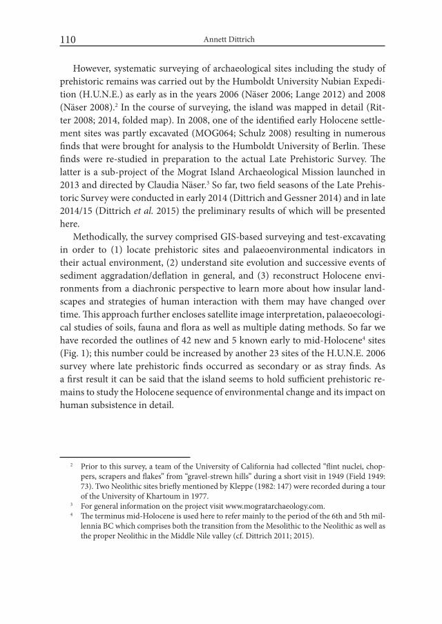
Annett Dittrich110
However, systematic surveying of archaeological sites including the study of prehistoric remains was carried out by the Humboldt University Nubian Expedi-tion (H.U.N.E.) as early as in the years 2006 (Näser 2006; Lange 2012) and 2008 (Näser 2008).2 In the course of surveying, the island was mapped in detail (Rit-ter 2008; 2014, folded map). In 2008, one of the identified early Holocene settle-ment sites was partly excavated (MOG064; Schulz 2008) resulting in numerous finds that were brought for analysis to the Humboldt University of Berlin. These finds were re-studied in preparation to the actual Late Prehistoric Survey. The latter is a sub-project of the Mograt Island Archaeological Mission launched in 2013 and directed by Claudia Näser.3 So far, two field seasons of the Late Prehis-toric Survey were conducted in early 2014 (Dittrich and Gessner 2014) and in late 2014/15 (Dittrich et al. 2015) the preliminary results of which will be presented here.
Methodically, the survey comprised GIS-based surveying and test-excavating in order to (1) locate prehistoric sites and palaeoenvironmental indicators in their actual environment, (2) understand site evolution and successive events of sediment aggradation/deflation in general, and (3) reconstruct Holocene envi-ronments from a diachronic perspective to learn more about how insular land-scapes and strategies of human interaction with them may have changed over time. This approach further encloses satellite image interpretation, palaeoecologi-cal studies of soils, fauna and flora as well as multiple dating methods. So far we have recorded the outlines of 42 new and 5 known early to mid-Holocene4 sites (Fig. 1); this number could be increased by another 23 sites of the H.U.N.E. 2006 survey where late prehistoric finds occurred as secondary or as stray finds. As a first result it can be said that the island seems to hold sufficient prehistoric re-mains to study the Holocene sequence of environmental change and its impact on human subsistence in detail.
2 Prior to this survey, a team of the University of California had collected “flint nuclei, chop-pers, scrapers and flakes” from “gravel-strewn hills” during a short visit in 1949 (Field 1949: 73). Two Neolithic sites briefly mentioned by Kleppe (1982: 147) were recorded during a tour of the University of Khartoum in 1977.
3 For general information on the project visit www.mogratarchaeology.com.4 The terminus mid-Holocene is used here to refer mainly to the period of the 6th and 5th mil-
lennia BC which comprises both the transition from the Mesolithic to the Neolithic as well as the proper Neolithic in the Middle Nile valley (cf. Dittrich 2011; 2015).
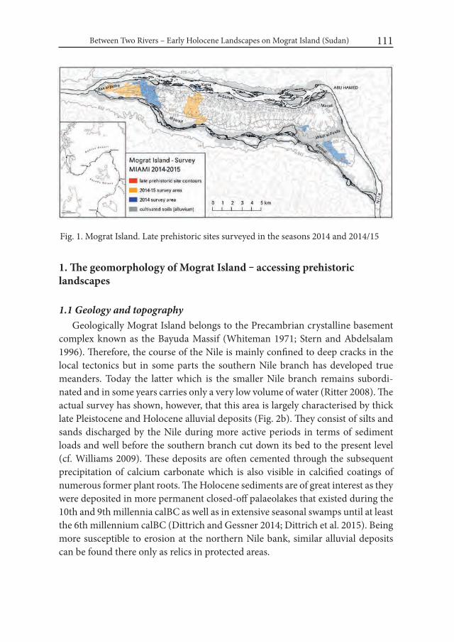
Between Two Rivers – Early Holocene Landscapes on Mograt Island (Sudan) 111
Fig. 1. Mograt Island. Late prehistoric sites surveyed in the seasons 2014 and 2014/15
1. The geomorphology of Mograt Island ‒ accessing prehistoric landscapes
1.1 Geology and topographyGeologically Mograt Island belongs to the Precambrian crystalline basement
complex known as the Bayuda Massif (Whiteman 1971; Stern and Abdelsalam 1996). Therefore, the course of the Nile is mainly confined to deep cracks in the local tectonics but in some parts the southern Nile branch has developed true meanders. Today the latter which is the smaller Nile branch remains subordi-nated and in some years carries only a very low volume of water (Ritter 2008). The actual survey has shown, however, that this area is largely characterised by thick late Pleistocene and Holocene alluvial deposits (Fig. 2b). They consist of silts and sands discharged by the Nile during more active periods in terms of sediment loads and well before the southern branch cut down its bed to the present level (cf. Williams 2009). These deposits are often cemented through the subsequent precipitation of calcium carbonate which is also visible in calcified coatings of numerous former plant roots. The Holocene sediments are of great interest as they were deposited in more permanent closed-off palaeolakes that existed during the 10th and 9th millennia calBC as well as in extensive seasonal swamps until at least the 6th millennium calBC (Dittrich and Gessner 2014; Dittrich et al. 2015). Being more susceptible to erosion at the northern Nile bank, similar alluvial deposits can be found there only as relics in protected areas.
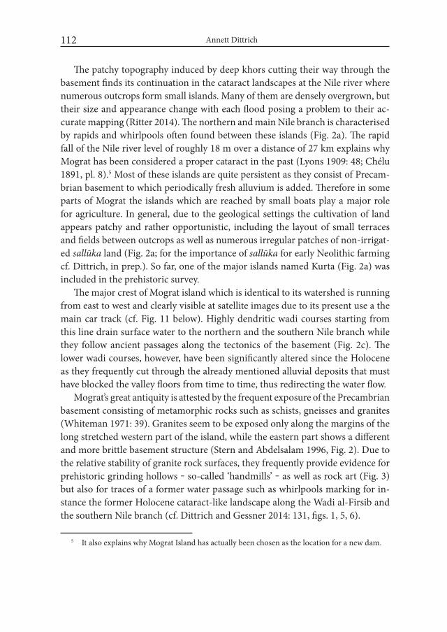
Annett Dittrich112
The patchy topography induced by deep khors cutting their way through the basement finds its continuation in the cataract landscapes at the Nile river where numerous outcrops form small islands. Many of them are densely overgrown, but their size and appearance change with each flood posing a problem to their ac-curate mapping (Ritter 2014). The northern and main Nile branch is characterised by rapids and whirlpools often found between these islands (Fig. 2a). The rapid fall of the Nile river level of roughly 18 m over a distance of 27 km explains why Mograt has been considered a proper cataract in the past (Lyons 1909: 48; Chélu 1891, pl. 8).5 Most of these islands are quite persistent as they consist of Precam-brian basement to which periodically fresh alluvium is added. Therefore in some parts of Mograt the islands which are reached by small boats play a major role for agriculture. In general, due to the geological settings the cultivation of land appears patchy and rather opportunistic, including the layout of small terraces and fields between outcrops as well as numerous irregular patches of non-irrigat-ed sallūka land (Fig. 2a; for the importance of sallūka for early Neolithic farming cf. Dittrich, in prep.). So far, one of the major islands named Kurta (Fig. 2a) was included in the prehistoric survey.
The major crest of Mograt island which is identical to its watershed is running from east to west and clearly visible at satellite images due to its present use a the main car track (cf. Fig. 11 below). Highly dendritic wadi courses starting from this line drain surface water to the northern and the southern Nile branch while they follow ancient passages along the tectonics of the basement (Fig. 2c). The lower wadi courses, however, have been significantly altered since the Holocene as they frequently cut through the already mentioned alluvial deposits that must have blocked the valley floors from time to time, thus redirecting the water flow.
Mograt’s great antiquity is attested by the frequent exposure of the Precambrian basement consisting of metamorphic rocks such as schists, gneisses and granites (Whiteman 1971: 39). Granites seem to be exposed only along the margins of the long stretched western part of the island, while the eastern part shows a different and more brittle basement structure (Stern and Abdelsalam 1996, Fig. 2). Due to the relative stability of granite rock surfaces, they frequently provide evidence for prehistoric grinding hollows ‒ so-called ‘handmills’ ‒ as well as rock art (Fig. 3) but also for traces of a former water passage such as whirlpools marking for in-stance the former Holocene cataract-like landscape along the Wadi al-Firsib and the southern Nile branch (cf. Dittrich and Gessner 2014: 131, figs. 1, 5, 6).
5 It also explains why Mograt Island has actually been chosen as the location for a new dam.
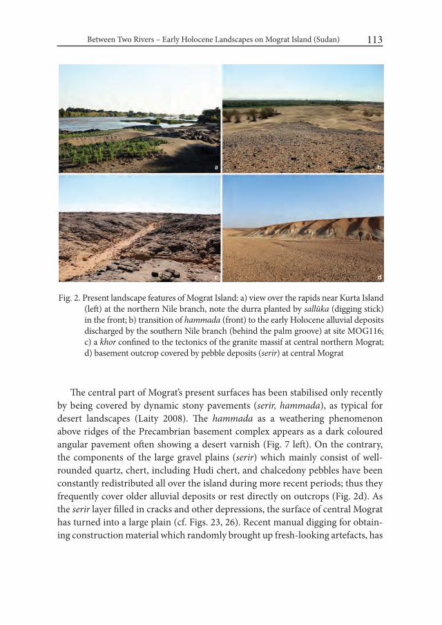
Between Two Rivers – Early Holocene Landscapes on Mograt Island (Sudan) 113
The central part of Mograt’s present surfaces has been stabilised only recently by being covered by dynamic stony pavements (serir, hammada), as typical for desert landscapes (Laity 2008). The hammada as a weathering phenomenon above ridges of the Precambrian basement complex appears as a dark coloured angular pavement often showing a desert varnish (Fig. 7 left). On the contrary, the components of the large gravel plains (serir) which mainly consist of well-rounded quartz, chert, including Hudi chert, and chalcedony pebbles have been constantly redistributed all over the island during more recent periods; thus they frequently cover older alluvial deposits or rest directly on outcrops (Fig. 2d). As the serir layer filled in cracks and other depressions, the surface of central Mograt has turned into a large plain (cf. Figs. 23, 26). Recent manual digging for obtain-ing construction material which randomly brought up fresh-looking artefacts, has
Fig. 2. Present landscape features of Mograt Island: a) view over the rapids near Kurta Island (left) at the northern Nile branch, note the durra planted by sallūka (digging stick) in the front; b) transition of hammada (front) to the early Holocene alluvial deposits discharged by the southern Nile branch (behind the palm groove) at site MOG116; c) a khor confined to the tectonics of the granite massif at central northern Mograt; d) basement outcrop covered by pebble deposits (serir) at central Mograt

Annett Dittrich114
further dotted this plain with huge fields of pits. During all prehistoric periods, the pebbles have been employed as raw materials for the knapping of lithic tools (cf. Dittrich et al. 2015, tab. 6).
1.2 Site preservationIn the course of the survey it proved useful to record the relationship between
site formation, surface type, the relative height according to the Nile level as well as the density and structure of artefacts as the main parameters of site preservation. It seems appropriate to describe the sites from the angle of different surface types including the granite outcrops, the pebble or hammada plains, as well as the al-luvial silt and sand deposits at the Nile terraces (Dittrich and Gessner 2014, tab. 1; Dittrich et al. 2015, tab. 5). One reason for this is that the capability of the listed environments to hold stratigraphic information as well as to preserve ecofacts and artefacts differs extremely.
Given that Mograt appears flat and largely featureless without any significant mound or hill, late prehistoric sites are mainly defined by artefact and ecofact concentrations in plain areas or at older terraces sometimes covered by alluvial deposits. Different states of site preservation as observed for various parts of the island can be explained by differing erosional patterns in connection with prevail-
Fig. 3. Mograt Island, al-Saihan. The characteristic ‘woolsack’ granite boulders carved with animals, humans, boats and symbols some of which may date back to prehistory, to the right a more recent rock-gong

Between Two Rivers – Early Holocene Landscapes on Mograt Island (Sudan) 115
Fig. 4. Finds and sediments are trapped in hollows inside the bedrock which occurs just below the surface at a test trench close to the northern Nile bank (MOG114)
ing wind directions, channelling through surface water and the ongoing exposure of the more durable basement or cemented terraces from which soils and finds were often washed down. To distinguish sites worth a more detailed investigation we were mainly looking for the presence of large immobile artefacts like grinding bases or handmills carved into rock surfaces that hint to former settlement activi-ties and are not just relocated material, or single finds.
Despite this objective, the relocation of prehistoric artefacts is a common phe-nomenon on Mograt Island. Recent geomorphological research has provided in-sights into the complex modifications of the landscape along the northern Nile bank where the preservation of sites is extremely poor (Dittrich et al. 2015: 133). There the hard rocks of the basement stand out as highly weathered ridges (yar-dangs) parallel to the river, while through wind abrasion as the most important erosional factor in the place the shallow valleys in between are emptied. Addition-ally, surface water as well as the northward draining wadis seem to be responsible for the washing of most of the artefacts along with softer sediments down the northward slope of the river bank. Larger particles and artefacts, however, have been sometimes piled up at the leeward side of the ridges that formed natural

Annett Dittrich116
barriers to this movement (Fig. 4). Taken to its extremes, artefact concentrations resting directly on the bedrock cannot be studied by the method of excavation anymore (e.g. site MOG124, Dittrich et al. 2015, Fig. 22). As a result prominent sites do exist in certain places where – often secondary, yet somehow stabilised – artefact accumulations and favourable topographic conditions protecting them from wind and water activity converge which, however, does not necessarily reflect the full range of sites and their spatial extents or inter-site relationships in the past.
1.3 Mapping Mograt’s antiquityMograt Island appears first on Western maps of the early 19th century when
the travel route through the Nubian Desert to enter the Nile valley again at Abu Hamed became an alternative to the crossing of the Bayuda desert (Ritter 2014). Mograt can be thought of as divided into three parts (Fig. 1): western Mograt the landmass of which very much narrows towards the tip of Ras al-Jazira, central Mograt with the rock art site of al-Saihan at the northern bank and large alluvial plains at the southern bank (e.g. al-Jaraif), and eastern Mograt which includes the characteristic bend of the island and the main town of Maqall. The latter part ap-pears as the actual cataract area on early maps (Chélu 1891, pl. 8).
One of the main study interests of the Late Prehistoric Survey project is the former human interaction with past landscapes which involves the access to its relics in the present landscapes. As landscapes we understand not only the is-land’s specific topography or geology, or, more generally, nature and its capabil-ity to transform over time. Landscapes are always social constructions, providing cultural-spatial orders for humans, animals and plants as well as for the deceased and for the spirits. This order is established by defining living spheres with vari-ous rights and resources, transitional spheres such as tracks and rivers, or spheres of memory that can also act as liminal spheres to access transcendental forces (e.g. rock art sites, specific rock formations, burial sites). All of these spheres are actively created and maintained by a society. As humans have probably never entered an ‘empty’ landscape, during each period new links between humans and their environments were imposed on existing links. In this sense, landscapes do not only constitute palimpsests in an ideological way – meaning the cultural su-perimposition of various rights and rules ‒ but also palimpsests in a strict mate-rial way – the superimposition of material remains (artefacts, ecofacts) of various periods and activities (cf. Bailey 2007).

Between Two Rivers – Early Holocene Landscapes on Mograt Island (Sudan) 117
For the practical determination of the past insular landscapes it is also neces-sary to have a look at the maximum Holocene Nile level. The present level of the southern Nile branch is 302‒305 m a.s.l. before inundation at western Mograt according to Google Earth terrain data. From the deposits recorded so far (see below) it can be assumed to have reached at least 12 m above the present level. A graphical simulation of the maximum Nile level for the late Pleistocene and early Holocene periods was created by using a Digital Elevation Model based on SRTM data (Fig. 5). It can be noticed that the colouring of the Holocene alluvial basin gradually changes from light in the east to dark in the west which reflects the rapid fall of the river level. By the rise of the Nile level the liveable part of the island would have be limited to its core that rises another 20.0 m above this level, but by the activation of the palaeochannel marked by the Wadi al-Firsib Mograt Island became divided into two major palaeoislands (Fig. 6 lower, left). While as-suming a maximum Nile level of 320 m a.s.l., the smaller southern palaeoisland would have still extended over an area of 5.2 km², but together with the larger palaeoisland (36.5 km²) the landmass significantly shrank to roughly 40 per cent of Mograt’s present dimensions.
Currently the dry course of the Wadi al Firsib is turned into fields thanks to a large-scale irrigation scheme. On the northern limits there are numerous gran-
Fig. 5. Mograt Island. Maximum Holocene Nile level simulation assuming the alluvial plain to be extended to a height of 315‒320 m, the gradual change of colours to dark to the west is due to the rapid fall of the river level to this direction (data based on SRTM)
Annett Dittrich118
ite outcrops which bear traces of a former cataract-like landscape. When com-pared to the maximum Nile level simulation all of the late prehistoric sites located in the vicinity of the Wadi al-Firsib are clearly lying within the limits of the two palaeoislands (Fig. 6, lower, left). Additionally, the four sites on the northern side of the palaeochannel indicate a horizontal stratigraphy, with the most southern one being the most recent one (late Neolithic), suggesting that the wadi gradu-ally ceased to flow during the mid-Holocene (Dittrich and Gessner 2014, Fig. 1). However, to further reconstruct the prehistoric landscapes of Mograt and to study the chronology of events that shaped them in greater detail it is necessary to focus on much smaller areas and site clusters.
2. Study area I: Eastern MogratIf the focus is set to the al-Karmal plateau as the major basement ridge of
the southern palaeoisland it becomes obvious that the late prehistoric sites are located on the highest part of the plateau overlooking the alluvial plain by about 5 metres (Fig. 6). The surface of the plateau is densely covered by the detritus of
Fig. 6. Mograt Island, eastern part. Early to mid-Holocene sites at the al-Karmal plateau (right) according to local elevation (top, left) which in the Nile level simulation marks the shoreline of the southern palaeoisland (lower, left; sites are marked in white) (local DEM: G. Rees)

Between Two Rivers – Early Holocene Landscapes on Mograt Island (Sudan) 119
the metamorphic basement, mainly gneiss and schist, as well as patinated quartz gravel forming together a dark-coloured hammada pavement. Over a large area this pavement is mixed with artefacts of various prehistoric periods. The finds are more densely concentrated at the sites MOG027/MOG033, MOG029 and MOG0646 (Fig. 6), but since they are very close they can hardly be considered as separate settlements.
Today, the most characteristic landscape feature are the numerous tumuli which are strewn over the plateau and excavated and studied within the scope of the sub-project ‘Bronze Age burial sites’ (Schulz 2008; Weschenfelder and Rees 2014; Weschenfelder 2015a, 2015b). As prehistoric artefacts are regularly present in the fill of the tumuli’s superstructures, their construction must have caused considerable disturbance of older occupational remains. Additionally, the varying degree of patination on excavated slab stones which marked some of the tombs indicates the former level of soil cover.
6 The former were recorded during the H.U.N.E. 2006 season (Näser 2006; Lange 2012) while MOG064 was recorded and test-excavated during the H.U.N.E. 2008 season (Näser 2008; Schulz 2008).
Fig. 7. Mograt Island, al-Karmal plateau. Trenches 2008-1 and 2008-2 at MOG064 during excavation (photos: R. Schulz)

Annett Dittrich120
Fig. 8. Mograt Island, al-Karmal plateau. Section and plana sequence at the two geological test trenches 2014-93/59 and 2014-100/50 (photos: J. Schäfer)
Between Two Rivers – Early Holocene Landscapes on Mograt Island (Sudan) 121
Table 1. Radiocarbon dates available for late prehistoric sites at Mograt Island
site/sample no.
material/species
context height above
local NN in m
lab no. conven-tional
14C age
calibrated 14 C age
(2nd sigma)
calibrated 14 C age
(1st sigma, rounded)
MOG000-33
shell of La-nistes sp. (mature)
WP 189 0 Poz-75369 7590 ± 50 BP
6570–6374 calBC
6480–6410 calBC
MOG064-22
shell of Pila sp.
trench 1, sq. 32/83,
pl. 3-4, cont. 1
-0.20–0.40 Poz-63632 6870 ± 50 bp
5877–5661 calBC
5830–5710 calBC
MOG064-21
shell of Li-micolaria cailliaudi
trench 1, sq. 32/82,
pl. 3
-0.20–0.30 Poz-63630 7325 ± 35 bp
6245–6077 calBC
6230–6100 calBC
MOG064-10
shell of bivalve/
Aspatharia sp. ?
trench 2, sq. 27/68,
pl. 2
-0.10–0.20 Poz-63628 8300 ± 35 bp
7484–7192 calBC
7450–7320 calBC
MOG064--SF01
ostrich eggshell
bead frag-ment
trench 2, sq. 28/67,
pl. 3
-0.20–0.30 Poz-62767 9060 ± 50 bp
8427–8208 calBC
8300–8250 calBC
MOG064-13
shell of Zootecus insularis
trench 2, sq. 29/67,
pl. 2
-0.10–0.20 Poz-63629 18630 ± 80 bp
20753–20385 calBC
20600–20450 calBC
MOG102-26-11-2
shell of Etheria elliptica
trench 1, sq. C, pl. 0–10 cm
-0.10 Poz-75231 6515 ± 35 BP
5549–5377 calBC
5530–5470 calBC
MOG102-26-2
ostrich eggshell
workpiece fragm.
trench 1, sq. D,
pl. 10–20 cm
-0.10–0.20 Poz-75368 6530 ± 40 BP
5609–5381 calBC
5530–5470 calBC
MOG105-25-2-2
shell of Pila sp.
(mature, large)
trench 1, extension (grey se-diment)
-0.10–0.80 Poz-72519 6440 ± 40 BP
5479–5331 calBC
5470–5380 calBC
Annett Dittrich122
site/sample no.
material/species
context height above
local NN in m
lab no. conven-tional
14C age
calibrated 14 C age
(2nd sigma)
calibrated 14 C age
(1st sigma, rounded)
MOG105-24-6-1
shell of Lanistes
sp. (imma-ture)
trench 1, sq. C,
pl. 0–10 cm
-0.10 Poz-72516 6540 ± 40 BP
5613–5386 calBC
5530–5480 calBC
MOG105-24-8
ostrich eggshell
bead frag-ment
trench 1, sq. D,
pl. 0–10 cm
-0.10 Poz-72515 6650 ± 40 BP
5639–5511 calBC
5620–5550 calBC
MOG105-25-2-1
shell of Bellamya unicolor
(?)
trench 1, extension (grey se-diment)
-0.10–0.80 Poz-72518 7190 ± 40 BP
6205–5989 calBC
6080–6010 calBC
MOG105-24-6-2
shell of Zootecus insularis
trench 1, sq. C,
pl. 0–10 cm
-0.10 Poz-72517 8060 ± 50 BP
7176–6815 calBC
7120–6840 calBC
MOG107-05
shell of Lanistes
sp.
silt stra-tigraphy,
north wall
2.54 Poz-63636 8975 ± 35 BP
8291–7984 calBC
8270–8020 calBC
MOG107-02
shell of Lanistes
sp.
silt stra-tigraphy,
south wall
2.23 Poz-63633 9030 ± 40 BP
8300–8213 calBC
8280–8250 calBC
MOG107-04
shell of Cleopatra bulimo-
ides
silt stratigra-
phy, lb 2, north
wall
2.33–2.43 Poz-63634 9680 ± 40 BP
9261–8856 calBC
9250–8960 calBC
MOG116-35-2
shell of Nile bivalve (indet.)
SE sec-tion, m 20
3.33 Poz-72520 9800 ± 50 BP
9360–9200 calBC
9300–9250 calBC
Between Two Rivers – Early Holocene Landscapes on Mograt Island (Sudan) 123
2.1 The al-Karmal plateau sites (MOG064, MOG027)In 2008, two test trenches have been excavated at the site MOG064 (Fig. 7;
Schulz 2008). Trench 2008-1 covered 4 by 4 squares and a total area of 16 m². While trench 2008-2 reached only half of this size it produced the major part of finds of altogether more than 5000 lithic artefacts, 400 potsherds as well as few grinders, ostrich eggshell beads, mollusc shells and heavily fragmented ani-mal bones. Since also Middle Palaeolithic artefacts were among the lithics it was thought that the site could provide a clear stratigraphy (Schulz 2008).
The aim of the 2014 survey season was to (1) verify the presence and density of Palaeolithic and early to mid-Holocene finds, (2) study the geomorphology of the plateau as well as (3) assess its capability to provide a stratigraphic rela-tion of Palaeolithic and Holocene finds. Several test trenches of the size of 1 x 1m were excavated in the vicinity to study the stratigraphy of the area (Fig. 8).7 At the H.U.N.E. site MOG027 systematic surface find mapping (71 m²) and collection (39 m²) were conducted to study the full range of artefacts dating from the Middle Palaeolithic to the Kerma period (Dittrich and Gessner 2014: 134f., Fig. 3-4). Fur-thermore, during the 2014/15 season soil samples have been taken out of the still visible trenches at MOG064.
When the top hammada layer was removed in each of the geological test trenches, a silt layer of aeolian origin appeared. Characteristically it shows a co-lumnar structure due to shrinking processes which are comparable to loess (Laity 2008: 164‒165). These silts cover just the upper 8 cm, and rest directly on top of heavily weathered bedrock (Fig. 8). The consistence of the latter varies to a large degree but there is a zone of at least up to 40 cm below the surface where it is quite brittle and weathered to the size of silt, sand and gravel, additionally mixed with wind-blown and water-rolled material.8 As the hammada’s development oscillates between deflation, surface wash through rains, as well as aeolian sedimentation (Laity 2008), it fosters the vertical movement of artefacts resulting in statistical bi-ases when excavated in stratigraphic layers. In the excavated trenches 2008-1 and 2008-2 there was a high amount of surface finds due to uplifting processes, con-trasting with few or even absent finds at the aeolian silt layer, deeper down again followed by increasing frequencies. As the decay of the basement progresses from the top down, the separated lower finds get buried more deeply over time, in case
7 Test excavations as well as the study of Palaeolithic artefacts were carried out by J. Schäfer, Berlin (Schäfer, unpublished report).
8 Next to the camp house at al-Karmal a trench for a pit drainage was dug into the brittle bed-rock which was easily removed by means of a toria down to a depth of approximately 6 m.

Annett Dittrich124
of trench 2008-1 down to 70 cm, while at trench 2008-2 artefacts ceased already at a depth of 30 cm. For trench 2008-1 the excavators described a ‘cultural layer’ which consisted of loose sediment with traces of secondary burning on potsherds (Fig. 10: GE15; cf. Schulz 2008: 58, Fig. 6). Most clearly it occurred as the fill of a pit roughly 45 cm in diameter (Fig. 7 right) from which a shell was dated (Tab. 1: MOG064-22). As it was later confirmed through the excavation of grave pits in the vicinity, such artificial diggings but also natural cracks are capable to act as sediment traps. However, the dry sieving of two sediment samples from the pit at trench 2008-1 gave no indication of charcoal or any other macroremains.
The micromorphological and geochemical analysis of two soil samples taken in 2014 proved a very high mineral content mostly of minerals of igneous origin of the basement, and besides that, organic contents as well as traces of bioturbation.9 In large contrast to the actual environment, the organic contents indicate a former dense vegetation cover. Also the observed bioturbational features must have result-ed from biological activities in more humid conditions. The presence of iron oxide pedofeatures, a product of wetting and drying, further supports this suggestion. From this we would conclude that the hammada is one of the oldest surfaces pres-ent at Mograt characterised by the constant decay of bedrock and subsequent defla-tion of former top soils of which only very few components still persist. While the hammada surface contains an interesting and wide chronological spectrum of finds it does not provide sediments directly linked to one of the archaeological periods in question. In fact, Holocene stratigraphy seems largely absent. Nevertheless the sites are important archives storing a palimpsest of different events the exact order of which remains stratigraphically so far unknown. With this in mind, we tried to tackle the local chronology of palaeoenvironmental and cultural events by (1) es-tablishing a radiocarbon data series as well as by (2) studying typological features of lithics that allow for a diachronic assessment of the local knapping strategies.
During excavation, numerous conchifera shells have been found that could be employed for the purpose of radiocarbon dating (Tab. 1).10 Landsnails such as Zoo-tecus sp. and Limicolaria sp. hint to the former presence of humic soils and grassland and have been dated to the 21st and 7th millennium BC. The late Pleistocene dating
9 This analysis was carried out by S. Neogi, Cambridge (Neogi, unpublished report).10 The impact of the hard water effect remains unclear. The similar dates of MOG102 for terrestrial
material (ostrich eggshell) and an aquatic species (Etheria elliptica) suggest it to be negligible or at least consistent on a regional level (Tab. 1: MOG102-26-2 and MOG102-26-11-2). However, it must be kept in mind that it could cause dates to appear up to 400 older than dates run accord-ing to the laboratory standard, i.e. that of charcoal (see discussion in Dittrich 2011: 51-53, 56).
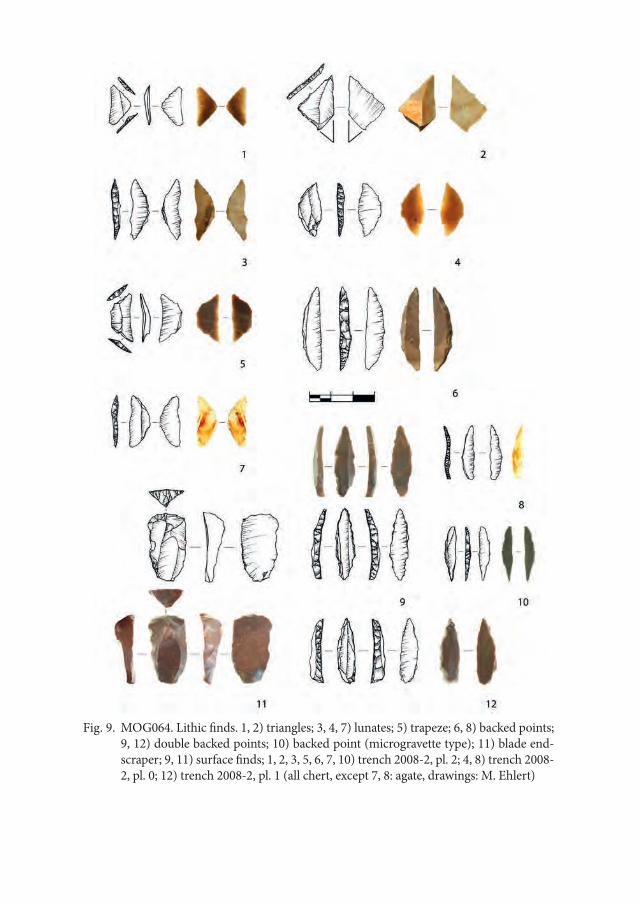
Fig. 9. MOG064. Lithic finds. 1, 2) triangles; 3, 4, 7) lunates; 5) trapeze; 6, 8) backed points; 9, 12) double backed points; 10) backed point (microgravette type); 11) blade end-scraper; 9, 11) surface finds; 1, 2, 3, 5, 6, 7, 10) trench 2008-2, pl. 2; 4, 8) trench 2008-2, pl. 0; 12) trench 2008-2, pl. 1 (all chert, except 7, 8: agate, drawings: M. Ehlert)
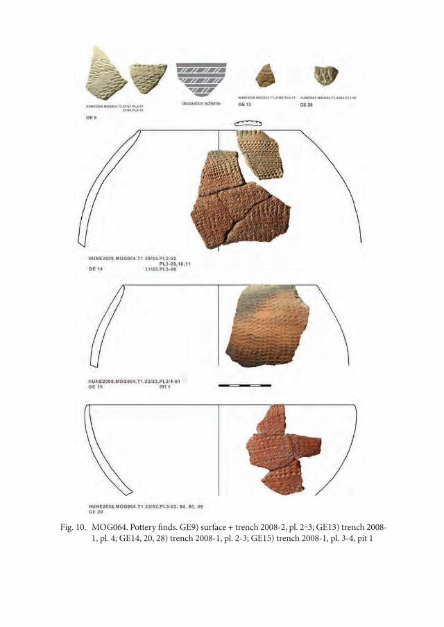
Fig. 10. MOG064. Pottery finds. GE9) surface + trench 2008-2, pl. 2‒3; GE13) trench 2008-1, pl. 4; GE14, 20, 28) trench 2008-1, pl. 2-3; GE15) trench 2008-1, pl. 3-4, pit 1
Between Two Rivers – Early Holocene Landscapes on Mograt Island (Sudan) 127
of Zootecus sp. from planum 2 at trench 2008-2 would underline that relics of this period further suggested by traits of blade technology are indeed present. Human activity is attested by ostrich eggshell bead manufacture dated to about 8,300–8,250 calBC which must have been a period when the Nile level reached one of its maxima and the plateau became attractive as settlement area. This is corroborated by ob-servations at western Mograt (see below). It is assumed that a significant amount of the lithic finds among them the backed point tradition frequently found at the plateau should be dated to that period. These tools are indicators to hunting in the open savannah. After these events, human activity is indirectly dated through a Nile mussel that must have been brought to this spot around 7450–7320 calBC. From the pit feature at trench 2008-1, containing rocker-stamped pottery and undiag-nostic flakes, Pila sp. shells were dated to 5830–5710 calBC. Since these shells stem only from adult specimen, they were selectively collected and probably deposited as kitchen refuse. Human presence is finally dated through three charcoal samples to about 3020–2900 calBC (Weschenfelder and Rees 2014: 153). These charcoal finds derive from a grave pit filling in one of the late Neolithic graves excavated in 2014 (see also Weschenfelder 2015a).
The diagnostic lithic artefacts are mostly made from chert reaching high pro-portions of 60%, sometimes also from agate (c. 7%), and other more opaque stone varieties.11 The proportion of quartz is relatively low (19.5%) when compared to other sites at Mograt Island. The tools made from chert and agate comprise end-scrapers on blades (Fig. 9.11), backed points (Fig. 9.6, 8, 10), double backed points (Fig. 9.9, 12), lunates (Fig. 9.3, 4, 7), triangles (Fig. 9.1, 2) and trapezes (Fig. 9.5), retouched blades as well as different types of perforators and scrapers. The char-acteristic endscrapers on thick blades would rather point to an Upper or Late Palaeolithic date. Their occurrence is consistent with that of few blades exceed-ing microlithic dimensions as well as of cores showing a more developed scheme of preparation and reduction. The latter pertains also to a number of backed tools. The tanged backed point (Fig. 9.10) which typologically resembles a micro-gravette or Sauveterre point (Barrière et al. 1969) as well as the long backed points should be assigned a Late Palaeolithic date or very early date within the Holocene sequence. Differently from this tradition, the occurrence of geometric microliths might correspond to the human presence dated by shells to the late 8th millennium calBC. Besides the indicators for the Upper and Late Palaeolithic, there is also
11 Statistics and drawings of the lithic finds were done by M. Ehlert, Wrocław; the publication is in preparation.
Annett Dittrich128
a constant proportion of up to 4% of Middle Palaeolithic finds, represented by Le-vallois cores and flakes struck from chert pebbles.12 Discoid cortex platform cores, cortex backed flakes turned into borers as well as irregular and concave scrapers are assumed to date from the Neolithic period.
The pottery fragments from the surface of the trenches were usually very small and eroded. Out of the larger fragments from the excavated levels jars and bowls can be reconstructed (Fig. 10: GE14, 15, 20), while few fragments belonged to pointed bases. Refittings of fragments from different plana were common. The presence of mica temper was always associated to that of rocker stamp decora-tion (Fig. 10: GE14, 20) and corresponding rim decorations include herringbone patterns as well as simple parallel strokes. Few small and reworked fragments of a quartz tempered fabric showed an incised wavy-line decoration (Fig. 10: GE13) indicating that these finds might have been deposited during earlier periods. 39 fragments ‒ one of them clearly points to the reconstruction as a carinated vessel type ‒ belonged to a fine sandy fabric bearing a banded decoration (Fig. 10: GE9). This decoration consists of small zigzags executed with a plain edge tool. Plain zigzags occurred also in another variety (Fig. 10: GE28). The fine grey fab-ric reminds of that of similar carinated bowls excavated in the area of the Fourth Cataract and also the way of combining horizontal with diagonal bands is known from there (Dittrich et al. 2007, Fig. 1.14, 15; 2.8).
From the pottery finds in the vicinity, namely from site MOG027, further patterns are known such as incised wavy-line which appears in banded patterns rather than as complete fillings (Dittrich and Gessner 2014, Fig. 20.1‒3). Other patterns include the so-called wolf-tooth decoration which is actually a variety of plain zigzags (ibid. Fig. 20.5, 9), double-pronged tool impressions (ibid. Fig. 20.8) and a peculiar pattern which we would preliminary call ‘fish-scale’ (ibid. Fig. 20.7) and which is so far known only from the Fifth Cataract area (cf. Alkhi-dir, this volume). It was probably made by means of a roulette. Concluding also from the presence of different fabrics, these decorations are suggested to date from the Mesolithic to late Neolithic periods.
To sum up, the al-Karmal plateau bears the chronological record of several prehistoric events when human interest was directed to this elevated spot which
12 As this proportion does not vary between surface finds and that of trench 2008-1 it is likely that MOG064 does not bear an in situ Middle Palaeolithic knapping site (as supposed by Schulz 2008: 58), but Levallois cores and flakes might have been collected during the Holo-cene together with other raw materials brought from the pebble plains or wadi beds to the site. There are clear traces of re-use on Levallois artefacts (Ehlert, unpublished report)
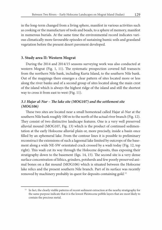
Between Two Rivers – Early Holocene Landscapes on Mograt Island (Sudan) 129
in the long-term changed from a living sphere, manifest in various activities such as cooking or the manufacture of tools and beads, to a sphere of memory, manifest in numerous burials. At the same time the environmental record indicates vari-ous climatically more favourable episodes of sustaining humic soils and grassland vegetation before the present desert pavement developed.
3. Study area II: Western Mograt During the 2014 and 2014/15 seasons surveying work was also conducted at
western Mograt (Fig. 1, 11). The systematic prospection covered full transects from the northern Nile bank, including Kurta Island, to the southern Nile bank. Out of the mappings there emerges a clear pattern of sites located more or less along the river banks and of a second group of sites located along the main crest of the island which is always the highest ridge of the island and still the shortest way to cross it from east to west (Fig. 11).
3.1 Hajar al-Nur – The lake site (MOG107) and the settlement site (MOG106)
These two sites are located near a small homestead called Hajar al-Nur at the southern Nile bank roughly 100 m to the north of the actual river branch (Fig. 12). They consist of two distinctive landscape features. One is a very well preserved alluvial mound (MOG107, Fig. 13) which is the product of continued sedimen-tation at the early Holocene alluvial plain or, more precisely, inside a basin once filled by an ephemeral lake. From the contour lines it is possible to preliminary reconstruct the extensions of such a lagoonal lake limited by outcrops of the base-ment along a wide NE-SW orientated crack crossed by a wadi today (Fig. 12, top right). This wadi cut its way through the Holocene deposits, thus exposing their stratigraphy down to the basement (figs. 14, 15). The second site is a very dense surface concentration of lithics, grinders, potsherds and few poorly preserved ani-mal bones on a flat mound (MOG106) which is situated between the Holocene lake relics and the present southern Nile branch. Part of its surface was recently removed by machinery probably in quest for deposits containing gold.13
13 In fact, the clearly visible patterns of recent sediment extraction at the nearby stratigraphy for the same purpose indicate that it is the lowest Pleistocene pebble layers that are most likely to contain the precious metal.
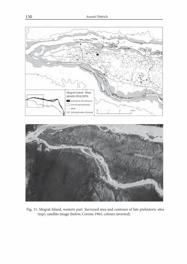
Annett Dittrich130
Fig. 11. Mograt Island, western part. Surveyed area and contours of late prehistoric sites (top), satellite image (below, Corona 1965, colours inverted)

Between Two Rivers – Early Holocene Landscapes on Mograt Island (Sudan) 131
During the first season the stratigraphy of MOG107 was recorded in detail over a height of 3.50 m (Fig. 15; cf. Dittrich and Gessner 2014: 138ff.). From the stratigraphic observations two distinct phases of sedimentation were evident and could be roughly associated with the early Holocene and the Pleistocene or earlier periods. In the lower part it revealed gravels and sands of an older Nile terrace that contained few rolled Palaeolithic artefacts (Fig. 15.H‒L). As a major discontinu-
Fig. 12. Mograt Island, western part. Satellite image with the location of the sites MOG106/107 and MOG116 along the southern Nile branch (Google Earth) and the assumed extension of the early Holocene lake (top, right)
Fig. 13. Panorama view of sites MOG107 (silt bar, centre) and MOG106 (right, in front of the car) enclosed by a wadi bed, behind the trees to the right flows the southern Nile branch
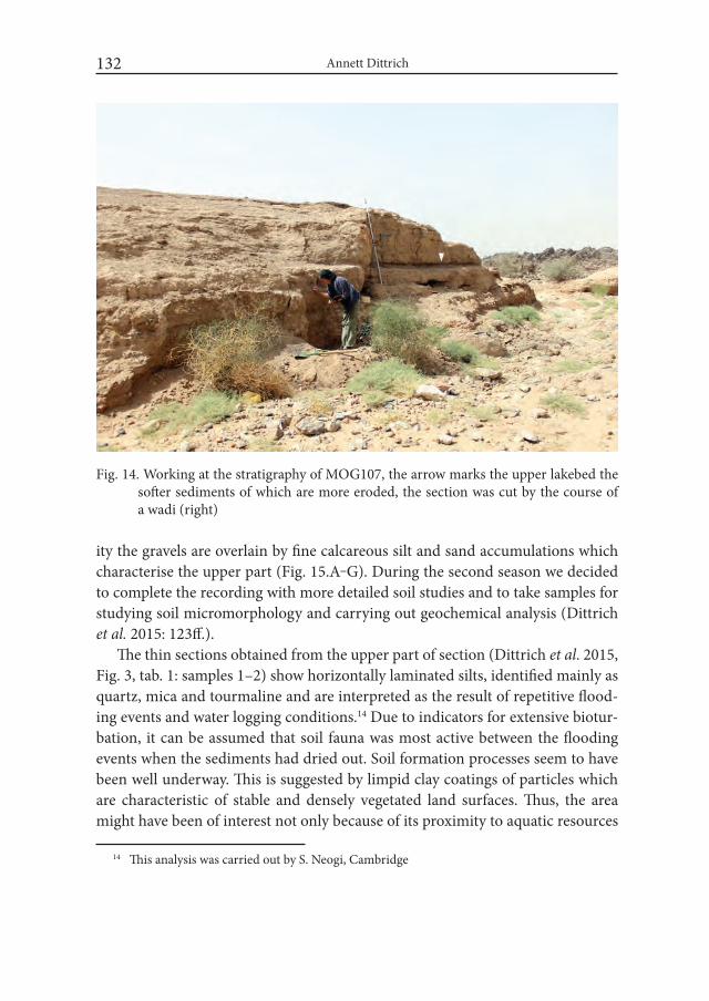
Annett Dittrich132
ity the gravels are overlain by fine calcareous silt and sand accumulations which characterise the upper part (Fig. 15.A‒G). During the second season we decided to complete the recording with more detailed soil studies and to take samples for studying soil micromorphology and carrying out geochemical analysis (Dittrich et al. 2015: 123ff.).
The thin sections obtained from the upper part of section (Dittrich et al. 2015, Fig. 3, tab. 1: samples 1–2) show horizontally laminated silts, identified mainly as quartz, mica and tourmaline and are interpreted as the result of repetitive flood-ing events and water logging conditions.14 Due to indicators for extensive biotur-bation, it can be assumed that soil fauna was most active between the flooding events when the sediments had dried out. Soil formation processes seem to have been well underway. This is suggested by limpid clay coatings of particles which are characteristic of stable and densely vegetated land surfaces. Thus, the area might have been of interest not only because of its proximity to aquatic resources
14 This analysis was carried out by S. Neogi, Cambridge
Fig. 14. Working at the stratigraphy of MOG107, the arrow marks the upper lakebed the softer sediments of which are more eroded, the section was cut by the course of a wadi (right)
Between Two Rivers – Early Holocene Landscapes on Mograt Island (Sudan) 133
Fig. 15. MOG107. Stratigraphic record with the positions of radiocarbon dated mollusk shells and of a singular tool find

Annett Dittrich134
but also to plants growing during interim episodes. As post-depositional events, redoximorphic features such as iron mottles indicate a fluctuating water table later followed by the drying-up which led to the subsequent precipitation of calcium carbonate. Embedded within the silts were two dark brown layers with higher organic content (Dittrich et al. 2015, tab. 1: sample 2) which were interpreted as lakebeds (Fig. 15.E, G). This was further suggested by the inclusion of mollusc shells.
These shells have been attributed to the freshwater snail species Cleopatra bu-limoides (Fig. 15), the carinated shells of which strongly point to the prevalence of lacustrine environments (Van Damme 1984: 23; Tothill 1946: 160, Fig. 9). The other identified species is the apple snail Lanistes sp. which is a typical inhabitant of alluvial plains grown with an acacia-tall-grass community and being flooded for a significant part of the year (Tothill 1946: 159). Thus, the radiocarbon dates of the respective shells indicate two events dated to 9250‒8960 calBC suggesting more permanent lacustrine environments and to 8270‒8020/8280‒8250 calBC pointing to seasonal flooding of the lake followed by the fast growth of grasses. Interestingly, the Lanistes sp. date closely matches that of an ostrich eggshell bead excavated at the al-Karmal plateau at eastern Mograt (Tab. 1: MOG064-SF01). Therefore, one of the objectives of the 2014/15 season was to search for a strati-graphic connection between the early Holocene lake (MOG107) and the nearby settlement (MOG106) and to identify artefact types dating from that period out of the mixed find assemblage.
During the second season several trench sections along an axis of altogether 41 m were excavated to provide a section through the mound of MOG106 on which the majority of surface finds is resting (figs. 16, 17; Dittrich et al. 2015: 126ff.). One important question is whether the mound could have supported a shoreline habitation close to the lake, since the present height of the mound (c. 9.4 m above present Nile level) appears much lower than the highest lake level as indicated by the preserved height of silty deposits (c. 10.7 m above the present Nile level).
Indeed, at the lakeside end of trench 1, the two significant lakebed strata of the adjacent site MOG107 were again identified, with upper limits of c. 8.7 m and c. 9.0 m above the present Nile level (Fig. 17 left). They gradually slope to the north towards the centre of the lake basin. Combining the evidence of the four excavat-ed sections, the mound is part of an older Nile terrace probably of Pleistocene age and consists of hard deposits such as calcified silts and sands as well as cemented pebble layers that rest on the local basement. If the early Holocene lake and the
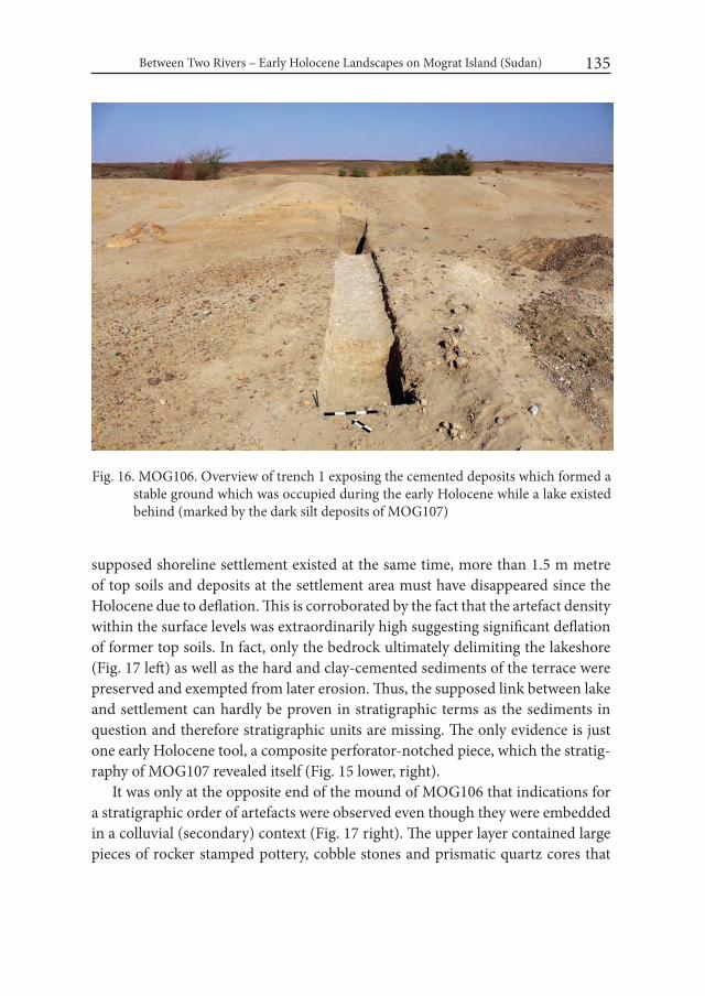
Between Two Rivers – Early Holocene Landscapes on Mograt Island (Sudan) 135
Fig. 16. MOG106. Overview of trench 1 exposing the cemented deposits which formed a stable ground which was occupied during the early Holocene while a lake existed behind (marked by the dark silt deposits of MOG107)
supposed shoreline settlement existed at the same time, more than 1.5 m metre of top soils and deposits at the settlement area must have disappeared since the Holocene due to deflation. This is corroborated by the fact that the artefact density within the surface levels was extraordinarily high suggesting significant deflation of former top soils. In fact, only the bedrock ultimately delimiting the lakeshore (Fig. 17 left) as well as the hard and clay-cemented sediments of the terrace were preserved and exempted from later erosion. Thus, the supposed link between lake and settlement can hardly be proven in stratigraphic terms as the sediments in question and therefore stratigraphic units are missing. The only evidence is just one early Holocene tool, a composite perforator-notched piece, which the stratig-raphy of MOG107 revealed itself (Fig. 15 lower, right).
It was only at the opposite end of the mound of MOG106 that indications for a stratigraphic order of artefacts were observed even though they were embedded in a colluvial (secondary) context (Fig. 17 right). The upper layer contained large pieces of rocker stamped pottery, cobble stones and prismatic quartz cores that

Annett Dittrich136
Fig.
17.
MO
G10
6, tr
ench
1, S
E se
ctio
n. St
ratig
raph
ic re
latio
n be
twee
n th
e ear
ly H
oloc
ene s
ettle
men
t are
a and
the r
adio
carb
on d
ated
al
luvi
al d
epos
its at
nei
ghbo
urin
g sit
e M
OG
107
(left)
; the
ver
tical
bar
s abo
ve th
e se
ctio
n m
ark
the
freq
uenc
y of
lith
ic fi
nds must have been brought there from nearby rock
fields (Dittrich et al. 2015, Fig. 7). This find assem-blage appears very similar to that of the stratified Neolithic layer of site MOG116 (see below). By contrast, the lower layer contained small blades and microlithic implements made from chert. Chert artefacts – often clearly exceeding micro-lithic dimensions of 3 cm –, namely narrow blades and backed implements as well as elongated single platform cores were also frequent at the middle part of the slope (Fig. 17 centre), where they had most probably weathered out of an older layer (Dittrich and Gessner 2014, Fig. 21: 1, 4–7, 22; Dittrich et al. 2015, Fig. 8). Judging from the sample of a test trench, however, the majority of lithics were made from quartz (c. 68%) suggesting a chronological shift in raw material preferences. The detailed study of artefacts will be the scope of further research. As a preliminary assumption, the two different lithic strategies could signify two different subsistence strategies, changing from a lakeshore occupation during the early Holocene to a Nile terrace occupation close to arable soils during the mid-Holocene after the lake had finally dried up (Dittrich, in prep.).
3.2. Gharghara – The stratigraphy (MOG116)In a distance of only about 2 km from
MOG106/MOG107 a second stratigraphy provid-ing an extensive Quaternary record resting on the Precambrian basement was located (Figs. 12, 18). The site lies at the mouth of a wadi near the single homestead named Gharghara15, approximately
15 ‘Gharghara’ (arab.) means the noise of the water in a current when flowing between stones and is related to the English word ‘to gurgle’ or the German ‘gurgeln’.
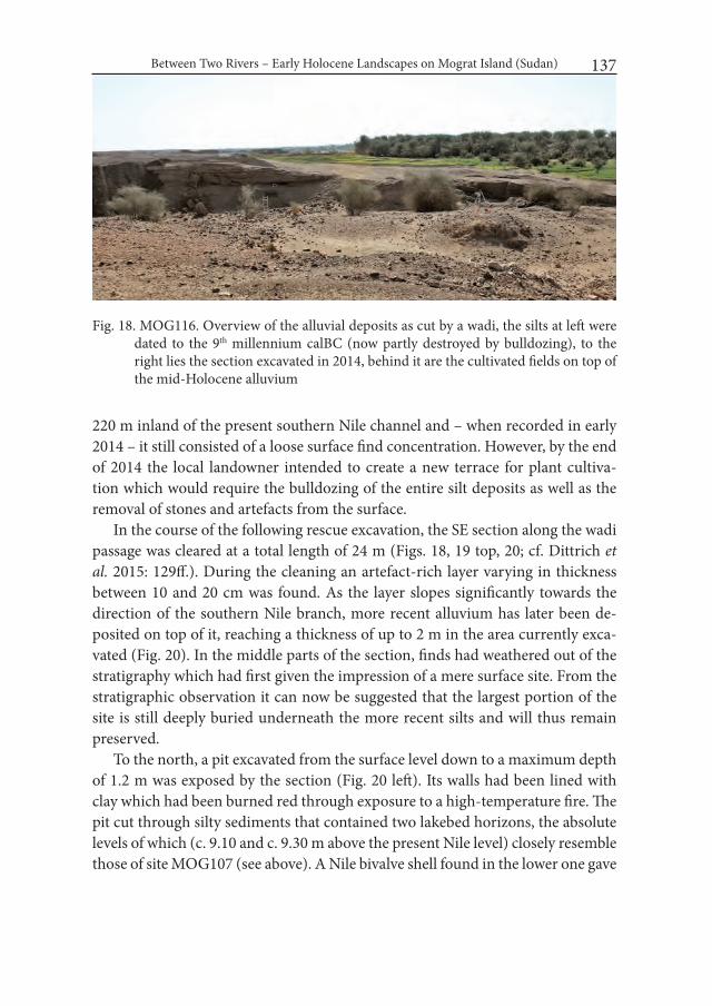
Between Two Rivers – Early Holocene Landscapes on Mograt Island (Sudan) 137
Fig. 18. MOG116. Overview of the alluvial deposits as cut by a wadi, the silts at left were dated to the 9th millennium calBC (now partly destroyed by bulldozing), to the right lies the section excavated in 2014, behind it are the cultivated fields on top of the mid-Holocene alluvium
220 m inland of the present southern Nile channel and – when recorded in early 2014 – it still consisted of a loose surface find concentration. However, by the end of 2014 the local landowner intended to create a new terrace for plant cultiva-tion which would require the bulldozing of the entire silt deposits as well as the removal of stones and artefacts from the surface.
In the course of the following rescue excavation, the SE section along the wadi passage was cleared at a total length of 24 m (Figs. 18, 19 top, 20; cf. Dittrich et al. 2015: 129ff.). During the cleaning an artefact-rich layer varying in thickness between 10 and 20 cm was found. As the layer slopes significantly towards the direction of the southern Nile branch, more recent alluvium has later been de-posited on top of it, reaching a thickness of up to 2 m in the area currently exca-vated (Fig. 20). In the middle parts of the section, finds had weathered out of the stratigraphy which had first given the impression of a mere surface site. From the stratigraphic observation it can now be suggested that the largest portion of the site is still deeply buried underneath the more recent silts and will thus remain preserved.
To the north, a pit excavated from the surface level down to a maximum depth of 1.2 m was exposed by the section (Fig. 20 left). Its walls had been lined with clay which had been burned red through exposure to a high-temperature fire. The pit cut through silty sediments that contained two lakebed horizons, the absolute levels of which (c. 9.10 and c. 9.30 m above the present Nile level) closely resemble those of site MOG107 (see above). A Nile bivalve shell found in the lower one gave
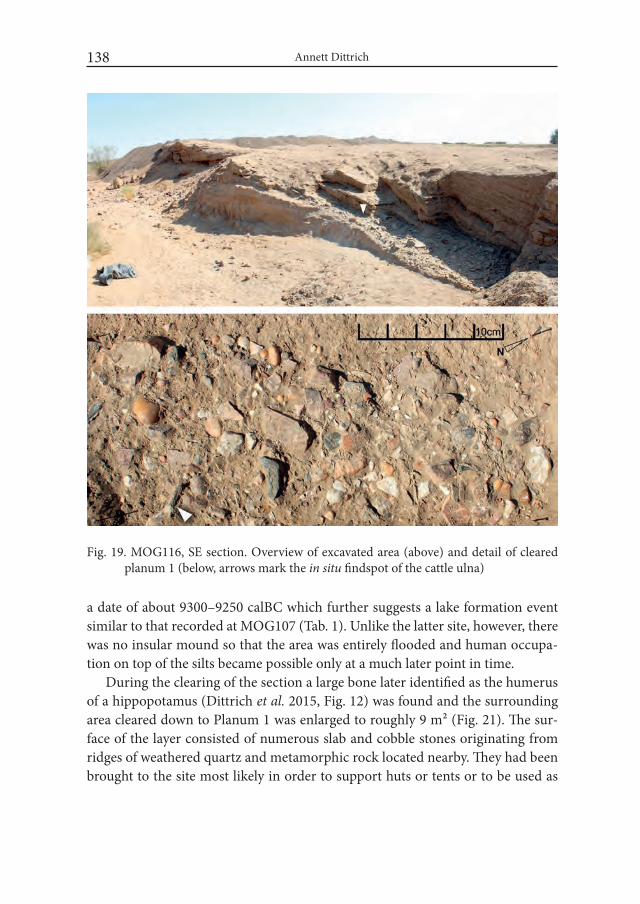
Annett Dittrich138
Fig. 19. MOG116, SE section. Overview of excavated area (above) and detail of cleared planum 1 (below, arrows mark the in situ findspot of the cattle ulna)
a date of about 9300–9250 calBC which further suggests a lake formation event similar to that recorded at MOG107 (Tab. 1). Unlike the latter site, however, there was no insular mound so that the area was entirely flooded and human occupa-tion on top of the silts became possible only at a much later point in time.
During the clearing of the section a large bone later identified as the humerus of a hippopotamus (Dittrich et al. 2015, Fig. 12) was found and the surrounding area cleared down to Planum 1 was enlarged to roughly 9 m² (Fig. 21). The sur-face of the layer consisted of numerous slab and cobble stones originating from ridges of weathered quartz and metamorphic rock located nearby. They had been brought to the site most likely in order to support huts or tents or to be used as

Between Two Rivers – Early Holocene Landscapes on Mograt Island (Sudan) 139
Fig.
20.
MO
G11
6, S
E se
ctio
n. C
hron
o-st
ratig
raph
ical
inte
rpre
tatio
n
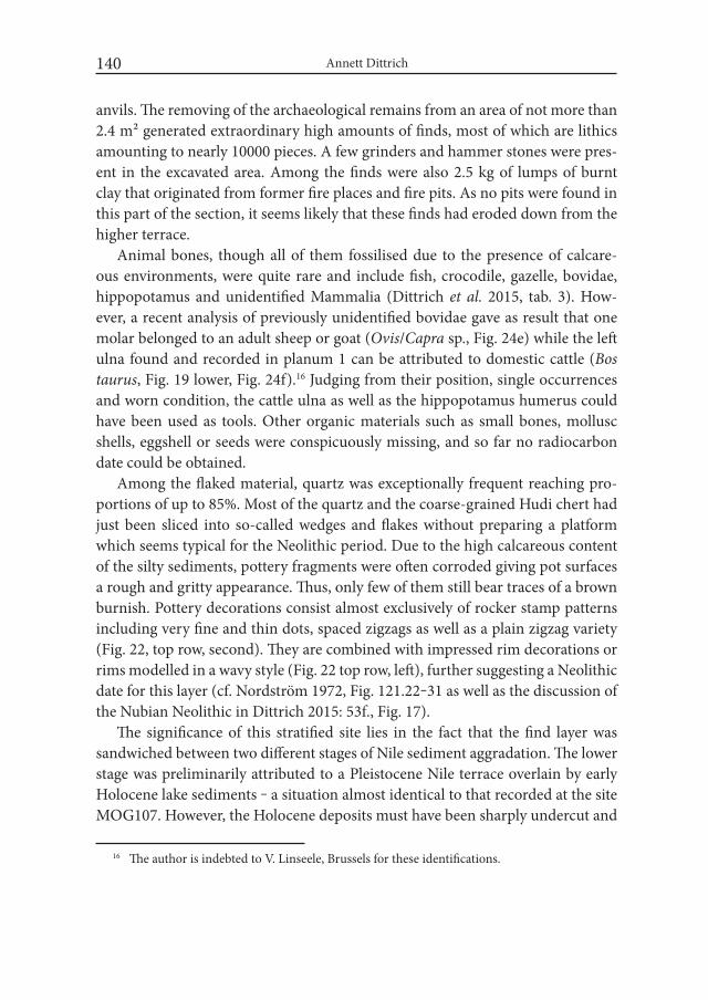
Annett Dittrich140
anvils. The removing of the archaeological remains from an area of not more than 2.4 m² generated extraordinary high amounts of finds, most of which are lithics amounting to nearly 10000 pieces. A few grinders and hammer stones were pres-ent in the excavated area. Among the finds were also 2.5 kg of lumps of burnt clay that originated from former fire places and fire pits. As no pits were found in this part of the section, it seems likely that these finds had eroded down from the higher terrace.
Animal bones, though all of them fossilised due to the presence of calcare-ous environments, were quite rare and include fish, crocodile, gazelle, bovidae, hippopotamus and unidentified Mammalia (Dittrich et al. 2015, tab. 3). How-ever, a recent analysis of previously unidentified bovidae gave as result that one molar belonged to an adult sheep or goat (Ovis/Capra sp., Fig. 24e) while the left ulna found and recorded in planum 1 can be attributed to domestic cattle (Bos taurus, Fig. 19 lower, Fig. 24f).16 Judging from their position, single occurrences and worn condition, the cattle ulna as well as the hippopotamus humerus could have been used as tools. Other organic materials such as small bones, mollusc shells, eggshell or seeds were conspicuously missing, and so far no radiocarbon date could be obtained.
Among the flaked material, quartz was exceptionally frequent reaching pro-portions of up to 85%. Most of the quartz and the coarse-grained Hudi chert had just been sliced into so-called wedges and flakes without preparing a platform which seems typical for the Neolithic period. Due to the high calcareous content of the silty sediments, pottery fragments were often corroded giving pot surfaces a rough and gritty appearance. Thus, only few of them still bear traces of a brown burnish. Pottery decorations consist almost exclusively of rocker stamp patterns including very fine and thin dots, spaced zigzags as well as a plain zigzag variety (Fig. 22, top row, second). They are combined with impressed rim decorations or rims modelled in a wavy style (Fig. 22 top row, left), further suggesting a Neolithic date for this layer (cf. Nordström 1972, Fig. 121.22‒31 as well as the discussion of the Nubian Neolithic in Dittrich 2015: 53f., Fig. 17).
The significance of this stratified site lies in the fact that the find layer was sandwiched between two different stages of Nile sediment aggradation. The lower stage was preliminarily attributed to a Pleistocene Nile terrace overlain by early Holocene lake sediments ‒ a situation almost identical to that recorded at the site MOG107. However, the Holocene deposits must have been sharply undercut and
16 The author is indebted to V. Linseele, Brussels for these identifications.
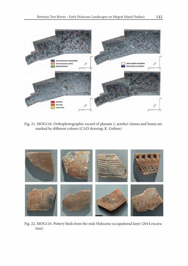
Between Two Rivers – Early Holocene Landscapes on Mograt Island (Sudan) 141
Fig. 21. MOG116. Orthophotographic record of planum 1, artefact classes and bones are marked by different colours (CAD drawing: K. Geßner)
Fig. 22. MOG116. Pottery finds from the mid-Holocene occupational layer (2014 excava-tion)

Annett Dittrich142
Fig. 23. MOG086. Overview of test trench 1 where light aeolian silts overlay pebble depos-its embedded in dark red sediment

Between Two Rivers – Early Holocene Landscapes on Mograt Island (Sudan) 143
thus removed by a Nile meander or tributary before the artefact-rich layer could have slipped down from the top of the earlier lake sediments during a landslide (Fig. 20).17 Obviously, dramatic changes of landscapes still occurred during the mid-Holocene period. The presence of domestic animals as well as of a quartz flaking industry places this occupation event firmly within the Neolithic period, and would suggest a dating to the 5th millennium BC or, when compared to the inland sites (see below), even slightly earlier. Finally the artefact layer was sealed by up to two metres of post-Neolithic/late Holocene alluvium. Interestingly, these deposits are part of a large alluvial formation covering the southern plains of Mograt (e.g. al-Jaraif) which suggests a late Holocene date for the arable soils still under cultivation (cf. Dittrich, in prep.).
3.3. Inland sites at the watershed (MOG086, MOG102, MOG105)A further pattern of occupation was observed at the plains of the central is-
land’s crest where medium to large surface sites are located (Fig. 11). Today the landscape appears desert-like and entirely uninhabited (Figs. 23, 26). Four sites (MOG086, MOG102, MOG105, MOG108) were identified during the 2014 sur-vey by the presence of stone slabs, grinders, fragments of grinding bases, pot-sherds and lithics, all of them intermingled with the dense pebble cover of the serir plain (Dittrich and Gessner 2014: 136f., tab. 1, Fig. 8, 9). During the 2014/15 survey four sites of this type were found at the central part of the island where the watershed plain is even more extended (Fig. 11: MOG128, MOG129, MOG132, MOG133, cf. Dittrich et al. 2015, tab. 5).
At three of the sites (MOG086, MOG102, MOG105) test trenches were exca-vated which revealed an almost identical stratigraphy (Fig. 23). After the removal of the surface artefact and pebble layer and below an accumulation of wind-blown silts, two brownish to reddish iron-rich soil horizons mainly composed of small pebbles were recognised. So far, no structures were observed in the pebble ma-trix. However, bones and shells seemed to be much better preserved than those found in the calcium-rich layers at the Nile terraces (compare Fig. 24, top and lower row). The zooarchaeological identification resulted in the following species: catfish (Synodontis sp.), crocodile, Nile monitor, ostrich, dorcas gazelle (Fig. 24a), hippopotamus (Fig. 24b), bovidae and other unidentified small to large mammalia
17 A similar situation was reported by Arkell (1947, 173) for the site of Khartoum Hospital. Arkell assumed that the majority of finds that were found in a sloping position had eroded down together with the soft sediments from the former elevated settlement area.
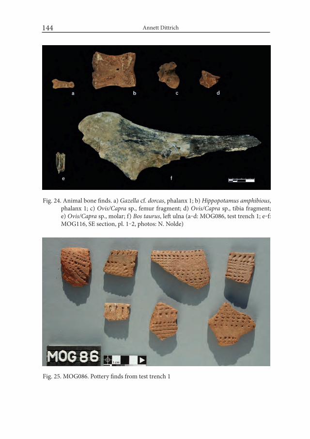
Annett Dittrich144
Fig. 24. Animal bone finds. a) Gazella cf. dorcas, phalanx 1; b) Hippopotamus amphibious, phalanx 1; c) Ovis/Capra sp., femur fragment; d) Ovis/Capra sp., tibia fragment; e) Ovis/Capra sp., molar; f) Bos taurus, left ulna (a‒d: MOG086, test trench 1; e‒f: MOG116, SE section, pl. 1‒2, photos: N. Nolde)
Fig. 25. MOG086. Pottery finds from test trench 1
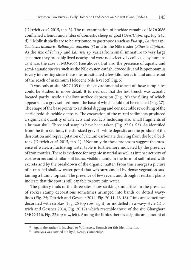
Between Two Rivers – Early Holocene Landscapes on Mograt Island (Sudan) 145
(Dittrich et al. 2015, tab. 3). The re-examination of bovidae remains of MOG086 confirmed a femur and a tibia of domestic sheep or goat (Ovis/Capra sp., Fig. 24c, d).18 Mollusk shells are to be attributed to gastropods such as Pila sp., Lanistes sp., Zootecus insularis, Bellamyia unicolor (?) and to the Nile oyster (Etheria elliptica). As the size of Pila sp. and Lanistes sp. varies from small immature to very large specimen they probably lived nearby and were not selectively collected by humans as it was the case at MOG064 (see above). But also the presence of aquatic and semi-aquatic species such as the Nile oyster, catfish, crocodile, and hippopotamus is very interesting since these sites are situated a few kilometres inland and are out of the reach of maximum Holocene Nile level (cf. Fig. 5).
It was only at site MOG105 that the environmental aspect of those camp-sites could be studied in more detail. It turned out that the test trench was actually located partly inside a shallow surface depression (Fig. 26) the filling of which appeared as a grey soft sediment the base of which could not be reached (Fig. 27). The shape of the base points to artificial digging and considerable reworking of the sterile reddish pebble deposits. The excavation of the mixed sediments produced a significant quantity of artefacts and ecofacts including also small fragments of a human skull. Three soil samples have been taken (Fig. 27.S1‒S3). As identified from the thin sections, the silt-sized greyish-white deposits are the product of the dissolution and reprecipitation of calcium carbonate deriving from the local bed-rock (Dittrich et al. 2015, tab. 1).19 Not only do these processes suggest the pres-ence of water, a fluctuating water table is furthermore indicated by the presence of iron mottles. There is evidence for organic material as well as intense activity of earthworms and similar soil fauna, visible mainly in the form of soil mixed with excreta and by the breakdown of the organic matter. From this emerges a picture of a rain-fed shallow water pond that was surrounded by dense vegetation sus-taining a humic top soil. The presence of few recent and drought-resistant plants indicate that the spot is still capable to store rain water.
The pottery finds of the three sites show striking similarities in the presence of rocker stamp decorations sometimes arranged into bands or dotted wavy-lines (Fig. 25; Dittrich and Gessner 2014, Fig. 20.11, 13-16). Rims are sometimes decorated with strokes (Fig. 25 top row, right) or modelled in a wavy-style (Dit-trich and Gessner 2014, Fig. 20.12) which resemble those of the site Gharghara (MOG116, Fig. 22 top row, left). Among the lithics there is a significant amount of
18 Again the author is indebted to V. Linseele, Brussels for this identification.19 Analysis was carried out by S. Neogi, Cambridge.
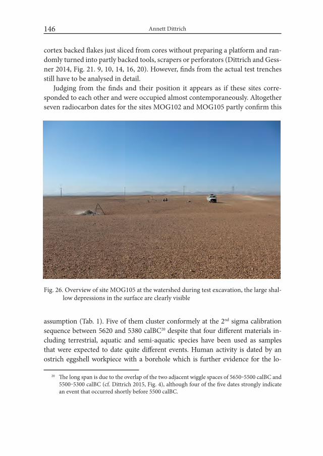
Annett Dittrich146
Fig. 26. Overview of site MOG105 at the watershed during test excavation, the large shal-low depressions in the surface are clearly visible
cortex backed flakes just sliced from cores without preparing a platform and ran-domly turned into partly backed tools, scrapers or perforators (Dittrich and Gess-ner 2014, Fig. 21. 9, 10, 14, 16, 20). However, finds from the actual test trenches still have to be analysed in detail.
Judging from the finds and their position it appears as if these sites corre-sponded to each other and were occupied almost contemporaneously. Altogether seven radiocarbon dates for the sites MOG102 and MOG105 partly confirm this
assumption (Tab. 1). Five of them cluster conformely at the 2nd sigma calibration sequence between 5620 and 5380 calBC20 despite that four different materials in-cluding terrestrial, aquatic and semi-aquatic species have been used as samples that were expected to date quite different events. Human activity is dated by an ostrich eggshell workpiece with a borehole which is further evidence for the lo-
20 The long span is due to the overlap of the two adjacent wiggle spaces of 5650‒5500 calBC and 5500‒5300 calBC (cf. Dittrich 2015, Fig. 4), although four of the five dates strongly indicate an event that occurred shortly before 5500 calBC.
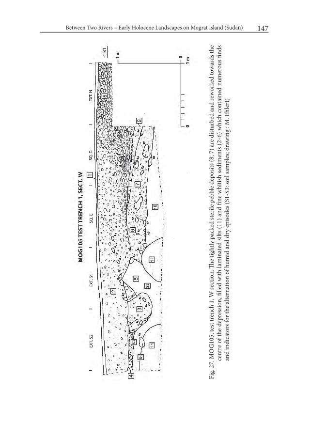
Between Two Rivers – Early Holocene Landscapes on Mograt Island (Sudan) 147
Fig.
27.
MO
G10
5, te
st tr
ench
1, W
sect
ion.
The t
ight
ly p
acke
d st
erile
peb
ble d
epos
its (8
, 7) a
re d
istur
bed
and
rew
orke
d to
war
ds th
e ce
ntre
of t
he d
epre
ssio
n, fi
lled
with
lam
inat
ed si
lts (1
1) a
nd fi
ne w
hitis
h se
dim
ents
(2‒6
) whi
ch c
onta
ined
num
erou
s find
s an
d in
dica
tors
for t
he a
ltern
atio
n of
hum
id a
nd d
ry e
piso
des (
S1-S
3: so
il sa
mpl
es; d
raw
ing
: M. E
hler
t)

Annett Dittrich148
cal manufacture of beads (Tab. 1: MOG102-26-2). The diversity of the gastropod fauna present at all of the dated sites indicates conditions varying from grasslands to seasonal swamps between 7120 and 5380 calBC. The study of soil micromorphol-ogy produced evidence for intense earthworm activity, which is characteristic for humic topsoils as well as evidence for the alteration between wet and dry conditions (Dittrich et al. 2015: 135). Such soils would surely have supported the growth of savannah grasses, but also of any cultivated plant, although no evidence for them exists so far. All of the sites found at the watershed plains provided sound evidence for grinding activities as well as indirect evidence for the watering of hoofed ani-mals, namely by traces of trampling seen in the high degree of fragmentation of pottery finds. Whether the two bones of domestic sheep or goat from site MOG086 were deposited during the human occupational event multiple dated at 5500 calBC, which would seem likely in the view of the recently revised evidence for domestic caprines from Egypt (Linseele et al. 2014, Linseele in prep.), can only be decided upon the results of more extensive excavation work. Apart from this, the major evi-dence comes from aquatic and semi-aquatic species as one would expect it to be the case for an island. As it can be observed today, fish is a common option while the number of herded animals is generally low and confined to the household level. In summary, the sites following the watershed scheme mark a mid-Holocene tran-sitional corridor, which ‒ depending on its water storing capacities ‒ was probably visited only seasonally, but immediately lost its attractiveness when rainfalls started to cease.
4. Conclusions: settlement and land-use patterns – preliminary obser- vations
If we sum up the preliminary results for the late prehistory of Mograt Island there are at least five different landuse patterns:
(1) plateau occupation at the southern palaeoisland (Upper/Late Palaeolithic, early to mid-Holocene)
(2) upper Nile terrace and shoreline occupation along ephemeral lagoonal lakes (early Holocene)
(3) upper and middle Nile terrace occupation in proximity to early Holocene alluvium (mid-Holocene)
(4) inland occupation near the watershed around shallow pools of periodically stored rain water (mid-Holocene)
Between Two Rivers – Early Holocene Landscapes on Mograt Island (Sudan) 149
(5) lower Nile terrace and granite massif occupation overlooking alluvial plains, mainly indicated by grinding activities and the presence of rock art (late Holocene)
Schemes 1 and 2 are clearly connected to higher Nile levels dividing Mograt into two palaeoislands and turning ephemeral basins into lagoonal lakes. Such lakes have to be assumed for all of the elongated incisions along the early Holo-cene shoreline at western and central Mograt as well as at the opposite right Nile bank (Fig. 5). These incisions are identical to the passages of major wadis coming from inland. This situation differed from the tectonics of eastern Mograt favour-ing plateau occupation. While additionally at this part of Mograt numerous small islands emerged at the southern end of each of the palaeoislands (Fig. 5), the is-lands presently flanking western and central Mograt do not seem to have existed.
Mid-Holocene sites are either located at the upper and middle Nile terraces (3), still indicating a much wider alluvial plain than today, or around the rain-fed reservoirs that have to be assumed for the island’s crest far from the river banks (4). Both locations would have benefitted from the presence of arable alluvial soils as a leftover of the early Holocene lakes, swamps and ponds. Only late Holocene and Kerma period sites which are often connected to granite outcrops at the lower Nile terraces (5) seem to refer to a narrowed alluvial plain indicating the stabilisa-tion of annual Nile floods at a lower level. However, this rough pattern still has to be rendered more precisely through future studies. Also a number of questions are still open as for instance nothing can be said so far about the spatial relation to burial sites of each period.
AcknowledgementsI am indebted to the director of the Mograt Island Archaeological Mission
Prof. Dr. Claudia Näser for initiating the Late Prehistoric Survey as well as for her kind permission to study the finds of the H.U.N.E. 2006 and 2008 missions. Furthermore I would like to thank my colleagues Kerstin Gessner, Maciej Ehlert, Sayantani Neogi, Hassan Mustafa Alkhidir and Nadine Nolde for their collabora-tion as well as our logistic partners in Sudan. The 2014 and 2014/15 field seasons as well as post-excavation work have been generously funded through the Qatar Sudan-Archaeological Project and specific analyses have been made possible in close cooperation with NCAM Khartoum.
Annett Dittrich150
REFERENCES
AHMED, A. S. 1971. The Antiquities of Mograt Island. Sudan Notes and Records 52: 1-22.
ARKELL, A. J. 1947. Early Khartoum. Antiquity 21: 172–181.BAILEY, G. 2007. Time perspectives, palimpsests and the archaeology of time.
Journal of Anthropological Archaeology 26 (2): 198-223.BARRIÈRE, C. L., DANIEL, R., DELPORTE, H., ESCALON DE FONTON, M.,
PARENT, R., ROCHE, J., ROZOY, J.-G., TIXIER, J. and E. VIGNARD. 1969. Epipaléolithique-Mésolithique – Les microlithes géométriques. Bul-letin de la Société préhistorique française 66: 355-366.
CHÉLU, A. 1891. Le Nil, le Soudan, l’Egypte. Paris.CRAWFORD, O. G. S. 1954. Field Archaeology of the Middle Nile Region. Kush
I (1): 2‒29.DITTRICH, A. 2011. Zur Neolithisierung des Mittleren Niltals und angrenzender
Regionen: Kultureller wandel vom Mesolithikum zum Neolithikum im Nord- und Zentralsudan (= BAR International Series 2281). Oxford.
DITTRICH, A. 2015. Dating the Neolithisation process in the Middle Nile valley: A critical approach. In: J. Kabaciński, M. Chłodnicki and M. Kobusiewicz (eds), Hunter-Gatherers and Early Food Producing Societies in Northeastern Africa (= Studies in African Archaeology 14): 15‒64.Poznań..
DITTRICH, A. (in prep.). Revolutions of the Middle Nile – the dynamics of a Ho-locene riverscape. Conference paper, Revolutions ‒ The Neolithisation of the Mediterranean Basin: The Transition to food Producing Economies in North Africa and Southern Europe, TOPOI workshop, Berlin, 2015.
DITTRICH, A. and K. GESSNER. 2014. Early Holocene landscapes on Mograt Island (Sudan) ‒ perspectives and first results of the Late Prehistoric Survey 2014. Der antike Sudan. MittSAG 25: 127–144.
DITTRICH, A., GESSNER, K. and B. GABRIEL. 2007. A Mesolithic occupa-tion site near Umm Klait at the Fourth Nile Cataract, Sudan. In: C. Näser and M. Lange (eds), Proceedings of the Second international Conference on the Archaeology of the Fourth Nile Cataract (Berlin, August 4th–6th, 2005) (= Meroitica 23): 43-52. Wiesbaden.
DITTRICH, A., GESSNER, K., NEOGI, N., EHLERT, M. and N. NOLDE. 2015. Holocene Stratigraphies and sediments on Mograt Island (Sudan) ‒ The second season of the Late Prehistoric Survey 2014/15. Der antike Sudan. MittSAG 26: 123–144.
Between Two Rivers – Early Holocene Landscapes on Mograt Island (Sudan) 151
FIELD, H. 1949. The University of California African Expedition: II, Sudan and Kenya. American Anthropologist 51 (1): 72‒84.
JACKSON, H. C. 1926. A trek in Abu Hamed District. Sudan Notes and Records 9 (2): 1‒35.
KLEPPE, E. J. 1982. Antiquities in the Middle Nile region – a preliminary report from a reconnaissance tour. In: J. M. Plumley (ed.), Nubian Studies – Pro-ceedings of the Symposium for Nubian Studies, Selwyn College, Cambridge, 1978: 146-150. Warminster.
LAITY, J. 2008. Deserts and Desert Environments. Chichester.LANGE, M. 2012. Prehistoric sites on Mograt Island. In: H.-P. Wotzka (ed.), Pro-
ceedings of the Third international Conference on the Archaeology of the Fourth Nile Cataract. University of Cologne, 13–14 July 2006 (= Africa Prae-historica 22): 303-311.
LINSEELE, V. (in prep). Early livestock in Egypt ‒ The current state of archaeo-zoological research. Conference paper, Revolutions ‒ The Neolithisation of the Mediterranean Basin: The Transition to food Producing Economies in North Africa and Southern Europe, TOPOI workshop, Berlin, 2015
LINSEELE, V., VAN NEER, W., THYS, S., PHILLIPPS, R., CAPPERS, R., WEN-DRICH, W. and S. HOLDAWAY. 2014. New Archaeozoological Data from the Fayum ‘‘Neolithic’’ with a Critical Assessment of the Evidence for Early Stock Keeping in Egypt. PLoS ONE 9(10): e108517. doi:10.1371/journal.pone.0108517
LYONS, H. G. 1909. The Longitudinal Section of the Nile. The Geographical Jour-nal 34 (1): 36-51.
NÄSER, C. 2006. Die Humboldt University Nubian Expedition 2006 ‒ Arbeiten auf Us und Mograt. Der Antike Sudan. MittSAG 17: 1‒28.
NÄSER, C. 2008. Die Humboldt University Nubian Expedition 2008 ‒ Arbeiten auf der Insel Mograt. Der Antike Sudan. MittSAG 19: 47-52.
NORDSTRÖM, H.-A. 1972. Neolithic and A-Group Sites.The Scandinavian Joint Expedition to Sudanese Nubia 3.Uppsala.
RITTER, M. 2008. Die Insel Mograt – eine geographische Übersicht der größten Insel im Nil. Der antike Sudan. MittSAG 19: 77-88.
RITTER, M. 2014. A new topographic map of Mograt Island. Der antike Sudan. MittSAG 25: 123‒125.
SCHULZ, R. 2008. H.U.N.E. 2008 ‒ MOG034 und MOG064 ‒ zwei mehrperi-odische urgeschichtliche Fundstellen auf dem Plateau von Karmel (Insel Mograt). Der antike Sudan. MittSAG 19: 53-60.
Annett Dittrich152
STERN, R. J. and M.G. ABDELSALAM. 1996. The Origin of the Great Bend of the Nile from SIR-C/X-SAR imagery.Science 274: 1696-1698.
TOTHILL, J. D. 1946. The origin of the Sudan Gezira clay plain. Sudan Notes and Records 27: 153–183.
VAN DAMME, D. 1984. The Freshwater Mollusca of Northern Africa – Distribu-tion, Biogeography and Palaeoecology. Dordrecht.
WESCHENFELDER, J. 2015a. The Terminal Neolithic cemetery in the funerary landscape of MOG034, Mograt Island, Sudan. Der antike Sudan. MittSAG 26: 145‒152.
WESCHENFELDER, J. 2015b. Preliminary report of the second and third field seasons at the Bronze Age cemetery MOG034 on Mograt Island, Sudan. Der antike Sudan. MittSAG 26: 153‒168.
WESCHENFELDER, J. and G. REES. 2014. Preliminary report of the first field season of the Kerma cemetery MOG034 on Mograt Island, Sudan. Der an-tike Sudan. MittSAG 25: 144–154.
WHITEMAN, A. J. 1971. The Geology of the Sudan. Oxford.WILLIAMS, M. A. J. 2009. Late Pleistocene and Holocene environments in the
Nile basin. Global and Planetary Change 69: 1–15.

Desert and the Nile. Prehistory of the Nile Basin and the Sahara.
Papers in honour of Fred Wendorf Studies in African Archaeology 15
Poznań Archaeological Museum 2018
Elena A.A. Garcea and Giulia D’Ercole
What Do We See When We See a Decoration? An Overview on the Pottery from Sai Island and Esh Shaheinab
“I have been fortunate to live an interesting life, go to strange places, do interesting work, and learn about the past.” (Wendorf 2008: 339)
DedicationFred Wendorf was severely wounded to his arm in Italy, our country, during
World War II in a fight against the Nazi regime and the fascist oppression. We take the opportunity of this book in his honour to express our everlasting gratitude to all young people like him, who fought to liberate our country from dictatorships. The first author of this paper met him the first time in 1988, at the Dymaczewo Conference, one of the numerous that she attended in the following years. She al-ways keeps a vivid memory of Fred’s remarkable stories and admirable actions on the battlefields in Italy. The second author of this paper regrets she never had the honour to meet him, but still had the privilege to take part in a Poznań conference in 2011 and appreciate the magic atmosphere of these meetings.
Elena A.A. Garcea and Giulia D’Ercole154
IntroductionThis paper presents an overview on the ceramic productions of prehistoric
(Khartoum Variant, Abkan, and Pre-Kerma), Pharaonic, and ethnographic as-semblages from Sai Island, in northern Sudan, dating from the eighth millennium BC until the present, and prehistoric (Early Khartoum, Neolithic, and Late Neo-lithic) assemblages from Esh Shaheinab, 50 km north of Omdurman, in central Sudan (Fig. 1, left). The paper discusses the first criteria used to classify Nubian and Sudanese pottery, which were mostly based on visual observations of sur-face decorations, and extends its analysis to broader considerations of the entire chaînes opératoires by comparing five temporally different productions (Mesolith-ic, Neolithic, Late Neolithic, Pharaonic, and ethnographic) from two culturally and geographically distinct areas, northern Sudan and central Sudan.
In agreement that pottery manufactures are indicative markers of cultural identities (e.g., Rice 1996; Gosselain 2000; Roux 2013), Sudanese ceramics have provided effective means to observe the evolution with continuities and discon-tinuities in pottery making traditions and to discern distinct cultural orbits and their social networks and boundaries (e.g., Caneva and Marks 1990; Welsby 1997; Garcea 1998; 2006a; 2006b; Gatto 2002a; 2006; Keding 2006; Lange and Nord-ström 2006; Garcea and Hildebrand 2009; Jesse 2010; Winchell 2013; D’Ercole et al. 2015; 2017a).
Pottery making in Sudan was initiated by hunting-fishing-gathering groups with a precocious production, although not the earliest on the African continent (see below). The earliest dates of Sudanese pottery have been recently obtained from an excavation in the Amara West district, just north of Sai Island, and are from about 8600 BC (Garcea et al. 2016). This age is almost contemporary to the earliest dates of pottery found at Sorourab 2 in central Sudan, which average around 8700 BC (Hakem and Khabir 1989). This pottery is slightly younger than the oldest African ceramics, which notably have been dated from the end of the tenth millennium BC at Ounjougou, in Mali (Huysecom et al. 2009), from the early ninth millennium BC at Adrar Bous and Tagalagal, in the Nigerien Sahara (Roset 1982; 1987), and from the late tenth/early ninth millennium BC at Bir Kiseiba, in the Egyptian Western Desert (Connor 1984).
Due to a lower energy of the water flow in the middle Nile River, small islands formed between the cataracts of the river, one of them being Sai Island, which lies in a gold-rich area between the Second and the Third Cataract (Fig. 1, left). This island had a central strategic role from early prehistory until Ottoman times, thanks to its protected position, and was constantly related to Lower Nubia

What Do We See When We See a Decoration?... 155
in Egypt and the Levant to the north, the Sahara to the west, and East Africa to the south-east (Geus 1998; 2004; Budka 2011; 2015; Garcea 2012).
Macroscopic, stylistic and archaeometric analyses of the ceramic assemblages from Sai Island were undertaken on both prehistoric (Garcea and Hildebrand 2009; D’Ercole 2015; D’Ercole et al. 2017a; 2017b) and New Kingdom produc-tions (Budka 2011; 2014; 2015; D’Ercole et al. 2017a). For comparison, additional analysis was made on modern ceramics from a currently active pottery workshop in the nearby village of Abri (D’Ercole et al. 2017b).
Fig. 1. Map of the Nile Valley with Sai Island, Esh Shaheinab and the other sites mentioned in the text (modified after D’Ercole et al. 2017b, Fig. 1)
Elena A.A. Garcea and Giulia D’Ercole156
In central Sudan, the pottery sample comes from Esh Shaheinab (Fig. 1, left), which is the well-known site excavated by Arkell (1953) in the 1950s and re-excavated by Haaland (1982) in the late 1970s. This site gave the name to the ‘Shaheinab Neolithic’, although the excavations also yielded Early Khartoum and Late Neolithic occupations and provided considerable quantities of pottery, which EAAG restudied at the National Museum in Khartoum in 2001. While petro-graphic, mineralogical, and chemical analyses of the ceramic assemblage from this site are still under way, the available data regard macroscopic observations on pastes, vessel shapes, surface treatments, and decorations (Garcea 2006a; 2006b). Additionally, functional data from absorbed organic residues, in particular lipids, in the vessels, using chemical and isotopic techniques on a sample from both Sai Island and Shaheinab are currently in progress.
1. What do we see when we see a decoration?Saharan and Sudanese decorated pottery drew the attention of scholars of all
times to such an extent that decorations have been among the priority objectives in typological classifications especially concerning prehistoric pottery, which usu-ally occurs in fragmented sherds and, therefore, vessel shapes or rim diameters can be rarely detected. Several past studies elaborated typologies of decorative styles, motifs, or design structures from both the Sahara (e.g., Camps Fabrer 1966; Bailloud 1969) and the Sudan (e.g., Nordström 1972; Hays 1976; Mohammed Ali 1982; Chłodnicki 1984).
The first development of these traditional typologies of the 1960s and 1970s evolved into a hierarchical system of classification of decorated pottery, start-ing from decorative techniques (rocker impressions, alternatively pivoting stamp, simple impression, incision) and proceeding to higher levels that consider deco-rative implements, and then, progressively, elements, motifs, and structures (Ca-neva 1983; 1988; 1995; Caneva and Marks 1990; Caneva et al. 1993). This system resulted to be open and flexible (Garcea 1998; 2005, see also Gatto 2002b) and could be successfully applied to other contexts than the Sudanese one, name-ly the Libyan Sahara (Caneva 1987; Garcea and Sebastiani 1998; Garcea 2001a), the Nigerien Sahara (Garcea 2008; 2013), and the Atlantic Sahara (Commelin et al. 1992).
A further methodological elaboration implied that the hierarchical system of classification of decorations was to be conceived as a component of the steps un-dertaken in the entire production sequences, where decorations are an integral
What Do We See When We See a Decoration?... 157
part of the finishing process within the chaîne opératoire and all the other manu-facturing steps are equally important and functional to detect and define social identities, regional boundaries, and cultural processes (Garcea 2001b).
The pottery productions that we studied from Sai Island cover a very long chronological framework, spanning from about 7600 BC to the present and in-cluding the foraging culture associated with the Khartoum Variant period (7600-4800 BC), the earliest pastoral culture, locally called Abkan (5500-3700 BC), the emerging complex societies of the Pre-Kerma period (3600-2500 BC), the 18th Egyptian New Kingdom (1539-1077 BC), and a presently active workshop in the village of Abri, just north-east of Sai Island (Fig. 1, right.). The studies of these ceramic assemblages included observations on fabrics, surface treat-ments, and decorations by mineralogical (X-ray powder diffraction analysis: XRPD), petrographic (SEM observations, and thin sections with a polarized light microscope: OM), and chemical analyses (trace elements by X-ray fluo-rescence: XRF, and Instrumental Neutron Activation Analysis: INAA) (Garcea and Hildebrand 2009; Garcea 2012; D’Ercole 2015; D’Ercole et al. 2015; 2017a; 2017b).
The site of Esh Shaheinab is mostly known for its Neolithic evidence, which has been dated between about 4580-4460 BC and 4500-4380 BC (Haaland 1982; 1987). However, Early Khartoum pottery was also recovered in undisturbed lay-ers below the Neolithic occupation, as well as in some mixed surface material. Furthermore, some Late Neolithic pottery was also found at the site (Arkell 1953; Garcea 2006a; 2006b).
In addition to macroscopic examinations, petrographic, mineralogical, chemi-cal, and functional (organic residues) analyses have been able to: (a) provide a dia-chronically extensive perspective on the very long tradition of pottery production in Nubia, (b) cross-check and validate or discard the results from single analyses, (c) delineate cultural and technological processes, and (d) demarcate social iden-tities and regional boundaries, in northern and central Sudan.
2. Khartoum Variant and Early Khartoum potteryThe earliest pottery at Sai Island is associated with the Khartoum Variant cul-
tural complex (Shiner 1968b) for its presumed similarities with the Khartoum ‘Mesolithic’, although it later appeared to have more affinities with the Nabta-Kiseiba area, in the Egyptian Western Desert, than the Khartoum province (Gatto 2002b; Jesse 2002; Garcea and Hildebrand 2009).
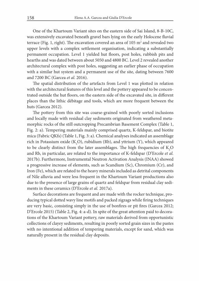
Elena A.A. Garcea and Giulia D’Ercole158
One of the Khartoum Variant sites on the eastern side of Sai Island, 8-B-10C, was extensively excavated beneath gravel bars lying on the early Holocene fluvial terrace (Fig. 1, right). The excavation covered an area of 105 m2 and revealed two upper levels with a complex settlement organisation, indicating a substantially permanent occupation. Level 1 yielded hut floors, post holes, rubbish pits and hearths and was dated between about 5050 and 4800 BC. Level 2 revealed another architectural complex with post holes, suggesting an earlier phase of occupation with a similar hut system and a permanent use of the site, dating between 7600 and 7200 BC (Garcea et al. 2016).
The spatial distribution of the artefacts from Level 1 was plotted in relation with the architectural features of this level and the pottery appeared to be concen-trated outside the hut floors, on the eastern side of the excavated site, in different places than the lithic débitage and tools, which are more frequent between the huts (Garcea 2012).
The pottery from this site was coarse-grained with poorly sorted inclusions and locally made with residual clay sediments originated from weathered meta-morphic rocks of the still outcropping Precambrian Basement Complex (Table 1, Fig. 2: a). Tempering materials mainly comprised quartz, K-feldspar, and biotite mica (Fabric QKfs) (Table 1, Fig. 3: a). Chemical analyses indicated an assemblage rich in Potassium oxide (K2O), rubidium (Rb), and yttrium (Y), which appeared to be clearly distinct from the later assemblages. The high frequencies of K2O and Rb, in particular, are related to the importance of K-feldspar (D’Ercole et al. 2017b). Furthermore, Instrumental Neutron Activation Analysis (INAA) showed a progressive increase of elements, such as Scandium (Sc), Chromium (Cr), and Iron (Fe), which are related to the heavy minerals included as detrital components of Nile alluvia and were less frequent in the Khartoum Variant productions also due to the presence of large grains of quartz and feldspar from residual clay sedi-ments in these ceramics (D’Ercole et al. 2017a).
Surface decorations are frequent and are made with the rocker technique, pro-ducing typical dotted wavy line motifs and packed zigzags while firing techniques are very basic, consisting simply in the use of bonfires or pit fires (Garcea 2012; D’Ercole 2015) (Table 2, Fig. 4: a-d). In spite of the great attention paid to decora-tions of the Khartoum Variant pottery, raw materials derived from opportunistic collections of clayey sediments, resulting in poorly sorted grain sizes in the pastes with no intentional addition of tempering materials, except for sand, which was naturally present in the residual clay deposits.
What Do We See When We See a Decoration?... 159
Table 1. Comparative outline of the techniques of raw material procurement and prepara-tion in the different periods at Sai Island
Period Site Raw material procurement Preparation
Khartoum Variant (7600-4800 BC)
8-B-10C Mainly Fabric QKfs: residual clay (Precambrian Basement Complex suite) K-feldspar, metamorphic rocks, coarse Qtz rich-specimens + biotite and Fabric Q: Qtz-rich--specimens
No intentio-nally added tempers
Abkan (5500-3700 BC)
8-B-76 Mainly Fabric QPl: secondary, alluvial sediment (Nile clay) Plagioclase, fine Qtz-rich-spe-cimens + volcanic rocks, heavy minerals and micritic calcite aggregates
Organic tempers (charcoal, wood ash)
Pre-Kerma (3600-2500 BC)
8-B-52A 8-B-10A
Organic tempers (herbivore dung and vegetal fibres)
New Kingdom (1539-1077 BC)
SAV 1 Organic tempers (her-bivore dung and vegetal fibres: chaff, grains, glu-mes, seeds)
Modern Abri workshop Organic tempers (herbivore dung)
Elena A.A. Garcea and Giulia D’Ercole160
Fig.2. Sherd sections. a: Coarse-grained Khartoum Variant sherd with abundant angular in-clusions of quartz and K-feldspar; b: Pre-Kerma sherd tempered with abundant or-ganic material (Photos: R. Ceccacci)
What Do We See When We See a Decoration?... 161
Fig. 3. Microphotographs of thin sections. a: Khartoum Variant pottery rich in K-feldspar (Kfs), quartz and biotite mica; b: Abkan pottery tempered with small charcoal par-ticles (Chr); c: Pre-Kerma pottery from Site 8-B-10A with abundant quartz, pla-gioclase (Pl) and volcanic rock fragments (Vrf); d: Pre-Kerma pottery from Site 8-B-52A tempered with abundant organic plant remains (Veg); e: New Kingdom ‘Nubian style’ pottery with very fine quartz inclusions and organic plant remains (Veg); f: Modern pottery from Abri tempered with herbivore dung that was totally burnt. Photos a and c are in cross-polarised light; photos b, d-f are in plane-polar-ised light (Photos: G. Eramo and G. D’Ercole)
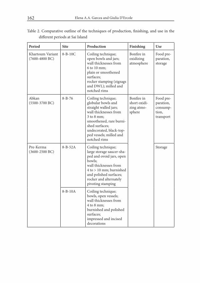
Elena A.A. Garcea and Giulia D’Ercole162
Table 2. Comparative outline of the techniques of production, finishing, and use in the different periods at Sai Island
Period Site Production Finishing Use
Khartoum Variant (7600-4800 BC)
8-B-10C Coiling technique; open bowls and jars; wall thicknesses from 6 to 10 mm; plain or smoothened surfaces; rocker stamping (zigzags and DWL); milled and notched rims
Bonfire in oxidizing atmosphere
Food pre-paration, storage
Abkan (5500-3700 BC)
8-B-76 Coiling technique; globular bowls and straight walled jars; wall thicknesses from 3 to 8 mm; smoothened, rare burni-shed surfaces; undecorated, black-top-ped vessels; milled and notched rims
Bonfire in short oxidi-zing atmo-sphere
Food pre-paration, consump-tion, transport
Pre-Kerma (3600-2500 BC)
8-B-52A Coiling technique; large storage saucer-sha-ped and ovoid jars, open bowls; wall thicknesses from 4 to > 10 mm; burnished and polished surfaces; rocker and alternately pivoting stamping
Storage
8-B-10A Coiling technique; bowls, open vessels; wall thicknesses from 4 to 8 mm; burnished and polished surfaces; impressed and incised decorations

What Do We See When We See a Decoration?... 163
Period Site Production Finishing Use
New Kingdom (c. 1539-1077 BC)
SAV 1 Coiling technique; large storage jars, cooking pots, cups and beakers; burnished and polished surfaces; geometric and rocker-stamped decorations, mat/basket impressions
Bonfire Storage, food pre-paration, consump-tion
Modern Abri work-shop
Slow wheel and coiling technique; storage jars, plates, bowls, incense burners; undecorated, incised wavy line decorations
Kiln and bonfire
Storage of water, food pre-paration, ritual and orna-mental function
Khartoum Variant pottery is spread over a wide area, extending north to Nabta and Kiseiba, Wadi el Akhdar, Great Sand Sea, Abu Tartur, Abu Ballas, and Dakhla Oasis, and south to El Barga near Kerma (Garcea and Hildebrand 2009). At this time, human groups were mainly semi-sedentary, but their influence expanded over a culturally uniform area, although they did not probably compete for exter-nal resources and therefore did not need to establish strong social relations with other groups in the central and upper Nile Valley, or the Western Desert. The uniform culture shared a rather conservative system of generalised features in common, that was based on practically permanent exploitation of water and food resources. It suggested that large cultural units were related within a social loose network and successfully persisted over the onset of the harsher climatic condi-tions that occurred towards the middle Holocene, in association with the dry and cold 8.2 BP (ca. 6300 BC) event.
Preliminary isotopic data on organic residues showed that the samples from the Khartoum Variant site 8-B-10C appeared to be used to contain carcass fats of both wild ruminant and non-ruminant animals (Dunne personal information).

Elena A.A. Garcea and Giulia D’Ercole164
Fig. 4. Potsherds from Sai Island. a-d: Khartoum Variant; e-g: Abkan (Photos: R. Ceccacci)
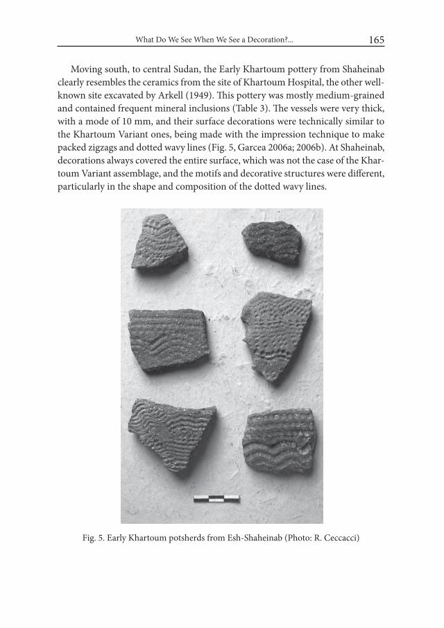
What Do We See When We See a Decoration?... 165
Moving south, to central Sudan, the Early Khartoum pottery from Shaheinab clearly resembles the ceramics from the site of Khartoum Hospital, the other well-known site excavated by Arkell (1949). This pottery was mostly medium-grained and contained frequent mineral inclusions (Table 3). The vessels were very thick, with a mode of 10 mm, and their surface decorations were technically similar to the Khartoum Variant ones, being made with the impression technique to make packed zigzags and dotted wavy lines (Fig. 5, Garcea 2006a; 2006b). At Shaheinab, decorations always covered the entire surface, which was not the case of the Khar-toum Variant assemblage, and the motifs and decorative structures were different, particularly in the shape and composition of the dotted wavy lines.
Fig. 5. Early Khartoum potsherds from Esh-Shaheinab (Photo: R. Ceccacci)
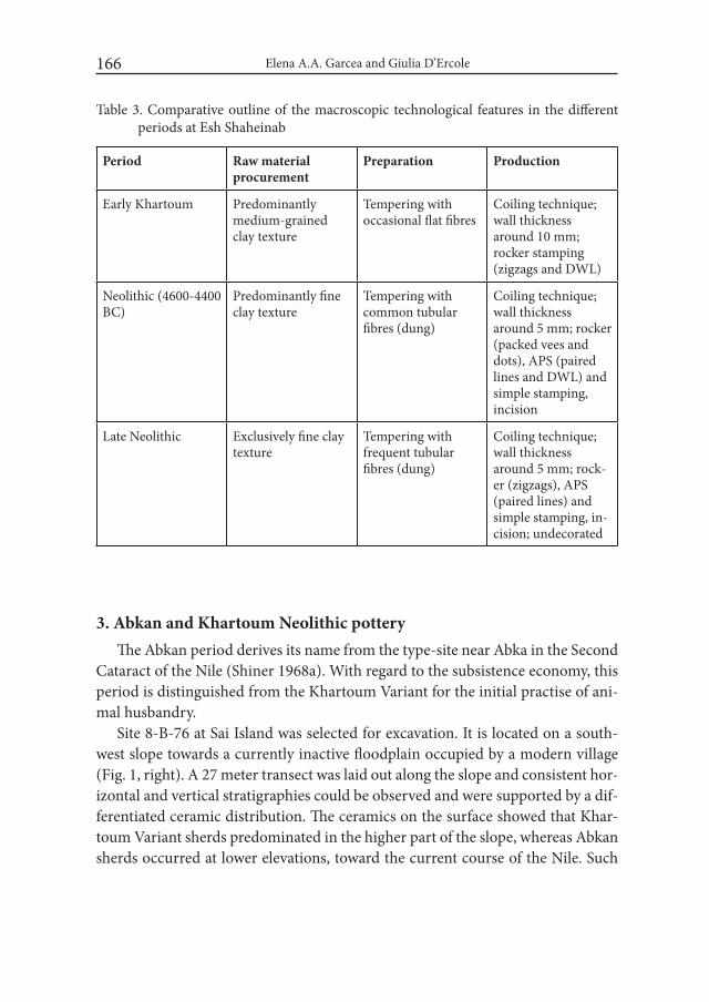
Elena A.A. Garcea and Giulia D’Ercole166
3. Abkan and Khartoum Neolithic potteryThe Abkan period derives its name from the type-site near Abka in the Second
Cataract of the Nile (Shiner 1968a). With regard to the subsistence economy, this period is distinguished from the Khartoum Variant for the initial practise of ani-mal husbandry.
Site 8-B-76 at Sai Island was selected for excavation. It is located on a south-west slope towards a currently inactive floodplain occupied by a modern village (Fig. 1, right). A 27 meter transect was laid out along the slope and consistent hor-izontal and vertical stratigraphies could be observed and were supported by a dif-ferentiated ceramic distribution. The ceramics on the surface showed that Khar-toum Variant sherds predominated in the higher part of the slope, whereas Abkan sherds occurred at lower elevations, toward the current course of the Nile. Such
Table 3. Comparative outline of the macroscopic technological features in the different periods at Esh Shaheinab
Period Raw material procurement
Preparation Production
Early Khartoum Predominantly medium-grained clay texture
Tempering with occasional flat fibres
Coiling technique; wall thickness around 10 mm; rocker stamping (zigzags and DWL)
Neolithic (4600-4400 BC)
Predominantly fine clay texture
Tempering with common tubular fibres (dung)
Coiling technique; wall thickness around 5 mm; rocker (packed vees and dots), APS (paired lines and DWL) and simple stamping, incision
Late Neolithic Exclusively fine clay texture
Tempering with frequent tubular fibres (dung)
Coiling technique; wall thickness around 5 mm; rock-er (zigzags), APS (paired lines) and simple stamping, in-cision; undecorated
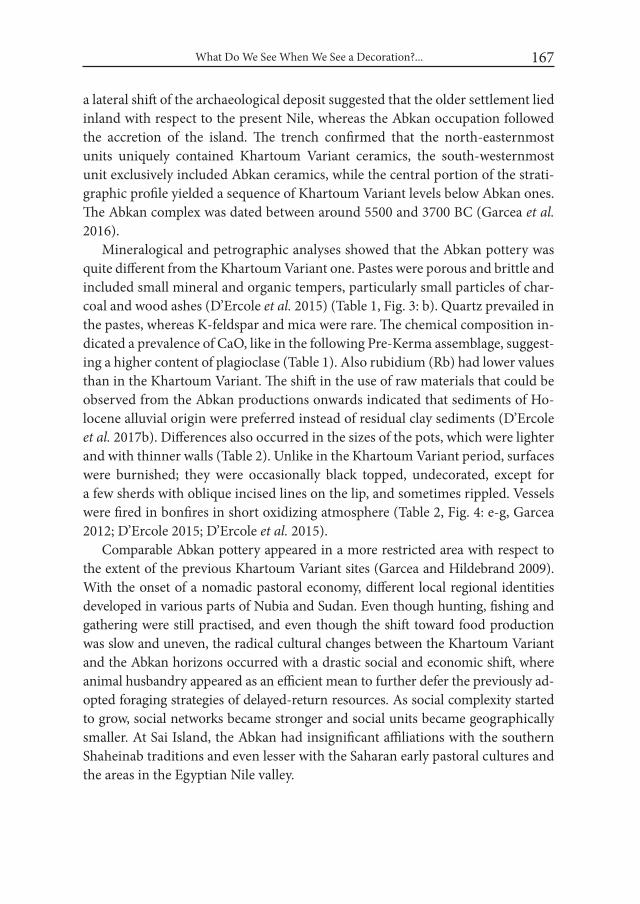
What Do We See When We See a Decoration?... 167
a lateral shift of the archaeological deposit suggested that the older settlement lied inland with respect to the present Nile, whereas the Abkan occupation followed the accretion of the island. The trench confirmed that the north-easternmost units uniquely contained Khartoum Variant ceramics, the south-westernmost unit exclusively included Abkan ceramics, while the central portion of the strati-graphic profile yielded a sequence of Khartoum Variant levels below Abkan ones. The Abkan complex was dated between around 5500 and 3700 BC (Garcea et al. 2016).
Mineralogical and petrographic analyses showed that the Abkan pottery was quite different from the Khartoum Variant one. Pastes were porous and brittle and included small mineral and organic tempers, particularly small particles of char-coal and wood ashes (D’Ercole et al. 2015) (Table 1, Fig. 3: b). Quartz prevailed in the pastes, whereas K-feldspar and mica were rare. The chemical composition in-dicated a prevalence of CaO, like in the following Pre-Kerma assemblage, suggest-ing a higher content of plagioclase (Table 1). Also rubidium (Rb) had lower values than in the Khartoum Variant. The shift in the use of raw materials that could be observed from the Abkan productions onwards indicated that sediments of Ho-locene alluvial origin were preferred instead of residual clay sediments (D’Ercole et al. 2017b). Differences also occurred in the sizes of the pots, which were lighter and with thinner walls (Table 2). Unlike in the Khartoum Variant period, surfaces were burnished; they were occasionally black topped, undecorated, except for a few sherds with oblique incised lines on the lip, and sometimes rippled. Vessels were fired in bonfires in short oxidizing atmosphere (Table 2, Fig. 4: e-g, Garcea 2012; D’Ercole 2015; D’Ercole et al. 2015).
Comparable Abkan pottery appeared in a more restricted area with respect to the extent of the previous Khartoum Variant sites (Garcea and Hildebrand 2009). With the onset of a nomadic pastoral economy, different local regional identities developed in various parts of Nubia and Sudan. Even though hunting, fishing and gathering were still practised, and even though the shift toward food production was slow and uneven, the radical cultural changes between the Khartoum Variant and the Abkan horizons occurred with a drastic social and economic shift, where animal husbandry appeared as an efficient mean to further defer the previously ad-opted foraging strategies of delayed-return resources. As social complexity started to grow, social networks became stronger and social units became geographically smaller. At Sai Island, the Abkan had insignificant affiliations with the southern Shaheinab traditions and even lesser with the Saharan early pastoral cultures and the areas in the Egyptian Nile valley.

Elena A.A. Garcea and Giulia D’Ercole168
The Neolithic occupation at Sha- heinab was later than at Sai Island, be-ing dated between about 4580-4460 BC and 4500-4380 BC (Haaland 1987). The corresponding pottery production exhibited fine-grained textures with vegetal, probably dung, tempering material, some burnished surfaces, and, unlike the Abkan pot-tery, a wide range of decorations, in-cluding impressed decorations made by alternately pivoting and rocker stamping (Table 3). However, the lat-ter employed different implements compared to the previous period, which had unevenly serrated edges, producing bands of vees and dots (Fig. 6, Garcea 2006a; 2006b).
Preliminary isotopic data on or-ganic residues from some Neolithic samples from Shaheinab provided
chromatograms with high C16 and C18 fatty acids, which are typical of a degrad-ed animal fat profile (Dunne et al. 2012). They also showed the use of both rumi-nant and non-ruminant fats (Dunne personal communication).
The time of these developments corresponds to the ‘marginalization phase’ by Kuper and Kröpelin (2006), which features the formation of regionally diverse and specialised cultural enclaves. At the same time, early pastoralism was able to stimulate a system of long-distance trade and exchange among different cultural groups, supporting the introduction and spread of domestic animals and plants imported from the Near East (Garcea 2016).
4. Pre-Kerma and Late Neolithic potteryIn the subsequent period, the Pre-Kerma culture was defined at Kerma when
an earlier settlement was found below a cemetery of the Kerma period (Bonnet 1988). The Pre-Kerma period paved the way to the rising Kerma kingdom (c. 2500 BC) and maintained relations with the already established Egyptian kingdom
Fig. 6. Neolithic potsherds from Esh-Shaheinab (Photo: R. Ceccacci)
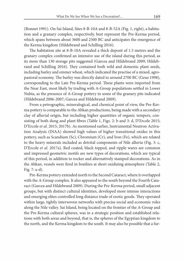
What Do We See When We See a Decoration?... 169
(Bonnet 1991). On Sai Island, Sites 8-B-10A and 8-B-52A (Fig. 1, right), a habita-tion and a granary complex, respectively, best represent the Pre-Kerma period, which spans between about 3600 and 2500 BC and anticipates the emergence of the Kerma kingdom (Hildebrand and Schilling 2016).
The habitation site at 8-B-10A revealed a thick deposit of 1.5 metres and the granary complex confirmed an intensive use of the island during this period, as its more than 130 storage pits suggested (Garcea and Hildebrand 2009; Hildeb-rand and Schilling 2016). They contained both wild and domestic plant seeds, including barley and emmer wheat, which indicated the practise of a mixed, agro-pastoral economy. The barley was directly dated to around 2700 BC (Geus 1998), corresponding to the Late Pre-Kerma period. These plants were imported from the Near East, most likely by trading with A-Group populations settled in Lower Nubia, as the presence of A-Group pottery in some of the granary pits indicated (Hildebrand 2006-2007; Garcea and Hildebrand 2009).
From a petrographic, mineralogical, and chemical point of view, the Pre-Ker-ma pottery is comparable to the Abkan productions, being made with a secondary clay of alluvial origin, but including higher quantities of organic tempers, con-sisting of both dung and plant fibres (Table 1, Figs. 2: b and 3: d, D’Ercole 2015; D’Ercole et al. 2015; 2017b). As mentioned earlier, Instrumental Neutron Activa-tion Analysis (INAA) showed high values of higher transitional oxides in this pottery, such as Scandium (Sc), Chromium (Cr), and Iron (Fe), which are related to the heavy minerals included as detrital components of Nile alluvia (Fig. 3: c, D’Ercole et al. 2017a). Red coated, black topped, and ripple wares are common and impressed geometric motifs are new types of decorations, which are typical of this period, in addition to rocker and alternatively stamped decorations. As in the Abkan, vessels were fired in bonfires at short oxidizing atmosphere (Table 2, Fig. 7: a-d).
Pre-Kerma pottery extended north to the Second Cataract, where it overlapped with the A-Group complex. It also appeared to the south beyond the Fourth Cata-ract (Garcea and Hildebrand 2009). During the Pre-Kerma period, small adjacent groups, but with distinct cultural identities, developed more intense interactions and emerging elites controlled long distance trade of exotic goods. They operated within large, tightly interwoven networks with precise social and economic roles along the Nile valley. Sai Island, being located on the frontier of the A-Group and the Pre-Kerma cultural spheres, was in a strategic position and established rela-tions with both areas and beyond, that is, the spheres of the Egyptian kingdom to the north, and the Kerma kingdom to the south. It may also be possible that a fur-
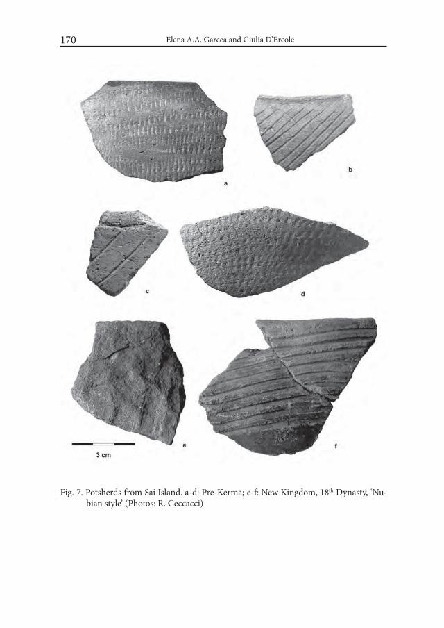
Elena A.A. Garcea and Giulia D’Ercole170
Fig. 7. Potsherds from Sai Island. a-d: Pre-Kerma; e-f: New Kingdom, 18th Dynasty, ‘Nu-bian style’ (Photos: R. Ceccacci)
What Do We See When We See a Decoration?... 171
ther push of A-Group peoples at the beginning of the 3rd millennium BC could have been triggered by Egyptian military campaigns in Lower Nubia (Garcea in press).
The Late Neolithic pottery from Shaheinab is technologically comparable to the local Neolithic production with fine-grained textures and the use of dung as tempering material (Table 3). Surface treatments are different, though, showing frequent burnished surfaces, and different and more standardised decorations than in the Neolithic (Fig. 8, Garcea 2006a).
Fig. 8. Late Neolithic potsherds from Esh-Shaheinab (Photo: R. Ceccacci)
Elena A.A. Garcea and Giulia D’Ercole172
5. New Kingdom potteryAt the beginning of the Egyptian New Kingdom, with the rise of the 18th Dy-
nasty around 1550 BC, military troops advanced southwards into Upper Nubia, in northern Sudan. While Sai Island previously was the northern outpost of the king-dom of Kush, Egypt’s rival, it was soon conquered by the Egyptian forces. By the mid-18th Dynasty, around 1450 BC, the island became one of the most important Egyptian centres in Upper Nubia and the place of foundation of a fortified town, built on the north-eastern bank of the island (Fig. 1, right, Budka 2014; 2015).
At the time of the Egyptians’ arrival, local pottery was still made according to the traditional Nubian and Kerma techniques of pottery hand-making which was derived from the previous productions (Tables 1 and 2) and was in contrast to the Egyptian ceramics that were wheel-made (Budka 2011; D’Ercole et al. 2017a). From a petrographic, mineralogical, and chemical point of view, the locally made New Kingdom pottery thrown on the wheel was manufactured with the same raw materials as the Pre-Kerma and Kerma productions and included herbivore dung and vegetal fibres as tempering material (Table 1, Fig. 3: e, D’Ercole et al. 2017a).
The most common vessel types from the Kerma tradition are cooking pots, large storage jars, and black-topped fine ware fired in bonfires. Surfaces were dec-orated with incised geometric motifs and rocker-stamped decorations, as in the previous periods, in addition to mat and basket impressions (Table 2, Fig. 7: e-f, Budka 2014).
6. Ethnographic potteryThe modern sample comes from a pottery workshop in the village of Abri, on
the eastern coast of the Nile River, north-west of Sai Island (Fig. 1 right, D’Ercole et al. 2017b). The family of potters in the Abri workshop is of Egyptian origin and moved to Sudan in the 1910-1920s, where they practice this job since several gen-erations (D’Ercole et al. 2017b).
As raw material, they use alluvial silty sediments that they collect on the Nile banks. These sediments are rich in plagioclase, resulting in high values of CaO, and quartz, originated from the sand naturally present in the sediments (Spataro et al. 2014). As tempering material, the Abri potters add herbivore dung, usually from donkeys to make large jars, and from small livestock for small pots (Table 1, Fig. 3: f). Mineral tempers are not intentionally added to the paste. Vessels are fired in either a kiln they have in the workshop, or in bonfires (Table 2, D’Ercole et al. 2017b).
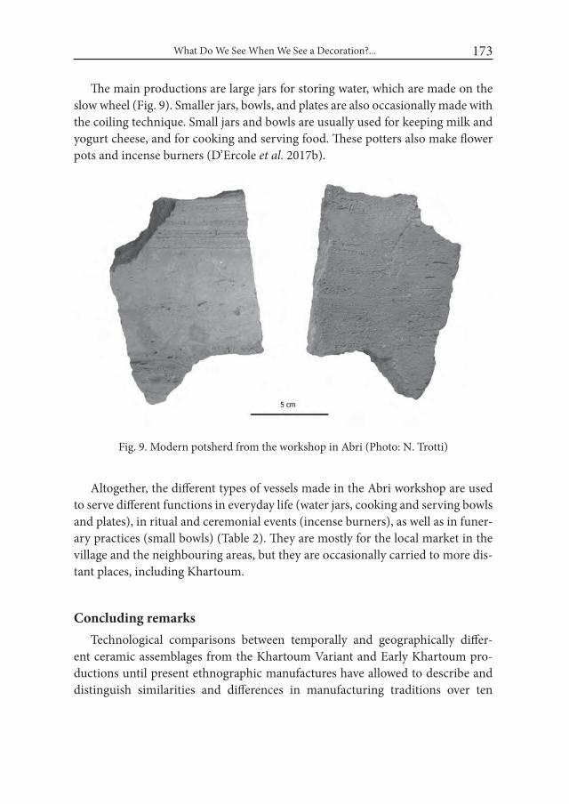
What Do We See When We See a Decoration?... 173
The main productions are large jars for storing water, which are made on the slow wheel (Fig. 9). Smaller jars, bowls, and plates are also occasionally made with the coiling technique. Small jars and bowls are usually used for keeping milk and yogurt cheese, and for cooking and serving food. These potters also make flower pots and incense burners (D’Ercole et al. 2017b).
Altogether, the different types of vessels made in the Abri workshop are used to serve different functions in everyday life (water jars, cooking and serving bowls and plates), in ritual and ceremonial events (incense burners), as well as in funer-ary practices (small bowls) (Table 2). They are mostly for the local market in the village and the neighbouring areas, but they are occasionally carried to more dis-tant places, including Khartoum.
Concluding remarksTechnological comparisons between temporally and geographically differ-
ent ceramic assemblages from the Khartoum Variant and Early Khartoum pro-ductions until present ethnographic manufactures have allowed to describe and distinguish similarities and differences in manufacturing traditions over ten
Fig. 9. Modern potsherd from the workshop in Abri (Photo: N. Trotti)
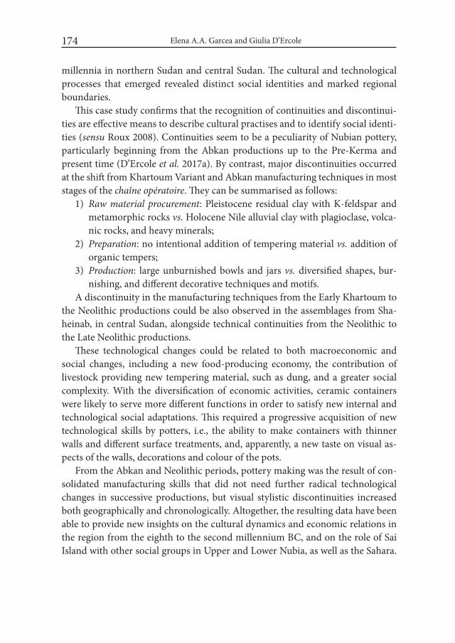
Elena A.A. Garcea and Giulia D’Ercole174
millennia in northern Sudan and central Sudan. The cultural and technological processes that emerged revealed distinct social identities and marked regional boundaries.
This case study confirms that the recognition of continuities and discontinui-ties are effective means to describe cultural practises and to identify social identi-ties (sensu Roux 2008). Continuities seem to be a peculiarity of Nubian pottery, particularly beginning from the Abkan productions up to the Pre-Kerma and present time (D’Ercole et al. 2017a). By contrast, major discontinuities occurred at the shift from Khartoum Variant and Abkan manufacturing techniques in most stages of the chaîne opératoire. They can be summarised as follows:
1) Raw material procurement: Pleistocene residual clay with K-feldspar and metamorphic rocks vs. Holocene Nile alluvial clay with plagioclase, volca-nic rocks, and heavy minerals;
2) Preparation: no intentional addition of tempering material vs. addition of organic tempers;
3) Production: large unburnished bowls and jars vs. diversified shapes, bur-nishing, and different decorative techniques and motifs.
A discontinuity in the manufacturing techniques from the Early Khartoum to the Neolithic productions could be also observed in the assemblages from Sha-heinab, in central Sudan, alongside technical continuities from the Neolithic to the Late Neolithic productions.
These technological changes could be related to both macroeconomic and social changes, including a new food-producing economy, the contribution of livestock providing new tempering material, such as dung, and a greater social complexity. With the diversification of economic activities, ceramic containers were likely to serve more different functions in order to satisfy new internal and technological social adaptations. This required a progressive acquisition of new technological skills by potters, i.e., the ability to make containers with thinner walls and different surface treatments, and, apparently, a new taste on visual as-pects of the walls, decorations and colour of the pots.
From the Abkan and Neolithic periods, pottery making was the result of con-solidated manufacturing skills that did not need further radical technological changes in successive productions, but visual stylistic discontinuities increased both geographically and chronologically. Altogether, the resulting data have been able to provide new insights on the cultural dynamics and economic relations in the region from the eighth to the second millennium BC, and on the role of Sai Island with other social groups in Upper and Lower Nubia, as well as the Sahara.
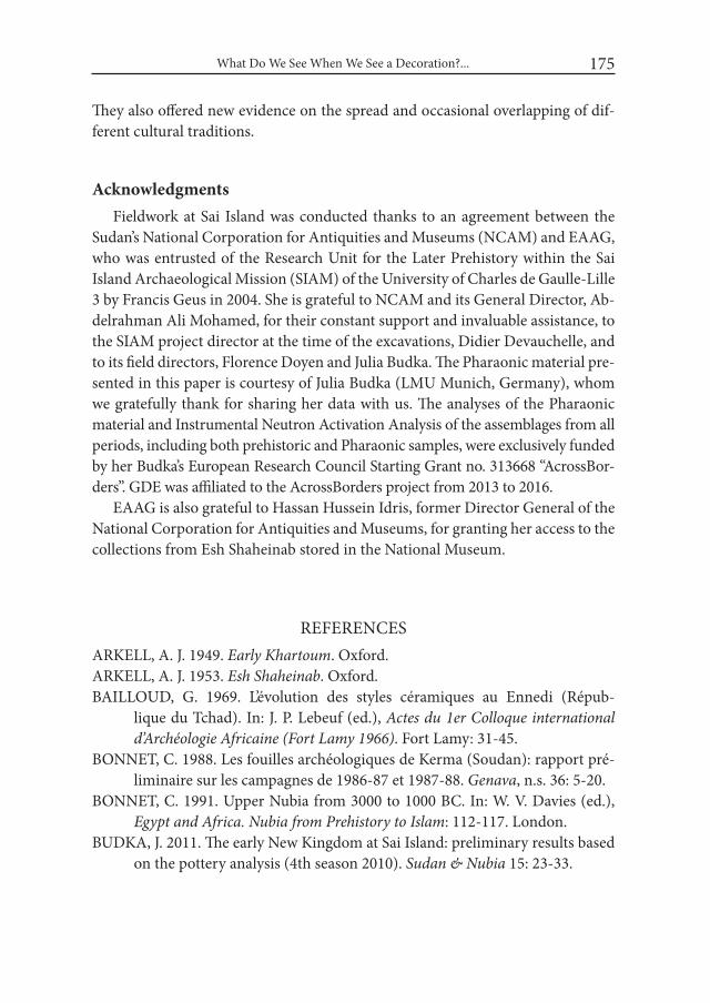
What Do We See When We See a Decoration?... 175
They also offered new evidence on the spread and occasional overlapping of dif-ferent cultural traditions.
AcknowledgmentsFieldwork at Sai Island was conducted thanks to an agreement between the
Sudan’s National Corporation for Antiquities and Museums (NCAM) and EAAG, who was entrusted of the Research Unit for the Later Prehistory within the Sai Island Archaeological Mission (SIAM) of the University of Charles de Gaulle-Lille 3 by Francis Geus in 2004. She is grateful to NCAM and its General Director, Ab-delrahman Ali Mohamed, for their constant support and invaluable assistance, to the SIAM project director at the time of the excavations, Didier Devauchelle, and to its field directors, Florence Doyen and Julia Budka. The Pharaonic material pre-sented in this paper is courtesy of Julia Budka (LMU Munich, Germany), whom we gratefully thank for sharing her data with us. The analyses of the Pharaonic material and Instrumental Neutron Activation Analysis of the assemblages from all periods, including both prehistoric and Pharaonic samples, were exclusively funded by her Budka’s European Research Council Starting Grant no. 313668 “AcrossBor-ders”. GDE was affiliated to the AcrossBorders project from 2013 to 2016.
EAAG is also grateful to Hassan Hussein Idris, former Director General of the National Corporation for Antiquities and Museums, for granting her access to the collections from Esh Shaheinab stored in the National Museum.
REFERENCESARKELL, A. J. 1949. Early Khartoum. Oxford.ARKELL, A. J. 1953. Esh Shaheinab. Oxford.BAILLOUD, G. 1969. L’évolution des styles céramiques au Ennedi (Répub-
lique du Tchad). In: J. P. Lebeuf (ed.), Actes du 1er Colloque international d’Archéologie Africaine (Fort Lamy 1966). Fort Lamy: 31-45.
BONNET, C. 1988. Les fouilles archéologiques de Kerma (Soudan): rapport pré-liminaire sur les campagnes de 1986-87 et 1987-88. Genava, n.s. 36: 5-20.
BONNET, C. 1991. Upper Nubia from 3000 to 1000 BC. In: W. V. Davies (ed.), Egypt and Africa. Nubia from Prehistory to islam: 112-117. London.
BUDKA, J. 2011. The early New Kingdom at Sai Island: preliminary results based on the pottery analysis (4th season 2010). Sudan & Nubia 15: 23-33.
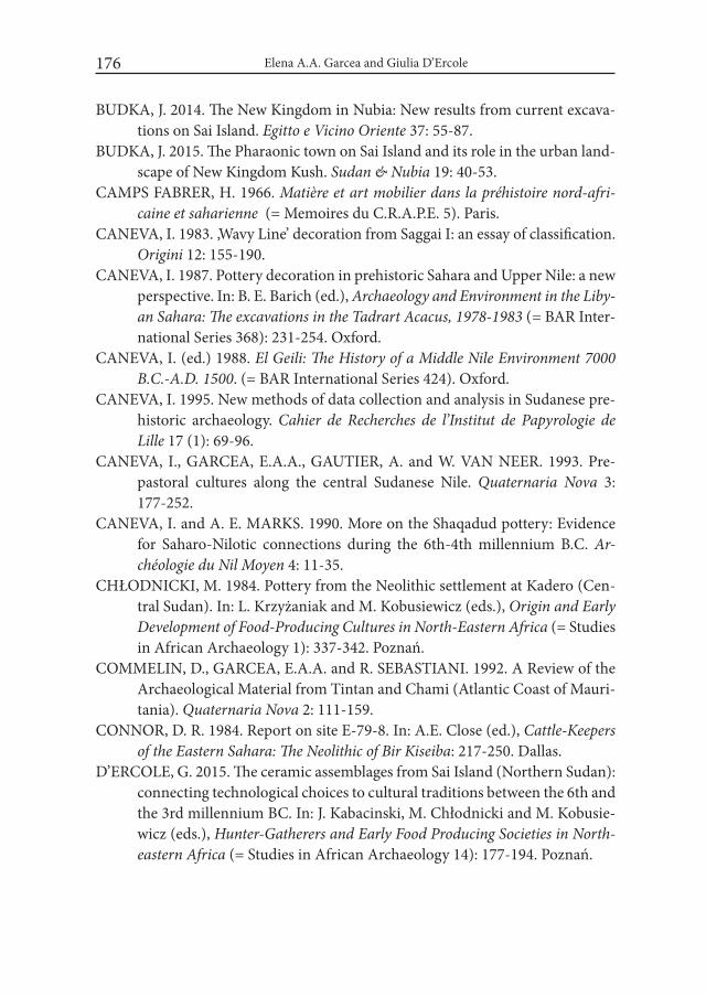
Elena A.A. Garcea and Giulia D’Ercole176
BUDKA, J. 2014. The New Kingdom in Nubia: New results from current excava-tions on Sai Island. Egitto e Vicino Oriente 37: 55-87.
BUDKA, J. 2015. The Pharaonic town on Sai Island and its role in the urban land-scape of New Kingdom Kush. Sudan & Nubia 19: 40-53.
CAMPS FABRER, H. 1966. Matière et art mobilier dans la préhistoire nord-afri-caine et saharienne (= Memoires du C.R.A.P.E. 5). Paris.
CANEVA, I. 1983. ‚Wavy Line’ decoration from Saggai I: an essay of classification. Origini 12: 155-190.
CANEVA, I. 1987. Pottery decoration in prehistoric Sahara and Upper Nile: a new perspective. In: B. E. Barich (ed.), Archaeology and Environment in the Liby-an Sahara: The excavations in the Tadrart Acacus, 1978-1983 (= BAR Inter-national Series 368): 231-254. Oxford.
CANEVA, I. (ed.) 1988. El Geili: The History of a Middle Nile Environment 7000 B.C.-A.D. 1500. (= BAR International Series 424). Oxford.
CANEVA, I. 1995. New methods of data collection and analysis in Sudanese pre-historic archaeology. Cahier de Recherches de l’institut de Papyrologie de Lille 17 (1): 69-96.
CANEVA, I., GARCEA, E.A.A., GAUTIER, A. and W. VAN NEER. 1993. Pre-pastoral cultures along the central Sudanese Nile. Quaternaria Nova 3: 177-252.
CANEVA, I. and A. E. MARKS. 1990. More on the Shaqadud pottery: Evidence for Saharo-Nilotic connections during the 6th-4th millennium B.C. Ar-chéologie du Nil Moyen 4: 11-35.
CHŁODNICKI, M. 1984. Pottery from the Neolithic settlement at Kadero (Cen-tral Sudan). In: L. Krzyżaniak and M. Kobusiewicz (eds.), Origin and Early Development of Food-Producing Cultures in North-Eastern Africa (= Studies in African Archaeology 1): 337-342. Poznań.
COMMELIN, D., GARCEA, E.A.A. and R. SEBASTIANI. 1992. A Review of the Archaeological Material from Tintan and Chami (Atlantic Coast of Mauri-tania). Quaternaria Nova 2: 111-159.
CONNOR, D. R. 1984. Report on site E-79-8. In: A.E. Close (ed.), Cattle-Keepers of the Eastern Sahara: The Neolithic of Bir Kiseiba: 217-250. Dallas.
D’ERCOLE, G. 2015. The ceramic assemblages from Sai Island (Northern Sudan): connecting technological choices to cultural traditions between the 6th and the 3rd millennium BC. In: J. Kabacinski, M. Chłodnicki and M. Kobusie-wicz (eds.), Hunter-Gatherers and Early Food Producing Societies in North-eastern Africa (= Studies in African Archaeology 14): 177-194. Poznań.
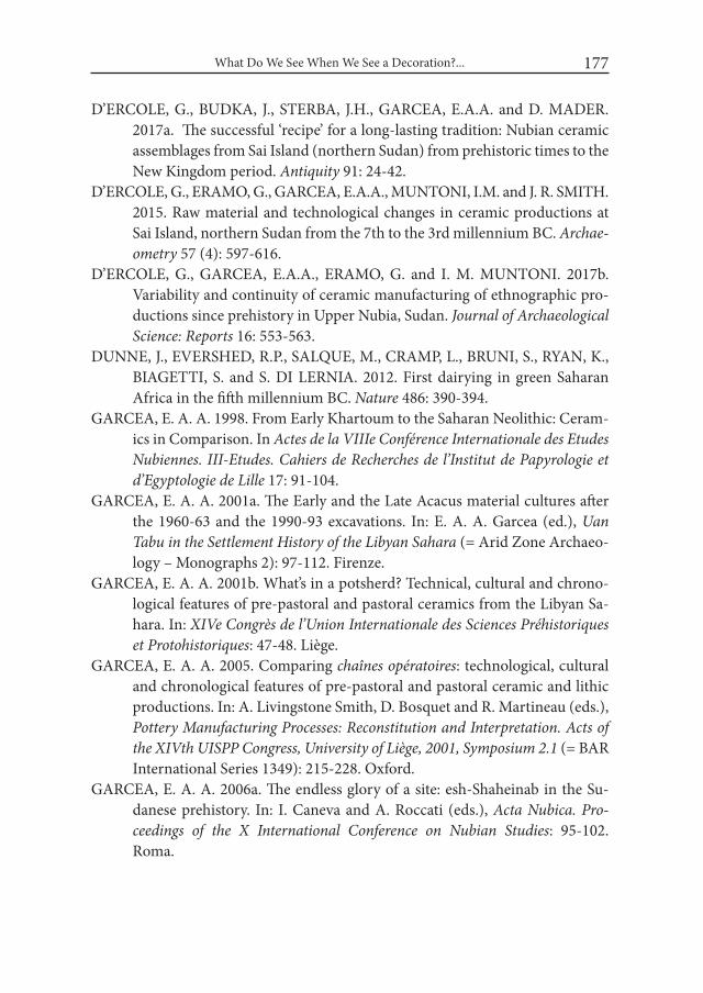
What Do We See When We See a Decoration?... 177
D’ERCOLE, G., BUDKA, J., STERBA, J.H., GARCEA, E.A.A. and D. MADER. 2017a. The successful ‘recipe’ for a long-lasting tradition: Nubian ceramic assemblages from Sai Island (northern Sudan) from prehistoric times to the New Kingdom period. Antiquity 91: 24-42.
D’ERCOLE, G., ERAMO, G., GARCEA, E.A.A., MUNTONI, I.M. and J. R. SMITH. 2015. Raw material and technological changes in ceramic productions at Sai Island, northern Sudan from the 7th to the 3rd millennium BC. Archae-ometry 57 (4): 597-616.
D’ERCOLE, G., GARCEA, E.A.A., ERAMO, G. and I. M. MUNTONI. 2017b. Variability and continuity of ceramic manufacturing of ethnographic pro-ductions since prehistory in Upper Nubia, Sudan. Journal of Archaeological Science: Reports 16: 553-563.
DUNNE, J., EVERSHED, R.P., SALQUE, M., CRAMP, L., BRUNI, S., RYAN, K., BIAGETTI, S. and S. DI LERNIA. 2012. First dairying in green Saharan Africa in the fifth millennium BC. Nature 486: 390-394.
GARCEA, E. A. A. 1998. From Early Khartoum to the Saharan Neolithic: Ceram-ics in Comparison. In Actes de la Viiie Conférence internationale des Etudes Nubiennes. iii-Etudes. Cahiers de Recherches de l’institut de Papyrologie et d’Egyptologie de Lille 17: 91-104.
GARCEA, E. A. A. 2001a. The Early and the Late Acacus material cultures after the 1960-63 and the 1990-93 excavations. In: E. A. A. Garcea (ed.), Uan Tabu in the Settlement History of the Libyan Sahara (= Arid Zone Archaeo-logy – Monographs 2): 97-112. Firenze.
GARCEA, E. A. A. 2001b. What’s in a potsherd? Technical, cultural and chrono-logical features of pre-pastoral and pastoral ceramics from the Libyan Sa-hara. In: XiVe Congrès de l’Union internationale des Sciences Préhistoriques et Protohistoriques: 47-48. Liège.
GARCEA, E. A. A. 2005. Comparing chaînes opératoires: technological, cultural and chronological features of pre-pastoral and pastoral ceramic and lithic productions. In: A. Livingstone Smith, D. Bosquet and R. Martineau (eds.), Pottery Manufacturing Processes: Reconstitution and interpretation. Acts of the XiVth UiSPP Congress, University of Liège, 2001, Symposium 2.1 (= BAR International Series 1349): 215-228. Oxford.
GARCEA, E. A. A. 2006a. The endless glory of a site: esh-Shaheinab in the Su-danese prehistory. In: I. Caneva and A. Roccati (eds.), Acta Nubica. Pro-ceedings of the X international Conference on Nubian Studies: 95-102. Roma.
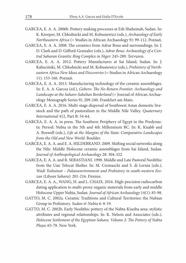
Elena A.A. Garcea and Giulia D’Ercole178
GARCEA, E. A. A. 2006b. Pottery making processes at Esh Shaheinab, Sudan. In: K. Kroeper, M. Chłodnicki and M. Kobusiewicz (eds.), Archaeology of Early Northeastern Africa (= Studies in African Archaeology 9): 99-112. Poznań.
GARCEA, E. A. A. 2008. The ceramics from Adrar Bous and surroundings. In: J. D. Clark and D. Gifford-Gonzalez (eds.), Adrar Bous: Archaeology of a Cen-tral Saharan Granitic Ring Complex in Niger: 245-289. Tervuren.
GARCEA, E. A. A. 2012. Pottery Manufactures at Sai Island, Sudan. In: J. Kabaciński, M. Chłodnicki and M. Kobusiewicz (eds.), Prehistory of North-eastern Africa New ideas and Discoveries (= Studies in African Archaeology 11): 153-166. Poznań.
GARCEA, E. A. A. 2013. Manufacturing technology of the ceramic assemblages. In: E. A. A. Garcea (ed.), Gobero: The No-Return Frontier. Archaeology and Landscape at the Saharo-Sahelian Borderland (= Journal of African Archae-ology Monograph Series 9): 209-240. Frankfurt am Main.
GARCEA, E. A. A. 2016. Multi-stage dispersal of Southwest Asian domestic live-stock and the path of pastoralism in the Middle Nile Valley. Quaternary international 412, Part B: 54-64.
GARCEA, E. A. A. in press. The Southern Periphery of Egypt in the Predynas-tic Period: Nubia in the 5th and 4th Millennium BC. In: K. Knabb and A. Boswell (eds.), Life at the Margins of the State: Comparative Landscapes from the Old and New world. Boulder.
GARCEA, E. A. A. and E. A. HILDEBRAND. 2009. Shifting social networks along the Nile: Middle Holocene ceramic assemblages from Sai Island, Sudan. Journal of Anthropological Archaeology 28: 304-322.
GARCEA, E. A. A. and R. SEBASTIANI. 1998. Middle and Late Pastoral Neolithic from the Uan Telocat Shelter. In: M. Cremaschi and S. di Lernia (eds.), wadi Teshuinat – Palaeoenvironment and Prehistory in south-western Fez-zan (Libyan Sahara): 201-216. Firenze.
GARCEA, E. A. A., WANG, H. and L. CHAIX. 2016. High-precision radiocarbon dating application to multi-proxy organic materials from early and middle Holocene Upper Nubia, Sudan. Journal of African Archaeology 14(1): 83-98.
GATTO, M. C. 2002a. Ceramic Traditions and Cultural Territories: the Nubian Group in Prehistory. Sudan & Nubia 6: 8-19.
GATTO, M. C. 2002b. Early Neolithic pottery of the Nabta-Kiseiba area: stylistic attributes and regional relationships. In: K. Nelson and Associates (eds.), Holocene Settlement of the Egyptian Sahara. Volume 2: The Pottery of Nabta Playa: 65-78. New York.

What Do We See When We See a Decoration?... 179
GATTO, M. C. 2006. Prehistoric Nubian ceramic Tradition: origin, developments and spreading trajectories. In: I. Caneva and A. Roccati (eds.), Acta Nubica. Pro-ceedings of the X international Conference of Nubian Studies: 103-106. Rome.
GEUS, F. 1998. Saï 1996-1997. Archéologie du Nil Moyen 8: 85-126.GEUS, F. 2004. Pre-Kerma Storage Pits on Sai Island, in: T. Kendall (ed.), Nubian
Studies: Proceedings of the Ninth Conference of the international Society of Nubian Studies, Boston 21-26 August 1998: 46-51. Boston.
GOSSELAIN, O. P. 2000, Materializing Identities: An African Perspective. Journal of Archaeological Method and Theory 7(3): 187-217.
HAALAND, R. 1982. Migratory herdsmen and cultivating women. The structure of the neolithic seasonal adaptation in the Khartoum Nile environment. Bergen.
HAALAND, R. 1987. Socio-Economic Differentiation in the Neolithic Sudan (= BAR International Series 350). Oxford.
HAKEM, A. M. A. and A. M. KHABIR. 1989. Sarourab 2: a new contribution to the Early Khartoum tradition from Bauda site. In: L. Krzyzaniak and M. Kobusiewicz (eds.), Late Prehistory of the Nile Basin and the Sahara (= Studies in African Archaeology 2): 381-385. Poznań.
HAYS, T. R. 1976. An examination of the Sudanese Neolithic. In: B. Abebe, J. Chavaillon and J. E. G. Sutton (eds.), Proceedings of the Viii Panafrican Congress of Prehistory and Quaternary Studies: 85-92. Addis Ababa.
HILDEBRAND, E. A. 2006-2007. The significance of Sai Island for early plant food production in Africa. Cahiers de Recherches de l’institut de Papyrologie et d’Egyptologie de Lille 26: 173-181.
HILDEBRAND, E. A. and T. M. SCHILLING. 2016. Storage amidst early agricul-ture along the Nile: Perspectives from Sai Island, Sudan. Quaternary inter-national 412, Part B: 81-95.
HUYSECOM, E., RASSE, M., LESPEZ, L., NEUMANN, K., FAHMY, A., BAL-LOUCHE, A., OZAINNE, S., MAGGETTI, M., TRIBOLO, C. and S. SORIA-NO. 2009. The emergence of pottery in Africa during the tenth millennium cal BC: new evidence from Ounjougou (Mali). Antiquity 83: 905-917.
JESSE, F. 2002. Wavy line ceramics: evidence from northeastern Africa. In: K. Nel-son & Associates (eds.), Holocene Settlement of the Egyptian Sahara. Volume 2: The Pottery of Nabta Playa. Kluwer Academic/Plenum: 79-96. New York.
JESSE, F. 2010. Early pottery in Northern Africa – An overview. Journal of African Archaeology 8(2): 219-239.
KEDING, B. 2006. Pottery of the Wadi Howar – traditions, transformations and their implications. In: K. Kroeper, M. Chłodnicki and M. Kobusie-
Elena A.A. Garcea and Giulia D’Ercole180
wicz (eds.), Archaeology of Early Northeastern Africa. in Memory of Lech Krzyżaniak (= Studies in African Archaeology 9): 235-259. Poznań.
KUPER, R. and S. KRÖPELIN. 2006. Climate-controlled Holocene occupation in the Sahara: motor of Africa’s evolution, Science 313: 803‒807.
LANGE, M. and H.-A. NORDSTRÖM. 2006. Abkan connections – the relation-ship between the Abkan culture in the Nile Valley and early Nubian sites from the Laqiya Region (eastern Sahara, northwest-Sudan). In: K. Kroeper, M. Chłodnicki and M. Kobusiewicz (eds.), Archaeology of Early Northeast-ern Africa. in Memory of Lech Krzyżaniak (= Studies in African Archaeol-ogy 9): 297-312. Poznań.
MOHAMMED ALI, A. S. A. 1982. The Neolithic Period in the Sudan, c. 6000-2500 B.C. (= BAR International Series 139). Oxford.
NORDSTRÖM, H.-A. 1972. Neolithic and A-group sites. Uppsala.RICE, P. M. 1996. Recent Ceramic Analysis: 1. Function, Style, and Origins, Jour-
nal of Archaeological Research 4(2): 133-163.ROSET, J.-P. 1982. Tagalagal : un site à céramique au Xe millénaire avant nos jours
dans l’Aïr (Niger). Comptes Rendus de l’Académie des inscriptions et Belles Lettres 123(3): 565-570.
ROSET, J.-P. 1987. Néolithisation, Néolithique et post-Néolithique au Niger nord-oriental. Bulletin de l’Association française d’étude sur le Quaternaire 4: 203-214.
ROUX, V. 2008. Evolutionary trajectories of technological traits and cultural transmission: A qualitative approach to the emergence and disappearance of the ceramic wheel-fashioning technique in the southern Levant during the fifth to the third millennia BC. In: M. T. Stark, B. Bowser and L. Horne (eds.), Cultural transmission and material culture. Breaking down boundar-ies: 82-104. Tucson.
ROUX, V. 2013. Spreading of Innovative Technical Traits and Cumulative Techni-cal Evolution: Continuity or Discontinuity? Journal of Archaeological Meth-od and Theory 20: 312-330.
SHINER, J. L. 1968a. The cataract tradition. In: F. Wendorf (ed.), The Prehistory of Nubia. Volume 2: 535-629. Dallas.
SHINER, J. L. 1968b. The Khartoum Variant industry. In: F. Wendorf (ed.), The Prehistory of Nubia. Volume 2: 768-790. Dallas.
SPATARO, M., MILLET, M. and N. SPENCER. 2014. The New Kingdom settle-ment of Amara West (Nubia, Sudan): mineralogical and chemical investi-gation of the ceramics. Archaeological and Anthropological Sciences. DOI: 10.1007/s12520-014-0199-y.

What Do We See When We See a Decoration?... 181
WELSBY, D. 1997. Early Pottery in the Middle Nile Valley. In: I. Freestone and D. Gaimster (eds.), Pottery in the Making: world Ceramic Traditions: 26-31. London.
WENDORF, F. 2008. Desert Days: My Life as a Field Archaeologist. Dallas.WINCHELL, F. 2013. The Butana Group Ceramics and Their Place in the Neolithic
and Post-Neolithic of Northeastern Africa (= Cambridge Monographs in Af-rican Archaeology 83). Oxford.

Desert and the Nile. Prehistory of the Nile Basin and the Sahara.
Papers in honour of Fred Wendorf Studies in African Archaeology 15
Poznań Archaeological Museum 2018
Mohammed Alfatih Hayati
Technical Characteristics of the Mesolithic Pottery in El Goz Sites (Central Sudan)
IntroductionPottery industry represents the greatest achievements of human in the Meso-
lithic. It emerged during the Late Paleolithic in Asia before 12700 years ago (Rice 1999: 14); and appeared in Europe during the eighth millennium BP, shortly be-fore the agriculture (Elizabeth and Barry 1988: 216). Pottery has been associated with cultural changes and daily activities. Paleolithic man did not know pottery commonly which means that he did not rely on it. Pottery have spread on settle-ment sites during the Mesolithic (Elamin and Mohammed-Ali 2004: 103-104) and if we want to follow up pottery industry in the Sudan during that period, we find that all the sites which witnessed the emergence of this industry were located near streams or pools, whether on the banks of the Nile or the valleys. Sites with pottery appeared during the early Holocene rainfalls (Hoelzmann et al. 2001: 193) in the tenth millennium BP and this is a date of the beginning of the pottery in-dustry in Sudan (Khabir 1987: 378).
1. El Goz Sites The British diplomat H. Glencarin Balfour-Poul who worked as an employee
in the period of English government was the first who mentioned the term (the Goz Culture). During his stay in Sudan he visited a number of regions in Central
Mohammed Alfatih Hayati184
and Western Sudan and between the years 1945-1954 he was in the area of the Gezira, on the eastern and western banks of the Blue Nile (Balfour-Poul 1952). He used Goz culture term for mound shape sites that were found in that area.
In the framework of this study we will focus on the Mesolithic pottery from a number of sites, namely: Wad Shanaina, Shekaira Al-Wadi, Goz Abdul Salam, Goz Kabaro, Goz Al-Rehaid, and Wad Egaibish (Fig. 1). Through the pottery sam-ples collected from these sites it became clear that there is a diversity of forms as well as similarities.
Fig. 1. Map showing the location of sites mentioned in the text
2. El Goz Pottery
Pottery pasteA paste is the important feature of the pottery. Obviously the environment and
the nature of the soil are reflected in the pottery. The Gezira area is characterized by gray clay soil that tend to black. This soil is the basic component of the paste (El-Hassan and Mohammed Ali 2008: 12), however, there were some other organ-ic and inorganic elements added to the mud to make it sticky and solid. Within organic materials we found animal dung, bones, crushed shells and plant seeds.

Technical Characteristics of the Mesolithic Pottery in El Goz sites (Central Sudan) 185
The inorganic admixtures contain crushed stones, mainly quartz, clearly visible on the surface of pottery. Quartz was crushed and grinded, and added to the mud in order to increase the hardness of the paste, to make vessel construction easier, to increase high temperature resistance and to prevent the absorption of liquids (Klein et al. 2004: 248). Sand was added to the paste rarely in the Mesolithic and addition of sand to the paste was one of the main characteristics of pottery indus-try during the Neolithic (Mohammed-Ali 1987: 128).
Vessel forming and surface treatmentAs the Mesolithic pottery was hand-made, the traditional methods played a
key role in the formation of the pot. Among the collection, we have never found a complete vessel or even a large sherd dated to the Mesolithic in El Goz sites, however the prints of hands produced during the manufacturing process are very clear on the surface of the pottery sherds.
During the study of pottery we observed that:1. Pottery walls tend to be very thick ranging from 1.5 cm to 3.0 cm; 2. The surface was treated by hand or by rag. Polishing of pottery surface was
usually made with hands;3. Most of the samples were characterized by rough and non-polished surface;4. There are some cases when the surface was painted with a layer of animal
dung paste, perhaps to increase the cohesion; 5. Except of some wavy-line decorated vessels, no colorants have been used
on the surface, and the colors that appeared on the pottery reflect the mul-tiple processes of the firing.
DecorationPottery decoration is one of the issues that preoccupied the thought of the
researchers due to its importance and position for the pot-maker as well as its use-fulness in reading the technical memory of the manufacturer (chain operatoire). Decoration is one of the main variables in pottery and perhaps one of the first variables that attract the beholder before any other variable.
The Mesolithic pottery has been decorated with some type of tools such as combs, incising tools and other decorative ways (El-Hassan and Mohammed-Ali 2008: 22). Ancient man used various tools such as wood combs, catfish spines and shell combs (Arkell 1949: 81; El-Hassan and Mohammed-Ali 2008: 22).
There were few methods for the implementation of the decoration, including impressions on the surface of the pot by a stick, rod or finger print. In the second

Mohammed Alfatih Hayati186
method incising was performed by placing the tool on the surface of the pot and it was towed to keep a shallow incising on the wall of the pot, varied in size and shape. The pressuring and incising are the oldest methods of decoration (El-Has-san and Mohammed-Ali 2008: 23). Other techniques of decoration include: (a) combing (passing the comb made of wood or catfish spine, on the surface of the pot before it becomes full dry); (b) carving and cutting with the help of a simple wooden tool (El-Hassan and Mohammed-Ali 2008: 24); (c) rocker technology. In this case relatively long, teeth-like comb tool was used, moved in a swing mode on the surface of the pot to produce continuous zigzag or dotted lines.
3. The main characteristics of Mesolithic pottery decoration
Wavy Line motifs This type of decoration is present in various forms (Hayati 2011: 44-48) and this
decorative pattern had been formed in different ways. Pottery decorated with classic waves are the most prevalent in the Central Nile (Mohammed-Ali and Khabir 2003: 38). Angular wavy line variety is rare, being reported from sporadic Mesolithic sites. Together with mild waves, it gives the impression of carelessly made work (Moham-med-Ali and Khabir 2003: 38), like the pattern of wavy lines with arch-shaped motifs
Fig. 2. Pottery with Wavy Line motifs from Wad Shanaina
Technical Characteristics of the Mesolithic Pottery in El Goz sites (Central Sudan) 187
(Fig. 2-3), occasionally non continuous, in addition to serpentine waves. This wavy line variety was occasionally coated with a bright red slip made with a type of red ochre (Fig. 4). Finally, we found composite motifs, where the comb was used for making more or less straight lines which meet other sets of wavy lines at an angle.However all these motifs are sporadic in most of the study sites.
Fig. 3. Pottery with Wavy Line motifs from Shekaira Al-Wadi
Fig. 4. Pottery with Wavy Line and Dotted Wavy line motifs from Goz Al-Rehaid
Mohammed Alfatih Hayati188
Dotted Wavy Line motifsDotted wavy lines resulted from the development of wavy line pattern. That
type of decoration spread in the Central and Northern Sudan as well as in the valleys connected to the Nile such as Wadi Howar (Jesse 2003: 101-103). Dotted wavy lines had different patterns and shapes (Fig. 5-6), but they were similar in different regions of Central Sudan (Marks et al. 1968: 321; Haaland 1995: 161). Three types of motifs were distinguished (Mohammed-Ali and Khabir: 2003: 43)
Fig. 5. Pottery with Dotted Wavy Line motifs from Wad Shanaina
Fig. 6. Pottery with Dotted Wavy Line motifs
Technical Characteristics of the Mesolithic Pottery in El Goz sites (Central Sudan) 189
which spread in different areas in Central Sudan (Arkell 1949, Plate: 72; Caneva 1983. Fig. 15: 1-13; Mohammed-Ali 1991: 69. Fig, 3-5: d-f): (1) deep dotted lines with same spacing of waves. Examples come from the Mesolithic sites of Saggai (Caneva 1983, fig. 15: 1-13); (2) shallow dotted waves. This motif was found on Khartoum Hospital site (Arkell 1949, plate 72); (3) dotted wavy lines with sharp angles. It has been identified on a few sites from the Central Nile and the Sahara (Mohammed-Ali and Khabir: 2003: 45).
Zigzag Motifs This type of decoration, chronologically late, was done by a rocker technique
(Fernandez et al. 2003: 206). It appeared during the second phase of the Mesolith-ic and represents the stage of basic transition from the Mesolithic to the Neolithic. This type of decoration has two basic variants: continuous zigzag lines and dotted zigzag lines. Both motifs were spread in El Goz area (Fig. 7).
Fig. 7. Pottery with Zigzag and Dotted Wavy Line motifs from Goz
Mohammed Alfatih Hayati190
Conclusion It seems that pottery of El Goz area carry the same features that characterized
Mesolithic pottery of Central Sudan. It is clear that pottery production was im-pacted by local raw material as the paste contained local materials (clay, impuri-ties, etc.) available in the area at that time.
REFERENCESARKELL, A. J. 1949. Early Khartoum: an Account of the Excavation of an Early
Occupation Site Carried out by the Sudan Government Antiquities Service in 1944-5. London.
BALFOUR-POUL, H. G. 1952. Early Cultures on the Northern Blue Nile. Sudan Notes and Records 33: 202-216.
CANEVA, I. 1983. Wavy line Pottery from Saggai I: An Essay of Classification. In: I. Caneva (ed). Pottery using hunters-gatherers at Saggai, (Sudan): Precondi-tion for food production. Origini 12: 155-190. Rome.
ELAMIN, Y. M. and A.S. MOHAMMED-ALI. 2004. Umm Marrahi An early Ho-locene Ceramic Site, North of Khartoum (Sudan). Sahara 15: 97-110.
EL-HASSAN. A. A. and A.S. MOHAMMED-ALI. 2008. An Archaeological Ceram-ics, Approaches of its study and analysis. Sultan Qaboos University. Masqat.
ELIZABETH, W. and W. BARRY. 1988. Past worlds. Atlas of Archaeology. British library cataloging in publication data.
FERNANDEZ, V. M. et al. 2003. Archaeological survey in the Blue Nile area, Cen-tral Sudan. Complutum 14: 201-272.
HAALAND, R. 1995. Sedentism, Cultivation, and Plant Domestication in the Ho-locene Middle Nile Region. Journal of Field Archaeology 22 (2): 157-174.
HAYATI, M. A 2011. The features of the cultural evolution during the Mesolithic in central Sudan, Case Study: Al Quoz sites. unpublished M A thesis. Univer-sity of Khartoum.
HOELZMANN, P., KEDING, B., BERKE, H., KRÖPELIN, S. and H-J. KRUSE. 2001. Environmental change and Archaeology, lake evolution and human occupation in the Eastern Sahara during the Holocene. Palaeogeography, Palaeoclimatology, Palaeoecology 69:193-217. Cologne.
JESSE, F. 2003. Rahib 80/87, ein wavy-Line Fundplatz im wadi Howar und die früheste keramik in Nordafrika. Köln.

Technical Characteristics of the Mesolithic Pottery in El Goz sites (Central Sudan) 191
KHABIR, A. M. 1987. New Radio carbon Dates for Sarurab2 and the age of early Khartoum Tradition. Currant Anthropology 28 (3): 377-380.
KIRCH, P. V. 2005. Archaeology and global change, the Holocene record. Annu- Rev- Environ- Resource: 409-440.
KLEIN, M. et al. 2004. Chemical characterization of ancient pottery from Sudan by X-Ray fluorescence spectrometry (X. R. F), electron microprobe analy-sis (E M P A) and inductively coupled plasma mass spectrometry (ICPMS). Archaeometry 46: 339-356.
MARKS, A. E. et al. 1968. Survey and excavation in the Dongola Reach, Sudan. Current Anthropology 9(4): 319-323.
MOHAMMED-ALI, A. S. 1987. The Neolithic of Central Sudan: A Reconsidera-tion. In: A. E. Close (ed), Prehistory of Arid North Africa: 123-136. Dallas.
MOHAMMED-ALI, A. S. 1991. The Mesolithic and Neolithic Ceramics from Shaqadud midden. In: A. E. Marks and A. S. Mohammed-Ali (eds), The Late Prehistory of the Eastern Sahel, The Mesolithic and Neolithic of Shaqa-dud, Sudan: 65-94. Dallas.
MOHAMMED-ALI, A. S and A.M. KHABIR. 2003. Wavy line and Dotted Wavy Pottery in the Prehistory of the Central Sudan and the Sahara- Sahel Belt. African Archaeological Review 20 (1): 25-58.
RICE, M. P. 1999. On the origins of pottery. Journal of Archaeological Method and theory 6(1): 1-54.


Desert and the Nile. Prehistory of the Nile Basin and the Sahara.
Papers in honour of Fred Wendorf Studies in African Archaeology 15
Poznań Archaeological Museum 2018
Lenka Varadzinová, Ladislav Varadzin, Lenka Lisá, Jan Pacina and Petr Pokorný
Exploration of the Site of Sphinx (SBK.W-60), Jebel Sabaloka (West Bank): Findings of the 2014 Field Campaign
IntroductionIn the autumn of 2014, the Czech interdisciplinary expedition directed by the
Czech Institute of Egyptology (Faculty of Arts, Charles University in Prague) re-sumed its fieldwork at Jebel Sabaloka (West Bank) explored for remains of pre-historic occupation since 2011. The attention of the mission focused on the site of Sphinx (SBK.W-60), one of this region’s most significant Early Khartoum/Me-solithic settlements located on a granite outcrop in an embayment in the north-western slope of the jebel (Fig. 1A, B).1
1 The field campaign lasted from 15th October till 4th November 2014. The research team con-sisted of: Aleš Bajer (geologist), Murtada Bushara (inspector), Kristýna Kuncová (student of archaeobotany), Lenka Lisá (geologist, micromorphologist), Jon-Paul McCool (geoarchaeolo-gist), Jan Novák (archaeobotanist – wood, charcoal), Jan Pacina (surveyor, GIS specialist), Adéla Pokorná (archaeobotanist – macro-remains), Petr Pokorný (palaeoecologist, biologist), Lenka Suková (research director, archaeologist), Ladislav Varadzin (field director, archaeologist), and four students-trainees – Safaa Ahmed Mohamed and Reemah Abdelrahim Kabashi (Nation-al Corporation for Antiquities and Museums of the Sudan) and Hanaa Mohamed Hafiz and Huyam Mohamed Alamin from the University of Bahri in Khartoum. The drivers and the cook of the expedition were Osman Abdalla, Salih Mohamed Salih, and Mahmoud Almahi Altayeb of Tumbus Tourism Co. Ltd.

Lenka Varadzinová, Ladislav Varadzin, Lenka Lisá, Jan Pacina and Petr Pokorný194
Fig. 1. A – Site of Sphinx (SBK.W-60) at Jebel Sabaloka (background: Google Earth 2011; map adapted from Adams 1977); B – Southern part of the settlement platform at Sphinx, from southeast (photo L. Varadzin, 2014); C – Contour plan of the settle-ment platform with the location of trenches excavated between 2011 and 2014; Trench 5 is indicated by an arrow (author J. Pacina, 2014)

Exploration of the Site of Sphinx (SBK.W-60), Jebel Sabaloka (West Bank)... 195
Four main aims were set for the 2014 field campaign based on the previous research at the site of Sphinx (see Suková and Varadzin 2012; Suková et al. 2014) and with regard to the generally known problems of exploration and the state of preservation of prehistoric deposits in central Sudan (already Arkell 1949: 4; most recently e.g. Salvatori 2012). They were: 1) to identify settlement layers and contingent sunken settlement features and to determine the stratigraphic rela-tions between those and the burials in the southern part of the settlement plat-form, AMS 14C dated tentatively to the 8th millennium cal. BC (Suková et al. 2014; Varadzinová Suková et al. 2015); 2) to investigate the post-depositional processes that have affected the original stratigraphic image and the depositional history of the site; 3) to elaborate the methods and procedures for exploration of this and other prehistoric sites in the geomorphologically and geologically rather specific area of Jebel Sabaloka (Almond and Ahmed 1993); 4) to verify the extent of the burial ground in the southern part of the site; and 5) to collect further evidence for the understanding of the former human occupation of the site.
This paper is based on the poster communication presented at the 2015 Dy-maczewo conference. It provides a brief overview of the source empirical ob-servations and findings of the 2014 field campaign that contribute to the topical discussion on the character of prehistoric deposits in central Sudan and on the possibilities and limits of their archaeological exploration (for more detailed over-view and discussion, see Varadzinová Suková et al. 2015).
1. MethodsTo attain the aims set for the 2014 field campaign, Trench 5 of 7.5 m2 was ex-
cavated by the north-eastern edge of the southern part of the settlement platform, i.e. on the opposite side of the supposed burial ground as compared with Trench 2 where 24 burials had been uncovered in 2012 (Fig. 1C; see Suková and Varadzin 2012). The excavation took 18 working days of 8–10 hours each and engaged two archaeologists and four trainees aided in the course of exploration by three ge-ologists (sedimentologists, micromorphologists), four archaeobotanists, and one surveyor. The trench – originally of 6 m2, later extended to 7.5 m2 – consisted of seven squares (SQ) of 1 × 1 m (A–G) and one sector of 0.5 m2 (H). During exca-vation – both in squares and later across the whole trench (Fig. 2A, B) –, colour, texture, and compactness of deposits (regularly highlighted by a water sprinkler; Fig. 2C–E) were used to differentiate stratigraphic units (SUs). The traditional
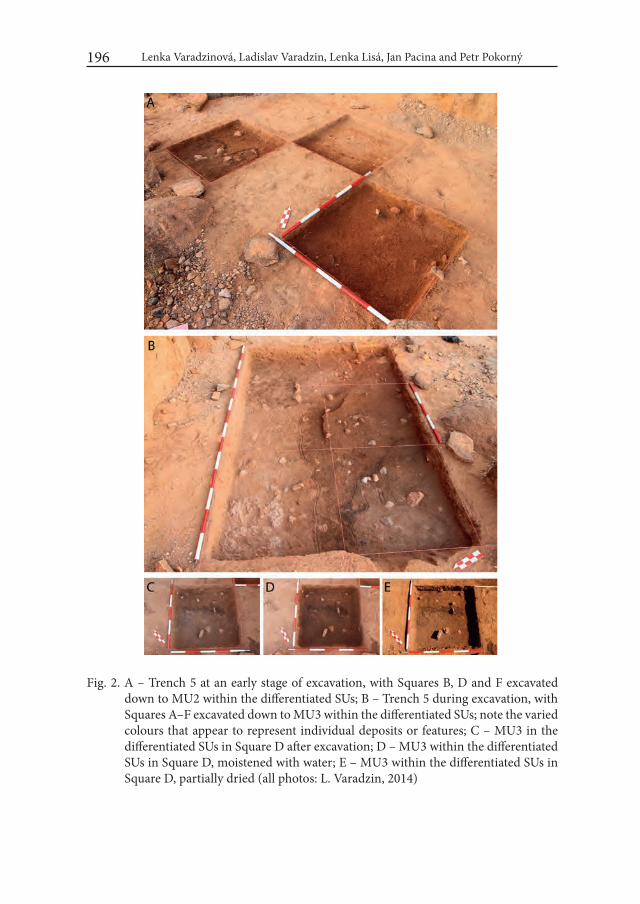
Lenka Varadzinová, Ladislav Varadzin, Lenka Lisá, Jan Pacina and Petr Pokorný196
Fig. 2. A – Trench 5 at an early stage of excavation, with Squares B, D and F excavated down to MU2 within the differentiated SUs; B – Trench 5 during excavation, with Squares A–F excavated down to MU3 within the differentiated SUs; note the varied colours that appear to represent individual deposits or features; C – MU3 in the differentiated SUs in Square D after excavation; D – MU3 within the differentiated SUs in Square D, moistened with water; E – MU3 within the differentiated SUs in Square D, partially dried (all photos: L. Varadzin, 2014)
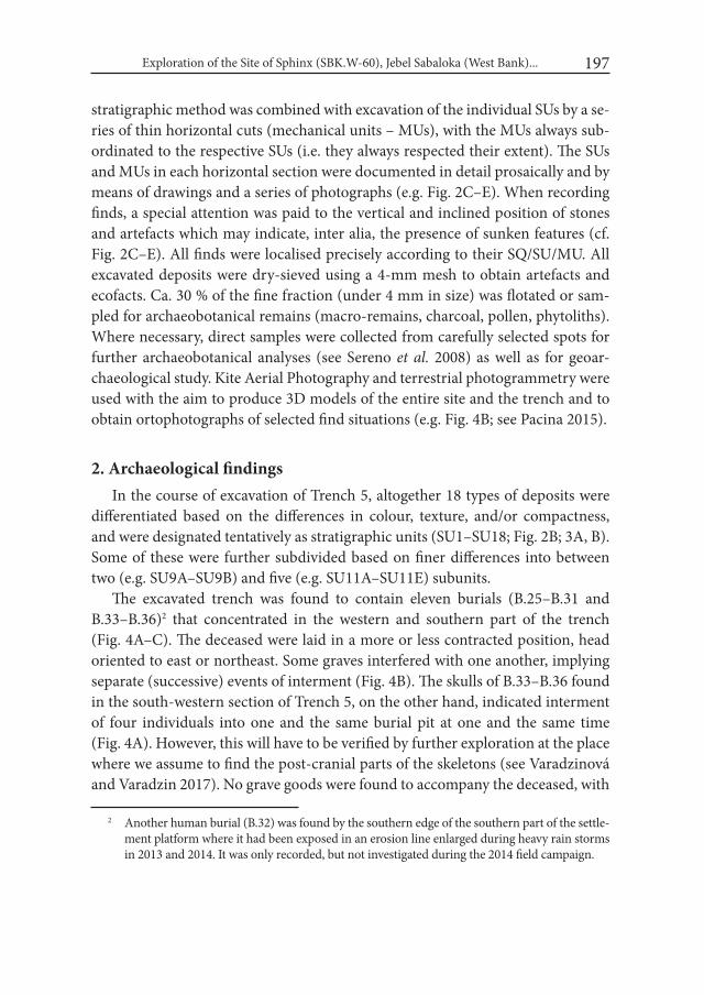
Exploration of the Site of Sphinx (SBK.W-60), Jebel Sabaloka (West Bank)... 197
stratigraphic method was combined with excavation of the individual SUs by a se-ries of thin horizontal cuts (mechanical units – MUs), with the MUs always sub-ordinated to the respective SUs (i.e. they always respected their extent). The SUs and MUs in each horizontal section were documented in detail prosaically and by means of drawings and a series of photographs (e.g. Fig. 2C–E). When recording finds, a special attention was paid to the vertical and inclined position of stones and artefacts which may indicate, inter alia, the presence of sunken features (cf. Fig. 2C–E). All finds were localised precisely according to their SQ/SU/MU. All excavated deposits were dry-sieved using a 4-mm mesh to obtain artefacts and ecofacts. Ca. 30 % of the fine fraction (under 4 mm in size) was flotated or sam-pled for archaeobotanical remains (macro-remains, charcoal, pollen, phytoliths). Where necessary, direct samples were collected from carefully selected spots for further archaeobotanical analyses (see Sereno et al. 2008) as well as for geoar-chaeological study. Kite Aerial Photography and terrestrial photogrammetry were used with the aim to produce 3D models of the entire site and the trench and to obtain ortophotographs of selected find situations (e.g. Fig. 4B; see Pacina 2015).
2. Archaeological findings In the course of excavation of Trench 5, altogether 18 types of deposits were
differentiated based on the differences in colour, texture, and/or compactness, and were designated tentatively as stratigraphic units (SU1–SU18; Fig. 2B; 3A, B). Some of these were further subdivided based on finer differences into between two (e.g. SU9A–SU9B) and five (e.g. SU11A–SU11E) subunits.
The excavated trench was found to contain eleven burials (B.25–B.31 and B.33–B.36)2 that concentrated in the western and southern part of the trench (Fig. 4A–C). The deceased were laid in a more or less contracted position, head oriented to east or northeast. Some graves interfered with one another, implying separate (successive) events of interment (Fig. 4B). The skulls of B.33–B.36 found in the south-western section of Trench 5, on the other hand, indicated interment of four individuals into one and the same burial pit at one and the same time (Fig. 4A). However, this will have to be verified by further exploration at the place where we assume to find the post-cranial parts of the skeletons (see Varadzinová and Varadzin 2017). No grave goods were found to accompany the deceased, with
2 Another human burial (B.32) was found by the southern edge of the southern part of the settle-ment platform where it had been exposed in an erosion line enlarged during heavy rain storms in 2013 and 2014. It was only recorded, but not investigated during the 2014 field campaign.
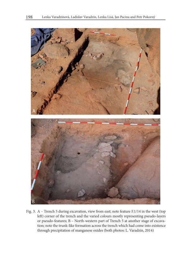
Lenka Varadzinová, Ladislav Varadzin, Lenka Lisá, Jan Pacina and Petr Pokorný198
Fig. 3. A – Trench 5 during excavation, view from east; note feature F.1/14 in the west (top left) corner of the trench and the varied colours mostly representing pseudo-layers or pseudo-features; B – North-western part of Trench 5 at another stage of excava-tion; note the trunk-like formation across the trench which had come into existence through precipitation of manganese oxides (both photos: L. Varadzin, 2014)

Exploration of the Site of Sphinx (SBK.W-60), Jebel Sabaloka (West Bank)... 199
Fig. 4. Jebel Sabaloka (West Bank), site of Sphinx (SBK.W-60): A – Skulls of burials B.33–B.35 in the south-western profile of Trench 5; B – Burials B.25–B.29 uncovered on the large granite boulder ca. 15–35 cm below the present-day surface; C – Trench 5 after excavation, view from southeast; D – Feature F.1/14 during excavation (pho-tos: A, C, D – L. Varadzin, 2014; orthophoto: B – J. Pacina, 2014)

Lenka Varadzinová, Ladislav Varadzin, Lenka Lisá, Jan Pacina and Petr Pokorný200
a possible exception of three shells of Nile bivalves collected from behind the head of B.33 at the bottom of the supposed quadruple burial (cf. Arkell 1949; Caneva 1983; Haaland and Magid 1995; Honegger 2014). The new burials constitute fur-ther evidence in support of the hypothesis on the existence of a large burial ground in the southern part of the site (see Suková et al. 2014). Interestingly, in the course of excavation it became evident that – with one exception (SU7) – practically none of the SUs corresponded to the supposed grave-pits of the explored burials.
In the south-western part of Trench 5, feature F.1/14, obviously of anthropic origin, was uncovered in a depth of ca. 40 cm below the present day surface. It was formed of medium-sized granite stones arranged in a semi-circle with a diameter of ca. 50 cm. Again, outlines of none of the 18 types of deposits (SUs) overlapped with this feature (Fig. 4D).
Several hundreds of pottery fragments datable to the Mesolithic period only (Incised Wavy Line, Dotted Wavy Line, Rocker Stamp), thousands of pieces of lith-ics from the same period, nearly one hundred upper and lower grinders (mostly broken), other finds including bone industry, pigment, mica, ostrich eggshell frag-ments and beads, mammal and fish bones, molluscs, and varied botanical remains were obtained through direct collection or dry-sieving of the excavated deposits.
In our field laboratory starch grains and phytoliths were detected on the working surfaces of grinders. This finding is of particular significance for addressing the issue of representation of vegetal component in the diet of the late prehistoric populations in the Middle Nile – one of the key issues of the Sudanese prehistory (cf. e.g. Haaland 1995; critically Usai 2014; also Buckley et al. 2014).
3. Observations on post-depositional processesSo far, no evidence of re-occupation of the site during post-Mesolithic times
has been brought to light through the hitherto excavation in the southern (as well as in the central and northern) part of the settlement platform. However, while later anthropic disturbances (sensu e.g. Caneva 1983; Salvatori 2012 – tumuli or other graves created at prehistoric sites) appear to have avoided the Mesolithic deposits at Sphinx, the following observations attest that the site has not escaped post-depositional alterations through a number of non-cultural processes:
1) The surface of the site is covered by a more or less consolidated layer con-sisting of weathered granite and a large amount of artefacts datable to the Me-solithic period; 2) Nearly continuous bands of horizontal weathering lines were detected on the boulders delimiting the settlement platform at a height ranging
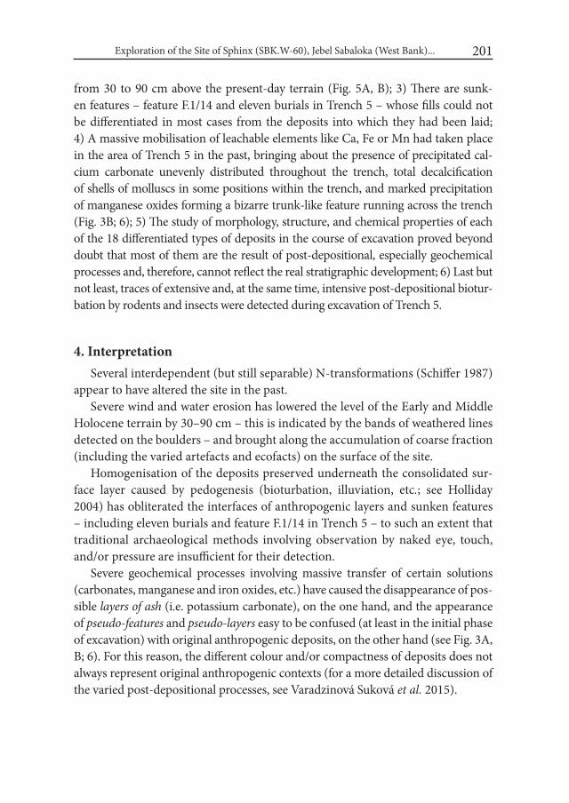
Exploration of the Site of Sphinx (SBK.W-60), Jebel Sabaloka (West Bank)... 201
from 30 to 90 cm above the present-day terrain (Fig. 5A, B); 3) There are sunk-en features – feature F.1/14 and eleven burials in Trench 5 – whose fills could not be differentiated in most cases from the deposits into which they had been laid; 4) A massive mobilisation of leachable elements like Ca, Fe or Mn had taken place in the area of Trench 5 in the past, bringing about the presence of precipitated cal-cium carbonate unevenly distributed throughout the trench, total decalcification of shells of molluscs in some positions within the trench, and marked precipitation of manganese oxides forming a bizarre trunk-like feature running across the trench (Fig. 3B; 6); 5) The study of morphology, structure, and chemical properties of each of the 18 differentiated types of deposits in the course of excavation proved beyond doubt that most of them are the result of post-depositional, especially geochemical processes and, therefore, cannot reflect the real stratigraphic development; 6) Last but not least, traces of extensive and, at the same time, intensive post-depositional biotur-bation by rodents and insects were detected during excavation of Trench 5.
4. InterpretationSeveral interdependent (but still separable) N-transformations (Schiffer 1987)
appear to have altered the site in the past.Severe wind and water erosion has lowered the level of the Early and Middle
Holocene terrain by 30–90 cm – this is indicated by the bands of weathered lines detected on the boulders – and brought along the accumulation of coarse fraction (including the varied artefacts and ecofacts) on the surface of the site.
Homogenisation of the deposits preserved underneath the consolidated sur-face layer caused by pedogenesis (bioturbation, illuviation, etc.; see Holliday 2004) has obliterated the interfaces of anthropogenic layers and sunken features – including eleven burials and feature F.1/14 in Trench 5 – to such an extent that traditional archaeological methods involving observation by naked eye, touch, and/or pressure are insufficient for their detection.
Severe geochemical processes involving massive transfer of certain solutions (carbonates, manganese and iron oxides, etc.) have caused the disappearance of pos-sible layers of ash (i.e. potassium carbonate), on the one hand, and the appearance of pseudo-features and pseudo-layers easy to be confused (at least in the initial phase of excavation) with original anthropogenic deposits, on the other hand (see Fig. 3A, B; 6). For this reason, the different colour and/or compactness of deposits does not always represent original anthropogenic contexts (for a more detailed discussion of the varied post-depositional processes, see Varadzinová Suková et al. 2015).
Fig. 5. A – Weathering lines (or grades) on the rock separating the southern and central parts of the settlement platform at Sphinx (photo L. Varadzin, 2015); B – Survey of the weathering lines/grades in the southern part of the settlement platform (photo: L. Varadzin, 2014)
Exploration of the Site of Sphinx (SBK.W-60), Jebel Sabaloka (West Bank)... 203
5. ImplicationsIn addition to a number of important archaeological finds, the exploration of
Trench 5 at the site of Sphinx at Jebel Sabaloka in 2014 brought to light several findings and observations of methodological significance. It proved true that at least at Jebel Sabaloka conventional stratigraphic excavation method involving observation by naked eye and touch is not sufficient for exploration of original prehistoric deposits. For this reason, it is indispensable to co-opt the traditional method of stratigraphic excavation by other, parallel procedures (various adjust-ments of excavation by mechanical units).
The observations deriving from exploration of one trench at one site in the peculiar environment of Jebel Sabaloka, presented in this brief paper (for more detailed overview and extended discussion, see Varadzinová Suková et al. 2015), cannot be schematically generalised, in their specific form, for other prehistoric sites in central Sudan. Nevertheless, they no doubt contribute to the recently re-opened discussion on the character of cultural deposits of prehistoric date in cen-tral Sudan and on the possibilities and limits of their archaeological exploration.
Fig. 6. Base of Trench 5, view from south; note the trunk-like feature formed by precipita-tion of manganese oxides which penetrate beneath the surface of the intact elu-vium (photo: L. Varadzin, 2014)

Lenka Varadzinová, Ladislav Varadzin, Lenka Lisá, Jan Pacina and Petr Pokorný204
AcknowledgementsOur sincere thanks are owed to the National Corporation for Antiquities and
Museums of the Sudan for the assistance and support rendered to our team in connection with the Sabaloka Research Project since 2009. The fieldwork at Jebel Sabaloka in 2014 was carried out thanks to the support of the Charles University Scientific development programme No. P14: Archaeology of non-European areas, Sub-project: Ancient Egyptian civilisation research: cultural and political adapta-tions of the North African civilisations in Antiquity (5000 BCE – AD 1000) and by “PAPAVER – Centre for Human and Plant Studies in Europe and Northern Af-rica in the postglacial period”, reg. no. CZ.1.07/2.3.00/20.0289, co-financed from the European Social Fund and the national budget of the Czech Republic. This paper is published thanks to the support of the Programme for the Development of Fields of Study at Charles University, no. Q11: Complexity and Resilience: An-cient Egyptian Civilisation in a Multidisciplinary and Multicultural Perspective, and the internal programme of the Institute of Geology of the Czech Academy of Sciences, no. RVO 67985831.
REFERENCESADAMS, W. Y. 1977. Nubia: Corridor to Africa. London.ALMOND, D. C. and F. AHMED. 1993. Field Guide to the Geology of the Sabaloka
inlier, Central Sudan. Khartoum.ARKELL, A. J. 1949. Early Khartoum. An account of the excavation of an early
occupation site carried out by the Sudan Government Antiquities Service in 1944–5. London.
BUCKLEY, S., USAI, D., JAKOB, T., RADINI, A. and K. HARDY. 2014. Dental Calculus Reveals Unique Insights into Food Items, Cooking and Plant Pro-cessing in Prehistoric Central Sudan. PLoS ONE 9(7): e100808. doi:10.1371/journal.pone.0100808.
CANEVA, I. 1983. Excavating at Saggai 1. In: I. Caneva (ed.), Pottery-using gatherers and hunters at Saggai (Sudan): Preconditions for food production: 7–29. Roma.
HAALAND, R. 1995. Sedentism, Cultivation, and Plant Domestication in the Ho-locene Middle Nile Region. Journal of Field Archaeology 22 (2): 157–174.
HAALAND, R. and A. M. MAGID. 1995. Aqualithic Sites along the Rivers Nile and Atbara, Sudan. Bergen.
HOLLIDAY, V. T. 2004. Soils in Archaeological Research. Oxford.
Exploration of the Site of Sphinx (SBK.W-60), Jebel Sabaloka (West Bank)... 205
HONEGGER, M. 2014. Recent Advances in Our Understanding of Prehistory in Northern Sudan. In: J. R. Anderson and D. A. Welsby (eds.), The Fourth Cataract and Beyond. Proceedings of the 12th international Conference for Nubian Studies: 19–30. Leuven – Paris – Walpole, MA.
PACINA, J. 2015. Geodetic surveying as a tool for discovering the prehistoric sett-lement in Sudan (the 6th Nile cataract). Geoinformatics 14: 25–48.
SALVATORI, S. 2012. Disclosing Archaeological Complexity of the Khartoum Mesolithic: New Data at the Site and Regional Level. African Archaeological Review 29: 399–472.
SCHIFFER, M. B. 1987. Formation processes of the archaeological record. Albuquerque.SERENO, P. C., GARCEA, E. A. A., JOUSSE, H., STOJANOWSKI, C. M., SALIÈGE,
J.-F., MAGA, A., IDE, O. A., KNUDSON, K. J., MERCURI, A. M., STAFFORD, Jr., T. W., KAYE, T. G., GIRAUDI, C., MASSAMBA N’SIALA, I., COCCA, E., MOOTS, H. M., DUTHEIL, D. B. and J. P. STIVERS. 2008. Lakeside Cem-eteries in the Sahara: 5000 Years of Holocene Population and Environmental Change. PLoS ONE 3(8): e2995. doi:10.1371/journal.pone.0002995.
SUKOVÁ, L. and L. VARADZIN. 2012. Preliminary report on the exploration of Jebel Sabaloka (West Bank), 2009–2012. Sudan & Nubia 16: 118–131.
SUKOVÁ, L., VARADZIN, L. and P. POKORNÝ. 2014. Prehistoric research at Jeb-el Sabaloka, Central Sudan (2011–2014). In: S. Sázelová, A. Hupková and T. Mořkovský (eds.), Mikulov Anthropology Meeting, 149–153. Brno [The Dolní Věstonice Studies, Vol. 20].
USAI, D. 2014. Recent advances in understanding the prehistory of Central Su-dan. In: J. R. Anderson and D. A. Welsby (eds.), The Fourth Cataract and Beyond. Proceedings of the 12th international Conference for Nubian Studies, 31–44. Leuven – Paris – Walpole, MA.
VARADZINOVÁ, L. and L. VARADZIN. 2017. Exploration of the site of Sphinx (SBK.W-60): findings of the 2014 and 2015 field seasons. In L. Varadzinová, L. Varadzin et al., Sabaloka (West Bank) Research Project. Sudan & Nubia 21: 23–33.
VARADZINOVÁ SUKOVÁ, L., VARADZIN, L., BAJER, A., LISÁ, L., PACINA, J. and P. POKORNÝ. 2015. Tracing post-depositional processes at Me-solithic occupation sites in central Sudan: view from the site of Sphinx (SBK.W-60) at Jebel Sabaloka. interdisciplinaria Archaeologica: Natural Sci-ences in Archaeology V (2): 133–150.

Desert and the Nile. Prehistory of the Nile Basin and the Sahara.
Papers in honour of Fred Wendorf Studies in African Archaeology 15
Poznań Archaeological Museum 2018
Attila Király
Digital Data and Holocene Lithic Industries in the Sudanese Nile Valley: a Case Study
Although I only met him once, Fred Wendorf has a basic impact on everything I know about archaeology. During my undergraduate years in Miskolc, Hungary, it seemed impossible to gain data about Palaeolithic Egypt until I found a Wen-dorf, Schild and others article in the Science journal (Wendorf et al. 1976). Their names guided me from publication to publication deep into the Northeast Af-rican prehistory. Fred Wendorf is and will be an unwavering foundation of our discipline. With this essay I thank him for all the inspiration and knowledge he gave to me.
IntroductionThe prehistoric remains from the fourth catarct area of the Nile stand in a vac-
uum. The uneasy taphonomic situations and the transit location between con-ventional research areas make these remains difficult to assess in the prevailing chronological and cultural schemes. Grasping the knapped lithics in these frames of reference posits a real challenge, because these artefacts are underrepresent-ed in the discourse about Holocene prehistory of the Sudanese Nile Valley. The Merowe Dam salvage era offers an opportunity to have a fresh look at the role of lithic industries, and the ways how lithic data can be managed. In the case of the
Attila Király208
Merowe Dam Archaeological Salvage Project (MDASP), it is hard to escape from the comparsion with the UNESCO High Dam salvage expedition. Both enter-prises were realized by international cooperation, conducted at a less known ter-ritory in archaeological terms and produced an astonishing amount of new data. One huge difference for the MDASP is its standing on the shoulders of giants. The past fifty years witnessed the elaboration of a Northeast African prehistory with a distinct scientific community.
This remarkable scholarly background is now further strengthened by novel ways of communication, i.e. through “The Internet”. Thoughtful management, sharing and co-creating of digital content already play an important role in scien-tific practice, and eventually, in the production of scientific knowledge. Through digital media, archaeologists are increasingly and inevitably engaged in a coop-erative system of stakeholders, which affects many existing norms of disciplinary behaviour. One of the grand challenges for archaeology is not just the use of soft-ware or the Web, but to understand their effects on the very core of its method, and to create a cyberinfrastructure for its own.
In my opinion, knapped lithics are a good match for digital care. Current methods in lithic analysis can be extremely data-consuming, in order to take reasonable statements about the archaeological record. For adequate conclusions and cooperation, great quantity and good quality data are essential, hence lithic experts are on the verge of a consensus about the standards of data creation. The logic of digital data processing favours these types of standards, besides, the ca-pacity of digital storage and transfer seems endless. In order to broaden the role of lithics from cultural markers to a versatile record of past human behavior in the fourth cataract area, I hypothesize a need for detailed and structured data about them that can be reused along diverse theoretical considerations. This need can be fulfilled by digital data publication, as one alternative among many others. Through a case study I present the manifold requirements of an effective publica-tion which facilitates data for further research.
1. Lithic artefacts in the Holocene prehistory of the Middle Nile ValleyLithics are not pivotal players in the discourse about Holocene prehistory of
the Sudanese Nile Valley. The regional cultural frames are built upon the relation-ship between absolute dates and ceramic material (e.g. Dittrich 2015; Garcea and Hildebrand 2009; Gatto 2002a; 2002b; 2006; Honegger 2014; Jesse 2002; Sadig 2010; Salvatori 2012; Salvatori and Usai 2007; Usai 2014). In many cases, lithics
Digital Data and Holocene Lithic Industries in the Sudanese Nile Valley: a Case Study 209
only complement these relationships, by typical retouched tools or technology derived morpho-types, as cultural markers. There are indications about the use of lithic tools as projectiles and insets, but so far we know little about debitage products that testify the lion’s share of variability in a lithic assemblage (Becker and Wendorf 1993; Caneva and Zarattini 1983; Honegger 2009; Kobusiewicz 1996). We do not have a detailed understanding about the economic and social aspects of lithic production. The recent years saw an explicit need for these in-formations, accompanied by publications with a more technological orientation and analytical accent (e.g. Dittrich 2011; Dittrich et al. 2007; Garcea 2003; Jakob 2010; Kabaciński 2003; Kobusiewicz 2011; Osypiński 2010; 2011; Usai 2005; 2006; 2008).
The present imbalanced assessment of lithic artefacts arose from a host of fac-tors. The first phase of research concentrated on the cultural-chronological outline of the area which was approached through the pioneer ceramic studies of Arkell, Myers and Reisner. Ceramics are recognized as a highly informative record of the past, with a design that changes faster than lithics (Garcea and Hildebrand 2009; Salvatori 2012). The vast distribution of wavy line ceramics over North Africa, the early appearance of ceramic technology and domestication in the Sahara directed the focus of research on questions about interregional contacts. The lithic imple-ments of the Sudanese Nile Valley had got less attention in that discourse (Dittrich 2013; Usai 2006; 2014). Moreover, many publications about the Holocene prehis-tory of Sudan continued to display the exploratory phase of scientific research, because many areas were just discovered from an archaeological point of view. These publications were and are not intended to unravel lithic technological or-ganization, their aim is to report proceedings. Lastly, the special taphonomic and stratigraphic situations warrant caution about the integrity of lithic assemblages (Dittrich 2015; Salvatori et al. 2011; Usai 2014; Wengrow et al. 2014). There are many variables to consider before we can recognize the temporal resolution of the preserved remains of a site/layer/concentration.
Lithics constitute the most durable and one of the most numerous artefact cat-egory from prehistoric times well until the Meroitic era. Our understanding about lithics today rest on a modest segment of the total variability that can be recorded. This segment approached by heterogenous classification schemas that forged in a gradual discovery of prehistoric Sudan. Complex technological analyses offer a more comprehensive understanding of local lithic traditions, site formation and intersite relations, with a more systematic, high resolution approach to lithic vari-ability (Andrefsky 2009; Barton et al. 2004; Hiscock and Tabrett 2010; Holdaway,
Attila Király210
Wandsnider 2006; Lycett 2015; Scerri et al. 2015). To achieve this aim, there is a need for substantial, standards-aligned datasets to share.
2. Digital archaeology and data publicationThe prime mover behind the knowledge economy and society today is com-
munication, which is accelerating at an unprecedented pace with the help of Web 2.0 and 3.0 (Boulton 2012; Cerroni 2007). The only 12-years-old Web 2.0 is not a new technological instrument but a novel attitude to digital communication. Instead of a one-sided dissemination tool (Web 1.0), the Internet can be used as an instrument for sharing, discussing and co-creation of contents (Dunn 2011; Limp 2011; O’Reilly 2005; Oikarinen and Karasti 2014). In our everyday world this means social media, blogs, comments, wikis and piles of cat videos. In the scientific method, this is the way of knowledge production.
Knowledge is a preformative act, as it is only embodied in practice (Boast and Biehl 2011). For this reason, generation of knowledge is possible only through en-gagement with other agents – other people and things, and this engagement must involve data sharing between people. In the field of lithic studies, François Bordes basically transformed our knowledge about the past, only through a transformed practice of lithic data presentation (i.e. with his typology). In 2016, we are facing such substantial changes. The almost infinite possibility to collect, arrange and communicate scientific data evokes René Descartes’ bedrock call of science:
„I am calling the best minds to progress further than me, each one according to his bent and ability, in the necessary experiments, and [they] would commu-nicate to the public whatever they learned, so that one man might begin where another left off; and thus, in the combined lifetimes and labours of many, much more progress would be made by all together than anyone could make by himself.” (Descartes 1993; translated to English by the author).
The Web 2.0 communication provoked a rapid and pervasive change in the expectations, methods and publication habits of the scholarly community (Austin et al. 2015; Boulton 2012; Emanuel 2015; Jamali et al. 2009; Kansa 2011; Larivière et al. 2015; Morgan end Eve 2012; Oikarinen and Karasti 2014; Richardson 2013; Stodden et al. 2013; Wallis et al. 2013). E-publishing is gaining ground in opposi-tion to printed media, and this trend is more pronounced in the younger age co-horts of academics. In practical terms the next generation of scholars will acquire scientific information almost exclusively online. Social media also have a growing impact; beside popular channels as Facebook or Twitter, there are specific pro-

Digital Data and Holocene Lithic Industries in the Sudanese Nile Valley: a Case Study 211
fessional applications (Academia, ResearchGate, Mendeley, Figshare, OrcID etc; Lupton 2014; Perry and Beale 2015). The scientific community is in the online state of a „constant conference”. Researchers, institutions, publishing companies and other stakeholders begin to perceive science as a cooperative system with an emphasis on effective communication through digital technologies (Destro Bisol et al. 2014). This system of knowledge production is also interlinked with policies and funding. In the EU, it is part of the Digital Agenda for Europe, one of the flagship initiavtives of the Europe 2020 strategy (European Commission 2012).
A grand challenge for archaeology in 2016 is not to accept or avoid these facts but to build a cyberinfrastructure in accordance with the special needs and pos-sibilities characterising this field of inquiry (Borgman 2015; Dallas 2015; Hole 2012; Huggett 2015; Kintigh et al. 2014). Archaeologists use digital techniques for a long time in their research, from GIS to virtual reconstructions. The majority of archaeological data are also born and stored in digital form, but these data are al-most never made public. Apart from skill-related, legal and organizational issues, this practice seems to contradict the scientific method per se (Austin et al. 2015; Destro Bisol et al. 2014). In ideal case, researchers publish their theories together with the data on which theories are built. This allows other scientists to replicate research in order to test associated theories, and to re-use data in novel ways. Data sharing thus is an essential part of the process.
The amount and complexity of archaeological, hence lithic data are growing continuously. Data publication was largely restricted in the printed academic dis-course, but it is possible to share in its entirety through digital means. Paraphras-ing Angela Close from 1989, this possibility does not take away our problems with data but highlights and rearranges them (Close 1989). We have to redefine what the (published) archaeological data mean; how can we structure and man-age them from a professional point of view; what are our technical choices for representation and sharing; lastly, how can we resolve the attribution, curation and preservation of digital data.
2.1. Data in archaeologyThere is not a clear-cut definition for archaeological data, nor some supreme
court to decide. Pragmatically data are structured information not economical to subdivide in the given structure (Atici et al. 2012; Borgman 2015; Van Pool and Leonard 2011). Archaeological narrative represents almost inseparable unity of data and interpretation. From the very moment of their discovery, physical resi-

Attila Király212
dues of the past are selected, arranged and interpreted by multiple parties. Hence, archaeological data is contextual, contingent and patchy (Dallas 2015). If we ac-cept the scientific method in archaeology, we would give the same epistemological credit for the first and the n-th narrative about the past. The main reason for our discredit is that the n-th researcher is more distant from the „raw data”, because she/he has to work with the results of former published interpretations. This cre-ate a confusing data diversity, but scientific method, for the sake of the Descartian benefits, promotes data integrity. Paradoxically, multifaceted interpretation is se-cured only if data have some distance from their creators’ dispositions. This very delicate act of data isolation, basically, standardization is typically a task for expert communities (Atici et al. 2012; Costa et al. 2013; Dallas 2015; Kansa et al. 2014; Limp 2011). This problem is well known in areas where communication is intense. Experts of Wavy Line ceramics reached great progress in integrating methods and terminology, creating baseline standards of study (Garcea and Caputo 2004; Gatto 2002a; 2002b; 2006; Jesse 2002; Mohammed-Ali and Khabir 2003; Salvatori and Usai 2007). The standards are constructed on the material reality of the sherds, reflect the specific archaeological agenda but not comitted to one theoretical po-sition. The trait of „tightly packed zigzag” can be used for a variety of purposes. This consensus on standards is the most important element of archaeological data.
2.2. Data publicationInformal data sharing is typically a one-to-one action embedded in personal
conversation (emails). Digital data sharing as publication enhances this practice in order to distribute consistent, standards-aligned datasets for reuse by a wider audience. Data publication conforms to disciplinary standards, formal require-ments of academic discourse and technical requirements of online dissemination (Kansa et al.2014; Kratz and Strasser 2014). Creating such datasets requires extra efforts with some necessary steps presented on Fig. 1.
The dataset is accompanied by documentation that helps other researchers from the same field to use the data. It consists of contextual informations and higher-level theories about the project; data ontology or creation methods as mid-dle-level theory; practical description of variables as low-level theoremes. Cur-rently there are three basic forms of documentation: attached file; separate pub-lication in a data journal (e.g. Journal of Open Archaeology Data); or in a more familiar reverse oreder, where documentation is the published article and dataset is the supplement. Digital repositories attach machine-readable metadata to the
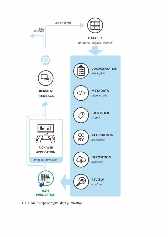
DATASETstandards-aligned, cleaned
METADATAdiscoverable
IDENTIFIERcitable
ATTRIBUTIONassessable
DEPOSITIONavailable
DOCUMENTATIONintelligible
REVIEWvalidated
RICH WEBAPPLICATION
DATAPUBLICATION
REUSE &FEEDBACK
living dissemination
version control
newresearch
Fig. 1. Main steps of digital data publication
Attila Király214
hosted content to make them discoverable by search engines. In most of the cases, these metadata can be manipulated by humans, for example, through tagging. One of the most important feature is citation, which can be secured online by Digital Object Identifiers (DOI-s), in order to implement publication in the aca-demic discourse (doi.org). Online data dissemination and archiving are provided by non-profit, for-profit organizations and public institutions as well. Copyright options can be set by the provider or by the uploader. In the case of datasets an open license is advised which allows to use and manipulate the data. Today we can encounter two distinct ways of dissemination (Costa et al. 2013). (1) Static data-sets released as stable resources, the files can be manipulated after downloading. This method is comparable to the paper based academic publication scheme with a big difference in storage capacity. Living datasets (2) offer interactive, so-called rich web applications to manipulate, visualize and expand the original content (Limp 2011).
Scientific and instrumental conditions of data publication have a distinct re-lationship. People use data not read them, thus instruments of use affect recogni-tion, methods of data creation, eventually, interpretation. Archaeological obser-vation usually involves phenomena, not a sole phenomenon. Therefore, analysis basically means organization and classification irrespective of the subject and theory of a given project. Digital instruments have been proven helpful exactly in this kind of work. They made a great contribution to the „scientific boom” in archaeological practice and the materiality turn in archaeological theory we are witnessing today (Killick 2015; Kristiansen 2014).
Print-based academic discourse requires highly filtered and abstract data presentation in order to save space for narratives at all. Online data publication does not supersede this requirement, but creates a problem that is exactly the opposite of scantiness: there is too much space, petabytes of information appear more of an obstacle than help. Web 2.0. takes advantage on quantity and offer personal filtering and abstraction tools. One single database can be repurposed many ways, and many separate databases can be aggregated as one to extract new informations. This degree of control over other people’s data is unprece-dented, giving the opportunity for multiple interpretation on the same sources. All these advances rely on interoperability, an agreed modularization of obser-vations on archaeological phenomena. Methods of lithic studies evolved in this direction during the past decades: standardization of taxonomy, decoupling ob-servations from the level of lithic tool to attributes, and statistical representation of data.
Digital Data and Holocene Lithic Industries in the Sudanese Nile Valley: a Case Study 215
3. Outline of lithic data management historyKnapped stone tools are part of the whole human story, it is the main source of
information concerning the million-years long preceramic era. Data about stone tools therefore have to comply a wide diverse set of theoretical systems, neverthe-less, physical qualities of rocks and the act of knapping constrain the range of ob-servable phenomena tight. Lithic data management, or systematics, became more comprehensive, more modular and more versatile to overcome these constraints throughout the years. The modern era of lithic research history begin with the typological work of François Bordes (Bordes 1979). During the sixty years since his Typologie du paléolithique… a wide array of methods formed and exist beside each other today. The monothetic, essentialist, teleologic, structuralist etc mod-els apply a priori discrete categories for classification. Polythetic, constructionist, evolutionist, analytic etc. models have a bottom up approach. The observed varia-tion serves criteria for pattern recognition (Read 2007; Tostevin 2011; Van Pool and Leonard 2011; Wylie 2002).
The Bordian method originally was a genuine solution for a communication problem. Instead of single artefacts as lead fossils, Bordes recognized the impor-tance of comparsion between distributional patterns in lithic assemblages. This approach demanded huge datasets that was impractical to publish in print, there-fore some kind of data shrinking was needed. This need was fulfilled by the con-cept of type, basic statistics and standardized forms of data presentation: cumula-tive diagrams, bar graphs, and consistent artefact drawings.
The essentialist view of type postulated a concept of a finished tool in prehis-toric minds that can be detected by the skillful prehistorian. Although Bordes never defined the term, his writing made clear that type was a heuristic cher-ry picking of different morphological and technological traits: „One has to see a great number of implements, classify them, see them again several times, before one acquires a »typological eye«” (Miller and Bordes 1972).
Classic typologies, among them Tixier’s work from 1963, defined the analyti-cal units of pattern recognition in typical tools (Tixier 1963). Lithic variability beyond secondary modfied typical tools almost never reached the public, i.e. sci-entific publication. Soon the scholarly community perceived data per se as typical tools and Bordian indices, because these were the primary structured informa-tions appeared in the printed media. This dilemma was addressed by Steward and Seltzer more than 75 years ago: constructing typology in the reality is a conclusive act of intensive research, but other scholars usually begin their research according to an existing typology (Steward and Setzler 1938).
Attila Király216
The lively discourse referenced as the Binford–Bordes debate lead the Ameri-can Reduction Sequence (RS) approach and processual archaeology in general, into the mainstream of lithic studies (e.g. Binford 1973; Bisson 2000; Bordes and Sonneville-Bordes 1970; Rolland and Dibble 1990; Tostevin 2011). The debate centered on the meaning of lithic variability, emphasizing that production and use are dynamic processes, during that form and functions of lithic implements change. Classic types are snapshots of change created by irresolute boundaries along a complex morphological-tehnological continuum. From a processual point of view typology draws a static picture about stone tools, compressing the long history of preparation and use into one sole timestamp (cf. Bailey 2007: 207). Some types in Bordes’ schema in fact represented different states of the same pro-cess which shook the credit planted in the concept of type as an intentional, fin-ished tool. Technological research, experimental archaeology and later traceology made clear that between use and design there is a complex set of relations (An-drefsky 2009; Hiscock and Tabrett 2010; Holdaway and Douglass 2012).
This functional argument opened up a rupture concerning the aims of stone tool research. Classic culture-historical interpretation of the past was supplanted by re-search programs that asked for realities of living, subsistence, and social relations of past communities. The RS approach, the French technological school, not least the Schild and Wendorf dynamic technological system compiled a different methodol-ogy, when they centered their research on technology and assemblage formation (e.g. Bar-Yosef and Van Peer 2009; Carr and Bradbury 2011; Soressi and Geneste 2011; Lycett and Chauhan 2010; Schild and Wendorf 1977; Tostevin 2011). The scope of analysis included whole assemblages irrespective the degree of modifica-tion on a piece. Consequently, the basic unit of research scaled up from artefacts to characteristic traits (témoins) or attributes. This resolution shift enabled polythetic classification. After Wittgenstein’s game analogy, a stone implement takes only one physical form but according to its attributes can be part of different aggregates si-multaneously: microlith by its size, flake by dimensions, sidescraper by location of retouch and grave offering by its context of deposition (Fig. 2). This broad and layered scope of data management followed by new representation techniques. An unambiguous taxonomy and meticulous rules of drawing set foot with the spread of the chaîne opératoire concept (Inizan et al. 1999). RS approaches adopted quantita-tive statistical methods and visualization to handle aggregate stone tool data (e.g. Lycett 2015; Magnani 2014; Scerri et al. 2015; Van Pool and Leonard 2011).
Current relativism in archaeological theory put emphasis on probability in-stead of objective facts about the past (e.g. Skibo and Schiffer 2008; Wylie 2002).
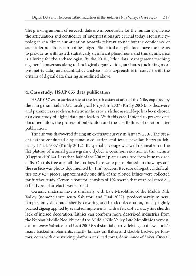
Digital Data and Holocene Lithic Industries in the Sudanese Nile Valley: a Case Study 217
The growing amount of research data are impenetrable for the human eye, hence the articulation and confidence of interpretations are crucial today. Heuristic ty-pologies can direct our attention towards relevant trends but the confidence of such interpretations can not be judged. Statistical analytic tools have the means to provide us with tested, statistically significant phenomena and this significance is alluring for the archaeologist. By the 2010s, lithic data management reaching a general consensus along technological organization, attributes (including mor-phometric data) and quantitative analyses. This approach is in concert with the criteria of digital data sharing as outlined above.
4. Case study: HSAP 057 data publicationHSAP 057 was a surface site at the fourth cataract area of the Nile, explored by
the Hungarian Sudan Archaeological Project in 2007 (Király 2008). Its discovery and parameters are characteristic in the area, its lithic assemblage has been chosen as a case study of digital data publication. With this case I intend to present data documentation, the process of publication and the possibilities of curation after publication.
The site was discovered during an extensive survey in January 2007. The pres-ent author conducted a systematic collection and test excavation between feb-ruary 17-24, 2007 (Király 2012). Its spatial coverage was well delineated on the flat plateau of a small gneiss-granite djebel, a common situation in the vicinity (Osypiński 2014). Less than half of the 300 m2 plateau was free from human sized cliffs. On this free area all the findings here were piece plotted on drawings and the surface was photo-documented by 1 m2 squares. Because of logistical difficul-ties only 627 pieces, approximately one fifth of the plotted lithics were collected for further study. Ceramic material consists of 102 sherds that were collected all, other types of artefacts were absent.
Ceramic material have a similarity with Late Mesolithic of the Middle Nile Valley (nomenclature sensu Salvatori and Usai 2007): predominantly mineral temper; only decorated sherds; covering and banded decoration, mostly tightly packed zigzag applied by serrated implements, with a few dotted wavy line sherds; lack of incised decoration. Lithics can conform more described industries from the Nubian Middle Neolithic and the Middle Nile Valley Late Mesolithic (nomen-clature sensu Salvatori and Usai 2007): substantial quartz debitage but few „tools”; many backed implements, mostly lunates on flakes and double backed perfora-tors; cores with one striking platform or sliced cores; dominance of flakes. Overall
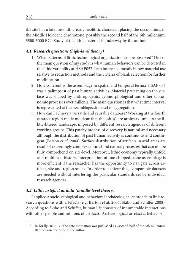
Attila Király218
the site has a late mesolithic-early neolithic character, placing the occupations in the Middle Holocene chronozone, possibly the second half of the 6th millenium, 5500-5000 BC.1 Study of the lithic material is underway by the author.
4.1. Research questions (high-level theory)1. What patterns of lithic technological organization can be observed? One of
the main question of my study is what human behaviors can be detected in the lithic variability at HSAP057. I am interested mostly in raw material use relative to reduction methods and the criteria of blank selection for further modification.
2. How coherent is the assemblage in spatial and temporal terms? HSAP 057 was a palimpsest of past human activities. Material patterning on the sur-face was shaped by anthropogenic, geomorphological and other tapho-nomic processes over millenia. The main question is that what time interval is represented at the assemblage/site level of aggregation.
3. How can I achieve a versatile and reusable database? Working at the fourth cataract region made me clear that the „sites” are arbitrary units in the li-htic-littered landscape, imposed by different research agendas of different working groups. This patchy process of discovery is natural and necessary although the distribution of past human activity is continuous and contin-gent (Barton et al. 2004). Surface distribution of artifacts in arid areas are result of exceedingly complex cultural and natural processes that can not be fully comprehend on site-level. Moreover, lithic economy typically unfold as a multilocal history. Interpretation of one chipped stone assemblage is more efficient if the researcher has the opportunity to navigate across ar-tifact, site and region scales. In order to achieve this, comparable datasets are needed without interfering the particular standards set by individual research agendas.
4.2. Lithic artefact as data (middle-level theory)I applied a socio-ecological and behavioral archaeological approach to link re-
search questions with artefacts (e.g. Barton et al. 2004; Skibo and Schiffer 2008). According to Skibo and Schiffer, human life consists of innumerable interactions with other people and millions of artifacts. Archaeological artefact is behavior –
1 In Király 2012: 175 the date estimation was published as „second half of the 5th millenium BC” because the error of the author.

Digital Data and Holocene Lithic Industries in the Sudanese Nile Valley: a Case Study 219
interaction and its impression in the physical world, the only way that past behav-ior is accessible to us. Archaeological artefacts parttaking countless interactions since their production, with humans, natural phenomena and other objects as well. This history of an artefact called behavioral chain.
Knapping as interaction leaves traces (témoins) in the matter. One gesture usually execute one notable detachment with a negative scar on the surface of the block. Series of detachments form a layered topography of negative scars and other stigmata, which can be read as a knapping method. As knapping advances, this topography begin to spread over on all the pieces that is detached from the original block of stone. Use and taphonomic processes cause further stigmata, even thousands of years later than the first detachments. From an epistemological point of view, lithics are aggregates of traces with distinct ontologies. If the aim of lithic analysis is to infer past human behavior, basic unit of measurement has to be the témoin, which consists of an attribute (sensu Clarke 1968) and its location: on the artefact, at the site, in the region.
The topography of attributes is a valuable asset for the archaeologist because human behavior can be modularized to single interactions, the traces of interac-tions can be arranged in a relative temporal sequence, and the sequence is de-tectable over many artefacts. Lithic attributes thus have distinct spatio-temporal
Fig. 2. Monothetic and polythetic classification systems, theory and data driven research models, and their complementary relationship, exemplified by a hypothetical lithic artefact
Attila Király220
scales of interpretation with different qualities: extent of an artefact, concentra-tion of artefacts, sites, regions. One single negative scar with certain character-istics can be interpreted as a detachment with a soft hammer; distinct pattern of negatives on a piece can be indicative for a Levallois method; abundant occurence of primary flakes in an assemblage can point on-site decortication; absence of primary flakes from nearby sites suggests that the first site is a local workshop area. Raw material, morphometric and technological data can captured on every single item irrespective of its stratigraphic position or the size of the sample. With the attribute system, these data from mixed surface assemblages can be handled together with data from more secure archaeological contexts.
4.3. Data ontology (low-level theory)Data collection was determined by three criteria. I surveyed the stone tool
research literature for the range of possible analyses, that I compared against the research questions and the character of the assemblage itself. Unit of data capture was the attribute which represent a higher resolution than the units commonly found in published reports about holocene prehistory of the Middle Nile Valley. This resolution was needed because of the technological character of my research and the diverse terminology observed in the reports. In the database, instead of „micropoinçons” there are pieces with dorsal cortex; having converging distal and proximal ends; left and right sides bear secondary modification in their entire length; type of modification is backing. Based on the attributes every user can assemble groups of artefacts according to her/his classification system. The at-tributes designate technological and morphological traits according to Inizan et al. (1999). This publication, beside its analytical strengths offers a multilingual nomenclature.
The database presently contains 131 different attributes (variables), data cap-ture on the 627 pieces required approximately 180 hours (Fig. 3). According to the third research question above, emphasis was placed on versatility. At the pres-ent state of inquiry we do not know exactly what attributes are significant in the understanding of lithic assemblages from the fourth cataract region. I registered much more variables than usually needed, to test their significance, and to facili-ate tests along different research questions as mine.
Variables along nominal and ordinal scales are attributes that can not be quan-tified by macroscopic observation, or their quantification would be inefficient. Examples are severity of platform edge damage, intensity of ventral ripples on flakes. The independent grouping variables are nominal too, like debitage catego-

Digital Data and Holocene Lithic Industries in the Sudanese Nile Valley: a Case Study 221
NEGATIVES (DETACHED PIECES) BACKED IMPLEMENTSType of support; shape of proximal and distal ends; side of backing; direction of backing; shape of backed and non-backed edge; shape of piece in lateral view
NEGATIVES (DETACHED PIECES) ZONAL-LOCATIONAL DATADorsal cortex coverage; non-modified edge length and steepness; type, location and steepness of edge alteration (non-retouch); type, location and steepness of edge modification (retouch, backing etc.)
NEGATIVES (DETACHED PIECES) METRIC DATALength, width and thickness by maximum dimension, by debitage axis, by morphological axis; outline length; Mass; width and thickness at proximal, mesial and distal sections; bulb length; bulb thickness; talon width; talon maximum depth and depth at the middle; theoretical talon depth; exterior and interior angle
NEGATIVES (DETACHED PIECES) OBSERVABLE DATADebitage class; breakage class; break type; form; form of cross-section; position of dorsal cortex; dorsal scar count; dorsal scar pattern; propagation; termination; point of force; location and number of bulbs; type of bulb; presence of cone of percussion; accentuated ripples; type of talon; talon damage; damage on the ventral proximal and dorsal proximal area
CORES DEBITAGE SURFACESLength, width, circumference; degree of damage, weathering, cracks, scaled area; scar count; scar pattern; number of attached striking platforms; number of scars with non-feather termi-nation; dimensions of biggest and last negative
CORES STRIKING PLATFORMSLength, width, circumference; type of striking platform; angle between striking platform and debitage surface
POSITIVES (CORES, CORE FRAGMENTS AND CHUNKS)METRIC AND OBSERVABLE DATAKnapping method; knapping technology; length, width and thickness by maximum dimension; number of non-cortical striking platforms; number of debitage surfaces; number of flake scars; number of flake scars on debitage surfaces
RAW MATERIAL OBSERVABLE DATAPetrology; nodule form; cortex color; cortex texture; color; texture; patterns, bioclasts, inclu-sions; brightness; translucence; heat modification; secondary cortex; polish; roundedness
Fig. 3. Selection of attributes recorded on the Mid-Holocene lithic assemblage from HSAP 057, fourth cataract area, Sudan. Source: Király 2016
Attila Király222
ry, talon type and different raw material characteristics. Interval scale variables are the metric data that I recorded along all the main orientations in use.
4.4. Process of data publicationData publication followed the static dissemination model. I pursued criteria
for intelligent openness which means that data must be: discoverable, accessible, intelligible, assessable and re-useable (Boulton 2012). During preparation I cor-rected the inconsistencies with the OpenRefine software (openrefine.org). The cleaned set converted to a Microsoft Access file, with an attached documentation file. The two files together constitute the database for publication. Assessment has been secured with a Creative Commons Attribution 4.0 international license (cre-ativecommons.org). I chose the Figshare repository for archiving, identification and dissemination (figshare.com). After uploading, metadata was created about the content. The uploaded data was reviewed by the editors, and the repository provided a persistent identifier (DOI) for the sake of citation (Király 2016).
4.5. Data curation and version controlThe deposited data file is not manageable online, it has to be downloaded to
work with it. The author can replace the file without modifying the metadata. Fig-share ensures version control, previous versions are stored under separate DOIs. Users can comment the dataset or request the author for modification. This re-pository offers a free-of-charge membership plan for private individuals.
5. Summary and future prospectsLithic analysis is an exceptionally data-consuming endeavor, because under-
standing the production and use of stone tools requires to survey whole assem-blages. This magnitude of data cannot be represented in the print-based academic discourse. Apart from compact statistical visualization techniques, researchers in-creasingly use digital dissemination tools, that do not impose volume restrictions. Data sharing can result standards-aligned, aggregate datasets, wich improves the ability to reproduce distinct conclusions and generate new knowledge. Digital communication is zealously promoted by different stakeholders around the sci-entific enterprise. Online data publication can comply with the formal standards of academic publication. Several workflows are available, according to preferences and institutional protocols imposed on the author. With the case study I present-ed a method which is free of charge and does not demand special IT skills.
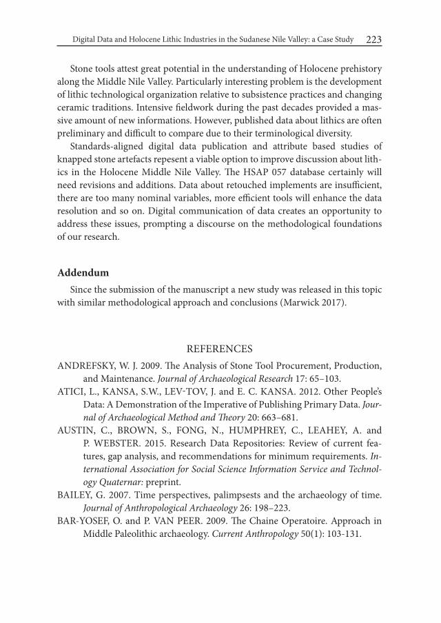
Digital Data and Holocene Lithic Industries in the Sudanese Nile Valley: a Case Study 223
Stone tools attest great potential in the understanding of Holocene prehistory along the Middle Nile Valley. Particularly interesting problem is the development of lithic technological organization relative to subsistence practices and changing ceramic traditions. Intensive fieldwork during the past decades provided a mas-sive amount of new informations. However, published data about lithics are often preliminary and difficult to compare due to their terminological diversity.
Standards-aligned digital data publication and attribute based studies of knapped stone artefacts repesent a viable option to improve discussion about lith-ics in the Holocene Middle Nile Valley. The HSAP 057 database certainly will need revisions and additions. Data about retouched implements are insufficient, there are too many nominal variables, more efficient tools will enhance the data resolution and so on. Digital communication of data creates an opportunity to address these issues, prompting a discourse on the methodological foundations of our research.
AddendumSince the submission of the manuscript a new study was released in this topic
with similar methodological approach and conclusions (Marwick 2017).
REFERENCESANDREFSKY, W. J. 2009. The Analysis of Stone Tool Procurement, Production,
and Maintenance. Journal of Archaeological Research 17: 65–103.ATICI, L., KANSA, S.W., LEV-TOV, J. and E. C. KANSA. 2012. Other People’s
Data: A Demonstration of the Imperative of Publishing Primary Data. Jour-nal of Archaeological Method and Theory 20: 663–681.
AUSTIN, C., BROWN, S., FONG, N., HUMPHREY, C., LEAHEY, A. and P. WEBSTER. 2015. Research Data Repositories: Review of current fea-tures, gap analysis, and recommendations for minimum requirements. in-ternational Association for Social Science information Service and Technol-ogy Quaternar: preprint.
BAILEY, G. 2007. Time perspectives, palimpsests and the archaeology of time. Journal of Anthropological Archaeology 26: 198–223.
BAR-YOSEF, O. and P. VAN PEER. 2009. The Chaine Operatoire. Approach in Middle Paleolithic archaeology. Current Anthropology 50(1): 103-131.

Attila Király224
BARTON, C. M., BERNABEU, J., AURA, J. E., GARCIA, O., SCHMICH, S. and L. MOLINA. 2004. Long-Term Socioecology and Contingent Landscapes. Journal of Archaeological Method and Theory 11: 253–295.
BECKER, M., and F. WENDORF. 1993. A Microwear Study of a Late Pleistocene Qadan Assemblage from Southern Egypt. Journal of Field Archaeology 20: 389–398.
BINFORD, L. R. 1973. Interassemblage variability-the Mousterian and the ‘func-tional’ argument. In: C. Renfrew (ed.), Explanation of Culture Change: 227–254. London.
BISSON, M. S. 2000. Nineteenth Century Tools for Twenty-First Century Ar-chaeology? Why the Middle Paleolithic Typology of François Bordes Must Be Replaced. Journal of Archaeological Method and Theory 7: 1–48.
BOAST, R., and P. F. BIEHL. 2011. Archaeological Knowledge Production and Dissemination in the Digital Age. In: E. C. Kansa, S. W. Kansa, and E. Wa-trall (eds.), Archaeology 2.0 : new approaches to communication and collabo-ration (= Cotsen digital Archaeology 1): 119–157. Los Angeles.
BORDES, F. 1979. Typologie du Paléolithique ancien et moyen (= Cahiers du Qua-teranire 1). Paris.
BORDES, F., and D. DE SONNEVILLE-BORDES. 1970. The Significance of Vari-ability in Palaeolithic Assemblages. world Archaeology 2: 61–73.
BORGMAN, C. L. 2015. Big Data, Little Data, No Data: Scholarship in the Net-worked world. Cambridge MA.
BOULTON, G. (ed.) 2012. Science as an open enterprise. The Royal Society Science Policy Centre report 02/12. London.
CANEVA, I. and A. ZARATTINI. 1983. Microlithism and functionality in the Sag-gai 1 industry. In: I. Caneva (ed.), Pottery using gatherers and hunters at Sag-gai (Sudan): Preconditions for food production (= Origini): 209–233. Rome.
CARR, P. J. and A. P. BRADBURY. 2011. Learning From Lithics: A Perspective on the Foundation and Future of the Organization of Technology. PaleoAn-thropology 2011: 305−319.
CERRONI, A. 2007. Individuals, knowledge and governance in the 21st-century society. Journal of Science Communication 6: 1–9.
CLARKE, D. L. 1968. Analytical archaeology. New York. CLOSE, A. E. 1989. Analysis of flaked stone artifacts at Wadi Kubbaniya: the
low-technology approach. In: A. E. Close, F. Wendorf and R. Schild (eds.), The Prehistory of wadi Kubbaniya volume 3: Late Palaeolithic archaeology: 293–303. Dallas.

Digital Data and Holocene Lithic Industries in the Sudanese Nile Valley: a Case Study 225
COSTA, S., BECK, A., BEVAN, A. and J. OGDEN. 2013. Defining and advocat-ing Open Data in archaeology. In: G. Earl et al. (eds.), Archaeology in the Digital Era. Papers from the 40th Annual Conference of Computer Applica-tions and Quantitative Methods in Archaeology (CAA), Southampton, 26-29 March 2012.: 449–457. Amsterdam.
DALLAS, C. 2015. Curating Archaeological Knowledge in the Digital Continu-um: from Practice to Infrastructure. Open Archaeology 1: 176–207.
DESCARTES, R. 1993. Értekezés a módszerről. Értekezés az értelem helyes használatának és a tudományos igazságok kutatásának módszeréről (1637). In: J. Zemplén (transl.), igazságkeresők: Galileo Galilei (1564-1642) és René Descartes (1596-1650) művei. Szentendre.
DESTRO BISOL, G., ANAGNOSTOU, P., CAPOCASA, M., BENCIVELLI, S., CERRONI, A., CONTRERAS, J., ENKE, N., FANTINI, B., GRECO, P., HEENEY, C., LUZI, D., MANGHI, P., MASCALZONI, D., MOLLOY, J., PARENTI, F., WICHERTS, J. and G. BOULTON. 2014. Perspectives on Open Science and scientific data sharing: an interdisciplinary workshop. Journal of Anthropological Sciences 92:179-200.
DITTRICH, A. 2011. Zur Neolithisierung des Mittleren Niltals und angrenzender Regionen: Kultureller wandel vom Mesolithikum zum Neolithikum im Nord- und Zentralsudan (= BAR International Series 2281). Oxford.
DITTRICH, A. 2013. Continuity, change and material memory: Taking a tempo-ral perspective on the Neolithisation in Northeastern Africa. In: N. Shirai (ed.), Neolithisation of Northeastern Africa (= Studies in Early Near Eastern Production, Subsistence and Environment 16): 43–64. Berlin.
DITTRICH, A. 2015. Dating the Neolithisation process in the Middle Nile valley – A critical approach. In: J. Kabaciński, M. Chłodnicki and M. Kobusiewicz (eds.), Hunter-Gatherers and Early Food Producing Societies in Northeastern Africa (= Studies in African Archaeology 14): 15–64. Poznań.
DITTRICH, A., GESSNER, K., and B. GABRIEL. 2007. A mesolithic occupa-tion site near Umm Klait at the 4th Nile cataract, Sudan. In: C. Näser and M. Lange (eds.), Proceedings of the Second international Conference on the Archaeology of the Fourth Nile Cataract: 43–52. Wiesbaden.
DUNN, S. 2011. Poor Relatives or Favorite Uncles? Cyberinfrastructure and Web 2.0: A Critical Comparison for Archaeological Research. In: E. C. Kansa, S. W. Kansa, and E. Watrall (eds.), Archaeology 2.0 : new approaches to com-munication and collaboration (= Cotsen digital Archaeology 1): 95–119. Los Angeles.
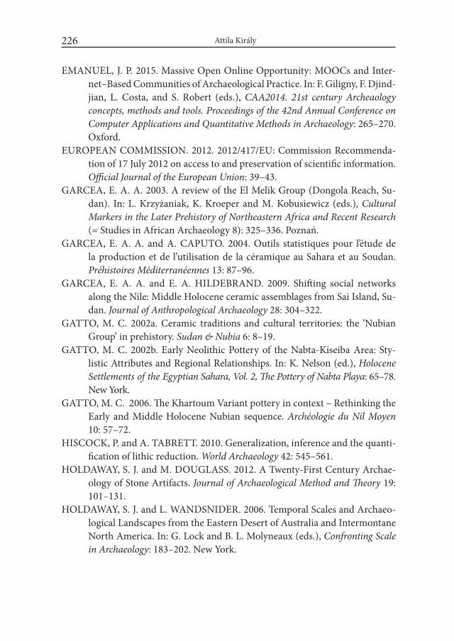
Attila Király226
EMANUEL, J. P. 2015. Massive Open Online Opportunity: MOOCs and Inter-net–Based Communities of Archaeological Practice. In: F. Giligny, F. Djind-jian, L. Costa, and S. Robert (eds.), CAA2014. 21st century Archeaology concepts, methods and tools. Proceedings of the 42nd Annual Conference on Computer Applications and Quantitative Methods in Archaeology: 265–270. Oxford.
EUROPEAN COMMISSION. 2012. 2012/417/EU: Commission Recommenda-tion of 17 July 2012 on access to and preservation of scientific information. Official Journal of the European Union: 39–43.
GARCEA, E. A. A. 2003. A review of the El Melik Group (Dongola Reach, Su-dan). In: L. Krzyżaniak, K. Kroeper and M. Kobusiewicz (eds.), Cultural Markers in the Later Prehistory of Northeastern Africa and Recent Research (= Studies in African Archaeology 8): 325–336. Poznań.
GARCEA, E. A. A. and A. CAPUTO. 2004. Outils statistiques pour l’étude de la production et de l’utilisation de la céramique au Sahara et au Soudan. Préhistoires Méditerranéennes 13: 87–96.
GARCEA, E. A. A. and E. A. HILDEBRAND. 2009. Shifting social networks along the Nile: Middle Holocene ceramic assemblages from Sai Island, Su-dan. Journal of Anthropological Archaeology 28: 304–322.
GATTO, M. C. 2002a. Ceramic traditions and cultural territories: the ‘Nubian Group’ in prehistory. Sudan & Nubia 6: 8–19.
GATTO, M. C. 2002b. Early Neolithic Pottery of the Nabta-Kiseiba Area: Sty-listic Attributes and Regional Relationships. In: K. Nelson (ed.), Holocene Settlements of the Egyptian Sahara, Vol. 2, The Pottery of Nabta Playa: 65–78. New York.
GATTO, M. C. 2006. The Khartoum Variant pottery in context – Rethinking the Early and Middle Holocene Nubian sequence. Archéologie du Nil Moyen 10: 57–72.
HISCOCK, P. and A. TABRETT. 2010. Generalization, inference and the quanti-fication of lithic reduction. world Archaeology 42: 545–561.
HOLDAWAY, S. J. and M. DOUGLASS. 2012. A Twenty-First Century Archae-ology of Stone Artifacts. Journal of Archaeological Method and Theory 19: 101–131.
HOLDAWAY, S. J. and L. WANDSNIDER. 2006. Temporal Scales and Archaeo-logical Landscapes from the Eastern Desert of Australia and Intermontane North America. In: G. Lock and B. L. Molyneaux (eds.), Confronting Scale in Archaeology: 183–202. New York.
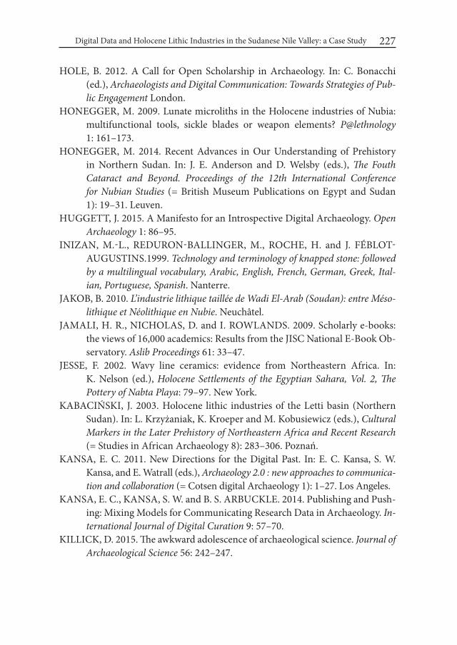
Digital Data and Holocene Lithic Industries in the Sudanese Nile Valley: a Case Study 227
HOLE, B. 2012. A Call for Open Scholarship in Archaeology. In: C. Bonacchi (ed.), Archaeologists and Digital Communication: Towards Strategies of Pub-lic Engagement London.
HONEGGER, M. 2009. Lunate microliths in the Holocene industries of Nubia: multifunctional tools, sickle blades or weapon elements? P@lethnology 1: 161–173.
HONEGGER, M. 2014. Recent Advances in Our Understanding of Prehistory in Northern Sudan. In: J. E. Anderson and D. Welsby (eds.), The Fouth Cataract and Beyond. Proceedings of the 12th international Conference for Nubian Studies (= British Museum Publications on Egypt and Sudan 1): 19–31. Leuven.
HUGGETT, J. 2015. A Manifesto for an Introspective Digital Archaeology. Open Archaeology 1: 86–95.
INIZAN, M.-L., REDURON-BALLINGER, M., ROCHE, H. and J. FÉBLOT-AUGUSTINS.1999. Technology and terminology of knapped stone: followed by a multilingual vocabulary, Arabic, English, French, German, Greek, ital-ian, Portuguese, Spanish. Nanterre.
JAKOB, B. 2010. L’industrie lithique taillée de wadi El-Arab (Soudan): entre Méso-lithique et Néolithique en Nubie. Neuchâtel.
JAMALI, H. R., NICHOLAS, D. and I. ROWLANDS. 2009. Scholarly e-books: the views of 16,000 academics: Results from the JISC National E-Book Ob-servatory. Aslib Proceedings 61: 33–47.
JESSE, F. 2002. Wavy line ceramics: evidence from Northeastern Africa. In: K. Nelson (ed.), Holocene Settlements of the Egyptian Sahara, Vol. 2, The Pottery of Nabta Playa: 79–97. New York.
KABACIŃSKI, J. 2003. Holocene lithic industries of the Letti basin (Northern Sudan). In: L. Krzyżaniak, K. Kroeper and M. Kobusiewicz (eds.), Cultural Markers in the Later Prehistory of Northeastern Africa and Recent Research (= Studies in African Archaeology 8): 283–306. Poznań.
KANSA, E. C. 2011. New Directions for the Digital Past. In: E. C. Kansa, S. W. Kansa, and E. Watrall (eds.), Archaeology 2.0 : new approaches to communica-tion and collaboration (= Cotsen digital Archaeology 1): 1–27. Los Angeles.
KANSA, E. C., KANSA, S. W. and B. S. ARBUCKLE. 2014. Publishing and Push-ing: Mixing Models for Communicating Research Data in Archaeology. in-ternational Journal of Digital Curation 9: 57–70.
KILLICK, D. 2015. The awkward adolescence of archaeological science. Journal of Archaeological Science 56: 242–247.

Attila Király228
KINTIGH, K. W., ALTSCHUL, J. H., BEAUDRY, M. C., DRENNAN, R. D., KINZIG, A., KOHLER, T. A., LIMP, W. F., MASCHNER, H. D. G., MI-CHENER, W. K., PAUKETAT, T. R., PEREGRINE, P., SABLOFF, J. A., WILKINSON, T. J., WRIGHT, H. T. and M. A. ZEDER. 2014. Grand chal-lenges for archaeology. American Antiquity 79: 5–24.
KIRÁLY, A. 2008. Preliminary report of the HSAP’s work at prehistoric sites near Dar el-Arab, Sudan. In: B. Gratien (ed.), Actes de la 4e Conférence internationale sur l’Archeologie de la 4e Cataracte du Nil. Supplément CRiPEL 7: 19–36. Lille.
KIRÁLY, A.. 2012. HSAP 057 – a Middle Holocene site in the fourth cataract area, Sudan. In: J. Kabaciński, M. Chłodnicki and M. Kobusiewicz (eds.), Prehis-tory of Northeastern Africa. New ideas and discoveries (= Studies in African Archaeology 11): 167–189. Poznań.
KIRÁLY, A.. 2016. Mid-Holocene site HSAP 057 lithic database. Figshare. DOI: 10.6084/m9.figshare.1431584.v1
KOBUSIEWICZ, M. 1996. Technology, goals and efficiency of quartz exploitation in the Khartoum Nelithic: tha case of Kadero. In: L. Krzyżaniak, K. Kro-eper and M. Kobusiewicz (eds.) interregional contacts in the Later Prehis-tory of Northeastern Africa (= Studies in African Archaeology 5): 347–355. Poznań..
KOBUSIEWICZ, M. 2011. The lithic implements. In: M. Chłodnicki, M. Kobus-iewicz and K. Kroeper (eds.), Kadero, The Lech Krzyzaniak Excavations in the Sudan (= Studies in African Archaeology 10). Poznań.
KRATZ, J. and C. STRASSER. 2014. Data publication: consensus and controversies [v3; ref status: indexed, http://f1000r.es/4ja].” F1000Research. doi:10.12688/f1000research.3979.3. http://f1000research.com/articles/3-94/v3.
KRISTIANSEN, K. 2014. Towards a new paradigm? The Third Science Revolu-tion and its Possible Consequences in Archaeology. Current Swedish Ar-chaeology 22: 11–34.
LARIVIÈRE, V., HAUSTEIN, S. and P. MONGEON. 2015. The Oligopoly of Aca-demic Publishers in the Digital Era. PLoS ONE 10: e0127502. doi:10.1371/journal.pone.0127502.
LIMP, W. F. 2011. Web 2.0 and Beyond, or On the Web, Nobody Knows You’re an Archaeologist. In: E. C. Kansa, S. W. Kansa, and E. Watrall (eds.), Archae-ology 2.0 : new approaches to communication and collaboration (= Cotsen digital Archaeology 1): 265–280. Los Angeles.
LUPTON, D. 2014. “Feeling Better Connected”: Academics’ Use of Social Media. News & Media Research Centre. Canberra.
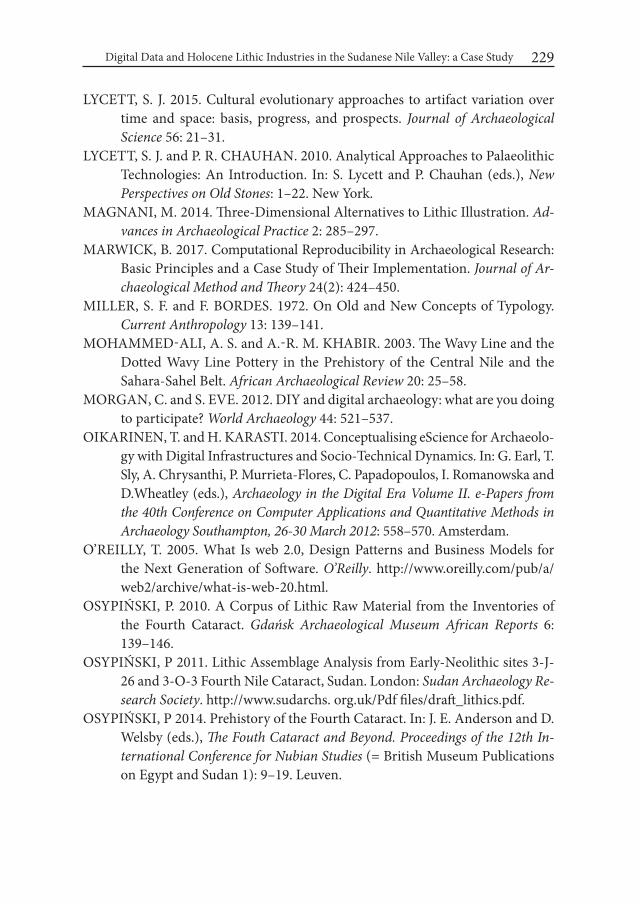
Digital Data and Holocene Lithic Industries in the Sudanese Nile Valley: a Case Study 229
LYCETT, S. J. 2015. Cultural evolutionary approaches to artifact variation over time and space: basis, progress, and prospects. Journal of Archaeological Science 56: 21–31.
LYCETT, S. J. and P. R. CHAUHAN. 2010. Analytical Approaches to Palaeolithic Technologies: An Introduction. In: S. Lycett and P. Chauhan (eds.), New Perspectives on Old Stones: 1–22. New York.
MAGNANI, M. 2014. Three-Dimensional Alternatives to Lithic Illustration. Ad-vances in Archaeological Practice 2: 285–297.
MARWICK, B. 2017. Computational Reproducibility in Archaeological Research: Basic Principles and a Case Study of Their Implementation. Journal of Ar-chaeological Method and Theory 24(2): 424–450.
MILLER, S. F. and F. BORDES. 1972. On Old and New Concepts of Typology. Current Anthropology 13: 139–141.
MOHAMMED-ALI, A. S. and A.-R. M. KHABIR. 2003. The Wavy Line and the Dotted Wavy Line Pottery in the Prehistory of the Central Nile and the Sahara-Sahel Belt. African Archaeological Review 20: 25–58.
MORGAN, C. and S. EVE. 2012. DIY and digital archaeology: what are you doing to participate? world Archaeology 44: 521–537.
OIKARINEN, T. and H. KARASTI. 2014. Conceptualising eScience for Archaeolo-gy with Digital Infrastructures and Socio-Technical Dynamics. In: G. Earl, T. Sly, A. Chrysanthi, P. Murrieta-Flores, C. Papadopoulos, I. Romanowska and D.Wheatley (eds.), Archaeology in the Digital Era Volume ii. e-Papers from the 40th Conference on Computer Applications and Quantitative Methods in Archaeology Southampton, 26-30 March 2012: 558–570. Amsterdam.
O’REILLY, T. 2005. What Is web 2.0, Design Patterns and Business Models for the Next Generation of Software. O’Reilly. http://www.oreilly.com/pub/a/web2/archive/what-is-web-20.html.
OSYPIŃSKI, P. 2010. A Corpus of Lithic Raw Material from the Inventories of the Fourth Cataract. Gdańsk Archaeological Museum African Reports 6: 139–146.
OSYPIŃSKI, P 2011. Lithic Assemblage Analysis from Early-Neolithic sites 3-J-26 and 3-O-3 Fourth Nile Cataract, Sudan. London: Sudan Archaeology Re-search Society. http://www.sudarchs. org.uk/Pdf files/draft_lithics.pdf.
OSYPIŃSKI, P 2014. Prehistory of the Fourth Cataract. In: J. E. Anderson and D. Welsby (eds.), The Fouth Cataract and Beyond. Proceedings of the 12th in-ternational Conference for Nubian Studies (= British Museum Publications on Egypt and Sudan 1): 9–19. Leuven.
Attila Király230
PERRY, S. and N. BEALE. 2015. The Social Web and Archaeology’s Restructuring: Impact, Exploitation, Disciplinary Change. Open Archaeology 1: 153–165.
READ, D. 2007. Artifact Classification. A Conceptual and Methodological Ap-proach. Walnut Creek.
RICHARDSON, L. 2013. A Digital Public Archaeology? Papers from the institute of Archaeology 23: 1–12.
ROLLAND, N. and H. L. DIBBLE. 1990. A New Synthesis of Middle Paleolithic Variability. American Antiquity 55: 480–499.
SADIG, A. M. 2010. The Neolithic of the Middle Nile region. An archaeology of Central Sudan and Nubia. Kampala.
SALVATORI, S. 2012. Disclosing Archaeological Complexity of the Khartoum Mesolithic: New Data at the Site and Regional Level. African Archaeological Review 29: 399–472.
SALVATORI, S. and D. USAI. 2007. The Sudanese Neolithic revisited. In: B. Gra-tien (ed.), Mélanges offerts à Francis Geus (= CRIPEL 26): 323–333. Lille.
SALVATORI, S., USAI D., and A. ZERBONI. 2011. Mesolithic Site Formation and Palaeoenvironment Along the White Nile (Central Sudan). African Ar-chaeological Review 28: 177–211.
SCERRI, E. M. L., GRAVINA, B., BLINKHORN, J. and A. DELAGNES. 2015. Can Lithic Attribute Analyses Identify Discrete Reduction Trajectories? A Quantitative Study Using Refitted Lithic Sets. Journal of Archaeological Method and Theory. (without volume designation) doi:10.1007/s10816-015-9255-x.
SCHILD, R. and F. WENDORF. 1977. The prehistory of Dakhla oasis and adjacent desert. Warszawa.
SKIBO, J. M. and M. B. SCHIFFER. 2008. People and Things. A Behavioral Ap-proach to Material Culture. Dortrecht.
SORESSI, M. and J.-M. GENESTE. 2011. The History and Efficacy of the Chaîne Opératoire Approach to Lithic Analysis: Studying Techniques to Reveal Past Societies in an Evolutionary Perspective. PaleoAnthropology 2011: 334–350.
STEWARD, J. H. and F. M. SETZLER. 1938. Function and Configuration in Ar-chaeology. American Antiquity 4: 4–10.
STODDEN, V., GUO, P. and Z. MA. 2013. Toward Reproducible Computational Research: An Empirical Analysis of Data and Code Policy Adoption by Journals. PLoS ONE 8: e67111. doi:10.1371/journal.pone.0067111.
TIXIER, J. 1963. Typologie de l’épipaléolithique du Maghreb (= Mémoires du Cen-tre de Recherche Anthropologique et Ethnographique 2). Paris.
Digital Data and Holocene Lithic Industries in the Sudanese Nile Valley: a Case Study 231
TOSTEVIN, G. G. 2011. Levels of Theory and Social Practice in the Reduction Sequence and Chaîne Opératoire Methods of Lithic Analysis. PaleoAnthro-pology 2011: 351−375.
USAI, D. 2005. Early Holocene Seasonal Movements between the Desert and the Nile Valley. Details from the lithic industry of some Khartoum Variant and some Nabta/Kiseiba sites. Journal of African Archaeology 3: 103–115.
USAI, D. 2006. Early and Middle Holocene cultural change in the Nile Valley (Egypt and Sudan). In: Acts of the XiVth UiSPP Congress, University of Liege, Belgium, 2-8 September 2001. Section 15, African Prehistory, General Sessions and Posters (= BAR International Series 1522): 93–99. Oxford.
USAI, D. 2008. Lunates and micro-lunates, cores and flakes: the lithic industry of R12. In: S. Salvatori and D. Usai (eds.), A Neolithic cemetery in the Northern Dongola Reach (Sudan): Excavation at Site R12: 33–52. London.
USAI, D. 2014. Recent Advances in Understanding the Prehistory of Central Su-dan. In: J. E. Anderson and D. Welsby (eds.), The Fouth Cataract and Be-yond. Proceedings of the 12th international Conference for Nubian Studies (= British Museum Publications on Egypt and Sudan 1): 31–45. Leuven.
VAN POOL, T. L. and R. D. LEONARD. 2011. Quantitative Analysis in Archaeol-ogy. Chichester.
WALLIS, J. C., ROLANDO, E. and C.L. BORGMAN. 2013. If We Share Data, Will Anyone Use Them? Data Sharing and Reuse in the Long Tail of Science and Technology. PLoS ONE 8: e67332. doi:10.1371/journal.pone.0067332.
WENDORF, F., SCHILD R., SAID, R., HAYNES, C., V., GAUTIER, A. and M. KOBUSIEWICZ. 1976. Prehistory of the Egyptian Sahara. Science 193: 103-114.
WENGROW, D., DEE, M., FOSTER, S., STEVENSON, A. and C.B. RAMSEY. 2014. Cultural convergence in the Neolithic of the Nile Valley: a prehistoric perspective on Egypt’s place in Africa. Antiquity 88: 95–111.
WYLIE, A. 2002. Thinking from Things. Berkeley.


Desert and the Nile. Prehistory of the Nile Basin and the Sahara.
Papers in honour of Fred Wendorf Studies in African Archaeology 15
Poznań Archaeological Museum 2018
Louis Chaix and Jacques Reinold
Animals in Neolithic Graves: Kadruka and Kadada (Northern and Central Sudan)
All around the world, animals have played an important role in the funerary rituals, as well as (Eliasberg 1992; Kenney 2004) or Europe (Bodson 1999; Bede et al. 2014).
In North-East Africa, the ritual deposit of animals in human graves is attested since the end of the Pleistocene in Egypt (Wendorf 1968). During the Ancient Ho-locene, many graves found in Egypt and Sudan contains whole animals or parts of animals (Chaix and Honegger 2015; Morey 2006; Gräslund 2004; Flores 2003; Nielsen and Petersen 2003; Paris 2000 ; Stager 1991; Bonnet and al. 1989 ; Chaix 1989).
During the Middle Neolithic, between 5000 and 4000 BC, many cemeteries were dug, delivering human graves with animal deposits or single animal graves. Two examples are presented below(Fig. 1).
1. KadrukaIn the Northern Sudan, around 50 km south of the 3rd cataract, the site of
Kadruka lies on the right bank of the Wadi el Khowi, a fossil tributary of the Nile (Reinold 1994a, 2001, 2004). Remains of settlements were found, often on flat ground, with scattering remains due to the strong erosion. On the other hand,
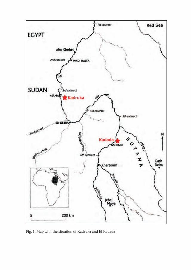
Fig. 1. Map with the situation of Kadruka and El Kadada
Animals in Neolithic Graves: Kadruka and Kadada (Northern and Central Sudan) 235
cemeteries were dug into hillocks, the depth of the pits allowing their better preservation. In such Neolithic contexts, the localisation of the tomb can be trans-lated into the social position of the dead within the community (Reinold 2004: 42) (Fig. 2).
The necropolis of KDK 21 is the oldest, dated between 5910±60 BP and 5850±70 BP (4944-4537 cal BC). The main tomb is of a women with a man as “mort d’accompagnement” (Testart 2004). Some dogs are buried in small pits: one on the top of the hillock and four others, each with two dogs, at the four cardinal points (Fig. 3). Despite the bad preservation of the skeletons, some remarks can be made:
– The dogs are oriented east-west with the head at the west, like humans; they are lying on the left side.
– Rare measurements indicate small and slender individuals, less than 50 cm at the wither (Fig. 4).We have no indication about the sex.
In some graves, bucrania of domestic cattle were deposited, inside the grave, with a clear relation with the dead (Fig. 5) For some measurements, like the least breadth between the horncore bases, skulls from Kadruka are significantly bigger than those from the later site of Kerma, around 2500 BC (Chaix 2007) (Fig. 6). Some graves delivered artefacts made of animal bones or ivory: hippopotamus incisors used as a box for make-up or bracelets, chisels made from sheep metapo-dials (Reinold 2000) (Fig. 7).
2. El KadadaAround 425 km south-east of Kadruka, in the Central Sudan, the necropolis
of el- Kadada lies on the right bank of the Nile (cf Fig. 1). The graves are dated between 3700 and 3200 BC; pits are excavated in a coarse fluviatile gravel, explain-ing the bad preservation of the bones (Reinold 1994b). Excavations led in 2009 delivered many Neolithic graves with various animal deposits (Fig. 8).
In El- Kadada, contrary to Kadruka, all animals are deposited inside the hu-man graves.
Four categories were found : whole dogs, whole kids, bucrania and artefacts. For a total of 38 graves studied, 10 contains one or two dogs (Tab. 1). The dis-
tribution of the graves with dogs do not show any concentration and no linkage with the dimensions of the graves. As we can see (cf. Tab.1), there is no clear rela-tions between the number of dogs and the sex of the dead.
The position and orientation of these dogs is variable. In the grave 86/144, with two main dead lying on the ground of the pit and two “morts d’accompagnement”,

Louis Chaix and Jacques Reinold236
Table 1. List of the graves containing one or more dogs
Table 2. List of the graves containing one or more kids

Fig. 2. Kadruka. Neolithic cemetery (KDK 1) showing the organisation of the necropolis around the grave of an important person, a man buried with a lot of furniture (after Reinold 2004: 44)
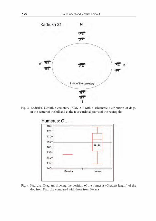
Louis Chaix and Jacques Reinold238
Fig. 3. Kadruka. Neolithic cemetery (KDK 21) with a schematic distribution of dogs, in the center of the hill and at the four cardinal points of the necropolis
Fig. 4. Kadruka. Diagram showing the position of the humerus (Greatest length) of the dog from Kadruka compared with those from Kerma
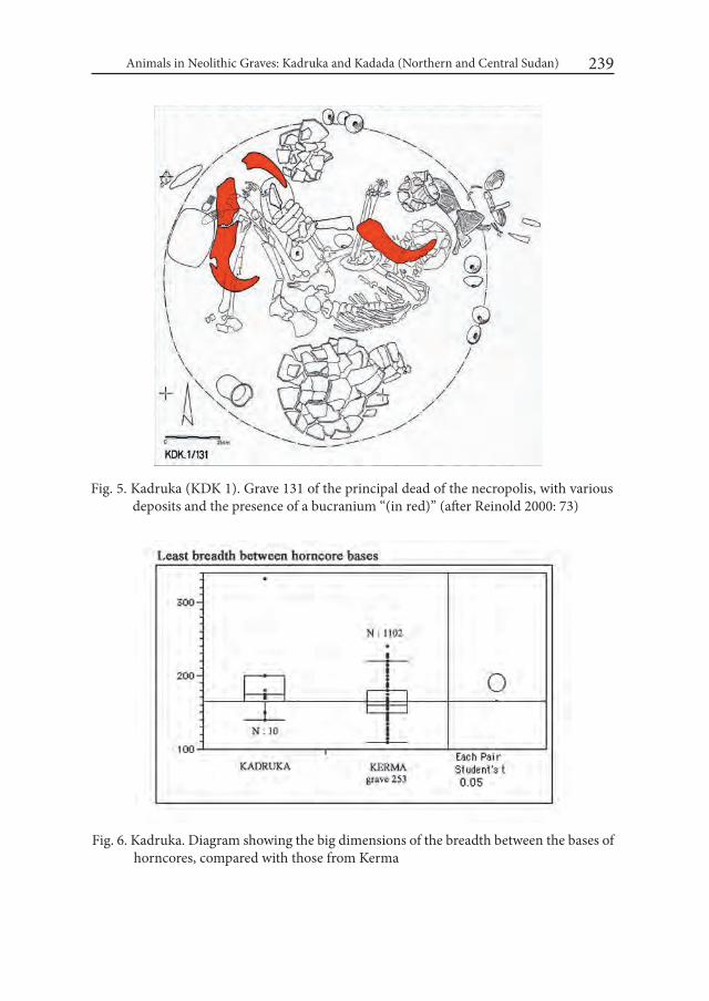
Animals in Neolithic Graves: Kadruka and Kadada (Northern and Central Sudan) 239
Fig. 5. Kadruka (KDK 1). Grave 131 of the principal dead of the necropolis, with various deposits and the presence of a bucranium “(in red)” (after Reinold 2000: 73)
Fig. 6. Kadruka. Diagram showing the big dimensions of the breadth between the bases of horncores, compared with those from Kerma

Louis Chaix and Jacques Reinold240
Fig. 7. Kadruka. Chisel made from a tibia from a sheep

Animals in Neolithic Graves: Kadruka and Kadada (Northern and Central Sudan) 241
Fig.
8. E
l Kad
ada.
Pla
n of
the
sect
ors e
xcav
ated
by
Jacq
ues R
eino
ld in
200
9 (in
red)
. Thes
e se
ctor
s de
liver
ed a
nim
al
skel
eton
s and
faun
al re
mai
ns p
rese
nted
her
e
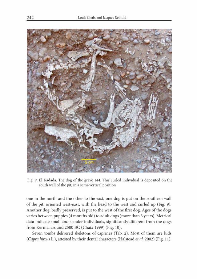
Louis Chaix and Jacques Reinold242
Fig. 9. El Kadada. The dog of the grave 144. This curled individual is deposited on the south wall of the pit, in a semi-vertical position
one in the north and the other to the east, one dog is put on the southern wall of the pit, oriented west-east, with the head to the west and curled up (Fig. 9). Another dog, badly preserved, is put to the west of the first dog. Ages of the dogs varies between puppies (4 months old) to adult dogs (more than 3 years). Metrical data indicate small and slender individuals, significantly different from the dogs from Kerma, around 2500 BC (Chaix 1999) (Fig. 10).
Seven tombs delivered skeletons of caprines (Tab. 2). Most of them are kids (Capra hircus L.), attested by their dental characters (Halstead et al. 2002) (Fig. 11).
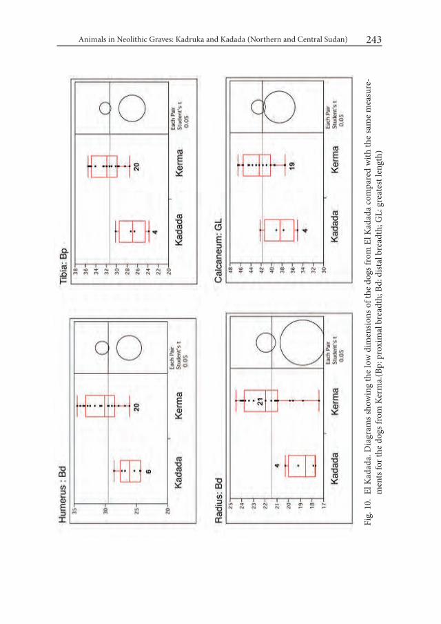
Animals in Neolithic Graves: Kadruka and Kadada (Northern and Central Sudan) 243
Fig.
10.
El K
adad
a. D
iagr
ams s
how
ing
the
low
dim
ensio
ns o
f the
dog
s fro
m E
l Kad
ada
com
pare
d w
ith th
e sa
me
mea
sure
-m
ents
for t
he d
ogs f
rom
Ker
ma.
(Bp:
pro
xim
al b
read
th; B
d: d
istal
bre
adth
; GL:
gre
ates
t len
gth)

Louis Chaix and Jacques Reinold244
Fig. 11. El Kadada: a – left portion of skull, b – right mandible, c – left lacteal D4 of young goats (Capra hircus L.) showing their typi-cal morphological features (after Halstead et al. 2002)

Animals in Neolithic Graves: Kadruka and Kadada (Northern and Central Sudan) 245
Fig. 12. El Kadada: a – view of the grave 60/61 with a bucranium under the head of the principal dead, covering the head of an adolescent; b – view of the cattle cranium after removing the principal human skeleton

Louis Chaix and Jacques Reinold246
Fig. 13. El Kadada. Various artefacts made of animal bones, teeth and marine shells
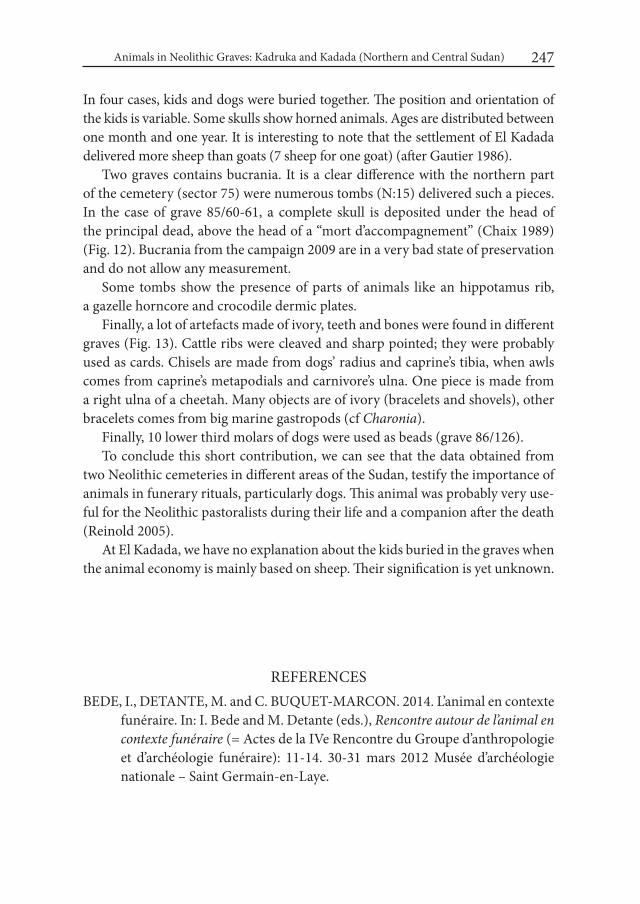
Animals in Neolithic Graves: Kadruka and Kadada (Northern and Central Sudan) 247
In four cases, kids and dogs were buried together. The position and orientation of the kids is variable. Some skulls show horned animals. Ages are distributed between one month and one year. It is interesting to note that the settlement of El Kadada delivered more sheep than goats (7 sheep for one goat) (after Gautier 1986).
Two graves contains bucrania. It is a clear difference with the northern part of the cemetery (sector 75) were numerous tombs (N:15) delivered such a pieces. In the case of grave 85/60-61, a complete skull is deposited under the head of the principal dead, above the head of a “mort d’accompagnement” (Chaix 1989) (Fig. 12). Bucrania from the campaign 2009 are in a very bad state of preservation and do not allow any measurement.
Some tombs show the presence of parts of animals like an hippotamus rib, a gazelle horncore and crocodile dermic plates.
Finally, a lot of artefacts made of ivory, teeth and bones were found in different graves (Fig. 13). Cattle ribs were cleaved and sharp pointed; they were probably used as cards. Chisels are made from dogs’ radius and caprine’s tibia, when awls comes from caprine’s metapodials and carnivore’s ulna. One piece is made from a right ulna of a cheetah. Many objects are of ivory (bracelets and shovels), other bracelets comes from big marine gastropods (cf Charonia).
Finally, 10 lower third molars of dogs were used as beads (grave 86/126). To conclude this short contribution, we can see that the data obtained from
two Neolithic cemeteries in different areas of the Sudan, testify the importance of animals in funerary rituals, particularly dogs. This animal was probably very use-ful for the Neolithic pastoralists during their life and a companion after the death (Reinold 2005).
At El Kadada, we have no explanation about the kids buried in the graves when the animal economy is mainly based on sheep. Their signification is yet unknown.
REFERENCESBEDE, I., DETANTE, M. and C. BUQUET-MARCON. 2014. L’animal en contexte
funéraire. In: I. Bede and M. Detante (eds.), Rencontre autour de l’animal en contexte funéraire (= Actes de la IVe Rencontre du Groupe d’anthropologie et d’archéologie funéraire): 11-14. 30-31 mars 2012 Musée d’archéologie nationale – Saint Germain-en-Laye.
Louis Chaix and Jacques Reinold248
BODSON, L. 1999. Ces animaux que l’homme choisit d’inhumer. Contribution à l’étude de la place et du rôle de l’animal dans les rites funéraires. Liège, Colloques d’histoire des connaissances zoologiques 11.
BONNET, C., CHAIX, L., LENOBLE, P., REINOLD, J. and D. VALBELLE. 1989. Sépultures à chiens sacrifiés dans la vallée du Nil. Cahiers de Recherches de l’institut de Papyrologie et d’Egyptologie de Lille 11: 25-39.
CHAIX, L. 1989. Animaux et sépultures, deux exemples: le dolmen M XI à Sion (Suisse) et la nécropole de Kerma (Soudan). Anthropozoologica 3e numéro spécial: 43-51.
CHAIX, L. 1999. The dogs from Kerma (Sudan) 2700 to 1500 BC. In: C. Becker, H. Manhart, J. Peters and J. Schibler (eds): Historia Animalium ex Ossibus (= Beiträge zu Paläoanatomie, Archäologie, Ägyptologie, Ethnologie und Geschichte der Tiermedizin. Festschrift für Angela von den Driesch zum 65. Geburtstag): 109-126. Rahden.
CHAIX, L. 2007. Contribution to the knowledge of domestic cattle in Africa: The osteometry of fossil Bos taurus L. from Kerma, Sudan (2050-1750 BC). In: G. Grupe and J. Peters (eds), Documenta Archaeobiologiae, Bd. 5: Skeletal series and their socio-economic context: 170-249. Rahden.
CHAIX, L. and M. HONEGGER. 2015. New data on animal exploitation from the Mesolithic to the Neolithic periods in Northern Sudan. In: S. Kerner, R. J. Dann and P. Bangsgaard (eds), Climate and ancient societies: 215-244. Copenhagen.
ELIASBERG, D. 1992. Pratiques funéraires animales en Chine ancienne et médiévale. Journal Asiatique 280 (1): 115-144.
FLORES, D. V. 2003. Funerary sacrifice of animals in the Egyptian Predynastic pe-riod (= BAR International Series 1153). Oxford.
GAUTIER, A. 1986. La faune de l’occupation néolithique d’el Kadada (secteurs 12-22-32) au Soudan central. Archéologie du Nil Moyen 1: 59-112.
GRÄSLUND, A. S. 2004. Dogs in graves – a question of symbolism? PECUS. Man and animal in antiquity. Proceedings of the conference at the Swedish insti-tute in Rome, September 9-12, 2002, Barbro Santillo Frizell (ed.), The Swed-ish Institute in Rome. Projects and Seminars, 1.
HALSTEAD, P., COLLINS, P. and V. ISSAKIDOU. 2002. Sorting sheep from the goats: morphological distinction between the mandibles and mandibular teeth of adult Ovis and Capra, Journal of Archaeological Science 29: 545-553.
KENNEY, E. 2004. Pet funerals and animal graves in Japan. Mortality 9 (1): 42-60.
Animals in Neolithic Graves: Kadruka and Kadada (Northern and Central Sudan) 249
MOREY, D. F. 2006. Burying key evidence: the social bond between dogs and people. Journal of Archaeological Science 33: 158-175.
NIELSEN, E. K. and E.B.PETERSEN. 1993. Burials, people and dogs. In: S Haas, B. Storgaard and U. L. Hansen (eds), Digging into the past – 25 years of ar-chaeology in Denmark: 76-81. Moesgaard, Jutland Archaeological Society.
PARIS, F. 2000. African livestock remains from Saharan mortuary contexts. In: R. M. Blench and K. C. MacDonald (eds), The origins and development of African livestock. Archaeology, genetics, linguistics and ethnography: 111-126. London.
REINOLD, J. 1994a. Le cimetière néolithique KDK.1 de Kadruka (Nubie souda-naise): premiers résultats et essai de corrélation avec les sites du Soudan central. In: C. Bonnet (ed.), Etudes nubiennes. Conférence de Genève. Actes du Viie Congrès international d’études nubiennes, 3-8 – septembre 1990, vol. II: 93-100. Genève.
REINOLD, J. 1994b. Les fouilles françaises et franco-soudanaises: el-Kadada. In: B. Gratien and F. Le Saout (eds.), Nubie- Les cultures antiques du Soudan à travers les explorations et les fouilles françaises et franco-soudanaises. Cata-logue de l’exposition: 51-66. Lille.
REINOLD, J. 2000. Archéologie au Soudan. Les civilisations de Nubie. Paris.REINOLD, J. 2001. Kadruka and the Neolithic in the Northern Dongola Reach.
Sudan & Nubia 55: 2-10.REINOLD, J. 2004. “Kadruka” . In: D. E. Welsby and J. R. Anderson (eds.): Sudan,
Ancient treasures: An exhibition of recent discoveries from the Sudan Na-tional Museum: 20-28. London.
REINOLD, J. 2005. Notes sur le monde animal dans le funéraire néolithique du Soudan. Revue de Paléobiologie 10: 107-119.
STAGER, L. E. 1991. Why were hundred dogs buried at Ashkelon? Biblical Ar-chaeology Review: 26-42.
TESTART, A. 2004. Les morts d’accompagnement. La servitude volontaire. Paris.WENDORF, F. 1968. Late Palaeolithic sites in Egyptian Nubia. In: F. Wendorf
(ed.): The prehistory of Nubia 2: 791-953. Dallas.

Desert and the Nile. Prehistory of the Nile Basin and the Sahara.
Papers in honour of Fred Wendorf Studies in African Archaeology 15
Poznań Archaeological Museum 2018
Hassan Mustafa Alkhidir
Jebel El-Khazna – a Late Prehistoric Site in the Fifth Cataract Area
Introduction The Fotwar area is located at the extreme south of the Fifth Cataract and north
of El-Bauga. It is bounded on the south side by El-Jul area and to the north by Al-siliamania area. From the eastern side of the Nile it is bordered by Mebierieka and El-Swiageat and to the western side lies the extended range of the Bayuda Desert Mountains (Fig. 1).
The Nile and steep valleys of surrounding area are the main natural features of the Fotwar area and typical for the Fifth Cataract landscape. The fact that due to its geographical location Fotwar and its surroundings contain mountains as well as plains can be regarded as privileged as it ensured the availability of fertile land and a multiplicity of natural resources. In addition, this area stimulated cultural interaction between the inhabitants of the Nile valley and those of the desert. These inter-regional contacts can be assumed from the prominent position of the Jebel El-Khazna in the landscape as well as from the archaeological materials found at the site. Furthermore, the area of the Fifth Cataract is a very important study area for its geographical location between Central and Northern Sudan, which have been studied independently from each other in the past. Besides, this region is currently subjected to human disturbance manifested in the planned construction of the Al-Shereik dam, which could negatively contribute to the ar-
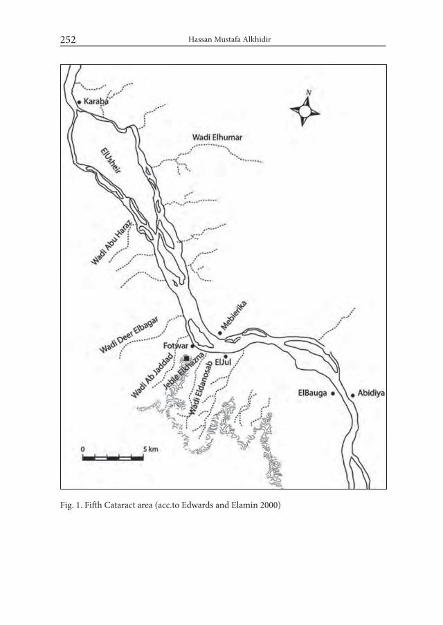
Hassan Mustafa Alkhidir252
Fig. 1. Fifth Cataract area (acc.to Edwards and Elamin 2000)
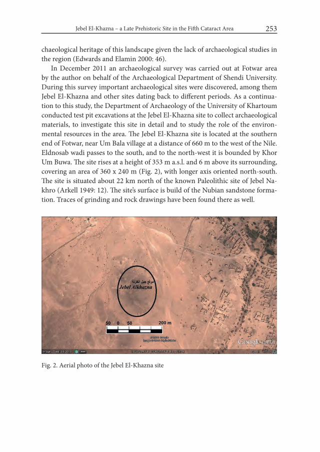
Jebel El-Khazna – a Late Prehistoric Site in the Fifth Cataract Area 253
chaeological heritage of this landscape given the lack of archaeological studies in the region (Edwards and Elamin 2000: 46).
In December 2011 an archaeological survey was carried out at Fotwar area by the author on behalf of the Archaeological Department of Shendi University. During this survey important archaeological sites were discovered, among them Jebel El-Khazna and other sites dating back to different periods. As a continua-tion to this study, the Department of Archaeology of the University of Khartoum conducted test pit excavations at the Jebel El-Khazna site to collect archaeological materials, to investigate this site in detail and to study the role of the environ-mental resources in the area. The Jebel El-Khazna site is located at the southern end of Fotwar, near Um Bala village at a distance of 660 m to the west of the Nile. Eldnosab wadi passes to the south, and to the north-west it is bounded by Khor Um Buwa. The site rises at a height of 353 m a.s.l. and 6 m above its surrounding, covering an area of 360 x 240 m (Fig. 2), with longer axis oriented north-south. The site is situated about 22 km north of the known Paleolithic site of Jebel Na-khro (Arkell 1949: 12). The site’s surface is build of the Nubian sandstone forma-tion. Traces of grinding and rock drawings have been found there as well.
Fig. 2. Aerial photo of the Jebel El-Khazna site
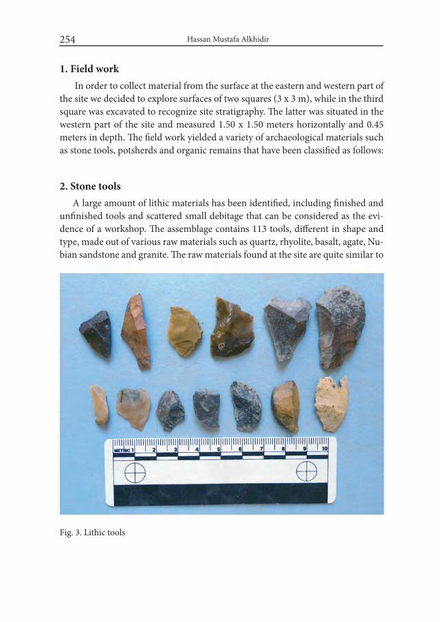
Hassan Mustafa Alkhidir254
1. Field work In order to collect material from the surface at the eastern and western part of
the site we decided to explore surfaces of two squares (3 x 3 m), while in the third square was excavated to recognize site stratigraphy. The latter was situated in the western part of the site and measured 1.50 x 1.50 meters horizontally and 0.45 meters in depth. The field work yielded a variety of archaeological materials such as stone tools, potsherds and organic remains that have been classified as follows:
2. Stone toolsA large amount of lithic materials has been identified, including finished and
unfinished tools and scattered small debitage that can be considered as the evi-dence of a workshop. The assemblage contains 113 tools, different in shape and type, made out of various raw materials such as quartz, rhyolite, basalt, agate, Nu-bian sandstone and granite. The raw materials found at the site are quite similar to
Fig. 3. Lithic tools
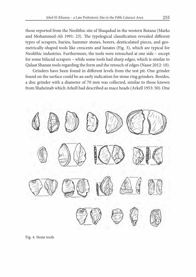
Jebel El-Khazna – a Late Prehistoric Site in the Fifth Cataract Area 255
those reported from the Neolithic site of Shaqadud in the western Butana (Marks and Mohammed-Ali 1991: 23). The typological classification revealed different types of scrapers, burins, hammer stones, borers, denticulated pieces, and geo-metrically-shaped tools like crescents and lunates (Fig. 3), which are typical for Neolithic industries. Furthermore, the tools were retouched at one side – except for some bifacial scrapers – while some tools had sharp edges, which is similar to Qalaat Shanan tools regarding the form and the retouch of edges (Nassr 2012: 10).
Grinders have been found in different levels from the test pit. One grinder found on the surface could be an early indication for stone ring grinders. Besides, a disc grinder with a diameter of 70 mm was collected, similar to those known from Shaheinab which Arkell had described as mace heads (Arkell 1953: 50). One
Fig. 4. Stone tools

Hassan Mustafa Alkhidir256
flint gouge with a sharp end on one side, measuring 55 mm in length and 40 mm in width was found (Fig. 4). It is identical to the Shaheinab gouges that have been described as tools used for carving wooden canoe boats. (Arkell 1953: 25).
3. PotteryIt appears that for pottery manufacturing locally available resources such as
clay of different kinds, quartz sands and the black valley soils (containing mica) were used. We have classified our finds into three different kinds of pottery: fine smoothed ware, hard ware and friable ware. depending also on the burning tech-niques. Accordingly, we have concluded that these kinds of pottery resemble Neo-lithic pottery found by Mohammed-Ali (1991: 63-66) at the multi-phase site of Shaqadud in the western Butana.
A representative sample of the pottery finds is shown on Fig. 5. For a relative dating we would suggest that although the pottery types from Jebel El-Khazna
Fig. 5. Decorated potsherds
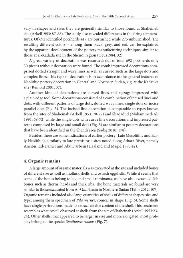
Jebel El-Khazna – a Late Prehistoric Site in the Fifth Cataract Area 257
vary in shapes and sizes they are generally similar to those found at Shaheinab site (Arkell1953: 87-88). The study also revealed differences in the firing tempera-tures. Of 692 identified potsherds 417 are burnished while 275 unburnished. The resulting different colors – among them black, grey, and red, can be explained by the apparent development of the pottery manufacturing techniques similar to those at al-Kadada site in the Shendi region (Geus1984: 32).
A great variety of decoration was recorded: out of total 692 potsherds only 30 pieces without decoration were found. The comb impressed decorations com-prised dotted straight and wavy lines as well as curved such as the large dots and complex lines. This type of decoration is in accordance to the general features of Neolithic pottery decoration in Central and Northern Sudan, e.g. at the Kadruka site (Reinold 2001: 37).
Another kind of decorations are curved lines and zigzags impressed with a plain edge tool. Some decorations consisted of a combination of incised lines and dots, with different patterns of large dots, dotted wavy lines, single dots or incise parallel dots (Fig. 5). The incised line decoration is comparable to types known from the sites of Shaheinab (Arkell 1953: 70-72) and Shaqadud (Mohammed-Ali 1991: 68-72) while the single dots with curve line decorations and impressed pat-terns composed by large and small dots (Fig. 5) are similar to pottery decorations that have been identified in the Shendi area (Sadig 2010: 178).
Besides, there are some indications of earlier pottery (Late Mesolithic and Ear-ly Neolithic), similarly to late prehistoric sites noted along Atbara River, namely Aneibis, Ed-Damer and Abu Darbein (Haaland and Magid 1995:42).
4. Organic remainsA large amount of organic materials was excavated at the site and included bones
of different size as well as mollusk shells and ostrich eggshells. While it seems that some of the bones belong to big and small ruminants, we have also excavated fish bones such as thorns, heads and thick ribs. The bone materials we found are very similar to those excavated from Al-Gaab basin in Northern Sudan (Tahir 2012: 107). Organic remains included also large quantities of shells of different shapes, size and type, among them specimen of Pila wernei, conical in shape (Fig. 6). Some shells have single perforations made to extract eatable content of the shell. This treatment resembles what Arkell observed at shells from the site of Shaheinab (Arkell 1953:23-24). Other shells, that appeared to be larger in size and more elongated, most prob-ably belong to the species Spathopsis rubens (Fig. 7).

Hassan Mustafa Alkhidir258
Fig. 6. Shells of Pila wernei, note the piercing hole at the left specimen
Fig. 7. Shells of Spathopsis rubens
Jebel El-Khazna – a Late Prehistoric Site in the Fifth Cataract Area 259
Other organic remains included circular beads with more than 1 cm in diam-eter made of ostrich eggshells and may have been used as personal ornaments. These finds also find equivalents in beads types excavated by Arkell at Shaheinab (Arkell 1953:22).
ConclusionsThe inhabitants of the site of Jebel El-Khazna were economically depending
on local natural resources such as plants and animals which in turn reflects the cultural homogeny between the Nile and the desert. Comparison of the archaeo-logical materials with that of other Neolithic sites in the Nile valley showed that the site Jebel El-Khazna most probably belongs to the Neolithic period and may hence be regarded as one of the most important site of the late prehistoric pe-riod that has recently been discovered in the Fifth Cataract area. Furthermore, its resemblance of Neolithic settlements known from Central and Northern Sudan proves large expansion and wide spread of such sites at that time. It seems Jebel El-Khazna may constitute a suitable area to facilitate and enable cultural comparison between Central and Northern Sudan. The biggest problem threatening the ar-chaeological heritage in this area is presently caused by humans: plans for the con-struction of Al-Shereik dam. During Neolithic times, Jebel El-Khazna was used as a permanent settlement over a certain period of time, during which different activities have been carried out, as shown by numerous archaeological remains excavated from a depth of 45 cm only. Our future plan is to expand archaeological investigations in this area to obtain further data.
AcknowledgmentsI would like to express special thanks to Ahmed Hamid Nassr and Mohammed
Alfateh Hayati. They have encouraged me and supported my work, including field activities. I am especially grateful to Dr. Annett Dittrich for useful correction of this text and comments. I also would like to thank Hashim Alkhidir and Gemma Tully for their review and language corrrections. Many word of gratitude go to University of Shendi and University of Khartoum and National Corporation for Antiquities and Museums (NCAM) for many years of support.
Hassan Mustafa Alkhidir260
REFERENCESARKELL, A.J. 1949. The Old Stone Age in the Anglo-Egyptian Sudan. (= Sudan
Antiquities Service Occasional Papers 1). Khartoum.ARKELL, A. J. 1953. Shaheinab. London.EDWARDS, D.N. and Y. M. EL-AMIN. 2000. Archaeological Survey in the Fifth
Cataract Region. Sudan & Nubia 4: 44-503.GEUS, F. 1984. Rescuing Sudan’s Ancient Culture. French Unit of the Directorate
General of Antiquities and National Museums of the Sudan. Khartoum.HAALAND, R. and E.A. MAGID.1995. Aqualithic Sites along the River Nile and
Atbara, Sudan. Bergen.MARKS, A.E. and A. MOHAMMED-ALI.1991. The Mesolithic and Neolithic of
Shaqadud, Sudan. Dallas.MOHAMMED-ALI, A. 1991. The Mesolithic and Neolithic ceramics from Shaqa-
dud Midden. In: A. E. Marks and A. Mohammed-Ali (eds.). The late prehis-tory of the Eastern Sahel. The Mesolithic and Neolithic of Shaqadud, Sudan: 65-93. Dallas.
NASSR, H. A. 2012. Qalaat Shanan: a large Neolithic site in Shendi Town. Sudan & Nubia 16: 8-12.
REINOLD, J. 2001. Kadruka and the Neolithic in the Northern Dongola Reach. Sudan & Nubia 5: 2-10.
SADIG, A.M. 2010. Child-Burials: a funerary practice in the Middle Nile Re-gion, evidence from the Late Neolithic site of Es-sour. Paper presented to the 12th international conference of the Society for Nubian Studies. British Museum.
TAHIR YAHIA FADL. 2012. The Archaeological, Ethnographical and Ecological Project of El-Ga’ab Basin in Western Dongola Reach: A Report on the First Season 2009. Sudan & Nubia 16: 100-108.

Desert and the Nile. Prehistory of the Nile Basin and the Sahara.
Papers in honour of Fred Wendorf Studies in African Archaeology 15
Poznań Archaeological Museum 2018
Agnieszka Mączyńska
On the Transition Between the Neolithic and Chal-colithic in Lower Egypt and the Origins of the Lower Egyptian Culture: a Pottery Study
IntroductionDuring the 4th millennium BC, the first traces of significant cultural, social and
economic processes including changes in subsistence strategies, social stratifica-tion and craft specialization can be observed in archaeological assemblages of the Nile Valley and the Nile Delta. They seem to be of great importance as they laid the foundation for the emergence of the Egyptian State. In the period in ques-tion Upper and Lower Egypt were inhabited by fully agricultural societies with a household mode of production. They adapted to the local conditions and cre-ated their cultural tradition consisting of material, social, economic and symbolic practices. In the archaeology of the Predynastic period, the societies settled in the south are referred to as Naqada culture. For the northern societies a few different terms are used, including ‘Maadi-Buto culture’ (e.g. von der Way 1992; Midant-Reynes 2003; Buchez and Midant-Reynes 2007; Hendrickx 2006; Levy and van den Brink 2003), ‘Lower Egyptian culture’ (e.g. Ciałowicz 2001; Mączyńska 2003; 2011; 2013) and ‘Lower Egyptian cultural complex’ (Tassie 2014). These two cul-tural units were separated by an uninhabited “buffer” zone without any traces of occupation in that period. The cultural division of the Predynastic societies, forcing them into a rigid framework of two distinct archaeological cultures, has
Agnieszka Mączyńska262
serious consequences on understanding of the occupation of Egypt in the 4th mil-lennium BC. Over the last 20 years researchers have focused mostly on relations between southern and northern societies, a cultural change often called the Naqa-da expansion or Naqadan-Lower Egyptian transition and the mechanisms of the emergence of the Egyptian state (i.e. Köhler 2008; Mączyńska 2011; Buchez and Midant-Reynes 2007; 2011). The origins of the Egyptian Chalcolithic societies of the 4th millennium BC lie outside the mainstream of that research. Although most researchers were aware that the ancestors of the Lower Egyptian cultural complex should be looked for in the Neolithic among the Merimde and el-Omari cultures, the poor state of research on this period in the whole of Egypt did not encourage detailed analyses (Mączyńska 2017).
For many years I have been involved in the research on the 4th millennium BC in Lower Egypt, including the Chalcolithic Lower Egyptian culture (LEC). In my publications I presented the state of research and focused mostly on interregional relations between Egypt and the Southern Levant or between Lower and Upper Egypt in this early period (Mączyńska 2004; 2008; 2011; 2013; 2014; 2015). In the recent years my scientific attention was attracted by the Neolithic. As a results of my research on the Neolithic pottery from Lower Egypt I proposed a hypothesis on the existence of a single cultural tradition in Lower Egypt in the Neolithic. The hypothesis was presented at the conference “Egypt at its Origin 5” held in the IFAO in Cairo in April 2014 (Mączyńska 2017). In my studies I have noticed strong cultural links between ceramic assemblages of the Neolithic and Chalco-lithic periods in the region. For this very reason I chose to return to researching the Lower Egyptian prehistory and to focus on and explore the transition between the Neolithic and Chalcolithic and the origins of the LEC.
The key objective of this paper is to identify the missing links between the Neo-lithic and Chalcolithic societies of Lower Egypt on the basis of pottery studies and to present a hypothesis on the origins of the LEC. Pottery was chosen as the main source-base for the analyses presented in this paper as it is the most abundant class of material recovered through archaeological excavations on the Neolithic and Chalcolithic sites and has a great research potential to provide a wide array of information. However I am aware of the limitations of my pottery research. The studied features (i.e. fabric, vessel shapes and surface treatment) are very generic and more detailed analyses have not been carried out. I consider my research as an introduction to a more detailed exploration of this still little known part of the Egyptian prehistory. I really hope that my hypothesis can be either disproved or confirmed in the course of further research.

On the Transition Between the Neolithic and Chalcolithic in Lower Egypt... 263
Moreover in this paper I refer to a new dynamic concept of the archaeologi-cal tradition to which the pottery tradition belongs (i.e. Pauketat 2001; Lightfoot 2001; Osborne 2008) and to the factors triggering change or ensuring continuity in the pottery production, proposed by P. Rice (1984).
1. State of research on the transition from the Neolithic to the Chalcolithic in Lower Egypt
In the recent years our knowledge of the LEC has improved thanks to the on-going excavations at Tell el-Farkha, Sais and Tell el-Iswid. Unfortunately, at none of them the earliest occupation of that complex was registered and the studies have not brought any evidence to enrich the state of research on the beginnings of the LEC. Although at Sais the Neolithic and Chalcolithic occupation was identi-fied and according to the excavators the LEC settlement overlays an earlier Mer-imde settlement, a 200 years long gap in the occupation between levels dated to Merimde and LEC was observed (Wilson et al. 2014). Nonetheless, Sais still seems to be a key site in understanding the transition between the Neolithic and Chalco-lithic as the end of Merimde occupation at this site coincides with the oldest layer at Buto (Schicht Ia) (Tassie 2014: 361).
The oldest remains of the LEC presence so far have been registered on the sites at Maadi and Wadi Digla, Heliopolis and Buto (Fig. 1-2; Rizkana and Seeher 1987; 1990; Debono and Mortensen 1988; von der Way 1997). They probably rep-resent only a small share of the actual early Chalcolithic occupation in Lower Egypt. Vessels found at Giza, Tura, el-Staff and Mersa Matruth A/600, identified as belonging probably to the early LEC without a clear and secure archaeological context, confirm a view on a wider extent of the LEC occupation (Bates 1915; 1927; Mortensen 1985:145-147; el-Sanussi and Jones 1997: 241-253; Kaiser and Zaugg 1988:121-124; Habachi and Kaiser 1985:43-46). Obviously, this scarcity of evidence does not make the studies on the origins of this cultural complex any easier. Additionally, a lack of evidence dated to the period between the Neolithic el-Omari culture and the Chalcolithic LEC makes the understanding of the tran-sition between these two periods even more difficult. Despite this, most scholars believe that the beginnings of the Lower Egyptian culture are linked to the influ-ence of multiple early Neolithic cultural traditions, including Merimde and el-Omari (i.e. Levy and van den Brink 2003: 10; Tassie 2014: 362). Moreover some scholars are convinced that the origins of the LEC are also closely linked to an-other Chacolithic unit – the Moerian, distinguished on the basis of excavations

Agnieszka Mączyńska264
Fig. 1. Map of Lower Egypt in the Chalcoithic period
in the region of Qasr el-Sagha (Fig. 3). K. Schmidt (1993: 273) and then N. Shirai (2010: 50) linked the Moerian flint assemblage to the LEC. According to N. Shirai (2010: 51) “it seems more probable that these two cultures were actually a single culture and different aspects of a single culture were misinterpreted”.
Without doubt, new excavation projects in Lower Egypt focusing on the Pre-historic occupation could help us to understand the relations between the Neo-lithic Fayumian, the Moerian and the LEC occupation in the region. It is worth mentioning the UCLA-RUG-UOA Fayum project and the TOPOI project “The Neolithic in the Nile Delta”, which have not only focused on re-studying old ma-

On the Transition Between the Neolithic and Chalcolithic in Lower Egypt... 265
Fig. 2. Chronology of the Lower Egyptian Neolithic and Chalcolithic units (grey arrows according to Hendrick 1999; white arrows according to Shirai 2010)
Fig. 3. Correlation of the chronology of the cultural units and the sites in the 4th millenium BC in Lower Egypt
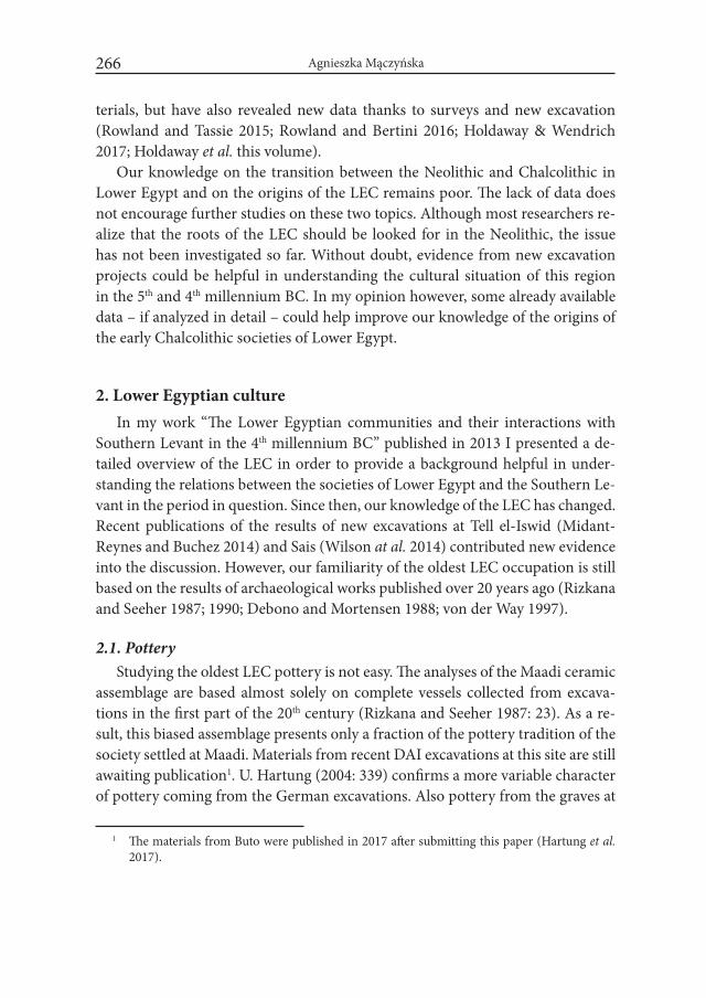
Agnieszka Mączyńska266
terials, but have also revealed new data thanks to surveys and new excavation (Rowland and Tassie 2015; Rowland and Bertini 2016; Holdaway & Wendrich 2017; Holdaway et al. this volume).
Our knowledge on the transition between the Neolithic and Chalcolithic in Lower Egypt and on the origins of the LEC remains poor. The lack of data does not encourage further studies on these two topics. Although most researchers re-alize that the roots of the LEC should be looked for in the Neolithic, the issue has not been investigated so far. Without doubt, evidence from new excavation projects could be helpful in understanding the cultural situation of this region in the 5th and 4th millennium BC. In my opinion however, some already available data – if analyzed in detail – could help improve our knowledge of the origins of the early Chalcolithic societies of Lower Egypt.
2. Lower Egyptian cultureIn my work “The Lower Egyptian communities and their interactions with
Southern Levant in the 4th millennium BC” published in 2013 I presented a de-tailed overview of the LEC in order to provide a background helpful in under-standing the relations between the societies of Lower Egypt and the Southern Le-vant in the period in question. Since then, our knowledge of the LEC has changed. Recent publications of the results of new excavations at Tell el-Iswid (Midant-Reynes and Buchez 2014) and Sais (Wilson at al. 2014) contributed new evidence into the discussion. However, our familiarity of the oldest LEC occupation is still based on the results of archaeological works published over 20 years ago (Rizkana and Seeher 1987; 1990; Debono and Mortensen 1988; von der Way 1997).
2.1. PotteryStudying the oldest LEC pottery is not easy. The analyses of the Maadi ceramic
assemblage are based almost solely on complete vessels collected from excava-tions in the first part of the 20th century (Rizkana and Seeher 1987: 23). As a re-sult, this biased assemblage presents only a fraction of the pottery tradition of the society settled at Maadi. Materials from recent DAI excavations at this site are still awaiting publication1. U. Hartung (2004: 339) confirms a more variable character of pottery coming from the German excavations. Also pottery from the graves at
1 The materials from Buto were published in 2017 after submitting this paper (Hartung et al. 2017).
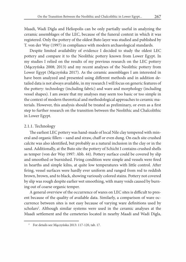
On the Transition Between the Neolithic and Chalcolithic in Lower Egypt... 267
Maadi, Wadi Digla and Heliopolis can be only partially useful in analyzing the ceramic assemblages of the LEC, because of the funeral context in which it was registered. Only the pottery of the oldest Buto layer was studied and published by T. von der Way (1997) in compliance with modern archaeological standards.
Despite limited availability of evidence I decided to study the oldest LEC pottery and compare it to the Neolithic pottery known from Lower Egypt. In my studies I relied on the results of my previous research on the LEC pottery (Mączyńska 2008; 2013) and my recent analyses of the Neolithic pottery from Lower Egypt (Mączyńska 2017). As the ceramic assemblages I am interested in have been analyzed and presented using different methods and in addition de-tailed data is not always available, in my research I will focus on generic features of the pottery: technology (including fabric) and ware and morphology (including vessel shapes). I am aware that my analyses may seem too basic or too simple in the context of modern theoretical and methodological approaches to ceramic ma-terials. However, this analysis should be treated as preliminary, or even as a first step to further research on the transition between the Neolithic and Chalcolithic in Lower Egypt.
2.1.1. TechnologyThe earliest LEC pottery was hand-made of local Nile clay tempered with min-
eral and organic fillers – sand and straw, chaff or even dung. On each site crushed calcite was also identified, but probably as a natural inclusion in the clay or in the sand. Additionally, at the Buto site the pottery of Schicht I contains crushed shells as temper (von der Way 1997: Abb. 44). Pottery surface could be covered by slip and smoothed or burnished. Firing condition were simple and vessels were fired in hearths and simple kilns, at quite low temperatures with little control. After firing, vessel surfaces were hardly ever uniform and ranged from red to reddish brown, brown, and to black, showing variously colored stains. Pottery not covered by slip was rough despite earlier wet smoothing, with many voids caused by burn-ing out of coarse organic temper.
A general overview of the occurrence of wares on LEC sites is difficult to pres-ent because of the quality of available data. Similarly, a comparison of ware oc-currence between sites is not easy because of varying ware definitions used by scholars2. Although similar systems were used in the ceramic analyses at the Maadi settlement and the cemeteries located in nearby Maadi and Wadi Digla,
2 For details see Mączyńska 2013: 117-120, tab. 17.
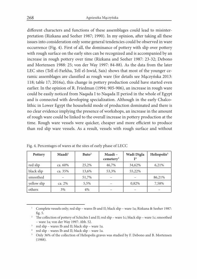
Agnieszka Mączyńska268
different characters and functions of these assemblages could lead to misinter-pretation (Rizkana and Seeher 1987; 1990). In my opinion, after taking all these issues into consideration only some general tendencies could be observed in ware occurrence (Fig. 4). First of all, the dominance of pottery with slip over pottery with rough surface on the early sites can be recognized and is accompanied by an increase in rough pottery over time (Rizkana and Seeher 1987: 23-32; Debono and Mortensen 1988: 25; von der Way 1997: 84-88). As the data from the later LEC sites (Tell el-Farkha, Tell el-Iswid, Sais) shows that most of the younger ce-ramic assemblages are classified as rough ware (for details see Mączyńska 2013: 118; table 17; 2016a), this change in pottery production could have started even earlier. In the opinion of R. Friedman (1994: 905-906), an increase in rough ware could be easily noticed from Naqada I to Naqada II period in the whole of Egypt and is connected with developing specialization. Although in the early Chalco-lithic in Lower Egypt the household mode of production dominated and there is no clear evidence implying the presence of workshops, an increase in the amount of rough ware could be linked to the overall increase in pottery production at the time. Rough ware vessels were quicker, cheaper and more efficient to produce than red slip ware vessels. As a result, vessels with rough surface and without
Fig. 4. Percentages of wares at the sites of early phase of LECC
Pottery Maadi1 Buto2 Maadi – cemetery3
Wadi Digla I4
Heliopolis5
red slip ca. 60% 25,2% 46,7% 34,62% 6,21%black slip ca. 35% 13,6% 53,3% 55,22%smoothed – 51,7% – – 86,21%yellow slip ca. 2% 5,5% – 0,82% 7,58%others 3% 4% – – –
1 Complete vessels only; red slip – wares Ib and II; black slip – ware 1a; Rizkana & Seeher 1987: fig. 5.
2 The collection of pottery of Schichts I and II; red slip – ware 1c; black slip – ware 1c; smoothed – ware 1a; von der Way 1997: Abb. 52.
3 red slip – wares Ib and II; black slip – ware 1a.4 red slip – wares Ib and II; black slip – ware 1a.5 Only 36% of the collection of Heliopolis graves was studied by F. Debono and B. Mortensen
(1988).

On the Transition Between the Neolithic and Chalcolithic in Lower Egypt... 269
slip became more numerous over time. It is easy to observe that the repertoire of pottery forms at Neolithic sites is rather unimpressive. However, the number of vessel shapes in the Chalcolithic became higher than in the Neolithic, e.g. at Sais (Wilson et al. 2014: 118; fig. 113-114). In addition, a change from multifunc-tional open vessels to closed vessels with more restricted functions can also be no-ticed at later Neolithic and early Chalcolithic sites. All these tendencies could be linked to an increase in pottery making and to greater demand, but in my opinion they were also a first step in the process of specialization.
It is also worth mentioning some observation of researchers working with early LEC sites. I. Rizkana and J. Seeher (1990: 78) noticed the dominance of red to brown slip over black slip (ware Ia) in the beginning of the cemetery of Wadi Digla (phase I), together with an increase in pottery covered by black slip (ware II) in the later phase of that cem-etery. The authors also mentioned the dominance of black pottery in graves of the younger cemetery at Heliopolis as a representation of the same change in pottery production, despite the fact that slip was reg-istered only on 6.2% of all vessels from graves published by F. Debono and B. Mortensen (1988: 24). At Maadi settlement, red slip pottery dominates over black slip pottery (Rizkana and Seeher 1987: 23-25, fig. 5). At Buto, color change could also be observed among the ceram-ics in the two first layers dated to LEC. Grayish black pottery (ware Ib) dominates in Schicht I, while red-dish-brown vessels (ware Ic) are typical for the later phase of the LEC occupation on the site (von der Way 1997: 86-87). However, this change concerns only the clay surface color, while the slip color remained unchanged in both wares.
The changes in slip or clay colors are difficult to interpret. The color of ves-sel surface including slip depends on firing conditions and the potter’s skills to control them. It is possible that some colors could be more or less preferred by certain groups of vessels’ users. Interestingly, imitations of Upper Egyptian
Fig. 5. Correlation of the vessel types of the Buto, Maadi and Heliopolis assemblages
Buto Maadi HeliopolisG1a.2 3G1a.3 4aG1b.2 1a-c, 2 Ia-bG1b.3 4B, 1a-b IIG1b.4 1a VG2b.2 miniature jars XIIG3a.1 5a, 5c VIIbG3a.3 1c, 6bO1a.4 1bO2.3 2a, 2b
O3b.2 2a, 2bO3b.3 2, 3
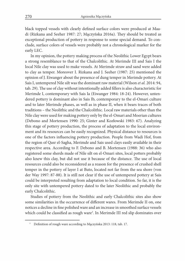
Agnieszka Mączyńska270
black topped vessels with clearly defined surface colors were produced at Maa-di (Rizkana and Seeher 1987: 27; Mączyńska 2016a). They should be treated as exceptional production of pottery in response to some special demand. To con-clude, surface colors of vessels were probably not a chronological marker for the early LEC.
In my opinion, the pottery making process of the Neolithic Lower Egypt bears a strong resemblance to that of the Chalcolithic. At Merimde III and Sais I the local Nile clay was used to make vessels. At Merimde straw and sand were added to clay as temper. Moreover I. Rizkana and J. Seeher (1987: 25) mentioned the opinion of J. Eiwanger about the presence of dung temper in Merimde pottery. At Sais I, untempered Nile silt was the dominant raw material (Wilson et al. 2014: 94, tab. 29). The use of clay without intentionally added fillers is also characteristic for Merimde I, contemporary with Sais Ia (Eiwanger 1984: 18-24). However, unten-dered pottery is dominant also in Sais Ib, contemporary to the el-Omari culture and to later Merimde phases, as well as in phase II, when it bears traces of both traditions – the Neolithic and the Chalcolithic. Local raw materials other than the Nile clay were used for making pottery only by the el-Omari and Moerian cultures (Debono and Mortensen 1990: 25; Ginter and Kozłowski 1983: 67). Analyzing this stage of pottery production, the process of adaptation to the local environ-ment and its resources can be easily recognized. Physical distance to resources is one of the factors influencing pottery production. People from Wadi Hof, from the region of Qasr el-Sagha, Merimde and Sais used clays easily available in their respective area. According to F. Debono and B. Mortensen (1988: 36) who also registered some sherds made of Nile silt on el-Omari sites, local potters probably also knew this clay, but did not use it because of the distance. The use of local resources could also be reconsidered as a reason for the presence of crushed shell temper in the pottery of layer I at Buto, located not far from the sea shore (von der Way 1997: 87-88). It is still not clear if the use of untempered pottery at Sais could be interpreted resulting from adaptation to local condition. So far, it is the only site with untempered pottery dated to the later Neolithic and probably the early Chalcolithic.
Studies of pottery from the Neolithic and early Chalcolithic sites also show some similarities in the occurrence of different wares. From Merimde II on, one notices a decline in fine polished ware and an increase in smoothed surface vessels which could be classified as rough ware3. In Merimde III red slip dominates over
3 Definition of rough ware according to Mączyńska 2013: 118, tab. 17.
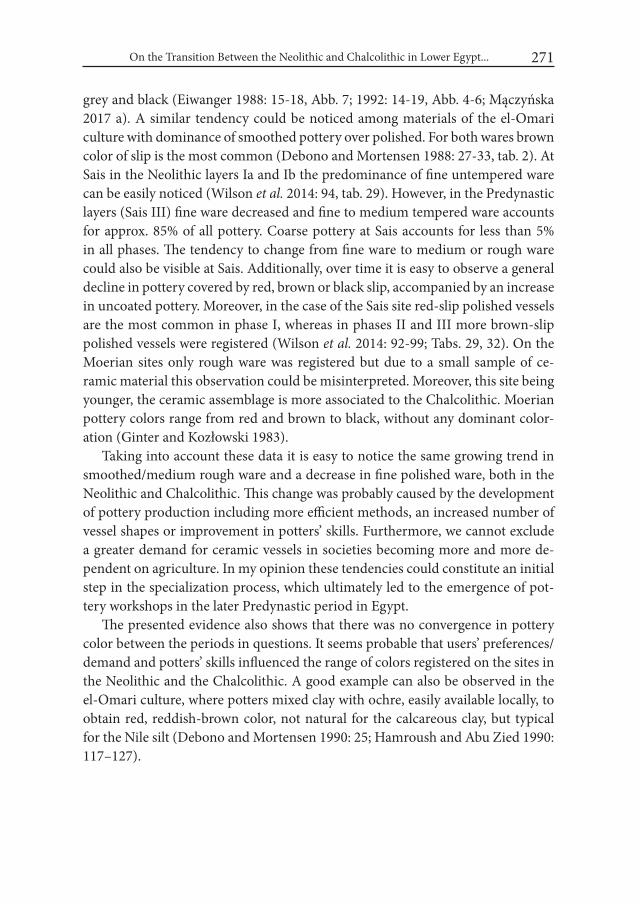
On the Transition Between the Neolithic and Chalcolithic in Lower Egypt... 271
grey and black (Eiwanger 1988: 15-18, Abb. 7; 1992: 14-19, Abb. 4-6; Mączyńska 2017 a). A similar tendency could be noticed among materials of the el-Omari culture with dominance of smoothed pottery over polished. For both wares brown color of slip is the most common (Debono and Mortensen 1988: 27-33, tab. 2). At Sais in the Neolithic layers Ia and Ib the predominance of fine untempered ware can be easily noticed (Wilson et al. 2014: 94, tab. 29). However, in the Predynastic layers (Sais III) fine ware decreased and fine to medium tempered ware accounts for approx. 85% of all pottery. Coarse pottery at Sais accounts for less than 5% in all phases. The tendency to change from fine ware to medium or rough ware could also be visible at Sais. Additionally, over time it is easy to observe a general decline in pottery covered by red, brown or black slip, accompanied by an increase in uncoated pottery. Moreover, in the case of the Sais site red-slip polished vessels are the most common in phase I, whereas in phases II and III more brown-slip polished vessels were registered (Wilson et al. 2014: 92-99; Tabs. 29, 32). On the Moerian sites only rough ware was registered but due to a small sample of ce-ramic material this observation could be misinterpreted. Moreover, this site being younger, the ceramic assemblage is more associated to the Chalcolithic. Moerian pottery colors range from red and brown to black, without any dominant color-ation (Ginter and Kozłowski 1983).
Taking into account these data it is easy to notice the same growing trend in smoothed/medium rough ware and a decrease in fine polished ware, both in the Neolithic and Chalcolithic. This change was probably caused by the development of pottery production including more efficient methods, an increased number of vessel shapes or improvement in potters’ skills. Furthermore, we cannot exclude a greater demand for ceramic vessels in societies becoming more and more de-pendent on agriculture. In my opinion these tendencies could constitute an initial step in the specialization process, which ultimately led to the emergence of pot-tery workshops in the later Predynastic period in Egypt.
The presented evidence also shows that there was no convergence in pottery color between the periods in questions. It seems probable that users’ preferences/demand and potters’ skills influenced the range of colors registered on the sites in the Neolithic and the Chalcolithic. A good example can also be observed in the el-Omari culture, where potters mixed clay with ochre, easily available locally, to obtain red, reddish-brown color, not natural for the calcareous clay, but typical for the Nile silt (Debono and Mortensen 1990: 25; Hamroush and Abu Zied 1990: 117–127).

Agnieszka Mączyńska272
2.1.2. MorphologyPottery shapes registered on Neolithic and early Chalcolithic sites are not
easy to analyze because of the quality and quantity of the data mentioned above. The ceramic assemblage from Maadi consists mostly of complete vessels, which is unique on settlement sites excavated according to modern standards. The oc-currence of vessel shapes in graves of the cemeteries at Maadi, Wadi Digla and Heliopolis also represents only part of the ceramic repertoire used on the set-tlement sites. Pottery from these cemeteries could be helpful, but only when its special context is taken into consideration. Without doubt, the assemblages from LEC sites share some types of closed and open vessels (von der Way 1997: 89-94). Unfortunately, due to the partial character of the assemblage from the Maadi settlement any quantitative comparisons of the type occurrence with the materials from Buto are difficult or even impossible. Despite these difficulties I de-cided to use whatever evidence is available to compare pottery shapes not requir-ing detailed figures. Figure 5 presents some parallel types of vessels from Buto, Maadi and Heliopolis. Unfortunately, as most of them could be with or without slip it is hard to notice a close correlation between wares and types from both sites, even though such correlation is present for Maadi and Buto separately (Rizkana and Seeher 1987: 33, fig. 33; von der Way 1997: 94, Taf. 5).
Pottery types found in graves at Maadi, Wadi Digla and Heliopolis could be eas-ily recognized on both known settlement sites as they were utilitarian vessels before they were put in graves as offerings. The traces on vessels from the graves confirm their earlier household use. By comparing the occurrence of different shapes in graves on these three cemeteries it is possible to notice some small differences and similarities (Fig. 5). At Heliopolis, 10 different types could be recognized among grave offerings, with types I and II being the most common (Debono and Mortensen 1988: 25-29). Among burial offerings from the Maadi cemetery only vessel 5 ty- pes are known (1a, 3b, 4a, 4b and 5a) with type 5a, similar to Heliopolis types I and II, being the most prominently represented (Rizkana and Seeher 1992: 27, fig. 9). At Wadi Digla the shapes registered in graves are more numerous than at Maadi (10 types). However type 5 vessels were also the most common offering (Rizkana and Seeher 1992: 78-88). Both differences and similarities between the cemeteries could be caused by many reasons including chronology and factors unknown to researchers, such as group preferences or symbolic meanings.
To conclude, it is impossible to present any general view of the settlement pot-tery characteristic for the early LEC phase. I am able to identify only some paral-lels in pottery shapes, which makes all comparisons with Neolithic assemblages
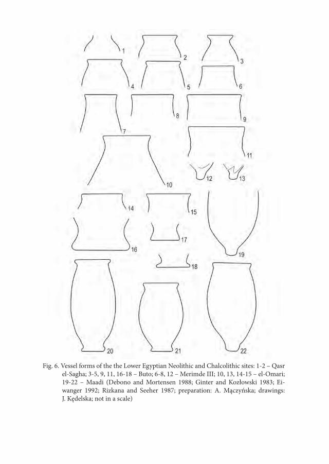
Fig. 6. Vessel forms of the the Lower Egyptian Neolithic and Chalcolithic sites: 1-2 – Qasr el-Sagha; 3-5, 9, 11, 16-18 – Buto; 6-8, 12 – Merimde III; 10, 13, 14-15 – el-Omari; 19-22 – Maadi (Debono and Mortensen 1988; Ginter and Kozłowski 1983; Ei-wanger 1992; Rizkana and Seeher 1987; preparation: A. Mączyńska; drawings: J. Kędelska; not in a scale)

Agnieszka Mączyńska274
difficult. However, taking into consideration their chronological and territorial proximity, this situation is likely to have resulted from the character of archaeo-logical assemblages. In my opinion all known sites – settlements and cemeteries – bear some affinity to each other in terms of pottery shapes, which allows one to treat them as belonging to a common pottery tradition.
The similarities between Chalcolithic and the Neolithic pottery shapes were noticed by researchers working on the materials from Maadi. According to I. Riz-kana and J. Seeher (1987: 64-66) parallels in pottery from Maadi and Merimde sites can be found in the younger phases of Merimde. The researchers indicated similarities in the fabric (chaff temper), surface treatment (grey and black-bur-nished pottery) and vessel shapes (jars with ogival rims, bowls of type 1a and b; ring bases, double-vessels). However, this comparison was made exclusively on the basis of pottery from Merimde published by H. Junker (1929) and H. Larsen (1962) and did not include the materials published later. It is worth mention-ing that J. Eiwanger (1992: 75) also indicated general similarities in vessel forms between both sites. I. Rizkana and J. Seeher (1987: 63-64) also compared Maadi pottery to el-Omari materials published by F. Debono and B. Mortensen (Debono 1948; 1956). Similarities in fabric and pottery shapes found by them allowed to treat the el-Omari culture as “a direct predecessor of Maadi, probably only a few centuries older.” (Rizkana and Seeher 1987: 64). According to F. Debono and B. Mortensen (1990: 39) the pottery from Maadi and el-Omari represents the same late Neolithic pottery tradition. A few vessel forms (oval basins and small red jars) indicate a connection between both sites. Moreover, in the researchers’ opinion local black-topped ware known from Maadi and el-Omari fits well the local development of that tradition. In my opinion however, black-topped vessels from el-Omari culture should be revised as they could be also interpreted as cook-ing pots blackened by fire or soot.
In my opinion some other similarities could be notices between jars with S-shaped profile known from Buto (Fig. 6:9, 11; special forms; von der Way 1997: Taf. 36:7, 10), Merimde III (Fig. 6:6-8; Eiwanger 1992: Taf. 18) and el-Omari (Fig. 6:10; 14-15; group 2; Debono and Mortensen 1990: Pl. 2: 1-12). Moreover small jars with a simple rim everted to the outside from Buto (Fig. 6:3-5; von der Way 1997: Taf. 2; types G1a.3, G1b.1-3;) resemble a vessel registered at Qasr el-Sagha (Fig. 6:1-2; Ginter and Kozłowski 1983: fig. 34: 7-8). In both periods ring bases appeared at: Mer-imde III (Eiwanger 1992: Taf. 19); Maadi (Fig. 6:20-21; Rizkana and Seeher 1987: pls. 1-4) and Buto (Fig. 6:16-18; von der Way 1997: Taf. 34: 8-13). It worth mentioning that ring bases are also present among Fayumian pottery (Caton-Thompson and Gardner
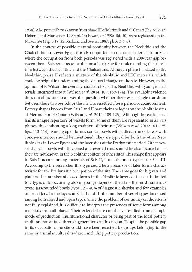
On the Transition Between the Neolithic and Chalcolithic in Lower Egypt... 275
1934). Also pointed bases known from phase III of Merimde and el-Omari (Fig. 6:12-13; Debono and Mortensen 1990: pl. 14; Eiwanger 1992: Taf. 40) were registered on the Maadi site (Fig. 6:19, 22; Rizkana and Seeher 1987: pl. 5: 2, 4, 6).
In the context of possible cultural continuity between the Neolithic and the Chalcolithic in Lower Egypt it is also important to mention materials from Sais where the occupation from both periods was registered with a 200-year gap be-tween them. Sais remains to be the most likely site for understanding the transi-tion between the Neolithic and the Chalcolithic. Although phase I is dated to the Neolithic, phase II reflects a mixture of the Neolithic and LEC materials, which could be helpful in understanding the cultural change on the site. However, in the opinion of P. Wilson the overall character of Sais II is Neolithic with younger ma-terials integrated into it (Wilson et al. 2014: 109, 159-174). The available evidence does not allow one to answer the question whether there was a single transition between these two periods or the site was resettled after a period of abandonment. Pottery shapes known from Sais I and II have their analogies on the Neolithic sites at Merimde or el-Omari (Wilson et al. 2014: 109-125). Although for each phase has its unique repertoire of vessels form, some of them are represented in all Sais phases, thus indicating a long tradition of their use (Wilson et al. 2014: 101-125, figs. 113-114). Among open forms, conical bowls with a direct rim or bowls with concave interiors should be mentioned. They are typical for both the other Neo-lithic sites in Lower Egypt and the later sites of the Predynastic period. Other ves-sel shapes – bowls with thickened and everted rims should be also focused on as they are not known in the Neolithic context of other sites. This shape first appears in Sais I, occurs among materials of Sais II, but is the most typical for Sais III. According to the researcher this type could be a precursor of later forms charac-teristic for the Predynastic occupation of the site. The same goes for big vats and platters. The number of closed forms in the Neolithic layers of the site is limited to 2 types only, occurring also in younger layers of the site – the most numerous ovoid jars/rounded bowls (type 12 – 40% of diagnostic sherds) and few examples of broad jars. In the layers of Sais II and III the number of vessel types increased among both closed and open types. Since the problem of continuity on the sites is not fully explained, it is difficult to interpret the presences of some forms among materials from all phases. Their extended use could have resulted from a simple mode of production, multifunctional character or being part of the local pottery tradition transmitted through generations in this region. Despite the possible gap in its occupation, the site could have been resettled by groups belonging to the same or a similar cultural tradition including pottery production.

Agnieszka Mączyńska276
Lower Egypt could have been settled by groups adapted to local conditions, sharing certain characteristics, and pottery production could have been one of them. Available evidence on the Chalcolithic occupation in this region is poor and does not seem to reflect the actual situation in the past, but rather the state of research. Some small discoveries in northern Egypt indicated a denser settlement pattern in both the Neolithic and the Chalcolithic. It is worth mentioning the presence of the so called lemon-shaped jars in the ceramic assemblage registered by Z. Hawass in 1976 at Merimde Beni Salame (Fig. 7:8-10; Hawass et al. 1988: fig. 3:12–14), similar to vessels known from Maadi (Fig. 7:5-7; Rizkana and Seeher 1987: pls. 6-7). This particular vessel type known from many Lower and Upper Egyptian sites of Naqada II period is sometimes treated as cultural markers of LEC (Buchez and Midant-Reynes 2007; 2011; Köhler 2008; 2014; Mączyńska 2016a). Despite unclear cultural affinity, the presence of lemon-shaped jars at Merimde, a site best known for its Neolithic occupation, implies that the occupation of the Chalcolithic societies in the north was wider than indicated by known LEC sites. Moreover, it seems likely that the settling preferences of the Neolithic and Chaco-litic groups were similar. In this context two jars registered by E. Caton-Thompson and E. Gardner (Fig. 7:3-4; 1934: LII:7-8) in the region of Fayum similar to Maadi type 4b should also be mentioned (Fig. 7:1-2; Rizkana and Seehre 1987: pls. 8-9) . Although they are not linked to the Neolithic occupation, they could also indicate the presence of the Chalcolithic occupation in this part of Lower Egypt. This ob-servation could be important in the light of the Moerian finds in this region and the possible links between the Moerian and the LEC. An analysis of the ceramic assemblage of the Moerian sites could reveal some features known from Maadi pottery. A jar with a vertical neck and a slightly everted rim (Fig. 7:11; Ginter and Kozłowski 1983: fig. 36:4) resembles jars of Maadi type 5c (Fig. 7:14; Rizkana and Seeher 1987: pls. 22–23). A conical vessel body from the QSVIIA/80 could also be a fragment of this type of jar (Ginter and Kozłowski 1983: 35). The links between the Moerian and LEC can also be noticed in the flint assemblage (Shirai 2010: 50; Schmidt 1993: 273).
Finally, in the research on the links between the Neolithic and the Chalcolithic, pottery from other sites not clearly affiliated to LEC could also be useful. According to Williams (1982: 216-219; 221) pottery found in some pits and graves at Sedment-Ma-yana/Sedmen J revealed the coexistence of features associated with cultural traditions of the Neolithic and Chalcolithic. Small jars with a short vertical neck or an everted rim (Fig. 7:17-20; Williams 1982: fig. 3; Kaiser 1985: Abb. 3: 6–10) are similar to those of Groups I and III of the el-Omari site (Fig. 7:15-16; Debono and Mortensen 1990: 37),
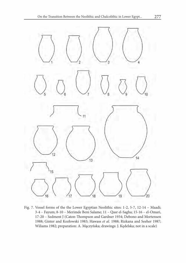
On the Transition Between the Neolithic and Chalcolithic in Lower Egypt... 277
Fig. 7. Vessel forms of the the Lower Egyptian Neolithic sites: 1-2, 5-7, 12-14 – Maadi; 3-4 – Fayum; 8-10 – Merimde Beni Salame; 11 – Qasr el-Sagha; 15-16 – el-Omari, 17-20 – Sedment J (Caton-Thompson and Gardner 1934; Debono and Mortensen 1988; Ginter and Kozłowski 1983; Hawass et al. 1988; Rizkana and Seeher 1987; Wiliams 1982; preparation: A. Mączyńska; drawings: J. Kędelska; not in a scale)
Agnieszka Mączyńska278
vessels from QSVIIA/80 (Ginter and Kozłowski 1983: fig. 35: 3, 6) and Maadi small globular jars of type 5a (Fig. 7:12-13; Rizkana and Seeher 1997: pls. 12–19). Addition-ally, a bottle with a long neck similar to those from Merimde III was found (Wil-liams 1982: fig. 2, 4:22; Kaiser 1985: Abb. 3: 22). At Sedment-Mayana/Sedmen J there are also conical bowls, occurring at Lower Egyptian sites from the Neolithic times through the entire Predynastic period (Kaiser 1985: Abb. 3: 2–3).
To conclude, although the Neolithic and Chalcolithic assemblages present dif-ferent ranges of forms, some of them could be identified in both periods. Most parallels could be identified among open forms from both periods, as they were multifunctional utilitarian utensils. Among jars these parallels seem to be rarer. In the Neolithic assemblages open forms prevail over closed forms. In the latter part of the Neolithic we can observe an increase in the number of closed forms. At Maadi, more than 90% of preserved vessels are jars, but this situation results from the partial
Fig. 8. Development of vessels shapes in the Neolithic/Chalcolithic period in Lower Egypt (preparation: A. Mączyńska; drawings: J. Kędelska)
On the Transition Between the Neolithic and Chalcolithic in Lower Egypt... 279
character of the whole Maadi assemblage, consisting mostly of complete vessels. At Buto I and II both forms are represented in similar numbers (von der Way 1997: 88). The emergence of new closed forms resulted from the development of the pottery tradition, well visible among the Sais ceramic assemblage.
3. Transition from the Neolithic to the Chalcolithic in Lower Egypt: cultural change or continuity?
The stages in the pottery making process, including procurement of raw mate-rials, followed by forming and firing vessels depended inter alia on the quality of and distance to resources, social structure and organization, subsistence system, climate, degree of sedentariness, population density and demand (Arnold 1989; Orton et al. 2010: 114, tab. 10.1). The available evidence does not show any sig-nificant environmental or climatic changes in Lower Egypt between the 5th and the 4th millennium BC. However, some local changes influencing the settlement pattern can be observed (e.g. abandonment of Merimde after phase I or possible abandonment of Sais during phase 2). Although these changes forced people to move, they probably did not seriously affect their way of life. People continued to make pottery in a similar way using the same raw materials as clay or temper. Without doubt potters gained more experience and their skills improved through time. They were able to make more elaborated vessel shapes and to control fir-ing conditions to obtain the desired surface color. The pottery tradition including potters’ know-how and pottery making techniques could be transmitted, learned, invented, created or inherited from generation to generation. The changes that the pottery tradition underwent over time and space, influenced by many cultural factors, account for differences between Neolithic and Chalcolithic pottery. By an-alyzing the pottery tradition of the Neolithic and early Chalcolithic we are able to track partly its development over time and also to notice some constant elements. On the one hand, the use of local resources, simple mode of production and fir-ing, restricted repertoire of forms typical for household mode of pottery produc-tion are typical for both periods. The use of some vessel shapes in both periods could also be an element of the common pottery tradition. On the other hand, the increase in rough pottery accompanied by the decrease in polished pottery covered by slip and the increase in the number of vessel shapes in the Chalcolithic could be treated as changes and steps in the tradition’s development. Analyses of the pottery tradition of the Neolithic and Chalcolithic show its dynamic character very clearly. In my opinion, the common cultural tradition linked both periods
Agnieszka Mączyńska280
and the available data indicates the continuity of the pottery tradition between the 5th and the 4th millennium BC.
In the studies on the continuity of the pottery tradition some observations concerning the relation between pottery production and cultural change made by P. Rice (1984) could also be helpful. The researcher proposed a list of factors influencing stability and/or change in pottery production, including recourses, efficiency, diet, ritual or ceremonial behavior, values, social/economic status/organization and market demand (Rice 1984: 241-255, tab. 2). According to P. Rice, pottery does respond to cultural change, but this response is ‘subtle and gradual’. Moreover, changes in pottery do not reflect cultural change in a reli-able and predictable manner (Rice 1984: 234 after Ehrlich 1965: 13 and Grieder 1975: 850).
In my opinion the cultural boundary between the Neolithic and Chalcolithic is artificial and was distinguished only on the basis on archaeological records. The same goes for the existing framework of archaeological cultures. Neither reflects the actual cultural situation in the past and they are merely an archaeological in-terpretation of the remains of past societies (see Mączyńska 2017). We can ob-serve the continuity of the pottery tradition between both periods.
In my research on the Neolithic and early Chalcolithic pottery I chose to iden-tify and analyze the factors proposed by P. Rice that account for continuity or change in pottery assemblages. According to her, adaptation to resources is one of the reasons for stability (Rice 1984: 241-244; 2005: 462). Clay, temper and fuel are fixed locally and potters adapt to their properties. All innovations involve the risk of failure, which is why potters are quite conservative and less likely to in-novate. Changes can be caused by various situations: exhaustion or inaccessibility of e.g. clays, temper, availability of new resources, forced resettlement of potters, environmental change or natural disaster. The availability of local resources pro-moted stability in the pottery-making system in the Neolithic and early Chalco-lithic. Moreover, pottery manufacturing efficiency / technique known in the pe-riod in question also promoted stability. The household mode of pottery-making, in which vessels were made for domestic purposes seems to have been resistant to change. Production and firing techniques were simple, requiring only basic skills.
It is worth analyzing two other factors closely related to each other – diet and demand. Utilitarian vessels are very often described as being the most resistant to change as they have little or even no symbolic meaning (Rice 2005: 45). The mode of their use and their content change little, even during and after a cultural
On the Transition Between the Neolithic and Chalcolithic in Lower Egypt... 281
change. The most change-resistant are water and cooking vessels, which make the majority of the ceramic assemblages on the Neolithic and early Chalcolithic sites. Their fabrics and shapes depend mostly on their function. In my opinion, the similarity of the Neolithic and early Chalcolithic utilitarian ceramic assemblages resulted from their similar function. Moreover, the change in the number of used forms and the well visible development of vessels from open towards closed forms in the later Neolithic and early Chalcolithic could result from changes in function, diet and demand. Evidence from Chalcolithic sites shows that LEC economy was fully based on farming and animal breeding (Mączyńska 2013: 101-106), while in the Neolithic wild recourses were still an important supplement in the diet. The more differentiated repertoire of forms on younger sites could reflect a shift from multifunctional vessels towards containers used for specific functions/products. The limited number of vessel shapes in both periods could influenced the use of utilitarian vessels as grave offerings. Burial customs in both periods were very simple with only single grave goods (or with no grave goods altogether), which probably had been previously used by the dead or their relatives.
To conclude, when analyzing the pottery-making system of Neolithic and Chal-colithic societies, it is easy to recognize the stability of the system. In my opinion, mostly stability promoting factors could be identified. Our limited knowledge on the early Prehistory of Lower Egypt does not allow us to analyze other factors proposed by P. Rice, such as ritual or ceremonial behavior and values. However, my research on the later phases of the LEC pottery shows that the pottery tradi-tion changed as new change-promoting factors emerged in the later part of the 4th millennium BC (Mączyńska 2016b).
4. Conclusion: the origins of the LECIn my opinion the origins of the LEC are closely linked to the Neolithic so-
cieties of Lower Egypt. For many years in the archaeology of Lower Egypt there was a time gap between el-Omari culture and LEC, with no finds dated to that period. The recent excavations at Sais showed that the end of Merimde occupa-tion is dated to 3900 BC, when LEC occupation at Buto started. However, it is still really difficult to propose any hypothesis on the beginning of LEC occupation in this region. According to G. Tassie (2014: 361), LEC occupation did not appear si-multaneously in the whole of Lower Egypt and it radiated from the western Delta. However, since only a few sites are known, data interpretation is far from easy. The territorial and chronological proximity of the Neolithic and Chalcolithic settlers

Agnieszka Mączyńska282
in Lower Egypt allows one to link them to the same cultural tradition. The ances-tors of LEC should be looked for within the Neolithic societies of Lower Egypt.
The pottery tradition is part of a cultural tradition and its analyses could give answers to questions concerning its continuity between the Neolithic and the Chalcolithic. My analyses show that ceramic assemblages from both periods dif-fer, but they also indicate some common characteristics which could be explained as a result of a common cultural background of the societies occupying the region in question in the 5th and 4th millennium BC (Fig. 8). The adaptation to and the use of local resources, simple pottery making techniques, limited number of vessels shapes and household mode of production can all be observed in both periods. Moreover, looking beyond the pottery tradition it is not difficult to notice that the societies from both periods also shared some other technologies (e.g. flint production), prac-tices (e.g. burial custom), social structure (egalitarianism) and economy (farming and animal breeding) (Mączyńska 2013; 2017). This Lower Egyptian cultural tradi-tion developed over time and underwent dynamic changes. As a result, the Neolith-ic and Chalcolithic societies have their unique characteristics distinguishing them from each other. On the one hand, the Chalcolithic produced more differentiated ceramic assemblages, buried their dead in separate areas outside settlements and re-lied fully on agricultures. But on the other hand, they still made vessels in the same way and used a few of the same shapes, equipped the dead with only a few offerings used before in household activities. They also cultivated and ate the same cereals and kept and used the same animals.
I am aware that my observations are tentative and should be confirmed by further studies on materials other than pottery, including more detailed analyses of social, economic and symbolic systems. However, the first step is always bet-ter than no step at all. I hope that my analyses can provoke a discussion on the cultural situation in Lower Egypt in this early period. It requires going beyond the secure framework of archaeological cultures, which makes it difficult to under-stand early occupation of Egypt. We have to keep in mind that the Neolithic and Chalcolithic societies were the ancestors of the Ancient Egyptian and the founda-tion of the Egyptian state were created in these very periods.
AcknowledgementsThis paper was prepared as part of the ‘The development of the early Neolithic soci-
eties in Lower Egypt during 5th millennium BC and their interactions with the South-ern Levant’ project financed by National Science Centre (No. 2014/13/B/HS3/04874).
On the Transition Between the Neolithic and Chalcolithic in Lower Egypt... 283
REFERENCESARNOLD, D. E., 1989. Ceramic theory and cultural process. Cambridge.BATES, O. 1915. Archaic burials at Marsa Marüt. Ancient Egypt: 158-165.BATES, O. 1927. Chapter II. Archaic remains. Harvard African Studies 8: 7-13.BUCHEZ, N. and B. MIDANT-REYNES. 2007. Le site prédynastique de Kom el-
Khilgan (Delta Oriental). Données nouvelles sur les processus d’unification culturelle au IVème millénaire. BiFAO 107: 43-70.
BUCHEZ, N. and B. MIDANT-REYNES. 2011. A tale of two funerary traditions: the Predynastic cemetery at Kom el-Khilgan, Eastern Delta. In: R.F. Fried-man and P.N. Fiske (eds.), Egypt at its Origins 3. Proceedings of the interna-tional Conference „Origin of the State. Predynastic and Early Dynastic Egypt”, London, 27th September-1st August 2008 (= OLA 205): 831-858. Leuven.
CATON-THOMPSON, G. and E.W. GARDNER. 1934. The Desert Fayum. London.CIAŁOWICZ, K. M. 2001. La naissance d’un royaume. L’Égypte dès la periode pré-
dynastic à la fin de la i ère dynastie. Kraków.DEBONO, F. 1948. El-Omari (près d’Hélouan). Exposé Sommaire. Annales du
Service des Antiquités de l’Egypte 48: 561-583.DEBONO, F. 1956. La Civilization Prédynastique d’el Omari (Nord d’Hélouan).
Nouvelles Données, Bulletin de l’institut d’Egypte 37: 329-339.DEBONO, F. and B. MORTENSEN. 1988. The Predynastic Cemetery at Heliopolis.
Season March – September 1950. Mainz.EHRICH, R. W. 1965. Ceramics and Man: a Cultural Perspective. In: F. R. Matson
(ed.), Ceramics and Man: 1-19. Chicago. EIWANGER, J. 1984. Merimde-Benisalâme i. Die Funde der Urschicht. Mainz.EIWANGER, J. 1988. Merimde-Benisalâme ii. Die Funde der mittleren Merim-
dekultur. Mainz.EIWANGER, J. 1992. Merimde-Benisalâme iii. Die Funde der jüngeren Merim-
dekultur. Mainz.EL-SANUSSI, A. and M. JONES. 1997. A site of the Maadi culture near the Giza Pyra-
mids. Mitteilungen des Deutschen Archaeologischen instituts Kairo 53: 241-253.FRIEDMAN, R.F. 1994. Predynastic Settlement Ceramics of Upper Egypt: a Com-
parative Study of the Ceramics of Hememieh, Naqada and Hierakonpolis, Ph. D. Thesis, University of California. Berkley.
GINTER, B. and J.K. KOZŁOWSKI. 1983. Investigation on Neolithic settlement. In: J. K. Kozłowski (ed.), Qasr el Sagha 1980. Contributions to the Holocene Geology, the Predynastic and Dynastic settlements in the northern Fayum Desert: 37-71. Kraków.
Agnieszka Mączyńska284
GRIEDER, T. 1975. The Interpretation of Ancient Symbols. American Anthropolo-gist 77: 845-855.
HABACHI, L. and W. KAISER. 1985. Ein Friedhof der Maadikultur bei es-Staff. Mitteilungen des Deutschen Archaeologischen instituts Kairo 41: 43-46.
HAMROUSH, H.A. and H. ABU ZIED. 1990. Petrological and Chemical Analy-ses of Some Neolithic Ceramics From el Omari, Egypt. In: F. Debono and B. Mortensen and El Omari (eds.). A Neolithic settlement and other sites in the vicinity of wadi Hof, Helwan: 117–128. Mainz.
HARTUNG, U. 2004. Rescue excavations in the Predynastic settlement at Maadi. In: S. Hendrickx, R.F. Friedman, K.M. Ciałowicz and M. Chłodnicki (eds.), Egypt at its Origins. Studies in Memory of Barbara Adams. Proceedings of the interna-tional Conference “Origin of the state. Predynastic and Early Dynastic Egypt”, Kraków, 28th August–1st September 2002 (= OLA 138): 337-356. Leuven.
HARTUNG, U., HARTMANN, R., KINDERMANN, K., REIMER, H. and W. STAHLE. 2017. Tell el-Fara‘in – Buto. 12. Vorbericht. Mitteilungen des Deutschen Archaeologischen Instituts Kairo 72: 73-126.
HAWASS, Z., HASSAN, F.A. and A. GAUTIER. 1988. Chronology, Sediments, and Subsistence at Merimda Beni Salama. Journal of Egyptian Archaeology 74: 31-38.
HENDRICKX, S., 1999. Le chronologie de la préhistoire tardive et des débuts de l’histoire de l’Egypte. ArchéoNil 9: 13-81.
HENDRICKX, S. 2006. Predynastic – Early Dynastic chronology. In: E. Hornung, R. Krauss and D. Warburton (eds.), Ancient Egyptian chronology: 55–93. Leiden.
HOLDAWAY, S., PHILLIPPS, R., EMMITT, J. and W. WENDRICH. this volume. E29G1 revisited: the current state of the surface archaeology of western regions of the Fayum North shore, Egypt. In: M. Chłodnicki, J. Kabaciński, M. Kobusiewicz and M. Winiarska-Kabacińska, M. (eds.). Desert and the Nile. Prehistory of the Nile Basin and the Sahara. Papers in honour of Fred Wendorf (= Studies in African Archaeology 15). Poznań.
HOLDAWAY, S. and WENDRICH, W. (eds), 2017. The Desert Fayum Reinvesti-gated. Los Angeles.
JUNKER, H. 1929. Merimde i. Vorläufiger Bericht über die Grabungen der Akade-mie der wissenschaften in wien auf der neolithischen siedlung von Merimde-Benisalame. Wien.
KAISER, W. 1985. Zur Südausdehnung der vorgeschichtlichen Deltakulturen und zur frühen Entwicklung Oberägyptens. Mitteilungen des Deutschen Archae-ologischen instituts Kairo 41: 61–87.

On the Transition Between the Neolithic and Chalcolithic in Lower Egypt... 285
KAISER, W. and A. ZAUGG. 1988. Zum Fundplatz der Maadikultur bei Tura. Mitteilungen des Deutschen Archaeologischen instituts Kairo 44: 121-124.
KÖHLER, E. CH. 2008. The Interaction between and the Roles of Upper and Lower Egypt in the Formation of the Egyptian State – Another Review. In: B. Midant-Reynes and Y. Tristant (eds.), Egypt at its Origins 2, Proceedings of the International Conference „Origin of the State. Predynastic and Ear-ly Dynastic Egypt”, Toulouse, 5-8 September 2005 (= OLA 172): 515-544. Leuven.
KÖHLER, E.CH. 2014. Of Pots and Myths – Attempting a comparative study of funerary pottery assemblages in the Egyptian Nile Valley during the late 4th millennium BC. In: A. Mączyńska (ed.), The Nile Delta as a centre of cultural interactions between Upper Egypt and the Southern Levant in the 4th millennium BC (= Studies in African Archaeology 13): 155–180. Poznań.
LARSEN, H. 1962. Die Merimdekeramikim Mittelmeermuseum Stockholms. Orientalia Suecana 11: 3-88.
LEVY, T. E. and E.M.C. VAN DEN BRINK. 2003. Interaction Models, Egypt and the Levantine Periphery. In: E.C.M. van den Brink and T.E. Levy (eds.), Egypt and the Levant. interrelations from the 4th through the Early 3rd Mil-lenium B.C.E.: 3-38. London – New York.
LIGHTFOOT, K.G. 2001. Traditions as Cultural Production. Implications for Contemporary Archaeological Research. In: T.R. Pauketat (ed.), The Ar-chaeology of Tradition. Agency and History Before and After Columbus: 287–252. Gainesville.
MĄCZYŃSKA, A. 2003. Lower Egyptian Culture at Tell el-Farkha. In: L. Krzyżaniak, K. Kroeper and M. Kobusiewicz (eds.), Cultural Markers in the Later Prehis-tory of Northeastern Africa and Recent Research (= Sudies in African Ar-chaeology 8): 213-226. Poznań.
MĄCZYŃSKA, A. 2004. Pottery Tradition at Tell el-Farkha. In: S. Hendrickx, R.F. Friedman, K.M. Ciałowicz and M. Chłodnicki (eds.), Egypt at its Ori-gins. Studies in Memory of Barbara Adams. Proceedings of the internation-al Conference „Origin of the State. Predynastic and Early Dynastic Egypt”, Kraków, 28th August – 1st September 2002 (= OLA 138): 421-442. Leuven.
MĄCZYŃSKA, A. 2008. Some Remarks on Egyptian-Southern Levantine Inter-relations in the First Half of the 4th Millennium BC. In: B. Midant-Reynes. and Y. Tristant (eds.), Egypt at its Origins 2, Proceedings of the international Conference „Origin of the State. Predynastic and Early Dynastic Egypt”, Tou-louse, 5-8 September 2005 (= OLA 172): 763-782. Leuven.

Agnieszka Mączyńska286
MĄCZYŃSKA, A. 2011. Lower Egyptian–Nagadian transition. A view from Tell el-Farkha. In: R.F. Friedman and P.N. Fiske (eds.), Egypt at its Origins. Pro-ceedings of the international Conference „Origin of the State. Predynastic and Early Dynastic Egypt”, London, 27th September-1st August 2008 (= OLA 205): 879-908. Leuven.
MĄCZYŃSKA, A. 2013. Lower Egyptian Communities and Their interactions with Southern Levant in the 4th Millennium BC. (= Studies of African Archaeo- logy 12). Poznań.
MĄCZYŃSKA, A. 2014. Some remarks on the visitors in the Nile Delta in the 4th millennium BC. In: A. Mączyńska (ed.), The Nile Delta as a centre of cultural interactions between Upper Egypt and the Southern Levant in the 4th millennium BC (=Studies in African Archaeology 13): 181-216. Poznań.
MĄCZYŃSKA, A. 2015. Some remarks on the chronology of the oldest graves from Minshat Abu Omar. In: M.A. Jucha, J. Dębowska-Ludwin and P. Kołodziejczak (eds.), Aegyptus est imago caeli. Studies presented to K.M. Ciałowicz on his 60th Birthday: 73-83. Kraków.
MĄCZYŃSKA, A. 2017. The pottery of the Neolithic Lower Egyptian Societies: a single regionwide tradition or multiple local traditions? In: B. Midant-Reynes and Y. Tristant (eds.) Egypt at its Origins 5, Proceedings of the in-ternational Conference „Origin of the State. Predynastic and Early Dynastic Egypt”, Cairo 13th-18th April 2014. (= OLA 260): 657-688. Leuven.
MĄCZYŃSKA, A. 2016a. Naqadan-Lower Egyptian interactions during the 4th Mil-lennium B.C. A comparative study of pottery dated to Naqada II period from the sites at Adaïma and Tell el-Farkha. In: M.D. Adams B. Midant-Reynes, E.M. Ryan and Y. Tristant (coll.) (eds.), Egypt at its Origins 4, Proceedings of the Fourth international Conference „Origin of the State. Predynastic and Early Dynastic Egypt”, New York, 26th-30th July 2011. (= OLA 252): 83-108. Leuven.
MĄCZYŃSKA, A. 2016b. Pottery as a Source for Studying Cultural Changes. The Prob-lem of Lower Egyptian-Naqadian Transition. In: B. Bader, Ch. M. Knoblauch and E. Ch. Köhler (eds.), Proceedings of the international Conference held at the University of Vienna 14th-18th of May, 2012. (= OLA 245): 387-401. Leuven.
MIDANT-REYNES, B. 2003. Aux origines de l’Égypte. Du Néolithique à l’émergence de l’État. Paris.
MIDANT-REYNES, B. And N. BUCHEZ. 2014. Tell el-iswid 2006-2009. Le Caire. MORTENSEN, B. 1985. Four jars from the Maadi culture found in Giza, Mit-
teilungen des Deutschen Archaeologischen instituts Kairo 41: 145-147.ORTON, C., TYERS, P. and A.VINCE. 2010. Pottery in Archaeology. Cambridge.

On the Transition Between the Neolithic and Chalcolithic in Lower Egypt... 287
OSBORNE, R. 2008. Introduction: for tradition as an analytical category. world Archaeology 40/3: 281–294.
PAUKETAT, T.R. 2001. A New Tradition in Archaeology. In: T. R. Pauketat (ed.), The Archaeology of Tradition. Agency and History Before and After Colum-bus: 1–6. Gainesville.
RICE, P. 1984. Change and Conservatism in Pottery-producing System. In: S. E. van der Leeuw and A. C. Pritchard (eds.), The Many Dimensions of Pottery. Ce-ramics in Archaeology and Anthropology: 231-288. Amsterdam.
RICE, P. 2005. Pottery analysis. A sourcebook. Chicago.RIZKANA, I. and J. SEEHER. 1987. Maadi i: The Pottery of the Predynastic Settle-
ment. Mainz.RIZKANA, I. and J. SEEHER. 1990. Maadi iV: The Predynastic Cemeteries of Maa-
di and wadi Digla. Mainz.ROWLAND, J.M. and L.C. BERTINI. 2016. The Neolithic within the context of
northern Egypt: New results and perspectives from Merimde Beni Salama, Quaternary international 410A: 160-172.
ROWLAND, J.M. and G.J. TASSIE. 2015. Prehistoric Sites along the Edge of the Western Nile Delta: Report on the Results of the Imbaba Prehistoric Sur-vey, 2013–14. Journal of Egyptian Archaeology 100: 49-66.
SCHMIDT, K. 1993. Comments to the lithic industry of Buto-Maadi Culture in Lower Egypt. In: L. Krzyżaniak, M. Kobusiewicz and J. Alexander (eds.), En-vironmental Change and Human Culture in the Nile Basin and Northern Af-rica until the Second Millennium B. C. (= Studies in African Archaeology 4): 267-277. Poznań.
SHIRAI, N. 2010. The Archaeology of the First farmer-herders in Egypt. New in-sights into the Fayum Epipalaeolithic and Neolithic. Leiden.
TASSIE, G.J. 2014. Prehistoric Egypt. Socioeconomic Transformations in North-East Africa from the Last Glacial Maximum to the Neolithic, 24,000 to 6,000 cal BP. London.
VON DER WAY, T. 1992. Excavation at Tell el-Fara’in/Buto in 1987-1989. In: E.C.M. van den Brink (ed.), The Nile Delta in Transition: 4th. – 3rd. Mil-lenium B. C.: 1-10. Tel Aviv.
VON DER WAY, T. 1997. Tell el-Fara’in. Buto i. Ergebnisse zum frühen Kontext. Kampagnen der Jahre 1983-1989. Mainz.
WILLIAMS, B. 1982. Notes on Prehistoric cache fields of Lower Egyptian tradi-tion at Sedment. JNES 41/3: 213-221.
WILSON, P., GILBERT, G. and G. TASSIE. 2014. Sais ii: The Prehistoric Period at Sa el-Hagar. EES Excavation Memoir 107. London.


Desert and the Nile. Prehistory of the Nile Basin and the Sahara.
Papers in honour of Fred Wendorf Studies in African Archaeology 15
Poznań Archaeological Museum 2018
Dorian Vanhulle
Preliminary Observations on Some Naqadian Boat Models. A Glimpse of a Discrete Ideological Process in Pre-pharaonic Arts
The boat is ubiquitous in Naqadian artistic productions, where it embodies various ideological concepts (Williams et al. 1987; Hendrickx and Eyckerman 2010: 127-133). Although this fact is well known, many questions remain open. An holistic approach that encompasses all the data available concerning the boat, both as a means of transport and as an iconographic motif, can shed some light on the process that leads it to express important ideological notions during the 4th millennium B.C.1
Because it would be impossible to consider the whole subject in these few pages, it is necessary to narrow it down to a more specific discussion. This paper presents preliminary observations concerning several boat models and suggests some possible correlations between this production and other categories of sourc-es. Then, it briefly discusses the diachrony of the process mentioned above, which is both ideological and artistic.
1 This research was the subject of a PhD thesis conducted at the Université libre de Bruxelles under the supervision of Dr Laurent Bavay.

Dorian Vanhulle290
1. Boat Models from the Predynastic Period Generally considered to be an offering to the dead, allowing the deceased to
travel to and in the other world (De Morgan 1920; Petrie 1920: 8), or even to be mere toys (Vandier 1952: 149; Hayes 1965: 107 contra Kromer and Badawi 1980: 270), boat models are most often poorly published and badly dated. Despite some exceptions (Brunner-Traut 1975; Kromer and Badawi 1980; Vinson 1987: 162- -177), they were mainly studied for the information they provide on naval archi-tecture (Reisner 1913: xvii-xviii, 20-21, Fig. 88-90, pl.VI.4814-4816; Landström 1970: 11-25; Merriman 2011).
Among the 250 exemplars documented in the context of our PhD, 194 are in baked clay, 8 are in unbaked clay, 7 are in wood, 1 is in basketry, 30 are in ivory and 10 are in various stones. Models that have been manufactured in these last two materials are not older than Naqada III and are typical of the Early Dynastic Period. This paper focuses on some models currently kept in the Petrie Museum in London, in the Museum of Archaeology and Anthropology in Cambridge and in the Ashmolean Museum in Oxford2.
2. Models from the Petrie Museum: a new category of ceremonial barque?
UC162873 (Fig. 1) is made of baked clay. It is flat bottomed and the upper half of the hull is hollowed. The prow is strongly incurved and a horizontal element protrudes from its extremity. The stern is slightly incurved and its extremity is directed outwards. It looks like a schematic “S”. The clay is of a reddish-brown co-lour and the object shows some traces of exposure to the fire. UC162884 (Fig. 2) is very similar to UC16287, albeit larger and completely hollowed. Its outer surface is smooth and still covered with an ochre slip. Despite the fact that the extremity of the prow is now lost, what can still be seen of it confirms that the horizontal
2 We would like to express our gratitude to P. Hedvisq (curatorial Assistant at the Petrie Muse-um, London), L. McNamara (assistant Keeper for Ancient Egypt and Sudan at the Ashmolean Museum, Oxford) and I. Gunn (collections Manager for the Museum of Archaeology and Anthropology, University of Cambridge) for giving us access to those models and for their kind welcome.
3 ca 11,5 cm long, ca 2,5 cm wide, ca 4,5 cm high (Petrie 1920: 42, Pl. XLVII.4; Petrie 1933: 6, Fig. 16; Kromer and Badawi 1980: 263, Fig.1.3; Merriman 2011: 141.9).
4 ca 24 cm long, ca 6,10 cm wide, ca 9,4 cm high (Petrie 1920: 42, Pl. LXVII.5; Petrie 1933: 6, Fig. 17; Kromer and Badawi 1980: 263, Fig. 1.4; Merriman 2011: 142.10).

Preliminary Observations on Some Naqadian Boat Models 291
Fig. 1. Model UC16287 (photo: D. Vanhulle)
Fig. 2. Model UC16288 (photo: D. Vanhulle)
feature also existed on this model. The stern is also higher than the prow and “S-shaped”. UC162895 (Fig. 3) is smaller than the previous ones and, at first sight, quite different. Its body is rounded. However, the general features are similar since one extremity is completely incurved and flattened at its apex. The stern has not survived but its base suggests that it rose vertically. Traces of exposure to fire after the original baking are also visible on this exemplar.
5 ca 8,3 cm long, ca 1,9 cm wide, ca 1,8 cm high (Petrie 1920: 42, Pl. XLVII.6; Kromer and Badawi 1980: 263, Fig.1.2; Merriman 2011: 139.2).
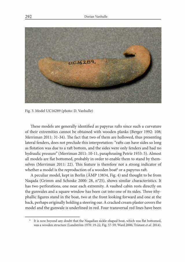
Dorian Vanhulle292
These models are generally identified as papyrus rafts since such a curvature of their extremities cannot be obtained with wooden planks (Berger 1992: 108; Merriman 2011: 31-34). The fact that two of them are hollowed, thus presenting lateral fenders, does not preclude this interpretation: “rafts can have sides so long as flotation was due to a raft bottom, and the sides were only fenders and had no hydraulic pressure” (Merriman 2011: 10-11, paraphrasing Petrie 1933: 5). Almost all models are flat bottomed, probably in order to enable them to stand by them-selves (Merriman 2011: 22). This feature is therefore not a strong indicator of whether a model is the reproduction of a wooden boat6 or a papyrus raft.
A peculiar model, kept in Berlin (ÄMP 13834, Fig. 4) and thought to be from Naqada (Grimm and Schoske 2000: 28, n°25), shows similar characteristics. It has two perforations, one near each extremity. A vaulted cabin rests directly on the gunwales and a square window has been cut into one of its sides. Three ithy-phallic figures stand in the boat, two at the front looking forward and one at the back, perhaps originally holding a steering oar. A cracked cream plaster covers the model and the gunwale is underlined in red. Four transversal red lines have been
6 It is now beyond any doubt that the Naqadian sickle-shaped boat, which was flat bottomed, was a wooden structure (Landström 1970: 19-22, Fig. 57-59; Ward 2006; Tristant et al. 2014).
Fig. 3. Model UC16289 (photo: D. Vanhulle)
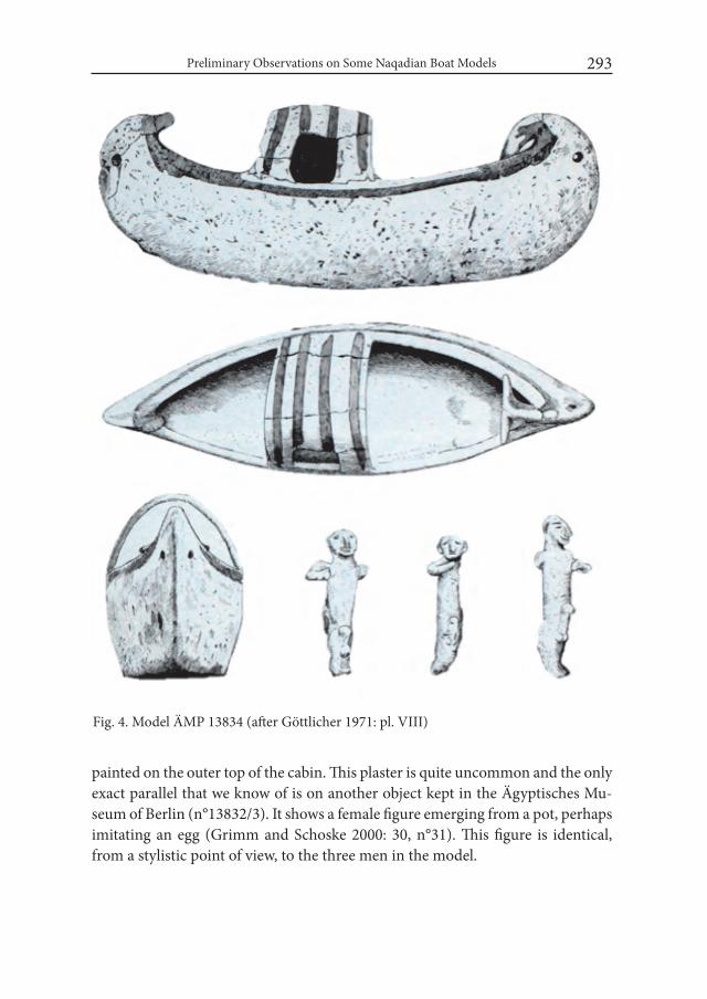
Preliminary Observations on Some Naqadian Boat Models 293
painted on the outer top of the cabin. This plaster is quite uncommon and the only exact parallel that we know of is on another object kept in the Ägyptisches Mu-seum of Berlin (n°13832/3). It shows a female figure emerging from a pot, perhaps imitating an egg (Grimm and Schoske 2000: 30, n°31). This figure is identical, from a stylistic point of view, to the three men in the model.
Fig. 4. Model ÄMP 13834 (after Göttlicher 1971: pl. VIII)
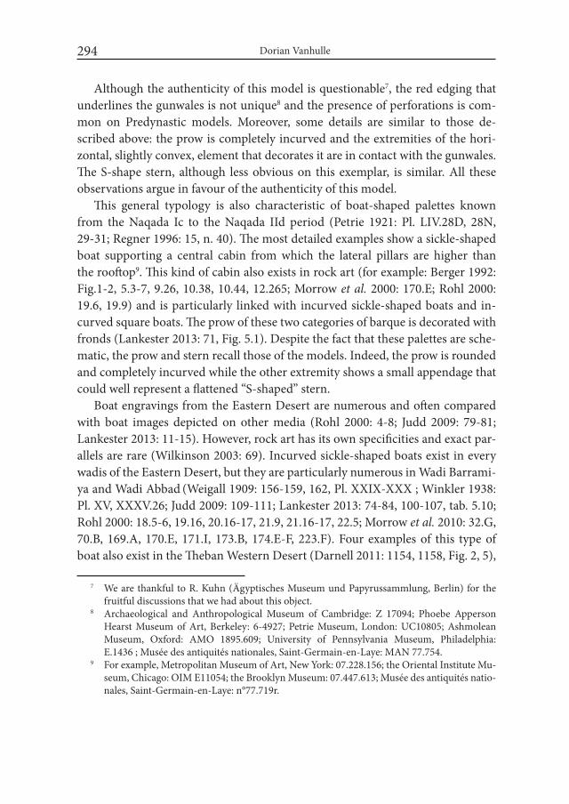
Dorian Vanhulle294
Although the authenticity of this model is questionable7, the red edging that underlines the gunwales is not unique8 and the presence of perforations is com-mon on Predynastic models. Moreover, some details are similar to those de-scribed above: the prow is completely incurved and the extremities of the hori-zontal, slightly convex, element that decorates it are in contact with the gunwales. The S-shape stern, although less obvious on this exemplar, is similar. All these observations argue in favour of the authenticity of this model.
This general typology is also characteristic of boat-shaped palettes known from the Naqada Ic to the Naqada IId period (Petrie 1921: Pl. LIV.28D, 28N, 29-31; Regner 1996: 15, n. 40). The most detailed examples show a sickle-shaped boat supporting a central cabin from which the lateral pillars are higher than the rooftop9. This kind of cabin also exists in rock art (for example: Berger 1992: Fig.1-2, 5.3-7, 9.26, 10.38, 10.44, 12.265; Morrow et al. 2000: 170.E; Rohl 2000: 19.6, 19.9) and is particularly linked with incurved sickle-shaped boats and in-curved square boats. The prow of these two categories of barque is decorated with fronds (Lankester 2013: 71, Fig. 5.1). Despite the fact that these palettes are sche-matic, the prow and stern recall those of the models. Indeed, the prow is rounded and completely incurved while the other extremity shows a small appendage that could well represent a flattened “S-shaped” stern.
Boat engravings from the Eastern Desert are numerous and often compared with boat images depicted on other media (Rohl 2000: 4-8; Judd 2009: 79-81; Lankester 2013: 11-15). However, rock art has its own specificities and exact par-allels are rare (Wilkinson 2003: 69). Incurved sickle-shaped boats exist in every wadis of the Eastern Desert, but they are particularly numerous in Wadi Barrami-ya and Wadi Abbad (Weigall 1909: 156-159, 162, Pl. XXIX-XXX ; Winkler 1938: Pl. XV, XXXV.26; Judd 2009: 109-111; Lankester 2013: 74-84, 100-107, tab. 5.10; Rohl 2000: 18.5-6, 19.16, 20.16-17, 21.9, 21.16-17, 22.5; Morrow et al. 2010: 32.G, 70.B, 169.A, 170.E, 171.I, 173.B, 174.E-F, 223.F). Four examples of this type of boat also exist in the Theban Western Desert (Darnell 2011: 1154, 1158, Fig. 2, 5),
7 We are thankful to R. Kuhn (Ägyptisches Museum und Papyrussammlung, Berlin) for the fruitful discussions that we had about this object.
8 Archaeological and Anthropological Museum of Cambridge: Z 17094; Phoebe Apperson Hearst Museum of Art, Berkeley: 6-4927; Petrie Museum, London: UC10805; Ashmolean Museum, Oxford: AMO 1895.609; University of Pennsylvania Museum, Philadelphia: E.1436 ; Musée des antiquités nationales, Saint-Germain-en-Laye: MAN 77.754.
9 For example, Metropolitan Museum of Art, New York: 07.228.156; the Oriental Institute Mu-seum, Chicago: OIM E11054; the Brooklyn Museum: 07.447.613; Musée des antiquités natio-nales, Saint-Germain-en-Laye: n°77.719r.
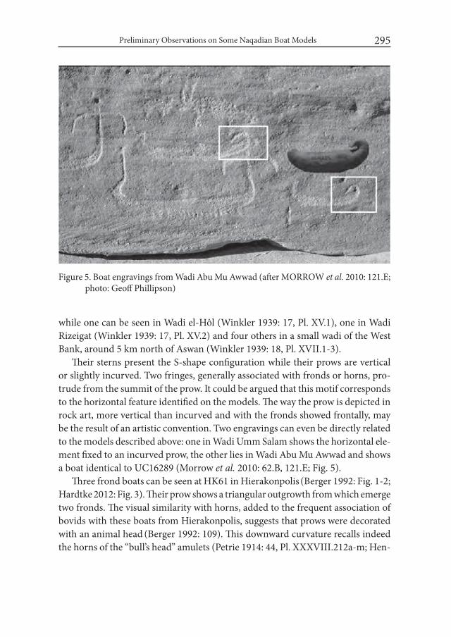
Preliminary Observations on Some Naqadian Boat Models 295
while one can be seen in Wadi el-Hôl (Winkler 1939: 17, Pl. XV.1), one in Wadi Rizeigat (Winkler 1939: 17, Pl. XV.2) and four others in a small wadi of the West Bank, around 5 km north of Aswan (Winkler 1939: 18, Pl. XVII.1-3).
Their sterns present the S-shape configuration while their prows are vertical or slightly incurved. Two fringes, generally associated with fronds or horns, pro-trude from the summit of the prow. It could be argued that this motif corresponds to the horizontal feature identified on the models. The way the prow is depicted in rock art, more vertical than incurved and with the fronds showed frontally, may be the result of an artistic convention. Two engravings can even be directly related to the models described above: one in Wadi Umm Salam shows the horizontal ele-ment fixed to an incurved prow, the other lies in Wadi Abu Mu Awwad and shows a boat identical to UC16289 (Morrow et al. 2010: 62.B, 121.E; Fig. 5).
Three frond boats can be seen at HK61 in Hierakonpolis (Berger 1992: Fig. 1-2; Hardtke 2012: Fig. 3). Their prow shows a triangular outgrowth from which emerge two fronds. The visual similarity with horns, added to the frequent association of bovids with these boats from Hierakonpolis, suggests that prows were decorated with an animal head (Berger 1992: 109). This downward curvature recalls indeed the horns of the “bull’s head” amulets (Petrie 1914: 44, Pl. XXXVIII.212a-m; Hen-
Figure 5. Boat engravings from Wadi Abu Mu Awwad (after MORROW et al. 2010: 121.E; photo: Geoff Phillipson)

Dorian Vanhulle296
drickx 2002: 285-287). However, recent works are challenging this interpretation: “these protrusions could also be explained in other ways, such as by branches or palm fronds as shown on some Naqada II vessel” (Hardtke 2012: 337).
Hierakonpolis engravings bear similarities with C-Ware decorations and may occupy a date range of Naqada I and Naqada IIB (Hardtke 2013: 112). Arguably, this chronological range can be narrowed down, as desert sites in Hierakonpolis do not seem to be older than Naqada IC10. It fits with the first appearances of the boat in iconography, notably on a well-known C-Ware plate (Egyptian Museum, Cairo: CG2076; Graff 2009: 218, n°74) and on a Nagada IC-IIA clay box from el-Amrah (Ashmolean Museum, Oxford: E.2816; Payne 2000: 79-80, Fig. 32.600).
10 Potential traces of a Badarian occupation have been found in Nekhen (Hoffman et al. 1986: 180, fig. 2), but the area of HK61, HK64 and the nearby elite necropolis HK6 do not seem to be older than Naqada IC (Hardtke 2013: 112).
Fig. 6. Boat engraving from Wadi Qash compared with a clay box from el-Amrah (photo: Janet and Paul Robinson)

Preliminary Observations on Some Naqadian Boat Models 297
The raft visible on this box is similar to both the models and most of the frond boats known in rock art (Fig. 6).
The peculiar prow of the models mentioned above looks like the extremity of a papyrus bundle that is bent inward and maintained in place by a rope. In all probability, it is a light material that bends under its own weight. We tentatively propose that palm fronds and large mats that decorate the prows of the wooden sickle-shaped boats depicted on D-ware are reminiscences of the frond prows of papyrus rafts (Petrie 1920: 18-19; Aksamit 1981: 168, Fig. 29; Graff 2009: 174.N8-N9)11. It should also be mentioned that some engravings of this classical sickle-shaped boat show two protrusions at the extremity of the prow that could possibly simulate horns (for example: Huyge 2014: Fig. 2; Hendrickx et al. 2012: 1074, Fig. 7).
An atypical example of this category of boat can be seen on a jar kept in the British Museum (BM 36326, Graff 2009: 383, n°569; Fig. 7). It shows an S-shaped stern with a vertical elongation and an incurved prow with some kind with gar-lands or a mat that hang down from its summit. Next to that prow is a kind of
11 These palm branches have been identified as a cover for the look-out (Petrie 1901: 15-16; Boreux 1925: 16, 33) or as proto-sails (Petrie 1920: 21; Thomas 1923: 97; Le Baron Bowen 1960). J. Aksamit challenged these theories (Aksamit 1981: 160). It could merely be a symbol-ic and apotropaic vegetal adornment, as seen in other maritime, riverine or coastal cultures around the world (Hornell 1945).
Fig. 7. Boat image on a D-ware vase (after Graff, 2009: 383, n°569)
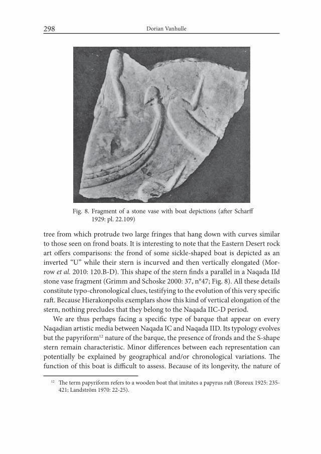
Dorian Vanhulle298
tree from which protrude two large fringes that hang down with curves similar to those seen on frond boats. It is interesting to note that the Eastern Desert rock art offers comparisons: the frond of some sickle-shaped boat is depicted as an inverted “U” while their stern is incurved and then vertically elongated (Mor-row et al. 2010: 120.B-D). This shape of the stern finds a parallel in a Naqada IId stone vase fragment (Grimm and Schoske 2000: 37, n°47; Fig. 8). All these details constitute typo-chronological clues, testifying to the evolution of this very specific raft. Because Hierakonpolis exemplars show this kind of vertical elongation of the stern, nothing precludes that they belong to the Naqada IIC-D period.
We are thus perhaps facing a specific type of barque that appear on every Naqadian artistic media between Naqada IC and Naqada IID. Its typology evolves but the papyriform12 nature of the barque, the presence of fronds and the S-shape stern remain characteristic. Minor differences between each representation can potentially be explained by geographical and/or chronological variations. The function of this boat is difficult to assess. Because of its longevity, the nature of
12 The term papyriform refers to a wooden boat that imitates a papyrus raft (Boreux 1925: 235-421; Landström 1970: 22-25).
Fig. 8. Fragment of a stone vase with boat depictions (after Scharff 1929: pl. 22.109)
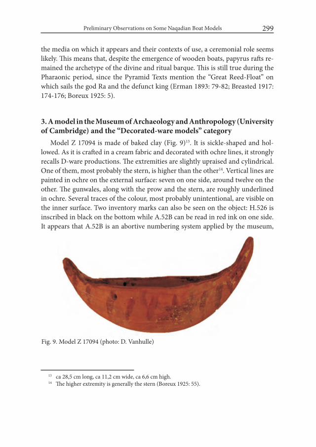
Preliminary Observations on Some Naqadian Boat Models 299
the media on which it appears and their contexts of use, a ceremonial role seems likely. This means that, despite the emergence of wooden boats, papyrus rafts re-mained the archetype of the divine and ritual barque. This is still true during the Pharaonic period, since the Pyramid Texts mention the “Great Reed-Float” on which sails the god Ra and the defunct king (Erman 1893: 79-82; Breasted 1917: 174-176; Boreux 1925: 5).
3. A model in the Museum of Archaeology and Anthropology (University of Cambridge) and the “Decorated-ware models” category
Model Z 17094 is made of baked clay (Fig. 9)13. It is sickle-shaped and hol-lowed. As it is crafted in a cream fabric and decorated with ochre lines, it strongly recalls D-ware productions. The extremities are slightly upraised and cylindrical. One of them, most probably the stern, is higher than the other14. Vertical lines are painted in ochre on the external surface: seven on one side, around twelve on the other. The gunwales, along with the prow and the stern, are roughly underlined in ochre. Several traces of the colour, most probably unintentional, are visible on the inner surface. Two inventory marks can also be seen on the object: H.526 is inscribed in black on the bottom while A.52B can be read in red ink on one side. It appears that A.52B is an abortive numbering system applied by the museum,
13 ca 28,5 cm long, ca 11,2 cm wide, ca 6,6 cm high. 14 The higher extremity is generally the stern (Boreux 1925: 55).
Fig. 9. Model Z 17094 (photo: D. Vanhulle)
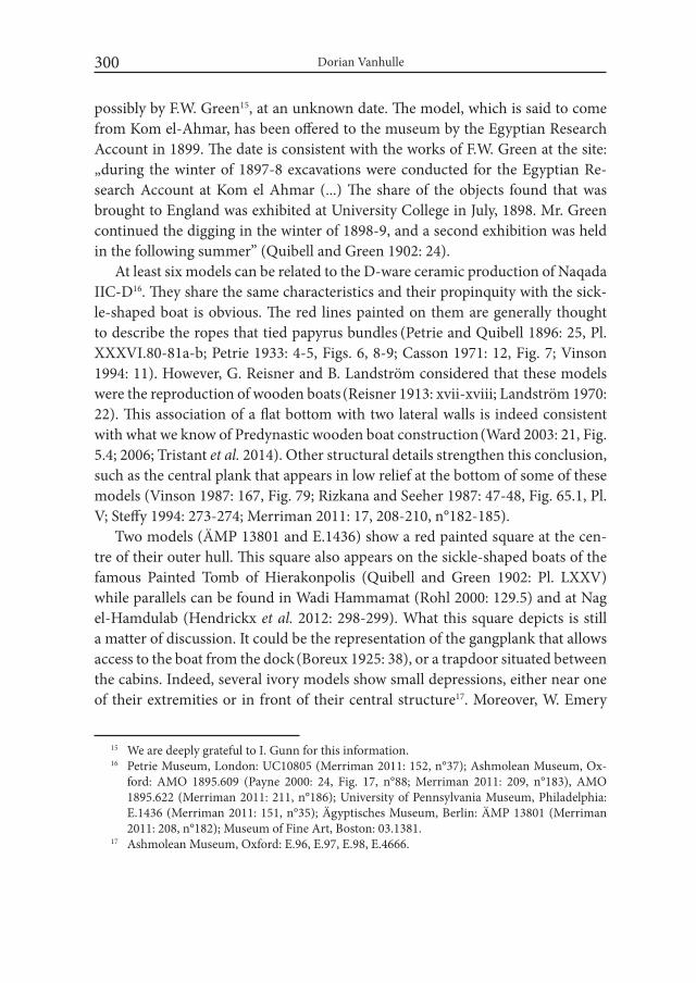
Dorian Vanhulle300
possibly by F.W. Green15, at an unknown date. The model, which is said to come from Kom el-Ahmar, has been offered to the museum by the Egyptian Research Account in 1899. The date is consistent with the works of F.W. Green at the site: „during the winter of 1897-8 excavations were conducted for the Egyptian Re-search Account at Kom el Ahmar (...) The share of the objects found that was brought to England was exhibited at University College in July, 1898. Mr. Green continued the digging in the winter of 1898-9, and a second exhibition was held in the following summer” (Quibell and Green 1902: 24).
At least six models can be related to the D-ware ceramic production of Naqada IIC-D16. They share the same characteristics and their propinquity with the sick-le-shaped boat is obvious. The red lines painted on them are generally thought to describe the ropes that tied papyrus bundles (Petrie and Quibell 1896: 25, Pl. XXXVI.80-81a-b; Petrie 1933: 4-5, Figs. 6, 8-9; Casson 1971: 12, Fig. 7; Vinson 1994: 11). However, G. Reisner and B. Landström considered that these models were the reproduction of wooden boats (Reisner 1913: xvii-xviii; Landström 1970: 22). This association of a flat bottom with two lateral walls is indeed consistent with what we know of Predynastic wooden boat construction (Ward 2003: 21, Fig. 5.4; 2006; Tristant et al. 2014). Other structural details strengthen this conclusion, such as the central plank that appears in low relief at the bottom of some of these models (Vinson 1987: 167, Fig. 79; Rizkana and Seeher 1987: 47-48, Fig. 65.1, Pl. V; Steffy 1994: 273-274; Merriman 2011: 17, 208-210, n°182-185).
Two models (ÄMP 13801 and E.1436) show a red painted square at the cen-tre of their outer hull. This square also appears on the sickle-shaped boats of the famous Painted Tomb of Hierakonpolis (Quibell and Green 1902: Pl. LXXV) while parallels can be found in Wadi Hammamat (Rohl 2000: 129.5) and at Nag el-Hamdulab (Hendrickx et al. 2012: 298-299). What this square depicts is still a matter of discussion. It could be the representation of the gangplank that allows access to the boat from the dock (Boreux 1925: 38), or a trapdoor situated between the cabins. Indeed, several ivory models show small depressions, either near one of their extremities or in front of their central structure17. Moreover, W. Emery
15 We are deeply grateful to I. Gunn for this information.16 Petrie Museum, London: UC10805 (Merriman 2011: 152, n°37); Ashmolean Museum, Ox-
ford: AMO 1895.609 (Payne 2000: 24, Fig. 17, n°88; Merriman 2011: 209, n°183), AMO 1895.622 (Merriman 2011: 211, n°186); University of Pennsylvania Museum, Philadelphia: E.1436 (Merriman 2011: 151, n°35); Ägyptisches Museum, Berlin: ÄMP 13801 (Merriman 2011: 208, n°182); Museum of Fine Art, Boston: 03.1381.
17 Ashmolean Museum, Oxford: E.96, E.97, E.98, E.4666.

Preliminary Observations on Some Naqadian Boat Models 301
considered that the beer jars he found inside the boat grave of Mastaba S.3506 were held in “cargo holds” (Emery 1958: 38, 42).
Two of these models come from Ballas, two from Naqada and one from Abadi-yeh. This is not surprising since it is generally thought that D-ware ceramics were produced in the vicinity of those particular sites (Gilbert 1999: 31-32). Their size, greater than the vast majority of Predynastic models, and their overall quality sug-gest that this is a prestigious production.
4. The Model E.86 from the Ashmolean Museum in Oxford: a prototype of the great royal barque?
Only a few ivory models have been found in tombs (Merriman 2011: 156, 212, n°56, n°189; Tristant 2012: 32, Fig. 19). Most of them come from pre-formal (Kemp 2006: 113) temple deposits at Tell el-Farkha, Tell Ibrahim Awad, Abydos and Hierakonpolis (Dreyer 1986: 37-50, 80; Bussmann 2010: 243, 291, 337, 342, Pl. 93/Fig. 5.51-5.57, Pl. 192/Fig. 5.681). 24 models in ivory and two in stone have been discovered in the Main Deposit of Hierakonpolis. Despite their great impor-tance, information about them has never been properly published.
E.8618 is papyriform (Fig. 10). The prow is vertical while the stern is incurved. Both of them are pierced at their summit, probably for the fixation of an exten-sion. A small transversal perforation situated at the summit of the prow allows the insertion of a small peg. On each side of the deck, a bundle that goes from the top of the prow to the top of the stern reproduces the gunwale. Although this is
18 We are thankful to P. Pomey for his very useful comments on this model.
Fig. 10. Model E.86 (photo: D. Vanhulle)

Dorian Vanhulle302
not the case for E.86, almost all ivory models have small vertical incisions regularly spaced at the emplacement of the gunwales. They probably designate the ropes that solidly tied the bundle to the plank-ing. On most of these ivory models, cross-shaped incisions are visible on the extremities and on structures such as the cabin. Such details can also be seen on the boat depicted on the Narmer Palette and on the Plover Palette (Asselbergh 1961: 336-337, Pl. 90.159).
Two guard rails or gird-ers19 flank each side of the central section of the deck (Fig. 11), which is slightly upraised. A circular hole is pierced at the extremity of this central section, near the stern. Its purpose could have been to support a mast or a pole. Immediately before the
stern are four smaller perforations arranged in a square, probably for the instal-lation of a canopy. Between this canopy and the deck lies a shallow rectangular depression. The cabin is quite damaged but an off-centre door can still be seen (Fig. 12). Another interesting feature is the nodes sculpted along the gunwale un-til the top of the bow. No such nodes can be observed after the cabin nor before the girders. They are thus absent on one half of the model. Similar depictions of nodes can be observed in Early Dynastic sculpture, for example on a First Dy-
19 B. Landström and A. Merriman use the terms “side shelves” to describe this feature (Land-ström 1970: 28, Fig. 86.6 ; Merriman 2011: 18-19, Fig. 2.40-2.41), while Ch. Ward prefers the term “stringers” (Ward 2000: 54-55, fig. 16).
Fig. 11. Guard-rails on model E.86 (photo: D. Vanhulle)
Fig. 12. Cabin door of model E.86 (photo: D. Vanhulle)

Preliminary Observations on Some Naqadian Boat Models 303
nasty breccia basket from Aby-dos (ÄMP 17968: Grimm and Schoske 2000: 68, n°144).
E.86 shows many realistic fea-tures. This strongly suggests that such a boat has existed and that the artist that manufactured the model was familiar with it. What is very interesting is the strong relation between E.86 and the fa-mous cedar barque of Khufu (Jen-kins 1980; Lipke 1984; Mark 2009; 2011). Indeed, girders can be seen at exactly the same emplace-ment on Khufu’s boat (Fig. 13). Towards the prow, this line of girders stops just before a small canopy supported by several thin pillars (Fig. 14). Between the gunwales and the girders, there is no decking and the thwarts (or deck beam) are apparent. A gangplank allows passen-gers to cross this shallow space and to reach the deck (Fig. 15). The cabin of the barque has two off-centre doors, one on each side. The front side of the mod-el’s cabin is almost completely damaged so it is impossible to ascertain the existence of a sec-ond door. Last but not least, the prow and stern of the barque are separated pieces fixed to the main structure, exactly like the now lost prow and stern of the model.
Fig. 13. Girders on Khufu’s barque (photo: D. Van-hulle)
Fig. 14. Canopy near the prow of Khufu’s barque (photo: D. Vanhulle)

Dorian Vanhulle304
On Khufu’s barque, the rows are attached to the girders thanks to large rope knots. Would it be possible to correlate these knots with those carved on the mod-el? This interpretation would seem plausible and even encouraged by the fact that the rows are limited to the front half on both boats. However, the knots on the model continue up to the summit of the prow. This makes this hypothesis less likely to be correct, since rows cannot be found at this location. Another possibil-ity would be that these knots reflect the complex ligatures that tied the girders directly to the thwarts. But, again, this is seriously challenged by the fact that, on the model, these girders stop where the knots begin. We tend to believe that this feature, which can after all be something very different than knots, should be re-lated to the adornments that decorate the inner side of the prow on sacred boats such as the solar barques and the Ḥnw barque. These adornments also appear in Naqadian iconography, particularly on the frond boats discussed above and on the boat of Djet’s comb (Egyptian Museum, Cairo: JE47176).
5. Additional observationsOn their own, these models do not bring much information. No single ex-
ample looks exactly like another and they all vary in dimensions, overall quality
Fig. 15. Gangplank of Khufu’s barque (photo: D. Vanhulle).
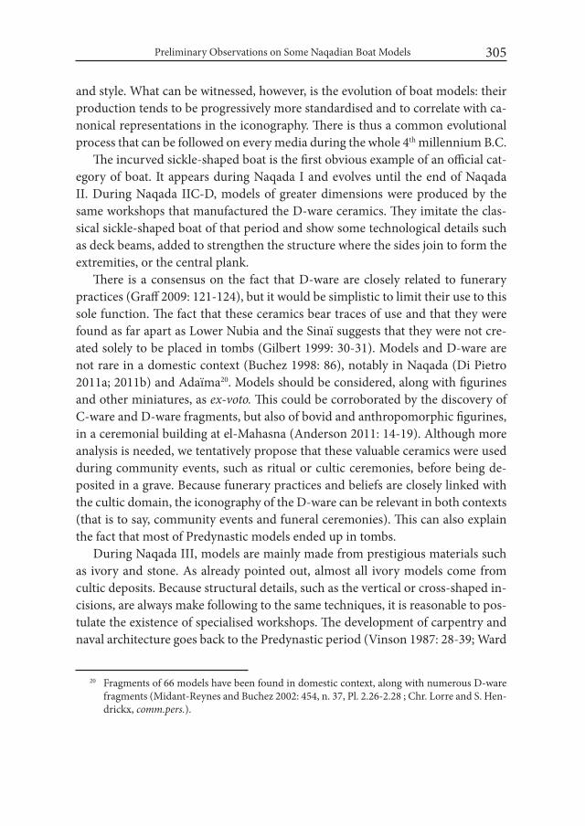
Preliminary Observations on Some Naqadian Boat Models 305
and style. What can be witnessed, however, is the evolution of boat models: their production tends to be progressively more standardised and to correlate with ca-nonical representations in the iconography. There is thus a common evolutional process that can be followed on every media during the whole 4th millennium B.C.
The incurved sickle-shaped boat is the first obvious example of an official cat-egory of boat. It appears during Naqada I and evolves until the end of Naqada II. During Naqada IIC-D, models of greater dimensions were produced by the same workshops that manufactured the D-ware ceramics. They imitate the clas-sical sickle-shaped boat of that period and show some technological details such as deck beams, added to strengthen the structure where the sides join to form the extremities, or the central plank.
There is a consensus on the fact that D-ware are closely related to funerary practices (Graff 2009: 121-124), but it would be simplistic to limit their use to this sole function. The fact that these ceramics bear traces of use and that they were found as far apart as Lower Nubia and the Sinaï suggests that they were not cre-ated solely to be placed in tombs (Gilbert 1999: 30-31). Models and D-ware are not rare in a domestic context (Buchez 1998: 86), notably in Naqada (Di Pietro 2011a; 2011b) and Adaïma20. Models should be considered, along with figurines and other miniatures, as ex-voto. This could be corroborated by the discovery of C-ware and D-ware fragments, but also of bovid and anthropomorphic figurines, in a ceremonial building at el-Mahasna (Anderson 2011: 14-19). Although more analysis is needed, we tentatively propose that these valuable ceramics were used during community events, such as ritual or cultic ceremonies, before being de-posited in a grave. Because funerary practices and beliefs are closely linked with the cultic domain, the iconography of the D-ware can be relevant in both contexts (that is to say, community events and funeral ceremonies). This can also explain the fact that most of Predynastic models ended up in tombs.
During Naqada III, models are mainly made from prestigious materials such as ivory and stone. As already pointed out, almost all ivory models come from cultic deposits. Because structural details, such as the vertical or cross-shaped in-cisions, are always make following to the same techniques, it is reasonable to pos-tulate the existence of specialised workshops. The development of carpentry and naval architecture goes back to the Predynastic period (Vinson 1987: 28-39; Ward
20 Fragments of 66 models have been found in domestic context, along with numerous D-ware fragments (Midant-Reynes and Buchez 2002: 454, n. 37, Pl. 2.26-2.28 ; Chr. Lorre and S. Hen-drickx, comm.pers.).
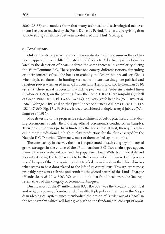
Dorian Vanhulle306
2000: 25-38) and models show that many technical and technological achieve-ments have been reached by the Early Dynastic Period. It is hardly surprising then to note strong similarities between model E.86 and Khufu’s barque.
6. ConclusionsOnly a holistic approach allows the identification of the common thread be-
tween apparently very different categories of objects. All artistic productions re-lated to the depiction of boats undergo the same increase in complexity during the 4th millennium B.C. These productions convey different notions depending on their contexts of use: the boat can embody the Order that prevails on Chaos when depicted alone or in hunting scenes, but it can also designate political and religious power when used in naval processions (Hendrickx and Eyckerman 2010: op. cit.). These naval processions, which appear on the Gebelein painted linen (Ciałowicz 1997), on the painting from the Tomb 100 at Hierakonpolis (Quibell et Green 1902: 20-21, Pl. LXXV-LXXIX), on ivory knife handles (Williams et al. 1987; Delange 2009) and on the Qustul incense burner (Williams 1986: 108-112, 138-147, 360, Fig. 171, Pl. 34) are indeed considered to depict a royal jubilee (Wil-liams et al. 1987).
Models testify to the progressive establishment of cultic practises, at first dur-ing ceremonial events, then during official ceremonies conducted in temples. Their production was perhaps limited to the household at first, then quickly be-came more professional: a high-quality production for the elite emerged by the Naqada II C-D period. Ultimately, most of them ended up into tombs.
The consistency in the way the boat is represented in each category of material grows stronger in the course of the 4th millennium B.C. Two main types appear, namely the sickle-shaped boat and the papyriform boat. With its archaic style and its vaulted cabin, the latter seems to be the equivalent of the sacred and proces-sional barque of the Pharaonic period. Detailed examples show that this cabin has what seems to be a door placed to the left of its central axis. This structure most probably represents a shrine and confirms the sacred nature of this kind of barque (Hendrickx et al. 2012: 300). We tend to think that frond boats were the first rep-resentatives of this category of ceremonial barques.
During most of the 4th millennium B.C., the boat was the allegory of political and religious power, of control and of wealth. It played a central role in the Naqa-dian ideological system since it embodied the notion of “Order out of Chaos” in the iconography, which will later give birth to the fundamental concept of Ma’at.

Preliminary Observations on Some Naqadian Boat Models 307
By analysing the use of the boat in Naqadian arts, it is possible to follow the evolu-tion of a complex ideological system that ultimately set the basis of the Pharaonic civilisation. Things changed with the first personifications of the king as the ruler of the Two Lands. The boat was then not needed anymore to express complex ideological notions since they were embodied by the king. Nevertheless, the boat continued to express royal power in rock art during the first reigns of the First Dy-nasty: official engravings commissioned by the State have indeed been discovered in remote areas such as the South Sinai Peninsula (Tallet and Laisney 2012; Tallet 2015) and the Gebel Sheikh Suleiman (Tallet and Somaglino 2015). They testify the control of a specific territory by the new Egyptian State thanks to the depic-tion of a boat in association with a serekh. By the Old Kingdom, the boat starts its timeless function in iconography: a means of transport for men, kings and gods, on earth and in the sky, in this world and in the other.
AcknowledgementOur gratitude goes to Anja Stoll and David Lorand for their comments on
a first draft of this paper. We are also deeply indebted to Janet and Sarah Robin-son, who had the important task to revise the English.
REFERENCESAKSAMIT, J. 1981. Representation of boats in Predynastic Egypt. Fontes Archaeo-
logici Posnanienses 32: 156-168.ANDERSON, D.A. 2011. Evidence for Early Ritual Activity in the Predynastic
Settlement at el-Mahâsna. In: R.F. Friedman and P.N. Fiske (eds.), Egypt at its origins 3. Proceedings of the Third international Conference „Origin of the State. Predynastic and Early Dynastic Egypt” (Londres 27 Juillet-1 août 2008) (= Orientalia Lovaniensia Analecta 205): 3-29. Leuven.
ASSELBERGH, H. 1961. Chaos en Beheersing. Documenten uit Aeneolithisch Egypte. Leiden.
BERGER, M.A. 1992. Predynastic animal-headed boats from Hierakonpolis and Southern Egypt. In: R. Friedman and B. Adams (eds.), The Followers of Horus. Studies dedicated to Michael Allen Hoffman: 107-120 (= Egyptian Studies Association Publication 2/Oxbox Monographs 20). Oxford.

Dorian Vanhulle308
BOREUX, CH. 1925. Études de nautique égyptienne. L’art de la navigation en Égypte jusqu’à la fin de l’Ancien Empire (= Mélanges de l’Institut Français d’Archéologie Orientale 50). Cairo.
BREASTED, J.H. 1917. The Earliest Boats on the Nile. The Journal of Egyptian Archaeology 4, 2/3: 174-176.
BRUNNER-TRAUT, E. 1975. Drei altägyptische Totenboote und vorgeschichtli-che Bestattungsgefässe (Negade II). Revue d’Égyptologie 27: 41-55.
BUCHEZ, N. 1998. Le mobilier céramique et les offrandes à caractère alimentaire au sein des dépôts funéraires prédynastiques : éléments de réflexion à partir de l’exemple d’Adaïma. Archéo-Nil 8: 85-103.
BUSSMANN, R. 2010. Die Provinztempel Ägyptens von der 0. bis zur 11. Dynastie (= Probleme der Ägyptologie 30). Leiden.
CASSON, L. 1971. Ships and Seamanship in the Ancient world. Princeton.CIAŁOWICZ, K.M. 1997. Le plus ancien témoignage de la tradition du heb-sed ?.
Folia Orientalia 33: 39-48.DARNELL, J.C. 2011. The Wadi of the Horus Qa-a : A Tableau of Royal Ritual Pow-
er in the Theban Western Desert. In: R.F. FRIEDMAN and P.N. FISKE (eds), Egypt at its Origins 3. Proceedings of the Third international Conference “Ori-gin of the State. Predynastic and Early Dynastic Egypt” (London 27th July-1st August 2008) (= Orientalia Lovaniensia Analecta 205): 1151-1193. Leuven.
DE MORGAN, J. 1920. La barque des morts chez les Égyptiens prédynastiques. Revue Anthropologique 30: 272-282.
DELANGE, E. 2009. Le poignard égyptien dit « du Gebel el-Arak ». Paris.DI PIETRO, G.A. 2011a. Models for Predynastic Daily Life: A view from Naqada.
In: M. Horn et al.(eds.), Current Research in Egyptology. Proceedings of the Eleventh Annual Symposium, Leiden University 2010: 42-52. Oxford.
DI PIETRO, G.A. 2011b. Miscellaneous Artefacts from Zawaydah (Petrie’s South Town, Naqada) ». In: R.F. Friedman R. F. and P.N. Fiske (eds.), Egypt at its origins 3. Proceedings of the Third international Conference „Origin of the State. Predynastic and Early Dynastic Egypt” (Londres 27 Juillet-1 août 2008) (= Orientalia Lovaniensia Analecta 205): 59-76. Leuven.
DREYER, G. 1986. Elephantine Viii. Der Tempel der Satet. Die Funde der Frühzeit und des Alten Reiches. Mainz am Rhein.
EMERY, W.B. 1958. Great tombs of the first dynasty iii. Excavations at Saqqarah (=Egypt Exploration Society 47). London.
ERMAN, A. 1893. Zur Erklärung der Pyramidentexte. Zeitschrift für Ägyptische Sprache und Altertumskunde 31: 75-83.
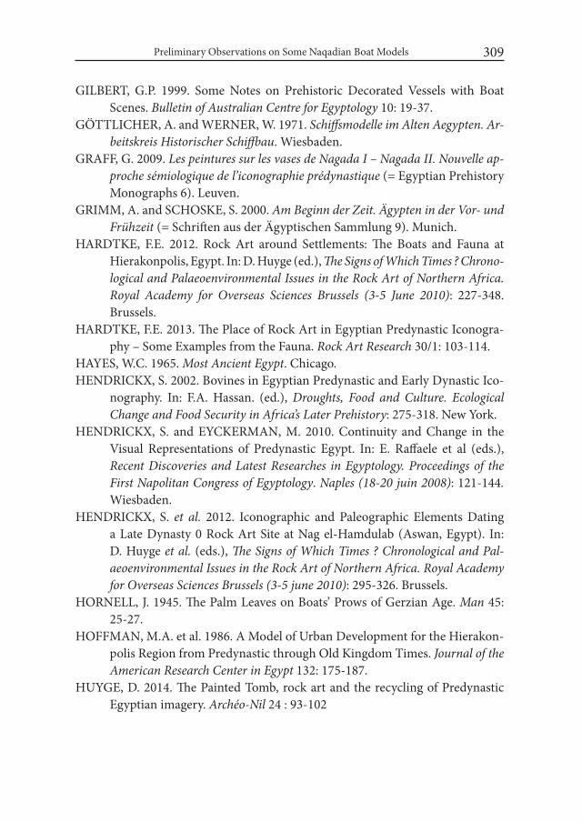
Preliminary Observations on Some Naqadian Boat Models 309
GILBERT, G.P. 1999. Some Notes on Prehistoric Decorated Vessels with Boat Scenes. Bulletin of Australian Centre for Egyptology 10: 19-37.
GÖTTLICHER, A. and WERNER, W. 1971. Schiffsmodelle im Alten Aegypten. Ar-beitskreis Historischer Schiffbau. Wiesbaden.
GRAFF, G. 2009. Les peintures sur les vases de Nagada i – Nagada ii. Nouvelle ap-proche sémiologique de l’iconographie prédynastique (= Egyptian Prehistory Monographs 6). Leuven.
GRIMM, A. and SCHOSKE, S. 2000. Am Beginn der Zeit. Ägypten in der Vor- und Frühzeit (= Schriften aus der Ägyptischen Sammlung 9). Munich.
HARDTKE, F.E. 2012. Rock Art around Settlements: The Boats and Fauna at Hierakonpolis, Egypt. In: D. Huyge (ed.), The Signs of which Times ? Chrono- logical and Palaeoenvironmental issues in the Rock Art of Northern Africa. Royal Academy for Overseas Sciences Brussels (3-5 June 2010): 227-348. Brussels.
HARDTKE, F.E. 2013. The Place of Rock Art in Egyptian Predynastic Iconogra-phy – Some Examples from the Fauna. Rock Art Research 30/1: 103-114.
HAYES, W.C. 1965. Most Ancient Egypt. Chicago.HENDRICKX, S. 2002. Bovines in Egyptian Predynastic and Early Dynastic Ico-
nography. In: F.A. Hassan. (ed.), Droughts, Food and Culture. Ecological Change and Food Security in Africa’s Later Prehistory: 275-318. New York.
HENDRICKX, S. and EYCKERMAN, M. 2010. Continuity and Change in the Visual Representations of Predynastic Egypt. In: E. Raffaele et al (eds.), Recent Discoveries and Latest Researches in Egyptology. Proceedings of the First Napolitan Congress of Egyptology. Naples (18-20 juin 2008): 121-144. Wiesbaden.
HENDRICKX, S. et al. 2012. Iconographic and Paleographic Elements Dating a Late Dynasty 0 Rock Art Site at Nag el-Hamdulab (Aswan, Egypt). In: D. Huyge et al. (eds.), The Signs of which Times ? Chronological and Pal-aeoenvironmental issues in the Rock Art of Northern Africa. Royal Academy for Overseas Sciences Brussels (3-5 june 2010): 295-326. Brussels.
HORNELL, J. 1945. The Palm Leaves on Boats’ Prows of Gerzian Age. Man 45: 25-27.
HOFFMAN, M.A. et al. 1986. A Model of Urban Development for the Hierakon-polis Region from Predynastic through Old Kingdom Times. Journal of the American Research Center in Egypt 132: 175-187.
HUYGE, D. 2014. The Painted Tomb, rock art and the recycling of Predynastic Egyptian imagery. Archéo-Nil 24 : 93-102
Dorian Vanhulle310
JENKINS, N. 1980. The Boat Beneath the Pyramid. New York.JUDD, T. 2009. Rock art of the Eastern Desert of Egypt: Content, Comparisons,
Dating and Significance (= BAR International Series 2008). Oxford.KEMP, B.J. 20062. Ancient Egypt. Anatomy of a Civilization. New York.KROMER, K. and AFIFI BADAWI., F. 1980. Neue Bootsmodelle aus Maadi bei
Kairo. In: F. Krinzinger et al. (eds.), Forschungen und Funde, Festschrift B. Neutsch: 261-272. Innsbruck.
LANDSTRÖM, B. 1970. Ships of the Pharaohs. London. LANKESTER, F.D. 2013. Desert Boats. Predynastic & Pharaonic Era Rock-Art
in Egypt’s Central Eastern Desert: Distribution, Dating & interpretation (= BAR International Series 2544). Oxford.
LE BARON BOWEN, R. 1960. Egypt’s Earliest Sailing Ships. Antiquity 34/134: 117-131.
LIPKE, P. 1984. The Royal Ships of Cheops (= Archaeological Series 9 and BAR International Series 225). Oxford.
MARK, S. 2009. The Construction of the Khufu I Vessel (c. 2566 BC): A Re-Eval-uation. The international Journal of Nautical Archaeology 38: 133-152.
MARK, S. 2011. New Data on Egyptian Construction Methods in the Khufu I Vessel (c. 2566 BC) from the Paul Lipke Collection. The international Journal of Nautical Archaeology 40/1: 18-38.
MERRIMAN, A.M. 2011. Egyptian watercraft Models from the Predynastic to Third intermediate Periods (= BAR International Series 2263). Oxford.
MIDANT-REYNES, B. and BUCHEZ, N. 2002. Adaima. 1: Économie et habitat (= Fouilles de l’Institut français d’archéologie orientale 45). Cairo.
MORROW, M. et al. 2010. Desert RATS: Rock Art Topographical Survey (= BAR International Series 2166). Oxford.
PAYNE, J.C. 2000. Catalogue of the Predynastic Egyptian Collection in the Ash-molean Museum. Oxford. Second Edition.
PETRIE, W.M.Fl. 1901. Diospolis Parva. The Cemeteries of Abadiyeh and Hu. 1898-1899. London.
PETRIE, W.M.FL. 1914. Amulets. London.PETRIE, W.M.FL. 1920. Prehistoric Egypt (= British School of Archaeology in
Egypt and Egypt Research Account 31). London.PETRIE, W.M.FL. 1921. Corpus of Prehistoric Pottery and Palettes (= British
School of Archaeology in Egypt and Egypt Research Account 32). London.PETRIE, W.M.FL. 1933. Egyptian Shipping. Ancient Egypt and the East. Part i:
1-14.
Preliminary Observations on Some Naqadian Boat Models 311
PETRIE, W.M.FL. and QUIBELL, J.E. 1896. Naqada and Ballas. 1895. London. QUIBELL, J.E. AND GREEN, F.W. 1902. Hierakonpolis. Part ii (= Egypt Research
Account 5). London.REGNER, Chr. 1996. Schminkpaletten. Wiesbaden.REISNER, G.A. 1913. Models of Ships and boats. Catalogue général des antiquités
Égyptiennes du Musée du Caire, nos. 4798-4976 and 5034-5200. Cairo. RIZKANA, I. and SEEHER, J. 1987. Maadi i. The Pottery of the Predynastic Settle-
ment (= Archäologische Veröffentlichungen 64), Mainz.ROHL, D. 2000. The Followers of Horus. Eastern Desert Survey Report. Volume
One. Abingdon.SCHARFF, A. 1929. Die Altertümer der Vor- und Frühzeit Ägyptens. Zweiter Teil
(= Mitteilungen aus der Ägyptischen Sammlung / Staatliche Museen zu Berlin 5). Berlin.
STEFFY, J.R. 1994. wooden Ship Building and the interpretation of Shipwrecks. Texas.
TALLET, P. 2015. La zone minière pharaonique du Sud-Sinai-ii. Les inscriptions pré- et protodynastiques du Ouadi’ Ameyra (CCiS n°273-335) (= Mélanges de l’Institut français d’archéologie orientale 132). Cairo.
TALLET, P. and LAISNEY, D. 2012. Iry-Hor et Narmer au Sud-Sinaï (Ouadi ‘Ameyra). Un complément à la chronologie des expéditions minières égyp-tiennes. Bulletin de l’institut français d’archéologie orientale 112: 399-447.
TALLET, P. and SOMAGLINO, C. 2015. Une campagne en Nubie sous la Ière dy-nastie. La scène nagadienne du Gebel Sheikh Suleiman comme prototype et modèle. Nehet 1: 1-46.
THOMAS, E.S. 1923. The Branch on Prehistoric Ships. Ancient Egypt and the East: 97.
TRISTANT, Y. 2012. Les enterrements d’enfants dans l’Égypte prédynastique et pharaonique. In: M.-D. Nenna (éd.), L’Enfant et la mort dans l’Antiquité ii. Types de tombes et traitement du corps des enfants dans l’antiquité (= Études Alexandrines 26): 15-59. Alexandria.
TRISTANT, Y. et al. 2014. Barques sur le Nil… Le mastaba M06 d’Abou Rawach et sa barque funéraire (Ire dynastie, règne de Den): découverte de la plus ancienne embarcation égyptienne actuellement conservée en Égypte. Bul-letin de l’institut français d’archéologie orientale 114: 563-588.
VANDIER, J. 1952. Manuel d’archéologie Égyptienne. Tome 1. Première partie. Les époques de formation. La Préhistoire. Paris.
VINSON, S.M. 1987. Boats of Egypt before the Old Kingdom. Austin.

Dorian Vanhulle312
WARD, CH. 2000. Sacred and Secular. Ancient Egyptian Ships and Boats. Boston. WARD, CH. 2003. Sewn Planked Boats from Early Dynastic Abydos, Egypt. In:
C. Beltrame (ed.), Boats, Ships and Shipyards: Proceedings of the Ninth in-ternational Symposium on Boat and Ship Archaeology. Venice 2000: 19-23. Oxford.
WARD, CH.A. 2006. Boat-Building and its Social Context in Early Egypt: Inter-pretations from the First Dynasty Boat-Grave Cemetery at Abydos. Antiq-uity 80: 118-129.
WEIGALL, A.E.P., 1909, Travels in the Upper Egyptian Deserts, Edinburg. WILLIAMS, B.B. 1986. Excavations between Abu Simbel and the Sudan frontier.
1: The A-Group Royal Cemetery at Qustul : Cemetery L. (= Oriental Institute Nubian Expedition III). Chicago.
WILLIAMS, B.B. et al. 1987. The Metropolitan Museum Knife Handle and As-pects of Pharaonic Imagery before Narmer. Journal of Near Eastern Studies 46/4: 245-285.
WILKINSON, T.H. 2003. Genesis of the Pharaohs. Dramatic New Discoveries that Rewrite the Origins of Ancient Egypt. London.
WINKLER, H.A. 1938. Rock-Drawings of Southern Upper Egypt i. Sir Robert Mond Desert Expedition. Saison 1936-1937 (= Egypt Exploration Society 26). London.
WINKLER, H.A. 1939. Rock-drawings of southern Upper Egypt ii. Sir Robert Mond desert expedition. Saison 1937-1938 (= Egypt Exploration Society 27). Lon-don.
Desert and the Nile. Prehistory of the Nile Basin and the Sahara.
Papers in honour of Fred Wendorf Studies in African Archaeology 15
Poznań Archaeological Museum 2018
Ulrich Hartung
Cemetery U at Umm el-Qaab and the Funeral Land-scape of the Abydos Region in the 4th Millennium BC1
IntroductionThroughout pharaonic times, Abydos in northern Upper Egypt played an
important role in religious beliefs and funeral rituals (e.g. O’Connor 2009; Ef-fland and Effland 2013). Presumably during the Old Kingdom, Abydos became the centre of worship of the god Osiris whose tomb had been identified with that of the 1st Dynasty king Djer at Umm el-Qaab, a place located ca. 1.5 km to the west of the cultivation in front of impressive limestone cliffs. Situated on a slightly elevated rise in the southern part of a large recess of the limestone plateau – the so-called bay of Abydos – Umm el-Qaab overlooks the entire flat desert of the re-gion. It is surrounded by a broad wadi which originates in the cliffs in the south-west and ends in the cultivation near the Osiris temple (Fig. 1). Since the excava-tions of E. Amélineau (Amélineau 1899-1905; 1899a) and W.M.F. Petrie (1900; 1901; 1902: 3-8), the site has been known as the location of the Early Dynastic royal tombs. Further excavations were carried out by E. Naville and T.E. Peet in 1910/11 (Naville 1914: 35-39), and during the last 30 years Umm el-Qaab was the focus of re-excavations by the German Archaeological Institute Cairo2 (see as
1 The following is an adapted English version of a paper written in German in memory of Wer-ner Kaiser (see Hartung 2014/2015).
2 Friendly supported by the Deutsche Forschungsgemeinschaft (DFG).
Ulrich Hartung314
a summary e.g. Dreyer 2007). Immediately to the north of the royal tombs, Amé-lineau exposed about 150 Predynastic graves (Amélineau 1899: 75-81) and 32 further tombs were excavated by Peet (1914: 14-16) who labelled this graveyard Cemetery U. As part of the German Institute’s work at Abydos from 1985-2001, this cemetery was completely excavated.
1. Predynastic settlement remains and cemeteries at AbydosThe archaeological record for settlement at Predynastic Abydos is rather mea-
gre. Although later activities in pharaonic times might have affected the early re-mains, even a comprehensive survey carried out in the early 1980s (Patch 1991; 2004) identified only a few additional Predynastic sites at Abydos that had not al-ready been known. Settlement remains (Fig. 1) are restricted to a battery of kilns, probably connected to a brewery, north of the monastery of Sitt Damyana (Peet and Loat 1913: 1-7), some vague structures in the area of the later Osiris temple (Petrie 1902: 9-10, 27; 1903: 1, 21; see also Kemp 1968: 151-155), a small area with remains of huts, fireplaces and further kilns of a brewery behind the temple of Seti I (Peet 1914: 1-10) and to the area around the pyramid temple of Ahmose at Abydos-South (Randall-McIver and Mace 1902: 76). At the northern edge of the bay of Abydos settlement evidence was discovered near the village of Salmany (Patch 1991: 426) and a place probably used for flint knapping in the north-west on the low desert (Patch 1991: 423). No precise date for these remains can be given: The brewery in the north might date to the late Predynastic, in the area of the Osiris temple only some scattered late Predynastic finds came to light, and for the remnants behind the temple of Seti I a Naqada IID/IIIA1 date can be assumed (Peet 1914: 4-5; Patch 1991: 437). The settlement near the Ahmose pyramid seems to have been in use during Naqada I and early Naqada II3. Most recently, further early settlement traces (Naqada I?) have been encountered to the north-west of the Seti I temple4.
These scanty archaeological remains are complemented by several cemeter-ies, most of them excavated already over 100 years ago (Fig. 1). In 1899/1900 D. Randall-MacIver excavated ca. 170 graves in two small cemeteries (Φ and Χ)
3 I would like to thank Steven Harvey for the possibility to look at the corresponding material from his excavations at Abydos-South, and Rita Hartmann for the dating of the pieces.
4 Many thanks are due to Yasser Mahmud from the inspectorate of Baljana for showing us the place.
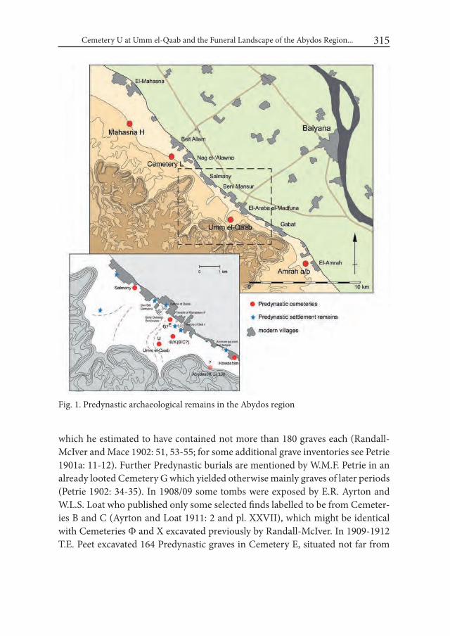
Cemetery U at Umm el-Qaab and the Funeral Landscape of the Abydos Region... 315
Fig. 1. Predynastic archaeological remains in the Abydos region
which he estimated to have contained not more than 180 graves each (Randall-McIver and Mace 1902: 51, 53-55; for some additional grave inventories see Petrie 1901a: 11-12). Further Predynastic burials are mentioned by W.M.F. Petrie in an already looted Cemetery G which yielded otherwise mainly graves of later periods (Petrie 1902: 34-35). In 1908/09 some tombs were exposed by E.R. Ayrton and W.L.S. Loat who published only some selected finds labelled to be from Cemeter-ies B and C (Ayrton and Loat 1911: 2 and pl. XXVII), which might be identical with Cemeteries Φ and Χ excavated previously by Randall-McIver. In 1909-1912 T.E. Peet excavated 164 Predynastic graves in Cemetery E, situated not far from
Ulrich Hartung316
the cultivation north of the temple of Ramesses II. Only 55 graves were published (Naville 1914: 12-17; Peet 1914: 17-19) but tomb cards for more than 90 unpub-lished graves are preserved in the Lucy Gura Archive of the EES5. The total extent of this cemetery cannot be estimated. Six further graves excavated by H. Frankfort in 1925/26 (Frankfort 1930: 213-215) may also have belonged to it, and perhaps even the graves mentioned by Petrie. At the northern fringe of Abydos near the village of Salmany 132 graves were excavated in 1966/67 and published by A. El-Sayed (1979: 249-301) who had already previously exposed a small cemetery with Early Dynastic and late Predynastic burials south of Abydos near the village of Hawashim (El-Sayed 1979: 259-260). A further Predynastic cemetery is indicated on a plan in the mouth of a small wadi near the tomb of Ahmose at Abydos-South (Ayrton et al. 1904: pl. LXI), but it is not mentioned in the text and the survey conducted during the 1980s could not prove its existence definitely (Patch 1991: 384-385).
Thus, at the beginning of the 1980s a total number of ca. 1000 graves (includ-ing ca. 180 graves excavated by Amélineau and Peet in Umm el-Qaab) could be estimated for Abydos, situated in several cemeteries and covering the entire Pre-dynastic period. Of these, approximately 700 had been excavated, but only ca. 270 fully published or at least mentioned with their tomb numbers. Hence, the known total number of burials at Abydos, and associated with it, the probable population density, differs not much from the neighbouring regions. Immediately north of the bay of Abydos (Fig. 1), Cemetery L at Beit Allam/Nag el-Alawna might have consisted of 200-300 graves (Garstang 1903: 5; Patch 1991: 397-398). Cemetery H at Mahasna (Ayrton and Loat 1911; see also Eyckerman and Hendrickx 2011) situated about 10 km to the north, is estimated to have contained ca. 600 tombs, of which approximately one half were excavated (Ayrton and Loat 1911: 3) but only 135 published. To the south of Abydos the cemeteries “a” and “b” at El-Amrah consisted of more than 1000 tombs (Randall-McIver and Mace 1902: 3), whilst a third unexcavated and badly plundered graveyard nearby may contain further tombs of the latest Predynastic period (e.g. Patch 1991: 378-381).
Summarizing this evidence, the fairly moderate settlement remains at Abydos are complemented by a relatively small total number of graves, in a quantity that seems not much different than in the neighbouring regions. Abydos appears to be, especially when compared with Naqada or Hierakonpolis, much more of a pro-
5 I thank J. Kyffin for her help and the Lucy Gura Archive in general for providing access to this material.
Cemetery U at Umm el-Qaab and the Funeral Landscape of the Abydos Region... 317
vincial settlement than an important centre with a large population and flourish-ing economy. These observations stand in contrast to the existence of the Predy-nastic ruler’s tomb U-j (Dreyer 1998) and other elite burials in Cemetery U and to the political significance assumed for late Predynastic Abydos as a reason for the location of the Early Dynastic royal tombs at Umm el-Qaab. Are there any other considerations which could explain the choice of the 1st Dynasty kings to favour this place? The results of the investigations in Cemetery U might perhaps shed some light on this question.
2. Cemetery UThe work by the German Institute at Umm el-Qaab was initiated by W. Kaiser
as a re-examination of the Early Dynastic royal tombs but soon extended to the Predynastic Cemetery U situated immediately to the north of them. The latest tombs in Cemetery U adjoin directly those of Dynasty 0 and the tomb complex of Aha. Despite the looting and the previous excavations, many of the graves still contained remnants of their inventory from which conclusions can be drawn re-garding their original funerary equipment. The approximately 600 graves of Cem-etery U cover almost the entire 4th millennium, from early Naqada I to Naqada IIIB. From Naqada IIIA onwards, all tombs are brick-lined. The chronology of the pit graves has been established by R. Hartmann on the basis of a seriation of about 200 graves. Complemented by further typological studies, Cemetery U provides a total number of ca. 250 pit graves – sufficiently well-dated for further studies – which can be assigned to two chronological main phases of use of the cemetery, each with several sub-phases (Hartmann 2011; 2011a; 2016). The first main phase corresponds to Naqada I until Naqada IIB of the conventional chronology (see e.g. Hendrickx 2006), the second main phase to Naqada IIC until Naqada IID2, and the brick-lined tombs constitute a third phase dating to Naqada IIIA and IIIB6.
Although Cemetery U covers the entire Predynastic period, it was not used with the same intensity during all the phases. Fig. 2a reveals its unbalanced us-age with a large number of early tombs (see Appendix 1), a diminishing number of burials during Naqada IIB, almost a hiatus in Naqada IIC, a slight increase again during Naqada IID (Hartmann 2016: 197-207 and table 25) and a moderate
6 The publication of the tombs with brick lining is in preparation by G. Dreyer and E.C. Köhler as volume V of the Umm el-Qaab series of the German Archaeological Institute Cairo.
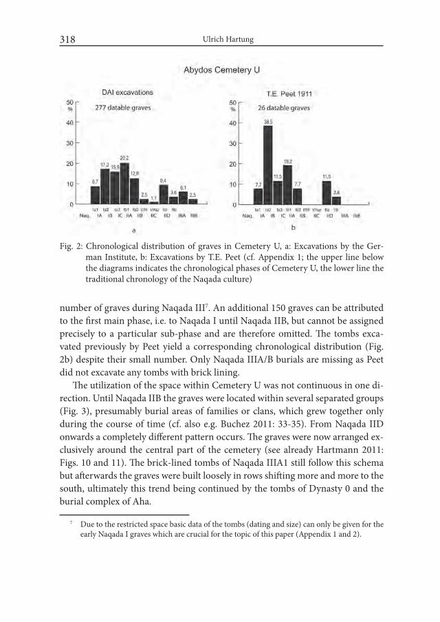
Ulrich Hartung318
number of graves during Naqada III7. An additional 150 graves can be attributed to the first main phase, i.e. to Naqada I until Naqada IIB, but cannot be assigned precisely to a particular sub-phase and are therefore omitted. The tombs exca-vated previously by Peet yield a corresponding chronological distribution (Fig. 2b) despite their small number. Only Naqada IIIA/B burials are missing as Peet did not excavate any tombs with brick lining.
The utilization of the space within Cemetery U was not continuous in one di-rection. Until Naqada IIB the graves were located within several separated groups (Fig. 3), presumably burial areas of families or clans, which grew together only during the course of time (cf. also e.g. Buchez 2011: 33-35). From Naqada IID onwards a completely different pattern occurs. The graves were now arranged ex-clusively around the central part of the cemetery (see already Hartmann 2011: Figs. 10 and 11). The brick-lined tombs of Naqada IIIA1 still follow this schema but afterwards the graves were built loosely in rows shifting more and more to the south, ultimately this trend being continued by the tombs of Dynasty 0 and the burial complex of Aha.
7 Due to the restricted space basic data of the tombs (dating and size) can only be given for the early Naqada I graves which are crucial for the topic of this paper (Appendix 1 and 2).
Fig. 2: Chronological distribution of graves in Cemetery U, a: Excavations by the Ger-man Institute, b: Excavations by T.E. Peet (cf. Appendix 1; the upper line below the diagrams indicates the chronological phases of Cemetery U, the lower line the traditional chronology of the Naqada culture)
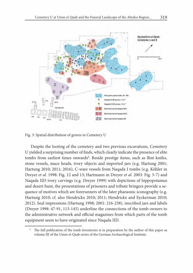
Cemetery U at Umm el-Qaab and the Funeral Landscape of the Abydos Region... 319
Despite the looting of the cemetery and two previous excavations, Cemetery U yielded a surprising number of finds, which clearly indicate the presence of elite tombs from earliest times onwards8. Beside prestige items, such as flint knifes, stone vessels, mace heads, ivory objects and imported jars (e.g. Hartung 2001; Hartung 2010; 2011; 2016), C-ware vessels from Naqada I tombs (e.g. Köhler in Dreyer et al. 1998: Fig. 12 and 13; Hartmann in Dreyer et al. 2003: Fig. 5-7) and Naqada IID ivory carvings (e.g. Dreyer 1999) with depictions of hippopotamus and desert hunt, the presentations of prisoners and tribute bringers provide a se-quence of motives which are forerunners of the later pharaonic iconography (e.g. Hartung 2010; cf. also Hendrickx 2010; 2011; Hendrickx and Eyckerman 2010; 2012). Seal impressions (Hartung 1998; 2001: 216-238), inscribed jars and labels (Dreyer 1998: 47-91, 113-145) underline the connections of the tomb owners to the administrative network and official magazines from which parts of the tomb equipment seem to have originated since Naqada IID.
8 The full publication of the tomb inventories is in preparation by the author of this paper as volume III of the Umm el-Qaab series of the German Archaeological Institute.
Fig. 3: Spatial distribution of graves in Cemetery U

Ulrich Hartung320
The presence of elite burials is also reflected in the size of the tombs. As a pa-rameter for the effort made by the community for the burial, grave size constitutes a social indicator which is widely unaffected by looting. Already during the early phases of Cemetery U a clear social stratification can be observed (Fig. 4). In ad-dition to a large number of smaller graves, several tombs of more than 3 sq. m are
Fig. 4. Grave sizes in Cemetery U during different chronological phases (cf. Appendix 1; the upper line below the diagram indicates the chrono-logical phases of Cemetery U, the lower line the traditional chronol-ogy of the Naqada culture; the number above the columns refers to the total number of graves of each chronological phase)
Cemetery U at Umm el-Qaab and the Funeral Landscape of the Abydos Region... 321
present from the beginning, and from Naqada IB onwards graves of even more than 5 sq. m occur (cf. Appendix 1). From these large tombs derive, among other things, clay figurines of hippopotami and bulls (Hartung 2011: 470-472), and also the remarkable C-ware jars with figural decoration. Whilst some individual large tombs are found within the particular grave groups, most of them cluster in the middle of the cemetery (Fig. 3). During the second chronological main phase of the cemetery (Naqada II(C/)D) a different picture emerges. The graves are now almost exclusively larger than 3 sq. m, and often more than 6 sq. m. They are ar-ranged, as mentioned above, around the centre of the cemetery, i.e. around the large tombs of presumable Naqada I/early Naqada II chiefs. The brick-lined Naqa-
Fig. 5. Chronological distribution of graves in cemeteries at Abydos (cf. Appendix 1; the upper line below the diagrams indicates the chronological phases of Cemetery U, the lower line the traditional chronology of the Naqada culture)
Ulrich Hartung322
Fig. 6. Chronological distribution of graves in other cemeteries (cf. Appendix 2; the up-per line below the diagrams indicates the chronological phases of Cemetery U, the lower line the traditional chronology of the Naqada culture)
Cemetery U at Umm el-Qaab and the Funeral Landscape of the Abydos Region... 323
da IIIA/IIIB tombs exceed mostly 10 sq. m with U-j of more than 60 sq. m as an exception. There can be no doubt that Cemetery U was the burial place of several socially stratified groups and their chiefs during Naqada I and early Naqada II, but from Naqada IID onwards the cemetery seems to have been used exclusively for burials of the highest elite.
3. Cemetery U and other Predynastic cemeteriesThe comparison with other Predynastic cemeteries – as far as it is possible with
respect to the limited records of old excavation reports – reveals some noticeable differences.
At Abydos (Fig. 5, cf. Appendix 1 and Hartmann 2016: table 25) only Cem-etery Φ has predominantly early tombs whilst in Cemetery E and in Salmany the climax of use dates to around Naqada IID. Cemetery X was used exclusively during the latest part of the Predynastic. The general trend visible in Cemetery E and Salmany – which stands in contrast to the chronological distribution of graves in Cemetery U (and Φ) – seems to be typical for most of the other Predy-nastic cemeteries. A corresponding picture (Fig. 6; cf. Appendix 2 and Hartmann 2016: table 26) can be observed in the cemeteries of Middle Egypt (Brunton and Caton-Thompson 1928; Brunton 1937; 1948), Naga ed-Deir (but with a rather large number of early graves, see Lythgoe and Dunham 1965; Friedman 1981), el-Amrah (Randall-McIver and Mace 1902), in the Abadiyeh-Hu region (Pet-rie 1901a)9 and in Armant (Mond and Myers 1937). Only Mahasna appears to be an exception with a fairly balanced distribution and a relatively large num-ber of early tombs. All the other cemeteries were apparently increasingly used only from late Naqada I onwards. Near Naga ed-Deir, the cemetery at Mesaed (Reisner 1936: 1-4, 371-377) seems to have contained a number of early Naqada I burials, and a small cemetery at Abadiyeh (Cemetery C) is mentioned by Petrie (1901a: 34) as the oldest cemetery he had excavated, but in both cases only little information was published. Although other early graves or even cemeteries may have been overlooked by the early excavators or have not yet been discovered, the overview on the basis of the current state of research reveals a clear concentra-tion of early Naqada I tombs in the region of northern Upper Egypt, including
9 I thank Alice Stevenson to provide the possibility to use the Petrie slips (by courtesy of the Petrie Museum of Egyptian Archaeology, University College London) as additional grave in-ventories.

Ulrich Hartung324
Abydos, Mahasna and Naga ed-Deir (Fig. 7). Hence, this region must have been the main area of occupation of the earliest Naqada culture, perhaps apart from smaller groups of people which might have locally gained a foothold elsewhere (see, e.g. Vermeersch et al. 2004). This evidence corresponds with the spread of the Naqada culture from northern Upper Egypt to the north and the south proposed by W. Kaiser already during the 1950s (see Kaiser 1956: Abb. 5; 1957: Taf. 26). The new evidence from Cemetery U allows us to refine the picture chron-ologically and shows that Abydos, with the largest (so far known) number of early Naqada I burials10, was the presumable core area of this development.
10 The minimum number of 116 Naqada IA-IB/C graves in Cemetery U and 20 additional buri-als in other cemeteries at Abydos (see Appendix 1) face at least 32 early graves at Mahasna, 33 at Naga ed-Deir and 11 at el-Amrah, but only 21 contemporaneous graves in all Middle Egypt and, e.g., 14 graves in the Abadiyeh/Hu region and 5 early burials in Armant.
Fig. 7. Chronological position of selected Upper Egyptian cemeteries
Cemetery U at Umm el-Qaab and the Funeral Landscape of the Abydos Region... 325
The comparison of grave sizes in different cemeteries reveals still another fea-ture of Cemetery U. Although this comparison must remain incomplete as many old excavation reports give no measurements of the graves, nevertheless, some information is available. In Abydos (Fig. 8 and Appendix 1), for the cemetery at Salmany and for some individual tombs of Cemetery E grave sizes are indicated. At Salmany most of the graves measure 1-2 sq. m, with only 5 graves measuring 2-3 sq. m and only one grave (grave 110, dating Naqada IID) more than 3 sq. m. Early graves do not exceed 2 sq. m. The sizes of the graves correspond to their fairly poor equipment in general (El-Sayed 1979: 260-273). Although in Cem-etery E several graves were equipped with a large number of pottery vessels, only one grave larger than 2 sq. m is indicated (E 4580) which dates to Naqada IIIA1 (Peet 1914: 14). For only two early graves measurements (of less than 1 sq. m) are given. The presence of other larger tombs would probably have been noted by the excavator. Beyond Abydos (Fig. 8 and Appendix 2), at el-Amrah, measurements are widely missing, one early grave (b 144) measures 1 sq. m and two Naqada IID graves between 3 and 5 sq. m are described as typical for this later time (b 154 and 221, Randall-McIver and Mace 1902: 8). Also in the well documented cemeteries of Armant early tombs do not exceed 1 sq. m whilst larger tombs (3-4 sq. m) date not before Naqada IID (e.g. 1446, 1468, 1494, 1541 (4.2 sq. m), 1542, 1560 and 1580; Mond and Myers 1937: 27-31). The same evidence is found in Middle Egyp-tian cemeteries (Brunton and Caton-Thompson 1928: 42-61, pl. XXX-XXXIII; Brunton 1937: 69-91, pl. XXIX-XXXI; Brunton 1948: 12-23, pl. IX and X). Excep-tional is grave 1805 (Naqada IA/B) at Mostagedda with a size of 2.6 sq. m. In Naga ed-Deir four early graves measure 2-3 sq. m (7016, 7045, 7130, 7179, 7394), and altogether only 20 graves are larger than 3 sq. m, one of them dating to Naqada IIA/B, the others to Naqada IIC/D (Lythgoe and Dunham 1965; Friedman 1981: Appendix III; Delrue 2001: 42-45). The Naqada IIC/D grave 7540 (13 sq. m) has to be especially mentioned as it is larger than contemporaneous graves in Ceme-tery U. Mahasna seems to be an exception again with individual large early tombs (e.g. H29, H30, H33, H45, three of them double burials) and noticeably, lacking large Naqada IID tombs (Ayrton and Loat 1911: 10-19).
The cemeteries at Naqada also seem to start moderately during Naqada I (e.g. Bard 1994: 80-85, 97-102, 119-120; Hartmann 2016: Table 26), with earlier tombs generally smaller than 3 sq. m. Large tombs, some of them brick-lined, are found especially in the elite Cemetery T. At least two of them, namely T 4 (6.8 sq. m) and T 5 (10.9 sq. m) are larger than corresponding graves at Abydos and date to Naqada IIC, i.e. to the span of time which is almost not represented in Cemetery
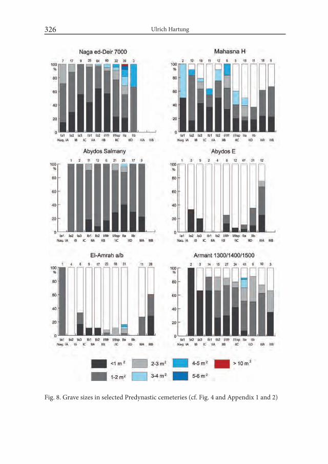
Ulrich Hartung326
Fig. 8. Grave sizes in selected Predynastic cemeteries (cf. Fig. 4 and Appendix 1 and 2)
Cemetery U at Umm el-Qaab and the Funeral Landscape of the Abydos Region... 327
U. Slightly later large tombs (e.g. T10 with 5.13 sq. m, T11 with 7.81 sq. m or T16 with 4.14 sq. m) match the range of Naqada IID grave sizes in Cemetery U (Pet-rie/Quibell 1896: pl. LXXXII; see also Kemp 1973: 38-43; Kaiser and Dreyer 1982: 242-245).
At Hierakonpolis, as far as it is known today, substantial activities apparently did not start before late Naqada I (see e.g. Friedman 2008: Table 1). The recent excavations in the elite cemetery of this period, HK6, revealed impressive funeral complexes with superstructures made of wood and matting, and exceptional hith-erto unknown finds such as multiple burials of humans and wild and domesticated animals (e.g. Friedman 2004: 131-168; 2008: 11-20; 2008a: 1157-1194; Friedman et al. 2011: 157-191; Droux 2014). The complex is only partly excavated so far and its significance is not yet completely clarified. The elite character of the construc-tion is obvious, but it eludes the comparison with other “traditional” cemeteries, including Cemetery U. During Naqada IIC funeral activities of the elite seem to have shifted especially to HK31, where a group of other tombs seems to have sur-rounded the decorated tomb 100 (with almost 15 sq. m) (e.g. Quibell/Green 1902: 20-22; Kaiser 1958: 187-192; Case/Payne 1962; Payne 1973; Kemp 1973: 36-38; Adams 1974: 86-93; Kaiser and Dreyer 1982: 242-245; Friedman 2008: 10-11, 23). Only during Naqada III, the HK6 complex was re-used as an elite cemetery (e.g. Adams 2000; Friedman 2008: 23-26) with grave sizes (e.g. Friedman 2009) com-parable to those of contemporaneous tombs at Abydos.
Although in large parts incomplete, the presented comparison reveals at least tendencies. Beside the largest number of early (Naqada IA/IB) tombs so far known, Cemetery U seems also to provide a larger number of big and richly equipped early Naqada I graves than any other of the contemporaneous cemeter-ies. Only at Mahasna individual early tombs of similar size and wealth are found. However, the size and equipment of the graves during the second chronological phase of Cemetery U, i.e. during Naqada IID, and those of the later brick-lined tombs also find only few parallels in other cemeteries. The revival of Umm el-Qaab as an outstanding burial place of the elite during this time must have had an important reason.
ConclusionsThe evidence from Cemetery U allows to draft at least a rough picture of
the development at Abydos in the course of the 4th millennium: The prominent, slightly elevated area of Umm el-Qaab was obviously chosen by connected groups
Ulrich Hartung328
of early Naqada I settlers as the collective burial place for their clans and chiefs. A little later, and probably connected to the growth of the area used for agricul-tural activities and habitation, places situated closer to the cultivation came into use as additional graveyards, such as Cemetery Φ and the oldest graves of Cem-etery E and Salmany. However, elite burials seem to be absent from these small cemeteries. Beyond the bay of Abydos, the establishment of Cemetery L near Beit Allam, and probably also of the cemeteries at Naga ed-Deir and El-Amrah prob-ably reflect the same development. In contrast, the isolated and slightly elevated location of Cemetery H at Mahasna, within the next recess of the limestone pla-teau to the north of Abydos, resembles the situation in Umm el-Qaab and might have been a primary cemetery of other arriving groups.
Until early Naqada II Umm el-Qaab remained the main burial place of Aby-dos. As no changes in the original pattern of grave distribution can be observed nor do additional grave groups occur in the course of time, Cemetery U seems to have been reserved for burials of old-established – i.e. probably locally dominant – families or clans until early Naqada II.
The diminishing number of graves in Cemetery U during Naqada IIB, and especially the lack of a large number of Naqada IIC tombs may indicate that the cemetery (and the old clans?) became gradually less important during this time. In contrast, graves of this time can be found in remote Salmany and in a moder-ately growing number in Cemetery E, which now starts to replace Umm el-Qaab as the main cemetery of Abydos. However, in contrast to Naqada and Hierakon-polis, elite tombs are missing so far at Abydos during this time.
The otherwise known archaeological remains at Abydos (see above) fail to offer an explanation for the return of funeral activities at Umm el-Qaab from Naqada IID onwards. Even considering that settlement remains might have been overlaid, destroyed or not yet discovered, any evidence of sudden economic or political growth is missing at Abydos. If not traceable directly by settlement re-mains, such a development would have been surely reflected in the equipment of graves, especially in a considerable number of well-equipped middle class buri-als. But this seems to be not the case. Although there are several well-equipped Naqada IID/IIIA graves in Cemetery E, neither their number, their size, nor their wealth especially exceeds those of the tombs in neighbouring cemeteries, e.g. in el-Amrah or Naga ed-Deir. The evidence from Umm el-Qaab remains isolated, and the transformation of Cemetery U into an exclusive elite cemetery must have had another background. If Umm el-Qaab was (one of) the first large burial place of the Naqada culture after its arrival in the Nile valley, the location where the
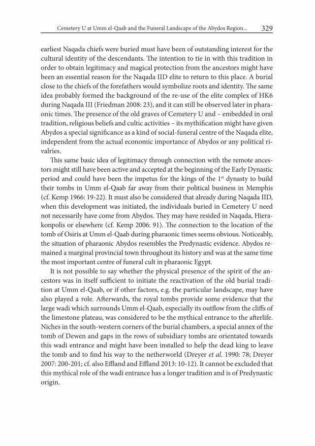
Cemetery U at Umm el-Qaab and the Funeral Landscape of the Abydos Region... 329
earliest Naqada chiefs were buried must have been of outstanding interest for the cultural identity of the descendants. The intention to tie in with this tradition in order to obtain legitimacy and magical protection from the ancestors might have been an essential reason for the Naqada IID elite to return to this place. A burial close to the chiefs of the forefathers would symbolize roots and identity. The same idea probably formed the background of the re-use of the elite complex of HK6 during Naqada III (Friedman 2008: 23), and it can still be observed later in phara-onic times. The presence of the old graves of Cemetery U and – embedded in oral tradition, religious beliefs and cultic activities – its mythification might have given Abydos a special significance as a kind of social-funeral centre of the Naqada elite, independent from the actual economic importance of Abydos or any political ri-valries.
This same basic idea of legitimacy through connection with the remote ances-tors might still have been active and accepted at the beginning of the Early Dynastic period and could have been the impetus for the kings of the 1st dynasty to build their tombs in Umm el-Qaab far away from their political business in Memphis (cf. Kemp 1966: 19-22). It must also be considered that already during Naqada IID, when this development was initiated, the individuals buried in Cemetery U need not necessarily have come from Abydos. They may have resided in Naqada, Hiera-konpolis or elsewhere (cf. Kemp 2006: 91). The connection to the location of the tomb of Osiris at Umm el-Qaab during pharaonic times seems obvious. Noticeably, the situation of pharaonic Abydos resembles the Predynastic evidence. Abydos re-mained a marginal provincial town throughout its history and was at the same time the most important centre of funeral cult in pharaonic Egypt.
It is not possible to say whether the physical presence of the spirit of the an-cestors was in itself sufficient to initiate the reactivation of the old burial tradi-tion at Umm el-Qaab, or if other factors, e.g. the particular landscape, may have also played a role. Afterwards, the royal tombs provide some evidence that the large wadi which surrounds Umm el-Qaab, especially its outflow from the cliffs of the limestone plateau, was considered to be the mythical entrance to the afterlife. Niches in the south-western corners of the burial chambers, a special annex of the tomb of Dewen and gaps in the rows of subsidiary tombs are orientated towards this wadi entrance and might have been installed to help the dead king to leave the tomb and to find his way to the netherworld (Dreyer et al. 1990: 78; Dreyer 2007: 200-201; cf. also Effland and Effland 2013: 10-12). It cannot be excluded that this mythical role of the wadi entrance has a longer tradition and is of Predynastic origin.
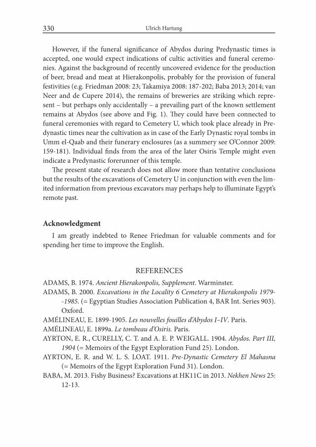
Ulrich Hartung330
However, if the funeral significance of Abydos during Predynastic times is accepted, one would expect indications of cultic activities and funeral ceremo-nies. Against the background of recently uncovered evidence for the production of beer, bread and meat at Hierakonpolis, probably for the provision of funeral festivities (e.g. Friedman 2008: 23; Takamiya 2008: 187-202; Baba 2013; 2014; van Neer and de Cupere 2014), the remains of breweries are striking which repre-sent – but perhaps only accidentally – a prevailing part of the known settlement remains at Abydos (see above and Fig. 1). They could have been connected to funeral ceremonies with regard to Cemetery U, which took place already in Pre-dynastic times near the cultivation as in case of the Early Dynastic royal tombs in Umm el-Qaab and their funerary enclosures (as a summery see O’Connor 2009: 159-181). Individual finds from the area of the later Osiris Temple might even indicate a Predynastic forerunner of this temple.
The present state of research does not allow more than tentative conclusions but the results of the excavations of Cemetery U in conjunction with even the lim-ited information from previous excavators may perhaps help to illuminate Egypt’s remote past.
AcknowledgmentI am greatly indebted to Renee Friedman for valuable comments and for
spending her time to improve the English.
REFERENCESADAMS, B. 1974. Ancient Hierakonpolis, Supplement. Warminster.ADAMS, B. 2000. Excavations in the Locality 6 Cemetery at Hierakonpolis 1979-
-1985. (= Egyptian Studies Association Publication 4, BAR Int. Series 903). Oxford.
AMÉLINEAU, E. 1899-1905. Les nouvelles fouilles d’Abydos i–iV. Paris.AMÉLINEAU, E. 1899a. Le tombeau d’Osiris. Paris.AYRTON, E. R., CURELLY, C. T. and A. E. P. WEIGALL. 1904. Abydos. Part iii,
1904 (= Memoirs of the Egypt Exploration Fund 25). London.AYRTON, E. R. and W. L. S. LOAT. 1911. Pre-Dynastic Cemetery El Mahasna
(= Memoirs of the Egypt Exploration Fund 31). London.BABA, M. 2013. Fishy Business? Excavations at HK11C in 2013. Nekhen News 25:
12-13.
Cemetery U at Umm el-Qaab and the Funeral Landscape of the Abydos Region... 331
BABA, M. 2014. Meat and Potatoes: A Food Factory at HK11C. Nekhen News 26: 20-21.
BARD, K. A. 1994. From Farmer to Pharaohs, Mortuary Evidence for the Rise of Complex Society in Egypt (= Monographs in Mediterranean Archaeology 2). Sheffield.
BRUNTON, G. 1937. Mostagedda and the Tasian Culture. London.BRUNTON, G. 1948. Matmar. London.BRUNTON, G. and G. CATON-THOMPSON. 1928. The Badarian Civilisation
and Predynastic Remains near Badari (= British School of Archaeology in Egypt 46). London.
BUCHEZ, N. 2011. Adaïma (Upper Egypt): The stages of state development from the point of view of a ‚village community’. In: R. F. Friedman and P. N. Fiske (eds.), Egypt at its Origins 3 (= Orientalia Lovaniensia Analecta 205): 31-40. Leuven/Paris/Walpole.
CASE, H. and J. C. PAYNE. 1962. Tomb 100: The Decorated Tomb at Hierakon-polis. Journal of Egyptian Archaeology 48: 5-18.
DELRUE, P. 2001. The Predynastic Cemetery N 7000 at Naga ed-Dêr, a Re-evalu-ation. In: H. Willems (ed.), Social aspects of funerary culture in the Egyptian Old and Middle Kingdoms (= Orientalia Lovaniensia Analecta 103): 21-66. Leuven/Paris/Sterling.
DREYER, G. 1998. Umm el-Qaab i. Das prädynastische Königsgrab U-j und seine frühen Schriftzeugnisse (= Archäologische Veröffentlichungen des Deutschen Archäologischen Instituts Kairo 86). Mainz.
DREYER, G. 1999. Motive und Datierung der prädynastischen Messergriffe. In: L’art de l’Ancien Empire égyptienne, Actes du colloque, musée du Louvre 1998: 195-226. Paris.
DREYER, G. 2007. Friedhof B: Vom König zum Gott – Die Anfänge monu-mentaler Architektur; Königsgräber ab Djer: Wege zur Auferstehung. In: G. Dreyer and D. Polz (eds.), Begegnung mit der Vergangenheit – 100 Jahre in Ägypten, Deutsches Archäologisches institut 1907-2007: 193-210. Mainz.
DREYER, G. ET AL. 1990. Umm el-Qaab, Nachuntersuchungen im frühzeitli-chen Königsfriedhof, 3./4. Vorbericht. Mitteilungen des Deutschen Archae-ologischen instituts Kairo 46: 53-90.
DREYER, G. ET AL. 1998. Umm el-Qaab, Nachuntersuchungen im frühzeitli-chen Königsfriedhof, 9./10. Vorbericht. Mitteilungen des Deutschen Archae-ologischen instituts Kairo 54: 77-167.

Ulrich Hartung332
DREYER, G. ET AL. 2003. Umm el-Qaab, Nachuntersuchungen im frühzeitli-chen Königsfriedhof, 13./14./15. Vorbericht. Mitteilungen des Deutschen Archaeologischen instituts Kairo 59: 67-138.
DROUX, X. 2014. A Tomb Fit for a king? The Discovery of Tomb 72 at HK6. Nekhen News 26: 4-7.
EFFLAND, U. and A. EFFLAND. 2013. Abydos, Tor zur ägyptischen Unterwelt. Darmstadt/Mainz.
EL-SAYED, A. 1979. A Prehistoric Cemetery in the Abydos Area. Mitteilungen des Deutschen Archäologischen instituts Kairo 35: 249-301.
EYCKERMAN, M. and S. HENDRICKX. 2011. The Naqada I tombs H17 and H41 at el-Mahasna. In: R. F. Friedman and P. N. Fiske (eds.), Egypt at its Origins 3 (= Orientalia Lovaniensia Analecta 205): 379-429. Leuven/Paris/Walpole.
FRANKFORT, H. 1930. The Cemeteries of Abydos: Work of the Season 1925–26. Journal of Egyptian Archaeology 16: 213-219.
FRIEDMAN, R. F. 1981. Spatial Distribution in a Predynastic Cemetery: Naga ed-Der 7000. M.A. thesis. University of California.
FRIEDMAN, R.F. 2004. Elephants in Hierakonpolis. In: S. Hendrickx et al. (eds.) Egypt at its Origins. Studies in Memory of Barbara Adams (= Orientalia Lovaniensia Analecta 138): 131-168. Leuven/Paris/Dudley.
FRIEDMAN, R. F. 2008. The Cemeteries of Hierakonpolis. Archéo-Nil 18: 9-29.FRIEDMAN, R. F. 2008a. Excavating Egypt’s early kings. In: B. Midant-Reynes
and Y. Tristant (eds.). Egypt at is Origins 2 (Orientalia Lovaniensia Analecta 172): 1157-1194. Leuven/Paris/Dudley.
FRIEDMAN, R.F. 2009. HK6 Checklist. Nekhen News 21: 7.FRIEDMAN, R. F. ET AL. 2011. The elite Predynastic cemetery at Hierakonpolis.
2009-2010 update. In: R. F. Friedman and P. N. Fiske (eds.), Egypt at its Origins 3 (= Orientalia Lovaniensia Analecta 205): 157-191. Leuven/Paris/Walpole.
GARSTANG, J. 1903. Mahasna and Bet Khallaf. (= British School of Archaeology in Egypt 7). London.
HARTMANN, R. 2011. The chronology of Naqada I tombs in the Predynastic cemetery U at Abydos. In: R. F. Friedman and P. N. Fiske (eds.), Egypt at its Origins 3 (= Orientalia Lovaniensia Analecta 205): 917-938. Leuven/Paris/Walpole.
HARTMANN, R. 2011a. Some remarks on the chronology of the early Naqada Culture (Naqada I/ Early Naqada II) in Upper Egypt. Archéo-Nil 21: 21–32.
HARTMANN, R. 2016. Umm el-Qaab iV. Die Keramik der älteren und mittleren Naqadakultur aus dem prädynastischen Friedhof U in Abydos (Umm el-Qaab)

Cemetery U at Umm el-Qaab and the Funeral Landscape of the Abydos Region... 333
(= Archäologische Veröffentlichungen des Deutschen Archäologischen In-stituts Kairo 98). Wiesbaden.
HARTUNG, U. 1998. Prädynastische Siegelabrollungen aus dem Friedhof U in Abydos (Umm el-Qaab). Mitteilungen des Deutschen Archäologischen insti-tuts Kairo 54: 187–217.
HARTUNG, U. 2001: Umm el-Qaab ii, importkeramik aus dem Friedhof U in Abydos (Umm el-Qaab) und die Beziehungen Ägyptens zu Vorderasien im 4. Jahrtausend v. Chr. (= Archäologische Veröffentlichungen des Deutschen Archäologischen Instituts 92). Mainz.
HARTUNG, U. 2010: Hippopotamus hunters and bureaucrats. Elite burials at Cemetery U. In: F. Raffaele et al. (eds.), Recent Discoveries and Latest Re-searches in Egyptology: 107-120. Wiesbaden.
HARTUNG, U. 2011: Nile mud and clay objects from the Predynastic cemetery U at Abydos (Umm el-Qaab). In: R. F. Friedman and P. N. Fiske (eds.), Egypt at its Origins 3 (= Orientalia Lovaniensia Analecta 205): 467-496. Leuven/Paris/Walpole.
HARTUNG, U. 2014/2015: Der Friedhof U in Umm el-Qaab und die funeräre Landschaft von Abydos in prädynastischer Zeit. Mitteilungen des Deutschen Archäologischen Instituts 70/71 (Gedenkschrift für Werner Kaiser).
HARTUNG, U. 2016: Chronological aspects of the development of funeral equip-ment in Cemetery U at Abydos (Umm el-Qaab). In: M. D. Adams et al. (eds.), Egypt at its Origins 4 (= Orientalia Lovaniensia Analecta). Leuven/Paris/Walpole.
HENDRICKX, S. 2006: Predynastic–Early Dynastic Chronology. In: E. Hornung et al. (eds.), Handbook of Egyptian chronology (= Handbuch der Orientalis-tik 83): 55-93. Leiden.
HENDRICKX, S. 2010. L’iconographie de la chasse dans le contexte social prédy-nastique. Archéo-Nil 20: 106–133.
HENDRICKX, S. 2011. Hunting and Social Complexity in Predynastic Egypt. Académie Royale des Sciences d’Outre-mer, Bulletin des Séances 57: 237–263.
HENDRICKX, S. and M. EYCKERMAN. 2010. Continuity and change in the visual representations of Predynastic Egypt. In: F. Raffaele et al. (eds.), Re-cent Discoveries and Latest Researches in Egyptology: 121-143. Wiesbaden.
HENDRICKX, S. and M. EYCKERMAN. 2012. Visual representation and state development in Egypt. Archéo-Nil 22: 23-72.
KAISER, W. 1956. Stand und Probleme der ägyptischen Vorgeschichtsforschung. Zeitschrift für Ägyptische Sprache 81: 87-109.

Ulrich Hartung334
KAISER, W. 1957. Zur inneren Chronologie der Naqadakultur. Archaeologia Geo-graphica 6: 69-77.
KAISER, W. 1958. Zur vorgeschichtlichen Bedeutung von Hierakonpolis. Mit-teilungen des Deutschen Archäologischen instituts Kairo 16: 183-192.
KAISER, W. and G. DREYER. 1982. Umm el-Qaab, Nachuntersuchungen im frühzeitlichen Königsfriedhof, 2. Vorbericht. Mitteilungen des Deutschen Archaeologischen instituts Kairo 38: 211-269.
KEMP, B. J. 1966. Abydos and the Royal Tombs of the First Dynasty. Journal of Egyptian Archaeology 52: 13-22.
KEMP, B. J. 1968. The Osiris Temple at Abydos. Mitteilungen des Deutschen Ar-chaeologischen instituts Kairo 23: 138-155.
KEMP, B. J. 1973. Photographs of the Decorated Tomb at Hierakonpolis. Journal of Egyptian Archaeology 59: 36-43.
KEMP, B. J. 2006. Ancient Egypt. Anatomy of a Civilization. 2nd edition. London/New York.
LYTHGOE, A. M. and D. DUNHAM. 1965. The Predynastic Cemetery N 7000. Naga ed-Der iV. Berkeley/Los Angeles.
MOND, R. and O. H. MYERS. 1937. The Cemeteries of Armant i. London.NAVILLE, E. 1914. The Cemeteries of Abydos i, 1909–1910. (= Memoir of the
Egypt Exploration Fund 33). London. O’CONNOR, D. 2009. Abydos. Egypt’s First Pharaohs and the Cult of Osiris. Lon-
don.PATCH, D. 1991. The origin and early development of urbanism in ancient Egypt:
A regional study. Ph.D. dissertation, University of Pennsylvania. Ann Arbor.PATCH, D. 2004. Settlement Patterns and Cultural Change in the Predynastic pe-
riod. In: S. Hendrickx et al. (eds.) Egypt at its Origins. Studies in Memory of Barbara Adams (= Orientalia Lovaniensia Analecta 138): 905-918. Leuven/Paris/Dudley.
PAYNE, J. C. 1973. Tomb 100: The Decorated Tomb at Hierakonpolis confirmed. Journal of Egyptian Archaeology 59: 31-35.
PEET, T. E. 1914. The Cemeteries of Abydos ii (= Memoirs of the Egypt Explora-tion Fund 34). London.
PEET, T. E. and W. L. S. LOAT. 1913. The Cemeteries of Abydos iii (= Memoirs of the Egypt Exploration Fund 35). London.
PETRIE, W. M. F. 1900. The Royal Tombs of the First Dynasty. 1900. Part i. (= Mem-oirs of the Egypt Exploration Fund 18). London.
Cemetery U at Umm el-Qaab and the Funeral Landscape of the Abydos Region... 335
PETRIE, W. M. F. 1901. The Royal Tombs of the Earliest Dynasties. 1901. Part ii. (= Memoirs of the Egypt Exploration Fund 21). London.
PETRIE, W. M. F. 1901a. Diospolis Parva, The Cemeteries of Abadiyeh and Hu. (= Memoirs of the Egypt Exploration Fund 20). London.
PETRIE, W. M. F. 1902. Abydos. Part i (= Memoirs of the Egypt Exploration Fund 22). London.
PETRIE, W. M. F. 1903. Abydos. Part ii (= Memoirs of the Egypt Exploration Fund 24). London.
PETRIE, W. M. F. and J. E. QUIBELL. 1896. Naqada and Ballas, 1895 (= British School of Archaeology in Egypt 1). London.
QUIBELL, J. E. and F. W. GREEN. 1902. Hierakonpolis ii (= British School of Archaeology in Egypt 5). London.
RANDALL-MCIVER, D. and A. C. MACE. 1902. El Amrah and Abydos 1899- -1901 (= Memoirs of the Egypt Exploration Fund 23). London.
REISNER, G. A. 1936. The Development of the Egyptian Tomb down to the Accession of Cheops. Oxford/London.
TAKAMIYA, I. H. 2008. Firing Installations and Specialization: A View from Re-cent Excavations at Hierakonpolis Locality 11C. In: B. Midant-Reynes and Y. Tristant (eds.). Egypt at is Origins 2 (= Orientalia Lovaniensia Analecta 172): 187-202. Leuven/Paris/ Dudley.
VAN NEER, W. and B. DE CUPERE. 2014. For Take Away and Delivery: Food Preparation at HK11C. Nekhen News 26: 22-23.
VERMEERSCH, P.M., W. van NEER and S. HENDRICKX. 2004. El Abadiya 2. A Naqada I Site near Danfiq, upper Egypt, in: S. Henrdrickx et al., Egypt at its Origins, Studies in Memory of Barbara Adams (= Orientalia Lovaniensia Analecta 138): 213-276, Leuven/Paris/Dudley.

Appe
ndix
1.
Dat
ing
and
grav
e siz
es o
f ear
ly N
aqad
a I t
ombs
from
the
Cem
eter
y U
and
oth
er ce
met
erie
s at A
bydo
s
Cem
eter
y U
Phas
es
Naq
ada
IA
N
aqad
a IB
Naq
ada
IC
Ia1
Ia2
Ia3
Aby
dos U
(DA
I exc
ava-
tions
)
129
(0,8
); 14
3b (0
,7);
249
(2,5
); 28
0 1,
1);
287a
(0,9
); 30
0 (2
,5);
324
(1,5
); 35
0 (1
,8);
367
(3,6
); 36
8 (3
,0);
380
(1,5
); 39
1 (1
,6);
395a
(0,6
); 39
7 (2
,3);
419
(1,0
); 44
7 (1
,2);
468
(3,3
); 46
8a (0
,6);
500
(4,8
); 50
5b (0
,8);
519a
(1,0
); 60
3 (1
,9);
623
(3,1
); 62
7 (3
,3)
129a
(0,9
); 13
8 (2
,3);
142
(2,0
); 14
3a (0
,7);
*146
(1,4
); 14
8 (1
,1);
178
(4,6
); 23
5 (3
,5);
250
(3,3
); 25
3 (1
,4);
*277
(3,4
); 28
2 (1
,4);
284a
(1,4
); *2
88a (
1,0)
; 291
(3,4
); *2
94a*
(1,2
); 30
3 (3
,3);
306
(2,1
); 30
7 (2
,5);
329a
(1,6
); *3
41(2
,2);
*345
(1,1
); 34
8 (1
,2);
*381
*(1,
7); 3
89(2
,5);
*390
a (0,
5); *
392b
(0,9
); 40
7 (0
,4);
415
(3,3
); 41
7 (2
,6);
*423
* (1,
9); *
501
(1,0
); 50
3b(0
,7);
506
(1,3
); *5
06c (
1,0)
; 507
a (1,
2); 5
07b
(1,0
); 52
9a (2
,3);
531
(1,9
); 53
2 (0
,8);
*533
(0,9
); *5
35 (1
,3);
*539
(1,3
); 55
9 (1
,6);
*628
(1,4
); *6
29 (1
,1);
637*
(2,0
); 64
7 (5
,8)
141
(5,6
); *1
52*(
1,3)
; 168
(1,4
); *2
15* (
1,3)
; *2
32 (3
,9);
237
(1,9
); 23
9 (4
,2);
248
(1,3
); 25
2 (1
,5);
263
(2,3
); 26
5 (3
,1);
268
(0,8
); *2
75 (1
,3);
*284
(1,7
); *2
95* (
0,8)
; 332
(4
,0);
339
(2,6
); *3
81a*
(0,9
);38
3 (1
,2);
384
(2,3
); 40
8 (2
,2);
*412
(1,0
); 41
6 (2
,6);
420
(0,6
); *4
25*(
1,7)
; 432
(2
,7);
*442
* (1,
2); *
448*
(1,9
); *4
51* (
1,3)
; *4
73*(
1,4)
; 502
(0,9
); 50
5 (1
,0);
505d
(1,4
); *5
08*(
2,4)
; *51
1*(1
,0);
*530
*(0,
8); 5
41
(1,8
); 54
8a (1
,1);
549
(1,6
); 55
1 (1
,6);
556
(1,4
); *5
58*(
1,0)
; *61
3*(3
,0);
653
(0,9
)
Aby
dos U
(Pee
t exc
av.)
3 (2
,0);
271;
*9; 1
1; 1
3 (1
,6);
16 (1
,6);
20; *
24; *
29; 3
0;*3
2**1
4*, *
15*(
0,5)
; 21
Aby
dos Φ
3; 2
2; 2
3; 3
1; 5
5; 6
0*4
4; 2
9
Aby
dos E
179
*132
; 163
(0,5
); *1
8244
; *12
0*; *
127*
; 168
(0,9
); 18
1Sa
lman
y*4
5 (1
,7)
25 (1
,7);
*43*
(1,2
)
Dat
ing
of to
mbs
is b
ased
on
seria
tion
and
addi
tiona
l typ
o-ch
rono
logi
cal a
naly
sis o
f pot
tery
type
s by
R. H
artm
ann
(201
6: T
able
25
and
26).
If lo
ng li
fe sp
ans o
f ves
sel t
ypes
do
not a
llow
the p
reci
se d
atin
g of
a gr
ave i
nto
one o
f Cem
eter
y U
sub-
phas
es, p
ossib
le ch
rono
logi
cal
rang
e has
bee
n av
erag
ed an
d th
e gra
ve is
indi
cate
d by
*gra
ve-n
o.*;
in th
e cas
e of o
nly t
wo
poss
ible
sub-
phas
es th
e tom
b ha
s bee
n as
signe
d to
you
nger
pha
se a
nd m
arke
d by
*gra
ve-n
o. G
rave
size
s (in
bra
cket
s) a
re g
iven
in sq
m a
nd a
re ta
ken
from
corr
espo
ndin
g pu
blic
atio
ns
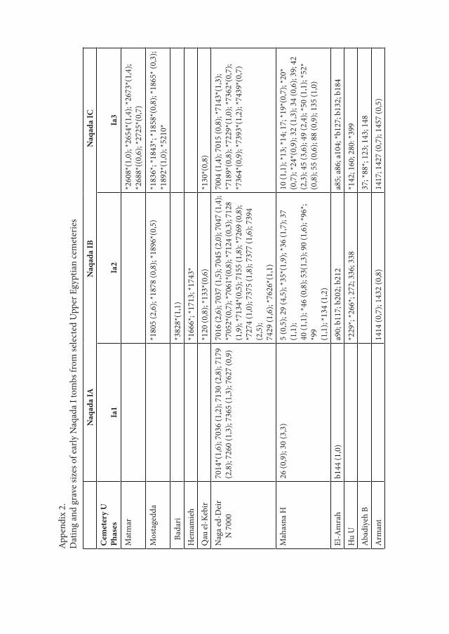
Appe
ndix
2.
Dat
ing
and
grav
e siz
es o
f ear
ly N
aqad
a I t
ombs
from
sele
cted
Upp
er E
gypt
ian
cem
eter
ies
N
aqad
a IA
N
aqad
a IB
N
aqad
a IC
Cem
eter
y U
Phas
esIa
1Ia
2Ia
3
Mat
mar
*260
8*(1
,0);
*265
4*(1
,4);
*267
3*(1
,4);
*268
8*((
0,6)
; *27
25*(
0,7)
Mos
tage
dda
*180
5 (2
,6);
*187
8 (0
,8);
*189
6*(0
,5)
*183
6*; *
1843
*; *1
858*
(0,8
); *1
865*
(0,3
); *1
892*
(1,0
); *5
210*
Ba
dari
*382
8*(1
,1)
Hem
amie
h*1
666*
; *17
13; *
1743
*Q
au el
-Keb
ir*1
20 (0
,8);
*133
*(0,
6)*1
30*(
0,8)
Nag
a ed
-Dei
r
N 7
000
7014
*(1,
6); 7
036
(1,2
); 71
30 (2
,8);
7179
(2,8
); 72
60 (1
,3);
7365
(1,3
); 76
27 (0
,9)
7016
(2,6
); 70
37 (1
,5);
7045
(2,0
); 70
47 (1
,4);
*705
2*(0
,7);
*706
1*(0
,8);
*712
4 (0
,3);
7128
(1,9
); *7
134*
(0,5
); 71
55 (1
,8);
*726
9 (0
,8);
*727
4 (1
,0);
7375
(1,8
); 73
77 (1
,6);
7394
(2
,5);
7429
(1,6
); *7
626*
(1,1
)
7004
(1,4
); 70
15 (0
,8);
*714
3*(1
,3);
*718
9*(0
,8);
*722
9*(1
,0);
*736
2*(0
,7);
*736
4*(0
,9);
*739
3*(1
,2);
*743
9*(0
,7)
Mah
asna
H26
(0,9
); 30
(3,3
)5
(0,5
); 29
(4,5
); *3
5*(1
,9);
*36
(1,7
); 37
(1
,1);
40 (1
,1);
*46
(0,8
); 53
(1,3
); 90
(1,6
); *9
6*;
*99
(1,1
); *1
34 (1
,2)
10 (1
,1);
*13;
*14;
17;
*19*
(0,7
); *2
0*(0
,7);
*24*
(0,9
); 32
(1,3
); 34
(0,6
); 39
; 42
(2,3
); 45
(3,6
); 49
(2,4
); *5
0 (1
,1);
*52*
(0,8
); 55
(0,6
); 88
(0,9
); 13
5 (1
,0)
El-A
mra
hb1
44 (1
,0)
a90;
b11
7; b
202;
b21
2a8
5; a
86; a
104;
*b12
7; b
132;
b18
4H
u U
*229
*; *2
66*;
272;
336
; 338
*142
; 160
; 280
: *39
9A
badi
yeh
B37
; *88
*; 12
3; 1
43; 1
48A
rman
t14
14 (0
,7);
1432
(0,8
)14
17; 1
427
(0,7
); 14
57 (0
,5)

Desert and the Nile. Prehistory of the Nile Basin and the Sahara.
Papers in honour of Fred Wendorf Studies in African Archaeology 15
Poznań Archaeological Museum 2018
Taichi Kuronuma
Goods Placement in Predynastic Burials: A Case Study from the Cemeteries in the Naqada Region
IntroductionThe studies of burial customs of the Naqada Culture in the 4th Millennium BC
allow tracing social development which influenced the emergence of the Early State (Fig. 1). Burials of the Naqada Culture were first discovered in the cemeter-ies at Naqada during 1894-95 by Petrie (Petrie and Quibell 1896). Subsequently more than 200 cemeteries have been excavated or surveyed to date (Hendrickx and van den Brink 2002). Through these investigations, typical and regulated mortuary characteristics have been observed. The contracted posture of burials with the head directed south and face directed west, or quantitatively wealthy and varied burial equipment, are typical characteristics of Upper Egyptian burial custom (e.g. Castillos 1982). Quantitative analyses of burial equipment have con-tributed to the understanding of social stratification (e.g. Bard 1994).
Despite recent research into Predynastic mortuary customs, many aspects re-mained unsolved. The placement of goods in burials is one such example, and is investigated here to better understand mortuary regulations and practices. Four cemeteries in the Naqada region of Upper Egypt are the subject of this analy-sis, since the Naqada region embraces a relatively large amount of documented graves, which are recorded in archival field notes and publications (Baumgartel 1970; Petrie and Quibell 1896).
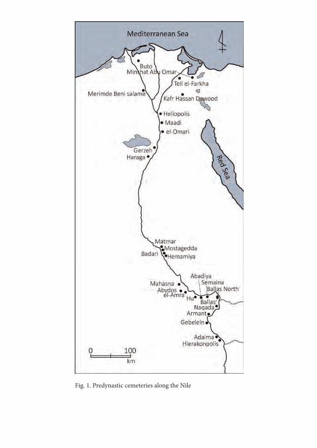
Fig. 1. Predynastic cemeteries along the Nile
Goods Placement in Predynastic Burials: A Case Study from the Cemeteries... 341
1. Research background
1.1. Mortuary archaeology in Predynastic research – a brief summaryThe investigation of mortuary practices is one of the common research themes
applied to the Naqada Culture. Many aspects such as the classification of tombs or style of interment were examined in the early-twentieth century (Murray 1956; Petrie 1920; Reisner 1936).
After the 1980s, research into Predynastic social stratification became more frequent. One landmark example is the study by Bard (1994) who conducted a cluster analysis for the Cemetery 1400-1500 at Armant and three cemeteries (Main, B, and T) at Naqada. Its results suggest the complexation of social stratum after mid-Naqada II.
From the mid-1990s, Predynastic mortuary archaeology diversified due to the increase of information from new interdisciplinary excavations such as at Hier-akonpolis (Friedman 2008). In addition, developments in methods and theory applied to mortuary archaeology enabled the investigation of new questions (cf. Parker Pearson 1999). For example, Jones (2007) analysed body manipulation in Hierakonpolis HK 43 Cemetery which was possible due to the human remains which were carefully retrieved with modern excavation techniques. Further, so-cial identity and relationships in the Predynastic were discussed by Stevenson (2009a; 2009b) who analysed the field records of the excavation of the el-Gerzeh cemetery.
Despite numerous studies applying various theoretical perspectives and meth-odological approaches, there are still obscurities regarding Predynastic burials. More research based on detailed observation, analysis, and interpretation are nec-essary. Furthermore, re-evaluation of old excavations through archival records can also contribute to the unsolved points under discussion. Predynastic burial goods placement is one such point.
1.2. Past research on the goods placement in burialSince interred goods closely relate to the buried person, understanding goods
placement in burials is important to observe mortuary regulations. However, for the Naqada Culture, detailed research has not been adequately attempted except in some examples. There are two directions in past research referring to goods placement. One is the placement of particular goods type, and the other is the general description of the well preserved graves. As an example of the former,

Taichi Kuronuma342
Regner (1996) gathered the information on the placement of palettes in the Pre-dynastic graves. Examples of burials in Lower and Upper Egypt were analysed and it was found that palettes were widely distributed around the buried person, especially around the head, hands, and pelvis. Furthermore, Roth (1992) studied the placement of fish-tailed knives in burial to examine the functional and histori-cal relationship with the Dynastic psš-kf knives which were used for the ‘Opening of the mouth ritual’.
For the latter case, general descriptions of the typical goods placement in well preserved graves are mentioned in many works. The oldest known example from Predynastic Egypt is the report on the observed placement regulations in the cem-eteries at Naqada (Petrie and Quibell 1896). Since then, some books mention the typical goods placement and its development (e.g. Adams 1988: 17). Grajetzki (2003) mentioned typical Predynastic goods placement in comparison with Dy-nastic mortuary customs.
Contrary to the examples in the above overview, the fragmentary state of detailed information prevents macroscopic analyses into the comprehension of goods placement by cemetery. This paper aims to overcome this issue by integrat-ing published and unpublished information sources.
2. Materials and methods
2.1. Research area and cemeteries to be analysedFor the analysis of burial goods placement, four cemeteries in the Naqada re-
gion were chosen. These are three cemeteries at Naqada (Main (NM), B (NB), and T (NT)) excavated by Petrie and his team (Petrie and Quibell 1896), and the cemetery in Deir el-Ballâs (Bâllas North (BN)) excavated by Lythgoe (Podzorski 1994) as part of the Hearst Expedition. Other Predynastic and Early Dynastic cemeteries were found in this area such as Ballas excavated by Quibell (Petrie and Quibell 1896) on the west bank of the Nile, or Khizam (e.g. Hendrickx 1992) on the east. However, the records of these cemeteries are too fragmentary for the current analysis1.
Though the published reports of the cemeteries at Naqada contain only partial records of graves and no final reports were published for BN, unpublished records
1 Archaeological sites in the Naqada region are listed by Hendrickx and van den Brink (2002).
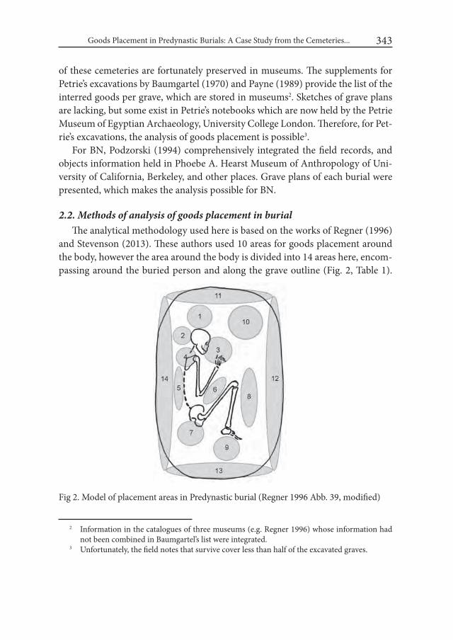
Goods Placement in Predynastic Burials: A Case Study from the Cemeteries... 343
of these cemeteries are fortunately preserved in museums. The supplements for Petrie’s excavations by Baumgartel (1970) and Payne (1989) provide the list of the interred goods per grave, which are stored in museums2. Sketches of grave plans are lacking, but some exist in Petrie’s notebooks which are now held by the Petrie Museum of Egyptian Archaeology, University College London. Therefore, for Pet-rie’s excavations, the analysis of goods placement is possible3.
For BN, Podzorski (1994) comprehensively integrated the field records, and objects information held in Phoebe A. Hearst Museum of Anthropology of Uni-versity of California, Berkeley, and other places. Grave plans of each burial were presented, which makes the analysis possible for BN.
2.2. Methods of analysis of goods placement in burialThe analytical methodology used here is based on the works of Regner (1996)
and Stevenson (2013). These authors used 10 areas for goods placement around the body, however the area around the body is divided into 14 areas here, encom-passing around the buried person and along the grave outline (Fig. 2, Table 1).
2 Information in the catalogues of three museums (e.g. Regner 1996) whose information had not been combined in Baumgartel’s list were integrated.
3 Unfortunately, the field notes that survive cover less than half of the excavated graves.
Fig 2. Model of placement areas in Predynastic burial (Regner 1996 Abb. 39, modified)
Taichi Kuronuma344
Goods were counted by type by placement area. The goods consisted of 7 different types: pottery, stone vessels (SV), stone artefacts (SA), palettes, beads/pendants (B/P), ivory, and shells. Other unlisted goods are included in ‘miscellaneous’. In the case of analysis for the cemeteries at Naqada, only goods discernible in the Petrie’s notebooks were counted. The supplementary lists of Baumgartel and Payne were also crosschecked during this counting. For BN, the author followed Podzorski’s descriptions.
Table 1. Placement area for burial
No. Desciption1 Above head2 Behind head3 In front of face and around hands4 Neck and shoulder5 Behind back6 Before body, between arms and upper legs7 Around pelvis8 In front of legs9 Below feet10 Before upper body11 Along grave outline above head12 Along grave outline before face13 Along grave outline below feet14 Along grave outline behind back
2.3. Timeframe and selection of tombsBased on the pottery typology and its seriation, the relative chronological
timeframe of the Naqada Culture was suggested by various authors such like Petrie (1920), Kaiser (1957), and Hendrickx (2006). Payne (1992) also proposed a local chronology at Naqada. Hendrickx’s chronology is used here, merged it to four periods: Naqada I, Early Naqada II, Late Naqada II and Naqada III. This modification aimed to include as many graves as possible, particularly those with a wider chronological range, and to facilitate the diachronic observation. Under this chronological setting, graves with exact or almost exact chronological posi-tion were selected, and not all of the graves were analysed as a consequence.
Goods Placement in Predynastic Burials: A Case Study from the Cemeteries... 345
3. ResultsTables 2 to 5 show the amount of goods from each chronological phase, with
the sum and percentage of each goods type by placement area, separated by cem-etery. The sum of each good type by cemetery is also provided.
3.1. Naqada I (Table 2)Pottery: Most potteries were placed along the grave outline, especially in areas
11 and 12. Contrarily, some pottery was also placed around the body, especially in areas 1, 3, 5 and 6. These results could be seen at NM and BN, but the number of goods per area at BN were max. 4 or 5 (area 11 or 12). Therefore, it is too small for evaluation for BN. NB shows a similar pattern in the dominant placement along the grave outline, but few potteries were placed around the buried person.
SV: Amounts are few in all cemeteries but they tended to be placed around the buried person, especially in areas 1 and 6 at NM and BN.
SA: No flint lithics could be identifiable at NB and BN. In NM, flint lithics were placed both around the buried person and along the grave outline. The amount in the latter area is slightly larger than that of the former, but evaluation is difficult due to the small number of flint lithics.
Palette: No palettes were identified at NB. Palettes were placed around the bur-ied person and along the grave outline at NM, but the former placement area was dominant. Three palettes in area 7 should be mentioned. At BN, a sole example was also placed near the buried person in area 6.
B/P: No goods could be identifiable at NB and BN. At NM, B/P were placed in both near the buried person and grave outline, but the former areas occur in a higher proportion than the latter. B/P were also dispersed in areas 3, 5, 6 and 9.
ivory: No ivory goods could be identifiable at NB and BN. At NM, area 3 was the dominant placement (72.4 %, 21 objects). Also, there were 6 objects in area 1.
Shell: Mainly placed near buried person in areas 1, 3 and 6 at NM and BN. At NB a sole example was placed in the step part of the grave.
3.2. Early Naqada II (Table 3)Pottery: Most of the pottery were placed along the grave outline. This could be
identified at NM, NB and BN, but was obscure at NT. Pottery were also confined around the buried person in this period, in particular at NM in areas 1, 3, 6, 8 and 9, while they were dominant in areas 6 and 9 in NB and 3, 6 and 9 at BN.
SV: No stone vessels could be identified at NT. The placement along the grave outline is observed at NM. Several stone vessels at NM were observed in areas 3

Tabl
e 2.
Pla
cem
ent o
f the
goo
ds in
bur
ial i
n N
aqad
a I (
SV =
ston
e ve
ssel
, SA
= st
one
arte
fact
, B/P
= b
eads
/pen
dant
s)N
M
N =
55
Are
aPo
ttery
SVSA
Pale
tteB/
PIv
ory
Shel
lM
iscel
lane
ous
15
1,3%
350
,0%
18,
3%1
8,3%
00,
0%6
20,7
%1
20,0
%2
13,3
%2
20,
5%0
0,0%
00,
0%0
0,0%
00,
0%0
0,0%
00,
0%0
0,0%
37
1,8%
00,
0%0
0,0%
18,
3%2
16,7
%21
72,4
%1
20,0
%1
6,7%
40
0,0%
00,
0%0
0,0%
00,
0%0
0,0%
00,
0%0
0,0%
00,
0%5
51,
3%0
0,0%
00,
0%0
0,0%
18,
3%0
0,0%
00,
0%0
0,0%
66
1,6%
116
,7%
00,
0%1
8,3%
216
,7%
00,
0%2
40,0
%1
6,7%
70
0,0%
00,
0%4
33,3
%3
25,0
%1
8,3%
00,
0%0
0,0%
16,
7%8
10,
3%0
0,0%
00,
0%0
0,0%
00,
0%0
0,0%
00,
0%0
0,0%
910
2,6%
00,
0%0
0,0%
00,
0%1
8,3%
00,
0%0
0,0%
00,
0%10
82,
1%0
0,0%
00,
0%3
25,0
%0
0,0%
26,
9%0
0,0%
213
,3%
1114
738
,5%
00,
0%0
0,0%
18,
3%2
16,7
%0
0,0%
00,
0%2
13,3
%12
103
27,0
%1
16,7
%4
33,3
%0
0,0%
18,
3%0
0,0%
120
,0%
320
,0%
1337
9,7%
116
,7%
216
,7%
216
,7%
216
,7%
00,
0%0
0,0%
320
,0%
1451
13,4
%0
0,0%
18,
3%0
0,0%
00,
0%0
0,0%
00,
0%0
0,0%
Tota
l38
26
1212
1229
515
NB
N =
2A
rea
Potte
rySV
SAPa
lette
B/P
Ivor
ySh
ell
Misc
ella
neou
s1
222
,2%
00,
0%0
0,0%
00,
0%0
0,0%
00,
0%0
0,0%
00,
0%2
00,
0%0
0,0%
00,
0%0
0,0%
00,
0%0
0,0%
00,
0%0
0,0%
30
0,0%
00,
0%0
0,0%
00,
0%0
0,0%
00,
0%0
0,0%
00,
0%4
00,
0%0
0,0%
00,
0%0
0,0%
00,
0%0
0,0%
00,
0%0
0,0%
50
0,0%
00,
0%0
0,0%
00,
0%0
0,0%
00,
0%0
0,0%
266
,7%
60
0,0%
00,
0%0
0,0%
00,
0%0
0,0%
00,
0%0
0,0%
00,
0%7
00,
0%0
0,0%
00,
0%0
0,0%
00,
0%0
0,0%
00,
0%0
0,0%

80
0,0%
00,
0%0
0,0%
00,
0%0
0,0%
00,
0%0
0,0%
00,
0%9
00,
0%0
0,0%
00,
0%0
0,0%
00,
0%0
0,0%
00,
0%0
0,0%
100
0,0%
00,
0%0
0,0%
00,
0%0
0,0%
00,
0%0
0,0%
00,
0%11
333
,3%
00,
0%0
0,0%
00,
0%0
0,0%
00,
0%0
0,0%
133
,3%
121
11,1
%0
0,0%
00,
0%0
0,0%
00,
0%0
0,0%
00,
0%0
0,0%
131
11,1
%0
0,0%
00,
0%0
0,0%
00,
0%0
0,0%
00,
0%0
0,0%
142
22,2
%0
0,0%
00,
0%0
0,0%
00,
0%0
0,0%
00,
0%0
0,0%
Step
00,
0%1
100,
0%0
0,0%
00,
0%0
0,0%
00,
0%1
100,
0%0
0,0%
Tota
l9
10
00
01
3BN
N =
5A
rea
Potte
rySV
SAPa
lette
B/P
Ivor
ySh
ell
Misc
ella
neou
s1
00,
0%0
0,0%
00,
0%0
0,0%
00,
0%0
0,0%
00,
0%0
0,0%
20
0,0%
00,
0%0
0,0%
00,
0%0
0,0%
00,
0%0
0,0%
00,
0%3
00,
0%0
0,0%
00,
0%0
0,0%
00,
0%0
0,0%
133
,3%
00,
0%4
18,
3%0
0,0%
00,
0%0
0,0%
00,
0%0
0,0%
00,
0%0
0,0%
50
0,0%
00,
0%0
0,0%
00,
0%0
0,0%
00,
0%0
0,0%
00,
0%6
18,
3%1
100,
0%0
0,0%
110
0,0%
00,
0%0
0,0%
266
,7%
410
0,0%
70
0,0%
00,
0%0
0,0%
00,
0%0
0,0%
00,
0%0
0,0%
00,
0%8
00,
0%0
0,0%
00,
0%0
0,0%
00,
0%0
0,0%
00,
0%0
0,0%
90
0,0%
00,
0%0
0,0%
00,
0%0
0,0%
00,
0%0
0,0%
00,
0%10
00,
0%0
0,0%
00,
0%0
0,0%
00,
0%0
0,0%
00,
0%0
0,0%
114
33,3
%0
0,0%
00,
0%0
0,0%
00,
0%0
0,0%
00,
0%0
0,0%
125
41,7
%0
0,0%
00,
0%0
0,0%
00,
0%0
0,0%
00,
0%0
0,0%
130
0,0%
00,
0%0
0,0%
00,
0%0
0,0%
00,
0%0
0,0%
00,
0%14
18,
3%0
0,0%
00,
0%0
0,0%
00,
0%0
0,0%
00,
0%0
0,0%
Tota
l12
10
10
03
4* N
o da
ta fo
r NT
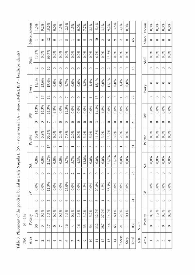
Tabl
e 3.
Pla
cem
ent o
f the
goo
ds in
bur
ial i
n Ea
rly N
aqad
a II
(SV
= st
one
vess
el, S
A =
ston
e ar
tefa
ct, B
/P =
bea
ds/p
enda
nts)
NM
N =
148
Are
aPo
ttery
SVSA
Pale
tteB/
PIv
ory
Shel
lM
iscel
lane
ous
130
2,9%
00,
0%0
0,0%
23,
9%3
14,3
%8
11,1
%2
13,3
%1
1,5%
23
0,3%
00,
0%0
0,0%
35,
9%3
14,3
%17
23,6
%0
0,0%
69,
2%3
171,
7%3
12,5
%5
21,7
%17
33,3
%7
33,3
%14
19,4
%10
66,7
%12
18,5
%4
00,
0%0
0,0%
00,
0%0
0,0%
14,
8%0
0,0%
00,
0%0
0,0%
57
0,7%
00,
0%0
0,0%
12,
0%0
0,0%
00,
0%0
0,0%
11,
5%6
161,
6%6
25,0
%2
8,7%
47,
8%3
14,3
%7
9,7%
00,
0%8
12,3
%7
40,
4%0
0,0%
28,
7%1
2,0%
00,
0%0
0,0%
00,
0%1
1,5%
816
1,6%
00,
0%1
4,3%
00,
0%0
0,0%
00,
0%0
0,0%
00,
0%9
333,
2%1
4,2%
313
,0%
23,
9%0
0,0%
34,
2%0
0,0%
57,
7%10
545,
2%0
0,0%
00,
0%3
5,9%
00,
0%1
1,4%
00,
0%2
3,1%
1133
232
,2%
520
,8%
00,
0%6
11,8
%3
14,3
%13
18,1
%1
6,7%
1015
,4%
1228
727
,9%
14,
2%0
0,0%
23,
9%1
4,8%
00,
0%0
0,0%
23,
1%13
146
14,2
%8
33,3
%5
21,7
%7
13,7
%0
0,0%
811
,1%
213
,3%
69,
2%14
636,
1%0
0,0%
521
,7%
23,
9%0
0,0%
00,
0%0
0,0%
913
,8%
Rece
ss21
2,0%
00,
0%0
0,0%
12,
0%0
0,0%
11,
4%0
0,0%
23,
1%St
ep1
0,1%
00,
0%0
0,0%
00,
0%0
0,0%
00,
0%0
0,0%
00,
0%To
tal
1030
2423
5121
7215
65N
BN
= 7
Are
aPo
ttery
SVSA
Pale
tteB/
PIv
ory
Shel
lM
iscel
lane
ous
10
0,0%
00,
0%0
0,0%
00,
0%0
0,0%
00
00,
0%0
0,0%
21
1,2%
00,
0%0
0,0%
00,
0%0
0,0%
00
00,
0%0
0,0%
30
0,0%
00,
0%0
0,0%
00,
0%0
0,0%
00
00,
0%0
0,0%
40
0,0%
00,
0%0
0,0%
00,
0%0
0,0%
00
00,
0%0
0,0%

52
2,5%
00,
0%0
0,0%
00,
0%0
0,0%
00
00,
0%0
0,0%
64
4,9%
00,
0%1
50,0
%0
0,0%
00,
0%0
00
0,0%
00,
0%7
11,
2%0
0,0%
00,
0%0
0,0%
00,
0%0
00
0,0%
00,
0%8
22,
5%0
0,0%
00,
0%0
0,0%
00,
0%0
00
0,0%
00,
0%9
44,
9%0
0,0%
00,
0%0
0,0%
00,
0%0
00
0,0%
00,
0%10
00,
0%0
0,0%
00,
0%0
0,0%
00,
0%0
00
0,0%
120
,0%
1115
18,5
%1
50,0
%0
0,0%
150
,0%
00,
0%0
00
0,0%
00,
0%12
2632
,1%
150
,0%
00,
0%0
0,0%
00,
0%0
01
100,
0%0
0,0%
1321
25,9
%0
0,0%
00,
0%1
50,0
%0
0,0%
00
00,
0%2
40,0
%14
56,
2%0
0,0%
150
,0%
00,
0%0
0,0%
00
00,
0%2
40,0
%To
tal
812
22
00
15
NT
N =
2A
rea
Potte
rySV
SAPa
lette
B/P
Ivor
ySh
ell
Misc
ella
neou
s1
25,
7%0
0,0%
00,
0%0
0,0%
00,
0%0
0,0%
00,
0%0
0,0%
20
0,0%
00,
0%0
0,0%
133
,3%
00,
0%0
0,0%
00,
0%0
0,0%
30
0,0%
00,
0%0
0,0%
00,
0%0
0,0%
00,
0%0
0,0%
00,
0%4
00,
0%0
0,0%
210
0,0%
10,
0%0
0,0%
00,
0%0
0,0%
120
,0%
50
0,0%
00,
0%0
0,0%
00,
0%0
0,0%
00,
0%0
0,0%
00,
0%6
00,
0%0
0,0%
00,
0%0
0,0%
00,
0%0
0,0%
00,
0%0
0,0%
70
0,0%
00,
0%0
0,0%
00,
0%0
0,0%
00,
0%0
0,0%
00,
0%8
12,
9%0
0,0%
00,
0%0
0,0%
00,
0%0
0,0%
00,
0%0
0,0%
90
0,0%
00,
0%0
0,0%
00,
0%0
0,0%
00,
0%0
0,0%
00,
0%10
1954
,3%
00,
0%0
0,0%
00,
0%0
0,0%
00,
0%0
0,0%
00,
0%11
1131
,4%
00,
0%0
0,0%
00,
0%0
0,0%
210
0,0%
00,
0%4
80,0
%

120
0,0%
00,
0%0
0,0%
00,
0%0
0,0%
00,
0%0
0,0%
00,
0%13
12,
9%0
0,0%
00,
0%0
0,0%
00,
0%0
0,0%
00,
0%0
0,0%
141
2,9%
00,
0%0
0,0%
133
,3%
00,
0%0
0,0%
00,
0%0
0,0%
Tota
l35
02
30
20
5BN
N =
21
Are
aPo
ttery
SVSA
Pale
tteB/
PIv
ory
Shel
lM
iscel
lane
ous
10
0,0%
00,
0%0
0,0%
00,
0%0
0,0%
00,
0%0
0,0%
00,
0%2
00,
0%0
0,0%
00,
0%0
0,0%
457
,1%
00,
0%0
0,0%
112
,5%
37
7,9%
00,
0%0
0,0%
220
,0%
114
,3%
125
,0%
00,
0%3
37,5
%4
00,
0%0
0,0%
00,
0%0
0,0%
114
,3%
00,
0%0
0,0%
00,
0%5
00,
0%0
0,0%
00,
0%0
0,0%
00,
0%0
0,0%
00,
0%0
0,0%
63
3,4%
00,
0%0
0,0%
110
,0%
00,
0%0
0,0%
00,
0%0
0,0%
70
0,0%
00,
0%0
0,0%
330
,0%
00,
0%0
0,0%
00,
0%0
0,0%
80
0,0%
00,
0%0
0,0%
00,
0%0
0,0%
00,
0%0
0,0%
112
,5%
92
2,2%
00,
0%3
100,
0%2
20,0
%1
14,3
%3
75,0
%3
37,5
%1
12,5
%10
22,
2%0
0,0%
00,
0%1
10,0
%0
0,0%
00,
0%0
0,0%
112
,5%
1124
27,0
%0
0,0%
00,
0%0
0,0%
00,
0%0
0,0%
562
,5%
00,
0%12
4044
,9%
110
0,0%
00,
0%1
10,0
%0
0,0%
00,
0%0
0,0%
112
,5%
1311
12,4
%0
0,0%
00,
0%0
0,0%
00,
0%0
0,0%
00,
0%0
0,0%
140
0,0%
00,
0%0
0,0%
00,
0%0
0,0%
00,
0%0
0,0%
00,
0%To
tal
891
310
74
88

Goods Placement in Predynastic Burials: A Case Study from the Cemeteries... 351
and 6 and also in 11 and 13. At NB and BN, no stone vessels were placed around the buried person but only along the grave outline.
SA: Objects were placed around the buried person and along the grave outline. The amount of the flint lithics at NM became larger, and dispersed in various areas (3, 6, 7, 8 and 9). In other cemeteries, flint lithics were placed in areas 4 in NT, 6 at NB and 9 at BN.
Palettes: Palettes in NM could be both around the buried person and along the grave outline, but compared to Naqada I, an increase in area 3 was recorded. However, in the other cemeteries the placement areas differ. Dominant placement around the buried person occurred at NT and BN. By contrast, palettes were placed along the grave outline at NB (areas 11 and 13).
B/P: No goods could be identified at NB and NT. At NM and BN, most of the B/P were placed in various areas around the buried person, similar to Naqada I.
ivory: No goods could be identified at NB. At NM, though the dominant num-ber around the buried person were similar to that from Naqada I, placement along the grave outline also increased especially in areas 11 and 13. Placement at NT was only in area 11 and at BN was separated from the buried person.
Shell: Compared to Naqada I, placement in area 3 increased. Placements in other areas continued, but along the grave outline became dominant at BN.
3.3. Late Naqada II (Table 4)Pottery: Similar to Early Naqada II, most were placed along the grave outline.
This was identifiable at NM, NB, and BN, however the increase in areas 9 and 10 is noticeable, except at BN. The placement around the buried person confirmed in this period but pottery slightly decreased in number in areas 3, 5, 6 and 7. The placement areas with several potteries were divergent and increased at NM in areas 1, 2, 3, 6, 8, 9 and 10. Similar results are observed between NM, NB, and NT, but goods along the grave outline was common at BN.
SV: No stone vessels could be identified at BN. The result was similar to that of Early Naqada II, and increasing utilisation of area 10 is noticeable at NM. At NT the pattern was similar to NM where objects were more dominant around the buried person than along the grave outline. Small numbers of stone vessels made it difficult to observe any pattern at NB.
SA: No flint lithics could be identifiable at BN. In contrast to Early Naqada II, the dominant placement areas were along the grave outline (areas 11 and 12) at NM. But at NM, flint lithics were also placed around the buried person, especially in areas 3, 6, 9 and 10. It was also common at NB (area 9) and NT (area 3).
Tabl
e 4.
Pla
cem
ent o
f the
goo
ds in
bur
ial i
n La
te N
aqad
a II
(SV
= st
one
vess
el, S
A =
ston
e ar
tefa
ct, B
/P =
bea
ds/p
enda
nts)
NM
N =
103
Are
aPo
ttery
SVSA
Pale
tteB/
PIv
ory
Shel
lM
iscel
lane
ous
146
3,7%
00,
0%0
0,0%
00,
0%1
25,0
%3
17,6
%0
0,0%
12,
2%2
181,
4%1
5,3%
00,
0%1
2,9%
00,
0%3
17,6
%0
0,0%
36,
5%3
60,
5%0
0,0%
411
,4%
12,
9%0
0,0%
15,
9%1
50,0
%3
6,5%
40
0,0%
00,
0%0
0,0%
00,
0%0
0,0%
00,
0%1
50,0
%0
0,0%
55
0,4%
00,
0%0
0,0%
25,
7%0
0,0%
15,
9%0
0,0%
12,
2%6
131,
0%2
10,5
%4
11,4
%4
11,4
%0
0,0%
423
,5%
00,
0%9
19,6
%7
20,
2%0
0,0%
00,
0%2
5,7%
00,
0%0
0,0%
00,
0%1
2,2%
824
1,9%
15,
3%0
0,0%
00,
0%0
0,0%
15,
9%0
0,0%
00,
0%9
210
16,7
%2
10,5
%5
14,3
%3
8,6%
00,
0%0
0,0%
00,
0%7
15,2
%10
836,
6%8
42,1
%2
5,7%
12,
9%0
0,0%
00,
0%0
0,0%
12,
2%11
211
16,8
%1
5,3%
925
,7%
617
,1%
125
,0%
423
,5%
00,
0%7
15,2
%12
296
23,5
%3
15,8
%11
31,4
%10
28,6
%2
50,0
%0
0,0%
00,
0%9
19,6
%13
224
17,8
%1
5,3%
00,
0%1
2,9%
00,
0%0
0,0%
00,
0%3
6,5%
1411
59,
1%0
0,0%
00,
0%2
5,7%
00,
0%0
0,0%
00,
0%0
0,0%
Rece
ss1
0,1%
00,
0%0
0,0%
12,
9%0
0,0%
00,
0%0
0,0%
00,
0%St
ep3
0,2%
00,
0%0
0,0%
12,
9%0
0,0%
00,
0%0
0,0%
12,
2%To
tal
1257
1935
354
172
46N
BN
= 1
1A
rea
Potte
rySV
SAPa
lette
B/P
Ivor
ySh
ell
Misc
ella
neou
s1
32,
0%0
0,0%
00,
0%0
0,0%
00,
0%0
0,0%
00,
0%0
0,0%
20
0,0%
00,
0%0
0,0%
00,
0%0
0,0%
00,
0%0
0,0%
00,
0%

30
0,0%
00,
0%0
0,0%
00,
0%0
0,0%
00,
0%0
0,0%
00,
0%4
00,
0%0
0,0%
00,
0%0
0,0%
00,
0%0
0,0%
00,
0%0
0,0%
50
0,0%
00,
0%0
0,0%
00,
0%0
0,0%
00,
0%0
0,0%
00,
0%6
10,
7%0
0,0%
00,
0%0
0,0%
00,
0%0
0,0%
00,
0%0
0,0%
70
0,0%
00,
0%0
0,0%
00,
0%0
0,0%
00,
0%0
0,0%
00,
0%8
00,
0%0
0,0%
00,
0%0
0,0%
00,
0%0
0,0%
00,
0%0
0,0%
918
11,8
%0
0,0%
210
0,0%
00,
0%0
0,0%
00,
0%0
0,0%
110
0,0%
1018
11,8
%1
50,0
%0
0,0%
00,
0%0
0,0%
00,
0%0
0,0%
00,
0%11
2919
,0%
00,
0%0
0,0%
00,
0%0
0,0%
00,
0%0
0,0%
00,
0%12
3120
,3%
00,
0%0
0,0%
00,
0%0
0,0%
00,
0%0
0,0%
00,
0%13
3019
,6%
00,
0%0
0,0%
00,
0%0
0,0%
00,
0%0
0,0%
00,
0%14
2315
,0%
150
,0%
00,
0%2
100,
0%0
0,0%
00,
0%0
0,0%
00,
0%To
tal
153
22
20
00
1N
TN
= 1
3A
rea
Potte
rySV
SAPa
lette
B/P
Ivor
ySh
ell
Misc
ella
neou
s1
123,
1%0
0,0%
00,
0%0
0,0%
00,
0%0
0,0%
150
,0%
00,
0%2
10,
3%0
0,0%
00,
0%0
0,0%
00,
0%0
0,0%
00,
0%0
0,0%
32
0,5%
541
,7%
310
0,0%
00,
0%0
0,0%
00,
0%0
0,0%
00,
0%4
00,
0%0
0,0%
00,
0%0
0,0%
00,
0%0
0,0%
00,
0%0
0,0%
57
1,8%
00,
0%0
0,0%
00,
0%0
0,0%
00,
0%0
0,0%
00,
0%6
00,
0%3
25,0
%0
0,0%
116
,7%
00,
0%0
0,0%
00,
0%1
12,5
%7
61,
6%0
0,0%
00,
0%0
0,0%
00,
0%0
0,0%
00,
0%1
12,5
%8
10,
3%0
0,0%
00,
0%1
16,7
%0
0,0%
00,
0%0
0,0%
00,
0%9
9925
,8%
18,
3%0
0,0%
00,
0%0
0,0%
00,
0%0
0,0%
00,
0%

1048
12,5
%1
8,3%
00,
0%2
33,3
%0
0,0%
150
,0%
150
,0%
450
,0%
1132
8,3%
18,
3%0
0,0%
00,
0%0
0,0%
00,
0%0
0,0%
00,
0%12
6918
,0%
18,
3%0
0,0%
116
,7%
110
0,0%
150
,0%
00,
0%1
12,5
%13
7619
,8%
00,
0%0
0,0%
00,
0%0
0,0%
00,
0%0
0,0%
00,
0%14
318,
1%0
0,0%
00,
0%1
16,7
%0
0,0%
00,
0%0
0,0%
112
,5%
Tota
l38
412
36
12
28
BNN
= 9
Are
aPo
ttery
SVSA
Pale
tteB/
PIv
ory
Shel
lM
iscel
lane
ous
10
0,0%
00,
0%0
0,0%
00,
0%0
0,0%
00,
0%0
0,0%
00,
0%2
00,
0%0
0,0%
00,
0%0
0,0%
00,
0%0
0,0%
00,
0%0
0,0%
30
0,0%
00,
0%0
0,0%
110
0,0%
00,
0%0
0,0%
00,
0%2
50,0
%4
00,
0%0
0,0%
00,
0%0
0,0%
00,
0%0
0,0%
00,
0%0
0,0%
50
0,0%
00,
0%0
0,0%
00,
0%0
0,0%
00,
0%0
0,0%
00,
0%6
24,
2%0
0,0%
00,
0%0
0,0%
00,
0%0
0,0%
00,
0%0
0,0%
70
0,0%
00,
0%0
0,0%
00,
0%0
0,0%
00,
0%0
0,0%
00,
0%8
24,
2%0
0,0%
00,
0%0
0,0%
00,
0%0
0,0%
00,
0%0
0,0%
92
4,2%
00,
0%0
0,0%
00,
0%0
0,0%
00,
0%0
0,0%
00,
0%10
00,
0%0
0,0%
00,
0%0
0,0%
00,
0%0
0,0%
00,
0%0
0,0%
1111
22,9
%0
0,0%
00,
0%0
0,0%
00,
0%0
0,0%
00,
0%0
0,0%
1217
35,4
%0
0,0%
00,
0%0
0,0%
00,
0%0
0,0%
00,
0%1
25,0
%13
816
,7%
00,
0%0
0,0%
00,
0%0
0,0%
00,
0%0
0,0%
00,
0%14
12,
1%0
0,0%
00,
0%0
0,0%
00,
0%0
0,0%
00,
0%0
0,0%
Step
510
,4%
00,
0%0
0,0%
00,
0%0
0,0%
00,
0%0
0,0%
125
,0%
Tota
l48
00
10
00
4
Goods Placement in Predynastic Burials: A Case Study from the Cemeteries... 355
Palettes: Compared to Early Naqada II, the number in area 3 decreased, though the number in other areas did not changed markedly. Similar placement occurred at NT but the results were obscured at NB and BN due to the small sample size.
B/P: No B/P could be identifiable at NB and BN. At NM, the amount of B/P was small but occurred both around the buried person (area 1) and along the grave outline. At NT the sole example was placed in area 12.
ivory: No ivory was identified at NB and BN. Though the placement along the grave outline could be observed at NM, most were distributed around the buried person, particularly in areas 1, 2 and 6. However, the case at NT was different and ivory were placed in either area 10 or 12.
Shell: No shell was identified at NB and BN. In NM and BN, shells tended to be placed around the bodies, especially in areas 1, 3 and 4, but 1 example was observed in area 10.
3.4. Naqada III (Table 5)Pottery: Similar to Late Naqada II, most of the pottery were placed along the
grave outline or slightly separated in particular areas such as 9 or 10. This was observed at NM, NT, and BN. At NB, no pottery was placed around the buried person but in several cases were placed along the grave outline as such in area 11.
SV: No stone vessels could be identified at NB. The result was similar to Late Naqada II, but the frequency of stone vessels around the buried person decreased at NM and NT. At BN, SV were placed in areas 7, 8, 10, and 11, contrary to the total absence in previous period.
SA: No flint lithics were identified from any cemetery.Palettes: No palettes were identified at NB. Palettes at BN were spread widely
around the buried person and along the grave outline. However, in other areas, particularly area 6, were dominant at BN. Placement at area 4 was common at NM. However, at NT, a palette was identified in area 11.
B/P: No B/P could be identified at NB and NT. BP was placed around the bur-ied person, especially in area 1 at NM, and 6 and 7 at BN.
ivory: The only ivory was identified at BN where it was in areas 9 and 11. Shell: No shell was identified from any cemetery.
3.5. Summary of the results The following patterns for the placement by goods type appeared:Pottery was placed both around the buried person and along the grave out-
line through all periods, though the goods along the grave outline were generally

Tabl
e 5.
Pla
cem
ent o
f the
goo
ds in
bur
ial i
n N
aqad
a II
I (SV
= st
one
vess
el, S
A =
ston
e ar
tefa
ct, B
/P =
bea
ds/p
enda
nts)
NM
N =
28
Are
aPo
ttery
SVSA
Pale
tteB/
PIv
ory
Shel
lM
iscel
lane
ous
12
1,3%
00,
0%0
0,0%
00,
0%1
100,
0%0
0,0%
00,
0%0
0,0%
23
1,9%
00,
0%0
0,0%
00,
0%0
0,0%
00,
0%0
0,0%
00,
0%3
85,
1%1
33,3
%0
0,0%
00,
0%0
0,0%
00,
0%0
0,0%
00,
0%4
00,
0%0
0,0%
00,
0%2
100,
0%0
0,0%
00,
0%0
0,0%
00,
0%5
00,
0%0
0,0%
00,
0%0
0,0%
00,
0%0
0,0%
00,
0%0
0,0%
65
3,2%
00,
0%0
0,0%
00,
0%0
0,0%
00,
0%0
0,0%
00,
0%7
00,
0%0
0,0%
00,
0%0
0,0%
00,
0%0
0,0%
00,
0%0
0,0%
85
3,2%
00,
0%0
0,0%
00,
0%0
0,0%
00,
0%0
0,0%
00,
0%9
42,
6%0
0,0%
00,
0%0
0,0%
00,
0%0
0,0%
00,
0%0
0,0%
1019
12,2
%0
0,0%
00,
0%0
0,0%
00,
0%0
0,0%
00,
0%0
0,0%
1128
17,9
%1
33,3
%0
0,0%
00,
0%0
0,0%
00,
0%0
0,0%
00,
0%12
4126
,3%
00,
0%0
0,0%
00,
0%0
0,0%
00,
0%0
0,0%
00,
0%13
2214
,1%
133
,3%
00,
0%0
0,0%
00,
0%0
0,0%
00,
0%0
0,0%
1417
10,9
%0
0,0%
00,
0%0
0,0%
00,
0%0
0,0%
00,
0%0
0,0%
Step
21,
3%0
0,0%
00,
0%0
0,0%
00,
0%0
0,0%
00,
0%1
100,
0%To
tal
156
30
21
00
1N
BN
= 2
Are
aPo
ttery
SVSA
Pale
tteB/
PIv
ory
Shel
lM
iscel
lane
ous
10
0,0%
00,
0%0
0,0%
00,
0%0
0,0%
00,
0%0
0,0%
00,
0%2
00,
0%0
0,0%
00,
0%0
0,0%
00,
0%0
0,0%
00,
0%0
0,0%
30
0,0%
00,
0%0
0,0%
00,
0%0
0,0%
00,
0%0
0,0%
00,
0%

40
0,0%
00,
0%0
0,0%
00,
0%0
0,0%
00,
0%0
0,0%
00,
0%5
00,
0%0
0,0%
00,
0%0
0,0%
00,
0%0
0,0%
00,
0%0
0,0%
60
0,0%
00,
0%0
0,0%
00,
0%0
0,0%
00,
0%0
0,0%
00,
0%7
00,
0%0
0,0%
00,
0%0
0,0%
00,
0%0
0,0%
00,
0%0
0,0%
80
0,0%
00,
0%0
0,0%
00,
0%0
0,0%
00,
0%0
0,0%
00,
0%9
00,
0%0
0,0%
00,
0%0
0,0%
00,
0%0
0,0%
00,
0%0
0,0%
101
11,1
%0
0,0%
00,
0%0
0,0%
00,
0%0
0,0%
00,
0%0
0,0%
115
55,6
%0
0,0%
00,
0%0
0,0%
00,
0%0
0,0%
00,
0%0
0,0%
122
22,2
%0
0,0%
00,
0%0
0,0%
00,
0%0
0,0%
00,
0%0
0,0%
130
0,0%
00,
0%0
0,0%
00,
0%0
0,0%
00,
0%0
0,0%
00,
0%14
111
,1%
00,
0%0
0,0%
00,
0%0
0,0%
00,
0%0
0,0%
00,
0%To
tal
90
00
00
00
NT
N =
10
Are
aPo
ttery
SVSA
Pale
tteB/
PIv
ory
Shel
lM
iscel
lane
ous
10
0,0%
00,
0%0
0,0%
00,
0%0
0,0%
00,
0%0
0,0%
00,
0%2
22,
1%0
0,0%
00,
0%0
0,0%
00,
0%0
0,0%
00,
0%0
0,0%
30
0,0%
00,
0%0
0,0%
00,
0%0
0,0%
00,
0%0
0,0%
00,
0%4
00,
0%0
0,0%
00,
0%0
0,0%
00,
0%0
0,0%
00,
0%0
0,0%
54
4,2%
00,
0%0
0,0%
00,
0%0
0,0%
00,
0%0
0,0%
00,
0%6
44,
2%0
0,0%
00,
0%0
0,0%
00,
0%0
0,0%
00,
0%0
0,0%
70
0,0%
00,
0%0
0,0%
00,
0%0
0,0%
00,
0%0
0,0%
00,
0%8
00,
0%0
0,0%
00,
0%0
0,0%
00,
0%0
0,0%
00,
0%0
0,0%
99
9,5%
00,
0%0
0,0%
00,
0%0
0,0%
00,
0%0
0,0%
00,
0%10
1010
,5%
00,
0%0
0,0%
00,
0%0
0,0%
00,
0%0
0,0%
00,
0%

358
1118
18,9
%0
0,0%
00,
0%1
100,
0%0
0,0%
00,
0%0
0,0%
00,
0%12
2122
,1%
00,
0%0
0,0%
00,
0%0
0,0%
00,
0%0
0,0%
00,
0%13
99,
5%0
0,0%
00,
0%0
0,0%
00,
0%0
0,0%
00,
0%0
0,0%
1418
18,9
%2
100,
0%0
0,0%
00,
0%0
0,0%
00,
0%0
0,0%
00,
0%To
tal
952
01
00
00
BNN
= 1
64A
rea
Potte
rySV
SAPa
lette
B/P
Ivor
ySh
ell
Misc
ella
neou
s1
162,
6%0
0,0%
00,
0%1
5,6%
00,
0%0
0,0%
00,
0%0
0,0%
23
0,5%
00,
0%0
0,0%
00,
0%0
0,0%
00,
0%0
0,0%
00,
0%3
172,
8%0
0,0%
00,
0%1
5,6%
00,
0%0
0,0%
00,
0%2
6,9%
40
0,0%
00,
0%0
0,0%
00,
0%0
0,0%
00,
0%0
0,0%
00,
0%5
61,
0%0
0,0%
00,
0%0
0,0%
00,
0%0
0,0%
00,
0%0
0,0%
613
2,1%
00,
0%0
0,0%
844
,4%
150
,0%
00,
0%0
0,0%
413
,8%
716
2,6%
240
,0%
00,
0%2
11,1
%1
50,0
%0
0,0%
00,
0%11
37,9
%8
50,
8%1
20,0
%0
0,0%
15,
6%0
0,0%
00,
0%0
0,0%
00,
0%9
304,
9%0
0,0%
00,
0%0
0,0%
00,
0%1
50,0
%0
0,0%
26,
9%10
467,
5%1
20,0
%0
0,0%
316
,7%
00,
0%0
0,0%
00,
0%3
10,3
%11
157
25,7
%0
0,0%
00,
0%0
0,0%
00,
0%1
50,0
%0
0,0%
413
,8%
1215
525
,4%
120
,0%
00,
0%2
11,1
%0
0,0%
00,
0%0
0,0%
13,
4%13
9315
,2%
00,
0%0
0,0%
00,
0%0
0,0%
00,
0%0
0,0%
13,
4%14
487,
9%0
0,0%
00,
0%0
0,0%
00,
0%0
0,0%
00,
0%0
0,0%
Step
61,
0%0
0,0%
00,
0%0
0,0%
00,
0%0
0,0%
00,
0%1
3,4%
Tota
l61
15
018
22
029
Goods Placement in Predynastic Burials: A Case Study from the Cemeteries... 359
dominant. Minor placement areas tended to be observed in the cemetery com-posed of many graves such as NM. This probably reflects the presence of burial with slight deviation from mortuary regulations about pottery placement.
Stone vessels were placed around the buried person through all periods, but from Early Naqada II they were also along the grave outlines. From Late Naqada II, their placement differentiated by cemetery. For example, areas separated from the buried person (9 and 10) and along the grave outline became dominant at NM, but the dominant goods were still placed around the bodies at NT.
Flint lithics were placed both around the buried person and along the grave outline, but the dominant area changed by period. In Early Naqada II, dominant placement was around the buried person, though in Naqada I and Late Naqada II, that was along the grave outline.
Palettes were also placed in both areas around the bodies and along the grave outline, but latter areas did not change much aside from minor differences.
Beads and pendants were small number, and it is difficult to indicate the ten-dency of placement. However, they were frequently found around the body.
Ivory and shells were generally placed around the bodies. For ivory, areas 3 and 6 were especially dominant areas for placement in Naqada I, but after Early Naqada II placement in areas 9 and 10 also occur. For shells, after Late Naqada II, the placement along the grave outline is also observed.
The results show the diversity of placement by goods type, but strong differ-ences by cemetery was not observed. Tendency of the goods placement in burial was generally similar in the Naqada region.
4. Discussion
4.1. The evaluation of patterns of goods placement by typeAt first, it can be considered that the placement area of the goods reflects the
function the goods originally had. For example, B/P, ivory, or shell tended to be placed around the buried person as a reflection of ornamental function. Such functional reflection can also be seen in the case of pottery and stone vessels. Pottery was placed around the buried person and along the grave outline. Large storage vessels such as Petrie’s R81 or R84 (Petrie and Quibell 1896: pl. 38) were placed along the grave outline, but small pottery tended to be placed around the buried person. The tendency of stone vessel placement around the buried per-son seems to concur with previous observations by Adams (1988). Certainly, this

Taichi Kuronuma360
pattern relates to their relative rarity and social meaning connected to the status of the person. Unlike the other object types, it is difficult to recognise the same principle for placement of flint lithics and palettes. According Roth (1992) their placement area was spread around the buried person. This argument is partially confirmed in this analysis, but microscopic analysis of individual lithic tool types is necessary for further insight. The tendency and meaning of the placement of palettes was discussed by Baduel (2008), and the result of this analysis gener-ally follows the results of that study. According to Baduel, palettes functioned as adornments in Naqada I, but in Naqada III their function changed into a similar category as pottery. It is suggested that this change was affected by the evolution of make-up practices such as the emergence of the make-up box. From the analysis in this paper, a similar pattern of palette placement is suggested. However, due to the reduction of burial activity in the Naqada III period at Naqada, more evidence is required to support the suggestion of Baduel.
4.2. The possible reasons for the difference of goods placement between periods and cemeteries
Differences in the placement of goods were observed between periods, though not to a necessarily large degree. One of the reasons is the enlargement of the av-erage grave volume in the later Naqada periods (cf. Castillos 1982). Larger graves provided more room for burial goods. The increase of the pottery in areas 9 and 10 strongly relates to larger grave volume. Therefore, in later Naqada periods, in-terring the dead with a large amount of pottery seemed to have importance as a mortuary custom. Contrary to the increased frequency of pottery, the amount of other goods types such as stone vessels, flint lithics, beads and pendants, or palettes did not drastically change. Instead of a change of frequency in these ob-jects, their significance may have been that they form a set of material culture with which people were interred. Mortuary practice changed between periods, as dem-onstrated by the possible change of palette function, even if the range of material culture included in burials did not.
It can be suggested that objects interred with the dead did not only perform the role of sustaining them in the afterlife (Reisner 1936), but also as a demonstra-tion of social status connected to those placing the grave goods. Aside from the general similarity of goods placement among four cemeteries from the analysis in this paper, minor differences of goods placement which also appeared in the results may indicate the subtle mortuary customs between the cemeteries.

Goods Placement in Predynastic Burials: A Case Study from the Cemeteries... 361
5. Concluding remarksOnly the broad understanding of the meaning and function of goods or burial
equipment could be suggested through the analysis of the pattern of the goods placement in burials. For further study, analyses by more refined categories such as size of vessel, lithic tool types, or other attributes may provide further insights. An object-based approach is also useful for investigating the burial contents and characteristics. Comparison with the recent excavations at Abydos or Hierakon-polis may enable the interpretation of other minor aspects of Predynastic mor-tuary practices. The re-evaluation of old excavations may also provide another avenue to contribute to Predynastic mortuary research.
It is undeniable that the graves and grave goods analysed in this paper are highly affected by natural and artificial post depositional process. Many beads and pendants, ivory, and shells could not be identified from notebooks, since small objects can easily move and be affected by the plundering and disturbance of the graves. This problem is difficult to overcome, but the reconstruction of post depositional process as part of site formation process (Schiffer 1972) may help the analysis of goods placement.
Predynastic burials are not only the evidence of social stratification, but also mortuary activity by people in the Predynastic. Macroscopic and microscopic analysis allow to reconstruct more detailed Predynastic mortuary aspects as the archetype of Dynastic mortuary customs.
AcknowledgementI would like to express my gratitude to Dr. Alice Stevenson (Institute of Ar-
chaeology, University College London) for her permission to access and use Petrie’s field records held in the Petrie Museum. I would also like to thank Mr. Joris van Wetering who provided intriguing information on the cemeteries in the Naqada Region. Many thanks are due to Dr. Joshua Emmitt (The University of Auckland) who kindly improved my English and gave me valuable comments. Finally, I would like to thank my supervisors Prof. Masahisa Yamada and Associ-ate Prof. Masami Izuho (Tokyo Metropolitan University). Any faults or misunder-standings in this article are of my own responsibility. This study was financially supported by the Takanashi Foundation for Historical Science in the years of 2013 and 2015, Tokyo, Japan.
Taichi Kuronuma362
REFERENCESADAMS, B. 1988. Predynastic Egypt. OxfordBADUEL, N. 2008. Tegumentary paint and cosmetic palettes in Predynastic
Egypt: impact of those artefacts on the birth of monarchy. In B. Midant-Reynes and Y. Tristant (eds.), Egypt at its origins 2: proceedings of the in-ternational conference “Origins of the State. Predynastic and Early Dynastic Egypt”. Toulouse (France), 5th-8th September 2005 (= Orientalia Lovaniensia Analecta 172): 1057-1098. Leuven.
BARD, K.A. 1994. From farmers to Pharaohs: mortuary evidence for the rise of complex society in Egypt (= Monographs in Mediterranean Archaeology 2). Sheffield.
BAUMGARTEL, E.J. 1970. Petrie’s Naqada excavation: a supplement. London. CASTILLOS, J.J. 1982. A reappraisal of the published evidence on Egyptian Predy-
nastic and Early Dynastic cemeteries (= Society for the Study of Egyptian Antiquities Studies 1). Toronto.
FRIEDMAN, R.F. 2008. The cemeteries of Hierakonpolis. Archéo-Nil 18: 8-29.GRAJETZKI, W. 2003. Burial customs in ancient Egypt: life in death for rich and
poor. London.HENDRICKX, S. 1992. The Predynastic cemeteries at Khozam. In: R.F. Friedman
and B. Adams (eds.), The followers of Horus: studies dedicated to Michael Allen Hoffman (= Egyptian Studies Association Publication 2): 199-202. Oxford.
HENDRICKX, S. 2006. Predynastic – Early Dynastic chronology. In: E. Hor-nung, R. Krauss and D.A. Warburton (eds.), Ancient Egyptian chronology (= Handbuch der Orientalistik I-83): 55-93. Leiden and Boston.
HENDRICKX, S. and E.C.M. van den Brink 2002. Inventory of Predynastic and Early Dynastic Cemetery and Settlement Sites in the Egyptian Nile Valley. In: T.E. Levy and E.C.M. van den Brink (eds.), Egypt and the Levant: inter-relations from the 4th through the Early 3rd millennium B.C.E.: 346-399. London.
JONES, J. 2007. New perspectives on the development of mummification and fu-nerary practices during the Pre- and Early Dynastic periods. In: J.-C. Goy-on, and C. Cardin (eds.), Proceedings of the Ninth international Congress of Egyptologists. Actes du neuvième congrès international des Égyptologues. Grenoble, 6-12 septembre 2004 (= Orientalia Lovaniensia Analecta 150): 979-989. Leuven.
Goods Placement in Predynastic Burials: A Case Study from the Cemeteries... 363
KAISER, W. 1957. Zur inneren Chronologie der Naqadakultur. Archaeologia Geo-graphica 6: 69-77.
MURRAY, M.A. 1956. Burial customs and beliefs in the hereafter in Predynastic Egypt. The Journal of Egyptian Archaeology 42: 86-96.
PARKER PEARSON, M. 1999. The archaeology of death and burial. Stroud.PAYNE, J.C. 1987. Appendix to Naqada excavations supplement. The Journal of
Egyptian Archaeology 73: 181-189.PAYNE, J.C. 1992. Predynastic chronology at Naqada. In: R.F. Friedman and B.
Adams (eds.), The followers of Horus: studies dedicated to Michael Allen Hoffman (= Egyptian Studies Association Publication 2): 185-192. Oxford.
PETRIE, W.M.F. 1920. Prehistoric Egypt: illustrated by over 1,000 objects in Univer-sity College, London (= British School of Archaeology in Egypt 31). London.
PETRIE, W.M.F. and J.E. QUIBELL. 1898. Naqada and Ballas (= British School of Archaeology in Egypt 1). London.
PODZORSKI, P.V. 1994. The northern cemetery at Ballâs in Upper Egypt: a study of the middle and late Predynastic remains. Salinas.
REGNER, C. 1996. Schminkpaletten (= Bonner Sammlung von Aegyptiaca 2). Wi-esbaden.
REISNER, G.A. 1936. The development of the Egyptian tomb down to the accession of Cheops. Cambridge, Mass.
ROTH, A.M. 1992. The psš-kf and ‘Opening of the mouth’ ceremony: a ritual of birth and rebirth. The Journal of Egyptian Archaeology 78: 113-147.
SCHIFFER, M.B. 1972. Archaeological context and systemic context. American Antiquity 37: 156-165.
STEVENSON, A. 2009a. The Predynastic Egyptian cemetery of el-Gerzeh: social identities and Mortuary Practices (= Orientalia Lovaniensia Analecta 186). Leuven.
STEVENSON, A. 2009b. Social relationships in Predynastic burials. The Journal of Egyptian Archaeology 95: 175-192.
STEVENSON, A. 2013. Predynastic burial rituals: citations and transformations. In: R.J. Dann and K. Exell (eds.), Egypt: ancient histories, modern archaeol-ogy: 9-49. New York.

Desert and the Nile. Prehistory of the Nile Basin and the Sahara.
Papers in honour of Fred Wendorf Studies in African Archaeology 15
Poznań Archaeological Museum 2018
Grazia A. Di Pietro
Investigating Intra- and Inter-site Variability of Late Predynastic – Protodynastic Settlements of Egypt
IntroductionOver the past forty years archaeological investigations in Egypt have amassed
a considerable amount of new data on settlements of the Predynastic period (c. IV millennium BC). The first compendium reviewing the old, renewed and new research on habitation sites along the Lower Nile Valley and the Delta for this period was published more than ten years ago (Tristant 2004). Since then, further valuable data has been provided by continuing settlement’ excavations (e.g. Kopp 2006; Chłodnicki et al. 2012; Midant-Reynes and Buchez 2014; http://www.hierakonpolis-online.org, amongst many others). Despite these research ef-forts, some crucial questions long posed about the nature, layout and structure of Predynastic settlements in both Upper and Lower Egypt remain unanswered, for example: „what is the typical size of houses? How are they positioned in relation to each other, or the site as a whole? […] Are elite residences clustered in one restricted area of a settlement, or scattered and surrounded by lower classes […]? what is a typical Predynastic settlement?” (Anderson 2006: 263–264).
It is not so infrequent the case that such habitation sites preserve scanty archi-tectural remains or consist of only shallow occupational debris, thus our ability to discern within their material culture remains any significant variability is still quite limited, as well as our understanding of how the latter might have been related to other domains, e.g. socio-economic structure, administrative control, cultural interaction, etc. Given such circumstances even the smallest details of
Grazia A. Di Pietro366
the artefactual vestiges, their physical attributes as well as their location, density, distribution and diversity, must be used to try to infer a site’s status, function, so-ciocultural complexity and to catch some glimpses of its internal structure.
The study reported here represents an attempt to use data on pottery from two distinct Late Predynastic – Protodynastic settlements for elucidating the range of ceramic-related activities and their relative importance in the respective contexts, with the aim of gaining information on the internal differentiation and general cha-racter of these sites. More specifically, the focus of this investigation is on charting functional variability at the intra-site and inter-site level via quantitative methods.
Unpublished ceramic data from approximately coeval1 settlement contexts2 from within two sites of equal status have been studied. These sites are Nekhen and Naqada „South Town” (or Zawaydah), which might be considered first rank settlements in their respective regions (Hierakonpolis and Naqada) in the wider period under examination3 (Fig. 1). As for Nekhen, this study involves ceramics recovered within a 10 x 10 meter square called 10N5W4, which lies not far from the temple of Horus (Fig. 1C), and was stratigraphically excavated by Michael A. Hoffman in 1984 (Hoffman 1986; 1989). For Naqada, the pottery5 derives from
1 The relative chronology suggested for the contexts under investigation (see further below) is based on the presence/absence of stylistically distinctive pottery types and comparative ceramic data drawn from other settlements of Upper Egypt.
Besides deriving from nearly contemporaneous contexts, pottery assemblages selected for analyses are assumed to be large enough to be statistically reliable and representative of the pottery population; cfr. Millett 1979: 39.
2 At least initially, known functional differences amongst these settlement contexts, suggested by elements different from the pottery (e.g. architectural features or small finds; see further below), have been “put in brackets” and the pottery assemblages were used to investigate any evidence of variability.
3 For the status of Naqada during the latter part of the Predynastic – Protodynastic period see: Fattovich et al. 2007: 53.
4 The entire pottery assemblage from the 1984 excavation at Nekhen 10N5W was sorted and recorded by Barbara Adams in 1984 and partly re-examined by Michael A. Hoffman in 1987. The relevant archive was kindly made available to me by Renée F. Friedman (Director of the Hierakonpolis Expedition). Moreover, between 2012 and 2014, I had the opportunity to re-analyse a sample of this material, which is currently stored in Egypt. Both archival data drawn from the examination conducted by Barbara Adams and data collected by me have been used in the present study.
5 The analysis of the ceramic material collected during the first field seasons at Zawaydah/Naqada (1979–1983) was carried out by Rodolfo Fattovich (Barocas et al. 1989: 298–300). The unpublished documentation and data from these analyses, presently kept at the University of Naples “L’Orientale” in Italy, were kindly made available to the me by R. Fattovich. Further-more, as part of my doctoral research project, in 2008 and 2009 I re-analysed a sample of the pottery assemblage from this excavation still stored in Egypt (Di Pietro 2016).
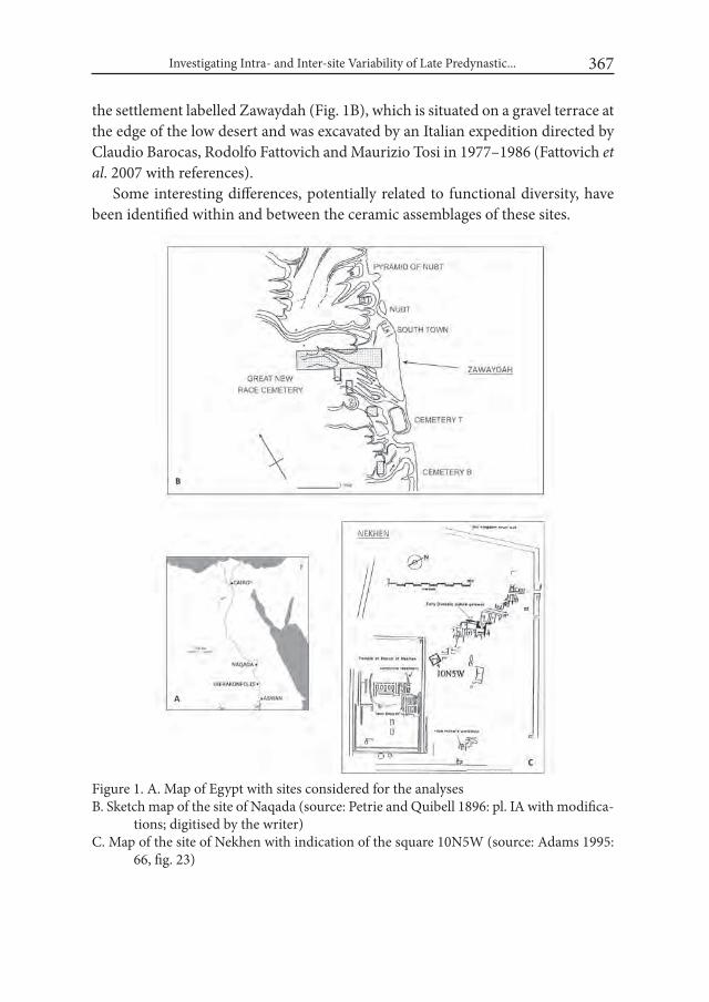
Investigating Intra- and Inter-site Variability of Late Predynastic... 367
the settlement labelled Zawaydah (Fig. 1B), which is situated on a gravel terrace at the edge of the low desert and was excavated by an Italian expedition directed by Claudio Barocas, Rodolfo Fattovich and Maurizio Tosi in 1977–1986 (Fattovich et al. 2007 with references).
Some interesting differences, potentially related to functional diversity, have been identified within and between the ceramic assemblages of these sites.
Figure 1. A. Map of Egypt with sites considered for the analysesB. Sketch map of the site of Naqada (source: Petrie and Quibell 1896: pl. IA with modifica-
tions; digitised by the writer)C. Map of the site of Nekhen with indication of the square 10N5W (source: Adams 1995:
66, fig. 23)
Grazia A. Di Pietro368
Details of the methods adopted, analyses performed, results and potential si-gnificance of this investigation are discussed in the following sections, along with some recommendations for future research.
1. Methods
1.1. Preliminary remarks Before detailing the methods used in this study, it is necessary to highlight
some of the assumptions and limitations of the present work.One of the key assumptions is that ceramic material was deposited relatively
near its primary area of use in both of the contexts taken into consideration. For Nekhen this assumption is based on the description of the relevant archaeological units and stratigraphic information provided by the excavator, while for Zaway-dah it is more problematic due to extensive disturbance suffered by the site. This issue is more extensively discussed below (see: Discussion).
The contexts examined from the two sites were excavated using slightly diffe- rent archaeological procedures. This disparity imposes caution on the interpreta-tion of the analyses conducted on their respective ceramic assemblages. However, the recovery techniques employed were quite similar6 and most of the ceramic samples have been re-examined by the writer using standard recording proce-dures.
Another problem relates to the fact that in different archaeological contexts the deposits might have undergone different formation processes, that, as far as the pottery is concerned, might result in different degrees of fragmentation (cfr. Schiffer 1996: 282–284). Any discrepancy concerning this aspect (i.e. an assem-blage being more broken than another) is considered to compromise the validity of results of comparisons between assemblages, especially when „sherd count”7
6 For Zawaydah, the archaeological deposit of the contexts considered here for the analyses was sieved. For Nekhen, at least two of the archaeological units examined (# 153 and # 156) derive from sieved deposits, while information on the collection strategy is missing for the third context (# 173).
7 As a measure of pottery quantification, the “rim sherd count” has been employed in the pre- sent study. Although more reliable measures exist (e.g. “estimated vessel equivalents” or EVES and “sherd weight” (Orton 1993: 175; Orton and Hughes 2013: 206–208), whose use is desi- rable especially when conducting inter-assemblage comparisons, for the assemblages studied here none of these methods could have been used consistently for practical reasons. Indeed, at least two of the most common pottery types (cfr. shape classes coded as 1-1b5 and 1-1o in
Investigating Intra- and Inter-site Variability of Late Predynastic... 369
is used as a measure of quantification (Orton and Hughes 2013: 35, 206–207). In order to test the comparability of the available pottery assemblages and before performing any analysis, the so called parameter of „brokenness” (defined as „the average number of sherds into which each pot in the assemblage has been broken”; Orton 1985: 114) was calculated8 and assessed for each of the samples. The levels of brokenness did not differ significantly across assemblages from distinct sectors at Zawaydah9 nor between the assemblages here considered for Zawaydah and Nekhen10. Therefore, this factor should not affect significantly results of the inter-assemblage comparisons conducted in this study11.
1.2. Establishing ceramic functional categories The ceramic material12 constituting the study sample, previously examined and
classified, was assigned to a series of broad functional categories13. Attributions to these categories and inferences about a plausible primary function for the shape classes identified were based on a set of criteria, ranging from a consideration of known morphotechnological characteristics (cfr. Rice 1987: 207–232) to sug- gestions and evidence of use discussed in previous studies on Predynastic ceram-ics (Friedman 1994: 240–262; Hendrickx 1994: 80–94; Hendrickx et al. 2002; Bu-
the Hierakonpolis system; Friedman 1994) have an elliptical orifice, so that no EVEs could have been calculated for them. Furthermore, since only diagnostic sherds were preserved for the assemblages under study, weight estimates would have been pointless.
8 The parameter of brokenness was calculated by using the formula “nos. sherds/EVEs”, devised by Orton (1985: 114). In particular, as “nos. sherds” all rim sherds deriving from concentric pottery types (i.e. excepting rim sherds with elliptical orifices; cfr. above) were considered. As for the “nos. EVEs” or “estimated vessel equivalents”, it was calculated as sum of rim-EVEs. The EVE value of a single rim-sherd, that represents the portion of the rim that survives of the vessel, was measured by means of a rim chart (cfr. Orton and Hughes 2013: 210), for example, the EVE value of a rim representing 25% of the original vessel orifice was expressed as 0.25.
9 The index of brokenness for the pottery deriving from four distinct sectors at Zawaydah ran- ges between 9.83 and 15.11. The lack of any statistically significant pattern in the data has been assessed via a T-test.
10 The overall level of brokenness of the pottery from ZWE (see further below) is similar to the level of brokenness of the pottery from Nekhen Structure 84-III (cfr. below). The pertinent values are 12.13 and 11.99 respectively.
11 Usually when conducting inter-assemblages comparisons a minimal assumption is made that “the relativities between the lifespans of different types remain constant between different but comparable assemblages”; Orton and Hughes 2013: 204.
12 Only data on rim sherds or vessels with reconstructible profiles was taken into account. 13 The main interest here has been on the function of the vessels as containers (cfr.: Rice 1987:
210), and not on their potential function as display items or, more generally, their symbolic meaning (cfr. Orton and Hughes 2013: 260–261).

Grazia A. Di Pietro370
chez 2004; Anderson 2006: 56–57, 59–61, table 4.2). These potential functional categories and the reasons for inclusion of the main ceramic shape classes in them are summarized below.
A. Vessels used for food preparation (with or without heat) Fig. 2, 1–2: two main shape classes have been included into this category, namely large basins with thick walls and rough shallow platters14. Considering their size and the strength provided by their walls, the former might have been used primarily as grinding or mixing bowls (cfr.: Rice 1987: 227; Friedman 1994: 243). For the latter a function as bread baking pans is usually suggested based on traces of soot and heat disco- loration which they sometimes show (Friedman 1994: 722; cfr. also Hendrickx et al. 2002: 296, Tab. 5, type R1g3).
B. Vessels mainly connected with food serving (Fig. 2, 3–8): a series of plat-ters and shallow bowls in a different array of fabrics have been included into this category15 (cfr. Fig. 2, 3–5). The relative shallowness that characterizes such ves-sels would have allowed their contents to be immediately visible and accessible, while their moderate size and weight would have favoured their handling and movement (cfr.: Rice 1987: 225–266; Friedman 1994: 243). Small and medium sized bowls made of marl or untempered Nile silt are generally considered serving vessels, because both their fabric and slipped and/or polished surfaces made them particularly resistant to breakage from impact (Friedman 1994: 257; Hendrickx 1994: 82). For this reason they are included in this category as well (Fig. 2, 6–8)16.
AB. Vessels for food preparation/serving (Fig. 2, 9–11): into this category a range of medium size bowls made of straw tempered Nile silt fabric with diverse shape profiles and surface treatments have been included17. Their unrestricted shape and limited size and weight hint at a serving function for them (cfr. above
14 These correspond to the subjective shape classes coded as 1-1n and 1-1o1 in the latest version of the Hierakonpolis system (Friedman 1994), to which the reader is referred for a full de-scription. Specific subtypes of the subjective classes 1-1b, 1-1g, 1-1h, 5-1g, 12-1h, but charac-terized by large diameter and thick walls have also been included into this functional category.
15 Pertinent subjective shape classes in the Hierakonpolis system are coded as 1-1b5 (characte- rized also by an elliptical orifice; cfr. Fig. 2, 3) and 5-1b2 (cfr. Fig. 2, 5); see Friedman 1994.
16 Remains from beakers, although they might have been mainly residual elements in the assem-blages under study, have been considered as having mainly a serving function when origina- ting from relatively small vessels (cfr. Friedman 1994: 262). They have been considered within the functional category of storage containers when originating from large vessels (cfr. Fried-man 1994: 641; Anderson 2006: 61).
17 Pertinent subjective shape classes in the Hierakonpolis system are coded as 1-1a, various sub-types of 1-1b (except for 1b2 and 1b5), 1-1f (Fig. 2, 9), 1-1e, 1-1g (Fig. 2, 10), 1-1h (Fig. 2, 11), 1-1j; cfr. Friedman 1994.
Investigating Intra- and Inter-site Variability of Late Predynastic... 371
category B)18. For bowls with a tronco-conical shape a function as bread moulds has also been suggested due to characteristics, such as their rough exterior, smoothed interior and relatively thick walls, considered typical of bread moulds (Hendrickx 1994: 91; cfr. also Wengrow 2006: 87–88, 94). The straw tempered fabric out of which these bowls were made would have been fit for the suggested purpose, since it is recognized as having good heat transfer and thermal shock resistance proper-ties (Friedman 1994: 258–260 and bibliography; Buchez 2004: 22)19.
C. Vessels mainly used for storage (both long-term and temporary) Fig. 2, 12–14: pithoi as well as large jars with a direct rim20 have been included into this class, mainly based on their morphology, which is suited for holding a variety of contents, as well as their size, which made them too heavy to be moved (cfr.: Rice 1987: 226; Friedman 1994: 244). The lack of a pronounced rim, that would have ensured tight closure, and the relatively wide orifice of the hole mouth jars sug-gests unsuitability for their use in transport. They are included in this category for this reason.
CD. Vessels used for storage/transportation (Fig. 2, 15–18): small and medium sized jars with modelled, everted or ledge rim, necked jars, as well as bottles21 might have served well in a storage function22, since their prominent rims and
18 It must be noted that bowls might have been used not only for food consumption, but also as lids for large containers.
19 It is interesting the fact that what appears to be later versions of these bowls, as observed by the writer within pottery from several desert settlement localities at Hierakonpolis, have a higher sand content in their fabric. Sand is known as a high thermal conductor (Friedman 1994: 260) and might potentially support the hypothesis that such vessels were used in con-nection with food processing with heat.
20 Pertinent subjective shape classes in the Hierakonpolis system are coded as 2n and 2a (cfr. Friedman 1994). Although here a primary storage function is suggested for these vessels, alternative uses are attested as well: e.g. in some specific contexts “pithoi” might have been used as vats in which beer was brewed (Friedman 1994: 656–657). Hole mouth jars made of straw tempered Nile silt (1-2a) might have also been used as cooking vessels; cfr. Buchez 2004: 22–24, 41, fig. 6; Friedman personal communication, May 2016.
21 Cfr. subjective shape classes coded as 2b (cfr. Fig. 2, 15), 2c (cfr. Fig. 2, 16), 2d (cfr. Fig. 2, 17), 2e (cfr. Fig. 2, 18), 2f, 2k in the Hierakonpolis system; cfr. Friedman 1994.
22 Empirical data on the storage function of at least one type of jar, that is a modelled rim jar with flat base made of straw tempered Nile silt fabric, exists; see: Baba 2009: 7.
On the other hand, it cannot be ruled out that some jars made of straw tempered Nile silt fabric and characterized by a large orifice, slight modelled rim and low shoulder (cfr. subjec-tive shape class 1-2b1 in the Hierakonpolis system) and, presumably, a conical bottom, might have also been used as cooking pots (cfr. Friedman 1994: 531), as suggested by a number of complete jars bearing evidence of soot staining from fire on their external surface, recovered at the Cemetery Hk43 at Hierakonpolis; Friedman personal communication, May 2016.
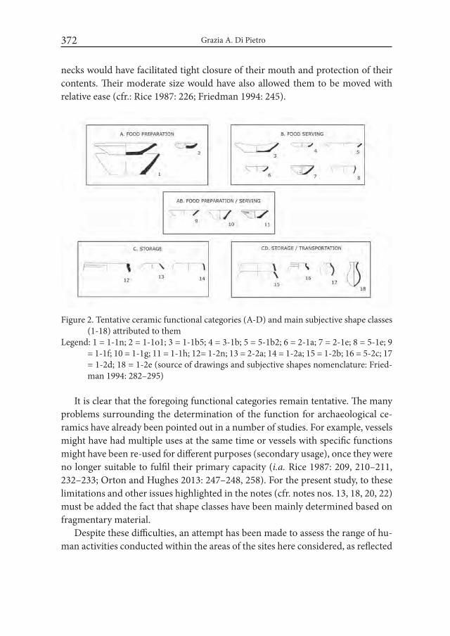
Grazia A. Di Pietro372
necks would have facilitated tight closure of their mouth and protection of their contents. Their moderate size would have also allowed them to be moved with relative ease (cfr.: Rice 1987: 226; Friedman 1994: 245).
It is clear that the foregoing functional categories remain tentative. The many problems surrounding the determination of the function for archaeological ce-ramics have already been pointed out in a number of studies. For example, vessels might have had multiple uses at the same time or vessels with specific functions might have been re-used for different purposes (secondary usage), once they were no longer suitable to fulfil their primary capacity (i.a. Rice 1987: 209, 210–211, 232–233; Orton and Hughes 2013: 247–248, 258). For the present study, to these limitations and other issues highlighted in the notes (cfr. notes nos. 13, 18, 20, 22) must be added the fact that shape classes have been mainly determined based on fragmentary material.
Despite these difficulties, an attempt has been made to assess the range of hu-man activities conducted within the areas of the sites here considered, as reflected
Figure 2. Tentative ceramic functional categories (A-D) and main subjective shape classes (1-18) attributed to them
Legend: 1 = 1-1n; 2 = 1-1o1; 3 = 1-1b5; 4 = 3-1b; 5 = 5-1b2; 6 = 2-1a; 7 = 2-1e; 8 = 5-1e; 9 = 1-1f; 10 = 1-1g; 11 = 1-1h; 12= 1-2n; 13 = 2-2a; 14 = 1-2a; 15 = 1-2b; 16 = 5-2c; 17 = 1-2d; 18 = 1-2e (source of drawings and subjective shapes nomenclature: Fried-man 1994: 282–295)
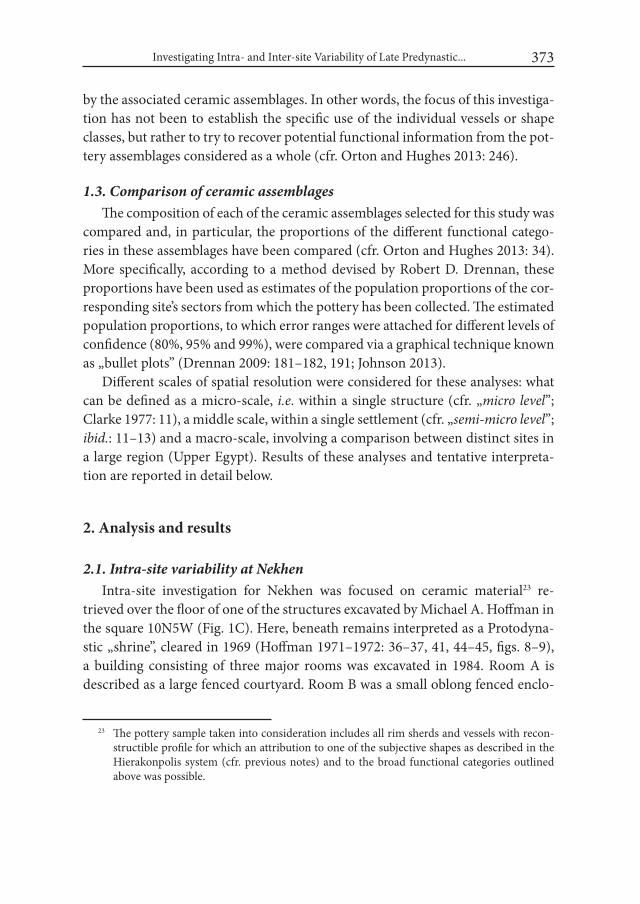
Investigating Intra- and Inter-site Variability of Late Predynastic... 373
by the associated ceramic assemblages. In other words, the focus of this investiga-tion has not been to establish the specific use of the individual vessels or shape classes, but rather to try to recover potential functional information from the pot-tery assemblages considered as a whole (cfr. Orton and Hughes 2013: 246).
1.3. Comparison of ceramic assemblagesThe composition of each of the ceramic assemblages selected for this study was
compared and, in particular, the proportions of the different functional catego-ries in these assemblages have been compared (cfr. Orton and Hughes 2013: 34). More specifically, according to a method devised by Robert D. Drennan, these proportions have been used as estimates of the population proportions of the cor-responding site’s sectors from which the pottery has been collected. The estimated population proportions, to which error ranges were attached for different levels of confidence (80%, 95% and 99%), were compared via a graphical technique known as „bullet plots” (Drennan 2009: 181–182, 191; Johnson 2013).
Different scales of spatial resolution were considered for these analyses: what can be defined as a micro-scale, i.e. within a single structure (cfr. „micro level”; Clarke 1977: 11), a middle scale, within a single settlement (cfr. „semi-micro level”; ibid.: 11–13) and a macro-scale, involving a comparison between distinct sites in a large region (Upper Egypt). Results of these analyses and tentative interpreta-tion are reported in detail below.
2. Analysis and results
2.1. Intra-site variability at NekhenIntra-site investigation for Nekhen was focused on ceramic material23 re-
trieved over the floor of one of the structures excavated by Michael A. Hoffman in the square 10N5W (Fig. 1C). Here, beneath remains interpreted as a Protodyna- stic „shrine”, cleared in 1969 (Hoffman 1971–1972: 36–37, 41, 44–45, figs. 8–9), a building consisting of three major rooms was excavated in 1984. Room A is described as a large fenced courtyard. Room B was a small oblong fenced enclo-
23 The pottery sample taken into consideration includes all rim sherds and vessels with recon-structible profile for which an attribution to one of the subjective shapes as described in the Hierakonpolis system (cfr. previous notes) and to the broad functional categories outlined above was possible.

Grazia A. Di Pietro374
sure on the western end of Room A and was considered to have functioned as an animal pen (Fig. 3). Room C was a rectangular shed which formed the southern end of the building and was defined by a mudbrick wall on its southern side, while on the north it joined the fenced courtyard (Room A). This complex was labelled collectively as „Structure 84-III”. It included a variety of domestic features such as ovens, pot basins and a possible grinding pit. A large number of potsherds and several reconstructable vessels were also found over its floor (Hoffman 1984: 5).
Figure 3. Plan of Structure 84-III (Rooms A and B) at Nekhen, square 10N5W (Courtesy: Hierakonpolis Expedition; digitised by Elli Petrocheilou)
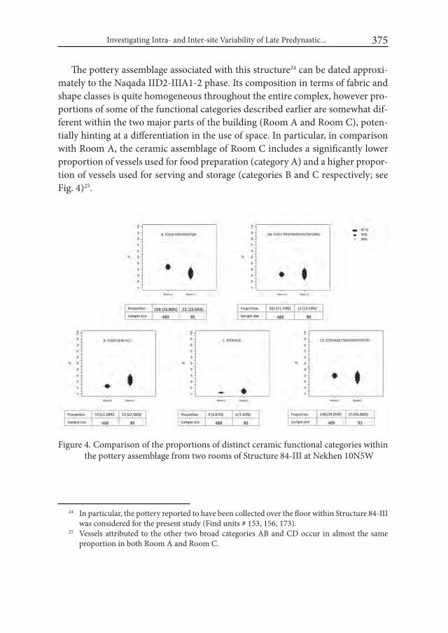
Investigating Intra- and Inter-site Variability of Late Predynastic... 375
The pottery assemblage associated with this structure24 can be dated approxi-mately to the Naqada IID2-IIIA1-2 phase. Its composition in terms of fabric and shape classes is quite homogeneous throughout the entire complex, however pro-portions of some of the functional categories described earlier are somewhat dif-ferent within the two major parts of the building (Room A and Room C), poten-tially hinting at a differentiation in the use of space. In particular, in comparison with Room A, the ceramic assemblage of Room C includes a significantly lower proportion of vessels used for food preparation (category A) and a higher propor-tion of vessels used for serving and storage (categories B and C respectively; see Fig. 4)25.
24 In particular, the pottery reported to have been collected over the floor within Structure 84-III was considered for the present study (Find units # 153, 156, 173).
25 Vessels attributed to the other two broad categories AB and CD occur in almost the same proportion in both Room A and Room C.
Figure 4. Comparison of the proportions of distinct ceramic functional categories within the pottery assemblage from two rooms of Structure 84-III at Nekhen 10N5W
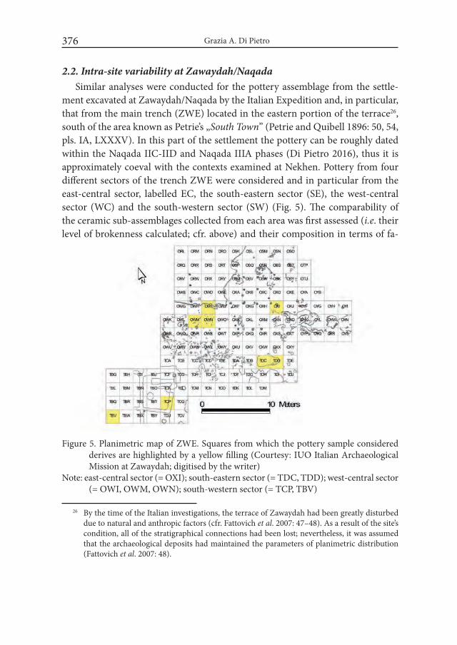
Grazia A. Di Pietro376
2.2. Intra-site variability at Zawaydah/Naqada Similar analyses were conducted for the pottery assemblage from the settle-
ment excavated at Zawaydah/Naqada by the Italian Expedition and, in particular, that from the main trench (ZWE) located in the eastern portion of the terrace26, south of the area known as Petrie’s „South Town” (Petrie and Quibell 1896: 50, 54, pls. IA, LXXXV). In this part of the settlement the pottery can be roughly dated within the Naqada IIC-IID and Naqada IIIA phases (Di Pietro 2016), thus it is approximately coeval with the contexts examined at Nekhen. Pottery from four different sectors of the trench ZWE were considered and in particular from the east-central sector, labelled EC, the south-eastern sector (SE), the west-central sector (WC) and the south-western sector (SW) (Fig. 5). The comparability of the ceramic sub-assemblages collected from each area was first assessed (i.e. their level of brokenness calculated; cfr. above) and their composition in terms of fa-
26 By the time of the Italian investigations, the terrace of Zawaydah had been greatly disturbed due to natural and anthropic factors (cfr. Fattovich et al. 2007: 47–48). As a result of the site’s condition, all of the stratigraphical connections had been lost; nevertheless, it was assumed that the archaeological deposits had maintained the parameters of planimetric distribution (Fattovich et al. 2007: 48).
Figure 5. Planimetric map of ZWE. Squares from which the pottery sample considered derives are highlighted by a yellow filling (Courtesy: IUO Italian Archaeological Mission at Zawaydah; digitised by the writer)
Note: east-central sector (= OXI); south-eastern sector (= TDC, TDD); west-central sector (= OWI, OWM, OWN); south-western sector (= TCP, TBV)
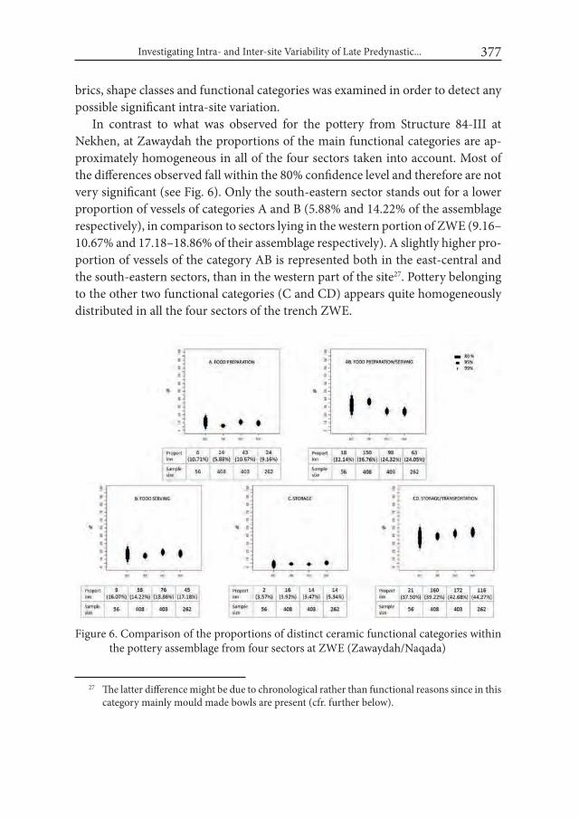
Investigating Intra- and Inter-site Variability of Late Predynastic... 377
brics, shape classes and functional categories was examined in order to detect any possible significant intra-site variation.
In contrast to what was observed for the pottery from Structure 84-III at Nekhen, at Zawaydah the proportions of the main functional categories are ap-proximately homogeneous in all of the four sectors taken into account. Most of the differences observed fall within the 80% confidence level and therefore are not very significant (see Fig. 6). Only the south-eastern sector stands out for a lower proportion of vessels of categories A and B (5.88% and 14.22% of the assemblage respectively), in comparison to sectors lying in the western portion of ZWE (9.16–10.67% and 17.18–18.86% of their assemblage respectively). A slightly higher pro-portion of vessels of the category AB is represented both in the east-central and the south-eastern sectors, than in the western part of the site27. Pottery belonging to the other two functional categories (C and CD) appears quite homogeneously distributed in all the four sectors of the trench ZWE.
27 The latter difference might be due to chronological rather than functional reasons since in this category mainly mould made bowls are present (cfr. further below).
Figure 6. Comparison of the proportions of distinct ceramic functional categories within the pottery assemblage from four sectors at ZWE (Zawaydah/Naqada)
Grazia A. Di Pietro378
2.3. Inter-site variability: Zawaydah/Naqada and NekhenThe general character of the ceramic assemblage from Zawaydah/Naqada was
further scrutinised by means of the same procedure detailed above. A specific research question was whether and to what extent this assemblage could be con-sidered an „ordinary domestic assemblage” or might have had a „special” com-position, also due to the fact that other artefactual remains (e.g. figurines and other miniatures, seals and clay sealings) found at the site of Naqada suggest that particular activities, administrative and ritual/ceremonial in nature, were taking place in the Late Predynastic period at the site (Di Pietro 2017). The pottery from Nekhen Structure 84-III, being nearly contemporaneous with the Naqada assem-blage and deriving from a context of domestic nature, provided an ideal chance for comparison and contrast, by which the nature of the assemblage from Naqada could be assessed.
When comparing the entire ceramic assemblage of the trench ZWE at Naqada with the ceramic material from the domestic building 84-III at Nekhen, an inte- resting diversity in terms of the proportions of functional categories emerges (see Fig. 7). The greatest difference between the two assemblages is in the proportion of vessels used for food preparation (category A), which is considerably higher in Structure 84-III (32.21% of the total assemblage), than at ZWE (8.59%). The other marked difference is the higher proportion of vessels of the category CD (storage/transportation) at ZWE, where they account for 41.54% of the total assemblage, in contrast to 29.36% in Structure 84-III. This difference might suggest a larger circulation of „goods” at ZWE, in comparison to a „domestic” context such as the one reflected by the assemblage of Structure 84-III. Finally, the assemblage at ZWE is characterized by a significantly higher proportion of vessels assigned to the broad category AB („preparation/serving vessels”; 29.14% of the total assem-blage), than the Structure 84-III assemblage (21.89%).
3. DiscussionThe analyses conducted on pottery assemblages from two discrete settlement
contexts of Late Predynastic-Protodynastic age and sub-assemblages within them, based on the comparison of proportions of distinct functional categories, let to discern potentially significant functional variability both at level of a single site and between sites.
As for Nekhen, the ceramic evidence related to Structure 84-III might sug-gest a diversification of spaces within this building and, in particular, a division
Investigating Intra- and Inter-site Variability of Late Predynastic... 379
Figu
re 7
. Com
paris
on o
f the
pro
port
ions
of d
istin
ct c
eram
ic fu
nctio
nal c
ateg
orie
s with
in th
e po
ttery
ass
embl
age
from
ZW
E (Z
a-w
ayda
h/N
aqad
a) a
nd S
truc
ture
84-
III a
t Nek
hen
Grazia A. Di Pietro380
into two major parts: one primarily designed for food preparation (Room A) and another where mainly activities connected with storage (and serving?) occurred (Room C)28. The architectural features of these two rooms would potentially fit the suggested functions: the former, being identified as an open area (a courtyard delimited by a shallow trench, which presumably once held a fence of organic materials), might have been suited for activities linked to food processing, espe- cially with heat. While Room C, being partially defined by a more permanent architecture (a mudbrick wall on its southern end), might have served well a sto- rage function or might have been a sort of utility-room for keeping vessels used in other areas. The suggested relationship between architecture and use of space requires further testing by means of a larger investigation. Furthermore, it cannot be excluded that other processes (e.g. refuse disposal patterns; cfr. Schiffer 1996: 281) might have produced the observed differences in pottery distribution.
At Zawaydah/Naqada, the lack of pronounced differences in the proportions of the various ceramic functional categories in the different areas of the trench ZWE might suggest that although a range of activities involving the use of diffe- rent types of pottery were being conducted at the site, none of them were clustered in any particular location. The possibility that disturbance might have blurred activity areas at the site must be also taken into account. However, the pattern of small finds indicates that the archaeological deposit at Zawaydah maintained the parameters of planimetric distribution to a certain degree, that is the archaeologi-cal materials did not move too far from the place where they were originally used and/or discarded (Di Pietro 2017).
Although the ceramic analyses did not provide any clear indication of intra-site functional variation within ZWE, the same type of approach on a larger scale proved useful in elucidating the character of the Naqada ceramic assemblage as a whole in comparison with coeval assemblages, such as the one from Nekhen Structure 84-III29. In contrast to the latter, the composition of the pottery assem-blage at Zawaydah suggests lower levels of food production, especially that invol- ving the use of rough and shallow platters (included in the functional category A;
28 The interpretation of Room B as an animal pen was suggested by M. A. Hoffman and was based on other sets of criteria (presumably faunal material and dung remains found at this spot).
29 Besides the ceramic assemblage from Nekhen Structure 84-III, assemblages from other settle-ment localities at Hierakonpolis (e.g. Hk25, Hk29A) have also been compared with the as-semblage from Naqada. This larger investigation reveals further differences in the composi-tion of the examined assemblages, which deserve separate discussion for the complexity of the subject.
Investigating Intra- and Inter-site Variability of Late Predynastic... 381
cfr. above) and a higher level of goods movement by means of middle / small sized jars (included in the category CD).
The third major element that distinguishes the composition of the ceramic assemblages under study, that is the functional category AB which occurs in higher frequency at ZWE, deserves further discussion. At both ZWE and within Structure 84-III the major component of the category AB consists of a particular type of tronco-conical bowls made of straw tempered Nile silt fabric30, for which a function as „bread moulds” is suggested by some scholars (cfr. above). This spe-cific shape class is also characterized by a relatively standardized size31 and an un-treated exterior surface bearing straw impressions, which suggest a manufacture by means of a straw filled mold32. This type of pottery has an intriguing similarity33 with what are known as „bevelled-rim bowls”, which are found in several admi- nistrative and temple contexts in Mesopotamia and surrounding regions (Middle-Late Uruk, c. IV mill. BC) and are supposed to have been employed to distribute alimentary rations, meals or bread to workers dependent on a centralized insti-tution (Goulder 2010: 355 with references). It is also remarkable that the con-text of recovery of this type of vessels at the Naqada settlement parallels one of the commonest location where bevelled rim bowls are found in the Near East,
30 Cfr: subjective shape classes coded as 1-1b6, 1-1f (Fig. 2, 9), 1-1g (Fig. 2, 10), 1-1h (Fig. 2, 11) in the Hierakonpolis system; Friedman 1994.
31 The mean values of rim diameter and height of these bowls range between 12.5 x 5.5 cm, cal-culated for the assemblage of ZWE, and 15 x 6 cm, calculated for the assemblage of Structure 84-III.
An attempt has been done to assess the variability of the rim diameter (the only measurement variable that could be recorded consistently across the ceramic assemblages examined) of dif-ferent categories of vessels by means of the “coefficient of variation” (see: Orton and Hughes 2013: 147-148). Rim diameters of the bowls under discussion resulted to have a lower coef-ficient of variation (i.e. to be more standardised), than rim diameters of other categories of vessels in the assemblages under study.
32 The shape of the rim of these bowls can be direct, slight everted, modelled or ledge.33 Besides the analogous type of manufacture by the means of a mould, some other features
which are common to both the bowls under discussion and the so called “bevelled-rim bowls” are: a heavy organic tempered fabric, straight sides and flat base, relatively thick walls, crin-kled exterior vs. smooth interior surface (cfr.: Goulder 2010: 354, table 2). As far as the size is concerned, a close comparison between the Predynastic rough mould made bowls and the bevelled-rim bowls is arduous due to the very few vessels with reconstructible profile available in our sample and, on the other hand, the high variability of the bevelled-rim bowls size (Goulder 2010: 355 and bibliography). In general, if we consider only the measurements of the large corpus of bevelled-rim bowls from Susa and Khuzistan, published by Gregory A. Johnson in 1973 (Johnson 1973: 189-195), one could suggest tentatively that the Predynas-tic mould made bowls fall in the lower end of the bevelled-rim bowls’ size range.

Grazia A. Di Pietro382
i.e. administrative buildings (Goulder 2010: 356, table 3, 359): according to the evidence provided by the small finds, at ZWE a sort of administrative-ritual/ceremonial complex might have stood (Di Pietro 2017). Based on these analo-gies and the different composition with respect to other coeval and functionally different contexts (cfr. above: Structure 84-III), the hypothesis that the Naqada assemblage could reflect to some degree administrative activities performed at the site, with the very high proportion of mould-made vessels potentially relat-ed to some kind of re-distribution (of local resources in form of meals?), is here suggested34.
However, the possibility that also other factors (e.g. chronology, amongst o- thers35) might have contributed to the distinctive composition of the ceramic as-semblage at Naqada cannot be completely discarded. In particular, certain types of pottery, including the aforementioned mould made bowls, tend to increase in frequency over time, as part of general developments of pottery production du- ring the Late Predynastic – Protodynastic period (cfr. Di Pietro 2012: 13).
ConclusionThe study presented here, based on archaeological pottery assemblages of
coeval or nearly coeval contexts and analyses of their composition by means of quantitative methods, has allowed to identify subtle and potentially significant variation at intra- and inter-site level in two major settlements of the Late Pre-dynastic – Protodynastic phase. These are suggested to elucidate the use of space across a site, at least at a micro-scale level (cfr. Structure 84-III at Nekhen), and inter-site differentiation and to be relevant for improving our knowledge of socie- tal organisation in the period under study.
On the other hand, it is acknowledged that in order to further advance our understanding of functional variability of settlements, in Egypt as well as in other regions, the use of more sophisticated analytical techniques (e.g. analyses of ar-tefacts and ecofacts integrated by chemical analyses of soil matrices; cfr. Wilson et al. 2008) are required. Visible and invisible residue analyses or systematic use-wear studies (Skibo 2013; Rice 2015: 425–431 with references) are also desirable
34 This suggestion does not exclude the possibility that in other contexts the same type of bowls might have served other functions.
35 Factors affecting variability of archaeological ceramic assemblages are reviewed in Rice 1987: 300–301; 2015: 218–219. Cfr. also Orton and Hughes 2013: 264.
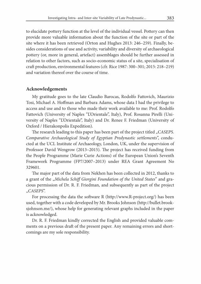
Investigating Intra- and Inter-site Variability of Late Predynastic... 383
to elucidate pottery function at the level of the individual vessel. Pottery can then provide more valuable information about the function of the site or part of the site where it has been retrieved (Orton and Hughes 2013: 246–259). Finally, be-sides considerations of use and activity, variability and diversity of archaeological pottery (or, more in general, artefact) assemblages should be further assessed in relation to other factors, such as socio-economic status of a site, specialisation of craft production, environmental features (cfr. Rice 1987: 300–301; 2015: 218–219) and variation thereof over the course of time.
AcknowledgementsMy gratitude goes to the late Claudio Barocas, Rodolfo Fattovich, Maurizio
Tosi, Michael A. Hoffman and Barbara Adams, whose data I had the privilege to access and use and to those who made their work available to me: Prof. Rodolfo Fattovich (University of Naples “L’Orientale”, Italy), Prof. Rosanna Pirelli (Uni-versity of Naples “L’Orientale”, Italy) and Dr. Renee F. Friedman (University of Oxford / Hierakonpolis Expedition).
The research leading to this paper has been part of the project titled „CASEPS. Comparative Archaeological Study of Egyptian Predynastic settlements”, condu- cted at the UCL Institute of Archaeology, London, UK, under the supervision of Professor David Wengrow (2013–2015). The project has received funding from the People Programme (Marie Curie Actions) of the European Union’s Seventh Framework Programme (FP7/2007–2013) under REA Grant Agreement No 329601.
The major part of the data from Nekhen has been collected in 2012, thanks to a grant of the „Michela Schiff Giorgini Foundation of the United States” and gra-cious permission of Dr. R. F. Friedman, and subsequently as part of the project „CASEPS”.
For processing the data the software R (http://www.R-project.org/) has been used, together with a code developed by Mr. Brooks Johnson (http://bullet.brook-sjohnson.me/), whose help for generating relevant graphs included in the paper is acknowledged.
Dr. R. F. Friedman kindly corrected the English and provided valuable com-ments on a previous draft of the present paper. Any remaining errors and short-comings are my sole responsibility.
Grazia A. Di Pietro384
REFERENCESADAMS, B. 1995. Ancient Nekhen: Garstang in the City of Hierakonpolis (= Egy-
ptian Studies Association 3). Surrey.ANDERSON, D. A. 2006. Power and competition in the Upper Egyptian Predyna-
stic: A view from the Predynastic settlement at el-Mahâsna. Ph.D dissertation, University of Pittsburg. University Microfilms International. Ann Arbor.
BABA, M. 2009. Pottery production at Hierakonpolis during the Naqada II pe-riod: Toward a reconstruction of the firing technique. British Museum Stu- dies in Ancient Egypt and Sudan 13: 1–23.
BAROCAS, C., FATTOVICH, R. and M. TOSI. 1989. The Oriental Institute of Naples Expedition to Petrie’s South Town (Upper Egypt), 1977–1983: an interim report. In: L. Krzyżaniak and M. Kobusiewicz (eds.), Late Prehi- story of the Nile basin and the Sahara. (= Studies in African Archaeology 2): 295–301. Poznań.
BUCHEZ, N. 2004. Le vases à cuire à l’époque prédinastique à el Adaïma: aspects techniques, économiques et culturels. Cahiers de la céramique égyptienne 7: 15–43.
CHŁODNICKI, M., CIAŁOWICZ, K. M. and A. MĄCZYŃSKA (eds.). 2012. Tell el-Farkha 1. Excavations 1998–2011. Poznań – Kraków.
CLARKE D. L. (ed.). 1977. Spatial archaeology. London.DI PIETRO, G. A. 2012. Nekhen 10N5W Revisited: Charting Ceramic Changes.
Nekhen News 24: 13–14.DI PIETRO, G. A. 2017. Beyond the bounds of domestic life? Naqada: Aspects of
the settlement in the Middle-Late 4th millennium BC. In B. Midant-Rey-nes, Y. Tristant and E. M. Ryan (eds.), Egypt at its Origins 5. Proceedings of the Fifth international Conference “Origin of the State. Predynastic and Early Dynastic Egypt”, Cairo, 13th – 18th April 2014 (= Orientalia Lovaniensia Analecta 260): 145–163. Leuven – Paris – Bristol, CT.
DI PIETRO, G. A. 2016. Upper Egyptian Pre- / Proto-dynastic settlement cera-mics. The assemblage from Petrie’s ‘South Town’ at Naqada. In: B. Bader, C. M. Knoblauch and E. C. Köhler (eds.), Vienna 2 – Ancient Egyptian Ce-ramics in the 21st Century. Proceedings of the international Conference held at the University of Vienna, 14th-18th of May, 2012 (= Orientalia Lovanien-sia Analecta 245): 179−190. Leuven − Paris − Bristol, CT.
DRENNAN, R. D. 2009. Statistics for Archaeologists: a Common Sense Approach. Second Edition. New York.
Investigating Intra- and Inter-site Variability of Late Predynastic... 385
FATTOVICH, R., MALGORA, S., PIRELLI, R. and M. TOSI. 2007. Explorations at South Town by the Naples Oriental Institute (1977–1986). In: H. Hanna (ed.), The international conference on heritage of Naqada and Qus region. Monastery of the Archangel Michael, Naqada, Egypt 22–28 January 2007. Preprints. Vol. I: 46–56. Cairo.
FRIEDMAN, R. F. 1994. Predynastic settlement ceramics of Upper Egypt: A com-parative study of the ceramics of Hemamieh, Nagada, and Hierakonpolis. PhD. dissertation, University of California, Berkeley. University Microfilms International. Ann Arbor.
GOULDER, J. 2010. Administrators’ bread: an experiment-based re-assessment of the functional and cultural role of the Uruk bevel-rim bowl. Antiquity 84: 351–362.
HENDRICKX, S. 1994. Elkab V. The Naqada iii Cemetery (= Publications du Co-mité des fouilles belges en Egypte). Bruxelles.
HENDRICKX, S., FALTINGS, D., OP DE BEECK, L., RAUE, D. and C. MI- CHIELS. 2002. Milk, Beer and Bread Technology during the Early Dyna- stic Period. Mitteilungen des Deutschen Archäologischen instituts, Abteilung Kairo 58: 277–304.
HOFFMAN, M. A. 1971–1972. Occupational Features at the Kom el Ahmar. Pre-liminary Report on the First Two Seasons at Hierakonpolis, Part III. Jour-nal of the American Research Center in Egypt, New York 9: 35–47.
HOFFMAN, M. A. 1984. Review of the archaeological stratigraphy uncovered in 1984 at Nekhen. Unpublished report.
HOFFMAN, M. A. 1986. A preliminary report on 1984 excavations at Hierakon-polis. Newsletter of the American Research Center in Egypt 132: 3–9.
HOFFMAN, M. A. 1989. A stratified Predynastic sequence from Hierakonpolis (Upper Egypt). In: L. Krzyżaniak and M. Kobusiewicz (eds.), Late Prehi- story of the Nile basin and the Sahara. (= Studies in African Archaeology 2): 317–323. Poznań.
JOHNSON, B. K. 2013. Bullet Builder Manual. A utility script for creating bullet graphs in R.
JOHNSON, G. A. 1973. Local Exchange and Early State Development in South-western iran. University of Michigan, Museum of Anthropology, Anthro-pological Papers 51.
KOPP, P. 2006. Elephantine XXXii. Die Siedlung der Naqadazeit (= Archäolo-gische Veröffentlichungen, Deutsches Archäologisches Institut, Abteilung Kairo 118). Mainz am Rhein.

Grazia A. Di Pietro386
MIDANT-REYNES, B. and N. BUCHEZ (eds.). 2014. Tell el-iswid 2006–2009. (= Fouilles de l’Institut français d’archéologie orientale 73). Cairo.
MILLETT, M. 1979. An approach to the functional interpretation of pottery. In: M. Millett (ed.), Pottery and the Archaeologist (= Institute of Archaeology Occasional Publications, 4): 35–48. London.
ORTON, C. 1985. Two useful parameters for pottery research. In: E. Webb (ed.), Computer Applications in Archaeology 13: 114–120. London.
ORTON, C. 1993. How many pots make five? An historical review of pottery quantification. Archaeometry 35, 2: 169–184.
ORTON, C. and M. HUGHES. 2013. Pottery in Archaeology, Second edition (= Cam- bridge Manuals in Archaeology). Cambridge.
PETRIE, W. M. F. and J. E. QUIBELL. 1896. Naqada and Ballas (= British School of Archaeology in Egypt 1). London.
RICE, P. M. 1987. Pottery Analysis: A Sourcebook. Chicago. RICE, P. M. 2015. Pottery Analysis: A Sourcebook. Second Edition. Chicago. SCHIFFER, M. B. 1996. Formation Processes of the Archaeological Record. Salt
Lake City.SKIBO, J. M. 2013. Understanding Pottery Function (= Manuals in archaeological
method, theory and technique). New York. TRISTANT, Y. 2004. L’habitat prédynastique de la vallée du Nil: Vivre sur les rives
du Nil aux Ve et iVe millénaires (= BAR International Series 1287). Oxford. WENGROW, D. 2006. The Archaeology of Early Egypt: Social Transformations in
North-East Africa, 10,000–2650 BC. (= Cambridge World Archaeology Se-ries). Cambridge.
WILSON, C. A., DAVIDSON, D. A. and M. S. CRESSER. 2008. Multi-element soil analysis: an assessment of its potential as an aid to archaeological inter-pretation. Journal of Archaeological Science 32(2): 412–424.
http://bullet.brooksjohnson.me/http://www.hierakonpolis-online.org/index.php/explore-the-predynastic-settle-
menthttp://www.R-project.org/
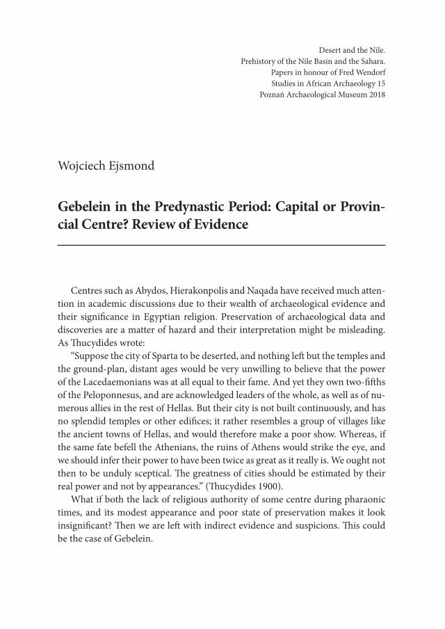
Desert and the Nile. Prehistory of the Nile Basin and the Sahara.
Papers in honour of Fred Wendorf Studies in African Archaeology 15
Poznań Archaeological Museum 2018
Wojciech Ejsmond
Gebelein in the Predynastic Period: Capital or Provin-cial Centre? Review of Evidence
Centres such as Abydos, Hierakonpolis and Naqada have received much atten-tion in academic discussions due to their wealth of archaeological evidence and their significance in Egyptian religion. Preservation of archaeological data and discoveries are a matter of hazard and their interpretation might be misleading. As Thucydides wrote:
“Suppose the city of Sparta to be deserted, and nothing left but the temples and the ground-plan, distant ages would be very unwilling to believe that the power of the Lacedaemonians was at all equal to their fame. And yet they own two-fifths of the Peloponnesus, and are acknowledged leaders of the whole, as well as of nu-merous allies in the rest of Hellas. But their city is not built continuously, and has no splendid temples or other edifices; it rather resembles a group of villages like the ancient towns of Hellas, and would therefore make a poor show. Whereas, if the same fate befell the Athenians, the ruins of Athens would strike the eye, and we should infer their power to have been twice as great as it really is. We ought not then to be unduly sceptical. The greatness of cities should be estimated by their real power and not by appearances.” (Thucydides 1900).
What if both the lack of religious authority of some centre during pharaonic times, and its modest appearance and poor state of preservation makes it look insignificant? Then we are left with indirect evidence and suspicions. This could be the case of Gebelein.
Wojciech Ejsmond388
Gebelein is an archaeological site complex located about 28 km south-west of Luxor on the west bank of the Nile. The current Arabic name el-Gabalein (‘two hills’) has the same meaning as the ancient name of the place – Inerti. The two mounts formation dominates the area, running from north to south. This raised massif is furrowed by numerous peaks and valleys. It is a place of great strategic value. The two hills enable control of the navigation on the Nile as well as land routes connecting the valley with the oasis of the western desert and along the river. It is possible to go directly from Gebelein to Hierakonpolis, Naqada, Hiw and Abydos/This by valley and desert routes (Fig. 1).
The western mount comprises of a stone quarry, rock-cut tombs, remnants of mastabas, numerous shafts and pits with burials dating to different periods. At
Fig. 1. Location of Gebelein, other main centres and ruts mentioned in the paper (made by W. Ejsmond)

Gebelein in the Predynastic Period: Capital or Provincial Centre? Review of Evidence 389
the top of the eastern mount, a temple of Hathor once stood and the city of Per-Hathor (Pathyris in Ptolemaic times) was located on its western slope down to the area between the two hills. This mount is also the location of burials and other archaeological features (Ejsmond 2016: 15-19).
At Gebelein there are sites representing all periods of Egyptian history. The place played an important role in ancient times. Strategically located stronghold, an important administrative (capital of the Pathyrite nome during the Ptolemaic Period, till c. 88 BC) and trade centre was located at Gebelein – inhabited by Egyptians, Nubians and Greeks (Fiore-Marochetti 2013). It is a matter of some controversy whether or not rulers of some local proto-state were buried in the local necropolis during the Predynastic Period (Cervelló Autori 1996; Wilkinson 2000; Campagno 2002; Ejsmond 2015). This may suggest that an early state capital was situated in the area.
Recently, new archaeological field works has been initiated at Gebelein, which resulted in the acquisition of new data (Ejsmond 2013; Ejsmond et al. 2015a; Ejs-mond et al. 2015b; Ejsmond et al. 2018). Studies on artefacts which came or are said to come from Gebelein also shed a new light on this place (Ejsmond 2015; 2016). Therefore, the aim of the paper is to present results of the recent studies and discuss relevance of Gebelein in the context of early history of ancient Egypt.
1. State of researchThere is an awareness of the general processes such as changes of settlement
pattern (Mortensen 1991), development of social stratification (Castillos 1998; Wengrow 2006) and regional differentiation of the material culture in the Naqada complex (Holmes 1989; Friedman 1994; Köhler 2014). There are some written sources referring to that times like the Palermo Stone (Wilkinson 2000), preserved fragments and extractions from Aegyptiaca by Manetho, but they are not very in-formative or reliable. In recent times, there is a development in archaeology of the Predynastic Period in Upper Egypt. There were some new surveys in southern Egypt, like Moalla area (Manassa 2011), Naqada region (Tassie et al. 2012), the Aswan – Kom Ombo Archaeological Project (Gatto et al. 2009) and archaeologi-cal missions are working at Hierakonpolis (Friedman 2011), El-Qab (Claes et al. 2014) and Abydos (Dreyer 2011), to name just the most important sites.
Archaeology of Egypt in the Predynastic Period is in large part the archaeology of necropoleis. New researches in the Delta changed this disproportion of sources and more data are available from settlements, e.g. Tell el-Farkha (Ciałowicz 2011),

Wojciech Ejsmond390
Buto (Hartung et al. 2009), and Tell Ibrahim Awad (van Haarlem 2000). Still, the analyses of tombs and graveyards are the prime source of information on social and political processes that took place in the Nile valley, especially in the Upper Egypt. Spatial distribution of large and richly furnish tombs, sometimes with ele-ments of royal iconography, provides information on locations of the most impor-tant cemeteries where the local elites and rulers were buried (Kaiser and Dreyer 1982; Wilkinson 1996; 2000). It is generally believed that there were three main centres with necropoleis of royal character – Hierakonpolis, Naqada and Abydos (e.g. Bard 2015: 113-114). It is thought that there was an ephemeral proto-state with its capital near Hiw (Kaiser and Dreyer 1982: 242-245; Hikade 2010). Ge-belein was a place of research of many scholars, who were more interested in the pharaonic times and the results of their excavations of dynastic as well as Predy-nastic sites were barely published (e.g. Fraser 1893; Steindorff 1901; Schiaparelli 1921; Farina 1929, 1937; Bergamini 2005). The sites of Hierakonpolis, Naqada and Abydos were excavated at the end of the 19th century and very beginning of the 20th century. Archaeologists came back to these sites later on. Recent researches at Hierakonpolis and Abydos produced many extraordinary discoveries, which furthered our understanding of early Egyptian history (Friedman 2011; Dreyer 2011) and there is ongoing research on earlier acquired materials from Naqada (Tassie et al. 2012).
Gebelein is the least known of such important centres in Upper Egypt. The place was the subject of research for several scholars who were excavating its Pre-dynastic sites 1. Unfortunately, they did not publish any sufficient account of their works. Existing publications are extremely general. Usually, they do not contain any illustrations, plans, drawings and sufficient descriptions of the locations of the excavations what makes them difficult to understand even with a good knowledge of Gebelein’s topography. Due to lack of publications of the results of previous works the site complex is poorly known and often neglected in studies on early history of ancient Egypt and therefore possibly underestimated. Both necropoleis and settlements are found at Gebelein what make the area significant for research on both kinds of sites. Its location among Hierakonpolis, Naqada, Hiw and Aby-dos-This makes it crucial in the understanding of the Predynastic Period.
1 For reconstruction of earlier works see: Ejsmond 2013, and for the most important accounts of the excavations of the Predynastic sites see: Anonymous 1930; 1935; 1937; Lortet and Gail-lard 1909: 229-230; Budge 1920: 359.
Gebelein in the Predynastic Period: Capital or Provincial Centre? Review of Evidence 391
The opinions concerning significance of Gebelein can be summarise by pre-senting two main point of view. For example, Toby Wilkinson (Wilkinson 2000) is close to see Gebelein as an independent political centre in contrast to Josep Cervelló Autori (Cervelló Autori 1996; Campagno 2002: 56-57). The latter scholar suggests that there is no evidence for the existence of powerful local elite, which would rule from Gebelein independently and the Gebelein linen should be con-sider as a result of influence from Hierakonpolis and not as an expression of power of an independent, local ruler. It must be noted that many objects from Gebelein have not been published yet, as well as results of previous excavations and the topography of the centre is poorly known in the literature. In effect Predynastic Gebelein is often unjustly ignored in discussions (see for example: Bard 2015: 113-114; Kemp 2006, 74-78). Therefore, the current research was launched.
2. Archaeological Sites at Gebelein Several Pre – and Early Dynastic sites are located at Gebelein. They are con-
centrating in two areas (Fig. 2). The first group is the best recognise one in terms
Fig. 2. Location of archaeological sites at Gebelein (base map by J. Chyla, locations of the sites by W. Ejsmond)

Wojciech Ejsmond392
of archival data as well as current archaeological surveys. It is located at the north-ern slope and foothill of the western mount. It is hard to say whether or not there was one large necropolis running along the slope or several small ones. In the un-published field journal by Virginio Rosa, who was conducting the field research in 1911 for Ernesto Schiaparelli, there are some information on Predynastic cemeter-ies on the north-eastern and north-western corners of the western mount (Rosa 1911: 25-26 and 56; B and D in Fig. 2). Unfortunately, there is no detailed descrip-tion of the sites and findings2. Between those two cemeteries there was another necropolis, used during Naqada I and possibly later as well, now completely de-stroy (Ejsmond and Chyla in press; Ejsmond et al. 2018; Ejsmond 2013); C in Fig. 2). Preserved documentation and publications are not very specific about the site. Circa 300 skeletons have been excavated there and sent to Turin during just one season (Marro 1929; Donadoni Roveri 1990: 25). In this area, the famous ‘Gebelein linen’ was found (Ejsmond 2013: 39). Northern foothill of the western mountain is subject to expansion of the el-Gherira settlement, which has already destroyed the northern limits of the burial grounds. Therefore, it is impossible to establish the northern extent of the cemeteries and determine if they are close enough to each other to consider them as one large necropolis comprising smaller group of tombs.
Such density of burials indicates that some settlements should be located in the vicinity. Indeed, Predynastic settlement, ‚of which the stratum of ashes remains’, has been mentioned north from the slope of this mound (Donadoni Roveri 1990: 23; Schiaparelli 1921; Rosa 1911: 25-26) (A? in Fig. 2). In more less the same area, a kom is located on the late 18th century map (Jacotin 1826: pl. 5) but there is no information on its dating. In pharaonic times, a town of Sumenu, where the god Sobek was worshipped, was located north from the western mountain. Unfortu-nately, there is no evidence on the exact location of Sumenu in such early period. The earliest attested instances of the deity related to Sumenu and the name itself is an Early Dynastic Period3 inscription from Saqqara4. Therefore, Sumenu existed
2 Preliminary analysis of the pottery from the cemetery on the western corner of the mount indicates the Naqada III dating of the site. Pottery collected from eastern corner of the mount is dated to Naqada I-III.
3 Crocodiles occur in many times in early inscriptions but it is difficult to say if such depictions refer to animal, god or name of a place, see: Regulski 2010: 130; Kaplony 1963: e.g. Abb. 48, 339, 910.
4 Tomb 3121 (Emery 1953: 116-120, but image and description are not published there. Drawl-ing of the artefact and inscription in Kaplony 1963: Taf. 150, no 865). The inscription men-tions Sobek and ima tree – the sacred plant of Sobek lor of Sumenu (for Sobek and ima tree

Gebelein in the Predynastic Period: Capital or Provincial Centre? Review of Evidence 393
already in such early time, possibly even earlier, and it can be speculated that aforementioned cemeteries were the burial grounds of people from Sumenu.
The second group of archaeological sites is located between eastern and west-ern mountain (Ejsmond 2013: 39-41). This area has been heavily damaged and only small part of a cemetery located at the eastern foothill of the western mount survived until today (E in Fig. 2). According to a very general statement by Jaques de Morgan (J. de Morgan 1907: 41-42), there was a cemetery dated to the Pre-dynastic times at the eastern foot of the western mountain (opposite location of ancient Pathyris) and Predynastic pottery acquired by the Cairo Museum at the end of the 19th century proably came from this place. It represents white-lined and decorated wears5. It is possible that the still existing part of the necropolis is the last surviving evidence on the location of the Predynastic burial ground. It is also likely that the well-preserved natural mummies discovered by Alfred Wallis Budge were found somewhere in this area (Ejsmond 2013: 40). Concentration of Predynastic rock arts has been discovered south from the cemetery (F in Fig. 2). It comprises of dipinti and graffiti showing animals, e.g. gazelles, giraffes, dogs etc. Jacques de Morgan mentioned some Predynastic settlement opposite the cem-etery on the western foothill of the eastern mountain (G in Fig. 2). In pharaonic times, the town of Per-Hathor (in Greek Pathyis) was located there and a lime-stone block dated to late Early Dynastic Period was found there by the Italian Mis-sion (Curto 1953). Second limestone block of unknown provenience was attribut-ed to Gebelein on the basis of the material used and similarity of execution to the aforementioned one (Stevenson Smith 1949: 137). Partly preserved scenes were depicted on both, probably showing ritual of temple foundation (Morenz 1994). Similar distribution of archaeological sites in this part of Gebelein is presented by Louis Lortet and Claude Gaillard (1909: 34, 225-226). They also mentioned that predynastic burials occur at the north-western foot of the eastern mountain, under the pharaonic settlement of Per-Hathor.
Henri de Morgan, who visited Gebelein during his survey of this part of Egypt in 1907, mentioned that he found two Predynastic settlements at Gebelein, but he did not gave any description of their location (H. de Morgan 1912: 49; Needler 1984: 70). Therefore, it is unknown whether or not he was referring to abovemen-tioned settlements.
see: Kuentz 1929: 157-158). 5 E.g. JE 26531, 25633, 26528.

Wojciech Ejsmond394
3. Selected Findings Several important artefacts came or are said to come from Gebelein (Fig. 3).
The Gebelein linen is the best known of them and its provenance is certain (A in Fig. 3). It was found in a tomb in the northern burial ground, next to some hu-man body and is dated to Naqada Ic-IIa period on stylistic grounds (Adams and Ciałowicz 1988: 36). Depictions of boat procession with a person in a crown is suggestive of its royal nature. An analogical depiction was painted in the Deco-rated Tomb at Hierakonpolis. The grave is dated to the Naqada IIc and is inter-preted as a burial of a local, Hierakonpolitan king (Huyge 2014: 93). By similarity
Fig. 3. Selected findings from Gebelein: A – Gebelein linen (Turin supp. 17138); B – lion figurine (Berlin 22440); C – fishtail knife with golden handle (Cairo CG 34210); D – two stone knives (Lortet and Gillard 1909: 167-168)
Gebelein in the Predynastic Period: Capital or Provincial Centre? Review of Evidence 395
of the depictions, both artefacts could be considered as elements of a furnishing of a ruler’s tombs, since they bear elements of royal iconography or, as Bruce Wil-liams and Thomas Logan calls it ‘early pharaonic cycle’ (Williams et al. 1987). It can be suggested that the northern necropolis at Gebelein (C in Fig. 2) was the elite cemetery where, among other elite members, local rulers had their burials.
A set of artefacts was acquired by James Quibell in 1900 from an antiquity dealer in Qena, who said that it came from Gebelein (Quibell 1901). It consists of several stone knives, wooden staff with gazelles in a row6, decorated pot and one fragment of furniture in the shape of bull’s/cow’s leg, probably part of some bed or chair. There is some controversy concerning the authenticity of a golden handle of one of the knives (Aksamit 1989). This knife (C in Fig. 3) requires comments due to its shape and the decoration of its handle. The flint blade is in a fish-tail form. Such instruments are said to be predecessors of psš-kf knifes used during the opening of the mouth ceremony (van Walsem 1979). Decoration of the handle shows a navigation scene, which is typical for the decorated pottery known from the funerary context. It is thought that the scenes with boats are related with the beliefs concerning afterlife (Graff 2009: 121). Therefore, the connection of the af-terlife scene with the knife related with the funerary ritual is very interesting. The whole set seems to be genuine and should be dated to late Naqada II or early Naqada III period. It has been proposed that the set could be interpreted as fur-nishing of some local ruler’s tomb (Ejsmond 2015).
Two stone knives (47 and 55cm long) has been acquired by Louis Lortet and Claude Gaillard from a local person during their excavations at Gebelein (D on Fig. 3). Handles of both artefacts are ornamented by depictions of crocodiles (Lor-tet and Gaillard 1909: 232-233). A stone model of a boat with representation of crocodile head at one end was also unearthed at Gebelein7. The town of Sumenu was located between Gebelein and el-Rizeiqat and as the cult place of Sobek, it is tempting to believe that abovementioned artefacts are the earliest instances of the cult of this deity in the Gebelein region.
Figurines of all sizes were found at Gebelein. The most frequent are stone stat-ues of lions (e.g. Petrie Museum UC 15191-4, the biggest of them: L15 – H8,8 cm). When the context of such statuettes is known, they accompanied the deceased king and his close retainers (Davis 1981: 42). Medium size figurines could be re-
6 The only analogical artefact come from the Main Deposit at Hierakonpolis (Ashmolean Mu-seum, E311).
7 Lyone, Musée des Confluences 90000095, Emmons et al. 2010: 75.
Wojciech Ejsmond396
garded as votive objects placed in temples (Bussmann 2010: 62), such as coming from Gebelein the New York (MMA 66.99.2, 25 cm long and 12 high) and Berlin (22440, 31,5 cm long) (B in Fig. 3) specimens. Also, one big statue of lion (MFA Boston 1980.73, estimated size of original of the complete sculpture was 45 x 50 cm (Davis 1981: 35), probably furnishing or/and architectural decoration, was found in the place. Analogical sculptures are known from Hierakonpolis and Koptos (Davies 1981; Cooney 1953: 2; Bussmann 2010: 201-203). The reconstructed size of Ge-belein large figurine is comparable to Hierakonpolis lion (see: Bussmann 2010: 201-203.). The dating of such sculptures is difficult and they can be attributed to the Predynastic as well as Early Dynastic Period. This suggests the existence of some important temple in the area during these times. In the dynastic times, Gebelein was a cult place of Hathor. She was sometimes represented as lioness. Lions in ancient Egypt usually represented the king as well. Hathor was a celestial mother deity who appeared as a cow suckling a king and as a wild lioness. Sometimes she is considered as mother or wife of Horus (Arnold 1995:17; Wilkinson 1994: 140; Lesko 1999: 83-88) and therefore of the king in symbolic way. The earliest record (11th/12th Dynasty) of any specific cult in the temple on the top of the eastern mound at Gebelein is that of Hathor, Lady of Dendera. Lady of Dendera was strongly associated with royal ideology of power (Fiore Marochetti 2010: 23-25).
In context of state religion, it is worth mentioning that a statue of falcon sym-bolising Horus was also discovered at Gebelein. Its size is 15,8 x 9,5 x 23,4 cm, which suggests that it was used as a cult image (Cooney 1975: 5-14; Baumgartel 1967-68). There was one more such sculptures coming from Gebelein, but it is lost now (Davis 1981: 41).
There are two aforementioned limestone blocks from the temple dated to the end of the Early Dynastic Period (Stevenson Smith 1949: 137). Such artefacts are rare. Contemporary analogies from the Khasekhemwy’s reign or approximate time are known only form two temples: Hierakonpolis (Quibell 1900, pl. II ) and el-Kab (Sayce and Clarke 1905: 260-261), which are essential places for state re-ligion. Therefore, Gebelein must have played an important role at that time to receive a temple with decoration in stone. One can speculate that the aforemen-tioned figurines and Hathor cult were related with royal self-promotion but one should remember that sculptures of lions occur also in temples not related with cult of Hathor, e.g. Min temple at Koptos or Horus temple in Hierakonpolis, and therefore they cannot be considered as indication of her cult.
These a artefacts are the most exceptional examples, which testify that Ge-belein was centre with very rich elite and was an important cult place. Many more
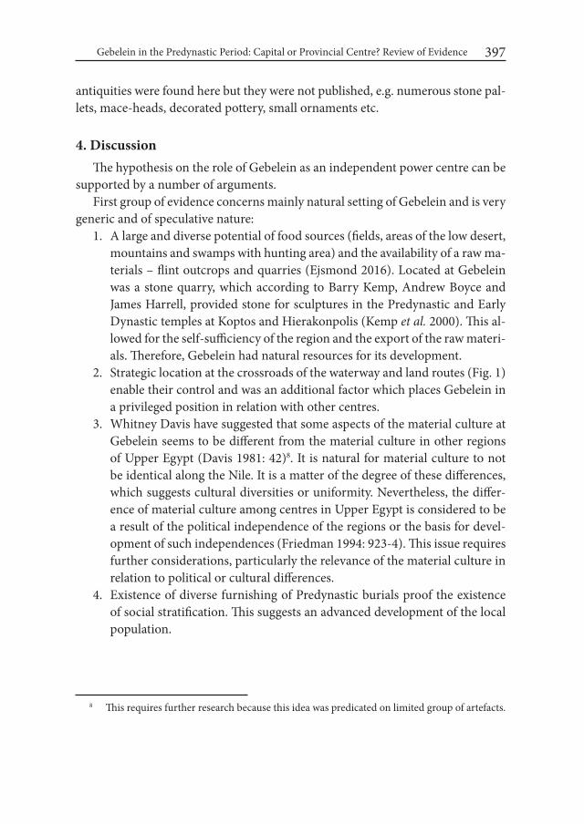
Gebelein in the Predynastic Period: Capital or Provincial Centre? Review of Evidence 397
antiquities were found here but they were not published, e.g. numerous stone pal-lets, mace-heads, decorated pottery, small ornaments etc.
4. DiscussionThe hypothesis on the role of Gebelein as an independent power centre can be
supported by a number of arguments. First group of evidence concerns mainly natural setting of Gebelein and is very
generic and of speculative nature:1. A large and diverse potential of food sources (fields, areas of the low desert,
mountains and swamps with hunting area) and the availability of a raw ma-terials – flint outcrops and quarries (Ejsmond 2016). Located at Gebelein was a stone quarry, which according to Barry Kemp, Andrew Boyce and James Harrell, provided stone for sculptures in the Predynastic and Early Dynastic temples at Koptos and Hierakonpolis (Kemp et al. 2000). This al-lowed for the self-sufficiency of the region and the export of the raw materi-als. Therefore, Gebelein had natural resources for its development.
2. Strategic location at the crossroads of the waterway and land routes (Fig. 1) enable their control and was an additional factor which places Gebelein in a privileged position in relation with other centres.
3. Whitney Davis have suggested that some aspects of the material culture at Gebelein seems to be different from the material culture in other regions of Upper Egypt (Davis 1981: 42)8. It is natural for material culture to not be identical along the Nile. It is a matter of the degree of these differences, which suggests cultural diversities or uniformity. Nevertheless, the differ-ence of material culture among centres in Upper Egypt is considered to be a result of the political independence of the regions or the basis for devel-opment of such independences (Friedman 1994: 923-4). This issue requires further considerations, particularly the relevance of the material culture in relation to political or cultural differences.
4. Existence of diverse furnishing of Predynastic burials proof the existence of social stratification. This suggests an advanced development of the local population.
8 This requires further research because this idea was predicated on limited group of artefacts.

Wojciech Ejsmond398
Second group is of archaeological nature and give more direct conclusion:5. Earlier works yielded opulent findings9. Local workshops required an elite
class who would provide them with materials and a market for their luxury goods. Wealth could be result of economic or political position of Gebelein or mixture of both. Existence of a rich elite class is a testament to the sig-nificance of the centre.
6. Spatial distribution of the archaeological sites at Gebelein show that it had a cloister of settlements and cemeteries, like Naqada and Hierakonpolis. Such concentrations in light of settlement pattern in Upper Egypt indicates developing centres which were seats of power during the Predynastic Pe-riod (Patch 1991: 334-340).
7. In the magazine of antiquities in Moalla there is a pot dated to middle or late Naqada III that come from Gebelein10 with two hieroglyphic signs: a bird (possible interpretations are Gardiners’ sign (Gardiner 1994: 467, 472, 493) G1 (Egyptian vulture) or G5 (falcon) (Regulski 2010: 117-119, 416-425) and O4 (Regulski 2010: 155 and 539) which shows a ‚reed shelter in fields’. It indicates use of writing at Gebelein which make it possible that it was some seat of bureaucracy at the earliest known stage of development of writing along the Nile.
8. Interest in Gebelein by later rulers (visible in construction works in the local temple and votive objects) and the wealth of this centre attested by rich burials dated to the Old Kingdom may be result of its former role as a power centre which declined to state of provincial administrative town (Ejsmond 2016: 7-11).
9. Equipment of a tomb (the set purchased by J. Quibell), which wealth is comparable to the wealth of burials from the same time at the royal ne-cropoleis at Abydos and Hierakonpolis indicates royal burials in the area.
10. The representation of a king during a ritual and/or triumph on Gebelein linen indicates the existence of a Predynastic ruler’s grave at Gebelein who used royal iconography. Rulers of proto-states were buried relatively near their capitals, e.g. Hierakonpolis, Naqada.
9 Museum of Egyptian Antiquities in Turin and Cairo Museum has the biggest collections of Predynastic artefacts from Gebelein. Unfortunately, most the objects are not yet published.
10 The artefact will be published elsewhere.
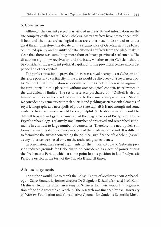
Gebelein in the Predynastic Period: Capital or Provincial Centre? Review of Evidence 399
5. Conclusion Although the current project has yielded new results and information on the
site complex challenges still face Gebelein. Many artefacts have not yet been pub-lished, and the local archaeological sites are either heavily destroyed or under great threat. Therefore, the debate on the significance of Gebelein must be based on limited quality and quantity of data. Attested artefacts from the place make it clear that there was something more than ordinary provincial settlements. The discussion right now revolves around the issue, whether or not Gebelein should be consider as independent political capital or it was provincial centre which de-pended on other capital?
The perfect situation to prove that there was a royal necropolis at Gebelein and therefore possibly a capital city in the area would be discovery of a royal necropo-lis. Without that the situation is speculative. The Gebelein linen is an argument for royal burial in this place but without archaeological context, its relevance in the discussion is limited. The set of artefacts purchased by J. Quibell is also of limited value for such considerations due to their uncertain provenance. Should we consider any cemetery with rich burials and yielding artefacts with elements of royal iconography as a necropolis of proto-state capital? It is not enough and some evidence from settlement would be very helpful. Such ideal situation would be difficult to reach in Egypt because one of the biggest issues of Predynastic Upper Egypt’s archaeology is relatively small number of preserved and researched settle-ments in contrast to large number of cemeteries. Therefore, the necropoleis still forms the main body of evidence in study of the Predynastic Period. It is difficult to formulate the answer concerning the political significance of Gebelein (as well as any other centre) based only on the archaeological evidence.
In conclusion, the present arguments for the important role of Gebelein pro-vide indirect grounds for Gebelein to be considered as a seat of power during the Predynastic Period, which at some point lost its position in late Predynastic Period, possibly at the turn of the Naqada II and III times.
Acknowledgements The author would like to thank the Polish Centre of Mediterranean Archaeol-
ogy – Cairo Branch, its former director Dr Zbigniew E. Szafrański and Prof. Karol Myśliwiec from the Polish Academy of Sciences for their support in organisa-tion of the field research at Gebelein. The research was financed by the University of Warsaw Foundation and Consultative Council for Students Scientific Move-

Wojciech Ejsmond400
ment of the University of Warsaw. The author would like to thank colleagues who took part in the recent research at Gebelein and without whom the project would not have taken place: Julia M. Chyla, Piotr Witkowski, Daniel Takács, Marzena Ożarek-Szilke, Dawid F. Wieczorek, Michał Madej, Cezary Baka, Adam Grylak, Aneta Skalec, Marcin Jakub Ordutowski and Lawrence Xu-Nan.
REFERENCESADAMS, B. and K.M. CIAŁOWICZ. 1988. Protodynastic Egypt, Pembrokeshire
(= Shire Egyptology 25).AKSAMIT, J. 1989. The gold handle of a fishtail dagger from Gebelein (Upper
Egypt). In: L. Krzyżaniak and M. Kobusiewicz (eds.), Late Prehistory of the Nile Basin and the Sahara (= Studies in African Archaeology 2): 325-332. Poznań.
ANONYMOUSM. 1930. Les fouilles de la mission italienne d’archéologie. Chro-nique d’Égypte 5/10: 233-234.
ANONYMOUS. 1935. El-Gebelein. Fouilles de la mission royale archéologique italienne. Chronique d’Égypte 10/20: 269-270.
ANONYMOUS. 1937. Gebelein. Fouilles de la mission égyptologique italienne. Chronique d’Égypte 12/24: 168.
ARNOLD, DO. 1995. „An Egyptian Bestiary”: The Metropolitan Museum of Art Bulletin 52, no. 4.
BARD, K.A. 2015. An introduction to Archaeology of Ancient Egypt. Chichester. BAUMGARTEL, E.J. 1967-68. The Nodding Falcon of the Guennol Collection at
the Brooklyn Museum. Brooklyn Museum Annual 9: 69-87.BERGAMINI, G. 2005. Museo Egizio – Turin (Italy): 1999 Field Activities at Ge-
belein. Annales du Service des antiquités de l’Égypte 79: 33-40. BUDGE, E. A. W. 1920. By Nile and Tigris: A narrative of journeys in Egypt and
Mesopotamia on behalf of the British Museum between the years 1886 and 1913, I. London.
BUSSMANN, R. 2010. Die Provinztempel Ägyptens von der 0. bis zur 11. Dynastie, Leiden – Boston.
CAMPAGNO, M. 2002. On the predynastic ‚“proto-states’’ of Upper Egypt. Göt-tinger Miszellen – Beiträge zur ägyptologischen Diskussion 188: 49–60.
CASTILLOS, J.J. 1998. Evidence for the appearance of social stratification in Pre-dynastic Egypt. In: C. Eyre (ed.), Proceedings of the Seventh international

Gebelein in the Predynastic Period: Capital or Provincial Centre? Review of Evidence 401
Congress of Egyptologists, Cambridge, 3-9 September Leuven (= Orientalia Lovaniensia Analecta 82) 1995: 255-259.
CIAŁOWICZ, K.M. 2011. The Predynastic/Early Dynastic Period at Tell el-Farkha. In: E. Teeter (ed.), Before the Pyramids: The Origins of Egyptian Civilization (= Oriental Institute Museum Publications): 55-64, Chicago.
CERVELLÓ AUTUORI, J. 1996. Egipto: Dinastia 0. Revista de arqueología 183: 6-15.
CLAES, W., HENDRICKX, S., DEVILLERS, A., HART, E., KINDERMANN, K., DE DAPPER, M., IKRAM, S., STORMS, G., SWERTS, C. AND D. HUYGE. 2014. From the early Old Kingdom to the Badarian. Preliminary report on the 2012 excavation campaign in the settlement area of Elkab. In: A. Mączyńska (ed.), The Nile Delta as a centre of cultural interactions be-tween Upper Egypt and the Southern Levant in the 4th millennium BC (= Studies in African Archaeology 13): 73-93. Poznań.
COONEY, J.D. 1953. Egyptian Art in the Collection of Albert Gallatin. Journal of Near Eastern Studies 7: 1-34.
COONEY, J.D. 1975. Nodding falcon. In: J.E. Rubin (ed.), The Guennol Collection I. New York: 5-14.
CURTO, S. 1953. Nota Sur Rilievo Poveniente a Gebelen nel Museo Egizio di To-rino. Aegyptus 33: 105-124.
DAVIS, W. M. 1981. An Early Dynastic Lion in the Museum of Fine Arts. In: W. K. Simpson and W. M. Davis (eds.), Studies in Ancient Egypt, the Aegean and the Sudan: 34-42. Boston.
DE MORGAN, H. 1912. Report on Excavations Made in Upper Egypt During the Winter 1907-1908. Annales du Service des antiquités de l’Égypte 12: 25-50.
DE MORGAN, J. 1907. Recherches sur les origin de l’Egypt II, 1907. Paris.DONADONI ROVERI, A. M. 1990. Gebelein. In: G. Robins (ed.), Beyond the Pyra-
mids, Egyptian Regional Art from the Museo Egizio in Turin: 23-29. Atlanta.DREYER, G. 2011. Tomb U – j: A Royal Burial of Dynasty 0 at Abydos. In: E. Teeter
(ed.), Before the Pyramids: The Origins of Egyptian Civilization (= Oriental Institute Museum Publications): 131-138. Chicago.
EJSMOND, W. 2013. Some Remarks on Topography of Gebelein Archaeological Site Complex in Predynastic and Early Dynastic Period. Göttinger Miszel-len – Beiträge zur ägyptologischen Diskussion 239: 31-42.
EJSMOND, W. 2015. Burial of a Local Ruler at Gebelein? An Interpretation of a Group of Predynastic Artefacts Purchased by J.E. Quibell in 1900. Göt-tinger Miszellen – Beiträge zur ägyptologischen Diskussion 244: 39-50.
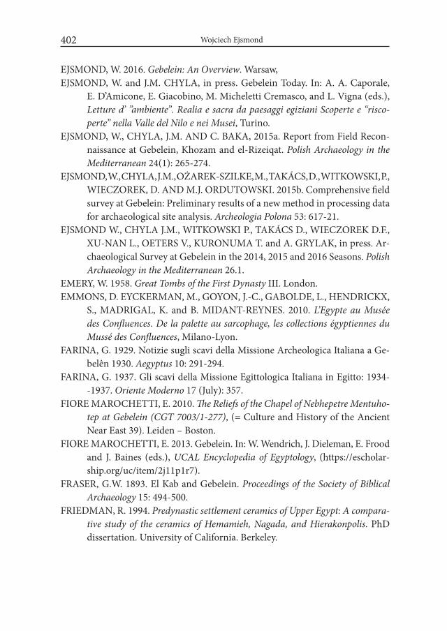
Wojciech Ejsmond402
EJSMOND, W. 2016. Gebelein: An Overview. Warsaw,EJSMOND, W. and J.M. CHYLA, in press. Gebelein Today. In: A. A. Caporale,
E. D’Amicone, E. Giacobino, M. Micheletti Cremasco, and L. Vigna (eds.), Letture d’ ”ambiente”. Realia e sacra da paesaggi egiziani Scoperte e “risco-perte” nella Valle del Nilo e nei Musei, Turino.
EJSMOND, W., CHYLA, J.M. AND C. BAKA, 2015a. Report from Field Recon-naissance at Gebelein, Khozam and el-Rizeiqat. Polish Archaeology in the Mediterranean 24(1): 265-274.
EJSMOND, W., CHYLA, J.M., OŻAREK-SZILKE, M., TAKÁCS, D., WITKOWSKI, P., WIECZOREK, D. AND M.J. ORDUTOWSKI. 2015b. Comprehensive field survey at Gebelein: Preliminary results of a new method in processing data for archaeological site analysis. Archeologia Polona 53: 617-21.
EJSMOND W., CHYLA J.M., WITKOWSKI P., TAKÁCS D., WIECZOREK D.F., XU-NAN L., OETERS V., KURONUMA T. and A. GRYLAK, in press. Ar-chaeological Survey at Gebelein in the 2014, 2015 and 2016 Seasons. Polish Archaeology in the Mediterranean 26.1.
EMERY, W. 1958. Great Tombs of the First Dynasty III. London.EMMONS, D. EYCKERMAN, M., GOYON, J.-C., GABOLDE, L., HENDRICKX,
S., MADRIGAL, K. and B. MIDANT-REYNES. 2010. L’Egypte au Musée des Confluences. De la palette au sarcophage, les collections égyptiennes du Mussé des Confluences, Milano-Lyon.
FARINA, G. 1929. Notizie sugli scavi della Missione Archeologica Italiana a Ge-belên 1930. Aegyptus 10: 291-294.
FARINA, G. 1937. Gli scavi della Missione Egittologica Italiana in Egitto: 1934- -1937. Oriente Moderno 17 (July): 357.
FIORE MAROCHETTI, E. 2010. The Reliefs of the Chapel of Nebhepetre Mentuho-tep at Gebelein (CGT 7003/1-277), (= Culture and History of the Ancient Near East 39). Leiden – Boston.
FIORE MAROCHETTI, E. 2013. Gebelein. In: W. Wendrich, J. Dieleman, E. Frood and J. Baines (eds.), UCAL Encyclopedia of Egyptology, (https://escholar-ship.org/uc/item/2j11p1r7).
FRASER, G.W. 1893. El Kab and Gebelein. Proceedings of the Society of Biblical Archaeology 15: 494-500.
FRIEDMAN, R. 1994. Predynastic settlement ceramics of Upper Egypt: A compara-tive study of the ceramics of Hemamieh, Nagada, and Hierakonpolis. PhD dissertation. University of California. Berkeley.
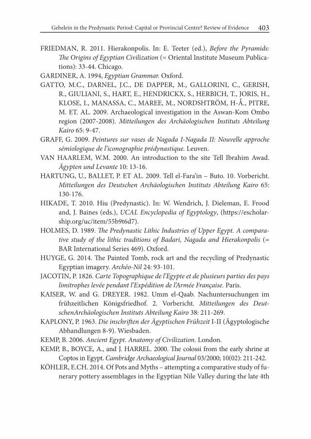
Gebelein in the Predynastic Period: Capital or Provincial Centre? Review of Evidence 403
FRIEDMAN, R. 2011. Hierakonpolis. In: E. Teeter (ed.), Before the Pyramids: The Origins of Egyptian Civilization (= Oriental Institute Museum Publica-tions): 33-44. Chicago.
GARDINER, A. 1994, Egyptian Grammar. Oxford. GATTO, M.C., DARNEL, J.C., DE DAPPER, M., GALLORINI, C., GERISH,
R., GIULIANI, S., HART, E., HENDRICKX, S., HERBICH, T., JORIS, H., KLOSE, I., MANASSA, C., MAREE, M., NORDSHTRÖM, H-Ǻ., PITRE, M. ET. AL. 2009. Archaeological investigation in the Aswan-Kom Ombo region (2007-2008). Mitteilungen des Archäologischen instituts Abteilung Kairo 65: 9-47.
GRAFF, G. 2009. Peintures sur vases de Nagada i-Nagada ii: Nouvelle approche sémiologique de l’iconographie prédynastique. Leuven.
VAN HAARLEM, W.M. 2000. An introduction to the site Tell Ibrahim Awad. Ägypten und Levante 10: 13-16.
HARTUNG, U., BALLET, P. ET AL. 2009. Tell el-Fara’in – Buto. 10. Vorbericht. Mitteilungen des Deutschen Archäologischen instituts Abteilung Kairo 65: 130-176.
HIKADE, T. 2010. Hiu (Predynastic). In: W. Wendrich, J. Dieleman, E. Frood and, J. Baines (eds.), UCAL Encyclopedia of Egyptology, (https://escholar-ship.org/uc/item/55b9t6d7).
HOLMES, D. 1989. The Predynastic Lithic industries of Upper Egypt. A compara-tive study of the lithic traditions of Badari, Nagada and Hierakonpolis (= BAR International Series 469). Oxford.
HUYGE, G. 2014. The Painted Tomb, rock art and the recycling of Predynastic Egyptian imagery. Archéo-Nil 24: 93-101.
JACOTIN, P. 1826. Carte Topographique de l’Egypte et de plusieurs parties des pays limitrophes levée pendant l’Expédition de l’Armée Française. Paris.
KAISER, W. and G. DREYER. 1982. Umm el-Qaab. Nachuntersuchungen im frühzeitlichen Königsfriedhof. 2. Vorbericht. Mitteilungen des Deut-schenArchäologischen instituts Abteilung Kairo 38: 211-269.
KAPLONY, P. 1963. Die inschriften der Ägyptischen Frühzeit I-II (Ägyptologische Abhandlungen 8-9). Wiesbaden.
KEMP, B. 2006. Ancient Egypt. Anatomy of Civilization. London.KEMP, B., BOYCE, A., and J. HARREL. 2000. The colossi from the early shrine at
Coptos in Egypt. Cambridge Archaeological Journal 03/2000; 10(02): 211-242.KÖHLER, E.CH. 2014. Of Pots and Myths – attempting a comparative study of fu-
nerary pottery assemblages in the Egyptian Nile Valley during the late 4th

Wojciech Ejsmond404
millennium BC. In: A. Mączyńska (ed.), The Nile Delta as a centre of cul-tural interactions between Upper Egypt and the Southern Levant in the 4th millennium BC (= Studies in African Archaeology 13): 155-180. Poznań.
KUENTZ, C. 1929. Quelques monuments du culte de Sobek. Bulletin de L’institut français d’archéologie orientale 28: 113-172.
LESKO, B.S. 1999. The Great Goddesses of Egypt. Oklahoma.LORTET, L. and C. GAILLARD. 1909. La faune momifiée de l’ancienne Égypte.
Lyon.MANASSA C. 2011. El-Moalla to El-Deir. In: W. Wendrich, J. Dieleman, E. Frood
and J. Baines (eds.), UCAL Encyclopedia of Egyptology. (http://digital2.li-brary.ucla.edu/viewItem.do?ark=21198/zz00293crv).
MARRO, G. 1929. L’esplorazione della necropoli di Gebelên. Atti della Socete itali-ana per il Progresso delle Scienze: 592-636. Pavia.
MORENZ, L. 1994. Zur Dekoration der frühzeitlichen Tempel am Beispiel zweier Fragmente des archaischen Tempels von Gebelein. In: R. Gundlach and M. Rochholz (eds.), Ägyptische Tempel-Struktur, Funktion und Programm, Akten der Ägyptologischen Tempeltagungen in Gosen 1990 und in Mainz 1992 (= Hildesheimer Ägyptologische Beiträge 37): 217-238. Hildesheim.
MORTENSEN, B. 1991. Change in the Settlement Pattern and Population in the Beginning of the Historical Period. Ägypten und Levante 2: 11-37.
NEEDLER, W. 1984. Predynastic and Archaic Egypt in The Brooklyn Museum (= Wilbour Monographs 9). Brooklyn.
PATCH, D. 1991. The Origin and Early Development of Urbanism in Ancient Egypt: A Regional Study, PhD dissertation. Pensilvania University.
QUIBELL, J.E. 1900. Hierakonpolis I. London.QUIBELL, J.E. 1901. Flint Dagger form Gebelein. Annales du Service des antiqui-
tés de l’Égypte 2: 131-132.REGULSKI, I. 2010. A Paleographic Study of Early writing in Egypt (= Orientalia
Lovaniensia Analecta 195). Leuven.ROSA, V. 1911. Giornale scavi a Gebelein (unpublished excavations journal from
Gebelein preserved in City’s Archive in Turin).SAYCE, M. and S. CLARK. 1905. Report on Certain Excavations Made at El – Kab
During the Years 1901, 1902, 1903, 1904. Annales du Service des antiquités de l’Égypte 6: 240 – 272.
SCHIAPARELLI, E. 1921. La Missione Italiana a Ghebelein. Annales du Service des antiquités de l’Égypte 21: 126-128.
Gebelein in the Predynastic Period: Capital or Provincial Centre? Review of Evidence 405
STEVENSON SMITH, T. 1949. History of Egyptian Sculpture and Relief. Boston.STEINDORFF, G. 1901. Grabfunde des Mittleren Reichs in den Königlichen Mu-
seen zu Berlin ii: Der Sarg des Sebk-o: Ein Grabfund aus Gebelein. Berlin.TASSIE, G. J., VAN WETERING, J. and I. CARROLL. 2012. Repatriating prehis-
toric artefacts to Egypt: Fekri Hassan’s Naqada and Siwa study collections. world Archaeology 12: 52-57.
THUCYDIDES. 1900. History of the Peloponnesian war, Thucydides, translated into English, to which is prefixed an essay on inscriptions and a note on the geography of Thucydides by Benjamin. Oxford.
VAN WALSEM, R. 1979. The Psš-kf. An investigation of an ancient Egyptian fu-nerary instrument. Oudheidkundige Mededeelingen uit het Rijskmuseum van Oudheden te Leiden 59: 193-249.
WENGROW, D. 2006. The Archaeology of Early Egypt. Social Transformations in North-East Africa, 10,000-2650 BC. Cambridge.
WILKINSON, R.H. 1994. The Complete Gods of Ancient Egypt. New York.WILKINSON, T.A.H. 1996. State Formation in Egypt: Chronology and Society
(= BAR International Series 651). London.WILKINSON, T. A. H. 2000. Political Unification: towards a reconstruction. Mittei-
lungen des Deutschen Archäologischen instituts Abteilung Kairo 56: 377-395.WILLIAMS, B, LOGAN T.J. and J.W. MURANE, 1987. The Metropolitan Muse-
um Knife Handle and Aspects of Pharaonic Imagery before Narmer. Jour-nal of Near Eastern Studies 46: 245-285.


Desert and the Nile. Prehistory of the Nile Basin and the Sahara.
Papers in honour of Fred Wendorf Studies in African Archaeology 15
Poznań Archaeological Museum 2018
Robert Kuhn
A Wooden Statue and Early Bronze Objects? A Critical Review of Tomb 1052 in the Necropolis of Abusir el-Meleq
Between 1905 and 1906 the German Egyptologist G. Möller excavated about 900 tombs in the Pre- and Early Dynastic necropolis of Abusir el-Meleq, a project financed by the Deutsche Orient-Gesellschaft (DOG) (Möller 1906; Möller 1907; Scharff 1926). Möller died in 1921 without finishing the publication. It was than his successor at the Museum in Berlin, A. Scharff, who was carefully studying the notebooks and notes left by G. Möller. Even-though A. Scharff published his manuscript in 1926 including a tomb catalogue, a full and detailed analysis of the whole necropolis is still lacking.
It is one of the main objectives for the next years to revise critically the known information provided in the field diary and tomb lists, as well as apply new ap-proaches and techniques of natural sciences to get a somehow new view on cer-tain aspects of this important Predynastic necropolis.
In the following I will focus on some context problems of the feature num-bered as 1052 by G. Möller and uncovered during his second season in Abusir el-Meleq in 1906.
The so-called tomb no. 1052 was a 60 cm deep pit measuring 1,8 m x 1,2 m, having quite vague borders, which seem to be not very clear in the moment of
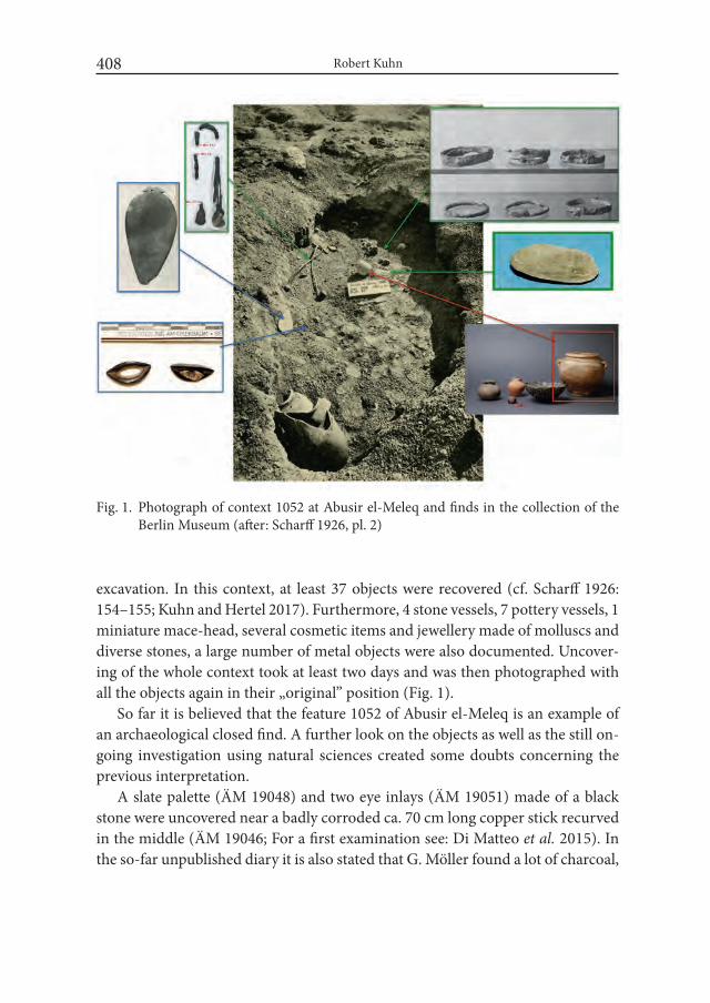
Robert Kuhn408
Fig. 1. Photograph of context 1052 at Abusir el-Meleq and finds in the collection of the Berlin Museum (after: Scharff 1926, pl. 2)
excavation. In this context, at least 37 objects were recovered (cf. Scharff 1926: 154–155; Kuhn and Hertel 2017). Furthermore, 4 stone vessels, 7 pottery vessels, 1 miniature mace-head, several cosmetic items and jewellery made of molluscs and diverse stones, a large number of metal objects were also documented. Uncover-ing of the whole context took at least two days and was then photographed with all the objects again in their „original” position (Fig. 1).
So far it is believed that the feature 1052 of Abusir el-Meleq is an example of an archaeological closed find. A further look on the objects as well as the still on-going investigation using natural sciences created some doubts concerning the previous interpretation.
A slate palette (ÄM 19048) and two eye inlays (ÄM 19051) made of a black stone were uncovered near a badly corroded ca. 70 cm long copper stick recurved in the middle (ÄM 19046; For a first examination see: Di Matteo et al. 2015). In the so-far unpublished diary it is also stated that G. Möller found a lot of charcoal,
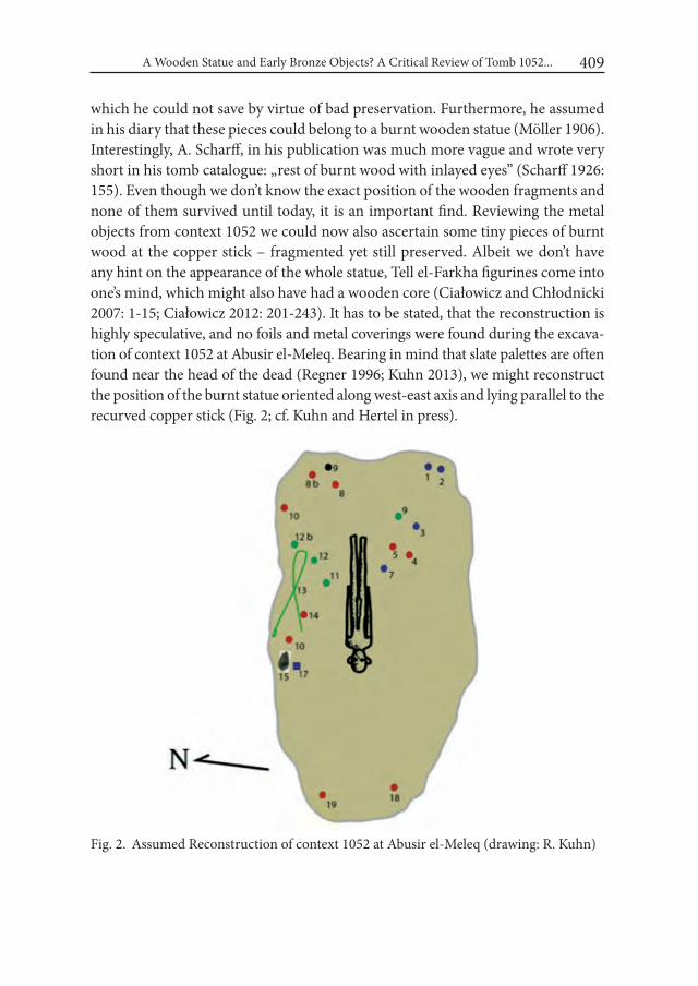
A Wooden Statue and Early Bronze Objects? A Critical Review of Tomb 1052... 409
which he could not save by virtue of bad preservation. Furthermore, he assumed in his diary that these pieces could belong to a burnt wooden statue (Möller 1906). Interestingly, A. Scharff, in his publication was much more vague and wrote very short in his tomb catalogue: „rest of burnt wood with inlayed eyes” (Scharff 1926: 155). Even though we don’t know the exact position of the wooden fragments and none of them survived until today, it is an important find. Reviewing the metal objects from context 1052 we could now also ascertain some tiny pieces of burnt wood at the copper stick – fragmented yet still preserved. Albeit we don’t have any hint on the appearance of the whole statue, Tell el-Farkha figurines come into one’s mind, which might also have had a wooden core (Ciałowicz and Chłodnicki 2007: 1-15; Ciałowicz 2012: 201-243). It has to be stated, that the reconstruction is highly speculative, and no foils and metal coverings were found during the excava-tion of context 1052 at Abusir el-Meleq. Bearing in mind that slate palettes are often found near the head of the dead (Regner 1996; Kuhn 2013), we might reconstruct the position of the burnt statue oriented along west-east axis and lying parallel to the recurved copper stick (Fig. 2; cf. Kuhn and Hertel in press).
Fig. 2. Assumed Reconstruction of context 1052 at Abusir el-Meleq (drawing: R. Kuhn)
Robert Kuhn410
The figurine was destroyed by fire but very little damage and discolorations can be observed. The remaining pottery and stone vessels, as well as the palette show just scarce traces of soot and discolorations. In any case this figurine shows a fascinating aspect of the necropolis of Abusir el-Meleq. Their possible parallels are so far the two Tell el-Farkha figurines coming from a probably cultic or hidden deposition in the settlement of the Eastern Kom and another figurine bought by C. T. Currelly in Thebes (Ciałowicz 2012: 204).
The most remarkable are metal objects found in „tomb” 1052: 3 vessels made of copper1, metal beads, the recurved copper stick, and nine bracelets. All these objects weigh together about 2 kg, contrary to low percentage of Predynastic tombs containing metal objects at Abusir el-Meleq, among which maximum of 1-2 copper objects were found (cf. Scharff 1926; Kuhn and Hertel 2017).
As some analysis of other metal objects are still on-going, I will focus in the following on bracelets. These were already classified by G. Möller during the ex-cavation as being made of bronze. All the bracelets were badly corroded, most of which could be cleaned and exposed by I. Hertel, restorer at the Berlin Museum. The cross-sections of five examples are round, or flat and rectangular. Four brace-lets are quite remarkable: despite corrosion, G. Möller has already seen that two bracelets had figurative applications. ÄM 19033-1, with a long-rectangular cross-section, shows 3 figurines of crocodiles and ÄM 19034 shows the application of a snake (Fig. 3). A third bracelet (ÄM 19035-2) seems to be a ring made of two twisted wires, but actually the whole is made by casting in cire-perdue technique2. The same production method can be assumed also for the other bracelets3. For a long time these objects were regarded as marvellous examples of the know-how of the early Egyptian metallurgists (e.g. Möller 1924: 51; Scharff 1926; Baumgartel 1960: 21; Dębowska-Ludwin 2014: 113). Indeed these objects are real beauties, but are they also early Egyptian?
1 ÄM 19043-ÄM 19045. One of the objects, the highly corroded vessel ÄM 19045, was exam-ined at the Rathgen-Laboratory to find out its composition. XRD and m-RFA analysis showed that the piece consists of almost pure copper. I thank Dr. I. Reiche and S. Schwerdtfeger from the Rathgen-Laboratory for their kind support and collaboration.
2 The imitation of the “strip-twist-technique” is especially known from Roman times: Ogden 1982: 56; Andrews 1990: 97 – some earlier examples were found in the tomb of Tut-Ankh-Amun: cf. Ogden 1982: 51.
3 For the ones with zoomorphic applications, already G. Möller assumed a connection with the cire-perdu technique: Möller 1924: 16.
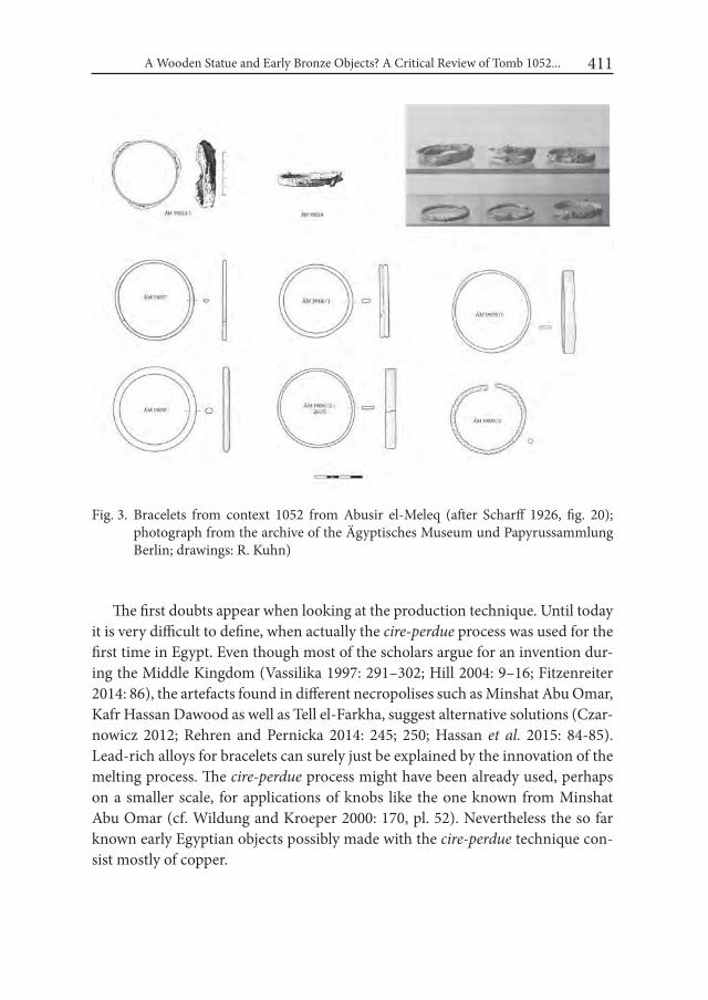
A Wooden Statue and Early Bronze Objects? A Critical Review of Tomb 1052... 411
The first doubts appear when looking at the production technique. Until today it is very difficult to define, when actually the cire-perdue process was used for the first time in Egypt. Even though most of the scholars argue for an invention dur-ing the Middle Kingdom (Vassilika 1997: 291–302; Hill 2004: 9–16; Fitzenreiter 2014: 86), the artefacts found in different necropolises such as Minshat Abu Omar, Kafr Hassan Dawood as well as Tell el-Farkha, suggest alternative solutions (Czar-nowicz 2012; Rehren and Pernicka 2014: 245; 250; Hassan et al. 2015: 84-85). Lead-rich alloys for bracelets can surely just be explained by the innovation of the melting process. The cire-perdue process might have been already used, perhaps on a smaller scale, for applications of knobs like the one known from Minshat Abu Omar (cf. Wildung and Kroeper 2000: 170, pl. 52). Nevertheless the so far known early Egyptian objects possibly made with the cire-perdue technique con-sist mostly of copper.
Fig. 3. Bracelets from context 1052 from Abusir el-Meleq (after Scharff 1926, fig. 20); photograph from the archive of the Ägyptisches Museum und Papyrussammlung Berlin; drawings: R. Kuhn)

Robert Kuhn412
In 1978 J. Riederer from the Rathgen-Laboratory in Berlin analysed several metal objects from the Berlin Museum with the Atomic Absorption Spectros-copy (AAS). In this study, he also studied the bracelet with the crocodile (Rie-derer 1978). This research confirmed G. Möller observations: it is a real bronze with a very high amount of lead – (68,97% of copper and almost 24,61% of lead; cf. Riederer 1978; tab. 1). Already in the late 1990’s other bracelets were tested as well, using X-Ray Fluorescence (XRF). The analysis showed again that also the rest of the bracelets consist of bronze and again a very high proportion of lead could be found. The highest amount of 28,12% of lead was identified for bracelet ÄM 19038 (see Fig. 4). This is of course a very remarkable result, as it allows us to speak of lead-bronzes or lead-rich-alloys (along the terminology cf. Riederer 1987: 108). For the very small number of early Egyptian metal objects analysed so far, the highest weight-percentage of lead ranges usually between 4 and 5%
Fig. 4. Results of the AAS Analysis undertaken by J. Riederer in 1978; 2) XRF-Analysis of the bracelets made by M. Ecclestone using Niton XL3t GOLDD
A Wooden Statue and Early Bronze Objects? A Critical Review of Tomb 1052... 413
(cf. Rehren and Pernicka 2014: 242-245), but for most of the objects a much lower amount of 1–2% is recorded (e.g. Spencer 1980: 88; Cowell 1987: 96-118). In his overview of Egyptian metallurgy J. Ogden showed that such a high percentage of lead in Egyptian bronze objects is rarely to be found in the New Kingdom and is much more common in Greco-Roman Period (Ogden 2000: 154-155; Martinot and Weber 2009: 444).
The metal analyses and the technical aspects lead us to the hypothesis that the bracelets are not of early Egyptian date. Interestingly, the necropolis of Abusir el-Meleq was re-used during the Hyksos-Period as well as during the Late Period and Greco-Roman Times (Rubensohn and Knatz 1904; Scharff 1926; Kuckertz and Schmidt 2013: 45–49). During the excavation, Möller found indications of Hyksos, as well as Greco-Roman disturbances in several of the Predynastic burials (Möller 1907; Scharff 1926: 12–13; 84–105).
The two bracelets in discussion fit well into the Greco-Roman Period. Even though a detailed comparison of the casted figurines (crocodiles and the snake) is not possible by virtue of corrosion, the visible details are very typical of the Fayum region during this time period (cf. Verner 1927). It is usually a crocodile connected to the god Sobek as well as snakes that are found on bracelets made of gold and bronze (CG 52094; 52123; cf. Verner 1927), in addition to objects in the form of votive figurines and statuettes (Kakosy 1965: 116–120; Brovarski 1984; Aubert and Aubert 2001: pl. 48).
Summarizing the above mentioned aspects, the so far accepted interpreta-tion for the context 1052 as an archaeologically closed find and a tomb has to be questioned. Both Möller and Scharff stressed the fact that no human remains were found during excavation (Scharff 1926: 155). Instead, presumably a wooden statue embellished with inlayed eyes was deposited with several objects of the material culture such as pottery, stone vessels, small knives made of carnelian, a slate palette made of greywacke, copper vessels and a copper stick. The whole arrangement is of course tomb-like, as it is characteristic for the period of early Naqada IIIA/B. The dimension and outline of the original deposit isn’t clear and seems to have been vague already during the excavation. In comparison with the other tombs found in the Predynastic necropolis the pit might have been also rectangular in form (Fig. 4).
On a stratigraphically higher level, where the bracelets were found – albeit – no measurement was recorded. Möller reports in his field diary the find of the bracelets for the first day, while most of the inventory reported for the tomb was found during the second working day, presuming they were also stratigraphically
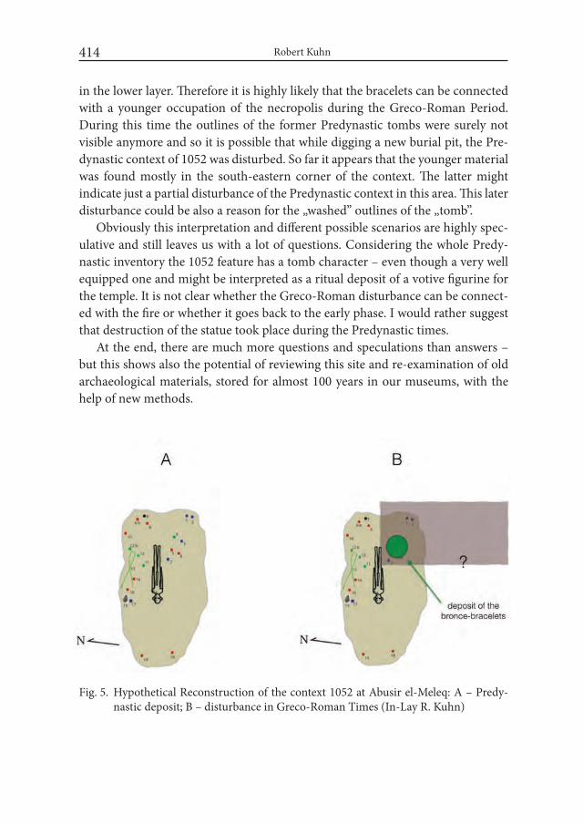
Robert Kuhn414
in the lower layer. Therefore it is highly likely that the bracelets can be connected with a younger occupation of the necropolis during the Greco-Roman Period. During this time the outlines of the former Predynastic tombs were surely not visible anymore and so it is possible that while digging a new burial pit, the Pre-dynastic context of 1052 was disturbed. So far it appears that the younger material was found mostly in the south-eastern corner of the context. The latter might indicate just a partial disturbance of the Predynastic context in this area. This later disturbance could be also a reason for the „washed” outlines of the „tomb”.
Obviously this interpretation and different possible scenarios are highly spec-ulative and still leaves us with a lot of questions. Considering the whole Predy-nastic inventory the 1052 feature has a tomb character – even though a very well equipped one and might be interpreted as a ritual deposit of a votive figurine for the temple. It is not clear whether the Greco-Roman disturbance can be connect-ed with the fire or whether it goes back to the early phase. I would rather suggest that destruction of the statue took place during the Predynastic times.
At the end, there are much more questions and speculations than answers – but this shows also the potential of reviewing this site and re-examination of old archaeological materials, stored for almost 100 years in our museums, with the help of new methods.
Fig. 5. Hypothetical Reconstruction of the context 1052 at Abusir el-Meleq: A – Predy-nastic deposit; B – disturbance in Greco-Roman Times (In-Lay R. Kuhn)
A Wooden Statue and Early Bronze Objects? A Critical Review of Tomb 1052... 415
AcknowledgementsFor their generous help and their support I have to thank Prof. Dr. F. Seyfried,
Director of the Ägyptisches Museum und Papyrussammlung in Berlin as well as Mrs. I. Hertel, our conservator for metal objects. They gave me the opportunity to study the objects and helped to find solutions for further analysis such as the Rath-gen-Laboratory as well as the BAM in Berlin. I am grateful for the help provided by Dr. I. Reiche, Director of the Rathgen-Laboratory as well as to Mrs. S. Schwerdt-feger, who made a lot of further research possible. Dr. B. Illerhaus, Dr. A. Staude and G. Di Matteo provided further possibilities of research such as a Micro-Computed Tomography of some other objects of the tomb context, which helped to understand some aspects much better. For their on-going support and help and their interest in this case, I am most grateful. Further thanks go to Mr. M. Ecclestone who al-lowed me to work with the results he has got after analysing the objects in the Berlin Museum using XRF-measurements. Furthermore I wish to express my thanks to Dr. E. El-Khalifa for proofreading the English version of the paper.
Last but not least I am grateful to Prof. Dr. J. Kabaciński for the invitation and possibility to show our first results during the Poznań conference „Desert and the Nile. Late Prehistory of the Nile Basin and the Sahara”.
REFERENCESANDREWS, C. 1990. Ancient Egyptian Jewellery. London.AUBERT, J. F. and L. AUBERT. 2001. Bronzes et or Egyptiens. Paris.BAUMGARTEL, E. J. 1960. The Cultures of Prehistoric Egypt II. Oxford.BROVARSKI, E. 1984. s.v. Sobek, in: LÄ V: 995–1031. Wiesbaden.CIAŁOWICZ, K. M. 2012. Early Egyptian objects of art. In: K. M. Ciałowicz,
M. Chłodnicki and A. Mączyńska (eds.), Tell el-Farkha i. Excavations 1998––2011: 201–243. Poznań/Kraków.
CIAŁOWICZ, K. M. and M. CHŁODNICKI. 2007. Golden Figures from Tell el-Farkha. Studies in Ancient Art and Civilization 10: 1–15.
COWELL, M. 1987. Scientific Appendix I. Chemical Analysis, in: W. V. Davies, Catalogue of Egyptian Antiquities in the British Museum Vii. Tools and weapons i. Axes: 96–118. London.
CZARNOWICZ, M. 2012. Copper tools. In: M. Chłodnicki, K.M. Ciałowicz and A. Mączyńska (eds.), Tell el-Farkha i. Excavations 1998–2011: 345–355. Poznań/Kraków.
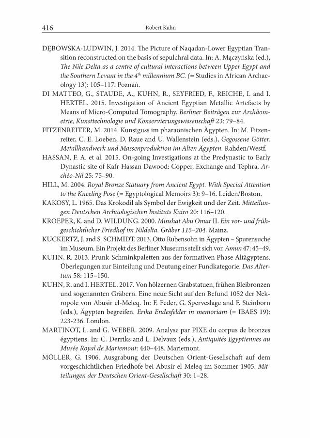
Robert Kuhn416
DĘBOWSKA-LUDWIN, J. 2014. The Picture of Naqadan-Lower Egyptian Tran-sition reconstructed on the basis of sepulchral data. In: A. Mączyńska (ed.), The Nile Delta as a centre of cultural interactions between Upper Egypt and the Southern Levant in the 4th millennium BC. (= Studies in African Archae-ology 13): 105–117. Poznań.
DI MATTEO, G., STAUDE, A., KUHN, R., SEYFRIED, F., REICHE, I. and I. HERTEL. 2015. Investigation of Ancient Egyptian Metallic Artefacts by Means of Micro-Computed Tomography. Berliner Beiträgen zur Archäom-etrie, Kunsttechnologie und Konservierungswissenschaft 23: 79–84.
FITZENREITER, M. 2014. Kunstguss im pharaonischen Ägypten. In: M. Fitzen-reiter, C. E. Loeben, D. Raue and U. Wallenstein (eds.), Gegossene Götter. Metallhandwerk und Massenproduktion im Alten Ägypten. Rahden/Westf.
HASSAN, F. A. et al. 2015. On-going Investigations at the Predynastic to Early Dynastic site of Kafr Hassan Dawood: Copper, Exchange and Tephra. Ar-chéo-Nil 25: 75–90.
HILL, M. 2004. Royal Bronze Statuary from Ancient Egypt. with Special Attention to the Kneeling Pose (= Egyptological Memoirs 3): 9–16. Leiden/Boston.
KAKOSY, L. 1965. Das Krokodil als Symbol der Ewigkeit und der Zeit. Mitteilun-gen Deutschen Archäologischen instituts Kairo 20: 116–120.
KROEPER, K. and D. WILDUNG. 2000. Minshat Abu Omar II. Ein vor- und früh-geschichtlicher Friedhof im Nildelta. Gräber 115–204. Mainz.
KUCKERTZ, J. and S. SCHMIDT. 2013. Otto Rubensohn in Ägypten – Spurensuche im Museum. Ein Projekt des Berliner Museums stellt sich vor. Amun 47: 45–49.
KUHN, R. 2013. Prunk-Schminkpaletten aus der formativen Phase Altägyptens. Überlegungen zur Einteilung und Deutung einer Fundkategorie. Das Alter-tum 58: 115–150.
KUHN, R. and I. HERTEL. 2017. Von hölzernen Grabstatuen, frühen Bleibronzen und sogenannten Gräbern. Eine neue Sicht auf den Befund 1052 der Nek-ropole von Abusir el-Meleq. In: F. Feder, G. Sperveslage and F. Steinborn (eds.), Ägypten begreifen. Erika Endesfelder in memoriam (= IBAES 19): 223-236. London.
MARTINOT, L. and G. WEBER. 2009. Analyse par PIXE du corpus de bronzes égyptiens. In: C. Derriks and L. Delvaux (eds.), Antiquités Egyptiennes au Musée Royal de Mariemont: 440–448. Mariemont.
MÖLLER, G. 1906. Ausgrabung der Deutschen Orient-Gesellschaft auf dem vorgeschichtlichen Friedhofe bei Abusir el-Meleq im Sommer 1905. Mit-teilungen der Deutschen Orient-Gesellschaft 30: 1–28.
A Wooden Statue and Early Bronze Objects? A Critical Review of Tomb 1052... 417
MÖLLER, G. 1907. 2. Ausgrabung bei Abusîr el-Meleq 1906. Mitteilungen der Deutschen Orient-Gesellschaft 34: 2–28.
MÖLLER, G. 1924. Die Metallkunst der alten Ägypter. Berlin.OGDEN, J. 1982. Jewellery of the Ancient world. London.OGDEN, J. 2000. Metals. In: P. T. Nicholson and I. Shaw (eds.), Ancient Egyptian
Materials and Technology: 148–176. Cambridge.REGNER, C. 1996. Schminkpaletten (= BoSAE 2).Wiesbaden.REHREN, T. and E. PERNICKA. 2014. First data on the nature and origin of the
metalwork from Tell el-Farkha. In: A. Mączyńska (ed.). The Nile Delta as a centre of cultural interactions between the Upper Egypt and the Southern Levant in the 4th millennium BC (= Studies in African Archaeology 13): 237–252. Poznań.
RIEDERER, J. 1978. Die naturwissenschaftliche Untersuchung der Bronzen des Ägyptischen Museums Preußischer Kulturbesitz in Berlin. Berliner Be-iträge zur Archäometrie 3: 5–42.
RIEDERER, J. 1987. Archäologie und Chemie. Berlin.RUBENSOHN, O. and F. KNATZ. 1904. Bericht über die Ausgrabungen bei Abu-
sir el Mäläq im Jahre 1903. Zeitschrift für Ägyptische Sprache 41: 1–21.SCHARFF, A. 1926. Die archaeologischen Ergebnisse des vorgeschichtlichen Gräber-
feldes von Abusir el-Meleq nach den Aufzeichnungen Georg Möllers, Aus-grabungen der Deutschen Orient-Gesellschaft auf dem vorgeschichtlichen Gräberfeld von Abusir el-Meleq I. Leipzig.
SPENCER, J. A. 1980. Catalogue of Egyptian Antiquities in the British Museum V. Early Dynastic Objects, London.
VASSILIKA, E. 1997. Egyptian Bronze Sculpture Before the Late Period. In: E. Gor-ing, N. Reeves and J. Ruffle (eds.), Chief of Seers. Egyptian Studies in Memo-ry of Cyril Aldred: 291–302. London/New York.
VERNIER, E. 1927. Catalogue Général des Antiquités égyptiennes du Musée du Caire 84, Nos 52001–53855. Bijoux et orfèvreries. Le Caire.

Desert and the Nile. Prehistory of the Nile Basin and the Sahara.
Papers in honour of Fred Wendorf Studies in African Archaeology 15
Poznań Archaeological Museum 2018
Natalia Małecka-Drozd
The Old Kingdom Upcountry Settlement Aarchitecture in the Nile Delta – the Case of the 3rd-4th Dynasty Building at Tell el-Murra
IntroductionThe current state of research on Egyptian settlements clearly indicates a grad-
ual decay of the Nile Delta sites from the Early Dynastic period until the end of the Old Kingdom (Małecka-Drozd, fortcoming). The amount of settlements with attested architectural remains significantly decrease at least since the early Old Kingdom. Simultaneously, a decline of quality of buildings discovered on some of the sites which enjoyed prosperity in the Predynastic and Early Dynastic periods is noticeable (van den Brink 1993; Małecka-Drozd 2014). One of the sparse exca-vated sites with architectural remains dated to the Old Kingdom is Tell el-Murra.1
Tell el-Murra is located in the northeastern part of the Nile Delta, in the Sharq-iyyah Governorate, markaz Kafr Saqr. A particular relevance of the area was con-
1 The excavations between 2010 and 2012 were financed by funds from the Ministry of Science and Higher Education, Poland, and the National Science Centre, Poland, grant no. 2195/B/H03/2009/36. Since 2014, the project has been financed by funds from the National Sci-ence Centre, Poland, which were allocated on the basis of decision number DEC-2013/09/B/HS3/03588.

Natalia Małecka-Drozd 420
firmed by numerous sites dated for the Late Predynastic and Early Dynastic peri-ods (Fig. 1), recognized during former research (van den Brink 1993; Hendrickx and van den Brink 2002: 370-371; Jucha 2009; 2011). The site is situated only ca. 10 km to the east from the important Predynastic and Protodynastic centre at Tell el-Farkha, excavated since 1998 by a Polish expedition (Chłodnicki et al. 2012) as well as ca. 8 km to the south-west from Tell el-Iswid, where French expedition has carried out its research since 2006 (Midant-Reynes and Buchez 2014). Even closer – less than 4 kilometers – distance was attested between Tell el-Murra and other sites from the same period (Jucha 2016; Jucha and Bąk-Pryc, forthcoming). These include Tell el-Akhdar (about 3 km away) (Jucha 2012), Tell Mashala (about 3 km
Fig. 1. The Nile Delta settlements during the Old Kingdom

The Old Kingdom Upcountry Settlement Aarchitecture in the Nile Delta... 421
away) (Rampersad 2006), Tell Gabarra (about 3.9 km away) (Rampersad 2008; 2015-2016), Tell el-Gherier (about 1.7 km away) and Tell Ginidba (about 3.5 km away) (Chłodnicki et al. 1992; van den Brink 1993: 294, tab. 3). One of the most important reasons for the development such a dense settlement network were the ancient Tanitic branch of the Nile and its distributaries flowing through this area as well as the important trade route from Egypt to the northern Sinai and Pales-tine, crossing the northeastern Delta (Oren 1973; van den Brink 1993: 294-297; Jucha 2010b: 379). It is appeared that Tell el-Murra was one of the settlement that have benefited from these favorable conditions.
Tell el-Murra has remained virtually undisturbed with only certain sections having been levelled by agricultural activity. The main part of the mound still rises about 3-4 m above fields and only its fringes are situated on the field level. Probably because of barren character of its soil (in Arabic murra means “bitter”), the entire tell has not been taken by agriculture so far. The mound spreads about 250 m from north to south and about 180 m along its east-west axis, covering an area of approximately 4.5 ha (Fig. 2). In the course of research that has been continued since 2008 (Jucha 2009; 2010a; 2010b; Jucha and Buszek 2011; Jucha
Fig. 2. Tell el-Murra, view from the west. Photo: M. A. Jucha
Natalia Małecka-Drozd 422
et al. 2013; 2014; 2015; 2016; 2017; Jucha and Bąk-Pryc 2017), a few test trenches was founded in various parts of the mound: S1 in its northeastern part, S2 in its southern end, S3 in its southwestern part and S4 in its eastern part. It allowed to establish an overall chronology of the site.
First settlers at Tell el-Murra were connected to the Lower Egyptian Culture, the one which was widespread throughout the Nile Delta during the most part of the Predynastic period. So far, no traces attesting to the existence of the Naqada II remains have been found. However, already during Naqada III, which corre-sponds to the Protodynastic and Early Dynastic periods, larger part of the site was covered by the settlement. At that time, two zones can be distinguished on the site: the settlement in the northern and eastern parts of the mound and the cemetery in its southwestern area. With the end of the Early Dynastic period, populated and exploited area of the site decreased one more time. The Old Kingdom traces were revealed only in northern and eastern parts of the tell. By all indications, the settlement was abandoned after the 6th dynasty, at the end of the Old Kingdom, i.e. ca. 2200 BC (Jucha 2010a; 2010b; Jucha et al. 2013; 2015; 2016; 2017; Jucha and Bąk-Pryc 2017).
1. Old Kingdom architectureThe Old Kingdom remains have been revealed within two test trenches: S1,
explored in season 2010 (Jucha et al. 2013) and S4, explored in season 2011 (Ju-cha et al. 2014). However, the greatest part of the settlement architecture dated to that period was provided by works within trench T5. This trench is situated in the northeastern part of the tell, directly north of the former test trench S1. The work was already initiated there at the end of 2012 archaeological season but was restricted only to the area 10 m by 10 m (are R7) and exploration of the surface strata. Since the beginning of the subsequent 2013 season, the excavated area was enlarged to the dimensions 15 m by 21 m and the trench T5 included ares R7, R8, squares S7AC, S8AC and southern ends of squares R6CD and S6C (cf. Figs. 4 and 5). According to pottery assemblage collected during three sea-sons of excavations (2013-2015) two main chronological phases were recognized: the early Old Kingdom (mainly 3rd and 4th dynasties) and the late Old Kingdom (5th and 6th dynasties) (Kazimierczak 2016: 121-127). Several sub-phases were fur-thermore observed in the early Old Kingdom phase, basing on the observation of changes in the layout of buildings. There are remains related to the very end of the Early Dynastic or the very beginning of the Old Kingdom, slightly later relics
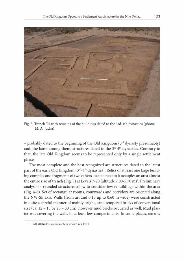
The Old Kingdom Upcountry Settlement Aarchitecture in the Nile Delta... 423
– probably dated to the beginning of the Old Kingdom (3rd dynasty presumably) and, the latest among them, structures dated to the 3rd-4th dynasties. Contrary to that, the late Old Kingdom seems to be represented only by a single settlement phase.
The most complete and the best recognized are structures dated to the latest part of the early Old Kingdom (3rd-4th dynasties). Relics of at least one large build-ing complex and fragments of two others located next to it occupies an area almost the entire size of trench (Fig. 3) at Levels 7-20 (altitude 7.00-5.70 m)2. Preliminary analysis of revealed structures allow to consider few rebuildings within the area (Fig. 4-6). Set of rectangular rooms, courtyards and corridors are oriented along the NW-SE axis. Walls (from around 0.15 up to 0.60 m wide) were constructed in quite a careful manner of mainly bright, sand tempered bricks of conventional size (ca. 12 – 15 by 25 – 30 cm), however mud bricks occurred as well. Mud plas-ter was covering the walls in at least few compartments. In some places, narrow
2 All attitudes are in meters above sea level.
Fig. 3. Trench T5 with remains of the buildings dated to the 3rd-4th dynasties (photo: M. A. Jucha)

Natalia Małecka-Drozd 424
Fig. 4. Earlier stage of the 3rd-4th dynasty building complex
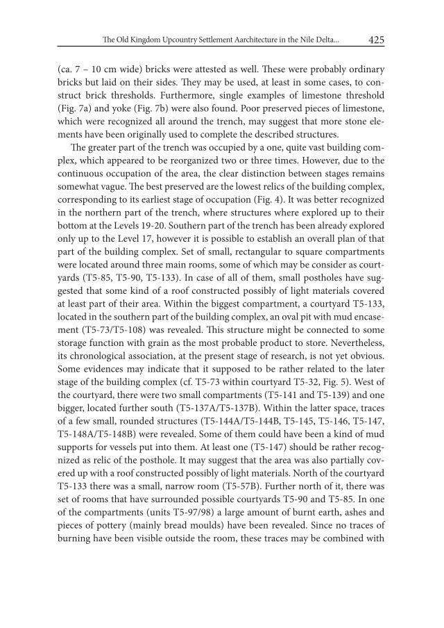
The Old Kingdom Upcountry Settlement Aarchitecture in the Nile Delta... 425
(ca. 7 – 10 cm wide) bricks were attested as well. These were probably ordinary bricks but laid on their sides. They may be used, at least in some cases, to con-struct brick thresholds. Furthermore, single examples of limestone threshold (Fig. 7a) and yoke (Fig. 7b) were also found. Poor preserved pieces of limestone, which were recognized all around the trench, may suggest that more stone ele-ments have been originally used to complete the described structures.
The greater part of the trench was occupied by a one, quite vast building com-plex, which appeared to be reorganized two or three times. However, due to the continuous occupation of the area, the clear distinction between stages remains somewhat vague. The best preserved are the lowest relics of the building complex, corresponding to its earliest stage of occupation (Fig. 4). It was better recognized in the northern part of the trench, where structures where explored up to their bottom at the Levels 19-20. Southern part of the trench has been already explored only up to the Level 17, however it is possible to establish an overall plan of that part of the building complex. Set of small, rectangular to square compartments were located around three main rooms, some of which may be consider as court-yards (T5-85, T5-90, T5-133). In case of all of them, small postholes have sug-gested that some kind of a roof constructed possibly of light materials covered at least part of their area. Within the biggest compartment, a courtyard T5-133, located in the southern part of the building complex, an oval pit with mud encase-ment (T5-73/T5-108) was revealed. This structure might be connected to some storage function with grain as the most probable product to store. Nevertheless, its chronological association, at the present stage of research, is not yet obvious. Some evidences may indicate that it supposed to be rather related to the later stage of the building complex (cf. T5-73 within courtyard T5-32, Fig. 5). West of the courtyard, there were two small compartments (T5-141 and T5-139) and one bigger, located further south (T5-137A/T5-137B). Within the latter space, traces of a few small, rounded structures (T5-144A/T5-144B, T5-145, T5-146, T5-147, T5-148A/T5-148B) were revealed. Some of them could have been a kind of mud supports for vessels put into them. At least one (T5-147) should be rather recog-nized as relic of the posthole. It may suggest that the area was also partially cov-ered up with a roof constructed possibly of light materials. North of the courtyard T5-133 there was a small, narrow room (T5-57B). Further north of it, there was set of rooms that have surrounded possible courtyards T5-90 and T5-85. In one of the compartments (units T5-97/98) a large amount of burnt earth, ashes and pieces of pottery (mainly bread moulds) have been revealed. Since no traces of burning have been visible outside the room, these traces may be combined with
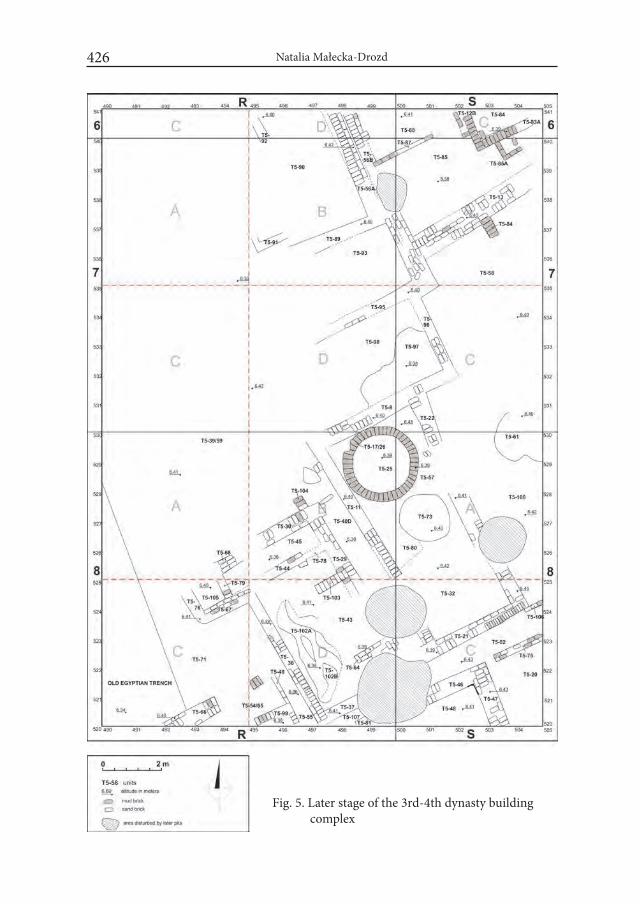
Natalia Małecka-Drozd 426
Fig. 5. Later stage of the 3rd-4th dynasty building complex

The Old Kingdom Upcountry Settlement Aarchitecture in the Nile Delta... 427
some cooking activity in the compartment. The other rooms are more difficult for interpretation, however the range of the findings (see below) may suggested the other economic activities.
The traces indicating a reorganization within the building complex were re-vealed above Levels 15-16 (6.20 – 6.10 m), however its general layout has not been changed. The range of a potential rebuildings that have occurred in struc-tures located in the northern part of the trench are difficult to recognize due to their bad state of preservation. Western part of the complex (squares R7AC, R8A) was completely vanished (Fig. 5). Within its central part (squares R7D and
Fig. 6. The latest rebuildings within northern part of the 3rd-4th dynasty building com-plex
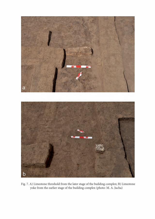
Fig. 7. A) Limestone threshold from the later stage of the building complex; B) Limestone yoke from the earlier stage of the building complex (photo: M. A. Jucha)
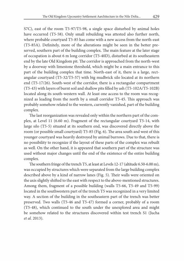
The Old Kingdom Upcountry Settlement Aarchitecture in the Nile Delta... 429
S7C), east of the room T5-97/T5-98, a single space disturbed by animal holes have occurred (T5-58). Only small rebuilding was attested also further north, where probable courtyard T5-85 has come with a new access from the north-east (T5-85A). Definitely, more of the alterations might be seen in the better pre-served, southern part of the building complex. The main feature at the later stage of occupation is about 6 m long corridor (T5-40D), disturbed at its southeastern end by the late Old Kingdom pit. The corridor is approached from the north-west by a doorway with limestone threshold, which might be a main entrance to this part of the building complex that time. North-east of it, there is a large, rect-angular courtyard (T5-32/T5-57) with big mudbrick silo located at its northern end (T5-17/26). South-west of the corridor, there is a rectangular compartment (T5-43) with layers of burnt soil and shallow pits filled by ash (T5-102A/T5-102B) located along its south-western wall. At least one access to the room was recog-nized as leading from the north by a small corridor T5-45. This approach was probably somehow related to the western, currently vanished, part of the building complex.
The last reorganization was revealed only within the northern part of the com-plex, at Level 11 (6.60 m). Fragment of the rectangular courtyard T5-14, with large silo (T5-5) situated at its southern end, was discovered directly above the room (or possible small courtyard) T5-85 (Fig. 6). The area south and west of this younger courtyard was heavily destroyed by animal burrows. Due to that, there is no possibility to recognize if the layout of these parts of the complex was rebuilt as well. On the other hand, it is appeared that southern part of the structure was used without major changes until the end of the existence of the entire building complex.
The southern fringe of the trench T5, at least at Levels 12-17 (altitude 6.50-6.00 m), was occupied by structures which were separated from the large building complex described above by a kind of narrow lanes (Fig. 5). Their walls were oriented on the axis slightly shifted to the east with respect to the above-mentioned structures. Among them, fragment of a possible building (walls T5-66, T5-49 and T5-99) located in the southwestern part of the trench T5 was recognized in a very limited way. A section of the building in the southeastern part of the trench was better preserved. Two walls (T5-46 and T5-47) formed a corner, probably of a room (T5-48), which continued to the south under the unexplored area and might be somehow related to the structures discovered within test trench S1 (Jucha et al. 2013).
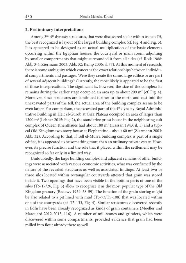
Natalia Małecka-Drozd 430
2. Preliminary interpretationsAmong 3rd-4th dynasty structures, that were discovered so far within trench T5,
the best recognized is layout of the largest building complex (cf. Fig. 4 and Fig. 5). It is appeared to be designed as an actual multiplication of the basic elements occurring within the Egyptian houses: the courtyard or main room, adjoining by smaller compartments that might surrounded it from all sides (cf. Roik 1988: Abb. 3-4; Ziermann 2003: Abb. 32; Kemp 2006: il. 77). At this moment of research, there is some ambiguity which concerns the exact relationships between individu-al compartments and passages. Were they create the same, large edifice or are part of several adjacent buildings? Currently, the most likely is appeared to be the first of these interpretations. The significant is, however, the size of the complex: its remains during the earlier stage occupied an area up to about 209 m2 (cf. Fig. 4). Moreover, since structures are continued further to the north and east into the unexcavated parts of the tell, the actual area of the building complex seems to be even larger. For comparison, the excavated part of the 4th dynasty Royal Adminis-trative Building in Heit el-Gurob at Giza Plateau occupied an area of larger than 1300 m2 (Lehner 2015: Fig. 2), the standarize priest house in the neighboring cult complex of Queen Khentkaues had about 180 m2 (Hassan 1943: il. 1) and a typi-cal Old Kingdom two-story house at Elephantine – about 60 m2 (Ziermann 2003: Abb. 32). According to that, if Tell el-Murra building complex is part of a single edifice, it is appeared to be something more than an ordinary private estate. How-ever, its precise function and the role that it played within the settlement may be recognized so far only in a limited way.
Undoubtedly, the large building complex and adjacent remains of other build-ings were associated with various economic activities, what was confirmed by the nature of the revealed structures as well as associated findings. At least two or three silos located within rectangular courtyards attested that grain was stored inside it. Two openings that have been visible in the bottom parts of one of the silos (T5-17/26, Fig. 5) allow to recognize it as the most popular type of the Old Kingdom granary (Badawy 1954: 58-59). The function of the grain storing might be also related to a pit lined with mud (T5-73/T5-108) that was located within one of the courtyards (cf. T5-133, Fig. 4). Similar structures discovered recently in Edfu have been already recognized as kinds of grain containers (Moeller and Marouard 2012-2013: 116). A number of mill-stones and grinders, which were discovered within some compartments, provided evidence that grain had been milled into flour already there as well.
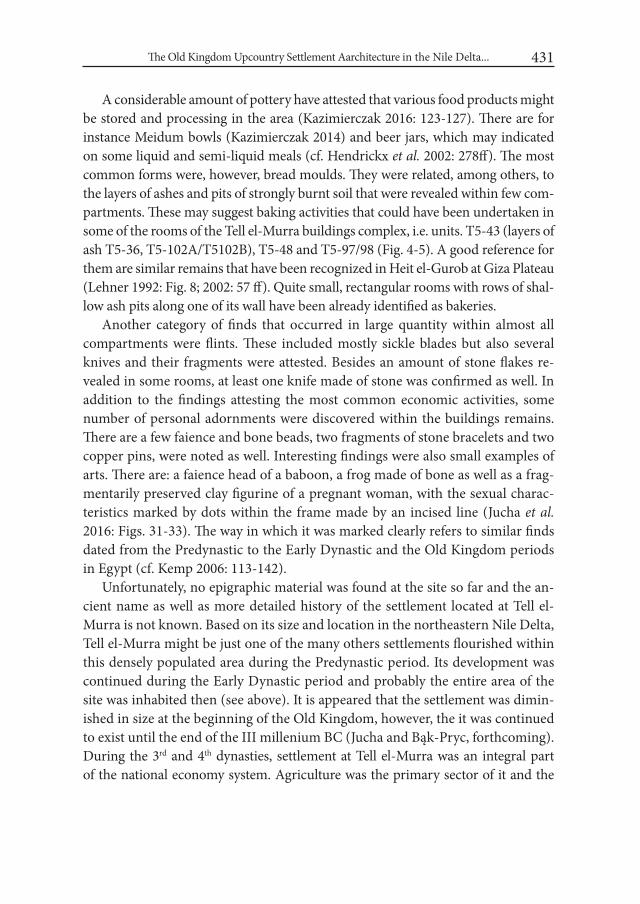
The Old Kingdom Upcountry Settlement Aarchitecture in the Nile Delta... 431
A considerable amount of pottery have attested that various food products might be stored and processing in the area (Kazimierczak 2016: 123-127). There are for instance Meidum bowls (Kazimierczak 2014) and beer jars, which may indicated on some liquid and semi-liquid meals (cf. Hendrickx et al. 2002: 278ff). The most common forms were, however, bread moulds. They were related, among others, to the layers of ashes and pits of strongly burnt soil that were revealed within few com-partments. These may suggest baking activities that could have been undertaken in some of the rooms of the Tell el-Murra buildings complex, i.e. units. T5-43 (layers of ash T5-36, T5-102A/T5102B), T5-48 and T5-97/98 (Fig. 4-5). A good reference for them are similar remains that have been recognized in Heit el-Gurob at Giza Plateau (Lehner 1992: Fig. 8; 2002: 57 ff). Quite small, rectangular rooms with rows of shal-low ash pits along one of its wall have been already identified as bakeries.
Another category of finds that occurred in large quantity within almost all compartments were flints. These included mostly sickle blades but also several knives and their fragments were attested. Besides an amount of stone flakes re-vealed in some rooms, at least one knife made of stone was confirmed as well. In addition to the findings attesting the most common economic activities, some number of personal adornments were discovered within the buildings remains. There are a few faience and bone beads, two fragments of stone bracelets and two copper pins, were noted as well. Interesting findings were also small examples of arts. There are: a faience head of a baboon, a frog made of bone as well as a frag-mentarily preserved clay figurine of a pregnant woman, with the sexual charac-teristics marked by dots within the frame made by an incised line (Jucha et al. 2016: Figs. 31-33). The way in which it was marked clearly refers to similar finds dated from the Predynastic to the Early Dynastic and the Old Kingdom periods in Egypt (cf. Kemp 2006: 113-142).
Unfortunately, no epigraphic material was found at the site so far and the an-cient name as well as more detailed history of the settlement located at Tell el-Murra is not known. Based on its size and location in the northeastern Nile Delta, Tell el-Murra might be just one of the many others settlements flourished within this densely populated area during the Predynastic period. Its development was continued during the Early Dynastic period and probably the entire area of the site was inhabited then (see above). It is appeared that the settlement was dimin-ished in size at the beginning of the Old Kingdom, however, the it was continued to exist until the end of the III millenium BC (Jucha and Bąk-Pryc, forthcoming). During the 3rd and 4th dynasties, settlement at Tell el-Murra was an integral part of the national economy system. Agriculture was the primary sector of it and the

Natalia Małecka-Drozd 432
period of the Old Kingdom was not an exception to this rule. Crops was the main currency in which taxes were collected and then forwarded to the state administra-tion’s agents. Moreover, it was the Nile Delta that has been perceived then as a major reservoir of agricultural products during the period. In this case, there is no surprise that the vast majority of the archaeological remains in exposed part of Tell el-Murra settlement was related to the crops storage and their later processing.
The nature of the large building complex and accompanying findings indicate that links between the settlement and the outer world were not just confined for paying taxes. Tell el-Murra was not self-sufficient settlement and some products and resources had to be provided from the outside. Therefore, there had to be an adequate surplus to provide trade exchange to the other parts of the country. The important evidence for the existence of such an exchange is limestone occurring at the site, for which the nearest sources are located beyond the Nile Delta. Its intentional transfer to the small settlement in the northeastern Nile Delta had to be cost-effective to be able to exist. It also applied to the other products and raw materials commonly attested at the site, for example flints and small sandstones as well as – more scarce – copper. The possible existence of a production zone, as-sociated with the manufacture of tools made of these materials, remains an open question. It might be located in the unexcavated part of the settlement.
Excavations at Tell el-Murra have already provided the unique possibility to recognize the Old Kingdom provincial settlement in the Nile Delta. Thanks to the current research, we have obtained first data for its chronology, layout and archi-tecture, as well as first insights into upcountry economy during the age of pyra-mids. Works in the area of trench T5 have not provided until now any traces of more residential rooms or compartments and we can only assumed that they had to be located in the unexcavated part of the tell. Due to the thickness of the walls, their possible presence at the upper floor is appeared to be precluded. In this case, the 3rd-4th dynasty building complex is appeared to be purely an economic area within a bigger layout, mansion presumable. The issue of its possible connection with a regular settlement buildings or some kind of estate remains open. The lack of the epigraphic material as well as still ongoing analysis of the revealed mate-rial do not allow at the moment to precise the identification. On the basis of the scale of the explored structures as well as their quality, such a mansion may be assumed as an important element of the Old Kingdom settlement landscape at Tell el-Murra. However, only further works and extension of the excavations to other parts of the site may complement our knowledge about the functions of the settlement during the 3rd and 4th dynasties.
The Old Kingdom Upcountry Settlement Aarchitecture in the Nile Delta... 433
REFERENCES
BADAWY, A. 1954. A History of Egyptian Architecture. Volume i: From the Earliest Times to the End of the Old Kingdom. Cairo.
CHŁODNICKI, M., FATTOVICH, R. and S. SALVATORI. 1992. The Italian Archaeological Mission of the C.S.R.L-Venice to the Eastern Nile Delta: A preliminary report of the 1987-1988 field seasons. Cahier de Recherches de l’institut de Papyrologie et d’Egyptologie de Lille 14: 45-62.
CHŁODNICKI, M., CIAŁOWICZ, K.M. and A. MĄCZYŃSKA (eds.). 2012. Tell el-Farkha i. Excavations 1998-2011. Poznań-Kraków.
HASSAN, S. 1943. Excavations at Giza iV: 1932-1933. Cairo. HENDRICKX, S. and E.C.M. VAN DEN BRINK. 2002. Inventory of Predynastic
and Early Dynastic cemetery and settlement in the Egyptian Nile Valley. In: E.C.M. van den Brink and T.E. Levy (eds.) Egypt and the Levant. in-terrelations from the 4th through the Early 3rd Millenium B.C.E.: 346-399. London-New York.
HENDRICKX, S., FALTINGS, D., OP DE BEECK, L., RAUE, D. and C. MICH-IELS. 2002. Milk, beer and bread technology during the Early Dynastic pe-riod. Mitteilungen des Deutschen Archäologischen instituts Abteilung Kairo 58: 277-304.
JUCHA, M. A. 2009. The North-Eastern Part of the Nile Delta – Research Per-spectives. Polish Archeological Survey in the Ash-Sharqiyyah Governorate. In: J. Popielska-Grzybowska and J. Iwaszczuk (eds.), Proceedings of the Fifth Central European Conference of Egyptologists. Egypt 2009: Perspectives of Research, Pułtusk 22-24 June 2009 (= Acta Archaeologica Pultuskiensia vol. II): 83-88. Pułtusk.
JUCHA, M. A. 2010a. Tell el-Murra. The Polish Archaeological Survey in Ash-Sharqiyyah Governorate (Egypt, the Nile Delta). Recherches Archéologiques. Nouvelle Serie 2: 229-237.
JUCHA, M. A. 2010b. Tell el-Murra. The Predynastic – Old Kingdom site in the North-Eastern Nile Delta. Folia Orientalia XLVII: 379-390.
JUCHA, M. A. 2011. The Polish archeological survey in the north-eastern part of the Nile Delta (season 2010) – the pottery from Tell el-Murra and Tell Abu el-Halyat. Recherches Archéologiques Nouvelle Serie 3: 179-194.
JUCHA, M. A. 2012. Naqada III – Old Kingdom pottery in the Nile Delta: a view from Tell el-Akhdar. Studies in Ancient Art and Civilization 16: 49-60.

Natalia Małecka-Drozd 434
JUCHA, M. A. 2016. North-Eastern Part of the Nile Delta during Naqada III Period. In: Egypt at its Origins 4. Proceedings of the international Conference ‘Origins of the State. Predynastic and Early Dynastic Egypt’ New York, July 26-30, 2011. (= Orientalia Lovaniensa Analecta 252). Leuven-Paris-Bristol: 63-76.
JUCHA, M. A. and A. BUSZEK. 2011. Tell el-Murra (Northeastern Nile Delta Sur-vey), season 2008. Polish Archaeology in the Mediterranean XX: 177-182.
JUCHA, M. A., BŁASZCZYK, K., BUSZEK, A. and G. PRYC. 2013. Tell el-Murra (Nrtheastern Nile Delta Survey). Survey 2010. Polish Archaeology in the Mediterranean XXII: 105-120.
JUCHA, M. A., BĄK-PRYC, G. and M. CZARNOWICZ. 2014. Tell el-Murra (Northeastern Nile Delta survey): season 2011. Polish Archaeology in the Mediterranean XXIII/1: 141-152.
JUCHA, M. A., BĄK-PRYC, G. And N. MAŁECKA-DROZD. 2015. Tell el-Murra (North-eastern Nile Delta Survey), seasons 2012-2013. Polish Archaeology in the Mediterranean XXIV: 199-214.
JUCHA, M. A., BĄK-PRYC, G., MAŁECKA-DROZD, N., KAZIMIERCZAK, M., OWNBY, M.F., MĄDRZYK, K., PANKOWSKA, A., WOŹNIAK, B., and R. ABŁAMOWICZ, 2016. Polish Excavations at Tell el-Murra in the Nile Delta. Preliminary Report 2013-2015. Archeologia 65: 85-146.
JUCHA, M. A. and G. BĄK-PRYC. 2017, Settlement and Cemetery – New Re-search on the 4th/3rd Millenium Nile Delta site of Tell el-Murra. In: B. Mi-dant-Reynes, Y. Tristant, with the collaboration of E.M. Ryan, Egypt At Its Origins 5. Proceedings of the Fifth International Conference “Origin of the State. Predynastic and Early Dynastic Egypt”, Cairo, 13th – 18th April 2014, (OLA 260), Leuven–Paris–Bristol, CT, 175-197.
JUCHA, M. A., BĄK-PRYC, G., MAŁECKA-DROZD, N. and M. KAZIMIER- CZAK. 2017. Tell el-Murra (Northeastern Nile Delta Survey) Seasons 2014- -2015. Polish Archaeology in the Mediterranean 26/1: 135-158.
KAZIMIERCZAK, M. 2014. Meidum bowls from Tell el-Murra trench T5 (sea-son 2013). In: M.A. Jucha, J. Dębowska-Ludwin and P. Kołodziejczyk (eds.) Aegyptus est imago caeli. Studies Presented to Krzysztof M. Ciałowicz on His 60th Birthday: 161-166. Kraków.
KAZIMIERCZAK, M. 2016. The pottery from the settlement – trench T5. In: M. Jucha et al. Polish Excavations at Tell el-Murra in the Nile Delta. Prelimi-nary Report 2013-2015, Archeologia 65: 121-127.
KEMP, B. J. 2006. Ancient Egypt. Anatomy of a Civilisation. London-New York.LEHNER, M. 1992. Excavations at Giza 1988-1991: the location and importance of
the pyramid settlement. The Oriental institute News and Notes 135 (Fall): 1-9.
The Old Kingdom Upcountry Settlement Aarchitecture in the Nile Delta... 435
LEHNER, M. 2002. The Pyramid Age Settlement of the Southern Mount at Giza. Journal of American Research Center in Egypt 39: 27-74.
LEHNER, M. 2015. Labor and the Pyramids. The Heit el-Ghurab “Workers Town” at Giza. In: P. Steinkeller, M. Hudson (eds.) Labor in the Ancient world. Dresen: 397-522.
MAŁECKA-DROZD, N. 2014. The Settlement Landscape in the Nile Del-ta of the third millenium BC. In: M.A. Jucha, J. Dębowska-Ludwin and P. Kołodziejczyk (eds.) Aegyptus est imago caeli. Studies Presented to Krzysz-tof M. Ciałowicz on His 60th Birthday: 57-62. Kraków.
MAŁECKA-DROZD, N. forthcoming, The Nile Delta during the Early Dynastic and the Old Kingdo periods. Preliminary remarks on the settlement land-scape evolution. In: G. Bąk-Pryc, J. Dębowska-Ludwin and M. A. Jucha (eds.) Studies on the Archaeology of the Nile Delta and Sinai.
MIDANT-REYNES, B. and N. BUCHEZ (eds). 2014. Tell el-iswid 2006-2009. (= Fouilles de l’IFAO 73). Cairo.
MOELLER, N. and G. MAROUARD. 2012-2013. Tell Edfu. The Oriental institute 2012-2013 Annual Report: 113-125.
OREN, E.D. 1973. The Overland Route between Egypt and Canaan in the Early Bronze Age. israel Exploration Journal 23: 198-205.
RAMPERSAD, S. R. 2006. Tell el-Masha’la: A Predynastic/Early Dynastic Site in the Eastern Nile Delta. In: K. Kroeper, M. Chłodnicki and M. Kobusie-wicz (eds.), Archaeology of Early North-Eastern Africa. in Memory of Lech Krzyżaniak (= Studies in African Archaeology 9): 789-816. Poznań.
RAMPERSAD, S. R. 2008. Introducing Tell Gabbara: New Evidence for Early Dynas-tic Settlement in the Eastern Delta. Journal of Egyptian Archaeology 94: 95-106.
RAMPERSAD, S. R. 2015-2016. Tell Gabbara: A Late Second Dynasty Settlement in the Eastern Delta, Egypt. Journal of the Society for the Study of Egyptian Antiquities 42: 83-99.
ROIK, A. M. 1988. Das altägyptische wohnhaus und seine Dorsteillung im Flach-bild. Teil i-ii, Frankfurt am Main – Bern – New York – Paris.
VAN DEN BRINK, E.C.M. 1993. Settlement patterns in the northeastern Nile Delta during fourth-second millennia B.C. In: L. Krzyżaniak, M. Kobusiewicz and J. Alexander (eds.) Environmental change and human culture in the Nile Basin and Northern Africa. (= Studies in African Archaeology 4): 279-304. Poznań.
ZIERMANN, M. 2003. Elephantine XXViii. Die Baustrukturen der altern Stadt (Frühzeut und Altes Reich). Mainz am Rhein.


Desert and the Nile. Prehistory of the Nile Basin and the Sahara.
Papers in honour of Fred Wendorf Studies in African Archaeology 15
Poznań Archaeological Museum 2018
Marek Chłodnicki and Krzysztof Grzymski
Kerma Culture in Letti Basin (Dongola Reach)
Letti Basin is located between the Third and the Fourth Nile Cataract in the so called Dongola Reach (Fig. 1). This fertile land was a perfect place for settle-ment since Palaeolithic times. Middle and Late Palaeolithic, Neolithic, Napatan, Meroitic, Post-Meroitic and especially Christian sites were identified there. It was only in the 1980s that the traces of the Kerma culture were also discovered in the area.
For the long time the southernmost known site of the Kerma Culture was Bug-dumbush, to the north of the Letti Basin (Gratien 1978: 21). Although now we know that the Kingdom of Kerma extended further up the Nile beyond the 4th cataract our knowledge of what was going on in the 20 km long Letti Basin during the Kerma period was very limited. Similar situation exists around the Old Don-gola, south of the Letti Basin. When compared to the finds from the Kerma Basin to the north and to those from the area between Karima and Abu Hamed further upstream, the material from the Letti Basin is very scant (Gratien 1978; Welsby 2003; Chłodnicki 2007; Osypiński 2007).
The present publication was provoked by a discussion during the Nubian Con-ference in Neuchâtel, September 2015, when the subject of the Kerma culture was brought up with suggestions that we know nothing about this culture in the Letti Basin. In fact, this is not the case, although our knowledge is admittedly very lim-ited. The presence of the Kerma material in the region was known since the 1970. It was known mostly from the surface collection although one site has been exca-
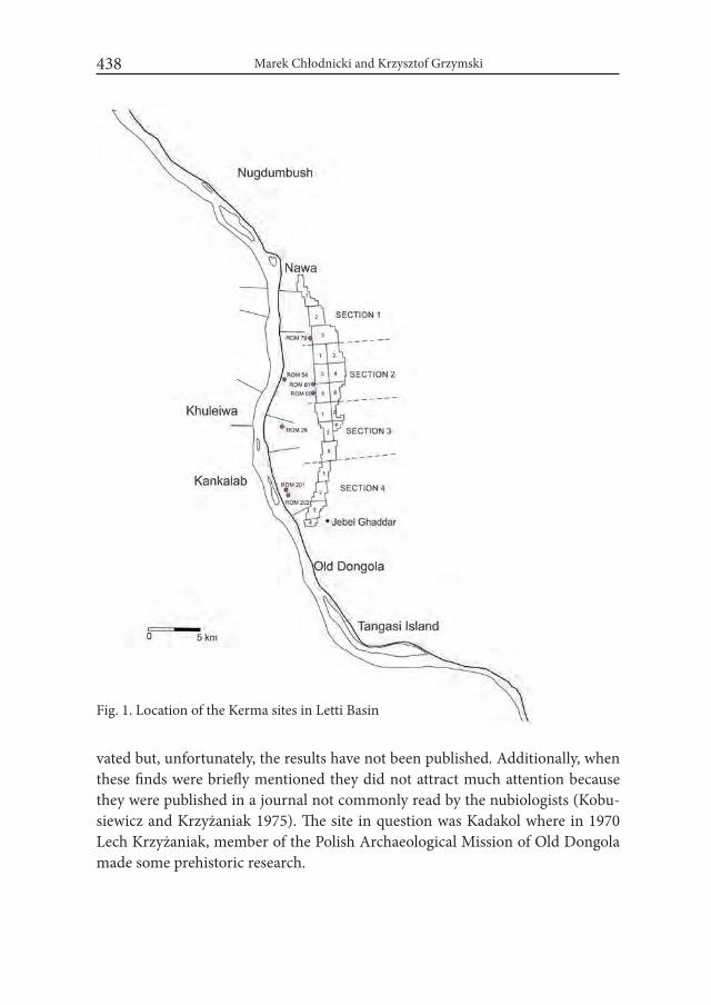
Marek Chłodnicki and Krzysztof Grzymski438
vated but, unfortunately, the results have not been published. Additionally, when these finds were briefly mentioned they did not attract much attention because they were published in a journal not commonly read by the nubiologists (Kobu- siewicz and Krzyżaniak 1975). The site in question was Kadakol where in 1970 Lech Krzyżaniak, member of the Polish Archaeological Mission of Old Dongola made some prehistoric research.
Fig. 1. Location of the Kerma sites in Letti Basin
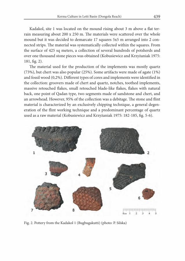
Kerma Culture in Letti Basin (Dongola Reach) 439
Kadakol, site 1 was located on the mound rising about 3 m above a flat ter-rain measuring about 200 x 250 m. The materials were scattered over the whole mound but it was decided to demarcate 17 squares 5x5 m arranged into 2 con-nected strips. The material was systematically collected within the squares. From the surface of 425 sq meters, a collection of several hundreds of potsherds and over one thousand stone pieces was obtained (Kobusiewicz and Krzyżaniak 1975: 181, fig. 2).
The material used for the production of the implements was mostly quartz (73%), but chert was also popular (25%). Some artifacts were made of agate (1%) and fossil wood (0,2%). Different types of cores and implements were identified in the collection: groovers made of chert and quartz, notches, toothed implements, massive retouched flakes, small retouched blade-like flakes, flakes with natural back, one point of Qadan type, two segments made of sandstone and chert, and an arrowhead. However, 95% of the collection was a debitage. The stone and flint material is characterized by an exclusively chipping technique, a general degen-eration of the flint working technique and a predominant percentage of quartz used as a raw material (Kobusiewicz and Krzyżaniak 1975: 182-185, fig. 5-6).
Fig. 2. Pottery from the Kadakol 1 (Bugbugakutti) (photo: P. Silska)
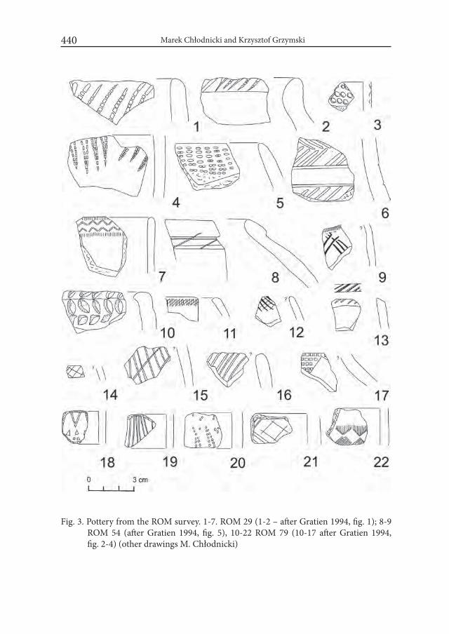
Marek Chłodnicki and Krzysztof Grzymski440
Fig. 3. Pottery from the ROM survey. 1-7. ROM 29 (1-2 – after Gratien 1994, fig. 1); 8-9 ROM 54 (after Gratien 1994, fig. 5), 10-22 ROM 79 (10-17 after Gratien 1994, fig. 2-4) (other drawings M. Chłodnicki)
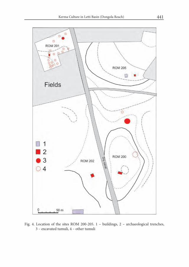
Kerma Culture in Letti Basin (Dongola Reach) 441
Fig. 4. Location of the sites ROM 200-205. 1 – buildings, 2 – archaeological trenches, 3 – excavated tumuli, 4 – other tumuli
Marek Chłodnicki and Krzysztof Grzymski442
Stone grinder and pottery were also collected from the investigated squares. The pottery was heavily eroded; the drawings and photos of a few sherds were published. The pottery was made of clay strongly mixed with chaff and sand tem-per. Material comes from the big pots, sometimes decorated with impressed pat-terns, mostly (90%) of the so called basket impressions. Sometimes red slip is preserved on the surface (Kobusiewicz and Krzyżaniak 1975: 181-182, fig. 3-4).
At the time of the publication the authors had problems with identifying the cultural affiliation of the Kadakol material. Firstly, it was not clear if it was a single or multi-phase settlement, and the secondly, there were no distinct parallels to it except for some slight affinities to the Cataract Tradition and the Abka industry. Lech Krzyżaniak noticed some similarity to the Kerma culture but was very careful not to say more about the chronological framework of the site. He described the site as a camp of the group of population living off fishing and hunting, dated between 2700-1800 BC. We must remember that at that time the Kerma culture was known only to the north of the Letti Basin (Kobusiewicz and Krzyżaniak 1975: 185).
We can now say that the material is characteristic to the Kerma flint indus-try but after the visit the site in 2002 we are also sure that this is a multi-phase site. The pottery collected on site confirmed for us that material which could be dated to the Early and Middle Kerma was there as one element of a multicultural site. Fortunately, part of material collected by Lech Krzyżaniak was stored in the Poznań Archaeological Museum. In this sample we also found small pieces deco-rated with zigzag made with rocker technique and a fragment of the vessel with black top (Fig. 2: 3-4).
Brigitte Gratien in her monograph of the Kerma culture, mentioned a wide tumuli cemetery dated to Kerma classic located in Bugdumbush, to the north of Letti, as the southernmost known site if that culture (Gratien 1978: 21). It is probably the same site discovered by Millet and Mills in 1978 in Zereib, north of Bugdumbush where they noted over a thousand graves with stone and bone frag-ments, and Kerma sherds scattered around (Grzymski 1987: 30).
In 1985 the expedition of Royal Ontario Museum, directed by Krzysztof Grzymski began the systematic investigation of the Letti Basin. Already in his first report Grzymski stated that:
„From the scholarly point of view perhaps the most interesting discovery was the existence of a number of Kerma sites in the Letti area. These are the most southerly sites presently known and further research is certainly worthwhile. We did not have the resources nor the time to excavate any of the Kerma sites, but we certainly hope that this will be done in the near future” (Grzymski 1985: 39).
Kerma Culture in Letti Basin (Dongola Reach) 443
Unfortunately no photos or drawings of the material were published at the time but some of the potsherds discovered by the Canadian team were later pub-lished by Brigitte Gratien (1994: 68-71) (Fig. 3:1-2, 8-17).
The number of the discovered Kerma sites in the Kerma Basin is not large but they show a potential of this area. Among the sites it is necessary to mention:
ROM 29. Bugbugakutti, District Kadakol. In this small roundish mound, ma-terial which was preliminary dated to Early Nubian (Grzymski 1987: 25) was found. Among the pottery fragments with the comb and mat impressions and fragments of tulip beakers, fragments made of pink or orange paste of Egyptian tradition what was frequent in Kerma (Gratien 1994: 68-69, Fig. 1) (Fig. 3:1-7) were also found. This is the same site described by L. Krzyżaniak and M. Kobus-iewicz as Kadakol 1.
ROM 54. Kadakol-Teraza. District Kadakol. K. Grzymski during his first sur-vey thought that it is the same site as Kadakol 1 published by Kobusiewicz and Krzyżaniak (Grzymski 1987: 25-26). It later became apparent that Kadakol 1 is to be identified with ROM 29, because the site of Kadakol (Teraza) has quite differ-ent appearance from the Kadakol described by the Polish archaeologists. More-over, most of the pottery was dated to the Christian period and only a few could be identified as Kerma Classic. Fragment of the rim of fine ware with black paste and orange exterior as well as rims with simple geometric decoration were also found (Gratien 1978: 69, Fig. 5) (Fig. 3: 8-9).
ROM 55, Arab Hag El Madrasa. District Arab Hag. Unidentified bricks and stone slabs, possibly pre-Christian were discovered there. The exact dating of the site was not certain, but hand made mat-impressed pottery, possibly be Neolithic or early Nubian (Grzymski 1987: 26) were found.
ROM 60, Sections, basin 3. The site is located between the sand dunes on the west side of Khor Letti and east of Kadakol. A scatter of pottery fragments and chert flakes. There he found clearly Kerma potsherds (Grzymski 1987: 23).
ROM 61, Section 2, basin 5. The site is located on two low mounds on the edge of cultivation on the west side of Khor Letti across the desert from Kadakol. The diagnostic potsherds included Kerma (Grzymski 1987: 22-23).
ROM 79. Barakol. Section 1, Basin 3. The site was located to the east of Amentego. A scatter of lithics and hand made potsherds spread over the rather flat area right on the edge of cultivation was found (Grzymski 1987: 23, Pl. 3b). Grzymski proposed identified this site as early Nubian and Kerma. Pottery analy-sis by Brigitte Gratien confirmed that the pottery could be dated from the Ancient to Classic Kerma. Between the pots, pottery fragments with incised criss-cross

Marek Chłodnicki and Krzysztof Grzymski444
Fig.5. Stone structures on the site ROM 202

Kerma Culture in Letti Basin (Dongola Reach) 445
Fig. 6. Plan of the stone structures on the site ROM 202. 1 – fireplaces, 2 – remains of a plaster, 3 – stone blocks

Marek Chłodnicki and Krzysztof Grzymski446
Fig. 7. Pottery from the site ROM 202 (photo: M. Chłodnicki)

Kerma Culture in Letti Basin (Dongola Reach) 447
lines, rim decorated with oblique incisions as well as with geometric decoration and mat impressions were found. Fragments of fine polished beakers were also collected (Gratien 1994: 69, fig. 2-4) (Fig. 3: 10-17). Some more potsherds were collected during the survey in 1998 (Fig. 3: 18-22).
ROM 80. Gerf el-Melik North, located north of Letti Basin, 2 km east of the Nile in the rocky desert near the lorry tracks. The site comprises up to 80 grave mounds of two types: 1 – conical pebble-covered mounds 3-4 m in diameter and 2 – mounds with the stone ring on top and usually a depression in the center, 6-8 m in diameter. Perhaps it dates to the Kerma period (Grzymski 1987: 29).
When in 1995 the Royal Ontario Museum team, comprising also archaeolo-gists from Poznan, started again a survey in the Letti Basin, the work was concen-trated in its the southern part. Especially interesting was the area located between the newly constructed suq and a new school in Ghaddar. In this area we found remains of a Neolithic settlement (Chłodnicki and Kabaciński 2003: 57-62) as well as a group of cemeteries consisting of almost flat tumuli of different sizes and construction. Some of the tombs were excavated but, unfortunately, all of them were robbed. Some of them, because of the construction method and position of the body, were clearly of a later date, but several seem to belong to the Kerma culture, especially those found at site ROM 201 (Fig. 4).
During the research we paid attention to a group of stones lying on the truck route. Around them flints and pottery sherds were scattered and fragments of Kerma classic black-topped beakers were found among the potsherds. This site was marked as ROM 202.
Small trench, 7x7m covering all stone blocks visible on the surface was opened. All stones are flat and carry signs of cutting to achieve a flat top surface (Fig. 5-6). The thickness of the blocks did not exceed 20 cm. The blocks were placed in the silt and the cultural debris not exceeded 10 to 12 cm. We discovered traces of the fireplaces and charcoal between the blocks, but not necessarily connected with the building. Remains of, most probably, a plaster could be of the Kerma chronology. Inside the construction a Post-Meroitic grave was dug.
From the trench almost 650 fragments of pottery were collected. 95 % of them were connected with the Kerma culture. Others are of the Neolithic, Post-Meroit-ic and Christian periods.
Almost a third of the material comes from the black-topped beakers. Similar quantity constitutes of red polished pottery decorated with comb impressions or brown pottery covered with incised lines. The smallest group, is pottery decorated with the mat or basket impressions (Fig. 7-8).
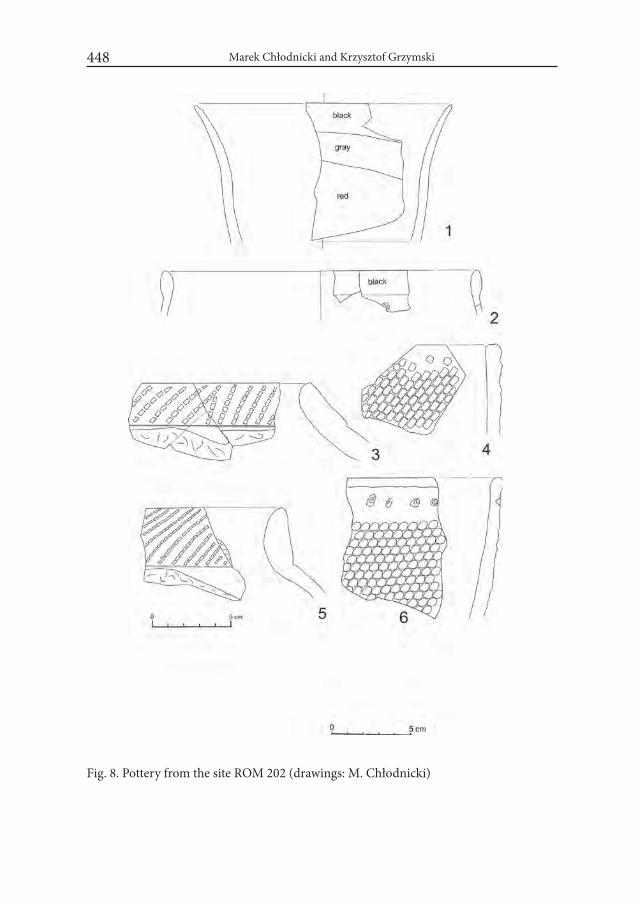
Marek Chłodnicki and Krzysztof Grzymski448
Fig. 8. Pottery from the site ROM 202 (drawings: M. Chłodnicki)
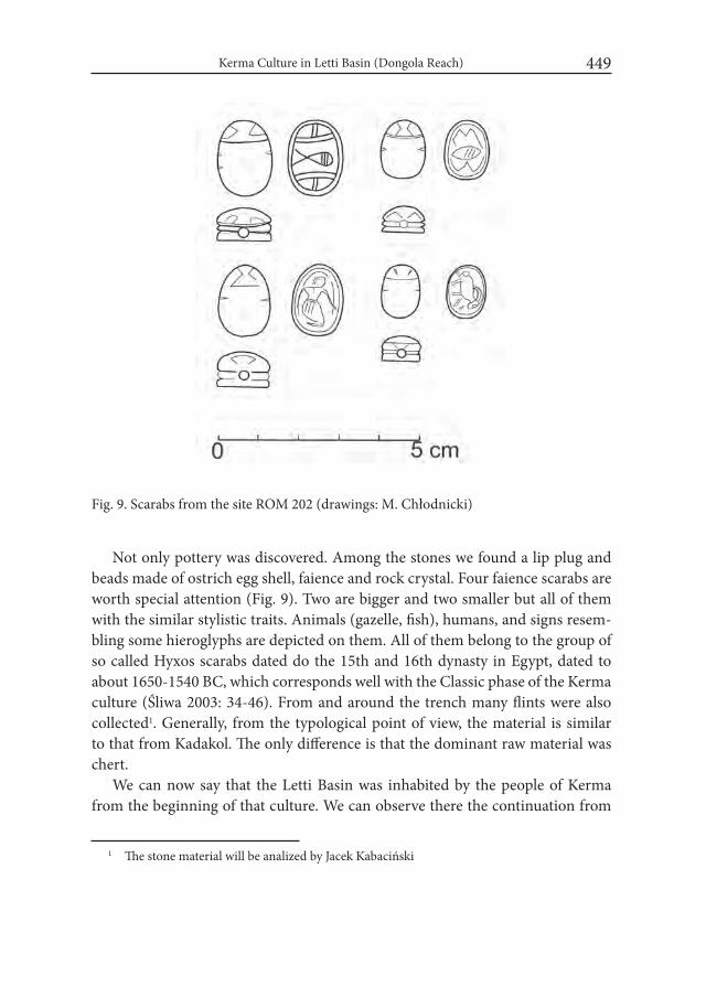
Kerma Culture in Letti Basin (Dongola Reach) 449
Not only pottery was discovered. Among the stones we found a lip plug and beads made of ostrich egg shell, faience and rock crystal. Four faience scarabs are worth special attention (Fig. 9). Two are bigger and two smaller but all of them with the similar stylistic traits. Animals (gazelle, fish), humans, and signs resem-bling some hieroglyphs are depicted on them. All of them belong to the group of so called Hyxos scarabs dated do the 15th and 16th dynasty in Egypt, dated to about 1650-1540 BC, which corresponds well with the Classic phase of the Kerma culture (Śliwa 2003: 34-46). From and around the trench many flints were also collected1. Generally, from the typological point of view, the material is similar to that from Kadakol. The only difference is that the dominant raw material was chert.
We can now say that the Letti Basin was inhabited by the people of Kerma from the beginning of that culture. We can observe there the continuation from
1 The stone material will be analized by Jacek Kabaciński
Fig. 9. Scarabs from the site ROM 202 (drawings: M. Chłodnicki)
Marek Chłodnicki and Krzysztof Grzymski450
the pre-Kerma phase to its Classic phase. Most of the sites have been eroded (as were the Neolithic sites), or covered by the huge mounds with Christian period remains. There is still a chance, however, that better preserved sites will be found in the area, but it requires further long term works in the Letti Basin. It seems that it is only a matter of time when more sites will be discovered in the Letti Basin.
REFERENCESCHŁODNICKI, M. 2007. Archaeological research between Khor Umm Ghizlan
and Shemkhiya region 2003-2005. In: C. Näser and M. Lange (eds.). Pro-ceedings of the Second international Conference on the Archaeology of the Fourth Nile Cataract, Berlin August 4th – 6th , 2005 (= Meroitica 23): 206-212.
CHŁODNICKI, M. and J. KABACIŃSKI, J. 2003. The Neolithic of the Dongola Reach (Nubia). GAMAR 2: 57-59.
GRATIEN, B. 1978. Les Cultures Kerma. Lille.GRATIEN, B. 1994. Cèramique Kerma dans la règion d’Hambukol (Soudan). Bul-
letin de Liaison du Groupe international d’Étude de la Cèramique Égyptienne XVIII: 68-71, IFAO.
GRZYMSKI, K. 1985. Dongola Reach Survey 1984 and 1985 seasons. Nyame Aku-ma 26: 38-39.
GRZYMSKI, K. 1987. Archaeological Reconnaissance in Upper Nubia (= The SSEA Publications 14). Toronto.
KOBUSIEWICZ, M. and L. KRZYŻANIAK. 1975. New prehistoric materials from the region of Old Dongola (Sudan). Fontes Archaeologici Posnanienses 25: 178-186.
OSYPIŃSKI, P. 2007. Excavations on two Kerma Horizon cemeteries in el-Gama-miya. PAM 19 (= Reports 2007): 400-405.
ŚLIWA, J. 2003. Skarabeusze egipskie. Ossolineum. Wrocław-Warszawa-Kraków.WELSBY, D. 2003. Survey above the Fourth Nile Cataract. London.
Desert and the Nile. Prehistory of the Nile Basin and the Sahara.
Papers in honour of Fred Wendorf Studies in African Archaeology 15
Poznań Archaeological Museum 2018
Maira Torcia
Towards Upper Egypt: Items and Cultural Elements on Trade Routes
Since the prehistory, the exchanges of goods were the first, if not the only way to transfer culture. The presence of obsidian and lapis lazuli far from the sources is the evidence of the movements of goods since archaic periods. Ideas travelled together with raw materials and cultural elements were transferred through the handicrafts, testifying to the contacts between distant areas.
1. HandicraftsAmong the well-known objects and themes coming from Near East, we high-
light the seals, symbol of power and accounting tool for leaders and officials: we can get information both from the materials they are made of and from their decorative patterns. They arrived in Egypt from Mesopotamia (Watrin 2004: 67-70; 2007: 20; Honoré 2007: 33-35) since Naqada IIb period, even if in spo-radic way. They were probably used at the beginning, as ornaments or amulets1. At the end of Naqada II period, the cretulae made their appearance (Hartung 1998: 188-217), testifying, together with seals, that at last in Late Prehistoric period,
1 An evidence of this could be the stamp seal from Mesopotamia, found in a tomb Naqada IIb at Naga ed-Der, inserted in a bracelet (Podzorski 1988: 262-263, fig. 3; Watrin 2004: 68-70).

Maira Torcia452
control systems were carried out also in Egypt (Hartung 1996: 33). However, we shall bear in mind that the control systems were in use in Mesopotamia long time be-fore: there, hundreds of seal impressions were found in the North, at Tell Sabi Aby-iad, dating back to the 6th millennium (Ak-kermans and Duistermaat 1996: 17-44).
As for the cretulae, I had the chance to study, among other groups from Near Eastern sites2, those from two settlements in Lower and Upper Egypt: Giza3 and Hi-erakonpolis4. The imagery of the archaic seal impressions from both sites, suggests connections with the Near East because of some iconographic motifs, moreover ar-ranged in rows (Amiet 1961: 27, Pl. 9, 171,
2 I have studied and partially published the cre-tulae from Uruk (Torcia Rigillo 1991a; Torcia 2009a), Tepe Gawra (Torcia Rigillo 1991b), Tell Brak and Susa.
3 The cretulae from Giza (239 pieces) were ex-cavated in ‘70ies by Austrian Archaeological Mission directed by K. Kromer (Kromer 1978: 93-99). This group comes from a site dated between the middle of Naqada II period and the Chefren kingdom (Kromer 1978: 70-73; 113-115). It includes seal impressions of the Pharaohs Cheops and Chefren (Kaplony 1981: 24-29; 67-95, Pl. 10-12, 23-31; Torcia Rigillo 2003: 36-73; 2007:1817-1826, Pl. 1-4; Torcia 2009b: 239-248, Pl. I-III; 2013: 219- -243, Pl. I-V) and a group of 104 pieces with figurative imagery, that dates back to the ar-chaic periods. Only drawings of 56 pieces were published (Kaplony 1981: Taf. 173-181).
4 These sealings are conserved at Cambridge, Museum of Anthropology and Archaeology. I wish to thank here Ann Taylor, then Direc-tor of MAA, who allowed me to study them. I published part of them in 2013 (see note above).
Fig. 1. a – the symbol of the goddess Neith combined with the toothed mouth (Z 46107); b – the Neith symbol and the bull with cres-cent horns (Z 45972); c – Nekh-bet as a vulture (Z 45936).
Z – the materials from Hiera-konpolis
Towards Upper Egypt: Items and Cultural Elements on Trade Routes 453
173-176) or in superimposed registers (Amiet 1961: 16-17, 27, Pl. 10, 181-185, Pl.13, 224, 230, Pl. 41, 618-619; Tobler 1950: Pl. CLXVIII-CLXIX), all patterns fre-quently present in Mesopotamian glyptic. The impressions show a very interest-ing, figurative imagery, with animalistic and vegetal motifs, often combined with some isolated signs of writing or “proto-hieroglyphs” which seem to have only decorative purposes. Quibell made this same remark (Quibell and Green 1902: 55) looking at these signs impressed on the archaic materials that he discovered at Hierakonpolis.
The cretulae from Hierakonpolis, excavated at the end of XIX century, are nearly 300 pieces, part of which dating back to Pre – and Early Dynastic periods. Only 46 of them have been published (Quibell and Green 1902: 16-17, Pl. LXX--LXXI, 1-46). Even if the site of Hierakonpolis presented stratigraphic problems, it results from Quibell reports that part of the cretulae dates back to archaic peri-ods, coming from areas with Pre – and Proto-dynastic materials, that is the Main Deposit (Quibell and Green 1902: 13-14, 33-34), a stratum close to the Temple entrance (Quibell and Green 1902: 2), the Northern Town Houses (Quibell and Green 1902: 18-19).
Among such interesting and peculiar patterns, we found elements and sym-bols referring to the religious sphere. We have entities as 3khw (Helck and Otto 1975: 49-52), b3w (Helck 1954: 22; Helck and Otto 1975: 588-590); k3 (Helck and Otto 1977: 275-282) and names of deities.
The symbol of the goddess Neit, the crossed arrows, is frequently found: it is combined with the reed or with the toothed mouth (Z 46107, Fig. 1a); in one case, with the bull with crescent horns, the ntr and a standard (Z 45972, Fig. 1b): likely, here is represented a cult place5. This impression could be dated to the 1st Dynasty (Quibell and Green 1902: 55).
Nekhbet, the goddess of Upper Egypt, is represented as a vulture on a perch (Z 45936, Fig. 1c) and M3’t through the goddess symbol (the ostrich feather).
But, above all, we need to mention here the presence of the symbol of the Su-merian goddess Inanna, impressed on a cretula from the Temple entrance (Fig. 2a).
The symbol of the mother-goddess Inanna in its origins is a pictogram repro-ducing the gateposts of the ancient reed huts in use in Sumer (Frankfort 1939: 15). We may compare the scene on our impression with the cult picture reproduced on a lapis lazuli seal from Uruk III-IVa (Fig. 2b) (Heinrich 1936: 9-10, 28-29, Taf. 17a;
5 A Neit sacred place is reproduced on an ebony tablet from Abydos, with Aha (Aha) name (Petrie 1901: 21, Pl. IIIA, n. 5; Emery 1963: 51-52, fig.12) and a bull with crescent horns.
Maira Torcia454
Amiet 1961: 30, Pl. 46, 655): the so-called “hampes bouclées”, generally in couple (Amiet 1961: 78-79, Pl. 43, 636, 638), are represented, according to the Sumerian iconography, on a boat combined with goats, both being Sumerian motifs: the former indicates the way to transport the offerings to the goddess, the latter sym-bolizes the sacred herd6. But, on the left top of our impression, there is also a part of the Egyptian seal xtm; therefore this impression has been done with a seal made in Egypt, employing symbols borrowed from Sumer. We underline the great im-portance of the presence of Inanna symbol in the deep South of Egypt, a strong sign of contacts between these areas.
Another witness of these straight relations between Upper Egypt and Mesopo-tamia, but in opposite direction, is an even more astonishing terracotta cylinder (Fig. 2c), found at Uruk in ‘70ies (Nissen 1974: 40, Pl. 28h), bringing the name of the queen Mr Neit (mid 1st dynasty). On it, the hieroglyph Mr (the hoe) and the symbol of the goddess Neit were engraved after baking, together with other symbols as the rosette, symbol of power. The extraordinary fact is that the cylinder comes from Uruk, the centre of Mesopotamia where, until now, no Egyptian ar-tefacts had ever been found. At the time of the discovery, Nissen wrote, about this piece coming from the debris dated to Sumerian Proto-Dynastic I period: “Die Zeichen ergeben keinen Sinn” (Nissen 1974: 40); the function of the object was not specified. Instead, we must suppose that it could be either a real cylinder seal with the name of the queen Mr Neit, entrusted to an official in charge of doing an exchange agreement or, more likely, a “message sealing” (Ratnagar 1981: 188 ff.) sent by the queen herself for accompanying goods and gifts, claiming some rare items – as we shall see later. Certainly the cylinder arrived from Upper Egypt to Uruk through trade routes. We may date the piece thanks to the name of Mr-Neit, the 5th queen of the 1st Dynasty (Khal 1994: 71). It is a good evidence that the mid 1st Dynasty in Egypt is nearly contemporary to the 1st Sumerian Proto-Dynastic period, as well as of the relations between the two areas.
Two other objects from Hierakonpolis may have been arrived from Mesopo-tamia: these are the bullae, peculiar of the Susian (Amiet 1972: 70, Pl. 66-68, 510, 540, 541, 649) and Sumerian areas (Lenzen 1965: 31-32, pl.17-19), highly sig-nificant in the course towards the cuneiform writing (Schmandt-Besserat 1980: 357-385). One of them is decorated with wavy lines (Z 46133,3, Fig. 2e), the other with two or three figures similar to fishes. The zoomorphic imagery at Hiera-
6 On our impression, the goat has a long beard, just like that reproduced on a white stone seal, from Uruk III (Amiet 1961: 30, Pl. 43 , 636).

Towards Upper Egypt: Items and Cultural Elements on Trade Routes 455
konpolis presents often fishes, also pin-nate, a pattern common in Near East: the most ancient seals from Upper Egypt, coming from Near East, show fishes combined with “ovals” or nets as decora-tive elements (Wilkinson 2002: 241-242, figs. 5-6).
Lizard too is present both at Hiera-konpolis (Fig. 3b) (Quibell-Green 1902: Pl. LXX, 40) and Giza (Fig. 3a) (Kaplony 1981: Taf. 181, 193).
At Giza – apart from proto-hiero-glyphs – we have a vast imagery showing iconographic patterns, both naturalistic and stylized. There are a great number of zoomorphic motifs, arranged in differ-ent ways: animals in human attitude, as the two monkeys, compared to the same animal on a seal impression from the 1st Dynasty tomb of Hemaka, at Saqqara (Emery 1938: 64, fig. 26; Torcia 2013: tav. II a-b) – or as the varanus, combined with the head of B3t close to a baboon, similar to the figure on the Uruk IVa impression (Amiet 1961: 31, Pl. 13, 225; Torcia 2013: tav. I c-d)7.
Comparisons with the archaic seal impressions from Abydos have also to be done since there are affinities with ma-terials from Giza. At Abydos the most ancient findings come from four tombs dated to Naqada IId (U-127, 133, 134, 210) (Hartung 1998: 188-217): they pro-
7 This piece comes from the White Temple, sit-uated on the Anu Ziqqurat (Heinrich 1937: 29-53; Lenzen 1967: 10-12, Pl. 26).
Fig. 2. a-b – the pictogram of the Sume-rian goddess Inanna (Z 45981) and the lapislazuli seal impression from Uruk (after Amiet 1961); c – the terracotta cylinder with the name of the queen Mr – Neith, from Uruk (photo Nissen 1974); d – the lapis lazuli statuette from Hierakonpolis (Main Deposit); e – “Bulle oblongue” showing a wavy lines pattern (Z 46133,3).
Z – the materials from Hierakon-polis
d
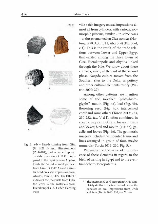
Maira Torcia456
vide a rich imagery on seal impressions, al-most all from cylinders, with various, zoo-morphic patterns, similar – in some cases – to those remarked on Giza cretulae (Har-tung 1998: Abb. 5, 11; Abb. 3, 4) (Fig. 3c-d, e-f). This is the result of the trade rela-tions between Lower and Upper Egypt that existed among the three towns of Giza, Hierakonpolis and Abydos, linked through the Nile. We know about these contacts, since, at the end of the second phase, Naqada culture moves from the Southern sites to the Delta, as pottery and other cultural elements testify (Wa-trin 2007: 27).
Among other patterns, we mention some of the so-called “proto-hiero-glyphs”: mouth (Fig. 4a), loaf (Fig. 4b), flowering reed (Fig. 4d), intertwined cord8 and some others (Torcia 2013: 223, 230-232, tav. V d-l), often combined in specific way as mouth and loaves or birds and loaves; bird and mouth (Fig. 4c), ga-zelle and loaves (Fig. 4e). The geometric imagery includes the indented frame and lines arranged in group of four, maybe numerals (Torcia 2013, 230, Fig. 5a).
We underline the value of the pres-ence of these elements in regard to the birth of writing in Egypt and to the even-tual debt to Mesopotamia.
8 The intertwined cord pictogram (H) is com-pletely similar to the intertwined tails of the lionesses on seal impressions from Uruk and Susa (Torcia 2013: 232, tav. V d-e).
Fig. 3. a-b – lizards coming from Giza (G 1421 J) and Hierakonpolis (Z 46104); c-d – superimposed caprids rows on G 1182, com-pared to the caprids from Abydos, tomb U-134; e-f – antelope head from Giza (G 1317 A) and a simi-lar head on a seal impression from Abydos, tomb U-127. The letter G indicates the materials from Giza, the letter Z the materials from Hierakonpolis; d, f after Hartung 1998
Towards Upper Egypt: Items and Cultural Elements on Trade Routes 457
2. Trade We specifically focus our interest on the movements of lapis lazuli and metals
as copper and gold, even if there is a good deal of other interesting materials car-ried on trade routes.
Lapis lazuli, in Upper Egypt and in many other sites along the Nile, dates back at least to the Gerzean period (Bavay 1997: 81-82; Payne 1968). The source of this precious stone is very remote: Badakhshan, in Central Asia (Herrmann 1968: 22-28); nevertheless, the lapis travelled on trade routes since the prehistory. We find it in the North of Iraq, since the Ubayd period: at Tepe Gawra, the XIII level testi-fies to its presence (Bavay 1997: 94; Tobler 1950: 176, 192). Likely, lapis lazuli comes through the northern routes, touching sites in the Elburz region as Tepe Hissar and Tepe Giyan, where a good deal of this stone was found (Bavay 1997: 94-95).
At the end of the 4th millennium, the long distance trade was prevalently han-dled by Uruk, in the South, phase IVa. This phase corresponds in Egypt to Naqada IIc (Boehmer and Dreyer 1993: 63-68), when lapis lazuli findings are more numer-ous along the Nile (Payne 1968).
At Uruk, magnificent temples and palaces, richly decorated (Jordan 1931: 31-40), were built with precious, imported materials9: the intense movements of merchandises were made possible because of the presence of a centralized power and a good social and administrative organization. Documents show a very rich and articulate management of the different fields of activity of the ancient Sume-rian society (Nissen et al. 1997: 292)10.
Uruk, lacking in raw materials, began to manage exchanges very early, in Mid-dle Uruk period (Watrin 2004: 56-63), so becoming the main source of demand. Manufactured items and raw materials were exchanged; Uruk sent handicrafts while raw or perishable materials arrived either from neighbouring or from far countries, Egypt among them. The lack of Egyptian items in Sumer could be explained just by the qualities of shipped merchandises (for instance textiles).
We believe that the two mentioned pieces (the cretula with Inanna symbol and the cylinder with Mr-Neit name) refer to direct exchanges between Sumer and Up-
9 The Steinstifttempel facades were decorated with cones made of imported stone as red sand-stone, limestone and alabaster (Lenzen 1959: 13-16, 47, Taf. 20 a-b, Pl. 36-37); the “Riem-chengebäude” (Lenzen 1958: 21-35, Taf. 9, 12) is rich in copper, gold and precious materials, decorating wooden furnitures (Lenzen 1959: 8-11). Huge blocks of fine limestone were used to build Eanna Temples and “Palast” (Lenzen 1968: 13-18, Taf.6 ff.; 1974: 14-18).
10 Nissen talks about 5000 documents dealing with administrative procedures coming from Uruk IVa/III.
Maira Torcia458
per Egypt. Lapis lazuli could arrive directly in the South of Egypt, in the sphere of the long distance organized trade. This even-tuality can be supported by the Mesopo-tamian cylinder seal, decorated with fish and net, found at Naga ed-Der, in a tomb Naqada IId (Podzorski 1988: 261), together with lapis beads and inlays (Kantor 1952: 245-246, Pl XXV B): these objects send us back to the Sumerian area. All the same, the lapis statuette of a praying woman (Fig. 2d) unearthed at Hierakonpolis (Main De-posit). It is 8.9 cm tall (the head was found later in the same context: Porada 1980: 175-176) and is described by Quibell as “simi-lar to those of the Greek islands figures” (Quibell and Green 1902, 38, Pl. XVIII, 3). Actually, it is not in Egyptian style (Po-rada 1980: 178-179, Pl. I-II). In my opin-ion, on stylistic ground this object seems, in fact, manufactured in Near East or bet-ter in Mesopotamia, following the orants fixed standards: the devotion attitude with joined hands, the nudity, the great orbital cavities, likely to be filled, the dotted pubic zone, some of these going back even to the Ubayd period. Likely, this fine fashioned statuette is the product of the high special-ized Mesopotamian handicraft, just as the well-known woman’s head from Uruk IVa is (Frankfort 1970: 17, tav. 14).
Hierakonpolis is rich in imported ma-terials. Beside lapis, which likely was ac-quired both raw and manufactured, also obsidian objects were found. For what concerns Upper Egypt, the source of ob-sidian seems to be the Ethiopian and Er-
Fig. 4. A – the toothed mouths (Z 46108); b – loaves in opposite position (Z 45951); c – bird combined with mouth, a knotty arrow and four bars (G 940); d – flowering reed on G 1062; e – the crouched gazelle combined with loaves (G 1410 B). The letter G indicates the materials from Giza, the letter Z the materials from Hierakonpolis
Towards Upper Egypt: Items and Cultural Elements on Trade Routes 459
itrean area, Yemen and Saudi Arabia (Bavay 2000: 15). Other stones as carnelian, serpentine, steatite, malachite were acquired from local mines, present in the East-ern Desert, while the turquoise was exploited in the Sinai, all likely arriving through a local, trickle trade (Beale 1973: 141).
Copper and gold are present at Hierakonpolis. The origin of copper ore, in Predynastic period, seems to be the Jordan mines (Watrin 2007: 9), but Sinai too could have been a source of supply. Copper largely spreads all over the Egypt since it is fit for making tools and weapons. Also Giza excavations provided copper objects and fragments (Kromer 1978: 79-82, Taf. 32). On the contrary, the bulk of gold came from the South, from Lower Nubia. Situated nearby the Nubian border and the wide goldfields of Eastern Desert, Hierakonpolis could easily reach this precious metal. We believe then that there is a chance for gold being one of the luxury goods sent to Mesopotamia.
Together with gold, other exotic goods as ivory, leather and incense came from the South, requested by the inhabitants of ancient Egypt. We know about the pres-ence of Naqadian groups, spreading towards Lower Nubia since the beginning of Naqada period (Ic-IId) and later on, settling there in order to establish trade rela-tions with the locals (Gatto 1998: 32). But we must also take into account that there were expeditions aimed at the control of the territory by 1st Dynasty kings (Emery 1963: 51, 59), at least to make sure of supplies of the precious Nubian products.
Evidence of Naqada culture are present as far as the II cataract, but Egyptian materials, including pottery (Emery 1963: 60; Gatto 1998: 29), are more numer-ous in the area south of the I cataract where also lapis has been found (Reisner 1910: 25, 128, 159; Payne 1968: 58-59).
Iconographic patterns provide evidence of cultural influences from Egypt to-wards Lower Nubia. The impression on the three Siali cretulae (Bongrani 1998: 36-37, fig. 1; Williams 1986: 169-171, fig. 58) are highly significant like the theme represented on the Qustul burners, inspired by the Egyptian royal ceremony of enthronization (Williams 1986: 138 ff., Pl. 34; Hill 2004: 61-62, fig. 31). The cretu-lae from Siali moreover are very interesting for our trading speech: the scene on the impressions could represent a tribute from Nubian inhabitants to Egyptian king: in fact, it would be really appropriate to read the round objects – ending in a comma – on the top of the impressions, as bags full of gold dust (Hill 2004: 60-61, fig. 27a), intended either as gift or as exchange goods.
Gold is testified in Lower Egypt too: at Tell el Farkha in the Delta area, there is a good deal of gold as well as ivory, both evidence of contacts with the South. Due to its strategic position, Tell el Farkha – rich in imported materials (lapis among
Maira Torcia460
them) – handles exchanges with the Near East, as well as South Egypt, from the second half of the 4th millennium (Ciałowicz 2011: 55-64). Probably, the raw ma-terials as gold and ivory from Nubia could arrive to this Northern site, passing through the brokerage of Hierakonpolis.
3. Hypotheses
We propose here three coexisting hypotheses, on the basis of the two com-pletely new elements, to which we add the lapis statuette:
1. The existence of straight contacts between Sumer (Uruk) and Upper Egypt (Hierakonpolis).
2. The role of Hierakonpolis as a hub.3. The long distance organized trade managed by the Sumerians.Straight contacts. Hierakonpolis, in the deep South of Egypt, presents crucial
elements from Sumer and Susa: high likely, the site was directly and independent-ly linked to the Near East (Hill 2004: 15-16). The cretula with Inanna symbol, the cylinder with Mr-Neit name, the lapis statuette and the bullae, all refer to direct exchanges between Sumer and Upper Egypt.
The relations began in Naqada II period (the stamp seal from Naga ed-Der is dated to IIb) and lasted until the half of the 1st Dynasty. The exchanges concern above all the Naqada II c-d phases, corresponding in Mesopotamia to Late Uruk-Jemdet Nasr periods, when the town of Uruk reaches the maximum extension and power, trades increase and writing appears and develops. Later on, at the beginning of Proto-Dynastic period, there is a deep crisis in the Near East. It’s a blank period also in trades; lapis lazuli and other materials almost disappear (Payne 1968: 59; Bavay 1997: 96). This is the moment in which the queen Mr Neit sends her “message sealing” to the Lord of Uruk. We want suppose that the dis-ruption in the lapis trade is a possible reason for that expedition.
It is necessary now to point out these other two factors, regarding these contacts:1) Inanna is the mother-goddess, patron-deity of Uruk where the large templar
area of Eanna is devoted to her. 2) The cylinder with the name of the Egyptian queen was found at Uruk, cer-
tainly a mark of movements between Egypt and Mesopotamia. The presence of elements with ideological roots, not merely common decora-
tive patterns, indicates that the relations between the two areas touched a deeper, ideological sphere and that there was a true cultural correspondence.
Towards Upper Egypt: Items and Cultural Elements on Trade Routes 461
Hierakonpolis as a hub. We easily believe that Hierakonpolis, with its great religious value, became a collecting centre to which the goods arrived from differ-ent sources. It is not a case that numerous cretulae bring impressions with sacred names of deities. Apart the offerings to the sacred places (Friedman 2011, 33-44), we may suppose that the bulk of merchandises (among them gold) were allocated to exchanges and sent to countries on different trade routes. Movements of luxury goods and commodities, in Egyptian area, were certainly managed by the two most important settlements in Upper Egypt: Hierakonpolis which, as collecting centre, should have had an important role on the Egyptian trade network, and Abydos, seat of the kings and likely the true administrative centre.
Trade in Sumerian hands. Which routes could have the trade followed, being handled by Sumerians? Probably Southern routes: going down the Euphrates, the boats reached the Persian Gulf and sailed along the Arabian coasts: the findings of numerous Ubaydian sites on the Eastern side of the peninsula (Fig. 5) (Masry
Fig. 5. Pre – and Proto-historic sites in Near East. Location of Ubayd sites on Eastern Arabian coast

Maira Torcia462
1997: 10, 65-96) give evidence of it. Then, the boats went on and docked on the West coast. Even if it is a very long and hard course, it is not impossible to hypothesize the crossing of the Red Sea or the circumnavigation of Arabia (Bavay 1997: 96) by Sumerian traders and other sailor peoples of the coasts, since we know about archaic mod-els of sailing boat, one of these found at Eridu (Fig. 6) (Lloyd-Sa-far 1981: 227, 230, fig. 111), dated back to the end of 5th millennium11. The same way, the Egyptians could cross the Red Sea, going toward the traders on Arabian coasts. Al-ternatively, the trade could have followed land routes. Caravans of onagers went along tracks, loaded with precious merchandises.
We may presume in fact that the long distance trade was carried on in composite ways: Arabia could be crossed and not circumnavi-gated. At that time, Arabia was not only a desert land; furthermore, it
is rich in precious materials as obsidian and scented resins, to be picked up along the way.
The unloaded merchandises, from Egyptian coasts, were sent towards South-ern centres as Hierakonpolis and Abydos, crossing the wadis of Eastern Desert, among them Wadi Hammamat and Wadi Abu Had (Bavay 2000: 17-18); then, the materials were sent to the North. We may also hypothesize the presence of small shelters, established by Sumerians for their boats on the western shore of Arabia,
11 The small boat come from the Ubayd cemetery area where infants’ burials were found (Lloyd-Safar 1981: 121) the boat could belong to a child.
Fig. 6. Model of sailing boat from Eridu (Ubayd period)
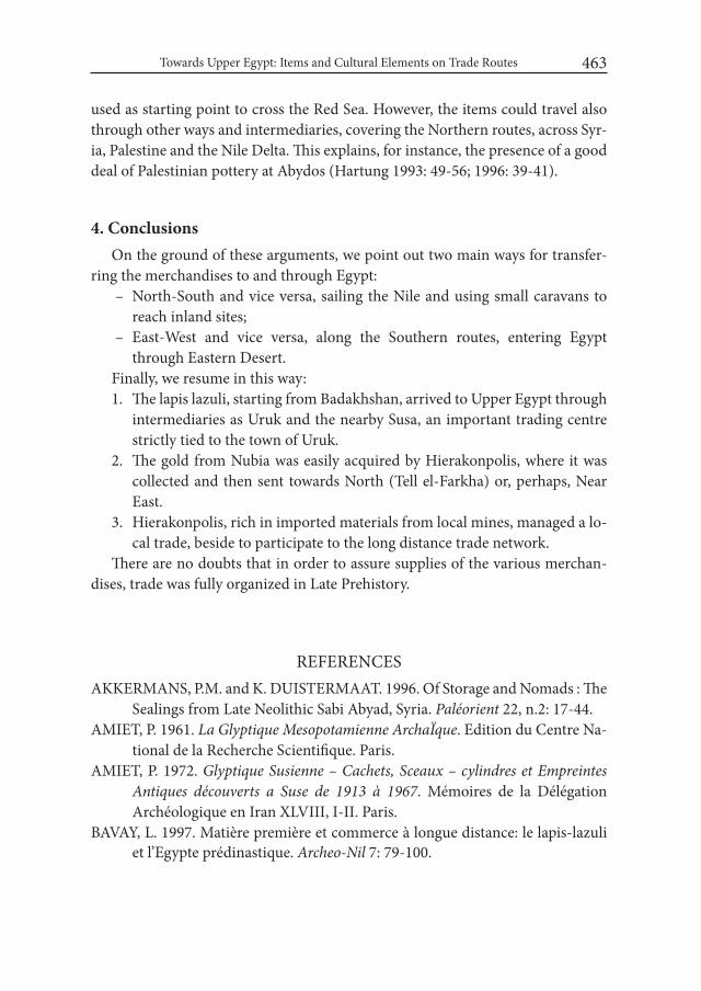
Towards Upper Egypt: Items and Cultural Elements on Trade Routes 463
used as starting point to cross the Red Sea. However, the items could travel also through other ways and intermediaries, covering the Northern routes, across Syr-ia, Palestine and the Nile Delta. This explains, for instance, the presence of a good deal of Palestinian pottery at Abydos (Hartung 1993: 49-56; 1996: 39-41).
4. ConclusionsOn the ground of these arguments, we point out two main ways for transfer-
ring the merchandises to and through Egypt: – North-South and vice versa, sailing the Nile and using small caravans to
reach inland sites; – East-West and vice versa, along the Southern routes, entering Egypt
through Eastern Desert. Finally, we resume in this way:1. The lapis lazuli, starting from Badakhshan, arrived to Upper Egypt through
intermediaries as Uruk and the nearby Susa, an important trading centre strictly tied to the town of Uruk.
2. The gold from Nubia was easily acquired by Hierakonpolis, where it was collected and then sent towards North (Tell el-Farkha) or, perhaps, Near East.
3. Hierakonpolis, rich in imported materials from local mines, managed a lo-cal trade, beside to participate to the long distance trade network.
There are no doubts that in order to assure supplies of the various merchan-dises, trade was fully organized in Late Prehistory.
REFERENCESAKKERMANS, P.M. and K. DUISTERMAAT. 1996. Of Storage and Nomads : The
Sealings from Late Neolithic Sabi Abyad, Syria. Paléorient 22, n.2: 17-44. AMIET, P. 1961. La Glyptique Mesopotamienne ArchaÏque. Edition du Centre Na-
tional de la Recherche Scientifique. Paris. AMIET, P. 1972. Glyptique Susienne – Cachets, Sceaux – cylindres et Empreintes
Antiques découverts a Suse de 1913 à 1967. Mémoires de la Délégation Archéologique en Iran XLVIII, I-II. Paris.
BAVAY, L. 1997. Matière première et commerce à longue distance: le lapis-lazuli et l’Egypte prédinastique. Archeo-Nil 7: 79-100.
Maira Torcia464
BAVAY, L. 2000. The Origin of Obsidian in Predynastic and Early Dynastic Upper Egypt. Mitteilungen des Deutschen Ärchäologischen instituts Abteilung Kairo 56: 5-20.
BEALE, T.W. 1973. Early trade in highland Iran: a view from a source area. world Archaeology 5: 133-146.
BOEHMER, R.M. and G. DREYER. 1993. Einige frühzeitliche 14C-Datierung aus Abydos und Uruk. Mitteilungen des Deutschen Ärchäologischen instituts Abteilung Kairo 49: 63-68.
BONGRANI, L. 1998. Documenti di regalità faraonica nella fase culturale avan-zata dei Gruppi-A, Atti della Prima Giornata di Studi Nubiani: 35-42.
CIAŁOWICZ, K.M. 2011. The Predynastic/EarlyDynastic Period at Tell el-Farkha. In: E. Teeter (ed.), Before the Pyramids: The origins of Egyptian Civilization, Oriental Institute Museum Publications 33: 55-64. Chicago.
EMERY, W.B. 1938. The tomb of Hemaka. Excavations at Saqqara. Cairo. EMERY, W.B. 1963. Archaic Egypt. Edinburgh. FRANKFORT, H. 1939. Cylinder Seals: A Documentary Essay on the Art and Reli-
gion of the Ancient Near East. London.FRANKFORT, H. 1970. Arte e Architettura dell’Antico Oriente. Torino.FRIEDMAN, R.F. 2011. Hierakonpolis. In: E. Teeter, Before the Pyramids: The Ori-
gins of Egyptian Civilization, Oriental Institute Museum Publications 33: 33-44 Chicago.
GATTO, M.C. 1998. Ricerche sulla tarda preistoria della Bassa Nubia. Atti della Prima Giornata di Studi Nubiani: 25-33.
HARTUNG, U. 1993. Umm el-Qaab: Importkeramik aus Grab U-j. Mitteilungen des Deutschen Archäologischen instituts Abteilung Kairo 49: 49-56.
HARTUNG, U. 1996. Bullen mit Siegelabrollungen. Importkeramik. Mitteilungen des Deutschen Archäologischen instituts Abteilung Kairo 52: 30-33; 39-41.
HARTUNG, U. 1998. Prädynastische Siegelabrollungen aus dem Friedhof U in Abydos (Umm el-Qaab). Mitteilungen des Deutschen Archäologischen insti-tuts Abteilung Kairo 54: 188-217.
HEINRICH, E. 1936. Kleinfunde aus den Archaischen Tempel-Schichten in Uruk, Ausgrabungen der deutschen Forschungsgemeinschaft in Uruk-Warka I: 6-35, Taf. 17, Berlin.
HEINRICH, E. 1937. Die Grabung im Planquadrat K XVii. Achter vorläufiger Be-richt über die von der Deutschen Forschungs-Gemeinshaft in Uruk-Warka unternommenen Ausgrabungen (UVB 8): 29-53, taf. 51. Berlin.
HELCK, W. 1954. Untersuchungen zu den Beamtentiteln des Ägyptischen Alten Reiches. Glückstadt – Hamburg-New York.
Towards Upper Egypt: Items and Cultural Elements on Trade Routes 465
HELCK, W. and E. OTTO. 1975. Lexicon der Ägyptologie I. Wiesbaden. HELCK, W. and E. OTTO. 1977. Lexicon der Ägyptologie II, Wiesbaden.HERRMANN, G. 1968. Lapis lazuli: the Early Phases of its Trade. iraq XXX: 21-57. HILL, J.A. 2004. Cylinder Seal Glyptic in Predynastic Egypt and Neighboring Re-
gions (= BAR International Series 1223). Oxford.HONORÉ, E. 2007. Earlier Cylinder-Seal Glyptic in Egypt: From Greater Mes-
opotamia to Naqada. In: H. Hanna (ed.) The international Conference on Heritage of Naqada and Qus Region Monastery of the Archangel Michael, Naqada, Egypt. Preprints I: 31-45. Cairo.
JORDAN, J. 1931. Ausgrabungen in Uruk 1929/30. Zweiter vorläufiger Bericht über die Ausgrabungen in Uruk-Warka (UVB 2): 31-40
KAHL, J. 1994. Das System der ägyptischen Hieroglyphenschrift in der 0-3 Dynas-tie. Wiesbaden.
KANTOR, H. J. 1952. Further evidence for Early Mesopotamian relations with Egypt. Journal of Near Eastern Studies 11: 239-250.
KAPLONY, P. 1981. Die Rollsiegel des Alten Reichs. IIA-IIB Monumenta Aegypti-aca, 3A-3B. Bruxelles.
KROMER, K. 1978. Siedlungsfunde aus dem Frühen Alten Reich in Giseh – Öster-reichische Ausgrabungen 1971-1975. Wien.
LENZEN, H. 1958. Mosaiktempel und Riemchengebäude in Md-Na XV4-XVi2. XIV vorläufiger Bericht über die Ausgrabungen in Uruk-Warka (UVB XIV): 21-35, taf. 9,12.
LENZEN, H. 1959. Die Ausgrabungen von der westecke von E-anna. XV vorläufiger Bericht über die Ausgrabungen in Uruk-Warka (UVB XV): 8-19, taf. 35-42.
LENZEN, H. 1965. Tontafeln und siegelabrollungen, XXI vorläufiger Bericht über die Ausgrabungen in Uruk-Warka (UVB XXI): 31-32, taf. 17-19.
LENZEN, H. 1967. Anu-Zikurrat, XXIII vorläufiger Bericht über die Ausgrabun-gen in Uruk-Warka (UVB XXIII): 10-21, taf. 26-27.
LENZEN, H. 1968. Uruk iVa, Die Kleinfunde. XXIV vorläufiger Bericht über die Ausgrabungen in Uruk-Warka (UVB XXIV): 11-26, taf. 28-30.
LENZEN, H. 1974. Die Hocharchaischen Schichten in Eanna. XXV vorläufiger Bericht unternommenen Ausgrabungen in Uruk-Warka (UVB XXV): 14-18, taf. 30.
LLOYD, S. and F. SAFAR. 1981. Eridu. Baghdad. MASRY, A. 1997. Prehistory in North-Eastern Arabia: the problem of interregional
interaction. London-New York.NISSEN, H.J. 1974. Tontafeln und Verwandtes. XXV vorläufiger Bericht unter-
nommenen Ausgrabungen in Uruk-Warka (UVB XXV): 38-40, pl. 28 h.
Maira Torcia466
NISSEN, H.J., DAMEROW, P. and R. ENGLUND. 1997. Archaic Book-keeping: Writing and Techniques of Economic Administration in the Ancient Near East. Journal of Near Eastern Studies 56, n. 4: 292-294.
PAYNE, J.C. 1968. Lapis lazuli in Early Egypt. iraq XXX: 58-61.PETRIE, W.M.F. 1901. The Royal Tombs of the Earliest Dynasties II. Memoir 21:
1-54. London.PODZORSKI, P.V. 1988. Predynastic Egyptian Seals of Known Provenience in the
R.H. Lowie Museum of Anthropology. Journal of Near Eastern Studies 47: 259-268.
PORADA, E. 1980. A Lapis lazuli Figurine from Hierakonpolis in Egypt. iranica Antiqua XV: 175-180, pl. I-II.
QUIBELL, J.E. and F.W. GREEN. 1902. Hierakonpolis II. London. RATNAGAR, S. 1981. Encounters – The westerly trade of the Harappa Civilization.
New Delhi.REISNER, G. A 1910. Archaeological Survey of Nubia. Report for 1907-1908, vol. I.
Cairo. SCHMANDT – BESSERAT, D. 1980. The Envelopes that bear the First Writing.
Technology and culture 21, n.3: 357-385.TOBLER, A.J. 1950. Excavations at Tepe Gawra II. Philadelphia.TORCIA RIGILLO, M. 1991a. Sealing Systems on Uruk Doors. Baghdader Mit-
teilungen 22: 175 – 222.TORCIA RIGILLO, M. 1991b. Cretule da Tepe Gawra. Mesopotamia XXVI: 35-98.TORCIA RIGILLO, M. 2003. Giza – Cretule dall’area delle Piramidi. Roma. TORCIA RIGILLO, M. 2007. Clay-sealings from the Giza Pyramids Area. In:
J. C. Goyon and C. Cardin (eds.), Actes du Neuvième Congrès international des Egyptologues, Grenoble 2004 (= Orientalia Lovaniensia Analecta 150), I-II: 1817-1826. Leuven-Paris.
TORCIA, M. 2009a. A Case of Survival of an ancient Locking System. Africa LXIV n. 3-4: 540-544, tav. I-II. Roma.
TORCIA, M. 2009b. Studi sulle cretule dall’Egitto e dal Vicino Oriente dagli inizi del V alla metà del III millennio a. C. In: Pirelli R., Ricerche italiane e Scavi in Egitto III: 239-248, tav. I-III. Cairo.
TORCIA, M. 2013. Giza e Hierakonpolis: Cretule con impronte di sigillo figurate e segni isolati di scrittura – Connessioni con la Mesopotamia. In: R. Pirelli (ed.), Ricerche italiane e Scavi in Egitto VI: 219-243, tav. I-V. Cairo.

Towards Upper Egypt: Items and Cultural Elements on Trade Routes 467
WATRIN, L. 2004. From Intellectual acquisitions to Political change: Egypt-Mes-opotamia Interaction in the Fourth Millennium BC. De Kemi à Birît Narî 2: 48-95.
WATRIN, L. 2007. The Relative Chronology of the Naqada Culture: a view from Buto, Ma’adi, Harageh and Gerzeh. In: H. Hanna (ed.), The international Conference on Heritage of Naqada and Qus Region Monastery of the Arch-angel Michael, Naqada Egypt. Preprints I: 1-30. Cairo.
WILLIAMS, B.B. 1986. The A-Group royal Cemetery at Qustul: cemetery L. Orien-tal Institute of Nubian Expedition III. Chicago.
WILKINSON, T. 2002. Uruk into Egypt: Imports and Imitations. In : J.N. Post-gate (ed.), Artefacts of Complexity: Tracking the Uruk in the Near East, Iraq Archaeological Report 5: 237-248. London.

Desert and the Nile. Prehistory of the Nile Basin and the Sahara.
Papers in honour of Fred Wendorf Studies in African Archaeology 15
Poznań Archaeological Museum 2018
Bashier Negood Hassan
The Nile as the Main Traffic Artery in the Ancient Sudan
The Nile has always played a very important role in the economic life of Su-dan. Especially in the ancient time, it was very important for all the people, who lived near it. The Nile was the main traffic artery as well as a source of water for agriculture (especially, on the floods’ periods) and a source of various types of fish (Bonnet 2000: 170; Adams 2010: 158).
The Nile flows from south to north at an average speed of about four knots during inundation season.
According to Pliny’s Natural History “a canal was dug from the river Nilus (Nile) to the spot where the obelisk lay; and two broad vessels, laden with blocks of similar stone a foot square, the cargo of each amounting to double the size, and consequently double the weight, of the obelisk, were brought beneath it; the extremities of the obelisk remaining supported by the opposite sides of the ca-nal. The blocks of stone were then removed, and the vessels, being thus gradually lightened, received their burden. It was erected upon a basis of six square blocks, quarried from the same mountain, and the artist was rewarded with the sum of fifty talents” (Pliny, Historia naturalis, XXXVI. 14). Herodotus wrote of the Nile: “the river rises of itself, waters the field, and then sinks back again; thereupon each man sows his field and waits for the harvest” (Herodotus, II. 93,6).
For traffic on the Nile, the Meroites made vessels (ships and boats) out of the stems of plants, reed and papyrus, so they were quick, but they could not carry more than three people.
Bashier Negood Hassan470
The wooden boats with steering oars, a mast and sail, which appeared in the later period, could run therefore against the wind. For ritual purposes, those boats and ships were decorated with the gods’ images on both sides. (Liverani 2004: 138-139; Bonnet 2004: 73). They carried portable Altar of God aboard. The graph-ics, indicating of that ceremony, are found on ceramics and pottery.
In the Graeco-Roman period in Egypt, the Romans used high side boats de-signed for two people (Engelmayer 1965) and large-sized boats, made out of sev-eral layers of papyrus. The large boats could place some passengers and even one big animal aboard. The boats made out of tightly roped papyrus’ stems and woven reed mat were used by fishermen and hunters at shallow water.
The bow of the boat was on the water level and the stern rose high above the river, so the boat could smoothly sail forward and it could be easily pushed away from the sandbank (Trigger 1976: 39; David 2008: 362).
Due to the geographical location of the Kingdom of Meroe, the Nile river played an important role in the development of the trade between the Kingdom of Meroe and Ancient Egypt (Trigger1976: 18-19), which had a great demand for raw materials, gold, silver, iron, manpower, African and exotic products (incense, animal skins, precious wood, etc.) (Gradel 2010: 99-101).
For this reason, the Egyptian administration system was imposed by the Egyp-tian government on the Nile. To protect trade on the Nile, the Egyptian govern-ment based the garrison on the island of Philae. Later two main trade points were found on the Nile route (used, probably, as traffic terminal as well): in Hiera Syka-minos and in Syene. (Carl 1998, Plate XVI). The customs receipts were found in Syene, testifying to the Roman-Egyptian Customs in the region in the 1st and 2nd century AD. And the large market, where the Egyptian and Meroe commodities were supplied, took place in Hiera Sykaminos. (Berzin 1992: 66).
Meroe also controlled trade on the Nile Road, and put some military checkpoints along the Nile to regulate trade and protect caravans. The luxury life and well-being had become a habit for the Greek and Roman emperors and their nobles. The de-mand for ivory increased the number of elephant tusks’ traders. (Tallet 2012: 84).
The Meroites used the Nile for goods’ transportation all the year around. How-ever, the Red Sea way was far from the trade centers’ suppliers and the caravan routes connecting the Nile Valley and the coast run through the waterless and hot Eastern Desert. Moreover, the sea trade route on the African coast was seasonal and depended on monsoon. The route was more dangerous from equipping level point of view, especially the first period when the Red Sea coast was developed and studied.

The Nile as the Main Traffic Artery in the Ancient Sudan 471
The commodities’ supply from Nubia to Greek Egypt, with their further reex-port to the Mediterranean countries, increased after the expedition of Ptolemy II.
The Meroe nobles maintained from their side the demand for luxury goods, jewelry, statues, lamps, ships and weapons, bottles of wine and honey, clothing, aromatic oils and cosmetics supplied from Egypt. (Hintze 1978: 93; Adams1988: 24; Gradel 2010: 101).
In the Ptolemaic period, the interest for elephants increased not only for com-merce but also for war purposes. The Greeks started to look for facilitation of the export of elephants and work on development of trade routes between Meroe and Egypt. Some Greek trade points were established on the Red Sea coast from there African elephants and other exotic products were deported to Egypt.
The shift of the trade route from the Nile to the Red Sea was one of the most crucial reasons that led to the end of the Kingdom of Meroe.
REFERENCESADAMS, W. Y. 1988. The Nile Trade in Post-Pharaonic Times. Sahara 1:24.ADAMS, W. Y. 2010. Nubia: Corridor to Africa. London.: Lexington. BERZINA, S. 1992. Meroe and the world i – Viii century AD. (Берзина С. Я. Ме-
роэ и окружающий мир I-VIII вв. н.э.. М.: Наука. С. 66): 66BONNET, CH. 2000. Edifices et rites funéraires à Kerma. Mission archéologique de
l’Universite de Géneve à Kerma (Sudan):170. Paris. BONNET, CH. 2004. “The Kerma Culture.” Sudan Ancient Treasures: An Exhibition
Of Recent Discoveries From The Sudan National Museum. Ed. D. A. Welsby and J. R. Anderson. British Museum: 73, 87. London.
CARL, F. 1998. The Cambridge History of Egypt. Vol. i. islamic Egypt, 640 – 1517. Plate XVI. Cambridge.
DAVID, R. 2003 (2008). Hand Book to life in Ancient Egypt. University of Man-chester (Russian edition 2008).
ENGELMAYER, R. 1965. Die Felsgravierungen im Distrikt Sayala-Nubian. Wien. GRADEL, C. 2010. Meroe. Royaume de Relais Commerciaux ?. In: M. Baud (ed.)
Méroé, Un empire sur le Nil, Catalogue d’exposition, éditions du Musée du Louvre: 99-101. Paris. HINTZE, F. 2010. The Kingdom of Kush: The Meroitic Period. In: S. Hoschfield (ed.) Africa ii in Antiquity: 93.

Bashier Negood Hassan472
LIVERANI, I. 2004. Hillat El-Arab. Sudan Ancient Treasures: An Exhibition Of Recent Discoveries From The Sudan National Museum. Ed. D. A. Welsby and J. R. Anderson. British Museum: 138–139. London.
TALLET, G., GRADEL, C. and S. GUÉDON. 2012. Le site d’el-Deir, à la croisée des routes du désert Occidental: nouvelles perspectives sur l’implantation de l’armée romaine dans le désert égyptien. In: P.Ballet (ed.) Grecs et Ro-mains en Égypte. Territoires, espaces de la vie et de la mort, objets de prestige et du quotidian: 84. Le Caire.
TRIGGER B. G. 1976. Nubia. Under the pharaohs:18-19, 39. London.
Desert and the Nile. Prehistory of the Nile Basin and the Sahara.
Papers in honour of Fred Wendorf Studies in African Archaeology 15
Poznań Archaeological Museum 2018
Ikram Madani, Petr Pokorný, Yahia F. Tahir, Hamad M. Hamdeen and Adéla Pokorná
Vegetation Mounds in El-Ga’ab Depression (Sudan): Their Significance in Archaeology and Archeaobotany
IntroductionVegetation mounds (or vegetation hillocks) are hilly formations of sand and
organic litter that has been trapped and thus successively accumulated within growths of long-living phreatophytic shrubs (mostly Tamrix sp. div., namely Tamarix aphylla). This phenomenon was described and first thoroughly studied in Baharyia oasis in the Western Desert of Egypt (Pokorný and Pokorná 2013). In Sudan, Kababeesh settlers have encountered them when they first arrived at El-Ga’ab area and they gave them a local name – tarbools. In the same area, many tarbools are recorded near the old settlement remains, such as graves, churches and other buildings assigned to the Christian and Early Islamic periods. Madani et al. (2015) in their description of the vegetation cover of El-Ga’ab area considered tarbools as the most interesting features of local vegetation that are mostly the rel-ics related to irrigated agricultural schemes of rather distant past. Tarbools occur in aggregations mainly in the bottoms of the depressions (Fig. 1). They extend along the whole length of El-Ga’ab in two chains. The eastern chain lies 25-40 km west of the Nile starting from north of Al Hasha through El-Ga’ab, Al Mweilih in

Ikram Madani, Petr Pokorný, Yahia F. Tahir, Hamad M. Hamdeen and Adéla Pokorná 474
Um Hilal , Al Thawani, and Al Hamra. The western chain lies 60-70 km west of the Nile starting from Al Yanboo’ Al Mirebeet through Al Yanboo’ southwards until 90 km west of Dongola in Al Kwaib area (Fig. 2). Aggregations of tarbools increase in Um Hilal and some still support living plants on their tops. Um Hilal area, which is the lowest part of El-Ga’ab Depression (214-218 m a.s.l.), used to be flooded by the Nile during Early and Middle Holocene (Williams et al. 2010), but now all the cultivated farms are irrigated from wells. Nevertheless, underground water level of the local aquifer is close to the desert surface – not more than few meters.
A field survey was conducted in El-Ga’ab area in May 2013, September 2014, and November 2015. Its main task was to record the presence, location and mor-phometrics of the tarbools. The plants that formed them were identified as Tama-rix aphylla (Fig. 3). The structures of these mounds or hillocks were also analyzed. More than 80 individual hillocks were encountered and documented in El-Ga’ab area. The height of some mounds may reach 10 m with a maximum basal circum-
Fig. 1. Vegetation mound (tarbool) landscape of El-Ga’ab Depression (Um Hilal area). Most tarbools are dead and partly eroded ones (photo: P. Pokorný)
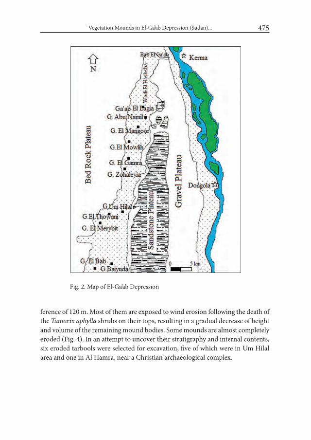
Vegetation Mounds in El-Ga’ab Depression (Sudan)... 475
Fig. 2. Map of El-Ga’ab Depression
ference of 120 m. Most of them are exposed to wind erosion following the death of the Tamarix aphylla shrubs on their tops, resulting in a gradual decrease of height and volume of the remaining mound bodies. Some mounds are almost completely eroded (Fig. 4). In an attempt to uncover their stratigraphy and internal contents, six eroded tarbools were selected for excavation, five of which were in Um Hilal area and one in Al Hamra, near a Christian archaeological complex.
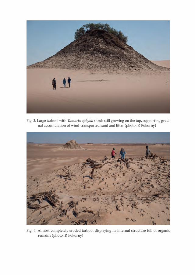
Fig. 3. Large tarbool with Tamarix aphylla shrub still growing on the top, supporting grad-ual accumulation of wind-transported sand and litter (photo: P. Pokorný)
Fig. 4. Almost completely eroded tarbool displaying its internal structure full of organic remains (photo: P. Pokorný)
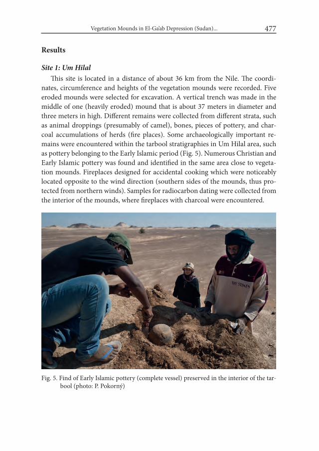
Vegetation Mounds in El-Ga’ab Depression (Sudan)... 477
Results
Site 1: Um HilalThis site is located in a distance of about 36 km from the Nile. The coordi-
nates, circumference and heights of the vegetation mounds were recorded. Five eroded mounds were selected for excavation. A vertical trench was made in the middle of one (heavily eroded) mound that is about 37 meters in diameter and three meters in high. Different remains were collected from different strata, such as animal droppings (presumably of camel), bones, pieces of pottery, and char-coal accumulations of herds (fire places). Some archaeologically important re-mains were encountered within the tarbool stratigraphies in Um Hilal area, such as pottery belonging to the Early Islamic period (Fig. 5). Numerous Christian and Early Islamic pottery was found and identified in the same area close to vegeta-tion mounds. Fireplaces designed for accidental cooking which were noticeably located opposite to the wind direction (southern sides of the mounds, thus pro-tected from northern winds). Samples for radiocarbon dating were collected from the interior of the mounds, where fireplaces with charcoal were encountered.
Fig. 5. Find of Early Islamic pottery (complete vessel) preserved in the interior of the tar-bool (photo: P. Pokorný)
Ikram Madani, Petr Pokorný, Yahia F. Tahir, Hamad M. Hamdeen and Adéla Pokorná 478
Site 2: El HamraThis site is located in a distance of about 33 km from the Nile in El Hamra
area near archaeological site reported as a Christian complex formed of 7 visible buildings and unknown number of invisible buried ones. The nearest to them, completely eroded tarbool was selected and the exposed plant remains (dry stems of Tamarix), as well as some carbonized seeds which were recovered during the Christian building excavation were taken for dating.
ConclusionsThe discovery of Tamarix hillocks in El-Ga’ab Depression and what they hide
underneath and in their internal stratigraphy qualifies them to be considered important archaeological and palaeoecological phenomenon. Inside the hillocks there are remains from old periods (Christian and Early Islamic in this particular case), indicating presence of irrigated lands in the past that supported germina-tion of seeds and growth of plants. After the settlement and irrigation ceased, the phreatophytic shrubs were able to survive for a long time, even during and after desert encroachment, while other plants died off. As the dry climate is not suitable for the growth and establishment of seeds of such plants, it is believed that seed-lings of these plants established in wet environment of irrigated agricultural land. They gradually accumulated wind-transported sand during the period of dry con-ditions, gradually forming the conical structure of vegetation mound (tarbool). Studying the internal structure of these mounds should recover archaeological materials and remains of plants and animals that reveal the ancient settlement, vegetation and fauna of the area, hence enabling to investigate environmental changes over centuries and even millennia.
REFERENCESMADANI, I., TAHIR, Y. F., HAMDEEN, H. M., POKORNA, A. and P. POKORNÝ.
2015. Vegetation Ecology and Taxonomy of El-Ga`ab Area, North-Western Sudan. European Academic Research 3: 2927-2943.
POKORNA, A. and P. POKORNÝ. 2013. “Agoul landscapes” in the oases of the Western Desert of Egypt: Ecology and palaeoecology of vegetation mounds in El-Hayz, Southern Bahriya. In: M. Dospěl M.and L. Suková (eds.), Bah-

Vegetation Mounds in El-Ga’ab Depression (Sudan)... 479
riya Oasis. Recent Research into the Past of an Egyptian Oasis: 113-130. Charles University in Prague.
WILLIAMS M. A. J., WILLIAMS F. M., DULLER, G. A. T. et al. 2010. Late Qua-ternary floods and droughts in the Nile valley, Sudan: new evidence from optically stimulated luminescence and AMS radiocarbon dating. Quater-nary Science Reviews 29: 1116-1137.

III
Oases and the Desert

Desert and the Nile. Prehistory of the Nile Basin and the Sahara.
Papers in honour of Fred Wendorf Studies in African Archaeology 15
Poznań Archaeological Museum 2018
Michał Kobusiewicz, Przemysław Bobrowski, Maciej Jórdeczka and Marek Chłodnicki
Gebel Karaiweb and Bir Nurayet (Sudan). The Oldest Settlement in the Red Sea Mountains
In the years 2010-12, owing to the grant received from the Ministry of Science and Higher Education No. NN109 244 239 and sponsored by Advertisement Agency “Just”, a group of researchers from the Institute of Archaeology and Eth-nology, Polish Academy of Sciences, investigated the widely termed prehistory of the region known as Bir Nurayet located in the Red Sea Mountains (Fig. 1). Outstanding is a Lower Palaeolithic site known as Gebel Karaiweb codenamed BN-11-3/2. It is located approximately 7 km north of the village Bir Nurayet, in the north-eastern tip of Gebel Karaiweb, the eponymous rock massif forming the west-ern edge of Wadi Diib. The massif is built mostly of sandstones with vertical and diagonal walls and its eastern edge is fragmented with small erosional cuts. Loose rock blocks and small boulders eroded from the massif lie scattered at its foot on the east side. The north-eastern edge of the massif is more gentle. It was on this hill-side and on adjacent longitudinal elevations that abundant Lower Palaeolithic ma-terials were deposited. The whole site is approximately one hectare in area (Fig. 2). Some 7 kilometres south of Gebel Karaiweb, in the vicinity of gebel Magardi by the village Bir Nurayet also several Middle Palaeolithic sites were discovered. The most rich of them, codenamed BN-10-1/5 was partially investigated.
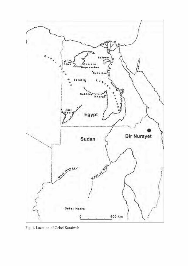
Fig. 1. Location of Gebel Karaiweb

Gebel Karaiweb and Bir Nurayet (Sudan). The Oldest Settlement in the Red Sea Mountains 485
1. Lower PalaeolithicAll Lower Palaeolithic artefacts recovered from the site BN-11-3/2 at Gebel
Karaiweb were made of dark brown, almost black, heavily diagenesed quarzitic sandstone1. This raw material was procured from an outcrop forming a small hill, located on the edge of the site (Fig. 3). The collected objects are ever so slightly eolized.
1 Kind information of dr Małgorzata Mrozek-Wysocka, Institute of Geology, Adam Mickiewicz University, Poznań.
Fig. 2. Gebel Karaiweb. Location of Acheulian site BN-11-3/2
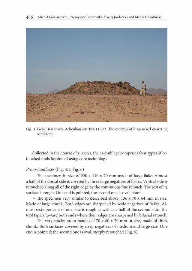
Michał Kobusiewicz, Przemysław Bobrowski, Maciej Jórdeczka and Marek Chłodnicki486
Collected in the course of surveys, the assemblage comprises four types of re-touched tools fashioned using core technology:
Proto-handaxes (Fig. 4:1; Fig. 6) – The specimen in size of 220 x 110 x 70 mm made of large flake. Almost
a half of the dorsal side is covered by three large negatives of flakes. Ventral side is retouched along all of the right edge by the continuous fine retouch. The rest of its surface is rough. One end is pointed, the second one is oval, blunt .
– The specimen very similar to described above, 136 x 70 x 64 mm in size. Made of large chunk. Both edges are sharpened by wide negatives of flakes. Al-most sixty per cent of one side is rough as well as a half of the second side. The tool tapers toward both ends where their edges are sharpened by bifacial retouch.
– The very stocky proto-handaxe 170 x 80 x 70 mm in size, made of thick chunk. Both surfaces covered by deep negatives of medium and large size. One end is pointed; the second one is oval, steeply retouched (Fig. 6).
Fig. 3. Gebel Karaiweb. Acheulian site BN-11-3/2. The outcrop of diagenesed quartzitic sandstone
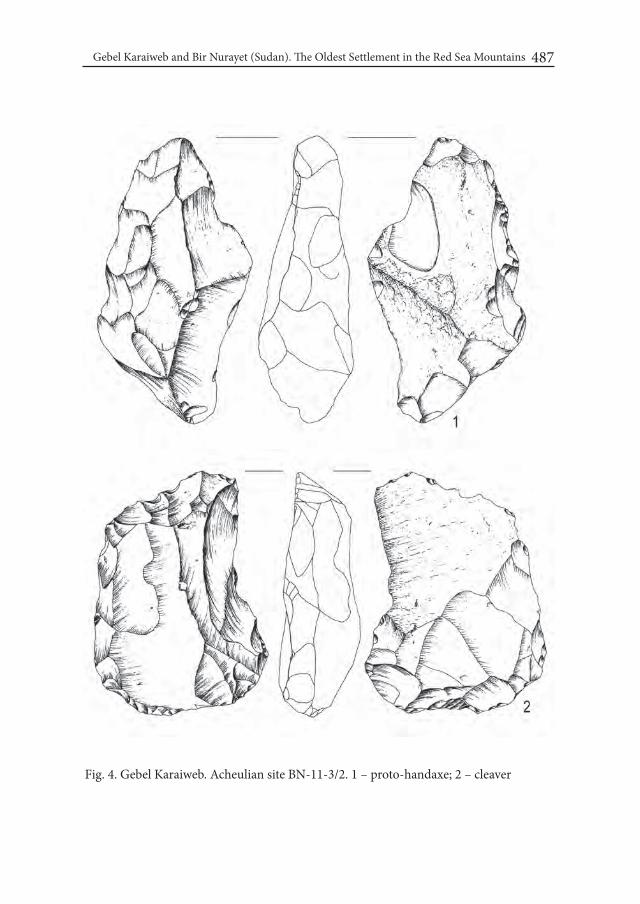
Gebel Karaiweb and Bir Nurayet (Sudan). The Oldest Settlement in the Red Sea Mountains 487
Fig. 4. Gebel Karaiweb. Acheulian site BN-11-3/2. 1 – proto-handaxe; 2 – cleaver
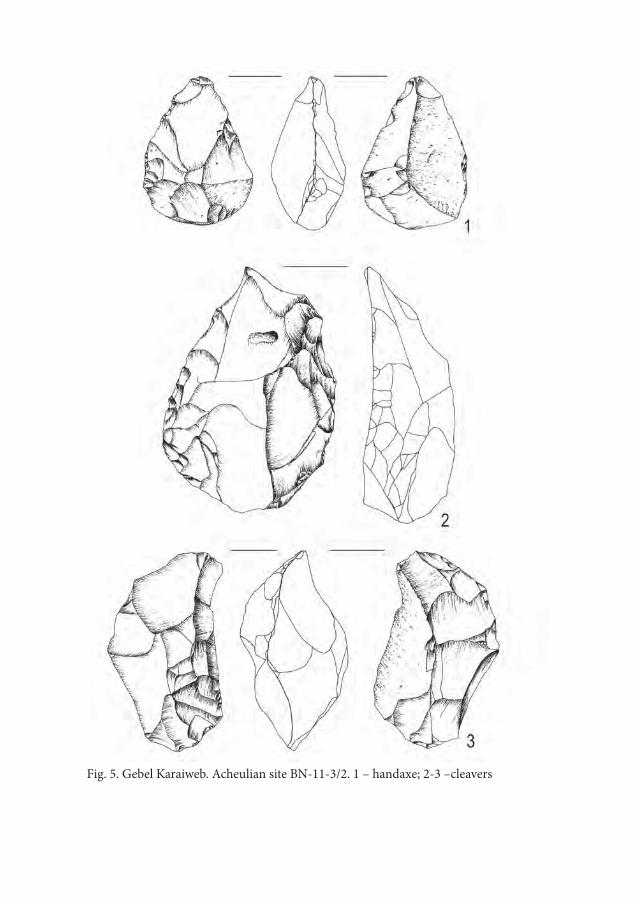
Fig. 5. Gebel Karaiweb. Acheulian site BN-11-3/2. 1 – handaxe; 2-3 –cleavers
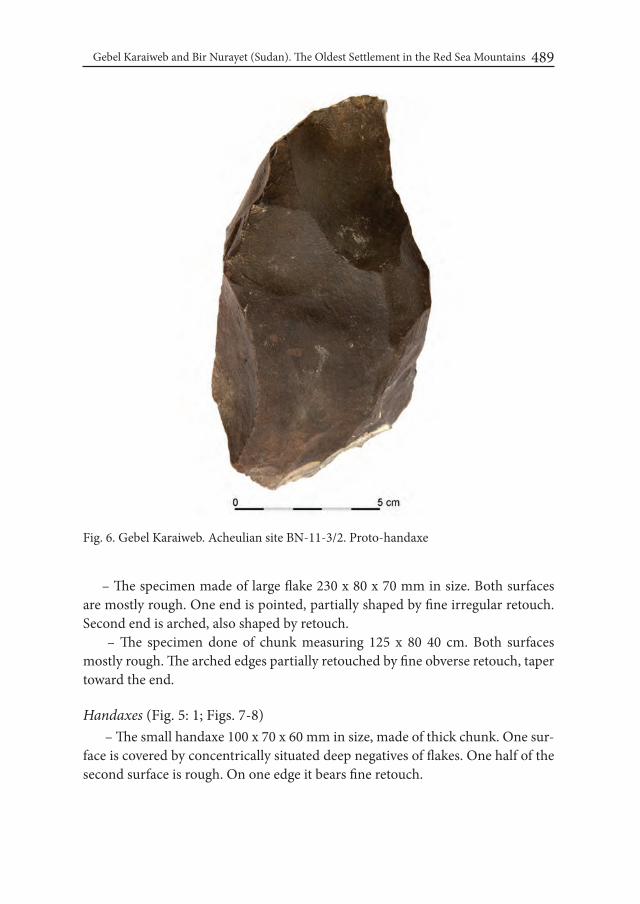
Gebel Karaiweb and Bir Nurayet (Sudan). The Oldest Settlement in the Red Sea Mountains 489
Fig. 6. Gebel Karaiweb. Acheulian site BN-11-3/2. Proto-handaxe
– The specimen made of large flake 230 x 80 x 70 mm in size. Both surfaces are mostly rough. One end is pointed, partially shaped by fine irregular retouch. Second end is arched, also shaped by retouch.
– The specimen done of chunk measuring 125 x 80 40 cm. Both surfaces mostly rough. The arched edges partially retouched by fine obverse retouch, taper toward the end.
Handaxes (Fig. 5: 1; Figs. 7-8) – The small handaxe 100 x 70 x 60 mm in size, made of thick chunk. One sur-
face is covered by concentrically situated deep negatives of flakes. One half of the second surface is rough. On one edge it bears fine retouch.
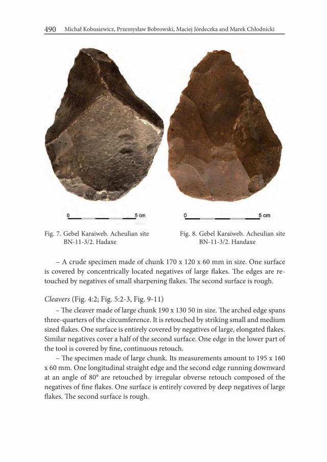
Michał Kobusiewicz, Przemysław Bobrowski, Maciej Jórdeczka and Marek Chłodnicki490
– A crude specimen made of chunk 170 x 120 x 60 mm in size. One surface is covered by concentrically located negatives of large flakes. The edges are re-touched by negatives of small sharpening flakes. The second surface is rough.
Cleavers (Fig. 4:2; Fig. 5:2-3, Fig. 9-11) – The cleaver made of large chunk 190 x 130 50 in size. The arched edge spans
three-quarters of the circumference. It is retouched by striking small and medium sized flakes. One surface is entirely covered by negatives of large, elongated flakes. Similar negatives cover a half of the second surface. One edge in the lower part of the tool is covered by fine, continuous retouch.
– The specimen made of large chunk. Its measurements amount to 195 x 160 x 60 mm. One longitudinal straight edge and the second edge running downward at an angle of 80° are retouched by irregular obverse retouch composed of the negatives of fine flakes. One surface is entirely covered by deep negatives of large flakes. The second surface is rough.
Fig. 7. Gebel Karaiweb. Acheulian site BN-11-3/2. Hadaxe
Fig. 8. Gebel Karaiweb. Acheulian site BN-11-3/2. Handaxe

Gebel Karaiweb and Bir Nurayet (Sudan). The Oldest Settlement in the Red Sea Mountains 491
Fig. 9. Gebel Karaiweb. Acheulian site BN-11-3/2. Cleaver

Michał Kobusiewicz, Przemysław Bobrowski, Maciej Jórdeczka and Marek Chłodnicki492
Fig. 10. Gebel Karaiweb. Acheulian site BN-11-3/2. Cleaver
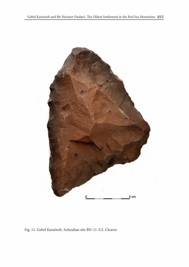
Gebel Karaiweb and Bir Nurayet (Sudan). The Oldest Settlement in the Red Sea Mountains 493
Fig. 11. Gebel Karaiweb. Acheulian site BN-11-3/2. Cleaver
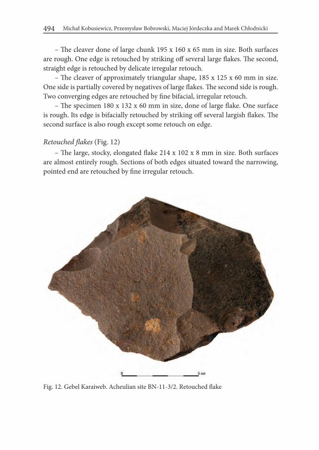
Michał Kobusiewicz, Przemysław Bobrowski, Maciej Jórdeczka and Marek Chłodnicki494
– The cleaver done of large chunk 195 x 160 x 65 mm in size. Both surfaces are rough. One edge is retouched by striking off several large flakes. The second, straight edge is retouched by delicate irregular retouch.
– The cleaver of approximately triangular shape, 185 x 125 x 60 mm in size. One side is partially covered by negatives of large flakes. The second side is rough. Two converging edges are retouched by fine bifacial, irregular retouch.
– The specimen 180 x 132 x 60 mm in size, done of large flake. One surface is rough. Its edge is bifacially retouched by striking off several largish flakes. The second surface is also rough except some retouch on edge.
Retouched flakes (Fig. 12) – The large, stocky, elongated flake 214 x 102 x 8 mm in size. Both surfaces
are almost entirely rough. Sections of both edges situated toward the narrowing, pointed end are retouched by fine irregular retouch.
Fig. 12. Gebel Karaiweb. Acheulian site BN-11-3/2. Retouched flake

Gebel Karaiweb and Bir Nurayet (Sudan). The Oldest Settlement in the Red Sea Mountains 495
– The flake of more or less trapezoidal shape, 121 x 125 x 4 mm in size. Both surfaces are rough. Only one straight edge of trapeze is retouched by slight re-touch.
Core (Fig. 13) – The fair sized cubical multiplatform core for flakes 220 x 187 x 165 mm in
size. Any traces of core preparation.
The distinction between the types described above poses considerable diffi-culties in some cases. This applies particularly to cleavers and retouched flakes. It is hardly possible to determine whether a specimen with edge retouch is still a retouched flake or an intentionally produced cleaver. In general, the inventory is very homogenous in terms of technology and even typology. The range of tech-nological and thus typological capabilities available to knappers working at the discussed site was extremely narrow. The raw material was procured exclusively from a single source, i.e., the outcrop of heavily diagenesed quarzitic sandstone. In
Fig. 13. Gebel Karaiweb. Acheulian site BN-11-3/2. Multiplatform core in the middle of debitage concentration
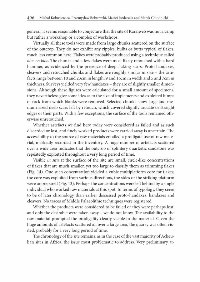
Michał Kobusiewicz, Przemysław Bobrowski, Maciej Jórdeczka and Marek Chłodnicki496
general, it seems reasonable to conjecture that the site of Karaiweb was not a camp but rather a workshop or a complex of workshops.
Virtually all these tools were made from large chunks scattered on the surface of the outcrop. They do not exhibit any ripples, bulbs or butts typical of flakes, much less common here. Flakes were probably produced using a technique called bloc en bloc. The chunks and a few flakes were most likely retouched with a hard hammer, as evidenced by the presence of deep flaking scars. Proto-handaxes, cleavers and retouched chunks and flakes are roughly similar in size – the arte-facts range between 10 and 23cm in length, 9 and 16cm in width and 5 and 7cm in thickness. Surveys yielded very few handaxes – they are of slightly smaller dimen-sions. Although these figures were calculated for a small amount of specimens, they nevertheless give some idea as to the size of implements and exploited lumps of rock from which blanks were removed. Selected chunks show large and me-dium-sized deep scars left by retouch, which covered slightly arcuate or straight edges or their parts. With a few exceptions, the surface of the tools remained oth-erwise unretouched.
Whether artefacts we find here today were considered as failed and as such discarded or lost, and finely worked products were carried away is uncertain. The accessibility to the source of raw materials entailed a profligate use of raw mate-rial, markedly recorded in the inventory. A huge number of artefacts scattered over a wide area indicates that the outcrop of splintery quartzitic sandstone was repeatedly exploited throughout a very long period of time.
Visible in situ at the surface of the site are small, circle-like concentrations of flakes that are much smaller, yet too large to classify them as trimming flakes (Fig. 14). One such concentration yielded a cubic multiplatform core for flakes; the core was exploited from various directions, the sides or the striking platform were unprepared (Fig. 13). Perhaps the concentrations were left behind by a single individual who worked raw materials at this spot. In terms of typology, they seem to be of later chronology than earlier discussed proto-handaxes, handaxes and cleavers. No traces of Middle Palaeolithic techniques were registered.
Whether the products were considered to be failed or they were perhaps lost, and only the desirable were taken away – we do not know. The availability to the raw material prompted the prodigality clearly visible in the material. Given the huge amounts of artefacts scattered all over a large area, the quarry was often vis-ited, probably for a very long period of time.
The chronology of the site remains, as in the case of the vast majority of Acheu-lian sites in Africa, the issue most problematic to address. Very preliminary at-
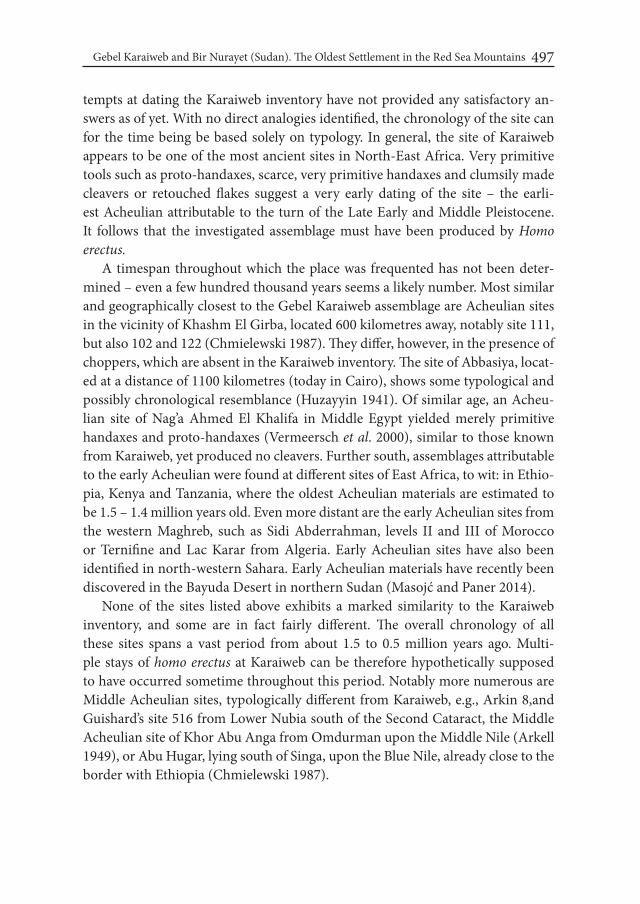
Gebel Karaiweb and Bir Nurayet (Sudan). The Oldest Settlement in the Red Sea Mountains 497
tempts at dating the Karaiweb inventory have not provided any satisfactory an-swers as of yet. With no direct analogies identified, the chronology of the site can for the time being be based solely on typology. In general, the site of Karaiweb appears to be one of the most ancient sites in North-East Africa. Very primitive tools such as proto-handaxes, scarce, very primitive handaxes and clumsily made cleavers or retouched flakes suggest a very early dating of the site – the earli-est Acheulian attributable to the turn of the Late Early and Middle Pleistocene. It follows that the investigated assemblage must have been produced by Homo erectus.
A timespan throughout which the place was frequented has not been deter-mined – even a few hundred thousand years seems a likely number. Most similar and geographically closest to the Gebel Karaiweb assemblage are Acheulian sites in the vicinity of Khashm El Girba, located 600 kilometres away, notably site 111, but also 102 and 122 (Chmielewski 1987). They differ, however, in the presence of choppers, which are absent in the Karaiweb inventory. The site of Abbasiya, locat-ed at a distance of 1100 kilometres (today in Cairo), shows some typological and possibly chronological resemblance (Huzayyin 1941). Of similar age, an Acheu-lian site of Nag’a Ahmed El Khalifa in Middle Egypt yielded merely primitive handaxes and proto-handaxes (Vermeersch et al. 2000), similar to those known from Karaiweb, yet produced no cleavers. Further south, assemblages attributable to the early Acheulian were found at different sites of East Africa, to wit: in Ethio-pia, Kenya and Tanzania, where the oldest Acheulian materials are estimated to be 1.5 – 1.4 million years old. Even more distant are the early Acheulian sites from the western Maghreb, such as Sidi Abderrahman, levels II and III of Morocco or Ternifine and Lac Karar from Algeria. Early Acheulian sites have also been identified in north-western Sahara. Early Acheulian materials have recently been discovered in the Bayuda Desert in northern Sudan (Masojć and Paner 2014).
None of the sites listed above exhibits a marked similarity to the Karaiweb inventory, and some are in fact fairly different. The overall chronology of all these sites spans a vast period from about 1.5 to 0.5 million years ago. Multi-ple stays of homo erectus at Karaiweb can be therefore hypothetically supposed to have occurred sometime throughout this period. Notably more numerous are Middle Acheulian sites, typologically different from Karaiweb, e.g., Arkin 8,and Guishard’s site 516 from Lower Nubia south of the Second Cataract, the Middle Acheulian site of Khor Abu Anga from Omdurman upon the Middle Nile (Arkell 1949), or Abu Hugar, lying south of Singa, upon the Blue Nile, already close to the border with Ethiopia (Chmielewski 1987).
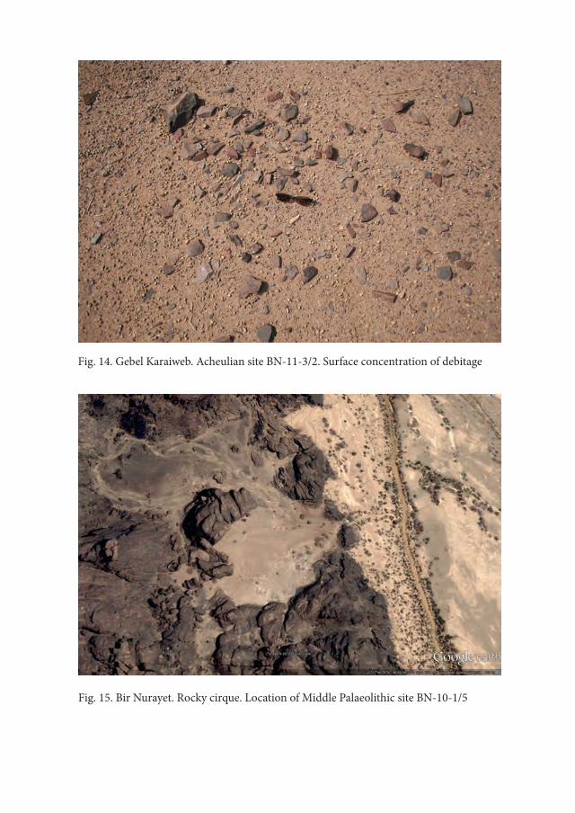
Fig. 14. Gebel Karaiweb. Acheulian site BN-11-3/2. Surface concentration of debitage
Fig. 15. Bir Nurayet. Rocky cirque. Location of Middle Palaeolithic site BN-10-1/5

Gebel Karaiweb and Bir Nurayet (Sudan). The Oldest Settlement in the Red Sea Mountains 499
The Late Acheulian sites from the northern areas of Lake Chad basin, south of Tibesti, are of particular interest to us – they yielded stone tool workshops (Tillet 1983), possibly analogous to the Gebel Karaiweb workshop.
The workshop character of the Gebel Karaiweb inventory and, above all, the type of raw material used for making tools can perhaps explain the remarkability of the Karaiweb typology. People exploiting the local outcrop could have chosen between large, sharp-edged chunks or flakes, while their distant neighbours from the areas upon the Nile or Atbara worked on cobbles – this, among other things, can partly account for the noticeable differences, at least in this case.
The current state of research on the Lower Palaeolithic of North-East Africa, particularly its older phase, is far from satisfying. Extremely scarce sites from this period are widely dispersed over a vast area – Gamal El Deen Idris (1994) notices merely four Older Acheulian sites in Sudan. Karaiweb is the only site to have been identified in the Red Sea Mountains thus far. Highly promising, the site of Gebel Karaiweb should definitely be further explored – it is bound to provide new data on the oldest period of human prehistory.
2. Middle PalaeolithicSix Middle Palaeolithic sites have been registered in the vicinity of the village
Bir Nurayet, approximately seven kilometres to the south of Gebel Karaiweb while walking along the western edge of Wadi Diib. Among them, the site codenamed BN-10-1/5 stands out as particularly wealthy. Having furnished most abundant information, the site currently provides the basis for our present knowledge on this period in the region of Bir Nurayet.
The site is located almost in the centre of the so-called rock cirque marked with number 1 This oval, nearly circular in shape erosion valley is surrounded on all sides with almost vertical walls (Fig. 15). From the east, looking from Wadi Diib, there are two low hills, between which an entrance to the valley was located in a depression (a kind of saddle). The bottom of this valley is located a few meters above the bottom of Wadi Diib and the maximum level of the ceiling of its allu-vial sediments. Therefore, in contrast to the neighbouring erosion valleys 2 and 4 in the eastern edge of the rock mass, Valley 1 was not flooded by water flowing through the main wadi and it is not filled with silts.
In 2010 and 2011 research seasons, lithic materials were collected from the surface of the site. An elongated, ellipse-shaped concentration of Middle Palaeo-lithic artefacts, approximately 30-40 meters in length and about 20-30 meters in
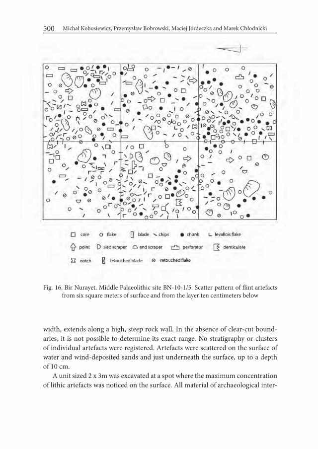
Michał Kobusiewicz, Przemysław Bobrowski, Maciej Jórdeczka and Marek Chłodnicki500
Fig. 16. Bir Nurayet. Middle Palaeolithic site BN-10-1/5. Scatter pattern of flint artefacts from six square meters of surface and from the layer ten centimeters below
width, extends along a high, steep rock wall. In the absence of clear-cut bound-aries, it is not possible to determine its exact range. No stratigraphy or clusters of individual artefacts were registered. Artefacts were scattered on the surface of water and wind-deposited sands and just underneath the surface, up to a depth of 10 cm.
A unit sized 2 x 3m was excavated at a spot where the maximum concentration of lithic artefacts was noticed on the surface. All material of archaeological inter-
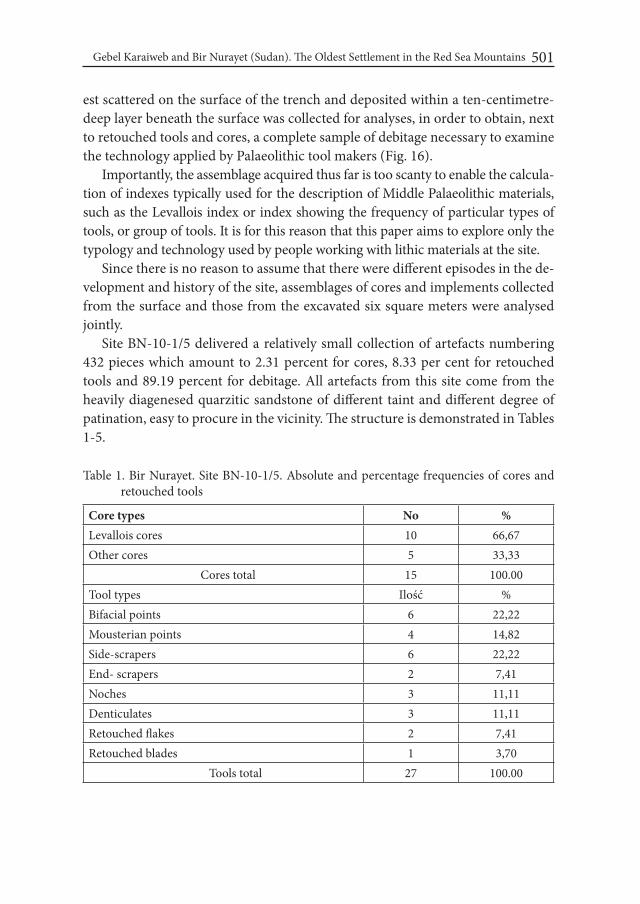
Gebel Karaiweb and Bir Nurayet (Sudan). The Oldest Settlement in the Red Sea Mountains 501
est scattered on the surface of the trench and deposited within a ten-centimetre-deep layer beneath the surface was collected for analyses, in order to obtain, next to retouched tools and cores, a complete sample of debitage necessary to examine the technology applied by Palaeolithic tool makers (Fig. 16).
Importantly, the assemblage acquired thus far is too scanty to enable the calcula-tion of indexes typically used for the description of Middle Palaeolithic materials, such as the Levallois index or index showing the frequency of particular types of tools, or group of tools. It is for this reason that this paper aims to explore only the typology and technology used by people working with lithic materials at the site.
Since there is no reason to assume that there were different episodes in the de-velopment and history of the site, assemblages of cores and implements collected from the surface and those from the excavated six square meters were analysed jointly.
Site BN-10-1/5 delivered a relatively small collection of artefacts numbering 432 pieces which amount to 2.31 percent for cores, 8.33 per cent for retouched tools and 89.19 percent for debitage. All artefacts from this site come from the heavily diagenesed quarzitic sandstone of different taint and different degree of patination, easy to procure in the vicinity. The structure is demonstrated in Tables 1-5.
Table 1. Bir Nurayet. Site BN-10-1/5. Absolute and percentage frequencies of cores and retouched tools
Core types No %Levallois cores 10 66,67Other cores 5 33,33 Cores total 15 100.00Tool types Ilość %Bifacial points 6 22,22Mousterian points 4 14,82Side-scrapers 6 22,22End- scrapers 2 7,41Noches 3 11,11Denticulates 3 11,11Retouched flakes 2 7,41Retouched blades 1 3,70 Tools total 27 100.00
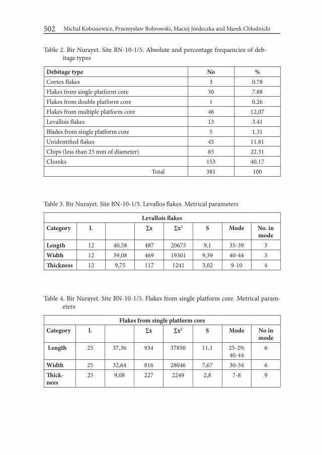
Michał Kobusiewicz, Przemysław Bobrowski, Maciej Jórdeczka and Marek Chłodnicki502
Table 2. Bir Nurayet. Site BN-10-1/5. Absolute and percentage frequencies of deb-itage types
Debitage type No %Cortex flakes 3 0.78Flakes from single platform core 30 7.88Flakes from double platform core 1 0.26Flakes from multiple platform core 46 12,07Levallois flakes 13 3.41Blades from single platform core 5 1.31Unidentified flakes 45 11.81Chips (less than 25 mm of diameter) 85 22.31Chunks 153 40.17 Total 381 100
Table 3. Bir Nurayet. Site BN-10-1/5. Levallos flakes. Metrical parameters
Levallois flakesCategory l. ∑x ∑x2 S Mode No. in
modeLength 12 40,58 487 20675 9,1 35-39 3Width 12 39,08 469 19301 9,39 40-44 3Thickness 12 9,75 117 1241 3,02 9-10 4
Table 4. Bir Nurayet. Site BN-10-1/5. Flakes from single platform core. Metrical param-eters
Flakes from single platform coreCategory l. ∑x ∑x2 S Mode No in
mode Length 25 37,36 934 37850 11,1 25-29;
40-446
Width 25 32,64 816 28046 7,67 30-34 6Thick-nees
25 9,08 227 2249 2,8 7-8 9
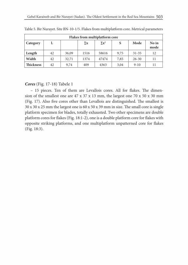
Gebel Karaiweb and Bir Nurayet (Sudan). The Oldest Settlement in the Red Sea Mountains 503
Table 5. Bir Nurayet. Site BN-10-1/5. Flakes from multiplatform core. Metrical parameters
Flakes from multiplatform coreCategory l. ∑x ∑x2 S Mode No in
modeLength 42 36,09 1516 58616 9,75 31-35 12Width 42 32,71 1374 47474 7,85 26-30 11Thickness 42 9,74 409 4363 3,04 9-10 11
Cores (Fig. 17-18) Tabele 1– 15 pieces. Ten of them are Levallois cores. All for flakes. The dimen-
sion of the smallest one are 47 x 37 x 13 mm, the largest one 70 x 50 x 30 mm (Fig. 17). Also five cores other than Levallois are distinguished. The smallest is 30 x 30 x 25 mm the largest one is 60 x 50 x 39 mm in size. The small core is single platform specimen for blades, totally exhausted. Two other specimens are double platform cores for flakes (Fig. 18:1-2), one is a double platform core for flakes with opposite striking platforms, and one multiplatform unpatterned core for flakes (Fig. 18:3).
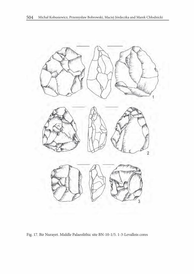
Michał Kobusiewicz, Przemysław Bobrowski, Maciej Jórdeczka and Marek Chłodnicki504
Fig. 17. Bir Nurayet. Middle Palaeolithic site BN-10-1/5. 1-3-Levallois cores
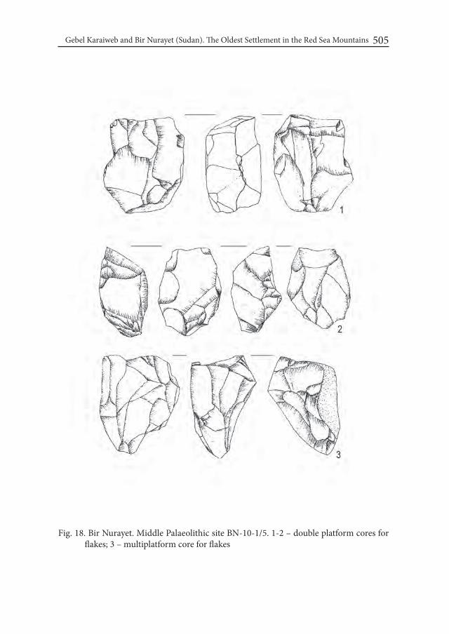
Gebel Karaiweb and Bir Nurayet (Sudan). The Oldest Settlement in the Red Sea Mountains 505
Fig. 18. Bir Nurayet. Middle Palaeolithic site BN-10-1/5. 1-2 – double platform cores for flakes; 3 – multiplatform core for flakes

Michał Kobusiewicz, Przemysław Bobrowski, Maciej Jórdeczka and Marek Chłodnicki506
Retouched toolsBifacial points (Fig. 19) Tabele 1
– The most common are bifacial points – six specimens. The largest is broken. The dimensions of its preserved part are 60 x 50 x 12 mm. The dimensions of four remaining cores are: length oscillate between 40-50 mm, width 28-35 mm and thickness 9-14 mm. Both sides are entirely covered by retouch composed of medium and small negatives of flakes.
Fig. 19. Bir Nurayet. Middle Palaeolithic site BN-10-1/5. 1-4 – bifacial points
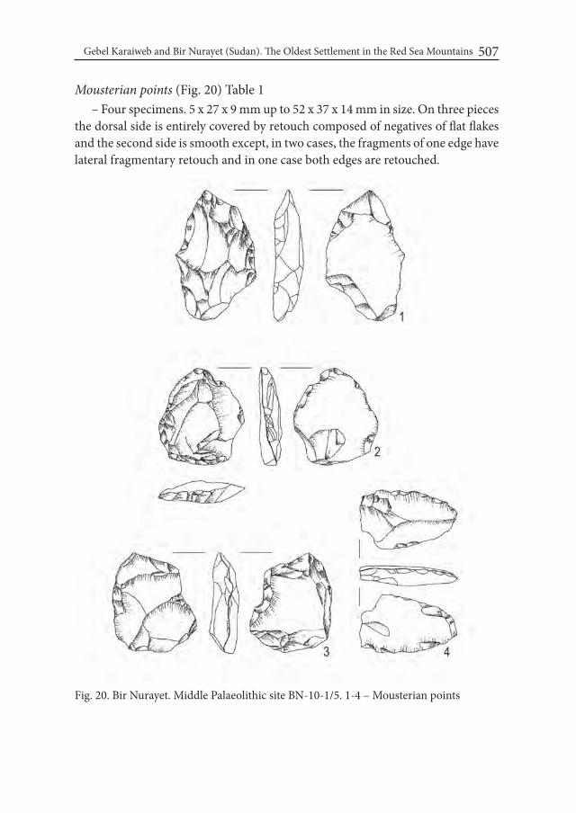
Gebel Karaiweb and Bir Nurayet (Sudan). The Oldest Settlement in the Red Sea Mountains 507
Mousterian points (Fig. 20) Table 1– Four specimens. 5 x 27 x 9 mm up to 52 x 37 x 14 mm in size. On three pieces
the dorsal side is entirely covered by retouch composed of negatives of flat flakes and the second side is smooth except, in two cases, the fragments of one edge have lateral fragmentary retouch and in one case both edges are retouched.
Fig. 20. Bir Nurayet. Middle Palaeolithic site BN-10-1/5. 1-4 – Mousterian points
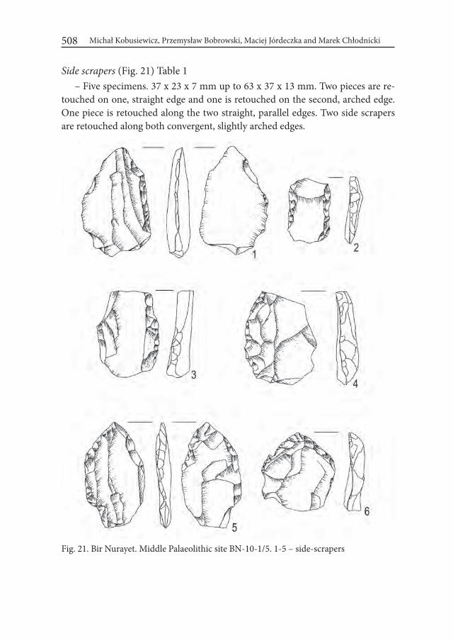
Michał Kobusiewicz, Przemysław Bobrowski, Maciej Jórdeczka and Marek Chłodnicki508
Side scrapers (Fig. 21) Table 1– Five specimens. 37 x 23 x 7 mm up to 63 x 37 x 13 mm. Two pieces are re-
touched on one, straight edge and one is retouched on the second, arched edge. One piece is retouched along the two straight, parallel edges. Two side scrapers are retouched along both convergent, slightly arched edges.
Fig. 21. Bir Nurayet. Middle Palaeolithic site BN-10-1/5. 1-5 – side-scrapers
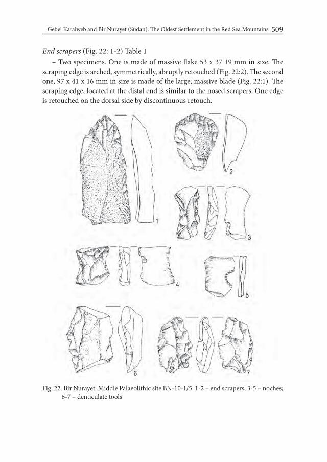
Gebel Karaiweb and Bir Nurayet (Sudan). The Oldest Settlement in the Red Sea Mountains 509
End scrapers (Fig. 22: 1-2) Table 1– Two specimens. One is made of massive flake 53 x 37 19 mm in size. The
scraping edge is arched, symmetrically, abruptly retouched (Fig. 22:2). The second one, 97 x 41 x 16 mm in size is made of the large, massive blade (Fig. 22:1). The scraping edge, located at the distal end is similar to the nosed scrapers. One edge is retouched on the dorsal side by discontinuous retouch.
Fig. 22. Bir Nurayet. Middle Palaeolithic site BN-10-1/5. 1-2 – end scrapers; 3-5 – noches; 6-7 – denticulate tools
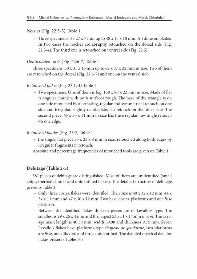
Michał Kobusiewicz, Przemysław Bobrowski, Maciej Jórdeczka and Marek Chłodnicki510
Noches (Fig. 22:3-5) Table 1 – Three specimens, 35 27 x 7 mm up to 48 x 17 x 10 mm. All done on blades.
In two cases the noches are abruptly retouched on the dorsal side (Fig. 22:3-4). The third one is retouched on ventral side (Fig. 22:5)
Denticulated tools (Fig. 22:6-7) Table 1Three specimens. 50 x 31 x 16 mm up to 62 x 37 x 22 mm in size. Two of them
are retouched on the dorsal (Fig. 22:6-7) and one on the ventral side.
Retouched flakes (Fig. 23:1, 4) Table 1 – Two specimens. One of them is big, 150 x 80 x 22 mm in size. Made of flat
triangular chunk with both surfaces rough. The base of the triangle is on one side retouched by alternating, regular and symmetrical retouch on one side and irregular, slightly denticulate, flat retouch on the other side. The second piece, 65 x 50 x 11 mm in size has the irregular, low angle retouch on one edge.
Retouched blades (Fig. 23:2) Table 1 – The single, flat piece 55 x 25 x 8 mm in size, retouched along both edges by
irregular fragmentary retouch. Absolute and percentage frequencies of retouched tools are given on Table 1
Debitage (Table 2-5)381 pieces of debitage are distinguished. Most of them are unidentified (small
chips, thermal chunks and unidentified flakes). The detailed structure of debitage presents Table 2.
– Only three cortex flakes were identified. Their size is 40 x 32 x 12 mm, 44 x 34 x 13 mm and 47 x 30 x 12 mm. Two have cortex platforms and one lisse platform.
– Between the identified flakes thirteen pieces are of Levallois type. The smallest is 29 x 26 x 4 mm and the largest 53 x 51 x 14 mm in size. The aver-age main length is 40.58 mm, width 39.08 and thickness 9.75 mm. Seven Levallois flakes have platforms type chapeau de gendarme, two platforms are lisse, one dihedral and three unidentified. The detailed metrical data for flakes presents Tables 3-5.
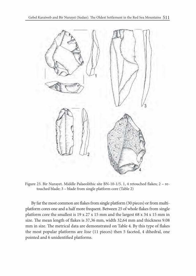
Gebel Karaiweb and Bir Nurayet (Sudan). The Oldest Settlement in the Red Sea Mountains 511
By far the most common are flakes from single platform (30 pieces) or from multi-platform cores one and a half more frequent. Between 25 of whole flakes from single platform core the smallest is 19 x 27 x 15 mm and the largest 68 x 34 x 15 mm in size. The mean length of flakes is 37,36 mm, width 32,64 mm and thickness 9.08 mm in size. The metrical data are demonstrated on Table 4. By this type of flakes the most popular platforms are lisse (11 pieces) then 5 faceted, 4 dihedral, one pointed and 6 unidentified platforms.
Figure 23. Bir Nurayet. Middle Palaeolithic site BN-10-1/5. 1, 4 retouched flakes; 2 – re-touched blade; 3 – blade from single platform core (Table 2)
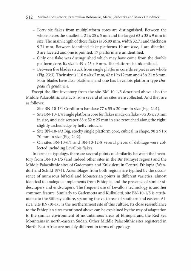
Michał Kobusiewicz, Przemysław Bobrowski, Maciej Jórdeczka and Marek Chłodnicki512
– Forty six flakes from multiplatform cores are distinguished. Between the whole pieces the smallest is 21 x 25 x 5 mm and the largest 63 x 38 x 9 mm in size. The main length of these flakes is 36.09 mm, width 32.71 and thickness 9.74 mm. Between identified flake platforms 19 are lisse, 4 are dihedral, 3 are faceted and one is pointed. 17 platform are unidentified.
– Only one flake was distinguished which may have come from the double platform core. Its size is 49 x 25 x 9 mm. The platform is unidentified.
– Between five blades struck from single platform core three pieces are whole (Fig. 23:3). Their size is 110 x 40 x 7 mm, 42 x 19 x12 mm and 43 x 21 x 8 mm. Four blades have lisse platforms and one has Levallois platform type cha-peau de gendarme.
Except the flint inventory from the site BM-10-1/5 described above also the Middle Palaeolithic artefacts from several other sites were collected. And they are as follows:
– Site BN-10-1/1 Cordiform handaxe 77 x 55 x 20 mm in size (Fig. 24:1). – Site BN-10-1/4 Single platform core for flakes made on flake 70 x 35 x 20 mm
in size, and side scraper 88 x 52 x 25 mm in size retouched along the right, slightly arched edge by hefty retouch.
– Site BN-10-4/3 Big, stocky single platform core, cubical in shape, 90 x 91 x 70 mm in size (Fig. 24:2).
– On sites BN-10-6/1 and BN-10-12-8 several pieces of debitage were col-lected including Levallois flakes.
In terms of typology, there are several points of similarity between the inven-tory from BN-10-1/5 (and indeed other sites in the Bir Nurayet region) and the Middle Palaeolithic sites of Gademotta and Kulkuletti in Central Ethiopia (Wen-dorf and Schild 1974). Assemblages from both regions are typified by the occur-rence of numerous bifacial and Mousterian points in different varieties, almost identical to analogous implements from Ethiopia, and the presence of similar si-descrapers and endscrapers. The frequent use of Levallois technology is another common feature. Similarly to Gademotta and Kulkuletti, site BN-10-1/5 is attrib-utable to the Stillbay culture, spanning the vast areas of southern and eastern Af-rica. Site BN-10-1/5 is the northernmost site of this culture. Its close resemblance to the Ethiopian sites mentioned above can be explained by the way of adaptation to the similar environment of mountainous areas of Ethiopia and the Red Sea Mountains in north-eastern Sudan. Other Middle Palaeolithic sites registered in North-East Africa are notably different in terms of typology.

Gebel Karaiweb and Bir Nurayet (Sudan). The Oldest Settlement in the Red Sea Mountains 513
Sites of the Stillbay culture in Africa date back to the period between 200,000 to 70,000 years BP, the timespan identical to that of site BM-1-1/5 and other Middle Palaeolithic sites in the area. The Stillbay cultural tradition lasted for a long time and there are no premises whatsoever to allow a more precise dating of our finds within such determined time frame. It is anticipated that further comprehensive research will provide a more exact chronology.
Given the wealth of artefacts, site BN-10-1/5 represents the remains of recur-rent occupation of people using the technology and typology of the Stillbay cul-ture. This multiplicity of stays can be explained by the favourable location inside
Figure 24. Bir Nurayet. Middle Palaeolithic site BN-10-1/1: 1 – handaxe; site BN-10-4/3: 2 – Core for flakes
Michał Kobusiewicz, Przemysław Bobrowski, Maciej Jórdeczka and Marek Chłodnicki514
the rock cirque, above the water levels rising in the adjacent Wadi Diib, sheltered from the wind blowing from the north and west. The discovery of other traces of the same Late Palaeolithic culture in various places in the region of Bir Nurayet testifies to the fact that the Stillbay communities penetrated the vast areas of the Red Sea Mountains.
REFERENCESARKELL, A. J. 1949. The Old Stone Age in the Anglo-Egyptian Sudan. Antiquities
Service Occasional Papers I. Khartoum.CHMIELEWSKI, W. 1968. Early and Middle Palaeolithic Sites near Arkin, Sudan.
In: F. Wendorf (ed.) The Prehistory of Nubia: 110-147. Dallas.CHMIELEWSKI, W. 1987. The Pleistocene and Early Holocene Archaeological
Sites on the Atbara and Blue Nile in Eastern Sudan. Przegląd Archeologiczny 34:5-48.
GAMAL EL DEEN IDRIS. 1994. Die Altsteinzeit im Sudan. Archäologische Beri-chte 4: 15-66.
HUZAYYIN, S. A. 1941. The place of Egypt in prehistory: a correlated study of climates and cultures in the Old World. Memoires de l’institut d’Egypte 43. Cairo.
MASOJĆ, M. and H. PANER. 2014. The Bayuda Project (BP). The Palaeolithic and Neolithic Age in the Light of Current Research (2009-2011). Gdańsk Archaeological Museum African Reports 11: 89-100.
TILLET, TH.1983. Le paléolithique du Bassin Tchadien Septentrional (Niger-Tchad). Paris
VERMEERSCH, P., PAULISEN, E., OTTE, M.and G. GIJSELINGS. 2000. Nag Ahmed El Khalifa Site. In: P. Vermeersch (ed.) Palaeolithic Living Sites in Upper Egypt (= Egyptian Prehistory Monographs 2): 57-74. Leuven.
WENDORF, F. and R. SCHILD. 1974. A Middle Stone Age Sequence from the Cen-tral Rift Valley, Ethiopia. Wrocław, Warszawa, Kraków, Gdańsk.
Desert and the Nile. Prehistory of the Nile Basin and the Sahara.
Papers in honour of Fred Wendorf Studies in African Archaeology 15
Poznań Archaeological Museum 2018
Agnieszka Czekaj-Zastawny, Joel D. Irish, Jacek Kabaciński and Jakub Mugaj
The Neolithic Settlements by a Paleo-lake of Gebel Ramlah, Western Desert of Egypt
IntroductionFrom the early 70’s of XX century the Egyptian Western Desert was a main
research area of the Combined Prehistoric Expedition (CPE). For the first three decades research activity of CPE was focused around the palaeo-lake of Gebel Nabta (Fig. 1). Over 20 years of intensive research allowed to reconstruct a se-quence of settlement episodes spanning from the Early to Final Neolithic and correlated with main climatic phases recognized on the territory of the West-ern Desert (Wendorf and Schild 1980; 1995-96; 2001; Schild and Wendorf 2001; Schild at al. 2005). Except of numerous occupations a number of constructions interpreted as astronomic, sacral and social phenomenon, like famous Nabta Pla-ya1 calendar, rows of anthropomorphic stelae and tumuli were studied (Wendorf and Schild 2001; Nelson 2002; Kobusiewicz et al. 2004; 2010; Bobrowski at al. 2014).
Only at the beginning of XXI century a part of CPE research interest moved ca. 20 km to the north where another palaeo-lake adjacent from the south to Ge- bel Ramlah, a rocky massif pronounced in the landscape, witnessed a Holocene
1 Playa is a Spanish-origin term for temporary lake.
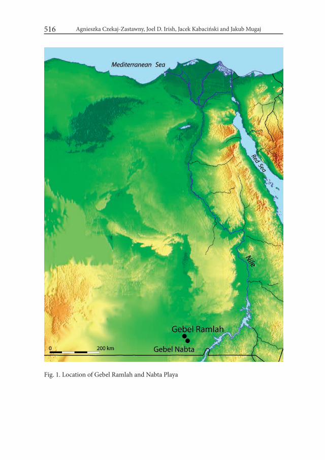
Agnieszka Czekaj-Zastawny, Joel D. Irish, Jacek Kabaciński and Jakub Mugaj516
Fig. 1. Location of Gebel Ramlah and Nabta Playa
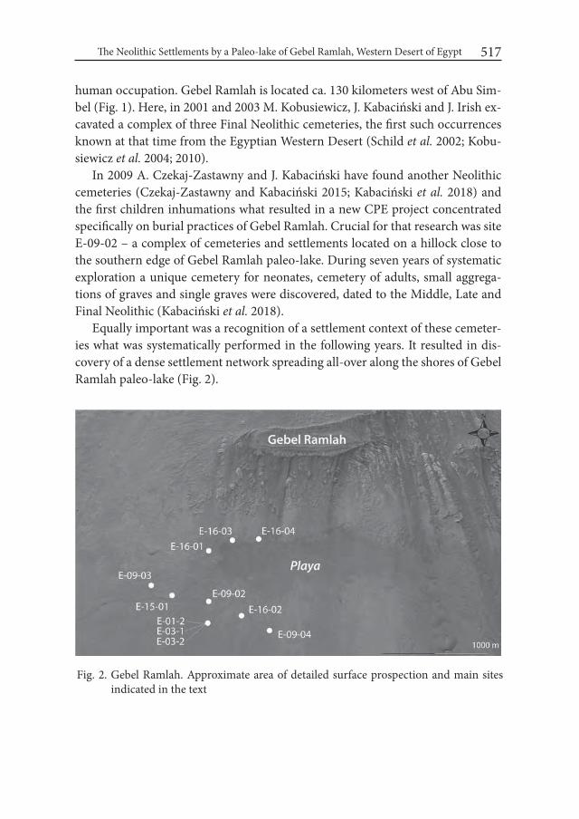
The Neolithic Settlements by a Paleo-lake of Gebel Ramlah, Western Desert of Egypt 517
human occupation. Gebel Ramlah is located ca. 130 kilometers west of Abu Sim-bel (Fig. 1). Here, in 2001 and 2003 M. Kobusiewicz, J. Kabaciński and J. Irish ex-cavated a complex of three Final Neolithic cemeteries, the first such occurrences known at that time from the Egyptian Western Desert (Schild et al. 2002; Kobu- siewicz et al. 2004; 2010).
In 2009 A. Czekaj-Zastawny and J. Kabaciński have found another Neolithic cemeteries (Czekaj-Zastawny and Kabaciński 2015; Kabaciński et al. 2018) and the first children inhumations what resulted in a new CPE project concentrated specifically on burial practices of Gebel Ramlah. Crucial for that research was site E-09-02 – a complex of cemeteries and settlements located on a hillock close to the southern edge of Gebel Ramlah paleo-lake. During seven years of systematic exploration a unique cemetery for neonates, cemetery of adults, small aggrega-tions of graves and single graves were discovered, dated to the Middle, Late and Final Neolithic (Kabaciński et al. 2018).
Equally important was a recognition of a settlement context of these cemeter-ies what was systematically performed in the following years. It resulted in dis-covery of a dense settlement network spreading all-over along the shores of Gebel Ramlah paleo-lake (Fig. 2).
Fig. 2. Gebel Ramlah. Approximate area of detailed surface prospection and main sites indicated in the text
Agnieszka Czekaj-Zastawny, Joel D. Irish, Jacek Kabaciński and Jakub Mugaj518
1. Outline of the Neolithic settlement on the Western Desert of EgyptOver forty years of CPE research allowed to recognize a basic chrono-strati-
graphic units of the Neolithic occupation of the Western Desert correlated with climatic fluctuations (Schild and Wendorf 2013). The sequence covers 4 basic pe-riods: the Early, Middle, Late and Final Neolithic, each separated by a remarkable arid period recorded in the form of intensive aeolian sedimentation and erosion. The Early Neolithic (ca. 9300-6150 cal BC2) includes 4 cultural units, with the ol- dest El Adam, than El Ghorab and El Nabta/El Jerar. Dry period between ca. 6150 and 6050 cal BC separates the Early and Middle Neolithic. Climatic improvement allowed again human occupation at around 6050 cal. BC. The Middle Neolithic sheep and goat herders (Ru’at El Ghanam) inhabited in the Nabta-Kiseiba area till ca. 5550 cal BC. Short arid phase (ca. 5550-5500 cal BC) preceded the Late Neo-lithic occupation called Ru’at El Baqar (cow herders) and dated between ca. 5500 and 4650 cal BC. After another dry phase (ca. 4650-4600 cal BC) the last phase of the Neolithic – the Final Neolithic began. In Nabta Playa area that Final Neolithic societies are called Bunat El Ansam – builders of megaliths and lived there up to ca. 3600 cal BC. The settlement sequence of the Western Desert is bordered by a C-Group occupation that appeared there during climatic improvement around 2400 cal BC after over 1000 years of hyper-arid climatic conditions.
For Gebel Ramlah area we apply a periodization formed for Nabta-Kiseiba region as it valid for all the Western Desert. It doesn’t exclude local differences in chronology of some units what is for instance suggested for Early/Middle Neo-lithic transition (see below).
2. History of the Neolithic occupation in Gebel RamlahSeveral years of archaeological research in the Gebel Ramlah area (between
2001 and 2016) allow to reconstruct general features of the Neolithic settlement around the paleo-lake. The Gebel Ramlah Playa measures approximately 1 x 3 km with the longer axis extending from east to west. It is adjacent to the Gebel from the south and certainly its range was changing during the Neolithic and what is readable today in the landscape is most probable a maximal extension of the lake during the Holocene climatic optimum.
2 All 14C dates are calibrated with the help of CalPal software, version March 2007 (Weninger and Jöris 2007; Weninger et al. 2007).
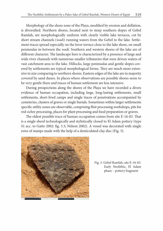
The Neolithic Settlements by a Paleo-lake of Gebel Ramlah, Western Desert of Egypt 519
Morphology of the shore zone of the Playa, modified by erosion and deflation, is diversified. Northern shores, located next to steep southern slopes of Gebel Ramlah, are morphologically uniform with clearly visible lake terraces, cut by short stream channels (wadi) running waters from the Gebel to the lake. Settle-ment traces spread especially on the lover terrace close to the lake shore, on small peninsulas in-between the wadi. Southern and western shores of the lake are of different character. The landscape here is characterized by a presence of large and wide river channels with numerous smaller tributaries that were driven waters of vast catchment area to the lake. Hillocks, large peninsulas and gentle slopes cov-ered by settlements are typical morphological forms. They are much more exten-sive in size comparing to northern shores. Eastern edges of the lake are in majority covered by sand dunes. In places where observations are possible shores seem to be very gentle there and traces of human settlement are less intensive.
During prospections along the shores of the Playa we have recorded a divers evidence of human occupation, including large, long-lasting settlements, small settlements, short-lived camps and single traces of penetrations accompanied by cemeteries, clusters of graves or single burials. Sometimes within larger settlements specific utility zones are observable, comprising flint processing workshops, pits for red-ochre processing, places for plant processing and food preparation or graves.
The oldest possible trace of human occupation comes from site E-16-03. That is a single sherd technologically and stylistically closed to El Adam pottery (type S1 acc. to Gatto 2002: fig. 5.3; Nelson 2002). A vessel was decorated with single rows of stamps made with the help of a denticulated clay disc (Fig. 3).
Fig. 3. Gebel Ramlah, site E-16-03. Early Neolithic, El Adam phase – pottery fragment
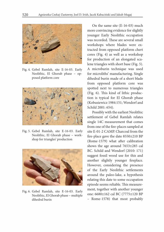
Agnieszka Czekaj-Zastawny, Joel D. Irish, Jacek Kabaciński and Jakub Mugaj520
On the same site (E-16-03) much more convincing evidence for slightly younger Early Neolithic occupation was recorded. These are several small workshops where blades were ex-tracted from opposed platform chert cores (Fig. 4) as well as a workshop for production of an elongated sca-lene triangles with short base (Fig. 5). A microburin technique was used for microliths’ manufacturing. Single dihedral burin made of a short blade from opposed platform core was spotted next to numerous triangles (Fig. 6). This kind of lithic produc-tion is typical for El Ghorab phase (Kobusiewicz 1984:151; Wendorf and Schild 2001: 654).
Possibly with the earliest Neolithic settlement of Gebel Ramlah relates single 14C measurement that comes from one of the fire-places sampled at site E-01-2 CAMP. Charcoal from the fire-place gave the date 8550±210 BP (Rome-1579) what after calibration shows the age around 7653±285 cal BC. Schild and Wendorf (2010: 171) suggest fossil wood use for this and another slightly younger fireplace. However, considering the presence of the Early Neolithic settlements around the paleo-lake, a hypothesis relating this date to some occupation episode seems reliable. This measure-ment, together with another younger one: 6680±162 cal BC (7775±120 BP – Rome-1578) that most probably
Fig. 4. Gebel Ramlah, site E-16-03. Early Neolithic, El Ghorab phase – op-posed platform core
Fig. 5. Gebel Ramlah, site E-16-03. Early Neolithic, El Ghorab phase – work-shop for triangles’ production
Fig. 6. Gebel Ramlah, site E-16-03. Early Neolithic, El Ghorab phase – multiple dihedral burin
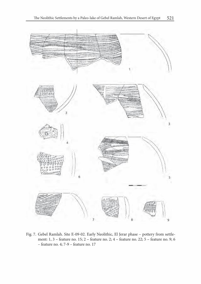
The Neolithic Settlements by a Paleo-lake of Gebel Ramlah, Western Desert of Egypt 521
Fig. 7. Gebel Ramlah. Site E-09-02. Early Neolithic, El Jerar phase – pottery from settle-ment: 1, 3 – feature no. 15; 2 – feature no. 2; 4 – feature no. 22; 5 – feature no. 9; 6 – feature no. 4; 7-9 – feature no. 17
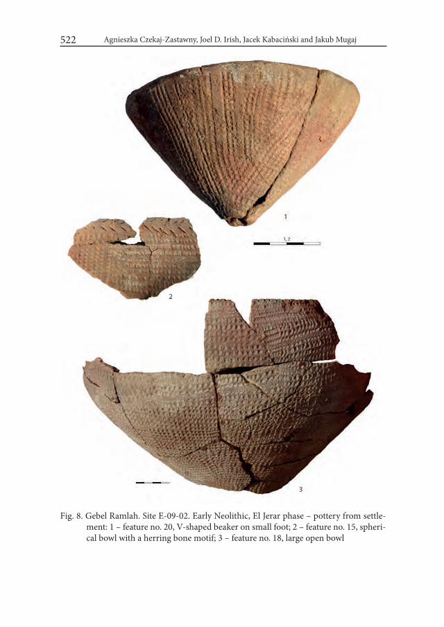
Agnieszka Czekaj-Zastawny, Joel D. Irish, Jacek Kabaciński and Jakub Mugaj522
Fig. 8. Gebel Ramlah. Site E-09-02. Early Neolithic, El Jerar phase – pottery from settle-ment: 1 – feature no. 20, V-shaped beaker on small foot; 2 – feature no. 15, spheri-cal bowl with a herring bone motif; 3 – feature no. 18, large open bowl

The Neolithic Settlements by a Paleo-lake of Gebel Ramlah, Western Desert of Egypt 523
Fig. 9. Gebel Ramlah, site E-09-02. Early Neolithic, El Jerar phase – lithics from settle-ment: 1, 3-7, 10 – feature no. 15; 2 – feature no. 13; 8-9, 11 – feature no. 20; 12 – feature no. 2

Agnieszka Czekaj-Zastawny, Joel D. Irish, Jacek Kabaciński and Jakub Mugaj524
point to the beginning of El Jerar phase, are till now the oldest 14C dates for the Early Neolithic of Gebel Ramlah area.
The most intensive occupation around the paleo-lake is related to El Jerar phase that developed during the climatic opti-mum of the Holocene. At ca. 6500 cal BC is dated the oldest burial discovered so far in Gebel Ramlah, at the site E-15-01.
Several settlements of that unit were recorded. The most characteristic feature of El Jerar is pottery – very uniform from technological, morphological and stylis-tic point of view. It is made of a locally extracted clay (silt) with admixture of fine crushed stones, sand and sometimes mica. Its reddish color and hardness show high temperature of firing and advanced firing technique as well. Vessels’ walls are medium-thick, mostly 6-7 mm some-times up to 10 mm in the case of larger forms. Majority of forms are spherical or open bowls (Fig. 7; 8:3). Rarely V-shaped beakers on small foot are present (Fig. 8:1).
The most distinguished feature is decoration: a carpet-like covering whole the exterior surface of every vessel. These are bands of imprints made with the help of denticulated clay discs mounted several in row on a stick rolled over the surface of the pot (Jórdecz- ka et al. 2011: fig. 12). This type of ornamentation is the same like that distinguished and called R4 by Gatto (Gatto 2002: fig. 5.3). On some forms a herring bone motif placed horizontally below the rim is visible, made with a flint edge (Fig. 8:2). Lithic inventories accompanied pottery assemblages are dominated by retouched flakes and blades, often denticulated and notched (Fig. 9). Typical Ounan points were not present in settlement features but recorded on the sites’ surface. In feature No. 2 (site E-09-02) with numerous El Jerar pottery a triangular point with retouched base was recorded (Fig. 9:12), so far linked with the Middle Neolithic period. Rela-tively numerous perforators (Fig. 9: 4-5, 8-9, 11) point to a specific activities un-dertaken on the site. Unusual find – a fragment of bone harpoon comes from site
Fig. 10. Gebel Ramlah, site E-09-02. Early Neolithic, El Jerar phase – harpoon made of animal bone

The Neolithic Settlements by a Paleo-lake of Gebel Ramlah, Western Desert of Egypt 525
E-09-02, feature No. 17 (Fig. 10). That last settlement is radiocarbon dated to ca. 6300 cal BC.
The Middle Neolithic period is poorly recognized. No settlements were found from that time yet. How- ever there are two finds that confirm the Middle Neolithic human occupa-tion of the Gebel Ramlah area. The first is a single burial of a 5.5 years old child (Burial 7/2014), without any equipment, dated to ca. 5680±26 cal BC (6775±30 BP – Poz-63828; Fig. 11). About 200 years older is a colie con-sisting of a triangular pendant made of animal long bone and a string of ca. 200 ostrich egg shell beads (Fig. 12). A bead from this jewelry gave a date 5967±45 cal BC (7090±50 BP – Poz-54443) what places this find at the very beginning of the Middle Neo-lithic period.
Much more intensive evidence of human settlement is confirmed for the Late Neolithic period. The most representative is the site E-16-02 from where comes a large collection of typi-cal Late Neolithic pottery (Gatto 1998; 1999 cited in Nelson 2001; 2002; Gatto 2010). It is made of a lake clay with a scarce admixture of sand and fine crushed stones. Pottery is completely undecorated with smoothed surface and relatively thin walls (5-7 mmm in average). The only forms recorded are spherical and open bowls (Fig. 13). The Late Neolithic lithic production
Fig. 11. Gebel Ramlah, site E-09-02. Middle Neolithic – Burial 7/2014
Fig. 12. Gebel Ramlah, site E-09-02. Middle Neolithic – colie consisting of a tri-angular pendant made of animal long bone and string of ca. 200 ostrich egg shell beads
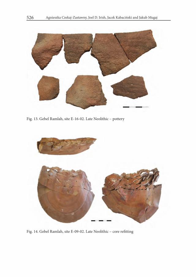
Agnieszka Czekaj-Zastawny, Joel D. Irish, Jacek Kabaciński and Jakub Mugaj526
Fig. 13. Gebel Ramlah, site E-16-02. Late Neolithic – pottery
Fig. 14. Gebel Ramlah, site E-09-02. Late Neolithic – core refitting

The Neolithic Settlements by a Paleo-lake of Gebel Ramlah, Western Desert of Egypt 527
based on simple flake technol-ogy (Fig. 14). Flakes removed from cores have edges covered by invasive abrupt and some-times denticulated retouch. Bifacial surface retouch is ap-plied for production of barbed points, unless bifacial techno- logy seems to be present already in the Middle Neolithic (Mugaj 2016). Side-blow flakes are ty- pical for this period (Fig. 15). For the first time in the Gebel Ramlah area a rectangular stone palettes appear on settle-ments, numerous later in the Final Neolithic burials.
At least two burials are con-nected with the Late Neolithic occupation. The first (Burial 3/2014) comes from site E-09-02. Most probably that is a ske- leton of an adult women di-rectly dated to 4943±63 cal BC (6045±45 BP – Poz-63827). The second is an inhumation of ca. 30 years old male found at site E-16-01 (Burial 1). A bifacial barbed flint point was placed by a sacrum bone (Fig. 16). Another con-firmation of the Late Neolithic occupation are series of 14C measurements from fire-places from sites E-01-01 and E-01-02 CAMP (Bobrowski et al. 2006; Schild and Wendorf 2010).
The last period of intense human presence around the Gebel Ramlah lake is the Final Neolithic. It is known mainly form numerous cemeteries: E-01-02, E-03-1 and E-03-2 (Kobusiewicz et al. 2010), two cemeteries from site E-09-02 (Kabaciński et al. 2018) and E-09-04 (Czekaj-Zastawny and Kabaciński 2015). Evidence for settlements is ambiguous as till now only pottery fragments from surface or sub-surface are known with settlement features lacking.
Fig. 15. Gebel Ramlah, site E-16-03. Late Neo-lithic – retouched side-blow flake

Agnieszka Czekaj-Zastawny, Joel D. Irish, Jacek Kabaciński and Jakub Mugaj528
For the first time a rich collection of vessels comes from graves (cemeteries E-01-02, E-03-1, E-03-2). It is strongly diversified containing both locally made pottery as well as numerous imports (for instance black-topped vessels or decorated tulip beakers – Gatto 2010). Locally produced pottery is made of a lake clay with possible marl and Qusier Clastic Member admixture (Nelson 2002). Pottery from settlement context we have recorded so far (site E-09-02) is either undecorated or with corru-gated rims only (Fig. 17). Vessels from cemeteries, if decorated, have outside walls covered by ripples or zig-zag’s. Morphology of pots is less uniform than in earlier periods but always these are spherical forms including spherical and open bowls (often deep), or conical forms, and ostrich egg containers (Fig. 18).
Fig. 16. Gebel Ramlah, site E-16-01. Late Neolithic – Burial 1
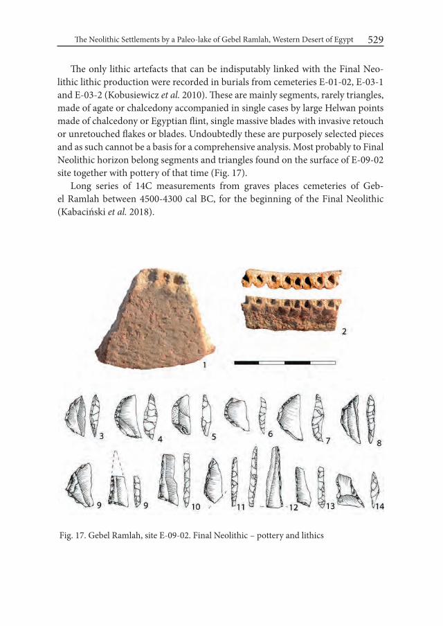
The Neolithic Settlements by a Paleo-lake of Gebel Ramlah, Western Desert of Egypt 529
The only lithic artefacts that can be indisputably linked with the Final Neo-lithic lithic production were recorded in burials from cemeteries E-01-02, E-03-1 and E-03-2 (Kobusiewicz et al. 2010). These are mainly segments, rarely triangles, made of agate or chalcedony accompanied in single cases by large Helwan points made of chalcedony or Egyptian flint, single massive blades with invasive retouch or unretouched flakes or blades. Undoubtedly these are purposely selected pieces and as such cannot be a basis for a comprehensive analysis. Most probably to Final Neolithic horizon belong segments and triangles found on the surface of E-09-02 site together with pottery of that time (Fig. 17).
Long series of 14C measurements from graves places cemeteries of Geb-el Ramlah between 4500-4300 cal BC, for the beginning of the Final Neolithic (Kabaciński et al. 2018).
Fig. 17. Gebel Ramlah, site E-09-02. Final Neolithic – pottery and lithics
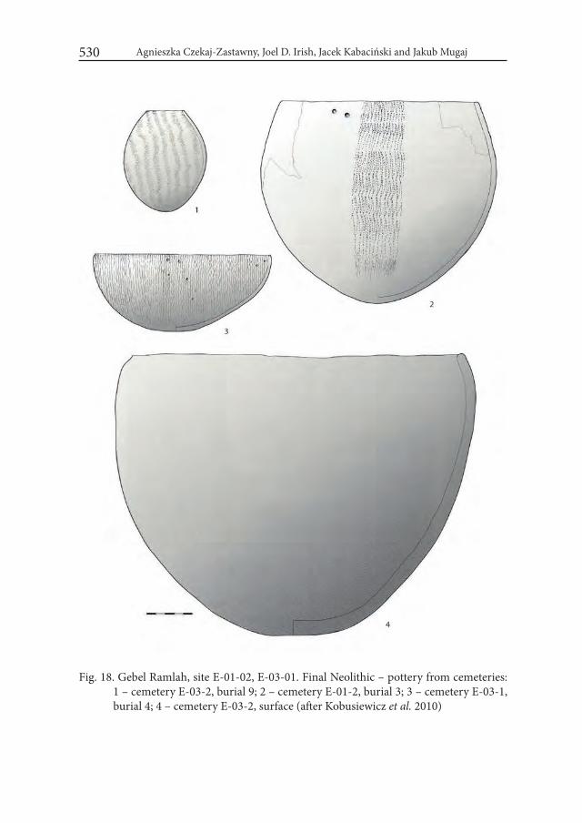
Agnieszka Czekaj-Zastawny, Joel D. Irish, Jacek Kabaciński and Jakub Mugaj530
Fig. 18. Gebel Ramlah, site E-01-02, E-03-01. Final Neolithic – pottery from cemeteries: 1 – cemetery E-03-2, burial 9; 2 – cemetery E-01-2, burial 3; 3 – cemetery E-03-1, burial 4; 4 – cemetery E-03-2, surface (after Kobusiewicz et al. 2010)
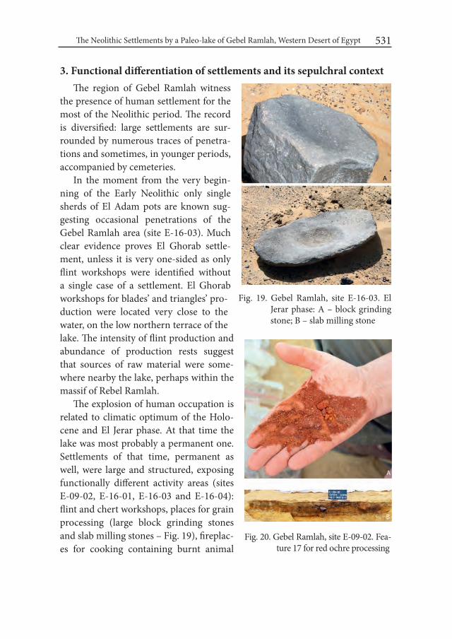
The Neolithic Settlements by a Paleo-lake of Gebel Ramlah, Western Desert of Egypt 531
3. Functional differentiation of settlements and its sepulchral contextThe region of Gebel Ramlah witness
the presence of human settlement for the most of the Neolithic period. The record is diversified: large settlements are sur-rounded by numerous traces of penetra-tions and sometimes, in younger periods, accompanied by cemeteries.
In the moment from the very begin-ning of the Early Neolithic only single sherds of El Adam pots are known sug-gesting occasional penetrations of the Gebel Ramlah area (site E-16-03). Much clear evidence proves El Ghorab settle-ment, unless it is very one-sided as only flint workshops were identified without a single case of a settlement. El Ghorab workshops for blades’ and triangles’ pro-duction were located very close to the water, on the low northern terrace of the lake. The intensity of flint production and abundance of production rests suggest that sources of raw material were some-where nearby the lake, perhaps within the massif of Rebel Ramlah.
The explosion of human occupation is related to climatic optimum of the Holo-cene and El Jerar phase. At that time the lake was most probably a permanent one. Settlements of that time, permanent as well, were large and structured, exposing functionally different activity areas (sites E-09-02, E-16-01, E-16-03 and E-16-04): flint and chert workshops, places for grain processing (large block grinding stones and slab milling stones – Fig. 19), fireplac-es for cooking containing burnt animal
Fig. 19. Gebel Ramlah, site E-16-03. El Jerar phase: A – block grinding stone; B – slab milling stone
Fig. 20. Gebel Ramlah, site E-09-02. Fea-ture 17 for red ochre processing

Agnieszka Czekaj-Zastawny, Joel D. Irish, Jacek Kabaciński and Jakub Mugaj532
bones and surrounded by smashed pots, pits for red ochre processing (Fig. 20) and tethering stones for tiding animals (Fig. 21). At the borders of settlements single burials were recorded, with contracted body on left or right side.
The only evident proof for the Middle Neolithic occupation are two graves dated to that period. Directly dated pendant may be placed either to dry peri-od between the Early and Middle Neolithic or just after it. In the light of evi-dence from the Gebel Ramlah area the Middle Neolithic period seems to be very problematic. The occurrence of a very characteristic Middle Neolithic triangular points in features with numerous El Jerar pottery at site E-09-02 would suggest that these points should be dated for earlier period. What strikes, is almost com-plete absence of the Middle Neolithic settlements. Also on neighboring territories (Nabta, Kiseiba) materials from that period are poorly recognized.
The Late Neolithic settlement is clearly less intensive when compared to El Jerar. Sites are less numerous and cover much smaller areas. Good example is site E-16-02. It has ca. 50 meters in diameter. Few fire-places containing burnt animal bones (including cattle and sheep/goat bones) were surrounded by several broken vessels and flint/chert artefacts. Seldom fragments of milling stones and grinders are re-corded as well (Fig. 22). From that period single graves located outside settlements are known. At the beginning of the Final Neolithic separated cemeteries appeared.
Fig. 21. Gebel Ramlah, site E-16-01. Teathering stone
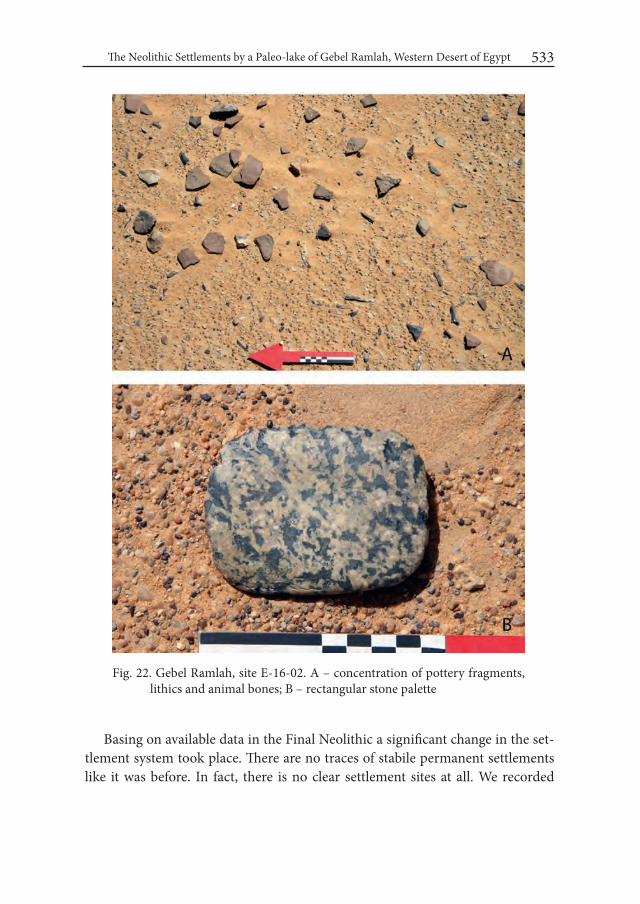
The Neolithic Settlements by a Paleo-lake of Gebel Ramlah, Western Desert of Egypt 533
Fig. 22. Gebel Ramlah, site E-16-02. A – concentration of pottery fragments, lithics and animal bones; B – rectangular stone palette
Basing on available data in the Final Neolithic a significant change in the set-tlement system took place. There are no traces of stabile permanent settlements like it was before. In fact, there is no clear settlement sites at all. We recorded
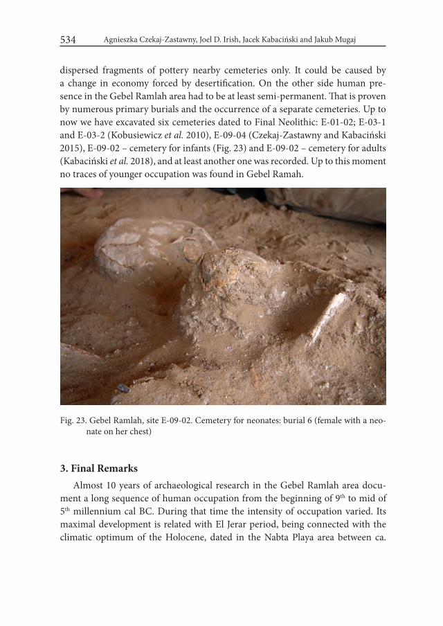
Agnieszka Czekaj-Zastawny, Joel D. Irish, Jacek Kabaciński and Jakub Mugaj534
dispersed fragments of pottery nearby cemeteries only. It could be caused by a change in economy forced by desertification. On the other side human pre- sence in the Gebel Ramlah area had to be at least semi-permanent. That is proven by numerous primary burials and the occurrence of a separate cemeteries. Up to now we have excavated six cemeteries dated to Final Neolithic: E-01-02; E-03-1 and E-03-2 (Kobusiewicz et al. 2010), E-09-04 (Czekaj-Zastawny and Kabaciński 2015), E-09-02 – cemetery for infants (Fig. 23) and E-09-02 – cemetery for adults (Kabaciński et al. 2018), and at least another one was recorded. Up to this moment no traces of younger occupation was found in Gebel Ramah.
3. Final RemarksAlmost 10 years of archaeological research in the Gebel Ramlah area docu-
ment a long sequence of human occupation from the beginning of 9th to mid of 5th millennium cal BC. During that time the intensity of occupation varied. Its maximal development is related with El Jerar period, being connected with the climatic optimum of the Holocene, dated in the Nabta Playa area between ca.
Fig. 23. Gebel Ramlah, site E-09-02. Cemetery for neonates: burial 6 (female with a neo-nate on her chest)
The Neolithic Settlements by a Paleo-lake of Gebel Ramlah, Western Desert of Egypt 535
7050 and 6150 cal BC (Schild and Wendorf 2013). During that time the lake was a permanent one with developed fauna and flora, as it was recognized in the case of Nabta and Kiseiba (Gautier 1984; 2001; Wasylikowa et al. 2001). Nabta was at that time surrounded by savanna with Acacia trees growing not only at the water basins but quite far from the lake (Wendorf and Schild 2001: 651-652). By the Gebel Ramlah lake numerous large settlements existed, and traces of short-lived stays and penetrations of the region are very distant from the lake shores indica- ting favorable environmental conditions.
Presence of numerous workshops for chert processing, located around the lake, but especially on north-western and northern terraces, suggest that sources of chert were nearby, most probably within the massif of Gebel Ramlah. It could also be a place where other stone materials, like limestone or sandstone were extracted.
Beside the time of climatic optimum, Gebel Ramlah lake was a temporary ba-sin supplied with water during the rainy seasons. Artifacts (grinders, fragments of milling stones, flint blades etc.) found on the surface of the lake in its central part suggest that during later periods (Middle, Late or Final Neolithic) its surface was temporarily accessible for different activities and penetrated by people. From the Middle Neolithic one may observe a subsequent change in settlement pat-tern, most probably highly influenced by deterioration of climatic conditions and gradual desertification of the area. In the same time people became much more mobile having contacts with the Nile valley, Red Sea coast and sub-Saharan areas (Kobusiewicz et al. 2004; 2010). Final desertification of the area forced them to withdraw from the Gebel Ramlah territory around mid-5th millennium cal BC.
AcknowledgementsThe research was sponsored by the Polish National Science Centre (grant No.
NCN 2012/05/B/HS3/03928) and by the Combined Prehistoric Expedition Foun-dation. The authors would like to thank both institutions for that support.
REFERENCES BOBROWSKI P., SCHILD R. and G. CALDERONII. 2006. Late Neolithic Settle-
ments (E-01-2 “CAMP”) from the Gebel Ramlah Playa Basin, South-West-ern Desert of Egypt (Preliminary Report). In: K. Kroeper, M. Chłodnicki and M. Kobusiewicz (eds.), Archaeology of Early Northeastern Africa. in Memory of Lech Krzyżaniak (= Studies in African Archaeology 9): 213-222. Poznań.

Agnieszka Czekaj-Zastawny, Joel D. Irish, Jacek Kabaciński and Jakub Mugaj536
BOBROWSKI P., CZEKAJ-ZASTAWNY A. and R. SCHILD. 2014. Gebel El Mu-qaddas (Site E-06-4). The Early Neolithic tumuli from Nabta Playa (West-ern Desert, Egypt). In: J. R. Anderson and D. A. Welsby (eds.), The Fourth Cataract and Beyond. Proceedings of the 12th international Conference for Nubian Studies (= British Museum Publications on Egypt and Sudan 1): 293-301. Leuven-Paris-Walpole.
CZEKAJ-ZASTAWNY A. and J. KABACIŃSKI. 2015. New Final Neolithic ceme-tery E-09-4, Gebel Ramlah Playa, Western Desert of Egypt. In: J. Kabaciński, M. Chłodnicki and M. Kobusiewicz (eds.), Hunter-gatherers and early food producing societies in the Northeastern Africa (= Studies in African Archae-ology 14): 375-384. Poznań.
GATTO M. C. 1998. The Late Neolithic pottery decorations from Nabta Playa. CPE Interm Report for the Egyptian Supreme Council of Antiquities.
GATTO M.C. 1999. The Late Neolithic pottery decorations from Nabta Playa. CPE Interm Report for the Egyptian Supreme Council of Antiquities.
GATTO M. C. 2002. Early Neolithic pottery of the Nabta-Kiseiba area: stylistic attributes and regional relationships. In: K. Nelson and Associates, The pottery of Nabta Playa. Holocene settlement of the Egyptian Sahara Vol. 2: 65-78. New York.
GATTO M. C. 2010. Pottery from Gebel Ramla. In: M. Kobusiewicz, J. Kabaciński, R. Schild, J. D. Irish, M. Gatto and F. Wendorf (eds.), Gebel Ramlah. Final Neolithic Cemeteries from the western Desert of Egypt: 123-158. Poznań.
GAUTIER A. 1984. Archaeozoology of the Bir Kiseiba region, Eastern Sahara. In: F. Wendorf, R. Schild, and A. E. Close (eds.), Cattle-keepers of the Eastern Sahara: the Neolthic of Bir Kiseiba: 49-72. Dallas.
GAUTIER A. 2001. The Early to Late Neolithic archeofaunas from Nabta and Bir Kiseiba. In: F. Wendorf and R. Schild (eds.), Holocene settlement of the Egyptian Sahara. The archaeology of Nabta Playa Vol. 1: 609-635. New York.
JÓRDECZKA M., KRÓLIK H., MASOJĆ M. and R. SCHILD. 2011. Early Holo-cene pottery in the Western Desert of Egypt: new data from Nabta Playa. Antiquity 85: 99–115.
KABACIŃSKI J., CZEKAJ-ZASTAWNY A. and J. D. IRISH. 2018. The Neolithic infant cemetery at Gebel Ramlah, in Egypt’s Western Desert. In: S. Han, T. K. Betsinger and A. B. Scott (eds.), Anthropology of the Fetus: 132-145. Berghahn Books. New York – Oxford.
KOBUSIEWICZ M. 1984. Report on site E-79-04: archaeology of El Ghorab Pla-ya. In: F. Wendorf, R. Schild and A. E. Close (eds), Cattle-keepers of the Eastern Sahara: the Neolthic of Bir Kiseiba: 135-164. Dallas.
The Neolithic Settlements by a Paleo-lake of Gebel Ramlah, Western Desert of Egypt 537
KOBUSIEWICZ, M., KABACIŃSKI, J., SCHILD, R., IRISH, J. D. and F. WEN-DORF. 2004. Discovery of The First Neolithic Cemetery in Egypt’s Western Desert. Antiquity 78(301): 566-579.
KOBUSIEWICZ M., KABACIŃSKI J., SCHILD R., IRISH J., GATTO M. and F. WENDORF. 2010. Gebel Ramlah. Final Neolithic Cemeteries from the western Desert of Egypt. Poznań.
MUGAJ J. 2016. The Neolithic refitting from Gebel Ramlah, the Western Desert of Egypt, Lithic Technology. DOI: 10.1080/01977261.2016.1238610 .
NELSON K. 2001. The pottery of Nabta Playa: A Summary. In: F. Wendorf and R. Schild (eds.), Holocene Settlement of the Egyptian Sahara. The Archaeo- logy of Nabta Playa Vol. 1: 534-543. New York.
NELSON K. and ASSOCIATES 2002. The pottery of Nabta Playa. Holocene settle-ment of the Egyptian Sahara Vol. 2. New York.
SCHILD R. and F. WENDORF. 2001. Geomorfology, lithostratigraphy, geochro-nology and taphonomy of sites. In: F. Wendorf and R. Schild (eds.), Holocene settlement of the Egyptian Sahara. The archaeology of Nabta Playa Vol. 1: 11-50. New York.
SCHILD R. and F. WENDORF. 2010. Geomorfology, lithostratigraphic environ-ment and paleoecology of Neolithic camps and cemeteries at Gebel Ramlah Playa. In: M. Kobusiewicz, J. Kabaciński, R. Schild, J. D. Irish, M. Gatto and F. Wendorf, Gebel Ramlah. Final Neolithic Cemeteries from the western Desert of Egypt: 159-186. Poznań.
SCHILD R., KOBUSIEWICZ M., WENDORF F., IRISH J. D., KABACIŃSKI J. and H. KRÓLIK. 2002. Gebel Ramlah Playa (Egypt). In: Jennerstrasse 8 (ed.), Tides of the Desert. Contributions to the Archaeology and Environmental His-tory of Africa in Honor of Rudolf Kuper (= Africa Praehistorica 14): 117-124.
SCHILD R., KOBUSIEWICZ M., WENDORF F., IRISH J.D., KABACIŃSKI J., KRÓ-LIK H. and G. CALDERONI. 2005. A new important area of the Neolithic occupation in the Southwestern Desert of Egypt. In: B. E. Barich, T. Tillet and K. H. Striedter (eds.), Hunters vs. pastoralists in the Sahara: Material culture and symbolic aspects (= BAR International Series 1338): 51-56. Oxford.
SCHILD, R. and F. WENDORF. 2013. Early and Middle Holocene paleoclimates in the South Western Desert of Egypt – the world before unification. Studia Quaternaria 30(2): 125–133. DOI: 10.2478/squa-2013-0013
WASYLIKOWA K., BARAKAT H. N., BOULOS L., DAHLBERG J. A., HATHER J. and J. MITKA. 2001. Vegetation and Subsistence of the Early Neolithic at Nabta Playa, Egypt, Reconstructed from Charred Plant Remains. In:

Agnieszka Czekaj-Zastawny, Joel D. Irish, Jacek Kabaciński and Jakub Mugaj538
F. Wendorf and R. Schild (eds.), Holocene settlement of the Egyptian Sahara. The archaeology of Nabta Playa Vol. 1: 544-591. New York.
WENDORF F. and R. SCHILD. 1995-96. Nabta Playa during the Early and Middle Holocene. ANKH Journal of Egyptology and African Civilization 4/5: 33-45.
WENDORF F. and R. SCHILD. 1980. Gebel Nabta and Vicinity. In: F. Wendorf and R. Schild (eds.), Prehistory of Eastern Sahara: 82-167. New York.
WENDORF F. and R. SCHILD. 2001. Conclusions. In: F. Wendorf and R. Schild (eds), Holocene settlement of the Egyptian Sahara, The archaeology of Nabta Playa Vol. 1: 648-675. New York.
WENINGER B. and O. JÖRIS. 2004. Glacial Radiocarbon Calibration. The CalPal Program. In: T. Higham, Ch. Bronk Ramsey and C. Owen (eds.), Radiocar-bon and Archaeology. Fourth international Symposium (= Oxford Univer-sity School of Archaeology, Monograph 62): 9-15. Oxford.
WENINGER B., JÖRIS O. and U. DANZEGLOCKE. 2007. CalPal-2007. Cologne Calibration & Palaeoclimate Research Package, (http://www.calpal.de/, accessed March 2007).
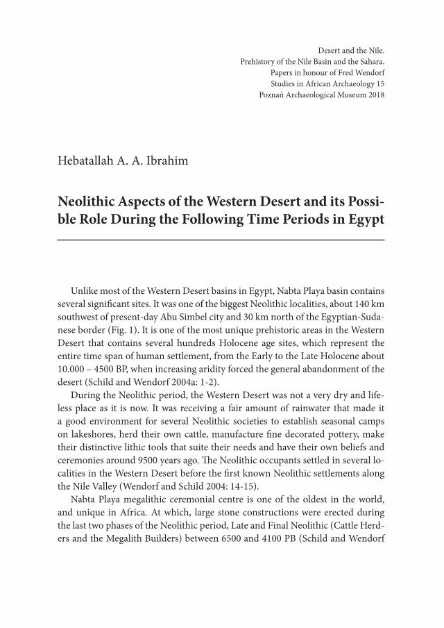
Desert and the Nile. Prehistory of the Nile Basin and the Sahara.
Papers in honour of Fred Wendorf Studies in African Archaeology 15
Poznań Archaeological Museum 2018
Hebatallah A. A. Ibrahim
Neolithic Aspects of the Western Desert and its Possi-ble Role During the Following Time Periods in Egypt
Unlike most of the Western Desert basins in Egypt, Nabta Playa basin contains several significant sites. It was one of the biggest Neolithic localities, about 140 km southwest of present-day Abu Simbel city and 30 km north of the Egyptian-Suda-nese border (Fig. 1). It is one of the most unique prehistoric areas in the Western Desert that contains several hundreds Holocene age sites, which represent the entire time span of human settlement, from the Early to the Late Holocene about 10.000 – 4500 BP, when increasing aridity forced the general abandonment of the desert (Schild and Wendorf 2004a: 1-2).
During the Neolithic period, the Western Desert was not a very dry and life-less place as it is now. It was receiving a fair amount of rainwater that made it a good environment for several Neolithic societies to establish seasonal camps on lakeshores, herd their own cattle, manufacture fine decorated pottery, make their distinctive lithic tools that suite their needs and have their own beliefs and ceremonies around 9500 years ago. The Neolithic occupants settled in several lo-calities in the Western Desert before the first known Neolithic settlements along the Nile Valley (Wendorf and Schild 2004: 14-15).
Nabta Playa megalithic ceremonial centre is one of the oldest in the world, and unique in Africa. At which, large stone constructions were erected during the last two phases of the Neolithic period, Late and Final Neolithic (Cattle Herd-ers and the Megalith Builders) between 6500 and 4100 PB (Schild and Wendorf
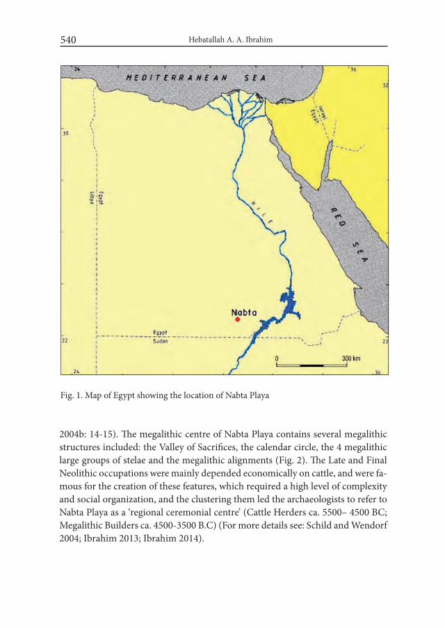
Hebatallah A. A. Ibrahim540
2004b: 14-15). The megalithic centre of Nabta Playa contains several megalithic structures included: the Valley of Sacrifices, the calendar circle, the 4 megalithic large groups of stelae and the megalithic alignments (Fig. 2). The Late and Final Neolithic occupations were mainly depended economically on cattle, and were fa-mous for the creation of these features, which required a high level of complexity and social organization, and the clustering them led the archaeologists to refer to Nabta Playa as a ‘regional ceremonial centre’ (Cattle Herders ca. 5500– 4500 BC; Megalithic Builders ca. 4500-3500 B.C) (For more details see: Schild and Wendorf 2004; Ibrahim 2013; Ibrahim 2014).
Fig. 1. Map of Egypt showing the location of Nabta Playa

Neolithic Aspects of the Western Desert and its Possible Role During the Following Time... 541
Fig. 2. The Megalithic structures at Nabta Playa (courtesy of R. Schild)
The idea of megalithic struc-tures that started at Nabta large ba-sin in the Western Desert appears to be extended to other areas in the Nile valley and some sites of the Eastern Desert during the Neolith-ic and into the following periods of Predynastic and Early Dynastic Egypt. The megalithic site at Nabta Playa might have some kind of in-fluence on the Nile Valley and the Eastern Desert that the megalithic tradition appears to be continued in the later periods of Predynas-tic and Early Dynastic, although in different representations and amounts, and the limited number of examples were found.
Nabta Playa became a dry des-ert around 3350 BC, when the herders had to move to some place not far, like the Nile Valley, and it may be there that the prehisto-ries of Upper Egypt and the South Western Desert have met. The Late and Final Neolithic megalithic structure of the Nabta Playa may be regarded as the earliest repre-sentations of features that continue into the Predynastic and Dynas-tic periods (Schild and Wendorf 2004b: 15).
At the Eastern Desert, several archaeological sites with a crude megalithic stone architecture were recorded. In Wadi Elei east of the Wadi Allaqi, Wadi Er Arib in wadi
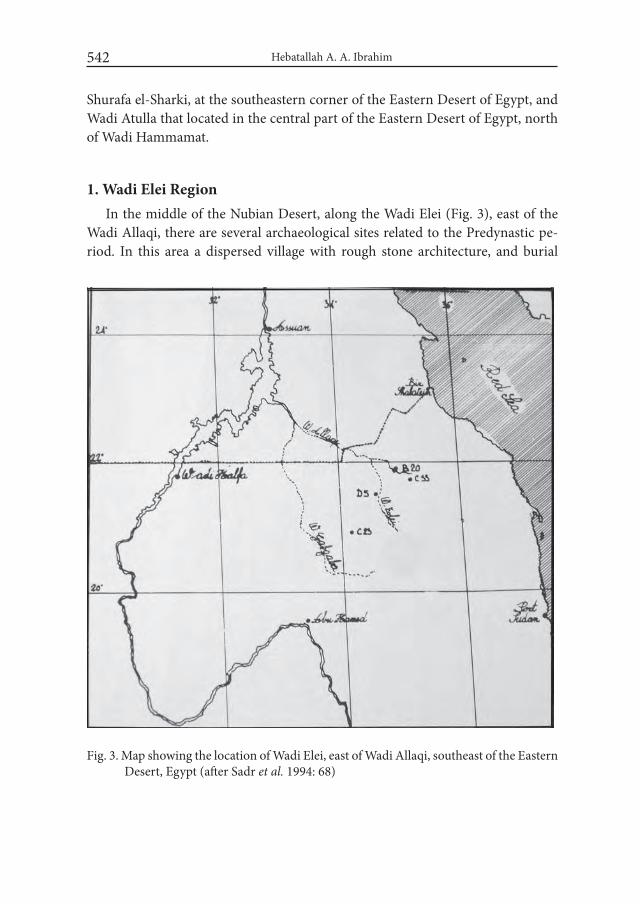
Hebatallah A. A. Ibrahim542
Shurafa el-Sharki, at the southeastern corner of the Eastern Desert of Egypt, and Wadi Atulla that located in the central part of the Eastern Desert of Egypt, north of Wadi Hammamat.
1. Wadi Elei RegionIn the middle of the Nubian Desert, along the Wadi Elei (Fig. 3), east of the
Wadi Allaqi, there are several archaeological sites related to the Predynastic pe-riod. In this area a dispersed village with rough stone architecture, and burial
Fig. 3. Map showing the location of Wadi Elei, east of Wadi Allaqi, southeast of the Eastern Desert, Egypt (after Sadr et al. 1994: 68)

Neolithic Aspects of the Western Desert and its Possible Role During the Following Time... 543
Fig. 4. Profile of a burial type of Wadi Elei, southeast of Egypt (after Sadr 1997: 71)
Fig. 5. Plan of a grave type at Wadi Elei, south of the Eastern Desert (after Sadr 1997: 72)

Hebatallah A. A. Ibrahim544
grounds were located. The dates from this site suggested to the 5th – 4th millennia B.C. and the late 2nd millennium B.C (Sadr 1997: 67).
At Wadi Elei, several tumuli burials were recorded, relatively undisturbed graves that have a superstructure composed of rings of boulders filled with sand. Within the circles were upright stelae, or slabs of stones marking the offering area (Friedman and Hobbs 2002: 182). The stone features extend along the Wadi in scattered clumps for at least 5 km. Among them there were many potsherds and stone tools of entirely local row material. The ceramics were associated with the Predynastic period (for more details see: Sadr 1997; Sadr et al. 1994; 1995). Sev-eral radiocarbon dates, provided from the excavated graves, are comparable with the date of the village as assessed by ceramics (Sadr 1997: 67-68).
Three types of graves were documented; most contained offerings such as a polished stone pendants, beads, ceramic and in some one case gold objects. At the first type of graves, the burial shaft was located to the east of the offerings pit, they were constructed of boulders filled with sand and approximately 7 m. in di-ameter, revealed an offering area in the centre of the tumulus. These graves were marked by megalithic stelae (Fig. 4, 5). The overall Predynastic character of these finds was confirmed by radiocarbon dates of ca. 4475 BC. Another grave gave date of ca. 3962 BC. One of the graves types had low superstructures of circles of stones capped with small pebbles. To the east, it had two megalithic stelae placed like a gate (fig. 6). This grave gave a radiocarbon date to ca. 1295 BC. Another type of grave was like a cairn of stones rather than a ring of boulders. No data is avail-able to know if it was associated with any grave goods, because it was destroyed by looters (Sadr et al. 1995: 207-11; Sadr 1997: 68-73). Faunal remains from the site suggest a pastoral population, while the ceramics suggest a population in contact with both Upper Egypt and Eastern Sudan (for further readings see: Sadr 1991)
2. Wadi Er Arib CemeteryThe site was noted by Murray, 1926, and recent archaeological research has
been conducted in the area. According to Murray, the site was recorded as a re-markable cemetery, which is located at the foot of the mountain of Er Arib, in wadi Shurafa el-Sharki, at the southeastern corner of the Eastern Desert of Egypt, north of Gebel Gerf. It was marked by a low rubble wall, about 25 cm high, with an entrance at the east marked by a high monolith, now fallen, around 6 m in length. In the centre of the cemetery is a platform, about 50 cm high, formed of rubble walls filled in with earth. Three other megalithic stelae or standing stones,

Neolithic Aspects of the Western Desert and its Possible Role During the Following Time... 545
Fig. 6. Plan of a burial type at Wadi Elei (after Sadr 1997: 75)
now fallen, can be seen in the eastern part of the platform. The cemetery contains around 300 low stone tumuli. To the east, outside the walls, there is a subsidiary cemetery, which contained 41 graves. Three graves of the main cemetery were ex-cavated, and one in the subsidiary cemetery (Fig. 7). All contained bones of oxen at a depth of 50-60 cm. The bones were found in a confused state suggesting that the animals had been cut up before they were buried. No ceramics were associ-ated with the site, except for one potsherd, which was found in the fill of one of the graves, representing C-Group type pottery. The burials could be dated to the

Hebatallah A. A. Ibrahim546
C-Group or later, who inhabited Lower Nubia during the Middle Kingdom. These people undoubtedly possessed cows, because cow heads and horns are common in their cemeteries. They also setup megalithic standing stones. These stones were found in Faras and Dakkah, where the rough outlines of a cow were scratched on two of the stelae. A similar cemetery was recorded at Wadi Abu Had, the Sudanese tributary of Wadi Allaqi (Murray 1926: 248-249).
3. Wadi Atulla TombIn Wadi Atulla, located in the central part of the Eastern Desert of Egypt, north
of Wadi Hammamat (Fig. 8), a burial site was found, which indicated multiple occupants. The closest finds of this site are parallel with the Tasian. Conventional radiocarbon dating of the remains provided dates of between ca. 4970 and 4455 BC. Ceramics analysis suggests that they were locally made. The recent discovery of similar material deep in the western desert indicates that the makers of these ceramics were apparently far-ranging desert dwellers. The presence of related pot-tery at various locations in the Egyptian Nile Valley may be the most distinctive
Fig. 7. Sketch map showing Wadi Er Arib cemetery (after Murray 1929: 250)
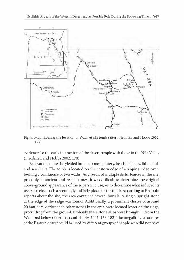
Neolithic Aspects of the Western Desert and its Possible Role During the Following Time... 547
Fig. 8. Map showing the location of Wadi Atulla tomb (after Friedman and Hobbs 2002: 179)
evidence for the early interaction of the desert people with those in the Nile Valley (Friedman and Hobbs 2002: 178).
Excavation at the site yielded human bones, pottery, beads, palettes, lithic tools and sea shells. The tomb is located on the eastern edge of a sloping ridge over-looking a confluence of two wadis. As a result of multiple disturbances in the site, probably in ancient and recent times, it was difficult to determine the original above-ground appearance of the superstructure, or to determine what induced its users to select such a seemingly unlikely place for the tomb. According to Bedouin reports about the site, the area contained several burials. A single upright stone at the edge of the ridge was found. Additionally, a prominent cluster of around 20 boulders, darker than other stones in the area, were located lower on the ridge, protruding from the ground. Probably these stone slabs were brought in from the Wadi bed below (Friedman and Hobbs 2002: 178-182).The megalithic structures at the Eastern desert could be used by different groups of people who did not have

Hebatallah A. A. Ibrahim548
any connection with the people of Nabta, but putting in mind that there is an evi-dence for an active trade network between the Western Desert and the Nile Val-ley by the beginning of the Final Neolithic and the existence of some goods and shells from the Red Sea might show that there was some direct or indirect connec-tions between Nabta Playa and Eastern Desert.During the following period, the Early Dynastic period, there were numerous examples for using stone megaliths as tomb stelae beside the graves, at several localities in Upper and Lower Egypt as the cemeteries of Um el-Qa’ab cemetery at Abydos, Abu Rawash north of Giza, Helwan, southeast of Giza and Dahshour south of Giza. At the Royal and Private tombs, some stelae were rough, others were decorated and some were well shaped and finely decorated. The most interesting part concerning these tomb stelae, at Um el-Qa’ab cemetery, the private rough stelae were oriented to the northwest, the same direction of Nabta Playa megaliths.
The amount of evidences from the Eastern Desert and the Nile Valley might be enough proof for extending the use of megalithic stelae from the Neolithic through the Predynastic to the Dynastic period and explain the development and the changes of their shapes and uses. Finally, The Tasian-related material in the Eastern Desert and at the burials at Gebel Ramlah area near Nabta Playa in the Western Desert suggests that this Neolithic culture may be the most distinctive missing link in the picture of interaction between the desert dwellers and the Nile Valley cultures, which led ultimately to the development of Egyptian civilization (for further reading see: Friedman and Hobbs 2002: 178; Kobusiewicz et al. 2010).
The megalithic structures, perhaps the most striking of the ceremonial features at Nabta, do not have close analogs in the Neolithic or in the Predynastic record along the Nile; although the shaping and use of large stones occurs in some of the tombs in Badarian graveyards. It is possible, however, that similar features to those at Nabta are present in the Nile Valley, but are unrecognized. The Combined Prehistoric Expedition worked at Nabta Playa for several years, even mapping some of these features as bedrock, before they recognized that they were of hu-man origin (Wendorf and Schild 2004: 25). Perhaps, other expeditions did not pay enough attention, in the past century, to recognize the presence megalithic structures in the Nile Valley. On the other hand, they could have been destroyed or they were never there at all.
The small amount of evidences from the eastern desert may not create a strong argument for extending the use of megalithic stelae from the Neolithic through the Predynastic to the Dynastic period. Similarly, it may not explain the devel-opment and the changes of their shapes and uses. However, their representation

Neolithic Aspects of the Western Desert and its Possible Role During the Following Time... 549
shows the existence of the use of megalithic structures during the Predynastic period, and offers proof that there were megaliths in Egypt during these periods.
AcknowledgmentsMy immense gratitude goes to Fred Wendorf and Romuald Schild who made
the data about Nabta Playa available today. I emphasize my gratefulness to both of them, without their support and help I wouldn’t be able to do any of my research-es. My deep gratitude is also owed to Jacek Kabaciński and Gebel Ramlah Team-work for the support and all scientific data that they have kindly offered to me, in particular, Agnieszka Czekaj-Zastawny. I’m deeply indebted to my professors and Dear friends who never gave up on me, Renee Friedman, Richard Parkinson, Vivian Davies and Liam McNamara.
REFERENCESFRIEDMAN, R. and J. J. HOBBS. 2002. A ‘Tasian’ Tomb in Egypt’s Eastern Des-
ert. In: R. Friedman (ed.), Egypt and Nubia: Gifts of the Desert: 178–191. London.
KOBUSIEWICZ, M., KABACINSKI, J., SCHILD, R., IRISH, J., GATTO, M. and F. WENDORF. 2010. Gebel Ramlah, Final Neolithic Cemeteries from the west-ern Desert of Egypt. Poznań.
IBRAHIM, H. 2013. Megaliths of Nabta Playa and Their Significances. Unpub-lished MA Thesis, Faculty of Archaeology. Cairo University. Cairo.
IBRAHIM, H. 2014. Megalithic Architecture and the Nubian Desert. In: J. R. Ander-son and D. A. Welsby (eds.), The Fourth Cataract and Beyond: Proceedings of the 12th international Conference for Nubian Studies,: 303-309. Leuven.
MURRAY, G. W. 1926. Graves of Oxen in the Eastern Desert of Egypt. The Journal of Egyptian Archaeology XII: 248-253. London.
SADR, K. 1991. The Development of Nomadism in Ancient Northeast Africa. Phila-delphia.
SADR, K. 1997. The Wadi Elei Finds: Nubian Desert Gold Mining in the 5th and 4th Millennia BC.?. Cahiers de Recherches de l’institut de Papyrologie et d’ Égyptologie de Lille 17(3): 67-76. Lille.
SADR, K., CASTIGIONI, A. and A. CASTIGIONI. 1995. Nubian Desert Archae-ology: a Preliminary View. Archéologie du Nil Moyen 7: 203-235.
Hebatallah A. A. Ibrahim550
SADR, K., CASTIGIONI, A., CASTIGIONI, A and G. NEGRO. 1994. The Nubian Desert, Sahara, Prehistory and history of the Sahara 6: 69-75.
SCHILD, R. and F. WENDORF. 2004a. Reasons for saving the Archaeological sites at Nabta Playa, Seminar on Prehistoric Cultures in Egypt, the Egyptian Geological Survey and Mining Authority: 1-3. Cairo.
SCHILD, R. and F. WENDORF. 2004b. The Megaliths of Nabta Playa are an ex-pression of an Elaborate Late and Final Neolithic Ceremonialism unprec-edented in Africa, Mysteries of Neolithic Societies, Focus on Archaeology, ACADEMiA 1: 10-15. Warsaw.
WENDORF, F. and R. SCHILD. 2004 The Western Desert During the 5th and 4th Millennia BC, the Late and Final Neolithic in the Nabta-Kiseiba Area. ARCHÉO-NiL 14: 13-30. Paris.
Desert and the Nile. Prehistory of the Nile Basin and the Sahara.
Papers in honour of Fred Wendorf Studies in African Archaeology 15
Poznań Archaeological Museum 2018
Maria Lityńska-Zając and Krystyna Wasylikowa
The Role of Ziziphus in the Economy of Neolithic Nomadic Societies of the Sahara (S Egypt)
The strategies adopted by ancient people in order to cover their basic food demands belong to essential questions in the study of prehistoric societies. Much information about procuring foodstuffs can be obtained from plant remains re-covered from archaeological sites and the achievements of the Combined Pre-historic Expedition are good example how much can be deduced from properly handled archaeobotanical material. The investigations carried out in Egypt by the Combined Prehistoric Expedition, first under the supervision of Professor Fred Wendorf and Professor Romuald Schild and later by Professor Michał Kobus-iewicz, Professor IAE PAS, Dr. hab. Jacek Kabaciński, and Dr. Przemysław Bo-browski, brought about the discovery of numerous settlements and camp sites left by the nomadic Epipaleolithic and Neolithic people. The fillings of these features contained rich plant material which provided numerous information about sub-sistence of pre-agricultural populations of the Eastern Sahara. From among many plants documented by macrofossils the jujube tree was selected as an example of a wide variety of possible uses confirmed by ethnographic evidence. In 2001-2003 for the first time three cemeteries were discovered in Gebel Ramlah (e.g. Wendorf and Schild 1998; Wendorf et al. 2001; Kobusiewicz et al. 2004, 2010). With this short article the authors want to pay tribute to the memory of Professor Fred Wendorf and express their appreciation for his deep interest in archaeobotanical investigations.
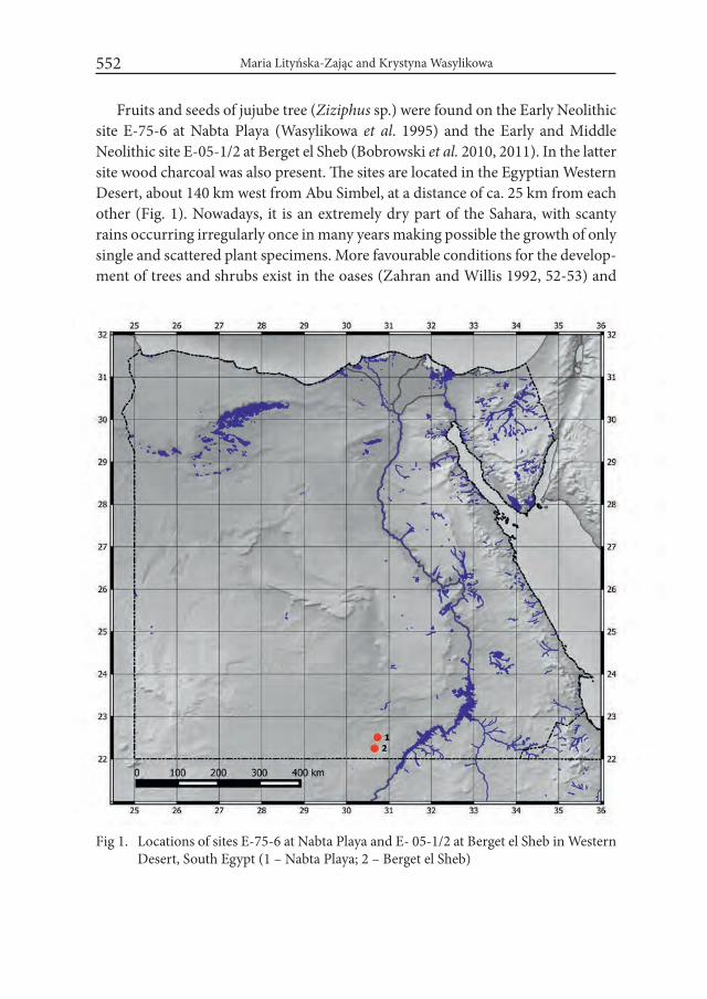
Maria Lityńska-Zając and Krystyna Wasylikowa552
Fruits and seeds of jujube tree (Ziziphus sp.) were found on the Early Neolithic site E-75-6 at Nabta Playa (Wasylikowa et al. 1995) and the Early and Middle Neolithic site E-05-1/2 at Berget el Sheb (Bobrowski et al. 2010, 2011). In the latter site wood charcoal was also present. The sites are located in the Egyptian Western Desert, about 140 km west from Abu Simbel, at a distance of ca. 25 km from each other (Fig. 1). Nowadays, it is an extremely dry part of the Sahara, with scanty rains occurring irregularly once in many years making possible the growth of only single and scattered plant specimens. More favourable conditions for the develop-ment of trees and shrubs exist in the oases (Zahran and Willis 1992, 52-53) and
Fig 1. Locations of sites E-75-6 at Nabta Playa and E- 05-1/2 at Berget el Sheb in Western Desert, South Egypt (1 – Nabta Playa; 2 – Berget el Sheb)
553
humid depressions are periodically covered with luxuriant grass communities with sedges and rushes. Archaeobotanical, anthracological, and geological inves-tigations indicate that in the Neolithic much better moisture conditions prevailed in this area and the development of fairly abundant herbaceous vegetation with some trees and shrubs was possible. Such favourable environment encouraged nomadic populations to locate their seasonal settlements near the then existing water reservoirs (e.g. Kubiak-Martens and Wasylikowa 1994; Barakat 1995, 2001; Wasylikowa 1997, 2001;Wendorf and Schild 1998; Wendorf et al. 2001; Wasy-likowa et al. 2001, 2001a; Kobusiewicz et al. 2004).
Huts and pits from Nabta Playa provided the richest assemblage of plant re-mains hitherto known from the Western Desert, which contained at least 128 species of wild plants. Many of them had useful properties and were collected and stored for food or for other uses, for instance grass grains (including the oldest finding of wild sorghum Sorghum bicolor var. arundinaceum), fruits and seeds of several other herbaceous plants and of few trees or shrubs (e.g. Kubiak-Martens and Wasylikowa 1994; Wasylikowa et al. 1995; Wasylikowa 1997, 2001; Wasy-likowa et al. 1997, 2001, 2001a). Plant material from Berget el Sheb was poorer (Lityńska-Zając 2016, in preparation). Both sites provided relatively high number of Ziziphus remnants (Fig. 2) which suggests that useful properties of this plant were recognized by their inhabitants.
The genus Ziziphus Mill. from the family Rhamnaceae includes about 86 spe-cies (or over 40 according to other sources, Shahat et al. 2001) which grow in the subtropical, tropical, and warm zones (Boulos 2000: 84). Three species Ziziphus spina-christi (L.) Desf., Z. lotus (L.) Lam. and Z. nummularia (Burm. f.) Wight &Walk. occur in the modern flora of Egypt. The first one is an evergreen tree up to 4-8 m high, the two others are deciduous shrubs. The Christ’s thorn jujube, Ziziphus spina-christi, is a plant of subtropical zone, nowadays growing on the Mediterranean and Black Sea coasts, in the Nile delta and in the oases. It can be found also in desert wadi in the Western and Eastern Deserts. It belongs to the native flora of Sudan (Jafri 1977). Due to human activity it was introduced to the Sahara already in the Neolithic (Marinova 2008), because its fruits and seeds could have been transported by people and animals (Bakarat 2001). At present, it is cultivated in the Nile valley and in the oases (Boulos 2000: 84) but its rem-nants found in the Roman port Berenike at the Red Sea coast suggest that it was cultivated as early as the 1st – 5th c. A.D. (Cappers 1999). Z. lotus is a 1-3 m high shrub growing on stony and sandy substrate in north Africa. Z. nummularia is a relatively small shrub reaching the maximum height of ca. 1-2.5 m. In Egypt it
The Role of Ziziphus in the Economy of Neolithic Nomadic Societies of the Sahara (S Egypt)

Maria Lityńska-Zając and Krystyna Wasylikowa554
Fig. 2. Remains of Ziziphus from Nabta Playa and Berget el Sheb (1 – Nabta Playa – com-plete fruitstone; 2 – Nabta Playa – fruitstone fragment with two cells which con-tain seeds; 3 – Berget el Sheb – fruitstone fragments (1-2 photo: A. Pachoński; after Wasylikowa 1997 with permission from the W. Szafer Institute of Botany PAS, Cracow; 3 photo: K. Cywa). Scale bars equal 1 mm
555
is recorded only from Ka-el-Nabg, about 15 km north-west of Taba (Boulos 2000: 85-86). According to some authors (Barakat 1995) it is a pioneer tree.
Mature fleshy Ziziphus fruits are edible and can be consumed either fresh with no preparation or dried. Coarse-grained flour made from dried fruits can be used for baking or making porridge (Wasylikowa 1997: 133 ; Wasylikowa and Mitka 1998; Wasylikowa et al. 2001: 559 and the lit. cited). Ziziphus fruits can also be used as components of different food products (Tenberg 2003), for instance thick paste used for spreading on bread. Ethnographic data indicate that fresh and dried fruits of Ziziphus spina-christi are valued by Egyptian Arabs and Bedouins. Bed-ouins gather fruits, dry them and store for future use during winter time. Similar use of Z. lotus fruits is reported from Cyprus and Saudi Arabia (Dafni et al. 2005). Ziziphus species belong to melliferous plants and are important source of hon-ey in Eritrea and Jemen (Dafni et al. 2005). This honey, known under the name sidr after the local name of the tree, is considered highly valuable and belongs to the most precious ones. The pap made of the bark from young branches is also consumed (El Hadidi 1985). In ancient Egypt Ziziphus spina-christi was probably considered sacred tree, it was found in the Dynastic tombs and was used for mak-ing funerary loaves (Fahmy 2003: 104, and the lit. cited).
Fruits, leaves and ashes from burnt wood were used in folk medicine (Wasy-likowa 1997: 133). Few examples cited below illustrate fairly broad use of jujube in phytotherapy thanks to its antiseptic properties. The ash obtained by burn-ing wood and mixed with vinegar was applied locally to cure wounds caused by serpent bites. Cataplasms made of leaves were used against abscesses and furuncles and for skin softening. Fresh green leaves were put on swollen eyes. Ziziphus was used as antiphlogistic, purifying and analgesic medium as well as shrinking medium for gargling. In Saudi Arabian folk medicine leaves were ap-plied to speed up the healing of wounds and to cure some skin diseases. The brew made from bark and fresh fruits was used for compresses applied in healing wounds and for body washing. People suffering from bronchitis, cough, and tu-berculosis were also treated with brew from fruits (Shahat et al. 2001, and the lit. cited.).
Heavy and durable Ziziphus spina-christi wood is used in the production of artistic woodworks while branches and wastes from trunk woodworking are used for fuel and for making the high quality charcoal (Dafni et al. 2005). Ac-cording to the records dated to various historical periods of ancient Egypt jujube wood was used for making boats, dowels, coffins, mummy labels, stelae, bows
The Role of Ziziphus in the Economy of Neolithic Nomadic Societies of the Sahara (S Egypt)

Maria Lityńska-Zając and Krystyna Wasylikowa556
and several other objects (Gale and Cutler 2000, 286-288; Cartwright and Taylor 2008).
Collecting fruits was a seasonal activity dependent on the rhythm of nature. Following summer floods, during the period of abundant vegetation development mainly fruits and seeds of herbaceous plants were available. In winter months, as the other environmental resources were exhausted, human activity was focused on gathering mature fruits of trees and shrubs (El Hadidi 1985). It is worth em-phasizing that collecting wild plants was not given up in the times of the intensive cultivation of cereals, as evidenced by the numerous findings coming from the pre-dynastic localities (Fahmy 2005).
Macroscopic remains of the genus Ziziphus recovered from archaeological sites include fruits, seeds and charcoals, among which the lignified fruit-stone (endocarp) fragments are usually the most frequent. They are recorded in ar-chaeological sources of different age, prehistoric and historic ones, situated in the Western and Eastern Deserts in Egypt (e.g. El Hadidi 1985; Neumann 1987; Wasylikowa 1997; Marinova et al. 2008; Neef et al. 2011: 554-560; Fadl 2013). The material from Nabta Playa, site E-75-6 included 7 complete fruit-stones, over 670 their fragments of various sizes and 27 seeds. They were found in eight huts and four pits. Radiocarbon dating of fruit-stones from three features gave the follow-ing results: 1. 8050±130 BP OxA-3218 (hut F 1/90); 2. 9025±120 BP OxA-3220 (pit P 1/90); 3. 7980±95 BP OxA-3485 (pit P 75/5) (Wasylikowa 1997). In the neighbouring site Nabta Playa, E-92-7, dated also to the Early Neolithic, 71 char-coal fragments were found and identified as Ziziphus spina-christi (Barakat 2001). Fairly large number of remains was found also in Berget el Sheb, site E-05-1/2. They were represented by 72 fruit-stone fragments and 2 seeds, which occurred mainly in pits 4 and 6, but also in pits 3 and 5. Pits 4 and 6 contained also char-coals, four and two specimens respectively (Lityńska-Zając 2016, in preparation). Wood charcoals represented the remnants of fuel.
The occurrence of jujube tree remnants (most probably Ziziphus spina-christi) at Nabta Playa and Berget el Sheb indicates that they were intentionally collected and stored for different purposes. Some fresh fruits were certainly consumed on the spot but a portion of the gathered yield must have been dried (over a fire?) for future use because the nomadic tribes only seasonally visited this area. The pres-ence of many endocarp fragments may be an evidence of purposeful crushing of fruit-stones in order to extract seeds but some spontaneous fragmentation of stones thrown to the hearth was also possible (Wasylikowa 1997: 133). The pres-ence of charcoals indicates that jujube wood was used for fuel.

557
Acknowledgements The authors wish to thank Ms Katarzyna Cywa, M. SC., W. Szafer Institute
of Botany, PAS, for taking Ziziphus fruit-stone picture and the arrangement of Figure 2.
REFERENCESBARAKAT, H. N.1995. Contribution archeobotanique a l’histoire de la végétation
dans le Sahara Oriental et dans le Soudan Centrale. Thése, Université de Droit, d’Economie et des Sciences d’Aix-Marseille, Faculté des Sciences et Techniques de Saint-Jérôme, Aix-Marseille.
BARAKAT, H. N. 2001. Part I: Anthracological studies in the Neolithic sites of Nabta Playa, South Egypt. In: F. Wendorf, R. Schild and Associates (eds.), Holocene Settlement of the Egyptian Sahara. T. i. The Archaeology of Nabta Playa: 592-600. New York.
BOBROWSKI, P., JÓRDECZKA, M., MAŃKA, D., KRÓLIK, H., SCHILD, R. and F. WENDORF. 2010. The Combined Prehistoric Expedition in Nu-bia, 2003-2008. Gdańsk Archaeological Museum African Reports 6:15-30.
BOBROWSKI, P., JÓRDECZKA, M., LITYŃSKA-ZAJĄC, M. and M. OSYPIŃSKA. 2011. Berget El Sheb (E-05-1). Early and Middle Neolithic settlement on Egyptian Western Desert. (in:) International Symposium of the Later Pre-history of Northeastern Africa. Origin and Early Development of Food Producing Cultures in Northeastern Africa – 30 years later. Book of ab-stracts. Instytut Archeologii i Etnologii PAN. Poznań. p. 6.
BOULOS, L.2000. Flora of Egypt, vol 2. (Geraniaceae – Boraginaceae).Cairo. Egypt. CAPPERS, R. 1999. Trade and subsistence at the Roman Port of Berenike, Red Sea
Coast, Egypt. In: M. van der Veen (ed.), The exploitation of plant resources in ancient Africa: 185-197. New York.
CARTWRIGHT, C. AND J.H. TAYLOR. 2008. Wooden Egyptian archery bows in the collections of the British Museum. Technical Research Bulletin 2: 77-83.
DAFNI, A., LEVY, S. and E. LEV. 2005. The ethnobotany of Christ’s Thorn Jujube (Ziziphus spina-christi) in Israel. Journal of Ethnobiology and Ethnomedi-cine 44: 11-18, DOI: 10.1186/1746-4269-1-8).
EL HADIDI, M. N. 1985. Food plants of prehistoric and predynastic Egypt. In: G. F. Wickens, J. R. Goodin and D. V. Field (eds.), Plants for Arid Lands. Proceedings of the Kew international Conference on Economic Plants for Arid Land held in the Jodrell Laboratory, Royal Botanic Gardens. Kew.
The Role of Ziziphus in the Economy of Neolithic Nomadic Societies of the Sahara (S Egypt)
Maria Lityńska-Zając and Krystyna Wasylikowa558
FADL, M. A. 2013. Comparison between archaeobotany of inland and coastal sites in the Eastern Desert of Egypt in 300 B.C.-700 A.D. international Re-search Journal of Plant Science 4(5): 117-132.
FAHMY, A.G. 2003. Palaeoethnobotanical studies of Egyptian Predynastic cem-eteries: new dimensions and contributions. In: K. Neumann, A. Butler and S. Kahlheber (eds.), Food, Fuel and Fields. Progress in African Archaeobota-ny: 95-106. Köln.
FAHMY, A. G. 2005. Missing plant macro remains as indicators of plant exploitation in Predynastic Egypt. Vegetation History and Archaeobotany 14: 287–294. DOI 10.1007/s00334-004-0058-3.
GALE, R. and D. CUTLER. 2000. Plants in Archaeology. identification manual of artefacts of plant origin from Europe and the Mediterranean to ca 1500. Wertbury and Royal Botanic Garden. Kew.
JAFRI, M. S. H. 1977. Flora of Libya. 30. Rhamnaceae. Al Faateh University. Tripoli.
KOBUSIEWICZ, M., KABACIŃSKI, J., SCHILD, R., IRISCH, J. D., GATHO, M. C. and F. WENDORF. 2010. Gebel Ramlah. Final Neolithic Cemeteries from the western Desert of Egypt. Poznań.
KOBUSIEWICZ, M., KABACIŃSKI, J., SCHILD, R., IRISH, J.D. and F. WEN-DORF. 2004. Discovery of the first Neolithic cemetery in Egypt’s Western Desert. Antiquity 78(301): 566-578.
KUBIAK-MARTENS, L. and K. WASYLIKOWA. 1994. Sorgo ze stanowiska wcze-snoneolitycznego Nabta Playa w południowym Egipcie. In: K. Wasylikowa (ed.), warsztaty archeobotaniczne, igołomia, 1990-1991-1992-1993(= Pol-ish Botanical Studies, Guidebook Series 11): 109-119.
MARINOVA, E. 2008. Woody vegetation and its use during the Neolithic at the Tree Shelter. In: P. Vermeersch (ed.), A Holocene Prehistoric Sequence in the Egyptian Red Sea Area: The Tree Shelter: 78-83. Leuven.
MARINOVA, E., LINSEELE, V. and P. VERMEERSCH. 2008. Holocene environ-ment and subsistence patterns near the Tree Shelter, Red Sea Mountains, Egypt. Quaternary Research 70 (3): 392-397.
NEEF, R., CAPPERS, R.T.J. and R.M. BEKKER. 2011. Digital Atlas of Economic Plants in Archaeology. Groningen Archaeological Studies 17. Barkhuis.
NEUMANN, K. 1987. Middle Holocene vegetation of the Gilf Kebir/SW Egypt – A reconstruction. Palaeoecology of Africa and the surrounding islands 18: 179-188.
559
SHAHAT, A. A., PIETERS, L., APERS, S., NAZEIF, N. M., ABDEL-AZIM, N.S., VANDEN BERGHE, D. and A.J. VLIETINCK. 2001. Chemical and biologi-cal investigations on Ziziphus spina – christi L. Phytotherapy Research 15: 593-597.
TENBERG, M. 2003. Archaeobotany in the Oman penisula and the role of East-ern Arabia in the spread of African crops. In: K. Neuman, A. Butler and S. Kahlheber (eds.) Food, fuel and fields (= Africa Praehistorica 15): 229- -237. Köln.
WASYLIKOWA, K.1997. Flora of the 8000 years old archaeological site E-75-6 at Nabta Playa, Western Desert, southern Egypt. Acta Palaeobotanica 37 (2): 99-205.
WASYLIKOWA, K. 2001. Vegetation and subsistence of the Early Neolithic at Nabta Playa, Egypt, reconstructed from charred plant remains. In: F. Wen-dorf, R. Schild and Associates (eds.), Holocene Settlement of the Egyptian Sahara. i. The Archaeology of Nabta Playa: 544-591. New York.
WASYLIKOWA, K., BARAKAT, H. N., BOULOS, L., DAHLBERG, J.A., HA-THER J. and J. MITKA. 2001. Site E-75-6: Vegetation and Subsistence of the Early Neolithic at Nabta Playa, Egypt, reconstructed from charred plant re-mains. In: F. Wendorf, R. Schild and Associates (eds.), Holocene Settlement of the Egyptian Sahara. T. i. The Archaeology of Nabta Playa: 544-591. New York.
WASYLIKOWA, K., BARAKAT, H. N. and M. LITYŃSKA-ZAJĄC. 2001a. Part IV. Nabta Playa Sites E-75-8, E-91-1, E-92-7, E-94-1, E-94-2, and El Gebel El Beid Playa Site E-77-7: Seeds and Fruits. In: F. Wendorf, R. Schild and Associates (eds.), Holocene Settlement of the Egyptian Sahara. T. i. The Ar-chaeology of Nabta Playa: 605-606. New York.
WASYLIKOWA K. and J. MITKA. 1998. Rola roślin w gospodarce wczesnoneoli-tycznej osady na stanowisku Nabta Playa E-75-6 w Egipcie na podstawie analiz ilościowych. Archeologia Polski 43(1/2): 7-35.
WASYLIKOWA, K., MITKA, J., WENDORF, F. and R. SCHILD. 1997. Exploi-tation of wild plants by the Early Neolithic hunter-gatherers in the West-ern Desert of Egypt: Nabta Playa as a case – study. Antiquity 71 (274): 932-941.
WASYLIKOWA, K., SCHILD, R., WENDORF, F., KRÓLIK, H., KUBIAK-MAR-TENS, L. and J.R. HARLAN. 1995. Archaeobotany of the early Neolithic site E-75-6 at Nabta Playa, Western Desert, South Egypt. Acta Palaeobo-tanica 35(1): 133-135.
The Role of Ziziphus in the Economy of Neolithic Nomadic Societies of the Sahara (S Egypt)

Maria Lityńska-Zając and Krystyna Wasylikowa560
WENDORF, F. and R. SCHILD. 1998. Nabta Playa and its Role in Northeastern African Prehistory. Journal of Anthropological Archaeology 17: 97–123
WENDORF, F., SCHILD, R. and ASSOCIATES. 2001. Holocene Settlement of the Egyptian Sahara. vol. 1. The Archaeology of Nabta Playa. New York.
ZAHRAN, M. A. and A.J. WILLIS. 1992. The vegetation of Egypt. London.
Desert and the Nile. Prehistory of the Nile Basin and the Sahara.
Papers in honour of Fred Wendorf Studies in African Archaeology 15
Poznań Archaeological Museum 2018
Friederike Jesse, Nader El-Hassanin, Hubert Berke and Nadja Pöllath
First Insights into the Prehistory of Selima Oasis, Northern Sudan – Excavations at Site SOP 1024
IntroductionCompared to the Egyptian oases, the oases of northern Sudan, among them
Selima and Laqiya, attracted much less archaeologists. Probably because they have not been permanently occupied and are more difficult to reach. However, being located on the Darb el Arba’in, a main ancient traffic route linking the middle Nile Valley with the Darfur region (Riemer and Förster 2013: 52-53), they have been important places within the trans-Saharan network.
Selima Oasis (Fig. 1) was known early on, descriptions of ancient travellers go back to the 17th century. Especially the ancient building present there attracted the attention and led to speculation about its function with propositions ranging from a church to a fort to a tavern (Leach 1926: 43-44; see Hinkel 1979 as well as Pichler and Negro 2005 for overviews of the visits to Selima). From an archaeo-logical point of view, the oasis and the whole region remained, however, relatively unknown. In 1926, Thomas Leach, then Governor of Halfa, published a detailed description of Selima oasis and a relatively precise ground plan of the ancient building (Leach 1926). In the 1920s and 1930s different expeditions led among others by Donald Newbold and William B. Kennedy Shaw travelled in the south-ern Libyan Desert (see e.g. Newbold 1928; Newbold and Shaw 1928; Shaw 1936a) and reported archaeological finds, for example in Grassy Valley (Shaw 1936b),

Friederike Jesse, Nader El-Hassanin, Hubert Berke and Nadja Pöllath 562
Burg et Tuyur (Newbold 1928: 282) and the Laqiya region (around Camp 49; Shaw 1936a: 206). Research was intensified in the 1970s and 1980s: Palaeolithic and Neolithic sites were discovered by American team led by C. Vance Haynes e.g. in Selima and the Laqiya region (see Haynes 1985: 271). Many more sites were then recorded – especially in the Laqiya region – by the University of Cologne’s B.O.S. project directed by Rudolph Kuper during the field seasons between 1980 and 1985 (for an overview see Kuper 1995). At Selima Oasis, however, only a few
Fig. 1. The location of site SOP 1024 (black star) close to Selima oasis and other archaeo-logical sites and regions mentioned in the text (base map: Heinrich-Barth-Institut)

First Insights into the Prehistory of Selima Oasis, Northern Sudan... 563
sherds were collected on the site 80/90 during a short stay in 19801. Even taking into account all this work, archaeological research in this part of the South Libyan Desert is still punctual and scarce, despite the great importance of this region for contacts between the Nile Valley and the areas to the west, south and north. To fill this gap, the Selima Oasis Project (SOP) was initiated by the French archaeologist Coralie Gradel in 2011. The aim of the project is to study the development of the oases at Selima and Laqiya and their surroundings since prehistoric times but also their role as trade stations on the Darb el Arba’in. Since the beginning the Selima Oasis Project works as a German-French Cooperation and in strong collabora-tion with the Sudanese counterpart, the National Corporation for Antiquities and Museums (NCAM). Three short field seasons took place so far, in 2011, 2013 and 2014 (Jesse et al. 2015). During the survey altogether more than 150 sites were recorded, covering all periods from the Palaeolithic to modern times. In 2011, a study of the vegetation and water resources was conducted in Selima Oasis and the ancient building and especially the petroglyphs there were documented. Dur-ing the second field season in November 2013 excavations took place in the oasis, in and around the ancient building (“Beit es-Selima”, SOP 2001), at the nearby site SOP 57, and at a prehistoric site (SOP 1024) situated about 6 km northwest of the oasis. The latter will be described in more detail in this paper. In 2014 the French part of SOP continued excavations at Beit es Selima (SOP 2001).
1. The area of interestThe British desert explorer William Boyd Kennedy Shaw called Selima “...the
loveliest of all the Libyan oases...” (Shaw 1935). Selima is located at the base of an escarpment formed by Jurassic to middle Cretaceous rocks. Geoscientific research – done by an American team directed by Vance Haynes, and the Berlin Collab-orative Research Centre 69 – documented old lake sediments (Haynes et al. 1989; Pachur and Altmann 2006): shore terraces of different age are marked by calcified rhizomes. Palaeolithic artefacts have been found. The Holocene lake development started at around 9200 bp (8300 BC) and may be explained with increased local rainfall. At that time savannah-type vegetation can be supposed. The main exten-sion of the lake occurred at around 8000 bp (6900 BC). The molluscs found point to a water depth of more than 3 m over large areas of the lake and in some places
1 See the African Archaeology Archive Cologne (AAArC): arachne.dainst.org/project/afrarch-cologne For site 80/90: arachne.uni-koeln.de/item/topographie/8008653

Friederike Jesse, Nader El-Hassanin, Hubert Berke and Nadja Pöllath 564
even of more than 10 m. Around 5500 bp a transition to a saltwater / sebkha phase is attested at Selima. A radiocarbon date of about 4100 bp (2700 BC) (H-7877-7929) indicates the drying out of the lake (Pachur and Altmann 2006: 363-371).
Today, water of good quality is available at a depth of about 70 to 80 cm. The actual vegetation is not very rich in species. In 2011 and 2013 different kinds of grasses, among them Halfa grass, were mapped, as well as reed (Phragmites aus-tralis, Saccharum), camelthorn (Alhagi maurorum) and tamarisk (Tamarix). There are date (Phoenix dactylifera) and doum palms (Hyphaene thebaica) (Jesse et al. 2015: 163). Up to recent times, salt was exploited in Selima, mainly by groups coming from the Nile Valley especially for that purpose (see Leach 1926: 42-43; Jesse et al. 2015: 163).
2. Site SOP 1024About 6 km northwest of the oasis the prehistoric site SOP 1024 was discovered
in 2011. The large surface site is situated in a flat depression which is surrounded by small outcrops (Fig. 2). The archaeological material consists of stone artefacts, a few potsherds of Early Khartoum type as well as some fragments of bone and ostrich eggshell, and spreads over an area of about 1000 x 300 m. Different denser concentrations of artefacts are visible as are numerous small mounds of gravel and / or stone which probably represent tumuli. In 2013, the contours of the site were mapped and some features and artefacts were recorded and partly collected on the surface using GPS. Furthermore, an area with a concentration of lithic artefacts and some bone fragments visible on the surface was chosen for excavation.
The excavation trench SOP 1024-1 covers 7 x 4 m2. Underneath the small layer of windblown sand (about 2 to 3 cm) playa sediments of reddish-brown colour became visible (Fig. 2). In some parts of the excavation trench artefacts such as lithics and bones were still visible in the playa sediments (Fig. 3). In these squares two sub-surface strata, each about 5 cm thick, were excavated to recover the ar-chaeological material. In three squares (501/807, 501/808 and partly also 501/809) concentrations of bones and lithic material were present. On top of the second level (sub-surface 1) a small knapping area was documented (squares 501/809c and 501/808a; Fig. 4). One part of the trench (squares 500/806b and 501/806a)
2 The trench was excavated by the late Amged Bashir, accompanying inspector of the National Corporation for Antiquities and Museums (NCAM), Jan Kuper and Friederike Jesse (both University of Cologne, Institute for Prehistoric Archaeology, African Archaeology).
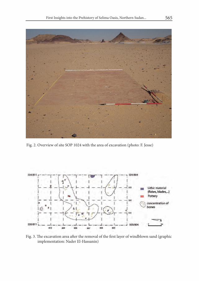
First Insights into the Prehistory of Selima Oasis, Northern Sudan... 565
Fig. 2. Overview of site SOP 1024 with the area of excavation (photo: F. Jesse)
Fig. 3. The excavation area after the removal of the first layer of windblown sand (graphic implementation: Nader El-Hassanin)
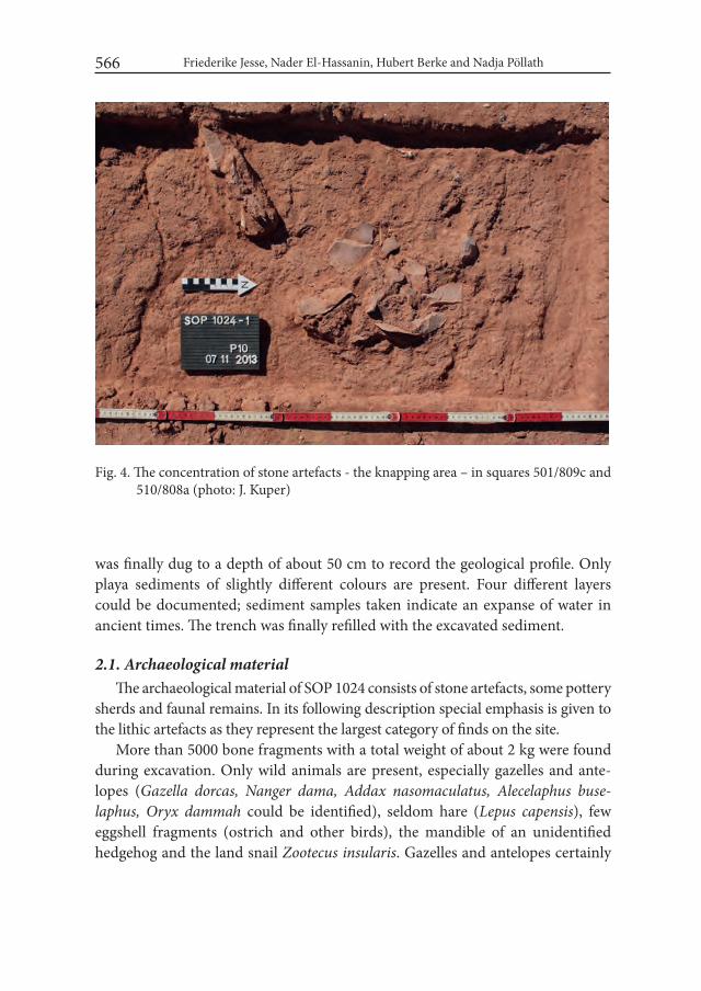
Friederike Jesse, Nader El-Hassanin, Hubert Berke and Nadja Pöllath 566
was finally dug to a depth of about 50 cm to record the geological profile. Only playa sediments of slightly different colours are present. Four different layers could be documented; sediment samples taken indicate an expanse of water in ancient times. The trench was finally refilled with the excavated sediment.
2.1. Archaeological materialThe archaeological material of SOP 1024 consists of stone artefacts, some pottery
sherds and faunal remains. In its following description special emphasis is given to the lithic artefacts as they represent the largest category of finds on the site.
More than 5000 bone fragments with a total weight of about 2 kg were found during excavation. Only wild animals are present, especially gazelles and ante-lopes (Gazella dorcas, Nanger dama, Addax nasomaculatus, Alecelaphus buse-laphus, Oryx dammah could be identified), seldom hare (Lepus capensis), few eggshell fragments (ostrich and other birds), the mandible of an unidentified hedgehog and the land snail Zootecus insularis. Gazelles and antelopes certainly
Fig. 4. The concentration of stone artefacts - the knapping area – in squares 501/809c and 510/808a (photo: J. Kuper)
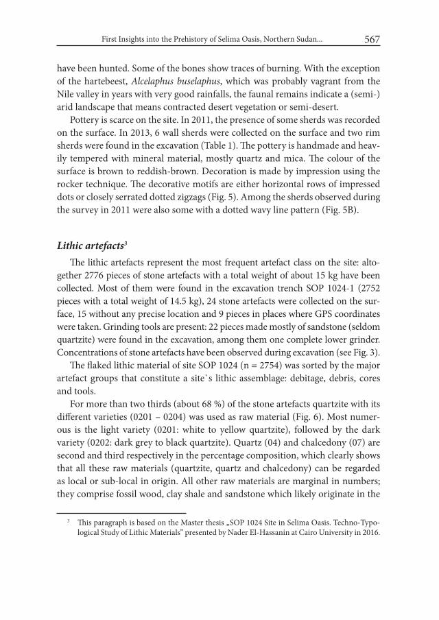
First Insights into the Prehistory of Selima Oasis, Northern Sudan... 567
have been hunted. Some of the bones show traces of burning. With the exception of the hartebeest, Alcelaphus buselaphus, which was probably vagrant from the Nile valley in years with very good rainfalls, the faunal remains indicate a (semi-)arid landscape that means contracted desert vegetation or semi-desert.
Pottery is scarce on the site. In 2011, the presence of some sherds was recorded on the surface. In 2013, 6 wall sherds were collected on the surface and two rim sherds were found in the excavation (Table 1). The pottery is handmade and heav-ily tempered with mineral material, mostly quartz and mica. The colour of the surface is brown to reddish-brown. Decoration is made by impression using the rocker technique. The decorative motifs are either horizontal rows of impressed dots or closely serrated dotted zigzags (Fig. 5). Among the sherds observed during the survey in 2011 were also some with a dotted wavy line pattern (Fig. 5B).
Lithic artefacts3 The lithic artefacts represent the most frequent artefact class on the site: alto-
gether 2776 pieces of stone artefacts with a total weight of about 15 kg have been collected. Most of them were found in the excavation trench SOP 1024-1 (2752 pieces with a total weight of 14.5 kg), 24 stone artefacts were collected on the sur-face, 15 without any precise location and 9 pieces in places where GPS coordinates were taken. Grinding tools are present: 22 pieces made mostly of sandstone (seldom quartzite) were found in the excavation, among them one complete lower grinder. Concentrations of stone artefacts have been observed during excavation (see Fig. 3).
The flaked lithic material of site SOP 1024 (n = 2754) was sorted by the major artefact groups that constitute a site`s lithic assemblage: debitage, debris, cores and tools.
For more than two thirds (about 68 %) of the stone artefacts quartzite with its different varieties (0201 – 0204) was used as raw material (Fig. 6). Most numer-ous is the light variety (0201: white to yellow quartzite), followed by the dark variety (0202: dark grey to black quartzite). Quartz (04) and chalcedony (07) are second and third respectively in the percentage composition, which clearly shows that all these raw materials (quartzite, quartz and chalcedony) can be regarded as local or sub-local in origin. All other raw materials are marginal in numbers; they comprise fossil wood, clay shale and sandstone which likely originate in the
3 This paragraph is based on the Master thesis „SOP 1024 Site in Selima Oasis. Techno-Typo-logical Study of Lithic Materials” presented by Nader El-Hassanin at Cairo University in 2016.
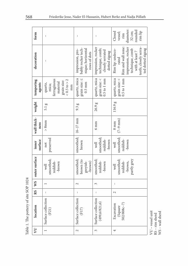
Friederike Jesse, Nader El-Hassanin, Hubert Berke and Nadja Pöllath 568
Tabl
e 1.
The
potte
ry o
f site
SO
P 10
24
VU
loca
tion
RS
WS
oute
r sur
face
inne
r su
rfac
ew
all t
hick
-ne
ssw
eigh
tte
mpe
ring
ag
ents
deco
ratio
nfo
rm
1Su
rfac
e co
llect
ion
(F21
)–
1w
ell
smoo
thed
; re
ddish
--b
row
n
not
pres
erve
d>
8mm
5.1
gqu
artz
, m
ica;
ferr
ugin
ous
mat
eria
lgr
ain
size:
<
0.5
to >
2
mm
––
2Su
rfac
e co
llect
ion
(F17
)–
2sm
ooth
ed;
brow
n (to
grey
ish-
-bro
wn)
smoo
thed
;br
own
(6–)
7 m
m9.
3 g
quar
tz, m
ica
grai
n siz
e: ≤
0.
5 m
m
impr
essio
n, p
ro-
babl
y ro
cker
tech
-ni
que;
hor
izon
tal
row
s of d
ots
–
3Su
rfac
e co
llect
ion
(499
,6/8
21,6
)–
3sm
ooth
ed;
redd
ish-
-bro
wn
wel
l sm
ooth
ed;
redd
ish-
-bro
wn
6 m
m26
.9 g
quar
tz, m
ica
grai
n siz
e: <
0.
5 to
1 m
m
impr
essio
n, ro
cker
te
chni
que,
com
b;
clos
ely
serr
ated
do
tted
zigz
ag
–
4Ex
cava
tion
(Squ
are
502/
808c
–7)
2–
wel
l sm
ooth
ed;
redd
ish-
-bro
wn,
pa
rtly
gre
y
wel
l sm
ooth
ed;
redd
ish-
-bro
wn
8 m
m
(7–9
mm
)11
6.9
gqu
artz
, mic
agr
ain
size:
<
0.5
to 1
mm
Rim
lip:
und
eco-
rate
dRi
m a
nd w
all z
one:
im
pres
sion,
rock
er
tech
niqu
e, co
mb
with
at le
ast 7
te
eth;
clos
ely
serr
a-te
d do
tted
zigz
ag
Clo
sed
vess
el;
rim
diam
eter
: 32
cm;
roun
ded
rim li
p
VU
– v
esse
l uni
tRS
– ri
m sh
erd
WS
– w
all s
herd
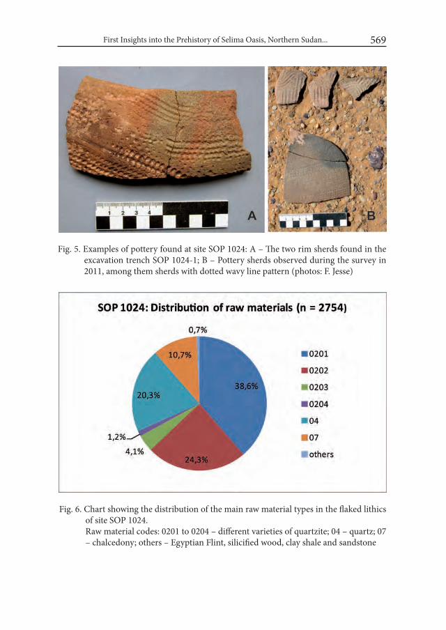
First Insights into the Prehistory of Selima Oasis, Northern Sudan... 569
Tabl
e 1.
The
potte
ry o
f site
SO
P 10
24
VU
loca
tion
RS
WS
oute
r sur
face
inne
r su
rfac
ew
all t
hick
-ne
ssw
eigh
tte
mpe
ring
ag
ents
deco
ratio
nfo
rm
1Su
rfac
e co
llect
ion
(F21
)–
1w
ell
smoo
thed
; re
ddish
--b
row
n
not
pres
erve
d>
8mm
5.1
gqu
artz
, m
ica;
ferr
ugin
ous
mat
eria
lgr
ain
size:
<
0.5
to >
2
mm
––
2Su
rfac
e co
llect
ion
(F17
)–
2sm
ooth
ed;
brow
n (to
grey
ish-
-bro
wn)
smoo
thed
;br
own
(6–)
7 m
m9.
3 g
quar
tz, m
ica
grai
n siz
e: ≤
0.
5 m
m
impr
essio
n, p
ro-
babl
y ro
cker
tech
-ni
que;
hor
izon
tal
row
s of d
ots
–
3Su
rfac
e co
llect
ion
(499
,6/8
21,6
)–
3sm
ooth
ed;
redd
ish-
-bro
wn
wel
l sm
ooth
ed;
redd
ish-
-bro
wn
6 m
m26
.9 g
quar
tz, m
ica
grai
n siz
e: <
0.
5 to
1 m
m
impr
essio
n, ro
cker
te
chni
que,
com
b;
clos
ely
serr
ated
do
tted
zigz
ag
–
4Ex
cava
tion
(Squ
are
502/
808c
–7)
2–
wel
l sm
ooth
ed;
redd
ish-
-bro
wn,
pa
rtly
gre
y
wel
l sm
ooth
ed;
redd
ish-
-bro
wn
8 m
m
(7–9
mm
)11
6.9
gqu
artz
, mic
agr
ain
size:
<
0.5
to 1
mm
Rim
lip:
und
eco-
rate
dRi
m a
nd w
all z
one:
im
pres
sion,
rock
er
tech
niqu
e, co
mb
with
at le
ast 7
te
eth;
clos
ely
serr
a-te
d do
tted
zigz
ag
Clo
sed
vess
el;
rim
diam
eter
: 32
cm;
roun
ded
rim li
p
VU
– v
esse
l uni
tRS
– ri
m sh
erd
WS
– w
all s
herd
Fig. 5. Examples of pottery found at site SOP 1024: A – The two rim sherds found in the excavation trench SOP 1024-1; B – Pottery sherds observed during the survey in 2011, among them sherds with dotted wavy line pattern (photos: F. Jesse)
Fig. 6. Chart showing the distribution of the main raw material types in the flaked lithics of site SOP 1024.
Raw material codes: 0201 to 0204 – different varieties of quartzite; 04 – quartz; 07 – chalcedony; others – Egyptian Flint, silicified wood, clay shale and sandstone
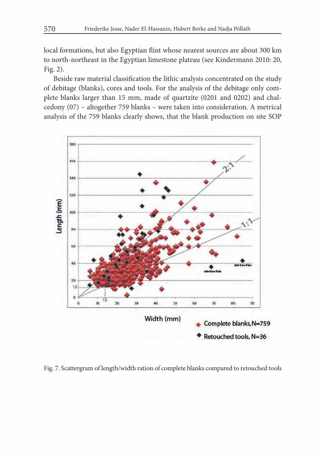
Friederike Jesse, Nader El-Hassanin, Hubert Berke and Nadja Pöllath 570
local formations, but also Egyptian flint whose nearest sources are about 300 km to north-northeast in the Egyptian limestone plateau (see Kindermann 2010: 20, Fig. 2).
Beside raw material classification the lithic analysis concentrated on the study of debitage (blanks), cores and tools. For the analysis of the debitage only com-plete blanks larger than 15 mm, made of quartzite (0201 and 0202) and chal-cedony (07) – altogether 759 blanks – were taken into consideration. A metrical analysis of the 759 blanks clearly shows, that the blank production on site SOP
Fig. 7. Scattergram of length/width ration of complete blanks compared to retouched tools

First Insights into the Prehistory of Selima Oasis, Northern Sudan... 571
1024 is flake based. Around 85 % of the stone artefacts are flakes, while 15 % are blades (Fig. 7). A qualitative inspection of the blanks’ type indicates that they tend to show a rather irregular shape. This mainly represents direct hard-hammer technique which is also supported by a QS-index of 2.5 for the blades and 2.8 for the flakes (for the QS-index see Schön 1996: 64-71).
A total of 18 cores were identified from the different levels of the excavation at the site: 13 cores were collected from the surface of trench SOP 1024-1, while 5 pieces came from the sub-surface levels. Cores were analyzed following the clas-sification of Angela Close (1977). Most of them were made of quartzite (n = 10) and chalcedony (n = 7). This is fully in line with the dominating raw materials in the blank production, indicating that these materials were flaked on site. Most numerous are single-platform cores (n = 7), ninety-degree cores (n = 4) and pat-terned multiple-platform cores (n = 3); all other core types (unpatterned multiple platform, opposed platform, bipolar core and discoidal core) were represented only with a single piece for each type (Fig. 8).
Modified pieces are rare on site SOP 1024. A total of 36 retouched tools were excavated (18 pieces) and collected (18 pieces) from areas of the surface scatter SOP 1024 outside of the excavated part. The analysis of tools by raw material shows that the prevailing materials used for blanks and cores – quartzite and chal-cedony – were also most frequently used for tools (Table 2). This also indicates that most tools were produced on site and perhaps in the nearer surrounding of the site where quartzite and chalcedony occur. Nevertheless, there are a number of outliers represented by exotic materials that are absent among cores and blanks. This is best represented by four tools made of Egyptian flint, for which no indi-cation is given that they were flaked on site. Considering blank types, tools are preferably made on blades, especially larger tools, while flake tools do not exceed 60 mm in length (see Fig. 7). The exception are two side-blow flakes made of Egyptian flint which are considerably larger.
The tool spectrum recognized at site SOP 1024 is rather limited. Tools were clas-sified according to Jacques Tixier’s description of flaked stone tools (Tixier 1963, 1974) (see Table 2). Most numerous are pieces with continuous edge retouch (Fig. 9.1-2) followed by notched pieces (Fig. 9.3), perforators and burins (Fig. 9.4-5). Geometric microliths (Fig. 9.7-8) and truncations are rare. Remarkable are side-blow flakes (Fig. 9.6), a tanged bifacial point and a bifacial foliate (Fig. 10).
With the examination of the flaked lithics and their technical aspects, it was possible to develop a model for the chaîne opératoire (production sequence) on the site where two different strategies could be determined (Fig. 11):

572
Fig.
8. S
OP
1024
. Exa
mpl
es o
f the
diff
eren
t cor
e ty
pes:
1, 3
– m
ultip
le p
latfo
rm c
ore;
2 –
nin
ety
degr
ee c
ore;
4-5
– si
ngle
pla
tform
cor
e; 6
– b
ipol
ar
core
. Raw
mat
eria
l: 1-
4 –
quar
tzite
; 5-6
– ch
alce
dony
. Sca
le 2
:3 (d
raw
ings
: Nad
er E
l-Has
sani
n)
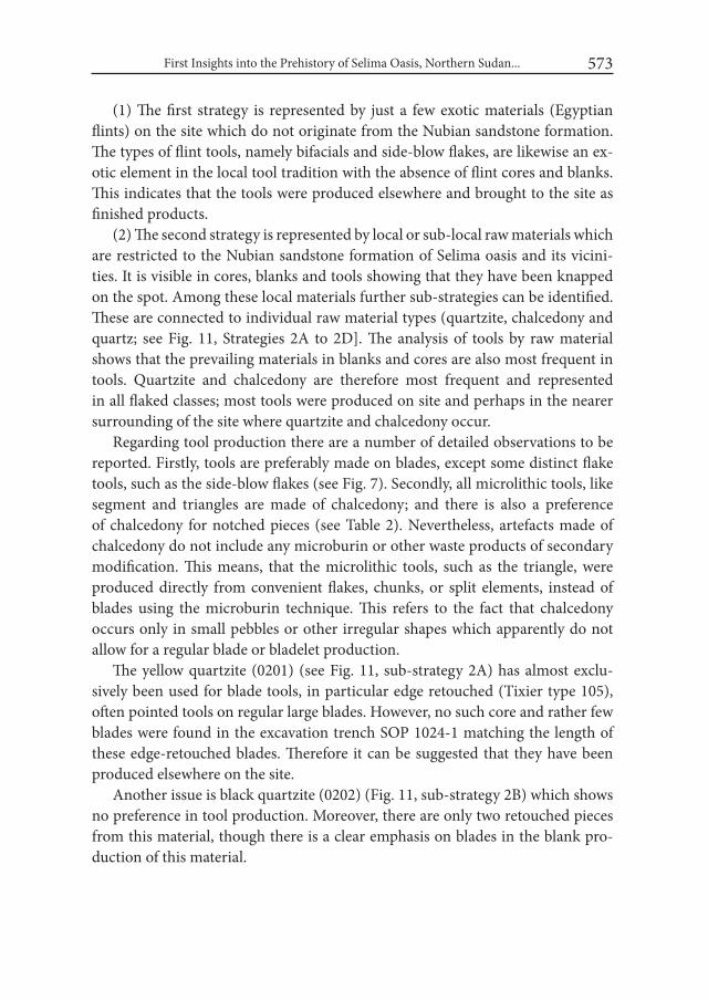
First Insights into the Prehistory of Selima Oasis, Northern Sudan... 573
(1) The first strategy is represented by just a few exotic materials (Egyptian flints) on the site which do not originate from the Nubian sandstone formation. The types of flint tools, namely bifacials and side-blow flakes, are likewise an ex-otic element in the local tool tradition with the absence of flint cores and blanks. This indicates that the tools were produced elsewhere and brought to the site as finished products.
(2) The second strategy is represented by local or sub-local raw materials which are restricted to the Nubian sandstone formation of Selima oasis and its vicini-ties. It is visible in cores, blanks and tools showing that they have been knapped on the spot. Among these local materials further sub-strategies can be identified. These are connected to individual raw material types (quartzite, chalcedony and quartz; see Fig. 11, Strategies 2A to 2D]. The analysis of tools by raw material shows that the prevailing materials in blanks and cores are also most frequent in tools. Quartzite and chalcedony are therefore most frequent and represented in all flaked classes; most tools were produced on site and perhaps in the nearer surrounding of the site where quartzite and chalcedony occur.
Regarding tool production there are a number of detailed observations to be reported. Firstly, tools are preferably made on blades, except some distinct flake tools, such as the side-blow flakes (see Fig. 7). Secondly, all microlithic tools, like segment and triangles are made of chalcedony; and there is also a preference of chalcedony for notched pieces (see Table 2). Nevertheless, artefacts made of chalcedony do not include any microburin or other waste products of secondary modification. This means, that the microlithic tools, such as the triangle, were produced directly from convenient flakes, chunks, or split elements, instead of blades using the microburin technique. This refers to the fact that chalcedony occurs only in small pebbles or other irregular shapes which apparently do not allow for a regular blade or bladelet production.
The yellow quartzite (0201) (see Fig. 11, sub-strategy 2A) has almost exclu-sively been used for blade tools, in particular edge retouched (Tixier type 105), often pointed tools on regular large blades. However, no such core and rather few blades were found in the excavation trench SOP 1024-1 matching the length of these edge-retouched blades. Therefore it can be suggested that they have been produced elsewhere on the site.
Another issue is black quartzite (0202) (Fig. 11, sub-strategy 2B) which shows no preference in tool production. Moreover, there are only two retouched pieces from this material, though there is a clear emphasis on blades in the blank pro-duction of this material.
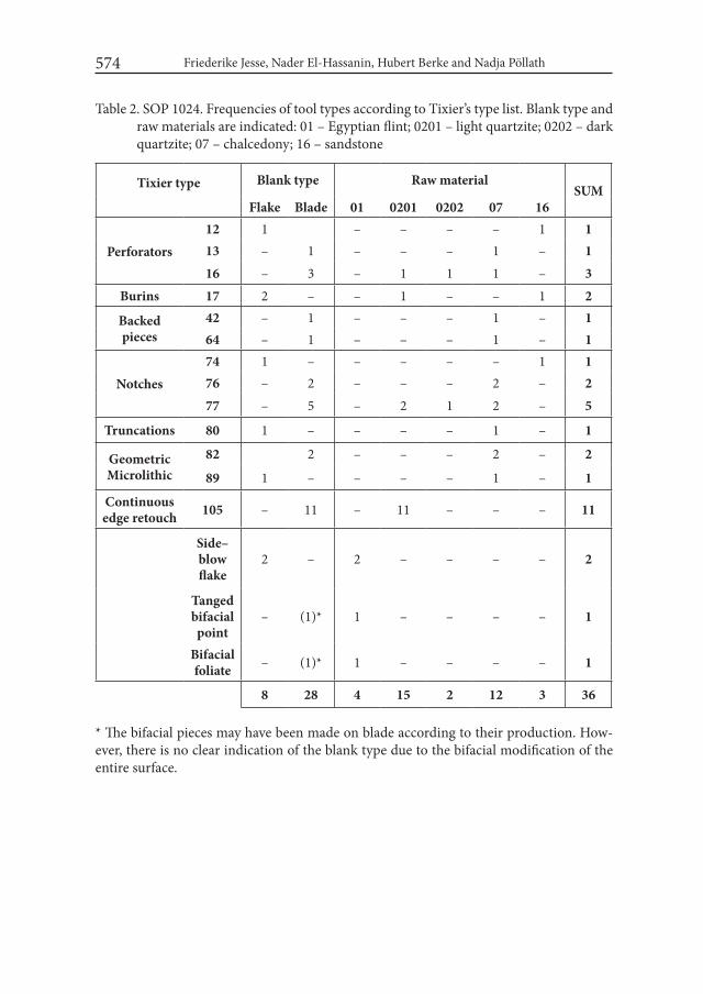
Friederike Jesse, Nader El-Hassanin, Hubert Berke and Nadja Pöllath 574
Table 2. SOP 1024. Frequencies of tool types according to Tixier’s type list. Blank type and raw materials are indicated: 01 – Egyptian flint; 0201 – light quartzite; 0202 – dark quartzite; 07 – chalcedony; 16 – sandstone
Tixier type Blank type Raw materialSUM
Flake Blade 01 0201 0202 07 16
Perforators12 1 – – – – 1 113 – 1 – – – 1 – 116 – 3 – 1 1 1 – 3
Burins 17 2 – – 1 – – 1 2
Backed pieces
42 – 1 – – – 1 – 164 – 1 – – – 1 – 1
Notches74 1 – – – – – 1 176 – 2 – – – 2 – 277 – 5 – 2 1 2 – 5
Truncations 80 1 – – – – 1 – 1
Geometric Microlithic
82 2 – – – 2 – 2
89 1 – – – – 1 – 1
Continuous edge retouch 105 – 11 – 11 – – – 11
Side– blow flake
2 – 2 – – – – 2
Tanged bifacial point
– (1)* 1 – – – – 1
Bifacial foliate – (1)* 1 – – – – 1
8 28 4 15 2 12 3 36
* The bifacial pieces may have been made on blade according to their production. How-ever, there is no clear indication of the blank type due to the bifacial modification of the entire surface.

First Insights into the Prehistory of Selima Oasis, Northern Sudan... 575
Fig.
9. S
OP
1024
: Exa
mpl
es o
f too
ls: 1
-2 –
edg
e re
touc
hed
blad
es (T
ixie
r 105
); 3
– no
tche
d bl
ade
(Tix
ier 7
6); 4
-5 –
sing
le p
ierc
er
(Tix
ier
12);
6 –
side-
blow
flak
e; 7
– e
quila
tera
l tria
ngle
(Tix
ier
89);
8 –
sem
i-circ
ular
seg
men
t (Ti
xier
82)
; 9 –
shou
lder
ed
blad
elet
(Tix
ier 6
4). R
aw m
ater
ial:
1-2
– qu
artz
ite; 3
-5, 7
-9 –
cha
lced
ony;
6 –
Egy
ptia
n fli
nt. S
cale
2:3
(dra
win
gs::
Nad
er E
l-H
assa
nin)
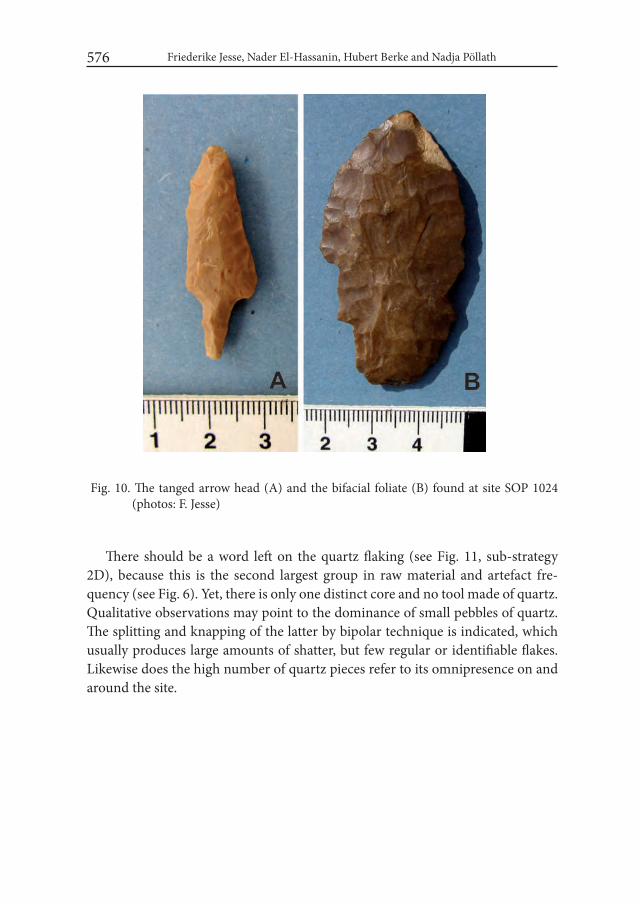
Friederike Jesse, Nader El-Hassanin, Hubert Berke and Nadja Pöllath 576
There should be a word left on the quartz flaking (see Fig. 11, sub-strategy 2D), because this is the second largest group in raw material and artefact fre-quency (see Fig. 6). Yet, there is only one distinct core and no tool made of quartz. Qualitative observations may point to the dominance of small pebbles of quartz. The splitting and knapping of the latter by bipolar technique is indicated, which usually produces large amounts of shatter, but few regular or identifiable flakes. Likewise does the high number of quartz pieces refer to its omnipresence on and around the site.
Fig. 10. The tanged arrow head (A) and the bifacial foliate (B) found at site SOP 1024 (photos: F. Jesse)
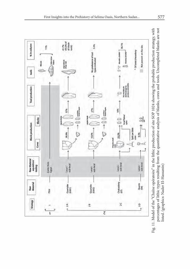
First Insights into the Prehistory of Selima Oasis, Northern Sudan... 577
Fig.
11.
Mod
el o
f the
“Cha
îne
opér
atoi
re” i
n th
e lit
hic
prod
uctio
n of
site
SO
P 10
24 sh
owin
g th
e pr
obab
le p
rodu
ctio
n st
rate
gy, w
ith
perc
enta
ges o
f lith
ic ty
pes r
esul
ting
from
the
quan
titat
ive
anal
ysis
of b
lank
s, co
res a
nd to
ols.
Unc
ompl
eted
bla
nks a
re n
ot
liste
d. (g
raph
ics:
Nad
er E
l-Has
sani
n)

Friederike Jesse, Nader El-Hassanin, Hubert Berke and Nadja Pöllath 578
2.2. ChronologyTwo radiocarbon dates were made out of bone samples for site SOP 1024: Sample 1: Poz-63698: 7125 ± 35 bp (6010 ± 30 calBC) [6070 – 5950 calBC, 95 %]; Sample 2: Poz-64363: 7280±40 bp (6150 ± 50 calBC) [6250-6050 calBC, 95 %].4
The dates indicate an occupation during the Middle Holocene: ca. 6200 to 6000 cal BC (Jesse et al. 2015: 168). This is confirmed by the archaeological mate-rial of site SOP 1024 which fits well to the Middle Holocene.
3. Comparison and conclusion When looking for comparisons for the Mid-Holocene site SOP 1024 the ar-
chaeological material give good hints. The pottery shows affinities with the broad Early Khartoum Horizon. During the SOP survey in 2011, similar ceramics (sherds with Dotted Wavy Line pattern and closely serrated dotted zigzag pat-terns) and lithic material were recorded on sites SOP 1009 and SOP 1022, both located close to SOP 1024. Comparable material can also be found in the Middle Holocene material from other regions such as the Abu Ballas Scarp-Land (Gehlen et al. 2002) and the Nabta – Kiseiba area (e.g. Wendorf and Schild 2001) in Egypt. In northern Sudan, Burg et Tuyur and Wadi Shaw in the Laqiya region are to name, especially for the pottery (see Schuck 1989, 1993; Kuper 1995).5 The pottery also finds parallels in the Khartoum Variant of the Nile Valley (e.g. site 1045; see Wendorf 1968: 723).
Especially the lithic industry of the El Jerar phase (ca. 6600 – 6200 BC [7700 – 7200 bp]; Wendorf and Schild 2001: 52-53, Tab. 3.1) shows striking parallels (personal communication Romuald Schild, Poznań 2015). El Jerar is documented at different sites in the region of Nabta – Kiseiba (e.g. E-75-6 and E-91-1; see Wen-dorf and Schild 2001), at the northern edge of El Gebal El Beid Playa, about 70 km north of Nabta and also “elsewhere in the Southwestern Desert the Jerar vari-ant is perhaps the most common occupation.” (Wendorf and Schild 2001: 658). In the El Jerar lithic industry at site E-91-1, flakes and blades are the dominant
4 Sample 1: SOP 1024-1, Square 501/808c-7; part of the horn core of Gazella dorcas, found in a loose concentration of bones and lithic material in the playa sediment in about 5 cm depth.Sample 2: SOP 1024-1, Square 500/806b-18; burnt bone of a large antelope (size of Oryx or Addax), found in the playa sediments in a depth of about 5 to 10 cm. Both dates were cali-brated using CalPal 2007 (Weninger et al. 2007).
5 The archaeological material of the early occupation phase in the Laqiya Region still awaits detailed publication.

First Insights into the Prehistory of Selima Oasis, Northern Sudan... 579
types of debitage, “quartz was used for presumed expedient tools, while flint or other fine-grained stones are used for retouched tools” and among the retouched tools in order of numerical importance continuously retouched pieces, perfora-tors, notches, denticulates and backed bladelets are present (Wendorf and Schild 2001: 325-328). Very similar lithic material was found at site Jebel Kamil 80/63, where quartzite was mainly used as raw material. A stone place there (80/63-2) was radiocarbon dated to about 6000 BC (KN-3175: 7140±160 bp).6
Of special interest for comparison are the side-blow flakes and bifacially re-touched tools found at site SOP 1024. Side-blow flakes are known in Mid-Holo-cene assemblages of different regions in Egypt and Libya, such as the Nile Valley, the oases but also the coastal Mediterranean region. Parallels can be found for example in Djara B assemblages dating to the 6th millennium BC (Kindermann 2010: 75-77), in Eastpans, the Nabta – Kiseiba region or in the Nubian Nile Val-ley (e.g. at Dibeira West 50; see Wendorf 1968: 754, Fig. 55.4). The bifacially re-touched foliate point also finds parallels in Mid-Holocene assemblages such as Djara 90/1 (see Kindermann 2010: 238, Fig. 99). The bifacial complex is present since the late 7th millennium BC and then characteristic for the 6th and early 5th millennium in the northern part of Egypt, in the area of the Abu Muhariq Plateau and the oases (Kindermann 2010: 109-110).
Basing on results of analysis of lithic artefacts, two occupation phases can be identified at site SOP 1024: the first one represented by the material from the ex-cavated area and dated to the end of the 7th millennium BC and the second one, represented by single finds found at the surface of the site, such as the side-blow flakes and the bifacial retouched tools, dated at the 6th millennium BC. The small knapping area and the bones of wild game excavated in trench SOP 1024-1 might indicate meat processing and preparation.
To conclude: Site SOP 1024 with its archaeological material of the Middle Ho-locene gives first insights in the hitherto more or less unknown prehistory of the Selima area and indicates wide contacts to other parts of the Libyan Desert which open broad perspectives for further research.
6 African Archaeology Archive Cologne (AAArC): arachne.uni-koeln.de/item/topographie /8008630

Friederike Jesse, Nader El-Hassanin, Hubert Berke and Nadja Pöllath 580
AcknowledgmentsThe work in Selima oasis would not have been possible without the support of
the National Corporation for Antiquities and Museums (Khartoum) to whom we are deeply indebted for close and fruitful co-operation. For good co-operation in the field we would like to thank the French colleagues of the Selima Oasis Project, especially Coralie Gradel and Franck Derrien. For help with the sediment analy-sis Olaf Bubenzer (Cologne) is greatly appreciated. Heiko Riemer, Karin Kinder-mann and Jan Kuper (Cologne) gave useful feedback for the analysis of lithic ma-terial. We especially would like to thank Abou Al-Hassan Bakry (Cairo), the main supervisor of the Master thesis of Nader El-Hassanin on the lithic material of site SOP 1024, for his useful comments and constant support.
REFERENCESCLOSE, A. 1977. The identification of Style in Lithic Artefacts from North East
Africa. (= Mémoires de l’Institut d´Égypte 61). Cairo.GEHLEN, B., KINDERMANN, K., LINDSTÄDTER, J. and H. RIEMER. 2002.
The Holocene Occupation of the Eastern Sahara: Regional Chronologies and Supra-regional Developments in four Areas of the Absolute Desert. In: Jennerstrasse 8 (ed.), Tides of the Desert – Gezeiten der wüste. Contri-butions to the Archaeology and Environmental History of Africa in Honour of Rudolph Kuper (= Africa Praehistorica 14): 85-116. Köln.
HAYNES, C. V. 1985. Quaternary Studies, Western Desert, Egypt and Sudan – 1979-1983 Field Seasons. National Geographic Society Research Reports 16: 269-341.
HAYNES, C. V., EYLES, C. H., PAYLISH, L. A., RITCHIE, J. C. and M. RYBAK. 1989. Holocene Palaeoecology of the Eastern Sahara; Selima Oasis. Quater-nary Science Reviews 8: 109-136.
HINKEL, F. W. 1979. Archaeological Map of Sudan ii, The Area of the South Libyan desert. Berlin.
JESSE, F., GRADEL, C. and F. DERRIEN. 2015. Archaeology at Selima Oasis, Northern Sudan – recent research. Sudan and Nubia 19: 161-169.
KINDERMANN, K. 2010. Djara. Zur mittelholozänenen Besiedlungsgeschichte zwischen Niltal und Oasen (Abu-Muharik-Plateau, Ägypten) (= Africa Praehistorica 23). Köln.

First Insights into the Prehistory of Selima Oasis, Northern Sudan... 581
KUPER, R. 1995. Prehistoric Research in the Southern Libyan Desert. A brief account and some conclusions of the B.O.S. project. In: Actes de la VIIIe Conférence Internationale des Études Nubiennes (Lille 11.-17.9.1994). CRiPEL 17, Lille 1995: 123-140.
LEACH, T. A. 1926. Selima Oasis. Sudan Notes and Records 9: 37-49.NEWBOLD, D. 1928. Rock Pictures and Archaeology in the Libyan Desert.
Antiquity 2: 261-291. NEWBOLD, D. and W. B. K. SHAW. 1928. An Exploration in the South Libyan
Desert. Sudan Notes and Records 11: 103-194.PACHUR, H.-J. and N. ALTMANN. 2006. Die Ostsahara im Spätquartär. Öko-
systemwandel im größten hyperariden Raum der Erde. Berlin–Heidelberg.PICHLER, W. and G. NEGRO. 2005. The Libyco-Berber inscriptions in the Se-
lima Oasis. Sahara 16: 173-178.RIEMER, H. and F. FÖRSTER. 2013. Ancient desert roads: Towards establishing
a new field of archaeological research. In: F. Förster and H. Riemer (eds.), Desert Road Archaeology in Ancient Egypt and Beyond (= Africa Praehis-torica 27): 19-58. Köln.
SHAW, W. B. K. 1935. Dead Libya. The Times, Aug. 07, 1935: 11.SHAW, W. B. K. 1936a. An expedition in the Southern Libyan Desert. The Geo-
graphical Journal 87: 193-221.SHAW, W. B. K. 1936b. Two Burials from the South Libyan Desert. The Journal of
Egyptian Archaeology 22: 47-50.SCHÖN, W. 1996. Ausgrabungen im wadi el Akhdar, Gilf Kebir (= Africa Praehis-
torica 8). Köln.SCHUCK, W. 1989. From lake to well: 5,000 years of settlement in Wadi Shaw
(Northern Sudan). In: L. Krzyżaniak and M. Kobusiewicz (eds.), Late Pre-history of the Nile Basin and the Sahara (= Studies in African Archaeology 2): 421-429. Poznań.
SCHUCK, W. 1993. An archaeological survey of the Selima Sandsheet, Sudan. In: L. Krzyżaniak, M. Kobusiewicz and J. Alexander (eds.), Environmen-tal change and human culture in the Nile Basin and Northern Africa until the Second Millennium B.C. (= Studies in African Archaeology 4): 237-248. Poznań.
TIXIER, J. 1963. Typologie de l’Épipaléolithique du Maghreb. Paris.TIXIER, J. 1974. Glossary for the Description of Stone Tools with special refer-
ence to the Epipalaeolithic of the Maghreb. Newsletter of lithic technology, special publication 1: 1-36.

Friederike Jesse, Nader El-Hassanin, Hubert Berke and Nadja Pöllath 582
WENDORF, F. (ed.). 1968. The Prehistory of Nubia. Vol. II. Dallas.WENDORF, F. and R. SCHILD (eds.) 2001. Holocene Settlement of the Egyptian
Sahara. Vol. i. The archaeology of Nabta Playa. New York et al. WENINGER, B., JÖRIS, O. and U. DANZEGLOCKE. 2007. CalPal-2007. Cologne
Radiocarbon Calibration & Palaeoclimate Research Package. http://www.calpal.de/
Desert and the Nile. Prehistory of the Nile Basin and the Sahara.
Papers in honour of Fred Wendorf Studies in African Archaeology 15
Poznań Archaeological Museum 2018
Simon Holdaway, Rebecca Phillipps, Joshua Emmitt and Willeke Wendrich
E29G1 Revisited: the Current State of the Surface Archaeology of Western Regions of the Fayum North Shore, Egypt
IntroductionIn their book on the Fayum North shore, Fred Wendorf and Romuald Schild
reported on a site they designated E29G1, recording the presence of stone arte-facts and fishbone and relating two radiocarbon determinations to the local la-custrine sediment stratigraphy. In 2009, we revisited the site and recorded the numbers and spatial distribution of material in two areas together with a survey to locate hearths and grinding stones. It was our intention to work in this area after the preliminary work was completed but political conditions have prevented our return. Since our visit, highway construction has modified areas of the desert surface in the vicinity of E29G1. While the Google Earth image accessed in No-vember 2015 showed the site had escaped direct damage, a new highway is located only 1.5 km to the south west of E29G1 and a new track exists adjacent to the site that leads to an area of what appears to be industrial excavation to the northwest. The site is therefore potentially threatened and it is important that our obser-vations, limited though they are, should be published. This report also provides a means to acknowledge the importance of the work Fred Wendorf and Romuald Schild undertook in the Fayum. The significance of the Fayum north shore to
Simon Holdaway, Rebecca Phillipps, Joshua Emmitt and Willeke Wendrich 584
our understanding of the prehistory of the eastern Sahara is due to the diligence of a small group of scholars, including Wendorf and Schild, who have built upon each other’s work. The results reported in this study continue this tradition.
1. BackgroundGertrude Caton-Thompson and Elinor Gardner worked in the Fayum in the
1920s concentrating on two stratified sites, Kom K and Kom W (Fig. 1), but noting the presence of extensive surface artefact deposits in surrounding areas. They produced an extensive body of published work (Caton-Thompson 1926a; 1926b; 1927; Caton-Thompson and Gardner 1929; 1934; Caton-Thompson et al. 1936; 1937), and their findings were incorporated into early studies accounting for the origins of the Neo-lithic (e.g. Braidwood 1960). These early publications were subsequently built upon through a series of later 20th century projects, notably by Fred Wendorf and Romuald Schild (1976) whose report we discuss in more detail below. Other notable studies include those by Bolesław Ginter, Janusz Kozłowski and colleagues (Ginter et al. 1980; Kozłowski and Ginter 1989; 1993), Robert Wenke (1984; Wenke, et al. 1983; Wenke and Casini 1989; Wenke, et al. 1988), Fekri Hassan (1986; Hassan, et al. 2006; 2012), and Douglas Brewer (1987; 1989a; 1989b). More recently Noriyuki Shirai (2010) has published a study focusing on the stone tools from the Fayum north shore.
In their 1976 book, Wendorf and Schild suggest that the site they labelled E29G1 is the equivalent of Caton-Thompson and Gardner’s Site Z1 (Fig. 1). Site Z1 is men-tioned briefly by Caton-Thompson and Gardner (1934: 59) and described as a loca-tion with large quantities of microliths. When Wendorf and Schild visited the area decades later, they reported on six artefact concentrations together with what they described as a scattered veneer of artefacts found along the eastern slopes of two de-flated basins covering an area measuring approximately 700 x 120 m (Fig. 2). Within lacustrine sediments, which they describe as organogenic swamp sediments associ-ated with Pila ovata snail shells, they describe a complex stratigraphy. Based on the observations they made from the trenches excavated this stratigraphy is used to pro-pose links to a series of suggested lake advances and retreats. As we have discussed elsewhere (Phillipps et al. 2016), there is reason to be cautious about the suggested lake change sequence, since there are issues with the way that chronostratigraphic cor-relations were made in a series of studies that followed on from Wendorf and Schild’s work. Rather than repeat the discussion of the issues surrounding chronostratigraphic correlations (see also Holdaway and Wendrich 2017), here we consider the artefact concentrations that Wendorf and Schild observed.
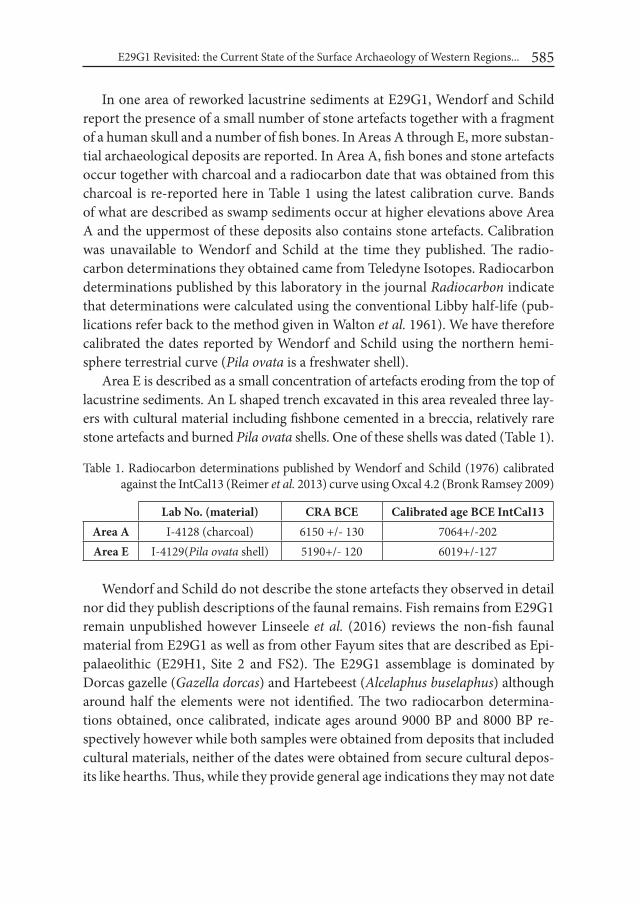
E29G1 Revisited: the Current State of the Surface Archaeology of Western Regions... 585
In one area of reworked lacustrine sediments at E29G1, Wendorf and Schild report the presence of a small number of stone artefacts together with a fragment of a human skull and a number of fish bones. In Areas A through E, more substan-tial archaeological deposits are reported. In Area A, fish bones and stone artefacts occur together with charcoal and a radiocarbon date that was obtained from this charcoal is re-reported here in Table 1 using the latest calibration curve. Bands of what are described as swamp sediments occur at higher elevations above Area A and the uppermost of these deposits also contains stone artefacts. Calibration was unavailable to Wendorf and Schild at the time they published. The radio-carbon determinations they obtained came from Teledyne Isotopes. Radiocarbon determinations published by this laboratory in the journal Radiocarbon indicate that determinations were calculated using the conventional Libby half-life (pub-lications refer back to the method given in Walton et al. 1961). We have therefore calibrated the dates reported by Wendorf and Schild using the northern hemi-sphere terrestrial curve (Pila ovata is a freshwater shell).
Area E is described as a small concentration of artefacts eroding from the top of lacustrine sediments. An L shaped trench excavated in this area revealed three lay-ers with cultural material including fishbone cemented in a breccia, relatively rare stone artefacts and burned Pila ovata shells. One of these shells was dated (Table 1).
Table 1. Radiocarbon determinations published by Wendorf and Schild (1976) calibrated
against the IntCal13 (Reimer et al. 2013) curve using Oxcal 4.2 (Bronk Ramsey 2009)
Lab No. (material) CRA BCE Calibrated age BCE IntCal13Area A I-4128 (charcoal) 6150 +/- 130 7064+/-202Area E I-4129(Pila ovata shell) 5190+/- 120 6019+/-127
Wendorf and Schild do not describe the stone artefacts they observed in detail nor did they publish descriptions of the faunal remains. Fish remains from E29G1 remain unpublished however Linseele et al. (2016) reviews the non-fish faunal material from E29G1 as well as from other Fayum sites that are described as Epi-palaeolithic (E29H1, Site 2 and FS2). The E29G1 assemblage is dominated by Dorcas gazelle (Gazella dorcas) and Hartebeest (Alcelaphus buselaphus) although around half the elements were not identified. The two radiocarbon determina-tions obtained, once calibrated, indicate ages around 9000 BP and 8000 BP re-spectively however while both samples were obtained from deposits that included cultural materials, neither of the dates were obtained from secure cultural depos-its like hearths. Thus, while they provide general age indications they may not date
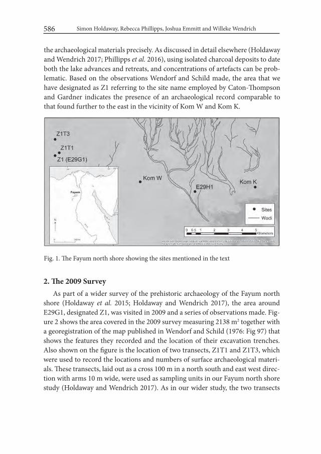
Simon Holdaway, Rebecca Phillipps, Joshua Emmitt and Willeke Wendrich 586
the archaeological materials precisely. As discussed in detail elsewhere (Holdaway and Wendrich 2017; Phillipps et al. 2016), using isolated charcoal deposits to date both the lake advances and retreats, and concentrations of artefacts can be prob-lematic. Based on the observations Wendorf and Schild made, the area that we have designated as Z1 referring to the site name employed by Caton-Thompson and Gardner indicates the presence of an archaeological record comparable to that found further to the east in the vicinity of Kom W and Kom K.
Fig. 1. The Fayum north shore showing the sites mentioned in the text
2. The 2009 SurveyAs part of a wider survey of the prehistoric archaeology of the Fayum north
shore (Holdaway et al. 2015; Holdaway and Wendrich 2017), the area around E29G1, designated Z1, was visited in 2009 and a series of observations made. Fig-ure 2 shows the area covered in the 2009 survey measuring 2138 m2 together with a georegistration of the map published in Wendorf and Schild (1976: Fig 97) that shows the features they recorded and the location of their excavation trenches. Also shown on the figure is the location of two transects, Z1T1 and Z1T3, which were used to record the locations and numbers of surface archaeological materi-als. These transects, laid out as a cross 100 m in a north south and east west direc-tion with arms 10 m wide, were used as sampling units in our Fayum north shore study (Holdaway and Wendrich 2017). As in our wider study, the two transects

Fig. 2. Z1 (E29G1) with the georegistered map published by Wendorf and Schild (1976: fig. 97). The georegistration is approximate and is based on the topographic fea-tures that Wendorf and Schild identified
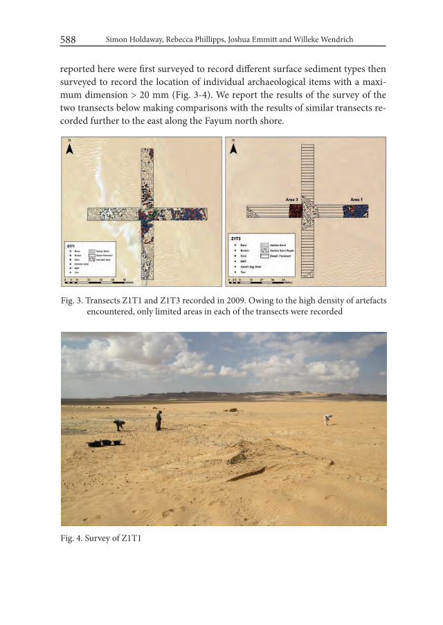
Simon Holdaway, Rebecca Phillipps, Joshua Emmitt and Willeke Wendrich 588
reported here were first surveyed to record different surface sediment types then surveyed to record the location of individual archaeological items with a maxi-mum dimension > 20 mm (Fig. 3-4). We report the results of the survey of the two transects below making comparisons with the results of similar transects re-corded further to the east along the Fayum north shore.
Fig. 3. Transects Z1T1 and Z1T3 recorded in 2009. Owing to the high density of artefacts encountered, only limited areas in each of the transects were recorded
Fig. 4. Survey of Z1T1
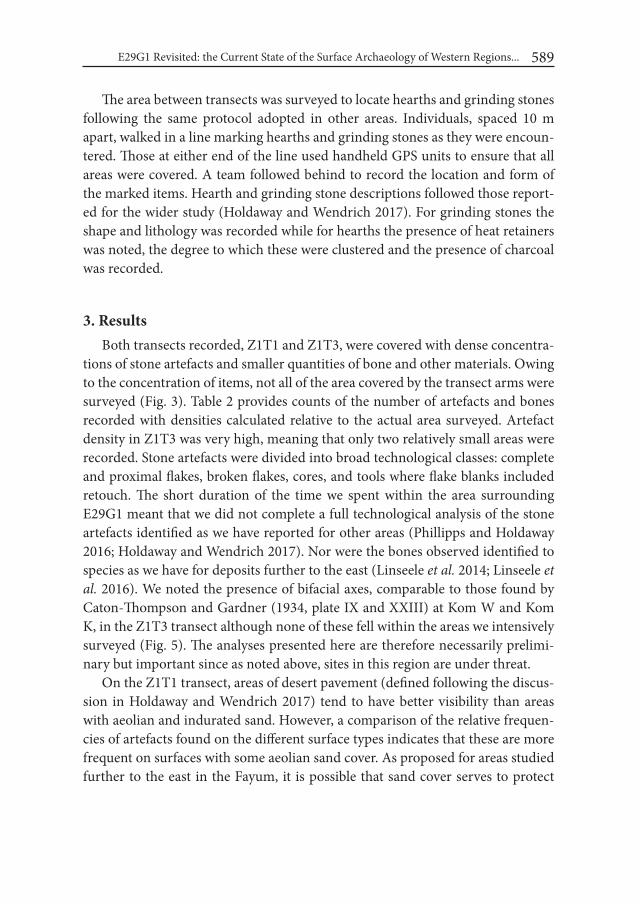
E29G1 Revisited: the Current State of the Surface Archaeology of Western Regions... 589
The area between transects was surveyed to locate hearths and grinding stones following the same protocol adopted in other areas. Individuals, spaced 10 m apart, walked in a line marking hearths and grinding stones as they were encoun-tered. Those at either end of the line used handheld GPS units to ensure that all areas were covered. A team followed behind to record the location and form of the marked items. Hearth and grinding stone descriptions followed those report-ed for the wider study (Holdaway and Wendrich 2017). For grinding stones the shape and lithology was recorded while for hearths the presence of heat retainers was noted, the degree to which these were clustered and the presence of charcoal was recorded.
3. ResultsBoth transects recorded, Z1T1 and Z1T3, were covered with dense concentra-
tions of stone artefacts and smaller quantities of bone and other materials. Owing to the concentration of items, not all of the area covered by the transect arms were surveyed (Fig. 3). Table 2 provides counts of the number of artefacts and bones recorded with densities calculated relative to the actual area surveyed. Artefact density in Z1T3 was very high, meaning that only two relatively small areas were recorded. Stone artefacts were divided into broad technological classes: complete and proximal flakes, broken flakes, cores, and tools where flake blanks included retouch. The short duration of the time we spent within the area surrounding E29G1 meant that we did not complete a full technological analysis of the stone artefacts identified as we have reported for other areas (Phillipps and Holdaway 2016; Holdaway and Wendrich 2017). Nor were the bones observed identified to species as we have for deposits further to the east (Linseele et al. 2014; Linseele et al. 2016). We noted the presence of bifacial axes, comparable to those found by Caton-Thompson and Gardner (1934, plate IX and XXIII) at Kom W and Kom K, in the Z1T3 transect although none of these fell within the areas we intensively surveyed (Fig. 5). The analyses presented here are therefore necessarily prelimi-nary but important since as noted above, sites in this region are under threat.
On the Z1T1 transect, areas of desert pavement (defined following the discus-sion in Holdaway and Wendrich 2017) tend to have better visibility than areas with aeolian and indurated sand. However, a comparison of the relative frequen-cies of artefacts found on the different surface types indicates that these are more frequent on surfaces with some aeolian sand cover. As proposed for areas studied further to the east in the Fayum, it is possible that sand cover serves to protect

Simon Holdaway, Rebecca Phillipps, Joshua Emmitt and Willeke Wendrich 590
Table 2. Object frequency and density (number/m2) together with surface type for the ar-eas recorded in transects Z1T1 and Z1T3. For transect Z1T3 the only surface type was desert pavement. Surface type and artefact class definitions follow those used in Holdaway and Wendrich (2017)
Z1T1 Z1T3Aeolian sand Desert pavement Area 1 Area 2
Frequency Density Frequency Density Frequency Density Frequency Density
Bone 123 0.94 12 0.07 3 0.01 1164 10.86Broken 423 3.23 171 1.02 903 4.49 1148 10.71Core 105 0.80 25 0.15 824 4.10 0.00Hammer stone 1 0.01 0.00 0.00Flake platforms 929 7.08 203 1.21 3236 16.09 3510 32.76Ostrich eggshell 1 0.00 0.00Tool 38 0.29 12 0.07 46 0.23 44 0.41Total lithic 1404 10.71 411 2.45 5009 24.90 5866 54.75
Fig. 5. Stone artefact density for the Z1 transects together with densities obtained for ar-eas further east in the Fayum north shore. Densities are calculated as number of objects of all forms per square meter and are based on fieldwork reported in Hold-away and Wendrich (2017)
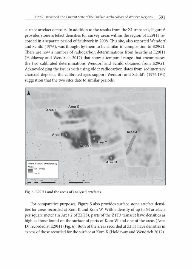
E29G1 Revisited: the Current State of the Surface Archaeology of Western Regions... 591
surface artefact deposits. In addition to the results from the Z1 transects, Figure 6 provides stone artefact densities for survey areas within the region of E29H1 re-corded in a separate period of fieldwork in 2008. This site, also reported Wendorf and Schild (1976), was thought by them to be similar in composition to E29G1. There are now a number of radiocarbon determinations from hearths at E29H1 (Holdaway and Wendrich 2017) that show a temporal range that encompasses the two calibrated determinations Wendorf and Schild obtained from E29G1. Acknowledging the issues with using older radiocarbon dates from sedimentary charcoal deposits, the calibrated ages support Wendorf and Schild’s (1976:194) suggestion that the two sites date to similar periods.
For comparative purposes, Figure 5 also provides surface stone artefact densi-ties for areas recorded at Kom K and Kom W. With a density of up to 54 artefacts per square meter (in Area 2 of Z1T3), parts of the Z1T3 transect have densities as high as those found on the surface of parts of Kom W and one of the areas (Area D) recorded at E29H1 (Fig. 6). Both of the areas recorded at Z1T3 have densities in excess of those recorded for the surface at Kom K (Holdaway and Wendrich 2017).
Fig. 6. E29H1 and the areas of analysed artefacts
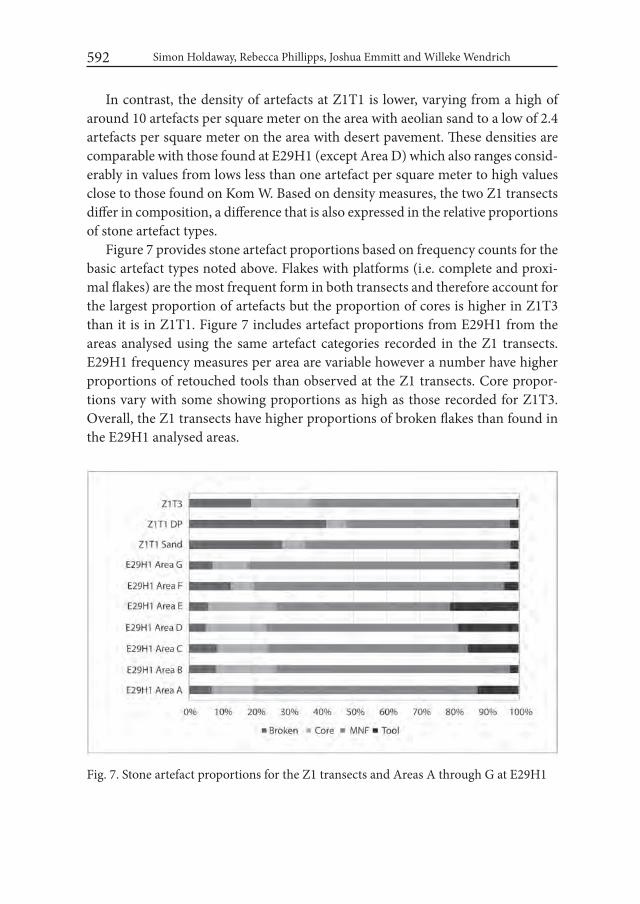
Simon Holdaway, Rebecca Phillipps, Joshua Emmitt and Willeke Wendrich 592
In contrast, the density of artefacts at Z1T1 is lower, varying from a high of around 10 artefacts per square meter on the area with aeolian sand to a low of 2.4 artefacts per square meter on the area with desert pavement. These densities are comparable with those found at E29H1 (except Area D) which also ranges consid-erably in values from lows less than one artefact per square meter to high values close to those found on Kom W. Based on density measures, the two Z1 transects differ in composition, a difference that is also expressed in the relative proportions of stone artefact types.
Figure 7 provides stone artefact proportions based on frequency counts for the basic artefact types noted above. Flakes with platforms (i.e. complete and proxi-mal flakes) are the most frequent form in both transects and therefore account for the largest proportion of artefacts but the proportion of cores is higher in Z1T3 than it is in Z1T1. Figure 7 includes artefact proportions from E29H1 from the areas analysed using the same artefact categories recorded in the Z1 transects. E29H1 frequency measures per area are variable however a number have higher proportions of retouched tools than observed at the Z1 transects. Core propor-tions vary with some showing proportions as high as those recorded for Z1T3. Overall, the Z1 transects have higher proportions of broken flakes than found in the E29H1 analysed areas.
Fig. 7. Stone artefact proportions for the Z1 transects and Areas A through G at E29H1

E29G1 Revisited: the Current State of the Surface Archaeology of Western Regions... 593
Figure 8 shows the flake to core ratios for the two Z1 transects and those from E29H1. The ratio for the two surface types at Z1T1 are high, comparable to the ratio from Areas F and G at E29H1. In contrast, the ratio value for Z1T3 is lower, comparable in value to Areas A through E from E29H1.
The area between the two Z1 transects was surveyed for hearths and grinding stones as discussed above. As a result of this survey, 68 grinding stones were iden-tified together with five hearths. The area covered was more than 2000 m2, giving a grinding stone density of 0.032 per square meter and a hearth density of 0.0023 per square meter. These are higher values compared to the densities of grinding stone and hearths recorded further to the east in the vicinity of E29H1 where grinding stones have a density of 0.000173 per square meter and hearths a density of 0.00066 per square meter.
Table 3 provides frequencies of the upper and lower grinding stones identified in the Z1 survey area together with their shape and lithology. Sandstone is the most common material whereas further to the east, in the vicinity of E29H1, lime-stone grinding stones are more common. The five hearths identified have scat-tered heat retainers and showed no evidence for the presence of charcoal.
Fig. 8. Flake to core ratio for the areas recorded at the Z1 transects together with Areas A-G at E29H1. The ratio is calculated by dividing the number of complete and proximal flakes by the number of cores. The two areas recorded at Z1T3 are combined
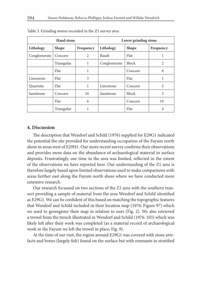
Simon Holdaway, Rebecca Phillipps, Joshua Emmitt and Willeke Wendrich 594
Table 3. Grinding stones recorded in the Z1 survey area
Hand stone Lower grinding stone
Lithology Shape Frequency Lithology Shape Frequency
Conglomerate Concave 2 Basalt Flat 1
Triangular 1 Conglomerate Block 2
Flat 1 Concave 8
Limestone Flat 3 Flat 1
Quartzite Flat 1 Limestone Concave 5
Sandstone Concave 10 Sandstone Block 3
Flat 6 Concave 19
Triangular 1 Flat 4
4. DiscussionThe description that Wendorf and Schild (1976) supplied for E29G1 indicated
the potential the site provided for understanding occupation of the Fayum north shore in areas west of E29H1. Our more recent survey confirms their observations and provides more data on the abundance of archaeological material in surface deposits. Frustratingly, our time in the area was limited, reflected in the extent of the observations we have reported here. Our understanding of the Z1 area is therefore largely based upon limited observations used to make comparisons with areas further east along the Fayum north shore where we have conducted more extensive research.
Our research focussed on two sections of the Z1 area with the southern tran-sect providing a sample of material from the area Wendorf and Schild identified as E29G1. We can be confident of this based on matching the topographic features that Wendorf and Schild included in their location map (1976: Figure 97) which we used to georegister their map in relation to ours (Fig. 2). We also retrieved a trowel from the trench illustrated in Wendorf and Schild (1976: 103) which was likely left after their work was completed (as a material record of archaeological work in the Fayum we left the trowel in place; Fig. 9).
At the time of our visit, the region around E29G1 was covered with stone arte-facts and bones (largely fish) found on the surface but with remnants in stratified

E29G1 Revisited: the Current State of the Surface Archaeology of Western Regions... 595
Fig. 9. Image of the trowel found at E29G1 during survey in 2009. The trowel is in the lower left hand side of the image

Simon Holdaway, Rebecca Phillipps, Joshua Emmitt and Willeke Wendrich 596
deposits. Our work concentrated on the surface deposits in one transect, Z1T1, in which we recorded a large number of stone artefacts.
Stone artefact density at Z1T1 is comparable to some of the areas recorded fur-ther to the east at E29H1 but the density in the area of E29G1 we recorded is rela-tively low. The artefacts are more fragmented compared to the areas further to the east and have relatively low proportions of retouched tools. The flake to core ratio values for both desert pavement and sand surfaces recorded at Z1T1 are high, toward the upper end of the values recorded at E29H1. More detailed recording at E29H1 indicated that flakes were likely transported away from this site for use elsewhere (Phillipps and Holdaway 2016). One of the consequences of this is rela-tively reduced values for the flake to core ratio. Although we did not measure the required variables to detect flake movement at Z1T1 directly, and so cannot dem-onstrate the movement or otherwise of the products of lithic reduction, the flake to core ratio at Z1T1 is at the upper end of the range of values found at E29H1. This might indicate a different form of lithic economy operated in the western edge of the Fayum north shore compared to areas further to the east. This might also be connected to the relatively low density of stone artefacts found at Z1T1 compared to E29H1 together with the small number of tools. However, these re-sults need to be read as interesting observations rather than firm conclusions at this stage until the area can be investigated more fully by further fieldwork.
The high density of stone artefacts at Z1T3 contrasts with the lower densities at Z1T1. The former are in fact some of the highest densities we have recorded in the Fayum north shore, and as noted above, are only approached by the deflated surface deposits in some parts of Kom W. The composition of the Z1T3 lithic as-semblage is different to that found at Z1T1 further to the south. It has a very large number of cores reflected in the low value of the flake to core ratio, which is lower than the majority of the areas studied at E29H1. The assemblage is dominated by flakes and cores with the retouched tool proportion barely registering in the rela-tive artefact proportions shown in Figure 7. This is similar to the low proportions of tools found in the Kom K and Kom W assemblages, and there are some typo-logical similarities between these locations (Phillipps 2012).
In some ways the potential of this assemblage is even more interesting than that observed at Z1T1. As described elsewhere (Phillipps and Holdaway 2016), further to the east there are a number of assemblages (e.g. Kom W) for which analysis indicates the loss of cores. That is, in contrast to the E29H1 assemblages, there is evidence to suggest that cores rather than flakes were removed leaving behind flake dominated assemblages. It is tempting to suggest that some of the
E29G1 Revisited: the Current State of the Surface Archaeology of Western Regions... 597
cores that were initially worked in the eastern parts of the Fayum north shore were transported west and deposited in areas sampled in the Z1T3 transect. Of course moving cores into an area would decrease the flake to core ratio by augmenting the number of cores relative to the number of flakes. Unfortunately we need more data than were recorded in 2009 to be sure of this conclusion so like the results from the comparisons between E29G1 and E29H1, this observation should only be taken as the impetus for more work.
A final set of observations relate to the grinding stones found when we sys-tematically surveyed an area between the Z1T1 and Z1T3 transects. In this area, grinding stones are common and they occur at densities higher than those found further to the east. Grinding stones are of course susceptible to movement by people well after their use and abandonment and it might be that this difference simply reflects removal of grinding stones from areas further to the east. However, any activity of this type was not very systematic since grinding stones are found across the Fayum north shore. Thus, they do not seem to have been uniformly attractive to later visitors to the area. In addition, as detailed in Holdaway and Wendrich (2017), despite a long prehistory of activity around the Fayum north shore, the surface archaeological record has remained surprisingly intact right up that is until recent times. Thus, the relatively large number of grinding stones can be added to the list of interesting observations that make the Z1 area an important location for future research.
One of the conclusions of our more in-depth study conducted in areas to the east of Z1 was the need to understand the Fayum record at a landscape scale (Holdaway and Wendrich 2017). No one location, not even the famous stratified sites of Kom K and Kom W, can provide sufficient information to allow for infer-ences about the settlement system and socio-economy of the prehistoric occu-pants of the Fayum. Instead, multiple records of different types spread across the Fayum north shore need to be assessed in combination. The results obtained from the Z1 area provide indications that may bolster this argument further. There are hints that the Z1T3 assemblage may include cores that were moved from areas further east. It is even possible that the high flake to core ratio at Z1T1 reflects flakes that were added to the assemblage transported from the places further to the east that show a net flake loss. Unfortunately, without further data recording, these observations must remain speculative.
This brings us to a final point. The need to publish these preliminary findings is driven not by the completeness of the scientific analysis we can present but by the imminent potential destruction of the archaeological record the study of which
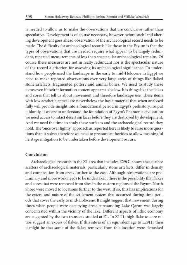
Simon Holdaway, Rebecca Phillipps, Joshua Emmitt and Willeke Wendrich 598
is needed to allow us to make the observations that are conclusive rather than speculative. Development is of course necessary, however before such land alter-ing development goes ahead observation of the archaeological record needs to be made. The difficulty for archaeological records like those in the Fayum is that the types of observations that are needed require what appear to be largely redun-dant, repeated measurements of less than spectacular archaeological remains. Of course these measures are not in realty redundant nor is the spectacular nature of the record a criterion for assessing its archaeological significance. To under-stand how people used the landscape in the early to mid-Holocene in Egypt we need to make repeated observations over very large areas of things like flaked stone artefacts, fragmented pottery and animal bones. We need to study these items even if their information content appears to be low. It is things like the flakes and cores that tell us about movement and therefore landscape use. These items with low aesthetic appeal are nevertheless the basic material that when analysed fully will provide insight into a foundational period in Egypt’s prehistory. To put it bluntly, if we are to understand the foundation of Egypt’s Pharaonic civilisation we need access to intact desert surfaces before they are destroyed by development. And we need the time to study these surfaces and the archaeological record they hold. The ‘once over lightly’ approach as reported here is likely to raise more ques-tions than it solves therefore we need to pressure authorities to allow meaningful heritage mitigation to be undertaken before development occurs.
ConclusionArchaeological research in the Z1 area that includes E29G1 shows that surface
scatters of archaeological materials, particularly stone artefacts, differ in density and composition from areas further to the east. Although observations are pre-liminary and more work needs to be undertaken, there is the possibility that flakes and cores that were removed from sites in the eastern regions of the Fayum North Shore were moved to locations further to the west. If so, this has implications for the extent and nature of the settlement system that occurred during time peri-ods that cover the early to mid-Holocene. It might suggest that movement during times when people were occupying areas surrounding Lake Qarun was largely concentrated within the vicinity of the lake. Different aspects of lithic economy are suggested by the two transects studied at Z1. In Z1T1, high flake to core ra-tios suggest an excess of flakes. If this site is of an equivalent age to E29H1 then it might be that some of the flakes removed from this location were deposited
E29G1 Revisited: the Current State of the Surface Archaeology of Western Regions... 599
further west. In contrast, at Z1T3 the flake to core ratio is low suggesting a large number of cores. In the eastern areas of the Fayum north shore sites dated to the mid-Holocene indicate the removal of cores. If these were deposited at loca-tions further west, this might explain the high number of cores (and therefore low flake to core ratio) at Z1T3. Unfortunately, these assessments remain speculative at present since we lack sufficient data to draw conclusive inferences. More work is needed before the critical surface deposits are destroyed through development.
AcknowledgementsWork reported here was supported by the Royal Society of New Zealand
through a Marsden grant, by the National Geographic Society and by the Univer-sity of Auckland. Permission to work on the Fayum material was provided by the Egyptian Supreme Council of Antiquities and the Ministry of State for Antiquities (MSA) to the UCLA, Groningen University, University of Auckland Fayum Proj-ect (URU). Figures were prepared by Briar Sefton and Tim Mackrell.
REFERENCESBRAIDWOOD, R. 1960. The agricultural revolution. San Francisco.BREWER, D. J. 1987. Seasonality in the Prehistoric Faiyum Based on the Incre-
mental Growth Structures of the Nile Catfish (Pisces: Clarias). Journal of Archaeological Science 14: 459-472.
BREWER, D. J. 1989a. A model for resource exploitation in the prehistoric Fa-yum. In: L. Krzyżaniak and M. Kobusiewicz (eds.), Late Prehistory of the Nile Basin and the Sahara (= Studies in African Archaeology 2): 127-138. Poznań.
BREWER, D. J. 1989b. Fishermen, Hunters and Herders: Zooarchaeology in the Fayum, Egypt (ca. 8200-5000 bp). BAR International. Oxford.
BRONK RAMSEY, C. 2009. Bayesian Analysis of Radiocarbon Dates. Radiocar-bon 51(1): 337-360.
CATON THOMPSON, G. 1926a. The Neolithic Industry of the Northern Fayum Desert. Journal of the Royal Anthropological institute 56: 309-323.
CATON THOMPSON, G. 1926b. The Recent Geology and Neolithic Industry of the Southern Fayum Desert. Journal of the Royal Anthropological institute 56: 301-308.
Simon Holdaway, Rebecca Phillipps, Joshua Emmitt and Willeke Wendrich 600
CATON THOMPSON, G. 1927. Explorations in the Northern Fayum. Antiquity 1: 326-340.
CATON-THOMPSON, G. and E. W. GARDNER. 1929. Recent work on the Prob-lem of Lake Moeris. Geographical Journal 73: 20-58.
CATON-THOMPSON, G. AND E. W. GARDNER. 1934. The Desert Fayum. The Royal Anthropological Institute of Great Britain and Ireland, London.
CATON THOMPSON, G., GARDNER, E. W., and S. HUZZAYIM. 1936. Lake Moeris: Reinvestigations and Some Comments. Journal of the Royal An-thropological institute 61: 301-308.
CATON THOMPSON, G., GARDNER, E. W., and S. HUZZAYIM. 1937. Lake Moeris: Reinvestigations and Some Comments. Bulletin de l’institut d’Egypte 19: 243-303.
GINTER, B., HEFLIK, W., KOZŁOWSKI, J. K., and J. ŚLIWA. 1980. Excavations in the region of Qasr el-Sagha, 1979: Contributions to the Holocene geolo-gy, the Predynastic and Dynastic settlements in the northern Fayum desert. Mitteilungen des Deutschen Archäologischen instituts, Kairo 36: 105-169.
HASSAN, F. A. 1986. Holocene Lakes and Prehistoric Settlements of the Western Faiyum, Egypt. Journal of Archaeological Science 13: 483-501.
HASSAN, F., TASSIE, G., FLOWER, R., HUGHES, M., and A. M. HAMDAN. 2006. Modelling environmental and settlement change in the Fayum. Egyp-tian Archaeology 29: 37-40.
HASSAN, F. A., HAMDAN, M. A., FLOWER, R., and K. KEATINGS. 2012. Oxygen and carbon isotopic records in Holocene freshwater mollusc shells from the Faiyum paleolakes, Egypt: paleoenvironmental and paleoclimatic implications. Quaternary international 266: 175–187.
HOLDAWAY, S. J. and W. WENDRICH. 2017. The Desert Fayum Reinvestigat-ed: The Early to Mid-Holocene Landscape Archaeology of the Fayum North Shore, Egypt. Monumenta Archaeologica 39. Los Angeles. Cotsen Institute of Archaeology Press.
HOLDAWAY, S. J., PHILLIPPS, R., EMMITT, J. J. and W. WENDRICH. 2015. The Fayum Revisited: Reconsidering the Role of the Neolithic Package, Fayum North Shore, Egypt. Quaternary international 410, Part A: 73–180.
KOZŁOWSKI, J. K. and B. GINTER. 1989. The Fayum Neolithic in the light of new discoveries. In: L. Krzyżaniak and M. Kobusiewicz (eds.), Late Prehistory of the Nile Basin and the Sahara (= Studies in African Archaeology 2): 157-179.
KOZŁOWSKI, J. K. and B. GINTER. 1993. Holocene changes in the Fayum: Lake Moeris and the evolution of climate in Northeastern Africa. In:
E29G1 Revisited: the Current State of the Surface Archaeology of Western Regions... 601
L. Krzyżaniak, M. Kobusiewicz and J. Alexander (eds.), Environmental Change and Human Culture in the Nile Basin and Northern Africa Until the Second Millennium B.C. (= Studies in African Archaeology 4): 327-336.
LINSEELE, V., VAN NEER, W., THYS, S., PHILLIPPS, R., CAPPERS, R. T. J., WENDRICH, W. and S. HOLDAWAY. 2014. New Archaeological Data from the Fayum “Neolithic” with a Critical Assessment of the Evidence for Early Stock Keeping in Egypt. PLoS ONE 9(10): e108517.
LINSEELE, V., HOLDAWAY, S. J. and W. WENDRICH. 2016. The earliest phase of introduction of Southwest Asian domesticated animals into Africa. New evidence from the Fayum Oasis in Egypt and its implications. Quaternary international 412(B):11-21.
PHILLIPPS, R. 2012. Documenting socio-economic variability in the Egyptian Neolithic through stone artefact analysis. Unpublished Ph.D. Thesis, De-partment of Anthropology, University of Auckland.
PHILLIPPS, R. S., HOLDAWAY, S. J., RAMSAY, R., EMMITT, J. J., WENDRICH, W., and LINSEELE, V. 2016. Lake Level Changes, Lake Edge Basins and the Paleoenvironment of the Fayum North Shore, Egypt, during the Early to Mid-Holocene. Open Quaternary 2 (2):1-12. doi: 10.5334/oq.19.
PHILLIPPS, R. S., and HOLDAWAY, S. J. 2016. Estimating Core Number in As-semblages: Core Movement and Mobility During the Holocene of the Fa-yum, Egypt. Journal of Archaeological Method and Theory 23 (2):520-540. doi: 10.1007/s10816-015-9250-2.
REIMER, P. J., BARD, E., BAYLISS, A., BECK, J. W., BLACKWELL, P. G., BRONK RAMSEY, C., GROOTES, P. M., GUILDERSON, T. P., HAFLIDASON, H., HAJDAS, I., HATTE, C., HEATON, T. J., HOFFMANN, D. L., HOGG, A. G., HUGHEN, K. A., KAISER, K. F., KROMER, B., MANNING, S. W., NIU, M., REIMER, R. W., RICHARDS, D. A., SCOTT, E. M., SOUTHON, J. R., STAFF, R. A., TURNEY, C. S. M., and J. VAN DER PLICHT. 2013. In-tCal13 and Marine13 Radiocarbon Age Calibration Curves 0-50,000 Years cal BP. Radiocarbon 55(4): 1969-1887
SHIRAI, N. 2010. The Archaeology of the First Farmer-Herders in Egypt: New in-sights into the Fayum Epipalaeolithic and Neolithic. Leiden.
WALTON, A., TRAUTMAN, M. A, and J. P. FRIEND. 1961. Isotopes, Inc. Radio-carbon measurements I. Radiocarbon 3: 47-59.
WENDORF, F. and R. SCHILD. 1976. Prehistory of the Nile Valley. New York.WENKE, R. J. 1984. Early agriculture in the Southern Fayum Depression: some
test survey results and research implications. In: L. Krzyżaniak and M. Ko-
Simon Holdaway, Rebecca Phillipps, Joshua Emmitt and Willeke Wendrich 602
busiewicz (eds.), Origin and Early Development of Food-Producing Cultures in North-Eastern Africa (= Studies in African Archaeology 1): 193-198.
WENKE, R. J., BUCK, C. E., HANLEY, J., LANE, M., LONG, J. E., and R. RED-DING. 1983. The Fayum Archaeological Project: Preliminary Report of the 1981 Season. Newsletter of the American Research Center in Egypt 122: 25-40.
WENKE, R. J., and M. CASINI. 1989. The Epipaleolithic-Neolithic transition in Egypt’s Fayum Depression. In: L. Krzyżaniak and M. Kobusiewicz (eds.), Late Prehistory of the Nile Basin and the Sahara (= Studies in African Archaeology 2): 139-155. Poznań.
WENKE, R. J., LONG, J.E., and P. E. BUCK. 1988. Epipaleolithic and Neolithic Subsistence and Settlement in the Fayum Oasis of Egypt. Journal of Field Archaeology 15: 29-51.

Desert and the Nile. Prehistory of the Nile Basin and the Sahara.
Papers in honour of Fred Wendorf Studies in African Archaeology 15
Poznań Archaeological Museum 2018
Noriyuki Shirai
New Light on The Desert Fayum: Restudying Gertrude Caton-Thompson’s Fayum Lithic Collections in London
Introduction The British archaeologist Gertrude Caton-Thompson has carried out the first
academic fieldwork in the Fayum in the 1920s. Her monograph entitled The Des-ert Fayum and published in 1934 is still regarded as the most authentic source of information about the prehistory of the Fayum, even though she did not publish every single find in this monograph. Regardless of whether published or unpub-lished, her finds which are presently stored in museums and other institutions around the world are worth restudying for information which one cannot ob-tain through new fieldwork anymore, as archaeological sites in the Fayum have been disturbed by antiquarians’ collecting activities and archaeologists’ fieldwork since her time and are being rapidly destroyed by modern land use activities like clay mining and agriculture. I had an opportunity to be based in London and to study her Fayum lithic collections at three institutions there. This article briefly overviews her fieldwork and the distribution of her finds, and presents what were found through this study.
1. Caton-Thompson’s fieldwork in the FayumCaton-Thompson had three seasons of fieldwork in the Fayum (Caton-Thomp-
son 1983: 101-109; Caton-Thompson and Gardner 1934: 3-11). The first season in
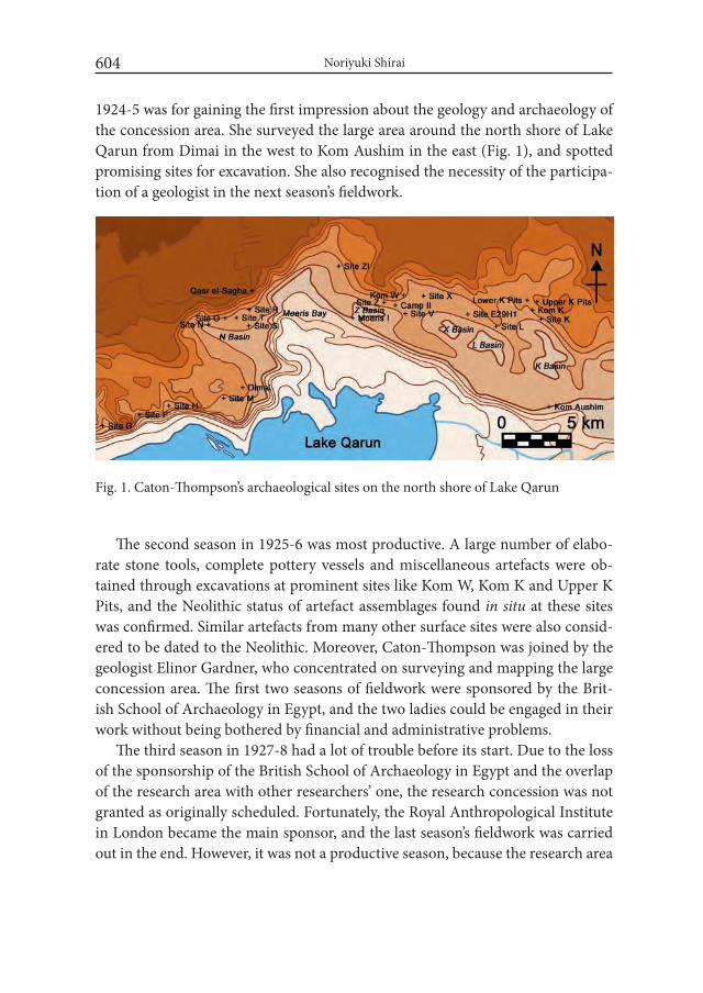
Noriyuki Shirai604
1924-5 was for gaining the first impression about the geology and archaeology of the concession area. She surveyed the large area around the north shore of Lake Qarun from Dimai in the west to Kom Aushim in the east (Fig. 1), and spotted promising sites for excavation. She also recognised the necessity of the participa-tion of a geologist in the next season’s fieldwork.
The second season in 1925-6 was most productive. A large number of elabo-rate stone tools, complete pottery vessels and miscellaneous artefacts were ob-tained through excavations at prominent sites like Kom W, Kom K and Upper K Pits, and the Neolithic status of artefact assemblages found in situ at these sites was confirmed. Similar artefacts from many other surface sites were also consid-ered to be dated to the Neolithic. Moreover, Caton-Thompson was joined by the geologist Elinor Gardner, who concentrated on surveying and mapping the large concession area. The first two seasons of fieldwork were sponsored by the Brit-ish School of Archaeology in Egypt, and the two ladies could be engaged in their work without being bothered by financial and administrative problems.
The third season in 1927-8 had a lot of trouble before its start. Due to the loss of the sponsorship of the British School of Archaeology in Egypt and the overlap of the research area with other researchers’ one, the research concession was not granted as originally scheduled. Fortunately, the Royal Anthropological Institute in London became the main sponsor, and the last season’s fieldwork was carried out in the end. However, it was not a productive season, because the research area
Fig. 1. Caton-Thompson’s archaeological sites on the north shore of Lake Qarun
605
was restricted and the fieldwork period was shortened. The planned participa-tion of Dorothy Garrod for studying Middle Palaeolithic artefacts was cancelled. In this situation, Caton-Thompson and Gardner have worked not only within the restricted concession area but also outside of it. Much time was spent work-ing at post-Neolithic sites, and the knowledge about the human life and mate-rial culture of the Predynastic, Old Kingdom, Ptolemaic and Roman periods was augmented.
2. Division and distribution of Caton-Thompson’s Fayum findsAt the end of the second and third seasons, her finds were transported to Cairo
for the official division at the Department of Antiquities of Egypt, and only small portions of her finds were left in the Egyptian Museum in Cairo. The rest of her finds were given to her and shipped to the United Kingdom. Upon arrival in Lon-don, her finds were divided further into small portions and distributed to many institutions in the United Kingdom and abroad as the reward for their financial support. When The Desert Fayum was out in 1934, the distribution had already been completed, and Caton-Thompson published a list of the finds distribution (Caton-Thompson and Gardner 1934: xiv). According to this list, her Fayum finds were finally distributed to 31 institutions in nine countries including Australia, Canada, Egypt, France, Ireland, Japan, the Netherlands, the United Kingdom and the United States, but no information about exactly how many and which finds were distributed to which institutions was provided. Unless the institutions which received her Fayum finds publish the accession list or any other data, there is no means to know which finds are there (Shirai 2011a).
I studied the portions of her finds which are presently stored in the Petrie Mu-seum of Egyptian Archaeology, the British Museum, and the UCL Institute of Ar-chaeology. These institutions have online catalogues of their collections, and these catalogues are the first clue to knowing which finds are stored there. However, these catalogues are incomplete and not informative, and it was not until I studied their collections that the whole picture of Caton-Thompson’s Fayum finds became clearer.
3. Caton-Thompson’s Fayum lithic collections in LondonThe Petrie Museum has the largest portion of Caton-Thompson’s Fayum finds,
and there are 1580 accessioned objects including approximately 1400 lithic arte-facts but debitage products are few. More than half of all accessioned objects are
New Light on The Desert Fayum: Restudying Gertrude Caton-Thompson’s Fayum...

Noriyuki Shirai606
from the 1925-6 season. At present, 63 Neolithic stone tools from Kom W, Kom K, Upper K Pits and some surface sites, and three Predynastic stone tools are on display in a showcase in the main gallery of the museum. All other artefacts ex-cept Neolithic pottery vessels and sherds displayed in the pottery gallery can be seen not only in the showcase of the main gallery but also in the glass-covered drawers under the showcase (Fig. 2). As far as I checked, the photographs and/or illustrations of 331 stone tools including 50 Epipalaeolithic ones, 266 Neolithic ones, 10 Predynastic ones and five Old Kingdom ones in the Petrie Museum were published in The Desert Fayum.
Caton-Thompson’s Fayum finds in the British Museum are not many, and the total number of artefacts is 80. All of the artefacts are from the 1925-6 season only and were accessioned in 1927. There are 58 stone tools including two Epipalaeo-lithic ones, 55 Neolithic ones and one Old Kingdom one. There are also pottery vessels, a basket, a complete wooden sickle with flint blades, wooden sticks for uncertain use, bone points, and a fragment of woven linen. As far as I checked, the illustrations and/or photographs of 37 artefacts (including 22 stone tools) out of the 80 artefacts were published in The Desert Fayum, and some of them have
Fig. 2. Drawer containing lithic artefacts from Kom W in the Petrie Museum. Photograph taken by the author by courtesy of the Petrie Museum of Egyptian Archaeology, UCL
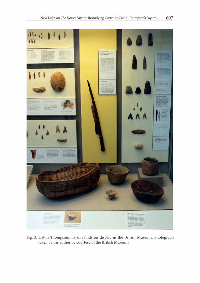
New Light on The Desert Fayum: Restudying Gertrude Caton-Thompson’s Fayum... 607
Fig. 3. Caton-Thompson’s Fayum finds on display in the British Museum. Photograph taken by the author by courtesy of the British Museum

Noriyuki Shirai608
were mentioned with the accession numbers given by the museum in the mono-graph. About one third of all artefacts representing the Fayum Neolithic culture have been on display in the Early Egypt gallery of the museum and well known to the general public as well as academics. In 2014, this gallery was completely refurbished, and the number of Caton-Thompson’s Fayum finds on display was reduced to 21 including 15 stone tools, a complete wooden sickle with flint blades, a basket, and five pottery vessels, all of which are Neolithic (Fig. 3).
Caton-Thompson’s Fayum finds in the UCL Institute of Archaeology have not been known even to academics because of their accession history and state of stor-age in the Institute. It is a portion which was originally given to the Wellcome His-torical Medical Museum in London, as simply indicated as ‘Wellcome Historical’ in Caton-Thompson’s distribution list. Its founder Henry Wellcome was a pharmaceu-tical entrepreneur and a keen collector of medical artefacts as well as archaeological and ethnological artefacts. After his death in 1936, his collection in this museum was divided and distributed, and part of his archaeological collection including Caton-Thompson’s Fayum finds came to the Institute (Russell 1986). For unknown reasons, only half of all artefacts were accessioned when they arrived at the Insti-tute in 1955, but the rest of artefacts have been left unaccessioned until I started to study them in 2014. The total number of accessioned artefacts is 250, and 247 are lithic artefacts including many formal tools as well as some cores. However, 52 lithic artefacts which are all described as arrowheads in the accession list made in 1955 could not be found in the storage of the Institute during my stay in London. At pres-ent, there are 192 tools including 73 Epipalaeolithic ones, 96 Neolithic ones, 22 Old Kingdom ones, and one Middle Kingdom one. None of them is on display in the In-stitute. More than half of all accessioned artefacts are from the 1927-8 season. As far as I checked, the photographs of nine Neolithic stone tools and four Old Kingdom stone tools in the Institute were published in The Desert Fayum.
As mentioned above, Predynastic and Old Kingdom stone tools are not many in the three institutions in London. Caton-Thompson has sometimes found Pre-dynastic and Old Kingdom stone tools at Neolithic surface sites and wrongly published some of those tools as of the Neolithic. Apart from the wrong ones, she recognised what Predynastic and Old Kingdom stone tools looked like, and published the Predynastic and Old Kingdom stone tool assemblages from par-ticular sites like Qasr Qarun and Kom IV in Plates LIII, LIV, LV, LVI, LVII, LXVII, LXVIII, LXIX, LXXIX, LXXX, LXXXI and LXXXII of The Desert Fayum. Howev-er, none of the Predynastic stone tools and few Old Kingdom stone tools in these plates were found stored in the three institutions in London.
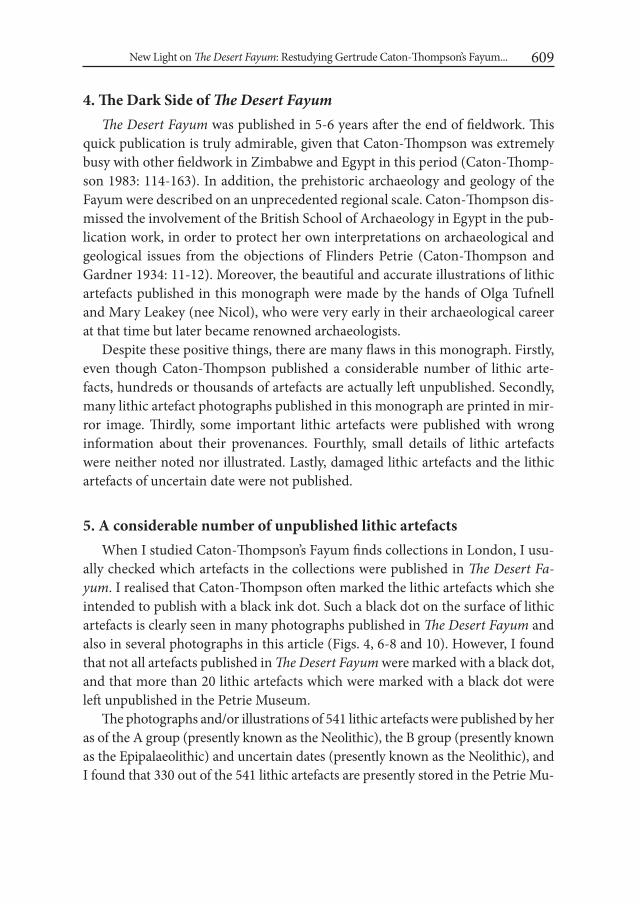
New Light on The Desert Fayum: Restudying Gertrude Caton-Thompson’s Fayum... 609
4. The Dark Side of The Desert FayumThe Desert Fayum was published in 5-6 years after the end of fieldwork. This
quick publication is truly admirable, given that Caton-Thompson was extremely busy with other fieldwork in Zimbabwe and Egypt in this period (Caton-Thomp-son 1983: 114-163). In addition, the prehistoric archaeology and geology of the Fayum were described on an unprecedented regional scale. Caton-Thompson dis-missed the involvement of the British School of Archaeology in Egypt in the pub-lication work, in order to protect her own interpretations on archaeological and geological issues from the objections of Flinders Petrie (Caton-Thompson and Gardner 1934: 11-12). Moreover, the beautiful and accurate illustrations of lithic artefacts published in this monograph were made by the hands of Olga Tufnell and Mary Leakey (nee Nicol), who were very early in their archaeological career at that time but later became renowned archaeologists.
Despite these positive things, there are many flaws in this monograph. Firstly, even though Caton-Thompson published a considerable number of lithic arte-facts, hundreds or thousands of artefacts are actually left unpublished. Secondly, many lithic artefact photographs published in this monograph are printed in mir-ror image. Thirdly, some important lithic artefacts were published with wrong information about their provenances. Fourthly, small details of lithic artefacts were neither noted nor illustrated. Lastly, damaged lithic artefacts and the lithic artefacts of uncertain date were not published.
5. A considerable number of unpublished lithic artefactsWhen I studied Caton-Thompson’s Fayum finds collections in London, I usu-
ally checked which artefacts in the collections were published in The Desert Fa-yum. I realised that Caton-Thompson often marked the lithic artefacts which she intended to publish with a black ink dot. Such a black dot on the surface of lithic artefacts is clearly seen in many photographs published in The Desert Fayum and also in several photographs in this article (Figs. 4, 6-8 and 10). However, I found that not all artefacts published in The Desert Fayum were marked with a black dot, and that more than 20 lithic artefacts which were marked with a black dot were left unpublished in the Petrie Museum.
The photographs and/or illustrations of 541 lithic artefacts were published by her as of the A group (presently known as the Neolithic), the B group (presently known as the Epipalaeolithic) and uncertain dates (presently known as the Neolithic), and I found that 330 out of the 541 lithic artefacts are presently stored in the Petrie Mu-

Noriyuki Shirai610
seum. This means that her publication relied heavily on the Petrie Museum collec-tion and that she published only one quarter of her Fayum finds stored there. A con-siderable number of lithic artefacts are left unpublished even in the Petrie Museum alone. There is little doubt that countless numbers of valuable lithic artefacts remain untouched and unrecognised in other museums and institutions around the world.
6. Lithic artefact photographs printed in mirror imageIt is obvious to the readers of The Desert Fayum that many lithic artefact photo-
graphs like Plate XXXV-2, 3, 7, 21 and 22, Plate XXXVI-8 and 14, Plate XXXVIII-8, Plate XL-4 and 9, Plate XLI-6, 11, 17 and 19, and Plate XLV-1 are printed in mirror image, because ink inscriptions on the artefact surface are mirror images (Fig. 4). However, as I compared real artefacts in my hand with their photographs in the
Fig. 4. Gouges from Site T (bottom left: UC3699) and Site N (bottom right: UC3620) with Plate XXXV-2 and 3 (top: © 1934 The Royal Anthropological Institute). Photograph taken by the author by courtesy of the Petrie Museum of Egyptian Archaeology, UCL
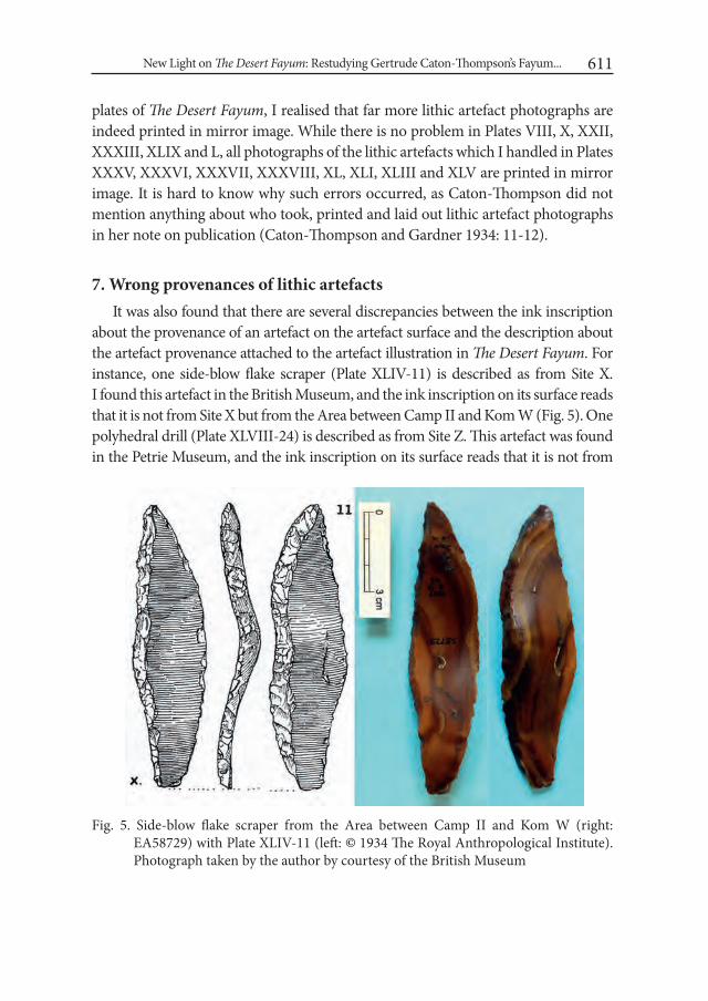
New Light on The Desert Fayum: Restudying Gertrude Caton-Thompson’s Fayum... 611
plates of The Desert Fayum, I realised that far more lithic artefact photographs are indeed printed in mirror image. While there is no problem in Plates VIII, X, XXII, XXXIII, XLIX and L, all photographs of the lithic artefacts which I handled in Plates XXXV, XXXVI, XXXVII, XXXVIII, XL, XLI, XLIII and XLV are printed in mirror image. It is hard to know why such errors occurred, as Caton-Thompson did not mention anything about who took, printed and laid out lithic artefact photographs in her note on publication (Caton-Thompson and Gardner 1934: 11-12).
7. Wrong provenances of lithic artefactsIt was also found that there are several discrepancies between the ink inscription
about the provenance of an artefact on the artefact surface and the description about the artefact provenance attached to the artefact illustration in The Desert Fayum. For instance, one side-blow flake scraper (Plate XLIV-11) is described as from Site X. I found this artefact in the British Museum, and the ink inscription on its surface reads that it is not from Site X but from the Area between Camp II and Kom W (Fig. 5). One polyhedral drill (Plate XLVIII-24) is described as from Site Z. This artefact was found in the Petrie Museum, and the ink inscription on its surface reads that it is not from
Fig. 5. Side-blow flake scraper from the Area between Camp II and Kom W (right: EA58729) with Plate XLIV-11 (left: © 1934 The Royal Anthropological Institute). Photograph taken by the author by courtesy of the British Museum
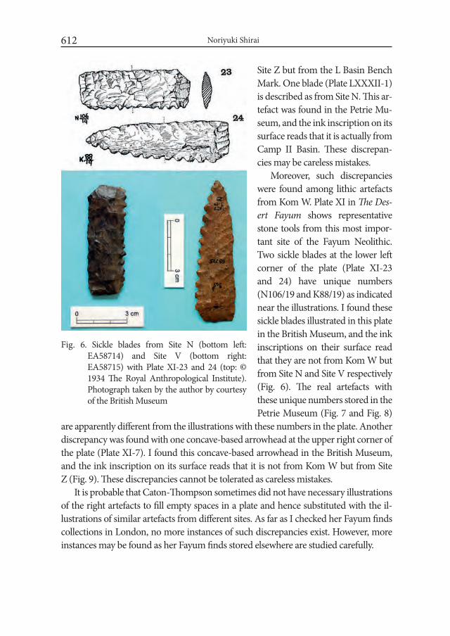
Noriyuki Shirai612
Site Z but from the L Basin Bench Mark. One blade (Plate LXXXII-1) is described as from Site N. This ar-tefact was found in the Petrie Mu-seum, and the ink inscription on its surface reads that it is actually from Camp II Basin. These discrepan-cies may be careless mistakes.
Moreover, such discrepancies were found among lithic artefacts from Kom W. Plate XI in The Des-ert Fayum shows representative stone tools from this most impor-tant site of the Fayum Neolithic. Two sickle blades at the lower left corner of the plate (Plate XI-23 and 24) have unique numbers (N106/19 and K88/19) as indicated near the illustrations. I found these sickle blades illustrated in this plate in the British Museum, and the ink inscriptions on their surface read that they are not from Kom W but from Site N and Site V respectively (Fig. 6). The real artefacts with these unique numbers stored in the Petrie Museum (Fig. 7 and Fig. 8)
are apparently different from the illustrations with these numbers in the plate. Another discrepancy was found with one concave-based arrowhead at the upper right corner of the plate (Plate XI-7). I found this concave-based arrowhead in the British Museum, and the ink inscription on its surface reads that it is not from Kom W but from Site Z (Fig. 9). These discrepancies cannot be tolerated as careless mistakes.
It is probable that Caton-Thompson sometimes did not have necessary illustrations of the right artefacts to fill empty spaces in a plate and hence substituted with the il-lustrations of similar artefacts from different sites. As far as I checked her Fayum finds collections in London, no more instances of such discrepancies exist. However, more instances may be found as her Fayum finds stored elsewhere are studied carefully.
Fig. 6. Sickle blades from Site N (bottom left: EA58714) and Site V (bottom right: EA58715) with Plate XI-23 and 24 (top: © 1934 The Royal Anthropological Institute). Photograph taken by the author by courtesy of the British Museum

New Light on The Desert Fayum: Restudying Gertrude Caton-Thompson’s Fayum... 613
Fig. 8. Sickle blade from Kom W (UC2724, K88/19). Photograph taken by the author by courtesy of the Petrie Mu-seum of Egyptian Archaeology, UCL
8. Small details of lithic artefacts missed by Caton-ThompsonIt is important to study small details of lithic artefacts, which Caton-Thomp-
son did not mention in her monograph. For instance, she described that various Neolithic flint tools in the Fayum such as axes, knife blades and spearheads were made by thorough bifacial flaking, but she did not describe the raw materials of those tools very well. It was noted through my study on hundreds of examples that one or both faces of those bifacially flaked tools often retain patinated patches which are cut by flake scars (Fig. 8). This means that toolmakers did not always use fresh flakes which were just knapped from flint cobbles but picked up naturally
Fig. 7. Sickle blade from Kom W (UC2595, N106/19). Photograph taken by the author by courtesy of the Petrie Mu-seum of Egyptian Archaeology, UCL
Fig. 9. Concave-based arrowhead from Site Z (right: EA58733) with Plate XI-7 (left: © 1934 The Royal Anthropological In-stitute). Photograph taken by the author by courtesy of the British Museum
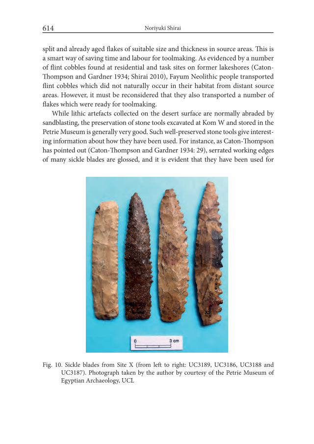
Noriyuki Shirai614
split and already aged flakes of suitable size and thickness in source areas. This is a smart way of saving time and labour for toolmaking. As evidenced by a number of flint cobbles found at residential and task sites on former lakeshores (Caton-Thompson and Gardner 1934; Shirai 2010), Fayum Neolithic people transported flint cobbles which did not naturally occur in their habitat from distant source areas. However, it must be reconsidered that they also transported a number of flakes which were ready for toolmaking.
While lithic artefacts collected on the desert surface are normally abraded by sandblasting, the preservation of stone tools excavated at Kom W and stored in the Petrie Museum is generally very good. Such well-preserved stone tools give interest-ing information about how they have been used. For instance, as Caton-Thompson has pointed out (Caton-Thompson and Gardner 1934: 29), serrated working edges of many sickle blades are glossed, and it is evident that they have been used for
Fig. 10. Sickle blades from Site X (from left to right: UC3189, UC3186, UC3188 and UC3187). Photograph taken by the author by courtesy of the Petrie Museum of Egyptian Archaeology, UCL

New Light on The Desert Fayum: Restudying Gertrude Caton-Thompson’s Fayum... 615
Fig. 11. Damaged axes from Kom W (from left to right: UC2820, UC2667 and UC2634). Photograph taken by the author by courtesy of the Petrie Museum of Egyptian Archaeology, UCL
cutting siliceous cereal culms. When looking at the working edges more carefully, I noted on several pointed sickle blades that the teeth on the tapered part of the blades are still sharp and not glossed while the teeth on the straight part of the blades are heavily worn and glossed (Fig. 8). This means that the tapered part of the blades has not frequently contacted cereal culms being cut and was not functional. In the case of rectangular sickle blades, the serrated working edges of the entire stretch of straight blades are equally worn and glossed. Caton-Thompson has point-ed out that the majority of sickle blades in the Fayum Neolithic were in the pointed form, but has not commented on the functional difference between the two forms (Caton-Thompson and Gardner 1934: 21). A question is why the majority of sickle blades were made pointed in spite of no functional merit in that form.
In relation to this question, another variation in sickle blades needs to be con-sidered. As Caton-Thompson has mentioned in her description of this tool class, great variation is seen in the fineness/coarseness of working edge serration (Fig. 10). Another question is whether such variation reflects different functions or dif-ferent ages. As it has not been made clear whether coarsely serrated sickle blades and finely serrated sickle blades had co-existed at the same time at any sites in the Fayum, a seriation study is important for understanding the development of sickle blades and discussing functional and non-functional aspects of the varia-tion in body form and working edge serration.

Noriyuki Shirai616
9. Negligence of the lithic artefacts of little aesthetic value and uncertain date
Caton-Thompson collected 75 axes at Kom W (Caton-Thompson and Gard-ner 1934: 25) and published 29 axes out of them with photographs and illustra-tions in Plates VIII and IX of The Desert Fayum. Most of the published axes are intact and good-looking examples. However, I realised through the study of all axes from Kom W which are stored in the Petrie Museum that half of all axes are badly damaged and that several examples have traces of repair and recycling (Fig. 11). From an aesthetic point of view, it is understandable that Caton-Thompson did not publish the damaged axes, but it is significant to focus on the unpublished axes in order to gain information about how these tools have been used. Many dam-aged axes suggest that there was a great need of tree cutting around Kom W.
Caton-Thompson collected 230 small arrowheads at a surface site named Camp II and more at nearby surface sites like Site V and Site Z (Caton-Thompson and Gardner 1934: 75-79), but she was not sure about their date, and published only 10% of them as of uncertain date in Plate LI of The Desert Fayum. Among the unpublished arrowheads, the most notable ones are Ounan points. It seems that she did not know the importance of these arrowheads, as more than 10 ex-
amples of these arrowheads are left untouched in the Petrie Museum (Fig. 12). Ounan point is a typical arrowhead in North Africa in the Early Holocene, but its existence in the Fayum has long been unknown and has recently been confirmed by my fieldwork (Shirai 2012). Caton-Thompson’s unpublished finds recon-firmed the existence of Ounan points in the Fayum Epipalaeolithic.
As for other undated small arrowheads made by unifacial or bifacial flaking, I have argued elsewhere that they are similar to the arrowheads of the Pottery Neolithic culture in the southern Levant, which are called Haparsa point (winged and tanged arrowhead), Nizza-nim point (shouldered and tanged arrowhead) and Herzliya point (lens-shaped arrowhead)
Fig. 12. Ounan points from Camp II (from left to right: UC3436, UC3435 and UC3438). Pho-tograph taken by the author by courtesy of the Petrie Museum of Egyptian Ar-chaeology, UCL
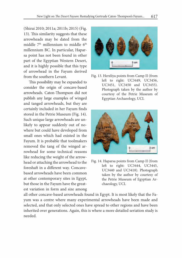
New Light on The Desert Fayum: Restudying Gertrude Caton-Thompson’s Fayum... 617
Fig. 13. Herzliya points from Camp II (from left to right: UC3449, UC3456, UC3451, UC3450 and UC3455). Photograph taken by the author by courtesy of the Petrie Museum of Egyptian Archaeology, UCL
(Shirai 2010; 2011a; 2011b; 2015) (Fig. 13). This similarity suggests that these arrowheads may be dated from the middle 7th millennium to middle 6th millennium BC. In particular, Hapar-sa point has not been found in other part of the Egyptian Western Desert, and it is highly possible that this type of arrowhead in the Fayum derived from the southern Levant.
This possibility may be expanded to consider the origin of concave-based arrowheads. Caton-Thompson did not publish any large examples of winged and tanged arrowheads, but they are certainly included in her Fayum finds stored in the Petrie Museum (Fig. 14). Such unique large arrowheads are un-likely to appear suddenly out of no-where but could have developed from small ones which had existed in the Fayum. It is probable that toolmakers removed the tang of the winged ar-rowhead for some technical reasons like reducing the weight of the arrow-head or attaching the arrowhead to the foreshaft in a different way. Concave-based arrowheads have been common at other contemporary sites in Egypt, but those in the Fayum have the great-est variation in form and size among all other concave-based arrowheads found in Egypt. It is most likely that the Fa-yum was a centre where many experimental arrowheads have been made and selected, and that only selected ones have spread to other regions and have been inherited over generations. Again, this is where a more detailed seriation study is needed.
Fig. 14. Haparsa points from Camp II (from left to right: UC3444, UC3445, UC3440 and UC3418). Photograph taken by the author by courtesy of the Petrie Museum of Egyptian Ar-chaeology, UCL
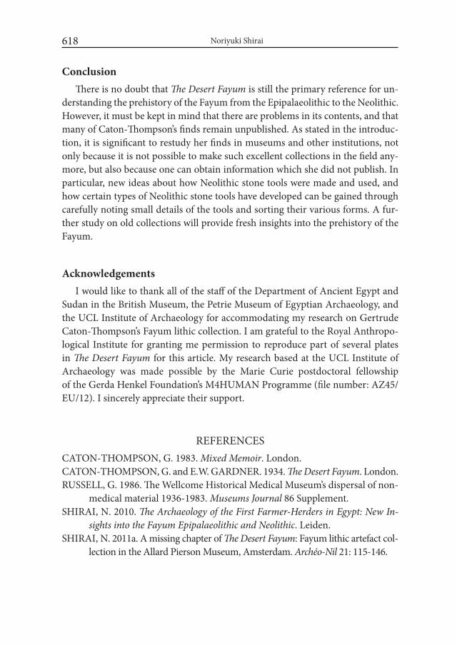
Noriyuki Shirai618
ConclusionThere is no doubt that The Desert Fayum is still the primary reference for un-
derstanding the prehistory of the Fayum from the Epipalaeolithic to the Neolithic. However, it must be kept in mind that there are problems in its contents, and that many of Caton-Thompson’s finds remain unpublished. As stated in the introduc-tion, it is significant to restudy her finds in museums and other institutions, not only because it is not possible to make such excellent collections in the field any-more, but also because one can obtain information which she did not publish. In particular, new ideas about how Neolithic stone tools were made and used, and how certain types of Neolithic stone tools have developed can be gained through carefully noting small details of the tools and sorting their various forms. A fur-ther study on old collections will provide fresh insights into the prehistory of the Fayum.
Acknowledgements I would like to thank all of the staff of the Department of Ancient Egypt and
Sudan in the British Museum, the Petrie Museum of Egyptian Archaeology, and the UCL Institute of Archaeology for accommodating my research on Gertrude Caton-Thompson’s Fayum lithic collection. I am grateful to the Royal Anthropo-logical Institute for granting me permission to reproduce part of several plates in The Desert Fayum for this article. My research based at the UCL Institute of Archaeology was made possible by the Marie Curie postdoctoral fellowship of the Gerda Henkel Foundation’s M4HUMAN Programme (file number: AZ45/EU/12). I sincerely appreciate their support.
REFERENCESCATON-THOMPSON, G. 1983. Mixed Memoir. London. CATON-THOMPSON, G. and E.W. GARDNER. 1934. The Desert Fayum. London. RUSSELL, G. 1986. The Wellcome Historical Medical Museum’s dispersal of non-
medical material 1936-1983. Museums Journal 86 Supplement.SHIRAI, N. 2010. The Archaeology of the First Farmer-Herders in Egypt: New in-
sights into the Fayum Epipalaeolithic and Neolithic. Leiden. SHIRAI, N. 2011a. A missing chapter of The Desert Fayum: Fayum lithic artefact col-
lection in the Allard Pierson Museum, Amsterdam. Archéo-Nil 21: 115-146.
New Light on The Desert Fayum: Restudying Gertrude Caton-Thompson’s Fayum... 619
SHIRAI, N. 2011b. Did the diffusion of Levantine Helwan points to north-east-ern Africa really take place? A study on side-notched and tanged projectile points in north-eastern Africa. In: E. Healey, S. Campbell and O. Maeda (eds.), The State of the Stone: Terminologies, Continuities and Contexts in Near Eastern Lithics: 171-183. Berlin. ex oriente.
SHIRAI, N. 2012. The Fayum Epipalaeolithic in the light of new discoveries. In: J. Kabaciński, M. Chłodnicki and M. Kobusiewicz (eds.), Prehistory of Northeastern Africa. New ideas and Discoveries (=Studies in African Archaeology 11): 225-254. Poznań.
SHIRAI, N. 2015. Filling the gap between the Fayum Epipalaeolithic and Neo-lithic. In: J. Kabaciński, M. Chłodnicki and M. Kobusiewicz (eds.), Hunt-er-Gatherers and Early Food Producing Societies in Northeastern Africa (=Studies in African Archaeology 14): 221-238. Poznań.

Desert and the Nile. Prehistory of the Nile Basin and the Sahara.
Papers in honour of Fred Wendorf Studies in African Archaeology 15
Poznań Archaeological Museum 2018
Friederike Jesse and Mirosław Masojć
Early to Mid–Holocene Pottery from Two Sites in the Bayuda Desert, Sudan
IntroductionThe Bayuda desert is the subject of an interdisciplinary research project of
Gdańsk Archaeological Museum (MAG) intended to recognize the history of settle-ment in this desert area from the earliest periods of prehistory to modern times, including its geological structure in the context of palaeogeography. The research work in the Bayuda was initiated in 2009. The concession covers an area of ca. 140,000 km excluding all sites situated in the Nile Valley and at its edges (Paner and Pudło 2010).
So far nearly a thousand archaeological sites have been discovered and doc-umented, including several dozen early to middle Holocene sites (for a gener-al commentary on the excavated sites see Masojć and Paner 2014). This article discusses the pottery material from two early to middle Holocene sites from the western part of the Bayuda desert (Fig. 1): BP133 and BP424. The sites are situated at a distance of ca. 60 km from each other in very different geological contexts. The site situated closer to the Nile – BP133, is located in the area of volcanic cul-minations (Basement Complex), while site BP424 is located within sedimentary deposits (Cretaceous Nubian Sandstone Formation). In both sites a small area was excavated.

Friederike Jesse and Mirosław Masojć622
1. Site BP133The site is situated in the western part of the Bayuda desert (N18° 21.818’ E31°
59.520’), ca. 20 km to the east of the locality of Karima, within the extensive massif of Jebel Naser (Fig. 1) which is of volcanic origins (Palaeozoic and Mesozoic igne-ous complexes and dyke swarms areas). Occupying an area exceeding 100 square kilometres, the massif is situated between two big wadis running along a SE–NW axis: Wadi Abu Dom in the north and Wadi Korai in the south. The site is located in the massif ’s western part, within a small basin surrounded by culminations largely shielding the site. In the west the basin adjoins a small, nameless wadi originating in the volcanic massif, running towards the south and joining Wadi Korai further away at a distance of 8 km from the site.
The remains of three residential objects were excavated in the basin’s central part. These are areas of oval outlines devoid of rock material (obviously cleared of the volcanic rocks occurring in large amounts at the site), with an occasional
Fig. 1. North-eastern Africa with the Bayuda desert in Sudan. On the right: B – location of sites BP133 and BP424 in the western part of the Bayuda with big volcanic mas-sifs east of the sites and hundreds of small volcanic structures south of the sites; C – view of the site BP133 from the south (white ellipse) (photo: M. Masojć)

Early to Mid–Holocene Pottery from Two Sites in the Bayuda Desert, Sudan 623
stone casing and a considerable accumulation of artefacts in their interiors. The excavation comprised one of such a residential object with a surface area of 15 m2 (Fig. 2).
Within the excavated area – the interior of such a residential object – a great number of artefacts were recorded. Apart from animal bones (Tab. 1)1 and pot-tery, over 2000 knapped stone products were found (including nearly 300 cores and 78 tools).2 The predominant raw materials are volcanic rocks, quartzite and flint. The stone material indicates a constant presence of microlithic tools and the presence of segments and backed bladelets among the microliths (Fig. 3: 1–5). Microlithic cores for bladelets are also present. These are mainly single platform cores with a prepared flaking platform in form of one or two side blows (Fig. 3: 6–8). The stone artefacts were relatively evenly distributed within the excavated area, without forming any bigger concentrations (Fig. 4).
1 The archaeozoological analysis was carried out by Dr Marta Osypińska, Polish Academy of Sciences, Poznań Branch.
2 A detailed analysis of the lithic material of sites BP 133 and BP 424 is still ongoing.
Fig. 2. Site BP133 during the excavation (photo: M. Masojć)

Friederike Jesse and Mirosław Masojć624
Fig. 3. Site BP133. Chosen stone artefacts: 1-5 – microliths; 6-8 – cores (drawing: by M. Masojć)
Table 1. Composition of the bone remains at site BP133: LSM / LSR– large size mammal / large size ruminant; MSM / MSR – middle size mammals / middle size ruminants. (data after Marta Osypińska)
TAXA nLSM 17MSM/MSR 5Ostrich eggshell 1Unidentified mammals 7TOTAL 30
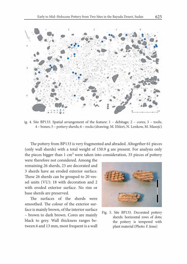
Early to Mid–Holocene Pottery from Two Sites in the Bayuda Desert, Sudan 625
The pottery from BP133 is very fragmented and abraded. Altogether 61 pieces (only wall sherds) with a total weight of 150.9 g are present. For analysis only the pieces bigger than 1 cm² were taken into consideration, 35 pieces of pottery were therefore not considered. Among the remaining 26 sherds, 23 are decorated and 3 sherds have an eroded exterior surface. These 26 sherds can be grouped to 20 ves-sel units (VU): 18 with decoration and 2 with eroded exterior surface. No rim or base sherds are preserved.
The surfaces of the sherds were smoothed. The colour of the exterior sur-face is mainly brown, of the interior surface – brown to dark brown. Cores are mainly black to grey. Wall thickness ranges be-tween 6 and 13 mm, most frequent is a wall
ig. 4. Site BP133. Spatial arrangement of the feature: 1 – debitage; 2 – cores; 3 – tools; 4 – bones; 5 – pottery sherds; 6 – rocks (drawing: M. Ehlert, N. Lenkow, M. Masojć)
Fig. 5. Site BP133. Decorated pottery sherds: horizontal rows of dots; the pottery is tempered with plant material (Photo: F. Jesse)

Friederike Jesse and Mirosław Masojć626
thickness of 9–10 mm. In two cases coiling technique is clearly recognizable as a mode of production.
The pottery is mainly tempered with rounded to angular quartz grains, only seldom exceeding 1 mm in size, sometimes mica was also added. Two vessel units show organic temper (Fig. 5), in one case only plant material was added as a temper-ing agent, in the second case a mixture of quartz and plant temper was used. All of the decoration was made by impression. Rocker stamping using a comb is the preferred technique and closely packed dotted zigzags (12 VU) or horizontal rows of dots (5 VU) are the most common decorative patterns (Fig. 6). The sherds might have been used as tools: in one case a later modification is probably present – a worked (rounded) edge (Fig. 6, right sherd).
The pottery from the site BP133 fits in the early to middle Holocene, the so–called Mesolithic/Neolithic period.
2. Site BP424The site is situated in the western part of the Bayuda desert (N17° 52.943’ E32°
08.014’), ca. 65 km to the south–east of the Nile valley, within the large Wadi Abu Rugheiwa running along a SE–NW axis and ca. 1 km to the north of a well (bir) of the same name (Fig. 1). In this part the Bayuda is formed of Palaeozoic and Meso-zoic sedimentary rocks. The site is situated at the foot of a small sandstone culmina-tion in the centre of the wadi and surrounded by Quaternary sediments (Fig. 7).
Seven square metres of the site were excavated (Fig. 8), where – apart from pottery and animal bones (Tab. 2) – over 6000 stone artefacts were found, in-cluding over 700 cores and 150 tools. Among the tools the dominant microlith’s
Fig. 6. Site BP133. Decorated pottery sherds: packed dotted zigzag; to the right: sherd with a probably intentionally rounded edge (photo: F. Jesse)
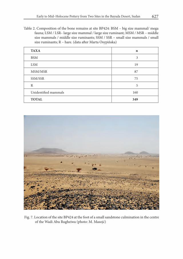
Early to Mid–Holocene Pottery from Two Sites in the Bayuda Desert, Sudan 627
Fig. 7. Location of the site BP424 at the foot of a small sandstone culmination in the centre of the Wadi Abu Rugheiwa (photo: M. Masojć)
Table 2. Composition of the bone remains at site BP424: BSM – big size mammal/ mega fauna; LSM / LSR– large size mammal / large size ruminant; MSM / MSR – middle size mammals / middle size ruminants; SSM / SSR – small size mammals / small size ruminants; R – hare. (data after Marta Osypińska)
TAXA n
BSM 3
LSM 19
MSM/MSR 87
SSM/SSR 75
R 5
Unidentified mammals 160
TOTAL 349
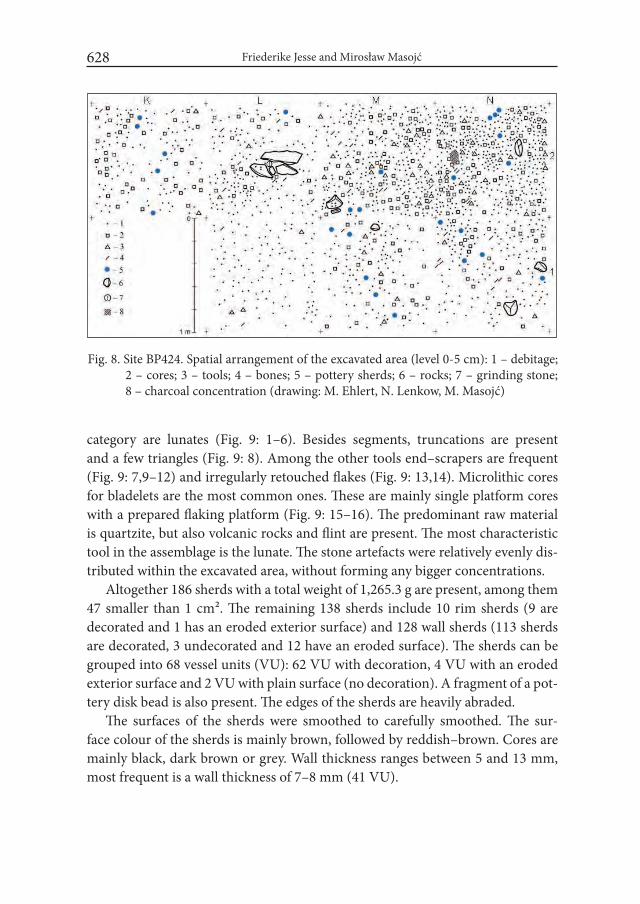
Friederike Jesse and Mirosław Masojć628
Fig. 8. Site BP424. Spatial arrangement of the excavated area (level 0-5 cm): 1 – debitage; 2 – cores; 3 – tools; 4 – bones; 5 – pottery sherds; 6 – rocks; 7 – grinding stone; 8 – charcoal concentration (drawing: M. Ehlert, N. Lenkow, M. Masojć)
category are lunates (Fig. 9: 1–6). Besides segments, truncations are present and a few triangles (Fig. 9: 8). Among the other tools end–scrapers are frequent (Fig. 9: 7,9–12) and irregularly retouched flakes (Fig. 9: 13,14). Microlithic cores for bladelets are the most common ones. These are mainly single platform cores with a prepared flaking platform (Fig. 9: 15–16). The predominant raw material is quartzite, but also volcanic rocks and flint are present. The most characteristic tool in the assemblage is the lunate. The stone artefacts were relatively evenly dis-tributed within the excavated area, without forming any bigger concentrations.
Altogether 186 sherds with a total weight of 1,265.3 g are present, among them 47 smaller than 1 cm². The remaining 138 sherds include 10 rim sherds (9 are decorated and 1 has an eroded exterior surface) and 128 wall sherds (113 sherds are decorated, 3 undecorated and 12 have an eroded surface). The sherds can be grouped into 68 vessel units (VU): 62 VU with decoration, 4 VU with an eroded exterior surface and 2 VU with plain surface (no decoration). A fragment of a pot-tery disk bead is also present. The edges of the sherds are heavily abraded.
The surfaces of the sherds were smoothed to carefully smoothed. The sur-face colour of the sherds is mainly brown, followed by reddish–brown. Cores are mainly black, dark brown or grey. Wall thickness ranges between 5 and 13 mm, most frequent is a wall thickness of 7–8 mm (41 VU).

Early to Mid–Holocene Pottery from Two Sites in the Bayuda Desert, Sudan 629
Fig. 9. Site BP424. Chosen chipped stone artefacts: 1-6 – segments; 8 – truncation; 7, 9-12 – end-scrapers; 13-14 – retouched flakes; 15-16 – cores (drawings: M. Ehlert)

Friederike Jesse and Mirosław Masojć630
The pottery is tempered with rounded and angular quartz grains seldom ex-ceeding 1 mm in size, or quartz and mica. The addition of mica sometimes gave the sherds a lustrous appearance. Five VU show organic temper: four times a mix-ture of plant material and quartz was used as a tempering agent, in one case only plant material was added.
Coiling technique is recognizable as a mode of production. The rim forms are simply rounded, but due to the predominantly rather small size of the rim sherds the reconstruction of the rim diameter was only possible in one case. Here a rim diameter of 24 cm could be identified. The recognizable vessel forms are all closed ones.
All of the decoration was made by impression. Only in one case a decoration of the rim lip was observed: shallow notches made by simple impression. A dis-crete decoration of the rim zone was recorded on 5 VU. The decorative patterns
Fig. 10. Site BP424. Decorated pottery sherd: the rim is decorated with a band of simple impressions (probably fingernail), the wall is decorated with horizontal rows of dots (photo: F. Jesse)
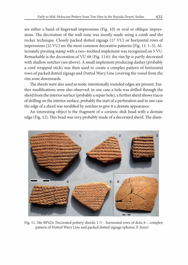
Early to Mid–Holocene Pottery from Two Sites in the Bayuda Desert, Sudan 631
are either a band of fingernail impressions (Fig. 10) or oval or oblique impres-sions. The decoration of the wall zone was mostly made using a comb and the rocker technique. Closely packed dotted zigzags (17 VU) or horizontal rows of impressions (22 VU) are the most common decorative patterns (Fig. 11: 1–5). Al-ternately pivoting stamp with a two–toothed implement was recognized on 5 VU. Remarkable is the decoration of VU 68 (Fig. 11:6): the rim lip is partly decorated with shallow notches (see above). A small implement producing dashes (probably a cord wrapped stick) was then used to create a complex pattern of horizontal rows of packed dotted zigzags and Dotted Wavy Line covering the vessel from the rim zone downwards.
The sherds were also used as tools: intentionally rounded edges are present. Fur-ther modifications were also observed: in one case a hole was drilled through the sherd from the interior surface (probably a repair hole), a further sherd shows traces of drilling on the interior surface, probably the start of a perforation and in one case the edge of a sherd was modified by notches to give it a dentate appearance.
An interesting object is the fragment of a ceramic disk bead with a dentate edge (Fig. 12). This bead was very probably made of a decorated sherd. The diam-
Fig. 11. Site BP424. Decorated pottery sherds: 1-5 – horizontal rows of dots; 6 – complex pattern of Dotted Wavy Line and packed dotted zigzags (photos: F. Jesse)
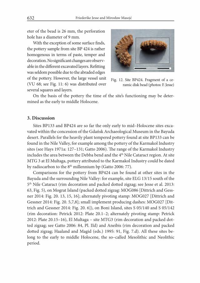
Friederike Jesse and Mirosław Masojć632
eter of the bead is 26 mm, the perforation hole has a diameter of 9 mm.
With the exception of some surface finds, the pottery sample from site BP 424 is rather homogenous in terms of paste, temper and decoration. No significant changes are observ-able in the different excavated layers. Refitting was seldom possible due to the abraded edges of the pottery. However, the large vessel unit (VU 68; see Fig. 11: 6) was distributed over several squares and layers.
On the basis of the pottery the time of the site’s functioning may be deter-mined as the early to middle Holocene.
3. DiscussionSites BP133 and BP424 are so far the only early to mid–Holocene sites exca-
vated within the concession of the Gdańsk Archaeological Museum in the Bayuda desert. Parallels for the heavily plant tempered pottery found at site BP133 can be found in the Nile Valley, for example among the pottery of the Karmakol Industry sites (see Hays 1971a: 127–131; Gatto 2006). The range of the Karmakol Industry includes the area between the Debba bend and the 4th Nile Cataract region. At site MTG 3 at El Multaga, pottery attributed to the Karmakol Industry could be dated by radiocarbon to the 8th millennium bp (Gatto 2006: 77).
Comparisons for the pottery from BP424 can be found at other sites in the Bayuda and the surrounding Nile Valley: for example, site ELG 13/15 south of the 5th Nile Cataract (rim decoration and packed dotted zigzag; see Jesse et al. 2013: 63, Fig. 5), on Mograt Island (packed dotted zigzag: MOG086 [Dittrich and Gess-ner 2014: Fig. 20. 13, 15, 16]; alternately pivoting stamp: MOG027 [Dittrich and Gessner 2014: Fig. 20. 5,7,8]; small implement producing dashes: MOG027 [Dit-trich and Gessner 2014: Fig. 20. 6]), on Boni Island, sites S 05/140 and S 05/142 (rim decoration: Petrick 2012: Plate 20.1–2; alternately pivoting stamp: Petrick 2012: Plate 20.15–16), El Multaga – site MTG3 (rim decoration and packed dot-ted zigzag; see Gatto 2006: 84, Pl. IId) and Aneibis (rim decoration and packed dotted zigzag; Haaland and Magid (eds.) 1995: 91, Fig. 7.d). All these sites be-long to the early to middle Holocene, the so–called Mesolithic and Neolithic period.
Fig. 12. Site BP424. Fragment of a ce-ramic disk bead (photos: F. Jesse)
Early to Mid–Holocene Pottery from Two Sites in the Bayuda Desert, Sudan 633
Early to mid–Holocene settlement in the Bayuda desert has not been exten-sively researched. Apart from the work carried out at the two sites discussed here, excavations were conducted only within Wadi Muqaddam in the 1990s, resulting from the construction of a road from Khartoum to the Nile valley in the area of Ganetti (Fuller and Smith 2004). “Artefactual evidence from sites 115.1 and 61.3 assessed to date, comprising ceramics and ground stone implements, pro-vided a general dating for the associated paleoenvironmental evidence within the period of the ‘Khartoum Mesolithic’ (...). Apparent stylistic similarities, most striking in the ceramics, further indicate links between the sites in or near the Wadi Muqaddam and areas to the north and south within the Nile Valley itself and, potentially, much further west into Saharan regions like the Wadi Howar.” (Fuller and Smith 2004: 275). Also the pottery of sites BP133 and BP424 find parallels in the near and also broader regional context. Of great interest regarding supra–regional contacts is the large vessel unit (VU 68) found at site BP424 (see Fig. 11:6): The complex pattern of Dotted Wavy Line and packed dotted zigzags reminds from a stylistic point of view the arrangement of (Dotted) Wavy Line in the Khartoum Variant (see Gatto 2002: 77, Fig. 5.10), in the Nabta–Kiseiba Area (see Gatto 2002: 69–74) and in the Atbara region (see Gatto 2002: 75, Fig. 5.8). The idea of a “Khartoum–Horizon Style” to account for broad similarities over a large area while still taking into account regional stylistic variations has already been proposed in the 1970s (Hays 1971b). To further elucidate the role of the Bayuda desert within such a larger “Khartoum–Horizon–Style” network and especially its role as a possible intermediary between central Sudan and north-ern Nubia (see also Gatto 2006: 77) further excavations and surveys will certainly contribute.
REFERENCESDITTRICH, A. and K. GESSNER. 2014. Early Holocene landscapes on Mograt
Island (Sudan) – perspectives and first results of the Late Prehistoric Survey 2014. Der Antike Sudan. Mitteilungen der Sudanarchäologischen Gesell-schaft 25: 127–144.
FULLER, D. Q. and L. SMITH. 2004. The Prehistory of the Bayuda: New Evidence from the Wadi Muqaddam. In: T. Kendall (ed.), Nubian Studies 1998, Pro-ceedings of the Ninth Conference of the international Society of Nubian Stud-ies August 21–26, 1998, Boston, Mass.: 265–281. Boston.

Friederike Jesse and Mirosław Masojć634
GATTO, M. C. 2002. Early Neolithic Pottery of the Nabta–Kiseiba Area: Stylistic Attributes and Regional Relationships. In: K. Nelson (ed.), Holocene Settle-ment of the Egyptian Sahara. The Pottery of Nabta Playa vol.2: 65–78. New York.
GATTO, M. C. 2006. The most ancient pottery from the Dongola Reach (North-ern Sudan): New data from the SFDAS survey related to the construction of the Merowe Dam. Archéologie du Nil Moyen 10: 73–86.
HAALAND, R. and A. A. MAGID (eds.). 1995. Aqualithic sites along the Rivers Nile and Atbara, Sudan. Bergen.
HAYS, T. R. 1971a. The Karmakol Industry: Part of the “Khartoum Horizon–Style”. In: J. L. Shiner et al. (eds.), The Prehistory and Geology of Northern Sudan. Part 1. Report to the National Science Foundation: 84–153.
HAYS, T. R. 1971b. The Sudanese Neolithic: A critical analysis. Ph.D. thesis Southern Methodist University. Dallas.
JESSE, F., FIEDLER, M. and B. GABRIEL. 2013. A land of thousand tumuli – an archaeological survey in the region of El Gol, south of the 5th Nile Cataract, North Sudan. Der Antike Sudan. Mitteilungen der Sudanarchäologischen Gesellschaft 24: 59–73.
MASOJĆ, M. and H. PANER. 2014. The Bayuda Project (BP). The Palaeolithic and Neolithic Age in the Light of Current Research (2009–2011). Gdańsk Archaeological Museum African Reports 11: 89–100.
PANER, H. and A. PUDŁO. 2010. The Bayuda Project. First Season – 2009. Gdańsk Archaeological Museum African Reports 7: 117–129.
PETRICK, B. 2012. The Cologne Fourth Cataract project 2005 field season on Boni Island. In: H.–P. Wotzka (ed.), Proceedings of Third international Con-ference on the Archaeology of the Fourth Nile Cataract. University of Cologne, 13–14 July 2006. Africa Praehistorica 22: 117–128. Köln.
Desert and the Nile. Prehistory of the Nile Basin and the Sahara.
Papers in honour of Fred Wendorf Studies in African Archaeology 15
Poznań Archaeological Museum 2018
Alain Anselin
Archaeology of the Images and the Words of the An-cient Egyptian World: from Pools of Gone Saharan Cultures to Current Sociological Parallels
Short introduction to the archaeology of Northeastern African cultures in the context of climatic and demographic co-evolution
The Eastern Sahara (the Western Desert of Egypt and the Nubian Western Desert notably) was populated during the Holocene Humid Phase, between 9000 and 5000 BC (Riemer et al. 2013: 159).
After 7000 BC, the bumpy decrease of the Humid Phase provided the time-span context for the emergence of cattle African lifeway from hunting-gathering worlds. In the midst of the sixth millennium BC, “retreating monsoonal rains caused the onset of desiccation of the Egyptian Sahara” (Kuper and Kröpelin 2006: 806, fig. 3, c-d), “impacted a dramatic depopulation of most territories in the Egyptian western Desert” and a lesser dropout in the now Nubian Western Desert because of the lower recoil of the summer rain belts to the south (Riemer et al. 2013). First half of the fourth millennia BC, in henceforth “full desert conditions all over Egypt”, the populations left the Western Egyptian Desert for the Nile Valley – a move coinciding “with the initial stages of pharaonic civilization” on its banks (Fig. 1). And later still, for a Sudanese today fossil hydrographic network, a hub to a wide hinterland stretching towards the past Mega-Chad zone and the present Omo river region (Kuper and Kröpelin 2006).
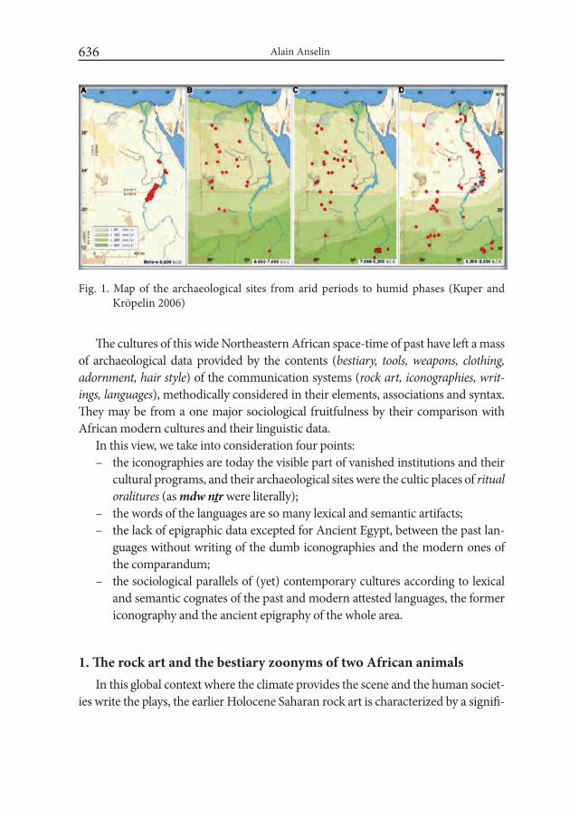
Alain Anselin636
The cultures of this wide Northeastern African space-time of past have left a mass of archaeological data provided by the contents (bestiary, tools, weapons, clothing, adornment, hair style) of the communication systems (rock art, iconographies, writ-ings, languages), methodically considered in their elements, associations and syntax. They may be from a one major sociological fruitfulness by their comparison with African modern cultures and their linguistic data.
In this view, we take into consideration four points:– the iconographies are today the visible part of vanished institutions and their
cultural programs, and their archaeological sites were the cultic places of ritual oralitures (as mdw nṯr were literally);
– the words of the languages are so many lexical and semantic artifacts; – the lack of epigraphic data excepted for Ancient Egypt, between the past lan-
guages without writing of the dumb iconographies and the modern ones of the comparandum;
– the sociological parallels of (yet) contemporary cultures according to lexical and semantic cognates of the past and modern attested languages, the former iconography and the ancient epigraphy of the whole area.
1. The rock art and the bestiary zoonyms of two African animals In this global context where the climate provides the scene and the human societ-
ies write the plays, the earlier Holocene Saharan rock art is characterized by a signifi-
Fig. 1. Map of the archaeological sites from arid periods to humid phases (Kuper and Kröpelin 2006)
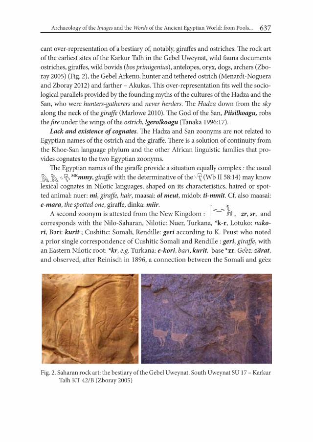
Archaeology of the images and the words of the Ancient Egyptian World: from Pools... 637
cant over-representation of a bestiary of, notably, giraffes and ostriches. The rock art of the earliest sites of the Karkur Talh in the Gebel Uweynat, wild fauna documents ostriches, giraffes, wild bovids (bos primigenius), antelopes, oryx, dogs, archers (Zbo-ray 2005) (Fig. 2), the Gebel Arkenu, hunter and tethered ostrich (Menardi-Noguera and Zboray 2012) and farther – Akukas. This over-representation fits well the socio-logical parallels provided by the founding myths of the cultures of the Hadza and the San, who were hunters-gatherers and never herders. The Hadza down from the sky along the neck of the giraffe (Marlowe 2010). The God of the San, Piisi!koagu, robs the fire under the wings of the ostrich, !gero!koagu (Tanaka 1996:17).
Lack and existence of cognates. The Hadza and San zoonyms are not related to Egyptian names of the ostrich and the giraffe. There is a solution of continuity from the Khoe-San language phylum and the other African linguistic families that pro-vides cognates to the two Egyptian zoonyms.
The Egyptian names of the giraffe provide a situation equally complex : the usual , MKmmy, giraffe with the determinative of the (Wb II 58:14) may know
lexical cognates in Nilotic languages, shaped on its characteristics, haired or spot-ted animal: nuer: mi, giraffe, hair, maasai: ol meut, midob: ti-mmit. Cf. also maasai: e-mara, the spotted one, giraffe, dinka: miir.
A second zoonym is attested from the New Kingdom : , zr, sr, and corresponds with the Nilo-Saharan, Nilotic: Nuer, Turkana, *k-r, Lotuko: nako-ri, Bari: kurit ; Cushitic: Somali, Rendille: geri according to K. Peust who noted a prior single correspondence of Cushitic Somali and Rendille : geri, giraffe, with an Eastern Nilotic root: *kr, e.g. Turkana: e-kori, bari, kurit, base *zr: Ge’ez: zärat, and observed, after Reinisch in 1896, a connection between the Somali and ge’ez
Fig. 2. Saharan rock art: the bestiary of the Gebel Uweynat. South Uweynat SU 17 – Karkur Talh KT 42/B (Zboray 2005)
Alain Anselin638
forms, and the Arabic zarafa(h) (with a suffix -f of unknown origin)– which re-places the original local form in Saho: zerraaf (Vergari and Vergari 2007).“The Semitic words appear to have been borrowed from a form such as *geri or *keri after it had been palatalized into something like *žeri or * šeri in the hypothetical African donor language.” (Peust 2008: 257-261). Phonetically suitable, if the source language is Cushitic: the Eastern Cushitic root *gir, to live, exist, is realized žira in Rendille (Takacs 2001: 267)1.
The Egyptian word for ostrich, , nἰw has lexical cognates in Berber languages: *nil, tamacheq, anil, a-nohil, a-nhêl, literally a-nɔhɔl, the stout and in Omotic, Dizi: noy (Beachy 2005). The Berber, Libyan Nefusi: asil, Sus and Mzab: asid, asil, share another root, *sid-, lacking in Egyptian, with the Nilotic language of Maasai: e-sidai, ostrich, where sidai means good (Payne and Ole-Ko-tikash 2008), that provides a perfect pair of semantic cognates with the Egyptian metaphoric concept of goodness carried by feather (see below).
From a god to another. Completed by the feminine marker -t, the hieroglyph H6 of the ostrich feather, names the feather itself, šwt (Gardiner 1988: 474) This ostrich feather, šw.t, is the attribute of , šw, the Air-god, and of the Goddess of the Truth, , Mɜct. The mao (Omotic) : šaw.i, šiw.i, wind, air, pro-vides the best cognate. The Berber languages give i-žuwu, for wind in Zenaga, ta-žawa.t, in Mzab, and ta-žežžwi.t, that names the fan in Ghat (Takacs 1999: 205).
The Arabic name, nacam, differs, and later, enters the Berber vocabularies (Zena-ga, Sus, Mzab: alnem, anneam), and the Sudanic (Ibiri). In Arabia, some toponyms of Hadramawt, wadi nacam (Ostrich River) and the Yemeni rock art attesting that the ostrich was in demand for its feathers, seem to be an extension of the Saharan African cultures. In addition, the food taboo which still affected the bird in a Surah of Quran may indicate a previous divine status (Potts 2001: 182-190).
The place in the social practices and in the culture. The bird and the mammal had a place in the Egyptian culture that differs from the last hunters-gatherers of Africa. But the Egyptian hunters, the nw.w, are often depicted in the same desert environment as the archers of Saharan rock art. The New shapes of their culture carry the Ancient ones, if it rules : since the Predynastic palettes, the nw.w are led by a royal leader, and from the Old Kingdom on, they are subordinated to the
1 The other Maasai word for giraffe, al-ɔsira, is a tantalizing cognate, but its meaning declines a property : al-ɔsira the doted, similar to e-mara, giraffe, the spotted one (Payne and Ole-Kotikash 2008).

Archaeology of the images and the words of the Ancient Egyptian World: from Pools... 639
pharaonic State by high officials, jmy-r nw.w n ḥm.f, director of the hunters of his Majesty, ḫrp nw.w, controller of the hunters. In a Middle Kingdom painting, the leader of the nw.w presents ostrich feathers to the jmy-r nw.w ḫɜs.wt (director of the hunters of the deserts) and his team brings ostrich eggs and feathers, roped up ostrich, hare, oryx (Gandonnière 2014). The key concepts of giraffe and ostrich were thereby re-arranged into new cultural uses in the cultivation and granary society of the Nile valley (see below).
2. From hunting to herding: artifacts, questions and sociological parallels
This earlier rock art iconography presents some elements of the materiality of first human-animal linkage, like weapons of hunting (clubs, spears, bows, ar-rows – and archers’ wrist-guards (Le Quellec 2011: 201-220), and binding artifacts (ropes, lasso, traps) linked to aurochs, antelopes, ostriches and giraffes (Zboray 2005: KT44; Houlihan 1986: 1-5; Osborn and Osbornova 1988: 148-150). It in-fers a particular ritualized relationship to the animals, perhaps documented by a Karkur Talh rock art site (Zboray 2005: KT61) engraving horny hunters likely identified to the game (bovines), and may result in a categorization of wild fauna into linguistic classes like among the Hadza (Blench 2013). The sociality of the rock art underlies the choice of the elements of the fauna elaborated into a besti-ary as well as the development of hunting practices into conservative attempts – possibly a man lassoing hartebeest on a rock drawing near Gebel Silsila docu-ments it (Osborn and Osbornova 1988: 171, 13-130). Such a panorama suggests that the development of herding did not mean the abandon of the hunting and gathering and their culture and values, but their mutualization. In this view, we can deduce from the presence or the lack of domesticated elements, and the asso-ciations, a period of dating – the archaeological horizons of the rock art associat-ing giraffes, ostriches, and humpless longhorn bovines in Karkur Talh sites (Zbo-ray 2005: KTN23) appear to be more recent than engraved scenes involving only giraffes and ostriches. In comparison with rituals still performed in contemporary caves, for eg., the masculine cult in a boomorphic fiber costume performed in the rock shelter of the painted mask of Ngombe by the Chewa, a farming sedentary society of Zambia (Smith 2014: 1448-1452), we can infer that the northeastern rock art sites were similar cultic places characterized by mutualized features of hunters-gatherers, herders, or/and farmers – and that the iconographies were pro-grams to be read, sung and/or danced, with a syntax, as an act of communication
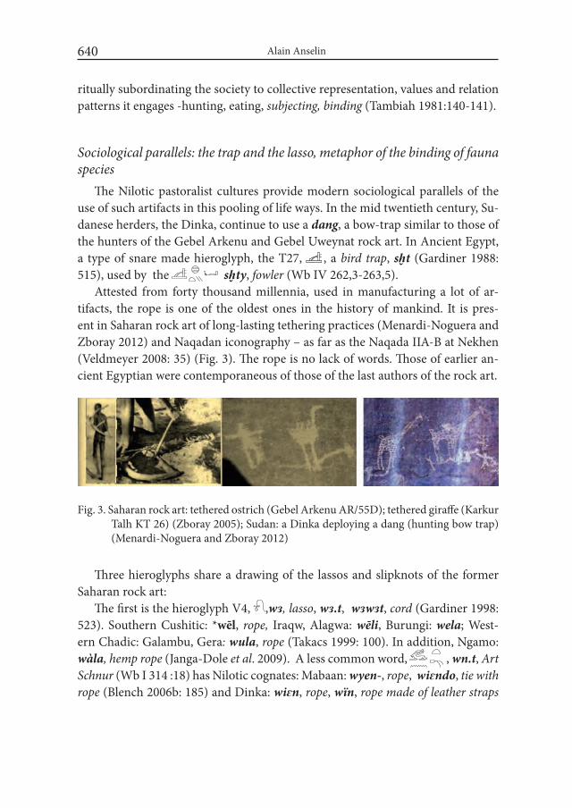
Alain Anselin640
ritually subordinating the society to collective representation, values and relation patterns it engages -hunting, eating, subjecting, binding (Tambiah 1981:140-141).
Sociological parallels: the trap and the lasso, metaphor of the binding of fauna species
The Nilotic pastoralist cultures provide modern sociological parallels of the use of such artifacts in this pooling of life ways. In the mid twentieth century, Su-danese herders, the Dinka, continue to use a dang, a bow-trap similar to those of the hunters of the Gebel Arkenu and Gebel Uweynat rock art. In Ancient Egypt, a type of snare made hieroglyph, the T27, , a bird trap, sḫt (Gardiner 1988: 515), used by the sḫty, fowler (Wb IV 262,3-263,5).
Attested from forty thousand millennia, used in manufacturing a lot of ar-tifacts, the rope is one of the oldest ones in the history of mankind. It is pres-ent in Saharan rock art of long-lasting tethering practices (Menardi-Noguera and Zboray 2012) and Naqadan iconography – as far as the Naqada IIA-B at Nekhen (Veldmeyer 2008: 35) (Fig. 3). The rope is no lack of words. Those of earlier an-cient Egyptian were contemporaneous of those of the last authors of the rock art.
Three hieroglyphs share a drawing of the lassos and slipknots of the former Saharan rock art:
The first is the hieroglyph V4, ,wɜ, lasso, wɜ.t, wɜwɜt, cord (Gardiner 1998: 523). Southern Cushitic: *wēl, rope, Iraqw, Alagwa: wēli, Burungi: wela; West-ern Chadic: Galambu, Gera: wula, rope (Takacs 1999: 100). In addition, Ngamo: wàla, hemp rope (Janga-Dole et al. 2009). A less common word, , wn.t, Art Schnur (Wb I 314 :18) has Nilotic cognates: Mabaan: wyen-, rope, wiɛndo, tie with rope (Blench 2006b: 185) and Dinka: wiɛn, rope, wïn, rope made of leather straps
Fig. 3. Saharan rock art: tethered ostrich (Gebel Arkenu AR/55D); tethered giraffe (Karkur Talh KT 26) (Zboray 2005); Sudan: a Dinka deploying a dang (hunting bow trap) (Menardi-Noguera and Zboray 2012)
Archaeology of the images and the words of the Ancient Egyptian World: from Pools... 641
used to tie down cattle; wiɛl, fiber, wire, giraffe tail (Blench 2006a: 184-185). In Ancient Egyptian, /l / is written ɜ or n : may wn.t be related with wɜ.t ?
The second sign for the cord, V12, , flax rope (Wb I 211,18-23), with pho-netic value, crḳ, carries the oath metaphor.
A third rope hieroglyph is related to the cattle binding, V16, , is OKzɜ, sɜ, looping cord serving as hobble for cattle (Gardiner 1988: 523). The word multiplies the cognates: Western Chadic: *zVr, Hausa: zaaraarà, long cord attached to the neck of animals, zaari, rope passed into the nose of groups of oxen, Bole-Tangale: *zōri, rope, Karekare, Ngamo: zòori, Gera: zùra (Takacs 1999: 178-179). In addi-tion: Ron-Fyer: Karfa: zir, Richa: zàr, and South Bauchi: *sVr, rope, Polchi: siyir, Buli: sir. Cushitic: Saho: soro, rope (to tie goods on animals). Gidole: sur, rope. The last not the least, the names of the back rope of the saddle, i-ž(w)iwr-en, in ayr (Berber), and the girdle, mizrana, in Syriac, derived from the same basic root.
In the same way many sites of the Gebel Uweynat gather engravings and paint-ings of giraffes, ostriches, cattle, the rope words tie both game and cattle in hiero-glyphic writing.
The semantic fields of the vocabularies of the rope point as well the earlier times of the giraffe hunting as those of the cattle binding, which suppose another intentions and food strategies. The rope of the rock art is less the representation of the instrumental bond used in the domestication than a pictorial metaphor that declines both two cognitive schemas, the subjugation one or force schema and the conjunction one or link schema, which will contribute to feed the discourse of power.
Then cattle came, by original ways African cattle were domesticated in the eastern Sahara during the Early Holo-
cene, and its African sheep and goats entered Africa slightly later and before crops were cultivated (Marshall and Hildebrand 2002; Wendorf and Schild 1998; 2002; 2004)2. So, a “distinctive African pathway toward food production” emerged, “where animals were domesticated before plants, herding populations became more mobile than their forager ancestors” (Marshall and Weissbrood, quoted by McDonald 2015: 274).
The interpretation of the current data may be nuanced by recent works updat-ing the field. At the earlier Holocene, the wadis deposits sedimented into gezi-rahs in the Egyptian Nile valley. In increasing aridification context of the east-ern Sahara (Kuper and Kröpelin 2006), the wadis opening out to the valley were
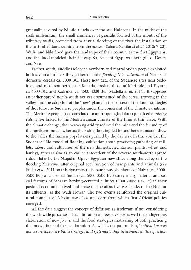
Alain Anselin642
gradually covered by Nilotic alluvia over the late Holocene. In the midst of the sixth millennium, the small eminences of gezirahs formed at the mouth of the tributary wadis, protected from annual flooding of the river the installation of the first inhabitants coming from the eastern Sahara (Ghilardi et al. 2012: 7-22). Wadis and Nile flood gave the landscape of their country to the first Egyptians, and the flood modeled their life way. So, Ancient Egypt was both gift of Desert and Nile.
Farther south, Middle Holocene northern and central Sudan people exploited both savannah millets they gathered, and a flooding Nile cultivation of Near East domestic cereals ca. 5000 BC. These new data of the Sudanese sites near Sede-inga, and most southern, near Kadada, predate those of Merimde and Fayum, ca. 4500 BC, and Kadruka, ca. 4500-4000 BC (Madella et al. 2014). It supposes an earlier spread north-south not yet documented of the cereal growing in the valley, and the adoption of the “new” plants in the context of the foods strategies of the Holocene Sudanese peoples under the constraint of the climate variations. The Merimde people (not correlated to anthropological data) practiced a raining cultivation linked to the Mediterranean climate of the time at this place. With the climatic change, the increasing aridity reduced the rains and the fecundity of the northern model, whereas the rising flooding fed by southern monsoon drew to the valley the human populations pushed by the dryness. In this context, the Sudanese Nile model of flooding cultivation (both practicing gathering of mil-lets, tubers and cultivation of the new domesticated Eastern plants, wheat and barley), appears also as an earlier antecedent of the reverse south-north spread ridden later by the Naqadan Upper-Egyptian new elites along the valley of the flooding Nile river after original acculturation of new plants and animals (see Fuller et al. 2011 on this dynamics). The same way, shepherds of Nubia (ca. 6000-3500 BC) and Central Sudan (ca. 5000-3500 BC) carry many material and so-cial features of Saharan herding-centered cultures (Usai 2005:103-115) in their pastoral economy arrived and arose on the attractive wet banks of the Nile, or its affluents, as the Wadi Howar. The two events reinforced the original cul-tural complex of African use of ox and corn from which first African polities emerged.
All the data suggest the concept of diffusion as irrelevant if not considering the worldwide processes of acculturation of new elements as well the endogenous elaboration of new forms, and the food strategies motivating of both practicing the innovation and the acculturation. As well as the pastoralism, “cultivation was not a rare discovery but a strategic and systematic shift in economies. The question
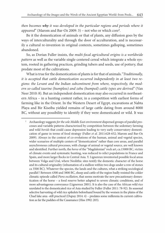
Archaeology of the images and the words of the Ancient Egyptian World: from Pools... 643
then becomes why it was developed in the particular regions and periods where it appeared” (Marom and Bar-Oz 2009: 3) – not who or which core2.
Be it the domestication of animals or that of plants, any diffusion goes by the ways of interculturality and through the door of acculturation, and is necessar-ily a cultural re-invention in original contexts, sometimes galloping, sometimes abandoned.
So, as Dorian Fuller insists, the multi-focal agricultural origins is a worldwide pattern as well as the variable single-centered cereal which integrate a whole sys-tem, rooted in gathering practices, grinding tubers and seeds, use of pottery, that predate most of the cultivations.
What is true for the domestication of plants is for that of animals.“Traditionally, it is accepted that cattle domestication occurred independently in at least two re-gions: the Levant and the indian subcontinent from where, respectively, the mod-ern so-called taurine (humpless) and zebu (humped) cattle types are derived” (Van Neer 2010: 8). But an independent domestication may also occurred in northeast-ern Africa – in a hunting context rather, in a competition with earliest forms of farming like in the Orient. In the Western Desert of Egypt, excavations at Nabta Playa and Bir Kiseiba yielded remains of large cattle dating from around 8000 BC, without any possibility to identify if they were domesticated or wild. It was
2 Archaeology suggests for the sole Middle East environment dispersed groups of parallel pro-cesses and variable patterns characterized by competition between the sedentary farming and wild bovids that could cause depression leading to very early conservatory domesti-cation of game in terms of food strategy (Fuller et al. 2011:628-652; Marom and Bar-Oz 2009). Always in the context of co-evolutions of the human, animal and vegetal species, wider scenarios of multiple centers of “domestication” rather than core areas, and parallel asynchronous cultural processes, with change of animal or vegetal source, are well known and identified. Further north, the horse of the “Magdalenian” rock art, ca.15000 BC, victim of climate events and systematic hunting, was reduced to relict populations in France and Spain, and more larger flocks in Central Asia. Y. Lignereux inventoried possible focal areas between Volga and Ural, where Neolithic sites testify the domestic character of the horse and its cultural originality (inhumation of a stallion within two dogs under a row of stones ca 3500 BC). Whatever the species, the lands and the cultures, what a striking sociological parallel ! Between 4300 and 3800 BC, sheep and cattle of the region badly resisted the colder climatic episode called Piora oscillation, that seems motivate the new precautionary domes-tication of the horse – a food reserve better adapted to severe climatic conditions, and of more advantageous conveyance (Lignereux 2001). It is also the case of the African wild rice unrelated to the domesticated rice of Asia studied by Fuller (Fuller 2011: 78-92). Its seasonal selective harvesting of wild rice spikelets beforehand bound by the women in the plains of the Chad lake area -still practiced (Dupuy 2014: 4) – predates some millennia its current cultiva-tion as far the paddies of the Casamance (Hiss 1992: 203).
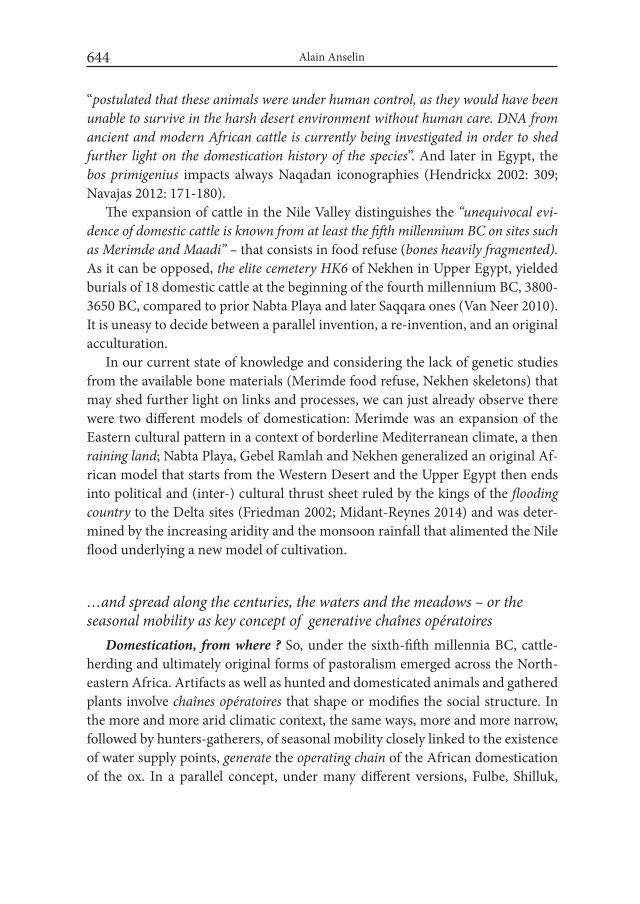
Alain Anselin644
“postulated that these animals were under human control, as they would have been unable to survive in the harsh desert environment without human care. DNA from ancient and modern African cattle is currently being investigated in order to shed further light on the domestication history of the species”. And later in Egypt, the bos primigenius impacts always Naqadan iconographies (Hendrickx 2002: 309; Navajas 2012: 171-180).
The expansion of cattle in the Nile Valley distinguishes the “unequivocal evi-dence of domestic cattle is known from at least the fifth millennium BC on sites such as Merimde and Maadi” – that consists in food refuse (bones heavily fragmented). As it can be opposed, the elite cemetery HK6 of Nekhen in Upper Egypt, yielded burials of 18 domestic cattle at the beginning of the fourth millennium BC, 3800-3650 BC, compared to prior Nabta Playa and later Saqqara ones (Van Neer 2010). It is uneasy to decide between a parallel invention, a re-invention, and an original acculturation.
In our current state of knowledge and considering the lack of genetic studies from the available bone materials (Merimde food refuse, Nekhen skeletons) that may shed further light on links and processes, we can just already observe there were two different models of domestication: Merimde was an expansion of the Eastern cultural pattern in a context of borderline Mediterranean climate, a then raining land; Nabta Playa, Gebel Ramlah and Nekhen generalized an original Af-rican model that starts from the Western Desert and the Upper Egypt then ends into political and (inter-) cultural thrust sheet ruled by the kings of the flooding country to the Delta sites (Friedman 2002; Midant-Reynes 2014) and was deter-mined by the increasing aridity and the monsoon rainfall that alimented the Nile flood underlying a new model of cultivation.
…and spread along the centuries, the waters and the meadows – or the seasonal mobility as key concept of generative chaînes opératoires
Domestication, from where ? So, under the sixth-fifth millennia BC, cattle-herding and ultimately original forms of pastoralism emerged across the North-eastern Africa. Artifacts as well as hunted and domesticated animals and gathered plants involve chaînes opératoires that shape or modifies the social structure. In the more and more arid climatic context, the same ways, more and more narrow, followed by hunters-gatherers, of seasonal mobility closely linked to the existence of water supply points, generate the operating chain of the African domestication of the ox. In a parallel concept, under many different versions, Fulbe, Shilluk,
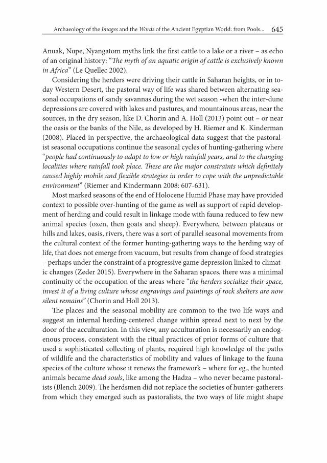
Archaeology of the images and the words of the Ancient Egyptian World: from Pools... 645
Anuak, Nupe, Nyangatom myths link the first cattle to a lake or a river – as echo of an original history: “The myth of an aquatic origin of cattle is exclusively known in Africa” (Le Quellec 2002).
Considering the herders were driving their cattle in Saharan heights, or in to-day Western Desert, the pastoral way of life was shared between alternating sea-sonal occupations of sandy savannas during the wet season -when the inter-dune depressions are covered with lakes and pastures, and mountainous areas, near the sources, in the dry season, like D. Chorin and A. Holl (2013) point out – or near the oasis or the banks of the Nile, as developed by H. Riemer and K. Kinderman (2008). Placed in perspective, the archaeological data suggest that the pastoral-ist seasonal occupations continue the seasonal cycles of hunting-gathering where “people had continuously to adapt to low or high rainfall years, and to the changing localities where rainfall took place. These are the major constraints which definitely caused highly mobile and flexible strategies in order to cope with the unpredictable environment” (Riemer and Kindermann 2008: 607-631).
Most marked seasons of the end of Holocene Humid Phase may have provided context to possible over-hunting of the game as well as support of rapid develop-ment of herding and could result in linkage mode with fauna reduced to few new animal species (oxen, then goats and sheep). Everywhere, between plateaus or hills and lakes, oasis, rivers, there was a sort of parallel seasonal movements from the cultural context of the former hunting-gathering ways to the herding way of life, that does not emerge from vacuum, but results from change of food strategies – perhaps under the constraint of a progressive game depression linked to climat-ic changes (Zeder 2015). Everywhere in the Saharan spaces, there was a minimal continuity of the occupation of the areas where “the herders socialize their space, invest it of a living culture whose engravings and paintings of rock shelters are now silent remains” (Chorin and Holl 2013).
The places and the seasonal mobility are common to the two life ways and suggest an internal herding-centered change within spread next to next by the door of the acculturation. In this view, any acculturation is necessarily an endog-enous process, consistent with the ritual practices of prior forms of culture that used a sophisticated collecting of plants, required high knowledge of the paths of wildlife and the characteristics of mobility and values of linkage to the fauna species of the culture whose it renews the framework – where for eg., the hunted animals became dead souls, like among the Hadza – who never became pastoral-ists (Blench 2009). The herdsmen did not replace the societies of hunter-gatherers from which they emerged such as pastoralists, the two ways of life might shape

Alain Anselin646
each other in a same temporality. Some rock art engravings show the presence of both animals of the earliest wild bestiary and domesticated cattle in the new way of life (Zboray 2005). Until the twentieth century, the sociological parallel points the mutualization of the life ways and cultural expressions: the Nilotic herders refer to the former bestiary, ostriches, when, like Dinka, they name wuut, the pawns of their manqala game, or to the new cattle when they identify “the game table to the enclosure of livestock, or its original river“ (Le Quellec 2002) – and, like the Nyangatom, call with a single name, ngiladoy, sg. lado, the animal tails (giraffe for men, cows for women), adorning the arms of the dancers (Tornay 2001: 350).
The seasonal mobility in the same life world appears to be the key of the genera-tive operating chain along which the herding arises – without eliminating artifacts and know-how of prior ways of life (ropes, baskets, ceramics, weapons). Once herding centered, the societies institute it into tradition, as a corpus of defined op-erating chains within its tools and skills henceforth more expressive of a transmit-table culture. That may explain that they printed their stamp on the same broader net of paths of a wider seasonal mobility, as suggested by a diachronic study of the rock art sites of the Wadi Takarkori in the Libyan Tadrart Akukas (di Lernia et al. 2015: 1-25) – and by similar data provided by the site of El Kab, where, ca. 8000-7000 BC, people fished on reed boats on the Nile, and gathered in the dunes at the time of the flood From the ninth to the fifth millennium BC, as S. di Lernia et al. (2015) show, the hunter-gatherers used the grindstones not only in milling the gathered seeds, but also to manufacture pigments with rock scrapers -from hematite, animal glue, egg -and at last, casein when herding came. They laid it on the rock faces of cultic shelters as well as bodies and their adornments in a sophis-ticated artwork prior to the renewing of the art of iconography by the pastoralists cultures from the cradle of the hunter-gatherers societies. Furthermore, both the hunting-gathering and herding life ways shaping a millenary context of step by step long-distance contacts favorable to pooling cultural paradigms and features, and the increasing aridity of the next millennia, may have foster the expansion of a regional model of seasonal mobile cattle-centered societies.
Domestication, how ? The Sahara of the end of the Humid period provides many rock art areas outlining the African meeting between the Ox and the Man. Paintings of iconographic social and cultural programs distinguishing the gender and associating oxen, cows, men and women in their dwelling, characterized the emergence of a new conceptual framework inferring a second type of human-ani-mal linkage, that of a narrow control of fauna, in an ox-centered relation not ruled
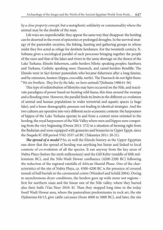
Archaeology of the images and the words of the Ancient Egyptian World: from Pools... 647
by a close property concept, but a metaphoric solidarity or commensality where the animal may be the double of the man.
Life ways are unpredictable: they appear the same way they disappear: the herding can be deserted in the event of epizooties or prolonged droughts. In the survival strat-egy of the pastoralist societies, the fishing, hunting and gathering groups in whose midst they live acted as refuge for destitute herdsmen. For the twentieth century, N. Sobiana gives a sociological parallel of such processes bringing together the people of the oxen and that of the lakes and rivers in the same shortage on the shores of the Lake Turkana: Elmolo fishermen, cattle-herders Nilotic speaking peoples: Samburu and Turkana, Cushitic speaking ones: Dasenech, and camel-herders Rendille. The Elmolo were in fact former pastoralists who became fishermen after a long famine, and by extension, hunters (hippo, crocodile, turtle). The Dasenech do not fight them: “we are brothers. They live by the lake, we have animals.”(Sobania 1988:41-56)
This type of redistribution of lifestyles may have occurred on the Nile, and reacti-vate paradigms of power based on hunting wild fauna, this time around the swamps and a flooding river. However, the parallel finds its limits in the different co-evolution of animal and human populations in wider terrestrial and aquatic spaces (a huge lake), and a lesser demographic pressure not leading to identical strategies. And the two cultures are operative into very different socio-economic contexts: the harpooners of hippos of the Lake Turkana operate in and from a context more oriented to the herding, the royal harpooners of the Nile Valley where men and hippos were compet-ing from the very beginning (Droux 2011: 372) in a situation of farming right from the Badarian and soon equipped with granaries and brasseries in Upper Egypt, since the Naqada IC-IIB period 3762-3537 cal BC (Takamiya 2011: 20-21).
The spread of a model ? So, as well the Elmolo history as the Upper-Egyptian one show that the spread of herding was anything but linear and linked to local contexts of co-evolution of all the species. It ran anyway from the key areas of Nabta Playa (before the sixth millennium) and the Gilf Kebir (middle of fifth mil-lennium BC), and the Nile-Wadi Howar confluence (4200-2200 BC) following the reduction of the regional rainfalls of African Humid Phase. One of the char-acteristics of the site of Nabta Playa, ca. 4500-4200 BC is the presence of covered tumuli of bull burials in the ceremonial centre (Wendorf and Schild 2004). Owing to asynchronous dryer conditions, the herders gave up wide more wet regions – first for northern oasis and the linear one of the Nile valley, where they buried also their bulls (Van Neer 2010: 8). Then they stopped long time in the today fossil Wadi Howar area, where the pastoralism predominates in rock art, the site Djabarona 84/13, give cattle carcasses (from 4000 to 3000 BC), and later, the site
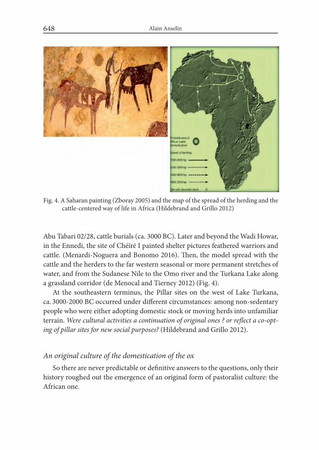
Alain Anselin648
Abu Tabari 02/28, cattle burials (ca. 3000 BC). Later and beyond the Wadi Howar, in the Ennedi, the site of Chéïré I painted shelter pictures feathered warriors and cattle. (Menardi-Noguera and Bonomo 2016). Then, the model spread with the cattle and the herders to the far western seasonal or more permanent stretches of water, and from the Sudanese Nile to the Omo river and the Turkana Lake along a grassland corridor (de Menocal and Tierney 2012) (Fig. 4).
At the southeastern terminus, the Pillar sites on the west of Lake Turkana, ca. 3000-2000 BC occurred under different circumstances: among non-sedentary people who were either adopting domestic stock or moving herds into unfamiliar terrain. were cultural activities a continuation of original ones ? or reflect a co-opt-ing of pillar sites for new social purposes? (Hildebrand and Grillo 2012).
An original culture of the domestication of the oxSo there are never predictable or definitive answers to the questions, only their
history roughed out the emergence of an original form of pastoralist culture: the African one.
Fig. 4. A Saharan painting (Zboray 2005) and the map of the spread of the herding and the cattle-centered way of life in Africa (Hildebrand and Grillo 2012)

Archaeology of the images and the words of the Ancient Egyptian World: from Pools... 649
Funerals. The Saharan Holocene was the crucible of a peculiar form of cattle domestication (di Lernia 2006; 2013). Archaeological materials and sociological parallels sketch original cultural frameworks -from the domesticated cow ritually buried in the Tumulus E-94-1N of the Late Neolithic Nabta Playa Ceremonial Complex in the mid of the sixth millennium BC to the funeral of the Sacred Bull of the Nigerian Fulbe which Hampate Ba witnessed in 1929 – passing by the do-mestic Longhorn Bull of the tomb 43 and the Cow of the tomb 36 of the Elite cem-etery HK6 at Nekhen (Naqada IC-IIA, in the first half of the fourth millennium, 3800-3650 BC), and, later, the burials of Apis at Saqqara (Van Neer 2010: 8). In contrast with earlier Merimde where domesticated bovines, attested only by food refuse, had no tomb.
Gods and myths. From its first Naqadan times, the Egyptian culture multiplied the zoomorphic deities, notably boomorphic ones, like Bɜt, prior to Hathor with her ears of cow, whose earlier name may have cognates in Afar and Oromo: bor-a, white faced animal (Takacs 2001b:14-15).
Divine figures like Apis, ḥcpy, the Bull of the Nile, or the Primordial Cow, ɜḫt, die Hathorkuh (Wb I 17:3-4), later known as Mḥt Wrt, litt. the Great Flood, may appear to be echoes of the mythical times of “an aquatic origin of cattle – exclusively known in Africa” like Fulbe or Nyangatom document it (Le Quellec 2002). (Fig. 5).
Artifacts. Ancient Egypt and the last today pastoralists cultures share many artifacts expressing a cognate sociality. The Nyangatom headrest, ekicolong, is the material double of his owner – the favourite ox is his living double (Tornay 2001:348). The artifact has counterparts in Ancient Egypt as well in contemporary African cultures (Beja, Oromo, Turkana, Luba, Zande, Dogon) (Fig. 6).
A cattle “hornstyle” -the dissymetric horns-, is common to rock art of Gebel Uweynat as of the Fifth Cataract (Abu Sideir, Sudan), Kerma (cemetery of Faras, Nubia), and Ancient Egypt (Old Kingdom bas-reliefs), and today Nilotic pastoral-ists who call it komar in Turkana (Otha 1989), kamar in Pokot (Crazzolara 1978). Cultures are dynamic. Omotic-speaker pastoralists who share the same cultural framework of shaping horns, the Hamar recently adopt the up-down one from their Nilotic neighbors (Honegger et al. 2009: 8). In the same way, the Mursi prac-tice a circular shaping of the horns of their oxen (Insoll et al. 2015: 99).
Evans-Pritchard gave a relevant explanation of the dissymmetric feature as ex-pression of a dualistic view of the world: the Nuer people always turned the left horn down, and the right up, representing what is good, right and up (Drzewiecki and Stępnik 2014: 115; Evans-Pritchard 1940 : 294-295). Like the ostrich feather among Maasai, Oromo, Pokot and other pastoralists (Fig. 7).
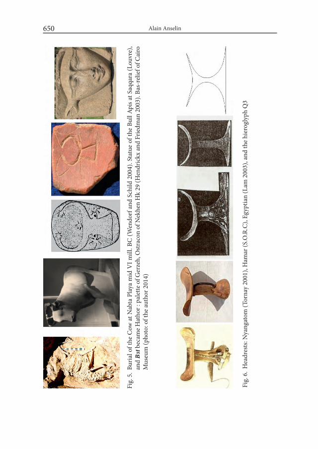
Alain Anselin650
Fig.
5. B
uria
l of t
he C
ow a
t Nab
ta P
laya
mid
VI m
ill. B
C (W
endo
rf a
nd S
child
200
4). S
tatu
e of
the
Bull
Apis
at S
aqqa
ra (L
ouvr
e),
and
Bɜt b
ecam
e Hat
hor :
pal
ette
of G
erze
h, O
stra
con
of N
ekhe
n H
k 29
(Hen
dric
kx a
nd F
riedm
an 2
003)
. Bas
-rel
ief o
f Cai
ro
Mus
eum
(pho
to: o
f the
auth
or 2
014)
Fig.
6. H
eadr
ests
: Nya
ngat
om (T
orna
y 20
01),
Ham
ar (S
.O.R
.C),
Egyp
tian
(Lam
200
3), a
nd th
e hi
erog
lyph
Q3
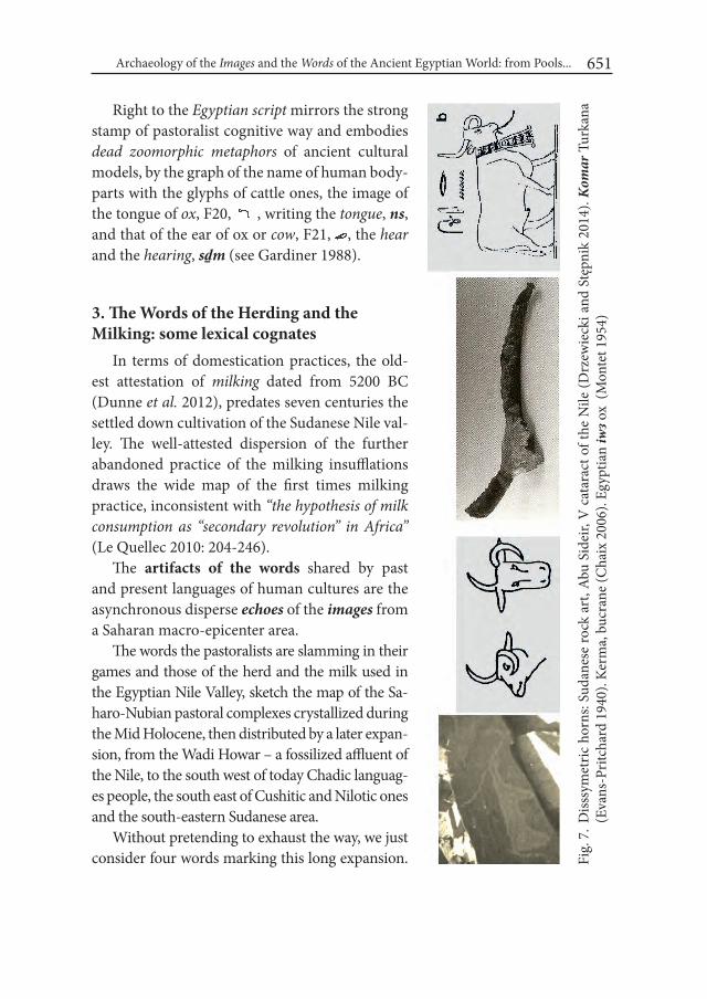
Archaeology of the images and the words of the Ancient Egyptian World: from Pools... 651
Right to the Egyptian script mirrors the strong stamp of pastoralist cognitive way and embodies dead zoomorphic metaphors of ancient cultural models, by the graph of the name of human body-parts with the glyphs of cattle ones, the image of the tongue of ox, F20, , writing the tongue, ns, and that of the ear of ox or cow, F21, , the hear and the hearing, sḏm (see Gardiner 1988).
3. The Words of the Herding and the Milking: some lexical cognates
In terms of domestication practices, the old-est attestation of milking dated from 5200 BC (Dunne et al. 2012), predates seven centuries the settled down cultivation of the Sudanese Nile val-ley. The well-attested dispersion of the further abandoned practice of the milking insufflations draws the wide map of the first times milking practice, inconsistent with “the hypothesis of milk consumption as “secondary revolution” in Africa” (Le Quellec 2010: 204-246).
The artifacts of the words shared by past and present languages of human cultures are the asynchronous disperse echoes of the images from a Saharan macro-epicenter area.
The words the pastoralists are slamming in their games and those of the herd and the milk used in the Egyptian Nile Valley, sketch the map of the Sa-haro-Nubian pastoral complexes crystallized during the Mid Holocene, then distributed by a later expan-sion, from the Wadi Howar – a fossilized affluent of the Nile, to the south west of today Chadic languag-es people, the south east of Cushitic and Nilotic ones and the south-eastern Sudanese area.
Without pretending to exhaust the way, we just consider four words marking this long expansion. Fi
g. 7
. Diss
sym
etric
hor
ns: S
udan
ese
rock
art
, Abu
Sid
eir,
V c
atar
act o
f the
Nile
(Drz
ewie
cki a
nd S
tępn
ik 2
014)
. Kom
ar T
urka
na
(Eva
ns-P
ritch
ard
1940
). Ke
rma,
buc
rane
(Cha
ix 2
006)
. Egy
ptia
n iw
ɜ ox
(Mon
tet 1
954)

Alain Anselin652
First two names of milk : Pyriɜ.t milk goddess (Wb I 26:16-17-27:1-4), OK jɜ.t.t, milk or cream (Wb I 27:1), Pyrjr.tj, milky (Wb I 116:6), XXIII jrj.t, milk-cow (Wb I 114:18), OK jr-č.t, milk (Wb I 117), irt, milk (WbI 117:1-6). Cushitic: *ore, cream; Nilo-Saharan: Teda : yọar, to milk, Daza: yɔɔr; milk, Didinga: iro, Nyima: elo; Teso: ak.ile, Maasai: k.ule (Takacs 1995: 123-131).
The determinative of the Egyptian word, mr, , of the milk jug (Gardiner 1988: 529), and the skin and vegetal containers (gourds, calabashes) of the iconog-raphy of the rock art of the Saharan dwellers stand comparison with the artifacts of last modern pastoralists (Fig. 8).
The hieroglyph W19 ` , is used to write the preposition: , mj (Wb II 36,9), whose graphical variants of the Old Kingdom document the phonetic commut-ability of the hoe U6, , and the jug W19,` : pyr , , mr (Wb I 36:9). The ety-mological study by G. Takacs sheds light on the comparandum: Egyptian: mr, milk jug, Chadic: Masa: miira, to milk, Gizey: mir, milk (Takacs 2008: 403). In addition: Cushitic: Proto-Sam: *māl, to milk, Somali: māl-ayya, to milk, māl, milk (Heine 1978). Nilotic: Dinka: miel, milk off (Blench 2006a: 115), Maasai: e-mala, milk container (Payne and Ole-Kotikash 2008).
Then, two of the many Egyptian words for the oxen, and their cognates in the basins of languages of their African hinterland. First, MK mr, bull (Wb II 106:8-109), mr wr, the great bull (Wb II 106:4), would seem very familiar to the speakers of Eastern Cushitic languages: *mor-a, ox, to these of Northern Omotic ones: mārā, young bull, Janjero: omora and Central Chadic ones: Matakam, Mafa: maray, bull sacrificed during the Taureau festival, Mofu-gudur: maray, fattened bull in the stable (see also Müller-Kosack 1999); and to another dead language like Egyptian is: the Akkadian: mīru, young bull (Takacs 2008: 392-394) as well the speakers of the Nilotic languages: Dinka: miɔr, bullock (Blench 2006a: 116).
Fig. 8. The Saharan rock art (Gebel Uweynat) (Zboray 2005). Milk jug of the Daseneč (Elfmann 2005), the Hamar (South Omo Research Center) and the Egyptian hi-eroglyph
Archaeology of the images and the words of the Ancient Egyptian World: from Pools... 653
The word travelled with the herds and the shepherds as far as the (Niger-Congo> Mande>) sooninke speaking country: mere, humpless bullock – continually used in this language after the later arrival of the Sanga during the mid second millen-nium BC in Africa.
At last, MK mnmn.t, herd, cattle (Wb II 81:18), a word linked with so-cial status and economic wealth as its semantic expansions shows, has lexical cognates in the same phyla: Northern Omotic: *mēn, buffalo, Male: meni, Zayso: meno, Gan-gule: mēno, Southern Omotic: Gimurra: men, Dizi, Seko: mīn; Eastern Nilotic: On-gamo, Maa: o-monyi ; Eastern Chadic: Mokilko: mâal, herd, Dangaleat: mallē, cattle; Cushitic: Agaw, Bilin: mal, cattle, Afar: māl, wealth; and on the southern shore of the Arabian peninsula, Mehri: mōl, livestock (Takacs 2008: 293-294).
4. How did the Egyptians see and name their neighbors?
Toponyms, ethnonyms, anthroponyms of the Old Kingdom ca 2500-2200 BC
The durable civilization of the grain and the granaries crystallized in the long linear oasis of the Nile, at the east of the last narrowing wet basins, bears a strong stamp of the original pastoralists cultures which came on the banks of the Nile from its Saharan hinterland and provided men, words, arts to Ancient Egypt. The country went in reverse the way of a history merged with that of the vast North-eastern Africa. With new cultural tools, including writing, ancient Egypt soon left the narratives of its contacts with its lifelong neighbors on the support of stone, bone, clay, leather and papyrus.
The Old Kingdom is contemporary with polities located in the Lower Nubia and the Wadi Howar-Nile confluence area. For instance, the biography of Weni gives the origins of the Egyptian army waging war against the Asiatics: Egyptians, Tehenou, Nubians (Sethe 1933: 101) and maps a past constellation of the peoples and their countries neighboring the Ancient Egypt (Fig. 9).
Their toponyms , wɜwɜt, , mḏɜ, , kɜɜw, , irṯt, , imɜ, are determined by the mountains hi-eroglyph and their OKEgyptian ethnonymic class, , nḥs.w, a feathered human plural, which characterize here both Cushitic and Nilotic-speaking peoples. The writing of the country of Berber-speaking people is characterized by the com-bination of the land sign N16, tɜ, and its abbreviated ethnonym, , ṯḥnw, glyphed with their typical throw stick T14 and the V13 of tethering rope.

Alain Anselin654
Toponyms and anthroponyms shape sets of languages as pointed by three few examples:
XII° wbɜspt may be a [mḏɜ] toponym: Beja: bur, land, safit, northern (El-Sayed 2011) Saho: buure, soil (Vergari and Vergari 2007).
VI° kɜɜw, with a channel determinative, may be a [mḏɜ] Cushitic place name: Agaw: kurā (El-Sayed 2011) and a [nḥsw] Nilo-Saharan one: Teda: karkur, wadi (Lecoeur 1955), Dinka: kuer, river (Blench 2006a; Anselin 2015b: 47-52; 2015a: 9-11).
V° wsɜ, w– šr, son of the ḥɜtj-c m ṯḥnw, a Libyan (Berber) anthroponym: wsr, wosor (El-Sayed 2011: 182).
Fig. 9. Feathered warriors and rulers: Tehenou ~Libyans, Nilotic pastoralists on Egyptian painting of New Kingdom and in the Upper Nile, XX century (Robbins 2010). Pre-dynastic Egyptians and Nehesou~Nubians (Sethe 1933), Nyangatom (Tornay 2001, from Musée de l’Homme)

Archaeology of the images and the words of the Ancient Egyptian World: from Pools... 655
After 2000 BC, the feathered warriors of Saharo-Nubian pastoralist popula-tions began to move down more and more to the southern areas. In terms of lexi-cal comparanda, it may be interesting to notice that the closely points of lexical reference for Nilo-Saharan and Cushitic languages are provided by the nearest neighbors the Teda and the Beja were and are always. The Beja are goat and camel herders, who name their country Atbai, a good land of wadi-centric topography, populated by perennial trees with wide umbrage and deep roots, notably the aca-cia tortilis. Their pastoralism is subject to the traditional silif law (pruning, ewak, the branches for the goats3) -a practice known in Egypt and elsewhere, as a paint-ing of a NKTheban tomb shows (Hendrickx et al. 2010:189-244), and the marginal cultivation of durra (sorghum) by the Islamic rule (Krzywinski and Pierce 2001: 28, 40, 52, 55, 57-58).
5. The feather as fossile directeur in pastoralist culturesThe Ancient Egyptians identified their neighbors, Nubians and Libyans, as
feathered peoples whose rulers wore two feathers. The same, they crowned with a pair of ostrich feathers few royal and divine figures, such as Hathor (Goebs 2008). They also share with other pastoral cultures the feather as a conceptual metaphor of rightness, justice, truth.
But, comparanda with nowadays Saharan societies of ancient pastoralists are uneasy because of cultural changes occurred during the two late millennia. Touareg and Tubu are no longer feathered. Most of the actors replaced the feather of justice and truth by the justice and the peace of holly books from later next Asian cultures – even if their cultures continue to convey past shapes and contents.
The , ṯḥnw wore ostrich feathers at a time when they had gods named cš or igɜy, long before Zenaga and Mzab call the bird alnem, anneam, from the Arabic – while the Touareg still use the older root, *nil (Heath 2006).
More easy is the parallel with the last pastoralist dynamic cultures who came down to the Omo river and Turkana Lake by the corridor of grasslands – now joined by all other more recent forms of human cultures in a clash way (see below the Pokot Tale) (Fig. 4).
3 Suggesting the motivation of the phytonym leggal mbaali, sheep tree in Fulfulde (Seydou 1998).

Alain Anselin656
In the Nilotic and Cushitic pastoralist cultures, the ostrich feather is closely linked to conceptual metaphors of the conjunctive socialization of cattle (headrest double, favou-rite ox, twisted horns), and its parallels artifacts of the words. So we’ll take the ostrich feather as the type fossil of a sociological comparandum (Fig. 9).
6. Contemporary sociological comparanda seen from the Egyptian culture
How did the Egyptians see the ostrich feathers and the giraffe, in their own culture? What do the texts say?
Present within the iconography of the palettes, ivories, combs, potteries from Naqada I to III, the ostrich and the giraffe soon disappear from the hieroglyphic repertoire (Regulski 2010), and appear again under Old Kingdom with the value of , Pyrniw, ostrich (Wb III 202:13) and Middle Kingdom with the value of MKmmy, giraffe (Wb II 56:14).
Some texts and data show the feature of the ostrich dancing with the sun shared by Nubians, Libyans and Egyptians : niw ḥr ibɜ m in.wt, the ostrich dances in the valleys, mi tm m iɜb.t pt, like Atoum to the east of the sky (Dautheville 1922: 225-229; Kuentz 1924: 86).
The site HK64 of Nekhen delivered a Nubian deposit of ostrich feathers dedicated to Hathor during the Second Intermediate Period. Comparable to a stance of pap.Ritual of Mwt : «Let us take for her feathers off the back of ostriches which the Libyans slay for you and let the Libyans dance for you». In both cases, Friedman adds “the inhabitants of the desert back when the sun is hottest and flooding occurs: the Nubians become symbols of the return of Hathor and play a role in its celebration” (Friedman 1996: 4-5).
Some passages of the Pyramid Texts, Coffin Texts and Book of the Dead highlight the perception of the historical depth of the Egyptian bestiary that the ritualists were still able to have: “Hail to thee, says Horus 21st Portal of the weary-hearted One. The God who guards thee his name is Giraffe. He came into being before pines grew, before acacias were born, before copper ore was formed in the desert (Allen 1974: 132, Spell 145).
During the New Kingdom, the giraffe reappears in the Egyptian culture like a ve-hicle of thought of the future which the zoonym was a paronym of word used for prediction: , , sr, has lexical cognates in Chadic, bideyat : čaar (Takacs 2009:120), and Nilotic, Dinka: caar, prophecy, car, to divine, cäär, to see with a magi-cal sight (Blench 2005: 33).
The Nilotic language of the Nuer provides a semantic cognate: the name of the prophecy is based on those of giraffe, gwɛɛc, and god, kwoth : gwɛɛc kwoth, prophecy
Archaeology of the images and the words of the Ancient Egyptian World: from Pools... 657
(Huffman 1929:18, 27). Like in earlier Saharan rock art, ca. 1550 BC, the giraffe and the (new) sanga cattle were co-textual in the valley royal paintings of Kerma (Emberling 2014:129) (Fig. 10).
7. Complex sociological parallels: commutables metaphors
When the ostrich and the ox were commutables. Like the herders of the Saharan rock art, the pas-toralists of Eastern Africa associate the ostrich and the cattle in their ritual games. Most of them play a manqala game in which the pawns, pebbles or seeds, placed in four lines of little hole, figure the oxen, and the party a cattle razzia, as in Erythrea (Le Quellec 2002).
The Dinka (Nilotic) name the game aweet, the cranes, or wuut (sg wut), the ostriches, a paronym of wut, pl.wuot, cattle camp, familial section (Blench 2006a).
The second version of the same game is founded on the myth of the first bo-vine, not on the birds, ostrich or crane. It is called fingers, ayit, a game with two rows of nine holes, where groups of four pions are called wong «cow», while those of five are named thon «bull». The Nuer – who call the ostrich wud– practice the same game «call(ing) the pions yung «cow», and tut «taureau». It is the same for Nyangatom, and their neighbors, the Mursi, for whom «play a game is said “lead a cow”, and win “i have driven a bull». Thus, parts of this game are regularly con-sidered representative of cattle», the gaming table is the enclosure, even the river where the man won the first bovine from the aquatic genie (Le Quellec 2002).
When the ostrich was the ox of the herders and the headrest their double. The Pokot story-tellers (Southern Nilotic) use the metaphor of the ox as a prototype of the favourite animals class of Teso and Pokot pastoralists: Oh, the ostrich is the ‘ox’ of a Teso named Arimo (see below A Modern Pokot Tale). May it be that current practices and ancient rock art associations underlied by a relational pattern where ostrich and ox are switchable as animal double of man?
8. Complex sociological parallels: Age classes, War feathers, Goodness and Justice Feathers
The feather headdresses of the Predynastic slates, Saharan rock art and Egyptian iconography of mḏɜw and ṯḥnw find modern sociological parallels and lexical mir-
Fig. 10. Mortuary Chapel KXI, Kerma, ca. 1550 BC (Emberling 2014)
Alain Anselin658
rors throughout the Northeastern Africa. In Cushitic, Bayso: baal, Oromo: baala, means feather. The Omotic languages abound in cognates: Ometo, Wolayta: ball-iya, Gofa: balla, Gamo, Dorze : balle, feather (Blazek 2008:73). In the Cushitic speaking cultures of the Afar and the Oromo, the word is inseparable from a precise social context. In Afar, baàla names the feather worn by one who killed a man, in Borana, the ostrich feather, in Ormo and Waata, the ostrich itself. The feather of the bird that does not fly is the prototypical feather of the conceptual metaphor of key institutions like the Oromo baali, which provides elected leaders, abba(s), fathers, to the gadaa, a socio-political structure of age classes (Stroomer 1976: 268, 308). At the term of his mandate, the abba celebrates the exchange of the scepter bokkuu, also called trans-fer of ostrich feathers (Birbiso 2013: 1-18). The highest leadership is exerted eight years by the holder of the bokkuu scepter. To the term of his mandate, the abba bok-kuu celebrates the bokkuu walira fuud’a, characterized by the “the event of power “take over ceremony”, i.e. the symbolic act of “the incoming class” and “the event of power “handover ceremony”, i.e. the symbolic act of “the outgoing class”. This ceremo-nial is also called baalli walira fud’a, transfer of the ostrich feathers (Legesse 1973: 81; 2006: 125) – two symmetrical acts/concepts (..) enfolded “as a single act [or word] of “exchange” performed by exchanging the Bokkuu scepter during Baalli ceremony (Birbirso 2013). Ostrich feather, ostrich and leadership based on the war and the age classes are there one and the same thing in the discourse of power. The ostrich feather is clearly a metaphorical emblem of power. Documented by the semantic of baalli in borana going from ‘ostrich feather’ to ‘power, authority, responsibility’ (Stegman 2011: 5, 68), an ultimate logical shift may find a conceptual parallel in the feathered Mɜct of Egyptian thought.
The words of the feather and of the fighting belong to a same sociological uni-verse in the past Egyptian society and in the pastoral ones of the Northeastern Africa. The Egyptian , cḥɜ, is attested from Predynastic times, as name, the Fighter, of a king, and as semantic value in the iconography of feathered hunters in ritual hunting palettes. The word, , cḥɜ, to fight (Wb I 215-216) <* cḥl, has an army of cognates in the languages who offer semantic ones to the phara-onic metaphor of the ostrich feather: Eastern Cushitic: * col, war ( Sasse 1979:21), Northeastern Omotic: *ol, to fight : Gofa, Gamo, Dorze: ?ola (Takacs 2005:88). Such retention of similar social facts and words by the ancient Egyptian from the first times and by modern languages is that they will continue to make sense in their societies.
The regulation of complementary antagonisms is the keystone of the fighting ethics of the culture: in addition to its scepters and ostrich feathers, the Abba
Archaeology of the images and the words of the Ancient Egyptian World: from Pools... 659
Gadaa, political leader, and the the Qaallu high priest of the Borana, wear for at-tributes the qallačča, a frontal ornament in meteoric iron, emblem of social and religious mediation «which is able to bundle positive and negative “cosmic” ener-gies» for want of a better world (Birbiso 2013). Comparable with the rule stick of the Hamar, an Omotic-speaking people, the woko “also extended to the realm of ritual where the fork of the staff is used to ward off what is unwanted (disease, drought, war) and the hook is used to draw close what is wanted (health, abundance, peace) (Thubauville 2009: 1-2). From this perspective, the ancient Egyptian God-dess of what is true, right, just, mɜc.t, wearing an ostrich feather appears a window on a pastoralists cradle where it has drawn materials and paradigms available for new developments in its culture of strongly hierarchical rural society: the pastoral violence (razzias), whose purpose was the prosperity of the group and the mari-tal circulation (beneficial actions to society and its reproduction), a way of life “wisely” ritualized. It may seem paradoxical that the feather of blood which flows is also the emblem of wisdom, and what motivates violence is searching for its op-posite, a code of the Good (Saho cognates of mɜc.t : mece, good, macani, goodness, righteouness (Vergari and Vergari 2007: 56, 60).
It should be remembered that no society is never a copy of another one, on the pretext that they are playing same cultural sheet music. In this case, the pharaonic power is not elective, and cumulates all the emblems of power. In the new context of the pharaonic state, shifting the conflicts and their modes of resolution along the stratification of a tributary rural society, the Mɜct became synonym of Order, peace, justice, goodness, an armed Harmony fighting and repelling the izf.t, the Chaos.
9. Cultures of Pastoralists, War feathers, Goodness and Justice Feathers
Semantic cognates of sociological parallels The Nilotic languages provides the same schemes than the Cushitic, not the
lexical cognates, but the semantic ones. So, the Maasai : e-sidai, names the ostrich, and sidai means good, well. So, kε atà ɔlmʉrrani inkiaasin sidain means: A war-rior has (by nature) good deeds (Payne and Ole-Kotikash 2008). After hunts and battles, a ceremony installs the young warriors as elders, and opens to them ways of marriage and cattle, after a milk ritual, aok kʉlɛ.
Both practices of hunting, herding and fighting shaped a complex cradle to pastoralists cultures. The shepherds sport ornaments from hunting pristine times,
Alain Anselin660
like the ostrich feather headdress, into the rituals of social reproduction giving ac-cess to cows and women – to the marriage.
Everything happens under the control of the higher ritualist of the Maasai, the ol-oiboni, who counseled and blessed when they went to fight. One of the elected leaders, the ol-aiguɛ nàni, embodies speech, arbitrations, chairs meetings and ceremonies.
Thus, the Karomojong and the Dongori, whose the last point of departure was Dongiro in the southern Sudan. The founding fathers of the Nyangatom are a frac-tion of the Dongori, ca. 1700 AC. Then, the Lycaons, ngi piey, succeeded them ca. 1730. Two centuries later, the generation of the Elephants, ngitome, is that of the Fathers of the Country (1930-1980) and the ngikaleeso, the Ostriches, the Sons of the Country and future Fathers. The Nyangatom generations cycle through like the rows of animals in narratives of Predynastic Egyptian slates and ivories.
Among the Nyangatom, the oryx horn, a-tom, carried accross the shoulder, like holster of the ostrich feathers, became by metaphor, the name of the gun they use today (Tornay 2001: 24-25, 35, 290-291). And the Ostriches, later called Nyam e-tom, Elephant Eaters, turned their name in nyang a-tom [yellows (fauves) – (horns of oryx) guns], the Yellow Guns. Their pastoralist culture was according with hunt and war patterns who traditionally associates two elements of the Des-ert bestiary, the oryx (horns) and the ostrich (feathers).
At last for examples of sociological parallels, a Pokot Song registered in the twentieth century stands comparison with the Egyptian texts seen above:
Sun, good, pretty thing My father holds a certain bird Ostrich, very good, pretty thing My mother holds another plume Ostrich , very good, very pretty thing Ostrich (akalis) of my ancestral father Ostrich, white feathers, mm its mother lays eggs in the sun (Robbins 2010: 191).
10. The Ban of Ostriches and the End of a Culture: how the Ostrich flied out the Pokot culture.
But the cultures fit or disappear: the same way the Nyangatom replaced in a clas-sical process of acculturation their ostrich feathers holster by the gun in their cul-
Archaeology of the images and the words of the Ancient Egyptian World: from Pools... 661
ture, the same way the Pokot abandoned the law of the ostrich feather under the constraint of new forms of power imposed by new rulers. Traditionally, the Pokot decline their temporality in oral annals characterized by events: The Year the Lizard Cried (1890), The Year the Sun Died (solar eclipse of 1896), The Year of the Great Rains (1930), The Year of the war Recruitment -a kind of tribute to the benefit of the new ruler (1939-1940), and so on.
The year of Kenyatta trial (1953), a Pokot, Chepusepa, tells: “The son of Arimo, a Teso, headman of the local road crew, found an os-trich’s nest, and took back the baby ostriches. Arimo took care of them, they grew quite large, and Arimo harvested its feathers twice. A colonial official saw the ostrich and asked the people, “where did this come from?”“Oh, the ostrich is the ‘ox’ of a man named Arimo,” they told him. The official demanded: “Do you have a license to keep an ostrich?” “Of course not!” Arimo replied: “This ostrich doesn’t belong to anyone else -it’s mine. So why would i need a license?” The official decreed: “From this day on, you must not keep this ostrich without a license. if you do, you will go to jail for stealing from the government!” That was only the beginning ! The officials have been seizing our pet ostriches ever since! When other people heard about the event, they killed their ostriches”. Now there are no ostriches left in the Pokot country.The Pokot can get feathers only by trading. However, they still sing frequently about these splendid birds. During one song, learned from the Karamojong, they join hands, raising and lowering their arms, like an ostrich flapping its wings in the rain (after Robbins 2010: 190).
REFERENCES
ALLEN, T. G.1974. The Book of the Dead or Going Forth by Day. ideas of the Ancient Egyptians concerning the Hereafter as expressed in their own terms. Chicago.

Alain Anselin662
ANSELIN, A. 2015a. Aegyptio-Geographica I. Sur la route de Wɜwɜt. Un mot qui prend la route, un mot qui prend l’eau – ou les interférences des langues en contact. i-Medjat 12: 9a-11b
ANSELIN, A. 2015b. Review of El-Sayed Rafed – Afrikanischstämmiger Lehn- wortschartz im älteren Ägyptisch. Untersuchugen zur ägyptisch-afri-kanischen Interferenz im dritten und zweiten Jahrtausend v.Chr, Orientalia Lovanensia Analecta 211. Bibliotheca Orientalis LXXII (1-2), januari-april : 47-52.
BEACHY, M, D. 2005. An overview of Central Dizin Phonology and Morphology. Uni-versity of Arlington.
BIRBIRSO, T. D. 2013. Qaallu Institution: A theme in the ancient rock-paintings of Hararqee-implications for social semiosis and history of Ethiopia. inter-national Journal of Archaeology and Human Cultures 1 (1): 001-018.
BLAZEK, V. 2008. A lexicostatistical comparison of Omotic languages. In: J. D. Bengt-son (ed.) in Hot Pursuit of Language in Prehistory Essays in the four fields of an-thropology in honor of Harold Crane Fleming: 57-148. Amsterdam/Philadelphia.
BLENCH, R.. 2001. Types of Language Spread and their Archaeological corre-lates : the example of Berber, Origini . Preistoria et protostoria delle Civiltà Antiche XXIII: 169-189 .
BLENCH, R. 2005. Dictionary of Dinka.BLENCH, R. 2006a. English to Dinka Glossary. BLENCH, R. 2006b. Maaban-English dictionary.BLENCH, R. 2013. Linguistic aspects of Hadza interactions with animals. In: A. Wit-
zlack (ed.) Proceedings of the Third international Conference on Khoisan Lan-guages:101-110. Köln.
CHAIX, L. 2006. Bœufs à cornes déformées et béliers à sphéroïde : de l’art rupestre à l’archéozoologie. Cahiers de l’AARS 10 : 49-54.
CHORIN, D. and A. F. C. HOLL. 2013. Les processus de néolithisation: socialiser la nature et naturaliser la société. European Journal of Sociology 54: 157-185.
CRAZZOLARA, J-P. 1978. A study of the Pokot (Suk) language. Bologna.DAUTHEVILLE, L. 1922. Danse d’autruche en l’honneur du Pharaon. Bulletin de
l’institut Français d’Archéologie Orientale 20: 225-229. DE MENOCAL, P. and J. TIERNEY. 2013. Green Sahara : African Humid Periods
Paced by Earth’s Orbital Changes. Nature Education Knowledge 3(12): 1-9.DI LERNIA, S. 2006. Building monuments, creating identity: Cattle cult as a social
response to rapid environmental changes in the Holocene Sahara. Quaternary international 151:50-62.
Archaeology of the images and the words of the Ancient Egyptian World: from Pools... 663
DI LERNIA, S. 2013. A Cover Story for a Nature cover: milking in the prehistoric ‘Green Sahara. Journal of Anthropological Sciences 91: 7-11.
DI LERNIA, S., BRUNI, S., CISLAGHI, I., CREMASCHI, M., GALLINARO, M., GUGLIELMI, V., MERCURI, A-M., POGGI, G., and A. ZERBONI. 2015. Co-lour in context. Pigments and other coloured residues from the Early-Middle Holocene site of Takarkori (SW Libya). Archaeological and Anthropological Sciences 8: 1-25.
DROUX, X. 2011. Twinned hippopotamus figurines of the Predynastic period. In: R.F. Friedman AND P.N. Fiske (eds.), Egypt at its Origins 3. Proceedings of the Third international Conference “Origin of the State. Predynastic and Early Dynastic Egypt”, London, 27th July – 1st August 2008 (= Orientalia Lovaniensia Analecta 205):349-378. Leuven/Paris/Walpole.
DRZEWIECKI, M. and T. STĘPNIK, T. 2014. Fortified sites at the mouth of wadis. Case study of Abu Sideir and Abu Mereikh in the Fifth Cataract region. Etudes et Travaux XXVII : 95-120.
DUNNE, J., EVERSHED, R., SALQUE, M., CRAMP, L., BRUNI, S., RYAN, K., BIAG-ETTI, S. AND S. DILERNIA. 2012. First Dairying in ‘Green’ Saharan Africa in the 5th Millennium BC. Nature 486 : 390-394.
DUPUY, Ch. 2014. Des céréales et du lait au Sahara et au Sahel, de l’épipaléolithique à l’âge des métaux. Afrique [En ligne] : 1-25.
ELFMANN, P. 2005. women’s worlds in Dassanetch, Southern Ethiopia. Working Papers 53. Mainz.
EL-SAYED, R. 2011. Afrikanischstämmiger Lehnwortschartz im älteren Ägyptisch. Untersuchugen zur ägyptisch-afrikanischen Interferenz im dritten und zweit-en Jahrtausend v.Chr. OLA 211. Leuven/Paris/Walpole.
EMBERLING, G. 2014. Pastoral States : Toward a Comparative Archaeology of Early Kush. Origini XXXVI:125-156.
EVANS-PRITCHARD, E. 1940. The Nuer. A Description of the Modes of Livelihood and Political Systems. London.
ERMAN, A. and H. GRAPOW (eds.) 1926-1953 (1982). worterbuch der aegyptisch-en Sprache im Auftrage der deutschen Akademien. 13 vols. (quoted with the mention [Wb]). Berlin.
FRIEDMAN, R. 1996. New secrets from Hk 64. Nekhen News 8: 4-5.FRIEDMAN, R. (ed.) 2002. Egypt and Nubia. Gifts of the Desert. London. FULLER, D. Q. 2011. Pathways to Asian Civilizations: Tracing the Origins and Spread
of Rice and Rice Cultures. Rice 4: 78–92.

Alain Anselin664
FULLER, D. Q., WILLCOX, G. and R. G. ALLABY. 2011. Cultivation and domestica-tion had multiple origins: arguments against the core area hypothesis for the origins of agriculture in the Near East. world Archaeology 43(4): 628-652.
GANDONNIÈRE, C. 2014. Chasseurs et équipes de chasseurs de l’Ancien au Nouvel Empire. NeHet 1: 47-69.
GARDINER, A. 1988. Egyptian Grammar. Oxford.GHILARDI, M., TRISTANT, Y. and M. BORAIK. 2012. Nile River evolution in Up-
per Egypt during the Holocene: palaeoenvironmental implications for the Pharaonic sites of Karnak and Coptos. In: M. Ghilardi and Y. Tristant (eds.) Charting Holocene landscape changes in the Mediterranean using the geoarchae-ological approach, Géomorphologie : relief, processus, environnement, 1: 7-22. Paris.
GOEBS, K. 2008. Crowns in early Egyptian Funerary Literature: Royalty, Rebirth, and Destruction. Oxford.
HEATH, J. 2006. Dictionnaire tamachek-anglais-français. cite page15. Paris.HEINE, B. 1978. The Sam Languages. A History of Rendille, Boni and Somali. Af-
roasiatic Linguistics 6(2): 23-115. HENDRICKX, S. 2002. Bovines in Egyptian Predynastic and Early Dynastic ico-
nography. In: F. Hassan (ed.), Droughts, Food and Culture. European Research workshop on Ecological Change and Food Security in Africa’s Later Prehistory: 275-318. New York.
HENDRICKX, S. and R. FRIEDMAN. 2003. Chaos and Order: A Predynastic “Os-tracon from HK29A. Nekhen News 15: 8-9.
HENDRICKX, S., RIEMER, H., FÖRSTER, F. and J.C. DARNELL. 2010. Late Pre-dynastic/early Dynastic rock art scenes of Barbary sheep hunting in Egypt’s Western Desert. From capturing wild animals to the women of the ‘Acacia House’. In: H. Riemer, F. Foster, M. Herb and N. Pöllath (eds.) Desert Animals in the Eastern Sahara: Status, Economic Significance and Cultural Reflection in Antiquity. Proceedings of an interdisciplinary ACACiA workshop Held at the University of Cologne (= Colloquium Africanum 4):189-244. Cologne.
HILDEBRAND, E., A. and K. M. GRILLO. 2012. Earl herders and monumental sites in eastern Africa: dating and interpretation. Antiquity 86: 338–352
HISS, K., 1992. The Carolina Rice Kitchen: the African Connection, University of South Carolina Press, Columbia.
HONEGGER, M. with contributions of C. BONNET, C., L. CHAIX and J. DU-BOSSON, J. 2009. Kerma (Soudan) – origine et développement du premier roy-aume d’Afrique noire. Archäologie Schweiz 32 : 2-13.
Archaeology of the images and the words of the Ancient Egyptian World: from Pools... 665
HOULIHAN, P., F. with the coll. of S. M. GOODMAN. 1986. The Birds of Ancient Egypt. Warminster.
HUFFMAN, R. 1929. Nuer-English Dictionary. Reimer, Berlin.INSOLL, T., CLACK T., and R. OLIREGE. 2015. Mursi ox modification in the Lower
Omo Valley and the interpretation of cattle rock art in Ethiopia. Antiquity 89 (343): 91-105. DOI: 10.15184/aqy.2014.31.
JANGA-DOLE, J.A, GOGE, U.M. and I. A. GASHINGE. 2009. Ngamo-English-Hau-sa Dictionary (Gudi and Yaya Dialects), Yobe Languages Research Project. In: R. SCHUH (ed.). Ajami Press, Postikum, Yobe State, Nigeria.
KRZYWINSKI, K. and R.H. PIERCE. 2001. Deserting the Desert, a Threatened Cul-tural Landscape between the Nile and the Sea. University of Bergen.
KUENTZ, C. 1924. La danse des autruches. Bulletin de l’institut Français d’Archéologie Orientale 23: 85-88.
KUPER, R. and S. KRÖPELIN. 2006. Climate-Controlled Holocene Occupation in the Sahara: Motor of Africa’s Evolution. Science 313: 803-807.
LAM, A., M. 2003. L’unité culturelle égypto-africaine à travers les formes et les fonctions de l’appui-tête. Dakar.
LECOEUR, Ch. and M. 1955.Grammaire et Textes Teda-Daza. IFAN. Dakar. LEGESSE, A. 1973. Gada: Three Approaches to the study of African Society. New York. LEGESSE, A. 2006. A Oromo Democracy: An indigenous African Political System.
Asmara. LE QUELLEC, J-L. 2002. A propos d’un mythe Nyangatom d’origine du bétail. Ca-
hiers Caribéens d’Egyptologie 3-4 : 179-200.LE QUELLEC, J-L. 2010. Traite et insufflation sur les images rupestres du Sahara
contredisent l’hypothèse de la consommation du lait comme «révolution sec-ondaire» en Afrique. Cahiers de l’AARS, 14 : 204-246.
LE QUELLEC, J-L. 2011. Arcs et bracelets d’archers au Sahara et en Égypte, avec une nouvelle proposition de lecture des “nasses” sahariennes. Cahiers de l’AARS 15 : 201-220.
LIGNEREUX, Y. 2001. La domestication du cheval. Données de l’Archéozoologie. In: J-F. Chary (ed.) Encyclopédie du cheval. Paris.
MADELLA, M., GARCIA-GRANERO, J. J., OUT WELMOED, A., RYAN, P. and D. USAI. 2014. Microbotanical Evidence of Domestic Cereals in Africa 7000 Years Ago. PLoS ONE 9. doi:10.1371/journal.pone.0110177.
MARLOWE, F. 2010. The Hadza, Hunter-Gatherers of Tanzania. Berkeley. University of California Press.
Alain Anselin666
MAROM, N. and G. BAR-OZ. 2009. Man made oases: Neolithic patterns of wild ungulate exploitation & their consequences for the domestication of pigs & cattle. Before Farming 1/2: 1-12
MARSHALL, F. and E. HILDEBRAND. 2002. Cattle before crops: The beginnings of food production in Africa. Journal of world Prehistory 16 (2): 99-143.
McDONALD M.A. 2015. Sedentism and the advent of food production in and around Dakhleh Oasis in the Western Desert of Egypt : a distinctively Af-rican phenomenon. In: J. Kabacinski, M. Chlodnicki, M. Kobusiewicz (eds.) Hunter-Gatherers and Early Food Producing Societies in Northeastern Africa, (= Studies in African Archaeology 14): 273-286. Poznań.
MENARDI-NOGUERA, A. and A. BONOMO. 2016. The Chéïré-1 painted shelter (Ennedi, Chad). Bergamo, AARS meeting, 31/05/2014, https://independent.academia.edu/alessandromenardinoguera
MENARDI-NOGUERA, A. and A. ZBORAY. 2012. Elongated human figures, large cows and tethered wild animals from the northern Jebel Arkenu (Libya). Sa-hara 23: 133-146.
MIDANT-REYNES, B. 2014. Prehistoric Regional Cultures. In: W. Grajetzki and W. Wendrich (eds.), UCLA Encyclopedia of Egyptology. Los Angeles. http://digital2.library.ucla.edu/viewItem.do?ark=21198/zz002hkz51
MONTET, P. 1954. Les Boeufs égyptiens. Kêmi I: 43-58.MÜLLER-KOSACK, G. 1999. The Metaphysics of Mafa and Dughwede bull festi-
vals. London. Cité p.1.3NAVAJAS, A., I. 2012. Some New Hunting Scenes in Pre-Dynastic C-Wares.
Zeitschrift für Ägyptische Sprache und Altertumskunde 139, 171-180.OSBORN, D.J. and J. OSBORNOVA.1998. The Mammals of Ancient Egypt. Warminster.OTHA, I.1989. A Classified Vocabulary of the Turkana in the Northwestern Kenya,
African Study Monographs 10. PAYNE, D. and L. OLE-KOTIKASH.2008. Maa Dictionary, Maasai (ilKee konyokie,
ilPurko, ilwuasinkishu) and Samburu [en ligne]. University of Oregon.PEUST, C. 2008. Some Cushitic Etymologies. In: G. Takacs (ed.), Semito-Hamitic
Festschrift for A. B. Dolgopolsky and H. Jungraythmayr. Reimer: 257-261.POTTS, D.T. 2001. Ostrich distribution and exploitation in the Arabian peninsula.
Antiquity 76:182-190.REGULSKI, I., 2010. A Palaeographic Study of Early Writing in Egypt (= Orientalia
Lovaniensia Analecta 195). Leuven.RIEMER, H., LANGE, M. and K. KINDERMANN. 2013. When the desert dried
up: Late prehistoric cultures and contacts in Egypt and Northern Sudan. In:

Archaeology of the images and the words of the Ancient Egyptian World: from Pools... 667
D. Raue, S. Seidlmayer and P. Speiser (eds.) The First Cataract of the Nile: One region – diverse perspectives (= Sonderschriften des Deutschen Archäologisch-en Instituts): 157-183. Kairo. Berlin.
RIEMER, H. and K. KINDERMANN. 2008. Contacts between the Oasis and the Nile : a résumé of the Abu Muhariq Plateau Survey 1995-2002. In: B. Midant– Rey-nes, B. and Y. Tristant (eds.) with the coll. of J. Rowland and S. Hendrickx, Pre-dynastic and Early Dynastic Egypt. Origin of the State 2 (= Orientalia Lovani-ensia Analecta 172) : 851-886. Leuven.
ROBBINS, P. 2010. The Red-Spotted Ox. A Pokot Life. Copenhagen. SASSE, H.-J. 1979. The Consonant System of Proto-East Cushictic (PEC). Afroasiatic
Linguistics, Vol. 7:1, Malibu. SETHE, K. 1933. Urkunden des Alten Reichs i, Urkunden des aegyptischen Alter-
tums. Leipzig.SEYDOU, C. 1998. Dictionnaire plurilectal des racines verbales du peul. Peul-français-
anglais. Paris. SMITH, B. 2014. Chongoni Rock Art Area. In: C. Smith (ed.), Encyclopedia of Global
Archaeology: 1448-1452.New York. SOBANIA, N. 1988. Fishermen herders : subsistence, survival and cultural change in
Northern Kenya. Journal of African History 29: 41-56.STEGMAN, V. R.P. 2011. English-Borana word List, Spiritan Collection. Duquesne
University. STROOMER, H.1978. A comparative study of three southern Oromo dialects in Ke-
nya. Hambourg.TAMBIAH, S.J. 1981. A Performative Approach to Ritual. Proceedings of the British
Academy 65:140-141. Oxford.TAKACS, G. 1995. Aegyptio-Afroasiatica II. Discussions in Egyptology 33: 123-131.TAKACS, G. 1999. Etymological Dictionary of Egyptian. Volume One. A Phonological
introduction. Leiden.TAKACS, G.. 2001. Etymological Dictionary of Egyptian. Volume Two, b-, p-, f-.
Leiden, Boston.TAKACS, G. 2005. Aaron Ember and the establishment of Egypto-Semitic phono-
logical and lexical comparison I. Acta Orientalia Vilnensia 6(2):78-101.TAKACS, G. 2008. Etymological Dictionary of Egyptian. Volume Three, m-. Leiden,
Boston.TAKACS, G., 2009. Dangla-Miagama and Afro-Asiatic II. Bidiya č and Ǯ. Lingua Pos-
naniensis LI: 119-124.
Alain Anselin668
TAKAMIYA, I. 2011. The Inside Story: The Installation and Granary at HK24B. Nekhen News 23: 20-21.TANAKA, J. 1996. The World of Animals viewed by San Hunt-er-Gatherers in Kalahari. African Study Monographs Supplement 22: 11-28.
THUBAUVILLE, S. (ed). 2009. Handing Over Ceremony at SORC. News from South Omo Research Center and Museum 5:1-2.
TORNAY, S. 2001. Les Fusils jaunes. Générations et politique en pays Nyangatom (Ethiopie). Nanterre.
USAI, D. 2005. Early Holocene seasonal movements between the desert and the Nile Valley: details from the lithic industry of some Khartoum Variant and some Nabta-Kiseiba sites. Journal of African Archaeology 3: 103-115.
VAN NEER, W. 2010. Egyptian Longhorn Cattle from the Elite Cemetery at HK6: Not Just a Load of Old Bull. Nekhen News 22: 8.
VELDMEYER, A. 2008. A Lot of Old Rope – Cordage at HK43. Nekhen News 18: 25. VERGARI M. and R. VERGARI. 2007. A basic Saho-English-italian Dictionary.
Asmara.WENDORF, F. and R. SCHILD. 1998. Nabta Playa and its role in northeastern
Africa history. Anthropological Archaeology 20: 97-123WENDORF, F. and R. SCHILD. 2002. Implications of Incipient Social Complexity
in the Late Neolithic in the Egyptian Sahara. In: R. Friedman (ed.) Egypt and Nubia. Gifts of the Desert.13-20. London. WENDORF, F. and R. SCHILD. 2004. The Megaliths of Nabta Playa. Focus on Archaeology Academia 1(1): 11-15.
ZBORAY, A. 2005. Rock Art of the Libyan Desert. Newbury, Fliegel Jezerniczky Expeditions Ltd. DVD.
ZEDER, M. A. 2015. Core questions in domestication research. PNAS Early Edition, 2– 01 2015: 1-8.
Desert and the Nile. Prehistory of the Nile Basin and the Sahara.
Papers in honour of Fred Wendorf Studies in African Archaeology 15
Poznań Archaeological Museum 2018
Miroslav Bárta
The Birth of Supernatural. On the Genesis of Some Later Ancient Egyptian Concepts
The following text represents a new way to understand rock-art preserved in the caves of Wadi Sura I and Wadi Sura II in Gilf Kebir, located on the southwest border of modern Egypt1. The sites are dated to the late seventh and the sixth millennia BC. The principal aim of this paper is to show that there are several elements featuring in their decoration which indicate that creators of this art formulated some very ba-sic ideas which were later on elaborated in the Nile valley and that we traditionally connect with the specific character of Ancient Egyptian civilization. These include the following motifs: running chieftain (renewing his magical powers and physi-cal forces), chieftain smiting his enemies, the ethiological myth of Earth and Sky, swimmers as the souls of the deceased individuals, creatures protecting the Neth-erworld and eventually what seems to be the earliest depiction of the hereditary principle. Surprising as it may be, the suggested link between the Gilf Kebir local populations of hunter-gatherers and cattle keepers, or the Western Desert popula-
1 The publication was compiled within the framework of the Charles University Progress project Q11 – Complexity and resilience. Ancient Egyptian civilisation in multidisci-plinary and multicultural perspective.
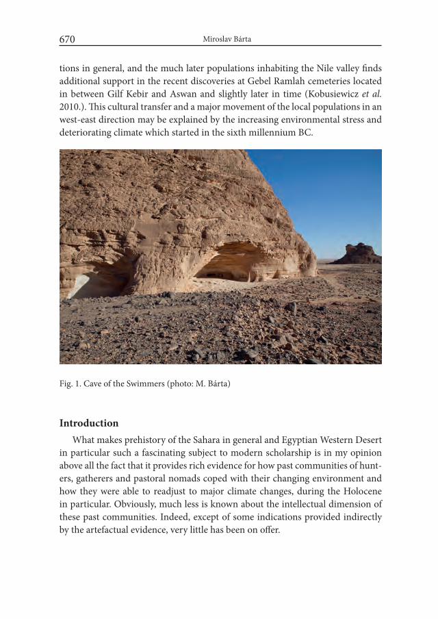
Miroslav Bárta670
tions in general, and the much later populations inhabiting the Nile valley finds additional support in the recent discoveries at Gebel Ramlah cemeteries located in between Gilf Kebir and Aswan and slightly later in time (Kobusiewicz et al. 2010.). This cultural transfer and a major movement of the local populations in an west-east direction may be explained by the increasing environmental stress and deteriorating climate which started in the sixth millennium BC.
IntroductionWhat makes prehistory of the Sahara in general and Egyptian Western Desert
in particular such a fascinating subject to modern scholarship is in my opinion above all the fact that it provides rich evidence for how past communities of hunt-ers, gatherers and pastoral nomads coped with their changing environment and how they were able to readjust to major climate changes, during the Holocene in particular. Obviously, much less is known about the intellectual dimension of these past communities. Indeed, except of some indications provided indirectly by the artefactual evidence, very little has been on offer.
Fig. 1. Cave of the Swimmers (photo: M. Bárta)

The Birth of Supernatural. On the Genesis of Some Later Ancient Egyptian Concepts 671
Except, perhaps, of some surviving remains of rock-art left behind by these populations. Few in numbers, rock-art sites pose itself as a very challenging sci-entific endeavor. Generally difficult to date and even more complicated to inter-pret, decorated surfaces present themselves as frequently used, reused, expanded, complemented and/or reduced sets of motifs likely imbued with different layers of meaning. From this observation results yet another stressful characteristics of the rock-art, namely that more often than not it doesn’t seem to follow a single mas-ter plan. Decorated surfaces incorporate different motifs juxtaposed next to each other, with frequent superimpositions, other without any significant relationship to one another. This is at least what we seem to anticipate based on our current knowledge of the issue.
The research on the Western Desert Holocene prehistory has been revolu-tionized by two dominant figures and their expeditions – American prehistori-an Fred Wendorf to whom this volume is dedicated and a German scholar Ru-dolf Kuper. It is thanks to their decades long focus on archaeology of the vast expanses of what is nowadays barren and life-threatening desert, in particular between the Gilf Kebir and the Nile valley, that we can seriously appreciate spe-cific forms of subsistence strategies and visual expressions of many local popula-tions (compare the current state of research with the one reflected in Kuper et al. (1978).
Yet even today we tend to think in categories born out by our modern percep-tion of the world based on sedentary principle of our everyday life and clear-cut boundaries lending support to our use of mutually exclusive categories of experi-ence – be it art, language, culture or history. Deep prehistory, however, may offer, completely different experience. During the middle Holocene, the whole Sahara was far from a vast emptiness. It was a region with rich forms of life occupied by populations of hunters, gatherers and pastoralist nomads. Only from the late seventh millennium BC the climate started to deteriorate and as a consequence Sahara became largely dry region within the following two millennia (Kuper and Kröpelin 2006). This had serious impact on the local populations which were forced to withdraw towards the east and started to experiment with sedentary forms of life in the Nile valley.
Until recently, the prevailing if not the only opinion among the scholars spe-cialized in the prehistory of Sahara and specifically of what we call today Egyp-tian Western Desert was that the prehistoric populations living there had barely anything in common with the later Egyptians from the Nile valley. To explore this view we have to turn to two most important sites with rock-art in Egyptian West-
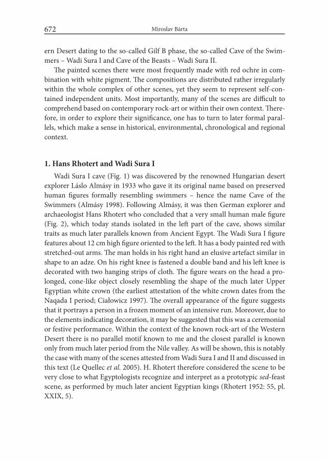
Miroslav Bárta672
ern Desert dating to the so-called Gilf B phase, the so-called Cave of the Swim-mers – Wadi Sura I and Cave of the Beasts – Wadi Sura II.
The painted scenes there were most frequently made with red ochre in com-bination with white pigment. The compositions are distributed rather irregularly within the whole complex of other scenes, yet they seem to represent self-con-tained independent units. Most importantly, many of the scenes are difficult to comprehend based on contemporary rock-art or within their own context. There-fore, in order to explore their significance, one has to turn to later formal paral-lels, which make a sense in historical, environmental, chronological and regional context.
1. Hans Rhotert and Wadi Sura IWadi Sura I cave (Fig. 1) was discovered by the renowned Hungarian desert
explorer Láslo Almásy in 1933 who gave it its original name based on preserved human figures formally resembling swimmers – hence the name Cave of the Swimmers (Almásy 1998). Following Almásy, it was then German explorer and archaeologist Hans Rhotert who concluded that a very small human male figure (Fig. 2), which today stands isolated in the left part of the cave, shows similar traits as much later parallels known from Ancient Egypt. The Wadi Sura I figure features about 12 cm high figure oriented to the left. It has a body painted red with stretched-out arms. The man holds in his right hand an elusive artefact similar in shape to an adze. On his right knee is fastened a double band and his left knee is decorated with two hanging strips of cloth. The figure wears on the head a pro-longed, cone-like object closely resembling the shape of the much later Upper Egyptian white crown (the earliest attestation of the white crown dates from the Naqada I period; Ciałowicz 1997). The overall appearance of the figure suggests that it portrays a person in a frozen moment of an intensive run. Moreover, due to the elements indicating decoration, it may be suggested that this was a ceremonial or festive performance. Within the context of the known rock-art of the Western Desert there is no parallel motif known to me and the closest parallel is known only from much later period from the Nile valley. As will be shown, this is notably the case with many of the scenes attested from Wadi Sura I and II and discussed in this text (Le Quellec et al. 2005). H. Rhotert therefore considered the scene to be very close to what Egyptologists recognize and interpret as a prototypic sed-feast scene, as performed by much later ancient Egyptian kings (Rhotert 1952: 55, pl. XXIX, 5).
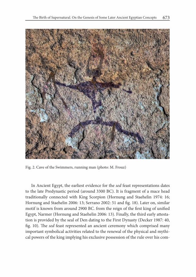
The Birth of Supernatural. On the Genesis of Some Later Ancient Egyptian Concepts 673
In Ancient Egypt, the earliest evidence for the sed feast representations dates to the late Predynastic period (around 3300 BC). It is fragment of a mace head traditionally connected with King Scorpion (Hornung and Staehelin 1974: 16; Hornung and Staehelin 2006: 13; Serrano 2002: 51 and fig. 18). Later on, similar motif is known from around 2900 BC. from the reign of the first king of unified Egypt, Narmer (Hornung and Staehelin 2006: 13). Finally, the third early attesta-tion is provided by the seal of Den dating to the First Dynasty (Decker 1987: 40, fig. 10). The sed feast represented an ancient ceremony which comprised many important symbolical activities related to the renewal of the physical and mythi-cal powers of the king implying his exclusive possession of the rule over his com-
Fig. 2. Cave of the Swimmers, running man (photo: M. Frouz)
Miroslav Bárta674
munity bestowed on him by the gods. At the same time, this ceremony became very important part of the king’s afterlife existence (Hornung and Staehelin 2006: 91–95; Kaiser 1971: 87–105; Martin 1984: 785–786; Serrano 2002: 44–46). Signifi-cant part of it was a ritual run. This was a specific way how to manifest that he was the true ruler of the world (Hornung and Staehelin 1974: 43).
Another dominant though much damaged feature in the cave represent the figures of the so-called swimmers (Fig. 3). This element occurs also in the Cave of Beasts. It shows small human figures portrayed on the belly prostrate formally resembling attitude of the swimmers. For Almásy they represented swimmers whom he thought were referring to the times when people used to swim in the local pools. Later, Hans Rhotert considered them to be images of dead persons (Rhotert 1952: 105). In this context, a reference to the Coffin Texts spells where the ‘swimmers’ are representing the souls of the dead floating in the waters of Nun (Le Quellec 2008: 31–33). The Ancient Egyptians ascribed to the swimmers quite specific status because they played an important role in resurrection ritual as at-tested by some Egyptian texts:
O drowned ones, who are in the water, swimmers, who are in thestream, see Re, who enters his boat, great of mystery…well, then, getup, tired ones. See Re. He takes care of you. Re says to them: Exit foryour heads [= your head above the water], O sinking ones. Movementof the arms for your arms, O overturned ones. Circulation for your legs, O swimmers.(Zandee 1960: 236)
The figures of the so-called swimmers occur in different caves in Gilf Kebir area including the Cave of the Swimmers and the cave of the Beasts. Recently, Rudolf Kuper and his team discovered that in the Cave of Beasts they form a kind of a “arc” overarching the most part of the cave (Kuper et al. 2013: 58, fig. 7). This allows to assume that their arrangement followed a preconceived plan and that the individual compositions in the cave were imbued with specific meanings. In fact, looking at the preserved similar arc in the Cave of the Swimmers indicates that the same solution was taken there as well. Thus we encounter a motif that was not local but had a generous meaning and was used in different locations as we know that the “swimmers” were preserved in more caves in the area.
It is above all the observation that these figures were intentionally arranged in an arc which renders the original notion of them being real swimmers rather obsolete.

The Birth of Supernatural. On the Genesis of Some Later Ancient Egyptian Concepts 675
2. Wadi Sura II – Cave of the BeastsUnlike Cave of the Swimmers, this cave was discovered almost a century later,
by an expedition led by col. Ahmed Mestekawy and Italian explorers Massimo and Jacopo Foggini in 2002 (Fig. 4). In this case, the decoration of the cave was incredibly well preserved and consisted of several thousands of painted elements/units. It features figures of the swimmers as well as several other motifs for which we can find parallels in the valley of the Nile only much later. As is the case with the swimmers, also all the below-mentioned motifs and scenes are unique within the context of the Saharan rock-art and parallels to them can be found only con-siderably later in the Nile valley.
To start with, the left-hand side of the cave contains a small scene with a male, perhaps a chieftain, holding in his hand a mace (Fig. 5). To the left of the chieftain we can see a fallen male upside down, perhaps a defeated enemy? Two rows of human figures are to the right of the assumed chieftain. The individual human figures are either standing or shown upside down. These two asymmetrical group-ings are separated by a horizontal natural rock fissure that divides the upper and
Fig. 3. Cave of the Swimmers, detail of the “swimming” figures (photo: M. Bárta)
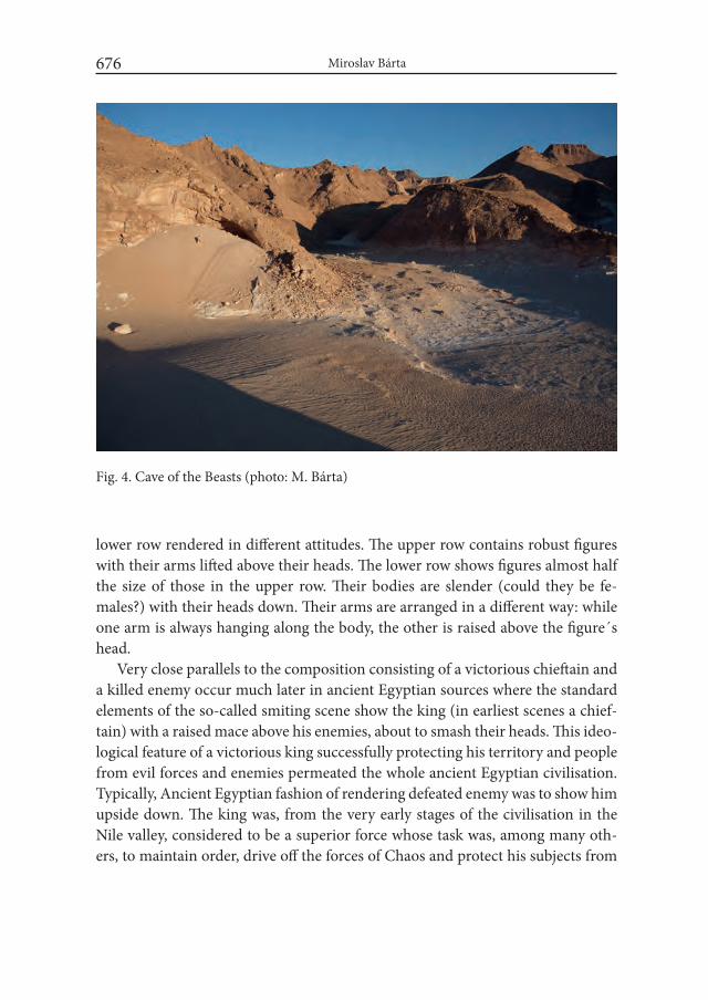
Miroslav Bárta676
lower row rendered in different attitudes. The upper row contains robust figures with their arms lifted above their heads. The lower row shows figures almost half the size of those in the upper row. Their bodies are slender (could they be fe-males?) with their heads down. Their arms are arranged in a different way: while one arm is always hanging along the body, the other is raised above the figure´s head.
Very close parallels to the composition consisting of a victorious chieftain and a killed enemy occur much later in ancient Egyptian sources where the standard elements of the so-called smiting scene show the king (in earliest scenes a chief-tain) with a raised mace above his enemies, about to smash their heads. This ideo-logical feature of a victorious king successfully protecting his territory and people from evil forces and enemies permeated the whole ancient Egyptian civilisation. Typically, Ancient Egyptian fashion of rendering defeated enemy was to show him upside down. The king was, from the very early stages of the civilisation in the Nile valley, considered to be a superior force whose task was, among many oth-ers, to maintain order, drive off the forces of Chaos and protect his subjects from
Fig. 4. Cave of the Beasts (photo: M. Bárta)

The Birth of Supernatural. On the Genesis of Some Later Ancient Egyptian Concepts 677
malevolent forces including enemies from different territories. One of the earliest examples of this iconographic element is attested from the late Predynastic tomb L 100 at Hierakonpolis belonging to one of the rulers of a local chiefdom (Quibell and Green 1902, pl. LXXVI).
One of the most important scenes in the Cave of Beasts features a large figure of a composite creature with body painted white (Fig. 6). It consists of a combination of beast´s legs and a female torso with a clearly visible breast. The figure is leaning against the ground with her outstretched arms and legs, making an arc. There is a red figure – probably of a male, which seems to support the body of the white creature, reclining on his right elbow and with his left arm touching/supporting her body. His legs are unnaturally long and nine men are depicted walking on them upwards on the right side. In their hands they carry large elongated items in a similar fashion as the later offering bearers attested in Egyptian tombs from the Old Kingdom (27th cent. BC) onwards. Based on the scheme of the scene, it may be said that the largest and thinnest figures in the composition which are painted red represent one species of creatures in human shape but with exceedingly long arms and legs, most likely beings of different, perhaps supernatural substance.
Fig. 5. Cave of the Beasts, chieftain smiting his enemy (photo: M. Bárta)
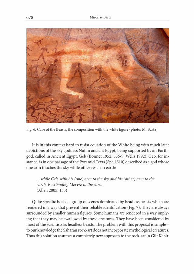
Miroslav Bárta678
It is in this context hard to resist equation of the White being with much later depictions of the sky goddess Nut in ancient Egypt, being supported by an Earth-god, called in Ancient Egypt, Geb (Bonnet 1952: 536-9; Wells 1992). Geb, for in-stance, is in one passage of the Pyramid Texts (Spell 510) described as a god whose one arm touches the sky while other rests on earth:
…while Geb, with his (one) arm to the sky and his (other) arm to theearth, is extending Meryre to the sun…(Allen 2005: 153)
Quite specific is also a group of scenes dominated by headless beasts which are
rendered in a way that prevent their reliable identification (Fig. 7). They are always surrounded by smaller human figures. Some humans are rendered in a way imply-ing that they may be swallowed by these creatures. They have been considered by most of the scientists as headless beasts. The problem with this proposal is simple – to our knowledge the Saharan rock-art does not incorporate mythological creatures. Thus this solution assumes a completely new approach to the rock-art in Gilf Kebir.
Fig. 6. Cave of the Beasts, the composition with the white figure (photo: M. Bárta)
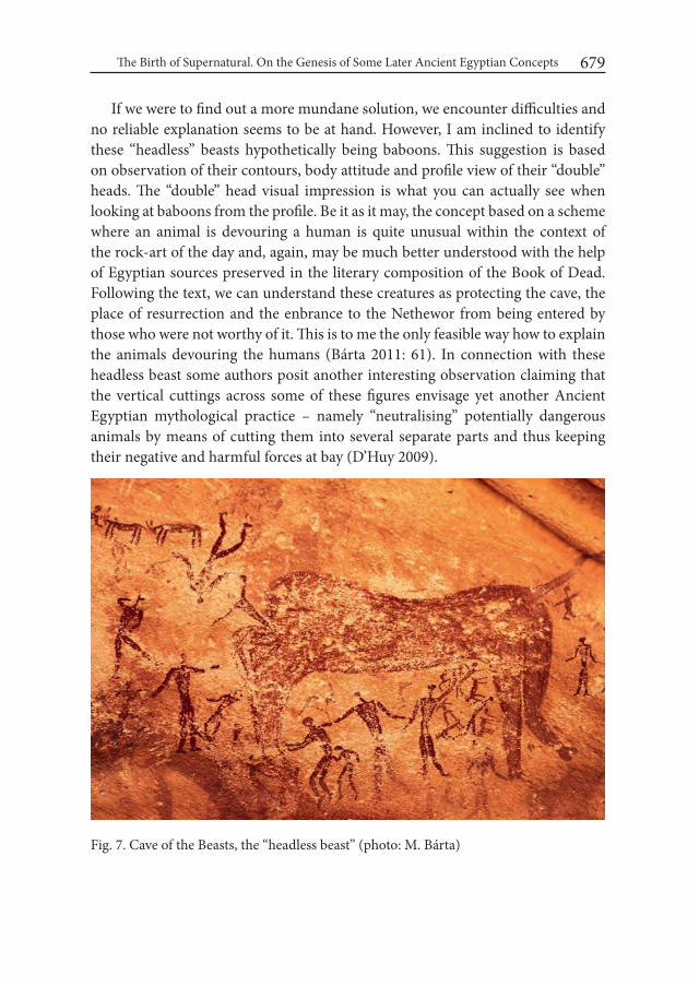
The Birth of Supernatural. On the Genesis of Some Later Ancient Egyptian Concepts 679
If we were to find out a more mundane solution, we encounter difficulties and no reliable explanation seems to be at hand. However, I am inclined to identify these “headless” beasts hypothetically being baboons. This suggestion is based on observation of their contours, body attitude and profile view of their “double” heads. The “double” head visual impression is what you can actually see when looking at baboons from the profile. Be it as it may, the concept based on a scheme where an animal is devouring a human is quite unusual within the context of the rock-art of the day and, again, may be much better understood with the help of Egyptian sources preserved in the literary composition of the Book of Dead. Following the text, we can understand these creatures as protecting the cave, the place of resurrection and the enbrance to the Nethewor from being entered by those who were not worthy of it. This is to me the only feasible way how to explain the animals devouring the humans (Bárta 2011: 61). In connection with these headless beast some authors posit another interesting observation claiming that the vertical cuttings across some of these figures envisage yet another Ancient Egyptian mythological practice – namely “neutralising” potentially dangerous animals by means of cutting them into several separate parts and thus keeping their negative and harmful forces at bay (D’Huy 2009).
Fig. 7. Cave of the Beasts, the “headless beast” (photo: M. Bárta)
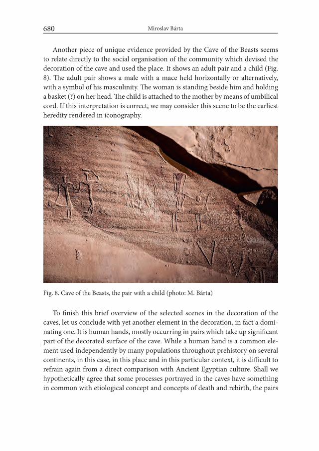
Miroslav Bárta680
Another piece of unique evidence provided by the Cave of the Beasts seems to relate directly to the social organisation of the community which devised the decoration of the cave and used the place. It shows an adult pair and a child (Fig. 8). The adult pair shows a male with a mace held horizontally or alternatively, with a symbol of his masculinity. The woman is standing beside him and holding a basket (?) on her head. The child is attached to the mother by means of umbilical cord. If this interpretation is correct, we may consider this scene to be the earliest heredity rendered in iconography.
Fig. 8. Cave of the Beasts, the pair with a child (photo: M. Bárta)
To finish this brief overview of the selected scenes in the decoration of the caves, let us conclude with yet another element in the decoration, in fact a domi-nating one. It is human hands, mostly occurring in pairs which take up significant part of the decorated surface of the cave. While a human hand is a common ele-ment used independently by many populations throughout prehistory on several continents, in this case, in this place and in this particular context, it is difficult to refrain again from a direct comparison with Ancient Egyptian culture. Shall we hypothetically agree that some processes portrayed in the caves have something in common with etiological concept and concepts of death and rebirth, the pairs
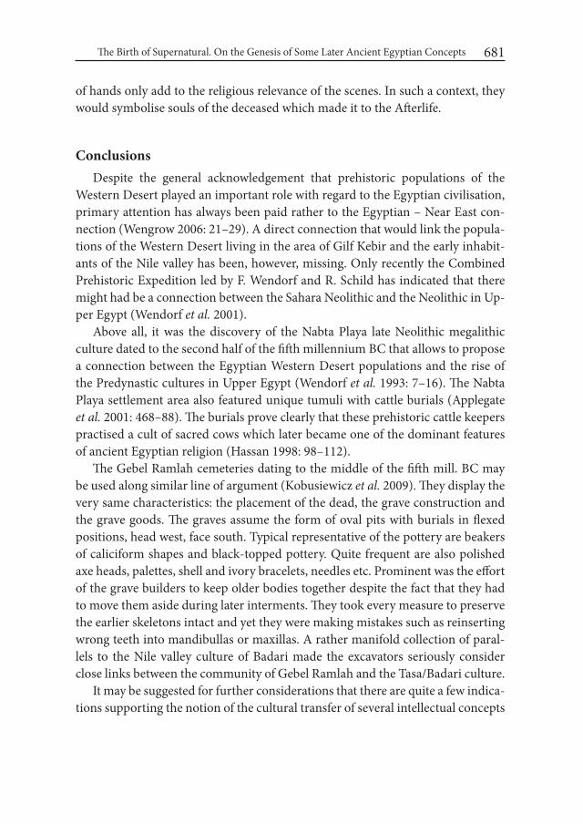
The Birth of Supernatural. On the Genesis of Some Later Ancient Egyptian Concepts 681
of hands only add to the religious relevance of the scenes. In such a context, they would symbolise souls of the deceased which made it to the Afterlife.
ConclusionsDespite the general acknowledgement that prehistoric populations of the
Western Desert played an important role with regard to the Egyptian civilisation, primary attention has always been paid rather to the Egyptian – Near East con-nection (Wengrow 2006: 21–29). A direct connection that would link the popula-tions of the Western Desert living in the area of Gilf Kebir and the early inhabit-ants of the Nile valley has been, however, missing. Only recently the Combined Prehistoric Expedition led by F. Wendorf and R. Schild has indicated that there might had be a connection between the Sahara Neolithic and the Neolithic in Up-per Egypt (Wendorf et al. 2001).
Above all, it was the discovery of the Nabta Playa late Neolithic megalithic culture dated to the second half of the fifth millennium BC that allows to propose a connection between the Egyptian Western Desert populations and the rise of the Predynastic cultures in Upper Egypt (Wendorf et al. 1993: 7–16). The Nabta Playa settlement area also featured unique tumuli with cattle burials (Applegate et al. 2001: 468–88). The burials prove clearly that these prehistoric cattle keepers practised a cult of sacred cows which later became one of the dominant features of ancient Egyptian religion (Hassan 1998: 98–112).
The Gebel Ramlah cemeteries dating to the middle of the fifth mill. BC may be used along similar line of argument (Kobusiewicz et al. 2009). They display the very same characteristics: the placement of the dead, the grave construction and the grave goods. The graves assume the form of oval pits with burials in flexed positions, head west, face south. Typical representative of the pottery are beakers of caliciform shapes and black-topped pottery. Quite frequent are also polished axe heads, palettes, shell and ivory bracelets, needles etc. Prominent was the effort of the grave builders to keep older bodies together despite the fact that they had to move them aside during later interments. They took every measure to preserve the earlier skeletons intact and yet they were making mistakes such as reinserting wrong teeth into mandibullas or maxillas. A rather manifold collection of paral-lels to the Nile valley culture of Badari made the excavators seriously consider close links between the community of Gebel Ramlah and the Tasa/Badari culture.
It may be suggested for further considerations that there are quite a few indica-tions supporting the notion of the cultural transfer of several intellectual concepts
Miroslav Bárta682
originally developed by the local populations of the Western Desert and Gilf Kebir areas (for details see Bárta 2011 with bibliography; for opposing and prevailing opinion comp. Förster and Kuper 2013; Zboray 2013). The scenes in the caves prove that there was significant social complexity existent in the society that con-ceived the commented concepts. At the same time, these local communities pos-sessed significant intellectual capability to embed their surrounding environment within the framework of complex etiological compositions that later on became a characteristic part of ancient Egyptian culture, mythology and world-view.
The Gilf Kebir decorated caves pose in general a very interesting and multi-layered phenomenon. In comparison with the rock-art known from other loca-tions such as Gebel Uweyinat or some minor places in the Western Desert but also including other sites from the north-east Africa in general, it is easy to recognise their unique status. The wide spectrum of individual motifs goes far beyond the traditional and expected genre of hunter-gatherers and early pastoralists.
The topicalization of the chieftain and scenes with suggested transcendental meaning indicates that these sites were of a special nature. This is also indicated by the fact that most ancient routes mapped by the Cologne team in the area of the Cave of the Beasts make the cave their focal point. It would be out of place to consider the creators and users of these caves exceptional within their environ-ment and context of other populations in the region (but this cannot be excluded either). It is more likely to suppose that the preserved decoration communicates the world as it was perceived by that time. We can even speculate that it could be the approaching climate deterioration which mobilised the intellect of the local communities and made them express their thoughts in particular sites developed as special places for communicating with the gods. Similar examples are easy to be named. Take, for instance, the appearance of the Gobekli Tepe monumental complexes in eastern Turkey close to modern Sanliurfa, most likely as a conse-quence as a Younger Dryas rash cooling on the Northern Hemisphere which led to a radically more difficult life for humans within one’s lifetime. Or the genesis of the first Egyptian state in the wake of another serious climate worsening. The human history is rich in examples when serious progress has been made due to internal or external stress. But these thoughts are currently beyond the limits of the presently known evidence.
While it is impossible to state that it was exclusively the populations of the Western Desert that created Ancient Egyptian civilization flourishing in the Nile valley, I fully subscribe to the conclusion that there is and most likely will be in-creasing evidence showing important relationships between populations which
The Birth of Supernatural. On the Genesis of Some Later Ancient Egyptian Concepts 683
once lived in the vast expanses of what we nowadays call the Western Desert and those settled in the Nile valley. Simultaneously, in my opinion, the populations originating to the west of the Nile valley contributed intellectually to the genesis of some of the most outstanding pillars which constituted the essence of Egyptian civilization.
Accordingly, it is tempting to assume that we are confronted here with an in-cipient concept of ethic norms according to which only people following them in their life could enter the afterlife existence following their physical death. Here the earlier commented compositions of the swimmers and the headless beasts merge together in a joined effect to express rather complicated concept of ethical princi-ples on which the community of the day perhaps operated.
Summing up the importance of the evidence provided by the Cave of the Swimmers and the Cave of the Beasts, we may conclude that these caves:
– provided legitimity to the current social order by fostering the topicality of victory of the chieftain on behalf of his population (smiting and running male figures, likely being chieftains);
– portray a sophisticated etiology how to imagine the physical world, earth and sky, that surrounded those communities;
– introduce ethics appeal – indicating means of resurrection after meeting the ‘qualifying’ criteria in order to attain the afterlife (headless beasts);
– they cemented the current status of the community by perpetuating the hereditary principle;
– they provided each member of the community with individual experience of the transcendental realm (pair-hands).
REFERENCESALLEN, J. P. 2005. The Ancient Egyptian Pyramid Texts. Atlanta. ALMÁSY, L. E. 1998. Schwimmer in der wüste. Munich.APPLEGATE, A., GAUTIER, A. and S. DUNCAN. 2001. The North Tumuli of the
Nabta Late Neolithic ceremonial Complex. In: F. Wendorf, R. Schild and Associates, Holocene Settlement of the Egyptian Sahara: The Archaeology of Nabta Playa, Vol. 1: 468–488. New York.
BÁRTA, M. 2011. Swimmers in the sand. On the Neolithic origins of ancient Egyp-tian mythology and symbolism. Prague.
BONNET, H. 1952. Reallexikon der ägyptischen Religionsgeschichte: 536–39. Berlin.

Miroslav Bárta684
CIAŁOWICZ, K. M. 1997. Le plus ancient témoignage de la tradition du heb-sed? Folia Orientalia 33: 39–48.
DECKER, W. 1987. Sport und Spiel im Alten Ägypten. Munich.FÖRSTER, F. and R. KUPER. 2013. Catching the Beasts – myths and messages in
rock art. In: R. Kuper in collaboration with F. Bartz, E. Büttner, F. Darius, F. Förster, L. Hermsdorf-Knauth, S. Krause, H. Leisen, H. Riemer, J. Seidel and A. Zboray. wadi Sura – The Cave of Beasts. A rock art site in the Gilf Kebir (Sw-Egypt)(= Africa Praehistorica 26): 24-27. Cologne.
HASSAN, F. A. 1998. The earliest goddesses of Egypt. In: L. Goodison and C. Morris, Ancient goddesses: the myths and the evidence: 98–112. London.
HORNUNG, E. and E. STAEHELIN. 1974. Studien zum Sedfest. Ægyptiaca Hel-vetica. Geneva.
HORNUNG, E. and E. STAEHELIN. 2006. Neue Studien zum Sedfest. Ægyptiaca Helvetica. Basel.
D’HUY, J. 2009. New evidence for a closeness between the Abu Ra’s shelter (East-ern Sahara) and Egyptian beliefs. Sahara 20: 125–26.
KAISER, W. 1971. Die kleine Hebseddarstellung im Sonnenheiligtum des Neuserre. Beiträge Bf. Wiesbaden.
KOBUSIEWICZ, M., J. KABACIŃSKI, R. SCHILD, J. D. IRISH AND F. WEN-DORF. 2009. Burial practices of the Final Neolithic pastoralists at Gebel Ramlah, Western Desert of Egypt. British Museum Studies in Ancient Egypt and Sudan 13:147-174.
KOBUSIEWICZ, M., KABACINSKI, J., SCHILD R., IRISH, J. D., GATTO, M. C. and F. WENDORF. 2010. Gebel Ramlah, Final Neolithic Cemeteries from the western Desert of Egypt. Poznań.
KUPER, R. (ed.). 1978. SAHARA – 10.000 Jahre zwischen weide und wüste, Co-logne.
KUPER, R., in collaboration with F. BARTZ, E. BÜTTNER, F. DARIUS, F. FÖRSTER, L. HERMSDORF-KNAUTH, S. KRAUSE, H. LEISEN, H. RIEMER, J. SEIDEL and A. ZBORAY. 2013. wadi Sura – The Cave of Beasts. A rock art site in the Gilf Kebir (Sw-Egypt)(= Africa Praehistorica 26). Cologne.
KUPER, R. and S. KRÖPELIN. 2006. Climate-Controlled Holocene Occupation in the Sahara: Motor of Africa’s Evolution. Science 313 (5788): 803–807.
LE QUELLEC, J.-L., DE FLERS, P. and P. DE FLERS 2005. Du Sahara au Nil, peintures et gravures d’avant les pharaons. Études d’égyptologie (Collège de France. Chaire de civilisation pharaonique). Paris.
The Birth of Supernatural. On the Genesis of Some Later Ancient Egyptian Concepts 685
LE QUELLEC, J.-L. 2008. Can one ‘read’ rock art? An Egyptian example. In: P. Taylor (ed.), iconography without Texts (= Warburg Institute Colloquia 12): 25–42. London.
MARTIN, K. 1984. “Sedfest”, Lexikon der Ägyptologie V: 782–790. Wiesbaden.QUIBELL, J. E. and F. GREEN. 1902. Hierakonpolis. Part ii, London.RHOTERT, H. 1952. Libysche Felsbilder. Ergebnisse der Xi. und Xii. deutschen in-
ner-afrikanischen Forschungs-Expedition (DiAFE) 1933/1934/1935. Darm-stadt.
SERRANO, A. J. 2002. Royal Festivals in the Late Predynastic Period and the First Dynasty. (= BAR International Series 1076). Oxford.
WELLS, R. A. 1992. The Mythology of Nut and the Birth of Ra, Studien zur altä-gyptischen Kultur 19: 305–21.
WENDORF, F., CLOSE, A. and R. SCHILD. 1993. Megaliths in the Egyptian Sa-hara. Sahara 5: 7–16.
WENDORF, F., SCHILD, R. AND ASSOCIATES. 2001. Holocene Settlement of the Egyptian Sahara: The Archaeology of Nabta Playa, Vol. 1. New York.
WENGROW, D. 2006. The Archaeology of Egypt. Social Transformations in North-East Africa, 10000 to 2650 B.C. Cambridge.
ZANDEE, J. 1960. Death as an enemy, according to ancient Egyptian conceptions. Leiden.
ZBORAY, A. 2013. Wadi Sura in the context of regional rock art. In: R. Kuper in collaboration with F. Bartz, E. Büttner, F. Darius, F. Förster, L. Hermsdorf-Knauth, S. Krause, H. Leisen, H. Riemer, J. Seidel and A. Zboray. wadi Sura – The Cave of Beasts. A rock art site in the Gilf Kebir (Sw-Egypt) (= Africa Praehistorica 26): 18-23. Cologne.


Desert and the Nile. Prehistory of the Nile Basin and the Sahara.
Papers in honour of Fred Wendorf Studies in African Archaeology 15
Poznań Archaeological Museum 2018
Paweł Lech Polkowski
A Giraffe’s Tale. On Enigmatic Composition from Site 04/08 in the Central Dakhleh Oasis, Egypt
1. The rock art in the central part of the Dakhleh OasisUntil 2002 the research conducted by the Petroglyph Unit (which is part of
the Dakhleh Oasis Project – DOP) was almost entirely focused on the eastern fringes of the Dakhleh Oasis (for references and general outline of the research, see Polkowski et al. 2013). However, in 2002 a new area was opened for scientific investigations of rock art, namely the Central Oasis – the rocky area between the modern villages of Ismant and Balat (Krzyżaniak 2004). Subsequent field seasons have yielded a high concentration of rock art findings and to date almost 1400 rock art panels, distributed among more than 250 sites, have been recorded (for the distribution of sites and panels, see Polkowski 2016: 38-44, figs. 1.13-1.19). The petroglyphs which are the subject of this paper were found by Lech Krzyżaniak in 2002, and later recorded by the team led by Michał Kobusiewicz in 2008 (Kucie- wicz and Kobusiewicz 2011: 238-9). The site has been registered as site 04/08.
The site is located in the southern part of the research area, approx. 6 km south of the tarmac road (Fig. 1-2). In this part of the sandstone ridge the wadis are broader than in the northern area; site 04/08 is located in the so-called Painted Wadi – the long and wide sandy valley running from north to south. The hill in question is situated within the wadi and resembles an isolated island. The sur-roundings of the site are surprisingly devoid of rock art, with only two registered sites within the 0.5 km radius (one of these contains solely dynastic petroglyphs,
Fig. 1. Dakhleh Oasis. Research area in the central parts of the Oasis, as well as the area of the site under study (04/08), are indicated. The rock art complexes investigated by Hans Winkler (late 30’s) and Lech Krzyżaniak (1985-2002) are situated southeast of the easternmost cultivation area
Fig. 2. The vicinity of site 04/08. The hill is located at the bottom of the sandy Painted Wadi. The valley is relatively wide and at this length rather devoid of rock art. The site under study provides an example of just one of a few locations with petroglyphs within the radius of approximately 0.5 km. Yellow points indicate rock art panels
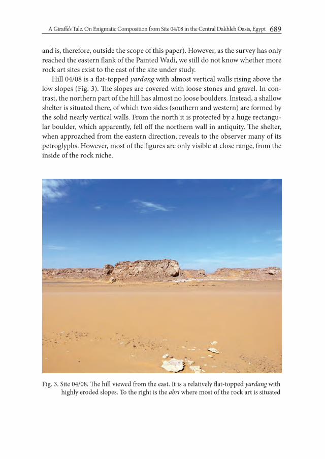
A Giraffe’s Tale. On Enigmatic Composition from Site 04/08 in the Central Dakhleh Oasis, Egypt 689
and is, therefore, outside the scope of this paper). However, as the survey has only reached the eastern flank of the Painted Wadi, we still do not know whether more rock art sites exist to the east of the site under study.
Hill 04/08 is a flat-topped yardang with almost vertical walls rising above the low slopes (Fig. 3). The slopes are covered with loose stones and gravel. In con-trast, the northern part of the hill has almost no loose boulders. Instead, a shallow shelter is situated there, of which two sides (southern and western) are formed by the solid nearly vertical walls. From the north it is protected by a huge rectangu-lar boulder, which apparently, fell off the northern wall in antiquity. The shelter, when approached from the eastern direction, reveals to the observer many of its petroglyphs. However, most of the figures are only visible at close range, from the inside of the rock niche.
Fig. 3. Site 04/08. The hill viewed from the east. It is a relatively flat-topped yardang with highly eroded slopes. To the right is the abri where most of the rock art is situated

Paweł Lech Polkowski690
Six panels have been registered on the site (Fig. 4). Five of them seem to contain petroglyphs dated broadly to the prehistoric period of history of Dakhleh. Panel 1 is located upon the horizontal surface of a huge boulder in front of the shelter. There, besides the sandal engraving from a later time, a human figure holding a bow is depicted. Just next to it a petroglyph is situated, which was interpreted by Krzyżaniak as representing the “female” anthropomorphic figure type (the so-called Winkler’s “goddess”; see Krzyżaniak 2004: 186-7, fig. 7; cf. Polkowski et al. 2013: 106-11). The third petroglyph depicts a hand, although in this case one can-not be sure of its Neolithic origin. On panel 3 a unique motif was registered, name-ly an animal tail. It seems to be a bushy tail of a giraffe, which characterizes many representations in the Oasis (Kuciewicz and Kobusiewicz 2011: 238-40, fig. 3). Petroglyphs on the southern wall of the shelter are barely visible and some of them
Fig. 4. Site 04/08. View from the north. The panels with petroglyphs are located in both the “shelter” itself or upon the huge boulder, which fell off the wall. Only two panels out of six are to be found outside the rock niche. Panel 6 is not indicated in this figure

A Giraffe’s Tale. On Enigmatic Composition from Site 04/08 in the Central Dakhleh Oasis, Egypt 691
are damaged. One of such figures seems to depict a tree or a hand and a fore-arm(?). Panel 4, also located on the rear wall of the abri, contains at least three rep-resentations of giraffes (Fig. 5). They clearly differ in size and stylistic features. The most visible one is the biggest giraffe with an extremely long neck. Moreover, it seems that the petroglyph was not only outlined, but also smoothed and executed in a manner which resembles sunken relief. The two remaining animal depictions are smaller and more rectangular in shape (however, one of them has also a very long neck, although straight, not curved). Panel 5, the last one associated with the shelter was produced during the Dynastic era. The final panel (panel 6) depicting giraffes, is located in the south-eastern part of the hill, away from the shelter. It is badly damaged and only some of the animals can be recognized. They seem to be of the same size and executed by the same person.
Fig. 5. Panel 4, fragment. On this almost vertical wall several petroglyphs of giraffes are executed. Each differs stylistically from the others. The one in the picture is char-acterized by an elongated and very massive neck, the non-naturalistic shape of its back and wide and exaggerated legs
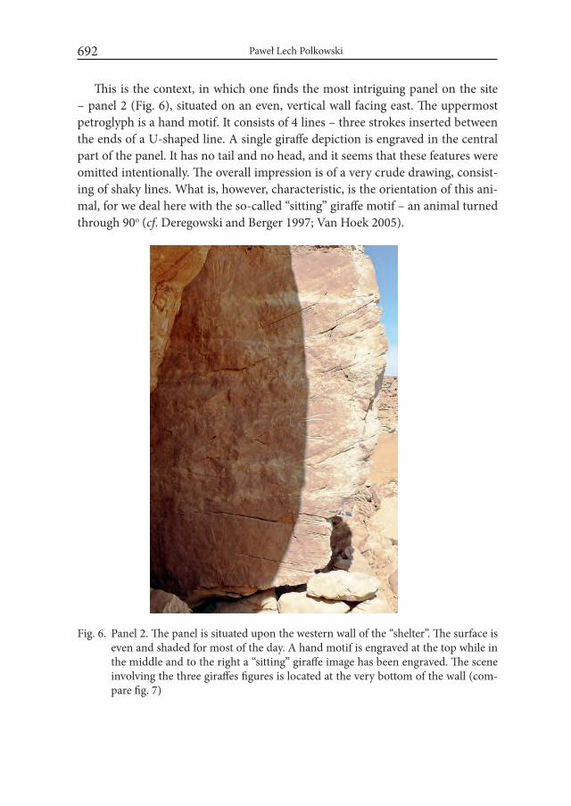
Paweł Lech Polkowski692
This is the context, in which one finds the most intriguing panel on the site – panel 2 (Fig. 6), situated on an even, vertical wall facing east. The uppermost petroglyph is a hand motif. It consists of 4 lines – three strokes inserted between the ends of a U-shaped line. A single giraffe depiction is engraved in the central part of the panel. It has no tail and no head, and it seems that these features were omitted intentionally. The overall impression is of a very crude drawing, consist-ing of shaky lines. What is, however, characteristic, is the orientation of this ani-mal, for we deal here with the so-called “sitting” giraffe motif – an animal turned through 90o (cf. Deregowski and Berger 1997; Van Hoek 2005).
Fig. 6. Panel 2. The panel is situated upon the western wall of the “shelter”. The surface is even and shaded for most of the day. A hand motif is engraved at the top while in the middle and to the right a “sitting” giraffe image has been engraved. The scene involving the three giraffes figures is located at the very bottom of the wall (com-pare fig. 7)
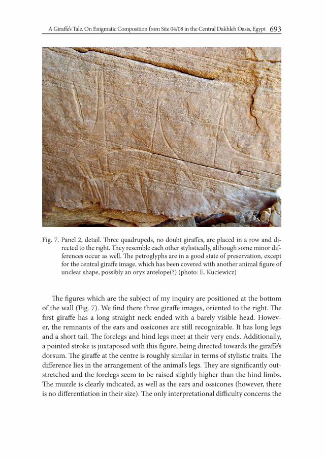
A Giraffe’s Tale. On Enigmatic Composition from Site 04/08 in the Central Dakhleh Oasis, Egypt 693
The figures which are the subject of my inquiry are positioned at the bottom of the wall (Fig. 7). We find there three giraffe images, oriented to the right. The first giraffe has a long straight neck ended with a barely visible head. Howev-er, the remnants of the ears and ossicones are still recognizable. It has long legs and a short tail. The forelegs and hind legs meet at their very ends. Additionally, a pointed stroke is juxtaposed with this figure, being directed towards the giraffe’s dorsum. The giraffe at the centre is roughly similar in terms of stylistic traits. The difference lies in the arrangement of the animal’s legs. They are significantly out-stretched and the forelegs seem to be raised slightly higher than the hind limbs. The muzzle is clearly indicated, as well as the ears and ossicones (however, there is no differentiation in their size). The only interpretational difficulty concerns the
Fig. 7. Panel 2, detail. Three quadrupeds, no doubt giraffes, are placed in a row and di-rected to the right. They resemble each other stylistically, although some minor dif-ferences occur as well. The petroglyphs are in a good state of preservation, except for the central giraffe image, which has been covered with another animal figure of unclear shape, possibly an oryx antelope(?) (photo: E. Kuciewicz)

Paweł Lech Polkowski694
hindquarters area of the animal. It seems that another animal drawing has been superimposed on this part of the petroglyph. According to the tracing published by Kuciewicz and Kobusiewicz (2011: 239, fig. 3), there is an unidentified quad-ruped imposed upon the legs of the two giraffes. This is quite probable; however, it is equally likely that we deal here with the depiction of an oryx whose short legs are drawn upon the hind limbs of the giraffe at the centre. Then, the deep slightly curved line connecting the left and central giraffes may be interpreted as the long horns of the oryx. Altogether, such a “style” of execution is fairly widespread in the whole Dakhleh Oasis and elsewhere (Fig. 8). There is also a possibility that the curved line, and the second one below it, had been executed before the oryx was added to the composition. Then, the horizontal lines touching the back of the giraffe at the centre could be treated as contemporary with it, and the antelope – as a later addition, where, subsequently, one of the existing lines was used to form the long horns. I will return to this ambiguity later in this paper. The last giraffe, (on the right) is again very similar to the other two, at least when it comes to the manner of execution. The top part of the animal is almost the same as that of the giraffe at the centre. The difference lies, however, in its overall orientation, as it is turned through 90o, in relation to the other giraffes. The legs are straight and perpendicular to its body, which also distinguishes the animal from the other two.
Fig. 8. Site CO52, panel 3. An image of an oryx antelope executed in a similar manner as the one superimposed on the central giraffe figure on site 04/08, panel 2. Both figures were pecked. The shape of their bodies is not naturalistic. The legs and the tails are schematically drawn and obviously too large in both cases

A Giraffe’s Tale. On Enigmatic Composition from Site 04/08 in the Central Dakhleh Oasis, Egypt 695
The prehistoric rock art in Dakhleh is relatively rich in scenes involving ani-mals, giraffes in particular. There are, for instance, rare “hunting scenes” with hu-mans and/or dogs preying these animals (e.g. Krzyżaniak 1990: 95, fig. 92) or less unique scenes showing together giraffes and anthropomorphic figures with exag-gerated buttocks (e.g. Kuciewicz et al. 2010: 309, fig. 7). Equally common are the compositions which bring together several giraffes, as if representing the herds (e.g. Polkowski 2016: figs. 5.42, 5.76). Doubtless, they are scenes constituting pic-torial narratives, which likely must have involved story-telling. It is beyond the scope of this paper to suggest whether these stories should be treated as “simple” narratives about the observed phenomena, depictions of events or perhaps as rep-resentation of mythological realm. What I intend to explore by analysing panel 2 is a more diachronic dimension of such a rock art scene. It stems from an observa-tion that we tend to treat similar compositions as representing one event, in which every petroglyph represents a single entity. In other words, they all “co-exist” in a story simultaneously as separate entities (for instance, in a scene depicting a row of giraffes, which is usually interpreted as a herd consisting of separate walking animals). I would like to consider an optional interpretation – that particular petroglyphs in a scene may represent the same entity in different stages of one story. In this case, it would be a story of one giraffe (not three!), with the narrative most probably divided into three parts.
2. From static petroglyphs to figures in motionThere are two implications stemming from the above deliberations: the ani-
mal figures on panel 2 may represent just one giraffe, depicted in different stages of a “story”, and secondly – it is a story of movement, so the giraffe would be represented in different stages of motion. The idea that prehistoric art in some instances could represent animals’ movement due to accumulation of images is not new. It is especially the Palaeolithic imagery that seems to provide good ex-amples of such visual treatment (e.g. Azéma 2005; Azéma and Rivère 2012; Luis and Batarda Fernandes 2009). Marc Azéma (2005) distinguishes between “break-ing down movement” by superimposition of figures and juxtaposition of succes-sive images. The first employs an image, which is covered by more depictions of similar shape in order to create a visual illusion of a moving animal. It is, however, the latter type of composition, which may be comparable with the panel 2 scene. Juxtaposed figures are not separated by any “artificial” features – they just repre-sent the same characters in different actions and poses. Azéma brings examples of

Paweł Lech Polkowski696
such “split-action movement” depictions from variety of contexts, including the Palaeolithic art of France. He notes, however, that this artistic mode was used to depict movement (therefore, a story) also in historical times, i.a. in the Egyptian paintings (e.g. the Middle Kingdom scenes of fight and wrestling in Beni Hasan tombs, see Newberry 1893: Pl. V). Does the scene on panel 2 provide an example of similar visual mode?
I believe one should not exclude such a possibility. Firstly, one deals here with three highly similar depictions of giraffes, and the degree of resemblance may point not only to the same artist, who would be responsible for drawing them, but also to his very intention to depict the same animal. The rendition of heads and body, and the overall size of the figures all add to such a possible conclusion. Secondly, the impression is strengthened by the arrangement of the petroglyphs in the form of a register. All drawings are based at the same level, and even though there is no baseline indicated, they all are placed just above the edge of a broken rock. One cannot know this for sure, but it is possible that the rock had already been broken when a prehistoric artist, or artists, decided to execute the petro-glyphs on panel 2. Moreover, the figures are all turned in the same direction, i.e. to the right. The three possible poses of the animal seem to be depicted in a very “natural” order and the overall impression of the intended successive changes of its position looks very probable. Needles to say, these arguments are highly de-pendent on intuition and impression. As persuasive as they may be, one cannot forget that such a regularity and linear “reading” of a scene may also be affected by modern comprehension of visual arts.
Having commented on the general similarity of the figures and their supposed linear composition, I would like to focus now on particular features of these im-ages. Firstly there is the congruence between the rendition of the animals’ poses (especially the legs) and the behavioural patterns. There are only two types of a giraffe’s gait. The first one is walking “with both legs on one side off the ground simultaneously” (Innis 1958: 254). The second is a gallop (giraffes do not trot), in which the forelegs and the hind legs work together in pairs. During gallop the hind feet land outside and a bit ahead of the forefeet (Innis 1958: 254; Innis Dagg 1971: 5; Jolly 2003: 12; Peterson and Ammann 2013: 101). It means that, when a giraffe is running fast, the legs become outstretched (Fig. 9-a) and subsequently the hind feet and forefeet meet at more or less one point (Fig. 9-d). I argue then, that both the giraffe to the left and the central one on panel 2 represent two stages of a galloping animal. The first image would show a moment, in which the legs of the giraffe are bunched together, and the second would be a depiction of an out-
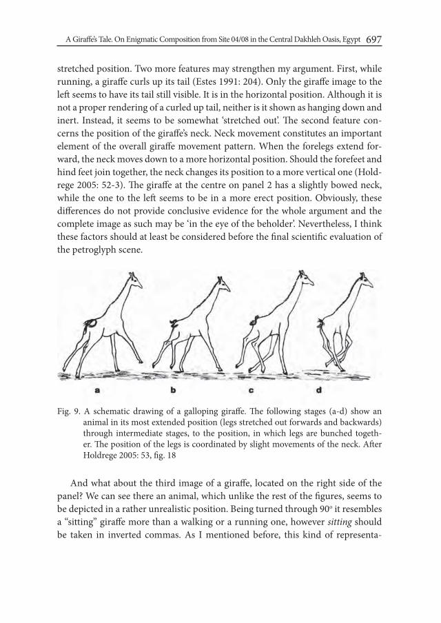
A Giraffe’s Tale. On Enigmatic Composition from Site 04/08 in the Central Dakhleh Oasis, Egypt 697
stretched position. Two more features may strengthen my argument. First, while running, a giraffe curls up its tail (Estes 1991: 204). Only the giraffe image to the left seems to have its tail still visible. It is in the horizontal position. Although it is not a proper rendering of a curled up tail, neither is it shown as hanging down and inert. Instead, it seems to be somewhat ‘stretched out’. The second feature con-cerns the position of the giraffe’s neck. Neck movement constitutes an important element of the overall giraffe movement pattern. When the forelegs extend for-ward, the neck moves down to a more horizontal position. Should the forefeet and hind feet join together, the neck changes its position to a more vertical one (Hold-rege 2005: 52-3). The giraffe at the centre on panel 2 has a slightly bowed neck, while the one to the left seems to be in a more erect position. Obviously, these differences do not provide conclusive evidence for the whole argument and the complete image as such may be ‘in the eye of the beholder’. Nevertheless, I think these factors should at least be considered before the final scientific evaluation of the petroglyph scene.
And what about the third image of a giraffe, located on the right side of the panel? We can see there an animal, which unlike the rest of the figures, seems to be depicted in a rather unrealistic position. Being turned through 90o it resembles a “sitting” giraffe more than a walking or a running one, however sitting should be taken in inverted commas. As I mentioned before, this kind of representa-
Fig. 9. A schematic drawing of a galloping giraffe. The following stages (a-d) show an animal in its most extended position (legs stretched out forwards and backwards) through intermediate stages, to the position, in which legs are bunched togeth-er. The position of the legs is coordinated by slight movements of the neck. After Holdrege 2005: 53, fig. 18

Paweł Lech Polkowski698
tion has been recognized throughout the whole of the Sahara, and an array of interpretational proposals has been put forward in that matter. Deregowski and Berger (1997: 88ff) proposed that this kind of imagery is a direct effect of certain perceptual issues, therefore it is a psychological and universal rule. The directional cues, or their lack in any given place, would be responsible for placing the ani-mal figures in a “sitting position” . Marteen Van Hoek (2005) reasonably refuted this hypothesis and showed that the perceptual rules of Deregowski’s and Berger’s model cannot help in answering many questions as regards the “sitting” zoo-morphs. Panel 2 engravings seem to provide a good example of why this model is doubtful. If one assumes that all three giraffe petroglyphs were executed by the same hand, then one deals here with pure intentionality in their placing. Two of the giraffes are placed horizontally (one may say – in a naturalistic way) and par-allel to an imagined ground line created by the broken rock. However, the third giraffe, although close to other figures, was chosen to be turned perpendicularly. It would be difficult for me to believe, that this situation was the outcome of purely perceptual factors. I rather prefer to see it as evidence of intentional and meaning-ful action. Neither do I share the view that the depiction may be just the result of the position (e.g. seated or lying), in which a prehistoric artist found himself when drawing, as suggested by Salima Ikram (2009b: 270).
If one refutes the simple explanation that the rightmost image on panel 2 was a depiction of a resting animal (after, supposedly, gallop), especially as such a po-sition is absolutely unnatural for a giraffe, one may ask, what other possible cir-cumstances may be depicted here. Deregowski and Berger (1997: 92) mention the work of Ulrich Hallier (1995), who considers the “sitting” giraffes to be rep-resentations of dead animals. Hallier (1995: Abb. 34, 76) provides examples from the area between Tassili and Tibesti, therefore a considerable distance from the Dakhleh Oasis, but at least two scenes found there seem to give us some insight into the giraffes scene on panel 2. Both scenes recorded by Hallier (Fig. 10-11) involve two giraffes and in both cases one animal is depicted as “sitting”. In the first scene the animal to the left seems to be represented in one of the stages of gal-lop. The giraffe to the right, similar in style to the first one, is turned through 90o. It resembles the panel 2 configuration of giraffes, but without the central animal image. In the second scene from the Central Sahara we come across a very similar situation involving two giraffes, however they are not as close to each other as in the first scene. Moreover, the giraffe on the left does not seem to be running, but rather standing. Still, the scene’s idea reminds that of panel 2, which would be a representation of one animal, but in different stages of motion/story.
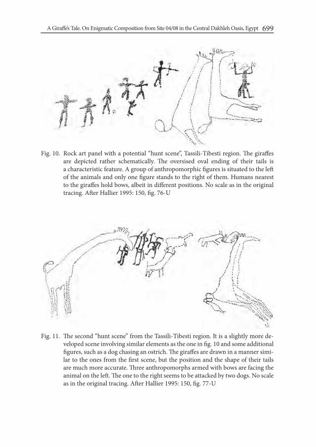
A Giraffe’s Tale. On Enigmatic Composition from Site 04/08 in the Central Dakhleh Oasis, Egypt 699
Fig. 10. Rock art panel with a potential “hunt scene”, Tassili-Tibesti region. The giraffes are depicted rather schematically. The oversised oval ending of their tails is a characteristic feature. A group of anthropomorphic figures is situated to the left of the animals and only one figure stands to the right of them. Humans nearest to the giraffes hold bows, albeit in different positions. No scale as in the original tracing. After Hallier 1995: 150, fig. 76-U
Fig. 11. The second “hunt scene” from the Tassili-Tibesti region. It is a slightly more de-veloped scene involving similar elements as the one in fig. 10 and some additional figures, such as a dog chasing an ostrich. The giraffes are drawn in a manner simi-lar to the ones from the first scene, but the position and the shape of their tails are much more accurate. Three anthropomorphs armed with bows are facing the animal on the left. The one to the right seems to be attacked by two dogs. No scale as in the original tracing. After Hallier 1995: 150, fig. 77-U

Paweł Lech Polkowski700
What is different in the scenes described by Hallier, is the presence of human figures. Thus, in the first scene the left side of the composition contains six an-thropomorphs and a dog. One human figure holds a bow with an arrow pointing at a giraffe. To the right, next to the “sitting” giraffe there is another human fig-ure with an attached tail(?) and a bow. It raises its hands and is called by Hallier
Fig. 12. Site 61-39/E3-3, eastern Dakhleh Oasis. The oversized giraffe (possibly preg-nant?) is surrounded by the anthropomorphic figures holding bows. The latter are accompanied by two dogs. In the case of the forelegs the cloven-hooves are indicated. After Krzyżaniak 1987: 186, fig. 2
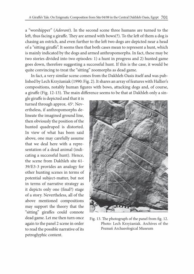
A Giraffe’s Tale. On Enigmatic Composition from Site 04/08 in the Central Dakhleh Oasis, Egypt 701
a “worshipper” (Adorant). In the second scene three humans are turned to the left, thus facing a giraffe. They are armed with bows(?). To the left of them a dog is chasing an ostrich, and even further to the left two dogs are depicted near a head of a “sitting giraffe”. It seems then that both cases mean to represent a hunt, which is mainly indicated by the dogs and armed anthropomorphs. In fact, these may be two stories divided into two episodes: 1) a hunt in progress and 2) hunted game goes down, therefore suggesting a successful hunt. If this is the case, it would be quite convincing to treat the “sitting” zoomorphs as dead game.
In fact, a very similar scene comes from the Dakhleh Oasis itself and was pub-lished by Lech Krzyżaniak (1990: Fig. 2). It shares an array of features with Hallier’s compositions, notably human figures with bows, attacking dogs and, of course, a giraffe (Fig. 12-13). The main difference seems to be that at Dakhleh only a sin-gle giraffe is depicted and that it is turned through approx. 45o. Nev-ertheless, if anthropomorphs de-lineate the imagined ground line, then obviously the position of the hunted quadruped is distorted. In view of what has been said above, one may carefully assume that we deal here with a repre-sentation of a dead animal (indi-cating a successful hunt). Hence, the scene from Dakhleh site 61-39/E3-3 provides an analogy for other hunting scenes in terms of potential subject-matter, but not in terms of narrative strategy as it depicts only one (final?) stage of a story. Nevertheless, all of the above mentioned compositions may support the theory that the “sitting” giraffes could connote dead game. Let me then turn once again to the panel 2 scene in order to read the possible narrative of its petroglyphic content.
Fig. 13. The photograph of the panel from fig. 12. Photo: Lech Krzyżaniak. Archives of the Poznań Archaeological Museum
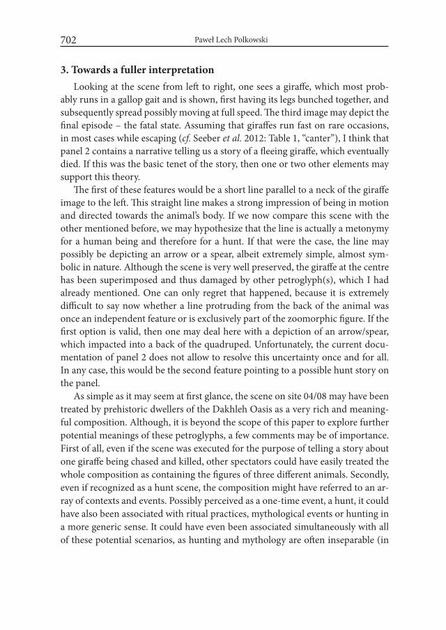
Paweł Lech Polkowski702
3. Towards a fuller interpretationLooking at the scene from left to right, one sees a giraffe, which most prob-
ably runs in a gallop gait and is shown, first having its legs bunched together, and subsequently spread possibly moving at full speed. The third image may depict the final episode – the fatal state. Assuming that giraffes run fast on rare occasions, in most cases while escaping (cf. Seeber et al. 2012: Table 1, “canter”), I think that panel 2 contains a narrative telling us a story of a fleeing giraffe, which eventually died. If this was the basic tenet of the story, then one or two other elements may support this theory.
The first of these features would be a short line parallel to a neck of the giraffe image to the left. This straight line makes a strong impression of being in motion and directed towards the animal’s body. If we now compare this scene with the other mentioned before, we may hypothesize that the line is actually a metonymy for a human being and therefore for a hunt. If that were the case, the line may possibly be depicting an arrow or a spear, albeit extremely simple, almost sym-bolic in nature. Although the scene is very well preserved, the giraffe at the centre has been superimposed and thus damaged by other petroglyph(s), which I had already mentioned. One can only regret that happened, because it is extremely difficult to say now whether a line protruding from the back of the animal was once an independent feature or is exclusively part of the zoomorphic figure. If the first option is valid, then one may deal here with a depiction of an arrow/spear, which impacted into a back of the quadruped. Unfortunately, the current docu-mentation of panel 2 does not allow to resolve this uncertainty once and for all. In any case, this would be the second feature pointing to a possible hunt story on the panel.
As simple as it may seem at first glance, the scene on site 04/08 may have been treated by prehistoric dwellers of the Dakhleh Oasis as a very rich and meaning-ful composition. Although, it is beyond the scope of this paper to explore further potential meanings of these petroglyphs, a few comments may be of importance. First of all, even if the scene was executed for the purpose of telling a story about one giraffe being chased and killed, other spectators could have easily treated the whole composition as containing the figures of three different animals. Secondly, even if recognized as a hunt scene, the composition might have referred to an ar-ray of contexts and events. Possibly perceived as a one-time event, a hunt, it could have also been associated with ritual practices, mythological events or hunting in a more generic sense. It could have even been associated simultaneously with all of these potential scenarios, as hunting and mythology are often inseparable (in
A Giraffe’s Tale. On Enigmatic Composition from Site 04/08 in the Central Dakhleh Oasis, Egypt 703
the context of rock art studies, see e.g. Dowson 2009: 382). What must be under-lined, is the fact that I do not intend to imply that the rock art composition was infested with meanings and that there was just one set of meanings to be decoded by others. There certainly must have been a meaningful intention behind creating the scene, possibly well understood by people from the same community, but the images themselves have always played their own roles in the never-ending inter-pretational game (cf. Ljunge 2013). The meanings emerging from an interaction between the people and rock art are always unique, though may be also similar across the time. Thirdly, it is the social aspect, which should be expanded upon for the purpose of a deeper understanding of such scenes. The societies inhabit-ing Dakhleh in the 6th and 5th millennia BC, a possible chronological frame for the petroglyphs on panel 2, (cf. Riemer 2011: 248) were economically dependent on hunting, despite the increased significance of pastoral elements (for the lat-est overview of the Dakhleh Oasis Neolithic phase, see McDonald 2016). One may assume that game hunting played an important role at many various levels of people’s social life and its economic significance was just one of them. Animals, no doubt, formed a part of the same world as humans, and their mutual engagement in this world could have been embraced by what we call mythology. However, it seems that there was often no division between the real and mythical realm, just one realm seemed to exist, in which humans, animals and many other entities dwelled (cf. Ingold 2000). The great interest in giraffes all over the eastern and central Sahara, measured in thousands of petroglyphs and paintings, provides an invaluable clue, namely that we are dealing with elements (images), which once belonged to a wide and apparently coherent and intersubjective system of knowl-edge. It was not merely about drawing images of animals. It was about important features of the world – about the prehistoric “truths”. Finally, there is a whole array of questions regarding the very context of rock art execution. Was panel 2 created during a one-time event? Was it produced as an element of a performance, e.g. a ritual or storytelling? Was the artist alone or surrounded by other members of a group, when drawing the images? Was the place of site 04/08 regularly visited because of the presence of the petroglyphs or was it abandoned after the figures were put on a rock face? There can be many questions asked regarding the biogra-phy of this rock art location (cf. Polkowski 2015).
All of these issues must temporarily remain unanswered as the main purpose of this brief contribution is to shift attention towards an alternative approach to understanding petroglyphs. In their studies, scholars tend to treat the human and/or animal figures as separate entities, but, in some instances, this approach may
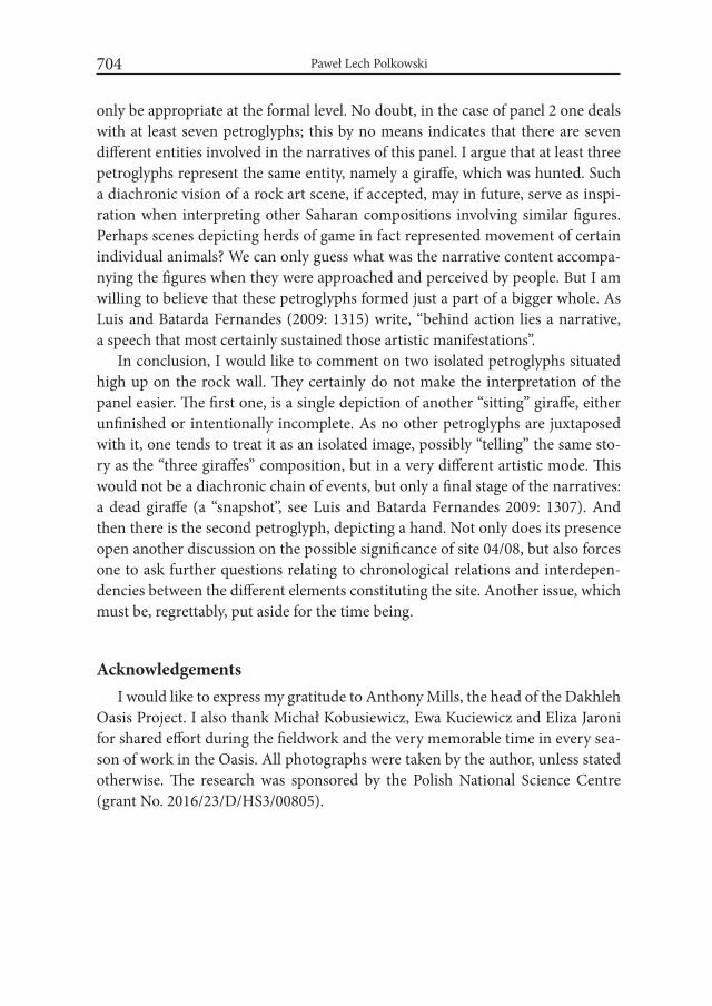
Paweł Lech Polkowski704
only be appropriate at the formal level. No doubt, in the case of panel 2 one deals with at least seven petroglyphs; this by no means indicates that there are seven different entities involved in the narratives of this panel. I argue that at least three petroglyphs represent the same entity, namely a giraffe, which was hunted. Such a diachronic vision of a rock art scene, if accepted, may in future, serve as inspi-ration when interpreting other Saharan compositions involving similar figures. Perhaps scenes depicting herds of game in fact represented movement of certain individual animals? We can only guess what was the narrative content accompa-nying the figures when they were approached and perceived by people. But I am willing to believe that these petroglyphs formed just a part of a bigger whole. As Luis and Batarda Fernandes (2009: 1315) write, “behind action lies a narrative, a speech that most certainly sustained those artistic manifestations”.
In conclusion, I would like to comment on two isolated petroglyphs situated high up on the rock wall. They certainly do not make the interpretation of the panel easier. The first one, is a single depiction of another “sitting” giraffe, either unfinished or intentionally incomplete. As no other petroglyphs are juxtaposed with it, one tends to treat it as an isolated image, possibly “telling” the same sto-ry as the “three giraffes” composition, but in a very different artistic mode. This would not be a diachronic chain of events, but only a final stage of the narratives: a dead giraffe (a “snapshot”, see Luis and Batarda Fernandes 2009: 1307). And then there is the second petroglyph, depicting a hand. Not only does its presence open another discussion on the possible significance of site 04/08, but also forces one to ask further questions relating to chronological relations and interdepen-dencies between the different elements constituting the site. Another issue, which must be, regrettably, put aside for the time being.
AcknowledgementsI would like to express my gratitude to Anthony Mills, the head of the Dakhleh
Oasis Project. I also thank Michał Kobusiewicz, Ewa Kuciewicz and Eliza Jaroni for shared effort during the fieldwork and the very memorable time in every sea-son of work in the Oasis. All photographs were taken by the author, unless stated otherwise. The research was sponsored by the Polish National Science Centre (grant No. 2016/23/D/HS3/00805).

A Giraffe’s Tale. On Enigmatic Composition from Site 04/08 in the Central Dakhleh Oasis, Egypt 705
REFERENCES
AZÉMA, M. 2005. Breaking down movement in Paleolithic art. international Newsletter on Rock Art 43: 14-21.
AZÉMA, M. and F. RIVÈRE 2012. Animation in Palaeolithic art: a pre-echo of cinema. Antiquity 86: 316-324.
DEREGOWSKI, J. and F. BERGER 1997. Sitting giraffes. Sahara 9: 87-92.DOWSON, T.A. 2009. Re-animating hunter-gatherer rock-art research. Cam-
bridge Archaeological Journal 19(3): 378-387.ESTES, R. 1991. Behavior Guide to African Mammals. Berkeley: University of
California Press.HALLIER, U.W. 1995. Felsbilder früher Jägervölker der Zentral-Sahara. Stuttgart.HOLDREGE, C. 2005. The giraffe’s long neck. New York. IKRAM, S. 2009a. Drawing the World: Petroglyphs from Kharga Oasis. Archéo-
Nil 19: 67-82.IKRAM, S. 2009b. A desert zoo: An exploration of meaning and reality of animals
in the art of Kharga Oasis. In: H. Riemer, F. Förster, M. Herb and N. Pöllath (eds.), Desert animals in the eastern Sahara: Status, economic significance, and cultural reflection in antiquity. Colloquium Africanum 4: 263-285. Köln.
INGOLD, T. 2000. The perception of the environment: essays on livelihood, dwelling and skill. London.
INNIS, A.C. 1958. The behaviour of the giraffe, Giraffa camelopardalis, in the east-ern Transvaal. Proceedings of the Zoological Society of London 131: 245-278.
INNIS DAGG, A. 1971. Giraffa Camelopardalis. Mammalian Species 5: 1-8.JOLLY, L. 2003. Giraffe Husbandry Manual. URL: http://www.australasianzoo-
keeping.org/Husbandry%20Manuals/Husbandry%20manual%20Giraffe.pdf (accessed 30.09.2016).
KRZYŻANIAK, L. 1987. Dakhleh Oasis Project: Interim report on the first season of the recording of petroglyphs, January/February 1988. The Journal of the Society for the Study of Egyptian Antiquities 17: 182-191.
KRZYŻANIAK, L. 1990. Petroglyphs and the research on the development of the cul-tural attitude towards animals in the Dakhleh Oasis (Egypt). Sahara 3: 95-97.
KRZYŻANIAK, L. 2004. Dakhleh Oasis: Research on petroglyphs, 2003. Polish Archaeology in the Mediterranean 15: 181-189.
KUCIEWICZ, E., JARONI, E. and M. KOBUSIEWICZ 2010. Dakhleh Oasis, Petroglyph Unit. Rock art research, 2007. Polish Archaeology in the Medi-terranean 19: 305-310.
Paweł Lech Polkowski706
KUCIEWICZ, E. and M. KOBUSIEWICZ 2011. Dakhleh Oasis Project, Petro-glyph Unit. Rock art research, 2008. Polish Archaeology in the Mediterra-nean 20: 237-244.
LJUNGE, M. 2013. Beyond ‘the Phenomenological Walk’: Perspectives on the Experience of images. Norwegian Archaeological Review 46(2): 139-158.
LUIS, L. and A.P. BATARDA FERNANDES 2009. “On endless motion”: depiction of movement in the Upper Palaeolithic Côa Valley rock art (Portugal). In: Congresso internacional da iFRAO 2009, Piaui, Brasil: 1304-1318. IFRAO.
McDONALD, M.M.A. 2016. The pattern of Neolithization in Dakhleh Oasis in the Eastern Sahara. Quaternary international 410: 181-197.
NEWBERRY, P.E. 1893. Beni Hasan. Part II. London. PETERSON, D. and K. AMMANN 2013. Giraffe reflections. Berkeley, Los Ange-
les, London: University of California Press.POLKOWSKI, P.L. 2015. The Life of Petroglyphs: A Biographical Approach to
Rock Art in the Dakhleh Oasis, Egypt. American indian Rock Art 41: 43-55.POLKOWSKI, P.L. 2016. Krajobraz i sztuka naskalna. w palimpseście egipskiej
Oazy Dachla. Poznań. POLKOWSKI, P.L., KUCIEWICZ, E., JARONI, E. and M. KOBUSIEWICZ 2013.
Rock art research in the Dakhleh Oasis, Western Desert (Egypt). Petro-glyph Unit. Dakhleh Oasis Project. Sahara 24: 101-118.
RIEMER, H. 2011. El Kharafish. The archaeology of the Sheikh Muftah pastoral nomads in the desert around Dakhla Oasis (Egypt). Köln.
SEEBER, P.A., CIOFOLO, I. and A. GANSWINDT 2012. Behavioural inventory of the giraffe (Giraffa camelopardalis). BMC Research Notes 2012(5): 650. URL: http://dx.doi.org/10.1186/1756-0500-5-650 (accessed 30.09.2016).
VAN HOEK, M. 2005. The “Sitting” Zoomorph in Saharan Rock Art. Sahara 16: 181-189.
WINKLER, H.A. 1939. Rock-drawings of Southern Upper Egypt ii: Sir Robert Mond Desert Expedition: Season 1937-1938. London.
Desert and the Nile. Prehistory of the Nile Basin and the Sahara.
Papers in honour of Fred Wendorf Studies in African Archaeology 15
Poznań Archaeological Museum 2018
András Zboray
The Petroglyphs of Jebel Uweinat. Many Questions and a Few Answers…
IntroductionJebel Uweinat and its environs, lying in the centre of the aridest part of the
Libyan Desert (Eastern Sahara) at the convergence of the borders of Egypt, Libya and Sudan (Fig. 1), contains one of the most prolific concentrations of prehistoric rock art in Northern Africa. According to the last published count (Zboray 2009) there are 720 sites scattered about the mountain and the surrounding smaller mas-sifs. Of these, 414 sites contain paintings and 347 petroglyphs, with an overlap of 41 sites containing both.
Recent comprehensive publications (Le Quellec 2009; Zboray 2012) focused mainly on the paintings, on account of their artistic appeal and much finer execu-tion, allowing for a more detailed study and conclusions. The evidence from the paintings demonstrate that the peak of occupation at Uweinat and the surround-ing area was during the time of the cattle pastoralists, with 337 (81%) of the paint-ing sites depicting cattle or humans in the Uweinat cattle pastoralist style. From a series of superimpositions it may be deduced that the paintings of the cattle herders were preceded by several styles of paintings that lack any domesticated fauna with few exceptions of dogs (Zboray 2013). Correlating the sequence of paintings with climatic and archaeological evidence, the cattle pastoralists may be confidently assigned to the 4400-3300 BCE time span, with the preceding cul-
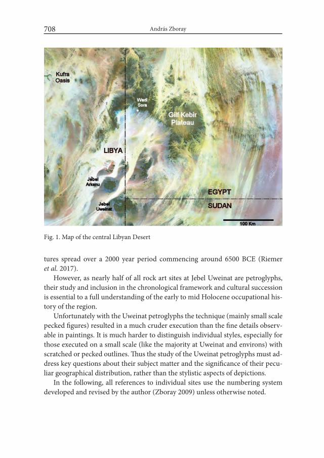
András Zboray708
tures spread over a 2000 year period commencing around 6500 BCE (Riemer et al. 2017).
However, as nearly half of all rock art sites at Jebel Uweinat are petroglyphs, their study and inclusion in the chronological framework and cultural succession is essential to a full understanding of the early to mid Holocene occupational his-tory of the region.
Unfortunately with the Uweinat petroglyphs the technique (mainly small scale pecked figures) resulted in a much cruder execution than the fine details observ-able in paintings. It is much harder to distinguish individual styles, especially for those executed on a small scale (like the majority at Uweinat and environs) with scratched or pecked outlines. Thus the study of the Uweinat petroglyphs must ad-dress key questions about their subject matter and the significance of their pecu-liar geographical distribution, rather than the stylistic aspects of depictions.
In the following, all references to individual sites use the numbering system developed and revised by the author (Zboray 2009) unless otherwise noted.
Fig. 1. Map of the central Libyan Desert
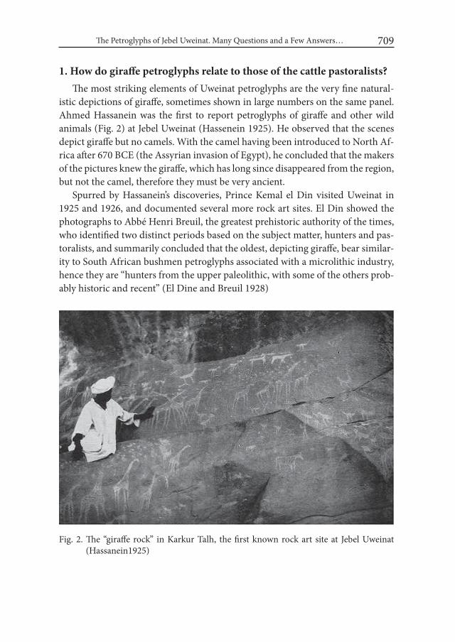
The Petroglyphs of Jebel Uweinat. Many Questions and a Few Answers… 709
1. How do giraffe petroglyphs relate to those of the cattle pastoralists?The most striking elements of Uweinat petroglyphs are the very fine natural-
istic depictions of giraffe, sometimes shown in large numbers on the same panel. Ahmed Hassanein was the first to report petroglyphs of giraffe and other wild animals (Fig. 2) at Jebel Uweinat (Hassenein 1925). He observed that the scenes depict giraffe but no camels. With the camel having been introduced to North Af-rica after 670 BCE (the Assyrian invasion of Egypt), he concluded that the makers of the pictures knew the giraffe, which has long since disappeared from the region, but not the camel, therefore they must be very ancient.
Spurred by Hassanein’s discoveries, Prince Kemal el Din visited Uweinat in 1925 and 1926, and documented several more rock art sites. El Din showed the photographs to Abbé Henri Breuil, the greatest prehistoric authority of the times, who identified two distinct periods based on the subject matter, hunters and pas-toralists, and summarily concluded that the oldest, depicting giraffe, bear similar-ity to South African bushmen petroglyphs associated with a microlithic industry, hence they are “hunters from the upper paleolithic, with some of the others prob-ably historic and recent” (El Dine and Breuil 1928)
Fig. 2. The “giraffe rock” in Karkur Talh, the first known rock art site at Jebel Uweinat (Hassanein1925)
András Zboray710
While Hans Rhotert made the first scientific survey of the petroglyphs and pa-intings, accompanying the 1933 Almásy/Frobenius expedition, his work remained unpublished till 1952. It was Hans Winkler who published the first monograph on the rock art of the area (1939), after having visited the area with Bagnold in 1938. He too identified two principal styles: the “Uweinat Cattle Breeders” (both paintings and petroglyphs, which he equated with his “Autochtonous Mountain Dwellers” of the Eastern Desert) which post date the “early hunters” who made exclusively petroglyphs of wild animals, predominantly giraffe. He commented that “the many grades of patination in the engravings prove that the occupation of Uweinat lasted for a very long period … from predynastic until far into historic times.”
Rhotert (1952) accepted Winkler’s general division and chronological se-quence, however observed that no evidence may be found of any contact with Egypt. He also noted that some scenes show both cattle and wild fauna, and con-sidered these petroglyphs and paintings to be the result of ‘intense intercourse’ between an indigenous group of hunters and cattle herder immigrants arriving from the south-west (lower Nile basin).
This view was supported by William McHugh who reviewed and published the archaeological material collected by Oliver Myers during the 1938 Mond-Bagnold expedition (McHugh 1971, 1975). He considered the petroglyphs depicting wild fauna to be the oldest, followed by an intermittent stage where both wild fauna and cattle were depicted, to be replaced by petroglyphs showing only cattle, be-fore the artists turned to paintings as their preferred medium. The same views were formulated by Paul Huard and Leone Allard-Huard, with a culture of ancient hunters represented by petroglyphs preceding two distinct groups (petroglyphs and paintings) of pastoralists (Huard and Allard-Huard 1977).
The monograph describing the results of the 1968 Belgian expedition to Jebel Uweinat (Van Noten 1978) substantially expanded the corpus of known paint-ings and petroglyphs, though unknown to Van Noten, many of the described petroglyphs were already recorded but not published by Winkler (as attested by the Winkler photographs in the Archives of the Egypt Exploration Society, Lon-don). Much influenced by McHugh (who reviewed the manuscript) Van Noten recognised five main periods of rock art at Jebel Uweinat. The early period dis-played exclusively petroglyphs of wild fauna without any depiction of cattle. This was followed by a period of petroglyphs of several styles, depicting among others long-horned cattle (taken to be domesticated Bos primigenius). He estimated this period to date posterior to 4500 B.C. the date of the appearance of these animals
The Petroglyphs of Jebel Uweinat. Many Questions and a Few Answers… 711
in Egypt. The next proposed period was of the paintings, dominated by cattle of Bos brachyceros type. His conclusion was that these paintings must post-date the petroglyphs and should be posterior to 2500 B.C. (when short-horned cattle made their debut in Egypt). The fourth recognised period was contemporary with or later than the previous, with depictions of goats replacing cattle, attributed to the increasing aridity of the area. Finally there was a period of protohistoric date, with present-day arid climate fauna and dromedaries shown exclusively on petro-glyphs.
All these categorisations and chronologies were based on the a priori assump-tion that any hunter-gatherers must precede pastoralists, and all petroglyphs lac-king domestcated fauna must by definition be hunter-gatherers. This view was challenged by Muzzolini (1981, 1995), who considered the absence of large “Ethi-opian fauna” (Elephant, rhinoceros) aside giraffe, and the presence of scimitar-horned oryx (a chronological marker for post pastoralist periods in the Central Sahara) proof that the petroglyphs depicting giraffe were of a later date than the paintings, from a period when the climate dried and could no longer support cat-tle. His argument in part was supported by the scarcity of giraffe (just two exam-ples known at the time) among the paintings.
Le Quellec first visited western Uweinat in 1996, and recorded several new rock art sites, including some paintings depicting giraffe (1998). He argued that as both petroglyphs and paintings represent giraffe and cattle, there is no need to make any distinction, they could be contemporary. He further argued that since archaeozoological material from the broader Libyan Desert area confirms the presence of large Ethiopian fauna in the region at the beginning of the Holocene, but no such fauna (except giraffe) is depicted, both petroglyphs and paintings must be relatively recent, not older than 4000 BP, by which time the environ-ment became so dry that only giraffe survived. Berger (2000) however presented that there is no conclusive evidence of large African fauna ever present at Jebel Uweinat itself, and suggested that 4000 BP is more likely a latest possible date for any giraffe depictions.
In light of new discoveries clearly indicating the presence of pre-pastoralist paintings Le Quellec revised his proposed chronology (Le Quellec et al. 2005) to permit an older date for the appearance of domesticated fauna and the preceding earlier painting styles, however did not address the position of petroglyphs.
In 2005 (revised in 2009) the author prepared an illustrated catalogue of all known rock art sites in the Gilf Kebir – Jebel Uweinat region, incorporating hun-dreds of new finds made over the preceding decade. An attempt was made to
András Zboray712
categorise petroglyphs based on depicted subjects along the lines developed by earlier authors, but incorporating some stylistic elements. This classification split petroglyphs into a group depicting ‘ancient’ wild fauna (primarily giraffe with some ostrich and oryx present), a group depicting cattle, and a group depicting present day arid climate wild fauna only (addax, oryx, ostrich, barbary sheep). However as both Rhotert, McHugh and LeQuellec observed, there are several panels of petroglyphs which depict both cattle and giraffe in a similar style, so this classification clearly needs to be revised.
Since 2002 numerous new rock art discoveries were made at Jebel Uweinat, among them several paintings that depict giraffe. Some of them show giraffe among cattle in the same style (eg. EH 21, Menardi Noguera et al. 2005, KTW 51, Zboray and Borda 2010), further giving support to LeQuellec’s observation that the presence of giraffe on any engraving cannot form a basis of differentiating them from cattle pastoralist art.
However giraffe are not only present in cattle pastoralist paintings. They are an integral part of the Wadi Sora style paintings in the Gilf Kebir, and several giraffe hunt scenes are known from miniature style paintings. A unique scene in Wadi Wahesh (WW52) shows a captured giraffe captured by a tether. All these scenes are demonstrably older than the cattle pastoralist paintings (Zboray 2013).
The 1998 discovery of the inscription of Montuhotep (II) Nebhepetre at Jebel Uweinat (Clayton et al. 2009) provided a unique dating opportunity for at least some of the local rock art. The inscription itself contains a version of the Royal Nomen (with the Sa Re title inside the cartouche) that was only in use between the 14th and 39th years of the reign, approximately 2047-2022 BCE (Von Beckerath 1984). On a terrace above the inscription, there are numerous petroglyphs depict-ing humans and wild fauna, including giraffe, oryx and ostrich (but no cattle). Associated with these petroglyphs, executed in the same style and with similar patination, there are four crude copies of the offering bearers of the Mentuhotep inscription. This association provides strong evidence that giraffe were present in the area until at least 2000 BCE, more than a thousand years after cattle have disappeared (Zboray and Borda 2010).
The corpus of sites and figures provide clear evidence that giraffe existed throughout the rock art producing periods of Jebel Uweinat (except the historic to recent period characterized by crude engravings of camels), and its presence or absence cannot be used as a chronological marker. To answer the original ques-tion of how giraffe petroglyphs relate to cattle pastoralist art of the region, the context of giraffe and cattle must be examined in detail.

The Petroglyphs of Jebel Uweinat. Many Questions and a Few Answers… 713
Of the 347 studied sites with petroglyphs in the Jebel Uweinat region (Zboray 2009), 248 contain giraffe or cattle among their depicted subjects, the balance showing other wild fauna, human figures or camels in any combination. Of these, 130 contain only cattle, 76 only giraffe, and 42 sites display both on the same panel.
Despite the large number of sites, there are only seven instances where giraffe and cattle petroglyphs overlap. In four of these, at sites KT 23/B (Fig. 3), KTN 11/C, KTS 12 and KTS 25, cattle are clearly superimposed over giraffe. However at three other sites, AR 11/B (Fig. 4), KT 39/A and KTE 12/A, giraffe overlie the cattle. In all cases there is very little if any difference in execution technique, style or patination, suggesting that only a short time elapsed between the creation of the lower layers and the superimposed figures.
In general there is little ground to make any stylistic distinctions between the majority of giraffe and cattle petroglyphs, there are several panels (e.g. AR 11/B, KT 12/A, KT 26, WW 23) where it is very clear from all details that the cattle and
Fig. 3. Engraved cattle superimposed over a giraffe, site KT 23/B (Karkur Talh, Jebel Uweinat)
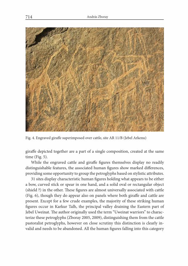
András Zboray714
giraffe depicted together are a part of a single composition, created at the same time (Fig. 5).
While the engraved cattle and giraffe figures themselves display no readily distinguishable features, the associated human figures show marked differences, providing some opportunity to group the petroglyphs based on stylistic attributes.
31 sites display characteristic human figures holding what appears to be either a bow, curved stick or spear in one hand, and a solid oval or rectangular object (shield ?) in the other. These figures are almost universally associated with cattle (Fig. 6), though they do appear also on panels where both giraffe and cattle are present. Except for a few crude examples, the majority of these striking human figures occur in Karkur Talh, the principal valley draining the Eastern part of Jebel Uweinat. The author originally used the term “Uweinat warriors” to charac-terize these petroglyphs (Zboray 2005, 2009), distinguishing them from the cattle pastoralist petroglyphs, however on close scrutiny this distinction is clearly in-valid and needs to be abandoned. All the human figures falling into this category
Fig. 4. Engraved giraffe superimposed over cattle, site AR 11/B (Jebel Arkenu)

Fig. 5. Cattle and giraffe executed in identical style on the same panel, site KT 12/A (Karkur Talh, Jebel Uweinat)
Fig. 6. Human figure associated with cattle holding a rectangular object (shield?) and a pair of curved sticks , site KT 23/A (Karkur Talh, Jebel Uweinat)
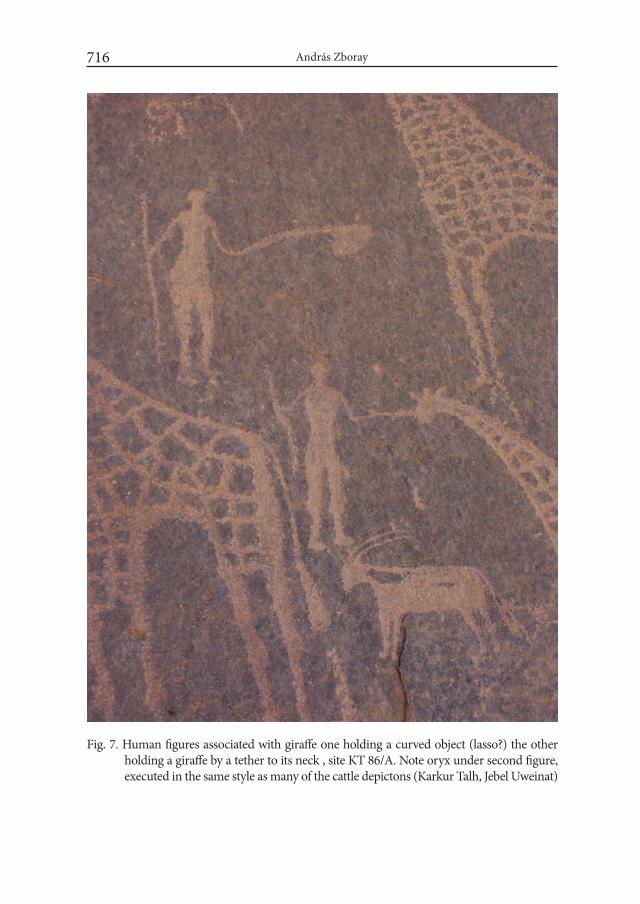
András Zboray716
Fig. 7. Human figures associated with giraffe one holding a curved object (lasso?) the other holding a giraffe by a tether to its neck , site KT 86/A. Note oryx under second figure, executed in the same style as many of the cattle depictons (Karkur Talh, Jebel Uweinat)
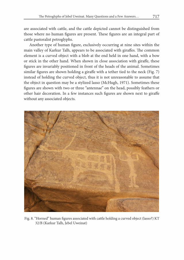
The Petroglyphs of Jebel Uweinat. Many Questions and a Few Answers… 717
are associated with cattle, and the cattle depicted cannot be distinguished from those where no human figures are present. These figures are an integral part of cattle pastoralist petroglyphs.
Another type of human figure, exclusively occurring at nine sites within the main valley of Karkur Talh, appears to be associated with giraffes. The common element is a curved object with a blob at the end held in one hand, with a bow or stick in the other hand. When shown in close association with giraffe, these figures are invariably positioned in front of the heads of the animal. Sometimes similar figures are shown holding a giraffe with a tether tied to the neck (Fig. 7) instead of holding the curved object, thus it is not unreasonable to assume that the object in question may be a stylized lasso (McHugh, 1971). Sometimes these figures are shown with two or three “antennae” on the head, possibly feathers or other hair decoration. In a few instances such figures are shown next to giraffe without any associated objects.
Fig. 8. “Horned” human figures associated with cattle holding a curved object (lasso?) KT 32/B (Karkur Talh, Jebel Uweinat)
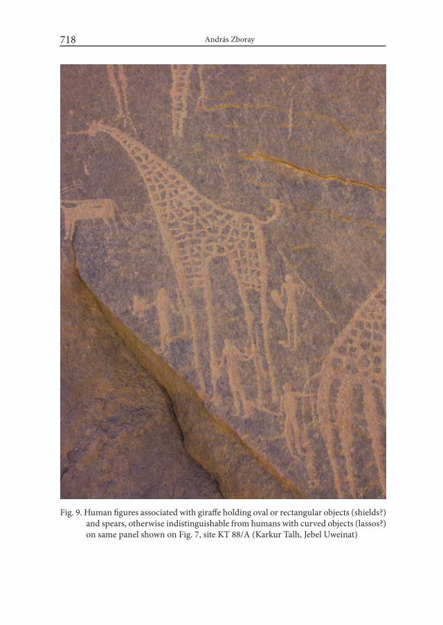
András Zboray718
Fig. 9. Human figures associated with giraffe holding oval or rectangular objects (shields?) and spears, otherwise indistinguishable from humans with curved objects (lassos?) on same panel shown on Fig. 7, site KT 88/A (Karkur Talh, Jebel Uweinat)
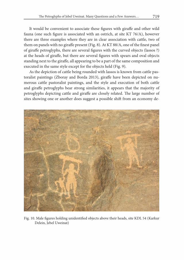
The Petroglyphs of Jebel Uweinat. Many Questions and a Few Answers… 719
It would be convenient to associate these figures with giraffe and other wild fauna (one such figure is associated with an ostrich, at site KT 76/A), however there are three examples where they are in clear association with cattle, two of them on panels with no giraffe present (Fig. 8). At KT 88/A, one of the finest panel of giraffe petroglyphs, there are several figures with the curved objects (lassos ?) at the heads of giraffe, but there are several figures with spears and oval objects standing next to the giraffe, all appearing to be a part of the same composition and executed in the same style except for the objects held (Fig. 9).
As the depiction of cattle being rounded with lassos is known from cattle pas-toralist paintings (Zboray and Borda 2013), giraffe have been depicted on nu-merous cattle pastoralist paintings, and the style and execution of both cattle and giraffe petroglyphs bear strong similarities, it appears that the majority of petroglyphs depicting cattle and giraffe are closely related. The large number of sites showing one or another does suggest a possible shift from an economy de-
Fig. 10. Male figures holding unidentified objects above their heads, site KDL 54 (Karkur Delein, Jebel Uweinat)
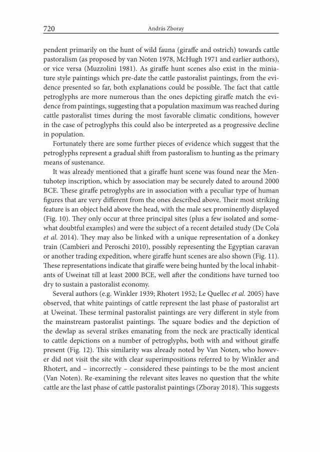
András Zboray720
pendent primarily on the hunt of wild fauna (giraffe and ostrich) towards cattle pastoralism (as proposed by van Noten 1978, McHugh 1971 and earlier authors), or vice versa (Muzzolini 1981). As giraffe hunt scenes also exist in the minia-ture style paintings which pre-date the cattle pastoralist paintings, from the evi-dence presented so far, both explanations could be possible. The fact that cattle petroglyphs are more numerous than the ones depicting giraffe match the evi-dence from paintings, suggesting that a population maximum was reached during cattle pastoralist times during the most favorable climatic conditions, however in the case of petroglyphs this could also be interpreted as a progressive decline in population.
Fortunately there are some further pieces of evidence which suggest that the petroglyphs represent a gradual shift from pastoralism to hunting as the primary means of sustenance.
It was already mentioned that a giraffe hunt scene was found near the Men-tuhotep inscription, which by association may be securely dated to around 2000 BCE. These giraffe petroglyphs are in association with a peculiar type of human figures that are very different from the ones described above. Their most striking feature is an object held above the head, with the male sex prominently displayed (Fig. 10). They only occur at three principal sites (plus a few isolated and some-what doubtful examples) and were the subject of a recent detailed study (De Cola et al. 2014). They may also be linked with a unique representation of a donkey train (Cambieri and Peroschi 2010), possibly representing the Egyptian caravan or another trading expedition, where giraffe hunt scenes are also shown (Fig. 11). These representations indicate that giraffe were being hunted by the local inhabit-ants of Uweinat till at least 2000 BCE, well after the conditions have turned too dry to sustain a pastoralist economy.
Several authors (e.g. Winkler 1939; Rhotert 1952; Le Quellec et al. 2005) have observed, that white paintings of cattle represent the last phase of pastoralist art at Uweinat. These terminal pastoralist paintings are very different in style from the mainstream pastoralist paintings. The square bodies and the depiction of the dewlap as several strikes emanating from the neck are practically identical to cattle depictions on a number of petroglyphs, both with and without giraffe present (Fig. 12). This similarity was already noted by Van Noten, who howev-er did not visit the site with clear superimpositions referred to by Winkler and Rhotert, and – incorrectly – considered these paintings to be the most ancient (Van Noten). Re-examining the relevant sites leaves no question that the white cattle are the last phase of cattle pastoralist paintings (Zboray 2018). This suggests
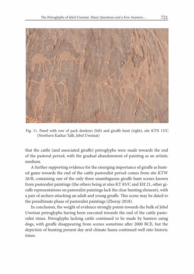
The Petroglyphs of Jebel Uweinat. Many Questions and a Few Answers… 721
that the cattle (and associated giraffe) petroglyphs were made towards the end of the pastoral period, with the gradual abandonment of painting as an artistic medium.
A further supporting evidence for the emerging importance of giraffe as hunt-ed game towards the end of the cattle pastoralist period comes from site KTW 26/B, containing one of the only three unambiguous giraffe hunt scenes known from pastoralist paintings (the others being at sites KT 83/C and EH 21, other gi-raffe representations on pastoralist paintings lack the clear hunting element), with a pair of archers attacking an adult and young giraffe. This scene may be dated to the penultimate phase of pastoralist paintings (Zboray 2018).
In conclusion, the weight of evidence strongly points towards the bulk of Jebel Uweinat petroglyphs having been executed towards the end of the cattle pasto-ralist times. Petroglyphs lacking cattle continued to be made by hunters using dogs, with giraffe disappearing from scenes sometime after 2000 BCE, but the depiction of hunting present day arid climate fauna continued well into historic times.
Fig. 11. Panel with row of pack donkeys (left) and giraffe hunt (right), site KTN 13/C (Northern Karkur Talh, Jebel Uweinat)

Fig. 12. Cattle representing the latest phase of cattle pastoralist paintings at site KT 64, and engraved cattle in an identical style at site KT 72/D (Karkur Talh, Jebel Uweinat)

The Petroglyphs of Jebel Uweinat. Many Questions and a Few Answers… 723
2. Are there any petroglyphs at Uweinat pre-dating the cattle pastoralists ?
While the arguments presented in the previous section demonstrate that the majority of petroglyphs at Jebel Uweinat and environs are contemporary with, or post-date the cattle pastoralist paintings, the possibility remains that some older petroglyphs do exist, not conforming to the above described patterns.
Just 200 kilometres to the North of Jebel Uweinat, at site WG 21 (“Cave of the Beasts”) near Wadi Sora along the Western Edge of the there are several petro-glyphs of wild fauna which are overlain by the negative hand stencils which repre-sent the oldest layer of paintings (Le Quellec et al. 2005). As the paintings may be dated to the 6500-4500 BCE period, these Wadi Sora petroglyphs are among the very earliest rock art known in the central Libyan Desert. They are not pecked in outline like those at Jebel Uweinat, but are executed in a shallow sunk relief, with the entire body sunk into the rock surface and smoothed (Fig. 13).
Fig. 13. Animal with curved horns, executed in sunk relief, painted over by later negative hand stencils, site WG 21 (“Cave of Beasts”, Wadi Sora, Gilf Kebir plateau)
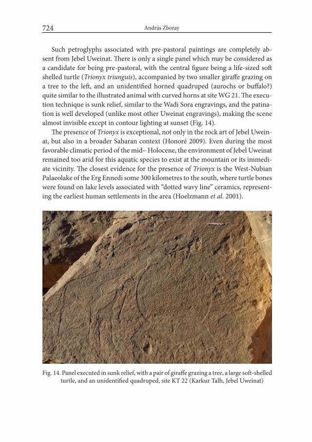
András Zboray724
Such petroglyphs associated with pre-pastoral paintings are completely ab-sent from Jebel Uweinat. There is only a single panel which may be considered as a candidate for being pre-pastoral, with the central figure being a life-sized soft shelled turtle (Trionyx triunguis), accompanied by two smaller giraffe grazing on a tree to the left, and an unidentified horned quadruped (aurochs or buffalo?) quite similar to the illustrated animal with curved horns at site WG 21. The execu-tion technique is sunk relief, similar to the Wadi Sora engravings, and the patina-tion is well developed (unlike most other Uweinat engravings), making the scene almost invisible except in contour lighting at sunset (Fig. 14).
The presence of Trionyx is exceptional, not only in the rock art of Jebel Uwein-at, but also in a broader Saharan context (Honoré 2009). Even during the most favorable climatic period of the mid– Holocene, the environment of Jebel Uweinat remained too arid for this aquatic species to exist at the mountain or its immedi-ate vicinity. The closest evidence for the presence of Trionyx is the West-Nubian Palaeolake of the Erg Ennedi some 300 kilometres to the south, where turtle bones were found on lake levels associated with “dotted wavy line” ceramics, represent-ing the earliest human settlements in the area (Hoelzmann et al. 2001).
Fig. 14. Panel executed in sunk relief, with a pair of giraffe grazing a tree, a large soft-shelled turtle, and an unidentified quadruped, site KT 22 (Karkur Talh, Jebel Uweinat)
The Petroglyphs of Jebel Uweinat. Many Questions and a Few Answers… 725
Similar dotted wavy line ceramics may be found at Uweinat associated with pre-pastoralist rock art sites (Riemer et al. 2017), and 300 kilometres is certainly not an unsurmountable distance for highly mobile small groups of hunter-gath-erers. The combined circumstantial evidence does suggest that this unique pan-el could be the oldest engraving at Uweinat, though being a single example not much more may be deduced.
3. Is there any evidence of depiction of large African fauna (other than giraffe) at Jebel Uweinat ?
Muzzolini (1981) used the lack of any of the “classical” large African fauna (elephant, rhinoceros, hippopotamus) as evidence for the late date of all rock art in the Jebel Uweinat region. However recent discoveries have created a somewhat more ambiguous picture. Among the already referred to petroglyphs in site WG 21 (“Cave of Beasts”) there is one very stylized depiction of an elephant, only rec-ognizable on account of the trunk and tusks as the rest of the body proportions bear no resemblance to a real animal. Two other panels with elephant petroglyphs have been found in the Gilf Kebir (Morelli et al. 2006; Zboray 2008), and one at Jebel es Soda in Libya (Berger et al. 2003). The common trait of all these panels is the association of the elephants with giraffe and ostrich, which on superficial look may not be distinguished from the petroglyphs depicting the same subject (minus elephants) at Jebel Uweinat.
However all the panels depicting elephants exhibit the low relief technique seen on the Cave of Beasts petroglyphs, with a smoothed body and a marked sunk edge as opposed to the lack of perceptible depth and rough pecked outlines and interior of the Uweinat wild fauna petroglyphs. The elephants, while recogniz-able, do not show natural body proportions, especially the legs are shown as long and thin, contrasting sharply with the fine anatomical detail shown on associated giraffe and ostrich figures. A ready explanation could be that the elephants were drawn based on a verbal description or distant memories, with no living examples to be observed in the closer environment.
While all the discussed examples may be assigned to the pre-pastoral periods, Le Quellec professed to see a figure of an elephant (Le Quellec et al. 2005, fig. 177) on a panel of Uweinat cattle pastoralist paintings at site KM 12 in Karkur Murr, at Jebel Uweinat. However the scene is much weathered, and the identification is highly questionable. The author is of the opinion that the “elephant” is in fact made up of several overlapping and partially effaced cattle.
András Zboray726
A supposed rhinoceros was also reported from the Wadi Hamra in the Gilf Kebir (Negro 2001). While its presence would not be surprising in the light of the recent elephant finds, the identification is very doubtful. Having observed the figure several times under different lighting conditions (site WH 2), the author is of the opinion that the crude pecked figure represents some other quadruped (possibly cattle), the “horn” being simply a flaw in the rock rather than part of the man-made figure.
As such one must agree with the conclusion of Berger (2000) that large African fauna were completely absent from the Jebel Uweinat region throughout the rock art producing periods.
4. Were the petroglyphs depicting cattle made by the same people who created the cattle paintings ?
Paintings of cattle, sometimes by the hundreds, often accompanied by the characteristic elongated human figures dominate the rock art landscape of Jebel Uweinat. The sheer numbers and proportions (337 sites out of a total of 414 paint-ings at Uweinat) suggest that the cattle pastoralist paintings represent the peak of human occupation at Jebel Uweinat. As the majority of petroglyphs also depict cattle, but in a seemingly very different style, the question arises whether the two were made by the same or different people.
It may be argued that the differences observable in the depictions of cattle (dif-ferent body postures, different coat patterns, etc.) may be explained by the choice of different mediums, however also the depicted human figures and their acces-sories are very different.
While there is a considerable variation in the style of depicting human figures among the Uweinat cattle pastoralists (Zboray 2018), a number of common ac-cessories unique to the Uweinat pastoralists confirm a clear cultural continuity (MenardiNoguera and Zboray 2011; Zboray 2013). The cattle pastoralists who made the paintings had well established conventions of representing the human body, clothing and accessories. Some recent and partially unpublished finds con-firm that these conventions were applied in petroglyphs too. At Jebel Soda Berger and Le Quellec found two engraved figures (ER 2, Berger et al. 2003, ER 3/A; Le Quellec et al. 2005) carrying the characteristic “tailed quiver cum utility bag” which is a standard accessory of the Uweinat cattle pastoralists. At site SU 17 a scene shows a couple of elongated human figures in the characteristic body pos-ture (both elbows bent) together with cattle, and a group of similar archers hunt-

The Petroglyphs of Jebel Uweinat. Many Questions and a Few Answers… 727
Fig. 15. Giraffe hunt scene, the style and body posture of archers with elongated bodies are similar to depictions of archers on cattle pastoralist paintings, site SU 17 (South Uweinat)
András Zboray728
ing a giraffe (Fig. 15, echoing the scene at KTW 26/B), while near Wadi Wahesh a recent find (Zboray and Borda 2013) again shows a typical cattle pastoralist couple in a posture seen on dozens of paintings. These rare but clearly recogniz-able examples indicate that the artists of the paintings could reproduce the same style in petroglyphs, just their preference was for paintings.
In contrast the characteristic figures holding spear and oval/rectangular ob-jects (shield ?) and the curved objects (lassos ?) have no parallels in any of the cattle pastoralist paintings. The single apparent example at site KT 57 on close scrutiny is revealed to hold a bow in one hand and a bunch of arrows in the other, rather than the rectangular or oval solid object depicted on petroglyphs.
The marked differences in depicting humans on paintings and on the majority of petroglyphs suggest that the latter were made by a group of people with different artistic conventions and cultural traditions. As it had already been demonstrated that the cattle petroglyphs are related to a small subset of paintings representing the final stages of painting activity at Uweinat, one may tentatively conclude that sometime near the end of the cattle pastoralist period a new group arrived to Jebel Uweinat, possibly after a temporary abandonment by the earlier pastoralists who made the majority of the paintings.
This hypothesis is supported by observing the rock art of Uweinat in a broad-er regional context. While the Uweinat cattle pastoralist paintings have no di-rect stylistic parallels elsewhere, both Huard (Huard and Leclant 1972) and Le Quellec (2005) commented on the resembance of some Jebel Uweinat petroglyphs to those attributed to the Nubian C Group in the Nile Valley, and there are also some recently discovered cattle pastoralist petroglyphs at Bir Nurayet (Bobrows-ki et al. 2013) in North-eastern Sudan which show a marked similarity to the engraved cattle at Uweinat. Perhaps most intriguingly, a large panel of petro-glyphs near the town of Bardai in the central Tibesti Mountains depicts a herd of cattle accompanied by a group of people appearing to hold the same curved objects (lassos ?) as some of the figures at Jebel Uweinat (Staewen and Striedter 1987).
While these similarities and the archaeological context have not yet been stud-ied in any detail, it is entirely conceivable to envision a period of increased migra-tion around 3500-2500 BCE when the gradual onset of present-day aridity forced pastoralist people to seek out new, more favorable grazing areas, while returning to the marginal desert regions during short wetter interludes (much as the Tibu people returned to Uweinat periodically after years of better rain in the first half of the last century).
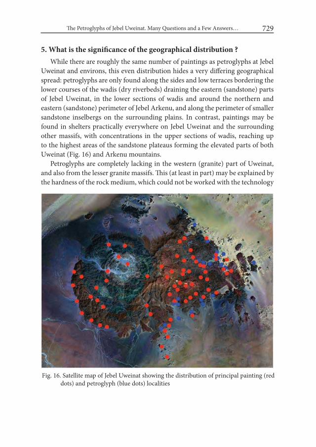
The Petroglyphs of Jebel Uweinat. Many Questions and a Few Answers… 729
5. What is the significance of the geographical distribution ?While there are roughly the same number of paintings as petroglyphs at Jebel
Uweinat and environs, this even distribution hides a very differing geographical spread: petroglyphs are only found along the sides and low terraces bordering the lower courses of the wadis (dry riverbeds) draining the eastern (sandstone) parts of Jebel Uweinat, in the lower sections of wadis and around the northern and eastern (sandstone) perimeter of Jebel Arkenu, and along the perimeter of smaller sandstone inselbergs on the surrounding plains. In contrast, paintings may be found in shelters practically everywhere on Jebel Uweinat and the surrounding other massifs, with concentrations in the upper sections of wadis, reaching up to the highest areas of the sandstone plateaus forming the elevated parts of both Uweinat (Fig. 16) and Arkenu mountains.
Petroglyphs are completely lacking in the western (granite) part of Uweinat, and also from the lesser granite massifs. This (at least in part) may be explained by the hardness of the rock medium, which could not be worked with the technology
Fig. 16. Satellite map of Jebel Uweinat showing the distribution of principal painting (red dots) and petroglyph (blue dots) localities
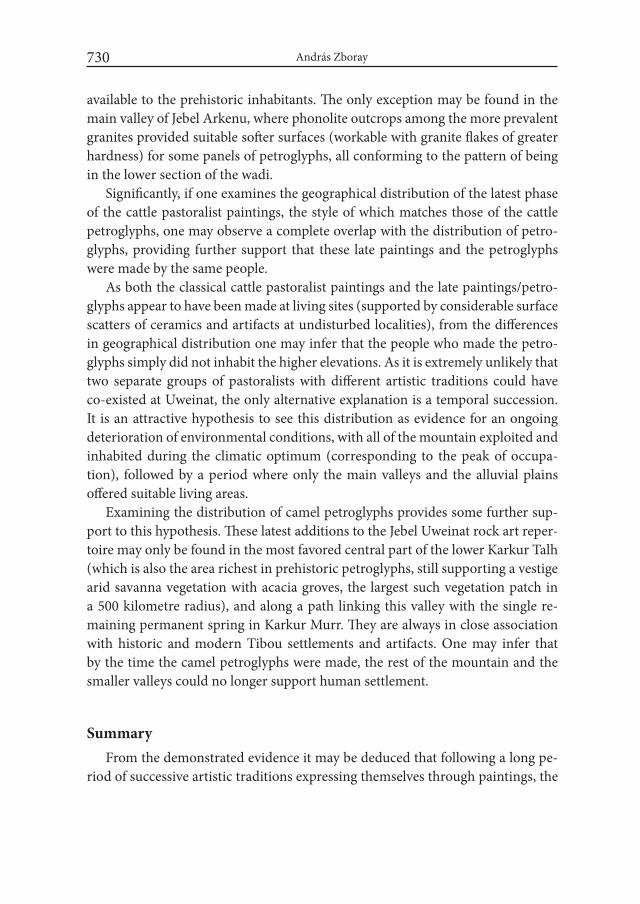
András Zboray730
available to the prehistoric inhabitants. The only exception may be found in the main valley of Jebel Arkenu, where phonolite outcrops among the more prevalent granites provided suitable softer surfaces (workable with granite flakes of greater hardness) for some panels of petroglyphs, all conforming to the pattern of being in the lower section of the wadi.
Significantly, if one examines the geographical distribution of the latest phase of the cattle pastoralist paintings, the style of which matches those of the cattle petroglyphs, one may observe a complete overlap with the distribution of petro-glyphs, providing further support that these late paintings and the petroglyphs were made by the same people.
As both the classical cattle pastoralist paintings and the late paintings/petro-glyphs appear to have been made at living sites (supported by considerable surface scatters of ceramics and artifacts at undisturbed localities), from the differences in geographical distribution one may infer that the people who made the petro-glyphs simply did not inhabit the higher elevations. As it is extremely unlikely that two separate groups of pastoralists with different artistic traditions could have co-existed at Uweinat, the only alternative explanation is a temporal succession. It is an attractive hypothesis to see this distribution as evidence for an ongoing deterioration of environmental conditions, with all of the mountain exploited and inhabited during the climatic optimum (corresponding to the peak of occupa-tion), followed by a period where only the main valleys and the alluvial plains offered suitable living areas.
Examining the distribution of camel petroglyphs provides some further sup-port to this hypothesis. These latest additions to the Jebel Uweinat rock art reper-toire may only be found in the most favored central part of the lower Karkur Talh (which is also the area richest in prehistoric petroglyphs, still supporting a vestige arid savanna vegetation with acacia groves, the largest such vegetation patch in a 500 kilometre radius), and along a path linking this valley with the single re-maining permanent spring in Karkur Murr. They are always in close association with historic and modern Tibou settlements and artifacts. One may infer that by the time the camel petroglyphs were made, the rest of the mountain and the smaller valleys could no longer support human settlement.
SummaryFrom the demonstrated evidence it may be deduced that following a long pe-
riod of successive artistic traditions expressing themselves through paintings, the
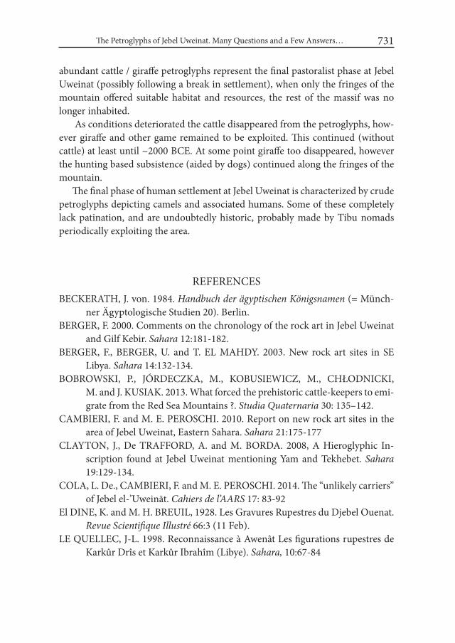
The Petroglyphs of Jebel Uweinat. Many Questions and a Few Answers… 731
abundant cattle / giraffe petroglyphs represent the final pastoralist phase at Jebel Uweinat (possibly following a break in settlement), when only the fringes of the mountain offered suitable habitat and resources, the rest of the massif was no longer inhabited.
As conditions deteriorated the cattle disappeared from the petroglyphs, how-ever giraffe and other game remained to be exploited. This continued (without cattle) at least until ~2000 BCE. At some point giraffe too disappeared, however the hunting based subsistence (aided by dogs) continued along the fringes of the mountain.
The final phase of human settlement at Jebel Uweinat is characterized by crude petroglyphs depicting camels and associated humans. Some of these completely lack patination, and are undoubtedly historic, probably made by Tibu nomads periodically exploiting the area.
REFERENCESBECKERATH, J. von. 1984. Handbuch der ägyptischen Königsnamen (= Münch-
ner Ägyptologische Studien 20). Berlin. BERGER, F. 2000. Comments on the chronology of the rock art in Jebel Uweinat
and Gilf Kebir. Sahara 12:181-182.BERGER, F., BERGER, U. and T. EL MAHDY. 2003. New rock art sites in SE
Libya. Sahara 14:132-134.BOBROWSKI, P., JÓRDECZKA, M., KOBUSIEWICZ, M., CHŁODNICKI,
M. and J. KUSIAK. 2013. What forced the prehistoric cattle-keepers to emi-grate from the Red Sea Mountains ?. Studia Quaternaria 30: 135–142.
CAMBIERI, F. and M. E. PEROSCHI. 2010. Report on new rock art sites in the area of Jebel Uweinat, Eastern Sahara. Sahara 21:175-177
CLAYTON, J., De TRAFFORD, A. and M. BORDA. 2008, A Hieroglyphic In-scription found at Jebel Uweinat mentioning Yam and Tekhebet. Sahara 19:129-134.
COLA, L. De., CAMBIERI, F. and M. E. PEROSCHI. 2014. The “unlikely carriers” of Jebel el-’Uweināt. Cahiers de l’AARS 17: 83-92
El DINE, K. and M. H. BREUIL, 1928. Les Gravures Rupestres du Djebel Ouenat. Revue Scientifique illustré 66:3 (11 Feb).
LE QUELLEC, J-L. 1998. Reconnaissance à Awenât Les figurations rupestres de Karkûr Drîs et Karkûr Ibrahîm (Libye). Sahara, 10:67-84
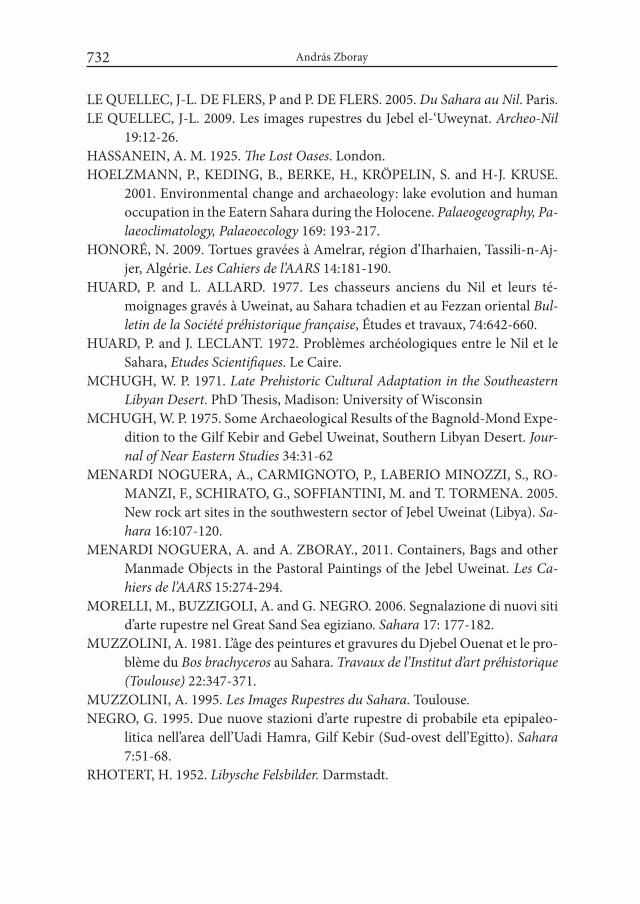
András Zboray732
LE QUELLEC, J-L. DE FLERS, P and P. DE FLERS. 2005. Du Sahara au Nil. Paris.LE QUELLEC, J-L. 2009. Les images rupestres du Jebel el-‘Uweynat. Archeo-Nil
19:12-26.HASSANEIN, A. M. 1925. The Lost Oases. London.HOELZMANN, P., KEDING, B., BERKE, H., KRÖPELIN, S. and H-J. KRUSE.
2001. Environmental change and archaeology: lake evolution and human occupation in the Eatern Sahara during the Holocene. Palaeogeography, Pa-laeoclimatology, Palaeoecology 169: 193-217.
HONORÉ, N. 2009. Tortues gravées à Amelrar, région d’Iharhaien, Tassili-n-Aj-jer, Algérie. Les Cahiers de l’AARS 14:181-190.
HUARD, P. and L. ALLARD. 1977. Les chasseurs anciens du Nil et leurs té-moignages gravés à Uweinat, au Sahara tchadien et au Fezzan oriental Bul-letin de la Société préhistorique française, Études et travaux, 74:642-660.
HUARD, P. and J. LECLANT. 1972. Problèmes archéologiques entre le Nil et le Sahara, Etudes Scientifiques. Le Caire.
MCHUGH, W. P. 1971. Late Prehistoric Cultural Adaptation in the Southeastern Libyan Desert. PhD Thesis, Madison: University of Wisconsin
MCHUGH, W. P. 1975. Some Archaeological Results of the Bagnold-Mond Expe-dition to the Gilf Kebir and Gebel Uweinat, Southern Libyan Desert. Jour-nal of Near Eastern Studies 34:31-62
MENARDI NOGUERA, A., CARMIGNOTO, P., LABERIO MINOZZI, S., RO-MANZI, F., SCHIRATO, G., SOFFIANTINI, M. and T. TORMENA. 2005. New rock art sites in the southwestern sector of Jebel Uweinat (Libya). Sa-hara 16:107-120.
MENARDI NOGUERA, A. and A. ZBORAY., 2011. Containers, Bags and other Manmade Objects in the Pastoral Paintings of the Jebel Uweinat. Les Ca-hiers de l’AARS 15:274-294.
MORELLI, M., BUZZIGOLI, A. and G. NEGRO. 2006. Segnalazione di nuovi siti d’arte rupestre nel Great Sand Sea egiziano. Sahara 17: 177-182.
MUZZOLINI, A. 1981. L’âge des peintures et gravures du Djebel Ouenat et le pro-blème du Bos brachyceros au Sahara. Travaux de l’institut d’art préhistorique (Toulouse) 22:347-371.
MUZZOLINI, A. 1995. Les images Rupestres du Sahara. Toulouse.NEGRO, G. 1995. Due nuove stazioni d’arte rupestre di probabile eta epipaleo-
litica nell’area dell’Uadi Hamra, Gilf Kebir (Sud-ovest dell’Egitto). Sahara 7:51-68.
RHOTERT, H. 1952. Libysche Felsbilder. Darmstadt.
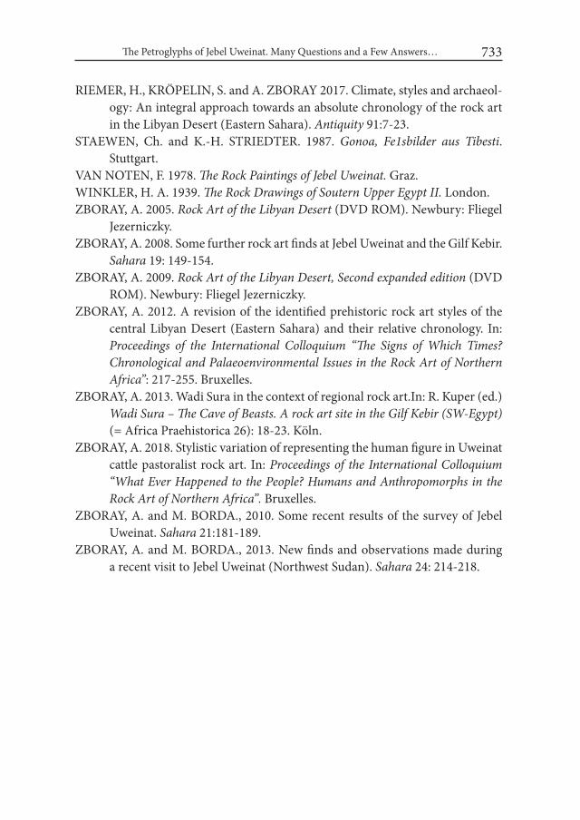
The Petroglyphs of Jebel Uweinat. Many Questions and a Few Answers… 733
RIEMER, H., KRÖPELIN, S. and A. ZBORAY 2017. Climate, styles and archaeol-ogy: An integral approach towards an absolute chronology of the rock art in the Libyan Desert (Eastern Sahara). Antiquity 91:7-23.
STAEWEN, Ch. and K.-H. STRIEDTER. 1987. Gonoa, Fe1sbilder aus Tibesti. Stuttgart.
VAN NOTEN, F. 1978. The Rock Paintings of Jebel Uweinat. Graz.WINKLER, H. A. 1939. The Rock Drawings of Soutern Upper Egypt ii. London.ZBORAY, A. 2005. Rock Art of the Libyan Desert (DVD ROM). Newbury: Fliegel
Jezerniczky.ZBORAY, A. 2008. Some further rock art finds at Jebel Uweinat and the Gilf Kebir.
Sahara 19: 149-154.ZBORAY, A. 2009. Rock Art of the Libyan Desert, Second expanded edition (DVD
ROM). Newbury: Fliegel Jezerniczky.ZBORAY, A. 2012. A revision of the identified prehistoric rock art styles of the
central Libyan Desert (Eastern Sahara) and their relative chronology. In: Proceedings of the international Colloquium “The Signs of which Times? Chronological and Palaeoenvironmental issues in the Rock Art of Northern Africa”: 217-255. Bruxelles.
ZBORAY, A. 2013. Wadi Sura in the context of regional rock art.In: R. Kuper (ed.) wadi Sura – The Cave of Beasts. A rock art site in the Gilf Kebir (Sw-Egypt) (= Africa Praehistorica 26): 18-23. Köln.
ZBORAY, A. 2018. Stylistic variation of representing the human figure in Uweinat cattle pastoralist rock art. In: Proceedings of the international Colloquium “what Ever Happened to the People? Humans and Anthropomorphs in the Rock Art of Northern Africa”. Bruxelles.
ZBORAY, A. and M. BORDA., 2010. Some recent results of the survey of Jebel Uweinat. Sahara 21:181-189.
ZBORAY, A. and M. BORDA., 2013. New finds and observations made during a recent visit to Jebel Uweinat (Northwest Sudan). Sahara 24: 214-218.

Desert and the Nile. Prehistory of the Nile Basin and the Sahara.
Papers in honour of Fred Wendorf Studies in African Archaeology 15
Poznań Archaeological Museum 2018
List of volume contributors
AHMED HAMID NASSR, Al-Neelain University, Faculty of Arts, Archaeology Department, Kahrtoum, Sudan; e-mail: [email protected]
Elizabeth ALEXANDER, e-mail: [email protected]
Alain ANSELIN, Cahiers Caribéens d’Egyptologie, Université des Antilles-Guyane 97233, Schoelcher, Martinique FWI; Gare Rosa no. 3, Belle Es-pérance, 97139 Abymes, Guadeloupe; e-mail: [email protected]; [email protected]
Kimball M. BANKS, Combined Prehistoric Expedition Foundation & Institute for the Study of Earth and Man, Southern Methodist University; e-mail: [email protected]; [email protected]
Bashier Negood HASSAN, Krasnogvardeysky Boulevard, 1. Flat. 186, 123317 Moscow, Russia; e-mail: [email protected]
Anna Christine BEDNAR, 12242 Montego Plaza, Dallas, TX 75230, USA; e-mail: [email protected]
Hubert BERKE, University of Cologne, Institute of Prehistoric Archaeology, Af-rican Archaeology, Jennerstr. 8, 50823 Cologne, Germany; e-mail: [email protected]
List of volume contributors736
Przemysław BOBROWSKI, Institute of Archaeology and Ethnology, Polish Academy of Sciences, Rubież 46, 61-612 Poznań, Poland; e-mail: boberpusz @gazeta.pl
Louis CHAIX, Département d’archéozoologie – Muséum d’histoire naturelle – 1 route de Malagnou – CH – 1211 Geneva 6; e-mail: [email protected]
Marek CHŁODNICKI, Poznań Archaeological Museum, Wodna 27, 61-781 Poznań, Poland; e-mail: [email protected]
Agnieszka CZEKAJ-ZASTAWNY, Institute of Archaeology and Ethnology, Polish Academy of Sciences, ul. Sławkowska 17, 31-016 Kraków, Poland; e-mail: [email protected]
Giulia D’ERCOLE, ERC Project Across Borders, Ludwig Maximilians Univer-sity, Katharina-von-Bora-Str. 10, 80333 Munich, Germany; email: [email protected]
Grazia A. DI PIETRO, Institute of Archaeology, University College London, 31-34 Gordon Square London WC1H 0PY; email: [email protected]; [email protected]
Annett DITTRICH, Hausburgstraße 24, 10249 Berlin, Germany; e-mail: annettdi @gmx.de
Wojciech EJSMOND, Antiquity of Southeastern Europe Research Centre, Uni-versity of Warsaw, 00-927 Warszawa, ul. Krakowskie Przedmieście 32, Po-land; e-mail: [email protected]
Joshua EMMITT, Department of Anthropology, University of Auckland, Auck-land, New Zealand; e-mail: [email protected]
Elena A. A. GARCEA, Department of Letters and Philosophy, University of Cassino and Southern Latium, Via Zamosch 43, 03043 Cassino (FR), Italy; email: [email protected]
Maria C. GATTO, The University of Leicester, School of Archaeology and An-cient History; e-mail: [email protected]
Krzysztof GRZYMSKI, Royal Ontario Museum, 100 Queen’s Park, Toronto, ON M5S 2C6; e-mail: [email protected]
List of volume contributors 737
Ulrich HARTUNG, German Archaeological Institute Cairo; e-mail: ulrich. [email protected]
HAMAD M. HAMDEEN, Department of Archaeology, Faculty of Arts, Khar-toum University, Sudan; e-mail: [email protected]
Nader El-HASSANIN, Faculty of Archaeology, Cairo University, Giza 12613, Egypt; e-mail: [email protected]
HASSAN MUSTAFA ALKHIDIR, Shendi University, Shendi town, Sudan; e-mail: [email protected]
HEBATALLAH A.A. IBRAHIM, Oriental Institute, Oxford University, UK; Ministry of Antiquities, Cairo, Egypt; e-mail: [email protected]
Simon HOLDAWAY, Department of Anthropology, University of Auckland, Auckland, New Zealand; Archaeology School of Social Science, Univer-sity of Queensland, St. Lucia, Brisbane, Australia and Department of En-vironmental Sciences, Macquarie University, NSW 2109, Australia; e-mail: [email protected];
IKRAM MADANI, Department of Botany, Faculty of Science Khartoum Univer-sity, Sudan; e-mail: [email protected]
Joel IRISH, Anthropology and Archaeology Research Centre in Evolutionary Anthropology and Palaeoecology School of Natural Sciences and Psychol-ogy, Liverpool John Moores University, Byron Street, Liverpool L3 3AF, United Kingdom; e-mail: J.D. [email protected]
Friederike JESSE, University of Cologne, Institute of Prehistoric Archaeology, African Archaeology, Jennerstr. 8, 50823 Cologne, Germany; e-mail: [email protected]
Maciej JÓRDECZKA, Institute of Archaeology and Ethnology, Polish Academy of Sciences, Rubież 46, 61-612 Poznań, Poland; e-mail: [email protected]
Jacek KABACIŃSKI, Institute of Archaeology and Ethnology, Polish Academy of Sciences, Rubież 46, 61-612 Poznań, Poland; e-mail: [email protected]
List of volume contributors738
Attila KIRÁLY, Institute of Archaeological Sciences, Eötvös Loránd University, Budapest, Hungary, H-1088 Budapest, Múzeum krt. 4/B; e-mail: [email protected]
Michał KOBUSIEWICZ, Institute of Archaeology and Ethnology, Polish Acad-emy of Sciences, Rubież 46, 61-612 Poznań, Poland; e-mail: [email protected]
Robert KUHN, Ägyptisches Museum und Papyrussammlung Berlin, Geschwis-ter-Scholl-Str. 6, 10117 Berlin; e-mail: [email protected]
Taichi KURONUMA, Department of Philosophy, History and Cultural Studies, Tokyo Metropolitan University, 1-1 Minami-osawa, Hachiouji-City, Tokyo, Japan. Postal Code: 192-0397; e-mail: [email protected]
Lenka LISÁ, Institute of Geology, Academy of Sciences of the Czech Republic, Prague; e-mail: [email protected]
Maria LITYŃSKA-ZAJĄC, Institute of Archaeology and Ethnology, Polish Acad-emy of Sciences, Sławkowska 17, 31-016 Kraków; e-mail: [email protected]
Natalia MAŁECKA-DROZD, Jagiellonian University, Institute of Archaeology, ul. Gołębia 11, 31-007 Kraków, Poland; e-mail: [email protected]
Agnieszka MĄCZYŃSKA, Poznań Archaeological Museum, Poznań, Poland; e-mail: [email protected]
Mirosław MASOJĆ, Laboratory for Non-European Archaeology, Institute of Archae-ology, University of Wrocław, Poland; e-mail: [email protected]
Jakub MUGAJ, Institute of Archaeology and Ethnology, Polish Academy of Sci-ences, Rubież 46, 61-612 Poznań, Poland; e-mail: [email protected]
MOHAMMED ALFATIH HAYATI, Department of Archaeology, University of Khartoum, Khartoum-Sudan, [email protected]
Jan PACINA, Department of Informatics and Geoinformatics, Faculty of En-vironment, J. E. Purkyně University in Ústí nad Labem, Czech Republic; e-mail: [email protected]

List of volume contributors 739
Rebecca PHILLIPPS, Department of Anthropology, University of Auckland, Auckland, New Zealand; e-mail: [email protected]
Adéla POKORNÁ, Laboratory of Archaeobotany and Palaeoecology, Faculty of Science University of South Bohemia, Česke Budějovice, Czech Republic; e-mail: [email protected]
Petr POKORNÝ, Center for Theoretical Study, joint workplace of the Charles University in Prague and the Czech Academy of Sciences, Czech Republic; Laboratory of Archaeobotany and Palaeoecology, Faculty of Science, Uni-versity of South Bohemia, České Budějovice, Czech Republic (2013–2015); e-mail: [email protected]
Paweł Lech POLKOWSKI, Poznań Archaeological Museum, ul. Wodna 27, 61-781 Poznań, Poland; e-mail: [email protected]
Nadja PÖLLATH, Institut für Paläoanatomie und Geschichte der Tiermedizin, ArchaeoBioCenter Ludwig-Maximilians-University, Kaulbachstr. 37, 80539 Munich, Germany; e-mail: [email protected]
Jacques REINOLD, Le Bourg – F-71260 Saint-Maurice de Sattonay, France; e-mail: [email protected]
Sandro SALVATORI, Centro Studi Sudanesi e Sub-Sahariani, Italy; e-mail: sandro [email protected]
Romuald SCHILD, Institute of Archaeology and Ethnology, Polish Academy of Sciences, Al. Solidarności 105, 00-140 Warszawa, Poland; e-mail: [email protected]
Linda SCOTT CUMMINGS, PaleoResearch Institute, Department of Geography & Anthropology, Louisiana State University, USA; e-mail: [email protected]@paleoresearch.com
Noriyuki SHIRAI, Institute of Archaeology, University College London, 31-34 Gor-don Square, London WC1H 0PY, United Kingdom; e-mail: [email protected]
J. Signe SNORTLAND, Combined Prehistoric Expedition Foundation; e-mail: [email protected]
List of volume contributors740
Maira TORCIA, Via Cesare de Fabritiis 133, 00136 Roma, Italy; e-mail: [email protected]
Donatella USAI, Centro Studi Sudanesi e Sub-Sahariani; Italy; e-mail: [email protected]
Dorian VANHULLE, F.R.S.-FNRS / Université libre de Bruxelles, Centre de Re-cherches en Archéologie et Patrimoine 50, avenue F.D. Roosevelt – 1050 Bruxelles (CPI 133/01); e-mail: [email protected]
Ladislav VARADZIN, Institute of Archaeology, Academy of Sciences of the Czech Republic, Prague; Laboratory of Archaeobotany and Palaeoecology, Faculty of Science, University of South Bohemia, České Budějovice, Czech Republic (2013–2015); e-mail: [email protected]
Lenka VARADZINOVÁ, Czech Institute of Egyptology, Faculty of Arts, Charles University, Prague, Czech Republic; Laboratory of Archaeobotany and Palaeoecology, Faculty of Science, University of South Bohemia, České Budějovice, Czech Republic (2013–2015); [email protected]
Krystyna WASYLIKOWA, W. Szafer Institute of Botany PAS, Lubicz 46, 31-520 Kraków; e-mail: [email protected]
Scott WENDORF, e-mail: [email protected]
Gail WENDORF, e-mail: [email protected];
Willeke WENDRICH, Cotsen Institute of Archaeology, University of California Los Angeles, Los Angeles, USA; e-mail: [email protected]
YAHIA F. TAHIR, Department of Archaeology, Faculty of Arts Khartoum Uni-versity, Sudan, e-mail: [email protected]
András ZBORAY, Denevér u. 48/D, Budapest, H-1121 Hungary; e-mail: [email protected]
Andrea ZERBONI, Dipartimento di Scienze della Terra “A. Desio”, Università degli Studi di Milano, Milano, Italy; e-mail: [email protected]
Desert and the Nile. Prehistory of the Nile Basin
and the Sahara Papers in honour of Fred Wendorf
Edited by Jacek Kabaciński, Marek Chłodnicki, Michał Kobusiewicz
and Małgorzata Winiarska-Kabacińska
POZNAŃ ARCHAEOLOGICAL MUSEUM
15
Desert and the N
ile. Prehistory of the Nile Basin and the Sahara
Papers in honour of Fred Wendorf
PL ISSN 0866-9244ISBN 978-83-60109-60-1
PREVIOUSLY RELEASED VOLUMES IN SERIES„STUDIES IN AFRICAN ARCHAEOLOGY”
vol. 1. Lech Krzyżaniak and Michał Kobusiewicz (eds.), Origin and Early Development of Food-Producing Cultures in North-Eastern Africa. Poznań 1984.
vol. 2. Lech Krzyżaniak and Michał Kobusiewicz (eds.), Late Prehistory of the Nile Basin and the Sahara. Poznań 1989.
vol. 3. Lech Krzyżaniak, Late Prehistory of the Central Sudan (in Polish, with English sum-mary). Poznań 1992.
vol. 4. Lech Krzyżaniak, Michał Kobusiewicz and John Alexander (eds.), Environmental Change and Human Culture in the Nile Basin and Northern Africa until the Second Millenium BC. Poznań 1993.
vol. 5. Lech Krzyżaniak, Karla Kroeper and Michał Kobusiewicz (eds.), Interregional Con-tacts in the Later Prehistory of Northeastern Africa. Poznań 1996.
vol. 6. Marek Chłodnicki, Pottery in the Neolithic Societies of the Central Sudan (in preparation).
vol. 7. Lech Krzyżaniak, Karla Kroeper and Michał Kobusiewicz (eds.), Recent Research into the Stone Age of Northeastern Africa. Poznań 2000.
vol. 8. Lech Krzyżaniak, Karla Kroeper and Michał Kobusiewicz (eds.), Cultural Markers in the Later Prehistory of Northeastern Africa and Recent Research. Poznań 2003.
vol. 9. Karla Kroeper, Marek Chłodnicki and Michał Kobusiewicz (eds.), Archaeology of the Earliest Northeastern Africa. In Memory of Lech Krzyżaniak. Poznań 2006.
vol. 10. Marek Chłodnicki, Michał Kobusiewicz and Karla Kroeper (eds.), Kadero: the Lech Krzyżaniak excavations in the Sudan. Poznań 2011.
vol. 11. Jacek Kabaciński, Marek Chłodnicki and Michał Kobusiewicz (eds.), Prehistory of Northeastern Africa. New Ideas and Discoveries. Poznań 2012.
vol. 12. Agnieszka Mączyńska, Lower Egyptian communities and their interactions with Southern Levant in the 4th millennium BC. Poznań 2013.
vol. 13. Agnieszka Mączyńska (ed.), The Nile Delta as a centre of cultural interactions be-tween Upper Egypt and the Southern Levant in the 4th millennium BC. Poznań 2014.
vol. 14. Jacek Kabaciński, Marek Chłodnicki and Michał Kobusiewicz (eds.), Hunter-Gatherers and Early Food Producing Societies in Northeastern Africa. Poznań 2015.
SAA