Democratic Design: Participation case Studies in Urban & Small Town Environments
161
i Contents Introduction……………………………………………………………………....1 Small Towns……………………………………………………………………..8 Bangalow, Australia………………………………………………………………………………12 Murfreesboro, North Carolina……………………………………………………………………24 Selma, North Carolina…………………………………………………………………………....30 Towns in Japan…………………………………………………………………………………..40 Ohya ………………………………………………………………………….........................41 Nanao…………………………………………………………………………………………..48 Urban Neighborhoods……………………………………………………...57 Richmond, Virginia Neighborhood Charrette, ………………………………………………....59 Edgemont Community, North Carolina………………………………………………….……...68 Urban Block Regeneration, Cordoba, Mexico…………………………………………….…...74 Community Facilities………………………………………………………..80 Owensboro, Kentucky Riverfront Development…………………………………………….….82 Cap School, Rio de Janeiro, Brazil……………………………………………………………...95 Community Arts Centers, North Carolina………………………………………………….….108 Government Center, St. Paul, Minnesota………………………………………………….….127 Appendix Urban Participatory Games………………………………………………..............................142 Best-Fit Slide Rule……………………………………………………………………………….145 Knowledge of Emerging Environmental Strategies (KEEPS)……………………………....150 Urban Improvement Visual Alternatives……………………………………………………....152 Arts Center Game……………………………………………………………………………….153 References.……………………………………………………………………156
Transcript of Democratic Design: Participation case Studies in Urban & Small Town Environments

i
Contents
Introduction……………………………………………………………………....1
Small Towns……………………………………………………………………..8
Bangalow, Australia………………………………………………………………………………12
Murfreesboro, North Carolina……………………………………………………………………24
Selma, North Carolina…………………………………………………………………………....30
Towns in Japan…………………………………………………………………………………..40
Ohya ………………………………………………………………………….........................41
Nanao…………………………………………………………………………………………..48
Urban Neighborhoods……………………………………………………...57
Richmond, Virginia Neighborhood Charrette, ………………………………………………....59
Edgemont Community, North Carolina………………………………………………….……...68
Urban Block Regeneration, Cordoba, Mexico…………………………………………….…...74
Community Facilities………………………………………………………..80
Owensboro, Kentucky Riverfront Development…………………………………………….….82
Cap School, Rio de Janeiro, Brazil……………………………………………………………...95
Community Arts Centers, North Carolina………………………………………………….….108
Government Center, St. Paul, Minnesota………………………………………………….….127
Appendix Urban Participatory Games………………………………………………..............................142
Best-Fit Slide Rule……………………………………………………………………………….145
Knowledge of Emerging Environmental Strategies (KEEPS)……………………………....150
Urban Improvement Visual Alternatives……………………………………………………....152
Arts Center Game……………………………………………………………………………….153
References.……………………………………………………………………156

ii

1
INTRODUCTION Participatory design is an attitude about a force for change in the creation and manage-
ment of environments for people. Its strength lies in being a movement that cuts across
traditional professional boundaries and cultures. Its roots lie in the ideals of a participatory
democracy where collective decision-making is highly decentralized throughout all sectors
of society, so that all individuals learn participatory skills and can effectively participate in
various ways in the making of all decisions that affect them.
Today participatory design processes are being applied to urban design, planning, geog-
raphy as well as to the fields of industrial and information technology. Research findings
suggest that positive outcomes are associated with solutions being informed by users’
tacit knowledge (Spinuzzi, 2005). More recently, another factor has been suggested as
being partly responsible for favorable participatory design outcomes, which is described
as collective intelligence (Fischer et al., 2005). Atlee (2003) describes collective intelli-
gence (CI) as a shared insight that comes about through the process of group interaction,
particularly where the outcome is more insightful and powerful than the sum of individual
perspectives. When people align their individual intelligences in shared undertakings, in-
stead of using their intelligence to undermine each other in pursuit of individual status,
they are much more able to generate collective intelligence.
Public participation builds on classic democratic theory: that those citizens who are af-
fected by decisions should have a say in decisions that affect their lives because they will
become better citizens. Participation is effective when, the task is conceptualized in terms
of what is to be accomplished when the need is acknowledged to involve citizens. And it is
often the physical and environmental projects that citizens see directly affecting their lives.
To create a condition in which people can act on their own environmental needs, in which
they can make the distinction between the experts technical and aesthetic judgment, re-
quires a change in the consciousness of both people and professionals. Citizen participation in community decision-making can be traced as far back as Plato’s
Republic (Plato & Grube 1992). Plato’s concepts of freedom of speech, assembly, voting,
and equal representation have evolved through the years to form the basis upon which the
United States was established. Some historians support the notion that Americans have

2
always wanted to be part of decisions affecting their lives. Billington (1974) contends that
freedom and the right to make decisions on the early American frontier was the shaping
force in grass roots democracy, i.e., people's right to participate. As many frontier villages
grew in population it became increasingly difficult for every citizen to actively participate in
all community decisions. To fill the void in the decision making process, people began to
delegate their involvement to a representative, which grew into the system of selecting of-
ficials by public elections, and the increase of volunteer associations and organizations (de
Tocqueville 1959). Although public participation can be approached and defined in many
different ways, this discussion is concerned with participation aimed at issues involving
community decision-making.
Colfer et al. (1999) argue for the importance of local people in involvement, decision-
making, and sustainable management. The debate about balancing local with national in-
terests, particularly in the case of public lands, is a discussion about power and is in many
situations the central theme in sustainability. Although social norms vary in different cul-
tures, a participatory approach helps people understand the complex interweaving of envi-
ronmental factors, and provide insights into situations so familiar that their characteristics
are not perceived. The form of participation is important, because it requires careful con-
sideration of communication behaviors throughout the process to bring about knowledge
sharing and learning by all participants (White, Nair and Ashcroft, 1994).
Community participation is commonly associated with the idea of involving local people in
social development. The most important influences come from the Third World community
development movement of the 1950s and 1960s, western social work, and community
radicalism (Midgley, 1986). The plans of many developing countries emphasized coopera-
tive and communitarian forms of social and economic organization, stressing the values of
self-help and self- sufficiency (Worsley, 1967), advocating that the poor and the op-
pressed should be mobilized to promote social and economic progress. Current commu-
nity participation theory suggests that politicians and bureaucrats have exploited ordinary
people and that they have been excluded from the community development process. Its
leading proponents are found in international agencies such as the United Nations, the
World Health Organization and UNICEF. The emergence of community participation the-
ory as an approach to social development is an outgrowth of the United Nations’ popular
participation program that required the creation of opportunities for all people to be politi-
cally involved and share in the development process.

3
DEMOCRACY AND PARTICIPATION Many authors describing concepts of participation point to connections between theories
of democracy and theories of participation in design and planning (Fagence, 1977). De-
mocratic theory has always stressed citizen participation in public decision-making. With
few exceptions, however, democratic theory has traditionally encouraged “low quality citi-
zen action by making a fetish out of only one form of political participation - voting”
(Pranger, 1968:30). In reality, democracy was perceived as a procedure for electing gov-
ernment leaders.
Despite the insistence on “citizen rule” in the ideology of democracy, large segments of the
population in all modern nations are in reality powerless to significantly affect the political
decisions, policies, and actions of their societies. The concept of participatory democracy,
which emerged in the 1960’s, was a rediscovery of traditional democratic philosophy (Ol-
sen, 1982).
The roots of the participatory process can be found in the classical writings of Jean
Jacques Rousseau and Robert Stuart Mill. Rousseau’s ideal political system is designed
to develop responsible individual and social action through the effect of the participatory
process. Rousseau believed that participation performs a vital educational effect, teaching
people to be informed, interested and involved citizens who have a sense of control over
their lives and concern for the broader community (Pateman, 1970).
Recently, many public figures have made references to democratic participation with
words like community and citizenship and endorsed concepts like community building.
New organizations such as the International Association for Public Participation and the
Civic Practices Network have identified communities and examples of cutting edge prac-
tices in community participation. Yet at times participation has been distorted to mean that
everything has to be checked with everyone before any decision is made. Juan Diaz Bor-
denave (1994) describes this as a disease called participationitis. Participation has also
come to mean attendance at ongoing public hearings and constant meetings or donating
money to a popular campaign.
Mill argues that participation in national government is only effective if the individual has
been prepared for participation at the local level. It is at this level that people learn self-

4
governance. The reemergence of the ideal of a participatory democracy awakened in
many people a concern for public issues outside their own immediate lives. The central
features of a participatory democracy can be distilled into the following conceptions:
• All individuals must have full opportunity to participate as extensively as they wish in all
collective decision making that pertains to them.
• Participation in collective decision-making must not be limited to voting but should in-
clude a wide variety of activities requiring varying degrees of commitment and involve-
ment.
• Responsibility for collective decision-making is to be widely dispersed, so that it is not
limited to officials and/or experts but includes all persons who will be affected by those de-
cisions.
• Participation in collective decision-making must not be limited to the political system, but
should extend throughout all realms of social life, especially work organizations.
• Participation in collective decision-making within nonpolitical spheres of life will teach in-
dividuals’ political skills and norms and will motivate them to become involved in larger po-
litical issues.
These principles can be combined into the following definition: In a participatory democ-
racy, collective decision making is highly decentralized throughout all sectors of society, so
that all individuals learn participatory skills and can effectively participate in various ways
in the making of all decisions that affect them. Particularly crucial in this conception of par-
ticipatory democracy is the insistence that full democratization of decision-making within
all local and private organizations is a necessary prerequisite for political democracy at the
national level.
Building a participatory democracy also means building an increased sense of community
among the population at large. When people have a strong sense of community, they are
more likely to respond positively to efforts to solve community problems, and will be willing
to contribute their time and resources to meeting community needs (Morris 1996). The
process is a stabilizing rather than a destabilizing force. Increased participation efforts do
bring in more people who initially have a lower sense of community than is typical for
those who are politically involved. But these efforts also develop the participants' sense of
community for as long as they remain involved (Thomson et al. 1994). Planners and archi-
tects facilitating a collaborative design process is described as “co-design” by King (1983),

5
with such benefits as creating events that allow for social interaction and developing a
sense of community through face-to-face interactions, and publicly affirming community
values. Similarly, the unique qualities of places where planning and development occur can play a
critical role in the process as well (Manzo 2006). Citizens’ attachment to places in their
community can help to inspire action because people are motivated to protect and im-
prove places that are meaningful to them. Sense of community has been linked to place
attachment at the individual and community scale. Rivlin’s (1987) study of a Brooklyn
neighborhood found that attachment to the neighborhood served as a precondition for the
development of a sense of community among neighbors. Both sense of community and
place attachment are linked to participation, consequently sense of community has be-
come a key planning goal (Morris 1996; Perkins, Brown & Taylor 1996). Other studies in
participation conducted during the past decade have referred to such benefits as citizen
empowerment, increasing social capital and promoting a sense of community (Guy 2002).
Advocates of participatory action research (PAR) distinguish between research for the
people and research by the people, where participatory methods have had parallel devel-
opments in such fields as public health, resource management, adult education, rural de-
velopment, and anthropology. Research is seen not only as a process of creating knowl-
edge, but simultaneously, as education and development of consciousness, and of mobili-
zation for action. Action research can be described as a family of research methodologies,
which pursue change and understanding at the same time. It is thus an emergent process,
which takes shape as understanding increases.
The effectiveness of community organizations, social relationships and mutual trust is re-
ferred to as social capital. It is a measure of the social networks in a community with such
indicators as civic education, community leadership, volunteerism, community pride, gov-
ernment performance, and capacity for cooperation (Bens 1994). Therefore, social capital,
along with place attachment can be perceived of as community assets that can be created
through community participation (Kretzmann and McKnight 1993). A community organiz-
ing approach described as Asset Based Community Development (ABCD) sees citizens
as assets and as co-creators of their community. Citizens discover, map and mobilize the
assets that are within the people in the community, as well as informal associations and
formal organizations. Active community participation is key to building an empowered

6
community. Empowerment is where people, organizations and communities have control
over their affairs (Rapoport 1987). Communities seeking to empower themselves can build
active citizen participation by welcoming it, creating valuable roles for each person to play,
actively reaching out to build inclusive participation, and creating and supporting meaning-
ful volunteer opportunities. Studies of empowerment demonstrate that such power is
achieved on the strength of interpersonal relationships among those working towards a
common goal (Perkins 1995). Shiffman states that, “community development is not simply
rebuilding…it is…about social and economic justice” (PICCED, 2000). Speer and Hughey
(1995) claim that shared values and strong emotional ties are more effective bonding
mechanisms than reactions to community issues alone.
Our collective journey to find a way to live harmoniously with each other and within our
social, economic, and ecological environments is a quest for sustainability. Community
participation promotes sustainable decisions by recognizing and communicating the needs
and interests of all participants, including decision makers (Sanoff, 2000). Key principles
include:
• Promise the public’s contribution will influence the decision
• Those affected by a decision have a right to be involved
• How can participants/stakeholders best participate
• Provide participants with information they need to participate in a meaningful way
• Recognize and communicate the needs and interests of all participants
• Involve those potentially affected by or interested in a decision
• Communicate to participants how their input affected decisions
Sustainable development was popularized through the 1987 publication of Our Common
Future, the report of the Bruntland Commission (WCED 1987). The Bruntland Commission
defined sustainable development as “development that meets the needs of the present
without compromising the ability of future generations to meet their own needs” (WCED
1987). Many people view sustainability as that ideal goal or state towards which we strive
(Brown and Peterson 1994); and consequently, the idea of sustainability as a process has
become commonplace. Although there are many themes and perspectives regarding
sustainability it is not absolute and is dependent on social values. One perspective is so-
cial sustainability, which focuses on the need for changes in institutions and current social
values.

7
Social sustainability encompasses human rights, labor rights, and corporate governance.
Similar to environmental sustainability, social sustainability is the idea that future genera-
tions should have the same or greater access to social resources as the current genera-
tion. Social resources include ideas as broad as other cultures and basic human rights.
Social sustainability is in essence about a shift from focusing more or less exclusively on
the needs of the individual, community or country, to the needs that will meet the best in-
terests of the whole. Therefore, a major activity of a democratic community is developing
the attitudes, skills, process and institutions needed for people to engage creatively with
their diversity (Atlee, 2003). Consequently, new tools are needed to address the environ-
mental challenges of the present and future.

8
SMALL TOWNS
The complexity of big cities with large numbers of people and institutions usually results in
a fragmentation of functions, a division of power, roles and responsibilities so there is a
likelihood of many disconnection’s between dimensions of a community. In a small town
the dimensions of cultural norms, social structure, local economy, and decision-making
are much more interconnected than in a big city. Thus, the goal based development plan
used in the towns of Murfreesboro and Selma in North Carolina, Bangalow in Australia,
and Ohya and Nanao in Japan, made connections between awareness, perception, deci-
sion-making, and implementation.
Current interest in small towns is associated with the concern for what are believed to be
the more manageable scales of human activity. The philosophies of smallness-seekers
run the gamut from the anarchists who believe in minimal external control to the critics of
urbanization who find large cities unlivable in, and even unmanageable.
As a result, the apparent changes to the small town have been from an autonomous and
distinctive place to live, to one that is no longer independent, or even separable. Once
characterized by limited growth and minimum resident control, small communities are
experiencing a renewed interest with people returning to the small town being signifi-
cantly different from those who never left it. There are also indications that small town
residents voice higher satisfaction with work, housing, and leisure time activity, and the
rate of participation tends to be higher in small communities.
Despite the higher subjective senses of quality of life, small towns are in need of help
particularly from the planners who stamp out master plans that look alike. The idiosyn-
crasies and characteristics of each small town are ignored. Every town has a personal-
ity, a unique combination of elements that creates its identity. A town's character, or
sense of place, is shaped by its architectural style, the natural setting, cultural diversity,
use of materials, and countless other local conditions that distinguish one place from an-
other. The relationships of all these elements to each other are important aspects of a
town's identity (Sanoff, 2000).

9
There are four action-modes that are generally used in small town revitalization (Swan-
son, Cohen, & Swanson, 1979). In some of them, proposed action is a one shot effort,
while in others, activities are undertaken sequentially or simultaneously. In some of
them, values are made explicit at the outset, while others project values that are implicit,
not clarified, or justified. In some outside experts play a prominent role, while in others
local residents dominate the process.
The categorical approach tends to carry out one substantive project at a time. The pre-
sumption is that each problem may be solved in relative isolation, without regard to its
interconnections to other problems. Recreation problems, housing problems, infrastruc-
ture problems all receive separate treatments, while the cumulative direction for the
community structure goes unattended. State and federal grants and programs, where
support is available, nurture this piecemeal approach by specific problem areas. This
approach encourages local people to think in categorical terms.
The comprehensive planning approach intends to overcome the piecemeal one
through an overall assessment of community facilities and services. The major problems
in a community are identified and recommendations are made, often without an analysis
of the impact on the residents. This approach examines the problems, but never sets
them in a perspective of how they relate to social structures, decision-making systems,
and community values.
The integrative approach attempts to involve people in a process where they identify
their own needs and preferred courses of action. These considerations are part of proc-
ess of organizing, choosing priorities, mobilizing support for the proposal, and engaging
in the implementation of the project. Thus a specific problem such as housing, sewage,
or social services, may be the beginning of a deeper exploration of the community's
problem. The integrative approach tries to connect problems to the social, political, and
value context of the community. In doing so, the solutions to housing problems may be
found in the social structure or political system, instead of in narrowly defined rehabilita-
tion or construction actions that commonly emerge from the categorical approach.
The dialogical approach emphasizes values clarification. It is concerned with having
local residents articulate their values up front, to understand how they help or constrain
achieving desired goals, and to decide the necessary changes they must make. In many

10
community improvement projects, the values being reinforced have tended to be those of
the dominant persons or groups in town. To avoid this, those who advocate the dialogical
format of community problem solving encourage community discussions of internal dy-
namics and values before engaging in specific projects. Basically, this is a process of
community education where residents become aware of the forces acting upon a com-
munity from within and from outside.
This balance of elements that creates a town's identity is under constant pressure for
change. For this reason it is important that new development and change be guided by
a conservation philosophy, a conscious policy of respect for the existing environment,
and for the unique identity of towns. Thus a renewed awareness is necessary to guide
change within certain desired limits. Awareness is the beginning of a process leading to
the understanding of problems, clarification of objectives, and the consequences of the
strategies for change.
The revitalization of a neighborhood or a small town requires knowledge about the inter-
nal conditions as well as those external forces that might impinge upon its development.
Such an investigation is referred to by Bernie Jones (1990) as an environmental scan
and includes the SWOT—strengths, weaknesses, opportunities, and threats. The infor-
mation needed in a neighborhood or small town planning process is in the categories of
physical, social and economic. Jones identifies 13 areas of needed information:
• Natural environments
• Existing land uses
• Zoning
• Circulation
• Utilities
• Housing
• Community facilities and services
• Urban design features
• General physical condition
• History
• Demography
• Social analysis
• Economic base

11
A method for organizing this information is by the SWOT categories, using a map to an-
notate and identify positive as well as negative features. A useful technique for integrat-
ing the data is to compose a scenario, describing what the community would be like at
some point in the future if certain trends are continued or reversed. The KEEPS (Appen-
dix) game is an exercise that can enable the public to be aware of the strategies for re-
versing undesirable trends.

12
BANGALOW, AUSTRALIA Bangalow is a small Australian town in New South Wales, with a population of 780 peo-
ple. The township and its immediate surrounding rural area consist of a population of
3000 people. Bangalow lies in the valley of Byron Creek, 12kms. West of Byron Bay.
With the coming of the railway in 1894 and the clearing of the "Big Scrub" rainforest,
Bangalow thrived as a dairying district. The comparative wealth of the early 1900's is
evidenced by the fine commercial buildings in the town center. The town's historic char-
acter was noted in an assessment of environmental heritage (Shellshear, 1983) and ef-
forts have been extended to reinforce the town's continuity with the past. The town of
Bangalow was where a design resource team spent four days helping to preserve the
town's past and to shape a new future. The team consisted of this author, and four ar-
chitecture students from the University of Sydney, as well as several local architects and
planners who served as consultants and information resources. This charrette process, a
period of intensive planning, was decided as the most expedient and time effective strat-
egy to enable the town to reassess its future, since a proposed by-pass off the Pacific
Highway would dramatically effect the potential of Bangalow as a rural tourist center and
gateway to the hinterlands.
The visit of the design team began with a meeting of community leaders followed by a
bus and walking tour with interested citizens (Figure 1). The tour provided the team with
additional insights about the community from local professionals who had conducted
feasibility studies of the implications of the by-pass. The second day consisted of inter-
views with townspeople who voiced conflicting opinions about the town's future (Figure
2). The purpose of the interviews was to identify the range of issues, from the resident’s
perspective, that seemed to be crucial to the towns’ economic and social development.

13
Figure 1: Walking tour
Figure 2: Interviews with townspeople

14
Resource Team Schedule
Evening before, team arrival and informal social event
Day One
8:00-9:30am Breakfast briefing with community leaders and resource people
9:30-1:00pm Driving tour of Bangalow and surrounds with community leaders and local
professionals. Included in the tour were industrial and residential, areas,
educational institutions, and the by-pass location.
1:00-2:00pm Working lunch
2:00-4:00pm Walking tour of Bangalow
6:00-8:00pm Resource team discussion and preparation for Day Two interviews
Day Two
8:00-8:30am Working breakfast
8:30-10:30am Interviews with interested individuals and community leaders
10:30-12:30pm Model making and drawing workshop with school children
12:30-1:30pm Working lunch
1:30-5:30pm Interviews continue
6:00-12 midn Resource team preparation of workshop materials
Day Three
8:00-9:00am Working breakfast
9:00-12 noon Preparation for workshop
12:00-1:00pm Working lunch
1:00-6:00pm Preparation for workshop
6:30-9:00pm Community workshop
9:00-10:30pm Dinner with Director of Arts Council of NSW, community consultants, and
community leaders
Day Four
8:00-9:00am Working breakfast
9:00-12 noon Measure key buildings and sites in the community
12:00-1:00pm Working lunch
1:00-6:00pm Continued gathering of information for future design/planning
6:00-8:30pm Dinner with community leaders for workshop summary and recommenda-
tions for future planning and management
Resident interest was displayed for converting Bangalow into a "heritage village with true
charm," while opposing views expressed belief in "not looking back." Many seemed to
agree, however, that recognition of the town's history was important. Gateways to Ban-
galow emerged as a popular issue as well as signage and streetscape enhancement.

15
Keen interest was shown for replacing the traditional verandahs (covered porches) and
encouraging reluctant shopkeepers to invest in Main Street improvements.
Many residents also cited new and improved facilities for the visual and performing arts
as a need, with an emphasis on places for the town's youth. Some people lamented the
problem of resident apathy, while others remarked about the "good community feeling." It
was generally recognized that the community was heterogeneous, with many new fami-
lies with young children moving to town. Consequently, the services in Bangalow were
inadequate, forcing residents to shop in nearby towns. While most residents seemed op-
timistic about Bangalow’s future, there was concern about their ability to satisfy all
authorities that impose conflicting and arbitrary regulations on new development. Simi-
larly, a popular view expressed was to limit residential development and ensure that
green views from Main Street are preserved.
The results of the interviews provided the necessary background to prepare for a com-
munity-wide workshop that was held at the local bowling club on the third evening. This
event was planned to provide an opportunity for the residents of Bangalow to meet face
to face to consider the goals and strategies that would enable their ideas to be imple-
mented. Public participation in Bangalow's future through a community workshop was a
strategy for bringing together different generations of residents, an event that had not
previously occurred in the town. The design team relied upon the expertise of the com-
munity participants to shape their future by developing a list of goal statements prepared
from previous interviews.
The objective for design intervention was to develop a process whereby citizens could
identify important issues, outline specific alternatives and implementation procedures, so
they could change the plan as they felt it should change. Since conflicting values are in-
herent in any goal oriented process, an approach was developed which encouraged
community members to clarify their differences through a game simulation, where goals
and implementation strategies were the key factors that participants could manipulate.
Since Bangalow's young people represent the future of the town, a special children's
workshop was conducted with 5th and 6th grade students from the public school. The
young people were involved in developing models of their future town as well as wall mu-
rals depicting their likes and dislikes (Figure 3). The message from the ten and eleven
year old children was clear; more stuff for the kids. Activities such as a pinball parlor,

16
skating rink and park were specific features identified, though there was a general feeling
that Bangalow lacked the necessary services and amenities associated with a self-
sufficient community. The results of this two-hour activity were exhibited at the commu-
nity workshop, held at the Bangalow Bowling Club. Special activities were developed for
the younger children attending the community workshop while their parents were en-
gaged in the goal setting process. The children viewed a 20-minute video of their school
workshop showing the making of their artwork.
Figure 3: Children making models and drawings of their future town

17
To begin the community workshop, small groups of five persons each were formed
where players selected from a goal list provided, four statements that seemed important
in developing the town. The individual lists were then pooled, and through a process of
collaboration, four mutually agreed upon statements were selected by consensus.
Through a similar process, complimentary strategies were selected that could effectively
accomplish each of the goal choices. During both phases of the process, group mem-
bers were urged to support their individual choices, and persuade the total group to in-
clude their own particular selection (Figure 4).
• Recognize the area's natural and scenic resources as major assets • Heighten public awareness to the town's unique historical character
• Provide youth oriented activities • Improve gateways to the town • Enhance the community's natural resources • Promote downtown revitalization
• Package and promote an image of innovation and tradition
• Encourage the arts to contribute to the development of the community
• Promote the town's historic resources
• Create avenues for public/private partnerships for community development
Figure 4: Twenty workgroups participating in the planning session
18
The process provided the impetus for discussions with town members, and the subse-
quent development of goals reflecting the wide range of possibilities for the town of Ban-
galow. The citizens of Bangalow explored many ideas. The ideas were summarized and
reflected a concern for the town's unique heritage, and the provision for services and fa-
cilities for special populations and interest groups.
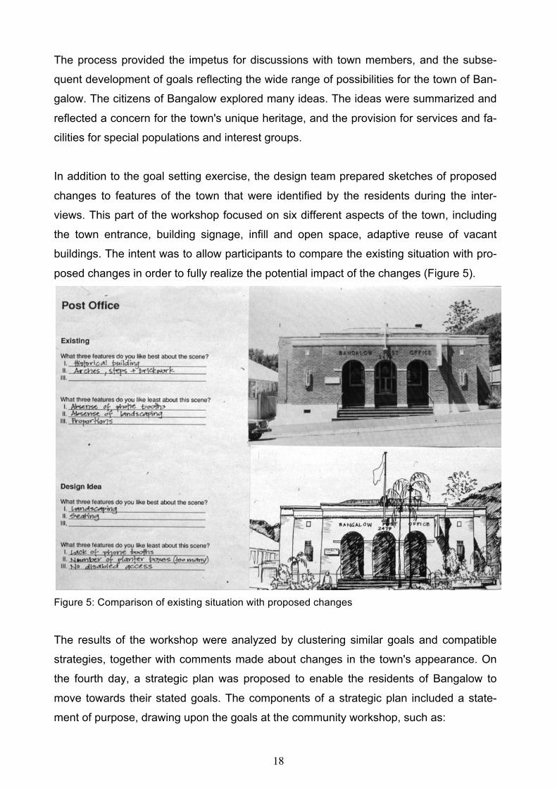
In addition to the goal setting exercise, the design team prepared sketches of proposed
changes to features of the town that were identified by the residents during the inter-
views. This part of the workshop focused on six different aspects of the town, including
the town entrance, building signage, infill and open space, adaptive reuse of vacant
buildings. The intent was to allow participants to compare the existing situation with pro-
posed changes in order to fully realize the potential impact of the changes (Figure 5).
Figure 5: Comparison of existing situation with proposed changes
The results of the workshop were analyzed by clustering similar goals and compatible
strategies, together with comments made about changes in the town's appearance. On
the fourth day, a strategic plan was proposed to enable the residents of Bangalow to
move towards their stated goals. The components of a strategic plan included a state-
ment of purpose, drawing upon the goals at the community workshop, such as:

19
To recognize the area's natural and scenic resources as major assets (Figure 6).
Figure 6: Comparison of existing situation to proposed changes
This statement defines what should be accomplished through the strategic plan, and will
be the responsibility of the participants in the process to shape this statement into a se-
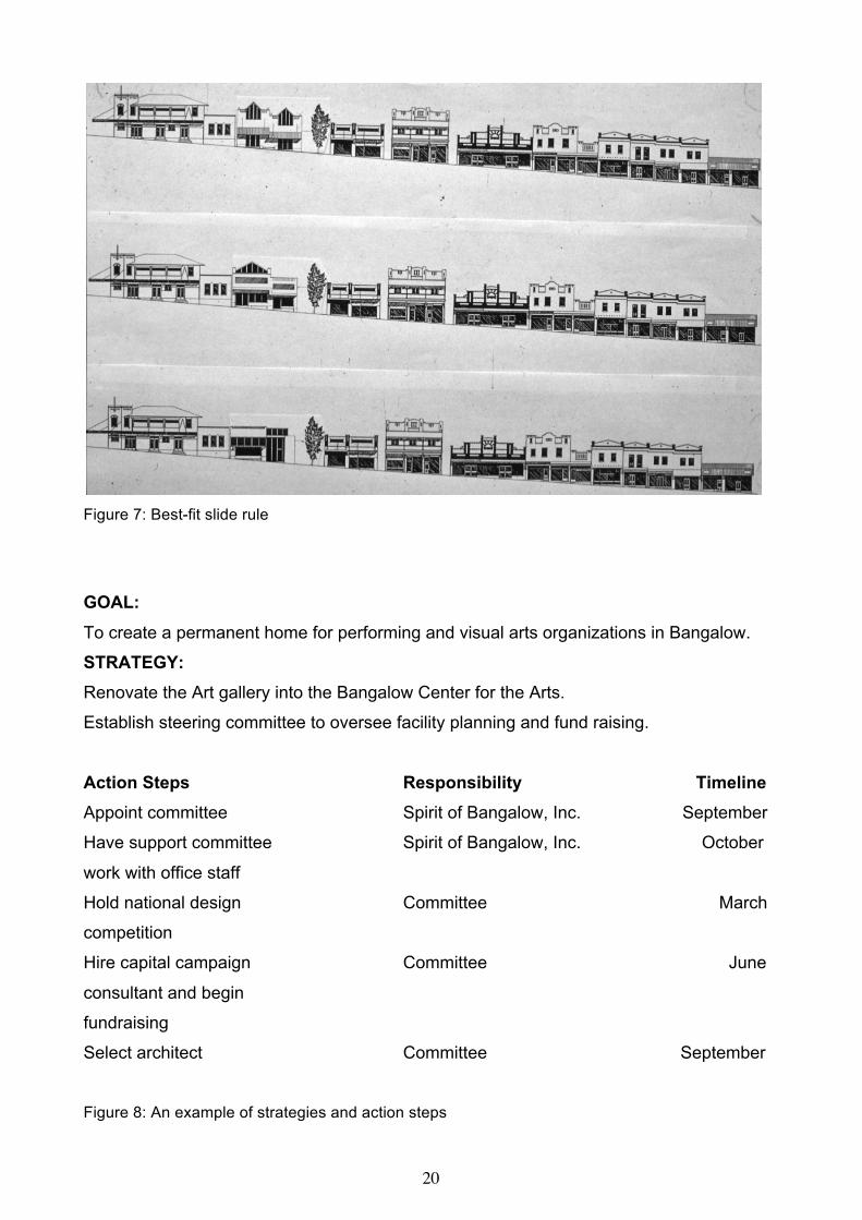
ries of tangible outcomes. Since the goals are broad statements of intent, strategies are
measurable tasks that support the accomplishment of goals. Action steps further ad-
vance strategies by specifying activities that contribute to their achievement (Figure 8).
The Bangalow best-fit slide rule (Figure 7) is a design tool for public officials, landowners
and citizens to collectively examine building infill alternatives and their consequences for
vacant sites. It is most effective when it is used in small groups settings where members
make individual choices, defend their decisions and reach consensus about the most
appropriate fit. The technique brings to light aesthetic issues that need to be understood
by various interest groups in order to assure that an infill solution is appropriate for the
character of the streetscape. A site left vacant by a fire was the stimulus for the devel-
opment of the best-fit slide rule.
20
Figure 7: Best-fit slide rule
GOAL:
To create a permanent home for performing and visual arts organizations in Bangalow.
STRATEGY: Renovate the Art gallery into the Bangalow Center for the Arts. Establish steering committee to oversee facility planning and fund raising.
Action Steps Responsibility Timeline Appoint committee Spirit of Bangalow, Inc. September
Have support committee Spirit of Bangalow, Inc. October
work with office staff
Hold national design Committee March
competition
Hire capital campaign Committee June
consultant and begin
fundraising
Select architect Committee September
Figure 8: An example of strategies and action steps

21
Implementation of the strategic plan required the formation of a new organization to pro-
vide the needed communication and coordination between civic, historic, government,
and arts related organizations. Although this would be an independent organization, it
would bring together representatives from existing groups with the intention of integrating
economic development and the cultural life of the town. Twenty-five people agreed to
become part of a steering committee, with task forces created in Natural Resource De-
velopment, Urban Design, Cultural Facilities, Cultural Tourism, and Media Communica-
tion Education. The identification of the task forces resulted from an analysis of the pat-
terns of goal statements generated at the workshop.
Two months after the formation of a new organization called, the Spirit of Bangalow, task
forces reported significant progress towards fund raising and implementation of numer-
ous projects including a community park, restoration of an old movie theater into an arts
center, and the restoration of verandahs. One year after the initial community workshop,
substantial changes were made including the addition of several verandahs (Figures 9 &
10) and a children's park.
Participation in neighborhoods and with community organizations is widely recognized as
a solution to many social problems. Over the last two decades, people in many neigh-
borhoods and small towns have come together to create their own community-based or-
ganizations to tackle problems, which government and the private sector have long ne-
glected. They have formed countless block clubs, self-help groups, neighborhood asso-
ciations, community organizing fund drives, and community development corporations.
The public demand for participation, especially in planning, has grown to where govern-
ments have begun to incorporate into their legislation, compulsory provisions for public
participation and public authorities have come to regard public involvement as a normal
part of their practice (Shearer, 1984). In many situations it can be observed that the par-
ticipation process is not considered a separate exercise from the design process.

22
Figure 9: Proposed addition of verandahs
Figure 10: New verandahs added to the streetscape

23
CONCLUSION
Community participation is a complex concept. Planning for effective participation re-
quires an analysis of the issues to be discussed; the individuals or groups that are to be
affected the resources that will be needed, and the goals for which the participation is
being initiated. While it is necessary to identify goals and objectives in planning for par-
ticipation, it is also necessary to analyze the techniques that are available and the re-
sources they require. Techniques such as surveys, review boards, neighborhood meet-
ings, conferences, task forces, workshops, and interviews, represent a few of the options
available to participatory designers. When people participate in the creation of their envi-
ronment, they need the feeling of control; it is the only way their needs and values can
be taken into consideration.
ACKNOWLEDGMENT
The Arts Council of New South Wales, Bangalow By-Pass Ring Road Committee, and the Com-
munity Cultural Development Unit, Australia Council sponsored this project. The design team in-
cluded Matt Devine, Ann McCallum, Roger Ackland, David Young, and David Huxtable. The
Project Coordinator was Rory O'Moore and included Helen O'Moore, Stacey Pollard, and Vicki
Reynolds, all from the town of Bangalow. An earlier version of this chapter appeared in Sanoff,
H. 2000. Community Participation Methods in Design and Planning. New York: Wiley & Sons.

24
MURFREESBORO, NORTH CAROLINA
Growth and development is not only a problem for large cities but for small towns as
well. Yet, the methods used for citizen involvement are equally suitable for use in urban
neighborhoods. This case study describes the delicate balance necessary between citi-
zen learning and effective decision making.
In recent years, the town of Murfreesboro, North Carolina (pop. 2000) under the direction
of the Murfreesboro Historic Association (MHA) rehabilitated and reused several of its
old, historically significant buildings. As a result, the community benefited by the addition
of space with the potential to support a variety of activities, but also retains its important
educational and cultural resources as reminders of the town’s physical, social and eco-
nomic development. In order for the MHA to make effective decisions and guide the fu-
ture of the historic district, the Community Development Group devised a growth plan
(Sanoff, 2000).
The concept of conservation through adaptive use has been applied in many communi-
ties throughout the country and is widely recognized as a viable approach in small com-
munities as well as in urban areas. The increasing demand for residential and commer-
cial development coupled with the continual deterioration of older structures within a
community, raised questions concerning the importance of conserving old buildings. The
dozens of reasons for preservation can be grouped into four main headings: cultural
memory, successful proxemics, environmental diversity, and economic gain. They are
described as follows:
• Cultural memory-Buildings are tangible reminders of the accomplishments and growth
that a community made throughout its history. Different architectural styles are a physical
record of the environment, in which the community’s ancestors worked and lived.
• Successful proxemics-This refers to the relationship between people, the activities they
engage in, and the places where they perform these activities. Before the development
of the automobile as the primary means of transportation and the development of land
use zoning, most neighborhoods displayed the characteristics of successful proxemics.
Places of employment, schools, churches, and the neighborhood stores were within
walking distance of one’s home. Today, the social interaction that once occurred as a

25
result of walking to and from work or to the neighborhood store has been lost. Conse-
quently, the feeling of town or neighborhood identity has diminished.
• Environmental diversity- People’s everyday environment is becoming increasingly more
homogeneous in appearance and in use. Zoning regulations, with restrictions on land
use and density, building appearance, location of a building on its site, were intended to
produce an orderly environment, but the result is often homogeneity. Rapid, uncontrolled
growth, too, created communities that are automobile dependent. These influences
make the preservation of older buildings and neighborhoods, with their diversity of build-
ing types, a desirable alternative to many of the newer monotonous environments.
• Economic gain-Recycling old buildings to new uses make it economical to save them
while retaining much of the original building. Investments in rehabilitation not only add to
the cultural resources of a community but have also produced a higher market value for
the improved property.
The town of Murfreesboro still contains neighborhoods that have successful proxemics.
Recognizing that these neighborhoods, like others throughout the United States have
adapted due to the growing pressures for change, an alternative approach to develop-
ment was deemed a necessity. Faced with limited resources and infrequent professional
assistance, the MHA sought assistance to develop a process where citizens groups
could identify important issues, explore alternative solutions, and select implementation
procedures so they could change the plan as they felt it should change. Since conflicting
values are inherent in any goal-oriented process, an approach was developed that en-
couraged community members to clarify their differences through a design game where
goals and strategies were the key elements that participants could manipulate. Knowl-
edge of Emerging Environmental Preservation Strategies (KEEPS) provided groups in-
terested in preserving the many qualities unique to older neighborhoods with an under-
standing of the strategies open to them. Organizing and planning for the preservation of
the qualities the community had identified as important, relied upon the consideration of:
• The environmental qualities the group chose to develop,
• Their goals,
• The type of strategies the community could realistically use to accomplish their goals.
26
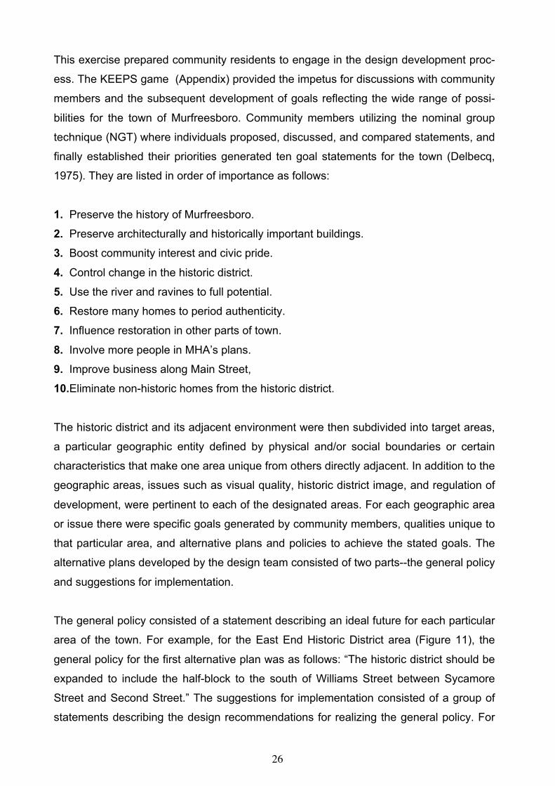
This exercise prepared community residents to engage in the design development proc-
ess. The KEEPS game (Appendix) provided the impetus for discussions with community
members and the subsequent development of goals reflecting the wide range of possi-
bilities for the town of Murfreesboro. Community members utilizing the nominal group
technique (NGT) where individuals proposed, discussed, and compared statements, and
finally established their priorities generated ten goal statements for the town (Delbecq,
1975). They are listed in order of importance as follows:
1. Preserve the history of Murfreesboro.
2. Preserve architecturally and historically important buildings.
3. Boost community interest and civic pride.
4. Control change in the historic district.
5. Use the river and ravines to full potential.
6. Restore many homes to period authenticity.
7. Influence restoration in other parts of town.
8. Involve more people in MHA’s plans.
9. Improve business along Main Street,
10.Eliminate non-historic homes from the historic district.
The historic district and its adjacent environment were then subdivided into target areas,
a particular geographic entity defined by physical and/or social boundaries or certain
characteristics that make one area unique from others directly adjacent. In addition to the
geographic areas, issues such as visual quality, historic district image, and regulation of
development, were pertinent to each of the designated areas. For each geographic area
or issue there were specific goals generated by community members, qualities unique to
that particular area, and alternative plans and policies to achieve the stated goals. The
alternative plans developed by the design team consisted of two parts--the general policy
and suggestions for implementation.
The general policy consisted of a statement describing an ideal future for each particular
area of the town. For example, for the East End Historic District area (Figure 11), the
general policy for the first alternative plan was as follows: “The historic district should be
expanded to include the half-block to the south of Williams Street between Sycamore
Street and Second Street.” The suggestions for implementation consisted of a group of
statements describing the design recommendations for realizing the general policy. For

27
example, for the Williams Street South-Side area, an implementation suggestion was to
“encourage rehabilitation of the commercial businesses on the William Street extension.”
Typically, there were at least two options that could be pursued for each target area. The
policies described an ideal future based on enhancing the target area qualities and satis-
fying the goals. The effects of each policy were predicted in order to indicate the type of
results that would be expected if the policy were to be followed. To further clarify the
process, combining verbs and objects created the general and specific suggestions for
policy implementation. For example, the verb “restore” was applied to an object (s) “the
West main Street group of significant buildings.”
Within each alternative plan the suggestions for implementation were arranged accord-
ing to their own priority system of three categories of importance. For each geographic
target area, specific questions were asked by participants in order to determine which
Figure 11: Sample worksheet describing goals and qualities of the area

28
alternative plan to pursue. Key questions were prepared since the development process
for the town was to be continued for at least twenty years. The questions were intended
to alert community members to the inevitability of changing goals and area qualities that
would require adding to the list of plan alternatives.
A community design workbook, prepared for the residents of the town, identified 15 geo-
graphic areas for Murfreesboro’s continuing preservation efforts to emphasize the town’s
colonial past. The workbook, describing the community participation process as a com-
ponent of the strategic plan, was given a First Award in the Progressive Architecture
awards program. In the past two decades the workbook has been the primary resource
in the development of Historic Murfreesboro. In addition to the restoration and reuse of
many older buildings, vacant buildings in the rural area have been moved to the historic
district (Figure 12), restored, and given new uses (Figure 13).
Figure 12: Building being relocated to the historic district

29
Today, Murfreesboro reflects the commitment of its citizens in creating a major tourist
attraction with tour guides acquainting visitors with the town’s natural and historic assets.
Murfreesboro’s continuing preservation efforts emphasize the town’s colonial past but
extend also to those things revered in living memory (Figure 14). The 1922 Murfreesboro
High School, as an example, has been recently acquired and restored by the Historical
Association to provide auditorium space for cultural events as well as exhibition rooms
for special collections.
Figure 13: Vacant building relocated Figure 14: Renovated law offices
ACKNOWLEDGMENT
Project team members included Greg Centeno, Larry Liberatore, David Polston and Brad Smith
and consultant, Bob Stipe.
An earlier version of this chapter appeared in Sanoff, H. 2000. Community Participation Methods in
Design and Planning. New York: Wiley & Sons.

30
SELMA, NORTH CAROLINA
Every age leaves its mark on a town. Every town is a living history of its own past and re-
flects the economic, social, technological and cultural conditions that shape it. Any town
that fails to respond to the demands made of it will decline, and unless positive action is
taken, will eventually die. Selma was at that point in its history when it needed to take ac-
tion. One of the most significant changes in recent years has been the shift in social val-
ues with regard to change and progress that has taken place throughout America. Much
has been learned from the mass demolition of the past leaving behind stark urban land-
scapes.
In a historical survey of the architecture of Selma done in 1980, it was noted that since the
1930s little of the historic fabric of the town has been destroyed, due in part to a general
lack of capital. This lack of widespread destruction has left Selma with a remarkably intact
physical history. Most of the buildings in Selma were built between the turn of the century
and the First World War. This was a period of growth and prosperity for Selma. At that
time there was a major railroad station, two hotels and an Opera House. The next major
change came in the 1960s and 70s, a period where downtown areas were no longer
suited to changing styles of retail trade. The shopping malls emerged as the answer
whereby the remaining downtown retailers found it difficult to compete. Many downtown
buildings were left empty conveying an image of dereliction and decay. Because money
was not available for major reconstruction, merchants tried to enhance the appearance of
their shops and attract more customers in the cheapest ways possible. One approach was
to simply let the building decay as rent and property value declined. Another was to paint
over the brickwork and board-up the second floor windows, which required only minimal
maintenance. Several older buildings were demolished and replaced with newer struc-
tures.

31
Figure 15: Metal canopies covering shops and original city hall building in downtown (1982 photo)
The measures that most reflected the new technology of the 1960s were aluminum fa-
cades that were erected to cover the buildings behind that were left intact. These together
with the installation of continuous aluminum canopies to replace the older canvas ones
had a great effect on the overall appearance of downtown Selma (Figure 15). None of
these approaches were successful since no amount of cosmetic patching could restore
Selma’s commercial viability.
Recognizing this dilemma, the town leaders contacted Henry Sanoff, director of the Com-
munity Development Group (CDG) at North Carolina State University for assistance. This
group, housed in the College of Design, provides assistance to community groups though
the active involvement of its citizens. The most common method used to encourage com-
munity participation is through workshops, through which all citizens are invited. Prior to
engaging Selma residents in a workshop a Discovering Selma walk was planned with the
assistance of the local newspaper (Figure 16). Important physical features that may go
unnoticed were photographed along with a map of the downtown area. Residents were
asked to locate those features as well as note their observations along key points in the
downtown for a discussion at the first workshop. At the first workshop the aim was to iden-
tify the citizens main concerns and issues related to Selma (Figures 17 & 18).

32
Figure 16: Discovering Selma walking tour Figure 17: Press clipping
Figure 18: Local newspaper informing residents of upcoming events

33
COMMUNITY WORSHOP
To begin, small groups were formed as asked to identify three problems they felt needed
immediate attention and defend their position (Figure 19). Once each group had decided
on their important issues there was a general discussion to reach agreement. One of the
main issues was the general appearance of the town, which participants attributed to the
building facades, canopies, sidewalks, shopping variety and a vast number of vacant
buildings (Figure 20).
Figure 19: Small groups discussing issues in Selma
Coincidentally, the Amtrak railroad, which had bypassed Selma for decades, had pro-
posed to reopen the station so the town planned a celebration called Railroad Days. Rec-
ognizing that this event would attract many residents of the town and surrounding area a
series of activities were developed by the design team to seek additional opinions and
confirm those that were stated at the workshop. Streetscape photographs were taken and
displayed at the celebration to allow citizens to rediscover desirable and undesirable fea-
tures of their town. Special activities were created for youth to participate by creating
games (Figure 21) and drawing walls (Figure 22). Since there were many children and
teenagers attending the celebration it became clear from their input that the town lacked
adequate recreational facilities for the youth.

34
Figure 20: Summary of workshop results
Figure 21: Streetscape photographs of downtown Selma
Figure 22: Town twister game and drawing wall developed for the youth

35
Although several key vacant buildings were slated for demolition by their owners some
Selma citizens were opposed to their removal, the most important of which was a three-
story corner building at the intersection of the main downtown street. To this end, a special
community workshop was held to draw attention to the importance of this building by cre-
ating several restoration scenarios (Figure 23). This exercise increased community
awareness to the importance of saving this building and subsequently applied sufficient
pressure on the owner to withdraw plan for demolition.
Figure 23: Scenarios for renovating the building
There were many vacant buildings in the downtown area and most buildings used the up-
per floor for storage. It was evident to the community that a new vision was needed for the
future of Selma, one in which there would be a long-sighted view towards investment and
the rebuilding of the downtown (Figures 24 & 25). In a visioning workshop about the future
of Selma it was clear that traditional retail development would be in direct competition to
the adjacent shopping malls. The idea that emerged and captured the interest of the par-
ticipants was to develop an antique center. The local Chamber of Commerce initiated an
active campaign for attracting investors in helping to achieve the new vision of Selma. In
less than ten years downtown buildings were restored, the metal canopy was removed,
downtown parks were located on vacant lots and investors came from different parts of
America and Canada to create the vision. Today, the town of Selma is a major antique
center with cafes and restaurants to receive regular busloads of tourists as well as antique
hunters.

36
Figure 24: Drawing of the improved streetscape above photograph of vacant buildings
Figure 25: Restored and renovated building

37
Figure 26: Sequence of development: Top photo (1982), showing a vacant building adjacent to the bank; middle photo (1995), showing a renovated building; bottom, photo showing building removed (2010), to create a drive-in window for the First Citizen’s bank.

38
Figure 27: Renovated streetscape with adjacent vest-pocket park
Figure 28: Removal of metal canopy revealed restored original city hall building (center)

39
CONCLUSION
Today, Selma is a town of 7,500 and described as the major antique center of the South.
A well-devised plan to offer "free rent" of retail space for one year to anyone who would
open an antique or arts store in Selma was put into place. With well-placed newspaper
stories, and advertising in antique magazine publications, the prospective dealers began
calling. Shoppers now find over 100,000 square feet of antiques within walking
distance of each other on a renovated streetscape. The buildings themselves are
important in defining the character of the streetscape. This character is a product of all of
the buildings’ elements; materials, decorative details, windows and the entrance. The spe-
cific elements that were recommended to contribute positively to the historic character of
the downtown included (Figures 27 & 28) included the removal of false facades and the
maintenance of the original brickwork. Where buildings have already been painted, they
should be a color that is sympathetic with the surrounding buildings. Aluminum canopies
were to be removed and decorative features of building were to be restored.
ACKNOWLEDGMENT
Project members from the College of Design, North Carolina State University included Neil Gold-
berg, Marilia DoVal, Dianne Pacella, Alvin Lester, and Larry Lovette. The Johnstonian-Sun,
Selma’s weekly newspaper distributed a Sunday supplement entitled, “Downtown Revitalization,”
which described the entire community participation process.

40
TOWNS IN JAPAN People, if given the opportunity and after acquiring the appropriate knowledge necessary
to develop their own strategies, can achieve the ability to determine the course of their
own lives. The sense of self-confidence they develop is in itself empowering.
Empowerment can be looked at as a positive outcome of self-discovery, and the ability to
dialogue with different people. Confidence to engage in group processes is in itself a lib-
erating action (White et. al., 1994). When individuals become self-reliant, their behavior
will change – from dependence to independence and from alienation to involvement. A
community of self-reliant people will be capable of diagnosing its own problems, and of
developing innovative solutions. The recent community design movement in Japan re-
flects the self-determination and confidence of people who unite together to define com-
munity needs. Public participation, however, is a relatively new idea in Japan since plan-
ning decisions are usually made at the national level, leaving citizens on the periphery of
the decision-making process. Consequently, there is increasing interest in applying par-
ticipation methods reported to have been successful in implementing plans that previously
met the needs of townspeople.
Recurring urban problems in Japanese cities led the Nippon Seinenkan Foundation, a
community development organization, to request my design assistance to conduct three
projects that incorporate citizen participation in finding appropriate solutions. Employing
the Design Games (Sanoff, 1978) approach to community participation, design teams
were formed in the cities of Arakawa, Ohya and Nanao based on their request for design
assistance, and led through intensive three-day sessions that began with fact-finding, and
concluded with community participation workshops. Projects varied in size and scope and
included the revitalization of a historic shopping lane in the city of Arakawa, the preserva-
tion and revitalization of the historic town of Ohya (famous for its stone used by Frank
Lloyd Wright in the construction of the Imperial Hotel in Tokyo), and the identification of
appropriate uses for a land-fill area in the resort town of Nanao. This intensive process
involved citizens of all ages and community leaders in rediscovering their community
problems and assets through walking tours, structured interviews and focus group dis-
cussions.
Volunteer architects, planners and interested citizens prepared graphic materials for a va-
riety of workshops that included a streetscape computer simulation where participants

41
could identify key visual features; graphic symbols that depicted spatial activities for par-
ticipants to select and locate on a map; and design recommendations of targeted im-
provement areas. Workshops were conducted with school children, and with community
members in a shopping mall, in a regional museum, and in a city hall. Participation in the
workshops ranged from forty to eighty people. The final step in the participation process
consisted of developing action plans to implement the ideas generated from the work-
shops.
OHYA
Utsunomiya is a city whose historical roots can be traced back to the 17th century. Today,
it is one of the major inland industrial areas of Japan. Utsunomiya is also the home of the
Ohya rock, a soft stone that resulted from volcano eruptions and crust movement. Stone
quarries and stone houses reflect the historic character of the area, however many of the
mines are abandoned and dangerous, while other underground spaces are underutilized
(Figure 29). Although the original stone is still quarried, a poor imitation of the stone is be-
coming increasingly popular. Today, Ohya is in a state of decline.
A local advocacy group composed of architects and planners from government and the
private sector formed since city bureaucracy has not been able to implement any plans
thus far considered. It is also believed that citizens distrust bureaucrats since townspeo-
ple are on the periphery of the decision-making process, and often lose interest in plans
generated by local government. A local leader commented, "The district of Ohya has
been wandering between lightness and darkness, reality and imagination. Though plans
are proposed one after another, the reception from the townspeople is stone cold. There
are many problems in the town, however, there are also many good sights and re-
sources."
This special interest group has entitled this project, "Only the residents can warm the
heart of Ohya." They believe that it is both in the interest of the city and the residents to
have a forthright discussion about what is needed and move to implement plans that meet
those needs. A community participation workshop was identified as an appropriate cata-
lyst to initiate change in Ohya.

42
The three-day process in Ohya began with a meeting of the 35 people, volunteer design
team. Some of the team members came from other cities in Japan with an interest in
learning about the design games approach. The Shiroyama community hall building,
which also functions as an agency of Utsunomia City Hall, served as the home base for
preparation of the workshop and community meetings. A bank of computers and drawing
materials was made available in a large multi-purpose meeting room occupied by the de-
sign team for three days. Since many team members were volunteers unfamiliar with the
area, informing the team about the attributes and problems in the district was the first step
in the process. Volunteer citizens from the Women’s Group in Ohya, led walking tours
throughout the district to inform design team members about the problems and prospects
of Ohya. Team members then conducted a map interview by dividing the district into five
sampling areas, where 100 residents were surveyed. Interviewees located on a map of
Ohya, their favorite and least favorite places in Ohya. Teams then went out to photograph
the problem areas identified during the interviews.
Middle school students from two elementary schools also participated in the design proc-
ess by conveying their ideas through drawings, to the design team. Sixth grade students
drew and described features they would like to see in Ohya (Figure 30). Over 100 draw-
ings were assembled and subsequently covered the walls of the workshop venue. In-
volvement of the adolescents in this process also engaged their teachers in this explora-
tory process. Parents, too, became involved in thinking about the future of Ohya as their
children discussed the school drawing project. This awareness and information gathering
step concluded the first day of the community design process.
Figure 29: Historic building constructed of local stonework

43
An analysis of the children's drawings, interview results, and photographic survey re-
vealed nine types of problem areas. They consisted of vacant buildings, danger zones for
cars and pedestrians, lack of historic markers, lack of recreation areas for young children,
and inaccessibility to the district's historic river.
Figure 30: Student’s drawing ideas for their community
Preparation of workshop materials occurred on the second day of the intensive commu-
nity design process. With the assistance of graduate architecture students from Utsuno-
miya University, design proposals were generated in response to the problem areas. Pho-
tographs of targeted problem areas served as a basis for developing the design alterna-
tives (Figure 31). Design proposals that entailed the removal of debris and other minor
modifications were developed through computer graphics methods. At the same time,
other team members’ brainstormed possible goals and implementation strategies that
might be selected in conjunction with the design proposals.
Figure 31: Sorting photographs of targeted areas

44
The aim of the community design workshop was to encourage participants to select and
prioritize goals, and to find appropriate implementation strategies associated with specific
design proposals. Each participant received a workshop packet that included goal state-
ments and illustrations of design proposals (Figure 32). These allowed participants to re-
cord their decisions for later use by design team members.
Figure 32: Henry Sanoff introducing the workshop process
A typical custom in Japan is for interested citizens to register in advance for the commu-
nity workshop. The City Hall meeting room was organized with sixteen tables, each ac-
commodating five people. This arrangement allowed all participants to voice their opinion
by making and discussing their individual choices. Eighty people, of all ages, from Ohya
and Utsunomiya joined the design team in the one-day workshop. Many children who par-
ticipated in the drawing exercise were present, along with their parents and teachers. Eld-
erly citizens, who had never experienced such a community meeting, felt comfortable in
sharing their knowledge and experience with younger participants.
To familiarize citizens with the events leading up to the workshop, a five-minute video
opened the meeting. It consisted of a series of 60 still images of the walking tour, the in-
terviews, the children's exercise, and the preparation of workshop materials, recorded with
a digital camera during the entire process.
Goal setting was the opening workshop activity that engaged participants in a lively dis-
cussion as they revealed their concerns about the future of Ohya. Work groups devoted

45
two hours discussing community goals and how they may benefit its citizens. Goals that
topped each group’s list of priorities were:
• Places for children to play
• Tourist development
• Preservation of Ohya’s streetscape
• Preservation of the town’s natural resources
• Revitalization of the characteristics of Ohya
Appropriate signage to historic areas and historic markers were described as effective
physical methods for promoting tourism. Street and monument lighting was noted as im-
portant elements necessary to make the town visible and active at night. Revitalization of
the river for fishing and recreation was seen to be equally appropriate for tourists and resi-
dents. Participants also agreed that abandoned mines should be filled and underground
spaces could be developed for theatrical and musical performances.
A traditional lunch prepared by a woman’s group and served by residents of the city, al-
lowed workshop participants to continue their discussions as well as learn more about
each other’s interest (Figure 33). Work groups continued into the afternoon as they re-
viewed nine design proposals developed from the initial resident survey of undesirable
community features. Participants made individual decisions and collaborated to reach
agreement as they prioritized those physical features that would have the greatest impact
on Ohya. Each working group presented their recommendations to the larger group to al-
low the design team to identify issues for discussion at subsequent workshops.
Figure 33: Traditional lunch served at the workshop

46
Figure 34: Project areas and their corresponding design solutions
It was encouraging and impressive to see elderly people, especially women, who rarely
have an opportunity to express their opinions, to actively participate in the discussions. In
local areas, meetings tend to be male-dominated allowing for few occasions for discus-
sions between men and women. Similarly, participants were comfortable in being able to
openly express their agreement as well as their opposition to the design proposals. Work-
shop participants also enjoyed seeing the student’s drawings on the wall and the elemen-
tary school students were equally proud of their contribution. A follow-up community work-
shop consisted of specific design solutions for promoting tourist activities, the highest pri-
ority action issue. Projects were identified that could be accomplished by citizens as well
as those that would require local government support. To build on the momentum of the
community workshops, several citizen participation projects were identified where work
could begin immediately. They consisted of stone markers at designated locations around
Ohya to inform tourists of the key community attractions (Figure 34). A street lighting de-
sign proposal was also developed and presented to local government officials for imple-
mentation. The local design team has effectively aroused the community into participating
in a major revitalization process where citizens have taken a leadership role in effecting
change (Figure 35).

47
Figure 35: Improvements using local stonework: Top left is a new café; top right is a public rest-
room; middle left are stone markers and middle right illustrates children carving the stone.
An earlier version of this chapter appeared in Sanoff, H. 2000. Community Participation Methods in
Design and Planning. New York: Wiley & Sons.

48
NANAO
The port city of Nanao has historical significance for its cultural assets and traditional per-
forming arts. Fishing villages scattered along the coast of the Japan Sea in the Nanao vi-
cinity lend visual interest to this area in the Ishikawa Prefecture. Nanao is also the Sister
City to Monterey, California, and features a fisherman's wharf, not unlike those settings
found in California.
Recently, the city reclaimed an eight-acre area next to fisherman's wharf that was sched-
uled to be filled by 1998. Originally, the reclamation was part of “Nanao: Marine City Pro-
ject, proposed by the Junior Chamber of Commerce in 1989 as a symbolic “greenland.”
Subsequent research by the Transport Ministry concluded in the authorization of the pre-
fecture to proceed with the reclamation plan, which later became a part of the port project.
The basic plan was prepared without consultation with the citizens; consequently, a citi-
zens group organized and submitted their own request to the mayor of Nanao. With a goal
of motivating people to think about their city, the Nanao Secretariat invited people of all
ages to participate in planning the new uses for this reclaimed area.
A small group of architects and planners from Nanao formed a volunteer design team and
initiated a community planning process. The three-day design process in Nanao began
when a chartered boat tour took the design team, sixty, middle and high school students,
their teachers and several parents around the future edge of the land to visualize the scale
of the site. Adolescents and teenagers were selected to participate in this tour because
they had been excluded from previous discussions about the future of this reclaimed area.
On board, they freely discussed their ideas for this area as they realized the scale of the
area and the type of activities that could be accommodated.
The community participation program in Nanao included a search through previous news-
papers for articles describing the intent of the landfill, a review of previous proposals, and
a public opinion survey conducted during the Noto International Tent Village festival. Such
a review provided insight into possible activities for the new site, which included cultural,
recreational and athletic activities. While the eight-acre site could enhance the breadth of
activities currently available in Nanao, citizens would be required to make trade-offs to se-
lect the most suitable for the community.

49
Recognizing that the workshop would include adolescents, teenagers and adults, an ap-
propriate strategy was needed to engage all participants at their level of competence.
Consequently, a mapping design game using graphic symbols to correspond to land uses
formed the basis of the community workshop (Figure 36). Design team members prepared
over 50 symbols for different spatial activities. While symbols were identical in size, each
corresponded to a specific unit of area (Figure 37). Activity data sheets included the popu-
lation capacity, the area requirement, and the number of symbol units that would need to
be fastened to a large map of the landfill.
Figure 36: Symbols and area requirements for outdoor recreation activities

50
Figure 37: Graphic symbols depicting different recreation activities
The community workshop was held in a central area at the fisherman's wharf shopping
mall on a Sunday morning (Figure 38). This public venue would give the community work-
shop high visibility to members of the community. Adolescent's and teenagers worked to-
gether in small groups of three to five people. In addition to using the symbols to locate
appropriate activities on a map, students used the map as a base to construct a three-
dimensional model of their proposals. Each team was provided with a package of model
making materials including straws, foam pieces, colored paper, a variety of plastic shapes
and glue. Team members collaborated in each step of the process.

51
Figure 38: Workshop consisting of twelve workgroups
Adults began the process by identifying community goals and linking them to appropriate
activities. Key goals included the need for a landscape that included the use of water,
places for recreation, and the need for a place to hold regular events such as concerts or
even a flea market. Activities to satisfy these goals included flower gardens, a landscaped
plaza, a child’s play area, a park with a water feature, a restaurant, and a concert hall. All
groups produced design solutions, at the same scale, for the landfill area (Figure 39). Rep-
resentatives from each group concluded the workshop by a brief presentation of their
ideas (Figure 40). While it was assumed that each group would opt for activities suited to
their age and interests, participants were surprised when students selected activities that
would allow for their parents recreational activities as well as for their interests.

52
Figure 39: Workgroups developing ideas for the landfill
Representatives of each planning team presented their landfill proposals to the larger
community, of about 250 residents at the local art museum. An open question and answer
process revealed a supportive response to many of the ideas proposed and unanimous
agreement about the viability of the community design process (Figures 41 & 42).
Figure 40: Team presentations

53
Following the community presentation, design teams developed charts and models based
on the workshop results for presentation at the local high school for the students’ com-
ments, as well as from resident groups. From the student’s reactions and resident’s com-
ments about the proposals, design models were subsequently exhibited at the Monterey
Plaza, the site of the original workshop. A review of the comments allowed the design
team to develop one design proposal. This proposal reflected the community’s interests,
which was contrasted with that of local government that did not involve the community in
their decisions. A comparison between the two proposals, made by the residents indicated
that the prefecture proposal did not effectively use the view, did not reflect a unified con-
cept, and did not use the open stage area effectively. Two proposals, one developed by
the prefecture and one developed by the community design process were presented to the
residents of Nanao to allow the broader community to select an appropriate solution.
Figure 41: Team presentations to community

54
Figure 42: Questions and answers with the larger community
Through this broad community process the results of the design team were favored and a
citizen’s council was organized by the prefecture government to assure the results of the
workshop were considered in the final scheme (Figure 43). To facilitate this process, peo-
ple who organized the workshop became participants in the citizen’s council.
A formal evaluation of the charrette process revealed it to be very successful. Part of this
success is attributed to the attention to detail and organization typical of many Japanese
events. The spirit of collective decision making, an integral aspect of Japanese culture,
was evident at every stage of pre-planning, and during the charrette process. People typi-
cally registered in advance of the workshop that allowed key logistics problems to be
solved prior to the arrival of the design team. Participants represented all levels of deci-
sion-making and community interests. In all cases the press documented the process and
the major results, informing the public of the events and decisions that had taken place.
Finally, the results of the community workshops were endorsed by the city officials and
implemented (Figures 44 and 45).

55
Figure 43: Design proposal for the park
In Japan, design games workshops are viewed as an important approach for achieving
public involvement in decision-making processes. A growing number of Japanese profes-
sionals and citizens believe it is necessary for the public to share in decisions that deter-
mine the quality and direction of their lives. In the past six years, many benefits have re-
sulted from the design games approach for communities, users, and designers. First, there
are bi-annual national conferences devoted to gaming workshops where participants are
required to present community projects that employed gaming strategies for citizen’s par-
ticipation. Two national conferences have been held since 1993, with over 400 attendees
in each, and about one hundred completed projects to date, all of which were initiated by
local citizens groups. The first national conference was held in Kochi in 1993, and the sec-
ond, two years later in the northern part of Kyushu.
An earlier version of this chapter appeared in Sanoff, H. 2000. Community Participation Methods in
Design and Planning. New York: Wiley & Sons.

56
Figure 44: Completed recreation area
Figure 45: Amphitheater

57
URBAN NEIGHBORHOODS
Neighborhood growth and change precipitated many explanatory theories, the most
prevalent being Hoyt's sector theory, which viewed the pattern of residential land use as
sectors along the transportation lines with high-rent districts shaping the growth of the en-
tire city in the same direction through normal operation of market forces. Firey (1965), on
the other hand, stressed the role of cultural and social systems in conditioning land use.
Areas, he stated, have certain symbolic qualities related to the cultural system, and activi-
ties are attracted to the space because of the significance of the symbol.
The idea of neighborhood or community or city has traditionally been tied to the idea of
place, where spatial proximity is considered to be a necessary condition, though sense of
belonging, shared values, and social organization are associated with the community.
Webber argues that it is becoming apparent that it is the accessibility rather than the pro-
pinquity aspect of place that is the necessary condition (Webber, 1967).
Lynch (1960) discusses the concept of imageability, which he describes as legibility or co-
herence, wherein environments resist or facilitate the process of image making. The
components of structure, identity, and meaning relate to physical attributes, which contrib-
ute to an environment's imageability. Clearly, there are many people who perceive their
environment in terms of its physical characteristics; however, there are others who com-
prehend their environment in terms of its social characteristics. Spatial meaning is per-
sonal, as is spatial reference and orientation. The spatial field is charged with meaning
from individual to individual and culture to culture. These sources of variance in environ-
mental perception are essential to an understanding of the variation in people’s behavior
in the environment.
Neighborhood-unit theories based on fixed populations and major physical boundaries do
not describe a neighborhood as a socially dynamic entity, nor have residents identified
with their neighborhood as a focus for social relationships. The ecological neighborhood
concept more aptly describes leisure and activity patterns from a socio-psychological per-
spective with a more viable rationale for future intervention via planning decisions. While

58
socially defined neighborhoods tend to be more homogeneous, their manageability is a
function of the resident's mobility or socio-economic status.
Neighborhoods are defined in many different ways. All definitions focus on essential char-
acteristics such as social networks, similar people, and service area for an elementary
school, a housing cluster or a name for that part of the city. So a neighborhood may be
seen as a source of place identity, or an element of urban form (Brower, 2000). The
neighborhoods described in this section satisfy basic residential functions, which include
opportunities for recreation and provision of services. They are active neighborhoods
where people know one another, where there are strong social networks. People interact
informally and participate in organizations that deal with issues at the local level.
Universal rules applicable to all cities have been dropped. Boundaries are related to the
particular aspect of the system under study. Clearly there are political boundaries, eco-
nomic boundaries, auto-commuting boundaries, newspaper boundaries, etc. The extent of
a given network of relationships, rather than the number of participants, becomes the sali-
ent factor.

59
RICHMOND, VIRGINIA NEIGHBORHOOD CHARRETTE
Highland Park is a low-income neighborhood in Richmond, Virginia where Highland Park
Restoration and Preservation Program, Inc. (HP RAPP), a non-profit community based
corporation, has a mission that includes creating and designing model neighborhood pro-
grams (Figure 46). Proposed as a model for future development throughout the commu-
nity, a nine-block “Adopt-a-Block” incubator and the adjacent commercial strip were des-
ignated by the community for total revitalization (Figure 47).
Figure 46: Existing conditions in the neighborhood
The aim of the charrette process was to involve residents, especially skilled community
leaders, and invited architects and planners to share their ideas regarding community de-
velopment. A planned one-day event allowed neighborhood residents to have the oppor-
tunity to select key issues, and identify appropriate goals and strategies for their imple-
mentation. Community leaders and professionals participated in the charrette process as
a resource to the residents to assure that informed decisions would be made.
An initial meeting of local leaders, project coordinator, Jeff Levine, and invited consultant,
Henry Sanoff, which constituted the Core Planning Team, resulted in identifying four ma-
jor development areas for discussion at the charrette. They included Business Develop-
ment, Housing, Image and Safety, and Education and Culture. From this discussion, re-
source teams consisting of area specialists in each of the key issue areas generated ap-

60
propriate goals and strategies for their implementation (Figure 48 and 49). Every effort
was made to include goals and strategies for presentation at the charrette that were real-
istic and achievable. This approach allowed area residents to examine a broad range of
possible options from which to make choices. Preparation for the charrette included:
• A promotion campaign including graphics material and banners to announce the forth-
coming meeting;
• Venue selection for the event, including the organization of space, equipment, food and
media coordination;
• Data collection to inform participants about loan programs and the Community Rein-
vestment Act, information on historical development, housing conditions, crime, and area
demographics; and a
• Follow-up report and plan of action.
Figure 47: Adopt-a-block mural

61
Figure 48: Richmond’s major development areas: Housing

62
Figure 49: Richmond’s major development areas: Education & Culture

63
The aim of the workshop was to allow each participant to select three goals with the high-
est priority for each respective key issue, and elect to participate in one of the key issue
groups. The procedure for achieving this was to provide each participant with 12 colored
tabs (3 red, 3 yellow, 3 green, 3 blue) corresponding to the key issues. After hearing the
presentation of key issues by the chairperson of each issue group, participants individu-
ally selected three goals they felt were important to the four key issues, and fastened the
colored tab next to that goal statement (Figure 50).
Individuals then selected a group in which they wished to participate. Group sizes ranged
from 20 to 40 people with a trained facilitator keeping the discussion focused. Each
group received a list of strategies prepared by the resource team along with the goals
achieving the highest priorities. Group discussions focused on matching strategies to
goals, and developing of an action plan for each strategy. Action plans answered the
question of “who, how, and when?”
Figure 50: Participants selecting key goals
Upon choosing the pertinent strategies for implementing a particular goal, a recorder com-
pleted a ‘strategy card,’ indicating the strategy, goal, key issue and action plan. Action
plans identified how to implement each strategy, who would be involved with the imple-
mentation, and the time frame for implementation. Design implications for certain strate-

64
gies required the presence of volunteer architects who provided sketches to clarify the
ideas (Figure 51). Completed cards were reproduced for overhead presentation at the end
of the charrette, and copies distributed to each participant.
Figure 51: Architects sketches at the charrette
The impact of the charrette during the 6 years following the participatory event had a
number of significant achievements. The Business Development goals were:
• To improve and nurture businesses in the main commercial area,
• To provide opportunities for increased employment in the area, and
• To provide for a concentration of a variety of goods, services and activities in the area.
A student and faculty team from Hampton University developed a business plan and a
model of the area showing how businesses could function (Figure 52). The plan was to
create a catalyst for economic development along the main commercial strip. Recognizing
the lack of sufficient business in the area as well as limited funds, a proposal was devel-
oped to seek support from the City of Richmond to establish an enterprise zone. In the
housing development area, the key goals established during the charrette were:
• To rehabilitate deteriorated housing,
• To maintain the present density of the neighborhood,
• To promote home ownership, and
• To create infill housing sympathetic to the Victorian character of the area.

65
Figure 52: Team facilitators at the housing workshop
Through the support of local about thirty houses have been rehabilitated (Figure 53) by
the architectural firm of Shelter Design, and designs for new infill housing have been pre-
pared. A major historic property now houses the offices of HP RAPP. For the Image and
Safety development area, the key goals were:
• To create a distinct and continuous landscape street and open space character,
• To improve maintenance and encourage small-scale improvements to existing buildings
and sites,
• To preserve and improve the distinctive visual and architectural character of the Adopt-
a-Block area in Highland Park,
• To preserve the history of Highland Park,
• To preserve architecturally and historically important buildings, and
• To create a safe neighborhood.

66
Figure 53: Completed Community Center above and Victorian house below (Photo: Jeff Levine)

67
This was achieved by the resident’s creation of a crime watch program, a periodic neigh-
borhood clean up and landscape improvement program, through the adopt-a-block
model. The creation of the arboretum, also outgrowth of the charrette is a neighborhood
park located on a vacant lot supporting a billboard. It was a pro-bono project developed
by landscape architect, Charles Snead with the assistance of Shelter Design.
Key goals of the Education and Culture development area were:
• To sponsor art, cultural, and special events to attract people to the area.
• To promote a racially, culturally, ethnically integrated community.
The achievement of these goals required the involvement of the youth in the community
development process. Operation Architecture, an environmental awareness program, in-
volved middle school students in a process of rediscovering the historical characteristics
of their community. Partnerships between HP RAPP and local schools helped to establish
periodic parent/children festivals as well as a number of ecologically oriented projects
conducted by students in the classroom and in the community.
The citywide effect of the charrette was the adopt-a-block process, the block watch and
the community festivals, where a community coordinator has extended these activities to
other communities. Many charrettes have occurred since the initial event. Exploring such
topics as crime prevention through environmental design, residents and local police met
at Virginia Commonwealth University to explore streetscape and neighborhood watch
strategies. Building Better Communities, a series of inner city neighborhood charrettes
brought participants from different communities to the Museum of Art to discuss various
collaborative approaches.
An earlier version of this chapter appeared in Sanoff, H. 2000. Community Participation Methods
in Design and Planning. New York: Wiley & Sons.

68
EDGEMONT COMMUNITY, NORTH CAROLINA
Edgemont is an old African American community located in Durham, North Carolina,
which originated as a community for workers in the Durham Hosiery Corporation. The
original Durham Hosiery Mill, completed in 1902, consisted of a four story main building
with a six-story tower. Additional storage and service sheds and cotton warehouses were
added along a railroad spur in 1912. The mill closed during the depression and it re-
mained largely vacant until after World War II, when the buildings were used for tobacco
drying and storage until 1960. All of the buildings comprising the Durham Hosiery Mill are
of typical mill construction with brick walls, wood floors and exposed wood ceiling joists.
The most outstanding architectural feature is the six-story tower, which displays distinctive
brickwork on its top story.
In general, the area was plagued by problems of neglect, age, and abuse. Edgemont had
more than its share of poor housing conditions, unpaved streets, inadequate recreational
facilities and vacant lots. Despite these deteriorating physical and social conditions, there
are many positive features, such as proximity to downtown and public transportation that
make Edgemont a convenient residential area for the elderly and the poor. The most
forceful and positive part of life in Edgemont is its social cohesion and sense of commu-
nity. Families of several generations still live in Edgemont. Edgemont’s most important re-
source is the residents’ commitment to revitalize the area into a viable neighborhood.
Members of the Edgemont Community Center sought assistance to facilitate the residents’
participation in a process to develop a neighborhood plan as an integral part of Durham’s
Community Development Block Grant program. Results of a series of community work-
shops revealed the need for new housing that would reflect the character of the neighbor-
hood, and renovating the hosiery mill into elderly housing. Although the first workshop
consisted of sixteen community members successive workshops achieved greater partici-
pation. The process employed in the workshops was the Nominal Group Technique (Del-
becq, et al. 1975), where each participant identified three problems that were noted on in-
dex cards. After the problems had been identified, subsequent workshops aimed at identi-
fying the goals for improving the Edgemont neighborhood, which became an integral part
of the neighborhood plan. They are as follows:

69
• To provide for the continuous participation of the Edgemont neighborhood residents
throughout all stages of neighborhood planning, development and implementation proc-
esses.
• To preserve, improve and develop Edgemont as a primary residential neighborhood,
with supportive public services, commercial development, and job opportunities.
• To provide the adequate circulation of people and vehicles within and throughout the
neighborhood in a way that disruptions are minimized.
• To provide for quality public facilities, such as streets, sidewalks, parks, street lighting
and utilities, which contribute to the well being of the residential neighborhood.
• To make Edgemont a safer place in which to live.
• To preserve the historic character of Edgemont.
• To ensure that sound residential properties and areas are preserved and improved in the
neighborhood.
• To remove uninhabitable structures and provide low density and affordable replacement
housing.
• To make new and rehabilitated housing affordable to the present residents who wish to
continue to live in Edgemont.
• To minimize economic hardships of the Edgemont neighborhood residents, which could
occur due to displacement or rent increases.
• To examine the feasibility of using Community Development Block Grants (CDBG) to es-
tablish a Housing Rehabilitation Revolving Loan Program for the improvement of neigh-
borhood housing.
• To provide for the development of functional and attractive commercial facilities by de-
molishing buildings that cannot economically be rehabilitated.
In addition to the development of plans for converting the mill building into elderly housing,
it was proposed to identify, move and renovate vacant houses and create a residential
area in character with the existing environment Figures 54 & 55). The passage of a bond
provided funds for the renovation of the mill and the vacant houses found in the rural ar-
eas relocated to available sites in Edgemont (Figures 56, 57 & 58).

70
Figure 54: Site proposal for relocated housing and mill conversion to elderly housing
Figure 55: Proposed elderly housing plan for the mill building (Drawing: Graham Adams)

71
Figure 56: Houses relocated and renovated Figure 57: Houses moved from the rural area
Figure 58: Restored houses and hosiery mill renovated into elderly housing
The success of this project was due to the continuous participation of the Edgemont
neighborhood residents throughout all stages of neighborhood planning, development,
and the implementation process, which continued over a period of several years.
ACKNOWLEDGMENT Participants involved in this project included Graham Adams and Joel Chou. An earlier version of
this chapter appeared in Salama, A. M & Wilkinson, N. (Eds.) 2007. Design Studio Pedagogy: Ho-
rizons for the Future. UK: The Urban International Press.

72
Figure 59: Gardens and sitting areas
Figure 60: Interior of mill building converted into elderly apartments

73
Figure 61: Restored mill building
Figure 62: Entrance lobby Figure 63: Tower

74
URBAN BLOCK REGENERATION, CORDOBA, MEXICO (Regeneracion
Urbana de Manzanas) Cordoba is a city with an important natural, cultural and historic heritage, which makes it a
zone of high potential. However, in the city there are deteriorated areas that detract from
its historic image. To improve the urban image of the city support was found through the
national program of Urban Regeneration of Blocks. The project aimed at developing new
communication and agreement mechanisms in order to improve the quality of the urban
environment.
A project was developed in a section of the Historical Center, which is an important place
because it has a strong sense of citizens’ identity and it is a zone where buildings are
catalogued by their architectural style. The project objectives were:
• To regenerate the deteriorated areas of the city.
• To appropriate an investment to improve the quality and furnishing of public spaces.
• To develop a participatory process that engages neighborhood residents.
The approach was to use the methods developed in this project as a model that could be
applied to other neighborhoods. An overarching goal was aimed at the improvement of
the neighborhood image, generating more inhabitable spaces where the citizens have the
opportunity to participate in the transformation of their own space.
An initial diagnosis of the urban blocks revealed the features that have established their
identity, or that could be used to enhance their image. The actions constituted a process
as follows:
• To perform actions by neighborhoods, taking as a basic unit the urban blocks.
• To use the Contrasting Table: Urban Image and Sustainable Development. The objec-
tive is to identify the relation among the elements of the urban image in order to develop
guidelines for sustainable development (Garzon L. 2000).
• To apply a participatory design process based on answering such questions of who,
what, where, how, and when.

75
Through a series of workshops, facilitators leading small groups aimed to help citizens to
identify appropriate public space activities, and how they can be realized, with the help of
plans, photographs, and symbols. This planning process allowed for a two-year period to
perform and implement the project; which consisted survey research, adaptation of the
methodology, performing the participatory design workshops, design development of the
project and implementation.
DESIGN AND PLANNING PROCESS
With the objective of affording citizen participation, the project was presented by the Plan-
ning Coordination Department to the Faculty of Architecture in order to identify a student
team to work on the project. One of the objectives, to link local government, student, and
the community in a project will generate benefits for everybody.
The initial step was to survey the residents of the project area (Figure 64). The object was
to identify:
• The number of people who live in the houses.
• The representative population of children, youth, adults and seniors.
• The form in which they want the public space of their neighborhood.
• The family income to determine the need for public funding (Programas de Apoyo) that
can be made available to low-income families.
Figure 64: Student teams interviewing residents of the neighborhood
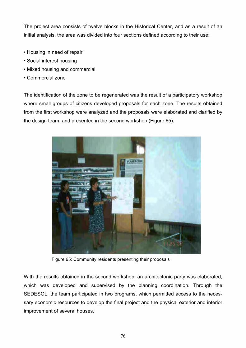
76
The project area consists of twelve blocks in the Historical Center, and as a result of an
initial analysis, the area was divided into four sections defined according to their use:
• Housing in need of repair
• Social interest housing
• Mixed housing and commercial
• Commercial zone
The identification of the zone to be regenerated was the result of a participatory workshop
where small groups of citizens developed proposals for each zone. The results obtained
from the first workshop were analyzed and the proposals were elaborated and clarified by
the design team, and presented in the second workshop (Figure 65).
Figure 65: Community residents presenting their proposals
With the results obtained in the second workshop, an architectonic party was elaborated,
which was developed and supervised by the planning coordination. Through the
SEDESOL, the team participated in two programs, which permitted access to the neces-
sary economic resources to develop the final project and the physical exterior and interior
improvement of several houses.

77
The improvement task of the first stage of the regeneration of the selected area, which in-
volves six streets, was completed. The improvements consist of the following (Figures 66-
69):
• Physical improvement of the house with the objective of guaranteeing the permanence
and vitality of the Historical Center.
• Adaptation of the design of sidewalks to give priority to pedestrian walking.
• Underground cable installation.
• Special access for people with different capabilities.
• Participative design.
• Participative management.
• Integration of green areas.
The results obtained up to this date have been positive with respect to the Management
and Promotion of the first stage of the Program of Regeneration of Urban Blocks, as well
as in the advances of citizenship participation that have been reached. Due to the fact that
an important goal was for the implementation of a citizenship participation process, the
success of this experience for the city of Cordoba will be invaluable for the administrations
to follow.
This project achieved national recognition in a program, Premio Habitat 2004, Mexico.
Figure 66: Renovated park and adjacent houses

78
Figure 67: Exisitng office building in need of repair Figure 68: Proposed streetscape renovation
Figure 69: Completed building and streetscape renovation
CONCLUSION
Sustainability is an important societal goal that enjoys public appeal. However, finding a
specific definition of sustainability that is broadly acceptable is difficult because it is about
values that vary among groups and over time. Ultimately sustainability requires decisions
about what to sustain, for whom, for how long, at what cost, and how.

79
Therefore, social sustainability takes a larger worldview into consideration in relation to
marriage, family, parenting, divorce, community, culture, nationality, and globalization. It
asks us to not only think of ourselves and what we want, but to take the whole system into
consideration as well.
Public participation builds on classic democratic theory: that those citizens who are af-
fected by decisions should have a say in decisions that affect their lives because they will
become better citizens. And it is often the physical and environmental projects that citi-
zens see directly affecting their lives. To create a condition in which people can act on
their own environmental needs, in which they can make the distinction between the ex-
perts technical and aesthetic judgment, requires a change in the consciousness of both
people and professionals. Architects and planners who wish to participate in community
building will need to assume a new role by making their solutions less representative of
themselves and more representative of user groups even though difficulties in applying
participation may arise.
Architects and planners who wish to participate in community building will need to assume
a new role by making their solutions less representative of themselves and more repre-
sentative of user groups.
ACKNOWLEDGMENT
The project coordinator was Rossanna Garzon Lopez assisted by architecture students from the
University of Veracruz in Cordoba.
80
COMMUNITY FACILITIES A community design project requires “buy-in” from the user groups who will be most af-
fected by the resulting policies and projects. The feasibility of change is dependent upon
the willingness of participants to accept the proposed change as beneficial and participate
in the process. The decision-makers, be it elected officials, planners, or architects and
owners, have to be willing to accept input and the user groups have to be willing to pro-
vide it. If a neighborhood or community is unable to participate in a meaningful way a
community development and design process may provide a result that does not have
support. When a final policy decision or building is about to be finalized, the discussion will
begin anew, instigated by those who are dissatisfied with the outcome or did not partici-
pate to begin with. The National Civic League uses a “Civic Index” to gauge the participa-
tory social capital of a community. Participatory social capital is a measure of the social
networks of the community, which in turn can indicate the amount of participation that can
be expected in a community-based project. Involvement in a neighborhood planning proc-
ess should therefore draw from the networks such as social clubs, churches, and civic or-
ganizations.
CIVIC INDEX
• Citizen Participation
• Community Leadership
• Government Performance
• Volunteerism
• Inter-group Relations
• Civic Education
• Community Information Sharing
• Capacity for Cooperation and Consensus Building
• Community Vision and Pride
• Inter-Community Cooperation
The quality and quantity of community involvement is aided by the quality of information
exchange from those conducting the project to the stakeholders in the project. The quality
of the information developed will in turn be enhanced by the continuity of participation by

81
stakeholders, and critique of the interpretations of the stakeholders’ input. Consequently,
understanding how to gather, analyze, present and receive information is critical to the
success of projects relying on citizen involvement. Even the “best practices” of community
development and design are dependent upon the development of personal relationships
and a sense of trust between designers and community developers, and the stakeholders
or “clients” of the project. Without this sense of trust, the participants in the process, par-
ticularly those who are used to being under-represented, will be less likely to reveal their
honest opinions.
Without being able to know all relevant information and the opinion of every stakeholder it
becomes necessary to sift through a myriad of sources of information in order to gain a
sense of an urban area, both fact and perception. The inputs for a project can include a
combination of fact and anecdote, expert and layperson, theories and principles, and prac-
tical experience. These inputs can be audio recorded, videotaped, written and collated in
order to formulate cohesive summaries for the purposes of presentations to the partici-
pants and other stakeholders such as the elected officials.
At the same time, site visits, walking tours, door-to-door surveys, daily trips through the
area and spending time working on a physical project in the area provide immeasurable
forms of information. Developing personal relations with neighborhood leaders, conducting
interviews with residents, and visits to neighborhood meetings provide insight that would
be impossible to gather other than through the persons who experience an area in a daily
and sometimes life-long manner.
Because the built environment is a major part of the public realm, it is of significant social
import. Every citizen has a stake in the community’s built environment, especially public
artifacts, because of their scale and immediacy (King, 1983). When indigenous persons
built using the constraints of tradition and the natural environment, this community based
planning and building provided social and environmental benefits. Communal construc-
tion, for instance, reinforces cooperative behavior, and architecture that functions within
the constraints of a regional bio-climate maintains cultural architectural traditions and
place-based ecological knowledge.

82
OWENSBORO, KENTUCKY RIVERFRONT DEVELOPMENT
INTRODUCTION
Waterfront planning and development has become a field in its own right, not unlike his-
toric preservation. Until recently, American cities have neglected the opportunities of their
waterfronts compared to European cities. After World War II, a number of factors came
together to affect the urban waterfront and set the groundwork for the waterfront phe-
nomenon of the present era. The availability of federal urban renewal funds and other as-
sistance programs had a significant impact in the early day of waterfront development.
Grants from the Department of Housing and Urban Development (HUD) through Commu-
nity Development Block Grant Programs and later Urban Development Action Grants pro-
vided significant funding for waterfront development. The transformation of urban water-
fronts often plays a major role in ongoing efforts to restore town and city centers to eco-
nomic and social health (Breen & Rigby, 1994). The determination to develop healthy core
areas applies equally to small towns as to big city examples. Community pride is a power-
ful motivator for people of all backgrounds to restore or revive their downtown area using a
waterfront, if they have one, to their advantage.
Owensboro is a relatively compact small town (population 54,000) bounded on the north
by the Ohio River. In the early years, the economic base was distilling and buggy manu-
facturing. Today tobacco and farming are important to the region, which has a diversified
economy.
The downtown is in the north central riverfront section of the city. Downtown Owensboro
has struggled in appearance and vitality since a retail mall opened on the city's south
fringe in 1978. Government, legal, and banking uses are prevalent. Owensboro's riverfront
has primarily been used for industrial purposes with a few exceptions such as a downtown
hotel/convention center, a performing arts center and a small downtown park. Riverfront
events and activities have been limited to festivals and concerts, and seasonal boating.
In 1996, the Public Life Foundation of Owensboro was formed to support citizen action in
tackling community problems, since citizens are often left out of the community's decision-
making process. The Foundation believes that informed and engaged citizens can influ-
ence decisions and public policy. PRIDE, a new grass roots group organized by the Public

83
Life Foundation in 1999, was specifically formed to create more public involvement in pro-
jects that impact on the appearance of the community. Reaching more people and getting
ideas from diverse backgrounds, they believe, can help to build more support. The de-
signer or planner’s role in this process is to promote effective processes of public learning,
practical and innovative instances of pubic deliberation, even consensus building in many
parts of the planning process (Forester, 1999, Innes, 1996).
COMMUNITY VISION
Community building is a holistic approach that focuses its efforts on people. It is dedicated
to the idea that citizens must take control of their destiny and that of their communities.
Community building grows from a vision of how communities function normally, where
community members create community institutions, which help to achieve their aspirations
as well as strengthen community fabric. Building social capital is the primary objective
achieved by citizens playing a central role in decision making and believing that they “own”
the process as they move away from being dependent. Many case experiences suggest
that citizen-driven initiatives have a greater chance of success because citizens are more
aware of the realities of their own community than outside professionals. They have a
sense of what will work and what will not work (Sanoff, 2000).
Citizens need to develop a vision of what they want the community to become and how to
get there. To start the process, a positive tone can be set by taking an inventory of com-
munity assets and then finding ways to take advantage of them in creating action pro-
grams. A community's taking initiatives from the perspective of solving problems casts a
negative tone on what should be a positive capacity building process. The community
building orientation should be positive and constructive.
Identifying assets in a community can dramatically alter the planning process inasmuch as
assets occur at different levels, which can relate to their priority in developing programs.
Assets within the neighborhood such as resident’s experience, neighborhood businesses
and citizens and business associations should be acted on first, and assets controlled by
outsiders, such as public institutions, can become assets which requires the community to
devise appropriate enabling strategies.

84
Participatory research is seen as the development of communities’ potential; as collabora-
tive problem solving; and as a synonym for ‘user participation’ in design and in the deci-
sion-making process. Participatory research attempts to break down the distinction be-
tween the researcher and the researched, the subjects and objects of knowledge pro-
duced by the participation of the people-for-themselves in the process of gaining and cre-
ating knowledge. (Gaventa, 1993), In the process, research is seen not only as a process
of creating knowledge, but simultaneously, as education and development of conscious-
ness, and mobilization for action.
One of the high profile projects in the community is the riverfront development. Previous
city efforts at urban renewal and development have met with community resistance and
very little action. Renewed interest by the City officials, the Chamber of Commerce, Down-
town Owensboro, Inc., and the Downtown Business Association, in the potential amenities
and income afforded by the riverfront led to the city's proposed plan for developing the riv-
erfront, which was approved by the U.S. Corps of Engineers. City officials say that they
plan to build a riverfront that will enhance downtown, encourage private development and
business and promote Owensboro as a boater's destination. The development proposal
included a boat launch, marina and dock facilities, a floating walkway and garden. The city
has secured $2.8 million in state and federal funds for the development, but it is estimated
that $7 million will be needed. To begin the planning process, the city officials to solicit
proposals for the development of the riverfront formed an eight-member selection commit-
tee. Four teams were interviewed and the consulting firm of EDSA was selected to de-
velop the master plan for the riverfront.
COMMUNITY AWARENESS AND PARTICIPATION METHODS
City officials have subsequently embraced a partnership with PRIDE to significantly ex-
pand citizen participation in the planning and design of the riverfront. PRIDE wanted to
create venues for public discussion about how the riverfront should look and where activi-
ties should be located. PRIDE volunteers took the riverfront project "to the people" through
a variety of activities.
Student projects, including drawings, essays, wish poems, and model building. The PRIDE
Education Committee includes teachers from each local school to represent the ideas of
students. After meeting at a PRIDE get-together for educators, an elementary school

85
teacher and a high school teacher joined forces to generate and build ideas for the river-
front. The primary students brainstormed ideas while the high school students set about
deciding which of the children's ideas they could actually build. After exchanging letters
and getting to know their older "co-workers", the students embarked on a field trip to actu-
ally construct a working model of the riverfront ideas. Students were asked to fantasize
what they would like to see available. Ideas included a Worship by the Water community
church, floating playgrounds, a bait shop and aquarium in the shape of a fish, parasailing,
and a "cave" down under the river for children to explore and play. Commitment to create
a unique learning opportunity has enabled collaboration between the teachers and schools
and facilitated involvement in the community outside their walls.
Figure 70: Students’ displaying their models and drawings
Surveys were also conducted at the Daviess County High School where students had the
opportunity to share their ideas for the riverfront. Ninety freshman students generated over
200 ideas for the riverfront. Among them included a homeless center, a farmers market,
an outdoor amphitheater, a casino and a floating shopping mall. Student involvement in
the planning stages is recognized as an important factor in strengthening local economic
conditions for the future allowing graduates to remain in Owensboro (Hart, 1997). Other
student activities included sketches of the riverfront generated by a group of elementary
students after a brief field study while visiting the Riverpark Center (Figure 70).
IDEA SHARING SESSIONS
The goal of these idea-sharing meetings was to gauge the opinions and views of a cross-
section of citizens about the riverfront and its future development. PRIDE hosted a series
of focus group meetings with neighborhood advisory boards. Through the Neighborhood

86
Advisory Board Program, city government has become more responsive to citizens. The
boards serve as a vital link between their neighborhoods and city government. In the
twelve focus group sessions PRIDE volunteers asked people:
1. What they now enjoy doing along the riverfront.
2. What they would like to do if facilities and programs were available.
3. What they like about waterfronts in other cities.
From the focus group sessions the most frequently reported activities desired along the
riverfront were to:
• Gaze at the river in a safe comfortable setting
• Attend festivals and concerts
• Eat and drink overlooking the river
• Walk along the water's edge
• See arts and crafts activities
• Walk from Smothers Park to English Park
Suggestions for how the riverfront could be made more attractive included gardens, ter-
raced riverbank, special lighting, more commercial development and public space, and
new development along Veteran's Boulevard (First Street). Along the riverfront participants
in the focus groups would like to see restaurants, an entertainment district, retail shops,
condominium apartments, and mixed use development.
Newspaper feature stories, columns, and survey. A newspaper survey was conducted with
the following questions:
1. What two features do you like most about Owensboro-Daviess County's riverfront?
2. What two features do you like least about Owensboro-Daviess County's riverfront?
3. What do you enjoy doing now at the riverfront?
4. What would you enjoy doing if facilities were available?
5. About how many times a year do you visit the riverfront?
Survey results indicated that the parks, boat ramp and Riverfront Center were the features
most liked, while the river view, boat watching and the peacefulness of the area were its
attributes. Attending festivals, concerts and river watching accounted for the most sources
of enjoyment. If facilities were available, a riverwalk would be most preferred, although

87
boating, dining, and picnicking were also identified as important considerations. Features
liked least included a lack of walking path near the water, insufficient access to water, lack
of proper maintenance, and unattractive buildings and parking lots along the riverfront. A
series of newspaper feature stories included such topics as “What kind of community do
we want? Resident’s input on riverfront important, Forums to give public voice in deci-
sions, and PRIDE to focus its efforts on riverfront.
RIVERFRONT DEVELOPMENT WORKSHOP
A community workshop is based on the viewpoint that professionals have an expertise that
is different from that of citizens. Citizens have an expertise in identifying problems not
necessarily solving problems. Collaboration is effective when all participants in the process
share their areas of expertise with one another (Sanoff, 2000). Participation does not imply
that there is no longer a role for institutional leaders. It only means that a dialogue is nec-
essary between grass roots citizenry and government leadership regarding needs and re-
sources to meet needs.
Consequently, the riverfront development community workshop provided citizens with an
opportunity to share their views with representatives of the planning firm before developing
the master plan. The workshop, held at the Riverfront Center, was an open invitation to
citizens of Owensboro-Daviess County to begin a planning process by clarifying objec-
tives, identifying appropriate activities, and locating desired activities on a base map of the
riverfront. One hundred and thirty people attended the Saturday morning workshop. The
workshop opened with welcoming remarks from the mayor and key officials. Participants
then revisited the riverfront through a narrated photographic tour, followed by a presenta-
tion of the students' vision, and ended with a video summary of the focus groups. The
"hands on" planning aspect of the workshop consisted of twenty-two workgroups consist-
ing of five people each, identifying appropriate objectives for various sections of the river-
front (Figure 71). Objectives were key factors in allowing participants to generate appro-
priate riverfront activities, which they located on a base map of the riverfront through the
use of graphic symbols.

88
Figure 71: Workshop setting
The riverfront was divided into four sections starting at the Riverfront Center and extending
to English Park (Figure 72). Workgroups were asked to individually select the three most
important objectives for each section, and then through discussion arrive at agreement to
those most important. When agreement was reached, the groups then matched activities
to each objective, then locate the activity, represented by a graphic symbol, to the appro-
priate location on a base map of the riverfront. At the completion of the exercise a repre-
sentative from each workgroup presented their proposal (Figure 73). A summary of the
most frequently cited objectives for the entire riverfront were:
1. Establish a continuous riverfront walkway
2. Create a visually pleasing order to the river's edge
3. Attract people and investment to the riverfront
4. Develop an arts/entertainment district
5. Expand leisure and recreational use of the river and riverfront
6. Emphasize pedestrian streets that connect to the riverfront
7. Provide housing for people in a wide range of income categories
8. Accommodate outdoor performances
9. Provide opportunities for boat launching and storage
10. Retail shops

89
The first two objectives received the largest number of votes and were identified as impor-
tant in three of the four-riverfront sections. Riverfront activities receiving the most agree-
ment among participants were:
1. Restaurants
2. Riverfront walkway
3. Bicycle trail
4. Jogging trail
5. Boat launch
6. Picnic area
7. Preserve historic building (jail)
8. Garden
The listing of priorities for each section of the riverfront is as follows:
OBJECTIVES ACTIVITIES AREA ONE
Attract people and investment to the riverfront Arts and Crafts
Create a visually pleasing order to the riverfront Retail shop
Develop an arts/entertainment district Restaurant

90
OBJECTIVES ACTIVITIES
AREA TWO
Create a visually pleasing order to the riverfront Riverwalk
Establish a continuous riverfront walkway Marina
Expand leisure and recreational use of the river Jogging
Retail shop
Historic Preservation
OBJECTIVES ACTIVITIES AREA THREE
Establish a continuous riverfront walkway Bicycle trail
Provide housing for people in a range of incomes Jogging
Create a visually pleasing order to the riverfront Riverwalk
Emphasize pedestrian streets that connect to the Picnic area
riverfront Garden

91
Park
OBJECTIVES ACTIVITIES
AREA FOUR
Accommodate outdoor performances Marina
Provide opportunities for boat launching Water sports
Establish a continuous riverfront walkway Picnic area
Expand leisure and recreational use of the river Boating
Park
Playground
Outdoor amphitheater
Fishing Figure 72: Proposals for each of the four areas along the riverfront
The locations of the activities most frequently cited are shown on the base map of the riv-
erfront (Figure 75). It can be observed from the placement of activities on the map that
several key privately owned properties were identified for alternative uses. Since many key
properties along the riverfront are privately owned further discussions are necessary with
property owners as the master plan unfolds. Lessons learned from other riverfront devel-
opment projects suggest that to achieve success requires a community building effort
based on public-private partnerships (Figure 76).

92
Figure 73: High school students presenting their proposal
Figure 74: Typical group solution
Figure 75: Summary diagram locating all activities proposed in the workshop

93
POST RIVERFRONT WORKSHOP ACTIVITIES
The firm of EDSA was selected by the city to develop a master plan for the riverfront. To
initiate this process, EDSA brought in The Waterfront Center, a nonprofit organization with
experience in waterfront development, to conduct community forums with different groups.
The first group forum was held with ten PRIDE members. Other forums were held for
boaters, residents, and retailers. Two facilitators from the Waterfront Center conducted the
forum- one for visual aids and assisting the group in plotting out a map, the other to en-
gage the participants in a discussion. The session began with a slide show of riverfront
developments from all over the world. It was apparent to the participants that the facilitator
had used all the material accumulated from surveys, focus group sessions and from the
riverfront workshop. Elements where chosen to illustrate different features and activities
identified in the previous workshop. A large map of the riverfront was used to graphically
discuss obstacles, needs, and dreams. Obstacles cited were key properties along the riv-
erfront that were privately owned as well as a State Department parking lot. Dreams in-
cluded a multi-level riverwalk, small parks or outdoor living rooms, a floating stage and a
full service marina, which could not be accommodated, within the scope of the project be-
cause of the lack of available acreage. When the forums were completed, a preliminary
plan was developed by EDSA and presented to the participants for a critique (Figure 77 &
78).
ACKNOWLEDGMENT Project team included Dr. Celen Pasalar and Dr. Dilek Yildiz
An earlier version of this project appeared in CoDesign, Vol. 1, No. 1, 2005, 61-78.
Figure 76: Riverfront activities adjacent to the arts center

94
Figure 77: Proposed Riverfront Park proposed as the cornerstone of downtown redevelopment
Figure 78: Plan of riverfront walk (EDSA)

95
CAp SCHOOL, RIO DE JANEIRO, BRAZIL
INTRODUCTION
Although there is general agreement about the importance of the designer reaching out to
include client/user needs (Baird, Gray, Isaacs, Kernohan, McIndoe, 1995), or to engage
their participation in the design process (Hatch, 1984), very little progress has been made
in answering key questions such, who should get involved, how to participate, and at what
stage of the process (Sanoff, 2000). Generally, people who will be affected by the design
decisions should be involved in the process of making those decisions. Appropriate par-
ticipation methods need to be matched to purposes to allow for diverse interests, and par-
ticipation can occur in the development, implementation, and evaluation stages of the de-
sign process. Participatory, or collaborative decision-making encourages creativity and
open communication (Godschalk. et al., 1994), while working together to share informa-
tion and reach agreements also requires a clear process.
Far from denying the role of the designer, it is necessary to develop appropriate research
strategies and methods, as well as to develop a new professional ethic- one that reflects a
participatory democracy (Pateman, 1970), and open to the knowledge, value systems,
and expectations of clients and users alike. The user group -- parents, teachers, students
and staff are assumed to be the non-paying client (Zeisel, 2006), yet they are as important
as the paying client is. The non-paying client group is a source of wisdom and information
about local conditions, needs, and attitudes and thus improves the effectiveness of deci-
sion-making.
Therefore, the potential participation of the non-paying client in all stages of the design
process is enormous, but particularly in the programming or the predesign stage, since it
permits the gathering of a wide and appropriate data-base for defining functional, technical
and behavioral objectives, for identifying design components, and guidelines for integrat-
ing the components into a spatial organization (Sanoff 1992).
Confirmation of these viewpoints and their consequences were apparent through an in-
tensive design workshop at the Graduate Program in Architecture – PROARQ, School of

96
Architecture and Urbanism of the Federal University of Rio de Janeiro, Brazil. Coordinated
by visiting Professor Henry Sanoff, the workshop dealt with the case study of a primary
and secondary school managed by the university, and concluded with a report discussing
all stages of the design process, and the resulting program including proposed alterna-
tives for the new school.
WORKSHOP DEVELOPMENT
The twenty participants that formed a design team were involved in the workshop, full-time
for four weekdays. Some participants came from a graduate course on design methodol-
ogy aimed at preparing them for the workshop with pertinent readings and discussions, as
well as initial contact with key officials at the school (Hester, 1990; Sanoff, 2000). Most of
the design team consisted of faculty members from a variety architecture schools in Rio.
The CAp (Colégio Aplicação) is a public school run by the university, offering quality pri-
mary and secondary education. It is located in an upper middle-class neighborhood in Rio
only a short distance away from the mountains and a surrounding lake, easily accessible
to the upper income district of Rio de Janeiro.
The CAp was elected as case study as a result of an analysis of the school facilities con-
ducted by the school officials. The analysis indicated that the existing facilities were seri-
ously inadequate for present pedagogical requirements and in need of some form of
physical intervention – either for the total refurbishing of the building or for the construction
of a new building on a larger site. The school's board of directors was eager to participate
in the design process because they were interested in exploring options, since they were
confronted with the building’s limitations and poor maintenance conditions.
Initially, the design team gathered basic information about the school from interviews with
school board members and evaluation walkthroughs of the building (Preiser, Rabinowitz,
White, 1988). Existing drawings of the school were corrected and then digitalized into a
CAD base. The school’s population was as follows:
93 teachers
35 managerial and maintenance staff persons.

97
500 teaching students (supervised trainees)
740 students (540 students in the AM shift (7:00 to 12:40): 5th t 8th grades and secondary-
education, and 200 students in the PM shift (1:00 to 5:40): 1st to 4th grades)
The workshop had the total support and participation of the school board, and involved par-
ents, teachers, students and staff at different stages in the process. Methods that were util-
ized by the design team that included:
Environmental inventory of existing data and building floor plans
• Student wish poems
• Exploratory drawings
• Building performance survey and field observations
• Parent-teacher design workshop
• Workshop results and design recommendations
ENVIRONMENTAL INVENTORY
The walkthrough that the design team performed generated a preliminary physical and
spatial inventory of the building’s performance, which included furniture conditions, zoning,
accessibility, circulation, working conditions and environmental comfort (lighting, acous-
tics, ventilation and temperature). Based on existing literature and prior experience of the
team members, two data-sheets for a primary environmental assessment were created
and utilized for each space. One of the sheets was designed for information on layout and
dimensions of room/space, number of occupants, furniture, and additional comments. An-
other data sheet contained evaluative information on the appropriateness of finishes, light,
acoustics and room temperature, aided by photos and/or sketches (Figure 79).

98
Figure 79: Design Assessment Scale
In order to verify students’ judgments of functional, programmatic, and aesthetic aspects,
as well as their expectations for an ideal school, the method of a “wish poem” was utilized
(Sanoff, 1994). It consisted of exploring the respondent’s imagination by asking them to
complete the single statement “I wish my school...” on a blank sheet of paper (Figure 80).
Respondents were allowed fifteen minutes to answer freely in either written or drawing
form. Distribution of responses was even among classes of the two school shifts, though
teachers and staff members also responded by offering their wishes. Examples are as fol-
lows:

99
• I wish my school had a swimming pool
• I wish my school had a computer room
• I wish my school had more extra-curricula activities
• I wish my school had a bigger library
• I wish my school had rooms without leaks
• I wish my school were more beautiful
• I wish my school were more colorful
Figure 80: Students’ developing their wish poems
Most teachers, but only some students did not express themselves through drawings,
which confirms existing literature (Hunt, 1985) that suggests a high degree of inhibition
and/or difficulty for adults in graphic expression. A content analysis of the most frequently
cited items in the students’ responses were summarized into ten categories, such as ap-
pearance, maintenance, recreation, function and pedagogy. The statements were written
onto large sheets of paper that, together with some of the most representative drawings,
were hung in the school’s patio to allow the entire school community to see during breaks.
This was perceived of as an exercise in self-recognition (Figure 81).

100
The wish poems revealed rich and useful information that was later used to assemble a
list of basic requirements for an ideal school. These results may be largely attributed to
the fact that the written responses were not only objective, but indicated where there was
agreement about certain needs and expectations –independent of the shift or grade of the
respondent. Responses were consistent with traditional school programs in Rio.
Figure 81: Display of wish poems in the school patio
Although the drawings represented extremely rich material, the design team was unable to
explore them sufficiently because of the limited time available for the workshop. However,
it was apparent that many drawings illustrated multi-story buildings– undoubtedly an influ-
ence of the high-density urban milieu of Rio de Janeiro – as well as child and teenager
icons such as the wish for a Mac Donald’s in the school building. The richness of the stu-
dents’ imagination was apparent in their use of typical residential images that included cur-
tains, towers, pitched roofs etc., to soften the institutional character of a public school.
BUILDING PERFORMANCE
A questionnaire was developed and administered to approximately twenty-five teaching
staff for them to evaluate the buildings’ function. Six categories of building features were

101
identified, such as quality, adequacy, security, function, homogeneity, and appearance
(Sanoff, 1994). Teachers' responded to the questionnaire by a walkthrough the school
with members of the design team. To complement the teachers’ assessment, twenty de-
sign team members also recorded their impressions of the school building during the
walkthrough to familiarize themselves with the building as well as to compare their obser-
vations of building performance with those of the teachers.
Respondents rated school-building performance on a 10-point Likert scale according to
satisfaction. Groups of respondents – the design team, and teachers in the morning and
afternoon shifts - were analyzed independently and their results were then compared to
each other using descriptive statistics. When all items are considered, responses of
teachers in the afternoon shift revealed a more positive assessment of the school in com-
parison to their colleagues in the morning shift (Figure 82). This may have occurred be-
cause the number students in the morning shift (540) more than doubled those in the af-
ternoon (200). This difference tends to generate all sorts of environmental conflicts.
Figure 82: Comparison between morning and afternoon teachers
A strong difference of evaluation was noted between the design team members and the
teacher’s responses to the issue on modular/pre-fabricated design. While the first ranked it
very low (2.60) the later gave it a more positive answer (4.97), but not very satisfactory.
Generally, all items that pertained to assessments of the quality, adequacy, and security of
present facilities were ranked poorly – the average between 3 and 4 - with the exception of
the height of floors, which ranked over 6 points on a scale where 10 was satisfactory.
While the survey results confirmed earlier assessments made by school officials, the sur-

102
vey items included many environmental factors that teachers were unaware of, or that they
had adapted to and were required to adjust their teaching methods. Consequently, the sur-
vey items provided information about environmental features to the teachers as well as
yielding insights into their perceptions.
PARENT- TEACHER DESIGN WORKSHOP
In the final evening, a design workshop was conducted where parents and teachers were
invited to participate in what was a highly dynamic and interactive process that produced
different programs translated into plan alternatives for an ideal school building (Figure 83).
Forty participants were divided into seven smaller mixed groups with at least one member
of the design team in each. Each group received a kit of parts for the school planning
game: a stiff board representing the site, covered with graph paper, scaled colored paper
rectangles and squares that represented all spaces (blue rectangles represented existing
spaces, and the red rectangles represented for new spaces), extra colored paper, ruler,
scissors and glue.
Each work group had access to all the information already gathered, and was allowed one
hour to discuss and develop an ideal program and school plan. Each group arrived at a
design proposal by organizing the colored pieces into a plan. When group agreement was
reached, the pieces were pasted on stiff board. Considering the workshop objectives, a
specific site was not determined for this exercise. Rather, it was assumed to approach an
ideal spatial layout for a single story school building with no area restrictions. Design team
members participating in the groups served as technical resource people and resisted in-
fluencing any decisions. Each group elected one member to present their ideas and pro-
posal to the others in plenary discussions that concluded evening workshop (Figure 84).
Although this exercise resulted in seven different alternatives for the school, there were
design elements common to all of them, such as public access to sports facilities and to
the theatre, intense tree planting and landscaping in all school’s open areas. There was
also a general tendency to create distinctive sectors according to different age groups.
Many of the ideas resulting from the workshop are unique when compared to the typical
Brazilian school. The collaborative discussions between teachers and parents reaffirmed
the importance of the school building in enhancing the educational goals. Another effec-
103
tive result of this workshop was to make teachers and parents aware of each other's
ideas, of the role of the architect, the potential inherent in such a participatory design
process, and of each individual’s capacity to contribute positively.
Figure 83: Teamwork between parents and teachers
WORKSHOP RESULTS AND DESIGN ALTERNATIVES
On the following morning, the design team was divided into three groups in order to ana-
lyze the similarities and differences present in the seven design workshop proposals (Fig-
ure 85). After discussing and preparing diagrammatic representations for each proposal,
each group agreed to the two or three basic schemes that best represented all alterna-
tives generated by the parent/teacher workshop. Finally, team members discussed the in-
terpretations and basic schemes until a decision was made to present two concepts that
best reflected the aspirations of the parents and teachers. The basic difference between
the two resulting schemes was the organization of a central core: one proposed it as a
large communal area (with open and roofed recreation areas), the other evolved around
what was described as the research core, with different recreation areas according to
grades and age groups.

104
Figure 84: Team presentation of design proposal
Both proposals set the main lobby in a strategic location, in relation to parking, and set
high value on sectors devoted to arts and music, and the labs, locating them either as in-
dependent entities, or adjacent to each other, but always in a position of easy access to
other school functions. Auditorium and sports facilities were sited for access from the out-
side of the school– close to the main entrance or to the service gate – so that the sur-
rounding residential community could take advantage of the school’s infrastructure. Green
areas were located for the ease of wayfinding, for outside classrooms, or for environ-
mental and noise filtering, in addition to their role for recreation and for serving eventual
building expansion.
The two alternatives developed by the design team were presented to the school’s direc-
tors, teachers, and parents – approximately forty people attended the session on the af-
ternoon of the fourth and last day of the workshop (Figure 86). The session was produc-
tive and the climate very positive with food prepared by teachers and parents.

105
Figure 85: Drawings summarizing plan alternatives
Figure 86: Design proposal

106
CONCLUSION
The workshop was successful from two viewpoints. First, it clearly demonstrated the effec-
tiveness of a participatory design process not only for developing an architectural pro-
gram, but also for enhancing the creative process itself, something that is yet to be ex-
plored in the Brazilian context. Second, through a participatory approach the workshop
proved to democratize architectural knowledge and to set foundations for a true participa-
tory process in shaping of the school environment (Figure 87).
In reaction to the more traditional manipulation of community meetings, and from design-
ers legitimizing their ideas through pseudo-participation, the workshop experience pro-
vided opportunities for users to participate, to engage in the use of different methods of
environmental awareness and discovery, and to resolve conflicts. People find themselves
in conflict because they have different values, because they have different information, or
because they process information differently (Lozare, 1994). Cooperative problem-solving
procedures, such as small group workshops allow disputes to be positively resolved.
A designer’s professional knowledge should not be used to fulfill personal objectives con-
fusing his/her role in responding to the needs of the building users. Participatory design is
not a simple functional design process, but one that allows for useful insights into behav-
ioral and cultural needs, as well as social and individual expectations. Participatory meth-
ods also permit laypersons to become aware of their own capacities to contribute to the
design process. This is based on the belief that by divulging knowledge about architecture
that we add value to it. The feeling of being able to participate in the decision making
process in the production of the built environment is a crucial step to value the results.

107
Figure 87: Cartoons depicting the process
In the case of the design workshop, a significant contribution was made to the political and
institutional processes currently present at the CAp School. In addition to the transparency
of the process where workshop methods and results were open to all participants, the final
meeting placed directors, teachers and parents in direct contact with the design and pro-
gram alternatives previously discussed by a larger body of users. A final report, presented
to the board of directors, aimed at improving design decisions as well as attracting funds
to rehabilitate or relocate the school. The report was extremely well received by the school
board as an important contribution for future planning decisions and/or requests for fund-
ing.
ACKNOWLEDGMENT
Responsible for the workshop: Visiting Professor Henry Sanoff (North Carolina State University) Local coordination: Professors Dr. Vicente del Rio and MSc Paulo Afonso Rheingantz. Design Team:
- PhD students: Professors Giselle Azevedo e Maria Cristina Henning Sampaio
- MSc students: Professors Eduardo Rocha, Helenita Bueno and Paulo Jardim, and Architects Ana Beatriz Rocha, Beatriz Chimenti, Eurico Calvente, Gilson Santos, Leila Monteiro, Marcelo Peçanha, Marco Leão, Marcos Fávero, Mário Saleiro, Mírian Pérez, Nara Iwata and Paulo Aguiar. Undergraduate student: Laura Monteiro
Financial Support: FAPERJ – Fundação de Amparo à Pesquisa no Estado do Rio de Janeiro (Foundation for the Support of Research in the State of Rio de Janeiro) CAPES – Coordenação de Apoio ao Ensino Superior, Ministério da Educação e do Desporto (Coordination for the Support of University Education, Ministry of Education and Sport) UFRJ – Universidade Federal do Rio de Janeiro (Federal University of Rio de Janeiro

108
COMMUNITY ARTS CENTERS, NORTH CAROLINA
INTRODUCTION
According to a 2007 study commissioned by the North Carolina Arts Council (2007), the
state’s emerging knowledge economy requires creative professionals. Data revealed that
North Carolina’s core creative enterprise cluster employs more people than any of the bio-
technology, computer and electronics, machinery, or transportation equipment manufactur-
ing industries in the state. Creative industries are providing a new high growth economic
sector and drive dynamic place-based economies. Creative economies, in turn, spur
community revitalization and creative products provide a competitive edge and entry to
global markets in both manufacturing and service sectors. Not only do creative economies
provide induced economic benefits, they also discovered that arts-related industries could
be catalysts for high-skill employment in sectors such as technology. “At the present rate
of increase, creative jobs alone will soon eclipse the total number of jobs in all of manufac-
turing.” “The other area of rapid job growth in the U.S. economy is in the service sector
however, those jobs, pay a third of those in the creative economy and half of what manu-
facturing workers make (Florida, 2006).”
Currently many rural counties have limited resources for and access to visual and perform-
ing arts education. Performance venues may be found among several educational institu-
tions, however, dedicated performance space, public studio, gallery and workshop space
is practically nonexistent and there are currently very few programs designed to develop
artists as entrepreneurs. Therefore, to address the lack of creative assets in economic de-
velopment, the educational needs of students and workers, and the lack of access to or
instruction in the visual and performing arts in rural counties in North Carolina, a place-
based economic development plan was created that focused upon arts education. The aim
is to create community arts centers to address arts education and to identify vacant facili-
ties suitable for the arts in locations that could enhance downtown revitalization.
To this end, the North Carolina Arts Council funded the development and implementation
of a participatory planning process for creating community arts centers, particularly in
downtown areas. Henry Sanoff and The Adams Group Architects were selected to develop
the process and design proposals. The process consisted of several steps including a
downtown walkthrough, interviews with all visual and performing arts groups, and the de-

109
velopment of a space needs program. This information provided the basis for conducting a
community space-planning workshop, and subsequent planning proposal. The community
workshop was organized by divided participants into groups of five people each, with base
plans of the vacant facility where they manipulated graphic symbols corresponding to each
function until they reached agreement about their appropriate location.
Two communities participated in the first round of the annual program, with a total of 160
community members participating in the workshops. A second round of funding from the
North Carolina Arts Council was made available to both communities to develop a fund
raising plan and to further develop the design ideas.
STRATEGY FOR DEVELOPING COMMUNITY ARTS CENTERS
Lumberton (pop. 20,000) is part of the North Carolina Main Street program, which focuses
on downtown revitalization, because the downtown is important to the community’s image,
to its economic development, to its potential for continued community growth in jobs and
businesses and to its quality of life. A quality community requires a quality built environ-
ment: buildings, streets, and parking; parks, plazas and walking trails; public and private
properties. The development and maintenance of all these elements will create a vital
downtown that people will find appealing and will return to repeatedly (Figure 88).
Figure 88: Main Street walking tour
Lumberton is the county seat and thereby houses the county courthouse and supporting
service businesses and offices. It houses a diverse mix of institutions: the African-
American Cultural Center, the Library, Exploration Station, Robeson County Heritage Mu-

110
seum, the future Fire Station Museum, Carolina Theater and the future home of the
Southeastern Waterworks Community Arts Center.
The aim of the Southeastern Waterworks Community Arts Center is to promote the arts in
Robeson County for the benefit of its entire citizenry. Workshop and classroom space will
be made available for artists, beginners, and producing artists. Artists from the county will
be gathered to collaborate on providing regular exhibits, demonstrations, and opportuni-
ties for adults, school children, and each other, expanding the county’s cultural awareness
and productivity.
Rotating exhibits will be solicited for the education and inspiration of the community and
visitors. A permanent collection will be developed from donations of private and public col-
lections. The main gallery will be designed to host large community gatherings that will be
charged rental fees.
To achieve these goals the Water Filtration Plant that has been vacant since 1990 will be
renovated and serve as a hub of the downtown revitalization.
COMMUNITY PARTICIPATION
Vital to the success of this project was a community participation process that was initi-
ated through the support of the North Carolina Arts Council. The aim of this process is to
identify critical project needs and challenges, site opportunities, and functional require-
ments for the project.
The City of Lumberton was awarded a $6000 facility feasibility study grant in conjunction
with the Robeson Arts Council in proposing the Water Filtration Plant’s new use as an Arts
Center. The proposal was the result of numerous community meetings exploring the pur-
pose of a community arts center. Henry Sanoff and Graham Adams, Architects, were se-
lected as consultants to direct the community participation process.
The first step in the process consisted of a walking tour of downtown Lumberton followed
by a visit to the Water Filtration Plant (Figure’s 88, 92, 93). In order to clarify the program
needs identified in the initial proposal submitted by the City of Lumberton, the consultants
conducted a series of interviews.

111
A typical interview data sheet was distributed to a variety of community members affiliated
with the arts to identify key functions to be housed in the arts center (Figure 89). The data
sheets served as the basis for the interviews, which provided additional detailed informa-
tion about desired center functions (Figure 90). These data sheets were compiled into an
initial list of center functions and their space requirements. This information served as the
basis for the community workshop, which was open to all individuals and groups inter-
ested in participating in space planning the arts center (Figure 91).
Figure 89: Interview sheet Figure 90: Interview schedule
More than forty people participated in the Arts Center Planning Workshop, held at the
Lumberton City Hall. Robeson County Arts Council members, local artists, merchants,
public officials including the mayor, and arts faculty from UNC Pembroke joined together
to share their views about the ideal location for the centers’ functions. Ten groups of four
or more people were seated at tables, each having building plans and graphic symbols
Time Event Location 10:00 am Walking tour of down-
town Lumberton
Begin at Old Post Office
11:00 am LEAD meeting (Lumberton Economic Development for Down-town)
Board Room, BB&T Bldg. Walnut St.
11:30 am Walk-through Water Filtration Plant
Water Street
12:30 pm Lunch Introductory meeting
Black Water Grille
4:00 pm Interviews Sandra Carter (Studios) Susie Brady (Classroom/ Workshops) Katherine Hewitt (Studios/ Pottery)
Community Room, Lumberton City Hall
4:30 pm Interviews Richard Sceiford (Public Events) Ruth Ann McLellan (Cater-ing/ Food Service Dr. Richard Gay (Gallery Spaces)
Community Room, Lumberton City Hall
5:00 pm Interviews Bob Fisher (Adminstrative Areas) Mary Ann Masters (Of-fices/ Volunteers) Don Metzger (Public Areas)
Community Room, Lumberton City Hall
5:30 pm Robeson County Arts Council meeting
Community Room, Lumberton City Hall
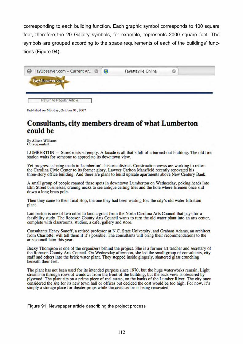
112
corresponding to each building function. Each graphic symbol corresponds to 100 square
feet, therefore the 20 Gallery symbols, for example, represents 2000 square feet. The
symbols are grouped according to the space requirements of each of the buildings’ func-
tions (Figure 94).
Figure 91: Newspaper article describing the project process

113
Figure 92: Existing waterworks building

114
Figure 93: Walking tour of waterworks interior

115
Figure 94: Graphic symbols corresponding to spatial activities
Figure 95: Small group planning process

116
Figure 96: Typical workgroup proposals After a lengthy discussion, workshop participants cut and pasted the symbols in their de-
sired location on each floor of the three-story building (Figure 96). A review of the 10 plan
proposals revealed a similarity in the location of the major functions, such as the gallery
and café on the ground floor, and the artists’ residences on the main floor (Figure 97).
Many groups proposed an extensive use of the outdoors including a sculpture garden,
children’s outdoor garden, and a café and terrace, all of which are included in the design
proposal (Figure 98).
Figure 97: Presentation of ideas

117
Figure 98: Consensus planning proposal

118
Figure 99: Final design proposal The design proposal reflects the general sentiment of the workshop participants (Figure
98). From the main entrance there is a view of the gallery/ reception area below with the
artists’ residences in full view from the entrance and adjacent to an outdoor sculpture gar-
den. For visual control of the arts center, a staff office at the main entrance is housed be-

119
hind the existing glass block wall and adjacent to a meeting room and youth classroom. A
kitchen and café are located on the ground floor surrounded by a south facing outdoor
café serviced from the kitchen. The second floor lobby overlooks the main entrance with
additional classroom and studio space adjacent to an outdoor terrace on the roof of the
main floor (Figure 99).
Figure 100: Sketch of proposed interior compared to existing conditions
Figure 101: Proposed waterworks design

120
CONCLUSION
Today, arts facilities have become a focal point of cities throughout the world. In part, it is
based on the recognition that the arts symbolize the culture of a community. Lumberton,
too, is in a position to reaffirm its’ commitment to the arts in the development of the vacant
waterworks building as a setting for an arts center. Through exhibitions, educational pro-
grams, and subsidize studio spaces, the arts center will serve as a bridge between artists
and the public (Figure 100). The goal is to increase awareness, appreciation, perception,
and involvement in the visual arts for the public in Robeson County. The site of the water-
works building located adjacent to the Lumber River offers the community opportunities for
a variety of outdoor arts activities not available in other locations. As a major contribution
to the development of the Main Street program, the waterworks building offers a signifi-
cant presence and a testimony to the importance of the arts in Lumberton and Robeson
County (Figure 101).
ACKNOWLEDGMENT
Support for this project came from the North Carolina Arts Council, The City of Lumberton, Re-
bekah Thompson and the Southeastern Waterworks Board

121
Figure 102: Local newspaper headline announcing Reidsville project
The vision of the Reidsville Downtown Corporation (RDC) is to enhance and creatively
manage the development of Downtown Reidsville as the cultural, historic and economic
center of the community while keeping within the context of historic preservation (Figure
102). Area artists have discovered that these beautiful old buildings provide the perfect
settings for galleries, studios and classrooms. A downtown 'arts district' is emerging (Fig-
ure 103). The RDC has recognized the rich heritage of the visual and performing arts in
Rockingham County and the impact the art community can have on downtown develop-
ment. To that end, the RDC partnered with the Fine Arts Festival Association (FAFA) of
Rockingham County, who has been supporting artist and art education in the community
for more than sixty years. (FAFA) has a membership of visual and performing artists, writ-
ers, musicians, students and teachers from across Rockingham County. The membership
includes representatives from all artist guilds and studio groups. The "Fine Arts Festival"
held each spring, began in 1945 and last year, there were over 400 entries and 5,000 at-
tendees. In addition, the FAFA has a yearly "Emerging Artists Show", highlighting the work
of local art students.
The Reidsville Downtown Corporation (RDC) partnered with FAFA to request support from
the NC Arts Council to invite an architectural consultant (Henry Sanoff and The Adams
Group) to facilitate the planning process of converting an empty McCrory’s Department
Store in downtown Reidsville into a cultural arts and community learning center. The build-

122
ing is 23,700 square feet, including main floor, full basement and mezzanine. There is an
adjacent parking lot that is also available. Built in 1920, it was last occupied in 2001, yet
the building is structurally sound.
The Reidsville City Council chose to become a major contributor to the FAFA since it was
impressed by the Association’s educational emphasis and long history of support for the
arts. The Council supports this effort participated in the planning workshop. The Reidsville
Downtown Merchants Association also understands the economic impact the cultural arts
center will have on their community. They are united in their support and are committed to
being active participants in the planning process. The Chamber of Commerce Board of
Directors has committed their support. Representatives will attend the planning meetings
and work to bring in the rest of the business community. As a major stakeholder, the RDC
knows that a community arts center in the downtown will be a major contributor to contin-
ued growth and development.
After discussion with the art community a place to showcase their work and talent is im-
portant to them, so is the opportunity to develop a cultural arts education program for chil-
dren and adults. This educational program would have an outreach component to seek
those who otherwise may have little opportunity to participate in the arts. A new facility
would include a main gallery, an interactive, hands-on children’s education gallery, class-
rooms for continuing art education for adults and children, “mini” galleries, a recording
studio and practice rooms, a small performance theatre to showcase local musicians,
writers, poets and actors, and banquet facilities and meeting space.
The planning process is aimed at supporting current downtown development plans. The
emerging downtown arts community will soon include a coffee house with a small per-
formance venue to feature local performing artists. Construction on a new downtown park
with a farmer’s market pavilion and a band shell will start later this year. New street-
scapes, wireless internet, residential development and a second downtown park are all in
stages of development. A future downtown planning process will include the cultural arts
and community learning center as a vital component to the town’s development goals.
The first step in the process consisted of a walking tour of downtown Reidsville followed
by a visit to the vacant McCrory’s building and adjacent theater (Figure 103). In order to
clarify the program needs identified in the initial proposal submitted by RDC, the consult-

123
ants conducted a series of interviews (Figure 104). A typical interview data sheet was dis-
tributed to a variety of community members affiliated with the arts to identify key functions
to be housed in the arts center. The data sheets served as the basis for the interviews,
which provided additional detailed information about desired center functions.
Figure 103: Walking tour of downtown Reidsville
Figure 104: Small group interviews with consultants
More than 100 people participated in the Arts Center Planning Workshop held at Café 99
in downtown Reidsville. Council members, local artists, musicians, performers, merchants,
citizens and public officials joined together to share their views about the most appropriate
functions and their location. Twenty groups of four or more people were seated at tables,
each having a building plan and graphic symbols corresponding to each building function
(Figure 105). Each graphic symbol corresponded to 100 square feet; therefore eight studio
symbols corresponded to 800 square feet. The symbols are grouped according to the
space requirements of each of the buildings’ functions.

124
Figure 105: Community workshop
After a lengthy discussion, requiring group consensus, the symbols were cut and pasted in
their desired location on the plan drawing (Figure 106). A representative of each group
presented their vision of the future arts center. A review of the twenty proposals revealed
a similarity in the location of the theater. Although there was some variation in the location
of the exhibition most groups agreed that it was to serve as a focal point for the arts center
(Figure 107).
Figure 106: Typical solutions from workgroups
Figure 107: Group representatives presenting their ideas

125
Figure 108: Proposed plan of the arts center based on consensus solution above
The design concept is based on developing the main entrance to the arts center through a
sculpture courtyard on Market Street in an effort to enhance the image of an arts district.
The aim is to alter the character of backstreet to be more consistent with the recent devel-
opment of The Gallery and crafts shop. The exhibition gallery can be entered through
Scales or Market Streets, although the theater lobby is only accessible through Scales
Street. This allows direct access to the arts center from both streets with studios and
classrooms opening into the exhibition area (Figure 108). The goal is to increase aware-
ness, appreciation, perception, and involvement in the visual and performing arts for the

126
public in Rockingham County. As a major contribution to the development of Reidsville’s
Main Street program, the McCrory building and adjacent theater offers a significant pres-
ence and a testimony to the importance of the arts in Reidsville and Rockingham County
(Figure 109).
Figure 109: Existing facility above and design proposal below

127
GOVERNMENT CENTER, ST. PAUL, MINNESOTA
INTRODUCTION
Recently, pre-design studies have become an integral part of the design process. Pre-
design is a phase that precedes the architectural programming and space planning
stages. However, a pre-design phase normally includes a strong programming compo-
nent. It may include tasks and activities that range from defining functional needs and ad-
jacency analyses to establishing design imperatives and prioritizing design recommenda-
tions, and from cost analysis and financial modeling to establishing urban design criteria
for locating new buildings. However, as an emerging field of specialization, pre-design is
still considered to be a relatively novel part in architecture and planning disciplines. Now,
large organizations are increasingly recognizing the need for pre-design studies that result
either in new construction or in managerial improvements, changes or reorganization of
existing space.
Efforts were undertaken by several government agencies and professional organizations
to make pre-design an integral part of their building delivery process (Preiser, 1985). As a
result, pre-design studies are taking place now as part of design and space planning prac-
tices, especially with the current complexities of building functions and activities.
Municipalities, state governments, and private corporations in North America occupy mil-
lions of square feet of work environments. In many cases, however, insufficient care is
taken initially to define clearly the specific requirements these work environments must
fulfill. Recent literature on work places (Davis, G. et al, 1993; Duffy and Powell, 1997;
Worthington, 1998; Duffy and Tanis, 1999) corroborates that the result is a large capital
investment in facilities that do not enhance and often hinder efficient office operations,
while also not supporting health, safety; functional performance, and employees' produc-
tivity and satisfaction. The importance of workspace has been shown by Duffy (1997,
1998) who studied an extensive number of work organizations from different countries and
illustrated that facilities costs (i.e. construction, maintenance and utilities0 amount to
10%whereas human costs (i.e. salaries) amount to 90% of all costs of an organization. A
more recent study by Brill (2001) has shown that over a period of ten years, operating and
maintenance costs of an organization remains close to8%, whereas human cost remains

128
close to 85-90%. Consequently, the major expenditure of work organizations is for the
people.
Workplace satisfaction has been studied through subjective evaluations by employees by
Marans and Spreckelmeyer (1986), Ferguson and Weisman (1986), and Cherulink (1993).
Common attributes evaluated in these studies covered satisfaction about such issues as
environmental factors and office layout, however they have been linked to job satisfaction
and performance. The importance of workspace has been shown by Duffy (1998) who
studied an extensive number of work organizations in different sectors and countries and
illustrated that facilities costs (i.e. construction, maintenance, utilities, etc.) amount to 10%
whereas human costs (i.e. salaries) amount to 90% of all costs of an organization. More
recently, Brill (2001) has shown that over a period of 10 years, operating and maintenance
costs of a work organization remains close to 8%, whereas human cost remains close to
90%. Consequently, the major expenditure of work organizations is for people.
More recently, workspace research has focused on workspace-work pattern relationships,
such as work and information flow. Conventional working patterns are changing dramati-
cally and thus new patterns are emerging as the opportunities provided by new technolo-
gies verge on every aspect of workplace environments. Designers, facility managers, and
top management in many organizations have already started to investigate whether the
conventional work environment helps or hinders opportunities for business development
and growth. It is increasingly acknowledged that requirements for workplaces have be-
come very demanding in recent years. Many factors related to information and communi-
cation technologies, energy codes, environmental quality; and employees' productivity
were of little concern or oversimplified a decade ago, but they have recently become of
vital importance.
Thomas Peters (1992,1997) argues that space management may well be the most ig-
nored, yet the most powerful tool for inducing cultural change, speeding up innovation pro-
jects, and enhancing the learning process in far reaching organizations. In this respect,
many authors argue that office buildings and office interiors must be designed to be used
in ways that add value to the employees' work while simultaneously drive down occu-
pancy cost.

129
The objective of this chapter is to describe a pre-design approach toward the development
of work environments. The paper reports on a pre-design study conducted over three
years for the Minnesota Departments of Agriculture (MDA), Health (MDH), and Human
Services (DHS), for developing new office facilities and laboratories. The approach of the
study is based on establishing a collaborative process that includes five major procedures.
These are:
• Analyzing the existing condition, problems and needs definition; conceptualizing chal-
lenges and opportunities;
• Developing and establishing mechanisms for understanding agency needs while devel-
oping consensus in decision making;
• Envisioning solutions and establishing guidelines.
The major components of the study are programming the workplace environment, defining
functional needs and relationship analyses, establishing principles for urban intervention,
and developing financial modeling. The paper concludes by outlining how emerging op-
portunities can be stemmed from pre-design studies, how employees' productivity and
comfort can be addressed, and how urban and environmental resources can be preserved
and conserved.
THE TWIN CITIES PROJECT
In 2000, the Departments of Agriculture (DA), Health (DH), and Human Services (DHS)
received funding to develop a pre-design study and investigate the feasibility of restructur-
ing the workplace of their agencies and divisions and of co-locating the Departments of
Health and Human Services program offices, and the Departments of Health and Agricul-
ture laboratories. The broad goal of the Minnesota State Administration was to minimize
long-term costs of government facilities, and to increase access, and most importantly, to
consider ways in which agencies can best serve their customers.
The concerned departments viewed the project as an opportunity to look carefully at the
relationships between their programs to provide better customer service. Currently, those
departments allocate their program facilities and staff between St. Paul and Minneapolis.
Current facilities are inadequate to meet the needs of the agencies, and in fact threaten
their ability to accomplish their mission and to maintain skilled and experienced staff.

130
Through a collaborative team approach a process was established to analyze the existing
conditions, and to develop mechanisms for understanding agency needs through a proc-
ess of consensus decision-making. The approach was participatory, intensive, and com-
prehensive in nature and employed several techniques. The first step for creating an em-
ployee responsive work environment is to develop the most reliable methods for collecting
information from Minnesota State employees. In fact, one of the main reasons for the con-
tinuing debate concerning ways to improve personnel productivity and their satisfaction of
their work environment is the lack of simple, reliable, and comprehensive methods.
Concomitantly, a number of methods and techniques were conceived. These include
visioning sessions, workshops, working meetings, survey questionnaires, interviews, and
web-based surveys. Since the project has included several components, the detailed de-
scription of the process and methodology might go beyond the scope of this paper. How-
ever, a brief outline of the major procedures and their findings is framed within the analy-
sis of the project development process.
EXISTING CONDITIONS AND NEEDS DEFINITION
Work meetings have been conducted as exploratory and discovery events to identify the
needs of the agencies and state the challenges that the project consultants together with
the client would face throughout the process. With the Minnesota Department of Admini-
stration leadership, and the guidance of the Minnesota Department of Finance, the exist-
ing condition was conceptualized. The results of this procedure have been clearly stated
and framed as representative problems as follows:
• The existing facilities of the agencies do not meet current and future needs.
• The agencies operate from multiple metro locations within the twin cities and this hinders
their ability to effectively carry out their business and service plans.
• The agencies continue to grow in terms of staff and services in response to mandated
programs. As a result, they have expanded into available leased spaces.
• The agencies have not always been successful to strategically locate programs having
close functional relationships or similar service programs.
• Many spaces pose critical environmental issues that pertain to life safety and space defi-
ciencies.

131
In this phase of the project major critical issues have been identified and classified into
four categories. These are: functional, psychological and organizational, utility and serv-
ice, and technological issues. In order to address the preceding issues a set of challenges
has been devised as driving forces and objectives for the overall process. These are:
• Community partnership and participation are a necessity to accomplish a project of this
magnitude.
• The larger community needs to be engaged in an open process leading to shared- solu-
tions, thereby sensing its ownership of the project.
• Non-traditional financing methods need to be explored.
• Use of state-owned sites need to be considered and surveyed.
• Setting priorities and developing a phasing plan for meeting the agencies space needs
requires involvement and assistance from the Department of Administration.
Based on investigating the existing condition major concerns have been defined to replace
previous conventional approaches adopted by the State. The traditional approach to meet-
ing the state agency facilities' needs has been to build or lease space to accommodate an
agency's staff growth. The concern here was to allow the agencies to operate in a func-
tional, productive, and healthy environment with minimal growth. The major critical con-
cept introduced was collocation that provides opportunities for shared spaces and facilities
between the agencies, while improving customer service delivery. As a result, the concern
was to utilize technology in well-situated facilities that permit inter-agency and intra-
agency cooperation and sharing of common spaces. These facilities need to be energy
efficient, cost effective, and flexible to serve as an integral part of broad based community
re-development efforts. With these new facilities, additional opportunities emerge to forge
and enhance partnership between state agencies, federal institutions, and different county
departments.
A USER CENTERED PROGRAMMING PROCESS
Programming is intended to facilitate communication among the designers, clients, and
eventual users. According to Sanoff (1992), it is a process of problem identification, infor-
mation collection, and information organization resulting in a communicable statement of
design intent. One of the important purposes of programming is to integrate human activi-
ties into space and time. Its aim is to tap the building occupants for information on what it

132
is they need in a building, a source that was largely ignored in the past. In this regard, the
authors argue that the process of involving those most affected by design decisions and
thus the built environment in the programming process promises better need definition,
morale, responsibility, and foster the development of a sense of belonging and ownership
on the part of users after building occupancy.
A typical approach to workplace programming and design is to define and then analyze
tasks and requirements of the individual and workgroups. However, the most ideal situa-
tion to assure a good fit between the workplace and the nature of work being performed is
to have each workplace custom designed for the tasks of each individual employee. It has
been generally assumed that this would create large number of workplace designs, often
referred to as "footprints", that are categorized by shape and floor area they occupy.
These in many cases appear too as not cost effective and may result in higher initial
costs. Therefore, designers used to identify a limited number of workplace types.
The current workplace of the three concerned departments is characterized by limited
technological capacity, poor environmental quality, and inflexibility. The approach under-
taken in the programming process recognizes the fact that there are misfits between the
current workplace and the nature of work. It is believed that a larger number of workplace
types are available than presently utilized. In order to resolve these misfits, and develop
new workstations responsive to agencies' needs, a participatory strategy was devised to
allow all employees to identify the workplace types best suited for their tasks. An exten-
sive research process resulted in the identification of square footage, visual character, and
work types of fourteen workplace variations found in recent literature and in the market-
place. A major part of this process was to analyze these types in terms of flexibility, com-
mon areas, shared spaces, teaming areas, and other factors. Three-dimensional modeling
for each type was developed to facilitate employees understanding of the key issues.
The approach undertaken in this project recognizes that there may be misfits between
work and the workplace, and a larger number of footprint options are available than pres-
ently utilized. Similarly, narrowly defined office standards tend to limit range of possible
workplace types. To resolve the workplace misfits, a strategy was devised to allow all em-
ployees of the Departments of Health, Human Services and Agriculture to identify the
workplace type best suited for their tasks. An extensive study of workplace types actually
revealed fourteen variations, many more than are usually considered in workplace design.

133
All fourteen workplace types recognize the current and future tasks and space require-
ments such as the hive and commons, as well as mobile office workers using hotelling, or
the free-address system.
A Workplace Types survey form was created to allow employees to identify the spatial ar-
rangement best suited for their task. A planning workshop with management representa-
tives of the State Departments of Health, Human Services and Agriculture engaged the 80
participants in familiarizing themselves with the survey task (Figure 110).
Figure 110: Management planning workshop

134
Each participant subsequently served as a liaison to their administrative unit to ensure that
the survey forms were distributed and completed. Generally, the results from the Depart-
ment of Health's 1,268 employees for example, indicate that 223 respondents required
private offices and the remaining 1,036 employees required a variety of workplaces.
Workplace type "D," the open plan was preferred by 50% of the employees, while "C" was
identified by 25% of the respondents (Figure111). From the Department of Human Serv-
ices, 2,205 employees responded and 447 required private offices (Figure 112).
The development of the architectural program was based on the workshop and survey re-
sults. It included the identification of activities, description of the spatial environment that
accommodates these activities, and a statement of design intent. Program data sheets
were developed to record requirements for the primary office activities. The information
contained includes: user information, range of activities, workplace objectives, spatial re-
quirements, workplace type, design requirements, and equipment needs.
The programming process of the lab facilities addressed the space requirements of the
Department of Agriculture and Health based on the number of personnel and space
needed for scientific equipment. A number of criteria have been considered while develop-
ing the program. These were: flexibility, and adaptability of space to accommodate change
in use and future needs, hours of operation, individual workstation and health and safety.
Working meetings with the section managers were held to review room data sheets and to
comment on the preferred distribution of functions. The overall participatory programming
process resulted in area requirements of each division in the department, definition of re-
quirements, functional requirements, and common space requirements.

135
Figure 111: Individual workplace types (developed by Umut Toker)

136
Figure 112: Workplace settings (developed by Umut Toker)
137
A visioning workshop with the management representatives engaged over 80 participants
in an exploratory process while familiarizing themselves with the survey tasks. Each par-
ticipant served as a liaison to his or her administrative units. The objective of the survey
was to gather information and record the divisions' responses to desired workplace types.
Major results were: From the Department of Health's 1268 respondents, 232 required pri-
vate offices, 1036 required variety of workplaces. The open plan type "D" was preferred by
50%, while type "C' was preferred by 25%. From the Department of Human Services 2113
respondents, 390 required private offices and 1723 required variety of workplaces. Nota-
bly, workplace preference percentages were similar in the agencies. Summary survey
sheets were developed showing area requirements of each division, and concluded with
comprehensive agency requirements including circulation and shared spaces.
COMMUNICATION AND RELATIONSHIP ANALYSIS
In order to improve the delivery of services to citizens of Minnesota, a social network
analysis of the information flow between divisions within the departments as well as be-
tween the agencies was envisioned. This analysis presumes that divisions within a high
frequency of information and communication flow between them would function more effi-
ciently if they were located within close proximity to each other. To identify the most impor-
tant connections between the Departments of Agriculture (DA), Health (DH), Human Serv-
ices (DHS), Corrections, and Public Safety, a database was developed with the aid of a
self-administered survey and face-to-face interviews with division managers and person-
nel. The survey required division managers from the five departments to identify the ad-
ministrative units with which that they are in frequent contact.
The relation between the social entities is graphically presented where a dot and a rela-
tional tie represent each social entity by a line. Depending on whether the tie is directional
or non-directional, this line may be an arrow or a line. The survey results indicated that
certain divisions identified a one-way communication while others were characterized as
having two-way or reciprocal connection or relational tie. Decisions regarding proximity
importance between divisions were based on those identifying the highest number of rela-
tional ties. Establishing a frequency procedure of these ties was necessary to develop a
threshold of importance.

138
From the ties identified in the survey, the Department of Human Services (DHS) is the
most centrally located within the five departments due to the number of reciprocal rela-
tions it has with the Departments of Corrections (DOC), Health (DH), and Public Safety
(DPS). With one hundred and thirty-one relational ties, the connections between DHS and
DOC represents the highest need for proximity followed by the link between the Depart-
ments of DH and DHS (Figure 113).
Figure 113: Network analysis of existing organizational relational ties
There also appeared to be a high degree of interaction reported between the DHS, Child
Services Administration and the DH, Family and Community Health Division, which re-
corded forty-eight interactions. Results also revealed that the Health Protection Division
within the DHS had minimal inter-departmental connections but a high level of relational
ties within its own division and with DA labs.

139
SITE SELECTION PROCESS
Site selection was one of the key components of this study. The process of selecting sites
for locating new facilities for the state departments involved an extensive literature review
and a collection of methods to assess the most appropriate procedure for establishing cri-
teria for site selection. An analysis of employee travel time to work to the five departments,
revealed six possible locations for a new facility. Each site offered different amenities and
required employees to make trade-offs between geographical locations based on their
preferences (Figure 114). In a workshop with agency managers, each were asked to
evaluate the six geographical locations within the metropolitan area and indicate how each
site would contribute positively to the employees’ daily experience and stage in their life
cycle. In addition to this workshop, an electronic web based survey of departmental s em-
ployees was conducted to assess site attributes and their preferences (Figure 115). Em-
ployee preferences were primarily transit, transportation and parking since more than 80%
drive to work, and most commute less than 20 miles. Strikingly, 70% of the respondents
expressed interest in telecommuting. As a result of this process, the consulting team to-
gether with Minnesota State administrative representatives selected three possible sites
for the new facilities.
In order to investigate environmental issues and the impact of development on the natural
environment, a comparative analysis of the three preferred sites was conducted by rating
each site according to specific criteria that included site-biodiversity, watershed protection,
potable water consumption, energy, air pollution, indoor environmental quality, and waste
management. The results revealed varying degrees of environmental eco-friendliness and
provided criteria for the final selection as shown in Figure 116.
ACKNOWLEDGMENT
Acting as principal investigators, The Adams Group, Henry Sanoff, Umut Toker and Hokan-
son/Lunning/Wende, have developed the pre-design study of the three agencies. The project team
also included specialists in strategic planning and, financial analysis, and sustainable design,
namely Art Pearce of Idea Works, Teresa Stems of Sterns & Associates, John Carmody of the
Center for Sustainable Building Research of the University of Minnesota, and Lisa Wilson of De-
sign Collaboration.
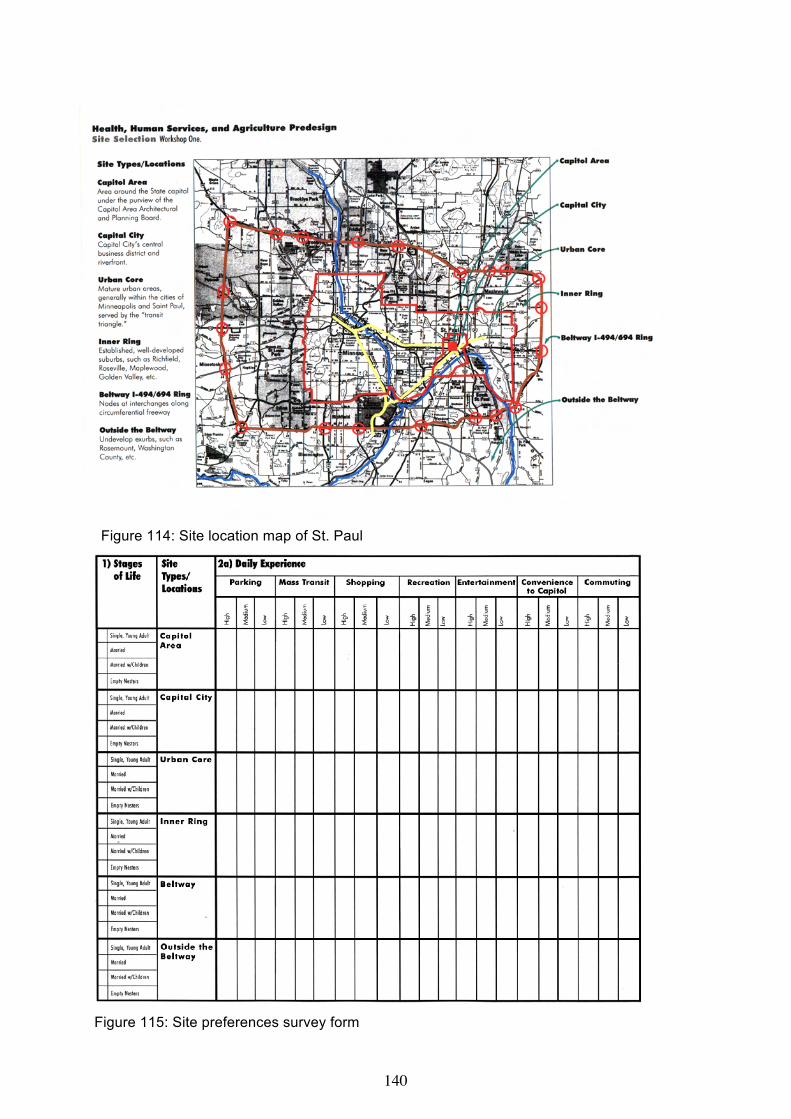
140
Figure 114: Site location map of St. Paul
Figure 115: Site preferences survey form

141
Figure 116: Area requirements to meet space needs of all departments of the preferred site

142
APPENDIX
URBAN PARTICIPATORY GAMES
Participation can take place through many types of involvement, such as design and
planning games for organizing group decision-making. Jerome Bruner (1967) suggests
that one of the key factors in the learning process is participation----particularly by the
use of games that incorporate the formal properties of the phenomena for which the
game is an analogue. A game is a simulation of a real situation, allowing participants to
act out situations and experience the interactions of a community activity. Games are
educational because their purpose is to create an environment for learning and prepare
people to act (Duke, 1974). Gaming is a participatory approach to problem solving that
engages a real-life situation compressed in time so that the essential characteristics of
the problem are open to examination. This technique permits learning about the process
of change in a dynamic environment requiring periodic decisions. Essentially, a complex
problem is identified, its essence is abstracted, and the end result is a process referred
to as a simulation. Games consist of players, placed in a prescribed setting, with con-
straints within this setting represented by rule systems and methods of procedure.
Games used for teaching in the academic community produce outcomes such as learning
of principles, processes, structures, and interrelationships; empathy and understanding for
predicaments, pressures, and real-world problems (Abt, 1970). Game use in social plan-
ning is helpful when players try out different forms of social structure, resource-allocation,
and communication within a simulated environment, to test the effectiveness of ideas,
costs, and rewards of options (Duke, 1974). The use of games by groups to explore val-
ues, ideas, and behaviors as a communication function gives participants a better under-
standing of themselves and others. Games used in conflict resolution facilitate communi-
cation between dissimilar or opposing groups (Greenblat & Duke, 1981). Design games
get people involved in their play and in their design and planning results. There are sev-
eral reasons for this, but three are central:
1. Participants take a role and argue the problem from that posture.
2. Games organize complex details into an overview model. This allows the player to
grasp details that might otherwise be lost.

143
3. Games require trial decisions, and this commitment sharpens the thought processes of
the participants who are required to act.
Gaming methods aim to accomplish specific tasks ranging from increasing people’s
awareness to particular environmental design issues, to teaching concepts and relation-
ships, to clarifying value differences between decision makers. Values are those beliefs
we hold to have some intrinsic worth. Value differences between individuals often account
for their inability to achieve agreement in group problem-solving situations. Quite often
so-called differences of opinions result from basic value differences not made explicit.
Values clarification methods encourage people to examine their own beliefs.
Each of the following design games provides a variety of materials, including lists of objec-
tives, activities, activity symbols, and environmental settings. Games help to facilitate an
understanding of strategies for solving a variety of environment design problems and im-
parting information in a meaningful way.
URBAN INFILL
At the core of urban design is the streetscape. What we describe as infill is also referred
to as redevelopment, which is a renewal or recycling process. Infill requires less energy
to build and maintain and denser development conserves energy and building materials.
Infill is also good for communities because fuel, pollution and travel time caused by
commuting are reduced.
Today, neglect and rapid decay have placed many streetscapes in need of replacement
or repair. Also, an empty sight is often a blighted site. Often, however, when action is
proposed in communities without the support of historic-district or similar regulations, the
visual impact of a proposed action does not lend itself readily to analysis, and recognized
guidelines are lacking to evaluate their significance and to weigh their beneficial or det-
rimental consequences. These problems have led to charges of insensitivity and even
litigation against those responsible for urban development projects.
In order to insure that there is some continuity in the process of restoring older street-
scapes, it is necessary to evaluate new building proposals very carefully. This is best
achieved by comparing each new proposal with design guidelines to insure the preserva-
144
tion of those unique qualities that make older buildings visually distinctive. Compatibility
in a streetscape can be attained if certain characteristics are maintained through the col-
lective development of design guidelines. Such features include:
• Setbacks
• Character
• Scale
• Building use
• Roof silhouette
• Surface variation
• Use of Ornamentation
• Proportion of window and door openings
• Relative height

145
BEST-FIT SLIDE RULE
This is a discussion tool developed to examine streetscape infill solutions and their con-
sequences (Sanoff, 1990). It is a visual guide for determining compatibility by identifying
those factors to be considered when contemplating new construction. As a strategy for
discussion, it can bring together professionals, public officials, landowners, and citizens’
groups to explore the consequences of various infill alternatives prior to construction.
Developing an awareness of the complex issues related to streetscape infill, through a
hypothetical exercise, can enable community members to focus on the social, economic,
and visual implications of changing the fabric of an existing streetscape. Since partici-
pants respond to a design situation with different values and beliefs, the exercise offers
the opportunity for participants to share those differences and learn from each other.
The slide rule is most effectively used in small group settings where participants make
individual choices, defend their decisions, and reach consensus about the most appro-
priate fit. The process requires each group member to select one of thirteen options for
the infill of the residential streetscape (Figure 117). Participants then try to maintain their
positions and debate them, but the final goal of the exercise is a solution that is accept-
able to the group.
The process requires each participant to select one of the thirteen options for the infill
site located in the center of a hypothetical urban residential street. The choices include
alternative building uses as well as visual appearance Figures 117a & 117b). Typically,
the issues participants discuss are related to the impact of changing uses depicted by
business or commercial additions and their corresponding parking requirements, and in-
creased traffic. Similarly, concerns about residential stability are as integral to the dis-
cussions as is architectural style.
Since people respond to a design situation with different values and beliefs, the exercise
offers the participants an opportunity to share those differences and learn from each
other. Participants use the game props to clarify and reconcile differences.
Developing an awareness of the complex issues pertaining to infill, through an abstract
exercise, can enable community members to focus on the social, economic, and visual
implications of changing the fabric of an existing residential streetscape. The technique

146
of using a hypothetical street as a stimulus for generating a discussion of important is-
sues permits all participants to learn from each other without being encumbered with and
confounded by the personal, political, economic, and site constraints of a real situation.
To follow-up on the discussion generated by the participants in the Best-Fit Slide Rule
exercise, the actual streetscape under consideration could be presented in a similar way,
together with alternative infill proposals. At this point, participants may already be aware
of such issues as building use, ornamentation, roof silhouette, relative height, proportion
of door and window openings and surface variation, so the discussion can also include
issues related to the streetscape. The visual impact of a building’s image is significant in
conveying connotations associated with building alternatives.
Figure 117: Typical streetscape
Figure 117a: Alternative infill building types
Figure 117b: Example of an infill alternative

147
Figure 118: Melbourne, Australia best-fit slide rule showing the original streetscape at the top,
with alternative infill options below

148
Figure 119a: Assembly instructions for making the Best Fit Slide Rule

149
Figure 119b: Assembly instructions

150
KNOWLEDGE OF EMERGING ENVIRONMENTAL STRATEGIES (KEEPS)
This game is designed to provide groups interested in preserving the many environmental
qualities unique to older neighborhoods, districts and towns with an understanding of the
strategies open to them (Figure 120). Organizing and planning for the preservation of the
qualities identified relies upon the consideration of (Sanoff, 1978):
• The environmental qualities the group seeks to develop
• Individual goals
• The strategies the group can use to accomplish their goals
To begin, each player reviews the three diagrams and identifies and records those neigh-
borhood or town qualities that were lost or need to be retained as the town changed from
image one to image three. Group members should record and discuss the qualities each
has identified. Next, from the goal list provided, each player should select no more than
four goals that seem to be important in developing the environmental qualities the group
has decided upon. When all the members of the group have made their individual
choices, the individual lists are pooled. Through discussion the group must choose a total
of four goals, with the additional constraint that the four statements must be incorporated
into a unified conservation program. Players are urged to forcefully support their individual
choices, even if other members of the group differ. Discussion should continue until group
members persuade or are persuaded to include four goals that reflect the group’s priori-
ties. This may require considerable discussion.
When consensus is reached, the group enters its choices on the record sheet. Next, using
the strategies list, each player selects no more than four strategies to accomplish each
goal. Some strategies may relate to more than one goal. After all group members have
made their strategy selections, the lists are pooled to arrive at the final group choices.
The completed record sheet now contains a framework of a collaboratively generated ac-
tion program. If several groups are engaged in this exercise simultaneously, the results
should be combined and used as a framework for future discussions.

151
Figure 120: Knowledge of Emerging Environmental Preservation Strategies (KEEPS)

152
When consensus is reached, the group should enter its choices on a record sheet. Next,
using the strategies list, each player should select no more than four implementation
strategies that can be used to effectively accomplish each of the goal choices. Each goal
should be worked through completely before starting a new one. Some strategies, how-
ever, may relate to more than one goal. After all members of the group have made their
strategy selections, the lists should be pooled to arrive at the final group choices.
The completed record sheet now contains the framework of a collaboratively generated
action program. If several groups are engaged in the exercise simultaneously, the results
should be combined and used as a framework for future discussions.
Urban Improvement Visual Alternatives
Figure 121: Web based survey to identify priority improvement projects
Based on the ideas presented in the Japanese small town projects and the community
arts centers, the Public Life Foundation of Owensboro, developed a series of before and
after images of various features of the town needing improvement (Figure 121).

153
ARTS CENTER GAME The basic format of this process is people working together towards group consensus de-
cisions. The arts center space planning game is a small group activity where participants
make choices, hold positions, and debates them, but the final goal of the game is a plan of
action for the entire group. Participants individually select from the list, four objectives and
by consensus agree to a final list of four (Figure 123). Participants, then, match each ob-
jective with four corresponding activities and their representative symbols. Objective and
activity consensus choices should be entered in the record sheet (Figure 124). When
agreement is reached about the appropriate activities the symbols can be selected and
then fastened to a board (Figure 122) or within the footprint of an existing building. This
exercise can be adapted for use in the planning other facilities, such as senior centers.
Figure 122: Sample layout game board

154
Figure 123: Example of objectives and activities lists

155
Figure 124: Record sheet
Figure 125: Activity symbols corresponding to their relative size

156
REFERENCES Abt, C. (1970). Serious Games. New York: Viking Press. Atlee, T. (2003). The Tao of Democracy. Cranston, RI: The Writers Collective. Baird, G., Gray, J., Isaacs, N., Kernohan, D., McIndoe, G. (1995). Building Evaluation Techniques. New York: McGraw Hill. Bens, C.K. (1994) Effective citizen government: How to make it happen. National Civic Review, 83(1), 32-38. Billington, R.A. (1974). American’s Frontier Heritage. New York: Holt, Rinehart & Winston. Bordenave, J.D. 1994. “Participative communication as a part of building the participative society.” In Participatory Communication: Working for Change and Development, edited by S.A. White, K.S. Nair & J. Ascroft. Thousand Oaks, CA: Sage Publications. Breen, A. & Rigby, D. (1994). Waterfronts: Cities Reclaim Their Edge. New York: McGraw-Hill. Brill, M. (2001). Disproving Widespread Myths About Workplace Design. Buffalo, NY: BOSTI. Brower, S. (2000). Good Neighborhoods: A Study of In-town and Suburban Residential Environ-ments. Westport, CT: Praeger Brown, T.C. and Peterson, G.L. (1994). A political-economic perspective on sustained ecosystem management. In: Debano, L.F. (ed.) Sustainable Ecological Systems: Implementing an Ecological Approach to Land Management. Gen. Tech. Rep. RM-247. Ft. Collins, CO: US Department of Ag-riculture, Forest Service, Rocky Mountain Forest and Range Experiment Station: 228-235. Bruner, J.S. (1967). Towards a Theory of Instruction. Cambridge, MA: Harvard University Press. Cherulink, P. D. (1993). Application of Environment-Behavior Research, Case Studies and Analy-sis (Vol. 1). New York: Cambridge University Press. Colfer, C.J.P., with Prabhu, R., Gunter, M., McDougall, C.,Miyasaka Porro, N. and Porro, R. (1999). Who counts most? Assessing human well being in sustainable forest management. In: Prabhu, R. (ed.) C&I Toolbox, vol. 8. CIFOR, Bogor, Indonesia. Davis, G., Thatcher, C and Blair, L. (1993). Methods for Setting Occupant Requirements and Rat-ing Buildings. Canada: International Center for Facilities. Delbecq, A.L., A.H. Van de Ven, and D.H. Gustafson. (1975). Group Techniques for Program Planning: A Guide to Nominal Group and Delphi Processes. Glen View, IL: Scott Foresman. De Tocqueville, A. (1959). Democracy in America. New York: Vintage Books. Duffy, F. M. (1998). The ideology of supervision. In G. Firth & E. Pajak (Eds.) Handbook of Re-search on School Supervision (pp. 181-199). New York: Macmillan. Duffy, F. and Powell, K. (1997). The New Office. United Kingdom: Conran Octopus. Duffy, F. and Tanis, J. (1999). A vision of the new workplace revisited. Site Selection, September. Duke, R.D. (1974). Gaming the Futures Language. New York: John Wiley.

157
Etzioni, A. (1994). Spirit of Community. New York: Touchstone. Fagence, M. (1977). Citizen Participation in Planning. Oxford: Pergamon. Ferguson, G. S., & Weisman, G. D. (1986). Alternative approaches to the assessment of em-ployee satisfaction with the office environment. In J. D. Wineman (Ed.), Behavioral Issues in Office Design (pp. 85-108). New York: Van Nostrand Reinhold. Firey, W. (1965). Law and Economy in Planning. University of Texas Press, Austin, Texas. Fischer, G., Giaccardi, E., Eden, H., Sugimoto, M. & Ye, Y. 2005. Beyond binary choices: Integrating individual and social creativity. Human-Computer Studies 63: 482-512. Florida, R. (2006). The Flight of the Creative Class. NY: Harper Collins. Forester, J. (1999). The Deliberative Practitioner: Encouraging Participatory Planning Processes. Cambridge: MIT Press. Garzon, R. (2000). Urban Image and Sustainable Development. Master en Gestion y Promocion Urbana para un DeSarrollo Sostenible. Facultad de Arquitectura, Cordoba. Universidad Ve-racruzana. Gaventa, J. (1993). The powerful, the powerless, and the experts: Knowledge struggles in an in-formation age. In Voices of Change: Participatory Research in the United States and Canada, ed-ited by P. Park, M.Brydon-Miller, and T. Jackson. Westport, CT: Bergin & Gazrvey. Godschalk, D.R., Parham, D.W., Potapchuk, W.R., and Schukraft, S.W. (1994). Pulling Together: A Planning Development Consensus Manual. Washington, DC: Urban Land Institute. Greenblatt, C.S. and Duke, R.D. (1981). Principles and Practices of Gaming Simulation. Beverly Hills, CA: Sage. Guy, B. (2002). Community Design Primer. Environmental Leadership Program. available at http://www.elpnet.org Hart, R. (1997). Children’s Participation: The Theory and Practice of Involving Young Citizens in Community Development and Environmental Care. New York: UNICEF. Hatch, R. (1984). Scope of Social Architecture. New York: Van Nostrand Reinhold. Hester, R. (1990). Community Design Primer. Mendocino, CA: Ridge Times Press. Hunt, M.E. (1985). Enhancing a building’s imageability, Journal of Architectural and Planning Re-search, 2:151-168. Innes, J. (1996). Planning through consensus building: A new view of the comprehensive ideal. Journal of the American Planning Association 62(4):460-472. Jones, B. (1990). Neighborhood Planning: A Guide for Citizens and Planners. Chicago, IL: Ameri-can Planning Association. King, S. (1983). Co-Design: A Process of Design Participation. New York: Van Nostrand Reinhold. Kretzmann, J.P. and McKnight, J.L. (1993) Building Communities from the Inside Out: A Path To-ward Finding and Mobilizing a Community’s Assets, ACTA, Chicago.

158
Lozare, B.V. (1994). Power and conflict. In Participatory Communication: Working for Change and Development, edited by S.A. White, K.S. Nair, and J. Ashcroft. Thousand Oaks, CA: Sage Publi-cations. Lynch, K. (1960). Image of the City. Cambridge: M.I.T. Press. Manzo, L. A. and Perkins, D. D. (2006). Finding common ground: The importance of place at-tachment to community participation and planning. Journal of Planning Literature20(4): 336-350. Marans, R. and Spreckelmeyer, K.F. (1981). Evaluating Built Environments: A Behavioral Ap-proach. Ann Arbor: University of Michigan, Institute of Social Research. Midgley, J. (1986). Community Participation, Social Development and the State. New York: Methuen. Morris, E.W. (1996). Community in theory and practice: A framework for intellectual renewal. Journal of Planning Literature 11:127-150. North Carolina Arts Council. (2007). Creative Economy Research. Raleigh: North Carolina Department of Cultural Resources. Olsen,M.E. (1982). Participatory Pluralism: Political Participation and Influence in the United States and Sweden. Chicago: Nelson Hall. Pateman, C. (1970). Participation and Democratic Theory. Cambridge: Cambridge University Press. Perkins, D.D., Brown, B.B. & Taylor, R.B. (1996). The ecology of empowerment: Predicting participation in community organizations. Journal of Social Issues 52(1): 85-110. Peters, T. (1992). Liberation Management. New York: Random House. Peters, T. (1997). The Circle of Innovation. New York: Random House. PICCED. Pratt Institute Center for Community and Environmental Development. (2000). http://www.picced.org/basics/overview.htm Pranger, R. J. (1968). The Eclipse of Citizenship. New York: Holt Rinehart & Winston. Plato, & Grube, G.M.A. (1992). Republic. Indianapolis, IN: Hackett Publishing Company. Preiser, W.F.E. (1985). Programming the Built Environment. New York: Van Nostrand Reinhold. Preiser, W.F.E., Rabinowitz, H. Z., & White, E.T. (1988). Post-Occupancy Evaluation. New York: Van Nostrand Reinhold. Rapoport, A. (1987) Terms of empowerment exemplars of prevention:Towards a theory for com-munity psychology, American Journal of Community Psychology, 15; 121-143. Rivlin, L. (1987). Group membership and place meanings in an urban neighborhood. Journal of Social Issues 38(3): 75-93. Sanoff, H. (1978). Design Games. Los Altos, CA: William Kaufmann. Sanoff, H. (1992). Integrating Programming, Evaluation and Participation in Design. Brookfield, VT: Ashgate. Sanoff, H. (1994). School Design. New York: John Wiley & Sons.

159
Sanoff, H. (2000). Community Participation Methods in Design and Planning. New York: John Wiley and Sons. Shellshear, T. (1983). Byronshire Environmental Study: Working paper No.6-Heritage, Sydney, Australia: Planning Workshop Pty Ltd. Speer, P.W. and Hughey, J. (1995) Community organizing: An ecological route to empowerment and power, American Journal of Community Psychology, 23(5); 729-48. Spinuzzi, C. 2005. The methodology of participatory design. Technical Communication 52(2):163-174. Swanson, B.E., Cohen, R.A. and Swanson, E.P. (1979). Small Towns and Small Towners. Beverly Hills, CA: Sage Publications. Thomson, K., Berry, J.M. & Portney, K.E. (1994). Kernels of Democracy. Boston, MA: Lincoln Filene Center at Tufts University. WCED (World Commission on Environment and Development), (1987). Our Common Future, Re-port of the World Commission on Environment and Development, Published as Annex to General Assembly Document A/42/427. Development and International Cooperation: Environment. Webber, M. (1967), Explorations in Urban Structure, Philadelphia: University of Pennsylvania Press. White, S.A., K.S. Nair, and J. Ashcroft (1994). Participatory Communication: Working for Change and Development. Thousand Oaks, CA: Sage Publications. Whyte, W.F. (1991). Participatory Action Research. Newbury Park, CA: Sage Publications. Worsley, P. (1967). The Third World. Chicago: University of Chicago Press. Worthington, J. (1998). Reinventing the Workplace. United Kingdom: Institute of Advanced Archi-tectural Studies, University of York. Zeisel, J. (2006). Inquiry by Design. New York: W.W. Norton.