Defining Typical Regional Pleasure Craft Marinas in the EU ...
279
November 2013 0 Defining Typical Regional Pleasure Craft Marinas in the EU for Use in Environmental Risk Assessment of Antifouling Products Ms Cheng Shan-I University of Newcastle Dr Jeremy Thomason University of Newcastle Dr Gareth Prowse International Paint Ltd (study sponsor) Version 3 November 2013
-
Upload
khangminh22 -
Category
Documents
-
view
2 -
download
0
Transcript of Defining Typical Regional Pleasure Craft Marinas in the EU ...

November 2013 0
Defining Typical Regional Pleasure Craft Marinas in the EU
for Use in Environmental Risk Assessment of Antifouling
Products
Ms Cheng Shan-I University of Newcastle
Dr Jeremy Thomason University of Newcastle
Dr Gareth Prowse International Paint Ltd (study sponsor)
Version 3 November 2013
November 2013 1
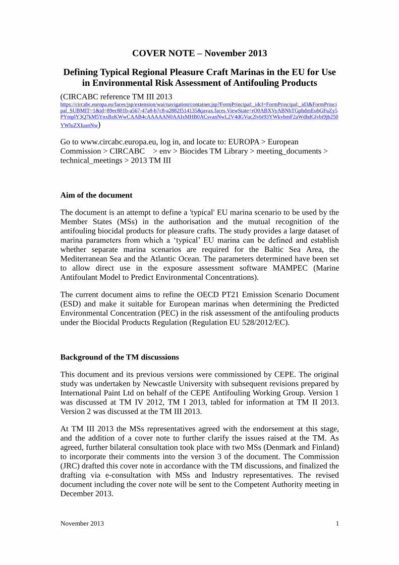
COVER NOTE – November 2013
Defining Typical Regional Pleasure Craft Marinas in the EU for Use
in Environmental Risk Assessment of Antifouling Products
(CIRCABC reference TM III 2013 https://circabc.europa.eu/faces/jsp/extension/wai/navigation/container.jsp?FormPrincipal:_idcl=FormPrincipal:_id3&FormPrinci
pal_SUBMIT=1&id=89ec801b-a567-47a8-b7c8-a2882f514135&javax.faces.ViewState=rO0ABXVyABNbTGphdmEubGFuZy5
PYmplY3Q7kM5YnxBzKWwCAAB4cAAAAAN0AAIxMHB0ACsvanNwL2V4dGVuc2lvbi93YWkvbmF2aWdhdGlvbi9jb250
YWluZXIuanNw)
Go to www.circabc.europa.eu, log in, and locate to: EUROPA > European
Commission > CIRCABC > env > Biocides TM Library > meeting_documents >
technical_meetings > 2013 TM III
Aim of the document
The document is an attempt to define a 'typical' EU marina scenario to be used by the
Member States (MSs) in the authorisation and the mutual recognition of the
antifouling biocidal products for pleasure crafts. The study provides a large dataset of
marina parameters from which a ‘typical’ EU marina can be defined and establish
whether separate marina scenarios are required for the Baltic Sea Area, the
Mediterranean Sea and the Atlantic Ocean. The parameters determined have been set
to allow direct use in the exposure assessment software MAMPEC (Marine
Antifoulant Model to Predict Environmental Concentrations).
The current document aims to refine the OECD PT21 Emission Scenario Document
(ESD) and make it suitable for European marinas when determining the Predicted
Environmental Concentration (PEC) in the risk assessment of the antifouling products
under the Biocidal Products Regulation (Regulation EU 528/2012/EC).
Background of the TM discussions
This document and its previous versions were commissioned by CEPE. The original
study was undertaken by Newcastle University with subsequent revisions prepared by
International Paint Ltd on behalf of the CEPE Antifouling Working Group. Version 1
was discussed at TM IV 2012, TM I 2013, tabled for information at TM II 2013.
Version 2 was discussed at the TM III 2013.
At TM III 2013 the MSs representatives agreed with the endorsement at this stage,
and the addition of a cover note to further clarify the issues raised at the TM. As
agreed, further bilateral consultation took place with two MSs (Denmark and Finland)
to incorporate their comments into the version 3 of the document. The Commission
(JRC) drafted this cover note in accordance with the TM discussions, and finalized the
drafting via e-consultation with MSs and Industry representatives. The revised
document including the cover note will be sent to the Competent Authority meeting in
December 2013.

November 2013 2
For further details on the TM discussions, please check the relevant minutes of the
meeting available to the MSs CAs in the TM folder on CIRCABC, and available to
the public on the JRC website:
http://ihcp.jrc.ec.europa.eu/our_activities/public-health/risk_assessment_of_Biocides/doc/minutes_tm/
minutes
Agreements for the TM endorsement of the Draft EU regional marina scenarios
MSs welcomed the document as a first attempt to define key parameters (marina
dimensions, maximum vessel occupancy and lengths, salinity, water temperature, pH
and DOC) for the marinas in the Atlantic, Baltic and Mediterranean environments.
This more extensive database represents a potential refinement over the simple default
marina scenario outlined in the existing PT21 OECD ESD. MSs found it very useful
especially for the MSs that do not have these data. This section aims to summarize the
concerns of the MSs expressed at the TM.
It was highlighted that some of the MSs already have national scenarios (e.g. Sweden
and Finland) and these have been successfully used to authorize biocidal products.
Germany is currently working on a relevant project that may result in a national
scenario for PT 21. Therefore, with this cover note, the TM wishes to express that,
although the document is endorsed, MSs will still have the possibility to continue to
use existing national scenarios for product authorisation, if considered more
appropriate to address exiting national protection goals. Additionally, MS
representatives highlighted the need to clearly specify the scenario(s) used for the
PEC calculation in the first assessment report, in order to prevent uncertainty during
the mutual recognition process. A suggestion was that the MS that makes the first
product authorisation should run all available scenarios for the actual region, and there
should be a requirement for authorisation that a preset minimum number of scenarios
should pass the risk assessment.
According to the authors, the current parametrisation of the saltwater marina in the
current PT21 OECD ESD was found to not accurately reflect the majority of marinas
in Europe. The endorsed report is not intended to propose a new EU marina scenario,
but presents a more updated data set for regions where there are no other appropriate
regional scenarios available, other than the OECD ESD marina scenario. As
highlighted above any future scenarios are not meant to replace the existing national
scenarios where these existing scenarios are still considered appropriate. It should be
noted that if MS choose not to develop their own scenarios and instead use the CEPE
Baltic scenario as presented in the report (which is not a worst case scenario) to
authorise products, unnecessarily potent (and harmful) products would appear on the
market for use in the Baltic Sea. This concern could be valid also for other regions.
The meeting agreed that this report provides a collection of data that MSs can use for
developing further national/regional scenarios. During the TM meetings, both the
definition (borders, transition zones) as well as characteristics of the Baltic Sea were
discussed at length, and consequently many of the revisions of the document focused
on this region. Once MSs gather more experience with authorisation of PT 21
products, it may become necessary to further refine the current data set for their
November 2013 3
specific regional sea conditions. MSs CAs are strongly advised to discuss at the
Competent Authority meeting and decide on protection goals (marinas, surrounding
areas of marinas) and the associated scenarios to be used well in advance of the PT 21
product authorisation stage.
Suggestions for further steps
During the TM discussions several elements were found necessary to be further
developed:
Defining the protection goals of marinas that MSs CAs mutually want to
protect. This needs to be decided at the level of the Competent Authorities;
The current document provides a collection of data that can be taken forward
by MSs to develop further national scenarios more suitable to their regional
conditions and their identified protection goals (marinas, surrounding areas of
marinas). In the development of national scenarios it should be carefully
considered which output they give and consequently which level of protection
they provide;
Industry representatives indicated their interest to collaborate with MSs CAs
in further developing MAMPEC model to incorporate these (potential)
national and regional scenarios to allow Member States to determine if
existing models reflect their specific protection goals, or reflect their regional
conditions. A similar experience of incorporating various scenarios to account
for environmental variability at an EU level has already been performed with
the FOCUS software tools for both surface water and groundwater. The details
of how the results from the current OECD marina scenario, existing national
scenarios and any future regional scenarios that may be developed should be
used in product authorisation at EU level need to be formally developed.
However the intention would be that a suite of scenarios should be developed
that would facilitate mutual recognition wherever possible whilst also enabling
individual MS protection goals to be retained;
Develop a scenario for the Black Sea. This was considered necessary during
the TM discussions, but Industry representatives informed they did not have
the resources to add this into the document.

November 2013 4
Contents
1. Introduction and Background ......................................................................................................... 5
2. Methods and Materials .................................................................................................................. 6
Study Area ............................................................................................................................................ 8
Marina Choice ...................................................................................................................................... 9
Tidal Difference .................................................................................................................................. 15
Salinity ............................................................................................................................................... 16
Average Water Temperature .............................................................................................................. 16
pH-value ............................................................................................................................................. 16
Dissolved Organic Carbon Values ....................................................................................................... 17
3. Data Analysis ................................................................................................................................ 17
Cluster Analysis .................................................................................................................................. 17
Canonical Discriminant Analysis ........................................................................................................ 19
4. Results ......................................................................................................................................... 19
Tidal Difference .................................................................................................................................. 19
Salinity ............................................................................................................................................... 20
Average Water Temperature .............................................................................................................. 26
pH value ............................................................................................................................................. 29
Dissolved Organic Carbon Values ....................................................................................................... 30
Marina Dimensions ............................................................................................................................ 33
Cluster Analysis .................................................................................................................................. 33
Canonical Analysis .............................................................................................................................. 38
Representative Marina Dimensions ................................................................................................... 44
5. Discussion .................................................................................................................................... 45
6. References ................................................................................................................................... 49
7. Appendices .................................................................................................................................. 54
Appendix 1: Marina list. ..................................................................................................................... 54
Appendix 2: Study Area ..................................................................................................................... 68
Appendix 3. SPSS model inputs ......................................................................................................... 69
Appendix 5: Raw Data ........................................................................................................................ 88
Appendix 6: Marina Codes ................................................................................................................. 98
Appendix 7: Specific Data sources ................................................................................................... 108
Appendix 8: Dendrogram detail ....................................................................................................... 276
November 2013 5
1. Introduction and Background
One of the critical risk assessment scenarios relevant to antifouling paints is the
environmental exposure of marinas as a result of antifouling paints found on pleasure
craft. Marinas provide safe moorings for yachts and services which cater for small to
mid-size vessels.
The aim of this project is to define a ‘typical’ EU marina scenario and set of regional
scenarios which most accurately represent the marinas sampled. The intention being
that this provides a series of scenarios for Rapporteur Member States to use in the
evaluation of antifouling paints as part of the requirements of the Biocidal Products
Directive (BPD: 98/8/EC).
The current scenario defined in the OECD (Organization for Economic Co-Operation
and Development) Environmental Scenario Document does not accurately reflect a
typical European marina. As a consequence, the model has been criticized by both
industry and the Member States of the EU on the basis that it cannot be used to
accurately define Predicted Environmental Concentrations (PEC) of marinas across
Europe. Whilst the OECD ESD scenarios are being used as part of the evaluation of
the active ingredients, there is widespread concern that they are not representative of
the marinas located in specific EU water bodies such as the Baltic.
The project aims to provide a robust data set of marina dimensions from which a
‘typical’ EU marina can be defined to validate the current OECD ESD and establish
whether separate marina scenarios are required for each of main water bodies of the
EU, the Baltic Sea, the Mediterranean Sea and the Atlantic Ocean. From these data a
November 2013 6
more realistic marina scenario could be defined for the EU assessment and or a series
of regionally relevant scenarios can be derived. As far as has been possible the
parameters determined have been set to allow direct use in the risk assessment
software MAMPEC 2.5 (Marine Antifoulant Model to Predict Environmental
Concentrations).
2. Methods and Materials
There are two key data sets to defining the risk assessment scenario; the physical
dimensions of the marina itself and the physico-chemical parameters of the water the
floods the marinas. Publically available data sources were used throughout the project;
dimensions of the marinas themselves were taken from analysis of satellite imagery
and generic map data (using Google Maps and equivalent services). Depth details
were taken from admiralty charts (or equivalent for that country) where available, or
from literature / websites provided by the marina operator. Maximum size of vessel
allowed in the marina and maximum occupancy values were also taken from literature
/ websites provided by the marina operator. Peer reviewed journals and reference
books were used to define water physical chemical parameters where ever possible. A
summary of data sources used are given in Table 1., with full details of each marina
given in Appendix 1.

November 2013 7
Table 1: A general description of the data sources used to define each parameter collected.
Marina length and
width
Length and width were measured using rulers in Google
Earth’s tools.
Marina depth
The depth of marinas collected from the official websites
of the marina or literature from the marina operator.
Width of the marina
entrance
The width of entrances measured using rulers in Google
Earth’s tools or data from websites of the marinas,
whichever was deemed to be most accurate.
Tidal difference
Tidal difference was predominantly found on the website
Admiralty EasyTide, which provides a comprehensive
tidal prediction service.
Salinity
Salinity values were taken from environmental
management related websites or peer reviewed academic
reports.
Average water
temperature
Sea surface temperature (SST) was collected from
marine weather websites and environmental research
websites.
pH
Sea pH values were mainly taken from the ICES CIEM
website, which is an organization that coordinates and
promotes marine research in the North Atlantic.
The number of vessels
moored in the marina
This was based on the maximum amount of vessels
which can be moored in the marinas. The information
was provided on official websites and berth booking
websites. If the data was absent from these two sources,
then the maximum occupancy was predicted by counting
the number of berths present on the image displayed on
Google Earth.
The maximum length
of a vessel that the
marina can
accommodate
This information was normally presented on official
websites and berth booking websites. When not available
measurement of the largest vessel present in the marina
image in Google Earth’s was used.

November 2013 8
Study Area
In total 181 marinas were measured from 21 European countries chosen on the basis
that they had a coastline on either the Baltic Sea Area, Mediterranean, North Sea or
the North Atlantic (Table 2).
Table 2: Breakdown of marina number by European country.
Country Marina
numbers
Country Marina
numbers
Country Marina
numbers
Norway 7 Latvia 3 Cyprus 5
Ireland 9 Lithuania 1 Slovenia 3
Netherlands 10 Poland 8 Malta 5
Belgium 8 Germany 10 Greece 10
France 10 Denmark 16 Italy 10
Portugal 10 Sweden 15 Spain 10
Estonia 10 Finland 9 England 10
From the compiled data set a further quality control step to confirm that the
dimensions measured were accurate and that the marinas identified were considered
appropriate for the analysis undertaken and the data updated accordingly where
appropriate. Quality criteria used were:
- Marina Length and width dimensions reflected the average of the measured
dimension
- Marina mouth measurement was taken at the correct point
- The marina was used predominantly for pleasure craft use (i.e. no fishing
vessels, commercial harbours rejected)
- The marina was bounded on at least 3 sides by either a fixed wall or
pontoon to best reflect the ‘enclosed’ marina type modelled in MAMPEC
November 2013 9
A number of marinas reported in the project were rejected on the basis of the above
criteria not being fulfilled. For example the Danish Marina Hvide Sande Nordhavn
was excluded from the analysis as this was later discovered to be a harbour for small
fishing vessels rather than pleasure craft. A target number of 10 representative marinas
were taken from each country in the study. For those countries with short coastlines
(or small pleasure craft market) as many marinas as possible were measured.
Following peer review at Technical Meeting IV 2012 of the Biocidal Products
Directive, 5 Swedish marinas were rejected from the analysis as they were located in
Lake Malaren, which borders the Baltic. These were:
Ålsta Road Marina
Bålsta Road marina
Ålsten Marina
Södertälje Gästhamn
Härnösand
To replace these, five further marinas located in the Stockholm Archipelago were
added to the data set.
A full list of all the marinas used can be found in Appendix 1. Those marinas that
were not used in the final analysis are marked in red font.
Marina Choice
Marinas were chosen on the basis that they were located on a coastline of the Atlantic

November 2013 10
Ocean, North Sea, Baltic Sea Area and Mediterranean seas, and not inland waterways
or lakes. In order to enable the correct level of discrimination between regions of each
larger water body for the large Baltic Sea Area and Atlantic categories, specific
subregions for the seas used were noted. The number of marinas in each regional sea
is presented in Table 3 with the number of marinas found in each local water body are
given in Table 4.
Table 3. Number of marinas identified in each regional sea and the main water body in which
they are located
Water Body
Regional Sea Atlantic Baltic Sea Area
Mediterranean
Atlantic 11
Baltic 38
Baltic Transition 17
English Channel 3
Irish Sea 5
Mediterranean 46
North Sea 28
Grand Total 47 55 46
Marinas within the Baltic Sea area were further divided according to whether they
were in either the ‘transition zone’ of the Baltic or the Baltic Sea. A hydrographic
approach was adopted which is consistent with other approaches adopted elsewhere
(Magnusson and Norén, 2012). The Baltic Sea and Baltic Transition areas are defined
as being separated by the Darss sill, 18m deep which separates the Great Belt and the
Arkona Basin, and the Drogden sill, 7m deep which separates the Sound from the
Arkona basin. On this basis the Great Belt, the Sound, the Little Belt and the Kattegat
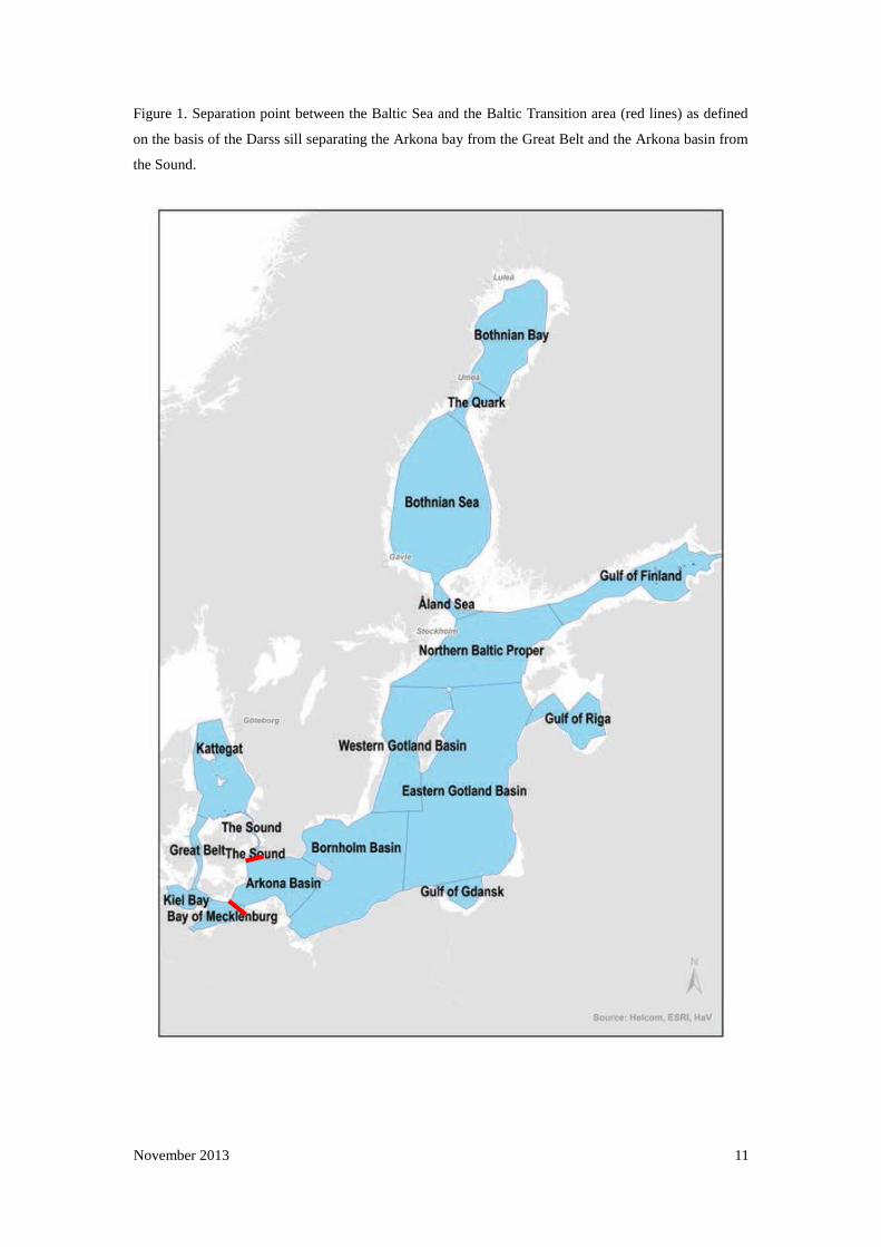
form the Baltic Transition area in this report (Jakobsen, 1995) (Fig. 1).
November 2013 11
Figure 1. Separation point between the Baltic Sea and the Baltic Transition area (red lines) as defined
on the basis of the Darss sill separating the Arkona bay from the Great Belt and the Arkona basin from
the Sound.

November 2013 12
Table 4. Number of marinas found in each locality and the regional sea in which they
are located
Regional Sea
Locality Atlantic
Baltic
Baltic Transitio
n
English Chann
el
Irish
Sea
Mediterranean
North
Sea
Aland Sea
1
Arkona Basin
1
Atlantic 11
Bay of Mecklenburg
3
Bornholm Basin
5
Bothnian Sea
2
Eastern Gotland Basin
3
Elbe
1
English Channel
3
Gdansk Bay
3
Great Belt
3
Gulf of Finland
7
Gulf of Riga
6
Ijsselmeer
1
Irish Sea
5
Kattegat
4
Kiel Bay
5
Lauwersmeer
1
Mediterranean
46
North Sea
22
Northern Baltic Proper
5
Oslo Fjord
2
Roskilde Fjord
1
Skagerrak
1
The Quark
4
The Sound
1
Western Gotland Basin
1
Grand Total 11 38 17 3 5 46 28
November 2013 13
To ensure that the maximum data set was available for each specific marina the
following three websites were used:
1. Blue Flag (http://www.blueflag.org)
2. Marinas.com (http://marinas.com)
3. Portbooker.com (http://www.portbooker.com)
The Blue Flag is an eco-label awarded to over 3200 beaches and marinas in 37
countries across Europe, South Africa, Morocco, Tunisia, New Zealand, Canada and
the Caribbean. It is owned and run by the independent non-profit organization
Foundation for Environmental Education (FEE) and works towards sustainable
development of beaches and marinas by applying strict criteria related to water quality,
environmental education and information, environmental management, safety and
other services (Blue Flag, 2008). The Blue Flag website provides data on a marina’s
depth and the number of vessels that can be moored in a marina. It also has links to
the official websites of marinas, which display longitude and latitude so that the
marinas’ positions can be located on Google Earth.
Marina.com displays photos of worldwide marinas at different angles. These images
were cross-referenced with those in Google Earth to confirm the accuracy of
measurements taken from Google image or predicted vessel occupancies (where
necessary). The website also provides locations and contact details of marinas, along
with local weather.
Portbooker.com is an online nautical guide with information on more than 8000
marinas. It includes an online mooring reservation system. The position, moorings,

November 2013 14
draught max and length max of most marinas are provided.
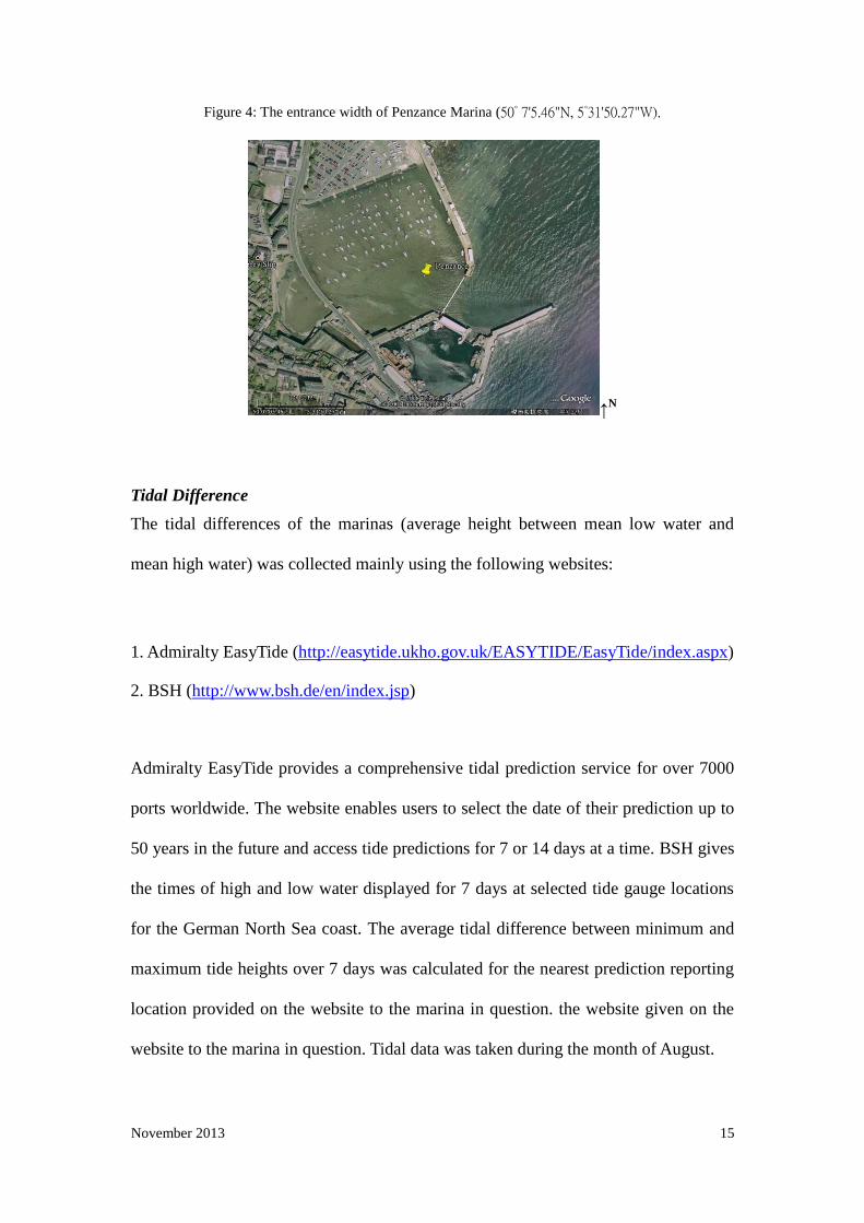
Figure 2, 3 and 4 provide an example of measurements taken using the Google image.
Figure 2: The length of Penzance Marina (50° 7'5.46"N, 5°31'50.27"W).
↑N
Figure 3: The width of Penzance Marina (50° 7'5.46"N, 5°31'50.27"W)
↑N
November 2013 15
Figure 4: The entrance width of Penzance Marina (50° 7'5.46"N, 5°31'50.27"W).
↑N
Tidal Difference
The tidal differences of the marinas (average height between mean low water and
mean high water) was collected mainly using the following websites:
1. Admiralty EasyTide (http://easytide.ukho.gov.uk/EASYTIDE/EasyTide/index.aspx)
2. BSH (http://www.bsh.de/en/index.jsp)
Admiralty EasyTide provides a comprehensive tidal prediction service for over 7000
ports worldwide. The website enables users to select the date of their prediction up to
50 years in the future and access tide predictions for 7 or 14 days at a time. BSH gives
the times of high and low water displayed for 7 days at selected tide gauge locations
for the German North Sea coast. The average tidal difference between minimum and
maximum tide heights over 7 days was calculated for the nearest prediction reporting
location provided on the website to the marina in question. the website given on the
website to the marina in question. Tidal data was taken during the month of August.

November 2013 16
Salinity
Whilst it is generally accepted that seawater salinity is typically of 35 parts per
thousand grams (psu) of water (Environmental Protection Agency USA, 2008) coastal
values and concentrations between discrete water bodies such as the Baltic and
Mediterranean seas will vary in comparison with this typical value. Data for specific
marinas is limited so values available from the adjacent area to the marina were used
wherever possible.
Average Water Temperature
Sea surface temperature (SST) data was collected from marine weather and
environmental research websites. Annual average SST was used in final analysis to
avoid seasonal high and low values.
pH-value
Sea surface pH for marinas was collected from the International Council for the
Exploration of the Sea (ICES) website (http://www.ices.dk/indexfla.asp). ICES
coordinate and promote marine research in the North Atlantic, as well as the Baltic
and North Seas. ICES provide a large amount of data collected from a wide range of
research studies and historical data. Marina specific data were not available however
pH values were recorded during the sampling as part of a research cruise (on board
research vessels) or survey buoys are available. Data locations are listed in the reports
on the ICES database and values that were closest to each marina were used.
November 2013 17
Dissolved Organic Carbon Values
Dissolved Organic Carbon data was collated from peer reviewed journal data for the
key coastal water bodies that were determined to be in closest proximity to the
coastlines occupied by each marina. Collecting individual DOC data for each marina
was beyond the scope of this study.
3. Data Analysis
Two multivariate techniques were applied to the data to determine how (if at all)
individual marinas should be grouped together and to identify the key parameters that
drive similarity between marinas separated out into a specific group. Cluster analysis
was used to group marinas on the basis of their similarity to each other taking into
account all the individual variables measured, whilst canonical discriminant analysis
was used to identify which of the variables has the strongest effect on grouping the
individual marinas within the groups. All data analysis was undertaken using IBM
SPSS Version 21. Details of each method are given below.
Cluster Analysis
Hierarchical cluster analysis was used to determine how the marinas identified in the
study can be grouped on the basis of the parameters measured. This approach makes
no assumption regarding how many clusters there should be and works by creating
gradually larger clusters of marinas on the basis of how similar each set of dimensions
are to each other. This creates a hierarchy of clusters containing similar marinas.

November 2013 18
Therefore, as one moves up the hierarchy the marinas become increasingly dissimilar.
The analysis works by creating increasing large clusters of similar marinas. Once a
marina has been assigned to a cluster it cannot be removed from it as the clustering
continues. Eventually the method results in one large cluster containing all of the
marinas.
These clusters are then displayed in a Dendogram (e.g. Figure 11) where each cluster
is defined by a vertical line. How large the cluster is will depend upon how far up the
dendogram you move. In the case of Figure 11 this means how far from left to right
you move through the diagram. The closer to the left of the dendogram you are the
smaller the cluster and hence the closer you are to defining individual marinas. The
further you are to the right the larger the cluster and hence the closer you are to
groping all marinas together.
Establishing how many clusters is appropriate was determined on the basis of defining
the level at which the number of clusters made sense based on the characteristics of
the marinas within the cluster. For example if all the marinas from the ‘Atlantic’ water
body fall into a cluster and all the marinas from the ‘Baltic Sea Area’ water body fall
in another cluster with the ‘Mediterranean’ water body marinas in a third, then it
follows that there should be three clusters.
This method was employed to determine whether it made sense to group marinas on
the basis of either their main water body (e.g. Atlantic etc), Regional Sea (e.g. Baltic
Transition) or Locality (e.g. Gulf of Finland).
By using this approach the appropriate level at which to group the marinas was
determined in order to define the typical parameters for a marina from that group.

November 2013 19
Canonical Discriminant Analysis
Canonical analysis is a multivariate analysis procedure for assessing the relationship
between multiple variables on the subject of interest, in this case a marina. Essentially
canonical analysis allows us to investigate the relationship between two sets of
variables and is effectively a sophisticated means of undertaking multiple regression.
Having used the cluster analysis to determine how many groups of marinas there
should be, discriminant analysis allows us to explore the relationship between all
marina parameters (the first set of variables: average water temperature, pH, salinity,
tidal difference, number of vessels and volume) and the group in which the marina is
found (the second set of variables: for example water body: Baltic Sea Area, Atlantic,
and Mediterranean Sea). The results will help to confirm whether marinas can
accurately be defined by the suggested grouping from the cluster analysis. The results
of the analysis also allows the identification of those parameters that have the greatest
effect on how the group is defined (e.g. whether Salinity has a greater effect on how
marinas are grouped – clustered- than temperature).
4. Results
Tidal Difference
Data sources used for each marina location is provided in Appendix 5. The average
tidal height for all marinas differs slightly from that for the OECD ESD which is 1.5.
Table 4 gives an overview of the values determined from the data set and a break
down by regional water body.
Table 4: Mean Tidal differences determined for each water body based upon corresponding
values determined for marinas present within them

November 2013 20
Water Body Average tidal
Height
(m)
Minimum
Tidal Height
(m*)
Maximum Tidal Height
(m)$
Atlantic 2.97(±1.17) 0.35(±0.83) 3.31(±1.33)
Mediterranean 0.53(±0.61) 0.21(±0.17) 0.74(±0.63)
Baltic Sea Area 0.20(±0.19) 0.04(±0.42) 0.32(±0.56)
EU Average 1.21(±1.44) 0.21(±0.56) 1.51(±1.62)
* height below mean sea water level. $ height above chart datum
Salinity
Local salinity values were chosen that were as close to each marina as possible. Full
details of data sources are given in Appendix 5. Summary information for each
particular region is provided below.
The Baltic Sea
The Baltic Sea is the second largest body of brackish water in the world (after the
Black Sea) (Ministry of the Environment, 2008). Whilst waters of highest salinity will
pass through the Danish straits there is still a significant mixing with the outflowing
water diluting water entering the Baltic. This combined with significant freshwater
inputs to the Baltic considerably reduces the salinity within the Baltic relative to
oceanic levels. Salinity in the southern Baltic (i.e excluding the bay of Bothnia in the
North) varies from < 7 psu in the Summer to < 6-8 psu in the Winter. The salinity
steadily decreases towards the North and East. In the northern part of the Gulf of
Bothnia the salinity levels are low enough to allow freshwater species to colonise this
region (Figure 5). Marine species’ biodiversity follows a decrease in Baltic Sea
Salinity (Aladin et al., 2006). As the entrance to the Baltic Sea is shallow, it restricts

November 2013 21
the exchange of water with the North Sea (Glasby and Szefer, 1998).The salinity
gradient is paralleled by a temperature gradient. These two factors limit many species
of animals and plants to a relatively narrow region of the Baltic.
Figure 5: Salinity (%0) in the Baltic Sea and in the zone of transition to the North Sea in August and
average values for the year (lower figure)
↑N
Surface salinities in the Baltic. Hermanni Backer:
http://www.itameriportaali.fi/en/tietoa/veden_liikkeet/en_GB/hydrografia/
Salinity (‰) at surface in the Baltic Sea and in the zone of
transition to the North Sea in August (by P.Hunfer, 1982)

November 2013 22
Poland (Bay of Gdansk)
The salinity of surface water of the Bay of Gdansk varies from 7.3‰ to 8.4‰, but is
lower in the vicinity of the Vistula River 5.5‰-6.2‰ (Figure 6). Salinity is strongly
influenced by the inflow of the Vistula River (Glasby and Szefer, 1997). Salinity
values for Polish marinas were based on data from Glasby and Szefer 1997.
Figure 6: A map of the Vistula River in Poland.
↑N
West Estonia and Latvia (Gulf of Riga)
The salinity in the Gulf of Riga varies from 4 to 7 psu (in near-coastal areas it is
0-2 psu). West of the Estonian Islands and at the mouth of the Gulf of Finland, at
a depth of 60–70 m (at approximately 8‰ water salinity), there is a sharp
transition between the upper water layer of low salinity (5–7‰) and the bottom
water layer of relatively high salinity. As this significantly affects the vertical
mixing of water, several hydrological, chemical and biological processes in
these layers differ. To account for this surface water salinities were used to

November 2013 23
reflect the shallow depths observed in marinas.
Finland and Estonia (Gulf of Finland)
The waters of the Gulf of Finland are among the freshest in the Baltic Sea (Britannica
Online Encyclopedia, 2008). The salinity of the brackish waters decreases from 6 ‰
in the Western part to 2 ‰ in the Eastern part of the gulf. Marinas Dirhami (59°12.68'
N, 23°30.07' E), Lohusalu (59°24.15' N, 24°12.39' E), and Tallinn – Pirita (59°28.23'
N, 24°49.10' E) in Estonia are located in the Gulf of Finland.
Finland and Sweden (Bothnian Bay)
Bothnian Bay in the Northern Baltic Sea is characterized by a stable north-south
salinity gradient (0.4-3.3 psu) as a result of river runoff and the absence of tides
(Busse and Snoeijs, 2002). Salinities higher than 5‰ can be occasionally recorded
north of the Quark. For most parts of the area the surface salinity is 3‰-4‰.
Germany (The South Baltic Sea)
Germany’s east coast lies on the Baltic Sea. Salinity data collected for the east coast
marinas were taken from data for the sailing route of the vessel depicted by the orange
line in Figure 7, which is the route of the commercial ferry travelling from
Travemünde to Helsinki (Finnish Institute of Marine Research (Finnmaid 15 - 16 July
2008)). The closest measurement point to each marina was used.

November 2013 24
Figure 7: Surface water temperature (red) and salinity (blue) along the route of the ferry Finnmaid
(Travemünde - Helsinki). Data: Finnish Institute of Marine Research (Finnmaid 15 - 16 July 2008).
↑N
North Sea
The North Sea lies between Norway, Denmark, Germany, the Netherlands, Belgium,
France and the UK. It links up with the Atlantic Ocean to the north and also the
south-west via the English Channel. The average temperature of the North Sea is 21°C
and its tidal difference is between 0-8m. The North Sea’s salinity is 34 à 35 g salts per
litre of water (The Management Unit of the North Sea Mathematical Models, 2000).
Most of the salinity data were collected from the ICES website, which provides pH
value and sea water temperature at the same time. For the purposes of this study
marinas located in the North Sea and English Channel have been categorised as
‘Atlantic’ marinas.
Mediterranean Sea
The Mediterranean Sea connects with the Atlantic Ocean through the Strait of
Gibraltar, with the Black Sea through the Dardanelles, the Sea of Marmara, and the
Bosporus, and with the Red Sea through the Suez Canal. Its chief divisions are the
Tyrrhenian, Adriatic, Ionian, and Aegean seas. The sea is of higher salinity than the
Atlantic. The salinity of marinas in the Mediterranean Sea were based on those

November 2013 25
provided by Sevault et al (2004: Figure 8).
Figure 8: The regions of the Mediterranean Sea studied: surface salinity (F.Sevault, et al. 2004).
↑N
Summary data
As discussed above the salinity of European marine waters varies widely within
water bodies and between them. Table 5 summarise the values determined for
the marinas used in this study. For all of the marinas investigated average
salinity was 25 PSU (range 2-39.52). Only those marinas located on the Atlantic
had PSU values similar to that considered to be the norm for seawater (average
PSU 30.68 as opposed to 35PSU), but even these differed from the OECD ESD
value of 34PSU. Lower values would be expected given that the majority of
marinas tend to be located in estuaries where there will be an effect of
freshwater from the river discharging into the estuary.

November 2013 26
Table 5: Details of salinity levels for each water body based upon corresponding values
determined for marinas present within each of them.
Water Body Average
Salinity
(PSU)
Minimum Salinity
(PSU)
Maximum
Salinity
(PSU)
Atlantic 31.4 17.0 37.0
Baltic Sea Area 9.4 2.0 33.0
Mediterranean 37.8 36.3 39.52
EU Average 25.2 2.0 39.52
Average Water Temperature
Baltic Sea
In Winter, the temperature of the water surface in the central part of the Baltic
Sea is 1°–2°C, while in bays and coastal areas covered with ice it is slightly
below 0°C (water in the coastal areas freezes at –0.2° to –0.4°C). Maximum
water temperatures can be measured in July–August, when the water temperature
in the sea areas west of islands and at the mouth of the Gulf of Finland is 16°–
17°C, and the water temperatures in the coastal sea of the Väinameri Sea and of
the Gulf of Finland, which are both separated from deep seas, are 18°–19°C. The
data shown in Figure 9 compares the central basins of the Baltic Sea in July 2005
with the mean value of 1990 – 2004, as well as with July of the previous year for the
marinas in the east of Denmark, Germany, Sweden and Finland (Herbert Siegel and
Monika Gerth, 2005)
.

November 2013 27
Figure 9: Temperature distribution along the transect through the central basins of the Baltic Sea in July
2005 in comparison with the mean value of 1990 – 2004 and July of the previous year.

November 2013 28
North Sea (Norway, Denmark, Germany, Netherlands, Belgium, France, Ireland)
The monthly mean temperature in January 2007 was 8.3 C, which was 1.7 C above
the climatologically mean (rank 1 among the highest January mean since 1971). In
June, the mean sea surface temperature rose to 13.2 °C and exceeded the
climatologically mean by 1.2 C (rank 4) (MURSYS - North Sea and Baltic Sea -
Report 1, 2007).
Mediterranean Sea (Cyprus, Greece, Italy, Malta, Spain, Slovenia, France)
Sea surface temperature is based on the annual mean value of 1961-1999 (Figure 10).
However, according to the latest report, temperatures have increased by about 2.5℃ at
the end of the 21st century over the entire basin (Sevault et al., 2004); hence, the data
which were used may lack some accuracy in this regard.
Figure 10: The regions of the Mediterranean Sea studied: Sea temperature (F.Sevault, et al. 2004).

November 2013 29
Summary Data
Average water temperatures vary widely throughout the year and as you traverse the
EU water bodies from North to South. The waters of the Mediterranean reached a
peak value of 33ºC for the data set obtained for those corresponding marinas, with the
lowest winter temperature observed in the Baltic marinas (-1ºC). The EU average
value for the data set was 15ºC (Table 6) which corresponds with the OECD EU
Commercial harbour value but is lower than the assumed value for the OECD EU
marina (20ºC). Both values are significantly higher than that recommended by the
Technical Guidance Document (TGD, Part II, 2003).
Table 6: Details of water temperature for each water body based upon corresponding values
determined for marinas present within each of them
Row Labels Average Water
Temperature
(°C)
Minimum
Winter Temperature
(°C)
Maximum Summer
Temperature
(°C)
Atlantic 13.44 (±3.73) 9.00 23.00
Mediterranean 19.45(±2.51) 16.00 27.50
Baltic Sea Area 10.93(±1.51) 8.50 16.25
Grand Total 14.38(±4.46) 8.50 27.50
pH value
Local pH values for measurements taken as close to each marina as possible; full
details of data sources and recorded values are given in Appendix 5. A summary of the
values determined is listed in Table 7. The average pH value across all water bodies
November 2013 30
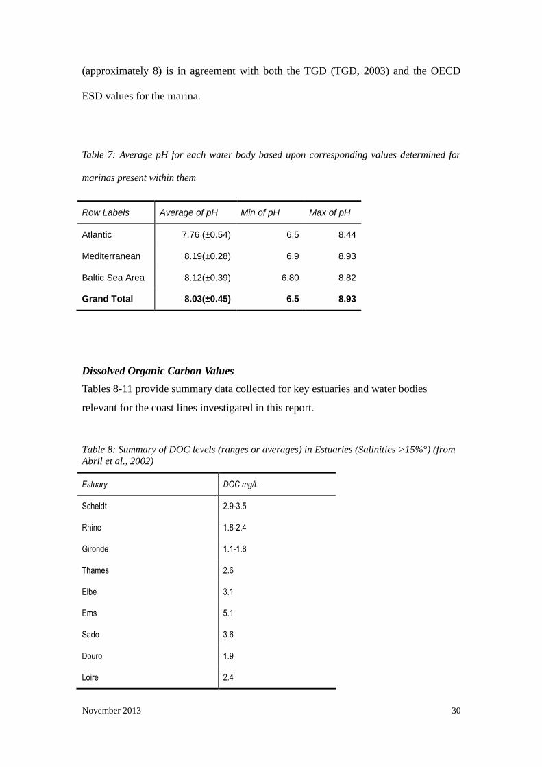
(approximately 8) is in agreement with both the TGD (TGD, 2003) and the OECD
ESD values for the marina.
Table 7: Average pH for each water body based upon corresponding values determined for
marinas present within them
Row Labels Average of pH Min of pH Max of pH
Atlantic 7.76 (±0.54) 6.5 8.44
Mediterranean 8.19(±0.28) 6.9 8.93
Baltic Sea Area 8.12(±0.39) 6.80 8.82
Grand Total 8.03(±0.45) 6.5 8.93
Dissolved Organic Carbon Values
Tables 8-11 provide summary data collected for key estuaries and water bodies
relevant for the coast lines investigated in this report.
Table 8: Summary of DOC levels (ranges or averages) in Estuaries (Salinities >15%°) (from
Abril et al., 2002)
Estuary DOC mg/L
Scheldt 2.9-3.5
Rhine 1.8-2.4
Gironde 1.1-1.8
Thames 2.6
Elbe 3.1
Ems 5.1
Sado 3.6
Douro 1.9
Loire 2.4

November 2013 31
Table 9: Summary of DOC levels in the North Sea and Atlantic (from Ferrari et al., 2000,
Obernoster and Herdndl, 2000)
Study area DOC (Average (SD) or range) mg/l Reference
River Rhine Plume 6.5 (0.9) Ferrari et al., 2000
Coastal N. Sea 4.4-9.9 Obernoster and Herdndl, 2000
Open ocean Atlantic 1.7 (0.9) Ferrari et al., 2000
Atlantic Deep waters (>500m) 0.7 Ferrari et al., 2000
Table 10: Summary of DOC levels in the Baltic Sea (from Kulinski and Pempkowiak, 2008)
Baltic area DOC mg/L Reference
Gulf of Gdansk 4.2 - 4.6 Kulinski and Pempkowiak, 2008
S. Baltic 3.9-4.1 Kulinski and Pempkowiak, 2008
Gulf of Gdansk 6.2-7.7 Grzybowski and Pempkowiak, 2003
Gulf of Gdansk 5.8-6.2 Grzybowski, 2002
Gulf of Gdansk 5.3-6.5 Ferrari et al., 1996
S. Baltic 5.7 Ferrari et al., 1996
S. Baltic 3.2-6.2 Jurkowskis et al., 1976
S. Baltic 4.6-7.1 Pempkowiak, 1984
Gulf of Finland 4.35-5.28 Koivisto, S., 2003
Bothnian Bay 3.57-4.3 Koivisto, S., 2003
Gulf of Riga 6-8 TM e-consultation 2013
Latvian Coast 2.8-4.6 TM e-consultation 2013
November 2013 32
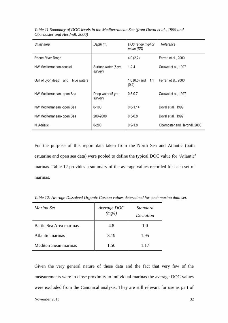
Table 11 Summary of DOC levels in the Mediterranean Sea (from Doval et al., 1999 and
Obernoster and Herdndl, 2000)
Study area Depth (m) DOC range mg/l or mean (SD)
Reference
Rhone River Tonge 4.0 (2.2) Ferrari et al., 2000
NW Mediterranean-coastal Surface water (5 yrs survey)
1-2.4 Cauwet et al., 1997
Gulf of Lyon deep and blue waters 1.6 (0.5) and 1.1 (0.4)
Ferrari et al., 2000
NW Mediterranean- open Sea Deep water (5 yrs survey)
0.5-0.7 Cauwet et al., 1997
NW Mediterranean -open Sea 0-100 0.6-1.14 Doval et al., 1999
NW Mediterranean- open Sea 200-2000 0.5-0.8 Doval et al., 1999
N. Adriatic 0-200 0.9-1.8 Obernoster and Herdndl, 2000
For the purpose of this report data taken from the North Sea and Atlantic (both
estuarine and open sea data) were pooled to define the typical DOC value for ‘Atlantic’
marinas. Table 12 provides a summary of the average values recorded for each set of
marinas.
Table 12: Average Dissolved Organic Carbon values determined for each marina data set.
Marina Set Average DOC
(mg/l)
Standard
Deviation
Baltic Sea Area marinas 4.8 1.0
Atlantic marinas 3.19 1.95
Mediterranean marinas 1.50 1.17
Given the very general nature of these data and the fact that very few of the
measurements were in close proximity to individual marinas the average DOC values
were excluded from the Canonical analysis. They are still relevant for use as part of

November 2013 33
the scenarios defined in absence of more specific data for the individual marinas.
Marina Dimensions
The list of Marinas studied is given in Appendix 1. Marina dimensions were entered
directly into SPSS to allow the Canonical Analysis. Summary statistics of the entire
data are given in Table 13.
Table 13: Average marina dimensions for all marinas sampled in the study (n = 148)
Marina Dimensions Mean Min Max Standard
Deviation
Length 398 56 1250 217
Width 207 34 809 121
Depth 5 1.2 18 3
Entrance Width 79 6 600 75
Tidal Difference 1.18 0 5.00 1.44
Maximum Occupancy 392 10 2588 396
Maximum Vessel Length 35 5 120 24
Cluster Analysis
The Cluster function in SPSS 19 was used to agglomerate the marinas from the
bottom up, i.e. looking to group marinas in increasingly large clusters as the analysis
proceeds. Proximity measures based upon the following parameters were used to
define the clusters:
- Marina Length

November 2013 34
- Marina Width
- Marina Depth
- Entrance Width
- Tidal Difference
- Maximum Vessel Occupancy
- Maximum Vessel Length
- Salinity
- Average Water Temperature
- pH
The squared Euclidean distance (the square of the difference between two values) was
used to determine the separation of marinas in the cluster analysis and the data were
standardised to ‘z’ scores with a mean value of 0 and a standard deviation of 1. This
was done to prevent the different scales from having a disproportionate effect on the
clustering; e.g. marina length (min 56m, max 1250) and pH (min 6.5, max8.9) in
effect giving equal value to all of the parameters in terms of the importance each has
on clustering.
SPSS was used to draw a dendrogram in order to determine the number of clusters
that is reasonable for the data set (Figure 11). The dendrogram is a graphical
summary of the cluster analysis. Marinas are listed along the left vertical axis. The
horizontal axis shows the distance between clusters when they are joined. Full details
of the SPSS input files and Results (including the average linkage values within

November 2013 35
groups) is given in appendix 5. The dendrogram is broken down into sections in
appendix 8 so that labels and details are easier to read.
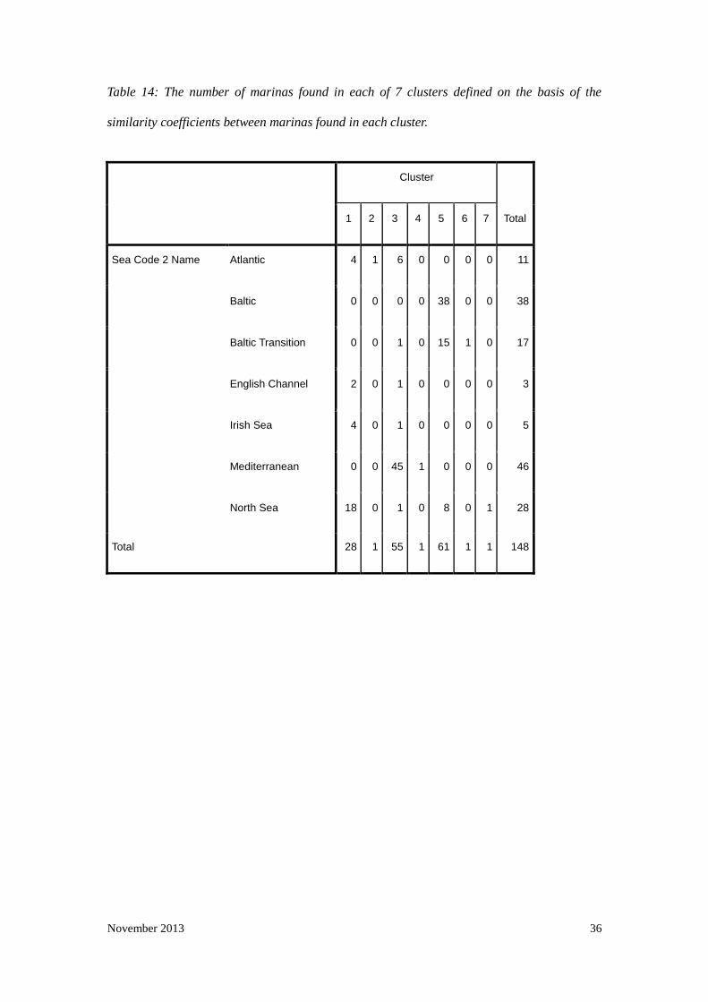
The core aim to the study is to determine if marinas naturally group together based
upon their location in a given water body. Intuitively it is expected that marinas
from the Atlantic, Mediterranean and Baltic Sea Area water bodies will be more
different to each other than those found within each water body group. However, it is
also reasonable to expect that there will be sub grouping within these water bodies,
particularly in those regions with extremes of variation across one or more parameters.
In this study the Baltic Sea Area and Atlantic regions have been identified as perhaps
being the most significantly diverse in terms of the water properties of the regional
sea (i.e. salinity, pH, and in the case of the Atlantic region tidal height). To determine
if the clusters identified in the dendogram (Figure 11) matched the expectation that
marinas found within a regional sea will group together, the marinas were grouped
into 7 clusters to match the number of regional seas (i.e. there are 7 regional seas)
identified based upon their similarity scores. Table 14 gives the results of the grouping
and groups are drawn onto the dendogram.
November 2013 36
Table 14: The number of marinas found in each of 7 clusters defined on the basis of the
similarity coefficients between marinas found in each cluster.
Cluster
Total 1 2 3 4 5 6 7
Sea Code 2 Name Atlantic 4 1 6 0 0 0 0 11
Baltic 0 0 0 0 38 0 0 38
Baltic Transition 0 0 1 0 15 1 0 17
English Channel 2 0 1 0 0 0 0 3
Irish Sea 4 0 1 0 0 0 0 5
Mediterranean 0 0 45 1 0 0 0 46
North Sea 18 0 1 0 8 0 1 28
Total 28 1 55 1 61 1 1 148

November 2013 37
Figure 11: Dendrogram of marinas found in the Atlantic, Mediterranean and Baltic Sea Area. Cluster
membership assigned using squared Euclidean distances. Marinas are identified by their Locality
within each ‘Regional Sea’. Case numbers linked to each marina in the analysis are given at the end of
each cluster arm. Results of dividing the marinas into 7 clusters to match the number of ‘regional seas’
are given by the overlaid boxes
Cluster 1
Cluster 2
Cluster 3
Cluster 4
Cluster 5
Cluster 6
Cluster 7

November 2013 38
The resulting review of the cluster analysis suggests that there are three natural
clusters given that 4 of the marinas occupy 4 individual clusters. The four marinas in
clusters 2,4,6 and 7 were:
- Marina Rubicon in Lanzarote (ES2)
- Porto de Setúbal (ES10)
- Herbern marina (NO1)
- Jyllinge Marina (Danish Authority – MST – Model marina: DK11)
Marina codes are given for each one and correspond to the marinas listed in Appendix
1 and 5. The remaining marinas group together in reasonable clusters, i.e. cluster three
contains predominantly Mediterranean marinas, Cluster 1 contains those from
regional seas that discharge join the North Atlantic and those in Cluster 5 are
predominantly from the Baltic Sea Area. Interestingly the marinas of the ‘Baltic
Proper region and the Baltic Transition region do not form two discrete groups within
the dendogram. Whilst they are all present in cluster 5 (the red box in Figure 11) they
do not separate out into two discrete groups within the cluster.
Therefore on the basis of the similarity of each marina’s parameters to each other
marina the data set can be divided into three clusters: The Atlantic, Baltic Sea Area
and Mediterranean.
Canonical Analysis
Given that the cluster analysis showed that the marinas most reasonably group into
three large clusters as opposed to 7 smaller ones based upon their regional sea

November 2013 39
location the canonical analysis was used to determine which of the marina parameters
measured were likely to have had the greatest influence on how the marinas were
grouped. Whist the Canonical Discrimination Analysis (CDA) and cluster results are
not directly related – cluster analysis looks at the absolute similarity of the marinas
with each other based on their dimensions whereas the CDA looks at the relationship
of measured parameters on the distribution of the marinas within the chosen water
bodies, irrespective of their similarity to each other – it can provide valuable
information on the relative importance of the parameters measured on determining
which group a marina should go in. This in turn can help to inform why the marinas in
the cluster analysis are organised the way they are.
The Canonical analysis calculated two canonical functions that accounted for all of
the variance in the data set. Plotting each marina along these two functions showed
that they aggregate in three clusters (Figure 12) showing that marinas from the Baltic
Sea Area, Mediterranean and Atlantic water bodies form separate groups with closer
associations with each other than those in any other group. As one would expect the
Atlantic group is most variable whilst those within the Baltic Sea Area and
Mediterranean are more tightly clustered.

November 2013 40
Figure 12: Ordination plot of marinas along the two Canonical discriminant functions. Mediterranean
green circles, Atlantic – blue circles, Baltic Sea Area – beige circles. Blue squares are the group
centroid for each water body
The fit of the marinas to each of the groups is also very good. 95.7% of marinas from
the Atlantic water body were in the Atlantic group, whilst all those from the
Mediterranean water body were in the Mediterranean group. 96.4% of those marinas
identified in the Baltic Sea Area were placed in Baltic Sea Area group. Table 15 lists
the individual results

November 2013 41
Table 15: The number of marinas found in each of 7 clusters defined on the basis of
the similarity coefficients between marinas found in each cluster.
Water Body
Predicted Group Membership
Total 1 2 3
Original Count Atlantic 45 1 1 47
Mediterranean 0 46 0 46
Baltic Sea Area 0 2 53 55
% Atlantic 95.7 2.1 2.1 100.0
Mediterranean .0 100.0 .0 100.0
Baltic Sea Area .0 3.6 96.4 100.0
The predicted group membership results show the number (or proportion) of marinas
that have been placed in the three groups relative to the Water Body group that they
were assigned to; i.e. it checks to see if the marinas that were pre-assigned to that
Water Body are actually grouped with other marinas in that Water Body. If there was
no relationship between water body and marina then you would expect the marinas to
be randomly distributed and hence no grouping. Table 15 shows that 95.7% of the
marinas in the Atlantic region were ‘correctly classified’, that is assigned to a
predicted group with other marinas from the Atlantic sample. Only two of the Atlantic
marinas were more similar to those in the second and third groups than the first. These
results confirm that the marinas from each water body are genuinely different to
marinas from other water bodies as in all cases 95% of the marinas or greater from
each Water Body are assigned to the same group in the Canonical analysis.
As noted previously the Canonical analysis distributes the marinas along two axes

November 2013 42
(the canonical functions; Figure 12) based on the relative affect of each of the marina
parameters measured (length, width etc). Of the two functions, Function 1 accounts
for the greatest amount of variance in the data set (60.3%, see eigenvalue Table in
Appendix 4, Canonical analysis section) indicting that parameters found within that
function have the greatest effect on distributing the marinas into groups.
Within these two functions Tide is the dominant positive variable accounting for the
distribution of the marinas along Function 1 (canonical coefficient of 0.847 and
Structure Matrix correlation of 0.728, appendix 4). For Function 2 the dominant
positive variable is Salinity (0.678 and 0.668 for canonical coefficient and structure
matrix correlation respectively, appendix 4). The dominant variables with negative
coefficients were pH (-0.171 and -0.123 canonical coefficient and structure matrix
correlation respectively, appendix 4) for Function 1 and Tide for Function 2 (-0.596
and -0.427 canonical coefficient and structure matrix correlation respectively,
appendix 4)
The distribution of marinas on the ordination clearly reflects this (Figure 12) as Baltic
Sea Area marinas (with lower tidal heights) are found to the far left of the plot (along
the Function 1 axis) and those from the Atlantic area (with higher tidal heights) are
found to the right. As expected there is a much larger spread of Atlantic marinas along
Function 1 relative to the Baltic Sea Area and Mediterranean groups, reflecting the
wider variation of tide heights found in these marinas (Atlantic 0.4-5m, Baltic Sea
Area 0-1m, Mediterranean 0.1-1.1m). For Function 2 the marinas also follow the
principle variable, Salinity, where Mediterranean marinas (typically having higher
salinities) are at the top with the Baltic Sea Area and Atlantic marinas lower down the

November 2013 43
axis (typically having low tidal heights) are found at the bottom of this axis. Again the
spread of the data along this axis reflects the variability in each group with the
Atlantic and Baltic Sea Areas having the broadest spread (Atlantic 17-37psu,
Mediterranean 36-39psu, Baltic Sea Area 2-33psu). This also explains the
categorisation of 2 Baltic Sea Area marinas in the Mediterranean group given that the
Baltic Sea Area and Mediterranean seas have very low tidal heights you would expect
similarities between some of the marinas due to the dominance of Tidal Difference in
Function 1. The same can also be said for those Atlantic Marinas (n= 4) which occur
in either the Mediterranean or Baltic groups. Tidal height is very variable across the
Atlantic category (which includes the North Sea and English Channel) so it is to be
expected that there would be some overlap with the two low tidal height groups.
Both the Mediterranean and Atlantic groups form groups which show reasonable
associations. The Mediterranean group is tightly clustered with a few outliers,
whereas the Atlantic group is more widely distributed but there is no real trend or
separation of marinas within the group. In the case of the Baltic Sea Area there is
the suggestion of a smaller sub set within the group that is separated from the more
tightly clustered group to the left of axis 1. Marinas outside of this tight group appear
to form a trend increasing as you move along both function 1 and 2. This suggests that
for those marinas there is a steady increase in tide height and salinity. The likely
explanation for this separation is the difference between those marinas in the Baltic
Sea Area group which are in either the Baltic Transition region or Baltic region of the
group.

November 2013 44
Representative Marina Dimensions
According to the results of the Cluster analysis and the Canonical Analysis the
marinas can effectively be grouped into three regions, Atlantic, Baltic Sea Area and
Mediterranean on the basis that marinas within a group are more similar to each other
than marinas of other groups. The cluster analysis takes into account the similarity of
marinas to each other based on all the variables within the data set. Reviewing the
assortment of the marinas in each of the three main groups of clusters it is clear that
the marinas separate out according to the Water Body to which they belong (i.e.
Mediterranean marinas are always found in group 3, and the Baltic Sea Area marinas
are always found in group 5. The Atlantic marinas are predominantly found in group
1with some present in both group 3 and 5 which reflects the varied nature of those
marinas in terms of their location (e.g., Irish Sea, English Channel etc). Reviewing the
clustering of the marinas within Group 5 (those predominantly from the Baltic Sea
Area) it is apparent that marinas from the Baltic proper and those from the Baltic
transition zone are not separated into different clusters as you would expect. This
suggests that marinas from that region are generally similar to each other when you
look at all the parameters together.
The Canonical analysis also supports the clustering of the marinas into three groups,
reflecting the Mediterranean, Baltic Sea Area and Atlantic water bodies, however, it
further identifies the key parameters measured that accounts for the difference
between the marinas. The analysis shows that the marinas are separated out on the
basis of their tidal height, pH and Salinity. It also shows an apparent trend in the
Baltic Sea Area showing that some marinas are separate from the core group of
marinas and distributed along the axes according to increasing tide height and salinity.

November 2013 45
Whilst individual marinas are not identified in the canonical ordination plot the likely
explanation is that these are the marinas from the Baltic Transition area. Therefore it
is not unreasonable to suggest that these marinas could be managed as two separate
marina scenarios within the Baltic Sea Area Group.
One likely explanation why the cluster analysis does not separate out the marinas in
the different regions of the Baltic Sea Area is that the similarity in terms of the marina
dimensions over rides any underlying differences based upon the hydrology of the
marina; i.e. the cluster analysis shows that the marinas in each of the groups of the
cluster analysis are of similar dimensions but not necessarily similar hydrology.
The average marina parameters for each Water Body are given in Table 16. For
reference the average parameter values for all marinas (effectively a typical EU
marina) and the OECD ESD marina are also included. The average parameters of the
Baltic Sea and Baltic Transition regions are also included.
5. Discussion
With respect to defining a set of standard parameters for use in risk assessments of
antifoulings there are options that should be considered. The intent of this study was
to determine if a typical EU marina could be defined. To some extent this can be
achieved if the hydrological measurements for salinity, tidal height, pH and water
temperature are excluded. Marinas found in each water body have similar
characteristics in terms of the dimensions according to the cluster analysis. Therefore
marinas can effectively be grouped on the basis of which water body they are located

November 2013 46
in: The Baltic Sea Area, the Mediterranean or the ‘Atlantic’ (which includes the North
Sea, English Channel and Irish Sea).
The dominant parameters which account for differences amongst all the marinas are
tidal height, salinity and pH. The remaining parameters have much weaker
associations with the canonical functions derived from the data and therefore play a
far smaller role in defining which group a marina belongs to. Within the three groups
identified by the canonical analysis only Baltic Sea Area shows any suggestion of
there being subdivisions within the group. Based on the distribution along the axes in
the knowledge that the key parameters are tidal height and salinity it is reasonable to
assume that it is those marinas based in the transitional zone of the Baltic Sea which
are separating from the main group. The areas within the Baltic Transition zone for
use in this study included the Bay of Mecklenburg, The Great Belt, the Kattegat, Kiel
bay, Roskilde Fjord and the Sound. Based on this the Baltic Sea Area water body has
been broken down into two sub regions for consideration as distinct marina scenarios.
Further analysis of the marina dimensions reveals that there is very little difference in
surface area per boat value between the Atlantic, Mediterranean, Baltic, and Baltic
Transition regions suggesting that irrespective of where the marina is located, marinas
are designed according to similar rules governing how many vessels you can safely
accommodate whilst accounting for practical requirements such as providing room for
manoeuvre. This is largely down to the fact that there will be regulations (or codes of
practice) dictating maximum occupancy rates for marinas and minimum space for
individual vessels. The typical minimum space allowed for a yacht berth is at least 1.5
times the length of the berth (or length of vessel; International Council of Marine
November 2013 47
Industry Associations, 2006). This is clearly supported by the data set used here where
the average values were all comparable to each other: 246 and 233, 227m2/boat (for
the Baltic, Atlantic, and Mediterranean marinas respectively). The only exception to
this was for the Baltic Transition marinas which have a lower surface area to boat
ratio of 139 m2/boat. Whether this is as a result of the sample of marinas used, or a
genuine trend for marinas in that region is not clear.
This report provides a base data set to define the typical marina scenario dimensions
for an Atlantic, Baltic Sea Area (or Baltic and Baltic Transition zone) and
Mediterranean marina scenario for use in EU risk assessment. Given the size of the
data sets provided for each Water Body (approx 50 marinas for each sea) the typical
marinas defined can be considered to be representative of marinas found in each of
the regions and can be adopted by Members State countries that have a coastline on
the particular water body of interest.
The dimensions defined can be used directly in the MAMPEC 2.5 risk assessment
software for the purpose of product authorisation of antifouling paints. Guidance
provided within the OECD ESD and decisions made as part of the Technical Meetings
of the Biocidal Products Directive should also be taken into account when interpreting
the results from such evaluations. It is important to acknowledge that protection goals
will vary and that currently authorisation of active substances focuses on the risk
assessment of the water body immediately outside of the marina or harbour as
opposed to within the harbour.

November 2013 48
Table 16: Parameter mean values of Atlantic, Baltic, and Mediterranean Sea and all marinas used in analysis. For comparison the OECD Environmental
Scenario Document marina has been included..
Regional Mean Value/ Parameters All values ± Standard Deviation except OECD Marina
Unit OECD Marina*
All Marinas
Atlantic Baltic Sea Area
Mediterranean Baltic Sea
Baltic Transition
Marina Length m 141.5 398±217 436±241 294±171 483±196 275±164 339±183
Marina Width m 141.5 207±121 215±145 162±101 254±98 148±97 192±105
Marina Depth m 4 5±3.0 5±3.7 4±1.9 6±2.8 4±2.2 4±1.3
Entrance Width m 100 79±75 68±53 79±101 91±56 79±77 80±143
Tidal Difference m 1.5 1.2±1.4 3±0.9 0.2±0.18 0.4±0.25 0.12±0.05 0.4±0.25
Maximum Vessel Occupancy -- 276 392±396 403±356 259±294 540±486 165±151 469±414
Maximum vessel length m 50 35±24 32±22 28±22 47±24 27±21 32±26
Salinity PSU 34 25±13 31±5.7 9.4±6.7 38±0.9 6±2.1 17±8.3
Average water temp oC 20 14±4.5 13±3.7 11±1.5 19±2.5 11±1.5 12±1.3
pH 8 8±0.5 8±0.5 8±0.4 8±0.3 8±0.4 8±0.3
DOC$ mg/l 2 -- 3.2±1.9 5.2±1.1 1.5±1.2 5.4±1.1 5.4±1.1
Marina Surface Area m2 20022 82,386.00 93,740.00 47,628.00 122,682.00 40,700. 65,088
Surface Area per boat m2 73 210 233 184 227 247 139
Marina volume m3 80089 411,930 468,700 190,512 736,092 162,800 260,352
Volume per boat m3 290 1,050 1,163 735 1,363 987 555
* number of vessels moored amended to 276 as per TM meeting guidance $ Average values taken from references and not from canonical analysis due to lack of marina specific data

November 2013 49
6. References
Abril G., Nogueira M., Etcheber H., Cabeçadas G., Lemaire E., Brogueira M.J., (2002) Behaviour of Organic Carbon in Nine Contrasting
European Estuaries. Estuarine, Coastal and Shelf Science, 54,(2), 241-262
Admiralty EasyTide.
http://easytide.ukho.gov.uk/EASYTIDE/EasyTide/SelectPrediction.aspx?PortID=1897 [accessed Aug 2008]
Aladin N.V., Plotnikov I.S. and Pianov M.B. (2006) Influence of Salinity Change on the Baltic Sea Biodiversity.
Alan Deidun, Marthese Azzopardi, Stephen Saliba and Patrick J. Schembri (2002) Low faunal diversity on Maltese sandy beaches: fact or
artifact? Estuarine Coastal and Shelf Science, 83-92.
Anita Mäkinen, (2005) The Baltic Sea - A particularly Sensitive Sea What makes the Baltic Sea a unique and sensitive sea? WWF Finland.
http://www.wwf.fi/tiedotus/seminaarit/seminaarimateriaalit/the_baltic_sea.html
Beach Quality and the Effect of Breakwaters http://www.globe.gov/fsl/worddocs/CY_01_beach.doc [accessed 15Aug 2008]
Belgrano A., Legendre P., Dewarumez J.-M and Frontier. S (1995) Spatial Sructure and ecological variation of meroplankton on the
French-Belgian coast of the North Sea, 128, 43-50.
Black Sea (Black Sea Geography, Oceanography, Ecology, History - general information. http://blacksea.orlyonok.ru/e2.shtml [accessed Aug
2008]

November 2013 50
Busse, Svenja; Snoeijs, Pauli, Gradient responses of diatom communities in the Bothnian Bay, northern Baltic Sea (2002), Nova Hedwigia, 74,
501-525(25.)
Cyprus Oceanography Center. Cyprus Southeast Forecast. http://www.oceanography.ucy.ac.cy/cycofos/viod_cyse.html [accessed 15Aug 2008]
De Castro M. and Gomez-Gesteira M. (2002) Study of upwelling events along the Galician coast (NW SPAIN) by means of sea surface
temperature images from the NOAA.http://www.cosis.net/abstracts/COSPAR04/03549/COSPAR04-A-03549.pdf
Doval, M. D., Pérez, F.F., Berdalet, E., (1999).Dissolved and particulate organic carbon and nitrogen in the Northwestern Mediterranean.
Deep-Sea Research I, 46, 511-527
Environmental Protection Agency. Marine Ecosystems.
http://www.epa.gov/bioiweb1/aquatic/marine.html [accessed 14Aug 2008]
European Virtual Institute for Speciation Analysis (2006) TBT from antifouling paint is still endangering marine life, says WWF.
http://www.speciation.net/Public/News/2006/10/11/2445.html [accessed 16 Sep 2008]
Evald Ojaveer, (2002) Gulf of Riga, Estonia Marine Institute of the University of Tartu, 1-3.
Ferrari, D., E. Bassignana and G. Pensabene. 2000. Efficacy evaluation of different low-rate copper formulations and acupric compounds against
grapevine downy mildew (Plasmopara viticola) in Piedmont (North-Western Italy) during the period 1994-1999. p. 163-165. In: H. Willer and U.
Meier (eds.). SOL-Sonderausgabe, No. 77. IFOAM 2000: The World Grows Organic. Proceedings of the 6th International Congress on Organic
Viticulture, Basel, Switzerland, August 25-26, 2000. Stiftung Okologie und Landbau; Bad Durkheim, Switzerland. 261 pp.

November 2013 51
Glasby G. P. and Szefer P. (1998) Marine pollution in Gdansk Bay, Puck Bay and the Vistula Lagoon, Poland: An overview. The Science of
the Total Environment 212, 49-57.
Henri Paatela, (2008) Temperature and salinity in the Baltic Sea 12 - 16 July 2008.The Baltic Sea Portal.
http://www.fimr.fi/en/tietoa/algaline_seuranta/mittaustulosarkisto/2008/en_GB/1208075859728_1_1_2_1/ [accessed 12 Aug 2008]
Herbert Siegel and Monika Gerth (2005) Development of Sea Surface Temperature in the Baltic Sea in 2005. Helcom.
http://www.helcom.fi/environment2/ifs/ifs2006/en_GB/sst/_print/ [accessed 5 Aug 2008]
IacMST. Salinity. UK Marine Waters 2004-Maine Process & Climate.
http://www.oceannet.org/medag/reports [accessed 11 Aug 2008]
ICOMIA (2006), OECD Emissions Scenario Document on Antifouling products – “the Marina Scenario”
I C Romania. Romania - Coast and beach.http://www.icromania.com/infoCoast.asp [accessed 13Aug 2008]
Iver lunn (1974)Antifouling; a brief introduction to the origins and development of the marine antifouling industry.
Jakobsen F. 1995. The major inflow to the Baltic Sea during January 1993. Jounal of Marine Systems 6:227-240
Janja France, Patricija Mozetic (2006) Ecological characterization of toxic phytoplankton species (Dinophysis spp., Dinophyceae) in Slovenian
mariculture areas (Gulf of Trieste, Adriatic Sea) and the implications for monitoring. Marine Pollution Bulletin, 52, 1504-1516
Kevin V., Thomas, Sylvia J. Blake and Michael J. Waldock (2000) Antifouling Paint Biocide Contamination in UK Marine Sediments. Marine
Pollution Bulletin, 40, 739-745

November 2013 52
Koivisto, S., (2003). Finnish exposure scenarios for antifouling products. SYKE
Kuliński K., Pempkowiak J., (2008). Dissolved organic carbon in the southern Baltic Sea: Quantification of factors affecting its distribution.
Estuarine, Coastal and Shelf Science 78, (1) 38-44.
Magnusson, K., Norén K., (2012). The sensitivity of the Baltic Sea ecosystems to hazardous compounds.Kemikalieinspektionen, Sundbyberg,
Sweden.
Medspiration. Org. The European Service for Precise Sea Surface Temperature.
http://www.medspiration.org/data_access/kml/ [accessed Aug 2008]
Michael L. Zettler, Doris Schiedek, Bernd Bobertz (2007) Benthic biodiversity indices versus salinity gradient in the southern Baltic Sea. Marine
Pollution Bulletin, 55, 287-270.
Obernosterer, I., Herndl, G.J. (2000). Differences in the optical and biological reactivity of the humic and nonhumic dissolved organic carbon
component in two contrasting coastal marine environments. Limnol. Oceanogr., 45(5), 2000, 1120-1129
Pavilosta Marina. What is ”Marina”? http://www.pavilostamarina.lv/?cat=/en/about_us/ [accessed Aug 2008]
Philippe Rekacewicz. UNEP/GRID-Arenda (2001) Salinity of the Black Sea Environmental Knowledge for
Changehttp://maps.grida.no/go/graphic/salinity_of_the_black_sea [accessed 12 Aug 2008]
RYA (2008) Antifouling.

November 2013 53
http://www.rya.org.uk/KNOWLEDGEBASE/ENVIRONMENT/Pages/Antifouling.aspx [accessed 12 Aug 2008]
Sevault, F., Somot S. and Deque M. (2004) Climate Change Scenario for the Mediterranean Sea.
Technical Guidance Document, 2003: Part II, Chapter 3 Environmental Risk Assessment. European Commission:
http://ihcp.jrc.ec.europa.eu/our_activities/health-env/risk_assessment_of_Biocides/doc/tgd/tgdpart2_2ed.pdf
Ted Klenk. (2007) The Apopka High Marine Science http://darter.ocps.net/classroom/klenk/index.htm
The Baltic Sea Portal (2008) Cyanobacteria decreased in the Gulf of Finland.
http://www.fimr.fi/en/ajankohtaista/mtl_uutisarkisto/2008/en_GB/levauutinen20080718_1_1_1/ [accessed Aug 2008]
Timo Yrjänä, Jaakko Erkinaro, Keijo Juntunen and Aki Mäki-Petäys. () Baltic salmon enhancement programmes in humic lowland rivers in Northern Finland.
Central Fisheries Board. http://www.cfb.ie/salmonid_workshop/timo_yrana.htm [accessed 10 Aug 2008]
Viesturs Berzins (Latvian Fisheries Research Institute), Uldis Bethers, Juris Sennikovs (University of Latvia), (2000) Hydrographic regime of
Gulf of Riga and water exchange with Baltic Proper: Years 1991/95. http://www.modlab.lv/publications/1998/publ3.htm [accessed 10 Aug
2008]
Weather Underground. Marine Weather
http://www.wunderground.com/MAR/eum.html#map [accessed 14Aug 2008]

November 2013 54
7. Appendices
Appendix 1: Marina list.
Those entries in red were excluded from the analysis.
Marina Address Phone Fax E-mail Website
BE1 Royal North Sea Yacht Club
Montgomerykaai 1, Oostende, 8400 0032 (0)59-50.59.12 0032 (0)59-51.32.70 [email protected] http://www.rnsyc.be/ostend/
BE2 Royal Belgian Sailing Club Zeebrugge
Isabellalaan 1, B-8380 Zeebrugge (+32) 54 49 03 (+32) 54 49 03 [email protected] www.zeebruggeport.be
BE3 Mercator Marina W. Churchillkaai, Oostende, West-Vlaanderen
0032 0)59 70 57 62 0032 0)59 70 57 65 [email protected] http://www.mercatormarina.be/dok/defaulteng.html
BE4 VVW Westhoek Sparrbekken Basin Marina
IJzer 55, Nieuwpoort, 8620 0473 56 27 16
[email protected] http://www.vvw-westhoek.be/
BE5 WSKLuM Halve Maanstraat, 2 b , Nieuwpoort, B-8620
0032(0)58/23.36.41 0032(0)58/23.98.45 [email protected] http://www.vvw-westhoek.be/
BE6 De Vrije Noordzeezeilers De Vrije Noordzeezeilers De Smet de Naeyerlaan 1 8370, Blankenberge
(+32) 50 42 52 92 (+32) 50 42 61 38 [email protected] www.vnzblankenberge.be
BE7 Koninklijke Yacht Club Nieuwpoort
Kromme Hoek, 8620 Nieuwpoort, West-Vlaanderen
058 / 23.44.13 058 / 24.03.59 [email protected] http://www.kycn.be
BE8 Blankenberge Marina Wenduinsesteenweg 3-4, Blankenberge, B-8370, Belgium
0032 (0)50 41 75 36 0032 (0)50 41 76 37 [email protected] http://www.vvwblankenberge.be/welkom.html
CY1 Larnaca Marina Larnaca Cyprus 35704653110 35704624110 [email protected]
http://www.loviisa.fi/index.php?cid=loviisa&mid=178
CY2 Saint Raphael Marina / Sheraton Marina
St Raphael Marina, Amathus Avenue, PO Box 51933, Limasol, 3509 Cyprus
357-25-321 100 / 357-25-329 208 [email protected] www.raphael.com.cy
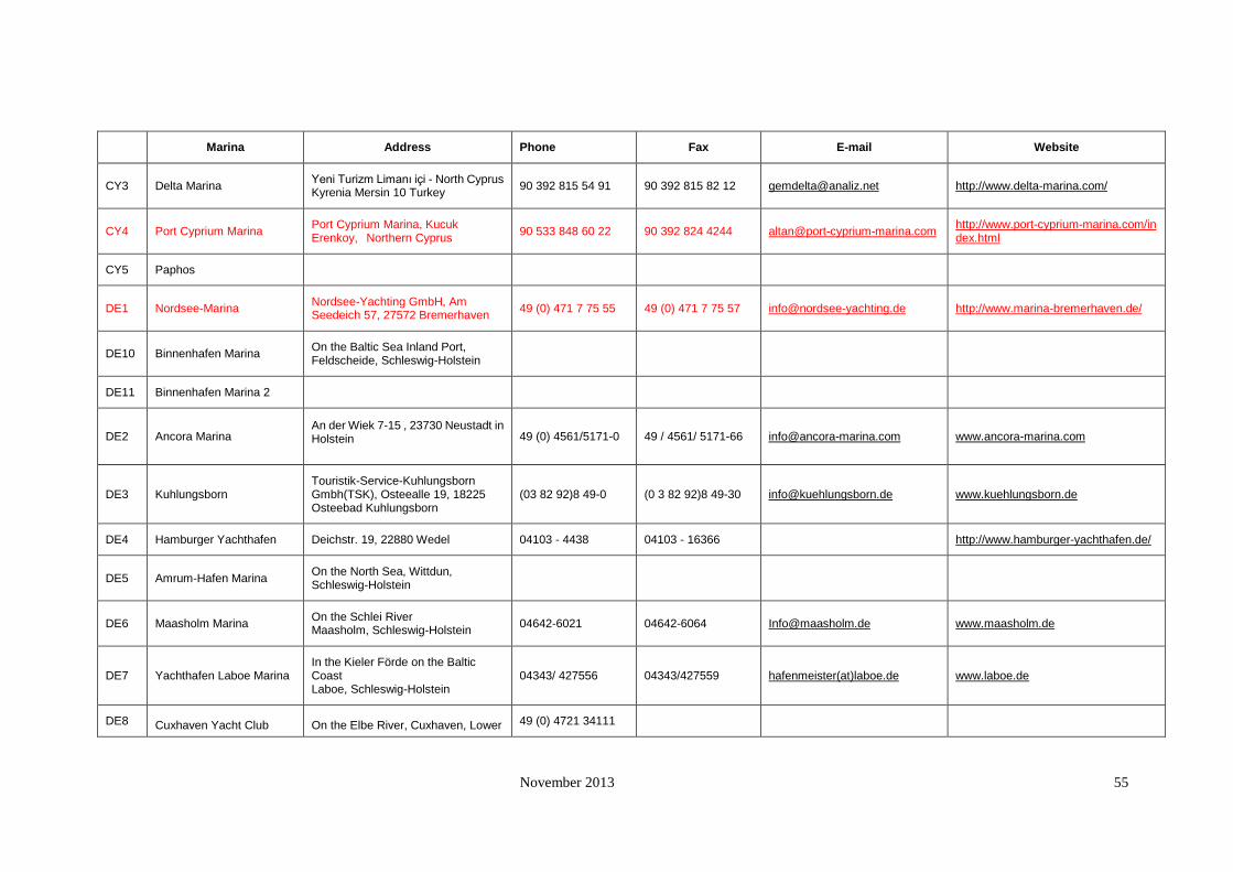
November 2013 55
Marina Address Phone Fax E-mail Website
CY3 Delta Marina Yeni Turizm Limanı içi - North Cyprus Kyrenia Mersin 10 Turkey
90 392 815 54 91 90 392 815 82 12 [email protected] http://www.delta-marina.com/
CY4 Port Cyprium Marina Port Cyprium Marina, Kucuk Erenkoy, Northern Cyprus
90 533 848 60 22 90 392 824 4244 [email protected]
http://www.port-cyprium-marina.com/index.html
CY5 Paphos
DE1 Nordsee-Marina Nordsee-Yachting GmbH, Am Seedeich 57, 27572 Bremerhaven
49 (0) 471 7 75 55 49 (0) 471 7 75 57 [email protected] http://www.marina-bremerhaven.de/
DE10 Binnenhafen Marina On the Baltic Sea Inland Port, Feldscheide, Schleswig-Holstein
DE11 Binnenhafen Marina 2
DE2 Ancora Marina
An der Wiek 7-15 , 23730 Neustadt in Holstein 49 (0) 4561/5171-0 49 / 4561/ 5171-66 [email protected] www.ancora-marina.com
DE3 Kuhlungsborn Touristik-Service-Kuhlungsborn Gmbh(TSK), Osteealle 19, 18225 Osteebad Kuhlungsborn
(03 82 92)8 49-0 (0 3 82 92)8 49-30 [email protected] www.kuehlungsborn.de
DE4 Hamburger Yachthafen Deichstr. 19, 22880 Wedel 04103 - 4438 04103 - 16366
http://www.hamburger-yachthafen.de/
DE5 Amrum-Hafen Marina On the North Sea, Wittdun, Schleswig-Holstein
DE6 Maasholm Marina On the Schlei River Maasholm, Schleswig-Holstein
04642-6021 04642-6064 [email protected] www.maasholm.de
DE7 Yachthafen Laboe Marina In the Kieler Förde on the Baltic Coast Laboe, Schleswig-Holstein
04343/ 427556 04343/427559 hafenmeister(at)laboe.de www.laboe.de
DE8 Cuxhaven Yacht Club On the Elbe River, Cuxhaven, Lower 49 (0) 4721 34111
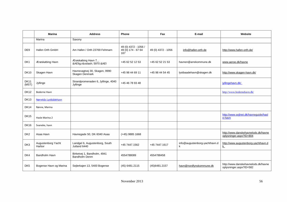
November 2013 56
Marina Address Phone Fax E-mail Website
Marina Saxony
DE9 Hafen Orth GmbH Am Hafen / Orth 23769 Fehmarn 49 (0) 4372 - 1056 / 49 (0) 174 - 67 64 167
49 (0) 4372 - 1056 [email protected] http://www.hafen-orth.de/
DK1 Ærøskøbing Havn Ærøskøbing Havn 7, , Ærø 5970 &AEl
+45 62 52 12 53 +45 62 52 21 53 [email protected] www.aeroe.dk/havne
DK10 Skagen Havn Havnevagtvej 30, Skagen, 9990 Skagen Denmark
+45 98 44 69 11 +45 98 44 54 45 [email protected] http://www.skagen-havn.dk/
DK11 (MST)
Jyllinge Strandpromenaden 6, Jyllinge, 4040 Jyllinge
+45 46 78 93 48
jyllingehavn.dk/
DK12 Boderne Havn
http://www.bodernehavn.dk/
DK13 Nørrekås Lystbådehavn
DK14 Rønne, Marina
DK15 Hasle Marina 2
http://www.sejlnet.dk/havneguide/hasle-havn
DK16 Svaneke, havn
DK2 Asaa Havn Havnegade 50, DK-9340 Asaa (+45) 9885 1668
http://www.danskehavnelods.dk/havneoplysninger.aspx?ID=804
DK3 Augustenborg Yacht Harbor
Landgel 6, Augustenborg, South Jutland 6440
+45 7447.1562 +45 7447.1617 [email protected]
http://www.augustenborg-yachthavn.dk
DK4 Bandholm Havn Birketvej 1, Bandholm, 4941 Bandholm Denm
4554788089 4554788458
DK5 Bogense Havn og Marina Sejlerkajen 13, 5400 Bogense (45) 6481.2115 (45)6481.2157 [email protected]
http://www.danskehavnelods.dk/havneoplysninger.aspx?ID=582
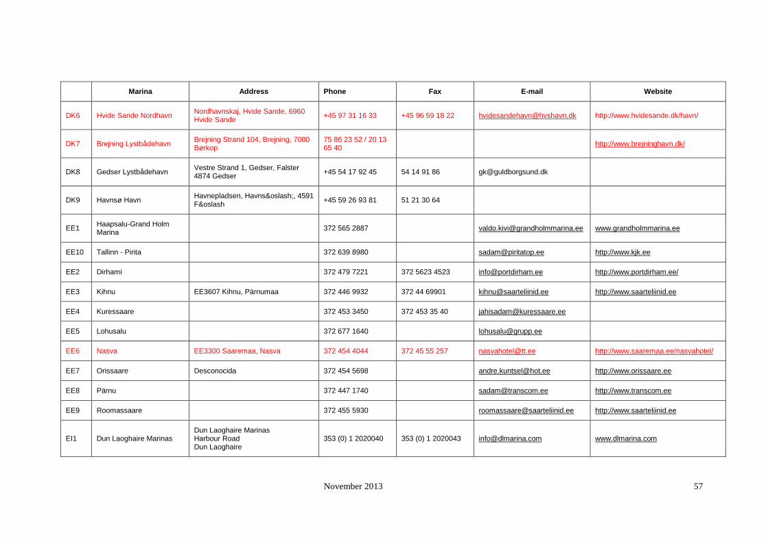
November 2013 57
Marina Address Phone Fax E-mail Website
DK6 Hvide Sande Nordhavn Nordhavnskaj, Hvide Sande, 6960 Hvide Sande
+45 97 31 16 33 +45 96 59 18 22 [email protected] http://www.hvidesande.dk/havn/
DK7 Brejning Lystbådehavn Brejning Strand 104, Brejning, 7080 Børkop
75 86 23 52 / 20 13 65 40
http://www.brejninghavn.dk/
DK8 Gedser Lystbådehavn Vestre Strand 1, Gedser, Falster 4874 Gedser
+45 54 17 92 45 54 14 91 86 [email protected]
DK9 Havnsø Havn Havnepladsen, Havnsø, 4591 Fø
+45 59 26 93 81 51 21 30 64
EE1 Haapsalu-Grand Holm Marina
372 565 2887
[email protected] www.grandholmmarina.ee
EE10 Tallinn - Pirita
372 639 8980
[email protected] http://www.kjk.ee
EE2 Dirhami
372 479 7221 372 5623 4523 [email protected] http://www.portdirham.ee/
EE3 Kihnu EE3607 Kihnu, Pärnumaa 372 446 9932 372 44 69901 [email protected] http://www.saarteliinid.ee
EE4 Kuressaare
372 453 3450 372 453 35 40 [email protected]
EE5 Lohusalu
372 677 1640
EE6 Nasva EE3300 Saaremaa, Nasva 372 454 4044 372 45 55 257 [email protected] http://www.saaremaa.ee/nasvahotel/
EE7 Orissaare Desconocida 372 454 5698
[email protected] http://www.orissaare.ee
EE8 Pärnu
372 447 1740
[email protected] http://www.transcom.ee
EE9 Roomassaare
372 455 5930
[email protected] http://www.saarteliinid.ee
EI1 Dun Laoghaire Marinas Dun Laoghaire Marinas Harbour Road Dun Laoghaire
353 (0) 1 2020040 353 (0) 1 2020043 [email protected] www.dlmarina.com
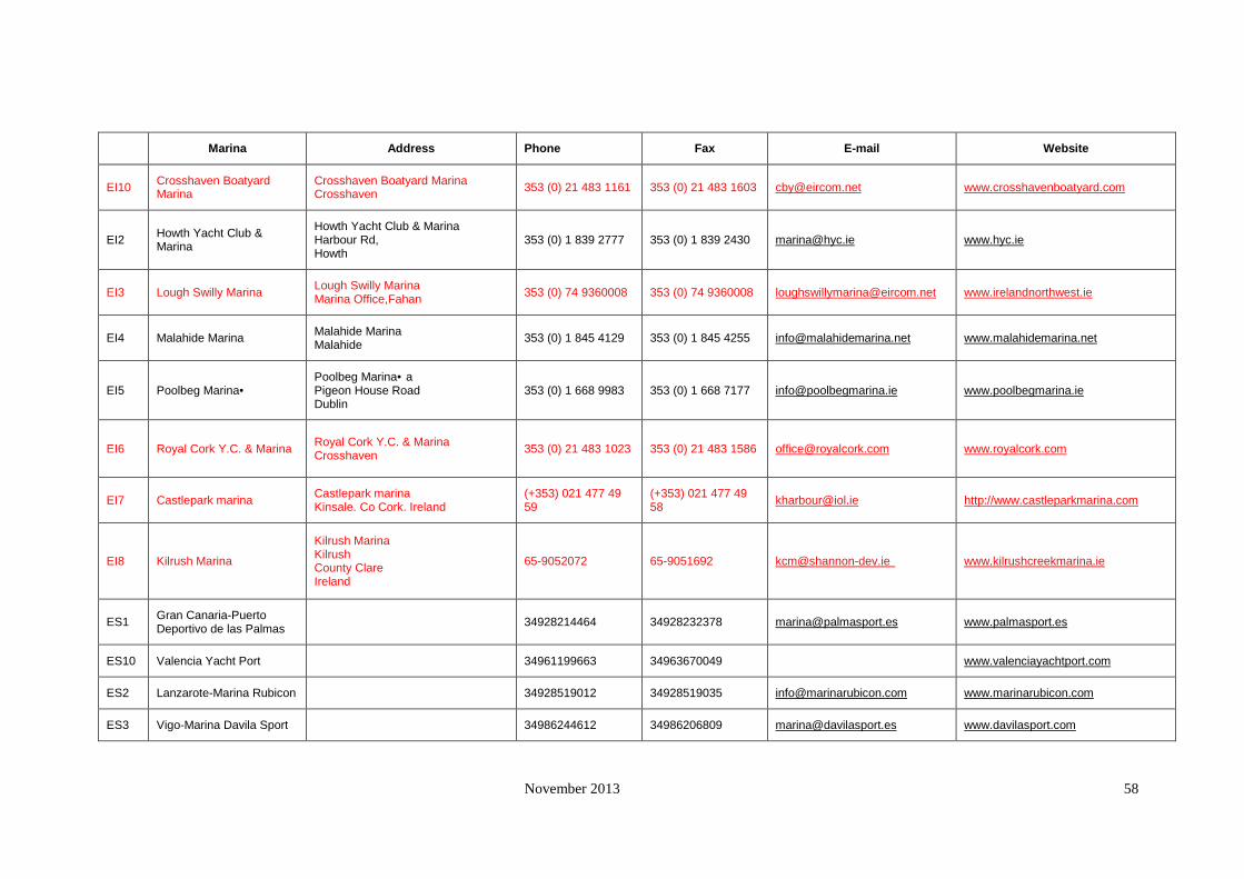
November 2013 58
Marina Address Phone Fax E-mail Website
EI10 Crosshaven Boatyard Marina
Crosshaven Boatyard Marina Crosshaven
353 (0) 21 483 1161 353 (0) 21 483 1603 [email protected] www.crosshavenboatyard.com
EI2 Howth Yacht Club & Marina
Howth Yacht Club & Marina Harbour Rd, Howth
353 (0) 1 839 2777 353 (0) 1 839 2430 [email protected] www.hyc.ie
EI3 Lough Swilly Marina Lough Swilly Marina Marina Office,Fahan
353 (0) 74 9360008 353 (0) 74 9360008 [email protected] www.irelandnorthwest.ie
EI4 Malahide Marina Malahide Marina Malahide
353 (0) 1 845 4129 353 (0) 1 845 4255 [email protected] www.malahidemarina.net
EI5 Poolbeg Marina• Poolbeg Marina•a Pigeon House Road Dublin
353 (0) 1 668 9983 353 (0) 1 668 7177 [email protected] www.poolbegmarina.ie
EI6 Royal Cork Y.C. & Marina Royal Cork Y.C. & Marina Crosshaven
353 (0) 21 483 1023 353 (0) 21 483 1586 [email protected] www.royalcork.com
EI7 Castlepark marina Castlepark marina Kinsale. Co Cork. Ireland
(+353) 021 477 49 59
(+353) 021 477 49 58
[email protected] http://www.castleparkmarina.com
EI8 Kilrush Marina
Kilrush Marina Kilrush County Clare Ireland
65-9052072 65-9051692 [email protected] www.kilrushcreekmarina.ie
ES1 Gran Canaria-Puerto Deportivo de las Palmas
34928214464 34928232378 [email protected] www.palmasport.es
ES10 Valencia Yacht Port
34961199663 34963670049
www.valenciayachtport.com
ES2 Lanzarote-Marina Rubicon
34928519012 34928519035 [email protected] www.marinarubicon.com
ES3 Vigo-Marina Davila Sport
34986244612 34986206809 [email protected] www.davilasport.com

November 2013 59
Marina Address Phone Fax E-mail Website
ES4 Estepona-Marina de Estepona
34952801495 34952796840 [email protected] www.puertosdeandalucia.com
ES5 Marbella-Jose Banus Marina
Club de mar de Puerto Banús, Muelle de Honor s/n 29660 Marbella
34952909800 34952810899 [email protected]
www.puertobanus.com
ES6 Almunecar-Puerto del Este
34958640801 34956790109 [email protected]
www.marinasmediterraneo.com
ES7 Almerimar-Almerimar Marina
34950607755 34950497353 [email protected] www.marina-almerimar.com
ES8 Portals(Mallorca)-Puerto Portals
34971171100 34971171117 [email protected] www.puertoportals.com
ES9 Valencia-Real Club Nautico
34963679011 34963677737 [email protected]
www.rcnauticovalencia.com
FI1 Loviisa Laicasilta Marina Town of Loviisa, Mannerheiminkatu 4, PL 77, 07901 LOVIISA
358 (0)19 555 445 358(0)40 740 7308
http://www.loviisa.fi/index.php?cid=loviisa&mid=178
FI2 Vaasa Hietasaari Marina Vaasa
FI3 Vaasa Kalarannanpuisto
FI4 Aminne Yacht Harbour
FI5 Aminne Marina
FI6 Herttoniemen Marina Helsinki
FI7 Uutela Marina Uutela
FI8 Mikonkari Marina Raahe
FI9 Reila Marina Reila

November 2013 60
Marina Address Phone Fax E-mail Website
FI10 Uittamo Marina Koivisto Model (SYKE)
FR1 Marseille-old port
33(0)491556664 33(0)491334103
FR10 St Jean Cap Ferrat-St Jean Cap Ferrat
33(0)493764545 33(0)493764546 [email protected] www.port-saint-jean.com
FR2 ST Tropez-old port and new port
33(0)494566870 33(0)494973102 [email protected]
http://www.port-de-saint-tropez.com
FR3 Mandelieu-Port la Napoule
33(0)492977777 33(0)4929977878 [email protected]
www.portlanapoule.fr
FR4 Cannes-old port
33(0)492987000 33(0)492987001 [email protected]
www.riviera-ports.com
FR5 Villefranche-port de villefranche
33(0)493017805 33(0)493769233 [email protected]
ww.riviera-ports.com
FR6 Beaulieu-Beaulieu sur mer
33(0)493011049 33(0)493011412 [email protected] www.portbeaulieu
FR7 cap d'ail-port of cap d'ail
33(0)493782846 33(0)493419829 [email protected]
FR8 Menton-port de garavan
33(0)493287800 33(0)493354801
FR9 Cogolin-Cogolin Marina
33(0)494560731 33(0)494562675 [email protected] www.marines-de-cogolin.com
GR1 Lefkas-Lefkas Marina
30(0)2645026645 30(0)2645026642 [email protected] www.medmarinas.com
GR10 Kos-Kos Marina
30(0)2242057500 30(0)224220877 [email protected] www.kosmarina.gr
GR2 Attica-Alimos Marina
30(0)2109880000 30(0)2109880001 [email protected] www.alimos-marina.gr
GR3 Attica-Flisvos Marina
30(0)2109871000 30(0)2109871060 [email protected] www.flisvosmarina.com
GR4 Piraeus-Zea Marina
30(0)2104559000 30(0)2104559031 [email protected] www.medmarinas.com

November 2013 61
Marina Address Phone Fax E-mail Website
GR5 Athens-Vouliagmeni Marina
30(0)2108960012 30(0)2108960415
www.vouliagmeni-marina.gr
GR6 Lavrio-Olymic Marina
30(0)2292063700 30(0)292022569 [email protected] www.olympicmarine.com
GR7 Samos-Samos Marina
30(0)2109968136 30(0)2109931379 [email protected] www.samos-marina.com
GR8 Crete-Agios Nikolaos
30(0)2841082384 30(0)2841082386 [email protected] www.marinaofagiosnikolaos.gr
GR9 Sithonia-Porto Carras
30(0)2375077000 30(0)2375072126 [email protected] www.portocarras.com
IT1 Degli aregai-Marina degli aregai
39(0)183667453 39(0)183650246 [email protected] www.imperiamare.it
IT10 Marina di Porto San Giorgio
39(0)734675263 39(0)734675263 [email protected] www.marinaportosangiorgio.it
IT2 Santa Margherita Ligure
39(0)185287029 39(0)185284717
IT3 Chiavari-Marina Chiavari
39(0)185364081 39(0)185316287 [email protected] www.marinachiavaritigullio.it
IT4 Lavagna-Porto Turistico
39(0)185321732 39(0)185376308 [email protected] www.portodilavagna.com
IT5 La Spezia-Porto Lotti
39(0)187532200 39(0)187532245 [email protected] www.portolotti.it
IT6 Elba-Portoferraio
39(0)565914121 39(0)565945355
IT7 Santo Stefano-Porto del Valle (Porto Santo Stefano)
39(0)564810845 39(0)564815063 [email protected]
IT8 Capri-Marina Grande
39(0)818378950 39(0)818375318 [email protected]
IT9 Palermo (Sicily)-Marina Villa Igiea
39(0)91364123 39(0)91364225 [email protected] www.marinavillaigiea.com

November 2013 62
Marina Address Phone Fax E-mail Website
LT1 Klaipeda marina
061 12511/ 64594
LV1 Pāvilosta Marina Ostmalas iela 1, Pāvilosta, Liepājas rajons, LV-3466
371 3498581 371 3498582 e-mail: [email protected]
LV2 Ventspils Yacht harbour (Marina)
Ventspils Free Port Authority, 19 Jana Str., Ventspils LV-3601
371 29421049 371 63620153 [email protected] www.portofventspils.lv
LV3 Jurmala
371 7752408
[email protected] www.latviancoast.lv
MT1 Grand Harbour Marina The Capitanerie Vittoriosa Wharf Vittoriosa BRG 1721
35621800700 35621800900 [email protected] www.ghm.com.mt
MT2 Portomaso Marina St. Julians PTM01 35621387803 35621389655 [email protected] www.portomasomarina.com
MT3 Manoel Island Marina (Pierre Balzan), Manoel Island, Gzira GZR03
35621338589 35621341714 [email protected] www.manoelislandmarina.com
MT4 Msida Marina Ta'Xbiex Msd 11, Malta 35621235711 35621235713
www.mma.gov.mt
MT5 Mgarr Marina Gozo, Mgarr, GSM 104 MT (+356) 21 558 856 (+356) 21 562 672
http://www.mma.gov.mt/yacting_mgarr_marina.htm
NL1 Compagnieshaven Enkhuizen, Noord-Holland +31(0)228313353 +31(0)228321083
http://www.compagnieshaven.nl/
NL10 Jachthaven Lauersoog Jachthaven Oostmahorn, Oostmahorn 31
(+31) 0 505 01 01 76 (+31) 0 505 01 01 77 [email protected] http://www.noordergat.nl/
NL2 Jachthaven Waterkant Sasdijk 2x , RN Dinteloord, 4671 +31 167 522553
http://www.waterkantbv.nl/
NL3 Jachthaven Brouwershaven
Nieuwe Jachthaven 12, 4318 AR, Brouwershaven
0031-111-691330 0031-111-692022 [email protected]
www.wvbrouwershaven.nl
NL4 Jachthaven Neptunus Handelskade West 12 , 9934AA Delfzijl
(+31) 0 596 61 50 04
[email protected] http://www.kzrvneptunus.nl/zv/
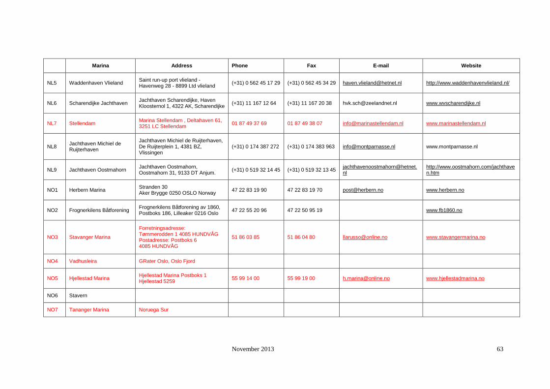
November 2013 63
Marina Address Phone Fax E-mail Website
NL5 Waddenhaven Vlieland Saint run-up port vlieland - Havenweg 28 - 8899 Ltd vlieland
(+31) 0 562 45 17 29 (+31) 0 562 45 34 29 [email protected] http://www.waddenhavenvlieland.nl/
NL6 Scharendijke Jachthaven Jachthaven Scharendijke, Haven Kloosternol 1, 4322 AK, Scharendijke
(+31) 11 167 12 64 (+31) 11 167 20 38 [email protected] www.wvscharendijke.nl
NL7 Stellendam Marina Stellendam , Deltahaven 61, 3251 LC Stellendam
01 87 49 37 69 01 87 49 38 07 [email protected] www.marinastellendam.nl
NL8 Jachthaven Michiel de Ruijterhaven
Jachthaven Michiel de Ruijterhaven, De Ruijterplein 1, 4381 BZ, Vlissingen
(+31) 0 174 387 272 (+31) 0 174 383 963 [email protected] www.montparnasse.nl
NL9 Jachthaven Oostmahorn Jachthaven Oostmahorn, Oostmahorn 31, 9133 DT Anjum.
(+31) 0 519 32 14 45 (+31) 0 519 32 13 45 [email protected]
http://www.oostmahorn.com/jachthaven.htm
NO1 Herbern Marina Stranden 30 Aker Brygge 0250 OSLO Norway
47 22 83 19 90 47 22 83 19 70 [email protected] www.herbern.no
NO2 Frognerkilens Båtforening Frognerkilens Båtforening av 1860, Postboks 186, Lilleaker 0216 Oslo
47 22 55 20 96 47 22 50 95 19
www.fb1860.no
NO3 Stavanger Marina
Forretningsadresse: Tømmerodden 1 4085 HUNDVÅG Postadresse: Postboks 6 4085 HUNDVÅG
51 86 03 85 51 86 04 80 [email protected] www.stavangermarina.no
NO4 Vadhusleira GRater Oslo, Oslo Fjord
NO5 Hjellestad Marina Hjellestad Marina Postboks 1 Hjellestad 5259
55 99 14 00 55 99 19 00 [email protected] www.hjellestadmarina.no
NO6 Stavern
NO7 Tananger Marina Noruega Sur

November 2013 64
Marina Address Phone Fax E-mail Website
PL1 Gdynia ZarzÄ…d Morskiego Portu Gdynia SpóÅ‚ka Akcyjna ul. Rotterdamska 9 81-337
48 58 627 40 46 48 58 620 31 91 [email protected] www.marinagdynia.pl/index.htm
PL2 Hel
PL3 Jastarnia
058 675 20 13 058 675 2097 [email protected]
PL4 Marina Gdansk ul. Szafarnia, 80-755 Gdańsk 48 58 301-33-78
[email protected] www.mosir.gda.pl
PL5 Puck 84-100 Puck ul. Lipowa 2 48 58 673 29 51 48 58 673 26 10 [email protected]
http://moksir-puck.home.pl/eng/accom.html
PL6 Sopot
PL7 Władysławowo WÅ‚ adysÅ‚ awowo, polonia 48-91 46-23-414 48-91 46-23-414 [email protected]
PL8 Kuźnica
PT1 Cascais-Marina de Cascais
351214824800 351214824899 [email protected] www.marinacascais.pt
PT10 Marina Porto Atlantico Marina Porto Atlantico, Molhe Norte de Leixoes 4450-718 Leca da Palmeira, Portugal
351 229 964 895 351 229 966 636 [email protected] http://www.marinaportoatlantico.net/
PT2 Azores-Horta Marina
351292208300 351292208315 [email protected] www.portohorta.com
PT3 Portimao-Portimao Marina
351282400680 351282400681 [email protected] www.marina-portimao.com.pt
PT4 Algarve-Marina de Vilamoura
351289310560 351289310580 [email protected] www.marina-vilamoura.com
PT5 Marina de Lagos Edifício da Administração Marina de Lagos 8600-780 Lagos Portugal
351282-770-210 351282-770-219 [email protected] www.marlagos.pt

November 2013 65
Marina Address Phone Fax E-mail Website
PT6 Porto de Lisboa - Doca de Recreio do Bom Sucesso
APL - Administracao do Porto de Lisboa, S.A.Rua da Junqueira, 94,1349-026 Lisboa, Portugal
351 21 361 10 00 351 [email protected]
http://www.portodelisboa.pt/portal/page/portal/PORTAL_PORTO_LISBOA_ING/NAUTICA_RECREIO
PT7 Porto de Recreio de Sesimbra
351 351
http://www.naval-sesimbra.pt/work/marina00.htm
PT8 Porto de Setúbal - Doca de Recreio
351 265 542000 351 265 230992 [email protected]
http://www.portodesetubal.pt/pt_doca_recreio.htm
PT9 Marina de Viana do Castelo
INSTITUTO PORTUÁRIO E DOS TRANSPORTES MARÍTIMOS (DELEGAÇÃO DOS PORTOS DO NORTE) PORTO COMERCIAL DE VIANA DO CASTELO 4900-056 DARQUE
351 258 359500 351 258 359535 [email protected]
http://www.ipnorte.pt/p/portorecreio.htm
SE1 Aalsta Road Marina Kungsaengen
SE10
Morarna Road Marina
http://marinas.com/view/marina/9034_Morarna_Road_Marina_Oesterhaninge__Sweden
SE11 Graeddoe Marina
http://marinas.com/view/marina/10164_Graeddoe_Marina__Sweden
SE12
Marsaettra Marina
http://marinas.com/view/marina/9025_Marsaettra_Marina_Skaergaardsstad__Sweden
SE13
Erikso Yacht Harbour
http://marinas.com/view/marina/10601_Erikso_Yacht_Harbour_Vaxholm_Uppland_Sweden
SE14 Fisksatra Baatklubb Marina
http://marinas.com/view/marina/10605_Fisksatra_Baatklubb_Marina__Sweden

November 2013 66
Marina Address Phone Fax E-mail Website
SE15 KemI West Coast Marina (Gunneby)
SE2 Aalsten Smaabaatshamn Marina
Aalsten (city)
SE3 Limhamns Småbåtshamn
Småbåtshamnen i Limhamn, Vågbrytarevägen, 216 12 Limhamn
46 40 15 20 24 46 40 15 18 95 [email protected]
http://www.smabatshamnen.nu/english.htm#Diesel
SE4 Södertälje Gästhamn Södertälje 46 (0)8 550 64 712 46 (0)8 550 61 403 [email protected] http://gasthamn.se/engelska.htm
SE5 Baalsta Road Marina Haabo
SE6 Härnösand Härnösand kommun, 871 80 Härnösand, Swden
0611 20211/070609
SE7 Arkösund
0125 200 36
SE8 Kalmar
0480 451450
www.kalmar.se
SE9 (kemi)
Bullando
SI1 Marina Izola Porting Marina Izola, Tomaziceva 10,, Izola
(+386) 5 66 25 406 (+386) 566 25 400 [email protected]
http://www.marinaizola.com/
SI2 Marina Portoroz MARINA PORTOROSE d.d., Cesta solinarjev 8, SI - 6320 Portorož
(+386) 0567 61100 (+386) 567 61210 [email protected] http://www.marinap.si/elements/frame
s.html
SI3 Marina Koper d.o.o. Kopališko nabrežje 5 6000 Koper (+386) 5 662 61 00 (+386) 5662 61 61 [email protected] www.marina-koper.si
UK1 Penzance Isles of Scilly Ferries 362009 (+44) 01 736 36 45 3
www.penzance.co.uk/harbour/index.htm?hom…
UK10 Aberystwyth Marina Aberystwyth Marina, Trefechan, Aberystwyth, Ceredigion, Wales,
(+44) 01 970 61 14 (+44) 01 970 62 41 [email protected] www.abermarina.co.uk

November 2013 67
Marina Address Phone Fax E-mail Website
SY23 1AS 22 22
UK2 Mevagissey East Quay, St Austell Cornwall PL 26 6Qu, T. 843305
(+44) 07 977 20 33 9
[email protected] www.mevagisseyharbour.co.uk
UK3 Newhaven Marina The Yacht Harbour, Fort Road, Newhaven, East Sussex BN9 9BY
(+44) 01 273 51 38 81
(+44) 01 273 51 04 93
www.seacontainers.com
UK4 Ramsgate The Harbour Office, Military Road, Ramsgale, Kent CT11 9LQ
(+44) 01 843 57 70 00
(+44) 01 843 29 09 06
www.portoframsgate.co.uk/portoframsgate
UK5 Bradwell Marina Waterside Bradwell on Sea Essex CM0 7RB
(+44) 01 621 77 63 91
(+44) 01 621 77 63 93
[email protected] www.bradwellmarina.com
UK6 Royal Norfolk & Suffolk Yacht Club
Royal Norfolk & Suffolk Yacht Club Royal Plain ,NR33 OAQ, Lowestoft
(+44) 01 502 56 67 26
[email protected] www.rnsyc.org.uk/marina.htm
UK7 Sunderland Sunderland Marina, Sunderland Marina, Sunderland, Tyne and Wear, England, SR6 0PW
(+44) 01 91 51 447 21
(+44) 01 91 51 418 47
www.marineactivitiescentre.co.uk/marina
UK8 Blyth Marina South Harbour Blyth Northumberland NE24 3PB
(+44) 1 670 35 36 36
[email protected] www.rnyc.org.uk
UK9 Amble Marina Amble Marina, Amble Marina, Amble, Northumberland, England, NE65 0YP
(+44) 01 66 571 21 68
(+44) 01 66 571 33 63
[email protected] www.amble.co.uk
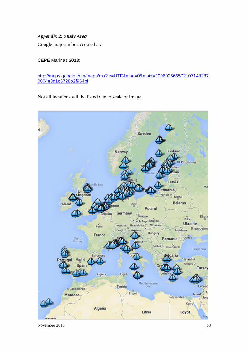
November 2013 68
Appendix 2: Study Area
Google map can be accessed at:
CEPE Marinas 2013:
http://maps.google.com/maps/ms?ie=UTF&msa=0&msid=209602565572107148287.0004e3d1c5728b2f964bf
Not all locations will be listed due to scale of image.

November 2013 69
Appendix 3. SPSS model inputs
Cluster Analysis
Output Created 14-Aug-2013 16:33:50
Comments
Input Data M:\Marinas\marinas 2013c.sav
Active Dataset DataSet1
Filter <none>
Weight <none>
Split File <none>
N of Rows in Working Data File 148
Missing Value Handling Definition of Missing User-defined missing values are treated as
missing.
Cases Used Statistics are based on cases with no
missing values for any variable used.
Syntax PROXIMITIES MarinaLength
MarinaWidth MarinaDepth EntranceWidth
TidalDifference
MaximumVesselOccupancy
MaxVesselLength SalinityPSU
Averagewatertemp pH
/MATRIX
OUT('C:\Users\thomasoj\AppData\Local\T
emp\spss5924\spssclus.tmp')
/VIEW=CASE
/MEASURE=SEUCLID
/PRINT NONE
/ID=SeaCode4Name
/STANDARDIZE=VARIABLE Z.
November 2013 70
Resources Processor Time 00 00:00:00.015
Elapsed Time 00 00:00:00.033
Workspace Bytes 103760
Files Saved Matrix File C:\Users\thomasoj\AppData\Local\Temp\s
pss5924\spssclus.tmp
Canonical Analysis
Output Created 10-Feb-2012 16:04:32
Comments
Input Active Dataset DataSet1
Filter <none>
Weight <none>
Split File <none>
N of Rows in Working Data
File
147
Missing Value Handling Definition of Missing User-defined missing values are treated as
missing in the analysis phase.
Cases Used In the analysis phase, cases with no user-
or system-missing values for any predictor
variable are used. Cases with user-,
system-missing, or out-of-range values for
the grouping variable are always excluded.
Syntax DISCRIMINANT
/GROUPS=Sea_Code(1 3)
/VARIABLES=MarinaLengthm
MarinaWidthm MarinaDepthm_A
EntranceWidthm TidalDifferencem

November 2013 71
Thenumberofvesselsmooredinthemarina
Maximumlengthofvesselthatthemarinacana
ccommodatem SalinityPSU
AveragewatertempC pH
/ANALYSIS ALL
/PRIORS EQUAL
/STATISTICS=MEAN STDDEV CORR
TABLE
/PLOT=COMBINED
/PLOT=CASES
/CLASSIFY=NONMISSING POOLED.

November 2013 72
Appendix 4: Analysis results (SPSS output)
Cluster Analysis
Case Processing Summarya
Cases
Valid Missing Total
N Percent N Percent N Percent
148 100.0% 0 .0% 148 100.0%
Average Linkage (Within Groups)
Agglomeration Schedule
Stage
Cluster Combined
Coefficients
Stage Cluster First Appears
Next Stage Cluster 1 Cluster 2 Cluster 1 Cluster 2
1 88 89 .177 0 0 4
2 35 37 .189 0 0 10
3 121 122 .229 0 0 7
4 88 90 .349 1 0 16
5 36 46 .398 0 0 25
6 86 116 .403 0 0 17
7 94 121 .447 0 3 27
8 110 113 .457 0 0 15
9 56 57 .544 0 0 23
10 35 55 .548 2 0 21

November 2013 73
11 105 124 .553 0 0 13
12 33 34 .578 0 0 30
13 105 111 .634 11 0 18
14 69 71 .678 0 0 34
15 110 112 .699 8 0 46
16 88 92 .703 4 0 27
17 86 123 .727 6 0 28
18 101 105 .743 0 13 26
19 125 138 .769 0 0 44
20 96 120 .822 0 0 28
21 32 35 .847 0 10 29
22 63 81 .887 0 0 45
23 47 56 .913 0 9 38
24 87 91 .915 0 0 36
25 36 41 .984 5 0 35
26 101 136 1.023 18 0 47
27 88 94 1.081 16 7 36
28 86 96 1.132 17 20 42
29 22 32 1.148 0 21 40
30 29 33 1.165 0 12 52
31 95 118 1.188 0 0 47
32 39 42 1.206 0 0 57
33 73 133 1.229 0 0 41
34 66 69 1.236 0 14 51
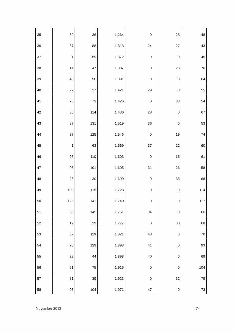
November 2013 74
35 30 36 1.264 0 25 48
36 87 88 1.313 24 27 43
37 1 59 1.372 0 0 45
38 14 47 1.387 0 23 76
39 48 50 1.391 0 0 64
40 22 27 1.421 29 0 55
41 70 73 1.426 0 33 54
42 86 114 1.436 28 0 67
43 87 131 1.519 36 0 53
44 97 125 1.546 0 19 74
45 1 63 1.569 37 22 60
46 98 110 1.603 0 15 61
47 95 101 1.605 31 26 58
48 26 30 1.699 0 35 68
49 100 115 1.723 0 0 114
50 126 141 1.740 0 0 117
51 66 145 1.751 34 0 66
52 12 29 1.777 0 30 68
53 87 119 1.821 43 0 70
54 70 129 1.893 41 0 93
55 22 44 1.898 40 0 69
56 61 75 1.916 0 0 104
57 31 39 1.923 0 32 79
58 95 104 1.971 47 0 73

November 2013 75
59 108 127 2.103 0 0 118
60 1 65 2.110 45 0 72
61 98 99 2.150 46 0 77
62 49 54 2.161 0 0 81
63 4 10 2.164 0 0 83
64 17 48 2.201 0 39 91
65 67 85 2.231 0 0 92
66 66 74 2.232 51 0 72
67 86 117 2.277 42 0 84
68 12 26 2.338 52 48 75
69 19 22 2.349 0 55 82
70 87 130 2.448 53 0 85
71 80 84 2.526 0 0 116
72 1 66 2.584 60 66 78
73 95 135 2.613 58 0 93
74 97 102 2.681 44 0 84
75 12 18 2.688 68 0 86
76 14 134 2.690 38 0 96
77 98 137 2.707 61 0 89
78 1 62 2.816 72 0 88
79 23 31 2.854 0 57 97
80 8 9 2.884 0 0 127
81 15 49 2.888 0 62 121
82 5 19 2.896 0 69 90

November 2013 76
83 4 11 3.018 63 0 100
84 86 97 3.082 67 74 89
85 87 93 3.099 70 0 98
86 12 21 3.114 75 0 91
87 6 78 3.307 0 0 129
88 1 68 3.311 78 0 92
89 86 98 3.492 84 77 95
90 5 13 3.511 82 0 96
91 12 17 3.541 86 64 100
92 1 67 3.774 88 65 99
93 70 95 3.855 54 73 109
94 142 143 3.889 0 0 133
95 86 128 3.945 89 0 103
96 5 14 4.074 90 76 107
97 23 28 4.185 79 0 113
98 87 140 4.186 85 0 109
99 1 83 4.190 92 0 104
100 4 12 4.211 83 91 106
101 52 53 4.214 0 0 121
102 72 144 4.303 0 0 125
103 86 109 4.464 95 0 110
104 1 61 4.606 99 56 108
105 147 148 4.621 0 0 131
106 4 25 4.796 100 0 111

November 2013 77
107 5 60 5.020 96 0 119
108 1 77 5.063 104 0 112
109 70 87 5.098 93 98 114
110 86 106 5.213 103 0 117
111 4 40 5.361 106 0 115
112 1 58 5.545 108 0 116
113 23 51 5.731 97 0 126
114 70 100 5.903 109 49 124
115 4 24 6.007 111 0 123
116 1 80 6.054 112 71 122
117 86 126 6.192 110 50 125
118 107 108 6.211 0 59 136
119 5 38 6.243 107 0 129
120 20 43 6.244 0 0 130
121 15 52 6.384 81 101 134
122 1 76 6.645 116 0 128
123 4 64 6.841 115 0 130
124 70 79 7.102 114 0 131
125 72 86 7.250 102 117 132
126 3 23 7.267 0 113 135
127 7 8 7.390 0 80 139
128 1 82 7.655 122 0 133
129 5 6 8.104 119 87 134
130 4 20 8.374 123 120 135
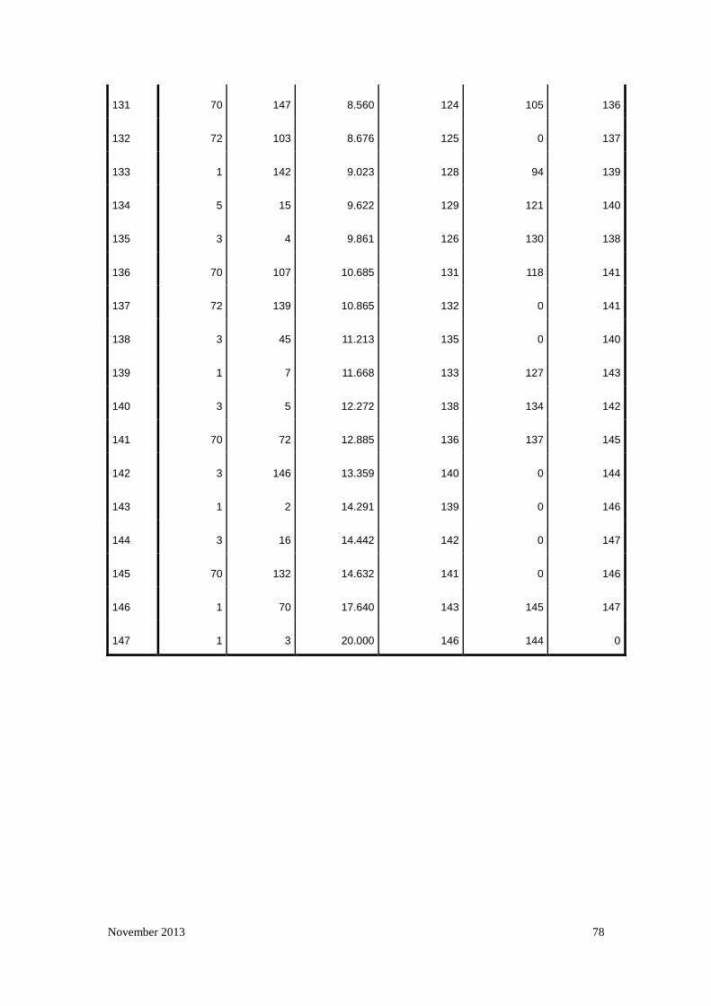
November 2013 78
131 70 147 8.560 124 105 136
132 72 103 8.676 125 0 137
133 1 142 9.023 128 94 139
134 5 15 9.622 129 121 140
135 3 4 9.861 126 130 138
136 70 107 10.685 131 118 141
137 72 139 10.865 132 0 141
138 3 45 11.213 135 0 140
139 1 7 11.668 133 127 143
140 3 5 12.272 138 134 142
141 70 72 12.885 136 137 145
142 3 146 13.359 140 0 144
143 1 2 14.291 139 0 146
144 3 16 14.442 142 0 147
145 70 132 14.632 141 0 146
146 1 70 17.640 143 145 147
147 1 3 20.000 146 144 0

November 2013 79
Marina Cluster Membership and Case identity listed according to marina locality
reference
Case 7 Clusters Case 7 Clusters
1:Atlantic 1 40:Mediterranean 3
2:Atlantic 2 41:Mediterranean 3
3:Atlantic 3 42:Mediterranean 3
4:Atlantic 3 43:Mediterranean 3
5:Atlantic 3 44:Mediterranean 3
6:Atlantic 3 45:Mediterranean 3
7:Atlantic 1 46:Mediterranean 3
8:Atlantic 1 47:Mediterranean 3
9:Atlantic 1 48:Mediterranean 3
10:Atlantic 3 49:Mediterranean 3
11:Atlantic 3 50:Mediterranean 3
12:Mediterranean 3 51:Mediterranean 3
13:Mediterranean 3 52:Mediterranean 3
14:Mediterranean 3 53:Mediterranean 3
15:Mediterranean 3 54:Mediterranean 3
16:Mediterranean 4 55:Mediterranean 3
17:Mediterranean 3 56:Mediterranean 3
18:Mediterranean 3 57:Mediterranean 3
19:Mediterranean 3 58:English Channel 1
20:Mediterranean 3 59:English Channel 1
21:Mediterranean 3 60:English Channel 3
22:Mediterranean 3 61:Irish Sea 1

November 2013 80
23:Mediterranean 3 62:Irish Sea 1
24:Mediterranean 3 63:Irish Sea 1
25:Mediterranean 3 64:Irish Sea 3
26:Mediterranean 3 65:Irish Sea 1
27:Mediterranean 3 66:North Sea 1
28:Mediterranean 3 67:North Sea 1
29:Mediterranean 3 68:North Sea 1
30:Mediterranean 3 69:North Sea 1
31:Mediterranean 3 70:North Sea 5
32:Mediterranean 3 71:North Sea 1
33:Mediterranean 3 72:North Sea 5
34:Mediterranean 3 73:North Sea 5
35:Mediterranean 3 74:North Sea 1
36:Mediterranean 3 75:North Sea 1
37:Mediterranean 3 76:North Sea 1
38:Mediterranean 3 77:North Sea 1
39:Mediterranean 3 78:North Sea 3
79:North Sea 5

November 2013 81
Case 7 Clusters Case 7 Clusters
80:North Sea 1 119:The Quark 5
81:North Sea 1 120:The Quark 5
82:North Sea 1 121:The Quark 5
83:North Sea 1 122:The Quark 5
84:North Sea 1 123:Western Gotland Basin 5
85:North Sea 1 124:Bay of Mecklenburg 5
86:Aland Sea 5 125:Bay of Mecklenburg 5
87:Arkona Basin 5 126:Bay of Mecklenburg 5
88:Bornholm Basin 5 127:Great Belt 5
89:Bornholm Basin 5 128:Great Belt 5
90:Bornholm Basin 5 129:Great Belt 5
91:Bornholm Basin 5 130:Roskilde Fjord 5
92:Bornholm Basin 5 131:Kattegat 5
93:Bothnian Sea 5 132:Kattegat 6
94:Bothnian Sea 5 133:Kattegat 5
95:Eastern Gotland Basin 5 134:Kattegat 3
96:Eastern Gotland Basin 5 135:Kiel Bay 5
97:Eastern Gotland Basin 5 136:Kiel Bay 5
98:Gdansk Bay 5 137:Kiel Bay 5
99:Gdansk Bay 5 138:Kiel Bay 5
100:Gdansk Bay 5 139:Elbe 5
101:Gulf of Finland 5 140:Kiel Bay 5
102:Gulf of Finland 5 141:The Sound 5

November 2013 82
Case 7 Clusters Case 7 Clusters
103:Gulf of Finland 5 142:North Sea 1
104:Gulf of Finland 5 143:North Sea 1
105:Gulf of Finland 5 144:Ijsselmeer 5
106:Gulf of Finland 5 145:Lauwersmeer 1
107:Gulf of Finland 5 146:Oslo Fjord 7
108:Gulf of Riga 5 147:Oslo Fjord 5
109:Gulf of Riga 5 148:Skagerrak 5
110:Gulf of Riga 5
111:Gulf of Riga 5
112:Gulf of Riga 5
113:Gulf of Riga 5
114:Northern Baltic Proper 5
115:Northern Baltic Proper 5
116:Northern Baltic Proper 5
117:Northern Baltic Proper 5
118:Northern Baltic Proper 5

November 2013 83
Canonical Analysis
Summary of Canonical Discriminant Functions
Eigenvalues
Function Eigenvalue % of Variance Cumulative %
Canonical
Correlation
1 8.213a 60.3 60.3 .944
2 5.411a 39.7 100.0 .919
Wilks' Lambda
Test of Function(s) Wilks' Lambda Chi-square df Sig.
1 through 2 .017 573.052 20 .000
2 .156 261.057 9 .000
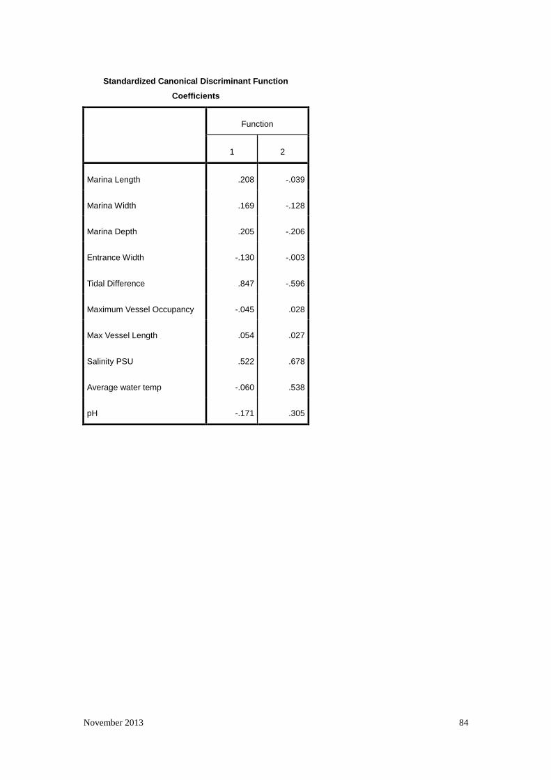
November 2013 84
Standardized Canonical Discriminant Function
Coefficients
Function
1 2
Marina Length .208 -.039
Marina Width .169 -.128
Marina Depth .205 -.206
Entrance Width -.130 -.003
Tidal Difference .847 -.596
Maximum Vessel Occupancy -.045 .028
Max Vessel Length .054 .027
Salinity PSU .522 .678
Average water temp -.060 .538
pH -.171 .305

November 2013 85
Structure Matrix
Function
1 2
Tidal Difference .728* -.427
pH -.123* .120
Salinity PSU .615 .668*
Average water temp .149 .546*
Max Vessel Length .030 .143*
Marina Depth .071 .123*
Marina Length .104 .118*
Marina Width .069 .115*
Maximum Vessel Occupancy .058 .111*
Entrance Width -.021 .046*
Functions at Group Centroids
Sea_Code 1
Function
1 2
1 3.642 -1.629
2 .118 3.427
3 -3.210 -1.474
Classification Statistics

November 2013 86
Classification Processing Summary
Processed 148
Excluded Missing or out-of-range group
codes 0
At least one missing
discriminating variable 0
Used in Output 148

November 2013 87
Prior Probabilities for Groups
Sea_Code 1 Prior
Cases Used in Analysis
Unweighted Weighted
1 .333 47 47.000
2 .333 46 46.000
3 .333 55 55.000
Total 1.000 148 148.000

November 2013 88
Appendix 5: Raw Data
Country_
Code Marina Marina Length
Marina Width
Marina
Depth Entrance Width
Tidal Difference
Maximum Vessel Occupancy
Max Vessel Length Salinity PSU
Average water temp pH
ES1
Gran Canaria-
Puerto Deportivo de las Palmas 645.00 300.00 8.00 55.00 2.20 1000.00 50.00 37.00 23.00 8.43
2 ES2 Lanzarote-Marina Rubicon 525.00 327.00 7.00 52.00 2.50 500.00 45.00 36.80 20.50 8.44
3 ES3 Vigo-Marina Davila Sport 288.00 215.00 15.00 60.00 3.20 180.00 80.00 35.83 18.00 8.22
4 PT1 Cascais-Marina de Cascais 448.95 251.25 7.00 63.25 2.80 650.00 45.00 36.00 18.00 7.96
5 PT10 Marina Porto Atlantico 1036.08 809.27 3.50 238.49 2.90 240.00 30.00 35.82 14.00 8.25
6 PT3 Portimao-Portimao Marina 663.62 236.01 4.00 60.75 2.70 620.00 30.00 36.25 19.00 6.63
7 PT4 Algarve-Marina de Vilamoura 520.00 480.00 4.00 80.00 3.00 1000.00 50.00 36.25 18.50 6.63
8 PT5 Marina de Lagos 977.22 185.87 3.00 106.01 2.80 462.00 30.00 36.25 19.00 6.63
9 PT7 Porto de Recreio de Sesimbra 366.25 181.30 6.90 59.41 2.80 250.00 15.00 36.00 17.00 7.96
10 PT8 Porto de Setúbal - Doca de Recreio 364.98 111.54 15.00 51.44 3.00 150.00 20.00 36.00 17.00 7.96
11 PT9 Marina de Viana do Castelo 433.86 102.56 3.00 29.82 2.90 163.00 20.00 35.75 13.50 8.25
12 CY1 Larnaca Marina 418.93 301.19 5.00 119.48 0.40 350.00 40.00 39.21 24.25 6.90
13 CY2 Saint Raphael Marina / Sheraton Marina 206.26 198.73 5.00 65.10 0.30 237.00 30.00 39.23 24.55 7.50
14 CY3 Delta Marina 285.00 316.53 5.00 155.49 0.40 50.00 25.00 39.28 25.70 8.18

November 2013 89
Country_
Code Marina Marina Length
Marina Width
Marina
Depth Entrance Width
Tidal Difference
Maximum Vessel Occupancy
Max Vessel Length Salinity PSU
Average water temp pH
15 CY5 Paphos 509.47 227.37 4.00 174.53 0.30 25.00 15.00 39.15 27.50 8.27
16 ES10 Valencia Yacht Port 775.29 218.87 8.00 114.68 0.20 176.00 120.00 37.00 20.75 8.50
17 ES4 Estepona-Marina de Estepona 510.00 309.00 4.50 72.00 0.90 440.00 25.00 36.25 19.00 8.93
18 ES5 Marbella-Jose Banus Marina 560.00 240.00 4.50 104.00 0.60 450.00 50.00 36.25 22.00 8.19
19 ES6 Almunecar-Puerto del Este 290.00 137.00 6.50 41.00 0.60 227.00 30.00 36.67 22.50 8.19
20 ES7 Almerimar-Almerimar Marina 593.00 422.00 3.00 78.00 0.30 1100.00 60.00 36.67 21.50 8.50
21 ES8 Portals(Mallorca)-Puerto Portals 487.00 309.00 3.00 79.00 0.10 375.00 25.00 36.67 25.50 8.20
22 ES9 Valencia-Real Club Nautico 538.41 258.54 5.00 73.32 0.20 1300.00 60.00 37.00 20.75 8.50
23 FR1 Marseille-old port 866.00 307.00 6.80 75.00 0.20 2588.00 100.00 36.67 18.00 8.45
24 FR10 St Jean Cap Ferrat-St Jean Cap Ferrat 352.00 182.00 4.00 35.00 0.30 511.00 28.00 37.84 18.20 8.40
25 FR2 ST Tropez-old port and new port 300.00 133.00 6.00 50.00 0.20 285.00 20.00 37.40 16.00 8.13
26 FR3 Mandelieu-Port la Napoule 492.00 259.00 7.00 89.00 0.30 960.00 52.00 37.52 18.50 8.18
27 FR4 Cannes-old port 375.00 338.00 5.00 104.00 0.30 650.00 65.00 37.60 18.20 8.15
28 FR5 Villefranche-port de villefranche 326.00 142.00 4.00 28.00 0.30 520.00 33.00 37.80 18.00 8.35
29 FR6 Beaulieu-Beaulieu sur mer 410.00 225.00 4.50 66.00 0.30 743.00 42.00 37.82 17.80 8.30
30 FR7 cap d'ail-port of cap d'ail 285.00 146.00 12.00 69.00 0.20 253.00 65.00 37.92 17.65 8.08

November 2013 90
Country_
Code Marina Marina Length
Marina Width
Marina
Depth Entrance Width
Tidal Difference
Maximum Vessel Occupancy
Max Vessel Length Salinity PSU
Average water temp pH
31 FR8 Menton-port de garavan 533.00 170.00 5.00 54.00 0.20 800.00 40.00 37.92 17.65 8.10
32 FR9 Cogolin-Cogolin Marina 792.00 514.00 6.00 83.00 0.20 1556.00 30.00 37.40 19.00 8.17
33 GR10 Kos-Kos Marina 263.00 126.00 6.00 40.00 0.70 250.00 50.00 39.52 18.50 8.26
34 GR2 Attica-Alimos Marina 626.00 452.00 5.00 77.00 0.10 900.00 40.00 39.17 18.00 8.32
35 GR3 Attica-Flisvos Marina 639.00 463.00 9.00 97.00 0.10 247.00 90.00 39.17 18.00 8.32
36 GR5 Athens-Vouliagmeni Marina 198.00 185.00 8.00 53.00 0.10 113.00 45.00 38.96 18.00 8.32
37 GR6 Lavrio-Olymic Marina 451.00 389.00 4.30 59.00 0.10 680.00 45.00 39.00 18.50 8.32
38 GR7 Samos-Samos Marina 293.00 165.00 3.70 43.00 0.70 280.00 25.00 39.40 19.00 8.26
39 GR8 Crete-Agios Nikolaos 309.00 125.00 8.00 33.00 0.70 225.00 50.00 39.52 19.00 8.17
40 GR9 Sithonia-Porto Carras 530.00 350.00 5.50 75.00 0.70 315.00 55.00 37.50 17.00 8.33
41 IT1 Degli aregai-Marina degli aregai 622.00 259.00 8.00 259.00 0.30 974.00 40.00 37.92 18.00 8.10
42 IT10 Marina di Porto San Giorgio 401.19 284.40 4.50 58.67 0.40 800.00 50.00 38.75 18.00 8.33
43 IT2 Santa Margherita Ligure 373.00 274.00 10.00 155.00 0.30 300.00 60.00 37.60 18.50 8.13
44 IT3 Chiavari-Marina Chiavari 271.00 252.00 5.00 42.00 0.30 460.00 25.00 37.60 18.50 8.14
45 IT4 Lavagna-Porto Turistico 855.00 233.00 5.00 59.00 0.30 1560.00 50.00 37.42 18.50 8.14
46 IT5 La Spezia-Porto Lotti 382.00 222.00 8.00 53.00 0.30 548.00 60.00 37.42 18.75 8.16
47 IT6 Elba-Portoferraio 255.00 177.00 10.00 124.00 0.30 150.00 70.00 37.92 18.00 8.16

November 2013 91
Country_
Code Marina Marina Length
Marina Width
Marina
Depth Entrance Width
Tidal Difference
Maximum Vessel Occupancy
Max Vessel Length Salinity PSU
Average water temp pH
48 IT7 Santo Stefano-Porto del Valle (Porto Santo Stefano) 454.00 395.00 10.00 118.00 0.30 100.00 25.00 37.50 18.50 8.28
49 IT8 Capri-Marina Grande 654.00 220.00 10.00 110.00 0.40 300.00 50.00 37.40 19.00 8.15
50 IT9 Palermo (Sicily)-Marina Villa Igiea 398.34 306.94 4.50 92.91 0.40 400.00 60.00 37.60 18.50 8.17
51 MT1 Grand Harbour Marina 858.99 198.79 18.00 261.16 0.40 193.00 100.00 38.33 20.00 8.00
52 MT3 Manoel Island Marina 727.02 261.86 5.00 227.22 0.40 150.00 90.00 38.00 19.80 8.00
53 MT4 Msida Marina 883.22 129.16 10.00 162.65 0.40 700.00 18.00 37.92 19.70 8.00
54 MT5 Mgarr Marina 503.86 270.63 5.00 84.29 0.40 208.00 15.00 38.00 20.00 8.09
55 SI1 Marina Izola 696.57 319.77 3.50 90.07 1.10 650.00 30.00 37.00 17.50 8.21
56 SI2 Marina Portoroz 503.15 185.44 4.50 23.91 1.10 640.00 24.00 37.50 17.50 8.17
57 SI3 Marina Koper d.o.o. 149.43 85.55 3.50 52.50 1.10 85.00 18.00 37.00 17.00 8.24
58 GB1 Penzance 248.98 227.17 10.67 74.97 3.70 250.00 10.67 35.40 13.00 8.13
59 GB2 Mevagissey 340.22 189.56 4.00 45.21 3.80 250.00 15.00 35.20 12.80 8.20
60 GB3 Newhaven Marina 337.32 138.31 4.00 225.00 5.00 120.00 12.00 34.90 12.50 7.90
61 EI1 Dun Laoghaire Marinas 650.41 263.50 10.50 150.71 3.30 800.00 30.00 35.20 10.00 8.19
62 EI2 Howth Yacht Club & Marina 330.00 270.00 5.00 102.00 3.60 350.00 20.00 35.00 9.80 8.19
63 EI4 Malahide Marina 337.34 165.08 2.40 40.00 3.70 370.00 70.00 34.90 9.50 8.19

November 2013 92
Country_
Code Marina Marina Length
Marina Width
Marina
Depth Entrance Width
Tidal Difference
Maximum Vessel Occupancy
Max Vessel Length Salinity PSU
Average water temp pH
64 EI5 Poolbeg Marina• 217.74 73.00 2.40 15.00 3.40 100.00 20.00 35.00 9.80 8.19
65 GB10 Aberystwyth Marina 189.47 164.24 7.00 35.24 3.20 160.00 20.00 35.30 12.00 8.19
66 BE1 Royal North Sea Yacht Club 87.55 85.82 2.50 21.53 3.96 100.00 5.00 34.20 18.20 6.50
67 BE2 Royal Belgian Sailing Club Zeebrugge 676.56 92.54 13.50 108.85 3.59 180.00 18.00 31.90 18.50 8.02
68 BE3 Mercator Marina 429.64 111.95 4.00 17.84 3.80 225.00 45.00 32.00 11.50 6.50
69 BE4 VVW Westhoek Sparrbekken Basin Marina 440.97 188.51 2.00 28.00 4.15 200.00 6.00 34.40 18.00 7.42
70 BE5 WSKLuM 522.40 260.43 2.00 50.20 3.96 1000.00 30.00 34.50 11.50 7.42
71 BE6 De Vrije Noordzeezeilers 279.75 98.58 2.50 35.75 3.79 300.00 15.00 32.80 11.50 8.02
72 BE7 Koninklijke Yacht Club Nieuwpoort 399.15 134.71 3.00 24.50 3.96 350.00 20.00 34.60 11.50 7.42
73 BE8 Blankenberge Marina 419.62 241.17 2.50 56.32 3.79 900.00 15.00 32.80 11.50 8.02
74 DE5 Amrum-Hafen Marina 219.39 80.93 2.20 80.93 2.90 53.00 40.00 27.20 10.00 8.18
75 DE8 Cuxhaven Yacht Club Marina 353.61 141.95 3.17 58.42 3.50 148.00 30.00 19.00 11.00 8.13
76 GB4 Ramsgate 447.51 448.61 3.00 91.67 3.70 315.00 30.00 24.05 12.30 7.70
77 GB5 Bradwell Marina 247.22 159.92 4.00 45.20 3.90 300.00 15.25 22.45 12.00 7.70
78 GB6 Royal Norfolk & Suffolk Yacht Club 151.17 90.00 2.50 14.71 1.50 100.00 30.00 22.30 12.00 7.80

November 2013 93
Country_
Code Marina Marina Length
Marina Width
Marina
Depth Entrance Width
Tidal Difference
Maximum Vessel Occupancy
Max Vessel Length Salinity PSU
Average water temp pH
79 GB7 Sunderland 274.87 139.90 3.00 63.94 3.60 114.00 13.00 22.27 11.00 7.87
80 GB8 Blyth Marina 497.08 241.09 0.00 88.55 3.50 100.00 16.00 22.00 10.00 7.69
81 GB9 Amble Marina 209.64 127.30 2.40 27.00 3.40 250.00 20.00 22.00 10.00 7.20
82 NL10 Jachthaven Lauersoog 969.43 198.31 2.80 89.43 2.90 400.00 30.00 29.00 12.95 8.05
83 NL4 Jachthaven Neptunus 371.61 126.96 3.50 65.77 3.60 170.00 60.00 29.00 12.50 7.88
84 NL5 Waddenhaven Vlieland 318.71 97.88 2.50 18.10 2.30 250.00 30.00 26.00 11.00 8.09
85 NL8 Jachthaven Michiel de Ruijterhaven 195.22 54.63 9.00 22.81 4.40 100.00 50.00 31.00 11.72 7.80
86 SE11 Gräddö Marina 283.00 155.00 4.00 150.00 0.10 400.00 30.00 6.00 10.00 8.30
87 DK8 Gedser Lystbådehavn 256.41 100.00 3.40 47.12 0.20 45.00 25.00 15.00 10.38 7.75
88 DK12 Boderne Havn 56.00 87.00 1.25 13.00 0.30 85.00 10.00 7.60 11.00 7.90
89 DK13 Nørrekås Lystbådehavn 70.00 51.00 2.25 6.00 0.10 150.00 20.00 7.60 11.00 7.90
90 DK14 Rønne, Marina 192.00 127.00 2.00 67.00 0.10 101.00 20.00 7.60 11.00 7.90
91 DK15 Hasle Marina 2 121.00 65.00 1.20 26.00 0.10 115.00 10.00 7.60 11.00 7.90
92 DK16 Svaneke, havn 71.00 55.00 3.50 9.00 0.10 45.00 30.00 7.60 11.00 7.90
93 FI8 Mikonkari Marina 116.33 34.32 3.58 93.70 0.15 29.00 15.00 2.00 8.50 6.80
94 FI9 Reila Marina 121.54 34.50 3.58 48.20 0.14 45.00 15.00 4.00 10.50 7.70

November 2013 94
Country_
Code Marina Marina Length
Marina Width
Marina
Depth Entrance Width
Tidal Difference
Maximum Vessel Occupancy
Max Vessel Length Salinity PSU
Average water temp pH
95 LT1 Klaipeda marina 228.41 50.42 5.00 27.39 0.10 100.00 30.00 6.09 9.45 8.48
96 LV2 Ventspils Yacht harbour (Marina) 320.87 205.96 5.00 63.76 0.10 500.00 20.00 6.92 11.81 8.28
97 PL7 Władysławowo 466.01 378.15 5.00 58.48 0.10 420.00 20.00 7.08 10.61 8.54
98 PL2 Hel 482.41 265.60 5.00 70.78 0.10 60.00 20.00 7.13 10.53 8.82
99 PL3 Jastarnia 423.22 271.02 5.00 72.40 0.10 60.00 20.00 7.04 10.18 8.02
100 PL5 Puck 175.40 82.37 13.00 45.52 0.10 33.00 20.00 8.40 10.50 8.02
101 EE10 Tallinn - Pirita 886.48 390.35 2.80 58.10 0.10 310.00 50.00 6.16 10.00 7.86
102 EE2 Dirhami 252.00 201.00 4.20 201.00 0.10 10.00 110.00 6.66 10.03 8.56
103 EE5 Lohusalu 174.73 69.99 2.20 37.57 0.10 10.00 20.00 6.13 10.00 8.46
104 FI1 Loviisa Laicasilta Marina 216.25 105.31 2.50 31.00 0.21 55.00 10.00 4.00 12.47 8.50
105 FI10
Uittamo Marina
Koivisto model (SYKE) 420.00 140.00 2.20 420.00 0.00 226.00 20.00 4.60 10.00 8.00
106 FI6 Herttoniemen Marina 328.08 309.15 3.00 83.77 0.16 190.00 30.00 4.00 16.25 8.70
107 FI7 Uutela Marina 263.03 117.88 3.58 27.92 0.16 190.00 12.00 5.00 16.25 8.70
108 EE1 Haapsalu-Grand Holm Marina 200.00 150.00 2.00 22.07 0.10 70.00 24.00 6.00 10.00 8.25
109 EE3 Kihnu 368.68 100.00 3.50 239.84 0.10 20.00 35.00 5.50 10.50 8.70
110 EE4 Kuressaare 459.00 143.83 2.50 89.49 0.10 132.00 30.00 5.90 10.00 8.32

November 2013 95
Country_
Code Marina Marina Length
Marina Width
Marina
Depth Entrance Width
Tidal Difference
Maximum Vessel Occupancy
Max Vessel Length Salinity PSU
Average water temp pH
111 EE7 Orissaare 411.29 163.46 2.30 75.83 0.10 18.00 20.00 7.00 10.00 8.45
112 EE8 Pärnu 121.07 59.89 5.00 42.55 0.10 90.00 100.00 5.50 11.00 8.24
113 EE9 Roomassaare 529.22 147.84 3.00 35.18 0.10 70.00 30.00 6.00 10.00 8.30
114 SE10 Morarna Road Marina 339.00 82.00 6.00 30.00 0.10 270.00 15.00 7.00 10.00 8.30
115 SE12 Marsattra Marina 220.00 166.00 3.00 118.00 0.10 342.00 30.00 6.00 10.00 8.30
116 SE13 Erikso Yacht Harbour 152.00 191.00 4.00 125.00 0.10 150.00 10.00 6.00 10.00 8.30
117 SE14 Fisksatra Baatklubb Marina 193.00 108.00 10.00 68.00 0.10 200.00 20.00 6.00 10.00 8.30
118
SE9
(kemi) Kemi-Bullando 350.00 400.00 3.00 140.00 0.10 376.00 30.00 6.10 10.00 8.30
119 FI2 Vaasa Hietasaari Marina 356.86 180.08 5.00 98.57 0.20 500.00 30.00 3.50 9.40 8.30
120 FI3 Vaasa Kalarannanpuisto 334.85 98.11 5.00 76.39 0.20 200.00 30.00 3.50 9.40 7.80
121 FI4 Aminne Yacht Harbour 94.33 80.30 3.58 29.04 0.20 32.00 10.00 4.00 10.65 7.50
122 FI5 Aminne Marina 131.99 82.03 3.58 14.00 0.20 120.00 15.00 4.00 9.50 7.50
123 SE7 Arkösund 252.30 186.68 5.00 136.31 0.10 500.00 30.00 4.00 11.75 8.51
124 DE10 Binnenhafen Marina 1 137.50 100.00 3.00 20.00 0.30 115.00 15.00 8.00 10.75 8.28
125 DE2 Ancora Marina 530.71 433.36 3.69 99.76 0.30 1400.00 35.00 14.00 10.75 8.25
126 DE3 Kuhlungsborn 338.70 293.31 5.00 43.80 0.30 400.00 30.00 8.00 10.70 8.29

November 2013 96
Country_
Code Marina Marina Length
Marina Width
Marina
Depth Entrance Width
Tidal Difference
Maximum Vessel Occupancy
Max Vessel Length Salinity PSU
Average water temp pH
127 DK4 Bandholm Havn 80.47 62.99 5.00 32.27 0.30 50.00 120.00 20.00 11.40 8.05
128 DK5 Bogense Havn og Marina 415.54 291.07 3.50 19.44 0.30 760.00 55.00 23.00 10.00 8.04
129 DK9 Havnsø Havn 278.49 180.48 2.75 39.22 0.20 250.00 18.00 25.00 10.58 8.04
130 DK1 Ærøskøbing Havn 178.00 100.00 3.00 15.35 0.50 350.00 15.00 20.00 12.50 7.68
131 DK10 Skagen Havn 150.00 125.00 7.00 15.00 0.30 183.00 50.00 33.00 11.25 8.20
132
DK11
(MST) Jyllinge 262.00 112.00 1.80 12.00 1.00 400.00 10.00 14.50 12.50 7.00
133 DK2 Asaa Havn (Kattegatt) 223.10 107.72 2.00 17.88 1.00 175.00 30.00 30.00 11.10 8.20
134 SE15 KemI West Coast Marina (Gunneby) 700.00 200.00 3.00 600.00 0.23 1288.00 30.00 20.30 13.50 8.00
135 DE11 Binnenhafen Marina 2 200.00 187.50 3.00 20.00 0.30 366.00 15.00 8.00 10.75 8.28
136 DE6 Maasholm Marina 368.63 246.48 3.69 38.06 0.30 450.00 25.00 16.00 10.75 8.27
137 DE7 Yachthafen Laboe Marina 534.48 201.43 3.69 59.07 0.30 285.00 20.00 15.00 10.75 7.73
138 DE9 Hafen Orth GmbH 560.68 52.77 3.00 20.38 0.30 150.00 18.50 3.00 15.00 8.08
139 DK3 Augustenborg Yacht Harbor 228.63 225.17 3.00 225.17 0.50 260.00 20.00 21.00 13.00 7.68
140 DE4 Hamburger Yachthafen 591.87 450.91 3.69 73.48 3.90 1950.00 15.00 17.00 21.50 7.70
141 SE3 Limhamns Småbåtshamn 570.65 347.81 5.00 77.12 0.10 1088.00 30.00 8.00 11.10 8.15
142 NL3 Jachthaven Brouwershaven 422.10 144.89 8.00 12.26 2.70 435.00 100.00 31.00 12.17 8.00

November 2013 97
Country_
Code Marina Marina Length
Marina Width
Marina
Depth Entrance Width
Tidal Difference
Maximum Vessel Occupancy
Max Vessel Length Salinity PSU
Average water temp pH
143 NL6 Scharendijke Jachthaven 401.34 151.95 3.00 30.06 2.70 850.00 100.00 30.00 12.42 8.00
144 NL1 Compagnieshaven 574.68 449.86 2.80 90.81 2.00 670.00 50.00 21.00 10.00 8.09
145 NL9 Jachthaven Oostmahorn 245.84 212.35 2.50 42.90 2.90 450.00 30.00 28.00 12.95 8.05
146 NO1 Herbern Marina 180.04 153.67 12.00 67.69 0.40 300.00 50.00 35.20 9.00 7.00
147 NO2 Frognerkilens Båtforening 1250.36 550.16 9.00 244.01 0.40 800.00 40.00 35.20 9.00 7.00
148 NO6 Stavern 378.49 174.69 10.50 63.25 0.40 300.00 5.00 35.60 9.20 7.00

November 2013 98
Appendix 6: Marina Codes
Country_Code
Water Body
Sea Code 1
Water Body
Sea Code 1
Name
Regional Sea
Sea Code 2
Regional Sea
Sea Code 2
Name
Locality
Sea Code 3
Locality
Sea Code 3 Name
Site Specific
Sea Code 4
Site Specific
Sea Code 4
Name
1 ES1 1.00 Atlantic 1 Atlantic 1 Atlantic 1 Atlantic
2 ES2 1.00 Atlantic 1 Atlantic 1 Atlantic 1 Atlantic
3 ES3 1.00 Atlantic 1 Atlantic 1 Atlantic 1 Atlantic
4 PT1 1.00 Atlantic 1 Atlantic 1 Atlantic 1 Atlantic
5 PT10 1.00 Atlantic 1 Atlantic 1 Atlantic 1 Atlantic
6 PT3 1.00 Atlantic 1 Atlantic 1 Atlantic 1 Atlantic
7 PT4 1.00 Atlantic 1 Atlantic 1 Atlantic 1 Atlantic
8 PT5 1.00 Atlantic 1 Atlantic 1 Atlantic 1 Atlantic
9 PT7 1.00 Atlantic 1 Atlantic 1 Atlantic 1 Atlantic
10 PT8 1.00 Atlantic 1 Atlantic 1 Atlantic 1 Atlantic
11 PT9 1.00 Atlantic 1 Atlantic 1 Atlantic 1 Atlantic
12 CY1 2.00 Mediterranean 2 Mediterranean 2 Mediterranean 2 Mediterranean
13 CY2 2.00 Mediterranean 2 Mediterranean 2 Mediterranean 2 Mediterranean
14 CY3 2.00 Mediterranean 2 Mediterranean 2 Mediterranean 2 Mediterranean
15 CY5 2.00 Mediterranean 2 Mediterranean 2 Mediterranean 2 Mediterranean
November 2013 99
Country_Code
Water Body
Sea Code 1
Water Body
Sea Code 1
Name
Regional Sea
Sea Code 2
Regional Sea
Sea Code 2
Name
Locality
Sea Code 3
Locality
Sea Code 3 Name
Site Specific
Sea Code 4
Site Specific
Sea Code 4
Name
16 ES10 2.00 Mediterranean 2 Mediterranean 2 Mediterranean 2 Mediterranean
17 ES4 2.00 Mediterranean 2 Mediterranean 2 Mediterranean 2 Mediterranean
18 ES5 2.00 Mediterranean 2 Mediterranean 2 Mediterranean 2 Mediterranean
19 ES6 2.00 Mediterranean 2 Mediterranean 2 Mediterranean 2 Mediterranean
20 ES7 2.00 Mediterranean 2 Mediterranean 2 Mediterranean 2 Mediterranean
21 ES8 2.00 Mediterranean 2 Mediterranean 2 Mediterranean 2 Mediterranean
22 ES9 2.00 Mediterranean 2 Mediterranean 2 Mediterranean 2 Mediterranean
23 FR1 2.00 Mediterranean 2 Mediterranean 2 Mediterranean 2 Mediterranean
24 FR10 2.00 Mediterranean 2 Mediterranean 2 Mediterranean 2 Mediterranean
25 FR2 2.00 Mediterranean 2 Mediterranean 2 Mediterranean 2 Mediterranean
26 FR3 2.00 Mediterranean 2 Mediterranean 2 Mediterranean 2 Mediterranean
27 FR4 2.00 Mediterranean 2 Mediterranean 2 Mediterranean 2 Mediterranean
28 FR5 2.00 Mediterranean 2 Mediterranean 2 Mediterranean 2 Mediterranean
29 FR6 2.00 Mediterranean 2 Mediterranean 2 Mediterranean 2 Mediterranean
30 FR7 2.00 Mediterranean 2 Mediterranean 2 Mediterranean 2 Mediterranean
31 FR8 2.00 Mediterranean 2 Mediterranean 2 Mediterranean 2 Mediterranean

November 2013 100
Country_Code
Water Body
Sea Code 1
Water Body
Sea Code 1
Name
Regional Sea
Sea Code 2
Regional Sea
Sea Code 2
Name
Locality
Sea Code 3
Locality
Sea Code 3 Name
Site Specific
Sea Code 4
Site Specific
Sea Code 4
Name
32 FR9 2.00 Mediterranean 2 Mediterranean 2 Mediterranean 2 Mediterranean
33 GR10 2.00 Mediterranean 2 Mediterranean 2 Mediterranean 2 Mediterranean
34 GR2 2.00 Mediterranean 2 Mediterranean 2 Mediterranean 2 Mediterranean
35 GR3 2.00 Mediterranean 2 Mediterranean 2 Mediterranean 2 Mediterranean
36 GR5 2.00 Mediterranean 2 Mediterranean 2 Mediterranean 2 Mediterranean
37 GR6 2.00 Mediterranean 2 Mediterranean 2 Mediterranean 2 Mediterranean
38 GR7 2.00 Mediterranean 2 Mediterranean 2 Mediterranean 2 Mediterranean
39 GR8 2.00 Mediterranean 2 Mediterranean 2 Mediterranean 2 Mediterranean
40 GR9 2.00 Mediterranean 2 Mediterranean 2 Mediterranean 2 Mediterranean
41 IT1 2.00 Mediterranean 2 Mediterranean 2 Mediterranean 2 Mediterranean
42 IT10 2.00 Mediterranean 2 Mediterranean 2 Mediterranean 2 Mediterranean
43 IT2 2.00 Mediterranean 2 Mediterranean 2 Mediterranean 2 Mediterranean
44 IT3 2.00 Mediterranean 2 Mediterranean 2 Mediterranean 2 Mediterranean
45 IT4 2.00 Mediterranean 2 Mediterranean 2 Mediterranean 2 Mediterranean
46 IT5 2.00 Mediterranean 2 Mediterranean 2 Mediterranean 2 Mediterranean
47 IT6 2.00 Mediterranean 2 Mediterranean 2 Mediterranean 2 Mediterranean

November 2013 101
Country_Code
Water Body
Sea Code 1
Water Body
Sea Code 1
Name
Regional Sea
Sea Code 2
Regional Sea
Sea Code 2
Name
Locality
Sea Code 3
Locality
Sea Code 3 Name
Site Specific
Sea Code 4
Site Specific
Sea Code 4
Name
48 IT7 2.00 Mediterranean 2 Mediterranean 2 Mediterranean 2 Mediterranean
49 IT8 2.00 Mediterranean 2 Mediterranean 2 Mediterranean 2 Mediterranean
50 IT9 2.00 Mediterranean 2 Mediterranean 2 Mediterranean 2 Mediterranean
51 MT1 2.00 Mediterranean 2 Mediterranean 2 Mediterranean 2 Mediterranean
52 MT3 2.00 Mediterranean 2 Mediterranean 2 Mediterranean 2 Mediterranean
53 MT4 2.00 Mediterranean 2 Mediterranean 2 Mediterranean 2 Mediterranean
54 MT5 2.00 Mediterranean 2 Mediterranean 2 Mediterranean 2 Mediterranean
55 SI1 2.00 Mediterranean 2 Mediterranean 2 Mediterranean 2 Mediterranean
56 SI2 2.00 Mediterranean 2 Mediterranean 2 Mediterranean 2 Mediterranean
57 SI3 2.00 Mediterranean 2 Mediterranean 2 Mediterranean 2 Mediterranean
58 GB1 1.00 Atlantic 5 English Channel 5 English Channel 5 English Channel
59 GB2 1.00 Atlantic 5 English Channel 5 English Channel 5 English Channel
60 GB3 1.00 Atlantic 5 English Channel 5 English Channel 5 English Channel
61 EI1 1.00 Atlantic 6 Irish Sea 6 Irish Sea 6 Irish Sea
62 EI2 1.00 Atlantic 6 Irish Sea 6 Irish Sea 6 Irish Sea
63 EI4 1.00 Atlantic 6 Irish Sea 6 Irish Sea 6 Irish Sea
November 2013 102
Country_Code
Water Body
Sea Code 1
Water Body
Sea Code 1
Name
Regional Sea
Sea Code 2
Regional Sea
Sea Code 2
Name
Locality
Sea Code 3
Locality
Sea Code 3 Name
Site Specific
Sea Code 4
Site Specific
Sea Code 4
Name
64 EI5 1.00 Atlantic 6 Irish Sea 6 Irish Sea 6 Irish Sea
65 GB10 1.00 Atlantic 6 Irish Sea 6 Irish Sea 6 Irish Sea
66 BE1 1.00 Atlantic 7 North Sea 7 North Sea 7 North Sea
67 BE2 1.00 Atlantic 7 North Sea 7 North Sea 7 North Sea
68 BE3 1.00 Atlantic 7 North Sea 7 North Sea 7 North Sea
69 BE4 1.00 Atlantic 7 North Sea 7 North Sea 7 North Sea
70 BE5 1.00 Atlantic 7 North Sea 7 North Sea 7 North Sea
71 BE6 1.00 Atlantic 7 North Sea 7 North Sea 7 North Sea
72 BE7 1.00 Atlantic 7 North Sea 7 North Sea 7 North Sea
73 BE8 1.00 Atlantic 7 North Sea 7 North Sea 7 North Sea
74 DE5 1.00 Atlantic 7 North Sea 7 North Sea 7 North Sea
75 DE8 1.00 Atlantic 7 North Sea 7 North Sea 7 North Sea
76 GB4 1.00 Atlantic 7 North Sea 7 North Sea 7 North Sea
77 GB5 1.00 Atlantic 7 North Sea 7 North Sea 7 North Sea
78 GB6 1.00 Atlantic 7 North Sea 7 North Sea 7 North Sea
79 GB7 1.00 Atlantic 7 North Sea 7 North Sea 7 North Sea
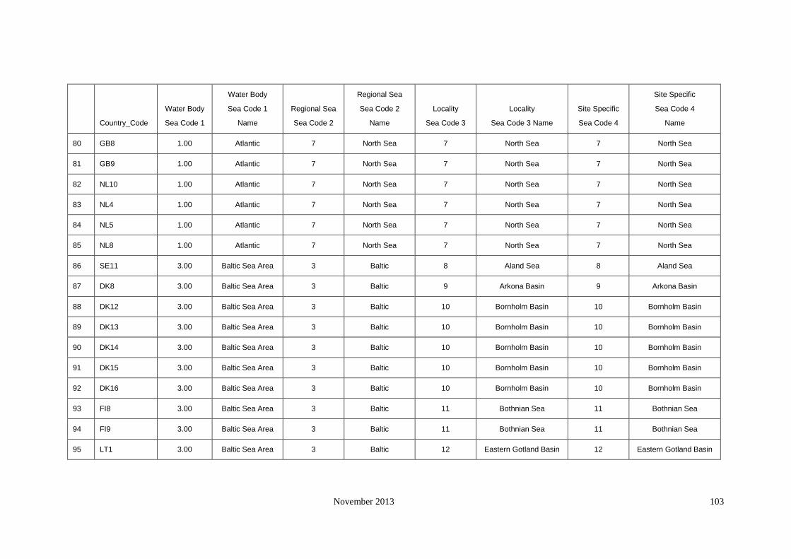
November 2013 103
Country_Code
Water Body
Sea Code 1
Water Body
Sea Code 1
Name
Regional Sea
Sea Code 2
Regional Sea
Sea Code 2
Name
Locality
Sea Code 3
Locality
Sea Code 3 Name
Site Specific
Sea Code 4
Site Specific
Sea Code 4
Name
80 GB8 1.00 Atlantic 7 North Sea 7 North Sea 7 North Sea
81 GB9 1.00 Atlantic 7 North Sea 7 North Sea 7 North Sea
82 NL10 1.00 Atlantic 7 North Sea 7 North Sea 7 North Sea
83 NL4 1.00 Atlantic 7 North Sea 7 North Sea 7 North Sea
84 NL5 1.00 Atlantic 7 North Sea 7 North Sea 7 North Sea
85 NL8 1.00 Atlantic 7 North Sea 7 North Sea 7 North Sea
86 SE11 3.00 Baltic Sea Area 3 Baltic 8 Aland Sea 8 Aland Sea
87 DK8 3.00 Baltic Sea Area 3 Baltic 9 Arkona Basin 9 Arkona Basin
88 DK12 3.00 Baltic Sea Area 3 Baltic 10 Bornholm Basin 10 Bornholm Basin
89 DK13 3.00 Baltic Sea Area 3 Baltic 10 Bornholm Basin 10 Bornholm Basin
90 DK14 3.00 Baltic Sea Area 3 Baltic 10 Bornholm Basin 10 Bornholm Basin
91 DK15 3.00 Baltic Sea Area 3 Baltic 10 Bornholm Basin 10 Bornholm Basin
92 DK16 3.00 Baltic Sea Area 3 Baltic 10 Bornholm Basin 10 Bornholm Basin
93 FI8 3.00 Baltic Sea Area 3 Baltic 11 Bothnian Sea 11 Bothnian Sea
94 FI9 3.00 Baltic Sea Area 3 Baltic 11 Bothnian Sea 11 Bothnian Sea
95 LT1 3.00 Baltic Sea Area 3 Baltic 12 Eastern Gotland Basin 12 Eastern Gotland Basin

November 2013 104
Country_Code
Water Body
Sea Code 1
Water Body
Sea Code 1
Name
Regional Sea
Sea Code 2
Regional Sea
Sea Code 2
Name
Locality
Sea Code 3
Locality
Sea Code 3 Name
Site Specific
Sea Code 4
Site Specific
Sea Code 4
Name
96 LV2 3.00 Baltic Sea Area 3 Baltic 12 Eastern Gotland Basin 12 Eastern Gotland Basin
97 PL7 3.00 Baltic Sea Area 3 Baltic 12 Eastern Gotland Basin 12 Eastern Gotland Basin
98 PL2 3.00 Baltic Sea Area 3 Baltic 13 Gdansk Bay 13 Gdansk Bay
99 PL3 3.00 Baltic Sea Area 3 Baltic 13 Gdansk Bay 13 Gdansk Bay
100 PL5 3.00 Baltic Sea Area 3 Baltic 13 Gdansk Bay 13 Gdansk Bay
101 EE10 3.00 Baltic Sea Area 3 Baltic 14 Gulf of Finland 14 Gulf of Finland
102 EE2 3.00 Baltic Sea Area 3 Baltic 14 Gulf of Finland 14 Gulf of Finland
103 EE5 3.00 Baltic Sea Area 3 Baltic 14 Gulf of Finland 14 Gulf of Finland
104 FI1 3.00 Baltic Sea Area 3 Baltic 14 Gulf of Finland 14 Gulf of Finland
105 FI10 3.00 Baltic Sea Area 3 Baltic 14 Gulf of Finland 14 Gulf of Finland
106 FI6 3.00 Baltic Sea Area 3 Baltic 14 Gulf of Finland 14 Gulf of Finland
107 FI7 3.00 Baltic Sea Area 3 Baltic 14 Gulf of Finland 14 Gulf of Finland
108 EE1 3.00 Baltic Sea Area 3 Baltic 15 Gulf of Riga 15 Gulf of Riga
109 EE3 3.00 Baltic Sea Area 3 Baltic 15 Gulf of Riga 15 Gulf of Riga
110 EE4 3.00 Baltic Sea Area 3 Baltic 15 Gulf of Riga 15 Gulf of Riga
111 EE7 3.00 Baltic Sea Area 3 Baltic 15 Gulf of Riga 15 Gulf of Riga

November 2013 105
Country_Code
Water Body
Sea Code 1
Water Body
Sea Code 1
Name
Regional Sea
Sea Code 2
Regional Sea
Sea Code 2
Name
Locality
Sea Code 3
Locality
Sea Code 3 Name
Site Specific
Sea Code 4
Site Specific
Sea Code 4
Name
112 EE8 3.00 Baltic Sea Area 3 Baltic 15 Gulf of Riga 15 Gulf of Riga
113 EE9 3.00 Baltic Sea Area 3 Baltic 15 Gulf of Riga 15 Gulf of Riga
114 SE10 3.00 Baltic Sea Area 3 Baltic 16 Northern Baltic Proper 16 Northern Baltic Proper
115 SE12 3.00 Baltic Sea Area 3 Baltic 16 Northern Baltic Proper 16 Northern Baltic Proper
116 SE13 3.00 Baltic Sea Area 3 Baltic 16 Northern Baltic Proper 16 Northern Baltic Proper
117 SE14 3.00 Baltic Sea Area 3 Baltic 16 Northern Baltic Proper 16 Northern Baltic Proper
118 SE9 (kemi) 3.00 Baltic Sea Area 3 Baltic 16 Northern Baltic Proper 16 Northern Baltic Proper
119 FI2 3.00 Baltic Sea Area 3 Baltic 17 The Quark 17 The Quark
120 FI3 3.00 Baltic Sea Area 3 Baltic 17 The Quark 17 The Quark
121 FI4 3.00 Baltic Sea Area 3 Baltic 17 The Quark 17 The Quark
122 FI5 3.00 Baltic Sea Area 3 Baltic 17 The Quark 17 The Quark
123 SE7 3.00 Baltic Sea Area 3 Baltic 18 Western Gotland Basin 18 Western Gotland Basin
124 DE10 3.00 Baltic Sea Area 4 Baltic Transition 19 Bay of Mecklenburg 19 Bay of Mecklenburg
125 DE2 3.00 Baltic Sea Area 4 Baltic Transition 19 Bay of Mecklenburg 19 Bay of Mecklenburg
126 DE3 3.00 Baltic Sea Area 4 Baltic Transition 19 Bay of Mecklenburg 19 Bay of Mecklenburg
127 DK4 3.00 Baltic Sea Area 4 Baltic Transition 20 Great Belt 20 Great Belt

November 2013 106
Country_Code
Water Body
Sea Code 1
Water Body
Sea Code 1
Name
Regional Sea
Sea Code 2
Regional Sea
Sea Code 2
Name
Locality
Sea Code 3
Locality
Sea Code 3 Name
Site Specific
Sea Code 4
Site Specific
Sea Code 4
Name
128 DK5 3.00 Baltic Sea Area 4 Baltic Transition 20 Great Belt 20 Great Belt
129 DK9 3.00 Baltic Sea Area 4 Baltic Transition 20 Great Belt 20 Great Belt
130 DK1 3.00 Baltic Sea Area 4 Baltic Transition 21 Kattegat 21 Kattegat
131 DK10 3.00 Baltic Sea Area 4 Baltic Transition 21 Kattegat 21 Kattegat
132 DK11 (MST) 3.00 Baltic Sea Area 4 Baltic Transition 21 Kattegat 27 Roskilde Fjord
133 DK2 3.00 Baltic Sea Area 4 Baltic Transition 21 Kattegat 21 Kattegat
134 SE15 3.00 Baltic Sea Area 4 Baltic Transition 21 Kattegat 21 Kattegat
135 DE11 3.00 Baltic Sea Area 4 Baltic Transition 22 Kiel Bay 22 Kiel Bay
136 DE6 3.00 Baltic Sea Area 4 Baltic Transition 22 Kiel Bay 22 Kiel Bay
137 DE7 3.00 Baltic Sea Area 4 Baltic Transition 22 Kiel Bay 22 Kiel Bay
138 DE9 3.00 Baltic Sea Area 4 Baltic Transition 22 Kiel Bay 22 Kiel Bay
139 DK3 3.00 Baltic Sea Area 4 Baltic Transition 22 Kiel Bay 22 Kiel Bay
140 DE4 1.00 Atlantic 7 North Sea 22 Elbe 22 Elbe
141 SE3 3.00 Baltic Sea Area 4 Baltic Transition 23 The Sound 23 The Sound
142 NL3 1.00 Atlantic 7 North Sea 23 North Sea 23 North Sea
143 NL6 1.00 Atlantic 7 North Sea 23 North Sea 23 North Sea

November 2013 107
Country_Code
Water Body
Sea Code 1
Water Body
Sea Code 1
Name
Regional Sea
Sea Code 2
Regional Sea
Sea Code 2
Name
Locality
Sea Code 3
Locality
Sea Code 3 Name
Site Specific
Sea Code 4
Site Specific
Sea Code 4
Name
144 NL1 1.00 Atlantic 7 North Sea 24 Ijsselmeer 24 Ijsselmeer
145 NL9 1.00 Atlantic 7 North Sea 25 Lauwersmeer 25 Lauwersmeer
146 NO1 1.00 Atlantic 7 North Sea 26 Skagerrak 28 Oslo Fjord
147 NO2 1.00 Atlantic 7 North Sea 26 Skagerrak 28 Oslo Fjord
148 NO6 1.00 Atlantic 7 North Sea 26 Skagerrak 26 Skagerrak

November 2013 108
Appendix 7 Specific Data sources
Belgium
Marina 1 http://www.portbooker.com/en/marinas/belgium/zeebrugge/oostende/royal-north-sea-yacht-club/
Marina length; width Google Earth
Depth http://www.portbooker.com/en/marinas/belgium/zeebrugge/oostende/royal-north-sea-yacht-club/
Width of the marina entrance Google Earth
Tidal difference http://www.mumm.ac.be/EN/Models/Operational/Tides/table.php?station=zeebruges
Salinity http://www.mumm.ac.be/EN/Models/Operational/Tides/table.php?station=zeebruges
Average water temperature http://www.mumm.ac.be/EN/Models/Operational/Tides/table.php?station=zeebruges
pH http://www.ices.dk/Ocean/
The number of vessels moored in the marina http://www.portbooker.com/en/marinas/belgium/zeebrugge/oostende/royal-north-sea-yacht-club/
The maximum length of vessel that the marina can
accommodate http://www.portbooker.com/en/marinas/belgium/zeebrugge/oostende/royal-north-sea-yacht-club/

November 2013 109
Belgium
Marina 2 http://www.portbooker.com/en/marinas/belgium/zeebrugge/zeebrugge/royal-belgian-sailing-club/
Marina length; width Google Earth
Depth http://www.portbooker.com/en/marinas/belgium/zeebrugge/zeebrugge/royal-belgian-sailing-club/
Width of the marina entrance Google Earth
Tidal difference http://www.mumm.ac.be/EN/Models/Operational/Tides/table.php?station=zeebruges
Salinity http://www.mumm.ac.be/EN/Models/Operational/Tides/table.php?station=zeebruges
Average water temperature http://www.mumm.ac.be/EN/Models/Operational/Tides/table.php?station=zeebruges
pH http://www.ices.dk/Ocean/
The number of vessels moored in the marina http://www.portbooker.com/en/marinas/belgium/zeebrugge/zeebrugge/royal-belgian-sailing-club/
The maximum length of vessel that the marina can accommodate http://www.portbooker.com/en/marinas/belgium/zeebrugge/zeebrugge/royal-belgian-sailing-club/

November 2013 110
Marina 3 http://www.portbooker.com/en/marinas/belgium/zeebrugge/oostende/mercator-marina-cvba/
Marina length; width Google Earth
Depth http://www.portbooker.com/en/marinas/belgium/zeebrugge/oostende/mercator-marina-cvba/
Width of the marina entrance Google Earth
Tidal difference http://www.mumm.ac.be/EN/Models/Operational/Tides/table.php?station=ostend
Salinity http://www.mumm.ac.be/EN/Models/Operational/Tides/table.php?station=ostend
Average water temperature http://www.mumm.ac.be/EN/Models/Operational/Tides/table.php?station=ostend
pH http://www.ices.dk/Ocean/
The number of vessels moored in the marina http://www.portbooker.com/en/marinas/belgium/zeebrugge/oostende/mercator-marina-cvba/
The maximum length of vessel that the marina can accommodate http://www.portbooker.com/en/marinas/belgium/zeebrugge/oostende/mercator-marina-cvba/

November 2013 111
Belgium
Marina 4 http://www.vvw-westhoek.be/DOC/Info/alginfo.html
Marina length; width Google Earth
Depth http://www.vvw-westhoek.be/DOC/Info/alginfo.html
Width of the marina entrance Google Earth
Tidal difference http://www.mumm.ac.be/EN/Models/Operational/Tides/table.php?station=ostend
Salinity http://www.mumm.ac.be/EN/Models/Operational/Tides/table.php?station=ostend
Average water temperature http://www.mumm.ac.be/EN/Models/Operational/Tides/table.php?station=ostend
pH http://www.ices.dk/Ocean/
The number of vessels moored in the marina http://www.vvw-westhoek.be/DOC/Info/alginfo.html
The maximum length of vessel that the marina can accommodate http://www.vvw-westhoek.be/DOC/Info/alginfo.html

November 2013 112
Marina 5 http://www.wsklum.be/welcome.htm
Marina length; width Google Earth
Depth http://www.wsklum.be/welcome.htm
Width of the marina entrance Google Earth
Tidal difference http://www.mumm.ac.be/EN/Models/Operational/Tides/table.php?station=Newport
Salinity http://www.mumm.ac.be/EN/Models/Operational/Tides/table.php?station=Newport
Average water temperature http://www.mumm.ac.be/EN/Models/Operational/Tides/table.php?station=Newport
pH http://www.ices.dk/Ocean/
The number of vessels moored in the marina http://www.wsklum.be/welcome.htm
The maximum length of vessel that the marina can accommodate http://www.wsklum.be/welcome.htm

November 2013 113
Belgium
Marina 6 http://www.portbooker.com/es/puertos/belgica/oostende-a-zeebrugge/blankenberge/de-vrije-noordzee
zeilers/
Marina length; width Google Earth
Depth http://www.portbooker.com/es/puertos/belgica/oostende-a-zeebrugge/blankenberge/de-vrije-noordzee
zeilers/
Width of the marina entrance Google Earth
Tidal difference http://www.mumm.ac.be/EN/Models/Operational/Tides/table.php?station=Blankenberge
Salinity http://www.mumm.ac.be/EN/Models/Operational/Tides/table.php?station=Blankenberge
Average water temperature http://www.mumm.ac.be/EN/Models/Operational/Tides/table.php?station=Blankenberge
pH http://www.ices.dk/Ocean/
The number of vessels moored in the marina http://www.portbooker.com/es/puertos/belgica/oostende-a-zeebrugge/blankenberge/de-vrije-noordzee
zeilers/
The maximum length of vessel that the marina can accommodate http://www.portbooker.com/es/puertos/belgica/oostende-a-zeebrugge/blankenberge/de-vrije-noordzee
zeilers/

November 2013 114
Marina 7 http://www.portbooker.com/en/marinas/belgium/de-veurne-nieuwpoort/nieuwpoort/koninklijke-yacht
club-nieuwpoort/
Marina length; width Google Earth
Depth http://www.portbooker.com/en/marinas/belgium/de-veurne-nieuwpoort/nieuwpoort/koninklijke-yacht
club-nieuwpoort/
Width of the marina entrance Google Earth
Tidal difference http://www.mumm.ac.be/EN/Models/Operational/Tides/table.php?station=nieuwpoort
Salinity http://www.mumm.ac.be/EN/Models/Operational/Tides/table.php?station=nieuwpoort
Average water temperature http://www.mumm.ac.be/EN/Models/Operational/Tides/table.php?station=nieuwpoort
pH http://www.ices.dk/Ocean/
The number of vessels moored in the marina http://www.portbooker.com/en/marinas/belgium/de-veurne-nieuwpoort/nieuwpoort/koninklijke-yacht
club-nieuwpoort/
The maximum length of vessel that the marina can accommodate http://www.portbooker.com/en/marinas/belgium/de-veurne-nieuwpoort/nieuwpoort/koninklijke-yacht
club-nieuwpoort/
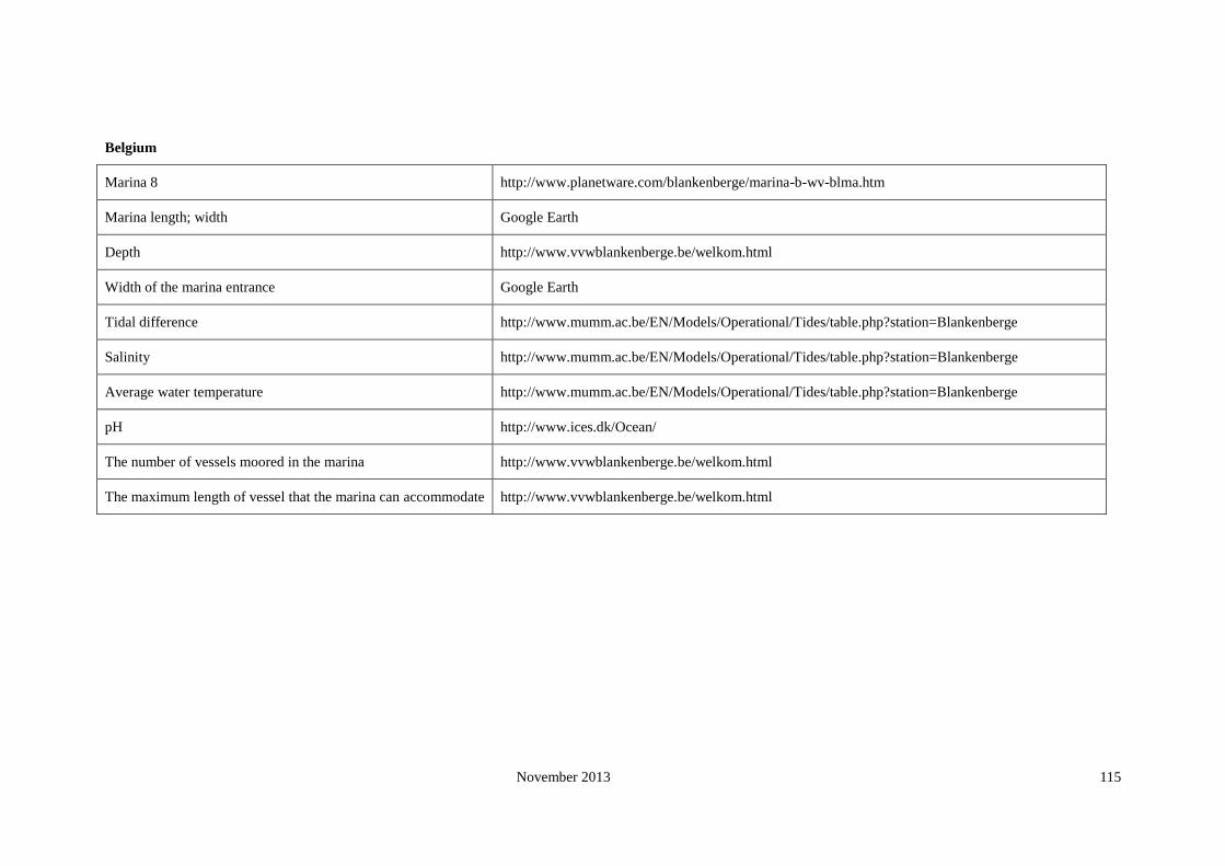
November 2013 115
Belgium
Marina 8 http://www.planetware.com/blankenberge/marina-b-wv-blma.htm
Marina length; width Google Earth
Depth http://www.vvwblankenberge.be/welkom.html
Width of the marina entrance Google Earth
Tidal difference http://www.mumm.ac.be/EN/Models/Operational/Tides/table.php?station=Blankenberge
Salinity http://www.mumm.ac.be/EN/Models/Operational/Tides/table.php?station=Blankenberge
Average water temperature http://www.mumm.ac.be/EN/Models/Operational/Tides/table.php?station=Blankenberge
pH http://www.ices.dk/Ocean/
The number of vessels moored in the marina http://www.vvwblankenberge.be/welkom.html
The maximum length of vessel that the marina can accommodate http://www.vvwblankenberge.be/welkom.html

November 2013 116
Bulgaria
Marina 1 http://www.blueflag.org/blueflag/2008/Bulgaria/Bourgas/Marina
%20Dinevi
http://www.dinevimarina.com/
about.php?cntid=21
Marina length; width google earth
Depth http://www.dinevimarina.com/about.php?cntid=21
Width of the marina entrance google earth
Tidal difference http://blacksea.orlyonok.ru/e2.shtml
Salinity http://www.icromania.com/infoCoast.asp
Average water temperature http://www.wunderground.com/MAR/eum.html#map
pH http://www.sumae.gov.tr/eng/proje/devam/02.htm
The number of vessels moored in the marina http://www.dinevimarina.com/about.php?cntid=21
The maximum length of vessel that the marina can
accommodate http://www.dinevimarina.com/about.php?cntid=21
*Tidal oscillations of the Black Sea level do not exceed 10cm because Mediterranean tidal waves
extinguish in the Straits.
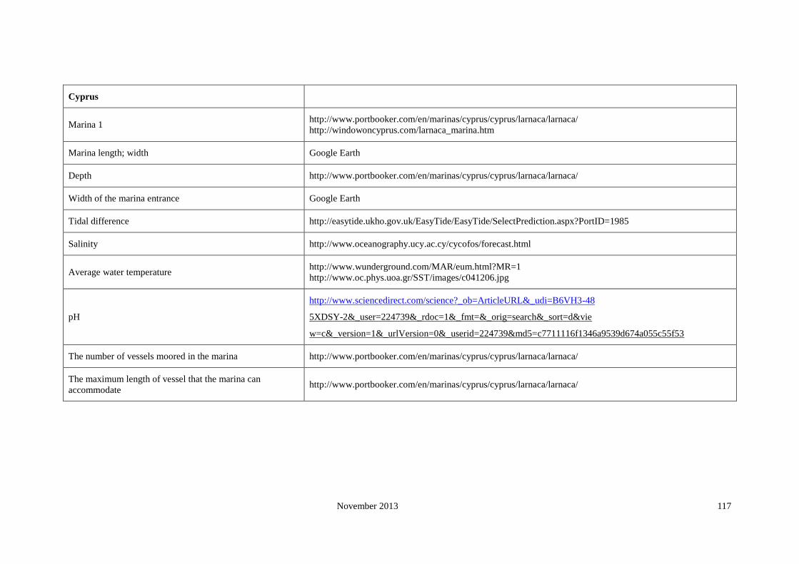
November 2013 117
Cyprus
Marina 1 http://www.portbooker.com/en/marinas/cyprus/cyprus/larnaca/larnaca/
http://windowoncyprus.com/larnaca_marina.htm
Marina length; width Google Earth
Depth http://www.portbooker.com/en/marinas/cyprus/cyprus/larnaca/larnaca/
Width of the marina entrance Google Earth
Tidal difference http://easytide.ukho.gov.uk/EasyTide/EasyTide/SelectPrediction.aspx?PortID=1985
Salinity http://www.oceanography.ucy.ac.cy/cycofos/forecast.html
Average water temperature http://www.wunderground.com/MAR/eum.html?MR=1
http://www.oc.phys.uoa.gr/SST/images/c041206.jpg
pH
http://www.sciencedirect.com/science?_ob=ArticleURL&_udi=B6VH3-48
5XDSY-2&_user=224739&_rdoc=1&_fmt=&_orig=search&_sort=d&vie
w=c&_version=1&_urlVersion=0&_userid=224739&md5=c7711116f1346a9539d674a055c55f53
The number of vessels moored in the marina http://www.portbooker.com/en/marinas/cyprus/cyprus/larnaca/larnaca/
The maximum length of vessel that the marina can
accommodate http://www.portbooker.com/en/marinas/cyprus/cyprus/larnaca/larnaca/

November 2013 118
Cyprus
Marina 2
http://www.portbooker.com/en/marinas/cyprus/cyprus/limassol/limasol-st.-raphael-marina/
http://www.tripsailor.com/pois/6337515-st-raphael-marina
Marina length; width Google Earth
Depth http://www.portbooker.com/en/marinas/cyprus/cyprus/limassol/limasol-st.-raphael-marina/
Width of the marina entrance Google Earth
Tidal difference http://easytide.ukho.gov.uk/EasyTide/EasyTide/SelectPrediction.aspx?PortID=1984B
Salinity http://www.oceanography.ucy.ac.cy/cycofos/viod_cyse.html
Average water temperature http://www.tripsailor.com/pois/6337515-st-raphael-marina
pH http://www.globe.gov/fsl/worddocs/CY_01_beach.doc
The number of vessels moored in the marina http://www.portbooker.com/en/marinas/cyprus/cyprus/limassol/limasol-st.-raphael-marina/
http://www.raphael.com.cy/article.php?id=21
The maximum length of vessel that the marina can
accommodate http://www.portbooker.com/en/marinas/cyprus/cyprus/limassol/limasol-st.-raphael-marina/

November 2013 119
Cyprus
Marina 3
http://www.portbooker.com/en/marinas/cyprus/cyprus/kyrenia/delta-marina/
http://www.delta-marina.com/english/english_ana.htm
Marina length; width Google Earth
Depth http://www.portbooker.com/en/marinas/cyprus/cyprus/kyrenia/delta-marina/
Width of the marina entrance Google Earth
Tidal difference http://easytide.ukho.gov.uk/easytide/EasyTide/SelectPrediction.aspx?PortID=1984
Salinity http://www.oceanography.ucy.ac.cy/cycofos/viod_cyse.html
Average water temperature http://www.ices.dk/Ocean/
pH http://www.ices.dk/Ocean/
The number of vessels moored in the marina http://www.portbooker.com/en/marinas/cyprus/cyprus/kyrenia/delta-marina/
The maximum length of vessel that the marina can
accommodate http://www.portbooker.com/en/marinas/cyprus/cyprus/kyrenia/delta-marina/

November 2013 120
Cyprus
Marina 4 http://www.port-cyprium-marina.com/index.html
Marina length; width Google Earth
Depth http://www.port-cyprium-marina.com/index.html
Width of the marina entrance Google Earth
Tidal difference http://easytide.ukho.gov.uk/easytide/EasyTide/SelectPrediction.aspx?PortID=1983
Salinity http://www.oceanography.ucy.ac.cy/cycofos/viod_cyse.html
Average water temperature http://www.ices.dk/Ocean/
pH http://www.ices.dk/Ocean/
The number of vessels moored in the marina http://www.port-cyprium-marina.com/index.html
The maximum length of vessel that the marina can
accommodate http://www.port-cyprium-marina.com/index.html

November 2013 121
Cyprus
Marina 5 http://www.portbooker.com/en/marinas/cyprus/cyprus/paphos/paphos/
Marina length; width Google Earth
Depth http://www.portbooker.com/en/marinas/cyprus/cyprus/paphos/paphos/
Width of the marina entrance Google Earth
Tidal difference http://easytide.ukho.gov.uk/EasyTide/EasyTide/SelectPrediction.aspx?PortID=1984B
Salinity http://www.oceanography.ucy.ac.cy/cycofos/viod_cyse.html
Average water temperature http://www.wunderground.com/MAR/eum.html?MR=1
pH http://www.ices.dk/Ocean/
The number of vessels moored in the marina http://www.portbooker.com/en/marinas/cyprus/cyprus/paphos/paphos/
The maximum length of vessel that the marina can
accommodate http://www.portbooker.com/en/marinas/cyprus/cyprus/paphos/paphos/

November 2013 122
Denmark
Marina 1 http://www.tripsailor.com/pois/6327733-%C3%86rzskzbing-havn
Marina length; width Google Earth
Depth http://www.danskehavnelods.dk/havneoplysninger.aspx?ID=380
Width of the marina entrance Google Earth
Tidal difference http://www.danskehavnelods.dk/havneoplysninger.aspx?ID=380
Salinity http://www2.dmu.dk/marineecologyandmicrobiology/Cruisereports/Cruise154/
Average water temperature http://www2.dmu.dk/marineecologyandmicrobiology/Cruisereports/Cruise154/
pH http://www.ices.dk/Ocean/
The number of vessels moored in the marina Google Earth
The maximum length of vessel that the marina can
accommodate http://www.danskehavnelods.dk/havneoplysninger.aspx?ID=380

November 2013 123
Denmark
Marina 2 http://www.danskehavnelods.dk/havneoplysninger.aspx?ID=804
Marina length; width Google Earth
Depth http://www.danskehavnelods.dk/havneoplysninger.aspx?ID=804
Width of the marina entrance Google Earth
Tidal difference http://www.danskehavnelods.dk/havneoplysninger.aspx?ID=804
Salinity http://www2.dmu.dk/marineecologyandmicrobiology/Cruisereports/Cruise154/
Average water temperature http://www2.dmu.dk/marineecologyandmicrobiology/Cruisereports/Cruise154/
pH http://www.ices.dk/Ocean/
The number of vessels moored in the marina http://www.visitaarhus.com/international/en-gb/menu/turist/om-aarhus/
aktiviteter/ved-paavandet/fritidshavne/produktside/gdk006833/asaa-havn.htm?CallerUrl=1
The maximum length of vessel that the marina can
accommodate http://www.danskehavnelods.dk/havneoplysninger.aspx?ID=804

November 2013 124
Denmark
Marina 3
http://www.augustenborg-yachthavn.dk/engelsk/eaugustenborg.htm
http://marinas.com/view/marina/828
Marina length; width Google Earth
Depth http://www.danskehavnelods.dk/havneoplysninger.aspx?ID=380
Width of the marina entrance Google Earth
Tidal difference http://www.danskehavnelods.dk/havneoplysninger.aspx?ID=380
Salinity http://www2.dmu.dk/marineecologyandmicrobiology/Cruisereports/Cruise154/
Average water temperature http://www.tripsailor.com/pois/6354351-augustenborg-yachthavn
pH http://www.ices.dk/Ocean/
The number of vessels moored in the marina http://www.augustenborg-yachthavn.dk/engelsk/eaugustenborg.htm
The maximum length of vessel that the marina can
accommodate http://www.danskehavnelods.dk/havneoplysninger.aspx?ID=380

November 2013 125
Denmark
Marina 4
http://www.danskehavnelods.dk/havneoplysninger.aspx?ID=27
http://www.tripsailor.com/pois/6336502-bandholm-marina
Marina length; width Google Earth
Depth http://www.danskehavnelods.dk/havneoplysninger.aspx?ID=27
Width of the marina entrance Google Earth
Tidal difference http://www.danskehavnelods.dk/havneoplysninger.aspx?ID=27
Salinity http://www2.dmu.dk/marineecologyandmicrobiology/Cruisereports/Cruise154/
Average water temperature http://www2.dmu.dk/marineecologyandmicrobiology/Cruisereports/Cruise154/
pH http://www.ices.dk/Ocean/
The number of vessels moored in the marina http://www.visitaarhus.com/international/en-gb/menu/turist/om-aarhus/aktiviteter/ved-paa
vandet/fritidshavne/produktside/gdk014306/bandholm-havn.htm?CallerUrl=1
The maximum length of vessel that the marina can
accommodate http://www.danskehavnelods.dk/havneoplysninger.aspx?ID=27
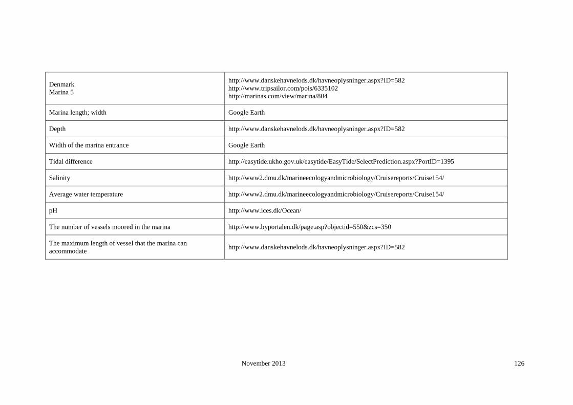
November 2013 126
Denmark
Marina 5
http://www.danskehavnelods.dk/havneoplysninger.aspx?ID=582
http://www.tripsailor.com/pois/6335102
http://marinas.com/view/marina/804
Marina length; width Google Earth
Depth http://www.danskehavnelods.dk/havneoplysninger.aspx?ID=582
Width of the marina entrance Google Earth
Tidal difference http://easytide.ukho.gov.uk/easytide/EasyTide/SelectPrediction.aspx?PortID=1395
Salinity http://www2.dmu.dk/marineecologyandmicrobiology/Cruisereports/Cruise154/
Average water temperature http://www2.dmu.dk/marineecologyandmicrobiology/Cruisereports/Cruise154/
pH http://www.ices.dk/Ocean/
The number of vessels moored in the marina http://www.byportalen.dk/page.asp?objectid=550&zcs=350
The maximum length of vessel that the marina can
accommodate http://www.danskehavnelods.dk/havneoplysninger.aspx?ID=582

November 2013 127
Denmark
Marina 6
http://www.tripsailor.com/pois/6326309-hvide-sande-nordhavn
http://www.hvidesande.dk/havn/
http://marinas.com/view/marina/11366
Marina length; width Google Earth
Depth http://www.hvidesande.dk/havn/tidevand.htm
Width of the marina entrance Google Earth
Tidal difference http://www.hvidesande.dk/havn/tidevand.htm
Salinity http://www.mumm.ac.be/EN/Models/Operational/Salinity/series.php?station=esbjerg
Average water temperature http://marinas.com/view/marina/11366
pH http://www.ices.dk/Ocean/
The number of vessels moored in the marina Google Earth
The maximum length of vessel that the marina can
accommodate http://www.hvidesande.dk/havn/tidevand.htm

November 2013 128
Denmark
Marina 7
http://www.danskehavnelods.dk/havneoplysninger.aspx?ID=584
http://www.blueflag.org/blueflag/2008/Denmark/Regionsyddanmark/BrejningHavn
http://www.brejninghavn.dk/
Marina length; width Google Earth
Depth http://www.danskehavnelods.dk/havneoplysninger.aspx?ID=584
Width of the marina entrance Google Earth
Tidal difference http://www.danskehavnelods.dk/havneoplysninger.aspx?ID=584
Salinity http://www.mumm.ac.be/EN/Models/Operational/Salinity/series.php?station=esbjerg
Average water temperature http://www.mumm.ac.be/EN/Models/Operational/Salinity/series.php?station=esbjerg
pH http://www.ices.dk/Ocean/
The number of vessels moored in the marina http://brejninghavn.dk/index.php?id=92,0,0,1,0,0
The maximum length of vessel that the marina can
accommodate http://www.danskehavnelods.dk/havneoplysninger.aspx?ID=584

November 2013 129
Denmark
Marina 8
http://www.danskehavnelods.dk/havneoplysninger.aspx?ID=90
http://www.tripsailor.com/pois/6325383-gedser-lystbzdehavn
http://marinas.com/view/marina/10516
Marina length; width Google Earth
Depth http://www.danskehavnelods.dk/havneoplysninger.aspx?ID=90
Width of the marina entrance Google Earth
Tidal difference http://easytide.ukho.gov.uk/easytide/EasyTide/SelectPrediction.aspx?PortID=1390
Salinity http://www.mumm.ac.be/EN/Models/Operational/Salinity/series.php?station=esbjerg
Average water temperature http://marinas.com/view/marina/10516
pH http://www.ices.dk/Ocean/
The number of vessels moored in the marina Google Earth
The maximum length of vessel that the marina can
accommodate http://www.danskehavnelods.dk/havneoplysninger.aspx?ID=90

November 2013 130
Denmark
Marina 9
http://marinas.com/view/marina/10756
http://www.tripsailor.com/pois/6325648-havnsz-havn
http://www.danskehavnelods.dk/havneoplysninger.aspx?ID=605
Marina length; width Google Earth
Depth http://www.danskehavnelods.dk/havneoplysninger.aspx?ID=605
Width of the marina entrance Google Earth
Tidal difference http://easytide.ukho.gov.uk/easytide/EasyTide/SelectPrediction.aspx?PortID=1387
Salinity http://www.mumm.ac.be/EN/Models/Operational/Salinity/series.php?station=esbjerg
Average water temperature http://www2.dmu.dk/marineecologyandmicrobiology/Cruisereports/Cruise154/
pH http://www.ices.dk/Ocean/
The number of vessels moored in the marina http://www.visitodsherred.dk/international/engb/menu/turist/oplevelser/aktiviteter/
fritidshavne/produktside/gdk009776/havnsoehavn.htm?wbc_purpose=Basic&CallerUrl=1
The maximum length of vessel that the marina can
accommodate http://www.danskehavnelods.dk/havneoplysninger.aspx?ID=605

November 2013 131
Denmark
Marina 10
http://marinas.com/view/marina/11743
http://www.tripsailor.com/pois/6326708-skagen-havn
http://www.danskehavnelods.dk/havneoplysninger.aspx?ID=827
Marina length; width Google Earth
Depth http://www.danskehavnelods.dk/havneoplysninger.aspx?ID=827
Width of the marina entrance Google Earth
Tidal difference http://www.danskehavnelods.dk/havneoplysninger.aspx?ID=827
Salinity http://www2.dmu.dk/marineecologyandmicrobiology/Cruisereports/Cruise154/
Average water temperature http://www2.dmu.dk/marineecologyandmicrobiology/Cruisereports/Cruise154/
pH http://www.ices.dk/Ocean/
The number of vessels moored in the marina Google Earth
The maximum length of vessel that the marina can
accommodate http://www.danskehavnelods.dk/havneoplysninger.aspx?ID=827

November 2013 132
Estonia
Marina 1 www.marinas.nautilus.ee
Marina length; width Google Earth
Depth www.marinas.nautilus.ee
Width of the marina entrance Google Earth
Tidal difference http://www.fimr.fi/en/itamerinyt/en_GB/vedenkorkeus/#locations
Salinity http://www.estonica.org/eng/lugu.html?kateg=10&menyy_id=515&alam=71&tekst_id=516
Average water temperature http://www.fimr.fi/en/ajankohtaista/mtl_uutisarkisto/2008/en_GB/levauutinen20080718_1_1_1/
pH http://www.ices.dk/Ocean/
The number of vessels moored in the marina www.marinas.nautilus.ee
The maximum length of vessel that the marina can accommodate www.marinas.nautilus.ee

November 2013 133
Estonia
Marina 2 http://www.marinas.nautilus.ee/index.php/database
Marina length; width Google Earth
Depth http://www.marinas.nautilus.ee/index.php/database
Width of the marina entrance Google Earth
Tidal difference http://www.ices.dk/Ocean/
Salinity http://www.estonica.org/eng/lugu.html?kateg=10&menyy_id=515&alam=71&tekst_id=516
Average water temperature http://www.ices.dk/Ocean/
pH http://www.ices.dk/Ocean/
The number of vessels moored in the marina http://www.marinas.nautilus.ee/index.php/database
The maximum length of vessel that the marina can accommodate http://www.marinas.nautilus.ee/index.php/database

November 2013 134
Estonia
Marina 3 http://www.marinas.nautilus.ee/index.php/database
Marina length; width Google Earth
Depth http://www.marinas.nautilus.ee/index.php/database
Width of the marina entrance Google Earth
Tidal difference http://www.fimr.fi/en/itamerinyt/en_GB/vedenkorkeus/#locations
Salinity http://www.modlab.lv/publications/1998/publ3.htm
Average water temperature http://www.fimr.fi/en/ajankohtaista/mtl_uutisarkisto/2008/en_GB/levauutinen20080711_1_1/
pH http://www.ices.dk/Ocean/
The number of vessels moored in the marina http://www.marinas.nautilus.ee/index.php/database
The maximum length of vessel that the marina can accommodate http://www.marinas.nautilus.ee/index.php/database

November 2013 135
Estonia
Marina 4 http://www.marinas.nautilus.ee/index.php/database
Marina length; width Google Earth
Depth http://www.marinas.nautilus.ee/index.php/database
Width of the marina entrance Google Earth
Tidal difference http://www.fimr.fi/en/itamerinyt/en_GB/vedenkorkeus/#locations
Salinity http://www.modlab.lv/publications/1998/publ3.htm
Average water temperature http://www.fimr.fi/en/ajankohtaista/mtl_uutisarkisto/2008/en_GB/levauutinen20080718_1_1_1/
pH http://www.ices.dk/Ocean/
The number of vessels moored in the marina http://www.marinas.nautilus.ee/index.php/database
The maximum length of vessel that the marina can accommodate http://www.marinas.nautilus.ee/index.php/database

November 2013 136
Estonia
Marina 5 http://www.marinas.nautilus.ee/index.php/database
Marina length; width Google Earth
Depth http://www.marinas.nautilus.ee/index.php/database
Width of the marina entrance Google Earth
Tidal difference http://www.fimr.fi/en/itamerinyt/en_GB/vedenkorkeus/#locations
Salinity http://www.estonica.org/eng/lugu.html?kateg=10&menyy_id=515&alam=71&tekst_id=516
Average water temperature http://www.fimr.fi/en/ajankohtaista/mtl_uutisarkisto/2008/en_GB/levauutinen20080711_1_1/
pH http://www.ices.dk/Ocean/
The number of vessels moored in the marina http://www.marinas.nautilus.ee/index.php/database
The maximum length of vessel that the marina can accommodate http://www.marinas.nautilus.ee/index.php/database
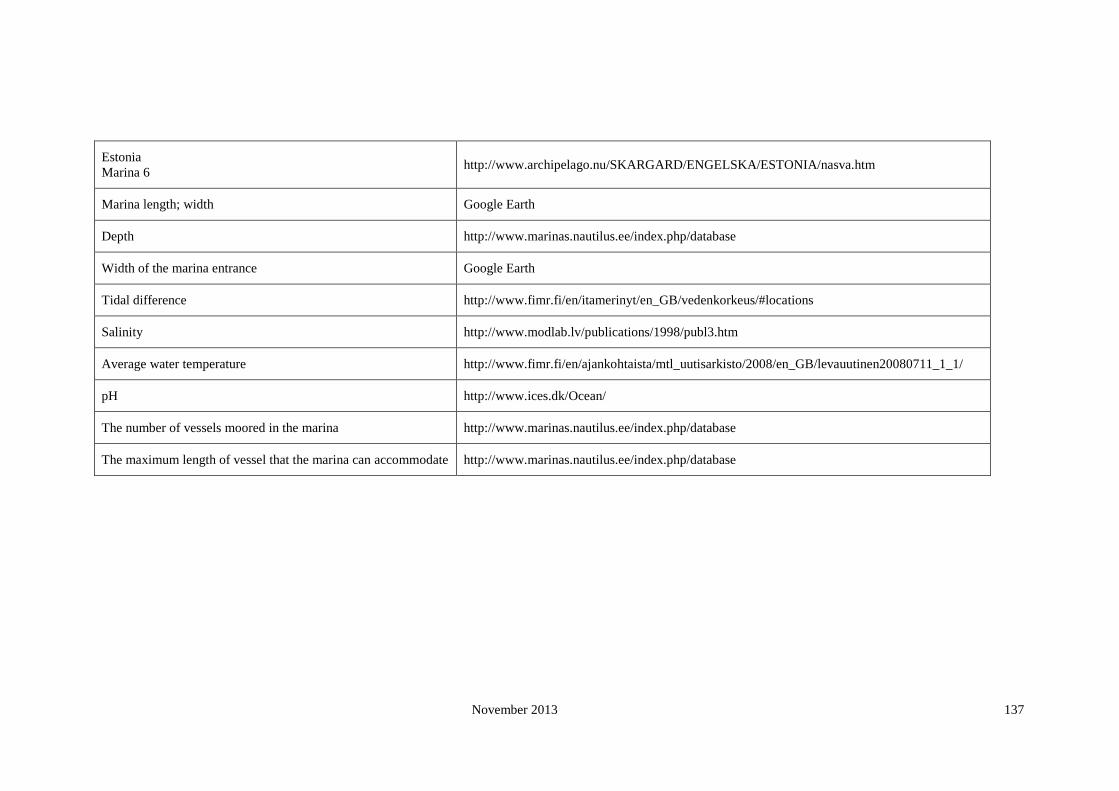
November 2013 137
Estonia
Marina 6 http://www.archipelago.nu/SKARGARD/ENGELSKA/ESTONIA/nasva.htm
Marina length; width Google Earth
Depth http://www.marinas.nautilus.ee/index.php/database
Width of the marina entrance Google Earth
Tidal difference http://www.fimr.fi/en/itamerinyt/en_GB/vedenkorkeus/#locations
Salinity http://www.modlab.lv/publications/1998/publ3.htm
Average water temperature http://www.fimr.fi/en/ajankohtaista/mtl_uutisarkisto/2008/en_GB/levauutinen20080711_1_1/
pH http://www.ices.dk/Ocean/
The number of vessels moored in the marina http://www.marinas.nautilus.ee/index.php/database
The maximum length of vessel that the marina can accommodate http://www.marinas.nautilus.ee/index.php/database

November 2013 138
Estonia
Marina 7 http://www.marinas.nautilus.ee/index.php/database
Marina length; width NA
Depth http://www.marinas.nautilus.ee/index.php/database
Width of the marina entrance NA
Tidal difference NA
Salinity http://www.estonica.org/eng/lugu.html?kateg=10&menyy_id=515&alam=71&tekst_id=516
Average water temperature http://www.fimr.fi/en/ajankohtaista/mtl_uutisarkisto/2008/en_GB/levauutinen20080711_1_1/
pH http://www.ices.dk/Ocean/
The number of vessels moored in the marina http://www.marinas.nautilus.ee/index.php/database
The maximum length of vessel that the marina can accommodate http://www.marinas.nautilus.ee/index.php/database
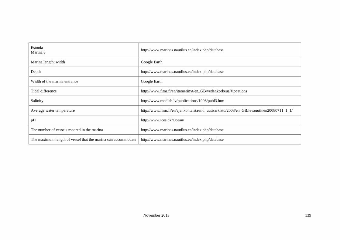
November 2013 139
Estonia
Marina 8 http://www.marinas.nautilus.ee/index.php/database
Marina length; width Google Earth
Depth http://www.marinas.nautilus.ee/index.php/database
Width of the marina entrance Google Earth
Tidal difference http://www.fimr.fi/en/itamerinyt/en_GB/vedenkorkeus/#locations
Salinity http://www.modlab.lv/publications/1998/publ3.htm
Average water temperature http://www.fimr.fi/en/ajankohtaista/mtl_uutisarkisto/2008/en_GB/levauutinen20080711_1_1/
pH http://www.ices.dk/Ocean/
The number of vessels moored in the marina http://www.marinas.nautilus.ee/index.php/database
The maximum length of vessel that the marina can accommodate http://www.marinas.nautilus.ee/index.php/database

November 2013 140
Estonia
Marina 9 http://www.portbooker.com/en/marinas/estonia/saaremaa/kuressaare/roomassaare/
Marina length; width Google Earth
Depth http://www.portbooker.com/en/marinas/estonia/saaremaa/kuressaare/roomassaare/
Width of the marina entrance Google Earth
Tidal difference http://www.fimr.fi/en/ajankohtaista/mtl_uutisarkisto/2008/en_GB/levauutinen20080718_1_1_1/
Salinity http://www.estonica.org/eng/lugu.html?kateg=10&menyy_id=515&alam=71&tekst_id=516
Average water temperature http://www.fimr.fi/en/ajankohtaista/mtl_uutisarkisto/2008/en_GB/levauutinen20080711_1_1/
pH http://www.ices.dk/Ocean/
The number of vessels moored in the marina http://www.portbooker.com/en/marinas/estonia/saaremaa/kuressaare/roomassaare/
The maximum length of vessel that the marina can accommodate http://www.portbooker.com/en/marinas/estonia/saaremaa/kuressaare/roomassaare/

November 2013 141
Estonia
Marina 10 http://www.marinas.nautilus.ee/index.php/database
Marina length; width Google Earth
Depth http://www.marinas.nautilus.ee/index.php/database
Width of the marina entrance Google Earth
Tidal difference http://www.fimr.fi/en/ajankohtaista/mtl_uutisarkisto/2008/en_GB/levauutinen20080718_1_1_1/
Salinity http://www.estonica.org/eng/lugu.html?kateg=10&menyy_id=515&alam=71&tekst_id=516
Average water temperature http://www.fimr.fi/en/ajankohtaista/mtl_uutisarkisto/2008/en_GB/levauutinen20080711_1_1/
pH http://www.ices.dk/Ocean/
The number of vessels moored in the marina http://www.marinas.nautilus.ee/index.php/database
The maximum length of vessel that the marina can accommodate http://www.marinas.nautilus.ee/index.php/database
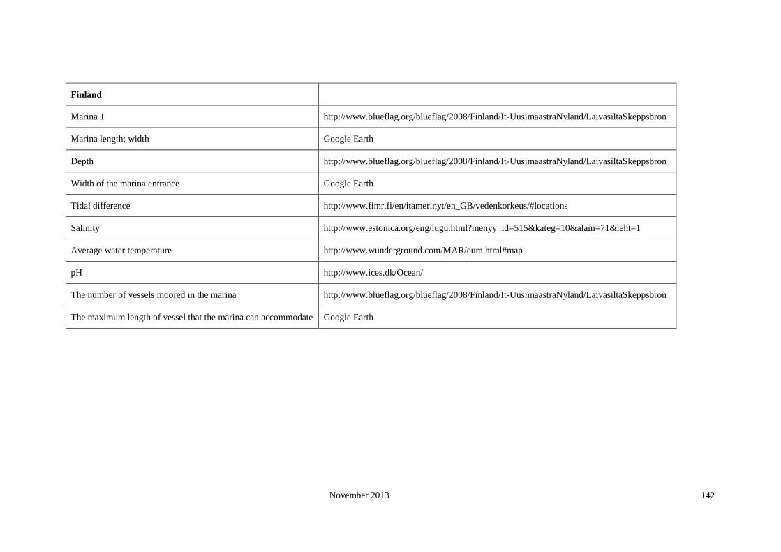
November 2013 142
Finland
Marina 1 http://www.blueflag.org/blueflag/2008/Finland/It-UusimaastraNyland/LaivasiltaSkeppsbron
Marina length; width Google Earth
Depth http://www.blueflag.org/blueflag/2008/Finland/It-UusimaastraNyland/LaivasiltaSkeppsbron
Width of the marina entrance Google Earth
Tidal difference http://www.fimr.fi/en/itamerinyt/en_GB/vedenkorkeus/#locations
Salinity http://www.estonica.org/eng/lugu.html?menyy_id=515&kateg=10&alam=71&leht=1
Average water temperature http://www.wunderground.com/MAR/eum.html#map
pH http://www.ices.dk/Ocean/
The number of vessels moored in the marina http://www.blueflag.org/blueflag/2008/Finland/It-UusimaastraNyland/LaivasiltaSkeppsbron
The maximum length of vessel that the marina can accommodate Google Earth

November 2013 143
Finland
Marina 2 http://marinas.com/view/marina/14058
Marina length; width Google Earth
Depth http://marinas.com/view/marina/14058
Width of the marina entrance Google Earth
Tidal difference http://www.fimr.fi/en/itamerinyt/en_GB/vedenkorkeus/#locations
Salinity http://www.springerlink.com/content/f763565953154102/fulltext.pdf
Average water temperature http://www.helcom.fi/environment2/ifs/ifs2006/en_GB/sst/_print/
http://www.springerlink.com/content/f763565953154102/fulltext.pdf
pH http://www.ices.dk/Ocean/
The number of vessels moored in the marina Google Earth
The maximum length of vessel that the marina can accommodate Google Earth

November 2013 144
Finland
Marina 3 http://marinas.com/view/marina/14061
Marina length; width Google Earth
Depth http://marinas.com/view/marina/14061
Width of the marina entrance Google Earth
Tidal difference http://www.fimr.fi/en/itamerinyt/en_GB/vedenkorkeus/#locations
Salinity http://www.springerlink.com/content/f763565953154102/fulltext.pdf
Average water temperature http://www.helcom.fi/environment2/ifs/ifs2006/en_GB/sst/_print/
http://www.springerlink.com/content/f763565953154102/fulltext.pdf
pH http://www.ices.dk/Ocean/
The number of vessels moored in the marina Google Earth
The maximum length of vessel that the marina can accommodate Google Earth

November 2013 145
Finland
Marina 4 http://marinas.com/view/marina/13195
Marina length; width Google Earth
Depth
Width of the marina entrance Google Earth
Tidal difference http://www.fimr.fi/en/itamerinyt/en_GB/vedenkorkeus/#locations
Salinity http://www.springerlink.com/content/f763565953154102/fulltext.pdf
Average water temperature http://www.helcom.fi/environment2/ifs/ifs2006/en_GB/sst/_print/
http://www.springerlink.com/content/f763565953154102/fulltext.pdf
pH http://www.ices.dk/Ocean/
The number of vessels moored in the marina Google Earth
The maximum length of vessel that the marina can accommodate Google Earth
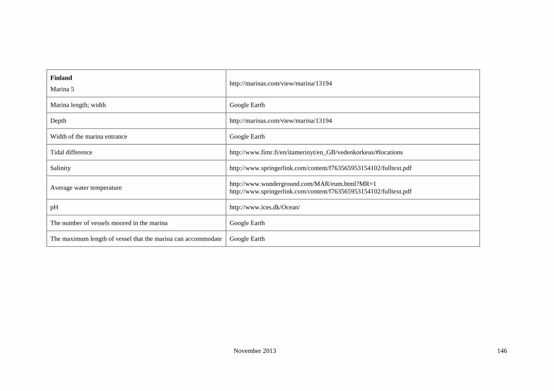
November 2013 146
Finland
Marina 5 http://marinas.com/view/marina/13194
Marina length; width Google Earth
Depth http://marinas.com/view/marina/13194
Width of the marina entrance Google Earth
Tidal difference http://www.fimr.fi/en/itamerinyt/en_GB/vedenkorkeus/#locations
Salinity http://www.springerlink.com/content/f763565953154102/fulltext.pdf
Average water temperature http://www.wunderground.com/MAR/eum.html?MR=1
http://www.springerlink.com/content/f763565953154102/fulltext.pdf
pH http://www.ices.dk/Ocean/
The number of vessels moored in the marina Google Earth
The maximum length of vessel that the marina can accommodate Google Earth
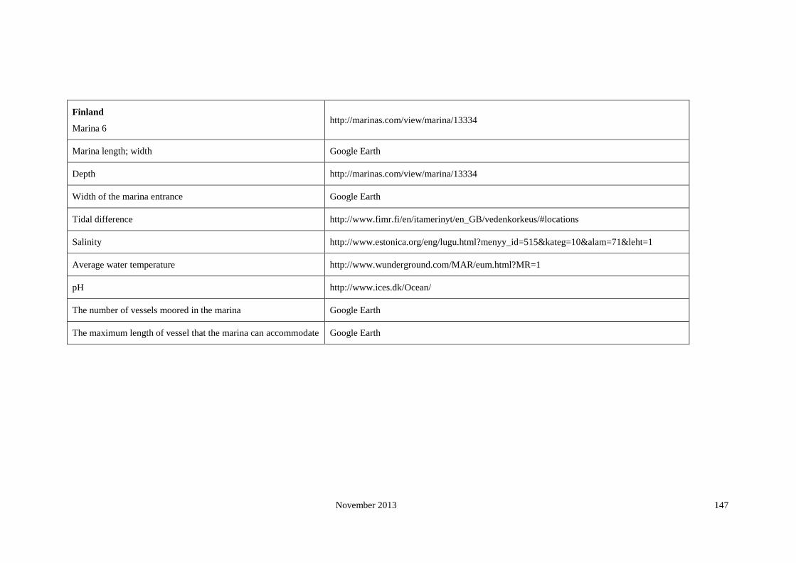
November 2013 147
Finland
Marina 6 http://marinas.com/view/marina/13334
Marina length; width Google Earth
Depth http://marinas.com/view/marina/13334
Width of the marina entrance Google Earth
Tidal difference http://www.fimr.fi/en/itamerinyt/en_GB/vedenkorkeus/#locations
Salinity http://www.estonica.org/eng/lugu.html?menyy_id=515&kateg=10&alam=71&leht=1
Average water temperature http://www.wunderground.com/MAR/eum.html?MR=1
pH http://www.ices.dk/Ocean/
The number of vessels moored in the marina Google Earth
The maximum length of vessel that the marina can accommodate Google Earth

November 2013 148
Finland
Marina 7 http://marinas.com/view/marina/14053
Marina length; width Google Earth
Depth http://marinas.com/view/marina/14053
Width of the marina entrance Google Earth
Tidal difference http://www.fimr.fi/en/itamerinyt/en_GB/vedenkorkeus/#locations
Salinity http://www.estonica.org/eng/lugu.html?menyy_id=515&kateg=10&alam=71&leht=1
Average water temperature http://www.wunderground.com/MAR/eum.html?MR=1
pH http://www.ices.dk/Ocean/
The number of vessels moored in the marina Google Earth
The maximum length of vessel that the marina can accommodate Google Earth

November 2013 149
Finland
Marina 8 http://marinas.com/view/marina/15281
Marina length; width Google Earth
Depth http://marinas.com/view/marina/15281
Width of the marina entrance Google Earth
Tidal difference http://www.fimr.fi/en/itamerinyt/en_GB/vedenkorkeus/#locations
Salinity http://www.springerlink.com/content/f763565953154102/fulltext.pdf
Average water temperature http://www.wunderground.com/MAR/eum.html?MR=1
pH http://www.cfb.ie/salmonid_workshop/timo_yrana.htm
The number of vessels moored in the marina Google Earth
The maximum length of vessel that the marina can accommodate Google Earth

November 2013 150
Finland
Marina 9 http://marinas.com/view/marina/13837
Marina length; width Google Earth
Depth http://marinas.com/view/marina/13837
Width of the marina entrance Google Earth
Tidal difference http://www.fimr.fi/en/itamerinyt/en_GB/vedenkorkeus/#locations
Salinity http://www.springerlink.com/content/f763565953154102/fulltext.pdf
Average water temperature http://www.springerlink.com/content/f763565953154102/fulltext.pdf
pH http://www.ices.dk/Ocean/
The number of vessels moored in the marina Google Earth
The maximum length of vessel that the marina can accommodate Google Earth

November 2013 151
France
Marina 1 Yachting Pages 61
Marina length; width Google Earth
Depth Yachting Pages 61
Width of the marina entrance Google Earth
Tidal difference http://easytide.ukho.gov.uk/easytide/EasyTide/SelectPrediction.aspx?PortID=1785
Salinity Climate Change Scenario for the Mediterranean Sea
Average water temperature Climate Change Scenario for the Mediterranean Sea
pH http://www.ices.dk/Ocean/
The number of vessels moored in the marina Yachting Pages 61
The maximum length of vessel that the marina can accommodate Yachting Pages 61
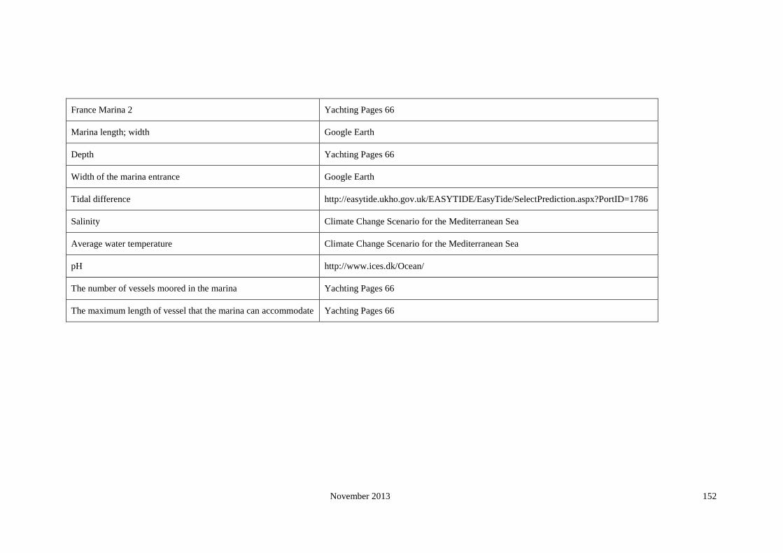
November 2013 152
France Marina 2 Yachting Pages 66
Marina length; width Google Earth
Depth Yachting Pages 66
Width of the marina entrance Google Earth
Tidal difference http://easytide.ukho.gov.uk/EASYTIDE/EasyTide/SelectPrediction.aspx?PortID=1786
Salinity Climate Change Scenario for the Mediterranean Sea
Average water temperature Climate Change Scenario for the Mediterranean Sea
pH http://www.ices.dk/Ocean/
The number of vessels moored in the marina Yachting Pages 66
The maximum length of vessel that the marina can accommodate Yachting Pages 66

November 2013 153
France Marina 3 Yachting Pages 73
Marina length; width Google Earth
Depth Yachting Pages 73
Width of the marina entrance Google Earth
Tidal difference http://easytide.ukho.gov.uk/EASYTIDE/EasyTide/SelectPrediction.aspx?PortID=1789
Salinity Climate Change Scenario for the Mediterranean Sea
Average water temperature Climate Change Scenario for the Mediterranean Sea
pH http://www.ices.dk/Ocean/
The number of vessels moored in the marina Yachting Pages 73
The maximum length of vessel that the marina can accommodate Yachting Pages 73
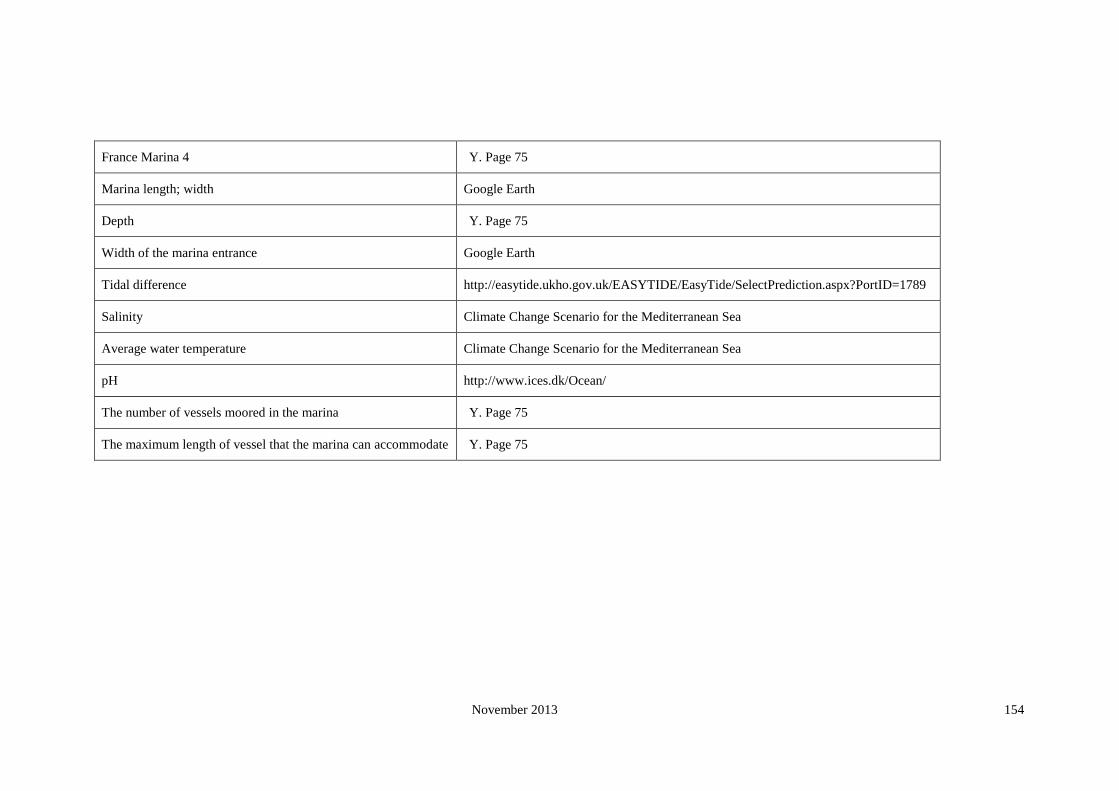
November 2013 154
France Marina 4 Y. Page 75
Marina length; width Google Earth
Depth Y. Page 75
Width of the marina entrance Google Earth
Tidal difference http://easytide.ukho.gov.uk/EASYTIDE/EasyTide/SelectPrediction.aspx?PortID=1789
Salinity Climate Change Scenario for the Mediterranean Sea
Average water temperature Climate Change Scenario for the Mediterranean Sea
pH http://www.ices.dk/Ocean/
The number of vessels moored in the marina Y. Page 75
The maximum length of vessel that the marina can accommodate Y. Page 75

November 2013 155
France Marina 5 Y. Page 89
Marina length; width Google Earth
Depth Y. Page 89
Width of the marina entrance Google Earth
Tidal difference http://easytide.ukho.gov.uk/EASYTIDE/EasyTide/SelectPrediction.aspx?PortID=1789
Salinity Climate Change Scenario for the Mediterranean Sea
Average water temperature Climate Change Scenario for the Mediterranean Sea
pH http://www.ices.dk/Ocean/
The number of vessels moored in the marina Y. Page 89
The maximum length of vessel that the marina can accommodate Y. Page 89

November 2013 156
France Marina 6 Y. Page 91
Marina length; width Google Earth
Depth Y. Page 91
Width of the marina entrance Google Earth
Tidal difference http://easytide.ukho.gov.uk/EASYTIDE/EasyTide/SelectPrediction.aspx?PortID=1789
Salinity Climate Change Scenario for the Mediterranean Sea
Average water temperature Climate Change Scenario for the Mediterranean Sea
pH http://www.ices.dk/Ocean/
The number of vessels moored in the marina Y. Page 91
The maximum length of vessel that the marina can accommodate Y. Page 91

November 2013 157
France Marina 7 Y. Page 92
Marina length; width Google Earth
Depth Y. Page 92
Width of the marina entrance Google Earth
Tidal difference http://easytide.ukho.gov.uk/EASYTIDE/EasyTide/SelectPrediction.aspx?PortID=1790
Salinity Climate Change Scenario for the Mediterranean Sea
Average water temperature Climate Change Scenario for the Mediterranean Sea
pH http://www.ices.dk/Ocean/
The number of vessels moored in the marina Y. Page 92
The maximum length of vessel that the marina can accommodate Y. Page 92

November 2013 158
France Marina 8 Y. Page 98
Marina length; width Google Earth
Depth Y. Page 98
Width of the marina entrance Google Earth
Tidal difference http://easytide.ukho.gov.uk/EASYTIDE/EasyTide/SelectPrediction.aspx?PortID=1790
Salinity Climate Change Scenario for the Mediterranean Sea
Average water temperature Climate Change Scenario for the Mediterranean Sea
pH http://www.ices.dk/Ocean/
The number of vessels moored in the marina Y. Page 98
The maximum length of vessel that the marina can accommodate Y. Page 98

November 2013 159
France Marina 9 Y. Page 69
Marina length; width Google Earth
Depth Y. Page 69
Width of the marina entrance Google Earth
Tidal difference http://easytide.ukho.gov.uk/EASYTIDE/EasyTide/SelectPrediction.aspx?PortID=1786
Salinity Climate Change Scenario for the Mediterranean Sea
Average water temperature Climate Change Scenario for the Mediterranean Sea
pH http://www.ices.dk/Ocean/
The number of vessels moored in the marina Y. Page 69
The maximum length of vessel that the marina can accommodate Y. Page 69

November 2013 160
France Marina 10 Y. Page 90
Marina length; width Google Earth
Depth Y. Page 90
Width of the marina entrance Google Earth
Tidal difference http://easytide.ukho.gov.uk/EASYTIDE/EasyTide/SelectPrediction.aspx?PortID=1789
Salinity Climate Change Scenario for the Mediterranean Sea
Average water temperature Climate Change Scenario for the Mediterranean Sea
pH http://www.ices.dk/Ocean/
The number of vessels moored in the marina Y. Page 90
The maximum length of vessel that the marina can accommodate Y. Page 90

November 2013 161
Germany
Marina 1 http://www.tripsailor.com/pois/6353151-nordsee-marina
http://www.marina-bremerhaven.de/
Marina length; width Google Earth
Depth http://www.marina-bremerhaven.de/
Width of the marina entrance Google Earth
Tidal difference http://www.bsh.de/cgi-bin/gezeiten/was_tab_e.pl?ort=DE__103P&zone=Legal+time+%B9&niveau=NN
Salinity http://www.mumm.ac.be/EN/Models/Operational/Temperature/series.php?station=bremerhaven
Average water temperature (Arkona SST)
pH http://www.ices.dk/Ocean/
http://www.meteo24.de/wetter/49X492.html
The number of vessels moored in the marina http://www.marina-bremerhaven.de/
The maximum length of vessel that the marina can
accommodate http://www.marina-bremerhaven.de/

November 2013 162
Germany Marina 2 www.ancora-marina.com
Marina length; width Google Earth
Depth www.ancora-marina.com
Width of the marina entrance Google Earth
Tidal difference http://www.bsh.de/aktdat/wvd/wahome.htm
Salinity http://www.fimr.fi/en/tietoa/algaline_seuranta/mittaustulosarkisto/2008/en_GB/1208075859728_1_1_2_1/
Average water temperature
(Arkona SST)
Development of Sea Surface Temperature in the Baltic Sea in 2005
http://www.meteo24.de/wetter/49X492.html
pH http://www.ices.dk/Ocean/
The number of vessels moored in the marina www.ancora-marina.com
The maximum length of vessel that the marina can
accommodate www.ancora-marina.com

November 2013 163
Germany Marina 3 http://www.portbooker.com/en/marinas/germany/fehmarn-to-warnemunde/kuhlungsborn/kuhlungsborn/
Marina length; width Google Earth
Depth http://www.portbooker.com/en/marinas/germany/fehmarn-to-warnemunde/kuhlungsborn/kuhlungsborn/
Width of the marina entrance Google Earth
Tidal difference http://www.bsh.de/aktdat/wvd/wahome.htm
Salinity http://www.fimr.fi/en/tietoa/algaline_seuranta/mittaustulosarkisto/2008/en_GB/1208075859728_1_1_2_1/
Average water temperature http://www.bsh.de/en/Marine_data/Observations/MURSYS_reporting_system/mursys0108.jsp
pH http://www.ices.dk/Ocean/
The number of vessels moored in the marina http://www.portbooker.com/en/marinas/germany/fehmarn-to-warnemunde/kuhlungsborn/kuhlungsborn/
The maximum length of vessel that the marina can
accommodate http://www.portbooker.com/en/marinas/germany/fehmarn-to-warnemunde/kuhlungsborn/kuhlungsborn/

November 2013 164
Germany Marina 4 http://www.blueflag.org/blueflag/2008/Germany/Schleswig-Holstein/HamburgerYachthafen-Gemeinschaft
http://www.hamburger-yachthafen.de/
Marina length; width Google Earth
Depth NA
Width of the marina entrance Google Earth
Tidal difference http://www.bsh.de/cgi-bin/gezeiten/was_tab_e.pl?ort=DE__508P&zone=Legal+time+%B9&niveau=NN
Salinity http://www.fimr.fi/en/tietoa/algaline_seuranta/mittaustulosarkisto/2008/en_GB/1208075859728_1_1_2_1/
Average water temperature (5/8) SST, Google E
pH http://www.ices.dk/Ocean/
The number of vessels moored in the marina http://www.hamburger-yachthafen.de/
The maximum length of vessel that the marina can
accommodate Google Earth

November 2013 165
Germany Marina 5 http://marinas.com/view/marina/9305
Marina length; width Google Earth
Depth http://marinas.com/view/marina/9305
Width of the marina entrance Google Earth
Tidal difference http://www.bsh.de/cgi-bin/gezeiten/was_tab_e.pl?ort=DE__631P&zone=MEZ&niveau=KN
Salinity http://www.mumm.ac.be/EN/Models/Operational/Salinity/series.php?station=husum
Average water temperature http://www.tripsailor.com/pois/6336479-amrum-hafen-marina
pH http://www.ices.dk/Ocean/
The number of vessels moored in the marina Google Earth
The maximum length of vessel that the marina can
accommodate Google Earth

November 2013 166
Germany Marina 6 http://www.blueflag.org/blueflag/2008/Germany/Schleswig-Holstein/YachthafenMaasholm
Marina length; width Google Earth
Depth NA
Width of the marina entrance Google Earth
Tidal difference http://www.bsh.de/aktdat/wvd/wahome.htm
Salinity http://www.ices.dk/Ocean/
Average water temperature (Arkona SST)
pH http://www.ices.dk/Ocean/
The number of vessels moored in the marina http://www.tripsailor.com/pois/6336796-maasholm-marina
The maximum length of vessel that the marina can
accommodate Google Earth

November 2013 167
Germany Marina 7
http://www.blueflag.org/blueflag/2008/Germany/Schleswig-Holstein/YachthafenLaboe
http://marinas.com/view/marina/9453
http://www.laboe.de/portal_1000.htm
Marina length; width Google Earth
Depth NA
Width of the marina entrance Google Earth
Tidal difference http://www.bsh.de/aktdat/wvd/wahome.htm
Salinity http://www.ices.dk/Ocean/
Average water temperature http://www.tripsailor.com/pois/6336643-fischenhafen-laboe/marinas
(Arkona SST)
pH http://www.ices.dk/Ocean/
The number of vessels moored in the marina Google Earth
The maximum length of vessel that the marina can
accommodate Google Earth
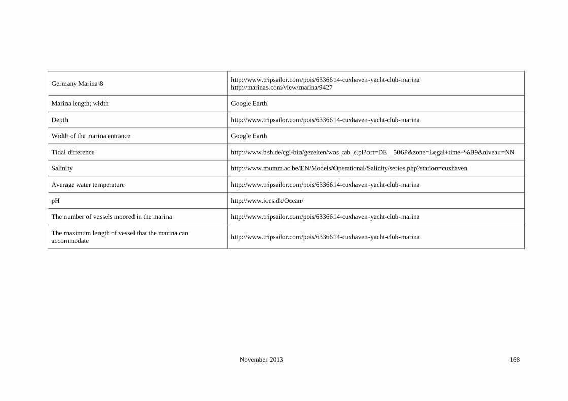
November 2013 168
Germany Marina 8 http://www.tripsailor.com/pois/6336614-cuxhaven-yacht-club-marina
http://marinas.com/view/marina/9427
Marina length; width Google Earth
Depth http://www.tripsailor.com/pois/6336614-cuxhaven-yacht-club-marina
Width of the marina entrance Google Earth
Tidal difference http://www.bsh.de/cgi-bin/gezeiten/was_tab_e.pl?ort=DE__506P&zone=Legal+time+%B9&niveau=NN
Salinity http://www.mumm.ac.be/EN/Models/Operational/Salinity/series.php?station=cuxhaven
Average water temperature http://www.tripsailor.com/pois/6336614-cuxhaven-yacht-club-marina
pH http://www.ices.dk/Ocean/
The number of vessels moored in the marina http://www.tripsailor.com/pois/6336614-cuxhaven-yacht-club-marina
The maximum length of vessel that the marina can
accommodate http://www.tripsailor.com/pois/6336614-cuxhaven-yacht-club-marina
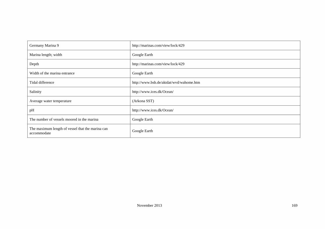
November 2013 169
Germany Marina 9 http://marinas.com/view/lock/429
Marina length; width Google Earth
Depth http://marinas.com/view/lock/429
Width of the marina entrance Google Earth
Tidal difference http://www.bsh.de/aktdat/wvd/wahome.htm
Salinity http://www.ices.dk/Ocean/
Average water temperature (Arkona SST)
pH http://www.ices.dk/Ocean/
The number of vessels moored in the marina Google Earth
The maximum length of vessel that the marina can
accommodate Google Earth

November 2013 170
Germany Marina 10 http://www.blueflag.org/blueflag/2008/Germany/Schleswig-Holstein/HafenOrthGmbH
Marina length; width Google Earth
Depth http://www.hafen-orth.de/hafen.html
Width of the marina entrance Google Earth
Tidal difference http://www.bsh.de/aktdat/wvd/wahome.htm
Salinity http://www.ices.dk/Ocean/
Average water temperature (Arkona SST)
pH http://www.ices.dk/Ocean/
The number of vessels moored in the marina http://www.blueflag.org/blueflag/2008/Germany/Schleswig-Holstein/HafenOrthGmbH
The maximum length of vessel that the marina can
accommodate Google Earth
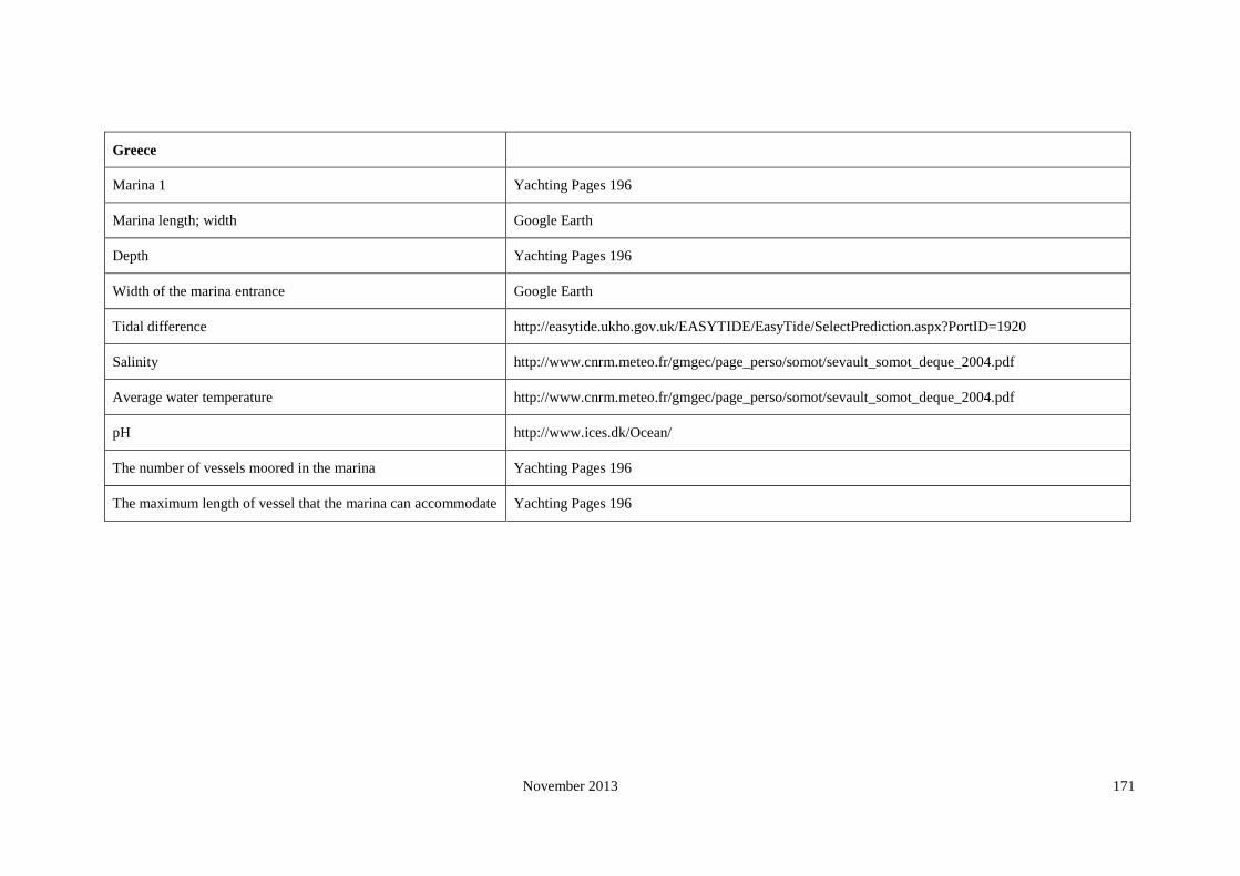
November 2013 171
Greece
Marina 1 Yachting Pages 196
Marina length; width Google Earth
Depth Yachting Pages 196
Width of the marina entrance Google Earth
Tidal difference http://easytide.ukho.gov.uk/EASYTIDE/EasyTide/SelectPrediction.aspx?PortID=1920
Salinity http://www.cnrm.meteo.fr/gmgec/page_perso/somot/sevault_somot_deque_2004.pdf
Average water temperature http://www.cnrm.meteo.fr/gmgec/page_perso/somot/sevault_somot_deque_2004.pdf
pH http://www.ices.dk/Ocean/
The number of vessels moored in the marina Yachting Pages 196
The maximum length of vessel that the marina can accommodate Yachting Pages 196

November 2013 172
Greece Marina 2 Yachting Pages 199
Marina length; width Google Earth
Depth Yachting Pages 199
Width of the marina entrance Google Earth
Tidal difference http://easytide.ukho.gov.uk/EASYTIDE/EasyTide/SelectPrediction.aspx?PortID=1920
Salinity http://www.cnrm.meteo.fr/gmgec/page_perso/somot/sevault_somot_deque_2004.pdf
Average water temperature http://www.cnrm.meteo.fr/gmgec/page_perso/somot/sevault_somot_deque_2004.pdf
pH http://www.ices.dk/Ocean/
The number of vessels moored in the marina Yachting Pages 199
The maximum length of vessel that the marina can accommodate Yachting Pages 199

November 2013 173
Greece Marina 3 Yachting Pages 200
Marina length; width Google Earth
Depth Yachting Pages 200
Width of the marina entrance Google Earth
Tidal difference http://easytide.ukho.gov.uk/EASYTIDE/EasyTide/SelectPrediction.aspx?PortID=1920
Salinity http://www.cnrm.meteo.fr/gmgec/page_perso/somot/sevault_somot_deque_2004.pdf
Average water temperature http://www.cnrm.meteo.fr/gmgec/page_perso/somot/sevault_somot_deque_2004.pdf
pH http://www.ices.dk/Ocean/
The number of vessels moored in the marina Yachting Pages 200
The maximum length of vessel that the marina can accommodate Yachting Pages 200

November 2013 174
Greece Marina 4 Yachting Pages 201
Marina length; width Google Earth
Depth Yachting Pages 201
Width of the marina entrance Google Earth
Tidal difference http://easytide.ukho.gov.uk/EASYTIDE/EasyTide/SelectPrediction.aspx?PortID=1920
Salinity http://www.cnrm.meteo.fr/gmgec/page_perso/somot/sevault_somot_deque_2004.pdf
Average water temperature http://www.cnrm.meteo.fr/gmgec/page_perso/somot/sevault_somot_deque_2004.pdf
pH http://www.ices.dk/Ocean/
The number of vessels moored in the marina Yachting Pages 201
The maximum length of vessel that the marina can accommodate Yachting Pages 201

November 2013 175
Greece Marina 5 Yachting Pages 202
Marina length; width Google Earth
Depth Yachting Pages 202
Width of the marina entrance Google Earth
Tidal difference http://easytide.ukho.gov.uk/EASYTIDE/EasyTide/SelectPrediction.aspx?PortID=1920
Salinity http://www.cnrm.meteo.fr/gmgec/page_perso/somot/sevault_somot_deque_2004.pdf
Average water temperature http://www.cnrm.meteo.fr/gmgec/page_perso/somot/sevault_somot_deque_2004.pdf
pH http://www.ices.dk/Ocean/
The number of vessels moored in the marina Yachting Pages 202
The maximum length of vessel that the marina can accommodate Yachting Pages 202

November 2013 176
Greece Marina 6 Yachting Pages 203
Marina length; width Google Earth
Depth Yachting Pages 203
Width of the marina entrance Google Earth
Tidal difference http://easytide.ukho.gov.uk/EASYTIDE/EasyTide/SelectPrediction.aspx?PortID=1972
Salinity http://www.cnrm.meteo.fr/gmgec/page_perso/somot/sevault_somot_deque_2004.pdf
Average water temperature http://www.cnrm.meteo.fr/gmgec/page_perso/somot/sevault_somot_deque_2004.pdf
pH http://www.ices.dk/Ocean/
The number of vessels moored in the marina Yachting Pages 203
The maximum length of vessel that the marina can accommodate Yachting Pages 203
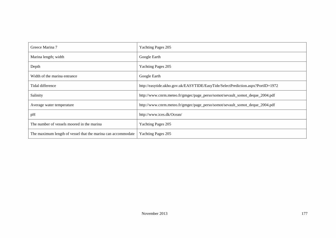
November 2013 177
Greece Marina 7 Yachting Pages 205
Marina length; width Google Earth
Depth Yachting Pages 205
Width of the marina entrance Google Earth
Tidal difference http://easytide.ukho.gov.uk/EASYTIDE/EasyTide/SelectPrediction.aspx?PortID=1972
Salinity http://www.cnrm.meteo.fr/gmgec/page_perso/somot/sevault_somot_deque_2004.pdf
Average water temperature http://www.cnrm.meteo.fr/gmgec/page_perso/somot/sevault_somot_deque_2004.pdf
pH http://www.ices.dk/Ocean/
The number of vessels moored in the marina Yachting Pages 205
The maximum length of vessel that the marina can accommodate Yachting Pages 205
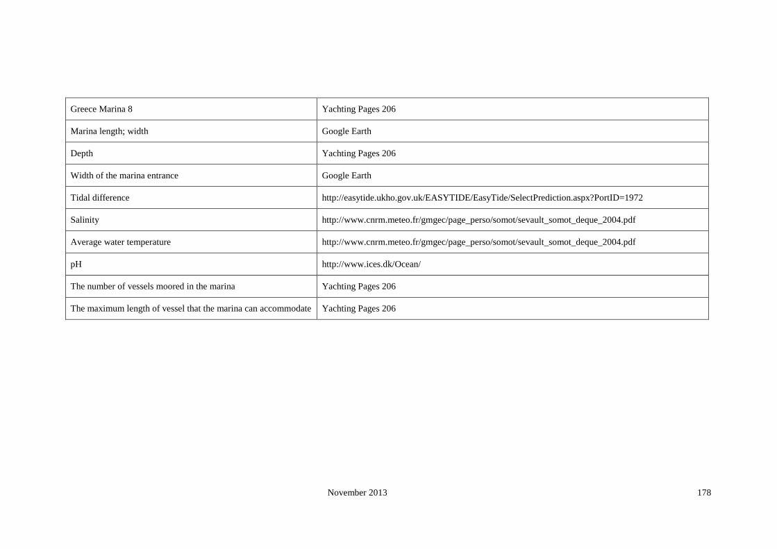
November 2013 178
Greece Marina 8 Yachting Pages 206
Marina length; width Google Earth
Depth Yachting Pages 206
Width of the marina entrance Google Earth
Tidal difference http://easytide.ukho.gov.uk/EASYTIDE/EasyTide/SelectPrediction.aspx?PortID=1972
Salinity http://www.cnrm.meteo.fr/gmgec/page_perso/somot/sevault_somot_deque_2004.pdf
Average water temperature http://www.cnrm.meteo.fr/gmgec/page_perso/somot/sevault_somot_deque_2004.pdf
pH http://www.ices.dk/Ocean/
The number of vessels moored in the marina Yachting Pages 206
The maximum length of vessel that the marina can accommodate Yachting Pages 206

November 2013 179
Greece Marina 9 Yachting Pages 207
Marina length; width Google Earth
Depth Yachting Pages 207
Width of the marina entrance Google Earth
Tidal difference http://easytide.ukho.gov.uk/EASYTIDE/EasyTide/SelectPrediction.aspx?PortID=1943
Salinity http://www.cnrm.meteo.fr/gmgec/page_perso/somot/sevault_somot_deque_2004.pdf
Average water temperature http://www.cnrm.meteo.fr/gmgec/page_perso/somot/sevault_somot_deque_2004.pdf
pH http://www.ices.dk/Ocean/
The number of vessels moored in the marina Yachting Pages 207
The maximum length of vessel that the marina can accommodate Yachting Pages 207

November 2013 180
Greece Marina 10 Yachting Pages 208
Marina length; width Google Earth
Depth Yachting Pages 208
Width of the marina entrance Google Earth
Tidal difference http://easytide.ukho.gov.uk/EASYTIDE/EasyTide/SelectPrediction.aspx?PortID=1972
Salinity http://www.cnrm.meteo.fr/gmgec/page_perso/somot/sevault_somot_deque_2004.pdf
Average water temperature http://www.cnrm.meteo.fr/gmgec/page_perso/somot/sevault_somot_deque_2004.pdf
pH http://www.ices.dk/Ocean/
The number of vessels moored in the marina Yachting Pages 208
The maximum length of vessel that the marina can accommodate Yachting Pages 208

November 2013 181
Italy
Italy Marina 1 Yachting Pages 116
Marina length; width Google Earth
Depth Yachting Pages 116
Width of the marina entrance Google Earth
Tidal difference http://easytide.ukho.gov.uk/easytide/EasyTide/SelectPrediction.aspx?PortID=1850
Salinity http://www.cnrm.meteo.fr/gmgec/page_perso/somot/sevault_somot_deque_2004.pdf
Average water temperature http://www.cnrm.meteo.fr/gmgec/page_perso/somot/sevault_somot_deque_2004.pdf
pH http://www.ices.dk/Ocean/
The number of vessels moored in the marina Yachting Pages 116
The maximum length of vessel that the marina can accommodate Yachting Pages 116

November 2013 182
Italy Marina 2 Yachting Pages 122
Marina length; width Google Earth
Depth Yachting Pages 122
Width of the marina entrance Google Earth
Tidal difference http://easytide.ukho.gov.uk/easytide/EasyTide/SelectPrediction.aspx?PortID=1851
Salinity http://www.cnrm.meteo.fr/gmgec/page_perso/somot/sevault_somot_deque_2004.pdf
Average water temperature http://www.cnrm.meteo.fr/gmgec/page_perso/somot/sevault_somot_deque_2004.pdf
pH http://www.ices.dk/Ocean/
The number of vessels moored in the marina Yachting Pages 122
The maximum length of vessel that the marina can accommodate Yachting Pages 122
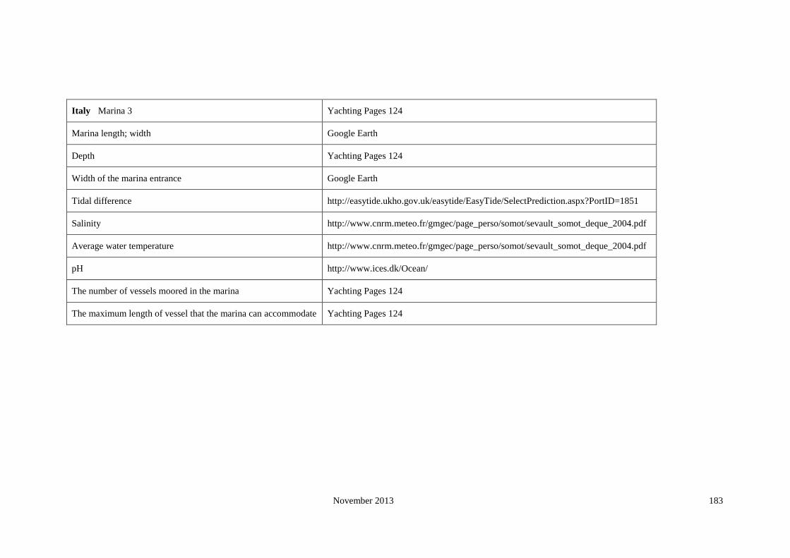
November 2013 183
Italy Marina 3 Yachting Pages 124
Marina length; width Google Earth
Depth Yachting Pages 124
Width of the marina entrance Google Earth
Tidal difference http://easytide.ukho.gov.uk/easytide/EasyTide/SelectPrediction.aspx?PortID=1851
Salinity http://www.cnrm.meteo.fr/gmgec/page_perso/somot/sevault_somot_deque_2004.pdf
Average water temperature http://www.cnrm.meteo.fr/gmgec/page_perso/somot/sevault_somot_deque_2004.pdf
pH http://www.ices.dk/Ocean/
The number of vessels moored in the marina Yachting Pages 124
The maximum length of vessel that the marina can accommodate Yachting Pages 124

November 2013 184
Italy Marina 4 Y. Page 125
Marina length; width Google Earth
Depth Y. Page 125
Width of the marina entrance Google Earth
Tidal difference http://easytide.ukho.gov.uk/easytide/EasyTide/SelectPrediction.aspx?PortID=1851
Salinity http://www.cnrm.meteo.fr/gmgec/page_perso/somot/sevault_somot_deque_2004.pdf
Average water temperature http://www.cnrm.meteo.fr/gmgec/page_perso/somot/sevault_somot_deque_2004.pdf
pH http://www.ices.dk/Ocean/
The number of vessels moored in the marina Y. Page 125
The maximum length of vessel that the marina can accommodate Y. Page 125

November 2013 185
Italy Marina 5 Y. Page 126
Marina length; width Google Earth
Depth Y. Page 126
Width of the marina entrance Google Earth
Tidal difference http://easytide.ukho.gov.uk/easytide/EasyTide/SelectPrediction.aspx?PortID=1851A
Salinity http://www.cnrm.meteo.fr/gmgec/page_perso/somot/sevault_somot_deque_2004.pdf
Average water temperature http://www.cnrm.meteo.fr/gmgec/page_perso/somot/sevault_somot_deque_2004.pdf
pH http://www.ices.dk/Ocean/
The number of vessels moored in the marina Y. Page 126
The maximum length of vessel that the marina can accommodate Y. Page 126

November 2013 186
Italy Marina 6 Y. Page 129
Marina length; width Google Earth
Depth Y. Page 129
Width of the marina entrance Google Earth
Tidal difference http://easytide.ukho.gov.uk/easytide/EasyTide/SelectPrediction.aspx?PortID=1852
Salinity http://www.cnrm.meteo.fr/gmgec/page_perso/somot/sevault_somot_deque_2004.pdf
Average water temperature http://www.cnrm.meteo.fr/gmgec/page_perso/somot/sevault_somot_deque_2004.pdf
pH http://www.ices.dk/Ocean/
The number of vessels moored in the marina Y. Page 129
The maximum length of vessel that the marina can accommodate Y. Page 129

November 2013 187
Italy Marina 7 Y. Page 130
Marina length; width Google Earth
Depth Y. Page 130
Width of the marina entrance Google Earth
Tidal difference http://easytide.ukho.gov.uk/easytide/EasyTide/SelectPrediction.aspx?PortID=1852
Salinity http://www.cnrm.meteo.fr/gmgec/page_perso/somot/sevault_somot_deque_2004.pdf
Average water temperature http://www.cnrm.meteo.fr/gmgec/page_perso/somot/sevault_somot_deque_2004.pdf
pH http://www.ices.dk/Ocean/
The number of vessels moored in the marina Y. Page 130
The maximum length of vessel that the marina can accommodate Y. Page 130
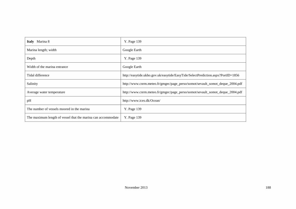
November 2013 188
Italy Marina 8 Y. Page 139
Marina length; width Google Earth
Depth Y. Page 139
Width of the marina entrance Google Earth
Tidal difference http://easytide.ukho.gov.uk/easytide/EasyTide/SelectPrediction.aspx?PortID=1856
Salinity http://www.cnrm.meteo.fr/gmgec/page_perso/somot/sevault_somot_deque_2004.pdf
Average water temperature http://www.cnrm.meteo.fr/gmgec/page_perso/somot/sevault_somot_deque_2004.pdf
pH http://www.ices.dk/Ocean/
The number of vessels moored in the marina Y. Page 139
The maximum length of vessel that the marina can accommodate Y. Page 139

November 2013 189
Italy Marina 9 Y. Page 142
Marina length; width Google Earth
Depth Y. Page 142
Width of the marina entrance Google Earth
Tidal difference http://easytide.ukho.gov.uk/easytide/EasyTide/SelectPrediction.aspx?PortID=1867
Salinity http://www.cnrm.meteo.fr/gmgec/page_perso/somot/sevault_somot_deque_2004.pdf
Average water temperature http://www.cnrm.meteo.fr/gmgec/page_perso/somot/sevault_somot_deque_2004.pdf
pH http://www.ices.dk/Ocean/
The number of vessels moored in the marina Y. Page 142
The maximum length of vessel that the marina can accommodate Y. Page 142

November 2013 190
Italy Marina 10 Y. Page 147
Marina length; width Google Earth
Depth Y. Page 147
Width of the marina entrance Google Earth
Tidal difference http://easytide.ukho.gov.uk/easytide/EasyTide/SelectPrediction.aspx?PortID=1867
Salinity http://www.cnrm.meteo.fr/gmgec/page_perso/somot/sevault_somot_deque_2004.pdf
Average water temperature http://www.cnrm.meteo.fr/gmgec/page_perso/somot/sevault_somot_deque_2004.pdf
pH http://www.ices.dk/Ocean/
The number of vessels moored in the marina Y. Page 147
The maximum length of vessel that the marina can accommodate Y. Page 147

November 2013 191
Ireland
Marina 1 http://www.marina-guide.eu/en/marinas/
www.marinamap.com
Marina length; width Googl Earth
Depth http://www.marina-guide.eu/en/marinas/
Width of the marina entrance Googl Earth
Tidal difference http://easytide.ukho.gov.uk
Salinity (annual world salinity/2005)
Average water temperature annual seasurface temperature 2005
pH http://www.ices.dk/Ocean/
The number of vessels moored in the marina http://www.marina-guide.eu/en/marinas/
The maximum length of vessel that the marina can accommodate http://www.marina-guide.eu/en/marinas/

November 2013 192
Ireland Marina 2 http://www.portbooker.com/en/marinas/ireland/fingal-(fine-gall)/dublin/howth-yacht-club---marina/
Marina length; width Googl Earth
Depth http://www.portbooker.com/en/marinas/ireland/fingal-(fine-gall)/dublin/howth-yacht-club---marina/
Width of the marina entrance Googl Earth
Tidal difference http://easytide.ukho.gov.uk
Salinity (annual world salinity/2005)
Average water temperature annual seasurface temperature 2005
pH http://www.ices.dk/Ocean/
The number of vessels moored in the marina http://www.portbooker.com/en/marinas/ireland/fingal-(fine-gall)/dublin/howth-yacht-club---marina/
The maximum length of vessel that the marina can accommodate http://www.portbooker.com/en/marinas/ireland/fingal-(fine-gall)/dublin/howth-yacht-club---marina/

November 2013 193
Ireland Marina 3
Marina length; width Googl Earth
Depth http://www.portbooker.com/en/marinas/ireland/donegal-(dun-na-ngall)/fahan/lough-swilly-marina/
Width of the marina entrance Googl Earth
Tidal difference http://easytide.ukho.gov.uk
Salinity (annual world salinity/2005)
Average water temperature annual seasurface temperature 2005
pH http://www.ices.dk/Ocean/
The number of vessels moored in the marina http://www.portbooker.com/en/marinas/ireland/donegal-(dun-na-ngall)/fahan/lough-swilly-marina/
The maximum length of vessel that the marina can accommodate http://www.portbooker.com/en/marinas/ireland/donegal-(dun-na-ngall)/fahan/lough-swilly-marina/

November 2013 194
Ireland Marina 4 http://www.marina-guide.eu/en/marinas/
Marina length; width Googl Earth
Depth http://www.marina-guide.eu/en/marinas/
Width of the marina entrance Googl Earth
Tidal difference http://easytide.ukho.gov.uk
Salinity (annual world salinity/2005)
Average water temperature annual seasurface temperature 2005
pH http://www.ices.dk/Ocean/
The number of vessels moored in the marina http://www.marina-guide.eu/en/marinas/
The maximum length of vessel that the marina can accommodate http://www.marina-guide.eu/en/marinas/

November 2013 195
Ireland Marina 5 http://www.portbooker.com/en/marinas/ireland/fingal-(fine-gall)/dublin/poolbeg-marina/
Marina length; width Googl Earth
Depth http://www.portbooker.com/en/marinas/ireland/fingal-(fine-gall)/dublin/poolbeg-marina/
Width of the marina entrance Googl Earth
Tidal difference http://easytide.ukho.gov.uk
Salinity (annual world salinity/2005)
Average water temperature annual seasurface temperature 2005
pH http://www.ices.dk/Ocean/
The number of vessels moored in the marina http://www.portbooker.com/en/marinas/ireland/fingal-(fine-gall)/dublin/poolbeg-marina/
The maximum length of vessel that the marina can accommodate http://www.portbooker.com/en/marinas/ireland/fingal-(fine-gall)/dublin/poolbeg-marina/
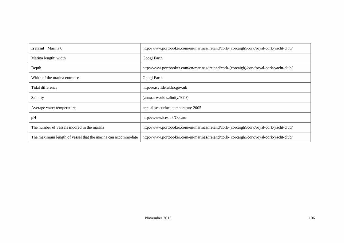
November 2013 196
Ireland Marina 6 http://www.portbooker.com/en/marinas/ireland/cork-(corcaigh)/cork/royal-cork-yacht-club/
Marina length; width Googl Earth
Depth http://www.portbooker.com/en/marinas/ireland/cork-(corcaigh)/cork/royal-cork-yacht-club/
Width of the marina entrance Googl Earth
Tidal difference http://easytide.ukho.gov.uk
Salinity (annual world salinity/2005)
Average water temperature annual seasurface temperature 2005
pH http://www.ices.dk/Ocean/
The number of vessels moored in the marina http://www.portbooker.com/en/marinas/ireland/cork-(corcaigh)/cork/royal-cork-yacht-club/
The maximum length of vessel that the marina can accommodate http://www.portbooker.com/en/marinas/ireland/cork-(corcaigh)/cork/royal-cork-yacht-club/

November 2013 197
Ireland Marina 7 http://www.marina-guide.eu/en/marinas/
Marina length; width Googl Earth
Depth http://www.marina-guide.eu/en/marinas/
Width of the marina entrance Googl Earth
Tidal difference http://easytide.ukho.gov.uk
Salinity (annual world salinity/2005)
Average water temperature annual seasurface temperature 2005
pH http://www.ices.dk/Ocean/
The number of vessels moored in the marina http://www.marina-guide.eu/en/marinas/
The maximum length of vessel that the marina can accommodate http://www.marina-guide.eu/en/marinas/

November 2013 198
Ireland Marina 8 http://www.portbooker.com/en/marinas/ireland/clare-(an-clar)/kilrush/kilrush-marina/
http://www.bluemoment.com/marinasireland.html
Marina length; width Googl Earth
Depth http://www.portbooker.com/en/marinas/ireland/clare-(an-clar)/kilrush/kilrush-marina/
Width of the marina entrance Googl Earth
Tidal difference http://easytide.ukho.gov.uk
Salinity (annual world salinity/2005)
Average water temperature annual seasurface temperature 2005
pH http://www.ices.dk/Ocean/
The number of vessels moored in the marina http://www.portbooker.com/en/marinas/ireland/clare-(an-clar)/kilrush/kilrush-marina/
The maximum length of vessel that the marina can accommodate http://www.portbooker.com/en/marinas/ireland/clare-(an-clar)/kilrush/kilrush-marina/

November 2013 199
Ireland Marina 9 http://www.marina-guide.eu/en/marinas/
Marina length; width Googl Earth
Depth http://www.marina-guide.eu/en/marinas/
Width of the marina entrance Googl Earth
Tidal difference http://easytide.ukho.gov.uk
Salinity (annual world salinity/2005)
Average water temperature annual seasurface temperature 2005
pH http://www.ices.dk/Ocean/
The number of vessels moored in the marina http://www.marina-guide.eu/en/marinas/
The maximum length of vessel that the marina can accommodate http://www.marina-guide.eu/en/marinas/

November 2013 200
Ireland Marina 10 http://www.portbooker.com/en/marinas/ireland/cork-(corcaigh)/cork/crosshaven-boat-yard/
Marina length; width Googl Earth
Depth http://www.portbooker.com/en/marinas/ireland/cork-(corcaigh)/cork/crosshaven-boat-yard/
Width of the marina entrance Googl Earth
Tidal difference http://easytide.ukho.gov.uk
Salinity (annual world salinity/2005)
Average water temperature annual seasurface temperature 2005
pH http://www.ices.dk/Ocean/
The number of vessels moored in the marina http://www.portbooker.com/en/marinas/ireland/cork-(corcaigh)/cork/crosshaven-boat-yard/
The maximum length of vessel that the marina can accommodate http://www.portbooker.com/en/marinas/ireland/cork-(corcaigh)/cork/crosshaven-boat-yard/

November 2013 201
Latvia
Marina 1 http://www.pavilostamarina.lv/?cat=/en/yacht_berth/
Marina length; width NA
Depth http://www.portbooker.com/en/marinas/latvia/gulf-of-riga/pavilosta/pavilosta/
Width of the marina entrance NA
Tidal difference Baltic sea countries, tide different less than 1 meter.
Salinity http://www.ices.dk/Ocean/
Average water temperature http://www.ices.dk/Ocean/
pH http://www.ices.dk/Ocean/
The number of vessels moored in the marina http://www.portbooker.com/en/marinas/latvia/gulf-of-riga/pavilosta/pavilosta/
The maximum length of vessel that the marina can accommodate http://www.portbooker.com/en/marinas/latvia/gulf-of-riga/pavilosta/pavilosta/

November 2013 202
Latvia Marina 2
http://www.ody.lv/marina/?sec=prices
http://www.archipelago.nu/SKARGARD/ENGELSKA/LATVIA/marina.htm
http://www.portbooker.com/en/marinas/latvia/gulf-of-riga/ventspils/ventspils/
Marina length; width goole earth
Depth http://www.portbooker.com/en/marinas/latvia/gulf-of-riga/ventspils/ventspils/
Width of the marina entrance goole earth
Tidal difference Baltic sea countries, tide different less than 1 meter.
Salinity http://www.ices.dk/Ocean/
Average water temperature http://www.ices.dk/Ocean/
http://www.ody.lv/marina/?sec=weather
pH http://www.ices.dk/Ocean/
The number of vessels moored in the marina http://www.portbooker.com/en/marinas/latvia/gulf-of-riga/ventspils/ventspils/
The maximum length of vessel that the marina can accommodate http://www.portbooker.com/en/marinas/latvia/gulf-of-riga/ventspils/ventspils/

November 2013 203
Latvia Marina 3 http://www.portbooker.com/en/marinas/latvia/gulf-of-riga/jurmala/jurmala/
Marina length; width goole earth
Depth http://www.portbooker.com/en/marinas/latvia/gulf-of-riga/ventspils/ventspils/
Width of the marina entrance goole earth
Tidal difference Baltic sea countries, tide different less than 1 meter.
Salinity http://www.modlab.lv/publications/1998/publ3.htm
Average water temperature http://www.ices.dk/Ocean/
pH http://www.ices.dk/Ocean/
The number of vessels moored in the marina http://www.portbooker.com/en/marinas/latvia/gulf-of-riga/jurmala/jurmala/
The maximum length of vessel that the marina can accommodate http://www.portbooker.com/en/marinas/latvia/gulf-of-riga/jurmala/jurmala/

November 2013 204
Lithuania
Marina 1 http://www.portbooker.com/en/marinas/lithuania/lithuania-and-the-west-coast-of-latvia/klaipeda/klaipeda/
http://www.portofklaipeda.lt/en.php
Marina length; width google earth
Depth http://www.portbooker.com/en/marinas/lithuania/lithuania-and-the-west-coast-of-latvia/klaipeda/klaipeda/
Width of the marina entrance google earth
Tidal difference Baltic sea countries, tide different less than 1 meter.
Salinity http://www.ices.dk/Ocean/
Average water temperature http://www.ices.dk/Ocean/
pH http://www.ices.dk/Ocean/
The number of vessels moored in the marina http://www.portbooker.com/en/marinas/lithuania/lithuania-and-the-west-coast-of-latvia/klaipeda/klaipeda/
The maximum length of vessel that the marina can
accommodate http://www.portbooker.com/en/marinas/lithuania/lithuania-and-the-west-coast-of-latvia/klaipeda/klaipeda/

November 2013 205
Malta
Marina 1 http://www.portbooker.com/en/marinas/malta/malta-island/valletta/grand-harbour-marina/
Marina length; width Google Earth
Depth http://www.portbooker.com/en/marinas/malta/malta-island/valletta/grand-harbour-marina/
Width of the marina entrance Google Earth
Tidal difference http://easytide.ukho.gov.uk/EASYTIDE/EasyTide/SelectPrediction.aspx?PortID=1880
Salinity http://www.cnrm.meteo.fr/gmgec/page_perso/somot/sevault_somot_deque_2004.pdf
Average water temperature http://www.cnrm.meteo.fr/gmgec/page_perso/somot/sevault_somot_deque_2004.pdf
pH http://www.ices.dk/Ocean/
The number of vessels moored in the marina http://www.portbooker.com/en/marinas/malta/malta-island/valletta/grand-harbour-marina/
The maximum length of vessel that the marina can accommodate http://www.portbooker.com/en/marinas/malta/malta-island/valletta/grand-harbour-marina/

November 2013 206
Malta Marina 2 http://www.portbooker.com/en/marinas/malta/malta-island/valletta/portomaso-marina/
Marina length; width Google Earth
Depth http://www.portbooker.com/en/marinas/malta/malta-island/valletta/portomaso-marina/
Width of the marina entrance Google Earth
Tidal difference http://easytide.ukho.gov.uk/EASYTIDE/EasyTide/SelectPrediction.aspx?PortID=1880
Salinity http://www.cnrm.meteo.fr/gmgec/page_perso/somot/sevault_somot_deque_2004.pdf
Average water temperature http://www.cnrm.meteo.fr/gmgec/page_perso/somot/sevault_somot_deque_2004.pdf
pH http://www.ices.dk/Ocean/
The number of vessels moored in the marina http://www.portbooker.com/en/marinas/malta/malta-island/valletta/portomaso-marina/
The maximum length of vessel that the marina can accommodate http://www.portbooker.com/en/marinas/malta/malta-island/valletta/portomaso-marina/

November 2013 207
Malta Marina 3 http://www.portbooker.com/en/marinas/malta/malta-island/valletta/manoel-island-marina-(marsamxett)/
Marina length; width Google Earth
Depth http://www.portbooker.com/en/marinas/malta/malta-island/valletta/manoel-island-marina-(marsamxett)/
Width of the marina entrance Google Earth
Tidal difference http://easytide.ukho.gov.uk/EASYTIDE/EasyTide/SelectPrediction.aspx?PortID=1880
Salinity http://www.cnrm.meteo.fr/gmgec/page_perso/somot/sevault_somot_deque_2004.pdf
Average water temperature http://www.cnrm.meteo.fr/gmgec/page_perso/somot/sevault_somot_deque_2004.pdf
pH http://www.ices.dk/Ocean/
The number of vessels moored in the marina http://www.portbooker.com/en/marinas/malta/malta-island/valletta/manoel-island-marina-(marsamxett)/
The maximum length of vessel that the marina can accommodate http://www.portbooker.com/en/marinas/malta/malta-island/valletta/manoel-island-marina-(marsamxett)/
Malta Marina 4 http://www.portbooker.com/en/marinas/malta/malta-island/valletta/msida-creek-marina/
Marina length; width Google Earth
Depth http://www.portbooker.com/en/marinas/malta/malta-island/valletta/msida-creek-marina/
Width of the marina entrance Google Earth
Tidal difference http://easytide.ukho.gov.uk/EASYTIDE/EasyTide/SelectPrediction.aspx?PortID=1880
Salinity http://www.cnrm.meteo.fr/gmgec/page_perso/somot/sevault_somot_deque_2004.pdf

November 2013 208
Average water temperature http://www.cnrm.meteo.fr/gmgec/page_perso/somot/sevault_somot_deque_2004.pdf
pH http://www.ices.dk/Ocean/
The number of vessels moored in the marina http://www.portbooker.com/en/marinas/malta/malta-island/valletta/msida-creek-marina/
The maximum length of vessel that the marina can accommodate http://www.portbooker.com/en/marinas/malta/malta-island/valletta/msida-creek-marina/
Malta Marina 5 http://www.portbooker.com/en/marinas/malta/gozo-island/nadur/mgarr-marina/
Marina length; width Google Earth
Depth http://www.portbooker.com/en/marinas/malta/gozo-island/nadur/mgarr-marina/
Width of the marina entrance Google Earth
Tidal difference http://easytide.ukho.gov.uk/EASYTIDE/EasyTide/SelectPrediction.aspx?PortID=1880
Salinity (2000 Ix-Xatt l-Ahmar)
Average water temperature http://www.portbooker.com/en/marinas/malta/gozo-island/nadur/mgarr-marina/
pH (2000 Ix-Xatt l-Ahmar)
The number of vessels moored in the marina http://www.portbooker.com/en/marinas/malta/gozo-island/nadur/mgarr-marina/
The maximum length of vessel that the marina can accommodate http://www.portbooker.com/en/marinas/malta/gozo-island/nadur/mgarr-marina/
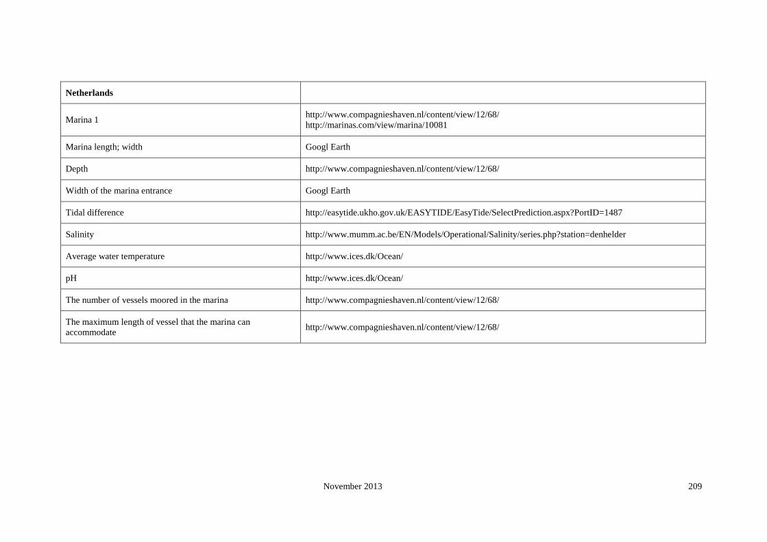
November 2013 209
Netherlands
Marina 1 http://www.compagnieshaven.nl/content/view/12/68/
http://marinas.com/view/marina/10081
Marina length; width Googl Earth
Depth http://www.compagnieshaven.nl/content/view/12/68/
Width of the marina entrance Googl Earth
Tidal difference http://easytide.ukho.gov.uk/EASYTIDE/EasyTide/SelectPrediction.aspx?PortID=1487
Salinity http://www.mumm.ac.be/EN/Models/Operational/Salinity/series.php?station=denhelder
Average water temperature http://www.ices.dk/Ocean/
pH http://www.ices.dk/Ocean/
The number of vessels moored in the marina http://www.compagnieshaven.nl/content/view/12/68/
The maximum length of vessel that the marina can
accommodate http://www.compagnieshaven.nl/content/view/12/68/

November 2013 210
Netherlands Marina 2 http://marinas.com/view/marina/10082
Marina length; width Googl Earth
Depth http://marinas.com/view/marina/10082
Width of the marina entrance Googl Earth
Tidal difference http://easytide.ukho.gov.uk/EASYTIDE/EasyTide/SelectPrediction.aspx?PortID=1520B
Salinity http://www.mumm.ac.be/EN/Models/Operational/Salinity/series.php?station=denhelder
Average water temperature http://www.actuelewaterdata.nl/watertemp/
pH http://www.ices.dk/Ocean/
The number of vessels moored in the marina http://marinas.com/view/marina/10082
The maximum length of vessel that the marina can
accommodate http://marinas.com/view/marina/10082
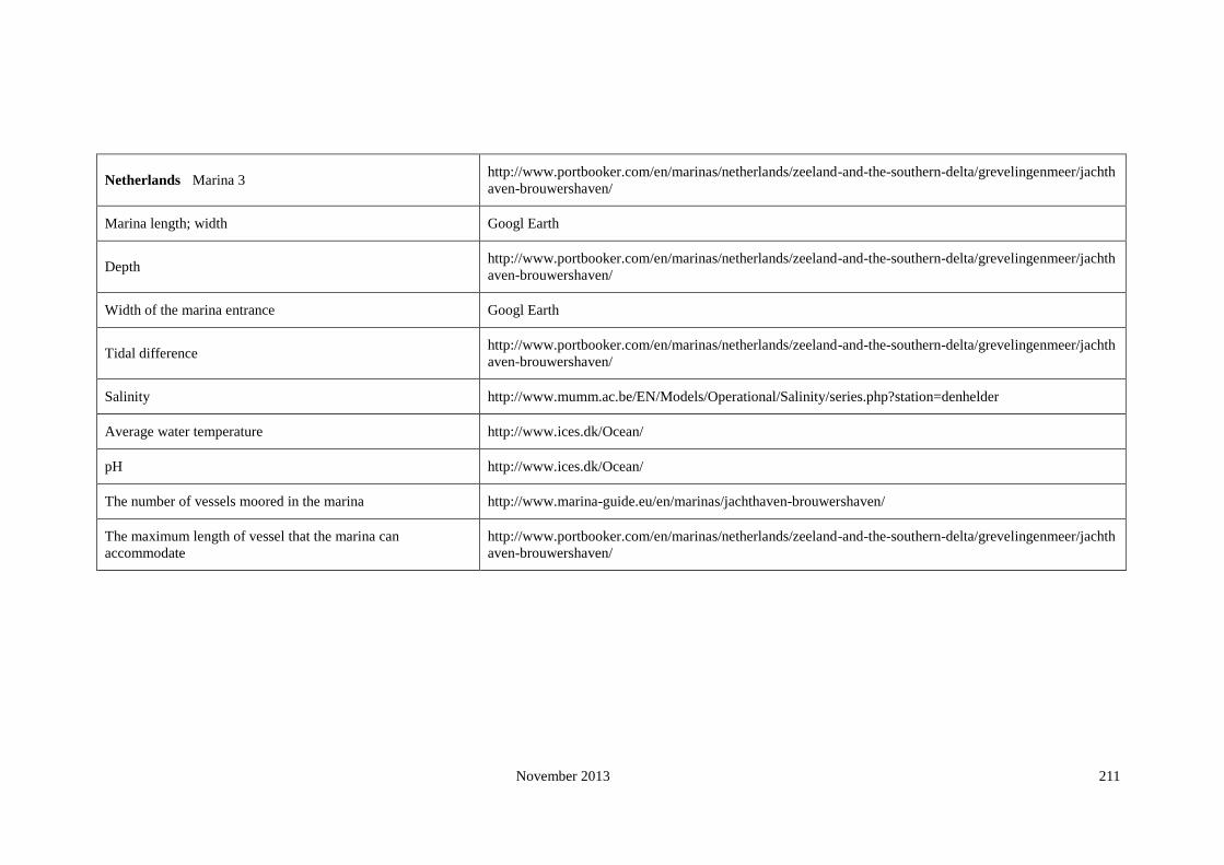
November 2013 211
Netherlands Marina 3 http://www.portbooker.com/en/marinas/netherlands/zeeland-and-the-southern-delta/grevelingenmeer/jachth
aven-brouwershaven/
Marina length; width Googl Earth
Depth http://www.portbooker.com/en/marinas/netherlands/zeeland-and-the-southern-delta/grevelingenmeer/jachth
aven-brouwershaven/
Width of the marina entrance Googl Earth
Tidal difference http://www.portbooker.com/en/marinas/netherlands/zeeland-and-the-southern-delta/grevelingenmeer/jachth
aven-brouwershaven/
Salinity http://www.mumm.ac.be/EN/Models/Operational/Salinity/series.php?station=denhelder
Average water temperature http://www.ices.dk/Ocean/
pH http://www.ices.dk/Ocean/
The number of vessels moored in the marina http://www.marina-guide.eu/en/marinas/jachthaven-brouwershaven/
The maximum length of vessel that the marina can
accommodate
http://www.portbooker.com/en/marinas/netherlands/zeeland-and-the-southern-delta/grevelingenmeer/jachth
aven-brouwershaven/

November 2013 212
Netherlands Marina 4 http://www.portbooker.com/en/marinas/netherlands/noord-holland-and-the-frisian-islands/friesland-to-gron
ingen/jachthaven-neptunus/
Marina length; width Googl Earth
Depth http://www.portbooker.com/en/marinas/netherlands/noord-holland-and-the-frisian-islands/friesland-to-gron
ingen/jachthaven-neptunus/
Width of the marina entrance Googl Earth
Tidal difference http://easytide.ukho.gov.uk/EASYTIDE/EasyTide/SelectPrediction.aspx?PortID=1476
Salinity http://www.mumm.ac.be/EN/Models/Operational/Salinity/series.php?station=borkum
Average water temperature http://www.ices.dk/Ocean/
pH http://www.ices.dk/Ocean/
The number of vessels moored in the marina http://www.portbooker.com/en/marinas/netherlands/noord-holland-and-the-frisian-islands/friesland-to-gron
ingen/jachthaven-neptunus/
The maximum length of vessel that the marina can
accommodate
http://www.portbooker.com/en/marinas/netherlands/noord-holland-and-the-frisian-islands/friesland-to-gron
ingen/jachthaven-neptunus/

November 2013 213
Netherlands Marina 5 http://www.portbooker.com/en/marinas/netherlands/noord-holland-and-the-frisian-islands/the-frisian-island
s/waddenhaven-vlieland/
Marina length; width Googl Earth
Depth http://www.portbooker.com/en/marinas/netherlands/noord-holland-and-the-frisian-islands/the-frisian-island
s/waddenhaven-vlieland/
Width of the marina entrance Googl Earth
Tidal difference http://easytide.ukho.gov.uk/EASYTIDE/EasyTide/SelectPrediction.aspx?PortID=1484
Salinity http://www.mumm.ac.be/EN/Models/Operational/Salinity/series.php?station=denhelder
Average water temperature http://www.ices.dk/Ocean/
pH http://www.ices.dk/Ocean/
The number of vessels moored in the marina http://www.portbooker.com/en/marinas/netherlands/noord-holland-and-the-frisian-islands/the-frisian-island
s/waddenhaven-vlieland/
The maximum length of vessel that the marina can
accommodate
http://www.portbooker.com/en/marinas/netherlands/noord-holland-and-the-frisian-islands/the-frisian-island
s/waddenhaven-vlieland/

November 2013 214
Netherlands Marina 6 http://www.portbooker.com/en/marinas/netherlands/zeeland-and-the-southern-delta/grevelingenmeer/schare
ndijke-jachthaven/
Marina length; width Googl Earth
Depth http://www.portbooker.com/en/marinas/netherlands/zeeland-and-the-southern-delta/grevelingenmeer/schare
ndijke-jachthaven/
Width of the marina entrance Googl Earth
Tidal difference http://easytide.ukho.gov.uk/EASYTIDE/EasyTide/SelectPrediction.aspx?PortID=1522
Salinity http://www.mumm.ac.be/EN/Models/Operational/Salinity/series.php?station=denhelder
Average water temperature http://www.ices.dk/Ocean/
pH http://www.ices.dk/Ocean/
The number of vessels moored in the marina http://www.portbooker.com/en/marinas/netherlands/zeeland-and-the-southern-delta/grevelingenmeer/schare
ndijke-jachthaven/
The maximum length of vessel that the marina can
accommodate
http://www.portbooker.com/en/marinas/netherlands/zeeland-and-the-southern-delta/grevelingenmeer/schare
ndijke-jachthaven/

November 2013 215
Netherlands Marina 7 http://www.portbooker.com/en/marinas/netherlands/the-delta/harinvliet-and-the-slijkgat/stellendam/
Marina length; width Googl Earth
Depth http://www.portbooker.com/en/marinas/netherlands/the-delta/harinvliet-and-the-slijkgat/stellendam/
Width of the marina entrance Googl Earth
Tidal difference http://easytide.ukho.gov.uk/EASYTIDE/EasyTide/SelectPrediction.aspx?PortID=1521
Salinity http://www.mumm.ac.be/EN/Models/Operational/Salinity/series.php?station=denhelder
Average water temperature http://www.ices.dk/Ocean/
pH http://www.ices.dk/Ocean/
The number of vessels moored in the marina http://www.portbooker.com/en/marinas/netherlands/the-delta/harinvliet-and-the-slijkgat/stellendam/
The maximum length of vessel that the marina can
accommodate http://www.portbooker.com/en/marinas/netherlands/the-delta/harinvliet-and-the-slijkgat/stellendam/

November 2013 216
Netherlands Marina 8 http://www.portbooker.com/en/marinas/netherlands/the-delta/westerschelde/jachthaven-michiel-de-ruijterh
aven-(vlissingen)/
Marina length; width Googl Earth
Depth http://www.portbooker.com/en/marinas/netherlands/the-delta/westerschelde/jachthaven-michiel-de-ruijterh
aven-(vlissingen)/
Width of the marina entrance Googl Earth
Tidal difference http://easytide.ukho.gov.uk/EASYTIDE/EasyTide/SelectPrediction.aspx?PortID=1534
Salinity http://www.mumm.ac.be/EN/Models/Operational/Salinity/series.php?station=denhelder
Average water temperature http://www.ices.dk/Ocean/
pH http://www.ices.dk/Ocean/
The number of vessels moored in the marina http://www.portbooker.com/en/marinas/netherlands/the-delta/westerschelde/jachthaven-michiel-de-ruijterh
aven-(vlissingen)/
The maximum length of vessel that the marina can
accommodate
http://www.portbooker.com/en/marinas/netherlands/the-delta/westerschelde/jachthaven-michiel-de-ruijterh
aven-(vlissingen)/

November 2013 217
Netherlands Marina 9 http://www.portbooker.com/en/marinas/netherlands/noord-holland-and-the-frisian-islands/the-frisian-island
s/jachthaven-oostmahorn/
Marina length; width Googl Earth
Depth http://www.portbooker.com/en/marinas/netherlands/noord-holland-and-the-frisian-islands/the-frisian-island
s/jachthaven-oostmahorn/
Width of the marina entrance Googl Earth
Tidal difference http://easytide.ukho.gov.uk/EASYTIDE/EasyTide/SelectPrediction.aspx?PortID=1478
Salinity http://www.mumm.ac.be/EN/Models/Operational/Salinity/series.php?station=denhelder
Average water temperature http://www.ices.dk/Ocean/
pH http://www.ices.dk/Ocean/
The number of vessels moored in the marina http://www.portbooker.com/en/marinas/netherlands/noord-holland-and-the-frisian-islands/the-frisian-island
s/jachthaven-oostmahorn/
The maximum length of vessel that the marina can
accommodate
http://www.portbooker.com/en/marinas/netherlands/noord-holland-and-the-frisian-islands/the-frisian-island
s/jachthaven-oostmahorn/
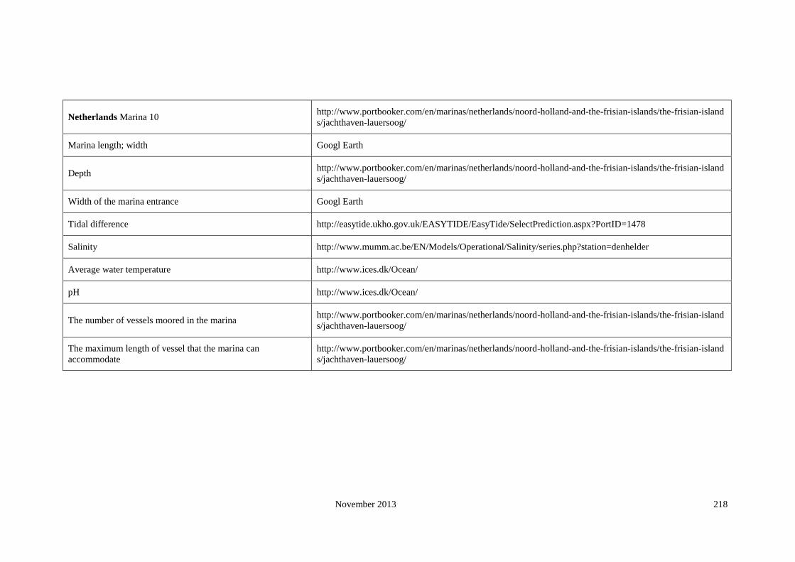
November 2013 218
Netherlands Marina 10 http://www.portbooker.com/en/marinas/netherlands/noord-holland-and-the-frisian-islands/the-frisian-island
s/jachthaven-lauersoog/
Marina length; width Googl Earth
Depth http://www.portbooker.com/en/marinas/netherlands/noord-holland-and-the-frisian-islands/the-frisian-island
s/jachthaven-lauersoog/
Width of the marina entrance Googl Earth
Tidal difference http://easytide.ukho.gov.uk/EASYTIDE/EasyTide/SelectPrediction.aspx?PortID=1478
Salinity http://www.mumm.ac.be/EN/Models/Operational/Salinity/series.php?station=denhelder
Average water temperature http://www.ices.dk/Ocean/
pH http://www.ices.dk/Ocean/
The number of vessels moored in the marina http://www.portbooker.com/en/marinas/netherlands/noord-holland-and-the-frisian-islands/the-frisian-island
s/jachthaven-lauersoog/
The maximum length of vessel that the marina can
accommodate
http://www.portbooker.com/en/marinas/netherlands/noord-holland-and-the-frisian-islands/the-frisian-island
s/jachthaven-lauersoog/

November 2013 219
Norway
Marina 1 http://www.portbooker.com/en/marinas/norway/oslo-fjord/oslo/akerbrygge/
http://www.archipelago.nu/
Marina length; width Google Earth
Depth http://www.portbooker.com/en/marinas/norway/oslo-fjord/oslo/akerbrygge/
Width of the marina entrance Google Earth
Tidal difference N
Salinity (annual world salinity/2005)
Average water temperature annual seasurface temperature 2005
pH http://www.ices.dk/Ocean/
The number of vessels moored in the marina http://www.portbooker.com/en/marinas/norway/oslo-fjord/oslo/akerbrygge/
The maximum length of vessel that the marina can accommodate http://www.portbooker.com/en/marinas/norway/oslo-fjord/oslo/akerbrygge/

November 2013 220
Norway Marina 2 http://www.archipelago.nu
Marina length; width Google Earth
Depth http://www.archipelago.nu
Width of the marina entrance Google Earth
Tidal difference http://easytide.ukho.gov.uk/EASYTIDE/EasyTide/SelectPrediction.aspx?PortID=1300
Salinity (annual world salinity/2005)
Average water temperature annual seasurface temperature 2005
pH http://www.ices.dk/Ocean/
The number of vessels moored in the marina http://www.archipelago.nu
The maximum length of vessel that the marina can accommodate http://www.archipelago.nu

November 2013 221
Norway Marina 3 www.marinamap.com
Marina length; width Google Earth
Depth www.marinamap.com
Width of the marina entrance Google Earth
Tidal difference http://easytide.ukho.gov.uk/EASYTIDE/EasyTide/SelectPrediction.aspx?PortID=1300
Salinity (annual world salinity/2005)
Average water temperature annual seasurface temperature 2005
pH http://www.ices.dk/Ocean/
The number of vessels moored in the marina www.marinamap.com
The maximum length of vessel that the marina can accommodate www.marinamap.com
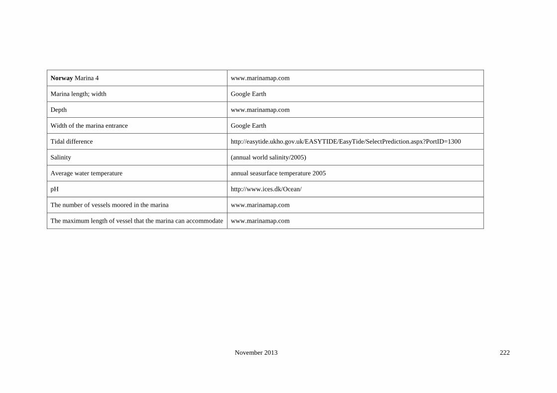
November 2013 222
Norway Marina 4 www.marinamap.com
Marina length; width Google Earth
Depth www.marinamap.com
Width of the marina entrance Google Earth
Tidal difference http://easytide.ukho.gov.uk/EASYTIDE/EasyTide/SelectPrediction.aspx?PortID=1300
Salinity (annual world salinity/2005)
Average water temperature annual seasurface temperature 2005
pH http://www.ices.dk/Ocean/
The number of vessels moored in the marina www.marinamap.com
The maximum length of vessel that the marina can accommodate www.marinamap.com
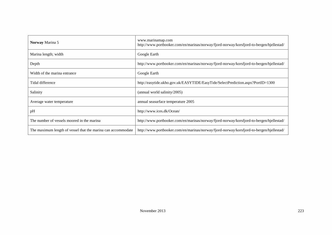
November 2013 223
Norway Marina 5 www.marinamap.com
http://www.portbooker.com/en/marinas/norway/fjord-norway/korsfjord-to-bergen/hjellestad/
Marina length; width Google Earth
Depth http://www.portbooker.com/en/marinas/norway/fjord-norway/korsfjord-to-bergen/hjellestad/
Width of the marina entrance Google Earth
Tidal difference http://easytide.ukho.gov.uk/EASYTIDE/EasyTide/SelectPrediction.aspx?PortID=1300
Salinity (annual world salinity/2005)
Average water temperature annual seasurface temperature 2005
pH http://www.ices.dk/Ocean/
The number of vessels moored in the marina http://www.portbooker.com/en/marinas/norway/fjord-norway/korsfjord-to-bergen/hjellestad/
The maximum length of vessel that the marina can accommodate http://www.portbooker.com/en/marinas/norway/fjord-norway/korsfjord-to-bergen/hjellestad/

November 2013 224
Norway Marina 6 http://www.portbooker.com/en/marinas/norway/oslo-fjord/larviksfjord/stavern/
Marina length; width Google Earth
Depth http://www.portbooker.com/en/marinas/norway/oslo-fjord/larviksfjord/stavern/
Width of the marina entrance Google Earth
Tidal difference http://easytide.ukho.gov.uk/EASYTIDE/EasyTide/SelectPrediction.aspx?PortID=1300
Salinity (annual world salinity/2005)
Average water temperature annual seasurface temperature 2005
pH http://www.ices.dk/Ocean/
The number of vessels moored in the marina http://www.portbooker.com/en/marinas/norway/oslo-fjord/larviksfjord/stavern/
The maximum length of vessel that the marina can accommodate http://www.portbooker.com/en/marinas/norway/oslo-fjord/larviksfjord/stavern/

November 2013 225
Norway Marina 7 www.marinamap.com
Marina length; width Google Earth
Depth www.marinamap.com
Width of the marina entrance Google Earth
Tidal difference http://easytide.ukho.gov.uk/EASYTIDE/EasyTide/SelectPrediction.aspx?PortID=1276
Salinity (annual world salinity/2005)
Average water temperature annual seasurface temperature 2005
pH http://www.ices.dk/Ocean/
The number of vessels moored in the marina www.marinamap.com
The maximum length of vessel that the marina can accommodate www.marinamap.com
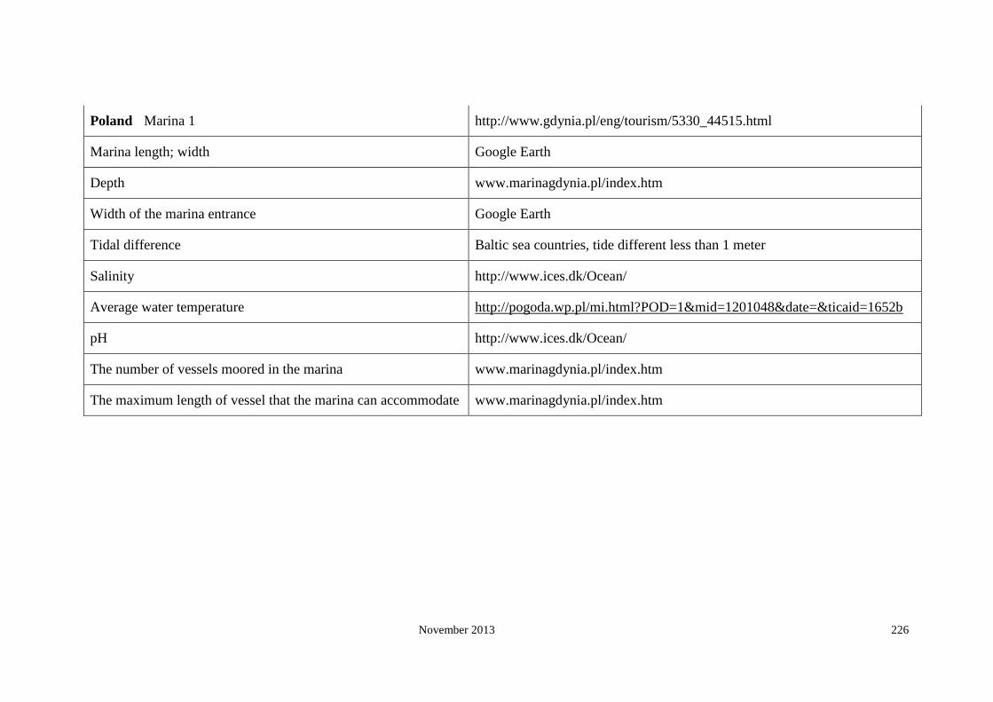
November 2013 226
Poland Marina 1 http://www.gdynia.pl/eng/tourism/5330_44515.html
Marina length; width Google Earth
Depth www.marinagdynia.pl/index.htm
Width of the marina entrance Google Earth
Tidal difference Baltic sea countries, tide different less than 1 meter
Salinity http://www.ices.dk/Ocean/
Average water temperature http://pogoda.wp.pl/mi.html?POD=1&mid=1201048&date=&ticaid=1652b
pH http://www.ices.dk/Ocean/
The number of vessels moored in the marina www.marinagdynia.pl/index.htm
The maximum length of vessel that the marina can accommodate www.marinagdynia.pl/index.htm

November 2013 227
Poland Marina 2 http://www.portbooker.com/en/marinas/poland/gulf-of-gdansk
Marina length; width Google Earth
Depth http://www.portbooker.com/en/marinas/poland/gulf-of-gdansk
Width of the marina entrance Google Earth
Tidal difference Baltic sea countries, tide different less than 1 meter
Salinity http://www.ices.dk/Ocean/
Average water temperature http://www.ices.dk/Ocean/
pH http://www.ices.dk/Ocean/
The number of vessels moored in the marina http://www.portbooker.com/en/marinas/poland/gulf-of-gdansk
The maximum length of vessel that the marina can accommodate http://www.portbooker.com/en/marinas/poland/gulf-of-gdansk

November 2013 228
Poland Marina 3
http://www.portbooker.com/en/marinas/poland/gulf-of-gdansk
http://www.gdynia.pl/eng/tourism/5330_44515.html
http://www.jastarnia.pl/marinywgminiejastarnia.html
Marina length; width Google Earth
http://www.jastarnia.pl/marinywgminiejastarnia.html
Depth http://www.portbooker.com/en/marinas/poland/gulf-of-gdansk
Width of the marina entrance Google Earth
Tidal difference Baltic sea countries, tide different less than 1 meter
Salinity http://www.ices.dk/Ocean/
Average water temperature http://www.jastarnia.pl/
pH http://www.ices.dk/Ocean/
The number of vessels moored in the marina http://www.portbooker.com/en/marinas/poland/gulf-of-gdansk
The maximum length of vessel that the marina can accommodate http://www.portbooker.com/en/marinas/poland/gulf-of-gdansk
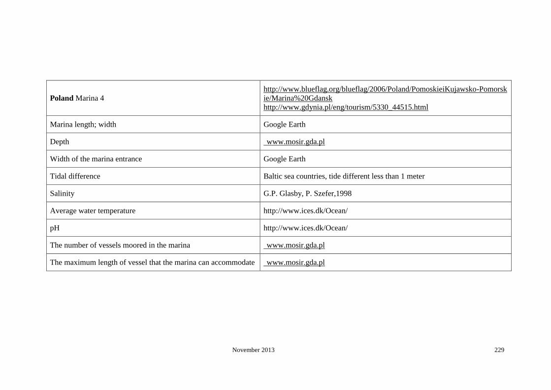
November 2013 229
Poland Marina 4
http://www.blueflag.org/blueflag/2006/Poland/PomoskieiKujawsko-Pomorsk
ie/Marina%20Gdansk
http://www.gdynia.pl/eng/tourism/5330_44515.html
Marina length; width Google Earth
Depth www.mosir.gda.pl
Width of the marina entrance Google Earth
Tidal difference Baltic sea countries, tide different less than 1 meter
Salinity G.P. Glasby, P. Szefer,1998
Average water temperature http://www.ices.dk/Ocean/
pH http://www.ices.dk/Ocean/
The number of vessels moored in the marina www.mosir.gda.pl
The maximum length of vessel that the marina can accommodate www.mosir.gda.pl

November 2013 230
Poland Marina 5 http://moksir-puck.home.pl/eng/index.html
http://80.55.74.74/index.shtml.en
Marina length; width Google Earth
Depth http://moksir-puck.home.pl/eng/index.html
Width of the marina entrance Google Earth
Tidal difference Baltic sea countries, tide different less than 1 meter
Salinity G.P. Glasby, P. Szefer,1998
Average water temperature
http://www.wunderground.com/cgi-bin/findweather/getForecast?query=puc
k+poland
http://www.wunderground.com/MAR/eum.html
pH http://www.ices.dk/Ocean/
The number of vessels moored in the marina Google Earth
The maximum length of vessel that the marina can accommodate http://moksir-puck.home.pl/eng/index.html

November 2013 231
Poland Marina 6 http://www.gdynia.pl/eng/tourism/5330_44515.html
Marina length; width Google Earth
Depth http://www.gdynia.pl/eng/tourism/5330_44515.html
Width of the marina entrance Google Earth
Tidal difference Baltic sea countries, tide different less than 1 meter
Salinity Baltic sea countries, tide different less than 1 meter
Average water temperature G.P. Glasby, P. Szefer,1998
pH http://www.ices.dk/Ocean/
The number of vessels moored in the marina N
The maximum length of vessel that the marina can
accommodate N

November 2013 232
Poland Marina 7 http://www.portbooker.com/en/marinas/poland/gulf-of-gdansk/wladyslawowo/wladyslawowo/
Marina length; width Google Earth
Depth http://www.portbooker.com/en/marinas/poland/gulf-of-gdansk/wladyslawowo/wladyslawowo/
Width of the marina entrance Google Earth
Tidal difference Baltic sea countries, tide different less than 1 meter
Salinity http://www.ices.dk/Ocean/
Average water temperature http://www.ices.dk/Ocean/
pH http://www.ices.dk/Ocean/
The number of vessels moored in the marina http://www.portbooker.com/en/marinas/poland/gulf-of-gdansk/wladyslawowo/wladyslawowo/
The maximum length of vessel that the marina can
accommodate http://www.portbooker.com/en/marinas/poland/gulf-of-gdansk/wladyslawowo/wladyslawowo/

November 2013 233
Poland Marina 8 http://www.gdynia.pl/eng/tourism/5330_44515.html
Marina length; width Google Earth
Depth http://www.gdynia.pl/eng/tourism/5330_44515.html
Width of the marina entrance Google Earth
Tidal difference Baltic sea countries, tide different less than 1 meter
Salinity http://www.helcom.fi/environment2/ifs/ifs2006/en_GB/sst/
Average water temperature http://www.helcom.fi/environment2/ifs/ifs2006/en_GB/sst/
pH http://www.ices.dk/Ocean/
The number of vessels moored in the marina Google Earth
The maximum length of vessel that the marina can
accommodate NA

November 2013 234
Portugal
Marina 1 Yachting Pages 17
Marina length; width Google Earth
Depth Yachting Pages 17
Width of the marina entrance Google Earth
Tidal difference http://easytide.ukho.gov.uk
Salinity (annual world salinity/2005)
Average water temperature http://www.surf-forecast.com/breaks/PraiadoGuincho.seatemp.shtml
pH http://www.ices.dk/Ocean/
The number of vessels moored in the marina Yachting Pages 17
The maximum length of vessel that the marina can
accommodate Yachting Pages 17

November 2013 235
Portugal Marina 2 Yachting Pages 20
Marina length; width Google Earth
Depth Yachting Pages 20
Width of the marina entrance Google Earth
Tidal difference http://easytide.ukho.gov.uk
Salinity (annual world salinity/2005)
Average water temperature annual seasurface temperature 2005
pH http://www.ices.dk/Ocean/
The number of vessels moored in the marina Yachting Pages 20
The maximum length of vessel that the marina can
accommodate Yachting Pages 20

November 2013 236
Portugal Marina 3 Yachting Pages 21
Marina length; width Google Earth
Depth Yachting Pages 21
Width of the marina entrance Google Earth
Tidal difference http://easytide.ukho.gov.uk
Salinity (annual world salinity/2005)
Average water temperature annual seasurface temperature 2005
pH http://www.ices.dk/Ocean/
The number of vessels moored in the marina Yachting Pages 21
The maximum length of vessel that the marina
can accommodate Yachting Pages 21

November 2013 237
Portugal Marina 4 Yachting Pages 22
Marina length; width Google Earth
Depth Yachting Pages 22
Width of the marina entrance Google Earth
Tidal difference http://easytide.ukho.gov.uk
Salinity (annual world salinity/2005)
Average water temperature annual seasurface temperature 2005
pH http://www.ices.dk/Ocean/
The number of vessels moored in the marina Yachting Pages 22
The maximum length of vessel that the
marina can accommodate Yachting Pages 22

November 2013 238
Portugal Marina 5 www.marinamate.com/m-eu-pt.html
Marina length; width Google Earth
Depth Yachting Pages 17
Width of the marina entrance Google Earth
Tidal difference http://easytide.ukho.gov.uk
Salinity (annual world salinity/2005)
Average water temperature annual seasurface temperature 2005
pH http://www.ices.dk/Ocean/
The number of vessels moored in the marina www.marinamate.com/m-eu-pt.html
The maximum length of vessel that the marina can
accommodate www.marinamate.com/m-eu-pt.html

November 2013 239
Portugal Marina 6 Yachting Pages
Marina length; width Google Earth
Depth Yachting Pages
Width of the marina entrance Google Earth
Tidal difference http://easytide.ukho.gov.uk
Salinity (annual world salinity/2005)
Average water temperature annual seasurface temperature 2005
pH http://www.ices.dk/Ocean/
The number of vessels moored in the marina Yachting Pages
The maximum length of vessel that the marina can
accommodate Yachting Pages

November 2013 240
Portugal Marina 7 Yachting Pages
Marina length; width Google Earth
Depth Yachting Pages
Width of the marina entrance Google Earth
Tidal difference http://easytide.ukho.gov.uk
Salinity http://www.cnrm.meteo.fr/gmgec/page_perso/somot/sevault_somot_deque_2004.pdf
Average water temperature annual seasurface temperature 2005
pH http://www.ices.dk/Ocean/
The number of vessels moored in the marina Yachting Pages
The maximum length of vessel that the marina
can accommodate Yachting Pages

November 2013 241
Portugal Marina 8 Yachting Pages
Marina length; width Google Earth
Depth Yachting Pages
Width of the marina entrance Google Earth
Tidal difference http://easytide.ukho.gov.uk
Salinity (annual world salinity/2005)
Average water temperature annual seasurface temperature 2005
pH http://www.ices.dk/Ocean/
The number of vessels moored in the marina Google Earth
The maximum length of vessel that the marina
can accommodate Google Earth

November 2013 242
Portugal Marina 9 www.marinamap.com
Marina length; width Google Earth
Depth Yachting Pages 17
Width of the marina entrance Google Earth
Tidal difference http://easytide.ukho.gov.uk
Salinity (annual world salinity/2005)
Average water temperature annual seasurface temperature 2005
pH http://www.ices.dk/Ocean/
The number of vessels moored in the marina www.marinamap.com
The maximum length of vessel that the marina can
accommodate www.marinamap.com
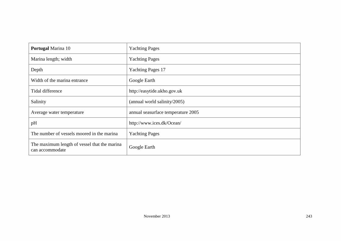
November 2013 243
Portugal Marina 10 Yachting Pages
Marina length; width Yachting Pages
Depth Yachting Pages 17
Width of the marina entrance Google Earth
Tidal difference http://easytide.ukho.gov.uk
Salinity (annual world salinity/2005)
Average water temperature annual seasurface temperature 2005
pH http://www.ices.dk/Ocean/
The number of vessels moored in the marina Yachting Pages
The maximum length of vessel that the marina
can accommodate Google Earth

November 2013 244
Romania
Marina 1 http://www.anayachtclub.ro/eng/calendar.htm
Marina length; width Google Earth
Depth http://www.anayachtclub.ro/eng/calendar.htm
Width of the marina entrance Google Earth
Tidal difference http://blacksea.orlyonok.ru/e2.shtml
Salinity http://www.icromania.com/infoCoast.asp
Average water temperature http://www.wunderground.com/MAR/eum.html#map
pH http://www.sumae.gov.tr/eng/proje/devam/02.htm
The number of vessels moored in the marina http://www.anayachtclub.ro/eng/calendar.htm
The maximum length of vessel that the marina can accommodate http://www.anayachtclub.ro/eng/calendar.htm

November 2013 245
Slovenia
Marina 1
http://www.portbooker.com/en/marinas/slovenia/slovenia/izola/marina-izola/
http://www.blueflag.org/blueflag/2008/Slovenia/Slovenia/MarinaIzola
http://www.tripsailor.com/pois/6350451-marina-izola
Marina length; width Google Earth
Depth http://www.portbooker.com/en/marinas/latvia/gulf-of-riga/pavilosta/pavilosta/
Width of the marina entrance Google Earth
Tidal difference http://easytide.ukho.gov.uk/EASYTIDE/EasyTide/SelectPrediction.aspx?PortID=1897
Salinity http://www.cnrm.meteo.fr/gmgec/page_perso/somot/sevault_somot_deque_2004.pdf
Average water temperature http://www.wunderground.com/MAR/eum.html?MR=1
http://www.cnrm.meteo.fr/gmgec/page_perso/somot/sevault_somot_deque_2004.pdf
pH http://www.ices.dk/Ocean/
The number of vessels moored in the marina http://www.portbooker.com/en/marinas/slovenia/slovenia/izola/marina-izola/
The maximum length of vessel that the marina can accommodate http://www.portbooker.com/en/marinas/slovenia/slovenia/izola/marina-izola/
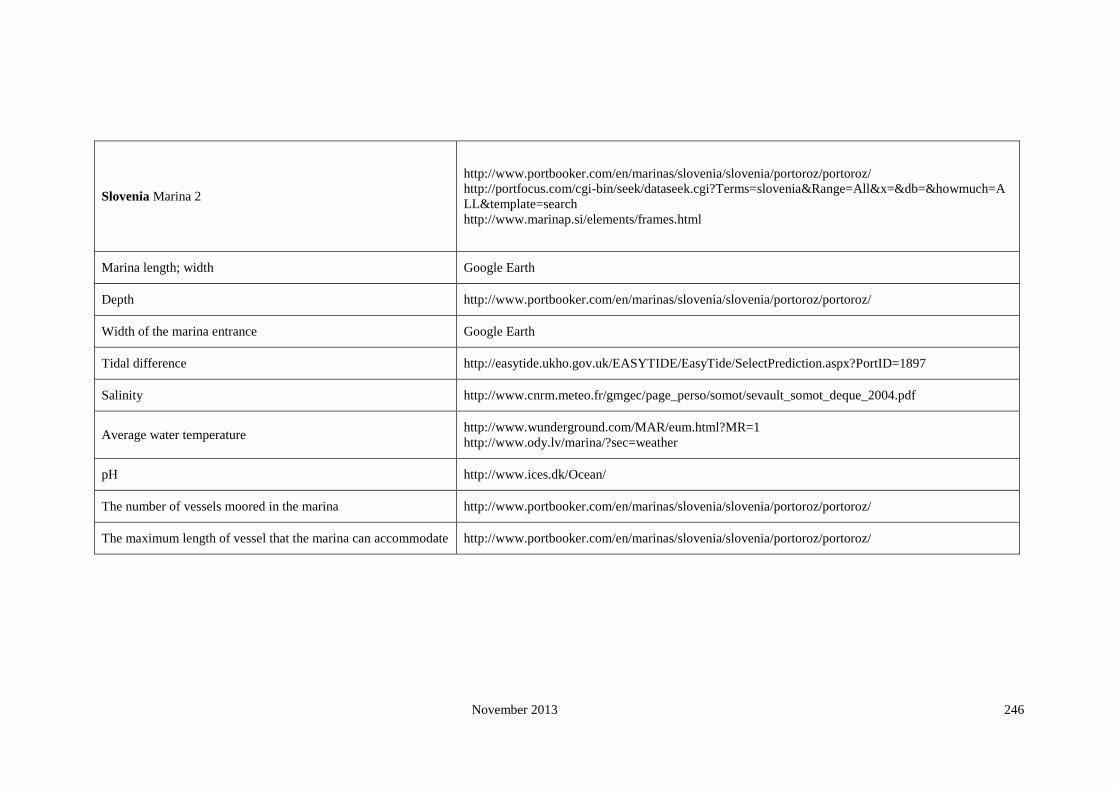
November 2013 246
Slovenia Marina 2
http://www.portbooker.com/en/marinas/slovenia/slovenia/portoroz/portoroz/
http://portfocus.com/cgi-bin/seek/dataseek.cgi?Terms=slovenia&Range=All&x=&db=&howmuch=A
LL&template=search
http://www.marinap.si/elements/frames.html
Marina length; width Google Earth
Depth http://www.portbooker.com/en/marinas/slovenia/slovenia/portoroz/portoroz/
Width of the marina entrance Google Earth
Tidal difference http://easytide.ukho.gov.uk/EASYTIDE/EasyTide/SelectPrediction.aspx?PortID=1897
Salinity http://www.cnrm.meteo.fr/gmgec/page_perso/somot/sevault_somot_deque_2004.pdf
Average water temperature http://www.wunderground.com/MAR/eum.html?MR=1
http://www.ody.lv/marina/?sec=weather
pH http://www.ices.dk/Ocean/
The number of vessels moored in the marina http://www.portbooker.com/en/marinas/slovenia/slovenia/portoroz/portoroz/
The maximum length of vessel that the marina can accommodate http://www.portbooker.com/en/marinas/slovenia/slovenia/portoroz/portoroz/

November 2013 247
Slovenia Marina 3 http://www.portbooker.com/en/marinas/slovenia/slovenia/koper/koper-(capodistria)/
Marina length; width Google Earth
Depth http://www.portbooker.com/en/marinas/slovenia/slovenia/koper/koper-(capodistria)/
Width of the marina entrance Google Earth
Tidal difference http://easytide.ukho.gov.uk/EASYTIDE/EasyTide/SelectPrediction.aspx?PortID=18
97
Salinity http://www.cnrm.meteo.fr/gmgec/page_perso/somot/sevault_somot_deque_2004.pdf
Average water temperature http://www.cnrm.meteo.fr/gmgec/page_perso/somot/sevault_somot_deque_2004.pdf
pH http://www.ices.dk/Ocean/
The number of vessels moored in the marina http://www.portbooker.com/en/marinas/slovenia/slovenia/koper/koper-(capodistria)/
The maximum length of vessel that the marina can accommodate http://www.portbooker.com/en/marinas/slovenia/slovenia/koper/koper-(capodistria)/

November 2013 248
Spain
Marina 1 Yachting Pages 23
Marina length; width Google Earth
Depth Yachting Pages 23
Width of the marina entrance Google Earth
Tidal difference http://easytide.ukho.gov.uk/EASYTIDE/EasyTide/SelectPrediction.aspx?PortID=3485
Salinity (annual world salinity/2005)
Average water temperature annual seasurface temperature 2005
pH http://www.ices.dk/Ocean/
The number of vessels moored in the marina Yachting Pages 23
The maximum length of vessel that the marina can accommodate Yachting Pages 23
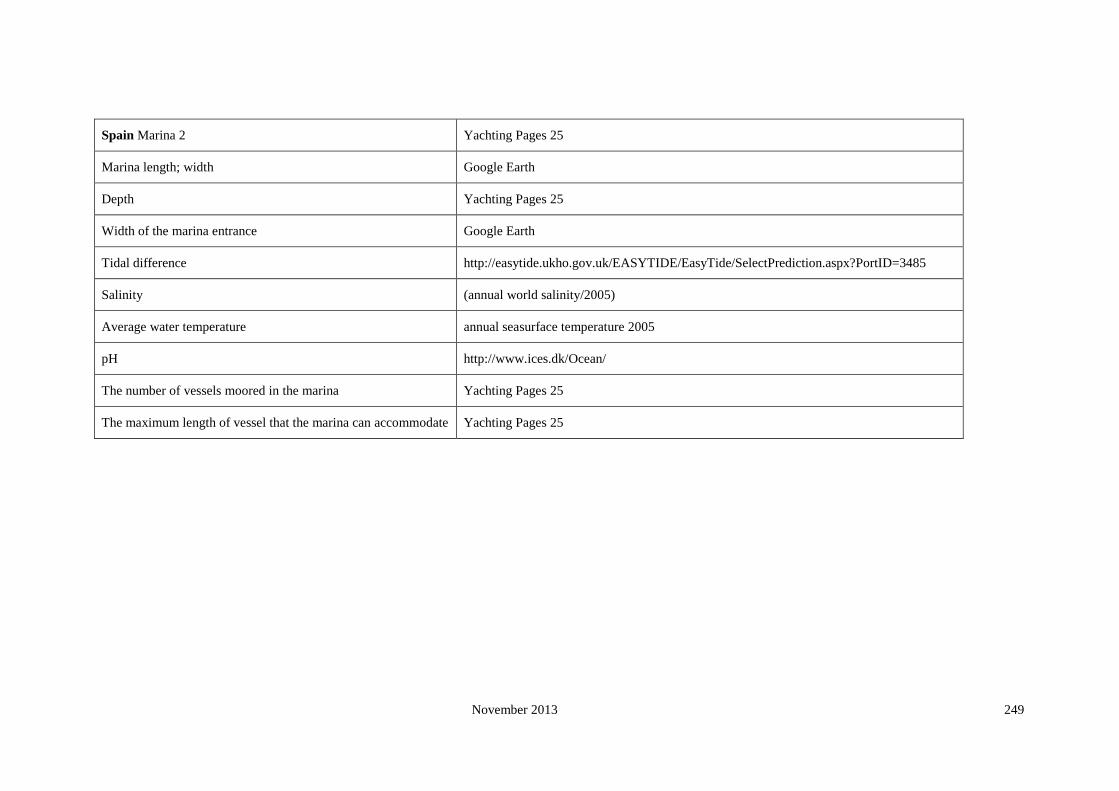
November 2013 249
Spain Marina 2 Yachting Pages 25
Marina length; width Google Earth
Depth Yachting Pages 25
Width of the marina entrance Google Earth
Tidal difference http://easytide.ukho.gov.uk/EASYTIDE/EasyTide/SelectPrediction.aspx?PortID=3485
Salinity (annual world salinity/2005)
Average water temperature annual seasurface temperature 2005
pH http://www.ices.dk/Ocean/
The number of vessels moored in the marina Yachting Pages 25
The maximum length of vessel that the marina can accommodate Yachting Pages 25

November 2013 250
Spain Marina 3 Yachting Pages 26
Marina length; width Google Earth
Depth Yachting Pages 26
Width of the marina entrance Google Earth
Tidal difference http://easytide.ukho.gov.uk/EASYTIDE/EasyTide/SelectPrediction.aspx?PortID=1724
Salinity (annual world salinity/2005)
Average water temperature http://www.cosis.net/abstracts/COSPAR04/03549/COSPAR04-A-03549.pdf
pH http://www.ices.dk/Ocean/
The number of vessels moored in the marina Yachting Pages 26
The maximum length of vessel that the marina can accommodate Yachting Pages 26

November 2013 251
Spain Marina 4 Yachting Pages 31
Marina length; width Google Earth
Depth Yachting Pages 31
Width of the marina entrance Google Earth
Tidal difference http://easytide.ukho.gov.uk/EASYTIDE/EasyTide/SelectPrediction.aspx?PortID=1770
Salinity http://www.cnrm.meteo.fr/gmgec/page_perso/somot/sevault_somot_deque_2004.pdf
Average water temperature annual seasurface temperature 2005
pH http://www.ices.dk/Ocean/
The number of vessels moored in the marina Yachting Pages 31
The maximum length of vessel that the marina can accommodate Yachting Pages 31

November 2013 252
Spain Marina 5 Yachting Pages 32
Marina length; width Google Earth
Depth Yachting Pages 32
Width of the marina entrance Google Earth
Tidal difference http://easytide.ukho.gov.uk/EASYTIDE/EasyTide/SelectPrediction.aspx?PortID=1773
Salinity (annual world salinity/2005)
Average water temperature annual seasurface temperature 2005
pH http://www.ices.dk/Ocean/
The number of vessels moored in the marina Yachting Pages 32
The maximum length of vessel that the marina can accommodate Yachting Pages 32

November 2013 253
Spain Marina 6 Yachting Pages 34
Marina length; width Google Earth
Depth Yachting Pages 34
Width of the marina entrance Google Earth
Tidal difference http://easytide.ukho.gov.uk/EASYTIDE/EasyTide/SelectPrediction.aspx?PortID=1773
Salinity (annual world salinity/2005)
Average water temperature annual seasurface temperature 2005
pH http://www.ices.dk/Ocean/
The number of vessels moored in the marina Yachting Pages 34
The maximum length of vessel that the marina can accommodate Yachting Pages 34

November 2013 254
Spain Marina 7 Yachting Pages 35
Marina length; width Google Earth
Depth Yachting Pages 35
Width of the marina entrance Google Earth
Tidal difference http://easytide.ukho.gov.uk/EASYTIDE/EasyTide/SelectPrediction.aspx?PortID=1773A
Salinity (annual world salinity/2005)
Average water temperature annual seasurface temperature 2005
pH http://www.ices.dk/Ocean/
The number of vessels moored in the marina Yachting Pages 35
The maximum length of vessel that the marina can accommodate Yachting Pages 35

November 2013 255
Spain Marina 8 Yachting Pages 45
Marina length; width Google Earth
Depth Yachting Pages 45
Width of the marina entrance Google Earth
Tidal difference http://easytide.ukho.gov.uk/EASYTIDE/EasyTide/SelectPrediction.aspx?PortID=1780
Salinity (annual world salinity/2005)
Average water temperature annual seasurface temperature 2005
pH http://www.ices.dk/Ocean/
The number of vessels moored in the marina Yachting Pages 45
The maximum length of vessel that the marina can accommodate Yachting Pages 45

November 2013 256
Spain Marina 9 Yachting Pages 50
Marina length; width Google Earth
Depth Yachting Pages 50
Width of the marina entrance Google Earth
Tidal difference http://easytide.ukho.gov.uk/EASYTIDE/EasyTide/SelectPrediction.aspx?PortID=1775
Salinity (annual world salinity/2005)
Average water temperature annual seasurface temperature(2005
pH http://www.ices.dk/Ocean/
The number of vessels moored in the marina Yachting Pages 50
The maximum length of vessel that the marina can accommodate Yachting Pages 50

November 2013 257
Spain Marina 10 Yachting Pages 51
Marina length; width Google Earth
Depth Yachting Pages 51
Width of the marina entrance Google Earth
Tidal difference http://easytide.ukho.gov.uk/EASYTIDE/EasyTide/SelectPrediction.aspx?PortID=1775
Salinity (annual world salinity/2005)
Average water temperature annual seasurface temperature(2005
pH http://www.ices.dk/Ocean/
The number of vessels moored in the marina Yachting Pages 51
The maximum length of vessel that the marina can accommodate Yachting Pages 51

November 2013 258
Sweden Marina 1 http://marinas.com/view/marina/8864
Marina length; width Google Earth
Depth http://marinas.com/view/marina/8864
Width of the marina entrance Google Earth
Tidal difference Baltic sea countries, tide different less than 1 meter.
Salinity http://www3.interscience.wiley.com/cgi-bin/fulltext/118487839/PDFSTART
http://www.int-res.com/articles/meps/149/m149p073.pdf
Average water temperature http://www.bbc.co.uk/weather/world/city_guides/results.shtml?tt=TT004300 (max)
http://marinas.com/view/marina/8864
pH http://ambio.allenpress.com/perlserv/?request=get-document&doi=10.1639%2F0044-7447
(2001)030%5B0277%3AUIITHO%5D2.0.CO%3B2&ct=1
The number of vessels moored in the marina Google Earth
The maximum length of vessel that the marina can
accommodate http://marinas.com/view/marina/8864

November 2013 259
Sweden Marina 2 https://marinas.com/view/marina/8865
Marina length; width Google Earth
Depth https://marinas.com/view/marina/8865
Width of the marina entrance Google Earth
Tidal difference Baltic sea countries, tide different less than 1 meter.
Salinity http://ambio.allenpress.com/perlserv/?request=get-document&doi=10.1639%2F0044-7447(2001)
030%5B0277%3AUIITHO%5D2.0.CO%3B2&ct=1
Average water temperature https://marinas.com/view/marina/8865
http://www.bbc.co.uk/weather/world/city_guides/results.shtml?tt=TT004300 (max)
pH http://www.springerlink.com/content/nm666867033t2778/fulltext.pdf
The number of vessels moored in the marina Google Earth
The maximum length of vessel that the marina can
accommodate https://marinas.com/view/marina/8865

November 2013 260
Sweden Marina 3 http://www.portfocus.com/sweden/zz_marinas/index1.html
Marina length; width Google Earth
Depth http://www.portfocus.com/sweden/zz_marinas/index1.html
Width of the marina entrance Google Earth
Tidal difference Baltic sea countries, tide different less than 1 meter.
Salinity http://www.ices.dk/Ocean/
Average water temperature
http://marinas.com/view/marina/8998
http://www.wunderground.com/weatherstation/WXDailyHistory.asp?ID=ISKNEMAL2&mo
nth=1&day=27&year=2008
pH http://www.ices.dk/Ocean/
The number of vessels moored in the marina Google Earth
The maximum length of vessel that the marina can accommodate http://www.portfocus.com/sweden/zz_marinas/index1.html

November 2013 261
Sweden Marina 4 http://www.blueflag.org/blueflag/2008/Sweden/Stockholmsln/SdertljeGsthamn
Marina length; width Google Earth
Depth http://www.blueflag.org/blueflag/2008/Sweden/Stockholmsln/SdertljeGsthamn
Width of the marina entrance Google Earth
Tidal difference Baltic sea countries, tide different less than 1 meter.
Salinity http://www.fimr.fi/en/tietoa/algaline_seuranta/mittaustulosarkisto/2008/en_GB/12080
75859728_1_1_2_1/
Average water temperature http://www.helcom.fi/environment2/ifs/ifs2006/en_GB/sst/_print/
pH http://www.ices.dk/Ocean/
The number of vessels moored in the marina http://gasthamn.se/engelska.htm
The maximum length of vessel that the marina can accommodate http://gasthamn.se/engelska.htm

November 2013 262
Sweden Marina 5 http://marinas.com/view/marina/8918
Marina length; width Google Earth
Depth http://marinas.com/view/marina/8918
Width of the marina entrance Google Earth
Tidal difference Baltic sea countries, tide different less than 1 meter.
Salinity http://www.fimr.fi/en/tietoa/algaline_seuranta/mittaustulosarkisto/2008/en_GB/120
8075859728_1_1_2_1/
Average water temperature http://www.helcom.fi/environment2/ifs/ifs2006/en_GB/sst/_print/
pH http://www.ices.dk/Ocean/
The number of vessels moored in the marina http://marinas.com/view/marina/8918
The maximum length of vessel that the marina can accommodate http://marinas.com/view/marina/8918

November 2013 263
Sweden Marina 6 http://www.portbooker.com/en/marinas/sweden/the-gulf-of-bothonia/gavle/harnosan
d/
Marina length; width Google Earth
Depth http://www.portbooker.com/en/marinas/sweden/the-gulf-of-bothonia/gavle/harnosan
d/
Width of the marina entrance Google Earth
Tidal difference Baltic sea countries, tide different less than 1 meter.
Salinity http://www.springerlink.com/content/f763565953154102/fulltext.pdf
Average water temperature http://www.helcom.fi/environment2/ifs/ifs2006/en_GB/sst/_print/
pH http://www.ices.dk/Ocean/
The number of vessels moored in the marina http://www.portbooker.com/en/marinas/sweden/the-gulf-of-bothonia/gavle/harnosan
d/
The maximum length of vessel that the marina can accommodate http://www.portbooker.com/en/marinas/sweden/the-gulf-of-bothonia/gavle/harnosan
d/

November 2013 264
Sweden Marina 7 http://www.portbooker.com/en/marinas/sweden/vastervik-to-nynashamn/arkosund/a
rkosund/
Marina length; width Google Earth
Depth http://www.portbooker.com/en/marinas/sweden/vastervik-to-nynashamn/arkosund/a
rkosund/
Width of the marina entrance Google Earth
Tidal difference Baltic sea countries, tide different less than 1 meter.
Salinity http://www.fimr.fi/en/tietoa/algaline_seuranta/mittaustulosarkisto/2008/en_GB/120
8075859728_1_1_2_1/
Average water temperature http://www.helcom.fi/environment2/ifs/ifs2006/en_GB/sst/_print/
pH http://www.ices.dk/Ocean/
The number of vessels moored in the marina http://www.portbooker.com/en/marinas/sweden/vastervik-to-nynashamn/arkosund/a
rkosund/
The maximum length of vessel that the marina can accommodate http://www.portbooker.com/en/marinas/sweden/vastervik-to-nynashamn/arkosund/a
rkosund/
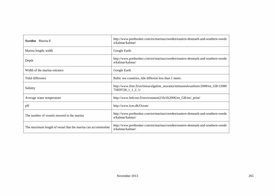
November 2013 265
Sweden Marina 8 http://www.portbooker.com/en/marinas/sweden/eastern-denmark-and-southern-swede
n/kalmar/kalmar/
Marina length; width Google Earth
Depth http://www.portbooker.com/en/marinas/sweden/eastern-denmark-and-southern-swede
n/kalmar/kalmar/
Width of the marina entrance Google Earth
Tidal difference Baltic sea countries, tide different less than 1 meter.
Salinity http://www.fimr.fi/en/tietoa/algaline_seuranta/mittaustulosarkisto/2008/en_GB/12080
75859728_1_1_2_1/
Average water temperature http://www.helcom.fi/environment2/ifs/ifs2006/en_GB/sst/_print/
pH http://www.ices.dk/Ocean/
The number of vessels moored in the marina http://www.portbooker.com/en/marinas/sweden/eastern-denmark-and-southern-swede
n/kalmar/kalmar/
The maximum length of vessel that the marina can accommodate http://www.portbooker.com/en/marinas/sweden/eastern-denmark-and-southern-swede
n/kalmar/kalmar/

November 2013 266
United Kingdom Marina 1 http://www.portbooker.com/en/marinas/united-kingdom/england/cornwall/Penzance
Marina length; width Google Earth
Depth http://www.portbooker.com/en/marinas/united-kingdom/england/cornwall/Penzance
Width of the marina entrance Google Earth
Tidal difference http://easytide.ukho.gov.uk
Salinity http://www.ices.dk/Ocean/
Average water temperature http://www.surf-forecast.com/breaks/PraiadoGuincho.seatemp.shtml
pH http://www.ices.dk/Ocean/
The number of vessels moored in the marina http://www.portbooker.com/en/marinas/united-kingdom/england/cornwall/Penzance
The maximum length of vessel that the marina can accommodate http://www.portbooker.com/en/marinas/united-kingdom/england/cornwall/Penzance

November 2013 267
United Kingdom Marina 2 http://www.portbooker.com/en/marinas/united-kingdom/england/cornwall/mevagissey/
Marina length; width Google Earth
Depth http://www.portbooker.com/en/marinas/united-kingdom/england/cornwall/mevagissey/
Width of the marina entrance Google Earth
Tidal difference http://easytide.ukho.gov.uk
Salinity http://www.ices.dk/Ocean/
Average water temperature annual seasurface temperature 2005
pH http://www.ices.dk/Ocean/
The number of vessels moored in the marina http://www.portbooker.com/en/marinas/united-kingdom/england/cornwall/mevagissey/
The maximum length of vessel that the marina can accommodate http://www.portbooker.com/en/marinas/united-kingdom/england/cornwall/mevagissey/

November 2013 268
United Kingdom Marina 3 http://www.portbooker.com/en/marinas/united-kingdom/england/east-sussex/newhaven-ma
rina/
Marina length; width Google Earth
Depth http://www.portbooker.com/en/marinas/united-kingdom/england/east-sussex/newhaven-ma
rina/
Width of the marina entrance Google Earth
Tidal difference http://easytide.ukho.gov.uk
Salinity http://www.ices.dk/Ocean/
Average water temperature annual seasurface temperature 2005
pH http://www.ices.dk/Ocean/
The number of vessels moored in the marina http://www.portbooker.com/en/marinas/united-kingdom/england/east-sussex/newhaven-ma
rina/
The maximum length of vessel that the marina can accommodate http://www.portbooker.com/en/marinas/united-kingdom/england/east-sussex/newhaven-ma
rina/
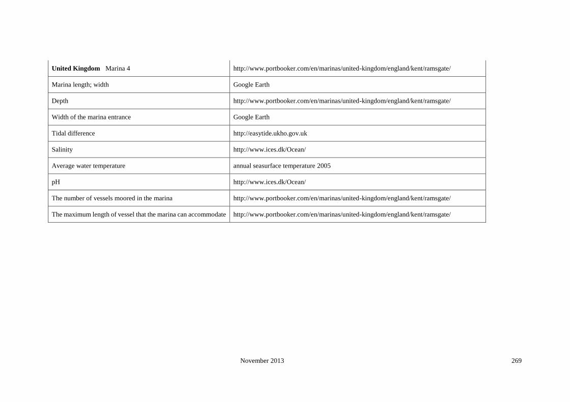
November 2013 269
United Kingdom Marina 4 http://www.portbooker.com/en/marinas/united-kingdom/england/kent/ramsgate/
Marina length; width Google Earth
Depth http://www.portbooker.com/en/marinas/united-kingdom/england/kent/ramsgate/
Width of the marina entrance Google Earth
Tidal difference http://easytide.ukho.gov.uk
Salinity http://www.ices.dk/Ocean/
Average water temperature annual seasurface temperature 2005
pH http://www.ices.dk/Ocean/
The number of vessels moored in the marina http://www.portbooker.com/en/marinas/united-kingdom/england/kent/ramsgate/
The maximum length of vessel that the marina can accommodate http://www.portbooker.com/en/marinas/united-kingdom/england/kent/ramsgate/

November 2013 270
United Kingdom Marina 5 http://www.portbooker.com/en/marinas/united-kingdom/england/essex/bradwell-marina/
Marina length; width Google Earth
Depth http://www.portbooker.com/en/marinas/united-kingdom/england/essex/bradwell-marina/
Width of the marina entrance Google Earth
Tidal difference http://easytide.ukho.gov.uk
Salinity http://www.ices.dk/Ocean/
Average water temperature annual seasurface temperature 2005
pH http://www.ices.dk/Ocean/
The number of vessels moored in the marina http://www.portbooker.com/en/marinas/united-kingdom/england/essex/bradwell-marina/
The maximum length of vessel that the marina can accommodate http://www.portbooker.com/en/marinas/united-kingdom/england/essex/bradwell-marina/

November 2013 271
United Kingdom Marina 6 http://www.portbooker.com/en/marinas/united-kingdom/england/suffolk/royal-norfolk-
--suffolk-yacht-club/
Marina length; width Google Earth
Depth http://www.portbooker.com/en/marinas/united-kingdom/england/suffolk/royal-norfolk-
--suffolk-yacht-club/
Width of the marina entrance Google Earth
Tidal difference http://easytide.ukho.gov.uk
Salinity http://www.ices.dk/Ocean/
Average water temperature annual seasurface temperature 2005
pH http://www.ices.dk/Ocean/
The number of vessels moored in the marina http://www.portbooker.com/en/marinas/united-kingdom/england/suffolk/royal-norfolk-
--suffolk-yacht-club/
The maximum length of vessel that the marina can accommodate http://www.portbooker.com/en/marinas/united-kingdom/england/suffolk/royal-norfolk-
--suffolk-yacht-club/

November 2013 272
United Kingdom Marina 7 http://www.portbooker.com/en/marinas/united-kingdom/england/sunderland/sunderland-
marina/
Marina length; width Google Earth
Depth http://www.portbooker.com/en/marinas/united-kingdom/england/sunderland/sunderland-
marina/
Width of the marina entrance Google Earth
Tidal difference http://easytide.ukho.gov.uk
Salinity http://www.ices.dk/Ocean/
Average water temperature annual seasurface temperature 2005
pH http://www.ices.dk/Ocean/
The number of vessels moored in the marina http://www.portbooker.com/en/marinas/united-kingdom/england/sunderland/sunderland-
marina/
The maximum length of vessel that the marina can accommodate http://www.portbooker.com/en/marinas/united-kingdom/england/sunderland/sunderland-
marina/

November 2013 273
United Kingdom Marina 8 http://www.portbooker.com/en/marinas/united-kingdom/england/northumberland/blyth-
marina/
Marina length; width Google Earth
Depth http://www.portbooker.com/en/marinas/united-kingdom/england/northumberland/blyth-
marina/
Width of the marina entrance Google Earth
Tidal difference http://easytide.ukho.gov.uk
Salinity http://www.ices.dk/Ocean/
Average water temperature annual seasurface temperature 2005
pH http://www.ices.dk/Ocean/
The number of vessels moored in the marina http://www.portbooker.com/en/marinas/united-kingdom/england/northumberland/blyth-
marina/
The maximum length of vessel that the marina can accommodate http://www.portbooker.com/en/marinas/united-kingdom/england/northumberland/blyth-
marina/

November 2013 274
United Kingdom Marina 9 http://www.portbooker.com/en/marinas/united-kingdom/england/northumberland/amble-
marina/
Marina length; width Google Earth
Depth http://www.portbooker.com/en/marinas/united-kingdom/england/northumberland/amble-
marina/
Width of the marina entrance Google Earth
Tidal difference http://easytide.ukho.gov.uk
Salinity http://www.ices.dk/Ocean/
Average water temperature annual seasurface temperature 2005
pH http://www.ices.dk/Ocean/
The number of vessels moored in the marina http://www.portbooker.com/en/marinas/united-kingdom/england/northumberland/amble-
marina/
The maximum length of vessel that the marina can accommodate http://www.portbooker.com/en/marinas/united-kingdom/england/northumberland/amble-
marina/

November 2013 275
United Kingdom Marina 10 http://www.portbooker.com/en/marinas/united-kingdom/wales/ceredigion/aberystwyth-m
arina/
Marina length; width Google Earth
Depth http://www.portbooker.com/en/marinas/united-kingdom/wales/ceredigion/aberystwyth-m
arina/
Width of the marina entrance Google Earth
Tidal difference http://easytide.ukho.gov.uk
Salinity http://www.ices.dk/Ocean/
Average water temperature annual seasurface temperature 2005
pH http://www.ices.dk/Ocean/
The number of vessels moored in the marina http://www.portbooker.com/en/marinas/united-kingdom/wales/ceredigion/aberystwyth-m
arina/
The maximum length of vessel that the marina can accommodate http://www.portbooker.com/en/marinas/united-kingdom/wales/ceredigion/aberystwyth-m
arina/

November 2013 276
Appendix 8: Dendrogram detail
Cluster 5 and 7
Cluster 7
Cluster 5
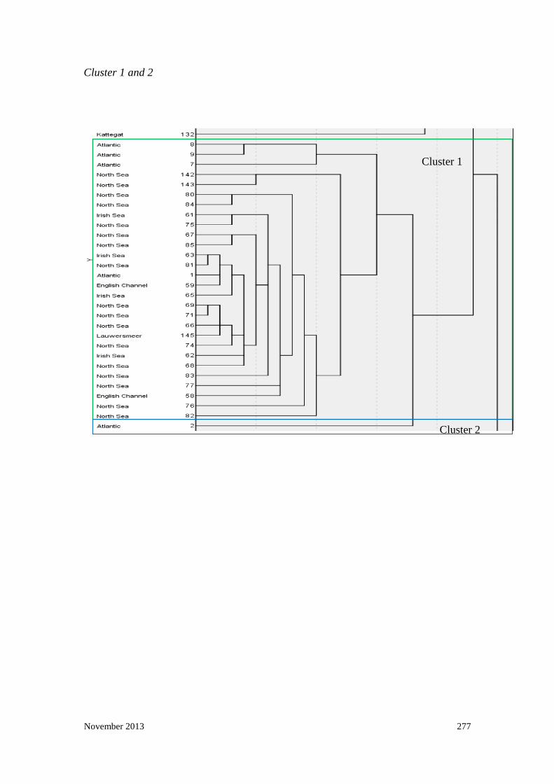
November 2013 277
Cluster 1 and 2
Cluster 1
Cluster 2

November 2013 278
Cluster 3, 6 and 4
Cluster 3
Cluster 4
Cluster 6