De Temporada Farms Report - Chatham-Kent
22
Municipality of Chatham-Kent Community Development Planning Services To: Mayor and Members of Council From: Bruce McAllister, MCIP, RPP Director, Planning Services Date: May 25, 2020 Subject: Application for Site Plan Control PL202000053 – 2585435 Ontario Limited o/a De Temporada Farms 4891 Talbot Trail, Community of Tilbury East (West Kent) ______________________________________________________________________ Recommendation It is recommended that: 1. Site Plan Control application File D-11 TE/10/20/T, to permit the construction of a 21.22 ha (52.46 acre) Large Scale Greenhouse and associated Warehouse and Bunkhouse, in Part of Lots 172 & 173, Talbot Road Survey, in the Community of Tilbury East as shown on the site plan drawing, prepared by Y.C. Liu Engineering, dated September 24, 2019 (final revision May 25, 2020), be approved, subject to the following special conditions: a) The Developer acknowledges that the Chatham-Kent Lake Erie Shoreline Study prepared for the Municipality of Chatham-Kent by Zuzek Inc. dated May 25, 2020 (the “Shoreline Study”), has found that in 50 years or less Talbot Trail will be threatened by erosion. Notwithstanding the approval of the Plan and the issuing a building permit in connection therewith by the Corporation, the Developer waives any claims it may have or may have in the future against the Corporation for any loss, damage or expense that it may suffer as a result of the failure of Talbot Trail caused by erosion. b) The Developer further acknowledges being advised by the Corporation that as a result of the Shoreline Study, the current location of Talbot Trail may be abandoned, and the Developer agrees that in the event that Talbot Trail is abandoned as a result of the Shoreline Study, the Developer shall be responsible for any costs associated with it obtaining alternative access to the Lands and the extension of utilities. The Corporation agrees to cooperate with the Developer and to issue any permits or approvals that may be required by the Developer for the development of such access and extension of utilities
-
Upload
khangminh22 -
Category
Documents
-
view
0 -
download
0
Transcript of De Temporada Farms Report - Chatham-Kent

Municipality of Chatham-Kent
Community Development
Planning Services
To: Mayor and Members of Council
From: Bruce McAllister, MCIP, RPP Director, Planning Services
Date: May 25, 2020
Subject: Application for Site Plan Control PL202000053 – 2585435 Ontario Limited o/a De Temporada Farms
4891 Talbot Trail, Community of Tilbury East (West Kent) ______________________________________________________________________
Recommendation
It is recommended that:
1. Site Plan Control application File D-11 TE/10/20/T, to permit the construction of a 21.22 ha (52.46 acre) Large Scale Greenhouse and associated Warehouse and Bunkhouse, in Part of Lots 172 & 173, Talbot Road Survey, in the Community of Tilbury East as shown on the site plan drawing, prepared by Y.C. Liu Engineering, dated September 24, 2019 (final revision May 25, 2020), be approved, subject to the following special conditions:
a) The Developer acknowledges that the Chatham-Kent Lake Erie Shoreline Study prepared for the Municipality of Chatham-Kent by Zuzek Inc. dated May 25, 2020 (the “Shoreline Study”), has found that in 50 years or less Talbot Trail will be threatened by erosion. Notwithstanding the approval of the Plan and the issuing a building permit in connection therewith by the Corporation, the Developer waives any claims it may have or may have in the future against the Corporation for any loss, damage or expense that it may suffer as a result of the failure of Talbot Trail caused by erosion.
b) The Developer further acknowledges being advised by the Corporation that as a result of the Shoreline Study, the current location of Talbot Trail may be abandoned, and the Developer agrees that in the event that Talbot Trail is abandoned as a result of the Shoreline Study, the Developer shall be responsible for any costs associated with it obtaining alternative access to the Lands and the extension of utilities. The Corporation agrees to cooperate with the Developer and to issue any permits or approvals that may be required by the Developer for the development of such access and extension of utilities

De Temporada Farms PL202000053
2
including but not limited to any upgrades required to Askew Road. Notwithstanding the foregoing, the Corporation agrees that the Developer shall be entitled to participate in any environment studies or land use studies arising from the Shoreline Study or any other or future environmental studies and to participate in any cost sharing or subsidies, including any government subsidies or grants, which may be available or result therefrom.
c) The Developer acknowledges that any future development on the Lands will be subject to the Corporation’s by-laws and development regulations and policies at that time
and that the site plan agreement be executed..
Background
The subject property is located on the north side of Talbot Trail, east of the intersection of Askew Road and Talbot Trail, in the Community of Tilbury East (Roll Nos. 3650 060 003 30500, 30700 & 31000). The subject lands are approximately 61.3 ha (151.5 ac.) in area and are comprised of vacant farmland. The subject lands are designated Agricultural in the Chatham-Kent Official Plan and zoned Agricultural (A1). A key map showing the subject property and surrounding area is attached as Appendix A. Site photos are attached as Appendix B.
The applicant has prepared and submitted plans seeking Site Plan approval to construct a Greenhouse, Warehouse, and Bunkhouse as shown on the site plan attached as Appendix C.
The development of the Greenhouse is proposed to be comprised of three phases of construction, totaling approximately 21.22 ha (52.46 ac.) in area, as shown on the attached site plan. The proposed 9,731 sq. m. (104,743 sq. ft.) Warehouse will contain areas for storage and the packaging of crops produced in the greenhouse, as well as be adjacent to an outdoor loading dock and a parking area accessed from Talbot Trail. The greenhouse and warehouse structures will be setback approximately 575 m from Talbot Trail. The proposed 1,600 sq. m. (17,222 sq. ft.) Bunkhouse is setback approximately 135 m from Talbot Trail and will provide on-site living quarters to seasonal workers when needed, and be adjacent to an outdoor parking area accessed from a second driveway from Talbot Trail. The total building area of the development is proposed to be 22.3 ha (55.1 ac.) on the subject lands. The remainder of the property will consist of farmland, grassed swales and landscaped open space. Two ongoing municipal planning studies may eventually lead to changes in Chatham-Kent’s service delivery to the subject property over the long term. These studies include the Lake Erie Shoreline Study and the Talbot Trail Environmental Assessment Study. Links to websites with information about these studies is below:

De Temporada Farms PL202000053
3
Lake Erie Shoreline Study: https://www.letstalkchatham-kent.ca/chatham-kent-lake-erie-shoreline-study. Talbot Trail Environmental Assessment Study: https://www.chatham-kent.ca/residents/maintenance/talbot-trail-environmental-assessment-study. It is anticipated that services along Talbot Trail, and the road itself, will not sustain development in this area in the future as it does today. Therefore, it is prudent that Chatham-Kent consider the complete effect of its decision with respect to the following priorities:
Natural Hazards, Climate Change & Transportation and Infrastructure.
Agriculture & A Thriving Economy.
Fiscal Sustainability.
Comments
The planning process relies on the Provincial Policy Statement and Chatham-Kent Official Plan to evaluate development proposals and make recommendation to Municipal Council. The Provincial Policy Statement, 2020 (PPS), provides policy direction on matters of provincial interest related to land use planning and development. The PPS provides for appropriate development while protecting resources of provincial interest, public health and safety, and the quality of the natural and built environment. The PPS supports improved land use planning and management, which contributes to a more effective and efficient land use planning system. Planning matters of provincial interest integrated into this report include:
Managing development that is integrated with infrastructure planning
Economic development strategies
Managing agricultural resources
Infrastructure
Shoreline and Great Lakes related issues
Natural hazards The Official Plan is a key part of Chatham-Kent’s planning policy structure that will guide land use decisions in the Municipality. The goal of the Official Plan is to reflect the shared views of its citizens within the established Provincial planning policy framework. The Plan also allows the Municipality to evolve in a way that will contribute to Chatham-Kent’s prosperity and to provide a range of opportunities to live, learn, work and play.

De Temporada Farms PL202000053
4
Planning matters of local interest integrated into this report include:
Achieving a safe, healthy and sustainable Chatham-Kent, by specifically addressing matters related to land-use planning, changing community characteristics, and quality of life.
Addressing the Province’s requirements for planning under the Provincial Policy Statement, ensuring (i) efficient, cost effective development and land use patterns, (ii) adequate planning for natural resources, and (iii) protection of public health and safety.
Addressing Chatham-Kent’s needs for community-level planning by providing a policy framework for Chatham-Kent’s urban and rural settlement areas, economy, natural environment, diverse heritage and community participation.
In reviewing this proposal in the context of the Provincial Policy Statement and Chatham-Kent Official Plan, several relevant policies apply. The proposal is reviewed within three broad themes, which highlight the main issue at hand. The themes are:
Natural Hazards, Climate Change & Transportation and Infrastructure
Agriculture & A Thriving Economy
Fiscal Sustainability
Climate Change & Transportation and Infrastructure
There are issues affecting the proposal related to the erosion of the Lake Erie shoreline and the potential long-term closure of Talbot Trail, decommissioning of public and private services in the Talbot Trail right-of-way, and loss of access to the subject property.
The local roads in the area are not adequate to support the proposal to the same service level that is currently provided by Talbot Trail. The local roads in the area are not suitable for large and heavy vehicles and do not contain suitable public or private services in the right-of-way. The Askew Drain bisects the westerly frontage along Askew Road. This large municipal drain would require an engineered crossing structure.
The Provincial Policy Statement, 2020, and Chatham-Kent Official Plan set of the following policies to guide decision-making in this regard:
Transportation and Infrastructure
Provincial Policy Statement, 2020
1.6.1 Infrastructure and public service facilities shall be provided in an efficient manner that prepares for the impacts of a changing climate while accommodating projected needs.

De Temporada Farms PL202000053
5
Planning for infrastructure and public service facilities shall be coordinated and integrated with land use planning and growth management so that they are: a) financially viable over their life cycle, which may be demonstrated
through asset management planning; and b) available to meet current and projected needs.
1.6.7.1 Transportation systems should be provided which are safe, energy efficient, facilitate the movement of people and goods, and are appropriate to address projected needs.
Chatham-Kent Official Plan
2.4.2.1.2 Establish and maintain a safe and efficient road network that will support the various modes of transportation including transit, active transportation and motor vehicle traffic.
Natural Hazards & Climate Change
Provincial Policy Statement, 2020
3.1.2 Development and site alteration shall not be permitted within:
c. areas that would be rendered inaccessible to people and vehicles during times of flooding hazards, erosion hazards and/or dynamic beach hazards, unless it has been demonstrated that the site has safe access appropriate for the nature of the development and the natural hazard.
3.1.3 Planning authorities shall prepare for the impacts of a changing climate that may increase the risk associated with natural hazards.
Chatham-Kent Official Plan
4.5.3.2.2 Development and site alteration will generally be directed outside of areas of flooding, erosion, and/or dynamic beach hazards along lakefronts, rivers and stream systems. Development and site alteration, however, may be permitted on certain floodplains and erosion constraint areas provided that:
b) no new hazards are created or existing ones aggravated;
4.5.3.2.3 Development and site alteration will not be permitted within Shoreline Hazard Lands.

De Temporada Farms PL202000053
6
The Chatham-Kent Lake Erie Shoreline Study integrated the latest information on historical and anticipated future coastal hazards due to climate change into a comprehensive vulnerability and risk assessment. The study was led by the Municipality of Chatham-Kent, with support from the Lower Thames Valley Conservation Authority. The technical work was completed by Zuzek Inc. in partnership with Linda Mortsch from the University of Waterloo.
Figure 1 - Lake Erie Shoreline Study Area
Climate Change adaptation concepts that follow the four general principals of avoid, accommodate, retreat, and protect are considered in the study. The coastal zone was sub-divided into four regions with similar physical conditions and exposure to hazards. The subject property is within a region that includes the Lake Erie shoreline between Wheatley and Erie Beach.
The recommended adaptation concept is this region is retreat. This adaptation concept recommends undertaking the following actions in the short term (1-5 years):
Re-align approximately 30 km of the Talbot Trail inland. The road would be re-aligned somewhere within the shaded red area of Figure 3, below. The existing development along the bluffs would access the re-aligned Talbot Trail by the existing north-south road network. Sections of the current re-alignment would be decommissioned when threatened by erosion.
Re-locate buildings as required when threatened by erosion and slope instability. The vulnerability assessment identified 235 primary buildings and 204 secondary buildings between the lake and the 50-year estimate for the future top of bluff.
Re-evaluate existing land-use policies, zoning regulations, and building standards along the eroding bluffs to avoid future challenges with development and erosion hazards.

De Temporada Farms PL202000053
7
Figure 2 - Talbot Trail Relocation Concept
In line with the recommendations of the Lake Erie Shoreline Study, the Municipality has initiated a Class Environmental Assessment (EA) Study to develop a transportation plan for the Talbot Trail from the 2nd Concession Line (Ellerbeck Road) to Port Road in the Community of Romney. The Talbot Trail has been experiencing slope instability along the shores of Lake Erie from erosion coinciding with large storm events. This study will consider alternatives for rehabilitation of the existing corridor to address the issue of road failure/slope instability. It will consider the potential for connection of Talbot Trail from Blenheim to Wheatley. It will consider the need to maintain access to existing property/business owners and will examine property impacts as a result of the proposed improvements. The Study will provide the opportunity to improve reliability of the corridor and provide a safe link for road users; reduce maintenance and operating costs; and define a long-term infrastructure plan to support travel within the Municipality. It is anticipated the recommended plan will be determined in 2021. Preliminary design alternatives for a new connection and the location of the subject property are show in Figure 1, below. It is expected that a preferred alternative for Talbot Trail in the study corridor will be a deciding factor on a preferred alternative for future EAs regarding Talbot Trail further east. The property is approximately two kilometres east of the study corridor’s easterly extent at Port Alma.

De Temporada Farms PL202000053
8
Figure 3 - Talbot Trail Route Location Alternatives
Agriculture & A Thriving Economy
Across Chatham-Kent, there are very few constraints to preclude the expansion of greenhouse farming. The weather is favourable, the needed infrastructure services are either available or can be provided, and the impact on the local economy is significant. The estimated economic multiplier spending associated with greenhouse farming is at a factor of five or six times the operating cost of a greenhouse facility. The most important considerations for establishing locations for greenhouse farms are:
a good and reliable source of water;
an adequate fuel supply; and
access to three-phase electrical power. The variables associated with greenhouse farming are too great to identify locations in advance. Each potential site should be evaluated based on its ability to provide a water supply, natural gas and three-phase electrical power. Once the adequacy of utilities has been confirmed, then other locational criteria such as road access, proximity to market, size of the proposed parcel, and price of land should be considered. Environmental issues associated with greenhouses include the disposal of waste. The major social issues associated with greenhouses revolve around the use of migrant workers to work the farms and the need for supporting social and community services.
Subject Property Location

De Temporada Farms PL202000053
9
The Provincial Policy Statement, 2020, and Chatham-Kent Official Plan set of the following policies to guide decision-making in this regard:
Provincial Policy Statement, 2020
1.7.1 Long-term economic prosperity should be supported by:
a) promoting opportunities for economic development and community investment-readiness;
c) optimizing the long-term availability and use of land, resources, infrastructure and public service facilities;
i) sustaining and enhancing the viability of the agricultural system;
k) minimizing negative impacts from a changing climate and considering the ecological benefits provided by nature;
2.3.3.1 In prime agricultural areas, permitted uses and activities are: agricultural uses, agriculture-related uses and on-farm diversified uses.
2.3.3.2 In prime agricultural areas, all types, sizes and intensities of agricultural uses and normal farm practices shall be promoted and protected in accordance with provincial standards.
Chatham-Kent Official Plan The intention of the Official Plan is to make provisions for the long-term protection of the agricultural industry in Chatham-Kent. Agriculture is a cornerstone of Chatham-Kent’s economy. The policies affirm that agriculture is a predominant activity in the Municipality. The leading Agricultural objective of the Official Plan is:
It shall be the objective of Chatham-Kent to support a healthy and viable agricultural industry as a cornerstone of the Municipality’s economy.
The property is designated Agricultural Area, which supports the development of a Greenhouse on the lands. Fiscal Sustainability It is important to protect the overall health and safety of the population, including preparing for the impacts of a changing climate. The planning process directs development away from areas of natural hazards. This preventative approach supports provincial and municipal financial well-being over the long term, protects public health

De Temporada Farms PL202000053
10
and safety, and minimizes cost, risk and social disruption. To address the competing issues related to the development proposal, being:
Natural Hazards, Climate Change & Transportation and Infrastructure; and,
Agriculture & A Thriving Economy
further discussions were held with the Developer on how these municipal concerns could be addressed, while allowing the development to proceed. To address these concerns, the Developer has agreed to add the following special conditions to protect municipal interests in the future:
a) The Developer acknowledges that the Chatham-Kent Lake Erie Shoreline Study prepared for the Municipality of Chatham-Kent by Zuzek Inc. dated May 25, 2020 (the “Shoreline Study”), has found that in 50 years or less Talbot Trail will be threatened by erosion. Notwithstanding the approval of the Plan and the issuing a building permit in connection therewith by the Corporation, the Developer waives any claims it may have or may have in the future against the Corporation for any loss, damage or expense that it may suffer as a result of the failure of Talbot Trail caused by erosion.
b) The Developer further acknowledges being advised by the Corporation that as a result of the Shoreline Study, the current location of Talbot Trail may be abandoned, and the Developer agrees that in the event that Talbot Trail is abandoned as a result of the Shoreline Study, the Developer shall be responsible for any costs associated with it obtaining alternative access to the Lands and the extension of utilities. The Corporation agrees to cooperate with the Developer and to issue any permits or approvals that may be required by the Developer for the development of such access and extension of utilities including but not limited to any upgrades required to Askew Road. Notwithstanding the foregoing, the Corporation agrees that the Developer shall be entitled to participate in any environment studies or land use studies arising from the Shoreline Study or any other or future environmental studies and to participate in any cost sharing or subsidies, including any government subsidies or grants, which may be available or result therefrom.
c) The Developer acknowledges that any future development on the Lands will be subject to the Corporation’s by-laws and development regulations and policies at that time.
Site Plan In support of the Site Plan application, the applicant has also submitted a number of supporting studies and technical documents, which are under review by the Municipality:

De Temporada Farms PL202000053
11
a) Detailed Site Plan
Site Planning is a tool used in Chatham-Kent when property is being developed to coordinate the Developer’s needs as well as the interests of the community, and use of public resources. It is extremely valuable in implementing Chatham-Kent’s goals for continuous improvement towards being a welcoming, active and sustainable place to work and live. The site plan submitted with this application implements Chatham-Kent’s Official Plan and Zoning By-law. The site plan coordinates municipal servicing, public safety and compatibility of land uses. It provides opportunities for being a healthier and progressive place, and respects the Developer’s choice, style and budget for the project. The proposed site plan adheres to Chatham-Kent’s requirements and will form part of the site plan agreement.
b) Lighting Plan and Photometric Data
Chatham-Kent’s Development Standards require site plans to adhere to the following principles through adhering to technical standards as set out in the Development Standards Manual. Lighting plans shall:
i. Contribute to personal safety ii. Support the supervision of secure areas iii. Assist in way finding iv. Conserve energy v. Preserve the experience of the night sky vi. Respect the privacy of residential space vii. Respect animal habitat viii. Heighten the enjoyment of public space and nighttime activity ix. Apply the above listed guiding principles consistently
The proposed site plan adheres to Chatham-Kent’s requirements for lighting and will form part of the site plan agreement. This particular greenhouse is not proposing to install internally growing lights, so impact to the night sky should be minimal.
c) Stormwater Management Plan & Report
A storm water management Plan (SWM) starts with calculations to determine the storm water volumes for the proposed site development and then a design for the movement and storage of storm water that will not upset the natural water cycle of the area. A SWM plan will determine measures that are necessary to allow sediment to settle out of the storm water and to prevent flooding and erosion. The Developer has submitted a stormwater management plan acceptable to the Municipality and it will form part of the site plan agreement.

De Temporada Farms PL202000053
12
d) Ontario Building Code Data Matrix
An Ontario Building Code (OBC) Data Matrix is prepared to demonstrate the proposed development conforms to the relevant aspects of the OBC. It is submitted alongside the relevant site plan drawings to display OBC information clearly for building officials to review. The Developer has submitted an OBC Data Matrix for the proposed bunkhouse found to be acceptable to the Municipality.
e) Rate of Flow Application
The Public Utilities Commission (PUC) requires a Rate of Flow Application for large scale development that are considered large volume users of piped municipal water, which includes a Greenhouse, Agricultural Development, Industrial, or Large Commercial Development. Applications are reviewed to determine if the local distribution system has the appropriate pressure, capacity and that the request will not cause adverse effects to adjacent water customers. The applicant has submitted a rate of flow application for Phase 1(A & B) of the greenhouse development. The PUC has confirmed that adequate water supply is available for this development, on-going coordination between the applicant and the PUC will be required through the preceding phases of development.
f) Servicing Brief A Servicing brief is required for large scale developments in order to identify requirements for site servicing and stormwater management, and to demonstrate how the proposed site will function within the framework of the existing municipal infrastructure. This study is usually submitted as an additional resource to a storm water management plan to better understand how the site will function for the proposed development or addition.
Y.C. Liu Engineering, on behalf of the Developer, has submitted a Servicing Brief acceptable to the Municipality which identifies current water, stormwater, and sanitary service to the proposed site.
Zoning By-law
The proposed greenhouse is defined as “Greenhouse Farm Large Scale” in the Chatham-Kent Zoning By-law. The Zoning By-law defines a Greenhouse Farm Large Scale as:
“GREENHOUSE FARM LARGE SCALE” means an agricultural use in which the predominant economic activity involves the growing of plant materials in large scale greenhouses for subsequent replanting or sale.

De Temporada Farms PL202000053
13
The subject property is zoned Agricultural, which permits a Greenhouse Farm Large Scale as a permitted use, and a Bunkhouse and Warehouse as ancillary to the main use.
The proposal of a Large Scale Greenhouse is further regulated in Section 4, General Provisions, of the Zoning By-law. This development proposal complies with Section 4.11, Greenhouse Farms (Large Scale), which contains specific provisions for the performance standards for a Greenhouse Farm (Large Scale) within an Agricultural (A1) zone:
a) Large-Scale Greenhouse Farm Regulations for all buildings and structures:
i) lot frontage (minimum) – 120 m
ii) front yard (minimum) – 30 m
iii) side yard (minimum) – 15 m or 30 m from the nearest dwelling on a separate lot, whichever is greater
iv) rear yard (minimum) – 15 m or 30 m from the nearest dwelling on a separate lot, whichever is greater
v) lot coverage (maximum) – 80%.
Comment: all proposed buildings maintain the minimum required setbacks from all lot lines and the proposed greenhouse is below the allowable lot coverage.
Notwithstanding (a) (iii), (iv) and (v), the setback for all large-scale greenhouse farm building and structures from all Residential and Deferred Development Zones, as set out in Section 5.0 of this By-law, shall be 300 m
Comment: there are no residential or deferred developments zones in the area, therefore the proposed development will maintain the minimum setback of 300 m.
b) Greenhouse Farm Employee Accommodation – maximum capacity of 2.5 employees per acre of greenhouse.
Comment: the proposed greenhouse development is 52.5 ac. in area, which allows a maximum capacity of 138 employees on the property.
c) Packing, Shipping, Loading Facilities – 15 m minimum setback from all lot lines or 30 m from the nearest dwelling on a separate lot, whichever is greater.
d) Driveways – 7.5 m minimum setback from any side or rear lot line.
e) Parking Areas – 7.5 m minimum setback from all lot lines.
De Temporada Farms PL202000053
14
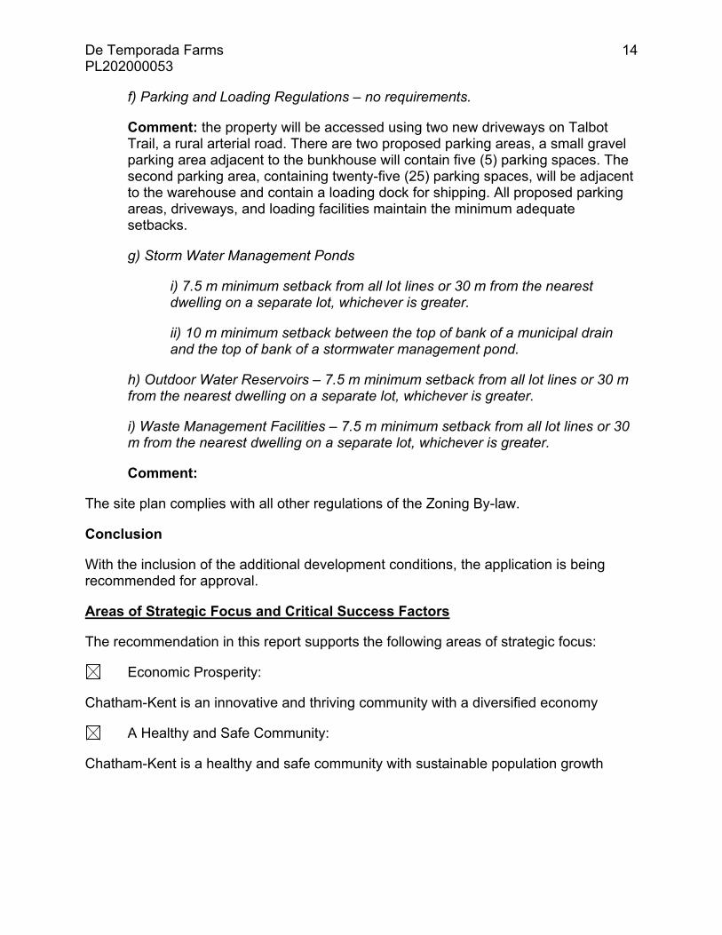
f) Parking and Loading Regulations – no requirements.
Comment: the property will be accessed using two new driveways on Talbot Trail, a rural arterial road. There are two proposed parking areas, a small gravel parking area adjacent to the bunkhouse will contain five (5) parking spaces. The second parking area, containing twenty-five (25) parking spaces, will be adjacent to the warehouse and contain a loading dock for shipping. All proposed parking areas, driveways, and loading facilities maintain the minimum adequate setbacks.
g) Storm Water Management Ponds
i) 7.5 m minimum setback from all lot lines or 30 m from the nearest dwelling on a separate lot, whichever is greater.
ii) 10 m minimum setback between the top of bank of a municipal drain and the top of bank of a stormwater management pond.
h) Outdoor Water Reservoirs – 7.5 m minimum setback from all lot lines or 30 m from the nearest dwelling on a separate lot, whichever is greater.
i) Waste Management Facilities – 7.5 m minimum setback from all lot lines or 30 m from the nearest dwelling on a separate lot, whichever is greater.
Comment:
The site plan complies with all other regulations of the Zoning By-law.
Conclusion
With the inclusion of the additional development conditions, the application is being recommended for approval.
Areas of Strategic Focus and Critical Success Factors
The recommendation in this report supports the following areas of strategic focus:
Economic Prosperity:
Chatham-Kent is an innovative and thriving community with a diversified economy
A Healthy and Safe Community:
Chatham-Kent is a healthy and safe community with sustainable population growth

De Temporada Farms PL202000053
15
People and Culture:
Chatham-Kent is recognized as a culturally vibrant, dynamic, and creative community
Environmental Sustainability:
Chatham-Kent is a community that is environmentally sustainable and promotes stewardship of our natural resources
The recommendation in this report supports the following critical success factors:
Financial Sustainability:
The Corporation of the Municipality of Chatham-Kent is financially sustainable
Open, Transparent and Effective Governance:
The Corporation of the Municipality of Chatham-Kent is open, transparent and effectively governed with efficient and bold, visionary leadership
Has the potential to support all areas of strategic focus & critical success factors
Neutral issues (does not support negatively or positively)
Consultation
Internal
Infrastructure and Engineering Services (IES)
Infrastructure and Engineering Services confirmed the transportation and infrastructure related service levels discussed in this report.
External
Lower Thames Valley Conservation Authority (LTVCA)
The subject lands are located within the regulated area of the LTVCA. Consultation with the LTVCA was undertaken prior to this application and a conditional permit for the proposed development was issued by the LTVCA. A copy of this permit has been included as Appendix D for review.
Financial Implications
There are no financial implications resulting from the recommendation.

De Temporada Farms PL202000053
16
Prepared by: Reviewed by:
____________________________ __________________________ Bruce McAllister, MCIP, RPP John Norton Director, Planning Services General Manager Community Development Attachments: Appendix A – Key Map
Appendix B – Site Photos Appendix C – Site Plan Appendix D – LTVCA Letter
P:\RTC\Community Development\2020\Planning Services\June 15-20 De Temporada Farms Report.docx

De Temporada Farms PL202000053
17
Appendix A – Key Map

De Temporada Farms PL202000053
18
Appendix B – Site Photos
Looking north at the subject property.
Looking west at the vacant subject property and adjacent residential properties

De Temporada Farms PL202000053
19
Appendix C – Site Plan dated September 24, 2019 (final revision May 25, 2020)

De Temporada Farms PL202000053
20
Appendix D – LTVCA Letter

De Temporada Farms PL202000053
21

De Temporada Farms PL202000053
22