The case of the Kurdistan Region of Iraq - Clingendael Institute

The Rowanduz Archaeological Program 2013 First Report to the Kurdistan Regional Government
Michael D. Danti (Boston University) March 5, 2014
The Rowanduz Archaeological Program (RAP)i seeks to revitalize archaeology in Iraqi Kurdistan through the implementation of a long-term, integrative program of multidisciplinary archaeological research projects and cultural heritage management initiatives. The area represents one of the most compelling and unknown corners of the Near East — over a century of warfare and political strife have prevented most archaeological research. In 2013, the Department of Antiquities of the Kurdistan Regional Government granted RAP a five-year permit to conduct archaeological surveys and excavations in the Soran District of northeastern Erbil Province (Figures 1–6). The surrounding mountain ranges of the western Zagros have been renowned for millennia for their scenic wonders and strategically prized as a natural stronghold controlling the mountain routes afforded by the erosional forces of the Greater Zab and its tributaries, especially the immense Rowanduz Gorge and the passes at Kel-i Shin and Gawra Shinka (Figures 1, 3). The high valleys provide summer pastures for herders and tracts of arable land that supported prosperous highland settlements as early as the Pre-pottery Neolithic. Remote sanctuaries, grotto shrines, and monumental rock inscriptions and stele dedicated to ancient storm and mountain deities stand testament to the primordial powers attributed to the awe inspiring landscape and the vitality of the rivers that emanated from the highlands to water the neighboring arid Mesopotamian plain and intermontane basins of Iranian Kurdistan (Pecorella and Salvini 1982). The Zagros also inspired fear, standing as a byword for the forces of chaos and the haunts of wild beasts, mythical creatures, bandits, and marauders. Previously scholars knew little about this region in antiquity save for its hidden potential gleaned from historical sources (Radner 2012; Salvini 1993–1997), travelers’ accounts (e.g., Ainsworth 1841; Cunningham 1966), or the occasional archaeological reconnaissance (Boehmer & Fenner 1973; al-Haik 1968). Cuneiform texts spanning the Early Bronze Age to the early Iron Age suggest the Soran District formed the territorial core of the Hurro-Urartian kingdom of Musasir/Ardini (see esp. Radner 2012; Lehmann-Haupt 1917, 1926; Boehmer 1973), doubly famed as home to the trans-regional cult center of the Hurrian storm-god Haldi and for the sacking of this temple and its treasury by the Neo-Assyrian king Sargon II in 714 BC during his renowned Eighth Campaign (Levine 1977; Zimansky 1990). Archaeological reconnaissance and excavations have revealed evidence for human occupation over the longue durée (Solecki 1954, 1971, 1979, 1998; Solecki, Solecki & Agelarakis 2004; Braidwood & Howe 1960; Braidwood et al. 1983) with clear evidence of the region’s prosperity in the later Bronze and early Iron Age (Boehmer & Fenner 1973; Danti 2013a, 2013b; Dyson 1967, 1973; Muscarella 1968, 1971, 1973, 1974). RAP promises to shed much new light on this Zagrosian buffer state, whatever its ancient name(s), as well as its vacillating relations vis-à-vis its hegemonic neighbors Assyria and Urartu and their complex and shifting networks of vassals and allies. RAP’s research design centers on producing a diachronic assessment of past cultures and human ecology spanning the early Neolithic to the early modern era with a special emphasis on the later Bronze and Early Iron Ages. RAP methods include archaeological excavations, archaeological surveys, geophysical surveys, a bioarchaeological program, and cultural heritage management projects. In 2013, we conducted initial surveys, excavations, and unscheduled emergency rescue excavations in the Soran and Rowanduz subdistricts (Figures 6–7). Our initial findings are extremely promising, but have also revealed a need for immediate action to preserve endangered cultural heritage — the threats primarily derive from rapid, unbridled economic development.

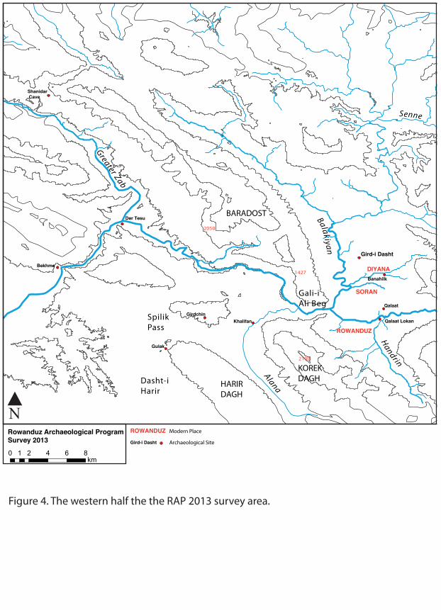
2013 Results In May–July 2013, RAP completed a short field season following extended permit negotiations. The primary objectives were to establish a dig house and to implement regional archaeological surveys and complete test excavations, surface collections, and topographic mapping at Gird-i Dasht (36˚40’50” N, 44˚30’57” E, Elev. 670m ASL), the largest known mound in the Soran area (Figure 4). Gird-i Dasht dominates the Diyana Plain and is situated near the only other excavated site in the immediate area, the Halaf mound of Banahilk (36˚39’53” N, 44˚32’13” E, Elev. 650m ASL, Watson 1983: 545–613). Surface collections completed prior to 2013 and the site’s prominent height indicated a long sequence of occupation, and so in part RAP chose to excavate here in order to develop a regional archaeological sequence. Moreover, the site’s viewshed and location suggest this tabular truncated mound — a form typically indicative of fortresses — controlled overland traffic in the Diyana Plain where several major routes converge. Hence, excavations promise to shed light on the shifting borders of early Iron Age kingdom’s and cultural interactions, especially the influences of Urartu and Assyria in this strategically prized area. The site’s position and prominence was not lost on the New Zealand engineer A. M. Hamilton, who remarked on the view of Gird-i Dasht from the Rowanduz Gorge,
As we descended beyond the highest point of the track, Franklin checked his mule and pointed across the gorge to a strange and unexpected site. Through a narrow slit in the opposite wall the Balkan [Balekian] River delivered its waters. Framed between towering cliffs we saw in the distance green plains and a ruined bridge of many arches, beyond which rose a conical mound that was once perhaps a fort of Darius or of Alexander (1958: 80).
In addition to the planned 2013 objectives, an archaeological site assessment was completed at the small late Islamic fortress of Qalat Lokhan (36˚37’19” N, 44˚32’3” E, elev. 600m ASL) at the request of the Mayor of Rowanduz and the Soran Department of Antiquities, headed by Abdulwahhab Suleiman. In the closing weeks of the season, the Soran Department of Antiquities requested RAP conduct emergency rescue excavations in the Sidekan Subdistrict near the modern village of Topzawa (Figure: Map) where a road improvement project between Sidekan and Kel-i Shin had revealed several archaeological sites, including the Achaemenid cemetery of Ghabrestan-i Topzawa (36˚49’48” N, 44˚45’44” E, 1371m ASL) and the early Iron Age village of Gund-i Topzawa (36˚49’03” N, 44˚44’05” E, 1230m ASL). Gird-i Dasht The oval high mound of Gird-i Dasht stands 20 meters above the surrounding plain and measures 180m north–south by 90m east-west with a total area of 1.60 HA (Figure 7). An earthen ramp extending from the mound’s southeastern upper corner slopes down to the northeastern quadrant, providing easy access to the summit. This feature marks the entrance to the upper fortified settlement of the Islamic era but may also correspond to the gateways of earlier periods. A topographically indistinct lower area of occupation surrounding the high mound, recognizable only from a high density of surface artifacts, covers an additional estimated 1.25 HA. Nearby streams provide perennial water sources, and a man-made subterranean channel with a stone masonry outlet brings water to within 800m of the site from an unknown catchment in the east. The date of this feature is currently undetermined, but we suspect it belongs to the Islamic occupation. Local informants link the final occupation of the mound to the Sorani Emirate (Eppel 2008) and reported that a suq was situated atop the mound at that time. The traces of late mud-brick walls and possible towers on the mound’s surface, as well as later Islamic pottery similar to that collected at Qalat Lokhan, seemingly verify this claim. Overall, the site is well preserved. We identified a few looter pits on the mound and uncovered some traces of recent military activity. The local landowner informed us that looters had found numerous artifacts in their digging,

including an inscribed stone door socket — subsequent investigation by the Soran Department of Antiquities has yet to recover it. In 2013, a short excavation season was undertaken to verify the results of surface collections made by the Soran Department of Antiquities and RAP in 2012, which indicated a long occupation sequence with substantial settlement in the Middle–Late Bronze Age, early Iron Age, and Middle–Late Islamic periods. Other occupation phases are evident, but the poorly known archaeological sequence for the region currently complicates their identification. Operation 1, measuring three meters north–south by four meters east–west, was situated on the mound’s northeastern slope over a low stone retaining wall or wall footing eroding out of the slope and partially exposed for a distance of 8m north to south (Figure 6b). A stone-paved revetment or stone packing, sloping markedly upward to the west, ran along the west (interior) side of the wall/footing and lay partially atop it. The exact chronological relationship between these two features has yet to be determined. We found stratigraphic evidence of a terracing of the eastern slope of the mound associated with the construction of the retaining wall/wall footing. The wall, standing three courses high (50 cm) and measuring 70–80 cm thick, was made of crudely dressed limestone slabs laid in a herringbone pattern. No preserved mud brick or tauf were found atop it, and there was no evidence of plastering. The operation was truncated several times to reach the feature’s initial construction surface in the short time available.ii A radiocarbon sample of charcoal from the initial construction surface, lying 1.60m below the mound’s surface (Abs. Elev. 96.89m), provided a date of AD 985–1154 (two-sigma range) or within the Uqaylid (AD 990–1096) to Seljuk/early Zenjid Periods (AD 1016–1153). Two subsequent Islamic occupation phases were also documented. The few ceramic diagnostics, mainly monochrome glazed wares such as so-called green-glazed Geruz Ware (Danti 2004) indicated Middle and Late Islamic dates, respectively. Operation 1 was continued down the slope to the east 2.0m as a shallow step trench (three steps) to investigate occupation phases predating the fortification wall. Sherds of probable early Iron Age and Middle–Late Bronze Age date were recovered in the step trench and were also found as extrusive sherds in the Islamic levels of Operation 1. Operation 2, a test trench measuring two meters north-south by three meters east-west, was situated at the base of the high mound at its northeast quadrant and was oriented northeast to southwest, long axis perpendicular to the mound’s contours (Figure 7). The operation exposed 1.0m of deposit at its southwest end (Abs. Elev. 86.08m) and 30 cm at its east end (Abs. Elev. 85.50m), revealing a mud-brick fortification wall running northwest–southeast with the contours of the mound. The wall’s base was not exposed, and the extant mudbrick varied in height between 30–70cm and the wall measured at least 1.70m thick — the eastern interior face lay outside the excavated area. There was not enough time to investigate the wall’s initial construction phase, but abundant sherds of the Middle and Late Bronze Age suggest a date no later than the 2nd millennium BC, including chaff-faced Late Bronze Age wares and painted Khabur Ware of the early-to-mid 2nd millennium. A layer of wash and an Islamic midden deposit, 40–60cm thick, covered the wall following its use-phase. The 2013 excavations at Gird-i Dasht demonstrate that continued work at the site will yield incredible dividends in terms of understanding settlement in the Diyana Plain over several millennia and that the site was indeed fortified in multiple periods. Gund-i Topzawa This early Iron Age site is situated on the north slope of the Topzawa Çay valley stretching along the ancient road between the Sidekan area, the original position of the Topzawa Stele (Boehmer 1979) five km to the southwest, and the Kel-i Shin Pass and Kel-i Shin Stele (De Morgan and Scheil 1893; Benedict 1961) 20 km to the northeast (Figure 5). The erosion of the hillside in antiquity had completely obscured the archaeological remains (Figure

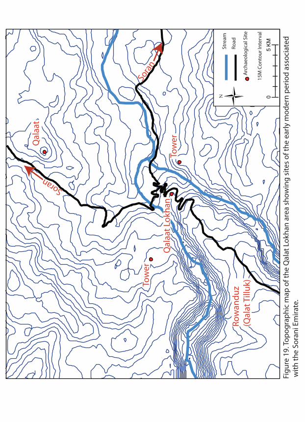
8). Road widening work in 2013 sectioned the site’s south edge (h. 3.0–4.0m), exposing a 133m stretch of cultural deposit running northeast–southwest. The site was easy to identify since the settlement had been burned in antiquity: in several places the section contained thick layers of charcoal, ash, and other burned debris above clearly delineable floor levels. Several buildings and room blocks could be distinguished. The buildings were terraced into the hillside similar to modern traditional construction in the area (Figure 9a), and possibly construction depicted in Assyrian reliefs and associated with Ardini/Musasir (Figure 10a). Stone walls were set into the terraces. Some north–south walls were preserved as high as 4.0m. Occasionally these north-south walls were doubled (two courses thick) where separate buildings abutted one another, and we could identify benches or buttresses against some walls. Where the bases of the walls were visible in the road cut, we determined they were founded on bedrock. The road widening had severely damaged some of the southern walls that faced the valley and road — these presumably contained the doorways into the structures. Ceramics collected from the exposed sections and two whole vessels given to the expedition by the construction company and allegedly from the site (Figure 9b) indicate a date in the early Iron Age. The ceramic wares are closely related to the Monochrome Burnished Ware Horizon of northwestern Iran best known from the neighboring Ushnu-Solduz Valley just beyond the Kel-i Shin Pass (Danti 2013a, 2013b). This dating was verified by three radiocarbon determinations from samples of charcoal from the carbonized remains of roof beams from three separate rooms — two separate structures — and so constitute terminus post quem for the destruction of the buildings. At the two-sigma level, these dates range from 801–519 BC, 996–817 BC, and 1188–904 BC, or the Iron I–III (Figure: 10b). Gund-i Topzawa represents an incredible find, but is now threatened by destruction and looting. Other smaller burned habitations with early Iron Age pottery were also identified in the road cut to the northeast. Continued work in the Topzawa Çay Valley holds great promise for understanding settlement in the western Zagros in the late 2nd and early 1st millennium BC. Ghabrestan-i Topzawa The cemetery of Ghabrestan-i Topzawa is situated on the north side of the Topzawa Çay Valley three km northeast of Gund-i Topzawa (Figure 5). Road widening work had revealed one stone-built tomb of probable late Achaemenid date and a contemporary semi-subterranean structure located immediately to the northeast of the tomb — an apparent habitation used by the tomb’s builders (Figure 11–12). The tomb was constructed of three walls (north, east, and west) of roughly worked limestone slabs that were batted inward and set into a square terrace/pit dug into the hillside to a depth of 2.50m (Figure 13). The tomb chamber, oriented west of magnetic north (345˚), measured 2.20m north–south by 2.25m east–west and had a maximum height of 1.85m. The roof was constructed from large, boat-shaped, worked limestone slabs cantilevered over the walls. A mound of small slate slabs and slate chips was arranged over the roof slabs to prevent water penetration. Overall, the construction technique is reminiscent of traditional modern architecture in the area as well as the structures documented at Gund-i Topzawa. The tomb’s entrance was located at the south side facing the Topzawa Çay, and a small spring running southward down to the larger stream was located just below the entrance. The entrance had originally been blocked by smooth, grey river cobbles from the Topzawa Çay. The tomb contained two use-phases separated by a thick sterile matrix (40–60 cm depth). Burials from the original use-phase were not damaged or disturbed by the modern roadwork and lay on or just above a packed clay floor and beneath the scattered blocking stones of the entrance. These graves were heavily disturbed in antiquity, although some skeletal elements were found in articulated arrangements. Other skeletal elements were found arranged in intentional piles along the walls of the tomb (Figure14a), and it appears the tomb was used over a period of time for multiple interments. At this time, it is unclear whether primary or secondary burials were interred in the tomb. The chamber contained a large assemblage of pottery (Figures 15–16), a few items

of personal ornament — including twisted-hoop bronze wire earrings, beads, and a serpent-headed bronze bracelet (Figure 14b) — and abundant animal bones, including the remains of at least two canids. We did not have adequate time to analyze the skeletal remains in 2013. The ceramics, exhibiting a wide range of fine and utilitarian wares, date to the Achaemenid period based on cross-sequence comparisons. A spouted jar (Figures 15: J, 17a back row, left) has parallels with Hasanlu IIIa (Young 1965: Fig. 2 no. 5), Yesilalic II (Sevin 1985: Fig. 4 no. 5), Pasargade (Ghirshman 1954: pl. XXIV no. 6), and the Spring Cemetery at Persepolis (Schmidt 1957: Pl. 89 no. 5). Another spouted jar (Figure 16: R, 17b) has close parallels at Agrab Tepe (Muscarella 1973: Fig. 15 no. 8), Hasanlu IIIa (Dyson 1965: 205, 212 n. 36), and Susa Achaemenid Village I (Ghirshman 1954: pl. XXIX, GS 2242). The bracelet with serpent-headed terminals supports this dating with wide ranging parallels, including the Achaemenid cemetery at Ghalekuti (Haerinck 1989: 472, Fig. 4 no. 7) and Susa Achaemenid Village I (Ghirshman 1954: pl. XXXIX, G.S. 2242). Following the initial use-phase, the stone blocking of the entrance was pushed inward or fell inward, resulting in much damage to the tomb’s contents, and the tomb may have been partially looted. One radiocarbon date was obtained from charcoal collected from the earliest surface and below the collapse of the blocking stones, providing a calibrated range in the late Achaemenid period or post-Achaemenid (359–89 cal BC). A Seleuco-Parthian date seems highly unlikely given the absence of any Hellenistic or Parthian related material in the burial group. A thick deposit of sterile wind and water-lain silts interspersed with stone collapse accumulated following the ancient opening of the tomb. At a later date, the tomb was re-used for a large number of burials. The graves on the south (entrance) side of the tomb had been hit by the earthmoving equipment and were in poor condition. The Soran Department of Antiquities had removed these skeletons prior to our excavation. We excavated four of these later graves at the north end of the tomb, which were in good condition and were tightly packed into the tomb in extended positions with the head to the west resting against the west wal. There were no grave goods associated with the tomb’s second use-phase. Ceramics recovered from cleaning the section of the contemporary semi-subterranean pit house (Figure 18a) provided limited information on vessel forms, but the attested wares were identical to those from the tomb. Following the use-phase of this dwelling, it was filled with construction debris from the tomb — primarily slate chips and other construction debris. Ghabrestan-i Topzawa provides an extremely rare local late Achaemenid or early post-Achaemenid assemblage from a sealed context. The site may yield additional tombs: we were unable to make a thorough investigation of other parts of the site in the time available. Qalat Lokhan Qalat Lokhan is a small archaeological site located on the north edge of modern Rowanduz and overlooking the village of Kaw Lokhan to its north (Figures 18b–19). Our investigations show the site dates to the late Islamic Period (17th–19th centuries AD). Local tradition maintains the mound represents the remains of a structure associated with the last ruler of the Sorani Emirate, Mir Mohammad (ruled 1825—1835), also know as Mohammad “Khor,” Khor Pasha, or Mohammad the Blind (Eppel 2008), and the site’s location and relationship to neighboring Late Islamic structures strongly suggests it formed part of a network of towers and fortresses constructed during the Sorani Emirate that guarded the main approaches to and from Old Rowanduz, now the modern village of Kaw Lokhan, up to the rocky spur of Qala Tiluk (Masters 1953). Prior to World War I, the more lavish buildings of Old Rowanduz occupied this highpoint overlooking the valley (Masters 1953). Following the demise of the Sorani Emirate, the Ottomans made Rowanduz the seat of a qaimmaqam under the Kirkuk sanjaq (district) of the vilayet (province) of Mosul. During World War I, the larger part of Rowanduz’s population was slaughtered by the Russians or were forced to flee, and the settlement lay derelict for some time. Masters writes,

“The town was gradually rebuilt during the decade which followed the First World War, not in the valley, but on the bluff formerly called Qala Tiluk which is a formidable defensive position against infantry, for the gorges of the Rowanduz and Handrin rivers protect it on three sides. This is the new Rowanduz, and the site of the older is occupied only by an army barracks constructed by the British and a small aggregate of buildings known as Kawlokan (1953: 14).
Qalaat Lokhan occupies a rocky spur flanked on either side by branches of the Rowanduz Gorge to the west and the Handrin Gorge to the east. Two stone watchtowers (recently reconstructed) occupy bluffs to the east and west of the site across the deep precipices of the gorges and, according to local informants, date to the same time as Qalat Lokhan. The larger fortress of Qalat lies to the north and is clearly visibly from Qalat Lokhan and the watchtowers. Masters, writing of Qalat in 1953, noted, “A ruined fortress of this leader [Mir Mohammad] is to be seen a short distance north of the town, and his descendants , the House of Ismail Beg, still own much of its property” (Masters 1953: 13). Viewshed analysis shows that these Islamic sites were situated to control the important crossroads in the area of Kaw Lokhan where two outlets of the Rowanduz Gorge open into a range of hills just to the south of the Diana Plain. Qalat Lokhan commanded the switchback road leading up to Qala Tiluk, which winds along the north and east sides of the rocky outcropping. The site comprises a small central oval mound — the remains of a single rectilinear stone-block and mudbrick building — taking in ca. 0.1 HA and standing 2.50m high and a lower, extensive archaeological site to the north, west, and south composed of linear mound arrangements (presumably mudbrick walls), smaller low mounds, and exposed stone footings. Surface artifact densities were quite low and the site was mostly covered in thistles, inhibiting surface collections. There was some disturbance of the archaeological deposits by recent military activity: the most obvious and damaging was the digging of a gun emplacement into the top of the main mound. The Mayor of Rowanduz requested RAP conduct a site assessment of Qalat Lokhan to determine the nature of its archaeological deposits and to submit an opinion on the suitability of the location for a new museum for Rowanduz and Soran, which would entail the leveling and destruction of most of the site. In 2011, during the initial stages of the museum construction project a bulldozer had cut the edge of the main mound (Figure 18b) revealing the corner of a masonry structure. The local antiquities office then halted construction at the site. RAP excavated three small soundings, and completed a topographic map of the site. Operations 1–2 were situated over the masonry corner exposed by the bulldozer to recover interior and exterior contexts. Our objectives were to attempt to determine the date of the structure, the building’s function, and the extent of disturbance caused by the modern gun emplacement in the limited time available. We exposed the southeast corner of the building, which was constructed from roughly dressed pieces of locally available limestone. We reached the exterior building surface and recovered in situ artifact deposits. Inside the structure, we revealed a small section of the floor. Glazed ceramics and clay pipes indicate a date no earlier than the Safavid Period/early Sorani Emirate (1501–1736). Occupation extended into the late Ottoman Period, and so the site dates to the time of the Sorani Emirate. One coin recovered from Operation 1 provided a date of 1840 AD.

Operation 3, a two by two meter test pit, was excavated on the lower portion of the site southeast of the main mounded area. Our objective here was to investigate the depth of deposit and to determine whether earlier periods were present. Two phases of a Late Islamic midden were investigated: the deposits consisted of an ashy matrix with abundant faunal remains, a low density of ceramics and glass, and a few pieces of heavily corroded iron. We reached bedrock at a depth of 55–70 cm below the surface. We believe the site of Qalat Lokhan should be preserved and that additional excavations should be completed at the site to expose the entire main building. 2014 Objectives In 2014, RAP will conduct a three-month field season of geophysical surveys, archaeological surveys, and excavations. At Gird-i Dasht, a team from Ludwig-Maximilians University, Munich led by Jorg Fassbinder will conduct a geophysical survey of the high mound and areas of the low mound to detect subsurface features and guide our excavations. We will then open two 10 x 10m units at the top of the mound to expand the area of Operation 1 and investigate pre-Islamic occupation phases. Following the harvest, we will also expand Operation 2 into a 10 x 10m unit to increase our exposure of the fortification wall and collect more evidence on the 2nd millennium BC occupation in this area. Additional objectives include archaeological and geophysical surveys in the Sidekan, Mudjesir, and Topzawa areas, especially at the sites of Gund-i Tiopzawa and Ghabrestan-i Topzawa, where we will also conduct additional test excavations. Sources Cited AL-HAIK. A. 1968. Key List of Archaeological Excavations in Iraq. (Coconut Grove, FA: Field Research Projects), pp. 64–67, 140. AINSWORTH, W. 1841. Travels and Researches in Asia Minor, Mesopotamia, Chaldea and Armenia (London: John Parker). BENEDICT, W. 1961. ”The Urartian-Assyrian Inscription of Kelishin,” Journal of the American Oriental Society: 81/4: 359–385. BOEHMER, R. 1973. Zur Lage von Musasir. Baghdader Mitteilungen 6: 31–40. ___. 1979. Zur Stele von Topzawä. Baghdader Mitteilungen 10: 143–144, Pls. 12–13. ___. 1993–1997. Musasir B. Archaeology. Reallexikon der Assyriologie und Vorderasiatischen Archäologie 8, (DeGruyter), pp. 446–450. BOEHMER, M. & H. FENNER. 1973. Forschungen in und um Mudjesir (Irakisch-Kurdistan). Archäologischer Anzeiger 4: 479–521. BOLTON, C. 1955. Report on the geology and economic prospects of the Rowanduz area. Site Inv. Co. report. NIMCO Library (Baghdad). ___. 1956. The geology of the Rowanduz-Qala Dizeh areas. Site Inv. Co. report. NIMCO Library (Baghdad). BRAIDWOOD, L., R. BRAIDWOOD, B. HOWE, C. REED & P. WATSON. 1983. Prehistoric Archaeology Along the Zagros Flanks. Oriental Institute Publications 105 (Chicago: The Oriental Institute). BRAIDWOOD, R. & B. HOWE. 1960. Prehistoric Investigations in Iraqi Kurdistan. Studies in Ancient Oriental Civilization 31 (Chicago: The Oriental Institute).

COLLINS, P. 2010. Iran 1932–1978. In Y. Rakic (ed.), pp. 30–39. CUNNINGHAM, A. (ed). 1966. The Early Correspondence of Richard Wood, 1831–1841. (London: Royal Historical Society). DANTI, M. 2004. The Ilkhanid Heartland: Hasanlu Tepe (Iran) Period I. Hasanlu Excavation Reports II. University Museum Monograph 120 (Philadelphia: University of Pennsylvania Museum). ___. 2013a. The Late Bronze and Early Iron Age in northwestern Iran. In D. Potts (ed.), pp. 327–76. ___. 2013b. Hasanlu V: The Late Bronze and Iron I Periods. Hasanlu Excavation Reports III. (Philadelphia: University of Pennsylvania Press). DYSON, R. 1965. Problems of Protohistoric Iran as Seen from Hasanlu. Journal of Near Eastern Studies 24: 193–217. ___. 1967. Early Cultures of Solduz, Azerbaijan. In A. Pope (ed.), pp. 2951–70. ___. 1973. The Archaeological Evidence of the Second Millennium B.C. on the Persian Plateau. The Cambridge Ancient History. 3rd ed. Vol. II, Pt. 1 (Cambridge: Cambridge University Press), pp. 686–715. EPPEL, M. 2008. The Demise of the Kurdish Emirates: The Impact of Ottoman Reforms and International Relations on Kurdistan during the First Half of the Nineteenth Century. Middle Eastern Studies 44(2): 237–258. GHIRSHMAN, R. 1954. Village perse-achéménide. Mémoires de al Mission Archéologique en Iran XXXVI. Paris: Presses Universitaires de France. GUNTER, M. 2010. Historical Dictionary of the Kurds. (Lanham, MD: Scarecrow Press). HAMILTON, A.H. 1958. The Road Through Kurdistan. New edition. (London: Faber & Faber Limited). HAERINCK, E. 1989. The Achaemenid (Iron Age IV) Period in Gilan. In L. De Meyer and E. Haerinck (ed.) Archaeologia Irancia et Orientalis. Miscellanea in Honorem Louis Vanden Berghe (Gent), pp. 454–474. LEACH, E. 1940. Social and Economic Organisation of the Rowanduz Kurds. Monographs on Social Anthropology 3 (London: Percy Lund, Humphries & Co.). LEVINE, L. 1977. Sargon’s Eighth Campaign. In L. Levine & T.C. Young (ed.), pp. 135–151. LEVINE, L. & T. C. YOUNG (EDS.) 1977. Mountains and Lowlands: Essays in the Archaeology of Greater Mesopotamia. (Malibu: Undena). LEHMANN-HAUPT, C. 1917. Musasir und der achte Feldzug Sargons II (714 v. Chr.). Mitteilungen der Vorderasiatischen und Ägyptischen Gesellschaft 2: 131 ff. ___. 1926. Armenien Einst und Jetzt II. 1 (Berlin: B. Behr): 299ff. JASSIM, S. & J. GOFF (Ed) 2008. The Geology of Iraq. (Dolin).

MASTERS, W. 1953. Rowanduz: A Kurdish Administrative and Mercantile Center. PhD Dissertation. University of Michigan, Ann Arbor. DE MORGAN, J. & V. SCHEIL. 1893. La Stèle de Kel-i-chin. Recueil de travaux relatifs à la philologie et à l'archéologie égyptiennes et assyriennes 14: 153–160. MUSCARELLA, M. 1968. Excavations at Dinkha Tepe, 1966. Bulletin of the Metropolitan Museum of Art. 27: 187–96. ___. 1971. Qalatgah: An Urartian Site in Northwestern Iran. Expedition 13: 44–49. ___. 1973. Excavations at Agrab Tepe, Iran. Metropolitan Museum Journal 8: 47–76. ___. 1974. The Iron Age at Dinkha Tepe, Iran. Metropolitan Museum Journal 9: 35–90. ÖZOĞLU, H. 1996. State-Tribe Relations: Kurdish Tribalism in the 16th- and 17th-Century Ottoman Empire. British Journal of Middle Eastern Studies 23 (1): 5–27. PECORELLA, P. & M. SALVINI. 1982. Tra lo Zagros e l’Urmia: Ricerche Storiche ed Archeologiche nell’Azerbaigiano Iranico. (Rome). POPE. A. (ED.) 1967. A Survey of Persian Art. (New York: Oxford University Press). POTTS, D. (ED.) 2013. The Oxford Handbook of Ancient Iran (New York: Oxford University Press). RADNER, H. 2012. Between a Rock and a Hard Place: Musasir, Kumme and Subria — The Buffer States between Assyria and Urartu. In S. Kroll, C. Gruber, U. Hellwag, M. Roaf & P. Zimansky (ed.) Biainili-Urartu. (Leuven: Peeters), pp. 243–264. RAKIC, Y. (ed.) Discovering the Art of the Ancient Near East. Archaeological Excavations Supported by the Metropolitan Museum of Art. 1931–2010. The Metropolitan Museum of Art Bulletin. Summer 2010 (New York: The Metropolitan Museum of Art). RUSSELL, H. 1984. Shalmaneser's Campaign to Urartu in 856 B.C. and the Historical Geography of Eastern Anatolia According to the Assyrian Sources. Anatolian Studies 34: 171–201. SALVINI, MIRJO. 1993–1997. “Musasir A. History,” Reallexikon der Assyriologie und Vorderasiatischen Archäologie 8, (DeGruyter), pp. 444–446. SCHIMDT, E. 1957. Persepolis II. Oriental Institute Publication LXIX. (Chicago: The University of Chicago). SEVIN, V. 1985. Van Bölgesi Yüzey Arastirmasi, III. Arastirma Somuçlari Toplantisi. Ankara, pp. 287–295 SOLECKI, R. 1954. Shanidar cave: a paleolithic site in northern Iraq. Annual Report of the Smithsonian Institution: 389–425. ___. 1971. Shanidar: The Humanity of Neanderthal Man. (London). ___. 1979. Contemporary Kurdish winter-time inhabitants of Shanidar Cave, Iraq. World Archaeology 10: 318–330. ___. 1998. Archaeological survey of caves in Northern Iraq. International Journal of Kurdish Studies 12: 1–70.

SOLECKI, R., R. SOLECKI & A. AGELARAKIS. 2004. The Proto-Neolithic Cemetery in Shanidar Cave. (Texas A&M University Press). WATSON, P. 1983. The Sounding at Banahilk. In L. Braidwood et al. (Ed.), pp. 545–613. YOUNG, T.C. 1965. A Comparative Ceramic Chronology for Western Iran, 1500–500 B.C. Iran 3: 53–85. ZADOK, R. 1978. West Semitic toponyms in Assyrian and Babylonian sources. In Y. Avishur & J. Blau (ed.) Studies in the Bible and the Ancient Near East Presented to S. E. Loewenstamm on his Seventieth Birthday. (Jerusalem), pp. 163–179. ZIMANSKY, P. 1990. Urartian Geography and Sargon’s Eighth Campaign. Journal of Near Eastern Studies 49: 1–21. i RAP is sponsored by Boston University, The University of Pennsylvania Museum, and Ludwig-Maximilians Universität München. Dr. Michael D. Danti (Boston University) serves as General Director and Dr. Richard L. Zettler (University of Pennsylvania) is the Associate Director. RAP includes the following staff members: Dr. John MacGinnis (McDonald Institute, Cambridge University), Epigrapher; Dr. Jessica Johnson (University of Delaware), Conservator; Dr. William Hafford (University of Pennsylvania), Excavation Supervisor; Dr. Christian Piller (Ludwig-Maximilians Universität München), Excavation Supervisor; Dr. Jorg Fassbinder (Ludwig-Maximilians Universität München), Geophysical Survey; Dr. Tina Greenfield (University of Manitoba), Zooarchaeologist; Dr. Alexia Smith (University of Connecticut), Archaeobotanist; Darren Ashby, MA (University of Pennsylvania), Excavation Supervisor; Kathleen Downey, MA (University of Sheffield), Human Osteologist; Lucas Proctor (University of Connecticut), Archaeobotanist; Kyra Kaercher (Boston University), Ceramicist; Hardy Maaß (Ludwig-Maximilians Universität München), Illustrator; Allison Cuneo (Boston University), Cultural Heritage Management; Marshall Schurtz (University of Pennsylvania), Archaeological Survey and Remote Sensing. ii This feature was designated Locus 4 Lot 3.

Tabriz
SAHAND
Hasanlu
Salmas
Bezug Dağ
Kuh-eZanbil
Q. Ismael Aqa
Urmia Kordlar
BerdesurQ
asem
lu
Baranduz
Geoy
RuzehNazlu T. Gijlar
DinkhaUshnuyeh
Gadar
Mas
u
Talkeh
Ain-e Rum
Guverçin Kala
Miyanduab
Simineh Rud
Zarineh
Mah
abad
Kuh-e Siah
Kuh-e Choganlu
Kuh-e AlmaluKulaboz
Mahabad
Marand
Khoy
Maragheh
Ajab Shir
Bonab
Su�
Murdi
Gol
Yanik
Masjid-eKabudShahi
Peninsula
QuriSalian
DandDağ
Sarand
Adji
0 50 100 km
N Rowanduz
Sidekan
ErbilArbail
Gawra Shinke PassTell HaftunHiptunu
Topzawa
Haftavan
Lake Urmia
Khalifan
Mudjesir
Kel-i Shin
Gird-e Dasht Piranshahr
Shanidar
Figure 1. SRTM Map of the Middle East showing the area of northeastern Iraqi Kurdistan and northwestern Iran. Ancient sites are shown with blue circles and modern places with red triangles. Important ancient routes in Iraqi Kurdistan are shown in red.

KIRKUK
SULA
YMA
NIY
EH
DOHUK
TURKEYIRAN
SidekanMergasur
HajjiOmran
CHOMAN
SORAN
DiyanaKhalifan
RowanduzGalala
Harir
Salahaddin
Ainkawa
HAWLER(ERBIL)
Khabat
Shorsh
Qushtapa
MAKHMUR
Taqtaq
Khosaw
Bnaslawa
Koysinjaq
Makhmur
Caraj
Kandinawa
GuwaiKOYSINJAQ
SHAQLAWA
MERGASUR
Sherwan Mazn
Barzan
Figure 2. Hawler (Erbil) Province showing its districts and subdistricts. RAP has beengranted a �ve-year permit to conduct archaeological research in the Soran Districtand will also work in the Mergasur and Choman Districts. The Soran Department ofAntiquities covers the area of Soran, Choman, and Mergasur Districts and the HarirSubdistrict of the Shaqlawa District.
N

Figure 3. A branch of the Rowanduz Gorge in modern Rowanduz.
KOREK DAGH
BARADOST
HARIR DAGH
Gulak
1427
2100
Gali-iAli Beg
Spilik Pass
Dasht-i Harir
2050
Greater Zab
Balakiyan Senne
Handrin
Alana
Rowanduz Archaeological Program Survey 2013
0 2 4 6 81km
Qalaat
Shanidar Cave
Qalaat Lokan
Banahilk
Gird-i Dasht
SORAN
ROWANDUZ
DIYANA
Gund-i Topzawa
Bekhme
Der Tesu
KhalifanGirdchin
ROWANDUZ Modern Place
Gird-i Dasht Archaeological Site
Figure 4. The western half the the RAP 2013 survey area.
N

Rowanduz Archaeological Program Survey 2013
0 2 4 6 81km
ROWANDUZ Modern Place
Gird-i Dasht Archaeological Site
HANDRIN DAGH
HASSAN BEG
2500
2550
1800
1020
HALGURD3600
Senne
Qalaat Mudjesir
Gird-e Mudjesir
Gund-i Topzawa
Sidekan TopzawaStele
Gawra Shinka Pass
Galala
Choman
Kel-i Shin Pass
Gund-iTopzawa
Ghabrestan-iTopzawa
Kel-i ShinStele
Figure 5. The eastern half the the RAP 2013 survey area.
N

Figure 6a. The high mound of Gird-i Dasht from the east with the Baradost Mountains in the background.
Figure 6b. Gird-i Dasht Operation 1 looking west and showing the step trench and the Islamic stone retaining wall or forti�cation wall.

-150 -100 -50 0m 50 100
150
100
50
0m
-50
-100
-150
9880
OP 1
OP 2
Figure 7. Preliminary topographic map of Gird-i Dasht showing the RAP 2013 excavations.Elevations are calculated above and below the base datum point 0, 0, 100m (X, Y, Z), contour interval three meters.

Figure 8a. A portion of the section of Gund-i Topzawa exposed by road constructionlooking northeast.
Figure 8b. Early Iron Age walls exposed at Gund-i Topzawa, looking north.

Figure 9a. A traditional structure terraced into a hillside in the village of Mudjesir.
Figure 9b. Vessels allegedly found at Gund-i Topzawa and returned to the Soran Deparment of Antiquities.

Figure 10a. The temple of the storm-god Haldo at Musasir as drawn by Eugène Flandin fromSlab 4 of Room XIII of Sargon II’s palace at Khorsabad /Dur-Sharukkin (from Botta 1849: pl. 141).
1100 1000 900 800 700 6000.
2.
4.
6.
8.
10.
12.
cal BC
Calibrated Age Ranges
Figure 10b. Calibrated radiocarbon date ranges from Gund-i Topzawa.

Figure 11a. Ghabrestan-i Topzawa looking southwest . The tomb chamber (right) was discovered during road widening work.
Figure 11b. Ghabrestan-i Topzawa looking north prior to excavation. The exposed skeletons are from the tomb’s second use-phase.
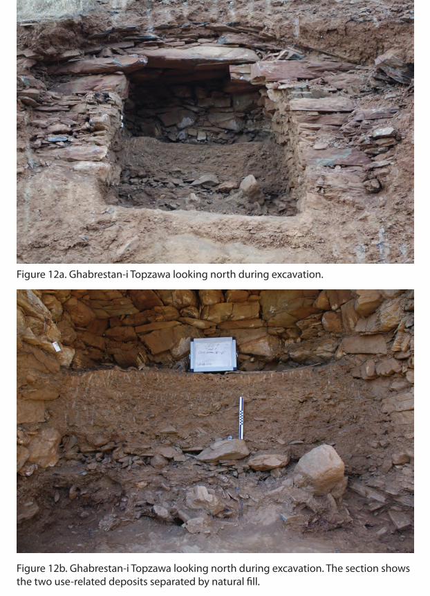
Figure 12a. Ghabrestan-i Topzawa looking north during excavation.
Figure 12b. Ghabrestan-i Topzawa looking north during excavation. The section shows the two use-related deposits separated by natural �ll.

showing the distribution of early burials and blocking stones.
0 1m

Figure 14b. Ghabrestan-i Topzawa: Bronze bracelet with stylized animal-headed terminals in situ.
Figure 14a. Ghabrestan-i Topzawa: Skeletal elements from the tomb’s early use-phase stacked along the east wall of the tomb chamber (looking east).

0 5 cm
A
B
G
CD
H
I
J K
L
M
N
O P QR
S TU
VW X
Y Z AA BB CC DD EE
FF GG HH II JJ
KK LL MM NN OOPP
Figure 15. Ghabrestan-i Topzawa: Select ceramics from the tomb’s early use-phase.
F
E

0 5 cm
A B C
ED F
G H I
J K
LM
N O
PQ
R
S
T
U
V
Figure 16. Ghabrestan-i Topzawa: Select ceramics from the tomb’s early use-phase.

Figure 17a. Ghabrestan-i Topzawa whole vessels from the tomb’s earliest use-phase.
Figure 17b. Ghabrestan-i Topzawa: Fragment of a spouted jar from the tomb’s earliest use-phase.

Figure 18a. Ghabrestan-i Topzawa: The remains of the semi-subterranean pit houselocated immediately northeast of the chamber tomb (looking north).
Figure 18b. Qalat Lokhan: The exposed northeast corner of the Islamic stone-block structure looking west.
Qal
aat L
okha
n
Qal
aat
Tow
er
Tow
er
Row
andu
z(Q
alat
Till
uk)
Soran
Sora
n
05
KM
Stre
am
Road
Arc
haeo
logi
cal S
ite
15M
Con
tour
Inte
rval
Figu
re 1
9. To
pogr
aphi
c m
ap o
f the
Qal
at L
okha
n ar
ea s
how
ing
site
s of
the
early
mod
ern
perio
d as
soci
ated
with
the
Sora
ni E
mira
te.
Copyright © 2022 FDOKUMEN


![A Concise History of Ancient Kurdistan [in Kurdish]](https://static.fdokumen.com/doc/165x107/63335467b6829c19b80c5cc1/a-concise-history-of-ancient-kurdistan-in-kurdish.jpg)