Daedalus Supplementary Planning Document - Gosport ...
95
Gosport Borough Council Local Development Framework Daedalus Supplementary Planning Document September 2011 D e livering for G os port
-
Upload
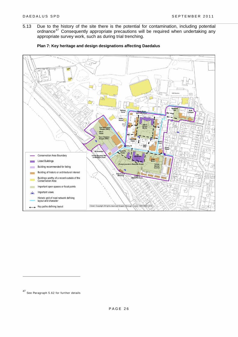
khangminh22 -
Category
Documents
-
view
1 -
download
0
Transcript of Daedalus Supplementary Planning Document - Gosport ...

Gosport Borough Council
Local Development Framework
Daedalus
Supplementary Planning Document
September 2011
DDeelliivveerriinnggffoorr GGoossppoorrtt

Daedalus Supplementary Planning Document: September 2011
Gosport Borough Council

Foreword The Gosport Peninsula is undergoing a period of major change with tremendous opportunities for businesses to invest in our Borough. This transition will result in the diversification of the Gosport economy whilst continuing to build on its particular strengths. A clear vision for Gosport is an essential enabler to seeking economic growth and ensuring an appropriately and highly skilled workforce for the future.
The Daedalus site in Lee-on-the-Solent plays a major role in that future for Gosport. Daedalus has the potential to create significant new local jobs and be a place for business to thrive.
Supporting our ambition locally, the Government has recently identified Daedalus as an Enterprise Zone, one of only 22 in the UK. This Enterprise Zone status gives visibility to the site, recognises it as a national priority and will help attract businesses within the maritime, aviation and advanced manufacturing sectors building on the assets that the Daedalus site clearly offers. Success at Daedalus will increase the potential to attract funding for infrastructure and will facilitate long-term investment in the wider Gosport and Solent area.
It is within this context that I welcome the Daedalus SPD which sets out the planning framework for Daedalus. The SPD highlights the opportunities for developers and assists them when preparing their proposals to shape the future at Daedalus.
This SPD will be used to help inform future planning decisions made by the Borough Council. It provides a greater element of certainty both to developers and the local community whilst providing sufficient flexibility to bring forth innovative solutions. It will safeguard the amenities of local residents as well as providing the necessary protection to historic buildings and the natural environment. It will also help maintain the quality of life that Lee-on-the-Solent and Gosport already offers, which makes it such an attractive place for inward investment. It will help business understand the Daedalus site and facilitate investment.
Daedalus will play a significant role in the on-going development of our Borough and is a major priority for the Council. Creating this SPD supports the Council’s determination to create a sustainable future, underpinned by economic growth, and that ‘Gosport is open for business’.
Councillor Michael Lane
Chairman,
Economic Development
Gosport Borough Council
Michael Lane
September 2011

Daedalus Supplementary Planning Document (SPD): Contents Page
Whole Site Plan 1 Plan for the Gosport part of Daedalus 2 The Vision for Daedalus 3
1: Introduction 4
Purpose and status of the Daedalus SPD 4 How the SPD was prepared 5 Environmental Assessment 5
2: Site and Surroundings 7 Location 7 History of Daedalus 8 Site Assessment 9
3: Planning Policy Context 12 National Policy 12 Sub Regional Context 12 County Level 13 Local Policy 14 Planning History 16
4: Development Strategy 17 Key Objectives 17 Mix of Uses 18
5: Development Considerations 24 Design and Built Heritage 24 Green Infrastructure 27 Biodiversity 28 Sustainable Construction 30 Energy Efficiency and Renewable Energy 31 Use and Protection of Water Resources 32 Flood Risk 32 Waste and Recycling 33 Amenity Issues 33 Contaminated Land 35 Utilities 36 Specific Employment and Commercial Development Considerations 38 Specific Aviation Considerations 39 Specific Marine Activity Considerations 40 Specific Residential Development Considerations 41
6: Transport and Accessibility Strategy 44 Introduction 44 Existing Transport Conditions 44 Transport Objectives and Key Principles 46 Transport Assessment and Contributions 47 Provision of Off-site Infrastructure 47 Public Transport 48 Access Points 50 Street Layout and Hierarchy 52 Walking and Cycling opportunities 53 Travel Plan 54
7: Design 55 Design Concept 55 Character Areas and Design Considerations 55
8: Implementation 70 Enterprise Zone 70

Planning Applications 71 Phasing 72 Planning Obligations 73 Other Funding mechanisms 73 Viability/Enabling Development 73 On-going Maintenance 74
Daedalus SPD: List of Plans
Plan 1 Whole site Plan 1
Plan 2 Plan for the Gosport part of Daedalus 2
Plan 3 Location of Daedalus within the sub region 7
Plan 4 Daedalus and its surroundings 9
Plan 5 Key Planning Policy Considerations (as identified by the saved policies of the Adopted Gosport Borough Local Plan Review)
15
Plan 6 Potential mix of uses to be accommodated at the Daedalus site within Gosport
18
Plan 7 Key heritage and design designations affecting Daedalus 26
Plan 8 Strategic Access to Gosport Study - proposed transport measures particularly relevant to Daedalus
49
Plan 9 Access arrangements 50
Plan 10 Plan of Character Areas 56
Plan 11 Enterprise Zone 70
Daedalus SPD: List of Appendices
Appendix 1 Consultation to date A76
Appendix 2 List of Background Papers A78
Appendix 3 Summary of National Government guidance relevant to the Daedalus Site
A80
Appendix 4 Gosport Borough Local Plan Review Saved Policies A83
Appendix 5 Recent planning history A88
Note:
Footnotes and web-links do not form part of the adopted text and will be subject to change in the electronic version of this document in order to provide the most up-to-date information.
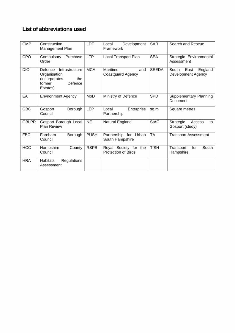
List of abbreviations used
CMP Construction Management Plan
LDF Local Development Framework
SAR Search and Rescue
CPO Compulsory Purchase Order
LTP Local Transport Plan SEA Strategic Environmental Assessment
DIO Defence Infrastructure Organisation (incorporates the former Defence Estates)
MCA Maritime and Coastguard Agency
SEEDA South East England Development Agency
EA Environment Agency MoD Ministry of Defence SPD Supplementary Planning Document
GBC Gosport Borough Council
LEP Local Enterprise Partnership
sq.m Square metres
GBLPR Gosport Borough Local Plan Review
NE Natural England StAG Strategic Access to Gosport (study)
FBC Fareham Borough Council
PUSH Partnership for Urban South Hampshire
TA Transport Assessment
HCC Hampshire County Council
RSPB Royal Society for the Protection of Birds
TfSH Transport for South Hampshire
HRA Habitats Regulations Assessment

D A E D A L U S S P D S E P T E M B E R 2 0 1 1
P A G E 1
Plan 1: Whole Site Plan
D A E D A L U S S P D S E P T E M B E R 2 0 1 1
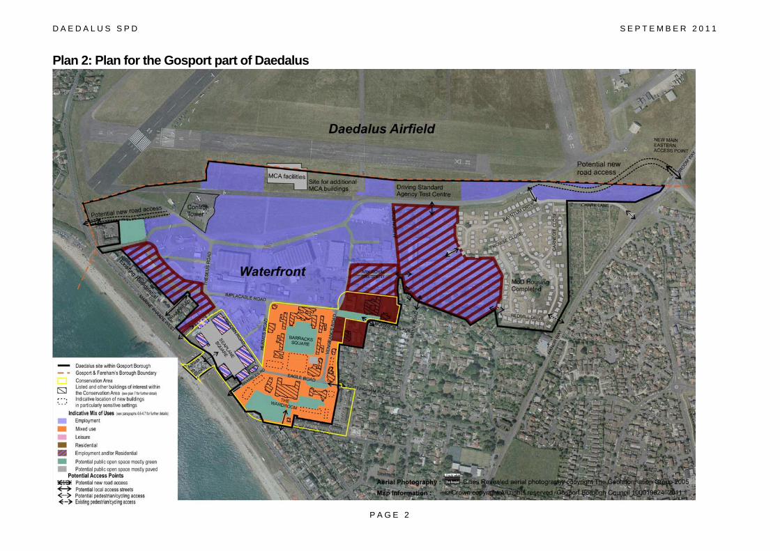
Plan 2: Plan for the Gosport part of Daedalus
P A G E 2
D A E D A L U S S P D S E P T E M B E R 2 0 1 1
The Vision for Daedalus Daedalus will be transformed into a sustainable strategic business location. The site will provide significant new job opportunities particularly within key business clusters including aviation, high-tech manufacturing and marine. It will provide a significant number of highly skilled jobs contributing to Gosport’s and the Solent area’s economic growth and diversification.
Daedalus will include a range of uses and facilities which complement the identity of the site as a strategic business location. The design and use of existing and new buildings and spaces will be of a high quality to ensure the preservation and enhancement of the environment, the Daedalus Conservation Area and its Listed Buildings. The prestigious development will be an identifiable place in its own right, well related to, and benefiting the wider community.
P A G E 3

D A E D A L U S S P D S E P T E M B E R 2 0 1 1
P A G E 4
1.0 INTRODUCTION
1.1 In August 2011 the Government announced that the Daedalus site will be an Enterprise Zone. The aim of Enterprise Zones is to allow areas with real potential to create significant new business and employment opportunities and deliver positive benefits across a wider area. One of the key objectives of Enterprise Zones is to reduce burdens for business including lower tax levels and the potential for simplified planning measures such as a Local Development Order. The SPD will therefore provide a framework for developing simplified planning measures and will be used as a material consideration when determining planning applications where these are required.
1.2 Since its closure in 1996, the former Naval Base at Daedalus has been under-utilised and
was declared surplus to requirements by the Ministry of Defence in 2004. In March 2006, the Maritime and Coastguard Agency (MCA) acquired the airfield which extends to approximately 106 hectares and the South East England Development Agency (SEEDA)1 acquired 82 hectares of land surrounding the airfield. This SPD covers the approximately 38 hectares within Gosport Borough.
Purpose and Status of the Daedalus Supplementary Planning Document
1.3 The purpose of the Daedalus Supplementary Planning Document (SPD) is to provide significant certainty regarding the potential scale and mix of future proposals for the Daedalus site within Gosport Borough, yet provide sufficient flexibility to be able to address changing market demands. The SPD will provide a framework for developing simplified planning measures such as a Local Development Order (LDO)2 on appropriate parts of the site. The SPD will also be used by the Borough Council as a key consideration when determining future planning applications on the site.
1.4 At this stage it is not known the precise boundaries and nature of any potential local development order. It is clear from Government guidance that an LDO will not be applicable for all parts of the Daedalus site3 and consequently a planning application will need to be submitted in the normal way.
1.5 The SPD is linked to ‘saved’ Policy R/DP4 of the Gosport Borough Local Plan Review
(GBLPR) (Adopted May 2006) which identifies the Daedalus site as a mixed use site. The detailed guidance of the SPD has been prepared in accordance with the relevant saved policies of the GBLPR. The SPD also takes into account the emerging Gosport Core Strategy and its supporting evidence. Once the Core Strategy is adopted the SPD will be linked to the Daedalus Strategic Site policy.
1.6 The SPD has been prepared in the context of a site-wide plan (Plan 1) which takes into
account Fareham Borough Council’s latest policy position in order to ensure the site is planned in a comprehensive manner. This is necessary to ensure uses are compatible and
1 It should be noted that SEEDA will cease to exist in 2012 and SEEDA’s assets were transferred to the Housing and Communities
Agency in September 2011.
2 DCLG Circular 01/2006. 3 including Listed Buildings and areas which would affect their setting; or for development which could have a significant effect on a
European site . In such cases a planning application would be necessary in order to consider the principle and detailed nature of
development.
D A E D A L U S S P D S E P T E M B E R 2 0 1 1
P A G E 5
the required infrastructure is provided to serve the whole site. This SPD covers the part of the Daedalus site which is located within Gosport Borough (see Plans 2 & 3).
1.7 It is recognised that the development will take a number of years to complete.
Consequently, this document is not intended to be viewed as being the end of the design process. GBC is committed to ongoing consultation with potential developers and other key stakeholders as planning applications for Daedalus are brought forward.
How the SPD was prepared
1.8 This SPD has been prepared by Gosport Borough Council and follows consultation with the local community and relevant organisations and businesses4. It has been developed in accordance with the Joint Planning Statement for Daedalus (April 2006) which has been adopted by both Fareham and Gosport Borough Councils.
1.9 The SPD takes account of agreed principles reflected in SEEDA’s Draft Visionary
Framework5 (January 2009) and informed by subsequent responses made by the two Borough Councils6 and Hampshire County Council. The Framework (with the local authority responses) is intended to act as an overarching document for the whole site and ensures that there is a continued collaborative approach to development in order to deliver the cross boundary vision.
1.10 There has been close liaison with Fareham Borough Council throughout the preparation of the SPD in order to ensure that the whole of the Daedalus site is planned on a comprehensive basis to meet the needs of the Gosport peninsula and its communities.
1.11 Since purchasing the site SEEDA has undertaken significant consultation with the local
community, businesses and other key stakeholders to inform the development process. The details of the consultation arrangements are contained in Appendix 17
1.12 SEEDA has also carried out significant research regarding the opportunities and constraints
for developing the site which has informed the details of the SPD. Key studies are outlined in Appendix 2.
Environmental Assessment 1.13 The SPD has been informed by a Strategic Environmental Assessment Report (SEA)8. The
SEA Report sets out the statutory position on the need for an environmental assessment and concludes that whilst a formal Sustainability Appraisal and Strategic Environmental Assessment is not required it is considered best practice to undertake some form of assessment to identify key issues, potential constraints, opportunities for environmental enhancement and whether there is a need for mitigation measures.
4 Details of the consultation are contained in Appendix 1 5 The Visionary Framework can be viewed at: http://www.daedalus-seeda.co.uk/site/seeda/publications--documents/publications--documents?LanguageId=0 6 Gosport Borough Council’s comments can be viewed in the minutes for the Policy and Organisation Board minutes for 11th March
2009 at www.gosport.gov.uk/sections/democratic-services/agendas-minutes/policy-and-organisation-board/minutes/2009/
Fareham Borough Council’s comments can be viewed at: www.fareham.gov.uk/crs/executive/090309/reports-public/xpt-
090309-r13-lje.pdf 7 full details available on the Daedalus website http://www.daedalus-seeda.co.uk/site/seeda/publications--documents/publications--documents?LanguageId=0 8 Prepared by Drivers Jonas Deloitte on behalf of SEEDA
D A E D A L U S S P D S E P T E M B E R 2 0 1 1
P A G E 6
1.14 The SEA Report includes an assessment for the whole Daedalus site and supports both the
Gosport SPD and future Fareham SPD. The key findings are set out in the relevant part of the development considerations section (Section 5).
1.15 A Habitats Regulations Assessment (HRA) Report9 has been undertaken to inform and
accompany the Daedalus SPD. The HRA Report has been informed by the draft HRA Report for the emerging Core Strategy and the comments received to the Daedalus HRA Screening Report (January 2011). The relevant findings have been incorporated within this SPD.
9 www.gosport.gov.uk/daedalus-spd

D A E D A L U S S P D S E P T E M B E R 2 0 1 1
2.0 SITE AND SURROUNDINGS Location 2.1 Daedalus is located on the Gosport peninsula in Hampshire (see Plan 3). It occupies a
coastal location on the Solent between the residential communities of Lee-on-the Solent to the east and Stubbington and Hill Head to the west. The site is within two local authority districts, Gosport Borough and Fareham Borough. The main towns of Gosport and Fareham are located to the east and north respectively. The city of Portsmouth is located 8km (5 miles) to the east and Southampton is 17km (11miles) to the west.
Plan 3: Location of Daedalus within Sub-Region
P A G E 7

D A E D A L U S S P D S E P T E M B E R 2 0 1 1
P A G E 8
praisal (GBC March 2007)10 11
otably Westcliffe House and its
e end of the
luding Eagle
ult of the transfer of Fleet Air Arm to Admiralty
r raids because of its military significance. The site performed an important role on D-
still based at Daedalus even though the establishment was past the peak levels of
test centre has been completed
History of Daedalus 2.2 A detailed account of the development of the site, buildings and features of historic interest
is included in the Council’s Daedalus Conservation Area Apand the Conservation Area Management Plan (HGP 2010) .
2.3 In summary the site was open farmland until the 1880s, when there was an attempt to
develop a seaside town health resort of Lee-on-the-Solent. Central to the development was the seafront itself and Marine Parade East and West, along with parkland (West Cliff Park and East Cliff Park), promenades and pier. A new ‘village centre’ soon appeared, with shops along Pier Street and a hotel. On the Daedalus site a few buildings of particular interest were developed and a grid of streets laid out, most nestate, Norbury House, Keith Cottages and Wykeham Hall.
2.4 In 1917 the site was requisitioned to provide a training school for seaplane pilots and
permanent Admiralty Designed Hangars and a slipway were developed. By thWar the site had a staff of nearly 500, providing training for almost 100 pupils.
2.5 After World War 1, the site became the base for the newly formed Fleet Air Arm, and
growth continued into the 1930s when the site became Coastal Command Headquarters. A number of important buildings appeared on the site during this period incBlock, the Wardroom, the Barrack Blocks, and Dining Room and Cookhouse.
.6 At the outbreak of World War 2, and as a res2
Control, the facility became HMS Daedalus. 2.7 During World War 2 the site became a key aviation base with an expanding camp and
airfield to the north and north east, and was a crucial base for air sorties. The site suffered two aiDay.
2.8 Daedalus continued in military use after 1945, although on a smaller scale and focusing on
technical training, particularly helicopter and hovercraft testing12. In 1992 1,600 personnel were use.
2.9 HMS Daedalus closed in 1996, and the MoD declared it surplus to requirements in 2004. It
was subsequently acquired by SEEDA and the MCA in 2006. The MCA have a new building for its Search and Rescue (SAR) Helicopter Unit at Daedalus with proposals for additional facilities. They use the site as a helicopter base for sea and air rescue operations. The airfield is currently used by a limited number of existing small scale aviation users. The site is also home to a number of smaller and medium sized businesses that make use of the former hangars and military buildings on an interim basis until long-term arrangements are developed. More recently a driving and is now in operation on the MCA-owned part of the site.
10 http://www.gosport.gov.uk/sections/your-council/council-services/planning-section/conservation/conservation-areas/area-
appraisals/
11 Prepared by HGP on behalf of SEEDA
12 In 1961 the Interservice Hovercraft Trials Units was founded at the site.

D A E D A L U S S P D S E P T E M B E R 2 0 1 1
2
P A G E 9
.10 In August 2011 the Government announced that Daedalus would become an Enterprise ccessful application by the Solent Local Enterprise Partnership (LEP).
The SPD also gives attention to nkages with other parts of the site particularly the airfield itself. Most of the Airfield,
largely or entirely within Fareham Borough Council’s m Daedalus SPD.
lan 4: Daedalus and its surroundings
’s Visionary Framework (January 2009) (with additional material added by GBC)
Zone following a suThe benefits provided by an Enterprise Zone are set out in Section 8 ‘Implementation’.
Site Assessment
2.11 Daedalus can be divided into four key areas all of which have different characters and current uses: Daedalus Waterfront, Hangars West, Hangars East and the Airfield. It is considered that the airfield remains the focus for the site with built development being directed to the areas around the airfield. This SPD covers the parts of Daedalus within Gosport Borough, which is primarily the Daedalus Waterfront area, but also the southern edge of the airfield and Hangars East as shown in Plan 4. liHangars East and Hangars West, are area and will be covered by the Fareha P
Source: based on SEEDA

D A E D A L U S S P D S E P T E M B E R 2 0 1 1
Daedalus Waterfront – 31.5 Hectares
2.12 This part of the site lies between the seafront, the built up area of Lee-on-the-Solent and the airfield. This area is the most developed part of Daedalus and has direct access to the Solent via the slipway. It comprises a combination of brick-face former offices and domestic buildings alongside large-scale industrial/ warehousing buildings. Some of the buildings are of historic and architectural value. Part of this area is a designated Conservation Area, in which three buildings are listed. The total built floorspace of the area extends to 67,640 sq m.
2.13 Part of the site has been retained by the Defence Infrastructure Organisation (DIO)13 for
residential development to support its operational requirements. 148 married quarters have been constructed. However a further proposed 152 dwellings had outline planning permission which has now lapsed (4.9 ha)14 Hangars East – 40.5 Hectares
2.14 Hangars East is located on the east side of the airfield and is accessed from Broom Way. This area consists of areas of hardstanding with groups of loosely clustered hangars adjacent to the airfield and a red brick building. There is 9,680 sq m of built space in this area.
13 from 1st April 2011 includes the former Defence Estates. The DIO has now placed their undeveloped land within Daedalus on the
Register of Surplus Public Sector Land
14 February 2011- GBC refused planning permission to renewal the consent as insufficient evidence was supplied regarding whether the
Married Quarters are still required, particularly in the light of the latest review of defence spending.
P A G E 1 0

D A E D A L U S S P D S E P T E M B E R 2 0 1 1
Hangars West – 14.4 Hectares 2.15 Hangars West comprises
three linked triangles of land formed by the serrated edge of Stubbington, and lies on the west side of the airfield. There is currently an unused access point on Gosport Road. It is a large, flat area bordering the remaining active runway, with various hangars and taxi ways. The buildings extend to 7,140 sq m.
Airfield – 101.2 Hectares 2.16 Most of the airfield is within Fareham Borough with its southern edge within Gosport
Borough. Both Borough Councils strongly support the site’s continued use as an airfield The Maritime and Coastguard Agency (MCA) acquired most of the airfield15 and a new high quality building for the MCA has recently been completed providing a benchmark for the quality of new employment floorspace that could be accommodated on other parts of the site.
15 Long term management arrangements for the airfield are currently under discussion (as 1/4/11).
P A G E 1 1

D A E D A L U S S P D S E P T E M B E R 2 0 1 1
P A G E 1 2
3.0 PLANNING POLICY CONTEXT 3.1 In preparing this supplementary planning document particular regard has been given to
national and local policies and consequently it will be necessary for developers to have regard to the implications of these policies16 when submitting development proposals. National Policy
3.2 National planning guidance is set out in the Planning Policy Statements (PPSs) and Planning Policy Guidance (PPGs). A brief overview of the key guidance and its relevance to the Daedalus site is set out in Appendix 3.
3.3 Government policy seeks to promote the efficient use of land through higher density, mixed
use development and the use of suitably located previously developed land and buildings. In particular, vacant and under-used sites and buildings should be brought back into beneficial use. It encourages the promotion of inclusive urban development, which supports existing communities and contributes to the creation of safe, liveable and mixed communities with good access to jobs and key services for all members of the community. Consequently Daedalus is particularly suitable for development. Sub-Regional Context
3.4 The Daedalus site is located within the South Hampshire Sub-regional Strategy Area. At the sub-regional level a consortium of south Hampshire authorities, has come together to form the Partnership for Urban South Hampshire (PUSH). PUSH through local consultation produced its own sub-regional strategy for South Hampshire (2006-2026) which was submitted to the former South East of England Regional Assembly (SEERA) and was included (largely unchanged) in the South East (SE) Plan following an Examination in Public.
3.5 Despite the Government’s intention to revoke the SE Plan17 it is considered that the South
Hampshire Strategy is still a valid consideration. It provides a policy framework to guide the preparation of the Council’s emerging Core Strategy because it has been devised at a local level by a group of local authorities and has been subject to public consultation and examination.
3.6 The aim for the sub-region is to improve economic performance which has been under-
performing relative to the region as a whole. The South Hampshire Strategy (May 2009)18 requires that land is provided to accommodate two million square metres of new business floorspace in the sub-region with around 900,000 sq. m being provided in the south east part which includes Gosport. Further work conducted by the Partnership for Urban South Hampshire (PUSH) has identified that Gosport should aim to provide at least 81,500 sq. m
of employment floorspace. Daedalus has been identified by PUSH as an area of strategic importance for employment purposes.
16 Includes current and subsequent Government policies.
17 The Government announced in July 2010 that it had revoked the South East Plan. On 10 November 2010 the High Court re-
established Regional Strategies as part of the development plan. This will be on a temporary basis as the Localism Bill includes
provisions to quash the Regional Strategies.
18 As included in PUSH’s South Hampshire Sub-regional Strategy- Final Advice to SEERA (December 2005) and incorporated in the
South East Plan (May 2009).

D A E D A L U S S P D S E P T E M B E R 2 0 1 1
P A G E 1 3
3.7 The South Hampshire Strategy (May 2009) aims to raise the economic performance of the sub-region and improve the skills of the labour force. Daedalus offers a clear opportunity to assist in achieving these targets, including providing floorspace for marine, aviation and general employment.
3.8 The Strategy19 identifies a target of 2,500 dwellings in Gosport over the period 2006-2026.
The Borough Council can demonstrate that it can meet this figure and that it has a five year land supply.20
County Level
Transport Policy 3.9 The Local Transport Plan for Hampshire (LTP3)21 covers the period 2011-2031 and is
produced by the County Council as the highway authority. It contains a joint strategy for South Hampshire and will provide a consistent transport strategy for the Transport for South Hampshire (TfSH)22 area. Consequently the proposals contained in LTP3 are of particular relevance to the development timescale for Daedalus. LTP3 is based on the principles of Reduce, Manage and Invest. A key measure to reduce the number of trips is the creation of employment for local residents thereby mitigating the acknowledged transport constraints.
3.10 In addition the County Council has prepared the Strategic Access to Gosport (StAG) study
(HCC/Mott Gifford 2010) which has informed LTP3. The StAG has identified schemes that will benefit the Gosport peninsula, and which are necessary to accommodate planned growth up to 2026. Further details are included in Section 6.
3.11 Currently there is uncertainty with regards to the capital funding of schemes, and given the
pressures on Government spending over at least the next 5 years it is likely that there will be increased reliance on developers to fund improvements where necessary to mitigate the impacts of development.
Minerals and Waste Policy 3.12 The Daedalus site has known sand and gravel deposits however for a variety of reasons
this has not been safeguarded as a site for mineral extraction. The potentially workable reserve of mineral has been assessed as totalling up to 3.4 million tonnes (largely within Fareham Borough area).
3.13 The Minerals and Waste Core Strategy (adopted 2007) prepared by Hampshire County
Council, as the minerals and waste authority for the Gosport and Fareham area includes the primary policies and proposals for the county and forms part of the Development Plan. Parts of this plan are currently under review23
19 As included in PUSH’s South Hampshire Sub-regional Strategy- Final Advice to SEERA (December 2005) and incorporated in the
South East Plan (May 2009) 20 See the Council’s Annual Monitoring Reports http://www.gosport.gov.uk/sections/your-council/council-services/planning-section/annual-monitoring-report/ 21 http://www3.hants.gov.uk/tfsh/tfsh-what-tfsh-does/local-transport-plan3.htm
22 Transport for South Hampshire (TfSH) is the transport enabling and delivery agency for strategic transport projects in the South
Hampshire sub-region, with the key role of developing major transport schemes, securing funding and implementation to meet the
transport requirements arising from planned economic growth. 23 Following a challenge in the high court by the Association of British Ports in 2009 resulted in the quashing of some policies

D A E D A L U S S P D S E P T E M B E R 2 0 1 1
P A G E 1 4
3.14 Hampshire County Council24 is now preparing a replacement single Hampshire Minerals and Waste Plan. In early consultation relating to mineral sites, Daedalus was promoted as a safeguarded preferred area for extraction. Later HCC resolved to exclude Daedalus on the basis that it will be developed for employment uses and that the size of deposits in the area outside of the active airfield is relatively small. When the Borough Council is consulted further, it will again seek to ensure that the use of Daedalus as an operational airfield is not compromised by any future proposals for mineral extraction on the site.
3.15 The Hampshire Minerals and Waste Plan will also identify the locations to deliver the waste
management requirements in Hampshire in accordance with the Minerals and Waste Core Strategy. HCC will be seeking views on possible sites to be identified in the emerging Plan.
Local Policy 3.16 The ‘saved’ policies of the Gosport Local Plan Review (May 2006) remain a key element of
the development plan for Gosport and will be used in determining planning applications for the Daedalus site. A summary of key policies are set out in Appendix 4. Reference to the key policies are included as part of the development considerations set out in Section 5.
3.17 The Local Plan Review promotes an employment-led strategy and identifies the need for
new employment opportunities within Gosport which will improve the Borough’s economic prosperity, help alleviate deprivation and reduce the amount of out-commuting and resulting congestion.
3.18 The Local Plan Review includes a specific policy for mixed-use development at Daedalus
(R/DP4) and this represents the main policy to which this SPD is linked. This policy allocates the site for employment, residential development and leisure uses. Plan 5 includes the main Local Plan Review designations.
3.19 The northern part of the area within Gosport Borough is outside the defined urban area
boundary and therefore Policy R/OS1 of the Local Plan Review is applicable which normally restricts development except that related to statutory undertaking and appropriate recreation uses. It is also designated as part of the Strategic Gap25. The emerging Core Strategy26 recognises that this northern strip is appropriate for development as it will not significantly compromise the gap between Lee and Stubbington, particularly as the buildings will relate well to existing buildings associated with the airfield.
3.20 Once adopted the Council’s Core Strategy will supersede parts of the Local Plan Review.
The Core Strategy includes a policy relating specifically to the Daedalus site which identifies the site as being of strategic importance. This policy sets out the potential mix of uses on the site and the key development principles, which have been expanded upon within this SPD.
3.21 As shown in Plan 5, part of the site is within a Conservation Area. The Daedalus
Conservation Area Appraisal was published by the Council in 2007 and provides a guide to the buildings and features that make a special contribution to the character of the area27. It
24 With its partner Mineral and Waste authorities in Hampshire i.e. Southampton City Council, Portsmouth City Council and New Forest Park Authority 25 Policy R/OS2 is applicable and states that development proposals which would physically and/or visually diminish the
Stubbington/Lee-on-the-Solent Strategic Gap will not be permitted. 26 expected to be adopted in late 2012 27 view at http://www.gosport.gov.uk/sections/your-council/council-services/planning-section/conservation/conservation-areas/area-appraisals/
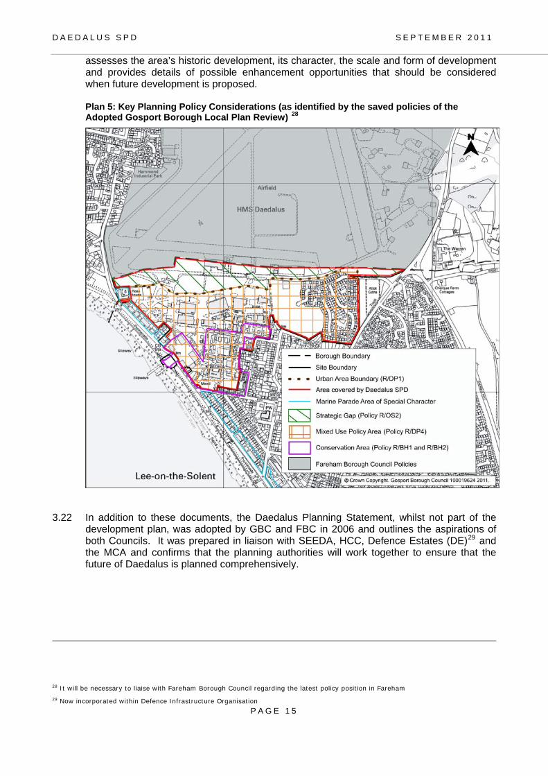
D A E D A L U S S P D S E P T E M B E R 2 0 1 1
assesses the area’s historic development, its character, the scale and form of development and provides details of possible enhancement opportunities that should be considered when future development is proposed.
Plan 5: Key Planning Policy Considerations (as identified by the saved policies of the Adopted Gosport Borough Local Plan Review) 28
3.22 In addition to these documents, the Daedalus Planning Statement, whilst not part of the development plan, was adopted by GBC and FBC in 2006 and outlines the aspirations of both Councils. It was prepared in liaison with SEEDA, HCC, Defence Estates (DE)29 and the MCA and confirms that the planning authorities will work together to ensure that the future of Daedalus is planned comprehensively.
28 It will be necessary to liaise with Fareham Borough Council regarding the latest policy position in Fareham
29 Now incorporated within Defence Infrastructure Organisation
P A G E 1 5

D A E D A L U S S P D S E P T E M B E R 2 0 1 1
P A G E 1 6
Planning History 3.23 The planning history of the site is limited because much of the site was built before the
need for planning permission and more recent development has had Crown immunity from planning control as it was an operational Ministry of Defence site. Appendix 5 contains the details of recent applications in the Gosport part of the site.
3.24 The most significant consents in relation to current uses are briefly outlined below:
• Planning consent has been given for 300 dwellings as Married Quarters for the Ministry of Defence (ref K/15857). 148 of these have now been built (K/15857/2) whilst permission for the other 152 dwellings has now lapsed30
• Circular 18/84 consent was received for the Maritime and Coastguard Agency’s Search and Rescue (SAR) Helicopter Unit, which has now been completed (K/16914/1).
• A second phase of MCA buildings was approved at the Council’s Regulatory Board in August 2010 (K/17819).
• Planning consent was granted for a new driving test centre on the site on the airfield part of the site (owned by the MCA) which is now operational (K/17477).
• Temporary consents have been granted to use existing buildings on the site for B1, B2 and B8 uses and open storage (ref K/15520/6). As part of the interim letting strategy many occupiers, including small and medium sized businesses make use of the former hangars and military buildings.
30 Planning application to renew the consent K15857/4 was refused by the Borough Council in February 2011 as insufficient justification was provided that these dwellings were required as Married Quarters.

D A E D A L U S S P D S E P T E M B E R 2 0 1 1
P A G E 1 7
4.0 DEVELOPMENT STRATEGY 4.1 The Development Strategy sets out the key principles for development and outlines the
preferred mix of uses. Redevelopment of the Daedalus site presents an excellent opportunity to create a strategic high technology employment site providing a variety of jobs as well as leisure, commercial and residential uses within walking distance of each other.
4.2 Redevelopment will bring an under-used and partly derelict site back into productive use
whilst being sensitive to its historic land use, the Listed Buildings and the designated Conservation Area.
4.3 To ensure delivery of a comprehensive development it is necessary to consider the site as
a whole. (See Plan 1). Key Objectives 4.4 The key objectives for the development of Daedalus are as follows:
• To provide significant new employment opportunities for local residents which will assist in alleviating deprivation and reducing out-commuting from the Gosport Peninsula;
• To provide a variety of employment premises to meet the needs of a wide range of modern businesses including those associated with aviation, marine, and hi-tech industries;
• To ensure future development maximises the benefit of the existing runways for aviation industries;
• To ensure that any new development enables the site to benefit from its direct links to the Solent (via the slipway) for marine industries and recreational uses;
• To create a vibrant place with a mix of uses that is integrated with Lee-on-the-Solent and complements and supports the regeneration of the existing local centre and sea-front;
• To provide public access to the site; • To ensure the site has good transport accessibility to make it attractive to new
investment; • To ensure the provision of leisure and community facilities which complement existing
facilities to the benefit of local residents; • To ensure that dwellings provided on the site include affordable housing and a mix of
sizes and types to meet local requirements; • To foster a distinctive identity for Daedalus based on its heritage, through the careful
reuse and restoration of existing buildings and the creation of high quality new buildings which complement and enhance the Daedalus Conservation Area and historic buildings;
• To conserve and enhance the natural environment including: the protection of internationally and nationally important habitats within the vicinity; and the incorporation of green infrastructure within the site as well as the creation of appropriate linkages to the wider green infrastructure network;
• To promote sustainable development and meet high standards of sustainable construction and design including energy efficient buildings, the use of renewable energy sources, the use of sustainable modes of transport, maximising recycling and minimising waste; and
• To require that the site will be served by infrastructure to meet the requirements of businesses, residents and other users.

D A E D A L U S S P D S E P T E M B E R 2 0 1 1
Mix of Uses 4.5 Daedalus will be an employment-led mixed use site. It will be important to provide a mix of
uses to create a vibrant and diverse community, which is active beyond the working day and therefore creates a greater feeling of safety and sense of place.
4.6 Plan 6 below highlights how a mix of uses can be potentially accommodated on the site.
This plan is included for illustrative purposes only and acknowledges the need for some flexibility however it is clear that the following principles will need to be incorporated:
• employment is the dominant land use and opportunities are maximised throughout the
site; • residential uses are suited to the historic core and in close proximity to existing
residential areas; and • leisure uses are most suited to the areas fronting Marine Parade.
4.7 It is accepted that there will be a variety of possible mixes of uses and the Borough Council will consider alternatives to those outlined in Plan 631. The detailed design elements will need to accord with the design principles set out in the Design Section (Section 7) which includes suggested uses for key buildings. Plan 6: Potential mix of uses to be accommodated at the Daedalus site within Gosport
31 As well as Plan 1 (Gosport part) and Plan 2
P A G E 1 8

D A E D A L U S S P D S E P T E M B E R 2 0 1 1
P A G E 1 9
Employment and Skills 4.8 Proposals should be ambitious with the aim of creating a dynamic and innovative
employment area which can attract new and expanding businesses within the existing clusters such as marine, aviation and high technology industries. The site has the potential to attract businesses within new and emerging sectors such as technology-based clusters where the South East has a comparative advantage.
4.9 The Daedalus site represents an exceptional opportunity to contribute to the economic
development of the Borough and the sub-region. The site has been identified by PUSH as a Strategic Employment Site32. This has been reinforced with the successful Solent LEP bid to the Government to designate Daedalus as an Enterprise Zone. Consequently Daedalus is considered to have a significant role in delivering the total net additional employment floorspace and contribute to a Gross Value Added (GVA) growth of 3.5% by 2026 as identified by PUSH in the South Hampshire Strategy. The latest PUSH Economic Strategy (November 2010) emphasises the need to provide high quality jobs within the sub-region.
4.10 SEEDA’s Daedalus Economic Scoping Report prepared by ARUP (2009) recognises that
Daedalus should:
• Provide capacity for priority economic activities and sectors, with a focus on aviation and marine industries and other value-added knowledge-based industries;
• Build upon the particular assets of the site, such as the runway, waterfront access and the ability to offer relatively large plots;
• Contribute to sub-regional economic development objectives, creating jobs and increasing GVA productivity;
• Use and enhance local skills; • Contribute to the sustainable development of the Gosport Peninsula; and • Provide improved social infrastructure for the local community and leisure opportunities
at the strategic scale. 4.11 The Borough Council considers that the site will form a key element of its employment-led
strategy set out in the Local Plan Review and emerging Core Strategy. The site will provide significant levels of employment which can create opportunities for all residents across the Borough including higher skilled residents currently out-commuting. It will also potentially provide work for those living in areas where there are significant levels of multiple deprivation such as Grange Ward, which is within 5km from the site and has the highest proportion of under-16’s in England. Thus Daedalus will be important for providing a source of jobs and training for the local workforce.
4.12 In terms of gross floorspace33 it is estimated that between 65,000 to 85,000 sq.m.34 in the
Gosport part of the site could be developed, which could accommodate approximately 2,000 jobs35 Within the Fareham part of the site it is estimated between 10,000 to 33,000 sq.m. of employment floorspace could be developed in addition to 17,000 sq.m. of existing hangar spaces36 Therefore the whole site has the potential to accommodate between
32 Including in its Business Plan 2008-2011 33 Including new buildings and the re-use of existing buildings (those with and without temporary planning permission) 34 The higher end of the range assumes a greater proportion of buildings in the historic core can be converted for employment uses (offices and workshops). It is estimated that there is 24,000 Esq. of floorspace in Gosport Borough already in employment use (albeit with temporary planning permission) 35 based on an average density of 1employee per 33 sq.m. which is an averaged out figure of small business units (32 m2 per worker) and general industrial buildings (34 m2 per worker) (Arup 2001) as cited by the Government’s ‘Employment Land Reviews: Guidance Note (ODPM 2004) and used in the Council’s Employment Land Review (2010) 36 As identified in the Pre-submission version of the Fareham Borough Council Core Strategy

D A E D A L U S S P D S E P T E M B E R 2 0 1 1
P A G E 2 0
92,000 to 135,000 sq.m. of employment floorspace depending on the type of business premises proposed.
4.13 The site has a number of advantages that make it attractive to a variety of sectors.
Development proposals will need to fully utilise and where possible enhance a number of economic assets at Daedalus. These include:
• access to the airfield which has enormous potential to attract businesses within the
aviation sector including both manufacturing and service businesses; • access to the Solent via the slipway which has the potential to attract marine industries; • the seafront location makes it a pleasant location which can be an important choice for
businesses for which the quality of the environment is a priority, such as creative industries and knowledge services; and
• the large area of land available provides flexibility for a variety of building types to be accommodated.
4.14 It is envisaged the aviation sector will be a prime focus for new business activity on the site
with the potential to create a centre of excellence. The airfield is a key asset and measures to improve facilities will be encouraged in order to attract long term inward investment and significant additional employment at Daedalus. SEEDA37 identifies a number of opportunities at the Daedalus site including scope to enhance the General Aviation market as well as the potential for ancillary growth in aviation-related businesses such as light aircraft maintenance and manufacture. There are also opportunities for growth in the aerospace and/or marine related cluster of activities which include firms that would not need access to the runway but would benefit from close links with companies that do.
4.15 It is essential that the medium and long term arrangements for the management of the
airfield38 are established to ensure its continued use by a range of users and that it is viable. It will also be necessary to ensure the runway will be easily available to aviation industries located around the airfield creating a secure aviation business park. Such measures will improve the viability of Daedalus as an airfield focussed regeneration site and consequently it will be necessary to consider proposals for the airfield and associated hangars and land together. It is considered that the overall prospects for the aviation sector at Daedalus are good provided that management issues can be resolved and the site can attract the required investment to improve on-site facilities.39
4.16 In relation to the marine sector, SEEDA’s Solent Waterfront Strategy recognises the
importance of the Daedalus site for the marine industry. It is identified as the only sizeable near-coastal site in the Solent area on which marine industries can be accommodated and expand.
4.17 The site provides an excellent opportunity to develop centres of excellence and other
employment sectors including high-tech 'clean' industries and emerging environmental energy-saving technologies. The site could provide skills, training and educational facilities, linked to the specialist sectors being developed on-site, which can assist in the development of appropriately skilled employees. It will be important to build on the wealth of technical expertise and skills already found within the area and to provide the resources
37 ‘Aviation Potential of Lee-on-the-Solent Airfield (Formerly HMS Daedalus)’ (York Aviation 2011). 38 As at April 2011 negotiations are continuing between the MCA and SEEDA in respect of medium and long term arrangements for
Daedalus.
39 Aviation Potential of Lee-on-the-Solent Airfield (Formerly HMS Daedalus)’ (York Aviation 2011).

D A E D A L U S S P D S E P T E M B E R 2 0 1 1
P A G E 2 1
and infrastructure that these businesses will need to facilitate their expansion and create new job opportunities.
4.18 Due to the sheer size of the site there is also scope to develop different segments of the
business premises market including: • a high-tech business park type development; and • the potential for business start-up premises with managed shared facilities and move-
on accommodation. Leisure, Heritage and Community Facilities 4.19 The Solent frontage of the site presents significant opportunities to enhance and diversify
the visitor attractions of Lee-on-the-Solent, which is popular with day visitors. The re-use of historic buildings such as the Wardroom offer opportunities for hotel/conferencing facilities. There will be opportunities for a range of food and drink establishments.
4.20 The Daedalus site currently accommodates the Hovercraft Museum which uses hangar
space and associated outdoor space in Seaplane Square. This popular attraction is open to the public on a small number of days each year as well as educational and private tours. A hovercraft museum facility should be accommodated on the Daedalus site given its historic links with the development of the hovercraft and the potential complementary role the museum would have with other leisure facilities on Daedalus and the Borough as a whole.
4.21 The developers of the Daedalus site will need to ensure that suitable accommodation for a
Hovercraft Museum is provided and that it can be easily accessed by the general public. Whilst the use of existing historic hangar space close to the slipway appears to be an appropriate location for a Hovercraft Museum other options may be considered. It is acknowledged that the outdoor display of the hovercrafts will need to be managed to enable flexible use of Seaplane Square by a range of users. There will also be a need to provide facilities for related uses such as the Search and Rescue Hovercraft facilities.
4.22 Heritage interpretation facilities of the site’s history particularly its aviation tradition should
be considered. Early dialogue with the relevant heritage/community groups40 is encouraged.
4.23 Certain buildings on the site may lend themselves for commercial indoor sport/leisure
activities. There may also be potential to develop water sports facilities with access to the Solent via the slipway. Such proposals will particularly need to consider the impact on internationally important habitats in the vicinity.
4.24 Community uses, for example education and health facilities, could also be included within
the overall redevelopment to provide services for both new and existing residents. A number of service providers have expressed interest in being accommodated on the Daedalus site.
4.25 Leisure and community uses on the site will need to complement the existing district centre
of Lee-on-the-Solent some 500 metres to the south east. 4.26 Limited retail use may be appropriate, for example a small convenience store or specialist
retail outlets (for example connected to the marine leisure sector) to serve the needs of the
40 Including the Hovercraft Museum, Hovercraft Society, Gosport Aviation Society, the Defence Heritage Support Group, Association of
Search & Rescue Hovercraft Gosport Branch(ASRHGB)

D A E D A L U S S P D S E P T E M B E R 2 0 1 1
P A G E 2 2
site. However it will be necessary to ensure any retail provision does not significantly harm the viability and vitality of other centres, particularly Lee Centre (in accordance with the tests outlined in the latest national planning policy statement). The site is considered to be in close proximity to Lee Centre and therefore Lee Centre is well-placed to serve most, if not all, the local shopping needs of people working and living on Daedalus.
Residential 4.27 It is considered important to have an element of residential development on Daedalus
which will increase activity on the site and assist with blending new development with neighbouring residential areas. Many buildings in the historic core are appropriate for residential use. It is anticipated that residential development will be principally located adjacent to existing housing, where there is potential to enhance the urban fabric. It is recognised that an element of residential development will assist in increasing the financial viability of the scheme and therefore ensure that a genuine employment-led development is created with an emphasis on high quality jobs which suit the local skills base.
4.28 The Gosport Local Plan Review allocates 500 dwellings for the Daedalus site. The MoD
has built 148 Married Quarters which count towards the overall allocation and consequently there is a remaining 352 dwellings that could be built on the site including any conversions within the proposed mixed use areas.
4.29 The MoD originally proposed a second phase of 152 Married Quarters41. The Borough
Council will need to ensure that the MoD has a genuine need for a further phase of Married Quarters particularly in the light of the recent Defence Review. If a need can be sufficiently demonstrated the remaining land would be an appropriate location for the Married Quarters as it will be in close proximity to the service personnel and their families of the Phase 1 dwellings. The Borough Council considers that if the land for the second phase is no longer required for Married Quarters it may be appropriate to consider alternative development options. This could include employment uses on the northern part with residential on the southern part. Any residential development would count as part of the overall residential allocation and consequently if a second phase of 152 dwellings is completed this would leave a residual allocation of 200 dwellings for the rest of the Daedalus site. Similarly if an alternative residential proposal came forward for all or part of the site this would also count towards the outstanding 352 dwelling allocation.
4.30 As Daedalus is considered as the key employment site in the Borough it will not encourage
proposals that exceed the outstanding 352 dwellings. The Council has demonstrated42 that it will be able to meet its local housing target43 without the need to find additional housing over and above this figure. It can also demonstrate that it has a 5-year housing land supply as required by the Government’s PPS3.
4.31 In exceptional circumstances it may be appropriate to include some flexibility and consider
a higher residential figure in order to help achieve the Council’s key objectives in relation to maximising employment opportunities on the site particularly in relation to creating high quality jobs predominately within the aviation, marine and high-technology sectors. Developers that propose to exceed the allocated residential figure will need to provide a clear rationale as to why additional dwellings are required including design and viability considerations. The Borough Council will require an ‘open book’ approach regarding the proposed quantum of residential units and a robust justification relating to the economic
41 An outline permission for a further 152 married quarters lapsed in 2009. A planning application to renew this permission was refused in February 2011 as the need for the Married Quarters was not sufficiently demonstrated. 42 Through its Strategic Housing Land Availability Assessment (SHLAA) (GBC 2009) and its Annual Monitoring Report (GBC 2010) 43 The South Hampshire Strategy covering the period to 2026 identifies that Gosport Borough should aim to provide 2500 net additional dwellings.

D A E D A L U S S P D S E P T E M B E R 2 0 1 1
P A G E 2 3
benefits of the scheme. It will also be necessary to ensure that the environmental capacity of the area will be considered in relation to any additional dwellings, particularly with regard to potential impacts on internationally important habitats within the vicinity.
4.32 A variety of housing types will be required, such as apartments and family housing, in order
to encourage a balanced community. The exact mix will be established at the more detailed design stage. It will be necessary to include an element of affordable housing44 on site, in accordance with the Borough-wide policy. Further details regarding the Borough Council’s requirements for residential development are included in Section 5. In addition certain buildings on the site such as the Wardroom, Westcliffe House and Eagle Block may be suited for conversion to a residential institution such as a care home (see also paragraphs 4.19 and 7.11 for other potential uses for these buildings).
44 See paragraph 5.90 for further details

D A E D A L U S S P D S E P T E M B E R 2 0 1 1
P A G E 2 4
5.0 DEVELOPMENT CONSIDERATIONS 5.1 The following section sets out key requirements that developers will need to consider when
submitting a planning application. These have been informed by planning policy, various evidence studies, and consultation with key stakeholders and the general public. Key considerations are set out below:
• design and built heritage • contaminated land • biodiversity • utilities • sustainable construction • energy efficiency/renewable energy • flood risk • waste and recycling • amenity issues
• specific requirements for - employment development - aviation-related development - marine related activity - residential development
Design and Built Heritage
Importance of Good Design
5.2 The Council requires that proposals for the site have a high standard of design to create a vibrant area in which to attract investment and be a pleasant place to work, live and visit. The Local Plan Review (including R/DP1) and the emerging Core Strategy place a significant emphasis on good design. The Design section of the SPD (Section 7) includes more detailed design considerations including overall design principles, design coding for different parts of the site, an open space/landscaping strategy and the Council’s approach for protecting and enhancing historic assets on the site.
5.3 The design and layout of the site will need to reflect the historic character of the Daedalus
Conservation Area which includes a number of nationally and locally important buildings (see Plan 7). It will also need to have regard to the characteristics of the Marine Parade Area of Special Character (R/DP10). Conservation Area
5.4 Proposals within the Conservation Area and those affecting its setting will need to preserve and enhance its character (Policies R/BH1 and 2 of the Local Plan Review). The Council’s Daedalus Conservation Area Appraisal45 outlines the key features of the Conservation Area which need to be considered when designing proposals for the site. The SPD is also supported by a Conservation Management Plan46 which provides detailed guidance for each building on features of interest and will need to be taken into account when designing schemes for the site.
5.5 The design of the proposals should be sensitive to its setting and planning applications
should be accompanied by detailed visual impact assessments. It will be necessary to consider the setting of historic buildings outside of the site within the Conservation Area including the Fleet Air Arm Memorial and the former married quarters on Richmond Road and Kings Road.
45 http://www.gosport.gov.uk/sections/your-council/council-services/planning-section/conservation/conservation-areas/area-
appraisals/
46 Prepared by HGP on behalf of SEEDA

D A E D A L U S S P D S E P T E M B E R 2 0 1 1
P A G E 2 5
Listed Buildings 5.6 There are a number of Listed Buildings and proposed Listed Buildings on the site (R/BH3
and 4). The buildings are set out below and shown on Plan 7. Further details are contained in the Daedalus Conservation Area Appraisal.
Table 1: Listed Buildings at Daedalus
Name of Building (Blg) Grade of Listing
Dining Rooms and Cookhouse (Blg 91) II
The Wardroom, Officers’ Mess and Quarters (Blg 118) II
Westcliffe House (Blg 119) II
Type J Seaplane Hangars (WW1) (three hangars) and Winch House Recommended for listing
5.7 These listed buildings make a significant contribution to the character of the area. It will be
necessary to re-use these buildings in such a way which preserves and enhances their historic character. Any proposed development will need to ensure that the setting of these buildings is protected and enhanced including those buildings which are protected as being part of the curtilage of the Listed Buildings.
5.8 It should be noted that many of the listed buildings on the site will require a comprehensive
repair and refurbishment programme. It is important that the re-use of these buildings take place at an early stage of the site’s development.
Other Buildings of Interest
5.9 The Daedalus Conservation Area Appraisal identifies a number of other buildings of historic and architectural interest which contributes to the character of the site. These relate closely to the listed buildings in terms of their historical context, size, scale and design. The Council considers that these buildings should also be re-used as part of any redevelopment scheme as they form an integral part of the wider Conservation Area setting.
Other Buildings/Demolitions 5.10 Within the Conservation Area there are a number of buildings of little historic or
architectural merit which could be demolished. In some cases this provides an opportunity to redevelop the plots with buildings of higher quality. In accordance with the Conservation Management Plan a level of recording may be required prior to demolition.
Archaeology
5.11 Hampshire County Council, which maintains the Archaeology and Historic Buildings Record (AHBR), consider the Daedalus site to be an area with potential for archaeological deposits. The Historic Environmental Baseline Report (undertaken by Forum Heritage Services and Terence O’Rouke for SEEDA October 2007) for the site concludes that it is difficult to predict the significance of archaeological potential in the vicinity of the site.
5.12 It will be necessary for proposals to accord with saved Policy R/BH8 and consequently
developers will be required to submit an archaeological assessment in consultation with the County Archaeologist. This assessment should include consideration of the above and below ground archaeological potential and an appropriate mitigation strategy. The mitigation strategy could include an archaeological evaluation (such as trial trenching) which would inform any further mitigation that might be necessary, such as area excavation or focussed watching briefs. This could be undertaken on a site-by-site basis.
D A E D A L U S S P D S E P T E M B E R 2 0 1 1
5.13 Due to the history of the site there is the potential for contamination, including potential ordnance47 Consequently appropriate precautions will be required when undertaking any appropriate survey work, such as during trial trenching.
Plan 7: Key heritage and design designations affecting Daedalus
47 See Paragraph 5.62 for further details
P A G E 2 6

D A E D A L U S S P D S E P T E M B E R 2 0 1 1
P A G E 2 7
Green Infrastructure
Green Infrastructure (GI) is a strategically planned and delivered network of high quality green spaces and other environmental features. It should be designed and managed as a multifunctional resource capable of delivering a wide range of environmental and quality of life benefits for local communities.48 It includes parks and gardens, natural and semi natural greenspaces, green corridors, outdoor sports facilities, amenity greenspace, provision for children and teenagers, cemeteries and churchyards, accessible countryside in urban fringe areas, river corridors, allotments, domestic gardens, street trees, green roofs and sustainable drainage systems.
5.14 Green Infrastructure should be provided as an integral part of all new development. It
should be strategically planned and be designed and managed as a multifunctional resource. It should also respect and enhance the character and distinctiveness of an area with regard to habitats and landscape types.
5.15 Given the built up nature of the Gosport part of the Daedalus site there are limited
opportunities for extensive green infrastructure. However there is some potential on-site as well as the possibility to improve linkages to the wider local and sub-regional network. It may also be necessary to mitigate against the impact of development on internationally important habitats with the creation of new greenspaces to deflect recreational pressures on sensitive sites generated by new development at Daedalus.
5.16 On-site opportunities for green infrastructure on Daedalus include:
• Small areas of open spaces to serve the new neighbourhood such as the suggested park adjacent Ross House (see Plan 2) and other spaces for local informal recreation which could include on-site play facilities in accordance with the standards set out in Policy R/OS8 of the Local Plan Review;
• sustainable urban drainage system (SuDs) (see paragraph 5.51); • measures to protect and enhance on-site biodiversity (see paragraphs 5.19-5.32); • street trees to provide shade and ameliorate climate change impacts as well as
soften hard townscape; • opportunities for green roofs and green walls which can soften landscape, increase
energy efficiency, reduce air pollution and ameliorate climate change impacts; • provision of domestic gardens.
5.17 There is also a proposal in the Fareham Borough Council Core Strategy to manage and
create a habitat area within the north east part of the Daedalus site within the Fareham Borough area (see Plan 1) which has the potential to link with the Alver Valley Country Park and with the network of footpaths in the countryside within the Strategic Gap between Fareham, Gosport, Stubbington and Lee-on-the-Solent.
5.18 There are also requirements and/or opportunities for off-site green infrastructure including:
• Developer contributions for off-site sports pitches and other outdoor sports in accordance with Policy R/OS8 of the Local Plan Review. Such funds will be directed towards provision in the Alver Valley Country Park which is in close proximity to serve residents and employees of the Daedalus site.
• Further contributions may be required towards other facilities in the Alver Valley Country Park which has significant potential to deflect recreational pressures from
48 Natural England see:
www.naturalengland.org.uk/ourwork/planningtransportlocalgov/greeninfrastructure/default.aspx

D A E D A L U S S P D S E P T E M B E R 2 0 1 1
P A G E 2 8
the internationally important habitats at Hill Head. This could include improving pedestrian and cycling linkages between Daedalus and the Alver Valley.
• Similarly funds may be required to encourage recreational activities generated by the development (such as dog walking) in alternative locations rather than Hill Head mudflats. This could include contributions towards improved dog walking facilities in less sensitive sites and alternative management arrangements at the sensitive sites (in liaison with the relevant authorities).
• Provision for allotments, of which there is a significant need in Lee-on-the-Solent, will also be considered as a part of any developer contribution required under Policies R/DP3 and R/OS8 of the Local Plan Review.
Biodiversity
Internationally important habitats within the vicinity 5.19 The Daedalus site is within 100 metres of the mudflats at Hill Head which form part of the
Solent and Southampton Water Special Protection Area (SPA) and Ramsar site which are of international importance for wading birds.
5.20 The Daedalus SPD has been subject to assessment under the Habitats Regulations 201049
which has influenced the development options for the site. The Council recognises that additional growth in the Borough, in-combination with growth in neighbouring authorities could without appropriate management and mitigation, lead to adverse effects on European sites. In order to prevent such effects, the Borough Council will work with other authorities (including the Partnership for Urban South Hampshire) to develop and implement a strategic approach to protecting European sites from recreation pressures and other impacts of development. Where development at Daedalus is shown to have an impact on European sites, the developer will be required to consider and implement a range of mitigation measures which are outlined below and in the other relevant sections50 of this SPD.
5.21 The HRA has identified a number of potential direct or indirect impacts of proposed
development of Daedalus on the SPA and Ramsar site either alone or in-combination with other development. This includes air pollution (mainly from vehicular movements), recreational disturbance (largely from new residential development), disturbance from the potential increase in use of the slipway and airfield as well as potential light and noise pollution.
5.22 The SPD includes a number of measures to ensure that the Daedalus site will not have an
adverse effect on the European sites in the sub-region. Such measures include:
• reducing travel out of the Borough by providing new jobs and creating greater opportunities to travel to work by modes other than the private car, and thereby reducing congestion and air pollution;
• directing most traffic to the primary access to Broom Way which is further from the SPA at Hill Head and thereby reducing traffic and potential air pollution at this point;
• requiring a Construction Environmental Management Plan including the consideration of the impacts of construction such as dust, noise and vibration (see paragraphs 5.62-5.70);
49 The Habitats Regulations Assessment (HRA) Report containing the appropriate assessment can be viewed at
www.gosport.gov.uk/daedalus-spd.
50 Including the sections on noise pollution, light, aviation and marine considerations.

D A E D A L U S S P D S E P T E M B E R 2 0 1 1
P A G E 2 9
• requiring the use and management of green infrastructure (see paragraphs 5.14-5.18) to provide new and/or improved open space to deflect pressure from sensitive habitats as well measures such as tree planting and green roofs to ameliorate the effects of air pollution;
• incorporating water efficiency measures as required by the Code for Sustainable Homes and BREEAM measures (see paragraphs 5.33-5.35); and
• incorporating sustainable drainage systems as required by the Code for Sustainable Homes and BREEAM measures (see paragraphs 5.33-5.35 and 5.51) and the provision of the necessary infrastructure in liaison with Southern Water will help increase the capacity of waste water facilities.
5.23 The potential impacts from recreational disturbance generated by new development across
the sub-region is considered a particular issue and consequently the Solent Forum has commissioned research on this issue, known as the Solent Disturbance and Mitigation Project51. The Borough Council, where applicable to the Daedalus site, will require developers to contribute towards mitigation measures identified in this Study which could include measures already identified in this SPD such as contributions towards new green infrastructure or particular management measures.
5.24 There is concern that residential development particularly on the western side of the site
could have an adverse effect through recreational disturbance on the SPA. Access arrangements towards Hill Head will require careful management to avoid any adverse effects including the disturbance to birds on the intertidal habitats. Pedestrian access towards the south (i.e. Lee beach) and the east (Lee beach, Alver Valley and Stokes Bay) should be promoted to deflect pressure from Hill Head.
5.25 Any potential impacts on the European sites will need to be fully assessed through an
Appropriate Assessment (AA) at the planning application stage when more detail is known (i.e. project level) under the Conservation of Habitats and Species Regulations 2010.
5.26 It will be necessary to consider appropriate mitigation measures depending on the results of
the findings of this assessment. Possible measures include:
• developer contributions towards alternative greenspace for recreation to deflect pressure from European sites;
• developer contributions towards the management of recreational activities which are, potentially, causing a disturbance as a result of the development; and
• developer contributions towards the management of important habitats. 5.27 It is important to recognise that any development that would be likely to have a significant
effect on a designated site, either alone or in combination with other plans and projects would not be in accordance with the Habitats Regulations 2010 or the development plan and would be refused. Protected Species on-site
5.28 Several European and nationally protected species have been recorded within Daedalus52, including badgers, bats and birds (barn owl and skylark). The suitability of habitat for reptiles and amphibians was also established during the Phase 1 Habitat Survey. Protected species surveys will need to be completed at the appropriate time of year by a suitably qualified ecologist, in order to ascertain the number and extent of protected species
51 http://www.solentforum.org/forum/sub_groups/Nature_Conservation_Group/Disturbance%20and%20Mitigation%20Project/
52 including areas within FBC

D A E D A L U S S P D S E P T E M B E R 2 0 1 1
P A G E 3 0
in order that development proposals can avoid and protect them. Where disturbance is necessary, suitable mitigation will need to be designed, in consultation with Natural England and GBC.
5.29 The Ecological Appraisal (Capita Symonds January 2009) undertaken on behalf of SEEDA
identifies that certain buildings on the site have high bat potential. Development proposals would need to meet the tests set out in Natural England’s standing advice in order for any necessary licence to be obtained.53 Where a building is to be lost which has a bat roost, a licence will be required from Natural England prior to demolition. Loss of any roosting habitat should be mitigated for through the incorporation of bat bricks in new buildings and/ or the provision of bat boxes on buildings and trees.
Measures to enhance biodiversity on-site 5.30 Future developments should recognise the ecological potential of the site, including the
need to retain important features on the site such as mature trees. Measures to enhance biodiversity should be incorporated into detailed development design at the planning application stage including the planting of indigenous species. The use of sustainable drainage systems has the potential to enhance biodiversity on the site as well as the incorporation of green roofs and walls on appropriate new buildings. Consideration will need to be given of how enhancements to biodiversity link with the wider green infrastructure network.
5.31 Opportunities identified in the Ecological Appraisal include:
• further enhancement for badgers including access under fences via maintained corridors to foraging habitats;
• bird boxes suitable for a range of species to be installed on trees and buildings; • creating habitats for reptiles and amphibians including the creation of small areas of
rough grassland with shrub and creating log piles to provide hibernacular habitat; and • the creation of a wild flower meadow through planting a wild flower seed mix of native
species which is managed under a long sward regime. Invasive Plant Species 5.32 The Phase 1 Habitat Survey has identified the presence of a small area of the invasive
plant Japanese knotweed. This is an extremely invasive plant and it is an offence to cause it to spread. Appendix 3 of the Ecological Appraisal54 sets out a proposed Japanese Knotweed eradication strategy for the Daedalus site. Advice from specialists is required on this matter in accordance with Environment Agency guidelines.
Sustainable Construction 5.33 Proposals for development at the Daedalus site will be required to meet the appropriate
sustainability standard which will help to encourage sustainable lifestyles. This includes the BREEAM for non-residential development and the Code for Sustainable Homes for new dwellings.
5.34 Early phases will be required to meet the national timetables for applying the Code for
Sustainable Homes and BREEAM standards as they apply at the time of submitting a planning application. Once the Council has adopted its Core Strategy it will then be
53 Natural England’s standing advice on protected species is available at
www.naturalengland.org.uk/ourwork/planningtransportlocalgov/spatialplanning/standingadvice/default.aspx This sets out the legal
protection afforded by all bat species and the test that should apply for European Protected species licenses
54 Capita Symonds January 2009
D A E D A L U S S P D S E P T E M B E R 2 0 1 1
P A G E 3 1
necessary to apply the standards contained within the relevant policy. The Borough Council will encourage high standards to reflect the potential for the Daedalus site to be an exemplar site setting a benchmark for other developments in the Borough and the wider sub-region.
5.35 If developers are unable to provide the required level then it will be necessary for them to
demonstrate that the higher level is not viable in this particular instance. This will need to be done through an ‘open book’ process and be independently validated. Energy efficiency and renewable energy
5.36 Work undertaken on behalf of SEEDA suggests the potential for a range of measures and given the site’s size it represents a significant opportunity to develop such schemes. Energy efficient refurbished buildings
5.37 When refurbishing buildings it will be important to consider the performance of the building fabric to create air tight and energy efficient building forms through insulation and double/triple glazing. With regard to historic buildings enhanced single glazing (through additions of draft strips and general refurbishment) may be necessary. District Heat and Power Network
5.38 The proposed mix of uses and the energy load of existing buildings to be retained or refurbished, will generate a mixed pattern of energy demand for heating and electricity.
5.39 Learning lessons from the historic heat provision at Daedalus, an energy strategy for the
site should be based around a district Combined Heat and Power network. The CHP system will work on a district scale with energy centres considered as part of the phasing. The district energy system, site services and infrastructure will need to be located on a network of central service corridors to maximise efficiency of the network and allow for maintenance access.
5.40 To ensure that the CHP strategy is robust it must be flexible to future fuel supply constraints
and for that reason the CHP plant would ideally be dual fuel. This approach would provide future scope to convert bio-fuel as sources are identified and other alternative sources become more viable.
Integrated Renewable Energy
5.41 The proposed layout of the development should allow the use of solar water panels on roofs that collect energy from the sun to heat water that is piped directly to a hot storage device. Photovoltaic panels can also be roof mounted or an array can be distributed on facades to convert energy from the sun directly into electricity.
5.42 Installation on new build properties and retrofitting of refurbished buildings could offset the
amount of energy required for providing domestic hot water. 5.43 The suitability of this technology in relation to Listed Buildings and their setting will need to
be discussed further with the Council’s Conservation and Design section on a case by case basis.
Ground-source heat pumps 5.44 The opportunity to distribute closed loop Ground Source Heat Pumps in open spaces can
be tested at detailed design stages. Single bore holes require 60 metre depth and can provide hot or cold air throughout the year. Where this is not possible ‘slinky’ systems can be run along shallow trenches. The airfield and the open spaces to the north part of the site may offer the greatest opportunities for this.

D A E D A L U S S P D S E P T E M B E R 2 0 1 1
P A G E 3 2
5.45 Any testing or development of a ground source heat pump system must consider the potential for contamination. The EA would wish to be consulted on the development of any such scheme including the placement of any infrastructure required for use. Should the proposal be an open loop system, additional approval will be required for the abstraction and discharge of groundwater55.
Adaptability
5.46 Building fabric of new and refurbished buildings should be to the highest environment standards in order to maximise long term efficiency. The buildings must also be able to adapt to future service technologies and renewable energy technologies. The building layouts of both refurbished and new buildings must also be robust and flexible to allow for future market and user demands for the internal space.
Use, and protection of, water resources 5.47 Early phases of development will be required to reduce water consumption in accordance
with the national timetables for applying the Code for Sustainable Homes and BREEAM standards as they apply at the time of submitting a planning application. Once the Council has adopted its Core Strategy it will then be necessary to apply the standards contained within the relevant policy. Depending on the required level measures could include:
• use of water efficient appliances; • external water consumption measures (including water butts); and • rain harvesting and greywater recycling
5.48 It is important that development proposals do not have an adverse effect on the quality of surface, ground or coastal water quality (Policy R/ENV2). This is particularly relevant in relation to the potential disturbance of contaminated land (see below) which can mobilise pollutants. Flood Risk
5.49 The Government’s Planning Policy Statement 25: Development and Flood Risk (PPS25) will be applicable for considering this issue. Daedalus is in Floodzone 1 and therefore it is not in a high risk area for tidal or fluvial flooding. However poor site drainage in parts of the site has caused localised flooding so it will be necessary to improve storm water drainage infrastructure.
5.50 Given the size of the site a flood risk assessment (FRA) will be required which will need to
particularly consider the issue of surface water flooding and include recommended mitigation measures to reduce the risks both to and from the development to an acceptable level. It must be demonstrated that there will be no increase in current runoff rates or volumes, in accordance with Annex F of PPS25.
5.51 In order to minimise direct surface water run-off the FRA should include a Sustainable
Drainage System (SuDS) feasibility study meeting the following objectives56:
• identifying the potential constraints to the use of SUDs, informed by both the ground investigation and contaminated land report/remediation strategy;
• identifying particular SuDS techniques that could be utilised on-site; and
55 Further information is available at http://www.environment-agency.gov.uk/business/topics/128133.aspx
56 These are the minimum requirements for an outline planning application depending upon the particular matters for consideration.
Further information available from the EA.
D A E D A L U S S P D S E P T E M B E R 2 0 1 1
P A G E 3 3
• identifying the area of land that will be required to accommodate surface water management infrastructure (SuDS features plus any additional infrastructure requirements).
Waste and Recycling
5.53 A Site Waste Management Plan (SWMP) will be required for Daedalus in accordance with the Site Waste Management Plan Regulations 2008.
Construction and Demolition Waste 5.54 It will be necessary for commercial and residential development to incorporate best
practice in design and construction for waste minimisation, recycling and the re-use of construction and demolition materials. Where hazardous wastes are identified these should be segregated from inert materials and disposed of in accordance with appropriate regulations and guidance.
Operational domestic and commercial waste 5.55 The layout and design of the development should provide adequate space to facilitate
storage, re-use, recycling and composting. Waste and recycling facilities will need to be provided in accordance with the relevant BREEAM or Code for Sustainable Homes requirements.57 It will be necessary to provide appropriate facilities for the storage and collection of recyclable materials with guidance provided by Gosport Borough Council.
On-site recycling and other waste facilities 5.56 It is considered that due to the size of the site there may be opportunities in consultation
with Hampshire County Council, as the waste authority, to locate some form of recycling facility within the site. It will important that such facilities do not have an adverse impact on the amenities of local residents nor have a detrimental impact on new businesses at the site. Importantly any assessment regarding suitability will need to ensure that such a facility would not deter other businesses including the high-tech sectors from locating at Daedalus. Proposals that could have a detrimental impact on the operational requirements of the airfield would not be acceptable. Consequently such facilities would need to complement and help deliver the Council’s overall objectives for the site.
Amenity Issues 5.57 The site is adjacent a residential area and it will be necessary for proposals to consider the
impact of development on local amenities including existing residents in the vicinity as well as the potential impacts on residents of new properties on the Daedalus site. It will also be necessary to consider the operation of different types of businesses and how they could potentially impact on each other, for example in terms of noise, dust, smell and vibration. Policy R/DP1 of the Local Plan Review is applicable in this instance. Key considerations are set out below.
Daylight and privacy 5.58 The layout of the development will be particularly important to ensure a satisfactory
standard of daylight and privacy for existing residents adjacent the site and those future occupants of the site.
57 Early phases of development will be required to accord with the national timetables for applying the Code for Sustainable Homes and
BREEAM standards as they apply at the time of submitting a planning application. Once the Council has adopted its Core Strategy it
will then be necessary to apply the standards contained within the relevant policy.

D A E D A L U S S P D S E P T E M B E R 2 0 1 1
P A G E 3 4
Security 5.59 It is widely acknowledged that the built environment can influence criminal behaviour.
Consequently it is important to ensure measures are considered early in the design process to minimise such opportunities. Planning applications will be assessed in order to ensure the risk of criminal and anti-social behaviour is minimised at the design stage. This includes appropriate layout design, boundary features and means of enclosure and to try to create a place which has a good level of natural surveillance. Developers are advised to contact Hampshire Constabulary’s Architectural Liaison Officer for guidance.
Lighting 5.60 Lighting is needed for the safety of workers, residents and visitors and assists with overall
security. However unsuitable lighting can cause a number of problems including shadowing and intrusion by glare and dazzle. There are a number of considerations relating to light pollution at the Daedalus site including:
• the need to be sensitive to the requirements of an operational airfield; • the need to consider the proximity of the open urban fringe land to the north which is
characterised as having limited external lighting; • the potential impact on the amenities of local residents; • the need to consider highway safety issues; • the need to reduce wasted light to limit light pollution and reduce energy
consumption; • the need to maintain dark areas which may be important for bat roosting and
foraging;58 • the need to ensure that there is no significant effect on the integrity of European
sites within the vicinity; and • the need for a safe environment for users at night.
5.61 All lighting should be the minimum necessary to be effective and be designed to limit
spillage above the horizontal plane. It should be directed downwards onto the target rather than upwards towards the sky. Saved Policy R/ENV11 is applicable in this instance.
Noise pollution and vibration 5.62 Airfields and employment sites can be noisy locations and therefore noise will be a very
important consideration when determining future planning applications. Noise levels will need to be assessed against previous levels when the site was in greater use. Saved Policy R/ENV10 of the Local Plan Review and the latest Government guidance is applicable in this instance. Such operations are often associated with increased vibration effects.
5.63 Construction noise could cause disturbance to nearby residents and wildlife. Good
construction practice through the implementation of best practice mitigation measures in a Construction Environment Management Plan should be followed to minimise these disturbance effects.
5.64 Detailed assessments to determine the likely noise and vibration impacts from operational
activities should be undertaken at the planning application stage to determine suitable mitigation measures. Potential mitigation measures include:
58 This will need to be ascertained from the relevant ecological appraisal.
D A E D A L U S S P D S E P T E M B E R 2 0 1 1
P A G E 3 5
• locating potentially noisy operations further from residential areas and other noise sensitive uses;
• hours of operation; • sound-proofing of buildings; and • the incorporation of sound-proofing barriers such as bunding, where appropriate.
5.65 To ensure a suitable internal noise environment in new residential units, PPG 24 assessments should be undertaken to enable acoustic ventilation requirements to be determined. High levels of sound-proofing and screening as part of sustainable housing design and construction will be an important consideration and forms part of the Code for Sustainable Homes.
5.66 Natural England should be consulted on the potential for noise impacts on the Solent and
Southampton Water SPA and Ramsar site and determine necessary mitigation measures. These could include the timing of particular operations to avoid disturbing over-wintering birds if these are deemed to have a detrimental effect as identified in an appropriate assessment associated with a planning application.
Air pollution 5.67 Development of the site is likely to result in impacts to local air quality during the
construction phase and potentially once construction is complete. Construction phase impacts should be mitigated by the adoption of a Construction Environmental Management Plan (CEMP) requiring the adoption of best practice methods to minimise impacts from construction dust and construction plant, and vehicle emissions. Working hours must be agreed with GBC and consider potential impact on residents’ amenity.
5.68 There are currently no Air Quality Management Areas (AQMAs) in the Borough where
national objectives for nitrogen dioxide (NO2) or fine particulates (PM10) are exceeded. However there is an AQMA in Fareham in the vicinity of Quay Street which is used by traffic going to and from the Gosport peninsula. Consequently an employment-led strategy at Daedalus which has the potential to reduce out-commuting has the potential to reduce pollution within the AQMA.
5.69 For operational phase impacts, detailed air quality dispersion modelling should be carried
out to determine the potential impact on local air quality from traffic flows and commercial activities. Odour assessment and potentially dispersion modelling should also be carried out for relevant commercial developments, including waste facilities, to determine mitigation/abatement measures to be incorporated.
5.70 Natural England should be consulted on the potential for air quality impacts of the
construction and operational phases on the Solent and Southampton Water SPA and Ramsar site and determine necessary mitigation measures.
Contaminated Land 5.71 As with many former Ministry of Defence sites, the issue of contaminated land needs to be
fully considered as part of the planning application process (Policy R/ENV5). 5.72 Baseline contamination reports are available for the site (Entec 2007). The strategic
environmental assessment (see Ground Conditions Chapter)59 has highlighted that contamination is present on-site. This includes contamination associated with processes undertaken within the workshops and hangars, fuel storage and on-site burning and
59 of the Drivers Jonas Report (November 2009)

D A E D A L U S S P D S E P T E M B E R 2 0 1 1
P A G E 3 6
disposal. Key types of contamination identified include a small number of radioactive hotspots, hydrocarbons, metals and asbestos. There may also be a risk of unexploded ordnance at the site and consequently further investigation and consultation with the MoD will be required. Details of the previous pipe mining clearance operation and any potential remaining risk is detailed in report by the Defence Logistics Organisation (DLO) and the Environmental Science Group (ESG) (2007)60.
5.73 The remediation of existing ground contamination will be required particularly for sensitive
land uses such as gardens. Further surveys and assessments will need to be completed at the application stage to fully characterise the contamination and identify source-pathway-receptor relationships so that a remediation strategy can be formulated to render individual sites suitable for use for their intended purpose. The scope of intrusive assessments and remediation strategies will need to be agreed with GBC and the Environment Agency. The remediation strategy will need to be designed to prevent contamination of local surface waters.
5.74 Further explanation of the remedial measures required with regard to the limited
radiological contamination hotspots identified are provided in the Entec Technical note. 5.75 For any large areas of car parking or internal access roads, oil interceptors will need to be
installed to remove hydrocarbons from run-off, prior to discharge to the receiving water.
5.76 Best practice construction methods will need to be employed during ground disturbance, in accordance with a Construction Environmental Management Plan to avoid mobilisation of contamination and remove risk to workers. This will include the need to accord with EA Pollution Prevention Guidelines.
Utilities
5.77 Utilities include the supply of water, the drainage of foul and surface waters, gas and electricity, and Information and Communications Technology (ICT). New development can place increased demands on the functioning of these utilities both in the new development area and in the surrounding areas.
5.78 It will be necessary for prospective developers to have an early consultation with the
statutory undertakers responsible for providing these services before submitting any planning applications. Any planning application will need to illustrate how the provision of new services will successfully integrate with existing facilities. Any offsite works to upgrade existing or provide new utilities infrastructure will be expected to form part of the planning application details. Further consideration of the key utilities is set out below.
Water Supply, treatment and sewerage 5.79 Residential and commercial development on site will place additional pressure on the
mains water supply and foul drainage system. 5.80 Portsmouth Water advises that sufficient water supply resources are currently available but
off-site reinforcements to the existing water mains network may be required. Potable water supply mains are located on site with connections to apparatus adjacent to the eastern and southern boundaries. It is understood that the main supply point is routed from the north-south service corridor in Manor Way to the junction of Implacable Road and Ark Royal Crescent. The mains supply feeds both the on-site potable water main network and a
60 DLO/ESG (2007): HMS Daedalus Phase II and III Explosive Ordnance Risk Assessment

D A E D A L U S S P D S E P T E M B E R 2 0 1 1
P A G E 3 7
separate fire mains system, which connects to both a pump house and storage water tank located in the eastern area of the site. 61
5.81 Portsmouth Water advises that it may be sensible to consider a new ‘spine main’
associated with the new main access route to supply the commercial and housing developments.
5.82 Southern Water is responsible for waste water services in the area. The company advises
that there are uncertainties associated with the available treatment capacity at the nearby Peel Common Wastewater Treatment Works due to environmental constraints. This constraint is not immediate but could emerge over time as new development comes forward over the next 10 to 15 years. The assessment of the constraint is dependent on the future environmental standards required in the treatment of wastewater which is set by the Environment Agency. If a constraint emerges a solution will need to be found and development will need to be phased to coincide with its delivery. Further capacity assessment will need to be undertaken in consultation with Southern Water regarding waste water in order to determine the likely impact of development and potential mitigation.
5.83 With regard to the local sewerage system (i.e. the underground pipes and associated
pumping station) Southern Water advises that there is currently insufficient capacity to accommodate the proposed development. It will therefore be necessary for the development to provide the necessary off-site sewerage infrastructure to connect to the nearest point of adequate capacity, which is the Peel Common Wastewater Treatment Works. If the necessary infrastructure is not provided the existing sewers could become overloaded to foul water flooding. Early liaison with Southern Water is encouraged to ensure a comprehensive solution for the whole of the Daedalus site.
5.84 To minimise impact, water efficiency measures should be incorporated into all
developments in accordance with the relevant Code for Sustainable Homes or BREEAM standards.62
Electricity and Gas Supply 5.85 It will be important to ensure that a reliable electricity supply is established across the site.
The HMS Daedalus sub-station immediately adjacent to Vengeance Road is connected to the mains network via a high-voltage below-ground electricity cable in the northern footway of Norwich Place. A low-voltage below-ground cable connects from Richmond Road and is routed into the site within the Nottingham Place/Eagle Road carriageway. There is a low-voltage below-ground cable within the eastern footway of Drake Road with potential on-site connections. 63
5.86 Southern Gas networks have plans of gas pipes owned by them and they also note that
low/medium/intermediate pressure gas mains are located in proximity to the site. A low pressure gas main64 connects from the gas governor station in Brambles Road and is routed northwards on-site via a meter building adjacent to Brambles Road. It will be necessary for developers to contact Southern Gas Networks directly for full details.
5.87 The National Grid has confirmed that development on the site carries negligible risk with
regard to the national operational electricity network and gas transmission network.
61 Cited in SEEDA’s Design and Access Plan (2011)
62 see paragraphs 5.33-5.35
63 Shown on Distribution Network Operator (Scottish and Southern Electricity) records cited in SEEDA’s Design and Access Statement
64 Shown on Licensed Gas Transport records cited in SEEDA’s Design and Access Statement

D A E D A L U S S P D S E P T E M B E R 2 0 1 1
P A G E 3 8
Information and Communications Technology (ICT) 5.88 It will be important that the site has the highest available standard of ICT infrastructure in
order to meet the needs of modern hi-tech businesses. The delivery of superfast broadband is a key element of the Enterprise Zone designation of which Government support could be forthcoming.
5.89 BT has plans showing approximate locations of BT apparatus present in the vicinity of the
site. They do not have details regarding communications within the Daedalus site itself. 5.90 Mobile telecommunications plant and apparatus are located within the site. There are plant
compounds for a number of mobile phone networks65. The antennae also provide for emergency services communications apparatus66. Digital technology ducting/cabling (used for broadband) is located within the eastern footway of Drake Road67.
Specific Employment and Commercial Development Considerations
Skills and Training Requirements 5.91 As part of developing a sustainable community it is necessary to ensure that local residents
have the skills required to take employment opportunities at the Daedalus site. Developers will be required to prepare a Training and Employment Plan to be approved prior to the implementation of the development. This should focus on the opportunities that the development can offer to the benefit of the local labour market. The Council’s Economic Prosperity section will be able to provide advice on this matter.
5.92 Proposals for premises that provide appropriate training facilities will be supported at the
Daedalus site. Developers and end-users will be encouraged to work with the Borough Council, training providers and other key partners to provide pre-employment and specialist training provision including apprenticeships.
Developer Contributions 5.93 The key developer contributions sought in connection with employment and commercial
uses will be in relation to off-site transport improvements to make the site more attractive for investment. Further details are set out in Section 6 relating to the Transport Strategy for the site. There may also be the need to seek developer contributions for training purposes should this be identified as the most appropriate measure in a Training and Employment Plan (see Paragraph 5.91). There may also be the need for contributions for environmental improvements. This could include any mitigation measures identified as a result of the findings of an appropriate assessment in terms of potential impacts on internationally important habitats (e.g. such as alternative green infrastructure provision, alternative management requirements). There may also be other requirements identified in connection with Policy R/DP3 of the Local Plan Review.
65 O2, Vodafone and Three Networks, cited in SEEDA’s Design and Access Statement
66 Cited by SEEDA’s Design and Access statement
67 Virgin Media

D A E D A L U S S P D S E P T E M B E R 2 0 1 1
P A G E 3 9
Low Employment Generating Uses 5.94 The Borough Council aims to maximise the employment opportunities on Daedalus and will
limit low generating employment uses68. Planning applications should be accompanied with an assessment of estimated employment densities envisaged on the application site. Low employment generating uses will only be considered if it is the most appropriate use, is ancillary to a higher density business use or forms a smaller element of a comprehensive scheme (Policy R/EMP7 of the Local Plan Review is applicable).
Specific Aviation Considerations
5.95 As the airfield, including the runways, is within the Fareham Borough Council area, development proposals relating to the level and type of usage will need to be determined by Fareham Borough Council, in consultation with Gosport Borough Council. The SEEDA Aviation Study69 has identified a range of aviation and aviation-related uses for the Daedalus site as set out earlier in paragraphs 4.14 and 4.15. It would appear from the SEEDA Aviation Study that investment is required to improve the condition of the runway and other associated airfield infrastructure.
5.96 Gosport Borough Council will ensure development proposals in its area do not unduly affect
the operation of the airfield as it is important that the site can attract aviation-related businesses. An application will need to include details that demonstrate that the siting of new development and infrastructure will not undermine the future operation of the airfield. The Airfield and Safeguarding Study (Mott MacDonald 2011) commissioned by SEEDA sets out the potential aerodrome operational constraints relating to the site’s current status as an unlicensed aerodrome as well as the potential to become a licensed aerodrome at some point in the future. It concludes that the proposed western access just north of Ross House would not have any impacts on the current operation of the Daedalus airfield.
5.97 It states that should future operators wish to consider making the airfield a licensed site it
would be necessary to reduce the length of the runway by 110m to 1199m. This would be as a result of the presence of the existing Ross House residential building rather than the proposed new access. The report concludes that this length of runway would bring it within a Code 2 Licensed Aerodrome70
5.98 When developing the Daedalus site it will also be important to ensure aviation-related
businesses operating in the Gosport part of the site can gain access to the airfield facilities.71
5.99 An application which proposes aviation use will need to be accompanied by an aviation
study which sets out details regarding the level and type of use of the airfield. This will be necessary to ascertain the overall infrastructure requirements for the site including for the airfield itself. It will also inform any ecological assessments that may be necessary.
5.100 The Civil Aviation Authority (CAA) advises that it and/or the aerodrome operator will need to
be consulted on proposals for wind turbines and telecommunications installations72. It adds
68 The PUSH Study ‘Property Requirements for Distribution and Logistics’ (Tym and Partners/Lambert Smith Hampton/MDS Transmodel
June 2008) has demonstrated that there is little demand for warehouse uses on the Gosport peninsula
69 Aviation Potential of Lee-on-the Solent Airfield (York Aviation January 2011)
70 Civil Aviation Publication (CAP) 168: Licensing of Aerodromes-Civil Aviation Authority.
71 The York Aviation Study identified that the existing blue fence around the airfield which separates it from many of the existing
hangars can represent a problem for aircraft manoeuvring through the gates in the fence.
72 Also tall buildings (over 90metres in height)- but no such buildings would be appropriate for Daedalus

D A E D A L U S S P D S E P T E M B E R 2 0 1 1
P A G E 4 0
that ‘safeguarding’ responsibilities rests in all cases with the relevant aerodrome licensee/operator and it is essential that the views of the operator are ascertained for proposals that could affect the safeguarded areas around an airfield. Specific Marine Activity Considerations
5.101 It is important to ensure that the slipway73 remains available for businesses and other activities linked to the Daedalus site in order to retain a link to the Solent which gives the site a potential locational advantage over other employment sites. The operation arrangements of crossing Marine Parade from the Daedalus site to the slipway (and vice versa) will need to be considered. Measures could include the introduction of traffic signals. The anticipated level of use will need to be set out in future applications in order to assess any highway implications regarding its operation.
5.102 It will be necessary to ensure the type and level of usage associated with marine activities
generated by the site does not have any detrimental impact on the nature conservation features of internationally important sites within the vicinity. This needs to be demonstrated with detailed studies at the planning application stage to inform an appropriate assessment under the requirements of Habitats Regulations 2010. Proposals that will harm the features of the internationally important sites will not be permitted.
5.103 In terms of other marine activity issues, consideration has been given in the past to a
possible marina option at Lee-on-the-Solent adjacent the Daedalus site. It is important to note that a marina does not form part of the SPD. However for the purposes of providing a comprehensive guidance document for developers it is considered important to outline the potential issues if a marina proposal were to come forward by a developer with the potential complementary links with the Daedalus site.
5.104 There are a number of significant issues that would need to be addressed when designing
any marina proposal. This includes the proximity to the internationally important habitats of the Solent including the Special Protection Area immediately adjacent at Hill Head; the impacts on the Site of Special Scientific Interest (SSSI) on Lee beach for geological reasons; and the SSSI at Browndown further to the east which could be affected by changes to the local hydrology. Early dialogue with Natural England and the Environment Agency will be critical. Any development should provide appropriate measures that would mitigate any significant effects on a designated site either alone or in combination with other plans and projects. If these effects can not be successfully mitigated the proposal would not be in accordance with the Gosport Borough Local Plan or the emerging Core Strategy and would be refused.
5.105 A number of other issues will need to be considered including flood risk74, the design and
the impact on the visual qualities of the area, access (safety and congestion issues) and infrastructure (transport, utilities).
5.106 Any proposal will be required to secure the necessary permissions from the Maritime
Management Organisation.
73 SEEDA’s assets were transferred to the Homes and Communities Agency in September 2011.
74 Flood Defence Consent from the Environment Agency may be required

D A E D A L U S S P D S E P T E M B E R 2 0 1 1
P A G E 4 1
Specific Residential Development Considerations Affordable Housing
5.107 The Borough Council will seek the provision of 40% of the proposed residential development to be affordable housing, in accordance with saved Policy R/H5 of the Local Plan Review. The affordable housing will be required to be built on-site. Mix of dwelling sizes and types
5.108 The site should include a mix of dwelling sizes and types of dwellings (Policy R/H4 of the Local Plan Review) in order to ensure a genuinely mixed community. It is recognised that the conversion of historic buildings on the site will generally be more suitable as apartments.
5.109 Dwellings will need to reflect that Lee-on-the-Solent has one of the oldest age profiles in
Hampshire and will continue to remain a popular location for older residents particularly as the age profile of the Borough is forecast to become more dominated by older people. At the same time it will also be necessary to provide a mixed community and that family housing will also be required to form an element of the mix.
5.110 It will be necessary to incorporate lifetime home standards as part of the new dwellings to
ensure that a range of people can live in the properties including those with small children, people with disabilities and elderly residents. The Borough Council currently seeks at least 15% of all new market housing should be designed to lifetime home standards (Paragraph 5.53 of the Local Plan Review).
Housing Design 5.111 The Design Section (Section 7) sets out the key principles in relation to the design of the
site and requires that residential development is of a high standard. The conversion of some buildings in the historic core may be suited for higher density development to ensure these buildings have a viable future but only where viability is directly enabled by such a density.
5.112 Housing will need to have regard to the CABE and the Home Builders’ Federation, ‘Building
for Life’ standards. Planning applications will need to be accompanied with a Design and Access Statement75 which cover these issues.
Working from Home 5.113 As part of the Council’s strategy to reduce out-commuting residential units which encourage
working from home will be supported. Such dwellings will form part of the Council’s total site allocation of 352 remaining dwellings and will not be additional to it. Associated facilities such as meeting rooms and associated facilities to serve those working from home will be supported. Developer Contributions
5.114 The Borough Council will require that new residential development is supported by appropriate infrastructure and facilities (as set out in Policy R/DP3 and the relevant policies of the LDF). Contributions in relation to improved transport infrastructure to serve the whole site are set out in the Transport Strategy (Section 6). In addition the Borough Council will normally require specific developer contributions in relation to new residential developments for education and open space provision. There may be other requirements
75 For further guidance on the Council’s requirements see www.gosport.gov.uk/sections/your-council/council-services/planning-
section/requirement-for-design-and-access-statements/

D A E D A L U S S P D S E P T E M B E R 2 0 1 1
P A G E 4 2
that may need to be funded in accordance with ‘saved’ Policy R/DP3 of the Local Plan Review including measures to conserve and enhance the natural environment which may be necessary to mitigate potential impacts on important habitats in the vicinity.
5.115 Education: ‘Saved’ Policy R/CF6 of the Local Plan Review requires that development proposals of more than 10 dwellings make appropriate provision for education facilities to the satisfaction of the Hampshire County Council as the local education authority. It is considered that in many cases additional education provision is required to accommodate a demand that has been created by residential development and that it is appropriate for the developer to make a contribution towards this extra requirement in accordance with the provisions set out in the Government Circular 05/2005 Planning Obligations. As part of any planning application the Borough Council will liaise with Hampshire County Council on the need for additional provision in accordance with its guidance, ‘Developer Contributions towards Education Facilities’, which includes the formula for calculating the developer contributions. In the recent past there has been the need for additional provision to be made in Lee-on-the-Solent and there continues to be pressure on local provision.
5.116 In order to ensure contributions relate to where there is a direct impact, schemes for
accommodation for the elderly including sheltered accommodation will not be required to provide a contribution.
5.117 Open Space: New residents on the Daedalus site will also place additional pressure on the
existing public open space (both natural and amenity), children’s play areas, sports facilities and other recreational facilities. Policy R/OS8 (and the supporting Appendix O) of the Local Plan Review requires that provision is made for sports pitches, other outdoor sports facilities and children’s play facilities. Where on-site provision is not possible or appropriate the Borough Council may accept developer contributions in lieu of on-site provision, with suitable justification, in accordance with the provisions of the Local Plan Review (and subsequent policies in the Gosport Core Strategy)76.
5.118 The sports pitch and other outdoor facilities will be required off-site as the character of the
site is not suitable for on-site provision. This provision can be in the form of part-funding improvements of existing facilities or proposed new facilities in the Borough.
5.119 It is likely that some form of children’s play area will be required on-site to serve family
housing provided on the site. However it may be more appropriate to consider whether improvements can be made to the play areas provided in association with the Married Quarters development. A reduced open space contribution is required for accommodation associated with older residents.
5.120 Under Policy R/DP3 developers may be required to make contributions towards other types
of open spaces and related environmental improvements (including other public open spaces, countryside management and the appropriate management of habitats). This could include the need to fund mitigation measures in order to reduce the impacts (such as recreational disturbance) of residential development on important habitats. The developer will need to provide sufficient information in order that the Borough Council can undertake an ‘appropriate assessment’ in accordance with the Habitat Regulations 2010 to understand whether there are any impacts and whether it is possible to mitigate for these impacts without harming the important features of the international sites.
76 Details of the Council’s current developer contributions for residential dwellings (one, two and three and over bedrooms) can be
found at www.gosport.gov.uk/sections/your-council/council-services/planning-section/pre-application-advice/

D A E D A L U S S P D S E P T E M B E R 2 0 1 1
P A G E 4 3
5.121 The emerging Core Strategy also aims to use developer contributions for a wide range of open space and green infrastructure requirements and consequently the Borough Council will consider the use of developer contributions for other open spaces including the Alver Valley Country Park as well as allotments77 for which a local need has been demonstrated.
5.122 Other requirements: There may also be the need for contributions for other requirements
identified as part of a proposed development (see Policy R/DP3) which could include environmental enhancements, community uses and indoor leisure facilities. Such requirements, together with those outlined above, may be included as part of the Borough Council’s forthcoming Community Infrastructure Levy (CIL).
77 The Borough Council may also consider the use of land at Manor Way in lieu of the full on-site provision or the required financial
contribution. The site is outside of the Daedalus site but within close proximity to future occupants of the site. It has the potential for a
number of open space functions including allotments. The site was previously owned by SEEDA whose assets have now been
transferred to the Homes and Communities Agency in September 2011.

D A E D A L U S S P D S E P T E M B E R 2 0 1 1
P A G E 4 4
6.0 TRANSPORT AND ACCESSIBILITY STRATEGY Introduction 6.1 A Transport Assessment78 will be required to assess in detail the transport requirements
and the impacts of the proposed development at Daedalus. It will need to identify suitable measures to achieve a sustainable development and reduce the need to travel; make best possible use of existing transport infrastructure; and any improvements necessary to mitigate residual impacts. Proposals will need to accord with the Highway Authority’s Strategic Access to Gosport (StAG) study, which is the transport strategy for the Peninsula.
Existing Transport Conditions Highways
6.2 A description of existing traffic conditions, transport provisions and traffic flow data is provided in the Transport Baseline Report (MVA Consultancy June 200779) and summarised below.
6.3 The Gosport Peninsula has two main road accesses to the north; the A32 Fareham Road,
and B3385 Newgate Lane. Both routes converge south of Fareham town centre and connect via the A27 to M27 Junction 11. Titchfield Road (B3334) offers a route from Stubbington heading north-west to M27 Junction 9 (see Plan 8).
6.4 There is presently a large volume of out-commuting exacerbated by a lack of available jobs
on the Peninsula. The road and public transport infrastructure is inadequate to accommodate extended peak hour demands resulting in congestion on the access roads, which is a major inconvenience to commuters moving off the Peninsula in the am peak and returning in the evening. However in-commuters experience few delays in the am and pm peaks. It is also important to recognise that in the off peak, the Borough has relatively good access to the motorway network.
6.5 During peak periods there is extensive queuing on the A32 Fareham Road and Gosport
Road due to a lack of capacity at several junctions along the route, particularly the Quay Street roundabout at the junction with A27. The Longfield Avenue/ Speedfields roundabouts contribute to slow moving traffic on Newgate Lane, with queuing on the Broom Way and Rowner Road approaches to the Peel Common roundabout in the am peak. There are also queues on the Gosport Road (eastbound) approach to this roundabout in the pm peak.
6.6 Queuing occurs on Stubbington Lane and the Gosport Road approaches to Stubbington
Village in the am peak and on the Titchfield Road and Mays Lane approaches in the pm, reflecting peak hour tidal traffic flows.
6.7 Southern parts of both Newgate Lane and Titchfield Road are of a width and alignment not
well-suited to HGV’s and cycles.
78 The TA will need to comply with the Department for Transport’s Guidance on Transport Assessment (2007)
79 http://www.daedalus-seeda.co.uk/site/seeda/publications--documents/publications--documents?LanguageId=0

D A E D A L U S S P D S E P T E M B E R 2 0 1 1
P A G E 4 5
Existing Access to Daedalus
6.8 Currently only one access to Daedalus is in use at Chark Lane (off Broom Way to the east of the site) with internal links to Hangars East and the Waterfront area. There are six potential access points from Marine Parade West, which is an important local distributor road and a strategic route to southern parts of Gosport. Additional access at three points from the east is also available through predominantly residential areas. Public transport
6.9 Public transport in Gosport is provided by local bus services and the passenger ferry between Gosport and Portsmouth, which also carries cycles. The ferry is well used and is in close proximity to both the Gosport and Portsmouth Hard bus stations, and the Portsmouth Harbour railway station. A new ferry pontoon on the Gosport side of the harbour has recently been constructed.
6.10 Existing bus services mostly run on a variety of routes between Gosport and Fareham
Town Centres. The frequency of services to Lee-on-the Solent is relatively poor and all peak hour services can be delayed due to the variable effects of congestion. Nearly all destinations beyond Fareham require a change of service at Fareham Bus Station and few services currently serve Fareham Railway Station directly.
6.11 The results of a public transport accessibility audit are included in the Transport Baseline
report. Whilst some areas, such as Stubbington centre and Collingwood Retail Park, are relatively accessible from the Daedalus site, public transport accessibility to many other key destinations is poor.
6.12 The first phase of a Bus Rapid Transit (BRT) system will be completed in early 2012 which
will improve accessibility for some parts of the Peninsula. It will operate along the former railway line between Tichborne Way and Redlands Lane (see Plan 8). It may be utilised by services in whole or part and will thus enable buses to bypass congestion on the A32 and the northern part of Newgate Lane and provide faster and more reliable journeys. It will also result in more services providing direct access to Fareham railway station. In the future BRT is expected to be extended further south into Gosport and northwards via West Street to Fareham town centre, with later bus links to the proposed North of Fareham Strategic Development Area.
Walking / Cycling
6.13 Due in part to the favourable topography and climate there is a high level of cycling on the Peninsula. Across the Borough there is a good network of existing cycle lanes and off road paths, but some key links to Lee-on-the-Solent and Daedalus are missing. Broom Way and Gosport Road have good shared use off-road cycle routes linking Lee-on-the-Solent to Stubbington. However Newgate Lane has no dedicated cycle facilities to encourage cycling northwards to Fareham and in southern parts the road is intimidating due to its heavy traffic, narrow and poor alignment.
6.14 There are no dedicated cycle facilities on Marine Parade, but there is potential to link the
site with off-road cycle routes to Lee town centre and existing routes from Gosport town centre which at present terminate at Portsmouth Road.
Summary of Existing Conditions
6.15 Overall, there are clear problems of road-based access to the Gosport Peninsula. There is a need for local highway improvements, improved management of the existing network and the promotion of alternative transport modes to accommodate growth.

D A E D A L U S S P D S E P T E M B E R 2 0 1 1
P A G E 4 6
6.16 The scale of the transport infrastructure deficit is significant and the Highway Authority (Hampshire County Council) has developed an outline programme of transport interventions identified in the Strategic Access to Gosport Study (StAG),80which will need to be delivered through Government, County Council and developer funding. The StAG Report identifies the most appropriate and deliverable schemes to improve access to Gosport and support growth and economic development. It includes improvements to address specific local issues including junction and carriageway improvements along Newgate Lane and improvements to the Peel Common and Stubbington roundabouts through signalisation.
Transport Objectives and Key Principles
6.17 The transport strategy for Daedalus is based on the following key principles: • reducing the need to make a journey and reducing the need to travel off the Gosport
Peninsula; • making greater use of sustainable modes; and • making better use of existing transport infrastructure and providing new transport
infrastructure where necessary to achieve an attractive and successful employment-led development.
Reducing the need to travel
6.18 Daedalus is strategic employment site and will provide significant local employment. One of the main reasons for high levels of out-commuting is a lack of available jobs in appropriate business sectors. The proposal for an employment-led mixed-use site should create a significant number of suitable jobs at Daedalus to give residents in the Borough a greater opportunity to work locally. It should afford them choice as to how far they travel for employment, and providing employers convenient access to a strong pool of potential workers. This accords with the Strategic Access to Gosport (StAG) study in that the strategic network serving the peninsula has spare capacity for in-commuting during the peak travel time and because the opportunity to meet employment needs locally has the potential to reduce out-commuting during the morning peak.
6.19 Provisions for home working and broadband Internet connections can facilitate flexible and
sustainable working practices.
Promotion of Sustainable Modes 6.20 An improved frequency and range of bus services will be sought to improve accessibility
and journey time to and from Daedalus and provide an attractive alternative to the car. Early discussions between the developers and the bus operators will be required to explore potential improvements.
6.21 A permeable network of access routes should be provided for all modes to assist in
reducing the need to travel and to encourage cycling and walking. The site’s close proximity to Lee-on-the-Solent and Stubbington presents opportunities for the improvement of pedestrian and cycle connections to these communities. In addition the development of comprehensive travel plans will be crucial to promote sustainable modes.
Improving infrastructure
6.22 Additional traffic will be generated by the redevelopment of Daedalus, and the opportunities for substantial local employment will modify the existing distribution of traffic over the highway network. It will be necessary to ensure that the main access roads to the
80 published in February 2010 by Transport for South Hampshire (TfSH)

D A E D A L U S S P D S E P T E M B E R 2 0 1 1
P A G E 4 7
peninsula, together with the local road network can accommodate the changes in traffic flow. Mitigation measures may be required to ensure that the development’s traffic is accommodated in terms of capacity, operation and safety. Improvements to the main access routes, in particular the Newgate Lane corridor, will be important in attracting inward investment to Daedalus and creating new local employment opportunities. The Enterprise Zone designation at Daedalus may provide opportunities to secure further transport infrastructure.
Transport Assessment and Contributions
6.23 The measures required to support and promote development and to mitigate transport impacts, should be determined by a full Transport Assessment (TA) prepared in accordance with national and Hampshire County Council guidance. This will need to be carried out to the satisfaction of the Highway Authority and the Borough Councils prior to the determination of any individual applications for development and must account for the likely scale and progress of development over the whole Daedalus site including areas within Fareham Borough. The TA will identify the transport impacts of the proposed development and the measures that can be used to meet its access and transport requirements. These measures should be drawn from the relevant Highway Authority strategy. Where transport and access mitigation measures are identified then these will be the subject of negotiations between the developer and the local authorities. The latest Hampshire County Council Transport Contributions Policy will form the basis of these negotiations as an indicative measure of funding required from the development.
6.24 It will be necessary to secure the following by means of a legal agreement:
• transport contributions to fund off-site schemes; • relevant on-site and off-site transport works; and • any maintenance costs in respect of adopted highways or infrastructure and
landscaping maintained by the Highway Authority 6.25 An Implementation Plan will be required which links the delivery of the transport measures
to the progress and phasing of the development to ensure the timely delivery of suitable access and transport measures appropriate to the scale and nature of the development.
6.26 The TA will need to inform further assessments81 relating to the potential impact of air
pollution from traffic generated by the development and whether there will be particular concentrations at junctions which could impact on local residents and/or features of important habitats. Provision of Off-Site Infrastructure
6.27 Development at Daedalus will first look to minimise any impact on the surrounding network by reducing the need to travel through the provision of significant employment and through the promotion of public transport, walking and cycling as sustainable modes of travel.
6.28 The Daedalus development will also seek to make the best use of existing infrastructure
where the strategic access routes have some spare capacity. However, some off-site improvements will be required to mitigate the direct impacts of additional traffic generated by development at Daedalus and to promote the site as a strategic employment location.
81 Including an Environmental Statement (as part of Environmental Impact Assessment) and an Appropriate Assessment undertaken as
part of the Habitats Regulations 2010.

D A E D A L U S S P D S E P T E M B E R 2 0 1 1
P A G E 4 8
6.29 The Strategic Access to Gosport Study (StAG)82 has indicated a number of schemes (Plan 8) which will improve access to the Gosport Peninsula and consequently support the local economy and enable growth. Improvements83 in relation to Daedalus may include the following:
• Improvements to Peel Common roundabout, including possible signalisation and
improved entry lanes; • Improvements to Stubbington Village roundabouts, including possible signalisation; • Improvements to Newgate Lane84 including straightening and widening the section
between the Speedfields and Peel Common roundabouts to make the road more suited to goods vehicles and allow the provision of an off road cycle lane; and
• Measures to facilitate pedestrian and cycle access, including cycle measures on Marine Parade and pedestrian / cycle crossing facilities.
6.30 The StAG Report also identifies provision for a ‘Western Access to Gosport’ as a potential
scheme. Whilst Government funding for this scheme is unlikely to be available in the short-medium term, justification for its construction may arise in the future in order to relieve congestion on Junction 11 of the M27, caused by future traffic growth from new development in the area including Daedalus. Public Transport
6.31 The developer will need to work with the local bus operators, Hampshire County Council and the Borough Councils to develop and implement an improved bus service network to enhance accessibility to the site, other employment areas, local shops, schools and services. Better public transport connections for the residents of Daedalus and the wider area to the key transport interchanges in Fareham and Gosport should also be promoted. Improvements could be based on a combination of enhanced services and diverted routes which seek to improve the overall bus service in all parts of Lee-on-the-Solent.
6.32 The introduction of BRT services on the Peninsula offers an opportunity to provide better
quality buses and a more frequent and reliable service on a number of routes. The developer and local bus operators will need to consider the means of bringing some of the benefits of BRT to Daedalus.
6.33 The site design and layout should enable through bus services. Provision of bus shelters
and accessible stops, in and adjacent the site, will need to be considered, as well as the provision of travel information at bus stops and through travel plans. Ideally all parts of the site should be within a 400m walking distance of bus stops serving a range of locations.
6.34 The public transport provision should be an integral part of the site Travel Plan, and the TA
should demonstrate how modal shifts and forecast patronage will be achieved.
82 See paragraphs 3.9-3.14 of this SPD for further details
83 Such improvements will need to accord the provisions of Circular 05/05 where it can be demonstrated that the works are ‘directly
related, fair and reasonably related in scale and kind to the proposed development
84 The LTP3 includes proposals for the widening of Newgate Lane as part of the integrated transport programme for 2013/14

D A E D A L U S S P D S E P T E M B E R 2 0 1 1
Plan 8: Strategic Access to Gosport Study- Proposed transport measures particularly relevant to Daedalus
P A G E 4 9

D A E D A L U S S P D S E P T E M B E R 2 0 1 1
Access Points 6.35 It is important to integrate the site within the local area, through the provision of efficient
and flexible access, which reduces the need to travel and encourages sustainable modes. Daedalus should therefore achieve high levels of permeability through the use of a number of access points and an appropriate internal network of roads, footways, footpaths and cyclepaths 85 It will be important to demonstrate that traffic using the proposed accesses can be accommodated without causing significant demonstrable harm to the highway network. Plan 9 identifies potential access points to Daedalus which would help integrate the site with the rest of Lee-on-the-Solent.
Plan 9: Daedalus Access Points
6.36 It is recognised that there is potential for an increase in lorry movements through
Stubbington which is not desirable in view of the nature of the existing roads, in particular southern parts of Titchfield Road. Accordingly a lorry route signing strategy from the M27 and A27 corridors should be developed and implemented in consultation with the Highway Authority to direct heavy goods vehicles to Newgate Lane, from where access can be gained to the Gosport section of the site and the development sites within Fareham at Hangars West and Hangars East. The developer will be required to fund signing of this lorry route.
6.37 The primary vehicular access point to the Gosport employment areas will be provided by
means of a new access road from the Broom Way / Cherque Way signal controlled junction within Fareham Borough86 The access should be all-purpose and suitable for all heavy goods and articulated vehicles. It should include controlled crossing facilities to accommodate the existing off-road shared cycle route on the west side of Broom Way. It is considered that all the land necessary to achieve a satisfactory layout is available within the existing highway and the Daedalus site. The timing and delivery of the new access point
85 This network will need to be in accordance with DfT Manual for Streets (2007 and 2010), Hampshire County Council’s Companion
Document to Manual for Streets (April 2010), and Design Manual for Road and Bridges (Highway Agency et al)
86 As included in Policy CS12 in the Fareham Core Strategy: Pre-submission Draft (December 2010)
P A G E 5 0

D A E D A L U S S P D S E P T E M B E R 2 0 1 1
P A G E 5 1
will be linked to the phases of development and having regard to the capacity and suitability of the existing arrangements.
6.38 The main internal road should extend from Broom Way and enable circulation and servicing
of the whole site. Where appropriate the network should be suitable for rigid and articulated heavy goods vehicles. The alignment of the internal road network is flexible and may be adjusted to reflect the requirements of the proposed employment development. This could include the need for business premises to be incorporated within a larger secure airfield facility and consequently the road alignment may need to be further south than indicated on Plan 9. Where possible, the road should avoid bringing commercial traffic in close proximity to residential areas.
6.39 A secondary access should be provided from Marine Parade or Stubbington Lane by
means of a signal controlled junction, including crossing facilities for cyclists and pedestrians. Although traffic management should be employed to focus heavy commercial traffic on the primary access at Broom Way, the secondary access must be capable of carrying 12m buses and 11m rigid goods vehicles. It should be carefully designed so as not to encourage articulated lorries whilst providing access for residents, employees and local services. Land availability for this access is restricted and it should be provided with regard to the restraints imposed by existing development and the reasonable operational requirements of the runway.
6.40 Effective off-site traffic management measures must be identified and implemented to
forewarn and redirect articulated vehicles via appropriate routes to Broom Way. 6.41 With regard to the secondary (western) access various options have been investigated as
follows :
• Access across MCA land to form a junction with Stubbington Lane, and Crofton Avenue (Option A on Plan 9) (within Fareham Borough);
• Access just to the north of the Ross House access (Option B) (within Fareham Borough)
• Two-way access between Ross House and West Lodge (Option C) • Access through Drake Road; • Entry only access between Ross House and West Lodge with exit only through Drake
Road; and • Exit only access between Ross House and West Lodge with entry only through Drake
Road. 6.42 The Borough Council’s preferred location is just north of Ross House (Option B). This
location is prominent, and is expected to offer sufficient space to accommodate the required standard of access. The road will be separated from Ross House by the parking/drive area which will minimise the impact on the amenities of the residents. The access to the parking area can be relocated from Marine Parade to the new link road, thereby offering residents safer access onto Stubbington Lane/Marine Parade via a controlled access point. This access will be less intrusive on the operation of the runway than the more northerly access option (Option A).
6.43 Option B will not present the ‘canyonning effect’ arising with access to the south of Ross
House (Option C) as it will not be closely confined to both sides by existing buildings. Option C, and other access points considered, may not afford sufficient space within available land to achieve an appropriate standard of access.
6.44 The Borough Council acknowledges that further detailed assessment of the access options
will be required. The Borough Council will also consider other options with developers if is

D A E D A L U S S P D S E P T E M B E R 2 0 1 1
P A G E 5 2
considered that these will be better suited to attract and support employment on the site. These alternative options will need to meet other planning considerations outlined in the SPD.
6.45 In addition to the above access points have been identified for the Gosport part of the site
and would be considered by Hampshire County Council and the Borough Council. These are: • Chark Lane - this is currently the main vehicular access to the Daedalus site. Once
the new Broom Way junction is in place it is anticipated that this access will be closed to vehicular traffic but will still be available for cyclists and pedestrians. It also has potential as a bus route should that provide an advantage over the Broom Way access.
• North-end of Milvil Road - opening this road would help integrate any proposed residential development within the southern part of the undeveloped MoD land with the adjoining community. If employment development was proposed for this part of the site it would not be appropriate to introduce a new access at this point instead it will be necessary to use Broom Way.
• Queen’s Gate- to be re-opened as a pedestrian and cycle access • Norwich Place - it is considered that this should be a pedestrian/cycle access point
associated with an open space adjacent Wykeham Hall. There may be scope for a small no through access to serve proposed dwellings in the immediate vicinity.
• Nottingham Place/Eagle Drive - this is considered an important road access to integrate the new uses of Daedalus with the existing residential neighbourhood. It will also be an important cycle/pedestrian link to Lee district centre.
• Access off Richmond Road - to primarily serve the uses associated with the Wardroom and Westcliffe House.
• Brambles Road - to form part of the local network off Marine Parade West. • Seaplane Square (off Marine Parade West) - this is viewed as the ‘front door’ of the
Waterfront site and pedestrians using the Lee seafront will be encouraged to enter the site through the square and enjoy a variety of facilities. There will be no public road access however it will be suitable for service vehicles and those vehicles required to transfer boats to the slipway on the opposite side of the road. Appropriate safety measures will be required to protect all users of Marine Parade and Seaplane Square.
• Drake Road - to form part of the local network off Marine Parade West. 6.46 All these access points will need to be constructed to the satisfaction of the Highway
Authority. It will also be necessary to provide pedestrian and cycle crossing facilities on Marine Parade West in association with new access arrangements.
Street Layout and Hierarchy
6.47 Recent guidance, such as Manual for Streets (2007 & 2010) indicates the importance of the dual function of streets; partly as a link for movement and partly as a place to dwell and socialise. The internal layout of Daedalus will incorporate these principles of creating ‘living streets’ as appropriate within the residential and mixed use areas.
6.48 It is important to ensure that appropriate access routes are suitable for wide loads87 often
associated with marine and aviation uses including a link from the northern hangars88 through ‘the Triangle’89 and Seaplane Square to the slipway.
87 A figure of 15.75m has been suggested by SEEDA

D A E D A L U S S P D S E P T E M B E R 2 0 1 1
P A G E 5 3
6.49 Distributor and connector routes should include or enable the provision of bus stops and
shelters in appropriate locations. 6.50 The developer should seek the adoption of the main service road, other potential bus
routes and dedicated cycle links as publicly maintainable highway to ensure public rights of access. The adoption of other streets and places should be considered in consultation with the Highway Authority.
Parking Strategy
6.51 Sufficient parking should be provided for business and residential needs, including visitors, taking account of expected levels of car ownership, the importance of promoting good design and using land efficiently. The design and provision should contribute positively to the appearance and function of the site through considered allocation and placement of parking spaces to reflect reasonable needs in every part of the site. The provision should be determined with regard to the likely success of travel planning and other measures in encouraging travel by sustainable modes and reducing car ownership and use.
6.52 Non-residential parking standards will be based on those included in Appendix E of the
Local Plan Review90. The Council’s revised residential parking guidelines are also applicable91. The proposed mix of uses at the Daedalus site may present opportunities for efficiencies in car parking allocations, for example through the sharing of spaces used for employment sites during the day and residential parking in the evening. Any efficiency on spaces or shared parking arrangements should be justified on a case by case basis and secured by legal agreement.
6.53 Due consideration must be given to potential impact on the surrounding areas. The
availability of parking to existing residents and businesses should not be compromised. Appropriate parking capacity must also be provided for larger vehicles that are likely to service businesses at Daedalus, or be stored there if the business is the operating base.
Walking and Cycling Opportunities
6.54 Aside from reducing car use to cut congestion the promotion of walking and cycling meets other policy objectives including healthy lifestyles, obesity reduction, carbon reduction and environmental protection.
6.55 It will be important to establish a safe, convenient and direct network of high quality
pedestrian and cycle routes providing good access and permeability to, and within the site. 6.56 Good linkages should also be established with key local destinations such as the Lee-on-
the-Solent district centre, the Clifflands and the beach, bus stops, schools, other local facilities and neighbouring residential areas.
6.57 The pedestrian and cycling network in the vicinity of Daedalus presently follows the road
layout. There is significant potential to link various parts of the site with these existing cycle/pedestrian routes along Broom Way and Gosport Road.
88 Character Area 8 –see Section 7
89 Character Area 4-see Section 7 90 http://www.gosport.gov.uk/sections/your-council/council-services/planning-section/local-plan-review/saved-local-plan-review-may-2006/appendices/ or any revised future guidance produced as part of the LDF (which will eventually supersede the Local Plan Review). 91 http://www.gosport.gov.uk/sections/your-council/council-services/planning-section/residential-car-parking/
or any revised future guidance produced as part of the LDF (which will eventually supersede the Local Plan Review).

D A E D A L U S S P D S E P T E M B E R 2 0 1 1
P A G E 5 4
6.58 There are opportunities off-site to fill gaps in existing networks, such as the creation of a
cycle link along Marine Parade which would link with the existing network in Gosport Borough. There is also potential to improve links between Daedalus and the proposed Alver Valley Country Park with through-movements to Rowner and other parts of the Borough. There may be further opportunities within the Fareham part of the site to improve cycle and pedestrian links with surrounding settlements including Stubbington and the existing network.
6.59 Appropriate lighting, surfacing and visibility should be provided on cycle routes to ensure
pedestrians and cyclists feel safe on these routes. Strong legibility of routes and wayfinding is also an important requirement. The layout of the site should promote the principles of the Safer Routes to School programme.
6.60 Commercial and residential properties will need to adhere to the cycle parking standards
within Appendix E of the Local Plan Review (or any subsequent standards produced as part of the LDF). Long stay cycle parking should be convenient, covered and secure. It should be considered early in the development process to ensure it is properly integrated into the site design to ensure high standards of design.
Travel Plan
6.61 A comprehensive Framework Travel Plan will need to be developed in accordance with Hampshire County Council 92 and Department for Transport guidance. The Travel Plan will set out a series of measures to be implemented to encourage behavioural change and sustainable travel amongst residents, employers and employees. It will need to include measures which are designed to maximise the use of existing and proposed public transport facilities and services for the site.
6.62 This Framework Travel Plan will need to cover the whole Daedalus site and set out
measures of how it will be co-ordinated, monitored and reviewed. Supplementary details relevant to each detailed planning application will need to be submitted. This will set out the requirements of individual sites within the overall Daedalus site to create their own Travel Plans, which are consistent with the wider targets and objectives of the Framework Travel Plan.
6.63 Specific measures should be included to:
• Facilitate residents working from home, or changing mode or time of travel; • Encourage employers to put in place facilities that offer workers transport choices; and • Encourage employees to modify commuting behaviour through mode choice or work
patterns to reduce their transport impact.
92 See guidance on www3.hants.gov.uk/workplacetravel

D A E D A L U S S P D S E P T E M B E R 2 0 1 1
P A G E 5 5
7.0 DESIGN 7.1 This section focuses on the overall layout of the site and key design principles for the
different character areas within Gosport Borough’s part of Daedalus. Design Concept
7.2 The design concept relates to the key objectives set out in the development strategy (see Paragraph 4.4). It has been informed by the work undertaken by the Borough Council and studies carried out on behalf of SEEDA to understand the historic development of Daedalus and the significance of the buildings and spaces present on the site.
7.3 This Section should be read in conjunction with the Design and Built Heritage part of
Section 5, with particular reference to Plan 7 which shows buildings and features of interest and key spaces within the Conservation Area. Plan 2 also provides some useful guidance to opportunities for new development within the Conservation Area.
7.4 The design of the Gosport part of the site should be built upon a number of basic principles
which include:
• A critical mass of new employment development to the north, creating a cluster of aviation, marine, innovation and technology industries;
• A strong grid network throughout the site, with clear and convenient pedestrian and cycle routes linking into the surrounding neighbourhoods;
• Clear and convenient links between Daedalus and Lee-on-the-Solent and Stubbington by breaking down established barriers to movement surrounding the site;
• A main service road which provides access to employment facilities from the east and to mixed-use development to the west;
• Areas adjacent Marine Parade (i.e. Seaplane Square and Wardroom Area) to be opened to the public with opportunities for cultural activities;
• The WWI Seaplane Hangars and their associated open space, which has the potential to provide both leisure facilities for the community and marine based employment;
• The Wardroom and Westcliffe House area, where a number of uses could be accommodated including hotel/conferencing, institutional uses or care facilities;
• Barrack Square, which forms the mixed-use heart of the scheme and reinterprets a historic open space;
• Residential development along the eastern and south western boundaries providing a buffer between the existing communities and the employment and mixed use areas of Daedalus;
• Airside permeability for relevant business use as well as the need for airside security; 7.5 There may also be cross-boundary design considerations which will need to be assessed
with Fareham Borough Council. Design principles for the Fareham part of the site are contained within Policy CS12 of the Fareham Core Strategy: Pre-submission version (December 2010).
Character Areas
General Design Considerations 7.6 To assist in understanding key design issues the site has been broken down into a number
of different character areas (Plan 10) which reflect both the nature of the historic fabric and identify opportunities to meet the objectives for the site. Each character area includes a description of key principles that need to be taken into account when considering integrating new development.

D A E D A L U S S P D S E P T E M B E R 2 0 1 1
7.7 A number of common design considerations have been identified:
• New buildings and spaces should respect their context and incorporate a palette of appropriate quality materials.
• New buildings should address public spaces and streets, providing active frontages. • Careful consideration will need to be given to integrating parking into the landscape to
ensure that it does not harm the quality of the landscape or setting of key groups of historic buildings.
• Road, pavement and pathway finishes should be informed by the historic character and contemporary function and use.
• Streets should be well landscaped, incorporating high quality street furniture consistent throughout the waterfront area.
• Retention of important natural features on the site such as mature trees with visual amenity value.
• Well-designed secure and convenient cycle parking facilities should be provided throughout the site. Resident and employee cycle parking should be covered.
• Access for disabled people should be convenient and easy, providing direct access from parking areas to various uses.
• Consideration should be given to taking the opportunity to integrate a feature or sculpture which celebrates the legacy of naval aviation on the site.
• Create safe environments which encourage investment, where crime and disorder or fear of crime does not undermine quality of life.
Plan 10: Character Areas plan
P A G E 5 6

D A E D A L U S S P D S E P T E M B E R 2 0 1 1
Character Area 1: Wardroom and Westcliffe House Area (Conservation Area)
7.8 General Character This area retains some of the sites most prominent historic buildings within an important open landscape setting. 7.9 Buildings and features of historic interest to be retained
• Westcliffe House: Grade II Listed • The Wardroom: Grade II Listed • Eagle Block • The Lodge to Westcliffe House • Boundary Wall to Westcliffe House • Fleet Air Arm Memorial • Historic open landscape to Westcliffe House
7.10 Key Principles
• The need to retain and respect the historic buildings and their setting. • The open space to the south of both listed buildings which forms the core of the original
grounds to Westcliffe House should be retained and enhanced.
7.11 Land Use • The internal configuration of the Wardroom lends itself to an institutional use,
particularly the ground floor. For example this could include a conference facility with accommodation on the upper floors, a hotel, sheltered accommodation or a college.
• Westcliffe House (and indeed any of the proposed buildings within the character area) could provide supporting accommodation. Alternatively it could provide office, hotel, or residential accommodation.
• Eagle Block is suitable for office uses, either independently or in relation to other buildings.
• There may be scope for some new buildings west of Westcliffe House. These buildings could include residential or office use.
• New development may be possible towards the southern side of the large car park in this area. This development would need to have regard to the scale and orientation of
P A G E 5 7

D A E D A L U S S P D S E P T E M B E R 2 0 1 1
the nearby residential properties and be mindful of the setting of Eagle Block and properties along Richmond Road and Kings Road.
7.12 Building Details
• The Wardroom, Westcliffe House and Eagle Block should remain the dominant buildings, with any new buildings being subservient in scale so as to sit comfortably in their setting as well as retaining key views of these landmark buildings.
• The scale and mass of any new buildings south west of Westcliffe House will need to sit comfortably within the scale and mass of development within its context, be mindful of the Council’s policy relating to development along Marine Parade, and respect the sensitive context of the Conservation Area.
• The boundary wall to Westcliffe House should be retained and provides an important sense of enclosure to the open landscape.
7.13 Public Realm
• The heart of the character area is focused around the existing open space to the south of the Wardroom and Westcliffe House.
• Improvements to this landscape should consider including the reinstatement of historic planting elements and pathways and be sensitive to the proximity of the Fleet Air Arm Memorial.
• The form of the original footpaths throughout the character area, but most notably in front of Westcliffe House, should be retained.
Character Area 2: The Seaplane Hangars (Conservation Area) 7.14 General Character This is the first phase of the military use of Daedalus dating back to 1917. The seaplane hangars are the finest group of WWI buildings of this type in Britain. The expanse of hard standing, referred to as Seaplane Square, and the slipway which provides access to the sea are essential to the character of the hangars, three of which have been recommended for Listed Building status. The wide entrance between the two roadside hangars allows important views into the area of open space and to the rest of the Daedalus site beyond. The south-eastern part of the character area is almost fully enclosed by three hangars.
P A G E 5 8

D A E D A L U S S P D S E P T E M B E R 2 0 1 1
P A G E 5 9
7.15 Buildings of historic interest to be retained
• 3 x J Type Seaplane Hangars (Put forward for listing by English Heritage) • Winch House (Put forward for listing by English Heritage) • 2 x G Type Hangars
7.16 Key Principles
• The need to safeguard the position and scale of the Hangars and the space between them.
• To ensure the area becomes the vibrant ‘front door’ of the site with public access and strong linkages with Marine Parade.
7.17 Land Use
• Due to their close proximity to the seafront, suitable uses for the Seaplane Hangars may include a combination of leisure facilities including heritage uses, such as a museum, café/bar uses and other indoor and outdoor leisure uses, as well as marine related employment.
• A facility for a Hovercraft Museum and associated heritage uses is supported although it is recognised that the areas currently used will need to re-organised and balanced with other potential commercial and leisure uses.
• There is the potential for a new building to be located on the west side of the square, closing the space between the Type G and Type J hangars. The most appropriate use would be complementary or ancillary to the hangars in the western side of Seaplane Square.
7.18 Building details
• Respecting the external massing of the hangars and their layout as a group is of prime importance in this area.
• The cladding is not original and there is scope to add glazing and make horizontal and vertical subdivisions within structures subject to discussions with Gosport Borough Council. Any changes to the cladding need to be respectful of the internal structure of the buildings.
• Visually, the hangars should be seen to remain as a group (for example through the treatment of any external colour finish). The options for the colour of the buildings are open to discussion, based on further historic research or an agreed sympathetic palette.
• The form and massing of the potential building proposed to enclose the north-western face of the square should reflect that of the building opposite, on the south-eastern face.
7.19 Public Realm
• Seaplane Square is a highly flexible space. Subdivision of the space should be avoided. However it could either be used as one space or could be broken down into smaller areas as required. There should be no physical division of the space. If used as several spaces it should still be capable of being used as one area for events.
• Depending on the use of the seaplane hangars and the amount of parking required, some parking may be able to be accommodated within Seaplane Square. The central corridor between the two sets of Hangars to the south-east and north-west should be kept clear of parking. A parking strategy and management plan would be required as part of an application.
• There will be the need to balance the interests of the Hovercraft Museum with that of other commercial and public interests.
• The provision for access for service deliveries and pedestrians would also be important.

D A E D A L U S S P D S E P T E M B E R 2 0 1 1
Character Area 3: Barracks Square (Conservation Area) 7.20 General Character Barracks Square is the most formal space within the site and is framed by the Dining Room and Cookhouse (Grade II Listed) to the north and the four 1935-6 barrack blocks of Anson, Duncan, Cunningham and Blake to the east and west. Although there was formerly a group of chapels within Barracks Square, the existing open space is regarded as a highly sensitive area, which has little potential to accept new development. Historically the character is neoclassical with buildings of simple design and detailing incorporating pediments, elongated windows (many sash) and shallow pitched slate roofs. These buildings are set within a relatively formal open space. 7.21 Buildings of historic interest to be retained
• Dining Room and Cookhouse (Grade II Listed) • Barracks (Anson, Duncan, Cunningham and Blake blocks) • Parachute Store
7.22 Key Principles
• The need to safeguard the historic buildings and their setting. • The need to protect and enhance Barracks Square.
7.23 Land Use
• The Barracks Square character area forms the mixed-use heart of the development, with the potential to provide a range of residential and commercial accommodation.
• Appropriate uses for the Dining Room and Cookhouse could include community facilities or studio space for start-up businesses.
• The four barrack blocks are extremely flexible in their design and could be used either for commercial uses or for residential dwellings.
• There is potential for a new landmark building to the south of the square, this would replace existing buildings of low significance. This new building should enclose the square and provide active frontages to all of its facades and especially towards Barracks Square and Eagle Road.
P A G E 6 0

D A E D A L U S S P D S E P T E M B E R 2 0 1 1
7.24 Building Details • New buildings should have regard to the vertical and horizontal rhythm of the 1930s
buildings and should respect the classical principles that characterise the area in terms of proportion and massing.
• Each of the four Barrack blocks includes a mid-century flat-roofed toilet block extension which runs parallel to the original building. These could be removed.
7.25 Public Realm
• There is flexibility in the design of Barracks Square, which would vary depending on the uses of the surrounding buildings. The historic form of the square should be enhanced, with scope for an avenue of small trees and possibly a landmark feature to commemorate the history of the site.
Character Area 4: Implacable Road and Hermes Road (part Conservation Area)
7.26 General Character This character area takes in ‘the triangle’ of land bounded by Unicorn Road, Implacable Road and Hermes Road. It also includes a length of Implacable Road. 7.27 Key Principles
• To provide a zone of transition between the historic core and the larger employment area to the north.
7.28 Buildings of historic interest to be retained
• The Power House
P A G E 6 1
D A E D A L U S S P D S E P T E M B E R 2 0 1 1
P A G E 6 2
7.29 Land Use
• This character area is predominantly employment, however of a smaller scale than that in the Northern Hangars area.
7.30 Building Details • New buildings in close proximity to the Conservation Area should show particular
sensitivity through their scale and materials. • New buildings should be horizontal and relatively low in form reflecting the classical
rhythm of the buildings in Barracks Square, with scope for deep buildings if required. • A variety of architectural styles should be encouraged. • All buildings should front onto the street along a consistent building line. • The Power house should remain a landmark building on Hermes Road with new
development in its immediate setting remaining subservient in scale. • The ‘Triangle’ is a particularly prominent and sensitive location between the fine grained
historic core and the very large buildings to the north. It is bounded on two sides by the Daedalus Conservation Area boundary and therefore careful consideration needs to be given on how proposed buildings will affect the setting of the Conservation Area. The design of the new buildings in this location will be particularly critical as development in this area could impact on the character of Seaplane Square.
• Buildings in the area immediately to the north of the seaplane hangars should be no taller than the eaves of the seaplane hangars fronting onto Unicorn Road. Particular consideration needs to be given as buildings in this location will be highly visible and enclose the view from Marine Parade.
• At the junction of Hermes Road and Eagle Road there may be an opportunity to create a landmark building facing the axis of Brambles Road. The visual relationship of a new building on this site to the surrounding areas will need particularly careful consideration.
7.31 Public Realm
• Implacable Road and Hermes Road have the potential to become high quality boulevards where avenues of trees would significantly enhance their setting.
• Areas to the front of the buildings should be well landscaped and should present an attractive front-of house.
• A route through ‘the triangle’ should be reserved to allow for the movement of boats and other equipment from the Northern Hangars character area to the Solent via the slipway at the Seaplane Hangars. This area should be kept clear of all street furniture, planting and parking.

D A E D A L U S S P D S E P T E M B E R 2 0 1 1
Character Area 5: Vengeance Road (largely Conservation Area)
7.32 General Character This is a pleasant north-south link with Eagle Block forming a prominent landmark building at the southern end. The buildings reflect the domestic scale of development to the east. 7.33 Key Principles
• The Guardhouse and the complex of 1930s buildings around Eagle Club are important landmark buildings and should be retained and enhanced. There is also the opportunity to strip back a number of poor quality buildings in the context of the 1930s Sick Bay.
7.34 Buildings of historic interest that should be retained
• The Guardhouse • Eagle club and adjacent buildings • The Sick Bay
7.35 Land Use
• The former Guardhouse at the entrance to the site on Eagle Road, as well as land to its immediate north, may be suited to community uses such as a GP surgery.
• With the exception of the Guardhouse the eastern side of Vengeance Road should be predominantly residential in character to merge with the existing adjacent area.
7.36 Building Details
• There is an opportunity to enhance the Eagle Club building by removing the unsympathetic mid-century extension to its southern façade.
• New buildings should be of low density, generally of no more than 2 storeys in height, and have their principal façades addressing Vengeance Road. The 1930s neo-classical character that predominates should influence the massing and rhythm of new development.
• Particular care will need to be given to the form of development at the junction of Vengeance Road and Implacable Road. In this area there is an opportunity to create a landmark building that closes the view along Vengeance Road (much as Eagle block
P A G E 6 3

D A E D A L U S S P D S E P T E M B E R 2 0 1 1
does to the south) whilst being sensitive to the important views towards this site from all directions (This being a key visual junction).
7.37 Public Realm
• The strong linear character of the road should be retained. • Careful consideration of the landscaping in the context of the former Sick Bay will be
necessary and an opportunity to create some soft open landscaping in this area should be considered.
Character Area 6: Norwich Place (Conservation Area in part)
7.38 General Character Wykeham Hall and Keith Cottages pre-date the military use of the site. Wykeham Hall is of significant historic importance to the history of the Fleet Air Arm. The general character of this area forms a transitional zone between the residential properties to the south and east and larger scale buildings towards the north and west. The open grassed area to the south of these buildings contributes to the character of the area. 7.39 Buildings of historic interest to be retained
• Wykeham Hall • Keith Cottages
7.40 Key Principles
• To preserve and enhance the historic buildings and their setting. • To ensure that this area is well integrated with the adjoining existing residential area.
7.41 Land Use
• Due to its location on the boundary between the existing residential streets of Lee-on-the-Solent and the remainder of Daedalus, the character area should be predominately residential in nature.
P A G E 6 4

D A E D A L U S S P D S E P T E M B E R 2 0 1 1
7.42 Building Design • In the eastern half of this area new buildings should reflect the residential scale, rhythm,
form and height of the existing dwellings along Kings Road and Milvil Road. • Wykeham Hall should remain the dominant structure and any new buildings should be
sensitive to its setting. There is scope to remove or remodel the later rear extensions of the building as they are of limited architectural value.
• The north western half of the site forms a transitional zone between the residential area to the east and the employment area to the north and west. This should be reflected in the layout and design of buildings.
• The non-residential buildings in this area will need to be to a low density and scale and follow the grid like layout suggested by the axis of the roads and arrangement of plots.
7.43 Public Realm • The future landscaping of the open space south of Wykeham Hall would need to have
regard to the potential for enhanced landscaping towards the former Sick Bay to the south west, and the prevailing soft landscaped character that merges well with the adjacent residential area.
Character Area 7: Western buffer area
7.44 General Character This area is located at the western edge of Daedalus, bounded by the residential properties of Marine Parade to the south-west, the airfield to the North and the main employment area to the east. The main service road passes through the northern part of the character area. 7.45 Key Principles
• To provide a transitional zone between Marine Parade and the main employment area.
P A G E 6 5

D A E D A L U S S P D S E P T E M B E R 2 0 1 1
7.46 Land Use • Due to its location on the boundary between the existing residential properties of Marine
Parade and the remainder of Daedalus, the character area lends itself to a mix of residential and compatible employment uses.
7.47 Building Design
• Buildings should be sensitive to their context including the existing residential development along Marine Parade and the airfield to the north.
7.48 Public Realm
• The land to the rear of Ross House has the potential to be used for open space and soft landscaping due to the concentration of trees in this area. It formed the gardens to the original Ross House.
Character Area 8: Northern Hangars
7.49 General Character This area represents part of the extension of the Lee-on-the-Solent seaplane base prior to WWII, and is dominated by the three large existing hangars of Dunning (the largest of the hangars), Swann and Overlord. These three hangars dominate the skyline in views to the north and represent a distinctive element of the character of Daedalus.
7.50 Key Principle
• To provide a mix of employment premises to suit a range of business needs.
7.51 Land Use • The character area should be employment based, with opportunities for aviation and
marine-related business, as well as for hi-tech sectors. • The three large hangars may provide opportunities for re-use for employment purposes.
P A G E 6 6

D A E D A L U S S P D S E P T E M B E R 2 0 1 1
P A G E 6 7
• There are opportunities for a range of business premises including small units (particularly in transitional areas close to residential properties) through to medium-large size premises.
• This area may be best placed to provide a building to supply heat and electricity across the site via a combined heat and power unit (CHP)93.
• The area west of the existing Married Quarters has the potential to be used for employment purposes but could also be considered for further Married Quarters (if a need has been demonstrated) or other residential uses.
• Similarly a narrow strip just to the north of Character Area 6 could also be appropriate for residential use.
7.52 Building Design
• Smaller buildings should generally be located on the western and southern boundary of the character area.
• The eastern part of the site adjacent Broom Way (part within Fareham) forms the main gateway to the site and it is important that the employment buildings in this area are well-designed to give the entrance a prominent presence and a sense of arrival to this employment-led site.
• If the hangars are to be retained, the interiors are large flexible spaces which can accommodate significant change without compromising the heritage interest of the buildings.
7.53 Public Realm
• The majority of the character area comprises functional hard standing related to the uses within the hangars. Appropriate soft landscaping would enhance the area.
• The main service road runs through the character area. Its route is not fixed and may be routed further south than indicated on plans 1 and 2 in order to accommodate a greater level of aviation-related floorspace which may need to be air-side (i.e. north) of the road.
• A north-south route through the centre of the character area should be reserved to allow for the movement of boats and other equipment to the Solent via the slipway at the Seaplane Hangars. This area should be kept clear of all street furniture, planting and parking.
• The eastern edge adjoining the existing Married Quarters will need be supplemented with a vegetation barrier to screen any employment areas from the existing residential buildings.
93 other locations on the site would be considered if shown to be more appropriate.

D A E D A L U S S P D S E P T E M B E R 2 0 1 1
Character Area 9: North of Manor Way
7.54 General Character
This discreet area is enclosed to the south and east by residential development. The section of Manor Way, which borders the southern edge of the area, forms part of the ancient medieval road from Lee northwards. This road is characterised by soft cover and a more established ‘semi-rural’ character.
7.55 Key Principle
• The soft southern boundary to Manor Way should be retained and acts as an important screen to the site as well as enhancing the character of Manor Way.
7.56 Land Use
• Although there may be opportunity for some mixed use this site seems more appropriately developed as discreet low density residential development, especially towards its southern boundary.
7.57 Building Design
• Development in the vicinity of Manor Way should be kept discreet in design and low in height and density.
• Development to the north and north east of the site could follow the general pattern of the recent MoD housing.
7.58 Public Realm
• Trees should be retained or planting along the southern boundary enhanced to reinforce the separation of the site from Manor Way.
• This character area should be permeable for cyclists and pedestrians and well-connected with the surrounded area including Milvil Road.
• The main access to this character area should be from the north and east, although a limited local access from the south via Milvil Road may be appropriate to serve part of this character area.
P A G E 6 8

D A E D A L U S S P D S E P T E M B E R 2 0 1 1
Character Area 10: Existing MoD Married Quarters
7.59 General Character • The area is a modern housing estate built within the past 10 years with winding
residential roads and characterised by detached houses.
7.60 Land Use • The existing residential use will be retained.
7.61 Building Design • No changes proposed for the area itself. • It will be important to ensure that proposed uses in the adjacent character area to
the west respects the residential character of this area.
7.62 Public Realm • The existing main road on the northern edge of the character area will be retained
with a new access point at the junction with Cherque Way. • The existing access point on Broom Way via Chark Lane will be closed for motor
vehicles but still used by pedestrians and cyclists. Consequently access to the estate is proposed from the north rather than the east.
• One of the residential roads within the site has been constructed to allow an extension into Character Area 9, immediately to the west.
P A G E 6 9

D A E D A L U S S P D S E P T E M B E R 2 0 1 1
8.0 IMPLEMENTATION Enterprise Zone 8.1 The announcement that Daedalus has become an Enterprise Zone (see Plan 11) has a
number of potential measures which can help encourage business and employment opportunities to the site. Current known measures include:
• A business rate discount worth up to £275,000 per business over a five year period. • All business rates growth within the zone for a period of at least 25 years will be
retained by the local area, to support the Local Enterprise Partnership’s economic priorities and ensure that Enterprise growth is reinvested locally.
• Potential for a simplified planning system to cover part of the site. This could take the form of an Local Development Order. At present the geographical coverage and nature of the LDO have yet to be determined. However there will be parts of the site that can not be covered by an LDO and consequently a planning application will need to be submitted in the normal way.
• Government support to ensure that superfast broadband is rolled out throughout the zone.
8.2 The designation of an Enterprise Zone can also assist with bids for the Regional Growth
Fund94 which can be used to fund necessary infrastructure or remediate land to allow employment growth.
Plan 11: Daedalus Enterprise Zone
94http://www.bis.gov.uk/RGF The Regional Growth Fund (RGF) is a £1.4bn fund operating across England from 2011 to 2014. It
supports projects and programmes that lever private sector investment creating economic growth and sustainable employment. It aims
particularly to help those areas and communities currently dependent on the public sector to make the transition to sustainable private
sector-led growth and prosperity.
P A G E 7 0

D A E D A L U S S P D S E P T E M B E R 2 0 1 1
P A G E 7 1
Submission of Planning Applications 8.3 Notwithstanding that the Borough Council will be considering the use of simplified planning
measures there will be a number of instances where a planning application will still be required, which are not covered by such measures as a Local Development Order95. The supporting documents required to accompany a planning application can be viewed on the Council’s website as part of the ‘Local List’ of documents96. The level of detail required will be dependent on the type of application.
8.4 Proposals will need to be supported by a number of evidence studies which demonstrate
the various impacts of the scheme and how these can be mitigated. Much work has already been undertaken by SEEDA, which has helped inform this SPD, and consequently is available to use as baseline material by the applicant to inform their own detailed proposals. A list of links is included in Appendix 2.
8.5 The requirement for an Environmental Impact Assessment (EIA) should be determined at
the pre-planning application stage in accordance with the appropriate regulations and supporting Government guidance.
8.6 Key studies required to support all major applications for development include:
• a transport assessment;
• ecology assessment;
• assessments of contamination, noise and other pollution issues;
• an assessment of how proposals relate to the operation of the airfield
• flood risk assessment;
• townscape/landscape appraisal;
• details of an archaeological watching brief; and
8.7 Consideration will need to be given to the requirements of the 2010 Habitats Regulations and the need to provide sufficient information in order that the Council can undertake a Habitats Regulations Assessment, where appropriate. The ecological assessment will need to include an avoidance and mitigation strategy (where it has been demonstrated to be necessary), green infrastructure provision and biodiversity enhancements. The flood risk assessment will need to provide information regarding the surface and drainage infrastructure requirements;
8.8 An Outline application for Daedalus will require at least the following information:
• quantum of development; • indicative layouts, land uses, built form with areas or units of development identified; • a phased programme with likely implementation arrangements; • off-site highway and infrastructure works; • on-site highways, cycleways, footpaths and design of points of access into the
site97; • a travel plan; • an ecological assessment; • a landscape appraisal and proposals; • sufficient detail regarding the treatment of the Listed Buildings and their setting and
how the proposals will protect and enhance the Conservation Area and its setting;
95LDOs can not be used in areas which include Listed Buildings or their setting; or for development which could have a significant effect
on a European site . In such cases a planning application would be necessary in order to consider the principle and detailed nature of
development.
96 http://www.gosport.gov.uk/sections/your-council/council-services/planning-section/applying-for-planning-permission/
97 This should be indicative unless the developer is seeking specific approval of access and layout under the Outline Application
D A E D A L U S S P D S E P T E M B E R 2 0 1 1
P A G E 7 2
• a management and maintenance strategy for the site. 8.9 Further studies may be required by the Borough Council in the light of the details of a
particular application and how it relates to the relevant development management policies (including the ‘saved’ policies of the Local Plan Review).
Phasing 8.10 Both Gosport and Fareham Borough Councils will aim to ensure that development at
Daedalus is not undertaken on a piecemeal basis and that all development will be required to have regard to the comprehensive development of the whole site. The overall timescale to develop the site will extend over a number of years and it is anticipated that some parts of the site will be developed sooner than others.
8.11 It will be necessary for developers, in agreement with the Borough Council, to agree a
phasing programme which accords with the following principles: • Daedalus will be developed in a comprehensive way where the development of one
part of the site does not prejudice the successful development of another part of the site (as required by R/DP1).
• The priority phasing areas will be: - identified employment areas in order to maximise job opportunities; and - development within the Conservation Area including the re-use of historic buildings
to prevent further deterioration of the quality of these buildings. • The infrastructure will be phased in accordance with an agreed trigger list in relation to
a specified level of development. 8.12 It is considered that a set of principles rather than a prescribed phasing plan will allow
developers flexibility of developing parts of the site which suits the end-users. 8.13 Certain mitigation measures and infrastructure requirements may need to be undertaken
before works commence, whilst other measures may be required at each individual phase. The timing will largely be determined by the findings of the various supporting studies which accompany the planning application. For example, the requirement for, and phasing of, access provisions and off-site transport infrastructure should be determined by the Transport Assessment to the satisfaction of Gosport Borough Council in liaison with the Highway Authority in order to meet the needs of the development and mitigate impacts upon the existing transport network.
8.14 Phasing of development should ensure that retained premises can continue to operate
during the course of development. The phasing of construction will need to minimise the impact on existing businesses and adjoining landowners. Routeing agreements will be considered to minimise the impact of construction traffic on the surrounding area and existing occupied properties.
8.15 Phasing of demolition will be sought to maximise the reuse of material arising on site and
minimise the need to transport material off site.98
98 In accordance with the Site Waste Management Regulations 2008

D A E D A L U S S P D S E P T E M B E R 2 0 1 1
P A G E 7 3
Planning Obligations 8.16 In line with the latest Government advice 99 and in accordance with local planning policy,
any development which requires a planning application will be expected to provide facilities both on and off site to serve the proposed development. Where such requirements can not adequately be secured by a condition on a planning permission the Council will seek a Section 106 Agreement to deliver the required facilities. Such requirements100 include: • transport measures/contributions; • open space, green infrastructure provision/ contributions and on-going management; • affordable housing; • education contributions; • training requirements; • community facilities; and • other requirements as part of the detailed planning application process.
8.17 It is likely that future funding arrangements for infrastructure and facilities required for new
development will be secured through the Government’s proposed new Community Infrastructure Levy (CIL)101. Consequently once the Council has its local arrangement adopted, development at Daedalus will need to be in accordance with these arrangements.
Other funding mechanisms 8.18 Due to the strategic importance of the Daedalus site there may be opportunities for
developers, local authorities and/or other organisations to access particular funding mechanisms in order to enable development to take place on this site. This could include the Regional Growth Fund, the use of Tax Increment Finance powers, and/or the provisions of the New Homes Bonus. 102
Viability/Enabling Development 8.19 In order to attract new investment to the area, and to ensure successful implementation of
the vision, it is important that the site attracts commercially viable development opportunities.
8.20 The assessment of viability will be an ongoing process, and will need to be reviewed and
refined as detailed proposals are brought forward. It must take account of employment, residential and other uses of the entire development site. In the exceptional cases where the developer is proposing a higher element of housing than the remaining allocation of 352 dwellings it will be necessary to undertake a viability assessment. This must be able to demonstrate that the proposed level is required in order to make the site viable and deliver the Council’s key employment objectives for the site with an emphasis on high quality jobs particularly those within the aviation, marine and high-technology sectors. The assessment will need to be transparent and be subjected to independent scrutiny. The Borough Council will require an ‘open book’ approach regarding the proposed quantum of residential units and a robust justification relating to the economic benefits of the scheme.
99 Circular 05/05 or replacement documents.
100 Further details included in the relevant section of the SPD.
101 As at January 2010, the Government’s latest consultation on the Community Infrastructure Levy are available to view
http://www.communities.gov.uk/publications/planningandbuilding/communityinfrastructurelevy1.
102 further details are contained within the Government’s White Paper- Local Growth-Realising Every Place’s Potential (HM Government
28 October 2010).

D A E D A L U S S P D S E P T E M B E R 2 0 1 1
P A G E 7 4
On-going Maintenance 8.21 The long term management of the site infrastructure will need to be fully considered
including:
• Energy provision; • Utilities provision; • Waste management and recycling; • Surface water drainage;
• Management of open space and landscaping • Highways (if not adopted); • Management of community facilities; and • Maintenance of historically important
buildings.

D A E D A L U S S P D S E P T E M B E R 2 0 1 1
P A G E 7 5
Daedalus SPD:
Appendices
Gosport Borough Council
September 2011

Appendix 1: Consultation to Date Daedalus SPD: Consultation Draft (24th January to 4th March 2011) The Borough Council conducted significant consultation in relation to the Daedalus SPD: Consultation Draft and the accompanying Habitat Regulation Assessment: Screening Report. This included:
• letters to 136 organisations and individuals in its contact database who had expressed an interest on LDF matters generally and Daedalus specifically;
• statutory notice in local press; • two press releases (one relating specifically to the consultation draft the other to the public
meeting which resulted in articles in the Portsmouth News and the BBC website; • radio interview with Councillor Lane promoting the consultation document; • public exhibition for the six week period in Lee-on-the-Library, Gosport Discovery centre
and the Planning Reception area in the Borough council Town Hall. Each exhibition included:
- display boards; - summary leaflets; - comments form which could be posted in a box at each exhibition (this generated
significant responses) - staffed sessions attended by GBC planning officers to deal with queries( these were
advertised in leaflets and on exhibition boards) • public meeting held at St Faith’s Church , Lee-on-the Solent 17th February at 7pm. This was
attended by around 200 people. The Council received 110 responses from a variety of organisations as well as local residents. Each representation has been summarised and considered by officers to inform the final version of the SPD. SEEDA’s Consultation To date a significant amount of consultation has been undertaken by Groundwork Solent on behalf of SEEDA in accordance with a consultation strategy (March 2007)103. Each phase has resulted in significant public interest with high level of attendances at public exhibitions. Since Spring 2007 there have been several phases of consultation which have included workshops; exhibitions; meetings with resident groups, schools, business forums and support agencies; regular updates on a dedicated Daedalus website; and the circulation of newsletters. Each stage of consultation is set out below. The results of all these phases are included on SEEDA’s website.104
• Phase 1 Community Consultation (June 2007): A questionnaire was sent to local residents. 5,187 responses received (26% return rate). Questions related to uses residents would like to see on the site.
• Phase 2 Community Consultation (September 2007): Included a number of workshops on a range of topics including transport, heritage, leisure, employment and greenspace. Representatives from a number of strategic bodies and the local community attended and participated in various mapping exercises.
103 http://www.daedalus-seeda.co.uk/site/seeda/publications--documents/publications--documents?LanguageId=0
104 http://www.daedalus-seeda.co.uk/site/seeda/publications--documents/publications--documents?LanguageId=0
P A G E A 7 6

• Business Consultation Phases 1 and 2 (October 2007): Phase 1 consisted of letters being sent to a large number of businesses to ascertain views on future proposals on Daedalus and developer interest. Phase 2 included one to one meeting with various business support agencies.
• Phase 3 Community Consultation (December 2007): Five initial masterplan concepts were presented to the public, businesses and other organisations as part of a public exhibition in Lee-on-the-Solent. 819 people attended.
• Phase 4 Community Consultation (December 2008): A draft Visionary Framework was made available through a public exhibition to gain the views of the local community. 750 people attended with 160 comments forms completed. Formal consultation also took place with Gosport and Fareham Borough Councils.
• Phase 5 (2010): SEEDA’s Daedalus Masterplan Proposals which has been made available on-line during 2010 for general comment.
In March, SEEDA have held an exhibition to inform local residents of their proposals contained in the forthcoming planning application.
Other relevant Gosport Borough Council consultation. To date the Borough Council’s consultation in relation to proposals at Daedalus has been linked with the wider planning policy function of the Borough Council, particularly in relation to the emerging Core Strategy. Consultation has been carried out in accordance with the Council’s Statement of Community Involvement (2007).105 Key phases to date include:
• Making Your Mark (December 2006) - a joint Borough Council Planning Policy and Gosport Partnership public event. The event in Gosport town centre was well attended by the public in which attitudes to a number of issues were explored including future development in the Borough. The aim was to inform the emerging Core Strategy and Community Strategy.
• Gosport Core Strategy: Issues and Options (Jan/Feb 2007) - linked to the Making Your Mark event, this stage involved consultation with residents, businesses, statutory and non-statutory organisations via letters, website and public exhibition.
• Gosport Core Strategy: Preferred Option (Oct-Dec 2009) - this document included proposals relating to Daedalus. The public were invited to make representations on the document. The Council received a number of detailed comments relating to Daedalus which have informed the emerging Core Strategy and Daedalus SPD.
This consultation draft of the Daedalus SPD will be the main opportunity for interested parties to comment on the Council’s planning policy framework for the Daedalus site. The SPD will be subject to six weeks consultation, including a public exhibition. Representations will be reported to the relevant Board with the appropriate changes made to the SPD where necessary before it is formally adopted by the Borough Council.
Fareham Borough Council Similarly Fareham Borough Council’s (FBC) consultation in relation to Daedalus has been in connection with its emerging Core Strategy.106
105 http://www.gosport.gov.uk/ldf-sci/
106 http://www.fareham.gov.uk/council/departments/planning/ldf/cssreport.asp
P A G E A 7 7

Appendix 2: List of Background Papers ARUP (March 2009) - Daedalus Economic Scoping Report http://www.daedalus-seeda.co.uk/site/seeda/publications--documents/publications--documents?LanguageId=0 Capita Symonds (January 2009) - Daedalus Ecological Appraisal DLO/ESG (January 2007) – HMS Daedalus- Phase II and III Explosive Ordnance Risk Assessment Drivers Jonas (July 2009) - Environmental Assessment Scoping Report for Daedalus, Lee-on-the-Solent Supplementary Planning Documents The following topic papers have been included in the Environmental Assessment
Socio-economics (employment, population & community, education);
Ecology & nature conservation;
Recreation & leisure; Transport & traffic; Local air quality; Noise; Cultural heritage & archaeology; Landscape & visual impact; Waste; Ground conditions; Water resources & flood risk
assessment (FRA);
Entec UK Ltd (May 2007) - HMS Daedalus Land Quality Assessment: a) Phase 2 Site Investigation DE Project 05002, Final Land Quality Assessment Report; b) Radiological Survey Report DE Project 05002, Final Land Quality Assessment Report; c) Phase Two: Radiological Survey Report DE Project 05002, Final Technical Note - Remediation
Proposal; d) Phase Two: Intrusive Investigation DE Project 05002, Final Technical Note.
Forum Heritage/ Terence O’Rouke (October 2007) - Historic Environment Baseline Report for Daedalus, Lee-on-the-Solent http://www.daedalus-seeda.co.uk/site/seeda/publications--documents/publications--documents?LanguageId=0 GBC (May 2006) - Gosport Borough Local Plan Review accompanied with list of ‘saved’ policies outlined in the Direction under Paragraph 1(3) of Schedule 8 to the Planning and Compulsory Purchase Act 2004 (GOSE May 2009). http://www.gosport.gov.uk/sections/your-council/council-services/planning-section/local-plan-review/ GBC (March 2007) - Daedalus Conservation Area Appraisal. http://www.gosport.gov.uk/sections/your-council/council-services/planning-section/conservation/conservation-areas/area-appraisals/ GBC (May 2007) - Marine Parade Area of Special Character - Supplementary Planning Document. http://www.gosport.gov.uk/sections/your-council/council-services/planning-section/local-development-framework/supplementary-planning-documents/marine-parade-spd/ GBC (July 2007) - Statement of Community Involvement http://www.gosport.gov.uk/ldf-sci/ GBC (September 2009) - Gosport Core Strategy: Preferred Options http://www.gosport.gov.uk/sections/your-council/council-services/planning-section/local-development-framework/core-strategy/ HCC (Feb 2011) : The Third Local Transport 2011-2031 (LTP3) http://www3.hants.gov.uk/hampshire-transport/local-transport-plan.htm HCC, Portmsouth City Council and Southampton City Council (1998) - Hampshire, Portsmouth and Southampton Minerals and Waste Local Plan http://www3.hants.gov.uk/planning/mineralsandwaste/planning-policy/documents-2/other-documents/local-plan.htm
P A G E A 7 8

HCC, New Forest National Park Authority, Portsmouth City Council, Southampton City Council (2007) - Hampshire, Portsmouth, Southampton and New Forest National Park Minerals and Waste Core Strategy http://www.newforestnpa.gov.uk/core_strategy HGP (2010) – Conservation Area Management Plan Mott MacDonald (February 2011) Airfield and Safeguarding Study MVA Consultancy (October 2007) - Designing the Future at Daedalus: Transport Baseline Report-Final. http://www.daedalus-seeda.co.uk/site/seeda/publications--documents/publications--documents?LanguageId=0 PUSH (December 2005) - South Hampshire Sub-Regional Strategy- Final Advice to SEERA http://www.push.gov.uk/partnership/background/content-advice-to-seera.htm PUSH (January 2008) –Strategic Flood Risk Assessment undertaken on behalf of the Authorities for the Partnership for Urban South Hampshire www.gosport.gov.uk/sfra PUSH (March 2009) – PUSH Sustainability Policy Framework http://www.push.gov.uk/work/sustainability-and-social-infrastructure/sustainability-policy-framework.htm SEEDA (January 2009) - Daedalus Visionary Framework http://www.daedalus-seeda.co.uk/site/seeda/publications--documents/publications--documents?LanguageId=0 Terence O’Rouke (June 2007) -Urban Design- Baseline Report http://www.daedalus-seeda.co.uk/site/seeda/publications--documents/publications--documents?LanguageId=0 Terence O’Rouke (September 2007) - Landscape Appraisal- Baseline Report http://www.daedalus-seeda.co.uk/site/seeda/publications--documents/publications--documents?LanguageId=0 UE Associates (September 2009) - Habitat Regulation Assessment of the Gosport Borough Council Core Strategy: A Screening Report http://www.gosport.gov.uk/cs-hra
York Aviation (April 2011) Daedalus-The Aviation Study
P A G E A 7 9

Appendix 3: Summary of National Government Guidance relevant to the Daedalus Site used in the preparation of the SPD (as at September 2011)
Planning Policy Statement/ Guidance
Key Elements of the PPS/PPG relevant to Daedalus
PPS1: Delivering Sustainable Development
Sustainable development is the core principle underpinning planning. It encourages the promotion of inclusive urban development. It also states that local planning authorities (lpa) should aim to achieve sustainable development through the following measures:
• Making suitable land available for development in line with economic, social and environmental objectives to improve people’s quality of life;
• Protecting and enhancing the natural and historic environment, the quality and character of the countryside, and existing communities;
• Ensuring high quality development through good and inclusive design, and the efficient use of resources;
• Ensuring that development supports existing communities and contributes to the creation of safe, sustainable, liveable and mixed communities with good access to jobs and key services for all members of the community; and
• Providing improved access for all to jobs, health, education, shops, leisure and community facilities, open space, sport and recreation, by ensuring that new development is located where everyone can access services or facilities on foot, bicycle or public transport rather than having to rely on access by car.
The Government encourages development on previously developed land. PPS1: Planning and Climate Change Supplement
Tacking climate change is a key Government priority for the planning system. Developers should consider how well their proposals contribute to a low-carbon economy and how well adapted they are for the expected effects of climate change. Local authorities should ensure:
• that the proposed provision of new development, its spatial distribution, location and design be planned to limit carbon dioxide emissions;
• new development be planned to make good use for opportunities for decentralised and renewable or low carbon energy; and
• new development be planned to minimize future vulnerability in a changing climate,.
PPS 3: Housing
Housing development should be in suitable locations which offer a good range of community facilities and with good access to jobs, key services and infrastructure. It encourages developers and local authorities to develop a shared vision with their local communities of the type(s) of residential environments they wish to see and develop design policies that set out the quality of development that will be expected for the local area.
PPS4: Planning for Prosperous Economies
Economic development includes development within the B Uses classes, public and community uses and main town centre uses. PPS4 aims to achieve sustainable economic growth and deliver more sustainable patterns of development including reducing the need to travel, and promoting vitality and viability of town and other centres. Policy EC10 states that proposals for economic development should be assessed against the following considerations:
• whether the proposal has been planned over the lifetime of the development to limit carbon emissions and minimise vulnerability and provide resilience to, climate change;
• the accessibility of the proposal by a choice of means of transport including walking, cycling, public transport and the car; as well as the effect on local traffic levels and congestion after public transport and traffic management measures have been secured;
P A G E A 8 0

• whether the proposal secures a high quality and inclusive design which takes opportunities for improving the character and quality of the area and the way it functions;
• the impact on economic and physical regeneration in the area including the impact on deprived areas and social inclusion objectives;
• the impact on local employment. Policies EC15-17 relates to town centre uses that are not in a centre and not in accordance with an up to date development plan.
PPS5: Planning for the Historic Environment
The Government’s overarching aim is that the historic environment and its heritage assets should be conserved and enjoyed for the quality of life they bring to this and future generations. To preserve such assets it will be necessary to understand the significance of the asset and that they are put to an appropriate and viable use that is consistent with their conservation. Policy HE1 relates to heritage assets and climate change and recognises that where appropriate modifications should be made to historic assets so as to reduce carbon emissions and secure sustainable development. Policy HE6 relates to the information requirements for consent affecting heritage assets. The level of detail should be proportionate to its importance. Policy HE7-HE10 outlines principles for determining applications including the need to ensure the protection of historic assets and their setting. These policies set out detail on the various elements that need to be considered when determining an application which potentially affects a historic asset. Policy HE11 relates to enabling development. This is where local planning authorities assess whether the benefits of an application for enabling development to secure the future conservation of a heritage asset outweigh the disbenefits of departing from the development plan.
PPS7: Sustainable development in Rural Areas
The guidance seeks to protect the countryside for the sake of its intrinsic character and beauty and where possible enhance the quality and character of the wider countryside.
PPS9: Biodiversity and Geological Conservation
Any proposal will need to have regard to maintaining and enhancing the biodiversity value of a site. In taking decisions local planning authorities should ensure that appropriate weight is attached to designated areas of international, national and local importance and protected species. Planning authorities should refuse permission where harm to the species or their habitats would result from development unless the need of, and benefits of, development clearly outweigh the harm.
PPS10: Sustainable Waste Management
Encourages sustainable waste management through considering waste as a resource. New developments should be supported by a Site Waste Management Plan. PPS10 promotes good design and layout in developments to secure opportunities for sustainable waste management without creating adverse impacts on the street scene.
PPG13: Transport
It promotes more sustainable methods of transport, promote accessibility to jobs, shopping, leisure facilities and services by public transport, walking and cycling and reduce the need to travel, especially by car. PPG13 introduced maximum parking standards and obligated all highway and planning authorities to adopt maximum vehicle parking standards.
PPG17: Open Space, Sport and Recreation
Sets out guidance in relation to the provision of adequate open space and sporting facilities for the local community.
PPG20: Coastal Planning
The site is adjacent to the Solent coast. PPG20 states that public access to the coast should be a basic principle unless it can be demonstrated that this is damaging to nature conservation interests or impractical (Para 3.9).
PPS22: One of the Government’s key objectives is to reduce carbon emissions through
P A G E A 8 1

Renewable Energy the use of renewable energy. PPS23: Planning and Pollution Control
Any consideration of the quality of land, air or water and potential impacts arising from development, possibly leading to an impact on health, is capable of being a material planning consideration. Local planning authorities have an important role in encouraging the sustainable re-use of land whilst preventing harmful development and mitigating the impact of potentially polluting developments. Further details are contained in PPS23 Annex 1: Pollution Control, Air and Water Quality.
PPG24: Planning and Noise
It provides guidance when determining planning applications both for noise sensitive developments (including residential development) and for those activities which will generate noise (including transport and industrial).
PPS25: Development and Flood Risk
The broad aim of PPS25 is to minimise the number of people and properties at risk from flooding. To achieve that aim, planning authorities are required to ensure that flood risk both to and from a proposed development is properly assessed during the initial planning stages.
P A G E A 8 2

Appendix 4: Gosport Borough Local Plan Review Saved Policies Please refer to the relevant policy for full details. See www.gosport.gov.uk/localplanreview. GBLPR Policy
Policy Title Comment in relation to Daedalus
R/DP1 General Standards of Development within the Urban Area
This is the key overarching policy for dealing with planning applications for the Daedalus site in Gosport and includes a list of key considerations including design, amenities, and the protection and enhancement of important natural and built features. It aims to ensure contamination and flood risk issues are fully considered and that there is sufficient infrastructure. It requires that any new scheme does not prejudice the comprehensive development of adjoining land.
R/DP3 Provision of Infrastructure, Services and Facilities
Aims to ensure that sufficient infrastructure, services and facilities are available to serve the site including the need to take account of the cumulative impact of development.
R/DP4 Mixed-Use Developments Identifies Daedalus as a mixed use site and is the key policy which links the SPD to the Development Plan
R/DP9 Outdoor Advertisements Will be used in relation to any outdoor advertisements proposed on the Daedalus site.
R/DP10 Marine Parade Area of Special Character
The Marine Parade Area of Special Character runs along Lee seafront in front of the Daedalus site. The design of new buildings will need to consider the character of Marine Parade, which is supported by its own SPD.
R/T1 Land Use and Transport Aims to ensure that developments are served by a choice of transport modes and consequently the operation of efficient public transport will be permitted.
R/T2 New Development Permits development proposals that are likely to generate significant levels of travel demand such as Daedalus provided that: it is convenient for public transport; accessible to pedestrians and cyclists; any new or improved road access and traffic generated, does not have any unacceptable environmental implications, nor interfere with the safety, function and capacity of the road network; and a travel plan is provided. It requires transport assessments to be submitted alongside planning applications.
R/T3 Internal Layout of Sites Requires that the internal layout of the site (amongst other things) is safe and convenient for pedestrians and cyclists, provision is made for buses, provision is made for vehicles to park, manoeuvre, and load and unload in a convenient manner.
R/T4 Off-Site Transport Infrastructure
Requires development contributions to be made for off-site transport infrastructure which is directly related in scale and kind to the proposed development.
R/T6 Improvements to Public Transport
Encourages the improvements to public transport including bus corridors and bus priority measures.
R/T8 New Roads Safeguarding of Proposed Routes
Safeguards two road routes. One is the Cherque Farm link road which has recently opened and has improved accessibility to Daedalus from the south. The other is the proposed Newgate Lane Improvement Scheme which has significant potential to improve access to Daedalus from the north.
R/T9 Cycleways and Footpaths Encourages the improvement and extension of footways and cycleways.
R/T10 Traffic Management Recognises the importance of traffic management measures to accommodate traffic generated by the development.
R/T11 Access and Parking Requires appropriate provision is made for vehicles including people with disabilities.
P A G E A 8 3

R/H3 Major Housing Proposals as Part of a Mixed-Use Development
Allocates 500 dwellings at Daedalus as part of a mixed use site. Identifies that 300 dwellings already had planning permission for Married Quarters (as at 1/5/05) and that 200 dwellings were outstanding as part of the allocation.
R/H4 Housing Densities Type and Size
Recognises the potential of higher density housing development in locations close to a District Centre such as Lee-on-the-Solent centre. Also recognises the need to provide a mix of dwellings sizes and types.
R/H5 Affordable Housing Seeks the provision of 40% affordable housing. R/H8 Accommodation for the
Elderly May be applicable if existing buildings on the site are used to accommodate elderly residents including the potential for residential institutions. Such conversions need to be compatible with the building and not affect the amenities of adjoining residents.
R/H9 Lifetime Homes Encourages the provision of lifetime homes. R/EMP2 Land Allocated for
Employment Use as Part of Mixed-Use Development
Allocates Daedalus for employment use as part of a mixed-use site.
R/EMP4 Marine Related Employment Encourages marine-related employment, which is of particular relevance to Daedalus.
R/EMP7 Low Employment Generating Uses
Aims to maximise the employment potential of sites in Gosport by limiting low-employment generating uses.
R/S2 Location of Additional Shopping & Leisure Floorspace
Sets out the criteria for ensuring shopping and leisure development does not affect the vitality and viability of existing defined centres such as Lee-on-the-Solent District Centre. Needs to be read together with the latest government guidance on retail tests.
R/S10 Protection of Commercial and Leisure Uses in the Marine Parade Area of Special Character
Aims to protect existing commercial and leisure uses on Marine Parade to help attract visitors to Lee-on-the-Solent.
R/CF1 New or Improved Community and Health Facilities
Would enable the provision of new community and health facilities to be located at the Daedalus site.
R/CF3 Provision of Community Facilities on Major Housing Development
Aims to ensure that new residential development is served by appropriate community facilities.
R/CF5 Development of Childcare and Day Care Facilities
If such facilities are proposed at Daedalus they will need to be easily accessible and not have a significant impact on the amenities of local residents.
R/CF6 Provision of Educational Facilities
Aims to ensure development proposals of 10 or more dwellings make appropriate provision for educational facilities. The requirement of a development contribution will be considered following discussions with Hampshire County Council as the local education authority.
R/CF7 Land for the provision of Additional Educational Establishments
Land in the northern part of the Alver Valley (which is close to the Daedalus site) is no longer required for education purposes.
R/CF8 Provision of Built Leisure Facilities
Sets out criteria for the provision of built leisure facilities which may be applicable for the Daedalus site.
R/CF11 Improvement or Development of Tourist Accommodation and Conference Facilities
Encourages the use of tourist accommodation and conference facilities, which may be applicable for the Daedalus site.
P A G E A 8 4

R/BH1 Development in Conservation Areas
Part of the Daedalus site is within the Daedalus Conservation Area and consequently proposals will need to accord with the criteria set out in this policy.
R/BH2 Demolition in Conservation Areas
Sets out the criteria which needs to be considered if it is proposed to demolish a building in the Conservation Area
R/BH3 Development Affecting Listed Buildings
There are listed buildings on the site and consequently this policy sets out the criteria relating to their alteration, change of use or a change to their setting.
R/BH4 Demolition of a Listed Building
It is not anticipated that any of the listed buildings will need to be demolished and consequently this policy is not considered applicable.
R/BH5 The Local List There are currently no local listed buildings on the site. R/BH6 Registered Historic Parks
and Gardens None on Daedalus
R/BH7 Parks and Gardens of Local Historic Interest
None on Daedalus
R/BH8 Archaeology and Ancient Monuments
Sets out the requirements relating to any archaeology found on the site.
R/OS1 Development Outside of the Urban Areas
Aims to restrict development outside of the urban area boundary except for appropriate recreational use and development essential to the operation requirements of public and other essential services. A relatively small part of the Daedalus site within Gosport is outside of the Urban Area. Permission has been granted for the Maritime and Coastguard Agency’s new headquarters and the new Driving Test Centre as these have been considered an appropriate use on this site.
R/OS2 Strategic Gaps Aims to prevent development that would physically and/or visually diminish the Stubbington/Lee-on-the-Solent and Fareham/Gosport Strategic Gaps. The Gap covers most of the area of Daedalus within Fareham Borough to the north as well as a relatively small area within Gosport between the built-up area and the airfield.
R/OS3 Urban Gaps Not applicable. R/OS4 Protection of Existing Open
Space No parts of the Daedalus site is currently protected open space.
R/OS5 New Open Space Provision Enables the provision of new open spaces within Gosport if considered appropriate.
R/OS6 Recreation Allocation in the Alver Valley
The proposed Country Park in Gosport will be of significant benefits to residents and workers at Daedalus. Could potentially help attract investment to the site.
R/OS8 Recreational Space for New Residential Developments
Sets out the open space requirements for new residential developments.
R/OS9 Allotment Gardens Protects allotment land including the area immediately to the east of the site (adjacent the married quarters area).
R/OS11 Protection of Areas of National Nature Conservation Importance
Aims to protect nationally important biodiversity and geological sites. Lee beach is a Site of Significant Scientific Interest due to geological reasons, particularly bird fossils. The area just to the west (within FBC area) is a SSSI for its bird habitats and is of internationally important as part of the Solent and Southampton Water Special Protection Area and Ramsar Site (see the Habitats Regulations for key policy considerations). The Local Plan Review details other SPA, Ramsar and SSSI sites in the area.
P A G E A 8 5

P A G E A 8 6
R/OS12 Locally Designated Areas of Nature Conservation Importance
Aims to protect locally important sites. None are present on Daedalus. The Local Plan Review details the local designated Sites of Importance for Nature Conservation (SINCs) in the Borough.
R/OS13 Protection of Habitats Supporting Protected Species
Aims to protect important habitats and sets out the requirements to safeguard such habitats.
R/OS14 Biodiversity Action Plans Aims to ensure that opportunities are taken to promote biodiversity on sites in accordance with the National and Hampshire Biodiversity Action Plans.
R/CH1 Development within the Coastal Zone
The Daedalus site is adjacent the Coastal Zone. Proposals should aim to preserve or enhance the coastal environment.
R/CH2 Pedestrian Access Along the Coast
Proposals should not result in the loss of existing public access to the coast and should improve public access to the shore where practical and appropriate. This is of particular relevance in relation to proposals relating to the slipway.
R/CH3 Reclamation and Dredging May be applicable for proposals in association with the slipway
R/CH4 Marina Development Aims to restrict marina development in Portsmouth Harbour due to capacity considerations not the Solent itself.
R/CH5 Moorings Aims to ensure additional moorings have adequate on-shore facilities, have no detrimental impact on areas of nature conservation value, that the distinctive landscape of the coastline is safeguarded and that design incorporates the appropriate consideration of flood defences.
R/ENV2 River and Groundwater Protection
Aims to ensure development proposals will not have an adverse effect on the quality of surface, ground or coastal water quality.
R/ENV3 Water Resources Aims to ensure the necessary water resources are available to serve the development. When they are deficient development proposals should be phased to safeguard the environmental qualities of the area. Measures should be included to minimise the use of water.
R/ENV4 Treatment of Foul Sewage and Disposal of Surface Water
Aims to ensure the use of sustainable drainage systems where practical and that sewerage, sewage disposal facilities and surface water drainage capacity is adequate to serve the development.
R/ENV5 Contaminated Land Aims to ensure that on sites such as Daedalus that a site assessment of contamination is submitted. It sets out a number of requirements to treat, contain or control any contaminants.
R/ENV7 Hazardous Substances Is only of relevance if there are any proposals to use, move or store hazardous waste on the site.
R/ENV8 Development within the Proximity of Hazardous Substances
Is only of relevance if there are any proposals to use, move or store hazardous waste on the site.
R/ENV9 Safeguarded Areas Proposals will need to consider any constraints to development (e.g. building heights) in relation to the safeguarding area associated with the Daedalus airfield.
R/ENV10 Noise Pollution States those development proposals which are noise sensitive will not be permitted if the users would be affected by noise from existing or proposed noise generating uses. Noise generating proposals will not be permitted if they would be liable to increase adversely the noise experienced by the users of existing or proposed neighbouring noise sensitive development.
R/ENV11 Minimising Light Pollution Will permit external lighting if there are no significant adverse impacts from light pollution on the environment or on residential amenity.
R/ENV12 Air Quality Aims to restrict development if it would lead to the National

Air Quality standards or objectives being exceeded. R/ENV13 Telecommunications Will be of relevance if there are any proposals for such
development on the Daedalus site. Policy sets a number of criteria for such proposals. It will also be necessary to have regard to the operations of the airfield.
R/ENV14 Energy Conservation Aims to encourage measure which conserve energy and reduce the use of other resources (water, materials).
R/ENV15 Renewable Energy Aims to seek renewable energy provided it does not have an adverse affect on other consideration such as built heritage, landscape and ecology.
P A G E A 8 7

Appendix 5: Recent Planning History107
Planning Reference
Description Borough Council Decision
Decision Date
K.15520
Circular 18/84 Consultation - Use of land and existing buildings for open storage and industrial use (Class B1/B2 and B8) (Conservation Area) Withdrawn
K.15520/1 Use of land and existing buildings for open storage and industrial use (Class B1/B2 and B8) (Conservation Area)
Grant Permission 21/06/2000
K.15520/2
Renewal of temporary consent - Use of land and existing buildings for open storage and industrial uses (Class B1/B2 & B8) (Conservation Area) (as amended by letter dated 12.02.02)
Grant Temporary Consent 14/03/2002
K.15520/3
Circular 18/84 Consultation - Demolition of buildings (nos. 52, 59, 70, 85, 127 and 129) (part in Conservation Area) (as amended by letter dated 15.3.05)
Raise No Objection 16/03/2005
K.15520/4
Circular 18/84 Consultation - Demolition of buildings (nos. 103-105) (Conservation Area) (as amplified by email dated 12.09.05)
Raise No Objection 15/09/2005
K.15520/5
Circular 18/84 Consultation - Demolition of building no. 167 (Conservation Area) (as amplified by email dated 12.09.05)
Raise No Objection 22/09/2005
K.15520/6
Extension of temporary consent (K.15520/2) from July 2007 to December 2010 - Use of land and existing buildings for open storage and industrial use (Class B1/B2 and B8) (Conservation Area)
Grant Temporary Consent 15/12/2005
K.15520/7 Circular 18/84 Consultation - Demolition of buildings (nos. 123-126) (Conservation Area)
Raise No Objection 16/12/2005
K.15857
Outline Application - Erection of 300 units to provide officers and other ranks married quarters: phase 1 to comprise 148 units and phase 2 to comprise 152 units (area 6) (as amended by plans received 12.07.02 **)
Grant Outline Consent 26/10/2004
K.15857/1
Circular 18/84 Consultation - Erection of 300no. officers married quarters (area 6) (as amended by plans received 12.07.02 and 28.01.03) Withdrawn
K.15857/2
Details pursuant to K.15857 - Erection of 148 no. officers and other ranks married quarters (phase 1) (as amplified and amended by letters dated 16.12.04, 04.01.05 and 20.01.05 and by plans received 05.01.05, 21.01.05 and 24.01.05)
Grant Permission 04/02/2005
K.15857/3 Installation of foul pumping station and 1.8 metre high perimeter fencing
Grant Permission 31/05/2005
K.15857/4
Renewal of planning permission to extend the time limit for implementation of phase 2 - outline application - erection of 300 units to provide officers and other rank married quarters: phase 1 to comprise 148 units and phase 2 to comprise 152 units (area 6) (as amended by plans received 12.07.02 and 28.01.03 and amended and amplified by letters dated 09.07.02., 29.07.02,11.12.02 and 24.01.03) Refused 21/02/11
K.16180
Erection of 18 metre high lightweight lattice telecommunications tower, 6 antenna, 2 microwave dishes and equipment cabinets (as amended by plans received 18.10.02)
Grant Permission 07/11/2002
107 As at 31st March 2011
P A G E A 8 8

P A G E A 8 9
K.16797
Erection of 18 metre high lattice telecommunications mast, 3 antenna, 2 dish aerials (max. height 20M) and equipment cabinets
Grant Permission 17/12/2004
K.16810 Erection of 20 metre high telecommunications tower, 3 antenna, 2 dish aerials and equipments cabinets
Grant Permission 17/12/2004
K.16914
Circular 18/84 Consultation - Erection of new search and rescue facility to include helicopter hanger, associated buildings and airfield fencing (as amplified by letters dated 05.05.05 and 11.05.05 and plan received 06.05.05)
Raise No Objection 31/05/2005
K.16914/1
Circular 18/84 Consultation - Erection of new search and rescue facility to include helicopter hanger, associated buildings and airfield fencing (amended plans)
Raise No Objection 19/01/2006
K.17477
Construction of a multi-purpose driving test centre with motorcycle manoeuvring area (as amended by plans received 20.12.07)
Grant Permission 14/02/2008
K.17819
Construction of proposed maritime rescue co-ordination centre (MRCC) building, single storey sector base building, communications tower and associated on site parking and landscaping
Pending completion of a Section 106 Agreement Outstanding