Cutting It Back and Burning It Black
18
Cutting It Back and Burning It Black: Archaeological Investigations of Charcoal Production in the Missouri Ozarks James R. Wettstaed 29 Investigations by the Mark Twain National Forest have documented two extensive charcoal-production complexes affiliated with iron furnaces dating to the late-19th cen- tury. These complexes include numerous charcoal pits and temporary workers’ houses. Investigations at several habi- tation sites recovered relatively small but clearly domestic assemblages and demonstrated variability between these sites. These results represent the first archaeological investigations of charcoal production in Missouri and pro- vide a rare opportunity to examine the entire suite of sites related to charcoal production. They contribute to a fuller picture of the 19th-century Missouri iron industry. Introduction In the 19th century iron played an important role in the early development of Missouri. Until recently, the archaeological remains of the Missouri iron industry have been largely ignored, although this is beginning to change with the investigations at the Nova Scotia Iron- works. 1 Despite the importance of charcoal production to the Missouri iron industry, no previous attempt has been made to systematically investigate this aspect of iron production. Recent investigations by the Mark Twain National Forest in southeastern Missouri have discovered numerous archaeological remains associated with charcoal production. 2 Two kinds of charcoal- related sites have been documented. Most common are the collier’s pits left behind by the actual production of charcoal. In addition to the charcoal pits, several small, ephemeral habitation sites were also recorded, and lim- ited excavations were carried out at several of them. Such intact charcoal production complexes are rare in the eastern United States and it is important to docu- ment those that remain. The Missouri Iron Industry Almost all of the iron furnaces constructed in Missouri were charcoal fueled, which was typical of frontier iron production. 3 However, Missouri iron producers were unusual in their continued reliance on charcoal as a fuel in the mid- to late-19th century. Nationally, by 1854 coal had become the main fuel, and by 1865 only 25 percent of the iron produced nationally was made using charcoal fuel. 4 For a brief period, Missouri showed signs of becoming an important iron producing state. In 1870, Missouri ranked as high as sixth in annual iron production, but it dropped to tenth in 1880 and contin- ued to decline thereafter. The two main reasons for this decline were the exhaustion of many productive ore bodies and the inability of charcoal-fueled iron produc- tion to compete economically with coke fuel. 5 Those sites discussed in this report come from two distinct mining districts, each of which is discussed below. Iron production in Missouri began in 1815 or 1816 in what became known as the Iron Mountain District in St. Francis and Iron counties (figure 1), with consistent production beginning in the late-1840s. Production in this area focused on high quality specular hematite. A series of furnaces were constructed at Iron Mountain and Pilot Knob that produced 90 percent of Missouri iron output by 1870, but problems appeared in the late- 1870s. 6 According to Arthur Cozzens, there was a short- age of charcoal fuel, and a new coke-fueled furnace was constructed in 1879. 7 Similar problems were reported for the Irondale Furnace, located north of the Iron Mountain District, where charcoal production was done under contract. 8 However, according to Carl Sauer, production in this district rapidly declined after 1887 because of cheap ore from the Lake Superior region and the exhaustion of local deposits. 9 Robert Gordon and Patrick Malone noted that claims of exhausted wood supplies typically meant that the fur- nace owners did not own enough timberland and/or were not willing or able to pay the going price for char- coal, which was always available for a price. 10 The Iron Mountain District was cited by Richard Schallenberg and David Ault as an example of how access to rich ore supplies was the critical factor in the survival of a min- ing district. 11
Transcript of Cutting It Back and Burning It Black
Cutting It Back and Burning It Black: Archaeological Investigations of
Charcoal Production in the Missouri Ozarks
James R. Wettstaed
29
Investigations by the Mark Twain National Forest havedocumented two extensive charcoal-production complexesaffiliated with iron furnaces dating to the late-19th cen-tury. These complexes include numerous charcoal pits andtemporary workers’ houses. Investigations at several habi-tation sites recovered relatively small but clearly domesticassemblages and demonstrated variability between thesesites. These results represent the first archaeologicalinvestigations of charcoal production in Missouri and pro-vide a rare opportunity to examine the entire suite of sitesrelated to charcoal production. They contribute to a fullerpicture of the 19th-century Missouri iron industry.
IntroductionIn the 19th century iron played an important role in theearly development of Missouri. Until recently, thearchaeological remains of the Missouri iron industryhave been largely ignored, although this is beginning tochange with the investigations at the Nova Scotia Iron-works.1 Despite the importance of charcoal productionto the Missouri iron industry, no previous attempt hasbeen made to systematically investigate this aspect ofiron production. Recent investigations by the MarkTwain National Forest in southeastern Missouri havediscovered numerous archaeological remains associatedwith charcoal production.2 Two kinds of charcoal-related sites have been documented. Most common arethe collier’s pits left behind by the actual production ofcharcoal. In addition to the charcoal pits, several small,ephemeral habitation sites were also recorded, and lim-ited excavations were carried out at several of them.Such intact charcoal production complexes are rare inthe eastern United States and it is important to docu-ment those that remain.
The Missouri Iron IndustryAlmost all of the iron furnaces constructed in Missouriwere charcoal fueled, which was typical of frontier ironproduction.3 However, Missouri iron producers were
unusual in their continued reliance on charcoal as a fuelin the mid- to late-19th century. Nationally, by 1854coal had become the main fuel, and by 1865 only 25percent of the iron produced nationally was made usingcharcoal fuel.4 For a brief period, Missouri showedsigns of becoming an important iron producing state. In1870, Missouri ranked as high as sixth in annual ironproduction, but it dropped to tenth in 1880 and contin-ued to decline thereafter. The two main reasons for thisdecline were the exhaustion of many productive orebodies and the inability of charcoal-fueled iron produc-tion to compete economically with coke fuel.5 Thosesites discussed in this report come from two distinctmining districts, each of which is discussed below.
Iron production in Missouri began in 1815 or 1816 inwhat became known as the Iron Mountain District inSt. Francis and Iron counties (figure 1), with consistentproduction beginning in the late-1840s. Production inthis area focused on high quality specular hematite. Aseries of furnaces were constructed at Iron Mountainand Pilot Knob that produced 90 percent of Missouriiron output by 1870, but problems appeared in the late-1870s.6 According to Arthur Cozzens, there was a short-age of charcoal fuel, and a new coke-fueled furnace wasconstructed in 1879.7 Similar problems were reportedfor the Irondale Furnace, located north of the IronMountain District, where charcoal production wasdone under contract.8 However, according to CarlSauer, production in this district rapidly declined after1887 because of cheap ore from the Lake Superiorregion and the exhaustion of local deposits.9 RobertGordon and Patrick Malone noted that claims ofexhausted wood supplies typically meant that the fur-nace owners did not own enough timberland and/orwere not willing or able to pay the going price for char-coal, which was always available for a price.10 The IronMountain District was cited by Richard Schallenbergand David Ault as an example of how access to rich oresupplies was the critical factor in the survival of a min-ing district.11
INDUSTRIAL ARCHEOLOGY VOLUME 29, NUMBER 2, 2003
30
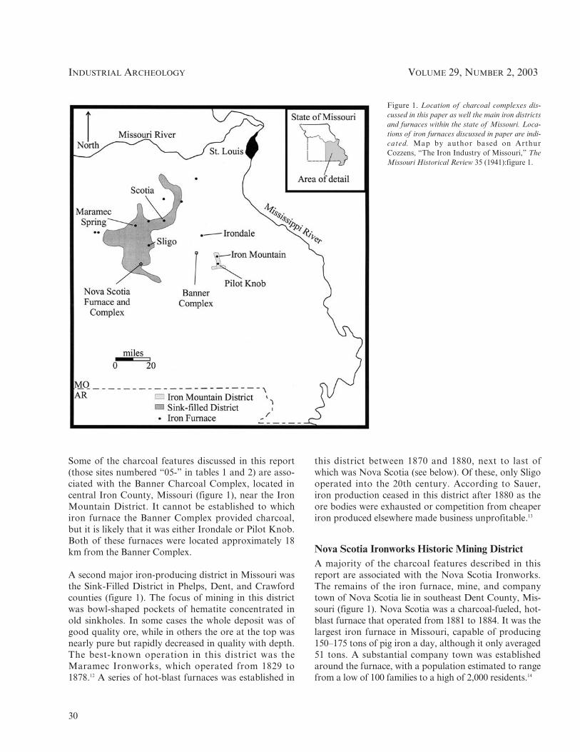
Some of the charcoal features discussed in this report(those sites numbered “05-” in tables 1 and 2) are asso-ciated with the Banner Charcoal Complex, located incentral Iron County, Missouri (figure 1), near the IronMountain District. It cannot be established to whichiron furnace the Banner Complex provided charcoal,but it is likely that it was either Irondale or Pilot Knob.Both of these furnaces were located approximately 18km from the Banner Complex.
A second major iron-producing district in Missouri wasthe Sink-Filled District in Phelps, Dent, and Crawfordcounties (figure 1). The focus of mining in this districtwas bowl-shaped pockets of hematite concentrated inold sinkholes. In some cases the whole deposit was ofgood quality ore, while in others the ore at the top wasnearly pure but rapidly decreased in quality with depth.The best-known operation in this district was theMaramec Ironworks, which operated from 1829 to1878.12 A series of hot-blast furnaces was established in
this district between 1870 and 1880, next to last ofwhich was Nova Scotia (see below). Of these, only Sligooperated into the 20th century. According to Sauer,iron production ceased in this district after 1880 as theore bodies were exhausted or competition from cheaperiron produced elsewhere made business unprofitable.13
Nova Scotia Ironworks Historic Mining DistrictA majority of the charcoal features described in thisreport are associated with the Nova Scotia Ironworks.The remains of the iron furnace, mine, and companytown of Nova Scotia lie in southeast Dent County, Mis-souri (figure 1). Nova Scotia was a charcoal-fueled, hot-blast furnace that operated from 1881 to 1884. It was thelargest iron furnace in Missouri, capable of producing150–175 tons of pig iron a day, although it only averaged51 tons. A substantial company town was establishedaround the furnace, with a population estimated to rangefrom a low of 100 families to a high of 2,000 residents.14
Figure 1. Location of charcoal complexes dis-cussed in this paper as well the main iron districtsand furnaces within the state of Missouri. Loca-tions of iron furnaces discussed in paper are indi-cated. Map by author based on ArthurCozzens, “The Iron Industry of Missouri,” TheMissouri Historical Review 35 (1941):figure 1.

CUTTLINE IT BACK AND BURNING IT BLACK:
31
Machinery for the Nova Scotia Furnace was movedfrom the location of the former Scotia Furnace, locatedin Crawford County to the north, which ceased opera-tions in 1880. The stack was 58 feet high and con-structed with an iron shell that was lined with firebrick.Data on what may have been a typical production runfor a day indicate that the furnace consumed 117charges a day, with each charge consisting of 2,456pounds of ore, 40 bushels of charcoal, and 200 poundsof limestone.15 The primary reasons why the Nova Sco-tia Furnace failed were the depletion of nearby ore bod-ies and high transportation costs without access to arailroad.16 All that remains to indicate the location ofthe furnace stack today are the remains of the lastcharge and scattered firebrick, while the rest of theindustrial complex is evident only as an archaeologicalsite (figure 2). The legacy of the scale of industrial oper-ations at Nova Scotia can be seen in the changed com-position of the forest in the area. When General LandOffice surveys were conducted in 1820, the area wascharacterized by large (50–75 cm diameter) mature pinetrees with an open understory. In contrast, today thearea is dominated by black oak with a dense, brushyunderstory, and only small amounts of pine.17 Thereplacement of pine by oak is largely due to the removalof fire from the ecosystem that accompanied historicsettlement in the area.
The Nova Scotia Ironworks Historic District was listedon the National Register of Historic Places in August2003. Unfortunately, little documentary record of thisfurnace has been found.18 Almost everything that isknown about Nova Scotia has been learned from thearchaeological record. Research at this district was car-ried out over a number of years under the sponsorshipof the Mark Twain National Forest. This researchincluded completing a company history and conductingfour test excavations throughout the town of Nova Sco-tia. Investigations at the industrial complex around thefurnace were limited to mapping. The identification ofintact charcoal production facilities in close proximityto Nova Scotia (figure 3) was one of the important fac-tors in establishing the historic district, which encom-passes 3,500 acres.19
Charcoal ProductionAlthough charcoal was not produced in pits, the term“charcoal pit” is the common term used in Missouri andelsewhere.20 The term “pit” as used in this study denotesthe remains of a temporary charcoal production facilityand is sometimes interchanged with the term “kiln,”which usually indicates more substantial installation.Charcoal production was one of the most importantparts of iron production at Missouri iron furnaces. Early
Figure 2. Map of Nova Scotia industrial complex. Map by author based on fieldwork by Robert Elgin and James Price.

INDUSTRIAL ARCHEOLOGY VOLUME 29, NUMBER 2, 2003
32
furnaces using charcoal as a fuel were often established inremote, isolated locations because they required exten-sive woodlands from which to produce charcoal, as wasthe case with the Missouri iron industry.21 The variousaspects of charcoal production employed by far thelargest number of workers at an ironworks, usually morethan 50 percent of the workforce. It was also one of themost difficult and dangerous jobs in the industry. Formany furnaces, charcoal production was the single great-est expense of the entire iron production operation.22
The following general discussion of charcoal produc-tion addresses those methods believed to have beenused in Missouri in the 19th century. Several other stud-ies provide detailed descriptions of the process as wellas variations used elsewhere.23 The actual production ofcharcoal involved three basic steps: cutting and prepar-ing the wood and kiln site, producing the charcoal, andtransporting the final product to the furnace. To pro-vide wood for charcoaling, woodcutters usually workedfrom late October through early spring because woodwas lighter when sap was in the roots, the wood driedquicker, and transport was easier over ice-covered roadsin cold areas. Often, the woodcutters were seasonal
employees. The woodcutters were responsible for fellingthe trees, trimming and cutting the logs to the correctlength, and hauling the logs to a storage area. Thewood was then stacked and left to dry.24
The charcoaling process ran from March through Decem-ber. Wood was piled in heaps and covered in earth, and afire was set to char the wood. The demanding process hadto be carried out in a careful and controlled manner.25
Charcoal pits were set on a clean, level ground surface,sheltered from the wind. If the surface was not level, a flatterrace was produced by excavating into the hillside anddumping the spoil on the slope to create a level platform.An area measuring 12–15 meters in diameter was gener-ally cleared. The logs were stacked, end on end, typically3.6–4.5 meters high. A central chimney opening would beleft in place. The pile was covered with a layer of dirt,clean charcoal dust, and wet vegetation several centime-ters thick. The pit was then fired through the chimney.The burning rate was controlled using the chimney andvent holes at various locations. In favorable conditions(such as dry, calm weather), a pile could be reduced tocharcoal in 7–10 days, though it could take up to 21 daysin poor conditions.26
Figure 3. Map showing distribution of recordedcharcoal pits and residential sites around NovaScotia. Because only scattered surveys have beenconducted in the area, the overall distribution ofthe sites shown in this figure is indicative of thelocation of the surveys rather than the actual sitedensity. Map by the author.

CUTTLINE IT BACK AND BURNING IT BLACK:
33
As soon as the charcoal was cool enough to work with,the last step of charcoal production was begun, whichinvolved drawing the charcoal from the heap and haul-ing it to storage at the furnace. A typical pit of 1,500bushels would be completely drawn in a week. Rakeswere used to remove the charcoal from the heap. If theworkers were not careful, the entire pile of charcoalcould catch fire while drawing the charcoal. The cooledcharcoal was loaded into large, high-sided wagons, eachof which carried 100–250 bushels of charcoal, andhauled to the storage sheds adjacent to the furnace.28
Summary of InvestigationsThe investigations of the charcoal sites documented inthis study involved three different cultural resource man-agement (CRM) projects carried out over several years.Because this work was carried out as part of CRMinvestigations, it was limited in extent, with only enoughdata being gathered so as to avoid and protect the sites.
Two survey projects inventoried several thousand acresprior to timber sales in Dent, Iron, and Reynolds coun-ties in the north-central Ozarks, documenting most ofthe sites included in this study.28 No test excavationswere conducted at a majority of these sites, and field-work involved mapping and limited shovel testingand/or the use of a metal detector. Limited exploratorytest excavations were carried out at one charcoal pit anda residential site to investigate the nature and function offeatures present at the sites.29 Two additional residentialsites were investigated to assess the extent of damageinadvertently caused by recent timber harvest activities.30
The results of these investigations are briefly summa-rized in the following two sections.
Charcoal PitsSixty-eight charcoal pits have been documented in thesestudies (Table 1), and all are essentially the same. Thepits average 12.3 m in diameter and 17 cm deep. These
Table 1. Data on Charcoal Pits
Site No. Pit Size Pit Depth Platform Size Artifacts Location
23DE142a 9.2 5 10.0 m 17 cm 15.4 5 18.5 m Muleshoe Terrace23DE142b 5.4 5 5.4 m 19 cm NA No Terrace23DE142c 10.8 5 10.0 m 18 cm NA No Terrace23DE142d 18.5 5 6.9 m 18 cm 18.5 5 13.1 m Wire Terrace23DE142e 6.9 5 9.2 m 14 cm NA Metal strapping Terrace23DE142f 5.4 5 10.8 m 16 cm NA No Terrace23DE143a 10.1 5 16.2 m 21 cm 13.1 5 17.7 m No Toeslope23DE143b 14.6 5 17.7 m 14 cm 14.6 5 16.9 m Piece of collier’s rake, tin can Terrace23DE143c 12.3 5 15.4 m 22 cm 13.1 5 13.9 m No Terrace23DE143d 16.2 5 15.4 m 15 cm 17.7 5 15.4 m Condensed milk can Terrace23DE143f 9.2 5 6.4 m 12 cm 10.8 5 11.1 m Iron strapping, 2 pieces wire,
2 piece sheet metal Terrace23DE144a 18.5 5 19.3 m 14 cm 15.4 5 19.3 m No Ridge23DE144b 16.9 5 15.4 m 18 cm NA No Terrace23DE145a 16.2 5 10.0 m 19 cm 12.3 5 10.0 m No Terrace23DE145b 5.4 5 5.4 m 22 cm 10.8 5 7.7 m No Terrace23DE145c 6.9 5 6.2 m 36 cm 14.6 5 17.9 m No Terrace23DE145d 13.1 5 15.4 m 13 cm 13.1 5 13.4 m No Terrace23DE145e 13.9 5 10.0 m 13 cm 15.4 5 10.8 m No Terrace23DE145f 10.8 5 10.8 m 19 cm 11.6 5 14.6 m Wagon tongue clevis, wire Terrace23DE146a 9.2 5 8.5 m 15 cm 12.3 5 10.0 m Nail Terrace23DE146b 26.2 5 17.5 m 23 cm 27.0 5 23.1 m No Terrace23DE147a 14.7 5 13.9 m 18 cm NA Wire Terrace
Continued on page 34

INDUSTRIAL ARCHEOLOGY VOLUME 29, NUMBER 2, 2003
34
23DE147b 16.9 5 13.9 m 13 cm 13.9 5 14.6 m Harness part Terrace23DE147c 15.4 5 11.6 m 20 cm NA No Terrace23DE147d 8.5 5 9.2 m 12 cm NA No Terrace 23DE148a 12.3 5 13.1 m 21 cm NA No Terrace23DE148b 13.1 5 10.8 m 10 cm NA Tin can Terrace23DE148c 13.9 5 11.6 m 13 cm NA Prince Albert tobacco can Terrace23DE148d 15.4 5 13.9 m 13 cm 15.4 5 13.9 m No Terrace23DE148e 13.9 5 13.1 m 12 cm 18.5 5 13.1 m Wire, large spike, 3 nails Terrace23DE148f 13.1 5 14.6 m 12 cm 13.1 5 13.9 m Chain link Ridge23DE149a 21.5 5 11.5 m 20 cm 17 5 20 m No Terrace23DE149b 14.5 5 6.0 m 20 cm 16 5 9 m Horseshoe, muleshoe Toeslope23DE149c 17.7 5 17.0 m 23 cm 20.8 5 20.0 m Tin can Toeslope23DE149d 15.4 5 7.7 m 14 cm 18.5 5 12.3 No Terrace23DE151 9.2 5 16.9 m 18 cm NA No Terrace23DE153 15.4 5 10.8 m 13 cm 13.9 5 13.1 m Chain link Terrace23DE155 7.7 5 6.9 m 21 cm 10.8 5 16.9 m No Terrace23DE156 4.6 5 10.0 m 13 cm 11.6 5 11.6 m No Ridge23DE157 14.6 5 13 m 23 cm NA Chain link, 3 pieces sheet metal Toeslope23DE158 13.1 5 20.0 m 20 cm NA Cast iron vessel Terrace23DE159 10.8 5 10.8 m 18 cm 13.9 5 12.3 m No Ridge23RE115b 15.4 5 10.0 m 12 cm NA Nail Terrace23RE115c 11.6 5 12.3 m 22 cm 14.6 5 16.9 m No Terrace05-697 8.2 m 15 cm 11 m Wire Slope05-698 8.4 5 10.6 m 13 cm 10 5 12.6 m No Slope05-699 15.2 510.8 m 18 cm 15.2 510.8 m Metal hook Ridge05-700 9.2 5 8.5 m 18 cm 9.2 5 8.5 m No Slope05-701 10.5 5 11.5 m 14 cm 10.5 5 11.5 m Numerous—see text Slope05-702 10 5 10.8 m 18 cm 10 5 10.8 m No Slope05-703 10 5 8.5 m 13 cm 10 5 8.5 m No Ridge05-704 10 5 7.8 m 13 cm 10 5 10 m No Toeslope05-705 10.8 5 8.5 m 15 cm 10.8 5 8.5 m Bolt, bracket, washer, chain link Toeslope05-707 12 5 12 m 15 cm 12 5 12 m Nail, metal plate Ridge05-708 10.8 510.8 m 15 cm 10.8 510.8 m Wire Slope05-710 9.2 5 13.1 m 15 cm 9.2 5 13.1 m Horseshoe Ridge05-725 6 m 15 cm 6 m No Ridge07-381 13.1 5 11.6 m 18 cm NA Horseshoe, sheet metal Terrace07-382 12.3 5 15.4 m 18 cm NA Horseshoe Terrace07-383 13.7 m 15 cm NA No Terrace07-384 13.1 5 11.6 m 15 cm NA Horseshoe Terrace07-385 12.3 m 19 cm 12.3 m Bolt Terrace07-386 ? 20 cm NA No Terrace07-387 8.5 m 18 cm 8.5 m No Terrace07-388 5.4 5 8.5 m 14 cm 5.4 5 8.5 m No Terrace07-389 10 5 11.6 m 21 cm 10 5 11.6 m Sheet metal Terrace07-390 13.1 5 15.4 m 19 cm NA 2 nails, bracket Terrace07-393 9.2 m 15 cm NA No Terrace

CUTTLINE IT BACK AND BURNING IT BLACK:
35
dimensions reflect diameter at the ground surface, whilethe depth reflects the charcoal fines left behind after theprocess was completed. Almost all pits are located oncreek terraces adjacent to the base of the slope (figure3). The original ground surface was artificially leveledby excavating into the base of the slope, and the spoilfrom this excavation was used to build up the lower sideof the platform thus created (figure 4). These excavatedareas averaged 14.95 meters in diameter. On a basiclevel, the charcoal pits recorded by these projects resem-ble those documented by previous studies. Detailedexcavations, such as those discussed by Ronald Renowere not performed, so only basic comparisons can bemade.31 In contrast to the findings of Charles Zeier andReno, a layer of burned earth was not obvious beneaththe charcoal pits.32 The reason for this is not clear,although it is possible that the pits examined were onlyused once, while those examined by Zeier and Renowere used multiple times, or perhaps the characteristicsof the underlying soils were sufficiently different as to
obscure evidence of burning. The frequency of charcoalpits, 1 every 13 acres, is the same as seen in the BlueRidge Mountains of Virginia.33
All charcoal pits were investigated using a metal detector.Once a metal object was detected, a trowel was used toscrape the soil until the object was located. Thirty-fourcharcoal pits had associated artifacts, ranging in fre-quency from one to five artifacts per pit, with one excep-tion to be discussed below. Artifacts recovered from char-coal pits in this project include mule shoes, shoe nails,wagon parts, horseshoes, harness parts, a fragment of awagon tongue clevis, chain links, a stove door hinge,pieces from a cast-iron vessel, a collier’s rake (metal piecein which wooden tines were set), square-cut nails, tobaccocans, condensed-milk cans, metal strapping, bolts, brack-ets, and wire. These artifacts are generally associated withanimals or wagons, food storage and preparation, char-coal production, and clothing. Most are probably derivedfrom the animals or wagons used to haul the charcoal to
Figure 4. Sketch map of a typicalcharcoal pit recorded by this project.
Map by author.

INDUSTRIAL ARCHEOLOGY VOLUME 29, NUMBER 2, 2003
36
the furnace. The rest are probably associated with the per-sonal possessions of the workmen, such as food or drinkcontainers and clothing. Some, such as the stove doorhinge and cast-iron vessel, suggest occupations near thecharcoal pits. These may have been in the form of tents orlean-tos, possibly used by the colliers.
Initial investigations at one of the charcoal pits in the Ban-ner Charcoal Complex, Banner No. 5 (site no. 05-701),revealed a more substantial concentration of artifacts thanwas found at any other charcoal pit.34 Use of a metaldetector around the pit revealed a concentration of metalartifacts, including square-cut nails (n=35), cast-iron vesselfragments (n=4), and a chain. Pottery was recovered whiletroweling for positive metal detector responses. In order toinvestigate the artifact concentration, limited testing cover-ing 2.75 m2 was carried out in the area where the chain andpottery were found (figure 5).
A majority of the nearly 100 artifacts recovered from thesite were pottery sherds (n=54), and most pottery (n=26) isengine-turned whiteware, almost certainly from the samevessel.35 These sherds are blue with black bands. Addi-
tional sherds representing other vessels include 5 plainsherds, 19 pottery fragments too small to identify, 2 piecesof stick-stamped whiteware (black with a red band), 1piece of hand-painted whiteware (green with a red band),and 1 piece of plain ironstone. Based on the pottery recov-ered, it is likely that this site was occupied between 1860and 1880.36 The only other artifacts beyond those alreadymentioned are two buttons. This concentration of artifactslikely represents the remains of a short-term occupation,possibly by the colliers burning the charcoal. Alternatively,it could represent woodcutters working earlier in theprocess. No evidence for a structure has been found, andthe dwelling may well have been a tent.
According to Reno, watch stations were establishednear the charcoal pits.37 Burning pits had to be moni-tored constantly and one person or several working inshifts might do this. At those watch stations investi-gated by Reno, the material culture left behind by thisactivity was described as “sparse in the extreme.”38 It islikely that many of the artifacts recorded around thecharcoal pits by the investigations reported here arerelated to the use of such watch locations.
Figure 5. Sketch map of Banner no. 5 showing loca-tion of artifact scatter and test pits in relation to thecharcoal pit. No investigations occurred on privateland. Map by author.

CUTTLINE IT BACK AND BURNING IT BLACK:
37
Table 2. Data on structures
Site ID Site Size Site Area Rock Pile Size Rock Pile Area
23DE142 S1 31 5 41 m 1271 m2 2.5 5 3.0 m 7.5 m2
23DE142 S2 81 5 35 m 2835 m2 2.7 5 2.2 5.94 m2
23DE142 S3 9 5 20 m 180 m2 2.1 5 2.1 m 4.62 m2
23DE142 S4 15 5 15 m 225 m2 2.0 5 1.0 m 2.0 m2
23DE142 S5 13 5 18 m 234 m2 2.3 5 3.0 m 6.9 m2
23DE143 NR NR 2.3 5 2.6 m 5.98 m2
23DE144 NR NR 3.0 5 3.0 m 9.0 m2
23DE145 S1 NR NR 3.3 5 2.4 m 7.92 m2
23DE145 S2 NR NR 2.4 5 2.7 m 6.48 m2
23DE146 NR NR 2.0 5 2.0 m 4.0 m2
23DE147 NR NR 1.4 5 1.6 m 2.24 m2
23DE150 NR NR 3.0 5 3.0 m 9.0 m2
23DE162 50 5 40 m 2,000 m2 3.0 5 2.0 6.0 m2
23DE163 50 5 45 m 2,250 m2 2.3 5 2.3 m 5.29 m2
07-392a 16 5 17 m 272 m2 1.7 5 2.0 m 3.4 m2
07-392b 16 5 23 m 368 m2 3.0 5 2.0 m 6.0 m2
23DE161 22 5 18 m 396 m2 3.0 x 3.6 m 10.8 m2
23DE160 16 5 18 m 288 m2 1.25 5 2.0 m 2.5 m2
07-368 45 5 20 m 900 m2 4.5 5 3.5 m 15.75 m2
07-391 16 5 16 m 256 m2 2.5 5 2.0 m 5.0 m2
05-696 70 5 65 m 4,550 m2 3.0 5 3.0 m 9.0 m2
NR = site size could not be determined because of disturbance.
StructuresTwenty-one features are believed to represent theremains of short-term occupations associated with char-coal production. The structures themselves consist ofsmall rock piles and associated light scatters of histori-cal period artifacts (Table 2). These rock piles come in arange of sizes, varying from 2.0 m2 to 15.75 m2. Basedon data obtained from excavations, the rock piles prob-ably represent the hearths at the base of mud and stickchimneys. Such “mudcat” chimneys are common inArkansas but have not been recorded in this areabefore.39 A majority (n=16) have a rock pile that meas-ures 5 m2 or less.
The heaviest concentration of artifacts is located imme-diately around each of the rock piles. These consist pri-marily of square-cut nails and stove parts, but severalother types of metal artifacts were observed, along withsmall quantities of whiteware and bottle glass. The over-all size of the associated artifact scatters ranges from 180m2 to 4,550 m2. Of the 14 structures for which the dimen-
sions of the artifact scatter were determined, a majority(n=8) have an area of less than 400 m2, two sites measurebetween 900 m2 and 1,280 m2, and four measure greaterthan 2,000 m2. These features have a distinctly domesticfeel to them, despite the small quantity of artifactsrecovered. They generally are located on creek terracesadjacent to the base of the ridge (figure 3). Five of thefeatures require a more detailed discussion because theywere the subject of more intensive investigations, andthese sites collectively provide important informationrelating to the nature and function of this type of site.
One structure locality (23DE142 S2) was recorded thatappeared different from the others. It consisted of theusual rock pile and artifact scatter, but it was adjacentto an artificial pond. The creek has been channelizedand excavated deeper in order to form a hole that holdswater year-round. There are a larger number of muleshoes at this structure than at any of the others, and theonly ox shoe from the entire Nova Scotia complex wasfound at this structure. A number of tack and wagon

INDUSTRIAL ARCHEOLOGY VOLUME 29, NUMBER 2, 2003
38
parts were also recorded at this locality. The assemblagefrom the site, combined with the large developed watersource, suggests the presence of larger numbers of draftanimals, at least in comparison to the other areas atNova Scotia.
Site 23DE161 is located on a low terrace at the end of apoint ridge between two intermittent creeks (figure 6). Itconsists of a rock pile (3.0 5 3.6 m) two stones thick andan associated scatter of artifacts (22 5 18 m). The rockpile is interpreted as originally consisting of a rectangu-lar platform of stones with a chimney. Excavations atthe site consisted of nine test pits (2 5 2 m), laid outalong an area disturbed by use as a skid trail in recent
logging activity.40 Ninety-seven artifacts, most of whichwere sherds (n=38) and nails (n=30), were recovered.Pottery from the site includes 5 hand-painted whitewaresherds (3 blue, 2 green), 2 earthenware sherds, and 31plain whiteware sherds. Other artifacts includebottle/container glass, a piece of slate, flat glass, lampglass, and sheet metal. This site appears to represent adomestic assemblage, probably a short-term occupa-tion, based on the scant remains.
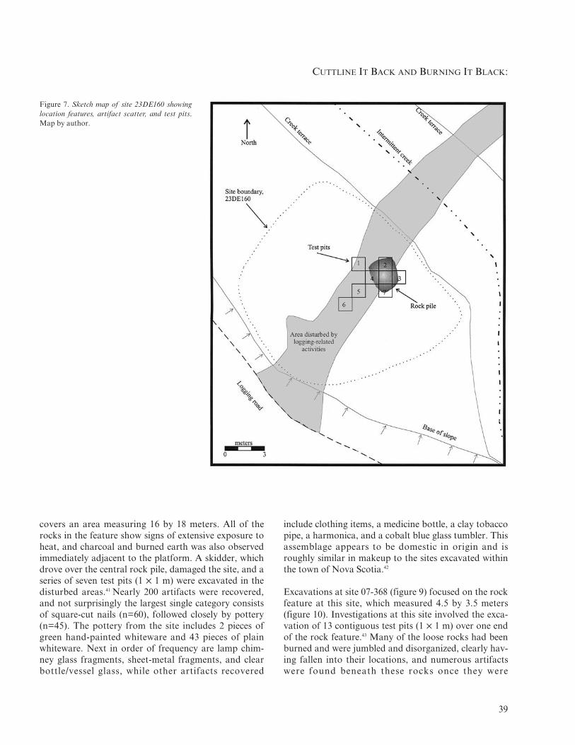
Site 23DE160 is located on a high terrace of an inter-mittent creek, adjacent to the base of the slope (figure7). It consists of a low rock pile (1.25 5 1.8–2.2 m) twocourses thick (figure 8) and a scatter of artifacts that
Figure 6. Sketch map of site 23DE161 showinglocation of features, artifact scatter, and test pits.Map by author.
CUTTLINE IT BACK AND BURNING IT BLACK:
39
Figure 7. Sketch map of site 23DE160 showinglocation features, artifact scatter, and test pits.Map by author.
covers an area measuring 16 by 18 meters. All of therocks in the feature show signs of extensive exposure toheat, and charcoal and burned earth was also observedimmediately adjacent to the platform. A skidder, whichdrove over the central rock pile, damaged the site, and aseries of seven test pits (1 5 1 m) were excavated in thedisturbed areas.41 Nearly 200 artifacts were recovered,and not surprisingly the largest single category consistsof square-cut nails (n=60), followed closely by pottery(n=45). The pottery from the site includes 2 pieces ofgreen hand-painted whiteware and 43 pieces of plainwhiteware. Next in order of frequency are lamp chim-ney glass fragments, sheet-metal fragments, and clearbottle/vessel glass, while other artifacts recovered
include clothing items, a medicine bottle, a clay tobaccopipe, a harmonica, and a cobalt blue glass tumbler. Thisassemblage appears to be domestic in origin and isroughly similar in makeup to the sites excavated withinthe town of Nova Scotia.42
Excavations at site 07-368 (figure 9) focused on the rockfeature at this site, which measured 4.5 by 3.5 meters(figure 10). Investigations at this site involved the exca-vation of 13 contiguous test pits (1 5 1 m) over one endof the rock feature.43 Many of the loose rocks had beenburned and were jumbled and disorganized, clearly hav-ing fallen into their locations, and numerous artifactswere found beneath these rocks once they were

INDUSTRIAL ARCHEOLOGY VOLUME 29, NUMBER 2, 2003
40
Figure 8. Detailed map of rock pile at site23DE160 and the location of test pits. Map byauthor.
removed. Underneath the disturbed rocks were the baseof a chimney constructed with large, thick stones set ina stack, and a hearth platform consisting of large, butrelatively thin, flat rocks set into the original groundsurface (figure 11).
Square-cut nails and fragments were the most commontype of artifact at the site, accounting for 65 percent ofthe total. Plain whiteware pottery was the next mostcommon at 9 percent, with flat glass (5%), sheet metalfragments (3%), buttons (3%), and clear glass fragments(2%) following in order of frequency. In addition to theplain whiteware, two red transfer-print whitewaresherds were recovered. The flat glass fragments maywell represent the remains of a single windowpane, asthey were found in a very limited area immediatelyadjacent to the platform. Some artifacts suggest that,although this may have been a temporary occupationsite, the residents tried to bring some finer items withthem, and the furnishings may not have been as primi-tive as some accounts suggest. Two upholstery tackswere found along with a small key of the type thatwould go with a clock case or small chest. Also of inter-est were the three ceramic doll parts (one foot, two
pieces of a head) found in front of the cabin. Thesealmost certainly came from a child’s toy. The assem-blage from site 07-368 likely represents that of a largelyself-sufficient family.
Our interpretation is that these rock features are theremains of structures that represent short-term habita-tion sites, probably occupied by the woodcutters. Over-all, the assemblage from these sites clearly appears to bedomestic in origin. All three tested cabins have aroughly similar artifact assemblage. The artifact collec-tion as a whole from these sites is quite similar in con-tent and appearance to those recovered from excava-tions within residential areas of Nova Scotia, especiallythe workers’ houses.44 They are also roughly similar toearly-19th-century domestic sites excavated in theOzarks.45 The main differences are in the pottery, withthe earlier sites containing more decorated whitewares,while the later sites are dominated by undecoratedwhitewares. Although it is possible that these structuresrepresent outlying houses from the town of Nova Scotiaitself, they are more than a mile from the main part oftown. No cisterns or wells are present, and the onlydeveloped water source is a waterhole or pond that was

Figure 9. Sketch map of site 07-368 showing location of features, arti-fact scatter, and test pits. Map by author.
CUTTLINE IT BACK AND BURNING IT BLACK:
41
constructed at one site, which would probably not havebeen used for domestic purposes. This lack of a goodwater source, along with the absence of additional fea-tures such as cellars, also suggests that these structuresdo not represent farmsteads. None of the area has beencleared for agriculture, and long-term habitation sites inthe area all have a developed water source and addi-tional outbuildings. The apparently sparse midden alsosupports the hypothesis that these represent short-termoccupations. A longer, more established occupationwould likely generate much more refuse.
DiscussionCharcoal production has been the subject of a numberof previous studies.46 The present study has documentedthe presence of an extensive charcoal-production com-plex associated with the Nova Scotia Ironworks, as wellas a second complex that could not be associated with aspecific furnace. Overall, the complexes documented bythis study resemble in a general way charcoal-produc-tion facilities described elsewhere that are roughly con-temporaneous with the present study.47
This similarity may well be related to the fact that in allthree areas charcoal production was carried out as partof an industrial operation. Some studies have not dis-covered evidence for the presence of features other thanthe charcoal pits.48 It is possible that this difference istemporal, as the sites Susan Frye was studying wereused in the early-19th century. The furnace that utilizedthe pits documented by Frye was also smaller than theoperations at Nova Scotia or the other studies. Zeiersuggested that charcoal production organized on a pat-tern different than the centralized, industrial organiza-tion he found in Nevada may have a different appear-ance. Those operations investigated by Frye may havebeen organized differently than the industrial operationsdescribed by Zeier, Reno, and Edward Heite in theirstudies.
One of the biggest differences between this study andprevious investigations of charcoal production in Mis-souri and the eastern United States is the identificationof artifacts in frequent association with charcoal pits.However, similar patterns have been found in the west-ern United States. A wide variety of artifacts wererecovered, including mule shoes, wagon parts, tack, andtools, as well as stove parts and food/beverage contain-ers. Most of these artifacts (shoes, tools, wagon parts)represent items broken while in use at the pits and dis-

INDUSTRIAL ARCHEOLOGY VOLUME 29, NUMBER 2, 2003
42
Figure 10. Profiles of rock feature at site 07-368 showing location of test pits in relation to base of chimney and hearth. Map by author.
Figure 11. Map of excavation block at site 07-368. Map by author.

CUTTLINE IT BACK AND BURNING IT BLACK:
43
carded in place. A few are suggestive of other activities.Although the food and beverage containers could havebeen carried to the sites by the workmen, the stove partsand cooking vessels probably represent at least a tem-porary occupation of a location. The results of investi-gations at Banner No. 5 (site 05-701) confirm that occu-pations occurred in the vicinity of charcoal pits. Theselikely represent watch locations such as those describedby Reno.49
The use of temporary structures appears to have beencommon in industrial charcoal-production. As Gordonand Malone have noted, proper charcoal productionrequired constant supervision by the collier, who had tolive nearby.50 Heite, Reno, and Zeier report the use oftemporary structures by charcoal workers. 51 VictorRolando reports that in Vermont “the collier spent theentire charcoal-making season on a mountainside, liv-ing in a small hut among his mounds.”52 Woodcuttersfrom the Maramec Ironworks of central Missouri livedin primitive cabins while working over an area. Accord-ing to James Norris, “the wood choppers built bleakand lonely huts.”53
Woodcutters working for the large lumber companies inthe southern Ozarks often lived in primitive cabins orlarge wall tents for several months at a time while work-ing over an area. Several of these temporary cabins(sites 23RI512, 23RI515, 23RI565) have been recordedby Cynthia Price in Ripley County.54 Although they donot contain the rock piles, these cabin sites consist ofsurface scatters of artifacts that are similar in content tothose documented in this report. Land records on filewith the Mark Twain National Forest indicate that log-gers occupied these sites for a short period of time. Twoare described as “small lumber cabins,” while the thirdis reported to be a logging camp occupied by four fami-lies for three months. In addition to temporary cabinsand tents, loggers in southern Missouri are also knownto have lived in portable wooden cabins built on skids.55
The cabins investigated by Zeier and Reno were fairlybasic with little elaboration in the material culture.56
Both woodcutters and colliers used such cabins. Onlymales lived in the cabins (28 m2) investigated by Zeier,constructed using vertical pinion posts.57 None of thecabins recorded by Heite were tested, but they averaged29.16 m2 in area and consisted of small, circular moundswith a central depression.58 These were also reported tohave only been used by males and were used first by
woodcutters and then by the colliers. Reno investigatedcabins with an average size of 13.75 m2, ranging from8.4 to 19.2 square meters.59 Primarily males lived atthese sites, although a few families were present.60 Thepattern seen for the present study is similar to thesestudies. In most cases, the size of the cabins docu-mented in the present study could not be established,but at site 07-391, the distribution of nails and possiblefoundation stones indicated that the structure couldhave measured 5.4 to 6.0 meters in diameter. This corre-sponds with the sizes of structures described by Zeierand Heite.61
It is proposed that the structure localities recorded bythis project are temporary cabins occupied by woodcut-ters. Several pieces of evidence have been used to reachthis conclusion. At site 23DE142, the structure wasoccupied prior to the use of a nearby charcoal pit. Anax found at another site (23DE145) is also suggestive ofuse by woodcutters as this was of a type that wouldhave been used for felling and bucking trees.62 Norrisreported that woodcutters working for the MaramecIronworks lived in primitive cabins.63 Woodcutters typi-cally worked from October through spring, a time whenmore substantial structures would have been required.At least one of the sites (23DE142) contained theremains of a heating stove. In contrast, charcoal wasburned from March through December. Based on thisinformation, it is our present interpretation that wood-cutters used the structures recorded by these projects.Colliers, who worked during the warmer months, prob-ably made use of more ephemeral structures, such aswall tents. The presence of this kind of shelter may beseen in the occasional recovery of artifacts such as thestove door hinge at one pit or the cast-iron vessel atanother. The artifacts recovered from the area of Ban-ner No. 5 definitely suggest some form of occupation inthe vicinity of the charcoal pits.
The picture obtained as a result of these excavationsdiffers from that presented by Norris for the woodcut-ters working for the Maramec Ironworks. According toNorris,
the wood choppers built bleak and lonely huts . . . temporary shel-ters, lacking even the most rudimentary comforts. The small hutsusually had no windows and only one door, hung on leather hingesto permit entrance and egress. Most had log and dirt roofs, logsides, no floors, and a primitive fireplace for both heating andcooking.64

INDUSTRIAL ARCHEOLOGY VOLUME 29, NUMBER 2, 2003
44
Site 07-368 clearly does not fit this description.Although it appears to be a temporary shelter, rudimen-tary comforts are definitely present. The presence ofwomen and children also differs from accounts of char-coal-production. According to Zeier and Norris, onlymen were present at the charcoal sites, while Heite refersonly to men. Women and families were rare according toReno.65 However, woodcutters working for the largetimber companies in southern Missouri in the late-19th,and early-20th centuries often lived in primitive cabinsor large wall tents for several months at a time whileworking in an area.66 In many cases, entire families werepresent. This appears to be the case at site 07-368.
The presence of families in the Ozarks, as opposed toprimarily males in Nevada, may be related to the differ-ent labor pools.67 In the Ozarks most of the workers,especially the woodcutters, were seasonal employeeswho farmed or performed other work the rest of theyear. Even if they were recent immigrants to the area,they were almost all Americans who brought their fami-lies to settle in the area. In contrast, the charcoal work-ers in Nevada, to a large extent, were immigrants andoften their families had not accompanied them to theUnited States.
Overall there is great similarity between the three exca-vated cabins, with one distinct difference. The artifactassemblages are roughly similar with no substantial dif-ferences, and all appear to result from a habitation site.The only real difference appears to be in the complexityof the rock feature. The rock feature at site 23DE160was a simple, rectangular stone hearth that originallyhad a mud and stick chimney. In contrast, site 07-368has a rock chimney with a stone hearth, and the rockfeature is the largest such feature documented to date.Much more effort was put into constructing the rockfeature at site 07-368. One possible reason could be thatthis house was to be the residence of a family, asopposed to that of a single adult male. The man whoconstructed the cabin at site 07-368 may have desired amore substantial and elaborate cabin to house his fam-ily. In contrast, the man who built the cabin at site23DE160 may have simply desired a functional shelter.An alternative explanation could be status differences;someone of higher status may well have had the abilityto build, or have built, a more elaborate structure con-taining better furnishings. There is a real variety in theshapes and sizes of the 18 rock piles recorded in the sur-veys that were not tested (Table 2). At the present time
it is not possible to determine if these differences reflectdifferences in personal preference, the presence orabsence of families, status differences, or some otherexplanation.
ConclusionsThe present study has documented the presence of twoextensive charcoal-production complexes, one of whichhas been listed on the National Register of HistoricPlaces. These investigations reveal elements of a historiccultural landscape created by the production of iron inMissouri that can still be seen more than 100 years afterproduction ceased. It may be typical of those associatedwith charcoal-fueled iron furnaces throughout the 19thcentury; differences in the details reflect possible regional,cultural, or functional differences in the industry.
While these charcoal-production complexes are typical,they are also unusual in another way. As Heite noted,“intact coaling complexes of pits, huts, and roads arefragile and extremely rare.”68 Such intact complexes arerare in the eastern United States for a variety of reasons.They consist of small, ephemeral features that are dis-persed across a landscape covering hundreds or thou-sands of acres. Most investigations focus on the indus-trial heart of an iron operation, neglecting the thousandsof acres of associated features. In order to document thefull range of operations associated with the iron indus-try, it is necessary to conduct intensive surveys of largeareas around the industrial plant. Because a majority ofthe workers associated with an iron furnace worked andlived away from the furnace for most of the year, we willnot learn about their lives if we do not look for andinvestigate sites such as those discussed here. As withmany aspects of archaeology, the small and ephemeralcan be as important to understanding what occurred inthe past as the big and highly visible.
AcknowledgementsThe Mark Twain National Forest funded the fieldworkdiscussed in this paper, and I would like to thank SalemDistrict Ranger Warren Dubois and Potosi DistrictRanger Katherine Stuart for their support of the proj-ects. Judith Harpole, Jack Bergstresser, Sr., MichaelO’Brien, and three anonymous reviewers provided help-ful criticism and comments on the various drafts of thispaper. I would also like to thank IA editor Patrick Mar-tin for his assistance in completing this project. Any

CUTTLINE IT BACK AND BURNING IT BLACK:
45
mistakes are those of the author and none of the con-clusions or opinions reflects those of the reviewers orthe author’s employer.
Notes1. Judith L. Harpole, James R. Wettstaed, and James E. Price, “A
Victorian Ghost in the Ozark Pines: Archaeological Investigationsat the Nova Scotia Ironworks, Missouri,” paper presented at the63rd Annual Meeting of the Society for American Archaeology,Chicago, Ill. (1999).
2. James R. Wettstaed, “Heritage Resource Investigations at a Char-coal-Production Complex Affiliated with the Nova Scotia Iron-works: The Meramec and Nova Scotia Timber Sales, DentCounty, Missouri,” Mark Twain National Forest CulturalResource Report #09-05-07-234, Supervisor’s Office, Rolla, Mo.,1999; “Damage Assessment for Four Charcoal-Related SitesLocated within the Nova Scotia Timber Sale, Dent County, Mis-souri,” Mark Twain National Forest Cultural Resource Report#09-05-07-238, Supervisor’s Office, Rolla, Mo., 1991; “CulturalResource Investigations for the Environmental Impact Statementfor the Oak Decline and Forest Health Project, Dent, Iron,Reynolds, Shannon and Washington Counties, Missouri,” MarkTwain National Forest, Cultural Resource ReconnaissanceReport R2002-09-05-00001, Supervisor’s Office, Rolla, Mo.,2002).
3. Arthur B. Cozzens, “The Iron Industry of Missouri,” The Mis-souri Historical Review, 35 (1941): 509–39; “The Iron Industry ofMissouri (continued),” The Missouri Historical Review, 36 (1942):48–60; Robert B. Gordon and Patrick M. Malone, The Texture ofIndustry: An Archaeological View of the Industrialization of NorthAmerica (New York: Oxford Univ. Press, 1994), 84.
4. R. Bruce Council, Nicholas Honerkamp, and M. Elizabeth Will,Industry and Technology in Antebellum Tennessee: The Archaeologyof the Bluff Furnace (Knoxville: Univ. of Tennessee Press, 1992);James L. Smith, “Historical Geography of the Southern CharcoalIron Industry, 1800–1860” (doctoral diss.), Univ. of Tennessee,Knoxville, 1982; Peter Temin, Iron and Steel in Nineteenth-CenturyAmerica (Cambridge, Mass.: MIT Press, 1964).
5. William T. Hogan, Economic History of the Iron and Steel Industryin the United States, Vol. 1, (Lexington, Mass.: Lexington Books,1971), 67–69; Carl O. Sauer, The Geography of the Ozark Highlandof Missouri (Chicago: Univ. of Chicago Press, 1920), 126, 155;Richard H. Schallenberg and David A. Ault, “Raw MaterialsSupply and Technological Change in the American Charcoal IronIndustry” in Technology and American History: A HistoricalAnthology from Technology and Culture, ed. Stephen H. Cutcliffeand Terry S. Reynolds (Chicago: Univ. of Chicago Press, 1997),73–103.
6. Cozzens, “Iron Industry,” 507 (see n. 3); Cozzens, “Iron Industry(cont.),” 48 (see n. 3); Milton D. Rafferty, The Ozarks: Land andLife, (Norman: Univ. of Oklahoma Press, 1980), 127–28.
7. Cozzens, “Iron Industry (cont.),” 49–50 (see n. 3).8. Cozzens, “Iron Industry,” 51 (see n. 3); Barbara A. Vogler, M.
Colleen Hamilton, and Joseph M. Nixon, “Archaeological Assess-ment of Cultural Resources in the Mid-Missouri Mining District,”Research Report No. 101, Archaeological Survey, Univ. of Mis-souri at St. Louis, 1990, 29–30; 76–79; Charles P. Williams, Geo-
logical Survey of Missouri, Industrial Report on Lead, Zinc, andIron (Jefferson City, Mo.: Regan & Carter, 1877), 147
9. Sauer, Geography, 128 (see n. 5).10. Gordon and Malone, Texture of Industry, 86 (see n. 3).11. Schallenberg and Ault, “Raw Materials,” 101 (see n. 5).12. James D. Norris, Frontier Iron: The Story of the Maramec Iron-
works (Madison: State Historical Society of Wisconsin, 1972), 6–7.13. Sauer, Geography, 155 (see n. 5).14. Cozzens, “Iron Industry (cont.),” 56–57 (see n. 3); Robert L.
Elgin, “History of the Nova Scotia Iron Company,” Mark TwainNational Forest Supervisor’s Office, Rolla, Mo., 1992, 3–5; JamesR. Wettstaed, Nova Scotia Ironworks Historic District, NationalRegister of Historic Places Registration Form, submitted to U.S.Department of the Interior, National Park Service, (prepared6/14/2000, listed 8/25/2003); Harpole et al., “Victorian Ghost,”(see n. 1); Earl W. Kersten, Jr., “Changing Economy and Land-scape in a Missouri Ozark Area,” Annals of the Association ofAmerican Geographers 48 (1958): 398–418.
15. Elgin, “History,” (see n. 14).16. Ibid.; Kersten, “Changing Economy,” 404 (see n. 14).17. John Bryan, personal communication, 1999.18. Elgin, “History,” (see n. 14).19. Wettstaed, Nova Scotia (see n. 14).20. Ronald L. Reno, “Fuel for the Frontier: Industrial Archaeology
of Charcoal Production in the Eureka Mining District, Nevada1869–1891” (doctoral diss.), Univ. of Nevada, Reno, 1996, 79.
21. Temin, Iron and Steel, 83 (see n. 4).22. Council et al., Industry and Technology, 16 (see n. 4); Norris, Fron-
tier Iron, 42–43, 52 (see n. 12); Paul A. Paskoff, Industrial Evolu-tion: Organization, Structure, and Growth in the Pennsylvania IronIndustry, 1750–1860, (Baltimore: Johns Hopkins Univ. Press,1983), 29.
23. Norris, Frontier Iron, 48–52 (see n. 12); Frederick Overman, ATreatise on Metallurgy (New York: D. Appleton & Co., 1852),352–60; Reno, “Fuel,” 71–143 (see n. 20); Charles D. Zeier “His-toric Charcoal Production near Eureka, Nevada: An Archaeologi-cal Perspective,” Historical Archaeology 21, No. 1 (1987): 84–86;Daniel J. O’Rourke, “Rock Kilns, a Case Study of Michigan’sCharcoal Industry,” (master’s thesis) Michigan TechnologicalUniversity, 1997, 19–39.
24. Council et al., Industry and Technology, 16 (see n. 4); Overman,Treatise, 342–43 (see n. 23); James M. Ransom, Vanishing Iron-works of the Ramapos (New Brunswick: Rutgers Univ. Press,1966), 12.
25. Norris, Frontier Iron, 48–52 (see n. 12); Overman, Treatise, 352–60(see n. 23); Zeier, “Historic Charcoal,” 84–86 (see n. 23).
26. Norris, Frontier Iron, 48–52 (see n. 12); Overman, Treatise, 352–59(see n. 23).
27. Norris, Frontier Iron, 49–52 (see n. 12); Overman, Treatise,359–360 (see n. 23).
28. Wettstaed, “Heritage Resource,” “Cultural Resource” (see n. 2).29. Wettstaed “Cultural Resource” (see n. 2).30. Wettstaed “Damage Assessment” (see n. 2).31. Reno, “Fuel,” 122–33 (see n. 20).32. Ibid.; Zeier, “Historic Charcoal,” (see n. 23).33. Susan Winter Frye, “Charcoal Manufacturing in the Blue Ridge:
A View from Maryland Heights” in Upland Archaeology in theEast: A Third Symposium, ed. Michael R. Barber, USDA ForestService, Southern Region, Cultural Resource Report 87-10, 1987,pp. 2–14; Zeier, “Historic Charcoal,” (see n. 23).

INDUSTRIAL ARCHEOLOGY VOLUME 29, NUMBER 2, 2003
46
34. Wettstaed, “Cultural Resource” (see n. 2).35. All pottery identification in this paper is based on the following:
Cynthia R. Price, “Nineteenth Century Ceramics … in the EasternOzark Border Region,” Center for Archaeological Research,Monograph Series No. 1 (Springfield: Southwest Missouri StateUniv., 1979); Teresita Majewski and Michael J. O’Brien, “AnAnalysis of Historical Ceramics from the Central Salt River Valleyof Northeast Missouri,” American Archaeology Division, Depart-ment of Anthropology Publications in Archaeology, No. 3, (Colum-bia: Univ. of Missouri, 1984).
36. Cynthia R. Price, personnel communication, 2001.37. Reno, “Fuel,” 180–85 (see n. 20).38. Ibid., 182.39. For example of structures with “mud cat” chimneys, see articles in
Ann M. Early, ed., Forest Farmsteads: A Millennium of HumanOccupation at Winding Stair in the Ouachita Mountains, ArkansasArchaeological Survey Research Series, 57 (Fayetteville: ArkansasArchaeological Survey, 2000).
40. Wettstaed “Damage Assessment” (see n. 2).41. Ibid.42. Harpole et al., “Victorian Ghost” (see n. 1).43. Wettstaed, “Cultural Resources” (see n. 2)44. Wettstaed, Nova Scotia (see n. 14); Harpole et al., “Victorian
Ghost” (see n. 1).45. James R. Wettstaed, “Perspectives on the Early-Nineteenth-Cen-
tury Frontier Occupations of the Missouri Ozarks,” HistoricalArchaeology 37, No. 3 (2003): 97–114.
46. Frye (see n. 33); Edward F. Heite “Unearthing Business History:Can Archaeology Provide Evidence for Interpreting ManagementStyles” IA: The Journal of the Society for Industrial Archeology 18,No. 1/2 (1992): 123–28; Victor R. Rolando, “Nineteenth-CenturyCharcoal Production in Vermont,” IA: The Journal of the Societyfor Industrial Archeology 17, No. 2 (1991): 15–36; Zeier, “HistoricCharcoal” (see n. 23).
47. Zeier, “Historic Charcoal” (see n. 23); Heite, “Unearthing” (see n.46); Reno, “Fuel” (see n. 20).
48. Frye, “Charcoal Manufacturing” (see n. 33).49. Reno, “Fuel” 180–85 (see n. 20).50. Gordon and Malone, Texture of Industry, 231 (see n. 3).51. Zeier, “Historic Charcoal” (see n. 23); Heite, “Unearthing” (see n. 46).52. Rolando, “Nineteenth-Century,” 18 (see n. 46).53. Norris, Frontier Iron, 43 (see n. 12).54. Cynthia R. Price, personal communication, 1999.55. Susann E. Harris, James E. Price, and Cynthia R. Price “The
Archaeology of the Logging Industry in the Little Black RiverWatershed” in Conservation Archaeology: A Guide for CulturalResource Management Studies, ed. Michael B. Schiffer and GeorgeJ. Gummerman (New York: Academic Press, 1977), 391–400.
56. Zeier, “Historic Charcoal,” 95–96 (see n. 23); Reno, “Fuel” (see n. 20).57. Zeier, “Historic Charcoal,” 95–96 (see n. 23).58. Heite, “Unearthing,” 126 (see n. 46).59. Reno, “Fuel,” 177 (see n. 20).60. Ibid., 220–22 (see n. 20).61. Zeier, “Historic Charcoal” (see n. 23); Heite, “Unearthing” (see n. 46).62. James E. Price, personal communication, 1999.63. Norris, Frontier Iron, 43–44 (see n. 12).64. Ibid.65. Zeier, “Historic Charcoal,” 96 (see n. 23); Norris, Frontier Iron
(see n. 12); Heite, “Unearthing” (see n. 46); Reno, “Fuel,” 220–22(see n. 20).
66. Cynthia R. Price, personal communication, 1999.67. Reno, “Fuel” (see n. 20); Zeier, “Historic Charcoal” (see n. 23).68. Heite, “Unearthing,” 127 (see n. 46).