Cremaschi M., Ferraro F., Pizzi C., Putzolu C., Spatial Intra-Site Analyses at the terramara of...
11
Spatial Intra-Site Analyses at the Terramara of Poviglio S. Rosa (Reggio Emilia, Italy): The Enclosure Vs. The Hydraulic System M. Cremaschi, 1 F. Ferraro, 1 C. Pizzi 1 & C. Putzolu 2 'C.N.R. I.D.P.A., Dipanimento di Scienze della Terra, via Mangiagalli 34, 20133 Milano 2 Via Fanfulla da Lodi, 80 ROMA, [email protected] Abstract. Digital techniques were adopted in the excavation of the Terramara di Poviglio as a first slep in creating the GIS of the site. A GIS plalform appear an essential choice first to manage the large quantity of data collecled in twenty years of excavation through traditional techniques. Since few years the archaeological feature unearthed during the excavation are surveyed through total station and dedicata software both in the inner part of the village and in the moat surrounding the site. Inside the village the shape and the size oh the houses have been recognized and their relation with the heaps of ash and sherds related to the former hearths. In the fringe of the village a detailed DTM of the moat was also created to understand of the dynamics of the hydraulic system and the relationships of enclosure and internai structures of the village. 1 Introduction This paper deals with the use of digitai techniques in the survey of the Bronze Age site (terramara) of Santa Rosa of Poviglio, located in the centrai Po plain (Reggio Emilia, Italy). It is not a paper directly dealing with GIS technology; it aims to demonstrate how digitai technology and GIS may improve the scientific quality of an archaeological project in managing and interpreling data to reconstruct the archaeological landscape at the inlrasite scale. Archaeological excavati ons in terramara Santa Rosa started in 1984, under the direction of M. Bernabò Brea and M. Cremaschi (Bernabò Brea, Bronzoni, Cremaschi, Mutti 1990). In twenty years of excavation, the volume of the field data and records has so grown that it cannot be at present managed by traditional techniques and it needs a GIS framework to be properly handled. Digital technology is useful not only because it helps to manage a larger quantity of data in shorter time, if compared with traditional procedures, but also because it gives specifìc analylical tools which enter into the analysis and interprelation of the processes of site formation. However, the GIS of the S. Rosa excavation does not exist yet; it is just a project we are working on, but it may be of interest to show how the need to set up a GIS originaled from the progress in research, and is now an urgenl demand. 2 Terramare and Landscape The terramare are archaeological pluristratified sites which developed in the Po plain from the Middle Bronze up to the Late Bronze age (Bernabò Brea, Mutti 1994; Bernabò Brea, Cardarelli, Cremaschi 1997a). They were large villages up to 20 hectares wide, square in shape, fortified and surrounded by ditches, and, at least during their last phase, enclosed inside hearth ramparts. The internai structures were houses on posts and intersecting roads, built according to a consciously conceived urban project whose features were quite regular and Constant through time (Bernabò Brea, Cremaschi, Pizzi 2003). The terramare were built by a complex and stratified society whose subsistence was based upon agriculture, pastoralism, handicraft and international trade connecting the Po plain to north-eastern Europe and to the east Mediterranean (Bernabò Brea et alii, 2004). The terramare settled the alluvial plain of the Po as of the XVI century BC. They underwent a significant progressive growth in demography during the second half of the XV century, and at their apogee, during the XVI and XIII centuries BC, they displayed a significant enlargement of single sites and a noteworthy concentration in the density of sites (fig. 1 ): one village every 25 square kilometres (Cardarelli 1988). The terramara system collapsed abruptly at about 1150 BC, and the causes of this collapse are stili unknown (Bernabò Brea, Cardarelli, Cremaschi 1997b). The terramare civilisation had a heavy impact on the environment (Cremaschi 1997). It led to total deforestation, but it represented the first phase of management and organisation of a rural landscape. Single sites acted as centres for collection and distribution of the water resources to irrigated fields, as demonstrated by the water management system recently discovered in the terramara Santa Rosa (Cremaschi, Pizzi, in press). 23
-
Upload
independent -
Category
Documents
-
view
1 -
download
0
Transcript of Cremaschi M., Ferraro F., Pizzi C., Putzolu C., Spatial Intra-Site Analyses at the terramara of...
Spatial Intra-Site Analyses at the Terramara of Poviglio S. Rosa (Reggio Emilia, Italy): The Enclosure Vs. The Hydraulic System
M. Cremaschi,1 F. Ferraro,1 C. Pizzi1 & C. Putzolu2
'C.N.R. I.D.P.A., Dipanimento di Scienze della Terra, via Mangiagalli 34, 20133 Milano 2 Via Fanfulla da Lodi, 80 ROMA, [email protected]
Abstract. Digital techniques were adopted in the excavation of the Terramara di Poviglio as a first slep in creating the GIS of the site. A GIS plalform appear an essential choice first to manage the large quantity of data collecled in twenty years of excavation through traditional techniques. Since few years the archaeological feature unearthed during the excavation are surveyed through total station and dedicata software both in the inner part of the village and in the moat surrounding the site. Inside the village the shape and the size oh the houses have been recognized and their relation with the heaps of ash and sherds related to the former hearths. In the fringe of the village a detailed DTM of the moat was also created to understand of the dynamics of the hydraulic system and the relationships of enclosure and internai structures of the village.
1 Introduction
This paper deals with the use of digitai techniques in the survey of the Bronze Age site (terramara) of Santa Rosa of Poviglio, located in the centrai Po plain (Reggio Emilia, Italy).
It is not a paper directly dealing with GIS technology; it aims to demonstrate how digitai technology and GIS may improve the scientific quality of an archaeological project in managing and interpreling data to reconstruct the archaeological landscape at the inlrasite scale.
Archaeological excavati ons in terramara Santa Rosa started in 1984, under the direction of M. Bernabò Brea and M. Cremaschi (Bernabò Brea, Bronzoni, Cremaschi, Mutti 1990).
In twenty years of excavation, the volume of the field data and records has so grown that it cannot be at present managed by traditional techniques and it needs a GIS framework to be properly handled. Digital technology is useful not only because it helps to manage a larger quantity of data in shorter time, if compared with traditional procedures, but also because it gives specifìc analylical tools which enter into the analysis and interprelation of the processes of site formation.
However, the GIS of the S. Rosa excavation does not exist yet; it is just a project we are working on, but it may be of interest to show how the need to set up a GIS originaled from the progress in research, and is now an urgenl demand.
2 Terramare and Landscape
The terramare are archaeological pluristratified sites which developed in the Po plain from the Middle Bronze
up to the Late Bronze age (Bernabò Brea, Mutti 1994; Bernabò Brea, Cardarelli, Cremaschi 1997a).
They were large villages up to 20 hectares wide, square in shape, fortified and surrounded by ditches, and, at least during their last phase, enclosed inside hearth ramparts.
The internai structures were houses on posts and intersecting roads, built according to a consciously conceived urban project whose features were quite regular and Constant through time (Bernabò Brea, Cremaschi, Pizzi 2003).
The terramare were built by a complex and stratified society whose subsistence was based upon agriculture, pastoralism, handicraft and international trade connecting the Po plain to north-eastern Europe and to the east Mediterranean (Bernabò Brea et alii, 2004).
The terramare settled the alluvial plain of the Po as of the XVI century BC. They underwent a significant progressive growth in demography during the second half of the XV century, and at their apogee, during the XVI and XIII centuries BC, they displayed a significant enlargement of single sites and a noteworthy concentration in the density of sites (fig. 1 ): one village every 25 square kilometres (Cardarelli 1988). The terramara system collapsed abruptly at about 1150 BC, and the causes of this collapse are stili unknown (Bernabò Brea, Cardarelli, Cremaschi 1997b).
The terramare civilisation had a heavy impact on the environment (Cremaschi 1997). It led to total deforestation, but it represented the first phase of management and organisation of a rural landscape. Single sites acted as centres for collection and distribution of the water resources to irrigated fields, as demonstrated by the water management system recently discovered in the terramara Santa Rosa (Cremaschi, Pizzi, in press).
23

THE RECONSTRUCTION OF ARCHAEOLOGICAL LANDSCAPES THROUGH DIGITAL TECHNOLOGIES
Srtt «*•#'«*» CM Br onto
TfKC« tH pa-ece'***
gj f«T » « i ptMtocantci
I I I Mvftto ITOI<1» "•»•>! *l» dBUt ptanutB lombafds
>"l*n«tl 0*OC**r#
Fig.l
3 The Terramara Santa Rosa
The Terramara Santa Rosa is a site about 7 hectares in size; it lies 5 km south of the present course of the Po river.
First discovered by G. Chierici in 1876, it was exploited as a quarry for fertiliser, and was therefore partly damaged during the nineteenth century.
Since 1984, it has been under excavation by M. Bernabo Brea and M. Cremaschi (Bernabo Brea, Cremaschi 1997). The size and the organisation of the village are clearly seen in the aerial photograph (fig. 2): the strips of clear soil consist of the earth ramparts built during the last phase of the village. A smaller village (Villaggio Piccolo) is the core of the site and it represents its older part, founded in the XVI century BC. A U-shaped rampart deliminates the larger part of the site (Villaggio Grande) which was built as of the XIV century BC.
The excavation opened a wide transect in a North-South direction across the site: about 2000 square metres were
Fig. 2
7.4
M. CREMASCHI, F. FERRARO, C. PIZZI & C. PUTZOLU: SPATIAL INTRA-SITE ANALYSES AT THE TERRAMARA
Fig. 3
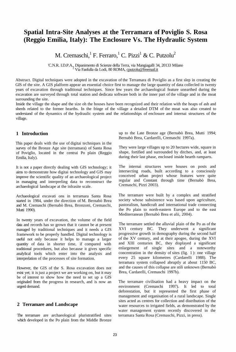
dug inside the Villaggio Piccolo (from 1984 to 1992; Bernabo Brea, Cremaschi 2004) and about 5000 in the Villaggio Grande (since 1992).
At present the excavation is concentrated on the Villaggio Grande in the South-West quadrant (fig. 3). At the beginning it affected the inner part of the village; and now it is concentrated on the enclosure and related moat, in correspondence to the South-West corner.
4 The Survey
Techniques adopted in surveying have changed significantly through the time: the entire area of the Villaggio Piccolo was surveyed just using level tachometer and metric tape. This method appears now to have been time consuming and resulted in a low degree of precision. This notwithstanding, the archaeological features have been properly surveyed and interpreted: three different phases of house construction have been
recognised. The houses are connected to storage pits and water wells which inform us about the position of the water table during the Middle Bronze Age (Cremaschi, Bemabo' Brea 2004).
The palaeochannel of the Po river was discovered at the northern fringe of the Villaggio Piccolo. It had an important role as it flooded and eroded the site, and mainly because it fed the water table exploited by the wells of the entire village (Cremaschi 2004).
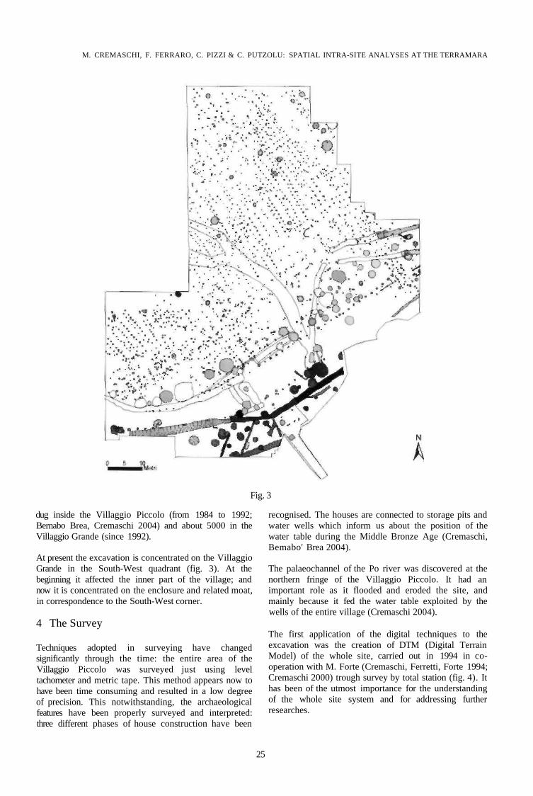
The first application of the digital techniques to the excavation was the creation of DTM (Digital Terrain Model) of the whole site, carried out in 1994 in cooperation with M. Forte (Cremaschi, Ferretti, Forte 1994; Cremaschi 2000) trough survey by total station (fig. 4). It has been of the utmost importance for the understanding of the whole site system and for addressing further researches.
25
THE RECONSTRUCTION OF ARCHAEOLOGICAL LANDSCAPES THROUGH DIGITAL TECHNOLOGIES
Fig. 4
The digital model indicates that the bulk of the archaeological deposit, forming a little mound, is well preserved in the Villaggio Grande, while completely absent in the Villaggio Piccolo, due to the XIX century quarrying. Furthermore, in the digital model, the ditch surrounding the site is clearly visible in the southern part of the site (fig. 5).
Fig. 5
4.1 The Survey in the inner part of the Village
Since 1992, at the beginning of the excavation in the area of the Villaggio Grande, a digital reliefs/survey system by Total Station has been definitively adopted. The use of the Total Station was devoted to create the micro relief of the base of the excavation, which emphazise man made
and natural features occurring on it: pits, post holes, water wells and an erosional rill trending toward the ditch.
The main feature inside the Villaggio Grande is the regular distribution of the post holes (fig. 6), which clearly indicates the existence of houses (Bernabo Brea, Cremaschi 1997; Bernabo Brea, Cremaschi, Pizzi 2003). The archaeological stratification superposed on them, mainly consists of dumps of pottery and ash and fragments of hearts discharged from the house floors related to them. The archaeological features were recorded at the beginning according to traditional methods.
However the data collected on the field were first geo-referenced trough CAD overlay and a database was created (fig. 7). Afterward, a software G1S (Arcview 3.2) was used to visualize information. The archaeological evidence was represented then in 2D space, and thanks to the possibility to make queries and manage a large quantity of data, the relationships with archaeological structures have been analysed (fig. 8).
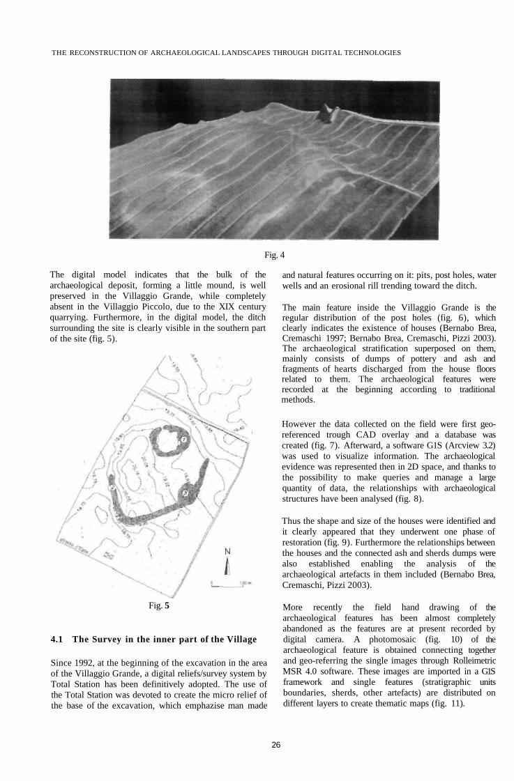
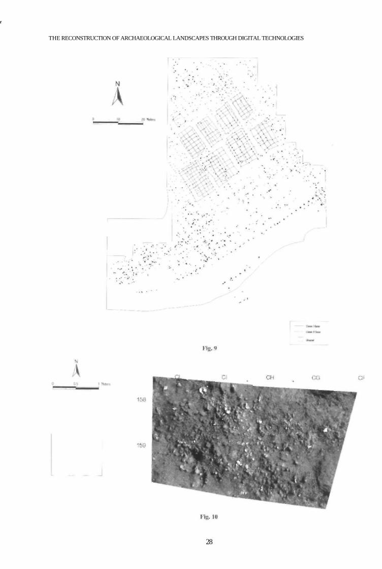
Thus the shape and size of the houses were identified and it clearly appeared that they underwent one phase of restoration (fig. 9). Furthermore the relationships between the houses and the connected ash and sherds dumps were also established enabling the analysis of the archaeological artefacts in them included (Bernabo Brea, Cremaschi, Pizzi 2003).
More recently the field hand drawing of the archaeological features has been almost completely abandoned as the features are at present recorded by digital camera. A photomosaic (fig. 10) of the archaeological feature is obtained connecting together and geo-referring the single images through Rolleimetric MSR 4.0 software. These images are imported in a G1S framework and single features (stratigraphic units boundaries, sherds, other artefacts) are distributed on different layers to create thematic maps (fig. 11).
26

M. CREMASCHI, F. FHRRARO, C. PIZZI & C. PUTZOLU: SPATIAL INTRA-SITE ANALYSES AT THE TERRAMARA
Fig. 6 Fig. 7
27
r
THE RECONSTRUCTION OF ARCHAEOLOGICAL LANDSCAPES THROUGH DIGITAL TECHNOLOGIES
28

M. CREMASCHI, F. FERRARO, C. PIZZI& C. PUTZOLU: SPATIAL INTRA-SITE ANALYSES AT THE TERRAMARA
Fig. 12
4.2 Survey in the Enclosure Area
Since 1998 the excavation has concentrated on the enclosure area, and outside of it in the moat facing the southern part of the village (fig. 12). The earth rampart which can be seen in the aerial photograph was built during the last phase of the village.
The early enclosure consisted of a fence, which is testified by regularly spaced post holes. The fence is interrupted by a gate on the continuation of the road crossing the inner houses, and a small ditch was excavated to reinforce the comer of the village (fig. 13).
Bui the most impressive feature consists of about 60 large water wells. They are generally 2.5 - 3 metres deep and reach the aquifers held by sand layers occurring in the underground of the site.
The fill of these water-wells has a complex stratigraphy consisting of organic material, laminated deposits, and
Fig. 13
material fallen from the walls, which indicates that the wells collapsed and were re-excavated several times. Fragments of pottery, mainly devoted to water extraction, are often included in the fill, and their typology suggests that the wells were in use for a long time from the late Middle Bronze Age, the period of the foundation of the Villaggio Grande, up to its apogee at the Recent Bronze Age. Some of the wells are interconnected by small ditches which appear to bring the water outside the site in the direction of the peripheral moat.
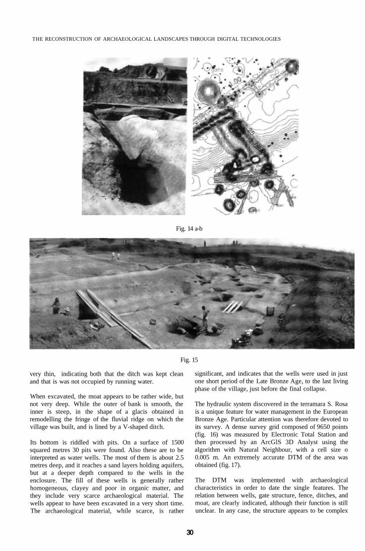
This is particularly clear for the well US 2206 (figs. 14a and 14b) close to the western gate: the water rising from the water table intersect by the bottom of the well, is abducted through a ditch along the slope of the moat to fill some cisterns open at its base.
Outside the fence, to the south, is the ditch surrounding the village (fig. 15). While still apparent in the present topography, the bulk of the sediment in it included was deposited long after the abandonment of the terramara. The bronze age stratification included inside the moat is
29
THE RECONSTRUCTION OF ARCHAEOLOGICAL LANDSCAPES THROUGH DIGITAL TECHNOLOGIES
Fig. 14 a-b
Fig. 15
very thin, indicating both that the ditch was kept clean and that is was not occupied by running water.
When excavated, the moat appears to be rather wide, but not very deep. While the outer of bank is smooth, the inner is steep, in the shape of a glacis obtained in remodelling the fringe of the fluvial ridge on which the village was built, and is lined by a V-shaped ditch.
Its bottom is riddled with pits. On a surface of 1500 squared metres 30 pits were found. Also these are to be interpreted as water wells. The most of them is about 2.5 metres deep, and it reaches a sand layers holding aquifers, but at a deeper depth compared to the wells in the enclosure. The fill of these wells is generally rather homogeneous, clayey and poor in organic matter, and they include very scarce archaeological material. The wells appear to have been excavated in a very short time. The archaeological material, while scarce, is rather
significant, and indicates that the wells were used in just one short period of the Late Bronze Age, to the last living phase of the village, just before the final collapse.
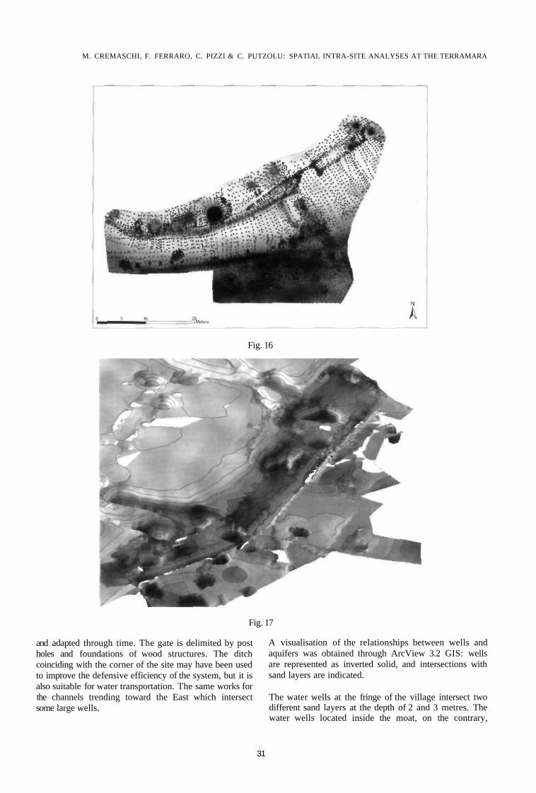
The hydraulic system discovered in the terramara S. Rosa is a unique feature for water management in the European Bronze Age. Particular attention was therefore devoted to its survey. A dense survey grid composed of 9650 points (fig. 16) was measured by Electronic Total Station and then processed by an ArcGlS 3D Analyst using the algorithm with Natural Neighbour, with a cell size o 0.005 m. An extremely accurate DTM of the area was obtained (fig. 17).
The DTM was implemented with archaeological characteristics in order to date the single features. The relation between wells, gate structure, fence, ditches, and moat, are clearly indicated, although their function is still unclear. In any case, the structure appears to be complex
30
M. CREMASCHI, F. FERRARO, C. PIZZI & C. PUTZOLU: SPATIAL INTRA-SITE ANALYSES AT THE TERRAMARA
Fig. 16
Fig. 17
and adapted through time. The gate is delimited by post holes and foundations of wood structures. The ditch coinciding with the corner of the site may have been used to improve the defensive efficiency of the system, but it is also suitable for water transportation. The same works for the channels trending toward the East which intersect some large wells.
A visualisation of the relationships between wells and aquifers was obtained through ArcView 3.2 GIS: wells are represented as inverted solid, and intersections with sand layers are indicated.
The water wells at the fringe of the village intersect two different sand layers at the depth of 2 and 3 metres. The water wells located inside the moat, on the contrary,
31
THE RECONSTRUCTION OF ARCHAEOLOGICAL LANDSCAPES THROUGH DIGITAL TECHNOLOGIES
Fig. 18
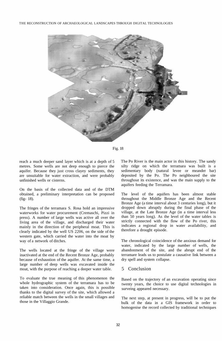
reach a much deeper sand layer which is at a depth of 5 metres. Some wells are not deep enough to pierce the aquifer. Because they just cross clayey sediments, they are unsuitable for water extraction, and were probably unfinished wells or cisterns.
On the basis of the collected data and of the DTM obtained, a preliminary interpretation can be proposed (fig- 18).
The fringes of the terramara S. Rosa hold an impressive waterworks for water procurement (Cremaschi, Pizzi in press). A number of large wells was active all over the living area of the village, and discharged their water mainly in the direction of the peripheral moat. This is clearly indicated by the well US 2206, on the side of the western gate, which carried the water into the moat by way of a network of ditches.
The wells located at the fringe of the village were inactivated at the end of the Recent Bronze Age, probably because of exhaustion of the aquifer. At the same time, a large number of deep wells was excavated inside the moat, with the purpose of reaching a deeper water table.
To evaluate the true meaning of this phenomenon the whole hydrographic system of the terramara has to be taken into consideration. Once again, this is possible thanks to the digital survey of the site, which allowed a reliable match between the wells in the small villages and those in the Villaggio Grande.
The Po River is the main actor in this history. The sandy silty ridge on which the terramara was built is a sedimentary body (natural levee or meander bar) deposited by the Po. The Po neighboured the site throughout its existence, and was the main supply to the aquifers feeding the Terramara.
The level of the aquifers has been almost stable throughout the Middle Bronze Age and the Recent Bronze Age (a time interval about 3 centuries long), but it dropped down abruptly during the final phase of the village, at the Late Bronze Age (in a time interval less than 50 years long). As the level of the water tables is strictly connected with the flow of the Po river, this indicates a regional drop in water availability, and therefore a drought episode.
The chronological coincidence of the anxious demand for water, indicated by the large number of wells, the abandonment of the site, and the abrupt end of the terramare leads us to postulate a causative link between a dry spell and system collapse.
5 Conclusion
Based on the trajectory of an excavation operating since twenty years, the choice to use digital technologies in surveing appeared necessary.
The next step, at present in progress, will be to put the bulk of the data in a GIS framework in order to homogenise the record collected by traditional techniques
32
M. CREMASCHI, F. FERRARO, C. PlZZI & C. PUTZOLU: SPATIAL iNTRA-SlTE ANALYSES AT THE TERRAMARA
with those acquired trough digital technologies during last field seasons.
The advantage of use of digital technology in a GIS framework do not relay only on a easier and time saving way to process date but it improves the interpretation of the record and emphasize its archaeological and palaeoenvironnment meanings.
The examples shown concern the identification of houses shape on the base of the post holes distribution and the development of the hydraulic system at the fringe of the site which reveals a drough episode at the end of the site life.
References
BERNABO BREA M., BIANCHI P., BRESCIANI R., CENCI L., FORNACIAR1 M., FORNARI C, HOMAN C, LINCETTO S., MEDICI T., MUTTI A., TRAMONTANO R, WOLF C, ZANINI C. 2004 / materiali: la ceramica, in BERNABO BREA M., CREMASCHI M. a cura di // Viilaggio Piccolo della Terramara di Santa Rosa a Povig/io -scavi 1987/1992.
BERNABO BREA M., CARDARELLI A., CREMASCHI M. (cdd.) 1997a, Le Terramare. La piu antica civilta padana., Milano, Electa.
BERNAB6 BREA M., CARDARELLI A., CREMASCHI M.1997b, // crollo del sistema terramaricolo, in BERNABO BREA, M., CARDARELLI, A., CREMASCHI, M. (edd.) 1997, «Le Terramare. La piu antica civilta padana.» Milano, Electa, 745-757.
BERNABO BREA M., BRONZONI L., CREMASCHI M., MUTTI A. 1990) Le indagini 1983-1984 nella Terramara S. Rosa a Fodico di Poviglio (RE), in Padusa XXV (pp. 69/172).
BERNABO BREA M., CREMASCHI M. 1997, Le terramare: "palafltte a secco" o "villaggi arginali", in BERNABO BREA, M., CARDARELLI, A., CREMASCHI, M. (edd.) 1997, «Le Terramare. La piu antica civilta padana.» Milano, Electa, 187-196.
BERNABO BREA M., CREMASCHI M., 2004 // Viilaggio Piccolo della Terramara di S.Rosa di Poviglio (Scavi 1987/1992).
BERNAB6 BREA M., CREMASCHI M., PIZZI C. 2003 Le slrutture abitative del Viilaggio Grande-fase su palafitta-della Tterramara di S. Rosa di Poviglio (RE), in «Atti del Convegno "Analisi informatizzata e trattamento dati delle strutture di abitato di eta Preistorica e Protostorica in Italia" », pp. 271-285.
BERNABO BREA M., MUTTI A. (edd.) 1994, "Le terramare si scavano per concimare /' prati". La nascita dell 'archeologia preistorica in Parma nella seconda metd dell'800, catalogo della mostra, Parma.
CARDARELLI A. 1988, Veto del Bronzo, organizzazione del lerritorio, forme economiche, strutture sociali, in «Modena dalle origini all'anno Mille. Studi di archeologia e storia», Modena, Panini, 86-127.
CREMASCHI M. 1997, Terramare e paesaggio padano, in BERNABO BREA, M., CARDARELLI, A., CREMASCHI, M. (edd.) 1997, «Le Terramare. La piu antica civilta padana. » Milano. Electa, 107-125.
CREMASCHI M., FERRETTI A, FORTE M. 1994, Tecniche digitali e di visualizzazione in geoarcheologia: il caso di studio della terramara Santa Rosa di Poviglio, «Archeologia e Calcolatori», 5, 305-316.
CREMASCHI M., FORTE M. 1999 Reconstructing a fossil landscape by Remote Sensing and Gis application: sites, virtual models and territory during the Middle Bronze Age in the Po plain (northern Italy), in «Archeologia e Calcolatori», 10,207-225.
CREMASCHI M., 2000, Manuale di geoarcheologia, Laterza, Bari.
CREMASCHI M., 2004 La terramara di Santa Rosa ed il suo lerritorio: aspetti geomorfologici, in BERNABO BREA M., CREMASCHI M. a cura di // Viilaggio Piccolo della terramara di Santa Rosa a Poviglio - scavi 1987/1992.
CREMASCHI M., PIZZI C, in press, Paieoidrografia padana olocenica e gestione delle acque interne nelle terramare, in «Geografia Fisica e Dinamica Quaternaria», Atti del convegno "II contributo della geografia fisica e della geomorfologia alia ricerca archeologica".
33