Cover Letter and Carpenter Street Phase II Report.pdf
382
U.S. Department 1200 New Jersey Avenue, SE of Transportation Washington, DC 20590 Federal Railroad Administration April 27, 2016 Rachel Leibowitz, Ph.D. Deputy State Historic Preservation Officer Preservation Services Division Manager Illinois Historic Preservation Agency 1 Old State Capitol Plaza Springfield, Illinois 62701 Re: Determination of National Register Eligibility for Site 11SG1432 and Site 11SG1433 Carpenter Street Underpass Project, 10 th Street Corridor, Springfield Rail Improvements Project Springfield, Sangamon County, Illinois Dear Dr. Leibowitz: The purpose of this letter is to continue the Federal Railroad Administration’s (FRA) Section 106 consultation with the Illinois Historic Preservation Agency (IHPA) for the Carpenter Street Underpass Project and to present FRA’s National Register of Historic Places (NRHP) eligibility determinations for two archaeological sites identified during project construction. Project Description As you are aware, the City of Springfield (City) is receiving Federal funding for the Carpenter Street Underpass Project under a Transportation Investment Generating Economic Recovery (TIGER) grant administered by the FRA. The Carpenter Street Underpass Project is part of the larger Springfield Rail Improvements Project, which in turn is part of the Illinois High-Speed Rail Chicago-to-St. Louis Program. The Springfield Rail Improvements Project involves the consolidation of passenger and freight rail service in Springfield along 10th Street, and improving rail crossings throughout the city. The Springfield Rail Improvement Project ultimately will involve the reconstruction of approximately four miles of new rail corridor, eight new underpasses, one new overpass, and reconstruction of four existing underpasses, and ultimately will reduce the number of at-grade rail crossing in the city from 68 to 32. The Carpenter Street Underpass Project involves the construction of a vehicular underpass along Carpenter Street, between 9th and 11th Streets. This underpass will replace the existing at-grade rail crossing for the Norfolk Southern Corporation’s rail line, which runs along 10 th Street through Springfield. The project also includes other improvements to accommodate rail consolidation along 10 th Street, such as site grading to support placement of a future second track and relocation of utilities.
-
Upload
khangminh22 -
Category
Documents
-
view
2 -
download
0
Transcript of Cover Letter and Carpenter Street Phase II Report.pdf

U.S. Department 1200 New Jersey Avenue, SE
of Transportation Washington, DC 20590
Federal Railroad Administration
April 27, 2016
Rachel Leibowitz, Ph.D. Deputy State Historic Preservation Officer Preservation Services Division Manager Illinois Historic Preservation Agency 1 Old State Capitol Plaza Springfield, Illinois 62701
Re: Determination of National Register Eligibility for Site 11SG1432 and Site 11SG1433 Carpenter Street Underpass Project, 10th Street Corridor, Springfield Rail Improvements Project Springfield, Sangamon County, Illinois
Dear Dr. Leibowitz:
The purpose of this letter is to continue the Federal Railroad Administration’s (FRA) Section 106 consultation with the Illinois Historic Preservation Agency (IHPA) for the Carpenter Street Underpass Project and to present FRA’s National Register of Historic Places (NRHP) eligibility determinations for two archaeological sites identified during project construction.
Project Description
As you are aware, the City of Springfield (City) is receiving Federal funding for the Carpenter Street Underpass Project under a Transportation Investment Generating Economic Recovery (TIGER) grant administered by the FRA. The Carpenter Street Underpass Project is part of the larger Springfield Rail Improvements Project, which in turn is part of the Illinois High-Speed Rail Chicago-to-St. Louis Program. The Springfield Rail Improvements Project involves the consolidation of passenger and freight rail service in Springfield along 10th Street, and improving rail crossings throughout the city. The Springfield Rail Improvement Project ultimately will involve the reconstruction of approximately four miles of new rail corridor, eight new underpasses, one new overpass, and reconstruction of four existing underpasses, and ultimately will reduce the number of at-grade rail crossing in the city from 68 to 32.
The Carpenter Street Underpass Project involves the construction of a vehicular underpass along Carpenter Street, between 9th and 11th Streets. This underpass will replace the existing at-grade rail crossing for the Norfolk Southern Corporation’s rail line, which runs along 10th Streetthrough Springfield. The project also includes other improvements to accommodate rail consolidation along 10th Street, such as site grading to support placement of a future second trackand relocation of utilities.

Carpenter Street Underpass DOE 2
Plans showing the Carpenter Street Underpass Project are included as Attachment 1.
Area of Potential Effects
The Carpenter Street Underpass Project’s area of potential effects (APE) is the western side of the existing 10th Street right-of-way beginning a half block north of Carpenter Street and proceeding south to Madison Street (see Attachment 1). The new right-of-way for the Carpenter Street Underpass Project is approximately 130 feet wide on the north end of the project area near Carpenter Street and 75 feet wide on the south end of the project area at Madison Street. Additionally, approximately 50 feet of new right-of-way along the north side of Madison Street, from 9th to 10th Street, and 40-45 feet along both the north and south sides of Carpenter Street, from 9th to Tenth Street, are required for development of the underpasses at Carpenter and Madison Streets. The majority of the APE is currently a paved surface parking lot for St. John’s Hospital (see Attachment 1). A single late twentieth century commercial building is located on the north end of the APE. The City purchased the new right-of-way from three property owners in spring 2014.
Identification Methods and Results
In early 2014, Fever River Research, on behalf of Hanson Professional Services, Inc., conducted a Phase I archaeological survey for the proposed Carpenter Street Underpass Project. The results of the survey were reported in A Cultural and Historical Resources Study for the Proposed
Carpenter Street Underpass, Springfield Rail Improvements Project (Stratton and Mansberger 2014). The report identified multiple areas within the proposed project area that had a relatively high potential for intact archaeological resources. Based on this report, the IHPA determined that areas ranked by this survey with an “A” or “B” rating should be subjected to Phase II archaeological testing prior to the construction of the project (Attachment 2). Subsequently, in June 2014 FRA, IHPA, and the City executed a Section 106 Memorandum of Agreement (MOA), which included a Plan and Schedule for Phase II Archaeological Investigations for the Carpenter Street Underpass Project (March 2014).
In late September and October 2014, Fever River Research, pursuant to the MOA, conducted Phase II archaeological investigations in three of the four areas identified for Phase II testing. These three half-block areas lie to the south end of the Carpenter Street Underpass Project. Two archaeological sites were identified as a result of the Phase II investigations. Site 11SG1432 is located on the southern two-thirds of the project area, along Tenth Street between Mason and Madison Streets. Site 11SG1433 is located on the northern third of the project area, north of Madison Street and south of the alley separating Mason and Reynolds Streets.
Site 11SG1432
Site 11SG1432 consists of the structural remains and intact cultural deposits of seven 19th
century houses in Block 3 of the City of Springfield’s Near North Side (Attachment 3). The

Carpenter Street Underpass DOE 3
seven house remains were designated as Houses A through G, from Madison Street proceeding north to Mason Street, and correspond extremely well to both the 1890 and 1896 Sanborn fire insurance maps. The initial backhoe stripping of the asphalt parking lot and modern overburden indicated that the archaeological integrity of Houses A through E was excellent, whereas the integrity of Houses F and G had been previously compromised. The IHPA determined that Houses F and G were not eligible for listing in the NRHP.1 Because Houses F and G were in anarea crucial for the construction of underground boring for electrical service to St. John’s Hospital, those two locations were mapped and then additional stripping done in the area to verify that no additional features were present.
The archaeological integrity associated with Houses A through E is excellent. Test units were excavated within the lots containing Houses A through E in order to better assess the depth of the archaeological deposits, the presence or absence of basement cellars, and the complexity of the fill deposits in each house. In most instances, two test unit were excavated in each section of the house (i.e. main dwelling and rear service wing) to determine comparative fill sequences in each section.
The foundations of the five houses remain, and at least four of the five houses (Houses A through D) exhibited physical evidence of having been destroyed by fires associated with the 1908Springfield Race Riots. Several of the houses were capped with yellow silt loam subsoil shortly after the 1908 fire event. The Phase II investigation suggested that several of the houses (at least Houses A through C) probably sat open for an extended period after the 1908 fire. The low-lying area located between Houses A and B, and the cellar of House B, were subsequently filled with a wide variety of both domestic and structural demolition debris—as if the area functioned as an open landfill for a time during the 1910s and 1920s.
Intact cultural deposits identified within Site 11SG1432 consisted of several distinct artifact assemblages associated with the former residents who occupied Houses A through E. The limited archaeological testing completed during the Phase II testing indicates the presence of several discrete intact middens within the cellars of the structures that date to three separate occupations periods. They include several dating from the middle nineteenth century and associated with the earliest house occupants when the neighborhood was settled in the 1840s. Overlying those deposits are other discrete depositions associated with the later nineteenth and early twentieth century occupants. Within the cellars of Houses A through D the uppermost intact midden deposits consists of domestic material associated with the African American households who occupied the houses in the first years of the twentieth century and whose homes and belonging were destroyed as a result of the 1908 Springfield Race Riot.
Phase II testing also identified several intact features in the side yards of the houses. In the side yard of House A an intact midden was identified that contained a discrete deposit of domestic refuse associated with the earliest occupation of the property from the 1840s. Elsewhere on the
1 It is FRA’s understanding that this determination was made during discussions among IHPA, Fever River, and the City’s primary project consultant (Hanson Professional Services Inc.). IHPA reiterated this determination during the July 23, 2015 consulting parties meeting in Springfield.

Carpenter Street Underpass DOE 4
site, numerous fence and other structural postholes were identified as well as a cistern, well, and several pit features that may represent former cellars or subfloor pits associated with structures that once stood in the side yards.
Aside from the intact remains of house foundations, fireplaces and other interior structural elements, the lots for Houses A though E also contain numerous other intact structural features in the side and front yards of properties. Those intact structural elements include brick walkways, porches, and stone stoops. Of particular significance was the intact remains of the brick walkway and stone steps extending from the front door at House A. According to the August 15, 1908 account in the Illinois State Register, at the time of the 1908 Springfield Race Riot, House A was occupied by William Smith, an African American invalid who was dragged from the house over the stone steps and brick walkway. He was subsequently beaten and tied to a telegraph pole on Madison Street during the first night of rioting in August 1908.
Site 11SG1433
Site 11SG1433 consists of the structural remains and intact cultural deposits of two 19th centuryhouses in Block 14 of the City of Springfield’s Near North Side (Attachment 3). The two houses were designated by their lot numbers (Lots 15 and 16) and fronted Mason Street. During the middle 19th century, these two lots were occupied and initially improved by Portuguese families from the Madeira Islands. The Portuguese families in this block represented the southern extension of the middle 19th-century Madeiran Portuguese neighborhood on the Near North Side which represented one of the earliest and largest Portuguese settlements in the Midwest at that time.
A similar testing strategy was employed at Site 11SG1433 as was utilized during the Phase II investigation of Site 11SG1432. A backhoe was used to remove the modern overburden within a wide block, exposing the east half of Lot 15 and the west half of Lot 16. Back dirt was placed along the eastern edge of the project area covering the east half of Lot 16. A swath of ground approximately 12-15 feet wide was left unexcavated along the west side of the project area, which comprised the west half of Lot 15. Following the removal of the overburden, cultural features were mapped and photographed and a sample were excavated.
Unlike Site 11SG1432, there were limited structural remains of the two middle 19th-century homes that once stood on Lots 15 and 16. Modern improvements to the properties severely impacted the southern extent of the lots where the houses once stood. Only remnant foundation segments from the house on Lot 15 were present and the Phase II investigation indicated all structural evidence of the house on Lot 16 has been removed during subsequent construction activity.
While the house foundations on the south quarter of Lots 15 and 16 were severely compromised, the Phase II investigation revealed that the northern three-quarters of the lots possessed excellent archaeological integrity. Numerous intact cultural features were identified in the rear yards of Lots 15 and 16. They included numerous fence and structural postholes, wells, cisterns, brick

Carpenter Street Underpass DOE 5
piers of former outbuildings, middens, and nearly two dozen privy pits. The numerous cultural features span the entire 19th and 20th-century occupation of the lots, with several privy pits and other intact features consisting of discrete cultural deposits associated with the earliest Portuguese residents who first resided here in the 1840s. Given the numerous features with a high level of integrity in those portions of the Lots 15 and 16 sampled during the Phase II investigation, it is highly likely that additional features with similar levels of integrity exist in those portions of the site where the overburden was left in place.
FRA’s Eligibility Determinations
Site 11SG1432
As a result of the Phase II investigation conducted by Fever River Research and reviewed by FRA, FRA has determined Site 11SG1432 meets the eligibility standards for listing on the NRHP under both Criterion A and Criterion D. The period of significance for Site 11SG1432 is 1842-1908, a timeframe that encompasses the earliest known development in the neighborhood up through the 1908 race riot.
Under Criterion A, Site 11SG1432 is eligible for listing due to its association with the 1908 Race Riot. The Badlands was the scene of widespread destruction and violence during the August 1908 Springfield Race Riot, and Block 3 (Site 11SG1432) was the point where the white assault on the Badlands was initiated. That portion of the site located within the Carpenter Street project area contains physical remains of five houses (Houses A-E) that were destroyed by the mob on August 14, 1908. These five houses (and their associated features) represent a unique “snapshot in time” of a diverse neighborhood, as it existed at the time of the 1908 riot. Not only was the Springfield Race Riot a seminal event in the history of the city, but it also was of national importance due to its role in the formation of the National Association for the Advancement of Colored People (NAACP).
FRA has determined that Site 11SG1432 is eligible for listing under Criterion D because the intact cultural deposits contain potential for possessing information that could substantially contribute to our understanding of the lifeways of multiple ethnic and racial groups who resided in Springfield during the 19th and early 20th centuries. The intact archaeological deposits have excellent integrity and offer multiple data sets from which relevant research questions can be derived. One of the most significant data sets is the structural remains of the houses on Block 3. Though reduced to their foundations, these homes nonetheless provide valuable information in respect to the dimension, interior layout, and change through time of the earlier generation of housing in this neighborhood.
In addition to their structural remains, several distinctive artifact assemblages are associated with these houses. Phase II testing indicated the presence of several discrete middens within and in the yards surrounding these structures. Several of the midden deposits, including the stratified deposits identified in several of the cellar holes date from the middle 19th century and areassociated with residents of an ethnically diverse neighborhood containing a mix of native-born

Carpenter Street Underpass DOE 6
Americans, and immigrant families from Germany and Ireland. At that time and into the late 19th century, the neighborhood where Site 11SG1432 is situated served as a gateway neighborhood where newcomers of divergent backgrounds and lower-to-middle income status first laid down roots in Springfield.
Other intact cultural deposits identified during the Phase II investigation of Site 11SG1432 are attributed to the late-19th and early 20th-century occupation of the neighborhood and these houses by African American families. By the early 20th century, Site 11SG1432 represented the western extension of the so-called “Badlands,” a segregated African American community. The Badlands was the scene of widespread destruction and violence during the August 1908 Springfield Race Riot. The houses within Site 11SG1432 represent the location where the Euro-American assault on the Badlands began and multiple residences within it, then occupied by African American families, were destroyed. Numerous intact discrete cultural deposits were identified on the site that are associated with households who resided on the site at the time of the 1908 Springfield Race Riot.
All three components are significant, but the latter is especially so as it has the potential to provide a “snapshot in time” of the contents contained within the homes when the riot occurred. These artifacts have the potential to yield a variety of contextual information regarding the house occupants. In some of the houses, it may be possible to develop a room by room inventory of the artifacts present immediately prior to the riot.
In addition to providing a recommendation for NRHP eligibility, the purpose of the Phase II study is to determine boundaries of the site being evaluated. Given that the Phase II study was confined to the APE of the Carpenter Street Underpass Project, the full boundaries of Site 11SG1432 are not known. As determined by the Phase II study, intact archaeological deposits and features associated with the occupation of Houses A through G on Block 3 were bound by Tenth Street to the east, Madison Street to the south, Mason Street to the north, and the APE boundary to the west (Attachment 4). Given that intact cultural deposits were identified directly up to the APE boundary, FRA has determined that the boundaries of Site 11SG1432 extend west beyond the APE limits to include the entirety of the historic boundaries of Blocks 3 and 17 as illustrated by the 1896 Sanborn Fire Insurance Map. Given the level of preservation observed underneath the parking lot in those areas exposed during the Phase II investigation, it is highly likely a similar level of preservation exists under the remaining untested portion of Blocks 3 and 17 with intact deposits associated with the 19th and early 20th-century occupations documented at Site 11SG1432.
Under Section 106, traditional Phase III data recovery would ordinarily suffice as an appropriate mitigation strategy for sites to be impacted by development. While such a data recovery effort would be a satisfactory mitigation for the site in respect to its eligibility for the NRHP under Criterion D, the site is also significant under Criterion A. The preserved structural remains of this row of houses, particularly those remains (stone steps and walkway) associated with the attempted lynching of William Smith, provide an integrity of feeling and association in respect to this nationally significant event. Such a sense of feeling cannot be preserved and ultimately

Carpenter Street Underpass DOE 7
would be lost through Phase III data recovery. The significance of the intact structural remains associated with the 1908 Springfield Race Riot are inexorably tied to place and the relocation of the remains would qualitatively diminish their significance in respect to NRHP under Criterion A. Given the site’s eligibility for the NRHP under Criterion A as possessing local and national significance with its direct association with the events of the 1908 Springfield Race Riot and its subsequent relevance to the formation of the NAACP, FRA recommends that Site 11SG1432 warrants preservation in place.
Site 11SG1433
As a result of the Phase II investigation conducted by Fever River Research and reviewed by FRA, FRA has determined that Site 11SG1433 meets the eligibility standards for listing on the NRHP under Criterion D. The period of significance for Site 11SG1432 is 1853-1920, the period that encompasses the time when these properties developed as part of a large Madeiran Portuguese neighborhood on Springfield’s Near North Side. The Madeiran Portuguese community of which Site 11SG1433 was a part is especially noteworthy as it represented one of the earliest and largest Portuguese settlements in the Midwest during the middle-to-late nineteenth century.
The site is eligible for listing under Criterion D because the many recorded intact cultural deposits identified at the site contain potential for possessing information that could substantially contribute to the understanding of the lifeways of a unique Portuguese immigrant community that flourished in Springfield during the nineteenth and early twentieth centuries. Site 11SG1433 offers potential to possess a range of data sets that lend themselves to understanding the lifeways of the early Portuguese residents. Although the structural remains are poorly preserved in this area, the site encompasses two complete lots with over 60 intact features including fence and structural postholes, privy pits, a well, a cistern, and multiple midden deposits. The data sets produced from the investigation of these features could provide important information concerning the evolution of site organization over time, consumer choice and quality of life among an immigrant Portuguese community, and expressions of ethnic identity and that of assimilation as such immigrant families begin to identify culturally with their native-born neighbors. The interpretive value of the study of Site 11SG1433 would be further enriched when compared to data previously yielded from investigations of the nearby Lincoln Home neighborhood and the Abraham Lincoln Presidential Library and Museum.
During the Phase II study, the investigation of Site 11SG1433 consisted of the entirety of Lot 16 and the western half of Lot 15 (Attachment 4). The eastern half of Lot 15 was located outside of the project APE and was not included in this study. For the purpose of defining the boundaries of Site 11SG1433, FRA recommends including all of Block 14 as shown in Attachment 4. Given the level of preservation observed in the investigated portion of Block 14, it is highly likely a similar level of preservation is present under the remaining untested portion of the block. If such preservation does exist, there is a likelihood that additional intact deposits and features are present which could provide further information that could substantially


Carpenter Street Underpass DOE 9
Attachments: 1) Location Map 2) Archaeology Probability Areas as previously reviewed by IHPA3) Phase II Feature Maps for Sites 11SG1432 and 11SG14334) Recommended Site Boundary Maps for Sites 11SG1432 and 11SG14335) Eligibility Table6) Phase II Report
cc: Andrea Martin, FRA Andrea Green-Armstrong, FRA Nate Bottom, City of Springfield Kevin Seals, Hanson Professional Services Inc.

Attachment #1: Location Map

Attachment #2: Archaeology Probability Areas as reviewed by IHPA

Attachment #3: Phase II Feature Maps for the Investigations at Sites 11SG1432 and 11SG1433
Site 11SG1432

Site 11SG1433

Attachment #4: Recommended Site Boundary Maps for Sites 11SG1432 and 11SG1433
Site plan showing the relationship of Sites 11SG1432 and 11Sg1433 (hatched ingreen) in relationship to the Carpenter Street Underpass Project Area (outlined in blue) and surrounding vicinity. Site 11SG1433 corresponds to Block 3 of J. Whitney’s Addition and Block 17 of Wells and Peck’s Addition to Springfield. Site 11SG1432 corresponds to Block 14 ofWells and Peck’s Addition.

Attachment #5: Eligibility Table
Project Name: Carpenter Street Underpass, Springfield Rail Improvements Project, Springfield, Sangamon County June 23, 2016
Resource Type FRA NR Det.
NR Criterion FRA Recommendation SHPO Opinion
11SG1432 A NR A and D preservation in place
11SG1433 A NR D Avoidance/Phase III data recovery mitigation if avoidance is not possible
Codes: Resource Types: S (Structure), A (Archaeological Site), HD (Historic District), NHL (National Historic Landmark) NR Determination: ND (Not Determined), X (Not Eligible), NR (Eligible), NRL (Listed), NHL (Landmark)

RESULTS OF PHASE II ARCHAEOLOGICAL INVESTIGATIONSOF SITES 11SG1432 AND 11SG1433
FOR THE PROPOSEDCARPENTER STREET UNDERPASS,
SPRINGFIELD RAIL IMPROVEMENTS PROJECT,SPRINGFIELD, ILLINOIS
Fever River Research, Inc.Springfield, Illinois
2016

RESULTS OF PHASE II ARCHAEOLOGICAL INVESTIGATIONSOF SITES 11SG1432 AND 11SG1433
FOR THE PROPOSEDCARPENTER STREET UNDERPASS,
SPRINGFIELD RAIL IMPROVEMENTS PROJECT,SPRINGFIELD, ILLINOIS
By:Floyd Mansberger
andChristopher Stratton
Fever River Research, Inc.Springfield, Illinois
Prepared for:City of SpringfieldSpringfield, Illinois
and
Federal Railroad AdministrationWashington, D.C.
2016

i
Abstract
The current report summarizes the methods and results of the Phase II archaeologicalinvestigations conducted in late 2014 at archaeological sites 11Sg1432 and 11Sg1433, which arelocated in downtown Springfield, Illinois. These two archaeological sites were identified duringthe Phase I archaeological survey for the proposed Carpenter Street Underpass project, which isbeing undertaken by the City of Springfield in anticipation of proposed rail improvements alongthe Tenth Street rail corridor. The remains of seven nineteenth century houses (six of frameconstruction, one of brick construction; all pre-dating circa 1870) were documented within thatportion of Site 11SG1432 that lies within the proposed project right-of-way. Similarly, Site11Sg1433 contains the physical remains of a frame house, an adjacent commercial building, andthe rear yard activity areas associated with both nineteenth century structures. The Phase IItesting indicates that the subsurface integrity of these two sites is excellent, and that they bothmeet the standards for National Register eligibility under Criterion D (archaeology). Both siteshave local significance in respect to their potential to contribute substantially to ourunderstanding of the lifeways of the various ethnic/racial groups in Springfield during thenineteenth and early twentieth centuries. Additionally, archaeological site 11Sg1432 issignificant under Criterion A (social history) for its association with the 1908 Springfield RaceRiot, which was a seminal event in the history of the city as well as of national importance due toits role in the foundation of the National Association for the Advancement of Colored People(NAACP). A formal determination of eligibility is recommended.

ii
Table of Contents
Introduction 1
Research Methods 5Previous Research (Phase I) 5Current Research (Phase IB/II Testing) 8
Historical Context 14Early Development of Springfield (1819-1865) 14Springfield’s Post Civil War Development 20Springfield’s Near North Side 22Springfield’s Vice District and the Badlands 25Springfield and the Race Riot of August 1908 47
Results of the Phase II Archaeological Investigations 61Site 11Sg1432 61
Summary of Archival Research 61Summary of Field Investigations 84
House A 84House B 104House C 128House D 147House E 167House F 188House G 215
Site 11Sg1433 226Summary of Archival Research 226Summary of Field Investigations 239
Lot 15 239Lot 16 245
Conclusions: Site Significance 271Site 11Sg1432 272Site 11Sg1433 277
Summary and Recommendations 280
References Cited 285
AppendicesI. Archaeological Site Forms: Sites 11Sg1432 and 11Sg1433 291II. The 1908 Springfield Race Riot: Burned Building Locations and Other
Historic Photographic Views 296III. Summary of Springfield City Directories by Street Address,
Site 11Sg1432 339

iii
IV. Summary of Newspaper Research by Street Address,Site 11Sg1432 343
V. Summary of Newspaper Research for “Tenth and Madison” Location,Site 11Sg1432 351
VI. Summary of Newspaper Research for “Shinbone Alley” and“Cocaine Alley” Locations, Springfield, Illinois 355
VII. Summary of Newspaper Research for Landowner Isadore Kanner 377

1
Introduction
The City of Springfield proposes to construct a vehicular underpass along CarpenterStreet (between Ninth and Eleventh Streets). This underpass will replace a grade-level railcrossing for the Norfolk Southern Corporation’s rail line, which runs along Tenth Street. Thisproposed construction is the first stage of the greater Springfield Rail Improvements Project,which is part of the Illinois High-Speed Rail Chicago to St. Louis program. The Springfield RailImprovements Project involves the consolidation of rail lines in Springfield along Tenth Street,and improving rail crossings throughout the city.1 The project ultimately will involve thereconstruction of approximately four miles of new rail corridor, eight new underpasses, one newoverpass, and reconstruction of four existing underpasses, and ultimately will reduce the numberof at-grade rail crossing in the city from 68 to 32 (http://www.hanson-inc.com/news.aspx?page=news-release-text&articleid=hanson-submits-preliminary-plans-for-carpenter-str; http://springfieldrailroad.com/newsite/).
Participants in the Springfield Rail Improvements Project include the City of Springfield,the Illinois Department of Transportation (IDOT), the Federal Railroad Administration (FRA),the Illinois Commerce Commission (ICC), Norfolk Southern Corporation, and the Union PacificRailroad Corporation. Funding sources for the Carpenter Street Underpass project—which isone of many planned components of the larger Springfield Rail Improvement Project—arevaried, and include major sources of federal funding, including a Transportation InvestmentGenerating Economic Recovery (TIGER) grant, as well as monies from the Grade CrossingProtection Funds managed by the ICC.
The Carpenter Street Underpass project area is identified as the western side of theexisting Tenth Street right-of-way beginning a half block north of Carpenter Street andproceeding south to Madison Street (Figures 1-2). The proposed new right-of-way isapproximately 130-ft (39.63m) wide on the north end of the project area (near Carpenter Street)and 75-ft (22.86m) wide on the south end of the project area (at Madison Street). Additionally,approximately 50-ft (15.24m) of new right-of-way along the north side of Madison Street (fromNinth to Tenth Street) and 40-45-ft (12.19-13.72m) along both the north and south sides ofCarpenter Street (from Ninth to Tenth Street) are required for development of the underpass.
1 The purpose of the Springfield Railroad Improvements Project is to accommodate a projected increase inpassenger and freight rail traffic through Springfield in the near future. There presently are three principal rail linespassing through Springfield: the Union Pacific (UP) Railroad, which runs down Third Street; the Norfolk Southern(NS) Railroad, following Tenth Street; and the Canadian National (CN) Railroad, centered on Nineteenth Street.The UP alone expects to increase the number of freight trains it runs through the city per day to twenty-two over thenext few years. In the event funding is secured for high-speed passenger service between Chicago and St. Louis,eighteen passenger trains could also pass through Springfield on the UP’s tracks per day, thereby bringing the totaldaily traffic on this line to forty trains (a figure independent of the current or future traffic on the NS and CN lines).An increase in the rail traffic of this magnitude will present significant challenges to the residents of Springfield—challenges the Springfield Railroad Improvement Project will address (See Stratton and Mansberger 2011).

2
In late 2013, in compliance with the provisions of Section 106 of the National HistoricPreservation Act of 1966 (36 CFR 800, et. seq.), Fever River Research conducted a culturalresource assessment (literature search) of the Carpenter Street Underpass Project area for theCity of Springfield (under subcontract to Hanson Professional Services, Inc., Springfield,Illinois) to assess the impact of the proposed construction activity associated with the newunderpass on the historic resources within the project area. The results of that Phase Iarchaeological survey is detailed in the report entitled A Cultural and Historical Resources Studyfor the Proposed Carpenter Street Underpass, Springfield Rail Improvements Project (Strattonand Mansberger 2014).
The Phase I archaeological survey identified two potentially significant archaeologicalsites (Sites 11Sg1432 and 11Sg1433) that were recommended for Phase II archaeological testing.In late summer and fall 2014, Phase II archaeological investigations of these two sites wereundertaken by Fever River Research, Springfield, Illinois. The current report summarizes themethods and results of the Phase II archaeological investigations conducted in late 2014.

3
Figure 1. Location of the proposed Carpenter Street Underpass in Springfield, Illinois(Springfield West, IL 7.5-minute U.S.G.S. topographic map, 1998). The location of both theLincoln Home National Historic Site and the Abraham Lincoln Presidential Library andMuseum (ALPLM) project area also are indicated. Significant subsurface archaeologicalresources have been identified in both urban areas.
Lincoln Home National Historic Site
ALPLM Project Areas
Carpenter Street Underpass Project Area

4
Figure 2. Location of the proposed Carpenter Street Underpass in Springfield, Illinois (Hanson Professional Services, Inc.2013). The areas of new right-of-way are color coded (red, green, and blue) by existing property owner.

5
Research Methods
Previous Research (Phase I Survey)
Ultimately, the objectives of the cultural and historical resources study were to identifyhistoric properties potentially eligible for inclusion on the National Register of Historic Places inthe Carpenter Street Underpass project area. As the current project area was located in an urbanenvironment, which was completely covered with pavement, a traditional Phase I archaeologicalsurvey was not feasible. In heavily built-up urban environments, where most of the groundsurface has been paved and/or covered with extensive fill deposits (such as the current projectarea), traditional Phase I archaeological reconnaissance surveys are difficult to conduct—oftenrequiring extensive disruption of the existing landscape (such as the excavation of backhoetrenches) to accomplish the survey. This was, indeed, the case with the current project, whichwas entirely paved at the time of the survey.
The objectives of the Phase I archaeological reconnaissance survey was to 1) conduct aliterature and/or archival search to assess site-specific documentary records pertaining to theproject area land use through time, 2) develop an historical context for the project area to assistwith the evaluation of potential resources, 3) prepare a predictive model of potentialarchaeological resources within the project area to assist with the excavation of backhoetrenches, if warranted, and 4) prepare a report that discusses the methods and results of theseinvestigations.
The literature search consisted of a systematic assessment of archival resources in orderto locate site-specific information pertaining to the historic land use in the project area. A widerange of archival resources was used to achieve this task. Of particular interest were two middlenineteenth century city maps (Potter 1854, Sides 1858), three bird’s eye views of Springfield(Ruger 1867, Beck and Pauli 1872, and Koch 1873) as well as several late- nineteenth and earlytwentieth century fire insurance maps (Sanborn 1884, 1890, 1896, 1917). The 1854 and 1858city maps, combined with information obtained from land sales and/or deed records, allowedresearchers to assess the pre-Civil War land use of each block. Similarly, the fire insurance mapsallowed the researchers to assess the late- nineteenth and early-twentieth-century land use historyof each location—particularly the presence of second (or third) generation building episodes thatmight impact on the earlier historic resources. The literature search was conducted at variouslocal repositories including the Sangamon Valley Collection at the Lincoln Library (SpringfieldCity Library) and the Illinois State Library. The vertical files at the Sangamon ValleyCollection, as well as the county histories, city directories, and biographical sources wereconsulted for general historical background and site-specific information.
By looking at the many historic documents available for this area (such as late-nineteenth and early-twentieth-century Sanborn fire insurance maps) and the character of therecently demolished buildings (such as presence or absence of deep basements), a predictivemodel outlining the probability of intact archaeological resources in the project area wasprepared. The modeling is based on two primary factors: 1) the probability of early

6
archaeological resources with good integrity being present; and 2) on whether the suspectedresources have a significant research potential (i.e. can provide significant data to addressrelevant research questions). A greater emphasis was placed on early archaeological resources,with 1870 serving as the benchmark date. Later archaeological components do exist within theproject area but are considered to have less significance—one exception being those specificallyrelated to the 1908 Race Riot.
With the information compiled from the Phase IA survey, each parcel of ground withinthe project area was assessed for its archaeological potential, and ranked from very low to highpotential. The Carpenter Street Underpass project area consists of four discreet areas locatedalong the west side of the Tenth Street rail corridor. From north to south, these consist of: 1) anarea north of Carpenter Street (in Block 6, Wells and Peck’s Addition), 2) an area bounded byCarpenter and Reynolds Street (in Block 11, Wells and Pecks Addition), 3) an area bounded byReynolds and Mason Street (in Block 14 Wells and Pecks Addition), and 4) an area bounded byMason and Madison Streets (in Block 3 Jonas Whitney’s Addition) (see Figure 2).2 Figure 3summarizes the archaeological potential of each parcel in the greater project area based on theliterature search. The following discussion defines each of the categories used in this model, andthe location of each ranking within the four areas of the project.
Areas identified as Very Low Potential on the map indicates that no early (pre-1870)resources were identified for this area. The only areas falling into this category are Lots 1 and15-16 of Block 11, which were developed between 1873 and 1896.
Areas identified as Low Potential on Figure 3 indicates 1) that historic resourcesassociated with a pre-1870 component were identified for this area but 2) that these resourceshave a low research potential. Low research potential may be due to loss of integrity, caused bythe subsequent building construction (particularly in the case of buildings with deep basements)or other disturbance. Such is the case with Lots 1-2 of Block 14, which is the site of an earlyhouse pre-dating 1854 and destroyed prior to 1867, but which also witnessed multiple laterbuilding episodes involving multiple dwellings and (later on) a wholesale grocery store. Lot 2 ofBlock 11 also was developed prior to 1870, but the early house here was replaced by a second-generation dwelling later in the century, which likely impacted the earlier resources. Theaccessibility of archaeological resources (and/or the presence of the resource within the projectarea) also impacts research potential. The project area includes narrow easements along bothsides of Carpenter Street (impacting Lots 9-14 of Block 6 and Lots 3-8 of Block 11) and alongthe north side of Madison Street (impacting Lots 9-12 of Block 17). Most of the lots in questionwere developed prior to 1870; indeed several of those on Block 17 had been built up by 1854.Even so, the easements will encroach upon only what historically were the front yards of theseproperties and possibly clip the front edge of whatever building remains may still be present aswell. The rear yards of these properties—typically the most fertile area of archaeological
2 The later parcel, located on the far southern end of the project area, is comprised of two parcels of land from twoseparate additions to the city, which together form the typical city block. The eastern third of this block—and thatportion which comprises the majority of the project area in this block—was platted as Block 3 of the Jonas WhitneyAddition. The western two-thirds of this block—only a small portion of which, fronting Madison Street, is locatedwithin the project area—was platted as Block 17 of Wells and Pecks Addition. As discussed below, both additionswere platted during the later 1830s (circa 1836-37).

7
investigation—generally will not be impacted. One exception to this was that portion of theeasement along Madison Street through Block 3, which represented the rear yard of the south 80-ft (24.38m) of Lots 12-16 historically (and associated with the Westenberger family early on).This segment of the easement has a higher probability of archaeological resources being present.
Areas identified as Moderate Potential on Figure 3 indicates that 1) historic resourcesassociated with a pre-1870 component were documented for this area and 2) that subsequentdisturbances associated with the construction of later buildings have occurred but the extent of itsimpact to the early archaeological component remains undetermined. One area considered tohave moderate potential was Lots 15-16 of Block 6. Both lots were developed in the late 1850sor early 1860s but have seen later building activity. A small commercial building was erected onthe rear of Lot 16 early in the twentieth century, and a modern commercial structure has sincebeen erected on the two lots. While this later construction activity likely impacted the earlydomestic component to some degree, the extent of damage remains to be determined. The use ofa slab foundation for the modern commercial building may have had a minimal impact on thesubsurface archaeological resources in this area. Another area of moderate potential was thenorthern three-quarters of Lots 1-4 of Block 3. This area was fully developed by 1867, withsome parcels having houses on them by 1854. By the late-nineteenth-century, this area hadbecome a black enclave, which would be targeted in the 1908 Race Riot. As such, it representeda prime area of research potential. Yet, the construction of a large building here by the BarkerLubin Company in the middle twentieth century raises questions as to integrity of the subsurfacearchaeological resources. However, if this building had a slab foundation (as we suspect it did)its construction and subsequent demolition may have had minimal impact on these resources.
Areas identified as High Potential on Figure 3 indicate that 1) historic resourcesassociated with an early component (pre-1870s) were documented for this area and 2)subsequent disturbances associated with later construction are suspected as being light. Theseareas also have a direct association with several significant research themes, including the earlyperiod of settlement in Springfield, the city’s Portuguese community (one of the earliest in theMidwest), and the 1908 Race Riot. Two of these themes overlap on Block 3, which containedearly-settlement-period housing that later was occupied by black residents and destroyed duringthe race riot. The south 40-ft (12.19m) of Lots 1-4 and Lots 13-16 of Block 3 appear to havebeen exposed to limited construction activity after 1908, being left vacant initially, laterincorporated into the Barker Lubin lumber yard, and finally used as a surface parking lot.Similarly, mid-nineteenth-century buildings on Block 14 persisted post-1950 and were laterreplaced by a parking lot. Springfield’s early Portuguese community on the Near North Sideextended onto Block 14, and two lots here within the project area were developed by andoccupied by Portuguese immigrants in the late 1850s—specifically Lot 15, which had aresidence, and Lot 16, with a grocery store. These buildings persisted post-1950 and were laterreplaced by a parking lot. Should subsurface resources (such as privy pits, carriage houses,cisterns, and rear yard middens) remain intact on Blocks 3 and 14 they would have the potentialto contribute significantly to our understanding of early lifeways in Springfield, including thoserelated to several immigrant groups—the Portuguese, of course, but also Germans as representedby the Westenberger family on Block 3. The archaeological resources on Block 3 also offer thepotential to illuminate the material culture of blacks in Springfield at the turn of the twentiethcentury. Indeed, the fact that this block was cleared of housing in one devastating event and

8
never reoccupied, presents a unique opportunity to examine one enclave of black residents at onepivotal point in time. The archaeological resources may have the potential to represent asignificant alternative source of information on a community that often was neglected or paintedin an unfavorable light by contemporary written sources.
The recommendations in the Phase I report focused on the need to conduct Phase IB/IIinvestigations in areas identified as having High Potential. Additionally, the report noted thatPhase IB/II investigations in some areas identified as having Moderate Potential may also bewarranted. The Phase IIB/II archaeological testing was recommended to “ground truth” theearlier archival research and model building to determine if intact archaeological deposits arepresent in the identified areas, and whether or not those subsurface archaeological resources haveintegrity and research potential. The recommended method of conducting this Phase IB/IIinvestigations will consist of the excavation of a series of backhoe trenches within the areas ofhigh and moderate archaeological potential, removing the upper deposits to inspect for intactarchaeological features. If features are encountered, it would be the goal of the investigations toassess the integrity of the feature(s) and determine potential age, function, and research potential.Full scale excavation (and/or Phase III archaeological mitigation) is not the objective. Thenumber, size, and location of backhoe trenches in these areas will be determined in consultationwith the SHPO’s Chief Archaeologist (Preservation Services Division, Illinois HistoricPreservation Agency). During the course of these Phase IB/II investigations, additional site-specific documentary research, particularly early chain-of-title research and a more thoroughunderstanding of the early city directories, will be conducted.
In consultation with the IHPA, areas identified as Very Low and Low Potential weredetermined to not require Phase II testing, whereas areas identified as Moderate and HighPotential were in need of Phase II archaeological testing. This report discusses the results of thePhase II archaeological testing conducted within those areas identified as Moderate and HighPotential.
Current Research (Phase IB/II Testing)
Based on the Phase I survey (and in consultation with the IHPA), three areas wereidentified within the greater four-block project area were ranked with a Moderate or HighPotential, and thus warranted Phase IB/II archaeological testing. Areas ranked with a Highpotential were located in the south half of Block 14, and the south half of Block 3 extending intothe southern quarter of the north half of that block. Areas ranked with a Moderate potential werelocated in the remaining section of the northern half of Block 3, and in the south half of Block 6.Thus the areas determined in need of Phase IB/II archaeological testing were 1) the south half ofBlock 6, 2) the south half of Block 14, and 3) all of Block 3 (see Figure 3).
In late September-November 2014, Fever River Research conducted Phase IIarchaeological investigations in two of the three areas identified for Phase II testing by the IHPA.That area located in Block 6 is currently located beneath an extant, late twentieth centurybuilding that currently is not slated for demolition within the immediate future. Phase IB/IIarchaeological investigations were not conducted in this area, as the building has not, as yet,been demolished. The Phase II investigations in this area will have to be conducted at a future

9
date. Similarly, no Phase IB/II archaeological testing was conducted within Block 11, as all ofthis area had a ranking of Low or Very Low potential.
The two areas subjected to the Phase IB/II archaeological testing are located at the southend of the Carpenter Street Underpass project area. The southern portion of the area testedconsists of the two half-blocks located along Tenth Street between Mason and Madison Streets,and is discussed below as the Block 3 Investigations (Site 11Sg1432). Similarly, the northernthird of the area tested consists of a two-lot area located north of Mason Street is discussedbelow as the Block 14 Investigations (Site 11Sg1433) (Figure 4).
Upon completion of the Phase I archaeological survey, these two areas were identified asindividual archaeological sites 11Sg1432 and 11Sg1433, respectively. In each case, thearchaeological site boundaries were defined as the entire block, with the adjacent streetsdemarking the site edges. Although these city blocks were part of a much larger geographicalarea—the City of Springfield—which might have been identified as the actual site, this approachis not practical due to the large, complex nature of this community. As both sites were occupiedduring the historic period (and dating from a period after the 1830s platting of theseneighborhoods), there was little potential for individual components identified in each of thesesites to overflow into the surrounding street. An alternative approach might have been toidentify each individual platted lot as a site. Unfortunately, as with the current project, these lotboundaries do not equate with the individual components (individual buildings—often houses—and their adjacent activity areas) on a city block, with various lots (and portions of lots) oftenbeing reorganized through time to suit changing landscapes (and the needs of the lot ownersand/or occupants). By identifying the city block as the archaeological site, overlapping historiccomponents—each with distinctively different geographical limits and/or boundaries—generallyall fall within a single block and ultimately share a common border. This is the practice that hasbeen followed in Springfield for many years regarding the identification of site limits.3
Prior to the archaeological investigations, the asphalt parking lot in each of the two siteareas was saw-cut along the entire length of the project area’s western edge, after which thegeneral contractor removed the asphalt pavement and gravel underlayment exposing theunderlying pre-parking lot ground surface. Once this had been accomplished, the Phase IB/IIarchaeological investigations were initiated by Fever River Research, beginning within thesouthern end of Site 11SG1432 (at Madison Street).
The initial field strategy was to excavate a series of parallel backhoe trenches along thelength of the project area, parallel to Tenth Street, with work beginning at the southern end of theproject area (at Madison Street) and proceeding north. This work was initiated, and immediatelyupon opening the first backhoe trench, it became clear that intact structural remains were present,and the field strategy shifted from the excavation of trenches to larger block excavations. Theshift in strategy was employed to better facilitate the exposure of the house foundations, with the
3 With this in mind, the following report discusses predominately that area of each site located within the existingproject right-of-way, and not the site as a whole. Although the archaeological integrity of those areas locatedoutside of the existing project area has not been assessed, the absence of subsequent construction activity in theseareas suggests that the areas outside of the existing project area also have a high probability of exhibiting excellentarchaeological integrity.

10
block excavations being located along the west side of the right-of-way, and the placement of thebackdirt along the front (eastern) edge of the property. The excavation of a series of closelyspaced trenches creates a problem with the placement of the backdirt (due to a lack of space),and it was felt that this strategy would allow for the greatest exposure of intact features with theplacement of the backdirt in an area of low-feature density (the front yards). This strategy wasdiscussed, and accepted, by the IHPA. The fieldwork proceeded from south to north along theentire length of the Tenth Street frontage (between Madison and Mason Streets) (Figure 5).
The Phase II investigations at Site 11SG1432 exposed the structural remains of sevenhouses (all fronting Tenth Street to the east). Figure 29 illustrates the location of the sevenhouses, identified in the field as Houses A through G (from south at Madison Street proceedingnorth to Mason Street). In order to better assess the depth of the archaeological deposits, thepresence or absence of basement cellars, and the complexity of the fill deposits in each house, atleast one test unit (1m x 2m in size) was hand excavated within each of the first five houses(Houses A-E). In most instances, two tests were excavated—one in each section of the house(i.e. main dwelling and rear service wing)—to determine comparative fill sequences in eachsection of the structure.
The initial stripping of the houses indicated that the archaeological integrity of Houses Athrough E was excellent, whereas the integrity of Houses F and G had been compromised.Houses F and G were located in an area crucial for the construction of an underground electricalutility line servicing power to St. John’s Hospital and requiring boring beneath the existing railcorridor. As the integrity of both House F and G was poor, an effort to clear the area for theconstruction of the underground utility line was made in consultation with the IHPA. Theremains of these two houses were mapped, and additional stripping was done in the area to verifythat no additional features were present in this area.
The Phase II investigations conducted at Site Sg1433 (Lots 15 and 16, Block 14) locatednorth of Mason Street and south of Reynolds Streets followed a similar strategy. Unlike theproperties located to the south which fronted Tenth Street, the improvements on these two lotsfaced Mason Street. A backhoe was used to remove overburden within a wide block excavationarea running down the center of the area of effect, exposing the east half of Lot 15 and the westhalf of Lot 16. Backdirt was placed along the eastern edge of the project area (covering the easthalf of Lot 16). An unexcavated swath of ground approximately 12-15ft wide was leftunexcavated along the west side of the project area (consisting of the west half of Lot 15) (seeFigure 116 for site plan). Several pit features were identified and partially excavated to assessthe age of the deposits and potential significance. In addition to the field investigations,additional archival research was conducted as part of these Phase II investigations, and addressedboth site specific questions and general context development.

11
Figure 3. View of the Carpenter Street Underpass project area illustrating thearchaeological probability areas identified during the Phase I archaeological survey(Stratton and Mansberger 2014).

12
Figure 4. Site plan showing the relationship of Sites 11SG1432 and 11Sg1433 (hatched ingreen) in relationship to the Carpenter Street Underpass Project Area (outlined in blue)and surrounding vicinity. Site 11SG1433 corresponds to Block 3 of J. Whitney’s Additionand Block 17 of Wells and Peck’s Addition to Springfield. Site 11SG1432 corresponds toBlock 14 of Wells and Peck’s Addition.

13
Figure 5. Phase II archaeological investigations in process. Top: Initial investigationsopening area north of House A, using a small tractor-mounted backhoe. Bottom:Continuation of stripping near House D, using a larger trackhoe.

14
Historical Context
Early Development of Springfield (1819-1865)
Historically, Springfield was part of a vast, environmentally diverse and agriculturallyrich region of central Illinois known variously as the San-gam-ma, Sangamo or, most recently,Sangamon Country. By the late eighteenth and early nineteenth centuries, much of the upperreaches of the Sangamon River valley were occupied by the Kickapoo Indians. Although earlytraders and trappers no doubt temporarily camped within the Sangamo County at an early date,the first Euro-American awareness of the splendor of the Sangamo Country was developedduring the War of 1812, when several military expeditions launched against the Kickapoo passedthrough the valley. The route followed by the American troops became known as the EdwardsTrace—in honor of Ninian Edwards, then Territorial Governor of Illinois. The Trace passeddirectly through the future site of Springfield.
The earliest known Euro-American settlement in the vicinity of Springfield occurred in1819, when the Kelly family arrived from North Carolina. The Kellys constituted a largeextended family and, by the end of 1819, they had erected at least four cabins within the presentlimits of Springfield. Over the next two years, several other families settled in the vicinity of theKellys. In 1821, Elijah Iles arrived and opened the first mercantile in the area. The Kellysettlement, although loose and unorganized, represented the largest population center inSangamon County upon its organization in 1821, and it was selected to serve as the temporarycounty seat (Wallace 1904:5-6; Inter-State Publishing Company 1881:563).
In November 1823, a government land office was established in Springfield. Pascal P.Enos, a native of Connecticut, was appointed by President Monroe to serve as receiver at theland office, and Thomas Cox was appointed register. Enos and Cox purchased two (of the four)quarter sections of land on which the original town of Springfield would be platted out. Theother two quarter sections were purchased by John Taylor and merchant Elijah Iles. Before theend of the year (1823), Enos, Cox, Taylor, and Iles platted a town and arranged to have itsurveyed. The base line for the survey was the rough line of cabins that extended east and westof Elijah Iles' store. The trail passing between these structures eventually became JeffersonStreet. The plat of the town called for twenty-three blocks (each with eight city lots) and apublic square. Madison Street, one block north of Jefferson, marked the northern edge of thetown, while Monroe Street was the southernmost street. The north/south streets were numbered,beginning with First Street on the west and ending with Seventh Street on the east. Disliking thename of Springfield, the proprietors of the town decided to name it Calhoun. Calhoun, however,never really was accepted (partially due to the fact that a Springfield post office had beenestablished before the town's formal platting), and the name was officially dropped in 1833(Wallace 1904:7; Enos 1909:198-9).
In December 1824, the State Legislature passed legislation requiring the selection of apermanent seat of government in Sangamon County. Springfield, which had served as thetemporary county seat since 1821, had considerable support, but it also faced several rivals. The

15
most significant rival was Sangamo Town, which was located on a bluff overlooking theSangamon River, eight miles northwest of Springfield. Platted in June 1824, Sangamo Townwas little more than a cluster of cabins when it was considered for the county seat, but itsriverine setting seemed more advantageous than Springfield's location on the prairie—especiallygiven the importance of water-borne commerce during the period. Nonetheless, Springfieldprevailed, and in March 1825 it was designated as the permanent county seat. Soon after, a two-story, frame courthouse was erected on the public square (Wallace 1904:7-8). In April 1825, theEdwardsville Spectator ran an advertisement for the Town of Springfield noting that theSangamo County Clerk, Charles Matheny, was offering for sale, thirty lots in an area“delightfully situated on the border of a handsome prairie,” with plenty of timber nearby.
By 1830, Springfield had a population of around 500. The major east/west thoroughfarethrough the community at that time was Jefferson Street, which was the site of Elijah Iles' store,the government land office, and many other early businesses. Jefferson Street continued west oftown and eventually forked, with one road leading to Beardstown on the Illinois River, and theother to Jacksonville in Morgan County. The other major road servicing Springfieldcorresponded to the old Edwards Trace and ran north from Edwardsville, in Madison County.South of Springfield, this road intersected with a road from Vandalia, which was then the statecapital. The Edwardsville road entered Springfield via First Street, turned east on Jefferson, andthen headed north again on Fourth Street. Beyond Springfield, the road continued northward toPeoria and the lead mining district around Galena (Wallace 1904:9).
The manufacturing concerns in Springfield during this period were relatively limited andwere designed to meet a local need. This was due in part to Springfield's inland location anddifficulty of transporting goods long distances by wagon. Prior to 1831, this transport wouldhave primarily been conducted along the Edwards Trace. After that date, regular steamboatservice was available at Beardstown, forty-six miles west of Springfield, and this town quicklydeveloped into a port of entry for supplies and people into the Sangamo Country. Although theBeardstown route was certainly an improvement over the Edwards' Trace, it still presented theinconvenience of hauling goods overland, over poorly developed roads, for forty-six miles. Fora time it was hoped that the Sangamon River would be navigable for steamboats as far asPortland Landing, which was located four miles north of Springfield. This route wassuccessfully negotiated in March 1832 by the steamboat Talisman, but was never attemptedagain due to the Sangamon's inconsistent water level and twisting course. Another proposal putforward to solve the transportation problem involved the construction of a canal betweenBeardstown and Springfield and the improvement of the Sangamon River's channel as far asMacon County. Canals had proven to be an economic success in New York, Ohio, and otherstates further east, and this proposal was received enthusiastically in Springfield, and in 1836, thestate legislature chartered the Beardstown and Springfield Canal Company. The project wasdropped when it was discovered that it would take an estimated $811,082 to construct the canal(Howard 1974:25).
In 1837, the State Legislature voted to move the capital from Vandalia to Springfield.This move is commonly attributed to the "log-rolling" affected by Sangamon County's largelegislative delegation of seven representatives and two senators. The delegation, which includeda young Abraham Lincoln, was referred to as the "Long Nine" due to their above average height.

16
Recent research, however, has raised doubts as to the effectiveness of the "Long Nine" in gettingthe capital moved. Regardless, the move of the capital from Vandalia to Springfield simplymade a great deal of sense. Settlement in Illinois was rapidly moving northward, and given thedifficulty of travel during the period (especially in a state the size of Illinois), it was moreconvenient to have the capital near the geographic center of the state. Springfield agreed to paythe state $50,000 in order to cover the costs of the move, and also gave the state the publicsquare for the state house (Inter-state Publishing Company 1881:568-9). The county courthouse,which occupied the square, was demolished in order to make way for the new capitol building,and a new courthouse was erected on the east side of Sixth Street (Russo et al. Mann 1995:10).
Another legacy of the 1836-7 legislative session in Illinois was the ill-starred internalimprovement bill. This bill provided for the construction of a network of railroads throughoutthe state and several river improvements, all of which was to be state funded. One railroad,called the Northern Cross, was to run across the central part of the state and pass throughSpringfield. While this bill was visionary in its recognition of the future importance of railroads,it proved to be a financial fiasco. The State proposed to construct the entire network all at once,when it had neither the proper funding nor expertise to do so. Whatever chance of success theremay have been was erased by the Panic of 1837, which was the worst financial crisis the countryhad seen up to that point. By 1839, the state was deeply in debt and work on the system was at avirtual standstill. Final abandonment of the internal improvement system occurred during the1840-1 legislative session (Howard 1972:200-2).
The only portion of the proposed railroad network actually put in operation at the timewas the section of the Northern Cross between Springfield and the town of Meredosia, located onthe Illinois River. Work on the fifty-nine mile line began in the spring of 1838 and continuedover the next four years. The first train arrived in Springfield on November 14, 1842. Railservice continued over the next five years, but it was erratic at best. The one locomotiveoperating on the line often broke down, and in 1844 it was retired altogether. At that point, therailroad started using mules to pull the rail cars. In 1847, the state sold the Northern Cross toprivate interests for a mere $21,100, which represented only a fraction of what it had cost tobuild the railroad. The businessmen, who purchased the Northern Cross, renamed it theSangamon and Morgan Railroad. They also rebuilt the entire line and re-routed its westernterminus from Meredosia to the town of Naples. The Sangamon and Morgan Railroad openedfor traffic in 1849 and initially offered two trains daily (Howard 1972:200-2; Bateman and Selby1912:773-4). 4
Springfield's railroad service expanded dramatically during the 1850s. In 1852, the Altonand Sangamon Railroad reached Springfield and established direct rail service to St. Louis (viaAlton in Madison County). Over the next couple of years, the line was extended northward,reaching Bloomington in 1854 and Joliet in 1856. At Joliet, it linked with the Joliet and ChicagoRailroad, which had been completed in 1855. The Alton and Sangamon was renamed theChicago, Alton, and St. Louis Railroad in 1855. It operated under this name until 1857, when itwas reorganized as the St. Louis, Alton and Chicago Railroad. The line was renamed onceagain, in 1861, as the Chicago and Alton Railroad (Bateman and Selby 1912:775). For clarity,
4 Some of the other proposed railroads, such as the Illinois Central, would eventually be constructed, but this workwould not occur until the 1850s.

17
the railroad will be referred to as the Chicago and Alton when discussed in this report. Unlikethe Northern Cross—which, in its reduced form, supplemented river transport and provided adistinctly local service—the Chicago and Alton was tied into a national rail system andconnected Springfield with regional and national markets. For most of its route throughSpringfield, the Chicago and Alton Railroad ran along Third Street. On the city's north side,however, it turned to the northeast, following Peoria Road.
The Sangamon and Morgan Railroad also provided increased rail service during the1850s to Springfield. By 1854, the railroad had constructed a line laid along the centerline ofTenth Street, which extended through Springfield terminating in Decatur.5 It is believed that thestretch of rail line located along Tenth Street within the Carpenter Street Underpass project areawas constructed sometime between 1849 and 1853. In 1859, the Sangamon and MorganRailroad consolidated with the Wabash and St. Louis Railroad and the Toledo and IllinoisRailroad and became part of the Great Western Railway. This line later was incorporated intothe Wabash system (Bateman and Selby 1912:774). Its route through Springfield mostlyfollowed Tenth Street, passing through the current project area.
Corresponding with the improvement in rail service was an expansion of Springfield'sindustrial base. Several brick yards, such as John Nolin’s brickyard located at the southeastcorner of Madison and Tenth Streets, were established in the community (SCD 1855). Flour andgrist milling—an industry that dated to the earliest years of the community—boomed between1845 and 1865 (Inter-state Publishing Company 1881:577). One such mill established duringthese years was the Francis and Sanford mill located at the intersection of Tenth and MadisonStreets (adjacent to the existing project area). Later known as the Phoenix Mill, it was purchasedby William Grimsley in early 1845 (Illinois State Journal, February 27, 1845).6 The SpringfieldWoolen Mills also blossomed during this period. The woolen mill was an outgrowth of ahumble, two-man wool carding operation established in 1834. The business started clothproduction in 1848, and by 1857 it was producing "one hundred yards of flannel, fifty yards ofjeans, and fifty pounds of stocking yard per day." In 1860, the woolen mill erected a large,three-story, brick factory building on the corner of Fourth and Jackson Streets. There were alsoseveral “heavy” industries established during this period. The Ætna Iron Works was foundedsometime prior to 1848 on the corner of Second and Adam Streets, and the Excelsior Foundryand Machine Works was established by John Rippon in 1854 (Inter-state Publishing Company1881:575, 578).
5 The Great Western Railway depot located at Tenth and Monroe originally was constructed in 1852, at the point intime when the rail line was being extended further eastward towards Decatur and ultimately the Illinois-Indiana stateline. It is believed that the stretch of rail line along the Carpenter Street Underpass project area was first laid at thattime.
6 The William Grimsley Estate apparently sold the property in circa 1863. Amelia Grimsley advertised “MillProperty For Sale” beginning April 28th, 1863 (cf. Illinois State Register, August 28, 1863 for a copy of theadvertisement). At that time, the mill was described as “one of the best in the city… [with] attached a largewarehouse, stable, and three good wells. The ground on which the mill and other buildings is situated embracessome four lots, and is enclosed by a strong board fence.” This mill was an anchor adjacent to the south end of thecurrent project area. In 1867, Jacob Tigar offered the steam mill (and associated improvements) for sale (IllinoisState Journal, February 6, 1867). The mill was demolished in 1885.

18
Springfield received its first institution of higher learning in 1852, when Illinois StateUniversity moved to the community. This school had been founded by the Lutheran Church in1848, and was originally named Hillsboro College due to its location in Hillsboro, MontgomeryCounty, Illinois. The inducements offered to the school to make the move from Hillsboro toSpringfield included a ten-acre tract of land located north of the city (donated by the children ofPascal P. Enos) and $37,000 that was to be used for the construction of a university building andfor scholarships. The land donated by the Enos family was located between Twelfth andFifteenth Streets and Moffat and Matheny Streets. Classes were held in temporary quarters untilthe university building was completed in 1854. Despite its ties to the Lutheran Church, theuniversity tried to be non-sectarian in its teaching, and its arrival was warmly welcomed bySpringfield residents, most of whom were not Lutheran. Members of some of Springfield's mostprominent families attended the university, including Abraham Lincoln's oldest son, Robert.Another prominent student was future Secretary of State John Hay, who came from Pittsfield, inBrown County, to attend school. The student body also included members of Springfield'sgrowing Scandinavian population (Evjen 1931:56-71; Campbell 1976:83). Unfortunately, manyof the American students held nativist beliefs, and this proved to be a decisive factor in causingthe Scandinavian students to withdraw from the school en masse in 1860. Dropping enrollmentexacerbated the university's persistent financial woes, and the institution was forced to close itsdoors in 1868. The university buildings were occupied in 1874 by Concordia College.7
Aside from the Scandinavians, several other immigrant groups made their appearance inSpringfield during the period 1840-1860. Germans began arriving in large number in Illinoisduring the early 1830s, and they played a prominent role in Springfield’s business community.Not surprisingly, the Germans dominated Springfield’s brewery industry. The earliest breweryin the city was erected by Franz Reisch in 1848. Over the next thirty years, at least seven otherbreweries are known to have operated in-- or immediately adjacent to—Springfield. The ReischBrewery proved to be the most successful of the lot and stayed in business until 1966. Threebreweries (Kun; Ackermann and Nolte; and Reisch) were situated relatively close to one anotheron the city’s northwest side, and the area around them developed into a distinctively, working-class, German neighborhood. This neighborhood, which was centered on west Carpenter Street,was also home to several other German-dominated trades, including sausage manufacturing andsoda bottling, and eventually became known as Old Goose Town (Mansberger 1993:19-25).Springfield’s earliest Jewish residents arrived in the 1840s and were mostly German as well(Campbell 1976:68). Another early ethnic group who settled in Springfield around this time wasthe Portuguese from the Madeira Island, about whom more is said below. Free blacks also beganarriving in Springfield during the 1840s (Campbell 1976:58-59, 68).
Between 1850 and 1860, the population of Springfield nearly doubled from 4,533 to9,320, and the city was destined to experience a comparable increase over the course of thefollowing decade (Campbell 1976:352). Unfortunately, this population growth outpaced thedevelopments in infrastructure, and the community was desperately lacking in city improvements
7 Concordia College, originally established as Concordia Theological Seminary, was maintained by the LutheranChurch for the training of its ministry. Established in 1846 in Fort Wayne, Indiana, it moved to St. Louis ca. 1861prior to moving to Springfield, Illinois. It is one of two seminaries in the United States that is maintained by theMissouri Synod. In 1976, the college closed its doors in Springfield (Sangamon Valley Collection, Vertical Files,Concordia College).

19
prior to 1855. Visitors to the state capital were often surprised at its filthy, unorganizedappearance. Describing the city's muddy streets in 1848, Norwegian immigrant Frithjof Meidellwrote:
It would be very beautiful here if the streets were paved. But picture to yourself atown laid out on the blackest mold without pavement, and add to this that swine,Irishmen, cows, and Germans walk around loose in this slush and you have apretty good idea how the streets look (Campbell 1976:63).
In 1853, the editor of the Rockford Forum was equally critical. He lambasted the city on itsbackwardness, observing:
Springfield presents neither a pleasant nor cheerful appearance, nor does it giveany demonstrations of great enterprise, either public or private. There does notappear to be much taste in the arrangement of things, either of a private or publiccharacter, especially of a public, judging from the streets, alleys, sidewalks,etc....As to city improvements, it is horrible to think of a city containing seven oreight thousand inhabitants, with all the boasted wealth of this city, and sofavorably patronized too, without a single good sidewalk in it, or even a publiclamp to light a street (Campbell 1976:76).
Similar criticism was no doubt delivered by Springfield citizens as well, and the city councileventually responded to the complaints. Starting in 1855, board sidewalks were laid out in thedowntown commercial district. Around the same time, a contract was let for the installation ofgaslights in the city (Power 1871:52, Campbell 1976:76). The city's first fire company wasorganized in 1857 and was followed within months by two others. The first attempts atestablishing a reliable public water supply (albeit unsuccessful) were also made in 1857(Campbell 1976:87; see also Mansberger and Stratton 2012). The city council also showed itswillingness to engage in urban planning in 1859, when it expanded the corporate boundaries onemile in each direction from the city center. The limits of the city were defined by four GrandAvenues (North Grand, East Grand, etc.) (Russo et al 1995:12). Similarly, there were effortsmade during this period in the way of cemetery design. In 1855, the city council purchased atract of land north of town that was to be used for a new cemetery named Oak Ridge. Two olderburying grounds were located within the city limits, but these were nearly full and couldn't meetfuture needs. Unlike its predecessors, Oak Ridge Cemetery was designed by an architect. It wasdedicated in May 1860 (Campbell 1976:77). Unfortunately, the dirt (often mud) streets ofSpringfield were not paved for another decade (Campbell 1976:119, 140).
During the Civil War, Springfield functioned as an important military center, largely dueto its recently expanded rail facilities and political connections to Lincoln. In August 1861,Camp Butler was opened at Clear Lake, east of Springfield. Over the course of the war, thirtyregiments of infantry, four regiments of cavalry, and five batteries of artillery were mustered intoservice at Camp Butler, making the camp second only to Camp Douglas, in Chicago, as amobilization center. Camp Butler also functioned as a prisoner-of-war camp between February1862 and May 1863 (Campbell 1976:96-8). The Springfield Woolen Mills added to the wareffort by producing uniforms and blankets for the troops. Due, in part, to political connections

20
with Lincoln, Springfield received its fair share of military contracts bringing relatively goodeconomic times to the community.
Springfield’s Post-Civil War Development
Except for a brief decline following the disastrous Panic of 1873, Springfield's industrialgrowth largely continued unabated during the latter half of the nineteenth century. This growthwas spurred in part by the discovery of immense coal reserves in Sangamon County. Coal beganto be mined on a large scale in the county following the Civil War, and by 1900, the coalindustry was Springfield's biggest employer. Unlike the ante-bellum industries in the city (manyof which were located adjacent to, or near, the commercial district) most of Springfield's late-nineteenth century manufacturing interests were constructed on the periphery of the city. Whilethis movement of industry away from the city center may have been a result of improved urbanplanning, it's also likely to have been caused by lack of building space and inflated real estateprices in the older sections of town. Residential construction was continuing apace with thegrowth in population (which had climbed to 24,963 by 1890), and the city was rapidly expandingoutward (Campbell 1976:352).
Springfield’s industrial growth was closely allied with the development of its coal miningindustry. The first significant discovery of coal within Sangamon County was made by P. L.Howlett in April 1866, after drilling an exploratory hole at a location seven miles east ofSpringfield (at the little community of Howlett, formerly known as Jamestown). By September1867, Howlett had sunk a shaft to the coal and was supplying a local market. After beingpurchased by Jacob Bunn in September 1869, the mine was leased to C. O. Godfrey of Hannibal,Missouri who operated it for a short while prior to its sale to the Western Coal and MiningCompany in May 1870. The Western Coal Company had several other mines and began thelarge scale, commercial production of coal in the region. Although Howlett was the first todiscover coal, the first coal to be removed from a shaft in the county was by J. G. Loose, who,upon learning of Howlett’s discovery, proceeded to sink a shaft. Working through the winter,Loose was able to supply the local markets with coal by April 1867. Loose equipped his minewith a steam engine, hoisting equipment and pumps at a cost of $80,000, and generally employed50 to 100 miners at a time, taking out about 200 tons per day. Loose’s coal mine was locatedsouth of Springfield (Power 1871:46-48; Russo et al. 1995:62-63).
The excavation of the first coal mine shaft along the north edge of Springfield wascommenced by William Saunderson and William Beard in February 1867 (at a location about 1.5miles north of the State Capital Building at the east side of the Chicago and Alton Railroadlines). After hitting a vein of quicksand, they began a second shaft on the west side of the tracks.By September 1867, the shaft had been completed and the necessary buildings and machinerywere in place for commercial production. The total investment was $40,000. During the wintermonths, the firm employed about 60 miners, laying off approximately half during the summermonths. The average daily output was 100 tons per day. Being situated adjacent to the rail lines,the firm was “finely situated to attract manufactories around them [and were] prepared to offerspecial inducement in the way of land grants, and the cheapest and best fuel, to parties desiringto engage in any branch of manufacturing” (Power 1871:48-49).

21
Other mines were opened throughout the city, especially along the northern fringe of thecommunity. One such mine was opened by the Co-Operative Coal Mining Company in 1874near the intersection of Eleventh and Ridgely Streets. One of the original stockholders in thiscompany was Robert Solomon, who eventually became a “prominent mine operator ofSangamon County” (Sangamon Valley Collection, Vertical Files). Another nearby mineshaftwas opened by the Lincoln Park Coal and Brick Company in 1901. This mine was located alongthe north side of Springfield, immediately south of Oak Ridge Cemetery. In 1928, this companysold its mine to the Panther Creek Mine. Panther Creek Mine No. 2 was closed in 1949 and thestructures demolished in 1967 (Russo et al. 1995:63, Krohe 1975). Similarly, during the earlytwentieth century, the Capital Coal Company opened a shaft at Tenth and North Grand Streets.8
One early North End industry that developed side-by-side with the coal mines was theSpringfield Iron Company (commonly known as “the Rolling Mills”), which was situated onapproximately 50 acres located north of town at the junction of the Chicago and Alton, andJacksonville Southeastern Railroad lines. Organized in 1871 by Colonel H. B. Hayes of Bostonand Charles Ridgely of Springfield, the firm first produced iron in the fall of 1872. TheSpringfield Iron Company was established for the production of iron rails for the railroad tradeand were “at once taking rank as one of the most important rail mills in the country” (IllinoisState Journal 1892:83). Beginning in 1882, the firm ceased production of rails to manufacture“merchant iron and steel,” specializing in railroad splice bars and bar iron for car building. Thefirm also maintained a large machine and blacksmith shop. This firm supplied their furnaceswith gas generated from coal mined on their own property –an innovative process for which theybecame fairly well known. This firm employed from 800 to 1200 men continuously and “haveprobably added not less than 5,000 people to the population of the city and suburbs” (IllinoisState Journal 1892:83-84). The Springfield Iron Company was sold to the Republic Iron andSteel Company of Chicago in 1900. Shortly thereafter, the company shut down, and the plantwas dismantled in 1905 (Inter-State Publishing 1881:573-74; Russo et al. 1995:66).
Springfield’s rail network also expanded following the Civil War. Aside from the twolines that existed before the war, the railroads that would ultimately service Springfield included:the Pana, Springfield, and Northwestern Railroad (1870); the Gilman, Clinton, and SpringfieldRailroad (1870); the Springfield and Northwestern (1877); the St. Louis and Chicago Railroad,known as the "Wing Road" (1886); and the Indianapolis, Decatur, and Western Railroad (1902).Nearly all of these railroads were intra-state lines that were eventually bought out and integratedinto larger systems. The Gilman, Clinton, and Springfield, for instance, was purchased by theIllinois Central in 1877, and the Pana, Springfield, and Northwestern was acquired by the Ohioand Mississippi Railroad (Bateman and Selby 1912:776-7). These railroads provided vitaltransportation services for Springfield's industries, and they also created a wide-range of jobs.The 1910 population census of Springfield listed 553 residents who had railroad-relatedoccupations, including 150 locomotive engineers, 261 railroad laborers, and 142 men who wereemployed as switchmen, flagmen, and yardmen. This represented approximately 3% ofSpringfield's working population (Senechal 1990:202).
The year 1908 was a year of social and political turmoil for the City of Springfield.
8 A picture of the Panther Creek Mine No. 2 is in Russo et al. (1995:63). A picture of the Capital coal Companymine is the Sangamon Valley Collection, Lincoln Library (VF95-494).

22
During the late summer of that year, the city was embroiled in a race riot, which became thecatalyst for the formation of the National Association for the Advancement of Colored People(NAACP) (Senechal 1990:2). Between August 14 and 16 of that year rioting ravaged thecommunity and left two blacks and four whites dead, injured scores of others, and resulted in thedestruction of dozens of black homes and businesses (Senechal 1990:140-141). The details ofthe riot are discussed in further detail in the section “Springfield and the Race Riot of August1908” (page 47).
During the 1920s and 1930s, strife between the United Mine Workers of America, theReorganized United Mine Workers of America, and later the Progressive Miners of America,again brought violence to Springfield. These turbulent times resulted in the bombing of severalbuildings in town by disgruntled mine workers. This same period, however, also marked a timeof great Progressivism in respect to municipal governance, most notably with the development ofLake Springfield and construction of the city-owned water treatment and power plants (see alsoMansberger and Stratton 2012). Following World War II, Springfield saw a decline in itsindustrial and manufacturing base, but an increase in white-collar jobs related to Stategovernment, insurance, and various service industries.
Springfield’s Near North Side
The current project area is located on the eastern end of Springfield’s Near North Side.As discussed here, the Near North Side is delineated by Madison and Carpenter streets on thesouth and north and more roughly by First and Twelfth streets on the west and east. The NearNorth Side lies just outside the Original Town Plat for Springfield (Madison Street being thenorthern boundary of the plat) but was one of the earliest areas incorporated into the communityin the 1830s. The area developed as a residential neighborhood initially, but its proximity to theCentral Business District eventually encouraged the development of commercial and institutionalbuildings here as well. The presence of several railroad lines from the 1850s onward alsoencouraged light industrial development there. The mixed character of the Near North Sidemade it distinct from the predominately residential (and more upper income) Enos ParkNeighborhood to the north of it .
Multiple additions to Springfield were platted on the Near North Side during the earlyand middle 1830s. Two of these directly that relate to the current project area are: 1) Wells andPeck’s Addition, and 2) Jonas Whitney’s Addition. The former was laid out by Thomas N.Wells and Stiles C. Peck late in 1836, with the plat being officially recorded on December 2 ofthat year (Sangamon County Deed Record [SCDR] K:107). It consisted of seventeen blockslying north of Madison Street, between Eighth and Twelfth streets. Some of the numberedblocks in the addition were partial rather than full city blocks. When Wells and Peck’s Additionwas platted, present-day Carpenter and Miller streets had astrological-orientated names, beingnamed Gemini and Cancer streets, respectively. An ordinance changing the names of Geminiand Cancer Streets to Carpenter and Miller Streets respectively was passed on July 23, 1860.
Jonas Whitney’s Addition was laid out directly east of Wells and Peck’s Addition, theplat being recorded on April 17, 1837. It comprised six blocks (two being partials) extendingnorth of Jefferson Street, west of Twelfth Street, south of Mason Street, and east of Ninth Street

23
(SCDR K:553). Both of the additions in question were platted out at the end of the landspeculation boom preceding the Panic of 1837. The Panic, which began with a suspension ofspecie payments by banks in New York City on May 10, ushered in a nation-wide recession thatwould last for seven years. It is little surprise, then, to find no land sales recorded for landswithin immediate project area until 1839. And in the case of the former, the earliest transactionsinvolved Wells and Peck dividing the lots in their addition between themselves, as opposed toselling them to other parties Land sales within the two additions would increase as the economyrecovered in the early-to-middle 1840s (Sangamon County Tract Books [SCTB]).
Although far-less prestigious than “Aristocracy Hill,” on the south side of Springfield, theNear North Side nonetheless attracted a number of prominent figures who had residences here bycirca 1850. One such person was James H. Matheny,9 a lawyer and long-term public servant,who built a home on the northeast corner of Mason and Ninth streets. Another was merchantThomas Lewis, who resided on Mason at Eighth Street. Lewis’ house lot actually bisectedEighth (between Mason and Reynolds), which provided a commanding view down that street.The neighborhood in which these men lived was remarkably diverse socio-economically duringthis period. The 1850 federal census and 1855-6 Springfield city directory present the easternend of the Near North Side as being comprised of households headed by professionals,merchants, tradesman, craftsmen, and laborers, all living in close proximity to one another10
(United States Bureau of the Census [USBC] 1850:75-79; Springfield City Directory 1855).Springfield was still very much a rather circumscribed “walking city” during this era, and it wasonly later in the nineteenth century, after the community had expanded physically and inpopulation (coupled with the development of a mass-transit system), that the socio-economiclines between its neighborhoods began to harden.
Immigrants comprised a significant segment of the population on the Near North Side bythe 1850s. This is attested to by the array of ethnic/racial-specific churches established in theneighborhood during this period. The Nast Memorial German Methodist Evangelical Church,which was organized as a mission in 1849, had a church on the northeast corner of Eighth andMiller, while SS. Peter and Paul’s, Springfield’s first German Catholic congregation, had achurch on the southeast corner of Sixth and Reynolds Streets. The Westenbergers, a family ofcabinet makers who resided on Block 3 of Whitney’s Addition may have attended one of theseGerman churches. Two Portuguese Presbyterian congregations also had churches in theneighborhood. The First Portuguese Presbyterian Church, which was organized in 1849,eventually occupied a building at Seventh and Reynolds. The Second Portuguese PresbyterianChurch was organized in 1858 and worshipped in a church at the corner of Eighth and Milleruntil 1896, when it consolidated with the First Portuguese (Koch 1873; Bateman and Selby1912:858, 863, 869).
9 James H. Matheny was the son of early Springfield resident Charles R. Matheny. The father came to Springfield in1821 at served concurrently as county clerk, auditor, and circuit clerk when Sangamon County was first organized.James H. Matheny was appointed deputy clerk to the Illinois Supreme Court in 1839 and 1840, became deputy tothe Circuit Clerk of Sangamon County in 1841, and then served as Circuit Clerk himself for four years, beginning in1852. He was elected Judge of Sangamon County for a four-year term in 1873 (Power 1876:479-480).
10 Mixed socio-economic neighborhoods such as this were not at all unusual in ante-bellum Springfield, as attestedto by the diversity seen among Abraham Lincoln’s own neighbors along South Eighth Street circa 1860.

24
The two Portuguese churches mentioned were founded by immigrants from the MadeiraIslands who were converts to the Presbyterian faith and had immigrated to the United States afterbeing persecuted by the Catholic authorities in their homeland. The first Portuguese arrived inSpringfield in 1849,11 and by 1855 some 350 were living in the city. The majority settled as agroup along Miller and Carpenter Streets, between Ninth and Tenth (Garvert et al. 1997:27). Aswill be discussed below, however, by the middle 1850s several Portuguese families—Gomez,Mendonca, Rodrigues, and Ferriera—had purchased lots on Block 14 of Wells and Peck’sAddition on the north side of Mason Street. Joseph Rodrigues would establish a neighborhoodgrocery store on the northwest corner of Mason and Tenth streets by 1860. Springfield’sPortuguese was one of the first to be established in the Midwest and stood out in respect to itsdeep inland location.12.
The first known Jewish residents of Springfield arrived in the 1840s. A large segment ofthis population also appears to have been centered on the Near North Side at different times, withseparate waves of Jewish immigrants from Western and Eastern European countries occurring.Three synagogues ultimately came to be built within a few blocks of one another on the NearNorth Side. The earliest of these was located at 426 North Fifth Street and was built by aReformed congregation that was the ancestor of present-day Temple B’Rith Shalom. This wasin place by 1867 and likely was founded by Jews from Western Europe. Eastern European Jewsformed the B’Nai Abraham Congregation in the 1880s, and in 1895 this group purchased aformer Methodist church at Seventh and Mason for use as their synagogue. The Isadore KannerMemorial Synagogue, located at Mason and Eighth Streets was completed in 1915 (Russo et al.1998:118; Ruger 1867).
The earliest picture we have of the structural developments on the Near North Side isprovided by two maps of the city published in 1854 and 1858 (Figures 6-7). Both of thesesources illustrate principal buildings as well as some outbuildings. The maps depict the blockslocated within the project area as being lightly developed, with the notable exception of Block 3of Whitney’s Addition. The latter block was unique within the project area in that its lots, assold and developed, were reoriented to face Tenth Street rather than the east-west streetsadjoining it, as platted. Railroad lines are shown running down Third and Tenth streets on boththe 1854 and 1858 maps. These lines attracted shipping-dependent industries to their environs,particularly flour and/or grist mills. The Phoenix Mill, for instance, was built adjacent to theSangamon and Morgan (later Great Western) Railroad on the southwest corner of Madison andTenth Streets (immediately south of the project area). Mills were built adjacent to the Chicagoand Alton Railroad on Third Street as well. The Chicago and Alton also had a maintenance yardand shops on the Near North Side, which covered a three-block area between Madison andCarpenter Streets (Potter 1854; Sides 1858; see Figure 7).
11 A related group of Portuguese from Madeira arrived in nearby Jacksonville at this same time. The north sideneighborhood the Portuguese settled in became known as “Madeira.” Another rural enclave developed outside ofJacksonville and was known as Portuguese Hill (Doyle 1983:128-31).
12 The Portuguese population in United States was relatively small at this time, and the majority was concentrated incoastal areas, where the group was prominent in the fishing industry and other seafaring occupations.

25
Bird’s eye views of Springfield published in 1867 and 1873 indicate an extensive build-up of the blocks within the project area since the late 1850s (Ruger 1867; Koch 1873; seeFigures 8 and 9. At this time, the project area was not that far removed from the northeasternedge of the platted community—lying only two to three blocks from the edge of the town.Nonetheless, by 1870, the neighborhood had become well integrated into the city landscape—with gas lines being laid along Mason Street (from Sixth to Tenth Streets) in late 1870 and early1871 (Illinois State Journal, December 1, 1870). In 1868, a much improved railroad depot wasconstructed on the west side of the Tenth Street rail corridor, between Jefferson and WashingtonStreets. A short section of newly platted street identified as the “Wabash Alley” was laid outalong the western side of the depot—which was located only 1½-blocks south of the project area.Also, in circa 1870, the Ohio and Mississippi Railroad laid track down the center of MadisonStreet, dramatically changing the character of the southern end of the current project area. Bythis date, the Tenth and Madison Street intersection was a major crossroad of industrial activity,with major rail spurs servicing an expanding warehouse district beginning at Eighth Street andextending to the west.
Though some empty lots remained in the streetscape, the street frontage within theproject area was well developed by this time. One feature of note on the 1873 bird’s eye view isthe line of box cars parked on the railroad running down Tenth Street, directly in front of Block 3of Whitney’s Addition. Two sets of tracks are shown on the bird’s eye (and a third would beadded by 1884). Railroad traffic obviously was a constant feature in the daily lives of theresidents along Tenth Street during this period—a fact painfully apparent to previous residentElizabeth Smith, whose young son James was hit and killed by a train in the 1850s. The earliesthousing on Block 3 of Whitney’s Addition actually was built before the railroad was laid downTenth Street, but even after the railroad was completed, the socio-economic make-up of thisblock does not appear to have significantly changed for some time afterwards. Later in thenineteenth century, however, as the city expanded and urban transportation improved, olderhousing directly adjacent to the railroad was considered less attractive, either due its age, modestsize (by Victorian standards), and regular exposure to train traffic. Residents of poorer meansoften had no other alternative, but those who had the financial means built or purchased housesaway from the railroad. A similar situation would develop in respect to Madison Street after theGilman, Clinton, and Springfield Railroad [later named the Ohio and Mississippi Railroad] laidtrack down it in circa 1870 (see Figure 9-12). Additional activity during the later nineteenthcentury affecting the character of this Near North neighborhood included the demolition of theold Phoenix Mill (also referred to as the old Wackerle Mill) at the southwest corner of Tenth andMadison Street. This occurred in the late summer of 1885 (Illinois State Journal, August 12,1885). The demolition of this large industrial complex opened up a large tract of land at thesouthwest corner of this intersection, which was quickly re-developed by the Schuck and SonLumber Yard and Planning Mill.
Springfield’s Vice District and the Badlands
Springfield is no stranger to vice. Although the local newspapers of the period madereference of prostitutes and “houses of ill fame” in the 1830s and 1840s, no such references werefound relating to these activities in Springfield during this period. When the Capitol Citypublished its new ordinances in October 1844 (Andrew McCormick being the mayor at the

26
time), the first item in the list of “Special Ordinances” pertained to “Houses of Ill Fame.”Specifically, this ordinance identified a “bawdy house” as “a house or any apartment of a housefor prostitution” and banned such bawdy houses from within the city limits. This ordinance,which also set a fine of $10 for any person who maintained a bawdy house within the city limits,addressed the operators of such facilities (and not the workers or clients).13
It is not until the later 1850s that specific references to illicit sexual activity taking placein Springfield are found in the local newspapers.14 The first reference to prostitutes working inSpringfield occurred in January 1859. At that time, Harvey Taylor was accused of “keeping ahouse of ill fame, contrary to the ordinance…” (Illinois State Journal, January 21, 1859).Besides Taylor, one Frances Warren, an “inmate of Taylor’s house,” was also arrested.15 Againin April 1859, Taylor was in front of the Circuit Court for “keeping a house of bad character onAdams street” (Illinois State Register, April 26, 1859; April 30, 1859). It is suspected that the“house of bad character” being operated by Harvey Taylor was a euphuism for a “house of illfame.”16
13 By 1851, the fine had been raised to $50 (Illinois Weekly State Journal, October 10, 1844).
14 Similarly, published histories contain very little information on prostitution in the Capitol City, and whenmentioned it is generally brief and in reference to Madame Taylor. Hickey (1965:24) contains a paragraph relatingto Madame Taylor’s activities in 1865 Springfield. Angle (1971:196) contains a single sentence that simply states“Houses of ill fame were numerous.” Russo (1983:21, 48-49) has a short reference to “Fort Taylor” (and MadameLucinda), and discusses efforts to clean up the vice district in the early years of the twentieth century. Quinn(1991:63-64) briefly discusses the Taylors (and the problem of prostitution) during the Civil War years. Mann,Russo and Garvert (1996:94-95) contains a short chapter entitled “Walk on the Wild Side.” One of the more lengthydiscussions of prostitution in Springfield is by Mann (2008) who discusses Harvey and Lucinda Taylors exploits.
15 The “inmate” arrested was variously referred to as Francis Warner, and Frances Warren. The 1857 SpringfieldCity Directory indicates that Harvey Taylor was a saloon operator residing on the north side of Madison Street,between Second and Third Streets—well to the west of the current project area, as well as the central businessdistrict. Lucinda Taylor purchased a house from James Weiss on the west side of Fourth Street on February 8, 1860.Weiss, a carpenter, purchased the lot from Isaac Diller in 1856, and may have constructed the house at this locationsometime shortly thereafter. In February 1861, Lucinda purchased from Weiss the adjacent house to the north forthe sum of $1,000 (Mann 2008:3).
16 In 1859, according to the news story, Taylor’s place of business was on Adams Street, “opposite the Registeroffice…”, which placed in squarely in the downtown central business district. Taylor may have been operating asaloon at this address, in conjunction with his “house.” In early May 1859, after refusing to a allow several men toenter his place of business for a drink, an altercation ensued that resulted in a rather nasty shooting affair, whichinjured at least two men. “Much indignation was felt against Taylor, and he was speedily arrested by officer Elkin;but returning with the officer to the house, on the plea of getting his breakfast before going to jail, he escaped out ofthe back door, and up to dark last evening, had eluded the search of the police” (Illinois State Journal, May 4, 1859).After his escape “the inmates of his house moved out yesterday, bed and baggage, though the latter, we understandhas been attached at the suit of Taylor’s bondsmen” (Illinois State Journal, May 5, 1859). A couple of days later,Harvey was re-arrested while trying to flee to Pana (located along the Illinois Central Railroad’s main line inChristian County—approximately 40 miles southeast of Springfield) (Illinois State Journal, May 7, 1859; May 9,1859). While being returned to Springfield, his unnamed wife, and a woman named Ada Johnson, attempted to freehim by unsuccessfully slipping him a revolver. Harvey’s trial was well covered in the local newspapers (IllinoisState Register, May 10, 1859).
The “Ada” Johnson mentioned in the newspaper article is believed to be Ida Johnson. The 16-year old Ida Johnsonwas enumerated by the 1860 U.S. census as living within the Christian County community of Pana in that year. Atthat time, Johnson was living in a household of four young white women—all of whom were labeled with the

27
Harvey Taylor’s “house of ill fame” was not the only business of its kind in Springfield atthe time. On May 3, 1859, “the case of Mrs. Nash for keeping a house of ill fame was triedbefore Justice Francis on yesterday. Of course, a large crowd assembled to hear the disgustingdetails of the case” (Illinois State Journal, May 3, 1859).17 This same newspaper noted that“Eight negroes [were] arrested in a den of iniquity, on Jefferson street…”.18 Again on July 21,1859, The Illinois State Register reported that “Susan Weisert, a prostitute, was arrested fordrunkenness and vagrancy, and sent to the lock up. Kate O’Hara, a notorious and utterlydepraved prostitute who has infested our streets so long, was fined $50, and sent up to work itout.”
During the ten years from 1850 to 1860, Springfield’s population had more than doubledin size, and the city was experiencing problems typically associated with larger communities.19
In August 1859, in an effort to curb some of these illicit activities, the City of Springfield passed“An Ordinance in Relation to the Sale of Liquors, Gambling and Other Misdemeanors” which,among other things, made those individuals who “contribute to the support of any disorderly,gaming or bawdy house, house of ill fame, or of assignation, or any place used for the practice offornication” a misdemeanor “subject to a penalty of not less than fifty dollars” (RevisedOrdinances Passed Since 1858; 1861:43).20 By late 1859, although no further occurrences arenoted in the newspapers regarding specific illicit sexual activities in the Capitol City for that
appellation of “Fancy House.” The presumed “head” of the household was a 28-year old English-born womannamed Jenny Soar. Living with Soar was Mary Alle (?) (a 29-year old Ohio-born woman), Jenny Young (a 15-yearold Kentucky born woman), and Ida Johnson (a 16 year old New York born woman). All of the girls were listed aswhite, and none of them had any real estate evaluation. Only Jenny Soar had a personal property evaluation,consisting of $50. Presumably, Harvey and his wife Lucinda had some connection with this “Fancy House” locatedin Pana, and may have been expanding their illicit activities to the Capital City.
17 The news article continued by noting that “a jury was duly summoned and about fifteen witnesses were examined,but none of them knew anything about Mrs. Nash or her house, and so accordingly the Jury brought in a verdict ofacquitting the woman. It is a little singular that persons who when out of Court know so much of the character ofthe premises in question, remember so little when under oath.”
18 This is one of the few references in the Springfield newspapers that associate prostitution with blacks. Generallyspeaking, throughout the middle and later nineteenth century, the “business” of prostitution was a business that wasa segregated business owned and staffed by whites for white clientele, with little mention—at least in Springfield—of “houses” catering to black clientele. This changed quickly at the turn-of-the-century—as is discussed in thefollowing pages.
19 Between 1850 and 1860, the population of Springfield more than doubled, increasing from approximately 4,500individuals in 1850 to slightly over 9,300 in 1860. By the end of the Civil War, in 1865, the City of Springfield hadreached a population of approximately 16,000 individuals—nearly doubling again in the five years from 1860-65(Gross 1865)..20 The wording of this portion of the amendment appears to have first appeared in late 1856 (cf. Illinois StateJournal, September 27, 1856). Specifically, it reads “Be it enacted by the City Council of the city of Springfield:That whoever shall, within the city of Springfield, or within two miles of said city, keep, maintain, frequent, be aninmate of, or connected with, or contribute to the support of any disorderly, gaming or bawdy house, house of illfame, or of assignation, or any place used for the practice of fornication, or shall knowingly suffer or permit anypremises owned or occupied by him, or under his controll [sic], to be used for any such purposes shall be subject toa penalty of not less than fifty dollars.”

28
year, the need had apparently crossed the minds of some city fathers for a new ordinance. Inmid-January 1860, the city council passed a new ordinance entitled “An Ordinance Supplementalto Chapter Nineteen (XIX) of the Revised Ordinances of the City, Entitled Misdemeanors” whichwas printed throughout the local newspapers that same month (and signed by then mayorWilliam Jayne on January 16, 1860). For reasons unknown, this ordinance did not banindividuals from participating in illicit sexual activity within the community—but on thecontrary—seems to condone it. Specifically, this ordinance stipulated that
No person shall be subject to the penalty prescribed in said section, or any penaltywhatever for frequenting or being an inmate of any disorderly, gaming or bawdyhouse; house of ill fame or of assignation, or any place used for the practice offornication… (Illinois State Journal, January 20, 1860).
Apparently, Harvey Taylor was not deterred very long from his chosen profession. InJuly 1860, the U.S. census enumerated the Harvey Taylor residence in Springfield. Even thoughTaylor had made a splash in the community with his criminal exploits the previous spring, hewas back at it, operating another resort by the summer of 1860. By this time, Harvey hadrelocated his “house” to a fourth Street location.21 The 1860 U.S. census suggests that he had re-established a “house of ill fame” in Springfield by this date. This census listed the 38-year oldHarvey, his 35-year old wife Louise (a.k.a. Lucinda), and their two-year old, Illinois-born son(Alfonzo) as living within the household. Both Harvey and Louise had been born in Ohio.Although Harvey’s occupation was listed simply as “Boarding House,” one must questionwhether this, too, was simply an euphuism for “house of ill fame,” as living within this samedwelling—albeit in a separate “household” listing—were four young white women named JennyJackson (a 22-year old dress maker from Ohio), Rosa Smith (a 28-year old French-born woman),Martha Davis (a 19-year old domestic from Ireland), and Kate Holliday (a 16-year old domesticfrom Germany). The presence of the four young women in the house strongly suggests that Mr.Taylor and his wife were operating a “house of ill fame” at this location by that date.
As one might suspect, the city ordinance passed in January 1860 condoning illicitbehavior in the local bordellos did not persist for very long, as it was appealed in March 1861,slightly over one year after its initial passage (Gross 1865). Just prior to its repeal, the exploitsof one Jenny Gray appeared in the local newspapers. In late January 1861, Jenny Gray wasarrested for “keeping a disreputable house,” and soon was tried “for keeping a house of ill fame.”Much to the dismay of the prosecutors, she apparently was acquitted of charges as “there was notsufficient testimony to establish the charge” (Illinois State Register, January 29, 1861; January30, 1861). Again in February 1861, she was fined $50 for “presiding over a disreputableestablishment” (Illinois State Register, February 11, 1861). By early 1861, without a doubt,Harvey and Lucinda Taylor were clearly in the prostitution business in Springfield by that time.In March of that year, Harvey Taylor “and his amiable Lucinda [were] both arraigned for
21 The 1860 Springfield City Directory indicates that the H. Taylor residence was located on the west side of FourthStreet, between Madison and Gemini (Carpenter) Streets. The 1863 city directory simply states that the house waslocated on North Fourth Street. The 1866 city directory notes that the house was located on the west side of FourthStreet, seven houses north of Madison. It is odd that the 1866 city directory lists Harvey Taylor as a “farmer.” The1868 Springfield City Directory indicates the Harvey residence as being located at 93 North Fourth Street.

29
superintending the management of a bawdy house in this city” (Illinois State Register, March 20,1861).
The repeal of the later referenced ordinance was none-too-soon. Only a couple of monthsafter its repeal, on April 12, 1861, Confederate forces fired upon Fort Sumter in South Carolina,and on April 15th President Abraham Lincoln called for the recruitment of 75,000 soldiers forputting down the rebellion. The following day, April 16, Governor Yates appealed to thecitizens of Illinois for 6,000 volunteers to meet President Lincoln’s call for volunteers. Over thenext four years, nearly 260,000 soldiers were recruited from Illinois—a large percentage of thempassing through Springfield on their way to the front lines.22
Though located far from the battlefields of the American Civil War, Springfield, Illinoismade an important contribution to the Union’s successful war effort. For a variety reasons—including its role as State Capital, its rail connections, and the equally important politicalconsideration of it being President Abraham Lincoln’s hometown—Springfield was selected bythe U. S. Government to serve as a military training and supply center during the war. CampYates was established on the west side of the city in April 1861, and it was here that Ulysses S.Grant received his first commission during the war. This encampment shortly was succeeded byCamp Butler, which was located six miles east of Springfield and served as one of two primarytraining centers in Illinois (the other being Camp Douglas in Chicago). Ultimately, an estimated200,000 Illinois troops would process through Camp Butler, which also was used as aConfederate prisoner-of-war camp for a time. Aside from this, several prominent Springfieldindustries were awarded government contracts to supply war materials, including uniforms andgeneral commodities.
Springfield may have been on the home-front, yet the city still regularly was exposed tothe war through its war-related facilities and industries, the steady stream of soldiers passingthrough it, and the volatile political climate created by the conflict. The war, for all of itsdestructive tendencies, was a decided boon to the local economy on multiple levels. Majorindustries were obvious benefactors, but the war also generated opportunities for more mundane,if not illicit, businesses. Concentrations of single young men in a community required outlets forleisure activity, and this need became more pronounced in a war-time setting. Bars, saloons, andhouses of prostitution were available for their use in Springfield. The exact number of suchbusinesses present in the city prior to 1861 is poorly documented, but it undoubtedly increasedduring the war when Camp Butler barracked several thousand troops at any one time and manyother veterans were passing through Springfield on their way home on furlough or aftermustering out.
Contemporary accounts of soldiers causing troubles at saloons or houses of prostitutionare quite common in Springfield papers during these years. Almost immediately after theinitiation of the conflict and the arrival of troops in Springfield, the local newspapers begancarrying news stories about the presence of “bawdy houses” in town. One of the first occurred
22 http://www.nps.gov/liho/planyourvisit/upload/Civil-War-Site-neighborhhod-Bulletin.pdf. Springfield wasone of the main debarkation points for Illinois soldiers during the Civil War, in part to the presence of the stateCapitol, as well as the Chicago and Alton Railroad line (see also Mansberger and Stratton 2014).

30
only two weeks after Governor Yates’ call for volunteers. The Illinois State Journal (April 30,1861) wrote that:
Two soldiers from one of the Chicago companies visited the fancy house kept byJennie Gray, on the Great Western Railroad, this morning, and signalized theirentrance by a cruel and unprovoked attack upon a boy who was on the premises,beating him severely, and pursuing him, all over the yard maltreating him invarious ways. They also attacked a colored man who made his appearance, andbeat him considerably, when he drew a knife and stabbed one of the ruffianlyassailants in the leg, inflicting a deep, but not dangerous, wound. The soldierswere brought to the calaboose, but released on the solicitation of the commandingofficer, who promised to keep them in camp under strict guard for the future.
As noted earlier, Jennie Gray apparently had established a bawdy house in Springfield sometimeearlier, perhaps in late 1860 or very early 1861. The location of her “house of ill fame” along theroute of the Great Western Railroad (the current Tenth Street rail corridor) was no coincidence.A location adjacent to the depot would have been an opportune location for Madame Gray’s“house” given the numerous male travelers coming and going through the Great Western Depot(located at the southwest corner of Monroe and Tenth Streets)—a situation that increaseddramatically after the influx of soldiers during the Civil War. Additionally, the great influx ofyoung men to Springfield during these years resulted in the movement of young women from thesurrounding communities into the Capitol City. The very same issue of the Illinois State Journal(April 30, 1861) also carried a story about a Mary Walter, which stated that she was
rather a good looking Dutch girl, somewhat stumpy, but on the wholeprepossessing. She came from Chicago on Friday last, and was captured on thestreets Saturday night, in company with several soldiers, and indulging in conductvery unbecoming in a lady. She claims to have a father and several brothers inthe camp, but the Justice regarded this as a mere pleasant fiction of Mary’s, andaccordingly remanded her back to the city prison for a short time, in the hope thatshe would resolve to discard the bad company and ways of living she has beenindulging in. We certainly hope she will.
A couple of months later, a disastrous fire struck downtown Springfield “issuing from the rear ofa livery stable on Washington street, between Seventh and Eighth, the property of HenryCarrigan…” (Illinois State Journal, April 22, 1861). Among the buildings destroyed by that firewas Withey’s new carriage factory, as well as “a brick building occupied by Aggie Preston as ahouse of ill fame. The furniture in the house was most removed, the occupants however, wereobliged to complete their toilets in the street, so rapid was the progress of the fire” (Illinois StateJournal, April 22, 1861).23
23 Although the 1860 Springfield City Directory does not list an Aggie Preston, it does note that the Withey carriagefactory was located on the south side of Washington Street, between Seventh and Eighth Streets—an area that wassoon to become identified as the Levee. As the fire spread west from the carriage factory, the Preston “house”appears to have been located along the south side of Washington Street, between Seventh and Eighth Streets,approximately 1½-blocks east of the public square—not quite half way between the Great Western Depot and theCourthouse.

31
By the spring of 1861, Harvey and Lucinda Taylor were operating their “house” on thewest side of Fourth Street, north of Madison (Springfield City Directory 1860, 1863).24
Apparently by this date, the young Miss Ida Johnson (who had earlier tried to slip a revolver toHarvey while in police custody) was operating a competing “house” within relatively closeproximity—her “house” being located at the corner of First and Madison Streets (SpringfieldCity Directory 1863).25 Both houses were located northwest of the central business district,potentially located in this vicinity due to the proximity of the Chicago and Alton Depot. Itappears that Ida and Lucinda were once friends and/or co-workers who had come to Springfieldtogether, with Harvey, in circa 1859-60.26 Within a short time of their arrival in Springfield, thetwo women apparently had become fierce rivals of each other—with Harvey apparently taking“favors” from both his wife and the much younger Ida. By mid-June 1861, the rivalry hadbecome violent, with:
Mrs. Harvey Taylor, in a fit of jealous anger, fired upon Mrs. Ada Johnson with ashotgun. The load of buckshot killed Mrs. Johnson’s riding horse, and she wasslightly wounded, but she procured a pistol and returned the fire. Mrs. Taylor wasnot injured. Officers disarmed both women (Illinois State Journal, June 23, 1861,as reprinted in June 23, 1928).
The following day, the Illinois State Journal noted, in a tongue-and-cheek manner, that:
24 By this date, Lucinda Taylor owned two side-by-side houses, both of which may have been operating as resortsunder her guidance at the time. In May 1861, several soldiers were arrested for throwing bricks at “Taylor’sinstitution.” At the court hearing, “Madame Taylor drove up to the magistrate’s office in one of the finest vehiclesto be found in the city, and delivered her evidence with as much effrontery as if were one of the most orderly andrespectable persons in the city. Will the time never come when this insufferable nuisance shall be abated, or at leastnot allowed to flaunt so barely in the eyes of decent people?” (Illinois State Journal May 18, 1961).
North Fourth Street had more than one “bawdy houses” in operation in 1861. In October of that year, The IllinoisState Journal reported that an Isaac Sisson, “the proprietor of a den of infamy on North Fourth street,” was fined$50 and costs “for keeping a bawdy house” at that location (Illinois State Journal October 10, 1861). Mann(2008:4) indicates that “the stretch along north Fourth Street where Taylor’s house was located was considered thesinkhole of the city, being infested with ‘bawdy houses.’”
25 Unlike Harvey Taylor, Ida Johnson does not appear listed in the 1860 Springfield City Directory (apparently stillresiding in Pana at that date). Miss Ida Johnson first appears listed in the 1863 Springfield City Directory. Both the1863 and 1864 city directories indicate that Miss Ida Johnson was residing at the corner of First and Madison Streets(Springfield City Directory 1864). In 1866, the city directory indicates that Ada Johnson was living at the southwestcorner of Madison and First Streets. In 1868, the Springfield City Directory notes that the widow, Mrs. I. Johnson,was residing on Madison street, near Klein.
26 Harvey Taylor and Lucinda Johnson were married on August 1, 1852 in Clark County, Illinois (Mann 2008:5). In1850, Lucinda was living in Clark County within the Thomas and Sarah Johnson household. In that year, Lucindawas 22-years old and had a 3-year old son named Simpson. As Mann (2008) suggests, Lucinda may have been anunmarried daughter, or daughter-in-law of the Johnsons. The young Ida Johnson, who would have been about 6years old in 1850, is not enumerated. It seems reasonable to suspect that, as Ida and Lucinda may have been relatedgiven that they shared a common last name..

32
Madame Lucinda Taylor [who] has previously been immortalized in thesecolumns… we record the humiliating fact that this distinguished and universallyrespected lady passed the weary hours of last night and the night before in thesolitude of a cell in Sangamon county jail. Listen to the sad story of her disgrace,young men and maidens of Springfield, and take warning from her example. It isa current belief amongst certain malignant and evil-disposed people of this citythat the establishment over which Mr. Harvey Taylor and Madame Lucindapreside is not of a character to warrant its being on the visiting list of fashionablepeople (Illinois State Journal, June 24, 1861).
The reporter continued by writing that “there is another similar institution, conducted byMademeiselle [sic] Ada Johnson, which Harvey occasionally visits, much to the annoyance ofhis loving spouse…” (Illinois State Journal, June 24, 1861).27 The two competing “houses of illfame” were colloquially known as Forts Taylor and Johnson (cf. Illinois State Register, October14, 1864; October 21, 1864; January 24, 1865).
It appears that Madame Taylor befriended another “prominent” Springfield woman fairlysoon upon arriving in Springfield. That woman’s name was Emeline Gladden (alias EmmaNash) “who readily” put up bail for Mrs. Taylor in June 1861 (Illinois State Journal June 25,1861).28 Earlier that same month, the local newspaper reported that Emeline Gladden, “betterknown as Emma Nash” was fined $50 and costs “for keeping a house of ill fame.” Thenewspaper continued by noting that “this is the first pull the police have had on Emma for sometime,” suggesting that she may have been in the business for some time prior to this June 1861date (Illinois State Journal, June 11, 1861). The 1860 Springfield City Directory indicates thatMrs. Emma Nash resided on the east side of Eighth Street, between Washington and JeffersonStreets—which would have placed her within a block of the house operated by Aggie Preston.The 1860 U.S. census enumerated the Emma Gladden household, which in late July 1860consisted of Emma Gladden (31 years of age and Illinois-born), Ada Smith (a 20-year old femaleseamstress from New York), Martha Stewart (a 22-year old black servant from Alabama),29 and
27 This jealous feud between these two madams continued for some time. The September 24, 1861 issue of theIllinois State Journal reported on a riding accident that occurred and nearly resulted in the death of the “frail Ada.”Harvey Taylor had given the horse to Ada. The accident occurred while riding in a buggy under the care of a certainAfrican-American servant, who was subsequently beaten severely by Harvey for his “negligence” (Illinois StateJournal, September 24, 1861; September 25, 1861). Again in October 1863, Lucinda fired shots at Ada (IllinoisState Journal, October 26, 1863; October 27, 1863), and once more Emma Nash posted bail for Lucinda Taylor.
28 “Madame Taylor was brought yesterday [in front of the court] and was “held to bail in the sum of $500. Herfriend, Emeline Gladden, alias Emma Nash, readily went her security, and the madame [sic] was out taking the air inher buggy yesterday afternoon, in the delectable society of her loving spouse” (Illinois State Journal, June 25,1861). In February 1863, Harvey and Lucinda Taylor deeded their two houses and associated lots to EmmalineGladden for the sum of $5,000—perhaps as collateral to secure bail paid by Emma. Two weeks later Emma deededthe property back to the Taylors for only $500 (Mann 2008: Part III, 5).
29 The June 3, 1862 issue of the Illinois State Journal noted that “Martha Stewart became incensed against MaryHall, and used language calculated to provoke a breach of the peace. [She was] fined $5 and costs.” Later, inSeptember of that same year, the Illinois State Journal noted that a Maggie Stuart had been committed to jail on thecharge of stealing $25 from Harvey Taylor. Maggie was “an inmate of the house of Harvey Taylor.” One mightquestion if the Martha Stewart enumerated in the 1860 census in the Gladden household may not be the same

33
Dick Nash (a 3-year old black child born in Illinois).30 Emma Gladden, who was listed as thehead of the household, was operating a boarding house with a real estate evaluation of $2,500and personal property value of $1,400—both of which were quite high for the time, suggestingthat the Gladden/Nash “house of ill fame” may have been a fairly upscale resort well establishedby the mid-summer of 1860.31
By the early months of the Civil War, it would appear that there were at least threeprominent “houses of ill fame” in Springfield at that time. The competing “houses” operated byHarvey and Lucinda Taylor, and that operated by Ada (aka Ida) Johnson—known as FortsTaylor and Johnson, respectively—were located in the northwest corner of the city in closeproximity to the Chicago and Alton Railroad depot. In February 1865, at least twenty-twowomen (referred to as “W.E.V’s”) were working between the two “houses” (Illinois StateJournal, February 16, 1865).32 The other well-known establishment was that operated by EmmaGladden (aka Nash) on South Eighth Street (between Washington and Jefferson Streets). TheIllinois State Journal noted the arrests and fines placed on Lady Ada Johnson, GentlemanHarvey Taylor, and Lady Emma Nash for “keeping a disreputable house” (Illinois State Journal,July 24, 1861).33 Other less prominent houses were, no doubt, also present in the communityduring these years. By the middle 1860s, two distinct areas of the community had developedinto what might be called “red light districts”—one near the Chicago and Alton depot, the otherhalf-way between the Great Western depot and the central business district (an area soon to beidentified as the Levee). These “houses” continued in operation throughout the duration of thewar years.
individual—and thus documents the character of the Gladden household at that 1860 date (Illinois State Journal,June 3, 1862; September 24, 1862).
30 If this young boy was, indeed, Emma’s child it would suggest that she may have been living with an African-American man at one time. It would appear that Emma would be going by the Nash name within a short time afterthe 1860 census was taken. At a much later date, in the 1870s, she may have taken the name “Taylor.”
31 The three houses enumerated immediately ahead of the Gladden household was that of Rachel Clay (a 47-year oldblack wash woman from Missouri), Harriet May (a 54-year old black wash woman from Maryland), and NancyFreeman (a 42-year old white wash woman from North Carolina). The Clay household included Mary (8 years old),Adaline (14-years old) and Sarah (19 years old)—all born in Missouri, and John Haywas (?) (a 20-year old blackman), and his one month old daughter (Eveline)—both from Illinois. The May family included David (14-years old)and Eveline Haywas (?) (a 22-year old black woman from Alabama). The 1860 Springfield City Directory notesthat Harriet May resided on the west side of Eighth Street between Washington and Jefferson Streets. In total,approximately 13 black individuals were living among four families near this Eighth Street location—making it arelatively large enclave of black individuals in 1860 Springfield.
32 Although it is clear that the acronym “W.E.V.” was used in reference to prostitutes during the Civil War era, theexact meaning of the term is not understood.
33 Although Ada Johnson and Harvey Taylor were both fined, a change of venue to Christian County for LadyEmma Nash was obtained “owing to imputations against her character for chastity in the Journal and Register…”(Illinois State Journal, July 24, 1861).

34
The end of the Civil War brought a fairly abrupt end to the careers of Harvey andLucinda Taylor, and Ada Johnson.34 Business quickly dropped off, and on August 22, 1865, theCity of Springfield passed an ordinance declaring “certain houses in the Second Ward, owned byIda J. Reynolds alias Ida Johnson, and Lucinda Taylor, and kept as houses of ill fame, bedeclared nuisances, and the city police be instructed to remove such nuisances and call on anycitizen to aid them” (Illinois State Journal, August 22, 1865). Subsequent news stories suggestthat the City of Springfield was not immediately successful in closing down the Johnson andTaylor “houses of ill fame.” Nonetheless, the Taylor house was put up for sale at a sheriff’s salein May 1866 (Illinois State Register April 26, 1866). Whether the sale ever went forward is notknown. Similarly, whether it was a result of the city ordinance or not is also unknown. TheHarvey-Lucinda relationship became further estranged in early 1867 with Harvey threatening thelife of his wife in January of that year (Illinois State Register, January 4, 1867). Nonetheless,Lucinda was still practicing her trade with minimally five “W.E.V.” inmates in March 1867,suggesting that the Taylors may not have lost their house after all (Illinois State Journal, March18, 1867). The last raid of the Taylor “house of ill fame” reported within the local newspapersoccurred on May 13, 1867 (Illinois State Journal, May 13, 1867). The big downfall of theTaylors occurred shortly after that time, in September 1867, when the couple (with the assistanceof Lucinda’s son) robbed the dry goods firm of W. H. Johnson and Company of over $7,000worth of silk, and the auction house of H. C. Meyers and Son of $300-$500 worth of jewelry,knives, and pistols (Illinois State Journal, January 18, 1868). Eventually, after escaping fromjail and being recaptured, Harvey Taylor was convicted and sentenced to six years in jail, only tobe pardoned by Governor Palmer in 1873 (Illinois State Register, January 13, 1869; Illinois StateJournal, January 4, 1873). Lucinda Taylor was released from jail “on condition that she leavethe State immediately”—a condition that she ignored (Illinois State Journal, January 14, 1869;Illinois State Register, March 8, 1869). By 1872, Lucinda Taylor was “pursuing her career ofcrime in Chicago where she “re-appeared among the criminal classes of Chicago. A day or twosince she was arrested and convicted on a charge of enticing young girls to a life of crime, andappears to be pursuing her criminal career with energy, and in defiance of the law and itsofficers” (Illinois State Register, September 14, 1872).
Life for Ida Johnson was also in transition, albeit a bit less dramatic. In late December1864, a serious altercation between Ida and a couple of soldiers in her “house” resulted in hershooting one of the soldiers who subsequently died from his wounds. Ida was arrested but soonacquitted with a determination that the shooting was in self-defense (Illinois State Journal,December 31, 1864; January 2, 1865). In the subsequent February 1865, both Forts Taylor andJohnson were raided, with a total of twenty-two inmates being arrested collectively between thetwo “houses” (Illinois State Journal, February 16, 1865). Again, in early August 1865, Ida’s“house” was raided. At that time, she had only six working women present—documenting thesharp decline in her business over the past few months. City raids were few in number in 1866and subsequent years. A raid in late October of that year resulted in only seven “W.E.V.’s”(inmates) being arrested between both Lucinda’s and Ida’s “houses” (Illinois State Journal,
34 On April 9, 1865, the Army of North Virginia, under the command of General Robert E. Lee, surrendered toGeneral U.S. Grant at Appomattox Courthouse, Virginia—thus initiating a series of events leading to the eventualcessation of the conflict. It was not until May 26, 1865 that the majority of the Confederate troops had surrendered.Naval troops aboard the CSS Shenandoah did not surrender until November 1865 (in Liverpool, England), and itwas not until late August 1866 that President Andrew Johnson formally declared the war ended.

35
October 27, 1866). Both houses were again raided in very early 1867, with seven inmates fromthe Taylor “house” and only four from the Johnson “house” (Illinois State Journal, January 8,1867). Again in 1868, the police raided the Johnson establishment only twice. During the firstof those raids (on February 4), Ida had only two inmates present, and on the second raid (onSeptember 3), she had only three inmates present (Illinois State Journal, February 4, 1868;September 3, 1868). No further notices were published regarding Ida Johnson’s infamous“house of ill fame” after that date. On September 8, 1868, the newspapers reported on a fire thatdestroyed several buildings, including the barn on Ida’s property.35
Whereas the “sporting” establishments located in the northwest quarter of the city seemto have been eliminated—or greatly curtailed—by circa 1869, those within the near east side ofSpringfield continued to flourish. Lady Emma Nash’s “house” was located along the east side ofthe 100-block of South Eighth Street (north of Washington Street). A resort persisted at thislocation into the early years of the twentieth century.36 Aggie Preston’s house, which wasdestroyed by fire in 1861, was also located in this immediate area (along Washington Street). In1868, a greatly enlarged new Wabash depot was constructed along the west side of the TenthStreet corridor, extending the length of the entire block from Jefferson to Washington Streets--and immediately to the south of the current project area.37 A new stretch of street, appropriatelynamed Wabash Alley, was constructed along the west side of the depot allowing access to thebuilding. The construction of this new depot gave impetus for the commercial development ofWashington Street—a district that quickly became known for its saloons, pawn shops, gamblingdens, and “houses of ill fame” (and nicknamed the Levee). By 1872, George Bailey wasoperating a saloon along Washington Street (between Ninth and Tenth), and occupying a houseat 325 North Tenth Street (House F in the existing project area). Additionally, the laying of trackdown the center of Madison Street and the construction of the Ohio and Mississippi Railroad
35 Although the August 1865 city ordinance suggested that Ida Johnson had married a man named Reynolds by thatdate, she apparently continued to operate the business under her name. Although the 1866 Springfield CityDirectory had indicated that Ada Johnson was living at the southwest corner of Madison and First Streets, the 1868city directory indicated that the widow Mrs. I. Johnson was residing on Madison Street, near Klein. The 1869Springfield City Directory indicates that A. J. Johnson was residing at the southwest corner of Madison and FirstStreets. Ida was not listed within the 1872 Springfield City Directory. The December 23, 1869 issue of the IllinoisState Register indicates that Ida Johnson Reynolds owed for taxes on Lot 1, Block 1 of J. Mason’s Addition toSpringfield (Illinois State Register, December 23, 1869). After that date, no further news items have been locatedregarding Ida’s activities in Springfield.
36 The Nash “resort” appears to have been in operation at this address by July 1860, being operated at that time byEmma Gladden (aka Emma Nash). By 1872, Emma Nash had relocated her “house of ill fame” to the north side ofMadison Street, mid-way between Ninth and Tenth Streets (what eventually became 915 E. Madison Street and laterthe location of Mabel Baxter’s infamous resort). Lady Nash’s “house of ill fame” located within the 100 block ofSouth Eighth Street appears to have continued under the management of Maggie Brown. “Big Maggie” Brownoperated her resort from this location for nearly forty years (from circa 1872 through circa 1910). The house at thisEighth Street location was in operation as a “house of ill fame” from at least July 1860 through at least early 1910(every bit of fifty years duration). By 1910, this house was clearly a Springfield landmark. The house, which wasvariously described as a “mansion” and a “palace,” was destroyed by fire in 1915 (Illinois State Register, December8, 1915). At the time of the fire, the house was listed as 118 North Eighth Street.
37 The 1867 Bird’s Eye of Springfield illustrates this block with a limited number of structures—and oddly devoid oftrees. The circa 1873 Bird’s Eye View of Springfield illustrates the recently completed depot.

36
Depot (along the north side of the 200 block of East Madison Street) further helped to isolate this“Near East” neighborhood and to funnel new clientele into the district.
By 1875, Springfield’s fight with vice—which appears to have taken on a new vigorshortly after the end of the Civil War—was an on-going struggle that many of the city’sinhabitants thought they were losing. In August 1875, the Illinois State Register carried thefollowing story.
LIVELY TIMES. The Police on Saturday and Sunday nights pulled the housesof prostitution presided over respectively by Mag. Brown, Fanny Peebles, LaviniaGirard, Cynthia Myers, Clara Lee, Jessie Brown, Eva Montague, Kate Robbinsand Emma Taylor. Add to these the “inmates,” male and female, captured, and avery few “drunk and disorderlies” [sic] that were taken in, and you will have atotal of seventy-five, which seem to indicate that the social evil is not yet quiteextinct in the city (Illinoi State Register, August 23, 1875).
Seven of these nine “houses of ill fame” noted in this article were located within the two-blockarea soon to be referenced as the Levee.38 These “houses of ill fame”—which were all operatedby white women, with white working girls—seem to have clustered near Jefferson and EighthStreets (and the location of the infamous Emma Nash’s and Maggie Brown’s resort). By 1880,at least three “houses” were located in the 700 block of East Jefferson, one within the 800 blockof East Jefferson, and others located along Eighth and Ninth Streets in close proximity toWashington or Jefferson Streets. By 1884, a large “Fancy House” with attached saloon had beenconstructed fronting Jefferson Street (806-808 Jefferson), and a large “Dancing Hall” extendedfrom the rear of the “house” south to the alley.39 The illicit commercial activity of this two-blockarea located north of Washington Street (much of which fronted Jefferson Street and wasoperated by white entrepreneurs) developed hand-in-hand with the Washington StreetCommercial District—otherwise known as the Levee. It would appear that this illicit “red-light”district had its beginnings in the Civil War era resorts established in this area, and pre-dated thedevelopment of the commercial establishments fronting Washington Street.
38 In circa 1872, Mag Brown took over Emma Nash’s resort on the east side of the 100-block of South Eighth Street.Fanny Peebles “house” was located along South Washington Street, two houses east of Eighth Street by 1875. In1876, her “house” had an address of 814 East Washington Street. Lavinia Gerard had a “resort” at 818 EastWashington Street by 1876. Cynthia Myers was variously located on the west side of Ninth Street, betweenWashington and Jefferson Streets in 1873, at the southeast corner of Eighth and Washington Streets in 1874, and at103 North Ninth Street in 1876. Clara Lee—who most likely was Cora Lee—was residing at 114 South Ninth Streetin 1876. An Annie Lee was listed that same year as residing at 103 North Ninth Street—the same address as theMyers resort. In 1876, a Minnie and Mattie Lee were noted as residing at 915 and 910 East Madison Street (one ofwhich was the location of Emma Nash’s new house; see discussion below). A Kittie Robbins (perhaps the KateRobbins mentioned in the article) was listed as residing at 898 East Jefferson Street in 1876. All of these addressesare located in what was to become known as the Levee in circa 1875-76. In 1874, Jessie Brownie was operating a“house” at 1016 East Mason Street, but by 1879, she had relocated to 729 East Jefferson Street—a location withinthe Levee in which she remained for many years.
39 The early resort operated by Emma Nash (and later Maggie Brown) fronted Eighth Street and by 1884 backed upagainst this large dance hall. The saloon (and potentially “house of ill fame) was variously owned by Peter Burns(1880), Thomas Sheedy (pre 1890), W. J. Ward (circa 1890), and Dan Smith (1890s).

37
Washington Street, which fronted the northern edge of the Public Square (and the StateCapitol building), extended east four blocks to the Tenth Street rail corridor (and immediatelysouth of the existing project area). With the construction of the new Wabash Depot at theintersection of Washington and Tenth Streets, the commercial establishments along EastWashington Street began expanding east from the Public Square. By the early 1870s, this “neareast” neighborhood had a mixed residential and industrial character. Located at the southeastcorner of Seventh and Jefferson Streets was a large grist mill complex (the Exchange Mill). TheWithey Brothers carriage manufactory, which had burned in 1861, was rebuilt near the southeastcorner of Eighth and Washington Streets (along the south side of Washington Street). In theadjacent block, fronting the north side of Washington Street between Eighth and Ninth Streetswere both the Booth and McCosker’s Wagon Works and Jonathan Foster’s Livery andUndertaking business. Across the street, at the southwest corner of Washington and NinthStreets, was the street car stables and car house. Interspersed among these industrialestablishments were several small frame dwellings (many labeled “tenements”) as well as smallshops occupied by tradesmen (barbers, tinsmiths, blacksmiths, undertakers) and an occasionalmerchant (grocer). Several large boarding houses and small hotels were located along SeventhStreet. At the northeast corner of Seventh and Adams Streets was the large Everett House hotel,and at the southeast corner of Seventh and Washington Streets was the Jefferson House.Dispersed among these industrial properties was a mix of residential housing occupied by avariety of working class families. Over the next twenty years, this stretch of East WashingtonStreet between Seventh and Ninth Streets was re-developed with a second generation ofcommercial buildings fronting both sides of the street. This secondary commercial district—known in the community as the Levee—housed the majority of the black-owned and/or operatedbusinesses in Springfield, perhaps in part due to the earlier presence of a small black enclaveliving at this location by 1860.
One of the first mentions of the term “levee” in the local newspapers in reference to theEast Washington Street commercial district occurred in March 1886. 40 In describing a fight at P.Quinn’s saloon on East Washington Street, the headline read, in part, “Cutting Affray on theLevee.” In concluding the story, the reporter felt that he needed to define his term, and wrotethat “that portion of Washington Street upon which the affair occurred is called by the police ‘thelevee’ and abounds in groggeries, at which the worst characters of the city congregate” (IllinoisState Journal, March 28, 1886). Another occurrence of the term was in October 1888, when the
40 The term “levee” has its origins in archaic French meaning “to raise,” as with a lever. By the 1850s, the term hadmultiple meanings that included 1) “the concourse of persons who visit a prince or great personage in the morning,”(as in “raising” the King in the morning), and 2) “a bank or causeway, particularly along a river, to preventinundation” (the “raising” of the bank along the river edge) (Webster 1854:660). In light of the second definition,the term came to designate the river landings in major river ports throughout the Midwest (such as the Levee at theSt. Louis riverfront). In light of the first definition, and being a young democracy that bucked European aristocracy,the term “levee” had also become a term used to describe the event we might today refer to as a “reception,” a“party,” or a “soiree.” By the 1860s and 1870s, the term is found throughout the local newspaper in reference tosuch social events, as the levee at Hecht’s new store on Fifth street (Illinois State Journal, July 11, 1877), or thelevee being held at the Leland Hotel for the arrival of a celebrated individual (Illinois State Register, February 11,1879; see also June 1 1887). By the middle 1880s, the term apparently had become applied in a colloquial mannerto the Washington Street district in reference to the social gatherings and/or partying activities that occurred in thisarea. In essence, it was referring to the area as a “party district.”

38
Illinois State Register contained a minor reference to two men being arrested “last evening forfighting on the levee” (Illinois State Register, October 14, 1888). The term was little used duringthe later 1880s and early 1890s in the newspapers.41 Beginning in the middle 1890s, the term isincreasingly associated with the illicit activities of Springfield’s Washington Street commercialdistrict. In March 1894, the newspaper noted that “May Smith and Lou Maxwell, two coloredchippies on the levee, had a fight at Eighth and Washington streets…” (Illinois State Journal,March 20, 1894). Very quickly this “near east” neighborhood became known for its violence.42
Senechal (1990:16) suggests that, by circa 1905, the Levee was thought of as a muchlarger area than noted above, and was “roughly bounded by Seventh and Tenth streets on the eastand west, and East Jefferson and East Washington streets on the north and south.”43 As shepoints out, at the turn of the century, the Levee was characterized by two and three-story brickcommercial buildings that housed a variety of businesses, many of which were associated withillicit activities that included gambling, alcohol, sex, and drugs. Although technically illegal, itwas “unofficially sanctioned as long as it remained within traditional and recognized geographicbounds—that is, away from the more respectable business and residential districts to the westand south” (Senechal 1990:16). Although the local newspapers give extensive accounts of theactivities undertaken in the Levee throughout the late nineteenth and early twentieth centuryyears, one particular expose published by a “zealous anti-saloon crusader” in 1909 and entitledHell at Midnight, contains vivid descriptions of the late-night activities in this district. Thiscorrespondent noted that the district was “a mass of dive saloons, pawn shops, questionablehotels, fourth rate lodging houses and brothels from the lowest ramshackle hovels to the mostrichly and elaborately equipped which can be found anywhere in the State” (Senechal 1990:16-18). As Senechal (1990:16-18) also notes, the expose’s author clearly showed his “middle-classand nativist bias” in describing the “negro dive” and “Bohemian” saloons (of which he notedtwenty-five within this short four-block stretch) which were “blazing lighthouses of Hell andrecruiting stations for the penitentiary.”
41 Additional references to the term can be found in the Illinois State Journal (July 24, 1890; January 14, 1891;October 19, 1895; October 27, 1895).
42 One 1906 article about Washington Street notes that “This street for years was known as ‘bloody row,’ but timehas erased this title, and only the older residents recall the large number of fatalities that have been recorded there.”The article continues by noting that “Since the Civil War days, seventeen men have been killed in the block…Perhaps the first serious battle engaged in within the boundaries of the ‘block of crime’ was during the Civil war.On Christmas day, 1865, a large number of soldiers were in the alley between Seventh and Eighth streets andWashington and Adams streets. The police and soldiers clashed. One soldier was killed and an old resident namedDick Woods was shot and killed.” The article further notes that “Police records show that no less than twenty-fivemen have been brutally assaulted within this district” (Illinois State Journal, July 2, 1896; see also November 26,1905 and August 16, 1908).
43 At what point Jefferson Street became incorporated into the greater Levee district is unknown. AlthoughJefferson Street was well known for its saloons and “houses of ill fame,” the businesses along that street werepredominately white-owned and operated. Nonetheless, by the end of the first decade of the twentieth century,Jefferson Street—and the vice associated with it—was associated with the greater Levee district (cf. Illinois StateJournal, April 27 1908).

39
By the early 1890s, a new menace—cocaine—began terrorizing the Levee district.44 Thisdrug quickly became one of the more sought after substances by a variety of Springfield’s less-than-desirable citizens, and its presence was well noted in the East Washington Streetcommercial district. By this time, both the east/west alleys located to the north and south of thisshort stretch of East Washington Street had apparently attained their own notoriety. It was in thesouth alley (between Washington and Adams Streets) that police fired on off-duty soldiers in late1865. These alleys became the location of a variety of “behind-the-scenes” illicit activity thatincluded the sale of cocaine. By the late 1890s, the alley located on the south side of the Leveecommercial district was a notorious region of downtown Springfield known as “CocaineAlley.”45 According to the Illinois State Journal (July 3, 1899):
The expressive appellation, ‘Cocaine alley,’ is applied to a portion of the districtbounded by Eighth and Ninth streets and Washington and Adams streets. Hutsalong this alley are occupied by some of the outcasts of the city, and the placesthey call homes are the abiding placed of filth and squalor of the direst sort.Negroes and whites live together in these houses, and their debauches and theresulting outbreaks have caused the police much trouble.46
44 Cocaine was first extracted from coca leaves in 1859 by a German chemist, but it was not until the 1880s that itbecame popular among the medical profession. The drug was early recognized as a cure for opium and/or morphineaddiction (often referred as the “old soldier’s disease” due to opiate addiction during the Civil War years). By the1880s, additional uses, such as a topical anesthetic, were recognized. The use of the drug greatly increased in themiddle 1880s with the publication of a treatise by Sigmund Freud for the use of cocaine to treat depression andsexual impotence in 1884. By this time, cocaine was being added to a variety of proprietary medicines (from hairtonics to teething drops for infants), and even soda waters (such as Coca-Cola, beginning in 1886; removed from thesoda water in 1903). Although pure food and drug laws passed in the first decade of the twentieth century cut downon the use of cocaine in proprietary medicines and foods, it remained legal to use through 1916. Burnett’s Cocainewas a popular product marketed nationally during the later nineteenth and early twentieth centuries. Agitation tochange the laws regarding cocaine began much earlier than 1916. For example, a Springfield newspaper carried astory regarding the Illinois Pharmaceutical Association’s annual meeting in Chicago in August 1905, noting that“Among the interesting subjects on the program for discussion will be the need of a narcotic law to effectually putthe ‘dope’ fiends out of business in Illinois” (Illinois State Journal, August 13, 1905). Local pharmacist R. N. Doddwas secretary of the organization.
45 The first use of the term “Cocaine Alley” found in the local newspapers occurred in mid-summer 1898 regarding arobbery of an individual who ventured into the alley (Illinois State Journal, July 21, 1898). This news story reportsof the robbery of one Isham Sharp as he sat on a railroad track, and his friend went into a house adjacent—suggesting that the event may have occurred adjacent to an unknown location adjacent to either the Tenth Street orMadison Street rail corridors.
46 Another source noted that, “‘Cocaine alley’ is located in the rear of the business houses on the south side ofWashington street, between Eighth and Ninth streets. Men and women, both negroes and whites, and all ages,congregate there daily to indulge in the deadly dissipation. It is in this alley that many of the robberies of visitors tothe city have been committed. Like the victim of the morphine or opium habit, the cocaine fiend will go to anylength to obtain money with which to purchase the drug. Innocent strangers and adventurous countrymen areenticed into these places under various pretexts and then are set upon and robbed, sometimes suffering severely atthe hands of their assailants” (Illinois State Journal, July 24, 1899). In 1903, the newspapers reported that“‘Cocaine alley’ is to be exterminated for sanitary reasons. It is claimed that the place is filthy and dirty beyonddescription, whites and blacks living together in the little shacks that serve as houses for the residents” (Illinois StateJournal, January 19, 1903).

40
Similarly, the newspaper noted that:
The place known as ‘Cocaine alley’ is in the rear of an old tumbled-down houseoccupied Bob Winston on Washington street between Eighth and Ninth streets.Every day men and women congregate there and drink beer and snuff cocaine.When thoroughly under the influence of the drug the negresses go into the alleyand terrorize the community by their conduct. Drunken men are enticed there andthen relieved of their valuables. The last victim was Frank Rogers of Taylorville.He was robbed of his gold watch and chain, forty dollars, and a pair of shoes.
‘Cocaine alley’ will soon be a thing of the past. So numerous have been thecomplaints of persons who have been robbed there, that the police have decided torid the city of the characters which inhabit the place. Already one of the womenhas been arrested. She is a negress named Ella Brown, better known as ‘SloughFoot Lou,’ and she has caused the police much trouble within the last few years.She will be given a hearing before Justice Brinkerhoff tomorrow. A number ofother arrests will follow (Illinois State Journal, May 30, 1899).
This illicit use of cocaine was not confined to the south alley, and by 1900 both alleys flankingWashington Street were notorious for their concentration of “dope fiends.”47 The newspapermenwere quick to associate the drug problem with the local African-American population.48 Byearly 1902, city authorities were mounting some of the first efforts to clean up the vice district,beginning with “Cocaine Alley.” These efforts were being promulgated by the SpringfieldHealth Department citing public safety concerns: “‘Cocaine Alley’ [is] one of the worstneighborhoods in the city, [and] will be wiped out of existence as soon as warm weather sets in”(Illinois State Journal, February 12, 1902). These efforts were hampered by legal issues; and theclean-up of Cocaine Alley was not successful at this time.49
By the later nineteenth century, the area north of the Levee had taken on an air all itsown. Sandwiched between the rail corridor running down Madison Street, and the ever moredeveloping commercial district of East Washington Street, the several blocks stretching between
47 In 1903, the newspapers report as many as fifty “shacks” located in the alley and housing cocaine “fiends”(Illinois State Journal, January 5, 1903) [See also “From Life’s Other Side: Some Pictures of Degradation in theCapital City. Places Where Blacks and Whites Mingle and Hit the ‘Pipe of Imaginations’—a Few High Grade Densof Vice,” Illinois State Register, December 24, 1900)]. At one point, a newspaperman unfamiliar with the City’svice districts gave the name “Cocaine Alley” to the alley between Mason and Madison Streets, extending fromTenth to Twelfth Streets—a district more correctly referred to as “Shinbone Alley” in (see discussion below)(Illinois State Journal, December 3, 1909).
48 The Illinois State Register (July 11, 1898) carried a long news story entitled “ARE COCAINE FIENDS:Springfield Negroes Go Wild Over The Drug. Woman from the East Starts the Habit Among Colored People in theCity—While Under the Influence They Do Many Queer Things.”
49 One issue that city officials ran into was the fact that a large portion of the property fronting the alley was ownedby William Florville, reportedly the wealthiest African-American living in Springfield, and he was not interested incomplying with the city’s requests (Illinois State Journal, January 19, 1903; Illinois State Register, January 1, 1903,March 4, 1903).

41
Seventh and Ninth Streets, between Madison and Jefferson Streets, continued to maintain aresidential character, albeit interspersed with many small saloons, lunch rooms, and boardinghouses. As noted earlier, by the 1870s, this “near east” neighborhood—which became known asthe “Badlands”—was the heart of the “red light” district of Springfield. The neighborhood’sname was derived, in part, from its being home to a number of gambling dens, brothels, andsaloons, and thereby representing an extension of Springfield’s notorious Levee District on EastWashington Street.
The first occurrence of the term “Badlands” encountered by the current research inreference to a Springfield neighborhood in the local newspapers was in the late summer of 1894.At that time, the Illinois State Journal (August 13, 1894) reported the arrest of a man named J.W. Day in the “Bad Lands.” Day was attempting to sell a stolen watch. An adjacent story in thenewspaper—although not noting the location as being in the Badlands, reported on the attemptedhanging of one of the inmates at the infamous Lou Grant “house of ill fame on Madison betweenSeventh and Eighth streets.”50 The October 26, 1894 issue of the Illinois State Register noted“there was trouble up in the bad lands last evening” with the beating of Dora McDonald by herhusband. “Dora and Ike McDonald are lovers living in one of the little shanties on the east sideof Eighth street, near Madison street…”. In November 1894, the Illinois State Register notedthat the police
were scouring the bad lands last night in the neighborhood of Eighth and Madisonstreets in search of one Ernest Knight. Ernest came to the city from Auburn sometime ago. He fell into bad company, and finally decided not to return to his littlecountry home, as the charms of city life were so much greater. He met AdaAnderson, who resides in a rookery at No. 220 North Eighth street, and has sincebeen adherent to her many charms….
A search of the Springfield newspapers resulted in locating only four short news briefs relatingto Springfield’s Badlands that year (1894). These early news stories pertaining to the“Badlands” all reference that area of the city near the intersection of Eighth and Madison Streets.At least two of these stories note that the “Bad Lands” were located along Madison Street,between Seventh and Eighth Streets at the time (cf. Illinois state Register; August 13, 1894).
The following year (1895), the local papers published no less than thirty-five news storiesrelating to the nefarious activities of the Badlands. The activities reported by the newspapersranged from fights, beatings, thefts, illegal gambling, and prostitution. One such story, related inFebruary 1895 by the Illinois State Register (February 15, 1895) noted that Pearl Goldsmith—“agirl of the bad lands near Eighth and Madison streets” was arrested for her involvement in thedeath of two Fairfield men. One report, from November 1895, indicates that “the police are stillcontinuing their raids on all the resorts in [the] bad lands. Yesterday morning they made raids on
50 Lou Grant’s “house of ill fame” was located “on Madison between Seventh and Eighth streets” (Illinois StateJournal, August 13, 1894).

42
some resorts run by white women and arrested twelve inmates” (Illinois State Journal,November 30, 1895).51
Although these early references to the Badlands appear to reference an area centered atEighth and Madison Streets, the designation quickly became associated with a much larger areaextending farther to the east. In her seminal work on the 1908 race riot, Senechal (1990:16)defined the Badlands as this expanded region, noting that it extended “northeast of the Levee(between Reynolds and Jefferson streets on the north and south, and east of Ninth Street forseveral blocks).” Her definition of the Levee did not include that region west of Ninth Street,which was the core of the early district. Senechal (1990:16) further states that, in this area “lay alarge settlement of poor blacks known as the Badlands. This neighborhood, like others of itskind in American cities, was vulnerable to invasion by gambling dens, brothels, and otherassorted ‘dives’” (Senecal 1990:16). Well-visited “resorts” from the middle 1890s located in theexpanded Badlands region included: Malinda Reed’s “house on Tenth Street” (Illinois StateRegister, May 1, 1896); Mabel Baxter’s “house of ill repute on Madison street, between Ninthand Tenth streets” (Illinois State Register, December 21 1892);52 Lizzie Cousin’s “house of illfame at Tenth and Madison streets” (Illinois State Register, October 5, 1895); and Lou Barnes“house” at 1016 East Mason Street (Illinois State Register, December 19, 1889)—all within orvery close to the current project area.53 At this time, Mollie Drennan’s “house of prostitution onJefferson street” was also referenced as being “in [the] bad lands…” (Illinois State Register, Dec28, 1896). The number of news briefs during the later 1890s and early years of the twentiethcentury referencing the Badlands increased exponentially, and by the early years of the newcentury, the red-light district known as the Badlands had expanded dramatically. In late summer1905, the red-light district was reported to be located along Madison and Mason Streets, betweenNinth and Twelfth Streets (Illinois State Register, August 22, 1905). As noted earlier, Senechal(1990) suggests that the Badlands had shifted a bit more to the east by 1908, and covered an arearoughly bounded by Ninth Street on the west, Fifteenth Street on the east, Jefferson Street on thesouth, and Reynolds Street on the north (see Figures 13-14).
By the early 1890s, the heart of the illicit activity generally associated with the Badlandswas located at the intersection of “Tenth and Madison” Streets—which corresponds to the south
51 The newspaper noted raids on “some resorts run by white women” and named Lillie Reeves, Hattie Spencer, andGoldie Werner as being “charged with keeping houses of ill-repute.” Goldie Werner, and her husband Joe, werearrested again in December 1895. Joe was charged with “keeping a house of ill fame,” whereas Goldie was chargedwith “being an inmate.” The newspaper reporting the arrest noted that “this pair is part of a tribe in the bad landswhich the police are endeavoring to run out of town” (Illinois State Register, December 3, 1895). The Illinois StateRegister (May 1, 1896) noted that Abraham Hamilton, a farmer, “went into the bad lands yesterday afternoon with afriend, and dropped into a colored joint at No. 314 North Tenth Street. When he got ready to go he found that hehad been touched for $15, and he immediately swore out a warrant…”. This resort was located immediately acrossTenth Street from the current project area.
52 Mabel Baxter’s resort was located along the north side of Madison Street, midway between Ninth and TenthStreets—immediately adjacent to the rear of House A. By 1896, Charles Baxter had opened up a saloon alongMadison street, immediately adjacent to his wife’s “resort”—both of which were destroyed by the mob in August1908 (Illinois State Register, August 11, 1896).
53 This house was labeled “Old Point Comfort” on the 1896 Sanborn fire insurance map.

43
end of the current project area. This locational designation first appears in the local newspapersin the middle 1860s in reference to the Old Phoenix Mill located on the southwest corner of thisintersection. Occasional references to the intersection—many of them rail related—occurthrough the 1870s and early 1880s.54 Beginning in early 1885, these news stories increased innumber, and dramatically changed in character. At this time, the newspapers began to documenta range of illicit activity being conducted at that location. The first of these news stories reportedthe arrest of four women on charges of vagrancy. In describing these four women, thenewspaper stated that “the entire quartette are dusky damsels of doubtful character, who werearrested a day or two ago at Dan Sutton’s ranch, corner of Tenth and Madison streets” (IllinoisState Journal, January 3, 1885).55
It would appear that Dan Sutton’s “ranch” was not the first of its kind in this vicinity, andthat this Tenth and Madison Street location had become a destination point for “sporting”gentlemen by a fairly early date. In 1875, the three “resorts” not located within the immediatearea of the original Eighth Street “red light district” (the two-block area located north ofWashington Street between Seventh and Ninth Streets) discussed earlier consisted of thoseoperated by Jessie Brownie/Eva Montague, and Emma Nash/Taylor. These two “resorts” werelocated within a new area that had expanded to the northeast (just east of the new Ohio andMississippi Railroad Depot, and north of the new Wabash Depot). These new “sporting”establishments were located along Mason and Madison Streets, respectively, within a half blockof the current project area on Tenth Street—the heart of the area that was soon to be known asthe Badlands.56 The establishment of these two resorts at this location may have been an early
54 In November 1883, the Illinois State Journal (November 24, 1883) mentioned the need for the establishment of anew depot at the corner, which was never constructed. Change began to occur in at the intersection about this time.In 1885, the old Phoenix Mill (located at the southwest corner of the intersection) was demolished, and replaced by alarge lumber yard. In 1890, the Fitzgerald Plaster Company constructed a large 3-story brick manufacturing planton the northeast corner of this intersection (Illinois State Journal, January 25, 1890). At the southeast corner of theintersection was a large rail spur allowing rail traffic to make the curve between Madison and Tenth Streets. By1890, the only non-industrial corner of this intersection was that located at the northwest corner (House A, currentproject area).
55 Although Dan Sutton was living on the south side of Madison Street, he may have been operating a “resort” at theTenth and Madison Street location—potentially in House A. By 1888, the local newspapers note a woman namedMollie Lynch was operating a resort at the northwest corner of Tenth and Madison streets, clearly within House A(Illinois State Journal, May 28, 1888).
56 In 1874, Jessie Brownie was listed as residing at 1016 East Mason Street. By 1879, she had apparently relocatedto 729 East Jefferson Street—a location within the Levee. Eva Montague was listed as residing at 1016 East MasonStreet in 1876, having probably taken over the earlier Jessie Brownie resort. This location—1016 East MasonStreet—was to persist as a “house of ill fame” for several decades. In circa 1886, this house was taken over by LouBarnes, who continued to operate it through circa 1899. In 1896, the Sanborn fire insurance map designated thisproperty as the “Old Point Comfort.” Emma Taylor appears to be the one-and-only Emma Nash who relocated her“house of ill fame” to 915 East Madison Street in circa 1872. Emma Gladden married a Robert B. Taylor on April21, 1864 (Mann 2008: Part III, page 5). Robert Taylor, who was operating a “bawdy house” in close proximity toLucinda Taylor’s place in 1862, may have been related to Harvey Taylor (perhaps a brother?). Emma continued tobe a regular fixture in the local newspapers through late October 1887, when she and “a quartette of highly improperfemale boarders” were arraigned for prostitution. By 1891, Mabel Baxter was operating the business from thislocation and her husband Charles ran a rather notorious saloon next door beginning in late summer 1896. MabelBaxter’s Ranch was rather well known through circa 1905.

44
(circa 1870) attempt by the proprietors to relocate and “upscale” their businesses outside of theearlier Eighth Street district (which have become rather “seedy” and crowded by that date). Atany rate, by the middle 1890s, illicit activity was well recognized as taking place at the Tenthand Madison Street intersection.
In 1880, all of the “resorts” documented in the Badlands were operated by white womenutilizing white prostitutes (whether male of female), and catering to white clientele. Thebusiness of prostitution was clearly dominated by—at least in the sporting districts of downtownSpringfield—by whites. But this was to quickly change during the 1890s. By the 1890s, theprofession had greatly expanded, and many of the “houses” in the Badlands were being operatedand/or staffed by African-American women. In an article entitled Negro Dives Raided:Wholesale Capture of Male and Female Inmates Last Night (Illinois State Register, November28, 1895), the local newspaper wrote:
The police have at last decided to drive the negro thieves—men and womenalike—from the city, or else keep them on the rock pile all the time. The negrodives of the city, located around Tenth and Madison streets, have been runningwide open since the fair, which brought a bad crowd of St. Louis negroes here,and they have become so bold that it is now dangerous for a white man to even goon the streets where these dives are located, even when on business and in broaddaylight.57
Although most of the more established “houses” in Springfield at this time (1890s) wereoperated by whites, the public anger appears to have been directed at the “negro dives.” Thecrusade against the “negro dives” continued for many years. In 1902, the Illinois State Journalreported that:
Vice has taken such a strong hold on the disorderly districts of Springfield that theconditions are alarming. Chief of Police Herring realizes the danger andyesterday he commenced a crusade on the negro dives. Nearly forty keepers andinmates of these places were taken into custody. They include men and women ofthe most depraved character and among them are a score of white persons.[Herring stated that] “Matters have become serious in the disorderly district. Thekeepers and inmates of negro dives are swelling in number so that it will benecessary to drive them out of town. Heavy fines will be imposed on them and ifthey cannot pay they must either go to prison or leave town. In this way I hope tofree Springfield of a majority of these people” (Illinois State Journal, April 9,1902).
Around that same time [circa 1902], the City of Springfield launched a campaign to cleanup the district and began their efforts on Cocaine Alley. With the assistance of the Board of
57 The reporter further noted that the police “captured fourteen negroes, including men and women. All werebooked as disorderly, but the police believe that in some of the cases they can prove the women prostitutes, in whichcase they can be fined heavier than on a charge of disorderly conduct.” A couple of days later, the Illinois StateJournal (November 30, 1895) reported that “the police are still continuing their raids on all the resorts in [the] badlands. Yesterday morning they made raids on some resorts run by white women and arrested twelve inmates.”

45
Public Health, the City emphasized the unsanitary conditions and danger to the public(particularly related to the spread of contagious diseases such as smallpox). Describing “CocaineAlley,” Mayor Phillips described the area as “one of worst plaque spots in the city…” and “oneof the worst thoroughfares in the bad lands,” and in consultation with the Board of Health,developed a plan to condemn “the wretched shanties that line the alley on either side and havethem torn down for sanitary reasons” (Springfield News June 3, 1902). Unfortunately, althoughthis was hoped to be the beginning of a major cleanup of the Badlands, the project ran into avariety of legal problems and was ineffective in getting results.58
By 1905, the “red light district” was a hot political topic for city officials, many of whomwere intent on cleaning up the neighborhood. In a news story entitled Investigate Nuisances, theIllinois State Register (August 12, 1905) discussed the city’s efforts to clean up theneighborhood, noting that “Madison and Mason streets, from Ninth to Twelfth streets, the redlight district, will be the object of a visit from the police committee and it is thought that manyplaces will be torn down at the instance [sic] of the officials.” The following day, in an articleentitled Vile Shacks To Be Torn Down, the City (and Mayor Devereux) discussed in more detailtheir plans to demolish “a number of unsanitary buildings… most of them are harboring placesfor petty criminals and are said to be in a filthy condition” (Illinois State Journal, August 13,1905).
If plans laid by city officials and members of the health board are executed,Springfield soon will be rid of a number of unsanitary buildings in the Seventhand First wards. A crusade against unsightly structures in ‘Shinbone alley,’ andother well-known places is to be investigated under the direction of the board ofhealth.
A few days ago Superintend of Health Sutton and other city officials went on atour of investigation and found a large number of huts which they believe shouldbe declared nuisances, and so reported to the mayor. These building long havebeen noted as fences for petty thieves and other persons who are constantly givingthe police trouble and to destroy the buildings is one of the plans laid to rid thenortheast part of the city of a number of its resorts. In ‘Shinbone alley,’ whichextends from Ninth street to Tenth street, between Madison and Mason streets,there are a number of hovels which the health officers found in a filthy conditionand the attention of the council will be called to the matter.”
Two years ago war declared on similar resorts in old ‘Cocaine alley,’ which hassince passed into history. The alley was the loafing place for hundreds of whitesand negroes who refused to work and notwithstanding the efforts of the policethey continued to exist on money derived from the sale of stolen property. Finallyit was determined to condemn the old shacks in which these people lived, and inthe course of a few weeks all the places had disappeared, and with them wenttheir occupants.
58 It appears that much of the land that comprised “Cocaine Alley” was owned by William Florville at the time.Florville was probably the wealthiest black man in Springfield at the time, and he was not agreeable to thedemolition of his properties.

46
After being driven from their old haunts many left the city and, believing the planto be a good one, it is probable that it will be executed again (Illinois StateJournal, August 13, 1905).
Although the newspaper suggests that the City apparently had had success earlier cleaning upCocaine Alley, the same article concluded by noting that there had been issues with using thisstrategy.
The City officials have condemned several buildings around the city, but in everyinstance they have experienced difficulty in carrying out the requirements of thecity code. Suits have been filed for damage done to property, but in no instancehas judgement been secured against the city. The members of the fire departmentwill be called upon to destroy the old buildings, if necessary, and in the course ofa few months, it is said, only a few of the old haunts will be in existence. Severalof these places are looked upon as landmarks, but they must also go…
In the red light district there are a hundred shacks which are on the list and thecrusade will probably be commenced this week, or as soon as those who are tohave charge of the work can arrange a meeting.
“To destroy the shacks in the northeast part of the city, which are merely fencesfor thieves and criminals, should meet with public approval,” said a city officialyesterday. “In the last few years several building have been destroyed by order ofthe board of health and in spite of the complaint which has been made by theowners, not a single judgement has been secured. I believe the law gives the citythe right to do away with unsightly and unsanitary buildings and it is the duty ofthe officials to comply with the ordinances on the books.”
Superintendent of Health Sutton is anxious to take up the task and he will beassisted by the members of the council. To tear down the large number of oldhouses in the northeast part of the city would be a move for better buildings, as inmost cases the ground is owned by persons who are financially able to erect moredesirable buildings. This move, I believe, will be carried out to the letter and inthe course of a few months, the red light district which for years has been adetriment to Springfield, will be forced out of the way (Illinois State Journal,August 13, 1905).
Again, the efforts to clean up the city were fraught with difficulty and, to many city inhabitants,the process was not moving fast enough. One newspaper noted, over a year later, that “There isan effort being made to purify the ‘red light’ district in New York city. Springfield has two orthree such districts and there is no effort made to purify them. It’s somebody’s time to move”(Illinois State Register, November 19, 1906).
Cleanup efforts were not sufficient to stem the tide of the illicit activities, and theBadlands continued to thrive as a wide-open district in which you could obtain about anything

47
one might want—legal or otherwise. Just prior to the race riot of August 1908, in a story relatingto arrests made in the City of Springfield the previous year (1907), the Illinois State Journalwrote that
[Call] Box No. 13, located at Eleventh and Madison streets, is the one in whichthe patrol wagon made a majority of trips. Since the police alarm system wasinaugurated, ten years ago, policemen have known this box as the ‘hoodoo.’ It islocated in the outskirts of the red light district. It is estimated that 800 personswere sent to headquarters from that station during the year (Illinois State Journal,January 6, 1908).
After the riots of August 1908, many things in the Badlands continued as before, withlittle having changed. Efforts prior to the riots to clean up the Badlands had been fraught withdifficulty, and such was the case even after that eventful summer. In early 1911, vice still ranrampant in Springfield. Mrs. C. L. Wolfe, President of the Hyde Park Anti-vice Crusade, visitedSpringfield in support of proposed new anti-vice legislation at the Statehouse. At an anti-vicemeeting held in the Sangamon County courthouse she reported on her work in Chicago, andclaimed that “As far as vice and wickedness are concerned, Chicago is nothing compared toSpringfield in proportion to their population.” Specifically, in regard to Springfield, Mrs. Wolfenoted that “this very city is one of the wickedest I have ever known. I have been in the badlandsof Springfield and know it to be a terrible place of crime and iniquity… In years to come youwill look back on these days and wonder why such places were permitted” (Illinois StateJournal, May 9, 1911).59
Shortly thereafter, in the spring of 1913, Springfield’s vice district came under scrutinyduring hearings conducted by the Illinois Senate over the morality of the state’s lieutenantgovernor (Illinois State Register, May 11, 1913). In late 1914, the Russell Sage Foundationsponsored a multi-faceted study of the “social health” offered by the public services in the Cityof Springfield in an effort to identify specific needs of the community. This study outlined manyof the problems facing the city at the time—not the least of which was inadequate housing forthe “Negro District,” unsanitary conditions in the older sections of the community, and an over-reliance on liquor license fees to fund the City treasury. Subsequent civic reforms forthcomingfrom this work included the closing of many saloons within the Levee district, and improvementsin the water and sewer services to the older sections of the town (Ihlder 1914; Decker andHarrison 1917; Harrison 1920; Russo 1983:48-49).
59 The news article was entitled “Calls Tenderloin Here Among Worst: Mrs. C. L. Wolfe, At Anti-Vice Meeting,Tells of Vice in Springfield” (Illinois State Journal, May 9, 1911). The reporter further wrote that “Mrs. Wolfe’stalk was one of the most impressive addresses on the condition in the underworld of Chicago and this city that everhas been given in Springfield. Mrs. Wolfe told of her work in Chicago, where she has accomplished much in herfight against vice. She gave in detail the story of how she stood in the doorways of many resorts pleading with mennot to enter; of how she was attacked on one occasion; and in one instance narrowly escaped death. The policethreatened her and gave every protection in their power to the dives, she claims, but regardless of this, she has beenable to save many a young man from a life of shame.”

48
Springfield and the Race Riot of August 1908
Although vice certainly was prevalent in the Badlands in circa 1900, equally important inthe derivation of its name was the fact that a large number of poor black families resided there(Senechal 1990:16). “Badlands” was a label produced from white racism, with the compositionof the neighborhood’s population factoring into its unsavory reputation as much as the characterof the businesses located there. Contemporary newspaper accounts also refer to the area as the“Black Belt” and describe it in overtly racist terms.60
Blacks had been living in Springfield since the 1830s, but the number was limited due tothe restrictive Black Codes practiced in Illinois prior to the Civil War.61 The African-Americanpopulation in Springfield increased considerably after the war, and by 1900 the city had 2,227black residents (representing 6.7% of the total population). While there were several blackenclaves within the city, many blacks chose to settle on the city’s Near North Side (Senechal1990:60-61, 66). By 1873, there were two African-American congregations in this area: anAfrican Methodist Evangelical Church situated on Fourth Street, between Madison andCarpenter, and the Colored Baptist Church, located on the northwest corner of Carpenter andEighth. The Colored Baptist Church (later renamed Zion Baptist) later erected a permanentchurch at the corner of Carpenter and Ninth streets in 1877 (Russo et al. 1998:101).62 AnotherAfrican-American congregation, Union Baptist, had erected a church on the northwest corner ofMason and Twelfth streets by 1896 (Sanborn-Perris Map Company 1896:52). Senechal(1990:69-70) documents a sharp increase in black-occupied residences and businesses in theBadlands and vicinity between 1892 and 1907. A number of these residences were locatedwithin the current project area, with a particularly heavy concentration being located on Block 3of J. Whitney’s Addition (see Figures 13 and 14).
The Springfield Race Riot of August 14-16, 1908 had a dramatic impact on the NearNorth Side and the current project area. Figures 15-18 illustrate several views of houses andstreetscapes in Springfield immediately after the rioting (see also Appendix II). The twoincidents primarily cited as igniting this riot both occurred in the Enos Park neighborhood. Oneof the incidents involved the stabbing death of Clergy Ballard in the front yard of his house at1135 North Ninth Street. During the night of July 4, 1908, Ballard’s young daughter awoke inher bedroom to find an intruder at the foot of her bed. Upon pursuing the intruder out of thehouse, Clergy Ballard was stabbed. Prior to his death, Ballard stated that his assailant was black,and early the next morning, a black man by the name of Joe James was arrested in theneighborhood. Ballard was a long-time resident of the north end and had been employed atvarious times on the railroad, coal mines, and at the Illinois Watch Factory (Senechal 1990:19-20). The second incident that precipitated the riot involved Mabell Hallam, the wife of a citystreetcar driver, who claimed she’d been attacked by a black man in her home along north Fifth
60 The term “black belt” had been in use for many years, particularly in describing the population of the South. Theterm was first used in reference to Springfield in circa 1906, in describing voter fraud in the city (cf. Illinois StateRegister, November 7, 1906).
61 The 1850 census reported 171 blacks living in Springfield (Senechal 1990:60).
62 This congregation remained at this location until the 1970s (Russo et al. 1998:101).

49
Street on the night of August 13, 1908. Although Hallam initially identified George Richardson,a black hod carrier, as her attacker, she later recanted her statement and admitted that it was herwhite lover who had assaulted her (Senechal 1990:25-6, 158-9). Her initial charge, however—coupled with Ballard’s murder the previous month—was enough to stir a mob of angry whites togather at the county jail on August 14 to demand that James and Richardson be lynched.63
Fearing such an outcome, the sheriff had arranged for the prisoners to be secretly spirited out oftown in the automobile of Harry Loper, a local restaurateur. Once this was discovered, theenraged mob descended upon Loper’s restaurant, destroyed it, and set his automobile ablaze.The mob then moved on to systematically attack black businesses and residences in the Leveeand nearby Badlands. The Illinois State Register described the course of the rioting on August14 as follows:
The mob then deserted the jail and wreaked vengeance on the negro [?] alongWashington Street. Every piece of plate glass window in a negro establishmentwas smashed to bits. Then the matter of shooting into the second stories ofbuildings along the street was taken up. Thousands of shots were fired.
It required only mention from one of the leaders of the mob to take the thousandsof men running to the corner of Ninth and Jefferson streets, where the barber shopof Burton Scott was doomed to fall prey to the firebrands of the mob. The shopwas completely destroyed together with its contents. This morning the bare walls,and not much of the walls at that, are left standing to tell of the revenge of theriotous feelings of the motley gang. Not content with the destruction of this place,but determined to wipe out every negro residence and dwelling in the city, themob started out with revenge aiding their firebrands.
Going to Madison street, the house occupied by negroes on the corner of Ninthand Madison was burned. That was but the beginning. Twenty-six houses andone negro church were destroyed before the flames had been brought to a stop.The mob was at fever heat. Nothing would stop them. With the determinationfired by mob spirit, they wrecked and burned right and left. The houses burnedwere as follows:
Three at Tenth and Madison streets.Two at Eleventh and Madison streets, Nos. 815 and 817 East Jefferson
streets, occupied by whites—Mary Smith at 815 and Ira Smith at 817.One at Twelfth and Madison streets.Four on Tenth street between Madison and Mason streets.One at Twelfth and Mason streets.Four at Eleventh and Madison streets.Union Baptist (colored) churchOne on Eleventh street, between Madison and Mason streets.
63 In a 1973 interview, Ross Wright described the crowd at the county jail (Alexander 1973:2): “…the group waspacked in solid on Seventh Street from Madison to Washington and half-way between Sixth and Seventh clear toEighth Street. You could have walked over their heads and never fell down…”.

50
The firemen were helpless to do anything with the flames. The fires were burningin half a dozen places at one and the same time. The members of the mob wouldcut the hose when the firemen seemed to be getting control of a fire. On Madisonstreet between Ninth and Tenth streets, a house was burned which was occupiedby a family of white people… (Illinois State Register 15 August 1908, p. 2, col.7).
In its account of the rioting, the Illinois State Journal stated that, “The entire districtbetween Mason and Jefferson streets and Ninth and Eleventh streets, covering four squareblocks, was wiped out. From one point eighteen fires were counted at one time (Illinois StateJournal 15 August 1908, p. 1, col. 3). Continuing, the Journal reported:
Along the north side of Madison street from the middle of the block south [east?]of Ninth street four houses in a row were totally destroyed. At Tenth andMadison streets the flames were at their highest. On both sides of Tenth streetnorth of Madison street, there were a row of huts, which were destroyed by thetorch of the mob.
On the west side of this street, however, there are some white people, andmembers of the mob secured all the available buckets in the neighborhood andassisted firemen in keeping the flames from reaching these residences.
On the southeast corner of Tenth and Madison street, a family of white peoplelive, and their home and a saloon owned by William Smith at the corner ofEleventh and Madison streets, were not set ablaze.
Immediately across the street from Smith’s saloon a negro lunch room, which wasformerly a saloon, met the fate of the other negro holdings (Illinois State Journal15 August 1908, p. 1, col. 3).
The Journal continued the reporting the following day:
The ‘bad lands,’ a territory east of Eighth street between Jefferson and Masonstreets, once the scene of activity and infested with negroes, is now spread withruin and desolation. The majority of huts that were occupied by negroes are nowsmouldering ashes, while those still standing are occupied by colored men whoare guarded from any outbreak by members of the Fifth regiment.
The old fashioned brick chimneys are in many places the only evidence thathomes once existed.
Here and there in a negro home which had been overlooked by Friday night’smob were clustered aged negroes, cooped up together, with despair andmoroseness written upon their countenances. They were surrounded by thetroops, and many of them were practically prisoners in their own homes (IllinoisState Journal 16 August 1908, p. 3, col. 6).

51
Scott Burton, whose barber shop was torched before the assault on the Badlands, waslynched by the mob at Eleventh and Madison Streets after he attempted to defend his nearbyhome. State militia troops, summoned by Governor Charles Dennen, ultimately dispersed themass of rioters from the Badlands early in the morning of August 15. Scattered mob violencecontinued into a second day (August 15), however, when William Donnegan, a prominent andlong-time black resident of Springfield, was lynched. In addition to Burton and Donnegan, fourwhites were killed during the riot. Scores of others were injured (Senechal 1990:39-45).
The black residences on Block 3 of Whitney’s Addition and Block 17 of Wells andPeck’s Addition were at the beginning of the mob’s route through the Badlands and clearly weretargeted during the August 1908 riot. The 1917 Sanborn map suggests that these homes were alldestroyed during the riot or removed shortly afterwards (Sanborn Map Company 1917:34). Inthe 1930s, a large portion of the Badlands to the east of Eleventh Street was cleared, and theFederal-funded public housing project known as the John Hay Homes were constructed there.
The commercial activity in and around the project area expanded during the middletwentieth century. The automobile played a role in this, with Ninth Street becoming part of U. S.Route 66 and serving a major north-south corridor through the city. Carpenter and Madisonstreets also developed into important commercial arteries through the Near North Side. By 1950,the Barker Lubin Company, a building materials supplier, had built a warehouse and lumber yardat Mason and Tenth streets, which covered the full extent of Block 3 of Whitney’s Addition.
In recent decades, the project area—and surrounding neighborhood—has been mostnoticeably impacted by the growth of St. John’s Hospital. St. John’s was founded by a group ofGerman nuns belonging to the Hospital Sisters of St. Francis, who arrived in Springfield in 1875.The Sisters initially opened a hospital (Springfield’s first) in a home on South Seventh Street, butby 1878 were able to move to a more commodious structure built expressly for them on MasonStreet at Eighth street, at the former site of Thomas Lewis’ residence. The hospital enjoyeddramatic growth in the years that followed, and by 1912 it was ranked as the largest in Illinoisoutside of Chicago. Multiple additions were made to the original hospital building, including amassive twelve-story wing built in 1938 (Russo et al. 1998:124-5). St. John’s eventually came tooccupy the two-block area bounded by Seventh, Ninth, Mason, and Carpenter Streets.Subsequent expansions have since been undertaken. The result has been the transformation ofthe Near North Side from a predominately residential neighborhood to one large hospital district,centered on St. John’s and Memorial Medical Center to the west of it.64 The greater portion ofthe project area currently is used as surface parking for St. John’s.
64 Fever River Research documented some of properties on the Near North Side in 1992, prior to the proposedexpansions of St. John’s Hospital and Memorial Medical Center (see Mansberger et al. 1992).

48
Figure 6. Detail of the northeast section of the City of Springfield, Sangamon County,Illinois illustrating the Carpenter Street project area neighborhood in 1855-56 (SpringfieldCity Directory and Sangamon County Advertiser 1855-56). The approximate project area isoutlined in red. Gemini Street was later changed to Carpenter Street, and Cancer Street toMiller Street.

49
Figure 7. View of the Carpenter Street Underpass project area as illustrated on the 1858City of Springfield map (Sides 1858). The approximate project area is outlined in red. The1854 City of Springfield map is very similar—with individual blocks illustrated below.

50
Figure 8. General view of Springfield’s Near North Side and the Carpenter Street Underpass project area, as illustrated by an1867 bird’s eye view. The approximate project area is outlined in red (Ruger 1867). Note the large undeveloped plot ofground south of Jefferson Street—soon to become the location of the new railroad depot, only one block south of the projectarea.

51
Figure 9. The approximate location of the Carpenter Street Underpass project area (outlined in red) as illustrated by theBird’s Eye View of Springfield, Illinois (Koch 1873).

52
Figure 10. The approximate location of the Carpenter Street Underpass project area(outlined in red) as illustrated by an 1876 Map of Springfield (Bird 1876).

53
Figure 11. The Carpenter Street Underpass project area (outlined in red), as illustrated onthe 1884 Sanborn index map. The Sanborn maps published this year do not illustrate thebuildings on three blocks locate within the project area. However, they do note that thesouthernmost of the blocks within the area (Block 3) contained fifteen frame dwellings, twobrick dwellings, and ten frame barns (Sanborn Map and Publishing Company 1884).

54
Figure 12. The approximate location of the Carpenter Street project area (outlined in red)in 1906, as illustrated on a Block Map of Springfield’s Central Business District (SanbornMap Company 1906). This map was produced just two years before the 1908 SpringfieldRace Riot, which would devastate the southern end of the project area.

55
Figure 13. Black residences and businesses in the Badlands and vicinity in 1892 (Senechal 1990:Map 2.1). The Levee Districtand Badlands are outlined blue. The project area is outlined in red.
LEVEE
BADLANDS

56
Figure 14. Black residences in the Badlands and vicinity in 1907 (Senechal 1990:Map 2.2). The Levee District and Badlandsare outlined in blue. The project area is outlined in red.
LEVEE
BADLANDS

57
Figure 15. Photograph taken in the immediate aftermath of the 1908 Springfield RaceRiot, entitled: “Scene on East Madison Street: In the Heart of the Black Belt.” The guttedhouses shown in the background appear to be of brick construction and are 1-1/2 to two-stories in height. They belie the impression conveyed by contemporary newspaperaccounts that the black housing destroyed in the riot was “huts” or “shacks”. The imagedepicts the south side of the 1000 block of East Madison Street, looking southwest. Thegutted two-story, brick house at 1022 East Madison appears in background. This imagewas published in the Illinois State Register (August 16, 1908).

58
Figure 16. Three views of the devastation suffered by black residences in the Badlandsduring the 1908 Springfield Race Riot. Top: Black firemen hosing off the remains ofhomes located at the southwest corner of Mason and Twelfth Streets. South side of the1100 block of East Mason Street, looking west and showing ruins of houses at numbers1128 and 1130 in foreground and damaged house at 1126 in background (ALPLM IdeCollection, NG5793). Middle: South side of 1000 block of East Madison Street, lookingsouth and showing house numbers 1018, 1020 and 1022 (ALPLM Ide Collection, NG5804).Bottom: North side of 1100 block of East Madison Street, looking north and showing ruinsof house numbers 1113 through 1129. The building shown at far right is the saloon whereScott Burton was lynched (ALPLM Ide Collection, NG5797). Similar scenes of destructionoccurred on the southern end of the project area (see Appendix II).

59
Figure 17. View of “Negro Residence” identified as being located at Ninth and MadisonStreet. Research indicates that this “house” was located mid-block at 915 East MadisonStreet. A dwelling of similar size and footprint (two-story I-house with rear ell) isillustrated on the 1896 Sanborn map at this address but is absent from the 1917 Sanborn.The house in question was once located on Lot 12, Block 17 of Wells and Pecks’ Addition.Current research indicates that this was the location of Emma Nash Taylor’s, and laterMabel Baxter’s “House of ill fame”—one of the more infamous landmarks in the Badlands.In 1908, the house was occupied by Daniel Neal (an African-American) who operated asaloon from the adjacent building to the east (which was completely destroyed by the fire)(Sangamon Valley Collection, Lincoln Library).

60
Figure 18. Top: Burned-out houses at 312 and 314 North Ninth Street, looking east(ALPLM Ide Collection PC11a). Bottom: Burned homes at 313 North Ninth Street (atleft), looking east (ALPLM Ide Collection NG5795). These dwellings were similar to the“negro shanties” burned on Tenth Street.

61
Results of the Phase II Archaeological Investigations
The following sections discuss the results of the Phase II archaeological investigations ofthe Sites 11Sg1432 and 11Sg1433.
Site 11Sg1432
Summary of Archival Research. This site is located partially in Block 3 (JonasWhitney’s Addition) and partially in Block 17 (Wells and Peck’s Addition), Springfield, Illinois.Together, these two irregular parcels comprise a typical city block bounded on the north byMason Street, on the south by Madison Street, on the west by Ninth Street, and on the east byTenth Street (and the existing railroad right-of-way). Block 3 of Jonas Whitney’s Additionoccupies the eastern half of the city block, whereas Block 17 of Wells and Peck’s Additionoccupies the western half of the city block in question. Although Block 3 and Block 17 wereplatted separately, their lot numbering was complimentary in order to provide a consistencybetween them—sixteen lots being the norm in the full blocks within the respective additions.Lots 1-4 of Block 3 and Lots 4-8 of Block 17 faced onto Mason Street, while Lots 9-13 of Block17 and Lots 13-16 of Block 3 faced onto Madison Street (the two Lot 4s and two Lot 13s beingpartial lots adjoining one another). Block 3 represents one of the more interesting segments ofthe project area due to its comparatively early date of development and connection to events thatoccurred during the 1908 Springfield Race Riot.
In early 1837, James Whitney acquired title to, and consolidated 22 acres in the southeastcorner of Section 27 by purchasing interests from P. Bergen, Ninian Edwards, and FrancisBristow. His plat was filed with the county in April 1837 (SCDR K:553). Despite their originalorientation to Mason and Madison streets, the lots in Block 3 of Jonas Whitney’s Addition weresubdivided early in their history in order to be reoriented towards Tenth Street. Lots 1-4 on thenorth side of the alley, for instance, were partitioned into four parcels described as the N1/2,N1/2, the S1/2, N1/2, the N1/2, S1/2, and the S1/2, S1/2 of Lots 1-4. This process began inNovember 1839 with the sale of N1/2, N1/2 of Lots 1-4 by Thomas N. Wells to Stiles C. Peck(House G).
64 Two years later (November 1841), Jonas Whitney sold the entire S1/2 of Lots 1-4(Houses D and E) to Thomas Lewis. Then in May 1842, Whitney sold the S1/2, N1/2 of Lots 1-4 (House F) to William W. Hall. The S1/2 of Lots 1-4 came to be divided into two halves inDecember 1849, when John E. Roll (who had acquired the parcel from Thomas Lewis in May1842) sold the N1/2, S1/2 of Lots 1-4 (House E) to Isaac H. Smith (SCTB 1:302-303; SCDRDD:120).
64 The house designations assigned to each legal description refer to the dwellings later constructed on these parcelsof land, and are given here as reference to the following discussions of the seven parcels of land and their associatedimprovements. None of the seven houses, more than likely, had as yet been constructed in 1841-42 at the time ofthese transactions.

62
Lots 13-16 of Block 3 were subdivided in a similar fashion as Lots 1-4, with four parcelsof equal frontage facing Tenth Street. This process, as with Lots 1-4 on the north half of theblock, began sometime prior to mid-1842. Tract Book listings generally describe the parcels asthe North 38½-ft, the S1/2, N1/2, the North 40-ft of the South 80-ft, and the South 40-ft of theSouth 80-ft of Lots 13-16. Several of these parcel descriptions are cumbersome, and forconvenience, the following designations are used in the discussion below: the North 38½-ft ofLots 13-16 is referenced as the N1/2, N1/2; the North 40-ft of the South 80-ft as the N1/2, S1/2;and the South 40-ft of the South 80-ft as the S1/2, S1/2—all in reference to the “re-packaged”Lots 13-16.65 Jonas Whitney sold off these tracts in a series of transactions conducted in 1841-1842. The first of these involved the sale of the N1/2, S1/2 (the vacant parcel north of House A)to Michael Mergenthaler, which occurred on July 23, 1841. It was followed by the sales of theN1/2, N1/2 (House C) to William Barnett on January 10, 1842, the S1/2, N1/2 (House B) toFrancis B. Aldridge on April 8, 1842, and the S1/2, S1/2 (House A) to John Meyers onNovember 3, 1842 (SCTB 1:302-303).
The early subdivision of Lots 1-4 and Lots 13-16 suggests an intention to improve theparcels involved, and potentially to orient these improvements to the recently constructed and/orproposed railroad. The 1854 map of Springfield indicates that five of the eight parcels had beenbuilt upon by that early date (Figure 19). Buildings are shown on the N1/2, S1/2 of Lots 1-4(presumably House E), the S1/2, S1/2 of Lots 1-4 (presumably House D), the N1/2, N1/2 of Lots13-16 (presumably House C), the S1/2, N1/2 of Lots 13-16 (presumably House B), and the S1/2,S1/2 of Lots 13-16 (presumably House A). The latter parcel was the most developed of the five,having a total of four structures upon it; the western of these may have fronted Madison Street,while those on the east appear oriented to Tenth Street (Potter 1854). Census records and citydirectories suggest that most of the improvements shown on the 1854 map were residential incharacter. Besides those structures fronting Tenth Street, the only other buildings on this blockwere three houses located at the northeast corner of the Madison and Ninth street intersection(straddling Lots 9, 10, and 11 of Block 17 in Wells and Peck’s Addition). The 1858 map ofSpringfield shows the same suite of buildings on Block 3 as were illustrated on the earlier 1854map (Sides 1858; Figure 19). The 1860 U.S. Census indicates the neighborhood as beingoccupied by predominately white working class tradesmen.
The 1867 birds’ eye view of Springfield shows five dwellings on the west side of TenthStreet on Block 3, two of which are located on Lots 13-16 (south of the alley dividing the block)while the other three are on Lots 1-4 (Figure 20). They are depicted as side-gabled structures,mostly one or 1-1/2-stories in height, one exception being a two-story building located on thesouthwest corner of Tenth and Mason Streets. The latter building (House G) is not illustrated onthe 1858 map and hence would appear to have been built during the intervening period(sometime between 1858 and 1867). This house (House G) was located on the N1/2, N1/2 ofLots 1-4—a tract owned by John W. Priest in 1858 but not ever occupied by him personally.66
65 The revised lot descriptions used in this report refer to the North 38-ft of Lots 13-16 as the N1/2, N1/2 of Lots 13-16; the North 40-ft of the South 80’ as the N1/2, S1/2 of Lots 13-16; and the South 40-ft of the South 80’ as theS1/2, S1/2 of Lots 13-16 [In each case, the 40’ metric equivalent is 12.19m, and the 80’ metric equivalent to24.38m—which is too cumbersome to include in the legal descriptions throughout the remainder of the report.]
66 John W. Priest resided elsewhere in Springfield (Power 1876:581).

63
Outbuildings on Block 3 are poorly represented on the 1867 bird’s eye. However, this sourcedoes show what appears to be a front-gabled building on the west end of the Westenberger tracton Lots 13-16 (and fronting Madison Street), the use/function of which remains unclear (Ruger1867). The 1870 U.S. Census also depicts a neighborhood of predominately white working classfamilies.
The 1873 bird’s eye view provides a more detailed illustration of the structuraldevelopments on Block 3 than that depicted on the 1867 view (see Figure 21). This 1873 viewnot only depicts principal structures with greater clarity but also shows outbuildings. Sevenprincipal buildings—all dwellings apparently—are shown fronting Tenth Street. Discussing theindividual parcels on Block 3 in order (from north to south), the 1873 bird’s eye illustrates a two-story, side-gabled, three-bay residence on the N1/2, N1/2 of Lots 1-4 (House G), with a smallshed-roofed outbuilding (privy?) to the rear. On the adjoining parcel (i.e. the S1/2, N1/2 of Lots1-4) a one-story, side-gabled, five-bay house is shown (House F), with a modest-sizedoutbuilding (possibly a small carriage barn) to the rear. This residence was not illustrated on the1858 city map, nor was it clearly indicated on the 1867 bird’s eye view, suggesting aconstruction date of 1867-1873. On the N1/2, S1/2 of Lots 1-4, a one-story, side-gabled, three-bay (?) dwelling is depicted, along with an outbuilding comparable in size to that shown on thetract to the north of it (House E). On the S1/2, S1/2 of Lots 1-4, the bird’s eye view shows aone-story, side-gabled, five-bay, single pile residence with a shed-roofed rear wing or extension(House D). A fairly substantial gable-roofed outbuilding (possibly a carriage barn?) is shown tothe rear of this residence, fronting the east/west alley dividing the block. The orientation of thisoutbuilding is opposite that shown here on the 1858 city map. Moving to south side of the alley,a one-story, side-gabled, single pile dwelling with an extended rear wing is depicted on the tractdescribed as the North 38-ft of Lots 13-16 (House C). A sizable outbuilding also is shown on therear of this parcel. Another single-story, side-gabled, single pile dwelling, with three-bay façade,is shown on the S1/2, N1/2 of Lots 13-16 (House B). The latter dwelling appears to be attached(or immediately adjacent to) to that on the North 38-ft of Lots 13-16—an articulation alsosuggested by the 1854 and 1858 city maps. The dwelling on the S1/2, N1/2 of Lots 13-16(House B) is not clearly indicated on the 1867 bird’s eye view, but this may be due its closeproximity to that on the North 38-ft of these lots (House C). Indeed, the 1854 and 1858 citymaps suggest these two residences were attached. No outbuildings are shown to the rear of thedwelling on the S1/2, N1/2 of Lots 13-16 (House B). The seventh residence fronting TenthStreet on Block 3 illustrated by the 1873 bird’s eye view occupies the northwest corner of Tenthand Madison streets and is located on the South 80-ft of Lots 13-16 (House A). It is a 1-1/2-story, side-gabled, five-bay, single pile structure. A separate building (or cluster of smalloutbuildings) is depicted on the west end of this tract and appears to correspond to that shown invarious forms on the 1854 and 1858 maps and 1867 bird’s eye views. The 1873 bird’s eye viewdepicts this second building as having three distinct parts: a principal section with a gable-endfronting Madison Street; a shed-roofed, rear extension on the north; and a shed-roofed wing onthe east, along Madison (Koch 1873).
Archival research suggests that by this early 1870s date, the Tenth Street neighborhoodhad begun to change character. By this date (1873), the north/south Great Western rail linerunning down the center of Tenth Street intersected the more recently constructed east/westGilman, Clinton and Springfield Railroad’s tracks running along the centerline of Madison Street

64
(which had been constructed in circa 1870), and the new Wabash depot had been constructedalong the west side of the Tenth Street tracts only a block south of the project area. Located atthe southwest corner of this intersection was the large Phoenix Mill. The intersecting rail linesand presence of the Phoenix Mills (and adjacent lumber yard to the south of the mill) gave theMadison and Tenth Street intersection a distinctive industrial character. Additionally, theresidential character of the neighborhood had begun to change. By circa 1872, two prominent“houses of ill fame” had been established within the immediate project vicinity.67 Over the nextdecade, a dynamic shift is observed in the character of the neighborhood occupants with theintroduction of a greater number of low-income, black families (many of whom are listed aslaborers). One of the first individuals of color documented as living in the neighborhood wasColeman Hill, a laborer who appears in the 1868 Springfield City Directory as living on the westside of Tenth Street, between Mason and Madison Streets; his exact location is unknown. The1870 census indicates numerous black families scattered throughout the greater Near Northneighborhood surrounding this Tenth Street location.
The 1880 U.S. Census of Population enumerated the occupants along Tenth Street inWard 5 (Springfield’s Enumeration District 227), and with the assistance of contemporarySpringfield City Directories (particularly the 1879 and 1880 directories) it was possible to assignoccupants to all seven houses located within the project area (Table 1). In 1880, there apparentlywere eleven families (thirty individuals) living within these seven houses—with both Houses Dand G apparently each subdivided into three units by that time.68 Of the eleven families livingwithin the neighborhood at this time, only three of the eleven (or approximately 27% of thehouseholds) had a male “Head of Household.” These traditional families included a livery stableoperator (Belleville Watkins) living in House B with his wife and a servant, and those of twolaborers (John Bell living in House E with his wife, and John Cantrall living in one of theapartments in House G with his wife and young child). The other eight household “Heads”(comprising nearly 73% of the households in the project neighborhood) were all females withoccupations listed as “Keeping House.” This preponderance of female “heads of household” isstriking for this early date. Of the eleven families, all but one were white, with House C beingoccupied by an black family named Fero. Additionally, an black servant was living within theWatkins house (House B). Besides the eleven occupations listed as “Keeping House,” five werelisted as “laborer,” three listed as “servant,” one listed as “At Home,” one listed as “LiveryStable,’ and two listed as “Prostitute.” The two females listed with occupations of “Prostitute”were boarders, with one each living in Houses D and F. Subsequent research suggests that atleast one of these houses was operating as a “house of ill fame” by this date.
Unfortunately, the Sanborn fire insurance maps published for Springfield in 1884 do notillustrate the buildings on Block 3. However, the index map for these maps does note that theblock consisting of the joint Block 3 of Jonas Whitney’s Addition and Block 17 of Wells andPeck’s Addition contained fifteen frame dwellings, two brick houses, and ten frame barns at that
67 These included Emma Nash (a.k.a. Emma Taylor’s) house at 915 East Madison Street immediately behind HouseA, and Jessie Brownie’s (later Eva Montague’s and Lou Barnes’) house at 1016 East Mason Street. The later housewas known as “Old Point Comfort.”
68 Potentially House D may have been subdivided only into two units with an additional apartment located in a reardwelling located behind the main house and facing the alley.

65
point in time (Sanborn Map Company 1884; see Figure 22). One of the brick houses was locatedwithin the project area (House B).69 The vast majority of these seventeen houses appear to havebeen constructed by the time of the 1873 bird’s eye view, with the majority of them having beenin place by the time of the 1867 bird’s eye view (one exception being House G in the projectarea, which was constructed sometime between 1867 and 1873).
The earliest set of Sanborn maps to illustrate Block 3 in detail was published in 1890.This map documents the continued presence of seven frame houses fronting the west side ofTenth Street between Madison and Mason streets (now numbered as the 300 North block). As in1873, four of these homes were located on Lots 1-4, while the other three were situated on Lots13-16. One change indicated by the Sanborn map, however, is the presence of a second dwellingon the S1/2, S1/2 Lots 1-4, facing onto the alley. It’s not entirely clear whether this dwellingwas constructed after 1873 or represents a conversion of the carriage barn illustrated on the 1873bird’s eye view of Springfield (which was located immediately west of, and outside of, thecurrent project area). The 1890 Sanborn map also indicates the removal of the building(s) shownby earlier views on the western end of the South 80-ft of Lots 13-16 (that property occupied bythe Westenberger family and used as a carpenter shop; House A) (Sanborn-Perris Map Company1890:12; see Figure 23).
The 1890 Sanborn fire insurance map depicts a landscape not too dissimilar from thatdepicted on the 1873 bird’s eye view. Predominately, the block was dominated by smaller, one-story, traditional frame housing presumably occupied by working class families. Three largertwo-story dwellings were located on the block—one in the center of the block facing MadisonStreet, one in the center of the block facing Mason Street, and the third at the intersection ofMason and Tenth (House G). What is of great significance at this time, is the appearance of aone-story addition onto the front of the frame house fronting Madison Street (and located threebuildings east of the Ninth Street intersection, immediately west of the house occupied by MabelBaxter and her “house of ill fame”).70 This new addition onto this dwelling was marked “Sal.”,and represents the introduction of a commercial saloon into this domestic neighborhood—coupled with the earlier introduction of the “houses of ill fame”—document the dramatic changein the dynamics of this neighborhood ongoing during these years. This change coincides withthe demolition of the old Phoenix Mill in 1885, further changing the character of theneighborhood. Although 1890 was a decennial Federal census year, the census returns forIllinois for that year were destroyed by fire and are not available for the project area. By themiddle 1880s, the Springfield newspapers began carrying a variety of news stories of events thatoccurred at the “Corner, Tenth and Madison Streets” (See Appendix x). Of particular note is theappearance of both “Dan Sutton’s Ranch,” and the “Lynch Resort” at this intersection location inthe 1885 newspapers—both of which were probably being run from House A.
69 The second brick house was located at the northeast corner of Ninth and Madison Streets. By 1906, an additionwas constructed on the front of the house, which was converted into a saloon.
70 Although identified as “V.I.” on the 1890 map, this building was identified as 909 East Madison Street, on the1896 Sanborn map.

66
Table 1Details of House Occupancy in Project Area,
1880 U.S. Census of Population
House Family Name Race Age Occupation
A Eva Westenber[er] White 70 Keeping House
B Bell Watkins White 44 Livery StableLyda White 41 Keeping House
Allie Hall Black 18 Servant
C Mary Fero Black 45 Keeping HouseJoseph Black 30 Laborer
Eva Black 27 ServantCarrie Black 23 ServantLaura Black 21
Georgie [?] Allen Black 27
D 1 Sarah Williams White 28 Keeping HouseJoseph Howard White 26 LaborerMaude Lyddie White 23 Prostitute
2 Elizabeth May White 29 Keeping HouseWilliam White 12
3 Lucy Roderick [?] White 28 Keeping HouseNellie White 2
Hattie Smallwood [?] White 24
E John Bell White 20 LaborerLizzie White 30 Keeping House
F Lizzie Kendal White 22 Keeping HouseOrie White 3
Julia Williams White 24 Prostitute
G 1 Fanny Howell White 50 Keeping HouseFanny White 18 At Home
William White 15 Laborer2 Nellie Luce White 28 Keeping House3 John Cantrall White 26 Laborer
Carrie White 23 Keeping HouseIda White 1

67
Table 2Changing House Numbers As Depicted
on the 1890, 1896, and 1917 Sanborn Fire Insurance Maps
The 1890 Sanborn fire insurance map is the first map resource for the existing projectarea that assigns house numbers to specific buildings. From south to north, the house numbersassigned to the seven houses on the west side of Tenth Street on the 1890 Sanborn map were“S.I.”, 311, 313, “L.I.”, 323, 325, and “K.I.”. Although it is unclear as to what the Sanborn mapis referencing with the three houses identified by the paired letters, it appears that the letters wereused in absence of clear posting of house numbers. Other buildings with similar designations arescattered throughout the neighborhood, and appear to represent the entire alphabet (A-Z),followed by an “I.” Unfortunately, the house numbers are not consistent from year to year—which makes the site-specific research for each of the houses identified in the project areadifficult. Table 2 details the various designations for the seven houses on the 1890, 1896, and1917 Sanborn maps.
The 1896 Sanborn map suggests that relatively few structural changes had occurred onthis block over the previous six years. Continuing in the tradition noted earlier on the 1890Sanborn map, another commercial structure (labeled “S.”, for “Store” and/or “Saloon”) wasconstructed at 917 East Madison Street immediately to the east of Mabel Baxter’s “house of illfame,” and in close proximity to the rear of the Westenberger property (House A).69 The earliercommercial structure located immediately to the west of Madame Baxter’s resort (which
69 This small frame building was probably constructed in circa 1895 as a small restaurant/lunch room. It wasunsuccessful, and soon taken over by Charles Baxter who operated a saloon in this building for nearly a decade. Hiswife, Mabel, operated a well-known “resort” from the adjacent building located at 915 East Madison Street. Bothbuildings were burned by rioters during the 1908 race riot.

68
previously had been labeled “Sal.” for “saloon”) was similarly was labeled “S.” at this time,suggesting that both structures were occupied by saloons by 1896. Additionally, a small framehouse located at 911 East Madison Street was apparently moved from the mid-yard to a positionwith a similar setback to the surrounding houses. Significantly, however, the map labels the sixnorthern dwellings within the project area fronting Tenth Street (extending from the S1/2, N1/2of Lots 1-4 northward) as “Negro Shanties”—a label not used on the Sanborn map issued sixyears before, nor applied on other properties in the adjoining neighborhood (Sanborn-Perris MapCompany 1896:4; see Figure 24). The labeling used on the map is even more curious when oneconsiders that the 1896 city directory reported only half of the eight addresses70 on the west sideof the 300 block of North Tenth Street) (i.e. Block 3) as having black residents, though thisobviously could have varied by month or year.71 One thing that can be said about the residentson the block at this time—both white and black—is that they appeared to be lower income andworking class. All of the males reported on the block in the directory (consisting of four blacksand three whites) were employed as laborers. Females, with no reported occupations occupiedthree of the residences (Springfield City Directory 1896:120).72 Only two years earlier, in 1894,the local newspapers used the term “Bad Lands” to describe the general project area for one ofthe first times.73 Heavily integrated racially, the neighborhood consisted of working class andpoor families.
By the 1890s, this neighborhood had declined considerably, and it was not a very safeplace for the naïve and faint-of-heart—whether during the day or the night. By this time, theTenth and Madison Street intersection had become the center of a wide range of illicit, late nightactivity. The existing project area represented the western edge of the predominately blackneighborhood referred to as the “Badlands.” St. John’s Hospital (at Ninth and Carpenter Streets)effectively separated the western edge of the district from the more respectable neighborhoods tothe northwest (Enos Park). Located to the southwest was the older “vice district” located alongJefferson and Madison Streets (between Seventh and Ninth Streets) and effectively segregatedfrom this Tenth Street location by the Madison Street rail line (with their multiple side tracks andfreight warehouses).
By the early 1890s, the alley running through the Tenth Street project area (running fromNinth to Tenth Streets, between Madison and Mason Street) was known as “Shinbone Alley.”The first reference to this location occurs in an early 1893 news account reporting on theattempted rape of a 9-year old girl “who resided with Rose Reed in her hut in ‘Shinbone alley,’between Madison and Mason streets, near Tenth street” –presumably to the rear of House D
70 The number of addresses listed on the block is one greater than number of residences (n=7) known to have frontedTenth Street, though the directory may been included the secondary house on the rear of the S1/2, S1/2 of Lots 1-4,which fronted the alley (and previously discussed in respect to the 1890 Sanborn map).
71 Senechal (1990:69, fig. 2.1) suggests that Block 3 was entirely composed of black residents in 1892.
72 The 1896 directory of Springfield, and others of its era, made a point of distinguishing black residents in the cityfrom their White counterparts, with the former having a “C” in parentheses after their names (indicating “Colored”).73 At that time, the newspapers note that the “Bad Lands” were located along Madison Street, between Seventh andEighth Streets (Illinois State Register, August 13, 1894). One of the more notorious dives at this location was LouGrant’s “house of ill fame.”

69
(Illinois State Register, March 8, 1893). Although often confused with nearby Cocaine Alley,Shinbone Alley appears to represent a distinctive locale centered on the existing project area.74
The local newspapers contain numerous accounts of the nefarious activities conducted at thislocation throughout the middle to late 1890s. In one 1898 account, the newspaper reported onthe presence of a “robber’s roost” located mid-block across the tracks from the immediate projectarea.
Trouble has broken out among the cocaine fiends in Shinbone alley. FannieWilson and Carrie Scott are sisters and are the white wives of two colored fiends.Fannie went into the warrant business on a wholesale scale yesterday and with asuddenness that caused her sister and brother-in-law to plead guilty, the former tokeeping a house of ill fame and the later to being an inmate, before they hardlyhad time to realize what they were doing…. Mrs. Wilson charges that Scott andhis wife run a robber’s roost at No. 322 North Tenth Street. She lived with themawhile, but left, she alleges, when they sought to compel her to administer‘knockout drops’ to a victim that Scott lured into their den of iniquity. Mrs.Wilson charges that when Scott enticed his victim into his lair he purchasedcocaine and instructed her to put it in his beer. This would render himunconscious and she was to go through his clothes. Mrs. Wilson alleges that sherevolted at this villainous suggestion and put the intended victim on his guard, andthen sought other quarters, but that Scott and her sister followed and beat andabused her (Illinois State Register May 25, 1898).
In mid-summer 1899, the Illinois State Journal reported on a ruckus that occurred at the Tenthand Madison Street locations. The story reports on the arrest of one William Smith (occupant ofHouse A, and potentially the same individual who received a severe beating at this locationduring the 1908 riots):
William Smith says he is a greatly injured individual. He is under arrest on acharge of disorderly conduct, a charge which he declares to be without warrantand wholly beyond the bounds of reason, especially when it is considered that thearrest followed close upon a robbery by which he lost $2.60. William wasarrested in the unplatted court near Tenth and Madison streets which, for want ofbetter designation, is popularly known as ‘Shinbone alley.’ The police allege thatWilliam was raising a disturbance in the neighborhood and was threatening to‘clean out’ the shanty of one of the residents of the alley. William, on the otherhand, avers that he was only protesting, in a mild and gentle voice, against therobbery which had deprived him of his $2.60.
74 One account in early 1894 reports on a fire “in a one room house in ‘Shinbone’ alley, between Eighth and Ninthand Adams and Washington streets” (Illinois State Register, March 13, 1894). This would more appropriately havebeen referred to as Cocaine Alley. Another account, details the arrest of one “May Overton, who was found in theretail cocaine joint in Shin Bone alley, conducted in a woodshed” (Illinois State Register, October 12, 1906). It isunclear as to whether the latter example was in reference to Cocaine Alley or to Shinbone Alley. To furthercomplicate the issue, the Illinois State Register in late 1909 reported on the robbery of Claud Hansy “while talkingwith Lizzie Jones, colored, in ‘Cocaine alley,’ between Madison and Mason streets and Tenth and Twelfthstreets”—clearly that area known as Shinbone Alley (Illinois State Register, December 3, 1909).

70
Just what Maggie Howey had to do with the affair is not quite plain. She was onthe scene when the police arrived, and as she had the appearance of a woman whowould be as well satisfied in the city prison as anywhere else, they took her along.Yesterday they told Justice Early they though the woman had been “bittin’ thecocaine,” but she wearily and dreamily replied that “it was no such thing.” Thecouple declined to plead guilty to the charges of disorderly conduct which werebooked against them and their cases were continued a week (Illinois StateJournal, July 23, 1899).75
The above-quoted news story is of great interest due to its reference to “the unplattedcourt near Tenth and Madison streets which, for want of better designation, is popularly knownas ‘Shinbone alley.’” By the middle 1890s, the Westenberger House (House A), located at thenorthwest corner of the Tenth and Madison Street intersection, was no longer owner-occupied(and presumably was being operated as a house of ill fame”). Located immediately to the westof the corner house (House A), fronting Madison Street to the south, was Mabel Baxter’sinfamous “house of ill fame” flanked each side by a saloon. Located along Tenth Street to thenorth of the corner house (House A) was a very small brick dwelling followed by a row of“negro shanties” pierced by the east/west running alley (as depicted on the 1896 Sanborn fireinsurance map). Located behind one of these “shanties”—on the north side of the alley behindHouse D—was another small dwelling (occupied by Rosa Reed during the 1880s and alsooperated as a “house of ill fame”). By this time, all of the outbuildings once located behind theWesterberger house (House A) had been demolished, and the family had constructed a largebillboard along the much of the Madison Street frontage, which would have shielded the largeopen area located to the north of Madison Streets and behind the Tenth Street dwellings (many ofwhich were being operated as “houses of ill fame” by this time). As such, this large open arealocated behind the south half of the project area and within the heart of the city’s red-lightdistrict would have been surrounded by saloons and “houses of ill fame,” and well-shielded fromview from Madison Street—creating an ideal “sporting” environment at the turn-of-the-century.By 1906, another saloon had been constructed onto the front of the house located at the northeastcorner of Ninth and Madison Streets, further increasing the number of non-domesticestablishments along this block.
Subsequent city directories indicate that the racial composition of Block 3 did becomesolidly black with time. The 1907 city directory, for instance, lists five addresses on the westside of Tenth Street between Madison and Mason Streets: 301, occupied by William Smith; 311,occupied by Susie Newton; 313, with Lloyd Thomas and Warren Bernard as residents; 323,listed as vacant; and 325, with M. C. Jones as the occupant. All five of the residents identified inthe directory on this block were black, and many of them—such as Lloyd Thomas—hadextremely notorious reputations (Springfield City Directory 1907).
The block’s racial composition, coupled with its proximity to the Levee District, wouldexpose it to great damage and violence during the 1908 Springfield Race Riot. Newspaperaccounts of the riot indicate that the white mob, after attacking black businesses in the Levee,
75 The news story was entitled “PLEAS OF NOT GUILTY. William Smith and Maggie Howey Refuse To Waive aJury Trial.” William Smith is suspected as being the occupant of House A. The Maggie Howey may represent theMartha Howell that occupied House G in the later 1870s and 1880s.

71
proceeded north on Ninth to Madison Street and from there moved eastward, systematicallylooting and burning homes occupied by black families on Madison Street and adjoining sidestreets. Block 3 was one of the first residential areas hit by the mob and suffered accordingly.The Illinois State Journal reported that:
Along the north side of Madison street from the middle of the block south [east?]of Ninth street four houses in a row were totally destroyed. At Tenth andMadison streets the flames were at their highest. On both sides of Tenth streetnorth of Madison street, there were a row of huts, which were destroyed by thetorch of the mob (Illinois State Journal 15 August 1908, p. 1, col. 3).
Taking a tally of homes destroyed in the riot, the Illinois State Register counted multipleones on or adjacent to Block 3, including “three at Tenth and Madison” and “four on Tenth streetbetween Madison and Mason streets” (Illinois State Register 15 August 1908, p. 2, col. 7).Based on these accounts, the so-called “Negro Shanties” on Block 3 had to have been targeted bythe mob. William Smith, described as an elderly, invalid black man, was dragged from his homeat 301 North Tenth Street (House A, once occupied by the Westenberger family) and savagelybeaten. Eventually, a concerned bystander intervened and was able to remove Smith to safety.This event was featured in contemporary newspaper accounts and also is recounted in RobertaSenechal’s The Sociogenesis of a Race Riot: Springfield, Illinois, in 1908 (Senechal 1990:37-38;see also Landis 2002, Merritt 2008). The impact of the 1908 race riot on Block 3 is clearlyevident on the 1917 Sanborn map. This map illustrates only one building on the entire block,this being a residence on the S1/2, N1/2 of Lots 1-4 (House F). All of the other housing shownon previous maps was gone, cleared away, along with associated outbuildings (Sanborn MapCompany 1917:33-34; see Figure 26. The residence on the S1/2, N1/2 of Lots 1-4 (House F)eventually would be removed as well; it was demolished in circa 1924-25.76
The 1950 Sanborn map depicts all of Block 3 as occupied by the Barker Lubin Company(supplier of lumber and building materials). This large firm had its main offices in a largemasonry building located at 300 North Ninth Street. This firm was formed in early 1932 withthe consolidation of two of Springfield’s larger wrecking and building materials firms—Goldman and Lubin Company, and the Morton Barker Company. The Barker ManufacturingCompany was the older of the two firms, having been established in circa 1910. The firm hadtheir manufacturing plant and scrap yards at Eleventh and Madison Street. The wrecking firm ofGoldman and Lubin Company was begun in 1922, by Sam Goldman and Adolph Lubin (IllinoisState Journal, April 6, 1932). Advertisements placed as early as April 19, 1924 by the Goldmanand Lubin firm note: “all kinds of junk bought, rags, magazines, iron, etc.—Tenth and MasonStreets” and suggests that they may have been established on the southwest corner of the Tenthand Mason Street intersection in 1922, and gradually expanded onto the adjacent properties (afterdemolition of House F in circa 1925) (cf. advertisement in Illinois State Journal, September 6,
76 Shortly after the riots, the Illinois State Register (March 28, 1910) again report on the illicit activities occurring inShinbone alley. In an story entitled “Negress Was on War Path. With a Big Gun Etta Denard is Charged WithTerrorizing ‘Exclusive Shin Bone Alley’ District.” The story reports that “Etta Denard, a husky wench residing nearTwelfth and Madison streets… was terrorizing the ‘shin bone alley’ district. Etta is said to have imbibed too freelyand with a big gun in hand went in search of her better half, but the quest was fruitless. This seemed to anger Ettaand the wrath she had stored up for the purpose of venting upon her husband, was poured forth upon her neighbors.”This was the last reference to Shinbone Alley in the local newspapers.

72
1925). Upon merging in 1932, the firm became known as the Barker-Goldman-Lubin Company,with the new headquarters located near the northeast corner of the Ninth and Madison Streetintersection. The new building contained large showroom for building materials and a largebuilding complex on the northern three-quarters of Lots 1-4, sections of which were used formaterial storage, a planning mill, carpentry shop, and lime and cement storage. The largestorage building principally was one-story in height, had concrete floors, and wood support postson the interior. The S1/2, S1/2 of Lots 1-4 and Lots 13-16 of Block 3 were used as a lumberyard by the company (Sanborn Map Company 1950:34; see Figure 27). The 1972 Sanborn mapof Springfield indicates that Barker Lubin still had their building complex and a lumber yard onLots 1-4 of Block 3. The size of the lumber yard was significantly reduced from 1950, however.Lots 13-16 were being used as surface parking by this date (Sanborn Map Company 1972:34; seeFigure 28).

73
Figure 19. Block 3 of Jonas Whitney's Addition and Block 17 of Wells and Peck's Addition, as illustrated on the 1854 (LEFT)and 1858 (RIGHT) maps of Springfield. The frontage along Tenth Street in Block 3 was well developed by this date, with fiveresidences present. Several buildings also had been constructed along Madison Street by this time as well. The dark linerunning down the center of Tenth Street represents the Great Western Railroad (Potter 1854, Sides 1854). The project area iscircled in red.

74
Figure 20. Detail of the 1867 bird's eye of Springfield showing Block 3 of Jonas Whitney's Addition and Block 17 of Wells andPeck's Addition. Note the row of one to 1-1/2-story residences facing Tenth Street (circled in red). Larger two-storyresidences front Madison Street. The large structure in the lower left corner of this view (occupying the northwest corner ofMadison and Tenth Streets) is the Phoenix Mills, a flouring mill (Ruger 1867). The project area is circled in red.

75
Figure 21. Block 3 of Whitney’s Addition and Block 17 of Wells and Peck’s Addition as illustrated on the 1873 Bird’s EyeView of Springfield, Illinois (Koch 1873). Note the presence of the second rail line running down the center of Madison Street,which had been constructed only a couple of years earlier, in circa 1870. The project area is circled in red.

76
Figure 22. Index map for the 1884 Sanborn map of Springfield, showing Block 3 ofWhitney’s Addition and Block 17 of Wells and Peck’s Addition. The Sanborn mapspublished this year do not illustrate buildings within the project area. However, they donote that Blocks 3 and 17 contained fifteen frame dwellings, two brick dwellings, and tenframe barns, The Phoenix Mills, located immediately south of the project area, was stillpresent at this date (Sanborn 1884). Note the presence of the second rail line running downthe center of Madison Street, which had been constructed in circa 1870.

77
Figure 23. View of Block 3 of Whitney’s Addition and Block 17 of Wells and Peck’sAddition from the 1890 Sanborn fire insurance map of Springfield. The buildingspredominately are residential in character, though a small saloon is depicted in the front ofa residence facing Madison Street (Sanborn-Perris Map Company 1890:12). The red lineindicates the edges of the current project area.

78
Figure 24. View of Block 3 of Whitney’s Addition and Block 17 of Wells and Peck’sAddition from the 1896 Sanborn fire insurance map of Springfield (Sanborn-Perris MapCompany 1896:4). The housing facing Tenth Street within the block is labeled “NegroShanties.” The housing in question was forty to fifty years old by this date. The housecircled in green represents Emma Nash (a.k.a. Emma Taylor’s and later Mabel Baxter’s)“house of ill fame” which was demolished during the riots of 1908 (see attached picture offire remains, Figure 17). The red line indicates the edges of the current project area.

79
Figure 25. View of Block 3 of Whitney’s Addition and Block 17 of Wells and Peck’sAddition from a Block Line Map of Springfield’s Central Business District, published bythe Sanborn Map Company in 1906 (Sanborn Map Company 1906). This map suggeststhat the blocks had changed very little since 1896, in respect to structural developments.Dramatic changes would soon occur here, however, as a result of the 1908 Springfield RaceRiot. The red line indicates the edges of the current project area.

80
Figure 26. View of Block 3 of Whitney’s Addition and Block 17 of Wells and Peck’sAddition from the 1917 Sanborn fire insurance map of Springfield (Sanborn MapCompany 1917:33-34). Only one of the six houses shown facing Tenth Street in 1906remained standing by this date, the others having been destroyed in the 1908 race riot. Thered line indicates the edges of the current project area.

81
Figure 27. Block 3 of Whitney’s Addition and Block 17 of Wells and Peck’s Addition fromthe 1950 Sanborn fire insurance map of Springfield (Sanborn Map Company 1950:33-34).By this date, the Barker Lubin Company, a lumber and building materials supplier,occupied a large portion of this block. The red line indicates the edges of the currentproject area.

82
Figure 28. Block 3 of J. Whitney’s Addition from the 1972 Sanborn fire insurance map ofSpringfield. At this time, the Barker and Lubin Company still had buildings on thenorthern half of the block, while the southern half was used for parking (Sanborn MapCompany 1972:34). The red line indicates the edges of the current project area.

83
Figure 29. Plan map of the Site 11Sg1432 illustrating the limits of the excavations at this site, with seven house foundationsexposed. The houses are labeled A through G, from south to north. Houses A through E were constructed in the 1840s-early1850s. Houses F and G were constructed slightly later (probably in the 1860s). House A (Figure 31), Houses B and C (Figure43), Houses D and E (Figure 64), and Houses F and G (Figure 86) are presented in more detail in each of the aforementionedfigures.

84
Summary of Archaeological Field Investigations. As discussed above, the archivalresearch suggested that seven houses were once located within the current project area locatedalong Tenth Street (see Figures 19-28) (and identified as Site 11Sg1432). As suspected by thepreliminary research, the Phase II archaeological investigations exposed the structural remains ofseven houses within this area. Figure 29 illustrates the location of the seven houses, identified inthe field as Houses A through G (from south at Madison Street proceeding north to MasonStreet).
House A (301 N. Tenth Street) (Figures 29, 30-39) is located at the northwest corner ofthe Tenth and Madison Street intersection, on land identified as the South 80-ft (which equates tothe S1/2) of Lots 13-16, Block 3, Jonas Whitney’s Addition, Springfield. House A sits on theSouth 40-ft (or S1/2), S1/2 of Lots 13-16, with the N1/2, S1/2 of Lots 13-16 being an empty lotand/or side yard once associated with the house. The house is situated approximately 8-ft(2.44m) from the south edge of the property line (and the Madison Street right-of-way), and 2-ft(0.61m) from the north property edge of the original landholding (S1/2, S1/2 of Lots 13-16).The front of the house is set back approximately 19-ft (5.79m) from the Tenth Street corridor.Although the majority of this dwelling was exposed during the archaeological investigations, thewest end of dwelling extended into the adjacent parking lot and was not exposed.
Results of Archival Research: As discussed earlier, Jonas Whitney filed the plat of hisnew subdivision in April 1837 (SCDR K:553). As originally platted, Lots 13-16 were initiallyoriented towards Madison Street to the south. Sometime prior to 1842, Whitney “re-packaged”Lots 13-16, reorienting them to Tenth Street, and it was not until mid-1842 that the “re-packaged” lots began to sell. In July 1842, Whiney sold the N1/2, S1/2 of Lots 13-16 (the vacantlot adjacent to House A) to Michael Mergenthaler (SCDR T:381), and in November of that yearhe sold the S1/2, S1/2 of Lots 13-16 (House A) to John Meyers (or Mayers) (SCDR S:115).Each of these parcels had an approximate 40-ft (12.19m) frontage on Tenth Street.
John Meyers sold the S1/2, S1/2 to Peter Westenberger on September 1, 1848.Westenberger purchased the N1/2, S1/2 of Lots 13-16 from Michael Mergenthaler on February26, 1850 (SCDR BB:51, EE:440)—thus consolidating the two parcels into an 80-ft (24.38m)wide lot. Currently it is not known whether Meyers sold a vacant lot to Westenberger, orwhether it was Meyers who improved the property with a dwelling prior to the sale. Furtherresearch may address this issue.
Peter Westenbeger was a German cabinet maker and carpenter/builder who hadimmigrated to the United States in 1848. Traveling through the Port of New York, Westenbergerand his family arrived in Springfield in July 1848 (Interstate Publishing 1881:726; Wallace1904:912). Although he devoted his life to cabinet making upon arrival in the United States, healso was a carpenter/builder in Germany prior to immigrating. The 1850 census reports him asage 61 and residing with his wife Eve (age 40)77, daughter Margaret (age 7), and son Valentine(age 5). The census indicates Westenberger’s real estate value at $550. His household alsoincluded a second family group—a young married couple named Gerhardt and FredericaWilkenberg, the former being a blacksmith (USBC 1850:75). Based on his proximity to other
77 His wife’s maiden name was Eva Boll (Ancestry.com).

85
known property owners and/or residents on Block 3 in the census, Peter Westenberger likely wasresiding on the S1/2 of Lots 13-16 (House A) in 1850. The 1854 and 1858 maps illustrate a totalof four buildings on this tract. That shown on the eastern end of the tract—at the northwestcorner of the Tenth and Madison streets—is believed to represent the Westenberger residence.The 1859 and 1860-1 city directories both place his residence on the northwest corner of Tenthand Madison Streets. Westenbeger’s cabinet shop probably was located within one of the framebuildings located on the rear of the property and illustrated on these two 1850s-era maps.78
The 1860 U.S. census indicates two households that appear to have been living withinHouse A. The first, and most obvious, was that of Peter Westenberger. At that time, Peter waslisted as a 72 year-old cabinet maker, apparently still practicing his trade despite his advancedage (and he would continue to do so for some years to come). His personal household consistedof his wife (Eve; age 50), son (Folly, age 15), and daughter (Margaret, age 18). By this date,Peter’s oldest son Gerhardt had left the family business (and was potentially working inTaylorville at the time). Peter Westenberger’s real estate had risen in value to $2,000 by thisdate, while his personal property had an estimated value of only $75 (USBC 1860:212). Thesecond household potentially living within House A at that time was that of a wood turner namedEber B. Bowen.79 The 1860 census indicates the Eber, who had a real estate evaluation of only$60, was living with his wife Mary (age 48) and their five children (B. F., age 17; George, age15; Eliza, age 11; Rebecca, age 9; Christian, age 7). All of the family members were born inOhio. By 1864, Bowen was listed as living on West Adams Street.80
The 1868 Springfield City Directory lists several Westenberger family members asresiding at, or very near, this location. Peter is listed as a cabinet maker with his residence on thenorth side of Madison, between Ninth and Tenth Streets. Similarly, John is listed as ablacksmith who was boarding at the same location/address. Valentine was listed as a cabinetmaker with his residence at the corner of Tenth and Madison Streets. These slight differences in
78 The 1866 city directory suggests that Peter Westenberger’s cabinet-making business was fairly substantial. Inaddition to Peter, George and Valentine Westenberger also were employed as cabinet makers, and all were residingat the northwest corner of Tenth and Madison streets—presumably in House A. The directory also notes D. P. andF. Westenberg as cabinet makers “employed by Westenberger” (Springfield City Directory 1866:238-239). The1869 Springfield City Directory lists both Peter and John residing at this location, with George residing at 812 N.Fifth Street, and his furniture shop located at 39 W. Adams (Springfield City Directory 1869).
79 The enumerator listed the family as that of E. B. Brewer, but the 1860-1 Springfield City Directory indicates anEber B. Bowen, turner, living at the northwest corner of Tenth and Madison Streets. Besides Brewer, this citydirectory also listed Henry R. Grape as residing at the northwest corner of Tenth and Madison streets (SpringfieldCity Directory 1860). Grape is not listed in the 1860 census for Springfield. As noted above, “E. B. Brewer”, waslisted in the census returns immediately before Peter Westenberg. It’s unclear whether “Bowen” and “Brewer”represent the same man, or are two different individuals. The census also indicates that Brewer was employed as awood turner [maybe in Westenberger’s shop?]. Oddly, his household is assigned a dwelling number in the censusbut no family number (USBC 1860:212).
80 Little is currently known about Mr. Bowen. The Illinois State Journal (December 2, 1856) listed Mr. Bowen ashaving mail to be picked up at the post office (suggesting that he may have been in the Springfield area by that date).In the spring of 1868, the Illiniois State Journal (May 1, 1868) reported that Mr. Bowen was nominated as theMarket Master by City Alderman Vredenburg.

86
listings may suggest that the original dwelling had been subdivided into at least two units by thistime, with one having an entrance facing Madison Street, and the other facing Tenth Street.81
Sometime in 1869, at 82 years of age, Peter Westenberger died (Interstate Publishing1881:726). After her husband’s death, the widow Westenberger (Eva) apparently continued tolive at the family home. In 1870, shortly after her husband’s death, the U.S. Federal censusenumerator documented Eva Westenberger as living within the John Dickerson household.Dickerson was listed as a 33-year old, Prussian-born cabinet maker. Besides Eva (age 60),Dickerson was living with his wife Margaret (age 24) and their young son, Theodore (age 1).82
This household was documented while the enumerator traversed along Madison Street, and wasnot tallied with the other nearby Tenth Street properties, and may corroborate that the house hadbeen subdivided into two units earlier (with one unit fronting Madison Street).
The 1876 Springfield City Directory indicates Eva Westenberger as a German-bornwidow and property owner residing at 301 N. Tenth Street. Although the 1879 Springfield CityDirectory does not list Eva in the directory, the 1880 U.S. Federal census lists the 70-year oldEva Westenberg [sic] as living by herself, presumably in the family home (House A). The 1880Springfield City Directory lists Mrs. Eva Westenberger as residing at 716 E. Mason Street. Thenext available city directory, from 1887, indicates that Eva Westenberger was the widow of PeterWestenberger, and was boarding at 1005 N. Fifth Street (which was her son’s Gerhardt’saddress). The date of Eva Westenberger’s death, which presumably occurred sometime after1887, is unknown.83 Tax assessments published in 1889 indicate that the S1/2 of Lots 13-16 wasstill in Peter Westenberger’s name at that time (Illinois State Register, April 13, 1889), and deedrecords confirm that the property remained in the hands of the Westenberger family through theearly years of the twentieth century (SCTB 1:302-303). A Master-in-Chancery Deed datedMarch 1903 to Gerhart Westenberger may suggest that Eva Westenberger died in circa 1902-03(SCDR 70:227).
Little is currently known about the use of the older Westenberger house after it wasvacated by Eva. In early 1885, the Illinois State Journal noted that “Dan Sutton’s ranch” waslocated at the corner of Tenth and Madison Streets (Illinois State Journal, January 3, 1885).84
Although unconfirmed, it is suspected that this “resort” was located in House A. A couple ofyears later, the same newspaper reported on the potential suicide of a man at the “Lynch Resort”and specifically notes its location at the northwest corner of Tenth and Madison Streets—presumably House A. The “landlady” of the Lynch Resort was a Mollie Lynch. Little historicalinformation has surfaced regarding Mollie Lynch and her “resort.”
81 Brother Gerhardt’s residence at this time was listed as 812 N. Fifth Street.
82 In 1897, John Dickson [sic, Dickerson?] quit claimed an undivided fifth of the property to Gerhart Westenberger,suggesting that Dickerson may have held partial title to the property, and may have been family through themarriage of Peter’s daughter Margaret (?). Between 1896 and 1901, several quit claim deeds document the transferof interest in the property from Westenberger family members to Gerhart.
83 Several Westenberger family trees on Ancestry.com all indicate that Eva Boll Westenberger died in 1858. UnlessPeter had two wives named Eva, our research suggests that this is not correct.
84 In 1880, Sutton was living along the south side of Madison Street, near Tenth (Springfield City Directory 1880).
87
In 1893, a news story noted that “Malinda [sic] Reed’s negro house of ill fame” waslocated “at Tenth and Madison streets” (Illinois State Register, September 19, 1893).85 MelindaReed was described by contemporary reporters as “a notorious levee negress… known to be acrook and has been in the police courts before on various charges. She belonged to the Etta Pagegang before that crowd was broken up by the police recently” (Illinois State Register, August 19,1897). By February 1894, Melinda appears to have relocated her “colored resort” to EastWashington Street (Illinois State Journal, February 25, 1894, March 1, 1894).86 The 1896Springfield City Directory indicates that Melinda was residing at 313 North Tenth Street(presumably House C). Contemporary newspaper accounts from 1896 also indicate that she wasliving on Tenth Street at that date (cf. Illinois State Register, April 28, 1896, May 1, 1896).Unfortunately, it is unclear as to whether she was living in House C or D at that time, and forhow long she continued to reside at this Tenth Street location.87
The Illinois State Register (October 5, 1895) indicates that “Lizzie Cousins’ house of illfame” was located “at Tenth and Madison streets.” Again, although unconfirmed, it is believedto have operated from House A. After an physical altercation (a fight) between Melinda andLizzie, the house was continued under Lizzie Cousins guidance. Another “resort” potentiallybeing operated from House A was that of Etta Page, who was noted as being “a negroproprietress of a house of ill fame on North Tenth street” in 1896 (Illinois State Register, May 8,1896). Etta apparently was the “ring leader” of the “Etta Page Gang” which “was broken up bythe police” in late summer 1897. She and Malinda Reed (occupying nearby House D) apparentlywere cohorts in a variety of shady activities (Illinois State Register, August 19, 1897). Pageapparently was “living in adultery” with a George Lewis in early 1898 (Illinois State Register,February 24, 1898). Although the exact location of Etta’s “house of ill fame” is unknown, it mayhave been operated from House A—as it was during those years that the house was occupied bythe Tina Lewis family, and George was Tina’s son. By 1898, Page’s “house of ill fame”appeared to be out of business. It is unclear if this is coincidence, or not. Later, in 1906, thehouse was occupied by the Page family, even after the death of Tina. Mrs. Lina [sic] Lewispassed away “at the family residence, northwest corner of Tenth and Madison streets, of asthma”on February 10, 1902 (Illinois State Journal, February 11, 1902).
85 Accounts of Melinda Reed’s activities first appear in the local newspapers in November 1890, when she filed acomplaint on a local black man (Illinois State Register, November 15, 1890).
86 This move may have been precipitated by a fight between her and Lizzie Cousins in May 1893 (Illinois StateRegister, May 9, 1893). For a short time thereafter, the “resort” located at Tenth and Madison Streets was known as“Lizzie Cousin’s house of ill fame” (Illinois State Register, October 5, 1895).
87 Malinda does not appear listed in the 1898 city directory. In March 1898, she married Horace Grison. Themarriage license noted that Malinda was 34 years old, and was residing at 1008 East Mason Street at the time(Illinois State Journal, March 1, 1898). Later that same summer, Grison was arrested for shooting a man at thecorner of Tenth and Madison Streets for accosting Malinda (Illinois State Journal, July 11, 1898). Little is heardregarding Melinda until early 1902 when the newspapers reported a man being robbed of $25 “in a resort conductedby Malinda Reed, a negress, on Ninth street, between Mason and Madison streets” (Illinois State Journal, April 15,1902). The 1902 Springfield City Directory indicates that Melinda Reed was a roomer at 320½ South Fifth Street.From this point, Melinda does not appear in the city directories, and no further news is found relating to MelindaReed.

88
The city directories paint a completely different picture than that presented above anddocumented in the local newspapers. The city directory street listings beginning in 1891 suggestthat the Westenberger’s family residence was rental property through the 1890s during theirownership of the property. During these years, the house appears to have been occupiedpredominately by black families (see Table 3). In 1891, the house appears to have been occupiedby the James Graberg family; in 1892, the M. Howard family, and by 1896 by Mrs. Lina Lewis(who remained in the house through early 1902.) Mrs. Lina Lewis died “at the family residence,Tenth and Madison streets” on February 13, 1902 (Illinois State Journal, February 13, 1902). In1903, House A was occupied by Mrs. Anne Conley (Springfield City Directory 1903). AnnieConlee [sic] was one of twenty-eight women “arrested” in “Cocaine Alley” for disorderlyconduct in July 1900 (Illinois State Journal, July 11, 1900). Family surnames associated withthis address in the city directories, besides those noted above, from 1904 through 1908 includeDarden, Johnson, Hymes, and Smith.88 In 1905, the Illinois State Register (August 27, 1905)reported on a fire at 310 [sic] North Tenth Street, where “a frame house owned by GerhardWestenberger and occupied by Maude Johnson, was damaged. The roof was ablaze and it wasnecessary to tear off a lot of the shingles to subdue the flames.”89
The first specific reference to the property within the local newspapers occurred in early1899 with the notification of the death by consumption of the 24-year old Henry Moore in hishome at this location (Table 4). Subsequent newspaper entries through 1908 document a seriesof everyday life experiences (births, deaths, marriages, and work) associated with the occupantsof this house. Family surnames associated with these events include Moore, Hughes, Williams,Allen, Oglesby, Johnson, Conley, Page, and Smith. The 1900 U.S. census indicates that twofamilies were residing at 301 N. Tenth Street (House A) at this time. The first was the blackLouis [Lewis] family, which consisted of Tina Louis (age 44) and her four sons (ranging in agefrom 17 to 25). Tina was listed as a widow, with an occupation of “washing.” Her four sons allworked as laborers, or delivery men.90 The second family was represented by William Hughes(age 45) and his 26 year old wife, Flora. Hughes’ occupation was listed as “waiter.” Severalnewspaper accounts from circa 1899-1900 document Hughes’ (a.k.a. “Tea Rose Willie”)activities, many of which were fairly violent affairs located within the immediate project area (cf.Illinois State Journal, April 13, 1900; Illinois State Register, November 28, 1899, April 24,1900). The Illinois State Journal (August 26, 1900) documents Hughes release from jail andsubsequent abuse of his wife at their Tenth and Madison Street residence.
88 Springfield city directories list a James Graberg (col) living at 303 N. Tenth Street in 1891, a M. Howard at 306N. Tenth Street, and a Mrs. Ling Lewis as living at 307 North Tenth Street in 1896. These entries are suspected ashaving incorrectly listed the house number for these residences.
89 Maude Johnson’s maiden name may have been Conlay. As such, she may have been related to the Annie Conleyliving in the house in 1903. Maude was divorced from her husband, William, in 1904 (Illinois State Journal,November 4, 1904). Maude married William Johnson on February 13, 1893, and they lived together through May 1,1904. According to the divorce papers, “her husband beat her until she became unconscious… he often kickedher… [and he] is now living with another woman.”
90 Mrs. Lina Lewis died in February 1902 “at the family residence, Tenth and Madison streets” (Illinois StateJournal, February 13, 1902).

89
The archival record and physical remains suggest the house, which was owned by GeorgeWestenberger at the time, was occupied in August 1908 by tenants, and thoroughly destroyed byfire during the riot. A panoramic photograph taken of the north side of Madison Street a day ortwo after the riot illustrates the remnant chimney of House A, and a substantial billboardstretching across nearly the entire backyard of the property (facing Madison Street). It is nosurprise that one of the prominent advertisements on this billboard was for G. Westenberger’sfurniture store.91 Archival evidence suggests that House A was occupied at the time of the riotby, among others, Callie, Mary, and William Smith—all of whom filed claims against the City ofSpringfield after the riot. Currently, the relationship of these three individuals is unknown.William Smith (Jr.?) was a black invalid that was dragged from the house, severely beaten, andtied to a telegraph pole on Madison Street during the first night of rioting in 1908 (Senechal1990:37-38; Illinois State Register, 15 August 15 1908). Newspaper accounts from shortly afterthe riot indicate that a Harrison West—a 65 year old black man “living by himself at Tenth andMadison streets since he came to this city thirty years ago, was attacked by a mob and badlybeaten over the head with a club before he was rescued by the police” (Illinois State Journal,August 15, 1908). The most likely location for the West residence would have been in House A.No reference to a Harrison West was found in a search of the Springfield city directories (1898,1906, or 1907), however.
Early plats (1854 and 1858)—as well as the majority of the Sanborn fire insurance maps,suggest that House A had a square footprint. Both the 1854 and 1858 city maps illustrate thehouse with a large outbuilding adjacent to the northwest corner of the house. This buildingprobably represented a summer kitchen. Additionally, these maps depict several rear-yardoutbuildings fronting Madison Street (at far western edge of the property), which may representthe family’s workshop. By 1890, the rear-yard activity area was devoid of outbuildings. The1873 bird’s eye view, and the 1896 Sanborn fire insurance map, both depict the dwelling with arectangular footprint with its long axis running north/south. Whether this house had arectangular or square footprint is unknown. The 1867 bird’s eye view suggests that this was a1½-story, side-gable, double-pile frame structure with a central doorway along its easternelevation, fronting Tenth Street. One post-fire photograph taken along Madison Streetpotentially depicts the remains of this house (Figure 30). This photograph appears to document alarge brick chimney stack, with fireplace, located towards the rear of the structure (presumablyon the north wall, near the northwest corner of the structure, just outside of the current projectarea).
Results of Archaeological Field Investigations: Immediately upon the initiation of thebackhoe trenching, the physical remains of a brick perimeter foundation was encountered, 16-ft(4.88m) north of Madison Street, and approximately 2-ft 4-in (0.72m) below the surface of the
91 Prominently located on the western end of this billboard were three identical placards promoting the appearanceof John C. Weber and his band performing at the White City amusement park on East Capitol Avenue in Springfieldthe week of the riots. Similar broadsides were posted on many of the burned houses in the district, and a largebanner announcing his arrival was stretched across the burned out remains of Loper’s Restaurant. The aftermath ofthe riot was a sightseeing extravaganza that brought many individuals to downtown Springfield. Photographicsouvenir books and postcards of the burned out properties and National Guardsmen on the streets of Springfieldwere almost instantaneously produced for sale to tourists and sightseers. Placement of these broadsides on theburned-out houses, and Loper’s restaurant was an opportunistic advertising strategy conducted by Weber’spromoters.

90
asphalt parking lot (Figure 32). Subsequent work with the backhoe exposed three brickfoundation walls (representing the north, south, and east walls) of a building, with the east wallsetting approximately 19-ft (5.79m) west of the Tenth Street right-of-way. Additionally, theremains of a stone, two-step entrance stoop, and two brick sidewalks were located in associationwith this building. The north and south foundation walls extended into the unexcavated portionof the St. John’s parking lot located to the west of the project area. As such, the west end of thisstructure was not encountered by the excavations (Figure 21).
The perimeter foundation walls were constructed with hand-struck, soft-mud brick set ina very soft lime mortar. The foundation walls were two bricks wide (approximately 9-in or23cm). The base of the foundation wall did not have a spread footing, and was set in a veryshallow builder’s trench, with the base of the foundation walls being only about 3-in (8cm)below the pre-settlement ground surface. The first course of brick work, at least in the area ofTest 1, was a rowlock course, capped by five courses laid in a running bond. In total,approximately 1-ft 6-in (0.46m) of brick work has survived of this structure. No interior walls orfireplace/chimney foundations were noted. The structure documented by these perimeterfoundation walls measure approximately 30-ft 0-in (9.14m) wide (north/south), by anindeterminate depth (east/west). Minimally, House A measures 20-ft (6.09m) in depth, with therear unexposed portion of the building extending into the unexcavated parking lot to the west.Assuming a square footprint, an additional 10-ft (3.05m) of the house may extend into theadjacent parking lot. As noted above, although there is no indication of any chimneys norfireplaces being present, they may exist beneath the yellow capping fills and/or be locatedimmediately outside of the excavated area to the west (as suggested by the extant photograph).
The stoop and steps, which were located in the front of the house, was 4-ft 0-in (1.22m)wide, and fabricated from two slabs of local limestone stacked one on top of the other (Figures33-34, 37-38). The lower step was a slab of stone that measured 6-in (15cm) high by 1-ft 6-in(47cm) deep. The upper step measured 5-in (12cm) thick by 2-ft 0-in (61cm) deep, and leftexposed a 12-in (0.30cm) wide lower step. The stone slabs had been squared up and tooledalong their edges. The steps were located one foot (30cm) off-center of the house’s frontelevation (being slightly closer towards the north side of the house).92 At the base of the stepswas located a heavily worn and disturbed brick sidewalk that ran in an easterly direction(presumably intersecting a north/south brick sidewalk located further to the east of the house).This walk, which abutted the base of the stone step, was made using soft-mud brick laid in apattern suggestive of a modified and/or repaired herringbone design. The stone step and stooprested on deteriorated brick wing walls. Several bricks laid on the original ground surface alongthe outside edge of the southern foundation wall may document the location of a secondaryentrance fronting Madison Street. By 1908, the brick walk and the entire bottom step on the easthad been completely covered with coal ash, clinkers, and topsoil fill, raising the grade of thefront yard by at least 8-in (20cm). The backside of both steps had settled at least 2-in (6-7cm)with both being in major disrepair (and hazardous by today’s standards).
92 The one foot off-center nature of this stoop probably indicates the presence of two unequal-sized rooms within thefront half of this structure. The larger, northern room probably measured approximately 16-ft (4.87m) in width, withthe smaller southern room measuring approximately 12-ft (3.04m) in width. No central hallway would have beenpresent in this house.

91
A single one-meter by two-meter test unit was excavated within the interior of the house,along the northern wall adjacent to the west right-of-way edge (Figure 35-36). This test unit wasexcavated to the base of the brick foundation, exposing approximately 1-ft 6-in (46cm) of filldeposits. The test unit exposed a narrow builder’s trench into which was set the first course ofbrick—a rowlock course. Capping the original ground surface, and presumably deposited afterconstruction of this foundation system, was a thin 2-in to 3-in (6-8cm) thick deposit ofhomogeneous topsoil fill (Zone VI), and/or pre-fire deposits. Capping Zone VI was a similarlythin 2-in to 3-in (6-8cm) thick deposit of burned wood, charcoal, ash, and domestic artifacts(Zone V)—representing the physical remains of the burned structure and its contents thatcollapsed into the shallow basin during the fire. Capping the fire debris represented by Zone Vwas Zone IV, which although contemporary with Zone V, consisted mostly of demolition debris(plaster) and ash. Zone IV was, in turn, capped by a very clean, yellow silt loam (Zone I) whichextended over the top of the foundations onto the fills surrounding the exterior of the building.Zone I represents a post-fire capping episode placed over the burned structure. This fill wasprobably placed over the burned remains sometime shortly after the fire—late 1908 or early1909.
Zones IV and V appear to have been disturbed along the northern edge of the test unit.Zones II and III are located within a shallow trench that extends to the base of the fire depositsalong the edge of the brick foundation wall. These two fill zones suggest that someone may havedug into the fire debris shortly after the 1908 fire and prior to the capping of the house ruins withclean fill. This digging activity may have been undertaken in an attempt to recover personalitems from the house rubble. The excavations indicate that the interior fire deposits(construction rubble with household artifacts), albeit relatively thin, are well preserved beneath athin cap of yellow silt loam, and a thin deposit of pre-fire materials are present on a relativelyundisturbed topsoil beneath them.
The excavations also documented the presence of the narrow side yard facing Madison SStreet. The narrow area between the edge of the house and the street right-of-way isapproximately 8-ft (2.43m). It was in this area that the large bill board documented in thehistoric photograph of the site was located. Although little of this area was excavated, a denseconcentration of electrical insulators were located along the outside edge of the south perimeterfoundation wall. Similarly, a much wider side yard was documented along the north side of thedwelling. The north edge of this yard was demarcated by a line of posts (representing aneast/west fence line) located approximately 42-ft (12.80m) to the north of the house (andconsistent with the 80-ft/24.38m-wide subdivision partitioned off Lots 1-4 in the 1840s). Thisfence line was represented by a series of approximately 2-ft (0.61m) diameter circular post holes.Except for an additional post near the northeast corner of the structure, no additional featureswere noted in the north side yard. An early domestic midden was present in the northern sideyard of the house, with several small fragments of transfer printed whitewares (typical of an1840s occupation) and small fragments of bone being recovered. The front yard of the housewas only minimally investigated. A small remnant of a north/south trending brick walkway waslocated along the east edge of the excavation block.
Conclusions: House A was probably constructed by, or for, either John Meyers in late1842, or Peter Westenberger in late 1848. The archaeological integrity of this frame house is

92
excellent. Post-fire archaeological evidence, suggests that the house was capped with cleansubsoil fill, and that the lot located immediately to the north of the house remained open for atime. The presence of a thick fill deposit containing early twentieth century artifacts over the firedeposits suggest that this area was used as an open landfill, with a considerable amount of post1908 dumping taking place. The property was finally capped during the circa 1920s and leveledoff—presumably by and/or for the Barker Lubin Company.
Table 3Details of Occupancy, 301 North Tenth Street (House A)
(from select Springfield City Directories)
“Col” is an abbreviation for the term “Colored,” and was used in reference to theoccupant’s race (black) within the historic document.
Date Address House Occupant1876 301 North Tenth St. Eva Westenberger1891 303[sic] North Tenth St. James L. Graberg (col)1892 306[sic] North Tenth St. M. Howard (col)1894 301 North Tenth St. Mrs. L. Lewis (col)1896 307[sic] North Tenth St. Mrs. Lina Lewis1902 301 North Tenth St. E. Louis (col)1904 301 North Tenth St. Mrs. A. Conley (col)1905 301 North Tenth St. Maude Johnson (col)1905 301 North Tenth St. T. A. Hymes1906 301 North Tenth St. Robert Darden (col)1907 301 North Tenth St. Wm. Smith (col)1908 301 North Tenth St. Mrs. Smith, Jr. (col)

93
Table 4Items Gleaned from Newspapers Regarding 301 North Tenth Street (House A)
Date Newspaper Address Name of Person in Article Synopsis of Newspaper Article2/6 1899 DISJ 301 North 10th St. Henry J. Moore Died of Consumption at his home (24)7/7 1899 DISJ 301 North 10th St. William T. Hughes & Florence Williams Marriage license recorded (aged 25 and 26 resp.)
2/13 1902 DISJ Tenth and Madison Lina Lewis Obituary12/4 1902 DISJ 301 North 10th St. Harriet W. Allen Infant son died at family residence12/5 1902 DISJ 301 North 10th St. Harriet W. Allen Funeral for infant son8/22 1903 DISR 301 North 10th St. Mr. & Mrs. William Oglesby Birth of fourth son6/19 1904 DISR 301 North 10th St. Wm. Johnson $2; groceries4/23 1905 DISJ 301 North 10th St. Anna Conley Death of complication of diseases (42)4/27 1905 DISJ 301 North 10th St. Anna Conley Funeral1/17 1905 DISJ 301 North 10th St. Wanted-Work by the day by competent woman1/29 1905 DISJ 301 North 10th St. Experienced Colored Lady Cook Wanting Work6/16 1905 DISR Mary Smith Received aid for burial and grave: $5
10/13 1905 DISR 301 North 10th St. Winnetta Conley Received marriage license (18)9/18 1906 DISR 301 North 10th St. Grace Page Received $2 for grocery assistance9/13 1908 DISJ 301 North 10th St. Callie Smith Claim Filed Against City9/13 1908 DISR 301 North 10th St. Mary Smith Claim Filed Against City8/18 1908 DISJ 301 North 10th St. Will Smith Badly Beaten8/16 1908 DISJ 301 North 10th St. Will Smith Revised List of Casualties (badly beat face, chest, arms)8/29 1908 DISR North 10th St. Will Smith [Sr.] Claim Filed Against City8/29 1908 DISR North 10th St. Will Smith, Jr. Claim Filed Against City9/5 1908 DISJ 301 North 10th St. Will Smith List of damaged properties; owner and occupant
9/13 1908 DISR 301 North 10th St. Mary Smith Filed Suit Against City, for personal property valued at $302.839/13 1908 DISR 301 North 10th St. Callie Smith Filed Suit Against City, for personal property valued at $268.159/5 1908 DISJ 301 North 10th St. George Westenberger (owner) Riot: Frame residence destroyed9/5 1908 DISJ 301 North 10th St. Will Smith (occupant) Riot: Frame residence destroyed

94
Figure 30. Bottom: View of the ruins of the house and adjacent saloon at 913-915 and 917East Madison Street (far left) and House A (far right; circled in red). Top: Enlarged detailof burned remains of House A. This seems to be the only image of the burned houses in theimmediate project area (ALPLM Ides Collection, NG5792; see also http://alplm-cdi.com/chroniclingillinois/items/browse?collection=221).

95
Figure 31. Site plan illustrating exposed House A in relationship to property line boundaries.

96
Figure 32. Top: Initial backhoe excavations uncovering House A and side yard to thenorth of the house; looking north Bottom: Sample of artifacts recovered from the lowermidden adjacent to the north edge of House A. These items included transfer printedwhitewares and redwares consistent with the 1840s occupation.

97
Figure 33. View of House A, shortly after initial stripping of overburden. This house was constructed in the 1840s by aGerman tradesman. By 1900, the house was occupied by working class black families. In August 1908, the house wasoccupied by, among others, an elderly invalid named Will Smith. Smith was pulled from the house and severely beaten by themob during the riot.

98
Figure 34. Top: Detail of the front stoop of House A. Bottom: Documenting the stepsduring the Phase II investigations.

99
Figure 35. Two views of Test 1, located in House A. Top: This test indicates the relativelythin lens of burned remains associated with the 1908 fire event, which is situated on top ofan older ground surface. The fire-deposit contains a variety of artifacts (albeit burnedand/or melted) associated with the house and its contents. The fire-deposits were cappedwith a clean, loess fill. Bottom: Note the presence of the rowlock stretcher course on thebottom of the wall.

100
Figure 36. East wall profile, Test 1, House A.

101
Figure 37. Plan view of stone steps and brick sidewalk, House A.

102
Figure 38. Profile through House A stoop.

103
Figure 39. Photo illustrating potential step supports located along the south side of HouseA. These disturbed brick were laid in a line once parallel with the south foundation wall.

104
House B (311/313 N. Tenth Street)93 (Figures 29, 41-54) is located approximately 62-ft(18.90m) north of House A on the S1/2, N1/2 of Lots 13-16, Jonas Whitney’s Addition, City ofSpringfield. The house sits 20-ft (6.10m) north of the southern property line, and immediatelyadjacent to the northern property line of this 38-ft 6-in (11.74m) wide lot. The northern wall ofHouse B lies on the property line and abuts the southern wall of the adjacent House C. Both the1854 and 1858 city maps suggest that the dwellings located on the N1/2, N1/2 (House C) andS1/2, N1/2 (House B) of these two lots may have been physically connected. Sanborn fireinsurance maps indicate that House B was of brick construction—and represents the only non-frame house in the project area. Although the majority of this dwelling was exposed during thearchaeological investigations, the west end of the rear service wing of this structure extends intothe adjacent parking lot and was not exposed.
Results of Archival Research: As discussed earlier, Jonas Whitney filed the plat of hisnew subdivision in April 1837 (SCDR K:553). As originally platted, Lots 13-16 were initiallyoriented towards Madison Street to the south. Sometime prior to 1842, Whitney “re-packaged”Lots 13-16, reorienting them to Tenth Street, and it was not until mid-1842 that the “re-packaged” lots began to sell. In April 1842, Whitney sold the S1/2, N1/2 of Lots 13-16 (HouseB), with its 40-ft frontage, to Frances Aldridge (SCDR T:57).
The 1850 census enumerates a “B. F. Aldridge” living in this immediate vicinity of Block3. Given the similarity in the names, it’s possible that this “B. F.” actually was Francis B.Aldridge, and the census taker simply got the initials reversed. The Aldridge listed in the censuswas a 35-year-old drayman from Ohio, whose real estate was valued at $750. His household atthe time included his wife Elizabeth (age 30) and 7-year-old Lucy Peel (USBC 1850:76). TheAldridges may have been residing in a house located on the S1/2, N1/2 of Lots 13-16 (House B)at this time, in the home later depicted at that location on the 1854 and 1858 city maps. Asindicated by the later 1890 Sanborn fire insurance map (Figure 41), this house was of brickconstruction—and would have stood in contrast to the neighboring frame dwellings.
The S1/2, N1/2 of Lots 13-16 (House B) experienced a rapid change in ownership duringthe 1850s, making it difficult to ascertain who actually occupied the tract during this period.Francis Aldridge sold the property to Lewis Keeling on January 2, 1852 (SCDR HH:316). Asuccession of owners followed: Sarah A. Ailes (1854), Samuel S. Hake (1854), Bennett W.Osborn (1854-1856), Mary Ann Rites (1856-1857), John and Eliza Rites (1857), James D. VanMeter (1857-1860), William Kelly (1860-1863), and Charles Read (1863-64) (SCTB 1:302-303).None of these individuals are listed as residing in the vicinity of Block 3 in the 1857 or 1860 citydirectories.
The 1860 census lists the presence of two dwelling units between Lewis Apgar’sresidence (suspected as being the location of House C) and the Westenberger/Bowen residence(House A). Both of these dwelling units, presumably located in House B, were listed as“unoccupied” at the time.
93 In 1890, the Sanborn fire insurance maps list the house as 311 N. Tenth Street, whereas in 1896, it is listed as 313N. Tenth Street.

105
Deed records suggest that Charles Reed sold this property to Ann E. Dick in July 1864(SCDR 20:294). The 1864 Springfield City Directory does not list the Dick family as being inSpringfield at that time. The 1866 Springfield City Directory indicates that Lida Dick, ThomasDick’s widow, was residing in a house on the west side of Tenth Street, two houses west [sic;north] of Madison Street—which would place their residence at the time in House B. That sameyear, the August 22, 1866 Illinois State Register carried a public notice (Chancery Notice)attempting to locate Thomas Dick (as defendant) by Ann E. Dick (as complainant) (Figure 40).Presumably, Mrs. Dick—who was passing herself off as a widow in the city directories—hadbeen abandoned by her husband and was attempting to find him (presumably to pursue adivorce). Both the 1875 and 1876 Springfield city directories indicate that Ann E. Dick wasresiding at 311 N. Tenth Street at that time (which would place her in House B).94 Records fromthe Illinois State Archives indicate that an Ann Eliza Pollard married Thomas Dick in SangamonCounty in August 1862.95
Analysis of the 1870 Federal census did not find a listing for an “Ann Dick” within thatdocument. Her absence in the 1872, 1873, and 1874 city directories might suggest that she hadpotentially moved from Springfield at that time. It is interesting, though, to note that the 1870census indicates that the dwelling located immediately south of House C (then occupied by theSeaman family) was occupied by a Lida Pollard, a 30-year old Missouri-born woman with a realestate value of $1,500. No other occupants were listed within this household.96 To furtherconfuse the issue relating to the occupancy of House B during the early 1870s, the 1873Springfield City Directory lists both Miss Lydia May (a saleslady with J. La F. King) and Mrs.Lydia May as residing on the west side of Tenth Street, two house north of Madison—whichwould place them in House B.97
94 The 1869 Springfield City Directory indicates that the widow Mrs. Lidd [sic, Lida] Dick resided in a house onTenth Street between Mason and Reynolds—which would place her residence one block north of House B. It isunclear as to whether this is an error, or not. The 1872, 1873, and 1874 Springfield city directories do not list thewidow Dick. Mrs. Dick is also absent from the 1879, and subsequent city directories.
95 One might speculate that the young Mr. Dick may have been a casualty of the Civil War? A Thomas Dick islisted as having been mustered into the 4th Illinois Cavalry in December 1862. Unfortunately, no other information(place of residence or muster location) is available on the Illinois State Archives database regarding this individual’senlistment.
96 Who was Lida Pollard? One possible interpretation is that she was Ann’s sister or sister-in-law. It seems morelikely, though, that Ann Eliza Pollard Dick gave the name “Lida Pollard” to the census enumerator in 1870. Pollardwas her maiden name, and it would appear that she was later using the name “Lida,” as the 1880 census suggests.The 1880 census indicates that she was living with Belle Watkins in 1880, albeit unmarried, and using the nickname“Lida” at that time). If so, was she trying to hide from her married name of Dick? The 1870 census indicates thatshe was 30 years old at the time, which corresponds well with the age given in her death certificate, as well as withthe 1880 census. Similarly, her place of birth (Missouri) is in agreement. In March 1895, her death certificateindicates that she was 56 years of age (Illinois State Archives Death Index, Pre-1916 Database for Ann E. Watkins).The 1872 Springfield City Directory lists a Lyd Pollard as a boarding house operator/owner at “55 Tenth Street.”Although the address is confusing (with this and all other addresses listed by number in this directory), one mightquestion that Ann Dick (a.k.a. Lyda Pollard) was operating a boarding house in House B at this time. Lida Pollard isnot represented in any other Springfield city directories.
97 The 1880 U.S. census noted the 29-year old Elizabeth May as residing in House D—perhaps this is the samewoman?

106
Figure 40. Chancery Notice filed on Ann E. Dick’s behalf, August 22, 1866 (Illinois StateRegister).
Although the widow Dick had not been listed in the earlier 1872-74 directories, the 1875and 1876 Springfield City Directories both list Ann Dick as residing at 311 N. Tenth Street—presumably in House B. The next available city directory (1879) again does not list the widowDick. The 1876 Springfield City Directory also listed a home owner named Belle Watkins withan address of 313 N. Tenth Street—presumably living in the adjacent (and attached) House C.Belle Watkins (with an occupation listed as “horse dealer”) first appears in the Springfield citydirectories in 1874, with an address at the time being listed as 311 N. Tenth Street.98 The 1875Springfield City Directory indicates that Watkins was a “horse dealer,” and appears to list hisresidence as “stable rear of Everett House.”99 The following year, 1876, the Springfield citydirectory lists Belle’s address as 313 N. Tenth Street. The 1880 Springfield City Directory listsBell Watkins as residing at 311 N. Tenth Street. The 1880 U.S. Federal census suggests thatHouse B was occupied by “Bell Watkins” (age 44) with his wife Lyda (age 40), and a blackfemale servant named Allie Hall (age 18) (USCB 1880). It would appear that Watkin’s wife,Lyda, probably is the earlier Lyda Pollard noted in the 1870 census. Even though they were, asyet, not married, it would appear that Lyda Pollard (aka Ann Dick) may have been living withBell Watkins as a married couple. 100 At this time, Watkin’s occupation was listed as running a“Livery Stable.”
98 Belleville Watkins does not appear enumerated in the 1869 Springfield City Directory. The 1873 Springfield CityDirectory indicates that “Belleville Watkins” was operating a boarding stable, with a residence located on AdamsStreet, at the northeast corner of Eleventh Street. Although the 1876 Springfield City Directory indicates Watkins asresiding at 313 North Tenth Street, the 1879 directory listed him as residing at 311 North Tenth Street. At that time,he still was operating as a horse dealer.
99 The Everett House was located one block east of the pubic square, at the corner of Adams and Seventh Streets.

107
Deed records suggest that Ann Watkins and her husband (Belle) sold this property inSeptember 1883, to a John Rubenstein (SCDR 32025). At some point, the couple apparentlymoved into a newer house at 1211 East Adams Street (1887 Springfield City Directory), thusending a nearly 20 year occupancy by Ann Dick Watkins.101 Little is known regarding thepotential inhabitants of House B during the 1880s. On October 27, 1887, the Illinois StateRegister noted that
early yesterday morning, Sarah Clark, a white woman, was found dead in her bedat the second house from the northwest corner of Tenth and Madison streets. Thecause of her death was exposure, hunger, and a loathsome disease. She had beenin the habit of living with colored men, and is the mother of several coloredchildren… Sarah Clark was about 37 years of age, born in Ohio, and has lived inIllinois about seventeen years.102
Sarah Clark may have lived in House B.
Tax assessments published in 1889 indicate that “J. C. Rathenstein” was the owner of theS1/2, S1/2 of Lots 13-16 at that time (Illinois State Register, April 13, 1889). John Rubensteinowned the property associated with House B through 1891, selling it to Dane Desper in June1891 (SCDR: 45650). The Sangamon County Tract Book suggests that this house (House B)was owned by Dane Desper for a short time in 1891, and subsequently purchased by HenrySchwartz later that same year (December 1891) (SCTB 1:302-303). Henry Schwartz was atavern keeper, with his saloon located on Jefferson Street, between Seventh and Eighth Streets.Schwartz seems to have run a questionable tavern, as many news briefs of his run-ins with thepolice appear in the 1880s and 1890s newspapers.103
During the 1890s, the Sanborn fire insurance maps depict House B with both a 311 and313 North Tenth Street listing. Nonetheless, it would appear that the 311 North Tenth Streetlisting is the appropriate listing—with the 313 representing an error on the maps. Table 5 liststhe occupants of 311 North Tenth Street during the very late nineteenth and early twentiethcentury years. By this time, House B was a rental property occupied predominately by blackfamilies. Various surnames associated with the 311 N. Tenth Street address in the citydirectories include Donnegan, Bosley, Jones and Newton. The first reference to the 311 addresswithin the local newspapers occurred in late 1873 in reference to an unnamed housekeeper living
100 Ann E. Pollard Dick married Bellfield Watkins on August 2, 1883 in Macoupin County (Illinois State ArchivesStatewide Marriage Index).
101 Rubenstein is not documented in either the 1887 or 1891 city directories. The 1891 Springfield City Directorydoes list Isaac Rubenstein, a rabbi with the Hebrew Temple, residing at 405 North Seventh Street.
102 The Illinois State Journal noted that Sarah Clark had “DIED ALONE… in a dilapidated tenement house, near thecorner of Tenth and Madison streets… At what time she died perhaps will never be known, for she was unattendedand alone, even those of her kind avoided her. The cause of her death was disease, brought on by her life ofwantonness, and exposure…”. She was buried in the “potters field” (Illinois State Journal, October 27, 1887).
103 The 1880s newspapers contain numerous accounts of his selling liquor to minors at his “old stand” on JeffersonStreet. Henry Schwartz died in April 1894. His wife, Theresa, continued to manage his properties after his death.

108
at this address seeking employment (presumably Lyda Pollard Dick?) (Table 6). Subsequentnewspaper entries through 1908 document a series of everyday life experiences (births, deaths,marriages, and work) associated with tenants living at this address. Family surnames associatedwith these events are similar, with some additions, to those noted above.
The 1900 U.S. census documents a single family living within House B (311 N. TenthStreet). At that time, the black family living in this house consisted of William Bosley (age 72),his wife Mary (age 45), their three children (ranging in age from 15 to 24), and two step sons(Robert and John Jones, age 24 and 23, respectively). The elder Bosley worked at “Washing andIroning”, whereas his sons and one step son worked as laborers. The youngest step son (John)worked as a “porter in saloon” (USBC 1900).
Newspaper accounts indicate that “Miss Ora Jones, colored, aged 22 years” died “at thehome of her mother, Mrs. Mary Jones, 311 North Tenth street” in May 1902 (Illinois StateRegister, May 23, 1902). In 1905, 311 North Tenth Street was occupied by Mrs. Mary Jones,and her daughter Clara Jones Carvington was living in a nearby house “across the street.” ClaraJones was murdered at her residence in that year (see discussion, House C).104 Although the1907 Springfield City Directory indicates that 311 North Tenth Street was occupied by an blackwoman named Suzie Newton, both the 1906 and 1908 Springfield City Directories suggest that311 North Tenth Street was vacant during those years.105 Mary Jones apparently married HenryWilliams in January 1904 (Illinois State Register, January 12, 1904).
Shortly after the riots in the late summer of 1908, the local newspapers list the damagedproperties and claims filed against the City of Springfield. According to these newspaperaccounts, 311 North Tenth Street (which was completely destroyed by the riots) was owned byEd Payne, and may have been unoccupied at the time of the riots. Nonetheless, the newspapersalso note that an individual named R. N. Wright was a resident at 311 North Tenth Street, andthat he had filed a claim against the City for loss of personal property valued at slightly over$180 in September 1908 shortly after the riot (Illinois State Journal, September 11, 1908).106
Similarly, the newspapers noted that an unknown trio identified as “Fitz, Westenberger &Moore” also filed a claim against the City for furniture lost at 311 North Tenth Street. John Fitzeand Frank Westenberg[er] operated a Furniture and House Furnishings store at 519 East Monroe
104 There is some thought that the house numbering system at this time is not correct, and these two individuals mayhave been living in Houses C and D instead of Houses B and C.
105 In late 1901, the Illinois State Journal (September 29, 1901) note that “two colored women, Mary Jones and MaryNewton, who frequently have aired their troubles in police courts, have again had an altercation.” Apparently Mrs.Newton threatened to kill Mary, having threatened “to blow out her brains and put her in the black box, meaning acoffin. The women are neighbors and their troubles date back to a time when the Jones woman borrowed somecooking utensils from her neighbor.” This may suggest that House B, was indeed, multi-family and that the twowomen were living at this location as early as 1901. Apparently Mrs. Jones maiden name was Harris, and that shemay have been born in Shelbyville, as was her brother John (Illinois State Journal, April 18, 1899). Her mother wasMrs. Celia Jane Bosley (Illinois State Register, January 30, 1892). She had six siblings—one of which was Mrs.Lucy Wilson (perhaps the Madame Lou Wilson who operated a resort on adjacent Mason Street?).
106 The 1908 Springfield City Directory does not contain a listing for a R. N. Wright, nor does it indicate anybody bythe surname Wright living on North Tenth Street.

109
Street (cf 1908 Springfield City Directory), and it is possible that they filed for damages offurniture being paid for on account by the house occupants (who failed to pay after the fire).
Results of Archaeological Field Investigations: Physical remains of House B, consistingof a series of brick perimeter foundations, were located 62-ft (18.90m) north of House A (Figure43-44). These brick foundations were located approximately 20-ft (6.10m) north of the fenceline demarcating the southern property line (which corresponds to the northern edge of the largeside yard located north of House A). The front of House A and House B appear to align veryclosely, being approximately 19-ft (5.79m) from the Tenth Street right-of-way. The originalstructure identified on this parcel of land consists of a rectangular, perimeter foundation thatmeasured 18-ft 9-in (5.72m) long (north/south) by 16-ft 6-in (5.03m) wide (east/west). Thefoundation walls were approximately 9-in (0.23m) thick and constructed using soft mud, hand-struck brick laid in a lime mortar. Except for portions of the west wall, which were capped withearly twentieth century fill, the entire perimeter foundation wall appears to be intact. A 1-ft 11-in (0.58m) wide opening in the wall, presumable for a window or vent, was identified in thesouth wall of the foundation (Figure 46). Similarly, an interior fireplace foundation wasintegrated into the north wall of the structure (Figure 45). The fireplace measured 1-ft 1-in(0.34m) deep by 4-ft 8-in (1.42m) long, not counting the thickness of the outer wall of thestructure (as the back firewall of the firebox was integrated into the outer brick wall of thestructure. The firebox measures approximately 1-ft 1-in (0.34m) deep, with a 3-ft 2-in (0.98m)wide mouth, and 2-ft 0-in (0.61m) wide fireback. Unlike House C, the fireback was incorporatedinto the exterior brick wall.
As originally constructed, this small, single-room, brick structure represents the minimalhousing unit of the 1840s—albeit constructed with a high-value product (brick). Although small,the house was constructed with a quality material. Sometime during the middle nineteenthcentury, a frame addition was construction onto the rear (west side) of this small dwelling. Thisaddition, which was in place by 1890, was represented by two segments of east/west bearingperimeter foundation walls (representing the south and north walls of the addition) that extendedinto the unexcavated portion of the adjacent parking lot outside of the project area to the west.This addition extended the entire width of the original house, and—based on the Sanborn fireinsurance maps—probably extended about 13-ft to 15-ft (3.96-4.57m) to the west. Thefoundations of this rear service wing were constructed of similar soft mud brick, and abutted theoriginal foundation walls. Approximately 8-ft to 10-ft (2.43-3.05m) of this wing was exposed bythe archaeological investigations.
More than likely, this single story rear addition, which was constructed during the middlenineteenth-century, probably functioned as a kitchen. The 1890 Sanborn fire insurance mapsalso depict two small detached frame outbuildings located immediately north of the northwestcorner of the rear service wing. These two outbuildings may have functioned as summerkitchen, wood house, and/or even a privy. By 1896, these two detached frame outbuildings hadbeen demolished and another large frame addition had been constructed onto the rear of thedwelling—extending the structure minimally an additional 20-ft (6.10m) to the west. During thissame six year period, the small courtyard to the north, behind House C, had been enclosed,creating a large contiguous mass of attached buildings (Houses B and C).

110
Two test units were excavated in the rear of House B, and document a complexstratigraphic sequence of structural features (living surfaces, foundation walls, piers, and cellar)associated with this dwelling. Test 1, which measured 1m wide by 2m long, was located in thesoutheastern corner of the rear service wing. This test unit, which would have been located inthe immediate rear yard adjacent to the southwest corner of the original house, was excavated toa depth of approximately 1-ft 4-in (0.40m) below the scraped surface, at which time it wasdetermined that a relatively deep cellar was apparently located within the northern third of thetest unit. As sufficient room was not available to excavate the test to the base of the cellar, asmall one-meter square test (Test 2) was excavated along the northern edge of Test 1. Theexcavation of Tests 1 and 2 yielded a complex set of features and fill deposits that documentdramatic changes through time associated with this small structure. The following discussionwill discuss the results of the excavation of Tests 1 and 2 in terms of the sequential evolution ofHouse B (Figures 49-54).
As originally constructed, the foundation wall of House B was constructed by initiallylaying a rowlock course of brickwork on, or very near, the pre-settlement ground surface. Ontop of the rowlock course, the mason began laying brick in a running bond pattern. At thesouthwest corner of the building, nine courses of brickwork (including the base rowlock course)are intact. Located at the southwest corner of the original house was a large 1-ft 4-in to 1-ft 6-in(40-46cm) diameter, ash-filed post hole. Although the function of this post as either a fence postor remnant of a post-in-ground structure is unclear, it clearly dated to the early years of the siteoccupation. As originally constructed, the small brick dwelling probably did not have a cellarbeneath it.
Sometime during the middle nineteenth century shortly after construction of this smallhouse—and presumably prior to 1854—a rear service wing was constructed onto the dwelling.By this time, approximately 4-in (10cm) of fill (or midden) had been deposited on the pre-settlement ground surface. It was upon this fill that the brick perimeter foundation wall of thefirst rear service wing addition was constructed. Currently, six courses of brickwork of thisaddition survive, and abut the adjacent southwest corner of the original dwelling (Figure 46).Unlike the earlier generation of brickwork, this wall was not constructed on a rowlock course. Itappears that the interior of this rear service wing may have originally had a dirt and/or flagstonefloor. Remnants of a heavily disturbed sandstone pavement (constructed with flagstonesapproximately 1-in to 2-in (or 3-5cm) thick)) was present on the inside of this wing (Figure 51).This paved surface was located approximately 2-in (5-6cm) above the base of the foundationwall. The surface of the remnant flagstones were slightly reddened, and exhibited evidence of insitu burning (presumably from the 1908 fire).
At some point during the middle nineteenth century, potentially at the same time that thisrear service wing was constructed, a cellar was excavated beneath the front portion of thedwelling. The archaeological testing indicates that the floor of the cellar is locatedapproximately 4-ft 3-in (1.30m) below the current scraped surface. The entrance steps into thiscellar were located within a bulkhead entranceway that projected through the western foundationwall of the original house into the adjacent rear service wing. When constructed, the contractoropened a hole in the brick wall that was approximately 4-ft 1-in (1.25m) wide, presumably toburrow under the original dwelling to construct the cellar. Upon completion of the cellar

111
excavation work, the perimeter of this cellar—or at least the entranceway of the cellar—was laidup with an 8-in to 9-in (0.23m) wide brick perimeter wall laid around the edges of the cellar.Three courses of this brickwork projects west of the house foundation wall into the bulkhead,forming what appears to be a small 9-in (0.23m) square pier (perhaps functioning as support forthe bottom step leading into the cellar). A sloped and/or stepped bulkhead extended from thecellar entrance west into the rear service wing, much of which was exposed in Test 2. Other thanthe two short brick piers at the bottom of the bulkhead, no other brickwork was present in thisbulkhead entranceway. The steps, and presumably sidewalls of this bulkhead entrancewayapparently were constructed with wooden planks, which appear to have either deteriorated (ormore likely have been dismantled) by the time of the 1908 fire. The presence of burned in-situfloor joists along the north wall of the rear service wing suggests that floor joists and a woodenfloor were added to this wing sometime during the later nineteenth century—and the cellar mayhave been abandoned at that point in time.
At the time of the August 1908 fire, the cellar beneath House B appears to have beenpartially filled. Located on the base of the cellar is approximately 1-ft 4-in (0.40m) of humictopsoil fill (with artifacts) (Zones V, VI, and VII) that suggests that the cellar was abandonedwell before the 1908 fire. Capping these pre-fire deposits was a series of distinctive ash andbrick rubble fills associated with the August 1908 fire (Zones III and IV) and subsequentdemolition of the dwelling. Artifacts within the fire-deposits consist of a variety of domesticitems suggesting that the house may have been occupied at the time of the fire. Large fragmentsof the building’s brick wall appear to have been pushed over into the cellar and/or bulkhead.These fire deposits were subsequently capped with a thick deposit of yellow silt loam subsoil(Zone II) and cinders (Zone I). Post-1908 fill consist of a thick deposit of domestic trash datingfrom the 1910s and 1920s, which extended into the low-lying area immediately the south ofHouse B. The post-fire debris is relatively thick and appears to document an open land-fillduring the immediate post-fire years. Finally capped during the circa 1920s and leveled off—presumably by and/or for the Barker Lubin Company.
House B represents another early structure potentially constructed in the early 1840s by,or for, Francis Aldridge (who owned the property from 1842 through 1852). After 1852, thehouse exhibits multiple, and rapid changes in ownership. The combined archival and physicalevidence suggests that the house was originally constructed as a one-story, single pen dwelling.A single fireplace foundation is centrally located along the north wall of the structure. At thetime it was constructed, this house would have represented the “minimal” standard for a singlefamily residence—typical of many one-room log structures constructed prior to the Civil Waryears in Illinois. A rear addition was constructed onto the structure sometime shortly after it wasconstructed. Although the 1867 and 1873 bird’s eye views do not seem to indicate the presenceof this back wing, an inspection of both the 1854 and 1858 city maps suggest that the rear wingwas in place by the middle 1850s. House B was the only structure of the seven housesinvestigated at this site to have a substantial cellar beneath the house. The archaeologicalintegrity of this house is excellent.
Conclusions: House B, the only brick structure in the project area, represents one of theearlier dwellings constructed in this row of housing. This small house was probably constructedby, or for, Francis Aldridge in mid-1842. The archaeological integrity of this house is excellent.

112
Unlike the other houses in the project area, this structure had a formal basement cellar. Post-firearchaeological evidence, suggests that the house was capped with clean subsoil fill, and that thelot located immediately to the south of the house (and this unfilled house cellar) remained openfor a time. The presence of a thick fill deposit containing early twentieth century artifacts overthe fire deposits suggest that this area was used as an open landfill, with a considerable amountof post 1908 dumping taking place (over the partially filled cellar and foundations). Theproperty was finally capped during the circa 1920s and leveled off—presumably by and/or forthe Barker Lubin Company.
Table 5Details of Occupancy, 311 North Tenth Street (House B)
(from select Springfield City Directories)
Date Address House Occupant1874 311 North Tenth St. Belle Watkins1875 311 North Tenth St. Ann E. Dick1876 311 North Tenth St. Ann E. Dick1879 311 North Tenth St. Belle Watkins1880 311 North Tenth St. Belle Watkins1887 311 North Tenth St. Henry Horn1891 311 North Tenth St. Quinn Donnegan (col)1892 311 North Tenth St. Quinn Donnegan (col)1894 311 North Tenth St. Wm. Bosley (col)1894 311 North Tenth St. Robert Jones (col)1896 311 North Tenth St. Wm. Bosley (col)1898 311 North Tenth St. Wm. Bosley (col)1902 311 North Tenth St. Mrs. M. C. Jones1904 311 North Tenth St. Mary C. Jones (col)1905 311 North Tenth St. Mrs. Mary Jones (col)1906 311 North Tenth St. vacant1907 311 North Tenth St. Suzie Newton (col)1908 311 North Tenth St. vacant
“Col” is an abbreviation for the term “Colored,” and was used in reference to theoccupant’s race (black) within the historic document.

113
Table 6Items Gleaned from Newspapers Regarding 311 North Tenth Street (House B)
Date Newspaper Address Name of Person in Article Synopsis of Newspaper Article10/27 1873 DISJ 311 North 10th St. Housekeeper seeks Work5/22 1902 DISJ 311 North 10th St. Ora Jones Daughter of Mary Jones; died of consumption (22)9/1 1902 DISJ 311 North 10th St. Edward Jones Son of Wm. Jones; Funeral
9/12 1902 DISJ 311 North 10th St. Wm. Bosley Grocery Assistance12/12 1902 DISJ 311 North 10th St. Mary Scott Received aid for groceries; $10
9/4 1903 DISJ 311 North 10th St. Young Colored Man Seeks Job as Coachman3/14 1903 DISJ 311 North 10th St. Wm. Bosley Received aid for groceries; $43/15 1904 DISJ 311 North 10th St. Wm. Bosley Receives aid for groceries and coal; $94/5 1904 DISJ 311 North 10th St. Willie Jones and Viola Johnson Receive marriage license (22 and 20, respectively)
6/19 1904 DISR 311 North 10th St. Mary Scott $2; groceries9/20 1904 DISR 311 North 10th St. Mary Scott Receives aid for groceries and coal; $2
11/15 1905 DISJ 311 North 10th St. Mrs. Hester Butler Died of Hemorrhaged Brain (52); getting water3/08 1905 DISR 311 North 10th St. Mrs. Mary Jones Dau. Clara shot by Wm. Jackson; body brought to house.3/20 1906 DISR 311 North 10th St. Wm. Bosley Received aid for coal; $7.509/5 1908 DISR 311 North 10th St. Ed Payne Owner of unoccupied (?) house; destroyed by riot9/5 1908 DISJ 311 North 10th St. Ed Payne Owner of unoccupied (?) house; destroyed by riot
9/11 1908 DISJ 311 North 10th St. R. N. Wright Claim Filed Against City9/11 1908 DISJ 311 North 10th St. R. N. Wright Filed Claim Against City; Personal Property; $180.509/11 1908 DISJ 311 North 10th St. Fitz, Westenberger & Moore Filed Claim Against City; Furniture; $78.00

114
Figure 41. Detail of 1890 Sanborn Fire Insurance Map, in color, illustrating the originalportion of House B as being of brick construction.

115
Figure 42. View of the Phase II investigations of House B and C in progress, looking north.

116
Figure 43. Plan view of Houses B and C (illustrating limits of excavation in relationship to vacated alley, east property line,and proposed new right-of-way).

117
Figure 44. View of House B (which abuts House C on the right) in the process of being exposed for mapping. Both House Band House C were constructed in the 1840s. View is looking west.

118
Figure 45. Detail illustrating the back-to-back, abutting walls associated with Houses B(with fireplace foundation) and C (with chimney only). View is looking north.

119
Figure 46. Top: Detail of the southwest corner of the original house, illustrating the rearservice wing and the underlying post hole. Bottom: Detail of window opening in south wallof the original house foundations. Both views are looking north.

120
Figure 47. View of the adjoining north wall of House B (left) and the south wall of House C(right). The fireplace foundation is present in House B, opposite the chimney foundation ofHouse C. View is looking west.

121
Figure 48. At the scraped surface, House B exhibited strong evidence of having been destroyed by fire. Subsequent testexcavations indicate that five of the houses (Houses A through E) had been destroyed by fire—presumably during the eveningof August 14th, 1908.

122
Figure 49. Plan view (center) and profile views (top and bottom) of Tests 1 and 2 in HouseB. The excavation of this test indicated complex stratigraphy associated with multiplebuilding episodes, and the presensce of a relatively deep basement or cellar.

123
Figure 50. Plan view (center) and profile views (top and bottom) of Tests 1 and 2 in House B. The excavation of this testindicated complex stratigraphy associated with multiple building episodes, and the presensce of a relatively deep basement orcellar.

124
Figure 51. Test 1, House B at approximately 30cm below the scraped surface. Note thedisturbed flagstone pavement background) and the ash and brick filled bulkheadentranceway to the adjacent cellar (foreground). View is looking south.

125
Figure 52. Detail of the east wall of Test 1 and 2, House B. View is looking east.

126
Figure 53. Detail of the base of the bulkhead entranceway adjacent to the northeast corner of Test 2 (left; north edge ofbulkhead as it cuts through foundation wall, looking north) and adjacent to the southeast corner of Test 2 (right; lookingsouth).

127
Figure 54. View of the west wall of Test 2 illustrating the base of the bulkhead entrance way into the cellar and the collapsedbrick wall of the rear service wing.

128
House C (313/315 N. Tenth Street)107 (Figures 29, 55-63) is located on the N1/2, N1/2 ofLots 13-16, Block 3, Jonas Whitney’s Addition, City of Springfield. With an approximate 38-ft(11.58m) frontage, the house fronted Tenth Street to the east, with the front of the structureroughly in line with Houses A and B, and set back approximately 19-ft (5.79m) from the TenthStreet right-of-way. The south wall of House C was located immediately on the property edgeand abutted the north side of House B. The north wall of the house was located 5-ft 6-in (1.68m)south of the 16-ft (4.88m)-wide east/west alley once located in the center of the block. Althoughthe majority of this dwelling was exposed during the archaeological investigations, the west endof the rear service wing of this structure extended into the adjacent parking lot and was not fullyexposed.
Results of Archival Research: As discussed earlier, Jonas Whitney filed the plat of hisnew subdivision in April 1837 (SCDR K:553). As originally platted, Lots 13-16 were initiallyoriented towards Madison Street to the south. Sometime prior to 1842, Whitney “re-packaged”Lots 13-16, reorienting them to Tenth Street, and it was not until mid-1842 that the “re-packaged” lots began to sell. In January 1842, Whitney sold the N1/2, N1/2 of Lots 13-16(House C), with its 38½-ft frontage, to William Barnett (SCDR T: 94). William Barnett ownedthis parcel for a very short time, selling it to John T. Briscoe in 1843 (SCDR V:503). Briscoemay have hailed from nearby Menard County, as a notice for him to appear in the MenardCounty circuit court appeared in the March 15, 1853 Illinois State Journal. Briscoe held title tothis property through June 1850. Unfortunately, we have no information regarding Barnett orBriscoe’s place of residency during their period of ownership. In June 1850, Briscoe sold thisproperty to Jacob Tigar (SCDR DD:516). Tigar and his family are listed within the 1850 U.S.census for Springfield, living in a location presumed to be that of House C. Tiger’s residence inthis census is listed only two doors away from Isaac Smith’s in the census (occupant of HouseE), making it plausible that he was residing on the N1/2, N1/2 of Lots 13-16 (in House C) at thistime. The census reports Tigar as a 27-year-old miller and native of Ohio, whose real estate wasvalued at a modest $350. At this time, he was married to Effa Ann, who was age 25 and fromNew Jersey. The couple had five children between 1 month and 7 years of age. A fellow millernamed Thomas Billington, age 28 and from England, also was living in the household at the time(USBC 1850:76).108 Tigar was probably working at the adjacent Phoenix Mills.109
Jacob and Effa Anna Tiger sold the N1/2, N1/2 of Lots 13-16 to Lewis Apgar on August8, 1853 (SCDR LL:637). Lewis Apgar’s name is not included in the 1855 city directory, butdoes appear in the 1860-1 directory, which places his residence on the west side of Tenth Streetbetween Madison and Mason (presumably in House C). At the time, the directory notes thatApgar was an “engineer.” The 1860 census lists Lewis Apgar two doors down from ElizabethSmith’s household (presumably House E), which fits with the N1/2, N1/2 of Lots 13-16 (House
107 In 1890, the Sanborn Fire Insurance maps listed this house as 313 N. Tenth Street, whereas in 1896, it was listedas 315 N. Tenth Street. The 313 N. Tenth Street listing is probably the most accurate.
108 Billington was later to buy a house on the north half of this block (see House G discussion).
109 By 1867, Jacob Tigar apparently was the owner of the Phoenix Mill, which was located at the southwest cornerof Madison and Tenth Streets. Notices published in February 1867 newspapers by Jacob Tigar advertise for the saleof the “Old Phoenix Mill” at auction (Illinois State Journal, February 6, 1867)..

129
C). Apgar is reported in the census as 35-year-old New Jersey native, who was employed as a“fireman in mill” (possibly at the nearby Phoenix Mill). He was married to Mary Ann (age 26),and had three children between the ages of 9 and 12. His real estate had an estimated value of$2,500, while his personal property was worth $100 (USBC 1860:211). The Apgars apparentlyrelocated not long after this census was taken, as they sold the N1/2, N1/2 of Lots 13-16 onAugust 16, 1860 to George McDaniel (SCDR 8:495). Although McDaniel is not noted in the1863 city directory, the 1864 city directory indicates that he is a teamster living on Tenth Street,between Madison and Mason Streets at the time. The 1866 Springfield City Directory is slightlymore specific, indicating that McDaniel (a farmer) was residing on the west side of Tenth Street,three houses north of Madison (presumably in House C). McDaniel was not listed in the 1869city directory.
The 1870 U.S. Census of Population suggests that the Seaman family was residing inHouse C in that year. At the time, the head of household was listed as 47-year old, Virginia-bornAnn Seaman. Also residing in the house were her seven children (Joseph, age 27; Annie, age 23;Hattie, age 19; Mary, age 15; Charles, age 17; Lulu, age 13; and Jonacetta, age 11). All of thechildren were born in Illinois. Joseph was listed as a laborer. Besides these family members, 68-year old Elizabeth McDaniel, and two-year old Georgie Turley were also residing in the housewith the family. It is interesting to note that the elder Elizabeth McDaniel may have beenGeorge McDaniel’s widow, and thus the owner of the property, which may suggest that theSeaman and McDaniel families were related by marriage. The 1872 Springfield City Directoryindicates that Ann Seaman was a widow residing on Tenth Street between Madison and Monroe.Similarly, the 1873 Springfield City Directory further notes that Ann Seaman was living on thewest side of Tenth Street, three houses north of Madison—which would place her in House C.The widow Seaman was living on Jefferson Street by 1874.110
In July 1878, Ann Seaman deeded the property to Joseph Faro (SCDR 21:979). Theredoes not seem to be an earlier deed record documenting the sale from the McDaniel family to theSeaman family, which may corroborate the fact that Ann Seaman was George McDaniel’sdaughter. Based on the Springfield city directories, it would appear that the Faro family wasliving at this location by 1875—several years prior to the purchase of the property in 1878.111
The 1875 Springfield City Directory listed both Joseph and Daniel Faro as black laborersresiding at 313 N. Tenth Street (House C). In October 1878, only a few months after hispurchase of the property, Joseph Faro died “at his residence, 313 North Tenth Street.” Hisobituary states that
110 The 1860 Springfield City Directory lists Mrs. Ann Seaman as living on Klein Street, between Jefferson andMadison Streets. It is interesting that she is listed in this manner, without reference to a husband, or as a widow.The fact that the Seaman listing in the directory is not by the husband’s name suggests that the husband may havebeen separated from the family for some time.
111 The 1870 U.S. census suggests that the Joseph Faro, Sr. family were living in the block immediately to the northof the project area. At that time, the family consisted of Joseph (age 36; laborer), his wife Mary (age 19; keepinghouse), Daniel (age 15), Caroline (age 14), Laura (age 12), and Ellen Taylor (age 13). All of the family membershad been born in Kentucky. Mary Faro’s obituary states that she was a former slave born in Kentucky (Illinois StateJournal, January 9, 1916; see also Illinois State Register, January 20, 1916).

130
He was a member of St. Paul’s A. M. E. Church, and was a devoted and zealousChristian. He leaves a wife and six children to mourn his loss. In the death ofJoseph Faro this community loses a good citizen and his church an uprightmember (Illinois State Journal, October 16, 1878, page 5).
The 1879 city directory listed a total of five Faro family members associated with thisaddress, including Joseph (Clerk), Daniel, Jr. (laborer), Carie [sic], and Laura—who all werelisted as residents, as well as Edith who was listed as “help at 313 N. Tenth Street.” An AdahFaro had no listing for residence, but was simply listed as “help at 725 Fourth Street.” Similarly,Carie’s occupation was listed as “help at 912 Mason Street, between Ninth and Tenth.” The1880 U.S. Federal Census suggests that House C was occupied by the black Faro family. Marywas enumerated as being 45 years old, with an occupation of “Keeping House.” Living with herat that time were her four step-children (Joseph, age 30; Eva, age 27; Carry, age 23; and Laura,age 21), all born in Illinois. Georgie Allen, Mary’s 17-year old niece, was also living in thehouse at the time. The 1880 city directory listed Mary Faro as a widow residing at 313 N. TenthStreet (House C). By 1887, Mary was listed as a “domestic” living on the east side of SeventhStreet, near Monroe. Tax assessments published in 1889 indicate that “Mary Fero” was still theowner of the property at that time (Illinois State Register, April 13, 1889).
The occupants of House C during the later 1880s are unclear. Although the widow Faroappears to have vacated the property, we currently do not have any record of her selling it. In1891, W. H. Colby (Master in Chancery) deeded the property to Rachel Rubinsky (SCDR45:650). This deed may indicate that the Faro family maintained ownership of the propertythrough that date. Further deed research is needed to fill in this gap in the chain of title. RachelRubinsky continued to own this property through 1903 when she sold it to Charles Sullivan(SCTB 1:302-303; SCDR 14:400, 21:979, 45:650, 70:944). Neither Rubinsky nor Sullivanoccupied this house.
During the 1890s, the Sanborn fire insurance maps depict House C with both a 313 and315 North Tenth Street address. Nonetheless, it would appear that the 313 North Tenth Streetaddress is the appropriate listing—with the 315 listing representing an error on the maps. Table7 lists the occupants of 313 North Tenth Street during the very late nineteenth and earlytwentieth century years. By the early 1890s, House C was a rental property, and from that datethe house was occupied predominately by black families. In 1891, an African American namedJohn Bailor was listed as occupying 313 North Tenth Street. The city directory for 1896 isconfusing, as the street index suggests the house was occupied by Theorore Esslinger, a whitelaborer, but the actual name directory lists Melinda Reed at 313 North Tenth—potentially inerror, as the street index for that year has her living at 312 North Tenth Street (across the street tothe east). Besides Bailor, surnames associated with this address in the city directories through1895 include Harris and Fry—both black families. Various surnames associated with the 315 N.Tenth Street address in the city directories include Bailor, Harris, Fry, Esslinger, Butler, Skelski,Conley, Jones, Smith, and Minard. The first reference to this property by address in the localnewspapers is from January 1889, which notes that a Jerry McKinney was deathly ill at hismother’s house on Tenth Street (Table 8). McKinney was a Cincinnati railroad worker ofunknown race (possibly employed by the Cincinnati, Indianapolis and Western Railroad).Subsequent newspaper entries through 1908 document a series of everyday life experiences

131
(births, deaths, marriages, and work) associated with tenants living at this address. Familysurnames associated with these events are similar to those noted above, with some additions [Seediscussion of Bosley family, House B].
The 1900 U.S. Federal Census indicates that House C (313 N. Tenth Street) was occupiedby Hattie Butler (age 46), who was operating a boarding house at this location in that year.112
Hattie apparently was the only permanent resident in the house at this time. The censusenumerated seven individuals in the house besides her. These included four “roomers” (one witha daughter), and two boarders. The “roomers” included Edna Crouch (age 24; laborer), MaryKelleher (age 34; washing) and her daughter (age 9), John Lutrics (age 52; laborer), and HenryLutrics (age 41; laborer). The “boarders” included Albert Thrasher (age 27; laborer), and LillySchribner (age 27; dress maker). All inhabitants of this house were white. A search of theSpringfield newspapers indicate numerous news stories relating to Hattie Butler, beginning in theearly 1880s and carrying through circa 1901. These news accounts suggests that Hattie had a“colorful” past which included numerous allegations of theft, general illicit behavior, and for atime during the early 1890s she reportedly ran a “house of ill fame” at Ninth and Madison Streetsreferred to as “Hattie Butler’s Ranch” (cf. Illinois State Register, December 3, 1893). Similarly,both Edna Crouch and Mary Kelleher were relatively well-known in the neighborhood for theirillicit activities (as reported in the newspapers). Although there is no direct reference to Hattieoperating a “house of ill fame” in 1900 within House C, the possibility is strong that she was stillin the “resort” business. [There is also some possibility that Hattie and her “boarding house”were located in House D (see discussion, House D).]
In 1905, House C apparently was occupied by Clara Jones. Newspaper accounts detailthe tragic shooting of Clara in a jealous outrage by her lover William Jackson, who subsequentlyshot himself. According to the accounts, “Jackson… has had a reputation of being a bully. It isstated by them [the authorities] that he is also married, although he has been living for some timewith the Jones woman.” Jackson died almost immediately. Whereas Jones was suspected tosurvive, she ultimately died of her wounds. Clara’s mother—Mrs. Mary Jones—lived at 311North Tenth Street (presumably in House B).113
Both the 1906 and 1907 Springfield City Directories indicate that the house at 313 NorthTenth Street was occupied by an individual named Lloyd Thomas. A news account fromDecember 1900 indicates that Thomas, an black hod carrier, was arrested for disorderly conductand “for some time has been living with a woman in a resort on North Tenth street” (Illinois
112 The term “boarding house” was often an euphemism for a “house of ill fame.” In late December 1901, theIllinois State Register (December 5, 1900) reported that Lloyd Thomas “has been living with a woman in a resort onNorth Tenth street…” We later know that Thomas was living in House C, and as such, it is very possible that it wasHattie Butler who he was living with—and House C was the new location of Hattie Butler’s Ranch.
113 The initial account by the Illinois State Journal states that the event occurred at Clara’s house on North TenthStreet, between Mason and Jefferson Streets. A later account by the Illinois State Register states that Clara lived onNorth Tenth Street, between Madison and Mason (Illinois State Journal, February 9, 1905, February 11, 1905,March 8, 1905; Illinois State Register, February 9, 1905, February 10, 1905, March 8, 1905, March 10, 1905).These accounts also state that Clara’s mother lived across the street—potentially making reference to the alleybetween Houses C and D.

132
State Register, December 5, 1900). In 1906, the Illinois State Register reports that Thomas wascharged with inducing a young woman recently released from the Jacksonville asylum withcocaine to enter a house of ill fame.
Thomas is alleged to have taken the young woman to the bad lands district and tohave loaded her with the drug… Lloyd… is known far and wide as the “king ofthe bad lands” and has an unenviable name in police records. He is a dealer incocaine and runs a resort in Shin-Bone alley. He is a bad character and known toall who have dealings with him to be bad (Illinois State Register, September 13,1906; see also September 22, 1906).114
Although the 1908 Springfield City Directory does not have an entry for 313 or 315North Tenth Street (suggesting that House C may have been unoccupied and/or vacant during thelate summer of 1908), it appears that Lloyd Thomas continued to reside at this location throughthe late summer of 1908—presumably living in House C at the time of the riots. On September10, 1908, Lloyd Thomas filed a claim with the City of Springfield for personal property lost at313 North Tenth Street (valued at $316.25) during the riots. At the same time, Mrs. T. Schwartzfiled for damages to her house at 313 North Tenth Street in the sum of $1,800 (Illinois StateRegister, September 10, 1908; July 15, 1909; Illinois State Journal, July 15, 1909).115 Anotherpossibility is that this house was considered part of 311 North Tenth Street (House B) at thattime. In 1908, 311 North Tenth Street was listed as “vacant,” and as the two residences wereattached it is possible that this referred to both locations—and would thus suggest that 313 NorthTenth Street referenced House D, and not House C.
Newspaper accounts summarizing the property damage after the 1908 riot indicate both aMrs. T. Schwartz and Theresa Schwartz as filing claims against the City of Springfield fordestruction of property at both 313 and 317 North Tenth Street.116 Later, in 1911, Schwartz wascited by the health department for allowing weeds to grow up on a vacant lot she owned on northTenth Street, between Mason and Madison (Illinois State Journal, August 26, 1911). In 1912,although claiming $2,000 in damages, Schwartz was awarded $750 for the loss of a house onTenth Street during the race riot (Illinois State Journal, February 2, 1912).
114 Although Lloyd Thomas was charged with a variety of crimes over the years (including disorderly conduct andassault with a deadly weapon), he seems to have avoided serving any serious prison time through 1908 (Illinois StateJournal, July 1, 1907; Illinois State Register, July 1, 1907). Although once known as “Lord Thomas, King of theBadlands”, Thomas’ fall from grace apparently was rapid. In late December 1909, Thomas—then known by thenickname “Short and Dirty” was arrested for stealing chickens (Illinois State Journal, December 31, 1909). Fortheir chicken heist, Thomas and his accomplice (William Bell) were “given an indeterminate sentence in the Chesterpenitentiary” (Illinois State Register, February 12, 1910). By 1917, Thomas was back in Springfield and up to hisprevious fowl behavior. The Illinois State Journal noted that Thomas “an old offender with chicken stealing…[who] has served time for a similar offense, was arrested by the police last night. Three chickens were recovered”(Illinois State Journal, December 1, 1917).
115 It seems that many of the less-than-upstanding citizens of Springfield, such as Mr. Thomas, were generally notaccounted for in the city directories.
116 Theresa Schwartz was the widow of Henry Schwartz, a local bartender and property owner.

133
The Oral History Office (Sangamon State University) conducted an interview with Mr.Ross Wright in 1973. Wright was an eleven year old boy at the time of the 1908 riots, and withhis father, he saw many of the events of the August riot firsthand. In 1973, when asked about theconflicting reports as to the number of casualties that occurred that night, he potentially madereference to the overgrown lots owned by Mrs. Schwarz, when he noted that:
I only know of two that actually came out. But there is a place on Tenth andMadison, and it’s behind Barker-Lubin’s [Luber City]. It was allowed to grow upin weeds and it was rumored they don’t know how many was killed and throwed[sic] in there (Alexander 1973:4).
Results of Archaeological Field Investigations: House C, which was represented by brickperimeter foundations, brick piers, and both chimney and fireplace foundations, consisted of twodistinct parts—the front section (or main body), and the rear service wing (Figure 43, 55). Themain body of this dwelling was represented by a rectangular perimeter brick foundation wall twobricks wide (approximately 9-in) which measured 16-ft 2-in (4.93m) wide (east/west) by 35-ft 6-in (10.82m) long (north/south). Abutting the south wall of this foundation was a rectangular pad1-ft 0-in (33cm) wide by 1-ft 9-in (53cm) long, which represents the remains of an internalchimney (Figure 45). Similarly, abutting the north wall of this foundation was a large fireplacefoundation, which measures 2-ft 2-in (0.66m) wide by 5-ft 0-in (1.53m) long (Figures 56-57).Both the chimney and fireplace foundations were set slightly off center (not on the ridgeline) andcloser to the front (east side) of the building. The firebox measures 2-ft 11-in (0.89m) wide atthe front, and 2-ft 1-in (0.64m) wide at the back firewall. The firebox is 1-ft 5-in (0.43m) deep.Unlike the fireplace foundation associated with House B, the double-course brick wallcomprising the back wall of the firebox abuts the two-course foundation wall, due to the housebeing of frame construction versus the brick construction of adjacent House B.
The rear service wing of House C was represented by a brick perimeter wall along thenorth side of the wing, and two brick piers along what is interpreted as the south side of thewing. This service wing measures 15-ft 3-in (4.65m) wide by minimally 12-ft (3.66m) long.The west end of the rear wing was not exposed by the archaeological investigations, andextended into the adjacent parking lot to the west. The northern wall was two bricks(approximately 9-in or 23cm) wide, and offset approximately 10-in (25cm) from the northwestcorner of the adjacent main body of the house. The two brick piers located along the south wallof the service wing measured approximately 9-in (0.23m) wide by 1-ft 6-in (0.46m) long, with agap of 5-ft (1.52m) between them. Assuming an equal spacing of the piers along this wall, therear service wing would have had a length (east/west) of approximately 14-ft 6-in (4.42m). Thisis considerably shorter than the length determined from the available archival data (Sanborn fireinsurance maps), which suggests that this rear service wing was approximately 25-ft to 26-ft(7.63-7.93m) long (east/west). The brick perimeter foundation wall, and eastern brick pier of therear service wing, both abutted the adjacent main house foundation wall, suggesting that the rearservice wing of House C was not original to the dwelling, but represented a later additionconstructed onto the original house. Both sections of the building were constructed with soft-mud, hand struck brick. The foundations were two courses wide (approximately 9-in or 23cm)and were constructed without a spread footing.

134
Three small brick piers abutted the west wall of the main body of the dwelling, just southof the rear service wing, and probably represent supports for a porch and/or entrance steps(accessing either the rear service wing or the main body of the house prior to the construction ofthe rear service wing). A long, narrow brick-rubble filled depression (potentially representing afilled in utility trench?) ran in an east/west direction down the center of the rear service wing.The function of this potential feature is unknown. No features were noted in the adjacent alleyfrontage.
The north wall of the adjacent House B, in conjunction with the west wall of the mainbody of House C, created a small enclosed courtyard south of House C’s rear service wing. Thewidth of the associated porch of the service wing is unknown. Assuming that this porch wasapproximately 6-ft (1.83m) wide, this enclosed courtyard would only have been about 10-ft(3.05m) wide. Sometime between 1890 and 1896, this small rear courtyard was enclosed withthe expansion of the rear service wing to the south.
Two test units (1m x 2m in size) were excavated within the confines of House C—one inthe main body of the dwelling adjacent to the fireplace foundation, and the other in the northeastcorner of the rear service wing. Test 1 was located within the rear service wing at the junction ofthe north wall of the rear service wing and the main body of the house (Figures 58-60). Theundisturbed pre-settlement ground surface was located approximately 8-in to 10-in (20-25cm)below the scraped surface. The excavations indicated that both foundation walls were set withina narrow (approximately 4-in or 10cm wide) builder’s trench which extended below the circa1840 ground surface. The depth of these foundations is not known. Lying along the inside ofthe north wall of the rear service wing was a single width brick wall which had been laid upalongside the original wall at some later date. This secondary wall was badly deteriorated, andconstructed on the circa 1840 surface. Capping the circa 1840s surface was a thin 2-in to 3-in (5-8cm) thick topsoil midden (Zone VIII), which consisted predominately of black silt loams withminor inclusions of artifacts. This midden pre-dates the service wing, and was cut through bythe builder’s trench associated with the north wall of the rear service wing. Above Zone VIIIwere Zones II-V, which were cumulatively thicker along the north wall of the service wing.Zone II is a thin lens of black soot and light plaster fragments. Zone III is predominately plasterrubble with light soot. Zone IV is predominately coal and coal ash (both black and purple incolor)—potentially representing fuel stored in the building prior to the fire. Zone V is coalmixed with gritty topsoil and small brick fragments. Both Zones IV and V are mounded againstthe inside edge of the north wall, and capped by Zones II and III. The character of these fills,which represent circa 1908 fire debris and/or post-fire demolition activity, suggest that the rearservice wing of this house may not have been heavily damaged by the 1908 fire. Zone I is ayellow silt loam capping the demolition debris, as well as the foundation walls. It represents thedeposition of clean fills in a final clean-up activity. Cutting through Zone III, and lying on thecirca-1840 ground surface was linear deposit of pea gravel, which runs up to, and abuts the mainhouse foundation. Although the function of this feature is unknown, it may represent an earlywalkway predating the rear service wing. Zone VI is a concentration of brick and mortar rubbleoverlying the pea gravel, and is potentially coincidental to Zone VII (and probably representing1908 fire debris).

135
Test 2 was located adjacent to the east end of the fireplace foundation within the mainblock of the dwelling (Figures 61-62). The circa-1840 ground surface was encountered atapproximately 1-ft 2-in to 1-ft 4-in (35-41cm) below the scraped surface. The circa-1840 groundsurface was slightly deeper along the foundation wall at the north end of the test unit, apparentlyhaving been scraped down slightly during construction of the house. A narrow (2-in to 3-in (6-7cm) wide)) builder’s trench was identified along the inside of the north foundation wall, andextending around the base of the fireplace foundation. The base of the foundations was notencountered.
The circa-1840 ground surface was capped with 2-in to 4-in (5-10cm) of a black topsoilfill mixed with minor amounts of mortar and brick debris associated with the construction of thedwelling (Zone VI). Zone VI was capped with fire deposits (Zone V), and post-fire cleanupactivities (Zones I-IV). Zone V consisted of a dense concentration of plaster and mortar rubblewith charcoal and wood ash. Zone IV consisted of brick rubble with mortar and plaster mixedwithin it. Zone III consisted of mixed yellow silt loam and topsoil. Zone II consistedpredominately of clean yellow silt loam. Both Zones II and III were clean fills laid over theremains of the burned-out house. Zone I consisted of dense concentration of brick and mortarrubble lying along the foundation wall, and apparently capping the clean fills. The small areaexcavated within the fire box had a distinctive fill which consisted of heavy concentrations ofwood ash and charcoal mounded against the back of the firebox. Although this may represent1908 fire deposits, it might also represent debris present in the firebox at the time of the fire. It isinteresting to note that a series of small finds (i.e. buttons) were found in the thin midden beneaththe firebox and immediately in front of it (Figure 63).
Conclusions: House C was probably constructed by, or for, either William Barrett inearly 1842, or John Briscoe in 1843. By 1850, the house was occupied by John Tigar (a miller).Physical evidence suggests that House C was a one-and-a-half story, frame, single pile dwellingwith a side-gable roof. The original house had a fireplace centered in the north gable-end wall,and a chimney (for use with a stove) on the south wall. As originally constructed, the houseprobably had two ground-floor rooms, probably without a central hallway, and definitely withouta rear service wing. A single story service wing was constructed onto the rear of the housesometime shortly after the initial construction. This wing was in place by 1854. Post-firedisturbances are minimal, and the archaeological integrity is excellent.
.

136
Table 7Details of Occupancy, 313 North Tenth Street (House C)
(from select Springfield City Directories)
Date Address House Occupant1875 313 North Tenth St. Daniel Faro (col)1875 313 North Tenth St. Joseph Faro (col)1876 313 North Tenth St. Belle Watkins1879 313 North Tenth St. Faro Family [multiple entries]1880 313 North Tenth St. Mary Faro1891 313 North Tenth St. John S. Bailor (col)1892 313 North Tenth St. Mrs. S. Harris (col)1894 313 North Tenth St. Mrs. S. Harris (col)1894 313 North Tenth St. Thomas Fry (col)1896 313 North Tenth Melinda Reed1896 313 North Tenth St. Theodore Esslinger1898 313 North Tenth St. T.E. Butler1898 313 North Tenth St. John Skelski1902 313 North Tenth St. Mrs. A. Conley1904 313 North Tenth St. Mrs. H. Butler1904 313 North Tenth St. Clara Jones1905 313 North Tenth St. vacant1906 313 North Tenth St. L. Thomas (col)1906 313 North Tenth St. J. Smith (col)1907 313 North Tenth St. Lloyd Thomas (col)1907 313 North Tenth St. Warren Minard (col)
“Col” is an abbreviation for the term “Colored,” and was used in reference to theoccupant’s race (black) within the historic document.

137
Table 8Items Gleaned from Newspapers Regarding 313 North Tenth Street (House C)
Date Newspaper Address Name of Person in Article Synopsis of Newspaper Article1/18 1889 DISR 313 North 10th St. Jerry McKinney Cincinnati railroad worker; dangerously ill at house of mother7/9 1891 DISR 313 North 10th St. John S. Balor Residence; City directory errors noted7/9 1891 DISR 313 North 10th St. William H. Balor Boarder; City directory errors noted
1/30 1892 DISJ 313 North 10th St. Celia J. Bosley Death notice (69)2/6 1892 SC 313 North 10th St. Mrs. Celia Bosley Obituary
2/22 1898 DISR 313 North 10th St. Mrs. J. Bryant Moving to Beardstown11/22 1898 DISJ 313 North 10th St. Mr. & Mrs. John Swaringer Death of infant son (3 months old)
4/30 1899 DISJ 313 North 10th St. Thomas Butler Death of consumption (37 year old horse trader)11/22 1902 DISJ 313 North 10th St. Mr. & Mrs. Fred Curtis Death of only child of pneumonia (2 months old)11/25 1902 DISJ 313 North 10th St. Ada Huey Funeral notice; suicide (carbolic acid)11/26 1902 DISR 313 North 10th St. Julia Haughey Funeral notice
7/24 1904 DISR 313 North 10th St. Bert Thrasher Scavenger Arrested6/15 1905 DISR 313 North 10th St. John Davis Received aid for groceries; $26/16 1905 DISR 313 North 10th St. Erle Davis Received aid for groceries; $43/12 1908 DISR 313 North 10th St. Warren W. Minard Cook at St. Nicholas; dropped dead (56 years old)9/10 1908 DISR 313 North 10th St. Mrs. T. Schwartz Files Claim with City for Damage to House, $1,8009/10 1908 DISR 313 North 10th St. Lloyd Thomas Files claim against City for personal property, $316.259/16 1908 DISR 313 North 10th St. Riot damage, with 317; Residence destroyed; damage $1,0009/21 1908 DISR 313 North 10th St. Riot damage, with 317; Residence destroyed; damage $1,0007/15 1909 DISJ 313 North 10th St. Theresa Schwartz Files Claim with Court for Damage to House, $2,000

138
Figure 55. View of House C during initial exploratory investigations (looking northwest).

139
Figure 56. Plan view of north end wall of House C, illustrating the foundation of afireplace. Opposite this fireplace, located on the south wall of the house, was a chimneyfoundation (no fireplace; see Figure 20).

140
Figure 57. Two views of House C. Top: Looking south. Bottom: Detail of fireplacefoundation.

141
Figure 58. Plan view and section of Test 1, House C. This test was located with the rearservice wing of the dwelling.

142
Figure 59. Two views of Test 1, House C. Left: Looking north. This test was located within the northeast corner of the rearservice wing. The brick wall on the right is from the original dwelling (main house), and the deteriorated wall on the northend of the test unit is that of the rear service wing. Right: Looking northwest.

143
Figure 60. Two additional views of Test 1, House C. Top: Looking west. Note the peagravel along the south edge of the test unit. Bottom: Looking northwest.

144
Figure 61. Plan view and sections of Test 2, House C. This test was located in the original portion (front section) of thedwelling.

145
Figure 62. Three views of Test 2, House C. Top: Looking north at fireplace foundation.Middle: Looking northwest. Bottom: Looking east.

146
Figure 63. Several distinctively embossed, loop-shank buttons (similar to those illustratedhere) were recovered from the fills of Test 2). These buttons document the potentialpresence of both a motorman and conductor—or at least their clothes—within House C. Amotorman was the individual that drove the electric streetcars that plied the city after circa1890, whereas the conductor was the individual that dealt with the public on thestreetcar—opening doors, collecting fares, etc. The motorman’s job was the more skilledposition. Photographs of Springfield electric streetcars (and the men that operated them)are presented in Russo, Garvert, Mann (1995:22-24).

147
House D (315/319 N. Tenth Street)117 (Figures 64, 65-72) is located on the S1/2, S1/2 ofLots 1-4, J. Whitney’s Addition, City of Springfield. The house is situated to the north of, andacross the alley from, House C. House D sits approximately 4-ft (1.22m) north of the alley right-of-way, and 4-ft (1.22m) south of the north property line. The entire footprint of this framehouse was exposed during the archaeological investigations, with the west end of the dwellingbeing located approximately 3-ft to 5-ft (0.91-1.52m) from the western edge of the excavationblock.
Results of Archival Research: As discussed earlier, Jonas Whitney filed the plat of hisnew subdivision in April 1837 (SCDR K:553). As originally platted, Lots 1-4 were initiallyoriented towards Mason Street to the north. Sometime prior to 1839, Whitney “re-packaged”Lots 1-4, reorienting them to Tenth Street, and it was not until late 1839 that the “re-packaged”lots began to sell. In November 1841, Jonas Whitney sold the entire S1/2 of Lots 1-4 (Houses Dand E) to Thomas Lewis (SCDR R:10). A few months later, in May 1842, Lewis sold the twolots to John Roll (SCDR Y:54). The S1/2 of Lots 1-4 came to be subdivided into two halves inDecember 1849, when John E. Roll sold the N1/2, S1/2 of Lots 1-4 (House E) to Isaac H. Smith(SCTB 1:302-303; SCDR DD:120). Roll, a prominent carpenter-builder in Springfield, ownedthe property through December 1849, and it was during those years (1842-49) that Rollpresumably constructed both Houses D and E (see discussion, House D). In December 1849,Roll sold the N1/2, S1/2 of Lots 1-4 (and presumably the recently constructed House E) to hissister and brother-in-law (Isaac H. and Elizabeth Smith) (SCDR DD:120).
John Roll was a local carpenter/builder who “learned the trade of a plasterer and brickmason, and for thirty years followed the business of building and dealing in real estate, havingbuilt about one hundred houses, on his own account, in Springfield” (Power 1876:628).”118
Sometime after his purchase of this property, Roll apparently constructed two houses (Houses Dand E) on the S1/2 of Lots 1-4. In late December 1849, Roll sold the N1/2, S1/2 of Lots 1-4 (andpotentially a newly constructed House E) to Isaac H. Smith (SCDR DD:120). Both the 1854 and1858 maps note John E. Roll as the owner of the S1/2, S1/2 of Lots 1-4, which had a residenceupon it at this time. Roll is one of only two landholders on Block 3 to be specifically identifiedon these maps. Yet, he is not known to have lived on the block. The 1855 city directory lists hisresidence as being located on Jefferson, near Fifth Street (Springfield City Directory 1855). Histract on Block 3 would thus appear to represent an investment property (one of many he ownedin Springfield at different points in time), and which he may have constructed. Deed recordssuggest that Roll maintained ownership of the S1/2, S1/2 of Lots 1-4 through at least 1894 (cf.Illinois State Register, April 4, 1894).
The 1850 U.S. census suggests that House D was occupied by the Philip Gysenger family[sic Geisenger]. This household listing in the census was located between the Jacob Tigar(House C) and Isaac Smith (House E) households. Gysenger was reported as a German-born,
117 In 1890, the house is listed simply as “L.I.”, whereas in 1896, it is listed as 313 N. Tenth Street. In 1890, thelogical progression of numbers would suggest that the house was identified as 315, 317, or 319 N. Tenth Street.
118 John E. Roll assisted Abraham Lincoln in constructing the flatboat he took down to New Orleans in 1831. Rolland his family were residing at Sangamo Town at the time (Power 1876:628). Additionally, Roll is known to haveworked on remodeling Abraham Lincoln’s Springfield home in 1849 (Temple 1984).

148
43-year old laborer living with his wife Eva (age 40) and their four children (Eliza, age 12;Catharine, age 10; Mary, age 8; and Philip, age 1). Philip Gysinger had no real estate valuelisted—suggesting that he was indeed, a tenant. The Gysinger family is poorly represented in theSpringfield city directories. The earliest city directory to document the Gysinger family was the1866 Springfield City Directory which listed Eve, a widow of Philip, living on the north side ofCarpenter Street, five houses west of Rutledge.
It is unclear as to how long the Gysinger family lived in House D. A search of the citydirectories indicated a John Menill residing on the west side of Tenth Street between Mason andMadison Streets in 1857. Assuming Menill was a tenant, he most likely would have resided inHouse D in that year. During the later 1850s, most of the houses in the project area were owneroccupied, with John Roll’s House D being the only likely rental property available for him tohave occupied. Menill worked at Coat’s Shingle Machine [Company] (presumably makingwooden shingles). He does not appear in subsequent city directories.
The 1860 U.S. census suggests that House D potentially was occupied by Ralph Jacksonin that year. The 1860 census places the Jackson household between those of Elizabeth Smithand Lewis Apgar, which are known to have been located on the N1/2, S1/2 of Lot 1-4 (House E)and the N1/2, N1/2 of Lots 13-16 (House C), respectively. The 1860-1 city directory also notesJackson’s residence as being on the west side of Tenth Street between Madison and Mason.119
Jackson was a hatter and reportedly owned $6,000 in real estate in 1860; yet, he is not known tohave owned any property on Block 3 (USBC 1860:211; Springfield City Directory 1860).Numerous advertisements began appearing in the Springfield newspapers for Jackson’s store in1858, and continue through circa 1860. Jackson apparently entered the U.S. military during theCivil War, joining the 55th Illinois Regiment. In 1862, Jackson was listed as a patient at thePresbyterian Church Hospital in Paducah, Kentucky suffering from inflammation of the lungs.Although his condition was noted as “favorable” no further news is recorded in the newspapersafter that date regarding Jackson (Illinois State Journal, March 21, 1862). Little is knownregarding the occupants of House D during the 1860s.
The 1870 Federal census suggests that House D was occupied by the Judge Haywardfamily. The census places the Hayward household between the Billington family (suspected asliving in House F or G) and the Seaman family (believed to be living in House C). Mr. Haywardwas a 45-year old black laborer living with his wife Francis (age 33), and their four children(Benjamin, 12; Judge, Jr., 4; John 3; and Francis 1). Hayward was born in South Carolina, andhis wife in Kentucky. All four of the Hayward children were born in Illinois, which suggeststhat the family had been in Illinois since 1858, and thus represent a pre-Civil War free-blackfamily in Springfield. The Hayward family represents one of the first black occupants of theproject area. It is unclear as to when Hayward and his family may have moved into House D.120
119 The earlier 1857 Springfield City Directory indicates that R. Jackson, a hatter, was boarding at the SangamonHouse.
120 The only Hayward documented in the early Springfield city directories is a clergyman named Henry L. Haywardwho shows up in the 1860 city directory.

149
The census also suggests that House D may have been subdivided into two units by this date, andthat the second unit in House D was unoccupied at the time of this census.121
The 1873 Springfield City Directory suggests that House D was occupied by JamesHowey. Howey, a laborer, was noted as residing on the west side of Tenth Street, four housesnorth of Madison, which would place the family in House D. The 1876 city directory suggeststhat P. Howey, a widow, was living at 331 N. Tenth Street in that year (potentially House G?). Itwould appear that James may have died, and his widow moved to a new location a couple ofhouses to the north during the intervening years. The 1875 Springfield City Directory indicatesthat an Aaron Jenkins was residing on North Tenth Street, four doors north of Madison Street.This would place him, presumably, within House D. Jenkins was an African American plasterer.Jenkins is not listed in the subsequent 1876 city directory at this, or any other, location.
The 1880 U.S. Federal Census indicates that House D may have been subdivided intotwo, if not three, separate rental units by this date (as three separate families were enumeratedwithin what probably was this dwelling). Another more likely possibility is that the house hadbeen subdivided into two rental units, whereas another structure located along the alley in therear of the property (and facing the alley) was occupied by the third family—all beingenumerated under the same address. The first family noted at this location was the 28-year oldLucy Roderick (widowed), who was living with her young daughter Nellie (age 2) and a femaleboarder named Hattie Swallow (?)(age 29).122 The second family listed at this location was 29-year old Elizabeth May (widowed) and her son William (age 12).123 The third family listed atthis location was 28-year old Sarah Williams (divorced). Ms. Williams had two boarders—ayoung male laborer named Joseph Howard (age 26),124 and a female prostitute named MaudeLyles (divorced).125 The 1880 Springfield City Directory lists a Mrs. Sadie Williams as residingon the west side of Tenth Street, near Mason—presumably this is the Sarah Williams whoresided in House D. Howard and Williams (a.k.a Sadie Woods) reportedly were living together“in an open state of adultery and fornication” and were eventually charged with these crimes
121 Judge Hayward died in June 1895 at his son’s residence at 515 N. Second Street. He was 72 years old at the timeof his death and “was a well-known colored man, a laborer by occupation” (Illinois State Register, June 28, 1895).
122 A Hattie Swallow was listed as a seamstress in the 1876 Springfield City Directory as living at 1100 EastReynolds Street.
123 The 1874 Springfield City Directory lists the widow Elizabeth May as residing at 1003 South College Street.The 1876 Springfield City Directory lists a widow named Elizabeth May as living at 421 East Monroe Street at thattime. No occupation was given. The 1879 Springfield City Directory indicates an Elizabeth May as living at 317North Eleventh Street—again with no occupation listed. This directory may have incorrectly listed the address asEleventh Street, instead of Tenth Street. The 1887 Springfield City Directory indicates an Elizabeth May, widow ofWilliam May, as living at 1000 East Monroe Street.
124 Howard was a disreputable character well-known in police circles by the early 1880s. Howard first appears inthe local newspapers in 1879, in the “Police Pickings.” For the next several years, news briefs appear frequentlyrelating to his exploits—which include assaulting a Portuguese man, carrying concealed weapons, beating his wife,as well as robbery.
125 This is the first reference to prostitutes living in the neighborhood. No information has been found on Ms. Lyles.

150
(Illinois State Register February 21, 1882). 126 Sadie first appears within the Springfieldnewspapers in March 1879—with her arrest for prostitution.127 In September 1880, the City ofSpringfield charged Sadie Woods with keeping a house of ill fame (presumably in House D), andAlexander Madison and James Ansley for being found in a house of ill fame. Althoughtestimony for the city “indicated that the woman and the house in which she dwelt had badrepute,” the defendants beat the charge as they argued “that Sadie kept a boarding house and thatno unbecoming conduct took place” (Illinois State Register, September 23, 1880).128 By theearly 1880s, the neighborhood was beginning to change character rather quickly—anddramatically.
Unfortunately, we have little insights into who occupied House D during the middle tolate 1880s. Presumably, the house was still owned by John Roll during the 1880s and 1890s.129
Table 9 lists the potential occupants of House D during the 1890s and early years of thetwentieth century. Unfortunately, it has been difficult to determine the house number assigned tothis property during these years. To complicate the issue, a second house appears to have beenconstructed on the back of the lot associated with this property sometime during the 1880s. Thishouse, which is documented on the 1890 Sanborn map, fronted the alley and appears in thelocation of an earlier carriage barn. As noted earlier, this structure may have been at thislocation by 1880. By the time the Springfield city directories begin listing their street indexingin the early 1890s, three addresses (315, 317, and 319 North Tenth Street) stand out aspotentially representing House D (by then a duplex) and the adjacent house in the rear. Based on
126 In February 1882, Howard and Sadie Woods are arrested and “charged with living together in an open state ofadultery and fornication… Howard is a negro. The woman is ‘poor white trash’ of the most debased character”(Illinois State Journal, February 21, 1882; Illinois State Register, February 21, 1882). Sadie was sentenced tofifteen days in the county jail, whereas Howard was sentenced for three month. In May 1884, Howard wasconvicted of robbery and sent to the Joliet penitentiary for a term of one or two years (the news stories areconflicting as to his sentence). Howard was not heard from after that point in time. Joseph Howard may be thehusband of Minnie Howard (a.k.a. Minnie Bright)—a notorious prostitute plying her trade in the neighborhoodduring the 1890s and early years of the twentieth century.
127 The newspaper noted that “Jennie Mack, Maggie Hendricks and Sadie Woods, badly soiled white doves… werearrested at the paper mills… about four o’clock yesterday morning” (Illinois State Journal, March 29, 1879).
128 Life did not improve over the years for Sadie. Throughout the 1880s Sadie is a common fixture in thenewspapers, for a variety of charges including prostitution, running a house of ill fame, and general larceny. InJanuary 188, the Illinois State Journal noted that Sadie Woods “is neither good nor virtuous” (Illinois State Journal,January 26, 1888). In July 1891, St. Clair Todd and Sadie Woods had been living together on East Mason Street,drinking and raising a general disturbance and charged with disorderly conduct (Illinois State Register, July 301891). In September 1891, she was arrested for “being an habitual drunkard” and sentenced to thirty days in thecounty jail. Sadie offered “to sign the pledge if the Justice would allow her to go, but he told her she had betterremain in jail long enough to get sober and he would then consider the question” (Illinois State Journal, September17, 1891).
129 No deed record has been located documenting the sale of the property by the Roll family. Tax assessmentspublished in 1889 indicate that John Roll still the owner of the property at that time (Illinois State Register, April 13,1889). Similar newspaper listings from 1894 and 1903 indicate that the property was still in John Roll’s name atthose times (Illinois State Register, April 4, 1894; see also Illinois State Journal, April 28, 1903). John Roll died inApril 1901, and his estate was settled during over the next few years. The 1903 listing may indicate the last yearthat this property was in the Roll name. More research is needed to resolve this question.

151
the current research it seems likely that the two houses on this lot may have been referred to inthe 1890s by the 317 and 319 North Tenth Street addresses. By the early 1900s, it appears tohave been referred to as 315 North Tenth Street. Unfortunately, the assignment of housenumbers during these years is fraught with difficulty.
Even a quick perusal of the individuals noted as residing at these addresses indicates thatthe locale was well known to the police department by the early 1890s. A review of thenewspaper accounts relating to these addresses also attests to the nefarious activities taking placeat this location at the turn-of-the century (Table 10). In 1891, the city directories indicate that aRosa Reed (widow of Norman Reed) and a Miss Mamie Reed (a domestic) both resided at 319North Tenth Street. Both Rosa and Mamie were listed as being “colored.”130 Rosa appears inthe local newspapers operating a “house of ill fame” as early as 1883.131 Contemporary newsstories from the early 1890s note that “Rosa Reed, a colored woman, who has figured in policecircles for the past eight or ten years, has been lying flat on her back in a little shanty in the alleynear Mason Street for the past several weeks, she claims, from the effects of a dose of poisonadministered to her by Bob Cummins, a colored man, seven weeks ago” (Illinois State Journal,August 18, 1891). As such, it would appear that the 319 North Tenth Street address probablyreferred to the small house fronting the alley behind House D, and that this house was being usedas a “house of ill fame” as early as circa 1890.132 Apparently Rosa recovered from the poison,as in April 1892 the newspapers reported the capture of two “tough negroes… who have beencommitting numerous robberies throughout the city the past week.” The two young men were“found at Rosa Reed’s place in the alley running west of Tenth street, between Madison andMason streets” (Illinois State Journal, April 6, 1892). 133 News accounts note the activities ofMamie Reed in 1889 and 1890, but after that date she is no longer reported on in Springfield.134
Neither the 1894 Springfield City Directory nor subsequent city directories documentRosa Reed in Springfield, suggesting that she had either moved from town or died by that date.
130 Rosa first appears in the September 5, 1883 issue of the Illinois State Register when she and Lizzie Webster wereconvicted and each fined $10 and court costs “for being inmates of a house of ill fame.”
131 In July 9, 1885, the Illinois State Journal reports that Rosa (with Lucy Boon and Georgie Denton) were “chargedwith being inmates of a house of ill fame” (Illinois State Register, September 5, 1883; Illinois State Journal, July 9,1885).
132 The 1887 Springfield City Directory indicates that both Rosa Reed and Miss Mamie Reed were residing at 1004E. Monroe Street at that time. This was located immediately adjacent to the east side of the Tenth Street tracks,across from the old Wabash freight depot and the older horse-drawn street car barn—and would have been an ideallocation for an early “resort.” By 1890, it would appear that Rosa moved her “house” to the North Tenth Streetlocation—which was more centrally located in the newly developing vice district.
133 The Illinois State Journal (April 6, 1892) noted that Egbert Russell and Essex Jones were “a pair of toughnegroes [who] were captured by the police last night… Both are rather young and are loafers of the worst sort,spending their time with bad women and in tough crap joints.”
134 In 1889, the newspapers report that “a negro named Alonzo Jones [was] accused of assaulting a negress namedMamie Reed and with attempting to drown her by throwing her in the Sangamon river” (Illinois State Register, April28, 1889). In 1890, Mamie Reed, along with Lucy Boone, were “each fined $3 and costs for disorderly conduct”(Illinois State Register, October 7, 1890).

152
Similarly, nothing more is noted regarding Mamie Reed after 1891. The 1894 city directorydoes, nonetheless, list a Melinda Reed (widow of William Reed)135 as residing at 317 NorthTenth Street (presumably House D). Melinda Reed was described by contemporary reporters as“a notorious levee negress… known to be a crook and has been in the police courts before onvarious charges” (Illinois State Register, August 19, 1897). In 1893, “Malinda [sic] Reed’snegro house of ill fame” was located “at Tenth and Madison streets” (presumably in House A)(Illinois State Register, September 19, 1893).136 The 1896 Springfield City Directory presentsconflicting information, with the alphabetical listing for her name as being 313 North TenthStreet (presumably House C).137 The street index listing, nonetheless, suggests that she wasresiding at 312 North Tenth Street, across the street from Houses C and D, living with a blackcarpenter named David Sappington. The alphabetical entry for Sappington indicates that he wasliving at 312 North Tenth Street, suggesting that Melinda’s entry may have been in error.Contemporary newspaper accounts from 1896 also indicate that she was living on Tenth Street atthat date—presumably on the east side of Tenth Street at that time (cf. Illinois State Register,April 28, 1896, May 1, 1896).138
Although it is unclear as to whether Melinda Reed ever operated a “resort” from HouseD, it seems clear that one was operated at that location by 1894. In that year, Minnie Howardwas documented as living at 315 North Tenth Street (House D). Minnie Howard (a.k.a. MinnieBright) was well known to the police department by the middle 1890s, and may have beenoperating a “house of ill fame” from House D at this time.139 Definitely by the spring of 1896,Minnie was working from her house on Tenth Street (cf. Illinois State Journal, March 1, 1896).Things got a bit more complicated for Minnie in late 1896 when she “was indicted for allowingunmarried females under 18 in a house of ill fame” (Illinois State Register, October 19, 1896).
135 A William Reed (a black man from Petersburg) was arrested in early 1887 in Springfield for passing counterfeitbills. According to Reed, he and his wife operated a laundry in Petersburg. The newspaper account of his arrestnoted that “his prospect for a term in the state penitentiary is very promising” (Illinois State Register, February 27,1887). If this is the same family, it is for this reason that Malinda Reed may have relocated to Springfield, and hadbeen considered a “widow.”
136 Accounts of Melinda Reed’s activities first appear in the local newspapers in November 1890, when she filed acomplaint on a local black man (Illinois State Register, November 15, 1890).
137 It is interesting to note that she was not listed as being “colored” at that time.
138 Malinda does not appear listed in the 1898 city directory. In March 1898, she married Horace Grison. Themarriage license noted that Malinda was 34 years old, and was residing at 1008 East Mason Street at the time(Illinois State Journal, March 1, 1898). Later that same summer, Grison was arrested for shooting a man at thecorner of Tenth and Madison Streets for accosting Malinda (Illinois State Journal, July 11, 1898). Little is heardregarding Melinda until early 1902 when the newspapers reported a man being robbed of $25 “in a resort conductedby Malinda Reed, a negress, on Ninth street, between Mason and Madison streets” (Illinois State Journal, April 15,1902). The 1902 Springfield City Directory indicates that Melinda Reed was a roomer at 320½ South Fifth Street.From this point, Melinda does not appear in the city directories, and no further news is found relating to MelindaReed.
139 The first appearance of Minnie Bright in the local newspapers occurs in June 1895, when she “was arrested earlyin the morning on a charge of keeping a house of ill fame.” In November of that same year, Minnie Bright (“anegro”) and Carrie Bell (“a white woman”) reportedly were charged with being “inmates of a low resort on EastMason street” (Illinois State Journal June 5, 1895; Illinois State Register, November 19, 1895). By 1896, Minniewas “well known in police circles” (Illinois State Journal, March 1, 1896).

153
Although Minnie goes relatively undocumented in the city directories during the middle to late1890s, she apparently was residing in a residence along North Tenth Street at that time—potentially House D. In 1898, the Illinois State Register, in discussing cocaine use inSpringfield, notes that “Minnie Bright, a woman who lives on Tenth street, between Madisonand Mason streets, also uses cocaine.”140 The following year, Minnie Bright was found guilty“of keeping a disorderly resort” and “house of ill fame” and was fined $25 and costs (IllinoisState Journal, June 11, 1899; Illinois State Register, June 10, 1899). In July 1900, Minnie andtwenty-seven other women were arrested for disorderly conduct while drinking with soldierswhile visiting “Cocaine Alley.”141 Again in early 1903, Bright ran afoul with the authorities for“harboring females in a house of prostitution who are under the age of eighteen years… TheBright woman is alleged to have been harboring Clara York, a pretty mulatto girl, who is onlyfifteen years old” (Illinois State Register, March 12, 1903; March 15, 1903; March 17, 1903).The newspaper states that Bright’s “house” was located on North Tenth Street—an address atwhich she may have resided until the August 1908 riot.142
The 1900 U.S. census lists only one individual as residing at 317 N. Tenth Street(presumably House D)—Carrie Wurzberger (age 25). Wurzberger’s occupation is listed as“washing.” It is interesting to note that Wurzberger, who was white, was listed as a “roomer,” asif a carryover from the previous House C listing of Hattie Butler’s presumed boarding house (at313 North Tenth Street) (see discussion House C). Nonetheless, the Wurzberger entry has aseparate address, house number and family number—suggesting that it was, indeed, a separatedwelling. House D would have been a fairly large dwelling for a single woman to occupy.Another possible interpretation, albeit not one that seems very plausible, is that the 313 NorthTenth Street designation in the 1900 census was referring to House D residents—and the 317listing referred to the rear dwelling fronting the alley.
The 1905 Springfield City Directory suggests that 315 N. Tenth Street (presumablyHouse D) was occupied by J. W. Diggs and L. Thomas, both of whom were black. L. Thomas—and his clashes with the authorities—were previously documented in House C (see House Cdiscussion). It is unclear as to whether Mr. Thomas was moving from house to house (which is astrong possibility), or whether there is inconsistencies in the house numbering system during thistime. In 1906, the Springfield city directory suggests that 315 North Tenth Street (presumablyHouse D) was vacant, and that the dwelling in the rear of House D was occupied by W. W.Minard. Minard was a black man who also had numerous encounters with the police. Neitherthe 1907 or 1908 city directories contain a street index listing for 315 North Tenth Street.
140 “Are Cocaine Fiends: Springfield Negroes Go Wild Over the Drug,” Illinois State Register, July 11, 1898.
141 The women were held in prison until after the soldiers encampment left town (“Raided ‘Cocaine Alley.’: Twenty-Eight Women Taken in Charge by The Police Officers,” Illinois State Journal, July 11, 1900). Other women of notearrested that day were Hattie Butler (House C), and Annie Conlee (sic, Conley) (House A).
142 In 1914, Minnie Bright was residing only a block north, at 425 North Tenth Street. In September of that year,Bright attempted suicide multiple times. In December 1916, Bright was successful in her attempts to take her life bydrinking carbolic acid. At that time, she was residing at 1223 East Madison Street (Illinois State Journal September18, 1914, September 19, 1894; December 29, 1916; December 31, 1916).

154
After the August riots, newspaper accounts suggest that Mrs. Theresa Schwartz filedclaims against the City of Springfield for damages incurred at both 313 and 317 North TenthStreet—both being locations with houses that were apparently destroyed during the riots. Thenewspaper accounts fail to list occupants of these houses, suggesting that they may have beenvacant at the time of the riot.
The archival evidence suggests that the front portion of the house was a one-and-a-halfstory, single pile structure with a side-gable roof fronting Tenth Street, with a single-story shed-roofed rear service wing running the entire width of the structure. The 1873 bird’s eye viewstrongly suggests that the house had a five-bay façade with a central door (two windows eachside of a central entrance door). This configuration is similar to that associated with House A.
Results of the Archaeological Field Investigations: The archaeological remains of HouseD is represented by a brick perimeter foundation, three interior brick piers, and two interiorfireplace foundations (Figure 64-65). The house has a nearly square footprint with four interiorfireplaces (represented by two H-shaped foundations, each representing two back-to-backfireboxes). The archaeological remains of House D consist of a large slightly rectangularperimeter foundation that measures 31-ft 2-in (9.50m) north/south by 27-ft 3-in (8.31m)east/west. This perimeter foundation wall is approximately 9-in (0.23m) wide. The location ofthe rear wall separating the two sections of the house (the front 1½-story and the rear singlestory) is indicated by the presence of three interior brick piers. These three piers, which arelocated in a north/south line approximately 16-ft (4.88m) west of the front wall of the house, areof two sizes. The two piers at each end of this line of piers measure 9-in (0.23m) wide by 12-in(0.30m) long, whereas the larger central pier measures 9-in (0.23m) wide by 3-ft 0-in (0.91m)long.
An H-shaped foundation for two back-to-back fireplaces (with a common chimney stack)is present in the approximate center of each of these two sections of the house (Figures 66-68).The two fireplace foundations are of different sizes, with the rear foundation being the larger ofthe two. The front fireplace foundations measures 2-ft 6½-in (0.78m) deep by 5-ft 1-in (1.55m)long. Each of the two fireboxes in this stack measures 2-ft 11½-in (0.90m) wide, with thesouthern firebox being 10-in (0.25m) deep, and the northern firebox being only 8½-in (0.22m)deep. This chimney stack was located slightly off center to the west side of the two rooms(suggesting the potential presence of a doorway on the east side of the two rooms). In contrast,the rear fireplace foundations measures 3-ft 11-in (1.20m) deep by 4-ft 11½-in (1.51m) long.Each of the fireboxes in this chimney “stack” measures 2-ft 11½-in (0.83m) wide by 1-ft 5-in(0.43m) deep. Unlike the fireplace foundations located in the front section of the house, this rearset of foundations is located more closely to the center of this section of the building. Thefirewall between the two fireboxes in each chimney “stack” was 1-ft 1-in (0.33m) wide. Thelarger two fireboxes located in the rear of the dwelling probably functioned as cookingfireplaces, in contrast to the two smaller heating fireplaces located to the front of the building.The cooking fireplaces were constructed with older, non-Rumsford style fireboxes (with square,non-flaring side walls).
These four fireplaces document four primary interior rooms within the dwelling. The twoequal-sized front rooms would have measured approximately 15-ft (4.57m) square, whereas the

155
two equal-sized rear rooms would have measured approximately 10-ft 9-in (3.27m) by 15-ft(4.57m) in size. Whereas a doorway may have been present between the two front rooms (andlocated towards the east side of the chimney stack). There is not sufficient space for a similardoor between the two rear rooms. The structural evidence indicates that both the front and rearsections of the house were built in a single episode of construction—presumably sometimeshortly after Roll purchased this property in the spring of 1842. The symmetrical layout of thisstructure, with the presence of the two cooking fireplaces, hints at the possibility that it wasconstructed as a “double house” (or duplex), and may explain some of the confusion with thehouse numbering noted in the earlier discussion. The structural integrity of the house isexcellent. The 1858 city map suggests that a large addition was constructed onto the northwestcorner of this dwelling by that date—perhaps in an effort to expand on the kitchen and/or diningspace available for use in the house. Additionally, a large outbuilding straddling along the rearproperty line was also present during these early years. Neither the detached or attachedstructure depicted on the 1858 maps appear on the later 1890 Sanborn fire insurance map—suggesting that they may have been demolished by that time.
Two test units (each 1m x 2m in size) were excavated within House D. Test 1 waslocated within the northeast (front) corner of the dwelling, whereas Test 2 was excavated in thenorthwest (rear) corner of the dwelling. Both test units documented a very similar stratigraphicprofile with three primary fill zones (Figures 69-71). The circa-1840 ground surface was locatedapproximately 1-ft 2-in (0.36m) below the scraped surface. Located on top of the undisturbedground surface was a thin zone of topsoil (approximately 2-in to 3-in or 5-8cm thick) withinclusions of mortar and small clean brick fragments—representing construction debris (ZoneIII). This fill was slightly thicker against the north wall of Test 1. Although artifacts were fewin number from this zone, an occasional item was found, and these represent materials thataccumulated beneath the floor of the building during the life of the building. Among the itemsrecovered from Test 2 from the surface of this zone was an 1863 one-cent coin. Capping this fillzone was a thick deposit of wood ash and charcoal, plaster and brick rubble, and topsoil fillrepresenting the 1908 fire and immediate post-fire demolition activity (Zone II). Capping ZoneII was a thick deposit (in places more than 10”/25cm thick) of coal and clinkers, plaster rubble,and domestic artifacts (Zone I, Test 2) or clean yellow silt loam (Zone I, Test 1)—both of whichrepresent post-fire clean-up activities capping the foundations. The back of the house exhibitsless evidence of burning and the presence of a relatively thick coal-rich midden, complete withartifacts dating from circa 1908 (Figure 72).
In both Tests 1 and 2, the base of the perimeter foundation wall encountered. This wallwas constructed on top of the circa 1840 ground surface without the presence of a spread footing.In Test 1 (front of the building), only four courses of brickwork were extant. In contrast, sixcourses of brickwork were extant in Test 2 (rear of the building).
Conclusions: House D was probably constructed by John Roll sometime shortly after hispurchase of the property in May 1842. Roll, and/or his family, retained ownership of the rentalproperty through the remainder of the nineteenth century. The archaeological integrity of thisframe house is excellent. Physical evidence suggests that House C was a one-and-a-half story,single pile dwelling with a side-gable roof, and a one-story, shed-roof kitchen wing. Asoriginally constructed, the house probably had four ground-floor rooms, without a central

156
hallway (with each room accessing a fireplace). There is a possibility that this was a double-house. Post-fire disturbances are minimal, and the archaeological integrity is excellent.
Table 9Details of Occupancy, 315-317-319 North Tenth Street (House D)
(from select Springfield City Directories)
Date Address House Occupant1894 315 North Tenth St. Minnie Howard1902 315 North Tenth St. S. Greenlee (col)1902 315 North Tenth St. A. Jones (col)1904 315 North Tenth St. S. Greenlee (col)1905 315 North Tenth St. J. W. Diggs (col)1905 315 North Tenth St. L. Thomas (col)1906 315 North Tenth St. vacant1906 315 North Tenth St. (rear) W. W. Minard (col)
1894 317 North Tenth St. Mrs. M. Reed (col)1898 317 North Tenth St. Samuel Jones (col)1898 317 North Tenth St. (rear) Mrs. M. J. McCochran1898 317 North Tenth St. (rear) Nelson Mitchell
1891 319 North Tenth St. Miss Rosa Reed (col)1892 319 North Tenth St. Mrs. R. Williams (col)1892 319 North Tenth St. Mrs. Mollie Lee (col)1894 319 North Tenth St. vacant1896 319 North Tenth St. Allen Crannberry1896 319 North Tenth St. Syrus Greenlee (col)1898 319 North Tenth St. vacant
“Col” is an abbreviation for the term “Colored,” and was used in reference to theoccupant’s race (black) within the historic document.

157
Table 10Items Gleaned from Newspapers
Regarding 315-317-319 North Tenth Street (House D)
Date Newspaper Address Name of Person in Article Synopsis of Newspaper Article11/6 1895 DISR 315 North 10th St. Lillie Williams License to marry8/17 1897 DISR 315 North 10th St. Mrs. Wallace Warrant; Keeping House of Ill Fame9/8 1897 DISJ 315 North 10th St. Mrs. Walker Accused of Prostitution; Dismissed
8/29 1900 DISJ 315 North 10th St. Grant Ramsey & Lillie F. Schribner Received marriage license4/10 1903 DISJ 315 North 10th St. Clara York Youth sent to juvenile home4/10 1903 DISR 315 North 10th St. Minnie Bright Madame Arrested; House of Prostitution3/3 1905 DISR 315 North 10th St. William and Viola Jones Assault and Battery against wife3/9 1905 DISJ 315 North 10th St. Massiege S. Cain Wanted: Place to Work advertisement
6/15 1905 DISR 315 North 10th St. Lloyd Thomas Received aid for groceries; $2
9/21 1908 DISR 317 North 10th St.Riot damage, with 313; Residence
destroyed; damage $1,000
9/16 1908 DISR 317 North 10th St.Riot damage, with 313; Residence
destroyed; damage $1,000

158
Figure 64. Plan view of Houses D and E, illustrating the vacated alley, limits of excavation, and right-of-way edges. Thosefeatures highlighted in blue represent post-1925 disturbances associated with the construction of the Barker-Lubin buildings.

159
Figure 65. View of House D, looking west. Note the bilateral symmetry documenting a four-room structure (which mayrepresent a double house).

160
Figure 66. View of the two fireplace foundations (chimney “stack” foundations; eachrepresenting two back-to-back fireplaces) located in the center of House D (looking west).Also note the central brick pier midway between the two large chimney stacks.

161
Figure 67. Views of the two back-to-back fireplace foundations from House D. Top: Viewof the western (rear) fireplace complex, looking north. This is the larger of the twochimney stacks, and probably represents two back-to-back kitchen fireplaces. Bottom:View of the eastern fireplace complex on the front of the dwelling, looking north. Theseprobably represent smaller heating fireplaces.

162
Figure 68. Plan view of the two sets of double (or back-to-back) fireplace foundations within House D. The differences in sizeand form probably suggests the difference between fireplaces associated predominately with a heating function (left) and thoseassociated with a cooking and heating function (right).

163
Figure 69. Plan and sectional views of Tests 1 and 2, House D.

164
Figure 70. Three views of Test 1, House D. This test unit was located in the northeast(front) corner of the dwelling. Top: View looking west. Middle: View looking north.Bottom: View looking south.

165
Figure 71. Two views of Test 2, House D. This test unit was located in the northwest (rear) corner of the dwelling. Left: Viewlooking north/northwest. Right: View looking east.

166
Figure 72. This small bone artifact represents a hand-manufactured (fret sawn anddrilled) stylized cross, similar to rosary crosses which held a small Stanhope in the centeropening (Galloy 2007:20). The Stanhope was a small magnifying lens which contained animage. Although images depicted in Stanhopes—particularly those associated with rosarycrosses—often were of a religious nature, they also included landscapes, famousindividuals, and even erotica. This rosary cross, which may suggest the presence ofsomeone practicing the Catholic faith at this site, was recovered from the upper fills ofHouse D (Test 2) (Twice actual size).

167
House E (323 N. Tenth Street)143 (Figures 64, 73-85) is located in the N1/2, S1/2 of Lots1-4. The house is located north of House D and south of House F. Although House E sits fairlytight against House F (with only 7-ft 5-in or 2.26m separating the two dwellings), there is a 25-ft(7.62m) wide, open yard between House E and House D to the south. House E sitsapproximately one foot (0.30m) south of the north property line, and 20-ft (6.10m) north of thesouth property line. A three-foot (0.91m) wide brick walkway runs the length of the house alongits south side, connecting the front yard of the dwelling with the rear service wing and other rearyard activity areas. Approximately 2-ft (0.60m) separates the walk from the house.
Results of Archival Research: As discussed earlier, Jonas Whitney filed the plat of hisnew subdivision in April 1837 (SCDR K:553). As originally platted, Lots 1-4 were initiallyoriented towards Mason Street to the north. Sometime prior to 1839, Whitney “re-packaged”Lots 1-4, reorienting them to Tenth Street, and it was not until late 1839 that the “re-packaged”lots began to sell. In November 1841, Jonas Whitney sold the entire S1/2 of Lots 1-4 (Houses Dand E) to Thomas Lewis (SCDR R:10). A few months later, in May 1842, Lewis sold the twolots to John Roll (SCDR Y:54). The S1/2 of Lots 1-4 came to be subdivided into two halves inDecember 1849, when John E. Roll sold the N1/2, S1/2 of Lots 1-4 (House E) to Isaac H. Smith(SCTB 1:302-303; SCDR DD:120). John Roll had acquired the S1/2 of Lots 1-4 from ThomasLewis in May 1842. Roll, a prominent carpenter-builder in Springfield, owned the propertythrough December 1849, and it was during those years (1842-49) that Roll presumablyconstructed both Houses D and E (see discussion, House D). In December 1849, Roll sold theN1/2, S1/2 of Lots 1-4 (and presumably the recently constructed House E) to his sister andbrother-in-law (Isaac H. and Elizabeth Smith) (SCDR DD:120).
The 1850 census for Springfield reports Isaac H. Smith as a 33-year-old plasterer, whowas a native of South Carolina and owned real estate valued at $800. Smith’s occupation as aplasterer may suggest that he was working with Roll in the construction trades. In 1850,Elizabeth Smith was reported as age 30, and at the time, the Smiths had five children: William(age 10), James (age 7), John (age 5), Eliza (age 3), and Edwin (4 months old). Several of theSmiths’ neighbors in the 1850 census match those of individuals known to have owned propertyon Block 3, which strongly suggests that the family was residing on the N1/2, S1/2 of Lots 1-4 atthis time—something corroborated by later city directories (USBC 1850:76). Isaac H. Smithreportedly died in 1851, leaving the widowed Elizabeth to raise their five young children. Theirson James later was killed by a passing train, while still a child, very likely on the railroad tracksrunning down Tenth Street in front of the family’s home (Power 1876:628). Although absent inthe 1855 city directory, Elizabeth Smith is listed as living on the west side of Tenth Streetbetween Madison and Mason streets in the directories published in 1857 and 1860 (SpringfieldCity Directory 1857, 1860). House E is depicted on both the 1854 and 1858 Springfield citymaps.
143 Both the 1890 and 1896 Sanborn fire insurance maps indicate this dwelling as 323 N. Tenth Street. The Housedesignations assigned to each legal description refer to the dwellings later constructed on these parcels of land, andare given here as reference to the following discussions of the seven parcels of land and their associatedimprovements. None of the seven houses, more than likely, had as yet been constructed in 1841-42 at the time ofthese transactions.

168
The 1860 U.S. census suggests that the occupants of House E were “E. W. Smith” andnotes that Mrs. Smith then owned $2,000 worth of real estate and $75 in personal property. Hereldest son, William M., who was age 20 and single, was still residing in her household; he wasemployed as a plasterer, following the same trade as his father and uncle before him. Threeother children also were present in the household: James R. (age 17), Eliza (age 12), and a boy“E. W.” [presumably Edwin] (USBC 1860:211). Deed records suggest that William H. Smith,Isaac’s oldest son, received partial interest to the house at some point after his father’s death, andin May 1868, he deeded an undivided quarter of the N1/2, S1/2 of Lots 1-4 to G. Mott (SCDR34:371). George Mott was married to William’s sister Elizabeth (who was Isaac and ElizabethSmith’s only daughter).144 The 1866 Springfield City Directory places widow Smith’s residenceas being located on Tenth Street between Madison and Mason (Springfield City Directory1866:224).
The 1870 federal census suggests that House E was still occupied by the Smith family.This census enumerated widow Smith (age 45 years) as the head of the household, with anoccupation of “Keeping House.” Living with her at this time, presumably in House E, was her16-year old son, Edwin, and the George Mott family (consisting of George, his wife Elizabeth,and their three-year old son, William). Mott was listed as a 26 year old Illinois-born merchant orsalesman (listed with an occupation of “Boot and Shoe Store”). His wife Eliza was 28 years oldat this time. The 1873 Springfield City Directory notes that Elizabeth Smith (a widow) and herson Edwin (a salesman) both resided on the west side of Tenth Street, three houses south ofMason Street. The 1874 city directory also documents her at this same location.145
The 1880 U.S. census suggests that House E was occupied at that time by a young laborernamed John Bell (age 20?) and his wife (?) Lizzie (age 30).146 This family was sandwichedbetween the Lizzie Kendall household (House F) and the multi-family listing suspected as beingin House D. Little is known about the Bell family. The 1879 Springfield City Directory lists aLizzie Bell residing at 63 North Ninth Street, a Kate Bell as residing on the south side ofMadison, between Ninth and Tenth Streets, and John Bell (a moulder) residing on North FifthStreet, between Mason Alley and Carpenter Street. None of these individuals are noted in the1880 Springfield City Directory. A Lizzie Bell is noted in the newspapers as operating a “houseof ill fame” on Ninth Street, between Jefferson and Madison Streets in the late 1870s—andpresumably was the Lizzie Bell noted in the 1879 city directory (cf. Illinois State Register, July31, 1878; Illinois State Journal, December 20, 1878). In May 1883, Lizzie Bell was in the
144 Deed records also suggest that William Smith had purchased the S1/2, N1/2 of Lots 1-4 (the lot immediately tothe north of House E, on which House F is located) from William Officer in November 1864 (SCDR 24:498).Based on the sale price of only $12, it would appear that this lot had not been developed by this late 1864 date. Aswill be discussed below, an early domestic midden (identified as Feature 4, House F) was located on this parcel ofland, and is believed to have been associated with the early occupation of House E. It seems that the Smith familymay have been using the land adjacent to their house, even though they had not purchased it.
145 A search of the local newspapers uncovered little information on the Mott family. A news story from December1885 documented a George Mott, a railroad brakeman in Pennsylvania, who was badly injured in train accident. Itis doubtful that this is the same man (Illinois State Register, December 30, 1885).
146 It is unclear as to John’s age, and the relationship between John and Lizzie, as the census return is difficult toread.

169
county jail for keeping a house of ill fame (Illinois State Journal, May 3, 1883). It is unclear asto whether or not this is the same Lizzie Bell as that living in House E.
The first entry in the Springfield city directories with a listing for 323 N. Tenth Streetappears in the 1891 city directory (Table 11).147 In that year, the city directory lists a Mrs. S.Harris (black) as residing at that location. Surnames of the occupants of this house during the1890s include White and Clark. The first reference to this address in the local newspapersoccurs in July 1895 (Table 12). The 1900 U.S. census indicates that House E (323 N. TenthStreet) was occupied by two families at that time. The first was the Joseph Kieling [Keeling]family. Joseph (age 47) was a black carpet fitter living with his wife Martha (age 45; white).The second family was represented by Jim Little (age 23; janitor) and his wife Mary (age 23).Both Jim and Mary Little were black. In 1906, the city directory suggests that this house wasoccupied by Ella Bailey, who also was black. Ella apparently was a large woman, and wasarrested for physically carrying a passerby off the street into her house “in the vicinity of Tenthand Mason streets” and robbing him (Illinois State Journal, June 6, 1907). The 1907 and 1908city directories note the residence as “vacant.” Newspaper accounts from 1906 and 1907 noteboth the Lewis and black families as residing at this address and receiving aid from the city inthe form of groceries. Newspaper accounts from September 1908 indicate that this house wasowned by R. L. McGuire, and that it was occupied by an M. Stoutmeyer. The dwelling was atotal loss on account of the riot (Illinois State Journal, September 5, 1908).148
Archival evidence, which is contradictory, suggests that the dwelling may have been asingle-story, single-pile structure with a side-gable roof similar to the other houses along thisrow. Physical evidence, and later Sanborn maps, suggests that the house was a long rectangularstructure with its long axis oriented perpendicular to the street (Figure 73).
Results of Archaeological Field Investigations: The archaeological investigationsdocumented a series of perimeter foundations that were once associated with the domesticstructure at this location (House E). As originally constructed, House E measured approximately17-ft 8-in (5.38m) wide (north/south) by 25-ft 4-in (7.72m) long (north/south). The brickperimeter foundation wall was 9-in (0.23m) wide, with an internal chimney foundation abuttingboth the north and south perimeter foundation walls (Figure 77). The southern chimneyfoundation measured 1-ft 0-in (0.23m) by 1-ft 6-in (0.46m) in size, and was located just off-center, slightly closer to the front of the dwelling. In contrast, the northern chimney base wasslightly larger, measuring 1-ft 6-in (0.46m) by 2-ft 4-in (0.71m) in size, and located considerablycloser to the northwest corner of the dwelling, than the northeast corner. The western foundationwall had a 5-ft 0-in (1.52m) wide opening in the center of the wall. It is unclear as to whether
147 To further complicate the issue, the street indexes in the Springfield city directories have several listings for 321North Tenth Street. It is unclear as to whether or not this may also represent one of the units in House D or E.These listings occur in 1891 (Milton Boon, occupant), 1892 (vacant), and 1896 (Miss Minnie Howard,occupant)(see Appendix).
148 Tax assessments published in 1889 indicate that the Smith heirs were the owner of this property at that time(Illinois State Register, April 13, 1889). It is not known as to when McGuire purchased the property.

170
this opening was original to the house or not. The top of the undisturbed house foundation wasonly 1-ft 2-in (35cm) below the surface of the parking lot.
Two segments of what probably represents a single perimeter brick foundation wallassociated with a rear service wing and/or addition onto the dwelling was identified at the rear ofthe structure. These foundation walls abutted the original house foundation, and were slightlyoffset from the original foundations, at least along the north wall of the structure. Minimally,this addition extended 10-ft (3.05m) to the west (and into the adjacent parking lot). Based on the1890 and 1896 Sanborn fire insurance maps, it would appear that this rear service wing extendedapproximately 12-ft to 16-ft (3.66-4.88m) to the west of the original building. Physical evidenceof an early stoop and later full-length replacement porch—both pre-dating this rear wingaddition, are present (see discussion Test 2). Clearly, this rear service wing was in place by1890. Unfortunately, the 1867 and 1873 bird’s eye views are not detailed enough to determine ifthis rear service wing was in place by those dates. Nonetheless, based on the size of this houseon the 1858 map—and its relationship to House D to the south, it would appear that this servicewing had been constructed onto the original dwelling by that date (1858).
Foundation remnants were identified on the front of the original dwelling that representsthe remains of both a small, front stoop, and a later full-length porch (Figures 74-76). The earlierstoop measured approximately 3-ft (0.91m) wide by 3-ft 9-in (1.14m) deep. The side walls ofthis stoop (and related step) foundation were constructed with a variety of small brick fragments,and appears to represent an expeditiously constructed feature built with salvaged materials.Based on the location of this stoop, the center of the front door of the house was located 5-ft 6-in(1.68m) from the northeast corner of the house. In contrast, the later porch rested on a well-builtperimeter brick foundation that measured 5-ft 6-in (1.68m) deep by the full width of the house(17-ft 8-in or 5.38m). A remnant of a badly disturbed brick pavement (or walkway) was locatednear the northeast corner of this porch foundation. Based on the Sanborn fire insurance maps,this full-length porch was in place by 1890.
Running along the entire length of the south side of House E was a brick walkway(Figure 78). This walkway was 3-ft (0.91m) wide and set back approximately 2-ft (0.61m) fromthe house at the southeast corner of the dwelling, and 2-ft 6-in (0.76m) from the southwestcorner. As originally constructed, the walkway did not have a border or edging. Near thesoutheast corner of the later porch, the walkway made a slight jog to the north. At this point, thewalkway appears to have been repaired and/or rebuilt. The newer section of the walkway has asingle course of brick work laid on edge for a border. Near the western edge of the excavationblock, the walkway turned both to the north (into the rear service wing/addition), as well to thesouthwest. This particular area of the walkway—located to the south of the rear addition—exhibits substantial evidence of having been rebuilt and/or repaired. The original walkway wasconstructed using soft-mud brick laid in a running bond pattern without mortar.
Physical evidence suggests that House E, when originally constructed, may haveconsisted of only two rooms—a front room which measured approximately 14-ft (4.27m) by 16-ft 6-in (5.03m) (with a small chimney in the southwest corner of the room), and a back room thatmeasured approximately 10-ft (3.05m) by 16-ft 6-in (5.03m) (with a relatively large chimneycentrally located along the north wall of the room). Physical evidence of an early stoop suggests

171
that the main entrance to the house was located in the northeast corner of the front room.Archival evidence (i.e. bird’s eye views) strongly suggests that this house had a side-gable roof.The most likely manner in which a side-gable roof would have fit on this double-pile structure isfor the front section of the dwelling to be 1½-stories in height and the rear only one story inheight—a trait that was shared by with both Houses A and D. As such, it appears that theoriginal House E represents a nearly equivalent copy, albeit probably a slightly later example, ofone of the dwelling units located in House D. Whereas House E represented a single stand-alonedwelling, House D represented two attached versions of the same house—both structures (allthree dwelling units) constructed by Roll during the 1840s. Neither of these dwelling units hadcellars, as originally built. The archaeological integrity of House E is excellent.
Two excavation units (each 1m x 2m in size) were excavated within this house—onewithin the front of the original structure (Test 1), and the second within the rear addition onto thehouse (Test 2) (Figure 79). Test 1 was located in the northeastern corner of the original dwelling(Figures 80-82). The excavation of Test 1 indicates that a shallow basin-shaped cellar is presentbeneath the front section of the dwelling, and that this cellar is capped by thick post-1908 cinderfills. The cellar floor is located approximately 2-ft 6-in (0.78m) below the scraped surface. Theedge of this cellar is slightly inset from the outer perimeter foundation walls. This earth-walledcellar has concave walls. The floor of the cellar has a thin deposit (Zone VII) of topsoil fillpotentially dating from the occupation of the house. This thin deposit is, in turn, capped bydense plaster fill mixed with ash and charcoal (Zone VI) which was deposited during the 1908fire. Zones III, IV, and V represent a variety of plaster, charcoal, wood ash, topsoil, anddomestic artifacts associated with the post-fire demolition of the dwelling. These deposits arethickest along the outside brick wall. Zones I and II represent distinctively different topsoil andcinder-rich fills deposited over the remains of the burned house, and potentially representmaterials laid down immediately after the riot. The excavation of Test 1 indicates that thehouse’s perimeter foundation was constructed at or near the circa-1840 ground surface withoutthe use of a spread footing. Approximately six courses of brick work (12-in or 0.31m) areextant. The excavation of this test also indicated that, although the northern foundation wall (andcorner of the eastern wall) was two courses wide, the majority of the eastern wall appears to havebeen constructed with a single width of brickwork laid in a running bond and sitting on a singleheader course of brickwork. A similar method was also used in the adjacent House F (betweenthe support piers in the front of the house).149
Test 2 was located in the northeast corner of what was suspected as being a rear additionconstructed onto the house (Figure 83). The excavation of this test noted the presence of shallowfire-deposits (Zones I and II) overlying a similarly shallow pre-fire midden (Zone III) which hadbeen deposited on an intact pre-settlement ground surface. No cellar was noted in this portion ofthe structure. The original, circa-1840 ground surface was located 2-ft (0.62m) below thesurface of the adjacent parking lot, and approximately 1-ft (0.29m) below the scraped surface.Located on this early surface was an occasional fragment of well-weathered mammal bone.Zone III (which was approximately 4-in (10cm) in thickness)) represented a mixed dark brown
149 There were slight differences in these two foundations. In House E, the upper courses of brickwork rested on theouter edge of this spread footing. In House F, the upper courses of brickwork were centered on the spread footing.Further fieldwork may indicate that the eastern foundation wall of House D was two courses wide throughout theentire length of the wall, and the existing condition of the wall in Test 2 is due to post-fire demolition activity.

172
topsoil and yellowish brown subsoil fill with minor amounts of brick flecking and mortarpresent. This zone probably represents a post-construction fill deposit and/or inner yard middenthat may have developed beneath a rear porch or stoop. A small brick pier identified along theoutside edge of the original house foundation in this test unit was constructed on the 1840 pre-settlement surface and terminated at the surface of Zone III. This small pier measured only 9-in(0.23m) square probably represents structural remains of an early stoop or porch centrallylocated along the rear wall of the original structure. The fill of Zone III was relatively looseand/or un-compacted and contained a light density of artifacts, including a range of smallpersonal items associated with the middle nineteenth century. Of particular interest from thiszone was the recovery of a series of bone and ebony dominos. Whereas the fill of Zone III hadbeen laid up against main house foundation (which was set into a shallow builder’s trench thatcut into the underlying soil), the foundations of the rear service wing had been laid into a moresubstantial builders trench that cut through Zone III, and rested directly on the pre-settlementground surface. Only four courses of this foundation wall were intact. Zone II was a dark-colored, humic topsoil fill with mortar, plaster, and light wood ash mixed throughout. This zonecontained a considerable amount of artifacts mixed throughout. A thin lens of mortar associatedwith the demolition of the adjacent wall, fingers into this zone along its north edge. Zone IIprobably was deposited during the immediate post-fire clean-up activities. Zone I was a verythin deposit of red and black cinders and clinkers with considerable amount of burned woodmixed in. It represents the final post-fire clean-up activity. The excavation of Test 2 indicatedthat the north foundation wall of the service wing clearly abutted the northwest corner of theoriginal house, and was offset 2-in (5cm) from the corner. This wall exhibited considerabledamage, presumably caused during the demolition of the structure after the 1908 fire. The eastend of this wall, where it abuts the northwest corner of the original structure, appears to rest ontop of a small pit or post that extends into the underlying topsoil. A variety of mid-centurydomestic artifacts were recovered from the surface of this feature (the function of which isunknown).
A well-preserved and encapsulated midden was identified immediately to the north ofHouse E, within that portion of the S1/2, N1/2 of Lots 1-4 (and associated with House F). Thisearly midden was located stratigraphically beneath fills once associated with House F, andappear to pre-date that house. Although our current understanding of the landownership historydoes not indicate that the Roll or Isaac Smith family owned this property to the north of House E,it seems probable that the early midden at this location was associated with the early constructionand occupation of House E.150 After removal of the overlying deposits associated with House Fwith a backhoe, a series of twelve 1m by 2m test units were laid out within this midden and handexcavated, which resulted in the recovery of an early (circa 1840s and 1850s) artifact assemblageassociated with the early occupation of either House E or F.
Conclusions: House E was probably constructed by John Roll sometime shortly after hispurchase of the property in May 1842. Roll sold the frame house to his brother-in-law in late1849. As originally constructed, the house was a small, 1½-story, single pen dwelling with asingle story, shed-roofed kitchen wing. A single story service wing was constructed onto the
150 It appears that William Smith may have owned this property to the north of House E for a few months in late1864 and early 1865 (see discussion, House F).

173
rear of the house sometime shortly after the initial construction. Post-fire disturbances areminimal, and the archaeological integrity is excellent.
Table 11Details of Occupancy, 323 North Tenth Street (House E)
(from select Springfield City Directories)
Date Address House Occupant1891 323 North Tenth St. Mrs. S. Harris (col)1892 323 North Tenth St. W. White (col)1896 323 North Tenth St. Mrs. Lou Clark1898 323 North Tenth St. vacant1902 323 North Tenth St. J. Keeling (col)1904 323 North Tenth St. J. Keeling (col)1905 323 North Tenth St. L. Mitchell (col)1906 323 North Tenth St. Ella Bailey (col)1907 323 North Tenth St. vacant1908 323 North Tenth St. vacant
“Col” is an abbreviation for the term “Colored,” and was used in reference tothe occupant’s race (black) within the historic document.

174
Table 12Items Gleaned from Newspapers
Regarding 323 North Tenth Street (House E)
Date Newspaper Address Name of Person in Article Synopsis of Newspaper Article7/4 1895 DISJ 323 North 10th St. Lincoln Morgan Shot in hand
12/24 1895 DISR 323 North 10th St. John Blue Killed in Industrial Accident at Rolling Mills12/25 1895 DISJ 323 North 10th St. John Blue Funeral at House12/26 1895 DISJ 323 North 10th St. John Blue Funeral at House
1/24 1898 DISJ 323 North 10th St. Jane Watson Funeral notice3/14 1903 DISJ 323 North 10th St. Jennie King Received aid for groceries and coal; $83/21 1903 DISJ 323 North 10th St. Joseph Keeling Advertisement: Carpet cleaning, fitting, laying8/11 1903 DISR 323 North 10th St. Joseph Merry & Jennie Green Received license to marry (38 and 30, respectively)
12/14 1906 DISR 323 North 10th St. Charles Lewis Received aid for groceries: $412/21 1906 DISR 323 North 10th St. Charles Lewis Received aid for groceries; $4
3/15 1907 DISR 323 North 10th St. Jessie Black Received aid for groceries; $103/15 1907 DISR 323 North 10th St. Charles Lewis Received aid for groceries; $83/19 1907 DISR 323 North 10th St. Charles Lewis Received aid for groceries; $86/13 1907 DISR 323 North 10th St. Jessie Black Received aid for groceries: $46/13 1907 DISR 323 North 10th St. Charles Lewis Received aid for groceries: $26/14 1907 DISR 323 North 10th St. Jessie Black Received aid for groceries: $46/14 1907 DISR 323 North 10th St. Charles Lewis Received aid for groceries: $29/13 1907 DISR 323 North 10th St. Charles Lewis Received aid for groceries; $49/5 1908 DISJ 323 North 10th St. R. L. McQuire (owner) Frame residence destroyed9/5 1908 DISJ 323 North 10th St. H. Stoutmeyer (occupant) Frame residence destroyed
9/12 1908 DISJ 323 North 10th St. R. L. McQuire (owner) Files claim against city; multiple properties

175
Figure 73. View of House E, and associated brick sidewalk, looking west. This house has two chimneys (lacking fireplaces),with one on each of the side walls of the house.

176
Figure 74. View of front porch foundations, House E, looking south.

177
Figure 75. Two views of the original front porch stoop foundations. Top: Looking eastfrom inside house. Bottom: Looking west from outside house.

178
Figure 76. Left: Detail of south wall of second porch illustrating near total demolition of the foundations after abandonmentof the house. Right: view of in situ burned floor joist in rear service wing, House E.

179
Figure 77. House E lacked fireplaces, and in their place were two chimney stacks for theuse of cast iron and/or sheet metal stoves. Top: Chimney foundation along south wall,towards the front of the house. Bottom: Chimney foundation along north wall, towardsthe rear of the house. This chimney was slightly larger than the front chimney.

180
Figure 78. Two views of the brick sidewalk located along the south side of House E (both looking west). Right: Detailillustrating repair and/or rebuilding at eastern end. The later manifestation of the walk appears to have had an edging. Thesidewalk was capped with yellow subsoil fill.

181
Figure 79. Excavating test units in House E. Test 1 was located in the main section of the dwelling, and documented ashallow, basin-shaped cellar. Test 2 was located in the rear of the dwelling and documented that the cellar did not extend intothe rear of the house, and that the rear portion of the dwelling represented an addition onto the original structure. Firedeposits were clearly evident in both Tests 1 and 2. An interesting assemblage of pre-fire artifacts were recovered from thesetest units, particularly from Test 2.

182
Figure 80. Plan view and west wall profile, Test 1, House E. This house appears to have ashallow basin-shaped cellar.

183
Figure 81. Two views of Test 1, House E. Test 1 documented a shallow, expedient, basin-shaped cellar beneath House E.

184
Figure 82. Two additional views of Test 1 after excavation. Top: Looking northeast.Bottom: Detail of northeast corner of foundation wall indicating presence of L-shapeddouble wide wall transitioning into a single course wall. The single course brick wall waslaid on an initial header course which corresponded to the same width as the double-coursewide wall. A similar method was also observed in the adjacent House F, and may representa characteristic employed by Mr. Roll in his buildings.

185
Figure 83. Plan view and west wall profile, Test 2, House E.

186
Figure 84. View of site looking north with House E, F, and G (from south to north). The small dirt pile rests on the edge of theabandoned stretch of Mason Street, with the backhoe in the background across the street. The bulldozer is sitting on Site11sg1433.

187
Figure 85. View of site looking south, with House D (background) and E (foreground). House A can be seen in the farbackground.

188
House F (325 N. Tenth Street)151 (Figures 86, 87-101) is located immediately to thenorth of House E, on the S1/2, N1/2 of Lots 1-4. The north edge of this house is situated only 1-ft 6-in (0.46m) from the north property line, and approximately 5-ft 3-in (1.60m) from House G(located to the north). Similarly, the south edge of House F is located 7-ft 5-in (2.26m) from thenorth edge of House E (approximately 6-ft or 1.83m north of the property line). The front of thehouse is located approximately 19-ft (5.79m) from the Tenth Street right-of-way, and is alignedwith House G immediately to the north, and set back slightly (approximately 1-ft 6-in or 0.46m)from House E to the south. The lot on which the house sits is approximately 38-ft 6-in (11.73m)wide (north/south). The entire house was exposed during the current investigations.
Results of Archival Research: As discussed earlier, Jonas Whitney filed the plat of hisnew subdivision in April 1837 (SCDR K:553). As originally platted, Lots 1-4 were initiallyoriented towards Mason Street to the north. Sometime prior to 1839, Whitney “re-packaged”Lots 1-4, reorienting them to Tenth Street, and it was not until late 1839 that the “re-packaged”lots began to sell. In May 1842, Whitney sold the S1/2, N1/2 of Lots 1-4 (House F) to WilliamW. Hall (SCDR T:109). Subsequent deeds relating to this property include William Hall to IsaacHall in June 1857 (SCDR ZZ:410), Isaac Hall to John McKay in March 1863 (SCDR 14:442),Johnathan McKay to R. Officer in May 1864 (SCDR 19:533), William Officer to William Smithin November 1864 (SCDR 24:498), William Smith to Toys Tyson in June 1865 (SCDR 23:223),and Toys Tyson to Thomas Billington in November 1865 (SCDR 23:576).152
Cartographic information suggests that the S1/2, N1/2 of Lots 1-4 remained undevelopedfor many years, and that House F was the last house to be constructed within the project area.Both the 1854 and 1858 city maps (Figure 19) do not illustrate a house at this location.Similarly, the 1867 Bird’s Eye View of Springfield (Figure 20) does not illustrate a house at thislocation—as there appears to be only three houses on the north half of the block, with a vacantspace between Houses E and G. House F first appears illustrated on the 1873 Bird’s Eye View ofSpringfield (Figure 21), suggesting that the house was probably constructed sometime between1867 and 1873. The 1873 Bird’s Eye View depicts a small, single-story, single-pile, potentiallyfive-bay, side-gable dwelling at this location, and does not appear to indicate the presence of arear service wing at this time.
The 1866 Springfield City Directory indicates that Thomas Billington, a miller, wasliving on Tenth Street, between Madison and Mason Streets at the time.153 Although it seemsmost likely that Billington was living in a house on his property (S1/2, N1/2 of Lots 1-4), thecartographic evidence does not suggest that a house had been constructed on that property at that
151 Both the 1890 and 1896 Sanborn fire insurance maps indicate this dwelling as 325 N. Tenth Street.
152 This deed was for the S1/2 of Lots 1-4. One might question if this should read the S1/2, N1/2, Lots 1-4. Theoriginal deed needs to be checked.
153 In 1850, young Thomas Billington was enumerated in the 1850 census as residing with the Jacob Tigar family(presumably in House C). In 1860, Billington was listed as residing on the south side of Monroe Street, betweenPasfield and Lewis Streets. In 1863, Billington apparently returned to the Tenth Street neighborhood, and wasresiding along Madison Street, between Ninth and Tenth Streets.

189
time.154 Although Billington is not listed in the 1869 Springfield City Directory, he and hisfamily were enumerated within the 1870 census. Additionally, tax assessments for both 1870and 1879 indicate that Thomas Billington was the owner of the S1/2, N1/2 of Lots 1-4. 155
The 1870 U.S. census suggests that Thomas Billington was living at this location duringlate June of that year. The census enumerates the Thomas Billington family between a duplexoccupied by the Wesley Ford and Henry Johnson families (both of whom were black) and theElizabeth Smith family (occupants of House E). Although it is unclear as to where the Ford andJohnson families were residing, they may have been residing in the larger two-story houseconstructed by Priest on the adjacent N1/2, N1/2, Lots 1-4 (House G).156 As such, the combinedarchival information suggests that House F had been constructed by 1870 and was occupied bythe Billington family at that time. The 1870 census listed Billington as a 47-year old miller fromEngland with a real estate value of $1,200. He was living with his 39-year old, Pennsylvania-born wife (Rachel) and their five Illinois-born children (Louis, age 16; Sarah, age 12; Medora,age 11; Julia, age 6; and Alice, age 2). Although Billington also was listed at this location in the1872 Springfield city directory, he no longer was documented in any subsequent city directories.
The 1873 Springfield City Directory notes that Elizabeth Smith (a widow) resided on thewest side of Tenth Street, three houses south of Mason Street. Knowing that the widow Smithwas living in House E immediately to the south, this would suggest that Houses F and G hadboth been constructed by this date—a fact substantiated by the 1873 Bird’s Eye View ofSpringfield. The 1873 Springfield City Directory also lists a George Boyle (laborer), and PatrickCarmody (puddler) as residing on the west side of Tenth Street, two houses south of Mason(presumably in the newly constructed House F). Neither man is listed in the 1872 or 1874 citydirectories. The 1875 city directory lists a George Bailey (occupation listed simply as “Agent”)as residing at 325 N. Tenth Street (potentially in House F). The 1876 directory notes Bailey stillat this address, and that he was an Irish travel agent. The 1872 Springfield City Directoryindicates that George Bailey was a saloon operator, residing at and a saloon from a WashingtonStreet location between Ninth and Tenth Streets. George was not documented in either the 1873or 1874 city directories.
The 1880 U.S. Federal Census suggests that House F was occupied by Lizzie Kendal[l](age 22; occupation listed as Keeping House), her 3-year old daughter (Orie), and a 24-year-old
154 As no house is identified at this location on the 1867 Bird’s Eye View of Springfield, it is possible that Billingtonmay have been living in the adjacent house to the north which was owned by John Priest (House G).
155 Tax assessments published in late 1870 suggest that the S1/2, S1/2 of Lots 1-4 was owned by Thomas BIllington,and the N1/2, N1/2 of Lots 1-4 was owned by John Priest. Billington’s property was assessed a value similar to thatassessed both the N1/2, S1/2 of Lots 1-4 (House E), and the S1/2, S1/2 of Lots 1-4 (House D). The corner lot ownedby Priest (N1/2, N1/2 of Lots 1-4 occupied by House G) was assessed a value approximately 36% higher than theother three properties on this lot. When comparing only those sections of the Lots 1-4 on which the actual houseswere located, Priest’s property was assessed a value 60% higher than the other three properties (Illinois StateRegister, September 17, 1870; see also Illinois State Journal, June 21, 1879).
156 If, perchance, these two families were living at another location (such as north of Mason Street), then Billingtonmay, indeed, have been residing in House G in 1870.

190
woman named Julia Williams (a boarder whose occupation was listed as “prostitute”).157 Alloccupants of the house were “white.” Julia had been born in Switzerland. Lizzie Kendall waslisted in both the 1879 and 1880 Springfield City Directories. The 1879 directory lists Lizziewith an address of “325, west side Tenth, between Madison and Mason.” Similarly, the 1880directory listed “Miss Lizzie Kendall” as living at “325 N. Tenth Street.” Additionally, the 1880Springfield City Directory has a listing for a Miss Julia Vineyard as a boarder at 325 N. TenthStreet.
Apparently, Lizzie Kendall was “keeping house” in a very specific and atypical manner.In August 1880, the Illinois State Register reported that “Miss Kendall is charged with being theproprietress of a “guilded [sic] palace of sin’” (Illinois State Register August 15, 1880).Although this was Miss Kendall’s first entry in the local newspapers, it definitely was not herlast. In January 1881, the same newspaper reported that a Daisy Morrison—a “painted womanwho makes her home in the fashionable bagulo [sic] presided over by Madam Lizzie Kendall”—had been assaulted while on the job (Illinois State Register, January 4, 1881). Again in February16, 1881, Lizzie was arrested and charged with eight others for keeping “houses of ill fame”(Illinois State Journal, February 16, 1881).158 Again, in July 1882, she was charged withoperating a “house of ill fame” at this location (Illinois State Register, July 7, 1882). It is unclearas to how long Lizzie may have continued operating at this Tenth Street location. In February1882, the Illinois State Journal (February 4, 1882) indicates that “the house of Lizzie Kendall, aprostitute, [was located] on East Mason street…” Although the newspaper’s reference to an EastMason Street location may indicate that Lizzie had moved to a new location by early 1882, thenewspaper account may be in error as the East Mason Street location is in close proximity to herTenth Street house. Lizzie’s reputation was fairly well-known during the early 1880s, and theIllinois State Journal (March 2, 1882) noted that she was the “proprietress of a noted bagnio ofthe city…”159 No less than 32 entries relating to Lizzie Kendall’s exploits appear in the localnewspapers during the years 1880 through 1885. In January 1884, the Illinois State Journalreported that “Lizzie Kendall’s house was burglarized Tuesday night. Three men entered thehouse, choloroformed [sic] the fair Lizzie, and captured some jewelry, a revolver and a lot oftrinkets” (Illinois State Journal, January 12, 1884). The last entry detailing her life as a“madam” was in March 1885 (Illinois State Journal, March 19, 1885). Apparently LizzieKendall married a local Springfield man named Frank Ryan in May 1882. Ryan had divorcedhis wife, married Lizzie, and soon drifted away from Springfield only to re-appear in the news inearly 1888 accused of having murdered a woman in Omaha, Nebraska (Illinois State Register,March 6, 1888). Lizzie filed for a divorce in October 1883 on grounds of desertion and cruelty(Illinois State Journal, October 3, 1883). No further stories appear in the local newspaperregarding Lizzie Kendall Ryan after that 1888 news story.
157 No Julia Williams is listed in the Springfield city directories or newspaper accounts from this period. There is anewspaper account regarding a Jennie Williams, who was charged with the theft of linen goods from the St.Nicholas Hotel in May 1870 (Illinois State Register, May 3, 1870). These probably are two different people.
158 In October 1881, Kendall was described as keeping a “bawdy house”—yet another name for her trade (IllinoisState Register; October 2, 1881).
159 A “bagnio” is a brothel or bath house (especially in Turkey).

191
The next known entry in the Springfield city directories regarding this address is in 1887,when a Frank Hickox (with an occupation of “hackman”) was listed as living at 325 N. TenthStreet. Subsequent entries for the 1890s indicate that the property was subdivided into multiplerental units by that time. This address was associated with two family names during much of the1890s—Alfred White and J. Jones. Alfred White appears on a couple of occasions in the localnewspapers. The first was in January 1890, when he was arrested for assault and battery while“practicing bare fisted boxing on his wife, Eliza” (Illinois State Journal, January 31, 1890).Subsequent entries detail his eloping with a 13-year old girl (Illinois State Register, August 16,1891), and a charge of larceny for borrowing a brass horn and refusing to return it to its rightfulowner (Illinois State Journal, December 29, 1893). Alfred White (who was born in Mobile,Alabama) died at his residence at 325 North Tenth Street on December 10, 1898 (Illinois StateJournal, December 11, 1898). He was survived by his wife, a daughter (Addie Jones ofSpringfield), and a son (in Chicago). The 1900 U.S. census indicates that House F (325 N. TenthStreet) was occupied the Addie Jones family—Alfred White’s daughter. Addie (age 36) workedas a cook, and lived with her daughter Hazel White (age 14; at school), her mother Eliza White(age 84; retired),160 and a “roomer” named Abraham Myers (age 33; “porter in saloon”). Allinhabitants of this house were black. In January 1892, Addie White married James Jones at thefamily residence (Illinois State Register, January 17, 1892). Eliza—Alfred’s widow—died at herfamily residence at Tenth and Mason Streets, on January 16, 1904. Eliza, who was 72 years ofage, was born in Virginia, and came to Illinois in 1864, which was the same year that shemarried Alfred White. Eliza was survived by five children who included two daughters (Mrs.Addie Barton and Mrs. Lizzie Cozzen—both of Springfield) (Illinois State Journal, January 17,1904).
Tax assessments published in 1889 suggest that the house was owned by R. McGuire atthat time (Illinois State Register, April 13, 1889). The 1890 Sanborn fire insurance map depictsa single-story house with an L-shaped footprint (with a rear service wing in line with the northhalf of the main body of the house). A small front porch is illustrated on the house. The 1896Sanborn map depicts a structure nearly identical to that illustrated on the 1890 map, albeit withthe addition of a rear porch located within the reentrant angle formed by the junction of the mainbody of the house and rear kitchen wing. The simplified block line Sanborn map from 1906illustrates a similar structure. The 1917 Sanborn map illustrates only one house along the westside of Tenth Street between Madison and Mason Streets—and that dwelling is House F. Thisisolated dwelling was little changed from its 1890-96 configuration. This house was probablydemolished sometime during the early to middle 1920s.161
Family names associated with the tenant occupants of this property through the 1890sand 1900s include Jones, White, Mallory, Barton, January, Clay, and Williams families (Table13). At the time of the 1908 race riot, the house was occupied by Mrs. M. C. Jones, who wasblack. Mrs. Jones had apparently moved into this house sometime prior to 1906, and she appears
160 Eliza’s age apparently was listed incorrectly in the 1900 census, as her obituary in 1904 would suggest that shewas only 68 in 1900. Her obituary also indicates that she immigrated to Springfield in 1864, and represents one ofthe immigrants that arrived in Springfield from the South during the Civil War.
161 This date was based on the appearance of news articles relating to this address through the spring of 1922 (seeTable 14).

192
to have remained at this location through at least 1910. In March 1910, the house had a roof fireand Mrs. Jones does not appear to have lived at this location past that date. It remains a mysteryas to why her home did not suffer the same fate as those located south of it during the 1908 raceriot.
House F (325 N. Tenth Street) is the only house within the project area which survivedthrough 1910. Houses A through E were destroyed in August 1908 during the race riot, whereasHouse G was apparently demolished in circa 1907. The 1910 U.S. Census indicates that MaryJones (aged 45) was living in House F in 1910. Mary had no occupation listed. A single lodger,Lucy Boon (age 52) was living in the house with Mary. Neither Mary nor Lucy had anoccupation listed; both individuals were listed as widowed black women.
A search of the Springfield city newspapers resulted in locating numerous news articlesrelating to this dwelling. The first reference occurs in January 1892 with the announcement ofthe wedding of Addie White and James Jones at their residence. The last news article foundrelating to this house was in April 1922 which reported on the theft of cash from the houseoccupant, Louise Thomas. Throughout these thirty years, the house appears to have beenoccupied by black tenants. Although most of the news stories relating to this address report oneveryday life occurrences (such as marriages, deaths, and illnesses) of the house occupants, twostories stand out as rather horrific. The first event is reported in several November 1916 newsstories, which report on the axe murder of “Mother” Davis at her residence. The second eventwas reported in several news stories beginning in late August 1920. At that time, Morris“Headlight” Howard was shot in the house by Augustus Robinson (for beating his mother).Howard later died of his injuries, and Robinson was charged with murder (see Table 14).
This address (325 North Tenth Street) last appears in the street index of the 1924Springfield City Directory. At that time, the house was occupied by Charles Darnall (black). Nofurther listings are present for this property, suggesting that House F was demolished sometimein circa 1925.
Results of Archaeological Field Investigations: The initial archaeological investigationsat this location documented a series of brick perimeter foundation walls, brick piers, and a brick-lined well (Figure 86). As originally constructed, House F consisted of a rectangular dwellingthat measured 16-ft 0-in (4.88m) (east/west) by 32-ft 2-in (9.80m) (north/south). The originalhouse rested on a series of 9-in (0.23m) wide brick piers, constructed at—or very near—thecirca-1840 ground surface. These foundation remnants were shallow, and at most, only twocourses of brickwork was preserved in place. An L-shaped pier was located at each corner, withthree piers in each of the east and west walls, and one centered in each of the north and southwalls. The space between each of the piers in the east, north and south walls had been infilledwith a single-course brick wall (Figures 87, 89-90). A brick pad indicated the presence of achimney centered within the south gable-end wall of the dwelling. The chimney foundationmeasured approximately 1-ft (0.30m) by 2-ft (0.61m) in size, and abutted the central pier alongthe south foundation wall. No chimney was noted in the opposite north wall (Figure 90). Thesebrick piers, and infill walls, were constructed of soft-mud brick with a lime-rich mortar; nospread footing was present with the piers. The single-course-wide brick walls were constructedon a single course spread footing. The infill between the piers appears to have been

193
contemporaneous with the piers, and would have given the impression from the street of acontinuous perimeter foundation wall (Figure 91). No physical evidence of a front porch wasnoted by the archaeological investigations. Archival sources suggest that this dwelling had aside-gable roof, and was either 1- or 1½-stories in height. The 1873 bird’s eye view suggeststhat the house may have had a central entrance door along the east façade, flanked each side bytwo windows (a five-bay dwelling). This house probably had two rooms, each about 15-ft(4.57m) square. It is doubtful if this small house had a central hallway separating the two rooms.
At some point in time, a rear service wing was constructed onto the west side of thehouse (Figures 92-93). Based on the Sanborn fire insurance maps, this wing had beenconstructed by 1890—presumably sometime shortly after the original construction of the house.This wing was 16-ft 2-in (4.93m) deep (east/west) by 16-ft 6-in (5.03m) wide (north/south). Thenorth and west walls of this wing were represented by a perimeter brick foundation wall, whereasthe south wall was represented by three piers (the western-most corner pier being integrated intothe perimeter foundation wall located on the west side of the wing). At the northeast corner ofthis wing, the perimeter foundation wall turned the corner forming a short L-shaped pier whichabutted the original foundation wall (clearly indicating that these two sections of the building hadbeen constructed at separate times). A similar L-shaped corner was present at the southeastcorner of this perimeter foundation wall. A small foundation representing an interior chimneywas located slightly off-center of the west wall of the wing (Figure 94). This chimneyfoundation measured 9-in (0.23m) by 1-ft 10-in (0.56cm) in size.
Two brick foundation walls (one on the west, and the other on the south), and a singlebrick pier represent the remnants of a 7-ft 9-in (2.36m) wide south-facing porch that ran thelength (east/west) of this rear service wing. The original porch appears to have been supportedby a large pier abutting the original house foundation at the southeast corner of the porch, and ashort segment of foundation wall along the west end of the porch. This large pier measuredapproximately 12-in (0.30m) by 18-in (0.46m) in size—and is similar to the oversized pier thatanchored the southeast corner of the service wing. It is possible that these two piers representremnants of an earlier porch associated with a doorway exiting the main house at this locationprior to the construction of the rear service wing onto the house. A short section of a 9-in(0.23m) wide foundation wall was located along the west end of the porch. This short wing wallabutted the southwest corner of the rear service wing—suggesting that it may not have beenoriginal to the wing. At a later date, a single-width brick wall was constructed beneath the southedge of the porch. The available archival information (predominately the 1896 and 1917Sanborn maps) suggests that an L-shaped porch was present on the rear of House F, extendingfrom the southwest corner of the rear service wing to the southwest corner of the original house.No archaeological evidence was found for the north/south leg of this porch. This south-facingporch would have taken advantage of the limited sunlight and exterior exposure to the outsideavailable to the occupants of this house.
A brick-lined well (House F, Feature 2) was located near the southwest corner of the rearservice wing, beneath what would have been the south-facing porch (Figure 97). This wellprobably pre-dated the rear service wing, and would have been located approximately 12-ft(3.66m) directly outside the suspected location of the rear door of the original house. Thisfeature measured 3-ft 4-in (1.02m) in outside diameter and was lined with soft-mud brick similar

194
to those used in the construction of the house foundations. The feature was mapped in planview, and hand excavated to a depth of approximately 3-ft (0.92m) below the scraped surface.The fill in the upper reaches of the well consisted of predominately cinder-rich deposits with avariety of industrial artifacts (including large electrical insulators) probably dating from the1930s or later). Hand excavations were abandoned, and after the excavation of the surroundingmidden (see discussion below), a backhoe was used to continue the excavations of the well(Figure 97). The machine excavations were continued to a depth of 14-ft (4.27m) below thescraped surface, which was the extent of depth capable with the existing backhoe. The wellcontained a variety of twentieth-century industrial waste at this depth. The base of the wellcould not be reached, and its depth could not be determined.
As noted earlier, no physical evidence was found that House F was destroyed in theAugust 1908 rioting. No fire deposits were identified during the investigations of this house, andthe foundation remnants uncovered were shallow and poorly preserved. Additionally, theshallow fill deposits identified with these foundations appeared to post-date the 1908 period ofsignificance. In consultation with the IHPA, and in anticipation of underground electrical workin this area scheduled as part of the existing construction project, additional stripping with abackhoe was undertaken to remove the foundation remnants and to inspect for additionalfeatures. Upon the removal of upper fill and structural components, this fieldwork indicated thata thin midden capped with clean fill approximately 6-in to 8-in (0.15-0.20mm) thick, was locatedon the southwestern corner of this exposed house lot. Although our initial thoughts were thatthis midden predated the circa-1870 construction of the main house (and associated with anearlier component—potentially associated with House E to the south), our current interpretationis that this domestic midden dates from the early years of the original House F occupation (circa1867-1875). Besides this domestic midden, the additional backhoe work located a small inneryard cellar (House F, Feature 1), a cistern (House F, Feature 3), as well as a construction midden(associated with the construction of the original house) (House F, Feature 4).
Although no test units were excavated within House F prior to the backhoe stripping,twelve 1m by 2m test units were laid out in the small inner-yard activity area once locatedbehind the original house (Figure 96). These twelve test units were hand excavated with all fillbeing screened. These tests documented a short-term domestic midden that was most densearound the well (Feature 2). Although the midden quickly declined in density as one moved tothe north (and under the rear service wing), the presence of the well and the midden beneath theporch strongly suggests that this midden pre-dated the rear service wing (with the recovery ofmid-century printed and painted ceramics, redware, and container glass). The future analysis ofthe material collected from these twelve excavation units will document the material culture ofthis short-term circa-1870 component, as well as help establish a date of construction for the rearservice wing.
Feature 1 (House F) was a small rectangular pit identified along the southern propertyline of the lot and approximately 4-ft (1.22m) southwest of the well (Feature 2) (Figure 98). Atthe scraped surface, Feature 1 measured 4-ft 8-in (1.43m) wide (north/south) by 5-ft 0-in (1.52m)long (east/west). The pit was located approximately 13-ft (3.96m) west of the original house,with the south edge of the feature being closely aligned with the south edge of the original house.The pit appears to have cut through the early midden identified at this location. The flat base of

195
the pit is situated approximately 1-ft 4-in (0.40m) below the pre-settlement ground surface(which is 2-in or 5cm below the surface of origination). At the base, well preserved planks wereintact, and strong evidence of plank sidewalls were present. Based on the limited evidence, itwould appear that the original plank-constructed box set into this pit measured approximately 4-ft 0-in (1.22m) square. Two prominent fill zones were noted within the feature. The bottom fill(Zone III) consisted of a silt loam rich in organic material, wood ash, and small domesticartifacts reminiscent of household slop buckets. The upper fill (Zone I) consisted of a topsoil fillwith a considerable amount of plaster, mortar, and small brick fragments mixed throughout—asif the feature was capped off during a construction event (such as the construction of the adjacentrear service wing). Several large brick fragments were concentrated at the base of this fill zone.The feature contained an interesting assortment of mid-century artifacts believed to have beendeposited in circa 1870-75. The location of this feature suggests that it was a small inner-yardcellar associated with the original House F, and the presence of a similar feature in the samelocation behind House G would corroborate this interpretation.
Feature 3 (House F) was a brick-walled cistern located along the far western edge of theexcavation block adjacent to the southwest corner of the service wing addition (Figures 99-101).Only a small section of the feature was exposed in the excavation block, with the majority of thefeature extending into the unexcavated parking lot to the west. Additionally, a large L-shapedconcrete pier rested on top of the eastern end of the feature. Based on the limited exposure ofthis feature in the excavation unit, it was difficult to get an accurate measurement of thefeature—which approximated 7-ft 6-in (1.98) in diameter. The eastern edge of the feature waslocated only 1-ft (0.30m) west of the rear service wing foundation wall. The southern edge ofthe cistern appears to align closely with the southern wall of the service wing. The cistern wasmapped in plan view, and after the excavation of the surrounding midden (and in consultationwith the IHPA), a backhoe was used to excavate along the outside edge of the cistern to a depthslightly below the base of the feature. With the aid of the backhoe, the cistern wall was cutthrough (minimally disturbing the feature) in order to prepare a sectional drawing and to assessthe character of the fills within the feature. The interior fill of the feature was left undisturbed,and after documenting the structure of the feature, it was backfilled to prevent slumping. Thisfeature lies on the edge of the project right-of-way, and it is recommended that it remainundisturbed by the proposed undertaking.
The base of the cistern was located 3-ft 5-in (1.05m) below the pre-settlement groundsurface—and 4-ft 7-in (1.41m) below the surface from which it was constructed. The surfacefrom which this feature was constructed is located approximately 1-ft 6-in (0.45m) below thesurface of the adjacent parking lot. The base of the feature consisted of a single course ofbrickwork laid in a running bond flat on the base of the pit. The sidewalls were constructed bylaying brick on their long edge (as a rowlock stretcher). Nine courses of brickwork brought theside walls, which were originally vertical, to the 1840 pre-settlement surface. The tenth courseof brickwork initiated what was originally a brick dome. Currently, the upper section of thesidewall has splayed outward approximately 3-in (8cm), allowing the dome to drop and flattenwith time. It would appear that the dome may have been relatively flat when originallyconstructed. At least two episodes of thick mortar has been applied to the inside surface of thecistern (including the underside of the dome. An unglazed earthenware drain tile penetrates thedome (as an inlet tube). The central opening (and/or throat) of the cistern was not exposed. The

196
fill in the cistern consisted predominately of cinder fill (with no artifacts observed). Thestratigraphic profile adjacent to the edge of the cistern indicates the presence of a lower midden(Zone IV) which was approximately 6-in (0.15m) thick. This lower midden consists of a limemottled fill (Zone IVc) that was probably laid down during the construction of the originalHouse F (circa 1870) and an upper deposit (Zone IVa) which consists of a thin topsoil middenwith domestic artifacts deposited by the occupants prior to the construction of the rear servicewing. This lower midden was capped by 8-in (0.20m) of mixed topsoil and subsoil fill (ZoneIII). Zone III probably was deposited after the construction of the adjacent service wing addition(or other structure). It was from the surface of Zone III that the cistern was constructed.Capping Zone III (and deposited over the completed cistern dome was a yellow subsoil fill (ZoneII) which was subsequently capped with a thick cinder-rich topsoil midden (Zone I). With this inmind, the cistern was probably constructed sometime shortly after the construction of the rearservice wing (potentially during the later 1870s or 1880s?).
Conclusions: House F was the latest house to be constructed within the project area.This house was probably constructed by, or for, Thomas Billington sometime between circa1867 and 1870. Physical evidence suggests that House C was a one-and-a-half story, frame,single pile dwelling. As originally constructed, the house did not have a rear service wing.Shortly after construction, a small one-story kitchen wing was built onto the rear of the dwelling(giving the house an L-shaped footprint). Archival and physical evidence suggests that thishouse survived the 1908 riot, and was not demolished until the middle 1920s. Post-abandonmentdisturbances consisted of a series of large concrete piers once associated with the Barker-Lubinlumber company buildings constructed on this property during the later 1920s-30s. Except forFeature 3 (a cistern located on the edge of the project right-of-way), the archaeologicalinvestigations have resulted in the complete excavation of this structure and the associatedfeatures. No further archaeological work is necessary within this area, as all archaeologicalfeatures within this house lot were documented through excavation. Feature 3 (the cistern)should be protected from future construction activity.

197
Table 13Details of Occupancy, 325 North Tenth Street (House F)
(from select Springfield City Directories)
Date Address House Occupant1875 325 North Tenth St. George Bailey (col)1879 325 North Tenth St. Lizzie Kendall1880 325 North Tenth St. Lizzie Kendall1880 325 North Tenth St. Miss Julia Vineyard1887 325 North Tenth St. Frank Hickox1891 325 North Tenth St. Alfred White (col)1892 325 North Tenth St. Alfred White (col)1892 325 North Tenth St. J. Jones (col)1894 325 North Tenth St. Alfred White (col)1894 325 North Tenth St. J. Jones (col)1896 325 North Tenth St. Alfred White (col)1898 325 North Tenth St. Alfred White (col)1898 325 North Tenth St. Mrs. S. J. Words (col)1902 325 North Tenth St. Mrs. E. White (col)1902 325 North Tenth St. E. Mallory (col)1902 325 North Tenth St. B. Barton (col)1904 325 North Tenth St. H. January ?? (col)1904 325 North Tenth St. Mrs. S. White (col)1905 325 North Tenth St. Laura Clay (col)1905 325 North Tenth St. H. Williams (col)1906 325 North Tenth St. Mrs. M. C. Jones1907 325 North Tenth St. M. C. Jones (col)1908 325 North Tenth St. Mrs. M. C. Jones (col)1909 325 North Tenth St. Mrs. M. C. Jones (col)1910 325 North Tenth St. Mrs. M. C. Jones (col)1918 325 North Tenth St. J. R. Irvin1924 325 North Tenth St. Charles Darnall (col)
“Col” is an abbreviation for the term “Colored,” and was used in reference to theoccupant’s race (black) within the historic document.

198
Table 14Items Gleaned from Newspapers Regarding 325 North Tenth Street (House F);
(Edited; See Full List in Appendix X)
Date Newspaper Address Name of Person in Article Synopsis of Newspaper Article1/17 1892 DISR 325 North 10th St. Addie White and James Jones Married at House5/22 1895 DISR 325 North 10th St. Lilly Doyle Licensed to Marry [with Macon Thompson?] (25)
12/11 1898 DISJ 325 North 10th St. Alfred White Death notice [daughter is Addie Jones]7/22 1899 DISJ 325 North 10th St. Edward Mallory Marriage license (27)7/22 1899 DISJ 325 North 10th St. Mabel Day Marriage license (26)
10/29 1899 DISJ 325 North 10th St. James Jones Funeral notice12/12 1902 DISJ 325 North 10th St. Eliza White Received aid for groceries: $6
2/13 1903 DISR 325 North 10th St. Miss Hazel White Ill at St. John's; Relocated home3/14 1903 DISJ 325 North 10th St. Eliza White Received aid for groceries: $65/26 1903 DISJ 325 North 10th St. Hazel White Feared eloped with young white Hebrew man5/26 1903 DISJ 325 North 10th St. Addie Barton Mother of Hazel; feared eloped with white man9/15 1903 DISR 325 North 10th St. Eliza White Received aid for groceries: $9
12/15 1903 DISR 325 North 10th St. Eliza White Received aid for groceries: $93/6 1904 DISJ 325 North 10th St. Wanted: Washing to Take Home
3/12 1904 DISR 325 North 10th St. Laura Clay Received aid for groceries and coal; $203/12 1904 DISR 325 North 10th St. Lizzie Conzzin Received aid for groceries and coal; $93/15 1904 DISJ 325 North 10th St. Laura Clay Receives aid for groceries and coal; $203/15 1904 DISJ 325 North 10th St. Lizzie Conzzin Receives aid for groceries and coal; $93/15 1904 DISR 325 North 10th St. Lizzie Conzzin Received aid for groceries and coal; $96/1 1904 DISJ 325 North 10th St. Elizabeth Cozzens Death notice [sister is Addie Barton]
6/21 1904 DISR 325 North 10th St. Laura Clay Received aid for groceries and coal; $106/21 1904 DISR 325 North 10th St. Lizzie Conzzin Received aid for groceries and coal; $63/18 1905 DISR 325 North 10th St. Laura Clay Received aid for coal: $4.505/18 1905 DISJ 325 North 10th St. Wanted By Competent Woman: Family Washing
12/19 1905 DISR 325 North 10th St. Laura Clay Received aid for groceries: $212/19 1905 DISR 325 North 10th St. Eliza Lee Received aid for coal: $4
3/20 1906 DISR 325 North 10th St. Laura Clay Received aid for groceries and coal; $710/15 1906 DISJ 325 North 10th St. William Jones (age 24) Died after extended illness, complication of diseases10/15 1906 DISJ 325 North 10th St. Mrs. Mary C. Jones Mother of William (deceased)10/16 1906 DISJ 325 North 10th St. William Jones Funeral notice
3/15 1907 DISR 325 North 10th St. William Bosely Received aid for coal: $511/30 1907 DISJ 325 North 10th St. William Bosely Funeral notice
3/10 1910 DISR 325 North 10th St. Mrs. Mary Jones Roof Fire3/10 1910 DISR 325 North 10th St. T. K. Tanner Owner of house; House occupied by Mary Jones

199
2/15 1916 DISR 325 North 10th St. Mrs. Mary January Patient at St. John's; awaiting surgery6/12 1916 DISR 325 North 10th St. James January Auto Accident; Badly Crushed chest11/6 1916 DISR 325 North 10th St. Alice Davis Beer Party Followed by Host Slain With Axe11/7 1916 DISR 325 North 10th St. Louis McCloud Arrested for murder of "Mother" Davis
11/10 1916 DISR 325 North 10th St. Lee Hey Chinaman sought in murder of "Mother" Davis3/5 1918 DISJ 325 North 10th St. Solomon Large Hit by Train and Killed3/5 1918 DISJ 325 North 10th St. Ruth Irwin Large's Daughter3/5 1918 DISJ 325 North 10th St. Solomon Large Killed by train (86)3/5 1918 DISJ 325 North 10th St. Ruth Irwin Daughter of Solomon Large3/5 1918 DISR 325 North 10th St. Solomon Large Killed by train (86)
5/20 1919 DISJ 325 North 10th St. Joseph B. Lawson Soldier Returns From Oversees8/31 1920 DISJ 325 North 10th St. Morris "Headlight" Howard Shot while beating Robinson's Mother8/31 1920 DISJ 325 North 10th St. Augustus Robinson Shot Howard for Beating Mother9/13 1920 DISR 325 North 10th St. Morris "Headlight" Howard Shot while beating Robinson's Mother9/13 1920 DISR 325 North 10th St. Augustus Robinson Shot Howard for Beating Mother9/29 1920 DISJ 325 North 10th St. Morris "Headlight" Howard Died of gunshot wounds9/29 1920 DISJ 325 North 10th St. Augustus Robinson Arrested for murder of Howard8/16 1921 DISJ 325 North 10th St. Edmund Richmond Admitted to hospital8/28 1921 DISR 325 North 10th St. Kittie Richmond Left Hospital after receiving treatment4/4 1922 DISJ 325 North 10th St. Louise Thomas Robbed of cash in sock by W. L. Griffin4/6 1922 DISJ 325 North 10th St. Louise Thomas Drops charges on W. L. Griffin

200
Figure 86. Plan view of Houses F and G, illustrating vacated Mason Street, limits of excavation, and right-of-way edges. Thefeatures highlighted in blue represent post-1925 disturbances associated with the Barker-Lubin buildings. The featureshighlighted in red represent relatively recent underground utility lines.

201
Figure 87. View of House F during excavation (looking northwest).

202
Figure 88. Upon initial stripping of overburden over the north end of House F, remnants of a rail spur (as noted here by theghosts of the spur’s timber ties) was uncovered. This rail spur was probably constructed for the Barker Lubin LumberCompany, and would have accessed the lumber sheds and/or storage buildings (see Figure 27).

203
Figure 89. Details of the east foundation wall (original, front section) of House F. Thedouble-wide brick pier and adjacent single-wide brick “curtain” wall were constructed in asingle episode.
Figure 90. Detail of the chimney foundation, south wall of the original section of House F.

204
Figure 91. Detail of east wall construction, House F. This wall consisted of a series two-course wide piers with the space between them infilled with a single-course wide “curtainwall.” Both the piers and the curtain wall between them were constructed in the sameepisode.

205
Figure 92. Two views along the rear wall of the front section of House F. Left: Looking north from the southwest corner ofthe house. Right: Looking south from the northwest corner of the house.

206
Figure 93. Two views of the rear service wing, House F. Left: Looking north from the southwest corner along the entirelength of the wall. Note the unusual character of the wide pier integrated into the southern end of the wall. Right: pierslocated adjacent to the west wall of the original structure. Notice how the two piers abut one another.

207
Figure 94. Detail of chimney foundation of the rear service wing, House F.

208
Figure 95. Detail illustrating the two abutting foundation systems for the front and rearsections of House F. These foundations were constructed at different times, indicating thatthe rear service wing of House F was not original to the dwelling. Top: Detail of southeastcorner of rear service wing. Bottom: Detail of northeast corner of rear service wing.

209
Figure 96. Plan detail of features (middens, well and cellar) and test units associated withHouse F. The twelve test units (outlined in red) were laid out and excavated after theremoval of the House F foundations. The features highlighted in blue represent post-1925disturbances associated with the construction of the Barker-Lubin buildings. Feature 3 (acistern) is the only feature that is still extant.

210
Figure 97. Four views of the hand excavation (top), and machine excavation (bottom) ofthe House F well (Feature 2).

211
Figure 98. Plan and profile view of House F cellar (Feature 1). This feature represents a shallow pit cellar once locatedimmediately outside the rear kitchen wing of the house.

212
Figure 99. View of House F cistern (Feature 3). This view illustrates the partially collapseddome with inlet tile.

213
Figure 100. Left: Profile view through southern edge of cistern (House F, Feature 3). Right: View of outside edge of cisternwall after exposing it with a backhoe.

214
Figure 101. Three views of the cistern (House F, Feature 3) during machine excavations. Left: Beginning excavation.Middle: Cistern wall and interior contents exposed. Right: Detail of collapsed dome, displaced side wall, and multiple coatsof interior mortar lining.

215
House G (327/329 North Tenth Street / 930 East Mason Street)162 (Figures 86, 102-106), which is located immediately north of House F at the southwest corner of Tenth and MasonStreets, is situated on the N1/2, N1/2 of Lots 1-4, Block 3, Whitney’s Addition, City ofSpringfield. The southern edge of this house is situated 3-ft 9-in (1.14m) from the southernproperty line, and 5-ft 3-in (1.60m) from the north edge of House F. House G is located only onefoot (0.30m) from the northern property edge (and the Mason Street right-of-way). The front ofthe house is aligned with House F immediately to the south. The lot on which the house sits isapproximately 38-ft 6-in (11.73m) wide (north/south). The entire house was exposed during thecurrent investigations.
Results of Archival Research: As discussed earlier, Jonas Whitney filed the plat of hisnew subdivision in April 1837 (SCDR K:553). As originally platted, Lots 1-4 were initiallyoriented towards Mason Street to the north. Sometime prior to 1839, Whitney “re-packaged”Lots 1-4, reorienting them to Tenth Street, and it was not until late 1839 that the “re-packaged”lots began to sell. The first sale of the re-organized lots occurred in November 1839, when theland on which House G is located (N1/2, N1/2 of Lots 1-4) was sold by Thomas N. Wells toStiles C. Peck (House G). Peck, in turn, sold the N1/2, N1/2 of Lots 1-4 to John W. Priest inMay 1848 (SCDR AA:508). Priest’s name was prominently displayed on the 1854 and 1858 citymaps at this location suggesting that he still retained ownership of the N1/2, N1/2 of Lots 1-4during the 1850s. Deed research tentatively suggests that Priest owned this lot through at leastthe late 1870s. Tax assessments for 1879 suggest that Priest still owned this corner lot (andassociated House G) at this time (Illinois State Journal, June 21, 1879).
As with the S1/2, N1/2 of Lots 1-4, the N1/2, N1/2 of Lots 1-4 remained undeveloped formany years. Neither the 1854 or 1858 city maps (Figure 19) illustrate a house at this location.Nonetheless, both maps indicate that the property was owned by “J. W. Priest” at that time. JohnW. Priest was a prominent local figure, who served eight successive years as a city alderman,Mayor from 1856-1858 and 1870, as well as President of the Springfield School Board andPresident of the Board of the Water Works Commission. In the 1870s, he was running a stoveand tin ware store in the city (Power 1876:581). He never lived on this parcel of land.Presumably Priest had purchased the lot as investment property, and may have been responsiblefor the construction of House G. 163
House G first appears on the 1867 Bird’s Eye View of Springfield (Figure 20),suggesting that the house was probably constructed sometime between 1858 and 1867. The1867 view depicts a two-story, side-gable, single-pile dwelling at the southwest corner of Tenthand Mason Streets—and facing Tenth Street. This map appears to depict an empty lotimmediately to the south of the house (the future location of House F). This dwelling was theonly two-story structure documented in the project area.
162 In 1890, the house is listed simply as “K. I.” on the Sanborn fire insurance map, whereas in 1896, it is listed as329 North Tenth Street. In 1890, the logical progression of numbers would suggest that the house was identified as327 or 329 North Tenth Street. Based on the accompanying archival research, this house most commonly wasreferenced as 327 North Tenth Street throughout most of its existence.
163 John W. Priest resided elsewhere in Springfield (Power 1876:581).

216
Tax assessment records published in the local newspapers suggest that John Priestretained ownership of the N1/2, N1/2 of Lots 1-4 through at least 1879 (cf. Illinois StateRegister, September 17, 1870 and Illinois State Journal, June 21, 1879). The assessed value ofthe property in 1870 suggests that a house (House G) had been constructed on this lot by thatdate. As discussed earlier (in regard to House F), the 1870 census may suggest that House G wasa double-house occupied in that year by Wesley Ford and Henry Johnson families (both of whomwere black). Unfortunately, no additional information has been found in reference to these twofamilies.
The 1874 Springfield City Directory lists George Cox and Nancy Batey as living on thesouthwest corner of Tenth and Mason Streets—presumably in House G.164 The 1876 citydirectory suggests that P. Howey, a widow, was living at 331 N. Tenth Street in that year(presumably in House G). Previously, in 1873, the James Howey family was living on the westside of Tenth Street, four houses north of Madison (presumably in House D). The 1874Springfield City Directory listed Pliney Howey, a widow, as living on the west side of TenthStreet between Madison and Mason Streets (potentially still in House D). Although it is unclearas to when the widow Pliney Howey moved into House G, the city directory research wouldsuggest that this occurred sometime between 1874 and 1876. The 1879 city directory lists aMartha Howell, a dressmaker, as residing at the southwest corner of Tenth and Mason Streets(potentially in House G). The 1880 Springfield City Directory suggests that Martha Howellresided on “Tenth Street, southwest corner of Mason.”
The 1880 U.S. Federal Census suggests that this house had been subdivided into threeseparate rental units by this time. The first unit was occupied by the John Cantrall family.Cantrall was a 26-year old laborer living with his wife Carrie (age 23), and their one-year olddaughter Ida.165 The second unit was occupied by a single, 28-year old woman named NellieLuce, whose occupation was listed as “Keeping House.” The third rental unit in the house wasoccupied by Fanny Howell (age 50) and her two children, Fanny (age 18, occupation listed as“At Home”) and William (age 15, occupation listed as laborer).166 All occupants of the house atthis time were listed as “white.” Neither Luce nor Howell were noted in any pre-1880
164 Cox does not appear listed in either the 1869 or 1872 directories. George Cox appears within the pages of the“Court Cullings” in May 1881, having been indicted for assault and battery upon an Asa Potts (Illinois StateJournal, May 11, 1881). In 1869, the widow Mrs. Nancie Batey was listed as residing on Washington Street,between Ninth and Tenth Streets.
165 The Illinois State Journal (January 17, 1881) documents the divorce of John F. Cantrall from his wife CarrieCantrall. Carrie Cantrall was adjudged to be insane in 1899, suffering from “melancholia,” and sent to theJacksonville State Hospital (Illinois State Journal, October 1, 1899). Carrie died at the hospital in March 1900. Shewas of Portuguese descent, being the daughter of Mrs. Mary Vieira (Illinois State Register, April 14, 1900; April 15,1900).
166 William died in February 1894 of consumption at the residence of his mother, Martha Howell (Illinois StateJournal, February 5, 1894). His obituary notes that his sister Fanny had married (Mrs. Fannie Geathard). Hismother was residing at 316 North Thirteenth Street at the time. Perhaps his mother’s actual name was Martha, andnot Fanny?

217
Springfield city directories. John Cantrall was listed in the 1879 city directory apparently livingwith his parents just around the corner at 923 E. Mason Street.167
The first entry in the Springfield city directories with a listing for 327 North Tenth Streetaddress appears in the 1887 directory (Table 15). In that year, the city directory has two listingsfor this address. One listing is for Thomas H. Faulkner, a laborer residing at this address. Thesecond listing in that year’s directory is for a Miss Lucy Henry, a boarder. Subsequent entriesfor this address were found in the 1892, 1894, and 1896 city directories. The 1892 Springfieldcity directory suggests that the property was occupied by two families at that time—the S.Oppleman and Samuel Schwartz families. Both families (and accompanying male children)were listed as peddlers. The 1894 city directory suggests that the house was occupied by S.Schwartz, S. Oppleman, Q. S. Harmon, and Moses Smith. Additionally, a Miss Fannie Carollwas noted as residing at 327½ North Tenth Street. All residents of this house noted above werelisted as being “white.” City directories fail to list this address after 1896, even though the houseremained standing for some time afterward (as illustrated on the 1906 map). No entries werefound for a search of 329 North Tenth Street. The reason for the address disappearance from thecity directories is detailed below.
A search of the Springfield city newspapers resulted in only a single news story related to327 North Tenth Street (Table 16). The September 20, 1895 issue of the Illinois State Registerannounced the issuance of a marriage license to Walter Dean (age 25) and Rosa Williams (age22). Both were listed as black. No news stories were found in reference to the 329 North TenthStreet listing.
Tax assessments published in 1889 indicate that a J. P. Latham was the owner of theN1/2, N1/2 of Lots 1-4 at that time (Illinois State Register, April 13, 1889). Both the 1890 and1896 Sanborn maps depict a similar structure at this location. Both maps depict a two-story,rectangular front section (probably consisting of two rooms on each floor), and a single storyrectangular rear service wing to the west. In 1890, the service wing was not quite as long(north/south) as the front wing. By 1896, the rear service wing had been expanded to the south,extending past the southwest corner of the front wing. Both the 1890 and 1896 maps depict along and narrow front porch facing Tenth Street. The 1906 Sanborn map, although only a BlockLine Map of Springfield’s Central Business District depicts a very different structure than thoseillustrated on the two previous maps. It would appear that sometime during the ten yearsbetween 1896 and 1906, House G was picked up and rotated 90-degrees, reorienting the front ofthe house to Mason Street. The northeast corner of the newly reoriented house appears to havebeen placed on the very corner of the lot’s northeast corner. House G is not depicted on the 1917Sanborn fire insurance map suggesting that it had been demolished sometime between 1906 and1917. Based on city directory listings, it would appear that House G faced Tenth Street throughcirca 1897. In 1898, the house is listed as 930 East Mason Street and occupied by “Gomes andDeFrates.” The house continued to be listed with a 930 East Mason Street address, and asoccupied, through 1905. In 1905, the city directory indicates that the house was occupied byEdward Gomes. In 1906, the street index listing indicates that the house was “vacant.” TheIllinois State Register (October 6, 1902) indicates that Eddie Gomes operated a Saloon at “Tenth
167 Based on the 1879 Springfield City Directory, it would appear that John’s father (M. E. Cantrall) was a clerk inJustice Keedy’s office.

218
and Mason Streets” (presumably from House G) at that time. The newspaper also reports on thefatal shooting of his wife, which Gomes attested was “accidental” (and highly questioned byauthorities). The City accused Gomes of operating an unruly saloon, and his license wassuspended in May 1905 (Illinois State Register, May 21 1905). Shortly thereafter, Gomes wasarrested for larceny and by 1906 the saloon was apparently closed. The 1905 news article notesthat the saloon address was “930 East Mason Street.”
The 1907 city directory has no listing for this address. Apparently House G wasdemolished in circa 1907, just prior to the race riot. No listing for 930 East Mason Street couldbe located in the 1900 U.S. Census, either.
Results of Archaeological Field Investigations: Physical remains of House G uncoveredduring the investigations consisted of multiple perimeter brick foundation walls and brick piers(Figures 86, 102). The integrity of House G had been compromised by not only the circa 1898reorientation of the dwelling to Mason Street, as well as to post-demolition activities (Figure103). Presumably during the 1920s, a series of concrete pier footings were constructed for theBarker Lubin Lumber Company’s improvements on this lot (which included a large “BuildingsMaterial Storage” building). During the later twentieth century, multiple episodes ofunderground utility line trenching severely impacted the north end of this structure. Initially, thefoundation remains were difficult to interpret due mainly to these post-demolition disturbancesalong the north end of the dwelling. The most confusing aspect of these foundation remains wasthe presence of an interior brick “perimeter” wall with an integral corner encapsulated withinwhat was believed to have been the front portion of the house (Figure 104). It eventually becameapparent that these foundation walls represented two foundation episodes for House G—one set(the better preserved and/or lower set) representing the house depicted on the 1867 Bird’s EyeView, and the 1890 and 1896 Sanborn fire insurance maps (with the house fronting TenthStreet). The second set of foundations, which was the less well-preserved set, represents thehouse in its relocated position (depicted on the 1906 Sanborn map and fronting Mason Street).
As originally constructed, the front portion of House G is represented by a perimeterbrick foundation that measures approximately 32-ft 0-in (9.75m) wide (north/south) by 19-ft 6-in(5.94m) deep (east/west). The rear (or kitchen/service) wing of the dwelling extended anadditional 12-ft 3-in (3.73m) to the west (or rear) of the dwelling, and was 26-ft 3-in (8.00m)wide (north/south). This large service wing was inset approximately 3-ft (0.91m) on each side ofthe front (or east) section of the dwelling. Two long brick piers of unequal size were locatedalong the common wall between the two sections of the building. The southern pier measuredapproximately 2-ft 3-in (0.69m) in length, whereas the northern one was 2-ft 9-in (0.84m) inlength. A single chimney foundation was noted along the south wall of the front section of thehouse, and no fireplace foundations were noted. Presumably, a second chimney would havebeen located in the opposite north gable end wall.168 No cellar was present beneath the house.The continuity in the perimeter foundations between the front and rear of the structure, and thepresence of the interior brick piers between the two sections of the building, suggest that the
168 Although the area of a suspected second chimney along the northern wall of this front section of the house wasdisturbed—making a determination of a second chimney not possible—the foundation support of this chimney, in itsrelocated circa 1906 position, was noted during the archaeological investigations.

219
front and rear of this structure were constructed at the same time. No evidence of fire damagewas noted during the archaeological investigations. The brick foundation walls were constructedwith a soft-mud brick using a lime mortar. The shallow foundation wall did not have a spreadfooting, and in several places was represented only by a single course of extant brick work. Itwould appear that the foundation wall had been constructed on, or very near, the pre-settlementground surface.
Unlike House F which persisted into the 1920s, House G appears to have beendemolished in circa 1907, immediately prior to the race riot. Due to the fact that the house hadbeen demolished prior to August 1908, exhibited no evidence of having been burned, andexhibited substantial disturbance post-demolition, no archaeological test units were excavated in,or around this dwelling (Figure 105). In anticipation of proposed underground utilityconstruction, and in coordination with the Illinois Historic Preservation Agency, after thoroughlydocumenting the physical remains of House G, additional backhoe work was conducted at thislocation. The objective of this additional backhoe work was to remove the overburden (houseremains and post-1908 fill deposits) to inspect for pre-1908 features that might be masked bythese deposits. After the removal of the house foundations and fill deposits, five 8-9” round postholes were noted along the south property line, likely associated with a historic fence line.Additionally, a shallow pit feature (House G, Feature 1) was located along this same propertyline (and adjacent to the southwest corner of the dwelling). Feature 1 was excavated.
At the scraped surface, Feature 1 (House G) measured 4-ft 6-in (1.39m) north/south by anindeterminate east/west dimension (Figure 106). The west end of this pit was impacted by alarge concrete pier once associated with a building constructed by the Barker Lubin LumberCompany. Presumably, if similar to the small pit located adjacent to House F, this pit at HouseG would have been approximately 4-ft 6-in (1.39m) square. Excavation of this pit indicates thatit extended to a depth of only 7-in (18cm) below the scraped surface. The base of this featurewas relatively flat, and would have been located approximately 1-ft 4-in (40cm) below the circa-1890s ground surface. This pit appears to have been originally lined with planks, both on theside walls and floor. The fill in the pit consisted of a mottled subsoil and topsoil mixture withlarge amounts of clinkers, brick fragments and small pockets of wood ash. The artifact densityin this pit was very low. This pit, which probably represents a shallow food storage cellar oncelocated immediately outside the dwelling’s kitchen, may have been filled in circa 1898 when themain house was rotated to face Mason Street.169 This pit was nearly identical in morphology andlocation (in relationship to the house) to the one found in association with adjacent House F.
Conclusions: House G was probably constructed for John Priest sometime after 1858,and prior to 1867 as a rental property. Most likely, this house was proabably constructed duringthe middle 1860s, immediately after the conclusion of the Civil War. Physical evidence suggeststhat House G was a one-and-a-half story, frame, single pile dwelling very similar to House F.Unlike House F, House G was originally constructed with a one-story, rear service wing (givingthe house an L-shaped footprint). Archival and physical evidence suggests that this house wasdemolished shortly prior to the 1908 riot. Post-abandonment disturbances consisted of a seriesof large concrete piers once associated with the Barker-Lubin lumber company buildings
169 It seems logical to suspect that the fence line along the south side of the lot may have been installed at that timealso.

220
constructed on this property during the later 1920s-30s, as well as more recent undergroundutility line trenches servicing the nearby St. John’s Hospital. The archaeological investigationshave resulted in the complete excavation of this structure and its associated features. No furtherarchaeological work is necessary within this area, as all archaeological features within this houselot were documented through excavation.
Table 15Details of Occupancy, 327 North Tenth Street (House G)
(from select Springfield City Directories)
Date Address House Occupant1887 327 North Tenth St. Thomas Faulkner1887 327 North Tenth St. Miss Lucy Henry1892 327 North Tenth St. D. Jones (col)1892 327 North Tenth St. S. Schwartz1892 327 North Tenth St. S. Oppelman1894 327 North Tenth St. S. Schwartz1894 327 North Tenth St. S. Oppelman1894 327½ North Tenth St. Miss Fannie Carrol1896 327 North Tenth St. Abraham Myer1898 930 East Mason St. Gomes and DeFrates1905 930 East Mason St. Edward Gomes1906 930 East Mason St. vacant
“Col” is an abbreviation for the term “Colored,” and was used in reference to theoccupant’s race (black) within the historic document.
Table 16Items Gleaned from Newspapers Regarding 327 North Tenth Street (House G);
(Edited; See Full List in Appendix X)
Date Newspaper Address Name of Person in ArticleSynopsis of
Newspaper Article9/20 1895 DISR 327 North 10th Street Walter Dean (col) & Rosa Williams (col) License to marry

221
Figure 102. Two views of House G during excavations (looking west/northwest).

222
Figure 103. View of the disturbed character of the foundation remains, House F (Viewlooking south).

223
Figure 104. Two views of foundation details, House G (south wall of the front section of the building). Both images depict theoriginal foundation system (with intact chimney support) and the later replacement foundation (associated with the re-locatedand/or rotated house).

224
Figure 105. Top: Initiating backhoe work to remove remnant foundations and search foradditional features. Bottom: Excavation of House G, Feature 1.

225
Figure 106. Plan and profile views of Feature 1 (House G). This feature, which was nearly identical to a contemporaryfeature uncovered at House F, probably functioned as a shallow inner yard pit cellar once located immediately outside the rearkitchen wing of the house.

226
Site 11Sg1433
Summary of Archival Research. This site is located in Block 14 of Wells and Peck’sAddition. This block is bounded by Mason Street on the south, Tenth Street on the east,Reynolds Street on the north, and by Ninth Street on the west. The specific project area islocated along the eastern edge of the block, consisting of Lots 1-2 on the north (frontingReynolds Street), and Lots 15-16 on the south (fronting Mason Street). At the time of thearchaeological testing, this area was a surface parking lot used by employees and guests of theadjacent St. John’s Hospital. Unlike the previously discussed lots associated with Site11Sg1432, the lots located along the east side of this block generally were never partitioned andre-oriented to Tenth Street. Archaeological Phase II testing was conducted only on Lots 15 and16.
The plat of Wells and Peck’s Addition to Springfield was recorded in the countycourthouse in December 1836 (SCDR K:107). Like the previous areas discussed with Site11Sg1432, although this addition had been platted in 1836, no land transactions weredocumented for Block 14 until late 1839 (SCTB 1:283-284).170 In December 1839, Stiles C.Peck and Thomas N. Wells signed separate quit claim to Lots 1-4, granting these parcels toDewey Whitney (SCDR P:265, 267). Unfortunately, there is a gap in the chain-of-title for theselots, with the Tract Book indicating no transfer from Whitney to another party. The next transferin ownership as recorded in the Tract Book index occurred on May 27, 1843, when AntoninCampbell Corman (?) sold Lots 1-4 to Erastus Wright (SCDR U:536).171 Once again, there is agap in the chain-of-title. By 1849, the four lots in question (fronting Reynolds Street on thenorth) were owned by David Phelps,172 who sold them to Silas W. Robbins on March 18 of thatsame year (SCDR CC:46). Robbins retained ownership of the four lots for less than a year,before selling them to Isaac Smith173 on December 15, 1849 (SCDR DD:43). Smith, in turn, soldpart of the lots (believed to be the south half) to George Leggett on December 12, 1851. Smithdied shortly afterwards.174 Thereafter, his widow Elizabeth W. Smith, subsequently sold all fourlots to George Westenberger on June 10, 1855 (SCDR SS:600). None of these four lots weretested during the current investigations.
Potter (1854) and Sides (1858) illustrate Block 14 as being lightly developed at this date,with only three residences present on the entire block (Figure 107). Two of these houses lieoutside of the project area (in Lots 9 and 11-12). The third house straddled Lots 1 and 2 (on the
170 The plat of Wells and Peck’s Addition to Springfield was recorded in the county courthouse in December 1836(SCDR K:107).
171 Later city directories list Erastus Wright as a real estate investor with an office on the Public Square.
172 David Phelps had settled in Loami (Sangamon County) in 1836 or 1837. In 1849, the year he sold his Springfieldproperty, Phelps moved to California to pursue mining interests. He was killed in a California mine in 1866 (Power1876:565).
173 Isaac H. Smith was born in South Carolina and married Elizabeth W. Roll, the daughter of William Roll. IsaacSmith died in 1851, leaving a window and five children (Power 1876:628) (see discussion of House E, Site11Sg1433).
174 Power (1876:628) states that Isaac Smith died in 1851.

227
northeast corner of the block), and lies within the project area. Dashed property lines present onthe 1858 city map suggests that Lots 1 and 2 may have been subdivided, with this house locatedon the northern portion of these two lots and fronting Tenth Street—a practice that was also doneon the lots associated with Site 11Sg1432 to the south. The presence of this house on both the1854 and 1858 maps suggest that this dwelling may date from the 1840s or very early 1850s.Archival research suggests that Elizabeth Smith owned this house in 1854, but, as of 1857, shewas residing in a home one block south on Tenth Street (House E; Springfield City Directory1857). The 1860-1 city directory lists John Anderson residing at the southwest corner ofReynolds and Tenth streets (Springfield City Directory 1860). This location corresponds to thedwelling illustrated on the 1854 and 1858 maps. Anderson’s name, however, does not appear inthe chain-of-title. He would appear to be a renter.
The development of Lots 15 and 16, fronting Mason Street at the southeast corner of theblock, occurred later than that on Lots 1 and 2. Stiles C. Peck quit-claimed his rights to Lots 5-10 and Lots 13-16 to his fellow proprietor Thomas N. Wells on November 24, 1839. Wells thensold Lots 5 and 13-15 to Edwin J. Brown on January 31, 1842 (SCDR P:149, S:382). In April1853, Brown sold Lot 15 to Jose Rodrigues (or Rodriguo) (SCDR OO:346). Rodrigues wasPortuguese, being among the many Madeira Islands immigrants who settled on Springfield’sNear North Side in the 1840s. In November of that same year, Brown sold adjoining lots to twoother Portuguese immigrants: Antonio T. Mendonca acquired Lot 13 and Joseph Gomes (orGomez) bought Lot 14 (SCDR MM:297-298). James N. Brown (possibly a son of Edwin?) latersold Lot 16 to Clara Rodrigues in March 1866 (SCDR 27:277). This small enclave ofPortuguese-owned properties on the southeast corner of Block 14 represented the southernextension of this ethnic group’s neighborhood on the Near North Side. It is unclear as to whetherClara and Jose Rodrigues were related.
The 1867 bird’s eye view documents a substantial build-up on Block 14 since 1858(Ruger 1867) (Figure 108). The early house straddling Lots 1 and 2 (and fronting Tenth Street)is clearly indicated. This view depicts a large structure at mid-block fronting Tenth Street.Unfortunately it is difficult to determine if it is on Lot 1 or Lot 16.175 Additionally, by this time,at least two buildings were illustrated on Lots 15 and 16 to the south, facing Mason Street. Asnoted above, these later two lots were purchased by Portuguese families in the late 1850s andremained in their hands into the late nineteenth century. The two-story frame structure locatedon Lot 16 at the northwest corner of Mason and Tenth streets was a grocery store. Multiple deedtransactions involving Lot 16 were recorded during the period 1867-1870 between John andManuel Mendonca and John Allen.176 The Mendoncas presumably built the grocery store on Lot16, though John Allen may have been a partner. Manuel Mendonca sold Lot 16 to Jonathan andJoseph Fernandez on May 13, 1884 (SCDR 33:227).
The 1873 bird’s eye view indicates that the early house once located on Lots 1-2 hadbeen demolished by this date, and replaced by a small, single story, gable-front dwelling facingTenth Street (Figure 109). This new house appears to have been constructed slightly to the southof the location of the original structure. Two structures—one each facing Tenth Street on the
175 This building disappeared by 1873.
176 The content of these deeds is currently unknown. Further deed research is needed.

228
south end of Lots 15 and 16 were also documented on this map, and represent a dwelling (Lot15) and grocery (Lot 16). The 1876 city map suggests these same three structures were presentwithin the project area at that date.
The 1890 Sanborn fire insurance map is the first to illustrate Block 14 (Figure 110). Thismap depicts conditions nearly identical to that indicated on the 1873 bird’s eye view, with twohouses and a grocery present within the project area. Both houses represent smaller, single storyframe structures probably associated with low-income families which were, by this date, wellintegrated into what had become known as “the Badlands.” Subsequent maps published in 1896and 1906 show relatively few changes to the block, which apparently was spared damage duringthe 1908 race riot (Figures 111-112).
The 1917 Sanborn map documents the addition of multiple new dwellings (potentially asmany as six) since 1906 on Lots 1-3, including three small, narrow homes (possibly representingShotgun Houses) fronting Tenth Street (Sanborn Map Company 1917:33-34) (Figure 113).Additionally, three new dwellings had been constructed along Reynolds Street. Two of thesestructures appear to represent double houses. Both the double houses and the Shotgun housetypes are consistent with dwellings associated with low-income families, specifically built forrental property. The earlier single-story dwelling once located on Lots 1-2 appears to have beendemolished during this time period and replaced by three shotgun-style dwellings. Additionally,the single-story frame dwelling on Lot 15 appears to have been converted into a double houseduring this same time period. Between 1906 and 1917 the neighborhood appears to haveundergone major change resulting in a major increase in the number of families living within theproject area. This may have been a result of the rebuilding and/or redevelopment after the 1908Riot.
By 1950, the residences on the northeast corner of Block 14 (Lots 1-4) had beendemolished to make way for the construction of a large commercial building, which at that timewas occupied by a wholesale grocery business (Sanborn Map Company 1950:33-34) (Figure114). This masonry building appears to have had a concrete floor and was of steel-frameconstruction. A truck loading platform was located on the west side of the structure. It isunclear as to whether the building had a partial basement. In 1950, the neighborhood grocerylocated on Lot 16 still remained. A new building located on the rear of the lot associated withthe grocery appears to represent a refrigerated storage facility. By 1972, all buildings on Lots 15and 16 had been demolished, and the corner of the block was being used for commercial surfaceparking (Sanborn Map Company 1950:55) (Figure 115).
The archival research suggested that the proposed project area located within Block 14had a potential to contain relatively intact mid-nineteenth century archaeological resources—particularly along the southern half (in Lots 15-16). Although the remains of a small, pre-1850sdwelling and associated domestic component may have been located within the north half ofLots 1 and 2, later improvements on this property—consisting of the construction of multipleearly twentieth century dwellings—probably impacted subsurface remains of this earlieroccupation. In contrast, Lots 15 and 16 appeared to have a much greater potential for containingintact archaeological remains. Documented in these two lots, located at the southeast corner ofBlock 14, were a circa-1860s dwelling (Lot 15) and grocery (Lot 16), both of which were

229
associated with Portuguese immigrants. The store and dwelling were demolished sometime after1950 and prior to 1972. Later twentieth century disturbances of these resources seemed minimal.

230
Figure 107. Block 14 of Wells and Peck's Addition, as illustrated on the 1854 (LEFT) and 1858 (RIGHT) maps of Springfield.This block was lightly developed at this date, with only three residences present on the entire block. Only one these homes—that shown on Lots 1 and 2 (and circled in red)—lies within the current project area (Potter 1854, Sides 1854). The projectarea is circled in red.

231
Figure 108. Detail of the 1867 bird's eye of Springfield showing Block 14 of Wells and Peck's Addition, between Reynolds andMason Street. This image documents a substantial built-up on the block since 1858, with several buildings present within theproject area (circled in red) (Ruger 1867). The project area is circled in red.

232
Figure 109. Block 14 of Wells and Peck’s Addition as illustrated on the 1873 Bird’s Eye View of Springfield, Illinois (Koch1873). The project area is circled in red.

233
Figure 110. View of Block 14 of Wells and Peck’s Addition from the 1890 Sanborn fireinsurance map of Springfield (Sanborn-Perris Map Company 1890:12). Area to the rightof the red line is located within the project area. The red line indicates the western edge ofthe current project area.

234
Figure 111. View of Block 14 of Wells and Peck’s Addition from the 1896 Sanborn fireinsurance map of Springfield (Sanborn-Perris Map Company 1896:51-52). The red lineindicates the western edge of the current project area.

235
Figure 112. View of Block 14 of Wells and Peck’s Addition from a Block Line Map ofSpringfield’s Central Business District, published by the Sanborn Map Company in 1906.The block had witnessed few changes since 1890 (Sanborn Map Company 1906). The redline indicates the western edge of the current project area.

236
Figure 113. View of Block 14 of Wells and Peck’s Addition from the 1917 Sanborn fireinsurance map of Springfield. One major change illustrated by this map is the addition ofmultiple new dwellings since 1906 on Lots 1-3, including three small, narrow homes(possibly representing Shotgun Houses) fronting Tenth Street (Sanborn Map Company1917:33-34). Area to the right of the red line is located within the project area. The redline indicates the western edge of the current project area.

237
Figure 114. View of Block 14 of Wells and Peck’s Addition from the 1950 Sanborn fireinsurance map of Springfield. By this date, the residences on the northeast corner of theblock had been demolished to make way for the construction of a large commercialbuilding housing a wholesale grocery business (Sanborn Map Company 1950:33-34). Thered line indicates the western edge of the current project area.

238
Figure 115. View of Block 14 of Wells and Peck’s Addition from the 1972 Sanborn fireinsurance map of Springfield. This map documents the continued destruction of thenineteenth-century-era buildings on the block, including those located within the projectarea on Lots 15 and 16. The latter buildings had been replaced by a surface parking lot(Sanborn Map Company 1972). The red line indicates the western edge of the currentproject area.

239
Summary of Archaeological Field Investigations. Based on the archival research,Phase II archaeological investigations were conducted on Lots 15 and 16, Block 14, Wells andPecks Addition, City of Springfield. The Phase II investigations exposed the structural remainsof both a mid-nineteenth century dwelling (on Lot 15) and a commercial structure (on adjacentLot 16). Figure 116 illustrates the location of the two structures, and ancillary features discussedbelow. As platted, these two lots measure approximately 40-ft (12.19m) wide (east/west) by157-ft (47.85m) deep (north/south).
Lot 15 (927-929 East Mason Street) (Figures 116, 117-134) is located one lot west ofLot 16 and the southeast corner of this block (and the intersection of Mason and Tenth Streets).At the southern property line (at the Mason Street right-of-way), the proposed project right-of-way was approximately 25-ft (7.62m) wide and expanded to approximately 32-ft (9.75m) wide atthe northern edge of the lot (adjacent to the alley that separated Lots 1-2 from Lots 15-16). ThePhase II investigations did not expose the entire project area. After removal of the graveloverburden by the general contractor, remnant house foundations (consisting of only a singlecourse of brick work remaining) was observed and mapped. As these foundations wereapparently constructed on the original circa-1850 grade and of limited integrity, no furtherinvestigations were conducted on the front 46-ft (14.02m) of this lot. On the rear two-thirds ofthe lot, the Phase II testing did not extend the entire width of the right-of-way. An unexcavatedstrip of ground approximately 11-ft to 13-ft (3.35-3.96m) wide was left unexcavated along thewestern edge of the project area. As such, the eastern half of the rear two-thirds of Lot 15 wasstripped of overburden to define features.
Results of Archival Research: As noted earlier, Lot 15 of Block 14 was purchased byJose Rodrigues (or Rodriguo)—a recent Portuguese immigrant—in April 1853 (SCDROO:346).177 On December 17, 1855, Joseph Rodrigues sold the E1/2 of Lot 15 to Mary Ferreira,who also was Portuguese. Ferreira subsequently established a residence on Lot 15. Archivalcartographic evidence suggests a structure first appears at this location sometime between 1858and 1867. Mary Ferreira is listed in the 1859 and 1860-1 city directories as residing on the northside of Mason Street, between Ninth and Tenth streets—suggesting that a house may have beenconstructed on this lot sometime shortly after her purchase of the property.178 AntonioMendonca (owner of the adjacent Lots 13) and Joseph Rodrigues (presumably the owner of theW1/2, Lot 15) also are listed as residing on this street in the 1860-1 directory (Springfield CityDirectory 1859, 1860).179 It is unclear as to why only the east half of the lot was purchased by
177 Joseph Rodriguez [sic] was listed as a carpenter residing on the south side of Washington Street, betweenTwelfth and Thirteenth Street in the 1857 Springfield City Directory. Joseph was born on the island of Madeira inFebruary 1826. Rodrigues “was an ardent Christian and a faithful member of the Portuguese Presbyterian church.”Circa 1846, he immigrated to the United States “where he could worship as his conscience directed him.” Circa1851, he married Miss Clara Mendonsa (who died circa 1894). The couple had at least two daughters (Mrs. SidneyVasconcellos and Mrs. John DeFrates), and one son (J. M. Roderick). His son appears to have Americanized hisname to Roderick (Illinois State Register, October 19, 1906).
178 The 1859 directory lists Mary as “Miss Mary” whereas the 1860 listed her as “Mrs. Mary.” This confusionpersists throughout the ensuing years. It is unclear as to why there is no reference to a husband, or to the fact thatshe may have been a widow. As such, we suspect the “Miss” is the correct prefix.
179 The 1860 Springfield City Directory indicates that another one or two households of Ferreiras are living onnearby Cancer Street [now Carpenter Street], between Tenth and Eleventh Street. These include Joseph and

240
Ferreira in late 1855. Potentially, Rodrigues may have constructed a double house at thislocation in the early to middle 1850s, and sold the east half of the house to Ferreira in 1855.180
The 1860 U.S. census lists no less than four Mary Feraras as living in the sameSpringfield neighborhood. One was the presumed wife of Manuel Ferrar [sic], a 45-year oldlaborer living with their two infant children (Dwelling 1327). A potential double house(Dwelling 1420) was occupied by Antonia Fereara [sic] (a 19 year old painter) and John Fereara[sic] (a 26 year old laborer)—both living with women named Mary. The woman living withAntonia was 60 years old and had a real estate value of $500 and a personal property value of$50. The woman living with John was 27 years old and presumably his wife. The fourth Marywas one of three unattached women, presumably unmarred sisters, named Ferera [sic] livingtogether: Mary (aged 48; a seamstress), Louise (aged 43), and Cindera (aged 50; a domestic)(Dwelling 1651). It is unclear whether one of these women represents the Mary living on MasonStreet in the late 1850s. Although the most likely candidate would be the 60-year old property-owner living with Antonia, it is interesting to note that the 48-year old Mary living with her twosisters is living adjacent to a 38-year old laborer named Joseph Roderick—who may be the verysame Joseph Rodrigues known to own the W1/2, Lot 15.181 Roderick, who was living with hiswife Clara and their one-month old daughter Lucy, had a real estate value of $300, and apersonal property value of $200.
The 1863 Springfield City Directory indicates that Mrs. Mary Ferrara [sic] was residingat the corner of Mason and Tenth Streets. Similarly, the 1863 Springfield City Directory givesthe same location (corner of Mason and Tenth Streets) for the residence of J. Rodrigo [sic].Rodrigo’s occupation was listed as “laborer.” In 1866, several Ferrieras (Joseph, Manuel,Augustus, and Mrs. Mary) are listed in the city directory. Mary was noted as residing on thenorth side of Mason Street, between Ninth and Tenth Streets. There were no listings for aRodrigues or Rodrigo in the 1866 directory. The 1868 city directory lists Miss M. G. Ferreira asresiding on the north side of Mason Street, near Tenth Street.
Augustus—both house painters. Another family member, Manuel is living near the Illinois State University, east ofthe Great Western Railroad lines (Springfield City Directory, 1860). In contrast, the 186 directory lists only oneFerreira—Mrs. Mary Ferrara.
180 This does not account for the fact that a house does not show up at this location on either the 1854 or 1858 citymaps. The 1854 map is suspected as being the more accurate of the two maps, with the 1858 map’s accuracy oftenbeing questioned. Perhaps Rodrigues constructed a house sometime circa 1854-55—immediately after thepublication of the 1854 map?
181 It appears that Joseph may have Americanized his name by changing it from Rodrigues to Roderick. The nexttwo entries in the 1860 census are for the George Roper and Antonia Mendonza families. Roper was a 28-year oldmerchant with the firm of Mendell and Roper, dealers in boots and shoes with a store on the Public Square in theRidgely Building. The 1860 Springfield City Directory indicates that Roper resided at 75 Mason, between Ninthand Tenth Streets. The 1866 city directory indicates that he lived on the north side of Mason Street, “3 W Ninth”—which probably is in error and either is “3 W Tenth” or “”3 E Ninth”. Both the 1863 and 1864 city directories statethat George was “in Army” and residing on Mason Street between Ninth and Tenth Streets. The 1863 SpringfieldCity Directory indicates that A. Mendonca, a laborer, resided on Mason Street, between Ninth and Tenth Streets. Assuch, both Mendonca and Roper appear to have lived mid-block along the north side of Mason Street, betweenNinth and Tenth Streets in 1860—immediately west of the Ferrara and Roderick households.

241
The 1870 U.S. census lists at least eight Mary Feraras as living in Springfield at that time.The most likely candidate for the occupant of the house along Mason Street is a 61-year oldMary who was “Keeping House” and living with two other presumably single women: LouisaChaerico (aged 56; no occupation listed) and Candida (aged 66; no occupation listed). Thesethree women were listed as living in a dwelling occupied by two families (Dwelling 460), andcorrelates well with the 1860 census. The second family unit living in this structure was that of40-year old day laborer, Joseph Radgues [sic]. Radgues (presumably Rodrigues or Roderick)was living with his presumed wife (Laura; age 25) and their three children: Julia (age 10), Lucy(age 5), and Pauline (age 1). Neither Mary nor Joseph had any real estate or personal propertyassessment listed in this census. [Two doors down was James Stewart, Saloon Keeper. Threedoors down was Joseph William dealer in Plows, etc.—otherwise there are no insights as to whomay have been occupying the adjacent store on the corner.]
Presumably, Mrs. Mary Ferriera (Ferara), who first began residing in the east half of thehouse on Lot 15 sometime in the mid-to-late 1850s, vacated the property sometime circa 1870.There is no further reference to a Mary Ferreira (or Ferara) residing at this Mason Street locationin subsequent city directories from the 1870s. The 1880 Springfield City Directory indicates thata Mrs. Mary Ferara was residing at 826 East Miller, with no occupation listed.182 Similarly, the1880 U.S. Census does not indicate a Mary Ferara as living in the Mason Street neighborhood.Deed records indicate that Maria Ferrea [sic] sold the E1/2 of Lot 15 to Joseph Rodrigues in June1880 (SCDR 25:527).
Little information is available as to who may have lived at this location during the 1870sand 1880s. The 1876 Springfield City Directory lists a Peter Young residing at 927 East MasonStreet, presumably in this house. Young was a German-born, lessee (or tenant). The 1880 U.S.census indicates a 34-year old widowed woman named Elizabeth Gage as living immediatelyadjacent to Emanuel Mendonca, the grocer living in the structure on the adjacent corner. Gagewas living by herself. Immediately adjacent, and presumably in the west half of the house inwhich Gage was living was an Albert Jennings, a 38-year old book keeper living with his wife(Isabella; aged 26) and their infant child (William; age seven months). Apparently west of theGage and Jennings houses was a double house and adjacent to that a large boarding houseoperated by Joseph Melton—both structures probably located along north side of Mason Streetin the middle of the block. Albert Jennings apparently did not live at this location for any lengthof time, as he was listed as residing at 1420 North Monument Avenue at the time of his death in1888. His obituary notes that he was employed at the time of his death at the Elevator Mills “andwas an old soldier” (Illinois State Register, December 22, 1888; February 7, 1889).
By the 1890s, this house—which was, in essence a double house—was referenced as 927East Mason Street. Sometime between 1898 and 1904, the eastern half of this double house wasassigned the street address of 929 East Mason Street. Table 17 is a listing of occupants of thesetwo addresses from the street index listings of the Springfield city directories. The 1891 streetindex—which is the first of its kind in Springfield—indicates that the two units were occupied
182 There is a strong possibility that this Mary Ferara is not the Mary living in the project area. An obituary for aMrs. Mary Ferara who died in February 1881 states that she died at her son Anthony’s residence, 826 East Miller.We don’t believe this is the correct Mary. Another obituary from September 1884 indicates the death of anotherMary Ferrera (Illinois State Journal, September 1884).

242
by a Joseph Bento, and a Mrs. Bridget Mullen. Mrs. B. R. Mullin [sic] was indicated as residingin this residence in 1892 also. Although a search of earlier city directories did not locate anyinformation on the Bento family, a Bridget Mullin, widow of John, was listed in the 1887 citydirectory as living at 923 East Mason Street.183 A Miss Annie Mullin, who worked at the watchfactory, was listed as boarding at 921 East Mason Street. During the mid-1910s, through themid-to-late 1930s, the eastern half of this house (929 East Mason Street) was occupied by theWilliam H. and Hatie Cummings family. The last city directory to list the 929 East Mason Streetaddress was 1953, suggesting that the house was demolished sometime around circa 1954.
Results of Archaeological Field Investigations: As noted above, much of the east half ofLot 15 was stripped of overburden exposing the underlying subsurface features. Physicalremains of the dwelling on this lot are poorly preserved, with only portions of the foundationwalls being intact. These foundation walls are represented by fragmentary remains of a 9-in(0.23m) wide perimeter wall with only a single course of brick work remaining intact (Feature36). The foundations were constructed using soft-mud brick with a soft, lime mortar, and appearto have been laid directly on the original (circa 1850) ground surface. The house, which was setback from the street approximately 10-ft (3.05m), appears to have had a rectangular footprint thatmeasured approximately 25-ft (7.62m) wide (north/south) by an indeterminate length (minimally32-ft or 9.75m in length). A perimeter foundation wall representing a rear service wing oncelocated at the northwest corner of the building, extended 14-ft (4.27m) from the main house(north/south), and appears to have been approximately 12-ft (3.66m) in width (east/west). Thefoundations walls of this service wing appear to have been an integral part of the main housefoundations, suggesting that it was an original feature of the house. Although a similar servicewing was documented on the Sanborn maps at the northeast corner of the house, noarchaeological evidence was observed, suggesting that it may have been a later addition to thehouse. This may suggest that the house was originally constructed as a single family dwelling,only to be subdivided shortly after its construction (and prior to the sale of the east half of thedwelling to Mrs. Ferarra).
Besides the physical remains of the house, approximately sixteen pit features wereidentified within the back half of the lot (see Figures 117-134). The majority of these features(minimally ten) represent a series of privy pits that span from the middle nineteenth throughmiddle twentieth centuries. These pits are located in three distinctive clusters. The earliestcluster appears to lie along the rear of the lot, along the alley (Features 2, 7, and 8). Feature 2(Figures 120-121) was the only one of this cluster that was tested. It consisted of two smallbarrels set side-by-side into a shallow rectangular pit. Feature 8 may represent a similar pit,which appears to cut into an earlier rectangular pit (Feature 7). It is unclear whether Features 7and 10 represent privy pits, or more likely, concentrations of surface midden similar to Feature11
A second cluster of privy pits forms a line along the eastern edge of the mid-section lineseparating the eastern and western halves of the lot. This line of features begins with Feature 2,and extends in a southerly direction. From north to south, these include Features 2, 3 (Fogires
183 The 1880 city directory indicates that John Mullon [sic] was a wood turner working with T. A. McGuire, andresided at 708 East Madison Street.

243
122-123), 4 (Figures 125-126), 5 (Figures 127-128), and 6 (Figures 129-130)—with Feature 6being located 30-ft to 32-ft (9.14-9.75m) south of the alley.
A third cluster lies along the east property line approximately 30-ft to 60-ft (9.14-18.29m) south of the alley. From north to south, these include Features 12 (Figure 131), 14(Figure 132), 15 (Figure 133), and 16 (Figure 134) (with Feature 16 having shifted 10-ft or3.05m off the eastern property line and more into the mid-yard). It would appear that themajority of these privy pits were associated with the east half of Lot 15, and that an equivalentnumber may have been associated with the west half of this lot. The potential exists for thepresence of additional privy pits along the west edge of the proposed right-of-way, in the areacurrently unstripped of overburden (which was once associated with the second family unitliving in the west half of the house).
As part of the Phase II investigations, ten of the privy pits were sampled—with half ofeach pit being excavated to its base. Table 18 summarizes information from the twelve potentialprivy pits. The earliest of the privies that was tested (Feature 2) was centrally located along thealley—as if servicing both the east and west halves of the house. As noted above, this privyconsisted of two small barrels set into an oval pit. Few artifacts were present in the east half,which was excavated to the base of the feature. This feature may date from the 1850s or 1860s.The next privy constructed on this lot appears to have been represented by Feature 3, which wasconsiderably different morphologically from Feature 2. At the scraped surface, this feature wasrepresented by a large oval. Excavation of the east half of the feature indicated that it was a deepshaft feature that extended to a depth of 6-ft (1.85m) below the scraped surface. This privy, asoriginally constructed, was a rectangular wood lined pit that extended to a depth ofapproximately 4-ft 6-in (1.40m) below the scraped surface. Its holding capacity wasapproximately 70% greater than that of the earlier Feature 2. During its use life, the pit wascleaned out and basined out to a depth of 1.85m—increasing its holding capacity by over 30%.Prior to its abandonment, the side walls of Feature 3 failed and partially slumped into the interiorof the pit. This privy may have dated from the circa 1870s.
Once Feature 3 was abandoned, Features 4 and 5 were then constructed, one after theother, along the mid-section property line separating the eastern and western halves of Lot 15.These two wood-lined features (Features 4 and 5) were similar in size and depth to one another.Although having a holding capacity similar to that of Feature 3 (as originally constructed), thesetwo privies were considerably smaller than the later expanded version of Feature 3. Features 4and 5 (as well as many of the later privies constructed after this time) appear to have had a use-life shorter than that of Feature 3, having been abandoned well before the decay of the wood boxlinings (and not being cleaned out as aggressively as Feature 3). Although Features 4 and 5appear to have been cleaned out during their use, they were extended in depth only slightly fromtheir original depth—suggesting that they were cleaned out only once, and not multiple timeslike Feature 3 may have been. Instead of multiple cleanout events over an extended amount oftime, the family opted for only a single cleanout event followed by the construction of a new pitin a lesser amount of time. Apparently the strategy of multiple cleaning out episodes and/orrelining the older privy pits was abandoned at this time (between Features 3 and 4) in favor ofconstructing new pits instead. Feature 4 may date to the circa 1880s, whereas Feature 5 maydate to the circa 1890s.

244
Feature 6 was the last privy in this line of pits. At the scraped surface, Feature 6appeared similar to Features 4 and 5. Upon excavation, it was clear that the pit did not extend asdeep as the adjacent earlier pits, and that it exhibited some odd characteristics, incorporating twointerior wooden box-like chambers into its vault. These interior chambers potentially functionedfor separating solid from liquid waste in an attempt to extend the life of the pit, and makingclean-out activities easier. Along the north edge of the pit, the base of the feature was extendedbelow the base of the wood box, perhaps to assist with the removal of liquids. The holdingcapacity of this privy had dropped dramatically from that of Feature 5.
With the abandonment of Feature 6 (in circa 1900), the occupants of this house shiftedthe line of privies from the mid-section property line to the eastern property line. Feature 12appears to have been the next in the sequence of privies to be used by the occupants of thishouse. It was followed, in sequence, by Features 14, 15, and finally 16—presumably the last tobe constructed on this lot. These privy pits, with one exception, document the continuation ofthe same strategy of digging new pits as opposed to cleaning out the older ones. Unlike theearlier rectangular privies, these newer privy pits are nearly square in plan and slightly shallowerthan earlier Features 4 and 5. These differences in physical characteristics and location mayrepresent a shift in home ownership at the turn-of-the-twentieth-century. These later pits,beginning with Feature 6, had a lower holding capacity—potentially representative of changingfamily demographics. Feature 15 was a bit different from the other pits in this cluster. Thisfeature was slightly smaller in size at the scraped surface. As originally constructed, the wood-lined box extended to a depth similar to the others in this row. Unlike the others in this cluster,though, the base of the pit had been greatly expanded to a depth well below the base of the woodbox. This unlined base may document the reversion to the older practice of cleaning out theprivy pits multiple times (and/or more aggressively) to extend their use life. If so, this change instrategy may have been triggered by the economic hard times of the 1930s, which is thesuspected time frame of this privy. Feature 16, which was constructed with thick verticalplanked walls, represents the last of the privies present on this parcel of land, and its use life mayhave extended well into the later 1940s (and maybe even the early 1950s). Feature 16 was filledwith a variety of domestic artifacts as well as hundreds of chicken eggs. The eggs appear to havebeen dumped whole, en masse, in this pit, as if spoiled and/or unsuccessfully hatched. Alsopresent in this lower fecal deposits was a green-colored non-human (bovine or horse?) fecalmaterial with substantial inclusions of straw. Feature 14 also had similar concentrations of eggssuggesting the potential continuity from Features 14 to 16.184
A row of posts holes ran from north to south along the property line separating Lots 15and 16. These posts represent multiple episodes of fence lines once present between the two lots.
Conclusions: The small frame house once located on this property was probablyconstructed during the early to middle 1850s (circa 1853-55) for either Joseph Rodrigues orMary Ferreira. By 1855, the house was being utilized as a double house with the east halfoccupied by Mrs. Ferreira. This house (and site) was probably abandoned in circa 1954-55.
184 Features 11 and 13 were originally identified as pit feature (and suspected to represent privy pits). Subsequentexcavations indicated that they were not pit features. Feature 11 consisted of a thick concentration of cinders.

245
Approximately two-thirds of Lot 15 lies within the existing project area. The Phase IIarchaeological testing has exposed much of the east half of the lot, and has documented thephysical remains of the dwelling, as well as a series of privy pits within the rear yard onceassociated with that half of the house. Several of the privy pits were partially excavated. Aportion of Lot 15 located along the western right-of-way edge was not investigated. Post-abandonment disturbances were minimal, and the archaeological integrity of the site is excellent.
Lot 16 (931-935 East Mason Street) (Figure 116) is located on the southeast corner ofBlock 14, at the intersection of Tenth and Mason Streets. The project area right-of-wayencompasses the entire 40-ft (12.19m) wide by 157-ft (47.85m) deep lot. The Phase IIarchaeological investigations exposed the western half of the lot, extending from the MasonStreet right-of-way through to the alley on the north. The area stripped of overburden on Lot 16measured approximately 22-ft to 25-ft (6.71-7.62m) in width, by the entire depth of the lot.
Results of Archival Research: Presumably, Edwin Brown purchased Lot 16 fromThomas Wells sometime in circa 1842 (cf. SCDR S:382).185 Brown retained ownership of Lot16 through March 1866, at which time he sold it to Clara Rodreigues [sic] (SCDR 27:277).186 Itis believed that Lot 16 probably remained undeveloped throughout the Brown ownership of Lot16. Clara held onto this lot for only a few months, selling it to John Mendonca in May 1866(SCDR 27:450). In January 1867, John Mendonca transferred title of Lot 16 to AntonioMendonca (SCDR 29:476).187 Although the 1860 Springfield City Directory suggests that Mrs.Mary Ferreira was living on the north side of Mason Street, between Ninth and Tenth Streets, the1863 Springfield City Directory indicates that Mrs. Mary Ferrara [sic] was residing at the cornerof Mason and Tenth Streets—suggesting that the corner lot may not have, as yet, beendeveloped.
The cartographic data suggests that a structure was constructed on this lot sometime after1858 and prior to 1867. Based on the combined cartographic and deed records, it would appearthat Lot 16 was improved sometime after 1866 and prior to 1867—probably during the years1866-67. At that time, a two-story frame (?) structure was constructed on Lot 16, presumably byJoseph and Clara Rodrigues and/or John Mendonca. This structure is documented on both the1867 and 1872 bird’s eye views of Springfield. This improvement represented a combination
185 Unfortunately, we do not currently have a deed documenting the sale of the lot to Mr. Brown. In January 1842,Brown purchased Lots 5, 13, 14, and 15 from Mr. Wells (SCDR S:382). Further deed research is needed.
186 Clara Rodrigues was the wife of Joseph Rodrigues—the individual who is believed to have constructed the houseon adjacent Lot 15. It is possible that Rodrigues may also have constructed an early frame store at this locationduring his ownership of the property.
187 Antonio Mendonsa [sic] is listed as residing on Mason Street, near Ninth Street as early as 1855 (SpringfieldCity Directory 1855). Antonio Mendonca (owner of the adjacent Lots 13) and Joseph Rodrigues (presumably theowner of the W1/2, Lot 15) also are listed as residing on this street in the 1860 directory (Springfield City Directory1859, 1860). The 1860 Springfield City Directory indicates that another one or two households of Ferreiras wereliving on nearby Cancer Street [now Carpenter Street], between Tenth and Eleventh Street. These included Josephand Augustus—both house painters. Another family member, Manuel was living near the Illinois State University,east of the Great Western Railroad line (Springfield City Directory, 1860). In contrast, the 1863 directory lists onlyone Ferreira—Mrs. Mary Ferrara (and residing at the corner of Mason and Tenth Streets).
246
grocery store and residence, which was located at the northwest corner of Mason and Tenthstreets. The 1867 Bird’s Eye View of Springfield appears to document a one-and-a-half-story,front-facing gable-roofed structure with a full width porch fronting Mason Street. Although theview is not the clearest, the image may even depict a clipped front gable at the roof line. The1872 Bird’s Eye View of Springfield also documents what probably was a two-story, flat-roofedcommercial structure (presumably of brick construction).
During the period 1867 to 1870, there were multiple deed transactions involving Lot 16between John and Manuel (Emanuel) Mendonca and John Allen. Although the nature of thesetransactions is currently unknown, they may potentially represent loans from John Allen—whomay also have acted as a partner in the business. The 1868 Springfield City Directory indicatesthat J. F. Mendonsa [sic] was a grocer with his store located on Mason Street, at the corner ofTenth Street. At that time, Mendonsa’s residence was listed as Mason Street, between Ninth andTenth—a location different than his store. The 1866 city directory indicates that John Mendoncawas a grocer residing on the north side of Mason, “three [houses] west of Tenth.” In 1875, thecity directory indicates that a Manuel Mendonsa was a grocer residing at 931 Mason Street,which matches the store location. Manuel Mendonca sold Lot 16 (and the store) to Jonathan andJoseph Fernandez on May 13, 1884 (SCDR 41:745).188
The 1870 U.S. Census lists Emanuel Mendonsa as a day laborer with a real estate valueof $1,200. Although he was clearly living in the neighborhood, he was not occupying oroperating the store at that time.189 The earlier 1869 Springfield City Directory lists threeindividuals living at the “corner of Tenth and Mason Streets.” These include: B. Jones (a blackcook), A. Booth (the proprietor of A. Booth, Son and Company), and John Shaffer (a bartender).Unfortunately, it is unknown as to which of the four corners of this intersection these individualswere living, and it is unclear at to whom—if anyone—was living at the store in 1870.
The 1876 Springfield City Directory indicates that Manuel Fernandez was the owner of agrocery at 931 East Mason at that time, and that he apparently was living at this address. Thisdirectory suggests that Manuel Mendonsa was also living at this same address (931 E. MasonStreet) at that time.190 The 1879 Springfield City Directory indicates that the grocer ManuelFernandes operated a store at 931 East Mason, but was residing at the southwest corner of KleinStreet and Calhoun Avenue. This same directory notes that the upstairs rental unit at the storewas occupied by Manuel Mendonsa (presumably a laborer). The 1879 city directory indicatesManuel residing “over, northwest corner Mason and Tenth Streets” (Springfield City Directory1876, 1879). This directory seems to indicate that Fernandez may have purchased the store (or atleast took over the management of the store) earlier than indicated by the deed. The 1880 U.S.census suggests that the Emanuel Mendonca family was residing at the store. The familyconsists of 42-year old grocer, his 35 year old wife Mary, and their 11-year old daughter Clara.
188 These deed records need additional research to sort out this early history of the Mendonca ownership history.189 The 1860 U.S. Census indicates that Antonia Mendonza was a laborer with $500 real estate value. He also had ason named Manuel, who was a Teamster. The family was probably living probably in a house along the north sideof Mason Street in the mid-block, just to the west of the Ferreira and Rodrigues double house.
190 At this same time (1876) Antonio Mendonsa (a laborer) was residing at 917 E. Mason, and John Mendonsa(occupation listed simply as “M. Shop” [machine shop?]) was residing at 919 East Mason, and Manuel Mendonsa(with no occupation listed) was residing at 931 East Mason.

247
The 1880 city directory indicates the Manuel Vierra was a grocer, with his store at 931East Mason Street, but with a residence at 1009 East Miller Street. Manuel Vierra was listed a asresiding at this same East Miller Street address in 1875, but with an occupation of “teaming”(teamster?). The later 1887 Springfield City Directory indicates that Manuel Vierra, was agrocer residing at 931 East Mason Street. The 1891 and 1892 city directories street index listsManuel Vierra as residing at 931 East Mason Street. Manuel Vieira died in March 1916. Hisobituary notes that
Mr. Vieira had been a resident of Springfield for over sixty years and was one ofthe oldest business men in this city. He was born in the Madeira islands, comingto this country at an early age. Shortly after moving to Springfield, he establisheda grocery store in the 500 block of North Sixth street, where Hulett’s drug storenow stands. He operated this store for ten years, when he located in business at931 East Mason street, where he remained for over thirty-five years. His healthbroke down five years ago. He formerly resided at 1009 East Miller street. Mr.Vieira has been a patient at St. John’s hospital for five years… (Illinois StateRegister, Marcy 8, 1916).
Based on his obituary, it would appear that Mendonsa sold interest in the grocery to Vierrasometime circa 1876. 191
The 1890 and 1896 Sanborn fire insurance maps depict a relatively similar landscape asthat depicted on the earlier bird’s eye view. These two maps depict the main store (which was ofbrick construction) fronting Mason Street, a small outbuilding approximately 25-ft to 30-ft (7.62-9.14m) to the rear of the store (adjacent to the Tenth Street right-of-way), and a small framecarriage barn along the rear alley (in the northwest corner of the lot). One small modification onthe 1896 Sanborn map indicates the presence of exterior stairs along the rear of the store buildingleading to the second story. These stairs may have been added to the structure during the years1890-96.
By 1898, John Fernandes was listed at this address, and the 1900 U.S. census indicatesthat John Fernandes was a grocer living by himself at 931 East Mason Street. Fernandes waslisted at this address in 1904, 1908, and 1912. The 1918 city directory indicates two listings forthis property (931 and 931½ Mason Street)—both as being vacant. In 1925, the 931 MasonStreet listing was no longer indicated in the directory, having been replaced by 933 East MasonStreet. The 1925 city directory indicates Joseph Gomes and Miss Ruth Hatchet as residing at933 and 933½ East Mason, respectively. Again in 1930, both units were vacant. In 1934, theMilk Bottle Exchange was listed as being at 933 East Mason. The 1948 directory indicates thatthe occupant of that address was the Springfield Milk Bottle Exchange. The last listing for the
191 Vieirra’s obituary would suggest that he operated the store on Mason street from circa 1876 through 1911. Theobituary also notes that his sister—Mrs. M. De Frates—survived him.
The Illinois State Register (May 22, 1890) states that “Mrs. Dora Rosenmeyer… keeps a saloon and grocery on thecorner of Tenth and Mason streets.” Apparently she was arrested for selling liquor to minors, and had sued aWilliam Roderick for a whiskey bill. In 1891, Mrs. Dora Rosemeyer was listed as living at 509 West Capitol, andno information could be found relating to a bar at this location in that directory.

248
property is in 1955, with 933 Mason Street being occupied by the Springfield Milk BottleExchange and 933½ Mason Street by Thomas St. Pierre. There are no subsequent listings forthis property, suggesting its demolition circa 1955-56.
Results of Archaeological Field Investigations: As noted above, much of the west half ofLot 16 was stripped of overburden to expose the underlying subsurface features. Thearchaeological investigations documented the physical remains of a perimeter brick foundation(with basement) (Feature 24) that represents the commercial building—or at least the later-nineteenth-century manifestation of this commercial enterprise. This building, which waslocated in the far southeastern corner of the lot, measured approximately 21-ft (6.40m) in width(east/west) by 40-ft (12.19m) in depth (north/south). It was situated with its front wallimmediately adjacent to the Mason Street right-of-way, and its east wall adjacent to the TenthStreet right-of-way (with no setback on either side of the building). Extending off the rear(north) of the building was brick perimeter foundation (Feature 32). This foundation wall wasoffset about 4-ft (1.22m) from the northwest corner of the building, and extended approximately28-ft (8.53m) to the north where it appears to have formed a corner. Although the north end ofthis rear wing appears to coincide with the small outbuilding documented on both the 1890 and1896 Sanborn maps, the foundation wall represented by Feature 32 is continuous for its entirelength. The 1917 Sanborn map suggests that the area between the small outbuilding and mainstore had been infilled during the early years of the twentieth century, and this foundation wallmay represent an early twentieth century addition.
Located in line, and to the north of the store (Feature 24) and its rear extension (Feature32), were a series of concrete block, machine-made brick, and poured-concrete foundations(Features 33, 34, and 35) that represent the remains of two, if not three, early-twentieth-centurystructures. These foundations extend at least 65-ft (19.81m) from the rear of the original storeinto the middle of the lot. The 1950 Sanborn map suggests that these foundations may be theremains of a large automobile garage connected to the rear of the store. The archaeologicalintegrity in this area has been substantially compromised by the later twentieth century episodesof construction. Two potential privy pits (Features 18 and 19) were identified immediatelyadjacent to the northwest corner of this garage. These pits are in line with the west wall of thestore, and may represent a couple of the earlier privy pits associated with this site.
Also associated with the original store were a large brick-domed cistern (Feature 27) anda brick-lined well (Feature 28), both of which were located off the northwest corner of thebuilding. Located approximately 4-ft to 5-ft (1.22-1.52m) west of the well, and adjacent to theline of posts representing the western property line of Lot 16, were located three rectangular (toslightly oval) pit features (Features 29, 30, and 31), of unknown function. Although our initialthoughts were that these might be privy pits, their location in close proximity to the well andcistern may suggest that they had another function (such as food storage?).
Feature 25, a feature of indeterminate function, is located along the western wall of thestore foundation (Feature 24). This feature is approximately 25½-ft (7.77m) in length(north/south) by an indeterminate width (east/west). The east end of this large pit was cutthrough by the construction of the brick foundations of the later nineteenth century store (Feature24). Similarly, the west end of the pit was cut through by the construction of a relatively modern

249
(middle-twentieth century) waterline trench (Feature 26). The pit is situated with an approximate6-ft to 7-ft (1.83-2.13m) setback from the Mason Street right-of-way. The fill in the feature (atleast that at the scraped surface) is a clean subsoil fill, and the depth of the feature is unknown.One potential interpretation is that this feature represents a remnant of a cellar once associatedwith an earlier, circa mid-1860s frame store, which was replaced with the construction of alarger, more-modern brick structure in the very early 1870s. All of the Sanborn fire insurancemaps document the presence of a two-story brick store at this location (represented by Feature24). As noted earlier, the 1873 Bird’s Eye View of Springfield documents this two-story, flat-roofed, brick structure, whereas the earlier 1867 bird’s eye view, though, appears to document aconsiderably different gable-roofed structure. As such, Feature 25 may represent the physicalremains of a cellar once located beneath this short-term 1860s store.
The only other features (beside numerous posts) identified on Lot 16 are several potentialprivy pits (Features 17, 20, 21, 22, and 23) which were located along the western property linenear the very rear of the lot. Features 17 and 20 appear to have been located immediately outsideof, and to the south of a frame carriage barn once located in the northwest corner of the lot. Thiscarriage house is documented on all of the Sanborn fire insurance maps through 1917. Features21, 22 and 23 probably post-date the carriage barn. These three features are slightly oval torectangular in shape and are capped with a distinctive red shale rubble, which may representfoundation debris associated with the commercial refrigeration plant that appears in this locationon the 1950 Sanborn fire insurance map.
Conclusions: The entirety of Lot 16 lies within the existing project area, andapproximately 60% of the lot was investigated during the Phase II investigations. Physicalremains of a mid-century brick store were documented on the southeast corner of the lot. Thisstore, or an earlier frame one, probably was constructed in circa 1866-67 for Joseph and ClaraRodrigues and/or John Mendonca. The store remained on this property through circa 1955-56.The entire west half of the lot was exposed during the Phase II investigations. A series ofsubsurface archaeological features (privy pits, potential mid-yard cellars, a well, and a cistern)were documented on the western half of the lot. Much of the east half of the lot was notinvestigated. Portions of the east half of the lot that were investigated documented several earlyto middle twentieth century structural foundations which appear to impact the archaeologicalintegrity of this portion of the lot. None of the features within Lot 16 were investigated.
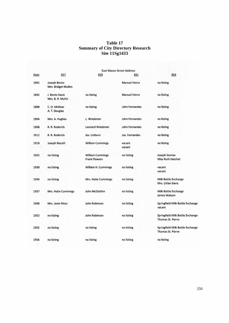
250
Table 17Summary of City Directory Research
Site 11Sg1433

251
Figure 116. Plan of the south half Block 14, illustrating Lots 15 and 16 with exposed archaeological features, limits ofinvestigations, and proposed right-of-way. The features with the small red dots have been partially excavated as part of thePhase II investigations.

252
Figure 117. Left: Row of pit privies exposed during initial stripping of overburden along the west side of the E1/2, Lot 15.Differential drying indicates location of privy pits. Right: Partial excavations of pit privies in progress during testing (Fall2014).

253
Figure 118. Plan views of Features 1, 2, 3, and a portion of Feature 4.

254
Figure 119. View of privy pits along center of property line during excavation.

255
Figure 120. Plan and profile of Feature 2, Site 11sg1433.

256
Figure 121. Two views illustrating the excavated east half of Feature 2, Site 11Sg1433. Note the remnant wood barrel stavesin the base of the pit (right).

257
Figure 122. Plan and profile of Feature 3, Site 11Sg1433.

258
Figure 123. Two views illustrating the excavated east half of Feature 3, Site 11Sg1433.

259
Figure 124. Sectional views of Features 2 and 3 (Site 11Sg1433), illustrating the dramatic shift in holding capacity betweenthese two sequential privy pits. Both are illustrated at the same scale.

260
Figure 125. Plan and profile of Feature 4, Site 11Sg1433.

261
Figure 126. Detail of base of Feature 4—note thin fecal deposits capped with extensive heating waste.

262
Figure 127. Plan and profile of Feature 5, Site 11Sg1433.

263
Figure 128. Remains of a Civil War era field medicine kit were recovered from near baseof Feature 5. Top: In situ view of bottles in place. Middle: Several bottles removedillustrating case. Bottom: Historic example of field kit similar to that found in Feature 5(http://www.civilwarpreservations.com/newmus161.html).

264
Figure 129. Plan and profile of Feature 6, Site 11Sg1433.

265
Figure 130. Detail of eastern internal box within Feature 6, prior to removal ofsurrounding fills.

266
Figure 131. Plan and profile of Feature 12, Site 11Sg1433.

267
Figure 132. Plan and profile of Feature 14, Site 11Sg1433.

268
Figure 133. Plan and profile of Feature 15, Site 11Sg1433.

269
Figure 134. Plan and profile of Feature 16, Site 11Sg1433.

270
Table 18Privy Data,
East Half of Lot 15, Site 11Sg1433

271
Conclusions: Significance of Sites 11Sg1432 and 11Sg1433
As with all properties assessed within the context of cultural resources management, thesignificance of archaeological sites 11Sg1432 and 11Sg1433 located in the Carpenter StreetUnderpass project area is determined by their eligibility for listing on the National Register ofHistoric Places. Eligibility to the National Register is based on four broad criteria that aredefined by the National Park Service and used to guide the evaluation process. These criteriastate that:
The quality of significance in American history, architecture, archaeology, andculture is present in districts, sites, buildings, structures, and objects that possessintegrity of location, design, setting, materials, workmanship, feeling, andassociation, and
A) that are associated with events that have made a significant contribution to thebroad patterns of our history; or
B) that are associated with the lives of persons significant to our past; or
C) that embody the distinctive characteristics of a type, period, or method ofconstruction or that represent the work of a master, or that possess high artisticvalues, or that represent a significant and distinguishable entity whosecomponents may lack individual distinction; or
D) that have yielded, or may be likely to yield, information important inprehistory or history (36CFR60.4 Criteria for Evaluation).
A property may qualify under one or more the above criteria, provided: 1) that it is historicallysignificant, through its association with an important historic context; 2) it retains the historicintegrity of those features necessary to convey its significance; and, in the case of archaeologicalsites, 3) it offers information that can answer relevant research questions and fill in gaps in thehistorical record.
Although each of the two sites investigated encompass an entire city block, the followingsummary discussion refers predominately to those areas of each site located within the existingproject right-of-way. Those portions of the two archaeological sites located within the CarpenterStreet Underpass project area (Sites 11Sg1432 and 11Sg1433) meet the standards for NationalRegister eligibility under Criterion D (archaeology). Both sites have local significance in respectto their potential to contribute substantially to our understanding of the lifeways of the variousethnic/racial groups in Springfield during the nineteenth and early twentieth centuries.Additionally, archaeological site 11Sg1432 is significant under Criterion A (social history) for itsassociation with the 1908 Springfield Race Riot. The significance of both sites is discussed inmore detail below.
The greater Carpenter Street project area (and both archaeological sites 11Sg1432 and

272
11Sg1433) is located within Springfield’s Near North Side, an area that was platted in the middle1830s and was well developed by the Civil War. Interposed as it was between the CentralBusiness District and the fashionable Enos Park Neighborhood to the north of it, the Near NorthSide was a mixed area in respect to its structural composition and resident population during thenineteenth century. Though predominately residential in character initially, the Near North Sidealso featured scattered businesses, particularly on its southern edge close to the Central BusinessDistrict. Commercial activity within the neighborhood expanded during the twentieth century.The resident population in the middle nineteenth century included native-born Americans, aswell as immigrants from Germany, Ireland, and the Portuguese-controlled Madeira Islands. Asizable Jewish population resided in the neighborhood during this period as well. The MadeiranPortuguese community on the Near North Side is especially noteworthy, as it represented one ofthe earliest and largest Portuguese settlements in the Midwest.
The Near North Side served as a gateway neighborhood, where newcomers of divergentbackgrounds and lower-to-middle-income status first laid down roots in Springfield. It offeredaffordable housing and was in close proximity to the Central Business District. These samefeatures attracted Springfield’s growing black population to the neighborhood during the middle-to-late nineteenth century. Black residents are documented in the immediate project area as earlyas 1864. By the early twentieth century, archaeological sites 11Sg1432 and 11Sg1433represented the western extension of the so-called “Badlands,” where a large number of blacksresided.
The Badlands had a reputation for crime and vice. This reputation often was played upby the local press and too broadly applied to the entire area. However, there was a reality to it aswell. Two locales regularly reported upon as being centers of criminal activity in the Badlands(i.e. “Tenth and Madison” and “Shin-Bone Alley”) were located within the limits of Site11Sg1432, and some of the residents there were active participants (as amply documented innewspaper accounts). Yet, as detailed in the historical context, this criminal activity did not arisefrom the changing racial composition of the project area in the late nineteenth century, so muchas representing a continuance of long tradition of having an established vice district Springfield.The expansion of the vice district into the project area—begun in the 1870s by whites—profoundly changed the character of the neighborhood. It ultimately also placed the project areaat the epicenter of the 1908 Race Riot.
Archaeological Site 11Sg1432 qualifies for the National Register of Historic Placesunder both Criteria A and D. Under Criterion A, Site 11Sg1432 is eligible for listing due to itsassociation with the 1908 Race Riot. The Badlands was the scene of widespread destruction andviolence during the August 1908 Springfield Race Riot, and Block 3 (Site 11Sg1432) was thepoint where the white assault on the Badlands was initiated. That portion of the site locatedwithin the Carpenter Street project area contains physical remains of five houses (Houses A-E)that were destroyed by the mob on August 14, 1908. These five houses (and their associatedfeatures) represent a unique “snapshot in time” of a diverse neighborhood, as it existed at thetime of the 1908 riot. Not only was the Springfield Race Riot a seminal event in the history ofthe city, but it also was of national importance due to its role in the foundation of the NationalAssociation for the Advancement of Colored People (NAACP).

273
Similarly, the site is eligible for listing on the National Register of Historic Places underCriterion D, for its association with the early-to-middle-nineteenth century settlement ofSpringfield. This site has local significance in respect to its potential to contribute substantiallyto our understanding of the lifeways of multiple ethnic/racial groups in Springfield during thenineteenth and early twentieth centuries. The physical remains of these five houses, plus twoadditional houses not affected by the riot (Houses F and G), have the potential to yieldsignificant information relating to the early (1840s-80s) history of this neighborhood, andSpringfield in general.
The period of significance for the archaeological resources within the project area is1842-1908—a timeframe that encompasses the earliest known development in the project areaup through the 1908 race riot. It also spans a period during which Springfield developed from araw frontier community of several thousand individuals to a major urban industrial center.
The remains of seven nineteenth century houses (six of frame construction, one of brickconstruction; all pre-dating circa 1870) have been documented within that portion of Site11Sg1432 that lies within the proposed project right-of-way. When initially constructed, all ofthese dwellings faced Tenth Street. During the middle to late nineteenth century, these dwellingsappear to have been occupied by a variety of German and American-born tradesmen andmerchants (as well as their families). By 1880, the demographics of Site 11Sg1432 had begun tochange dramatically. By the 1890s, the number of working class and/or poor African Americanfamilies occupying this site had increased. More importantly the number of owner-occupiedproperties had diminished, many of the houses were occupied by families with women listed asthe “head of household,” and illicit businesses (“houses of ill fame”) were being operated frommultiple homes at different points in time. By 1908, Site 11Sg1432 was occupied primarily bylower-income families—many of whom were black and experienced the horror of the race riotsof 1908 personally. In addition to the five houses within the current project area destroyed byfire during the evening of August 14, 1908, another three homes and one saloon locatedelsewhere on Site 11Sg1432 were burned down that night as well.
Phase II archaeological investigations found the archaeological integrity of 11Sg1432within the proposed project area to be excellent. The foundations of six of the seven dwellingswere in excellent condition. Foundations of House G exhibited the most post-1908 impacts, butwere nonetheless still sufficient to assess the size and character of the dwelling once located onthis house lot. Five of the seven houses (Houses A through E) exhibit physical evidence ofhaving been catastrophically destroyed by fire. The physical remains of these dwellingsrepresent a dense cluster of early settlement structures that remain well preserved and littleaffected by post-1908 processes. Post-riot, early twentieth century improvements to Site11Sg1432 were limited, and consisted of the redevelopment of the area as a lumber andscrap/junk yard. Many of the structures associated with this twentieth century development(such as the lumber sheds) were not substantial and encapsulated the earlier nineteenth centuryarchaeological resources, further preserving them. Immediately after the fire, much of the areawas cleaned up and backfilled with clean subsoil. The low-lying area located between Houses Aand B, and the cellar of House B, appears to have remained open and subsequently filled with awide variety of both domestic and structural demolition debris—as if the area functioned as anopen landfill for during the 1910s and early 1920s.

274
The archaeological resources uncovered within that portion of Site 11Sg1432 locatedwithin the Carpenter Street Underpass Project Area represent what were once the dwellings andfront-yard activity areas associated with these seven house lot.192 The project area right-of-wayis slightly wider at the north end of site 11Sg1432 than at the south end. As such, not all ofHouses A, B, C, and E were exposed during the Phase II investigations. Small sections of therear of each of these four houses extends into the unexcavated parking lot to the west of theproject area right-of-way. Houses D, F, and G were exposed in their entirety within the projectright-of-way during the Phase II investigations. Archaeological features associated with mid-yard and back-yard activity areas once associated with each of these dwellings is suspected asbeing equally well preserved beneath the existing parking lot to the west of the project area. Thecombined archaeological resources associated with 11Sg1432 have the potential to contributesignificantly to our understanding of the dynamics of urban life in Springfield during thenineteenth and early twentieth centuries.
The archaeological resources within Site 11Sg1432 consist of multiple data sets that lendthemselves to answering a series of relevant research questions. One of the most significant datasets identified from within that portion of the site located within the current project right-of-wayis the structural remains of the seven houses. Though reduced to their foundations, thesearchaeological resources nonetheless provide valuable information in respect to the houses’dimension, form, interior layout, construction methods, and physical changes through time—allof which provide information about the lifeways of the families that had them constructed and/orinitially occupied them through the years (predominately white, working class tradesmen andmerchants). Several traditional house types were documented by the Phase II archaeologicalinvestigations of Site 11Sg1432. The single room, 1½-story dwelling represented by House B,when constructed in the middle 1840s, represents what might be considered the “minimal” housein Springfield for the time period. As originally constructed, House E represents a similar houseform, albeit with a rear service wing. Houses A, C, D and F represent variations of a slightlylarger house form often referred to as an I-cottage and/or I-house house. Additionally, additionsconstructed onto these dwellings, and modifications made to them through time, are invaluabledata sets that can address questions relating to changing perceptions of what was considered a“minimal” house at various points in time.
Besides these structural remains, several distinctive artifact assemblages are associatedwith these houses. The archaeological testing completed at 11Sg1432 indicates the presence ofseveral discrete middens, and fill deposits, in and around these structures. The archaeologicaltesting of these house lots indicate the presence of discrete artifact assemblages with each thatcan be segregated into at least three components: one dating from the middle nineteenth century(associated with the early house occupants); another associated with the later-nineteenth andearly-twentieth-century occupants; and yet another from the 1908 fire. All three components are
192 With regard to Site 11Sg1432, the entirety of the rear lot activity areas associated with each of the housesidentified within the project area lies outside of the current project area, and extends into the adjacent parking lot tothe west. Although this area has not been tested, a shared history and lack of subsequent construction activity inthese areas suggests that much of the remaining site located outside of the existing project area has the potential forexcellent archaeological integrity as well.

275
significant, and have the potential to address quality of life issues relating to the site occupants atvarious points in time. The artifact assemblages from the August 1908 destruction of thesedwelling are of special interest as they provide a “snapshot in time” of the contents containedwithin the homes when the riot occurred. The fact that the fire deposits typically fell within acrawlspace area, and appear to have been little disturbed since the event, may allow researchersto segregate the artifacts by room. As such, in some of the houses (such as House A), it may bepossible to develop a room by room inventory of the artifacts present in these houses at the timeof the riot.
The archaeological data collected from the Phase II testing of Site 11Sg1432 has the potentialto address several research questions. Some of these research questions are quite broad—beingapplicable to the wider community, state, or region—while others are more site-specific, and arediscussed below.
1) Changing Structure of the Urban Landscape. Relatively little is known about theorganization (or structure) of the urban house lot during the initial years of settlement withinSpringfield. Spatial requirements (both within the dwelling as well as the surroundingyardscape) vary between ethnic, regional, and/or racial groups (German versus Irish;Southern versus Northern; white versus black), and between socio-economic strata (theworking class versus merchant class). Similarly, changing technologies and cultural valuesaffect the layout of the urban house lot. Documentary research suggests a great diversitybetween nineteenth and early twentieth century households (whether inter-block, or betweenthe blocks) among the residents of Springfield as to how they structure the house lot onwhich they live.
Research questions to be addressed by the data from 11Sg1432 include: “What are thedomestic and commercial requirements of the early pioneer family during the nineteenthcentury?”; “How did these conditions differ from that of their neighbors?”; and “How didchanging technologies (particularly associated with new sanitary, food preparation, andheating improvements) affect the domestic needs of these families through the late nineteenthand early twentieth centuries?”. Future data recovery programs should focus on defining thestructure (or organization) of the house lot and how it changed through the years. Thechanging structure of the site—as determined from the mapping of structural features,subsurface pits, as well as cisterns, wells, and middens—will allow for the definition ofactivity areas within the greater yard and help to address these questions.
2) Consumer Choices and/or Quality of Life Standards. Tied closely to the above discussion ofthe organization (or structure) of the urban landscape, is the discussion of the socio-economicwell-being of the occupants of the site (11Sg1432). Any discussion of the variouscomponents (as represented at the individual house lots) must also attempt to address suchquestions as: “What was the quality of life of the households that occupied this house lot?”;“Do the divergent data sets (architectural remains, ceramic and glass tablewares, and dietaryremains) from this house lot reflect similar quality of life assessments of the occupants?”; “Ifnot, what does the divergent data sets tell us about the character of the early lifeways?; “Doesthe quantity and quality of material goods and dietary remains found at each house lot sitebespeak of a working class or merchant class family?”; “Does the material goods consumed

276
and dietary remains recovered from each house lot reflect various ethnic, racial, or socio-economic characteristics of the occupants?” Answers to these questions can be sought fromthe material culture remains from the subsurface features (such as filled cellars, cisterns) andmiddens at this site. The physical remains of the glass and ceramic tablewares, teawares, andcrockery, as well as the faunal and floral remains recovered from the features will lendthemselves to addressing these questions.
3) 1908 Springfield Race Riot: By circa 1900, Site 11Sg1432 was largely occupied by lower-income black families, many of whom experienced the horror of the race riots of August1908 personally. At least five houses facing Tenth Street (Houses A-E) on this block weretorched during the riot, with several additional dwellings fronting Madison and Ninth Streets(and outside of the current project area) also being destroyed. The archaeological resourceslocated within that portion of Site 11Sg1432 located within the proposed project right-of-wayconsist of the physical remains of these houses. The rear yard activity areas associated withthese dwellings was located immediately to the west, outside of the proposed right-of-wayand not investigated as part of this study. Nonetheless, the houses alone have the potential tocontribute to our understanding of the dynamics of urban life in Springfield during thenineteenth and early twentieth century years. Post-riot, early-twentieth-centuryimprovements to the project area were limited and not substantial enough to havesignificantly impacted the earlier archaeological resources. Indeed, the fact that this blocklargely was cleared of housing in one devastating event and never reoccupied, presents aunique opportunity to examine one enclave of black residents at one pivotal point in time.The houses and their contents can be considered part of the forensic evidence of what was inessence a crime scene. The archaeological remains can confirm exactly which houses wereburned during the riot, and to what extent. More importantly, they have the potential to offervaluable information regarding the victims of the riot. The fact that several houses on Block3 apparently were vacant at the time of the riot, coupled with the very transient nature of thehomes’ occupants (as illustrated by city directories), does pose some limitations on the depthof detail that can be drawn from this “snapshot in time.” Yet, all of the residences inquestion were fully occupied as recently as 1906 and their occupants primarily black since atleast the early 1890s; as such, they represent a key sample of the very community that wasvictimized by the riot. The archaeological resources may represent a significant alternativesource of information on a community that often was neglected or painted in an unfavorablelight by contemporary written sources. Research questions to be addressed by the datainclude: “What were the living standards of the occupants the various house lots at Site11Sg1432 at the time of the riot?”; “How do they compare to those of the Portugueseresidents on Block 14 (as represented by the data collected from adjacent Site 11Sg1433), orto the earlier white occupants of Site 11Sg1432?”, “Do the houses at this location deserve thecharacterization as ‘shanties’ or ‘huts’, as so labeled by contemporary sources; or was it thatthey represented a pocket of older housing occupied by blacks, during an era of deep racism,that caused them to be singled out in such a disparaging manner?,” and “To what degree dothe material remains challenge or support contemporary accounts of black living standards inthe Badlands?”. And as a corollary question, “Do the archaeological remains shed any lighton the illicit activity commonly attributed to the Badlands—activity that served as a pretextfor violence by the white mob in 1908.”

277
Archaeological Site 11Sg1433 qualifies for the National Register of Historic Places underCriterion D, for its association with the middle-to-late nineteenth century Portuguese settlementof the neighborhood. The Madeiran Portuguese community on the Near North Side is especiallynoteworthy, as it represented one of the earliest and largest Portuguese settlements in theMidwest. That portion of Site 11Sg1433 located within the Carpenter Street project area hasexcellent integrity, and contains physical remains of both a domestic component (Lot 15) and acombination domestic and commercial component (Lot 16). 193 The archaeological resources atthis site documented on the Lots 15 and 16 during the Phase II investigations offer a range ofdata sets that also lend themselves to understanding the lifeways of the early inhabitants of thissite. Unlike the archaeological resources documented within the project area at Site 11Sg1432,which consisted of only the dwelling and front yard activity areas of the various house lots, thatportion of Site 11Sg1433 located within the proposed project right-of-way includes nearly theentire house lot associated with each of these two lots. The period of significance of this site iscirca 1840 to 1940, and encompasses the period from the suspected date of the neighborhood’sinitial occupation through the end of the Great Depression.
The presence of the entire urban lot—as opposed to only the front portion of a lot—results in the availability of greatly expanded data sets being available, which include a moreholistic view of the entire house lot’s structure (location of features on the lot), an expanded lookat non-structural (dwelling related) feature density and diversity (located in the mid-yard and rearyard activity areas), and an expanded potential for the recovery of short-term artifactassemblages (such as those located in sealed privy pits). The large number of privies exposed onBlock 14 (11Sg1433) is of particular note, and have the potential to yield a variety of discreteshort term artifact assemblages once associated with the site occupants. The cultural remainsrecovered from Site 11Sg1433 complement those found on Site 11Sg1432, thereby providing abroader understanding of the neighborhood’s population during the period of significance.
The archaeological data collected from the Phase II testing of Site 11Sg1433 has the potentialto address several research questions similar to those discussed above with regard to Site11Sg1432. Some of these research questions are quite broad—being applicable to the widercommunity, state, or region—while others are more site-specific, and are discussed below.
1) Changing Structure of the Urban Landscape. Relatively little is known about theorganization (or structure) of the urban house lot during the initial years of settlement withinSpringfield. Spatial requirements (both within the dwelling, as well as the surroundingyardscape) vary between ethnic, regional, and/or racial groups (German versus Irish;Southern versus Northern; white versus black), and between socio-economic strata (theworking class versus merchant class). Similarly, changing technologies and cultural valuesaffect the layout of the urban house lot. Documentary research suggests a great diversitybetween nineteenth and early twentieth century households (whether inter-block, or betweenthe blocks) among the residents of Springfield as to how they structure the house lot on
193 That area of Site 11Sg1433 that lies outside of the current project area has not been subjected to Phase IIarchaeological testing. Although this area has not been tested, a shared history and lack of subsequent constructionactivity in these areas suggests that much of the remaining site located outside of the existing project area has thepotential for excellent archaeological integrity as well.

278
which they live.
Research questions to be addressed by the data from 11Sg1433 include: “What are thedomestic and commercial requirements of the early pioneer family during the nineteenthcentury?”; “How did these conditions differ from that of their neighbors?”; and “How didchanging technologies (particularly associated with new sanitary, food preparation, andheating improvements) affect the domestic needs of these families through the late nineteenthand early twentieth centuries?”. Future data recovery programs should focus on defining thestructure (or organization) of the house lot and how it changed through the years. Thechanging organization of the site—as determined from the mapping of structural features,subsurface pits, as well as cisterns, wells, and middens—will allow for the definition ofactivity areas within the greater yard and help to address these questions.
2) Consumer Choices and/or Quality of Life Standards. Tied closely to the above discussion ofthe organization of the urban landscape, is the discussion of the socio-economic well-beingof the occupants of the site. Any discussion of the various components must also attempt toaddress such questions as: “What was the quality of life of the household that occupied thissite?”; “Do the divergent data sets (architectural remains, ceramic and glass tablewares, anddietary remains) from this site reflect similar quality of life assessments of the siteoccupants?”; “If not, what does the divergent data sets tell us about the character of the earlylifeways?; “Does the quantity and quality of material goods and dietary remains found at thissite bespeak of a working class or merchant class family?”; “Does the material goodsconsumed and dietary remains recovered from this site reflect various ethnic, racial, or socio-economic characteristics of the site’s occupants?” Answers to these questions can be soughtfrom the material culture remains from the subsurface features (such as filled cellars,cisterns) and middens at this site. The physical remains of the glass and ceramic tablewares,teawares, and crockery, as well as the faunal and floral remains recovered from the featureswill lend themselves to addressing these questions.
3) Early Portuguese Community in Springfield: Several Portuguese families (such as theFierirra/Vieira and Mendonca families) are known to have resided within that area of Site11Sg1433 located within the proposed project right-of-way. These families were part of acolony of Portuguese who settled in Springfield, en masse in 1849, after fleeing the MadeiraIslands due to persecution by authorities for their adherence to the Presbyterian faith. Thecommunity established itself on the Near North Side and long remained a presence in theneighborhood. As noted above, this is one of the earliest and largest Portuguese settlementsin the Midwest. The Portuguese-owned properties within Site 11Sg1433 included aresidence and a grocery store (with living quarters above), both of which had beenconstructed by the middle 1860s. Research questions related to the Portuguese primarilyrevolve around ethnic identity and rate of assimilation. Ethnic identity can be expressed in anumber of ways, including language, religion, clothing, customs, and foodways. Althougharchaeology cannot address all of these points of expression (language for instance), it canaddress others to varying degrees (depending on the material recovered)—particularlyfoodways. Research questions to be addressed by the data include: “Does the culturalmaterial convey a Portuguese identity?”; “What was the standard of living of the immigrantsa decade after their arrival in Springfield?”; “How do these Portuguese-occupied properties

279
compare/contrast to those of their neighbors, in respect to site structure and material goods?”;and “Does the material recovered from the store indicate an orientation towards a Portugueseclientele, or general population?”

280
Summary and Recommendations
The Phase II archaeological testing has been completed at both Sites 11Sg1432 and11Sg1433. The sites have been backfilled, and re-seeded in grass awaiting a formaldetermination of eligibility for the two sites. Additionally, the public has been engaged througha series of public meetings and potential interested parties have been identified. Discussionsregarding the potential for site avoidance, and/or mitigations options have been initiated inanticipation of a determination of eligibility for these two sites. Although the field work for thisproject has been completed, the inventory and analysis of the artifacts recovered from theseinvestigations have not, as yet, been funded. Upon completion of the inventory and analysis ofthe artifact collections from Sites 11Sg1432 and 11Sg1433, the results will be presented as anaddendum to this Phase II report. Although this detailed artifact analysis has not yet beencompleted, it is our opinion that sufficient detail has been provided to allow for a determinationof eligibility for these two archaeological sites. Additionally, further research should beundertaken in order to resolve outstanding questions and inconsistencies among the historicalrecords, and the results from that work would be presented as an addendum to this Phase IIreport.
Site 11Sg1432 is considered eligible for listing on the National Register of HistoricPlaces, as per Criterion A and D. As discussed above, under Criterion A, Site 11Sg1432 iseligible for listing on a national level due to its association with the 1908 Race Riot. TheBadlands was the scene of widespread destruction and violence during the August 1908Springfield Race Riot, and Block 3 (Site 11Sg1432) was the point where the white assault on theBadlands and multiple black residences was initiated. That portion of the site located within theCarpenter Street project area contains physical remains of five houses (Houses A-E) that weredestroyed by the mob on August 14, 1908. These five houses (and their associated features)represent a snapshot in time of the multi-ethnic community that existed at the time of the 1908riot. Not only was the Springfield Race Riot a seminal event in the history of the city, but it alsowas of national importance due to its role in the foundation of the National Association for theAdvancement of Colored People (NAACP). Table 19 presents a data summary for the housesdocumented at Site 11Sg1432.
Similarly, Site 11Sg1433 is considered eligible for listing on the National Register ofHistoric Places, as per Criterion D, for its ability to address significant research questionsrelating to the nineteenth and early twentieth century Portuguese settlement of the neighborhood.Its period of significance is circa 1840 through 1940.

281
Table 19
Data Summary for Houses at Site 11Sg1432.

282
Figure 135. At the scraped surface, at least four of the seven houses (Houses A through D) indicated signs of having beendestroyed by fire. Subsequent test excavations indicate that five of the houses (Houses A through E) had been destroyed byfire—presumably during the evening of August 14, 1908. Left: View along east wall, looking south. Right: View in rearservice wing along north wall, looking south.

283
Figure 136. Location of seven houses (Houses A-G) documented at Site 11Sg1432(highlighted in yellow) within the Carpenter Street Underpass project area during thePhase II testing. The 1896 Sanborn map, with burned houses from the 1908 Race Riothighlighted in orange, is overlain onto the current aerial photograph of the project area.Houses A through E all were indicated as having been burned on that August evening.House F remained unmolested during the mob action, whereas House G had beendemolished shortly before the riot. At least four additional structures on Site 11Sg1432 (alllocated at the southwest corner of the block) were destroyed during that mob action, aswere homes on neighboring blocks (represented by structures in orange).

284
Figure 137. Location of Houses A-G (circled in red) at Site 11Sg1432 (highlighted in yellow), as illustrated on the 1896Sanborn fire insurance map. The houses located within the Carpenter Street Underpass project area are circled in red, andwere the focus of this Phase II archaeological testing. Additional burned/damaged buildings within the Badlands also areillustrated and highlighted in red. Appendix II contains historic photographs taken in the aftermath of the riot, and are keyedto the same map.

285
References Cited
Adjutant General of Illinois1909 “Reports of Riots at Springfield, Ill., August, 1908.” Biennial Report of the
Adjutant General of Illinois to the Governor and Commander-In-Chief, 1907-1908, pp.263-293.
Alexander, Brian1973 “Ross B. Wright Memoir.” Oral History Interview with Ross B. Wright. Oral
History Office, Sangamon State University, Springfield. [Archives/SpecialCollections, University of Illinois at Springfield, Springfield.]
Angle, Paul M.1971 “Here I Have Lived”: A History of Lincoln’s Springfield, 1821-1865. New
Edition. Abraham Lincoln Book Shop, Chicago. [Originally published in 1935by the Abraham Lincoln Association.]
Bateman, Newton and Paul Selby1912 Historical Encyclopedia of Illinois and History of Sangamon County. Chicago:
Munsell Publishing Company.
Bird, Judson S.1876 Map of the City of Springfield, Ill.. Jackson, Michigan. [On file, Sangamon
Valley Collection, Lincoln Library, Springfield, Illinois.]
Campbell, Bruce A.1976 The Sangamon Saga. Springfield: Phillips Brothers Inc.
Clark, William Lloyd.1910 Hell at Midnight in Springfield, or a Burning History of the Sin and Shame of the
Capitol City of Springfield. Milan, Illinois.
Coryell, Matthew2007 1908 Springfield, Illinois Race Riot Revisited. Springfield, Illinois: University of
Illinois at Springfield.
Crouthamel, James L.1960 “Springfield Race Riot of 1908,” The Journal of Negro History XLV: 164-181.
Washington, D. C.: The Association for the Study of Negro Life and History.
Decker, D. O. and Shelby M. Harrison1917 City and County Administration in Springfield, Illinois: A Survey by the
Department of Surveys and Exhibits, Russell Sage Foundation. The SpringfieldSurvey, Government Efficiency Section. Springfield Survey Committee,Springfield, Illinois and the Russell Sage Foundation, Phildadelphia.

286
Doyle, Don Harrison1983 The Social Order of a Frontier Community, Jacksonville, Illinois, 1825-1870.
Urbana, Illinois: University of Illinois Press.
Enos, Zimri1909 “Description of Springfield.” Transactions of the Illinois State Historical Society.
Springfield: Illinois State Historical Society.
Evjen, Harry1931 “Illinois State University, 1852-1868.” Journal of the Illinois State Historical
Society Vol XXXI. Springfield: Illinois State Historical Society.
Galloy, Joseph2007 “A Stanhope Rosary Cross From Cahokia, Illinois.” Illinois Antiquity 42(3 and
4): 20.
Garvert, Melinda, Curtis Mann, and Edward Russo1997 Springfield Home and Family: A Pictorial History. St. Louis: G. Bradley
Publishing.
Harrison, Shelby1920 Social Conditions in an American City: A Summary of the Findings of the
Springfield Survey. Russell Sage Foundation, New York.
Hickey, James1965 “Springfield, May, 1865.” Journal of the Illinois State Historical Society
57(1):21-33
Howard, Robert P.1974 A New Eden: The Pioneer Era in Sangamon County. Springfield: Sangamon
County Historical Society.
1972 Illinois: A History of the Prairie State. Grand Rapids, Michigan: William B.Eerdmans Publishing Company.
Ihlder, John1914 Housing in Springfield, Illinois: A Study by he National Housing Association.
The Springfield Survey, Housing Section. Springfield Survey Committee,Springfield, Illinois. Russell Sage Foundation, Philadelphia.
Iles, Elijah1883 Sketches of Early Life and Times in Kentucky, Missouri and Illinois. Springfield:
Springfield Printing Company.
Illinois State Historical LibraryPhotographic Collection. Springfield, Illinois.

287
Illinois State Journal (Springfield)
Illinois State Register (Springfield)
Illinois State Register[1908] Photographic Views of the Great Springfield Race War, August, 1908: Depicting
Work of Mob’s Violence in the Venting of Their Wrath on the Blacks. Springfield,Illinois.
Inter-State Publishing Company1881 History of Sangamon County, Illinois. Chicago.
Koch, August1873 Bird’s Eye View of Springfield. St. Louis.
Krohe, James, Jr.1973 Summer of Rage: the Springfield Race Riot of 1908. Springfield, Illinois:
Sangamon County Historical Society.
1975 Midnight at Noon: A History of Coal Mining in Sangamon County. Springfield:Sangamon County Historical Society.
1977 “‘Not Guilty!’ The Riot Trial of Abraham Raymer.” Sangamon ValleyCollection, Lincoln Library, Springfield.
1978 “Not Guilty! The Trial of Abraham Raymer After the Springfield Race Riots of1908.” Illinois Times (August 11-17). Springfield, Illinois.
Landis, Anthony M.2002 They Refused to Stay in Their Place: African American Organized Resistance
During the Springfield, Illinois Race Riot of 1908. Unpublished Master’s Thesis.Edwardsville, Illinois: Southern Illinois University Edwardsville.
Mann, Curtis2008a “Fort Taylor, Part I.” Historico (February, pp. 5). The newsletter of the
Sangamon County Historical Society , Springfield, Illinois.
2008b “Fort Taylor, Part II.” Historico (March, pp. 3-4). The newsletter of theSangamon County Historical Society , Springfield, Illinois.
2008c “Fort Taylor, Part III.” Historico (April, pp. 5-6). , The newsletter of theSangamon County Historical Society , Springfield, Illinois.
2008f “Fort Taylor, Part IV.” Historico (May, pp. 3). The newsletter of the SangamonCounty Historical Society , Springfield, Illinois.

288
Mann, Curtis, Edward Russo and Melinda Garvert1996 Springfield Entertainment: A Pictorial History. G. Bradley Publishing, St. Louis.
Mansberger, Floyd1989 Urban Archaeology: An Often Overlooked Context for Significant Historic
Resources. In “Nineteenth Century Historic Archaeology in Illinois,” compiledby Thomas Emerson and Charles Rohrbaugh, Illinois Cultural Resources StudyNo. 6, Illinois Historic Preservation Agency.
Mansberger, Floyd, Tracey Sculle, and Amy Spies1992 An Architectural Assessment of the Proposed St. Johns Hospital and Memorial
Medical Center Expansions, Springfield, Illinois. Prepared by Fever RiverResearch in association with the Historic Preservations Association ofSpringfield. On file, Fever River Research, Springfield.
Mansberger, Floyd and Christopher Stratton2003 The Architectural Resources of the Aristocracy Hill Neighborhood, Springfield,
Illinois. Fever River Research, Springfield, Illinois.
2012 Illinois Historic Engineering Record Documentation Package: City Water, Lightand Power Lakeside Facility (IL HAER No. SG-2012-1). Fever River Research,Springfield, Illinois.
2014 “Archaeology, the Civil War, and the Home Front in Springfield, Illinois.”Illinois Antiquity, 49(3):12-15.
Mansberger, Floyd, Christopher Stratton, and Christina Wresch2000 A Cultural and Historical Resources Study For The Proposed Site of the Abraham
Lincoln Presidential Library, Springfield, Illinois. Fever River Research,Springfield, Illinois.
Merritt, Carole2008 Something So Horrible: the Springfield Race Riot of 1908. Springfield, Illinois:
Abraham Lincoln Presidential Library Foundation.
Potter, C.1854 [Map of] City of Springfield, Sangamon County, Ills. New York: Hart and
Mapother.
Power, John Carroll1871 History of Springfield, Illinois: Its Attractions as a Home and Advantage For
Business, Manufacturing, Etc. Springfield: Illinois State Journal Print.
1876 History of the Early Settlers of Sangamon County. Springfield: Edwin A Wilsonand Company.

289
Proctor, Jack1942 The Levee: Verses and Drawings. Sangamon Valley Collections, Lincoln
Library, Springfield, Illinois.
Quinn, Camilla A.1991 Lincoln’s Springfield in the Civil War. Western Illinois Monograph Series, No. 8,
Western Illinois University, Macomb.
Russo, Edward J.1982 “When They Tried To Stamp Out Vice In Springfield,” Illinois Times (April 14-
20). Springfield, Illinois.
1983 Prairie of Promise: Springfield and Sangamon County. Windsor Publications,Woodland Hills, California.
Russo, Edward J., Melinda Garvert, and Curtis Mann1995 Springfield Business, a Pictorial History. St. Louis: G. Bradley Publishing, Inc.
1998 Springfield Community Service: A Pictorial History. G. Bradley Publishing, St.Louis.
Ruger, A.1867 [Bird’s Eye View of] Springfield, Illinois, 1867. Chicago: Chicago Lithographing
Company.
Sanborn Map and Publishing Company1884 Fire Insurance Map of Springfield, Illinois. New York.
Sanborn-Perris Map Company1890 Fire Insurance Map of Springfield, Illinois. New York.
1896 Fire Insurance Map of Springfield, Illinois. New York.
Sanborn Map Company1906 Springfield, ILL: Block Line Map of Central Business District. New York.
1917 Fire Insurance Map of Springfield, Illinois. New York.
1941 Fire Insurance Map of Springfield, Illinois. New York.
1950 Fire Insurance Map of Springfield, Illinois. New York.
1972 Fire Insurance Map of Springfield, Illinois. New York.

290
Sangamon CountyDeed Records (SCDR). On file at County Clerk and Recorder’s Office.Springfield, Illinois
Tract Books (SCTB). Springfield, Book 1, Part 1. On file at Sangamon ValleyCollection, Lincoln Library, Springfield, Illinois.
Sangamon Valley CollectionVertical Files. On file at the Lincoln Library, Springfield, Illinois.
Senechal, Roberta1990 The Sociogenesis of a Race Riot: Springfield, Illinois in 1908. Urbana: University
of Illinois Press.
2008 In Lincoln’s Shadow: the 1908 Race Riot in Springfield, Illinois. Carbondale,Illinois: Southern Illinois University Press. [Second edition of earlier 1990 work.]
Sides, William1858 [Map of] City of Springfield, Sangamon County, Ill. Philadelphia: R. L. Barnes.
Springfield City DirectoryMutiple years. Copies on file at Sangamon Valley Collection, Lincoln Library,Springfield, Illinois.
Stratton, Christopher and Floyd Mansaberger2011 Phase I Cultural Resources Evaluation: Springfield Railroad Corridor Study,
Springfield, Sangamon County, Illinois. Fever River Research, Springfield,Illinois.
Temple, Wayne C.1984 By Square and Compasses: The Building of Lincoln’s Home and its Saga.
Bloomington, Illinois: The Ashlar Press.
United State Bureau of the Census (USBC)1850 Population Schedule for Springfield, Sangamon County, Illinois.
1860 Population Schedule for Springfield, Sangamon County, Illinois.
Wallace, Joseph1904 Past and Present of the City of Springfield and Sangamon County, Illinois.
Chicago: S. J. Clarke Publishing Company.
Walling, William English1908 “The Race War in the North,” The Independent 65:529-534.

291
APPENDIX I
Archaeological Site Forms:Sites 11Sg1432 and 11Sg1433

292
ILLINOIS ARCHAEOLOGICAL SITE RECORDING FORMCounty: Sangamon Site Name: Revisit: NField Number: State Site No.: 11Sg1432Quadrangle (7.5'): Springfield, West Date Recorded: 2015.01.14
LEGAL DESCRIPTION (to quarter quarter quarter)
Align: SE 1/4s: NW SW SE NE SW SE Section: 27 Township: 16 N Range: 5 WAlign: 1/4s: Section: Township: Range:Align: 1/4s: Section: Township: Range:Align: 1/4s: Section: Township: Range:
UTM Coordinates (by ISM): UTM Zone: 16 UTM North: 273,747 UTM East: 4,409,182
Ownership: Public
ENVIRONMENT
Topography: Upland Ridge Elevation (in meters): 183Nearest Water Supply: Spring Creek Drainage: Lower SangamonSoil Association: Tama-Ipava-Sable
Description:. The site is located on a relatively level upland ridge a short distance north of the central business district in Springfield,Illinois. It consists of the city block bordered by Madison, Mason, Ninth, and Tenth Streets.
SURVEYProject Name: Carpenter Street Underpass Site Area (square meters): 12,416Ground Cover (List up to 3): Paved Visibility (%): 0Survey Methods (List up to 2): Machinery Standing Structures: NSite Type (List up to 2): Habitation Commercial
SITE CONDITIONExtent of Damage: ModerateMain Cause of Damage: Vandalism
MATERIAL OBSERVEDNumber of Prehistoric Artifacts (count or estimate): 0 Number of Historic Artifacts (count or estimate): 1000Prehistoric Diagnostic Artifacts: N Historic Diagnostic Artifacts: YPrehistoric Surface Features: N Historic Surface Features: Y
Description: Phase II testing recovered a wide variety of artifacts, including whiteware, porcelain, reware, and stoneware, as well asmetal and faunal materials, yet to be inventoried. It also revealed the foundation remains of seven houses, a well, anda cistern.
TEMPORAL AFFILIATION (check all that apply) Colonial (1673-1780):
Prehistoric Unknown: Late Archaic: Mississippian: Pioneer (1781-1840):Paleoindian: Woodland: Upper Mississippian: Frontier (1841-1870): YArchaic: Early Woodland: Protohistoric: Early Industrial (1871-1900): YEarly Archaic: Middle Woodland: Historic Native American: Urban Industrial (1901-1945): YMiddle Archaic: Late Woodland: Historic (generic): Post-War (1946-present): Y
Description: This area was platted as an addition to Springfield in 1836-1837. The block began to be developed in theearly-to-mid 1840s. Occupation continued into the late 20
thcentury. The east side of block was impacted
by the 1908 Springfield race riot.
Surveyor: F. Mansberger Institution: FRR Survey Date: 09/24/2014 Curation Facility: FRRSite Report by: C. Stratton Institution: FRR Date: 1/12/2015IHPA Log No.: IHPA First Sur. Doc. No.:Compliance Status: NRHP Listing: N

293
ILLINOIS ARCHAEOLOGICAL SITE RECORDING FORMCounty: Sangamon Site Name: Revisit: NField Number: State Site No.: 11Sg1433Quadrangle (7.5'): Springfield, West Date Recorded: 2015.01.14
LEGAL DESCRIPTION (to quarter quarter quarter)
Align: SE 1/4s: NW SW SE SW NW SE Section: 27 Township: 16 N Range: 5 WAlign: 1/4s: Section: Township: Range:Align: 1/4s: Section: Township: Range:Align: 1/4s: Section: Township: Range:
UTM Coordinates (by ISM): UTM Zone: 16 UTM North: 273,756 UTM East: 4,409,304
Ownership: Public
ENVIRONMENT
Topography: Upland Ridge Elevation (in meters): 183Nearest Water Supply: Spring Creek Drainage: Lower SangamonSoil Association: Tama-Ipava-Sable
Description:. The site is located on a relatively level upland ridge a short distance north of the central business district in Springfield,Illinois. It consists of the city block bordered by Mason, Reynolds, Ninth, and Tenth Streets.
SURVEYProject Name: Carpenter Street Underpass Site Area (square meters): 13,303Ground Cover (List up to 3): Paved Visibility (%): 0Survey Methods (List up to 2): Machinery Standing Structures: NSite Type (List up to 2): Habitation Commercial
SITE CONDITIONExtent of Damage: ModerateMain Cause of Damage: Vandalism
MATERIAL OBSERVEDNumber of Prehistoric Artifacts (count or estimate): 0 Number of Historic Artifacts (count or estimate): 1000Prehistoric Diagnostic Artifacts: N Historic Diagnostic Artifacts: YPrehistoric Surface Features: N Historic Surface Features: Y
Description: Phase II testing recovered a wide variety of artifacts, including whiteware,, reware, and stoneware, as well as metal andfaunal materials, yet to be inventoried. It also found the foundations of a store and house, seven houses, a cistern,well, and multiple privies.
TEMPORAL AFFILIATION (check all that apply) Colonial (1673-1780):
Prehistoric Unknown: Late Archaic: Mississippian: Pioneer (1781-1840):Paleoindian: Woodland: Upper Mississippian: Frontier (1841-1870): YArchaic: Early Woodland: Protohistoric: Early Industrial (1871-1900): YEarly Archaic: Middle Woodland: Historic Native American: Urban Industrial (1901-1945): YMiddle Archaic: Late Woodland: Historic (generic): Post-War (1946-present): Y
Description: This area was platted as an addition to Springfield in 1836. The block began to be developed circa 1850.Occupation continued into the late 20
thcentury. The area was part of the Portuguese neighborhood on the
city’s Near North Side.
Surveyor: F. Mansberger Institution: FRR Survey Date: 10/01/2014 Curation Facility: FRRSite Report by: C. Stratton Institution: FRR Date: 1/12/2015IHPA Log No.: IHPA First Sur. Doc. No.:Compliance Status: NRHP Listing: N

294
Figure 1. U.S.G.S. topographic map (Springfield West, IL 7.5-minute, 1998) showing thelocation of the Carpenter Street Underpass Project Area (outlined in blue) and twoarchaeological sites (outlined in green).
Site11SG1433
Site11SG1432
CARPENTER STREETUNDERPASS PROJECT AREA

295
Figure 2. Site plan showing the relationship of Sites 11Sg1432 and 11Sg1433 (hatched ingreen) in relationship to the Carpenter Street Underpass Project Area (outlined in blue)and surrounding vicinity. Site 11Sg1432 corresponds to Block 3 of J. Whitney’s Additionand Block 17 of Wells and Peck’s Addition to Springfield. Site 11Sg1433 corresponds toBlock 14 of Wells and Peck’s Addition.

296
APPENDIX II
THE 1908 SPRINGFIELD RACE RIOT:BURNED BUILDING LOCATIONS
AND OTHER HISTORIC PHOTOGRAPHIC VIEWS
byFloyd Mansberger
andChristopher Stratton
DRAFT(February 4, 2016)
Fever River ResearchSpringfield, Illinois
2016

297
Introduction
On August 14-15, 1908 Springfield, Illinois was rocked by a race riot that resulted in the deathsof nine people, dozens of properties destroyed or damaged, and the displacement of a largesegment of the city’s black population. The riot was a seminal event in Springfield’s history andis the acknowledged catalyst for the foundation of the National Association for the Advancementof Colored People (NAACP) in early 1909. The document presented here has two primarygoals: 1) identify the physical locations of the houses and business burned during the riot; and 2)isolate the locations of the numerous photographs that were taken in the riot’s aftermath, with aspecific emphasis on those illustrating buildings destroyed or severely damaged within (or closeproximity to) Springfield’s so-called “Badlands.”
The data presented here is derived primarily from several local newspaper articles detailingproperty losses in the Badlands incurred during the riot. On August 16th, only hours after thecessation of the mob action, both the Illinois State Journal and Illinois State Register ran multi-page stories regarding the riot and its devastation.1 Needless to say, these accounts wereproduced quickly after the event—the smoke had hardly cleared from the fires, and the accuracyof the reporting may have reflected this rush to publish. Both newspapers attempted to segregatethe damage into the two districts affected—the Levee and the Badlands. Tables 1 and 2summarize the destruction in the Badlands, as reported by the Illinois State Journal and theIllinois State Register, respectively.2 The Illinois State Journal, in their article entitled “PropertyLoss Near $120,000: Damage In Levee And Business District is Heavy” ([Springfield] IllinoisState Journal), summarized the damage as such:
Red Light District by fire $50,000Damage to Property in Levee District $35,000Loss at Loper’s Restaurant and Saloon $20,000General Loss Throughout the Business District $15,000
This article further noted in its subtitle that “Many owners begin repairs but in Red LightNeighborhood destruction of buildings owned or occupied by negroes is complete.” Manyphotographs of the damaged properties were published at the time, particularly by the IllinoisState Register.3
1 “Property Loss Near $120,000: Damage In Levee And Business District Is Heavy,” [Springfield] Illinois StateJournal (August 16, 1908, page 5), “Awful Havoc Is Wrought By Mob: Long List of Stores Wrecked and HomesBurned Gives Idea of Magnitude of the Mob’s Work of Destruction,” [Springfield] Illinois State Register (August16, 1908, page 1).
2Similarly, Tables 4 and 5 summarize the destruction along the commercial Levee, as reported by the Illinois State
Journal and the Illinois State Register, respectively. It is our hopes to integrate this data into a similar map at afuture date.
3 The Illinois State Register article was reprinted in its entirety (complete with additional photographs) on August21, 1908.

298
After the smoke had cleared, and the embers had cooled off, the City of Springfield released anofficial accounting of the houses damaged and destroyed during the riots. On September 5,1908, both the Illinois State Journal and the Illinois State Register carried accounts of Fire ChiefJacobs official accounting of the damage.4 As reported in the subtitle of the Register’s accountof the event, this “List Made For Benefit of Special Investigating Committee” of the CityCouncil. The Journal also noted that “in a number of cases the chief was unable to ascertain theloss, the occupants and owners having fled the town and is still working on the case.” Except fora couple of discrepancies related to suspect typographical errors, both news stories are basicallyidentical in their listing of the damaged properties.
Table 3 is a summary of the properties reported by Chief Jacobs by the two newspaper stories.This table provides an inventory of the properties discussed by the two September 5th newsarticles, along with additional information detailed by them (i.e. property description, owner,occupant, and condition). These properties have been plotted on the map presented as Figure 1,which represents a compilation of several sheets taken from the 1896 Sanborn fire insurance mapillustrating the section of the Badlands impacted by the riot. The 1896 Sanborn was the last full-set fire insurance map prepared for Springfield prior to the riot, and hence it was considered mostappropriate for our purposes. Several of the addresses listed in the destroyed/damaged inventorydo not appear on the 1896 Sanborn—having been built or relocated during the intervening period(1896-1908)—but these generally can be accounted for by consulting Springfield city directoriesand the “Block Line Map of the Central Business District” published the Sanborn Map Companyin 1906; these building have been added to the 1896 “base” map. Destroyed houses arehighlighted in orange on Figure 1.
During the two-day event (August 14-15, 1908), the local newspapers documented thedestruction of property, and the occupation of the city by armed troops, in a multitude ofphotographs, many of which were published in the newspapers. The Illinois State Registerpublished a total of 41 images relating to the riot and its aftermath over an eight-day period inwhich they covered the event (Illinois State Register, August 28, 1908). The aftermath of theriot was a sightseeing extravagance that brought many individuals to downtown Springfield.Almost immediately after the event—if not actually during the event—opportunistic individualshad printed a series of postcards illustrating the devastating destruction and presence of armedtroops in the Capital City, and were selling such to the multitude of sightseers touring theBadlands to view the damage firsthand. On Sunday (August 16, 1908), the very day followingthe riots, the Illinois State Journal published a short news item entitled “STOP SALE OFWOMAN’S PHOTOS. Police Prevent Distribution of Mrs. Hallam’s Picture.” This story notedthat a “postcard vendor who was selling photos of Mrs. Mabel Hallam, the woman [purportedly]attacked by the negro Richardson, and whose awful experience was the direct cause of thebreaking out of the race riot, was ordered off the streets last night. I[t] was feared putting forththe pictures in large numbers [w]ould inflame the minds of the persons and cause a fresh
4 “Lists Property in ‘Bad Lands’: Chief Jacobs Makes List of Owners of Those Shacks,” [Springfield] Daily IllinoisState Register (September 5, 1908), and “Forty Houses Damaged. Report of Chief Jacobs Shows Total NumberFired by Mob,” [Springfield] Daily Illinois State Journal (September 5, 1908).

299
outbreak of demonstration” (Illinois State Journal, August 16, 1908).5 Subsequently, theRegister also published a booklet of their photographs entitled Photographic Views of the GreatSpringfield Race War, August, 1908 (Illinois State Register, c.1908).6
This work attempts to compile these images in a single location, and presents them in thefollowing pages. Historic photograph locations also are indicated on Figure 1, with directionarrows and photo reference numbers colored in blue. The photographs referenced are presentedin sequence on the pages that follow. The images were obtained from a number of sources,including the Illinois State Historical Society collection (now integrated into the AbrahamLincoln Presidential Library and Museum), the Sangamon Valley Collection (Lincoln Library),Springfield historian Richard Hart, and from the Internet. Additional historic photographspertinent to our research likely do exist in public and private collections and will be integratedinto this document as they are located. As such, the document should be considered a work inprogress and envisioned to be expanded in the near future.
5 The adjacent story in this same issue of the newspaper was entitled “MILITARY SCENE UNUSUAL. UniformedGuards Forbid Curious in Forbidden Territory” (Illinois State Journal, August 16, 1908).
6 Another disturbing use of the destroyed properties was the opportunistic advertising used by promotors of the JohnC. Weber Band. Broadsides promoting John C. Weber and his band (who were performing at the White Cityamusement park on East Capitol Avenue in Springfield the week of the riots) were posted on many of the burnedhouses in the district, and a large banner announcing his arrival was stretched across the burned out remains ofLoper’s Restaurant downtown. Placement of these broadsides on the burned-out houses and Loper’s restaurant wasan opportunistic advertising strategy conducted by Weber’s promoters.

300
Table 1.List of Properties Damaged and/or Destroyed in the Badlands
During the August 1908 Race Riot,Springfield, Illinois
(As reported on August 16 by the Illinois State Journal)

301
Table 2.List of Properties Damaged and/or Destroyed in the Badlands
During the August 1908 Race Riot,Springfield, Illinois
(As reported on August 16 by the Illinois State Register)

302
Table 3Official City List of Dwellings Damaged and/or Destroyed
During the August 1908 Race Riot,Springfield, Illinois7
7 Table compiled from “Lists Property in ‘Bad Lands’: Chief Jacobs Makes List of Owners of Those Shacks,”[Springfield] Daily Illinois State Register (September 5, 1908), and “Forty Houses Damaged. Report of ChiefJacobs Shows Total Number Fired by Mob,” [Springfield] Daily Illinois State Journal (September 5, 1908).Additional information was also available from Illinois State Register (September 11, 1908) article entitled “RiotClaims Are $108,415.”

303
Table 4.List of Properties Damaged and/or Destroyed in the Levee District
During the August 1908 Race Riot,Springfield, Illinois
(As reported on August 16 by the Illinois State Journal)

304
Table 5.List of Properties Damaged and/or Destroyed in the Levee District
During the August 1908 Race Riot,Springfield, Illinois
(As reported on August 16 by the Illinois State Register)

305
Figure 1. Map illustrating the location of buildings destroyed or severely damaged during the 1908 Springfield Race Riot(highlighted in orange), and the locations of the historic photographs taken in the aftermath of the riot (indicated in blue).
2a
3a
78a-b
15a-d 16a-d
19
20
1a
5
6a-b9
14a-d12a-b
1b
3b-c2b
4a-b
11a
11b
13
1810a-b
17

306
Figure 2. Route of the mob taken on August 14, 1908 (http://thegermansmakegoodstuff.blogspot.com/2011/07/today-i-learned-about-1908-springfield.html). [The location of the Burton Barber Shop is misplaced on this figure.]

307
The Residential District (The Badlands)
1a. Scott Burton’s barbershop on the northeast corner of Jefferson and Ninth streets, which wastorched by the mob prior to its assault on the Badlands(http://www.lib.niu.edu/1996/iht329622.html).
1b. Ruins of Scott Burton’s barbershop, looking east (ALPLM Ide Collection PC5).

308
2a. Wrecked houses on the west side of the 300 block of North Ninth Street, looking southwest(ALPLM Ide Collection NG5798).
2b. Wrecked houses on the west side of the 300 block of North Ninth Street, looking northwest.The stone building seen in the background belongs to the adjacent Culver Stone and MarbleWorks (Ebay image from Dick Hart).

309
3a. Burned homes at 312 North Ninth Street (at center) and 314 North Ninth Street (at left), looking east (ALPLM Ide CollectionNG5795).

310
3b. Burned-out houses at 312 and 314 North Ninth Street, looking east (ALPLM Ide CollectionPC11a).
3c. Burned-out houses at 312 and 314 North Ninth Street, looking northeast, with NationalGuard troops camped out in front (ALPLM Ide Collection, PC13a).

311
4a. Postcard image labeled “Negro Residence 9th & Madison / Militia on duty Mob Violence” (Sangamon Valley Collection, LincolnLibrary). This image depicts the former “house of ill fame” initially established in the early 1870s by Emma Nash (aka EmmaTaylor), and later occupied by Mabel Baxter at 913-915 East Madison Street. The adjacent building, located at 917 East MadisonStreet, was occupied by Charles Baxter beginning in 1896 as a saloon. It lies completely destroyed in this image. In 1908, the BaxterResort had been closed, and this was probably the D. C. Neal residence (the manager of the adjacent saloon at the time of the riot).

312
4b. Two nearly identical views of the ruins at the house and adjacent saloon at 913-915 and 917East Madison Street. Top: ALPLM Ide Collection (PC7). Bottom: Postcard (courtesy ofRichard Hart).

313
5. View of the ruins of the house and adjacent saloon at 913-915 and 917 East Madison Street (far left) and House A (far right; circledin red). This seems to be the only image of the burned houses in the current project area (ALPLM Ides Collection, NG5792; see alsohttp://alplm-cdi.com/chroniclingillinois/items/browse?collection=221).

314
6a. South side of 1000 block of East Madison Street, looking southeast and showing housenumbers 1018, 1020 and 1022. The business on the southwest corner of Madison and Eleventhstreets (with “Bull Durham” sign) was spared during the riot (ALPLM Ide Collection, NG7599).
6b. Similar view as image above, showing the south side of 1000 block of East Madison Street,with ruins of house numbers 1018, 1020 and 1022 shown(http://library.uis.edu/archives/localhistory/riotphotos.html).

315
7. South side of 1000 block of East Madison Street, looking south and showing house numbers 1018, 1020 and 1022 (ALPLM IdeCollection, NG5804).
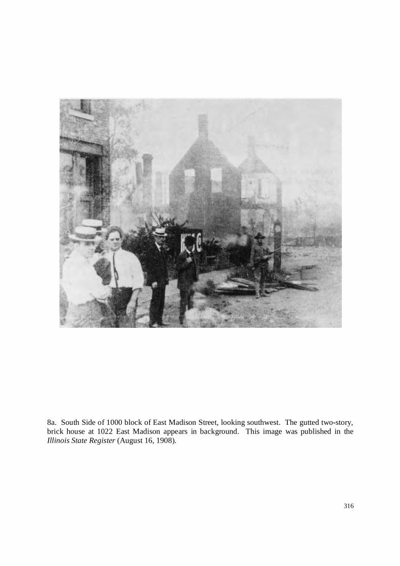
316
8a. South Side of 1000 block of East Madison Street, looking southwest. The gutted two-story,brick house at 1022 East Madison appears in background. This image was published in theIllinois State Register (August 16, 1908).

317
8b. Two pages from the souvenir booklet published by the Illinois State Register (1908). Top:Cover page. Bottom: Page 1 of images illustrating the south side of the 1000 block of EastMadison Street, looking southwest. The gutted two-story, brick house at 1022 East Madisonappears in background (http://cowanauctions.com/auctions/item.aspx?id=59759).

318
8b. Two postcard views of the gutted two-story, brick house at 1022 East Madison Street,looking southwest (originally published in the Illinois State Register, August 16, 1908). Bothimages are captioned “Scene In Burned District / Riot Aug. 15 ’08.”Top: http://cultheritage.com/unt/10958-springfield_illinois_race_war__scene_in_burned_district__riot_aug_14__1908_a.html;Bottom: ALPLM Ide Collection PC9 (lacks whole postcard detail).

319
9. Another view of the gutted two-story, brick house at 1022 East Madison Street, looking southwest. The junction of the Wabashand Illinois Central Railroads can be seen in background, with the State Capitol building in far distance(http://library.uis.edu/archives/localhistory/riotphotos.html; From the Booth-Grunendike Collection, Archives/Special Collections,Brookens Library, University of Illinois at Springfield).

320
10a. View of a saloon located at 1101 East Madison (on the northeast corner of Madison and Eleventh streets), which was ownedand/or operated by N. J. Poston (black). The brick saloon was badly damaged by the mob. The image is from a scrap book from circa1908 (http://cultheritage.com/unt/10335-very_rare_historical_1908_race_riots_springfield_il___rppc_photo_album_art_work.html).

321
10b Enlarged image from previous scrap book illustrating Poston’s saloon on Madison Street.

322
11a. Two views of page labeled “Ruined Negro Houses” from circa 1908 scrap book. Thesehouses were located on the east side of the 300 block of North Eleventh Street, lookingsoutheast.http://cultheritage.com/unt/10335-very_rare_historical_1908_race_riots_springfield_il___rppc_photo_album_art_work.html

323
11b. View of burned housing on the east side of the 300 block of North Eleventh Street, lookingnortheast (Walling 1908:530).

324
12a. View of an unidentified location, but suspected to be the south side of the 1100 block ofEast Madison Street, looking southwest towards Eleventh Street(http://www.ustrek.org/odyssey/semester2/013101/justsmoke_bg.html).
12b. Unidentified photograph location, but suspected to be the south side of the 1100 block ofEast Madison Street, looking southwest towards Eleventh Street (ALPLM Ides Collection PC8).

325
13. North side of 1100 block of East Madison Street, looking north and showing ruins of house numbers 1113 through 1129. Thebuilding shown at far right is the saloon where Scott Burton was lynched (ALPLM Ide Collection, NG5797).

326
14a. Top: Detail of postcard image illustrating the north side of 1100 block of East MadisonStreet, looking northeast and showing the ruins of house numbers 1121 through 1129 EastMadison Street (Photo is reversed; see previous and following images). Bottom: Postcard withtwo images of riot aftermath, and handwritten text “Nigger Dives Burned on Madison St.”(Postcard image courtesy of Richard Hart; see also http://www.lib.niu.edu/1996/iht329622.html).

327
14b. North side of 1100 block of East Madison Street, looking northeast and showing the ruinsof house numbers 1121 through 1129. Top: Image as published in the Illinois State Register(August 16, 1908). Bottom: Postcard image captioned “Scene in Burned District / Riot Aug. 14,‘08” (http://www.worthpoint.com/worthopedia/springfield-illinois-race-riot-ruins-00-10s)

328
14c-d. Two identical views of the north side of the 1100 block of East Madison Street, lookingnortheast and showing the ruins of house numbers 1121 through 1129.Top: ALPLM Ide Collection PC14. Bottom: http://cultheritage.com/unt/10957-springfield_illinois_race_war__scene_in_burned_district__riot_aug_14__1908_b.html

329
15a. National Guard troops posing in front of the ruins of 1121 East Madison Street in theimmediate aftermath of the riot (ALPM Ide Collection PC15).
15b. View from nearly same vantage point (Source unknown, from “Shame” VideoDocumentary). One of the few images that illustrates displaced African-American citizens[http://www.npr.org/templates/story/story.php?storyId=93606402 cites ALPLM as source].

330
15. Left: “A Looted Negro Saloon / Soldiers searching for dead bodies” (Walling 1908:533). Right: Postcard image of “Tree wherenegro was Lynched” (http://www.epa.illinois.gov/black-history-month/sculpture and http://cultheritage.com/unt/10960-springfield_illinois_race_war__riot__aug_1908__lynching_tree.html).

331
16a. Two views of the saloon at the northwest corner of Madison and Twelfth streets, whereScott Burton was lynched, with post-riot crowd gathered in front (Top: Ebay image labeled “XRemains of Tree Where Negro Was Hanged/ Springfield Race War Aug ‘08”). Bottom:Postcard (Courtesy of Richard Hart).

332
16b. Another view of saloon at the northwest corner of Madison and Twelfth streets, where Scott Burton was lynched, with NationalGuard troops stationed in front (ALPLM Ide Collection PC22).

333
16c-d. Another two views of the saloon at the northwest corner of Madison and Twelfth streets, where Scott Burton was lynched.Left: Illinois State Register, August 21, 1908. Right: Scrapbook (Cultheritage.com).

334
17. Another image of the saloon at the northwest corner of Madison and Twelfth streets, whereScott Burton was lynched (http://library.uis.edu/archives/localhistory/riotphotos.html; From theBooth-Grunendike Collection, Archives/Special Collections, Brookens Library, University ofIllinois at Springfield).

335
18. General view of the 1100 block of East Madison Street, looking west from the intersectionof Twelfth and Madison streets. The saloon where the Burton lynching occurred appears atright. Page from scrap book (top), and detail of picture (bottom)(http://cultheritage.com/unt/10335-very_rare_historical_1908_race_riots_springfield_il___rppc_photo_album_art_work.html).

336
18. South side of the 1100 block of East Mason Street, looking west and showing ruins of houses at numbers 1128 and 1130 inforeground and damaged house at 1126 in background (ALPLM Ide Collection, NG5793).

337
20. Top: Detail view of postcard illustrating the South side of the 1100 block of East MasonStreet, looking southwest from the intersection of Mason and Twelfth Street (similar to singlecard image at http://www.lib.niu.edu/1996/iht329622.html). Labeled “12 & Madison BurntNegro homes / Mob Violence Springfield 8-15-08.” Bottom: Postcard with two images of riotaftermath, and handwritten text “Nigger Dives Burned on Madison St.” (Postcard image courtesyof Richard Hart).

338
Ruins of the home of Ina Williams. Location yet to be determined (ALPLM Ide CollectionPC6).
This picture of an unburned house, with white flag, was also published in Walling (1908:531).Its location is unknown.

339
APPENDIX III
Summary of Springfield City Directories by Street Address,Site 11Sg1432

340
Date Address Name
1876 301 North Tenth St. Eva Westenberger
1892 306[sic] North Tenth St. M. Howard (col)
1894 301 North Tenth St. Mrs. L. Lewis (col)
1896 307[sic] North Tenth St. Mrs. Lina Lewis
1902 301 North Tenth St. E. Louis (col)
1904 301 North Tenth St. Mrs. A. Conley (col)
1905 301 North Tenth St. Maude Johnson (col)
1905 301 North Tenth St. T. A. Hymes
1906 301 North Tenth St. Robert Darden (col)
1907 301 North Tenth St. Wm. Smith (col)
1908 301 North Tenth St. Mrs. Smith, Jr. (col)
1891 303 North Tenth St. Jas. L. Graberg (col)
1896 307 North Tenth St. Mrs. Ling Lewis
1874 311 North Tenth St. Belle Watkins
1875 311 North Tenth St. Ann E. Dick
1876 311 North Tenth St. Ann E. Dick
1879 311 North Tenth St. Belle Watkins
1880 311 North Tenth St. Belle Watkins
1887 311 North Tenth St. Henry Horn
1891 311 North Tenth St. Quinn Donnegan (col)
1892 311 North Tenth St. Quinn Donnegan (col)
1894 311 North Tenth St. Wm. Bosley (col)
1894 311 North Tenth St. Robert Jones (col)
1896 311 North Tenth St. Wm. Bosley (col)
1898 311 North Tenth St. Wm. Bosley (col)
1902 311 North Tenth St. Mrs. M. C. Jones
1904 311 North Tenth St. Mary C. Jones (col)
1905 311 North Tenth St. Mrs. Mary Jones (col)
1906 311 North Tenth St. vacant
1907 311 North Tenth St. Suzie Newton (col)
1908 311 North Tenth St. vacant
1875 313 North Tenth St. Daniel Faro (col)
1875 313 North Tenth St. Joseph Faro (col)
1876 313 North Tenth St. Belle Watkins
1879 313 North Tenth St.Faro Family [multiple
entries]
1880 313 North Tenth St. Mary Faro

341
1891 313 North Tenth St. John S. Bailor (col)
1892 313 North Tenth St. Mrs. S. Harris (col)
1894 313 North Tenth St. Mrs. S. Harris (col)
1894 313 North Tenth St. Thomas Fry (col)
1896 313 North Tenth St. Theodore Esslinger
1898 313 North Tenth St. T.E. Butler
1898 313 North Tenth St. John Skelski
1902 313 North Tenth St. Mrs. A. Conley
1904 313 North Tenth St. Mrs. H. Butler
1904 313 North Tenth St. Clara Jones
1905 313 North Tenth St. vacant
1906 313 North Tenth St. L. Thomas (col)
1906 313 North Tenth St. J. Smith (col)
1907 313 North Tenth St. Lloyd Thomas (col)
1907 313 North Tenth St. Warren Minard (col)
1894 315 North Tenth St. Minnie Howard
1902 315 North Tenth St. S. Greenlee (col)
1902 315 North Tenth St. A. Jones (col)
1904 315 North Tenth St. S. Greenlee (col)
1905 315 North Tenth St. J. W. Diggs (col)
1905 315 North Tenth St. L. Thomas (col)
1906 315 North Tenth St. vacant
1906 315 North Tenth St. (rear) W. W. Minard (col)
1894 317 North Tenth St. Mrs. M. Reed (col)
1898 317 North Tenth St. Samuel Jones (col)
1898 317 North Tenth St. (rear) Mrs. M. J. Mc??
1891 319 North Tenth St. Miss Rosa Reed
1892 319 North Tenth St. Mrs. R. Williams (col)
1892 319 North Tenth St. Mrs. Mollie Lee (col)
1894 319 North Tenth St. vacant
1896 319 North Tenth St. Allen Crannberry
1896 319 North Tenth St. Syrus Greenlee (col)
1898 319 North Tenth St. vacant
1891 321 North Tenth St. Milton Boon (col)
1892 321 North Tenth St. vacant
1896 321 North Tenth St. Miss Minnie Howard
1891 323 North Tenth St. Mrs. S. Harris (col)
1892 323 North Tenth St. W. White (col)

342
1896 323 North Tenth St. Mrs. Lou Clark
1898 323 North Tenth St. vacant
1902 323 North Tenth St. J. Keeling (col)
1904 323 North Tenth St. J. Keeling (col)
1905 323 North Tenth St. L. Mitchell (col)
1906 323 North Tenth St. Ella Bailey (col)
1907 323 North Tenth St. vacant
1908 323 North Tenth St. vacant
1875 325 North Tenth St. George Bailey (col)
1879 325 North Tenth St. Lizzie Kendall
1880 325 North Tenth St. Lizzie Kendall
1880 325 North Tenth St. Miss Julia Vineyard
1887 325 North Tenth St. Frank Hickox
1891 325 North Tenth St. Alfred White (col)
1892 325 North Tenth St. Alfred White (col)
1892 325 North Tenth St. J. Jones (col)
1894 325 North Tenth St. Alfred White (col)
1894 325 North Tenth St. J. Jones (col)
1896 325 North Tenth St. Alfred White (col)
1898 325 North Tenth St. Alfred White (col)
1898 325 North Tenth St. Mrs. S. J. Words (col)
1902 325 North Tenth St. Mrs. E. White (col)
1902 325 North Tenth St. E. Mallory (col)
1902 325 North Tenth St. B. Barton (col)
1904 325 North Tenth St. H. January ?? (col)
1904 325 North Tenth St. Mrs. S. White (col)
1905 325 North Tenth St. Laura Clay (col)
1905 325 North Tenth St. H. Williams (col)
1906 325 North Tenth St. Mrs. M. C. Jones
1907 325 North Tenth St. M. C. Jones (col)
1908 325 North Tenth St. Mrs. M. C. Jones (col)
1909 325 North Tenth St. Mrs. M. C. Jones (col)
1910 325 North Tenth St. Mrs. M. C. Jones (col)
1892 327 North Tenth St. D. Jones (col)
1892 327 North Tenth St. S. Schwartz
1892 327 North Tenth St. S. Oppelman
1894 327 North Tenth St. S. Schwartz
1894 327 North Tenth St. S. Oppelman
1894 327½ North Tenth St. Miss Fannie Carrol
1896 327 North Tenth St. Abraham Myer

343
APPENDIX IV
Summary of Newspaper Research by Street Address,Site 11Sg1432

344
Day/Month Year Paper Address Name Event
2/6 1899 DISJ 301 North 10th St. Henry J. Moore (col) Died of Consumption at his home (24)
7/7 1899 DISJ 301 North 10th St. William T. Hughes & Florence Williams Marriage license recorded (aged 25 and 26 resp.)
12/4 1902 DISJ 301 North 10th St. Harriet W. Allen (col) Infant son died at family residence
12/5 1902 DISJ 301 North 10th St. Harriet W. Allen (col) Funeral for infant son
8/22 1903 DISR 301 North 10th St. Mr. & Mrs. William Oglesby Birth of fourth son
6/19 1904 DISR 301 North 10th St. Wm. Johnson $2; groceries
4/23 1905 DISJ 301 North 10th St. Anna Conley (col) Death of complication of diseases (42)
4/27 1905 DISJ 301 North 10th St. Anna Conley Funeral
1/17 1905 DISJ 301 North 10th St. Wanted-Work by the day by competent woman
1/29 1905 DISJ 301 North 10th St. Experienced Colored Lady Cook Wanting Work
6/16 1905 DISR Mary Smith (col) Received aid for burial and grave: $5
10/13 1905 DISR 301 North 10th St. Winnetta Conley Received marriage license (18)
9/18 1906 DISR 301 North 10th St. Grace Page Received $2 for grocery assistance
9/13 1908 DISJ 301 North 10th St. Callie Smith Claim Filed Against City
9/13 1908 DISR 301 North 10th St. Mary Smith Claim Filed Against City
8/18 1908 DISJ 301 North 10th St. Will Smith Badly Beaten
8/16 1908 DISJ 301 North 10th St. Will Smith Revised List of Casualties (badly beat face, chest, arms)
8/29 1908 DISR North 10th St. Will Smith [Sr.] Claim Filed Against City
8/29 1908 DISR North 10th St. Will Smith, Jr. Claim Filed Against City
9/5 1908 DISJ 301 North 10th St. Will Smith List of damaged properties; owner and occupant
9/13 1908 DISR 301 North 10th St. Mary Smith Filed Suit Against City, for personal property valued at $302.83
9/13 1908 DISR 301 North 10th St. Callie Smith Filed Suit Against City, for personal property valued at $268.15
9/5 1908 DISJ 301 North 10th St. George Westenberger (owner) Riot: Frame residence destroyed
9/5 1908 DISJ 301 North 10th St. Will Smith (occupant) Riot: Frame residence destroyed
10/27 1873 DISJ 311 North 10th St. Housekeeper seeks Work
5/22 1902 DISJ 311 North 10th St. Ora Jones (col) Daughter of Mary Jones; died of consumption (22)

345
9/1 1902 DISJ 311 North 10th St. Edward Jones Son of Wm. Jones; Funeral
9/12 1902 DISJ 311 North 10th St. Wm. Bosley Grocery Assistance
12/12 1902 DISJ 311 North 10th St. Mary Scott Received aid for groceries; $10
9/4 1903 DISJ 311 North 10th St. Young Colored Man Seeks Job as Coachman
3/14 1903 DISJ 311 North 10th St. Wm. Bosley Received aid for groceries; $4
3/15 1904 DISJ 311 North 10th St. Wm. Bosley (col) Receives aid for groceries and coal; $9
4/5 1904 DISJ 311 North 10th St. Willie Jones and Viola Johnson Receive marriage licence (22 and 20, respectively)
6/19 1904 DISR 311 North 10th St. Mary Scott $2; groceries
9/20 1904 DISR 311 North 10th St. Mary Scott Receives aid for groceries and coal; $2
11/15 1905 DISJ 311 North 10th St. Mrs. Hester Butler Died of Hemorrhaged Brain (52); getting water
3/20 1906 DISR 311 North 10th St. Wm. Bosley Received aid for coal; $7.50
9/11 1908 DISJ 311 North 10th St. R. N. Wright Claim Filed Against City
9/11 1908 DISJ 311 North 10th St. R. N. Wright Filed Claim Against City; Personal Property; $180.50
9/11 1908 DISJ 311 North 10th St. Fitz, Westenberger & Moore Filed Claim Against City; Furniture; $78.00
1/18 1889 DISR 313 North 10th St. Jerry McKinney Cincinnati railroad worker; dangerely ill at house of mother
7/9 1891 DISR 313 North 10th St. John S. Balor Residence; City directory errors noted
7/9 1891 DISR 313 North 10th St. William H. Balor Boarder; City directory errors noted
1/30 1892 DISJ 313 North 10th St. Celia J. Bosley Death notice (69)
2/6 1892 SC 313 North 10th St. Mrs. Celia Bosley Obituary
2/22 1898 DISR 313 North 10th St. Mrs. J. Bryant Moving to Beardstown
11/22 1898 DISJ 313 North 10th St. Mr. & Mrs. John Swaringer Death of infant son (3 months old)
4/30 1899 DISJ 313 North 10th St. Thomas Butler Death of consumption (37 year old horse trader)
11/22 1902 DISJ 313 North 10th St. Mr. & Mrs. Fred Curtis Death of only child of pneumonia (2 months old)
11/25 1902 DISJ 313 North 10th St. Ada Huey (col) Funeral notice; suicide (carbolic acid)
11/26 1902 DISR 313 North 10th St. Julia Haughey Funeral notice
7/24 1904 DISR 313 North 10th St. Bert Thrasher Scavenger Arrested
6/15 1905 DISR 313 North 10th St. John Davis Received aid for groceries; $2

346
6/16 1905 DISR 313 North 10th St. Erle Davis Received aid for groceries; $4
3/12 1908 DISR 313 North 10th St. Warren W. Minnard (col) Cook at St. Nicholas; dropped dead (56 years old)
9/10 1908 DISR 313 North 10th St. Mrs. T. Schwartz Files Claim with City for Damage to House, $1,800
9/16 1908 DISR 313 North 10th St. Riot damage, with 317; Residence destroyed; damage $1,000
9/21 1908 DISR 313 North 10th St. Riot damage, with 317; Residence destroyed; damage $1,000
7/15 1909 DISJ 313 North 10th St. Theresa Schwartz Files Claim with Court for Damage to House, $2,000
11/6 1895 DISR 315 North 10th St. Lillie Williams (col) License to marry
8/17 1897 DISR 315 North 10th St. Mrs. Wallace Warrant; Keeping House of Ill Fame
9/8 1897 DISJ 315 North 10th St. Mrs. Walker Accused of Prostitution; Dismissed
8/29 1900 DISJ 315 North 10th St. Grant Ramsey & Lillie F. Schribner Received marriage license
4/10 1903 DISJ 315 North 10th St. Clara York Youth sent to juvenile home
4/10 1903 DISR 315 North 10th St. Minnie Bright Madame Arrested; House of Prostitution
3/3 1905 DISR 315 North 10th St. William and Viola Jones Assault and Battery against wife
3/9 1905 DISJ 315 North 10th St. Massiege S. Cain Wanted: Place to Work advertisement
6/15 1905 DISR 315 North 10th St. Lloyd Thomas Received aid for groceries; $2
9/21 1908 DISR 317 North 10th St. Riot damage, with 313; Residence destroyed; damage $1,000
9/16 1908 DISR 317 North 10th St. Riot damage, with 313; Residence destroyed; damage $1,000
319 North 10th St. No entries noted.
7/4 1895 DISJ 323 North 10th St. Lincoln Morgan Shot in hand
12/24 1895 DISR 323 North 10th St. John Blue Killed in Industrial Accident at Rolling Mills
12/25 1895 DISJ 323 North 10th St. John Blue Funeral at House

347
12/26 1895 DISJ 323 North 10th St. John Blue Funeral at House
1/24 1898 DISJ 323 North 10th St. Jane Watson Funeral notice
3/14 1903 DISJ 323 North 10th St. Jennie King Received aid for groceries and coal; $8
3/21 1903 DISJ 323 North 10th St. Joseph Keeling Advertisement: Carpet cleaning, fitting, laying
8/11 1903 DISR 323 North 10th St. Joseph Merry & Jennie Green Received license to marry (38 and 30, respectively)
12/14 1906 DISR 323 North 10th St. Charles Lewis Received aid for groceries: $4
12/21 1906 DISR 323 North 10th St. Charles Lewis Received aid for groceries; $4
3/15 1907 DISR 323 North 10th St. Jessie Black Received aid for groceries; $10
3/15 1907 DISR 323 North 10th St. Charles Lewis Received aid for groceries; $8
3/19 1907 DISR 323 North 10th St. Charles Lewis Received aid for groceries; $8
6/13 1907 DISR 323 North 10th St. Jessie Black Received aid for groceries: $4
6/13 1907 DISR 323 North 10th St. Charles Lewis Received aid for groceries: $2
6/14 1907 DISR 323 North 10th St. Jessie Black Received aid for groceries: $4
6/14 1907 DISR 323 North 10th St. Charles Lewis Received aid for groceries: $2
9/13 1907 DISR 323 North 10th St. Charles Lewis Received aid for groceries; $4
9/5 1908 DISJ 323 North 10th St. R. L. McQuire (owner) Frame residence destroyed
9/5 1908 DISJ 323 North 10th St. H. Stoutmeyer (occupant) Frame residence destroyed
9/12 1908 DISJ 323 North 10th St. R. L. McQuire (owner) Files claim against city; multiple properties
1/17 1892 DISR 325 North 10th St. Addie White and James Jones Married at House
5/22 1895 DISR 325 North 10th St. Lilly Doyle Licensed to Marry [with Macon Thompson?] (25)
6/22 1895 DISR 325 North 10th St. Lilly Doyle Licensed to Marry [with Macon Thompson?] (25)
12/11 1898 DISJ 325 North 10th St. Alfred White (col) Death notice [daughter is Addie Jones]
7/22 1899 DISJ 325 North 10th St. Edward Mallory Marriage license (27)
7/22 1899 DISJ 325 North 10th St. Mabel Day Marriage license (26)
10/29 1899 DISJ 325 North 10th St. James Jones (col) Funeral notice
12/12 1902 DISJ 325 North 10th St. Eliza White Received aid for groceries: $6
2/13 1903 DISR 325 North 10th St. Miss Hazel White Ill at St. John's; Relocated home

348
2/26 1903 DISJ 325 North 10th St. Miss Hazel White Ill at St. John's; Relocated home
3/14 1903 DISJ 325 North 10th St. Eliza White Received aid for groceries: $6
5/26 1903 DISJ 325 North 10th St. Hazel White (col) Feared eloped with young white Hebrew man
5/26 1903 DISJ 325 North 10th St. Addie Barton (col) Mother of Hazel; feared eloped with white man
6/12 1903 DISJ 325 North 10th St. Eliza White (col) Received aid for groceries: $9
9/11 1903 DISR 325 North 10th St. Eliza White (col) Received aid for groceries: $9
9/15 1903 DISR 325 North 10th St. Eliza White (col) Received aid for groceries: $9
12/11 1903 DISR 325 North 10th St. Eliza White (col) Received aid for groceries: $9
12/15 1903 DISR 325 North 10th St. Eliza White (col) Received aid for groceries: $9
3/6 1904 DISJ 325 North 10th St. Wanted: Washing to Take Home
3/12 1904 DISR 325 North 10th St. Laura Clay (col) Received aid for groceries and coal; $20
3/12 1904 DISR 325 North 10th St. Lizzie Conzzin (col) Received aid for groceries and coal; $9
3/15 1904 DISJ 325 North 10th St. Laura Clay (col) Receives aid for groceries and coal; $20
3/15 1904 DISJ 325 North 10th St. Lizzie Conzzin (col) Receives aid for groceries and coal; $9
3/15 1904 DISR 325 North 10th St. Laura Clay (col) Recived aid for groceries and coal; $20
3/15 1904 DISR 325 North 10th St. Lizzie Conzzin (col) Received aid for groceries and coal; $9
6/1 1904 DISJ 325 North 10th St. Elizabeth Cozzens Death notice [sister is Addie Barton]
6/3 1904 DISR 325 North 10th St. Elizabeth Cozzens Death notice [sister is Addie Barton]
6/19 1904 DISR 325 North 10th St. Laura Clay $10; groceries and coal
6/19 1904 DISR 325 North 10th St. Lizzie Couzzin $6; groceries and coal
6/21 1904 DISR 325 North 10th St. Laura Clay (col) Recived aid for groceries and coal; $10
6/21 1904 DISR 325 North 10th St. Lizzie Conzzin (col) Received aid for groceries and coal; $6
3/18 1905 DISR 325 North 10th St. Laura Clay Received aid for coal: $4.50
3/21 1905 DISR 325 North 10th St. Laura Clay Received aid for coal: $4.50
5/18 1905 DISJ 325 North 10th St. Wanted By Competent Woman: Family and Bundle Washing
12/19 1905 DISR 325 North 10th St. Laura Clay Received aid for groceries: $2
12/19 1905 DISR 325 North 10th St. Eliza Lee Received aid for coal: $4
3/20 1906 DISR 325 North 10th St. Laura Clay (col) Received aid for groceries and coal; $7
10/15 1906 DISJ 325 North 10th St. William Jones Died after extended illness, complication of diseases (24)

349
10/15 1906 DISJ 325 North 10th St. Mrs. Mary C. Jones Mother of William (deceased)
10/16 1906 DISJ 325 North 10th St. William Jones Funeral notice
3/15 1907 DISR 325 North 10th St. William Bosely Received aid for coal: $5
3/19 1907 DISR 325 North 10th St. William Bosely Received aid for coal: $5
3/25 1907 DISR 325 North 10th St. Wm. Bosley Received aid for coal; $5
6/13 1907 DISRN 10th, btw Madison& Mason Wm. Bosley Received aid for coal; $2.50
6/14 1907 DISRN 10th, btw Madison& Mason Wm. Bosley Received aid for coal; $2.50
11/30 1907 DISJ 325 North 10th St. William Bosely Funeral notice
12/1 1907 DISJ 325 North 10th St. William Bosely Funeral notice
3/10 1910 DISR 325 North 10th St. Mrs. Mary Jones Roof Fire
3/10 1910 DISJ 325 North 10th St. Mary Jones Roof Fire
3/10 1910 DISR 325 North 10th St. Mary Jones Roof Fire
3/10 1910 DISR 325 North 10th St. Mrs. Mary Jones Roof Fire
3/10 1910 DISR 325 North 10th St. T. K. Tanner Owner of house occupied by Mary Jones
2/15 1916 DISR 325 North 10th St. Mrs. Mary January Patient at St. John's; awaiting surgury
6/12 1916 DISR 325 North 10th St. James January Auto Accident; Badly Crushed chest
11/6 1916 DISR 325 North 10th St. Alice Davis (col) Beer Party Followed by Host Slain With Axe
11/7 1916 DISR 325 North 10th St. Louis McCloud Arrested for murder of "Mother" Davis
11/10 1916 DISR 325 North 10th St. Lee Hey Chinaman sought in murder of "Mother" Davis
3/5 1918 DISJ 325 North 10th St. Solomon Large Hit by Train and Killed
3/5 1918 DISJ 325 North 10th St. Ruth Irwin Large's Daughter
3/5 1918 DISJ 325 North 10th St. Solomon Large Killed by train (86)
3/5 1918 DISJ 325 North 10th St. Ruth Irwin Daugher of Solomon Large
3/5 1918 DISR 325 North 10th St. Solomon Large Killed by train (86)
5/20 1919 DISJ 325 North 10th St. Joseph B. Lawson Soldier Returns From Oversees
8/31 1920 DISJ 325 North 10th St. Morris "Headlight" Howard Shot while beating Robinson's Mother
8/31 1920 DISJ 325 North 10th St. Augustus Robinson (col) Shot Howard for Beating Mother
9/13 1920 DISR 325 North 10th St. Morris "Headlight" Howard Shot while beating Robinson's Mother
9/13 1920 DISR 325 North 10th St. Augustus Robinson Shot Howard for Beating Mother

350
9/29 1920 DISJ 325 North 10th St. Morris "Headlight" Howard Died of gunshot wounds
9/29 1920 DISJ 325 North 10th St. Augustus Robinson Arrested for murder of Howard
8/16 1921 DISJ 325 North 10th St. Edmund Richmond Admitted to hospital
8/28 1921 DISR 325 North 10th St. Kittie Richmond Left Hospital after receiving treatment
4/4 1922 DISJ 325 North 10th St. Louise Thomas (col) Robbed of cash in sock by W. L. Griffin
4/6 1922 DISJ 325 North 10th St. Louise Thomas Drops charges on W. L. Griffin
9/20 1895 DISR 327 North 10th Street Walter Dean (col) & Rosa Williams (col) License to marry (25 & 22, respectively)
329 North 10th St. No entries noted.

351
APPENDIX V
Summary of Newspaper Research for “Tenth and Madison” Location,Site 11Sg1432

352
Day/Month Year Paper Address Name Event
2/11 1867 DISJ Corner, Tenth & Madison Grimsley/Phoenix Mill Mill to be sold at auction
2/11 1867 DISJ Mollie Hamilton Keeper of "Suspicious" house
10/16 1872 DISR Corner, Tenth & Madison Henry Brown (col) Son killed; playing on lumber pile
2/9 1878 DISJ Corner, Tenth & Madison Joseph Viera Died suddenly of apoplexy
1/3 1885 DISJ Corner, Tenth & Madison Dan Sutton's Ranch Quartet of dusky damsels of doubtful character arrested
8/12 1885 DISJ Corner, Tenth & Madison Old Wackerle Mill Mill being torn down
8/12 1885 DISJ N. Tenth Case of infanticide being investigated
3/2 1885 DISj Corner, Tenth & Madison Railroad Watch House Mike Burns accosted young Miss Lizzie Thomas
10/27 1887 DISR2nd House, NW Corner, Tenth
& Madison Sarah Clark Found dead of loathsome disease in house
5/28 1888 DISJ NW Corner, Tenth & Madison Jack O'Hunter Potential suicide at Lynch Resort; taken to St. John's Hospital
5/28 1888 DISJ NW Corner, Tenth & Madison Mollie Lynch Landlady at the Lynch Resort
8/24 1889 DISR Tenth & Madison Levi Thomas Deathly ill with typhoid fever
8/24 1889 DISR Corner, Tenth & Madison Levi Thomas Died at his home
1/8 1890 DISR NE Corner, Tenth & Madison Cement Factory Ground being cleared for construction of new factory
3/12 1890 DISR Corner, Tenth & Madison J. A. Booth With Brennan and Osborne; Traveling keg of beer and disturbance
4/24 1890 DISJ Corner, Tenth & Madison George TrentLives with Cranberry family; relates info regarding murder of Henry
Jackson
8/3 1890 DISJ Tenth & Madison Charles Havey Struck on head and robbed
8/12 1890 DISR NE Corner, Tenth & Madison Fitzgerald Plaster Co. Construction of new 3-story factory building
8/20 1890 DISJ Corner, Tenth & MadisonJoe Smith & Lena
Wagner Domestic disturbance.
10/21 1890 DISRAlley (btwn 9-10th, Madison-
Mason) Nellie Woods Negress badly bitten by Nellie Wood's dog in alley
9/19 1893 DISR Tenth & Madison Melinda Reed Fool farmer robbed at Melinda Reed's negro house of ill-fame
6/9 1894 DISR Tenth & Madison Henry Conners Arrested for robbery
11/30 1894 DISR Tenth & Madison William Mullen Fire; four-room house; Mullen tenant; Kanner owner ($100 damage)
7/2 1895 DISR Tenth & MadisonBen Loomis & William
Jacoby Jacoby slashed by Loomis; refuses to press charges
5/1 1895 DISRAlley (btwn 9-10th, Madison-
Mason) Gertie Harris Shot boyfriend (Horace Lewis) in alley during quarrel; Harris killed
7/25 1895 DISJ Tenth & Madison Edward Range Beat old man; warrant issued; found with Delia Flynn and Dora Jones
9/3 1895 DISR Tenth & Madison Lena Smart Jesse Fagan, carpenter at Fairgrounds, robbed by negress of $96

353
9/22 1895 DISJ Corner, Tenth & Madison Lulu Jones (col) Accused of robbing one man of $16, and Jesse Fagan of $96
9/27 1895 DISR Tenth & Madison John Fathamer Coming from house; robbed of $50 by man from Dan Smith's Saloon
9/29 1895 DISJ Near Tenth & Madison Joe Smith Italian organ grinder with monkey; monkey bit boy (Harry White)
10/5 1895 DISR Tenth & Madison William Fathauer Fathauer "robbed" at Lizzie Cousins' house of ill-fame
10/18 1895 DISR Tenth & MadisonLena Dairy (nee
Lanson) Dairy married John Langley (a 75-yr old farmer from Mechanicsburg)
11/24 1895 DISR Tenth & MadisonDella Flynn & Lillie
Williams Two men attacked and robbed by girls at negro resort
11/28 1895 DISR Around Tenth & Madison Lou Maxwell's Place Negro Dive Raided; Capitola Black and Nell Brown arrested
11/28 1895 DISR Around Tenth & Madison Etta Edwards' House Negro Dive Raided
11/28 1895 DISR Around Tenth & Madison Lizzie Kerns' Dive Negro Dive Raided
11/28 1895 DISR Around Tenth & Madison Rosie Dean's House Negro Dive Raided
11/28 1895 DISR Around Tenth & Madison Lou Wilson Negro Dive Raided; Madame at Bill Head's Old Dive on Mason Street
8/22 1895 DISJ Madison, near TenthMabel Baxter's House
of Ill-fame Arrested for harboring underage girl
8/22 1895 DISJ East MadisonLou Grant's House of
Ill-fame Arrested for harboring underage girl
8/22 1895 DISJ East Mason Bill Head's Dive Arrested for harboring underage girl
1/5 1896 DISR Tenth & Madison Alexander Morrison Negro cook arrested for theft
3/16 1897 DISJ Tenth & Madison Wabash RR agree to install arc lamps at crossing, in pfererence to gates
5/21 1898 DISR Corner, Tenth & MadisonBenjamin Adkins &
Benjamin Horn Left Charlie Baxter's Saloon; fight ensued; Adkins shot in arm by Horn
12/19 1898 DISJ Near Tenth & MadisonMike Molnr & James
Miller Riverton coal miners arrested for fighting
5/12 1899 DISR Tenth & Madison Mike Fortune Arrested for theft at immoral resort run by Edna Nichols
6/13 1899 DISJ Tenth & Madison Isaac Newbolt Worker at Loper's Restaurant; robbed customer of watch; found at house
7/23 1899 DISJ Near Tenth & MadisonWilliam Smith &
Maggie Howey Arrested for distrubance; unplatted court known as Shinbone Alley
8/19 1899 DISJ Tenth & Madison Baxter's Saloon Railroad men and soldiers brawl
9/17 1899 DISR Tenth & Madison Fitzgerald Plaster Co. Advertisement
3/14 1901 DISR Tenth & Madison Mollie Drennan Lamp explosion; small fire
8/26 1900 DISJ Tenth & MadisonAnna & William
Hughes Domestic disturbance.
8/17 1901 DISR Tenth & MadisonWilliam "Tea Rose
Willie" Hughes Arrested for creating disturbance at Fisimmons' Saloon
2/11 1902 DISR Corner, Tenth & Madison Mrs. Lena Lewis Death notice (62)
2/13 1902 DISJ Corner, Tenth & Madison Mrs. Lena Lewis Death notice (62)
7/9 1902 DISJ Tenth & Madison Katie Lewis & Rose Lewis and Drake shot for not walking with Martin Edmundson

354
Drake
2/14 1902 DISJ Tenth & Madison Mrs. Lina Lewis Funeral
8/28 1902 DISJ Tenth & Madison Georgia Anderson Recovered stolen property from her house
3/30 1903 DISJ Tenth & Madison William Thomas Entered saloon/resort; played craps; beaten and robbed of $12
7/12 1902 DISJ Tenth & Madison Eddie Gomes Saloon Saloon licence suspended
1/24 1904 DISR Corner, Tenth & Madison George Taylor Taylor shot and beaten by Andrew Anderson
3/9 1904 DISJ Tenth & Madison Lloyd D. Conley Death notice of young child (2 years old)
5/21 1905 DISR Corner, Tenth & Madison Eddie Gomes Gomes and others arrested; Gomes saloon is at 930 E. Madison
9/9 1905 DISJ East Side, Tenth & Madison Roof fire at old frame residence; second one in short time
6/28 1906 DISJ Tenth & Madison Mildred Spriggs Notorious negro woman living in a shack attempted suicide
7/28 1906 DISR Corner, Tenth & MadisonAnnie Rhodes & Annie
Smith Rhodes attacked Smith with hammer over loss of her house to Smith
5/7 1907 DISR Tenth & Madison Frank White Hospitalized with consumption
8/3 1907 DISR Corner, Tenth & Madison Edward Fountain Fountain arrested for theft from Koluyz saloon
8/3 1907 DISR Corner, Tenth & Madison John Koluyz Saloon located at corner Tenth & Madison
8/27 1907 DISR Vicinity, Tenth & Madison Helen Williams Fined $100; given choice of leaving City or 6 months in jail
2/4 1910 DISR Tenth & MadisonEtta Patton (aka Anna
Patton) Arrested for accosting man and robbing him of $6
4/25 1910 DISR Near Tenth & MadisonWilliam & Tilford
Coleman Convicted of murder od Frank Scott during craps game; sent to State Pen
9/17 1921 DISR Tenth & Madison Agitation to build Union Station at this location
2/6 1958 DISJ Tenth & Madison Gypsum mill demolished; incorrectly states constructed in 1908 (photo)
6/16 1905 DISR [301 N. Tenth] Mary Smith (col) Received aid for burial and grave: $5

355
APPENDIX VI
Summary of Newspaper Research for“Shinbone Alley” and Cocaine Alley” Locations,
Springfield, Illinois

356
SHINBONEALLEY
7/20 1899 DISJ William Smith & Maggie Howey Arrested for disturbance at unplatted court, 10th and Madison
3/8 1893 DISR William ClayArrested; child molestation/attempted rape (btw Mad. & Mason, nr
10th)
3/13 1894 DISR Shanty fire (btw 8th & 9th; Adams & Washington)
8/8 1895 DISR Lincoln Morgan & Lou Belle Clark Arrested for assault and battery
7/28 1896 DISR Joe and Jennie Brown Arrested for vagrancy
9/19 1896 DISR Laura Driggs & Sadie Harris Arrested for larceny
9/19 1896 DISR Sam Curry & George Williams Curry fined $5 for assaulting Williams
3/30 1897 DISR Nellie Wilson; Scott & Richardson Stole diamond from Mollie Chambers' house
5/16 1897 DISREtta Page; Ollie Covington & George
Lewis Page had patterson and Lewis arrested for assault and battery
5/28 1897 DISR Frank Williams & Alonzo Smith Arrested and discharged for burglary
5/25 1898 DISR Fannie Wilson & Carrie Scott Scott accused Wilson's of running "robber's roost" at 322 N. 10th
9/26 1898 DISR Ivy Stephenson Arrested for disorderly conduct
10/28 1898 DISR William Shanks From Berlin vicinity; robbed of $5 by "loddies” of tenderloin district
COCAINEALLEY
6/3 1902 SN Mayor has plan for abolition/reformation of Alley
7/21 1898 DISJ George Lewis & Glen Arnold Robbed man by tracks
10/2 1898 DISR George Barnet, the "carver" badly cut visitor to district
12/28 1898 DISR Ivy Stephenson Jailed for failure to pay fine; disorderly conduct
5/30 1899 DISJ Ella Brown Arrested; more arrests to follow; behind Bob Winston residence
7/3 1899 DISJ Boehner & Loomis families Fight

357
APPENDIX VII
Summary of Newspaper Researchfor Landowner Isadore Kanner

358
11/9 1891 DISJ Isadore Kanner Arrested for Being Open on Sunday
6/30 1892 DISJ Isadore Kanner Fined $5 for Maintaining Nuisance Outhouse
11/1 1893 DISR Isadore Kanner Pawn Shop Reports Stolen Goods
2/28 1894 DISJ Isadore Kanner Arrested for Violation of City Ordinance
3/10 1894 DISR Isadore Kanner Fined $10 for Failure to File Proper Reports
5/7 1898 DISR Isadore Kanner Fails to Collect for Store Room Lease
12/16 1908 DISJ Isadore Kanner Proposes to Move Fire-damaged Houses
12/17 1908 DISR Isadore Kanner Plans to Move Houses Changed
7/25 1909 DISR Isadore Kanner Files Claim Against City for $10.000
12/16 1909 DISJ Isadore Kanner Owner of Building Housing Tavern; Sued

![John Alden Carpenter Collection [finding aid]. Music Division ...](https://static.fdokumen.com/doc/165x107/63283a2be491bcb36c0baaac/john-alden-carpenter-collection-finding-aid-music-division-.jpg)