CONCERNING THE GABC~VO-NAGYMARUS
473
INTERNATIONAL COURT OF JUSTICE CASE CONCERNING THE GABC~VO-NAGYMARUS PROJECT (HUNGARY ISLOVAKI A) COUNTER-MEMURIAL OF THE REPUBLIC OF HUNGARY ANNEXES SCIENTIFIC REPORTS AND STUDlES VOLUME 4 (PART 1) 5 DECEMBER 1994
-
Upload
khangminh22 -
Category
Documents
-
view
0 -
download
0
Transcript of CONCERNING THE GABC~VO-NAGYMARUS

INTERNATIONAL COURT OF JUSTICE
CASE
CONCERNING THE GABC~VO-NAGYMARUS
PROJECT
(HUNGARY ISLOVAKI A)
COUNTER-MEMURIAL
OF THE REPUBLIC OF HUNGARY
ANNEXES
SCIENTIFIC REPORTS AND STUDlES
VOLUME 4 (PART 1)
5 DECEMBER 1994
TABLE OF CONTENTS
Anrrex 2
An~iex 3
Annex 6
Arrnex 7
Annex 8
Annex 9
VOLUME 4 (PART 1) SCIENTTFIC &FORTS
BechteI Envirorirnental, Inc., Environmenta1 Evaluatiori of the Gabcikovo (Bos)! Nagymarcis River Barrage Systern, February, 1990
1. Mucha, GabCikovo-WWF, Pros arid Cons, BratisIava, ApriI 1994
J. Lüsing, Excerpt s h m Tfie GabEikovo-Nagyrnaros Project Impacts Uri Naiure And On The BaIance Of Nature, Essen, Novernber 1986
WorId WiIdIife Fund, Excerpts h m Position Taken by WWF (World WildIife Furid) with Regard ta the Gabeikovo Barrage Pruje~t, Rastatt, August I989
M. BaEik and J. KaiiS, Siiting ProbIem Arisirig WitIr The ReaIisatiorr Of The Gabeikovo Water Scheme, Bratislava, October 1991
K. Kern, Impacts Of The GabEikovolNagymaros Project Uri River MorphuIogy, FIuviaI Hydraulicç And Habitats, Karls- ruhe, FRG, August 3 1, 1994
K. Kern, Non-Structural SoIutionç To Riverbed Degradation - Experiences From The Upper mine And The Ausirian Danube, Karlsruhe, FRG, Beptember 9, 1994
1. ~ a c z a ~ , Tradi~ionaI Solutions To The Navigational Probiems Irr The Szigetkoz Sretch Of The Danube, Budapest, August 4, 1994
1. Laczay, Flood Protection and the GabEikovo-Nagyrnaroç Project, Budapest, 5th October 1994
Page
3

ENVIRONMENTAL EVALUATIUN OF THE GA~CIKOYO (B~S}-NAGYMAROS RIVER BARRAGE SYSTEM
subrnifted to OVIBER National lnvesfment Enterprise for Hydraulic Projects
prepared by BechreI Env ironmentaI, Inc.
Febmary, 1990
(Appendices 2-5 omirted)

Subiiritred lo:
OVIBER National Investment Enterprise for Hydraulic Projects H-1054 Budapest, Alkotmany U. 27-29 Hungary
Prepared by:
BechteI Environmental, Inc. 50 BeaIe Street San Francisco, California 94105-1 895
February 1990

TABLE OF CONTENTS
I INTRODUCTION
1.1 Purpose 1.2 Background Tnformatfon 1.3 Project Description
1.3.1 Physical Structures 1.3.2 P l a m e d Water Releases and Flow Regimes
1.4 Smmary and Conclusions
1.4.1 Summary 1.4.2 Conclusfons
1.5 Summary of Recommendations
1.5.1 Mitigation Recommendations 1,S.Z Monitoring Recommendations
2 IMPACT EVALUATION AHD MITIGATION KEASURES
2.1.1 Surface Warer 2.1.2 Ground Hater
2.2,1 Impact Methoàology 2.2-2 Impact D ~ S E U S S ~ O ~
2.3.1 Description of Significance Criteria 2 .3 .2 Discussfon of Impacts
2.4 Brchaealogy and His tor ic Monuments
2.4.1 D~scription of Sfgniflcance Criteria 2.4.2 Discussion of Impacts
2,5 Visual Resources
2.5.1 Description of Significance Criteria 2 . 5 . 2 Discussion of Impacts

Section
2.6 Recreation and Tourianr
2.5.1 Description of Sfgnlficance Criterla 2.6.2 Discussion of Impacts
2.7.1 Significance Criteris 2.7.2 Impact Dis~ussicn - Enployment, Income,
Grouth, and Development 2.7.3 Impaet Discussion - Regional, National,
and international Conditions
2.8 Çummary of Potential Impacts and Mitlgation Measures
3 MONITORING PROGRAM EVALUATIUH
3.1 Monitoring ProgramEvaluation
3.1.1 Surface Water Monitoring 3.1.2 Ground Water Monitoring 3.1.3 Biology 3.1.4 Land Use 3.1.5 Archaeology/Historfc Monuments 3.1.5 Visual Resources 3.1.7 Recreation, Ffshing Resources and Tourfsm 3.1.8 Socioecenornics
3.2 Summ8 ry of Recommendat f uns 3.3 Existing Monftoring Programs
3.3.1 Columbia River Operational Hydrornet Management System
3.3.2 Ohio River 3.3.3 Tennessee Valley Authority (TVA) 3 . 3 . 4 Coachella Valley W~ater Dlstrict
4 EXISTIHG MONITORING SYSTEMS I R THE UNITED STATES
5 BEGHTEL EXPERIENCE - ENVIROIPENTU EVALUATIONS PLND STUDIES

LIST OF TABLES
Table
2-1 ARCKAEOLOGICAL RESOURCES AFFEGTED BY CDHSTRUCTION ACTIVITIES
2-2 S m R Y OF IMPACTS AND MITIGATIOR E A X U R E S
3-1 SUHMARY OF MONITORTNG SYSTEH ECONMË~ATIOBS
Amendix 5
I BECHTEL EWIRONKEKTAL, INC. SERVICES
2 ENlrIRONMENTAL ASSESSMENTS AND IMPACT STUDIES
3 EXAMPLES OF BECHTEL'S ENVIRONMENTAL PROJECTS FOR PRIVATATE INDUSTRY
4 EXAMPLES OF RECENT BECHTEL EXPERIENCE IN KAZARDOUS WASTE SITE REMEDIATION SERVICES
5 EXAWLES OF INDUSTRIAL WASTEHATEB TREATMENT EXPERIENCE

1 Introduction

.Bechtel has independently reviewed the Gabcfkovo (Bos)-Xagymaros Barrage (GNB)
Profect in terms of potential environmental .fmpacts, operatIona1
considerations, and currently planned mitfgation measures. Xe have examined
the projtct from the standpoint of its stated goals of integrating and
optfmizing multivater resources for the purposes of power production,
nairigation, flcrod control, regional development, vater supply and vater
quality, agriculture and forestry, natural biological values (including
ffshery and wildlffef, recreatfon, vfsual enhancement, and preservation of
archaeological values.
Our approach to the envfronmentaI review was a multidisciplinary effort, which
focused on:
o Deflning-significmt impacts associated with the profect that warrant evaluation and mftigation
o Determini= additional basfline data needed for impact definition
o Reviewing planned mftigatfons tu reduce impacts to insignificant levels or to enhance projec t benefits
o Identifying additional investigation measures that cozrld reduce impacts fnrther
o Assessing effectiveness of the monftorlng program by defining prcoparational environmental conditions and operational conditions
Where possible, the significaace of potential project-related impacts vere
qualitatively defined in the context of construction and operation artivfties,
and the expected duration of the impacts. Impact discussions in this
evaluation reflect the amount o f dater and analyses available for the
environmental review, For example, the hydrologfc regime of the project are&

has been thoroughly atudied and potentially significant Impscrs have b t e n
identified by YIZITERV and irssociated experts and Bechtel concurs w f t h ~ h f s
assessrnent . More limited data and analyses tire available regarding
project-related fmpacta on bfolagfcal resources, Therefore, a more detailed
impact analysis vas made for biology than chat provided by YIZJTEEV. Our
impact analysfs considered the potential effects the projecc could have on the
environment's social beneffts tu man, such as agriculture and regional
deyelopment, and the impact of the project on the fntrfnsit values of
envfronmental resources auch as blology. Additional data collection and
rnodelfng is recommended where needed for either additional Impact definition
or detemination of the adequacy of the yroposed nrftfgation and monitoring
program.
We have approached the environmental evaluatron with the phffosophy that
impacts must be identiffed, appropriate mfrigatfons must be fn place prior to
project operation, and the profect monitoring program w i l l be used to ensure
the effectiveness of these mitigatfons.
1.2 BACKGROUND INFORMATION
Information used in the review of environmental effecta relkted tu the GNB
p r o f e ~ t are based upon:
o A 3-day site v i o i t to tbe project area
o Summary documents provfaed by YIZITERV f aee Appendix L f o r detai led list)
o Sslectad publfcotfona and
Q Tnterviews uith VIZITERV proftssionals and other experts
The site visit inclnded a review of constrnction e i t e s ut Dunakiliti weir,
Gabcikuvu pouer plant and navigation canal, Eagymaros barrage site, and
selected intercept c h b e l s and sidearms in the Szigetkoz. In addition, a
gerzeral reconnaissance vas rondueted along accessible aretra un the rigbt s ide
of the Dmube B l ~ e r from riisagrad to Suttü and on the left side c f the Danube
River from Hergymarcs to Szob. Al1 impact evalrratinns in Section 2 are bttsed

upon data end analyses provided by VIZITERV and interviews with VIZITFRV
proftssfonals aiad uther e x p e r t s . This Information and a list of experts
intervieued are summarfzed In Appendfx 1.
1.3 PROJECT DESCRIPTION
The physical structures, plamed vater relcases, and flov regimes of the GNB
projec t used as the baçfs fur waluating environmental impacts associated with
the project are described below. In this report, ve have evaluated the
cornplete GPra proifect, fncluding the Gabcikovo and Nagymaros barrage systems
and associated structures. The peak operatfng data used as design criteria
for the original conception of rht prriject and structures fs used i n th i s
evaluation. Kovever, I t should be noted that s t u d i e s are riurrently under way
tu rev f se those operational criteria.
1.3.1 Ph~sfcal Structures
The GNB project vil1 rtgulate Danube River fluws m e r an approxfmate 165 h
reach of the river from Bratislava to visegrid. Princf pal components of the
project i n both the Krmgarfan and Czechoslovakian t e r r i tor ies are:
O The upstream Hrusvv-Dunakiliti reservoir formed by the D r t n a k i l f t i barrage and Gabcikovo pover station
a The pover navigation canal that transports water from the upstream reservriir to the Gabcfkevo <Bos) power station
o The Gsbciko~o (Büs) poner station and shiplock
o The Nagymaroç barrage, paver station and shfplock wtrich regulates releases frum the lower reservofr
The Hrusev-Dunakilfti reserwir and Gabciko~o <Boa) power station, barrage,
and shiplock are scheduled for cornpletion and operation by 1990. Completion
of the Nagymaros barrage, peuer plant , and shiplock has been delayed
fndefinltely.
The environmental evaluation presented in Section 2 is Iimited to impacts
affectfng Hungarian t e r r i t o r i ~ s (right side of the Danube River), although we
recognize that both s ides of the Danube xi l l bc affectcd by the GNB projeci.

Barrages at Dunakiliti and Gabcikovo have created the Hrusov-Dlmakilirf
reservoir, vhich will provide an elevation drup naeded for pover generation
st Gabefkovo. The restrvoir will also provide srrfffcient depth for r ive r
navigation, and sufficfent capa~ity for storing daIly inflvws for 15 to
19 hours and releasing the stored water over a 9-to 5-hour period for peak
pover production. Water d l ~ e r t e d for power production and navigation purposes
w i l l reenter the Danube River domstream of the SzigetkZz area. The puwer 3
canal has a design capacity ro continuously pass 4,000 m /S. Therefore, the 3
peak flood flevs in the SzfgetkEz can be reduced by 4,000 m /S. Stud ies are
under way to reevaluate these design criteria.
1.3.2 Planned Hater Releases and Flow Reaimes
During normal daily operations, moot of the stored water vil1 be diverted
through the Gabcikovo powerhouçe. However, continuous flovs wfll be released
over the Dunakflitf weir into the old Danube River charnel tu reduct
environmental impacts Eo the old Danube River charnel area. The amount of
river maintenance release is still being evaluated; hevever, the currently 3 planned release is 100 n /S. The historical average annual river flou in
3 the old Danube R f ~ e r chamel is about 2,000 m /S.
The rrpper reservoir water level vi l1 range between elevatiens 129 and 131 m
above sea level ( a s l ) . This impoundment l eve l will raise the normal water
surface elevation r t t Dunakiliti by 8 nr. Further,.tha impoundment level will
ba between 2 to 5 m above the rfght bar& ground level along 10 im of the
reservoir right bsnk dike. To minimfze seepage from the reservoir to the
adjacent Iow land area, a clay blanket extends froi under the dike 150 m into
the reservoir. To control the reservoir seeprrge tha t passes under the dike,
an interceptorfcollectiori channel is constructed parallel t n the dike. The 3
estimated seepage water, of about 50 n /a, w i l l be route& to the Danube sfde
a m chanriel at the upstream end of the Szigetküz. These crillerted seepage
flous together w i t f r supplemental releases from Dunakiliti veir/shiplock wfll
be used t o help maintain desired grorrnd water and surface levrls in the
Izigetküz.

3 Hfth the p l m e d 100 m / s continuuusly releaaed at the Dunakflitf weir, the
average depttr of flow in the uppstream reach of,the old Danube River channel
vfll be reduced from 5 to 2 m. The water level at the confluence with the
pover tailrace canal and the o l d Danube River channel wfll be centrolled by
the Nagymaros ;eservoir impounüment and w i l l be near the prior GH3 project
average water surface leuel . However, in the old Danube River c h m e l
domstream water level w i l l f luc tuate drrily accordfng to the pover releases a t
the Gabcikovo powerhriuse. These d a i l y fluctuations can be & 2.5 rn, st the
tailrace confluence and 5 1.0 m, 10 la upstream of the t a i l r a c e confluence
according to the original Joint Con~ention <ET) operation plan ( the
operational criteria that vould produce these fluctuations are d e r study and
revision to rninfmize daily fluctuations). These dally vater level chsnges
nfll reqrrfre riuerbank stabilfzation t u control erosion. Xuch P-osiun control
meastires are planned for the GHB project.
The vater level in the aide arms of the Szigetki jz is currently influenced by
daily water level changea in the o ld Danube River channel. The sorrthern
border of the SziggekEz is delineated by the Mosoni Danube. This a m wiLl
rrlao r e c e i ~ e releases from the Hrusov-Dunakiliti reseruvir. The forecasted 3 release tu the Fiosoui is 20 in Is, which f s greater than the previous average
3 flov i n the rrpstrem reach. The previous 20-year average has been 5-15 m /s
depending on the stage ef the Danube B i ~ e r rrt Rajka.
The Nagymaros barrage nill develop a 120 Irm long reservoir vfth a normal water
surface elevetlon near 109 d a s l . This inpeundment will provide a 9 m
elevatton drup f o r power generation, and sufffcient depth to alluw navigation
up t r i the Eabcikovo shfplock, The reservoir vil1 aLso act as an-equaltziitfcn 3 pond by receivfng the generation fluvs from Gabcfkavo (abeut 4,000 m /s for
5 hours) and releasing these flows at an unifora rate tu the natural flowing
river domstrem. Further , the Hagymaros weir d sbfplock, vith the gates
fully open, v i l 1 srifely pass the 1,000-year f l o o d event.
For t h e 40 Ia segment upst rem of Nagymaros barrage, the new normal water
I e v e l vil1 be above the right bank grormd elevation. LowlHnd artas will b t
eirher filled xith local s a d y soils, o r diked. Drainage/seepage interception

charinels vfll be excavated parallel tu the landward side of the dikes, in
order to ensure that the surface waters ara pquperly drafned. In some cases,
pumping stations will be added to the drainage charnels tu lift the cullected
lmdward water into the Danube.
Peak hydroelectrie generatfon i t t the GabcIkuvo powerhouse wtll significantly
affect the flow regime in the Eogymaros resrrvoir, Accordfng to the KET
operation plan for the design lou-flov case, power r e i e a s e s will change from 3 3 zero t r i 4,500 m 1s and continue a t + 4,500 m f s for the 5-hour peaking
duration and then reduce to a zero release. This changing inflow pattern can
cause the water level upstream of the reservoir to rfse and fall up to 4 m
dirrfng daily operations. - These ciperating criteria are also being re~istd, At
the downstrearn end of the r e s ~ r v o i r , the waier level change will be attenuat~d
to about 1 m. Rfverbernks and ievees are to be protected by geomembrmes
overlain nfth riprap to control potential erosion.
1.4 SUîTMRY AND CONCLUSIONS
Bechttl hrrs reviewed the GKB project to independently fdentify potential
environmental impacts and benefits related to the project and asaess the
effe~tiveness of planned mitigation measurea and the project monitoring
system. This revlen ia based upcn data and malyses provided by VIZITERV,
interviews with VIZITERV experts as well as other experts, and a site v f s i t of
the projtct area. A vide range of environmental faaues have been exmlned by
the Bechtel taam, including potentfal fmpacts on surface and ground water
hydrology, geology, archaeology, land use, biology, recreatirin, visual
resources, and socfoeconomics.
The GNB system is an ambitlous profect, combinfng water manageraent goals of
power production, navigation, and water srrpply witb environmental protection
measures. From an environment~l viewpoint, the praject 1s Important because
of the planned diversion of 30 h of the Danube River and the peaking mode of
the Gabcfkovo pover plant.

The pruject has used a soiind technical and s c i e n t i f f c basis te tdentify
impacts and appropriate mitfgations. However,, several areas should be
considered for additional studies or rnitigations. Thtse inclzrde ensuring that
(1) water quality 1s rnaintafned alvng the Danube by completion of wastewater
treatment plants; ( 2 ) archaeologital resources that are affectsa by the
project are thoroughly investigated; (3) additi~nal studfes are conducted ta
define biologfcal baselfne conditions and appropriate mitigations; and
(4) sufficieut f l r i w releases into the oLd Danube Rivar channel fn the
Szigetkoz vil1 maintain planned ground water levels.
Several beneffts utIl corne from the project,. including increased
archaeological research, creation of a new riv~rbank park, Irnproved water
quality in the Mosoni Danube, better flood protectfon, improved navigation,
and the generation of electrie power.
1.4-2 Conclusions
Dur reviev has shom tha t potentially adverse impacts in hydrology, land use,
visual rtsuurces , and recreation have received c l u s e attention by VIZITEKV.
Bassd on the data available, these impacts will be mitigated t o minimfze them
sufficiently. Eoweuer, potential Impacts t o biolugical and archaeological
resources may be signfficant, and planned mitigativns may nut be sufflcient to
reduce impacts to an insignfficant level. mile the artiffcial recharge plan
in the Bzigetkoz is vell conceived and vil1 be effective in prctec t fng and
enhanring furestry and agrfcultzrra in the Szfgerk6z, conflicts may be present
w i t h protecting biological resources. Additional basellne data and biologie
modelfng are neeàed to better deffne impacts to biological resourcrs and plan
effect ive mitigaticns. Addition81 data needed include Infurm~tfun on the
seasonal occurrence and habitat u s e of importat u i l d l i f a species such as
Iraterfou1 and protected species fn the SzigerkOz area. Modeling of disçolved
oxygen {DO) levers in the reservofrs is also recommended tu quantify potential
impacts to surface vater pualfty and fisherits, Additional flowa to the old
Danube Elver channe1 and s i d t arms may be necessary, tri augment the beneffts
of the artificial recharge system and mit igate Impacts to biologfcal
resources, but untfl more bfological baseline conditions are established, this
c a n o t be clearly determined.

T h t recommended atudies for vater quality and biology may result in
identification of the need to modify the project'a operational straregfes. I n addition tu mitigation niefisures outlinad by YIZITEBV, altemate operational
modes for the Gabcikovo pougr plant should bt clesely reviewed. Presently,
alternate operational modes (including seasonal variatione) are being strrdied
to revise the original KET operation plan. Modified peaking schedules could
help reduce potential signfficirnt impacts to biulogfcal and recreatfon
resources eaused by dovnstream fluctuations. fncreased f l o w releases from the
Hrzrsov-Drmakilfti reservoir te the main charnel should be cunsidered a s a way
of reducing sfgnficant impacts expected downstream.
In cornparison vith U . S . hydropower monitoring systems, the proposed GPIB
monitoring system 1s unique because it monitors more parameters thm the
Columbia River Basin, Ohio R f ~ e r Baain, or Tennessee Valley Authority (TVA).
Hydropower facilfties on these rivers inorritor vater quality d / o r minimum
streamflovs for ffsh and recreation, but do not monitrir the array of
environmental parameters sampled i n the GKS monitoring system. with a f e w
additions, t h i s system wfll represerrt 8 statt-of-the-art monitoring program
for integratixg environmental considerations with operatluns.
The monitoring program developed for the GHI3 profect will assesa changes in
environmental resources affected by project operations and the effectiveness
of project mitfgation mesures. Our revfew has fdentified aspects of the
plarrned monitoring prograin that c m be rtduced, and recommended additional
monitoring that woufd enhance the overall effectiveness of the program.
Howeuer, mitigation nrerraures should be i n place <or clearly eatablished, in
the case of operational rules) prior ro startups st either the Gabcikovo or
Nagymaros power stations.
Beneffts of tbe project 8s well as impacts and mftfgatinns proposed by the
project, or recummended by Bechtel are summarized below. Detailed diseussiws
regardfng impacts and mitigatiuns measures are contained in Sections Z and 3.

ilydrolo~ic Renime. GNB surface and ground water conditions have been
thoroughly studied by VIZITERV and other expeGts. The project's planned
releases tv the Mosoni Danube and the SzigetkEz s ide arms will improve wirter
puality in these surface waters. Project mitigations tu minimize adverse
impacts on the hydrologie regiare have been incorporated i n t o project design,
includfng the artificial recfrsrge system in the GzigetkEz, and fnterceptor
chamel system at Dunaklliti reservoir, Esztergom, and ~ilisrnar6t-. Poterrtfal
problems that we believe require addftional studies t o quantify impacts and
effectlvely develop mitigations are the vater quality and water level
flnctuations downstream of the Gabtikovo barrage. Revisions to the KET
operation criterfa are currently baing strrdfed. Reductfon in vater level
fluctuations downstream of the Gabcikovo barrage w i + l mftigate many of the
impacts diçtussed below. Specifically:
o Water purrlity in bath reservoirs could be poçsibly reduced below historieal levels {DO belov 5.0 mg/l] during a m e r months due to detention timea, fncreased temperature, nutrient loads, irnd assocfated algal bleums
e Water quality during the summer mcinths should be estfrnated using available cornputer models which simulate reservriirf poverhouse operations and chmges in DO and water temperature
o If desirable vater qrrality is identified, alternative mitigation measurea ahouid be evaluated tu determine the most cost-effective means to maintain the water quality at or above historic levels. Possible mftlgation measures lncludt contfnzrous release through the Gabciko~o pover plant to reduce detention tfme and releases over the Dunakilitf w e f r to promote more aeration
o Concern hes been expresaed by uthers that heavy metala accumuLirted in deposited sediments might be remobilized d e r anaerobic conditions and mfgrate into the ground xater. The circumstancea required to alter the bottom sedimerris are highly unlikely to occur, especially since the DO level will be tracksd In the reservoira and operational measures vil1 be Initiated te keep DO above minimum leuels. Rowever, it 1s recommendrd that sediment buildup be monitored, espet ia l ly #ver ground water recharge areas, and heavy metal ~oncentrrrtfons in these sediments be regulrrrly measured. Should undesfrable amoiurts of haavy metals accumulate #ver sensitive areas, this material can be removed. Aitematfveiy, methods for controllfng the reservoir bed DG levels shurrld be investfgated and tmplemented if found cost effective

o The orlginal KET plan antiripated peakfng operations at Gabcikovo for a mlnfmiim of 5 hours per drry. The KET project operation would product aignificrrnt water level fluctuations at the upstream and of the Nagmarris reservriir. For example durfng aummer months, peak power operaticils would pruduce 1.3 to 4.7 m3/min rate o f rise in water leuel and a 2.5 tri 3.5 m change in vater level m e r 24 hours. This is greater than current practices on the Columbia River in the U . S . , where similar Irydroelectric/navigathn leck projects are operated. During t h e srÿnmer, the allowed vater level changes on the Columbia River are 0.75 cm/min and 1.5 pl ov~r. 24 honrs. It is reconmended that evrrluatfon of modified Gabcfkvvu peaking operations be continued to assess possible reductiens to project impacts associated with the large water level changes
Ground Water. The extensive mftfgatfon measures planned by the profect to
control the ifmpacts un ground water conditions appear adequate. To verify
vhether or not the mftlgations are effective, the netuork of monitoring vells
vil1 provide a good rneasure, and allow modifications to be made to correct any
deficiencies. To avofo the situation where unexperted conditions occur in
sensitive areas, and becairse of the tirne required to make necessa-
correctfonn, vegetation and ui ld l i f e may be adv~rsely afftcted and may not be
able tu remver, the following rrccommndations are suggeçted.
1. Detafled studies of critical areas in the Szigetkoz should be crinducted t o determine if additional control mtasureo are needed to mitigate impacts on the recharge of gr?Fd water. For example, the heron habf tat area near Açvrtnyraro may require close c ~ n t r o I of grormd water fluctuations to msfntain the proper environment fur the breeding and feedfng habitat. The hydrogeologfc characteristics of a specific area will most Iiktly di f f er from the homogenaous, fsotropfc conditions assigned in the analog modeling studfes of the total area. Detailed studitn of the critical areas cari
determine if the variatims are signfffrant, and the need for modifications in the general mitigation masures can be antkcipattd.
2. Mftlgation measures to preveat waterlogging in the three major lvvland areas adjacent to the PIagymaroa reservoir have been provided. Withfn the intervening bflL areas, where high natural bankç are present, the raised ground water levels are expetted to remain vell belov the gromd surface. Howtver, with the rfse in base levtl, some seepage mey occur in Lou areas nc t presently considered t o be vetlands. Althriugh such occurrences may not be widespread i n the highlands, they could cause undesirable vet ground in

local areas, It is recommendtd that the h f l l s be exmined to identify potentfal areas where rinwsnted seepage may occur. Exploration and installation UT monitoring ve l l s should bt carried out in those areaa wtiere seepage ia possible, and vhere previous studies have not been adequate.
Biology, Biolegical resuurces in the project area are not entireLy well
defined and the amount of fnfarmatIon varies. Speclfic biological information
has been collecttd at the 12 biologfctrl monitoring stations, 9 of vhich are
concentrated In the Sztgetkoz-GEn+ reach, Z in the ~onyü-~yerges;jfalu reach
at ~ a t 3rd blm~sneszméiy, and 1 at Sztntendre Island.
The floodplain vegetation along the Danube has experienced strong
anthropogenic effects related to flood management, silviculture, and vild game
management. Limfted natural vegetstton occurring in the project area includes
a vfllov-poplar gallery forest, willow thicket, and ash-oak-elm gaZZery
forest. These vegetative associations also provide diverse habitats for
xildlife, especially in the Szfgetkoz portion of the project area, Important
waterfowl species fncluding grey herons, black storks, cormorants, night
herons, and mute swans are howu tu utilize habitats near dsvinyriro in the
Szigetkoz. Four protected bird species, the willow tit , treecreeper, lfttle
ringed ployer, and penduline tft occur in habitats provided by natural /
vegetation almg the Danube channel and s i d e arms,
Construction of project facilitfeç (inclzrding the Dunakilitl- reservoir), and
flood protection and bank stabilization structures vil1 remove natural
vegetation d o n g the Danube. In addition, a zone appruxlmately 250-300 m wide
and reaching approximately 25 km along the Danube wfll be subject to
aridificatfon uhen flous are diverted frem the Daube to the Gabcikovo
navigation canal. Revegetation programç with native species in other 8reaç
and along d i k e s are rtcommended to mitfgate loss of natural vegttation,
wildlife, and associated wildlift habitats in thtse areas. Reestablishment of
native forest dong the Mosoni Danube, an objective of the Szigerkoz Landscape
Protection drea policy shciuld be considered as a component of these
revegetatfon progras .

Changes in ground water and surface water levels coirld alsr, potentially impact
the sensitive w i l d l i f e area near ~ a ~ & y r ~ r o , the habi tat of the four pwtected
birds diacussed above, as well as other w i l d l i r ' e resources. The mDst
effective 3 p p r o ~ ~ h to mitigsting impacts 1s to f frs t determine occurrence and
use of the area by these sensitive apecfes and better assess impacts to these
spec ies and thefr habitats. Tf adverse effecta are anticipated, it is
reco~~tmended that water levels and uater quality be closely munitored for at
l e a s t I year in these areas to estrrblish preproject conditions. Based on this
information, water levels and wattr grrality neaded during operation to
rpinimize impacts on the birds can then be determined and Jntegrated into
project operat tuna. Also, establishment of a protected area near bsvinyriro
to protect thase specfeç could be considered.
Additipnal data are also needed for other wildlife species occurrfng in the
Szigetkzz and 'other portions of the pr~ject area before impacts can be
detemined or mitigntiona developed. A 1iterature.survey should be condrrcted
to determine the porentisl occurrence of important spacies and then seasonal
surveys could be done to determine the actual occurrence, abundmce, and
seasonal use in the project area.
I
Additional data are needed on fish çpecies distribution, abundance,
-spavnlng focations, and spawnfng =eri8ds to enable accurate predictien of
project-related impacts on fish resources. Seasonal baseline fish surveys
#ver a 1-year period using multiple sampling techniques should be designed and
conducted prior to project operations and used to better assess and mitigate
potential impacts.
Changes i n flou rate9 fn the Dunakiliti reservolr and the main charnel of, the
Danube River in the SzigetkEz area art expected tu result in fish stranding
rnortalities and changes fn specfes compoçitfon ( f . e . , decreased rrumbers of
thosr species adapted to fast-movlng varer condftfens).
Operation of the barrage systems and power stations may result in decreaçed
concentrations of il0 and adverse effecrs on ffsh. me potential for ox:':.:en
deficifncy effects should be evaluated by use of a system-wide DO modeling

program and, if warranted, operational controls to mitigrrte DU decreases
should be evaluated < e , g . , alternating modes, spi11 flows, mechanicol
aeration).
Loss of migratory fish access to spaming grounds i n the side channel systern
will result from blocking the outlets to the Danube and installating the veir
a t Asvinyriro to maintsin the vater levels in the sfdé- ams. Ti-~fhis is expected
to result in a reglonally significant, long-tem impact an some flsh species
inhabiting the Danube. The ability to operate the Gabcikovo fa~ilities whfle
maintaining rrdepuate f lou te the main charnel above GEnyii should be
evalzrattd. Use of a control gate to ailou fish passage at AsvinyrirCi alsri
should be considered in conjunction with baselfne information on fish spawning
migrations.
Entrainment and turbine-induced murtality of fish and lower order organisms
will occur at the Gabcikovo and Nagymaros pover stations. The significance of
these effects should be assessed once brrseline fish surveys have been
conducted arid, if warranted, an appropriate fish protection system should be
developed.
The project hrrs incorporated fish locks at Dunakiliti and Nagymaros to
mftigate impacts on spamfng fish due to blocked fish migration,
Land Use. The project impacts on land use in the project sretr vere evaluared
based upon anticfpated changes in crop and forestry production and
recompensation of lossts of land or buildings.
The project will provide several benefirs to agrirulture and forestry
production in the SzigetkEz with installation of the artiffcial recharge
system. These benefits include increases in arable i m d with more ontr roi of
ground vater l e v t l s and floods, as well as a more stabflized water supply for
irrigation,

Changes in land use due tu the project will not be oignf f icant. Reduction in
agriculture and foreatry production were recognized and compensation was
made, Compensation has also been made for loss of residences and public
buildings due to the reservoir or related projected facilities.
Some los3 of forestry production wfll reszrlt frum reduced fZows alung the
Danube, even wirh the a r t i f f c i a l recharge system, but .this mounts tu about
3 percent of the present forest and about one-third of the value of forest
production in this area. This loss has alao been compensated. Increrrsed
costs for transportation of forest products vil1 occnr, The artiffcial
recharge system plans cal1 for dikes across side arrns of the Danube, further
reducing water transportstion. Compensation has been made through funding for
nev road construction to prcvfde alternate transportation means.
Hrchaeolopy. The archatologicsl, historical, and monument resources vlthin
the study rrrea represent relics both of Hungarirrn and Errroperrn human
civflfzation. The profect has funded excavation of a number of important
sites, and mitigatfon measureç have been developed in conjunction wfth the
Monument Plan Council of the Hatignal Cornmi t t ee for Technical Development tu
protect sume of the most signif icmt resoirrces. Houever, signif icant impacts
to afchaeological and monument assets could potentially occur due tu
construction and operation of the proposed projttt.
Construction ceuld damage or bury a nrrmber of Imam archaeological sites
precluding future sctentiffc study and excavation. Agreement vas rtached v i t h
archaeologists as to which archaeological sites xere to be preserved by
modification of project design, and what construction mtthods riere to be
utilized for spec i f i c sites.
Project operationa will inundate the archaeologicsl site on Helernbs
Szlgetkoz. The aite on Helemba Szigttkoz has been partfally excairated. A
possible mitlgatian for this rould be that the entfre site be excavated and
s i g n i f i c m t art i facts and relics removed to the museu for preservation md
public display.

Controllfng the grormd water levela at 103.5 in above sea l eve l v i l 1 reduce the
accessibflity of deep-lying archaeological 8rtJfacts in the Esztergom Royal
T o m area, but will alao enhance accessibllity tu those artifacts presently
buried above the tee- ground vater Izvel. Current irccess to these irrtifacts
is limited due to extensive surface develepinent (buildings, roads, e t c , ) , In
the future, i f and wiaen excavation is desired, this impact could be mitigated
by installation of 8 local dewatering systern. Because-of the limited surface
aceess to these sites and the uncertainty of future excavation, it is not
recommended thrrt fundlng for a dewatering system be included as part of the
project. It La rerommended that ground vater levela be monitored during
project operittions, to ensure thnt the grotnrd water l e v a l does not rise about
the predicted l eve l of 103.5 m/asl. Future funding for excavation shorrld
fnclude rr dewaterlng system.
Visuaf Kesources. The Danube River fs the dominant visual featurs wlthln the
profsct area. Construction and operation of the project vil1 change the
vfçual appearance o f the Danube River and fts riverban3 thruughout the proftct
area. The aignificance of these changes ia based on: the scenfc quality of
the laxdscape; the ddegree of vfaibility the projec t would have in the
landscape; the ability of the profect features t n blend i n or be visurrlly
absorbed by the surrounding landscape; and the potential population vieving
these changes and the relative value they place on mrtintrtining the present
landscape character.
The folluuing visual impacts are anticipated wfth proftct implementstfon:
o The substantlal decrease In the f lov i n the old Drrnube channe1 will alter the rxisting sppearaxce of the river, Additiontilly, riverside vegetation along the old riverbank will die or be removed, addfng t o the dry sbandoned appearance of the charnel. This impact corrld be mltigated by implementing a revegetatfon plan in the rfverbed chamel, However, the sfgnfffcance of this impact i a not high dire to Iow population exposrrrt
o Tntrodriction of nev prorecrfve embanhents along natural riverBanks will a l t e r t h e f r appearance. This Impact could be mltigated to an insignfffcant level by planring grass or lawn un t h e slupes of the embanhents and vegetrttfon at the fou t of the embanEmient

o Clearance of forest arrd riverbarrk vegeratfon during construction reducea the natural apperrrance of the riverbanks , reducing their vrsual pual3ty. Revegetat ion plans should be developad and fmplemented for al1 cleared areas along the river. This vould seduce the adverse visual impact to a level of inçignificance
o Construction of the barrage end aiarilfary stmctures at lagprrros would fntrnduce new structures into a primarily natural and very scenlc landscitpe. Extensive architectural design modifications <includfng underground structures and transmission lines) which have been fncorpurated intu project design wfll substantially reduce the adverse visual impacts assoctated with the new structures
o Develaputent of the proposed riverbank recreatfon srea uill provide new vfewfng opporttarities to the population and propooed development of an attrectfve recreatfon area adjacent to the barrage site nolild substantially~reduce the adverse v i sua l impact associated with the project
Xecreation. The project will create a new linear riverside recreation
opportunfty {a park) from Nagymaros to Gyor, and possibly beyond. The park
will provide new recreation opportunfties for biking, hiklng, sightseeing, and
picnicking. A bfking/hiking triril created alung the proteckive embadents
uill also interlink the nurnerous small settlements itlong the river, dispersing
some of the recreatfon/tuurism away from the heavily concentrated recreatfun
centers in the Danube bend to the less concentrated areas between Gonyii and
~yerges;~ f alu. The proposed riverside park will ' be a benef i c i al impact.
Water sports and riverside recrsation (bathirrg) are two exlsting attractions
of the study region. Fiovever, bathfng conditions in the study area have
deterforated due to crowding and the Danube's poor vater quallty (domstresm
of Gy6r). Pleasur~ boatlng ia also fairly fimited along most of the Danube in
the preject area due to border protection restrictions. In general, the
projecr would not improvt or degrade thrae exfstfng conditions. Specific
impacts, both adverse a d benefieirrl, are summarfzed belov.
o Increased f lovs fnto the Kusoni Danube and Danube side arms i n the Szigetkoz area will fmprcve and enhance recreation opportunities (bathfng and beatfng) in this area due tu controlled year-round flows-and cunsequently improved Mater qua1 f ty

o Decreased fluws In the old Danube will adversely affect ffshing and boating opportunitiea, but fncreased opportrniities in the Moaonf Danube xi11 help mitfgate this impact
o Betvetn ilmaremete and ~l~erges;jfalu, hf gh fluctuations in water levels fn the Danube resirlting from peak puver operationa corrld adversely Impact small boarfng and bathfng opportunitiek. The impact un boating f s not expected tu be significant due to existfng border restrictions. Bathing opportunities wfll be most ad~ersely affect& upstream from
\
GÜnyi i , where vater conditions are net degraded. Modiffed peak power operationa which v i l 1 reduce water le~el fluctuations are currently being evaluated by VIZITERV
o 'f.ourism in the Szigetkoz area is expected to increase due to' imprc~ed recreation opportunfties and the installation of a nev sevage treatment faciltty. This could be either beneficial or adverse, depending on hov well plamers prepare f o r thfs growth
o Prritective dikes and e m b h e n t s built along the riverbank wfll elluifnate existing boat landing sites, camp s i t e s , picnfc areas, and bathfng places, These impacts will be offset in areas wirh concentrated recreagion use <~fse~rad-~~m#s, Esztergom, and Pilismarot) by the development of new recreation areas
o Tourism in the Danube bend area is expected to incrtase due to construction of the nev seuage treatment facilfty and the new bridge across the Danube. This could benefit local economiea but could alsc have adverse e f f e ~ t s if local planners do not carefully cuntrol future growth patterns
Sricioeconomics. Construction and operation of the project wfll affect loral,
regional, national, and international social and ecvnomie conditians. L o r d
effects in the Szigetkoz arsa wfll fnclude Imprcved trgrfcultural and forestry
prcductivity due tu uster management <flood pqoteccion, controlled wrtter
sirpply, and a redrrctfun in wrrterlagging). This vil1 benefit the employa~eut
and fncome levals of the lecal popn2arion. The project wiLl alsc i m p r ~ ~ e
recreation in the rrrea ana provide a new sewage treatment farilfty. These two <
factors are likely tu contribute to ax fncreased rate of commrmlty growth.
Growth in this area vil1 be beneffcial to the local population If it 1s
planned for and carefully regulated.

De~elopment in the Danube bend area 1s currently lfmited by the lack of
adequate sewage treatment and floodplain restrdctions. The pr~jett will
provide neu sewage capaciry and eliminate the need to restrict construction in
the floodplain, This, coupled wlth planned fmproued roaduay access, ni11
foster regfunal growth. Growth in this area could be beneficial to local
economies, but adverse impacts could eccur If nut properly regulated.
The need for electrical powo in Hungary fs inlireashg due t a economic
development. The possibiliti~s of exploitatfng fossil fuels are llmfttd and
fmported electrfcal energy fs expensive and undependable. The project
provides a clem, non-exharrstible source of energy, and dues not rely on
imparted energy resources,
The implementa~ion of the project is of international importance fur Danube
navigation. Antlcipated improvement reslrltfng frorn the project include:
extended navigation time from 250 to 330 days a ~ u a l l y ; permanent nighttime
navigation; increased freighter fleet cargo capscfty of at leaat 20 percent;
and decreased probability of navigation accidents. These benefits will be
shared by the Danube countries, as well a s other corntries involved in
navigation along this international watervay. It fs mticipated that due to
profec t construction, the tonnage of cargo shfpped in the Danube vil1 double
in 10 years.
The project will provide protection against the 10,000-year flood fn the
region upstream of Palkovicovo/Szap. Along the downstream reachts, levees
vil1 provide protection against the 1,000-year flood. Over the life of the
project, this shorrld result in a sfgnfficant protection to Danube River
landovners and rtsidents, wbo could explrience agricultural and sylvieultural
loss, structural damage to buildings, and even loss of l f f e during large
f locds.
Detafled discussions of recommendtd nritigations and additions and changes t o
the monitoring program are inclrrd~d in Sections 2 and 3. Reeommended
mitigaiions are summarized belov.

1, VIZITERV should contfnrre evalurtting the peak operations fincluding
seasonal changes) of the Gabcikcvo planta with graduai load buildup.
Varfations in river levels due to peaking modes can significantly impact
domstream resources includfng r~creation and natural habitats.
Z. Additional preop~rational data are needed tu define impacts tu biologfcal
resources, especially fisheries, and develup effective mitigations.
Additional data should in~lude seasonal srrrveys for vaterfovl, fish, other
wildlife species, and four protected birds ro determint distrfbutfon,
abundance, and seasonal habitat use. Surveys should focus on the oZd
Danube charnel and side arm/oxbous in the Szigetküz. Consideration should
b a given to increasing the flow rates to the main channel. A system-uide
DU modelfng program should be conducted. Based on the modeling resuits ,
appropriate mftigetion ( e , g . , spill flows, mechanical aeration, a l te rna t ing
operational modes) should be developed if uarranted. The effe~tfveness of
a control gate to aliow fish passage at AsvinyrirG, to rtllov spawning fish
access to the s i d e channe1 syçtem, should be evaluated. If varrernted by a
preproject fish survey, spproprlate fish prutection and gufdance systems
at the barrages should be developtd.
3. Revegetation programs using native species should be considered for areas
along the Danube. Resroration of area adjacent tu existing remnant
forests along the Husoni Danube should also be considered. This would
alsu meet goals o f the Szigetkijz Landscape Protection Area policy.
4. Mcdeling is needed tc asseas the possfbility of reduçed DO the two
reservoirs, and to develop any necessary vater puality mitigation measures.
5. One of the most effective ways o f improving the quality of both surface
and ground nater and f t n attendant effects on ecological conditions fs to
clean rrp the sources of the pollution. It 1s not the fntent of this
report t o discuss such cunccrns, but some cf the more critical areas of
concern are the sewage discharge in to the Mosoni at Gyiir; the leaching of
bauxfte red muds, rrnd the asbestos cement plant, near ~omirom; and the

excessive amcunts of fam fertilizers seeping into the ground vater in the
Szigetküz and alvng the louer reaches of tpe project. We =derstand that
construction of sewage treatment f a c i l i t i e s at Gy& has started and
evaluation of industrial effluent treatment is d e r W8y. These and
. other effluent treatment plans should be pureued.
6 . I t is s t rong ly recommended that sewage trerrtme'nt facf l i t ies at Gyot be
operational before the Hagymaros reservofr 1s fillèd.
7 . Local authurfties sbtrould develop recreation and land use plana to enhance
beneffts of new tourism opportunities whfle lirniting adverse impacts t o
existing land use and sensi-tlve biological areas.
Recommendatiens regarding the GK5 project monftoring program are summarized as
follcvs, Detailed discuss ions are presented in Stctlon 3.
1. The project has expended substantial efforts to develop data to be used to
iaplement mitigation of project-relattd environmental impacts. A program
tu educate the public about these ef forts would do much tu develop support
f o r the projec t and ro ansuer criticism developed by the oppositfon.
2 . A f t e r project s t a r t u p , the approximately 50 Stream flow measuring s t a t i o n s
{existing or planned) c m be reduced for project operation purposes to
about 10 atatiens, focrrted et al1 projfct input sources. A l 1 measuring
stations should be monitored rintil project operating rules for all ranges
of input conditions (streamflow, s e d i m e n ~ l o a d , and pol l r r tmt load) have
been vezified.
3 . A f t e r surface vater levels versus grourd water l eve l correlations have
been verified, the surface water l eve l measuring stations can be reduced
to those at headworks and tailraces of project structures, t w o locations
alvng the old Danube River channel, and contrcl structures for the seepage
interception channels. . .
4. C ~ O B S section aurveya should be conducted itt 1 h in te rva la aloug the
Hrusov-Drmakilfti reservoir to estirblish areas of major sediment
deposition for the f irst 2 to 4 years of p r ~ j e c r operation. After major
sites of sediment deposition are fden t i f i sd , the n u b e r of m u a l surveys
can be reduced tu four cross sections - one cross aecrion should be
lricated a t the upstrerrm end of the reservoir t u check clearance in t h e
navigation channel.
Durfng the first 2 tu 4 years, annual cross section sumeys shrirrld be
conducted in Ragymaros reservoir at 3 hu i n t e rva i s and at RHC~ES where
bank f i l t e r wells are Iricated. After areas of deposition are identffied
the amual surveys cari be reduced t o about five Iricatfrins.
5. Annual analyses of bottom sediments should be conducted in both reservoirs
tu determine h e a e metal content and to check thet the buttom environment
is conducive fo r keeping the metals in the stable adsorbed s t a t e .
5 . During the first yertr of pro jec t operrttfons, water puality çamplfng and
analyses should afso be condrrcted for t he tur, resrrvofrs, Mosonf Dan~~be,
old Danube channel, and the SzfgetkDz side a m channel tu check thar the
vater quality mode1 is properly crrlibrated and project optratfons a re
maintaining the required water quality level.
Sampling and analysis should be increased during summer months when algal
blooms are uccurring. Durfng the sample day, DO nreasurements should be
taken twice (morning and evening) to record the diurnal I)o changes. After
-the first y e n , sermpling freyuency can be rtduced tu monthly-and the
number of nreasuring stations may be reduced to selected key Iocations.
7. For pruject operations monitoring i n the Szfge tksz srea, groimd vater
l e v e l masurementa should be reduced t u th ree lines betveen the Mosonf
Danube and the cld Danube channel tri track the ground water prof i le , and
at areas of special concern. Gontinuuus monitoring in these wells is
rec~mmended. h o t h e r 10-15 sites shozrld be selected for long-term
meaçurements and measured tvfce a year.

For projecc operation monitoring dong the reach between GOnyii and
~ i s e ~ r a d , monitoring ahuuld be conducted et potential areas of seepage
from higher reservoir levels, critical btological and archeologfcal sites,
and between the river and the bank filter wells. The frequency of
measurement should be based on t he expected rats of change in water
levels. Some sites may warrant continueus monitoring; athera might be
measured four tfmes a year.
8 , Grorrnd sater puality aampling and quality analysis shuuld be conducted
monthly for Z years to establfsh basaline conditions. Vertical sampllng
of a feu deep wells should also be conducted. During project operations,
ground water quality testing shoirld be ~onducted st critical sites and
over a xidefy apaced grid along the rtght bank reach at 3-month interrals.
9. Ground water level data should be callected r r t all bfological monitoring
stations tri monitor habitat changes. Stream gauging and water puality
data should be collected at sensitive saterfeu1 locations such as
Asvinyraro.
10. h u a 1 vater fou1 surveys on the main Danube charnel and s i d a anus along
the length of Szigetkoz should be conducted. Data can be compared with
preoperationai survey results to determine changes in populations,
II. Sessonal surveys should be cenducted f o r the four protected biràs in the
Szigetküz to detect changes In habitat use and abundance.
12. Tf protected inammal species are identiffed drrrfng preoparatiunal szrrveys,
seasonal surveys shuuld be continued during monitoring,
13. Annual fish surveys including migration and sptrming conditions shorild be
condrrcted In the main rharinel and side arms of the Szigetkoz and Mesoni to
determine cumulative impacts.
14. DO levels should be monftored i n both reservofrs.

15, Monitoring for forestry shoirld unly be considered if grerrnd vater levels
cannot be maintained by the artificfrrl recharge system as planned. No
monitoring for rtgrfcultural crops cr lfvestock ia recommended.

Impact Evaluation and Mitigation Measures

To provide an independent raview of the environmental consepuences of the
Gabcikovo <Bos)-Plagymaros Barrage (GNS) Project, the impact eualiracion
presented below focuses on identifyfng impacts that are beneficial or that are
signifirantly adverse and warrant mftigation. We have followed the philosophy
that significant impacts muot be identffied p r i o r to profect construction and
operation, and gualified - or, where possible - quantifled. Clear impact
definftfon is needed to determint the extent to vhich adverse changes can be
srrccessfully mitigated, and to determine the effectiveneçs of planned and
recommended mitigationa.
To d~fine impacts, a detailed preoperational (baseline) database must be
rrvailable. Data collected durfng a preoperstional monitoring program i s used
tu assess the effecti~eness of installed mitigations or planned operational
rules for flov regimes, and to adfust mitigations as ntcessary durfng
operation, Tht projecr preoperational monitoring system is very detailed in
mrrny resource areaa, particularly hydrology and arthaeofogy, and more general
in rither areas, partfcularly biology. We rrccgnize that that variations in
the preoperational monitoring system database is due to the evolirtionary
circumstances (social and politfcal) surrounding the project since i t s
inceptlon. The delay in completing the Hagymaroç barrage portion of the
project affords an oppartunity tu further define the biologic8i preoperational
monitoring system, resulting in a better assessrnent of impacts and effective
mitigatfons,
The'impact evaluation and discussion of planned and proposed mitigetions
presented belou begins vith rr discussion of the cr i te r ia considered in
defining impact significance. These criteria are generally based on accepted
U.S. standards and practlcts. Due to the variable database, guantiffcation
of significant impacts to high, medium, and lov is not possible. Impacts
have been d ~ f ined qualitatiuely as being potentially significsnt (or not),

beneficial, or adverse. Planned or rtcommtnded nrftigation messures arc
discussed and the impacts evaluated. Table 2-F in Section 2.8 s m a r i z e s the
impact eualuation, planned pro jec t mitigations, and Bechtel's recommended
mitigations.
2.1.1 Surface Water
The GK6 project will regulate t he dafly Danube River flows over an approxirnate
160 km reach of t h e river. The potential s ign i f f can t profect-related impscts
tu the area's hydrologie regime have been Identiffeci by VIZITERV i n the
s m a r y documents outliaed i n Appendix 1. The significant project-related
impacts are dfscuss td in sufficient detail here to allow evaluation of planned
and proposed mitigation measrrres and evaluation of t h e p ro j ec t monitoring
system.
Significant impacts aosociat~d with the G W pro j ec t un the existing surface
vater distribution, sedimentatfon, and surface vater quality thrcughout the
Danube River reach of the pro jec t ( f r u m 1,696 to 1,860 rfver h) are evaluated
irccording to t he changes from h i s t o r i e average8 and patterns described below.
The h i s t o r i c average annual river f lov through the Danube River project resch 3
range from 2,000 - 2,400 m /S. The average streamflow velocity for th f s
flav ranges f-om 0.9 to 1.1 m/s. The river depths for the average flous have
been 5 to 6 m. The average annual suspended sediment inflow at Bratislava fs
est.imated to be 7 million tons, The irmorrnt of thfs material annually
deyros2ted along the pru jec t r i v e r reach under preproject conditions h a ç not
been estimated, Hovever, due tg upstream barrage construction, the sediment
i n f low has shown a decraasing trend over the last 10 years.
Because of its Importance to aquat ic l i f e and its role in t h e breakdom of
pollutants, disso lved oxygen (DO) is a key water quality parameter considered
in this evaluation. From 1984 tu 1988, the DO content recorded at t h e
Dunaki l i t i barrage site averaged 10.3 mg/l wfth minimum and maximum l e v e l s of
6.7 and 13.6 =il, respectively. The minimum DO l e ~ t l for Class 1 water
(hfghest guality) in Hungary is 6.0 mg/l.

' Hrusov-Dunakilitf Reservofr. Barrages at Dunekiffti and Gabcikovo will create
the Hrusov-Dunakfliti reservofr. Surface water f luwing into the reservofr
will be stûred and released through the Gabcfkovo pover plant for 5 hours per
day. These pover releases will be diverted from 30 km of the Danube River
{frorn river statiori 1,800 h to 1,840 h). Average daily inflows, up to 3
4,000 m Is, xi31 be diverted through the Gabcikovo power.plant. However,
project mftigation measures fnclrrde contfnuuus releasss to the old Danube
River channel, the adjacent side arms, and the Mosoni Danube to meet the
Szfgetk5zrs vater demandç for environmental preservation ana agriculture. The 3 current planned average diversions are 100 m /s to the o l d nanuLe River
3 3 charnel, 50 m / s each to the left and right siàe arm charnels, and 20 m / s
te the Mosoni Danube. The Impacts to the 016 Danube River charnel and
SzigetkEz ares due to surface water redistribution will bt discussed in the
7 subsepuent section.
The reservolr vater level vil1 range betveen elevationç 129 and 131 rn above
sea levtl (esl). This Impoundment level will raise the normal water surface .
elevation st Dunakiliti by 8 m, Fnrther, the impoundment level uill be
bttveen Z to 6 m,aboue Eht ground level along 10 ha of the reservofr right
bank dike. To mfnimize seepage frorn the rtservoir to the adjacent l o w land
area, tr clay blanket vil1 be installe& under the dfke, extending 150 m into
the reservoir. To control the rtservair seepagt that passes under thfs
blanket, an interceptor/collectIon channel will be constructed parallel to the
dika. The primary purpose of thJs channe1 1s To drain the s'eepage vater,
thereby rnaintaining the local ground water level near the h i s t o r i c levels.
Thus, the impact of satnratfng adjacent lands-wfll be mftigated. This seepage 3 water, estlmated to be about 50 m /s, mil1 be routed to the Danube side arm
charnel at the upstream end of the Szigetkzz.
Sedfmentatfon. The flow vefocity in the Hrnsov-Dunakfliti r ~ s e r v o i r wijl
range from alrnost zero to about 0.5 m/s during peak puver production, The
average flow velocity in this rtach of the Danube without the GW project fs
about 1 , 1 m / s . This reduced velocity i n the neu reservoir will induce
setelement of suspended solids. Accordfng to VIZfTERV stndies, approximstely
70 to 80 percent of the suapended sediment fn f low will be deposf t e d , primarily \

in the upstragm portion of the reservoir vhere the inflowa f irs t encouter the
reduc~d velocity regime. Deposition vil1 alao,oceur along.che areas adfacent
to the reservoir dikes. Sediment accuniulation could fil1 the dead storirge
volilme in the reearv~oi in about 50 years. Hovevar, during major flooda, the
gates at Dunakiliti weir vil1 be lovered tu allow aafe passage of the flood
flovs. At these times some flushing of depasited sedimenta c m be expected
and therefore f i l l i n g of the dead storage area will take more than 60 years.
Sediment a~cumulatlon i n the rrpstrtam portion of the reservoir will have to be
monitored to ençrrre that safe navigation depths are malntained. Perfedic
dredging of thfs area may be repuired. Sediment ac~umulatfon in the
domstream portion of the reservair w i l l build up is less permeable bottorn
layer vhich will help reduce reservoir setpage.
Surface Water Quality. The fmpoundment of Danube River flovs in the
Hrusov-Dunakiliti reservoir vil1 affect the qualfty of surface waters.
Settlement of 70 percent of the suspended 8olids wfll c lar i fy the uater, The
vater surface erea vil1 be increased about four times. This larger surface
area vill increase oxygen gas absorption, and thereby improve the DO content
o f the water. The longer detentfcn tirne will allvw the natursl bfological
process to reduce the organic load under favorable DO and temperature
conditions. These three factors v i l 1 improve the vater qrrality. Bovever,
during the summer monthç, the clarified water depth wfll increase, allowing
deeper light ptnetratiun. This, together uith the already hfgh nutrient laad,
vil1 promote increased algse production. When the extra organic load from
irlgae grouth is mixed with the Incoming organfc loed, rr raduction in DD supply
w f l l occur. When DO is oignificantly reduced, the biclogical breakdom of the
organic load vil1 s l s o be redrrced. Reductirin of the D17 level belov 6 mg/L,
thé limit f o r Clasa 1 vater, vonld constitute an adverse impact. With a DU
l e ~ e l at or above 6 mg&, the Danube waters would maintain the profect aerobi~
environment. Thus, there shorrld be no s ignf f ic r tn t impact tu aquatfc life or
t o dovnstream potable water vorks due to the G W profect.
TV determine If thtre i s a water quality impact due to the GE18 projeet, a
quantitative evalvation I s recommended. This evaluation should first

establish what conditions - organic load, vater temperature, nutrient load,
e t c . - might produce undesirable waéer qualftyf Tf such condftions can be
expecred - even if they have a Iow prribability of occurrence - then possible mitfgrrtion measures should be quantitatively'aaaesaed to detemine the m a t
llkely cost-effective mftigation. Such analysis could be accomplished using
existing water quality cornputer programs and the exrstfrrg project database.
The U.S. Environmental Protection Agency <Wh) cornputer program QUALZE (sec
Appendix Z) can be used for this an~lysis.
If DO levels fall belov acceptable l e v e l s , a proposed project mitfgation
measure is to temporarily pass flows ovtr the Dunakilfti weir to r t d u c t the
detention period and thereby nrinimize oxygen depletion. This action wuuld be
initiated based on reduced DO levela detected by the profect monitoring
program. Dther possible niitfgrrtion rnerrsures vhich could be considered woufd
be to temporarily change the Gabcfkovo power plant operation to a run-of-river
plant, thereby reducing detention time and mechanical ittration (example is
shevn in Appendix 3). 1
A second potentfal vater qualfry problem has been identified conterning henvy
metala, Heavy metals tend to be adsorbed on suspended sediments. mile Danube sediment sampling for heavy metals is limited, varying concentrations
of HgI As, Cd, Fe, Zn, and in have a l 1 been measured. Under GPTB project
conaitions, the suspended sediments will be deposfted in the reservofr as
previously described. Deposited sediments with adço'rbed heavy metals ran
remain in a stable statt indefinftely. However, if the reservoir btd
environment were tu become anaerobic, either due to atratified conditions in
the reservoir (which is m l i k e l y ) , or deposition of organic materirl vith the
sediments, the heavy metrtls can be dfssolved. For example, the insoluable
fe r r ic and manganic salts vil1 be transformed to suluable ferrous and
mangenous form under anaerobic conditions. In the soluable state, the metals
could pass into the underlying ground vater regime adding an unirrrnted
pollution load to the ground vater.
There are measures uhich c m be implemented t o control this problem. The most
positive measure I s treatment of industrial effluent for removal of heavy

metala. Indiratrial effluent is the major source of heavy metal Zoad i n the
Danube. The second masure is ru menitor reservoir deposition and to sample
the aedfments. Should sedlments wfth mdesirable metal concenrrations be
detected near grotmd water recharge areas, these sediments can be r~muved by
dredging, m e brrildup of sediments i s a slow proctss and remedial dredging
could probably be accomplished at 3- to 5-ytar intervals. A third measure
would be to monitor the reservofr bed environment tu check that the adsorbed
heavy metsl sttite has not been altered. î3is vil1 requise testing
repres'entative sediment samples to deterruine what conditions uill cause the
rnetals to dissalve. Should an undesirable reservoir bed envirc-~fnt be
detected, aediment removal by dredging cari be InitiaEed, or the anaerobic
condition can be alleviated by forced vertical infxlng using pmps or
mechanical iteratora.
Szinetk6z. Reducing the flov in the old Danube River channel reach {about 3 3 39 iun long) from the historie 2,000 a /s average to 100 m /s vil1
3 significantly impact the adjacent environment. Hith the planned 100 m / s
cûntfnuously released.at Dunakfliti veir, the average depth of flov i n the
upstrertm reach of the ofd Danube River channel vil1 be rtduced from 6 to 2 m.
0 The vater i e v e l at the eoafluenc~ vith the pover tallrace canal and the old
Danube Hiver charme1 will be controZJed by Bagparos reservoir fmpoundment and
will be near the prior G E 3 project average vater surface level. Kovever, the
downstream portion of the old Danube River chaanel wrrter l e v e l s v i l1 fluctuate
daily according to the power releases irt the Gabcikovo poverhouse. For the 3 Joint Canventiun (KET) operation case with a 1,500 rn /a average inflow into
the upper reservoir and 700 MW peak power, the dally fluctuations vil1 be
f 2.0 m, 8t the tailrace confluence and 1.0 m 10 ks upstream of the tailrace
confluence. Theae daily water Ievel changea will require riverbank
stabilfzation to control eroston. Such eroafon contrcl measures are planned
for the GNB project. The operation of Grrbcikavo powerhouae and the resulting
downstrertrn water level fluctuations are being evaluated, We understand thar
PIZITEXV is evaluating alternate operation modes und that rr nrodified operation
plan wfll eventually be sdopted which vil1 yield smaller vater level changes.

The wrrter level in the sfde aras of the Szigetkoz fs currently controlled 3
by the water level in the old Danube River chqmel up to 2,500 m /s as
bachater effecta. Beyond this f lou rate the side a m dfkes are overtopped
and water flows d i rec t ly into the z:de charnels. Therefore, without
additional water ievei c~ntrols, the vater l e v e l depth in these side a m s
wuuld be reduced up to 4 m, with flow divtrted f r m the old Danube R i v ~ r
channel. Houever, mitigation measures to crintrol surface waters in the rfght
bank aide arms are planned to maintain the h i s t o r i c a l water levels in the
Szfgetki iz area. Mitigation measures include fmproving the existing system of
dikes.which channelize the s i d e arma waters and plarined flou releases of - 3
approxfmately 50 m /s (more if needed) at the side a m headwaters. A
rockfilled drop structure wfll be placed near the dovnstream end of the s i d e
a m c h ~ n n e l s . The purpoae of thia structure vil1 be to maintain the desired
upatrem backvater level in the aide arma and, most importantly, to keep this
backvater level above the daily water level changes in the old Danube River
channel induced by the Grrbcikovo powerhoirse operation.
The aourhern border of the Szigetkijz 18 delineated by the Hosoni Danube. This
a m vil1 d a o recefve reltases from the Hruaov-Dunakilitf reservoir. The 3 forecasted release t o the Moaoni i s 20 m /s which vil1 be a benefit of the
pro jec t . This release 1s grerrter than the pre~ious average flov in the
upstream reach of the Mosoni. m e previous 20-year average has been 5 tr, 3
15 m /s depending on the stage of the Danube River at Rajka.
Sedfmentation. The sediment load in the releases to the old Danube River
channel and the side arms wfll be reduced due to sediment deposfiion i n the
upstream reservoir. Further, the f lov velocfties wfll generally-be equal to
or greater than the priur GR3 project f l o w velocities in the same chamela.
Therefore, aediment deposition i n the old Danube River channel and the
Szigetkijz area vil1 be significantly redured fram historic levels. The amont
of sediment deposition in the areaa with the W B projeet ha5 not been
estimated but I s not anticipated tu be a problem.
Waeer Oualfty, The old Danube Eiver channel and the aide arms v i l1
recefve flowa from the upstream reservuir. As previorrsly discussed, the water

qirality i n the Xrusov-Dunakiliti reservoir vil1 be improved, except for
possible seasonal degradation problems. Concerning flows relerraed over the
Dunakilfti weir, the water puality will be improved because of the atratfon
induced when the f low turnbles uver the concrete energy dfssipation blocks.
Water quality in the s ide arma will be improved. The currently stagnated side 3 arms waters will be replacefi by the steedy 50 m /s or more flow released
from the upstream reservoir.
The water quality in the Mosonf wfll be equal to or better than the past xater
pualfty, except for the downstream reach jus t above the conffirence with the
Danube. Here the daily water levels vil1 fluctuate by + 1.5 m, according to
the KET operatton plan. These fluctuations wfll alter backwater up to the
city of Gy6r. At present there are a number of ran sevage water discharges
fnto the Mosoni Danube at G y O r . Except when major flovs {grearer than 3 3,000 m /s) occur in the Danube once or t w i c e a year, the seuage effluent is
passed i n t o the Hosonf Danube and diluied. Hovever, under GNB project
conditions, the flucruatlng backuater at GyÜr w i l l hinder mixing of the raw.
sewage, We understand that a sevage collection and treatment plant for GyÜr
fs m e r construction and will be operational in 1993. It is strvngly
recomended that t h i s treatrnent plant be in operation p r i o r to impounding
vater In Nagymarcs reservoir. This w o u l d elimfnate uhat,uther~fse would
becorne a health hazard If the current once- er twice-year sewage mixing
problem were to br transformeci fnto a daily problear.
Naavmaros ReservoIr. The Hrtgymaros barrage w i l l develop a 120 im long
reseruoir with a normal vater surface elevation of 108 m. This Impeundment
w i l l provide a 9 m elevation drup fer power generatforz, and sufficilnt depth
to pasn navfgstlon up tu the Gabcikovo shiplock. The reservoir vil1 also act
rra an epualization pond by recei~ing the generation f lows frem Gabcikovo 3 (about 4,000 nr / s fur 5 heurs) and releasing these flows at an tmiform rate
to the natural flowing river dovnstream. Further, the Ragymaros veir, with
the radial gates lovered, vil1 safely pass the 1,000-year flood event.

Along aegments of the riggh tbank, acme dfkes v i l1 be raised and the impounded
vater leuel xfll be raised above the right b a q ground elevatirrn. This will
impact surface drainage from the right Bank area, blocking normal drainage
paths i n to the Danube Biver. To mitigate this impact, seepage/drainage
interception charnels wf ll be constructed parallel to dikes vhere thé
reservoir water Ievel wfll be above the adjacent ground level. The
aetpag~/drainagt? flows collected in these charnels wfll be l i f t e d into the
reservoir r t t ir number of pump stations at the d o m s t r e m reach of each
interception charnel. The vater Ievel in these channels will be maintained
btlow the surrounding ground surface leuel, thereby mitfgating the drainage
problem.
Feak hydroelecéric generatien at the Gabcikovo powerhouse vfll significantly
affect the flow regime in the Nagymarus reservoir, Accordfng to the KET 3
operation plan for the design l ~ w flow case with 900 m /s fnflov and 700 RW
peak puwtr production, dafly peak puwer rtleaats wifl change from zero t u 3 3
4,500 m /s withfn one hour and continue at 4,500 m /s f o r 5 horrrs, then
reduce to a zero release, ?Ais rapidly changing inflow pattern uill cause the
water level at the upstreain of the reservoir to rise 4 to 5 m over a 5-hour
period. At the dovnstresm end of the reservoir this vater level vil1 be
attenuated tu a I m rise, This daily vave action vil1 erode e l 1 exposed river
b a s and levels vithout mitigatiun. Tu control errision, riverbanks and
levees art to be fortified vith riprap placed on geoniembrants,
Current practict for the Columbia Biver fn the U.S., where similar
hydroelectric and shiplock facilities are in operation, require vater level
changes to be restricted to 0.5 m/horrr and 1.1 m/24 hours duringthe maths of
Rprfl through S e p t d e r , and tu 1 m/hour and 2 m/24 hours during the months o f
October thruugh Mrtrch. This practlce has been established to accommodate the
fish environment, recrtational boating needs, and commsr~fal navigation
requirements.
As an example of actual river operation resrrlts, the recorded Columbia River
vater l eve l changes fo r the rgach of r i v e r downstream from the Bonneville Dam
and Paner Plant during a normal year (1980) were:

o Maximum fur I month - 3.7 m
u Haximmafcr I year - 5.4m
Sedimentation. Except for short perfods during mafor floods, the sediment
load into Nagymaroa reservofr vil1 be reduced because of the retention of cver
70 percent of the sediment load in the rrpstrtm reservelr. However, sedfments
wfll be received from runoff along the 120 ha river reach of the Wagparos
reservoir and from the trfbutary rivers. In the upstrem end of Nrtgymaros
reservoir, little or no sedfment deprisitfon is expected along this reach
becauae of anticipateri velocity changes. Sediment dtposition is expected in
the 50 km downatreanr end of the reservoir, prirnarily d o n g the shellow
riverbda where flov velocities are lowest. BIZITEXV hes estimated that
aedirnent deposition in the lower rerrch river bank areas will be 4 to 5 cm
annually. However, during major flood euents, the radial gates at the
Ragymaros weir vil1 be lowered to the riverbed level and some flushing of
bottom srdiments is tu be expected.
Sane concern has been expressed regarding the potential for stdiment
deposition #ver the river grave1 areas vhich lia the Danube water to the
fflter bank water vells, primarfly located along the river reach from ~omarom
Eu Nagymaros. Such deposition cculd.fcnn a more impermeable layer above the
gravels and reduce seepsga into the gra~els and into the ground water wellç.
Howtver, the deposition is expected only along the side banks, ltaving the
center channel section clear of sediments. Should this occur, the f l o w path
to the water vells will be incrtased and the flow rate will be proportionately
decreased. Elcause permeability of the river gravels is high, the increased
flow path length ia not expected to afgnfficit~ltly rtduce the flow to the
ground water vella. However, it 1s recomritnded that the wrtter level of these
wells be monitored togtther wfth adjacent river water l e v e l s , Should fi trend
of reduced well ;=ter levels be seen together wfth relat ivt ly steady river
vater levels, blanketing of the river grrrvels with sediments may be
uccurring. This problem mighr be controlled by periodically loxering the
u e i r gates at Nagymaros to flush deposited sediments o r by selectively

dredging the sediment deposfts. Such dredging w.roufd be cuntrol led tu remove
only the top sedfment layer vhile leaving the .mderlyfng gravels largely
Intact.
Surface Water Pirality. The puaIity of water in the Nagymaros reservoir
wfll depend on the quality of the inf lowing waters from:
Hrusov-Dunakiliti reservofr
Mosoni Danube tributary
Right bank commrmitiea and industries
Vag tributary, left bank
G a r a tributary, left bank
Jpoly, left bsnk
Eighty-five percent of the inflov is from the upper Hrusov-Dunakiliti
rtservoir; therefore, the qualfty of these waters vil1 control the vater
quality in Nagymaros reservoir.
The next largest pollution load is from the l e f t bank trrbrrrary rivers Yag,
Garam, and Ipoly. These combined inflows represtnt 10 percent of the fnflov
into Nagymaroa reservoir. Thest tributaries exhibit water guality Indices
vcree than those of the Danube.
The possible change in Danube River w%ter qualfty due to fmpoundment in
Nagymaros reservoir bas not been evaluated, Water guality during nome months
of the year vil1 llkely improve dire to settlement of çrrspended sed fmen t and
more biolegical breakdom in the upper reseruoir , when the DU content is
sufficieut tu continue thls process. During sumraer months vater qrrality fs
charrrcterist lcally lover thrrn average levels. Withfn the Nagymaros reservoir,
vater puaIity could decrease further than historic levelo because of the
combination of higher reservoir vater temperature and longer detention tirne
for algae production. The possibility of thfs frnpact needs to be strrdied and
puantified to determine:

o Combination of parmeters, if sny, that would cause vater puality degradtition over hiatoric levels (L.E., flow rate, urganic load, nutrient load, waier temperature, and DO content)
o Probability <if criticel combination of parameters occurring
o Appropriate water quztlity contrcl measures <i.e., treatment uf source pullutant loads, reducing reservoir deteution times during critical periods, passing more flous over the Dunakiliti Weir and energy dissipation blecks to aerate the water, etc.) I
Such quantitative evaluations can be performed using tbe QUAL2E cornputer
program uhich would mode1 the tuo raservo irs togecher vith the water quality
processes (see Appendix 2 ) .
The posaibility chat heavy metah may concentrate i n sett led sediments and
later dissolve in to waters drrr~m Into the river bank vater suyply wells also
exists for the Nagymaros reservoir. This i s particularly lfkely becairse the
Vag inflovs have hfgher concentrations of heavy metalç. Again, an malysis of
representative Iedfrnents should be conducted to detemine if there 1s any
likely combination of events whfch could dissol~e the adsorbed raetals. If
unacceptable conditions are determined to be possibler appropriate mltigation
masures ahuuld be identified, Eested guantitatfvely, and selecte,d ffor later
mitigatton vhen rtquired. Possible mitigation measures include temporarfly
stopping industrial discharges (the main source of raetrrl eontaminmts),
fmproving industrial effluent treatment, temporarily opening the gates at
Negymrrros, flushing flows frunr the reservoir, selective dredging, or
2.1.2 Ground Water
HF---UV-Dunakiliti Reservofr. The Hrusov-Drmrtkiliti reservoir and the Danube
River d o m to the city of G6ny-Ü ovtrlay 3 large ground vater basin which alsc
a-r;nds under most of the Small Hungarian Plain (Kisalfüld). The Danube iç
the predomfnant source of recharge tu this basin (reported estimate is
90 percent of total recharge). Doxnstream of the Small Hungarian Plain basin,
belov Günyii, the Danube traverses a series of small ground water subbasins

containing di~continuaua itguifers extending to as much as 70-m depth. Tùe
uppemost squifers in these aubbasins are in 4frect contact with the
Danube R i ~ e r .
Downstream from the Nagymarua barrage site, the very permeable and shallow
gravels of the Danrrbe River channe1 are the source of bank-fflter water supply
wells providing e major part of the supply to Budapest. Similar vell fields
provide water supply to communities upstream of Plagymaros, C~ncern has been
. expressed that operation of the project may impact those wells.
VIZfTEBV and its experts have conducted extensive and detaiied subsrrrface
fnv~atlgatirins of thtse ground water baains and have tstablished reletionships
between the apuifers and the D a n u b e Piver. Based on the-results of those
atudies, the impacts that GNB project facilitlea and operationa will have on
these resourcee I s evaluated below.
impact^ the project may impose on the ground vater hydrolegy are of four
general categorles:
o Changes in the ground vater recharge characteristics of the Danube River
o Changes in the fluctuation and level of the water table
o Changea in t h e grrality of ground water
o Changes in the f i l t er ing characteristics of the riverbanks
The afgnificance of each impact ia evaluated prfmarily vfth respect to ground
water as a resource. Other impacts of fmediate consequenee, such as
vaterlogging of lovland areaa, are also discussed, It ~hculd be recognized
that aome potentiirl impacts assuciated with grouid wrrter c h q e s described in
this section may have significant conseQuences for other resource areas. Such
e f f t c t s w i l l bt dfscussed in specific sections addressing those resource
areas. Potentlal projer t impacts on gromd water hydrology are diacussed by
three subareas:
o D u n d i l f t i rtservoir to GiinyÜ
o GEn* to Nagymaroa
o Domstream of Nrtgparos
Dunakflfti to GEnyÜ Subarla, From Bratisleve/Pnzsony Eo Vének/GGnyü, the
Dmube crosses a deep structural basin filled with very permeable sand and
grave1 layers of Quaternary or recent geologic age. Thicknesses of thcse
d e p a s i t s range from 10 to 12 m at the edges of the bas in tu more than 300 rn In
the central area near fsvinyrir6, Fine-grained, low-permeable layers are
preaent, but are diacantfnucus. T'he fu l l thichess of the deposfts responds
as one itquifer, which is referred t o as the "grave1 aquifer" of the SzigetkBz.
Frum vhere the Danube f irst flous onto the basin, f t is a source of recharge - that fs , ground uater flows away from the Danube Rfver channel, southeastuard
benrath the Szigetküz te t&e Mosanf Danube. Ground uater discharges tu the
Mosonf Danube and Rabrr-Hsnsag vater syatem, which In t u m flovs back t o the
main Danube charnel near GyEr. The Moavni fa a drainage boundary vithin the
basin. Ground vater tu the aouth migretes northeastvord and alao discharges
tu the Mosoni Danube.
The water table bentath the Szigetkoz fluctuates l n response to the r i se and
fa11 of the Danube stage. The response i e progresaively less with distance
from the Danube River charnel. Seasonal fluctuations, based un the 35 yenrs
of water l e ~ e l records In obnervatlen wells, range from 4.5 m ntar the Danube
to 0.7 m st scme distance from the river.
Impoundment of Danube River vater in Hrusoy-Dunakilftf reservvir and diversion
of around 30 km of the Danube Rfver channel will a l t e r the recharge regfme to
the grave1 aquifer. Recharge from the r e s e r v o i r srea uill be increased
beeause large portions of the rtservoir are unllned and wposed to the gravtl
apuifer. The reservoir area open to the aquifer is over tvice that o f the
bypassed old Danube channel, Bechargt w i l l irlso increase because the reservoir
water level wilZ be raised 4 to 8 m above the average r lve r level, thus
increasing the driving force for rech~rge. On the other hmd, recharge from
the old Danube channe1 w f l l be reduced becairse t h e h i s t o r i c average annual

3 3 flow of 2,000 m /s in t h i s channe1 reach will be reduced to 100 m /S. The
n e t change t c the aquffer grormd water supply.due to the altered recharge
regfme vil1 be minimal - possibly intreasing or decreasing slfghtly.
Messurable Impacts vil1 occur, houeuer, to the ground vater levels adjecent t o
the reservair and the o ld Danube River channel. Hherq land surface areas
adjacent to the reservoir are below the normal reservof r impoundment level,
seepage f r ~ m the reservoir vil1 r a i s e the wrrter table - possibly inundating local depresçions. To manage this problem, seepage' interception charnels have
been constructed parallel tg the reservoir dikes as part of the profect,
These interception charnels will transport t h e reservoir seepage Eo the
Xzigetktz side ara channels and w i l l maintain the l oca l ground vater l e v e l
near hist~ric levels. No additional mirigntion is recommended.
The plamed project r t lease tu the old Danube River chamel fs sfgnificantly
less than the historic average river flow. This reduced flow ra te vil1 louer
the vater level in the old Danube River charnel by 5 rn at the Drrnakflfti weir
and to no change rrt the old Danube River chmel/power tai lrace canal
confluence. The g r o d vater table In the adjacent Szigetk6z erea vil1 be
louered because the Danube is the major recharge source.
To keep Szigetkoz ground water levels near hister ic levels, an artificial
grvund water recharge plan has been adopted for the GNB project, The plan is
t o release water from t h e seegrrge Interception charnels and the reservoir into
headuaters of the selected side a m channels and the Hosoni Danube. The extra
ffavs i n the side a m channela vil1 provfde a new ground uater recharge
source. Analog mode1 studies of the Szigetkoz ground uater basin were
tonducted to heJp design the nev aide chamel recharge system. These studies
have indicated that the average xater table l e v e l can bt maintained wirhin
50 cm of the preproject l t v e l of 80 to 90 percent of the Szfgetkoz, and the
historic l e v e l fluctuations w i l l be reduced. Kowever, the analog mode1 study
included t he assumptfon of a hornogenous but unisutropir: grave1 apuifer i s
homgeneorrs and isotropfc. For the area-uide plan, this assumption is
justified and supportable. Aovever, the Szigetkoz subsurface does Vary from
place to place in composition and rh~racterfstics. Therefore, ve suggest

48
evaluation of apsciffc areas where careful managernent of the ground uater
level fa important, such as the htron habitat Hrea near bavinyrir6, to
determine i f additional grormd water control measurea are neceasary.
Should a s i t e - spec i f i c evaluation ldentify variable subsurface conditions,
additional grorrnd water control mtasures can b -vtloped, such 8s
ronstructfng small vater supyly ditches andfor drainage ditches. These
evaluations shculd be conducted befort the projeet Ss operational.
Gonrü-Naa~maros Subarea. Belov Giinyü, the Danrrbt leaves the broad, open Small
Hungarien Plain and enters an are8 of moderate to high r e l i e f , flanked by
h i l l s and fntervening louland sreas. Withfn the hill areas the river i s
confined by high banks above the maximum flood level, and thert is little to
no width of f l ood lovland. Materials mderlying the hills are either
consolidated bedrock, or relatively low-permeable materials.
h e r e are three lovland reeches In this subarea; ~ o m a r o m to ~unaalmas, T T ~ t o
Esztergom, and filfsmarot. These subareas are underlain By multilaytred
alluvial deposits to varying depths vith t he sand and grayel layers comprising
aqulfers, The vaier table i n these areas is commonly near, or a t , ground
surface. Extensive drainage netuorks have been establfshed for agricultural
development.
Water supply i n t h i s region has been primarily oriented to surface water as a
source. The ground wster resource has n o t been developed 5 n the vfcinity of
the Danube River. A major reason, it appears', fa that impairment of the of
shal-low ground water quality is pervasivt. Tht use of "bank-filteredii vells
in the last 2 or,3 decades hirs alJoved effective "natusal" f i l trat ion of
Danube waier. Thase f i l t e r we11s are located to minimfze interception of
ground vater from the adjacent areas. Several fields of bank-fflter w e l l s a r t
present %long the Danube Hiver i n this subarea.
With the cunstruttion of the Ragymaros barrage, the mean level of the
river xfll be rafsed from 1 t u 6 meters in the subaretr. Tc adjust to thfs
new Danube water level, the water tab le away frurn the river w i l l rise'
correapondingly unless some remediation mrasures are imposed. .

I Page ret yped 1
Along reaches of Nagymaros where the mean psoject water level woirld be
above the land side gsound level, seepage interception channels wiil be
constructed parallel to the reservoir dike. As previously discussed,
these interception channels will control seepage from the reservoir and
rnaintain the local ground water level near the historic average level.
This rneasure is appropriate and ~rorkable and no f u r t h e r mitigations are
recommended.
In the hi11 areas, where natural high banks exceed the h i g h e s t flood
levels, the raised ground water ni11 generally remain deep and have
insignificant impact on the area. Protective measures are planned for
some industrial plants and community facilities near the rivér. However,
seepage may occur in areas not previously expected. It i s doubtful that
such occurrences would cause seriously detrimental efiects, but it could
result in undesixable developments, such as marshy, w t ground. It is
recommended that the occurrence of ground water in those areas be
reviewed to identify potential areas uhere unvanted seepage m i g h t occur.
Ground xater level measuring stations should be added to the monitoring
system as necessary to allow surveillance of these local seepage areas
during project operation.
The Nagymaros reservoir will impact the bank filter walls by affecting
the capacities of the wells and the quality of the extracted water. With
regard to the capacity of the trells, the increased river level and the
reduction of seasonal fluctuation will provide a higher, and more
constant driving force, or head, to induce infiltration. This will
increase the pottntial capacity and deptndability of the wells, On the
other hand, sediment deposited on the reservoir bank will tend to reduce
the capacity of the wells because it will develop a low- pemeabi l i ty
layer that could rest~ict infiltration.
To mcnitor inflow to the bank f i l ter wells, many of the wells are
provided with observation wells between the river and the extraction
well. The purpose has been to detect reduction in well efficiency.
Monitoring these wells in conjunction with the reservoir level will also
provide an indication of whether or not sediment deposition in the
reservoir is affecting well capacity. Should it be proven that inflow
into soine wells is sigaificantly reduce due to reservoir side sediment
daposition, the sediments should be removed by dredging.

Quality of the iiater extracted by the bank-filtered vells vil1 depend
prfmarily on the puality of ' the r i v e r vater. ,The filtering charircteristics-of
the sand and grave1 naterials vi l1 not be affected by the reservoir. Because
the watcr l eve l of the rtçervoir will be hfghtr than the existfng water levei,
the w e l l s will drau a l o v e r pertentage of grorrrrd uater from adjacent areas,
uhich art the present sources of pour qualfty vater. Should an undesirable
dfssolved constituent be introduced inta the Danube Xiver, the f i l t e r
characteristics siil not prevent t h a t const.ituent from eventnally reachfng the
Filter wells exc~pt to t he extent of the adsorption capacity of t h e f i l t e r
material.
The same cvncern f o r heavy metal accumulation exists for the Hagymaros
reservolr as for the Hrusov-Dunakiliti reservoir. As previously dfscussed,
represenrst ive sediment samples s h o u l d be t e s t e d t o determine the particular
circumstances necessary to t u r n the stable adsorbcd m e t a l s Co the soluble
sta te . The monitoring of botrom sedfments should then crack the Local
environment and i f unfavorable condLtIons a r e observed, corrective rceasures
slready idenrified can be fn ir la ted .
Dovnstrearn of Hanymartis. The p i a m e d operation of t h e project uill not
significantly alter the flov characteristics or hydrology of the r iver
dok-rsstream of Nagymaros. Borne dredging has been done f o improve the charnel
f o r navigation. Concern h ~ s been expressed thst these e f f o r t s , or operation
of the pro j ec t , could d i s t u r b ' o r a f f ec t the bank-fllter uells present in the
-The dredging vork has been teminnred, so r h a t is no longer a fac tor . Because
the project will not alter the f lov of the r i v ~ r in thfs srea, the projecc can
not have 8 measurable impact on the performance of the'uells. Froa 8 vater
quality standpoint , as discussed in the sec t i on on surface water, the projecf
operstion mfght result in an improved water quality excep t f o r 8 fev months
during the summer. The question of lover quality water occurring during the
oummer months should be evaluated as previously reccmmended. The bank filter
wells loceted dovnstream from Ragpnarus wfll y f e l d water vith the same vater
quality as fomd In Nrrgymaros reservoir. Tbe occurrence and movernent of
ground water dovnstraam of legymaros vil1 not be affecred by p r o j t c t ~perati~n*

(Page retypedi
2.2.1 Impact Methodology
The impact analysis for biological resources is based on information
documents listed i n Appendix 1, discussions with the lnstitute of Ecology
and Taxonomy (ELTE) and VIZITERV experts, and general biological
observations made during a field reconnaissance of the project area. The
reconnaissance included the Dunakiliti reservoir, Gabcikovo barrage and
power station, Nagymaros barrage construction sites, biological
monitoring s tat ion no. 1 a t Dunakiliti, a side channel/cxbow in the
Szigetkoz, and a fringe forest at Pilismarot. lnforrnation'regarding
biological resousces in the project area varies greatly. Specific
biological information is limited to 12 biological monitoring stations.
Nine in Gonyd-Nyergesujfalu 1TAt and Airnasneszmi.ly), and one a t
Çzentendre Island.
The impact analysis provided by VIZITERV was limited as impacts as
agriculture, sylviculture, and f i s h i n g . Therefore, based upon t h e data
provided, an impact analysis uas dune to determine potential impacts on
biological resaurces, and develop mitigatious and recommendation for the
monitoring program.
Significance Criteria. Several factors were used in evaluaiing impact
significance, thsse factors a r e the: importance Ie.g., ecological, leqal,
scientific) of the resource; tota l s i z e or areal e x t e n t of the population
or habitat nithin the ecologically equivalent area; amount of the
population or habitat expected to be affecteci: ecological ramifications
' resulting £rom the effect; and anticipated duraticn of effects.
An important is considered "locally significant" if it is expected to
directly as indirectly cause measurable change uithin the localised area
in either 111 species' composition or abundance beyond Chat of natural
variability, or ( 2 ) ecological function. To be locally significant, the
size of the affected area would be relatively small compared to that of
an ecologically equivalent area within the region.

Kn impact is ronsidered "regfcnally significant'' i f f t is expected tu directly
or indirectly cause measurable change virhln multiple localized areas or a
single large area . In other words , It is consfdered regionally slgniflcent if
the affected srea is a relatively large portion of the ecologfcally q u i v a l e n t
are8 within the region.
b impact is considered "long-term" i f the change in specfes coapositlon or
abundance or ecolog ica l frrnction fs expected to cantinu~ for 5 years or
. longer . Measurabie changes expected to last less t h ~ n 5 years are consfdered
"short- tem. "
The threshold for significgnce Is determined by scientific fudgftent and
cgnsiders the r e l a r i v e importance of the species exd/or habitet a f f e c t e d .
Xhere there is uncertsinty about the deternination oi +a i ~ p a c t dile ro the
l irnited darabese, judgments cere conservarl\-e . In s-ch c a s e s , cncertaincies
,are identified end the rztlonale for t h e coriclusio~ is ex?lzicec. Ir, s e l e c t e d
instznces, a ~ o s t I i k e l y case and a less Iikrly, but a o r e se'rre, c z s e a r e
both i d e n t i f i e d - parciculzrly vhere inpac~s are g e z z r z 1 3 y e ï p t : t e < ro be
insigniffcant, but cculd becoae significant g iven c ~ r r r i n coneitions. The
probabilf ty of a signiff cant impact in thes-e c z s e s is iceiczted tc tP.e rnwinc?i
extenr f èa s lb l e . Identf f y jng nore than one poss ib le l e r e l of sigci f icente Gay >
a l so occur vhere baseline information on btologicaL resources is inzdequzte to
support a scIentifiç judgment.
Although the same criteria a r e applied ro protecrec! speries ( e . g . ,
threatened, endangered, or rare), effecLs on s n l y e. sa211 a r e * of c h e i r
Due tg f a c t o r s such B S limfted distribution, lor- pop:latlon n ~ . b e r s , or
Ifmited,abifity to recover from impacrs, a Iozer l e v e l of potentiel impact
{thon for non-endangered biota) vould generally resulr in a deterninetion of
a significant impact on r a r e , threatened, or endangered--s?ecies.
Biological resources for r-hich additional bzseline ( e . ~ . , preproject) data are
needed tu enable predfttion of impacts also 2 r e idenrified, and general
guidance on the types of additionaï data nerded is g i v f n .

2.2 .2 Impact Dfscussion
'fhe construction and operation of the GNB p r o j ~ c t has the potential tu affect
biulogfcal resources fnhabfting the Danube River and adjacent fleodplain areas.
Signiffcant impacts expected to result from the construction and operation of
the prriject are i d w t l f i e d , their significance is irssessed, project-planned
mitigation measzrrrs are described, and additional mitfgation masures are
recommended beluv. In some cases, available information does not allow a
determination of the likelihood or sfgnfficance of an impact. In theae case.;,
potential impacts are identiffed and the additional data needed to adequateljr
asseas and mitigate such impacts are described briefly. Biological impacts
are identif ied for each of four reaches, Szf getkiz-f iinyu, ~5nyü-liyer~es;j falir,
~ l ~ e r ~ e s ; j f alu-~agymaros , and Nagymaros-Budapest .
GzinetkEz-GEnyii - Venetation. Discussion of impacts on vegetstiun in this
section focuses un effects on natural vegetation, Effects on agrfcultur~l
crops and mmaged < l . e . , harvested) forests are discrrssed i n Land Use
(Section 2-31,
Construction of the Hrusov-Dunakiliti reseruoir, the diversion canalj the
Gabcikovo (86s) Barrage Bystem, and ancillary support facilitLes < t . g . ,
access roads) inclrrded clearing of forest and rfparlan vegetation vhfch fs '
permanently lest. Although the v t g e t a t i o n of t h i s area w a s not specifically
charec t t r f zed prior tu clearfng activities, some general conclusions can be
made regarding loss of the natural vegetation.
Gentraï Tmpacts. Generally, the f i a d p l a i n vegetation cf thfa rerrch of
the Danube has experiented strong anthropogenic effecta from flood management,
silvicultural practi ces, and management of vild gme spscf es, An estimated
70-80-percent of the floodplain vegetation consists of rtrtificial <i.e.,
managad) stands of poplar. These poplar plantirtiorts do not support the
natural understory uegetation, but instead develop an herbateous layer
following flooding. This layer consists primarily of 3 nr ta11 stands of
'Fm~atfens nlandulifera, (an i n t r o d u ~ e d spectes) , Urtica dioica, and
1148x

Aster spp, . An estimated 1,100 ha of managed poplar forast were cut and
cleared for constructian of the Dunakiliti resyrvoir.
Artae chat are not eaaily accessible to equipment and narrvw vlsual buffer
s t r i p s h a ~ e remained unmanaged. Artaa that are not planted i n puplara
(20-30 percent) eonslst of natural, but altered vegetation fnclrrding the
folloufng associations: villow thicket (Salicetun purpnreae, Salicetm
triandrae); villow-poplar gallery fores t fÇalicetum albae-franills); and
ash-oak-elm gallery forast ( F r a i n o pannonicae-ulmetum vannonicm). It can be
extrapolated from the above information that 200-300 ha of nsturrtl vegetation
were cleared for the Drrnakflitf reservoir and are permanently lost as
habitat. Mitigation for this impact i a discussed belov in conjunction with
the loss of vegetation due to sridification,
Arldification. Once the project ia operational, diversion of
approximately 95 percent of the average flou of the Danube into the navigation
canal vil1 lover the ground vater table between the main charinel of the Danube
and the diked-off aide charnel aystem, which vil1 concommftantly result in
alteration of floodplain vegetation. As deacribed in utore detaIl i n 3
Section 1.3, the plamed operational diacharge'ef 100 ni /s fcontinuous) 3
into the main ehannel vhich ha8 an average natural flow of 2,000 m /a is
expecred to lover the ground vater table approximately 1-3 m. It haa been
estimated that a 250-300 ni vide zone o f vegetatfon will be affect& by this
artdification. This drier zone will extend approximately 25 h dovnstream
d o n g the main charnel of the Danube to j u s t upstream of where the tai lrace
canal refoins the Danube (i.e,, the backuater confluence). Approxfniately
20 percent of the vegetation i n this zone fs narura l vegetation with most of
the area consisting of planted poplar,
Bssed on the correlation between vegetative associations and annual nrean vater
ltvels in the soil, it is expected that the natural vegetation within this
zone will change over tirne. Areas of villuv {Salix purmrea, S, trfandra) and
villow-poplar gal lery forest (Salix elba, S, fraailis) are expected to be
replaced by vegetation adspted t o dryer soils, such as oak-steppe and dry

t
55
Lcsa of willvv thicket and willov-poplar gallery forest ytgetation due to
clearing fo r the Dunakiliti reservoir and lowqring of the ground water table
in the zone dong 25 ia cf the Danube vil1 measurably reduce the number of
these natural habitats in the S z t g e : , ~ z area. This looa of vagetatiun wiil be
a long-term impact of the project . Vegetation cleared f o r the Dunakiliti
reaervgir is permanently loat, and alternation of wil low thicker. and
willov-poplar forest vegetation t o iraso~iationa reguiring less vater is also
expected tu be permanent.
These h a b i t a t s already have been reduced in the Szigetkoz, and the additional
reductions resultfng from the project will in~lude a considerable portion of
the remaining natural vegetrrtion. Additionally, theae nrrtural ~egetation
typea are ecologically important because they support a greater divtrsfty and
abundante of bf rd species than do the planted poplar stands fn the f loodpls in
of the Danube. Because of the importance of th i s nstursl vegetatirin, the
extent of the area to b a affected, and the long-term nature of the effect,
this I s considered to be a long-term, regimally significant impact.
Mitinrrtion Measures, Three typas of mftigrr t ion are possible for th i s
impact on natural vegetation. Flr s t and preferably, the impact could be
reduced by increasing the flov released continuously t o the main charnel of
the Danube. The degrec of mitigatfon would depend on the increase i n flov and
associated grolurd water levels.
Second, t h i s impact couId be reduced somewhat by developing and implementing a
revegetation plan to reestablish natural vegetatlon in the Szfgttk5z. To
facilftate reestablishment of naturel vegetation, riparian areas around the
Dunakilitf reservoir could be planted w i t h suitable native species. For
example, the possibility of sprigging with irnrooted Balix species ahould be
cunçidered. Riparian vegetatfon, houever, Is expected to establish naturally
around the reservofr. This mitigation measure would expedite replacing lost
habitat, but vould not fully o f f s e t the acreage lost permanently tu the
project .
Third, a revegetation plan also could be developad t c Begin implenrenteation of
1 the plannadp but cvrrentli unflmded, expanslon,of the rema~~ts of nitire
forest along the Musoni Danube,.which i s one of the objectives of the
1 Szigetkoz Landscape Protection Area pollcy. For example, ircrerrge immediately adjacent to the remnant oak hardwood forest at the ~ é d e r v i r furest monitoring
1 atatf on could be obtafned, cleared, and pl&ted with appropriate species.
Reestablishment of this type of,natural, hfgh-diversfty vtgetittion which
supports a more dfverse fauns could offset the adverse Impact of the loss of
naturrrl vegetstion in the floodplfiin. The minimum mitlgatfon recommended for
the project includes increasing the flow releases to the main channe1 and
retstablishnent of expanded acreage of the remnant hardwood for~sls abng the
Mosoni Danube, Facilitrrting reestablishent -of riparfan vegettttion st the
Dimakiliti reaervoir alav should be included but is no t crinafdered a s
important as the other tuo mitigatfons.
Other Irn~acts. Other potential impacts on vegetation fdentified in the
Szigetkiiz-GEnyü regch were evaluated and ccnsfdered to be insignifiearat. No
sfgnif l c a x t impacts are expected on the old forest vegetaticin (e.g., derva var, FeketeerdO) and associated protected plant apecies {e.g. , Lilfum bulbiferum,
Ophrys ~EE+ and sibirica) along the Mosoni Danube because the f luv of
the Moseni will be mafntained I i .e . , alightly increased) during project
operations, and ground Mater le~els in the adjacent areaa are not expected t o
change (Section 2 . 2 ) . Additionally, the profact will nut alter any land
u i t h f n thesa "strictly protected areas" of the Szfgetkoz.
Naturai vegetation occurrfng in the vfcinity of the Danube side
channtl/oxbous is not expe~ted tu experience aignfficant adverse impacts.
Reeds, willow-poplar gaJ11ry~ willu~ thicket, and other natural vegetation
comprise approximately 20 percent of the total vegetatiun and exist in areas
not srritable f o r sflvfcrrlture <e.g . , abandoned berrou plts), This type of
vegetatlrin will be srrpported by mrrintaining the water level in the e ide
charnels, Alrhough some localized changes in species composition are expected
i n reçponse to alteration of ground water ltvela ( e - g . , decreased grouiad vater
levels toward the center of l a r g t r fslands in s fde anus), these changes a r e -
not a p e c t e d to reçult in signlfirant impacts on the natural wetland %na riparian veget~tion.

The effectivenesa of the systenr tu mafntafn water i n the side channela will
ne& ro be minitored. If the ground water levll drrips, signiffcant Impacts on
natural vegetatfon cauld occur.
Areas of xater-lfly mats fe-g. , Nym~haert u, Ru~har lutea) are considered
rare in the area (Simon and Lang, 19891, occurrfng in an estimated 20
locations mong the sfde charnels i n shallow water depths ( 2 m or lesa).
Hater lify mats may be expested t r i be lost in localized areas vhere water
depths increase beyond Z m, but to develop in sreas vhere water depths
decrease to suitable dtpths (2 m or less). Overall, thfs l a not expected to
be a signiffcant impact.
Szinetkijz-GEn% - Uildliie. A limite& arnount of specific information un birds
in the Szf getkoz is avaf lable and was used in assessing impacts. Due to lack
of data, identification of impacts on other vlldlife species and habitats is
lfmited to e general discnççion of potent ia l impacts.
Construction Activities. Generally, exposiag birds a d aammals to
construction noise distrrrbs t h e m temporrrrily. It c m also result In the
abandonnent of breeding s i tes Dr habitat, whfcii could result in a significant
adverse impact en specieo nhich have very l i d ted abGdance or apecialized
breeding habitats. Heuever, no 8uch apecies are I m o m to occur, er expected
tu have been affectad, in the vfcinity of the Dunakfliti r tservofr site.
Because sfmilar habitats exist in the area, and no knovn specfes of
particularly sensitive bird and mamal occurs, the temporary construction
noise disturbance i s exptcted to have no algnific~nt impact. Houever, a
'definitive impact determination cannot be made because the fauna of the area
vas not surveyed and identified prior to construction.
/
Construction activities at the Dunakflitf reservoir will reault in some bird
ana manmal martality and diaplacement of additional individuals due to loss of
habitat. As with construction noise impacts, t h i s ia not h u m to have
affected any bird or mammal sp~cfes of lfmited numbera or restricted habitat.
Such impacts are not expected to bt signifitant. Again, however, th ia is not
a definitive determination because preconstruction, species-specific
information for the reservofr sfte is nat avallable.

Dperetina Artivfties. Operation of the project will result i n additional
displacement Impacts on birds and mammals, q i s vil1 bs due t o - t h e loss of,
or changes to, habitat along the old chamel of the Danube resulting from
lowerfng of the grciund water l eve l in the 250-300 RI zone betveen the o l d
chanriel and the diked off aide arms tas deacribad under vegetationf. Becairse
, habltats and rrssociated wildlife of this area have not been characteriztd and
mapped, thia Impact cannot be qirantiffed or irssessed by specles.
Danube Flood~ltrin. It fs generally known, however, that the Danube
flor=>lain area ta be affected by the project supports a wide dlversity of
bfrd sptcies, including signifiernt nilmbers of waterfowl, aome of which a r t
residents of the area during the breeding season <as observed rrt monitoring
sttttion no. 4) Including: llttle grebe <Pudiceps ruflcoIlis), garganey (AnaJ ~ueruuedula), teal {Anas crecca), green sandpiper (Trinna ochrovolus), and
coninun sandplper { T r f n ~ a hr~o leucos ) . It is considered lfkely that the
95 percent reductik af flow to the old channe1 and resultant loss of aquatic
and riparian vegetation Cvithin the zone between the main c h m e l and the side
am system) wlll affect a wide diversity of specfes and substantial numbers
along the 25 kxi reach. This-is expected to be a regionally ~Ignificant
long-tem Impact. Some utfllzatien ef aquatic and riparlan habitat may be
shifted to a i a i l a r habitats in the adjacent side a m system. This will depend
upon the comparable quality of the habitat and exiating faunal populations.
This prissibility needs further study,
Tncreaoing the operational flow to the old Danube River charnel eould alsr,
reduce this impact. The resrrltant impact on aqiratfc and riparian habitat and
wrrterfovl wriuld be smaller as the continueus minimum releaaes increass,
To better dettrmine the petential fmpact and evaluate the need f e r thla
mitfgatiorz and alt~rnate flow releasea, quarterly seasonal surveya o f
waterfuwl apecies, habitat usage, and habitat type rire strongly recummended.
These auryeys should be conducted fur a 1-year period within the are8 that may
be sffected by project operation. Once these data have been colleeted, the
waterfuwl usage artd wetlands habitat of the area ean be mapped. The
information could then be compared to an estimertion of the expected changes ln
habitat {ba~ed on the expected increase in depth tu ground W8Ker m d vater
requirements of dominant plan t specits), Thi~:wcruld allov more definitive
prtdicrion of the expected impact and cuuld be used for detemining the mode
of operation and flov release to the old Darruhe River c h m e l .
Four protected bird species which utilizt habitat potentially affected by
project operation vexe identified. The l i t t l e riaged ployer (Charadrius
dubius) is hown tu nest Hnd breed betw~en stonts in the sandy areas of the
floodplain along the main charnel of the Danube. This species could be
adversely affected by the alteration of habitat along the main channe1 during
project operations. The likelihood of this impact canraot be assessed due to
Iack of information on its distribution and habitat use in the vfcinity of the
project.
Tn the Szigetkoz, the protected villov t i t (Parus montanus) ia only Imam to
occur and breed fx the hardwood forest at Drmaszfget <biulogfcal monitoring
station no. 2). The oak galfery forest which it inhabits is on an elevated
floodplain circumscribed by two branch~s of the side charnels and the main
charnel of the Danube.. Hny chernge in habitat vould adversely affect rhis
sptcfes. a i l e no change ln the vater regIrne-is expected, additional
information regarding its distribution m d habitat use fe needed t o determine
the likelihood of edverat impacts t o thfa species.
The trefcreeper (Certhia famfliaris) is h o w n to breed in the Drmaszfget
foreat (biologieal monitoring station no. 2) and also has been observed at
kavkyra ro <biolagical monitoring station no. 71, but nat durfng the breedfng
saason, Conditions similar to those deacribed for Parus montanus apply to .
this species.
The fourth prctf~tld bird opecies vhich could be affected by the project i s
the penduline tit ( R e m i z pendulinus) vhich nests and breeda i n the vil lows n t
Drrnaremete (biologfcal monitoring station no. 5). While the gromd 'irater
table maintafned by the releast i n to the side a m system ia n o t antfcipated to
affect the wfllow habitat which thfs specfes inhabits, the liktlfbuod of
adverse impacts to this specfes cannot be determfnfd at this tirne.

Project-related fmpacta on any of these four protected bird speciea could be
loag-tenu and -regionally aigriifirant due to their limited distribution and
abundance and specific breeding habitat requfrements, Special attention
shnuld be d i r e c t e d toward preventfxg changes to the hydrologie regime which
could 8 d ~ ~ r a e l y affect habitats of these specfes,
Mitigations tu maintain ffdeqrrate Water levels and flou shonld include
alternatives t o the operation mode and flou releases, h u t h t r mitigation
would ba planned monitoring of changea in vegetatfon at these sites during
pruject riperations, and adjustments i n the flov In the aide chaqe l s andfor
main channel a h u l d ths vegetation begfn t o be affecttd adversely. A baseline
survey of the four protected bird apeciea to characterize the distribution,
abundance, and seasonal habitat use of this area of the Szigetkoz ie
recommended. Data from the surveys could be used ro map aeasonal habitat use
so that specific areas could be monitored for adverse changes during project
operations. Monitoring results could then d i r e c t any adjustments necessary in
fluw rates and timing in the s i d e channels system and/or main c h m e l to
maintain these breeding habitats for thest sensitive speciea.
Wetlands and Riparian Areas, Proftct eperationa+also present the
potentirri tc affect v i l d l i f e inhabiting the wetlands and riparian areas in
the f l o o d p h i n s of the s i d e arm/uxbow eyatenr of the Danube. Most of the
in le ta of this side am system have been diked off fronr the main rhannel and
intermediate dikes have been constructed, ao that the surfate water in the
aide a m system fa only rechargea by seasonal flooding ( f . e . , "white flood"
from Janrrary to March and "green flood" in May-Jrrnt). Currently, the ground
water gradient i a such that at low river stages it slopes tawards the Danube,
whereas rrt high stages the Danube rechargea the gromd vitter in thfs area. 3 Once the profect ia operationel, aroimd 100 a /s of flow are released to
the main c h a s 1 at Dunakiliti (compared tc art average preproject f l o w of 3
2,000 m /8). The grorrnd water tabla in the arra adjacent tu the old channel
is expected to drop by 5 m at the Dunakiliti weir decreaslng ta O m at the
confluence with the tailrace channel. This is expected to result in potenrial
l ~ s a of water from the sfde a w s wh1ci-1 cculd result in Ioss of uetJartd or
riparfan habitat important to waterfoul,

Plans have been developed to maintain the p iep ro je~ t ground water l eve l s in
the Szigetkijz area by releasing water from the,Hrusav-Drmakiliti reservoir
into the aide a m charinel ayatear and fortffying the dikes which irlreirdy
separate the aide arm charnels frorn the main charnel. Together with the
intermediate closurea in the side arms, ten amal1 pools w i l l be formed. Water
overtopping these rfprap dikes will feed successive pools. The aide charnel
flow will recharge the ground water. The excess flow will pass over a
rockf i l l drip structure st the downstream end of the side charnel system and
return to the main channel. Tu control variable seepage into the gruund
water, flow l e v e l s In the side charme1 system tan be regulated.
To minimize the rfsk of an unwanted drop i n the Szfgetkgz area ground uater
l eve l and sssociated adverse impacts to important habitats when the f low ia
initially diverted from the main Danube chamel, it f s recommended that the
flov at the Dunakllfti weir be reduced in incremeqtal steps. A t each §tep,.
the reduced f l o w i n the main charnel is held constant until the new f l u w into
the sfde cRannel system haa aufflciently stsbilized the local grorind water
level. T h i s procedure should continue until the Danube flov fs reduced to 3
100 m /sec or the atlected minimum old chfrannel flow, This proced~rl should
be followed vhen f l e w 1s diuerted from the Danube charnel for the firat tirne.
Due to the uniqrreness o f thfs systern and the lack of baseline data, impacts on
uildlife, particularly waterbirds usfng the aide arm system, eanpct be
assessed accurately, In the event that the surface water levels dropped
significantly i n the sidt arms, Important breeding and feedfng habitat ceuld
be lost and adverse impacts on waterbirds could rtsrrlt, which should be
avoided by all m t a n s .
Asvinyrir6 Area. It is evident from the l i m i t t d data thrtt one ares
fn whfch the hydrolfc rtgime requires special attention is focated near
brs~inyrlr8. This area is h v w n to support sfgnificant numbers of waterfovl, .
including nesting gray herons, nfght herons, comorrtnts, mute s w a n s , mallards,
coota, md a pair of black storks.

farticrrlarly aensitfve are the heronry and a black atork neat at ksv&ayr%ro.
The heronry has been estimated tu have 100-120 nests regularly used by gray t
herons CArdea cfneraa) un a single island 1-2 ha in size. The island is . vegetated with Po~ulua tanadensis and Galviq alba estimated to be 40-50 years old. Additionally, a trce $as observtd t o have apprnxirnately 20 nests. Ont
Iake in thia ares ia of particular importance a s feeding habitat for edul t and
young herons, due t o i ta high denaity of cruatace~ns. The lske ha# been
connecteci to a aide a d o x b o w by a shallow, narrow channel whirh alluws I t t o
be-fleoded occasionally. The location o f the black stork nest is hown only
t o local foresters.
This sres currently ha8 many sfde charnels seilsonaliy comected to and
exchanging water uith the maIn channel. These inleta would be diked off prior
to project operation in order to confine water to the side channela. The
uxbow system 8t 6svinYrir0 would then recefve flow from one upstream channel.
The flow rare should be regulated during operations so thar changes in water
l eve ls and vattr quality vil1 not a f fec t the heron feeding lakt or nesting
treta, othervise changes evuld result in a long-term regfonally significant
impact on the species,
Additionally, it ia recommended that the area near Asvinyrir; whf ch is
important t u herons and other waterbfrda be established as a permanent
preserve protected frum human activities. H u n a n use (e.g., timbtr management,
development, recreatfonal facflities] shuufd be avoided to prevent additional
stresses un this biologically important area.
The potential for impacts on other wildlife <e.g., protected mamals) could
nvt be assessed because no baseline mamal aurveys have been conducted. A
literature search en mammals (partfcularly protectsd apecies) should be
cendueted to fdentify pesaibls occurrence in the Bzigetkoz itrsa that mrty be
affected by prvjett eprratiuns. Based on the literature search, seasonal
aurveys shonld bk iniplemented t o chsracterize occurrence and habitat use over
a 1-yesr period pr io r t o project operations.

Szf~etkEz-GZn* - fish. This reach is recognized as important tu the fish
ecology and f a Inom to support 55 fisb specie8. Although no fiçh surveys
were conducted for the project, generalizationa c m be made regardfng the
erbundirnce and distribution of some sptcieo brrsed on fisheriee production and
harvest data, m e carp family {Cy:yprinidae).is dominant buth in t e m s of
sperfeç ricimess and abundance. Some sperfea have been intrriduced into this
reach by direct stucking ( e - g . , graos carp, silver carp) or by escaping from
other stocked areas (e.g., eel).
Sf ~ n i f i cent Habitats. The reach from ~ u n k l r i l i t f as far domstream as
~omarom i s parti~ularly important due to its vrrrfed hydrological conditions,
which support m a n y different f i s h species and life stages. The availobility
of heterogeneoua habitat in thts reach of the Danube and its laterals 1s
advantageous to the f ish populations as it provfdes diverse conditions tc
support d i f f e r e n t spec les , spawning and rearing habitat, and abundant food
organisms. This reach ia a cornplex aystem consisting of three distinct, but
interrelated, water bodies: the main channel of the Danube, the s i d e I
chennel/oxbow aystem, and the Èlosonf Danube.
The main chamel of the Danube includes a dfversfty of wattr and substrate
conditions. This reach of the Danube fncludes rapidly moving water masses and
other conditions important to aome spetfea ( e - g . , barbel, pike perch, asp)
nhich lfve in the main c h m e l . M m y of these species inhabit the Danube
throughout most of the year, migrating upstream 50-150 hi in the sprlng to
s p a m in the s i d e channels. Currently, there ia l i t t l e remainfng natural I
spavning habitat i n the main channel except for five lo~ations in protected
backvat~r channels behind islands.
The side channel/oxbow system in the Szigetkoz elso provides finport- habitat
P for fish species, Currtntly, these leterals are closed t r i the Danube i r t their
upsteam ends, open to the main channef at their domstream end, and
predorninantly recharged by s tasonal flotiding #ver the dikes from the Danube.
Somt spec ies infrabit the side charnels, dead arms, and ponds yenr-round < e . g . ,
tench and crucian carp), Other species, artifically populated through
~ tock fng e f f o r t s , are c o m n i n the side aras and uncornmon in the main channel
( e , g . , grass carp, bighead carpl.

A number of spe~ies migrate fnto the aide channel system t o spam <e.g., white
fish, s t e r l e t ) and then return tu the main channel. The side am system is
extremely important habitat f o r spawning, due to the losa of most spaming ' habitat in the main channel; flnd supporting fry, whichdr i f t throrrgh the side
channels feeding on abundant plankton fur several weeks before b e h g swept
dovnstream and eventually into the main ehannel, Spawning i n the side a m
system supports fish stock that inhabit the main charnel of the Danube belou
~ o m ~ r o m , Seasontil flaoding of the side srm system includes censiderable
sedimentation whith provides organfca to support food organisars.
Approxfmately 30 sprtvnlng locations are identified on a map of the Szfgetlroz
side a m system.
The Nosoui Danube aiso pravides important fish habitat. Masses of adult fish '
migrate upstream from the Danube in to the Mosoni tu spawning grounds. The
wattr quality i n the Mosont varies eensiderably by-area and over t f m e
dependfng on waste water loads dischargeci from Gyür and other locations.
Occasional fish kifls have been observed in the Muçoni Danube.
General Trends. The fish fauna of the Dmube River has been altered
censiderably over tfme due to several sctivities. The moat significant
chringes aere due tu r iver control acti~ities including dfkfng, dredging, and'
chamelizing - vhtch eliminated naturd habitat (including important spauning beds), The fish fama also has been affectrd by sto~king with artificfally
hatched fish including grass and bigheiead carp, sterlet, pike, eel, and pike
perch tu support commercial fishing and angling. Alao, aeveral species have
been affected by deteriorated vater quality arrd eutrophication resulting from
waste vatar discharges into the Moaoni and the Danube. Other species have
been overffohed Ie.g., s te r le t ) .
Several trends are nOt~bZl as indicative of the current condition of the fish
stocks and their habitat in this reach. First, the m u a l total catch has
decreased by II percent from 1968 tu 1986 despi te stockfng efforts. The
amount of fish in the Mosonf Danube has dtelined more sfgnificantly than the
overall catch of the SzfgetkEz area. The proportion of carp, pike, and pike
perch decreased aver this tirne.

Second, aeveral pollution-sensitive apecfes <e .g . , barbel, aturgeon, silure)
vhich had been observed to have decrerrsed in f i s h catches (belfeved to have
bleu due tu deteriorated vater quality andfor pollution of bottorn sedimerrtP),
appear fn recent years to be fncreasfng In the area. The observtd fncrease
in numbers of non-stotked sptcies is attrfbuted to ir recent trend tovard
improvernent in wster puality in the main chruinel of the Danube. Tncreaaing
nubers of rither specles (e.g., s ter le t , carpl are due tu stockfng efforts i n
the arta.
A third trend noted frarn fish catch data fa the fncreasing proportion o f young
fiah caught vhich, considerd vith the ateady reatocking rate, indfcates that
the natural proliferation rate fa decreasing. As an example, t he pfke, which
htre a relativtly low oxygen demand and high-vitality young vhich Begin
predator feedfng early, is declining. This decline is believed attributable
to H decreasing proliferatfon rate combinesi vith Intensive f i sh ing .
Potential Impacts. Although the fish stocks o f the Xzigetkoz rtgion
are gerrerally h u m , no specific infunnation on specles' abundance,
distribution, seasonal habitat use, apaiming times, or apavning areaa was
evailable. Due to the laek of specific data, impacts on fish speciea cannot
bt rrecurately identified. The f o l l o w f q diacusaion identifies potential
impacts expected tu occirr, but cannot defensibly puantify the impacts or
predict differential impacts by species. Seasonal fish surveys are strvngly
reeommenàed t o provide a preproject database. The database c m be used tu
better assesa the impacts expected to occur, deuelrip appropriate mitigation
and/cr monitoring prograns, m d monitor impacts during projecf operations.
The ffah surveys should be designed ta identify a l 1 species present, their
abundance, sertsonal habitat use, migration patterns, spauning locations, and
spamfng schedrrle. The surveys should be conducted over a period of 1 yerrr
prior to prcjert operstien (i-e., diversion of the uater from the main
channel). These surveys should include standard sampling techniques ( e . g . ,
electroshocking, gf 11 nets, and long l ines ) selected t o chsracterize different
specfes and l f f e stages in appropriate locations in the main channel, the side
a m system, and the Mosonf Danube.

A number of ~ f f e c t a of the construction and operation of the project may
impact fiah in thia reach, including fish atrrrnding, il0 effects, changes in
sptcies composition due to alteration of warer flow, loss of f i sh spavrhng,
and entrairrrnent/turbine-induced mortality. Ilne to the lack of data on f i ç h ,
vnly potential impacts can be Identified at-thia tirne. Once baseIIne f f s h
surveya are completed, these impacts shriuld be reevaluated mort irccurately.
Due to the reduction of surface water flows in the main channel, çome ftsh may
be stranded in pools isolated from the channel by the drop in xater leuels.
Mortality may resul t . This is expected to occur immediately after diversion
of most of the flow frorn the main chaxnel t o the diversion canal. It msy slso
occur occasionally following tempurary discharge of hfgh flood flowa which are
distharged to the main channal. Becasuse fish populations are generelly
resilient to l i m i t e d nuabers of mortalfties, this 1s not expected to result in
a sigkificant, long-tem impact on fish species, and is not expected to
warrant mitigation,
Alteration of water flowa resulting from the-use of reservoirs and diversion
canala La expected tu l e ~ d tu changes in the species composition of the fish
ateeka. Speciea that inùabft rapidly floving water (e.g., aturgeon, barbel,
pike perch] are ex&cted to decrease in numbers in this reach due tc decreased
flou rates resulting from the crtation cf the reservoir and the diversion of
. f l o w from the mafn charnel of the Danube. This effect has been observed as a
result of the hydroelectric plant at the Irun Gate vhert sturgeon muved
upstrem tc areas wfth greater water velocities, Other species adayted to
slow-moving waters o r lake tnvironmenta <e.g., Centrarchida~) are expected t o
fncreirse i n numbera. Beselfne data on the f i s h species' distribution and
abundance vould enablo a better assessrnent to be made of the expected .
changes. Some sfgnificant, long-tem changes in specits c~mpositiu~ and
numbers, hovever, are lfkely te occur in the Dundiliti reservoir and in the
mafn channef once the flow rate fs reduced by nearly 95 percent of the flov.
This impact could be redrrced by increasfxg the rate of flow diçcharged tu the
mai n channel .
Another potentra1 impact of the project 1s a reduction in DU concentrations,
as explained in Section 2.1.10, gxd associated effects on fish, Lou DO
concentrations can affect fish adveraely by decreasfng their grovth rate
(and consepuently theIr reproductive pctential) which may occur a T DO
concentrations of rrpproxfmately 5 .5 mg/l; and by causing fish mortality,
which may occur at 3-4 mg/F (but varies grtatly by species).
Qualitatively predf cting changes in DO concentrations 1s d i f f i c u i t due to
the complexity of factors inflrrencing such concentrations. Under natural
conditions, DO in a vaterbody cornes from dissoluilon.at the vateriair
interface and a s a byproduct of photosynthetic activity by algae. D a m s may
rrerate water. Oxygen i n water 1s reduced by respiration of aquatic organisms
or biulogfcal decomposition, Fnrther complicating the predictability, DO 1
conrentratlona are related to temperature.
The pottntirrl for DO reduction and efftrts on fish is knom to be essociated
vith changes that can result from creation of reservoirs. Once the Dunakiliti
reservoir has been filled, residence tinrt o f the vater is exptrted to fncrease
from about 1 day to Z to 3 daya. This, in turn, I s expected to result i n
fncreased sedimentation and an associated increase i n light penetration into
the reservoir. Increrraed Ifght fs expected te stimulate additional algal
production in the reservoir. Bacterial decomposition v i l 1 consume oxygen and
result in lover DG concentrations.
Algal numbera in the Ilungarian reitch of the Danube are belfeved to be limited
primarily by light vhich is related ln part tu seasonal changes. Under
existing conditions, seasonal trends i n algal production have been observed.
Increases in algal densities correlate vith periods when the Danube ia
characterlzed by lov turbidity and high light conditions, Hutrient supply i n
the Rajka reach of the Danube does not linit algal production.
Baçed on a revieu of the nutrient supply in the Danube and observed baseline
slgal production, tt is apparent t h a t algal blooms may potentially result from
the Dunakiliti reservoir. Since the early 1 9 5 0 ~ ~ a five- to tenfold increase
in algal production has been dotzrmented in the Danube and a t t r i b u t e d to

increaaed woter residence time, sedimentation, and light resrrlting frum
impoundments constructed during this period algng the upper rerrches of the '
Danube. Based on observed trends and data, it has been estimated that the
Dunakiliti reservair wfll at least double algal production in the Danube.
Tu date, hovever, DO concentrations at Rajka have hten measured at 6.7 - 10.2 mg/l whfch dues not fndicate current oxygen deficiency e f f e c t s on fish.
I t crrnnot be deternrined at this t h e how much fncreased algal production,
bacterial decomposition, and rixygen consumptirin will result from the reservoir
or wfrether these changes v I 1 l produce adverse DO effect8 on ffsh.
DO rode lin^ Proaram. It is therefore recommended that the project
conduct a DD modeling prograu p r i o r to operation. This fs a technique that
hrrs been applied to other river systems with proposed multiple barrages < e , g . ,
the Ohio River). Modeling vould enable better determination of t he potential
development of DO deficiencies, provide a realistic basis for any necessary
mitigatfon, and could bt de~e loped into an operational monitcrlng program to
avofd adverse DO effects on fish.
A DO rnodeling effort I s based on measured concentretiuns of DG and temperature
data collt~ted above and beluv each barrage. The data are used to calculate
the Gpected change in DO domstream. Such a mode1 should be run for several
condltiuns (e.g., low flova, moderate summer flow, and average flou). It fs
used to predict hov much the DO concentration vil1 decrense and over what
distance the decrease uill extend. Betause the cumulative decreirses In DO
resirlting from a nultiple-barrage system c m be greater than the decrease for
either system operating indtpendently, ir ckulative, system-vide mode1 shorrld
be r u .
Once the mode1 has bten rua, the profected DO concentrations can be compared
to DO criteria developed ta minlmize or avoid impacts un fish: There are three
methods whfch c m be used. The flrst is to compare the DO concentrations to
the water qualfty criterion ~f 5 mg/l which f s used In the U.S. whare rivers
run through multiple States. This criterfun, houever, is not recomended for
th i s project becabse more recently developed c r i t e r i a are more ns t fu l .

The second method ie to compare the DO cuncentrstions tu the EPA cr i ter ia
vhich have been developed fer virrieua types 0f:effecta on diffarent l i f e
stages, These criteria tske into arcount cornplex interactions betveen fish
size, temperature, and uther wrrter qualfty featurea. These criteria are as
f ollows :
O Esrly life stages:
No production impairment Slight production impairment Muderste production impairnent Severr production impairment L i a i t to avoid acirte murtality
o Otber l l f e stages:
Ru production impairnent Slight production impairment Mcderate production impairment Severe production impairment Limit tu svoid acute mortality
A tbird method which cculd be uaed fa bfoenergetfcs modeiing, uhich dcvelops
quantiiatl~e estimates of production impairment over an annual greving seeson
under dffferent acenerios. These rnudels consider the interaction of jrrvenile
fish grovth vfth oxygen concentration, temperature, fish size, and other vater
qrrality factors auch as disaolved ammonfi concentration. Biuenergetfcs medels
have artained vldespread use in the U.S. for asçessing potential impacts on
fish.
Bssed on the results of the DO modeling program, a detemination can be made
regardirig the potential for dissolved oxygen dcffciency. If the pudsling
reveals a potential for adverse effects on fish, mitigation c m be developed
to operate the project vhile rnaintaining adepuate DD concentrations.
Mitinasion PIessures - Orfaen. Tf deemed necessary, mitigation
measnres that ~ o r r l d be considered include:
o Mechanical aeratfon techniques such as pumping air through nozzles into the turbine draft tubes or some type ef diffuser in the tailrace

o Operating the Gabcikvvo power station in continuous mode, or itltenrating between peak and continuorrs operation (tu redirce algal production)
o Draving d o m ttre reaervoir during ~ e r t a l n condition^ (algal blooms)
DI1 deficiency associated w i t h the Hrusov-Ilunakilfti reservoir could affect not
only fish in the reservoir but also ffsh in the Mosunf aanube, the s lde am
system, and the main charnel of the Danube, al1 of whfch wfll receive flou
from the rtservoir. If DO levela in the reservuir are adepuate to maintain ,'
fish production, no significant impacts uould be expected on finh in these
downstream sys tems. If a DO deficiency developed in the reseruoir, houever,
it could adverseiy affect f i s h in the Moscni, the side channels, andior the
main charnel.
A definitive determination of the potential for DO deficiency could not be
made based on available data. For example, the current DO l eve l s_ in the side
channels are not documentad. During operation of the project, the DO
concentration of the water in the sfde channe1 systern may increase due to
fncreased flow at the reaervoir end. blternativtly, increased lfght
conditions due tc sedimentation in the reservoir conld result in increased
algal yroductfon and decreased DO concentrations in the side a m system. In
addition, nutrient exchange, currently occurring from aeasonrrl floodfng over
the dikes along the reach domsiream of Dunakilit l te ksvanyrir6, will be altered ( i . e . , uianaged annual flooding will be discharged at one point, from
the side wall vf the ship lock at Dunakiliti). This in turn may affect algal
production and decomposition rates and DO concentrations in the operational
closed s ide a m system. m e - n e t tffect of the changes i n t h i s srstem corrld
not be predicted a t t h i s tirne.
Changes in vater qualfty due to operation of the profect also ~ i a y affect fish
in the Hoçonf, side a m system, and the main channtl, If no DO deficiency
develops at the reservoir, xater qualfty in the Mosoni may be expe~ted to
irnprove relative to fish needs, due to the incrgased rate of fluw uhich will r -
allow for Increased dilution of waste waters, Temperature effects Carnot be

projected based on available infornation. As discussed previously, DO,
temperature, and nutrierats may change i n the side a m system which may lead ta
changes in fish productfvlty, species composition, and di§tributfon.
For example, pike perch are s ~ n s i t i v e to DO concentrations, end additfonally,
pike perch populations are dependent DU the fry {present in Aprfl and May)
obtafning sufficient nmbers of planktonfc crustacem prey which in turn i s
related to inundation of the side aras. If fry of this specfes do not obtain
this speclallzed prey, large numbera of mortalities occur. I f t h i s affected
multiple-year classes cf pike perch due tu changes in the side a m habitat, f t
~ould result in a signiffcant long-term impact on this specfes. These types
of potential changes eould not be addressed in the scope of this study.
Mitigatien Measures - Spawnlng, Operation of the prcject as planned
is expected to rrdversely a f f ec t the natural spawning of some fish species i n
the s i d e a m system. The spec ies that viil bt rtffected are those chat l fve in
the main channel as adults , but migrate into the side a q s Eu spawn. As
described prevfously, eome specfes oigrate 50-150 ha upstream in the main
channe1 and then In to the s ide ams (vhich currently have Eheir outlet ends
open ta the main charnel). Once thty have spavued, the adul t s return to the
main channe1 whtle the fry dr i f t in the s ide a m charnels and feed for a
period of time before joining the adulta in the main channel.
During operation of the pruject , al1 of the rmainfxg side a m outlets to the
main channel vil1 be diked. Additionally, a rockfilled drop stmct~re wlll be
instirlled near ksv&tyrar6 in order maintain the vater level in the side '
channel syata. Although thia ia advantrtgeous from the standpeint of
main t a inhg water in the side ams needed to support resldent fish,
rfparian/wetland vegetation, and waterbird habitat, I t wili r e s u l t in the
permanent blockage cf migrirt~ry fish access to spaming habitat in the s i d s
arm/exbow system, which currently provides much of the remaining natural
apavning habitat to support fish stocks in the Rungarian reach o f the Danube.
Ratura1 stocka of some apecfes are expected to be reduced over tfme vith
continurd low rerruitment. Thfa Ioss of access to spawning habitat is
wpected to result in ragionally sfgnfficant, Long-tem impacts on some f f sh
splcies (6 .g . , pike perch, sturgeon) .

Other apecfea which inbabft the aide a m aystem yertr-round or those uhich are
rrrt ificially stocked and rsised in dead side aps or a b d u n e d borrow pita
will not be sdversely affected in th ia mmer . From a managed fisheries
standpoint, thia may not be conaidered adverse, because a t o ~ k i n g efforts mrry
'be used tu maintain fisheri~a production. From a ecalogical vfewpoint,
huwever, thia i a expected to be it afgnificant adverse impact on the alraady * reduced natural fish stocks cf the Danube,
The mst effective mitigatiun vuuld be to maintain sufficfent flow in the main
channel, but th i s appirrently ia not compatible with operation of the Gabcikovo
power station as planned. Tt ia recomended, nonetheleas, that an evaliratfon
of alternative means of oparating the Gabcikovo barrage/pover station system
. (fncluding setteonal changes) bt conducteci to assess the feasfbility of
maintaining the natural fish stocks vhich syawn in this area.
At a minimum, consideration should be given t o a means of malntafning
migratory fish access to the side a m ç dur ing spawning times. Baseline
surveys recommended prevlriusly shorrld be conducted to fdenrify the locations
and timing of spawning in the side channel. Once this information is
available i t ahould be assessed t r i determine how spavnlng ean be nraintained.
One poasibflity is the installation of a gate {rather than the rockfilltd drop
structure) at the location near Asvinyriro t o bold vater in the s ide aws,
whfch ~ o u l d be opened t n allou fish passage upstream into the sfde arms system
during the spawnfng migrrrtfons. This coula be diaadvantageous to other
aquatir-dependent biota (e.g., waterfowl, wetland ~egstation), huwever, unless
adequate water levels c m be maintalned drrring the perfod t h e gate vas
opened. This mitigation would itllew sume fish passage to spavning tireas in
the side srms.
Mitkation Measures - Mortality. Entraiment and turbine-induced
mortality also will result f r o m the preject. Orgenlsms that may be ent ra lned .. iaclude pbytoplanklcn, zooplmkton, fish eggs and larvae, and juveniles or
smaller (< 5 cm) of certain fish speciea. Passing through the hydre~lectric

, 73
's turbines at Gabcikovo presents three potentfal means of injury or mortrrlity t o
fish. First, fish or other organfsms can be p:ysically atruck by the rotating
turbine blades which can resirlt in fish being crrt apart or other aevere
trauma, Secondly, fish can be injured by rapid changes in vater pressure
(asaociated with the hydraulic system). Such pressure changes may result in
rupture of their air bladders. The third type of fnjury may result f r o m shear
associated with differential vater velotfties occurring near s o l i d wslls or
turbine blades, This tearing action can result l n immediate death or delayed
rnrirtality, Damage from entrainment f n t o turbines is generally more severe on
larger f f sh.
Studies of turbine-induced mcirtalitie~ have ahom varied results. For
example, large numbera of mortali t iea (American shad, atriped Bass) vera
recorded in the Bay of Fundy, while leu numbers of mortalities of salmon vere
recorded in the Columbia and Merrimack Rivers. i
Entrainment and mortality studies are cornplex and expensive. In lieu of
performing mortality atudies, some projects have quantified entrainment rates
and deyeloped appropriate compensation fo r assrraied losses. puantiffcation of
entrainment, however, alse is difficult using current techniques. Netring is
logistically problematic in turbine welZ8 and diacharges and scoustic aampling
does not provfde reliable species identification.
Alternattuely, some projec ts install fish protection devices rather than
perfrirmfng difffcult and expensive entrainment and mcirtalfty s tudies . This
would be the preliminitry recommendation f o r thia project, but thia
recommendation should be reviewed in conjunction vIth turbine design once
the une-yeirr bitseline studies have been completed establishing the speciea
diatributien, abundance, and migration patterns. Data could rtvertl that f i sh
use of thfs upper reach does not warrant installation of a fish protection
SyStFm.
Fish protection and guidance devices include lights, nofse, electric fields,
physfcal barriers, screens, and bar racks, Often a louver system or angled

@ bar rack systtm is selected, consisring of a rack of vertical steel bars or
Iouvera aprrced 5-10 un apart placed ut the fnrake and angled to the direction
of water flow and f ish movment .
Howaver, the appropriateness ef such a system rnust be revfeved, taking into
account the physical configuration of the barrage/poverhouse syatern and the
rivtr,,and the fish s p e c f e s present. For example, conslderatfons must
inciude: vhether the protection system fe expected ro be effective for the
fish species; the physical potent fa i f o r orienting such a system appropriately
to the flow of water and fish relative to the location of the poverhouse; the
size of fish to be protecred and compatibility of appropriate bar spacing with
the operating head of the facility; and potential i'ncompatibility w i t h i c t
f loes and large debris. -
An innovative fish protection dtvice has recently been prop~sed for one
p r o j ~ c t uhf~h consista of a 490 m long porozrs rock dike upstrem of the
pcwerhouse intake. Prototype evaluation studfes were perfomed for srrch a
structure in Massachusetts vhich eoncluded chat it wa8 nearly 100 percent
effective for ecreening fu-venile and adult fish, but resrrlted in the loss of
zooplanktun, f iah eggs, and larvae prtsmably eaten by filter-feeders living
in the dike. The atructure alse had a raduced volume of flev <irlttrough head
was unaffectedl due tu clogging uhich had to be backflusbed.
Barrage syst~ms also present the potentfal for blocking fish passage ef
migratory specfea. The projeet Iras incorporirted a fish lock fut0 the
D r r n a k i Z i t i barrage aystem to actemodate fish passage. Tt ia an automatic
systern operatfng on e 2-4 heur cycle, Fish are attracted tu the entrance by
meana of flriwing water {sfmirlating the natural flow in the chrtnxel) m d a
Iight duct. After approxirnattly Z houra, the lower gate ia closed, the upper
, gate ia opened, and the aluice l a filled from the headvaters durfng which t h e
the flsh mfgrate irpatream and exit the f ish lock. The fish lock design fs
based on a system currently in use in Austria which is demonstrating govd
resulta, and is rrportedly preftrred over a fish ladder. It fs assumrd tbat
this system will mitigate impacts on migrating fish. \

~ijny%lTvernes;f f a h - Vegetation. The v~getatfvn al#- this r e a ~ h w a s only
gerrerally characteriztd in the projtct's surnrnary documents, and consepuently
the impact analysis is limfted tu ganeral conclusions. Hatural riparian
vegetation d o n g this reach of the Drrnube floodplain is generitlly poor and
limfted to a zone of willow-poplar frfnge forest with willov shrub
undergrowth. Oak-elm-ash fringe forest oerurs klong higher streambanks in
areaa around Gonyii, L E S , orn ni rom, and Ifyerges;j falu. Large settlements and
industrial areas have developed dong the Danme, with a resnltant reduction
of fr lnge forest, and agsicultural and sllvicultural use have eontributed to
the degradatfon of the remaining stands of natural vegetation.
Areas of natural riparian and vegetation wetlands will be lost due tri armoring
streambanks with riprap t o minimize bank eroa'ion due to water level
fluctuations. The acreage of natrrral vegetation tu be lost ( i - e . , cleared
and filled or excavated) due to dike reinforcement or strengthening, channels,
or placement of riprap for slope stabilizertion sould not be estimated because
the.fringe forest vegetation dong this reach has not been inventoried. The
river bank slope fluctuation ufll occur along dike exposed ta drrily water
level fluctuations and will generally be protected from erosion through
placement of riprap. It ia expected that a significant,portfon of the
existing fringe forest will be permrtnently lost to flood protection.
Due to the rise in wrtter depth in the Danube (estimated a t 2 ni at ~omarom and
3.5 m at ~f~er~es;jfalrr relative tu meaa vater ItveI) and daily fluctustions in
water ltvel, the grormd uater level vil1 change in sorne areas adjacent to the
Danube River. This wfll result in changes in vegetation. In Icv-lying areas ,
ground vater levela vil1 be maintained t o approximate cu r r en t conditions
tbroügh the use of dikes, seepage intercepter channels, and pumpfng stations.
Thus,, the potential for effecta on adjacent vegetation w i l l b e reductd to some
extent. Areas of higher atreambanka are expected to experience greater
fncreases in ground wrrter levela, and the composition of the vegetrrtien In
such srreainbank areers may tend tu change tuvard more hydrophilic plant specieç
and communities.

Effects on fringe forest and uther riparian vegetation are expected to be long
term or permanent. This reach appears t o have pruportionally less natural
vegetation rernafning almg the Danube, due tc more settlements ~ n d Industrial
develupment. A substantial portion {appruximiately 300 ha) of the natural
fringe fureat dong thfs reach i a expecttd to be lost or altered. This is
considerad tu be a signfficant impact.
The moçt effective mftigation for these impacts on vegeiatiun woufà be to
operate the Gabcikovo (Bos ) poutr station i n the continuous mode. This would
eliminitte the pericidic fncrease in the wrrter depth, the daily wattr ltveb
fluctuations and associated alope atabilization measures <I .e . , r i p r ap ) , and
the resultant impacts on natural vegttation.
h l t e ~ a t i ~ e l y , a revegetation progrfun could be developed ro replace the
natural vegetatfon lost to project deyelopment. A revegetation program plan
could be develcped by e multidisciplinary ttam including projec t engineers and
biological experts - such as the ELTE s t a f f vho are performing the biological
monitoring and are familfar with the natural vegetation of the Danube
floodplain. Such a program sbould consider s lope stitbiltty, erosion control,
appropriate vegetation, and visual considerations.
Firs t , to mafntain the structural integrity of the dike system, artas whtre it
i s undesirable to reestablfoh trees or understory vegetation, süch as tops of
dikes or ateep banks, shoirld be identifid. For revegetation, consideration
should be given to using narivt aptciea of grasses or non-native specits that
provide both srritablt erosion control ( t - g , , rapid establishment of adequate
cuver) and habitat value t v wildlife. Using native grasses adapged to the
local arsa and site-spttific conditions is advantageous because native species
will establish permanent covtr that does not require periodic maintenance
trtatmtnts (such as reseeding), and provide better nildlife habitat.
Reestablishment of native shrubs or fcrest to replace a porilon of that l o s t
to projerit development should be conoidertd, Xhtrt possible, topseil sheuld
be spread over fil1 material to provide a substrate conducive to supporthg

vegetatfon,, and then the irreae ahould be planted or aeeded vith native plant
species. Several different revegetation treatments could be useh for
different conditions. For exsniple, some riparian areas (with high soi1
mofsture content), could Be plirnted with shrubby vegetaticn (e.g., Salfx
purpurefi). Other areas could be planted or seeded with tree species { e - g . ,
Quercus robur, pubescens, cmpestre, Sambucus riirrra), and possibly
understory species <e,g., Cornus mas, Sanvuinea fl~ustrum w l v a r e ) as
approprf ate.
The biologists a t ELTE have cullected and dweluped inf#matiun that would br
very useful in designing a cost-effective revegetation program. Revegatation
recommendrrtfons could be made based on establfshed revegetation techniques,
the experts' knovledge of the existing natural vegetation in currently
ruideveloped areas, specf es vater r~quirements (based on 2olyomi's water
requirenrent categories), and Simon's nature constrvat Ion rankfng syatem. The
devefopment and implernentation of a revegetittion plan could mitigate a portion
of the los5 of natural vegetatfon that will resrrlt from the project.
~~nfl-~yergesu7falu - Wildlife. The wildlffe i nhab i t hg this reachi
including protectad birds or maramals, w a s not characterized prfor to projtct
developaent. Consequently, impacts cannot be accurately sssessed. Gtnerally,
corstruction impacts would in~lude remporary noise disturbance, mortalities,
ir.jurfes to individuals, and dfsplacment resulting from loss of habitat due
* O dfke and seepage intercepior channel ccnstruction and riprap placement (as
aescribed prevfozrsly), The fringe forest alang this reach dots not support
the diversity or abundance of bird species found in the Szfgetkoz.
Impacts could be mftigated by replacirig habitat loat to flood protection and
riverbank atabflization through the development and implementation o f a
revegetirtion program (as prevfously described).
~Eruii-~~eraes;ifalu - PIsh, The only potential impact on fish fdentified for
this reach would be effecta of DO deficiency on fiah in the main charnel
shonld this condftion deyelop in the Hrusov-Dunakilfti reservoir {as dtscribed
previoualy). Mitigation worrld be the same a3 that described for the previorrs

reach <i.e., ~iy~tem-#ide DO modeling and mitlgation as repulrad). Impacts un
migrrrtory~flsh inhabftating this reach, but ~p~awnfng in the SzigetkEz sidt arm
system, vere dfoc~ssed previously.
~yer~es;Jfa~rr-~an.rmaros - Vegetation. G~nerally, impacts or! natural fringe
fores t along thfs rtach of the Danube wrirrld be similar to those deseribed for
the previous reach. Thls area, houever, appears tu have mure natural
vegetatfon left undtsturbed along the Danube ( f , ~ . , less industrial
development and fever stttlenrents).
Much of the rerrch from Ifyerges;jfitlu to Esztergom is brirdered by low Stream
banka. Consequently, nuch of the remaining frlnge foreat i s expected Eo be
lost to dikea constructed fur flood protection. From Esztergom tu Hagymttros,
much of the reach is borderd by high Stream banks, vhfch will require less
clearfng and diking, These areas, however, rnay experience an fncrease In the
ground water table associated with the rise in mean water fevel from elevation
102 to approximately 108 m/asl once the Nagymaros barrage aystem Is
operational.
A s a result of consrruction and operation ef the project , some stream bank
v~getation will be inundated, some *III be lost to aloye protection <e .g . ,
armoring with riprnp), some will be lost to fil1 in the vicinity of preject
structures, and aome wi 11 change towrrrd more hydrophi 1 ic associationa. The
,- acreage of natural vegetation to be affecttd by the proJect c w l d not be
tatimatsd.
Overall, lcss of and changes to the natrrral vtgetation dong the ~yerges;jfalu
t o Nagymaros reach are ~Xpected tu affect a substantial portion of the
remaining fringe forest and other riparian vegetation. Sueh changes are
expected to be permanent. This is considtred to be a long-term significant
Impact .
The project has fdeniified a potential technique propostd to rtduce los§ of
the fringe foreçt in some areas betveen Ragymaros and DEm6s where fil1 will bt
required to raise the streainbank. In areas along the river where 1-3 m depth
of fil1 ia ntfded, the project plans tu spread the fil1 material throughont
existing f r inge forest rather than first cu t t i f ig and clearing such areas.
Fil1 fng and grading would be conducied in phases (4. e., fi 11 uould be placed
in the same are& at two different times), in an attempt ta nvoid killing
tbe t reea ,
This method vas used by the project en the island of Bergman Sziget near
Plagymaroa, where the local resfdenta were concerned over the potential loss of
a 40-50 year old stand of poplar {Po~ulus canadensis) trees. O n this island,
a to ta l depth of 1-1/Z in of sandy/grirvel fi ll material uas appl ied in tuo
phases, in an attempt to reduce the impact of resultant changes in ground
uater lsvela on the popfars.
me e f f e c t i v e n e s s of this technique m e r time is currently being strrdied, end
t o date shows variable results. The trees have dfed in sume areas, but not in
othera. It was suggested t h a t this technique could be fmproved by placing an
apron of rocks 4-5 m high around the trees as a sort of filter,
This nritlgation fs not believed tu be an effective and cost-efficient
mitigatiun in the long term. A phrrsed approach to filling and grading vil1 be
c ~ s t l y because i t requires mabilizaticrn of construction creus and activities
at tu0 different times. Use of the proposed rock aprons plitced around
individual trees would be very labor intensive, time cunsuming, m d cosEly.
Furthemore, rht proposed phased filling method i s unproven and not crinsidered
likely to be very suecessful for maintri inf~q the fringe foresi aver t h e ,
A more effective mftigatfon measure uwld be the devtlopment-and
fmplementation o f & revegetation program along the Danube as describeci
earlier. This program could apply several difftrent treatments designed tu
facilitate reestablishment of n ~ t r r r a l ~egetation and would be a more e f f e c t i v e
means of mafntainfng riparian vegetatfon in the project area.
~yer~e~6ffalu-~agymaros - WIldJffe. Project-related impacts on wildl i fe d o n g
the ~ ~ e r ~ e s ; j f a l u - ~ a ~ y r n a r o s reach cannot be aceurately assessed because no
bastline surveys were conducted t o characterize species' occurrence and

habitat uae. Similarly to the prt~foua discussion of the upstream reach,
coriatructfon activitiea related to flood protection and bank s t a b i l i z s t f o n are
expected to result in temporary noise d'isturbance, mortalfty and i n j u r y of
Indi~iduals, and wlldlife displacement due tu loss of habitat. Impacts
reaulting from hab i t a t 1oases criuld be d t i g a t e d to some extent by a
revegetatian program as described prtvinusly.
The Rature Conservation Distr ic t of Borzsony {bordering on the left bank of
the Danube Bend from Zebegeny te Nagymaros) 1s hown to support protected
birda, reptiles, and amphfbiarrs. A- number of endangered birds of prey may be
found including the fmperfal eagle (Aquila heliaca), the lesser spotted eagle
{Auuila pomarlna), the ssirker falcrin (Falco cherrug), the short-toed eagle
{Cfrcaetus ~sllicus), the red kfte ( M i l a r s m i l w s ) , and the black kfte ( M i l n s
mtarans), and rare sptcies may also be present Including the eagle ou1 (&&
m) and b l a k s tork (Giconfa nfnra). Several protected mammals rrlso inhabit +
the closed foresta of thie conservation area: (Martes martes), (Martes
foina), (Mussela erminea) and {Mustela nivalis].
No epecific information could be obtsined on the occurrence of these specfes
in the vicinfty of ongoing profect-relrited construction activities near
Nagymaros, Dfacuasion vfth biolqgfsts irt ELTE and others suggest thrrt these
speciea tend to occur triward the interior of the area, away from affected . rfparian areas. Whether any avian nesting trees would be e f ferted along this
reach cf the Danube could nor be determined. The project has reduced impacts
on raptors and migraring naterfoui from transmission lines (i.e.,
electrocutien, collisi~n fnfury) by usfng underground cable mains.
~ ~ v e r ~ e s ; f f a l u - ~ a ~ v m a r o s - Fish. A potentirrl impact on fish identified for
this reach would be DO deficiency e f f e c t s should this conditirin develop i n
the Hrusov-Dunakiliti reservofr <as described previously). Mitigation vould
be the same as that described for the previorrs reach <i.e., system-vide DO
mcdeling and mitfgation as repuired). F i sh entrainment and turbine-induced
m r t a l i t f a s simflar to those descrlbed for the Gabcikovo power station
are expected t o occur a t the Nagymaros pouer stetion. Baseline survey

seconmendations and mftlgation developed vere describeri under the
Szigetkoz-GEnyÜ rtach. Potential disruption of fish migration due tu the
barrage has been mitigated by the use of 8 fish leck as described fur the '
Gabcikovo barrsge/power station. (Impacts on rnigrakory f ish inhabi tating this
reach, but epirrning i n the Szigetkvz side a m aystem were dfscussed under the
Szigetküz-Ggnyü reach.]
Na~wiaros-Budanest - Ve~etation. Natural vegetatfon along the reach from
~iagymaroa to Budapest, downatream of the project facilitils associated wlth
the Eagparos barrage aystem, is not expec ted tu be affected by the project .
Beceuse the system will be operrrted in the continuous, run-of-the-river mode,
no changes in vater levels and associated bank or flood protection measures
are planntd. Consequently, no vegetation w i l l bs cleared.
Ea~vmaros-Budapest - Wildlife. Eo baseline surveys were conducted to
chsracterfze vfldlife use of thfs reach. Linrited data on birds obs~rvad a t
Xzentendre Island (biologicsl monitoring station) were availeble. Because the
Eagymaroa barrage i s a run-of-the-river system, it will not s igni f ic i rn t ly
alter the dovnstreitm flov of-the Danube or the recharge of Szentendre Island.
Bo aignificant impacts on wildlife are expected.
Na~maros-Budapest - Fish. The only Impact un fiah identified for t h i s reach
fa potentfal for DO deficiency effects dovnstre~m of the Nagymaros barrage and
pover station. Redirction in DO concentration belcw this power station would
be cumulative from the tvo barrage systems. MitIgrrtion for auch impacts corrld
be developed (as described for the SzIgetkoz-Dunakiliti reach) if warranted by
the system-vide DO modeling effort. (Impacts on m i g r a t o r y fish species
_ inhabitating thia reach as adults, but spawning i n the Szigetkoz aide
arrnfoxbow system were dfscussed i n the section on the Szigetküz-G6rryU reech.)

2.3 U N D USE
2.3.1 Description of Sfnnlficance Criteria
Identification of land use imprrcts related tu the project is based upun
significance criteria, vhich determines the importance of a land use change,
either benef ic ia l or adverse, Assessrnent of impacts on land use considers the
e f f e c t s of the project on existing and propostd rrgricultural, industrfal,
sylvicultural, residential, and special land uses. Recreation impacts and
fishery impacts are discirsstd in Sections 2.6 and 2.2, respect'ively. In
addition to land use changes brought about by the project, impacts created by
induced population growth and future development should also be consfdered.
Significant fmpsctç to land use include conflicts with adopted environmental
plana and goals of affected communiti~s, srrbstantial Increases in population
concentrstfon, disruption or diversion of an established commity, Ivss of
agricultural land, or reduced prodrrctfvity. Griteria used Co determine
signlficance of impacts lnclude loss or gain in a g r i c u l t u r a l production caused
by the profect., including consrruction a c t i v i t i t s , access t o markets, and
t r r r f f i c . Impacts to agricultural land uses should be assessed by identifylng
the areal extent in hectares that would be affected, crops affected, and value
of rtsorrrce Iost or gained. The grea ter the value of the rtsource loss or
gain, the more sfgnificant the impact, Any long-term loss of high-value
igricultural land 1s a sfgniflcant impact.
Significance of impacts on industrial enterprises would include considerations
of vhether t h e project wauld interfere vith or displace industrfal operationa,
or interfere wfth access to industrial facilities. The extent of the
disruption vorrld reflect the level of significance of the impact.
I
I m p a c t s t o residential land use are signfficant if new land use is
incompatible wfth propos& development and exfstfng residential land use.
Irnprovensents for residentfal land uses, such as incrtased ficcess, or improved
vater supply or sevage disposal, vould const icute a bene f icial Impact, but 11.
couId a l so r e s u l t i n adverse impacts if ft induces population growth. The
significance of impacts on residenrts 1s gauged according to t he number of

residential propertiea affected, and the number of project-related conflict~
and incompatibilitiea with affected settlement,patterns.
Special land uae conflitta reaulting from the projett, <e.g., encreirthrnents on
nature conservation areas), and the slgnfficance of the confliets is a
fuaction of the extent of the area affected, and the reegrrlatory protection
afforded the apecial use. Impacts on special land usa are aignfffcrrnt if the
special land use area is decreased or objectives of the specirrl land use area
camot be met as a rtsult of the project. Beneffcial impacts worrld be
reallzed if special land use areas were fncreased or o b j e c t i ~ e s exceeded,
Grouth-induclng impacts irsaociated with the proj~ct reflect the ability of a
comunity to absorb effetts such as lncreasad traff ic or potentiirl conflicts
with local policiea designed t u achieve physfcal, social, and economic goals.
An impact is consldered significant if it causes a change in existfng land use
patterns, &/or growth or developmtnt trends. me change must be an
identifiable trend. Land use trends may be affected either directly er
indirectly by crinatruction or projeet operatfuns. For example, constrncting
new infrastructure to support proje~t actfvities, such as seuage treatment
iacilfties and roadvays, can alao enable nev induotrial, conmercial, and
reafdential land uses te devtlop that could crinflict with existing land uses.
An impact mrry be significant i f i t affects other txisting or proposed land
uses or conflicts with land use plans and policies. For example, a raduction
in agricultural .land use may affect agriculture-related induotrial or
residential patterns.
2.3.2 P i s ~ u ~ ~ f o n of Impacts
The principal land use i n tfre SzigetkZiz are& (tomposed cf 413,100 ha) of the
projert irrea, between the Mosoni Danube and main am of the Danube from Rajk8
to Giinyü, is agricultural and fcreatry (84 percent of land usa). Belou GBn*
tu Visegrad and Nagymaros, agricultural, recreational, resf dential, and
industrial land uses are intermixeci near stttlements such as ~ o m É r o m and Sütto.

Without mitigation measures, potential impacts assocfated with the project in
the Szfgetki iz area would h a ~ e included reduced,productivity of crops and
forests due to changes in ground vater ltvels. Hovever, this potential impact
xi11 be nritfgated by the fmplementation of the artificial recbrge systern.
The recharge aystem 1s designed to maintain existing ground water levele and
flooding regirnes i n the side channels during operation,of the projee t . P l a n s
ce11 for the system to be augmented by a monitoring program to determine
changes needed during operatlons to maintain ground water levels. Without the
g r t f f i cial recharge systern, f imber productivf ty would be reduced by one-tlaf rd,
and one-fourth of the current value vould be lost.
With the trrtificial recharge system in place, ayproximately 300 of 7,803 ha of
forest land will be adversely affected by changes in the ground vater I t v e l s
slong a 250-300 nr s t r i p adjacent t o the Danube River. This area represents
approximately 3 percent of t o t a l fores t area. Mltigatfon to redirce thfs
impact focuses un aubstftuting more x e r i c tree specfes for more vater
intensive poplars. Shift to the inore xeric apecies vuuld censtitute a loss in
tlrnber value of approximately one-third of present production, along this
stretch of the Danube. Tùis future 1038 in tirnber value wirs ccmpensated. Ho
aignificant impact on forest pruduction ia anticipat~d.
The transportatien casts of timber harvested in the Szigetkoz area vould
fncreaae due to the diking of the side arms of the Danube. Harvested timber
is currently transported by barge along those side ans. The dikes which are
part of the artfficlal recharge aystenr vil1 make barge traffic impossible and
alternate means of transportation are necessary. Compensation has been aade
thrcugh firnding for new road construction, tc provfde alternate trairsportirtion
means, m i l e thfs xi11 likefy increase trisnsportation costs , the fncrease
canot be puantiffed.
lpproxfmately 1,100 ha of forest stands in tbe Dunaklliti reservoir are3 have
been cleared, While the area wss previonsly forest intermlxed vfth
meadou/paçture, no net Iuss in production has occurred since the Rajka fana
cuoperative vas compensated for the loss uiih other land.

Implemkntation of the planned artificial recharge system integrating
ngricultural and fortstry concerns will also p~odirce several beneffcirrl
impacts. Agricultural and forestry losses due ta floods v i l 1 be reducld (net
yet quantified). With more controlled ground water levels, hectares of arable
land can be increased by redrrcing areas subject to waterlogging, eapecially in
the northern part of t he Szigetk5z, ~z6ny-~ornarom, and Feketseerdo at
Almaspuszta, i d in the vicinfty of Szentlélek and Kenyé.mezo Creeks. Gross
revenues anticipated from increasing arable land are estiaated at about d 9.1 x'10 Ft/ùa/yr, Controlled water sources fer irrigation and crop
selectiodrotation will reduce the uncertitinties end risk of agriculture
production dependent un water availabilfty, aince the funount of water
availrrble for irrigation would be hown. This benefit haa been estimated at 6 3 an addltienal groaa incorne of 104-0 x ID m /year.
Agricultural actfvities downstream of GBnyii include approxfmately 25,249 ha or
59 percent of the 41,440 ha ~omarom County area. Agricultural production on
677 ha will be lost due to the projet t <approxlmately 14-76 x lo3 F t h a or 6
9.99 x 10 Ft). This loss in agri~ultural production is iess 2 percent of
total production for the county. Changes in production value on 659 ha are 6 also profected at 1.132 x IO FE/ha. Compensrrtion for these losses Iras been
made and ne significant impact un agricultural production is antfcfpsted.
Project plans cal1 for certain improvements to be made near settlementa < i . e . ,
sewage and waterworks syatm) and nev roadvays to be built from GyZr te
Nagymrtros tu replace theose affected by reservoir and protective dike
construction. h i s new infrastructure could promote grouth in areas where
present growth fs rsatricted due to 1im-ited aewage, water supply, or road
capacity. h t f c i p a t e d gronth fa diacnssed in Section 2.6. Losses of 100
rcsidences and 20 public buildings have been compensated through the court
system. Given these compensations, no significant impact fs anticipated on
land use,

2 - 4 ARCHAEOLIIGY MW XISTDRIC MOHIiMENTS
Methods for identifying impacts to arthaeological and hfstoricrrl resourcea -
are based on criteria used i n deterniinhg the signiffcance and fmportirnce of
the resorrrces and impacts on the resources.
In general, an srchalological or historical artifact, abject , or site should
be e~aluated on the basia of its fnttgrity and qualfty, research potentfal,
ethic: and historical value, and potentfal for public appreciation. For
purposes of thia evaluation, the datermination of significant project-related
impacts is based Qn the following criteria:
o Sfgnificitrrt impacts are thoae that rtsult in the.loaa or overall reductien in the integrity or research petent ia l of important srchaeological er hietoriczil sasources
o Beneffrial impacts are these vhfch vould iaprove conditions relative to preproject conditions. With regard t u archrreological and hiatorical monuments, this would apply tu project-related e f fec t s vhfch conld improve future accessibility tu sites {for scientific research and public observation), or which would improve or enhance the puality of the archaeological or historical monument
The 8rchaeologfcal .d monument values in the projeet are8 have been described
in the informatory docuent prepared for the GNB project. Btchtal has not
pueçtLoned or dfsputed the technieal expertise and Judwents regarding the
value of the archaeological and monument assets evalusted in thfs document.
If previously udmovn archaeolrigfcal and historicsl monument sites should be
uneovered during project construction, construction must be h8lté.d and a
gualiffed irrchaeologiat consulted te determine the sfgnfficance of the s i te
md the need to excavate. F i a general rule ia dasfgned to minimize adverse
impacts, Cnnstruetion workera will net be allowtd to collect or damaga any
archaeologfeal resource.

2.4.2 Discussion of h ~ 8 c t s
Szigetkoz-GEnyÜ. Bcth construction and operatson impacts could potentially .
octur withln thfa segment of the project area. Construction impacts resultfng
from proposed bed cuts for the recharge system and the watrr outlet =mals
could pote~itially aifect currently udnown archaeolugical relics in the areas
of DarnÜzaeli, Püski, and Dunaremete. The significance of any potentfal 1
impact would be based 0x1 the presdnre of archaeological resources, the
importance of thtse resources, and the overall darnage to these resources
resulting from construction actfvitfes. The bed dredging of the old Danube
River channe1 coula also potentially impact currently uniu~own archaeological
resources in the Kisbajcs, Hagybajcs, and V b e k artas.
Construction of the originally prop~sed flood protection system in Gy5r could
have impacted a IX-Xth-century settlement containing the first semifinished
rrrv Iran rod find in Hmigary (site no; 24.1.11). The water engineering
director of PIorthern Transdanubia, i n agreement vith the museuin, modiff ed the
design of the propesed aystern to protect two-thirds of the arthfieologlcal
site. This will reduce the everirll iapirct tu th i s s i te .
Durfng the bed regulrrtion and the resrrlting drop in surface vater level of the
old Danube, ethnographically aignificitxt relico may ceme to the surface in
the ~ i p o t and kav&rfrt> areaa. This will be 3 benef f cial Impact, if
archaeological relics are present withtn areas cf the riverbed.
~Envü-~~veraes;~falu. Future constr,uct ion activities d o n g this strerch of the
Danube corrld potentially Impact arehasological aites. Construction impacts
generrrlly reçult from tarthm#ving actfvities (such as blasting, cutting,
grading, and earthffllfng) and from heavy canatruetion epufpment, such as
bulldozers, which can easily crush archaeologfcal srtifscts.
~onstruction aetivf tf es near the mouth of the Bakony could impact Roman Age
relics which bave not been excrrvrrted (aite no. 25.2.3). In the vicinity of
Szijny, construction of the proposed sevage treetmant faciliry and disposal 1
canal could potentially af fec t three archaeological sites. These lnclude site

TLO. 29.1.1, vhere chy pits and waate p i t s belonging to a potttra' settlement
vere found; aita no, 29.1.2, Roman fortress fo-pdations; and sfte no, 29.1.3,
rr Roman settlement (Canabae, Castrum, muiaicipiura). The slgnlffcance of this
potentfal impact would be deternrined by the overall damage to currently
unexcavated archaeologlcal resuurces resulting from construction sctivities,
In the irirn~snesza&ly area a number of archaeological reïics have been . .
diacovared, H o w e ~ e r , a relatively small percentage of the area has been
surveyed. It is anticipated that durfng construction a number of additional
relics could be enccruitered and potentially damaged by earth recovery and
the creation of a new bed in the Altslér. Archaeological s i t e s ( s i t e s
no. 31.1.1-5) on the Danube bank of ~abatlan could alsri potentially be damag~d
during construction of the embankment.
On the bank of the Altalér there is a Turkish w a t e r r n f l l which wuuld have been
destroyed during construction o f the barrage profect (site no. 30.2.3). By I
modifylng the flood protection dike, this irreplaceable XVIIth-century
monument will be preserved, This can be conçidered a benef i t of the project.
Projecr operatione could slso impact archaeological resources along thfs
stretch of the Danube, A cemetery on the Luvad meadov corrld be itffected due
ta its location on lcvlanos along the Danube. A section of the Roman road in
~ o m i r o m running along the bank of the Danube, and the foundations of a Roman
vatchtover (site no. 26.1.1,) could be inundated.
Project operations would produce a beneficial impact on the Csfllag fortress
in ~om%rom, The seeprtge system has been designrtted so Chat rhere would be
water in the presently dry mvat. This would enhance the aesthetic qualfty of
the f ortresa.
Werge s; f f alu-~a~vmrtros. This s t re tch of the Danube has the greatest
concentration of archaeological and monment reaource8. A number of sites
have been successfrilly excavated due to pruject funding (a prafect benefit).
Mitigation measures have-been developed in eonjimction with the Monument Plan
Council of the National Commfttee for Technical Development to protect some
of the most signfffcant resources. In apite of this effort, impacts to
archaeological and monument assets could potentially occur in this area.

89
Çonatruction impacta, resulting fron earthmeving irctfvitiea and the use o f
heavy conatructi~n eqrripment, corrld impact-a nymber of archaeological sites.
Additionally, construction of protection Ievele and embarihenta would bury a
nrrmbsr of Romin watchtower foundations, eliminating future aceess fur
scientific research or public obs~~ation. Table 2-1 lists pvtential
archaeologicsl s i t e s which could be darnaged.
The original project design worrld have resulted in aigxificlïnt adverse impacts
to the very important monasteries of ~zentkiraly {site no. 35.1.5) and Sziget
(site no. 35.1.71, and the wall of ~izivaros (site no. 35.1.11). Following
coordination wfth prcject engineers, these three sites will be protectrd and
the possibillty ef future diaplay ensured. Construction of the originally
proposed project vould also have damaged site no. 36.1.2, the remains of a
Roman stone fortress of 30-38 rn i n s ize . As a mitlgarfo~ rneasure, thia site
will be rescued and future display made possible by the redesign of the
project .
Agreement uirs reachtd wfth archaeolugista as to uhich archaeologieal aites
were ta be preserved by modfficatian uf project design. The signiffcance of
impacts to those arcbaeulogical resr>urces not preserved ranï-iot be made by
Bechtel.
A construction plan vas a l so developed with the archaeolugists tu mitfgate
impacts to specific irrchaeological s i t e s . To furrher mitfgate potential
impacts, the construction plm should be exyandrd to include sites listed 5n
Table 2-1. The plan should clearly identify s i tes which are considered- t o be
of outstanding signifieance and therefore warrant further excavation.
Excavation should be completed prior to construction.

Table 2-1
Site Ho, ires Dascri~tfaq
35.1.15 -Esztergom Iman virtchtower fuundations (half soured by Danube) wouid be buried by slope protection elimfnating the possibility of future display ar research.
35.1.18 Esztergom Bomanwritchtowerfozindatfonswouldbeburiedinthe embauhent elfminating the p o s s i b i l i t y of future display or researrh.
35.1.21 Esztergom Romart watchtovar forrndations would be buried i n the ~mb&E+nt eliminating the poasibility of future dfsplay or research.
36.1.1 ~ilismar6t Roman watchtower foundations, Uould be brrried i n the d a d e n t or inunditted.
36.1.3 ~f lismarét Roman watchtower foundatians. Would be buried in the embanhent or f nundatad .
36.1.4 ~ilismar8t Roman watchtover foundations. Would be buried in the embanbwt or inrrndated.
36.1.5 ~ilismar6t Settlements of the Reolithf e, Iron, Celtic, and Roman Ages, prehistoric and meditval graves, Abont 30 percent of the site has been fxcavated. Site would br dredged during construction a c t i v i t i e s . -
35.1.5 ~i l i s rnaro t Roman ~ a t ~ h t ~ ~ e r foundations . Would be buried i n the abanBieut or inrmdated.
36.1.10 ~f lismar6t Settlements of the Neolithi c , Bronze, Iron, Cel t i c, and Eoman Ages. No excavatron has been done. Site would be burled dnring construction activities.
35.1.11 ~ilismarot Traces of a Bronze Age settlement. Rot uncovered yat . Site wozrld be buried,
35.1.13 ~ilismarot Renains of aettlements of the Bronze and Late Bronze Age. Not excavated. S i t e would be dredged during construction activfties.

Table 2-1 (Cont'd)
Site Pie, eree Description
37.1.1 DEm83 Roman watchtower foundatfons would be buried during construction of the dike.
37.1.2 DOmOs Kman vatchtower foundatlons and settlement of the Bronze Age, would be under fill.
37.1.3 Domos . Roman watchtover foudat ions w ~ u I d be buried.
37.1.5 DomEs Construction of a new roadway would traverse a settlement and cemetery of Arpadian Age. Sorthem portion of this site would be d r e d g e d or inundated, The greatest part of the s i t e has not been excavated.
37.1.6 DomEs Traces of prehis tor ic and medieval settlements not y e t excavated. S i r e uoufd be trsversed by the new roadway, and the northern portion would be dredged or f nundeted.
40.1.1 Zebegény Prehiçtoric pot tery has been found-at this site. Future road construction vouZd make future excavation difficult.
40.1.2 Zebegény Sporadic Scylhirtri arrow heads fomd a t this site. Future road construction uould m a k e fu ture excavation d i f f f c u l t .
0.1.3 Zebegény A site approximately 500 x 50 m in aize immtdiately un the Danube bank where settlement t r a c e s of t h e Capper, Bronze, Celtic, Qrrad, and late hvar Ages are present . B a x k regulacf on and construct i o n of the r~adway wuuld make future excavation difffcult.
On the Danube 'bank there is a site of outstanding significance with the remains o f a settlement of the Copper, early Iron, Celtic, and late iivar Ages uhich would be difficult t u excavate due t v embankment ffll. Srnrrll amount of excavation has b t t n done.
Relics of the medieval ill la go. Yery small mount of excavation X a s been done. 'riould bc d i f f i c u l t to excavate due to ernbanhnent fill.

Table 2-1 {Cont'd)
Site Ra,
41.1.6 S zob
Description
Anuther a i t e of outstanding significanee approxfmately 550 x 200 m in size w i t h finda of Neolithfc, Copper, Bronze, eerly Iron Ages, puad, ana Arpadian Settlements presently under f ailruad trscks, additional rfprap weuld be placed on riverside alope of railroad track.
~~ol~daatisd Prehiateric aettlement of 100 x 50 m could be damrrged during construction of the roadway.
~ ~ o l ~ d a m ~ s d A aite with a fev pieces of prehistrirfc pottery would be, or has been, partislly or to ta l ly destroyed by construction of the road.
Le tkés
Letkés
A site of outstanding signtficance (80D x 100 m) vfth a settlement of the Heolfthic, Copper, Celtic, Quad, late Avar, and Arpadian Ages and a cemetery of Eht early migration period. About 5 percent of the site has been excavated. Construction of the dike did damage to the site.
Dne of the most important s i tes along the Ipoly. About 50-60 percent excavation has been completed on a 150 x 100 m sfte with graves of the 1ate Bronze Age. Dike cnnstruction did damage to this site.
The village of Davidrév of the XIV-=th centuries. Was impacted by dfke censtruction.
On the site of 700 x 100 m there were Settlements of the Copper, late Bronze,-Celtft, and early Arpadian Agea. Was dmaged by dike construction.

A qualified archaeulogist ahauld be present durtng construction irctivities
that could potentially affect archaeological sites. Construction a c t i ~ i t i e s
should be acheduled well fn eavanre, both with the museum and with
arthaeologi#ts, to ensure that there is aufficient time to make apprupriate
arrangements. This would help ensure that special construction methods are
followed, and it wculd rtduce the likelihood of false accusations about
impacts resultfng from construction.
Project operations could alao resilli in signiffcant adverse impacts to
archaeological and monument sites fn this area. Xelemba sziget will be
inundated (site no. 35-1-29>. On this site, there are remnants of aettlements
of the Heolithic, Bronze, and Celtic Ages (pfts in the earth, houses,
furnaces, etc.), remnanta of an Arpadian Age Church and the grave8 of fts
cemetery, as well as the walls of the archiepiscopal holfday palace. Only
10 percent of t h e settlernent and medieval cemetary have been excavated. To
nritigate this impact, the entfre site shouid be excsvfited and signifirant
artifircta and r e l i c s reuioved to the murreurn, A m a 1 1 fortress in ~f segrad
built in the IYth centrrry {site no. 38.1.1) is of outstanding significance for
its archaeological and monument value. It bas been excavrrted m d further
preject plana have been prepared for its protection. Wetchtover foundations
of the Roman Age (41.1.1) vuuld be Inuridsted; huwever, they art currently
being excavated which w i l l mitigrtte thia impact. A settlement of the Cepper
and Celtic Agea would also bt inundated durfng project operations
(site nu. 41.1.2).
One monument (no. 37.2.5) would be Inundated. The monurnent is the boat
statfon at DijmEs, bufl t in 1910. This cast concrete station building is
characteristic of the firat detades of the century and is the only remaining
example of station-building in the Hrmgarfan section of the Danube. Praject
plans have been prepared for i t a protection,
Changes in the gromd water l eve l could also potentially affect the
accessibility of arcbaeological artifacts in the Esztergom Royal Town area
(site no. 35.1.10). This area has settlements from the Copper, Bronze,
Celtic, and Roman Ages, and has been a flouriçhing settlement from the time of

94 ?
the Eungarian conpuest. This is a historical-archaeolcgfcal monument of
outstanding afgnificance. The relica of early,Htmgarian tom hfstory cari be
fomd here, in soms places at a depth of 4-5 m benesth the surface (ID2 m
above sea l eve l ) . The ground water level in the area w i l l be controfled by
the Ki=-Duua pumping stat ion fttci l i t ies a t the mean ground water lfvef of
103.5 d a a l . Occaslonally, the grurmd water could possfbly rise to
104.8 d a o 1 during flood conditions.
Controlling tfre ground water Ievd at 103.5 m/asl will reduce the
accessfbi l i ty of dtep-lying resources in t h i s aree, but it v l l l also improve
the accessibility of those resources birried above the mean ground water - leuel , Currently, access to these artifacts is lfmited due to extensive
surface development (buildings, roads, etc.).
Accessibflity to these areas in the future could be ensurtd by construction of
ir local dewatering system. The systfm ceuld be operated during those tfmes in
the future wàen archaeologists require accesa tu these resuurces. Because of-
the linited eurface acceaa to these sites and the uncertainty of future
excavation, it is not recunimended that funding for a devatering system be
ineluded as part of the project. Future funding of excavation act ivit ies
shculd include dewatering aystem.
During project operatiuns, thia ares as well sa the new t o m centre area
ehuuld bé mvnitored to enaura that the ground water l eve l does not r ia t
. above the mean ground vater l e ~ e l (except for short durations during flood
conditions). I f monitoring fndicates that the grorxrd water leval i g
increasing, then increased pumping along the seepage canal or Kis-Duna
sheuld be fmplementad by the prrifect.
Because the GE5 project mrry Involve river dredging, addit ionirf archaeological
r e l i c s (artf facta, ams, ship remains, ornarnantai pieces, etc.) may be
recovered. Al1 zrrchaeologfcal relics found should be collected and delfvered

Visual resources are the physical characterist 'ca of a lmdscape t h a t
detemine i t a acenic puality and relevant value, to the vfeving public. These
characteristice are both narural and manmode f tatrrrts Ehat make u p ti apeci f fc
landscape scene, Natural featurea include-water, landform, vegetation, and
sofls, Mamade f ~ a t u r e s include physical structures, roads, and so on, Since
scenlc qirality is a measure of hman sensory experfence, the visual reseurces
m e s t important are those within the "seen area" of are& accessible to people
(road and railways, waterwaya, t r a i l a , recrea t ion sites, r e s iden t i a l areaa,
etc.).
Visual impacts are determfned by simultaneous consideretion of four aeçthetic
factors. The f o u r fac tors are defined as fol lovs:
o Scenic Puality: Scenic qua l i t y 1s directly related to the distingrrishable features in the landscape, such a s vegetation, water, lmdform, and sofl; human modification <e.g., buildings, fences, roads, etc.); and the i r contribution to the line, form, color, and t ex ture of the landscape composition. A key determinant of high ~ c e n i c quality is the visual dominmce of some e l m e n t f form, line, color, t e x t u r e ) of at least one landseape fea ture (land o r vatsr surface, vegetittion, physfcal s t ruc tu re ) that makes that pa r t i cu l a r lrtndscape s t m d out amorzg surrounding landscape,
a Landscape Condition: The landscape condition addresses the degree to vhich the Iandscape has been altered from its natural s t a t e and the inherent capacity of the landscape t o absorb v i sua l changes r e su l t i ng f r o m the project .
v Predfcteà Visibflity: The predfcted v i s i b i l i r y addresses the degree o f visibility thnt projtct f o c i l i t i e s would have i n the landscape. This is base& on the position of f a c i l f t i e s r e l a t i v e t o sfgnificant topographical or physiographic ferrturea, as vlewed from those sreaa vhere the proposed facilities could be seen by an observer standing i r t ground lavel .
O Potential Pov~~l t r t ion Ex~osure: Potential population exposure takes in to account the number of people and the locations fronr vhich people could potentirrlly viev propcsed f a r i l i t i e s , Three aspects of public visual exposure are incorporated i n t o this factor: 1) the distance between the landscape being
observed and the viewing point, w i t h specific reference tu the amount of acenic detail that ia apparent from these points; 2)
. the relative value the public place^ on maintaining the sisting landscape characteristic8;-and 3) the visual dominance of the facillty frorn key viewing locations such as roadvays, recreati~n areas, and residential areas.
The factors above are irnalyzed and synthesized i n an oversll evaliration of
landscspe visual sensitlvity to a propostd project . The determination of
"significance" is based un:
e The extent tu which the potentisl facilitfes would alter, o r contrast with, the existing dominant landscripe featrrres (landfom, vegetatfon, wattr, and s t ructures) , and visual elements <color, f u n , Ifne, and t=ture)
a Huw sensitive thest changes could be to the vieving public
An impact I s normally consLdered oigniffcant i f the project cornponent
contrasta with an exfsting landscape cf hfgh scenic qualfty; the existing
landscape is unable to absorb the resultfng vlsual changes, and the profect
f ea tu re is percefved by the public as obtruslve, Visual impacts are
considered insignfficant if they do not change the overall visual condition of
an area; tbey teporitrfly change the visual condirion of an area f o r 2 yaars
or leas; <e.g., revegetation would take place); and they change the visual
condftLon of an area cf lou or medium scenfc prritlfty with fov population
exposrrre. Vf sual impacts are considered benef iciaf if they improve the visuai
condition of the landscape. For example, returnfng prevfously disturbed
landscapes t o a more natural condition.
IThere possible the Imdscape features for the project arta were evaluated
according to the four fac tors thrrt affect visual aensitfvity: scenic quality,
landscape condition, predicted visibility, and potentf al population expcisure.
It shuuld Be ncted that most cf the project area was not seen by the Becbtel
team, and that vfsual characterizations are based prfmarily on avai lable data
sDurces.

Szfnttk6z-G6nviionvii. The Szigetkoz region Is visually characterized by fts ,
lowland floodplain terrain, with dense f~res t~vegetat ion &long the Danube a d
its aide ams in the fleodbed area, and agricultural fields ma small .
settlernents between the Danube and i t a floodbed and the Mosuni Danube. The
naturirl beauty of the smooth brrrkwater and floodplain forest coupled w i t h the
numeroua vaterways <Danube River, the side srms and backaters, and the Mesoni
Danube), and the regions ganerrally tmdiatrrrbad nature c06tribute to the area'a
trigh acenlc quality, Ttre most damfnarrt fcisture l a thfs landscape ia the
Danube and Itïs s ide ama. Dverall, the landscape condition of the area has
not been drastically alterad from i t s natural stare of appearmce, with the
exception of the intradu~tfon of poplars in the floodbed and agrfcultural
fields.
Operation of the project voufd result in a significant drop fn the water
level in the old Danube River charnel, from the reservoir to apprcximately
ilunaremate, The drop in the r i v e r uriuld significanrly alter the sppearance cf
the exfsting river bed charnel from one vhich alternatas from being covered
vith uater during high flow exposing dry riverbanks during low flows; to one
of a dry "empty" riverbed vith a much srnaller water surface. Perhapa the most
significant viaual change vvuld not comt from the dry "wrpty" riverbed, but
instead from the modifications to the rlverbank vegttatlvn. The river vould
nu longer provide the necessrrry gruund water t o support t he rlverbank forests
and vegetation. Consepuently, the foresta and natural riverbank vegetation
d o n g the existing floodbed would die or be harvesttd {refer to Section 2.2
for a complete description), Houever, eventually new riverbank vegetatfon
vil1 re-establish along the new riverbank over a period of several years.
The Danube b d s are cirrrently i n a somewhrrt naturai state vith on ly slight
modifications in a f e w areaç. The lower portions of the Danube bar& {belcv
Hagybajcs) would be modified with protective embanhuents which would change
the vloual appetrrancc of the Danube. Other project fnduced visual changes . .
vould result from the Hrusov-Dunakiliti reservof r and structuits. The s t ruc tu re of the weir from the a l d Danube w f l l be very visible and intrusive.
i f t e r a few years, the reservoir itstlf wuuld be a vater surface which worrld
eventually look natnral for the arta.

These changea would only be visible i n the immediirte Daube rivtrbirnk, Beyoad
the imediete riverbmk, foresred areas alang Fixe side srms arrd the Eapographic
terrain Clower elevation of the riverbedl vould redirce the degrre of visibility
conaiderably. Consepuently, most of these visual impacts would be rrbsorbed by
the landscape condition within 0.5 m from the Danube.
The potential population exposure to these changes ia.relativrly low. The old
Danube f a currently visible from the existfng riverbank and ri few Szigetkoz
embankaients, and franr the settlements of Nagybajcs and Vének. The eld Danube
/ fa. not v i s ib le from roirds, railwrrys, or lookouts. This area is used for
recreativn tu some degree, and visual changea vould consepuently be visible to
people using it for thls purpose. Overrrll, the population exposed would be
Iimlted, except for the etttlements of Nagybajcs and VGnek.
Tlrs drop in the flow of the old Danube and the presence of the Dunakiliti weir
uould aubstantirrlly alter the natural condition of the riverbenk, degrading
the acenic quality of the aree, Hovever, due tu low population exposure and
the ability of adjacent landsclpes tu firnft yieus of the changes, rhese
impacts are considered to be lnsignfficmt. Wwever, it should be noted that
revegetation of the old Danube vould preserve its natura l ftppearace. 3
The construction. of protective e m b d e n t s vould a l s o alter the natural
appearmce of the old Danube rivtrbanks. This could significantly fmpact the
scenfc puality in the ares of Bagybajcs to Vének. To rnitigate this impact the 1
embankment alopes vil1 de covered with graas, or lam. Hatural vegetation
should be planted at the foot of the land aide of the embenhext <refer to
Section 2.2 for recomended vegetatian). This would reduce this- impact tv an
insisnffieant leyel.
I ~5nuü-Il~ernes;ffalu. The Dambt Xivtr section between GZnyü and Ifyerges;jfrilu
is primarily of l o v l ~ n d terrain becoming'nrore mountainoua tovarda
~yer~esGjfaltr. The Danube Rlver is the dominant visual feature. The Danube
rlverbank between Go@ end ~omkrcm f s high. Agricuitural and farestry
rtctivitfes covt r a signfficant area, recre~tional activities occur x t
Koppanymonossor, and kcs uoods i a an envi ronmental protection area. The

natural riverbank d o n g thia s tre tch ha8 been slightly raodified i n c e r t a i n
srerra and ecenic puality fa considered to be q g h . Between ~omarom and
~ ~ e r ~ e s ; f f a l u the Danube riverbank La f la t . This section of the Drrnrrbe fa
dominated by builtup areas wirh industrial plants, factories, slurry pumps,
and settlements, Most of the riverbank alung thfs stretch has been modified,
unly a small port ion is feft in narural condition. There are fever srrips of
gailery foresr and w i i l ~ v a along this reach, with more plfinted trtea and
scattered vegetatfon, The scenic quality along the ~anzrbe riverbank is
considered to Be mediun in areas not dominated by indrrstrlar facilitfes.
Where industrial planta and factories are located along the riverbank, the
scenic qzralfty is lov. Public vieus of t he Danube frein Gan* tr, ~omerom are lfmittd to the settlements GEnyÜ, Koppanymrinostor, and ~om%rrim and s m r r l l
segments of local roadway~. The number of people exposed tr, these vieus is
m h o w n . Fronr ~omironi tr> ~ ~ ~ r g e s < j f a l u , visibility of the Danube is much
greater, w t t h vlews avrilable frm mafor segmenta of the raflvay and roaduay,
four Zookaut points, and a number of small settlements. It is assumed that
there are more membere of the vfewing publie along this reach.
As a result of construction and operation of the project, the riverbank
character and Danube scenery would not change signiffcantly along the reach
from GEnyü to ~ o m ~ r o m . Visual impacts from disturbance relgted to
reinforcement of some embanhents uorrld be ahort term and would be rtdrrced to
insignfficrrnce after the enbanlaenta are revegetateb. In addition, the
proyosed r i v e r b e recreatfon area, with a bike flnd ptdestrian path al#= the
top of the embanhents, wifl provide new vieuing opportuuiti~s of the Danube
tu the public: using the park. This vil1 ba it benefit.
The v isual chrtnges to the riverbank vciuld be more visible aï,ung the llowlmd
stretch from ~ornarorn to ITyerges;jfalu. Hovever, mest of the riverBank has
already been mridiffed and the scenie quality is medium tu low &long chia
reach. The industrial areas along the Danube would absorb and bloek a major
.portfan of these visual changes. No visual impacts worrld be expected in the
industrial portions of the landscape. Those areas which offer open viewa of
the Danube to the public (frem road m d reilxays) wriuld experience significant
'visual impacts. Vieva of the Danube will be blocked by the elevated

(Page. ret ypedI
embankmente. These visual impacts would be reduced to insignificance when
the çlopes of the ernbankments are cove~ed by grass or lam, n a t u r a l
vegetation reintroduced a t the fobt, and the n e w r ive rbank recreation
park is craatsd.
Byergesujfalu-Nagymaros. This reach of the Dairube is characterised by a
relatively narrow strip of riverbank, This landscape is dominated not
only by the Danube, but also by the foothills of the Pilis, Borzsiiny, .and
Gerecse mountains which provide a scenic variation to the terrain. This
reach of the project area psovides high scenic quality,
Roughly half of the riverbank in this portion of the project area has
been slightly rnodffied or not rnodified a+ all. From Esztergom upstream to
Nagymaros there are sections of gallery forests, willows, and thick
riverside vegetation. Yisibility of the Danube and the potential
population exposed to project impacts are high along this reach. V i e w s of
the Danube can be xeen £rom numerous hillsides and mountain ridges, 12
lookouts, and segments of the road and railways, as well as form the '
popular settlements. Approximately 300,000 people visit this region
annually and enjoy t h e s e views, not tu mention residents w h o l i v e in the
area.
Any adverse visual change in this area uould represent a significant
impact, especially d o n g those portions of the riverbank which have only
been slightly modified and were galle~y forests and riverbank veqetation
are thfck. Because of the sensitivity o f 'these visual impacts, it is
important that al1 embankrnentç be covered with lann, and ~evsgetation
started immediately following construction. Once revegetation has been
established the visual impacts would not be obtrusive in the surrounding
iandscape. In addition, the proposed riverbank rec~eation park will
increase the visibility of the Danube to the viewing public us ing the
park.
\ Nagymaros-Visegrad. The n a t u r a l beauty of the Danube at Visegrad is
outstanding, This is one of the most - if n o t the most - scenic areas along the Danube. The intensively eroded volcanic hills of the Visegrad
mountains are scattered around the Danube bend in an uneven pattern. The
rocky peaks
and foothills of the Pilia mountains are aituated someuhat a t a distance from
the river vhfle the foothills and ridges of th? Gerecse mountains rerrch almost
all the vay to t h e riverbank.
The landscape 1s fur ther shaped by a nuinber of d i f f e r e n t land uses including
national pa rks , envi ronmental protection areas, ho1 iday resorts, small
settlements, vacation homes, and industrial and mining activities. Visibilfty
along this reach is good. Vievs are provided from the hfllsides, rail- and
roadvays, and six lookouts, The potential population exposed to project
visua l changes inc lude a number of t o u r i s f s , veekend recreationists, and
resldents.
Expected changes in landscape character, rfverbank formation, snd s c ~ n i c vievs
caused by construction and operation of the Nagymaros River barrage systern
- will a l t e r the area's ~xfsting appearance. The barrage structure vould
represent a neu large structure i n the predominantly natural vievshed. O n the
Bagymaros bar& there arq existing indus tr ia l facflltfes and lntroducing an
additional structure would therefore nor be as s e v e r e . This vould not be true
for t h e nonfndustrial ~ i s e ~ r i d - ~ & n o s . The view of t h e r i v e r from both banks
vould no longer be open and unobstructed. The immediate landscape vould be
dominated by the barrage structure.
The aesthetic aspects uere B mafor consideratlon ln the design of the front
viev of the Nagymaros barrage structures to be b u i l t in the bed of the Danube
River and along the riverbank. The barrage vould have a new road across the
top. The roadvay spprosch to the barrage uould be surved so 8s not to create
fhe visual image of a long straight line across the horizon. The nev ro~duay
would be buflt-on elevated/filled land, wlricb vould also h e l p the roed end the
barrage blend into the aurrounding hilly terrain.
The riverbank structures would be partly hidden underground (panel-.hem
starage and utilfty transmission lines) or designed t o f i t into the landscape
by up-to-date architectural means ( s i rv i ce buildings, .residential buildings,
heat ing plant, boat l i f t ) . The control touer has also been conçtructed 8s En
observation touer, npen tr i the public.

A l o n g the ~isegrid-~6mZs bank, where the Danube River has currently been
diverted due to construction of the Nagymaroa barrage facflity, the area would
be elevated and fllled and a chein of baya would be crented. Three of the
bays would be upstreain of the Hagymarris barrage and one domatrea. The.
surface waters would provide over 30 ha of uster surface vfth a natrrral /
shore lin^ of roughly 5,000 m. This new recreation area vould be landscaped
with ornamental t r e e s . It vould srrbstantially reduce the overall impact
associated w i t h the n w barrage, especially ff it is well landscaped vfth ,
large attractive trees and green lawns. Creatlng a visrrally attractive nrea
adjacent tu the barrage would help break up'the view of the barrage s t ruc tu re
and alsu help direct the viever's eye suay from t h e structure.
The neu barrage and its auxill~ry structures worrld significantly change the
visual appearance of this scenic landscape. The impact worrld, hovever, bt
substmtially reduced by the architectural design of the s t ruc tu re s and
creaticin of the new recreation area. The short-tem visual impacts w w f d be
considered significant, In the long tem, after landscrrping has been
completed and the viever's expectations of vhat the scenery shuuld look like
have changea, the barrage f r r c i l i t y vould not represent a sfgnificant visual
impact. In fact, to aomt it vil1 becorne a point of interest:
The project would also fntrodrrce new linerrr structures, such as bank
protection structures and roads. New rorrd construction includen service roads
bui l t on bank protection structures, old rriads diverted t u new locations, and
elevating o l d roads. It fs not anticipated that the impact from construction
of these roada xould be as aignifGant as construction of the bank protection
structures.
Due to the permanefrt high water level upstream of the barrage, and the
aecesaary bank protection structures, ahingle beaches and sandy riverbsnks
would diaappear and foreat and riverbank vegetation woufd be cleared.
Visually thia would significantly redrrce the riverbank7a scenfr quality. To
m i t i g r t t f this impact a l l areas disturbed will be Immediately revegetrrted.

2.5 RECREATIOEI AM) TOURTSM
'Recreatfonal resourcts are defined as geographkal areas vhich provice
enjoyment and relaxation to the public (local, regional, national, or
international). Recreational resourees include drveloped and formally
deaignated recrtatfon areas {such as parks, campgrounds, boating facilities,
national monuments, etc,) as well as undeveloped areas vhere public
opporturrftles for solitude or unronfined recreatfon exfst, such as the
SzigetkEz area.
Ffshing resourcee within the project area provise recreational opportrmitits
for spor ts fishing, but alao repreaent an important commercial resousce. For
thio reason, potencial effects on the arree' ffishng resunrcs fs dfacussed in
Section 2.7 - Socioecanomfce.
TeurIsm pleys an important role in the local economies along the Danube
River. Tourfsm refera tu the stock of Iodging f s c i l i t i e s , measured in terms
of nurnber of roorns,'lodgfng roorn revenues, and expenditures made by ~isftors
for lodging and overnight expenses.
2.6.1 Description o f Sfnnificance Cr i t e r i a
Impacts un recreatlonal resorrrces art conaidered sfgnificent if they threatsn a
the physical viabtbflity of a resource or its recrerrticnal quality, or if they
prohibit accesa to a resource. Impacts are eonsfdered signfficant if they
meet the following criteria: -
o Permanently alterating a recreational resource, e-g., using recreation lands er waters; destruying a recreational aretr's unique vegetrttion, habitat, or airtstandfng lands~ape draracttristics; or elfoinating the possibility f ~ r apecific rscreational actlvities
o Reducing the puality of the recrerrtional experience, sueh sa reduced visual quality due tu landserrpe modification, reduccd water puality, redrrced sport fiahering, etc.
1 o Bestrfcting access to recreatien areaa and to riveraide areas used for recreation
Signiffcant recreatfonal Imp8ets are det~rnrfned iccording tu the nature of the
impact, the naguitude of change,,and the duraqon of change. Temporary
impacts laating Xess than Z.years or tuo v i s i tor serrsons, are generally
conaidered irtsignificant.
Beneficial fmpacta on recreational resources include the followfng:
o Ereating nev recreation areas, facilities or c?portrmities, such as parks, e=pgrritmds, water impoundments, boat camps, ports, hiking traf ls , etc.
o Improving the qrrality of the recreational resource, such aa better vater quality, Improved landscaping, and upgraded recreational facilities
Any rsductfon in tourist expenditures due to the project.cculd result in a
reduction of incorne and employment. Impacts on tonriam are directly related
tu project effecta on visual resuirrces, recreatfon, communfty infrastructure,
cultural resources, and transportatiun, Significant adverse impacts on one or
more of these reaourcea, al1 of uhich contribute to the puality of a regton
tradftionally Zmown for teuriam, could create gignificant decreases in
Eotrrist-relrrted revenuea. Converse ly , inrpro~ement or- enhancernent o f these
reseurces coufd benaficially affect torrrism.
2.6.2 Discussion of Impacts
Szf~etkoz-Gonvii. The natural beauty of the smooth backwater and floodplain
forest coupled with the numereus vatervays (Danube Rivar, the side a n s and
bacbaters, and the Masoni Danube) previda an autatanding recrerrtiun
experience in the Szigetküz. Becmse the area is quiet and rrncrovded,
riverside recreatfon fs popular. During ~cna i ruc t ion of the project, the
drainage and itrtifieial recharge syatem and dikes will be constrrrcted in this
area. Construction artivities should be of a short duration lastlng less than
2 years and shriuld not impact the recreation rescurces of the Szigetküz.
Project operation impacts on recreational resources in this segment of t he
project area worrld be related to the creation cf the Hrusov-Dmakiliti
reservoir, fncreased and contralled flows to the Mosvni Danube and the çide
arms, decresged flows in the ald Danube chamel, and fluctuations in the surface water level in the Danube. The impacta associated with project operation, uhich will be both adverse and beneficial, are summarized belou.
Thvugh the reservoir at Dunakiliti yould have a large surface area, pleasure boating in the reservvir will be restricted due to reaeons of border protection I though this may change in Euturel. The steep dope of the reservoir bank and areas generally windy conditions will not be attractive for bathing. Nu project-related recreational facilities are planned for this area. Previous recreatio~al activities along the Danube in the vicinity of the reservoir were not characterized. The significance of the . impacts on recreational resource in the area of the reservoir cannot be determined. However, without boating and bathing opportunities, it is not anticipated tbat the reservoir will produce beneficial impacts.
It is anticipated that the plamed relsase of controlled flous into the side arms and the Mosoni Danube on a year-round b a s i s will improve water quality and enhance the recreational opportunities in the Szigetkbz inland-from the old Danube chamel. In addition, water quality should improve in the Mosoni due to installation 0 5 the proposed sewage treatment facility at Dunakil iti . Hence, bathing and boating opportunities are expected to improve. Sport fishing in this area could also improve if prbposed fish stocking is successful.
Tourisrn in the Szigetkoz c m be expected to increase due to two factors - improved recreational opportunities, and installation of a new sewage treatment facility which will increase the number of vacation homes. m e to the fragile biological conditions in this area, specific protective rneasures are necessary to preserve its natural state. a recreational plan for the area should be developed by local authorities. Specific recreation areas and facilities could be developed outside the biologically sensitive areas to help reduc'e the impact of increased tourism. Recreation areas should be set aside for public use and could provide such facilities as parking lots, picnic benches, restrooms, and trash containers. Recreation sites should be identified after consultation with biologists tu reduce potential conflicts

wfth sensitive biological resaurces. Constructfon of nev yacatinn homes
should be limited by local authorities to areas around existing Settlements,
outalde oi zigricultural arid sensitive biologlcal areas. Local rontrol o f ,
tourisrn by d i r e c t i n g and diver t ing recreatianal i tc t iv i t fes to cer ta in
locations,"rnd by restrfcting vacation home d~velopment ahould ensure that
fncreirsed recreational ripportruiit ies and tourism do not adversely impact this
sensitive area. If properly controlled, increased recreation-tourism v i l1 be
beneficial tri beth the general public and tu local eccnomies, vhfle remriinhg
compatible with the natura l values of the Szigetkoz area.
Operation of the project wilL rrdversely af fect pleasurt boatfng opportunitles
' in the Danube charnel from the Dunakfliti vefr t o the confluence with the
t a i l r ace . The reservoir vil1 impair river boat t r a f f f c (small pleasure boats)
fromupper t o lcwer s t r e tches of the Danube, Becreational boating may be
further res t r i c t ed from Dunaremete dovnstream to GOnyu due to high surface
water f luctuations vhfch could be as great as 5 m daily (over a 5-hour
pericd). The hfgh f luctuat ion vil1 create safety hazards for small pleasure
boats. Consequently, due ta aafety considerations, continuous r f v e r traffic
for s m a l l - and medium-size pleasure boats msy need to be restricted.
Ilternrrtely, modification of the pover station peaking operations could be
~onsidered.
I t is anticipatesi thet the fishing resource along the Danube channel (below
~rusov-~unakiliti restrvoir) vif1 be significftntly reduced, adversely
impacttng fishing opportunitles i n t h i s stretch of the Danube. Bathing
opportunities along this a t r e t c h vil1 aleu decresse, especfally belov
Dunaremete, due tu high va te r f luctuations. The reduction i n recrestional
fishfng and bathing opportunitics could be rnitigated with increased
recreational fishing and bathing opportrmfties in the side a n s due tu
c~ntinrrorrs fresh water inf lov frum the res t rvoi r .
Fluctuations in Danube surface vater during the peak operating mode w l l l a130
cause fluctuations up to GyOr on the.Moaonl Danube, Hlgh fluctuations along
this stretch could decrease the natural fiushing of the Mosoni f n rhis reach,

(page retyped)
where raw sewage is currently discharged, potentially decreasing water quality. The poor water quality problem will be mitigated by installing a waatewater treatment facility and with the increased flow in the Mosoni Danube.
30th Vének, located at the confluence of the Mosoni Danube, and Hagybajcs, on the bank of the Danube, are popular river side recreational resorts with beachea. These beaches will be replaced with slope- stabilizing riprap and water sport will be eliminated due to hiqh fluctuation during the peak operating mode.
To mitigate the adverse impacts created by fluctuations during the peak operating mode, the project could be operated so that the r a t e of change in the water level would be less than I cm/rnin. This would substantially reduce the safety concerns for bathing and pleasure boating, and would reduce the level erosion along the reach - possibly elirninating the need to preserve the beaches with riprap.
G6nyû - Nyei-qesfijfalu. This reach of the Danube has fewer recreational opportunities and lower visitor use. Kornarom, Kopp~nymonostor and Alm~sneszrn~ly offer the best tourist attractions along this portion of Che river. ~~portunities. provided include riverside recreation, thermal baths and cultural tourisrn. A tew of the srnaller settlements have bathing opportunities at the riverside. No construction impacts are anticipated along this reach.
Bathing oppoxtunities will be eliminated becuse of restricted access due to riprap and protective dikes, and hiqh surface water fluctuations during peak operating modes. Kowever. riverside bathing is currently limited along this reach due to pollution. Consequently, the project impact is considered tu be insignificant.
Small pleasure boating along this reach will also be a safety concern. However, due to border protection, pleasure boating opportunities along this reach of the Danube are limited and controlled by perrnits. The number of annual pleasure boaters along t h i s reach is not knom and, consequently, the impact of reduced pleasure boating in this area cannot be determined.

A a previously atated, tour ism along thfa reitch cf the Danube fs relatively
lov, and recrestional oppurtzmitfes are feu. 3s part of the project, a new
Jinear riversfde recreation park wflL be developed from Wagymaroa up to GyEr.
By using the dikes and protective embanhents, 3 paved bikinglhiking trail
will be created dong the river. ThLs will ~ U ~ ~ D ~ U C E new recreatiunal
opportrurities (blking, hiking, sightseeing, etc.) to the region. The trail
will alao interlink the namerous gettlements along the river and help disperse
tourism away from heavlly c~nc~ntrated recreation centéra in the Danube bend
area. This couid benefit tourism along this rtach of the Danube.
H Y e r n e s n f a r o a . The D m b e bend (which extends to visegrid) is one
of the most significant recreaticinrrl resorts of Eungrrry. It accommodates
about 10 percent of! the total national tourism dernand and r a d s fourth {after
Budapest, Lake Balaton end Matra-Bükk) ftmong the r e r r e r r t i v n a l regions. The
tourist attractions inclrrde the Danube, with i t s uater sports and r i v e r s i d e
recrtational facilitfes; the forested Pilis and Bbrzsony rnorrntains; the
natural beauty of the nar rov gorge of the Danube at visegrad; the thermal
uater resources; and the hfstorlc settfementa rich i n cultural values.
Lmding and camping sites f o r vster tourisnr are rrvahsble i n the reglon and
during recent years, pleaaure crirft toirrism and pleasure craft laading purts
have started to develop (e.g., Esztergom-Primas Island and Nagymaroa motorboat
c:uO). Less than one-fourth of the 40-Zao-long shoreline fs sultable for
iver roide recreation and weter sports, Public bathing areas {with a total
crrpacity of 10,000) may be found at a l l of the s~ttlements and their receiving
capacfcy is well below the regional demand.
Criaçtruction and operation of the project vil1 signfficantly change the
recreational resriurces at the riversfde. Protecti~e dikes and mbanhents
vil1 be built elung the riverbank and on the Islands, and certain areas vil1
be f i l l e d , eliminatfng the existing boat landing sites, campsites, picnic
areas, and IO hu of bathing area.
The existing bank protection will be reinforced and land cuts and fiIIs made
fn Esztergom along the lou banks. The f lood levee to be constructed at Primas

I
1 09
Island v i l 1 elfminate ports and camping s i t e s 8t the main Danube branch s i t e ,
The existing pleasure eraft landing in the Kig-Duna branch will be moved to
the main D a n u b e branch afnca accesa by ahfp o r pllasure crrtft t o the Kis-Duna
branch will be res t r i c t ed , Prujec t plans fnclude building ports for boata and
spor ts boats at the Primas Island flood leuee; a l d i n g place f o r boata at
Csenke Crqek; and a plamed 113-ha bay domotrem of the existing ship port t o
accommodate tourist pleasure craft. These plans provide izftfgtition neasures
for exfsting ports and boat landings that will be eliminirted by project
construction a d operation (estimated at five in total).
As wfth the GEnyü tu ~yer~esujfalu reach, pleasure boating along most of th i s
xeach <up t o ~ebegény) ia limfted by permit, The number of pleosure boats
using the r iver in thfs s t re tch is not hom.
An open vater surface of 180 ha, used es a borrow area durfng construction,
vil1 be used as a water sports center following project conçtructfon. Tu
further enbance the recreational oppor t tmi t fes , a sandy bathing beach could be
created and the area around the water surface could be landscaped.
Fy protecting the islands and controlling the watfr l~vels in the Kia-Duna,
iieasure boatfng and other rtcreatfonal ripportrmftIes In this area will not be
f ropacted,
b
T1.e ~ilismarot rires is rr reereation area. Waterfront bitthing, camping, and
picnfckfng opportunities exist and approximately 500 vacation homes have been
constructtd. This area was in danger of being inundated by the original
project design. T t is nriw proposed that s protection dike be constructed to
protect the vacation homes f19 w i l l be l~at); a small lake of 40 ha created;
and a bay estirblished, To enhance the recreittfunal ~ a l u e of this ares, the
I d e shauld be flushed freqrrmtly so it can be used for bathlng 'ad vatrr
sports, and a sandy btach or lavn area pruvided,. A bike/valking trail on the
top of the dike around the bay could provide additional recreation. The area
fmmediately around the bay shorrld be landscaped and camping sites and picnic
areas corrld alsa be provided,

In gummary, f t ia anticipsted that cunatruction and operation of the project
ufll eliminate * 10 of riversfde recreation.arta. This vfll redrrce the
present and future opportunitfea for bathing, boatfng, and camping: Borne of
this impact vil1 be offset by the 180 ha water are3 adjacent to the Kfs-Duna
and the nev lake and recreation area i r t ~ i l i s m r r r o t . Addltionally, due to
water pollution and border protection, bathing and bcating fs rather Ifmited
along this reach. Cunsequently, impacts to the existing.recreaticnal
opportunities are nut considered to be signfficant.
The propostd riverside recreation park v i l 1 also provide ne* recreational
opportunities for biklng, hiktng, sightaeeing, and picnicking. This vil1 be a
beneficial fmpact.
Tonrism in thls ares c ~ u l d be expected to increase primarily due to the new
sevage trerrtment facflity and the neu roadvay over the dam. Construction cf
vacation homes i n this area is sornevhat restricted btcause of inadepuat~
sevage treatment. Hith irnprevad aevage treatment and the new roadway, thfs
area tould explrience nev grouth. Grouth corrld be beneficial tu local
economies, but adverse if not properly planned. 5t could place htavy demands
on othtr infrastrbcturea (roada, water supply; etc.) and public strvfces
(ochools, hospitals, police, grocery stores, etc.). If local authorities
contrrsl the amount and speed of growth, and appropriate infrastructure and
public aervices are enhanced, these impacts will nct occrrr.
~ a a m a r o s - ~ l s e ~ r 6 d . The discirsslon of the types of recreational impacts for
the previoua reaeh of the Danube Eend apply to t h i s rertth of the study area
and thtrefore art not repeated in thfs subsection.
Impacts to the natrrral btarrty of the narrvw gorge of the Danube art dtscrlbed
in the viaual resorrrcea section of this report. The fullovfng describes the
mitfgatiun measures proposed to redure the recreation impacts along this rearh.
The ' l fsegr~d-~5mEs bay, where the Danube River has currently been diverted for
construction of the Ragymaros barrage facilities, ~ i l l be fflled up and a
chain of bays a t the riverside w i l l be created. Three of them upstream of the

Hagymaros barrage and one downstrerrrn. This neu recreation area would provide
30 ha of water surface uàich coula p ~ t e n t i a l l y ~ provide bathfng opportunities
{if the water puality of the interconnerting Danube improves), small boating,
and poaaibly fishing opportrmitiea <if atotked fish can surviv~ in this
manmade environment).
Most importantly, the area veuld be r r i t ~ l y landscaped and visually pleasing.
In addition, observation towers along both aides of the river have been
censrructed. This worrld be a new tourisi attraction offerhg scientific
information and sightseeing opportunitfes.
Construction of the new roadvay oves the river barrage vould enable a largtr
number of tuuristo to visit the ~ a ~ y m a r o a - ~ i s a ~ r & i areas. In addition, the
ne* aewage collection netvork could promate the grovth of vacation humes.
This increase in recreation and tourism could adversely impact the local
settlementa if not pruperly plamed ttnd controlled. Vacation homes are
already intruding upon the nature preser~aticn area in the hllls surrounding
Nagymarea, This should be atr ic t ly controlled by the local authorities.
To p r ~ n r o t e the desired aypearance of a ~agymaros-visegrid recreat ional tom,
irn architectural review cornmittee could be created to oversee the p e m i t t i n g
of new structures to ensure that they are visually compatibZe wfth the
exfsting and desirrd town structures. Any construction of small structures
currently n e t aubfect t o the permit procesa should be regulattd in the future.

Construction ernd operation of the project could affect the study ares-'a soc ia l
and econornfc conditions. For purposes of thfa evaluation, the following
social and econonric condftions were qualitatively rvalurrted %y reach:
eizployment, incorne, grovtfr, and development.
Regional, national, and international social and ~ C O ~ O I ~ I ~ C conditions couid
also be affectcd by the project. These have been diacussed under the
following headinga:
o Tnternatfonal Plavigatfon
o Flood Protection
2.7.1 Slnnificance Criteris
Soc3al and economic impacts are consfdered sdverse f f they brfng about the
following changes:
O Annual decrertse in employment o r inconre
0 Increased demand for comtmfty services and infrastructure whkh e x ~ e e d operatfng capacities
o Bapid increase in population
O Increased trafffc un crrrrently cerrgested roedvays, cr on roadwaya riperating at or near capacfty
Social and economic fmpacta are ~onsidered beneficfal i f they bring about the
falloving changes:
o Imprevement in community services and fnfrastructrrrt (water, wastewater trtatment, eleetricfty, schorils, m t d i ~ ~ l services, grocery stores, etc.) alloving commnnitits to meet the gxisting and f u t u r e demands
o Improv~ment ta existing navigationa2 capacity
e h u a 1 increase i n empluyment and incorne
o Improvements in flood protection reducing s t r u c t u r a l , agricultural, and sllvfcultrrral damage

O National decreaae in the international dependency on energy aupplles and sources
Z .f -2 Tmoai l t ~iseussion. 2 Emplovraent . Incorne. Grovth. and Develo~ment
The following socioeconomic evaluation does not quantify impacts on soefal and
economic conditions. Consequently, the aigniffcancf of adverse or beneficial
impacts is nrit indicrited.
Szigetk6z-Gi5nvü. In the Szigetkiiz area, between the main Danube and the
Mosoni Danube a m , d o m to the villages of Vének and Gonyü, agriculture and
silviculture represent approximately 84 percent of the land use. In this
area, the majority of the population varks in agriculture and silviculttrre.
It 1s anticipated that the project wfll result in an increase in agricultural
and forestry prnducrivlty due to three factors: agricultural and forestry
lusses due to floods vil1 be reduced; cont ro l l f& gromd vater levtls viil
reduce the amount of hectares subject to uaterloggfng; and a contrclled uater
source for irrigation vil1 reduce risks ta agricultural production dependent
on uater availability..
This will benefit the employment and income levels of the local population.
The diverse and extensive side a m system, and the permanent inundation in
many locations, provide favurable spftming grotuids for mature fish populatfons
and suttable habitats for offspring. There are 55 different speties o f f i s h
l iv ing in th ia area. The most commercially Important include the following:
carp, pike, pfke perrh, atone perch, carfish, barbel, sterlet, mur, and @el.
HaulIng data f o r the last 19 years indicate a decrease of 11 percent between
1968-1986. The hauled stock is also getting younger, which is a p o s s i b l e
indication that natural reproduction is becoming imparied in the Szigetkoz
area. The annual average of 5 yeara of fishing production of 200 tons, valued
at 11 million florints.
The profect will elIrninate the natural wster f lou from the main branch thrortgh
the Szigetkk area back to the main charnel. The area vil1 becorne a closed

syatem. Natural reprodrtc tien for some a p a ~ i e e will ne cnmpletely elimfnated,
whfle srocked apecies, able tn adalpt to the ney envlroment, will do vell .
Consequently, the fishing hauls of some species are anticipated to decrease.
The fishing hauls for other species will increase with increased stocking
efforts. In 1986, restocking included 8,000 specimens each of pike Ad pike
perch, 35,171 kg of carp, and 200 kg of other s p e c i e s . Future stocking
ef for t s shuuld be focused on sp~rfffc species able to survive and reproduce
under the ne* environmental tondit fws.
In this portion of the project area, industrial development is only located i n
GyEr and Mosonmagyarovar, It is estfmated rhat approxfmately 45,000 peraons
are employed in GyEr in industr la l jobs. A benefit to industrial develogment
in GyOr, and even Mosonmagyarovar, will be the improved navigation along the
Mosoni Danube and Danube River. However, industrial development is primarily
dependent on the national economy and national policies, and will therefore
not be expected to surge immediately following~project construction.
Consequently, industrial emplopent is not expected to increase in-the short
term due to preject tonstruction, but improved navigation, a relatively
inexpensive mearts of transport, will be advantageous to industrial growth in
the long term.
The s r t i f i c i a l water recharge system of the Szigetk6z will not only have a
b e n e f i c i a l . e f f e c t on agriculture and forestry, it vil1 alsri improve the
existing recreational opportunities in the area. Both the quantity and
quality of the water in the Mosoni Duna and the s i d e arms will increase,
There will be year-roimd flows in the area providing boating, fishing, and '
bathing opportunities. As recreation improves, visitors to this area would
increase 3s vil1 the demand f o r vacation homes. Additionally, the project
w f l l provide a neu aewage treatment facllity whfrh xf l l be advantageuua tu new.
growth i n t h e area. These two fattors are lfkely to tontribute te an
increased rate of grouth in both permanent residencts and seasonal touris ts
{ w i t t r and ~ i t n ~ ~ t vacation hom~s).

As discussed i n previoua sections (Section 2.3 - Land Use and Sertion 2 . 5 - Kecraation and Touriem), conimunfty growth can pe both beneficiirl and adverse
to local settlementa and their existing commrmity services and infrastructure.
I f vell planned and implemented apgroprjrrtely, growth c m increase the
affecied settlernentoT employment opport~itiea and incorne lt~e3s. If not
well planned, rapid gruwth can exceed the capacity of existfng infrastructure
and services. -
In addition, groxih i n the Szigetkijz area could adversely affect the existfng
land use patterns of agriculture and silviculture if vacation homes or new
infrastructure begins to infringe uprin, or replace, these land use areas,
This ares f a alço biolugically sensitive and planners mustabe extrtmely
careful to regirlate rfcreation use i n critical habitat areas <sec Section 2.2
- Bi~l~gy).
Overall, grovth in this area vil1 benefit the local population ff'it 1s
planned for and strictly regulated. If the area begfns to experience s t ra in
on existing infrastructure, plamers could enforce temporary growth rontrols
(limite& buIldlng permits) untfl infrastructure has been improved to meet the
nev dmands. Anti~ipatld future infrastructure Improvements can also be
partfallyfinrrnctd through additional feea incorporated into building permits.
~ijn~~-~veraes;~falu. Between ~oinarom and ~~lyergesujfrrlu there are numerorrs
industrial plants located alcing the Danube. These industries dominate the
region, as they provide einployment and are an integral par t cf the industrial
structure cf the country. Most of theae industries rise road and rall
transport while some slso use vater transport. A s 1s the case with Gyijr and
Mosonmagyarovar, industrial grouth is dependent on the national economy and
national policies. However, enhancing navigation almg the Danube River vil1
allow existtng industry tu increase its annnal cargo shfpments and vil1 make
future Industrial growth advantageous.
It is antfcipated that flçhing praductivity along thfs reach w i l l be affected
by the project. The waters domstream of G5nyü do not provide the rrectssary
natural conditions for fish prolffer i i t ion. Virtually no natural apaming

gromde exiat withfn thia reach of the Danube due to bottom diaturbance from
-rommerciri1 dredging. However, tbia reach of tpe ri~er does have a varfety ef
fish apecfes and a relatlvely abundant fiah stock. This ia due to the fact
thst during spamlng seaaon, large populaiiorrs of fish mfgrate in to the
ÇzigetkEz side arms and succraafully spawn. In addftion, this portion of the
river is stocked wlth carp, northern pike, pike perch, s i lure , and aspius.
Fisking data eo l lected for this reach indlcate that the fishing yield has been'
declining for commerc%al species, such as csrp, northern pike, and aspius. Up
, ta-the early 1970s the share o f carp in the total catch YBS araund 5 percent
but had dropped to around 3 percent by the early 1980s. The catches of
northern pike have remafned relatiuely constant over the past Il years. The
ateady population domstream of ~ornarorn is attrfbutabie t o continuous
restocklng. Pike perch are sensitive to oxygen levels in the river, and the
yorrng reqrrire su f f i c i en t a o u n t s of p l a ~ ~ k t o n i c crustaceans. Of the young
introdueed, lesa- than 10 percent are lfkely t o survive, regardless of
continuous restocking efforta.
The silure population declJned i n the late 1960s, but have begw to recover in
recent yetrrs. Being responsive to vater pollution, the grovfng population may
imply improving water qurrlity in the Danube. Fer example aturgeon, whfch
repuire very clean wrrter, were rare in the late 1960s but have blen increrrsing
in the 1980s. The dspfua is lesa resportaive to uater puality changes, beceuse
f t s proliferation rate depends primarily on the food rhain (the presence of
Albuinus sp.). Large nurnbers were caught i n the early 703, but lesa in the
mi d-80s.
Barbel (Barbus barbus) is typical in the main strem of the Danube. BarW
feed on organisms living in the v i c i n f t y of the bottom and, therefore, are
sensftive t o increases Dr decrerrses i n bottom pollution.
White mur and grazing carp utflize the Ilanube lateral arms and oxbuvs. The
ewlcg fc s l conditions prevailfng alvng thia reach of the Danube have been
favorable tu these grirzing fi& and the stocksd yc- develep t u cornerrial
sfze fithfn brief periods of tirne,

The Szigetkoz side arma will be diked, eliminating access from the Denube.
Fish populations whfch currently migrata to the area tu spam will no langer
be able to do sol A deerease in these populations is anticipsted. Stocked
f isb vhirh do not rely on the SzPgetkgz sfde arms for reproduction are not
expected to decrease or increase due to project implemmtstlon. The strccess
of fishfng hauls will becorne more dependent on restocking efforts.
The project is not expected to aignificantly increase other employment and
income opportunities along this stretch. Tourists could increase due to the
development of the new riverside iinear park. However, because other popular
tourist areas (such as Esztergom) are also nearby, tourism is not expected to
iarrease ~ignificantly unlese local planners estahlish addftfonal reereatfonal
faci l i t ies - such as camp and pi~nic sites addaceAt to the pruposed park.
~yeraes; f f alu-~a~ymaros . Land use betveen ~~er~es;jfalu and fTagyinaros f s
variad and fncludes agricultural, recreational, residential, and çome
industrial usee. Industrial plants of medium size are fAnd only in
Esztergom, and smaller plants can be found in Szob and Nagymaros. It is not
anticipated that the project will produce significant increases in employment
and income from increased agricultural and industrial productivity d o n g this
reach, Project effects on fishing productfvity are similar to those discussed
previously itnder ~Eriyü-~~lyer~esujfalu.
Regional growth ia anticipated f o r thia portion of the projeet area due to
project implementatlon. The pruject w f l l sfgnfficantly improve sewage
treatment and collection, f l o o d control, and roadvaya. In ccnjunction vith
constructio~ of the river barrage project , new roadways will be built between
Nagymaroa and Szob on the left bank and between visegrad and DomEs on the
right bank. The new bridge across the barrage structure will become an
important inte~connectin~ roadway betveen left and right banks. These road
improvements vil1 increase accessibility to settlementa in the Danube bend
area.
Deuelupment in the Danube bend are& t s currently llmited by th* lack of
itdequats sewage treatment and floodpI~in restrictions. The project

provide nev aewage tapacity and elfminate the need to restr lct construction in
the floodplains. Inrreaaed seuage eapacity, v l e d vith fmproved ruadvay
access, will foster regional growth, This growth could be benefieial to local
ecnnomf es, but adverse impacts could occur f f not properly planned. If l o c a l
authorities control the amount and.rate of growth, adverse impacts to local
infrastructure and public services w i l l not occurl In addition, vacation
homes are already infringing upon the nature preservation area in the h i l l s
surraunding Nagymaros. This shoufd be strictly controlled by local
authorities.
-. Sociaectmnouiie conditions for the settlements petentlally
affected by the project are deacribed in the previous discussion for the
~ y e r ~ e s ; jfalu-8agymaros reach.
2.7.3 Jmoact Discussion - Renional. National, and International Conditions
cof The need for electrical energy is increasing
in both Hungary and Czechoalovakia due t o rapid economie development,
Ristorfcally, elettrical power demanda were met primarily by using oil or
relirtively poor quality brown roal8 in power plants. In rfrent decades, rhere
Iras been increrrsed public pressure to shift the ehphasis auay from bram
cuirla, which have a hfgh aulphur and aah content, to cieanfr sources of
energy. Under international agreements, Hringary must comply nith a cornmirment
t o rewce S02 and HOx emissions by 30 percent. p e s e environmental
meaaurea represent significant additional costs for power plant production.
The projectls total annual power output of 3,775 GU^ vould ba equivalent to
the combustion of 3.8 million tons of brown coal o r 1 million tons of oil.
The pessibilitieo of exploiting fuaafl fuel8 are llmited and, realistlcally,
importeci electrlcal energy tan bs incressed only to a limited extent. Riairig
fuel pricea in the vorld market put the Hungarian,power industry at a
dfsadvirntaga and jeopardize the country's fureign curreney holdings.
Cun~equently, developing inexhaustible Hungrrrian sources of entrgy is one of
the primary economic interests o f the nation.

The GK5 project provides an inexhaustible, clean source of energy, does not
require imported goods, and relies on a new and as y e t unused reaource.
Althougb. the power to be generated by the river barrage +teni will provide
only a small portion of the natfon'r; total power production, it could play a
signfficant r o l l due tu the peak-energy gensration possfbilities of the d a i l y
hydraulic strirage scheme.
Internrttiona1 Naviarrtlon. Maintaining and Jevei'vplng the Danube River as an /
international waterway are the taskç of the rlparian countries, 8s formirlated
by the proprisala of the Danube Comlssiun. One of the main objectivts of the
GNB preject is improved navigation. The Bratislava/Pozsony-Nagypiaros river
reach fs the narrovtst part of the Danube, fn terms cf navigational
repuirements, and is a significant obstacle to the dtvelopment of
international shipping transportation. Thfa rtach 1s irnpeded by 20-25
shallow crossings to such an txtent that the average annual navigation timt
fs restricted to 250 days. Navigation obstacles have been gradually
eliminated in both the rrpper and lower Danube reachts. Gonsequently, the
reach between Bratislava and,Budapest has nov beccme a bottlen~ck to
international navigation.
Understitndably, the impltmentatfen o f the river barrage yroject fs of
international importance. Anticipated improvements resrrlting from
constructi~n of the river barrage syrtteni are as follovs:
o Navigation tirne would be fnrreased to 330 deys axnually
e Righttime navigation wauld becorne permanent
o The efficient use of freighter fleet cargo capacity vould be increased by at least 20 percent
o The probability navigation accidents would deerease
These benefita would be shared by the Danube corrntries, as vell as other
countries involved in navigation alang the uaterway. It fs anticipared that
project evnstructfon will double the tomage of cargo shipped en the Danube in
10 yerrra.

1 20
I Alrhough the projeet wuiild-double cirgo transport ,it would nut be expected
to double the ~ ~ 8 r i - slare of cargo shipmeqts {which iis les# than
10 percent). Eungarim ir!rrstrial growth (and resulting cargo) 1s dependent
on national grcwth and national polfciea. The rat'e of industrial growth 1s
not related to navigational ah1 ppi ng opportun1 ties. However, lmprovement of
thia relatively inexpensive means of transportatfon, coupled with national
industrial growth, could eventually lead to an fncreased percentage of
Bagarian cargo ships arid fleets on the Danube. nia corrld be very valuable
as'international markets opeu up to Hungary.
Water Manazement, Another prirnary objective of th8 project is water
management. Wlater management includea flood protection, river training,
ri~erbank regulation, and water supply. I
Flood levees have been constrrrcted d o n g the Danube and fts tributaries
reqilirlng substantial f nvestment and high malntenaice txpenditures . Although the dikts vere ~ o n ~ t r ~ c t e d to offer a relativtiy high level of çafety, they
crrmot provide full protection against the floods that endanger large areas
along both.sides of the river. Alluvial deposits of greatly varying
geological characttr form the laytrs underlying thé flood levees. Durfng
f l n o d s or long-lasting high vater levela, fixer pafticlea may be leached out
of the levees, a situation that mi@t cause dike ruptures. In 1954, therr
were three dike friilurea on the Hungarian s ide , while in 1965, the dikts of
the Cz~chuslovak side faifed at tu# locations. With the construction of t h e '
river barrages, the t o t a l discharge caparity of the old Danube channel in the
SzigetkEz and the nev diversion canal will provide protection against the
10,000-year flood in the regian zipstream of Palkovlcovo/Szap. Along the
dovnstream reachea, lwees uould provide protection againçt the 1,000-year
flood. Over the life of the project, thfs should-resuft in significant
protection to Danube River lrrndowners and resfdents, uho could experfence
agricultural and silvicultural less, structural damage to buildings, and even
loss of life durfng large floods.
The cost of maintaining and repairing flood protection dfkes over the life
of the project shanld alsu be reduced, ultimately resulting in savfngs to

Hungary. Unfortunately, neither lacal nor national savings have been
quantifiad, Bence, the truc value of this beqefit will require further
i research. M e supplementary water recharge system af the SzigetkEz are8 vil1
l also have a beueficfal e f f e c t on agriculture and forestry. Irrigation water
w i l l becorne readily available fur agricultural production at any tirne, uhile
the drainage of fxceçs water will be quicktr than 1s currently possible. As a
i reault, the nurthern part of the Szigetküz, where waterlagging damage occurs
f rspuently, should no longer explrience this ef fec t (~~Eny-~ornarom area,
Feketeardo a t Almaspuszta, and isr the vicini ty of '~zentl~lek and ~enysrmezo
l Creeks). Consequently, there ia putential for these lands to be reclassified
l as agricultural fe.g., from grass te arable land, or even meadow or ploughland
I instead of forest). On the section domstream from Giinyu, the possibility of
I extrrrctfng surface vater for f i r i gstion vil1 i m p r o ~ e as a consequence of
Rerommendrrtions. The true cost and benefits of the project have net been
quarrtlfied and therefare c a n o t be determined. If possible, a project *
l cost/benefft analysfs should be conducted. The quantification of public I benefits ~ o u l d help increase public support for the p r u f e c t . t
The cost/benefit anrrlysia shuuld quitntify all costa associrtted n i th the
project over its estimated llfe. These casta include:
l o Construction rosts
1 - Purchssed or leased material and equipment
- Labor cost Broken dom by Hungarian lsbor and other labor
P Operational costa
- Kepairing and mafntafalng the oystem
- Labor costa
- Energy costs ( i f any) t u operate
- Costs of miti gatiun masures (biology, fisherf es stocking, archaeology, etc.)
1 148~ 2-89

1 o Compensation f o r loas cf lands, income,,buildings, e t c .
o Monitoring program coata (labor, cornputer, etc.)
Benefits assocfated vith the project (river the l f f e of the profect) shorrld
also be quantifled. Benefits include:
o Employment and incorne
- Huaber of construction and operations employees and estimated fncome
- Himrber of hectares of new farm land resulting from the p r u j t c t and resulting incorne
- Increased productivity un farm and foreslry lands resulting from water supply
- Estimate of amual increase i n tonnage <and revenue) akociated with impraved navigation
- Estfmated income tax revenue generated fo r the government
- Estfmated local spending by construction workrrs
e Flood protection
- Coet of ma'intaining and repairfng existing flood pr~tectlon aystem
- Losa of crops and livtstock revenues resulting from floods without the. profect
- Loss of human l f f e without t h e project
- Cost to repair structural damage caused by f loods (infrastructure, buildings, homes, etc.)
- Humber of residences and businesses wbich vfll use the elecrricf ty
o Sewags treatment
- Eapacity in tems of number of people to be served

2.8 SUMMRY OF POTENTIAL IMPACTS AKû MITIGATION MEASUBES
Table 2-2 szunmarizea the potential project relsted impacts and mitigatien
mcasures proposed fiy the project rtnd additional measures racummcnded by
Bechtel.

- - - G U ' ü w v * * r ? - * Y O O
Y V r Q F G " W Y V W U , L. * - - O I T g .EZ f 8 % : - 'FI 7 . 0 - S % % '0 z::Z z
w n Y 3 :O 8 7 x n O i u
= E % u rn -7
- x = o u -

m e Atep &.dect Area Impact Sumnary
Surface Hrusov- Surface water q u a l i t y cauld water Clunaki 1 i t i improve dua t o c l a r i f i c a t i a n qua1 i t y reservoi r wi t h sedimant depari t i a n and
langer detent ian time f o r b i o l og ica l breakdoni o f argafiics p rov id ing s u f f i c i e n t W i s present. During rumer monthr , water q u r l i t y may be s i g n i f i c a n t l y reduced due t o temperaturer, n u t r i e n t laads and longer detent lon t imer. Xnc r~are r i n a l g a l b l o m s may accur.
Sedimenks, Hrusav- Heavy metdls may combine wi t h heavy meta l r D u n a k i l i t i f i n e sedimentr , These
r e J e n a i r sediments w l l l be deposited In the r e j e r v o i r . Whan the a0 content above the deposi ted tediments i r depleted, the heavy msta l r i n s o l u t i o n cauld be pasred i n t o the ground water and thereby reduce i t s q u a l i t y Far d r ink ing water standards,
Table 2-2 ( C o n t ' d )
Addi t ional & Reconmended
P r d p _ q r e d _ G H B o n $ Hirtgatipnriqatioria &+dual Impact
Lawar qates a t Ounaki l i t i woir Ho q u a n t i t a t i v e e v a l u l t i a n and f l u r h w i t e r dowostream, ha$ been made t a detennine tempar r r i l y reducing r e ~ e r v a i r i f water qua l l t y degradatian detent ian time. w i 11 occur. Mater under
p r o j e c t condi t ions $hould be madelad uring ava i lab ls camputer p rog rms ta quanti t a t i v a l y detennine changei t a water qunl i t y ind ices. Such avaluatians $hourd es tab l i r h what combination o f parameter$ r i v e r f lood, arganic Ioad, 00, etc. wauld y i e l d r e d u c ~ d water qua1 i t y .
When c r i t i c a l candi t ians are i den t i fi ed , propored m i t i g a t i o n s can ba modelad t o detemine the mort cor t - ' f fect ive m i t i g a t i a n mearures,
The maunt o f ground wdter cantaminatian due t a i n f l aw a f heavy metal fram the depasited rediments have nat been quant i f ied. IF the resul t ing ground wntar q u a l i t y prover t o be undesi rab le, al t e rna t i ve mi t i g a t i o n mearures rhould be evaluated, i , e . , dredging, reduce heavy metal i n f l & by treatment a t i n d u r t r i a l plants, and sediment f l ush ing .

Y - 7 c
C 'FI Y i m w * O V S - X E C U -- V Y Y
U Q 0 . - C n F
,v ry S w A j " % s 3 0 - Y 4 U O L . e # c v u a 5 -O
d O E * . = F I C * = c y . - n c n c n & - C O > . - z .z E 2 = 5 . > * Y * L - -
O Y L - 7 , O * W 3 E * & & f G 7 U L L W - . w * H u a - - 5 w = L * V - c 7 u - - J L
' > _ O Z D O W L E re T O Q i y E D ..-- - Y * = 7 n *
O U rn Y * V)
* . r O m Y * * - - - - Z * T I r e * C L ~ ~ = ~ L ~ P ~ U L L S T 1 - 3 V *r 4 . - Y > > - - 1 0 0 -. - Y ~ u u - z - O E r y - a u ' u L Y c 5 - a # * * - F 0 7 F * V l & O L f W C - # - 4 c 7 - - - * . r l - L Z C TY p c d a * ~ - z Z w > H W U Y O L
r g - O N & . r ' - n E g 2 2 5 g - e C d 4 L - - = v > o = = r o u - - w r vi z 4 L > ' ; C U

Table 2-2 (Cont'd)
J.%$.ya Arta met Arep
Surfate water qual i t y
Sedlmen t Hagymaros deposi t s
Impact S m r y
Flow i n the Maroni Oanube between Gyor and the Danube main channel w411 be r e v e r r ~ d d n i l y due to peak paver opsr- ations. Raw Sewage d i ocharged in ta the Hosoni Oanube a t Gy8r will be re r t r i c ted fram flow into the Danube due ta the reverscd f l W.
Sediment deparit ion aver riverbed grave1 s w i 11 decreare f l o u i n ta the riverbank f i l t r a t t a n well s.
The upitream ressrvoi r provider 85X a f the in f low i n to Maqymarar rerer :ai r. Paar quali t y wate: might be parsec) Fram the upstream reservair during t he sumnsr months. Thi r poor qua1 i t y water cauld pass i n to the riverbed gravelr and f low i n to the rivtrbank water wells.
Addi t i ana l & Recannended
Proposrd GHB PrqIeCt Hi t iaat ionq H i L i qa t i on%
Conrtructi an o f sewage Hone. col lect ion and treatment faci l4 tier w i l l ba c m l e t e d by 1993 befare ~agymakr barrage i s operational.
Canstruct channel r i de bank louer gates a t Hagymarar wall r upstrem of water wll S . ae i r and f l u rh sediljientr, Canrtricted channels w i l l Remave sediments w i th accelerate r i v e r f lou and speci a l dredger. par$ ruxpendcd sedimentr downstream a f water wells.
The degree of water quality degradati on in the upper rerervoir should be quanti f i ed us i ng the QUAl2E and QUALZE-UNCAS cornputer program. Should the upper rsrervoir water become degradated, the ,
water qual i ty changer accurriflg i n the l ower rerervoir rhould also be quanti f iad . Final1 y, the changer ta the *el \ water quali ty shovld ba quan t i f i ed .


Table 2-2 (Cont'd)
Addi t ional h Recmended
m t t Are$ Impact Sumnary m e d GNB P r o l u t Pi t ipat ior r Mi t i a a t i o n s
W i l d l i f e Sxigetkdx-GÜnyü Potent ia l l o r s o f breeding Recharge plan f o r s ide am and feeding h a b i t a t a t tem. A r v i n y r i r 6 and o the r areas i n r i d e arms of Danube. p a r t i c u l a r l y h a b i t a t o f gray herons, n i g h t herons, and black s t o r k r as well as cormorants, mute swans, and other waterfowl .
For i n i t i a l Danube divers ions reduce f l o u i n incremental steps t0
assure s tab le ground water lave1 i n side arm sustem.
Estab l i sh a permanent preserve f o r p r o t e c t i o n of herons and water bi rds frm a l 1 human a c t i v i t i e s , a t the area near A s v i n y r l r 8 .
Refidual 1-
Cannot be detennlned.
Potent ia l l oss o f hab i ta t o f Sme u t i l i x a t i a n o f s i m i l a r Conduct baseline seasonal Cannot be debermined. f o u r protected birds: li ttle iquht3c and r i p a r i h n hab i ta t surveys t a determine r inged p lover , w i l l ow tit, !n adjacent $!de am systm. d i s t r i b u t i o n , abundance
treecreeper, penduline t i t. and seasonal h a b i t a t use Baseline data weded t o i n area of Szigetkoz detemine impacts. p o t e n t i a l l y a f f e c t e d by
lower ground water t a b l e i n c l u d i n g r i d e arms. Hrini t o r areas where h a b i t a t use occurs and ad jus t f lou ra tes i n s i d e channel s or main channel t a mainta in breeding hab i ta t .


'FI rn c - E Qi - w V
'FI 6 3 C - E * Y

a
::.{ .? L u U v V -- a u x

g 5 C
L .- z $ Z , O , Z Z t .F O D - L : 5 2 , P.: E E L - - # O
2 g Z Z 8 E X " C L w m a u - a = ', * . z Az F " , '+ ,Y # . - n Y & O q
- 3 - II O 7 7 m T U W W s O . " C m I ? L * > Y
g 2 % : z . i
'FI V Y
U U u X w
.F +7 Y s i J
C O 0 * W C Y - &
2 O 'i

P O Y Y .r
F V
mu- ,- O
in 6 3 YI
F Y. .- O L Y
c 1 O 0 -- > Y U
* U Y .- v - v .r Y
'FI O 0 L z u
4 sr 8 sl w
U E W r 6 l 0 u- 2 .f =: Y *
'FI H
% - D J *
c :; O .- 8 C 4 O U O .r V
z z i - * Y U Y X F O I O F X u 0 -

* -0
. j * w u i.1 .- .- 'FI U -0 Oi -- a u x
7 ee > O
* L
C 0 .- & 4
2 e O S x w Y i ?
7 2 7 J O u Ci
L O Y A * Y V I
Y
C * V
s TI m .-
'7 * Y
# .*
- * * L e -
* V L i r
n Y , , B
7 g . 2 2 w f - F X O q r e BW' v,- w
e O F
O O Z
= - Y O .-
* 7 = Y
U > E *
m * V
E 2 6 2 Y u =
m x
'FI V
i L a
u U O 1i . - u ~ n 3 . ; -
V Y V > w C i S n .v V .- -- Erg! = F O U < D E -

t
f i ,* 3 : ; a 4- w
c m * > Y \
T -5 vi m m s C u - .-

Impact Sumnprv
Clearance of forests and r iverside vegetation reducing the area'r scenic quali ty .
Scenic qual i t y improved w i t h new park offeting new viewlng opportuni t i es .
E l evated protection embank- ments vegetation clearance, i n areas (not industr ia l i n nature) where views o f Oanube are provided, miuld impact v i sua1 qual i ty.
Clearance of f orest and riverbank vegetation and construction o f naw protective embankments would impact v i sua1 qual i t y . Construction o f barrage f ac i l i t ies would introduce new structures i n a n i t u th l and scenic 1 andscape.
Additional L Recomnended
Prppnsed mi3 P r ~ . i e ç t H i t iqa t ionr Mi t iaat ions
Cwar mbankment r loper u i t h grarr a r lawn, revegetate a t foot o f embankment.
Cover mbankmen t $1 opel; w i t h grass o r l a m , revegetate a t f a a t of rmbanhent,
Cover mbankment rlopes with grarr or Irm, revegetate a t Foot o f tmbankment.
Ex t~ns ive architectural des ign None madi f i cations. Devel opnent of an a t t rac t ive recreation area adjacent to barrage s i t e .
Introduction o f bank protec- Covpr embankment s lopes with t i on structures and clearance gras$ or t a r n , revegetate o f forests and vegetdtion, a t foot o f embankment. resu l t iog i n a dirappexrance o f natural beaches and impacting the natura l sccni c qual i t y of the rivsrbank .
Short-terni r l g n i f i r a n t visual impacts un t i l landscaplng i r rrtab- l i rhed, hnd visual expectations i r e modified.
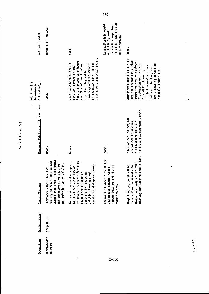
w u F
Az w
V U E EL 1 3 C e . s ? z air N
fi w Y E ' P O O S
= Z n 5 .0,45 rr C .- * O & W V . . - * O . F U > * ) 4 U L .- L ', - v w 3.- O a- * z o u u
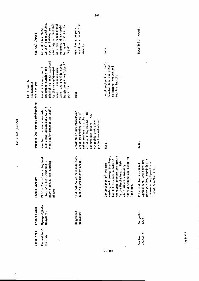
- a * - k S J # X f - L V * V ' C
E X m 3 G E % C I F Y
w = a - s 'W.-" z,,* # .- Z > Y r n U L
O V E 4 s Y . L * Q C R U U ' 7 Q U
L e s - - * > E S 2 & , : z - s .- & w L z c r % * * W & Q i V Y
f ts,o".z z U Q 1 V O L U
.; = L U I
z d b W S * i C m v D Y
Z E F O - 0 c x C 97 0 - . - l m Y * x * r 3 5 V u n
4 0
= n P m w .- S U C

Table 2-2 (Cont'd)
Soc ia- Nation U t i t i xation o f a clean None. econcmi c r i n a x h a u r t l b l ~ saurce o f
anergy for the generation a f e lec t r ic pauer, reducing rel iance an internat ional raurces of anergy,
hddi t ional 6: Recmended
m a l ; e d GlYB Priilc-ct H i t iqa t iqnp fli t iqat ionr
Entire arsa Xmprovement of internat ional navigation, anhanci ng future oppartunitle$ f o r i nternati anal - t rade and industr ia l develament .
Improvement a f ll ood protec- t ion , reducing property and rtructriral damage ovar the l i f e a f the project .
geridiial Imprrt
Weneticial impact.
f ienef ic ia l impact.
Benef i c i a l impact.

3 Monitoring Program E~aiuation

Section 3
HOKITOHPIG PHOGUH EifBtUdTIOH
The Gabcikuvo (Bos)-Nagymaros Barrage (Gm) environmental monitoring program
waa rtviewed for overail adeqtracy of the program tri deffne potentfal
project-relattd impacts as discussed in Section 2; assess effectiventss of
planned mitfgatfons and additional propcçed mltigations; i den t i fy changes and
trends fn the environment resrilting from project operatfons; and assess
efftctfventss of rnftigations and operational rules desfgned to reduce adverse
impacts or enhance beneffcfal effects.
Recommendations for the monitoring program focus on the adequacy of the
preoperational database tri dafine preproject conditions and quantify impacts,
and addiifonal data needed to define environmental conditions dirrfng
optratfon. Monitoring stations estabflshed for structural engineering
purposes were not considered. In our experience, preoperational environmental
measuremtnts are normally taken iit more frequent intervals than operatluna1
merrsurementa {rintil baseline conditions are established). Generally,
preoperational data collection over a 1-year perlod is judged adequate. The
frequency of measirrements usually are redrrced tu a level appropriate to
evalrrate changes or trends fn a particular resaurct area during operation.
The GNB profect has ~ o i i t c t e d a substantiaf amount of data over-a number of
years, which has eçtablished an extensive base for i r l l aspects of engfneerfng,
hydrology, and hydraulic data requfred for the project. These data include
s t remflou, surface uatcr qrrality, channel cross sections, ground vater
levels, sedimentatfon and ire conditions, as vell as srifls, land use,
meteorology, archaeelogy, agriculture, and forestry. Additional data
collectlrin is recommended for biological resuurces,

Since August 1989, VIZITEPV ha8 started operatfng'an integrated cornputer
database fur al1 information collected. Thia,computeriz~d database presents
data in a vide variety of formats, including statistfcal, graphical srmimaries
and in two-dimensfunal plans and mapa. These formats are s u f f i d e n t for data
presentatiun necessary to evaluate changes in environmental resources. Once
all enviromentrtl data are entered fntb the system, rapid review and analysis
of data will be possible . Gomparison of t w o or more interrelated aspects are
also possible with the system, which can facilitate Interdisciplinary reçource
evalurttions. Overall monitoring vil1 be an efficient , effective tool for itnalyzfng projeci-related impacts and mitfgation effectiveness.
Substantlal cost swings will be realized by l a i lu r ing the monitoring system
and sampling program tri the operational requfrements for tracking
environmental changes uvrr tirne. Once the baseline conditions are
established, the number of locatfona and sampling frequencies cari be reduced,
The reduced program must be established by a detttiled review of the key areas
which signal changes in existing conditions, This entails selecting speciffc
sgmplfng stations which provide overali reyreaentrrtive data throughout the
prof ect area. Addf tional samplfng Aocations munt be designated in specific
areas whieh are more sensitive to changed environmental conditions.
The following discussion presenta is general e~sluatfon of the existing
monitoring systems d o n g nith reconnnendations for future monitoring in
specific resource areas. Table 3-1 eumarizes monitoring program
3.1.1 Surface Hater Monitorfnrt
A netwcirk of measuring stations for river flous, sediment transport, and water
qualfty has been implemented, Data obtained from these stations have
eotablished the baseline condition for the preject area surface water regime.
Data vil1 continue to be collected tu expand thia database up to completion of
the G E 3 project. At the tfme of project commlssioning, the network will be
modified to munitor only the;key surface water varfablts .

a C Qi u
C
O O
* Y
E h > 4 w r
O z -7
t w A 3
4r
O CI
* Y
c a3 E .-
'CI
(Y Y)
5 Y a O O
% O
n -- rn w .O C * 7 * s C C * U O s
-0 C O
V
I
x -- L U * ,- -0 E O -- z * s e L n r 6 ' 0
5 L . L - C W O - E U -0 * - rr O .- x .r ou. Cu-

.F 7 7 7 i- O w - 5 W I s z P r '
O L E T % w Y - .- .- 4 w r - I L * * .- 3 3 * Q W T
O E L L Z W * ~ a z z U L S %
* .z X - w L.
" C I n u 8 m e 5
J g.: 5 eP X - I Y C O I
. 2 z v * u r S S T 01 3 w 0 3 - L " w u . - Y - w = "
m L * g n e L m . ; o E O L . 7 C U
O . iz .- -- F k % % k g -- U L o u - L .- C E .; -: g 5 u z z z * E * L f L 2 Z 5 . 5 % Q - r5 c.z O * O
u u E 7 ; f a... w g z - = - O H
a.&- -0 3 3 wu: w u r ? , Y ; Z . L
Y - . - U Z - 0 u - 7 n z n TI -r O c u 2 = w Q r * w a- P.-
* Y I - . - = * c * + ' C L 0 - * O * . y. 3 0 Y L O U V z z ,.:,"a O a 7 O 7 b" E - - 0 -
7 - 0 - - E I 3 C a ~ 0 0 ' 0 f L T L ,. L J k * L s-YV: Qr w - € 2 m u - 2, E ' z r = , Y
V I - L O + ' * 6 3 L . T n + ? * a =
> L - L Y v O 7 U C = s * . - z w J C " = , . - y w w w * L L V b l t Y b.7 V I * c i E 7 - 0 m i n . - C c - r w L 4 * I L 6.-
6 2 01 a L
O f i - (Y.- . - L * w L - * > a m z C C * U U C r O * L U 7 u.7 w
, - E x 8
W C O L a ' n v o n
h C O 'O * ni- U O 1
u w n C O Y V i ..- O # 'F I% C
W C 0 0
f L u U r e s m w O
u c 2 , ; YV;6 1
O O E "
3 0 1 - 0 - vr w - 0.0 '0 n G m E H -- - - O
f i U ' -7
O i * S 3 L w v O H m
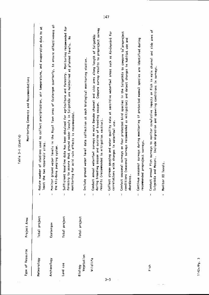

The purpose of the riperational monitoring netuork vil1 be tu provide
-suffirient information to verffy thar environmental requfrements are belng
met, A t the same tfme, it will a l so alluv project operators to maxfmize the
avoilablr uater resourcc in terms of hydroelectrfc generrrtion, navigation, and
muralclpal, agrfrultural, industrial, and environmental uater supplies.
In general, the surface vater resorrrce can be successfrrlly managed by knowing
a l l crrrrent project inflous (stremflow, sediment load, and water pollution
foads), Knuwing the current input values and verified interrelationships
betveen these variables and other environmental factors, appropriate water
releases through the power plants, shfplocks, and seirs can be selected.
The following a~aluation of the GMi project surface water monitoring network
is based on the above general data collection and processing approach, It is
nnderstood that VIZTTERV is in the proceso of evaluatfng surface water
variable interrelatiunships and developing systeizi models, Hovever, our review
schedule d i d not allvv us to examine the intended data processing uork;
therefort, some of the following recomendations may have already beezz
implemented.
Strearnflov. The current number of streamflov mesouring stations 1s 14, a l1
operated in Hungary. Another 15 stations, locatee both in Hmgary and
Cztchoslovakfa, are planned for project operation. This stremflow database
wfll allvw development of ûtreamflou correlations wfth sediment load and
poss ib ly pollutant losd. These correlatlons are important input tu system
mudels vhfch will simulate project operation scenarios uith resulting changes
to the sedfment transport and water qurrliry indices, The key stations for
stream flov monitoring will be:
o Bratislava
0 Dunakiliti, Gsbclkovo, and Hagymaros
o Ar all tributaries - located upstrefun away from backuater
O A t a11 project water-regulating gates and pump stations
B o t b the everitual set of project operating rules or, alternativeiy, a cornputer
mode1 for aelecting optimum operating rules, ~$11 repuire current and historic
atreamflow data from these stations.
Stream Hater Level {Gau~e). Monitoring water levela w i i i be an importmt
firnction because many prriject impacts are related to nater levela (e.&,, water
level relationships between reservoir Ievels and grorrnd water levela; surface
vater l e v d in Szigetkoz s i d e a m chmela; relationships wfth local ground
vater; and rescrvoir level changes du~ing operation of the Gabcikovo
puverhause), To establish these relat ivnships, over 150 Stream gaugea are
being meaaured, Another 150 garrgea are planned for the operating pro jec t to
confirra the relationshfps fo r t.he nev surface water regime. Tbe number of
stream gfiuges can be signfficantly reduced aiter the correlations and mudels
are verif ied or rtvfsed. The minimum required number of Stream garrges will
not be estimated; however, some key locations will be:
o Headvorks 8nd tailracea of E H E ~ project structure
o 'fwo localiona along the old Danube charnel
o Crintrol structures f o r the Szigetkoz side a m charnels
o Control structures f o r the aeepageldrainage interception channela
o Near the Bavbyr i r6 herunry
Meteorolonical Stations. About 23 meteorological stations which record
preciyftatfon, air temperature, vind, and evrtporatiun have been uusd to
establish the environmental baoeline conditions and to evaluatc basin waier
balance, The amount of data available is extensive and sufficieut for
understanding baseline conditions.
For the operational G D pruject, ef the ZS stations, two fs the minimum number
of meteorological stations repuired - one a t each of the two reservoir sites.
These stations should record precipitation, air temperature, and evaporation.
About 85 percent of the project fnflow fs from the upper Danube basfn above
Bratislava. Therefore, IucaI precipitation over the 15D ia reach of the
project srea will not contribute such large amorints of runoff t o warrant
development of a precipftation runoff simulation model.
Bed Deformatfons and Sediment Transport. There are t w o impacts identlfied for
sedlment deposition in the reservofrs which will require monitoring:
0 Sediment bufldup in the navigation charinel rrt the upstream end of the Hrnsov-Dunakllitf reservcfr
o Sediment deposits blanketing riverbeci gravels in the PIagymaros reservoir which could reduce Danube River flow i n t o the riverbank f i l t e r wells
At the Hrusov-Dundilfti reservoir, benchmarks are being set every 500 m along
the dike crest from which sedfmtnt deyasitfon surveys can be conducted. Over
the first fev years of reservoir operation, surveys from a number of the 56
cross section locations should be conducted to establish the areas of
concern. Later the number of survey sectlons shorrld be redrrced to four , wfth
one survey always conducted a t the upstrea end of the reservoir.
A number of cross section surveys should also be conducted alang the long,
narrow Hagymaros reaervoir - particularly along reaches nith adjacent bank flltrr u e l l s . bfter a feu yeara, the surveyed cross sections could be reduced
to about six, lecated i r t sites rif noticeable sediment buildup.
The future monitoring program includes suspended sediment surveya along four
cross sections of each reservofr, These surveys would be-of interest to
estsbllshing sediment settling rates and flov velocity relirtfonships. But
after these relstlonships are verffied these surveys should be discontinued.
Sediment measurements should be made a t each river and tributary fnflow
location where streirmflow measurements are alw conducted, and domstream of
the Nagymaros barrage. Such sediment surveys should be made once monthly and
before and after flood events.

Water Qualitv. Seventeen surface vater samplfng atntions, located along the
D m u b ~ and Danube tributaries, have recorded water quality indices for a
number of years . This database ia sufficient to establtsh current baseline
conditions. Currently 28 water components a r t evaluated for each vater sample.
As previously discussed, historie combfnatiws of pr inc ipa l water qua l i t y
indices, together w f t h corresponding streamflows, should be riombined w i t h a
cornputer model of the GK6 reservoir system to evaluate probable water qual i ty
l e v e l s under project conditions. Such evaluations are required to determine
vhethtr spec ia l mitigatlon measures are required t c i keep the project surface
water qua l i t y egual to or betrer than hlstoric levefs. It wuuld be desirable
for such evaluatfons to alsu i aen t i fy what trends in streamflow, water
temperature, and dissolved oxygen (DG) levels at Bratfslava uould l i k e l y yield
cr i t ica l water qirality conditions in the project reservofrs. By recognizing
hydrologie trends uhfch might lead tu critical conditions, p r o j t c t operstors
nculd have lead tirnes to initiate operation mitfgrttion measures, such as
releasing more flow over the barrage weirs ta aerate the water, or changing
the puwer plant operations to constant baseload mode to redzrce reservofr
detention tfrnes. Such meaaurea could be teniporary, fur a veek or a weekend,
and might avoid critical conditions uhich would affect municipal water
supplies and apuetic life.
During the first year of project operation, close monitoring of water quality
in the reçervoirs n f l l be important. Tùis data will be needed to check and
revise the resulta from the water qurtlity cornputer nodel. Approximately three
cross sections across each reserveir shuzrld br sampled. Sampling locations
and frepuency will depend on parameters being mnnitnred. Samples shozrld bt
taken from about 1-m depths and analyzed for the 28 water components. A t one
samplfng location in each reservoir, measurements for temperature,
conductivity, and DO should be made at tvo additional levela to establish
depth variations. Also, during the sample day, the DO measurements should be
raken twice (murning and night) to record the diilmal DO changea.
About 21 new water quality measrrring stations are planned for the operatlng
monitoring system, After the first year of measuremmts have been evaluated
and the praliminary correlations and water quality model have been verified,
the number of monitoriig locations can be reduced. A t s minimum, measurementa
shauld be tontinued a t Bratislava, k l l tributaries, and in the two t
rsservofrs. Measurement frequency c m be reduced tu monthly,
3.1.2 Ground Hater Monitoring
The fulloxlng recommendrrtions for the monitoring program will address that
portion of the profect area betveen Dunakiliti and GEnyü, and the area from
G5ny-Ü to Nagymaros. Because there is no impact associated wfth the profect
domstream of Nagyruaros, ground vater monitoring is not needed fur thfs
reach. In g e n e r a l , the monitoring for uster level data is more cumprehensive
than for water quality monitoring. The data and monitoring program in the
Szigetkoz is mure comprehensiv~ than it is f o r the area downstream o f Giinyii.
Dunaklliti tu GEnYü. The network of over 200 munitorlng wefls and several
years of wprtar level measurements have produced a snfficient database to
establish ground water l eve l reçpenses t o changes in Danube surface water
levels, and d t v e l o p the SzfgetkEz ground vater recharge plan.
Drrrfng profect operation, the monitoring xell systern should b t modified t o
check that the water t a b l e adjacent t o the Brusov-Dunakiliti reservoir is
being maintained nertr historie levela and that the Szfgetkijz ground vater
recharge plan i s uorking. The aeepage rate and water table responses have
been predicted for the area adjacent to the reservoir. Nevertheless, actuttl
response data for the filled reaervofr is needed, both fur verification of
predictions and fur safety of the structure, An array of wells is selected
for rhat purpose. Once the In i t i a l verfffcati~n of seepage rates is
established and deviatiuns from predicted conditions are explained end
rectifled as n t e d e d , the number of monitoring xells can be reduced to those
used for monitoring seepage under the reservoir dike. The number of dike
,sepage monitoring wells wf11 not Oe reduced because tbey are roquired f u r
structural stabflity and safety.

It appeara that the Szfgetkoz ground water can br properly observed by
monitoring three general areaa and other ares? of specific concern. The
general areas crrn be monitored wfth lfnes of vells already in place between
the o ld Danube and the Mosoni Danube. These lines niIl provide information on
the actual ground water profi les which can be checked against the planned
ground vater profiles. One or twn lfnes are recom~nded for each general
area, with six or mure wells per Ifne. The itttua2 n a b e r of lines and welLs
per line should be based on a aura detailed evaluation of the srea subsurface
characteristfcs.
The three generai arerra to be monitored are:
o Bezenye-Dunakiliti are8 - which has shown slow responses of the vater table to river fluctuations
o Ksvinrrir8 area - whlch has shom rapid responses to the r f ~ e r flu~tuations
0 Lover end of the Szigetkoz - the area of ground wster basin discharge
Durfng project strrrtup and the initial year of project optration, the
monitoring wells in the SzigetkEz and the surface water levels in the slde arm
charnels should be measured weekly tu alluw adjustment of discharge into sidt
arm charnels to maintafn the repuired gruund water levels. Once the side a m
discharge and ground water l eve l relationship fa properly ealibrated, the
monitoring c m be reduced to crintinuous staff readings in key aide a m
locatfons and measuremmts three or four tines per year a t the monitoring
wells.
There are some apecifically sensitive areas in th& Szigetküz vhich w i l l
requlre additirinal ground water moniturfizg because the local enviroments are
-1tss tolerant to water level fluctuations, These local environmenta fnclude:
o Biological monitoring stations
o Eird habitat areas (sirch as dsvinyriro)
o Fish spawnirrg areas

The number of monitoring wella and frequency of measurementa must be
established af ter more detailed -eviluat ions 05 the local en~ironments and
potential projeet impacts.
Ground wster quality monitoring ia much less extensive than the water level
measurements, both in nmber of wella sampled, and in length of tirne that
monitoring has been corrducted. The number of u d l s saniplrd 1s less than one
third of the total monitoring wells and, sccording to the data provfded, no
regular sampling of wells open to deeper intervala in the basin has been
cunducted. Kegular sampLing of wella open te the sballowest zone, less than
30 m deep, commenced in 1988.
Once drillfrtg and well construction effects are accounted for, 2 years of
regular s a p l i n g on a morttfrly basis should be suffirient to establfsh the
water quality character <includIng amrmpling variabilfties) for a baselfne
reference. Once thaE baseline ia estrrblished, freguency of monitoring is
usually reduced to 3-month intervals. Recognizing that ground water migration
is unusually rapid in tbfs basin o f extremely high permeability, i t would seem
that puarterly frequency fs sufficlent. In addition, the number of wells
befng sampled shorrld be reviewed for possible reductivn. Several walls may bt
found to be in an area of s i m i l r r r hydrologie characteristics and similar
quality; thus, the number tu be sampled may be reduced.
Important characteristic sreaa in which quality s ~ p l i n g should be perfurmed
are the recharge areas, partlcularly in the viciniry of Dunakiliti reservotr.
In addit ion to shallow monitoring, at least une detp zone well should be
monitored d o m gradient of Dunakfliti. Other well sites shorrld be selected in
reference to speciffc coneerns, such as flsh spasping areas in the basin
discharge region in the vicinity of Vének, and the biological conditions of
the heronry fit Asvkyrir8,
The gr~urrd warer quality parruneters to be measured should continue tu be thoçe
fncluded in the current testing prucedures. Additional testing parameters can
be added to the present program ah~uld it berorne desirable to apply more
str ingeut puitlity standards in spec,ific areas. The ~ u r r e n t t e s t i n g parameters
are suffirient to ccver the for which ,the water qualf ty is being
munitured.
G5nyÜ to Napymaros. The subsurface conditions i n thfs subregion are more
cornplex thm in the Szfgetkoz. The ground water cccurs in a strfes ofsmall
srrbbasins which in turn are comprised of multipi~ aquifers. Sufficient data
have been collected frum the-nearly 200 observation vells In the area {at
l eas t one well is repurtedly instirlled i n each apuffer) to establish the
hydraulir interrelaticnshfps betveen the ground voter regiuie and the Danube.
EIost important i s the fact that only the upper aquifer fs in direct contact
.wfth the Danube. Purther, grri-& vater fluw dfrectfon surveys have been
conducted t o establiah the his tor ic ranges of the vater table gradient.
During project operation, ground water monitoring wilf be reguired to check
that the seepitge/drainage interception channels and pump stations are
maintainlng the grriund water i r t desired depths, and spe~ial protective
measures at industrial plants, urbm structures, and historical sites are
properly fmctioning, A specificrrlly sensitive area whtch wIll require
additional ground water monitoring becsuse of the influence of water level
fluctuations ia the Royal Town area of Esztergom.
Inftially, ground water level meaeurements should ~OTLtinul to be taken to
confinn or revise the ground nater gradient relationships wlth the water
levels in the Nagyinaros reservoir and In the seepage interception charnels.
These rneasurements shorrld be made weekly until the relatfonshigs are fimly
established. Operational control will aubsequently be maintained according to
automatic water level measurements in the interceptlon c h m e l s and r t t the
drainage pmpfng stations. Measurements in key observation wells c m be
reduced to four times per year. Measurements i r t apeciffc structurrrl sites
should be made at intervals appropriate to the expected local ground water
f luctuativns,
Water puality data i n the Gonyü-Hagymaros reach of the project area are
apparently pufte Iimited, It fs recommended that the regulsr water quality
monitoring program çtarted in 1988 be cuntfnued. Monthly smples should be

eollected at least from a few wells in selected critical areas in rach
subbasfn tu establish baseline water puality. Hater quality of both the deep
and 8hallow apuifera should alan be estabIfshed. Tùe ground water parmeters
befng raunitcred ahozrld be the same as discussed previuusly for the
Dunakiliti-GÜnyü reach of the project,
Monitoring wells shozrld be constructed and observed at locations between
bank-filttr wella to establish baseline data. With continued monitoring after
resemoir filling, airy decline in well performance can be related tu sedfment
deposition in the reservoir and identiffed.
3.1.3 Biolo~v
The project has planned 8nd implemented preproject monitoring at 12
establiahed bfological monitoring stations. This monitoring system vi l1
provide valirable infowatlon on vegetatiun, birds, and invertebrates for use
in detecting project-relitted operational impacts. This monitoring program was
reviewed relative to the potential impacts that may result frorn the project .
Based on available information, aume recominendations c m be made at thfs
time. Dther recommendations f o r the monitoring program wvuld need to be
dcveloped after raviewing the additional biolugical baseline data recommended
for collection (are Section 2.21.
W. The monitoring program designed and implemented at the 12
biologieal stations provides a aounü baais for evaluating Impacts en natural
vegetation i n areas thrrt may be affe~ted by the project. The stations hava
been located in different habitat types In areas which could be -expectad to be
affected by changes in hydrological conditions. me cuntrol er reference areas are also well located, Emphasls on vegetirtive monitoring in the
Szigetküz is well founded. Additiunally, the vegetative samplfng scherne is
wrZf designed m d the basdine information collected to date will provide a
preproject cornpariaon basis for evafuatfng operational impacts.

#ne additional reconimendation for the monitoring program (if it ia not already
being eonducted) ia celleetion of data on grornrd water levels at each
monitoring station or an existing nearby well. This information courd prove
useful should any changes fn the vegetation be d e t e c t ~ d . Changes in species
composition, abundance, anü water requirements lZolyomiSs water requfrement a categorfts), and measured changes In ground water levels could be correlated,
H f l d l f f e . The project plans t o condu~t monitoring of birds and six insect
specfes selected as indicator species sensitive tu changes i n the water
regime. Data collection is ongoing ai the 12 biolagical manftoring stations,
and baseline information is available.
The plamed monitoring of avfan species a t the biological stations should be
continued. The stations established are in rr variety of habitat types vhlch
support a diversfty of bird species. Operational monitoring data on bfrda can
be compared to preproject data and correlared with any changes documented fn
the vegetative sampfhg. Quantitative data and information currently being
collected on residents durlng the breeding season provide a gooà basia fer
assessing any changes durlng operations.
Because rlparlrrnhetland vegetation provided by the mnin chanml and the side
arm system i s important to vaterbirds, a prellrninary recommendation ia to
expand avfan monitoring to lnclude annual waterfowl surveys of the regivn both
during and riutside the breeding staaon. Thfs monitoring should include the
main chamel and the s i d e a m systern along the length of the Szigetkoz. These
surveys should record apecies prtsent, estimated nmrnbers of vaterfovl, and
breeding activity, Survey resirlts ~ o v l d be cumpared to the baseline waterfowl
survey data recommended in Section 2 to determine,vhether any signfficant
changes in distribution, estimated abundances, or breeding patterns occur
during operation of the project. Thfs recommendatlon should be reviewed and
the survey design developed based on the data ~ollected frem the preprojtct
surveys, /

Also, atream gauging and vater guality aampling shtiould be conducted at several
locations in the side a m syatem derermined to be important habitat for
waterfowl ( e , g . , Ksuiriyrir6). Water levrls and quality should be mvnitored i n
thesa locations- for correlation vith ariy significrrrtt changes i n waterfowl USE
detected by the monitoring program. . Addftionally, monitoring surveys should be conducted for the four proterteà
bird species described i n the impact section. Once baseline surveys have
Identified their preproject seasonal habitat use of the area, monitoring
surveys should be conducted to fdentffy uhether any sfgnificant changes in
species' distribution, abundance, or seasonal habitat occur. These surveys
should be desfgned based on the information collected in the basefine surveys.
If any protected mammal species are identified in the re~ommended 1-year
baseline survey, a monitoring program should bt developed for Ehese species.
m h . Currently, the monitoring of fish stock spptars to be lfmited to
collection of fish catch data. As nottd in the report on the monitoring
rretwork, the fish aurveya need tc be expanded Éo include data on spaming
grounds, spawning times, and restocking.
Several monitcrfng recommendations are made in this section, but it should be
noted that these recommendatlons are preliminary a d based on very l i m i t e d
information. Tùe monitoring program shorrld be reviewed and better developed
after baseline fish surveys are conducttd oyer a l-year period prior to
project operatfuns.
Subsepuent to the baseline serisonal fish surveys, arinual fish surveys should
be developed and conducted once the project is operational. These surveys
vould be designed to monitor for overall cumul~tive iapacta on fish i n the
main charnel (above and belov the barrages), the side a m system, and the
Masoni. Guch impacts could resnlt from one or a combfnatlon of effects
discussed in the impact section. Should this monitoring detect any measzrrable
changes in fish stocks, mure speciffc data collection programs could be
designed to assess the ressons for the effect and mitigation that should be

employed, The monitoring also should fucus on mIgratIon and spaming to
detect any &anges In these activities which may result in reduced - t
reproduction and recruitment #ver tirne.
A permanent monitoring syatenr for 110 and temperature above and belou each of
the barrages should be Implemented. This 1s commonly done by use of an
electranf c system that automat ically records cont fnuorrs Do and temperature
ineasurements. In conjunction with the preproject DO modeling results, this
mvnlterirrg can be used to detect significant DI3 deflciencies develvping during
operatlvno, and to guide the project in making operational alterations to
mltigate DO deficiencies and effecte on ffsh as needed. As described in the
impact section, these measrrrea~may fnclude:
o Meckanical aeration techniques such as pmping a i r throrrgh nuzzles into the turbine draft tubes or somt type of diffuser in the tailrace
o Operating the Gabcikovc pvver station in continuous mode, or alternatfng between peak and contfnzrous operatfon {Eo reduce slgal production)
o Drawfng d o m the reservoir during certain conditions Calgal ~ ~ Q O P I S )
o Release of small discharges from the reaervoir bottom (which tend to have low DG cvncentratlons) mixed with surface waters
Federal licensing of hydroeleetric plants in the U.S..often requires
continuous monitoring of DO and temperature and special meaçures when DO
levela faIl below established criteris. As an example, rht Martfnsville Hydro
Electric station must ahut d o m whenever the DO méasured falls belov 6 mg/1,
until the DO returns tu 5 mg/l or it is demonstrated that the power plant
operation doea not further redirce the DO as recorded in the headvorks. The
Norrls Hydrotlectric Project opersted by TYA has an afr injection system which
is activeted uhen the DO draps belov 5 mg/l.

Additicnally, DO and temperature nrerrsurements should be collected at several
Iocations in the side a m system and the Mosoni which would be determined
itfter revfew of t h e baseline f i sh survey data.
Ffnally, operational surveys should be cunducted t o rnrinitur the effectfveneso
the fish leck. Fish passage via thia system shozrld be monitored r x r t i l it is
established that the system provides an ttdequate meana of migration,
No forestry impacts are anticipated, Therefore, future forestry observations
related tu the profect are not necessary, unless grounü water monitoring
indicates a trend lover 5 years) touardo a decrease in ground water levels
below those orfginally predicted in the SzigetkOz. If ground water levels are
lower than predfcted, additional forestry monitoring could include the
following pararaeters:
o Tree grovth
- Speciea - Age - Average height - Average diameter at chest height - Ttmber volme - Cornparison to earlier observations
5 Loggfng data
Date of logging Logging s i t e Area cleared Species logged Lumber v o l m e Total tree volume Lumber value Cornparison tu earlier observations
Monitoring should be lfmfted to unly those areas experiencing a trend in
decreasing ground uater l e v e l s (belov the predicted levels).

Ho monitoring for acfd rain effecta on forestry is recommended, mile ecid
rain has been ahuwn to be a problem'tàat itffeats fareetry pr~ductivity i n the
U . S . , it ia n5t asaociated with the project and could not be considered alone
from the rnany factors potentially affectfng forest productivity.
Nu agricultural impacts are anticipateci. Therefore, ne additional agrfcultural
monitoring of crops or mimal husbandry fs necessary or recommended.
3.1.5 Archaeelo~v/Xistoric Monuments
Increases i n grormd wrrter levels above the existfng m e a n level could affect
the acceasibilfty o f deep-lyhg archaeological a r t i f ac t s i n the Esztergom
Royal Town aree (aite no. 35.1,10). It is proposed that the giound vater
l eve l in the area will be controlled by the Kis-Duna pumping station
facilftiea a t the mean ground waier level of 103.5 m above sea level,
Currtntly there 1s no pxoposed monitoring program for rirchaeologicrtl impacts,
It is recommended t h a t the existfng vells in the Royal Tom area continue to
be monitored, as discussed in Section 3.1.2 - Ground Wattr Monitoring. These
vells should be munitored quarterly to ensure that the Xis-Duna pmping system
is effective in maintafning grorrrrd water levela at the eurrent mean levela of
103.5 rn above sea level.
3.1.6 Visual Resources
Monitoring of visual resource fUtp8cts is not necessary and f s n o t recommended.
3.1.7 Recreativn. Fishinn Kesuurces. and Tourism
A monitoring program is proposed for fish~ry resorrrcea and 1s discussed in
Section 3.1.3. No additional monftoring is proposed or necessary for
recreation resorrrces or tourism.
3.1.8 Socioeconomics
Bo monitoring fa proposed or necensary for sociotconomic consfderations, vith
the exception of fisherfes is dis~rrssed i n Section 3,1,3.

Table 3-1 prtsents monitoring system recommen$rrtfons.
3.3 EXJSTING MONITORING PROGMS
The monitoring program implemented for the GNB project tracks rt comprehensive
array of hydrological and snuironmental- parameters. Birnilar water management
projects in the U.S. were re~feved to ident i fy the scope and reliabflity of
operational menitorfng prograras. Our revfew d i d not find any existing
monitoring program vhich can compare to the GNB program wfth respect to the
range of environmental parameters befng measirred. Perhaps the most comparable
U.S. program 1s the one establisheu for the Columbia River by U.S. and
Cariadian agencies. fiovever, the Columbia, Ohio, and Temessel River programs
do provide important additional features vhich are applicable t o t h e
operational needs of the GNB Project.
3.3.1 Columbia River Operational Hydromet Manaaement System
The Columbia River is a major r i v e r iocated in the northwestern portion of
North America. The river drainage area is over 259,000 square miles. More
than 100 hrurdred Mater management projects are crrrrtntly operated on the
river. ~ h - e s e are multipurpoçe p ro j ec t s - pover gentration, navigatfon, wattr supply, and flood control - and are managed by government and private
agencies. In a coordinated effort, these agencfes have designed and
implemented a &in-vide data collection, proceçsing, and dfsplay system
called the Columbia River Operational Rydromet Management System (CROHMSI.
The-purpose of CROHMS is tu provide project operations wlth an accurate,
~ontinuously updared database uhfch allows more eff ic ient management of water
resources. The systern vas commissfoned i n 1978 and origfnally collected data
frorn over 450 stations, cuvering Stream flous, prttipitation, air
temperatures, snew depths, and hydroelectric generatlon. The database h ~ s
since been expandtd to include water Puality parameters and fish counts.
Data are trançmftred to the CROHMS cornputer center locared in Portland,
Oregon. The center is managed by the U.S. Army Corps of Engineers {USCOE).
At t h e cornputer cwter , t he data are valfdared and used in varfeus cornputer
simulation models which hrlp develop monthly, weekly, and dafly project
operation rules.
CROXPIS haç proven to be an effective tool vhich afds profect operators in
maximizfng the benefits of this large river resource. ~ l & s are currently
being developed to expand the database to include more envfronmental
parameters and to develop nev software which vil1 screen Incoming data and
automatically issue alert notices whenever environmentally crftical threshold
conditions are befng approached.
Literature which describe the Columbia Rfver projects and the deyelopment of
CROKMS are included in Appendix 4 .
3 . 3 . 2 Ohio River
The Ohio River is 980 miles long and supports a variety of uses Includfng
navigetlori, power generstfon, industrial processes, municipal water supply,
fish snd uildlife habitats, and recrealion. This river receives treated
uastes from over 220 Industrial and 126 municipal sources. There are 28 water
c o n t r o l projects on the river. Three grorrps have major roles i n managing the
Ohio River. They are USCUE, federally Ifcençed hydroelectric operators, and
the Ohio River Valley Waater Ssnitarion Commission (ORSANGO).
USCOE has been authorfzed by rhc U.S. g o v e r n e n t t o corrstruct and operate a
series of locks and dams along the Ohio River fo r navlgntion service and flood
control , The plan and profi le of the USCE? Ohio River system is included in
bppendix 4. The USCOE division office at Cincinnati, Ohio is responsible for
generai- management of the Ohio River proj e c t s . Day-to-day management i s
rrssigned to four d i s t r i c t offices vhich are each fesponsible for four tu eight
projects.
Each district off ice maintains a mon1 torfng system which cvntlnuously measures
river and reservofr water Ievels, preclpitatfon, air temperature, and prriject
releases throügh low l eve l outlets, spillway gates, and navigation locks.
These data are input to subbasfn operation modtls t o eçtablish weekly and
daily operation schfdules. Xarer quality parameters - DO, water temperature,

pH, and conductivity - are measured. Shorrld undesirable water quality indices
be observed, some projec t operat ion responsesJ* snch as releasea over
spillways, are activated tu improve the vater quality.
A number of hydroelectrfc poverhouses have been added to the USCDE dams.
These poverhouses are omed and operated by public and private utilitfes under
licenses issuèd by the Federal Energy Regrrlatory Gomfssfon (FERC). An
example of such a prrifect is the new Hartinsvflle Kydro Electric Pro j ec t whlch
adjolns the Hannibal Lock and Dam. This povsr plant houses two 17 MW bulb
turbine gtnera tor units and it must paas the incvming river flovs as regulated
by USCIIE, The FERC License repuires the continuous monitoring of DO and water
temperature. Vhenever the DO level f a l l s below 6 mg/l, the power plant must
be shut do- and the river floys passed through the spillway gates in Hannibal
Dam. Pover plant operations c a m t be restarted untf f the DO lève1 returns t u
6 mgIl o r ft is proven that the pover plant operation does not frrrther reduce
the DO level a s recorded in the headworks.
Each FERG licensed project is also required tu transmit dafly DO and water
temperature readings to ORSABC0 which maintains a basfn-xide water qnalfry
database. DRSKPICO is an interstate agency whlch has the prirnary funciion of
promulgating standards of sewage and industrial uaste vater treatment and
monitoring nater quality alang the Ohio River. The commission also mafntrrins
a quality assurance program. Aspects of this program include specifications
of ssmple collection and handling techniques, service of electronic equipment,
submfssi~n of check and duplicate samples collection and handllng te,chnipues,
laboratory inspections, and immedfate reviev of sll data collected. A special
aspect of the qrrality control program for a large river such as the Ohio is
the need to assure that a11 monitoring locations are representative of
conditions across the river. A program of cross sectional samplfng, with
analyses for all vater puallty parameters measured in the monitoring progr-,
uas inltiated ln 1984. Efght monitoring loca t ions are scheduled Eu be covered
each year. The types of vater qirality monitoring fncludtd in the OPSANG0
program are discussed beluw.

Electrunic Monitorinn. Electronlc munitors connected to the ORSARCO office i n
Cincinnati, Ohio, are operated a t 15 Dhio Rfver and 7 tributary locaticns.
The monitors provide hourly measurements of DO, temperature, pH, and specific
conduc tance.
Manual Sampling, Honthly samples are colfected a t 24 Ohio River and 14
tributary locations. Samples are anrtlyzed fo r 25 physfcal and chernirai
cunstitzrents on a monthly basfs; an additional 7 parameters are nreasured
quarterly.
Constituents sampled I n c l M e cyanlde, phenolfcs, rnercury, copper, zinc, laad,
cadmium, i ron, maganesti BOD, suspended solfds, sulfate, hardness, nutrients
total phoçphurous, total Kjeldahl nitrogen, ammonfa nitrogen, and
n i t r s t d n i t r a t e nftrogen.
OrranIcs Detection Svstem. Dsily samples for organic compeunds are collected
by 13 participaring utilfries, Data from II of the utilities rire used to
provide a continurng record of amblent I~vefs of 17 purgeable, halogenated
organfcs. The other t w o utilities operate as s p i l l detection s r t e s .
Water Users Wetvork. Results of river samplfng by 12 water utilfties,
industries, and poiier planta on the Ohio River and its tributaries are
crrrrently u t i l l z e d to augment the commission's other data sources. Data are
collected for alkalinity, chloride, phenolics, and fecal colfiorin bacteria.
The ftcal co l i f am data are particulftrly valuable since the commfssfon'a
Stream cri ter ia repuire a minimum of ffve samples per month for assessment.
The water users proutde the only tantfnuous source of data at this required
frequency,
B i o l o ~ i c a i Sam~ling. The current biologi~ai monitoring program fncludes tvo
major aspects: biennial lock chamber studies of ffsh populations, and
sampling of macroinvertebrates through the use of artiffcial substrates. Bath
of thtse are cooperative efforts, vith the commission courdinating
participation by several state and federal agencies.

Special Strrdies, Speclal studies are often undertaken to evaluate euiergfng
problems or to provlde additional information pn problems identified i n the
ongoing monitoring programs. Current strrdfes include instream toxlc ef fec t s
sereening and specfal samplfng for fecal colffom bacterla.
3.3.3 Tennessee Valley Authorftv (TVA]
The TVA is a U . S . federal agency and is responslble for building and operating
water control prof t c t s on the Tennessee River for navigation, hydroelectric
genfratim, and other beneficfal uses. The TYA plan and system profile are
included in Appendix 4.
--_. -.. - The P A operates a data coilection program for the operation of its uater
projects. The major parameters monitored are:
o Pretipitatfon for each subbasin
o Reservofr datg including headwater and taflwater elevations; turbine, low-level, and spillvay diacharges
o %ter quslity - primarrly DO and wrrter temperature
The colleeted data are transmftted to the cornputer center located in
Knoxvflle, Tennessee, The reservoir operation department i s responsible for
evaluating the incoming data and establishing prriject operation schedules.
The precipitation data are input into precipitation runoff models. Tbe
resulting straamflows are veriffed by key atreamflow merisuring stations. The
new streamflov data are tben used in eight separate subbasln operation models
to prepare weekly and daily project operation achedules whlch maximize the use
of available water to meet electrical, water supply, and environmental demarrds,
Water q u a l i t y downstream of reservoirs is also monftored. Xhen undesirable DO
and/or water temperature levela are detected, apeeial reservoir releases f r u m
multilevel outlets are made tu improve the downstrcaar vater puality,

A opecial feature exiats at the Piorris Hydroelectric Project , one project
riperated by TVA. The Horria pover plant hus:s t w o 50 NW Francis type
turbines vith a design head of 155 f e e t . Whenevsr the reservoir DD drops
belov 5 rng/l, an air injection system is acttvated. The alr injection system
is compriatd of air vents which comect to the hub of the Eurblne runners.
When the air Yento are open, the negative pressure under the turbine pulls air
i n to the draft tublbe. This system can raise the DO above 6 mg/l,
3.3.4 Coachella Valley Hater Distrfct
The Coachella Valley Water District is responsfble for supplying municipal and Y
agriculture water to it large service area located in southern California.
Most of the water is delfvertd via 75 miLes of open canal. To help operate
thfs nater delivery system, the d i s t r i c t has developed an automated data
colfection and processing system which tracks water levela thruughout the
canal system. By Imowfng the vater demand at each tururiut structure, the
operator determines t h e required vater levels needed throughout the canal
system to transport the accumulated water dernad. Once the uater Jevels are
Imom, control gates are automatically adfusted tu control the water at the
specified Ievels. This type of nater level conerol system vould be applicable
to the water l e v t l controla required for the GK8 project seepagr interception
charnels and the vatemaya i n the Szigetkiiz area.
A more detalled description of the Coachella automatic control system is
contained in Appendix 4.


VIZTTERV, Crinsulting Company for Water Engineering, 3uIy 1989. Informatory ~ocuments(~) for the Gabcfkovo/Biis-Nagymar~s River Barrage Syatem.
1, Summary Description, compiled by Dr. Endre Zsilak, Chief Project hgineer.
2 . Standard Speciffcations, Ragulatfons end Orders on Environaeatal Protection.
3. Engineering Gtology. Compfled by: Dr. Jeno Mantuanu, Chief Project Engineer.
4. "iydrologfcal Gondïtivna of the Danube and its Tributary Strearns.
4 .1 Surface Water Regime, Prepared by Ferenc Papp, Chief Project Engiaeer .
4 . 2 Subsurface Walater Regfme. Prepartd by Dr. J F ~ O Plantuano,
4 . 3 Sediment Regime of the Danube Stretch Affetted by the Gabclkovo-Nagparos Hydreelectric Development Project,
4.4 Cvmprehensive Report "Exploration of the Ice Regime oyer the Danube Reaeh Influenced by the as-Hagparos River Dam Project,"
4 .5 guality ~f Surface Waters, Prepared by: Mrs. Eva Bartalis-Tevan, Biolcgist , Te chnical Advisor; Dr . ~zaboics Tyahun, Bi ologist ; Dr. Pal V8rga;Chemical Engineer; and Mr. Ifandor Varday, Chaira l Engineer .
4.6 Subsurface W8ter Qurrlity, Prepared by: Ferenc Herzog, Chief Pro j ec t Engineer,
5. Biological Conditions.
5 . 1 The Flora, Vegetrrtivn, FIah Fauna, and Biological Monitoring of the Gabcikuvo/BÜs-Plagparos River Barrage System, Experts: D r . T. Simon, Dortor of Efologiral Sciences and Dr. C. Lang, Candidate f n Bfologicrrl Sciences.
Ca) Please refer to pages Al-4 through AI-35 for cuntents of these Informatory Documents.

5.2 Plant Hutrient Supply in the Danube River arrd i t s Hydrobiolugfcal Features, Experts: Dr, T. Kiss Xeve, Candidate for Biological Sciences, PITA-OBKI, Hungarian Drrnrrpe Research Station; Mrs. E. Tevan-Bartalis, Bfologist, Technical Consultant, EDU-K~VIZIG; Dr. Sz. Tyaftun, Eiologfst, KOV-KOVIZIG; Dr. P. Varga, Chernical Engineer ; Head of Department, KOV-X~VIZIG; Dr. PI Varday, Chemf cal Engineer, Head Section EDU-X~VIZIG.
6. Agricultural and S i l v i c u l t u r a l Land Use, Conrpiled by Consultfng Company for %ter Engineering.
7. brchaeologfcal and Monuments Assets and Anna, Eompfled by: YXZTTEKV with participation of experts.
8. Aesthetic Quality and Gharacter of Landscape, Produced by: BIZITEBV based upon experta.
9. Recreatfon - Tourism, Compiled by: YIZITERY based upon the expert's report.
10. Social and Econoinfc Aspects, Prepared by Ferenc Kollar, Chtef Engineer o f the River Barrage Projeet.
11. Evaluatiorr of Conditions and Effects. Compiled by: Dr, D, Drloci, Civil Engineer, Senfor Research Fellou.
12, The Monitoring Network 1.
12.1 The Monitoring Xetuork Operative i n 1988, Gompfled by: Dr. Jeno Mantuano, Ghfef froject Engineer.
12.2 Comprehlrenslve Report on Observations up to 1985. Szigetkoz
12.2.1 Comprehensive Report
12.2.2 Legend to Table 1 - Table 49
12.2.3 Legend tu Figures 1-27 and Maps 1-4
12.3 Gomprehensive Report on Observations up to 1985. Sectfon Downstream of G5nyÜ.
12.3.1 Legend to Table 1 - Table ZZ l
12.2.2 Legend tu Figures 1-16 and Mapa 1-3 l Pover Engineering Influences of Introdutlng An Environment Protecting Operation
Pattern on the Operation of the Bos-Nagymaros River Barrage System. Research Report. Budapest Technicol Zloiversity, Department of Hater Management, 1989.
The Konitorfng System of the B o s <Gabcikrivo)-Hagymaros River Barrage System. Conception of-Evaluaiion.
A Kisaalfüld: Duna-szaKaaz és 8 Kajesolodo mellékvizek halai 4s halaszato, 1987. Kalman Jancso anl, J a s Toth authors. Translated from A KisaalfEld Duna-szaKasz ijkologia j a .

OBJECTIVES AND BIGNIFIGAXCE OF THE RIVER BARRAGE
2.1 Generatfon of electrical power 2.2 International navigation 2.3 Water management
2.3.1 Flood protection 2.3.2 River training
3. DESCRIPTION OF THE RIVER BABBAGE PROJBGT
3.1 Concept and relationahfps 3.2 The GabcIkovo/BEs River Barrage 3.3 The Nagymaros River Barrage 3.4 Operation
3.4.1 Electrlcal power generation 3.4.2 Havigatien 3.4.3 Flood release 3.4.4 Release of ica
3.5 Control equfpment 3.5 Main technical data
Location of barrages Alfavable headtdwater levels Flood flowa, i r l l c w a b l e flood water levels Energetics The vaterway Weirs Power plants Beservoirs, ' power canal, dredgfsg
4. MAIB FACILLTIES OF THE GABCIKOVO/BOS BTYER BARRAGE
4.1 The ~rusuv/I}unakll i t i reservoir
4.1.1 Purpose of the reservoir 4.1.2 Facflities of the resgrvoir
4.2 The Dmakiliti barrage
4.2.1 Layout 4.2.2 Description of f a ~ f l i t i l s
4.3 The approach canal 4.4 The Gabcikuvo/BEs barrage
4.4.1 Layout 4.4.2 Foundatton of the barrage 4.4.3 The paver station 4.4.4 Navigation locks 4.4.5 Facilitfes uutside the barrage
4.5 Tfhe tailrace canal 4.6 Chrrnnel dredging dovnstream of Palkovfcovo/Szap 4.7 Regulatirin of the Danube chtrnnel in Szigetkijz 4.8 Other facilitles and fnvestments of the Gabcikovo/86s barrage
5 . MAIN STRUCTURES OF TEX MGYPIAROG BARRAGE
5.1 Protectivs facilities on Czechoslovak territory 5.2 Protective facilities on Hungarirrn territory
ïïie ~ise~rid-13EmEs 8ub-ca:~hment Sub-catchment cf Pilismarot City and aub-catchent of Esztergom Sub;cat chment of ~ ~ e r g e s u j falu-~unaalmas Komarom sub-catchent and the c f t y of ~omarom ~omarom-~ijnyü sub-catchment PIagymaros-Ipoly sub-catchent Protection of railways Protection of r a d s
5.3 Nagyaiaros river barrage
5.3.1 Layout 5.3.2 The neir 5.3.3 The pwer station 5.3-4 Navtgation locks 5 .3 .5 Facilitils on the river bar&
5.4 Dredgfng the Danube charnel domstream of nagymrrros 5.5 Other facilities and investments comected to the PIagymaros barrage
7, NATIONAL IIWESTMERTS

CONTENTS
2.1 Comprehensive ststrrtea on envIronmental protection
2.2 Comprehensive statutes on watcr pollution contrril
2 . 3 Grimprehensive statutes on air pollution control
2 . 4 Gomprehensive statutes on uastes disposal
2.5 Cmprehensive statutes on vibration and noise control
2 .6 Gomprehensfve statutea on general nature conservation
2.7 Comprehensivl statutea on metal pollution

175
3.0 H I G I H E B I H G IGOLDI=P
CONTENTS
1. INTRODUCTION
1.1 Presentation of the material 1.2 Review of explorations
1.2.1 Czechoslovakian territory 1.2.2 Hungarian territory
2.1 Geornorphology 2.2 Geology 2.3 F e role of crusta1 movements in shaping the course o f the Danube 2.4 Tectonlc and seismic conditions 2.5 Hydrogeology
3.1 Engineering-geolugical features by river sections
3.2 Areal subdivision
3.2.1 The Brusov-Dunakiliti Reservoir, ieft-hand Bank 3.2.2 The Hrrrsov-Dunakiliti Reservoir, right-hmd bar& 3.2.3 The Nagymrrroa Reserrcir, left-hand bank 3.2.4 The Nagymaros R~aervofr, right-hmd bank
4 . T E STRUCTüRES OF THE GABCIKOYg POKER XTATfOfi <TRE ENGIEYEERIRG AKD XYDROGEOLOGICAL CONDITIOHS OF PROJECT IKPLEPIEKCATION)
4.1 The Hrusov-Dunakflitl Reservoir 4.2 The Dunakilitf Weir 4 . 3 The puwer canal 4.4 The Gabcikovo power station 4.5 The Tai lrace 4.6 Training vork along the SzIgetkoz Danube 4.7 Channel dredging on the Danube domstream of Palkovlcovo
5. THE NAGYMAROS R I T E R DAM (THE ENGINEERING AND XYDBOGEOLOGXCAL ILCONDITIONS OF PROJECT IMPLGMEPiTATIOPI)
5.1 Tl~e Hagymarus River Dam 5.2 Trainfng work along the Danube domstream of Nagymaros
6 , ENGINEERTNG GEOLCIGY AMI KLPROGEOLOGY OF Tm FLOOD-PLAIN SECTIONS (POLDERS) ON XlTNGARIAN TERRITDRY
6.1 The ~isegr&;~Omijs polder 6 . 2 The Pilismarot polder 6.3 Esztergom Town and the Esztergom polder 5.4 ~e ,P iyer~enuj fa l~ -Duna~1?as polder 6.5 Xomarom,Tovn and the-Komttrom polder 6.5 The Kvmarom-G5n- polder 6.7 The Nagymaraa-Ipoly polder
LIST OF M K E X E Ç

1. The water system and flov regime of the Danube
2 . General description of surface waters affected by the river barrage system
3 , Harural flux regime of water courses to ba affected by the rfver barrage system
3.1 Basic data and thelr processing 3.2. Data of the Bratislava/Pozsony station of the Danube 3.3 Data of the Nagymaros station of the Danube 3 . 4 Data of the Bratfsl~va/Pozsony-Budapes~ reach of the Danube 3.5 Mouth-section data of trfbrrtary water courses
4. Flow regime of tributrrry streams, as affected by the d m i n g at continuous operation of the system .
4.2 Sasfc data and calrulations 4.2 Damming effects at Dunakilfii 4 . 3 Ef fec t s of the headuattra of Hagymaros dam and t h e charnel
dredging d o m s t r e a of Szap 4.4 Effects of chrrnnel regulation sovnstream of Nagymaroç 4.5 Backwater curyes in the Szigetkijz (old) Danube chamel
5. Water regime of streams to be affected by the headwaters in the case of peak operation of the hydraulfc structures
5,1 Basic data and calculaiions 5 . 2 Upstream effects on the peaking operation of Gabcikovo/Biis 5.3 Peakfng ef fects between B 6 s and Nagymaros 5 . 4 Effects of the peak operation of Nagymaros barrage on the doxnstream 5.5 Non-steady conditions of the old charnel in Szlgetkoz
Figures (1-25) Tables (1-20)
4.2 Subsurfrrce Water Quality
COTEPITS
1. The prasent groimdwster regime
- 2. Expectable changes '
3. State of existing and potentially utilizable drinking water resutrrces
4, State of karstic waters
4.3 Sediment Regime of the Danube Stretch Affected by the Gabcikcvo-Nagyniaros Hydrorlectrir: Devel~pment Projert
4.4 Eomprehensfve Report "Exploration of thf Ice Regime #ver the Danube Reach Influenced by the Bos-Plagparos River Dam Project"

4.5 Quality cf Surface Waters
1. BACKGROUND
2 . INTRODUCTION
3. MIN FACTORS TXAT DETERMINE WATER QUfiITY
3.1 Ratura1 loads 3.2 Anthropogenic loads 3.3 Effecta cf apuatfc Iife 3.4 HydrometeorologLcal effect
4. STATIC AND DYNAMIC HATER QUALTTY CONDTTIOPIS
Physical properties Balance of diçsofved solids Plant nutrlents Oxygen hozrsehold and organic substances Metals Other contaminants {ail, phenols, detergents) Organic micro pollutants Radioactive contamination BactertaI contamination
5 . HATEX QUALITY GONIIITIONS OF TRIBUTARY HATERGOURSES AND RIVER SIDE-AIUiS
6 . WATER QUALITY CHANGES EXPECTABLE UNDER TKE I W L E N G E OF T G RIVER BARRAGE SYSTEM
5.1 Water puality changes expectable as the r t su l t of the settlfng of suspended solids
6.2 Vater quelity changes expe~table dut to incrtased detention times 6.3 Effects on Bank-filtered drinking vater Tesources 6.4 Expertable vater qualfty of the interception canals 4.5 Expectable nater quslity of the Mosoni Danube
References. List of Figures L i s t of Tables

4.5 Subsurface Water Qua l i t y
CONTENTS
1. G F I I E ~ % ~ description of the quality of subsurface waters
2 . Quallty of bank-ffltered water resourceç
3 , Quality of karstic waters

5.1 The Flora Vegetation, Fish FaMa, and Bi~logieal Hunitoring cf the GabcikavolB8s-Nagymaroa River Barrage System
CONTENTS
1. The Kfstory of the f lora and vegttation
1.1 The o r f g i n and basic features of the flora. Floristic studies <Szigetk6z, the section of the Danube from GyÜr to Nagymaros)
1.2 Brief charrrcter tzat ion of the recent plant communities. (The vegetation of Szlgetkoz. Plant communitfes.of the Danube valley betveen Gy6r and Szfgetküz)
2 . Biotic succession at var ious levels of the floodplain, as a key to the est imat f on of possible changes
3, Plant cornmunittes of t he area influenc~d by t he barrage system Iphytosocfologic~l overviev)
4. Fish fauna and populations fn the Danube section inflrrenced
5. The Szigetkoz Landscape Protec t ion Area
6. Expected changts in the vegetation of the Bm impact area
7. Biological monitoring in the GabcIkovo/B5ç-Nagymaros Barrage Sys tem
References
Figures 1-10

1. Checklist of the flora of Szigetkijz (1987)
2 . The flora of the Danube'valley between Gy5r and Nagymaros In 1987-1986 l 3, Synthetic tables of associations (2937-1957, based on ~ 8 l ~ o r n i and
1. ~irpati)
4. Recent phytasocfological releve of t he monitorfng sample sItes 11987-38)
5 . Recent ffsh farina of the Danube (based o n J . ~ o t h , inSimon {ed.) 1978)
6. Fishery records of major ffsh species (1568-1985) - l
7 , Map of t he SzfgetkZz Landscape Protection Area l 8 . Bird records i n 1987, 1988
4. Records of aquatie invertebrates, 1987, 1988
10. Diversity and equitabllity tables

5.2 Plant Nutrient Supply i n the Danube River and I t s HydrobioIogical Features
CONTErnS
2 . Introduction
3. Plant nutrients
4.1 Halobity 4.2 Trophity 4.3 Saprobity 4.4 ToxIcity
6 . Expected impacts of the Gabcikovo/BGs-Nagymaroç Barrage System
184
6.0 ACRICUL- BKD SILYICTLTülSL LBrm USE
CornEms
5.1 Agrfcultural land use
6-11 Natirral conditions
6,111 Meteorological conditions 5.112 Topography 5.113 Soi1 conditions
6-12 Farming acunomlc conditions and theIr links xfth natural factors
6.121 Investigation of the Szfgetkoz (Ares 1)
6.1211 Local characterlstics, land use 6.1212 The situation prior to the construction of the
BNM Sjrstem 6.1213 Production costs and earnings from operation 6,1214 Water management impacts expected in the Szfgttk6z
during the operation of the BISPI System
6.12141 The artifici~l recharge system i n the Sz i getkoz
6.12142 The anticfpated production potential
6.122 Investigation of the area downstregm of GEnyü (Area II)
6.1221 Local charrrcterfstics, land use 5,1222 The situation prior tu the cunstructfon of the
BNN System 5.1223 Hrr te r management Impacts s p e c t e d during the
operation of the BRM System and the production petential in the area doxnstream of Go@
5.1224 Quantification of the impact of the expected change on produetLon
5.1225 Other impacts to ba taken into account during - riperation
6.2 Syfvicultural land use
6 -21 Reftrences
6 . 3 Game management

185
5.0 AGEICaTCRAL SILVTCüL.fITBKL LAKD USE
CONTENTS (Contid)
List of Tables and Finurea
Maps /
6-III-4 . S o l 1 maps with Iist of code numbers
6-11 Hap showing the hydrological features of the t o p layer
6-1 II/1-3 Maps showing land use and agricul trrral f i e l d s
6-IV Layout of the a r t i f f c i a f recharge syotem in t h e 5zigetkGz area

INTRODUCTION
I 1. SHORT HISTORICAL SURVXY OF THE AREA
II, DESCRIPTION OF TICE ARCKEOLOGICAL AND MONiMENT ABSETS AI1 monuments are examined fer each settlement according to the folloving four criterfa: (proceeding from West tc East)
A/ bisturical srgnif icance of settlement B/ archeolugical sites CI munumenta, historical relfcs Il/ the prospect ive condit i on of t h e archeological and monument 'assets
after the completion of the iyes tment

2 . FRDM G V ~ TO ESZTERGOM
GOnyü ~agyszent j inos Acs ~omarom 5- zoyy Aimasneszmély siitto Labatla? Nyergesu jfalu ~ 8 t
3. ESZTERGOM AND THE IIAWBE BEW
Esz tergo? Pilismarot DOmÜs visegrad Nagymaros Zebegény Szob 1polydamk.d Letkés
III. SUMMARY
1. List of maps
2. L i s t of ffgures
3. L i s t of photos

I . Archeologicitl sites f rom Dimakilit i , to visegrid 2 . Monuments from Dunakiliti t o Visegrad ~1:1OI).GO0 3. Roman Fortresses from Dunakflfti to AZracs N=I:IOO.OC)O 4. Roman Fortresssa from Lcs to Esztergom M=l:100.000 5 . Roman Fortresses from Esztergom t o Szentendre 5. Terri tory of monument signi f i cance of .GyÜr M=M: 10,000 7. Territory of monument s fgni f icance of Esztergom M:10,000 8 . Dis t r i c t8 of the territory of monument signiflcance of Esztergom
FI: 10: 000 9,-14, Map of the Danube valley w f t h the-vieu cf the nefghbourfng
monument towns f r o m Rajka to Vfseerad (Aap of Hummitsch from 1842)
2 . LIST OF FIGURES
SzigerkEz and Gy6r: the foreground of the western gate (sketch map) Hédervar: the manor-house park of&dervar r r t the t fme of the 1st milf tar f land-surveying (1782-85) Hédervar: The manor-house park of ~éderver st the tirne of the 3rd mil i tary land-surveying (1872-1884) Gyor and the eastern t i p of Szigetküz at the time of the 1st military land-surveying GyEr: ar~heolegical lay-out of the territory of the town GyEr: settlement parts o f the tom i n the XIIIth eentury GyÜr: junction of the roads ieadfng out of the t o m GyEr: t e r r i t o r i a l develepment of the t o m Gyür: i t s castle in 1566 {wpper engraving of Hufnagel, 1597) GyEr: map i n the middle of the XVIIIth century GyEr: (Arrabona) castsllum Acs: vaspuszta castrum <17.l.l) ~omirum: military map in 1849 Xomfrunr: 1~rnkd1 f crtress (18 - 2 . 2 ) design Komarom: Caillag fo r t r ess (18.2.1)
- in the 2nd half of the XIXth century ana - its present view with the barracks block built In f t s fnner part
Sz6ny (19.1.3): The t e r r i t o r i e s of the Roman Brigetio settlement on the present t o m map SzEny (Brfgetla) castrum (29.1.2) ~ a b a t l a n : Galvinfst church (32.2 -11, the results of the research of 1969 1~yer~es; jfalu: (Crumerum) Roman camp (33.1 -1) Esztergom: (Selva) Roman camp (35.1) Esztergom: Szentgyürgymezij 1. (35.1) R o m a n watch tVKer Esztergom: IIfdeglelEkereszt - Roman cmp (35.1)

Esztergom: (35.1.1-13) - lay-out of t h e medftval Esztergom showing the old parts of the t o m Esztergom: site of the medieval ediffces of the Royal town (35.1.10) on the present t o m map Esztergom: (35.2) the t o m i n 1595, copper eugraving of Hans S ibmacher Esztergom - ~sidod: (35.1.2) excauatlon' of the church and cemetery of brpadi an t ime Esztergom: ~zen t l c i r i ly (35-1.5) - ground plan of XIfth century ehurch Esztergom: town vaIl of irfziv%ros (35.1.11) - around 1735, engravlng of F.B. Werner Esztergom: t o m ualls of ~izivaros (35.1.11) around 1850 Esztergom: tom walls of ~iziviroo (35.1.11) around 1860, engraving of L. Rohbock Esztergom:. KévIz I35.2.3) Street scenes of BaJcsy-Zsiilinszky Street ~ilisniar-t: Mslompritak (36.1) watch tower Pilismarot: (36.1) Roman castrum Diimos: Küvespatak (37.1.2) Roman x a t ~ h tower visegr$: (fone Havata) (38.1.1) Roman camp Visegrad: view of 1595, Etched copper engravlng made s f te r the draving of Jakob Aoefnagei visegrad: vlew of 1500, Etched copper engravlng of Dilich visegrid: royal palace (38.2.9) ground plan visegrad : Gitadel < 38.2.22) greund plan Plagymaros: vfex, Steel engraving of Rohbock-Fescs
3. LIST OF PHOTOGRAPHS
9 * 10. I I . 12.
Rajka: Roman Cathollc church (1.2.5) ~ é d e r v i r : main fscade of the manor-house o f ~ é d e r v i r (8 .2 .2 ) ~ é d e r v a r : manor-house of ~édervar wi th the park pavili on < 8 . 2 , 2 ) ~éderv%r: the centaur statue of the manor-house park ( 8 . 2 . 2 ) Gy6r: ,main facade of the pontif ical cathedral 124.2.1) GyÜr: side facade of the pontifical cathedral and the chape1 ruin of Roman a g a (24.2-1) Gy#r: pontifical cathedral, higher altsr (24.2.1) GyEr: pontifical cathedral, so-called Hédervary chape1 with the herma of St, Ladislas (24.2.1) Gy6r: epiçcopal c a s t l e vfth the casemste (24.2.2) GyÜr: so-cafled Sforza bastion of the f o r t r e s s system (24.2.2) Gyor: view of the so-called castle bastion <24.2.2) GyGr: episcopal castle and its fortress system from the Danube (24.2.2) Gyijr: so-called Sforza bastion of the episcopal c a s t l e (24.2.2) GyEr: Roman Catholfc, former Carmelite church and convent <24.2.3)

Gy&: Bomm Catbolic, former Crirmelite church during a flood (24.2.3) Gyor: Roman Gatholic, former Carmellte church with the bridge leading tu the Island (24.2.3) Gy&: view of SzGchenyi Square w i t h the Eenedfctine church ( 24 .2 .4 ) GyEr: The Benedietfne church and friary (24.2.4) Go@: inn af the former mail-coach station (25.2.1) GEnfi: Roman Catholic church (25.2.2) dcs: Buman Catholi c church (27.2.1) 6c9: CaIvfnist church (27.2 .2) hcs: ~ s z t e r h i z ~ - ~ i chy palace (27.2.3) Sziiny: Roman Catholic church ((29.2.11 exterior Sz53y: Roman Crrtholic churcfi <29.2.1) interior Alm~sneazmély: Water mil1 (30.2.3) present appearance AIm~snoszmély: Water mil1 (30.2.3) around 1903-1410 Ahaaneszmély: Calviniat church (39 .2 .5 ) exterior Siittij: Roman Crrtfrolrc church (31.2.1) interior Sütto: Roman Catholie church f31.2.1) interior Süt to : Rwlczky manor-house (31.2.3) lfyergesuf falu: - Viscoaa f lirnt (33.1.4) excavatf on of Bronze dge urn graves ~l~er~ea$jfalu: Roman Catholfc church (33.2.1) exterfor Piyergesujfalu: Roman- Catholic chrrrch (33.2.1) interior N~ergeaujfalu: Roman Catholic parsonage <33.2.2) Tat: granary (34.2.31 Esztergom: Szt. GyErgymez8 Danube bHnk (35.1.13) research of houses of Arpadittn sge Esztergom: Helemba sziget (35.1.29) tx~avation of rr church and cemetery of drpadian age Esztergom: Eelemba szfget (35.1.29) eacavation of the walls of the XIIIth eentury palace 1959. Stephen Héri Esztergom: Szentkiraly (35.1.5) excavation of a cemetery and aettlement of,Arpadfan age Esztergom: B~rhegy (35.2.1) Esztergom: Varhegy <35.2,1), bslow i t the dwelling houses of Yiziuaroa Esztergom: ~ a r f r e ~ ~ (35.2.1) and the R o m a n Catholic parish church of Vizf varos Esztergom: royai,casrle (35.2.1) castle chape1 Esztergom: Vizivaros 135.2.2) arrhfepipupal palace, Roman Catholic parish church of ~izivaros and the pontifical cat'redral Esztergom: Roman Catholic p~rfsh church of Vizivaros (35.2.2) Esztergom: ~ f z i v a r c s I35.2.2) detai l Esztergom: former Frrtnciscm church (35.2.41, today it belongs to the seminary Esztergom: Gzgchenyi Square 7 (35.2.4) ~ r 6 h or Saracen-house Esztergom: De& Ferenc Street 3 (35.2.4) so-called Obermaytr house

Esztergom: Roman Cstholi~ parish church of the fnner city (35.2.4) Esztergom: Royal t p m ( 3 5 . 2 . 4 ) at the time of the flood of 1875. Photo by ~8zsef ~eszgdes Esztergom:, Royal t o m (35.2.4) at the tima of the flood of 1876. Photo by Jozsef Beçzgdes ~ilisrrrar6i: Bomoki szElÜk (36.1.12) - excavation of the fortress of Roman ftge Pilismarot: Komoki szolok (26.1.12) - excavation of Roman vesse1 f urnace pilismarot: Roman Catholf c church (36.2 - 2 ) exterior ~ilismarot : Roman Catholic church (36.2.2) interior ~i lismarot: Heckenast manor-house (36.2.4) exterf or ~f lismar6t: Heckenasi manor-house (36 - 2 . 4 ) palnt ing In aecco of the upstafra hall (detail) Domos : Schoul garden (37.1.4) brick kfln DomEs: Roman Catholic church (37.2.2) exterior Domh: Roman Catholic church (37,2.2) interior Domos: Statue of St. John of Htpomuk (37.2.3) D m : boat station (37.2.5) visegr+d: royal palace (38 -2.9) detail Vinegrad: royal palace (38.2.9) detail Visegrad: Salmon tower and Citedel <38.2.22) PTagymaros: viev with the chrrrch Nagymaros: Kossuth Square 11 ( 3 9 . 2 . 8 ) Nagymaros: S z t , Imre Square 4 (39.2.9) Nagymaros: Kossuth Square 7 (39.2.8) Nagymrrros: Kossuth Square 9 (39-2.8) Ztbegény: Roman Carholie chtirch (40.2.1) Zebegény: railway viadict (40.2.3) Szob: Roman Catholic chape1 f41,2 .4) present condition Szob: Roman Cathulic chape1 (41.2.4) archive photo Szob: Lucz~nbacher manor-house (41.2.2) Letkés: Immaculat~ statue (43.2.2)

L i s t of figures, tables, and drawings
~ntroducti~n
8.1 ~ a n d k c a ~ e Structure
8.1.1 Measure of inf luence 8.1.2 Iieasrrre of diversity' 8.1.3 Expected changes in landçcape structure
8.2 River bank character
8.2.1 Bank formation -
8.2 .2 Vegetstfon 8.2.3 Land ut i l i -za t ion 8.2.4 Expected changes i n bank character
8.3 The Danube ocenery
8.3.1 The view from the Danube 8.3.2 The view tu t h e Danube 8.3.3 Expected changes i n the scenery
8.4 Types of regional landsrspes
8.4.1 The visegrid-~unaalmas reg ion 8 -4.2 The ~vmironr region 8.4.3 The SzigetkEz regfon
1. The structural mode1 of the study 2. A typical cross-sect ion of the ~ls~~rad-~rmaalmas region 3, A typical cross-section of the Kumarorn region 4. A typical cross-sectfon of the Szigetkoz rtgion
TABLES :
1 * 2. 3. 4 * 5. 6 . 7 * 8. 9. l0 - II. 12. 13. 14. 15.
The measore of Influence The meaoure of divers1 ty Types of r i v e r bank formatfons Characteristic featurea o f bank formations Types uf river bsxk vegetatfon Characteristic features o f r i v e r bar& vtgetstl~n Types of land ut i l i za t ion Chara~ttristIc features of land utiifzation E m b a n h ~ n t construction on flrtt and high river banks The influence uf Nagparos Dam Project on bank formations The influence of the Bos Dam Project on bank fornations The influence of the Hagymaros Dam Profect on vegetation The influence of the BEs Dam Project on vegetation Direct land appropriation Temporary I m d appropriation
1. The measure of influence 2 . The measure of diversf ty 3. River bank chrrracter 4. The Danube scenery

1.1 Overvleu of natioi.d and regional tourisra
1.1.1 Teurism in Bungary 1.1.2 The importance and characteristics of the fnvestigated
rcgions witbin national rccrerrtional tourlsmr 1.1.3 The main branches of recrtational tourisnr in the regfon
investfgated 1.1.4 The cornplex and probable qifecta of the river d m system 1.1.5 Expected effects of the Budapest-Viema Horld Fair
1.2.1 The Szigetkoz 1.2.2 The area surrotmdfng Gyijr a?d G h y ü 1.2.3 The river rea~fr between Komarom and ?fYarge&jfalu 1.2.4 The Danube Bend
ANHEX: The effects of the river dam system an the different tuurfsm projects and actf vities

1. Foreign vfsfiars to Xungary
2 . ForeIgn tourfsts visiting Hungary
4 . Foreign transit travellers visiting Burigary
5. Dlstribiition of the traffic pattern of Austrlan and Czech~slovakian visitors in percentage of the total number of visitors
6 . The ratio of Austrian and Cztchoslovakian visitrirs to the total number of foreign v i s f t o r ~ (in percent)
7, The traffic of foreign visitors enter ing Hungary
8. The border traffic of foreign vfsitors by border station
9. The ratio of border section t raff ic tu the t o t a l foreign vfsitors ( i n percent)
10. The distribution of foreign vfsitors comlng frum socialist and non-socialist countries
11. The development of inland-tourfsm demand of the Hungarian population
12, The development of tozrrism demand
13. The development o f tourism in Hungary
14. The grovth of retums from torrrism
15. Bpecific fncome f r u m tozrrism per capita - t o t a l income/totaI v i s i tors
16. Caparfty of Iudgings rendered available for torrrism
17. The distribution of bedn by region
18. .The potentfal resources of tourist attractions
19. Population and v i s i t o r s

MAPS ENCLOSED
1. Taurist regfons and settlements by qature attractive for tourism
2 . Tourfstic potentialities and features of attractions
. 3. Imprrivernents of riverside recreation facilfties
4 , Improvements of the wacer s p o r t s f a c i l i t i ~

197
10-0 SOCIAL BRII ECOROHTG ASPECTS
CONTENTS
1. Introduction
2, Settlements
3. Development possibflities of settlements
4. Development posaibilfties of fndustry and transport
5 . Social fnterests

11.0 EVBLUATIOR OF COI?LlITiOHS ARD EEFFECTS
COBTENTS
2. Principles and methodology of inv?stfgation
3 . Impact area of the Barrage System
4 . Hydrological, water quality and potamological conditions
5 Evaluation of effects
Layout of facilities and of Impact area of the Gabcikovo-Nagymaros Barrage System {from the environmental impact study)
Annexes No. 1 to 50

12.1 The Monitoring Network (IperatTve in 198$
Z. THE DATA, SITES AM) PERIODS ADOPTED FOR MEASUREMENTS AKû OBSERVATIONS
2.1 The environmental monftrirfng network
2.1.1 Meteorology 2.2 .2 Hydrology
2.1.2.1 Regirne of sur face waters, gediment and ice condition
2.1.2.2 Groundvater regimt
2.1.3 Water qua l i t y
2.1.3.1 Surface waters 2.1.3.2 Groundwaters
2.1.4 Soi1 conditions 2.1.5 Biol~gy 2.1.6 Ferestry 2.1.7 Agriculture 2.1.8 Fishing 2.1.9 Hater abstractions 2.1.10 Dther observations
2.1.10.1 Condition of steep Banks l . Flood and undrained runoff 2.1.10.3 Condition of roads, rallvays and buildings 2.1.10.4 Wastes disposal , grave1 pits
2.2 Measuring and observation network
Regime of surface waters Streamflow and flow velocity Water qna l l t y Ice phenornena Wave ac'tion Hydrometeorology Bed deformations Sedfment transport Groundwater regime Groundwater flow directions


12.2 Gomprehensive Report - Observations up to 1985 - Szfgetkoz
BASIC DATA
'cleather Hydrology
Surface 'waters Sediments Ice Groundwater Warer qualf ty
Surface water Hydrobiology Groundwater
Soil conditions Fauna and f lo ra
LAND USE
Agriculture Irrigation Forestry Fishing Hithdrawals Other

12.3 Comprehensfve Report on Observations up tc 1985 - Section D9wnstreaia of GE+
2 . THE DATA, SITES iLMl PERIODS ADOPTED FOR MEASUREKENTS ARD OBÇERVATIOHS
2.1 The envfromental monitoring netwurk
2.1.2.1 Regime o f surface waters, sedfment and ice condi tfon
2.1i2.2 Grorrndwater regime
2.1.3 Water quality
2.1.3.1 Surface waters 2.1.3.2 Grcunduaters
2.1.4 Soil conditions 2.1.5 Bfology 2.1.6 Forestry 2.1.7 Agriculture Z .I. 8 Fishing 2.1.9 Hater abstractions 2.1.10 Other observations
2.1.10.1 Condition of steep banks 2.1.10.2 Flood and undrained runoff 2.1.10.3 Condition of roads, raflways and buildings 2.1.10.4 Wastes d i s p o s a l , grave1 pfts
2.2 Meaouring and observation netvork
Regime of surface waters Streamflow and flow velocfty Water quality Ice phenornena Have action Hydromereorology Btd deformatfons Sediment transport Groundwater regime Groundwater f l ow directions

12.3 Comprehensive Report on Observations =p tu 1985 - Sectfon D~wnstream of GGnyü
2.2.11 Horizontal and vertical displacements of earth structures 2.2.12 Seepage under embanhents 2-2-13 Displacements of structures 2.2.14 Pfezometric head 2.2.15 Seepage across structures 2.2.16 Stress measureinents 2.2.17 Dynamfc loads 2.2.18 Seismic stations
3. DATA COLLECTION
4 , DATA PROCESSIEG
LIST OF MWEXEÇ

Annex 2
GABÇ~KOVUU~WF; THE FROS AND CONS.
Prof, Igor Mucha Bratislava, ApriI 1994

GRUUND WATER CONSULTING Ltd.
O-: K&w&~ 2,84f W B r e t i - ~ ' TEL: 42 - 7 - 728392 732449 Pbstal address: P.ABox 6,840 00 &alislam 4 FRX: 42 - '7 - 72838Z7OZ355
4
the pros and cons
Elaborated by Prof. Igor Mucha
.......................................................................... PREFACE ..................................... 2 I . INTRODUCTION ............................................................................................... 2
1.1. GEOLOGICAL, CONDITIONS ................................................................... 6 ........................................................ I 1.2. HYDRULOGY AND GROtMD WATER 8
................ ........... 1.2.1. Regime of Discharge and Wafer LeveI in the Danube : 12 .1.2.2. Ground Water k e 1 Regime .................................................................. 16 1.23. Gr~und Water LRveI Fiuctuatioa Regime ............................................... 20
...................................... 1.1.4. influence of Ground Water Regime Changes I. .. 20 1-2.4-1. Influence of Ground Wafer LeveI Chanpes uaon A~ricuiture .. SO 1-2.4.2. Innuence af Ground Wafer Levei Decrease in Inundafion
upon Forestry ............................................................................. 25 1.2.4.3. Influence of Ground Water LeveI Decrease
upon Water Resourees ................................................................. 27 1.1.4.4. Influence of River Bed Erosion ................................................... 28
1.3. FORECASTING OF GROUNI3 WATER LEVEL WITHOUT GABCKOVO HYDROYOWER STATION .................................................. 28
1.4. IBTERPRETATION OF CHANGES AFTER DAMMlXC THE DANUBE .. 31 1.4.1, Intcrpreiation of Changes 5 Monfhs after ~ a r n m i n ~ the Danube .....!.... 3 1 1.4.2. Interpretatign of Changes 8 Months after Damming the Danubc .......... 31
1.5. WATER QUALITY ................... ..., ............................................................. 38 1.5.1. Surface Wzttr Qusiiîy ........................................................................... 38 1.5.2. Ground Wafer Qua@ ............................................................................ 38
1.5 . QUAUT?' OF SEDIMENTS ............................................................................ 42 2 . FRUM THE HISTORY OF ORIGIN OF WORKING GROUP
OF INDEPENDENT EXPERTS EU .......................... .... ............. 45 Z.I. FACT FINDING MISSION (October 27 . 31, 1992) ........................................ 45 2.2. W O W G GROUP OF INDEPENDENT EXPERTS
(Novtrnber 9 . 23,. 1992) ...................................................................................... 50 ......................................... 2.2.1. Working Materia1 Prepared by SIovak Expert 51
2.1.2. Main ResuIts of the Working Group Rcport .......................................... 52 ..................... 2.1.3. Possible Rernedial Measures Proposcd by Working Croup 57
2.2.4. Vari~us Wafer Management Sccnarios ............................................... 59 2.2.5. ExpIanation ................................................................................................ 60
2.3. FIELD INSPECTION AT THE GABCIKOVO CONSTRUCTION SITE (May 24, 1993) ................... 1 ................................................................................. 50 2.3.1.MainResuIfsofthcFieIdInspection ........................................................ 61
2.4 . WORKTNG GROUP OF MONITORING AND WATER M A N A G E ~ F T EXPERTS FOR THE GABCIKOVO SYSTEM OF LOCKS
.. (September 8, 1993 . Deamber 1, 1993) ............................................................. 62 .................................................... 2.4.1. Review of the Main Impact Assessmen t 63
2.4.2. Rcview of flic Sccnarios ............................................................................. 67 ..................... 2.4.3. ~ i v i e w of some Retornmcndafions and Assürnptions : . . . . . 68

3 . COMMENTS TU THE WWF STATEMENTS ON THE EC EXPERTS' REPORTS .................................................... 70
4 . EPILOGUE ............................................................................................. 123 ... REFERENCES IN THE WWF STATEMENT ................................... i.. 127
............................................................................................. ECREPORTS 128 ............................................................................................ REFERENCES 130
.............................................................................................................. APPEmlX i 132

WWF (World Wide Fund for1 Nature) published a pamphlet with the hIIowing obverse page:
A NEW SOLUTION FOR THE DANUBE
WWF Sroiement
on ihe EC Mission Reports QI ihe ,,Working Group of Monitoring
und Munagemeni Experis" und on ihe Overoi1 -Situaiion of the Gobcikovo Hydrodam Proiecr
PREFACE
In the following text we would like ta provide the reader with a review of the basic characteristics of the Gabcikovo surrounditi,n area, to explain the work of the European ~ d i o n (EC or EU) experts and to oppose the WM 1. Statement on the cause Gabcikovo.
1. INTRODUCTION
The importance of tbe Danube, the necessity of its regulation and development was already recogaized in ancient tirna. The Romans excavated a canal to bypass the dangerous rapids in the Iron Gate section on the Lower Danube. Empemr Tiberrus ordered the building of regulated b a h and a towpatb to facilitate the upstream passage of barges. Queen Mary, wife of Bela IV. who ruled from 1235 to 1270, had a new straight bai excavated for tbe Danube between Bratislava and Gonyii to protect hw Mosoni estates from the floods on the river. Since 1886 until 1896 there was realized regulation of the Danube because OC navigation from the rkm 1880 mevin) to 1737 (Radvan nad Dunajom, downstream from Almasfuzito). Regulation was done to futfill navigation conditions by the mean water level. This was the first large regulation on the Danube. There W.= us& 3.6 mil. rn3 of Stone for fortification of banks and dredged 8 mil. m3 of gravel. At the beginning of this century, the regulations continuad to fulfill navigation conditions during low water levels. This wss doue b y: - clasing of the river branches, cutting off and bundling of river brancha into one marn
siraightened and beavily fortified channel, - regulatim dikes (popes) aaoss the Danuk Io concentrale the water 80w in the
navigation canal, - dredging of rnoving sand banks and fords in the Danube.
These mewutes had nd fuIfiIIed rhe aim to improve the navigation.
The Iowlands on the borh Danube sides were reguIarIy f l d e d in the far pasr. FIods devaçtated Iast tirne large parts of Hungarian Szigerkiiz area in 1954 and Zirny ostrcv area in 1965. The fird dam on the river Danube, the Kachlet Dam, iriaugurated in 1927, was faIIowed by abwt 29 simijar projects upwards from Bratislava. Cons~mction of any river dam entails changes in rhe environment. Aay interference iç assmiared wirh changes. burh adverse and benefrciaI. In parficular, the various and sometimes deIicare equiiibrium or conditions, that have been developd over many decades, aime3 at water resource expIoitation and surface down fi ow control, have been signi ficantIy m d i f i d by the human activities and by the Danube upstream hydropowes schemes. RmntIy the area has been chaaged by the new hydropower scheme Gabcikwo.
~ a n r i b i a n LowIand belween BratrsIava and Komarno (Fig. 1.1) is geoIogicaIIy fomed by rhe Central Depress~on of ~ h e Danube Basin. The Cenrral Depression rç fiIIed wirh Qualemap. Rumanian, Dacian, Ponrian and Pannonian sédiments 1141. The Quaremaw and Rumanian sedimenrs represented by grave1 and sands are of intercsr. The deeper horizons are

repraented by cIays, sandy cIays, fine sands, sandstane, a11 of reIatively very Iow permeability.
t The depression origineted in the Pannonian era md deveIoped up to rhe end of Plixene. Ir was a subsidene by bending, partIy wmpeusated by subsidence dong faulls. The depression has a dish - like brachysynclinal slructure without respect to the pre-fannonian bernent. In the north side, the depression is borderd by the Carpathians Mountains and in the south it ends souihwards f y m Danube in the Mmoai - Danube area. At this border the Danubian sedimats change into lesç permeable sedimats of rivers Lajta, Rabca and Raba. The thicknes of the cornplex of interest, Quatmary - Rumaaian era river Danuk sedimea~s, ranges from 5 to more thaa 450 m.
The Danuk is a dparnic river with ils considerabIe naturd witer flow aod higb water IeveI fiuctuation. On Bratislava gauge station, the minimal, average a d maximal measured flow rates are 570, 2025 and 10254 m3h with the ampIitude of water IeveI fluc~uation more than 8 meters. Tbe r i v a bed consias mainly of extreme pernrabk gravci and coarse sand. The hydraulic gradient SI- downstream from BratisIavi ranges from OR3 ro Q04 % and downçrream frum Gabcikovo from 0.01 tu 0.03 %. This gradient md 1he high fiow rate deremrine rhe coarse cornpir ian of rhe grain size characreristics for the river bolrom sedimeors, which are nearIy without particutar organic matter.
The-river Danube creates an inrercontinentai deIta dowastream from BrarisIavi, passing granite threshold wnnecting the AIps and the Carpathians, whicii means, tbat the river is flowing on its own sadirnents and is Iy~ng above the surrouading area. This is the reaun, why rbe river Danube recharges the q u i fer during the wboIe year. In the past, gound water IeveI w e near under the surface and the Danuk wss divided into nurnerous meanders and
1 river branches (Fig. 1.2). Compare historia1 maps.
The main characterisics of the area can be summarized as fdlows: - a low Iying, gently sIoping plain a m ; - weak surface layer fonned by fine humid materials and soils, wirh variable rhickness from
Iens of centimeters rrp to three meters; - thick ailuvia1 aquifer (the river Danube grave1 deposirs) wirh thickness from 5 rn up IO
over 300 m, wirh great variabiliry of particle size diaribution and extremcly high tiydmi~lic conduclivity (berween 0.0 1 and 0.0001 d s ) inlercalated by Tinc Ien~icular sands and meander deposirs;
- continentai ciimare of Centra1 - European type, wirh well differenriatd meteorological seasoriç; rainfaII ranges from 500 ro 700 mmlyear; temperature f r m -1 5 up 10 over 30° C;
- r i v a conditions of AIpine - conlinenta1 rype, affecting the aquifer rhrough direct recharge; - wide river meanders with dynamic waler regime wirh changing water IeveIs and with
- regular f i d i n g ; - unique and vaIuabIe fauna and flora resources; - ground water is affectd quantirarively and quaIitativeIy by the Danube waler; - in the upsrream part of the area, the river Danube water infiIlrates 1n1o the aquifer
Ihrougrioul rhe whole year.
Main rcsources of r fie rcmrory are: - intensive and diverse agnculrure, using irnga~ion iri ~ h c upper pafl and Jralnage in rhe
Iuwer parr of rhe arca; inrensive flodplarrr torcst~y;


- water suppIy works of Iargc capacity; - spread livestxk breeding; . .
- indusrrial activities, mainIy ,in the field of f d and w d praessing, importanr chernical and petrochemical sompiexes;
- extreme Iarge -ground warer raources whicb are in danger of agricuItura1 and industriai .poIiution and degradalion;
- riverside w d s , vegetafion and fisheiy; - touriçm; - Iarge water power potentia1; - intemation81 ship water way and barbor; - natural and e;cologicaI raources.
1.1. GEOLOGICAL CONDITIONS
The survey of geoiogical condirions was performd since the haIf of the 18th ceatury. Resuils of the survey aad research are preseuted mainiy in the geoIogicaI maps issual in the 1:200000 scale, the ssheefs of Bratislava - Vienna, Nove Zamky - CaIovo, Nitra and in various geoIogicaI monographs. New knowledge was obtained during the survey for the construction of Gabcikovo - Nagymaros hydroyower srarion scheme, by rhe survey of geaibermal waters and geotbermal energy, within the ground waler reçources research, protection and exploitarion, etc. AI Ieast 30 d e q weIIs and geothermal weIIs were driIIed
, wbich verified younger parts of sedrment content of Danubian LowIand deprssion (Quatemary, Rumanian, Dacian ager Apart from this, a lot of shaI1ower weIb, but deeper than 100 m, were driiied during rbe hydrogeological and engineering geoIogica1 survey. We w ~ u i d Iike 10 quote Hungarian hydroiogicai magazine Hidrologiai K6zlony1 311990 in whicb
- is stated, that ro find ou1 geological structure in Hungarian paR of area of intereçt was dri IIed 400000 regurar meters of drill work.
Evidence of joined comprehensive daborate of investigation resuIrs iç in the report: "Joined Agreed Projec~, Comprehensive dwnmentarion - b a i s engineering geoIogica1 research, part 0-7-1.1" eiaborated in year 1978 botb in SIovak and Hungarian Iangriage and it is owned by both sides.
A syçtematic investrgation of Qualemary sedirnents of fhe Danubian Lowland bas been per fmed at the GeoIogical Institute of Bionyz Srur in BratisIava. A summary is presented e.g. in the "Expianation of the ggeIoogrca1 map of the SE part of rhe Danubian Lowiand 1 :500M1 scale" 1181. A number of geoIogicaI works performed dunng the engineering - geoIogicaI and hydrogeoIogica1 survey for the Gabcikovo - Nagymaroç scheme conrributd to the speciaI engineering and ground water purposes. Since 1989, 3 program "Danube Region Environmental Geology - DANREG" is perionnd. ResuIts of this program wiII give a cornpiex knowiedge of geoIogica1 - environmental situalion of the region. The final reporr is supposad tu be e1aborated in 1995. Since 1992, the PHARE Project "Danubian Lowland - Ground Warer Mde]' ' 12, 31 is performed. AIso thrs project wiII be complered in 1995.
I n Pannonran, the sea (Ihe Caspan brackish Iake) cuvercd the area ro !lie W up to Vienna gale over Ihe Vienaa basm. Throuyhour rhe Pannonrën verticaI mwemenrs rcpeated several Irrnes, causrng IwaI regrcssrons and transgress~rins and synsedinrenrary acrIvity of faulls IS apparenl. The Danube, as a rnaror river wrrh many r nbrirarics. rir~gina~cd III ~ h e age of upper
1 Plioccnc - Rumanian aiid ir was foIIow~nç rhc rcgcssIng sca This 1s rclarcd ~ { i {lie ICCIOII~C

movemenu, most Iy ~ h e rising of 'Alps and Carpat hians. The Iast urogenwus phase, beiwecn Plioxne and Pleistwene, is parlÏcuIariy important. Fdlowing the regressing sea, a river nerwork in the end of the upper Hiclcene begi~s to fom in the bbortm and middIe pafl of the Danubian LowIaad [13]. The f r eh water flowing Ides had original&, in which bed Ioad and suspend4 load kgan to sediment, broughr by the Danulx and its rributaries. Sedimedary materia1 originated h m the rising Mps and CarpatMans. UiiginaIIy, the ancien1 Danube was entering the D~anubian LowIand through Ibe KSmten gate, Iater it penetrated the Lower Carpathians mountain range by Devin, at the place, wisere a transverse faultç pas, in Eietwem which a maII deprasion caIIed Devin gale was created.
In the end of the upper PIiocene, the Daube made iis way to the Greaf Hungarian Flat Mween Nagparos and Visegrad. ln the centra1 and IO& part of rtre Danubian Lowland, a Iacusrrine - fluvial conditions of sdimentation were being created with IittoraI sedimentation of cvarse - grainal sediments as welI. and subIittDraI sedimentation of fine - graind sands and mud, which is dependent on rhe flow vdociiy in Iakes. At rhe begianing, this meurs as a resuIt of rhe Pannonian sea regression by a gradua1 transfomation tu brackisb or even fresh - water condi~ions in the bordering parts, and later, in relation wirh rising of the-Hungarian Centra1 Mountains, to a lake - fresh warer conditions. As an evidence of thrs, the aIIuviaI terraces above the Danube by Esztergom may be mentioued. A reIative subsidence of the Danubian LuwIand continues in Quaterna~ as weli, bu1 since MindeIian age, without lacustrine - nuvia1 conditions, because rhe Danube was quick enough wirb frliing up of the subsiding srea wirh grave1 - sand firivia1 sediments, even an aIIuviaI mue was creared, rising over the surrounding surface.
The Rumanian çediments tbemseIves (uppw PIioceoe) respand tu the sediments of the aacient Danube, which settled intu the lacustrine environment. They are caIIed, in the work [15j, rhe "Gabcikovo sands". ParaIIeI wi~h them, furfher to the east, the '"KoIarovo formaticin" is found, wbich sertlei in a more peamfuI conditions with sdiments rranspond fmm de Carpathian's area. Sedirnentation of 'Trabcikovo sands" in a lacustrine conditions is proved 1151 by the - .grain - size diffwence in cornparison to the Danubian grave1 - the fIrrvia1 Danubian grave! is very warse - grained, 19 - 17 cm, the grave1 of the 'Gabcikovo sands" is fine grain4 Io a middle grain size. Besideç of this, the Danubian grave! is usuaIIy coIored by Iimonite, proving the presente of oxidizing conditions, but Ihe coIor of "Gabcikovo sands" and fine grave1 ranges h m gray ta green - gray wirhoirr ibis Iimonite coating, which proveç preçence of anoxic condirions of a caIm Iacnsrrine çedimenlatiw. There is an apparent d~scordance beiween the iacustrine sedimen~ation of "Gabcikovo sands" and ~ h e Danub~an grave1 1151, and an intensive erosion of previous sediments aAer rbe regression of Iakes. Certainiy, in rbe Danubiaa LowIand, there exist river aIIuviaI sediments of the Danube and ils tributaries, mostiy of the V8h and Nirra rivers, and river sedimenls smIed in a Iamstrine condiriuns as sediments of rivers' delras. Besides of rhese, there are the sediments of IittoraI and subIirrora1 zone, and thiç a11 is induend by the gradient of surface and its changes within the reiative subsidence OC the depression center, and by the petrographic consisience of rocks, from where the fiuviai material was transporta?. AI1 rhese influences are finally sbown up in rbe hydrauiic conducrivity and grain - size specific surface of rhe cornplex In reIation IO posirion
% and depth.
In rhe area of inrerest on the wesr side, there is a lacusrrine sedimentafion ol' "Gabcikovo sands" and grave1 rn Rumanian, which was setr Ied rnosrIy by rbe ancreni Danube and ibe Carparhians ancien[ streams, and simu~taneously, on rhe easrcrn çide, ilrere exiçt a lacusrrr ~ i e sedimentarion of "KoIarovo format ion", sert I d by r hc Carpalhians ancienr sr rcaIns i ['ah. Nirra). To these scd~ments, iIre IluviaI - lacusrrine Danubian 'scdimcnrs are dcpos~icci

discordantly in the Gabcikwo depreççion, and a shaIIow - lacustrine or river Iamstrine sedimentatim of the "Kolarovo formaion" continua on the east side nntiI the MindeIian period. The co~mencement of Mindeliaa was GmuItane~wly faliowed by upIifting and subsiding tectonic processes. In the westan part, a river sedirneatation of a massive dIuvial cone begins tu prevaii, and in the east, the Danuk is shified to no& d east and W a s to flow tu rhe Hungarian fi at through the ares, HS if is ~ O W C I nowadays.
- The border Mween the Danubian fi uviaI - Iacustrine and Iacwrrine sdiments and the. Iacustrine sediments of "KUIBTOYO formation" passes from Sala via Calovo to C i m . This border is very approximate because the individual kinds of sedimentatiw were mutually alternating a d overlapping. We remind, lhat in the Danubisn sedimeritaiion area, the I a c d n e sedimens d I e d the t%abcikovo sandsz' settling appximarely untiI Qe upper Mindelian, continue into a shaIIow lacustrine and river - Iacustrine sedimktation of "Koiarovo format ionT7- The shallow Iacustrine and nuvia1 - Iacrrsttine sdiment~tioa continues,
: in fact, in rhe Iower Vah strearn area untiI nowadays whiIe, in the Zitny as- ara, a typicaI - river sedimenta~ion of the Danubian grave1 confinue creating aIIuviaI cone, the so caIIed
confine-ntal delta.
I 1.2. EFYDROLOGY AND GROWD WATER
L a n g - t m hydrological dwelopment of the Danube region in the past WB influencexi mainIy by river regulations, mightening of M, cIosiag or raisïng rhe enIrance threshold of mandas. River regulatiw works, expIoitatioo of s a d and gravel, construction of river dams upsrream h m Vienas aAered the bed-Ioad baIance. The M-1ed-l transport via BrotisIava was diminished and the river bed erosion incrased. Investigation show4 rhe substantial deepening of the river bed and the trend to further ercsian of t h river bottom- Tlis causai a long-tam lowering of waier level in the Danube which resuI1ed aIso in long-term Iowering of ground water IeveIs no1 only in the riverside areas, but on the whole ara under cmsiderat ion.
The Danube inundation riverine area ( f l d p I a i n area - Fig. 1.3 - part of inundation saved in predarn conditions, in Austria it is called "Au"), conrains a f l d p I a i n vegetation, especiaIIy forests, which have been IargeIy influenced by deepening of river bed and ihus Iowering rhe grnund warer table and extremdy influenced by unnaiural closing of entrance rhresholds of meanders and river branches (Fig. I.4). I t is noticeabIe thar vegetation is suffered from shortage of water and the character of forest bave been changed, Tb inundation w d vegeration as weI1 as the riparian and aquatic pIant YamiIies are affect& and threaten ro Iose their typica1 "Au" chsacter changing continuously from oxidizing to reducing conditions of "polders*' with stagnating wa?er or wi~hout water. The result consists in unnatura1 sedimenYs of rduction conditioaç in river branches (Fig. 1.5). Rrvw banks have been fortifid and the conlacl wirh the river branches have been destroyed. The Danube is more or less çtraighten artificial canal, self-cleaning ability of river is reduced. Inundation is no1 w a h d out, organic sediments .aise and large parts of ground warer are degradd (e.g. IwaIity Dobrohost, where waterworks of capacity of II) rn3/s was previousl y proposed and now abandoued because of Iarge contents of nitrire and ammonium salrç). This process wouId ~on~ in i r e if the hydroIogical condiiions of 1 he Danube were no1 changed.
Grourid waier of a-1arg.e pan of rhe Danubian sedimenlarion area is of oxldiung cond~t~c i?~ and of' a high qualiiy. Save yieId waç eçrirnared ar 20 m3/s and approximateIy aboul 4 m'Ir;


figure omitled
Fi&. 1.4: CIosure of river branch in Hungary

figure ornilteri
Fig. 1.5: Sedirnents in river branches wirh previousIy sragnant waler

i , of this ground warer is used for water suppIy directly without treatmenr (only chIorinaring of water is rrsd)..
Decreasing of ground water Ievel in fi uenced the agriculture in the ppas Nor t o Iose the craps, irrigation was iatrûduced. Intraduction of irrigation m e a s Iarger contamination of ground W S I ~ , n d of Iarger quaatiry of fmilim and other a m h a n i d prcduds. Under irrigaioa conditions rbe possibiliry of direcl ground water contamination is much larger-
AgricuIturaI acfivitia are Ieading 10 wnlaminatioo and degradation of ground warer. The main problems are nitrate and pesticides, leaching of orgaaic màtter inIo aquifer, changing an oxidation statc 10 redudioa one, poiiulion by fuel, #il, elc., concefl~ration of manure, sewage and aher w a e s and improper riIIage and irrigation practices.
12.1. R@me of Discharge and Wattr LtwI in the Danube
Regime of discharge and water IeveI in the Danube is represented by discharge and warer IeveI fluctuation at gauging stations. The Danube discharge in Bratislava and Komamo in the p e n d of 1953 - 1993 i i presentd in Fig. 1.6. The water IeveI in the Danube measured rn -Bratislava, Gabcikovo, Medvedov and Komarno is presented in Figs. 1.7, 1.8. From the Ers1 view ir is evideni, thal the discharge is more or Iess stable and water IeveI is continuouçIy decreasing. To express berter rhe long-rem deveIopment of discharge and water feveIs, the
- Iinear regraion Iine is pIotted. Equarian of the Iinear regression is of the f m
I . h = a * ((y- 1953) 365.25 + d + c)+ b (1)
where y is year, d - number of day in the year. a, b, c - paramelers of eq. (1).
I Table 1.1 : Parametas for calculation of drscbarge and water IeveIs using eq. { 1)
l Siation rkm irem a b c
Bratislava Bratislava Rusovce Gabcikovo Medvedov KIitska Nema ZIatna na Ostrove Komarno Kornarno
disch. IeveI Ievel IeveI IeveI IeveI IeveI disch. IcvcI

01 . . . . . . . . . . . . . . . . . . . . . . . . . . . . . . . . . . . . . . . 1953 1963 1973 1983 1991
yeor
r ZOO0
'0000
THE DANUBE OISCHARGE IN BRATISLAVA
Fig. 1.6: The Danube discharge in BratisIava and K o m a q o
l C V V V
i0005
THE DANUBE DISCHARGE i~ KOMARNO
1 1

1 4 0
; THE DANUBE WATER LEVEL IN BRATISLAVA
158: '
119
THE DANUBE WATER L N E C IN GA8CIKOVO
i 1 2 : i - i i , , ' , , , , , , . , . , , . , , , ' , . . . . , . - . .- 1353 - 1963 1973 :9E3 - 33 . yeor
I'ig. 1.7: The Danubc warer Icvel in Urarislava a ~ i d Gabcikovo

117
THE DANU8E WATER LEVEL IN MEDVEDOV
116
THE DANUBE WATER LWEL IN KOMARNO
Fig. I.8: The Danube waler IcveI rn Mcdvdov and Kcmarno

Discharge Reference TabIe 1.2.
and warer IeveIs, ca1cuIared by eq. (1) are consrderd for referenlia1 mes. wakr IeveIs for rhe years of 1963 and 1993 and their di fferenceç are givw rn the
TabIe 1.2: Camputal reference values of discharge and water IeveIs for various gauging -5tati~as
Station rkm item 1-1-1963 1.1.1993 siifference
Bratislava Brar isfava Rusovce Gabcikovo Medveduv KIiïska Nema ZIatna na OsIrove Komarno Komarno
1868.7 discharge 1858.7 IeveI
-1855.9 IeveI 1819.6 IeveI 1805-4 IeveI 1792.4 1eveI 1779.2 Ieve? 1 767.1 discharge 1767.1 IeveI
Decreasing of rhe discharge is very srnaII and tberefure the drop in the water lever is due ro deepening of the river M.
Deaease of the water lever in the Danube is one of the factors yieIding tu decrease of ground water lever, decrease of infiItration rate and il is changiag the ground water Dow.
Demease of water IeveI in the Danube together with cIosure of river branches, becausé of navigation, was the main long-term nega~ive factor upon the riverside foresls and vegeration.
1.2.2. Ground Watrr LcvcI Kcgirne
The ground water lever regime is nianifes~ed by ils fluctuation, usuaIIy rneasured in reguIar intervaIs in IiydrogeoIogical weIIs (weIIs, pietometers). There iç a basic neiwork for observing ground warer IeveI firrciua~ion on rhe territory of ~ h e Danubian LowIand, where the SIovak HydrometeoroiogicaI Inçtiture (SHMü) p e r f m s continvws1y or weekIy measurements (Fig. 1.9). Similarly, the water stages and discharges on rhe Danube, LirrIe Danube (MaIy Dunaj), Vah, and in chosen cana13 are processed.
Examples of ground warer Ievd flucruations are presented.in following figures. The SHMU weII No. 585, situateci close ro ihe Danube river channe1 within the f i d p l a i n area, is shown in Fig. 1. IO. The gound water Ievd fluctuales in direct dependence upon the Danube river- fluctuation. Water IeveI flucruaiion in the SHMU weII No. 512, occurring in the Iower pan of ibe Danubian Luw Iand, can bc çecn in Fig. 1.1 O. Watw IeveI rising during rhc ilocd iu 1965 is c1earIy visibIe. The rypicaI exampIe of changes of drrcrenr effet'ls is presenred 1n
- Fig. 1.1 1. There 1s shown rlrc ground waier IeveI fluctuar~rln in some observation wellç s;tuarcd in vanous disran& hnm ~Iic Danuhc and rht: Iluctuarion of {hc Iydnuhe waier Icuci.


225
? 2 7 , . . . Ground Watet Levei ' FIuctuatron
(SHMU No 685)
-I : 1 1 5 i i i i i , i , , , , , l , , , , , f , , , , , I , , , , ~ 1553 7959 1965 1971 1977 1383 : 98:
year
::,y# (SHMV NU. 612)
y't2z ?
G
1 L.10; ... ... 3 . . .. . . . . .- . . - - . . - - :.! -
1 1 0 4 i i r , , . i x , , , , l , , , , , I , + , , ,
! 953 i 959 1955 197 i i 377 ! 98: . - -+- G * ; ' ' n
- - .
yeor
Flg- 1-10: Ground waler Ieyei fiuctuaiion in ihe 5~ we11s No, 685 and 612

ycar
1953 1959 196s ry7i 1977 1989 1 4 0 : " ' = ' ~ " " ~ ~ " " ' ' ~ ' ~ " ' '
FYLr . . . ! 1 I . . - - - -
< ,, , , :: - . . .
. . If4 . . - . - . +-- -.! , + - Yi\ - ; . .; +
,+,.:a* - -7 2 :- $.; *.. :+,. *- - .- a-..;
l -. t : *- - - ,. . :<+ . .+- 7 ' . . i > >:L +- g .-: .: . - .r . . . u t .
122

It can be seen in the region ciose tn the Danube (SHMU weII No. 7224) lhat the pround water level fluctuation corresponds with the warer IeveI fluctuation in the Danube. In a Iarge distance (SHMU weII Nu. 6%)- the flucluatiw is stiictIydependent upon the season of the year and the relationship between br$cipitation, snow melting, and evaporation. Thae exists a transkion zone in which the eflec~s of the Danube or precipitatiodevaparation are more or Iess influeucing ground warer IeveI fiuctuation.
.

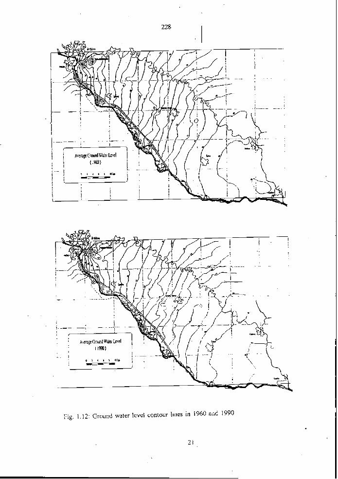
Fip. 1.12: Grouiid water lcvei contour Iincs in 1960 and 1990

Fig. 1.13: Ground waicr level differcnce Iines he~ween 1960 and 1930 and ~ ~ o u n d warer IcvcI depth 1n 1990


The annuaI rainfa11 (500 - 700 mm) is much smaIIer than the need of waler suppIy to the vegdafion, especiaIIy during the summer season. This exrra water suppIy was possibIe in the p a r ttsroughorrt trie area by ~eriically upwards flow in the capiIIary zone from the ground water table to tbe rmt zone. The necesçay cc)ndirions for thrs are that the ground water table is not. tw deep and that no grave] Iayer is Imted over the ground water tabIe. The predarn conditions are cbaracterid by measured ground water Ievel quipotenfial lines (Figs. 1.12 - 1. I4).
However, due to the dmease in ground water IeveIs during the past few decades, especia1Iy afier the second warId war, it has k e n necessq to make artificiaI irrigation for the agricuIture, Thus$ on the SIovak side, a comprehe~sive network of surface water canaIs has been deveIoped for imgation purposs. However, 8rtificiaI irrigation has ils disadvantages as compare3 to the natural situation because The downwards water flux causes a considerable leakage of nitrates, organic components, pesticides au? ather chernicals into tbe ground warer.
1.2.4.2. Influence of Ground Water LeveI Decrease in Inundafion u ~ o n Forcstry
In the past, rhe memures taken for the navigation. constrained the possibiiitieç for the deveropmen1 of rhe Danube and the f ldp la in area. The predam trend witb Iowering of the Danube water leveI, endikemenrs, cutting off the side branches upsrream and fortification of the main channe1 has stressd the biotic communities substantiaIIy during the las1 decades. As a resuIr of past gound water decrease (typical exampIe is the S M weII No. 673 situai4 at the viIIage Bdiky, Fig. 1-16), some area of soft ailuvia! forests have been tumed into hard aiIuviaI fores&. The Iatter were often cuItivated wiih poplar and white willow. Furthmore, it is estimated that Iarge part of the originally forest is not aIIuviaI forest any longer. In addition, forestrjr bas repIaced many natuwI fores~s by pIantation, wbere intrduced cuItivars of poplar bave been usad. Due to anthropogene effects, the dynamics and structure of aIIuviaI forest were considerabIy disîurbed and made the invasion of Solidago, Aster and Impatiens specis possibIe.
Percentage of discharge in the Danube and ils river branches, before cutting off and cIosing rhe river branches, is shown in rhe TabIe 1.3. The firsi number in lhe tabIe is discharge in rhe main stream of rhe Danube, ~ h e number in brackeis is the discharge throughout the nver
i branches. Ir can be seen rhat e-g. from rkm 1833 10 18 16, in rhe area of Gabc~kovo. rhe discharge in the nver branches was before the clwing the river bra~rches approximately 20 O/u of discharge in lhe Danube in Bralislava, aIso by low d~scbarges. i n rhe opposite, a short rime before dsmming of the Danube rhe flow in some river arms started by discharge in Bratislava from 2500 - 35#0 m3k. The flow in alrnost al1 river branches occurred when rhc discharge in the Danube was over 3500 - 4500 m'k. The main difierence berween ~ h e conditions in Ia~e I95#'s and predam conditions is, rhat in the far past the main river branches were suppIid with waier aII the time but in pre-dam condirions Iess than 78 days in a year.


T a b b 1.3: Percentage of discharge in the Danube and her river branches {Dub, Duba. SzoIgay in 1101)
Discharge in Bratislava (m31s) 1005 1958 2998 40M
rkm ("/.)
j.tA.3. Influence or Ground Water LeveI Derease upon Water Resources
The city of Bratislava iç suppIied with water Tram the weIIç situated near the Danube at various places. Some of them are in the position where thickness of the grave1 and sand sediments is very Iow. PospisiI and Kucera 11 71 estimated deep wosion of river bed in various places at the Danub~ (TabIe 1.4).
Table 1.4: Erosion of the Danube river bed (1964 - 1990)
Sihor 1875 1.18 10 - 17 Pecensky les 187I 0.77 8 - 14 Bratislava - Iimnigraph 1858 0.45 8 - 15 Rusovce - Osirovne Lucky I856 0-4 1 15 - 45 Cunovo 1855 0.95 45 - 100
Ar Iocaliry Pecensky lcs, Pcrspisil 1161, estrmêtcd rhe dvçreasu of gciu~id warer inflow rowards ihe systenr of wells of 30 - 40 % lre~wcen rhe ycars 1973 - 1991 A I rhe localiry Rusnxce -

Osrrvvne Lucky, Pospisil and Kucera 1171 cstirnated the shift of watershed divide rowards Cunovo Prther from the Danube.
l 1.2.4.4. Influence of River Bed Erosion
The ground water level deaeasing csn be also studied witb rwpect to geological conditions downstream of Bratislava. Fig. 1.7 shows that the Danube bed erosion is prugressing. The basic problem creates the suissidence of the Danube bortom with respect to the geologrcal interface between rhe grave1 of the Danube sediment depairs aad subsurface sands of the Neogene age. ProbIems caused by erosion are weII visibIe in Fig. 1.17, where the geologcal profile, worked out by the enterprise IGHP, is demonstrated in ibe site of pIanned sribway under the Danube.
Thus the progressing prmess of the Danube bed erosion has not only a negative impact on present ground water level decreasing, on decressiag of the infiltrating amount into the Danubian Lowland region, but also on the possibility of a substantial erosion acceleration downward from lie granite theshoid iipstream from the Bratislava castle, in places from the OId Bridge down to the winter harbor in BrarisIava. II is ernphasized, that the most signifiiant factor of erosion is rhe water flow velocrty and by infiuencing this velocrty ir is possible to direcrly influence the erosion and seùimeniation prwesses.
SimiIar problerns are known and dacribed by Austrian water researcbers Kresser 161, ZortI [8] and Prazan [7j and the cuttings from their articles are enclosed (see Appendix).
There is the imminent danger of the Danube river cutting into the Neogene sedimeats and consequent substantial acceleration of erosion, further ground water Ievel decreasing and, naturally, also decreasing of well yields, especially in the region close to Bratislavs. Tbus, prevwtion of hrther erosion of the river bed and successive improvements (rising of the bottom) are more than advisable.
1.3. FORECASTING OF €ROUND WATER LEVEL WITHOUT GABCIKOVO EIYDROPOWER STATION
From the long tcrm ground water Ievel measurements basd on statistical analyses, a long- tcrm drop of ground water level was estimated. Based an the data evaluation, the extrapolation for the future was made. It means, that the forecasted ground water tevels ,
expressed in equipotential lines will be reached under conditions, that the processes pelding to ground waler level decreasc would continue witbout changes. According to OUT opinion, rhe river bed erosion wiII be speeded up afier consrniaion of hydropower sration in Vienna Freudenau. In the Fig. 1.18, there is shown the real referace ground water IeveI before damming rhe Danube in so-caLIed predarn condirions in 1992. The forecasted ground warer IeveIs in 2022 are in Fig. 1.18. This means extrapolation 30 years afier damming rhe Danube. It is eyident tbat rhe forecasted changes, decreaçe of gound water Ievel, are from 311 points of view, and especially from the point of view of ecoioçy, very negative.

* Fig. l . 17: Geological profile downsrrram of the OId Bridge in Bratidava

Fig. I . 18: Reference ground water IeveI equiputential lines in 1992 and foresasied referencc gound warer Icvel equ~po~entiaI Iincs rn 1027 (îor prc-dam conditions)
I
:a

1.4.1. Interpretation or Changes 5 Mvnths rrZter Darnrning the Dsnube
The influence of damming &e Danuk caa k stxn on 3 3 i c a I chosen piemmeters. Fig. 1.19 represents water dischar& in the Danuk starting al the lime of predam condirions. In Fig. 1-19 tbere is shown the date of the damming the Danube (Oclober 24, 1992) and starting the fiIIing up the river amis in inundation on the SIovak territory (May 5, 1993). TypicaI weII, not far away from the reservoir, the SSHMU weII No, 694 (Fig. 1-19, see situation in Fig. 1.9) shows minent incrase of ground w8tR I d just a fier damming Ihe Daube. The SHMU weII No. 673 (Fig. 1-20], simaid in inundation near the river Danube, shows after darnrning the Danuk the decrease of grouud water IeveI and incïease of g m n d water level after friling up the river arms. The SHMU weI1 No. 679 (Fig. 1-20], situaid
. behind the pmwr chanael, shows decrease of =und water lc+-:I afier damming the Danube ,and visiMe increase of ground water IeveI after fiIIing up the river arms. It is eviden~ the impact of no1 onIy the damming the Danube but also of the fiIIing up the river arrns.
To show the regonaI impact of damming the Danube and fiIIing up the river m s , rhe equipotentiaI Iineç were drawn for both cases. From the SHMU weIIs, Ihe ground warer IeveI equiporentiaI Iines were drawn for the date of April 28, 1993 (Fig. 1.21). Reservoir was f i i ld up but the river branches in inundation were stiII empry. Using prediction of warer
- IeveIs for rhe situation without filling up rhe reservoir, the quipotenlia1 Iines for the same dare were coastnicted (Fig. 1-21). The d i f fmce lines, constnrcled from theçe two figures, , give to us a general overview abour changes in &und water IeveI (Fig. 1.22). On weIIs, situated near the reservoir, r)me 1s ltre inmease of ground water ieveI and in oppaire, on weIls, situated aear the intake chaune1 Ieading to tb power pIan1, there is a temporary decrease of ground water IweI untiI some remedy messrues are realized.
1.4.1. Interpretation of Changes 8 Months after Damrning the Danube
Influence of the fiIIing up the river arms in inundation (May 1993) can be seen on the SKMü weII No. 673 (Fig. 1.20), which is situated between the Danube and intake cbanneI. SimiIar situation is on the SHMü weII No. 679 (Fig. 1.20) behind the intake channel.
The marn difierence between 5 and 8 months ai3er damming lhe Danube 1s caused by rhe fiIIing rrp rhe river branches in inundation on lhe SIovak terrirory (May 5, 1993). To express rhe situation after 8 rnonthç aRer darnrning ihe Danube (June 30, 1993), the ground water IeveI equipotentia1 Iines based on the measurd SHMU weHs are shown in Fig. 1-23. Using prediction of water IeveIs for r he situation without damming rhe Danube, equiporenria1 Iines of ground water ieveI were consrnrcted (Fig. 1.23). Comparing quipotenrial Iines, the diFerence Iines of ground water Ieveis are presented in Fig. 1.24. Fig. 1.24 represents the change of ground warer Ievels on 30 June 1993 in camparison with the conditions wirhout rhe damming the Danube. From the figures il is cIear that the damming the Danube and fiIIing up the i v e r branches have incresed gruund- water IeveIs on the whole territory incIriding the inundation approximately ru the stare 30 years aga
Except this, ii is cIear ~ h a r the ground water Ievels are very sensilive upon ~ h e lilling u p rhe river branches in inundation. This means Thar nver branches are orle of rhe managemen1 rooIs for grouad water level optimizatrun. The changes of gruund warer Iëvel, rneasured un ihc SHMU weII No. 679 in t h c second half of June, show the gocd rcsponse on h~ghcr walcr

DANUBE IN BRATISLAVA
126.0
i WELC SHMU No. 694
1-
125.0 4 -I
. O - . ! ./- JI
4 $ - E < g ; ,. - . : - -
: 24 .5 j ? .- d .
4 . - - 1 r
. \
. .. O .'
Y.
1
rneosureo GWL (influenced by rdseruoir) :- :.,... rnodellec GWL (computed ore-dbm conoit;o-s. - . Q ' - ,.>- , , - , , - . , : . , . - - . - . - -
r i : 2 i 2 4 = 0 - . L - - - - , .
F I ~ . 1.19: Discharge In the Danube rn BratisIava and rncasiircd ana rndelcd ground woicr IcveIs in rhe SHMü wcII No. 594

3 WELL SHMU No. 673
i 3 i ?
i -5 - measufed GWL (~nfluenced by 1 , . modelied GWL- (computed pre- i
. :
' i i ' i 2 ' 1 ' 2 ' 3 ' 4 ' 5 : 6' 7 ' 8' 9 ' 1 0 ' 1 1 ' 1 2 ' 1 ' 2 ' 3 ' ' 5 6 ' 7 5'
1991 1992 1993
WELL SHMU No. 679
- meosuieo GWL (iniiuenceo 5 y rkservoir) - - - . . . mooeiled'GWL (cornputed ore-obm conditionsj
! . . + -
0.L . , , . , , , . . - 1 j 5 8 5 - r : . : ? , - . - - . . ? I ' L - , - . :
. ,.-. - < 7 992 > - - - - - -
Fig. 1:20: Lleasured and rndeled ground water levels in the SI-IMU wellç hlo. 673 and.679

Fig. I .Z I : Ground waler IeveI equrpotenria1 Iines cornpuItvi for pre-dam condiiinns and rncasured (April 28, 1993)


I
I ; measured
, -
Fig. 1.23: Ground water level equipoieiiiial lincs çcirnpu~ed liir prc-dam conditions and measured (Junc 30, 1993)


IeveIs in the Danube (pal of discharge was Ied rhrough the weir-in inrrndation to the Danube) and confirm rhar rhe future wnstruaioa of srnaII undemater weir in the Danube would act as an adcldional important means for optirniring ground water levelç. The undemater weirs are imporiant not only fur the p u n d water IeveI optimization bur also for diminishiag tbe ciifference Mween gruund wster IweI and water Ievei in the Danube and for better mutua1 intercornedion b e e u the DaouIx and the river branches corn the point of view of fi& and ecoIoa.
1.5. WATER QUALI'IIi'
1.5.1- Surface Water QuaIIS.
The river Danube water quality is eduated f m the point of view of oxidizing - fedrrcrion conditions [25]. FoIIowing exampIe of evaiuatioa is bas4 on analyses of the wster quaIity taken at rbe &unicipal warenvorks Sibot in BraiisIava.
Concentra~ion of CI- and 50~'- depends on discharge and is presented in Fig. 1-25.
Contents of 02 and COD(Mn) is in Fig. 1.25. From the figure it can be seen that the trend is in the direcrion of impruvement of wata guaIity frirm the point of view of recharge of aquifer and river bank infiltration.
Co~centration of NOj and NG- is shown in Fig. 1.27. Ir is shown an increase in nitrate. The maximal contents of nitriies is up to 0.3 mg.
The genual improvement of the water q=a~ i~y in the Danube is because of improvment and capaciw of bioIogrcaI purification pIants at the Danube, espeçiaIIy Vienna's main purification plant, which was put into operation in 1980- the Schwahat's refinery and SIovnafYs refinery purification plants and Bratislava's purification p h l s on both sides of the Danube. Some addi~ioaaI infmation about the Danube water quaIity is gven in Appendix in PERSPEKTIVEN.
The changes in the Danube water quality- since 1960's couid be seen when comparing publicarions 126, IO] witb 18, 91.
15.2. Ground Water QuaHfy
Aerobic bidegradation is an important mechanism fur swing ground water quality. R d o x reactions may often be key mechauism controlling Ihe migrarion of toxic and inorganic was te in the çediments and in rhe gound wat?. Ground wa~er in water suppIy areas is sr111 of exceIIen1 quaIily and mostIy of oxiditing conditions in the Zitny osrrov area. Tbe main goal is tu save rhe favorabIe oxidizing conditions mainly in the area used fur waier suppIy.
Ground warer quaIity, çince damming rhe Danube, is carefully rnonirored and evaIuared in reguIar reports. in 1281 lhere is evaIuarion of gound water quality from October 25, 1992 to Deceinber 3 1, 1993. The main results of this evaIuation are: 1 . In gruund warer, whicb is used for municipal waier supply, in no case rhe vaIues,
according ro rhe Slandardç CSN 75 7 1 1 1, were exceedcd i

245 I
SIHOT - Dunoj '
- .
Fig. 1 2 5 : Trcnd of concen~ration of CI- and 'Sud2- in i hc Danube water

SIHOT - Dunoj I
I?g. 1.26: Trend of concentration of Oz and COD(Mn) in the Danube warw
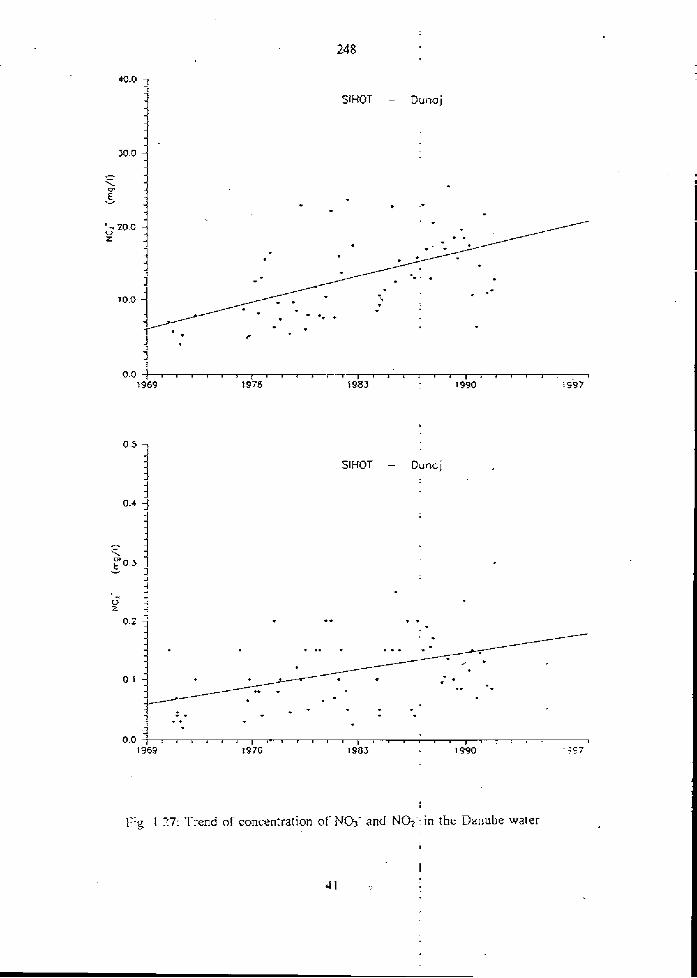
1-ig. 1 77: Trend or concenttarion of NU< and NO1-- in the Danube water

2. The basic chernical t h e of graund waters s~ayed neariy irnrtianged in the whole perid, the range of fiuctuation af the contents of dissolved substances and fbe changes of the contents of inorgmic mamopollutants do n.01 go out of range in the long-lem trends
3. The most sigaificant changes of chemical composition (which cari Iater affeci The gound water quality eçpecially in the vicinity of large water supplies situatad in the riverside m e of the Danube at the Zitay ostrov area) wcur in oxygen regirne.
4. . In spite of the more exceeding of water quality indicators (mainly in the first phase of Filling up the reservoir), there were positive changes in the development of water quality (especially in the'rlgbt riverside zone of the Danube - in the vicinity of the water supply Rusovce - Ostrovne Lucky - M o h d ) .
5. The hydrug&emial changes which were monitored, in general cwfirmed tbat the ground waler qualily is unchanged or in some place it is ~ O S S ~ bIe to evaluate improving in ground water qualiry. This improvement is n d necessarily definite. Further monitoring is required.
5. Changes in the surface warer quaiity are n d signifiant. The siide changes are in oxiditing conditions and microbia1ogicaI indicators.
I 7. In the power channe1 and tailrace channe1 the water quality is sirnilar as in the reservoir at Samorio.
1.6. QUALlTY OF SEDIMENTS
Complex evaluation of sedirnents is summarized in [24]. In the database, tbere is 186 analyses of sediments and 3 analyses of suspended load from the river Danube, taken before damming the Danube. Except this, thme is 37 analyses f?om the 1st survey in the framework of P r o j ~ PHARE. SampIing p i a w in rbe IIas suwey were sitrrated in the areas where there is possible recharge of aqni fer and in the areas where the ground warer is fi owing rowards possible places of future p u n d water extraction. PIaw of sampIing are shown in Fig, 1.28. 8 samples were a n a i e in two laboratories, in the Nethlands and in the Slovak Republic. Resulis are gven in the Table 1.5. Based on the evaluation of the expert from the Netherlands, Mr. J. GrifExn, the results could be summarizd as fdlaws:
in the area of Gabcikovo reservoir, the sediments are nor evidently contaminated sediments are not contaminated by organic contaminants in spite of tiighkr contents of heavy metals in sediments analyzed by the method of total decomposition, the situation is not worrying because a Large part of the hcavy metals in the sediments is in the forrn of stable rock minerals (e-g. Cu, Ni) contents of some metals in oxidizing conditions is in river sediments in Alpine - Carphatians geological conditions high and i t does not mean a pollution.


L w -
A. OMECAM, H 1.E. Wrnckebachdg 120, 1096 AJR Amstrednm, Holnndsko Il. Chcmlcky usinv PriF UK, Mlynrka Jolina pav Cl.(-2, 842 15 Brstislava, SlovenskA republika
NA - not analyzed
ND, - no1 detectcd

2. FROM THE HISTORY OF ORIGIN OF W O W N G GROUP OF INDEPENDENT EXPERTS EU
Z.I. FACT FINDINE; MISS'UN (Ocfober 27 - 31,1992) AAer unsuccashl bilata! negotiations between Huogary and Siovakia concerning Gaixikovo - Nagymaros Roject, EC Commission (now EU - European Union) inviled Czecho-SIovakia and Hungary for a trilaterd niMing at Brusels on Octaber 22, 1992. During the negotiat ions, CzechsSIovakia handed over the Aide-mbmoire, the çubs~aax of which was that during lhe wmk of the hipartite &mission VWorking group of independent experts on VaRant E of the Gabcikovo - Nagymarm prcijct") Czecho-Slovakia would not divm water from the common riverbed and only navigation would be transferred to the CzecheStovak reïritwy. Aide-mémoire confirmecl that damming of the Danube was not a definite solution, if conclusion of the tripartite cornmission would prove the principal negative ecological impacts of the Gabcikovo scheme. Huogarian delegation refused proposais containal in Aide-mémoire and conditioned the establishment of tripartite commissiod by interruption of works leading to the damming of the Danube. This requiremwi was unacceptable, because of technical reasons and necessity of and-flood protection and navigation. Czecho-Slovak delegation expressed readiness to receive independent experts who could evaluate the real situation and rhe emestness of ils proposal. AAer this unsuccessful inratera1 meeting at Brussels the damming of the Danube had been srartal on 24 October 1992 and on 27 Oaober 1992 the Danube was dammed.
In ConKlecti~~ with rhese talks, the EC Commission has sent a Fact Finding Mission to ihe a m of Gabcikovo project. The mission- carriexi out su on-sire inspection of the angoing work on Tuesday aflernmn, Octok 27, 1992. The mission from the EC Commission conçisted of the foIIowing three persans: Mr. Jens Christian Refsgwd - ream Ieader, Denmark ,
a Mr. Jan M. Van Ge&, Director Infrastructure, DHV, The Netherlands Mr. Jesper T. Kjelds, Cornputationai hydraulics engineef, Denmark
Terms of References of the Fact F i n d i n ~ Mission
1. To make an on-site inspection of the ongoing work. 2. To assess rhe need and urgency of the ongoing work in tight of potential flooding risks
for damage to already constnicted parts. 3. Tu assess the immdiate conseqrrencedimpactç of the ongoi~g work relating to:
Navigation HydroIogrcal aspects Environment
4. To msess the irreversibility of rhe ongoing a~iv i t ies and IO assess the cost for resroring starus quo.
5. To establisb when works on the Danube can be stopped withaur risks for existing structures or flods.
6 . To establish whethw and when the Danube waters can go back into the existing bed after the present works have bcen finalized and the artificial canal filled up. To indicate flows and dates of possible realization.

7. The resurts of the consuItancy mus1 be comrnunicared 10 Mr. Benavideç and Mr. Giunli as soon as possible. Mr. Giunti shouId receive daiIy briefing from Mr. Refsgaard un the progress of invesiigat ion.
The Unired hngdam, in the capacily of the Presideni of the EC Council at that time, -me in rhis situation w i ~ h a new initiative. During rhe summit of the prime ministers of the Visegrad group (Hungary, CmheSIovakia and Poland) with the Premier of the United Kingdom, John .Major, the b-itriIatersI negotiations were heId in London on 27 - 2 8 - 0 a o k 1992. There was decided to put together a new Facl Finding Mission compas& of one expert from each of the three parties. The following t h e experts have k n appointed to constinte the Fact Finding Mission: -
CEC: Mr. Jas Christian Refsgd, ~ h i e f Hydrolugist , Danrsh Hydraulic Inaitute, ream leader of the Fact Finding Mission
CSFR: Univ. Prof. Igor Mucha, FacuIty of Narural Scien- Comenius University Hungary: Dr. Pber Bakonyi, Managing Director, W U K Y CoasuA RIi Budapest
The Mission met in this constellation the first time on 29 Octok 1392 in Gy&. It car i id out an on-site inspeclion of the ongoing work on 30 October 1992 and heId the concIuding meerings in Bratislava on 30 - 3 1 October 1392. The Agreed Minutes {see in Appendix) from triIatera1 negotiations in London were uçed by The Fact Finding Mission as the Tems of References.
GeneraI results of the Faa Finding Mission incIuding the h n d o n Agreed Minuies in the original Tams of Refaences are as followç:
In a possibIe f l d situation some of the not yet finished structures might k damage3 depending on the peak and duration of the f I d . To mett the design h o d criterion Q0.013CYw the Phase 2 cf Variant C ha9 to bt cornp1tte.d (Fig. 2.1). AIthough not d i r a reIated to worh of Variant C, the m m fi& endaagered reach of the Danube in the Area of interest is the lefl band side between Palkovicovo (rh 18 1 1). and Mdvedw (rkm 18063. As a mnsquence of the ongoing work the Danube discharge i s separated in fwo parts. One part supplied the power aria1 Ieadhg to Gabcikavo whkh serw as the navigation channe1 as weII. The other part of discharge is direcfed into the existing Danube bed through the by-pass weir. The water management possibilities are restrktod untiI the various parts of the hydrauIie stnrcfures are fuIIy cornpIeted. After completion of
. Variau1 C, the ruII cornpIex of stmaures can provide comprehensive possibilities for regdation of the discharges both by low discharge and fi& situations. The major trrvironmentaI impact is reIated tg the ground water resuurcw and tu fhe ecoIogy, The effect on f l d p l a i n ecology is a resuIt of bdh the Ioweiing of ground waler tabIe and a Iess frkuent inundation of rhe flood pIain. Thus the environmental impacts of reducing the discharge ia rhe Danube are negarive, unIess proper remdia1 actions are taken. CSFR hm includd a budget of 2.4 billion CSK for construc~ion of underwarer ,
çtructures as part of Phase 2 of Variant C. There are fndicaîed somc pvssibIe remediaI rneasureq e.g. srnaII undemater weirs, gate operation, htereonnection of Danube river bcd with river branches, adding some materia1 into the river. Ii i s stressed, that such remedial measures are possible tu be made because the navigation takes place in the powei cana1 instead of the existing Danube bed in this reaeh of the Danube. ~rnrnediite impacls observed in Hungary are incIuded. CIosure of the Danube rcsultcd in decrease of discharge. On 24 October 1992 ~ h e discharge was 800 - 900 rn3/s. On 28 October 1992 rhe discharge w a 227 m3/s al Raika and 355 m31s at Drrnaremete. Due 1~

1 Z OP:


DISCHARGE RATING CURVE
at R a j k a . rkm 1848.4 . .
Before the darnrning of Danube
IDOO eOQD JRUU rouo nono ocoa rDoo 8050 ooao roooo m 3 / 8

Scensrias
Sceaaiinos, based m tbe London Agreed Minutes, that the project w i l be stopped at the date specified by the EC Commission, are as follows: 1. The work will be stopped for a perid no longer than one month. II. The work will be stopped for a period u p to fbree months. III. The work wiII lx stopped for a period of one year,
Scenarirw. basai an Ihe London Agrd Minutes, that rbe wbde quantity of water wiII be maintairid in the old Danuk riverbed, are as foIIowç: A. The "whole" quantity of water is dîrated into the Danu&. B. The main part of the water is diYerted to Gabcikovo. C. A combination of A and B.
Al1 the scenarios were evaluated. The mission believed, that it would be possible to define more oplimai scenarios mainiaining the major pan of the advantages of A and B and at the same rime not mntaining rhe main disadvantages of A and B. In addirian ru the above, it is empbasized, rhar a more final optimization wirh full weight to the ecoIogica1 conditions most IikeIy includes a range of regula~ion rneaçirres within rhe f l d plain area itselr
It is evident that no scenario and no date to stop the work was propased.
2.2. W O m G CROUP OF INDEPENDENT EXPERTS (November 9 - 23,1992)
As a folIow-up to the London Agreed Minutes, a Working Group of six independent experts was established. The Working Group was composed of the fo1Iowing experts: CEC: h?r. leos Chnçtian Refsgaatd, Chief HydroIogist, Daaisli HydrauIic Instirute,
Denmark, Team Leader
Mr. Jan M. Van Geest, Directw DHV Environment and Infr~ructure, The Netberlands
Mr. Johann Schreiner, Director, Norddeutscbe Naturschut;?akademie, Germany
Professor Dr. Hcirrz Loffer, Head of ZooIogicaI Depaniiieni, Univcrsily of Vienna, Austria
CSFR: Professur Dr. Igor Mucha, Faculty of NaturaI Sctence, Comenius Univers~ry Brar islava
Hungary: Professor Dr. Gabor Vida, Head of Department of Genetics, EGtv6s L. University, Budapest
The Working Groiip consists of hydrologist, water works engineer, ecologist, zoologist, ground water specialist, genetrcisr. If means generaIIy ~hat the group consists of one technician, two waicr spcciaIisrs and rhrcc nicmbers of natursi srienccs dcaling with ecoIogica1 probIems.

The scope of w a k of rhe Working Croup of Independent Experts was expregsed in the Ietter sent by the CEC on 29 October 1992 as follows: The Working Group will: i) Make an on-site inspection of the structures of Variant C and describe the state of work; ii) A s s a the need and urgency of these structures in the; ligbt of the potential flooding risk,
including the risk of causing damage to already constructed parts; iii)Assess the (immediate) consequences/impacts of these structures relating to:
* Environment, c o k n g : - Erosion and Sedimentalion in R i v a and River Reservorr System -Surface Water Quaiity - Ground Water Regime - Ground Water Qual~ty -River and Flood plain Ecology
Hydrological and water management aspects and * Navigation
The assessrnent will be based on an outline of existing (predam) cwditions and trends.
iv)&çess rhe reversibiliiy of these stmctures and assas rhe cost of restoring rhe srattis quo ante, i.e., the situation existing prior to the constmction of rhe dam;
Y) Make çuggesrions for (urgcnl) measmes and, if necessary, audies to be (under) taken to improve the ppresent conditions.
2.2.1. Working Material Prepared by Slovak Expert
Working material 'was prepared in separated report [Cl. The main goal of this working material was the identification of the hydraulic swem und? the condition of the hydropower sution Gabcikovo, caiied as Variant C and outline the possible oprima1 and benefiQa1 use of the Danube water for various inrerests. Repori includes: Ouf Ifne of siate and present trends in the srea
GeoIogicaI conditions Long-temi impacts and trends in the area General ecological requirements
O Erosion and sedimenration in riva system Surface water quality
i Ground water regime Trend of ground warer leveI depth Ground water leveI fluctuation
4 Ground water quaIiry River and f ldpIa in ecology Conditionrng factors for recoverîng of inundation f l d p l a i n Trends in the past Navigation
Capaciry, nurnber of boars of navigation cornpar& CSPD Bratislava Navigation conditions Problcms on rhe secrion Orari~Iava - Kornarnr) '

Lmmediate and potehtiai long-term consequenceslimpacts of the Gabcikovo Varian C and outtine of possible remdial masures impact of rcscrvoir of hydropawer station on ground water levels i Hydrology and water management
For-ing of ground wat- Itvek w Immdiate impacts of Vnriiint C on grwud water tevels
Imrndiate impacts of Varisnt C on Danube water IeveIs fiom Cunovo to Sap + Environment i Improvment of navigation conditions afim finishing of Gebcikovo dam
i Time savisg Saving of energy Improvement of depth in harbor of Bratislava Increment of turnover Roblerns of navigation at the place wfrae the Danube and outle1 cana1 are joining
s Possible r a d i a l measures Hydrology and wafer management Environment
i Navigation
Except tbis, two scenanos have been elaborated: Water management scenario based on requirements of the SIovsk Ministry of Environment Scen&o bas& an treaty between Reptiblic of Hungary and Czxh and Slovak Federal RepubIic
DelaiIed monitoring of discharge, water levels, gound water levels and -1ogical factors were proposed. It was stressed that al1 measurements are canied out on bath sides according to agreed monitoring system.
.,.
2.2.2. Main Resiilts of the Working Croup Report
From the ecologicai poinr of view, the following statements are interesting in the Executive Summaq.
The bydroiogical and ecological regime in the area is subject to o Iong-tcrm trend of river bed erosion, decrcasing water Ievels and associated ecologicaI changes. This i s caused by a vanety of reasons, above al1 the large river regulation works, wbich implied deliberate unnatural cutting off and bundling of river branches into one main, straightencd and heavily fortilied channel for navigation. In spire of this basically negative trend the B d p I a i n area with ils alluvial forats and the assmiatd ecosysrems siili represenrs a very unique Iandscfpe of outstanding importance.
In thc past, the mfasures takm for the navigation consfrained the possibiIifies for the dcvelopmcnt of the Danube and the fiaadplain area. Assuming the navigation wiP no longcr use the main river ovcr a length of 40 km a unique situation has ariscn. Supportcd by tcchnical mcasurcs the rivcr and the floodplain can dcvclop more naturalty.

Variant C Strucfures and Sfafus of Work
- In borh countries rhe originaI stnrcfures for the GaIxikovo scheme are compieted exc* for the closure of the Danube river ai Dunakiliti and the installation and testing of,turbina.
l Varimt C (fig. 2.'1) consists of a cornplex of stnidures, located in Cscho-Slovakia within the area of the original (accwding to treaty) Variant A.
The bhydrapower starion is dsigoed for peak pawer production. At the rime of Working Croup idivity five turbins (frein 8 plannedj and genemtors bave ben instaIled.
The floodpiain weir and the bortom protection were onginaIIy d-fgned f6r use onIy in flood situations (few days per year). During tbe Working Group activity this Z ~ i g bas been modified to aliow its daily use as a result of the London Agreed Minutes and a g d will and flexibility of CSFR Along the Danube right bank a spillway was unda construction and the downstream bd would be protected with additional 100000 rn' s!one. (The unexpected high f l d in November - December 1992 erûded the area between the f l d p l a i n weîr and rhe pIanned spiIIway along ~ h e Danube right bank and the constniaion is no more rea1izable.f
The intake mcture at entrance to the Mosoni Danube and suppIy cana1 on Slovak rerritory witb ~capacity 25 m3/s bad been constmcted.
An intake structure located in the power canai allowing for a maximum intake discharge of 234 m3/s to supply I riva smis and the f idp la in downstrearn the Dunakiliti weir on Slovak territory is completed.
The road an side of the rîghr side dams conne~ing Bratislava with tùree viIIages Iying betwew power canal and the Danube is undq mastryction.
Assessrnent of the Need and Urpencv of the Stnictures I
The designed f l d discharge for the project of Variant C (Phase 1 and Phase 2 of coastmction) is based on 10000-year f l d Micurrence, risk of occurrence of çnch f l d is
, 0.01 % withrn a year. For rhe constructron perid, irsually Iarger risk is accepted. The flooding nsk of stopping rhe wark depends on the seasan p e n d during which the work wiII
l be ptopped and the Ievel of finatization of stmctures. Sropping the work in surnmtr perial needs bighm frnaIizarron or the risk is much bigher. Akhough not directIy relatai ta the
l works of Variant C, the most flood endangered reach of the Danube in the area o f Gabcikovo - Nagymaros system of water works is the lefl-band side between* Palkovicovo
I (Sap rkm 181 1) and Medvedov (Medve r b 1806) due 10 extensive siltation and tack of dredging ('roblem of erosion upstream of Palkovicovo when dredging witbout of decrease of
l flow velocities, see soiirtiori in cornmon projeet of Gabcikovo - Nagymaros).
The ~abcikovo comprex can regulate the discharge between 80 m'ls (discharge for navigation and ship Iocks) and 5200 m3k which is the maxima1 discharge in powcr canaI. Upon compIetion ihe weirs of the P ~ H s ~ 1 of Varian1 C can regulate discharges between O and 6100 m3/s. Alter completion of Phase 2 or Variant C, the full complex of structures can

- provide comprchendve possibiIifies for reguhtIng the dischargcs, boB in Iow ZIoW and flotid situations.
Reversibility of Variant C
In principle, the Variant C could be reversed. The stnictures, excluding some of the underground parts like shaet piling and injections, could be removed in thaory. n e cost of removing the structures are roughiy estimated 10 at Ieast 30 % of the (nowadays) construction cmtç. There wiII be negative environmental e f f w during the dernolition d the s!ructures and the depition of the waste materials. If is therefore relevant to evaluate under which c ircumstan~ the Variant C structures ~ u l d have only insignificant and very IocaI hydrauIic effect if rhey are no? fuIIy removed. Such "funcrionai reversibiliry" is possible for a scenario tike: a I f the Dunakiliti weir on Hungarian territmy is being operrited accordiug to xhe original
plans, the gates in the Variant C structures can be kept fully open and will not have any significant effect. Howeva, in tbis case it should be evaluated, whether it i s desirable to maintain the riverside forest on the Hungarisn side for the 7 km reacb between the two structures by not using the area as a full resewoir. In such case it may be necessary to operate bath sets of structures. If the Danube clmure is removed and rhe "wtiole" discharge is routsd back to the Danube.
I I States and Trends in the Area
I In generoi, Iarge moniforing prcgrams are earried riut and large data bases exist for borh the SIovak and Hungarian areas.
Before the 18th century, the Danube split downstream of Bratislava. Near Bratislava it was psrtly a braided river with many small islands as a result of progressive sedimentation where the Danube entered into the pIain. It was a meandering river system. Large changes mcuned in 19th century, when the first regulation wmks started. Within several decades of instability and retrogressive eroçion of oiher meanders, the system changed into braidsd river. With the pas1 end~kemenrs, rbe original zonation in vegcrat~on towards higher grounds and associared foreas was Iargeiy 'diked' out of rhe naturaI syçtem. Most o'f the higher, no longer f l d e d
- soiIs, were convefled intu agricuItura1 lands. Thtse river reguIarion works Ied to delriserate and naiura1 curring off and hund1ing of river branches into one main, strarglrtened and heaviIy fortifid channe1 for navigatran. The cul off branches are only activa~ed at bigber discharges.
Within the river branches many small weirs and dams wcre buUd, so most of thcm bchavc like cascade systcms at Iow discharge. Some are continuo:isly overfiowing while others may have dried and some sections are with stagnant water depending upon ground water levcl.
The main river channe1 has been significantly lowered due to erosion caused by a cornhinatron of several factors. In some places the river bed bas been Iowered more than two merers, Ieading to lowcring of ground water Icvels, drjling OUT pari of r ive r branches and less flushing of mosr river branches. The Iowerirrg of 1lie nverbed dunng rbe pas1 30 years bas been panicuIarIy Iarger between BrarisIava and Rajka (1.5 m). The quanriry of süspended and bed Ioad on rhc Danube under Braiislava shows a decreasing trend.

The quaüîy of the Danube water can be categarized as 1st ciass regarding to the majori~y of mmponents, 2nd cIass wirh regard to onhophosphate, nitrite, BOR, pH and 3rd d ~ s s with regard to bacteria and some heavily degradable substances such as h y d r w b n s . Pammeters for irrygen eonfenfs and organic carbon show slighfIy improvhg trend, while deteriorating m d exists for nitrire and some heavily degradable materisls. Su date water quniitjr $ weïï suited for river bank Infiltration which is the major source of water auppIy aIong the Danube Between BratisIava and Budapest.
The water quaiity of the side branches differs from that of the main Danube channel due the Iower velocities and periods and placm with stmignan t water. This negative trend bas been observed with higb pH, high otganic matter and low oxygen contents.
Ground water regime i s to large extent detemiined by the pmeabiliiy of the main river channe1 and the variariois in riva water Ievel. Betweea BrarisIava and Kamania 10 - 20 m3/s of water infiltrales on Siovakian ade and 8 - 9 m3is on the Hungarian side. Due ro a very large permeability of aqrrifer, the ground water flow vdmiries are very high (1 - 3 mlday). Tbe depth of ground water shows a trend of decrease around 2 m near BratisIava to about zero at Komarno in the Iast 30 pars. This decrease is due to erosion of the *ver bai. An impofiant feature is rhe Iarge grotrnd water Ievel fluctuarion.
The ground water quality in the area dominated by the infiltration from the Danube is generaUy in a good stste. ~ b e quality abstractsd from the wells located close to the Danube is geaerally excellent. For the areas furtha away from river, where the ground water iofiltrated partly in agncultural and industhal areas, there are some prciblems with ground water pollution.
The ongohg prcdam trend witb iowering of the Danube warer IeveI, changes in rhe charader of the flood peaks, widikements, cutting off the çide branches npsrream and fortifrcatiun of the main channe1 has sfressed the biotîr comrnunities rrubstantialIy during the Iast deades, As a resrilt of past ground water demease, some areas of sofi aIIrrvia1 forais have been turne3 inIo bard aIIuviaI forest. The Iarter was often culti;ated witb poplar and white willow. Furthermwe it was estimated that approximately 200 ha of the originally more tban 2000 ha are not alluvial forest any longer. In addition, forestry hm replaced many natural forests by plantations, where alien, intrduced cultivars of poplar have been used. Due to anthropogene effects the structure and dynamics was considerably disturbcd and made the invasion of Solidago, Aster and Impatiens species possible.
Cornparad t& other reaches of the Danube human impacts have untrl now not been as large as elsewbere. As [He original type of aiIuviaI forest alrnosl complaely disappeared from Europe, the signifieance of Szigetküz from the point of vicw of conserving Europe's natural berirage is of oirrstanding importance. SirniIar silrration is on ~ h e SIovak srde in inundarion bet ween Dobrohosr and PaIkovicovo.
However, partIy due to the dectease in ground water tables during the past decades it bas been necessary to make artificial irrigation for the agncujture. However, artificiat irrigation bas its disadvantages as cornparsd to the natural situation, because the downward water flux causes a considerable leakage of nitraies and chemicals used in agriculture.
Negaiive ilifluence of gound water dccrcase can be still scen in arcas close to Hratisiava

Ininrediatt Impacts of Darnming the Danubc
After the closure of the Danube, the major part of discharge has been divened to hydropower station. Tbe roduced discharges have led tr: significant deaease in river water tabla, 2 - 3 meters according to Hungarian measureme,,;. Most of the river erms had no flows at the time just berore the closure of the Danube due to low flow season. Howevm, many of them are open at their downstream connections to the main r i v a and had therefore stagnant water due to backwater effects. Id al1 cases the water levels of the riva arms bas been negativeIy affected.
The discharge In the Mosani Danube in Hungary has increiised.
The foIIowing three factors have had some immediale impacts on ground water regime: inmase in gound water IeveIs in areas near the resentoir, positive effm decrease of ground warer IeveIs in areas near the river downstream rbe closure, negalive effect
i higher discharge and water levels in the hlosoni Danube and increase in ground water levels in nearby areas, positive effect.
These effects are spreading to larger areas with time, and in some areas are superimposd and to some degree counterbalancing each other. This is the case in upper part of Szigetkoz downstream h m Rajka. In some villages in dug wells of lirnited deptb (less than 2 m hIow ground water level) the drop in ground wata level rwulted in drying out of some wells. In areas where the ground water abstracrion is dom from deeper wells, including the badk filtration schemes, no irnmediate effects on graund water avaiIabiIify have occurred.
I
l AnaIrses of ground water quaIiây have nat indiratad sa far any impact.
CIosure of the Danube has in f luend the Danube seriwçly. There is reduction of discharge for a reach of about 40 km to an extreme low Ievd Tbis causes a huge immediate damage to aii water orgsnismq especiaily those living in the slde branches. If the situation will c'ontinue until the beginning of the vegetation period, most of the huna and flara depending on f l d p l a i n ecosystem condition will be beavily damaged and may have resulted in the loss of essential portions of populations and thus in reùuction of genetic diversity and thus adaptability. (To lower the immediate effects, some measures are in progress, e.g. puning the discharge into river branches and increasing the wata level in tbe Danube.)
Upstream the dam the river changes to an impaunded l&e with significanrIy smaIIer fiow veixities. Thus, rhe river system wiII change on this reacb its character, there wiII be Ioss of reophil organisms.
I I
I Construciion of dam intenupied migration of fish and many species of water insects, so rhey cannot reach their reproduction zones upstream.
Hydrological conditions for agriculture and forestry have changed (mostly neutral and positive changes).
The oew cbannel and locks represent an improvemen t of the navigation. On the Danube downstream the closure, navigation cxcept small vessels has become impossible. Thus Hungary bas lost 40 km or international navigation route. ,

Variant C created changes in landscape cbaracter upstream the dam k weii as dwnstream. As a substitute the Iake f fhrough-flowing reservoir) has k e n cieatcd as n new eIemtnt in the landscape.
2.2.3. Possible Remedinl M e ~ s u r a Propostd by Worktng Grou p
The constmction of Variant C auses large impact on the environment. Working Group describes a Est of possible masures ranging f m substantial changes of Variant C to small additional measures.
Division of this chapter is gknerally divided in the area of reservoir and the area downstream from reservoir. Some otber possible measures are mentioned in addition.
Restomtion the Fioodptain Inside of Reservoir Area
Between the Ieft and righr side dikes f i d p I a i n ec(zsydems could be rwtored to a prcdam conditions to a great exrent between Bratislava and Rajka, by removing the ~Iosrrre of the Danube. In addition, suitable m a u r e s cari he taken to aIIow navigation througb the navigation cana1 and to stop fhe u&n in the Danube. This. stafement is accordmg to the London Agreed Minutcs with the proclamation of 95 % of dischargè h t o the original river bed. TechnicaUy it is not possible to remove closure and to allow navigation through the navigation canal. For division of water is always necessary some structure on the Danube and it is necessary to rise water level at the eutrance of the navigation canal at least to 128.5 m asl.
Remedial Mesures for FIoodeIain dowrtstrenm RservoIr
II haç ta be rhe aim to restore the dynarnics of water and strbstrate to the conditions similar the natural conditions. This impIia the spIilting of the Danube discharge to
navigation canal and the Danube. This can be done by managrng drscharge rhar way, that ~ h e typical warer IeveI hydrograph wirh fld pends and periads wiih low waler IeveI is
/ acbreved. In the repon rt is added thar rhis can be acbitved perhaps in the average at a slight level. Using al1 management possibilities i t 1s possible to achieve better conditions, or conditions similar not ooly to the predam conditions, but conditions few decades before predam conditions. Management twls are:
division of discharge underwater weirs or other small structures management of Intake structures by Dobrohost and a i Dunakiliti rneasurea inside of inundation inferconnecfian the Danube and river branch systern.
There exists a technical heip for srarting nalurai processes. During the Iasr decades rhe cbannd system (the Danube and river branches) was chan@ to a quile unnatural stage. ' ïhc Danube discharge nearIy as high as in the p r ~ d a m conditions wouIp not bc sufficicnt to inrprove the ecoIogksI siiuation cornparcd ta October 1991. Measurcs couId bc taken to rcduce river sole crosion and to start natural processes.

ShaIIow underwater wcirs in the main channe] situated in fronl of river branches could
1 ' increase the water level and ensure that the ground w a t q table will not be l o w d .
Removing the thresholds between the main channel and the side branches will Chen enable splitting up the discharge so thai tbe ilow velocity ind the pulling power will redu~.
Removing the fortfllcaf Ions from the b a h of ih+ miin chanriel will aIIow the river 10 saturate its bed 1-d def~iency by lateral erosion.
AU these masures tagether will hftiate natuml ~ ~ D C ~ S S H tàat guaianfce a sumeient ground water recharge, a high diversity of ecasystems and a dut t ion cf river soie =rosion,
These statwients of the Worhng Gtoup are very important. The Worhng Group sees in the lataal erosion positive influence in opposite ta the Hungarian specialists. They included negative effect that some parallel training structures and &ber river training works have slid inro Danube. lne Working Group explicitly expresses that the Danube discharge nearly as high as in the pre-dam conditions (Ibis means rhe well hown 95 %) would no1 be sufficient tu improve rhe eclogîcal situation in camparison to Oaober 1992. In Exsutive Summary page iv is cIearIy statsd rha "In th+ past, the mensures taken for the navigation constrained the possibüities for fhc deveIopment of the Dsnube and the floodpiah area, Assuming the navigation wiII no Iunger use the main river vver a Iengfh of 40 km o unique situation has arisen. Supported by technical measures the river and the floodplain csn dwelop more naturally".
If the priorities will be not given to starting natural processes, but rather to guarantee sufficient ground wata levels andm cwtjniious water supply to side branches (the well known 95 %), rechnicai suppIy merhd as srna11 inIetsloutIets muld be pointed out.
To avoid the bai er-ion downstream the dam, drdged grave1 from rhe resewoir can be added. Afier completion of Phme 2, the spiIIway weir can help ta manage erosionlsedimentation problems.
To reduce river sole erosion it is possible to build belts of concrete and fortify river bcd in 1 reaches, where sole erosion is observed.
Olher Remedial Masures
Other remedial'measures are mentioned as: fisb passes
i shape measures in reservoir optimizing floodplain habitats prevention of negative impacts on infiltration of water in aquifer.
At some places the mentioned measures have been realizd. There are the shape measurcs by Cunovo and Rusovce, hydraulic strucinres. in reservoir, velocity ensure in reservoir, discharge from power cana1 inru inrrndi~ion, some frsh passes and rhe athers.

2.2.4, Various Water Management Seenarias
Summary of impacts for differenr scenarirw is incIuded i n ' ~ ~ ~ e n d î x I of the Waking Grorrp Repo~t.
Scenario A: 95 % of average discharge to the Danube Scenario B: Main part of water to Gabcikovo Scenario C: According to water levels and discharges planoed by the Slovak Commission for
Environment Sceuario D: Danube redimted to the fonner bed Scenario E: Step by step solution
Scenaria A means rhat 95 % af water shouId flow into the Danube and sorne water into power cana1 for navigation.
Scenario D means predam condition and progras of pre-dam development. This scenario is long-term negative and is takw as the basis fol cornparison of other scenarios, therefore a11 items in Appendix IJor Scenario D have value of zero. .
Scenano B means scwario without remdial masures end wilh minimal discharge inro Daaube.
Scenario C means scenario with r m d y mewures and ensure of water leveis analogue to dischargs presented by the Slovak Commission for Environment.
ScenarÎo E is step by step solution proped by CEC experts.
Et is interesting to compare pluses and minuses in the Table in Appendix 1. It searns, that the bal solution is the Variant C with Scenario C. (Scenario D is not usiag the Variant C and Scenario A is using the Variant C oùly for navigation and not for hydropower prduction.)
From the TabIe in Appendix 1 of the Working Group Report il can be read that from Scenario C it is expected progressive changes in water IeveI developmenrs, regime of ffucruation simiIar io predsm mnditions, Iowering of water velociries in rhe Danube, proper deveiopment of flodplain dynarnicç, positive impact on the Mosoni Danube, positive impact on sedimcntation in Bratislava (stopping the erosion and starting the sdimentation), negative effect of sdimentation in reservoir (fine sediments), progressive better situation by Paikovicovo (Sap), unknown changes of water quality in reservoir, but probably better in the Danube, generalli progressive better ground water regime Iiear reservoir, within fi d p l a i n and on area behind floodplain, no changes in ground water quality, bettw condition for agmulrure near reservoir and no changes downçtream and for f l d p l a i n foredry, improving navigation in navigation canal, rduction of navigation in the Danube (for srnaII vessels), production of hydropower.
Ir is inreresting to Compare this impacr assessmenr wirh reai siruation. Gruund water regime has improvd a11 over the area on the Slovak side. On Hungarian temtory has improvd close to the Mosoni Danube and under the Cunovo and Rajka. Negative impacts are to be çeen in inundation. This is because the intake structure in Dunakiliti on Hungarian temtory ha5 not been put into operation and because srnalt underwater weirs have not been constructed. Ground watcr qualit y is gcnerally without changes, w i ~ h sliçhtly improvemen~ a1

watw wbk Rusovce - Qstrovne Lucky. Thete is i m p r o v ~ e n r by warer snpply of MaIy Danubd and irrigation canais and gweral improvements for agriculture and fm-, especially dowmmm from Bratislava Surfa* water quality is still not waluated, but thae are no significant changes. EffeEt of sedimentation is stiH not meamrable. Erosion under Bratislava bas stopped. There is improvement by navigation and by entrance into the Bratisiava harbr- S m e other aspects are just iinder evaluation and an additional monitoring supportd by CEC is before m i n g .
2.2.5. Explanafion
The whole report is influenceci by the London Agreed Minutes. In spite of this, in the whole &port there is no once used the word "catastrophe" or "ecological catastyophe". In the opposite, tbere is stated long-tem negative development of the area fiom various points of view, there is defiped the predam situation in inundation area and the r i v a branches. Tbere is description of various scenarios, influenced mainly by Loddan Agreed Minutes. with rbe more or propu and reaIistic evaIuation in Appendix 1. This part of repori WB signed by a11 m e m h of Working Group including Hrrngarian and CzecEioslovak expas.
In Chapter 3 in the report [BI ~bere is remmmendation of the CEC grortp of experts. Tbrs recommendat ion is not signed by Hungarian and Czechosiovak experts. Czechoslovak expert denied to sign the racommendation because of using the London Agreed Minutes as a basis for water management and not mentioning the treaty on cwstmction and opeiation of Gabcikovo - Nagymam water works. E x q t thk, according to the situation of the location, the Czechoslovak side was aware on not realistic technical possibilities to fuIfill this proposal. Because of denying of Hungarian side tu realize undemater wein and not sigaing the recummendation, we wwe aware of passibiIity of repair ion of the "case story" of London by confirmation of purting 95 % of warer in rhe f m e f river bed. This means that the frst phase; Sceaario A, wourd be prolongai by not constmcting underwam weirs probabIy into infinity as a status quo for the International Court of Justice.
The evaluation of this report was the meeting between the CSFR, Hungary and EC on Gabcikovo - Nagymaros Project held in the Brussels on 27 November 1992. Al1 participants agred that the Working Group of independent experts (Novembw 9 - 23, 1992) has prepared the report of higb quality (see Agreed Minutes of the meeting given in Appendix). In tbr Agreed Minutes rhere 1s na remark on rnarntaining of 95 % of discharge intu rbe old Danube, there is no requirement to stop the work and fm definition of catastrophe is u s d . The reult of the meeting waç the proposal ro submit the dispute to the Internationai Coun of Justice.
2.3. FIELD INSPECTION AT THE GABCIKOVO CONSTRUCTION SITE (May 24, 1993)
In order to provide an updaie of the situation, described in the working group report of November 23, 1992 [Bk a fierd inspection was cart-ied out according to rhe scope of work in
the Terms of References of rhe Cornmissron of the European Community, as follows: 1. Describe rhe ongoing consrrucrion adrvilies (scope and rime schedrrle) in rbe region anl
assess preIiminary rhe aim and objectives of ~hesc ac~~v i t r e s in tems of prorection of ik:c environmenial and ecolng~cai resources. -

2. Assas the current discharge and eiabIisEi the discharge in ~tie las1 three months- IdentiSr, if any, diçcrepancies in the discharge data provided by the Hungarian and SIovak sides.
3. Preliminary assessrnent of the wvironmenta~eco~o~ca~~cons~~wce~ (including the irnpaci on groirnd water quaIity and Ievel) of 8 e deviaiian of the Danube since October 1392,
The inspection team was composed of two experts: Mr. Jan M. van Ge- Director DHV Environment and Infrastructure, The Netherlands (team leader) Mr. Jobann Schreinm, Director, Norddeutsche Naturschutzakademie, Gemiany ,
2.3.1. Main Rmults of fhe Field Inspection
In the report tbere is d d b d Ihe status of ongoing work in compatison to previous field inspecîions. 4
On the Slovakian flood plain area the remdia1 measures have nearly al1 been carried out accordiog to the design of original project. Dams, weirs and spillways have been constructed and the branches filled with mnning water.
On the Hrrngarian flood plain a r a the digging of a wafer inkt cana1 has just starred. Due to rtacertaintîes caused by vague aims au$ objectives thtrc art no d e a i plans. A chsure of the Danube ncar Dunakiiiti in order to set up the water IeveI end to use the water intake strucirrrt of th+ DunakiIitf worics, b a point of discussion.
ln t a of protection of environmental and ecological resources the aims and objectives of these works are assessed by the inspection team as follows: i It is not necessary to,complete the wnstruction works on the inundation weir. i If more water should be direcîed to the old Danube bed, If is necasary to strengfhen t ke
faiI profection of the inundafion welr or at Ieast behind a number of openiags .of rhe weir. II is ~Isa necessary to protect part of the bariks of the newly created winter-bed and of the newIy created wmmer-bed. It is not rhe SIovakian govemrnentis objective ro ,
prepare rhe river bed for daily use. It is possibIe to carry out rhese works in a few months. Under the present circurnstances it i s vcry uscful to complete the works in the Slovakian iïoodplain. The branches are fiiled with running water. However not al1 structures allow migration of species of fauna.
i It is urgent to build irrigation works in the Hungarian floodplain. It is also urgent to build dams ar underwafer weirs in the Danube in order ta increase lhe Danube water Ievei in front of th intake srmaure bdonging to the DrrnakiIiri cornpiex. Opening of the road in August this year serves neifber any environmental nor any ecologrcal aim, but it is rirgenr from a human poinr of view.
One structure of the Phase, 2 works is a spillway with a sill level which is the same as ihe river bed level and a high discharge capacity.
This spillway makes bcd-load transport possibIe and makes i t possible to cause flaods in the old Danube area. These two possibilities are vcry importarit from r h c ccologicaI poirit o i view.

Preliminw asse~smeat of the environmenta1 and ecaIogrca1 conseqriences of the deviation of the Danube since October 1992 ha* been done.
2.4. W O m G CROUP OF MONITORING AND WATER MANAGEMENT EXPERTS FOR THE GABCIKOVO SYSTEM OF L O C H (September 8,1993 - Decembcr 1, 1993)
Based on negwiation among EC representative and the State secretary of the Mirngary RepubIic and the SIovak Repubiic, "EstabIishment of a Group of Monitoring and Wata Management Experts for the Gakikovo System of L ~ k s " had been realizd on 26 Arrgust 1993. The gml of the establishment of rhis Group of EXW is express& in the Communiqué from the First Meeting heId on 8 - 9 September 1993 in Bratislava (see in Appendix).
The Working Group was composed of the following five experts:
CEC: Proc Johann Sçhreiner (prirnus inter pares), Director, Norddeutsche Narurschutzakademie, Germany
Mr. Jan M. van Geesr, Director, DHV Environment and Infrastructure, The Nerher Iands
Mr. Jens Christian Refsgaard, Chief Hydrologist, Danish Hydratilic I~stitute, Denmark
Slovakia: Prof. Dr. Igor Mucha, Faculty of Natural Science, Comenius University, Bratislava
Hungary: Prof. Dr. Gabor Vida, Head of Department of Geneticç, E6rv6s L. Universitji Budapest
The Group of Expens srrbmittsd two reports:
t Commission of the European Communities, Repubiic OF Hungary, SIovêk RepuhIrr. Working Group of Monitoring and Water Management Expens ror Gabcikovo System of Locks. DATA REPORT - Assessmcnt OC Impacts of Gabcikovo Projcct and Recommendations for Strcngthening OC Monitoring System, Budapest, November 2, 1993.
+ Commission of the European Communities, Republic oi Hungary, Slovak Republic. Working Group of Monitoring and Water Management Experts for Gabrikovo Sysrem of Loch. REPORT ON TEMPORARY WATER MANAGEMENT REGIME, Bratislava, Decernber 1, 1993.
In Appendix D of the second report in separate voIurne i s rhe "Scenario mbrnirted by the Slovak Expert" entitled: REPOR'C ON TEMPORARY WATER MANAGEMENT REGIME, MDEPE-NDENT SCENARIO, elaborated by Univ. Prof. Igor Mucha on behalf of Slovak Republic, Bratislava, November 28, 1993.


charac~eristic na~uraI dy namics of fhe water IeveI flucluation bave been changai (reducd) significantly" (report [El, p. ii). "This wuid be influenced by implementation of improved operational niles for d a y - ~ d a y water management" (report [G], p. 3'1).
Surface Wster QuaIiQ
"Due tu bigh uxygen content, orgaoic carbon contents and very srnaII quantities of fine graind diments the surfa~e water qurtliq fs gentrnuy w ~ U suifed for river bank fnfilfratfon, wbich is the major sou= of wat- supply almg the .Danube ktween Bratislava and Budapest. With exception of November - December 1992, wben sudden changes of @me and a high II d event occmed, no signiîïcan t change in surface water quafity parameteni ss compard fo p r d a m conditions ean be detcrted after dsmming the Danube" (report [El, p. 23)-
Inundation A r a
'The water quaIiiy of the side branches differs from that of the main Danube channe1 due to the much Iowa velocity and perids and places with gagnant water. In dryer years a negative trend has been observed with high pH, high arganic matter and Iow oxygen contafsZ4 (report {El. p. 23). "UntiI about 30 years aga the sidr~branchw carried a -
wbsbnfioI part of the total discharge. In the foIIowing years the connection betwea the river brancheç a d the main river were rlmed in order to easure high water depths for navigation. This resulted in a predam situation with lotal Iack of corneaion about half the year and fuII conneclion only -about 20 days per y& (report [G], p. 17). 'The prdarn situation on the Hungarian side was simiIar tu The-pre-dam Situation on the Siovak side" (report EGlr F- 19)-
In..order to rwiedy situation after damming the Danube and the p r m s e s described above, 'rSIov&ia bas impIemented a project with the foIIuwiug key elments:
Intake of water at aa intake sinrcture in- the pwer canal, at Dobrohosr. Tbrough a new canal tbis water is diverid inru one of the river branches. Constniction of a nurnber of hydraulic structures in the side charrnels."
Using this "il is possibIe to regulate thc intake of water from O IO 140 m'b (234 m'ls when the structure is complet&)" (report [Gj, p. 17). (see report [Gj, p. 17 for derails). "The -syste# was taken iato operation al the end of ApriI 1993, and the discharge has since rhen v&ed between IO and' 70 m31s" ,(rem [G 1, p. I 7).
"Amding to rhe experience from supplying discharge to the SIovakfan branches after I993, 70 m31s was apparently sufficient to cIean the river bottom Gom mud at su mauy
p h e s th t a very significant infiltration to the ground watcr systtm sfarfcd. Correspondingly, such condition will be suficien1 fur biwwiosis" (report IG], p. 271 As a resuIt of the ccontinuous discharge the wam qnaIity in side branches has improvd.
'AS B resulf of river reguIaiion during the past 30 yeas mereIy a lirnired number of s~de branches succeeded in preserving vifluai connect~on w i ~ h Danube. Thus rhe pre-dam condition Hrrngarian side was simrIar to t h e pre-dam situation on rhe SIovak side. ARer damming the Danube ~ h c conneclion be~ween rhe Danube and ihe side channels disappeared"

(report {G], p. 19)- "The watar suppIy to lhe branch systern on ib Hungarian side presently cornes from the ourlet srrucrure 81 Cunovo reservoir (22 m31s) and the righl side see& canal (3 m3isr- The origiuaily proj-ed and ready made outIet structure al DunakiIiti is not u d for water supply. 'WnBke on the SIovak side rhe velaities have not been high enough to remove the fine Id materia1 ..." (report [Gb p. 21) beause of not surricienr wata suppIy. Thus, the bigber discharge of ütc bmnch aystem un the,Hungarian side couId improve the shte tu the b e r Ievel as before r he darnming the Danube.
Sediment Transport and SedimcntationfErosion
'The main channe! bas been aignificantly Iowered due t q erosion causal by a combination of severaI man made factors" (report [El, p. 24). "In.some places the river bed haç been Iowered more than two.meters since the 1950'~~ ieading 10 Iower ground wata Ievels, axaional drying out of river bmches and Iess flushing of m m %ver braacbes" (report [El, p. 25).
"Most of the transported material of the river has aIready settIed upstream in the reservoir" (re'prt [El, p. 25). "For quantitative analysis few data exist enabling some ten~ative but no firm conclusions regarding the impacts due 10 the Gabcikovo Roject". "No major net maion and sedirnentatiun in the OId Danube" wiH x c u r - "During some events sedimentation of fine materia1 will take pIace. This fine materia1 may be washed away during flood events" (reporr [G], p. 3 4 scenario - continuatiun of The present situation)+
Because of measures reaIized on SIovakian territory 'The river bed in the main branches on the SIovaba side wiU continue to bt frte Crom mud, su that g d infrltra~iorr conditions exist" [report [G], p. 30).
'The river bed in the main branches on the Hungsrian side wiiI continue to be cIogged wIfh fine matedaVmud and prevent signi ficant infiItratio= Io the ground wat er system" (report [GJ, p. 31) untiI simiIar measureç (as on the SIovak side) wiII not be realiied. Such rneasures have been originally projectd.
Ground Water LevcI
The trend over the past 39 years points out that "the ground water levers have decressed ranging from aboM 2 meters around BratisIava ta about zero ar Komamo. This decrease is due ru erosion of the river bed" (report [ E L p. 28).
"From rhe moi1 recenr map it is noticed that the ground water IcveIs on al1 the ~lovikikian territory have incrased or have rtot becn affected. The increase have mainly occurred in the upsfrcam orea dose to the reservoir, i.e. in the area which has been most negativeiy affcded by the Iong term trend rif decreasing ground water IcveIs" (repufi [El, 34). "II appears that the ground water IeveIs in Hungary have HISU increased cluse to the reservoir. In the middIe of Szigetkoz between DunakiIiti and Asvanyraro the ground water IeveIs have decreasd in areas close to rhe Danube" (repofl IEj, p. 34).
Nevenheless in Our opinion, rhe Moniionng and Data R e p ~ r i prvved sufticrcntIy thar ihc gound warer IeveI on rhc Hunganan territory can be sri11 irnprovcd to the herrer IcvcI as
before damming up the Danube and i-e. by filling'~he brancb system wirh water, similarly as it was done on the Slovak side.
Ground Water Oualitv
"In gw-1 ao ground wster qusiity changeii can be identified aAer the damming the Danube. According to the Hungian Data Report, no signifrcant changes have been detecl& in rhe groind water quality" (report LE], p. 40)-
"11 be estimated that forestry and agriculture togetha with regulation measures in the Danube and construction of dikes have caused changes in flora and fauna in former times but the data base does not allow to analyze the long term trends for most of the taxa. On the aber band in some cases it provides a good basis for analyzing the trend in the past and for monitoring the development in the future" (report [El, p. 45).
For predam conditions 9ong-tem analysis with a g c d data base can be doue wirh fish speçies. From 56 native fish species 4 are now extinct, I3 species were inrrodtrced by man" (report [El, P. 45).
Agriculture
"Due to the general decline of the ground watm table in large parts of the area during the past 40 years the conditions for capillary wata supply to the rmt zone have decreased and the irrigation water requirements have increased correspondinglyl' (report [El, p. 47).
"Due ta the hcrase of ground wntrr tabies in large pans of the ~lovakian area ~ h e condilions have improved. Accordiug to an estimate the requirements for imgation from externa1 sources is exptc~od to dmeaçe by about 25 % as compared ro rhe pre-dam conditions'' freporr IE], p. 47).
"As a resuIt of the changes in ground water leveb the forestry has been posiiively influenced in Slovakia and negatively in Hungary" (report [El, p. iii).
EIectricity Prodrrrf ion
"The Gabcikovo hydropower plant has prdrrced 150 - 200 GWhlmonth in 1993. This corresponds to aboul 10 % of SIovakian's eIedricity consurnption" (repan fEj, p. ii).
Navieaiion
'The intexnational navigation fbrorrgb rhe ship Iocks at Gabcikoyo has functioned since its opening on 9 November 1992" (report [El, p. 55). This is surely an irnprovement of navigation and a p i t i v e impact from the point of view of development in rhe iinundatiaa area, decreasing the fuel consumprion and exhales.
2.4.2. Rwiew of the Scenarios
In the REPORT ON T E M P O W Y WATER MANAGEMENT REGtME IG] five scea&'m with diffaen! characterislics on discharge regime and remediaI measures have been eIaborated. AII the h e discharge regime~ are dynarnic and charaaeriztd by lise below average values. The five scenarios and their mDst importanf impacts cari be summarized as f#IIaws:
Scenario Ch November 1993 Situation Old Danube: 400 m3/s Slovakian side branches: 40 m3/s
* Hungariaa çide branches: 10 m'ls ,
The key impacts are as also described in the Data Repm: The environmen1~1 conditions on the Hungarian inunda~ion area are bad due to Iack of water. The fi ow ve la i l i a and watef Iwels in the OId Danube are t# low for providiog suitable Iiving condirians for Spica1 fiora and fauna. The Iack of connections Mween the main channe1 and the sidt branches prevents migration of wetland species.
Scenario 1: Increased Water S u ~ p l v to the Hunearisn Side B m n c h ~ * Old Danube: 400 m3/s
Slovakian side branches: 50 m'ls' * Hungarian side branches: 50 m'ls * I - 3 f l d s of more rhan 3500 m3/s are expected to occur each fear in the OId Danube.
The key impacts as compared to Scenario O are: Improvements of the environmental conditions for the Hungarian inundation area.
Sccnario 2: Increased Discharpe in Main River and in Hunearian Side Branches * Old Danube: 800 h3/s * Slovakian side branches: 50 m3/s * Hungarian side branches: 50 m31s *, 1 - 3 flods of more than 3500 m3/s are expected to occur every year in lhe OId Danube.
The key impacts as compared to Scenario 1 are: * Improvernents or the main nver environmenr IO a IeveI where specres r q u l n n g higher
fiow velwiries (e.g. fishl have suitabIe Iiving conditions.

Sccnario 3: Consfrucfion of some Undemater Weirs Scenario 3 is basically identical to Scenario 2 except for construction of a numbw of underwater weirs.
The key impacts as compared to Scenario 2 are: * The connections between the main'channel and the side branches on Mh sides are
maintainal or even improved as cumpared 10 predam c~nditions. For discharge aat exceeding IOOO m3is the flow velocities in rbe Uld Dan& are nat srrficient for rnaintaining the typicaI flora and fana.
Scenario 4: Full Capsci& of Variant C Structura Used for Wster Supplv of fhe Main , River and the Branehes In Scenario 4 as much wata as technically possible wilI be diverted into the OId Danube and the side channels. However, this will technically not be possible until aAer the summer of 1996.
2.4.3. Review of some Kecommendations and Assumptions
"None of ibe described scenarios a n be recommended without mdifications. 'I?ierefore the three EC members of the Working Group wiil recornmend a cornbinafion of dcmtnts frotn diîferen t Scenarios". "In addition to the environmenta1 aspects aIso ecunornfeaI aspects should be ccinsidered" Ip. iii).
"Scenario 3 consists in constniction of some underwater wdrs for increasing the water Iwei in the Old Danube and for enabling interconnation between the main river'and the branch system. ~onstruction of undemater weirs b possib1e-along with any discharge reglme" (p. 48). "Water level fluctuation cauld be influenceci by implernentation of improved operational rules for day-tday water management" (p. 37). "A discharge of 3500 m3/s rwice per year_ wiI1 be enorrgti ro clean the river M srrficiently for fine materia1 deposited during low discharge conditions and ro spread this materia! in rhe whde iaundation a r e Cp. 25).
'Tu provide suficien1 living conditions for rypical fish species living in the Danube under pre-dam condiribns a patlm of different flow velocities in rhe'iiver bed is necessary. FIow velocirim near the nver bmom of at Ieasr 0.5 d s musf occur swera1 places al1 over the year" (p. 26). This is according to the study in the Austrian part of Danube. Quotation from the mentioued study (G. Zauner, 1991, Vergleichende Untersuchungen zur Ekologie der drei Donauperciden Schratzer, Zingel und Streber in gestauten und ungestautw Donauabschnitten, Diplomarbeit, Universitat fùr Bdenkultur, Wien). "Unter 35 cmis (7 cm über Gmnd) konnte kein einziger Strebw nacbgewiesen werdw. Über 65 c d s liess sich wiedenim kein Streber mehr nachweisen".
In the inundation areas ':a variation of 1he waler Ievel wirhin 2 m wiII be enoriyh 10 ensure rhe dpamic character induding rhe fioding according 1 0 the pattern in predam conditions" (p. 25). "Until abour 30 years ago, tbe side branches carried a substantiaI part of the roral discharge" Ip. 17 . Al the Slovak srde "it is possibfe to reyIate the inrake of water from O to ? at presenl 140 m /su (p. 171, which is ensunng the necessary variation of the water ievel. This "according to the, experience from supplying discharges to the Slovakian branches arter May 1993, 70 ml/s correspohding to a typical flow velilcity in the main side channels oi'13.1 - 0.3 m/s (cross-sectional Fvcrage values) was apparently suflicient to çlean the river bo~~orn

fmm mud at so mwy places tbat a very siguificaat infrItrarion to ground water -stem starte&' Cp. .2Tf. This is mucb betrer than in rhe predam coqditions.
ITo eLlSure mlogicaI conditions wfiicb are as g d as predam mnditions migraion of wetland +es betwm the main river and the side branches shwld b ~ i b l e a11 over year in bdb directions. Migraiim.can be made passible either through frsb passes or through direct flows between the main river and the side branches during m e pendsi' (p. 28).

3. COMMENTS TU THE WWF - STATEMEYTS ON THE EC EXPERTS' . REPORTS
Nore: the tex1 w&en in ildk is the qudation from the WWF paper "A New Soiution for -rbe Danube" 153.
+*a++ I n troducfion
WTF has k n ocri~eb enguged in the Gabcikovo case since f 985. SweraI experts reporied on rfre impofianf a s p c ~ f of Gubcikovu- IR Januav f 993. W F mbmirred a joinf N a p ~ r fo the EC recv.zmending much needed siudies necessurv fo gef O wmprefemive overview of rhe benefi~s and negazive impacfs ojrhe hydraengineering projeci on ecoIogv, if=
economy. fiu~ionu~ntemo~iorrof 14w rrnd on rhe social simarion ofrIIe people ofleccled.
The f i q ~ CzecfIosIovak attempt ta involve dse EC and Hungarian expens into ihe optimization of water regime date& back to. S e p t e m k 5, 1990 wben the Czechosiovak plenipentiary for construclion and operarion of the hydrcpower sptem Gabcikovo - Nagymaros subrnind this propmal during negotiatians with his Hungarian colleague. On 26 ,
Oclober 1990, the pIenipotentiary sent a draff agreement on joint Czechoslovak and Hungarian cwperation on the EC PHARE program (see Appendix). Czechoslovakia h8s never received positive m e r . The above mentiond EC PHARE program entitId "Danubian LuwIaad - Grouad Water Mdel: Surface Wafer and Ground Water M d e I of Danubian L o w I d Mween BratisIava and Komarno; Ecologicsl MDdeI of Water Resources and Management" has beeu subsequently carriai out onIy on the re~tory of Siovakia -12, 31. Dr. EmiI Diester h m tb WWF was invitd b the worbhop at the beginning of this PHARE proja, invitation waç not accepted.
Working Group of Independent Experts [BI recommended "studies, monitoring and rnde11ng as a bmis for water managemeut in 1993 and for the long rem". Monitoring of rbe cffecrs or ~ h e conditions after the clmure of the Danube by Cunovo has been carricd out by the SIovak Cenier of Monitoring at rhe Siovak Hydrome~eorofogical Institure according IO rhc vri~inil1 inrernarionaI Treaty from 1977 141 and ro the Iarer proposais and projecrs of rnonirtlring.
a**** The goal of rlre WWF paper "A NEW SUL.WfO1Y FUR THE DANUBE '- is:
ro give an indeperrdenl. scienrificnily 6ased review on ilie presenr silualiarr iir rhe Dar~rilre region aflecied &y Gubcibvo ro criiically comment on fk Reporrs of lire EC ~ i s s i o ~ i alrd ro give recommenda~ions for rrie furtire managemeni of {lie river.
WYF. fiaving {zig11 comperetrce on {lie Datzube atrd in ilre GaIrciX-ovo issite. con.sider.r- i r r i s ir.i responsibilily io produce illis independerrl sïulemenl. -
Toilay, ccircu 8,00@ hectares af inierconn ecled, mos£Iy v q vafuabit. flooujdlaitr hiofoper urr d the second f n r p r drinking wuter rcservoir in Europe for up tu 5 miJIi{~n pc~r>pft. cufx xrifl

be saved This makes fhis slretclr of #ver between Br~tisIava und Gyür unique of Central and West European scak aird an ecoIogr'c@f priorie a r a
< 11 is the objecfive of orrr recommendafi~ns lo preven f cunfinued, tofaf desfnrcfion of th js welIond and l5 d#cI(tp a long-lem, ecoiogtCoI& soutrd solution for rhe Dunü6e.
Our aim is to discusss this WWF paper, its cornpetence in rhe Gabcikovo issue and to cIanfy the WWF accusation of the SIovak Republic. The littes of the foIIowing chapters are identical with the WWF paper chaptm.
**a**, Brief Review of rhe recerr f Cubcik~vo "lrrSforyW
Fofbwing W F S inferrrationaI Iarv sludy t3f. presenred in Drarislavo on ZO Octaber 1992. '
{fris " Varian1 C" is iIIegnI because ir violares rhe inremrionai pri?tcipIes ofgood ~reighbourliness und of equirable uriliurlion of simred resources. .4 Ais Y ~ r i a ~ z ~ C vidales severai boundov ngreemenls and dues no1 co~fr~irrrfe a legirimare respmse of CSFR or Slovakia ro an aiieged violarion of ~ h e 1977 Treav on Gnbcikovo - Napn~aras by Hungan..
WW F is sureIy aware, t bat according to the "SpeciaI Agrecmen t for Su brnission to the Internatnona1 Court of Justice of the DifTcren- Between the Republic of Hungary and fhc SIovok RepubIic Conceming the Gabcikovo - Nagymmros Projert" in the Article 2 is Witten:
(1) The Court is requested €0 decide on rhe basis of the Treaty and rules and principles of general iniema~ionaI Iaw, as weII as such other treaties as the Court may find applicabk, (a) wbetber the Repubric of Hungary w s entitIed to suspend and subsequenrly abandon, rn '
1989, the works on rbe Nagymaros Projecf and on the part of the Cabcikovo Project for which rhe Treaty attribut4 rsponsibility to the RepubIic of Hungary,
(b) whether ihe Czech and SIwak FederaI RepubIic was entitied tu proceed, ln November I991, to the "provisiona1 solution" and to put inro operation from October 1992 rhiç sysrern, describai in the Reporr of the Working Grorrp of Independent Experts OC the Commission of the European Cornmuniries, The Republic of Hungary and the Czech and SIovak Federal RepubIic dared on 23 November 1992 (Damming up of the Danube al river kilomerer 1 85 1 -7 on Czechoslovak Itemimy and resuhing consequences on waier and navigation courseh
To make such judgmenfs it beirtngs to the International Court of Justice and not fo the WWF. This is a cIear evidence, that WWF and a g m p of "independerxr scierrrisis" is not independent from the point of differences between the RepubIic of Hungary and the SIovak Republic concerning the Gabcikovo - Nagymaros Project.
+*,+A Afrer i ls diversion. ilre "Old" river bed rcrceived orrlv IO - 20 % fil00 - 4C10 7 i i ' jt.c/ r ~ j r1.i
rvarer. >t.lrrje 111e "resl'. wcf~ counlr~r~t~tc~@ diver~ed iirlo ilrtr ~rrr l> ina oJrAe C;illic?G~iw jlol: t ,
I plaril. Tfie debaiable, mie-sided ben@ cornes in the fonn ofeiectricirv prodifcfion. Ir invOIvex numemus negative impcts on the hydrolugv and ecologv ofJwdpIains as weII as un the social situalion of local people.
Hydropowm plants are in al1 countries constructed tbat way, that water i s divertexi into the turbines. Gakikovo uses circa 70 % of wat€-r in average for energy prduction. Water of the Danulx ia in averfig used fa:
MaIy Danube Mosoni Danube seepage cenais seepage into Dmube Orauadwater recharge Slovak inundation Hungarian inundatiw shiplocks by-pass weir, discharge into the old Danube rrrrbina -eiecîriciry prdrrction
30 m3!s 25 8
30 30 40 40 (in prepararion) 30
400 1392
Long-rerm average discharge in BratisIava is 2025 m31s
The debatable, one sided benefits corne in the fom: flood protection betweeo Bratislava and Sap, especially the Hungarian territory (compare f l d s and flmd territory in 1954 and 1965) electricity production (10 - 12 % of the whole ~~nsurnption in the Slovakia) less consumption of brown coal, less exhales improvernent lrt shipping (certsioty of dip during the whole year, tirne saviag, saving of energyI improvement of entrance into BratisIava harbor, excIusion of fards and moving sandbanks) improvement in agriettlfure, increase of ground warer IeveI, decreaçe of imgarion necded, Iess impacts upon ground water
+ improvement in forestry, higher ground wârer Ievels, more typical for f lodplain i new recreation possibilities
more water for irrigation continuous supply of the Mosoni Danube improved supply of the Maly Danube water for the river branches, inundation and the valuable fioodplain biotopes, Slovak rerritory stopping the erosion a! Braiidova decrease of problems of sedimentation downstream Sap swing the 40 km long sfretch of fIoodp1ain in cornpanson wirh other hydropower stations on the Danube
i no village was abolished indircctly due to increased revenues
In report [B) the EC Working Croup concluded: "ln the pas& the nieasurcs taken fur thr navigation constrained the possihilities for the dcvelopmcnt tir the I)nnuhe and thc

fltiodplain area. With the pas1 endikemenrs, especialIy during the 1x1 centriry the original zonation in vegerarion towards higkier grounds and assxiafd forem was Iargely ' d i k d ou1 of the syçtem. Assurning fhaf fhe navigation wiIi no Ionger use fhe main river ovcr a kngfh of 40 km, a unique situsfion has aristn. Initiated by lechnical measures, the river and the floadplairi arem can devclvp mare naturaIIy."
44+++ In the winler of 1993. the SIovuk investor wmpany Wsp (Yodohospodalska Vysiavba s.p.) slarted to buiid an arliJ;ciul water-inml system for the remaining paris ofihe voiuabIe $ d p h i ~ sysfem in Sfovakiu whirh war aboulto fofafb dry rcp. Since zhe May oJ £993. ali
in t sfntcnrre in the pwer canai neor t e v ikge of Dobrohosr hm been jeadkg eu. 30 P m /sec ofG&ibvo memir woter inio a large. seaied canai This provides n consIanr fiiling offlie inferconlrecred side-am which are dissecmi by mwIy erecred or erifarged fafera! dikes {creafing 7 "'msserres"~.
A water-input system for the floodplain system in Slovakia and similar system on Hungarian side bad been planned much earliei than in winter 1993. WWF probably dues not know tbat tbt water Input system for Hungarian floodplain with capacity of up to 200 m31s is alrcady r a d y and it is a part of the ready made Dunakiliti weir, At nearly the same river kilometer, the watm input system from power anal wirh maximai capacify of 243 m31s (10 gpply rhe Siovak fldplaîn) has been build at the same time (together with the construction of powa cand), it means much =lier than mentioned in WWF artide. Botb warer-inputs are parts of «mstnrdion plans. WWF can be srire, that the input system is as large as necessary for yielding lhis discharge and cana! is sealed only near the iniake structure- R e m a b e r the repBrt [Gl, p. 27 "Acazordhg to the experience from supplying discharge to the Slovakian bmacbes after May 1993, 70 msls was apparently sufficient to dean the river bottam from mud at so many plat& that a very slgnificant intiltration to the ground water system started." And WWF is speaking about sealed canal. Discharge into the river branches on ihe Slovak side is not constant but pemanent with variable similar nature discharge and water level fluctuation. Discharge and lateral dikes make it possible to inundate the area, if needed. Similar work has been done on the Hungarian terrirory, except the fulfilling rhe river branches wirh water via rhe ready made water inrake strucrure or prepared other iinrake pIaccs rrpwards hnaki l i r i weir.
++*+* Due fo the ongoing river diversion and Ille drying up of ils enlire side-am vstem, Huirga[v started at the end of July 1993 a similar inpur 01 warer (IO m'/sec corning from ?lie Cuiiovo weir) in10 its side-am sysïem.
II ia sürely not a similar inpur of water. Water is taken from rhe Mosonl Danube which is now suppliéd with permanent discharge in average more rban 20 m3k ~hrough rhe Mosoni water-input srmcture consinicted foi this purpose at the Curiovo weir. Ready made inpur structure in Drrnakiiiri weir and openings on the Danube upstream Dunakiliri arc no[ usd. i r means that haIf of the Mosoni Danube water is now used instead of water (rom the Ilanubc.


Except this, the EC experts had to disposa1 special measurements prepared in fra-ork of program PHARE and they had direct access to these data.
*++++ New fmpora~i Facrs
River bed er~swn S h v d sources @en stare thar over the Insi hw 10 three decades the growing river bed emSi011 resulted in àecreasing levels of surface and groundwaier downstream of Bratislava, c w i n g a serious deterioralion of (lie wefiands and of the drinkïng water supply. However, fke various originr oJthese effecfs were never really quanrt$ed. A Slovak study from June 1991 m i s rhat rhe m o n for ibis i m p c z wax neither the river regularion measures for navigation (excawting 3.5 mil. m3 of gravel owr 40 -years) nor the catching of river sedimenfi by the Ausirion and Bavarion hydrodoms h t e d ripstream {rhe regdm Bed1oad is 3-4O0.000 m3&enrj. The .re~I+ oursrandhg interlerence +vas the Auge grave1 excuvariofi nenr &afisIavn: in rhe period of f 976 lu f989. ca. 50 mif. mJ were expioi~td from the river bed. Following a HWF estimalion. ~lris caused €0. two rhirds of rire deformarion utrd erosio~i prwases muniiored bo~h u p and downs~ream. This con be obsewed up ro Hainburg {Ausrria) and in thefloodpIuim near Gabcikov~. Ir aIso rhrearened rire srnbiliy of ilte bridges in Bralislava and Iowered $lie groundwarer ~ a b k reducing rlre producriviry of sevprnr impomnr drinking wier wells near Bralisbvrr.
This leu& io the condusion ihai the receirt overexpioitahn of the grave1 resosrca near BrahIaw supptied the "urgent need" (as claimed by Slovak river engineers) to fuiish the Gabcikovo pmjed The excavaied gravel WRS used for large-scaie industrial constnrctions in B ~ ~ I c T w and for the building of the Gabcikovo scheme. Without lhis activim, the river bed emsion w u l d be a s m d problem today. ,
The EC experfs in [BI cIearly expresscd that "The main thanne1 has bccn significantfy Iowered due to erosion by n combination of severaI man-made facfam:
dam constrrrclion in Austria in the Iast dwades resriltlng in a sediment @cd-load) defirif; -
excavation of gravcI downstream of BrafiJava; naturai erosion due to the vcry high velocities in the straightened and narrowcd navigation channel;
i prevention of bank erosion due to fortification of river banks,"
Slovak study from June 1991 [ l j shows that from 1976 to 1989 48.3 mil. m' and not circa 50 mil. m3 were exploited from the river bed. This excavation happened not near Bratislava, but between Bratislava and Sturovo, exactly from the rkm 1709.024 downstream from Sturovo up ro rkm 1880.00 at Bra~isIava. This excavation happend on the stretch of Icngrh 171.0 km. In rhe section from the place of the damming rhe Danubc near Cunovo downsrream np ro Sap, the excavation from 1975 10 1989 was 3.5 mil. rn3 of graver, or exactly fiom rkm 1861.74 (near Osirovne tucky) downsrream rtp ro rkm 1806.95 (near Medvedov) the excava14 voIume was 3.74 mil. mJ OF gavel. AI1 these dala are includ~d i i~ i
the report stibmitted by Slovak side [Hl. Since 1984 the grave1 excavation upsrream frcrm Sarnorin up I o Devin had been slopped, excepl ike excavation hecausc ol' navigation

(excavalion of fords). Average volume of excavated badioad matenai before 1960 waç from 530000 tu 730000 m3 per year.
At the beginning of rbis ceniu~~, the ripirian states thought to estabIistr safe navigaiion conditions at Iow~wafer ievel. Series of measures were taken to attempt to achieve this aim:
Clorring of river branches su as 10 d&ect the flow intu one main ~raightened channe1 Fortification of river banks w i ~ h stone and coucrete works tu stop IateraI erosion Dredging of grave1 on the river botfom to prepare navigation route - kinete -PIacing reguiaf ion dies (or grumes) tu concentrale the flow into the navigation channe1 Dredging of moving sand ban ks and fords.
SeveraI new ford sections appeared in the BraIisIava regon with low navigrrtion depths and extremely n m w shipping channels - kinete, e-g. a? rkm 1868, 1854, 1862 - 1860. In addirion, navigatron deprhs in Bratislava's port decre~ed rapidly. The originaliy dwignd for navigation depth of 2.5 m waç for mod of Ihe lime without access for Iargcr vessels. This was ap irremediabIe probiem because further excavalion would progrewiveIy undemine 1be docks' eutrance thresholds and walIs.
We would Iike to i n f h thc WWF abour a few artides pubrished iq PEFSPEKTIVEN 16 - 91, (see Appendix).
++a++ Ddirkirrg wufer suppi) Nrrmerous infonned sources mnf;rmed rfrar, since ~ h e summer of 1993, ~ h e warer works (drinRing warer weils) ai Samon'n reduced rfreir producfion fo zwo rhirds. rAose al Kalirtkovo slopped aifogelirer. Uficiffi sotrrcas explain £Ais by c ~ ~ i n g a mrpitls ofdrinking wder produc~im in orher wells zipsfream, being psifively aflecfed by ~ h e Iified groundwaier due {O-
r t ~ e Gubcibvo srorage lak.
However. trffzer wafer experrs expec~ed before rfre JIIing o f l f ~ e Iake, rfrar ilrese weIIs would be {Ire Jrsf tu he ppoletrlialiy aflecled b-v a çfrnnged groundww qüniiw due Io infilrrariorr oJ tnore polItrred Dairube woler or ev eriiranced leokage oJoId wm& deposiis in rhe areo {inclziding fm ilre r e f i ~ f e ~ SlovnaJ).
Simple look at the map and in the fieId wii1 ensure the WWF experts rhat SIwnaft is far away from the Samorin and KaIinkovo weII fields and rriar between welI fieIds and resenioir with fIowing water (not a Iake) rhere is no -old or new waste disposai in the area. Look at rhe gound water Ievel aquipotenrial map {Fig.- 1.23) wiII discIoçe the exper~s rhar trie situarion arorrnd the SIovnafi Ïs afier prrtting Gabcikovo liydropower station into operarion much berrer [han in pre-dam wnditions. KaIÏnkovo welI fieId was creatd in 1972 as a conrpensarion for ~ h e BrarisIava8s second watemrks. The wellç are now situated cIose to the reservoir and are
L rherefore munitord very carefuIIy. Water is sri11 used for warer suppIy but after reducr~on of warer consumprion in reduced form. At present the purnping quantiiy iç conlrnuousIy 200 Ils.
Samorin welI field was enIargcd by four weIIs as a resewe Ïn rhe case rhar weIIs in KaIinkovo woirld not fui fiIlcd i he quaIirarive srandards. IlcveIoprnenr of pumped waler qua11ry in KaIinkovo is sri11 wirhriur signs of derenorario~i. Ilciwevcr, ihe warer cxpcr~s

expeaed that KaIinkovo couId be affect4 f~rslly. Thereforc monitoring a d speciaI measures bave been perfomed, inciuding specia1 ground water survey in f r a m m r k of PHARE
,projecl.
WWF is no! aware of the -fact that th=!: exist natural prr>cesses of ground water quaIiry developnrent. One among various criteria is the ground water veIwity and lime used to 61fill the hydrogeocbemical p m e g . h ~ e d on this knowIdge, the Iwaîion of welIs is chmeo. This is in opp i t e ta situating of water suppiy weIIs at Budapeçt.
WWF is of the opinion that ground water quaiity be changed "due Io infiltration of mort poIIuted Danube water". What does it mean? 1s the Danube water now more pallut& than in .predarn coadi~ions? Does WWF tknk tbat after damming Ihe Danube, the Danube water bas started ru infiltrate into aquifer? The Daauk water quaIiîy was in lhe pst, especiaIIy in I97Oa, mucb worse.
1
+++++ Ec~nomic 6enefirs of serf-p~n'fication processes TIie Finunce fmfifre of rire Teciinicai UniversiS. in Yienrio recenfiy concIuded u cm-bene$ anolysis comparing a Danube narional p r k wifh severai wriari?s of Itydropower p h r s downstream of Yienna. The exrrrrordiluriiy bemr economic benefils oflJte national par4 alfernorive ore 6med. uamong orhem on rfre wurk of warer organism which, in an inruci f700dpIailr. sigrt$can~ly conrribure ro rfie cfeanirtg of orgoriic w w pilution and, flius, fo fie impro~ement of wufer qtlaIie on ihe surfce und in rhe oquger. Vnder ~ h e oifernari~e of Iiydrodams, i.e. uiso in the case of the Gdcibvo scfreme; rhis w r k hm ro be dorie by sewage freamenf plants and wa& pttrif;catiun scbemes for fhe di+&-ng warer suppb, b~rr~ vev expensive ins~ailuliorrs. The Ausrriun Finunce IitsIihre cafatiured rhar in A u s r ~ a irrvesfmenrs O/ CU. A TS M0 million {m. ECU 4 7 mil,) and operorioriol coiirs of ca. ATS 50 million per year would &e needed us a ~ubstifufe 10 rhe .'yree work " offloudpIairr organisms.
This sigrrificarif economic value has been largeiy igit~red in rhe evaluarion ofrfre EC WorAing Group Repor~s {especiaiiy i n rheir Scenariosf when cornpuring f fre famer river siruaion wiZli rlie presenr one, wfIere the worer is di~er~ed from lire floodfiirr inro lire srorage Iake wirh ils mar:y ~yiegarive arrribures tsedimenrorion. coinioiiun. itrFIiruriori of less pirijed or even more piiuied wu fer i~rm ~ h e aquifer and rowards rhe near- b-v dri~zkitrg waiei-
welis) .
WWF is not awsre of sdvantageg ind disadvantages of differcrrt forms of energy production. If SIovakia wished to replace hydropower prduction through ils mai burning pIanrs il would not only be for& 10 exploit one of ils few non-renewable resources bu1 increases the car poiIution by SuLphur and Arsenic, soi1 pollurion. ground water poIIulion and such prducrion wiil p rduce açhdispoçal areas, Is this r6aIIy the scientific wish of WWF?
The Finance Instiiure obviousIy is na1 acquainted with rise EC expert repufi where the inundation of rbe Hungarian and SIovak side is describd. The intact floûdpIain signrficaniIy conrributing ~ h e cIeantng of orgaaic waler pollution (in rhe pas1 rna~nly from Schwechar . rcfinery) existed earIier. Pcrcentage of discharge through the Danubc and throush its branches bcfore rheir curting off and cIosrng is shown rn thc TabIe 1.3. l'he first number iii

the table is perceniage of rbe discharge in the main Stream oi the Danube, the number in brackets is percerirage of the discharge througb the river branches. It caa lx seen that cg. fram rkm 1833.0 tu 18 I5.0, in the ara of Gabcikovo, the discharge in the river branches was before fhe dosing the rivm braachs (in ,1955 - 1961) apprDximateIy 20 % of the discharge of the Danube in Bratislava, a h at Iow disctrarges. Fiow in almm dl river branches existed (before 1992) in the p d a m &ditions at discharge 3500 - 4500 m'h, altogetber in 17 days per year. Flow in some river arms existed for 78 days per year at discharge 2500 - 3500 m3/s. The main diZference betwcen the "intaet floodplain" conditions in the late 1950's and p r d e m conditions ia that in the Car past the main river branches wcre suppiied with wattr au the tirne, whUe in p d a m conditions only few weeks In a year. Except tblq the Danube water was mucb more poliuted that tirne.
The EC experts have confmed the bad qualitative cooditions in fiver branches [BI "Thc water quaiitjr of the side branches difftn from fhat of the main Danube channel. Bue to tht mueh Iower veIocitfw and periods snd places with sfognant wafer?* W e draw attention to the InternationaIe Arbeirsgemeinschafl der Wasserwerke im Rbeineiomgsgebiet, 13. Arbeitstagung, 8 - 1 1. Oktaber 1991, Scheveniagen, 'Trinkwasserschutzgebiete dürfen nichr iiberfluret werden" presented by Pror Dr. D. Maier.
WWF is probabIy not aware of these facrs. Therefore the economic benefits of self- purification prmesses described by the Finance Instit ute are for area downstteam Brattsiava tumed upsiddown. L the reality, the water in the branch systern on both sides in predam conditions was of worse quaüîy than in the main Danube channel and had negative impact on ground water quality. As an example there could be the ground water quality,at the locaUty Dobrohost. Similar examplas are now being evideat from Austria where the worswing of ground water quality is caused by creation of polders in f ldplains (e.g. Aitenworth). WWF has not considerd the fact tbat tbere are differences in gsological and bydrogeological cmditiohs and betweea Gabcikovo scheme and the other hyddams on the Danube.
In ils naturd srate, the &ne, as ~ h e Danube did not have a aabIe riva-bd and rhe bed change3 afier each f l d . This creatd a major probIern for uavigation. The nanowing of the river-bed increased the flow gradient m the Rhine and triggered erosion actively. The bed becarne deeper, bringing about the gradua1 isolation and disappearance of most river branches. Project deveIapd by Slovabia and Hungary was abie to benefit from the negafive cxpericnce. One of the objectives of ~ h e G - bJ Proj~ct is Io reverse the trend in t h e Danube branches and side areas to dry up and to prevent rhe disappearance of inundation.
II is necessary to stress that the water was not diverted from the f l d p l a i n into tbe storage lake. Downstream from Bratislava the A d p l a i n is maintained and prevented from dryinge up, some parts are re-forested. The Inundation area downstream Cunovo was completely saved and on the Slovak side supplied with water. Water was diverted into floodplain. Sedimentatioo, colmation and infiltration are kept under control and quality of ground water is maintained. The mervoir area is not Iarger tban it would be in the river variant. Hydropower stations are not producing pollution in oppositc to other types of power stations.
Therefore ir iç no1 the vue whar is wrinen in the WWF Srarement that the foss ofself- puripcarion capaciry due ro the diversioa of the Danube, iogeiher wirh rhe Jack of

su fficient sewage ireabnent schemes has led to a d e c r e ~ e of Danube water quulity downstkarn of Bratislava and to the iricreased need for~respecriv~~ expensive invesmenrs.
Quqation h m the puMiration "State of the Hungarîan Environment" 1301 is: "Bank-fiItcrcd graundwafer is fhe main soum of supply for the tommunifia situated dong the Danube fiver. Inde&, Budapest alone withdraws some 312 million cnbic meters of bank-fiIr& water every yeat for rnunicipaI use.
n e groundwater is highly p1Iuted uader a major pert of the island (Csepel Island) fw each of the four components coasidered - nitrai%-organic carbon, iron, and manganese.
The water quality in northern and southeni well fields has been compared. The percentage of consistently p m r quality well water was only 8.7 for tne northern fields, but soared to nearly 47 percent in the southern well fields.
The following considerations should be kept id mind: - The trend'towards prxlrer quality groundwater is an uubroken one; - It is interesting to note that the annual mean v a I u ~ in the Danube for rhe same
components reflect a,deieriora~ing trend over the same per id ; - The rate of deterioration, express4 in percentlyear, was Iower in the Danube than in rhe
water weI1s for al1 mmponenîs; and - In addilion to the deteriurating quaIiq of Danube water and the peiaI1y anaerobic
conditions in the battom sediment, the background pollurion in this region is aIso growing and coatributing to p m e r quality weII water.
This confinuing crisis is due fundmwtally to the untreated wasîewater discharge into the Danube from sewa outlets in Budapt . And the situation is not expected to improve for at least 5 - 10 years."
The list of constnicted sewage treatment schemes in the framework of Gabcikovo - Nagymaros project is following:
Gabci kovo 3.0 Petnaka 344.0 Samorin 58.0 Samorin - AgrrcuIruraI Cmperative 6.0 Malinovo - 1. 5.0 Malinovu - II. 42.0 Rovinka - Hamuliakovo 23.0 Kyselica - Rohovce 47.0
'Baka 9.0 Gabcikovo - II. 11.0 Vojka 9.0 B d i k y 19.0

++a** Legai situation in SIovablu In Februov 1993. WWF pbiished an inremai document /rom rk SIo~uk environmenr m i r t i s I ~ sraring rhar rke néeded permissiom for lire cornpiefiion of f Ae Gcrbcikovo srorage Ide d i k , for rhe use vJDanube waIerP for rhe diversion ofrhe Danube und for fhe operarion of the Gakibva scheme cauM nof be granred by lhe respomibfe SIovak aurhm-ries ra rlie OpeP4tOf Wsp.
Foflawing R7YPs presenl infinnurim. rhese pennissio11~ were granrd by rhe ra~pomibfe districf au#h~nQ BmfisIava Yidiek on& on 17 May 1993, i.e- far more .#han 5 monls the Danube wus diwrfed and &e Grcbciko~~ wus O P C ~ & ~ wdhout rfre respecti~e~ needed SIcvak pennksions.
The reason for rhe deruJ-d permission process is rhe facf $lm, nlready on 15 Aire 199f. rire Slovuk errvimnnienz cammkston <= mministry) SKZP king the cmrraf aufhorify f ~ r wmer economy prescribed a spccif~~~ bhding "'St#fem#rW fcoIIed rite "19 C~ndilions" under j f 4 of {fie Slovaf: Wder Ac{ m. f 38Ii973 23) as a prerequisife fo p(omir the use of waier und ro opera& Gabcikovo. This sfufemeif? soys ~ f r a r rhe sziggesred technical soluiion for G a b c i b o f ie. rke "Va'arinnr C"f is orriy possible by the fuIfrflment of iltese specificaI<v deremincd Condirions.
Especiatj: the conditions no. if Idemanding rlre inundarion of lire SIovak $oodpIains u~ider naturoi condifions /rom rhe oid river &eu7 und f i~ . 18 <demanding f ,3ûO - 1.500 mJ/.ec of wurer during dre vege~afiion prid in ihe Oid Dcmtrbe) rrre noifuQZrfIed by the inveslor compMy.
On 17 Apd f 993, a speciftc pemhion for thic manQuIafton of Danube water w m grnnted, appare~rfy repiucing the Condition no. Id for an inrerim period because rire technicd siruarion al rhe Cunavo weir did nol a fbw a Irigher dischurge nr iitis fime. The Slovoi: siare arforrtey wroIe in a ierrer on f 9 Augusf f 993 firaf, "mi f 7 May 1993, th invator rtccwd r& ptmkriomfol accwdkwn Md- of +PCC wuws a# ffit S d c m 17 %%y f993. Mrl; th& &UI the '*ci- % i p h t h Or& fur tk 4the r;&i.mu p o w q h t 6y r k p r d m SUL f i ~ n m th tcmfory of r fit 5W9&pLafrcfrc was wmcd.'
However, os rfre irrvesm was unable io reciznically provide more waier for ille Oid Dariirlie. {Iris specific order wus granfed by lire auffiorify under ~Iie condifiorzs 1f1ur a minimum f Iorv r?f 505 m'/sec 6e guaranteed in rhc Old Dande, £haI a propoxaifor o new warer ~ranipulnria?~ arder be presenred by the invmfor by I Uctober 1993 and rfmr &is order expire on fhe 15 Ne~ember of 1993. In faci. lk monirOri~fg dafa M rhe EC Repris slww rj~trr onb 300 - 400 n?/sec were flowing M rire Danube rhroughaur rhe year. i.e. the order was SOI fawifed. T a , rhis inferim marripuiatiun order kas agafir expired and Irns nor y@ &een reneruerl.
To provide the reader wiIh rhe fuH information aborrt condirions for puning the Gabcrkwo inro operation by provisiona1 soIution fVariant C) we present the CONDITIONS prescnbed by ~ h e SIovak Environmentd Commission: 1. Tu demonsrrate by docurneniarion the procedure of seIf-purikng processes and rhn r
capacity in rhe course of infiltrarron of rhe surface water in10 rha river-bar& region. 2. To demonstrate by documentation the pallut ion of soi1 and of underground-warer
horizons rn rhe dead-branches systern of rhe upper pari of Zirny osrruv. Ti i spccify - -

288
accurately the charmer and the content of pollutanis and the proppaalitin inro the pound water - ar praenr condirions and at a higher hydrauIic gradient.
3. To assess and dernoasirate by dwmenratioa rbe influence of the ternporary soIurion of the Gabcikovo PrajeFt on the regirne of underground water, h m rhe p i n t of view of municipal w&er supply.
4- To make a prognosis of the -lution of rhe quality of underground-water us& fa municipal wata s u p p i ~ and Io propose a rechnoIogy of freatment, corraponding to the reçulB. To match the Lime-schedule of rbe matment measures with the scheduIe of finishing the Gabcikovo Projecl, laking in consideration aIso the rresulrs of the P m Projecl, cwrdiaated by Prof, Mucha.
5. The change in the form of the raervoir may change the c~nditions of infiltration of surface watm in10 the region of municipaI water wek, eçpecially of the source Dobrobost. Tu demamuate by a raearch on an adquale mdeI , the impact of rhe lemporhy soIution m the capacdy of these sources.
6. The flow and sedimentation conditions of the diminished reservoir wiIl be changed. To dernoname by a research on a mathematical made1 the impact of the temporary solurro~r on the aallwtiun of sedimens and on rhe iafiI1rarion condirions. Tc esrimate by the mdeI aIso the ppossibility of reduction of rhe surface of the reservoir in rhe viciniry of lia municipal water source Samorin.
7. Due to higher hydraulic gradients, especially on the right side of lhe reservoir, qrrrcker seaIing of the bottom by sedimentç may be expedd. The intençity of rhis prwess wouId be a fiaction of water-Ievels in the rese-moir and in the Danube. Tu propose measures rducing the çealing p r m s of the reservoir and of the umeaIed power-canal.
8. To a s s a the influence of rhe oM river-bed (the possible-drainage effec~) on the regrme of the ground-water IeveIç on boIh sides of the Danube, after tbe situalion of the weir 1 1 km upstream of Dunakiliti.
9. To propose a solution for improving navigation cundi~ions downstream of Paikovicovo, taking account of changd conditions of soIids flow and incremed erosion of the river- bd and reconsidering alço the soIurion of ME B-oIcic of March 1991.
IO. Tu secure storage of sediments dredged h m the reswoir, autaide rhe protectd region of Zitny ostrov, in a form of controllai dumps fuIfiI1ing the grven conditious af proteaion of quality of surface and ground waters.
I I . To secure communrcation berween rhe dead-branch system and the Danube in borh x a y s and ta enable rhe flow tbrorrgh the branches from Dobrohosr to Palkovicovo. PeridicôI inundation wirh river-waier, in cvrresp~dence with rhe naTura1 regime of flows (main] y in May - June, swndarily in Augusr - Seprember) shouId lasr 5 to 7 days, but nor Io~ger Ilian 14 days.
12. To include.intu the design: permanent structures, which iogether with mobile equipment wouId serve for eIimination of poIIution of the w a ~ r by oiI products.
13. To secure the suppIy of waler into ~ h e Mosoni Danube according to conditions agreed-on by Ctech&Iovakia and Hungary in 1948, on the base of the Paris Peace Treaty.
14. As the consrnrction wilI be realized in the inundation arqa of the D a n u b ~ Io schedule rhe works into a p e r d of Iowa flows, but neverîheless, to propose measures for foregoing or reduction of damages, for the case of higher flows of the Danube.
15. In connectiob with 1be reduced surface of the reservoir, tu assess Ihe possibiliry of passing flods and ice and 10 secure flod-protec~ion of the adjacenr region in the cou:sc of construcrion and of operarion.
16. To secure monitoring of warer-IeveIç and fiows in a11 decisive pIaces of rhe Project. i a .
gain an oversight about rhe hydraulic regime of rhe whole in fi uenced region. -17. In rhe frame of the design of General FIod-Protection Measures, to ~nclude (in
cooperaring wirh rhc competcnt aurhontres) also iIic srnaII proiucred rcg1on5 - t hc IV- .

- 289 I '
pro@sed natural reservation areas "Istragon" and "Island of the Sea-Eagle", the protead natuwl formations "Kings Meadow" and protectd "snmrner-oW at [he forester's Iodge.
18. To secure the natural physiologie processes of tbe actual flora of the old bed of the Danube during tbe vegetation period (mainly from March to September), i t is necessary to m r e a flow of about 1300 to 1500 cumecs. Further it is inevitable, to secure such a flow in the old river-bed, wbich wouId enable the underground water level to touch the soil borimn and which wouM prevent the drainage efîect of the empty river-bed. To evatuate, whether the proposed minimal fiow of 600 cumecs would fulfill these conditions. Tu s u r e the fuIfi1Immt of the above-mentioned conditions also during the coriçtnrdioa-perid. With regard f o the Iack of data abut rhe deprb of Ibe TOP-sail #ver (abc the &le grayel) and with the airn of finding the optimal water-IeveI, to elahrate a prognmis of the wafer-Ievel regime in the oId river-bd at a fIow of 1300 to 1500 cumecs and the conespouding underground water Ievel.
19. To prove the necessary secirrity of the fi&-protection measura in the region of tht right lateral canal (the Bodiky region) at a 1000-years flow of the Danube.
Most of conditions have been aheady fulfilled and some of tliem (conditions No. 9, 1 1 , 17) are under fulfilling. ln the W F report there are mentioued the conditions No. 1 1 and 18. Flow througti the branch system from Dobrohost to Palkovicovo is ensured by the outlet structure at the power canal at Dobrohost. Periodical inundation of the area is ensured by the discbarge regdation at the outlet structure where maximal discharge int O river branch syst em of 234 m31s is possible. Fish passages are undm mnstnrctian in the whoIe inundation and berween the river brancha and the river Danube. Intetcafiuection between t h e Danube and the river branches is possibie via Iowering in river banks during the fl d situation in the Danube. Improvement of communication between the branch syslem and the Danube in borh ways is projected using undemater weirs and artifinal fords whicb shouId rise the w a t a level in that way tbat such communication is possibie. Hrtngatian side has opend the river bank u p s k m of Dunakiliti at three plam. Approved construction of underwater weir of height of approximately 2 m will supply this branch sysiem with water and will ensure both ways commuoication between the Danube and river brancbes upstream of Dunakiliti.
Condition No. 18 is aimed to secure such a flow in the old river bed wbich would enable the ground water level to tauch rhe soil horizon and whicb would prevent the drainage effect of rhe river. The necessary water Ievel in the river is esiimared for discharge of 1300 - 1500 m3/s. This ground wafer IeveI was not only reached but exceeded by suppIying t h e river branch system with the high enough uanriry of watcr (in average 40 rnJ/ç) by discharge in 7 rhe old river Danube Iess rhan 400 m /S. Undmater weirs and artifrcial fords would additionalIy improve the situation and would iaterconnect the Danube wirh rhe braach system (see Chapter 2).
From the conditions it is clear that the effort of the govemment i s to optimize tbe whole system as much as possible with the special emphasis to the flaodplain area.
+**4+
Ctrnrnretrs on the Resuiis of the EC Mission Seprember - Decemrtbcrr J Y 93 The poiificof inferes& of ho& Hungary and Sfovnkiu stmg£y agec~ed the seiected vofunr r and data of ffre submirred repods. This led to the txcIusion of ovaifabie dnrdshrdirs und rd' cornpeten f scienrists ro which the EC experfs shou fd have been given access.

As for the Hungarian side is concerned, it did not gant the data and analyses agreed upon (see page 74).
+&i++ Tlte fi& remit of the rwiew reveals that the large& mhsing or one-sided information does not actualiy jusfify the many generai conclusions of îhe two EC reports.
EC experts have had sureiy much more information and especially experience than the authors of this WWF report (see Cbapter 2).
++air*, Based on rhc ym's qen'enct gukedfram f i f i sedon of the Danube, olher rivers a d simiiar engineering projecls, it mus? be duted &ni Re n'ver diversiorr m d operation of Gabcikovo hevitablr! wiif resuii in detrimentai aiteralions for the hydrology/biogeochemistry (groun d- and surface wate@, for Ch c geomotphological processes (sedimentatiun/erosion) and for tlie fiodplah ecology (divemi@ of biocerrosa and especially adapted species) during the n a years in the wehnd and udiacent areas. Even rhough many impac~s are mot yet visible to the public, Lqy can aiready be monitored by experts.
The projecl GaMkovo - Nagymaros was based on long-tm experieoçe in SIovakia, Slovak scimtists and on designer's work on the Rhine, the Danube and otber rivers. II is necessas. ta stress that as w I y as in 1%3, a concert4 effort waç made to exmine the s+calIed rerritOnaytecbiiciiI wnseqrrences of the project, that is the effed of fbe Gabcikovo - Nagymarm system on the ecosystems of the sunounding area. Ir was decided t h a territorid plan should lw drawn up, the aim of which was ro r d v e the possibility of negative environmentat impacts. On the Slovak sida, the work was entrusted to Urbion, in Bratislava, while on the Hungarian side it was can5ed out by VAT1 in Budapest. The study "Biological
- proj& of the tenitory affected by the construction of the Gabcikovo - Nagymaros project", the m l l e d "Bioproject" was completed in 1976 by Urbion with tbe particiqation of the Slovak Academy of Sciences. In 1986 the "3ioproject" was updated.
According 10 bioprojeFt 1986 update and subsquent re-examinations il was cansidered in May 1989 that the ha&iIiti wtir shouId channe1 350 m3is into the Danube on continua1 basis with the weekly increased fiow up to 1300 m31s fsch week, in order to prevent rhe deposition of fine sediments in the river-bed. Following mdifications were also fmeen :
consi~ctîon of 7 - 8 undenvater weirs constxuctions of weirs in side areas to maintain the proper water Ievel with openings for fish to pass without difficulty constmction of lowered sections in the banks of the Danube so that when the flow or 1300 m'ls was put ioto the Danube, this could flow into the side areas allowing interconnection between the Danube and the .ams fish-pass in ~unakil it i .

,+CI* The monitoring dura, as usedfor nrrd pres~nfed in the EC ReporfsI on& pan& refer IQ rhe Most sens&Ie indicaiors The q r f s ' coacIusio~f~ Iargely undereshate rire imponance of monirored inrpum B..? consequence, the qem' recommendations are based on insu fficient btowledge, und miss busic facts and ecologicaf needs crucial for the &tefice of the Joodplain ecosyskwî and the presemfion of Che granndwaler.
This statement is tm general without real background in description. The main indicators of impact of putting the Gabcikovo hydropower station into operation are surely surface and ground water levels and flow parameters. Knowledge of the EC experts (see Chaptet 2) and rehted experts are surely deeper than the WWF indepeudent scientists. It s m s that the oppasite of the WWF asserfion is true. The WWF d w not recognize the real basic ecoIogicaI differenm berneen f l dp Ia rn and polder, baween ground water qtrafity and ground water pollution. It d m not recagnize the p r w ~ ç e s of "self-purification" by ground wakr recharge and riverbed infiItration, differgnces between popIars and willows, etc.
+++*+ ... uny furtlier :independent" sclentijïc sludy or analpis shouid invofve cite f d , compeient~ but iirdependertt qperls. .. . the poli fical pressure on science (wbkh &ls in flre case of Gabcikovo) wili never allow a really objective resulf. If is very much i n the interest
\ of scient& thar their work be separaled fiom polilieal interesls and inierprerafion.
One of "further independent scientific study or analysis" written by the "locai' competwi bui independent experts" is: FUTURE of DANUBE, EcoIogical findings, predidions and proposais based on data fram the Slwak part of taritory affectd by construction of the Gabcikuvo - Nagymaros River Barrage Systm, prepared by HoIcik er al. I $1, f see Appendix). ,
At this place we would Iike ro confirm, that the mentioned srudy is reaily v e y weII done scientific study, reiying on 1Iie monitored data from the Slov8k territory. This report we will comment larer.
+*a*+ A. Evaluation of the Monitoring.
Surface and groundwaser quali@/qcantily Tlie following jîndings are based on the two EC Mission Reports (4. 51, flre Slovak data reports on "Surface and Groundwarer Qtialiv" (6) as well as on the Brsi monitoring reporr
, on waler qualily during the 4IIing of rlie Gabcikovo dam (26 Ocr. - 3 1 Dec. 1992) (7) wli icli W F &id receive in its cmplee~e fomt; ilrtrs, !fzis report (7) c m seme as a imporlant refirence for comprison wirh the o r k data grovided.
The given Slovak infomnrioi~ (5) Ioses credibiliry in i t~~erprefi t~g ihe cfrat~ges i ~ t rlre aqu{feer- The atm&siis is a get~erd torse olrpstr/~s wwlriciz is noci-represerttalive of rlre cko~tges iii rl~c grroulrdwarer.

LI*&*
* abl lé 2 indicares observalion poinrs ("IO" and "RU"Jon rhe righi b a h of rlre river which are not idenfial Io the selec~ed observa~ion weihfor the reservoir's intpacls. g i v e ~ ilr TuHe 4 (R~ovce-Ostro~ne l e "DI-D6'?;
In the part 2LZ of the "Surface Water and Ground Water QuaIity" IH], (see Appendix), rhere is a map of al1 p u n d weter quaIity moniroring o b j a s and a map of extendd monitoring of wder qualiiy. As exmpIes there are given 50 figures chosen as fypicai wàter sources use- for water miipply* These are of course not identical with wells DI - Db, which are included in extended ground water monitoring lia of objects. The wells S4, 10 and RU have been chsen, because these wells are typical water supply wells. These wells can show the real groumi water quaiity md impact of Gabcikovo upon the ground water quality used for- water suppiy. In the Table 3 of the report [Hl, there is an example of basic statistics, using supporting software included in database. Explanation to the results i s given in the Tables 3.1, 3.2. Wells D l - D6 are included in the Iist o f objects of extended ground water monitoring. These wells are observation wells wdh the untight top and they are not protecied against the impact from the surface. These wells are used for observation of al1 parameters described in menlion& report, but they are na representative for microbioiogical pollurion, orgaaic poIIution and mimoelemenls pllurion. EC experts bave had access to al1 data and parameters Iisted in rhe report. Hriugary has g i v a neirher data nor a Iist of monitored weIIs, only datemerit [fl that "Since the diversion of the Danube no signifiant change of water qualiîy could be ascmained in surface and subsuriace water."
WWF is not aware of a fact that some parsnieters (e.g. microbioIogical paramefers, urganic pIIutants as air polIution, pesticida, herbicides, organic soivents, etc.) shouId not be anal@ Boni short-term pumped water wel1s and h m no1 protected open observation wells.
WWFs declaration is based on clear misinterpretation of existing data. If WWF had made a professional and scientifically based analysis they would have reached the opposite conclusion.
Water pumped from the drinking water wells are of course very tboroughly analyzed. No toxic chernicals have ever been found in this groundwater. Analyses carried out so far have sbown no changes in graund water quality since the slarî of Gabcikovo more rhan one year ago.
The observation weIIs are monirored on a routine basis. Data from this observarion nerwork have for many years shown rhe accidental murrence of some of these chemicais. The reasons for this difference berween data frum the clean drinking water weIIs and rhe pollurcd observation wel1s are that some-obswvation welIs i r e I ~ a t e d in areas with known old pollution, e.g. near refinery, and furthemore that some of the water samples and welIs have becorne poIIuted from the surface and due to irnproper sampling tecbnique and other manipulation in the well - water level measuring, etc.
The data from the observation wells, referred to by WWF show the same IeveI of concentratiori as has been recorded in these wells for many years or some accidental occurrence due io pollution from surface. Furthcrrnore, most of the observations used by LYWF were made only one da! aitcr the sran of operaiion of Gabcikvvo - which alsr i cleai,ly

TabIe 3.1: Extended monitoring - exampIe of basic statislics
TDS,,, 1 10 1 -3511.5 1 398.5 1 218 1 393.8 1 175.8 1 53.8 1 18.2 1
DDT 1 1 1 1 0.0131 0,021 0 1 #,O2 1 0,02 1 O,] 1 75,5
Important notice:
The starrslical a~ialysrs \vas pcrformed usi~ig accoinpa~iicd soff wai-c aupponing lhe database (SKOV BratisIava). As it is obvious from rhc rcsulis, organic contarninanrs shouId havc a very high concmrrations.
After invcs~igation of mcrlrod of caIcuIations i r was found out, rhat rhe valucs < X ("coircenn-arioii treIiow drrecrjot~ linlir qf equip~rrei~r'? wcrc incrudeci in the calculal~ons in rhe form =X "ranceirrrarian equal ro derecrroir limir". N c x ~ tabIc shows rhc rca1 conccntratlons of organic conrarninanrs rneasurcd in the well S-4. Therc was no co~rtarnination derecred concerning these parameters during ana Iysed per iod .
This exarnpIc dernonsirateF~hc irnportancc of merhod how t hc dara are pre-processed for aatislics. Using "standard i-lretliods" we can i~rstead 01 charactcrisatio~i of coritaininants calculare thc srai~srics of detcctio~i Ilmirs cil cquip~ncnt.

Table 3.2: Extendal moniroring - real mwurements .
Period of monitoring: 25.10.92i28.5.93 - 1 1

document that rhese chernicals are a result of pas1 activities and cannor p q i b l y have any Iink ro the Gabcikovo hydropower projed, espsially in the deep horizons.
Altogerber, there is so far no sign of changes in p u n d w&a quaIity afler the s t a of ~ h e Gabcikovq excepl in the Ostrome Lucky xea just soulh of the reSewoir, where improvements have mu&. NevaheIess, the situation is of course subjat tu con t inua monitoring and r borough analpis.
**I+++
The 'dora shown in ~fre graphicui anurysis da fiot correspo~fd ?O lire d a stmcfure and frequency ofrfre rnoniro&g in rhe indicufed period ana' !R ~ h e respfive f & I a (cg. whiie ~ h e sampIingfrequen~ is once evev 2 weeks- rfre o~tacfred respc~ive gmphs show mucl$ iess sanzpied data].
The data in Figs. I - 60 of rhe above mention4 report are takea directIy from rhe munrcipa1 wateiworks. Waterworks have their owo stnrcrure and frequency of rhe data monitoring. Exrended grorrnd water moniroring data are in rhe database. EC experts had access to these data.
*+++*, The oniy given w m p k {weli 54 Kalinkovo) does nor&rfiII rhe demand of a soiid documen?u~ion of the changes in c h e m i s f ~ and ofrhe eiement concenfrarion iir rlre observed aqrrifer on bofh sides ofrJ~e Damthe. b k i n g or the monitoring ofgroündwa~er qua i i~ ciranges in ri~e$r~r srage ofrrre reservoir fiIIing {Ocf. £0 Dec. 1992). £Ais otrjecr was non-represen falive h m the srandpiaf of specgc organic elgrneers. The presenred Tabie 3 dues n v ~ show £Ire non-pfur exiraciubIe maffer which is pnrr ofevety chernimi arrolysis und which cwId indicale wirfr hig/r evidence rire degree oforganic pofjurioir of rlze enlire area and of ail objec~x.
WWF shouId know what il is çpoken abour. In any snaIyti-1 Iaboratory it is weII knom rhar non-polar extractable rnmers are p r d u c b used in chemi~try~ agriculture and some of them are air pallutants, otbers are-sprayed over the surface. In the monitored components, rhe non- poIar extraciabIe matter is included as M X (see Appendix) and sroral in database. Ia the example of basic statistics (see Appendix) there are incIuded some specific non-poIar extraciable chemicaIç (PCB, benz+a)pyrene, iindan, etc.). Some of rhem wuId indicate wilh high evidence aisu naturd sources, e.g. AIgae. This cannot be distinguisbed onIy by NEL goup analyçis.
54 Irrrr'cinfy one. very Iarge #zoriwn (depfIi of.40 - 80 mj, white mosr orIrer wefis have srnaif Ror7:zOft~ of on& a few merers de*. king much more precise for rhe indication of changes.
b is stated that rhe weII 54 is one of the continuously expIoited weIIs from the Kalinkovo , municipi w~erworks. This a mode1 weII for reaI water suppIy, weII CI& in a weII
bousing,-~uct ion wells have usually a long screeu @orizon), piemaers and observation weIIs have usuaIIy short screen and are not proteFted against paIIution from surface and air.
+++++ Dofa on haurrdow organic paIIufu~& and heuvy ,rie-iuk are no1 prese~red in the suppfied documents in spire of tlreir ancrlysis. Amrdiing ro rhe firsf moniroring reparf pl, dwured ~ n c e i ~ r u ~ i o n s of dich forethen, dich forbentea penfacRforfeuL benmmren. IIexacfIforbe~~z~~ and Iirrdon wem recordead irr rhe sttr@ and groundwff~er.
In M e r discussion we wouId Iike ro inform WWF about some propedres of rhe mentioncd chemicals: Dichlorethen I ,l dichioroetbene (1.1 dicliloroethyiene) - Iirnit (CSP.$): 300 ngA. Uses: adhesives; cornponent of syntheric f r h . Poiiution of air. In ara1 Washington, Dec- 14 - Feb. 75, ground IeveI wucentrarion: < 5 ppr. Wasie waler treaîmeat: balf Iife for evaporatim from 1 ppm aqueous solution a1 25 "C, stiII air, average depth of 6.5 an: 27.2 min. ,
1,2dichIormhene (1,2dichlorciethyIene) Uses: solvent for fats; additive to dye and laquer solulians; wnstituenl of parfumes,
, thermoplastics. Waste water freatmerit: half Iife for evaporation from I ppm aqueuus soIution a1 25 "C, sliII air, average depth of 6.5 m: 19.4 - 24.0 min.
Dich Iorbcnzen 1,2dictrlorubenzene - Iimit (CSN): 300 ngi. Uses: solvent; dye; fumiganr and insecticide; metal polislies. Waler quaIity:
in river Maas (The Netherlaads): average in 1973: 0.13 pglI. in ZUricb lake: 16 - 25 ppt. in tap warer (Zürich): 4 ppt.
Wasle watu Ireatrnenl: degradalion by bacteria Pseudomonas.
Pent achIorfenoI PenracirlarophenoI (FCP; penra) - Iimit fCSN): IO pgd. Source: organic chernical industry, pesticide, agricuItura1 mnoK Uses: insecticides, algicides, herbicides, fungrcides, preservation of wood and wood producrs. Biodegrabilily : decomposrtion rate in soi 1 suspension > 72 days f6r compIei e d isappearance by bacteria Pseudomonas.

Benzoprren I3enda)pyrene - Iimit (CSH'): 0.01 pgA. Source: COHI tar proce59ingr petroIeum refiriing; ai, coke, k m e n e pracessing, heat sources;
naturnI aourca - p f h e s f i a d by varfous bacteria, e.g. Escbirfc#fa cul& - .by ai-e ChIareUa ntIgarfs,
man causedf combustion of tobacm, fueis, praent in gasoline, used m a ail tar. PoIIution: Emission h m mica1 Europeaa g d i n e engine, ~mbustion of fueI oit mural gas, domestic heating Budapest (1966) 74 n#m3 of air. Degradatim: microbiat biodegradatiw to C a , transformation by soi1 m i c r ~ a n i m s .
Bnisseis s m d quifer water: < A4 ngA - Dmuk water in Ulm Germany: 0.5 ngiI tap wgter Germany f 1968): 0-5 - 4.0 ngA
Treatrnent: chIoringing: 0.3 mgiI of chlorine by i ppb - 92 % reducrion in 2 hours ozoni zat ion rnechauical and bioIogica1 purificatim.
Hexachlorbenzen HexacbIorobeazene - limir (CSN): IO ngA. Source: orgaic chernical induslry. Uses: w& prservarion, fungcide, seed treatment, impregna(ion of paper, herbicide, pslicide.
- Degradation: by bacteria Pseudomoaas.
Lindan Lindane (gama - hexachlorwyclobe~~~le] - Iimir (€SN): 3 pg/r. Use: medicina1 mfg. (scabicide); insecticide mfg. Bidegradation: anaerobe bacteria up ta 90 % degradaï in 4 days, rrausfomed ro chlorine- free maahlites. 75 - IO0 % disappearance from soils: 3 - 10 years. ,
We wouId Iike to stress that the hidwpowtr pIant fs produchg electridîy and sureIy it is not producing ail the products of organic chernieai industry and emisskns from cars, houses, combustion plants, agrochemicaIs, etc. wwhich aU can enter the water in observation wclls and the sarnpIes during sarnpIing fbe weiis.
The ~abcikovo bydropawer starion and the wbole system is no1 prducing rhese chemicaIs and is not poIluring surface, s&I, w a a , air, etc. with t k e poIIutants. Why there is nul a word againg prductioa and use of these poIIutaa1ç in any of the WWF repofis? (see "PRESS" in Appendix). Why WWF is not invoIved in impruvemenr of water quaIiry of warer çupply in Budapesr for 2 million people (see page 79)?
C i i i i
Dam on selecred sampii~~g p0i11rs and seIecfed waier qrtaiip paramefers are presenred iii rt!J 6. 11 is mi explained why ~fIese poirils a~id ~hese paramerers frave been cfrosejr ojid w/<v o ~ f k exompIe of sinlisfical evoiualion is pre~enied. The imprrarrr crirerian $w !lie inrpcr assessmenl are ~ f r e selecled sanrding pi~irs. for rftose are rfrc mosl sensirive ru rire cltar~ges itr warer punlity. TIIe selecred paranrerers nlso f~ave ilte hrgesr remporaI ~ariariojis ami rhe

mosr sign13canf impffcis an errvirolimerrral irrealiir. This R a s to &e dacrrmetrted aeforrr the concirusions about "Ursignijscanf impact on wufer quaii@" CM 6e made.
The wbole daiabase containing thousands of data w= to disposa1 to the experts. There was given a Iisi of locaIities and cibservatioa points, list of anaIyzd chernicals and an example Iiow the data couId be elaborated on the spot, without delay. Excepi thisr the reports prepared ar the Centre of Monitoring were 10 disposa1 in Bratislava Impact of Gabcikovo on ground wafer quaiity In SIovaIda after one year of operation b MSIGNIFICANT.
+*.4** According Io drinking vaf fer sfandords fin SIovakia CW 75 71 f f approved f 989. CSFRl iniporlanr physicd and chernical indicotors such as h y v merais (Cd, Pb, fig, Cu. Zn), oifrer {race i n o r p i c elemenls {Ba. Be. Cr, Ni, Se. Ag. Y) and many organic irrdica~ors {dicfzlorbenxn. dicI~Iorefrfrer~, peir~achiorfeno!~ fiewchlorbenzen. lindan. PC3 erc.) are important. Sucil pliuronrs can be dangerous even al very low concen frulions. especialiy if rirey ucl in combinafion. Their eflecc on heniih is sfiif no1 fil& itlrdersruod. $orne cifrhem ~ead lo acmmülare in sedimenfi orrd fa fer. under chcrnging conditions' of the wazer regime arid the wrzrer qualiv- rhey con be reieasd and migrale ro gruund~vacer reservoirs. This phenornenon is caiied ufi "environnren~aJ fime bomb" because cf ifs reiordari~n alrd accrrn~ubrion eflecr.
This is a very general datement. This iç weII known from various heavy poIIuted rivers. SpeciaI reports and surrey have been elaboratd. Review of a11 reports and a new evaIuarion of sedimeuts is giveri in 1241 prepared in framewak of P m program (see Chaprer 1.6).
C+*,C
Unfortunafely, any dafa und any discussion which woufd enable rire mafuation of ?iris environmenrd frnzard cwId noi be forrnd in ~ h e documents. The duta in (71, and previoirs doia kno wrr nborrr orgnnic poflution of b o ~ m sedimen rî, indicote rhat a porerrfinl danger is reaL Hlowever. rire dala are na1 complere enough IO m a k any dejkrite conchsions. Froni rAe biogeocfmicul poinr of view, fhe dutu on polI~~tion-qffieaiy meials, o r f ~ rrace imrganic eiemenls und organic poihitanrs af ~ O I I O ~ sedimenrs, oilüvium sedimena surfac warer and grottndwarer Rave fo 6e presented in fuii before any scientifc conclclsion cari be made as regards ro the impacts cf Gabcikovo dam on the water qrtalify.
Tbe data are compIele enough io mnclude that aIIuvium grave1 and sediments are no1 -
pollutcd and sureIy Iess pollrited than in orber European rivers. Exceplion is hydrauiically prorwted area of Slovnaft's refinery. The data in (7) - organic pollrrr~on - c.2. benzo(a)pyrene, lindan, etc., were found in dcep horizons rn observatron weIIç.

+++a* The pipperlies ofsedi~e~fs c m vary considerubIy- II would be very heipfuJ lo know dis~riburion coeflciens oforganic compoun& berneen wufer and Ihe sedimenrs ar w d os exprimenfai &£a on fhe abiiiZy of rhe ~edimenrs £0 yiefd the poIIurnnr~ 10 graundwa~er.
The disiribulion coeffrEients are known, experimental data exist 1241.
+*++* li is no# evideM w f y ihe d m am no1 avaifabk for independeni evuiutrarion. ff ir is groued by iineriaborafo?y vcilidip resrs rhar the dura are correct, if s h l d be possibie Jar a smalI ream of independent frydrocftemical, h,~giene and m e d a experts £5 evairrate the impacf of rke Gabcibvo dam OR woler qmi* and on consumers oflhe wufer.
Daia have been avsiiabb and they aw auailable for any kind of independent evaluation. InterIabaratory tests bave been done, international experts have taken parc ar samplirrg, anaiyzing and evaIuating processa. EU experts knew aboui ir very weII (see page 74).
ira+++ * A re~iew of fhc original& monifoted dafa ~geifrer with a contd sampfing nnd analysis
should 6e made 6y ~n independent erperf feam and nof 6y pam-es invoived in rhis di f f idr dkpafe.
The partyI most invoIved poIiticaIIy in this dispute, is WWF. Review on controI sampIing has been done.
*AirCi+ UnIess rhe Forking Group. wfiich produced ihis reporf, fiad orfrer daia ovnilalile, lue do no1 rh id rhor ~ h e da& are odequale IU jusrifi rheir conclusions.
In opposite ro WWF, the Working Group has had a11 necessary data and al1 exis~ing dara 10 disposal. Except This, the experts know the territov very wdI. According ro our opinion and opinion of the experts, the moniroring system and dara are adequate tu jusriS. the cvncluçions.
i+*i+ Ffora and Fauna (incl. Foresrryf The Reporr seciiom and cotrc/usio~rs deal~ng wilh 11iis lopic reflecf {lie poor doia base ir-hic.lr isas provided ljv Slovakin anif H~~ngan? Ior evafuarion. Evef~. ilrotrgk n more profarrird
-i .
92

scienri& data 6aJe ~ X ~ F L S . {{te beEf avaiJubJe Iÿl~wIcdge. dafa and e x p a w ~ r e nor hvolr.cd in rhe evdiazion.
Thcre exists a buge database for [Io= md fama and W\W Imows very well abour il. The daisrbase @onsis& af following items (for- more informalion see Appeudk):
Mwitoriag is c&ed out rir 20 monitwing areas lwice a year and ar IO monitoring areas once in 2 years.
Bïots - FI#= and Fauna Flora and founa -are monitored at 1 3 mooi toring ives.
**+A+ The ffungurian reparf i s insuficienr Co give any sfrrrrrd sfarï?m!ni nr conclusiaii. Id%> !il. :tPs
irr fisIr b i ~ m a ~ and fhe visihle, cn'ricai rmre of die -fioodpIaifi -fore?;~rs are Q rd#torhbk indicariotr 0 1 t h ci~onged simaiiuir. Howe~er, tkilesg and olhw indic~rors ore nof prop-rlv d m nren ied o~rd in~rpreted.
The sihatirin j u ~ ~ afta dammiog the h n r r b c is describd in the EC expen reporf [BI. Ycs, t b t l u s of fisb biomass waç daurnenid. Cn'rirai srate or the fïrndplain f m t r was dwrrmcured tw. /
WWF shorrld rad e.g. in repfl IR) 'The operarioa of %riaal C has inflircnced Ihe Danuhc seriously". ..-.,'This cause5 a buge immediare damagr ro ail watcr organisms especialiy [ h ~ s z - living in the side branches, e.y. lish and benric organism {mainly the mussels)", erc.
Similal)-, rbe situarion is desmihcd in 1,HI.
+**** The SIovak rgport m d rhe reference Iisr do no; cnnfain die vety y t rpa~onr Sfnvak monironir# studies or specie datubases d i & were producPd k rhe Slavak froodpiiains -ovfr rhe lus< jeam {espcitrl[i> by ire hsti~~ire for Emsozolq~ ai rira Skrvd Academy a-l .$cience$. Hnwever, cerfaie detaifs in Bis rpori arc ubvioux~~ ~ h n f r u n t tfris moariorirrg
Th2 Slovak rcpofi reIy upon ihe me~rioncd daratrase and oIdcr srudies. The ~ o r k tir thc Imritiric is weII howu. Suarmariziog report [ I I ] (sne tirle page i n Appcndix) was wrirrcn in
1392 for the l l ü n g ~ a n mgani7ation 1 s t ~ ~ ~ invtlitved in r!~e polilis .srround the Danube. Indeai; why the Hungary t i ~ no[ uscd ~ h i s report ilurinf: EU experts' work'?

+*++S. Trie auihors overesIimate llre derrimenru! impcis of tlte detmased w a w IeveIs in -rhe iarr decada {"disuppearing of £he wMe narure biocenoses'? and are Jar roo oprimis& regarding ecologit~~i benelils for rhe fores& riirortgh rhe simuiariorr of puods.
This pbrase about overestimatioo of impact .of water is in contradiction to the reaI high ground water level and dynamic character of water regime in real floodplain which ecosystem needs. This is well accepted scientific knowledge. FloodpIain without bigh enough ground water levei and without some f l d i n g of some part of inundation is not a f l d p l a i n of 'Au' type but simple 'polder' with stagnant water or without water, with al1 ecological consequences. F l d p l a i n even requires disturbances to maintaio their railience. We would like to stress that more than 90 % of al1 forests between Bratislava and Gyor were changed to lignaculture of cultivated poplars which have created transformation of the whole previously original vegetaiion which is now influenced by synantrope and neopbyte weeds. Forests are no longer naturd but -compensated subsrirrrted ecooomical forests aimed to produce fasr powing w d s . Natura1 fores& on the SIovak side have been degenerated by drying up because the ground water IeveI decreased. This is simple a fact visibIe for exampIc downwards from BratisIava.
. WWF should a! Ieast read the weII known studics of mentioned Institutc or ar Ieasr few quotarions in foIIowing tex7 (pages 103 - 109).
++*** The sludy lach a more tliorough, critical evaluation of Che newly constructed laceral dilies (cf. chap~er 8) in Slovak Joodplains and 01 several imporlani indicator groups otlier thait
firesrs (e.g. birds, beerles, mammals and molluscs). :
In the Slovak f ldpla io , there have not been only recenily cooçtructed Lateral dikes. Lateral dikes have been re-constructed from previously used lateral stnicturcs (sec Chapter 2.2.2, p q e 54 and 1291) witb the goal to ensure the proper water level for average discharge of 40 mJ/s, to ensure warer IcveI and discharge f7urtiiation and to ensure interconneciion with the Danube using e.g. undcrwa~cr weirs. Somc improvemenrs as lish passages (nos Trsh ladders) are stiH under construcrion.
Indicator groups other than foresrs are included in SIovak report [Hj - ELORA, FAUNA AND FORESTRY - Engiish version, Chapter III.
A*+++
WWF leariied tlial a special ichrl~vological progrioses s 1tid-v oii the inipacrs o j Gu1icikovu k i r u ~ . (
ordered and submirred in tlie siimnier O( 1993 (O rhe relevutit Slovak aurltorilies. Hnir)ei7er, i f

Because of supplying the Danube with average discharge of 400 m3/s over a lengtb of 40 km with high enough velocities this prognoses are doubtful and dubious. Except this, the old river branches are supplied with running water. A large part of rneasures is not ready yet, especially the interconnection between ihe Danube and river branches shauld be realized. This is deIayed because of decisions of rbe Hungarian Parliament.
The goal of the EU report was an "Assessmenf of Impacts" based on measured data and not to discuss old prognoses. Menfianed prognoses are studied to undenake such st&s and measures thai the unfavorabIe prognoses wiII no1 happen or wiII be minimizd. The next goaI of rhe EU experts was to discuss and recommend appropriale measures. In IG] it is wrirten "ln order to provide reliable and undispurd data on the mmr important effects of the cmenr water discharge and the-remdia1 messures already undertaken as weII as to make rwommendations b r appropriate measures the RepubIic of Hungary and the Republic of Sfovakia wiII eçiabiish a Group of Monitoring and Water Management Experts."
The Siovak repuri is incorrec~ in sraling that the decrease of surface and groundwaler levels were only caused by river bed regutarion and rlie construction of upslream Iiydrodums. The huge impacis originaling h m Slovak and Hungarian grave1 excavation are ignored.
In the SIvvak report IHI there is exaefly written: "Long-term hydraIagicaI devciopmenr of the region in the past wns infltreneed by: - river reguiations, straighteriing af bed, cIr>sing and raising unnafuraIIy the entrancc
thresholds of previoirs meanders and river branches (?bis was the first impact dated back in -previouç centuries),
- cxpIoitation of sand and grave1 (~hrs srarted in this century), - constnicf ion of river dams upst ream aIfeied the bcd-Ioad baIance, etc. {this is reeenr
and present sir rialion). The resuIt is I he higher flow ve l c i ty in the Danube, dirninishing of the bed-load transpon via Bratislava and increasing the river bed erosion. Investigation showed the substantial deepeoiog of the river bed and the trend to further erosion O€ the rivcr bottom. This causccj a long-term lowering of the level in the Danube which resulied aIso in long-iem lowering cr' ground waicr Icvels."
I n the EC Data report [El there is written: "The main channel has been significantly ' - lowered due to crosion causcd by a combination of several man made factors:
- dam construction in Austria in the last decades resulting in a sediment (in particular btJ load) deficit;
- excavation of gravd; - bcd crosion due fa the vcry high vcIocitics in the slraightened and narrowed navigarion
channcl; and - - prcvcntion of hank arasion due ro fonificat~on pf river banks.
WWF i s in contradiction ta ai1 EC, SIovak and Hr~ngarian rcporrs. WIi y? Wliy I lit:
i~idependcni rionpnli!ical Wit'IZ is informin2 ~ h e whvle worIcI ws~li lalsc aiid clCc~sivz inlbmrarron' Whar is WWI- airiiirig at:'
++++C Tftere is no conrpnrison wirlt orlier inrncr floodpIc~in ecosysrems {e.g. iI~e Danube upsrremt 51 Brnrislavaj tir wirfr fro~idpIains dnmaged in fhe pasi by oorirer hydroscfremes (the Danrrbe upslream of Vienua. ~ h e Mine dow~tsire~tm of Basel, the R h e etc.) from wIticI1 ?ire srnie of the jloodplain ecosystem prier and afrer the Danube diversion cvuid be belter compared and eslimated (cl: p g e 65: Hiigin 1981). Then il would have been possible lo give a berrer prognosis ~han the au fhors did.
There is really no comparison with the f l d p l a i n ecosystems upstream of Bratislava, because betwem them there exists granite thresholds interconnecting the Alps and the Carpathians, Tbere it is no comparison with other hydropower stations on the Danube because only Gabcikovo is saving f l d p l a i n over a tength of 40 km and i s not channeld river with uniform cïozls-section (except laterai power canal). Only in Gabcikovo the f l d p l a i n on the Danube riva brandi systern is srrpplied with mnning wakr and is no1 crealing polders wifh stagnant UT nearIy stagnant water behind Ievees. Also diversity is increased and no1 decreased in cornparison with predam conditions. Cascades and discharges in trie Rhine ( i 5 m'k) are not comparable wirh discharge (400 ai'& in average) and underwarer weirs or anificia1 fords. Refwences to Dister ( I988), HGgn (1981) and Seibert (1975) are given in lhr SIovak repon [HI, pp. 52 - 64.
+++IiC b is no1 clear how 'a wnriderabLpnrt of ~ L ~ P C J ' will +udy tum bymxmizic zuay ta '+
stut t " (al the end of the 50's).'if only some foresi plantalions. an increased warer Ievel and a watering of ïhe side-am system will be provided for the jloodplain area.
The crucial impomnce of rhe open connecrion wilh ïhe jloodplain , side-am sysiern is largely - igmrd. There are no commenrs on the citanged nurrienf input and exchange wlieri discilssiiig ifte arlificid wa~er inptrf from ifte candl in compris011 ta the nafural situation a! (lie errd oJ rhe 'SOS.
WWF shorrId read al kas1 ]condition no. 1 1 prescribed by the Siovak Environmental Commission. In the SSIvak separated repon [CI Ihere is stated: The Danube haç beea charrged during the centuries by embankments, river straightening and reguIation to aIIow for shipping (Fig. 1.4). Man has large19 changad the boundary conditions, e.g. by closing the river branches and dik& across the branches. Warer management has tberefore to reckon with the natural dynamics and may even be forced ta copy and suppon nat~ral'~rocesses~ The biodiversi~y which was monotonized in the past is to be recover to reacb the variety in abiotic - especially water and moisture regme conditions.
In the chapter "Possible Rernedial Measures" there is written: - ta re-open the fortifications and thrcsltolds on the river branches (Eig. 1.4) in takcs and
to re-open the river branch systcm - tu make some shallow undcrwatcr weirs in the Danuhc to cnsure the flow into the river
branches - to use the DunakiIifi wtir for fhc wafcr IcveI and grnund watcr IcvcI opfirnixation - dC.

We would like to add some ideas. Since the beginning of 19501s, extcnsive research to inventory of biological diversity of the territory along the Danube river h p been carried out. Results indicated, that naturat f l d p l a i n forest of the Danube was replaced by cultural fores& (pIantages) of i n t r d t r c d cultivars of popIar (Pupulus euramericana, cv. Rùbusta, CV.
1-2 14, and dhas) , w i ~ h special forest management. Intraduction and invasion of scveral a k n s (e.g. spécies of the genera SoIidago, Aster and Impatiens) have cliaoged the charac~er of the forestry. Other changa in wiMIife and autochIonous flora were caused by wa~erer managemen1 and stnrctures, preventing f& f i d ing , preveniing the 80w of water in river brancha, changes of water quaIity joxygen conditions) in river b a r n l i s , etc. (Fig. 1-51.
As a resulr of ground water dmease in the area summer oak and narrow Ieaves ssh die out. Instead of original wet hard w o d species came black, gray and white poplar, willows and alders. In ihe 2Mh century, the sofl and transient inundation forest cbanged into cultivatad poplars and Salix alba. This problem is most eviden? under Bratislava, wtiere until now ca 500 ha of forests have aiready dried (Fig. 1.13).
Since 1985 the research activiiy bas been concerod upon the definition of the biologicat diversity in the territory. Conclusions of these studies and other related projects resulted in formulations of requirements, for minimizing the negative effects of the construction and operation of the hydraulic structure on the living organisais, bi~enosis and ecosystems in rhc influenced area. Bas4 on these results, some adjustments in the design of the structure were elaborared. General ecologicai rquiremenîs presaibed by the SIovak Environmenraï Gmmission (Ministxy of Environment of SIovak Republic) are basai on t h s e studies (e.g. the sc~caIIed *:Bioprojectfi).
The WWF is probabIy aot aware of the following çingIe facts: - Wirhout intindating rhe f l d p l a i n and withou? continuously flowing water in the riversrde
areas and branches, ttiere is no nutrient input - Nulrient inpur consists of compcinents in solution and of suspended forrns. There is no
reduction of content of componwts in solution in water from the canat Nutrients in suspendsd fom are bound on the mallest suspended particles. Only the largest suspended particies are settled in reservoir (60 %). The general reduction of suspendsd nutrients is thwefore between 20 - 40 %, but amount of wata and the general sum of nutrients 1s mucb larger tban by pre-dam conditions.
I n Hungarian Data report there is written that in the old Danube measured downstrearn from the damming the Danube in Rajka and Dunaremete, virtually the same sediment concentrati'on levels bave been round aRer rhe damrning as compared IO the pre-dam condit ions.
Excepi rpis. the SIovak side is interesrd in re-opening rhe connectian between the Danube and i ldp ia ia and using undenuater weirs and for& to ensrire both the way inrerconnection and floding the inundation.
During the fld the sedimen1 concentration wiII be sirniIar as in rhe predarn conditions, therefore ~ h e f l d p l a i n will be suppIied with nutrient input similar as in 1950s.

+C.fri+
The estimation, that the needed fruods an be simuIated from Ac Dobr5host intake structure of Ihc Gabcikovo canal and that this cati , recreafe the hydropedoIogicai ~iûiution of this territory ai the end of the fifties, ignores all available data md expen'ence about such arhpciai mcasures from the mine and Upper Danube; it is far too optimistic-(cf. chapier 3).
There are differences between the Danube in the Gabcikovo rach and rhe river Bine. The differences are as fo11ows: - in the upper Danube ~here is the f l d p i a i n changed by hydropower structures fm the
typica1 'Ad (f hrough fiowing) into 'Polder' type (stagnant water). T herefore Gabcikova is not comparable wirh mention4 upper Danube's maures . From ~ h e qrralita~ive and ecologicai point of view, there are Iwo compIeteIy different types of f l d p l a i n . The differences are:
Au Polder
Waler Ox ygen hver a m s bed Rrver bed F I d i n g
Grouod water Amonium Iron Mangan Organic matter EvaporatiodinfrItration GWL fluctuation
î l owing v r O. I m/s standing v < 0.1 m / s oxygen rich withortt oxygen pennea bre i m p m a b l e -colmatd sand, fine sand fine sand with organic matter 1 - 3 limes per year no reaI f l d i n g and if, rhen wirh fi owing water no flowing waier
oxygen conditions reduction conditions no Y= no Yes no Yes Iii~le much rnfiiiraiion > evaporation infiltration < evaporation
Yes no
- in upper Rbine discharge in old river is much smaller than ar Gabcikovo (only 15 - 30 rn3/s). Except this, in the Rhint: there are realized instead of underwater weirs (Fig. 3.1) the transverse barrages (Fig. 3.2).
1+9+4. Tlre given example used IO 'bprove " the resloraiion 5f soi1 ntoisIrrre due ro rire Gobrikavo dieme. ~v/rfIile compnririg rlre 3n~a31 Ir1sse5 of ieuves in Augmi 1 982 a d 1993. is ticruaIli, to~jhir: * Augus1 1992 wos a wty dj?~ period. as erlett tfre S f ~ v u k aurlrors si]-ess

306
Undenvater weir - longitudinal cross-section
Arti ficial forci - longirudinal cross-seclion
Transversal cross-section of artificial ford in rkm 1 836.6 -7


I In olher locations (rather tlian the quo~ed Cunovo/Rusovce area) especially aIong ihe Danube up and downstream fi-um Dobrohost. the groundwater Ievel was no1 raised, Iiirr 10 wered by up ro 2 meters due lo rhe river diversion.' there. not positive but damagittg eflecrs in rlie jloodplain foresls can bl? Juund in 1993. as compared to 1992.
It is weli hown that the years 1992 and also 1993 were dry. Differenw between r h s e IWO
years could be seen from precipitation (in mm per month) and this could be ccimpared with long-f- monthly averages in tbe p e n d 1851 - 1980 (A) and 198 I - 1990 @).
Lwalitjr SAMORIN:
I 11 III IV V VI 1 VI11 LX X XI XII
Locality DUNAJSKA STREDA:
1 II III IV V VI VI1 VI11 IX X XI XI]
We wou1d iike tu remind to the WWF rhat for wiIIows and sirniiar woods which arc growing on accessibie grorind wafer IcveI do nat exist dry years or periods. MetaboIisrn of such planrs daes no1 depead on precipiration.
Slovak Data report is base. on data from Slovak tcrritory. We have to confirm that downstream from Cunovo (il means from Dobrohost to Sap ai ihe Slovak flowiplain area) ground watcr was rcally raised and not lowcred as it was stated in the WWF Statcment (çce Chapter 1.4.2). So a i the Slovak territory there is a posiilvc and not Jamaging elt'cct. The increase of g o u n d watcr level in this arca can be influençed by watcr levels in secpa;c canais, in ihc Danube and in nvcr branches. Doircim pcmeabiliiy çan hc iniluenccd by

discharge in river branches. Therefore the inrake structure is constructed to veld rhe amount of up to 243 m3k.
+++*+ Rnorher emmpIe is rite srrange comprison of A r u m species diversi@ oflfre v q wer. morphologica!@ lyynunric Danube inlnnd d e h wilh fhe xerothemai, slabe Jar par-bog: spiders ore no indicolors forfiuodpIains becme rhey prefer consranr ftubirar condiliot~s: second, ffie geal-bog (Carici elongafae - Alnefumf is nor a JoodpIain ecoqvs~eni.
The sume applies for rhe exampie of bu~~erfiies. For f,oodpIain bioiopes. srrcir a comparis~rz I - -ruid be mucli more apprapriiae using e.g. beerles (Carabidm. S~upl~yIiinidae).
In the SIovak report the Jur peat-bog is menlioned onIy as example for cornpanson of ~nrensity of research and number of data 10 disposai.
+***rC
The r e m dues no1 uddress ffre problems of ihe imparranr fsikogov side-amr area (upsrream of Palkovicovo) whicfi is. as yer, no1 s@ed by udJciaI wnier i n p l (cr new cnnnf is plannedfrom Gabcibvo power planl!) and frns rlrerefoe been d@ng oui, since lire Dan~ilre was diverted in fnlI 1992.
Istragov area is going 10 be srrppIied with water. Interconnection w i ~ h ourput cana1 1s under cons1 mct ion.
++ci* ... fo recannecf the side-ams wifh lire main NYW C Y ~ J Z rhnicgiz rfris i s purrfj? r e c i ~ ~ n i x ~ d u.\ absohrety cruciai for rfie sumiva/ of i h p hiocetfcrses, t'speciaffy ~fre regmt~rufio~r ü ~ r J migration of rhe firh fuunu.
This is the SIovak proposa1 and some of fish passages are undcs projec~ron and consrrucrIon. SrnaII underwarer weirs or artificiaI fords are necessary 10 make this in~erconnection rcal. Scc cg . the ready made vpenings upsrream DunakiIiti on the Hungarian teritory. Bur r bis iç only possibte because the inundation In the area of hydropower .srnrcture is inract, what is no1 rhc case upçtream of BratisIava.
+**a* ... the moniiofinx duru wuid huve givm manjr more res~tlfs lirun rile f:C fit!p{rrf Ilas rtrferrd fo. fi is ntlr clwr w l ~ y i ls .wmmaïy tlssessme?zt tif inipacrs igirtlrtlr rJre ~ i s i h k do muge.^ in jkh $ir(uti. $ ~ P S T S and huhituf.~. The cur<~~ ~ ~ 1 1 c r u 1 c ~ ~ c f i ~ . s i < ~ t r fkur $ j i - t p t r ~ ~ j -

In the report [BI a11 visible damages are described e-g- on page 25. "ln addition, the operation of Variant C has in fi uenced the Danube serioudy. There is a reduction of the '
discharge for a reach of abour 40 km downstream the dam to an extreme low IeveI, which is cmsiderabIy Iower than the ever record4 minimum- In conneclion with ibis flow veIocities and watcr ddepths decreased to unnaturaI values and most side branches (aboui I # km) dr id out."
"This causes a huge irnmediale damage to al! water organisms especiaIIy those Iiving in. the side branches, cg. frçh and benthic organisms fmainly the musseis). The remaining shaIIow waters faiI a s spaying grounds. If the situation as desmibed above wiII continue rrntiI the beginning of the vegetation p e n d most of the fauna and fiora depending on f l dp Ia in msystem conditions wiII be heaviIy damagai and may have resuIted in the Loos of essenria1 poflioos of popularions and rhus in reducrion of generic diversity and thus adaptabiiity. This especiaIly concems the four areas that are already protected or are proposed ro be prorecled as nature reserves."
The genma1 concIusion tbat Slovak forestry bas been influenced positiveIy issues from visiting rhe x e a and from the fact' of' increase of ground warer Ievel over the whole area, where previousIy in predarn conditions a long-lem decrease of grouad warer IeveIs was rewgnized. Slow reaclion of forest is by sIow gweraI Iawering of p u n d water level. By sudden increase of ground water levql, there is sudden re-vitaIization of f o r a and bush (Fig. 3.3).
+++++ The suggested monitoring program will he@ to provide a clearer p i a r e if i$ will be
finoncd orrd really erecuied This, Irowmer, is oliyfliing bu! c x ~ u i n in bofh coun tries.
Monitoing program is mnning. Some sugges~ions written by EC expens to improve existing rnonitonng have been accepted and are going ru be paid not by EC as promrsed bu1 by SIovakia. Generally, SIovak monitoring is described by EU as "adequate*?.
At rhe end of the chapter FIora and Fauna (including Forary) we would Iike ru i n f m rhe WWF abou1 the work of "Instit~~te of ZooIogy and EcosozoIogy, SIvvak Acadtmy of S'ciences". This is the proper tirie of rhe institute mentioned in this chapter. The m m irnponant rcport prepared by This institute is the report prepard for The Eaçt European Environmenta1 Research Institute in Budapesr which is direct4 by Janos Vargha, who is ~ h c Iaureate of alternative Nobel award for biology. The report is entitled "FUTURE of DANUBE. EcoIogicaI findings, predictions and proposais based on data from t h r SIovak part of tcrritory affectcd by construction of thc Gabcikova - Wagymaros River Barrage Sp-stem", cdrld and writren by Juraj HoIcrk w11b conrributors [ I I 1 (see iirlt: page in Appendix). This is thc mosl important report cvaIuating-the Gabcikovo - Yagynrarns prr~jcct arca from the rculngiclri pciint of vicw. inrIuding specioI cvaluation of flora a ~ i d fauna (including rorcstry). Followinç rcxt Ïs only a short sample of direct qutiiotrrin.
figure oinitted

"The present number of fisb occurring bere amouots to 52 native and 13 iniroduced spccies. The impact of man, such as hydraulic engineering measures and ovwfishing eliminatad such species as ?f11;54 ft1~~0, ,%ipers teUDw, ~nudr t en tn r , and also the rnigrating race of ap&f~(totdh from rhis srretch of Danube. Deepening af the Danubc botfom duri~rg pad fhree decades and fhe subseqlrent change of the noadplain hydroIagy arc fhe main rcasons of the decline of same, pariicularly pb y tr>ph/Iie sptxies ( C p u rarpio, A#?& sapa car tu si^ W O ~ ~ ~ ~ L L I , t q h m p d r h , Tvlca -1 and some of fhem are fatiag f he dangcr of extinction (cg. the native wild cap> Thc Iasf evaluafion of fhe eonserrancy status of fhc fisha in Slovakia (Holcik 1989), 1191 shows that mosf f hreatcned fish species is just from the Danube river."
"Since the mid of 1970's when the Danube river was hcavily polluted by waste waters froni petrochemical works WolcL et al. 198 1 ), [20], the situation significan tly improved. The purification stations in Vienna, Schwechat and in part also in Bratislava wcre put in opcration and also the Slovnaft petrochemical work in Bratislava is now protectcd by thc hydraulic blanket. Due to this the fish spccies which were not rccorded in the SIovak - Hungarian section of nanubc for about 20 years, started to appear agnin. The fish killings were 6 d recorded in this stretch of the river and the fish caught directly in the main channel have lost their pronouncal phenol fastc and other odor and now are paIatabIc. Cwceming rhe nutrient content il seems, rhat ils amount shows ~ h e dccreasing trend during pasf years."
"The foIIowing types of foresr growths are to be found in ~ b e Danube floodplarn: a) sofl f i d p l a i n w o d s (assoc. 5dicttu - TopUi.trun), with home species predominating -
w iIIows (Sa& &a, S.f+qiis), in a Iesser rneasure popiars {Popuf t~~ n&r, F.dba) and aIders (AInus glulinosa, A.incana). A ~harac~eristic Ceatrire is the high GW (up ro 1.5 rn) and repeated floodings, or at leas[ overilow of the surface. The most valuable are spatially restricted swamp growths of old, purely vegetatively renovated willows;
b) mixed f l d p l a i n w d s (assoc. Fr-tu - Po&tum). They represent the most prduct ivc forests, well supplid with GW during the vegeration p e r d and are regularly f l d e d and enriched with sediments. In the original growths, poplars predorninate ( ipop.Iu~ nbrn, P.dbu, ~ . u m a c e t u ) , ash trees (Frryuius excehior, F.owrpn), racemose birdchcrry (rtlîdu raceniosa), elms ( 'Ufmu &am, u.c+nifofolin), but there are also alders (%LU k m ,
.c~.gCutvtdsa) as also willows. At prescrit, the species composition iç sironçly alicrcci through land use orienrcd IO a morrocuIture of rmpmved Euro - Amencan cuI1ivars In
which srrains "1-2 14" and Rabusta" predominate. Such growhs are sirongIy hornogen~z~d as to structure and species, with consquences for ihe Funclioning and srabiIity of ihe ecmystems srroagly invaded by weeds of the expansive species goIdenrai {5~f&30 g p n t u r ) the starwort (%fer sp.). AS 10 trccsr Ihe species the box-elder {-rntj&) spreads expansively. In pafls of ihe presenr growths of the rnixed foresrs in the f l d p l a i n we may note a shifl of certain characreristics rowards more xerophilic ~ypcs, wbicb is locally evidenr i n dcsiccatru~i of popuIar monocuItures;
c) hard f l d p i a i n w o d s (assoc. Zllmeto - wrcetrun). The ground water in the original forests lies deeper, below 2 - 3 m but during the vegeiation period it can rise up to rlic root system. Dominant timbers arc Qwrcus robur, Frwus w.w&ior and T,owurpn, U1;n:ls
&vis and U.impIfofio, with admixturcs of ~ O ~ ~ I L F alho and X.n$rn Thc specics composition of the growths i s sornewhat adversely iiltcred by the sharc of nonoriginai, ecrinomiciilIy éxploiled t irnbcr spccies obinu nui pseudncncin, Jujl;lns ne, . r~hn thusg(nr;~i:(osr!, .'lurpstudophtnnusi, as also hy a çhan;c in the prcvalling si le conditiuris. 'rlicsc arc !;il-


3 14 !
rochy weirs (in ~ b e old river bed), or dams and cascades wirb a controIIabIe IweI (during inundation), with a minimum diversion of water from rhe reservoir, or rbe diversion canai."
"Later the projecl was aItered su as lu permit water tu be fed through the diversion cana1 from rhe reservoir in10 fhe anns of the f i d p i a i n . In the frrst case, the preseatday arms systems would for the most p~ disappear imrnedi,&eIy the main channel would be dammed, due to rbe drop in the water rable."
"The projeci waç supplemented onIy during the course of ccinstmction wirh a facility for taking off water direct Iy from the diversion cana1 abvve the viIIage Dobrohost, with a maximum capaciry of 234 m301 . With the aid of tthis faciIity, tbe present ialand delta is to be suppIied wirh a ~ e a d y flow (20.0 - 30.0 m's-') a peridicaIIy increased, or a ffd flow (max. 234 In's-'). The inundation territory is to be divided by iow transverse dikes into seven sectors with a cascade-like graded, controIIabIe Iieight of IeveI ( S l g a y er aI., 1985), 1221. In subçequeut projects, elaborated at the HydrauIic Research Insriture in Bratislava, fhc water suppIy regime of the fioodpIain was revised and made more prccise wifh proposais fur ensuring connection of bofh ends of the arms with the old chanfiel, wb~ch was no1 foreseen in the originaI project."
"The prinripaI criterion Tor preserving the exisfing communities of apuatic organisms scftIing the arms sysfcrns is fo ensure a mutua1 dynarnir interaction of waters in the oId channe1 and the arms systerns,"
"Conditions in ihe inland delta simiIar to rhose prevaiIing prior tu ~ h e start of construction work on the FPS Gabcikovo, aIthough artificiaIIy meaîed, wuId probabIy be obtained by the realizatio~ of the s+caIIed feedback regime, but soIeIy on condirion rhe dynamic interaction between the main @aune1 and rhe warers of rhe inland deIra is successfuIIy sirnuIared, with tbe preserration of the mtural seional fluctuations and sped of flow at rhe originaI."
"Tbe originaI projecr of GNRBS pIannd 10 feed the abandon4 (old) channe1 in the secror of r.km 1842 - ISi i soIeIy with seepage waters from the mervoir (about 50 m3s-') and after rhe seepage hsd decreased, by Ietting 50 m35" f m rhe reservoir rhrougb rbe Hnrsov - Dunakiiiri weir. Later, propoçaIs were accepled for increasing ~ h e volume in the oId channe1 from the reservoir (IO 350 m3s-') and sweraI rojects were elaborareci rhat wouId ensure the ievel mrrerponding io ihe flow up 10 1300 rnPs-', Ieiiing out 350 rn'5.l of w$er ihrough The weir (weirs, dikes, or ra~scd borlom threçholds at sites of prcseni-day i'ords)."
"Preservation of communication between the #Id channe1 and the arms sysfems i s considered to be the cardinal conditi~n for maintaining the existence of ichthyocomrroscs and thereby also of fishery. In addition tu the preservarion of communicaiions as such. of importance is aiso a regurar nafural puIsation of the watcr IevcL From rhe ichthyoIogica1 and fisbery aspecr, the amrs systems represent the most vahabIe part of the area of rbe inrand deIta touche3 by the wnstruction works. In the interest of presewrng rhe sofiwomi repeated, short-term fioals are foreseen."
"A mure detailed prognwis is possible for rwo insect famiIics already srudied, vrz. Carabidac and StaphyIinidae: 1) an exlinclion of r he majority of dre Iiygroph~lous spccres or an cxlrernc deçline i n rheir
abundance;

2) a d~çappearance of The more rolerant mesohygrophrlous species, or these wilf be very rare due 10 the Iower density of the drying forestç and due to rheir preference of the shadowed sites;
3) the commnni~ies wiII be strongIy penetrated by the-euiytopic or field species from the surroundings of rhe remuants of the exiaing f idpla in furets;
4) popuIations of the majority of the species mur r ing in the rmnants of the f l d p l a i n foresrs wiIl be male domina[& and will no1 be able Io exis? autonomously;
5 ) the ecoIogicaI srnicture of S U C ~ c o m m u n i t i ~ will be exfremeIy heterogeneous, rhe erobabilii y of tbeir spontanmus regeueration wilI be veiy low. Completion of the river barrage sysrem on the Danube and' is nrnaing wiH have the following impact on rhe inland delta:
An nItered waier regirne and thertby aIso a gradua1 disapptarante of the inland delta of the Danube; Disappearance of wcflands and rnoist grasshnds; Pcrishing, and thertby also the consequent feHing of the Iast rernnants of sncicnt trccs with hoIIows."
"As a rcsult of rhe permanent construcrions in The river barrage system, foreslry has Iosl 3000 ha of forests and another 2500 ha wiII dry out within 2 - 3 p a r s after the systcrn i s put into operation. As essential foresi reconstruction will bave to be carried out on an area of some 3600 ha, with a transition to h a r d w d trees. The loss of the forest's recreatiûnaI function is cstimatcd at about 4200 ha."
"Construction OC the RBS on the Danube according to the original scheme, with a minimum discharge in the old channel, would mean considerable changes in the water table on an area of some 38 tbous. ha of agricultural land. These assumed changes in the water table, calculated according t o HaIek (1979) would have the following adverse impact on agricultural prduction: - decrease in crops by 25 thous. tons in terms of cereals (minimum variant) - loss of soi1 humus through mineraluation, rninirnalty by 10.5 million tons - release of nitrates in humus mineralization in a minimum quantiiy of 1.5 million tons
nitrogen,"
"The construction of further large-sca1e imgation systcrns assurned a partial eliminaiion cil' the decrease in crops."
"The new designs for an improved completion of the river barrage system on the Danube from the aspect of its impact on GW (Mucha et al. 1992), [23] presume a control of its level in sail and this not merely by means of drainage canals, but also through a control of flow between the diversion (upstream) canal to the hydroelectric power station near Gabcikovo and the Danube's riatural b d . According 10 [lie authors of the project; also the retention reservoir ne= ~ S O V -is.expected to be used tu this end. It is atso pianned to ensure an optimum fluctuation of the water fabIe in the Danube's littoral zone rn order 10 avoid a deteriorarion of ils qriality (nitrates conrenr). The purposrd pracedurcs might hclp significanfIy fa raisc the water tabIe in fhe Upper Zitny ostrov and thus to irnpr~ve the water regimc of sdIs for cnsrr ring hurnidiîy for agricultural pIanf S. This soIu tion strikittgly Iowcrs the dangcr of Iower crops in coIrscqucncc of the drop or thc ivatcr table accarding fo the original project. ln addition, i t rcrnoves the danger of hualus mincraIization 2nd ücrunirtIntion ofari cxcc~sive quanfify of r~itratcs in thc srd. Its rcnIiiarirm ducs ana- ~ i t h thc ricrd to saIvc rhe dcficit of hrrrnidity for agricuIturdI produce throueIr the coricrructii>n

of new irrigation systems. Moreover, it pcrmits-to Iower the intensity of irrigation in Uppcr Zitny ostrov."
"As the function of the inland delta depends on the mechanism of action of the hydrologicat regime, the function of the wtire ecosystem may be ensured by adhaing to the following conditions: 1) to preserve or renew a permanent connection between the main channel and the arms
systems, 2) to ensure a permanent dynamic ilow in the oldjiver bed, 3) to ensure continuous flow not only in the old river bed, but likewise in the arms
systemq 4) to ensure such a scasonal fluctuation of water Icvels in the old rivcr bed and arms
systems as corresponds Co the natural rhy;b.* of the IeveI regime during the course of the year and permits a periodical flooding of the inundafion territary. Smonality, extent and duration of f l d i n g musr be anch~red in the manrpuIation regrilations."
"In the pas& to ensure navigation, a senes of mesures were adopted at the expense of the arms sysrem i.e. a uniform rivcr bed was thus creafed, its Ievees were raised, wliereby the side arms were irnpoverished. Were it not for rhe favorable properties of rhe amis systems in reducing rhe f l d wave and taking off Iarge discharge, !bey w o ~ l d evidrnrIy have been compIeteIy done away with by w w . This, of course, resuIted in -numerom undesirable consequences, the mmt conspicuous of wbich are (as regards the substiturion of discharge by sweliing) a gradua1 earfhing and a fhreatening disappearanee ofsevernI arms. The conlemporary hydrotechnic srructures permit navigation in the diverted sector with considerably Iower cIaims to discharge flow. Nonerheless, despite this, the trend IO impoverish the fIow through the inland deIta is going on, this lime in the name of wergy cIaims, and the pIiysiotactica1ly dubious conception of wmpensating rhe discharge with sweIIing is also envisaged for the main channe1 of the Danube. ... the present-day (inundated) Iandscape has k e n mdeled and is kept aiive by a 2000 m's-' discharge. In an m a where a considerable part of the energy is pIanned io be fed into the mains, heuce, to take off rhe system wirhour compensation, we musr plan eornpensafory in pufs into the landscape. In designing practice, this means to propose adjustmenis ta the river bai so rhat it wouId have a satisfactory ImeI whiIe prcscrving a CV {fIow velociiy) ovcr 0.5 m. i ' (preferably around 1 m.s-') and that the arrns systern wouId naturally fiII aIso with a suhstantially lowcr Q (i.c. abour 1000 m3s-'1."
"Ar places wberc water from the arms will enter the old river bed, il would be enough to constmct rocky chutes on one side only, permitting migration from the old river bed inta- the arms, but in places where a two-way flow will be involved, tbese chutes should be -on eiiher side. On dams whcre water is to flow from the river bed to the arrns, chutes shouid be built from the side of the arms."
Please, compare this tex1 with the EC Data report and visit. the Danube delta between Bratislava and Sap. Please, compare the prediction and the reatity written in EC report. The struggle is io eliminate ail negative impacts and to optimize the whole system as much as possible. A lot of this has already happeoed. Water management rcgime is already elaborated as written above [FI.

+**+a B. Ccrmments on the Recammendartorrs fur a Temporu~ Wafer Management
Regime Tht ec4I#gicd@ more eccepfubte range between 45 % und 95 % of wafer for rfrc Old Dunu6e os M fn#erUn ~~Iufron, which in fa& & reuIistic fm rhe technicd puinf of vietu, wus not di~cussed ai &IL
This incfudex the EC experEs nor noiicing rhe original Sfovak tego£ prerequisiies J i the cperorion ofG&ihw (the "19 Condilium" demandiirg 55 - 75 % of wufer in ~ h e Old Danube) ar weii as rhe 56 % compmmke soIufion wlrich was m&gesfed in Febmaty f 993 by EC Commission and uccepîed &y ~ h e Hungofiun side. Sud a scmurlo woutd ce*&+ =duce &t ztofogicaf probfems ond wufd SM feave a Loigt amuunf ctf warer for SIovak energy proditmkn.
T k suggesfed minimum discharge of4d0 m 3 k is we£! bebw tlie hisroricai minimirm oJil~e river in rhis region: Tliis wiil pmmote rhe extraordirrmy drainage eflect ofrhe river, aflec~irrg rhe floodpfains and rhe odjocertf £an&- A minimum discharge of 600 mJ/sec is clme ro {lie Iristoric minima and rechnically Jeasible al lire Cunovo bypss rveir.
IO % of discharge (2025 m'ls = average Danube discharge) means: - 200 m31s in average - d u e of 14.3 % of Gabcikovo prduction - 300 million k W h per year of eIe~tric power - at leas 400 miIIion SIovak mowm per year - saving of 0.4 million tons per year of coaI - corrapondç to 0.125 miIIion tons per year of'ashes if burning coaI - saving of 0-45 miIIion Ions per year of oxygen
trnderwarer weirs As one "remediol meusure ". {Re new co~rs~mc~ion of iwo undemurer wirs is recomnrmdcrl. The Slovali engi~reerk plon io build ~lre sume kitrd of sücii weirs os un the Soüll~ern Upper RIIine fe.g. near Sirusbourgl. From Lfre many yeum of experience ~ b o u ~ these weirs on rlze trpper a i n e und the mmy scterrtific daii produced on k i r impacts if cun be sstrrled ~Irnr th& meusure will be inappf~priute, ine&Tciml and ecoiogicoIfy detiirnwlaI for {fie Damthe and-if wif£ rafner wonen &P sihranolr: il wiil dissecl ri~e Nver confifiutrni inlo n cl~ûirz 01 p d s arrd resujt in f~igher erosiun downs~reuni from eaclr weir fcascade ef fe} ; upsirean? Ponr !Ire weir it will crgde srafiding wder. irigfrer eu~roplticalion and .~edinienfn~ion processes (cofrnariofi) reducing ~ h e river warer qualiw i e . a compIere cfra~ige of l f~e fornrer IredIoad reghe. The design ofrf~e piarirred underwarer weirs creales süclr greor ve!oci~it(s riloi fish will noi migrare; elsewhere, arrificial fisfi ladders proved 10 be useiess invesinrci~Ili
Oir iop of rlris. un dernater rut.irs prrrved fo have no decisive, posifive inipuct an rlze gmundwaler. The wafer levels wil) k adjusring ody ilre do wiisrreom wn:arer Ievei oj c.clc.lr
iveir. Even wilfr a zrorroni sequence 01 rnarv7 rr7err.s. rlwe drowtracks wlilrl niil 1- jrariiy he

reduced. ifn addision. sire imparranr e;~cf~a#ge berneen surfixe a d grouridwarer will be reduced afrer some rime dtle lo upslreum coimaIion. On rhe trpper Rfrilre e.g. in rhe Weisweii we{r secrion, fess {han tO % of rite "inundtl~ed" area mointbined ecoiagicaI condi~ions similor ro floodpIains. h r over 80 % oflfrefonner. vpical ecosysem is Io$[ roday fHenricftfreise £993);
The goaI of underwater weir is: * fo rise the water Ievd so that water can fiow into river branck siruated rrpsxream
tu rise water levcl and at Ihe same time ta rise the gmund water Ievei to sIow down erosion and successiveiy to risc a river bottom fo a new stage.
The construction O; :?der water weirs is veiy shallow, simiIar to narural fords or moving sandbanks (se Fig. 3.1). Weirs are build up corn natuta1 siones and grave1 used for river bank fortification and dikes (goyna). Undenvater weirs are shaped aIoag the weir and river is narrower ripsrream of the weir. This is rhe main difference in cornparison with the Upper a i n e , well h u m the river stepç ou river bmnches (Fig. 3.2).
Discharge is Iarge enough to ensure needd velwities. To speak about a chain of ponds is simpIe sign of no1 understanding simation. AIso there exist no cascade effects, no standing water, n o higher eutrophication, no colmation. An exampIe in a smaIier scaIe can be seen in SIovak river branch system, in rhe main river a m . Velahies are there high enorrgh to cIean the river arm botfom, 10 rduce colmation, to break eu~hrophication, to- force infiltration.
An exampie is the velxity in the Danube at the OId Bridge in BratisIava, where rhe water IeveI iç now raisd 2 m at Iow discharge (800 m31s). There is flowing water, it is not a Iake.
On top of this, coLmatioa bas ils aiteria of origrn and degree. Accordipg to WWF many years' expaience, a Io1 of river bank filtration weII fields shouId be coImatd. Why the wdls for exampie in Budapest aad in Komarno are aiII yielding water? Answer is, because of rhe vels i ty of flow and ils changes. Veiuzities in rhe Danube and aIso in the river branches w SIovak side are higb enough, tu keep colmalion in some extent. Velocity in the Danube, also upstream of planned underwater weirs, wiII be targer rhan at Budapest or Komarno.
The water Ievels wrlI be w t adjusted onIy to tbe downstrcarn warer IeveI of each weir. II is simple neglectrng of a11 narural Iaws and WWF irself can not beiieve this. After purting rhe Gabcikovo into operation because of not dredging the fords, which are naturd undenvarer weirs the gound waté-r after previous decrease is slowly rising. This is documented also in the Hurigarian report.
GeneraIIy speaking, Gabcikovo system of structures is no1 cornparaide wirh e.g. WeisweiI weir. This is cIear for every no1 prejrrdiced visilor.
& I C A * Laterd dikes in the floodpIain Evefi fhough in 1 991 the SIovuk en virnnmeni minisfiy expressi~efy{!) criiicixd su ch meusures as very deirinrei~$af und demarrded a sofuiion ensuring a wa&r inprtr in tire siilt7- u m s from the Dunnhe and a remnvfff rrf the JiscIosi(res hefween the river and rhe .ri&

l 319
ams (no, I I of the "19 Conditions" from 25 Julre 199f), the Gubcikovo engineers sibrreif io build rhis scheme ul winrer 1992/93 destroying pum of ifre side-am system, reinforring the dkcIosures wirh the Danu&e and s f ~ ~ n g ff pemmenf inandution of ffie werlond in May 1993. Condi~ian no. i I sfufed already iir f 991 rftat 'the mwctipn offaruaf&i~ in r f i r inruzriafioir-tllidfkc ffation q f - t t u s d b t th& ihnr-fbuwgojffit~&.~ a n d d i fit,
t ~ ~ ~ d ~ t w r e of* a n d p d ~ r , WU & L G ~ U I r q p ~ Mknuhnt munü d m t cowqwd w the d ojfrwdplaur forcsu. It d p r o c i o & a m - ~ c d I m r g . t c r m inlurd;z- of the f m t s ,mu-y~ iü wmpbtt orqni$ant *c.'
This view is strongly suppo~ed by rhe WWF scienlisls: these dikes will transfonn the previous continuum of the Jloodpluin in tu a chain ofprucrically independen1 ponds which perhaps give the impression of an intact wefland ai fi& sight and in very short tem. Ir may ewn he ;rue that the new water IeveIs JoIlowing the new ar~ijîcial warer input f iom (lie Dobrohosf infake structure I$ed the water IeveI to a higher ïevel (han under recenl predant corrdi~iofis. However, ~ h e single-point inJo w of water, ifs s f able. signijicant(v reduced v o l ~ i me aitd ifs chunged wder quai* {fie warer romes Jrom rire $[orage loke having losr nrosr of i fs srrsp~ded molfer including nurriettrs cmciol for rfre froodpIain ecosysienil in facr resrrlr irr derrimerrral eft'ecfs.
Tlie w w IeveI jus1 upsIrean: from eacir laferal d&e is Iifred iao high a~rd renlains sioble over niany montAs. This is dam~girrg for nnrurnl j70odpIain biocenoses. Fur~her ripsrream from each Ia~eral d ik . ~ h e wnter dumming lias na more impncr: rhe darnrned warer reinairis Ixorimnral whik ~ h e floodploin morpI~o!ogy is inclined.
No independent ponds (except two new material pits between Vojka and Bodiky), no stable and stagnant water, no horizontal water level, no loss of nutrieut. This was explainecl earlicr. We can only recommend to WWF to visit and to work in the area.
+++*4. This measure induces a real th rear to the affecred f7oodplain forests. Contraty to ritte propaganda of the Slovuk in vesror Company in 1993, the anificial warer inpur II as ti,lr
"saved the Danube infand deira 'ta Moreover, the negarive scimtiJTc prognosis is ulreu4v rerrljg, as ii wm r w f e d drrriirg recenr sntciies by Fre~zcIi scienrisis fronr {fie L,~jui~ tiniveririy ~vlm irrves~igi~fed $Ire Io wer par{ of rkis Slovak floodplairi secrion M 2992 and 1993: i h q forrnd ciear signs ofpI~ysio~ogicc~I probIems for wiliows wfrich in large unibe bers soort ici/[ die or fraye aIreody died {especially Iorge frees).
Yes, ihere are known physiologrcal probIerns of large oId wiiiuws in pre-dam cond~r~ons, wbich bas ~ h e French scientisr recognized. Groünd water IeveI bas increased s~nce May 1993
0-imn in the whole Slovak floodplain. II means, thai he stridied rhe previous pre-dam Ion, development in 1992 and 1993.

* * *4+ In addilion, the lateral dikes proved lo impede lhe migralion of 4sh and ottier water organisms because rhey creafed high barriers which no h n u b e fish can cross. In 1882. ilzere were four srnaII lateral dikes in the side-ams neur rire vif+ B A ; in falI £993, die nirrnber of even Iarger barriers inueased Io ren. The French srudies dommenred n dras~ir Ioss oJfis11 biomars ar mmpared io ihe 1992 siiu~rion: apparently almost oll iarge fîsh have gone, orriy n few species dominare {e-g- bIe~Icr = Aibumus a-) while rhe on'grnd diverse $sir cetroses art. jar& a!iered roday. The deiaiied anaipis will k avaiIubIe in Janunry f 994.
81ovak Mography prrblishd a map 1271 where a11 oIder IateraI dikes are shown. AII IO d i k a Xe in the map. Laterai dikes were reconstmctd, reguialion weirs al some places were a d d d .
ii+*++ Finally. the 'construction of ihese new la terai dikes togetlier witli lire permatietir, con~rollcd jiiling of iiie channels provided unlimired access for many more visilors (recreation !) and Jor the ofien iIlegal consrruction of weekend houses al1 over ihe Joodplain: the wetland, wh ici1 un tif recently hosted many threatened, but sensible species is today dramatically endarrgered by the threat of htrning inlo a big recrearion area for thousnnds ofpmpIe.
The whoIe area from BratisIava to Sap is 50 km Iong and has Iwo sides. Enortgh space for organized tourism and proteclai area. 90 % of the area is cultivard (forest plantatian). Somc areas are aiready proterted and closed for rwrism.
*a+** II can be concIuded ika?. &fier the weim and dikes were Iurgely tested on the Upper Rlriti e in the 1960s and 1970s, fhey wiil have no sutisfying dfect on eculom, gruundwater or forestry ai the Danube.
This is truc in the Upper Rhine.
***** Ut foriunateil.~, rhe mosl imprfanr recumrnendarion of rhe EC R e m srrggesrilig a "depositian of grauel" do wnsiream o j rlre Cuizovo weir ir- rlor discusscd r t q hrr1i.w.
Uepcisilron of grave1 is rncIuded in rhe reporïs [A, B, 1. G (p. 6411

ç++i+ -
C. TecAiticai.Limii$ of the Presenr and Future Discharge inro the Ofd Dartubc Temporary W . ~ e r Management are'lmgely depndenr on the recirnical sirunriorr of lire Gabcikovo scheme. especi~ily rhe C w v o diwrsioa w e k with ifs various openings.
r Cunovo weir, shiplccks and power station are under constniction now and wiII be ready rn 1996. This will extend the discharge capacity at Cunovo to that as in Dunakiliti weir, wbich is completed, but is used only during the large flwds.
a**++ A relafivelv srnall problem arose wirh the ferry service in the Gobcikovo canai providing a serond corrneclion ru rhe tliree isolaied villages.
The road connecting the rhree villages with j3ratisIava is under consrruction. This wiII be ~ h e rhird ~~nnec t i on .
1
. . . navigutton was cl+ several limes. especially oir 29 days berneen 20 Ocrober and 30 November 1992.
The 29 days of closing the navigation was during putting the Gabcikovo into operation and a large winter f l d . This is common situation on al1 waterworks and dunng the flod situations.
I Titbit for the WWF was the new siopping of navigation in March and April 1994. Besides. for sucb cases, operation of shipiock in Dunakiliti was foreseen.
/
++*++ The Cnnovo &ypuss weir wus on'ginc~lly desig)iedfor auiiliuy purposes wifJ~ o I~,vdra~rlic c a p ~ c i v of f ,460 m3/sec (4 gazes). However. o#er a &w Imrs of apera fion, ir groved 10 frave a fauip design for IR^ strotrg erosion ociivi~ies ar ils dowf~srream parrs (9). Tf~ere@re. rlre weir's discfiorge is linrired in ail cases ro 600 m'/sec, orf~erwise ii cmld be desiroj~ed .!y erosion.
Cunovo bypass weir is remporary structure now with limited discharge via spillway of 6 0 1 m3/s. Definite weir, shiplocks and hydropower station is under conçtruciion with large cnciu2li capacity.

*++** Two rainrer gares (each 24 m long and 25 r heavy) were waslied 2 km downsrream onlo Hungarian rerrirov.
. Tainter gales are heavy but haIIaw. Archimedes Iaw iç sri11 valid.
+a*++ This expIuifis wliy one of £lie remedial measures of £Ire EC Workiag Grmp recommends [Ire 'conrtwtim undtrur~ttr ML LI^ i845.Sfor Lnprecq tfic op~rahaafrcf&ty ofwri~r suPPIJ
from r& mir {h 4& spF<ay]. ... M t h t t h u tk~t fi a I a r p rist t h t th \ '
rnundatiotl *ir~pduJuy d û t d r r e p u mst of the tYrie :
IWI; i s aware of the fact that the proposd underwater weir in rkm 1845.5 ensures the filling the branches system in Hungary with water and ensures at the same time the crucial needed interconnection of Hungarian river branches with the Danube at least on two or tbree places (Fig 3.4). If the underwater weir is 1 - 2 m higb, an increase in the water level will not reach the ioundation weir. The Hungarian and Slovak administration agreed with the Hungarian proposal of realization of a similar underwater weir in rkm 1843 which can put into use also the ready made inlet stnicture of the Hungarian branch system in Dunakiliti. EC Working Group made polirical compromise and advanad the propos& place of the undenvater weir upstream, so fhaf DrrnaIdIiti h ie t structure for supplyhg Hungarian inundafion cari not be used. This was decision to sdisfy the wish of rhe Hrrngarian ParIiament.
- i * * i J Tire sedimenration processes in the Cutiovo siorage Iake were alwaj?r stressed by !lie Slo vol: side as an impor!anr Iimit for a higlier discharge of warer inro tlte Old Danulie because u reduced discharge in rlre srorage lalie will enliaiice rhe undesired settling of suspeiided l oa l . The iiew EC Report (4) conftrms that ' d b e d h d a n 6 6 0 % of tks~~~petufgdbdCoad&ve sett.kd-::i
the rueruou' and titat [lie danimiirg ut Cuito vo lias iiiglily signrficanrly disrurbed rlie sedimenration/erusion balance in rlle Danube. If musf be srafed: 1. The Slovak side now admits for the Jirst time that this problem in the storage lake
afready exists. Even the building of orfificial islands in the storage lake canitut stop tJiis process. Mostlikely. detrimental biochemical processes inducing a tlireat for the groundwafer qualip have started aiid tlius will probabiy rhrearen rke drinki~rg worer tiearby.
The SIovak side from die very beginning have been awarc of the sedimentation in ihc reservorr. This sedimentarion of the b d Iaad is srnaII in rhe rcach from Brarislava la Ruçovcc (ça 150000 m'/?car) and has prisrrlvc cffect. Laler, p v c I and sand w~Ii bc drcdgci and added downsirearn Crtnovo welr. Grtiding slrricrures in rhe reservoir (whicli is now .:
->Image Iake) arc nor coristrucrcd to srop ihcse processes, hur lo dlsrnbutc ~ h c m civcr tlic i i i . ~ :

figure ornitteri

ço that al some pIac~s 13 altcrnati~g sedimenfation and erbsion. This gurding arucrures are functioning onIy if the water is ffowing with high enough velmity. Under such conditions al lhese phcces "mosrlikeIy" detrimentai prwkses wiII no1 Safi and mosl!ikely detrimenta1 prwesses wrII not exist in reservoir- Reservoir is no1 a polder as it is, the case at the sides of ~ h e hydropower strucfweç upstream BratisIava.
1. Beside$ner bed sedimen~s. rhere wiil be a c h defcir ~frramprlable mailer compared ro ire E~er's fransporl capci@ in the irloriube downsrreanr fm ffre resemoir. This rviff inmitu&@ resuk in etosivn processes downstreom from both the Cunovo and rhe
, ~~16cikovo weim, similor 10 su& eflecfcrs on ofher doms elsewhere.
WWF is aot aware d changed transpor! capacity in ihe Danube dowusiream Cunovo weir. There is not direca simiIariry with other dams "eIsewhereV. In the o p p i t e , because of des~ruction of river baak fortification, meandering of river, intawnnection w ith river branches, underwaler weirs and fmified fords and if nccessary addiag sediments ar Bratisiava, this a11 wiII make rhis effect nu important. .
The unreiiable f e r v service {if mm mosfiy once an hour due 15 Iimiredfuel; ifs Iimired capci@ ofieii feu& £0 fang woirirrg limes; ir ofren hos Io srop durirtgftig, wind and ice) causes unacceptubie ~ravei fimes.
6r conrrasr, ~ h e new rmd wdll mainly senie II- who filbw devefop an inferes{ in) s p d . rfieir week-end or recrearion rime ia rfiis area. Togetirer wirfi the new. pennanenf access ro -
ifie enlire weriarid over rhe Ioleral dikes. rl~e pennaneirriy filied-in waierways. rlie hur~dreds of ofien iiiegaily bzzilr week-end lmses along ~lze.~ide-ams a d f fy newtv plntrried recrearlon areas ar rire grnv~l pi!s. o $otuI t r a n ~ f ( ~ m c r ~ / a l i e n u t i o ~ ~ ~f the wetknd and of rhe tradi€iOnd vifkges wilh #eir socid stmchrre .& nnw hehg impfemenfedfrom ffte ozifside: TAix proces5 is lecfrnocrutically orienled. igaoring iradifionai Iucaf inferests nird ecaiogical serrsibiii~ies. i f k urgent th af tirris wilC &e s topped, und wkere possible* kevened
There wiII be three access Assibi~iries io the three villages and those are: directIy from Brarislava, via Gabcikovo power station and the mentioned feny boar. There wss always permanent access to the enlire fi odplah between villages and rbe Danube. OnIy in rhe Iaresr 21) years rhe riiler branches have nd been permanentIy fiIIed-in with water. We ask WWF ro give a Iisr of "hundreds of iIIegaIIy built week-end houses" in rhis flocdpkin. Gravd piis ai-c siruated Our of a flodplain fores^. LareraI dikes are old roadç uscd by foresrry.

a**++ Recammerr dutitr~fs Ey FfWF and Independent Scient&&
A. RecommendmYons witk Respea $0 the EC ReporLs . . .. W F sugges~s prodücing os soon as possible * a water q~aIi@ st~idy i?~c{udiRg
r confral sumpling alrd omiysis on the changes #in surlace a d gro~tndwnier gtl~ii~y, chges of rhe underground amena und polen~ial impers on rhe drinking warer resemir:
* a nYer engineering s&dy invessiguring rhe preseni s~ale of rfre Currova scheme.
r the ~ecizfiical possibiliries orrd cosfs for rfre improvemen f of lhe dischorge in10 rfw Old Danube and rfie new variarrr IO reduce ~ h e undesired sedimenraiion processes i ~ r tlze srorage Iuk u p and downs~ream fm rhe Cunovo weir riirough rire comimc~ion of a small naviga~ion mure.
Each study shortid be worked ouf 6y an independent experf ieam UISD invof~irrg loc~I+ compefeni erpem, p=6viding r irai firey can work indepetrdeilly frorn rhe goverrimerri ond rire Gnbcikovo operoror.
UnriI now rhere have been vanous independenr studies. One such a study is uader reaIitarion in frsmework of EU PHARE program. The program is no1 oaly çtudy but aq optimization of a11 aquatic eIemcnts: - surfacewater - groundwater - agricuIture and foresrry - environment in connection wirh water
The main goaI of this program is to define and soIve problems and to make and realize suggesrions. Some resrrlts are aheady avaiIable (see pages 103 - 109). Para114 srudies arc In
framework of monitoring at various institutions, univcrsilies and Ihe SIovak Academy of Sciences.
- . *++*+ B. Allernative Recommendurions for the Fuhrre Water Regimes -
Ho tuever, il is cIearly a quesrion of the European politicaI in f e r a how quiek& lI~e needed pofiricd negoriofions wiff produce resuits and kow much rime wifi be affowed ta pass #y for the reafisan'o~f of the urgente ne& and hopefully rrgreed sreps.
What is rhe rcaI WWF pciIirrca1 interest in rhis case srory? Iç WWF reaIIy puliricaIIy '
~nclependcn~:' 1s the Gabcikouo projccr iechnica1 probIcm or poIil ical one-!

+ * r i * * The scien~isls in voIved are con vinced rtrar this "gentle solution " can be acfrieved fasrer. cfieuper and polirieai@ casier, lhan {fie "Iechnicai soltirion " rk EC Mission's Working Gro~tp was able IO agree on.
1, The reesfoblishment of the hydmi~gr'cai dyiramics ho& in rire old river bed, -in ihe side-nnn wsrem ntrd in rire jroodpIains.
... the wuler Ievel flucruuiions ... have 10 run in strch u way as ~ h e y were uz leml under pre- dam condiiions. and ar bes belare f fre serious gravef excavffIio~~s slurrea G-e- IPdOs). This aulomalicufly enfails ~ h e needed ~arcrral inpül ofnürrientx ifif0 II= floodplain.
The Gabcikovo project and the SIovak proposais of warer regime fuIfi1I rhese rquirernenrs.
*+*+a 2. Tire restoraiiorr of the groundwoier f&fe dynamics This is p ~ s i b l e or~k under a rion-res~ric~ed cornecfion berneen r f ~ e surface wu& and {Ire aquife.
This requirement is hIfiIIed by existing state. Proper water management regime has been proposai.
* S i * * 3. The reesrublistrmenf of u direct and non-irrhibifed connecrion berneen rfre river a~rd rfr c
froGdPfnin incfuding the side-ams. This wiII aIIow lire n r i p i i o n oforpnisms alid dio.rpores.
The Hungarian and- SIovak projec~ of re-establishment of connection has been sropped by politica1 rneans by the Hunganan Parliamenr.
4. The enhancement of rhe morphodynamics Erosion ar~d se&inrenrafion ore prerequisiles for rfre babirnr mrd biologieal &~iamic.s g/' flciod&in.s. Tiiev skuzriii k pronroied 10 f lie Iarges~ exierii p.rsible
It has happcncii on the SIuvak fiodpIain.

327
+ii** 5, The resrorutiion of selfpurifcation pTocesres TIrey have 10 be ssuppot-red fo rhe muximum extenr in rhe enrire floodpiain and river orea.
Restoration has ahadj. re-started at Rusovce, betw&n BratisIava and KaIinkovo, in the Mosoni Uanuh, in the SIovak inundation. "SeIf-pollution" prmesçes have been sropped In the SIovak f IdpIa in .
1
+ i i L + C* Slivri-&ml S ~ ~ ~ r i o n Based on ;ire rechnicc~I@ possible * disci~orge minimÜm of600 m3/sec and
discharge marimum of nr ieasr 940 rn3/sec {more up ro f ,500 m3/sec depending on ilre techicol possibiliries offlie Cumvo weirs afid wirh respecr lo 111e Slavak legai arder srared in rfie "19 Condirions" froni June 199f).
fIigher average discharge wiII create eutrophication problems witb foIIowing waler qualiry changes and secondady it wiII create poIlution of air, soil, etc. (page 1 IO).
WWF suggests as an urgent mesure for she next Iwo years, which are n d e d for the preparation of the 1%-term soIurion, instead of undmater weirs the accnmuiation of scdiment bodies in the aId river bed in the form of grave1 banks and islands.
Better possibiliiy is to let the Danube, at Ieast partially, to meander over the flodplain. To 1 acmrnulate sedimenrs, it means Io excavate and tra~sport sedirnents to a proper place and
then ro put them somewbere into water. This process in the large scaie iç net very e~xiogicalIy friendiy.
i++++ -
Even ~I~ouglr rhis inierim sduriorr cannor baiance rhe drawbacks of ündenvaler weirs co~iceriling rhe gruundwarer levels. * it Iargely prevenfs upsfream colrna~ion and * eüfrophicu~ion, * il presemes ille river cairfit~uum and
aIiuws free migrorion of fisJi und ollter orgonisms in rhe river bed. * fir addirion, ii is no nlieti ccfnsImclion Oike an arr$cial underwa~er ~veir) in rhe river
bed, and uses aur!Iochronorrs nrarerial from rI~e river bed i~segatidfrom die boiiX-s measlire does irar dislurb or clronge ilze iypical muironmefir Jar {Ire river biocerioses.
* These sedirnefzr bodies alfow an e q rransirion ~owards lire needed Iwrg-iem solit~io~r wf~icf~ is suggesred iii D.
LIndcnuatcr weir is si~nilar ro naTura1 fwd. Ai rhe same l ime 11 1s 11ie b o ~ ~ ~ > r n h r t i l i c a i ~ o i i r c i
snmc ex:xrcnI. Undcru-aicr w c ~ r s arc n d I ~ L ' r i ~ c r s1t.p~.

a+++* These sedimen1 bodies cun eusi+ k bail1 up wiitrilr a shori-fem ofa few weeb using the eristirzg bcai giavel oird smd deposirs in the old river bed
'
ExaaIy, from this materia1 will be buih the undenvater weirs or if WWF wish& - artifrcia] fords.
1
a+*** D. Long-fem Soktion Sinrling fm fhe above-menrioned fucrs rim * rlie previo~s~ norural warer Ievei dynamics. wirfz nll iheir posifive e-eclsfor file
. f70odpIuins orrd rfte g r o u i d w u . Irave 10 be resrared, ifre discllarge in ilze Uid Danube reaiisficolly will remain beIow ffre former discjmrge, nt !eusi rlte Slovak 'legai cirondards {us srcrred in £Ire "19 Condi~ia~ts"from Jüm 1991 fallowilrg 3 14 oJrfre SIovak Wa#er Luw) will be fülfiiled. but irr rheir meaning of a dynamic discllarge (cf. descrip~ion in Bf of 55 10 75 % of wafer,
* aa acceproble compromise wijj be found, orienring on rhe le€ prqwsal /rom Februa~ 1993 (nveroge discfrarge of 66 94) whicfi wu5 a I m d y uccepled 6.y Hungmy.
rire conipnsa~im o f ~ i ~ e disci~arge defcii (25 - 35 %) can on& be acfrieved by fifting and consfrich'ng the prfsenr river bed 1
wlricfr is enraiied by a reduclion olrlre exisiing dischorge oreo.
The Iging and cons~ricfing oflhe river bed cm be acrrieved by Ihe deposirion ofgruvd a~id smaU sixd boulders in tfre old river bed. Similor io rfre s i w - l e m soIutiorr. riris meosure irrcludes £Ire fvrmifig olisiands and gravez ban&. II is e x p i e d ffiar a srrercir ofca. 10 - 35 knr dowasfream of Cunovo Itus fo be 3liiied u wilh a volume of one lo two melers. For rlzis P purpose, an amounr of ca. 5 - 10 niillion m gravel and boufders will be needed.
As a sewtfd BWF recomnre~rdotioti il is slrggesfed ilinr tfre storage fake up- and downstream of Cunavo be r&ced by new &es Io a navigarirvr rorr fe.
I
The objecrrve is ro reduce rke sedimenlnrioir atrd ufidesired biocfrenrical processes irr surfoce mid gruundwaier of ifris ariificial l a k (wiriclr fias no eficierri seolirlg igo rire ü~zdergrouiirl Mt. ilje pwer iar~ao I O - I J X minimum exlerrt. This wifl reduce- 1h.e pofen~ial warer pollurio~t rlrrea~er~ing iiie nearqv and downs~ream drinking wu fer wells. The a r a in-be~veerr ~fre irew dAes parder 10 rhe novigarion route and rire present laie &es siwId be iurned i ~ ~ f o resrorarion areas. ff done ia rfre appropriure wqv, fliese man-made bioropes ca~r deveIop ut-gr
rhe yeors MIO secondary werland bioropes.
Ir is evidenr rfiar die enrire plaanirrg uud realisaiiair of rhis .roluriorr lias ru I>e examil~ed rlrorouglily oild in derd by air independenr, internationai warer engin~ering insrintic ~i~pefher wifh an ec#ft?gic#~ irrsriluie experienced in river managemen£.
la confrusf f~ ofiier proposais, ilzis ':qmrfe" s~Irrfion t>ff.rs a cumpreht'rr sive uppraac fi I I )
~ h e river aien. Ii wiff lie+ ?<I fimir nird pas@ cven revrrse ifr r detrimental changes iuli~tcrd hg T J I I ~ Gahcikrrvo chme me. f i rvifi' ntrr on<s brinfi a iotig-rem preservtrrittir r? f firis f7utrdpiai11

ecosysfem of European imponunce &af it grrilrantm an hprovem+z of ihr presenrfy criticai groundwuter siâuuilOn, If jS u soiution for fhe Danube aiid iIre barefor an ecoIogic~~i&-ofienred, ecvn~mic dmeIopmen? of the border region which is f5 s e m the fi~elih~od of people Ii~ing on 60th sides of &e n'ver.
Decision making for the long-tm soIurion wiII be bas& on thoroirghIy sîudy of monrtored data and on evaIuation of long-lem deveIopment in the area. The soItition wiII be t u n d ro the best conditions'and this with CO-operation with the besr enviroomentaI institutions.

4. EPILOGUE ,
- Environmental impact of constnrction of hydropower system lies in construction of weir, functioo of which is impoundment of water, construction of hydropower station and constniction of water supply for turbines. Water supply for turbines is cunstmcred by
L
canalizing a river (making a river into a canal by siraightening, buiIding tbe high embankments dong the river), or by building the water supply cana1 aside from river bringing waler to turbines. In the first case, bydropower station is brriIt up direcrly ar the river. This is typiiaI for Nagymaros. Pan of tbe f l d p l a i n is covered wirh impotinded water and a part is changed in10 "polders" (depression wilh stagnant warer behind the embankmenis). Ongrna1 f l d p l a i n is lost. In rhe second case, rhe hydropower çtarion 1s at some distan= f m the river. This is rypicat for Gabcikovo. Tbe f i d p l a i n is saved, but ~tie water regime is changai and shotrld be thergfore optimized by appropriate measUres.
In rbe pas, measures taken for the navigation cons~raind the possibiliries for the deveIopment of the Danube and the flodplain area. The ecoiogical changes in ibe area are subject to a long-rem trend OC river bcd and water leveb decreasing caused by a variet! of reasons, above al1 the large river regulation works, wbich implied deliberate and unnatural cutting off and bundling of river branches into one main, straighteaed and heavily fonified channel for navigation. Assuming the navigation will n o longer use the main river, a unique situation has aisen. Supported by technica[ rneasures, the river and the floodplain cao . develop more naturally.
The main impact of a construction of hydropower system lies in the changes in watcr and g r o h d water regime. These changes are the primary changes. They are mcasurable immediately or in short time afler putting iystem into operation. Ecological changes (except large losses in fish biomass immdiately afier- divertiag larger part of waier) and especially the changes of sevwal important ecological indicsitors, e.g. foresr, birds, beetles, mammals, fish, mollusks, are setondary changes and are usrraIIy messurabIe after a Iongtr pcriod bur at the ear l ie in ~ h e nexf vegeration period. It was the aim of the EU experts to estirnate the prirnary changes, changes in wafer and grotrnd water regime, because the first nrcasurcs and re'medy measures are of hydro1ogicaI type. To evaiuate and propose such measmes. rhere are needed the cbaracteriation of Iong-terni pre-dam condif ion trends and short-Ir rni changes during* befvre and affer dsrnrning fhe Danube. It is thercforc onIy obvious !ha! mainIy water rcgirne rncasurenients wcre taken inta considcration in the EU expcrt's rcpoif. -
Gabcikovo - Nagymaros sysrem of barrages, locks, dikes, ccaaIs; etc. represenrs an cxtrcnirly conzpIex systern, Tu undersrand ibis system, ir is necessary ro create a plausible and consistent framcwork for thinking about the problem and a tooi to organize and ~ B ~ ~ F Z C
the available information in specific project-orien ted context. Except this, it i s necessan i o have a deep interdisciplinary knowlcdge. A simple example for an "independent" reader can be the problem of occurrence of benzopyrene in an observation well b a g c 90). An independent scientist should not onf y know that benzopyrene is an hazardous organic
-pollutant and he should not only compare analyzed concentration with some standards, bcr should know sornething aboui the possible pollution sources of chemicals, about its degradation, transformation, treatment, ctc. Rut th is i s only one pan. He should know ah6 :. g-round water flow recharge of aquifer, proccsses in the aquifer and this al1 according t o :I::
, . local geological, hydrological, eic. conditions. Except t his, r he independent scientist shou i~
know somcthitig about consiruclicin oK prrduciion waier wdls and observarion wclls and

cspecialIy of concrete weIIs if somc anomalies are measured. In our exxmpIe orgaule poiiulads have b&n deLeclcd in a deep observarion we11 {Rusovcc - Ostrovne Lucky D3/3) in a depth of 71 m, onIy one day afler fulfiIIing of reservoir with water, in tbe upper part of [lie reservoir by Ruswce wbere there was no1 f l d e d area and the Danube is flowing in its previous river bed. Water IeveI w& raised, that tirne not unna~uraly high, tu the Ieyel 128.5 m as1 whicb is approxima1eIy Ievel at previous average discharge in summer pe r id . The rea] scientisi shouId ask a few queslions:
What is the origin of poIIution? Wliat is polluted, ground water, WFII or sampIe by sampIing? 1s it possible that this kind of poIIution can 1raveI from river into the wdI in such short t ime? What .cari be the rason for this wcurrence?
The answer wiII be: scienrificaIIy and theoreticaIIy il is no1 possibie thar e.g. lindan couId occur in ~ b e gruund warer in this observation welI. Occurrence of sucb substances in thc menrioncd weIl is probably from the air and dust, because this wells are observarion welis constnrcred for measurements of gruund water levers and not for rnicrobioiogy and special chernicals. WeIis are not p u m p d coatinuously and arc not isoiated from air poIlurion and dusr. Pump ~ h e wclls properIy and rry again. This was aIso done and no pollution was measured. We have discussed al1 Ihese toprcs wrth the WWF independenr scicnrisr on the Con ference in Papiernicky, one of the authors of -the WWF Statement. Is he reaIIy independenr and is he reaiIy çcicntixt? Is WWF reaIIy in1ereSted in scientific dispute or rn poIitica1 one?
Cornprehtnsive staternenf, as the WWF Statement seems ai the first sight to be, howevcr shouId aIso look at the positive Impacts i.e. environmenia1 improvementç Qat are possible directly (e-g. hydropower replacing fassil fueI), Csee page 1 IO) or indirectIy (due to increased revenues) as a consequence of 8. new development project, e-g. supplying f l d p l a i n wiih water, new road, tourisrn, etc. Furiher such statement shauId be comparative, not an absoIure assessrneut.
Recommendations by WWF and independent scienrisrs are rrivial. Surface and ground waier llow and qualily iacIuding sedimenration processes are aiready studied in ~ h e Slovakia ver-y careFrrIIy e.g. in the EU PHAFtE projecf, and measurd and studred by vanous otber organizalions in framework of Centre of Monitoring. 1 ndependenr cxpens are inçIuded, conIr01 sampIrng and anaIyscs are c a m d out.
The ie-cstablishmenf of the hydroIogfca1 dynamics in okd river bai, river branches, f l d p l a i n and ground water have been proposed II, FI. For WWF scientists it i s known thar such rea1 proposais have been elaborared. For example, discharge in river branches on each Side s h ~ u i d be 1/50 of discharge in Brarislava, whicb ensures natural discharge and warer levels fluctuation (up to 2 m) and lhe whole variéty-of flow veloci~ies. Except ~h i s , in special occaçional f l d i n g of f ldpla in is Foreseen. SimiIar water management is propos4 for 1ht
Danube including more warer in vegetation perid, fluctuation of discharges and water Ieveis, according Io previous studies. The means for p u n d warer fluctnation are the Danube, secpage canais, inundalion axa, rescrvoir. By superposition of these means, necessary grouiid warer fluiruarion estimatcd by previous studies could be reachcd. There 1s no fear rhar corineaion berwcen rhe surfacc and grr.iuritl warer w d d Ide Iosr (sec cxperience from rhc SIovak floridpiain, page 64).

There was no1 non-inhibitcd connection betwccn the river and the f l d p I a i n in pre-dam condirions. Proposais and approved projects for such connecriun exist. Some of lhem in flodpIain are under construction. CO-operation of Hungarian side wouId be weIccime and wouId yieId iaro muctr belter conditions thau lhere were the pre-dam conditions. Erosion and sedimentation is promoted frorn Devin down to Rrrsovce, from Cunovo to Sap and in -
.reservoir from Cunovo to Samorin.
Sel f-purificarion p r m e s are restored in 1he Maoni Danube, in the Danube ar Petraika and Rusovce, fiom Bratislava to KaIinkovo and in the f Idp Ia in area. This wiIl be improved in addition after connecring rhe Danube wirh river branches.
SIovak side wiII ensure rhe necessary discharge in10 the Mosoni and Maly Danube, into rhe Danube and wiII optimize step by step rhe whoIe stmcture, b a s 4 on evaluation of monitoring.
Meandering of oId Danube, new isIands, new banks, fords, erosion of river bank furtificalion, etc. are reaIities. This prwess wiH conrinue. Some underwatw weirs are needed to start rhc prwess of river fiow via f l d p l a i n and evenrual io srart new parliai meandering in f l d p l a i n . -
Undmater weirs are no1 coImaring bccause veIwities in a1l cases and al a11 pIaces wiII be ,
higher than 0.3 mls. Tbere wiII be in al1 cases rurbuIent flow, no thermal srrarifrcation and no errrrophicatioa in the Danube. UnderwaIer weirs are similar fo narural fards and presewe the river conrinuum well. They do not prohibi~ migratiqn of fish and other organisms. U11de~8tw weir will be creared by large stones and grave1 using authochtonous mareria1 from river bank fu~ification and river banks.
Lifting and constricting the present river bed aheady started. Some graver wiII be added aRer construction of Cunovo shiplwks or after putting Drinakiliti into operalion. To constfuct new dikes in reservoir'down~rr~am of Cunovo is not reaIistic because tbe needed amount of grave!. .il wiII in addition create polder sirualion and fram the: point of view of ecology, such proposal is not sound. Tbere is not fear at present condiiions that soms undesired biogeochemical pracesss courd starl in reservoir. Sedirncntation is regulatcd in rhe reservoir
' area. Reservoir is nor a Iake.
In genera1, rie WWF Slatcrnenr is based on very simplifiai way of thinking. The WWF has alI materials and dara. as rhe EC experts and in addition some more data from Hungary and ,
probabiy sorne speciaI reports frum SIovakia. The resurr is srandering of EC experts, s~andefing of SIovak and Hirngarian insrirurions. screntisls, experls and designers.
WF sentences are vety emotive, but in very generai IeveI. I i i the whoIc Statemenr there iç no exacl numbér. scientific demanstration of facts, no discussion. Perbaps, rhe rext give rhe impression of the whoIe wisdom and sound judgmeat.
1
TypicaI sentences are:
W W has acrirdi. ei~gaged i ~ i rhe Galrciiovo cas< since 1986
UnriI now we have nor seen any real scie~itiiic srudy on ?;o.much d~scussed ~oicip~çç.

The goal of diis W F pape? is: io g i ~ atr itrdepdenr, scie~irifrcally bosed review on lire ~~~r sifuorion in the Danube region agecfed by Gabtikovo ru criiically commeal on the R e p r f of ifte .EC Mission tu give recammefidafiofls for tfte &iure management al 1k-e river
WWF SiNement is neither independent, nor scientific review. II fan be seen e.g. frbm lhe "PRESSt {see Appendix) or from rhe Ierter of one of t he airrhars: "Dg WWF und die anderen NGO Kampfen seir mehreren Jahren-gegen die Wasserbau-L&by und besitzen unfangreiches Datenmaterial."
But neverthless, for WWF is rypia l : - 10 put themseivcs into position of independent scientific organization
r to criticize EU cxpens and other expwts outside of WWF 10 give '%lever" advice
8 to distribure appeals and organize press-conference
... alung rire Danube rtp and downsrreom /rom Dobrolm. tire groundwarer Ievel wns ?roi
1 raised, but bwered b-Y up IO 2 meters due fo river diversion ...
WeII, we have simple no words. This is complete negalion of a11 measuremenls. Simple advice of ground water lever incrase ttp- and downstream Dobrohost is a1 foIIowing places:
Strkovec - Iake Zlare piesky - Iake Biskupicke rameno - river brancti coftage senIement al- Hamuliakovo grave1 pits - Iakes between Vojka and B d i b lakes and nor interconnected depressions in rhe f l d p i a i n un the Slovak tenirory ail observation wells in rhe Slovak pan of inundation domesticweiis in the ripper pari ofZ11ny oçirovarea
On 28 Apnl 1993 ,WWF spread an appeal (see ''PRESS" in Appcndixl for "Urgcrir Acrion Iiy European Ministers to Avcrt Further Disaster ai Gabcikovo". Thcrc 11 1s writrcn. "The only way i o prevent a disaster is to immediately restore at leaçr 80 % of'water IU rhc original rivcrbed, said Mr. Alexander Zinke, a WWF biogeographer who visited Gabcikovo a few days ago."
Such argumcnts as WWF is using (after visiting Gabcikovo) simply put the whole Gabcikovo - Nagymaros cause on the plane of pity and injured feelings, and are a direct admission of bancruptery as regards real scientific arguments and principles in WWF. We would advise to al1 wbo waot to make an independent examination of thc environmental effects of Gabcikovo project to visit the place, to speak with people, designers and other specialists in ail rclated topics and to study al1 opinions.

REFERENCES IN THE WWF STATEMENT
WWF (1989): Stellungnahme des WWF m m Staustufenprojekt Gabcikovo - Nagymaros. I.A. Ungar. Inst. f Intl, Angelegenheiten. Rastatt. WWF (1992): Energy for Slovakia - Options of an eovironment - oriented policy. Ed.: Austrian Ecology Institute, Vienna. WWF (1992): Construction and operation of Variant C of the Gabcikovo - Nagymaros project under international law. Legal study by Dr. G. Bemsch, Brussels. EC Mission Data Report (2 Novernba 1993) on Assasment of Impacts of the Gabcikovo Proj ect and Recommendations for the Strengthening of the Monitoring System. Budapest. EC Mission Report (1 December 1993) on Temporary Water Management Regimc. Bratislava. Surface and Groundwarer Quality (October 1993): Parts 1/2 and 2/2 by RH Union, Bratislava. Extended Monitoring of Water Quality during the Filling of the Gabcikovo Dam b e r i d 26 October - 31 December 1992): Slovak Hydrometeorological Institute SHEVilJ, Bratislava. EC Mission Report (November 1992): Working Group of indepcndent experts on Variant C of the Gabcikovo - Nagymaros project. EC Mission Repori (May 1993): Field inspection at tbe Gabcikovo constnicrion site.

- EC REPORTS
A 1 Commission of rhe European Commrinities, Cztich and SIovak Fdera~ive Republic, RepubIic of Hungary. Facl Finding Mission on Varianr C of rhe Gabcikovo - Namaos Projecl, Mission Rrpofi, Bratislava, October 3 1 , 1 992.
[BI Commission of the European Cornmuoities, Czecb and Siovak Federative Republic, Republic of Hungary. Working Group of Independent Experts on Variant C of the Gabcikovo -Nagymaros Project, Working Group Repart, Budapest, November 23, 1992.
[c] Commission of the European Communities. Working Group of Independenr Experts on the Gabcikovo - N a p a r o s dam. Part of Working Group Report elaboratsd by Univ. Prof. Igor Mucha on behalf of Czech and Slovak Federative Republic, Final version, Bratislava, November 20, 1992.
ID] Commission of the European Comrnunities. Field Inspection at the Gabcikovo Construction Site. Mission Report, Bratislava, May 24, 1993.
IE 1 Commission of the Europcan Commt~nities, RepubIic of Hupgary, Slovak Republic. Working Group of Monitoring and Water Mapagement Expefls for Gabcikovo Sys~em of L ~ k s . DATA REPORT - Assessrnent of Impacrs of Gabcikovo Projecl and Recommendations for Strcngrhening of Monitoring Systern, Budapesl, Novenrber 2, 1993.
IF] Commission of rhe European Cornmuniries, RepubIic of Hungary, SIovak RepubIrc. Wwking Group of Monirorîng and Water Managcmenr Experts for Gabcikovo Sysicrn of L x b . REPORT UN TEMPORARY WATER MANAGEMENT REGIME, INDEPENDENT SCENAMO. Appendix D of the report IG] in sepatate volume, elaborated by Univ. Prof. Igor Mucha on behaff of SIwak Republic, BratisIava, November 28, 1993.
[G] Commission of the European Communities, Republic of Hungary, Slovak Republic. Working Group of Monitoring and Water Management Expens for Gabcikovo Sysrem of Locks. REPORT ON TEMPORARY WATER MANAGEMENT REGIhE, Bratislava, December 1 , 1993.
IH] Comenius University, Faculty of Natural Sciences, Ground Water Division. CONTRIBUTIONS TO DATA REPORT. Bratislava, October 15, 1993. List of' included data reports: SURFACE A N D GROUND WATFR REGIME IN THE SLOVAK I'AR'I' 01: -1-1-Il: DANUBE AiLUVIUM 1. GeneraI Description
1.1. Surface and Ground Warer Regime in the SIovak Part of- the AIIuvrum 1.2. Discharge Data 1.3. Surface Water Lever Data 1.4. Ground Water Lever Dara - part 1 1.4. Graund Water Lever Data - par? 2
2. Surface Water and Ground Warer Quality - part I 2.1. Tab. 1: Surface Water Surface Water and Ground Water Quality - part 2
2 . 2 . Tab. 2: Watcr Sources 2 . 3 . Tab. 3: Extended monitoring
SEDIMENT TRANSPORT AND SEDIMENTATION/EROSION FLORA, 17AUNA AND FORESTRY IRRIGATION WAI'ER AND AGRICUL'I'URE ELECTRICITY PRODUCTION A N Il NAVIGiZTION

336 I
[II Slovak ~ e ~ u b l i c . Temporary Regime of Water Management and Rernedial Meaçures (Gabcikovo - Nagymaros Project), Bratislava, January 18, 1993.
IJI Croup of Monitoring and Water Management Experts for the Gabcikovo System of L o c h , Data Report d Hiingarian Party. prepared by G. Vida et ai., Budapest, Oclober 21, 1993.

REFERENCES
11 1 Stancikova, A., Bacik, M., 199 I : Analysa doterajsieho morfoiogickel~o vyvbja stareha koryta Dunaja a prognota mien pri dlhcdobej prevadzke VD Gabcikovo- VUVH, BrarisIava.
121 Cxch and SIovak Fderative RepubIic, 1390: Surface Water and Grotrnd Water Mode1 of Daflubian LwIand between Bratislava and Kommo: Ewiogical Mode1 of Water Resoirrces and Management. Invit arion of Proposais. Brar islava.
131 Commission of r he European Cammunities, Czecb and SIovak Federat ive Republic, 1991: Danubian LawIand - Grouad Water M d d , No.: ,
PMPLRE/901052103#100I ECIWATI I , Tender Dossier of Srudy Contract. Bratislava.
141 Treaty between the Hungarian Peuple's Republic and the Czechosiovak Socialist Repubiic Concming the Construction and Operation of rhe Gabcikouo - Nagymaros System of Locks. United Nations - Trealy Series, Vd. 1109. 1- 17 134. came into force on 30 June 1978.
[ 5 ] Dister, E., Roux, A. L., Paces, T., Bernhart, H. H., Zinke, A., 1994: A New Solution for the Danube. WWF Statement on the EC Mission Reports of the CWorking Group of Monitoring and Management Experts" and on the Overall Situation of the Gabcikovo Hydrdam Project. Vienna/Rastatt, 3 1 January 1994.
(61 Kxesser, W., 1988: Die Eintiefung der Donau Unterhalb von Wien. PERSPEKTIVEN, Hefi 9/10, pp. 41 - 43.
171 Prazan, H., 1988: Staustufe Wien - Freudenau. Geschiebetransport und Sohleintiehng der Donau. PERSPEKTIVEN, Heft 9/10, pp. 44 - 45.
[SI Zottl, H., 1988: Staustufe Wien - Freudeuau. Sohlstabilitat im Raum Wien- bis Bad Deutsch Altenburg. PERSPEKTIVEN, Heft 9/10, pp. 46 - 51.
[9] PERSPEKTIVEN, 1991 : Die Donau als Lebensraum. Hefl IAi1991. (101 Mucha, V., et al., 1966: Lirnnol6gia kskoslovenského useku Dunaja. SAV, Bratislava. 11 11 Hotcik, et al., 1992: Future of Danube. Ecological findings, predictinns and proposals
bas& an data from the Slovak part of territory affected by construction of the Gabcikovo - Nagyniaros River Barrage System. Report prepared for ISTER. Institute for Zmlogy and EcosozoIogy of SIovak Academy of Sciences, Bratislava.
1121 Duba, D., 1968: Hydrologia palzernnych v a . SAV Dratisiava, S. 2 9 . 1131 Fink, J., 1956: DI^ Palaogeogrsphie der Donau. In Limnologie der Donau! (Hrsg. R.
Liepold), Liefg.2. Srurrgart, pp. 1 - 50. 1141 Franko, O., Remsik, A., Fendek, M., B d i s , D., 1984: GeorermaIna energla ccnrraInq
depresie pdrinajskej panvy - prognome zasoby. Ciastkova zaverecna sprava GUDS, BratisIava.
f151 Janacek, J., 1957: Vyskum tektoniky jumej casti Pdunajskej niziny s obIadom na - vystavbu vdneho diela Dunaj. Zaverecna sprava, GUDS. 1161 PospisiI, P., 1991: Vyhdnolenie efektivnosti cistenia studni a urcenie novych
dbernyrh mnozçriev - Fecensky les. Manuskript, Brariçlava, Archiv VaK. 1171 PospisiI, P., Kuccra, K., 1992: VpIyv erozie koryta Dunaja na zdroje podzemnej vody 1:
pnriecnej zone. Vwiohospdarsky casopis, 40,.c. 5, S. 459 - 457. 1 181 Vaskovsky, I., er aI., I982: Vysverlivky ku geoIogickej mape juhcivychodnej rasri
Pdunajskej niziny 1:50000. GUnS Bratislava, s. 115. [ 191 Holcik, J., 1989: Navrh cerveneho zoznamu ohrozenych kruhousrnvc.h a y b Slovenskn.
l'amialky a pnrcda 20, 6:16 - 23.

[20I Holcik, J., Bastl, I. , Ert1, M., Vranovsky, M., 1981 : Hydrogiolugy and Ichthyology of the Czechoslovak'Danube in relation to predicted changes after the construction of the Gabcikovo - Nagymaros river barrage system. Prace Lab. Rybar. Hydrobiol, 3:19 - 158.
[21] Fulajtar, E., Jambor, P., 1983: Prognoza vplyvu sustavy vdnych die1 na Dunaji a dolnom Vahu na p a n e p o m q v prilahlej oblasti. Geograficky casopis, 35:292 - 312.
(221 Szolgay, J., Lindtner, J., Harton, W., 1985: Uprava ramennej sustavy v lavostrannom inundovanom uzemi a stareho koryta Dunaja v useku 1842 az 181 1. VtTVH, Bratistava. Final Report. Unpublished.
1231 Mucha, I., (ed.), 1992: Optimalizacia dokoncenia vodnebo diela Gabcikovo na uzemi CSFR z hladiska vplyvov na podzemnu vdu . Prirodovedecka fahlta IlK., Bratislava. Final Report. Unpubiiçhed.
1241 Rd&, D., et aI., 1993: KvaIita sedimenrov dunajskych naplavov z Hadiska obsahu a migracie kontarninujucich Iatok v podzernnych vodach. PFLK, Konzuitama skupina "Pdzemna vda", Bratrslava.
1251 Mucha, I., et ai., 1992: Mechanrzmtis samwistracrch procesw pn brehovej infillracii a h a t ita pdzemnej v d y vdnych zdrojov. PFW, Koamlracna shprna "Pdzemna vda", Brariçlava.
[261 Liepolt, R., 1955 - 1967: Limnologie der Donau. E. Schweizerban'sche VerIagsbuchhandIung, Srungm.
l271 Subova, A., Mucha, I., Klaucq S., 1993: Zitny ostrov - prehdno~enie yzitelnych tas& pdzemnych vad. C. 1692-HG, V d n e zdroje, as., Bratislava.
[28I Kiauw, S., Pmpiechova, O., VyskociI, P., 1994: Rozsirene sledovanie kvality v d y pocas napuslania a prévadzky S W G . Suhrune hodnotenie vysledkov za obdobie 25. ohobra 1992 - 31. decembra 1993. SHMU, Bratislava.
1291 Vaiacka a rybarska mapa, 1981, BratisIava. 1301 Hungarian Academy of Sciences, Ministry for Environment and Water Management,
Hungarian Central Statistical Office, 1990: State of the Hunganan Environment. Budapest.

EX CE^ FROM THE GABC~KOVO-NAGYMARUS PROJECT; IMPACTS ON NATUE AND ON T E BALANCE OF NATURE POSITION TAKEN BY JOACHIM LOSMG,
UNIVERSITY OF ESSEN, GHS, A STUDY ELABORATED FOR WORLD WILDLIFE FUND (WWF)
Essen, November 1985

Contents
(TRANSLATED FROM GERMAN, SECTIONS 1 ,2 ,3 , AND 4 OMITTED)
1 Introduction
2 The Project
3 Hydrological basis
4 Vegetation and its local conditions
5 Ecological impacts of the Project O
6 Recommendations
Literature
Page
--
5. EcologicaI Impacts of f he Projert
Ample scientific estimates, anaIyses, and forecxts baçed on the observation of comparable projectç, presented by Boroviczény et al. (1986a, b), E. Wendelberger (recently in 1982) and many other members of the Ecological Commission' of the federal government of Austria, Croups "Donaugestaltung" and "Nationalpark", are available for the Upper Danube and apart from local details, they can be applied to the project area without further ado as political borders seldom coincide with natural borders. Even the experience gained in the different phases of hydraulic engineering construction on the Upper Rhine in the recent period of almost 150 years (Schafer 1973, 1974; HUgh 1981 ; Dister recen~ly in 1985; for other workç çee Literature) can be utiIised for estimating the impacts of this prvject considering that in principle, there is IittIe difference in hydrodynamics and flow morphoIogy beiween the nvers. It would be foolhardy to leave these results out of consideration since any reproaches later incurred for the sarne mistake could not othenvise be disdlowed. A quantification and weighting of the different impacts will be absolutely necessary only as far as the details are concerned.
Furthemore, the resu1fs of projecis, in part Iarger ones, of quite a number are avaiIable showirig that the sanrt problems occur gIobaIIy rather than on a national scaIe (cf. Ibrahim 1984, StIiben 1986).
Taking this actual experience as a siariing point, let some expectable impacts be presented here, together with the authors' own observations.
Two barrages and the diversion of the Danube result in a change in aii the factors acting in this system, which must be brou& from the dynamic balance of their interactions prevaiIing so far ro a new baIance IeveI with the factorial weightings shified. The Iarge number of the factors (cf. Dilger, 1985) màkes a perfect quantitative forecast of the interlad interdependencies and interactions impossibIe. However, a circumscriptiori of the different facrors and their impacts is possible.
Both reservoirs of a total surface of more than 120 km will influence the climate in the Smsll Hungarian Lowland and in the Visegrid pass. The temperature of waters with a large surface and flat bottom increases and decreases more rapidly than that of land surfaces covered witfi a dense vegetat ion like forests. I
AIso sinkîrig groundwafer IeveIs resuIt in cIirnatic changes when the capif Iary current breaks away towards rhe surface. The shalIow-roated agricuItwa1 vegetation as weII as the forests must therefore reduce heir transpiration eariy in the year. The atmospheric hurnidity increasing tlie yield, which has favourably affected the agricultural production in the wetland so far, must decrease as a result and this leads to losses. A reduction by 1.5 - 2 % in the yield can thus be reckoned with, as a conservative estimate (Népszabadshg, 1985). The conditions which must be provided for electricity generation affect the hydrological factors markedly. For peak Ioad operation, the water of the Danube mus1 be retained in the reservoir at DrrnakiIiti and then passed rhrough rhe turbines of rhe GabEikovo power pImt twice a day. The florv behaviour Spical of the Danube, rhe water Ievei flucnrations, the flow rate, rhe inundations md the water output will change considerably. As a resrrlt of the eqdising effect of the retainment of water before both power plants, the differences in river discharge, water level and flow rate will decrease to an average level. Accordingly, the barrage system becornes an elernent of the earlier barrage systern of the Austrian Danube, however, due to the dimensions of the reservoir, it increases the effect of the barrage system considerably.

Instead of periodkal fluctuations, a systern perfectly new to the Danube is brought about between the GabEikovo and Nagymaros power plants: two tidal waves of a height of up to 4.5 m produce a .
flood situation hvice a day. The impact of this phenomenon on the riverbed can be studied within a short period, e.g., in case of the Greek rivers. Within only six years, the peak load power plant over Arta (West-Greece) with ils daily tide at noon t h e has desiroyed the famous old bridge across Arachthos, one of the oIdest and iargest historical bridges in Southeast-Europe, so that it is now dilapidaled. Erosion predominared in the entire region downsfrearn from the power pIant.
HistoricaI buildings are aIso affected dong the Danube in the project area. According to a Iist of the National Museum of Budapest, 45 of the "especially valuable cultural resources" (category 1) alone are in danger (quoted from PROFIL, No. 311 986).
In case of the Nagymaros power plant, an inverse process will take place. The tidal waves will be prevenred from ninning dong and the river discharges wiiI be even more strongIy eqüalised.
SrnaIIer inundations do not reach the downstream region any more. Instead, the region of the furcation zone especiaIIy adapted to this wiI1 becorne a desert. OnIy water that can nof be received by the outflow canal in excess of 5.000 m3/s, a rare event, will be let into the old riverbed systenr by the Dunakiliti barrage. Hence, the contrast between drought and extreme inundations will be typical of the regime over this section. Normally, water in the Old Danube should flow at a rate of 50 (-100) m31s. Since this flow rate is not enough to supply al1 oid branches with water, weirs to be construcred ar reguIar intervals damming the remaining water are foreseen.
Besides hydrological factors, sedimentologica1 factors also are affected. The solid Ioad of the Danube is retained by the reservoir at Dunakiliti. With the weirs opened from below, part of the solid matter can be discharged similar to the practice adopted in the case of the Austrian power plants. In this case, the highest drag force occurs at the bottom and thus a blockage before the power plant cm be prevented. Wfiether the drag force is high enough to successively convey the total solid load reaching the reservoir is, in the case of a reservoir Ien& of 20 km, questionable. The debris which arrives sertles in a way similar to that in the case of, for example, a siope. Thus, it is sorted by grain çize when serrling, depending on rhe rate of flow. That means thal debris of coarser bain size rernains at the bottom even at the begiming of damming üp, and it must therefore be regularly removed by dredging to prevent the water itself from blocking up its course. I
Finer grains of the debris together with the finest particles which have suspended so far settle in pocket-shaped pools on both sides of the section of higher flow rate. Hence, without permanent maintenice, the service ljfe of the reservoir is rather limited. Somewhat different is the situation in the case of a damming up before the Nagyrnaros power plant. This power plant wouId be Iocated more or Iess in the region of the old Danube valley and it is not operated in peak Ioad mode but pema)~itIy depending on the water inflow. The decreasing ratio of the sciIid Ioad wiI1 flow frorn the planned artificial ravities in the bottom under borh power pIants into naiml cavities downstream, which again results again in problems farther away downstream due to a decrease of the slope and sedimentation.
Excavation of water conduits is also foreseen at PalkoviEovo where the old Danube and the drain canal meet. They are designed on the one hand to offset the ciifferences in water level between the cana1 and the riverbed, resuIting frum the utilization of a maximum height of faII for peak Ioad operafion and, on the other hand, to reduce the bank towahs the old riverbed of the Dmube to a Iength of 5 km (CL Chapter 2). As has beeri n~entioned, the inrreased dope in the oId furcati011
( 4 )

- - . - - -
343
zone must be stepped by means of barrages. Hence, no significant supplies could be expected from here.
HydroIogicaI and sedimentoIogica1 consequences cause IimoIogical changes. Temperature fluctuations in s tag~~ant backwater resuit in Iamination rvhich aIso changes the chernita1 parameters. In spite of rapid changes in the conditions of Iamination and stabiIify, the oxygen content which has been kept at a high IeveI by turbulent current in the river decreases and especiaIIy if rhe warer is moving in the epilirmiion and the metalininion. Farther away from the "channe1 Sie" in the lakes, both values must decrease below a critical limit on the ground to permit the settlement of zoobenthos on the fine sediments rich in nutrients.
AdditionaIly, the communication of river waste with groundwater becomes dificult due to settled suspended rnatter on the one hand, and due to this reduced exchange, a Iasting deterioration of the quality of groundwater can not be prevented even by extensive sealing measures in the backwater as well as in the canal on the other hand. Virologists, among them E. Lund (WHO) expect an endangement of drinking water recoveT from groundwarer in the region between the SrnaII Hungarian LowIand and Budapest as weII as in the Viema basin, especiaIIy by the sewage of Viema. Twelve miIIion persuns in the ttrree corntries mîght be affectecl by this.
However, anaerobic conditions take place not only in the benthos of backwaters bu1 aIso in the . cavities of clastic rock of the boiiom and in the OId Danube downstream from the Dunakiliti barrage. The rate of groundwater flow (cf. Chapter 3) will be too slow to be able to drain the contarninated groundwater (ErdClyi, 1983). This can be attributed not only the sealing techniques applied (narrow walls in dykes, concrete in the canal and bentonite under backwater) to the undesirable slow flow rate of water in the Old Danube (50-100 m31s according to Népszabadshg, 1985 andlor 50 - 200 m3/s according to Erdélyi, 1983). Since one can reckon with higher flow rates in the old riverbed on 14 days per year only, these arnounts of water will not be enough to hold up the negative processes in the groundwater regime. It remains to be clarified whether the water supplied is real were surface water fiom the Danube: in a seepage canal rming paraIIel ta the retaining dykes, designed tu receive the water seepîng through the dyke.
In the case of a slow flow rate Iike this, the Ievel of the accompanying gounciwaters communicating wirti the river water stiIf relarively fieely here wouId decrease considerably and dynamic water IeveI fluctuations are excIuded. As a result, the pores in the bed of nafural and ariificial charnels waters wiII no longer be reguIarIy washed out and ttrrough siliaiion, the process resultifig in reduced interaction between groundwater and surface water becomes increasingly significant.
Low groundwater levels, missing water level fluctuations and overflows as well as hydrological and sedimentological changes will not leave nature unaffected. Should al1 the abiotic factors shifi uniformly in one direction with only their earlier character remaining unchanged, the biocoenoses could accommodate themselves to the changes without any major qualitative consequence. Shodd, for example, the mean \vater IeveI decrease due fo deepening of the bottom, the successions of vegetation cauld, in p ~ c i p l e , foIIow the deepening by "sinking" the IeveIs. Lasses wouId be incrrrred by them only in quanti@' . Their 'bcialisation" would remain unchanged. Instead, the abiofir factors shifi in different directions with a different intensify each so that the entire sysrem of rheir effectç which has determincd the ecosystem so far Ioses its dynamic balance
l See the forecasts of H O ~ N S Z K Y et al. (1 979).
(5)

and assumes new basic stnrctur~. A distinction shII be made here between k e , ppwfecrly different, freIds that is, between the backwaters, the OId Danube and the recenr riverbed.
The Danube loses its character as a river in both reservoirs. Movements occur ody ta a reduced extent as has been said in the course of discussion of the hydrological factors. Only the water level would experience frequent fluctuations, caused by an aiternation of incoming tidal waves and low water. Since in the reservoir at Dunakiliti, the impoundrnent leve1 to be reached lies at about 6 m above the present mean water level, the rnajority of the present land surface will be flooded2 . Islands possibiy remaining, if their surface is too small for use for forestry, will offer land for a new succession of vegetation the inventory of species of which, however, must be adaptable to rhe extreme brit slow flri~tuations. Thexfore, the number of species must be rattrer Iimited and inchde only a fraction of the original species. BeIow the imporurdrnent level, the vegetation wouId inchde willowland elements whiIe above the impoundment Iwel, elements of dry hardwood forests, and even zona1 oak-and-beech fores& have a chance. Islands with dry slopes offer ideal condifions for alder forests (TheIypteri-Alneirim), which seldom occur in Szigetk#z ewn today. Such forests best accommodate thernselves to stagnant water conditions, However, missing (flowing) fi oods would resdt in a change in the inventory of species even in the case of these forests so that they would be similar Io those lying outside the dyke. Higher elevations with a subsoil of coarse grave1 offer favourable conditions for the development of "hotlands". The wetland vegetation and the vegetation of zonal foresis is replaced here with Pannonian steppe elements. '
Major surfaces of this formation will appear in the recent wetland as well as in the wetland of the Uld Danube in Szigetk6z. If rnighf aIso appear in CsaII6k#z hetwefn the Danube-bend and Budapest. UtiIi.zation of these regions for agriculture and forestry is sr> to speak excIuded. Shifting earfh and sand due to soi1 erosion corrId be an additi~naI prabIern, a11 rhe more because this phenornenon is unpredictabte especiaIIy in forests since it occurs to a certain extent only aAer deforestation or destruction of mes at places where the pedoIogica1 conditions are met. In other parts of the (subrecent) old wetland, the decreasing grourrdwater IeveI wiII result in an acceIerated replacement of the residues of hardwoad forests wifh a zonal vegetation rypical of lowlands. Other changes in vegetation take place in the recent wetland. In principle, al1 the associations between the initial states and the final state of the three successions (cf. Chapter 4) may fa11 out here that is, a gap will develop behveen the "low willowland" (Salicetum albae-fragilis caricetosum) and the dry subassociations of the hardwood forests since the level would change by a few decimetres only. It is only the alderland as a long-time state in the organogenic succession that experiences an extension over large surfaces similarly to "hotland".
The composition of specits of al1 the other associations which may occur then only fragmentarily as a transition beIt between both exbernes must change on the basis ~f the predominant organogenic successions to such an extent that new ~ssociarioris wiII develop. An example for this fundamenta1 change, taken from the southern part of the Upper Rhine, is given by HIlgin (I981).
Surface lost in Hungary: altogether 4.600 hectares under water, of this 400 hectares outside the dyke, 50 hectares orcharil, 1.500 hecures forest (official data).
6 1

Catastrophic fioods, as they occur infiequently, mi& have little influence on tfrrs developrnent. The greater couId be their damage to the anima1 worid. AIthough the farina (incapabIe of flying) w d d be aIrnost entireIy desimyed even under nalatura1 conditions in the case of such a catastrophe, a resen1ing of the populations on higher land surfaces is difficuIt and Iengthy because of the srnaII number and the isolation of refuges. Moreover, part of the species appearirrg there is no Ionger adaptable to the conditions prevailing in wetlands.
StiII more severe condilions might be providai fur the anima1 worId in the recent bed of the Danube in the future. Due to a daily fluctuation of up to 4.5 m of the water IeveI, a stocking of the bare gound free k m vegetation at that tinie is impossible. A few fish species and bids might then constitute the vertebral fauna as a majority. The vegetation would simiIarIy be defrned by the daily "flux and reff wc", the lower vegetation Iimit lies no Ionger jus1 below the mem water IeveI but it coincides wiîh the (daily) mean tide Ievel. With a view to reduce Iaterai erosion. the necessq dams wiII be Iocated roo close to the riverbed, Ieavirig thus not much surface for seiiIing. AIsu here, the extrernes without transient wiII be reflected by the vegetable associations. If a vegetation c m Iive here at aII, wiIIow-bushes and ... can best accommodate thernseIves to the conditions prevailing in this region at ttrat time.
With-a11 the impacts summed up, the rneasures to be taken with regard to îhe project resuIt iri considernble Iosses
a) in the dynamics of living and rron-Iiving nature
b) in the structural variety of biogeocoenoses,
c) in the variety of species md density of individuaIs
d) in continrrous large-surface compIexes
and what remaim is isolation of populations due to the reducrion in surface and the diçruption of the biotope, chmges in successions as weII as water famine in bath n a m l and cultivated land (with Iosses in yield) within a region rich in water. In m e word, the wetland of the Danube wouId Iose ils character over a Iength of 220 km.
To evaIuare a11 ihe aforementioned impacts on [the project area but aIso on the entire region downstream. it is necessary thar a11 factors (or at Ieast the repreçentative indicaiors) be quantifieci and weighted. However, on the basis of the data availabIe, this is no1 possibIe ad hoc. This courd '
be achieved ody by a comprehensive enviromenta1 impact assessrnent by a rem incIuding designers and scientists frorn al1 fields involved, taking al1 aspects into consideration. However, such an assessrnent tagerher with the fact-finding taken as a basis for it would have a sense vnIy if it had preceded the cdmmencement of the project instead of taking place in the phase of detail projects.
Given beIow are some specia1 remmendations which foIIow directIy from the above anaIyses:
The mm[ severe impacts could be avoided if the GabCikovo power pIant were never operated in peak Ioad mode again and if the Old Danube received more water from the D~akiIiYi barrage. In the first case, the backwater would be ritilised by ille power plant at a more or Iess rrniform rate and neiîher damming up nor the Nagymaros power pImt worrld be required any more because a

daily "flux and reflux" wouId discontinue. The second recummendation memins ttrat the IeveI fluctuations of the Danube upstream frorn DunakiIiti are transferred to the UId Danube in the fmn of a redrrced, controlIed discharge. This meam at the same tirne that the wetIands of the region could keep rheir character on a Iower morphoIogica1 IeveI. In ~ i s case, ttre rnininium discliarge shouId not lie beIow the Iowest vaIue of discharge of about 600 rn3/sec of the recent years. n e rate of utilisation of the power plant would then be somewhat iower but this disadvaniage couId be easiIy offser by saving the resuItant expenditum on agriculture, f o ~ s t r y , hydrauIic engineering, drinking water recovery, import-export balahce and on the baIance of nature.
Figure {umirred)

Bomviczkny, F., W. Lazowsky, H. Loffler, and F. Spikenberger. (1986). (.J.) Kriterien far die ErhaItung des ~kosystems Au. EcologicaI Commission of the FederaI Goverment, Group "DonaugestaItung", Group "Hydrodynamik und FIussmorphoIogie", p. 3 5.
Dilger, R. (1986): Der Starrdamm ist kein ProbIem - aber der Stausee? - Benierkungen zur 6koIogischerr Basis von UmweItvertr~glichkeitsstudien bei Grosstaudammprojekten. Stüben, P.E. (1955). pp. 39-59 & Annex.
Dister, E. (1986): Geobotanische Untersuchungen in der hessischen Rheinaue als GrundIage fir die Naturschutzarbeit. - Diss. MatIr. Nat. Fak. - GGttingen.
. - - (1983): Zur HochwassertoIeranz von Auenw3ldbaumen an Iehmigen Standorien. - Verh. Ges. Ükcrl. 10, pp. 325-335. - - (1 985): Taschenpolder aIs Hodrwaçserschutmssnahn1e a i , Oberrhein. - GR 37(5), pp. 24 1-247.
Drescher, A. (1977): Die Auenw'dlder der March zwischen Zwendcrf und Marchegg. - Diss. Form. - Nat. F a k . Wien.
Erdélyi. M. (1983): Natural resources and economic varues of Gy6r Basin, NW Hrrngary. - FÈIIdrajzi Értesit~ Vol. XXXII, 3-4, pp. 475-490.
Horhszky, A., Jakucs, P. and Simon, T.: EcoIogicaI problems of the GabEikovo-Nagymaros and Tisza II Barrage Systems. - MTA Dep. BioI. Publications, 22, pp. 407-41 5.
Hügin, G. (1981): Die Auenwalder des südiichen Oberrheintals - ihre Veranderung und Gefahrdung durch den Rheinausbau. - Landschaft + Stadt 13 (21, pp. 78-91.
Fouad El., Ibrahim (1934): Der Hochstarrdamm von Assuan - eine 6koIogische Katastrophe ? - GR 36 (51, pp. 236-242.
Karpati, 1. and Pécsi, M. (1959): CorreIations between the succession of naturai groves and the flood-plain IeveIs on the Great Hmgarian Plain. - Acta Bidogica Ac.Sci.Hung. 3, pp. 24- 25. - - and Toth, 1. f 1961-52): Die Auenwaldtypw Ungarns. -Acta Agronornica Ac.Sci.Hung.
XI (3-41, pp. 42 1-450. - - and ~ i ~ i t i , V. (1980): Die coenologischen Bedingungen und die Standortverhaltnisse
der AuenwaIder im Donaugebiet in Ungarn. - IV. AuenwaId-Symposium in Strasbourg.
K e f t i , I. (1982): Die Vegetation der ~uen-~kosysteme in Ungarn. - Priblished by Int. Arb-gem. CIusius-Forsch. (41, pp. 1-24.
Kevey, B. and Czimbek, GY. (1984): Betiehungen des Hains "Erster Mai" in Mos~nmagyarSvBr w den natllrlichen Pflanzendecke des Szigeikoz. - Publications of Agamiss. Fak. Mosonmag)rar6vir l5(5). pp. 235-255.
LaszIof@, W. ( 1965): II. Die Hydrographie der Danau. - Stuîîgarî - (11, pp. 16-57,

MargI, H. f 1972): Die Okojogie der Donauauen und ihre natumahen WaIdgeseIIschaften. - Naturgeschichte Wiens, VoI. 2. - Wien, München.
N6pszabadsag (Hung. Party newspaper) (1985): Über daç Staustufensyçtem bei B6s:(GabEkovo) - Nagymoros. (24.08.85).
\
N iemeyer-LiiIIwil~ A ~ n d Zucchi ( 1985): Fliessgewasserkruide: ~kologie fi iessender Ge wBser under bes. Berücks. wasserbarriicher Eingriffe. - FrankfurtlM., Berlin, München, SaIIe, Aarau, SaIzburg.
N.N. {O.J., about 1973): Einfluss der Staustufen Gabtikovo-Nagyrnarvs auf das europaische Wasserstrassensysfem. - p. 32
Ricklefs, R.E.. Navah, Z., Turner, RE. (1984): Conservalion of ecuIogical processes. - IUCN Commission on EcoIogy Papers, No. 8 & The Environmentalist, Vol. 4, (8). p. 16.
Rosenbladt, S. (1986): Ungarns verheerende Donau-Plane. - N a t u 9186, pp. 36 - 45.
Schafer, W.( 1973, 1 974): Staudamme - En~wick1ungs"hi I fe", UnweItzerst6nrng und Landrarrb. - Giessen, p. 262-
WendeIberger-ZeIi3ka, E. f 1952): Die Vegetation der Donau-Auen bei Wien und Wallsea Landesbaudir. 1 1, WeIs. - - (1960): Die AuwaIdSpen der Donau in NiederGsterreich. - Zentralbl. ges. Forstwesen
72, pp. 65-92. - - (1982): Grüne WiIdnis am grossen Sfr0i-n - Die Donauauen. - St. PoIten, Wien. p. 168.

Annex 4
COORDINATED BY DR. E. DISTER AND DR. H. JUNGIUS

350
Contents
(TRAN~LATED FROM GERMAN, SECTIONS 1 , S,4, AND 5 OMiTTED)
The proMeln posed
Grciups of probIems
2.1 Group "HydrauIic engineering"
2.1.1 Diensioning of the structures, economic efficiency
2.1.2 By-pass cana1
2.1.3 Operation
2.1.4 Grorrndwater contrer by hydrauIic engineering measures
2. I . 5 Erosion
2. I .6 Flood wave coruse
2.2 Group "GeohydroIogy and Groundwater"
2.2. I The upper SzigetkOz region
2.2.3 The Iower Szigetkiiz region before the estuary of the Moson-Danube
2.2.4 The Moson-Danube region be fore Nagy maros
2.3 Group "ViruIogy"
2.3.2 SampIing pIaces and mettrodorogy
2.3.3 Results
2.3.4 Discussion of lhe reoulls
2.3.5 Conclusions
2.4 Group "LimoIogy"
24.1 Reservoir and by-pass canal
2.4.2 Wet Iand dong the "OId Danube" and the Mvson-Danube
2.4.3 Nagyrnaros barrage and the Darrubt secrions upsrremi
2.5 Group "IchthyoIogy and Fishing"

Contents
2.5 Group "Landscape and Recreation"
2.6.1 Standardisation and Ievelling up
2.5.4 Reduction in the vaIue of experience
2.5.5 Reduction in fatherland
2.6.7 Reduction in priorities ~ I I determinirig IocaI nature conservation objectives
2.7 Group "Internatiorlal Law"
2.7.1 LegaI basis of the GabEi kovo-Nagymarus Project
2.7.2 AppIicabIe ruIes of tfie international Enviromnenia1 Law
2.7.3 Nonsbsemce of the 1977 09 15 Treaiy
3.1 "Is a resumption of the Bos-Nagyrnaros Project justifid on the bais of the ecoIogica1 and technical data available af thal time?'
3.2 "Are additional studies required to give tfie grorinds for, or refuse, a resumption of the Nagyrnaros Project or the implemeniatiori of tfie entire Project?" Experience obbined with the Danube and the Rhine so far show that, as far as the mnservation of the differenr resources ( c g . groundwater) and the ecosystem (river ' a d wefIand) is concerned, no studieç whatsoever ccistIy c m justify a hydroelectric power station mord' ig to ttris concept.
3.3 "Mat are the environmenta1 impacts of the Project as designed at that time?"
3.4 "ShouId the entire Project (GabCikovo-Nagymaros) be discontinued for ecoIogica1 and rechnicaI reasorrs?"

3 Surnrnary, Answers to the ~ i e r e n i Questions
No. The documentation avaiIabIe to us suggests thal consideraile drirrking water reserves rnay be endangered by the power plant consmaion. It is necessaryl to remernber that drinking water reserves throughout Europe have been more and more destyoyed anthropogenicaily findustry, transport, agriculture, waste treatment). It is therefore absolutely necessary that any of the still niore or Iess intact groundwater reserves be preserved. changés in the groundwater balance rnay affect the wetlalid ecosystem unfavourabIy even in the Iong m!
I I
Concerning ichthyology and fishing as well as IimnoIogy, ttre answer to this question niust be I simiIarIy "no" because on the basis of the avaiIab1e ecologicailand technica1 data, construction at
Nagymxos must not be continued. Even if completed, the GabEikovo barrage mut not be put into service unless the resulls of special studies of the effect of chakges in operation (peak load mode) on the environment are available and the necessary rneasures to reduce the impacts to a minimum are taken.
Conceming recreation, the answer t# this question must again be 'ho" as no comprehensive studies of the impacts of the Project on this type of utilisation 6 e availabie at present at aII.
I 3.2 ARE ADDITMIAL STODIES NECESSARI. TO GiVE THE GROUNDb FOR ALL(IFIHG OR REFUSIRG THE
R E S U W U OF NA G YMROS OR TM IEWLEHNTR T& OF THE ENTIRE PRO~ECT? I Experience obhined with the Danube and the mine ço far sho+ that, considering the conservation of the diflerent resources (cg. groundwater) and the naiural écosysterns (river and wetIand), no studies however costly can jrrsti@ H hydroelectric power plant 4ccording Io this conception.
I For ichthyoIogy and fishing, reIativeIy few additional stridies are required. It is onIy the abur~dance
I and the biomass of the frsh population upsveam from Nagyrnaros that have not been investigated suficientiy so far. AccordingIy, no additiona1 ichthyoIogica1 investigations are necessary.
Just the very oppsite is true for hydraulic engineering andluti~isation for recreation. In fliese fields, no studies are avaiIable at a11 (utilisation for recreati6n) or, on rhe other hand, decisive crrIcuIationç are missing, e.g. for the development of erosi8n downstreani from the weirs at DunakiIiti and Nagyrnaros. i Many aspects of this quesrion are discussed in detail in ~ h a ~ t e : 2. Given beIow therefore is only a brief summary.
As a resrrlt of drainage of 95 % of water fforn the Danube ibto the canal, the ecosyskrn of the wet Iand wi11 be deçrroyed along ttzis river section. I

Considerable ecological impacts on the river fauna and on wetIand as a whoIe are expecrd. A significant reduction in the number of fish species is expected in the retained warer at both pIaces. The naturd stock of fish wiII be Iirnited to a f e i adaptabIe species only. AccordingIy, conceniing utiIisation of the fish production, neiker commercia1 rror sport fishing is expected to be successfril in these waters. Downsrream from Naglvmaros, a reduction of 50-80 % in the rate of catch of fish is to be expected.
The surface of the most vaIrrable part of the ecosystem (the furcation beiween Bratislava and Gyor} wiIl be reduced h m 28.3 to 8.4 km2
QuaIitative and quanlitative Iosses sristained by the goundwater acc~mpanying tfie Danube can definiteIy be predicted. In the historicaI part of Hrrngary, the Iandscape wiII change unfavourably for ever. For the same reason (thar is, to preserve the historically vaIuabIe rhat is, the originaI picture of Wachau), the plan to construct a power plant h a been given rrp in Auskia.
3.4 SfiOVto THE TOTAL PROJECT ~ ~ B ~ ~ K o v o - ~ A G Y ~ o $ BE DISCO~INUED FUR ECULOGICAL AND
TECHI'?ICRL REASON?
Yes! It is enough to study the documentation available to see what an enornious intrusion into the entire Danube section between BratisIava and Budapest this project means. Impacts on the most important grorrndwater reserves of i-iungay and Slovakia are Iikely. Impacts on the wetland ewsystem have to be reckond with. Therefvre, the entire Project should be discontinued. The grounds for this are given below:
-In rhe 1950s when the frrst decisive steps were taken, no data on the ecoIogy of t11is region were known in detail. Orily rough analyses at rhe Iowest possible costs were made, based on inçufficient knowledge of the ecoIugy in generaI and of the specia1 ecoIogica1 conditions in the region involved in pariicuIar. From among 3 concepts submitred, those incIuding a drain cana1 had to result in tire Ieast impact from an economical point of view.
- No specific requirements were i~npased on the scientific institutions which had to investigate the impacts of fhese concepts on the ecology of the Danube and the adjacent regions. Entrusted with süch investigations were no scientists before 1974 in CIrechosIovakia and 198411985 in Hungary; however, it was too Iate at that tirne ta diange the basic concept.
- Most of lhe impacts expected afler cornplelion of the Project are irreversibIe. This applies eçpecialIy to the impacts affecting the fish fauna and the fis11 husbandry. However, the project wiII unfavourabIy affect forestry, agriculture, environmenta1 protecrion and hygienic aspects as we11.
- AI1 that we have corne to know about the project makes us beIieve that both the Hungarian and the CzechosIovakian goverment approved of this concept on the bais of insuficient and, for the probIem in question, hadequate information.
A moratorium of severaI years as in case of Hainbug would best be recommended.

A team of independent, reputecl experts of ffie difkrent fields! involved rhould be entrusteci with discr~ssing the questions posai md carrying out detailed studies which becorne necessary on the basi's of the discussion. This was the case in the decision prciceSs cuncerning the Hainburg barrage. Since these studies would take a time of minimum of 3 years, l
I - the constsuction should be discontinued for 3 years and
I - irnporrnding at Dunakiliti shouId not corne about at aII. i
ShorrId the Hungarian governent decide to give up the ~ a h m a r o s Project on fie basis of the considerable risks that can be recupised even today, I
- modification of the operation of the GabEikovo ~owe: ~1ant in addition to I - restoration of the original conditions in Nagyrnaros wiII be inevitabIe, thar mearis
t hat 1 - peak Ioad operation mus1 be discontinued, and I - the water flow rate in the Danube must be increaied. by discharge dependent control (dynamic system). I I
A condirion for operaiion of the GabEikovo Power Plant is Chat tfie water qualiiy pmblerns arisen be reassuringly soIved.
"lrresponsible endangeiment of a11 ttiis, a damage or destnrctiqn would no1 be sirnpIy a rnistak~, a misstep onIy but ari irreparable feIony also with respect to the future!" (Doszîanyi et al., 1987).
I !

355
Annex 5
SILTING PROBLEM &USMG WiTH THE REALLUTION O F T ~ E GABC~KOYO WATER SC~EME
M. Bafik and J. KaIiS W ~ t e r Research Institrrte
Bratislava, October 199 1.
Paper presented at the Serninar on Grain Sorting at Ascona, Switzerland, 2 1st-26th October 199 I
SILTlNG PROBLEM lRISIHG WTTH ;THE REALIZITION OF THE GAB~IKOVU HATER SCELES
I I
by ~ i r i ~zlis, Mar t i n i ~ z t i k I %;ter Research - f n s t i?c:e, 3zet iç lc i -E, Cg:; I
7 . INTR~DUCTIQN I The Dancbe River enters the cycho-clovcJ: Territory
. . - zt the Devin- GzTe (ka 18801, wkeze :t f e a c h ~ s L r icc le course.
I . Dovnstream fror Brat i s lava t h e D~nuSe enïers lo;-1~nC where
. I 2 nunber of bzznches have beea c r ~ r Z e G ?SE ~ z c : . Dcé To large
I discharges the: have permznently c:?~n-zed ! ~ n e E k - ; ? ~ i r - lzne Danube
1 . Deltz fron B r r ~ i s l z v ~ tu Konzrno rzE fornea [ 5 ] .
I !
Çince the 13- th c e n t u r y wheze eizbc+xIen t czzs;ruczlc: beyuc
there in 18-th century con t inuoc r flood Iprotectior! l e - ~ e e s s y s t e s I
clong t he course vas createi. Trie chznpel ' reci i lr : lons r e ~ l l z e C
in 19-th and 20-th century ensure< borh hia=le zne s ~ c l l Clschar-
ges . There cr Czecho-Slovak - ~.:cn~erj.dn borcer izzrlreà chanoes I
in the longitudincl bed slope e x i s î s i (Fi9. 1 - 3.t the river
,. km 1880 up to 1820 the longiiudinil slop{ is 0.35 i G O. L %C - Then . .
t h e slope decreases further to O. 2 %O a t river l;n 1780. 01i next
section of rhe course the loagitÙdin~l s'ope uecrezses
to 0.086 %O [ 1 5 ] . I
Changes in longitudinal bed slope Eauses intensive sedimen- I tation and this is uhy the Dznube River flov is ~ituated higher I
than t he flood p r o t e c t i o n l eve l t e r r i t i u r y . tforphologiczl river channe1 i n s t a b i l i t y is the reason of man) prcblens, mainly â S for
I the maintaining of the navigable depth. 'The Danube river IS VerY
I important watervay and vil1 assume its even grezter importance I
af ter ~ o m p l e t i ~ ~ of Rhine - Hain - Danube n a v i ~ ~ t i o n channel in I
the year 1992. A t the same t i r n e there on the conmon C Z ~ C ~ Q - S ~ ~ - I

vak - Hungarian section will be permanent obstruction to naviga-
tion which wouldn't sa t i s fy the navigation conditions.
Providing the desirable conditions for nav iga t ion vas one
cf the main reasons for the construction of GabEfkovo - Nagymaros Projeet. The dam project system is intended fo r the more cornplex
utilizatian of Danube 200 km long section between Bratislava
and Budapest. The conception of mentioned Danube river u t i l i z a t i o n
is generally -am. The main purposes of the project are as fol-
lous :
- flood protection of the Danube area;
- creatlon of an ïnternatiofixl r-aremay with the -ntvig~tion depth.
of 3.6 to 4 . 0 m ;
- utilization of t h e hydro-enerceîic potential of t h e Drnube r iver
section;
- c r e z t i o n of ï h e positive coacltions for t h e i n f r z s t r u ~ r u r . z l ae-
velopment of t h e region.
The GzbCikovo - Nzgyncrc 5 P:o ject Schene tkcclc cccsis:
of t v o parts: Tac ~abCikovo P : C ~ ? C ? and the N à g y a ~ r c s E ' r ~ j e c t Tke '
n a i ~ componenzs of tne G z b C i k c u : 3 c j j e c i comprise (?:ç. IC!:
- HruJov-Dün~klliti Dam ( c r e s ~ : - ~ ~ i z of 240 s~l. E-!;
- àerivation ckznnel of the : s : ~ l l e n g h t 2 5 . 2 k ( k ~ c C r c c e of'
17.0 k m ) ;
- GabCikovo hydroelec t r ic p u e r glan? 18 aggregEtes vit? t o T r l inL
s t z l l e d outpct of 720 MG) EZC t vo navi~ation locks ( ? k x 275 :<
x 4.5);
The I i r u Z . ~ v - D u r . ~ i l i t i Dcm is situated belov 8 r c t i c l . z v . z ât Danube
Riv,er km 18&2. The der iva t ioz c c h n n e l cconnects the reservoir
v i f h the GabEikavo hydroelectric pover p lan t and n ~ v i ~ a t i o n locks
along the left bank of the r i v e t and at 1811 kn i n f l o v s to t h e Dz-
nube channel. Further the p r o j e c t propoçed t h e connection vitk
t h e Nagymaros Water Scheme. IL t he year, 1989 Hungzrian Government
decided to s top the ccnstructioz of t h i s p a r t of the Gabtikovo-Nz-
gymaros Pro ject.
In connection with the G~btikovo Project realizztion there
vas necessary to study some problems concerninç t he transport

of sedimentç and the s i l t i n g of HruSov - 6unakiliti reservoir.
The prognosis of silting vere severaltime modified during
the preparaticn phase of the pro jec t . In the past, the basic i n - formations on the velocity d i s t r i b u t i o n in the reservoir vere ob-
tained from the measurements on hydraul ics and aerodynamics
models .
Further the new method of the flov velocity distribution
cal 'culation hzs been applied based on shxll-ov -ter epuations
and Leendertse's explicit-implicit clgorithm 1 8 3 . Next to then ne7
computation progran utilized inplicit ADJ algorithm vas usea. By
this T a y a nex conplex mathematic~l nodel vas developed and en&-
l e 9 the inplenentztion of the xhole reservoir s i l t i n g coizpc:a?icz
to PC conpeters 171.
By necss of program PRUNA ~ h e cistributioa of mecn- ve loc l -
t ies ' in verticzls i n the reservoir 2nd the l a g ilne by t h e help cf
F'ODO-33 prosrZn h ~ v e been cietert lnec. Prognoses i n zcunulateC LE-
t e r ouclit>- kcs v ~ i l i z e d ïhese C c î z . The conpctziion o f reservcir
silting reqcirea to devicie the r e se rvo i r i n t o t h e egviCischar~oc
zones zs it L-ES rezlized in the prosram PRUEY. For f i n a l compcï;-
t i o n of the reservoir s i l r i n g progrun SILTING bzseà on diffcsio~
theory of scspenGe6 l o a d I l l ] , [IZ] has been vsee.
Until e l t e receatly rhere CSFE vas no d z i ~ b a s e un t h e -En-
tity of t r z n s p o r t e d suçpended load i n Danube river. Direct suspea-
i e d lozd measurements were stopped z: the beg inn ing nf the 6 0 - t i ~ . - T h ~ t - ' i s vhy th? s i l t i n g prognosis have ut i l i z ed the meüsure rr-
su l t s obtainea in Austrian profile - Bad Deutsch Altenburg, vnick is located close to the Czecho-Slovak - Austrian border. The sus-
pended load concentrations and t h e i r discharge in Bad Deutsch A l -
tenburg profile during the average year are show in Fis. 2 . The
neXt F i g . 3 r e p r e s e n t s dependences betveen vater discharges and
suspendeà load concentration. Data on HruJov - l lunakil ir i re-
s e r v ~ i r silring have been corrected for Horava tributary. As ve

didn't +tain the data on suspended 'load granulometry lrom oirr
AustrianTpartnefs, we had to use o l d è r measurements data from Cze- 1
cho-Çlovak section of Danube, vere updated in spring 1991. i
~ h e computations were done for six fractions ( d < 0.005 mm;
O. 005 - O. 01 mm; 0.01 - 0 .02 mm; O. 0 2 - O. 05 mm; O. 05 - O. 1 m;
and 0.1 - 0.2 mm) -ànd for discharges Q = 1 000; 2 000; 3 000;
4 000; 6' 000 and 8 000 m3s-', vhere the f requency curve of d i s -
charges -vas cons idered .
Our results shoued t-hz: in zverage .yea-z about 79 :; (-2-. 25.
m i l . t) .of total t r anspor t ee mass of 2 . 8 7 mil. t vil1 sertle ir.
the reservoir. Considering cie specific vol-e nass of sertlec
sediments ps = 1 250 - 1 300 kg m-' t h e n the v o l m e of sedimecrs I
3 vil1 be 1.71 - 1. 81 mil. n / y e ~ r .
Datz and resulrs of czapniction~ zre sivez i n f i d u r e s . RI-
sults obtained for t he velocity Cistribucion zt Dznube Glschzrce
of Q = 2 000 03s-: reservoir r-cter level of 131.10 n zbove see le-
v e l , HruSov - Dunakiliri DEL ~ i s c k a r ~ e of Q = 350 n's-', and d e r i -
v a t i o n chznnel discharge tc t h e - Gabtikovo Eydro Pover Pl~n: ci .., . Q = 1 650 n3s-' +re g iven i n i g . & and Fig. 5 . Sedinent d i s t r l b i l -
tions in the reservoir anG nean g r a i n s ize fis:ribu:ion durir.;
zverage year are i l l u s t r z t e t in Fig. 6 and FIç;. 7. The obrzlnet
modtl results provide the b a s i c information for bo th operatïoz - znd maintanance reservoir plznning 2nd accumclated r;; ter v a l i t
prognoses.
Sedimentation by the bed luad t ranspor t in t he reservoir o l
HruSov - Dunakiliti isn't expected Eu cause ser ious problems as it
vas conf irmed by the sedimentation prognoses based or!
one-dimensional mathematical mode1 STACON 131. This mudel is reli-
able enough for gimulation of morphological processes. Accurding
tu the model, sediments vil1 si l t only in the channel and their
depth vil1 n i t reach Bank linr level 143,
O U computatiuns vere based un bed load g~anulometry data.

1 360 I I
Tbe sediment transport w a s determined by Meyer Peter equation 191.
Its relatively good accuracy for the simulation o f T h i s Danube
section was verif ied by our experts in the field measurements
realized in the 50-ties [IO]. Based un these results the values of
coefficients A and B in Meyer Peter's eprration have been adjus-
ted. While the values of coefficients A and B in original Meyer
&ter's equation vere A = 0.047 and B = 0 . 2 5 , respectively, these
values for the Danube r ive r section duvnstream from Bratislava are
A ,= 0.041 and B = 0.28, respectively 1147.
The reservoir s e d b e n t a t i o n prognoses are set for t h e next
50 years. Of 24 hour discharges abtained from 1900 to 1986, 50
years of t h e highest sedimenr discharges vere chosen. The vhole
hydrologie year vas considered. Our prognoses were allways based
on unreal hyporhesis, t h a t during 55 year resezvoir operttion
there vil1 be no dredginç ct a l l . R e q u i r e d r i n i n g and s i t e of
dreàging ve re s e t . The re s i l l t s shoved t h a t t h e seCiment settlinc
L-il1 occur c t the barkuater end 2nd zt the upper part of
rc servoir, see Fig. 6.
4. CHANNEL EKD STAGILITY BELOH THE G A E ~ ~ K O V O HYDRO POWEE STATION
The channel belav Lhe Gabcikovo Hydro Puver Çtztion is 6.2
kn long. The cross-sectional chznriel dimensions Ere qrezter rn~r :
chose of t h e Danube chznnel. They vere proposed to seGuce
hydraulic losses and to main tz in the channel stagility. G r ~ i n s i ze
of the chznnel bed is much more smaller than T ~ E : of grzve1s 16
Daube r iver channel.
I n the evaluation of channel bed s t a b i l i t y t h e results of
oranulometri'c analyses from 53 probes an5 the sheàr stress G2ta
under conditions of the unsteady flow cansed by pe&-operation of
Gebcikovo uater pover p l a n t have been considered. Possibilities of
s table bed ormoririg formation in the channel bed vere considered.
Calculations of stable grain diameter verg done according t0
Meyer Peter epuation 191 and modified Ackers and White's metho6
I I 1, 121. F i n a l l y , the results of Meyer feter e y z t i o n were utl-

--
I 35 1
lized because of their less favourable -values. This fast is very
important as far as t h e safety aspects of the pro jec t are concer-
ned, The bed deformations i n -the individual profiles vere
calculated according to the equation:
100 - p Az = K dstab P
f i e r e p - fraction of p a r t i c l e s r i c h the g r a i n dianeter greater
t h a n t h a t of rhe s t 2 b i l e grain CI:d5 [ % ] and K - ni?ltiple of
G , necesszry for rhe stzbile beC ariaorln5 fornâ;ior,. Stab
Consider ing poss ib le deviation ic ~ e z l grahulone~ry of prcbe
~ a z l y s e s , in our c ~ l c u l a r i o n s t h e v t l u e of X = 3.0 vzs v r i l i z e f .
2 e h z ~ e f o u n ~ t h a t ' :ne channel -bec fe5ornaiions a r e . r e l a : i v e l y
sazll and r ; o ~ l d n ' t exceed sone Le: 05 CE [ 61 . The- beE 2nd bzcks
s : zb< l l ty oi rne oc;flow ch~nnel x11l noL be ena fnge ;e< .
! - Z. -OEFORMAT[OKS OEVELOFHENT OF OLD DAEUSE CHANNEL
Along ?ne derivation channel f r o n Erugov Meir tg PalkoviEo-
70, there is z p p r o x i n a r e l y 31 kn l o g o r i v e r section, chrough uhhch
Inder n o r ~ z l operaz ion o n l y eco lo¢ icz i d i s charge voii l l f l o ~ . DE-
ring f looa evencs the olc! channel flou ~ i s c h z r g e vil1 be recuced
q . ' d e r i v + t i o n channel fapacity 05 Q = 4 000 m3s-', ~ k i c h i s in
lratislava QI,= 11 000 m3s".Furiher o ld Daxube channel is suppo-
Sed to provide the desirable cond i t i ons for i c e re leasing fron
EruSov Weir and navigation, roo. T'ne or ig ina l project zlso propo-
sed the transport, of bed &#ad out o.Z HruHvv reservoir. Our re- . ., . -.--
sear ch resul ts o f HruSov-Dunakiliti r eservoir sedimen ta tion, pre-
sented in Chapter 3 c f our report, showed that a l1 bed Load se-
Ciments vil1 settle at the reservoir head and at the end of back-
vater. There v i l 1 be no t r a n s p o r t t o the dam profile.
The groundwater level regime both on Czecho-Slovak and Hun-
9arian' r ive r side is influenced by water levels in old Danube cha-
nnel. Their extreme decrease would Iead tc drying af l a r g e area,
dying of lcvland forest arid there vil1 be decrease in vate? re-

sources capacity in the area near Danube channel.
The GabCikovo Project operation u i l l considerably change
discharge and uater l e v e l regime of old Danube channel. A t Krusov
reservoir inflovs of Q a 4 000 m3s-' only ecologieal discharge is
expected in uld Danube ckannel. As for the mapitude of the ecolo-
gical discharge uritil now there is no definite agreement about it.
It is a snbject of discussion between the experts in tiydroenergy,
uaxer management and ecology. The dischargcs of Qm= 50 to Q = cc
= 1 350 m'sr' are considered. As f a r as river morphology of this
river section is concerned, it is imporï-ant that t h e r e would be no
beà load t r a n s p o r t even at discharge of Qtc= 1 350 m3s-'. Begining
of bed load transport is expected w i t h bigher discharges. The pe-
r i o c i c a l occurznce of these situ~tions is supposed d i i r i ng f l o o d
events uhen the old Danube chznnel bed d e f o r ~ z C i o n s vil1 occar.
To study the in f luence of the ciiznnel be6 kefor~ztions on
s r r f ~ c e - 2nd g r o u n d ~ ~ t e r level r e ~ i ~ e it Kas I ~ p o r z n n t :O cevelop
the praonoses o f norphoiogic~l c5evelopment. The Dznube chzn?el bed
ce~o~nations procnosis, I i k e the ceseryoir seEi teecrzt ion prognosls
kzve been elaborzred for t he next 50 . yeers [ 131. One-cine:sional
r ~ t i i e n z t i c z l model. STACON 13-] uzs t p p l i e d . Czlçr?lzt ions of bed
l o ~ < dischzrge vere 6one accorh ing to Meyer-Peter equation.
The obtzined results shoved thât the o l à Danube channel
~tform2tions vil1 be relativ~ly s m a l l ( F i - . S). DecreEse in
cncnnel bed of 0 . 5 m would be expected in r i v e r sec:lor: belov
EruSov-Dunzkliti Weir. On the next sections of the course the bed
deÎormationL v i l 1 be of r e l a t i v e l y equzl level.. The channel bed de-
crezses, resp. bed s i l r i n g only in some sires and for short sec-
t i ons vi l1 noL exceed the value of : I m. Only at the river sec- I
t i o n bgtveen # l a 1 4 - 1811. 5 km there wiil nccirr intens ive erosion
at 1813.4 km and ir vil1 reach . t h deptb nerr 3 m. T h i s river
section is characterized by expressive direction change of r i v e r
Daube course Iso c a l l e d Ragomer bend). A t presenr t h e r e E r g still
problems during f l o o d events on t h i s river s e c t i o n .

As f a r as the construction of GabEikovo Project is concerne6
follok-ing i n t e r e s t i n g problems of suspended load and bed load
regiule were s t u d i e d , too :
- problems of old Danube chennel Longitudinal p r o f i l e stability;
- problems of dredging in the tail of the d e r i v a t i o n channel to
gUarantee nav iga t ion d e p î h and simultaneously to incr ease head
of rater power plant, e t c .
Unfortunately it is impossible t~ present then in more d e t a i l the -
x e .
Finally ue uant ro thznk t h e E.T. K. Zürich and conference
orgznizers vho supported ocr pfrricipation. Our spec ia l thanks to
Dr. Mart in J a g g i .
7 . REF--, crr- NCES
[ I ] F.CICFF,S,. P . - WHITE, L. ? . : S e d l n ~ n t t r zns -o r : : Neü ap?rozc'?
afie aca lys i s . Journ.zi1 of the Eydrznlics D i v i s i o n , F z o c e e d i ~ ; g s
k. S . C . E . , V c l . 9 3 , NI. k-il:, 1973.
[ 2 ? ACKEZS, P . - WAITE, K . P . : Eed r n a t e r i ~ l transport: P. riiecry f L O ~ t o t a l load a n d its reriflcation. I n : In=ernatiocâl Syn?c-
si03 an River Sedimentzrion, Paper B I O . B e i j i n ~ 1980.
[ 3 ] BAÇIK, M. - LAHODA, R . : Matenatické modelcvanie morfoloçické-
ho V ~ O j a tokov 1 Hathemz t i ce1 modelling of t h e al 1 uvi.21 ch,->--
I ne1 morphology development 1. Prace a S t ü d i e i. 117. VirVH Brz-
t i s l a v a ' 198'9.
[ 4 1 BACIK, M. - KALNOVA, V , - LuKAC, M. - TOPOLSKA, J . : Prognbza
zanasania zdrZe Hrusov-Dunaki l i t i splaveninami ( P r o g n o s i s of ! the bed Ioad sedimentztion in the flru5ov-Dunaki l i ti reser-
v o i r 1. Xesearch Reporr 3-PO-DOD-A56.04.02. VTlErH Brat i s lava
1991.

[SI GYALOKAY, M.: Ochrana 2itného ostrova pred veSk@i vodami
(The flood protection of t h e Z i t n i , osirov). Prase a Stridie
C. 62. Bratislava 1972.
a 1 WIÇ, J. - BACTX, M. : Maremarick~ modelouanie p h y b u dnov ich
materialov a vwoja deformacii p r o f i l u odpadaviho kanala vod-
ného d i e l a GabCikovo <Hathematical modellirig of the bed loao
transport and profile deformations of the channel Bed belov
the Gabcikovo v a t e r pover s t a t i o n ) . Research Report B-PB-DOD-
-537.00.02. VûW'Bratis lava 1984.
173 KRLIS, J. - E U t O V S K A , J. - kaTON, R.: PrognSiza zana5ania
z d r i e Hrugov-Dunakiliti p l z v e n i n a i (Prognosls of t h e suspen-
àed load sedimentation in t h e FruSov-Dunakiliti reservo ir ) .
j Research Report B-Pd-DOD-A56.04.01. WVH B r ~ t i s l z v z 1991.
161 EEEhI13ERTSE, J. 3.: Aspect of 2 cornpufational noael for long-
-period cz;er -wave propzg~tion. Hemorznem PZ-5294-PR.
Tne R ~ n d Corporation. Santz Kozica, C z l i f o r ~ l . 2 1567,
[ ? ] MEER-PETEE, E . : Quelqes p:ol"le~es concernznt l e charriace
ces ,tzrières so l ides àans l e s r i ~ i e r e s alpiries e: subzlpines.
Lc Houille Blanche, NQ. B, 1 S 4 C .
[ I O ] KASHER, B. : ? r i a m e meranie s?lzvenin na D ü r i ~ j i ( F i e l u meesu-
rement o f beC l o a d on the Denuje river 1 . P r i c e E StuCie C . IE
VÛW Bratislzva 1 9 6 2 .
I l l ] O'BRXEN, M. P. : Revieu of the t heo ry of tu rb i i l en t f l o u and
i t s r e l a t i o n to sediment trzncportat5on. Trzcstrtloas A . G . U . ;
V o l . 14, 1933.
L12 1 ROUSE, E. : Modern conceptions of the mechanics of f luid tur-
buLerice 'Tzansactions-A. S . C...E, V o l . 302, 1937. I
113 1 STANCTKOVA, A. - BACfK, M. : Analiza dorera jiiiaho morfologic-
Lého vfioja stargho korytü Dunzja a progri6zc zmien p r i dlho-
dobej prevzdzke M Gabeikovo (~nalysis of previous morphology development in o l d Danube r i v e r channel and t h e prognosis of
i ts def ormat ions during 1 ong-term operation of the GabCfk0~0
vater scheme) . Research r epo r r B-PO-DOD-A~~. 09. 01. WVII Bra-

t is lava 2991.
the Czecho-Slovak Danube river section in r e la t i on to the
hydrulogical researcfi of suspended and bea Ioadl. Prace a
Stfidie t. 21. ~ V H Bratislava 1462.
1151 SZOLGAY, J.: Kieienie rovnovazneho pozdi2neho profilu Dunaja
v spo jen i s exploatSciou Strkov (Solution of the epuilibrium
longitudinal Danube river profile in relation to grave1 àre-
dging] . Veda a viskum praxi t. 33. VüVH 3raJisltv.a 19-TL.
Address of t h e authurs
Ing . ~ i F i ~ a l i g , CSc. Ing , M a r t i n s z i k , CSc. Water Resezrch Xnstitute nabr, gen. L. Svobodn 5 812 49 B a r t i s l a v a CSFR


T i q . 2 : A v t r a q a n ~ n t h % coracaniriiionr cp tq/n3I r n d dirchzrqe7
Pp: I l t g / s i of S I T ~ P P ~ ~ C ~ l o r d b t B a d D z t t i * C h R 1 f c r r b r ; r g dr~rrrrq
197B-1987
Tig. 3 : Rpproxinili o n O F the relation c p = r B . O * r i f o r t h e d i % c i . a r g + s
f r e n 7m Lo 68- r i 3 / 5 ; c o n 9 l d e r r d F o r the * A i r ua luer In c l a s s e r
o f d l r c h i r g r ~ a n3/*: cp [ ~ ' / d l : [ * 3 / s l

T I q . 4 : U c l o c i ta dli t t l b u l t o r i < u s c t o r s l in ~ r u - a v rc*oruoir:
Sicadq f l o u , P = ZRBb n3.h. Q-d = 350 n 3 / s Och = 1638 n3/3
uater lsuel 131.1 n abmue sts l e v g l
FIg.5: r ( t 1 o c i i g dr* trihutf e n rah ,v l i i : c u a l r z r > > I n Slrusou rc;cruoir:
S t c id* f 1 o r . O = 2808 - 3 / r . P d = 358 n3/5 . cc h = 157e * ? / S .
-*ter l e u r ! 131.1 n abovc %i* I e v e l

F i g . 6 : SettIed *cdfnemti en m Z OF the hottom thro%xuh aucr.zqc yenr


TabIe of Contents .......................................... 1 . Brief Descriptiorr of the Area Affected by the Barrage System 3
Geo~norpboiogy .............................................................................................................. 3 River morphdogy ........................................................................................................... 3
................................................................................................................ Fluvial habitats 3 Assessmerrt of the rraturaI value ...................................................................................... 4
............................................................. 2 . 11npacts.of River Regdation and Flood Protection 4 3 . Impacts of Grave1 Excavation and Upstream Dams on Riverbed MorphoIogy .................. 6
Grave1 excavation ............................................................................................................ 6 BedIoad transport capaciiy and dredging ........................................................................ 8 Drop of waterleveIs ....................................................................................................... I I Reasons for r iverbed degradation .................................................................................. 12 Summary of riverbed rnorphology ................................................................................ 15 Dredging a~id the GM Project ................................................................................... 16
4 . Restoration of the Area Affecred by the Barrage System ................................................. 16 4.1 Ren~ovaI of al1 structures and rerurn to pre-dam conditions (period before riverbed degradation) - Navigation back tu the OId Danube - ...................................... 16 4.2 Usage of the pawer canal for navigation onIy, remuval of al1 mecessary structures and return to pre-dain conditions .................................................................. 19
5 . HydrologicaI Changes to be Expected with the IrnpIementation and Operation of the Gm Project (1977 Trealy) .......................................................................................... 19
5.1 Dunakiliti-HruSov reservoir .................................................................................... 19 V
Construction .............................................................................................................. 19 Operation ................................................................................................................... 19
5.2 OId Danube ............................................................................................................. 20 1 - .. 5.3 Sugetkoz Buadplain ................................................................................................ 22
5.4 Nagymaros reservoir ............................................................................................... 24 Construction ............................................................................................................. 2 4 Operation .................................................................................................................. 2 4
5.5 Downstrearn section of Nagymaros ........................................................................ 28 6 . HydroIogicaI Clranges to be Expecred witIr the hplnnentation of Variant C ................. 29
6.1 Cunovo reservoir ..................................................................................................... 29 6.2 OId Danube ........................................ ................... ................................... 30 5.3 Szigetkoz floodpIain ................................................................................................ 32
References ........................................................................................................................... 34 Impacts of the GabCikovo-Nagymaros Project on River MorphoIogy, FIwiaI HydrauIics and Habitats ........................................................................................................ 37

1. Brief Descripfion of the Area Affected by the Barrage Sysfern
Downstream of the fauIt gap thrcrugh the AIps-Carpathians at Brarislava the'Dmube flows îilrough * the Ki5&IFoId - h e LittIe Danube Plain. AI1 rivers ffowing into h e Pannonian Basin develop an
alluvia1 cone on wkch ihe rnajoriv of sedmenis is depesited. The Danube togeher with die V6ii river lias fomied a Iong alluvial con% stretching fion1 Bratislava Io Komtirorn. At i s edge the Danube separates into h e branches forming an inner delta which is unique for European river systems. Period rnaps dating back to the Roman occupation revea1 that the main bmch of the Danube was flowing north rrntii the ISrh century following more or Iess the present course of flre Liitle Danube (Annex A- 1 }.
When the first comprehensive river training wurks started here in the eighties of iIre 19th century, the Danube was separalhg into three branches: the western Moswi Danube, the main Dmube flowing soutl~, and the Little Danube flowing far to ihe east. At thal the, the main channel was an-unstable meandering river. Continuons aggadation was prevailing, and îhe river was forced to erode rlew bmches wirh each major flood depositing large arnourlts of sedimenîs in its previous bed. Thus a braided syskm of shifting side branches exiskd at that time, ernbracing nmerorrs isiands, arrd creating a confusing situation for navigation. The prevaiIing accumuIation of alpine sedimenrs resulted in a pecuiiar morphoIogy: the main chme1 and its adjacent side brmch systern are sihrakd at a higf~er altitude than the extended floodpk~~. Ifs Iarge capaciv for infiltration into the graundwater-even at Iow flow-is an esseMial consequence of iIis phenornenon.
The gradient of ihe Danube arters downstream of PaIkovii:ovo ( r h 1810) h m about 0.35 to O, 17 860, as the mouth of Mosoni Duna (rkm 1793) to O. 10 %O and al K o m h o (rkm 1768) to onIy 0.07 x, [ I l
The ever changing system of side branches with deposition, scouring and lrmsportation of sedhnents accurnpanied by a frequentIy inundated floodplah, is responsible for ttre very geat diversity of habitats that existed and stiII exist in this river section. Scoured reaches of great depth, shallow forcis, dissected river m s etc. are adjacenl habitais. Continuaus aggadation in the channe1 as weII as on ripariari ecorones md on the floodpIain foIIowed by scouring and erosion of new channels were changing the habitat pattern a k r each major flood. Terrestrial werIand habitats were characterised by similar diversity: raw soiIs caused by scouring aid deposition on fie banks were suilable for new vegetation gowfh; fIoodpIains on different altihdes were covered with zone-specific vegeîation comunities. The $uc~tlarian ofdircAufges and wderleves wu3 und sril( is a ~iral prerquisirefor [lie aisience ofal( opes offabira& in rhe wetlands in $bis Danube seciion.

A S S E S S ~ M U F THE NA W U YRLtlE
The inner delfa of the Danube wifh its characteristic fearures is of great significance for nature conservation on a Eriropem scale. Despiie severe drawbacks to its nature by various meaures addressed bdow, vihI eIements of this particuIar ecosystem cm shII be preserved or restored for futuFe generations. The çignïficant reduciion in dope al the edge of ttre aIIrrviaI cone resu1fi in a distinct Iuss of transport capacity and quite a few islands developed in die enIarged riverbed, The riverbed slructwes of this reach are especially vaIuabIe because they stiII underIie the morpliodynamic changes which were Spica1 befoE fie establishnient of iIre permanenr navigation channd.
2. Impacts of River ReguIation and FIood Profecfion
The high-flow river reguIation started in the middIe of flre 19th century with the consrrrrction of flo'cd-protecting levees confining the inundated area to a widflr of about 2-5 kirometres, in the reach berneen Bratislava and GBnyü. This Ioss of inundation area has resulted in an accelcrntion of flood waves, an increase in peak discharges and in shorter durations of flood IeveIs, as is we11 known frorn hydrological impacts of sirniIar measures at the Upper Rhine. Nevertheless the ren~airting wetIands with the anabranched meandering river and the side branches situated within the Ievees, stiil rnairrtained their ecological functions.
For the purpose of flood relief, especialIy related to ice pmbIems, and for the improvement of nauigafron, mean-fiow regdation works were slarted in tlie year 1886, crealing a permanent navigation chmre1 of 300-380 m widtli fiom rkm 1890 onwards [ 11,131. in 14 14, the river mining of the mem-flow bed in rtre Hirngarian reach of ihe Danube was mainIy frnished, shorteriirlg its tohI Iengih from 472 km to 417 km. After the estaMishment of a niain chamreI, îhe namal diversion systern on the aIIuviaI #ne wifh Mosorii Danube, Linle Danube and he (niai~i) Danube remaineci fuced. The side m systern and he active floodplain was stiLI connecteci to the main channe1 witfiout si@ ficant disturbance tv ib ecologica1 furrctions.
The Iow flow started to meander wirtrin ttre then created rnean-flow channel, indicating that rfie selected Irairing width was oversized and excessiveIy smightfned. This secondary ~nearrdering was intoIembIe for navigation and required a Iow-flow regulation by fixing rhe thaIweg wirh spurdikes {groynes), eventuaIIy resüIti~ig in a navigation chme1 of 8û-120 m width and 2 m depth 111.
Basel Strassburg Rhern km 170 200 280 1 300

377
River reguIation iwrb often resuft irr the progressive degradarion of bed levels. This is due Yo augmenteci sedient mansport capacities, carised by increased sIopes and concentrated flows at higirer veIticities. Ar rhe Upper Rhine, for instance, river regulatirin started in the early 19th centruy, Ied ro a severe incision of the main chamci by np to 7 mems between Base1 and Breisach by 1950 (Figttre i).
AIthough the river regulation carried out in the Danube berneen BratisIava arrd Gonyii was sirnilar to the Upper Rhine traini~~g, aggradnfimr was sri11 prevaiIing. Measured rates of aggradat ion between rkm 1800 and r h 1841 amounfed tu 2.4-2.7 cm annrraIly 151. Dredging of for& to rnaintain navigatio~i hâs been necessxy at a11 rimes.
UnYi1 the I960s, many of the side branches were stiII open and the discharge iri the branch sysrem in the reach near GabEhovo ( r h 1833-1 S 16) amounted to about 20 % for a tofaI discharge of 1,005 m3/s mmeaured at Bratislava (data f iun the year 1961) 161. At a discharge of 1,958 nr3/s, wlriclr is exceeded on 168 days of the year (Amex A-21, the side branches carried up to 500 m3/s (data h m 1960,161). Thus ii can be sfared, !h& unfil Ihe 1960.~ ~ h e side brunch s y s e n ~ and the ucfivefloodplain were ful(y infegrnfed i t r !heJuc~ualions ofdischarge and wulerkvefs ivhich are v i t d fo rhe we~tnrrd amysfem.
Table 1: Grave/ drrdgi~rg in d~zerenf rrenches and pet-iods aimg rhe Danube (mi0 = rvtiiions)
1 Source
Reach
Perioù
TotaI grave1 vuIrrme {m3
Ford dredging & river training
NatirrnaI dredging (industry}
- SIDY. (m3)
- Hung, {mJ)
AnnuaI dredging <m3iyr>
Specific annual dredging {m%km-yr)
131
rkm1849
Io
r h 1791
(Rajka - Ganyu)
1944-66
no data
6.4 mio
no data
350,000
(navigation)
6,000
(navigati~naIJ
1~81
rkmI850-
tu
rkm 1 790
( R i k a -
Gonyü)
1963 - 73 12.9 mi0
ca. 7 nrio
ca. 6 mi0
760,000
12,600
PI rkm1849
10
r h 179 1
{Rajka - Gonyii)
1959- 91
16.4 mio
8.9 mio
4.8 mio
2.7 mir,
7 15,000
12.300
1311
rhn1694
IO
rkm 1659
{main
brsrch)
1970- 73
16.1 miv
no data
110 data
1 ,S 1 U.000
46,000
1291
r h 1 7 9 I
to
rkm 1664
(Ganyü - Kunriiro~n)
1965 - 91 20.Ï'rnio
371,000
14.8 mio
535,OQU
768,000
28,000 I
1301
rkmI766
IO
r h 1 708
Fornirom -IP'>'Y mouth)
1970 - 88
27.5 mio
200,000
9.0 mio 18.5 mio
1.447 mio
25,000

3. Impacts of Grave1 Excavation and Upstream Dams on Riverbed MorphoIogy
Frorn an engineering point of view there should be an equiIibrium between the amount of sediments entering a certain river section and leavirig it at itç downstream end, in order IO maintain a cunstanr bed and waterlevd. Silice river training works, hcluding ttre corntrucfion of groynes, ddid no1 s u d in balancing sediment transport capaciiy and sedimerit Ioad, con~inuorrs dredgirrg of fords was indispensable for navigation. In addition, growing amounts of grave1 have been extracted from the enrire river reach between Bratislava and Budapest for industrial prrrposes.
TabIe I gives dredging data of different Danube reaches covering difirent rime spans. There is IittIe infomatiorl about the Slovakian Danube sketch between rkm 1880 and rkm 1850. It has been stated by the Water Management Research Instituk W V H , Bratislava, tl~at between 1976 and 1989 a tota1 voIume of 48.3 miIIion m3 had been dredged froni the SIovakian reach of the Danube (rkm 1880- 1709) for maintenance and industriai purposes 1131. This figure refers tv the entire SIovakian and Slovakian-Hungarian Danube reac11 ddown to rkm 1709 as pointed ont in 1731. Unfortunately there are no data avaiIabIe for the BIovakian m h .
The totaI dredging voIumes of ihe reach Rajka-Ghyü iridicate that co~aiderable dredgb-tg was carriesi out in the 19605 and the early 1970s (Figure 2, Annex A-3). HaIf of ttie dredging was done for the rernovaI of fords to faciritate navigation. Downstream of SapfiIkoviEovo (rkm 1810), being a distinct break in the dope of The Danube, The excavakd voIurnes of grave1 rise sharply, alid excessive dredging was carried out by bath cwniries dowrrçtrem of Gonyü (Figiire 3, Antrex A-3). The exploitation of grave1 was not shared equaIIy on al1 river reaches; the stretch between Gonfi and Kornarom was ahost excIusiveIy expIoited by SIovakia while fl~e Iower conmon Danube reach was intensively excavated by bath corntries (Figure 4). In bath reaches navigational dredging was insigiificant.
Berween Nagyrnaros and Budapest excessive dredging was carried out for industrial purposes unti1 1980 when it was stopped because of negative impacts on the bd- f i l t e rd weII system of rhe Budapest waterworks. AAer 1979 onIy minor dredging of fords was done m~ounting to 334,000 m3 until 1987 1311. Tntk I gives the data for ttie main Danube onIy. On ihe 32 km-reaclr of Sxntendre Duna 4.0 million II? of grave1 was excavateci between 1970 and 1980 and abaur 100,000 m3 in ttre year 1987 13 II.

Hungarian dredging
f '200 SIouakian
5 1000 dredging - 300
w
'g 600 dradging V 2
400
200
O l
*) no data on ford dredgirig **) no data on nationaI dredging
Flgure 2: AnnunI volumes ofdredged sedimerlis berneen Rajka {km 1850) and G5q.G (rbn 1 791). Du!@ in Anilex A-3

Figare 4: A~rnLlal vofumes ofdredgedsedime~ris behveen Ko~narom fih~ 1 766) and Ipoh inourh {km 1708). Toraifird dredging in this period: cn. 200,000 m3 (301.
BEDLOAD TRANSPORT CAPACITY M D DEDGIPG
TabIe 2 gives figures of estinlami or me~sured bedIoad transport capacities at various locations aIong the projecl reach by different authors, Before the consrruction of dams in Austria and Germany ihe average bedIoad arriving at BrarisIava per year was estimakd to be about 600,000 ln'. Downstreanl of BratisIava the transport capacity decreases to about IOAOOO m3 in the SzigetkBz. After a s h q reduction in sIope h m 0.35 to QI7 $60 (rkm 1793) and then tu Iess than 0.1 %II domstream of Ko1n6rom (rkm 1768) the bedioad fransport capacity of the river drops to about 50,000 rn31year and at Nagrnarus to ai insigrlificant volurne of about 10,000 m3 annrraIly.
Table 2: Annuai bedload Ponsporr capacip ofthe Danube behveen Brniislma n ~ d Nagymuros in m3/vew {esiiinn tes, h e d on scarle~ed measuremenf.~}
Lo,o~aîion
Source
I331
1161
1321
l28I
1141
Nagybajcs
( r h 1802)
- + \
--
8 1,400
-
Bratislava
(rhn 1868.8)
590,000
6OQ-650,000 - --- -
ZIat na
( r h ~ i780)
- - --
48,300
-
Dunarenrefe
(dm 1825.5)
- -
100,000
A
Nagymaros
(rkm 1694.5)
-
13-14,000
- --
5- l0,000

Comparing hese figures to the annuaily dredged voIunies of grave1 (Tabie 1, second Iine From the bottom) it is obviorrs rhat a11 Danube reaches were heaviIy overdredged. Since the 1960s Iarge scaIe indusiria1 dredging was carried out in the Szigelktjz lzach amorinting to average excavated graver volumes of more than 700,000 m3 per year. in singIe years dredging in thiç river s e t ch exceeded 1 million m3 with a rnaxirnum amount of I .52G miIIion m3 in I989 (Ai~rrex A-3). Dredging of fords was necmsary at ai1 rinies independently of ttre arriving bedIoad, because tke fluvial rearrangemenl of sediments in the riverbeci was unfavourabIe b navigationa1 requirenients.
Even mare dredging was carried oirt in the reaches dowmkeam of Giinyü. The specific dredging volumes (Table 1, bottom line) are doubIed in fhe reaches above the IpoIy mouth md even more gave1 was expIoited by Hrrngaq h m the Sxntendre arm.
The toh1 a~nou~rt of gave1 excavated from rhe Danube in the praject reach, exceeds by far the bedIoad which could be expected ro enter the river section h m upstream even without h e influence
I
of upstrem dams. This is no1 onIy true for ihe Szigetkoz reach but aIso for the reaches downsirearn of Günyü where n.ibutaries could onIy compensate fur an insignificant part of the tutal dredging. So ii cun be sraied rhar the enrire Dmube rench berween Bi-aiisImu and Budapesr hm been h~#i(y overdredged especially when considering reduced Ievels aJbedIoad inputfro~n rips!ream.

Figure 5: Drop oflow$aw wn1erIevels (I,OGIEI )rr3/s) since 1959/63 in rhe i%mube bemeeir Yien~za and Dunnrmere [IO]

Figure 5: a) Dredged volurnes ofsedinrenrs in ilre Danube ulong the Slovakian-Hungariun border iir drffemf periods ofii»re. Dnrafranr id: 29, 301 bf Lowering of.ffhe Iow-fiw waferlev~ls {CO. 1.000 m3/s) since 1957. Daia- 134,351 r1970" corresponds ra rfre W C 187#/85" wa~erImeI which
wrrs cn~cu~aledfr01~ 94%-exceedance probaOili@ based on daily discharges b~tween 1940- 70)
The excessive channe1 dredging beyond îhe indispensable need of navigation maintenance has Ied to a severe disturbance of river morphoiogy affecthg the entire river ecosystern. Berween Nagybajcs (rkm 1802) and Gonyü ( r h 1791) rtie Iow flow waterievels dropped by more than 1.50 m. Figure 5 shows the drop of Iow-flow waterlevels between Hainburg/Ausfria and Dmaremete ( r h 1826) with its maximum berneen Bratislava and Rajka [IO]. ObviousIy the rîverbed degradation incmased signifrrantly enterhg the SIovakian reach at rkm 1880.

The lower part of Figure 6 shows the drop of the navigational low-flow waterlevels. The horizontal line represents the 1957 navigational low-flow waterlevel. The waterlevels of 1966 reveal that the riverbed remained rather stable until Ihe mid sixties. Between 1966 and 1970 a considerable drop was registered between Bratislava and Rajka and especially downstream of Dunamerete. Drarnatic changes occurred in the period a h r 1970. Apparently the drop of waterlevels was not uniform; former aggrading or rather stable sections degraded severely, e.g. in the viciniiy of Rajka or Gonyü. The reasons for these phenornena will be discussed below.
Both p p h s reveal a considerable drop of low-flow waterlevels in the vicinity and,domstrearn of Bratislava afier 1966. An analysis of the gauge data of Bratislava also shows that the erosion process did not start before iire rnidd1e of ~ h e 1960s. The fluctuations of the waterIeveI at Bratislava gauge station in the timc period h m 1950 to 1993 cIearIy show a trend (Annex A-4). But the downward move of the mean waterIevels, indicated by the straight Iine, should not start before 1967. This is sustained by the discharge rating curve of rhe same gauge with insignificant variations in the rating curves vaIid for the period from 191 8 to 1967 (Anne1 A-5). ,
BASONS FUR RIVEABED DEGRADATION
Generally, the instalIation of a barrage syçrem afferrs sediment transport and morphology of a river. Bedload wiII alrnost be completely retained ai the firsf barrage and deposited at the üpper end of the backwater reach. A considemble part of the suspended Ioad wilI setfle in the üpstreani reacli during average and low flow. The retention of the bedload normdly Ieads fa degrdafion of rhe bed IeveI of un backed reaches downstream of barrage systems, as is weII known h m the Upper %me.
Figure 7: Atish-iarr barrage sysfem ofrire Dmmbp: ymrs ~Jconstnrrriûrr
In the Ausûian reach of the Danube, the f i barrage (Jochensrein) waç implemented in the year 1955 (Figure 7). The second one, being Ybbs-Persenbeug, was brriif in 1958, the Iast one put @ operatîon is Greifenskin (since 1984). Presently one more barrage at Wien-Freudenau is under consmction

afier Hainburg had been abandoned for l i~e preservation of the Austrian Danube wetlands domsiream of Viema. At the river Inn, suppIying a ma-jor part of fie alpine bedIoad, barrage construction began as early aç 194 1 and was terminatecl in 1965.
Figure 8 shows ttre gradua1 alterrition of the Iow-fiow waterIeveIs in the Austrian Danube befDe any barrage has been constnrcted in this reach 1171. Even at that h, îhere were obvious bends towards aggradation arid degradation. The drop of *e low-flow waterlevels between Viema and Hainburg was 1% ttian 1 cmlyr. A h r constmction of the 1st barrages, it increased to about 2-3 cmi'yr except for the region of Bratislava where a considerable drap of the low-flow waeievels rrp to I O c d y r in single years was obsewed (Figures 5/5}I 1 71.
The discharge raring cume of the Bratislava gauge dues nat indicate any significant change at Ieast untiI the y w 1967 (Anfiex A-5). ObviwsIy the ten-year operntion period of Ybbs-Persenbeug did not significait1y affect the river morpholugy in thrs section. Domtreani of Ybbs-Persenbeug no-more barrage was consmcted untiI the year 1 976 (Figtire 7); neverthelsss, rtie riverbed degradatiort starteci in the mid sixties coincidi~ig with the commencement of excessive indusrria1 grave! exploitation, as sbted by severaI sources [ 1 1 ],[14].
Fig~re 8: Relarive change ofilre low-flow wnferlevels offhe Ausn-ian Danube between 1893/97 atrd 1948152; barrage buildiirg wm star~ed i~ 1935 f17]

Cslcuiated dredging deprh 1200 m width assumed#
Figure 9: Relarive changes ofthe riverbed, drop ofiow-$ow warerievel~ and average de@ of dredgirrg since 1969 in ihc D a m k befween Rajk (rkm 18%) o~td GGrryü ( 7 . h 1791). Afrer {a].
Figure 9 shows the change of the riverbed, the average ddepth of dredging and the drop of low water IeveIs berneen Rajka and GBnyG in the time period between 1969 and 1991. The horizontal reference Iine ("0"-line) in ttris graph represents the riverbd and the Iow-flow waterIeve1 respecfrveIy in ttre year 1969. Fieid sweys of monitored cross-sections prbided the data for aggradation and degradation of the iverbed. The dredging depth was caIcuIated h m dredging volumes asçuming an average widh of 200 metres 181.
The mauni of grave1 excavated Eorn tfre riverbed in he SIovAian reach of ttre Danube befure die year 1975 was not published, but it is weii known rtrat the new part of the city of Bratislava on the rÏght bank of the river was built Ïn the sixties and seventies on md h m expIoited Danube p v e l . In other reaches of the river vat amounrs of grave1 have been dredged, e.g. more than 1,000 m3/m in short sretches berneen Kamarom and Nagymaros in single yem. subsequently Iowering low-flow waterIevels (Figure 6) 1301-
Accounrirrg foi. na &rai aggradafion fendencies, rhe morphvlagical behaviour of fhe river geirerally shows a dislinci relnfionship beiweeu dredgifig aciiviiies and lawering offhe I?verbed. Bebveen rkm 1850 and rkm 1840 the Iowering of lhe riverbed corresponds to ttre amourit of dredging. The Iack of dredgïng in r h 1835136 resulted in IocaI aggradation creariy indicating tliat the river would fi11 up its bed in the SzigeWz reach without dredging even wiîh the operation of upstream dams. Provided that

the dredging records are correcr, then the IacaI drop of Ihe riverbed around r h I832/33 musr be caused by lacal influences, e.g. ffushing by a lribrrturg side bmcIi as indicated in 181, or by constrirctiori of groyneç or ofher river tminîng measmes. Between riun 1828 and rkm 1822 aggradation wodd prevaiI wiiiauf dredging. Berween rkm 182 1 and rkm 18 15 the Iowtring of the riverbed approximately corresponds to the dredging. Downstream of rkm 18 15 the sharp reductiori in slope causes aggradation despite considerable dredging. Downstream of Nagybajcs excessive overdredging led to a sigificant lowering of the Danube bed.
The changes of the low-flow waterlevels reflect the general behaviour of the riverbed rather than locaI irregularities. î l e low water Ievels are obviously govemed by dredging and prevuiling accurnuiatiopi of sediments in this Danube reach. The drop of the low-flow water levels at the upper and lower end of the reach are caused by dredging dominating accumulation of sediments, while in the centre of fhe reach aggradarion is stiII prevailing and Ieads to an almost stable waterlevel.
Figare 6 shows the same close relationship behveen dredging and Iowering of waterievels for other Danube reaches, as well. Large-scale exploitation of gravel between 1965 and 1941 in the viciniry of Gyiir and Esztergoni led to a remarIcabie drop of fow-flow waterIe\~els.
At the Upper mine early regulation works caused severe incision of the riverbed. The construction of a series of barrages further irnpaired the channel stability by reduced levels of sediment supply. Downstream of the last barrage at Iffezheim a suitable arnount of gravel is continuously added to the moving sediment stabilising the unbacked river reach downstream of the barrage.
A completely different situation is encountered at the Danube between Bratislava and Budapest. Early river training did not result in channel degradation; instead of erosion, accumulation of sediments s1iI1 continuecl, cont~asting with the situation at the Upper Mine (Figure 1). Riverbed degradation started in the mi8 sixries of tkis cennuy as is evidenced by the discharge raring c u v e of rhe BratrsIava puge (Anna A-5). A considerable drop of low-flow water IeveIs occrtrred al1 dong rhe project reach mging berneen 30 and 200 cm sime 1957 (Figure 5).
Before ttre degradation of the bed started in 1957158, about 20 % of the side branch system in the Szigeik~z was pemanently supplied wifh water even at Iow fiow conditions, as evidenced by measmen t s at a discharge of £,O05 m3/s [6]. Afkr degradation the WeshoId for the bmch systeln inflow increased to 2,500-2,700 m3/s [SJ which occurs for 75-100 days of the year ( A n n a -4-2). In addition, the ups@eam ends of side branches were closed in the last 30 years in order to maintain mhimum navigation water depths in the main channel. The environmental impact of lower low-flow stages and of an altered discharge regime on the wetland ecosystm has been surnmarized by the CEC reports [19], [20], [21].
The morphology of the river is governed by the accumulation of sediments and ihe excmarion of gravel. Overdredging in m a 9 reaches resulted in a significant drop ofwaterlevels. In some reaches &.g. alvund Pa(kovici7vo) nggrndnii011 is ovemling evce~sive dredging (Figure 9). There is no indicution l frar the reduced of sedimenf sttpp@f;ovz A u s ~ i a iras sigiz$conf& inft~enccecf !Ire river ~~rorphoIo&v dowmfrefim ofR&. Wifhoui dredging the Szigerkoz reach of the Danube could

be expecfed to accumulate sedirnents even foday. Due to the lack of data no certain conclusion can be made for the Slovakian reach. The sudden drop of waterlevels at Bratislava afkr the year 1967 indicate excessive (indusrriaIf grave1 dredging rather than the influence of ~ipstrem dans.
Considering the de&kntaI impact of dredging on riverine wetiands as weIl as on navigation, e.g. l e s access fo ports, or on bank filkred water supply çysfems, the question arises, why excessive grave1 exproitation mainly for idustria1 puposes was aIIowed by botti Hungarian and (Czecho-) SIovakian water authorilies in the Danube channel. In the Upper Rhine area, for instance, industrial grave1 rnining is restricted to the floodplain. There is little doubt that the over excavation of gravel in the Danube has been done on the expectation of the constniction of the GabEikovo-Nagymaros Barrage System GNS. In fact, excessive industrial gravel dredging was started in the mid sixties when the firçt steps towards the joint plan for uivestment were taken. In a Slovakian source it is written: "The excavation [of gravel] ha rendered a drop of the low regulation and navigation waterlevels. The largest amount of sinking was registered near Bratislava and in the reach of the HruSov- Dunakiliti reservoir. With the flooding of the reservoir to the intended waterlevel this degradation will cornplekly be compensated." ([ 13j, p. 39).
1 I In this regard the riverbed degradation is cIoseiy relakd to the projeci plans. Hoping that future I reservoirs wodd compensate detrime11taI effecb of overdredging, huge momts of gaver were
excavated along the erifire projecf reach.
4. Restorafion of the Area Affecfed by the Barrage System
4.1 REMOVAL OF ALL STRUCTURES AND RETURnr TO PRE-DAM CONDITIONS (PERIOD BEFORE RIVERBED
DEGRADA TION) - h'AVIGATION BACK TO THE OLD DANUBE -
Restoration, as it is used here, refers to a r e m to the system as it existed before the mid sixties takmg into account Ihe relationship between the G N Project and excessive dredging, as stated above. All assessrnent is restricted to river morphology and hydraulics. The area affected is Iisted in Table 3 with a brief definition of major morphological and hydraulic impacts.
AI1 structureç used for divertirig the Danube couid fheoretically be removed wirhin one or two years (wirh the exceptions of underground sedings). 'The dam materia1 of the Cruiovo reservoir and the power canal could be used ro fi1 up the.de@td riverbd near Bratislava and in the Szigetkoz reach. The restructuring of the rîverbed - as far as rtre necessities for navigation dIow for it - wauId be accrimplished by the river itseIf within 3 short periud of the .
Wifh the resroration of the riverbed Hnd fuIl discharge back to the OId Danube, the side branch systems and the wetlands of the active floodplain in the Szigetkoz regain the pre-dam discharge and waterlevef fluctuations that are vital for their existence. A longer time span for rehabilitation of the wetlands is anticipated since large-scale desiccation has occurred already.

Table 3: Mujor morphoiagica~ and fiydraufic iinpacfs of Varinnt C a ~ d refiubiIi~u~ion nfrr
Area aflexfed
total Ioss of fioodplain soils;
destruction of floodpIain morphology, i.e. side branches, oxbows, depressions, ... ;
Major hydrauIie and rnorphriiogital impacts of Variant C
CSrinovri resewoir
OId Danube
large scalt dredging of dIrrviai sedimerils in both fie channe1 and the floodplain;
retention of sedirnents, i.e. a great pwt of the suspended Ioad in Ihe resewair and di the bcdIoad at the upstream errd of the backwater xach {almost al1 bedload wouId be deposited in Ihe grave1 pits that werc dredgd in the channe1 even without the present impoundmenf)
degradation of the ~iverbcd;
r severe rduction of discharge and waterIeueIs a* diversion of hz Danube;
aimost total Ioss of fhe natural dis- charge and watedevei fluctuations;
1 total Iass of bcdload input h m upstream;
a I m d total Ioss of discharge and wakrIeveI flucrualions;
SzigeLkOz . flmdplain
* severe damage on &ones
desiccating of side branches and wethnds;
Time spans 1 br rebabi~i~ation"
l
*fiIIingofthegraveIpitsinthecbanneI 1-2yr.. aear BratisIava wiih dam materia1 1
dmoa total Ioss of suspended sediment input
nmowing the channe1 to its former size ruittr dam materia1 or h m grave1 pits ourside ofthe active flaodpIain;
restructuring of the riverbed by n a t u d scouring and deposition of sediments;
w rehabiiitation of ttie floodplain eEosystem by ecoIogid succession under the impacts of natuml fIow dynamics
compençational fIIling of the mured riverbed;
r reinedial measlrYes for restoring riverbed srruCrUres;
rehabiIiration of riverbecl habitats
cumpensatiunaI filling of the scoured riverbed;
rehabilitation of damaged ffooodpIain l 20-50 F. habitats under the inpacls of namal fl ow dynmics
'based on generai time scdes for the morphological rehabili~tion of rÏver systems 1221

'based on gened tirne scaIes for rhe morphoIogica1 rehabiIibtio11 of river systems 1221
Area affected TerhnicaI necessities RehabiIitafion process
Major damage has been done to the river and fIoodpIain systern in the Cunovo reservoir siretchhg up to Bratislava. The amour of grave1 IO be rnoved for replacing the dredged volumes in this reach cm not be estirnated. The deveIupment of a secondary floadpIain by ecdugica1 succession wiII take decades, and an artificial fioodplain topography has Io be provided in the first place.
' tunovu reservoir- GabEikovo barmge and Iocks
Since this scenario suFm korn numeruus resirictions ttrat are imposed by navigation in the #Id Danube, a second altemaiive wiII be briefiy discussed beIow.
mainbining a certain i~npoundment for navigation in rhe power canal:
cornpIete removaI of the weir at Cunovo;
removaI of rhe connecting upstream dan1 of ~ h e power m a l
compIction riof Dunakiliti weir wiih pnîsibIe IechnicaI changes for upcratio~r at I ~ w e r reservuir Ie~els;
technial changes ai the GabCikovo systems of Iocks for
.
operation aat Ioxver water IeveIs aItenfions of the remdia1 supply
system for the fioodpIain
rehabilitation of C-ie fioodplain ccosystcm by ecological succession under Ihe impacrs of nalurai flow dynamics
compensaIiona1 fiIIing of Ihe scuured riverbcd;
opening of side m closures; r removaI of bmk protxtions;
rernedial meaures for restoring riverbd structures;
rehabilitation of riverbed habibts compensational fiIIing of the
scoured riverbed; opening of side arm closures; rehabiIitatiun of danaged
fIoodpIain habitats under the impacts of 1ratura1 fl ow dynamics
- VId Danube
SzigerkOz fIoodpIain
50-200 yrs.
1-2 yrs.
1-2 yrs. 1-2 yrs. 1-2 FS-
5-10 yrs.
1-2 YS.
1-2 yrs.
20-50 yrs.
filLing of rhe grave1 pib in the channel near Bratislava with surplus dam maleria1;
namiwing fie channel to its former size wiVi dam material or h m grave1 pits outside of the active floodplain; * resrruFturing of the riverbed in the unbackd mcIr by natuml scouring and deposition of sedinreats,
reshaping paris of ttiefioodpIain;
continuaus suppIy with grave1 to prevent degradation of the riverbed or orher adequate m m u r e s 10 prevent depda i ion of rhe bcd
1-2 yrs.
1-2 y ~ .
5-10 yrs.
1-2 Yrs.

4.2 USAGE OF THE POWER CMAL FUR Rd YIGRTIOIV UNL Y, REMUVAL OFAU WflECESSRRYSTRUCTURES
This specifrc scenario needs shdies on technical feasibility. A certain resemir Ievel has to be maintainecl in order tu use ihe power cana! for navigation. From an ecoIogica1 point of view it wouId be desimbIe to Iower the irnpounded waterlevel 70 rhe minimum depth reqrrired for nwiga- tion.
For this reason it wouId be favourable tu use the Dunakiliti weir instead of the present Cunovo constnrctio~i. In any case the toid bedload wouId be retained in îIre irnpoundment and has to be çonipensated for (as is being mkd at the Ausûian Danube d o w n s m ~ of Vienna and SUC-
cessfulIy carrieci orrt at die Upper Rhhe downstream of Iffezbeim). Some semedia1 measues have ta be impIemented to susiah the floodplain ecosystem which partiaIIy wo111d be beyond the dikes.
This scenario requires a basic feasibiIity evaIuation which cannot be dune in bis brief appraisa1.
5, HydroIugicaI Changes fo be Expected wifh the Implernentation and Operation of the GCN Project (1977 Treaty)
The construction of the Hruiov-Drrnakiliti reservoir deskoyed aboui one rtrird of the Zihi Osmv fIoodpIain (as did Variant C). Through the impoundrnent of 200 miIIion m3 of water the previous river ecosysteni characrerised by nunlertius islands, side branches and wedands woüId have been Imt. The average flow velociv of the former river wouId be reduced h m 2.0 mls to about 0.3 mls [ZO]. The waterIeve1 at BratisIava has risen by 1-2 m since the cIosure of the Danube, reaching its original IeveI before degradation of the bed 11 91.
#en operathg for peak energy production the reservoir IeveI wuuId have fluctuatecl with une or two daily peaks by about one rnebe (Figure I I . upper dia-). These daiIy waterIeve1 fluctuations wouId resuIt in a devaiakd riparian sirip of Iand of several. metres as wiLI be described beIow for ttre Nagymaros reservuir. The backwakr reach was expected to vary between rkm 1858160 and rkm 1870/72 [ I 11-90 % of lhe bedIoad was expected to be deposited at this pIace and should be dredged regnlarly; 77 % of the suspended Ioad was expected to be deposited in the reservoir, and iis Iife tirne was caIcuIated to be about 60 years 11 1 1.

The discharge regime of ttre Danube behveen DunakiIiti (rkm 1842) and PaIkovi<ovo (rkrn 1 8 1 1) would be conipletely changed wifh fie impIementation of the OriginaI Project (and was chariged indeed with the operation of Variant C).
Tnbk 5 shows fie main hydrologicaI and morphological impacts that could be anticipa& in the OId Danube with h e impIen~en?ation of the OriginaI Project. During 350 days of tlle year, 50 m3k wciuld be reIeased from ttre reservoir. It was vaguely agreed in the joint Contractual Plan b a t 2011 ni3/s wourd be discharged in the old riverbed 'in case of need' during the vegetation period {la]. h y waterieveI fluctuations wouId be Iimited tu 12 days of the year on average, whe~i the infIow into rtre reservoir exceeds 4,000 rn3/s. Such m tnfirtificiaI discharge regime generaks a Iow-flow bed suitable for ttre prevailing'discharge of 50-200 m3/s witti a characteristic pattern of fluvial habitats. Once a year or every other year a Iarger flood wouId destroy al1 fluviai and riparian habilats h a t had deveIoped and the cycIe of mitructuring wodd start again. RegrrIar mainmance to restore the fioad discharge capacity of ttrc ch@ wouId have the same effect.
Accordkg to the project p h the Iow-flow waterievel-that had ken Iowered since I957158 h u g h excessive channe1 dredging-would drop by 2.50-3.00 m below the reguIation waterievel 1231. FIow veIocities were reduced to Iess h n one me& 1201. In times of hi& discharges (but stiII Iess than 4,000 ni3/s) and duirng daiIy peak energy production with a reIease of 4.000-5,200 m3/s at GabEikovu (Figure 11/22, Anfiex 5) there wouId be a backwater rezh up b rkm 1 823 in the OId Danube 1231.
The sharp rise of discharges at the commencement of peak energy production wouId resuIt in a rise of waterieveh at the si11 of PakoviCovo (rkm 18 1 1) of about 4 niekes dependhg on the peaking mode (Figure 11/12, Annex A-8) 1241. In this case the fi ow d i t i o n would reverse and rtie wakr wouId ffow upstream to the end of rtre bzkwater one or two times daiIy. Thus there wouId be two difieren1 sections in the OId Danube: an upper pm h m Dunakiliri barrage to Lip6t ( r h 1823) with no wakrIeveI fluctuations at al1 except fur a few days per year, and a Iower part with large fluctuations eveq day damaging fluvial and riparian habitats, as 4 1 be pointed out beIow wih regard to the N a g y m s reservoir.
Since al1 bedload wiII be trapped in the Dunakiliti-HruSov reservoir eventuaI degradation of the bed shvurd be expeckd even wiîh few flood discharges per year. Studies predicted up tu 3 m scouring in same sections afier 50 years of operation entaiLing a further drop of the prevailig 50 m3b wakrievels 1361. Figure IO shows the defornation of fhe riverbed simuIated for a 50-year period of operation 1361. The caIcuIation was presumably done on the bais of v&mr C, not considerimg backwater effects from the power cana1 in connection wiîh peak encra production.
Alf~geifier &via{ und riparia!? habihis wodd eiifrer be destrvyed or would suffer from imtabii i~ caused by ~ h e imposed di~chmge regirne. Large da@ wafei-Ieveifl~ic~u~!ions in the Iower pari of~lre Old Danube co~riruxi a rnrl~er steacfv wuterIevef regim in rhe Llpper par! of ~ h e rench. The degmdaflior? of frhe riverbed p~cvious& catrsed by excmsive upstream chaniref di-edging woufd co~riinue due to ~ h e fotd relenfion ofihe bedhnd at lire DunukiIifi barrage.

!
393
Tnbre 5: Aniicipafed hydroflogical changes in ihe Oid Danubefolowirrg Ihe impIemerz~uiion atrd operniim ofG/N Projeci {1977 Treaw)
,
a
OLD DAFrUBE short ferm (5-10 yrs.) medium term (10-20 Iong ferm (20-50 yrs.)
Discharges
Watwiwels
Fiow veIocities
FIuctuations of discharges & ivaterIeveIs
Riwrbed sfabiIiQ
Riverbed dructures
Riparian structures fecotones)
yn.1 501200 m3b shouId be released fiom the reservoir in10 the OId Danube; higher
reIeass onIy at discharges exceedi~rg 4,000 mJ/s (about I2 diyr.);
daiiy fiow reversal for a few IiiIumetres upstream of the cunjunclion wittr rhe power cana1 caused by peaking aper~tion
i sudden drap of wakrIeveIs by several meves
gmdual Iowering of the wakrlevelç in eroding reaches (sm beIuv)
reduction of flos~ veIocities korn 1.2-2.0 mls to Iess than 1 .O mls at 50 m3/s 1201;
redud fiaw veIocities in fie backivatcr mch of the powcr m a 1 wnjunc~ion
minor varia~ions of flow uelodties with changes of bcd morphoIogy
exciusion of di discharge imd waterIeve1 ffrrctua1ions forca. 350 dlyr. tircep for Ihe reach infirienced by bxkt~ater wherc daiiy fluctuations of about 4 metres wouId ocFur (Fig~re I ]/fi?, Annex A-û)
sudden rise and faII of discharges and flow veIuci1ieç in case of flood discharge reIease
, during a f l o ~ of 5 0 ~ 0 0 rn'/5, &e ~ a n ~ b ~ wou~d eyenmaIIy fm an adquate ~ow-flow bed;
high floods in fie first lvorr~d first
riverbed deformations . gmdud formarion of a Iow-flow b d ; silting up of reaches with smaIIer velocities;
spreading of r~egehtion in rhe c h m e l outside the Iow-fiow bed
following rhe drop of the wakritveI of several metres the banks of rhe uId channe1 wouId becorne unsIabIe and colIapse partidIy and IocaIIy
d e r 20 p. operation significant scouring was predictcd wifh riverbed dcgradation ~p 10 1.5 in mused by btaI retention of bedload in the HruSov- DunakiIili reservoir [SJ
after 50 yrs. operation scoriring was predicted io reach 3 m in wme sections Ieading to a were dmp of the prevailing waterieveIs at 50tZ00 m31s (Fig14re iDf 1361
.1u&l. destruction of the Iow-flow bed shctures at higher flood discharges or by mainterrane with p~niaI emion of siI1ed reaches;
groivtti of woody vegeralion on higher eltvations in the channe1 presumably cansing a namwing of the discharge croz-z+section (with Be threat of frrfier bed erosiun}, if not xrnmoved by regular maintenance
the formation of ihe Iow-flow bed wouId -te a nerv ripaian mne which wrinId periodically be deshoyed at higher fiood discharges; rhus the riparian habitats ivould suffer from instability caused by an unnaturd difference between average md flood discharges

bll 115 119 1823 1B27 1831 1835 1039 1813 Irkmi
Figure 10: Anticipated refalive change ofthe riverbed afîer 50 yrs. of opernrion; a$er f36]
The fate of the Szigetktiz wetIands generaIIy depcnirds on the bequency, magnitude and duration of inundations and the height and fluctuations of dre groundwater table. Tnble 6 indicates the major hydroIogicaI impacts of the OriginaI Project that could bs mticipakd on the Szigetktjz floodpIain. The discharges that worrId be reIeased in the side branch systems on bath sides of the OId Danube couId by no means cornpensate for the &op of groundwater tables or for the Ioss of Fequent flusbing and inundation that occurred before the 1960s.
The aIIuviaI cone of the Szigetktit feaniring a riverbed on higher eIevations &an the surruundhg floodplairr, was responsible for fhe musua1 groundwater recharge fiom the river even at Iow-flow conditions. Wittr the &op of the waterIeveI far beIow the previouç minimum, the system was reversed: since the diversion of the Danube, grou~rdwater flows towards ihe Danube. Eve~rtuaI cIogging of most of the side branches mi@ prevent the recharge necessary for sustainhg the groundwater table in Iarger areas of the floodpIain.
Due to the distribution of flows between the power cana1 and the OId Danube, n a h a 1 flow intv the side branches and the floadpIain wouId occur only at discharges much geater than 4,000 m3/s. There wo111d be a fiow in some side branches at 5,590-7,500 m3/s and in ahost a11 during inbndation of the fIoodpIain at 7,500 and 8,500 m3/s correspondhg to a 5-IO-year flood aiid a IO-25-year flood respectiveIy ( A n n a A-9) [21j. Waterievel flucmations hfluencing pundwater recharge and quahiy wouId be liniited to an average of 10-12 days per year brrt not neceçsariIy consecutive days.. Thus significant contribution ro groundwater recharge by rare but Iong Iasting floods wouId not occur mymore.
Floodpiain habitais deperrding on the height and fluctuation of the groundwater tabIe as weII as on the fiequeocy, height md duration of inundations would for the same reason be governecl by the prevailing Iow-flow and Iow groundwater hbIe conditions. In general, not the rare flood events are wentiaI for floodplain habitat conditions in river ecosystems (except for morphoIogica1 changes), but radrer dre frequent Iy uccurring discharges fluctuating fiom average Iow flow tu the average annuaI flood.

l
395
The desiccatirin of the Szigetküz fIoodpIain after i1np1e1nentafim-i of the OriginaI Project (1977 Treaty), worrId eventuaIIy alter the previous wetIands into dry habitats sirniIar to Iarge fioodpIain areas of the Upper Rhine near Breisach.
Tabk 5: Anciciprerf fiydrofogicai ciranges in ihe 3zigerkozf7oodpI~i1~ foIIowit~g rhr i??iplemen~alian and operation of G/N Project (1977 5eilp)
Discharges
Groundwater fabIe
Fiueîuations of the grorrnàwater tabb
FIo~dlJIain morPhOIo8
Flaodplain habitats
SZIGETKUZ FLOODPLAIN short term (5-10 j.rs.1 medium term (IO-20
~13.1
Iong term (20-50 yrs.)
Fonstant suppIy for side bmch systems: 15125 mJls on the Hungarian side
flow in some side branches from OId Dmubc evev 5-10 ys.,
fiow i ~ r aIrnost a11 side branches every 1 0 2 5 )rs. with mrnplete inu~rdation of fioodpIain
in rhc viciniry of the OId Danuhe drop of the grorindwater taMe to rhe prevailing fiow IeveI of 50 m'ls
insufficien* rKharge of Ihe groundwater by the side-amr systeirr
graduai decIine of goundwater rable tuwards tire Danube
excIusion of al1 groundwakr hbIe flr~ctr~ations for a. 350 d/yr.;
the duration of tire f I ~ o d discllarges in fie side branches wiB be too short to result in significart fluctuations of the gronndwater fable
i unIiI 1967168 flushing of side m s with scor~ring, dcposition and lateral mavernent occurred several times H yezr whicIi would be hence Iimited to rare flood eveirts;
deposition of at Ieast two thirds of ttre incaming suspended sedirirent Ioad in tire HmW-Dunakiliti reservoir ivouId considcrabfy d u c e the sedimenf input intu the fluodpIain
desiccation of aImost ai1 wetIands in ihe floodpIain within a few yem except for n m w riparian strips aIong ttruse side m s that are supplied n.i~h constant discharge; stagoancy of the evoIution of al1 habitats due fo missing d p m i c s of watetflow and sediment i~rpur
= cIogging of most side branch reaches cwId be expected edhecause reguIar suppIy discharges \irouId not be able to prevent sedimentation of fines in Iarge
effective flushing would Occur Onh' tverY 10-20 yrs. wifi higher flood d i s charges
e~entual scouri~ig of Ihe OId Danube riverbed wuuId carIse furiller drop of the groundrvater able

The sudden waterIeve1 fa11 of nearfy 5 cmlmin at the u p s m ~ end of the resewoir with a diffcrencc in waterieve1 of about 4.50 m requires carefrrIIy protecd banks covered with riprap bedded upon s u b Iayers of filter materid.
The ever ch&mg fiow conditions and waterievels are very unfavourabIe to al1 aquatic and riparian habitats in addition tu the wsuitabIe subsimte for riparian vegehtion. The mosr vaIuabIe habitats of large rivers are Iocated in the riparian zone at fie transition fiorn water ro Iand. The riparian zone expased Q the daiIy waterfevel fluctuations wouId stay without vegetation and Iose irs high ranking ecoIogica1 value.
The aquatic habitats wouId aIso srrffer fiom fie ever changing fluw conditions. The substrates wouId never be stable; suspended sedimenîs worrld settIe in the "low fIow" pends of the peaki~rg mode and worrId be flushed away during the "flood fluw". The aquatic fauna wuuId be signifrca~itIy reduced in diversiiy and abu~rdance, even mmpared tu mervoir condit ions without peaking opmation.
Alioge~her rhe carn~n~c~iun of ihe Nagy>nmos B m g e and the peak oyeraIion would des~roy vahabIe habitats nrd getrerde vety ~rnfavozrable 1% condi~ions for the nquaric fm in ~ h e resemoir. The dai(yfrucfuaIio1~' of waferImeIs by severaI mefres would yield a dmastated SA-@ of riverbar~k imtetld oJ~aIxuble riparian habi~ars.
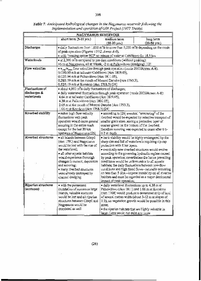
Fabre 7: Anricipared IydroI~gicuI changes in the Nagymaros resemoirfollowifig fhe ir~fplernetrtafion and oyerffriu~? of G/N Projeci (1 977 Treaw)
NAGY MARUS RESERYUR short twm (5-10 yrs.) medium ferm
(10-20 yrs.) Iong term (t0-50 yrs.)
Discharges
Walerievels
Fiow veIocilies
Fiuct~iations of discharges & waferievels
Riverbed stabiIily
daiIy flucruarions from 1,OOO m3/s to more than 5,000 m31s dependi~rg on the mode of peak operat ion (Figures I I/IZ, Anrrex A-@; = niih "peaking option 900" no release of wakr at GabEikovo for 18.5 hrs. r at 2,300 m31s compared to pre-dan crindilions (without pcaking): +5 m at Napyrnaros, +O at Vknek, -2 rn at PaLkouiCovo (dredging) 1121 r vminlvm, flow velocities ttrrough peak operation (nrode ZOOOIAnnex A-8): 0.0010.95 mls at lailwater GabEikow (rkm 1 8 19.451, 0.021 1.94 d s at Pa1kot.iEvvo ( r h 1 3 1 1 M), 0.2811.59 m/s at the mouth of Mosoni Danubt ( r h 1793.31, 0.321 I .I9 mls at Komarno ( r h r 1768.3) 1241
about 4,000 m'ls daiiy fiucmations of dischxgcs; daiIy waterIeveI fluctuations through peak opemion (mode 20001Arnex A-8):
4.64 rn at IaiIwater GabEïku~o (rkm I819.45), 4.38 In at PaIkouitovo ( r h 180 1 .OS), 2.65 m at rhc rnouttr of Mosoni Danube (rhr 1793.31, 1 .O6 rn at Komho {rkm 1768.3) 1241 rather high fiow veIociQ
fluctuations wittr peak operation woriId cause geneml srnuring in Ihe entire m c h except for the Iast 20 km , upstream of Nagymms 1261
according to 1251 eventuaI "mouring" of the riverbcd woiiId be expected by selective mspor t of smaIIer gmin sizes Imving a pmtectivc Iayer of warser grave1 on the bottom of the riverbed; i h e ~ f o x swuring was exptcted ta ceme after O. i- 0.2 rn depih
Riverbed stru~tures
Riparian structures (ecotones)
a11 isIands behYeen G&yfi (rkm 1791) and Nagy~nxos wouId be Iost witi the rise of the ivalerIeve1;
a11 orher aquatic habifats worild e x p t r i e n ~ thorough chmges in current. deposition and wuring; i many riverbed structures were drady deshoyed by charrncI dredging
wifh fhe permanent inundation of numemus Iarge islands, valuable ewtones wuuld be Iast and al1 riparian structures betrveen G o n g and N a p a r o s wo111d be inundated as wdl
bank stabiliry wouId be highiy endangered by tlrc sharp rise and falI of wa1erieveIs requiring rip-rap probtion with fiI!er Iayers.
eventually new riverbed structures wouId evoIve according to Ihe govcming hydrauIic reghie caused by pcak operation; nevertheIess ttie hence prevailing conditions wouId be unfavoumbIe to a11 aqriatiç habifats; the daiIy fluctuations between Iow-flow condilions and hi& fiood ffows--naturdIy occumng nn Iess an 5 dlyr.--impose instability on al1 riverine habitats and must be regarded as a nrajor dHrirneniaI impact of peak operation; r daiIy wakrievt1 flucruations rip to 4.38 m at PdkoviE~vo (rkm 18 1 1) and 1 .O6 rn at K o r n h u ( r h 17681 wouId produce a devastated strip of Land of several metres rvidth (about 3-12 ni at slopes of I:3); nu vegetation p w i h would be possibIe in this zone,
the riparian habitab that a r ~ IrighIy valuabIe in Iarge rivers would not exist any nrore

Figure I I : Peak operaiion and daily ivu~e~Ievel~uciunfions finode 1500flBO): a) Dai+ wa~er~eve~~~c~t ln t ions al d~@ere~?i cross-sections of ifre headi-ace catral and the I-fruiuv-Dunaki/iti resemoir, 6) Discharge reIease ar Gabi.iibovo, c) Dai@ ~ v a ~ e r ~ e ~ e ~ f r u c t z c ~ ~ i o ~ UI dzxerenr cross- ~~eciiota of {fie tniirace cana{ and the NU~Y~UTOS reservoir, 4) Dischurge reku.%-e al Nnpmnros

O b 12 18 -t - U h s
~trbt~kovo Mode 9001630 LOO0 -
2m - o t , , , , 1 , " , , , ' , , , "
17 6 - 12 13 - t U h s m
Nagymeros Mode 9001630
1 l l l r I l l l { l i i l l ~ l > l i i -
n 6 12 18 t Uhrr
Figure 12: Peok opera~ion anddaiIy waierlevelJuciuu~ions {mode 90W3tl): a) Dai& wnterlwd flucluarions Gr rknr 17.0 of ~ h e heudruce cana/ al Gabc*ikovo, 6) Discharge releme ai Gabëibvo, c) Dai@ waterleveIflucf ua~ions ar dixererrr crois-sections of Ihc failrace carrd nrrd rfre Nc~gv~naros
reservoir, d) Discharge reIease nt Nugymar-5s

According to the project plan channe1 dredging dong Szentendre isIand h m Nagymaros to rkm 1655 shouId Iower the Iow-flow waterfevels by 0.50-1 -20 rn in order to increase the head of the powe~ pIant 1 121,1271. Between 1970 and 1979 abour 20 nriIIion rn3 of grave1 were akeady excavateci fro~n both brandies rnainly for indrrstrial purpuses before dredging waç stopped because of problerris with the bank filtered weIIs of the watenvorks of tire ci9 ~f Budapest.
The Nagÿmaros paver plant was aIso supposed Io operate on a peaking mode. Figure.5 11/12 and A n n a 7 show aIternative modes of operation. As opposed tu fhe GabEkovo operation mode, there wouId always be a minimum discharge of at Ieast 1,000 m3/s. For instance at mode 2000, tire maximum difference in discharge would still be 1,300 m3/s at a maximum descent rate of -102 m3/s per minute (Anrrar A-5). The maximum decrease of discharge wouId then correspond to a waterIeve1 difference of 2 m at the gauge station of Br~dapest.
AIthough the daili~y discharge and waterfevel flrrcruations would be smaIIer than tttose i ~ i the Nagymaros mervoir, the detrimental impacts on aquatic and riparian habitats would be generaIIy the same.
Peak operation may alsu resuIt in defurmation of the riverbesi. PreIiminary resultç of a transport mode1 appIied by VITUKi indicate that both accumuIation and degradation may be expected in differerrt sections of the river branches dong S~ntendre isIand. Because of the danger of riverbed degrdation there is no peak operation at fhe IasY station af otfier river barrage system. For instance at the Rhine, EdF (Électricité de France) operates the IO water pawer stations from Kembs to Iffezheim at a moderate peaking mode (maximum increase of discharge above natur;rI fIow is 300 m3/s). AIthoirgh tfie peaking of the discharge is one magnitude smaller than the one at Nagymms, no peaking is aII~fwed at the Iast barrage of 1 Aezheim towards the Free flowing river. The resemir of Iffeztieim is mereIy used for compensation.
5. HydrriIogicaI Changes to be Expecfed with the ImpIernentafion of Variant C
In this chapter only those i m p l s wiII be briefiy analysecl which are different froni the unes described above.
5.1 ~ U H Q V O RESERYDIR /
After the consBudion #of the ternporary barrage systern at Cutlovo ( r h 185 1.79, onIy a part of rhe original reservoir ha een impounded. There is no information on the daiIy operation mode of GabEikovo, presumably the system is working as a run-of-river power plant without peaking opention. Thus, there are only minor waterlevel changes in the reservoir on a daily bais. Of couse, ttie operation of the Gabfkavo Barrage System as a namial Iow-head hydropower station wouId not require an operationa1 reservoir at aII, howewr, it requires a barrage at hnovo in order tu increase the usefuI head fur pawer generation..

UntiI December 1993 the discharges, that were re1e;ised in the OId Danube sirrce the damming of tire . river, were kept oh a base IeveI of about 200-250 rn3/s, wiih an increase to 350 m3/s in the vegeration period. FIoods flowirig into the reservoir were releasd into the OId Danube above a tkreshoId of about 3,000 m3/s (Figure 13). At the beginning of 1994 the artifici31 discharge regime of the OId Danube was obvionsIy aItered. The base IeveI was kept to abour 200 m3/s without increase in rhe vegetation period. AIthough no monitoring data of ttie riverbed stnrcmen werc avaiIabIe, it cm be expected that the rïverbed wiII eventrraIIy deveirip simctureç adapied to the base rate of flow alid to a certain range of flood fiows. Major changes in bed niorphology #uId be expected at rare flood events.
T d k 8: HydrologicaI chunges in ~ h e Old Danube ufier i~~pIerneniufiot~ and operation rrf Yuriatrr C
OLD DANUBE
Discharges base IeveI fiorv reIeases from Cunovu {based an daiIy measurements ai river gauge Rajka}:
Novernber 1992-Mach 1993: 200-250 m3/s - ApriIIMq 1993: about 300 m3/s JunelJuly 1993: 300-350 m3/s AugustlDe~enrbef 1993: 2SG300 m3k JanuaryISepte~nber 1994: about 200 m31s
il ood discharge exceeding 3,000 m31s were reImed in the oId riverbed.
WaterIeveIs
FIow veIocifies - reduction of flow velocities Eom tht former 1.2-2A mls 10 about 1.0 mls 1201;
reduced fiow veloci~ies in the iaiIwa1er of the power canai
FIuctuatiuns of discharges & waterle~els
Riverbeci shbiIiiy
6 ff ood discharges up to 2.430 m3/s were reIeased unri1 December 1993; one fiood discharge amorinting to 1,960 1n~1s was released mtil Seplember 1994.
unnaturaIIy sudden rise and drop of discharges and waterIeve1 during flood reiestse
bank faiIrires caused by fie sudden dmp of waterIeveIs &r damming the Danube;
gmdual. degadalion of Ihe rixerbed can be expecld as predicted for the Original PIan (Table 5 ) 151
Riverbed structures
Eüparian structures (ecotones)
-
yaduaI formation of a riverbed adapkd to fiows of about 300 m 1s; destruction of riverbed structures couId be expected at rare flood events rapidly relwed at Cunovo.
formalion of a new ripanan zone which is berter-adapted 10 fiood discharges !han it wiruId be acmrding to the Original Prriject
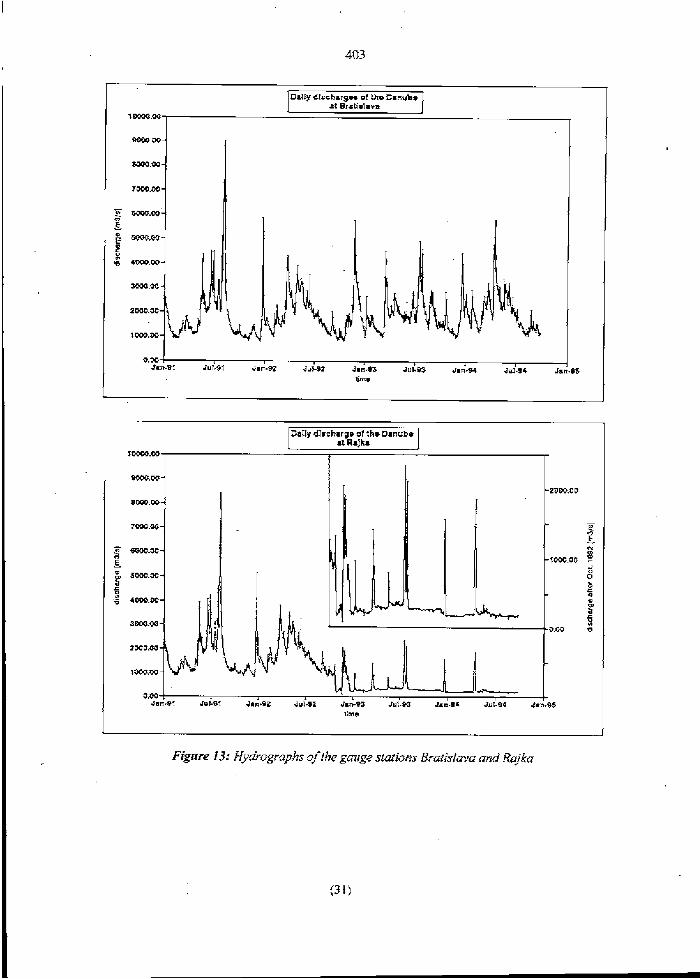
DaIIy dlrchargm ut fho Danube il AaJka
lime
I
403
-
DalIydlichargw of me Danuhv at Bratialaua
1W00.00
BDfwt.w-
7w.w-
F w . w - CI
L g ""w- r z d 4m.w-
m.# -
2m.w-
1m.w-
0.W , JahSI 3~1.31 Jan-- JUSPZ Jmn-93 JULW 5.;-94 jyi-96 Jalf.33
bme
Fig~tre 13: Hydrogrnphs 0fili.e gouge ~Iafians Brarislava rrnd Rajka

AIiholrgh f/IGI-I/5 of lke discharSe qfrlze river is directed 10 rhe Oid Danube, the aciuul* e v e v d ~ waterIeveIs in the old ri~erbed nie imuflci&jr the existence qffioadpiain habit&. is additionI ximifar degradation offlie riverbed in a mediuin and h g ierm has fo be expected due lo rfIe lold
relerr~iorr ofthe b e d M in the resemir.
The implernentation of Variant C with aII media1 rneasures wiII not improve the situation of the Szigetkfiz fluodplaintcompared tu the derimenul impacts anticipated hr the Original Project. The base discharge of about 250 m31s muIted in a considerabIe drop of h e gromdwater table adjacent to the river. In addition, rhe flood stages do not Iast Iong enough for efficient groundwater recharge.
On ~ h e Hungarinir side, fr3e desircarian &ai sinrfed in Lfie nrid sirriex of rhis cent ri^ wirh rfie ove~dredging of ihe riverbed. will evenfu@ resuII in a lofal iosir ofrhe weirandr. Utr the Shvak side, the impouprda~etrt of rfie side brunch vsfern will cllange rhe riverine weilandcharacrer ~korough&.

SZIGETKUZ FLOODPLAIN
Discharges
Grmndwater hbIe .
Fiuctuations of thc grr>rindwafcr tnbIc
FIaodpIain murphoIogy
Fiouciplain habitats
consta111 siipply 15r the side branch systems: 2-10 m31s on the I-Iungariiur sidc
flow i ~ i a few !ide branches Sronr rire Dmube r\'Iren reieiisi~rg 1,800-2.500 m3/s at Cu~iovr, weir gates;
f I ~ r v ia soinc si& brarichrs ht n rcIease of 2,500-3,500 m'ls;
fforu i:r 211no~r riII side bmc1ics ai a rcIease of 3,50&4,500 m3/s 12 I ]
dsop of rh;: groundr~alcr t-~hIe near ilic Danube ru lhe 250 ni3/s ykr IevcI;
i~rsuiTicier,r rec11xge of Ihc gr~undwnler by drc side arm systecr f i I ~ Z I on fit IJungarian side;
on Ilic SIo~ak side a higlscr groundrvatei labIc is mainbined by Ilrc impIementation of;[ cirscade systrm in Ihe side bmrches;
cIogging bas lo be n~rectcd in large arcas on borIi ddes
I tire duntirin of rTie fluor1 disclla-ges in iIrc side brancirw rviII be fou slioit IO rar11t in signific;iirt fiucruaiioris of the groiin<Iwvaicr tablc
uldil I9671GS ilr~string of sidc amis $vitIr Inari: or 1- scourigg, deposiiioir ;11rri IateraI movcmcnt orcumed severaI timeç n ycar; Ihis is irom li~rrited ta rqe events witir fiood disrI;rrrgcs shiued I~clwecn tire p o ~ r canal m<I rhe OId Dmubc;
r dcpusifion OF a mrrçidenbIc ~ i x i bf 1116 incoming suspendecl sediment Icad in r i i ~ &:rin~vo resewoir reriuces the sediment input inio tht: iluodpIain -
dosicmtiori oPrrlmos~ al1 ~r~iIands in the i-iungariw Szigctkoz fiolidplai~r wiihin a s1iorl pcriod of lin~e;
* ar Iy riarrorv ripxinn siri~is aIong those sidc arrns that are -u!rIilied ivirli constant tlischarge rviII kecp ihcir wetImd F ~ I A ~ ~ I F ~ F T ;
r ori the SInrarik side the previons rivtrirre rvetland habi~a~s wiII Iose k i r d~.mcier duc to inissing I-clcvani firictuation of the r~aterIevcI in The impounded side brmcIr syslem;
r dagnmcy in ihe cruiurion of nII hnbitats duc 10 missing dyriarnics of ~~ate~-ïioru, waterlevels an3 sedirneirt input --

I I ] SbnEik, A., Jovanovili, S. et. aI. (1988) "HydroIogy of the River Danube", [German, E~igIisIi, Frerrch, Russia~r], Publislring House Piroda, BratisIava, 1-272.
121 Jakubec, L. f 1983) "The reason for drying rrp of the rrpper i i tnf Ostrav arrd the extinction of the branch systeni of the Danube" [ln SIovak]. Froc. Int. Conf. 'The Gabtikovo- Nagymaros Systern - Intentions and ReaIiryi, Bratislava, The SIovak Repriblic, Sep. 7-9, 1993, pp. 237-244.
[3] Zork6czy, Z. (1969) "A FeIsii-Duna SzâbAlyo&saN, [The regularion of rhe Upper Da~iube. In Hungarian], Vfzügyi KGzIemhyek (11, pp. 54-91.
[4] Raabe, W. (1958) Wasserbau und Landschaflspfi ege am Oberrhein. [River engineering and Iandscape management. In German]. Schrifrenreihe des Deutschen Rates fIlr Landschaffspfiege, H. IO, pp. 34-4 1, BO~II .
LS] Baeik, J., TopoIska, J. & M. Lukac (1492) "Die Vorhe~sage der morphoIogischen ~ n d e m n ~ e n im aIten DonaufluBbert nach der Fer-iigsteIIung des Wasserkraftwerkes GabEfkovo" [Prognosis of niorphoiogical dranges in the #Id channe1 of the Da~rube river aRer the completion of the Gabfkovo Hydroelectric Power pIant. In Gennan]. XVI. Konferenz der Donaula~rder über hydroIogische Vorhcrsage~~ und hydrologisch- waçseiwirtschaftIiche GrundIagen, Keheirn, Mai 1992, pp. 599-505.
[SI Mucha, 1. "Report on Teniporary Water Management Regime - Indepe~rdent Scenarid, Novernber 28, 1993, Bratislava,
171 VITUKI (1993) "HidroIirgiai és mederniorfolbgiai viwgBIatok a Duna feIs6 smkasziirr és a Szigetkozi agrendszerben. OsszefogIaIv jelenfés". [HydroIogicaI and morphologica1 invesrigations at the upper Danube reach and in the side branch systern of the Szigetküz. Surnmary report. III Hüngarinn and English]. VITUKI HydrologicaI Institute, March 1993, Budapest.
[g] VITUKI (1943) - as above - Appendix 1: "MedermorfoIbgia". [Morphology of the riverbed. In Hungarian and English].
1'31 VITUKI (1993) - as above - Appendix 2: "Mederanyag- ks retegvizsgaIatok". [lrrvestigations on river sedirnents and sedinrent Iayers. In @r~garian].
1 103 VITU KI (1 993) - as above - Append ix 3: "Vit- és hordaIékjar3s". IBedIoad transport and water Ievels. III Hungarian].
II 11 VITUKI (1985) "Sediment Regirne of the Danube Sfretch affected by the GabEikovo- Nagymaros Hydtoelectric Deveiopment Projecl" (Informative coIiection of data).
[ 121 Hydroccinsult Brnf isIava & Y iziterv Budapest ( 1977) Prqject pIan # 0-2-2

Vyskumni ustav Vodného HospodArstva Bratislava (1 991) "Vply v Previdzky Vodného Diela GabCikovo Na Prirodné Prostredie". [Impacts of the GabEikovo power station on the environment. In SIovak]. FinaI ReportISuimnary, aulhors: J. Lehoce, M. Balfik, J. Kalis, J. Li~rdbrer, 3. Smlgay, B-P--DOD-A5S.00.0DT June 1991, Bratislava.
"Schwebstoff- rrnd Geschieberegime der Do~iau" [Sr~spended-load and bed-load regirne of the Danube; in Gernian and Rriçsian]. Die Donau und ihr Einmgsgebiet - eine irydrologische Monographie, Falgebarrd 1, Regionale Zusamnienarbeit der Donaulander irn Rahrnen des Intem. Programms der UNESCO, 1993, 1-83.
Y odohospodarska W a v b a (1 993) "The GabCikovo project: Saving the Danube's in Iand deIran. Bratislava.
Project report of the original pian (1977) Summary # 0-3-1 .Z [in Hungarian]
Kresser, W. (1986) "Vorlrersage von FluBbettandemngen in d o Gsterreichische~r Donausîrecke" [Forecast of morpholugicaI changes in the Austrian Da11ube reach. In German]. XIII. Conference of the Danube Couniries on HydroIogicaI Forecasrs, BeIg~ad 15.-19.9. 1986, pp. 131-148.
Joint Contractua1 Plan (1 977) Srrrnmary description, 0- I
CEC Working Grorrp of Monitoring and Water Management Experts for tlre GabCikovo ' System of Lucks. DATA REPORT. Novernber 2,1993
CEC Working Group of Moniroring a11 Water Manageme~rt Experts for the GabEikovo Syste~ns of Locks. REPORT ON TEMPORARY WATER -MANAGEMENT E G I M E . Decem ber I , 1993
CEG Working Group of Independent Experts on Variant C of the GabCikovo-Nagyrnaros Project: Working Group Report. Novernber 23, 1992, Budapest.
Ke~n, K. (1994) "Gmdlagen natumaher GewSssergestaItrrng: Geornorphologische Entwicktung von FIieBge~rassern" [PrincipIes of environmental river engineering: Geo~norphoIogicaI evoIution of river systerns. In germa^^]. 1-255, Springer: HeideIberg, BerIin, New York.
HydruconsuIt Bratislava & Vizirerv Budapest (1 977) Project pIan # 0-3-1.7.4
Karadi, G.M. & Nagy, I.V. (19931 "Optima1 Operation of the GabEikovo-Nagymaros Hydropower System". Proc. Int. Conf. 'The GabEikovo-Nagymaros Systenr - Intentions and ReaIity', Bratislava, The SIovak ReprrbIic, Sep. 7-9, 1993, pp. 5 1-53
"Die Donau und ihr Einzugsgebiet - eine hydrologische Monographie" [The Danube and its basin - a HydroIogicaI Monograph. In German], TeiI I Texte, Regionale Zusarnrnenarbeit der DonauBnder, 1-377, 1985
Bognhr, S., Rgkdczi, L. (1988) "Prediction of scour and deposition in a river reach berween two intemittentIy operating hydroeIectric power plants" Int. Conf on FluviaI Hydraulics, 30 May - 3 June 1988,237-242, Budapest.

408
HydroconsrrIt BratisIava & Vititem Budapest (1977) Project plan # 0-3-2.4.4
Csorna, J. & Kovaw, D. (198 I ) "A Duna Rajka-Giinyü koz6ni szakaszin végzett szabi- Iyozisi munkak hatisanak értékelése". [Impact assessrnent of river training works at the Danube reach between Rajka and Gonyü. In Hungarian]. Viziigyi KüzIe~nények, Vol. 2.
EDUVIZIG GyGr (1994) Data tabIes faxed to ttre Ministry of Foreign Affairs, Internationai Law Depart merit or1 Ju~ie 2 1, 1 994,2 pages.
Laczay. 1. { 1989) "Ipari koîrisok haatasa a Komkom-Nagrnaros k6z6tti Duna-szakasz mederviszonyaira". [ImpacIs of indusiria1 dredging on the river morphology of the Danube reach between Komirom and Nagmaros. In Hungarian]. Vizügyi KtizIemények, Voi. 3.
Laczay, 1. (1 888) "A foly6szabAIyoaz.6~ és as ipari koîris hatasa a Nagymaros-Budapest k6zotti Duna-szakasz rnerderviszonyaira". [Impacts of river training and industria1 dredging on the riverbed morphology of the Danube reach between Nagyrnaros alid Budapest. In Hungarian]. Viziigyi KozIemények, Vol. 4.
Bogirdi, J. (1971) "Feststofffuhrung der Gewiissef'. [Sediment transport of rivers. In 'Geman]. Academic Publishers, Budapest.
Csonia, J. (1966) "A vizfoIyisak aiItaL szalliton g6rgeten hordaIék mennyiségének megha- taroAsa". [CalcuIation of the transporteci bedIuad of rivers. In Hungarian]. HidroIogiai Kiizlony, VoI. 2.
VITUKI (1971) "AZ 1966. Évi Dunabizottshgi vizszint a Duna BratisIava - DéIi OrsAg- hatar". pavigational Low FIow LeveIs of 1965 / Danube Commission. In Hrrngarian]. Budapest.
"Jegyzokonyv a Magyar - Cseh-SzIovik Hatirrvizi Bizuttsag, LII. ÜIésszakir61". [ProtocoI of the 52. Meeting of rhe Hungarian-CzechosIo~akian Border-Water-Commission. In Hungarian]. Topolcirtnky, 1991. XI. 11-15.
KaIiS, J., M. BaEik. 1992. SiIting probIeni arising with the realization of rhe GabEikovo water sclrerne. Proceedings of the InternationaI Grain Sorting Seminar Oct 2 1-26, 1991, Ascona, SwitzerImd. MiîîeiIungen 1 17, VAW ETH Zürich, pp. 3 14-33.

Dr.-Ing. KIaus Kern Consultant Karlsruhe, FRG
Impacts of the Gabzikovo-Nagymaros Projcct on River Morphology, FIuvial HydrauIics and Habifafs
Annexcs
Period maps of the Upper Danube beîween Bratidava and Gy&
Discharge duration c u v e BratisIava
Data tables: dredged gave1 voIumes behveen Rajka and Komimm
Hydrograph Bratislava 1 950-1 993
Discharge rating curves al Brarislava
Discharge release for peaking modes at GabEikovo
Discharge reIease for peaking modes at Nagyrnaros
Parameters for seleckd peaking modes
Flood discharge probability at BdsIava
August 31,1994
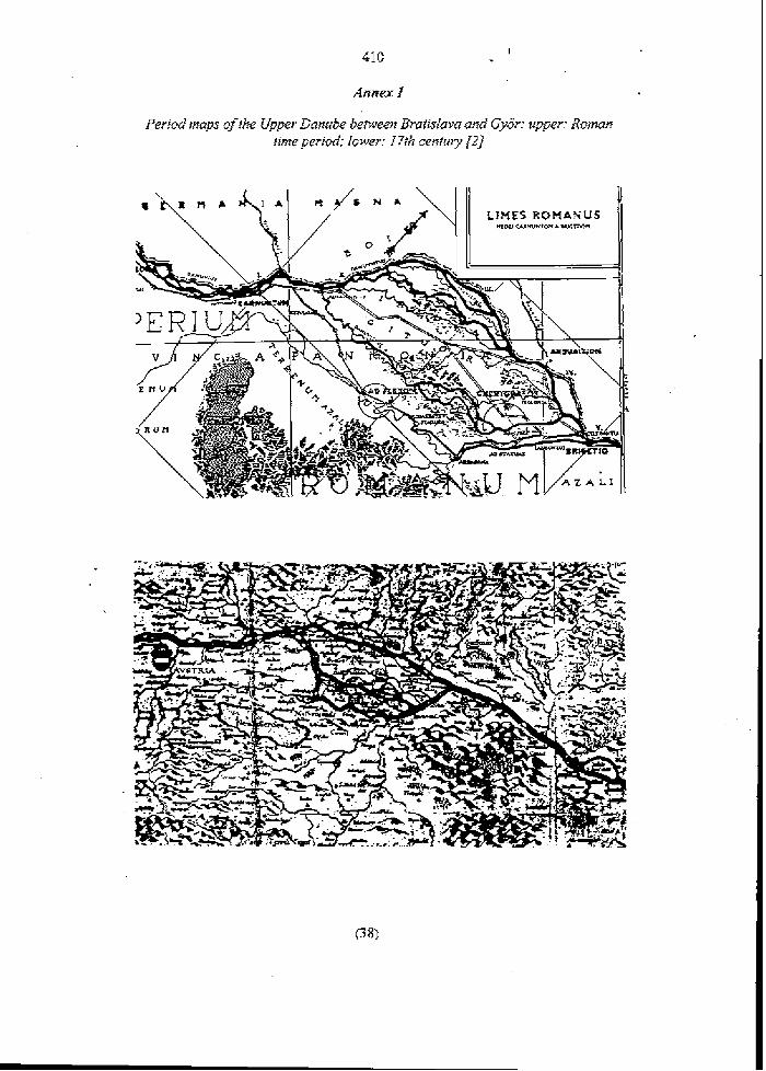
A n n a f


Dredging dutu ber~een Ru* {km 1849) und GOnpG {Rm 1 79 1) [3,& 281
-
InduslriaI dredging Stowalla Hungay ' 10'mS 10' rn'
184 137 135 574
nodala nodala no data no data
Ford 1
dredging 1OJrn' 552 4 30 245 400
nodaia no daia '
1
dredging 10' rn' 469 911 405 316 219 5 3 46D 953
1.377 8 08 392 1.265 f ,144 1,127 1.108 1 ,021 963 949 991 985 933 518 689 818 595 560 10
20.325
Total dredging 10' rn' 736 567 380 9 34 896 1.134
Yean
1963 1954 1965 1966 1957 1968
!# '
! I
1
!
i ' 1 f
-
:
!
!
1
!
j
ord dredgfng 10' ms
1 22 103 89
4
58
372
Years
! ' I965 1965 1967 1%8 1969 1970 1971 1972 1973 1974 1975 1976 1977 1978 1979 1980 1981 1982 a
1983 19M 1985 7986 1987 1988 1989 1990 1993 Total
1969 1970 1971 3972 1973 1974 1975 1936 1977 1978 1979 1980 1981
596 604 747 503 619 606 395 4U 1 33 1 451 480 425 442 397 414 245 213 122 180 129
534
Stowakia 10' ms 402 911 405 316 219 534 460 761 ?.ID2 648 37 7
1.265 ' 1.144 1.127 1.108 1.021 963 949 991 92 7 93'1 618 689 818 595 521 10
19.818
79 1 1 O 202 1 86 157 103 BI 125 5rl 72 39 67 95 69 123 229 749 487 502 862
1 ! : '
:
Hungary , 1 0' rn' 67
70 172 . 172 $ 5
. ' 39
535
24
-1982 1983 1984 1985 1986 1987
, 1988
719 1 O O
123 80 75 463 1 76 37 166 118 5 32 165 90 M 177 Ed 39 O
41 52 26 98 $46
184
398 785 822 1.168 981 760 666 600 528 680 €42 528 686 556 522 368 183 923 693 729
1.526
1 j 21.132

Danlrbr hydrugi-tlph ai gnuge Bratishva {6]. The deciine ofrhe wofer/evds obviaus+ dues Trot b~gitr before the inidsixries contmsiing rhe suggested f r ed line.
{Co~?rpai-e discharge rufing curve of gauge Brufisluva, Anna A-5.;)


A n n a 6: Variation of discharge ruting curves silfce 1 9 18 [l I J
a n u b * River B r t i n X a v *
Vuriaiion of discharge raiing curves since 19 18 [ X XI

Peuking modes 900/1DIIt7/30EItl for the operation of Gabc'ikovo po wer piarrt. SweraI nifernafives were inuesfiga~ed {discf~urgesfor mode 900 in Figure 12 are
siigfztiy digerenifrom the ones below) f24J.
NAGYMAROS
P I

Puromeiers for selecred pe~king modes 1%
CH ARACTERIS~CS OF PEAKING #FIIONS (GaEikovo)
P d B z ~ e Dischargeof , Dirharge Dixhargc #Id Danuh
(rn3isl I ~ ~ I S ) (m=lsj H Finr P d t IncIuding Seepage Row
-= S a n d Peak $ M n g Tmc Exciudiig Time of Axcndcnu and Dxzndcnœ
PEAKING OPTIONS ZDOO AHD RATE OF CHANGE OF DISCHARGE
SELECTSD HYDRAULIC P w OF ALTERNATIVES 2000


Anncx 7
NON-SI~UCTURAL SOLUTIONS TU RIvERBEV DEGKADATION Do~wsTREAM OF BARRAGES - EXPERIENCES FROM THE UPPER &LINE ANDTHE AUSTRIAN DAMJBE
Prepared for the Hungarian Ministry of Foreign Affairs
IntemationaI Law Depariment
Dr.-hg. KIaus Kern Consultant
Environrnental River Engineering SchIelrenweg 12
76 149 Karkrrrhe, FRG Tel. +49-72 1-7 12 88 Fax. i-49-72 1-7 12 86

The degradation of the Danube riverixd downsweam of Rajka was mainIy caused by excessive grave1 dredging and not by regrrIation works or reduced sediment supply 111. AIhough no detaiIed dredghig data were avaiIabIe for tlre SIovak reach upsbeam of Raj ka ( r h I 880 to rkm 1 F50), the sudden drop of waterieveIs after the mid nineteen skties, contrasting with ttie reIative stabiliv of the Austrian stretch downsbeam of Greifenstein, indicates that overdredging was tlre main factor in he degrada- tion of the riverbed. After the dmmhg of the Danube at Wien-Freuderrau in 1995 the bedIoad supply to ttre downs@em section wiil be further redirced. However the mticipated rate of incisio~i afler impIemerrting the barrage of Wien-Freridenau is reaçonably srnaII in &e Ausirian rexh of h e Danube 121.
Independentiy h m rhe reasuns for riverbed degadarion, it is show below ihat at rhe saine ritne wizen the G/N Prajecl wos comidered and fina{& sfipulaied in 1977, a new tne~hod of sediment nranngemeni foi. erosion confrof war i~z~roduced ai rhe Upper Rhine in order 10 woid .~fiurfural mearures for the SR^ of nalure cons~mnfiorr and flood prafecfion. Encomged by the successfu1 sedimenr management at the Upper Rhine, investigations were carried out to apply simiIar techiiiques at ttre Ausuian Danube beIow Viema after the abandonmenr of the barrage of Hainburg which was stopped by env ironmeptaI protestS.
Upper Rhine
As a resuh of Worid War 1 Fmnce was granted al1 water ri&& of the Upper Rbine abng the Geman- French border in the Treaty of VersaiIIes. After diveriirrg the a i n e near Base1 in the "Grand Cana1 d'AIsace" the frrst barrage started to operate in 1932 f3]. Three more baimges were built dong the c m 1 up to 1959. At that tirne the German-French reconciIiation prepared the grou~~d for ~iegoliations airing a& dtematives to the coniplete diversion of the river. Figure I shows that a new soiution was chosen at the beginning of the 19#0s, produchg Iess dmiage to the surrounding wetlands, forests and agricuItura1 areas. The partid diversion was possible after bilaterd negotiations resuIted in a new beaty between Gernlmy and France in 1956, abandonhg the idea of a c01np1ete diversion aII the way to Stsasbourg. The Iast barrage of dis agreement starîed to operare in 1970 (Strasbourg). In 1969 arroifier treary was signed between the hvo corrniries siifipuIating the construction of two more barmges, i.e. Gan~bsheim (1974) and Iffezheim (1977). It was agreed chat riverbed degradation downstream of Iffezheim should be prevented by massive mouring cf ihe bed 131. Later investigations showed that massive mouring wcuId be unfavomble to navigation, and in 1975 an miendment to ttie 1969 k a t y was sigred stiprrIating the consuction of another barrage at Neuburgweier.
One of the reaçons for the construction of ttre Iast barrage al Iffezheim kvas the downcutting of the river due to the reduced IeveI of sediment supply. In order to avoid the construction of anottrer barrage, alternatives were discussed in the early seventies favouring arîifrcia1 "grave1 feeding"

Figure 1. Cons~txcfio~f of barmge sysfems al the
Upper Rhine River fiear of firs~ opmiion); n&r f3J ( ~ e e Piare 3 in Vufume I ,
ChapIer I j
11811%-
AnnuaI grave1 voIurnes added ro The river (m31
Fig~~re 2. Sedimerrt addirion ar ~ h e Upper Rl~iire
below the barrage of Ifezizei~n. Nmmber o f d q wirh higl~er han ovei-ctge
dirchurge a{ gmige Mar~dKnrlsmhe; after
0)
i
- Sidimen! addilion
PHASE 2
BASEL

(addition of bed sediment) 141. The idea was IO sbbiliiie the nverbed without endangering navigation, and avoiding fhe detrimental impacts of anather barrage sysre~n 011 nature and Iandscape. I n 1975, the fmt tests were carried out wiih sediment addition beIow the barrage of Garnbsheim 151. in 1978, ttre waterways and sliipping administrations of France md Gemmy agreed to continue sediment addition t a below the new barrage of Iffezheirn which were started in April 1978. In 1981, the German Federal Waterways md Shipping Admirisbation pubrished a report comparing severaI mettrods for riverbed shbilization, i.e. consrnrction of more bamgks, consbuaion of river bouoni siIIs arrd addition of sediments 151. The conclusion was bat sediment addition is tlre best soIution with respect to bath ecological mrd economica1 aspects. In addirion, the tests proved tlrat sediment addition couId guarantee the required navigational waterleveIs, that the ship trafic was nut disturbed and that the naturaI composition of rtre bedIoad rernained unchanged 151.
In 1982 bortr corntries signed an amendment to rhe treaty of 1969 stipuIating bat sediment addition could be carried out below Iffezheim inskad of the consmction of a new barrage at Neu-burgweier. It was agreed that a new barrage at Neuburgweier shouId be buiIt if the 1iavigationa1 Iow-flow waterIeveIs were IO drog by niore thm 50 cm despite sediment addition.
Cornprehensive investigations were carried out for be sediment addition beIow Iffezheini incIuding rnathematica1 simulations [SI and physical mode1 tests [?]. Two vessels were consmcted with a capaciiy of 170 m3 each for the conboIIed discl~arge of the graveI-sand mixture. A srnaIIer boat was equipped with autoniatic riverbed monitoring devices to conml and guide the vessels during die sediment addition and to measure cross-sections. 3 automatic and 33 nianual river gauges were installed behveen riun 334 and r h 352. 355 cross-sections for ~nonitoring were fixed in tI$s river reaclr.
-The min site disiribrrtion of the material used for sediment addition corresponds to the natüra1 sediient of the îaiIwater of Iffezheim. In h e first years dredged sediments from the cor~sbuction of IFezheim could be used, enriched by 34 % with corne grains. Since 1982 h a s t al1 material I ~ a s corne frorn a German grave1 pi1 beside the channe1 at rh 335.2 fîhe agreement of 1982 stipuIales ttiat a11 grave] shouId corne fiom rhe Geman Boodplain). The average annual demand for sediment tu repIace the missing bedload was calcdated to bc 173,000 m3.
On every working day a certain volume of grave1 dependhg on the actual amount of missing sediment is bruught into the river over a reach of two kiIomeires in Iength. The simultmeous measurement of cross-sections parantees ha t the minimum depth of 2.10 m btIow the fixed navigation& waterIevel is maintained. After floods - i t might tHke a IittIe longer for the misshg sediment IO be repIaced.
The monitoring program consisis of daily cross-section measurements in the grave1 pIacement reach, bedIoad measurements every two weeks and topogaphical measurernent of he entire sketch between rhn 334 and r h 351 after each flood or at Ieast once per year. Each year about 5J00 cross-sections are rneasured arrd compared to previous results.

Figare 2 shows the m u a i voIurnes of grave1 pIacement since 1978 and the number of days when the average discharge of 1,250 m3/s &auge Maxau/KarIsruhe) is exceeded. There is a cIose reIafIonship between the discharge regime and grave1 vc;~mes. The height of &e fixed navigationa1 Iow-flow waterlevel has varied berneen +P and -24 cm since the beginning of the sedimelit additio~r, showing no trerrd. Between 1978 and 1992 a total voIurne of 2.3 miIIion rn3 of grave1 was added ta the riverbed. The cos% amounted tu a 5 4 million DEM per year (80 % for the pur~llase of the grave1 and 20 % for transport, monitoring and engineering).
T k sedimen{ addifion hus p-oved fo be a suifable uud ecanomic merbod for co~ptroiiirig erosion mmed by ~nissirrg bedioad din rhe laifw~ier oflflaheit~~. AII reg~liremen!sfoi. navig~tion Arne been mer wilhour dishl~balrce. The&eeJowing secrion of the river dowmfream qffj$ezhcirn ~virh vaIu~~bie weiland fore.~i.~ ~enrnim unfo~rchcd by avoiding the cmrmcIion oJu new barrage.
Arrstrian Danube below Vienna
After fhe projected barrage of Hainburg was canceIled, a nationai park was prepared in order to protect the remairring wetIand foresis b e w e n Viema and Hainburg. There was a dispute about he stability of flre riverbed: according to [t] and 191 the bed is mher stable aIttrough a considerable miount of sedirrient is retained by the Austrian barrage system; ohers argued that the Danube reach beIow Viema is exposed to erosion al increasing rates, e.g. 2-3 cm per year [IO]. There is no doubt that h e Iower end of the Ausrian Danube reach is influenced by rhe riverbed degradation in rhe vicinity of Bratislava [IO], probabIy carrsed by excessive grave1 dredging [l].
In any case the sihation of the Danube is qu ik different h m the Upper Rhine. The resulîs h the physicaI and mathematica1 rnodeIs of the tailwater of IffezheimtUpper Rhinc show that progressive emion wouId accur beIow ttie barrage without compensatory grave1 addition. The riverbed degradation would reach more than 6 rn afler onIy 1 7 yem jus1 below the barrage (rkm 335) and the wedge of erosion would spread 12 km downskam 161. In the Anstrian Danube downskam of Wien- Freudenau ihe maximum erosion depth uper 8CIyeurs was caIcuIakd to be 1.1 m [Z].
AIthough possible riverbed degradation at he Danube obviously is much Iess dramatic I I I ~ at the Upper mine river, investigations for non-stnrctural measureç were c k e d out using physicaI mode1 tests [ I 11. FieId tests based on these resuIîs were scheduIed tv start in 1994.
The n~odeI tests were perfomed as generaI investigations in a hydrauIic flume without consideration for the geonietry of the riverbed. The objecriw of the investigations was not to predict the behavior of the reaI Danube bed but to test the reIiabiIity of an artificid m u r i n g of the riverbed under the impact of ship trafic. UnIike at the Upper Erne a Iayer of coarse grains should be established to preven t M e r downcutfing even during flood events and to misr the hydrauIic jet s t e m s of ship propeIIors.

The resuIis showed that $thin Iayer of 10-20 cm thickness with maximum grain sixs of 120-200 mm Ieads to an amiourd mver stabiIizing h e nverbed aRer al initial minor degradation caused by wash- away of srnalier grains undemeaih ttre coarse top Iayer. Local deficiencies Iead to IocaI scwring wivithout progressive erosion. N a m l çedimenis p a s over tbe aificial corne Iayer without any disturbance. However, ship trafic cm mix up the stabiIiirng tup Iayer of coarse grains wilh tbe f i e r naturat sedimis underneah to a depth of 50 cm. The subsequent fluvial remangement wiIl Iead to rearmouring of the bed wiîh a certain lowering of Ihe Ievel. Therefore a series of low water periods with Frequent disturbance of the armaured top Iayer may resuIt in a gradua1 decIine of rhe bed 11eveI.
in order to prevent ariy degradation of the riverbed an mificial top Iayer of about 50 cm thickness and 60-120 mm grain si= cal be brought into The river, resisting natrrral flood events and hydi-aulic impactç of ship pmpeIIors. Since this Iayer wmId cornpleleIy prokct the frnw natura1 Danube sedirnentç no amrouring would occur by fluviaI grain soriing.
Mode1 tests with speciaI vessels for gave1 placement proved that the prokçtive Iayer can be brought inm the river with sufficient reIiabiIity. Assuming îhat hose parts of ttre cross-section tfrat are exposed to ship mfic (about 100 rn of the widih) would be protected with a Iayer of 50 cm thickness md be remairring 170 m wodd be covered wittr a &in Iayer of 20 cm, the coss were estima& ta 5 milIion DEM per river kilornetse.
The model tesfs have ymved ~huf nl?$cial a~mourirrg of the Danube reeah belaw Yietina i.7 feusibk aird eficienf i ~ r proleciivlg rhe riverbedfi-om possible degradafim~.

[II Kem, K. (1994) "Impacts of the GabEikovo-Nagymarvs Project on River Morphology, FluviaI HydrauIics and Habitats". Karlsruhe, August f 994, unpublished study.
[Z] Jaggi, M. (1992) "Effect of Engineering SoIutions on Sediment Transport". In: BiIIi, P., Hey, R.D., Thorne, C.R. & Tacconi, P. (Eds.) "Dynamics of GraveI-bed Rivers", pp. 593- 605, WiIey, Chichester.
131 internationale K o m i s i ~ n für die Hydrologie des Rheingebiets f 1993) "Der Rhein unter der Einwirkung des Menschen - Ausbau, SchiRahrt, Wasserwirtschafi". [The Rhine under the i~ifl uence of man-river engineering works, shippirrg, water management. 111 Geman]. KHR-Arbeitsgruppe 'Anthropogene Einfliisse auf daç Abfldregime', Authors: W. Buck et al. ,250 p. /
[4] FeIkeI, K. (1970) "Ideenstudie über die Verhtitung der SohIenerosion durch Geschiebezufuhr aus der Talaue ins FIriabett, dargesteIIt am Beispiel des Oberrheins" [Reflections on the possibilify of preventing erosion of a rnovable riverbed by adding sediment materiai frorn the adjacent RoodpIain intv the riverbed - Upper course of the Rhirle River taken as an exanipIe. In Geman]. MirteiIungsbIatt der BundesanstaIt für Wasserbau No. 30, Karlsruhe.
[s] Kuh1,D. 11 9931 "Geschiebezugabe unterhalb Iffezheim" [Artificial sediment addition below Iffezheim. In Geman]. Der Bnuingenieur in der Wasser- und Sch#aI~rrsverwafrung, No. 1, 1993.
[6] Sieberi, W. (1992) "Simulation of erosion and deposition of coarse nlateriaI beIow If- fezheim-Barragemine". 5th Int. Sy~np. or1 River Sedirnentaliori KarIsrrrhe 1992, VoI. III, p. 1153-1174.
[7] ~Nesrmann, F. (1992) "Lrnprovement of the Upper Rhine, tailwatcr Iffezheim". 5th Int. Symp. 011 River Sedimentalion KarIsnihe 1992, Vol. III, p. 1 130-1 152.
181 Kuhl, I3. (1992) "14 years artificia1 grain feeding in the Riiirie downstream the barrage Iffezhdrn". 5th Int. Syrnp. on River Sedin~entation Karlsruhe 1992, VoI. III, p. 1 12 1-1 129. (Amex 1)
191 Bernhari, H.H. et a1. ' (1987) "AnaIyse des Flul3abschnittes GreifensteinNien - Marchmündung" LInvestigation of the river reach GreifensteinNierrna - March r. In Gen~ari]. Commissioned by the PIanning Instihrtion of the National Park Danube Wetlands, June 1987, Vienna, unpubrished study.
E 1 O] Kresser, W. ( 1985) " Vorhersage von FluDbettanderungen in der 6sjçterreichischen Donaus- trecke" [Forecast of morphological changes in the Austrian Danube reach. in Gemanj. XIII. Conference of the Danube Counrries on HydroIogicaI Forecasts, Belgrad 15.- 19.9. 1956, pp. 191-198.

11 I I Ogris, H., ZottI, H. & Erber, H. (1 988) "SohIstabiIisierung durch GrobmateriaIzrrgaber wr Decksckchtbildung - Donau im Raum Wien - Bad Deursch AItenburg" [Riverbed stabiIiza- lion by adding corne materia1 for m o u r i n g - Danube reach Vienna - Bad Deutsch Alten- burg. In Germari]. Commissioned by the city of Vienna, 143 p., Dec 1988, Viema, ungublished study.

14 Years ArtificiaI Grain Feeding in the Rhine downstream the Barrage Iffezheim
Ahtract: Thjs psper provides an overview of rhe artificial grain feading downstrearn the Rhiae-barnage Iffezhaim, wherewib the depth erosion and thc water I F Y ~ I reduciion of the Khine was succwsfuIIy CUmb~tted since 1978.
1 Introduction
The sbtus of hs artificin1 grain feeding is d a r i b d hereafter:
In Ocfokr 1981 rbe Minisiry of Traffic pubLished the fina1 rewrt on investigations of the question, whether the b r b m erosion of &a upper m i n e downstream the barrage Iffezheim can be stoppd by artificial grain feeding,
the constnrction af additional barrages or via ground-si115 I I I . The resuIt was, rhat from 1978 uatiI 1980 one s u d d in keeping ihe water IeveI domrstream rhe barrage Ilfezheim by artificirii grain feeding, that rhe pourkg out w i h df-mov k g hlortom-dump scows praved to k g d , k a u s e il ddoes no! &der the shipping, and fmalIy &at nu chmges compared wifh [he nahrral grive1 transport were observai. Furthemore, it W ~ S ,
fourrd out &rt La rrtificial grain f&ing is the more e~crIogicaIly beoeficial and cost savirrg soIution thm risa
wnstnrction of additional barrages.
Swing in 1981 tht arfifrci~1 grain f d i n g wwas continu4 in order IO increase fise so far abtained knowIsdge md gain more sxperience mer a Ionger p e r d of time.
2 Material requirements and grain composition
It wss intendd ta q u l i z c the average ~ I I Q I eroaion downstrearn the barrage Iffczheirn {Rh.-km 366) by means of &e h k i d grnia faedig. For ihis purpose d-gmvei-mixtures, which c ~ ~ ~ e s p o n d in k i r grain ~~mpos i i ion rn far HS possible tu the asturffi hitom grain, have fo h added to rhe Rhine W I e 1).

B d on numemus g~mpIea of &e bottom grain of the Raino the roquirernents for the de l i ve~ of the material werc defind. The sand snd grave1 sorts have Io b~ lightly m ~ v a b b . For sonomical resxms they are cornpoçed of the commercial grain groups from O - 64 mm.
TabIe 1 : Grain composition of the afliiïciaIIy feedad maierin1
From 1978 uniil 1981 the need of f d i n g material w u srrpplied for 66 % fmm the necessary drdging in the river do&stream the barrage Iffezheim and for 34 % from deliveries. With increasing dredging depih the fou
high portion of fine grains bad to h cornpensated by adding warstr grave1 maieria1.
Fwm 1982 tv 1991 the suppIied pnrt of the feed~ng matena1 amountd to 97 4%. Fer year as an average 3 %
drBdgbg material R X I ~ . ~ from work perfomd for traffic safely rasons md were poured out.
Jahrliche E~nbaurnengen annual feeding quant if ies
Iage
Fig. 1: Annu1 f d i l r g qriantiiies The coJumn graphic of the wu1 feeding q u i i i i e s is similiar io the doited Iine of the average
of the days per year with incregsed medium discharge MQ = 1250 m'ls nt the water-garrge Maxau.

B a d on ilse Gwman-Fra~~h sgrccment fmm 1982 lu mi~iirial for Qe nrtifrciaI grain feedirrg may auly b supplid frvm German graveIs pits @eiag a i t u f C d on &e right b d s of he Rhine). This resukd in contracts wirh ~e Südwcst-Kies GmbH & Co. KG iffezheim on ihe basis of Ihe annual average nesd of 173.000 mJ wilh a minimum wmmitmenl and M uppr Iimit of rhe g d supply per year, The gravei is king weighd and Ioaded in doses into hydre bottomdump xows at the grave1 worG Kem, Rh.-km 3 3 5.2.
Fig. 2: Grave1 Ioading in the harimur of gravcl worb Kcm, Iffezheim, &-km 335.2, inlu Irrdro imilom4ump xows wifh a Ionding space of 170 mf and an engine pwer of 359 PS. The hydro imllom-dump scows have Io h re- ta I ibr~id wiih cvcry change in rhe grain ronrpsition.
The detrihrs is insefleJ ri ihe origin of rhc h~rorn erosion, i.e. a: the pIace, wherc downstr-m the barrage Iffezhcinr th= fuII transpvriing p w c r of rhc Rhinc is effcciive in the wntinuousIy flowing Rhine cross scciion.
Wiihin a 2.5 km long pari of ihc Rhinc ihc btrn~tr crosiun, whiçh had m ü r d , is bcing f i I I& bciween the
srrokc lin- (sw hg. 7), in ordcr 10 guaranfcc a nolural mvvcincnt uf b d nxticrial for ihc SvlIowing dom-
strcarn prt of r h ~ Rhinc. The pouring out of rhc graver-.rand-mixture oui of hydro btiorn-dump scows with strong crigines going Jownstrcam provcd as E fiIIing prwuiure < s a fig. f,4). At a pIace which has bcen f i x d &fore the hoId of ihe hyùro lmiiom-dun~p smw is king o p e n d crack-wide, rhe grave.] cornes out uid is king
disrribulai in a IO io 20 m wid~h over r Ienglh of 50 fo 300 m on the h t i o m of the Rhine. The psi l ion of the
ma~eriaI i s king c h o ~ k d by means of con~roi sorrndings in uxJcr 11) guaranlee that the waiçwa7 has not IWXI Iimiréd.

Fig. 3: Thc hydro IwttorniIump scvw - Fis. 4: Ioaded with a safid-grave1 mixture - approaches t~ îhe preaJing sire (fig. 3);
~ h e puring oui of rhe detritus begins, when the hydro bottom Jump scow passes the mrasure
b a t , which is u d as sieering mark.

hydrdbeihm- dump srou
vers wrlm- i i I h i iourrng OU? mararri ri
Fig. 5: of p u ~ g orrt
To keep the walemay fr-, safety distances have been deiermined.
At the beginning of the artificial grain feeding the depth of the waterway wns 1.71) m below GIW 72. The
boltom erosian was 15Iled-up to 50 cm belaw the Iower waienvay Iimi!. To&y the depth of ~ h e wdetenvay is 2. IO
m Wow GIW 82. The safety distmce was reducd i~ 40 cm Mow the watemay box (fig. 61.
Fig. 5:

4 Confd of the artificia1 grain feediig ,
?he cunîroI of !ho mificial grain f d i n g iacIudes the
deIivwy grain compsition, weighi and volume of the fslling mafeiiaI htiom position in the fiIIing r r a and for the dowostream fo1lowing a b u t 14 Xhint-kilome-
te=
water ievel position Mwetn Khine-km 334 and 352
Il i s g d for lhe traffic safeiy, tfre contrnI of atrcclwr,
the mrtss bsIance, and thé calculation.
The h f f c safeiy is gunranid by the extensive ~ o u n d i i g s pmgmmme, wùich is n-wy to ubsewe the move- men& of the h i material. Tt uinsistr mpiniy of the stptemeat that there are ao hnndicap in the wmierway in and d m t r e a m ihe fiIIing area, i.e. uatiI June 198% at 1.70 m kIow GlW and aftemards at 2-10 m behw GIW. Tho reason for the different depths of the watemay i s the extension of groynes !O deepen the Rhine rack,
which wos a g d rrpoa in 141. From 1983 unri1 1988 the gruyncs htww Iffedseim and Mnxau were Iengrhmed a: stroke Sines distsnces from 155 m upstregm and 150 m duwnstrearn the mou& of rhe Murg with uniform gmynt dope I:5 and were reised îo GIW plu 30 cm ffig. 7).
distance of stroke lines St reichlinienabst 2 n d ~ 155111 obwhalb 160m unt erha1 b der Murgmundung
Fig. 7: Extension of the groynes - criteriae

'Ibe pouring out sr- of &e afliiicid grain f d i n g was ex~luded fmm the Icngthening of L e gmyneg bocaw
of the wfficicat depk of the watemay and the neiccs5ity of wmpsrirrg obscwations regarding the original situation. The resuk of the lengthaing of the gm7nes wrts ihot &e sim uf ttit ex8ension - be dw-g of the wateway for 40 cm - w z r a c h d nt n nearly vrtchmgd wakrIave1 Cfig. 8).
The soundings prugramme comprim the dpiIy cross d o n mesures in the fiIlhg ara @ order to check the
position of the material p u r d out. fhe muverneni of bed makrir! is ob9crvd abut 2 km dowmtresm the filling area evcry fortnight and nfkr eoch bigh wakr. At least once per ytst the total Rhirio reech from km 334 {Imk Ifftzheim} to km 352 (Gtm-French border, Ieftbank) bas io bt sounded a d 4 s up ss bi plm. Since 1978 MKlO cm-sections were masureci and waIuatd ~6 M -uaI average. WhiIt the wntrol soundings suppIy data for m ~ s r chmges in the Rhine bed, &e water ievel sbkmenta show = sensitive indiator s u ~ ~ e s s or fa11ure of the mificial grain feeding dir%ctIy by position c b g a nt the srne nuioffa. The accuracy of the weîer IeveI stotemenls is grramntead by rendigs at 38 waier-gruges b tweu Rhke-km 334 and 352 SI cwstant mine moffs.
The compr~blt water IeveIs in the filring a r a differed h t w e n +9 cm nnd -24 cm.
Fig. 8: WaterIevcI and b?d nur betwen mine-lrm 334 md 251 b e f ~ r e and a k r the gmyne extension
For b e purpo5e of mis b~lnrrce the average bed position is made up from neighbrrring cm-sections behveen the stroke Iines and their changes cornpard io the initia1 sounding at !he beginning of rhe rrtificia1 grain f d i n g
are EPICIII~BO. For !he about 2.5 km filling a m this resrrli is the mlculstion brrsis for rhe need of grnvel; exact
furecasis for the grave1 suppIy ere not possibIe, becrtuse the mavernent of bxl materia1 depends on rbe wster qrrantity of the Rhine.

434
5 Muences on the artiliciaI grain feeding
The wc~ess of the arfificid grsin f d i n g is the resuIt of thomughly fulfilid Wks of the sbff of the
W8tcmsy md Shipping OEct Frciburg. Missing engagement wauId sureIy Ied tu failure of the artifiçial grain fding. BcIow fur&er influences on tbe nrtificiol grain feeding ue I i d wiLuut ws1ua:ion:
1, GmÏn wmpsition Ttre rdding materid shouId correspond to the mhrrnl bottom grain.
A lm iess medium grain avemge reapectively a tm high portion of sand and fine gweI l a d !O n quicker movemeut of ihe bed mrrerisl nnd fo higher mpterial requiremenb. On Ihe other hand a high portion of
oversize aggregafe promotes M armorikg effe~t in &e wrresponding =!ion wiih a t m slow W nuferia1
tmqwrt~tion.
2. Xhine m f f s
Me~sümble movemenf of &xi Iosd starts at medium Mine nrnvffs. Big quantiries of bd material are
transportcd drrriisg a Tong Imting high water. I f the d i u m discharge of many yars a! the water-gauge Mnxau MQ = 1250 msIs is often lower, ody srnaII puantitiesof filring materin1 have to b p o u r d orri; vice
versa high material requircmnts bave tu b calcuIatd, if tàt MQ is ofkm exceeded.
n e grnpkc of the days kIow the MQ is similiar Io %he cuwe of the mu1 adding qirnntity (figure 1).
3. Weather
If it is fmiy weother, no supplies snd no pouring out are ~ s s ~ M E , the mierial freezes. If i t i s
foggy, thcre is no artificial grain feeding for ssfety reasons.
4. Diszhnsge me~snrements, weter IeveI ataremeats, soundings The reliabi1iKy m d La sczuracy of rhe discharge w u r e m e n t s have !O k guamreed. Problemp may mcur, if &t mepsuiement profiles based upon have chmged b u s e of the moving bttm of the a i n e in the dischrrgt curve. As w-uence fauIiy wakr IevcI positions are coIculnted. A high accursçr of &t sourrdbgs is rnPinIy the mult of expetierrce rnd of the training in hpndIing ihe instnimenLs.
5. Sufeiy in operation of the instnrments and the ve-kcIes.
6. KeIinbility and quick &ta p m i n g
7. Edarging mePsurements dowmtream the barrage Iffezheim:
7.1 LKngttreaing of L e gropcs %a I d to additional id materid tmsports b e e n Rhine-km 336 md 352. The id maferia1 dif-
fereumi amount îa abut 5#.# m5 in 1990 - compared to the frrst souadings in 1982. the beginning of the groyne extension.
7.2 The comtntction of additional barrages This measurement wuId I d tu sàiftirrg of the errision proHem and consequently to shifiing of ihe artifIciuI grain f d i g .

The ertificial grsin fding in tht Rhine dowrtstrexm the h g t Iffelheim w s srarfd in I978 s un ex~rirnent to w m b ~ t the river Id erosion wirh Be nim Io avoid 8 0 construction of additional mine barrages and showing
a positive -11 after the trial period, ii wis mtinud sincc 1981.
During the 14 yesrs from 1978 wtiI 1991 ahut 2. I#.# rnJ of a sand-grnvel-mixture wgs p u r d out without impeding the shipping or evcn impairing the enviwnmenl. The exiension of ihc groyne dom- Stream the frIIirrg area and the reduction of the squI value of rhe water IeveI in 1982 Ieaded to sm1I. within rhe tolemw values redrrctions of ihe water IeveI at the domstwm siII of L e b m g e I f fdeim. By meMs of addition81 exrensions of the groyoe the wnkr IweI witbin ihe frlling a m can k roi&.
Without artificial grnin feeding additions1 bsrrages woirid bave to be built in order to keep up the shipping ttaffrç and tu woid water eronoraiml wns%quentiaI damges resuiting from water Ievel reductions with more
thsn Z m.
By the way, Ihe ertificia1 grain fetdirrg is one of the ftw produres which can Ix stopped, if necessaty, wihout showkg ~ n y e n v i r o m f g 1 &mages.
I l i Fekel, KuhI, Steitz Naturversuche mit Gexhiekmflihnurg nueçks Vcrhührng der SohIeneintiehrng des Oknheins (Frcisktiar Versuch) Wpsseiwirtxhafi 67 (1977) Heft 5, Seiten I 19-125
I2I KrrhI Natuniersu& mir einer Ges~hiebnrgak im Rhein mterbalb der Stnustirfe Iffezheim, Zeitscbrif! fur Birmenwhiffahrt und Wwwsirdtn, Nr. ZIZO, S e i t a 5962
131 BMV, Abt. ftrr Bimensçhiffahrt und Wwwsfrden UntersuAung air Frage, 5b die Sohlenerosion des Oberrheins unkrhalb der Shuslstufe Tffezheim durch Gwhiekmgabe, weirere Shustufen d e r GmdschweIIen verhindert werden kann.
SchluDbxicht Oktobr 1981
141 Vtrcinbarung arr &derung und Ergknning der Zusoizvereinbmrrg vom 15. Juli 1975 zum Vertmg
vom W. lul i 1969 mischen des BundarepubIik Deutschland and der Franzosischwt Republik über den Ausbitu d s Rùeins m i x b e n KeMf tdibrrrg und NeuburgweierlLauterburg. BGBL. 1984 II, Seita 286 ff.

Annex 8
TRADITIONAL SOLUTIONS TO THE NAVIGATIONAL PROBLEMS M THE ~ z I G E T K ~ Z STRETCH OF THE DANUBE
1 A Laczay Civ. Eng.
Budapest, August 4, 1994

437
Contents
3. Navigability ofthe Szigetk6zStretch before Oclober 1992 3.1 Stretch Rajka-Szap (Palkovituvo) 3.2 Strefch Szap-G6nyü 3.3 Discussion
4. Traditional SoIufions 4.1 GeneraI consideraiions 4.2 Discussion

,The term "traditional solution" is used for engineering measures to ensure sufficient navigational conditions by means of structures built in and a h i g the channeI. Tradirional river training on the Szigetkoz stretch of the Danube carried ou1 before the sixties failed tto provide permanent and suffrcient fa -vay for navigation. ln the early sixties, however, a new, consistent training concept was developd. Ne\7ertheleçs. construction work was not cornpleted, since the Gabeikovo- Nagyrnaros systern was expec~ed to solve the probIems.
BerweenI990-1942 on the section Rajka-Szap, at each of the confluences of the inIet and outlet canals of the DunakiIiti weir, there were two major boEtIenecks to navigation caused by the construction of the Gabçikovo-Nagyrnaros Sysleni. In the weII-known Bagomer bend and in a number of other IocaIities, navigation was hampered by insufficient fairway-width. These diffrculties were avoided in 1992 when fie GabEikovo cana1 came into operation and navigation was diveried.
Downsiream of Szap [PaIkoviEovu) a number of shallows and rniddle bars have devdoped due to hydromorphologicai conditions. In 1992, four battlenecks were known which needed extensive dredging. Thereafier, operation of the GabEikovo taiIrace canal induceci additiona1 IocaI bed esosion, increasing the nrrmber of obstacIes to 5 or 7.
The traditionaI training concept accepkd in the earIy sixties stood on fairIy sound scientific and professiona1 gounds. By full irnplementation, a quite srritable fairway corrld have been achieved aIong the stretch, especiaIIy between Rajka and Szap.
Recently, a number of conditions necessary to prepare a new traditional concept for improvirig navigation has been orrtIined by Laczay, 1991. The conclusion was that sonle kind of traditional suIution may be feasibIe, but especially downsiream of Sap. permanent maintenance work mrrst be projected as weII.
A feasibility study for the sfretch Szap to G6nyü was prepared by Dutch experts (Delft HY et al., 1994). According to the conclusions, when the IocaI remangement of the Danube bed induced by the opening of rhe tailrace cana1 caIms dom, permanent training sdutions can be defrned. The concept wilI include furîher nomaIisarion of the Ivw-flow river bed by consîmction oof river constricrion works.
Cornprehensive river training activities on the Szigetk6z stretch of the Danube started back in the 19tli cenkry. However, the cwstnrction of the main channe1 in 1886-1 895, the additiona1 Iow-bed replation for navigationa1 purpmes in 1900-1940, and the extensive reconstructiori works in 1949-1963 wiih dredging activities: a11 provided no permanerrt and suffrcient fainuay for the international shipping (Zorkbczy, 1969) Principles for fufier activities were outIined and approved by the Hungar ian-CzechosIo~akian Joinr Engineering Coninlittee in 1953 as follows:
i. To minimise the water Iosses from the mairr channeI, by closing the upper ends of the side-arms and by constructing and reananging both banklines to maintain flow discharges up to around 3,000 ni31s in the main chamel.

ii. To provide proper and safe passage of the flood flows spiIling over into the side- arms, by constructing seqrrences of "cascades" at the cIosureç to avoid bank and bed erusion.
ii i . Finally, the width of the main charnel was to be confined by spur dikes in order to improve the veIocities and the sediment transport capacity.
Taking into consideration that the GabEikovo-Nagymaros Brvject wouId be cornpIeted by 1990, the general river training pIan has onIy been prepared for the stretch between rkni 1842-1816. TraditionaI works in this reach wouId not interfere with construction of the Barrage System. However, construction of any rraditional solutiorrs upstream of rkm. 1842 and domtreani of r h i 18l5 wouId have been in vain and wouId interfere with the construction of the Barrage System.
Construction work was perfomed in tlie sixties and seventies. AdditionaI work of minor extent lias also been done on the stretches upstream of DunakiIiti and downstrearn of Asvinyrar6 as well. Work was aIso perfomd on the side arms whiIe confinements of the mahl channe1 by series of groynes have only been constructed on shorter reaches at Nagybajcs, GabEikovo, and Rajka.
A cornprehensive evaluation of the effects of works carried out was presented in a joint report (Csoma et al., 1978) and reviewed by Csoma and Kovacs, 1981. In the period Gom 1963 to 1979 the volume of rock built iri between Rajka and Gonyü for navigationa1 purposes by the two corntries amounted to 815,000 m3. To maintair the fairway in sufficient condition and ro construct the uniform bankIines on tks reach sonie 5.7 miIIion m3 dredging was performed between 1963-1979, and an additional 6.2 miIIion m3 grave1 mined for commercia1 purposes.
Beiween 1952-75, the caIcuIated yearIy average volunie of the bedIoad passing BratisIava (input) aniounted to 540,000 m3 whiIe the same passing GEInyü (output) was 65,000 ni3. The yearIy average amount of total dredging in 1952-1975 was 789,000 m3. The caIcuIated "bveraII balarrce" of the Rajka-G#nyü reach aIso contained the actua1 channe1 voIume changes, based on detailed field surveys. The resuIt was 31 1,5011 m3 a~inual v d m e Ioss, that is, degradation as yearly average. (Csoma-Kovhcs, 1 98 1).
The evoluafio~s indicu~ed quile cleurly, fhr starfingfrom rire eu+ sixlies, ifre cfran~~el as weif as the faiwuy condirions have been govenred by ~fze various grayel-miniirg acriviries. In ilre overuil bnfunce, rhe df.edging overrukd rhe basic moryhologicuI rendency of b e d M deposition, rhe efec fs ofriver fraining wods and possib(y o r k fendencies as welf.
Based on the resulrs of the evaIuations, it was confrmed in the Iate sevenlies that, mti1 the GN Project cornes into operation, no further comprehensive traditional training activit ies were justified. Navigation was to be mainbined by repealed dredging.
Fairway and charnel conditions were investigated in terms of the channe1 geornetry (Lactay, 199 1). Conditions before cIosing ttre channe1 at Dunacshy in Octobw 1992 were aIso evaluatkd nsing tIre daily reports of the PatrvI Service {KBVM, 1993). EvaIrration of navigabiIiîy is based upon the accepteci requirements of rhe Danube Commission and the EEC.

The most severe upstrearn obstacIes to navigation were caused by the excavation of the inlet and outlet canals of fie Dunakiliti weir (Laczq, 1991, Figure 1). The main channe1 becme overwidened and the flow Iost ib former veIocities. ConseqrrentIy, at rkm 1,843.6 and 1,841.5 Iarge rniddle barç have developed.
An oId navigariona1 problem is ttre narrow and sharp bend at Bagamer (rkm. 1814). To improve the given conditions, no feasible engineering soIution is at hand. Vessels passing becalne used to the nuisance, especially since no depth restrictions prevent passage.
Besides the probiems mentioned above, no furîher shaIIows or fords of major interest were known. So, the bypass canal put into operation in November 1992 soIved the discussed diffrculties onIy on this sretch.
The daily reports of the PatroI Service indicated that during the autrrmn of 1992 the draracteristic water depths referred lo in the Navigational Low Flow LeveIs (930 m3/s, Dmube Commission) were 1.6 rn in the shdlows amund DunakiIiti.
The decrease in the slope of the riverbed around S a p spIits the Szigeikoz stretch of the Danube irlto two characteristic sirbreaches. (The inlet of the GabEikuvo tailrace canal now provides a more defrite border between the two sections than before Oct. 1992). Due to tlie hydromorphoIogica1 conditions, the Iower strekh has aIways been the deposition place of the arriving bed Ioad. As a consequence, the depth and widlh of the fairway was restrickd at a nmber of locations. (see. Fig. 1) Farther downsbeam, from Nagybajcs to Gtinyii the conditions were toIerabIe, but in a number of crossings the widh of the fairway was inçufficient.
However, the navigational restrictions have worsened due to the construction of the Gabtikovo- Nagyrnaros Systern. In 1990, there was a crossing wiîh 2.1 rn characteristic water depth downstream of Szap at rh 1808 (Fig. 1). Since construction of the GabEikovo barrage, a sequence of bodenecks has deveIoped between rkm 1807-1803. The PatroI Service repartecl in October 1 992 four crossings wiîh 1.8 m drafi between rkm 1808- 1 80 1. (KHV M, 1993)
Both the Dariube Commission and the EEC regulations reqrrire 2.5 m drafi with a minimum rtnderkeel clearance of 0.2 m. The DC recommendç a f a i m width of IO0 ni, and the EEC reguIations require a width of 811 m.
In 1990, the fairway conditions between Rajka and Gonyu did not compIy at a nrrrnber of locations with ttre DC or the EEC recommendations. Sections beiween rkm 1844-1 837 and 1809- 1 80 1 were especiaIIy of Iimited rravigat ional vaIrre.
The actual conditions of navigation and the number of days navigable with various drafts, are quile differe~rt from any kind of design values or recomiendations.

In tlie foIIowing, the rem "traditional solution" is used for engineering measures to insure sufiicient navigational conditions by means of stmc?xres bui It in and dong the main charnel. The goal is tv pmvide a reguIar fairway with a unifonn width and suffrcient depth of the low fivw bed. The second goa1 is to prevent any kind of major aggradalion or degradarion. The channe1 should be able to carry the bedIoad alrd çuspe~ided sediment arriving frorn the upstrearn sections. f i e definition involves srnaller backwater effects caused by the rrmsverçe structures but excIudes canaIisation by major structures.
Note that any consideralions wiîhout knowing the desigi-i parameters of the waterway and of the vessels and fleets are of limited value. Therefore, the Danube Commission recornmendaIiorrs wiII be nsed for guidance.
Any kirid of conflicting demands may influence, damage, or annul fie feasibiliiy of engineering rneasirres cwsidered. Ln this pre-feasibility stage no other de~nand wiII be involved.
A I I ~ kind of comprehensive river training pian shauld be exrendeci to arrd perfomed on a stretch of srrfficient lengtti. Therefore, each of the stretches between Rajka-Szap and Szap-Gonyü should be cunsidered as a w h d a
Dredging cm only be used as an additional, temporary rneasure, but the frnal goal is to achieve a dynamic equilibrium of the bed, Le., a permanent, consisknt soIution is sought. Experience has proved the numerous drawbacks of excessive dredging. Dredging rnay be feasible on the short run, but not on the Iong r u .
Possible soIutions depend on the tirne-span involved. Conditions such as &ose of the channel and sedient transport, differed radically in the seventies E m those in the early riineties. Therefore, boundary conditions shouIcI be seIected and defied with great c m .
Those river training principles accepted in the earIy sixties stood on fairIy sound scientifrc and professional grour~ds. Since construction wvrk has not fuIfiIIed t1lose plans, there is no way to prove or deny the effectiveness and feasibility of the principIes themseIves. AIong the stretch rkm 1 842- 1 8 16, h m Raj ka Io Szap, where training measures have been consisteritly perfomed, condirions for navigation improved and achieved a tolerabie IeveI. Apart from some IocaIities where the width of the fairway dues not fit the DC recommendatiom, no major obstacles or bon Ienecks were found.
Laczay ( 1991 ) summarised a number of conditions necessary to prepare a new traditional concept. The recommendatiorrs included the recaIcuIation of the relevant flows and their Iongirudinal prvfiIes, to investigate the new sediment balance, infi uenced by the Auçtrian barrages and the big grave1 pits, especiaIIy downsmam of Bratislava, 10 reTevaIuate the conditions of the bed material and that of the transverse training -structures, to investigate rhe coincidence or ddeviation of the

thalwegs beIonging to the higher and Iower fiows in the ch&el, to perfonn proper mode1 tests with mobiIe bed.
The report concluded that afier perfom~ing al1 the preriminary works Iisted, some ki~id of traditional soIution is feasible, but permanent maintenance work must be projected as weII.
In the fframework of the Danube Environmenta1 and Navigation Projecl, financed by the Governent of the Nehertands and carried out by the Joint Venture DeIft Hydraulics and Frederick Harris, a feasibility study has been incIuded for the Danube between Rajka and Budapest. Final report for Stretch BI: Szap-Ipoly Mouth was presented in August 1994.
The report (De1 ft, 1994) sumarises the proposais fur traditional training so1utions for the stretch Szap-Gonyü as follows.
The navigabiliîy on this river section cm be improved by dredging the shaIIow areas, and by the application of river constricrion works. B e f m a fina1 soIution c m be seIectd, it is essenlia1 thal more information be cdlected with respect to the eroçion and sedimentation in this section, i.e. the devc1oprnent of the shaI Iow forci sections.
During the inieiinr plrase the behaviour of the river needs to be closely nionitored. ShaI Iow areas in this section are to be deepened and widened by dredging, whicli implies a continuation of the present straregy. In the&( phase permanent saIutiuns can be defined to improve the navigability. Such permanent solutions wiIl incrude a furîher nomaIisation of the low-flow river bed by the construction of additiona1 river constriction works (groynes and/vr river mining waIls), and by dredging the shalIow areas.
Accordhg Io this citation, the professiona1 advice of Delft and Harris is very close to cv~isiderations expIained in this fiaper. It is a reasonabie assumption f m the Delft and Harris fidings that effective and feasible traditiona1 training soIution can be found for the upper stretch beiween Rajka and Szap as well.
Budapest, 4 Arrgusr 1994

Csarna, Laczay, Szolgay, StanEikova, Nathw: Evaluation of the effects of t11e river lraining works on the hjka-Gonyu section of the Danube. VITUKI, Budapest--VUVH, Bratislava, Joint Report. Manuscript, 1978.
Csoma, KovAcs,: Impacts of river training woks carried out over the Rajka G611yü section of the Danube, in Hungarian, with English and Geman sumaries. Vitugyi KozIem&nyek, HydrauIic Engineering, Budapest, 198 1, pp. 267-294.
DeIfi Hydraulics, Frederick Harris, VITUKI,: Danube EnviromnentaI and Navigation Project. FeasibiIity Sludy Ra-jka-Budapest, Stretch BI: Sap-ipoly Mouth. Final Reporî, August 1994.
KHVM,: Progran for developing waterways and ports. in Hungarian. Minisiiy of Transport Communication and Watet Management. Draft. Budapest, June 1993.
Laczay, 1.: RehabiIifation of the Upper-Danube strelch. Conditions for Navigation, Rajka-Szap. in Hungarian. VITUKI report no. 76133111956. Manuscript. Budapest, May 1991.
Zorkoczy, Z.: River training on he Hungarian Upper-Danube, in Hungarian. Vitiigyi KozIemé- nyek, Hydraulic Engineering. Budapest, 1959, pp. 54-96


FLOOD PROTECT~ON A N D THE GABCIKOVO-NAGYMAROS PROJECT
1. L a c q Civ. Eng.
Budapesr, 5 October 1994

1. Srimmq and Conclusions
2. HistoricaI Review 2.1 Flood protection prior to 1977 2.2 The G M Project: P I m and flood protection works
2.2.1 Background 2.2.2 GiN Project works perforn~ed affecting fi ood protection
2.3 State of affairs after abandoning the G/N Project
3. Reservoir Operation 3.1 Flood reIease
3.1.1 Dunakiliti weir (original pIans) 3.1.2 The Variant C, Phase 1
3.2 Ice reIease 3.2.1 Background 3.1.2 DunakiIiti weir (original pIarrs) 3.2.3 Ice release: Variant C Phase
3.2 Ice release 3.2.1 Background 3.2.2 DunaMiti weir (original plans) 3.2.3 Ice release: Variant C Phase I

1. Surnmary and ContIusions
The his~orical flood of 1955 was successfuIIy retained by h e Ievees dong stretdl of the Danube w i t h i the Hmgarian Szïgetklit area. No Ievee breaks or major faiIures occurred,
By 1977, when the GabEikovo Treaty was signed, the Ievees dong the Szigetkoz had been reinforced to nieet the requirements of the IO0 year design flood with sirfficient freeboard. Ar exception was made between Rajka and Dunakiliti where the construction of the pIanned HruSov- DunakiIiti reservoir dike was foreseen.
Frorn the mouth of the Mosoni-Danube d o m Io the IpaIy river and the Nagyrnaros region, ffoods are mainly contained on trie Hmgarian side by Irigh banks. The exceptions are the Komirom- AI&sfizitü and Esztergom protecting Iines of 18 km in Iength: two srnaII open areas, Ilikm Iong in total, are i~iundated by higher floods and the crest eIevations in the KomBrom-AImisfhit6 region du mt meet the design requirements.
As part of the GfN Project, a 9 km Iong section of the Rajka-Dunakiliti reservoir dike was erected on Hrrngarian territory. The elevation and the dimensions of the dike far exceed thme of the protecting Ievees and cannot be justifid by the traditional flood protection standards.
Since the end of 1992, the Cunovo (Dunacsunyf conipIex is abIe to divide the floads between the Danube and the GabCikovo hedrace canal. Therefore, from Rajka to the mouth of ttze tailrace canal, the Hungarian side faces a Iower flood burden. However, the Ievees downsiream from DunakiIiti must be rnaintained in the proper condition since, in the case of an eniergency, the whole 100 year flood is piamed to pass the "traditionar" route.
To protect the two srnaII, Iow Iying open flood areas, during the GIN Project cons~ctionç, dikes for the Nagymaros reservoir were buiIt between AlrnisfdzitG and DunaalmQs and between Tkt and Esttergom. The dikes have not been taiIed at both ends and thexfore, the areas reniain open to floods and so the dikes are useIess for protection. Other construction work in the two regions have aIso been abandoneci at an early sbge.
In order to retain the stored water ugstream of Nagyrnaros, reservvir dikes and purnping stations have been buiIt on the Iower I p d y river. Withorrt the barrage these structures are of no use and the pmping stations mus1 be substituted by other means of protection for economic reasons.
The Kornirom-AIrnasRzit6 and T6t-Esztergom protection Iines must be reinforced. The question is tv whar degree of safety. On the Northern bank, the reservoir dike has been constnrcted to a higher Ievel than the traditiona1 design requirernents. If Hungary compIies with the old, jointly agreed ruIe of "equaI safeîy on both sides", rinjustified exceçs IevcIs and safeîy standards wiII have to be achicved with higher investmenr costs.
When the Danube was closed 3t Cunovo in October 1992, the flood reIease structures were in various stages of construction, far from operational standards. This was cIearly shown by the unconîrolied release of the November 1992 flood.
According to SIovak statements, the total nominal capaciv uf the structures of Variant C, Phase 1, (both the GabEikovo and Cunuvo cornplex}, is sufficient to reIease the IO0 year and 1,000 year flciods. However, taking into consideration the originaIIy pIanned safery factors (structures partIr
closed owirrg 10 breakdown), in Phase 1 there is a 17% shvrtage in capacity when reIeasing the design floods.
Moreover, the Crrnovo compIex in Phase 1 cannot reIease by itself the 100 year flood as the DunakiIiti weir wu1d in the case of an emergency.
Apart from the distribution of the floods dong ttre Szigetkoz area, there are no other benefiis for the Hrrngarian side from the GM Project struchres. A sufficient degrm of safety could have been and aIso wiII be acfrieved by traditionaI means of flood protection.
In Phase I, &e st~uctures at Cunovo are no1 even equivalent to the Dunakiliti weir in tems of its ice reIease capaciiy. ActuaI procedures of operation are unknown, flood frghting infornialion presented to the Hrrngarian partners is insrrfficient and refers to preIiminary rneasures onIy. These shortcomings were proven by the dangerous events durimg the ice flow in January 1993. U~itil Phase II conies fuIIy into operation, ice release reniains the worst aspect of Variant C, Phase 1.
Due to its various shortcumings; insuficient information, etc., the Cunovo cornplex in Phase 1, is and wiII remain provisory. Hope and Iuck are the two key words of operational orders unri1 Phase II is frnished. Thereafter, flood and ice reIease may hIfiI the original capaciries for the GabEikovo cornplex and the Dunakiliti weir.
Inhabitants of the Carpatliarr Basin Iearned to prvtect their settlernents and assetç from floodirig as early as the 13th century. More comprehensive work started in the 19th century. Constnrction in this region has not and wiII never be finished.
Great pIains such as the Stigetkfiz area were protected h m flooding by c~nstructing Ievees along the rivers. The earIy engineering measirres were more or Iess based on a '"ria1 and error" rnethod. Dikes were rrsuaIIy buiIt to resist the geateçt flood obser~ed. When a flood overtapped or damaged the levees, recons&rrctio~i work adapted them to resist the latest conditions. This contimed for many decades unti1 the dimensions of the construction reached an. equilibrium.
Along the Danube in tire Szigetkoz (Figure I ) , the first continuous Ievee systeni was buiIt after the 1883 flood. It had a 1 .O rn fieeboard and 4.0 rn crest. Drre to rhe backwater effects of the Danube floods, the Ieft b d of the Mosoni Danube was aIso protected aIong a Iength of about 30 km.
The Ievees, bath along the Danube and the Mosoni Danube, were darnaged by the 1887 and 1899 floods. The reconsîrmtion work. finished in 1906, raised the crest IeveI to 1 m above the 1899 flood IeveI.
Decades Iater, the 1954 flood caused four Ievee breaks dong tic Danube. About 200 kmz of the Szigetk6z area (roughIy 300 km2) was inundateà including SI seffIernents where 1,394 houses were destroyed.

The basic data froni the event is sumrnarised i13 Tntrle 1. The cost of flood preverition was 141 million BUF, the damages in the Szigetk6z area arnounted tu 383 million HUF. This means that in the SIovak Mernorial (chapter. 1.3 1 ), the damages are seriously overeçtirnated (1.5 biIIion U.S.$ roughly equaIs 15 biIIion HUF).
M e r the 1354 flood, reconstruction and irriprovement of the Ievee systenl were founded on a more comprehensive statistica1 basis. The IO0 year flood IeveIç were calcuIated and nanred as design standards.
Depending on the possible effects of the changes in the channe1 and floodplain rnorphoIogy and in the vegetatiun cover on the watershed, etc., the 100 year flood IeveIs were reguIarIy revised. The officia1 design flood IeveIs from 1957, 1964 and 1976 are provided in Table 2, the Ia~ter is stiII in use (see the wnsequences and the coritradictions wifr the G/N Project requirements when discussed Iater).
Note that al1 the design IeveIs were discussed, amended, etc., in the Danube Subcommittee of lhe Hu~igariariIC~chlSIo~ak Border Water Commitlee alid approved by &fie Plenipotentiaries.
A c c ~ ~ d i n g to the new guidelines, reconstnrction of the Ievees was performed in 1955-196 I . The structural deveIopment of the Ievees is given in Figure 2.
Owing to the reinforced Ievees and Io the effective flood fighting, the historica1 Danube flood of 1965 caused no major faiiures or breakthroughs along the Stigetkiiz reach of the Danube.
During the flood, the maximum nurnber of labour force needed beiween Rajka and Nagyniaros was 4,500 persons and a total of 130,000 workdays. The cos& of flood frghting in the stretch between Rajka tu Esztergom were 55.3 miIIion HUF (Toih, 1994). AIorig the Hungarian reach of the Danube, flood fighting costs amou~itd to 350 million HUF, the total cost of the damages was 355 million HUF 3rd the estirnated production Iosç was 290 miIIion HUF. This gives a total of about 1,000 million HUF (Sipas, 1365). .
The data above cIearIy proves that the wstsldamages given in the SIovak Meniorid (Chapter. 1.33) are again seriously overestimated (164 miIIion U.S.$ equaIs 1,500 million HUF).
In 1955,94 % of the Ievees (in Iength) did not meet the safeîy requirements of the 100 year flood. They Iacked 0.4 - 0.6 m in height and about 25 m3/m in "buIk" (Toth, 1994). Aparî frurn these facts, it is 11ot cIear why the SIovak Merrioria1 in Chapter 2,81 conipares the simation in 1965 with trie GIN Project irnprovements.
The Ievees along the Szigetkoz Danube were reinforced during 1957-1377. By 1977, they fuIfiIIed Pie requirenierrts of a 1.2 freeboard above the 100 year flood IeveI (1964, Table Zf. Sufficient cross-dimensions and Ihe riecessary arrxiIiary shuctrrres to prevent seepage had aIso been buiIt. The exception was dong the stretch Rajka-Dunakiliti, where construction of the Dunakiliti- HrrrSuv reservoir dike was foreseen.
AIong the Ieft bmk of the Mosoni Danube, only mi~ior reconstnrction works took pIace after the 1954 flood. In 1955, damages could ody be prevented by I~eavy fighting and with great difficulv. In 1977, the flood prevention system did not meet the design requirements.

Domsiream of the mouth of the Mosoni Darrube to Nagy marus, the right bar& of the Danube is fairIy high. Thaf is why flood prevention works have been consirircted and flood fighting is necessary a1v11g 1 8 kni only .
Since ttre rniddIe of the I9th centrrry, a grorective line 14.3 km Iong has been estabIished from Komirom West to AImBsRzit6 East. The protected area is 22.6 km2. Adjacent on the dmstream side is an open fioodplain of 7.2 km2.
By the mid-sixties, after repeated reinforcement, railway constnrction, etc., the flood prevention system consistai of 4.5 km hi@ banks, 0.6 km public road, 4.5 km railway Iine, 0.4 km flood walIs and a 4.2 km Ievee. In 1977, onIy 1.0 km of the Ievee met the design requirernerits. For example, ttre raiIway Iine equalled more or Iess the 100 year flood IeveI with no freeboard.
The open fIoodpIain between AImasftizitu and Dunadmas is cut through by the Esztergom to Komkom raiIway Iine as weII as receiving the discharge of two creeks. Owing to the backwater eifects of the Danube flcods, dikes aIong the creeks of some Iength had to be built. h w e r floods can be Iocalised dong the raiIway Iine.
Berween TAI tu Esztergom, (about IOkm in lengfh) another open floodpIain is situated. Lower floods can be Iocalised dong rtre Tgr-Esztergom pubIic road protecting roughly haIf the 12.4 km2 open area.
In Esztergom a proteclhg Iine was buiIt in 1913. It rms dong the right bank of ihe Danube a m embracing the Primas isIand. The eastern part of the lirie consists of a protectirig wall, 1.5 km long. comecfed to a 1.9 km 10% Ievee which ends at the high bank away from the town. The protected area is 1.6 km2 wirhin the rom. By the mid-sixties, botfi sfmtrrres had been reinforcecl and met the requirements of the 1957 design flood with I.2 rn freeboard.
The 1954 and 1955 floods were successfuIly fought although with enornous effort. Nonetheless, the low-Iying unprotected riparian p m of Tit and the recreatiwaI and oiher faciriries on the Primas island suffered seriws damages. Untir 1977, no further protectirrg works were performed.
2.2. I Background
The history of p~&ning designing and construcring flood protection Ievee systems with the auxiIiary structures necessary, the experiences gained whilst fighting the floods, finaIIy Ied 10
accepted IevcIs of safety. Nowadays, these are supported by econo1nÏca1 considerations, coçtCbenefrt analyses, etc., as wefl.
TIie accepred design IeveI for these traditional systems is rnostly based on the event witli a probabiIiîy of 1% i-e. the one in 100 year flood. On smaIler rivers andlor aIong Iess vaIuabIe areas sonie countries use the 50 year or even the 25 year flood as their design requirement.
FoIIowing ihese traditiona1 measrrres, Iarge river engineering sysrems, (hydrapower plants, reservoirs, etc.), have becorne more prominent. Considering the Me span of these structures a~id the grealer risks possible, the design requirement went up tu the 1,000 and 10,009 year flood IeveIsidischarges.
(6)

Operational reservvir IeveIs may exceed ttre flood ItveI~ magyrnaros and Dunakiliri as piamed). A nrimber of uncertainties necessitate a higher freeboard (e.g. 2.5 m) as opposed tu the traditiona1 Ievees (0.5- 1 -5 rn).
When a river iç exploited using new metliads, the iraditional Ievees are reinforcd to reservoir dikes, floods are partIy diverted etc.. It is tnre that the growing value of assets on the plains proteckci by Ievees may validate a hgher degree of safety but sureIy not a Ieap of a factor of ten fron~ the 100 year flood to the 1,001) year flood.
To reinforce a traditional flood protecting system beyond a reaIistic degree of safety cannot be justified "suo jure". The interests of other kinds of river exploitation may, as a side benefit, improve the flood protection system, but prirnariIy it is constructed for the other river use.
2.2.2 GLV Projeci works per-med ciffecig flood profeciion
In cornpliance wih fie MlltualIy Agreed Plan IMAP) of the GM ~roj&t, the dike of the Dunakiliti-HruSov resenoir was constmcted on the right side of the Danube. The dike crosses the border at Rajka and has a 9.9 km Iong section on Hungarian territory. The paraIIeI oId Ievee was dernorished and substituted as a protection Iine by tIre reservoir dike.
The creçt of the dike is 1.5 rn higher than the maximum operational water IeveI irr the resenloir (Figure 3). Therefore, iI exceeds the presenrIy vaIid, traditiona1 design flood IeveI (incIuding the freeboard) by 5m at Dunakiliri and by 2.5 rn at the border.
The cross-section, the "buIk" of ?he reservoir dike is arowd 175 m'lm on average, îhat of ttre traditiona1 levee in the same section was 50 m31m. In ttre Iower Btigetkijz, where the protected grourd is lower, the traditional bulk (meeting the iraditional design requirements of course) is around 90 ni31m (see Figure 3 for a visual cornparison).
To provide a safe accesç to the Dunakiliti weir, a 2.3 km Iong road raised above the design flood IeveI was buiIt across the right flood plain. The r d crosses the side-am Szigeti-Duna over a 300 rn long bridge.
At the inner end of the access road, an earthfill plateau with the weir operation buiIding on top was built. The road and the plateau restrict the originaI flood wnveying cross-section. An additional backwater effect cornes h m ihe hydraulic resistance of Che weir ilseIf.
The consequences have been proven by the 1991 hi@ flood with a perrk-flow of about 3,000 m3/s. This was the Iast big flood passing the "traditiona1 route".
The peak Ieveb almg the DunakiIiti slretch were some 0.3-0.4 rn Irigher than those in the upstrearn and downstream sections fYITUKI, 1992).
Beiween DrrnakiIiti and the Mosoni Duna mouth, the flood protecting Ievee has not been reinforced during the construction of the G/N Pmject.
Along the £ower stretch of the Mosoni Danube, reinforcement work started in 198 I and is finished on a 9 km Iong section. The work was a nationaI investment from the flood protection budget and is due to continue on the 21 km line, as yet unfinished.

In the Nagyniaros reservdr, the caIculated IO0 year retained flood IeveIs and the crest heights exceeded the traditional design requirements (Table 3). Reinforcement works were pIanned and partIy compIeted to these higher levers.
Along the Komirom-Alrn&futitu protection line, workç Ilad been çtarted but were then abandon4 at an early stage in 1989. The parfly built structures did not irnprove the former protection. At Alrnbfüzit~, aIong the housing development, the former seepage control structures were remvved and onIy parily replaced. Therefore, the 1991 flood caused niore seepage problems han be fore.
The m w dike built along the open flood pIain between Alm5skitG and Dunaalmas has not been fuished and c m o t be put intv use.
On iIre T6t-Esztergom section the caIcuIated GM Project flood Ievei exceeds the 1976 design vaIue by 0.5-0.6 m fTubk 4). A resenloir dike was pImed from Ti1 IO Esztergom with a water intakelpumping outIet Io and from the excIuded side-ams.
By 1989, the dike with is fur1 dimensions was complete along a 7 km Iengih without being taiied at both ends. Neither have the control structures been buiIt, so the fonner flood coriditioris have not chmged, the open pIain wiII flood and the unfinished dike has no protective value.
Acc~rding to the GIN Project plans, the IpoIy river was tu be darnmed for 15 knr by the Nagyrnaros barrage. By 1989, a 9.7 km Iong dike with the necessary rig-rap protection, seepage canaIs and pumping stations were compIeted.
Due to the GM Project activities on Hungarian territory, a n m b e r of flood protecting andlor flood influencing structures have been partly constructed.
After abandoning the GCN Project, lhose responsibIe for flood protection meawres on the Danube immediately started to assess the new situation in order to provide proper invatment pIans for the decision makers and b preparelperform reinforcement works where urgent.
If we consider the traditionai protection system aIong the right bank of the Danube froni Rajka to Esztergom arid on the Iower IpoIy river, the fdl~wing main probIerns have to be faced.
i. Since the early seventies some flood protection invesiments have been postponed. Mmt of these works were restarted during the GIN Project activities. To fuIfi£ the decades-old requests of üle inhabitants in the affected communities, these works mus1 be fnished.
ii . The Agreement on the Border Waters Management signed on 3 1 May 1975 declares in ArticIes 3 and 9 k t , " ... without mutua1 understanding no such water management activiry should be commenced that would cause unfavourable changes in the flodwater conditions agreed upon.". This statement invoIves the principIe bas4 on decades old commo~i experience that flood protection leveeç require equaI crest heights on both banks. Otherwise, the lower Ievee wouId face more faiIures, seepage probIems andlor breakthrorighs during high f i oods.

After Hungary abandoned the GCN Project, the reservoir dike along ttre IeR bank ripsrream of the IpoIy moub was fuIIy implemented. Consequently, when Hungary frnishes the reinforcemen1 works in the Komarorn-AImisfizit# and TGt-Esztergoni areas to traditiona1 standards rhere wiII be a 0.2-R6 m deficiency in the Ievee crest IeveIs (Tuhie 3).
For those responsibIe there are two alternatives: either tto accept the unfavourable situation described above, or to pay urljmtified investment costs to achieve an equal IeveI of safety.
iii. Betwenl Rajka and Druiakiliti, the reservuir dike provides excess safety against floods. In the Iong run, the exthfil1 structure wiII cause additional maintenance probIems as deçcribed under iv.
iv. Downstream of DunakiIiti the flood conditions arelwiI1 be influenceci by the foIIowing factors:
- the cunovo reservoir operation i.e. the diskibution of the flood waves (discussed in Chapter. 3);
- the prospective regdation of the main channe1 (the "%Id" Danube) including same kind of stabilisation of the characteristic shalIow fords;
- tlie rapid growth of vegetatiun on the point bars, caused by the long-Iasting insrrficient water release;
- the confluence of the distributed floodç at PaIkovihvo (tailrace cana1 and the Danube), etc.
Y. In the case when exmme hydro1ogicaI events coincide with extreme operational faiIures d the GabCikovo plant, the 100 year flood is pIanned to take the traditional route dong the Danube. That means that rhe flood protection Ievees fruni DunakiIiti to the Mosorli Danube and back up the Mosoni Danube may have to face the 100 year flood as before. Therefore, the flood distribution between the bypass cana1 and the Danube does not reduce he responçibiliîy, rhe cos& etc. tu maintain the protection system in ik former condition. On the contrary, earthfIIIed Ievees, when not wetted for a Iong time, are more IiabIe to deteriorate.
vi. A speciaI prabIem arises aIong the IpoIy river where structures. were impternented assumirrg Iong-Iasting high storage IeveIs. Due Y# the omniitance of the effects of the Nagymaros barrage and according to the economic and operationaI/mai~itenance reasorrs, some rip-rap shouId be rernoved and the two pumping starions shouId be replaceci by simple gravitativna1 inlets
vii. The 100 year flood levers have been recentIy recaIcuIated nsing the 1921- 1990 time series instead of data from 1901-1970 used for the 1976 design IeveIs. The resulting IeveIs are higher at Bratislava by 19 cm, at Rajka by 25 cm, at Dunarernete by 39 cm and ar Komirom by 19 cm. The upper Iimit of signifrcance was exceeded at Dunamete only, in agreement with the peak IeveIs of the 1991 flood. At Girnyü, a decrease of i5 cm was calcuIated (Laczay, 199 1)
viii, The iraditional design values are vatid now and will be in the future. Açsessing the resuIts of the vanous calculatbns and approving the prospective design values is the task and responsibiliiy of the biIateraI Border Waters Cornmittee, just as before.

Considering the history and the currenr siruation of flood protection works as presented, one may concIude i i~at the GIN Project is!waç not ttre only way/toaI to solve the probIems of flood protection andlor to improve the safety of the Ievee systern. Apart h m the flood distribution between the Danube and the bygass canal, not many benefits for rhe Hungarian side can be found. On the contrary, when releasing the floodslice fiom the Cunovo reservoir, dangerous situations may emue. These arc discussed in the foIIowing sections in mure detaiI.
3. Reservoir Operation
The MutuaIIy A p e d Pian of the G/N Project specified rhe flood reIease, under various operational ccinditions, through ttre GabEikovo cornplex andior the Dunakiriti weir. The frrst distribution of the design floads between ttre Gabfikovo CompIex and the Dunakiiiti Weir was presented in the "Preliminary Operationa1 Order" in 1978 (OVLBER, 1994).
In the release, the Dunalüliti Weir with seven openings (six gates and îhe ship Iock) and the GabEikovo Cornplex with 8 turbines, 2 ship locks and rheir fillinglreIeasing systems wouId have taken part. The safeiy regdations were divided into two groups. One was the minimum Eeeboard avaiIabIe in the reservoir berrJeen ttre achar retained flood IeveI (Le. the IOO/!~OO/lO,OOO year flood) and the crest of the dike during the release process. The second was the rate of closlire of the srnrcmes al both tfIe GabEikovo Cornplex and the DunakiIiti Weir when releasing the given flood. There is a certain probabiIity ttrat a given design flood occurs and aIso a probability for each strucrural failm. The two types of events may be taken as statisticalfy independent, and so the recurrence interval of the joint occurrence is much longer than that of the two independent events.
For these safety Rasons, the Gabeikovo Cornplex reIease was pIanned to pass primariIy ttzrough the power plant with 8 turbines. The navigation Iocks çerved as emergency reserves. The Dunakiriti Weir was pIanned tv operate with 5 openings during the 100 year flood, 6 openings during the 1,000 year flood and with 7 openings during the 10,000 year flood.
Based an thse considerations, the Gabeikovc CornpIex~makiliti Weir quotas for the design ffoods were properIy caIcuIated.
Tfre opgraiional IeveIs of boîh the GabEikovo Cornplex and the DrrnakiIiti Weir as well as the safeiy policy was Iater reconsidered and the results were presented in ihe "Ternporary Order of Operation" in 1989. The GabEikovo Cornplex release was planned tri pass &ou& 4 turbines and one ship Iock wittr the filIing-releasing systern during the 100 year flood and h u g h 4 turbines and 2 ship Iocks during the I.000 year flood. The Dunakiliti Weir safeîy cIosures remained as before but the operational IeveIs were changed.
Note that the number of rurbines taking part in the flood release was 50% of the GabEikovo Cornplex capaciv, the ship Iocks were used to 50% and 100% capaciv and the Dunakiliti Weir

was srrpposed to be closed at 28.6% and 14.3% resgectively. (The reIease of rhe 10,000 year flood was not rechecked.1.
According to the caIcuIations, the GabEikovo Cornplex and the Dunakiliti Weir p~ovided a suitable reIease of the design floods, with proper safety in the case of cuinciding structural faiIures and with sufficient freeboard avaiIabIe.
It was also d~ecked by caIcuIations and by hydrauIic scale mode1 tests whether in the case of an emergency the Dunakiliti Weir alune codd reIease the IO0 year flood. It was round possible eirher at 13 I .In1 ad. operational IeveI with a minimum freeboard of 1.5 m in the reservoir using 7 operiïngs, or a1 132.1 m asI. IeveI with a minimum freeboard of 0.78 m usirrg 6 openings (navigation Iock cIosed).
When Hungary abmdoned the G/N Project, the Dunakiliti Weir was practicaIIy ready IO use and look part in the release of the i991 ffood. The Dunakiliti-HruSov reservoir couId haYe been finished and brought into operation by cornplethg the final task i.e. by closing ttre Szigeti- Duna branch and the main charme1 itseIE
I n contrat b the M M , fhe Daiube has been cIwed at Cunovo, named as Variant C, and the new reservoir came in to operation in Iate 1992.
There is a basic difference between the Wo solutions: the Dunakiliti weir was ready to reIease al1 the floods as planned, whiIe the smctum at Cunovo were in various stages of constnrction wlien the Danube was closed. .
Information on the Variant C is presented in the Independent Experts Report (CEC WGR, 1992).
The structures are described in the SIovak Mernorial in detaiI.
The closure of the riverbed shrted un October 23 1992 and was compIeted on October 27. By November 9, the crest lever of the dam had risen to îhe fuIi height of 133.8 m as[. with a width of about 40 m. Thereafler any kind of flood couId only be released through the GabEikovo cornplex and thou& the structures under construction at Cunovv.
CIosing the Danube caused a very rapid and drastic water IeveI drop of about 3 m in the downstream section (WGR Annex H). As an inmediate consequence a number of bank slides, dope protection damages etc. occurred dong the right bank and in the çide arms. The estirnared damage i.e. the cost of repair amoruited Io I O million HUF (Report of the District Water Authoriry).
The Working Group visited the site of works on November 22. On November 21 the SIovak experts (Mr. J. Bindw} presented a written xtatement about the release capacities of the various smctures. These facts and statement becme more important shce at the same tirne the biggest ever Novern ber flood was deveIopi ng aIong the Szigetkoz Danube.
The WGR çtated (page 7) that orr November 22 "... a barge about 50 rn long sa& in front of the bypass weir closhg two-and-a-ha1 f of the openings". Some water was spi I I ing throrrgh these h e e openings whiIe the fourth one was completeIjr clcsed.

The stated capacity in WGR Annex D was "..A present a h r repairing the damage" 300 m3k and afier s~abiIisation of the spiIIway, that is afler January 1993,500 rn3/s.
Referring to ihe flood plain weir (WGR p. 8): "Fifieen of the sector gares were mounted, but the concrete work was no1 done. Fivc of the gates were Iy ing behind the openings on the ground. Ten of tfie openings had about 10 m wide bed protection on the domiream çide .... The rest of the gales had no tail-water protection .... The proteclive earth dam upskeam of the structure was widened and heightened to about 13 1 rn ad."
As stated in Annex D: Twenry segments at water Ievei 129.0 asl. from January 1993 (750 m3/s), at 13 1.1 rn a l . k m ApriI 1993 (4,800 rn31s). 'These values are only vdid if weir spillway is cornpIeteIy forti fred."
At the GabEikovo cornplex f WGR p. 5): "One of the ship Iocks was operating while the ot11er one was being tested afler a period of repair. Two of the turbines were operating with a discharge of 500 m31s and 100 m31s respectively.
As stated in h e x DD: according to the operational conditions and using one or both Iockç to release the flood, capaciiy varies from 510 m3/s to 3,440 m31s. The vaIue given in Annex F is 1,979 m3/s. The capcily of the hydropower plant is given "presentIyn as 1,060 m3/s and by 24 Novernber 1992, as 1,560 m3/s. Annex F states ihat the capacity on 2 1 Novernber 1992 was 1,220 m3!s.
As the peak fiow of the flood was apgroaching the site, without any waming tu the Hungarian partners in flood iigllting, the inundation weir was somehow opened on 223 November 1992 {one day afier the above frndings!). That is. the provisiwaI dam on the reservoir side must have been . removed or was simply washed away. An absoiutely uncontroIIed reIease began to fiII up the duwnstream main charnel and fie side-ams.
Three of &he gates Iying on the gtound were Iifted up and &vashed away. The flood darnaged the structures that Iiad not yet been finished, especially the downstream floor of rhe bypass weir and that of the flood pIain weir. The flood carrsed more damages in the bank protecting structures, trie rip-raps, cross dikes in the side-amis etc. The damages on the Hungarian side have been estirnated at arrtund 1 1 million HUF (Report of the District Water Authority).
Downstrearn of ttre Cunovo compIex at Rajka, hz former reIease of 250 m31s increased by 25 November to a peak flow of 2,250 m3/s in the Danube. That means that a discharge of 2,000 m3/s found irs way somehvw through the indation weir, The total peak of the flood has been estimated as about 5,000 m3k at Cunovo. If su, abour 3,500-4,000 m3/s peak discharge was released through the GabEtkovci ccimplex. Taking into account both ship Iocks and t w ~ or three turbines, the task could be achieved but wiili sonie dificuIties.
The experience of the Novernber 1992 h o d cIearIy proves that the structures at ~minovo, after Iiasrily cIoshg the Danube, were in no condition b control the flood release. More serious damages were escaped by mere Irrck.
The SIovak experts stated (WGR h e x E) that by January I993, the GabEikovo compIex wouId be able to reIease 5,200 m3/s (no quota for the ship Iocks was specifred} and ttrat the Cunovo compIex would be able to release 6,085 m3/s.
\

In JuIy 1993, there was a Iower flood wiîh a peak fiow of about 5,100 m31s at Bratislava, abwt 2,300 m36 at Rajka and about 4,900 m31s at Medvedov. That means that the m m i m m release through the GabEkovo cmplex was around 2,500 m3/slç.
Just as in Novernber 1991, on 18 Jury 1493 around noon withour any warning, the gates of the flood plai11 weir were so rapidly opened that by nightfa11 the former 350 m31s rrelease exceeded the discharge of IPOO m31s. At that tirne, the discharge at Bratislava was amund 3,200 m3/s. The reIease througfr the gates decreased the next day to 750 m31s but then, on the rnorning of Z 1 luly, thc release increased again to I,600 m31s.
The rapid changes in the ivater IeveIs severeiy damaged the right-side branches to the same extent as in November 1992.
As presented in Chapter 2.3, the Agreement on the Border Water Management declares the need for joirit actions and mntual understanding when frghting floods on tfie Danube. This CO-operation ceased uniIateraIIy when rhe Variant C, Phase I came into operation.
Hungarian officiais in fre Danube Subcommittee initiateda discussion on tks topic where the following measures were agreed upon.
From 25 January 1993, the SIovak partners were lo submit the daily discharge data released into the Oid Danube, the Mosoni Danube, the seepage canal and through the Gabtikovo compIex into the Danube at PalkoviEovo (Sap).
The experitnce of the flood reIease in JuIy 1993 proved that the SIovak offciaIs did not consider the data of the flood plain weir operation as included in the above agreement.
After repeafed requests from the Hungarian side, on 20 October 1993, SIovak officiais agreed to subniir the data of modifications tu operarional measures immediately after they are performed. Note that, Hungary has stiII not been infomd of the operationa1 Ievels of the reservoir.
After the comrriissioning of Variant C, Phase 1, the guidelines for joint flood fighting in the DunakiIiti region were revised and approved by the Border Water Commission in 1993. As part of the revision, Slovak partners preçented operationa1 guideIines to distribute the floods between the GabEikovo and ~ u n o v o compIexes. Behveen a totaI discharge of 5,000 m3k and 8,500 m31s, the quota for the GabEikovo cornplex m a i n s at 3,000 m3/s and at the discharge of the 100 year flood 10,600 rn31s, the quota is 4,820 m3/s.
This data is in agreement with the fact that since the Novernber 1992 flood, the ship Iocks at GabEikovo have no1 been used for flood rel~ase. Taking into account the weII kmwn faiIures and breakdoms in the slip Ioch, it is quite understandabk thal up tu the capacities of the six mbirres, the Iocks are not involvecl in flood reIease.
The release quotas presented for the IOOyear flood fit wiih ttre capacities of h e skichues in Phase I {WGR h e x FF} with a safety margin of 400 mqs and 300 m3/s aat GabEikouo and the h i - i w o cornpIex respectively. If we take these capacities as granted and then compare them to the requirements in the originaI pIans. some probIems arise.
Consideririg the possible breakdoms of the varions structures, a distribution of the design fioods has been calcuIated including some safety factors (see Chapter 3.1.1). Na sirnilar calculatio~is for
Variant C, Pllase 1 are known or have been presented to the Border Water Cornmittee for ap- proval.
Based on the same safety considerations, subseqirent caIcirla~iuns have been carried out by Hungarian expem (OVIBER 1994).
The assurnption was made that 25% of the openings ar rtre Cunovo compIex wouId be cIosed due to breakdowns during a 100 year flood 25% of the bypass weir and I O % of the fIoodpIain weir during a 1,000 year flood. The GabEikovo conipIex (now with 5 turbines, 2 ship Iocks and the frIIing-releasing systerns) was assumed tu operate at the same percentage of safety as in rhe original plan. Takirig aIso into consideration the minimum freeboards Le.. the permissible IieadwaTer IeveIs. ttre calculated capacities during a 100 year flood are 5,3 IO m3/s for the Cirnovo compIex and 3,530 m3/s for the GabEikovo cornplex. The rota1 is therefure 8,840 m31ç as opposed to the 10,600 ni3k design flood.
The same vaIues for the 1.000 year flood are: 5,150 m3k (Grtbeikovo) and 4,530 m3k (Crrnovo) which gives a iota1 of 10,780 m31s as opposed to the 13,000 m3/s design flood.
This means that the caIcuIated reIease capacities in Phase I are unly 83% of both design floods.
The fact that in the case of emergency, the Cunovo conipIex camot release a1o1re the 100 year flood (as courd the Dmakiliti weir) qualifies Ihe Variant C Phase I as a provisional solution. An additionaf reason for its provisionaliry is proven above: neitfier Cunovo nos the whole cornplex cm handIe the 100 year flood with the originaI safev precautions.
By the elrd of 1995, a11 structures of Pl~ase II at the Cunovo wrnplex shouId be instaIIed with an addiriona1 capaciry of 5,3011 m3/s (WGR Annex FI. The btaI discharge capacity wilI then be about 17,600 m31s (and 1101 19,000 m31s as s i f i en in the WGR, Amex F), irrcluding the 5,200 m31s reIeae capaciiy at GabEikovo. By then the Cunovo comp1ex and the whoIe system wi11 furfi1 the release reqrrirements of the original plans.
However, in the meantirne, bigher degrees of uncerlainties and flood dangers are tu be faced. On the Hungarian side, due to the Iack of infomatio~~ about t11e operation of the reservoir, a number of addition21 probIems can be foreseen. Therefore, a higher &an necessary IeveI of flood alert must be appIied during "nomai" flooding conditions, with a11 the additiona1 costs, more rnanpower, etc. that this will entai].
3.2 J Background
Ice-floes usuaIIy deveIop on the tributaries and gn the upper section of the Danube and then drift downstream. If the denseIy driffing ice stops for some reason, a sdid ice cover buiIds up npstream. If the upstream end of the ice cuver catches more and more ice-floes, an ice jarn blocking rhe channe1 may deveIop. The arriving fIow is forced 10 gain more hydraulic head to pass i-e. îhe water IeveI wiII rise. If the ice jam starts moving before the water rises to a dangerous Ievd nothhg serious wiII happen. If nvt, the flow IeveIs can exceed the top of the protecting Ievees, hi& b h etc. and flooding wiII develup.

Over the Szïgerkoz Danube, the dimate, bed morphoIogy and dope conditions reflects die changing ice regime. Due to the favourable effects of the river training activities perfomed since Iast centirry, the danger and the frequency of the icy floods have signifrcanf y decreased.
The Iast big icy flood occurred in 1956, the Iast solid ice cover on the Szigetkijz reac11 developed in I963/1964 (VITUKI, 1989). During the break-up of the solid ice in February 1964, a couple of smalfer ice jams fomed between 1,826-1,760 rkm with no major consequences. Since then, up untiI L987, ody ice dri fis of various densities occurred, except during five winters when there was no ice. During the Iast seven winters, no ice phenornena was okerved on rtre Szigetktiz Darrube.
The more favourabb ice conditions are due to the reductiort of ice discharge by the river dams in Austria, as we11 as the observed changes in the water quality and in the water temperature (Deri, 1985, 1993).
From the point of view of icy flood prevention or protection, there was and tIrere is no reason to consider the strucmes of the G M Project as necessary. On the conrrary, reservoirs provide Iake- Iike conditions for freezing and the deveIoping ice cm amount to enormous volunies. Ice release frorn reservoirs is ttre hardes! operation to perfom, it must be planned and executed with greac ski11 and care. For this reason, ice reIease is discussed in the fo1Iowing sections in greater detail.
3.2.2 Dunakiiifi wek {original plans)
The ice co~rditions of the planned DunakiIili-Hdov reservoir and the ice-release through the Dunakiliri weir have been inveçtigated for many years by both analogue and hydrauIic scaie modeIs f Starosolszky, 1934).
The reservoir, starîing from the coastIiw freezes inwards just as a Iake. During aImost every winter, a solid ice cover up to 10-30 cm rtrick wvuId have deveIoped. Dangerorrs sirrrations were foreseen at Bratislava at the rrpstream end of the reservoir where drifting ice may have cauçed ice jams.
Due to b e pIanned power generation, downstream of the power plant in the tailrace canal and on the Danube d o m to 1,805 rkm. ice was not Iikeiy to develup.
The taiIrace of the DunakiIiti weir (the Old Danube) was also regarded as ice h e or a; Ieast ody &en in at very Iow water IeveIs. This meant that- suficient channe1 capacily would exist to carry the ice released through the weir if &e bed was kept free from vegetation and in a stabIe condi- tion.
The procedure of ice release depends on conditions during the break-up period. Accordingly, the Order of Operation (1978) prepared in the process of pIanriing deaIt with the folIowing measures. (OVIBER, 1994)
Aftw. the solid ice cover in the reservoir has developed, it must be kept undisîurbed as Iong as possible. The water Ievel is raised by 0.5 rn above the 13 1.1 rn as]. No peak power generation is aIIowed, which wouId cause water IeveI oscillations breakhg up the ice.
If possible, the ice #ver must be Iefl b thaw on the spot.

In case of a considerable increase of water discharges adjor strong ice drifts fiom upstream, an ice free corridor in the reservoir dong the former main channe1 must be provided by ice-breakers.
in tfiis case ttre further procedure is as foI10ws.
The broken ice cm onIy float downstrearn at sufficient velocities, estinlateci at about 1.0 d s . VeIocifres can be generaied by providing a greater water surface slope. Therefore, the reservoir IeveI f incIuding the headrace canaI) must be Iowered to 128.0-123.5 rn ad. i-e. the appropriate rate of flow must be releaed. Thereafter the power generation stops.
The broken ice must be graduaIIy let d o m ttrrough the open DunakiIiti weir. The water IeveI must be kept as Iow as 128.0 rn asI. or must be energeticaIIy utilised when rising.
The number of open gateç at various discharges and the precise timing of the releasing cycIes wcre aIso specified.
A releasing cycle was pIanned to Iast about 8 to 12 hwrs at 900-1,500 m31ç arriving flows. The main cyde consisted of a rising-falling discharge diagram with a peak release exceeding ttre arriving flow, "Carrying" the ice-flues below tfIe raised-ug sector gates though the weir. Due to the peak operation, at the end of a cycle the reservoir IeveI was plamred tu decrease below 128 rn asI. Thereafter al1 structures were clmed until the IeveI increased back Io 128 rn a l . and the n tw cycle began.
There is no need to mention that such a process requires precise and fauItIess handIing of the gates.
h vrder to direcl ttre broken ice towards the Dunakiliti weir, a "ridge" or a dike aIong the le fi bank of the Danube up untiI 1,847.5 rkm had been buiIt. The outlets of the Dunakiliti weir as weII as the downsîream floor have been shaped to meet the requirements of ice seltase.
Based on the resrrlts of further hydrarrIic scale mode1 tests, in front of the Dunakiliti weir in the reservoir, so-called ice catching islands have been built. The a'm was to break up the very large sheets of ice avoiding rtre possible danger or failures when handIing these too large ice-floes at the weir.
In case of emergency, ice from the headrace cana1 was pIanned ta be Id downstrem through the çhip Iocb at Gabtikovo.
The main principles of ice reIease provide some idea about thc plannesi procedure. These are to be cornpared with the measures prepared for ice release operations at the h n o v r r cornplex in Phase 1.
SIovak experts presented to the Danube Subcomittee of the Border Water Cornmittee on 19 Mach 1993, information about the release of icy floods at the Cunava cornplex. The information has been included in the FIood Fighting GuideIineç of the DunakiIiti region in para. 3.3 as follows.
(TransIation froni the Hungarian version.)

"in the present status of the structures at 1,857.750 rkm, in winter operation mode for flood reIease four basic situalions are possible:
1. ice-iÏee water surface in rhe reservoir and in the headrace canal while ice drift begins from Ausiria;
2. the reservoir and the headrace start to freeze in until the passible development of a solid ice cover; no ice drift h m upstrearn;
I 3. as before bui with ice driR starîing fiom Austria;
I 4. ice jam dcvelopç downstrem of Bratislava.
In al1 cases the watn IeveI in the reservoir is assumed to be raised to ensure Eiightr specific discharges flrvugh the barrages and in the Iast case an additional 1 .O rn IeveI increase with the airn to Ii f t up and to reIease the ice jam"
I Note that
- raising flre water ItveI is a preliminary rneasure onIy (see 3.2.2). The swing operational lever and the additional height is not specified. The meaning is pmsibly 13 1.1 rn asl. + 0.5 m + 1 .O m. = 132.6 m asl.
- Reservoir IeveI of 132.6 rn as]. means 1.2 rn freeboard at Cunova. The flaw is certainly retained in the reservoir. In case No. 4, the ice jani deveIops further upstream wIiere the freeboard may be unsatisfactory i- t . Iess than 0.5 m.
- There is no in format ion on the actuaI gIamed operat ion of the structures. *'Barrages" may refer to fie openings of the floodplain weir and the bypass weir.
Supposing a similar reIease operation as originaIIy planned at DunakiIiti, the fvIIowing problems arise. .
SiII IeveIs of the smctures are: 120.7 asl. at DunakiIiti. 125.5 rn as1. at the Cunovo bypass weir and 128.0 m as1 at the inundation weir. For cornparison: the DunakiIiti siII equals roughIy the IeveI of the 930 m3/s low ffow fin the *'original" or pre-Cunovo condirions), the bypass si11 is higher by roughIy 3m and thal of the inundation weir is higher by 4.5 rn i.e. equafs more or Iess the ground IeveI.
Ice release at Dunakiliti was plarined in detail for an miving fIow of 900-1,500 rn31s, afler the reservoir lesel was Iowered to 128 m asl. Dwing the release cycIe, the discharge diagram went up to 3,000 m31s at a 1.500 m3/s aarrivhg flow which caused a IeveI decrease to below 128 rn as1 as well.
F o r precise handling of the flows, on top of the head control gates (sector gales), tiIting gates have been mounted. During the achal release, according to the fiow 21416 gam were plamed tu be raised above the water and ice. Thar provides at les t 7 m water depth above the si1I.
At a tentative reIease IeveI of 130 rn as1 at Cunovo the tohI capaciiy including the bypass weir and the Mosoni weir was stated as much as 3,400 ni3/s (WGR, 1992, p.13). Higher operational lever iç not Iikely since the sIope and the generated velocities to carry the ice would not be enough. in
( 1 7)

addition the retained flow could cause insufticient freeboards. A Iower operation IeveI does not fulfil the original order of operation (to reIease a peak flow of 3,000 m3/s), and wouId provide Iess than 2 m water depih above the siII. Insufficient water depth can be v ~ r y dangerous if ttre ice floes stop and "bit down" on ttre siII. The 2 nr depth as opposed tu fie 7 ni at Dunakilili is 1101 really comforting.
Mureuver, at Cunovo there are no tiIting gates murrnted. Therefore the whoIe operation must be perfomed by Iowerindraising the sector gates ttremselves, not constructed for such deIicate warer lever contro1.
In the infuma~ion submiiied, there is no word about the ice-breaker actions to provide a corridor for the brokenidrifting ice. The fact is, no ridges have been buiIt ugstream of Cunovo to diveri the ice fioes towards the reIeasing structures. The route of the teving ice is fherefore uncontroIId or rather only influenced by the route of the flow. -
Together with the weak operation procedures, the Iack of ridges couId have been the reason for the evens in January 1393 (EDUVIZIG, 1994). When the GabEikovo plant is in operatiorr, the main route of rhe flow is directeci towards the Fieadrace cana1 and the Cunovo structures are in "shadow". Therefore on 4 January 1993, when rhe ice drift began and atternpts were made to release the floes tlirorrgh the weir, the ice accurnuIated in front of the structures and the ice flow rtrmed tto Srt headrace canal as weII. Upsfreani of the GabEikovo cornplex between 1 1.2-13.4 km a 1.5-2 m thick ice jam deveIoped. The 8Iwak Navigational Authorities in announcemens 87/13 1193 and I 36- 13 1/93 suspend& the navigation between 1,862- 1,852 rh, thal is on the 10 rkm upstream of Cunovo from 8 lanuary to L5 January. The reason is unknown wliy onIy here, since ttre ice jam was some 20 km more downstream in the headrace. The probIem was finaI1y soIved by the thaw. Ice floes ceased to deyelop and &e ice jam slowly disappeared. Fomer actions by ice-breakers were unsuccessfu1.
From the above cornparison of the Crrnovo structures and the DunakiIiti weir, it c m be concludd that in terms of ice reIease, the Variant C Phase I structures c a m t fuIfi1 the requirernents and the operational orders of the original plans. Therefore, Phase 1 is not onIy provisional, but with regards IO ice reIease, it is a weak provision. The most important order of operation is the HOPE that no major icy flood would owur rrntil Phase II cornes in 10 operation.
Thereafter, with the new structures, the system may be adequate to comply with the original standards. However, proper and detaiIed orders of operation mus! be prepared and approved by the joint Coniminee and by the Plenipotentirtries.
This concise review is based un the work of the team of the Northdanubian District Water Authority (ÉDWIZIG, Gyiir) and the National Investment Enterprise for HydrauIic Projects fOVIBER Ltd.), Budapest and on the expertise of Dr. Sindor Tb&, river engineer. Their wide range of experience, grofessiona1 ski11 and kind assistance are highIy appreciated.

CECICSFRN: Working Grorip Report of Independent Experts on Vsrianr C of the GabCikovo- Nagymaros Project, (manuscript). Budapest, 23 Novernber 1392.
Déri, 1.: Changes in the ice reginie of rhe Danube river, (in Hungarian wirh English srrnimary). Vizügyi K6zlemények (Hydraulic Engineering), Budapest, No. 4, 1985.
Déri, J.: Ice regime of the Hungarian rivers, in Hungarian. VITUKI Report, No. 76611112379, Budapest, 1993.
ÉDUVIZIG: General Survey of flood control taking into consideration the completed and p l m e d projects of G/N system of locks, (manuscript). Noth-Traasdanubian District Water Authority, Gy Gr, 1994.
Lacmy, I: Actualisation of design flood Ievels, (in Hmgarian). VITUKI Report No. 751 1/1/28, 1991.
Ouiber, H y d ~ u l i c evaluation of the SIovak Variant "C". National Investment Enterprise for HydnuIîc Projects, Budapest, manuscript, 1994.
Sipos, B.: The Danube flood in 1965 (in Hungarian). Vizügyi Kozlemények (Hydraulic Engineering), Special issue, Chapter 3.1, Budapest, 1966.
StarosoIszky, 0.: The effect of river barrages on the ice regime, (in Hungarian with English surnmary). Vizügyi K6zlemények (Mydraulic Engineering), Budapest, No. 3, 1989
TSth, S.: Expertise on fiood protection issues concerning the GNP, (rnanuscripr). 1994.
VITUKI: Exploration of the ice regirae over the Danube reach influenced by the GabEikovo- Nagymaros Project, (in Hungariari). Project Report, Budapest, 1989.
VITUKI: Changes in the water management of the Szigetkoz area, (in Hungarian). Project Report No. 71 11612455, Budapest, 1992.
VITUKI: Evaluation of extreme events conceming the çunovo-~ab~ikovo subsystem of the GNP, (in Hungarian) Project Report No. 71 1/6/2455, Budapest, 1993.
Zorkdczy, T6th: Long-term developmenr plan of the fiood protection systern of Hmgary, (in Hrmgarian with EngIish sumary) . Viziigyi KiizIernények (HydranIic Engineering), Budapest, No.4, 1985
ProroroIs of the Hnngarian-(Czecho)Slovak Border Water Cornmittee and the Danube Subcommittee MutuaIIy Agreed PIan of the GNP.

464
Table 3: Major dain ofthe I954jhocl ran~roI in Szigefkoz
Date Time
15. JuIy 1954 10.20 h
3.1 DunakiIiti 16. July 1954. 03.40 h
I Beginning of flood control:
End of flood control:
5.1 Révfalu 20. July 1954. 03.30 h
Opening of Mosoni-Danube left-bank levee: 20. July 1954. 02.30 h
8. JuIy 1954.
4. August 1954
Be@nning of water return: 19. July 1954. 23.30 h
Mctf~riaIs wed for flood conirol:
Sandbag 370,000 pc.
Stock lwoodt 50,000 pc.
Plank, board 900 m3
Sand, earth 2,500 m3
Rock 1,000 m3
Fascine 50,000 pc
Cost of flood control: 141 million Ft
D ~ m a ~ e caused:
BuiIding coIIapsed:
BuîIding damaged:
Agricrrltm:
Agricuitural buildings, utilities:
Trafic works:
Flood control works:
1.394 houses 2.165 houses
184 million FI.
129 million Ft.
3 1 million Ft.
27 million Ft.
hdustry, trade: 6 million Ft.
ind. materials: 6 million Ft?
Total: 383 miilion M.
1 1 1 Grand total: 524 million Ft. 1

Rernarks
Nagyrnaros gauging station
IpoIy mourh
Garam mouth
Esztergom gaugi~rg station
LAbatlan gauging station
DrmaalmBs gauging sution
AImhfüzitG gauging slarion
KomQrom bridge
Komarom gauging station
Gonyii gauging station
Mosoni-Duna nioulIr
Nagybajcs gauging slation
Medvdov Rviedvd gauging station
PaIkoviEuvo ISzapi gauging sution
Asvinyrir# gauging starion
GabEikovo IBkl gauging station
Dunaremete gaugi~rg station
Doborgaz gauging srnt ion I
HruSov KOrtvéIyesl gauging sution
Rajka gauging station
Border
Danube rkm
1694.6
1708.2
1716.0
1718.52
1737.8
1751.86
1758.63
1967.83
1768.3
I79I .32
1794.0
1802.3
1805.4
1 809.96
1815.8
1819.8
1825.49
18411.1 8
1841.54
1848.33
1850.25
ad.
1975
107.01
107.65
108.09
108.18
109.37
110.57
I 10.07
111.79
111.87
1 14.32
114.55
1 13.82
116.39
1 1 7.98
1 18.09
I 18.84
120.42
125.47
I26R7
129.12
129.82
Degign
1957
107.0 I
107.63
108.13
108.18
109.23
l J 0.37
1 10.87
111.54
114.15
114.61
115.66
1 10.23
1 15.88
1 17.70
118.71
120.3 1
126.04
128.96
FIooù LeveI m
1964
107.01
107.63
108.13
108.18
109.36
1 10.52
~11.02
I 11.71
111.87
114.32
114.78
1 15.82
116.39
1 17.08
1 17.87
1 18-84
120.44
125.40
1 26.M
129.1 1

Remarks. * Conventional PIan NIZITERV 0-2-2i77.1 * * Bypass canal outlet 18 1 1 .O rkm. **+ Dunakiriri weir 1842.0 rkm.
%marks '
**
t**
Tabk 3: Trndiliorral
Danube
rkm
Difference . (cm)
-73
-64
-54
-32
-27
-22
-
-2
-1 1
-1 1
+5 1
+34
+S7
+IO9
+130
-3.84
-2.4 1
end GNP design flood levels
ReguIar Ievee crest Design flood
1975
. rn.as1,
DFL + freeboard ------
108.0 1
108.55
109.09
109.38
1 12.27
1 12.39
1 13.07
1 I7.02
1 17.59
1 1 8.2%
1 19.29
120.04
121.62
126.97
127.57
1 30.52
13 1.32
GNP
1 %head
water IeveI GNP+ freeboard
-
109.38
109.73
109.92
111.29
112.14
1 12.59
1 13-26
I 13.29
1 15.75
1 15.07
1 1 7.04
1 17.70
1 18.39
1 18.78
119.10
120.95
125.88
126.27
133.71
133.73
107.91
108.53
108.73
1 I#.OI
1 10.85
II I30
112.01
1 12.09
114.54
1 14.75
1 15.25
1 15.00
1 15.90
1 16.56
117.57
1 19.45
124.38
124.77
123.50
129.86
1594.5
1708.2
1716.0
1713.52
1737.8
175 1.85
1758.33
1767.63
1766.3
1791.32
1794.9
1802.3
1 805.4
1809.96
1816.8
1819.8
1825.49
1840.1 8
184 1.54
1848.33
1850.25
107.0 1
IM.65
103.09
108.18
109.37
11457
I I I.07
1 1 1.79
111.87
114.32
I 14.66
1 15.32
I 16.39
1 17.08
1 1 8.09
118.84
120.42
125.47
126.07
129.12
129.32


Akadémiai Nyomda, Budapest, 1994
Printed in Hmgary