Combining NDVI and surface temperature for the estimation of live fuel moisture content in forest...
10
Combining NDVI and surface temperature for the estimation of live fuel moisture content in forest fire danger rating Emilio Chuvieco a, * , David Cocero a,1 , David Rian ˜o a,b,1,2 , Pilar Martin c,3 , Javier Martı ´nez-Vega c,3 , Juan de la Riva d,4 , Fernando Pe ´rez d,4 a Department of Geography, University of Alcala ´, Calle Colegios 2, 28801 Alcala ´ de Henares, Spain b CSTARS, Department of Land, Air, and Water Resources, University of California, One Shields Avenue, 95616-8617 Davis, CA, USA c Institute of Economics and Geography, Consejo Superior de Investigaciones Cientı ´ficas (CSIC), Pinar 25-28006 Madrid, Spain d Department of Geography, University of Zaragoza, Calle Pedro Cerbuna 12, Zaragoza, 50009 Spain Received 17 July 2003; received in revised form 22 January 2004; accepted 22 January 2004 Abstract This paper presents an empirical method for deriving fuel moisture content (FMC) for Mediterranean grasslands and shrub species based on multitemporal analysis of NOAA– AVHRR data. The results are based on 6 years of field measurements of FMC. The empirical function was derived from a 4-year series and includes multitemporal composites of AVHRR’s normalized difference vegetation index (NDVI) and surface temperature (ST) values, as well as a function of the day of the year. It was tested using data from 2 other years on the same site as well as other sites with similar species but very distant from each other and with different elevation ranges. The results show that the model provides a consistent estimation of FMC, with high accuracies for all study sites and species considered, with r 2 values over 0.8 for both grasslands and shrub species. This performance enables the model to be used to derive spatial estimator of FMC, which is a key factor in operational fire danger management in Mediterranean conditions. D 2004 Elsevier Inc. All rights reserved. Keywords: Multitemporal analysis; Fuel moisture content; Surface temperature; Forest fires; AVHRR 1. Introduction Most research concerning the use of remote sensing techniques for forest fire applications have focused on detecting active fires, mainly using middle-infrared images (Ahern et al., 2001; Martı ´n et al., 1999). In recent years, burned land mapping is also widely extended on both local and global scales with a wide range of sensors (Gre ´goire et al., 2003; Justice et al., 2002). However, fewer activities have been reported regarding the pre-fire phase, which is critical to better manage fire suppression resources, to reduce accidental fire ignitions and mitigate fire propagation rates. Within this approach, remote sensing tools may greatly help the characterization of the fuel bed, with respect to both biomass loads and structural properties commonly referred to as fuel types (Chuvieco et al., 2003b; Keane et al., 2000; Rian ˜o et al., 2002) on one hand, and fuel water status on the other. The latter will be the basis for this paper. The moisture content of fuel is a critical parameter in fire ignition because flammability is closely dependent on it (Dimitrakopoulos & Papaioannou, 2001). Dead fuels lying on the forest floor (fallen branches, litter, foliage) are the most dangerous because they are drier than live fuels and more dependent on rapid atmospheric changes. The mois- ture content of live fuels has a marginal role in fire ignition, but it is critical in fire propagation modelling because the amount of water is directly related to the rate of fire spread (Carlson & Burgan, 2003; Sneeuwjagt & Peet, 1985; Viegas, 1998). Commonly, the estimation of dead fuel moisture content (FMC) is based on meteorological danger indices, which attempt to account for the adsorption– 0034-4257/$ - see front matter D 2004 Elsevier Inc. All rights reserved. doi:10.1016/j.rse.2004.01.019 * Corresponding author. Tel.: +34-918854438; fax: +34-918854439. E-mail addresses: [email protected] (E. Chuvieco), [email protected] (D. Cocero), [email protected] (D. Rian ˜o), [email protected] (P. Martin), [email protected] (J. Martı ´nez-Vega), [email protected] (J. de la Riva), [email protected] (F. Pe ´rez). 1 Fax: +34-918854439. 2 Fax: +1-530-7525262. 3 Fax: +34-915625567. 4 Fax: +34-976761506. www.elsevier.com/locate/rse Remote Sensing of Environment 92 (2004) 322 – 331
-
Upload
independent -
Category
Documents
-
view
1 -
download
0
Transcript of Combining NDVI and surface temperature for the estimation of live fuel moisture content in forest...

www.elsevier.com/locate/rse
Remote Sensing of Environment 92 (2004) 322–331
Combining NDVI and surface temperature for the estimation of live
fuel moisture content in forest fire danger rating
Emilio Chuviecoa,*, David Coceroa,1, David Rianoa,b,1,2, Pilar Martinc,3,Javier Martınez-Vegac,3, Juan de la Rivad,4, Fernando Perezd,4
aDepartment of Geography, University of Alcala, Calle Colegios 2, 28801 Alcala de Henares, SpainbCSTARS, Department of Land, Air, and Water Resources, University of California, One Shields Avenue, 95616-8617 Davis, CA, USA
c Institute of Economics and Geography, Consejo Superior de Investigaciones Cientıficas (CSIC), Pinar 25-28006 Madrid, SpaindDepartment of Geography, University of Zaragoza, Calle Pedro Cerbuna 12, Zaragoza, 50009 Spain
Received 17 July 2003; received in revised form 22 January 2004; accepted 22 January 2004
Abstract
This paper presents an empirical method for deriving fuel moisture content (FMC) for Mediterranean grasslands and shrub species based
on multitemporal analysis of NOAA–AVHRR data. The results are based on 6 years of field measurements of FMC. The empirical function
was derived from a 4-year series and includes multitemporal composites of AVHRR’s normalized difference vegetation index (NDVI) and
surface temperature (ST) values, as well as a function of the day of the year. It was tested using data from 2 other years on the same site as
well as other sites with similar species but very distant from each other and with different elevation ranges. The results show that the model
provides a consistent estimation of FMC, with high accuracies for all study sites and species considered, with r2 values over 0.8 for both
grasslands and shrub species. This performance enables the model to be used to derive spatial estimator of FMC, which is a key factor in
operational fire danger management in Mediterranean conditions.
D 2004 Elsevier Inc. All rights reserved.
Keywords: Multitemporal analysis; Fuel moisture content; Surface temperature; Forest fires; AVHRR
1. Introduction
Most research concerning the use of remote sensing
techniques for forest fire applications have focused on
detecting active fires, mainly using middle-infrared images
(Ahern et al., 2001; Martın et al., 1999). In recent years,
burned land mapping is also widely extended on both local
and global scales with a wide range of sensors (Gregoire et
al., 2003; Justice et al., 2002). However, fewer activities
have been reported regarding the pre-fire phase, which is
0034-4257/$ - see front matter D 2004 Elsevier Inc. All rights reserved.
doi:10.1016/j.rse.2004.01.019
* Corresponding author. Tel.: +34-918854438; fax: +34-918854439.
E-mail addresses: [email protected] (E. Chuvieco),
[email protected] (D. Cocero), [email protected] (D. Riano),
[email protected] (P. Martin), [email protected] (J. Martınez-Vega),
[email protected] (J. de la Riva), [email protected]
(F. Perez).1 Fax: +34-918854439.2 Fax: +1-530-7525262.3 Fax: +34-915625567.4 Fax: +34-976761506.
critical to better manage fire suppression resources, to
reduce accidental fire ignitions and mitigate fire propagation
rates. Within this approach, remote sensing tools may
greatly help the characterization of the fuel bed, with respect
to both biomass loads and structural properties commonly
referred to as fuel types (Chuvieco et al., 2003b; Keane et
al., 2000; Riano et al., 2002) on one hand, and fuel water
status on the other. The latter will be the basis for this paper.
The moisture content of fuel is a critical parameter in fire
ignition because flammability is closely dependent on it
(Dimitrakopoulos & Papaioannou, 2001). Dead fuels lying
on the forest floor (fallen branches, litter, foliage) are the
most dangerous because they are drier than live fuels and
more dependent on rapid atmospheric changes. The mois-
ture content of live fuels has a marginal role in fire ignition,
but it is critical in fire propagation modelling because the
amount of water is directly related to the rate of fire spread
(Carlson & Burgan, 2003; Sneeuwjagt & Peet, 1985;
Viegas, 1998). Commonly, the estimation of dead fuel
moisture content (FMC) is based on meteorological danger
indices, which attempt to account for the adsorption–
E. Chuvieco et al. / Remote Sensing of Environment 92 (2004) 322–331 323
evaporation relationships in inert materials (Simard, 1968).
Applying those indices to live fuel moisture trends is
complex because live plants are much less dependent on
atmospheric conditions than dead materials, given their
mechanisms to extract water from the soil reserve and
reduce evapotranspiration. Recent research have obtained
strong nonlinear relationships between live fuels moisture
content and long-term meteorological codes (Castro et al.,
2003; Viegas et al., 2001), but their results are species-
dependant. Additionally, meteorological data are frequently
not available for fire prone areas, which require the appli-
cation of spatial interpolation techniques that may introduce
additional noise.
Remote sensing data have been frequently used to
estimate the water status of plants, both in agricultural and
ecological research (Carter, 1991). In the forest fire danger
literature, the water content of plants is commonly
expressed as fuel moisture content (FMC), defined as the
percentage of water weight over sample dry weight:
FMC ¼ Ww �Wd
Wd
� �� 100 ð1Þ
where Ww is the wet weight and Wd is the dry weight of the
same sample. This variable is mostly obtained through field
sampling using gravimetric methods (wet samples are
weighed, then oven-dried at 60 or 100 jC; Viegas et al.,
1992) and weighed again to determine the dry weight).
FMC can be referred to for both live and dead species.
Within the context of fire danger estimation, good
correlations between live FMC and multitemporal series
of NOAA–AVHRR data have been found for herbaceous
species using normalized difference vegetation index
(NDVI) data (Chladil & Nunez, 1995; Paltridge & Barber,
1988), but problems were found for shrubs and trees
(Chuvieco et al., 1999; Leblon, 2001).
However, in the remote sensing literature, water content is
usually expressed as the equivalent water thickness (EWT:
water content/leaf surface), instead of FMC, because EWT is
directly related to the absorption depth of the leaf. Labora-
tory spectral measurements have been performed to estimate
EWT, showing divergent results in the visible and near
infrared (NIR) depending on whether they were done at leaf
or canopy level, because of the indirect effects of water
content changes on the whole plant (mainly through the
modification of the leaf area index [LAI]). However, short
wave infrared bands (SWIR: 1.1–2.5 Am) have proven to be
the most sensitive to EWT variations (Bowman, 1989;
Cohen, 1991; Datt, 1999), although additional bands are
required to reduce the uncertainty caused by other variables
affecting SWIR reflectance. Simulation studies based on
radiate transfer models have recently identified a ratio of
the near infrared (NIR) and SWIR band as the most appro-
priate for retrieving EWT at leaf and canopy levels (Ceccato
et al., 2001, 2002b), as previous experimental studies had
suggested (Hunt & Rock, 1989). In spite of this progress, to
estimate EWT from reflectance measurements, additional
efforts need to be made to derive FMC from satellite data in
fire danger studies because the amount of water per area is
not as critical in fire propagation as the quantity of water per
dry mass. Assuming that the specific leaf weight (SLW= dry
leaf weight/leaf area) is constant over time for single species,
FMC may be considered a function of EWT (Chuvieco et al.,
2003a). Still, when this relation changes significantly over
time, FMC may be indirectly estimated as a result of the
effects of plant drying on the decrease in leaf area index
(LAI) values (mainly in shrub species) and chlorophyll
content (herbaceous species). Therefore, the estimation of
FMC from reflectance measurements can be undertaken
when the estimation is restricted to single or (physiological-
ly) similar species. This explains why strong empirical
relations between FMC and satellite variables have been
found by several authors (Ceccato et al., 2003; Chuvieco et
al., 2002; Leblon, 2001). Recent studies have shown that by
better estimating other factors affecting canopy reflectance in
the NIR and SWIR bands, particularly the leaf area index
(LAI), it is possible to apply radiative transfer model (RTM)
inversion techniques to obtain a reliable estimation of EWT
and FMC (Zarco-Tejada et al., 2003).
Additionally, plant canopy temperature is affected by
FMC changes because water availability is a critical param-
eter in plant evapotranspiration. Based on this principle,
several authors have tested the use of thermal images to
estimate plant water content, mainly on crops (Jackson et
al., 1981; Moran et al., 1994). Forest and shrub canopies are
more complex, but some workers have shown good relation-
ships between the differences in air and surface temperature
(ST) and fire danger hazard (Vidal et al., 1994). Because
these differences are closely dependent on the density of
vegetation cover, the combined use of surface temperature
(ST) and NDVI have shown statistically stronger relation-
ships with water content than either of the two variables
alone (Alonso et al., 1996; Chuvieco et al., 1999; Prosper-
Laget et al., 1995).
2. Objectives
This paper presents the assessment of an empirical
approach to estimate FMC of Mediterranean species based
on multitemporal analysis of NOAA–AVHRR images. The
proposed method is built on statistical fitting of field
collected FMC and satellite data, using a function of the
day of the year to take into account the seasonal trends of
FMC. The empirical estimation was intended for operational
retrieval of FMC in fire danger assessments. Considering
the current limitations of meteorological networks and fuel
type maps, it was determined that the FMC estimation
should not require external data sets other than the infor-
mation derived from the AVHRR images and very simple
vegetation maps. The estimation was targeted at grassland
and shrub species, which are the most dangerous in fire
propagation of surface fires.
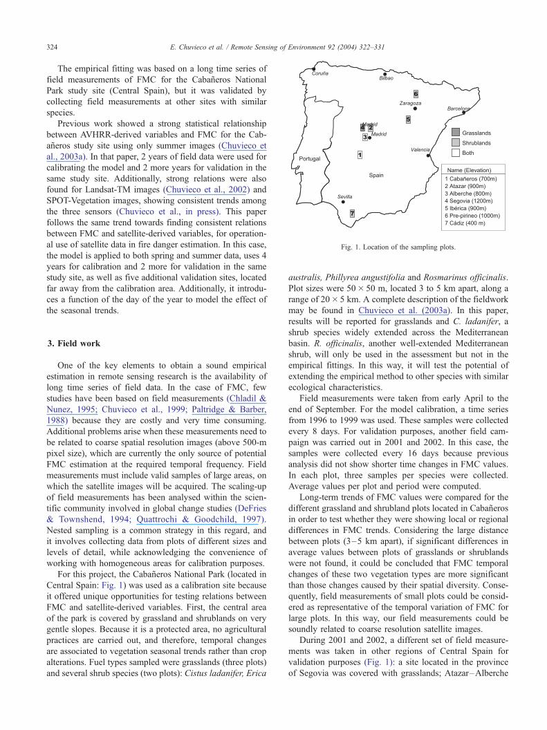
Fig. 1. Location of the sampling plots.
E. Chuvieco et al. / Remote Sensing of Environment 92 (2004) 322–331324
The empirical fitting was based on a long time series of
field measurements of FMC for the Cabaneros National
Park study site (Central Spain), but it was validated by
collecting field measurements at other sites with similar
species.
Previous work showed a strong statistical relationship
between AVHRR-derived variables and FMC for the Cab-
aneros study site using only summer images (Chuvieco et
al., 2003a). In that paper, 2 years of field data were used for
calibrating the model and 2 more years for validation in the
same study site. Additionally, strong relations were also
found for Landsat-TM images (Chuvieco et al., 2002) and
SPOT-Vegetation images, showing consistent trends among
the three sensors (Chuvieco et al., in press). This paper
follows the same trend towards finding consistent relations
between FMC and satellite-derived variables, for operation-
al use of satellite data in fire danger estimation. In this case,
the model is applied to both spring and summer data, uses 4
years for calibration and 2 more for validation in the same
study site, as well as five additional validation sites, located
far away from the calibration area. Additionally, it introdu-
ces a function of the day of the year to model the effect of
the seasonal trends.
3. Field work
One of the key elements to obtain a sound empirical
estimation in remote sensing research is the availability of
long time series of field data. In the case of FMC, few
studies have been based on field measurements (Chladil &
Nunez, 1995; Chuvieco et al., 1999; Paltridge & Barber,
1988) because they are costly and very time consuming.
Additional problems arise when these measurements need to
be related to coarse spatial resolution images (above 500-m
pixel size), which are currently the only source of potential
FMC estimation at the required temporal frequency. Field
measurements must include valid samples of large areas, on
which the satellite images will be acquired. The scaling-up
of field measurements has been analysed within the scien-
tific community involved in global change studies (DeFries
& Townshend, 1994; Quattrochi & Goodchild, 1997).
Nested sampling is a common strategy in this regard, and
it involves collecting data from plots of different sizes and
levels of detail, while acknowledging the convenience of
working with homogeneous areas for calibration purposes.
For this project, the Cabaneros National Park (located in
Central Spain: Fig. 1) was used as a calibration site because
it offered unique opportunities for testing relations between
FMC and satellite-derived variables. First, the central area
of the park is covered by grassland and shrublands on very
gentle slopes. Because it is a protected area, no agricultural
practices are carried out, and therefore, temporal changes
are associated to vegetation seasonal trends rather than crop
alterations. Fuel types sampled were grasslands (three plots)
and several shrub species (two plots): Cistus ladanifer, Erica
australis, Phillyrea angustifolia and Rosmarinus officinalis.
Plot sizes were 50� 50 m, located 3 to 5 km apart, along a
range of 20� 5 km. A complete description of the fieldwork
may be found in Chuvieco et al. (2003a). In this paper,
results will be reported for grasslands and C. ladanifer, a
shrub species widely extended across the Mediterranean
basin. R. officinalis, another well-extended Mediterranean
shrub, will only be used in the assessment but not in the
empirical fittings. In this way, it will test the potential of
extending the empirical method to other species with similar
ecological characteristics.
Field measurements were taken from early April to the
end of September. For the model calibration, a time series
from 1996 to 1999 was used. These samples were collected
every 8 days. For validation purposes, another field cam-
paign was carried out in 2001 and 2002. In this case, the
samples were collected every 16 days because previous
analysis did not show shorter time changes in FMC values.
In each plot, three samples per species were collected.
Average values per plot and period were computed.
Long-term trends of FMC values were compared for the
different grassland and shrubland plots located in Cabaneros
in order to test whether they were showing local or regional
differences in FMC trends. Considering the large distance
between plots (3–5 km apart), if significant differences in
average values between plots of grasslands or shrublands
were not found, it could be concluded that FMC temporal
changes of these two vegetation types are more significant
than those changes caused by their spatial diversity. Conse-
quently, field measurements of small plots could be consid-
ered as representative of the temporal variation of FMC for
large plots. In this way, our field measurements could be
soundly related to coarse resolution satellite images.
During 2001 and 2002, a different set of field measure-
ments was taken in other regions of Central Spain for
validation purposes (Fig. 1): a site located in the province
of Segovia was covered with grasslands; Atazar–Alberche
E. Chuvieco et al. / Remote Sensing of Environment 92 (2004) 322–331 325
with grassland and shrubs (a mixture of C. ladanifer and R.
officinalis); Iberica and Pre-pirineo with shrubs (R. offici-
nalis and other shrub species), and Cadiz with C. ladanifer.
These plots are 200 to 500 km apart from the Cabaneros site
and have different elevations but include similar species as
they are part of the Mediterranean ecosystem (with the
exception of the Pre-pirineo site). The plots were selected
so as to include homogeneous plant coverage on as gentle
slopes as possible. However, the shrub species were fre-
quently mixed, even with some trees. Among the different
mixtures, only those plots with a significant coverage of C.
ladanifer or R. officinalis (more than 60%) were selected for
validation purposes. To assure consistency in the results, the
field protocol of these assessment sites was the same as that
of Cabaneros.
4. Satellite image processing
AVHRR images were acquired by the University of
Alcala’s HRPT receiving station. Raw digital to reflectance
conversion was based on NOAA coefficients (including
degradation rates), and surface temperature (ST) was based
on methods proposed by Coll & Caselles (1997). Geometric
corrections were based on orbital models and multitemporal
matching was improved by manual control points and
automatic correlation. Daily data were synthesized into 8-
day composites using maximum NDVI values. The median
value of a 3� 3 pixel window was extracted from each
composite and correlated against field measurements.
As mentioned, when comparing AVHRR images and field
measurements, the potential noise caused by the great differ-
ences within the area covered may be reduced when using
average values of species, instead of single plot averages. For
instance, average values of grasslands collected in a length of
10 km (three plots separated linearly 5 km each) would be a
better representation of what an AVHRR pixel is actually
measuring than single plot measurements.
5. Model construction
Several authors have discussed the pros and cons of
empirical and theoretical models in remote sensing research
(Strahler et al., 1986). Theoretical models have two main
advantages: generalizing power and a better understanding
of the parameters involved. However, they are complex to
generate because they require many input parameters that
are often unavailable and are difficult to validate. Empirical
models are commonly based on statistical analysis. They are
simpler to formulate and provide a quantitative validation
on their exactness, but they are difficult to generalize,
especially when statistical relations are not based on phys-
ical properties.
In the field of water content estimation, a whole range of
theoretical models has been proposed in recent years, most
of them based on the radiative transfer function (Baret &
Fourty, 1997; Ceccato et al., 2001; Ceccato et al., 2002b;
Jacquemoud et al., 1996; Zarco-Tejada et al., 2003). They
are solid approaches but require further assessment and must
demonstrate their operational application with field cam-
paigns. These models estimate the EWT, which is the
variable directly associated to leaf water absorption. FMC
is equal to EWT divided by SLW. EWT can be estimated
using a radiative transfer function, but dry matter content
cannot be directly retrieved because the water is masking its
effect on reflectance (Jacquemoud et al., 2000). For this
reason, Zarco-Tejada et al. (2003) use a simplified inversion
model to obtain dry matter for FMC estimation, after
deriving EWT from a radiative transfer model.
Empirical fittings for the estimation of FMC from satel-
lite data have been proposed by several authors (Alonso et
al., 1996; Chladil & Nunez, 1995; Chuvieco et al., 1999,
2002, 2003a; Hardy & Burgan, 1999; Paltridge & Barber,
1988). Most commonly, these studies were based on
AVHRR images, although there are also some examples
using Landsat-TM images (Chuvieco et al., 2002).
For this project, the empirical model was based on linear
regression analysis, where FMC was the dependent variable
and the independent variables were AVHRR variables,
NDVI and ST, and a function of the day of the year. Two
models were generated, one for grasslands and one for
shrubs. The major physiological differences between these
two communities made it advisable to split the fittings. As
mentioned, C. ladanifer was selected as a representative of
Mediterranean shrub species because it is widely repre-
sented in Spain. Other species of the same family (Cistus
sp.) are also broadly distributed across the Mediterranean
basin.
The statistical model was built from 88 periods (22
periods of 8 days during 4 years: 1996 to 1999), covering
spring and summer conditions of the Cabaneros National
Park. The time series include a wide range of rain patterns,
with some dry years (1999 and 1997 with precipitation close
to 200 mm in 6 months), and more humid ones (1996 and
1998), with 250 and 230 mm, respectively.
The equation was validated using data from the same
study area (Cabaneros), as well as the other study sites
previously described during the 2001 and 2002 spring and
summer seasons.
Satellite variables considered in the linear regression
were NDVI and ST. The former would be positively related
to FMC because the drying of the plant reduces chlorophyll
activity in grasslands, as well as leaf area index in shrub
species. On the contrary, ST would be expected to be
negatively related to FMC because the cooling effect of
evapotranspiration is reduced when plants get dry and
introduce mechanisms to reduce water loss.
Before obtaining the estimations of FMC from linear
regression models, an analysis of trends between FMC and
these two variables (NDVI and ST) was undertaken. In a
similar way to other study areas (Alonso et al., 1996; Kalluri
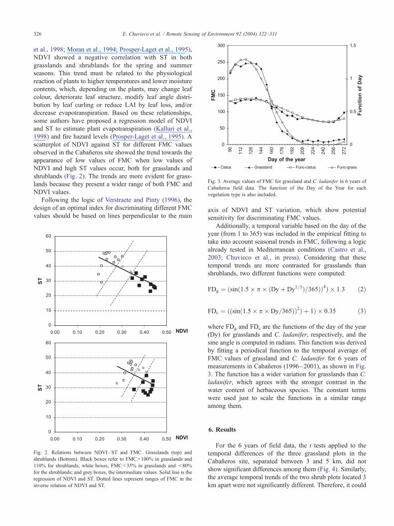
Fig. 3. Average values of FMC for grassland and C. ladanifer in 6 years of
Cabaneros field data. The function of the Day of the Year for each
vegetation type is also included.
E. Chuvieco et al. / Remote Sensing of Environment 92 (2004) 322–331326
et al., 1998; Moran et al., 1994; Prosper-Laget et al., 1995),
NDVI showed a negative correlation with ST in both
grasslands and shrublands for the spring and summer
seasons. This trend must be related to the physiological
reaction of plants to higher temperatures and lower moisture
contents, which, depending on the plants, may change leaf
colour, deteriorate leaf structure, modify leaf angle distri-
bution by leaf curling or reduce LAI by leaf loss, and/or
decrease evapotranspiration. Based on these relationships,
some authors have proposed a regression model of NDVI
and ST to estimate plant evapotranspiration (Kalluri et al.,
1998) and fire hazard levels (Prosper-Laget et al., 1995). A
scatterplot of NDVI against ST for different FMC values
observed in the Cabaneros site showed the trend towards the
appearance of low values of FMC when low values of
NDVI and high ST values occur, both for grasslands and
shrublands (Fig. 2). The trends are more evident for grass-
lands because they present a wider range of both FMC and
NDVI values.
Following the logic of Verstraete and Pinty (1996), the
design of an optimal index for discriminating different FMC
values should be based on lines perpendicular to the main
Fig. 2. Relations between NDVI–ST and FMC. Grasslands (top) and
shrublands (Bottom). Black boxes refer to FMC>100% in grasslands and
110% for shrublands; white boxes, FMC<35% in grasslands and < 80%
for the shrublands; and grey boxes, the intermediate values. Solid line is the
regression of NDVI and ST. Dotted lines represent ranges of FMC in the
inverse relation of NDVI and ST.
axis of NDVI and ST variation, which show potential
sensitivity for discriminating FMC values.
Additionally, a temporal variable based on the day of the
year (from 1 to 365) was included in the empirical fitting to
take into account seasonal trends in FMC, following a logic
already tested in Mediterranean conditions (Castro et al.,
2003; Chuvieco et al., in press). Considering that these
temporal trends are more contrasted for grasslands than
shrublands, two different functions were computed:
FDg ¼ ðsinð1:5� p � ðDyþ Dy1=3Þ=365ÞÞ4Þ � 1:3 ð2Þ
FDc ¼ ððsinð1:5� p � Dy=365ÞÞ2Þ þ 1Þ � 0:35 ð3Þ
where FDg and FDc are the functions of the day of the year
(Dy) for grasslands and C. ladanifer, respectively, and the
sine angle is computed in radians. This function was derived
by fitting a periodical function to the temporal average of
FMC values of grassland and C. ladanifer for 6 years of
measurements in Cabaneros (1996–2001), as shown in Fig.
3. The function has a wider variation for grasslands than C.
ladanifer, which agrees with the stronger contrast in the
water content of herbaceous species. The constant terms
were used just to scale the functions in a similar range
among them.
6. Results
For the 6 years of field data, the t tests applied to the
temporal differences of the three grassland plots in the
Cabaneros site, separated between 3 and 5 km, did not
show significant differences among them (Fig. 4). Similarly,
the average temporal trends of the two shrub plots located 3
km apart were not significantly different. Therefore, it could
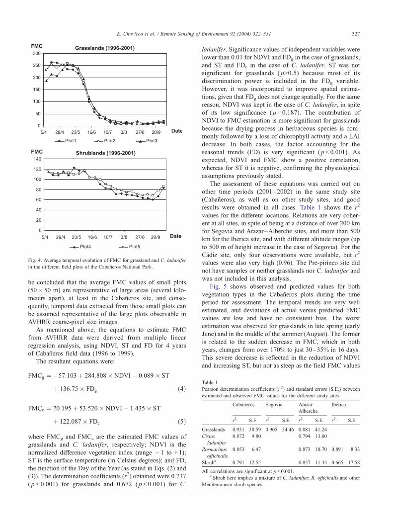
Table 1
Pearson determination coefficients (r 2) and standard errors (S.E.) between
estimated and observed FMC values for the different study sites
Cabaneros Segovia Atazar–
Alberche
Iberica
r2 S.E. r2 S.E. r2 S.E. r2 S.E.
Grasslands 0.931 30.59 0.905 34.46 0.881 41.24
Cistus
ladanifer
0.872 9.80 0.794 13.60
Rosmarinus
officinalis
0.853 6.47 0.873 10.70 0.891 8.33
Shruba 0.791 12.55 0.857 11.34 0.665 17.58
All correlations are significant at p< 0.001.a Shrub here implies a mixture of C. ladanifer, R. officinalis and other
Mediterranean shrub species.
Fig. 4. Average temporal evolution of FMC for grassland and C. ladanifer
in the different field plots of the Cabaneros National Park.
E. Chuvieco et al. / Remote Sensing of Environment 92 (2004) 322–331 327
be concluded that the average FMC values of small plots
(50� 50 m) are representative of large areas (several kilo-
meters apart), at least in the Cabaneros site, and conse-
quently, temporal data extracted from those small plots can
be assumed representative of the large plots observable in
AVHRR coarse-pixel size images.
As mentioned above, the equations to estimate FMC
from AVHRR data were derived from multiple linear
regression analysis, using NDVI, ST and FD for 4 years
of Cabaneros field data (1996 to 1999).
The resultant equations were:
FMCg ¼ �57:103þ 284:808� NDVI� 0:089� ST
þ 136:75� FDg ð4Þ
FMCc ¼ 70:195þ 53:520� NDVI� 1:435� ST
þ 122:087� FDc ð5Þ
where FMCg and FMCc are the estimated FMC values of
grasslands and C. ladanifer, respectively; NDVI is the
normalized difference vegetation index (range � 1 to + 1);
ST is the surface temperature (in Celsius degrees); and FD,
the function of the Day of the Year (as stated in Eqs. (2) and
(3)). The determination coefficients (r2) obtained were 0.737
( p < 0.001) for grasslands and 0.672 ( p < 0.001) for C.
ladanifer. Significance values of independent variables were
lower than 0.01 for NDVI and FDg in the case of grasslands,
and ST and FDc in the case of C. ladanifer. ST was not
significant for grasslands ( p>0.5) because most of its
discrimination power is included in the FDg variable.
However, it was incorporated to improve spatial estima-
tions, given that FDg does not change spatially. For the same
reason, NDVI was kept in the case of C. ladanifer, in spite
of its low significance ( p = 0.187). The contribution of
NDVI to FMC estimation is more significant for grasslands
because the drying process in herbaceous species is com-
monly followed by a loss of chlorophyll activity and a LAI
decrease. In both cases, the factor accounting for the
seasonal trends (FD) is very significant ( p < 0.001). As
expected, NDVI and FMC show a positive correlation,
whereas for ST it is negative, confirming the physiological
assumptions previously stated.
The assessment of these equations was carried out on
other time periods (2001–2002) in the same study site
(Cabaneros), as well as on other study sites, and good
results were obtained in all cases. Table 1 shows the r2
values for the different locations. Relations are very coher-
ent at all sites, in spite of being at a distance of over 200 km
for Segovia and Atazar–Alberche sites, and more than 500
km for the Iberica site, and with different altitude ranges (up
to 500 m of height increase in the case of Segovia). For the
Cadiz site, only four observations were available, but r2
values were also very high (0.96). The Pre-pirineo site did
not have samples or neither grasslands nor C. ladanifer and
was not included in this analysis.
Fig. 5 shows observed and predicted values for both
vegetation types in the Cabaneros plots during the time
period for assessment. The temporal trends are very well
estimated, and deviations of actual versus predicted FMC
values are low and have no consistent bias. The worst
estimation was observed for grasslands in late spring (early
June) and in the middle of the summer (August). The former
is related to the sudden decrease in FMC, which in both
years, changes from over 170% to just 30–35% in 16 days.
This severe decrease is reflected in the reduction of NDVI
and increasing ST, but not as steep as the field FMC values
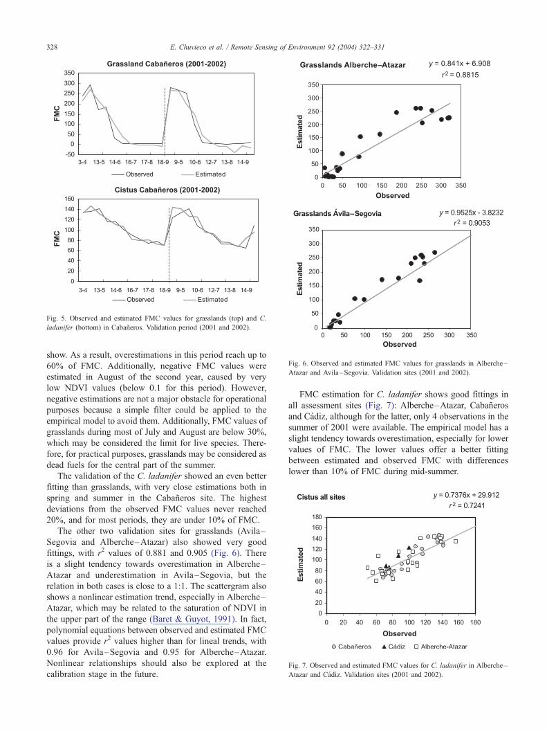
Fig. 6. Observed and estimated FMC values for grasslands in Alberche–
Atazar and Avila–Segovia. Validation sites (2001 and 2002).
Fig. 7. Observed and estimated FMC values for C. ladanifer in Alberche–
Atazar and Cadiz. Validation sites (2001 and 2002).
Fig. 5. Observed and estimated FMC values for grasslands (top) and C.
ladanifer (bottom) in Cabaneros. Validation period (2001 and 2002).
E. Chuvieco et al. / Remote Sensing of Environment 92 (2004) 322–331328
show. As a result, overestimations in this period reach up to
60% of FMC. Additionally, negative FMC values were
estimated in August of the second year, caused by very
low NDVI values (below 0.1 for this period). However,
negative estimations are not a major obstacle for operational
purposes because a simple filter could be applied to the
empirical model to avoid them. Additionally, FMC values of
grasslands during most of July and August are below 30%,
which may be considered the limit for live species. There-
fore, for practical purposes, grasslands may be considered as
dead fuels for the central part of the summer.
The validation of the C. ladanifer showed an even better
fitting than grasslands, with very close estimations both in
spring and summer in the Cabaneros site. The highest
deviations from the observed FMC values never reached
20%, and for most periods, they are under 10% of FMC.
The other two validation sites for grasslands (Avila–
Segovia and Alberche–Atazar) also showed very good
fittings, with r2 values of 0.881 and 0.905 (Fig. 6). There
is a slight tendency towards overestimation in Alberche–
Atazar and underestimation in Avila–Segovia, but the
relation in both cases is close to a 1:1. The scattergram also
shows a nonlinear estimation trend, especially in Alberche–
Atazar, which may be related to the saturation of NDVI in
the upper part of the range (Baret & Guyot, 1991). In fact,
polynomial equations between observed and estimated FMC
values provide r2 values higher than for lineal trends, with
0.96 for Avila–Segovia and 0.95 for Alberche–Atazar.
Nonlinear relationships should also be explored at the
calibration stage in the future.
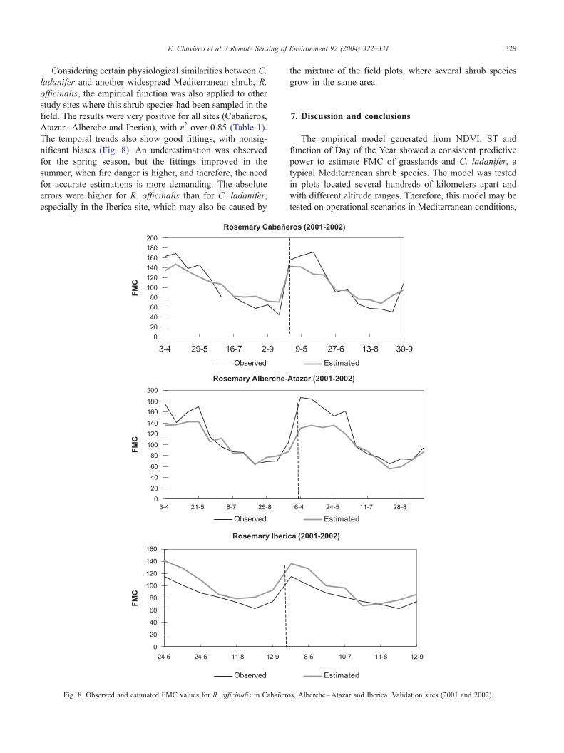
FMC estimation for C. ladanifer shows good fittings in
all assessment sites (Fig. 7): Alberche–Atazar, Cabaneros
and Cadiz, although for the latter, only 4 observations in the
summer of 2001 were available. The empirical model has a
slight tendency towards overestimation, especially for lower
values of FMC. The lower values offer a better fitting
between estimated and observed FMC with differences
lower than 10% of FMC during mid-summer.
E. Chuvieco et al. / Remote Sensing of Environment 92 (2004) 322–331 329
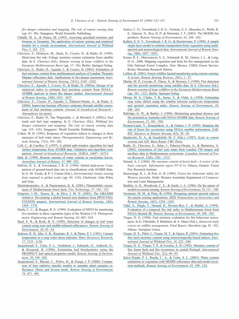
Considering certain physiological similarities between C.
ladanifer and another widespread Mediterranean shrub, R.
officinalis, the empirical function was also applied to other
study sites where this shrub species had been sampled in the
field. The results were very positive for all sites (Cabaneros,
Atazar–Alberche and Iberica), with r2 over 0.85 (Table 1).
The temporal trends also show good fittings, with nonsig-
nificant biases (Fig. 8). An underestimation was observed
for the spring season, but the fittings improved in the
summer, when fire danger is higher, and therefore, the need
for accurate estimations is more demanding. The absolute
errors were higher for R. officinalis than for C. ladanifer,
especially in the Iberica site, which may also be caused by
Fig. 8. Observed and estimated FMC values for R. officinalis in Cabanero
the mixture of the field plots, where several shrub species
grow in the same area.
7. Discussion and conclusions
The empirical model generated from NDVI, ST and
function of Day of the Year showed a consistent predictive
power to estimate FMC of grasslands and C. ladanifer, a
typical Mediterranean shrub species. The model was tested
in plots located several hundreds of kilometers apart and
with different altitude ranges. Therefore, this model may be
tested on operational scenarios in Mediterranean conditions,
s, Alberche–Atazar and Iberica. Validation sites (2001 and 2002).

E. Chuvieco et al. / Remote Sensing of Environment 92 (2004) 322–331330
applying both spring and summer data. Comparing these
results with previous findings (Chuvieco et al., 2003a), the
model provides a better estimation of FMC variations,
covering a wider temporal series, and has been assessed in
other study areas. The model only requires two basic
satellite variables (NDVI and ST), the day of the year and
a regional map of vegetation types, which distinguishes
grasslands from shrublands. This variable could also be
derived from the multitemporal classification of AVHRR
data, following any of the methods applied to derive global
land cover maps (DeFries & Townshend, 1994).
In the case of mixed pixels, a linear mixture of grassland
and shrubland FMC functions could be applicable, or
alternatively, the function of the most dangerous fuel can
be used, according to the experience of local fire managers.
Considering the spatial and temporal resolution of
AVHRR images, the empirical index may be used for
short-term estimations of FMC. Conversion of FMC values
to fire danger rating may be based on ignition delay values
for each vegetation species or alternatively on historical
relationships between FMC and fire occurrence. The for-
mer approach relies on calorimetric methods that estimate
the time it takes for a fuel to ignite based on its moisture
content (Dimitrakopoulos & Papaioannou, 2001). The
latter is more statistical and takes into account critical
levels of FMC for different degrees of fire occurrence.
The former approach seems preferable because it has a
more physical basis, measuring relations between FMC and
probability of ignition.
In spite of the great potential and interest that approaches
based on RTM have for FMC estimation, empirical fittings
are also critical for operational applications because they
provide faster and easily operated models of known accu-
racy. Additionally, RTM models do not include thermal
information that is vital, especially in fuels which are more
adapted to summer drought, which is the case in most
Mediterranean shrubs. In these species, FMC cannot be
accurately estimated using just NDVI values because chro-
lophyll and LAI changes caused by FMC variations are less
apparent in shrub species than in grasslands.
The applicability of the empirical model to other shrub
species may be based on their physiological similarities with
C. ladanifer. The paper has shown that FMC trends of R.
officinalis are also well estimated from the empirical model.
A more physical basis to extend this to other shrub species
should rely on physiological differences between the refer-
ence and the desired species, which may be based on
specific leaf weight or LAI factors, but this hypothesis
should be tested in future work.
This study has was based on NOAA–AVHRR imagery
due to the long time series available. In the near future,
FMC estimations based on other sensors should be achiev-
able. Recent studies have shown the potentials of Terra-
MODIS (Zarco-Tejada et al., 2003) and Spot-Vegetation
(Ceccato et al., 2002a), because both include information in
the SWIR water absorption bands. However, these efforts
should be extended to longer time series and calibrated in
Mediterranean conditions. Additionally, the local reception
of AVHRR images facilitates the operational use of their
data. The increasing availability of near-real time images
and products from the MODIS sensor should also provide a
sound alternative in the near future.
Acknowledgements
Funds for this project have been obtained from the
Spanish Ministry of Science and Technology (Firerisk
contract) and the European V Framework Research Program
(Spread contract). We would like to give special thanks to
the Cabaneros National Park authorities and the team
involved in the fieldwork, especially Patrick Vaughan,
Gemma Ventura, Enrique Meza, Raul Romero and Ricardo
Diaz-Delgado. Suggestions provided by Mark Danson have
been very valuable.
References
Ahern, F. J., Goldammer, J. G., & Justice, C. O. (Eds.). (2001). Global and
regional vegetation fire monitoring from space: Planning a coordina-
ted international effort. The Hague, The Netherlands: SPB Academic
Publishing.
Alonso, M., Camarasa, A., Chuvieco, E., Cocero, D., Kyun, I., Martın,
M. P., & Salas, F. J. (1996). Estimating temporal dynamics of fuel
moisture content of Mediterranean species from NOAA–AVHRR data.
EARSEL Advances in Remote Sensing, 4(4), 9–24.
Baret, F., & Fourty, T. (1997). Estimation of leaf water content and specific
leaf weight from reflectance and transmittance measurements. Agrono-
mie, 17, 444–455.
Baret, F., & Guyot, G. (1991). Potentials and limits of vegetation indices
for LAI and APAR assessment. Remote Sensing of Environment, 35,
161–173.
Bowman, W. D. (1989). The relationship between leaf water status, gas
exchange, and spectral reflectance in cotton leaves. Remote Sensing of
Environment, 30, 249–255.
Carlson, J. D., & Burgan, R. E. (2003). Review of users’ needs in opera-
tional fire danger estimation: The Oklahoma example. International
Journal of Remote Sensing, 24(8), 1601–1620.
Carter, G. A. (1991). Primary and secondary effects of water content on
the spectral reflectance of leaves. American Journal of Botany, 78,
916–924.
Castro, F. X., Tudela, A., & Sebastia, M. A. (2003). Modeling moisture
content in shrubs to predict fire risk in Catalonia (Spain). Agricultural
and Forest Meteorology, 116, 49–59.
Ceccato, P., Flasse, S., Tarantola, S., Jacquemoud, S., & Gregoire, J. M.
(2001). Detecting vegetation leaf water content using reflectance in the
optical domain. Remote Sensing of Environment, 77, 22–33.
Ceccato, P., Flasse, S., & Gregoire, J. M. (2002a). Designing a spectral
index to estimate vegetation water content from remote sensing data:
Part 2. Validation and applications. Remote Sensing of Environment, 82,
198–207.
Ceccato, P., Gobron, N., Flasse, S., Pinty, B., & Tarantola, S. (2002b).
Designing a spectral index to estimate vegetation water content from
remote sensing data: Part 1. Theoretical approach. Remote Sensing of
Environment, 82, 188–197.
Ceccato, P., Leblon, B., Chuvieco, E., Flasse, S., & Carlson, J. D. (2003).
Estimation of live fuel moisture content. In E. Chuvieco (Ed.), Wildland
E. Chuvieco et al. / Remote Sensing of Environment 92 (2004) 322–331 331
fire danger estimation and mapping. The role of remote sensing data
( pp. 63–90). Singapore: World Scientific Publishing.
Chladil, M. A., & Nunez, M. (1995). Assessing grassland moisture and
biomass in Tasmania. The application of remote sensing and empirical
models for a cloudy environment. International Journal of Wildland
Fire, 5, 165–171.
Chuvieco, E., Deshayes, M., Stach, N., Cocero, D., & Riano, D. (1999).
Short-term fire risk: Foliage moisture content estimation from satellite
data. In E. Chuvieco (Ed.), Remote sensing of large wildfires in the
European Mediterranean Basin ( pp. 17–38). Berlin: Springer-Verlag.
Chuvieco, E., Riano, D., Aguado, I., & Cocero, D. (2002). Estimation of
fuel moisture content from multitemporal analysis of Landsat Thematic
Mapper reflectance data: Applications in fire danger assessment. Inter-
national Journal of Remote Sensing, 23(11), 2145–2162.
Chuvieco, E., Aguado, I., Cocero, D., & Riano, D. (2003a). Design of an
empirical index to estimate fuel moisture content from NOAA–
AVHRR analysis in forest fire danger studies. International Journal
of Remote Sensing, 24(8), 1621–1637.
Chuvieco, E., Cocero, D., Aguado, I., Palacios-Orueta, A., & Prado, E.
(2004). Improving burning efficiency estimates through satellite assess-
ment of fuel moisture content. Journal of Geophysical Research -
Atmospheres (in press).
Chuvieco, E., Riano, D., Van Wagtendok, J., & Morsdof, F. (2003c). Fuel
loads and fuel type mapping. In E. Chuvieco (Ed.), Wildland fire
danger estimation and mapping. The role of remote sensing data
( pp. 119–142). Singapore: World Scientific Publishing.
Cohen, W. B. (1991). Response of vegetation indices to changes in three
measures of leaf water stress. Photogrammetric Engineering and Re-
mote Sensing, 57(2), 195–202.
Coll, C., & Caselles, V. (1997). A global split-window algorithm for land
surface temperature from AVHRR data: Validation and algorithm com-
parison. Journal of Geophysical Research, 102B14, 16697–16713.
Datt, B. (1999). Remote sensing of water content in eucalyptus leaves.
Australian Journal of Botany, 47, 909–923.
DeFries, R. S., & Townshend, J. R. G. (1994). Global land-cover: Com-
parison of ground-based data sets to classifications with AVHRR Data.
In G. M. Foody, & P. J. Curran (Eds.), Environmental remote sensing
from regional to global scales ( pp. 84–110). Chichester: John Wiley
and Sons.
Dimitrakopoulos, A., & Papaioannou, K. K. (2001). Flammability assess-
ment of Mediterranean forest fuels. Fire Technology, 37, 143–152.
Gregoire, J.-M., Tansey, K., & Silva, J. M. N. (2003). The GBA2000
initiative: Developing a global burned area database from SPOT-VEG-
ETATION imagery. International Journal of Remote Sensing, 24(6),
1369–1376.
Hardy, C. C., & Burgan, R. E. (1999). Evaluation of NDVI for monitoring
live moisture in three vegetation types of the Western U.S. Photogram-
metric Engineering and Remote Sensing, 65, 603–610.
Hunt, E. R., & Rock, B. N. (1989). Detection of changes in leaf water
content using near and middle-infrared reflectances. Remote Sensing of
Environment, 30, 43–54.
Jackson, R. D., Idso, S. B., Reginato, R. J., & Pinter, P. J. (1981). Canopy
temperature as a crop water stress indicator. Water Resources Research,
17, 1133–1138.
Jacquemoud, S., Ustin, S. L., Verdebout, J., Schmuck, G., Andreoli, G.,
& Hosgood, B. (1996). Estimating leaf biochemistry using the
PROSPECT leaf optical properties model. Remote Sensing of Environ-
ment, 56, 194–202.
Jacquemoud, S., Bacour, C., Poilve, H., & Frangi, J. P. (2000). Compar-
ison of four radiative transfer models to simulate plant canopies re-
flectance: Direct and inverse mode. Remote Sensing of Environment,
74, 471–481.
Justice, C. O., Townshend, J. R. G., Vermote, E. F., Masuoka, E., Wolfe, R.
E., Saleous, N., Roy, D. P., & Morisette, J. T. (2002). The MODIS fire
products. Remote Sensing of Environment, 83, 244–262.
Kalluri, S. N. V., Townshend, J. R. G., & Doraiswamy, P. (1998). A simple
single layer model to estimate transpiration from vegetation using multi-
spectral and meteorological data. International Journal of Remote Sens-
ing, 19(6), 1037–1053.
Keane, R. E., Mincemoyer, S. A., Schmindt, K. M., Garner, J. L., & Long,
D. G., 2000. Mapping vegetation and fuels for fire management on the
Gila National Forest Complex, New Mexico. USDA Forest Service.
Rocky Mountain Research Station.
Leblon, B. (2001). Forest wildfire hazard monitoring using remote sensing:
A review. Remote Sensing Reviews, 20(1), 1–57.
Martın, M. P., Ceccato, P., Flasse, S., & Downey, I. (1999). Fire detection
and fire growth monitoring using satellite data. In E. Chuvieco (Ed.),
Remote sensing of large wildfires in the European Mediterranean Basin
( pp. 101–122). Berlin: Springer-Verlag.
Moran, M. S., Clarke, T. R., Inoue, Y., & Vidal, A. (1994). Estimating
crop water deficit using the relation between surface-air temperature
and spectral vegetation index. Remote Sensing of Environment, 49,
246–263.
Paltridge, G. W., & Barber, J. (1988). Monitoring grassland dryness and
fire potential in Australia with NOAA/AVHRR data. Remote Sensing of
Environment, 25, 381–394.
Prosper-Laget, V., Douguedroit, A., & Guinot, J. P. (1995). Mapping the
risk of forest fire occurrence using NOAA satellite information. EAR-
SEL Advances in Remote Sensing, 4(3), 30–38.
Quattrochi, D. A., & Goodchild, M. F. (Eds.). (1997). Scale in remote
sensing and GIS. Boca Raton: CRC Press.
Riano, D., Chuvieco, E., Salas, J., Palacios-Orueta, A., & Bastarrica, A.
(2002). Generation of fuel type maps from Landsat TM images and
ancillary data in Mediterranean ecosystems. Canadian Journal of For-
est Research, 32(8), 1301–1315.
Simard, A. J. (1968). The moisture content of forest fuels—A review of the
basic concepts. Information report FF-X-14. Ottawa, Ontario: Forest
Fire Research Institute.
Sneeuwjagt, R. J., & Peet, G. B. (1985). Forest fire behaviour tables for
Western Australia. Perth: Western Australian Department of Conserva-
tion and Land Management.
Strahler, A. H., Woodcock, C. E., & Smith, J. A. (1986). On the nature of
models in remote sensing.Remote Sensing of Environment, 20, 121–140.
Verstraete, M. M., & Pinty, B. (1996). Designing optimal spectral indexes
for remote sensing applications. IEEE Transactions on Geoscience and
Remote Sensing, 34(5), 1254–1265.
Vidal, A., Pinglo, F., Durand, H., Devaux-Ros, C., & Maillet, A. (1994).
Evaluation of a temporal fire risk index in Mediterranean forest from
NOAA thermal IR. Remote Sensing of Environment, 49, 296–303.
Viegas, D. X. (1998). Fuel moisture evaluation for fire behaviour assess-
ment. In G. Eftichidis, P. Balabaris, & A. Ghazi (Eds.), Advanced study
course on wildfire management. Final Report, Marathon ( pp. 81–92).
Athens: European Union.
Viegas, D. X., Pinol, J., Viegas, M. T., & Ogaya, R. (2001). Estimating live
fine fuels moisture content using meteorologically-based indices. Inter-
national Journal of Wildland Fire, 10, 223–240.
Viegas, D. X., Viegas, T. P., & Ferreira, A. D. (1992). Moisture content of
fine forest fuels and fire occurrence in central Portugal. International
Journal of Wildland Fire, 2(2), 69–85.
Zarco-Tejada, P. J., Rueda, C. A., & Ustin, S. L. (2003). Water content
estimation in vegetation with MODIS reflectance data and model inver-
sion methods. Remote Sensing of Environment, 85, 109–124.