Combining AHP with GIS for landfill site selection: A case study in the Lake Beyşehir catchment...
10
Combining AHP with GIS for landfill site selection: A case study in the Lake Beys ßehir catchment area (Konya, Turkey) S ßehnaz S ßener a , Erhan S ßener b, * , Bilgehan Nas c,d , Remzi Karagüzel e a Suleyman Demirel University, Department of Geological Engineering, 32260 Isparta, Turkey b Suleyman Demirel University, Remote Sensing Center, 32260 Isparta, Turkey c Selcuk University, Department of Environmental Engineering, 42075 Konya, Turkey d University of Minnesota, Department of Soil, Water, and Climate, St. Paul, MN, 55108, USA e Istanbul Technical University, Department of Geological Engineering, Istanbul, Turkey article info Article history: Received 14 January 2010 Accepted 30 May 2010 Available online 1 July 2010 abstract Landfills are the most common method for the disposal of municipal solid waste (MSW) in Turkey. How- ever, determining the location of landfill sites is a difficult and complex process because it must combine social, environmental and technical parameters. Additionally, it depends on several criteria and regula- tions. The main objective of this study was to select of a landfill site for the Lake Beys ßehir catchment area. The Beys ßehir Lake is the largest freshwater lake and drinking water reservoir in Turkey, but there is no controlled landfill site in the region. Therefore, the landfill site should be determined such that the lake is protected. To determine the most suitable landfill site, an analytical hierarchy process (AHP) was com- bined with a geographic information system (GIS) to examine several criteria, such as geology/hydroge- ology, land use, slope, height, aspect and distance from settlements, surface waters, roads, and protected areas (ecologic, scientific or historic). Each criterion was evaluated with the aid of AHP and mapped by GIS. Data were assorted into four suitability classes within the study area, i.e., high, moderate, low and very low suitability areas, which represented 3.24%, 7.55%, 12.70% and 2.81%, of the study area, respec- tively. Additionally, 73.70% was determined to be completely unsuitable for a landfill site. As a result, two candidate landfill sites are suggested and discussed. The final decision for landfill site selection will require more detailed field studies. Ó 2010 Elsevier Ltd. All rights reserved. 1. Introduction In recent years, there has been growing support for the notion of integrated waste management and strategies to reduce waste. Waste materials are first considered for reuse and recycling, and the rest are disposed at landfill sites (Ngoc and Schnitzera, 2009). Municipal and industrial solid waste disposal sites have been the focus of special attention because they are a significant source of soil, water and air contamination. Unfortunately, many sites of waste disposal are uncontrolled; the restrictions imposed by envi- ronmental agencies are disregarded, and the rules and techniques for proper landfill management are ignored (Mondelli et al., 2007). The management of municipal solid waste (MSW) is going through a critical phase due to the unavailability of suitable facilities to treat and dispose of the increasing amount of MSW generated in metropolitan cities. Unregulated disposal has negative impacts on all components of environmental and human health (Rathi, 2006; Li’aoa et al., 2009). In many countries, MSW management focuses on waste collec- tion. While collection helps to remove waste from the generators, collected waste is often disposed of in open dumps without con- cern for environmental degradation (Von Einsiedel, 2001; Vidana- arachchi et al., 2006). In general, there is a lack of organization and planning in waste management due to insufficient information regarding regulations and financial restrictions endured by devel- oping countries, such as Turkey (Tınmaz and Demir, 2006). Land- fills have been used as the most common method for the disposal of solid waste generated by different communities for many years (Komilis et al., 1999; Mutlutürk and Karagüzel, 2007). The selection of landfill sites has targeted areas that are financially efficient and minimize hazards to environmental and public health (Mcbean et al., 1995; Kontos et al., 2005; Yes ßilnacar and Çetin, 2007). The integration of GIS and AHP is a powerful tool to solve the landfill site selection problem (Basag ˘aog ˘lu et al., 1997; Allen et al., 2003; Sener, B. et al., 2006; Sener, S. et al., 2010). AHP is a systematic decision approach first developed by Saaty (1980) (Bhushan and Rai, 2004). This technique provides a means of decomposing the problem into a hierarchy of sub-problems that can be more easily comprehended and subjectively evaluated. 0956-053X/$ - see front matter Ó 2010 Elsevier Ltd. All rights reserved. doi:10.1016/j.wasman.2010.05.024 * Corresponding author. E-mail addresses: [email protected] (S ß.S ßener), [email protected] (E. S ßener), [email protected] (B. Nas), [email protected] (R. Karagüzel). Waste Management 30 (2010) 2037–2046 Contents lists available at ScienceDirect Waste Management journal homepage: www.elsevier.com/locate/wasman
-
Upload
independent -
Category
Documents
-
view
3 -
download
0
Transcript of Combining AHP with GIS for landfill site selection: A case study in the Lake Beyşehir catchment...

Waste Management 30 (2010) 2037–2046
Contents lists available at ScienceDirect
Waste Management
journal homepage: www.elsevier .com/locate /wasman
Combining AHP with GIS for landfill site selection: Acase study in the Lake Beys�ehircatchment area (Konya, Turkey)
S�ehnaz S�ener a, Erhan S�ener b,*, Bilgehan Nas c,d, Remzi Karagüzel e
a Suleyman Demirel University, Department of Geological Engineering, 32260 Isparta, Turkeyb Suleyman Demirel University, Remote Sensing Center, 32260 Isparta, Turkeyc Selcuk University, Department of Environmental Engineering, 42075 Konya, Turkeyd University of Minnesota, Department of Soil, Water, and Climate, St. Paul, MN, 55108, USAe Istanbul Technical University, Department of Geological Engineering, Istanbul, Turkey
a r t i c l e i n f o a b s t r a c t
Article history:Received 14 January 2010Accepted 30 May 2010Available online 1 July 2010
0956-053X/$ - see front matter � 2010 Elsevier Ltd. Adoi:10.1016/j.wasman.2010.05.024
* Corresponding author.E-mail addresses: [email protected] (S�. S�e
(E. S�ener), [email protected] (B. Nas), karaguzel@itu
Landfills are the most common method for the disposal of municipal solid waste (MSW) in Turkey. How-ever, determining the location of landfill sites is a difficult and complex process because it must combinesocial, environmental and technical parameters. Additionally, it depends on several criteria and regula-tions. The main objective of this study was to select of a landfill site for the Lake Beys�ehir catchment area.The Beys�ehir Lake is the largest freshwater lake and drinking water reservoir in Turkey, but there is nocontrolled landfill site in the region. Therefore, the landfill site should be determined such that the lakeis protected. To determine the most suitable landfill site, an analytical hierarchy process (AHP) was com-bined with a geographic information system (GIS) to examine several criteria, such as geology/hydroge-ology, land use, slope, height, aspect and distance from settlements, surface waters, roads, and protectedareas (ecologic, scientific or historic). Each criterion was evaluated with the aid of AHP and mapped byGIS. Data were assorted into four suitability classes within the study area, i.e., high, moderate, low andvery low suitability areas, which represented 3.24%, 7.55%, 12.70% and 2.81%, of the study area, respec-tively. Additionally, 73.70% was determined to be completely unsuitable for a landfill site. As a result, twocandidate landfill sites are suggested and discussed. The final decision for landfill site selection willrequire more detailed field studies.
� 2010 Elsevier Ltd. All rights reserved.
1. Introduction
In recent years, there has been growing support for the notionof integrated waste management and strategies to reduce waste.Waste materials are first considered for reuse and recycling, andthe rest are disposed at landfill sites (Ngoc and Schnitzera, 2009).Municipal and industrial solid waste disposal sites have been thefocus of special attention because they are a significant source ofsoil, water and air contamination. Unfortunately, many sites ofwaste disposal are uncontrolled; the restrictions imposed by envi-ronmental agencies are disregarded, and the rules and techniquesfor proper landfill management are ignored (Mondelli et al., 2007).The management of municipal solid waste (MSW) is going througha critical phase due to the unavailability of suitable facilities totreat and dispose of the increasing amount of MSW generated inmetropolitan cities. Unregulated disposal has negative impactson all components of environmental and human health (Rathi,2006; Li’aoa et al., 2009).
ll rights reserved.
ner), [email protected] (R. Karagüzel).
In many countries, MSW management focuses on waste collec-tion. While collection helps to remove waste from the generators,collected waste is often disposed of in open dumps without con-cern for environmental degradation (Von Einsiedel, 2001; Vidana-arachchi et al., 2006). In general, there is a lack of organization andplanning in waste management due to insufficient informationregarding regulations and financial restrictions endured by devel-oping countries, such as Turkey (Tınmaz and Demir, 2006). Land-fills have been used as the most common method for thedisposal of solid waste generated by different communities formany years (Komilis et al., 1999; Mutlutürk and Karagüzel,2007). The selection of landfill sites has targeted areas that arefinancially efficient and minimize hazards to environmental andpublic health (Mcbean et al., 1995; Kontos et al., 2005; Yes�ilnacarand Çetin, 2007).
The integration of GIS and AHP is a powerful tool to solve thelandfill site selection problem (Basagaoglu et al., 1997; Allenet al., 2003; Sener, B. et al., 2006; Sener, S. et al., 2010). AHP is asystematic decision approach first developed by Saaty (1980)(Bhushan and Rai, 2004). This technique provides a means ofdecomposing the problem into a hierarchy of sub-problems thatcan be more easily comprehended and subjectively evaluated.
2038 S�. S�ener et al. / Waste Management 30 (2010) 2037–2046
The subjective evaluations are converted into numerical valuesthat are ranked on a numerical scale (Bhushan and Rai, 2004).
Several researchers have used different methods for the siteselection process. For example, Kontos et al. (2005) evaluated thesuitability of the study region to select an optimal landfill siteusing a spatial multiple criteria analysis methodology. Vatalisand Manoliadis (2002) overlaid GIS digital maps to find the suit-able landfill sites in Western Macedonia, Greece. Siddiqui et al.(1996) combined GIS and AHP for the same goal. According to Mut-lutürk and Karagüzel (2007), the site selection method should beapplied in two stages. In the first stage, potential landfill sites areidentified based on evaluations of geology, hydrogeology and mor-phological properties using GIS techniques. In the second stage, anumber of potential landfill sites are assessed considering variouscriteria in three fundamental dimensions and plotted on a 3-Dgraph with axes corresponding to these dimensions. Sener et al.(2006) used GIS and multi-criteria decision analysis to determineappropriate landfill sites. Chang et al. (2008) and Akbari et al.(2008) combined GIS and a convoluted multi-criteria decision-making process to select a landfill site. Nas et al. (2008a) selectedan MSW landfill site for Konya, Turkey using GIS and an evaluationof several criteria. Mahini and Gholamalifard (2006) described amulti-criteria evaluation method, called weighted linear combina-tion (WLC), in a GIS environment to evaluate the suitability of theoutskirts of Gorgan city (Iran) as a landfill site. Guiqin et al. (2009)used spatial information technologies and AHP for landfill siteselection in Beijing, China. In general, the researchers performedtheir methodology for cities. This study aimed to determine themost appropriate landfill site for the Lake Beys�ehir catchment area.GIS techniques, i.e., buffer zoning, neighboring computation, costdistance and overlay analysis, were combined with AHP methods.
2. Materials and method
2.1. The study area
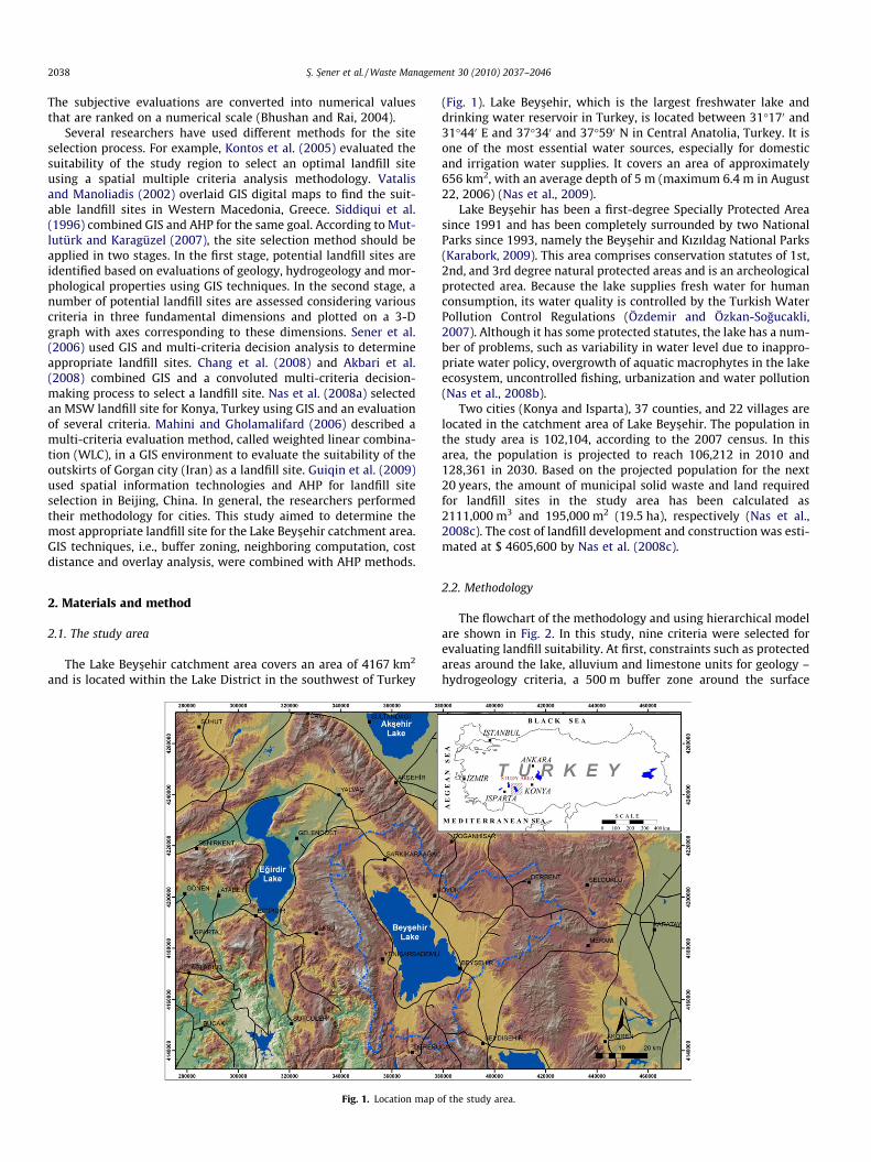
The Lake Beys�ehir catchment area covers an area of 4167 km2
and is located within the Lake District in the southwest of Turkey
Fig. 1. Location map o
(Fig. 1). Lake Beys�ehir, which is the largest freshwater lake anddrinking water reservoir in Turkey, is located between 31�170 and31�440 E and 37�340 and 37�590 N in Central Anatolia, Turkey. It isone of the most essential water sources, especially for domesticand irrigation water supplies. It covers an area of approximately656 km2, with an average depth of 5 m (maximum 6.4 m in August22, 2006) (Nas et al., 2009).
Lake Beys�ehir has been a first-degree Specially Protected Areasince 1991 and has been completely surrounded by two NationalParks since 1993, namely the Beys�ehir and Kızıldag National Parks(Karabork, 2009). This area comprises conservation statutes of 1st,2nd, and 3rd degree natural protected areas and is an archeologicalprotected area. Because the lake supplies fresh water for humanconsumption, its water quality is controlled by the Turkish WaterPollution Control Regulations (Özdemir and Özkan-Sogucakli,2007). Although it has some protected statutes, the lake has a num-ber of problems, such as variability in water level due to inappro-priate water policy, overgrowth of aquatic macrophytes in the lakeecosystem, uncontrolled fishing, urbanization and water pollution(Nas et al., 2008b).
Two cities (Konya and Isparta), 37 counties, and 22 villages arelocated in the catchment area of Lake Beys�ehir. The population inthe study area is 102,104, according to the 2007 census. In thisarea, the population is projected to reach 106,212 in 2010 and128,361 in 2030. Based on the projected population for the next20 years, the amount of municipal solid waste and land requiredfor landfill sites in the study area has been calculated as2111,000 m3 and 195,000 m2 (19.5 ha), respectively (Nas et al.,2008c). The cost of landfill development and construction was esti-mated at $ 4605,600 by Nas et al. (2008c).
2.2. Methodology
The flowchart of the methodology and using hierarchical modelare shown in Fig. 2. In this study, nine criteria were selected forevaluating landfill suitability. At first, constraints such as protectedareas around the lake, alluvium and limestone units for geology –hydrogeology criteria, a 500 m buffer zone around the surface
f the study area.

Fig. 2. Flowchart of the methodology.
S�. S�ener et al. / Waste Management 30 (2010) 2037–2046 2039
waters and 1000 m buffer zone around settlements, were maskedand not evaluated. Considered criteria were divided into two maingroups. The first group was environmental criteria, which limitedthe analysis to specific geographic areas (Guiqin et al., 2009). Also,environmental criteria should be considered more sensitive thaneconomic criteria. Because leachate generated from landfills canaffect natural sources negatively. The second group was economiccriteria, which are important due to financial restrictions. Thesecriteria were selected based on the regulations of Turkey (TSWCR,1991) and relevant international literature (Kontos et al., 2005;Vatalis and Manoliadis, 2002; Siddiqui et al., 1996; Sener et al.,2006; Chang et al., 2008; Akbari et al., 2008; Nas et al., 2008a;Mahini and Gholamalifard, 2006; Guiqin et al., 2009; Sener et al.,2010).
The AHP technique was used to evaluate each criterion. Becausemultiple, important objectives are difficult to prioritize, AHP canserve as a powerful tool to consider complicated problems that in-volve several interrelated objectives (Chuang, 2001). The weightsof specific criteria are established by ranking their importanceand suitability.
The AHP method is composed of three main steps (Saaty andVargas, 2001). The first step was to decompose the decision makingproblem into a hierarchical structure. A structural hierarchyformed for the decision problem consists of several levels. Toestablish the hierarchy of the main goals of landfill site selection,several criteria were created, including environmental factors, eco-nomic factors, constraints, etc. These criteria (e.g., environmentalfactors) were then divided into several sub-criteria, such as geol-ogy, surface water, land use, etc.
The second step was to create decision tables at each level of thehierarchical decomposition. The matrices capture a series of pair-wise comparisons (PC matrices) using relative data. The compari-son can be made using a nine point scale or real data, if available(Saaty and Vargas, 2001). The nine point scale includes: [9, 8,7, . . ., 1/7, 1/8, 1/9], where 9 means extreme preference, 7 meansvery strong preference, 5 means strong preference, and so on downto 1, which means no preference (Table 1). This pair-wise compar-ison allowed for an independent evaluation of the contribution ofeach factor, thereby simplifying the decision making process (Re-zaei-Moghaddam and Karami, 2008).
The pair-wise comparisons of various criteria were organizedinto a square matrix. The diagonal elements of the matrix were1. The principal eigenvalue and the corresponding normalized righteigenvector of the comparison matrix gave the relative importanceof the criteria being compared. The elements of the normalizedeigenvector were weighted with respect to the criteria or sub-cri-teria and rated with respect to the alternatives (Bhushan and Rai,2004). The consistency of the matrix of order n was then evaluated.If this consistency index failed to reach a threshold level, then theanswers to comparisons were re-examined. The consistency index,CI, was calculated as:
CI ¼ kmax � nn� 1
where CI is the consistency index (1), kmax is the largest or principaleigenvalue of the matrix, and n is the order of the matrix. This CI canbe compared to that of a random matrix, RI, such that the ratio, CI/RI, is the consistency ratio, CR. As a general rule, CR 6 0.1 should be

Table 1The comparison scale in AHP (Saaty, 1980).
Intensity of importance Definition Explanation
1 Equal importance Two activities contribute equally to the objective3 Weak importance of one over another Experience and judgment slightly favor one activity over
another5 Essential or strong importance Experience and judgment strongly favor one activity
over another7 Demonstrated importance An activity is strongly favored and its dominance is
demonstrated in practice9 Absolute importance The evidence favoring one activity over another is of the
highest possible order of affirmation2,4,6,8 Intermediate values between the two adjacent
judgmentsWhen compromise is needed
Reciprocals of above nonzero If activity i has one of the above nonzero numbersassigned to it when compared with activity j, then j hasthe reciprocal value when compared with i
2040 S�. S�ener et al. / Waste Management 30 (2010) 2037–2046
maintained for the matrix to be consistent. A homogeneity of fac-tors within each group, a smaller number of factors in the group,and better a understanding of the decision problem improve theconsistency index (Saaty, 1993). For this study, CR = 0.05441; thusindicating that a consistent matrix was formed.
For the third step, the rating of each alternative was multipliedby the weights of the sub-criteria and aggregated to determinethe local ratings with respect to each criterion. The local ratingswere then multiplied by the weights of the criteria and aggregatedto determine global ratings (Bhushan and Rai, 2004).
In this study, every criterion was assigned different ratings on ascale of 1 (least suitable) to 6 (most suitable). Initially, the con-strained areas for landfill site selection were masked. Subse-quently, the overall score of alternatives in the GIS environmentand land suitability of the study area was determined by calculat-ing the landfill suitability index (LSI):
LSI ¼ ½ðAÞ � ððA1cwi � A1scwiÞ þ ðA2cwi � A2scwiÞþ ðA3cwi � A3scwiÞÞ� þ ½ðBÞ � ððB1cwi � B1ScwiÞþ ðB2cwi � B3ScwiÞ þ ðB1cwi � B3ScwiÞþ ðB4cwi � B4ScwiÞ þ ðB5cwi � B5ScwiÞ þ ðB6cwi � B6ScwiÞÞ�
where, LSI: landfill suitability index; A1cwi: weight index of slopecriteria; A1scwi: weight index of slope sub-criteria; A2cwi: weight in-dex of height criteria; A2scwi: weight index of height sub-criteria;A3cwi: weight index of distance from road criteria; A3scwi: weight in-dex of distance from road sub-criteria; B1cwi: weight index of aspectcriteria; B1scwi: weight index of aspect sub-criteria; B2cwi: weight in-dex of landuse criteria; B2scwi: weight index of landuse sub-criteria;B3cwi: weight index of geology/hydrogeology criteria; B3scwi: weightindex of geology/hydrogeology sub-criteria; B4cwi: weight index ofdistance from protected areas criteria; B4scwi: weight index of dis-tance from protected areas sub-criteria; B5cwi: weight index of dis-tance from settlement criteria; B5scwi: weight index of distance fromsettlement sub-criteria; B6cwi: weight index of distance from surfacewater criteria; B6scwi: weight index of distance from surface watersub-criteria.
The final landfill suitability map was prepared using the ninecriterion layers by overlay analyses in the GIS environment. Theintegration of the GIS and AHP method allows the user to deter-mine a numerical value from the LSI. Higher LSI values indicateareas more suitable for landfills. According to the LSI values, thestudy area was divided into four classes (high, moderate, low andvery low suitability) using the equal interval ArcView classificationmethod.
2.3. Criteria description and application
Several criteria should be considered when selecting a landfillsite. Additionally, many significant environmental and political
obstacles have to be overcome for appropriate site selection. Thesecriteria may be presented in many ways, the most useful way beingthat which is easily understood by the community (Tchobanoglouset al., 1993). Landfill site selection criteria may change from one re-gion from another based on local conditions and circumstances.There are nine criteria that should be considered when selectinga landfill site in the Lake Beys�ehir catchment area. These includedistance from settlements, distance from surface waters, distancefrom protected areas (ecologic, scientific or historic), geology/hydrogeology, land use, distance from roads, slope, height, and as-pect. The distance from settlements, distance from surface waters,distance from protected areas (ecologic, scientific or historic), geol-ogy/hydrogeology, land use and aspect criteria are environmentalcriteria and more important than economic criteria such as dis-tance from roads, slope and height.
Each criterion was weighted by AHP and mapped using GIStechniques. All of considered criteria and their sub-criteria weresummarized in Table 2. According to the AHP calculations, theweight of the environmental criteria was 0.75, and the weight ofthe economic criteria was 0.25 (Table 2), suggesting that economiccriteria were less important than environmental criteria for landfillsite selection. Table 2 shows the weights of economic criteria inwhich the slope and height criteria were considered less importantthan roads, as obstacles related to slope and height can be over-come with excavations. However, the new transport systems aremore expensive than excavation. The highest weight was assignedto the surface water criterion in the environmental criteria becausethe study area focuses on the surface water catchment, as it is thedrinking water reservoir for the region.
Each criterion is explained in detail below. These explanationsinclude selection of the criterion and how each was evaluated, spa-tially resolved, mapped, and weighted. An explanation of relatedtable and figures is also provided.
2.3.1. Distance from settlementsLandfill sites located near the settlement areas introduce vari-
ous environmental problems. The establishment of landfills withincities, towns or villages is not suitable because of unfavorable odorand noise. For this reason, according to Turkish Solid Waste ControlRegulations TSWCR (1991), landfills cannot be located within1000 m of settlement areas. For this propose a 1000 m buffer zonewas masked, and then the other buffer zones (<1000 m, 1000–2000 m, 2000–3000 m, 3000–4000 m, >4000 m) were applied toexisting settlement areas. Buffer zones were converted into a gridmap with 30 � 30 m cell sizes. Each buffer zone was weighted byAHP. The sites less than 1000 m and greater than 4000 m were as-signed grades of 1 and 5 and weighted 0.062 and 0.416, respec-tively (Table 2). The criterion map was obtained from a digitizedtopographic map, which was interpreted by ArcGIS software to

Table 2Significance weights of main criteria, criteria and sub-criteria used in landfill site selection.
STAGE 1 STAGE 2 STAGE 3 STAGE
Main criteria Weight *CR Criteria Weight *CR Sub-criteria (SC) Weight *CR R Weight
Economic criteria 0.2500 0 Distance from road (m) 0.5450 0.0090 250> 0.4870 0.0188 0.066354250–500 0.2530 0.034471500–750 0.1320 0.017985750–1000 0.0690 0.0094011000< 0.0580 0.007903
Height (m) 0.2870 2000< 0.0581 0.0188 0.0041661750–2000 0.0693 0.0049711500–1750 0.1323 0.0094931250–1500 0.2534 0.0181781000–1250 0.4870 0.034942
Slope (�) 0.1680 20< 0.1230 0.0027 0.00516610–20 0.2230 0.0093660–10 0.4040 0.016968
Environmental criteria 0.7500 Aspect 0.0510 0.0300 SW and flat areas 0.0470 0.0422 0.001798NE 0.0470 0.001798NW 0.0700 0.002678SE 0.0910 0.003481N 0.1080 0.004131W 0.1410 0.005393E 0.1950 0.007459S 0.2980 0.011399
Distance fromsettlements (m)
0.2350 1000> 0.0580 0.0188 0.010223
1000–2000 0.0690 0.0121612000–3000 0132 0.0232653000–4000 0.2530 0.0445944000< 0.4870 0.085834
Distance from surfacewater (m)
0.4080 500> 0.0580 0.0188 0.017748
500–1000 0.0690 0.0211141000–1500 0132 0.0403921500–2000 0.2530 0.0774182000< 0.4870 0.149022
Distance fromprotected areas (m)
0.1430 250> 0.0580 0.0188 0.006221
250–500 0.0690 0.007400500–750 0.1320 0.014157750–1000 0.2530 0.0271341000< 0.4870 0.052231
Geology nHydrogeology
0.0950 Volcanics 0.1000 0.0190 0.007125
Flysch 0.1880 0.013395Ophiolite 0.2670 0.019024Metamorphic 0.4450 0.031706
Landuse 0.6700 Bare rock 0.0290 0.0247 0.014593Forest 0.0441 0.022175Ochards 0.0712 0.035798Shrup 0.1095 0.054999Pasture 0.1593 0.080043Irrigated arable land 0.2336 0.117364Not irrigated arable land 0.3533 0.177528
* CR: consistency ratio.
S�. S�ener et al. / Waste Management 30 (2010) 2037–2046 2041
establish buffer zones. The weighted value of each buffer was en-tered into the GIS database to create the final map.
2.3.2. Distance from surface watersAccording to Turkish Water Pollution Control Regulations
TWPCR (2004) and international literature (Kontos et al., 2005;Nas et al., 2008a; Dorhofer and Siebert, 1998), landfill sites shouldnot be placed near any surface water (lake, pond, river and stream).Therefore, 500 m buffer zones were drawn around all surfacewaters. Buffer zones were converted into a grid map that had30 � 30 m cell sizes, each weighted by AHP. The highest grade(5) was assigned to a buffer of >2000 m because TWPCR indicatedthat landfill sites should be placed as far as 2000 m from surfacewaters in Turkey. The lowest grade (1) was assigned to bufferzones of <500 m (Table 2). The surface water map was obtained
using the same process as for the distance from settlements (ex-plained above).
2.3.3. Distance from protected areas (ecologic, scientific or historic)The Lake Beys�ehir catchment area has some protected statutes,
such as national parks and archeological protected areas. Accord-ing to the Ministry of Environment and Forestry (2000), nationalparks and archeological areas are especially not suitable for landfillsites. Additionally, disposal of municipal solid waste at a distanceof less than 150 m from protected areas is not permitted. The pro-jected map, establishing 250 m buffer zones around protectedareas was obtained from the Ministry of Environment and Forestry,Turkey using the function in GIS software (Fig. 4). Buffer zoneswere converted into a grid map with a 30 � 30 m resolution, andeach buffer zone was weighted by AHP. The highest grade (5)

Fig. 3. Map of the distance from protected areas.
2042 S�. S�ener et al. / Waste Management 30 (2010) 2037–2046
was assigned to a buffer zone >1000 m, and the lowest grade (1)was assigned to buffer zones <250 m (Table 2); the results areshown in Fig. 3.
2.3.4. Geology/hydrogeologyLiterature and field studies were performed in order to create a
geological map of the study area. The formation boundaries andnames were determined based on previous studies (Elitok, 2000;Demirkol et al., 1977; Öztürk et al., 1987). The geological mapwas digitized using ArcGIS software and converted into a gridmap with a 30 � 30 m resolution. There were many formationsin the study area; however, these formations were grouped intosix lithologic units, including alluvium, limestone, volcanics, flysch,ophiolite and metamorphics. Alluvium and limestone depositshave high potential for water adsorption and are not suitable forlandfill sites. Hence, these areas were masked initially and werenot weighted. Volcanic and flysch are semipermeable and havelimited water adsorption potential. Ophiolite and metamorphicsare impermeable and are thus the most suitable lithologic unitsfor a landfill site. According to geologic and hydrogeologic adsorp-tion properties of the sediment, relative grades were assigned, anda map was prepared by GIS (Table 2 and Fig. 4).
2.3.5. Land useBecause there are some restrictions related to landfill sites, land
use of the region must be considered. Forest/heath lands and pas-ture areas should not be used for different purposes, which areclearly stated by the Forest Law 6831 and Pasture Law 4342. Theuse of garden areas depends on the specific conditions. In addition,irrigated and non-irrigated arable lands are not suitable for landfillsites. The 1:100,000 scale land use map was acquired from theManagement of Agriculture and Village Works and was digitizedfor use in ArcGIS software and converted into a grid map with a30 � 30 m resolution. The higher AHP weight was assigned to theareas more suitable for landfill sites; the scheme for the gradingcriterion is shown in Table 2.
2.3.6. Distance from roadsThe proximity to roads must be considered for landfill site
selection. According to TSWCR (1991), sanitary landfills shouldbe located at a site that can be reached by alternative roads underall weather conditions. On the other hand, landfill sites should notbe placed too far away from existing road networks to avoid theexpensive cost of constructing connection roads (Nas et al.,2008a). Additionally, landfill vehicles should not interfere withcurrent traffic (Guiqin et al., 2009). Hence, closer distances to exist-

Fig. 4. Geology map.
S�. S�ener et al. / Waste Management 30 (2010) 2037–2046 2043
ing roads were given higher grades. To evaluate this criterion,250 m buffer zones were drawn around all roads. Buffer zoneswere converted into a grid map with a 30 � 30 m resolution, andeach buffer zone was weighted by AHP.
2.3.7. Slope and heightLand slope and height are basic parameters for the construction
of a landfill site (Kontos et al., 2005). Areas with high altitude orhigh slope are not suitable landfill sites. The best places for wastedisposal are areas with medium altitude surrounded by hills andwith no more than 20% slope (Akbari et al., 2008). The slope ofthe land surface is a crucial criterion because very steep slopes leadto higher excavation costs. Steep areas (>20) were thus assigned agrade of 1, and the slightly sloping areas (0–10) were given a gradeof 5 (Table 2). The digital elevation model (DEM) of the study areawas created using data downloaded from ASTER GDEM (http://www.gdem.aster.or.jp). The slope of the study area was calculatedon the pixel basis using the DEM, and a slope map was preparedusing ArcGIS Software. The spatial resolution of the slope mapwas 30 m. The height criterion was evaluated using a digital eleva-
tion model with a 30 � 30 m resolution, and lower grades were as-signed to higher altitudes (Table 2). For example an area at 100–1250 m above sea level was assigned a grade of 5 (most suitableaccording to region topography), and an area at >2000 m abovesea level was assigned a grade of 1 (least suitable).
2.3.8. AspectThe wind direction of the basin was also considered. Settle-
ments must not be affected from the odor that originates fromthe landfill. To evaluate the wind direction of the study area, an as-pect map was prepared using a digital elevation model with a30 � 30 m resolution. The hillsides located in the windward direc-tion relative to settlements were assigned a lower grade via AHP.The wind frequency percentage data were obtained from the Na-tional Meteorological Agency of Turkey. The northeast (NE) and-southwest (SW) winds are the dominant winds in the basin. Hence,the hillsides located in NE–SW and flat areas were assigned a gradeof 1 because they are more exposed to the wind. The other hillsideswere assigned higher grades, depending on their wind frequency(Table 2).

2044 S�. S�ener et al. / Waste Management 30 (2010) 2037–2046
3. Result and discussion
To determine the suitable areas for landfill sites, AHP was usedto assess and evaluate scores based on suitable criteria. Each crite-rion map was prepared using ArcGIS Spatial Analyst, and preparedmaps were converted into Esri Grid Format using weight values ob-tained from AHP. The final suitability map was derived with the aidof the map calculator function of ArcGIS and overlay analyses ofArcGIS spatial analyst (Fig. 5). After the constrained areas were ex-tracted by masking, the land suitability of the study area was cal-culated by the LSI. By considering the determined weights, therange of the landfill suitability index was between 0.072 and0.382. Using an equal interval classification method, landfill suit-ability values of the basin were classified into four groups: highsuitability (0.382–0.304), moderate suitability (0.304–0.227), lowsuitability (0.227–0.195) and very low suitability (0.194–0.072).This method divides the range of attribute values into equal-sizedsub-ranges. This creates an easy to understand legend and worksbest with continuously distributed data.
The results indicate that 2.81%, of the study area has very lowsuitability, 12.70% has low suitability, 7.55% has moderate suitabil-ity and 3.24% has high suitability for a landfill site. The other73.70% of the study area is not suitable for a landfill site. The
Fig. 5. Landfill su
results of the AHP method are compatible with our field observa-tions. Lake Beys�ehir is a first-degree specially protected area thatis completely surrounded by two national parks. Therefore, thecatchment area is mostly unsuitable for landfill sites due to Turkishregulations.
Two candidate sites (C1 and C2) were suggested for landfill usebecause these regions were determined to be high suitability re-gions by the AHP and GIS techniques (Fig. 5). When the candidatesites were determined, the location of settlements, amount of solidwastes and transportation of waste were considered. These twocandidate sites are near the catchment boundary and away fromthe lake. C1 and C2 are located in the hillside of the mountains;C1 is located north of the lake around S�arkikaraagaç district. Thewastes of S�arkikaraagaç, Hüyük and the surrounding vicinity canbe collected at this site. The other candidate site (C2) is locatedsoutheast of the lake, near the catchment’s boundary, where itcan collect waste from areas such as Beys�ehir, Derbent and the vil-lages between them. Field observations and the results of the re-search suggest that there are highly suitable areas for landfillsites around Derbent district. However, due to transportation costs,Derbent district was not determined to be a candidate site by AHPanalysis. For the settlements that are located southwest of the lake,a transfer station can be established south of the study area. We
itability map.

S�. S�ener et al. / Waste Management 30 (2010) 2037–2046 2045
propose an optimal location between Huglu and Uzumlu counties;the economical feasibility of the exact location of this transfer sta-tion warrants further research.
For this study, the most important step was criteria selection.Landfill site selection must consider environmental factors as wellas economic factors. When criteria are selected and graded accord-ing to the properties of a region, related regulations and interna-tional literature should be considered.
4. Conclusions
Although it is very difficult and expensive to include social,environmental, economical and technical parameters, studies forselecting the sites for solid waste disposal should be performedfor every city in Turkey. To determine an appropriate landfill site,GIS is a very powerful tool that can provide a rapid assessmentof the study area. In this study, landfill site selection was per-formed with the aid of GIS and AHP techniques. GIS was used toprepare spatial statistics and clustering processes to reveal themost suitable areas for landfill site selection, which was ideal forthis preliminary study as it enabled us to manage and analyze largevolumes of spatially resolved data from a variety of sources. Fur-thermore, it has the capability to handle and simulate the neces-sary economic, environmental, social, technical, and politicalconstraints (Sener et al., 2006; Nas et al., 2008a). On the otherhand, the AHP is a powerful tool for solving complicated problemsthat may have interactions and correlations among multiple objec-tives. Therefore, the integration of GIS and AHP methods provides amechanism to thoroughly explore complicated problems and pro-vide immediate feedback for decision makers.
The selection of appropriate landfill sites is very crucial for Tur-key. Lake Beys�ehir was selected as the study area because it is thelargest freshwater and drinking water reservoir in Turkey. Initially,landfill site selection criteria were determined depending on therelevant TSWCR (1991) and international literature. Nine criteriawere evaluated in the present study, including environmental cri-teria such as geology/hydrogeology, land use, aspect and distancefrom settlements, surface waters, protected areas (ecologic, scien-tific or historic), and economic criteria such as roads, slope, andelevation. The areas that were unsuitable for landfills were initiallydetermined and masked. Thus, these areas were not considered.Each criterion was evaluated and converted into numerical valuesby AHP. The criteria maps were mapped by GIS using the calcu-lated numerical values. To derive the final suitability map, theunsuitable areas for landfill sites were masked. Geoformulas werethen used to generate the GIS and LSI overall score for the alterna-tive sites, which varied between 0.072 and 0.382. Using the equalinterval classification method, the study area was classified intofour groups of high, moderate, low and very low suitability, whichcovered 3.24%, 7.55%, 12.70% and 2.81% of the study area, respec-tively. The results of the analysis were compared with field studies,and two candidate landfill sites (C1 and C2) were chosen from thehigh suitability regions. These sites are also close to highly popu-lated settlements. Additionally, a transfer station was proposed be-tween Huglu and Uzumlu districts to collect the waste from thedistant settlements in the area southwest of the lake. There is justone settlement, Yenis�arbademli, to west of the lake, and wastescoming from this district can be transferred to the transfer station.In present study we concluded that the using methodology giveaccurate results for site selection. But, detailed field studiesincluding detailed geological and geotechnical investigations, landownership, questionnaire investigations to determine publicacceptance, detailed waste inventory, and determination of con-struction suitability should be performed before the final site isselected.
The present study offers a siting methodology for the region.Also, it allows the decision maker to perform decision analysisfunctions and support to them in solving the waste managementproblems. The previous studies shows that the landfill site selec-tion methods were applied for solid wastes of the cities. Therefore,infrastructures of the city, airport, railway are quite important cri-teria for studies. But, if landfill site selection is performed in thesurface water catchment areas, the considered criteria may be dif-ferent and also the most important criterion is offered as distancefrom surface waters because of environmental impact.
Appendix A. Supplementary material
Supplementary data associated with this article can be found, inthe online version, at doi:10.1016/j.wasman.2010.05.024.
References
Akbari, V., Rajabi, M.A., Chavoshi, S.H., Shams, R., 2008. Landfill site selection bycombining GIS and fuzzy multi criteria decision analysis, case study: BandarAbbas, Iran. World Applied Sciences Journal 3, 39–47.
Allen, B.G., Caetano, P., Costa, C., Cummins, V., Donnelly, J., Koukoulas, S., O’Donnell,V., Robalo, C., Vendas, D., 2003. A landfill site selection process incorporatingGIS modeling. In: Proceedings of Sardinia 2003, Ninth International WasteManagement and Landfill Symposium, Italy.
Basagaoglu, H., Celenk, E., Mariulo, M.A., Usul, N., 1997. Selection of waste disposalsites using GIS. Journal of American Water Resources Association 33 (2), 455–464.
Bhushan, N., Rai, K., 2004. Strategic Decision Making: Applying the AnalyticHierarchy Process. Springer-Verlag, New York, pp. 172.
Chang, N.B., Parvathinathan, G., Breeden, J.B., 2008. Combining GIS with fuzzymulticriteria decision-making for landfill siting in a fast-growing urban region.Journal of Environmental Management 87 (1), 139–153.
Chuang, P.T., 2001. Combining the analytic hierarchy process and quality functiondeployment for a location decision from a requirement perspective.International Journal of Advanced Manufacturing Technology 18, 842–849.
Demirkol, C., Sipahi, H., Çiçek, S., 1977. Stratigraphy and geological evolution ofSultandagı. General Directorate of Mineral Research and Exploration 6305.Ankara.
Dorhofer, G., Siebert, H., 1998. The search for landfill sites – requirements andimplementation in Lower Saxony, Germany. Environmental Geology 35 (1), 55–65.
Elitok, Ö., 2000. Geology, mineralogy and petrography of S�arkikaraagaç (Isparta)and vicinity. Süleyman Demirel University, Science Institute, Doctorate Thesis,220 s. Isparta.
Guiqin, W., Li, Q., Guoxue, L., Lijun, C., 2009. Landfill site selection using spatialinformation technologies and AHP: a case study in Beijing, China. Journal ofEnvironmental Management 90, 2414–2421.
Karabork, H., 2009. Selection of appropriate sampling stations in a lake throughmapping. Environmental Monitoring Assessment 163 (1–4), 27–40.
Komilis, D.P., Ham, R.K., Stegmann, R., 1999. The effect of municipal solid wastepretreatment on landfill behavior: a literature review. Waste Management andResearch 17, 10–19.
Kontos, T.D., Komilis, D.P., Halvadakis, C.P., 2005. Siting MSW landfills with a spatialmultiple criteria analysis methodology. Waste Management 25, 818–832.
Li’aoa, W., Ting’quana, P., Chuana, H., Huib, Y., 2009. Management of municipal solidwaste in the Three Gorges region. Waste Management 29 (7), 2203–2208.
Mahini, A.S., Gholamalifard, M., 2006. Siting MSW landfills with a weighted linearcombination methodology in a GIS environment. International Journal ofEnvironmental Science Technology 3 (4), 435–445.
Mcbean, E., Rovers, F., Farquhar, G., 1995. Solid Waste Landfill Engineering andDesign. Prentice-Hall PTR, Englewood Cliffs, NJ, USA.
Ministry of Environment and Forestry of Turkey, 1987. 6831 Numbered Forest Law,Official Gazzette, No: 19544 (in Turkish).
Ministry of Environment and Forestry of Turkey, 2000. Control List of site selectioncriteria for landfill sites. Ankara <http://www.atikyonetimi.cevreorman.gov.tr/evsel/2.doc> (accessed 15.04.09).
Ministry of the Agriculture and Village Works of Turkey, 1998. 4342 NumberedPasture Law Official Gazzette, No: 23272 (in Turkish).
Mondelli, G., Giacheti, H.L., Boscov, M.E.G., Elis, V.R., Hamada, J., 2007.Geoenvironmental site investigation using different techniques in a municipalsolid waste disposal site in Brazil. Environmental Geology 52, 871–887.
Mutlutürk, M., Karagüzel, R., 2007. The landfill area quality (LAQ) classificationapproach and its application in Isparta, Turkey. Environmental and EngineeringGeoscience 13, 229–240.
Nas, B., Cay, T., Iscan, F., Berktay, A., 2008a. Selection of MSW landfill site for Konya,Turkey using GIS and multi-criteria evaluation. Environmental MonitoringAssessment 160 (1–4), 491–500.
Nas, B., Karabork, H., Ekercin, S., Berktay, A., 2008b. Mapping chlorophyll-a throughin-situ measurements and Terra ASTER satellite data. EnvironmentalMonitoring Assessment 157 (1–4), 375–382.

2046 S�. S�ener et al. / Waste Management 30 (2010) 2037–2046
Nas, B., Berktay, A., Sevimli, M.F., Yagcı, K., Yılmaz, S., 2008c. Protection ActionPlan of Lake Beysehir. Ministry of Environment and Forest of Turkey, Konya,122p.
Nas, B., Berktay, A., Aygün, A., Karabork, H., Ekercin, S., 2009. Seasonal and spatialvariability of metals concentrations in Lake Beys�ehir, Turkey. EnvironmentalTechnology 30 (4), 345–353.
Ngoc, U.N., Schnitzera, H., 2009. Sustainable solutions for solid waste managementin Southeast Asian countries. Waste Management 29 (6), 1982–1995.
Özdemir, F.Y., Özkan-Sogucaklı, Ö., 2007. Importance of geological characteristics atdetermining basin conservation borders: sample of Lake Beys�ehir (Konya)basin. International Congress on River Basin Management, Antalya.
Öztürk, E.M., Dalkılıç, H., Ergin, A., Avs�ar, Ö.P., 1987. Geology of southwestSultandagı and Anamasdagı. General Directorate of Mineral Research andExploration, Ankara, 81–91.
Rathi, S., 2006. Alternative approaches for better municipal solid wastemanagement in Mumbai, India. Journal of Waste Management 26 (10), 1192–1200.
Rezaei-Moghaddam, K., Karami, E., 2008. A multiple criteria evaluation ofsustainable agricultural development models using AHP. Environment,Development and Sustainability 10, 407–426.
Saaty, T., 1980. The Analytic Hierarchy Process. McGraw-Hill, New York, USA. 287p..
Saaty, T.L., 1993. The analytic hierarchy process: a 1993 overview. Central EuropeanJournal of Operation Research and Economics 2 (2), 119–137.
Saaty, T., Vargas, L., 2001. Methods, Concepts and Applications of the AnalyticHierarchy Process. Kluwer Academic Publishers, Boston.
Sener, B., Süzen, M.L., Doyuran, V., 2006. Landfill site selection by using geographicinformation systems. Environmental Geology 49, 376–388.
Sener, S., Sener, E., Karagüzel, R., 2010. Solid waste disposal site selection with GISand AHP methodology: a case study in Senirkent-Uluborlu (Isparta) Basin,Turkey. Environmental Monitoring and Assessment, doi: 10.1007/s10661-010-1403-x.
Siddiqui, M., Everett, J.M., Vieux, B.E., 1996. Landfill siting using geographicalinformation systems: a demonstration. Journal of Environmental Engineering122, 515–523.
Tchobanoglous, G., Theisen, H., Vigil, S.A., 1993. Integrated Solid WasteManagement, Engineering Principles and Management Issues. McGraw-Hill,New York, USA.
Tınmaz, E., Demir, I., 2006. Research on solid waste management system: toimprove existing situation in Çorlu Town of Turkey. Waste Management 26,307–314.
TSWCR, 1991. Turkish Solid Waste Control Regulation. Ministry of Environment andForestry of Turkey 14 March 1991, Turkey.
TWPCR, 2004. Turkish Water Pollution Control Regulation. Ministry of Environmentand Forestry of Turkey 31 December 2004, Turkey.
Vatalis, K., Manoliadis, O., 2002. A two-level multicriteria DSS for landfill siteselection using GIS: case study in Western Macedonia, Greece. Journal ofGeographic Information and Decision Analysis 6 (1), 49–56.
Vidanaarachchi, C.K., Yuen, S.T.S., Pilapitiya, S., 2006. Municipal solid wastemanagement in the Southern Province of Sri Lanka: problems, issues andchallenges. Waste Management 26, 920–930.
Von Einsiedel, N., 2001. Asian cities in the 21st century: contemporary approach tomunicipal management, partnership for better management. Asian Mayor’sForum, Colombo, Sri Lanka.
Yes�ilnacar, M.I., Çetin, H., 2007. An environmental geomorphologic approach to siteelection for hazardous wastes. Environmental Geology 55 (8), 1659–1671.