Color-based road detection and its evaluation on the KITTI road benchmark
6
Color-based Road Detection and its Evaluation on the KITTI Road Benchmark B. Wang 1,2 V. Frémont 1,2 and S. A. Rodríguez 3,4 Abstract—Road detection is one of the key issues of scene un- derstanding for Advanced Driving Assistance Systems (ADAS). Recent approaches has addressed this issue through the use of different kinds of sensors, features and algorithms. KITTI- ROAD benchmark has provided an open-access dataset and standard evaluation mean for road area detection. In this paper, we propose an improved road detection algorithm that provides a pixel-level confidence map. The proposed approach is inspired from our former work based on road feature extraction using illuminant intrinsic image and plane extraction from v-disparity map segmentation. In the former research, detection results of road area are represented by binary map. The novelty of this improved algorithm is to introduce likelihood theory to build a confidence map of road detection. Such a strategy copes better with ambiguous environments, compared to a simple binary map. Evaluations and comparisons of both, binary map and confidence map, have been done using the KITTI-ROAD benchmark. Index Terms—Road detection, Color images, binary map, confidence map, KITTI-ROAD benchmark I. I NTRODUCTION Nowadays, Advanced Driving Assistance Systems have achieved great developments, and several new algorithms have been proposed to obtain a better understanding of the environment, in order to improve traffic safety and efficiency. Road detection is one of the key issues of environment understanding for intelligent vehicles. Many approaches that have been developed, involve many kinds of sensors like lidar, radar, camera; many different features like texture fea- tures [1], [2], and spatial feature[3]; and different algorithms like optical flow[4], or neural networks[5]; even the results presentations are various: perspective mapping[6], occupancy grid[7], and bird eye view mapping[3], [8]. Most of these approaches are evaluated on different datasets with different measurements. Fortunately, [8] has introduced an open-access dataset and benchmark which is called KITTI-ROAD for road area detection. They also provide a web interface to evaluate road detection approaches in the 2D Bird’s Eye View (BEV) space. In recent years, many vision-based road detection ap- proaches have been proposed such as [1], [2], [9]. The versatility of vision systems provides rich information like colors, shapes, and depth at low cost with reduced power consumption. However, vision-based systems are sensible to illumination conditions such as shadows, back-lighting and low rising sun conditions. In [6], a stereo vision based The authors are with 1 Université de Technologie de Compiègne (UTC), 2 CNRS Heudiasyc UMR 7253, 3 Université Paris-Sud, 4 CNRS Institut d’Eléctronique Fondamentale UMR 8622. fast road detection approach has been proposed to handle this problem. It uses the illuminant invariance theory on color images to extract road surface feature, and classify the pixels using confidence interval, finally a stereo vision based road profile extraction helps to confirm the detection result. However, in real traffic scenario, especially with unstructured road, a simple binary classifier presents some limits. Ambiguities often happen in the real driving scene. To handle this issue, we proposed a likelihood-based algorithm which provides a confidence map of the detection result inspired by [6]. In [6], there are two main parts in the algorithm: pre-detection from illumination intrinsic image and plane extraction from the v-disparity map segmentation. The idea is to build a likelihood for each pixel after these two main procedures, and to calculate a confidence map by fusing the two likelihood results. The objective is to show that the confidence map should be more flexible than a simple binary map in complex environments. Both the results of binary map and confidence map are evaluated on the KITTI-ROAD benchmark [8]. The eval- uation results support our hypotheses in the sens that the confidence map is more adaptive to ambiguous scenery, while binary map outperforms in regular road scenes configuration. Comparisons are also made with the other algorithms pub- lished on the KITTI-ROAD website. Our binary map take the second place in F-measure, and the confidence map algorithm still needs to be improved. The paper is organized as follows: Section II gives a general description of the fast road binary map generation algorithm; in Section III, a likelihood-based road confidence map generation algorithm is introduced in details with a dis- cussion of its application. Section IV shows the experiment results and their evaluation on the KITTI-ROAD benchmark. Finally, a conclusion is given in Section V. II. FAST ROAD DETECTION WITH BINARY MAP As described in [6], the method pipeline starts with a first processing for sky and shadows removal applied to the dataset. An image conversion into a log-chromaticity space provides an efficient and stable identification (i.e. illuminant invariant) of road surface intrinsic features. Then, sample pixels are randomly selected from an assumed “road” area. Next, a confidence interval is defined using the samples to classify pixels of the intrinsic image into the road and non- road surfaces. Finally, stereo-vision based extension grants access to the 3D road profile estimation and enhances the detection precision. The whole system is show in Fig. 1 hal-01010998, version 1 - 21 Jun 2014 Author manuscript, published in "2014 IEEE Intelligent Vehicles Symposium, United States (2014)"
Transcript of Color-based road detection and its evaluation on the KITTI road benchmark

Color-based Road Detection and its Evaluation on the KITTI RoadBenchmark
B. Wang1,2 V. Frémont1,2 and S. A. Rodríguez3,4
Abstract—Road detection is one of the key issues of scene un-derstanding for Advanced Driving Assistance Systems (ADAS).Recent approaches has addressed this issue through the useof different kinds of sensors, features and algorithms. KITTI-ROAD benchmark has provided an open-access dataset andstandard evaluation mean for road area detection. In this paper,we propose an improved road detection algorithm that providesa pixel-level confidence map. The proposed approach is inspiredfrom our former work based on road feature extraction usingilluminant intrinsic image and plane extraction from v-disparitymap segmentation. In the former research, detection results ofroad area are represented by binary map. The novelty of thisimproved algorithm is to introduce likelihood theory to builda confidence map of road detection. Such a strategy copesbetter with ambiguous environments, compared to a simplebinary map. Evaluations and comparisons of both, binary mapand confidence map, have been done using the KITTI-ROADbenchmark.
Index Terms—Road detection, Color images, binary map,confidence map, KITTI-ROAD benchmark
I. INTRODUCTION
Nowadays, Advanced Driving Assistance Systems haveachieved great developments, and several new algorithmshave been proposed to obtain a better understanding of theenvironment, in order to improve traffic safety and efficiency.Road detection is one of the key issues of environmentunderstanding for intelligent vehicles. Many approaches thathave been developed, involve many kinds of sensors likelidar, radar, camera; many different features like texture fea-tures [1], [2], and spatial feature[3]; and different algorithmslike optical flow[4], or neural networks[5]; even the resultspresentations are various: perspective mapping[6], occupancygrid[7], and bird eye view mapping[3], [8]. Most of theseapproaches are evaluated on different datasets with differentmeasurements. Fortunately, [8] has introduced an open-accessdataset and benchmark which is called KITTI-ROAD for roadarea detection. They also provide a web interface to evaluateroad detection approaches in the 2D Bird’s Eye View (BEV)space.
In recent years, many vision-based road detection ap-proaches have been proposed such as [1], [2], [9]. Theversatility of vision systems provides rich information likecolors, shapes, and depth at low cost with reduced powerconsumption. However, vision-based systems are sensibleto illumination conditions such as shadows, back-lightingand low rising sun conditions. In [6], a stereo vision based
The authors are with 1Université de Technologie de Compiègne (UTC),2CNRS Heudiasyc UMR 7253, 3Université Paris-Sud, 4CNRS Institutd’Eléctronique Fondamentale UMR 8622.
fast road detection approach has been proposed to handlethis problem. It uses the illuminant invariance theory oncolor images to extract road surface feature, and classifythe pixels using confidence interval, finally a stereo visionbased road profile extraction helps to confirm the detectionresult. However, in real traffic scenario, especially withunstructured road, a simple binary classifier presents somelimits. Ambiguities often happen in the real driving scene. Tohandle this issue, we proposed a likelihood-based algorithmwhich provides a confidence map of the detection resultinspired by [6]. In [6], there are two main parts in thealgorithm: pre-detection from illumination intrinsic imageand plane extraction from the v-disparity map segmentation.The idea is to build a likelihood for each pixel after these twomain procedures, and to calculate a confidence map by fusingthe two likelihood results. The objective is to show that theconfidence map should be more flexible than a simple binarymap in complex environments.
Both the results of binary map and confidence map areevaluated on the KITTI-ROAD benchmark [8]. The eval-uation results support our hypotheses in the sens that theconfidence map is more adaptive to ambiguous scenery, whilebinary map outperforms in regular road scenes configuration.Comparisons are also made with the other algorithms pub-lished on the KITTI-ROAD website. Our binary map take thesecond place in F-measure, and the confidence map algorithmstill needs to be improved.
The paper is organized as follows: Section II gives ageneral description of the fast road binary map generationalgorithm; in Section III, a likelihood-based road confidencemap generation algorithm is introduced in details with a dis-cussion of its application. Section IV shows the experimentresults and their evaluation on the KITTI-ROAD benchmark.Finally, a conclusion is given in Section V.
II. FAST ROAD DETECTION WITH BINARY MAP
As described in [6], the method pipeline starts with afirst processing for sky and shadows removal applied to thedataset. An image conversion into a log-chromaticity spaceprovides an efficient and stable identification (i.e. illuminantinvariant) of road surface intrinsic features. Then, samplepixels are randomly selected from an assumed “road” area.Next, a confidence interval is defined using the samples toclassify pixels of the intrinsic image into the road and non-road surfaces. Finally, stereo-vision based extension grantsaccess to the 3D road profile estimation and enhances thedetection precision. The whole system is show in Fig. 1
hal-0
1010
998,
ver
sion
1 -
21 J
un 2
014
Author manuscript, published in "2014 IEEE Intelligent Vehicles Symposium, United States (2014)"

Original color images
Pre-processing:Axis-Calibration
Primary Detection:Confidence interval
classification
Integration Processing
Plane Extraction:V-disparity map
Drivable road detection
Figure 1. System of the fast road detection algorithm from color image
A. Illumination intrinsic image generation
In feature-based detection, shadows usually lead to wrongdetections. Therefore, invariance properties to illuminationconditions must be extracted.
Firstly, a geometric mean based log-chromaticity space isbuilt from the RGB information of the color images [10]. Inorder to avoid favoring one particular channel, the R, G, Bfactors are divided by their geometric mean.
ci = Ri/Cref where, Cref =3√R ∗G ∗B (1)
where, ci defined as the chromaticity, is then transformedinto log space as ρi = log(ci). The color space ρ isorthogonal to u = 1/
√3(1, 1, 1)T .
Therefore, the transformation from the original coordinatesto the geometric mean divided space is given by:
χ ≡ Uρ, χ is 2× 1 (2)
where U = [v1, v2]T , and v1 = (1/√
2;−1/√
2; 0), v2 =
(−1/√
6;−1/√
6; 2/√
6).
Thus, the two dimensions of χ form a log-chromaticityspace. In this space, the pixels on the same surfaces underdifferent illuminations build a straight line. The lines whichrepresent different surfaces are almost parallel, Fig.2. Theirdirections only correspond to the spectral power distribution.Their displacements are only related to the surface spectralreflectance function [6]. Hence, an image Iθ with suppressedshadows, can be obtained by projecting the lines on theircommon orthogonal axis which make an angle θ with thehorizontal axis.
Iθ = χ1 cos θ + χ2 sin θ (3)
Entropy minimization[11] is used to find the correct axis θ(see Fig.2). After the geometric log-space transformation andprojection onto this axis, as a result, the image Iθ is lightingindependent and is also shadow-free.
In this research, the calibrated angle is defined off-line to
0 20 40 60 80 100 120 140 160 180
6.1
6.15
6.2
6.25
6.3
6.35
Angle of axis
Ent
ropy
Figure 2. Axis calibration in log-chromaticity space. Left image: exampleof chromaticities for 6 surfaces under 9 lights in log-chromacity space; Rightimage: Entropy plot along angle axis.
reduce time consumption. The result can be directly usedfor various driving scenes [9]. Thus, as a preparation work,calibration could be carried out, and would not affect the real-time detection performance. The algorithm is summarized in[6].
B. Confidence interval-based pre-detection
Practical fast road detection should be adaptive to dynamicenvironment. For this reason, it is necessary to reduce thedependency on the prior knowledge about road’s groundtruth. From this consideration, confidence interval theory isintroduced and helps to determine an interval [λ1, λ2] toseparate the pixels into road or non-road class.
Since Iθ has eliminated the influence of shadows, the his-togram composed by pixels on road surface is expected to beuni-modal with low dispersion and skewness. Therefore, thenormalized histogram follows the empirical form of a normaldistribution for a random variable, i.e. Iθ(road) ∼ N (µ, σ2).In the KITTI-ROAD dataset, there exist several surfacessimilar to road surface, and in order to correctly separatethem, a lower confidence level 1 − α = 0.75 is applied tocalculate the confidence interval [λ1 = µ− 0.6745 σ√
n, λ2 =
µ+ 0.6745 σ√n
] of Iθ(road).On image Iθ, pixels whose grayscale values fall outside
this interval, are considered as background or obstacles.Therefore the classifier is redefined as:{
IR = 1 Road, if λ1 ≤ I(p) ≤ λ2IR = 0 non Road, otherwise
(4)
Eq. 4 is a classifier, and provides binary images of roaddetection results. Because the thresholds are based on aconfidence level, some pixels can be mis-classified. Holesfilling and ’majority’ morphological operations can cope withfalse negative errors. For the false positives, we need fusioninformation to refine them. This is how stereo vision worksin the proposed algorithm, see Section II-C.
Notably, when the vehicle stops right behind the frontvehicle, the assumption of bottom road may not stand. Forvideos or continuous image sequences, a tracking processingis recommended to detect this situation. However, for thedataset composed of discrete frame from different sequencelike KITTI-ROAD, it is still a tough issue need to bediscussed. A possible way to solve this problem is using
hal-0
1010
998,
ver
sion
1 -
21 J
un 2
014

disparity region regroup to decide if the bottom area is ona quasi vertical plane or quasi-horizontal plane which helpsinstructing sample selecting region.
C. Road extraction by stereo vision
In this paper, the former method presented in Section II-Bis employed with stereo vision to assist the plane extractionand conversely the v-disparity map helps to correct the false-detected pixels.When driving in a complex environment,especially in urban scenery, artificial constructions are allalong the road, where the materials are possible to show asimilar intrinsic feature with the road surface. In this case,only confidence interval based classification is not enoughto exclude these artificial structures, while in disparity map,these buildings represent obvious difference with road struc-ture. Thus, stereo vision helps decreasing the false positivedetection.
With two images of the same scene captured from slightlydifferent viewpoints, a disparity map I∆ can be computed.Iv∆ is called the v-disparity map and is built by accumulatingthe pixels of same disparity in I∆ along the v-axis [12]. Aprojected plane in the v-disparity image follows the equation:
∆ = aυ + b (5)
Thus, for the road plane profile, the disparity value is linearlyrelated to the v-axis.
In the difference of classical methods[13], [14], only thepixels classified as road area in the binary image IR willbe accumulated to the disparity map in our algorithm. Thelimitation of Region-of-Interest (ROI) (where, IR = 1) willgreatly reduce the run-time consumption. Reminding that IRgives an pre-detection of drivable road area, most of theobstacles (e.g. buildings and pedestrians) can be avoided inthe v-disparity computation. Thus, a regular sloping line asa representation of the drivable area is achieved as shownin Fig.4. According to Eq.5 which is extracted by theHough Transform, the ground plane of image IG could beconstructed by:
if ∆p ∈ [∆υ ± ευ], IG = 1, else, IG = 0 (6)
Where, ευ = c·v is a dynamic variance, which depends onv with a constant scale factor c. The variable c is a positiveparameter which indicates that the closer the layout is, thegreater the variance becomes. It is determined by preservingthe pixels in a 0.95 leveled confidence interval. The varianceof disparity on each line is calculated during the accumulationwhich is used to calculate a proper factor c. Once theparameter is fixed, it is adaptable to most of the drivingscenes. Finally, the intersection of IG and IR represent adouble verified road detection result, i.e. Ifinal = IR ∩ IG.
However, the v-disparity maps are not always as idealas expected. Walk sides, or the deformation of the roadedge (usually depression) represent a bunch of lines slightlydifferent from road profile in v-disparity space. Fortunately,they only take a small portion of the ROI. A dominatefactor preservation step is added to refine the road profilein v-disparity image. The three upper images in Fig.4 shows
Figure 3. Binary map detection results on the KITTI-ROAD dataset. Eachline presents two images from UM, UMM and UU dataset separately.
comparison of v-disparity images before and after preserv-ing pixels with high intensity values. As a result, the lineindicating road profile becomes more clear and precise.
Fig.3 shows the final result of the algorithm integratedwith illumination invariant image, confidence interval and v-disparity map. This result is represented in form of a binarymap, which means there is no need for further training orthreshold determination on this detection result.
III. LIKELIHOOD METHOD WITH CONFIDENCE MAP
Binary map detection result requires a strict precision ofeach parameter in the algorithm. However, in some othercases, even the same road might be composed of differentmaterials with different surface textures. Thus, we not onlyneed to be able to separate the surfaces different from roadbut also need to be tolerant to different textures on thesame road. This would be a cruel request for binary mapdetection. To solve this problem a confidence map is builtto provide a more flexible and still reliable road detectionresult. A confidence map might be much more practical inunstructured roads and high variability in scene layout andin strong changes of illumination conditions.
For generating a confidence map of the road surface, weintroduced the concept of likelihood in both the pre-detectionprocessing (Section II-B) and plane extraction processing(Section II-C) in Fig.1.
A. Likelihood distribution of pre-detection
As in Section II-B, a pre-detection binary image IR isobtained from the intrinsic image Iθ. As mentioned above,there exist surfaces with similar intrinsic features to the roadsurface, and also the road surface itself might show differenttextures caused by materials, extreme illumination conditionslike over-saturation. The former problem will lead to falsepositive detection, and the latter one will cause false negativedetection. To deal with these two conflicting situations in arobust algorithm, a likelihood value is assigned to each pixelof IR with a 3-by-3 filter matrix composed of 1. For everypixel, the likelihood is calculated by the sum of its neighborsin the 3-by-3 operator, and then normalized:
hal-0
1010
998,
ver
sion
1 -
21 J
un 2
014
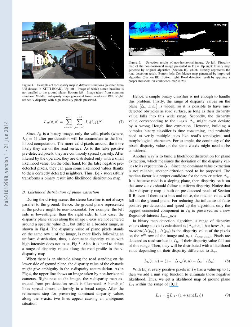
Figure 4. Examples of v-disparity map in different situations (selected fromUU dataset in KITTI-ROAD). Up left : Image of which stereo baseline isnot parallel to the ground plane. Bottom left : Image taken from commonsituation. Middle: v-disparity maps generated from pre-dected ROI. Right:refined v-disparity with high intensity pixels preserved.
LR(v, u) =
v+1∑i=v−1
u+1∑j=u−1
IR(i, j)/9 (7)
Since IR is a binary image, only the valid pixels (where,LR = 1) after pre-detection will be accumulate to the like-lihood computation. The more valid pixels around, the morelikely they are on the road surface. As to the false positivepre-detected pixels, they are commonly spread sparsely. Afterfiltered by the operator, they are distributed only with a smalllikelihood value. On the other hand, for the false negative pre-detected pixels, they can gain some likelihood values thanksto their correctly detected neighbors. Thus, Eq.7 successfullytransforms a binary result into likelihood distribution map.
B. Likelihood distribution of plane extraction
During the driving scene, the stereo baseline is not alwaysparallel to the ground. Hence, the ground plane representedin the picture might be non-horizontal. For example, the leftside is lower/higher than the right side. In this case, thedisparity plane values along the image u-axis are not centeredaround a specific value ∆υ , but differ in a broader range, asshown in Fig.4. The disparity value of plane pixels standson the same row v of the image, is more likely following anuniform distribution, thus, a dominant disparity value withhigh intensity does not exist, Fig.5. Also, it is hard to definea range of disparity values along the road profile in the v-disparity map.
When there is an obstacle along the road standing on thelower side of ground plane, the disparity value of the obstaclemight give ambiguity in the v-disparity accumulation. As inFig.4, the upper line shows an image taken by non-horizontalcameras. Right next to the image, the v-disparity map ex-tracted from pre-detection result is illustrated. A bunch oflines spread almost uniformly in a broad range. After therefinement step for preserving dominant disparity valuesalong the v-axis, two lines appear causing an ambiguoussituation.
Figure 5. Detection results of non-horizontal image. Up left: Disparitymap of the non-horizontal image presented in Fig.4. Up right: Binary mapgenerate by original algorithm (Section II), which, directly represents theroad detection result. Bottom left: Confidence map generated by improvedalgorithm (Section III). Bottom right: Road detection result by applying aproper threshold on confidence map (CM).
Hence, a simple binary classifier is not enough to handlethis problem. Firstly, the range of disparity values on theplane [∆υ ± ευ] is widen, so it is possible to have mis-detected obstacles as road surface, as long as their disparityvalue falls into this wide range. Secondly, the disparityvalue corresponding to the v-axis ∆υ might even deviateby a wrong Hough line extraction. However, building acomplex binary classifier is time consuming, and probablyneed to verify multiple cues like road’s topological andmorphological characters. For example, the continuity of thepixels disparity value on the same v-axis might need to beconsidered.
Another way is to build a likelihood distribution for planeextraction, which measures the deviation of the disparity val-ues to its expectation ∆υ . Since the dominant value extractionis not reliable, another criterion need to be proposed. Themedian factor is a proper candidate for the new criterion ∆υ .It is because road is a sloping plane, then disparity on it onthe same v-axis should follow a uniform disparity. Notice thatthe v-disparity map is built on pre-detected result of SectionII-B, even if there exist bias and noise, the median value willfall on the ground plane. For reducing the influence of falsepositive pre-detection, and speed up the algorithm, only thebiggest connected component in IR is preserved as a newRegion-of-Interest Inew_ROI .
In binary map detection algorithm, a range of disparityvalues along v-axis is calculated as [∆υ±ευ], but here: ∆υ =median(∆(pv)) , ∆(pv) is the disparity value of the pixelson the vth row of the image and pv ∈ Inew_ROI . Pixels aredetected as road surface in IR, if their disparity value fall outof this range. Then, they will be distributed with a likelihoodvalue depending on their disparity difference to ∆υ .
LG(v, u) = (1− | ∆IR(v, u)−∆v | /∆v) (8)
With Eq.8, every positive pixels in IR has a value up to 1;then we add a unit step function to eliminate those negativelikelihood. Thus, we get a likelihood map of ground planeLG within the range of [0,1];
LG =1
2LG · (1 + sgn(LG)) (9)
hal-0
1010
998,
ver
sion
1 -
21 J
un 2
014

C. Confidence map generation
With the two likelihood maps LR and LG, a confidencemap of road detection could be generated based on thefollowing fusion function:
LC(v, u) = LR(v, u) · LG(v, u)
Thus, every potential road surface pixel has been dis-tributed with a confidence value. After an evaluation on thetraining set of KITTI-ROAD benchmark, a best thresholdfor the confidence value will be found. Fig.5 compares thedetection performance of binary map and confidence map onthe non-horizontal image presented in Fig.4. In Fig.5, thebinary map detection result is deviated due to the ambiguityof the road profile line in v-disparity map. On contrary,in confidence map, every pixel that is likely to be on theroad is presented with a confidence value. After applying aproper threshold on the confidence map, the road area is verywell classified. Therefore, confidence map is more reliable incomplex situation.
Furthermore, the introduction of a confidence map notonly provides a good development based on the originalalgorithm, but also provides a compatible result with theother algorithms have been evaluated on the KITTI-ROADbenchmark.
IV. EVALUATION RESULTS AND DISCUSSIONS
The two algorithms in this paper are evaluated on theKITTI-ROAD benchmark[8]. It contains three different cat-egories of road scenes: UU - urban unmarked road, UM -urban marked two direction road and UMM - urban multiplemarked lanes’ road. The whole dataset has 600 annotatedtraining and test images captured from broad spectrum ofurban road scenes. Binary map detection (BM) is evaluatedboth on training dataset in perspective space and on testingdataset in Bird Eye View (BEV) space, see Fig.6. Consideringthe confidence map (CM) generation function is an ongoingresearch which still needs to be improved, here, we onlyevaluate it on training dataset as a reference to binary mapand baseline algorithm. Perspective evaluation is carried outon a local machine. Bird Eye View results are evaluated onKITTI web server.
Our local processing platform is a standard PC withWindows 7 Enterprise OS, Intel CPU of 2.66 GHz. Thecomputation environment is MATLAB R2013b. The run-timefor binary map method is about 2s per frame. A completeconfidence map generation algorithm takes about 4s perframe. To speed up the algorithm, we add a processing ofmaximum connected area preservation, which is firstly usedin the ROI calculation to reduce the calculation area for planeextraction. Secondly it is used in the final result definition torefine the result. We also improved the code in details, thatis how the computing time is reduced by a factor two from[6].
Table IRESULTS [%] OF PIXEL-BASED ROAD AREA EVALUATION ON TESTING
DATASET.
URBAN - BEV spaceFmax AP Prec. Rec. FPR FNR
SPRAY 86.33 90.88 86.75 85.91 7.55 14.09BM 82.32 68.95 76.15 89.56 16.15 10.44
CNN 78.92 79.14 76.25 81.79 14.67 18.21BL 75.61 79.72 68.93 83.73 21.73 16.27
A. Binary map evaluation
In the KITTI-ROAD benchmark, the images are selectedfrom different sequences, which demands a more reliabledetection result for single images. However, it leads to aproblem for usual axis-calibration. The intrinsic angles aredifferent from sequences according to changes in the cameraparameters. In the test with UM dataset, axis-calibrationvaries from images to images, while for the UMM dataset itdoes not change a lot. This is why our algorithm performsbetter on UMM dataset in Tab I. In order to provide a reliableresult on KITTI-ROAD benchmark, the ground truth of thetraining dataset is used to calculate the axis angle θ, which isapproximately equal to 33°. Detection results are evaluatedby F-measure, average precision, accuracy, and other standardmeasures like: precision, recall and false positive/negativerate.
Methods listed in Tab I are Spatial ray classification(SPRAY[3]); Convolutional neutral network (CNN[5]) andBase line (BL), they all have been introduced in [8]. In thecomparison, binary map detection (BM) performs the best inthe measurement of recall and false negative rate. However,since the intrinsic features with a high confidence level detectevery possible pixels on the road, in some special situations,binary map will simply lead to false positive detection, forexample, when sidewalk shows similar intrinsic features withthe road surface, it has a strong probability of being detectedas road area. In general, binary map detection methods pro-vides a relative high value on F-measure among the comparedalgorithms in BEV space. According to the F-measure, fastroad detection from color image in binary map won thesecond place comparing with the other algorithms mentionedin [8]. The strength of binary map is its independency fromprior knowledge of ground truth: it doesn’t need PR curveanalysis for a satisfying threshold of confidence. This makesit a portable algorithm which can be applied directly intodynamic environment.
B. Confidence map evaluation
Considering that the KITTI-ROAD dataset is composedof discrete frames from different sequences, (in differentweather condition, with different camera parameters), ahigher confidence level is assigned during the pre-detectionstep for likelihood distribution. Thus, more potential roadsurface pixels will be taken into consideration.
It is interesting that the average precision of the binarymap generation algorithm is quite low, which can be hardly
hal-0
1010
998,
ver
sion
1 -
21 J
un 2
014

Table IIRESULTS [%] OF PIXEL-BASED ROAD AREA EVALUATION ON TRAINING
SET.
UM perspective spaceFmax AP Acc Prec. Rec. FPR FNR
BL 89.27 92.18 96.53 88.93 90.17 2.26 9.83BM 85.67 72.21 94.89 77.83 95.26 5.18 4.74CM 81.69 80.46 94.09 81.06 82.33 6.67 17.67
UMM perspective spaceFmax AP Acc Prec. Rec. FPR FNR
BM 88.76 81.29 94.55 87.04 90.55 4.20 9.45CM 85.28 82.08 92.99 85.09 85.46 4.67 14.54BL 82.81 89.21 91.23 77.54 88.86 8.02 11.14
UU Perspective spaceFmax AP Acc Prec. Rec. FPR FNR
BL 80.79 86.13 94.70 79.00 82.67 3.42 17.33BM 80.50 62.53 94.19 73.44 89.07 5.02 10.93CM 75.88 71.48 93.18 72.53 79.55 4.69 20.45
compared to the other algorithms. Actually, this measure-ment, average precision, is a description of Precision-Recallcurve with different thresholds to classify the confidencemaps. While the binary map directly provides a definitePrecision and Recall value, this measurement might not besuitable for it. Under this consideration, we develop theconfidence map based on original algorithm so to evaluateour approach on this measure. According to the evaluationresult in perspective view (Tab II), the confidence map greatlyimproved the average accuracy of the detection compare tobinary map. Even though, the performance of confidence mapgeneral compared to binary image and baseline, it still showsgreat potential developing space to provide reliable resultsin complex environment, as been proved in Fig. 5.Besides,in the subset of UMM, confidence map even overpass thebaseline. If the confidence map algorithm is improved furthermore, a good performance is promising , and the evaluationin BEV space will be proceeded later.
V. CONCLUSION
In this paper, we proposed a novel method which combinedlikelihood theory with our former work presented in [6]. Theresults of the original algorithm using a binary map andthe improved one based on a confidence map are evaluatedon the KITTI-ROAD benchmark. The experimental resultsshow that the binary map provides a high value on the F-measure compare to the other algorithms (second place, onlybehind the SPRAY algorithm). Another strong point of thisalgorithm is it can provide a straightforward information offree road area without any training. Nevertheless, when drivein complex environments, the detection performance usingthe binary map falls sharply. As an improved approach, thelikelihood-based confidence map performs better in thesesituations, such as non flat road surface and over-saturationimages. However, according to the general evaluation result,there are still improvements need to be done for confidence
Figure 6. Detection results transformed in Bird Eye View (BEV) space.
map estimation. From this consideration, our future workswill focus on the likelihood model construction.
REFERENCES
[1] Hui K., J.-Y. Audibert, and J. Ponce. General road detection from asingle image. Image Processing, IEEE Transactions on, 19(8):2211–2220, 2010.
[2] S. Graovac and A. Goma. Detection of Road Image Borders Basedon Texture Classification. International Journal of Advanced RoboticSystems, 9:1, 2012.
[3] T. Kuehnl, F. Kummert, and J. Fritsch. Spatial ray features for real-timeego-lane extraction. In Proc. IEEE Intelligent Transportation Systems,2012.
[4] W. Yoshizaki, Y. Mochizuki, N. Ohnishi, and A. Imiya. Free SpaceDetection from Catadioptric Omnidirectional Images for Visual Navi-gation using Optical Flow. In The 8th Workshop OMNIVIS, 2008.
[5] Jose M. Alvarez, Theo Gevers, Yann LeCun, and Antonio M. Lopez.Road scene segmentation from a single image. In ECCV 2012, volume7578 of Lecture Notes in Computer Science, pages 376–389. SpringerBerlin Heidelberg, 2012.
[6] Bihao Wang and Vincent Frémont. Fast road detection from colorimages. In Intelligent Vehicles Symposium (IV), 2013 IEEE, pages1209–1214. IEEE, 2013.
[7] Mathias Perrollaz, J-D Yoder, Anne Spalanzani, and Christian Laugier.Using the disparity space to compute occupancy grids from stereo-vision. In Intelligent Robots and Systems (IROS), 2010 IEEE/RSJInternational Conference on, pages 2721–2726. IEEE, 2010.
[8] Jannik Fritsch, Tobias Kuehnl, and Andreas Geiger. A new per-formance measure and evaluation benchmark for road detection al-gorithms. In International Conference on Intelligent TransportationSystems (ITSC), 2013.
[9] J.M.A. Alvarez and A.M. Lopez. Road detection based on illuminantinvariance. Intelligent Transportation Systems, IEEE Transactions on,12(1):184–193, 2011.
[10] G.D. Finlayson, M.S. Drew, and L. Cheng. Intrinsic images by entropyminimization. In European Conference on Computer Vision, 2004.
[11] Cheng Lu G.D.Finlayson, M.S.Drew. Entropy minimization forshadow removal. International Journal of Computer Vision, 2009.
[12] David Pritchard. Cloth parameters and motion capture. Technicalreport, 2003.
[13] Nicolas Soquet, Didier Aubert, and Nicolas Hautiere. Road segmenta-tion supervised by an extended v-disparity algorithm for autonomousnavigation. In Intelligent Vehicles Symposium, 2007 IEEE, pages 160–165. IEEE, 2007.
[14] Basam Musleh, Arturo de la Escalera, and José María Armingol. Uvdisparity analysis in urban environments. In Computer Aided SystemsTheory–EUROCAST 2011, pages 426–432. Springer, 2012.
hal-0
1010
998,
ver
sion
1 -
21 J
un 2
014