codified ordinances of the city of lancaster ohio
161
CODIFIED ORDINANCES OF THE CITY OF LANCASTER OHIO Complete to December 31, 2018
-
Upload
khangminh22 -
Category
Documents
-
view
2 -
download
0
Transcript of codified ordinances of the city of lancaster ohio
CODIFIED
ORDINANCES
OF THE
CITY OF
LANCASTER
OHIO
Complete to December 31, 2018
2018 Replacement
2
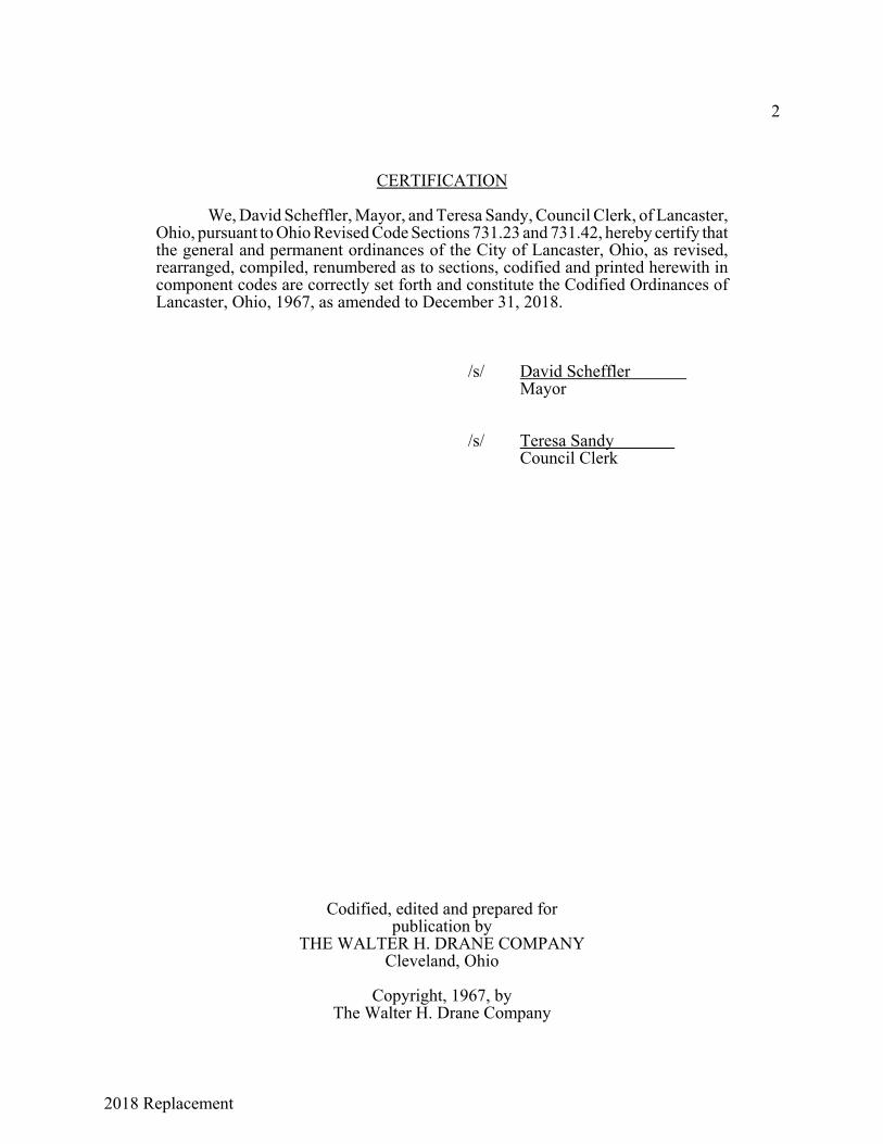
CERTIFICATION
We, David Scheffler, Mayor, and Teresa Sandy, Council Clerk, of Lancaster,Ohio, pursuant to Ohio Revised Code Sections 731.23 and 731.42, hereby certify thatthe general and permanent ordinances of the City of Lancaster, Ohio, as revised,rearranged, compiled, renumbered as to sections, codified and printed herewith incomponent codes are correctly set forth and constitute the Codified Ordinances ofLancaster, Ohio, 1967, as amended to December 31, 2018.
/s/ David Scheffler Mayor
/s/ Teresa Sandy Council Clerk
Codified, edited and prepared forpublication by
THE WALTER H. DRANE COMPANYCleveland, Ohio
Copyright, 1967, byThe Walter H. Drane Company
2018 Replacement
3
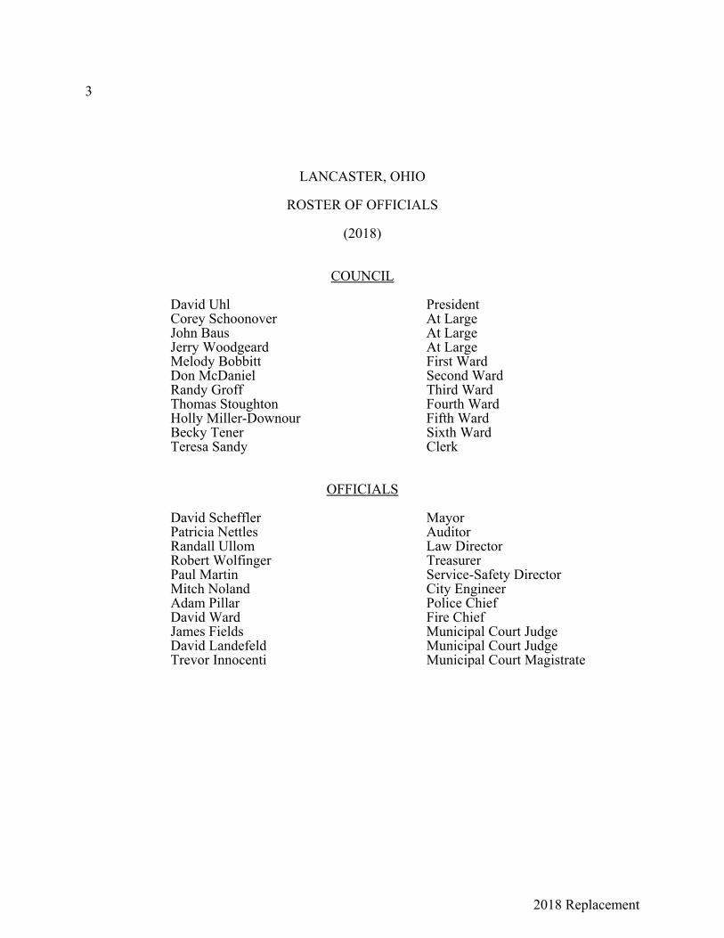
LANCASTER, OHIO
ROSTER OF OFFICIALS
(2018)
COUNCIL
David Uhl PresidentCorey Schoonover At LargeJohn Baus At LargeJerry Woodgeard At LargeMelody Bobbitt First WardDon McDaniel Second WardRandy Groff Third WardThomas Stoughton Fourth WardHolly Miller-Downour Fifth WardBecky Tener Sixth WardTeresa Sandy Clerk
OFFICIALS
David Scheffler MayorPatricia Nettles AuditorRandall Ullom Law DirectorRobert Wolfinger TreasurerPaul Martin Service-Safety DirectorMitch Noland City EngineerAdam Pillar Police ChiefDavid Ward Fire ChiefJames Fields Municipal Court JudgeDavid Landefeld Municipal Court JudgeTrevor Innocenti Municipal Court Magistrate

2018 Replacement
4
The publisherexpresses his appreciation
to
RANDALL T. ULLOMLaw Director
who gave hisable assistance, cooperation and counsel
to this Codification

2018 Replacement
5Ordinance No.
AN ORDINANCE TO APPROVE, ADOPT AND ENACT THECODIFIED ORDINANCES; TO REPEAL ORDINANCES INCONFLICT THEREWITH; TO PUBLISH THE ENACTMENT OFNEW MATTER, AND DECLARING AN EMERGENCY.
WHEREAS, the Council of the City of Lancaster, Ohio, has had the matter of codificationand general revision of the ordinances before it for some time, and
WHEREAS, it has heretofore entered into a contract with the Walter H. Drane Company toprepare and publish such codification, and
WHEREAS, the codification of such ordinances, together with the new matter to be adopted,the matters to be amended and those to be repealed are before the Council,
BE IT ORDAINED by the Council of the City of Lancaster, State of Ohio:
SECTION 1. That the ordinances of the City of Lancaster, Ohio, of a general and permanentnature, as revised, codified, rearranged and consolidated into component codes, titles, chapters andsections are hereby approved, adopted and enacted as the Codified Ordinances of Lancaster, Ohio1997.
One book-form copy of the Codified Ordinances shall be certified as correct by the Mayorand the Clerk of Council, attached to this ordinance as a part hereof, and filed with the permanentordinance records of the City of Lancaster, Ohio.
SECTION 2. That the provisions of this Ordinance, including all provisions of the CodifiedOrdinances, shall be in full force and effect from and immediately after passage of this Ordinanceand its approval by the Mayor. All ordinances and resolutions or parts thereof enacted prior toAugust 25, 1997, which are inconsistent with any provision of the Codified Ordinances, are herebyrepealed as of the effective date of this Ordinance, except as follows:
(a) The enactment of the Codified Ordinances shall not be construed to affect a right orliability accrued or incurred under any legislative provision prior to the effective dateof such enactment, or an action or proceeding for the enforcement of such right orliability. Such enactment shall not be construed to relieve any person frompunishment for an act committed in violation of any such legislation provision, norto affect an indictment or prosecution therefor. For such purposes, any suchlegislative provision shall continue in full force notwithstanding its repeal for thepurpose of revision and recodification.
(b) The repeal provided above shall not affect:(1) The grant or creation of a franchise, license, right, easement or privilege.(2) The purchase, sale, lease or transfer of property.(3) The appropriation or expenditure of money or promise or guarantee of
payment.(4) The assumption of any contract or obligation.(5) The issuance and delivery of any bonds, obligations or other instruments of
indebtedness.

2018 Replacement
6
(6) The levy or imposition of taxes, assessments or charges.(7) The establishment, naming, vacating or grade level of any street or public
way.(8) The dedication of property or plat approval.(9) The annexation or detachment of territory.(10) Any legislation enacted subsequent to August 25, 1997.
SECTION 3. That the Clerk of Council, pursuant to Ohio R.C. 731.23, shall cause to bepublished in a manner required by law a summary of the new matter contained in the CodifiedOrdinances. All sections of the Codified Ordinances without a previous ordinance or resolutionhistory at the end thereof indicate that the section contains new matter ordained by this AdoptingOrdinance.
SECTION 4. That this Ordinance is hereby declared to be an emergency measure necessaryfor the immediate preservation of the public peace, health and safety of the City, and for the furtherreason that there exists an imperative necessity for the earliest publication and distribution of theCodified Ordinances to the officials and citizens of the City, so as to facilitate administration, dailyoperation and avoid practical and legal entanglements; wherefore this Ordinance shall be in fullforce and effect from and immediately after its passage and approval by the Mayor.
Passed:
Approved:
President of Council
Attest: Clerk
Mayor
Offered by:
Seconded by:
2018 Replacement
7
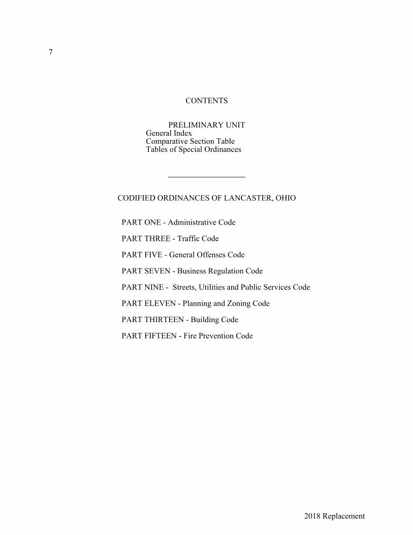
CONTENTS
PRELIMINARY UNITGeneral IndexComparative Section TableTables of Special Ordinances
CODIFIED ORDINANCES OF LANCASTER, OHIO
PART ONE - Administrative Code
PART THREE - Traffic Code
PART FIVE - General Offenses Code
PART SEVEN - Business Regulation Code
PART NINE - Streets, Utilities and Public Services Code
PART ELEVEN - Planning and Zoning Code
PART THIRTEEN - Building Code
PART FIFTEEN - Fire Prevention Code
2018 Replacement
8
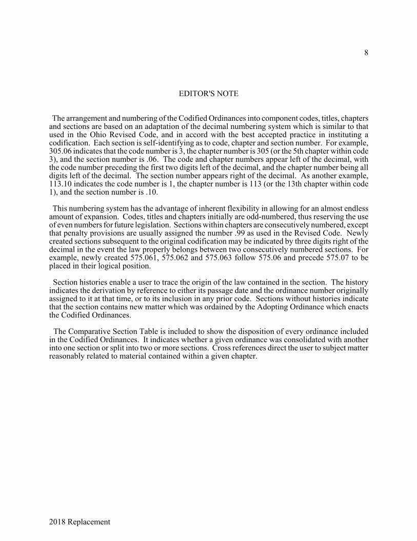
EDITOR'S NOTE
The arrangement and numbering of the Codified Ordinances into component codes, titles, chaptersand sections are based on an adaptation of the decimal numbering system which is similar to thatused in the Ohio Revised Code, and in accord with the best accepted practice in instituting acodification. Each section is self-identifying as to code, chapter and section number. For example,305.06 indicates that the code number is 3, the chapter number is 305 (or the 5th chapter within code3), and the section number is .06. The code and chapter numbers appear left of the decimal, withthe code number preceding the first two digits left of the decimal, and the chapter number being alldigits left of the decimal. The section number appears right of the decimal. As another example,113.10 indicates the code number is 1, the chapter number is 113 (or the 13th chapter within code1), and the section number is .10.
This numbering system has the advantage of inherent flexibility in allowing for an almost endlessamount of expansion. Codes, titles and chapters initially are odd-numbered, thus reserving the useof even numbers for future legislation. Sections within chapters are consecutively numbered, exceptthat penalty provisions are usually assigned the number .99 as used in the Revised Code. Newlycreated sections subsequent to the original codification may be indicated by three digits right of thedecimal in the event the law properly belongs between two consecutively numbered sections. Forexample, newly created 575.061, 575.062 and 575.063 follow 575.06 and precede 575.07 to beplaced in their logical position.
Section histories enable a user to trace the origin of the law contained in the section. The historyindicates the derivation by reference to either its passage date and the ordinance number originallyassigned to it at that time, or to its inclusion in any prior code. Sections without histories indicatethat the section contains new matter which was ordained by the Adopting Ordinance which enactsthe Codified Ordinances.
The Comparative Section Table is included to show the disposition of every ordinance includedin the Codified Ordinances. It indicates whether a given ordinance was consolidated with anotherinto one section or split into two or more sections. Cross references direct the user to subject matterreasonably related to material contained within a given chapter.
2018 Replacement
9
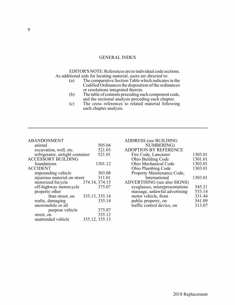
GENERAL INDEX
EDITOR'S NOTE: References are to individual code sections.As additional aids for locating material, users are directed to:
(a) The comparative Section Table which indicates in theCodified Ordinances the disposition of the ordinancesor resolutions integrated therein.
(b) The table of contents preceding each component code,and the sectional analysis preceding each chapter.
(c) The cross references to related material followingeach chapter analysis.
ABANDONMENTanimal 505.04excavation, well, etc. 521.03refrigerator, airtight container 521.01
ACCESSORY BUILDINGfoundations 1301.12
ACCIDENTimpounding vehicle 303.08injurious material on street 311.01motorized bicycle 374.14, 374.15off-highway motorcycle 375.07property other
than street, on 335.13, 335.14realty, damaging 335.14snowmobile or all
purpose vehicle 375.07street, on 335.12unattended vehicle 335.12, 335.13
ADDRESS (see BUILDING NUMBERING)
ADOPTION BY REFERENCEFire Code, Lancaster 1303.01Ohio Building Code 1301.01Ohio Mechanical Code 1303.01Ohio Plumbing Code 1303.01Property Maintenance Code,
International 1303.01ADVERTISING (see also SIGNS)
eyeglasses, misrepresentations 545.21massage, unlawful advertising 533.14motor vehicle, from 331.44public property, on 541.09traffic control device, on 313.07

2018 Replacement
GENERAL INDEX 10
AGRICULTURAL DISTRICT (see alsoZONING DISTRICTS)
accessory uses 1127.04agricultural use defined 1127.02bulk and area requirements 1127.06permitted uses 1127.03purposes 1127.01special exception uses 1127.05
AIDING OR ABETTING 501.10AIR POLLUTION
vehicle air cleaner required 337.25AIRTIGHT CONTAINER
abandoned 521.01ALARM SYSTEMS
equipment maintenance 503.02inspection 503.02penalty 503.99permits 503.01
ALCOHOL (see INTOXICANTS; INTOXICATION)ALLEY
defined 301.03right of way
entering 331.17 junction of alleys 331.16 leaving 331.22, 331.23
speed limit 333.03turning into 331.11use restricted to abutting lots 331.45
ALL PURPOSE VEHICLEaccident report 375.07bicycle path use prohibited 373.13certificate of title 375.08definitions 375.01equipment 375.02operation
permitted 375.04 prohibited 375.03
operator's license 375.05registration 375.06Traffic Code application 375.03
AMENDMENTSCodified Ordinances 101.04Subdivision Regulations 1118.02
AMUSEMENT DEVICE BOARD OF APPEALS
appeals mechanical amusement
device 731.12 mechanical musical
instruments 741.09created; members 731.12
AMUSEMENT DEVICES, MECHANICAL (see also ARCADES; COIN MACHINE)
definitions 731.01gambling devices
prohibited 731.02 seizure and destruction 731.10
license and registration appeals 731.12 application 731.06 display 731.06 each device 731.03 exceptions 731.06 exhibitor's 731.02 good moral
character 731.04, 731.08 issuance; fees 731.04 Mayor's regulations 731.08 ownership affidavit required 731.05 records 731.07 renewal 731.04 revocation,
suspension, notice 731.11musical (see MUSICAL INSTRUMENTS,
MECHANICAL)ANIMAL-DRAWN VEHICLES
freeway, prohibited on 303.06(b)lights, emblem 337.10
ANIMALSabandoning 505.04barking or howling dogs 505.09bites 505.10coloring; poultry sale or display 505.12
cruelty companion animals, to 505.071generally 505.07
dangerous dogs 505.14

2018 Replacement
11 GENERAL INDEX
ANIMALS (Cont.)dog registration 505.03freeway, on 303.06harboring
bees 505.15 snakes 505.16 wild or exotic 505.18
hunting prohibited 505.11impounding and disposition 505.02killing or injuring 505.05nuisance 505.08poisoning 505.06police dog or horse 525.15poultry or animal
yard maintenance 505.17running at large 505.01service dog, assaulting 525.15street, on 303.05
ANNEXATIONzoning annexed territory 1121.02(c)(2)
ANTENNAS AND SATELLITE DISHESzoning regulations 1125.04
ARCADESlicense
fee 715.02 penalty 715.99 required; term 715.01
ARRESTresisting 525.09
ARSONconditions governing 541.02determining property value 541.01
ASSAULTdisturbing the peace 509.08domestic violence 537.14inciting to violence 509.011negligent 537.04physical harm 537.03temporary protection order 537.15vehicular assault in
construction zone 537.021ASSEMBLY
disturbing lawful 509.04street, on; permit 311.02
ASSURED CLEAR DISTANCE 331.09, 333.03
ATTEMPT 501.09
AUCTIONSauctioneer fee 711.03by-bidding prohibited 711.06conduct of sale 711.05inventory, sales list 711.05license
application; bond 711.02 Mayor authority to
grant, revoke 711.04 required; issuance 711.01
Mayor's authority 711.04penalty 711.99
BAD CHECK 545.09BARRICADES AND
WARNING LIGHTSstreet excavations 901.01 et seq.
B-B GUNS 549.08BED AND BREAKFAST INNS
definition 1161.01BEER (see INTOXICANTS;
INTOXICATION)BEES
harboring 505.15BETTING (see GAMBLING)BICYCLE (see also MOTORCYCLE)
bell, signal device 373.05brakes 373.06defined 301.04freeway, on 303.06handle bars 373.02impounding 373.12lights 373.06motorized (see MOTORIZED
BICYCLE)parking 373.09parking zones, vehicle
other than bicycle in 374.01paths exclusively for bicycles 373.13reckless operation 373.02(d), 373.08reflector 373.06riding abreast 373.04riding on sidewalks 903.04right side of street 373.07seat, use 373.02Traffic Code, application 373.01traffic rules, obedience 373.07vehicle, attaching to 373.03
2018 Replacement
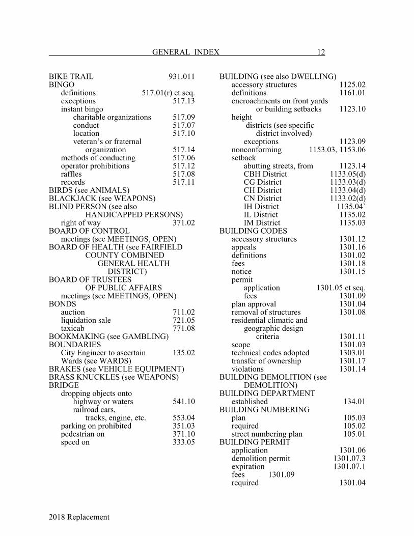
GENERAL INDEX 12
BIKE TRAIL 931.011BINGO definitions 517.01(r) et seq. exceptions 517.13
instant bingo charitable organizations 517.09conduct 517.07location 517.10veteran’s or fraternal
organization 517.14 methods of conducting 517.06
operator prohibitions 517.12raffles 517.08records 517.11
BIRDS (see ANIMALS)BLACKJACK (see WEAPONS)BLIND PERSON (see also
HANDICAPPED PERSONS)right of way 371.02
BOARD OF CONTROLmeetings (see MEETINGS, OPEN)
BOARD OF HEALTH (see FAIRFIELDCOUNTY COMBINED
GENERAL HEALTH DISTRICT)
BOARD OF TRUSTEES OF PUBLIC AFFAIRS
meetings (see MEETINGS, OPEN)BONDS
auction 711.02liquidation sale 721.05taxicab 771.08
BOOKMAKING (see GAMBLING)BOUNDARIES
City Engineer to ascertain 135.02Wards (see WARDS)
BRAKES (see VEHICLE EQUIPMENT)BRASS KNUCKLES (see WEAPONS)BRIDGE
dropping objects onto highway or waters 541.10railroad cars,
tracks, engine, etc. 553.04parking on prohibited 351.03pedestrian on 371.10speed on 333.05
BUILDING (see also DWELLING)accessory structures 1125.02definitions 1161.01encroachments on front yards
or building setbacks 1123.10height
districts (see specific district involved)
exceptions 1123.09nonconforming 1153.03, 1153.06setback
abutting streets, from 1123.14CBH District 1133.05(d)CG District 1133.03(d)CH District 1133.04(d)CN District 1133.02(d)IH District 1135.04`IL District 1135.02IM District 1135.03
BUILDING CODESaccessory structures 1301.12appeals 1301.16definitions 1301.02fees 1301.18notice 1301.15permit
application 1301.05 et seq.fees 1301.09
plan approval 1301.04removal of structures 1301.08residential climatic and
geographic design criteria 1301.11scope 1301.03technical codes adopted 1303.01transfer of ownership 1301.17violations 1301.14
BUILDING DEMOLITION (seeDEMOLITION)
BUILDING DEPARTMENTestablished 134.01
BUILDING NUMBERINGplan 105.03required 105.02street numbering plan 105.01
BUILDING PERMITapplication 1301.06demolition permit 1301.07.3expiration 1301.07.1fees 1301.09required 1301.04
2018 Replacement
13 GENERAL INDEX
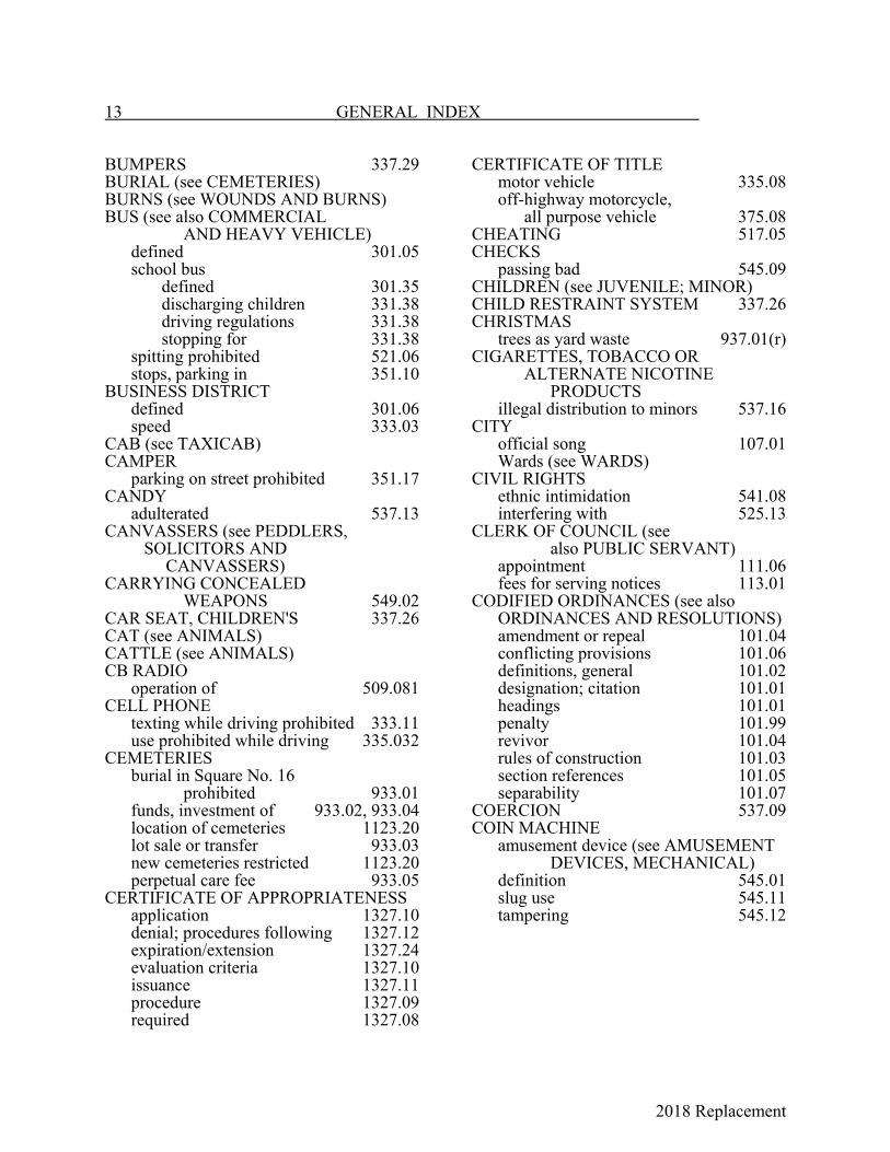
BUMPERS 337.29BURIAL (see CEMETERIES)BURNS (see WOUNDS AND BURNS)BUS (see also COMMERCIAL
AND HEAVY VEHICLE)defined 301.05school bus
defined 301.35 discharging children 331.38 driving regulations 331.38 stopping for 331.38
spitting prohibited 521.06stops, parking in 351.10
BUSINESS DISTRICTdefined 301.06speed 333.03
CAB (see TAXICAB)CAMPER
parking on street prohibited 351.17CANDY
adulterated 537.13CANVASSERS (see PEDDLERS, SOLICITORS AND CANVASSERS)CARRYING CONCEALED
WEAPONS 549.02CAR SEAT, CHILDREN'S 337.26CAT (see ANIMALS)CATTLE (see ANIMALS)CB RADIO
operation of 509.081CELL PHONE
texting while driving prohibited 333.11use prohibited while driving 335.032
CEMETERIESburial in Square No. 16
prohibited 933.01funds, investment of 933.02, 933.04location of cemeteries 1123.20lot sale or transfer 933.03new cemeteries restricted 1123.20perpetual care fee 933.05
CERTIFICATE OF APPROPRIATENESSapplication 1327.10denial; procedures following 1327.12expiration/extension 1327.24evaluation criteria 1327.10issuance 1327.11procedure 1327.09required 1327.08
CERTIFICATE OF TITLEmotor vehicle 335.08off-highway motorcycle,
all purpose vehicle 375.08CHEATING 517.05CHECKS
passing bad 545.09CHILDREN (see JUVENILE; MINOR)CHILD RESTRAINT SYSTEM 337.26CHRISTMAS
trees as yard waste 937.01(r)CIGARETTES, TOBACCO OR
ALTERNATE NICOTINEPRODUCTS
illegal distribution to minors 537.16CITY
official song 107.01Wards (see WARDS)
CIVIL RIGHTSethnic intimidation 541.08interfering with 525.13
CLERK OF COUNCIL (see also PUBLIC SERVANT)
appointment 111.06fees for serving notices 113.01
CODIFIED ORDINANCES (see also ORDINANCES AND RESOLUTIONS)
amendment or repeal 101.04conflicting provisions 101.06definitions, general 101.02designation; citation 101.01headings 101.01penalty 101.99revivor 101.04rules of construction 101.03section references 101.05separability 101.07
COERCION 537.09COIN MACHINE
amusement device (see AMUSEMENT DEVICES, MECHANICAL)
definition 545.01slug use 545.11tampering 545.12
2018 Replacement
GENERAL INDEX 14
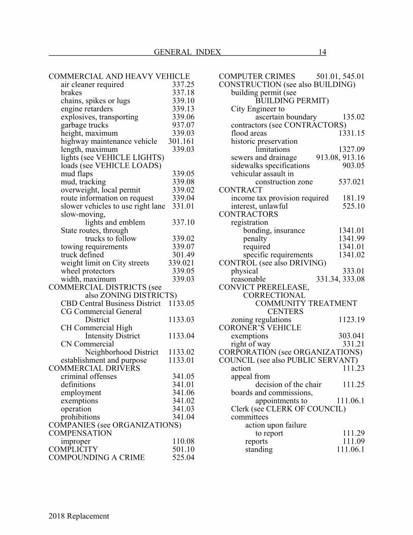
COMMERCIAL AND HEAVY VEHICLEair cleaner required 337.25brakes 337.18chains, spikes or lugs 339.10engine retarders 339.13explosives, transporting 339.06garbage trucks 937.07height, maximum 339.03highway maintenance vehicle 301.161length, maximum 339.03lights (see VEHICLE LIGHTS)loads (see VEHICLE LOADS)mud flaps 339.05mud, tracking 339.08overweight, local permit 339.02route information on request 339.04slower vehicles to use right lane 331.01slow-moving,
lights and emblem 337.10State routes, through
trucks to follow 339.02towing requirements 339.07truck defined 301.49weight limit on City streets 339.021wheel protectors 339.05width, maximum 339.03
COMMERCIAL DISTRICTS (see also ZONING DISTRICTS)
CBD Central Business District 1133.05CG Commercial General
District 1133.03CH Commercial High
Intensity District 1133.04CN Commercial
Neighborhood District 1133.02establishment and purpose 1133.01
COMMERCIAL DRIVERScriminal offenses 341.05definitions 341.01employment 341.06exemptions 341.02operation 341.03prohibitions 341.04
COMPANIES (see ORGANIZATIONS)COMPENSATION
improper 110.08COMPLICITY 501.10COMPOUNDING A CRIME 525.04
COMPUTER CRIMES 501.01, 545.01CONSTRUCTION (see also BUILDING)
building permit (see BUILDING PERMIT)
City Engineer to ascertain boundary 135.02
contractors (see CONTRACTORS)flood areas 1331.15historic preservation
limitations 1327.09sewers and drainage 913.08, 913.16sidewalks specifications 903.05vehicular assault in
construction zone 537.021CONTRACT
income tax provision required 181.19interest, unlawful 525.10
CONTRACTORSregistration
bonding, insurance 1341.01penalty 1341.99required 1341.01specific requirements 1341.02
CONTROL (see also DRIVING)physical 333.01reasonable 331.34, 333.08
CONVICT PRERELEASE, CORRECTIONAL COMMUNITY TREATMENT CENTERS
zoning regulations 1123.19CORONER’S VEHICLE
exemptions 303.041right of way 331.21
CORPORATION (see ORGANIZATIONS)COUNCIL (see also PUBLIC SERVANT)
action 111.23appeal from
decision of the chair 111.25boards and commissions,
appointments to 111.06.1Clerk (see CLERK OF COUNCIL)committees
action upon failure to report 111.29
reports 111.09 standing 111.06.1
2018 Replacement
15 GENERAL INDEX
COUNCIL (Cont.)meetings
attendance, power to compel 111.31, 111.32
call to order 111.03 open (see MEETINGS, OPEN) order of business 111.07 order of business,
exception to 111.08 permission to leave 111.05 Police Chief to
preserve order 111.31 preliminaries 111.03 presiding officer 111.04 quorum 111.04 refusal to attend 111.33 regular, time of 111.01 Robert's Rules of Order 111.34 smoking prohibited 111.36 speaking 111.10 special 111.02voters and taxpayers
addressing Council 111.10.1members
calling to order 111.27motions
considered during debate 111.16 debatable 111.26.1 division of question 111.12 made 111.11 previous question 111.19 reference to committee 111.14 to adjourn 111.15 to reconsider 111.18 to take from table 111.17 undebatable 111.26 writing out 111.13
ordinances (see ORDINANCES AND RESOLUTIONS)
planned unit developmentadministration 1147.08
President pro tempore 111.06rules
change in 111.28, 111.35 suspension of 111.30
voting 111.20
COUNTERFEIT CONTROLLED SUBSTANCES 513.13COURT, MUNICIPAL
name changed 161.02probation officer 161.01
CREDIT CARDdefined 545.01misuse 545.10
CRIME (see OFFENSE)felony (see FELON REGISTRATION)
CRIMINAL (see also OFFENSE)damaging and endangering 541.03mischief 541.04simulation 545.13tools, possession 545.19
CROSSWALKdefined 301.09obstructing 331.33parking on prohibited 351.03pedestrian right of way 371.01
CRUELTYanimals 505.07children 537.07
CULPABILITYcriminal liability 501.07knowingly 501.08(b)mental states 501.08negligently 501.08(d)purposely 501.08(a)recklessly 501.08(c)
CURBScurb cut permit
fee 905.02 penalty 905.99 required 905.01
driving over 331.37parking on prohibited 351.03
CURFEWminors 509.11probationary license 335.031temporary instruction permit 335.03
DANGEROUS ORDNANCE (see also WEAPONS)
defined 549.01exceptions 549.01(k)failure to secure 549.05possession 545.19(b)
2018 Replacement
GENERAL INDEX 16
DAY CARE HOMESzoning regulations 1123.17
DEFINITIONS (see also specific subject involved)
culpability 501.08dangerous ordnance 549.01detention 525.01drug abuse 513.01drug paraphernalia 513.12explosives 549.01gambling 517.01general 101.02intoxicants 529.01law enforcement officer 501.01liquor control 529.01material harmful to juveniles 533.01obscenity 533.01offense of violence 501.01physical harm 501.01property 501.01public servant 525.01sexual offenses 533.01sexually oriented business
standards 707.02Subdivision Regulations 1105.04theft and fraud 545.01Traffic Code Ch. 301weapons 549.01Zoning Code Ch.1121
DEFRAUDINGcreditors 545.17
DEMOLITIONhistoric preservation 1327.15lot regulations 1301.08, 1303.05permit fee 1301.07permit required 1301.07.3, 1303.04
DEMOLITION DERBY (see MOTOR VEHICLE RACING)
DERELICTION OF DUTY 525.12DESECRATION 541.07DETENTION
defined 525.01shoplifters 545.04
DISCRIMINATIONethnic intimidation 541.08
DISORDERLY CONDUCTcemeteries, in 933.15disturbing others 509.03inducing panic 509.06intoxicated persons 509.03intoxication; drug abuse 509.09riot (see RIOT)
DISTURBING THE PEACEmechanical musical instrument 741.06muffler noise 337.20prohibited 509.08racing vehicle motor 331.36squealing tires, peeling 331.36vehicle exhaust noise 331.36
DOGS (see ANIMALS)DOMESTIC VIOLENCE 537.14DRAG RACING 333.07DRAINAGE (see also SEWERS
AND DRAINAGE)Subdivision Regulations 1109.05
DRIVER'S LICENSE (see also COMMERCIAL DRIVERS)
application falsification 335.04(e)display 335.06fictitious, revoked, altered 335.04(a)lending 335.04(b)motorcycle, off-highway 375.05motorcycle operator 335.01(a)motorized bicycle 374.01nonresident driver 335.01(b)Ohio license required for
in state residents 335.021permitting operation without 335.02possession
more than one 335.02 someone else's 335.04(c)
probationary; curfew 335.031prohibited acts 335.04required 335.01restriction violation 335.07revoked or suspended
driving with 335.07 failure to surrender 335.04(d)
snowmobile or all purpose vehicle 375.05
2018 Replacement
17 GENERAL INDEX
DRIVER’S LICENSE (Cont.)suspended, driving under 335.074temporary, licensed
driver required 335.03DRIVEWAY
construction material 905.03parking in front of 351.03penalty 905.99permit
fee 905.02 required 905.01
right of way entering 331.17 leaving 331.22, 331.23
turning into 331.11DRIVING
accident (see ACCIDENT)allowing another
to drive illegally 335.05approaching stationary public
safety vehicle 333.031assured clear distance 331.09, 333.03backing vehicle 331.13bicycle path use prohibited 373.13cell phone use prohibited 335.032cemeteries, in 933.14certificate of title required 335.08change of course 331.14, 331.34closed road, on 331.26, 331.47construction zone,
vehicular assault in 537.021control of vehicle 331.34, 333.08crosswalk, obstructing 331.33distracted driving penalty 303.991divided street 331.31drag racing 333.07driver's view, control 331.25, 337.21drunk or drugged 333.01earplugs prohibited 331.43electronic wireless communication
device use prohibited while driving 335.032
entering or crossing roadway from other than roadway
duty to yield 331.22 stopping at sidewalk 331.23
exhaust noises 331.36
DRIVING (Cont.)fire hose, over 331.28following
emergency or safety vehicle 331.27 too closely 331.09
grade crossing 331.39, 331.40hazardous zones 331.07immobilization order 333.10intersection
obstructing 331.33 right of way 331.16 shortcutting 331.41 turning at 331.10
lanes, within 331.08lane-use control
signal indications 313.04left side of street 331.06one-way street 331.30operate defined 301.201OVI suspension, under 335.071passing
left of center 331.05 left side 331.03 no passing zones 331.07 right side 331.02, 331.04
racing motor 331.36reckless
failure to control 331.34, 333.08 full time and attention 331.34 prohibited 333.09 willful, wanton disregard 333.02
right of way funeral procession 331.24 intersections 331.16 public safety
vehicle 331.21, 331.211 turning left 331.17
right side of street 331.01rotary traffic island, around 331.30safety zone, through 331.29shortcutting 331.41sidewalk, street lawn, curb; on 331.37signals for turning
or stopping 331.14, 331.15speed (see SPEED)squealing tires 331.36
2018 Replacement
GENERAL INDEX 18
DRIVING (Cont.)starting vehicle 331.13stopping vehicle 333.04stop signs
emergency or public safety vehicle 331.20
operation at 331.14, 331.19street racing 333.07street under repair 331.26suspended license 335.074texting prohibited 333.11traffic signal indications 313.03turning
driveway, alley or building 331.11
intersection, at 331.10 left, right of way 331.17 right of red 313.03(c) signals 331.14, 331.15 U turns 331.12
unsafe vehicle 337.01water covered street, on 331.47weaving 331.34willful, wanton disregard 333.02wrongful entrustment
of a motor vehicle 335.05yellow line 331.07yield signs, operation at 331.18
DRUG ABUSEadulterated food 537.13attempt 501.09(e)Comprehensive Drug Penalty Act,
property accepted from 131.04controlled substance test;
offender to pay 513.14counterfeit controlled
substances 513.13definitions 513.01disorderly conduct 509.09driving under influence 333.01drug paraphernalia 513.12, 513.121drug samples 513.08
DRUG ABUSE (Cont.)hypodermic, possession
and dispensing 513.04, 513.10instruments 513.04intoxicants, harmful
possession or use 513.07 trafficking 513.11
labels, prescription 513.09marihuana
gift 513.02illegal cultivation 513.06paraphernalia 513.121possession or use 513.03
medical marijuana cultivating, processing,
dispensing prohibited 709.02, 1123.21
definitions 709.01penalty 709.99
permitting 513.05possession or use 513.03steroids, anabolic 513.03walking on street
under influence 371.09weapon use while intoxicated 549.03
DRUNK DRIVING 333.01DUI 333.01DWELLING (see also BUILDING)
definitions 1161.01group residential facility 1123.18one single-family dwelling
per lot of record 1123.08street frontage required 1123.07
E CIGARETTES 537.16ELECTRIC PERSONAL ASSISTIVE MOBILITY DEVICE (see also WHEELCHAIR)
regulations 371.12ELECTRONIC WIRELESS COMMUNICATION DEVICE
texting while driving prohibited 333.11use prohibited while driving 335.032
2018 Replacement
19 GENERAL INDEX
EMBLEMmotor vehicle, illegal use 525.14
EMERGENCYfalse alarm 509.07misconduct at 509.05telephone party line yielding 537.12traffic direction 303.02
EMERGENCY VEHICLE (see also PUBLIC SAFETY VEHICLE)
defined 301.11exemptions 303.041following, parking near 331.27paramedic
defense and liability 133.06 fees 133.10
siren, whistle, bell 337.19speed exceptions 333.06stop sign or signal, effect 331.20vehicle races or demolition
derby, required at 521.08EMPLOYEES, MUNICIPAL
PERS contributionswithholding 145.01
ENGINEER, CITYduties
ascertaining boundaries 135.02 general 135.01
flood damage prevention enforcement 1331.13
survey records 135.03
EROSION AND SEDIMENTATIONCONTROL
Subdivision Regulations 1109.04ETHICS 110.01 et seq.ETHNIC INTIMIDATION 541.08EXCAVATIONS
dangerous prohibited 521.03parking near prohibited 351.03street
deposits 901.07dumpsters 901.13emergency phone number
posting 901.12emergency repairs 901.05failure to perform 901.10fees 901.07general provisions 901.01haul routes 901.14inspections 901.06littering of streets 901.20, 901.21new pavement, in 901.09oversized loads 901.15pavement protection 901.19penalty 901.99permit
application 901.02plans 901.03required 901.01(c)
restoration 901.04special duty police 901.16street roadway plates 901.11stop work order 901.10, 901.24traffic control 901.08utility relocation 901.23
2018 Replacement
GENERAL INDEX 20
EXPECTORATINGprohibited 521.06
EXPLOSIVES (see also FIREWORKS)
defined 301.12, 549.01transporting 339.06
EYEGLASSESadvertising,
misrepresentations in 545.21FAIRFIELD COUNTY COMBINED
GENERAL HEALTH DISTRICTauthority 141.01septic tank permit 141.02
FAIRFIELD COUNTY MUNICIPAL COURT (see COURT, MUNICIPAL)FALSE INFORMATION
traffic violation 303.11FALSE REPORTS
fire alarms 509.07inducing panic 509.06
FALSIFICATIONdriver's license application 335.04(e)license plate registration 335.09(f)prohibited 525.02
FEDERAL REVENUE SHARING TRUST FUND 125.02
FEESFire Department contracts 133.03Fire/EMS Impact
Fee schedule Ch.1345 Exh.A-1impounding vehicle 303.084license
amusement device, mechanical 731.04
arcades 715.02 liquidation sale 721.11 musical instrument,
mechanical 741.04 sexually oriented
business 707.06 sign installation 1317.13 taxicab 771.03
FEES (Cont.)Mobile Home District
plan application 1160.03paramedic 133.10parking meters, all day fee 353.08permit
boxing and wrestling 139.02building 1301.09curb cut 905.02excavations 901.07loading zone 353.02motor vehicle race 791.02privy vault
contents removal 914.05sewage disposal, private 912.03(b)sewer tap 913.07sign 1317.14
police records, copy 131.01sewer
storm sewer tapping 913.10 tapping 912.04
utilities gas and water taps
outside City 137.04 new customer deposit 137.06
zoning appeals 1157.06FELON REGISTRATION
change of residence in City 515.04 outside City 515.05
pardoned crimes 515.08penalty 515.99photograph; fingerprints 515.03report
content 515.02 inspection 515.07 removal 515.06 required 515.01
FENCESabutting freeways 1123.20barbed wire 521.05(a)City Engineer to
ascertain boundary 135.02electric 1318.01residential fences and walls 1125.03zoning regulations 1123.11
2018 Replacement
21 GENERAL INDEX
FINANCEcooperative purchasing
with State 129.01Council expenditure of money 111.24funds (see FUNDS)Treasury Investment Committee 125.01
FIREalarm (see ALARM SYSTEMS)arson (see ARSON)false alarm 509.07parking interfering with
fire-fighting 351.03(q)FIREARM (see WEAPONS)FIRE CHIEF
power to subpoena witnesses and documents 133.07
Safety Service Board member 130.01FIRE CODE
adopted 1525.01amendments 1525.02
FIRE DEPARTMENTappointee age limitation waived 133.09defense and liability
of members 133.06Disability and Pension Fund
contribution pick-up 133.08fire protection contracts
authorized 133.02 charges 133.03 disposition of funds 133.04
income tax levied for 181.041paramedic
defense and liability 133.06 fees 133.10
runs outside City authorized 133.01 when made 133.05
FIRE/EMS IMPACT FEES (see IMPACT FEES)
2018 Replacement
GENERAL INDEX 22
FIRE HOSEdriving over 331.28
FIRE HYDRANTSadvertising on 541.09installed in developments (see
UTILITIES)parking near prohibited 351.03
FIRE INSURANCE PROCEEDSAccount Insurance Escrow 1530.03administration 1530.04State procedure adopted 1530.01unsafe buildings
removed or repaired 1530.02FIRE LANES 331.46FIREMAN
directing traffic 303.02(a)FIRE PREVENTION BUREAU
Chief; power to subpoena witnesses and documents 133.07
FIRE SAFETYopen burning 1540.02
FIRE STATIONparking near prohibited 351.03
FIRE TRUCKapproaching when stationary 333.031following, parking near 331.27
FLAMMABLE LIQUIDS (see also HAZARDOUS SUBSTANCES)
defined 301.14FLOOD DAMAGE REDUCTION
abrogation, greater restriction 1331.09administration 1331.13appeals 1331.16applicable lands 1331.06basis for areas
of special hazard 1331.07definitions 1331.05development permit 1331.14development standards 1331.15enforcement 1331.17findings of fact 1331.02interpretation 1331.10
FLOOD DAMAGE REDUCTION (Cont.)methods of reducing losses 1331.04penalty 1331.99severability 1331.12statement of purpose 1331.03statutory authorization 1331.01subdivision regulations 1109.03variances 1331.16warning, liability disclaimer 1331.11
FOODadulterated 537.13
FORGERYidentification card 545.20
FOWL (see also ANIMALS)coloring; sale or display 505.12running at large 505.01
FRAUDbad check passing 545.09credit card 545.10creditors 545.17definitions 545.01income tax 182.15insurance 545.07personating an officer 545.16securing writings by deception 545.15
FREEWAY (see STREETS)FUNDS
BUSTR FinancialAssurance Fund 125.03
Cemetery Trust Funds 933.21federal revenue
sharing trust fund 125.02Perpetual Care Fund 933.16Sanitary Sewer Fund 915.09Volunteer Peace Officers’
Dependents Fund 131.06.1FUNERAL PROCESSION
driving in 331.24GAMBLING
bingo (see BINGO)bookmaking 517.02cheating 517.05definitions 517.01

2018 Replacement
23 GENERAL INDEX
GAMBLING (Cont.)devices
prohibited 731.02 seizure and destruction 731.10
games of chance conducting 517.02(d)records 517.11
operating house 517.03prohibited conduct 517.02public gaming 517.04raffles 517.08skill-based amusement devices 517.15
GARAGEsetback from alley 1165.12
GARBAGE AND RUBBISHappeals 937.17collection
bulk pick-up; rates 937.15business prohibited 937.06charges a lien 937.16rates 937.03regulations 937.08service discontinued;
nuisance conditions 937.10transfer station rates 937.12unacceptable waste 937.14vehicles 937.07yard wastes 937.14(a)(3)
container regulations 937.05definitions 937.01dumpsters 937.11fire hazardlittering (see LITTERING)ownership of refuse 937.09penalty 937.99private disposal 937.04purpose of regulations 937.02refuse storage; failure to obey 554.05rules and regulations 937.18solid waste disposal fees 937.13
GAS, NATURAL (see also UTILITIES)conditions of service 917.10cost recovery charge 917.11definitions 917.01emergencies 917.17fees 917.09measurements 917.02operating cost adjustment 917.16permit 917.07rate stabilization fund 917.15rules and regulations 917.12
GAS, NATURAL (Cont.)schedules
commercial 917.04industrial 917.05outside City 917.06residential 917.03
service outside City 917.14special contracts 917.13transportation service 917.08
GAS UTILITY (see UTILITIES)GROUP RESIDENTIAL FACILITY
zoning regulations 1123.18GUN (see WEAPONS)HALLOWEEN
adulterated food 537.13HANDICAPPED PERSONS
blind pedestrian 371.02definitions 1161.01mobility device 371.12parking
locations 351.04 signs 351.19 spaces designated 351.18
service dog, assaulting 525.15wheelchair, motorized
defined 301.52 operation of 371.11
HIGHWAY (see STREETS)HILLSIDE DEVELOPMENT (see SUBDIVISION REGULATIONS)HISTORIC LANCASTER COMMISSION
established 1327.04guidelines 1327.07organization 1327.06powers and duties 1327.05
HISTORIC PRESERVATION/DESIGNREVIEW
appeals 1327.18certificate of appropriateness 1327.24definitions 1327.02demolition 1327.15design guidelines 1327.23Design Review Districts 1327.03economic hardship 1327.13enforcement 1327.22Historic Lancaster Commission (see
HISTORIC LANCASTERCOMMISSION)
landmarks 1327.03listed properties 1327.03
2018 Replacement
GENERAL INDEX 24
HISTORIC PRESERVATION/DESIGNREVIEW (Cont.)
maintenancefailure to maintain 1327.17generally 1327.16
penalty 1327.99purpose 1327.01remedies 1327.20severability 1327.19stop work order 1327.21unusual or compelling
circumstances 1327.14violation
criminal 1327.99notice of 1327.22
HITCHHIKING 371.06HIT-SKIP (see ACCIDENT)HOME OCCUPATIONS
definition 1161.01zoning regulations 1125.06
HOMICIDEfailure to report 525.05(c)negligent 537.01vehicular 537.02
HORN 337.19HORSES (see ANIMALS)HOTEL OR MOTEL
minors engaging accommodations 529.02
tax (see LODGING TAX)HUNTING
prohibited 505.11HYPODERMIC
possession, dispensing 513.04, 513.10IDENTIFICATION CARD
forgery 545.20misrepresentation 529.021
IMMOBILIZATION ORDERdriving under 333.10
IMPACT FEESappeals 1345.17chapter
effective date 1345.20intent and purposes 1345.03repealer; liberal
construction 1345.18rules of construction 1345.04severability 1345.19title; applicability 1345.02
computation of amount 1345.07credits against 1345.14definitions 1345.05
IMPACT FEES (Cont.) districts
established 1345.09review and termination 1345.15
exemption from payment 1345.13fee schedule Ch.1345 Exh.A-1imposition of fee 1345.06legislative findings 1345.01payment 1345.08penalty provisions 1345.16refunds 1345.12trust funds established 1345.10use of funds 1345.11
IMPERSONATIONlaw enforcement
officer to defraud 545.16peace officer, private police
officer 525.03IMPORTUNING 533.05IMPOUNDING
animals 505.02bicycle 373.12vehicle
damage by removal or storage 303.082
expense of removal and storage 303.083
fee 303.085 notice to owner;
redemption 303.084 payment of charges not release
from prosecution 303.081 storage charges 303.085
towing rotation 303.087traffic violation 303.08
IMPROVEMENTSsubdivision (see
SUBDIVISION REGULATIONS)INCOME TAX (see also INCOME TAX
EFFECTIVE JANUARY 1,2016)
Administrator duties 181.09 investigative powers 181.10
allocation of funds 181.15Board of Review 181.14collection
after chapter termination 181.18 at source 181.07 unpaid taxes 181.12
Commissioner; appointment, removal 121.02

2018 Replacement
25 GENERAL INDEX
INCOME TAX (Cont.) confidential information;
penalty 181.10declarations 181.08definitions 181.02effective period 181.05exception 181.03(e)imposition 181.03imposition of additional for
fire services, providing 181.043parks and recreation 181.04Police and Fire
Departments 181.041interests; penalties 181.11Mayor in control of 121.01payment 181.06performance withholding incentive
historic district jobs 181.23industrial/advanced
technology jobs 181.22purpose; levy 181.01refunds of overpayments 181.12registration of tenants,
contractors, employees 181.20relief provisions 181.16return check or ACH charge 181.21returns
after last effective year 181.18 amended 181.06 consolidated 181.03(d) failure to file; improper 181.09(c) required; forms; filing 181.06
saving clause 181.17violations; penalty 181.13
INCOME TAX EFFECTIVE JANUARY 1, 2016
annual return 182.09assessment 182.17audit 182.11authority to levy 182.01Board of Tax Review 182.18collection at source 182.05confidentiality 182.14credit 182.08definitions 182.03effective date 182.02estimated tax; declaration of 182.07fees and charges 182.10fraud 182.15income subject to tax
individuals 182.04net profit 182.06
penalty and interest 182.10
INCOME TAX EFFECTIVE JANUARY 1, 2016 (Cont.)
rounding 182.12rules 182.20statute of limitations 182.19Tax Administrator 182.13, 182.16violations; penalty 182.99
INCOME TAX EFFECTIVE JANUARY 1, 2018
annual return 183.09assessment 183.17audit 183.11authority to levy 183.01Board of Tax Review 183.18collection at source 183.05confidentiality 183.14credit 183.08definitions 183.03effective date 183.02estimated tax; declaration of 183.07fees and charges 183.10fraud 183.15income subject to tax
individuals 183.04net profit 183.06
net profit tax, filing of 183.40 et seq.penalty and interest 183.10rounding 183.12rules 183.20statute of limitations 183.19Tax Administrator 183.13, 183.16violations; penalty 183.99
INDECENCY (see OBSCENITY; SEXUAL OFFENSES)
INDUSTRIAL DISTRICTS (see also ZONING DISTRICTS)
establishment and purpose 1135.01IH Industrial Heavy District 1135.04IL Industrial Light District 1135.02IM Industrial
Moderate District 1135.03INDUSTRIAL WASTE (see SEWERS)INSURANCE FRAUD 545.07INTERNATIONAL FIRE CODE
adopted 1303.01INTERSECTION
defined 301.17obstructing 331.33parking in 351.03right of way 331.16, 331.17shortcutting 331.41stop signs 313.02, 331.19turning at 331.10
2018 Replacement
GENERAL INDEX 26
INTOXICANT, HARMFULpossessing, using 513.07trafficking 513.11
INTOXICANTSconsumption
hours 529.08 motor vehicle, in 529.04
definitions 529.01manufacture permit 529.05open container
outdoor refreshment areas, in 705.04
regulations 529.07permit for sale or manufacture 529.05sale
hours 529.08 intoxicated persons, to 529.03 low-alcohol beverages 529.06 minors, to 529.02, 529.06 permit 529.05 purchase by
minors 529.06, 529.021securing public
accommodations 529.02INTOXICATION
criminal liability 501.07disorderly conduct 509.03, 509.09disturbing the peace 509.08driving while
intoxicated; testing 333.01walking on street 371.09weapon use 549.03
INVASION OF PRIVACYvoyeurism 533.06
ITINERANT MERCHANTSdefined 785.01penalty 785.99registration
information 785.03 required 785.02
JAKE BRAKES 339.13JAYWALKING 371.03JUKE BOX (see MUSICAL INSTRUMENTS, MECHANICAL)JUNK AND SALVAGE YARDS
definition 1161.01JUNK MOTOR VEHICLE
impounding 303.08public or
private property 343.01 et seq.JURISDICTION 501.05
JUVENILE (see also MINOR)delinquency, contributing to 537.18material harmful to
deception to obtain 533.12 displaying 533.13 disseminating 533.11
KEYSparking, removal 303.03, 351.07
KNIFE (see WEAPONS)LANDSCAPING
purpose of requirements 1139.01shrubbery in street right of way 311.06trees (see TREES)yard waste (see GARBAGE
AND RUBBISH)LAW DIRECTOR (see
also PUBLIC SERVANT)annual report 123.02full-time position, as 123.01
LAW ENFORCEMENT (see specific subject involved)
LAW ENFORCEMENT OFFICER (see also POLICE OFFICER;
PUBLIC SERVANT)defined 501.01dereliction of duty 525.12failure to aid 525.06hampering at emergency 509.05ignition key removal 303.03personating 545.16refusal to disclose personal information
to in public place 525.17LIABILITY
criminalintoxication 501.07 organizational 501.11 personal 501.07
LIBRARYrights; property damage 545.04spitting prohibited 521.06
LICENSE (see also PERMIT)amusement device, mechanical
each device 731.03 exhibitor 731.02
arcades 715.01auction 711.01driving (see DRIVER'S LICENSE)fees (see FEES)liquidation sale 721.01musical instrument, mechanical 741.02scrap metal dealers 781.02 et seq.sexually oriented
business 707.04 et seq.
2018 Replacement
27 GENERAL INDEX
LICENSE (Cont.)sign installation 1317.12trucked waste operators 914.02 et seq.
LICENSE PLATES display 335.09
expired or unlawful; out of state 335.10illegal
impounding vehicle 303.08 use of 335.11
rear, illumination 337.04registration within thirty days
of residency 335.111unobstructed 335.10
LIGHTS, VEHICLE (see VEHICLE LIGHTS)
LIMITATION OF PROSECUTION 501.06
LIQUIDATION SALESdefinitions 721.02examiners 721.07exceptions 721.12information confidential 721.04, 721.07legislative findings 721.01license
application 721.04 application investigation 721.06 bond 721.05 denial 721.06 fee 721.11 information confidential 721.04 inventory required 721.04 issuance and conditions 721.08 renewal 721.10 required 721.03 revocation 721.09
penalty 721.99LIQUOR (see INTOXICANTS; INTOXICATION)LITTERING
motor vehicle, from 331.42LOADING ZONES (see
also VEHICLE LOADS)authorized users 353.06courtesy loading zone 353.07parking in 353.05permit
application; inspection 353.01 cancellation or renewal
of present permits 353.04 credit to present permit
holders for signs 353.03 fees; exceptions 353.02
signs; maintenance 353.02
LODGING TAXactions to collect 185.10application 185.03collection after
chapter termination 185.14definitions 185.02effective period 185.01failure to report and collect 185.09interest on unpaid 185.11penalty 185.99purpose 185.01records 185.05refunds 185.08returns
failure to file 185.09 filing 185.07
rules and regulations 185.12separately stated and charged 185.06transient guest
failure to pay 185.13(b) to pay 185.04
violations 185.13LOITERING
solicitation, to engage in 533.091unlawful congregation on sidewalks,
public grounds 509.10LOTS (see also specific district involved)
definitions 1105.15, 1161.01demolition, after 1301.08district regulations
Agriculture District 1127.06Office Districts 1131.05PUD Districts 1147.05RE District 1129.02(e)RM District 1129.04(e)RMH District 1129.05(e)RS District 1129.03(e)
division of 1123.06nonconforming 1153.05one single-family dwelling
per lot of record 1123.08street frontage required 1123.07Subdivision Regulations 1109.07top soil unimproved or
unseeded 521.04MANHOLE COVER
tampering with 313.08MANSLAUGHTER, VEHICULAR 537.02MANUFACTURED HOME
definition 1161.01
2018 Replacement
GENERAL INDEX 28
MANUFACTURED HOME (Cont.)occupying moving 331.35
MARIHUANA (see DRUG ABUSE)MASSAGE
advertising, unlawful 533.14MAYOR (see also PUBLIC SERVANT)
income tax, control of 121.01member of
Planning Commission 1101.02 Safety Service Board 130.01 Taxicab Board 771.02
MEETINGS, OPEN (see also specific subject involved)
definitions 109.02disturbing lawful 509.04general provisions 109.07notice of
news media, to 109.05 organizational meetings 109.03 regulations meetings 109.03 special meetings 109.04, 109.05 specific types of business 109.06
purpose of regulations 109.01MENACING (see also THREATS)
aggravated 537.05physical harm 537.06stalking, by 537.051
MINI-BIKE (see ALL PURPOSE VEHICLE)
MINOR (see also JUVENILE)cemeteries, in 933.13contributing to delinquency of 537.18criminal child enticement 537.17curfew 335.031, 509.11day care home regulations 1123.17distributing to
cigarettes, tobacco, nicotineproducts 537.16
harmful intoxicants 513.11endangering 537.07firearm purchase 549.07games in streets 311.04
MINOR (Cont.)hotel, campsite, etc., engaging 529.02intoxicant sales 529.02, 529.06play streets designated 311.05scrap metal dealer, dealing
with prohibited 781.10unlawful sexual conduct
with a minor 533.03MISDEMEANOR (see OFFENSE)MISSILES 549.09MOBILE HOME
defined as a motor vehicle 301.20definition 1161.01occupying moving 331.35
MOPED (see MOTORIZED BICYCLE)MOTORCYCLE (see also BICYCLE)
brakes 337.18defined 301.19handle bars 373.02headlight required 337.03helmets; safety glasses 373.02license to operate 335.01(a)muffler 337.20races (see MOTOR VEHICLE RACING)rear-view mirror 337.21riding abreast 373.04seat, use 373.02vehicle, attaching to 373.03
MOTORCYCLE, OFF-HIGHWAY
accident reports375.07certificate of title375.08definitions 375.01equipment375.02licensing requirements,
operator 375.05operation
permitted 375.04prohibited 375.03
T r a f f i c C o d eapplication 375.03
vehicle registration375.06MOTORIZED BICYCLE
accidents 374.14, 374.15altering serial numbers,
stickers or plates 374.11
2018 Replacement
29 GENERAL INDEX
MOTORIZED BICYCLE (Cont.)attaching to vehicle 374.03brakes 374.06control and speed 374.08definition 301.04(b)equipment 374.01helmets, safety glasses 374.01, 374.02license
fictitious, canceled, revoked, etc. 374.12(a)
lending 374.12(b) possession of 374.13 required 374.01
lights and reflector 337.02, 374.06parking 374.09penalty 374.99prohibited acts 374.12restrictions on operations 374.02riding
abreast 374.04 right side of roadway 374.07 sidewalks 374.10 traffic rules; passing 374.07
signaling device 374.05MOTOR VEHICLE
advertising from 331.44all purpose (see ALL
PURPOSE VEHICLE)certificate of title 335.08criminal forfeiture of 335.05(c)definitions 301.20, 301.51display for sale 1123.15driving (see DRIVING)emblem, illegal use 525.14entering or leaving
moving vehicle 371.06equipment (see
VEHICLE EQUIPMENT)homicide by 537.02immobilization order 333.10impounding (see IMPOUNDING)junk (see JUNK
MOTOR VEHICLE)key removal 303.03, 351.07
MOTOR VEHICLE (Cont.)license plates (see
LICENSE PLATES)liquor consumption;
open container 529.04littering from 331.42low-speed 345.01, 345.02operation (see DRIVING)racing (see MOTOR
VEHICLE RACING)registration within thirty days
of residency 335.111riding on outside 371.06slow moving (see COMMERCIAL
AND HEAVY VEHICLE)snowmobile (see SNOWMOBILE)storage or display 1123.15trespass 545.06unauthorized use 545.06unsafe 337.01vehicular vandalism 541.10weapon handling in 549.04wrongful entrustment of 335.05
MOTOR VEHICLE LICENSE TAXadditional tax 183.03levy 183.01reductions and exemptions 183.02
MOTOR VEHICLE RACINGCommission
created; members 791.01 supervision by 791.02
emergency vehicle required at 521.08penalty 791.99permit; fee 791.02rules and regulations 791.03street racing 333.07
MUFFLER (see VEHICLE EQUIPMENT)
MUSEUMdesecration 541.07rights; property damage 545.04
MUSICAL INSTRUMENTS, MECHANICAL
definitions 741.01disturbing the peace 741.06

2018 Replacement
GENERAL INDEX 30
MUSICAL INSTRUMENTS,MECHANICAL (Cont.)
license appeals 741.09 application 741.03 expiration 741.04 issuance; fee 741.04 records 741.05 registration sticker 741.04 required 741.02 revocation; denial 741.08
Mayor's regulations 741.07obscenity 741.06penalty 741.99
NATIONAL ELECTRICAL CODEadopted 1303.01(g)
NEGLIGENT HOMICIDE 537.01NOISE
disorderly conduct 509.03disturbing the peace 509.08dogs barking or howling 505.09sound amplification devices 509.08
NONCONFORMITIES (seeUSE REGULATIONS)
NUISANCEanimals 505.08dead trees, tree limbs 521.10
OBSCENITY (see also SEXUALLYORIENTED BUSINESS
STANDARDS)definitions 531.01, 533.01disturbing the peace 509.08materials harmful to
juveniles (see JUVENILE)mechanical musical
instrument, prohibited on 741.06notice of obscene
material or action 531.03penalty 531.99presumption of knowledge; actual
notice and defense 533.02prohibited conduct 531.02telephone call, obscene 537.10types of proceedings 531.04
OBSTRUCTING JUSTICE 525.08OBSTRUCTING OFFICIAL
BUSINESS 525.07
OBSTRUCTIONSintersection; crosswalk 331.33sewers and drainage 913.09shrubbery in street right of way 311.06stopping vehicle 333.04street
generally 311.01 permit to obstruct 1311.01 railroad, by 553.01
OFFENSE (see also CRIMINAL; specific subject involved)
attempt 501.09citation and settlement in
lieu of prosecution 101.08classification 501.02common law, abrogated 501.03complicity in commission 501.10compounding 525.04construction, rules of 501.04failure to report 525.05felons (see FELON REGISTRATION)fraud (see FRAUD)gambling 517.01jurisdiction 501.05liability 501.07motor vehicle or traffic
offense, predicate 301.251organizational (see ORGANIZATIONS)penalty 501.99prosecution limitation 501.06sexual (see SEXUAL OFFENSES)theft (see THEFT)violent, defined 501.01
OFFENSES AGAINST PERSONS (see specific subject involved)OFFENSES AGAINST PROPERTY (see specific subject involved)OFFICE DISTRICT (see also
ZONING DISTRICTS)accessory uses 1131.03bulk and area requirements 1131.05principal uses 1131.02purposes 1131.01special exception uses 1131.04

2018 Replacement
31 GENERAL INDEX
OFFICIALS, MUNICIPAL (see PUBLIC SERVANT)
OFFICIAL STANDARDSsong 107.01
OHIO BUILDING CODEadopted 1301.01
OHIO MECHANICAL CODEadopted 1303.01(b)
OHIO PLUMBING CODEadopted 1303.01(e)
OHIO RESIDENTIAL CODEadopted 1301.01
ONE-WAY STREET 331.30OPEN BURNING 1540.02OPERATOR'S LICENSE (see
DRIVER'S LICENSE)ORDINANCES AND RESOLUTIONS (see also CODIFIED ORDINANCES)
action of Council by; procedure 111.23book of provided to
Council members 111.37expenditures of money 111.24introduction 111.21limitations on reference 111.22resolutions 111.24
ORGANIZATIONSliability 501.11penalty 501.99(b)personal accountability 501.12
OUTDOOR REFRESHMENT AREASapplication process for events in 705.05creation, expansion 705.02definitions 705.01existing areas, review and
re-approval 705.03rules governing patrons;
open containers 705.04safety requirements; signs; cups 705.05
OVI driving under suspension 335.071prohibitions 333.01
PANHANDLINGunlawful 509.12
PARADE 311.02PARK COMMISSIONERS, BOARD OF
President as PlanningCommission member 1101.02
recreational activities supervised 931.03
PARK DEPARTMENT SUPERINTENDENT
Municipal Arborist, as 939.03, 939.05PARKING
angle 351.05bicycle 373.09brake, setting 351.07bus stop, in 351.10double 351.03emergency, safety
vehicle, near 331.27handicapped 351.04
signs 351.19 spaces designated 351.18
impounding vehicle 303.08key removal 303.03, 351.07liability for violation 351.02loading zone 351.09locations for
handicapped persons 351.04metered areas; special permit 353.08motorized bicycle 374.09off-street (see PARKING,
OFF-STREET)
2018 Replacement
GENERAL INDEX 32
PARKING (Cont.)opening door on traffic side 351.08owner prima-facie liable 351.02parallel 351.04posted private property 351.20prohibited
blocking right of way 351.11 fire lanes 351.031 places 351.03, 351.12 snow removal, during 351.15 street cleaning, during 351.15 trailer, camper, etc.
on street 351.17 trucks on residential streets 351.16
removal of unattended vehicle 351.01selling, washing or
repairing vehicle 351.06stopping engine 351.07taxicab stand, in 351.10time limit
generally 351.13parking spaces 351.21
trailers 1167.09vehicle containing
offensive substances 351.14PARKING AND LOADING, OFF-
STREET (see also LOADINGZONES; PARKING)
applicability of requirements 1151.01CBD District 1151.07
PARKING AND LOADING, OFF-STREET (Cont.)
definitions 1161.01design standards
loading areas 1151.05parking areas 1151.04
general requirements 1151.02nonconforming 1153.08parking spaces
required number 1151.08schedule of 1151.09
PUD Districts 1147.07setbacks 1151.03shared parking 1151.06
PARKSbike trail 931.011hours of operation 931.05income tax levied for 181.04motor vehicle, in 931.06Open Space Plan 931.02park rangers 931.04supervision of
recreational activities 931.03trail regulation 931.07unlawful congregation 509.10water, furnished free 911.01Zane Parks named 931.01
PEACE OFFICER (see alsoPOLICE OFFICER)
misconduct, false allegation of 525.16
2018 Replacement
33 GENERAL INDEX
PEDDLERS, SOLICITORS AND CANVASSERS
charitable solicitations in roadway; permit 751.07
definitions 751.01organizational liability 751.03registration card; display of 751.04registration required 751.02street peddler 751.06
PEDESTRIANblind person 371.02bridge or railroad crossing, on 371.10charitable
solicitations on streets 751.07control signal 313.05crosswalk, right half 371.04crosswalk, right of way 371.01defined 301.22diagonal crossing
of intersection 371.03electric personal assistive
mobility device 371.12(b)freeway, on 303.06hitchhiking 371.06intoxicated on street 371.09jaywalking 371.03right of way, yielding 371.03, 371.08sidewalk, right of way 371.07sidewalk, use required 371.05soliciting 371.06street or highway, on 371.05wheelchair, motorized 371.11yielding to public
safety vehicles 371.08PEEPING TOM 533.06
PENALTY (see also specific subject involved)
general 101.99general offenses 501.99Subdivision Regulations 1117.03Traffic Code 303.99, 303.991Zoning Code 1155.03
PERMIT (see also LICENSE)boxing and wrestling 139.02building (see BUILDING PERMIT)charitable solicitation in
roadway 751.07curb cut 905.01excavation 901.01(c)fees (see FEES)flood plain development 1331.14intoxicant sale or manufacture 529.05loading zone 353.01motor vehicle race 791.02parades; street assembly 311.02septic tanks 141.02sewage disposal, private 912.03sewer discharge 916.09sewer tap 913.06signs 1317.10street excavations 901.03temporary driver's instruction 335.03tire storage, outside 1535.04trucked waste 914.01vehicle, overweight 339.02wastewater discharge 916.09wireless telecommunications 1339.13zoning
clearance 1155.02special exception
use permits 1157.10PHYSICAL CONTROL 333.01PHYSICAL HARM
defined 501.01domestic violence 537.14missiles 549.09

2018 Replacement
GENERAL INDEX 34
PHYSICAL HARM (Cont.)temporary protection order 537.15
PINBALL MACHINES (see AMUSEMENT DEVICES, MECHANICAL; ARCADES)PLANNED UNIT DEVELOPMENT
administration of 1147.08bulk and area requirements 1147.05definitions 1161.01description 1147.01general provisions 1147.03off-street parking and loading 1147.07perimeter requirements 1147.06permitted uses 1147.04purposes 1147.02
PLANNING COMMISSIONestablished 1101.01members; term;
no compensation 1101.02organization; term 1101.02planned unit development
administration 1147.08powers and duties 1101.03subdivision authority (see
SUBDIVISION REGULATIONS)PLAT (see SUBDIVISION
REGULATIONS)POISONING
adulterated food 537.13animals 505.06
POLICE CHIEFgasoline allowance 131.02member of
Safety Service Board 130.01 Taxicab Board 771.02
regulations by 305.01POLICE DEPARTMENT
appointee age limitation waived 131.05Comprehensive Drug Penalty Act,
property accepted from 131.04Disability and Pension Fund,
pick-up of contributions 131.03income tax levied for 181.041records, copy fee 131.01reserve unit 131.06unclaimed property, donation of 131.07Volunteer Peace Officers’
Dependents Fund 131.06.1
POLICE OFFICER (see also LAW ENFORCEMENT OFFICER)
auxiliary as park rangers 931.04false information given to 303.11fleeing 303.01ignition key removal 303.03traffic order, compliance with 303.01
POOL TABLES (see ARCADES)PORNOGRAPHY (see OBSCENITY)PORT AUTHORITY
appointment of original Board 140.04Board of Directors 140.03created 140.01dissolving 140.06notice of meetings 140.05territorial limits 140.02
PRIVATE PROPERTYposted, parking 351.20
PRIVATE ROADright of way
entering 331.17 leaving 331.22, 331.23
turning into 331.11PROBATION OFFICER 161.01PROCURING (see PROSTITUTION)PROPERTY (see also
PROPERTY DESTRUCTION)defined 501.01stolen (see THEFT)unauthorized use 545.06, 545.08
PROPERTY DESTRUCTIONarson 541.01, 541.02cemeteries, in 933.12criminal damaging
or endangering 541.03criminal mischief 541.04desecration 541.07library; museum;
archival institution 545.04railroad vandalism 553.04, 553.05shrubs, trees, crops 541.06tampering (see TAMPERING)traffic signals 313.08vehicular vandalism 541.10
PROSTITUTIONdefined 533.01
2018 Replacement
35 GENERAL INDEX
PROSTITUTION (Cont.)loitering to engage
in solicitation 533.091procuring 533.08prohibited 533.10soliciting 533.09
PUBLIC OFFICIAL (see PUBLIC SERVANT)
PUBLIC SAFETY VEHICLE (see also EMERGENCY VEHICLE)
approaching when stationary 333.031defined 301.27exemptions 303.041following, parking near 331.27pedestrian to yield to 371.08right of way 331.21, 331.211siren, whistle, bell 337.19speed exceptions 333.06stop sign or signal, effect 331.20
PUBLIC SERVANTcivil rights interference 525.13contract interest 525.10defined 525.01impersonation 525.03improper compensation 525.11obstructing 525.07
PUBLIC TRANSIT BOARDcomposition 139.01
QUARANTINEanimal bites 505.10
RACING (see MOTOR VEHICLE RACING)
RAILROADabandoned; obstructing streets 553.011climbing on cars 553.02, 553.04(b)definitions 301.28 et seq.dropping objects onto 553.04(a)grade crossing
driving across 331.39 obstructing 331.33 parking prohibited near 351.03 pedestrian on 371.10 stopping at 331.40 taxicab at 771.14
locomotive engineer's duties 553.03obstructing streets 553.01trespassing on railroad
property 553.04(d)
RAILROAD (Cont.)vandalism
grade crossing or protective device 553.05
prohibited 553.04RECEIVING
STOLEN PROPERTY 545.18RECKLESS DRIVING (see DRIVING)RECORDS AND REPORTS
accident, snowmobile or all purpose vehicle 375.07
animal bites 505.10animal impounding
and disposition 505.02failure to report crime or death 525.05Law Director’s annual 123.02police; copy fee 131.01scrap metal dealers 781.07surveys, grades and levels 135.03tampering with 545.14wounds and burns 525.05
RECREATIONAL VEHICLEdefinition 1161.01flood plain regulations 1331.15(e)
RESIDENTIAL DISTRICTS (see also ZONING DISTRICTS)
defined 301.31establishment and purpose 1129.01RE Residential Single-Family
Estate District 1129.02RS Residential Single-
Family Districts 1129.03RM Residential Multi-
Family Districts 1129.04RMH Residential Manufactured
Home District 1129.05speed 333.03through streets 313.02(b)truck parking prohibited 351.16
RESISTING ARREST 525.09RESTAURANT
outdoor areas (see OUTDOOR REFRESHMENT AREAS)
RESTRAINT, UNLAWFUL 537.08RIGHT TURN ON RED 313.03(c)(2)
2018 Replacement
GENERAL INDEX 36
RIOTfailure to disperse 509.02prohibited 509.01
ROAD SERVICE VEHICLESapproaching 333.031defined 301.321
ROLLERBLADES 311.07ROLLERSKATES 311.07SAFETY SERVICE BOARD
created; composition; duties 130.01SAFETY-SERVICE DIRECTOR (see also
SERVICE-SAFETY DIRECTOR)member of
Amusement Device Board of Appeals 731.12
Planning Commission 1101.02 Taxicab Board 771.02
traffic powers 305.02 regulations 305.03, 305.04
SAFETY ZONEdriving through 331.29parking prohibited 351.03
SALESaltering object to
appear to have value 545.13auctions (see AUCTIONS)criminal simulation of objects 545.13intoxicants 529.01 et seq.itinerant merchants (see
ITINERANT MERCHANTS)liquidation (see
LIQUIDATION SALES)low-alcohol beverage 529.06peddlers (see PEDDLERS)scrap metal (see SCRAP METAL
DEALERS)self-manufactured articles 753.02solicitors (see PEDDLERS,
SOLICITORS AND CANVASSERS)
tobacco products to minors 521.09uninvited solicitation prohibited 753.01vehicle, certificate of
title required 335.08weapons, unlawful transactions 549.06
SATELLITE DISHESzoning regulations 1125.04
SCHOOL BUSdefined 301.35digital monitoring technology 567.01
et seq.stopping for 331.38
SCRAP METAL DEALERSappeals 781.13definitions 781.01inspections 781.12license; fee 781.02 et seq.motor vehicles; purchase
requirements 781.08prohibited purchases 781.11penalty 781.99records 781.07restricted purchases 781.10retention of articles 781.09severability 781.14
SEAT BELTuse required 337.27
SEMITRAILER (see COMMERCIAL AND HEAVY VEHICLE)
SEPTIC TANKpermit 141.02
SERVICE-SAFETY DIRECTOR (see also SAFETY-SERVICE DIRECTOR)
cooperative purchasing with State 129.01
fire insurance proceeds administration 1530.04
residency 129.02Safety Service Board member 130.01
SEWER RATES (see also SEWERS)application of 915.13charges as lien 915.07collection and
enforcement duties 915.06declaration of necessity 915.01definitions 915.02effective date 915.12future connections,
applicable to 915.08

2018 Replacement
37 GENERAL INDEX
SEWER RATES (Cont.)periodic review 915.10Sanitary Sewer Fund, use of 915.09strength surcharges 915.05user
classes 915.03 rates and charges 915.04
validity 915.11SEWERS (see also SEWER RATES)
building sewers 912.04charges and fees
capacity charge for trunk sanitary sewer benefit 912.05
strength surcharge 916.08 tapping fees 912.04waiver 921.06 wastewater disposal
system users 916.07City Engineer and
Superintendent authority 912.10connections; building sewers 912.04constructed in street
right of way 1111.03(c)damage or destruction 912.08definitions 912.01discharges
accidental 916.06 changes, notice of 906.10(g) emergency suspension 906.11 inspection and sampling 916.10 monitoring facilities 916.10 permit 916.09 permit revoked 916.12 permit suspended 906.11 prohibited 916.04 records retention 916.19 regulated 912.07 reporting requirements 916.10 strength limited 916.05violation
judicial proceedings 916.15notice of 916.13show cause hearing 916.14
grease and oil traps 912.07(f) et seq.
Hearing Board 912.11operating upsets 912.09, 916.18penalty 912.99, 913.99
SEWERS (Cont.)private sewage disposal;
permit, fee 912.03trucked waste
enforcement 914.08operator’s license 914.02
et seq.prohibited activities 914.07regulations 914.05restrictions 914.06
public sewers use regulated 912.07 use required 912.02
subdivisions, sanitarysewers, in 1109.08, 1111.03
validity of regulations 912.12wastewater pretreatment
abbreviations 916.03 appeals 916.17 definitions 916.02 enforcement
actions; publication 916.16 penalty 916.99 purpose and policy 916.01 severability and conflict 916.20 special agreements 916.21
SEWERS AND DRAINAGEadministration 913.05adoption of chapter 913.30applicability 913.03Best Management Practices 913.18construction or connection
specifications 913.08definitions 913.02discharges
construction activity 913.16industrial 913.16prohibitions 913.13right of way 913.14
enforcement 913.21, 913.23injunctive relief 913.25map 913.06monitoring 913.17MS4 access suspension 913.15obstructions 913.09penalty 913.99
2018 Replacement
GENERAL INDEX 38
SEWERS AND DRAINAGE (Cont.)purpose 913.01reimbursement rights 913.28remedies not exclusive 913.29responsibility 913.12severability 913.11spills, notification of 913.20stormwater sewers, tapping 913.10tapping
permit-fee 913.06, 913.07unlawful 913.09
violationabatement costs 913.24notice; appeal 913.22nuisance, as 913.27
watercourse protection 913.19SEXUAL OFFENSES (see also
SEXUALLY ORIENTEDBUSINESS STANDARDS)
definitions 533.01importuning 533.05imposition 533.04indecency in public 533.07message, unlawful advertising 533.14prostitution (see PROSTITUTION)unlawful sexual conduct
with a minor 533.03voyeurism 533.06
SEXUALLY ORIENTED BUSINESSSTANDARDS
classifications 707.03definitions 707.02enforcement 707.16hours of operation 707.13inspection 707.07license
expiration 707.08fees 707.06issuance 707.05required 707.04revocation 707.10suspension 707.09transfer 707.12
lighting, exterior 707.15loitering 707.15penalties 707.16prohibited activities 707.18severability 707.21zoning standards 1137.01 et seq.
SHOPLIFTERSdetention and arrest 545.04
SHORTCUTTING 331.41SIDEWALKS
advertising on 541.09appeals 903.08bicycle or skateboard on 903.04construction specifications 903.05defined 301.37driving over 331.37duty to keep in repair 903.06electric personal assistive
mobility device on 371.12enforcement 903.09obstructing movement 509.03obstructions, encumbering 903.02parking on prohibited 351.03pedestrian right of way 371.07penalty 903.99remedies not exclusive 903.10required use by pedestrian 371.05responsibility of property owner 903.01riding on
motorized bicycle 374.10snow and ice removal 903.03spitting prohibited 521.06unlawful congregation on 509.10vehicle to stop at 331.23violation notice 903.07
SIGNS (see also ADVERTISING)definitions 1161.01, 1317.02district regulations
PUD Districts 1147.04(b)(2)enforcement 1317.14exemptions 1317.04fee 1317.13maintenance and removal 1317.16matrix 1317.09measurement 1317.10nonconforming 1317.11penalty 1317.99permanent 1317.08permit 1317.05prohibited types 1317.03registration 1317.12temporary signs 1317.07traffic (see TRAFFIC
CONTROL DEVICE)variances 1317.11
SIRENprohibited on bicycle 373.05vehicle 337.19
2018 Replacement
39 GENERAL INDEX
SKATEBOARD (see also TOY VEHICLE)attaching to vehicle 373.03commercial areas, private
property 311.07defined 301.371impounding 373.12streets, on 311.03
SLUG (see COIN MACHINE)SMOKING
Council meetings, prohibited at 111.36minors prohibited 521.09
SNAKES (see ANIMALS)SNOW
parking prohibited 351.15SNOWMOBILE
accident report 375.07bicycle path use prohibited 373.13definitions 375.01equipment 375.02helmets; safety glasses 373.02operation
permitted 375.04 prohibited 375.03
operator's license 375.05registration 375.06Traffic Code application 375.03
SOLICITATIONScharitable; limitations
on streets 751.07fraudulent 509.12
SOLICITOR, CITYAmusement Device Board
of Appeals member 731.12SOLICITORS AND CANVASSERS
(see PEDDLERS, SOLICITORS AND CANVASSERS)
SOLID WASTE (see GARBAGE AND RUBBISH)
SONGofficial song 107.01
SOUND AMPLIFICATIONDEVICES 509.08
SPEEDbridge, limitations 333.05construction zone,
vehicular assault in 537.021emergency, public
safety vehicle 333.06maximum limits 333.03slow, minimum 333.04street racing 333.07
SPITTINGprohibited 521.06
STALKINGmenacing 537.051trespass 541.051
STEALING (see SHOPLIFTERS; THEFT)STOP SIGN (see TRAFFIC
CONTROL DEVICE)STORAGE FACILITIES, MINI
definition 1161.01special exception use in
Office Districts 1131.04(l)STORM WATER SEDIMENT
AND EROSIONPROTECTION 919.01
et seq.STORM WATER UTILITY
PROGRAM Ch. 918 et seq.STREET LAWN
driving over 331.37parking on prohibited 351.03

2018 Replacement
GENERAL INDEX 40
STREET RACING 333.07STREETS
abandoned junk motor vehicle on 303.09
animal on 303.05bicycle riding 373.07charitable solicitations on 751.07cleaning, parking prohibited 351.15closing for repair, driving on 331.26definitions 301.42, 1105.15divided, driving procedure 331.31dropping or throwing
objects onto 541.10electric personal assistive
mobility device on 371.12excavation (see EXCAVATIONS)expressway entering
and leaving 331.32freeway
backing vehicle on 331.13 entering and leaving 331.32 prohibited use 303.06
games in 311.04injurious material, placing on 311.01load, dropping on 339.08major street plan 1123.13numbering, plan 105.01obstructing movement 509.03obstructions
parked vehicle 351.11 permit to obstruct
forfeit of deposit 1311.03issuance; deposit 1311.02penalty 1311.99time restriction 1311.01
prohibited 311.01railroad 553.01, 553.011 shrubbery in right of way 311.06
one-way, driving on 331.30parades; assembly on 311.02parking prohibitions 351.03, 351.12
STREETS (Cont.)peddlers on 751.06play streets designated 311.05Subdivision Regulations
design standards 1109.06lighting 1109.10names of streets 1109.06(f)site improvements 1111.02street trees 1109.11
through right of way 331.18, 331.19 stop, yield signs 313.02
toy vehicles 311.03weight limit 339.021width 901.01
SUBDIVISION REGULATIONSamendments 1118.02appeals 1115.02application requirements
final developmentplan (PUD) 1113.07
final plat 1113.02preliminary development
plan (PUD) 1113.06preliminary plat 1113.01variances 1113.04
definitions 1105.15design standards and requirements
conformity 1109.01erosion, sedimentation
control 1109.04flooding 1109.03general subdivision design 1109.02land not suited for
development 1109.03lots 1109.07monuments 1109.13public sites and
open space 1109.12sanitary sewers 1109.08street lighting 1109.10streets 1109.06street trees 1109.11surface runoff,
storm drainage 1109.05underground utilities 1109.10water lines 1109.09

2018 Replacement
41 GENERAL INDEX
SUBDIVISION REGULATIONS (Cont.)enforcement
penalties 1117.03plat recording 1117.01revision after plat approval 1117.02
hillside developmentaverage slope determination 1112.02compaction of fills 1112.06cuts and fills 1112.05exceptions to
other requirements 1112.08general regulations 1112.01grading plan and controls 1112.04hillside defined 1112.01lot requirements 1112.03retaining walls 1112.07
improvementsacceptance 1105.13certification of 1111.05construction or performance
guarantees 1105.09construction plans 1113.03general 1111.01plans and specifications 1105.07required 1107.01responsibility and liability
during construction 1111.06sanitary sewers 1111.03streets 1111.02water systems 1111.04
owner/developer obligations 1107.02procedure
revision after plat approval 1117.02procedures
acceptance of public landsand improvements 1105.13
City Engineer review 1105.08final plat
appeal of refusal 1105.12application 1105.06, 1113.02approval application 1105.10Planning Commission
action 1105.11recording 1105.14, 1117.01
SUBDIVISION REGULATIONS (Cont.)procedures (Cont.)
improvement construction orperformance guarantees 1105.09
minor subdivisions;lot splits 1105.03
pre-application meeting 1105.01preliminary plat
application 1105.02, 1113.01Planning Commission
action 1105.05submitted to 1105.04
site improvement plansand specifications 1105.07
utilities, streets of excess size;City to share costs 1107.03
validity 1118.01variances 1113.04, 1115.01
SUNSCREENING MATERIALS 337.28
SWIMMING POOLSprivate swimming pools 1125.05
SWITCHBLADE (see WEAPONS)TAMPERING (see also
PROPERTY DESTRUCTION)coin machine 545.12criminal mischief 541.04library; museum;
archival institution 545.04records 545.14traffic control device 313.08
TAXATIONhotel (see LODGING TAX)income tax (see INCOME TAX)motor vehicle (see MOTOR
VEHICLE LICENSE TAX)TECHNICAL CODES
adoption of 1303.01permit fees 1303.02 et seq.
2018 Replacement
GENERAL INDEX 42
TELEPHONEharassment 537.10party lines yielded
in emergency 537.12TEMPORARY
PROTECTION ORDER 537.15TENTS
temporary accessory tents 1125.07TEXTING
prohibited while driving 333.11THEFT
alarm (see ALARM SYSTEMS)criminal tools, possession of 545.19definitions 545.01felony exceptions 545.03library; museum;
archival institutions 545.04petty 545.05property
defined 501.01(j) determining value 545.02 receiving stolen 545.18 unauthorized use 545.08
shoplifters 545.04vehicle
alarm signal 337.19 unauthorized use 545.06
THREATS (see also MENACING)coercion 539.09
THROUGH STREET (see STREETS)TINTED WINDOWS 337.28TIRES (see VEHICLE EQUIPMENT)TOBACCO PRODUCTS (see
also SMOKING)illegal distribution to minors 537.16purchase by minor 521.09
TOP SOILunimproved or unseeded 521.04
TOWINGrequirements 339.07
TOY VEHICLESattaching to vehicles 373.03streets, on 311.03
TRAFFIC CODEdefinitions Ch. 301disposition of
fines and revenues 303.12government vehicles 303.07misdemeanor classification 303.99(a)penalties 303.99(b)Police Chief, regulations by 305.01road workers,
equipment excepted 303.04TRAFFIC CONTROL DEVICE
advertising on 313.07alteration, removal 313.08ambiguous 313.09avoiding 331.41beacon; hybrid beacon 301.031center line, painted 313.08defined 301.46hidden 313.07highway traffic signal 301.162lane-use control
signal indications 313.04loading zones signs 353.02nonworking 313.09obedience required 313.01parking near prohibited 351.03pedestrian control signal 313.05portable signal preemption
devices prohibited 313.11purchase, possession, sale 313.10removal, injury 313.08Safety-Service Director
powers 305.02regulations 305.03, 305.04signs and signals 305.05
signs and signalserected, maintained 305.05
stop sign or signal emergency vehicle 331.20 operation at 331.19
2018 Replacement
43 GENERAL INDEX
TRAFFIC CONTROL DEVICE (Cont.)stop sign or signal (Cont.)
placing 313.02 public safety vehicle 331.20 right of way 331.19
through streets, signs at 313.02unauthorized 313.07yield signs
operation at 331.18 placing 313.02
TRAFFIC SIGNAL (see TRAFFICCONTROL DEVICE)
TRAILER (see also MOBILE HOME)
occupying moving 331.35parking on street prohibited 351.17
TREASURER, CITYAmusement Device Board
of Appeals member 731.12TREASURY INVESTMENT
COMMITTEE 125.01TREE COMMISSION
created; members; duties 939.02TREE LAWN (see STREET LAWN)TREES
dead, removal of 565.03definitions 939.01destruction 541.06enforcement 939.04Municipal Arborist
authority 939.05 Parks Department
Superintendent as 939.03
TREES (Cont.)prohibited species for
public use 1139.04size definitions 1139.02under public utility lines 1139.03yard waste (see GARBAGE
AND RUBBISH)TRESPASS
aggravated 541.051amusement place, public 541.11land or premises 541.05railroad 553.04(d)vehicle 545.06voyeurism 533.06
TRUCK (see COMMERCIAL AND HEAVY VEHICLE)
TRUCKED WASTE 914.01 et seq.
USE REGULATIONS (see also specific district involved)
accessory uses 1125.02essential services 1123.16limitation on land use 1123.04nonconformities
buildings, or buildings andland in combination 1153.03
general 1153.01lots 1153.05parking, loading, screening 1153.08repairs 1153.07signs 1153.04structural 1153.06unimproved land 1153.02
similar uses 1123.05special exception use permits 1157.10

2018 Replacement
GENERAL INDEX 44
UTILITIES (see also GAS, NATURAL)advertising on poles 541.09delinquent bills 137.05installation in developments
application 921.05 authorized without
detriment 921.01 compliance with standards 921.03 permits; fees 921.04 precedence over
existing law 921.02new customer deposit 137.06service extended outside City
gas and water tap fees 137.04 requests evaluated 137.02, 137.03
trees planted under lines 1139.03underground in subdivisions 1109.10
UTILITY SERVICES COMMITTEEestablished; composition 137.01rules 137.03service extended to nonresidents
report to Council 137.03 requests evaluated 137.02
U TURNregulated 331.12
VANDALISM criminal mischief 541.04grade crossing device 553.05railroad 553.04vehicular 541.10
VARIANCESflood damage prevention 1331.14Subdivision
Regulations 1113.04, 1115.01Zoning Code 1159.07
VEHICLE (see MOTOR VEHICLE)VEHICLE EQUIPMENT
air cleaner 337.25all purpose vehicle 375.02brakes 337.18bumpers 337.29chains 339.10child restraint system 337.26directional signals required 337.30exceptions 337.01(c)exhaust noise 331.36horn, siren 337.19lights (see VEHICLE LIGHTS)loads (see VEHICLE LOADS)motorized bicycle 374.01
brakes 374.06 signaling device 374.05
mud flaps 339.05muffler 331.36, 337.20
motor vehicle or motorcycle 337.26
snowmobile or all purpose vehicle 375.02
rear red reflector 337.05rear-view mirror 337.21red flag or light on load 337.08seat belts 337.27slow-moving vehicle, emblem 337.10snowmobile 375.02spikes, lugs 339.10sunscreening 337.28theft alarm signal 337.19tinted windows 337.28

2018 Replacement
44A GENERAL INDEX
VEHICLE EQUIPMENT (Cont.)tires
outside storagecertificate
issuance; permit 1535.04certificate required 1535.03definitions 1535.01penalty 1535.99permit renewal 1535.05severability 1535.06zoning; compliance 1535.02
peeling 331.36 studded 339.11
wheel protectors 339.05windshield regulations 337.22
VEHICLE LIGHTSauxiliary driving lights 337.11back-up 337.12bicycle 373.06commercial vehicle,
safety lighting 337.06distance, height measurement 337.02electric personal assistive
mobility device 371.12(b)fender or cowl 337.12flashing 337.10(e), 337.16headlights
focus and aim 337.17 required 337.03 use of beams 337.14
lighted, time 337.02motorized bicycle 337.02, 374.06number permitted 337.16parked or stopped 337.09slow-moving vehicle
less intensity 337.15 requirements 337.10
snowmobile and all purpose vehicle 375.02
spotlight 337.11stop lights 337.24tail light 337.04two displayed 337.13vehicles in
combination, obscured 337.07
VEHICLE LOADSextension on left side 337.23information on request 339.04leaking or dropping 339.08loading zones (see LOADING ZONES)obstructing driver's view 331.25off-street loading (see PARKING
AND LOADING, OFF-STREET)projecting, red flag or light 337.08shifting or loose 339.09truck loading zones 351.09
VEHICULAR HOMICIDE 537.02VENDING MACHINES (see
also COIN MACHINE)sale of cigarettes, tobacco or,
alternate nicotine products 537.16VENTILATION
heaters and burners 521.02VIDEO GAMES (see AMUSEMENT DEVICES, MECHANICAL; ARCADES)VIDEO SERVICE PROVIDER
fee 797.01VIOLENCE, INCITING 509.011VOYEURISM 533.06WARDS
boundaries Fifth Ward 103.06 First Ward 103.02 Fourth Ward 103.05 Second Ward 103.03 Sixth Ward 103.07 Third Ward 103.04
established 103.01WASTE (see under SEWERS)WATERCRAFT (see ALL
PURPOSE VEHICLE)WATER SUPERINTENDENT
right of entry 911.05WATER SUPPLY (see also STORM
WATER; UTILITIES; WELLFIELD PROTECTION PLAN)
backflow protection devices 911.02capacity charge 911.07connections unlawful 911.03parks, free water to 911.01right of entry for inspection 911.05

2018 Replacement
GENERAL INDEX 44B
WATER SUPPLY (Cont.)service discontinued;
restoration 911.06Subdivision Regulations 1109.09,
1111.04surveys and investigations
of property served 911.04taps outside City; fee 137.04
WATER SUPPLY WELL CODEdefinitions 910.02duty or standard 910.04notice; order 910.04penalty 910.99systems 910.03title; scope 910.01
WEAPONS (see also DANGEROUS ORDNANCE)
brass knuckles, billy, slingshot, blackjack, etc. prohibited 549.10
carrying certain weapons prohibited 549.10 concealed 549.02
defacing f i rearmidentification
marks; possessingdefaced firearm 549.12
definitions 549.01discharging 549.08minor, purchase by 549.07missiles 549.09motor vehicle, handling in 549.04replica firearm in
schools 549.11transactions unlawful 549.06use while intoxicated 549.03
WELL (see also WATER SUPPLY WELLCODE)
dangerous, abandoned 521.03WELLHEAD PROTECTION PLAN
application 1335.01creation of Zones 1335.04definitions 1335.03enforcement 1335.07inspections 1335.10land use 1335.05, 1335.06penalty 1335.99purpose 1335.02record keeping 1335.08violation notice 1335.09
WHEELCHAIRelectric personal assistive
mobility device 371.12motorized
defined 301.52 operator's rights 371.11
WIRELESS TELECOMMUNICATIONSapplicability 1339.02co-location requirements 1339.05conditional use, criteria 1339.07definitions 1339.03general requirements 1339.04legislative purposes 1339.01miscellaneous 1339.12nonresidential districts 1339.08penalty 1339.99permitted uses 1339.06residential districts 1339.09site review fee 1339.13tower, abandonment 1339.10variances 1339.11zoning clearance permit 1339.13zoning regulations Zon. Appx. C
WOUNDS AND BURNSreporting 525.05
WRESTLING (see BOXING AND WRESTLING)
YARDSdefinitions 1105.15, 1161.01district regulations
Agriculture District 1127.06PUD Districts 1147.05RE District 1129.02(e)RS Districts 1129.03(e)RM Districts 1129.04(e)RMH District 1129.05(e)
existing building encroachmentson front yards 1123.10
regulations 1125.01YARD SALES
advertising 795.07definitions 795.02exceptions 795.06exemptions 795.09goods, permitted 795.03hours 795.05intent 795.01parking 795.08penalty 795.99sales, permitted 795.04

2018 Replacement
44C GENERAL INDEX
YIELD SIGNS (see TRAFFIC CONTROL DEVICE)
ZONING APPEAL BOARDappeal application fees 1157.06appeals from
administrative official 1157.07Common Pleas Court 1157.11
compensation 1157.12conflict of interest 1157.04established; members 1157.01interpretation 1157.08notice of public hearing 1157.05powers 1157.02proceedings 1157.03special exception 1157.10variances 1157.09
ZONING CODEamendments
general 1159.01text 1159.03Zoning Map 1159.02, 1159.04
definitions 1161.01enforcement
construction and use to be asprovided in applications,
plans and permits 1155.04officials, other 1155.01violation penalties 1155.03Zoning Clearance Permit 1155.02Zoning Inspector duty 1155.01
height exceptions 1123.09interpretation 1121.02jurisdiction 1121.02lots (see LOTS)planned unit development (see
PLANNED UNITDEVELOPMENT)
platting requirement 1123.12purposes 1121.02screening requirement 1123.11title 1121.01uses (see USE REGULATIONS)variances 1157.09yards (see YARDS)
ZONING DISTRICTSagriculture (see AGRICULTURE
DISTRICT)boundary description
and interpretation 1123.03commercial (see COMMERCIAL
DISTRICTS)established 1123.01Flood Plain Zoning Ch. 1145industrial (see INDUSTRIAL
DISTRICTS)Office (see OFFICE DISTRICTS)Parking District (see PARKING
DISTRICT)PUD District (see PLANNED
UNIT DEVELOPMENT)residential (see RESIDENTIAL
DISTRICTS)scientific research (see SCIENTIFIC
RESEARCH ANDDEVELOPMENT DISTRICT)
Wellhead Protection Ch. 1143ZONING INSPECTOR
enforcement duty 1155.01Mayor to designate 1155.01
ZONING MAPamendments 1159.02, 1159.04established 1123.02

2018 Replacement
2018 Replacement
45
COMPARATIVE SECTION TABLE
EDITOR’S NOTE: Source material for the Codified Ordinancesof Lancaster was either ordinances or resolutions enacted by Council,or new matter ordained by the Adopting Ordinance. Sections of theCodified Ordinances without any history indicate that such sectionscontain new matter ordained by the Adopting Ordinance. In thefollowing table, the disposition of all source material in the LancasterCodified Ordinances is indicated.
Ord. No. Date C.O. Section1939 RO 111.02 to 111.05, 111.08 to 111.31, 111.34, 111.351939 RO 1:02 105.01 to 105.031939 RO 1:03 1311.01 to 1311.031939 RO 4:02 711.01 to 711.061939 RO 4:07 901.01, 901.03 to 901.06, 901.08 to 901.10, 901.991939 RO 7:04 933.12, 933.99(b)1939 RO 7:07 1511.02, 1511.031939 RO 7:15 913.121939 RO 9:01 139.011939 RO 9:03 135.01 to 135.031939 RO 9:04 1101.01 to 1101.03, 1107.01 to 1107.051939 RO 9:08 111.32, 111.331939 RO 10:01 141.01, 141.021939 RO 10:02 141.031939 RO 10:08 521.06(a)1939 RO 12:02 933.01 to 933.08, 933.10, 933.11, 933.13 to 933.151939 RO 12:06 913.091939 RO 12:07 901.02, 903.011939 RO 12:09 911.011939 RO Ch.XVII 1121.01 to 1121.38,
1121.40 to 1121.70, 1123.01, 1123.02,
1125.01, 1127.02, 1131.99, 1141.01, 1141.02, 1141.04, 1151.01 to 1151.03,
1155.02, 1155.04 to 1155.07, 1157.04 to
Ord. No. Date C.O. Section1939 RO Ch.XVII (Cont.)
1157.07, 1161.01 to1161.04, 1163.01,1165.01 to 1165.09
1944 6-26-39 351.142098 10-21-40 305.02(g)2098 10-21-40 373.102101 10-21-40 771.01 to 771.16,
771.9944-41 6-23-41 355.01(a)(c)(d), 355.03, 355.04, 355.06 to
355.11(d), 355.1315-42 3-23-42 771.1362-42 6-8-42 1511.08 to 1511.1058-46 9-9-46 913.11, 913.99(d)34-49 5-23-49 914.01 to 914.0544-49 12-18-44 917.0725-51 3-23-51 937.03, 937.07, 937.9955-51 8-13-51 1511.05, 1511.06,
1511.99(b)4-52 1-22-52 303.12, 305.02(a) to
(f), 305.03 to305.05, 311.04,311.05, 331.44,339.12, 373.04,373.11(c)
11-52 2-11-52 1511.0135-52 5-26-52 305.03(h), 353.01,
353.03 to 353.0637-52 5-26-52 133.01, 133.02,
133.04, 133.0533-53 6-8-53 731.01 to 731.04(a),
731.05 to 731.08,731.10 to 731.12,731.99
2018 Replacement
COMPARATIVE SECTION TABLE 46
Ord. No. Date C.O. Section34-53 6-8-53 741.01 to 741.09,
741.9950-53 7-27-53 1155.02(aa)72-53 11-23-53 545.21(a)(b)72-55 11-28-55 139.0272-55 11-28-55 305.01, 331.45,
505.15,521.05(a)(b),561.02, 561.03,561.06, 561.07,711.99, 751.01 to751.15, 751.99,761.01 to 761.13,761.99, 913.01 to913.05, 913.07,913.08,913.99(a)(b),933.99(a), 1121.39,1121.71, 1121.72,1155.02(r), 1165.11,1311.99, 1511.04,1511.11, 1511.99(a)
60-56 10-8-56 351.1362-56 10-22-56 355.02, 355.05,
355.1265-56 10-22-56 913.06, 913.99(b),
913.99(d)7-57 1-28-57 353.02, 353.07,
353.0824-57 3-25-57 937.0357-57 7-22-57 351.1178-57 10-14-57 731.04(a)82-57 10-28-57 561.048-58 2-17-58 901.0517-59 3-9-59 721.01 to 721.12,
721.9935-59 5-25-59 521.03(a)46-59 7-15-59 311.0665-59 9-14-59 339.0271-59 10-12-59 303.081 to 303.08424-60 4-11-60 1511.1233-60 5-23-60 561.0548-60 7-11-60 721.0253-60 7-11-60 505.1673-60 9-26-60 355.01(b)28-61 5-8-61 901.0549-61 9-11-61 521.04(a)62-61 12-18-61 561.0120-62 4-23-62 1123.0324-63 5-27-63 913.99(c)40-63 7-22-63 933.1641-63 7-22-63 933.09
Ord. No. Date C.O. Section69-63 12-9-63 181.14, 181.17,
181.18(b)69-93 19-9-93 181.01 to 181.02(j), (l)
to (v), 181.03(a)(1) to(5)(b) to (e), 181.06(b)to (e), 181.09 to181.13(b)(e)
23-64 4-13-64 181.03(e)24-64 4-13-64 145.0182-64 10-12-64 905.03, 905.9927-65 2-22-65 731.04(b)109-65 10-25-65 931.01110-65 11-22-65 1129.01 to 1129.03,
1129.05 to 1129.07,1141.03, 1143.01,1143.02, 1151.01(c),1155.01, 1155.08,1156.01 to 1156.03,1157.01, 1159.01,1159.02, 1161.05,1165.12, 1167.01 to1167.06, 1167.08,1167.09; Repealed1131.01, 1155.03,1157.02, 1157.03
120-65 12-27-65 137.01 to 137.0313-66 2-14-66 509.1164-67 6-26-67 917.01, 917.04,
917.0579-67 7-24-67 521.10(a)(b)107-67 13-26-67 125.01111-67 1-8-68 1125.029-68 2-26-68 351.1517-68 4-22-68 355.1127-68 6-10-68 905.01, 905.02,
905.042-69 1-13-69 145.08(b)51-69 8-25-69 753.01, 753.02,
753.9953-69 9-8-69 913.0654-69 9-8-69 913.1361-69 9-22-69 1165.106-70 2-23-70 917.0349-70 9-14-70 937.1053-70 10-13-70 505.1756-70 11-9-70 1127.03, 1127.04,
1127.0661-70 11-23-70 145.05(a)(b)66-70 12-28-70 131.0230-71 6-14-71 933.1735-71 7-12-71 1165.10(e),
1167.03(b)
2018 Replacement
47 COMPARATIVE SECTION TABLE
Ord. No. Date C.O. Section37-71 7-12-71 113.0151-71 11-8-71 111.0757-71 12-27-71 1141.03, 1160.01 to
1160.0958-71 12-27-71 1145.01 to 1145.0361-71 12-27-71 1153.01 to 1153.238-72 2-14-72 161.0123-72 4-24-72 933.1844-72 9-24-72 933.1952-72 11-27-72 181.02(k),
181.13(b), 181.18(a)54-72 11-27-72 Repealed 1511.0755-72 11-27-72 125.0218-73 3-12-73 509.09(a)25-73 6-25-73 1141.03, 1156A.01,
1156A.03, 1156A.0452-73 11-26-73 145.13(d)53-73 11-26-73 1317.01(c)(2)(4) to
1317.03(b)(2)(d) to(g)(i) to 1317.06,1317.11 to 1317.13,1317.15, 1317.99
55-73 12-10-73 Repealed 145.021(a)12-74 3-28-74 931.0211-75 3-10-75 107.0112-75 6-23-75 931.0317-75 5-12-75 917.10(a) to (b)(3)19-75 6-23-75 1317.01(a) to
(c)(2)(3),1317.03(b)(8)(9)(c),1317.04(b)(1)B.,1317.07, 1317.09
20-75 6-23-76 939.01 to 939.0439-75 12-22-75 351.1741-75 12-22-76 1151.06, 1151.0742-75 12-31-75 181.03(a)2-76 1-12-76 145.021(b)(c)6-76 1-19-76 109.01 to 109.077-76 1-19-76 133.068-76 1-26-76 931.04(a)(b),
931.04(d)25-76 4-11-76 141.0426-76 9-8-75 351.1635-76 8-9-76 933.2137-76 8-9-76 121.0145-76 10-11-76 901.0749-76 10-25-76 1105.01 to 1105.04,
1107.01 to 1107.05,1109.01 to 1109.04,1111.01 to 1111.07,1113.01, 1113.02,1115.01, 1117.01,
Ord. No. Date C.O. Section
49-76 (Cont.) 1117.02, 1118.01 to1118.03, 1119.01,1119.02
12-77 3-28-77 917.11 to 917.1649-77 10-24-77 145.155-78 3-13-78 917.02(a)(1)(2)(4)
to (b)(2)(4), 917.06,917.08
10-78 4-24-78 1511.1311-78 5-8-78 1511.14, 1511.99(c)14-78 6-26-78 303.08624-78 9-11-78 111.3632-78 11-27-78 145.03, 145.06(a),
145.06(c)23-79 4-9-79 1512.0328-79 5-14-79 1127.01, 1127.0730-79 5-14-79 1301.06, 1301.07(a)38-79 6-11-79 1151.0450-79 8-27-79 355.1472-79 12-10-79 145.0375-79 12-17-79 Repealed 145.05(d)75-79 12-17-79 145.05(a)78-79 12-20-79 145.1218-80 4-28-80 503.01, 503.02,
503.99, 505.01 to505.14
19-80 5-12-80 771.0221-80 5-12-80 1167.9925-80 6-9-80 1151.01(k)28-80 6-23-80 1167.0734-80 9-8-80 917.1748-80 10-13-80 137.0453-80 11-24-80 351.1859-80 12-8-80 145.06(b)61-80 12-8-80 145.0362-80 12-8-80 781.01 to 781.04,
781.05(b) to 781.09,781.99
2-81 1-13-81 145.074-81 1-26-81 145.13(e)5-81 1-26-81 145.13(a) to (c)6-81 2-9-81 145.178-81 2-9-81 133.039-81 2-23-81 137.0615-81 6-1-81 145.05(c)20-81 6-1-81 139.03, 139.9937-81 8-10-81 505.1850-81 9-28-81 1125.0351-81 10-12-81 137.05(a)(b)55-81 11-9-81 Repealed 731.0965-81 12-28-81 145.033-82 2-1-82 145.029-82 3-8-82 161.02
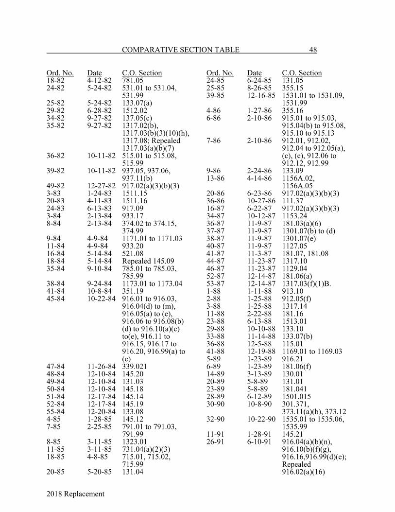
2018 Replacement
COMPARATIVE SECTION TABLE 48
Ord. No. Date C.O. Section18-82 4-12-82 781.0524-82 5-24-82 531.01 to 531.04,
531.9925-82 5-24-82 133.07(a)29-82 6-28-82 1512.0234-82 9-27-82 137.05(c)35-82 9-27-82 1317.02(b),
1317.03(b)(3)(10)(h),1317.08; Repealed1317.03(a)(b)(7)
36-82 10-11-82 515.01 to 515.08,515.99
39-82 10-11-82 937.05, 937.06,937.11(b)
49-82 12-27-82 917.02(a)(3)(b)(3)3-83 1-24-83 1511.1520-83 4-11-83 1511.1624-83 6-13-83 917.093-84 2-13-84 933.178-84 2-13-84 374.02 to 374.15,
374.999-84 4-9-84 1171.01 to 1171.0311-84 4-9-84 933.2016-84 5-14-84 521.0818-84 5-14-84 Repealed 145.0935-84 9-10-84 785.01 to 785.03,
785.9938-84 9-24-84 1173.01 to 1173.0441-84 10-8-84 351.1945-84 10-22-84 916.01 to 916.03,
916.04(d) to (m),916.05(a) to (e),916.06 to 916.08(b)(d) to 916.10(a)(c)to(e), 916.11 to916.15, 916.17 to916.20, 916.99(a) to(c)
47-84 11-26-84 339.02148-84 12-10-84 145.2049-84 12-10-84 131.0350-84 12-10-84 145.1851-84 12-17-84 145.1452-84 12-17-84 145.1955-84 12-20-84 133.084-85 1-28-85 145.127-85 2-25-85 791.01 to 791.03,
791.998-85 3-11-85 1323.0111-85 3-11-85 731.04(a)(2)(3)18-85 4-8-85 715.01, 715.02,
715.9920-85 5-20-85 131.04
Ord. No. Date C.O. Section24-85 6-24-85 131.0525-85 8-26-85 355.1539-85 12-16-85 1531.01 to 1531.09,
1531.994-86 1-27-86 355.166-86 2-10-86 915.01 to 915.03,
915.04(b) to 915.08,915.10 to 915.13
7-86 2-10-86 912.01, 912.02,912.04 to 912.05(a),(c), (e), 912.06 to912.12, 912.99
9-86 2-24-86 133.0913-86 4-14-86 1156A.02,
1156A.0520-86 6-23-86 917.02(a)(3)(b)(3)36-86 10-27-86 111.3716-87 6-22-87 917.02(a)(3)(b)(3)34-87 10-12-87 1153.2436-87 11-9-87 181.03(a)(6)37-87 11-9-87 1301.07(b) to (d)38-87 11-9-87 1301.07(e)40-87 11-9-87 1127.0541-87 11-3-87 181.07, 181.0844-87 11-23-87 1317.1046-87 11-23-87 1129.0452-87 12-14-87 181.06(a)53-87 12-14-87 1317.03(f)(1)B.1-88 1-11-88 913.102-88 1-25-88 912.05(f)3-88 1-25-88 1317.1411-88 2-22-88 181.1623-88 6-13-88 1513.0129-88 10-10-88 133.1033-88 11-14-88 133.07(b)36-88 12-5-88 115.0141-88 12-19-88 1169.01 to 1169.035-89 1-23-89 916.216-89 1-23-89 181.06(f)14-89 3-13-89 130.0120-89 5-8-89 131.0123-89 5-8-89 181.04128-89 6-12-89 1501.01530-90 10-8-90 301.371,
373.11(a)(b), 373.1232-90 10-22-90 1535.01 to 1535.06,
1535.9911-91 1-28-91 145.2126-91 6-10-91 916.04(a)(b)(n),
916.10(b)(f)(g),916.16,916.99(d)(e);
Repealed916.02(a)(16)

2018 Replacement
49 COMPARATIVE SECTION TABLE
Ord. No. Date C.O. Section30-91 8-12-91 1302.02 to 1302.09,
1302.9937-91 8-26-91 303.08540-91 9-9-91 145.2241-91 9-23-91 121.0242-91 9-23-91 Repealed 145.1643-91 9-23-91 1301.07(f)44-91 10-14-91 1151.0545-91 10-14-91 145.13(f)58-91 12-16-91 145.232-92 2-10-92 137.015-92 2-24-92 1512.068-92 3-9-92 1512.01, 1512.04,
1512.99, 1513.0213-92 5-11-92 931.04(c)25-92 9-14-92 1525.01 to 1525.07,
1525.9933-92 10-26-92 937.12(a)(c)34-92 10-26-92 937.0235-92 11-9-92 103.0143-92 12-28-92 1301.01 to 1301.05,
1301.09, 1301.1010-93 3-8-93 917.10(b)(4);
Repealed917.10(b)(5)
11-93 3-22-93 1327.01 to 1327.13,1327.99
12-93 3-22-93 143.0122-93 6-14-93 103.02 to 103.0727-93 6-14-93 133.03, 351.03131-93 8-9-93 1107.06 to 1107.0838-93 8-23-93 143.0241-93 9-13-93 916.05(f)11-94 3-14-94 937.14 to 937.1613-94 4-11-94 145.1118-94 5-9-94 916.04(c)19-94 5-9-94 185.01 to 185.03(a),
185.04 to 185.14,185.99
26-94 8-8-94 371.06527-94 8-22-94 912.01(a)(1.5),
915.02(a)(1.5)(7)30-94 10-10-94 911.02 to 911.0633-94 10-24-94 123.0137-94 6-10-94 937.08(a)(d)40-94 11-28-94 1335.01 to 1335.10,
1335.9946-94 12-28-94 185.03(b)6-95 2-27-95 145.08(c)7-95 2-27-95 915.02(a)(21)(22),
915.099-95 3-13-95 129.01
Ord. No. Date C.O. Section11-95 4-10-95 921.01 to 921.0514-95 5-8-95 Repealed 145.1021-95 9-11-95 1512.0527-95 11-27-95 937.01, 937.02,
937.04, 937.08(e),937.09, 937.11(a),937.12(b), 937.13,937.17
30-95 12-27-95 111.062-96 1-3-96 181.15(a)9-96 2-26-96 1302.0111-96 3-25-96 131.0618-96 5-28-96 183.01, 183.0226-96 6-24-96 111.0128-96 6-24-96 1317.03(b)(6)32-96 10-23-96 521.0938-96 12-23-96 145.08(a)11-97 2-24-97 937.01 to 937.14,
937.9912-97 2-24-97 541.0914-97 2-24-97 1530.01 to 1530.0418-97 3-24-97 912.05(d),
915.04(a)(1) to (3),915.05(a), 915.08(c)
21-97 4-28-97 343.01 to 343.06,343.99
32-97 5-12-97 1331.01 to 1331.15,1331.99
34-97 5-12-97 331.46, 1511.1339-97 6-9-97 181.04, 181.05,
181.1551-97 8-11-97 521.03, 1512.05,
1512.06, 1513.01,1515.99, 1525.01
52-97 8-11-97 912.03 54-97 8-25-97 133.10Adopting Ordinance 101.01 to 101.07,
101.99, 301.01 to301.52, 303.01 to303.11, 303.99,311.01 to 311.03,311.99, 313.01 to313.10, 313.99,331.01 to 311.43,331.99, 333.01 to333.10, 333.99,335.01 to 335.14,335.99, 337.01 to337.29, 337.99,339.01, 339.03 to339.11, 339.99,

2018 Replacement
COMPARATIVE SECTION TABLE 50
Ord. No. Date C.O. SectionAdopting Ordinance (Cont.)
341.01 to 341.06,341.99, 351.01 to351.10, 351.12,351.20, 371.01 to371.11, 373.01 to373.03, 373.05 to373.09, 374.01,375.01 to 375.07,375.99, 501.01 to501.12, 501.99,505.15(c), 505.16(c),509.01 to 509.08,509.09(b), 509.10,513.01 to 513.13,517.01 to 517.09,521.01, 521.02,521.03(b),521.04(b),521.05(c),521.06(b), 521.10(c), 525.01 to525.15, 529.01 to529.08, 533.01 to533.13, 537.01 to537.18, 541.01 to541.08, 545.01 to545.20, 545.21(c),549.01 to 549.10,553.01 to 553.03,561.99, 939.05,1515.01 to 1515.05,1515.99, 1519.01 to1519.05, 1519.99
56-97 9-8-97 525.1057-97 9-8-97 110.01 to 110.08,
110.9960-97 10-13-97 795.01 to 795.09,
795.9961-97 10-13-97 1335.01 to 1335.10,
1335.9970-97 11-10-97 1167.1075-97 12-22-97 145.08(a)4-98 1-2-98 181.15(b)5-98 1-12-98 111.019-98 1-26-98 111.0610-98 1-26-98 111.0711-98 1-26-98 111.3818-98 2-23-98 343.01(a)(5), (b)
Ord. No. Date C.O. Section22-98 3-9-98 Repeals 525.10,
525.1124-98 3-23-98 545.06(d), (f)30-98 4-13-98 Repeals Ch. 13931-98 4-13-98 311.0732-98 4-27-98 183.0341-98 6-29-98 1339.01 to 1339.12,
1339.9944-98 8-10-98 1339.1343-98 8-10-98 1123.03 Repealed45-98 9-14-98 311.0349-98 9-14-98 111.26.152-98 9-28-98 123.0153-98 10-26-98 1301.0762-98 12-14-98 917.01 to 917.1764-98 12-14-98 161.0265-98 12-14-98 303.041, 331.21,
331.39, 331.99,335.03, 335.09,335.99, 337.10,337.16, 339.07,341.02, 373.13,509.06, 509.07,517.02, 525.01,525.08, 525.09,529.07, 533.01,533.06, 537.03,537.10, 537.14,537.15, 545.07,1519.01 to1519.05
72-98 12-28-98 181.15(b)1-99 1-11-99 911.025-99 1-25-99 181.117-99 2-22-99 133.099-99 3-8-99 339.1314-99 3-22-99 916.05(f)15-99 3-22-99 911.07, 911.07.1,
911.07.2, 911.07.3,911.07.4
16-99 3-22-99 912.05(d),915.04
24-99 4-26-99 111.3041-99 6-28-99 1301.01, 1301.04,
1301.07, 1301.09,1302.01, 1302.05,1302.07, 1302.08

2018 Replacement
50A COMPARATIVE SECTION TABLE
Ord. No. Date C.O. Section47-99 9-13-99 509.0849-99 9-13-99 181.11(d)50-99 9-13-99 331.35, 331.38,
335.031, 335.99,375.01 to 375.08,501.01, 501.05,509.03, 513.01,513.03, 513.04,513.09, 513.10,513.12, 525.01,537.03, 537.051,537.10, 541.07,545.01, 545.02,545.05, 545.14,545.18, 545.22,549.11
53-99 10-11-99 343.01(b)68-99 12-27-99 912.0610-00 4-10-00 912.05(d), 915.0414-00 5-22-00 1121.01, 1121.02,
1123.01 to 1123.20,1125.01 to 1125.05,1127.01 to 1127.05,1129.01 to 1129.05,1131.01 to 1131.05,1133.01 to 1133.06,1135.01 to 1135.05,1137.01 to 1137.05,1139.01 to 1139.04,1141.01 to 1141.03,1143.01 Editor’sNote, 1145.01 Editor’s note,1147.01 to 1147.08,1149.01 to 1149.32,1151.01 to 1151.06,1153.01 to 1153.08,1155.01 to 1155.04,1157.01 to 1157.11,1159.01 to 1159.04,1161.01Appendices A, Band C
23-00 8-28-00 101.0830-00 10-23-00 333.01, 333.031,
333.99, 335.07,337.18, 337.24,337.30, 339.03,
Ord. No. Date C.O. Section30-00 (Cont.) 351.04, 351.99,
501.04, 501.09,509.03, 509.05,513.03, 513.05,513.06, 513.08,513.12, 525.07,525.12, 537.02,537.051, 537.07,541.07, 545.01,545.02, 545.05,545.06, 545.08,545.10, 545.15,545.18
37-00 11-27-00 937.03(a), 937.12(a)
38-00 11-27-00 181.012-01 2-12-01 145.185-01 2-26-01 1105.01 to 1105. 15,
1107.01 to 1107.03,1109.01 to 1109.13,1111.01 to 1111.06,1113.01 to 1113.07,1115.01, 1115.02,1117.01 to 1117.03,1118.01, 1118.02
11-01 4-23-01 1317.01 to 1317.1112-01 4-23-01 1121.02(b)(3),
1123.01, 1123.03,1123.12, 1125.02,1125.03(b)(1)B.,1127.02, 1127.03,1127.04(a), (b)(1)B.,1131.04, 1133.06(a), 1147.08,1149.02 to 1149.06,1149.12, 1149.13(b), 1149.14(b),1149.15(b), 1149.16to 1149.21, 1149.23(b),1149.24(b), 1149.25, 1149.27,1149.29(b), 1149.30(b),1149.31(b),1149.32(b), 1151.04, 1155.01,1161.01, AppendixB.

2018 Replacement
COMPARATIVE SECTION TABLE 50B
Ord. No. Date C.O. Section20-2001 9-10-01 111.01, 111.0725-2001 10-8-01 301.20, 337.02,
337.99, 375.03,501.06, 501.07,505.14, 513.01,513.12, 525.01,525.02, 525.03,525.08, 525.15,525.16, 529.07,533.03, 533.05,533.06, 537.03,537.05, 537.051,537.06, 537.16,537.17, 537.18,549.07, 553.01,553.011, 1519.02,1519.03
26-2001 10-22-01 912.05(d), 915.04(a)
30-2001 10-22-01 1157.1239-2001 12-10-01 111.0640-2001 12-10-01 181.02(j), 181.08(b),
181.16(b)(1)4-2002 3-25-02 181.07(a)(3)11-2002 4-22-02 103.01 to 103.0712-2002 4-22-01 141.01 to 141.04,
343.02(a), (b),1512.04(b),1512.06
17-2002 6-10-02 181.04, 181.05,181.15
18-2002 6-10-02 Repeals 1512.0529-02 8-26-02 303.08(a)(11),
303.082,303.085,303.087
30-02 8-26-02 509.08132-02 8-26-02 181.1634-02 9-9-02 1123.10(b)(5),
(10); 1127.03(b)(1)D., 1153.08(d)
Ord. No. Date C.O. Section38-02 10-28-02 335.08, 337.27,
375.08, 501.01,501.99, 509.03,509.05, 509.06,509.07, 513.01,525.08, 533.01,533.02, 533.04,537.051, 537.14,537.16, 537.18,545.22, 549.07,1519.02, 1519.03
43-02 11-25-02 1339.01 to 1339.13, 1339.99
45-02 11-25-02 1301.0146-02 11-25-02 1512.01(b)47-02 11-25-02 1512.01(d)48-02 11-25-02 1512.01(e)49-02 11-25-02 1512.01(c)50-02 11-25-02 1301.0251-02 11-25-02 1512.01(a)52-02 11-25-02 1525.0155-02 12-16-02 937.03, 937.1256-02 12-16-02 915.04, 915.05,
916.08(c)9-03 4-14-03 919.01 to 919.18,
919.9910-03 4-14-03 1335.05(a)(11)11-03 4-28-03 910.01 to 910.04,
910.9912-03 4-28-03 Repeals Ch. 77113-03 4-28-03 139.01, 139.0223-03 6-23-03 918.01 to 918.1525-03 8-11-03 919.9929-03 8-11-03 134.0140-03 9-22-03 301.20, 301.51,
303.04, 331.24,333.01, 371.12,371.99, 505.04,505.071, 513.01,517.01, 517.02,517.04 to 517.14,525.05, 529.01,

2018 Replacement
50C COMPARATIVE SECTION TABLE
Ord. No. Date C.O. Section40-03 (Cont.) 529.02, 529.021,
529.07, 529.08,533.05, 537.14,541.10, 553.04,553.05, 1515.01,1515.03 to1515.05
50-03 11-24-03 1121.02(a)(2),1123.08(d),1123.10(b)(4),1123.17, 1125.02,1125.03, 1127.02,1127.03 to 1127.05, 1129.02,1129.03, 1131.02,1131.03, 1131.05,1135.02, 1135.03,1147.04(a)(4),1149.02(c), 1149.03(c), 1149.06 (b),1149.10(c)(4)G., 1149.14(c),1149.15(e),1149.17(e), 1149.25, 1149.26(e), 1153.04,1157.10, 1161.01,1317.01 to 1317.14,1317.99
73-03 12-22-03 181.03(c), 181.07(a)
74-03 12-22-03 Traffic Code12-04 3-8-04 149.2415-04 3-22-04 916.05(f)18-04 4-12-04 1157.0321-04 4-12-04 1530.02(a)33-04 6-14-04 911.07(f)46-04 8-23-04 301.201, 331.40,
333.01 to 333.03,333.07, 335.01,501.99, 509.02,509.05, 513.02 to513.08, 513.12,529.021, 529.03 to529.05, 529.07,533.01, 533.02,533.09, 533.11,
Ord. No. Date C.O. Section46-04 (Cont.) 537.02, 537.021,
537.03, 537.051,537.07, 537.09,537.14, 537.15,541.05, 549.01,549.02, 549.04,549.11
47-04 8-23-04 911.07, 911.071,912.05, 912.06,915.04(a), 915.05(a),916.08(c)
53-04 9-27-04 918.13(a)(1)D.,(b)(1)D., (c)(1)C.,(d)(1)C., (e)(1)C.,(f)(1)C., (g) to (l)
55-04 9-27-04 111.0661-04 10-18-04 1153.06(d)63-04 11-8-04 1153.08(e)65-04 11-8-04 1112.01 to 1112.0867-04 12-6-04 917.03 to 917.0672-04 12-20-04 1341.01, 1341.02,
1341.992-05 1-24-05 Repeals Chapters
1513, 1515, 15193-05 1-24-05 Repeals 1512.044-05 1-24-05 Repeals 1511.01 to
1511.995-05 1-24-05 1512.01(a)6-05 1-24-05 1512.06, 1512.997-05 1-24-05 1512.01(f)19-05 4-25-05 145.2422-05 5-9-05 181.03(a), 181.043,
181.05, 181.1524-05 5-23-05 1341.01 to 1341.2025-05 5-23-05 1303.01(h); 1323.01,
1323.02 Repealed26-05 5-23-05 1303.03(c); 1512.01
(c) Repealed27-05 5-23-05 1303.01(e), 1512.01
(e) repealed28-05 5-23-05 1303.01(g); Repeals
Chapter 130229-05 5-23-05 1303.01(b); Repeals
1512.01(b)30-05 5-23-05 1303.06, 1303.99;
repeals 1512.06,1512.99
31-05 5-23-05 1303.01(a); Repeals1512.01(a)

2018 Replacement
COMPARATIVE SECTION TABLE 50D
Ord. No. Date C.O. Section32-05 5-23-05 1303.01(f); Repeals
1512.01(f)33-05 5-23-05 1303.02, 1303.0334-05 5-23-05 1303.01(d); Repeals
1512.01(d)35-05 5-23-05 1303.04, 1303.05,
1303.08, 1303.11,1303.12, 1303.14
36-05 5-23-05 1301.02 to 1301.10,1301.99
38-05 5-23-05 1301.0142-05 6-27-05 1123.01 to 1123.19,
1125.01 to 1125.07,1127.01 to 1127.05,1129.01 to 1129.05,1131.01 to 1131.05,1133.01 to 1133.05,1135.01 to 1135.04
43-05 6-27-05 1147.04, 1147.05(a)(1), (c), 1147.08(h)(11)
44-05 6-27-05 1151.01 to 1151.08,1153.01 to 1153.09
45-05 6-27-05 1157.10(a)(1),1157.10(c)
46-05 6-27-05 1159.04(c)(2)47-05 6-27-05 1161.0155-05 8-22-05 303.08, 313.11,
331.40, 333.01,333.02, 335.03,337.27, 337.28,501.01, 501.04,501.99, 513.01,517.01, 517.06,517.08, 517.09,517.14, 525.01,525.11, 525.15,537.17, 541.04,545.01, 545.05,545.06, 545.09
56-05 8-22-05 101.0861-05 10-17-05 137.0564-05 10-17-05 915.06(d)65-05 10-17-05 918.06(c)66-05 10-17-05 Repeals Ch. 91072-05 11-14-05 916.05(f)74-05 11-14-05 Repeals Ch. 1149
Ord. No. Date C.O. Section77-05 11-28-05 1341.0178-05 11-28-05 1303.06(f)(3)81-05 12-12-05 343.04(a)82-05 12-12-05 181.06(d)(2),
181.12(c)83-05 12-12-05 1127.0584-05 12-12-05 1123.2085-05 12-12-05 351.04, 351.13;
Repeals 351.1986-05 12-12-05 140.01 to 140.0694-05 12-19-05 1535.041-06 1-9-06 111.066-06 2-27-06 1137.01 to 1137.047-06 2-27-06 707.01 to 707.2115-06 4-24-06 1303.01(a)16-06 4-24-06 1303.06(a)18-06 4-24-06 915.04(b)(5)19-06 5-8-06 1303.01(h)20-06 5-8-06 911.07(d)(2), (5)24-06 5-22-06 1303.01 Repealed26-06 6-12-06 933.01 to 933.0534-06 8-28-06 333.01, 337.29,
501.06, 513.01,513.03, 513.04,513.08, 513.12,525.15, 525.17,529.08, 533.01,533.06, 537.07,541.11, 545.01,545.05
42-06 9-25-06 1301.01
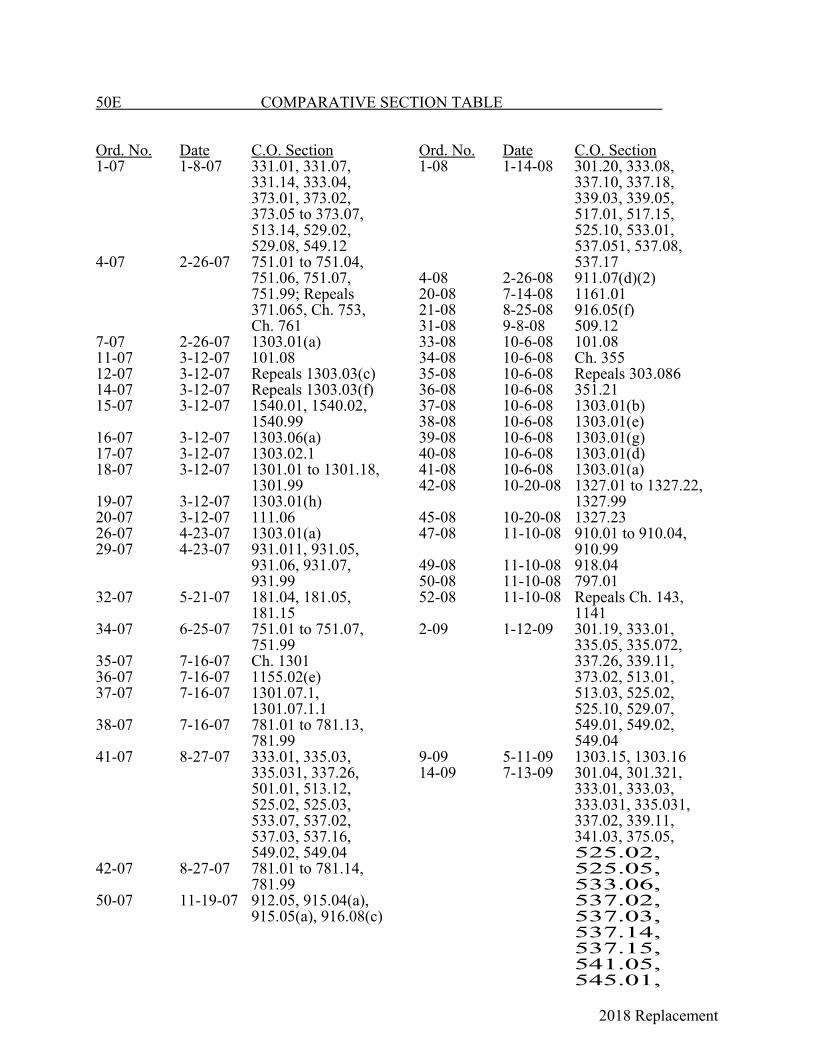
2018 Replacement
50E COMPARATIVE SECTION TABLE
Ord. No. Date C.O. Section1-07 1-8-07 331.01, 331.07,
331.14, 333.04,373.01, 373.02,373.05 to 373.07,513.14, 529.02,529.08, 549.12
4-07 2-26-07 751.01 to 751.04,751.06, 751.07,751.99; Repeals371.065, Ch. 753,Ch. 761
7-07 2-26-07 1303.01(a)11-07 3-12-07 101.0812-07 3-12-07 Repeals 1303.03(c)14-07 3-12-07 Repeals 1303.03(f)15-07 3-12-07 1540.01, 1540.02,
1540.9916-07 3-12-07 1303.06(a)17-07 3-12-07 1303.02.118-07 3-12-07 1301.01 to 1301.18,
1301.9919-07 3-12-07 1303.01(h)20-07 3-12-07 111.0626-07 4-23-07 1303.01(a)29-07 4-23-07 931.011, 931.05,
931.06, 931.07,931.99
32-07 5-21-07 181.04, 181.05,181.15
34-07 6-25-07 751.01 to 751.07,751.99
35-07 7-16-07 Ch. 130136-07 7-16-07 1155.02(e)37-07 7-16-07 1301.07.1,
1301.07.1.138-07 7-16-07 781.01 to 781.13,
781.9941-07 8-27-07 333.01, 335.03,
335.031, 337.26,501.01, 513.12,525.02, 525.03,533.07, 537.02,537.03, 537.16,549.02, 549.04
42-07 8-27-07 781.01 to 781.14,781.99
50-07 11-19-07 912.05, 915.04(a),915.05(a), 916.08(c)
Ord. No. Date C.O. Section1-08 1-14-08 301.20, 333.08,
337.10, 337.18,339.03, 339.05,517.01, 517.15,525.10, 533.01,537.051, 537.08,537.17
4-08 2-26-08 911.07(d)(2)20-08 7-14-08 1161.0121-08 8-25-08 916.05(f)31-08 9-8-08 509.1233-08 10-6-08 101.0834-08 10-6-08 Ch. 35535-08 10-6-08 Repeals 303.08636-08 10-6-08 351.2137-08 10-6-08 1303.01(b)38-08 10-6-08 1303.01(e)39-08 10-6-08 1303.01(g)40-08 10-6-08 1303.01(d)41-08 10-6-08 1303.01(a)42-08 10-20-08 1327.01 to 1327.22,
1327.9945-08 10-20-08 1327.2347-08 11-10-08 910.01 to 910.04,
910.9949-08 11-10-08 918.0450-08 11-10-08 797.0152-08 11-10-08 Repeals Ch. 143,
11412-09 1-12-09 301.19, 333.01,
335.05, 335.072,337.26, 339.11,373.02, 513.01,513.03, 525.02,525.10, 529.07,549.01, 549.02,549.04
9-09 5-11-09 1303.15, 1303.1614-09 7-13-09 301.04, 301.321,
333.01, 333.03,333.031, 335.031,337.02, 339.11,341.03, 375.05,525.02,525.05,533.06,537.02,537.03,537.14,537.15,541.05,545.01,

2018 Replacement
545.05,549.07
21-09 10-26-09 181.12

2018 Replacement
COMPARATIVE SECTION TABLE 50F
Ord. No. Date C.O. Section22-09 10-26-09 181.2023-09 10-26-09 181.2124-09 10-26-09 1317.1629-09 12-14-09 916.05(f)2-10 1-11-10 331.38, 335.01,
335.02, 335.07,335.10, 337.02to 337.06,337.08, 337.10to 337.17,337.19 to 337.22,337.24, 337.26,337.27, 351.04,375.05, 517.01,525.02, 525.03,533.06, 541.05,549.04
3-10 1-25-10 1318.018-10 5-24-10 125.0310-10 7-19-10 339.1324-10 12-13-10 521.05(b)
repealed2-11 1-10-11 333.01, 333.031,
335.01, 335.02,335.07, 335.072,335.10, 335.12,335.13, 337.28,337.29, 501.99,517.01, 517.02,517.06, 517.07,529.07, 537.10,537.11, 537.14,537.15
5-11 4-25-11 123.026-11 4-25-11 Repeals 111.3715-11 11-14-11 139.01, 139.0217-11 11-14-11 1331.01 to
1331.17, 1331.998-12 8-27-12 1331.1411-12 10-15-12 181.0312-12 10-15-12 181.0614-12 10-24-12 Repeals Ch. 91415-12 10-29-12 914.01 to 914.0830-12 12-10-12 915.0421-12 12-3-12 933.04(b)22-12 12-3-12 933.04(c)
Ord. No. Date C.O. Section8-13 4-8-13 901.01 to 901.24,
901.999-13 4-8-13 903.01 to 903.05,
903.99; Repeals373.11, Ch. 561
10-13 4-8-13 373.1312-13 7-15-13 567.0116-13 9-9-13 567.0125-13 12-16-13 351.0336-13 12-16-13 111.064-14 4-14-14 919.01 to 919.25,
919.995-14 4-14-14 913.01 to 913.30,
913.999-14 6-23-14 103.01 to 103.0724-14 12-8-14 915.0431-14 12-22-14 181.22, 181.236-15 3-23-15 351.1712-15 9-14-15 1151.02 to
1151.1113-15 10-12-15 505.07116-15 11-23-15 916.01 to 916.21,
916.9917-15 11-23-15 182.01 to 182.23,
182.97, 182.98,182.99
28-15 12-7-15 129.021-16 1-25-16 705.01 to 705.044-16 2-22-16 903.01 to 903.10,
903.997-16 3-14-16 937.01 to 937.16,
937.9912-16 3-28-16 131.01 to 131.06114-16 4-11-16 111.01 to 111.3816-16 4-11-16 1123.11, 1123.15,
1123.20, 1125.01,1125.05, 1155.03,1161.01
17-16 4-11-16 1129.01 to 1129.05, 1131.01to 1131.05
22-16 6-27-16 705.01 to 705.0525-16 9-26-16 709.01, 709.02,
709.9928-16 10-24-16 1157.01 to 1157.1229-16 10-24-16 1123.0140-16 12-12-16 345.01, 345.02,
345.99

2018 Replacement
50G COMPARATIVE SECTION TABLE
Ord. No. Date C.O. Section1-17 5-22-17 182.01311-17 4-10-17 1303.01(a),
1525.01, 1525.0212-17 4-10-17 1303.01(b)13-17 4-10-17 1303.01(e)14-17 4-10-17 1303.01(g)15-17 4-10-17 1303.01(d)18-17 5-8-17 911.07(d)(2)19-17 5-8-17 1327.01 to
1327.24, 1327.9922-17 6-26-17 1101.0227-17 9-11-17 131.0728-17 9-11-17 1123.01 to
1123.21, 1125.01to 1125.07,1133.01 to1133.05, 1139.01to 1139.05,1153.01 to1153.09, 1161.01
38-17 12-11-17 Repeals 145.01 to145.17, 145.19to 145.24
40-17 12-11-17 111.06.141-17 12-11-17 1327.043-18 3-12-18 183.01 to 183.39,
183.97, 183.98,183.99
7-18 6-11-18 1331.079-18 7-16-18 937.01 to 937.18,
937.9919-18 10-22-18 905.01 to 905.05,
905.9923-18 11-26-18 1317.01 to
1317.16, 1317.99
Ord. No. Date C.O. Section

2018 Replacement

2018 Replacement
51
EXPLANATION OF TABLES OF SPECIAL ORDINANCES
The Codified Ordinances of Lancaster cover allordinances of a general and permanent nature. The provisions of suchgeneral and permanent ordinances are set forth in full in the CodifiedOrdinances.
References must be made frequently to many specialordinances particularly those related to property, such as dedications,vacating of property, easements, purchase, sale, etc. In the followingTables A through L, all such ordinances are listed. These tables listordinances chronologically by subject, and include both a citation toand brief description of each ordinance.
TABLES OF SPECIAL ORDINANCES OF LANCASTER
Table A - Franchises Table B - Easements Table C - Vacating Streets and Alleys Table D - Dedication of Property Table E - Sale of Property Table F - Purchase of Property for City Use Table G - Lease of Property Table H - Grade Levels and Curb Lines Table I - Zoning Map Changes Table J - Annexation or Detachment of Territory Table K - Change of Name Table L - Special Assessments
2018 Replacement

2018 Replacement
53 TABLES OF SPECIAL ORDINANCES
TABLE A - FRANCHISES
Ord. Book& Page Ord. No. Date DescriptionA-136 Unno. 4-29-1889 To Wm. Duffy to operate a street ry.A-156 Unno. 6-23-1890 Amends Ord. of 4-29-1889.A-163 Unno. 11-24-1890 To W. G. Wagenhals and associates for an electric
light and power plant.A-202 Unno. 6-22-1891 Augmenting terms of franchise of 4-29-1899 re
street ry.A-210 Unno. 9-14-1891 To Western Union Telegraph Co. for telegraph
service.A-236 Unno. 11-14-1892 Amending Ords. of 4-29-1889 and 6-22-1891.A-277 Unno. 8-12-1895 To N. M. Wynkoop and A. L. Conger et al., for
electric telephone plant.A-282 Unno. 1-13-1896 To Andrew Bauman for street ry. for 25 years.A-315 Unno. 11-23-1896 To Lancaster Traction Co. to extend street ry.A-324 Unno. 7-10-1899 To North Electric Co. for telephone exchange.A-357 Unno. 6-13-1898 To O. N. Danison for telephone and telegraph lines.A-362 Unno. 8-8-1898 Amending Ord. of 6-13-1898.A-380 Unno. 7-10-1899 To North Electric Co. for telephone exchange.A-392 Unno. 11-13-1899 To Federal Gas and Fuel Co. for natural gas mains.A-398 Unno. 11-27-1899 To Columbus and Lancaster Traction Co. for street
ry.A-433 Unno. 9-10-1900 To Lancaster Traction Co. to extend street ry.B-77 20 7-27-03 To Ohio Postal Telegraph-Cable Co. for telegraph
service for 10 years.B-96 23 9-28-03 To Fairfield Traction Co. for street ry.B-112 35 3-28-04 To Ohio Fuel and Supply Co. of Columbus to lay
pipes to supply C. P. Cole's glass factory withnatural gas.
B-249 114 8-14-05 To Henry B. Peters for street ry.C-93 320 5-8-11 To Lancaster Power and Traction Co. for street ry.
on Front St.C-325 425 6-8-14 To Lancaster Traction and Power Co. for street ry.C-329 426 6-8-14 To Lancaster Traction and Power Co. for street ry.F-116 1037 3-14-27 To Ohio Power Co. for electric system.G-85 1289 6-23-30 To Lancaster Traction and Power Co. for electric
system.G-97 1300 8-25-30 To Lancaster Traction and Power Co. for street ry.H-175 1738 6-28-37 To Lancaster Traction and Power Co. for street ry.J-33 44-45 7-23-45 To Penna. R.R. for R.R.J-365 24-49 4-11-49 Amending Ord. 1738.K-256 49-53 7-13-53 Amending Ord. 24-49.L-29 30-57 4-8-57 Amending Ord. 24-49.L-432 77-60 10-10-60 Amending Ords. 30-57 and 24-49.L-454 91-60 12-27-60 To 2300 Cab Co., Inc., granting a 5-year franchise.M-344 114-65 12-13-65 To 2300 Cab Co., Inc.,to maintain and operate a taxi
company for 5 years.

2018 Replacement
TABLES OF SPECIAL ORDINANCES 54
TABLE A- FRANCHISES (Cont.)
Ord. Book& Page Ord. No. Date DescriptionM-384 29-66 3-14-66 To Ohio Power Co. for distribution of Electric
energy.N-153 13-69 2-24-69 Continental CATV, Inc. to erect, maintain and
operate CATV for 10 years.P-183 10-72 2-14-72 2300 Cab Co., Inc. taxicab franchise for 5 years.P-232 37-72 6-26-72 To Fairfield Cable Television for CATV service for
15 years.Q-22 13-73 2-26-73 Amends Ord. 37-72.Q-121 57-73 12-10-73 Repeals Ord. 10-72.
5-74 1-28-74 To William Patterson dba Safe-Way Cab Co.13-74 2-25-74 Approves assignment of CATV franchise from
Fairfield Cablevision, Inc. to Fairfield CablevisionAssociates.
45-74 9-9-74 To South Central Power Co. to construct, maintainand operate an electrical system for 50 years.
33-75 11-10-75 Amends Ord. 37-72 above re CATV rates.23-77 5-23-77 Street lighting contract with Ohio Power Co.12-78 5-8-78 Regulates street lighting charges of S. Central
Power Co. for 10 years.23-83 5-9-83 To Lancaster Glass Corp. to construct and maintain
a conveyor and loading hopper in Zane Alley for 25years.
7-92 3-9-92 Continental Cablevision granted a nonexclusivefranchise renewal.
23-93 6-14-93 Regulates street lighting charges of S. CentralPower Co. for 10 years.
6-02 3-26-02 Allows extension of the current nonexclusive cablefranchise agreement with Time Warner Cable.
22-02 6-24-02 Allows extension of the current nonexclusive cablefranchise agreement with Time Warner Cable.
35-02 9-23-02 Allows extension of the current nonexclusive cablefranchise agreement with Time Warner Cable.
14-03 4-28-03 Time Warner Cable granted a nonexclusive cablecommunications franchise.
9-16 3-14-16 To Ohio Power Company, for the right to acquire,construct, maintain and operate in the streets,thoroughfares, alleys, bridges, and public places ofthe City, lines for the transmission and distributionof electric energy.
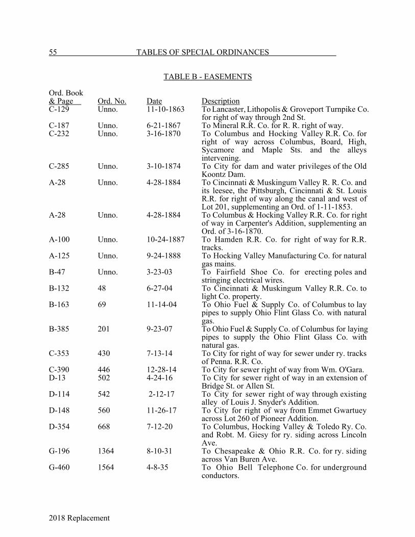
2018 Replacement
55 TABLES OF SPECIAL ORDINANCES
TABLE B - EASEMENTS
Ord. Book& Page Ord. No. Date DescriptionC-129 Unno. 11-10-1863 To Lancaster, Lithopolis & Groveport Turnpike Co.
for right of way through 2nd St.C-187 Unno. 6-21-1867 To Mineral R.R. Co. for R. R. right of way.C-232 Unno. 3-16-1870 To Columbus and Hocking Valley R.R. Co. for
right of way across Columbus, Board, High,Sycamore and Maple Sts. and the alleysintervening.
C-285 Unno. 3-10-1874 To City for dam and water privileges of the OldKoontz Dam.
A-28 Unno. 4-28-1884 To Cincinnati & Muskingum Valley R. R. Co. andits leesee, the Pittsburgh, Cincinnati & St. LouisR.R. for right of way along the canal and west ofLot 201, supplementing an Ord. of 1-11-1853.
A-28 Unno. 4-28-1884 To Columbus & Hocking Valley R.R. Co. for rightof way in Carpenter's Addition, supplementing anOrd. of 3-16-1870.
A-100 Unno. 10-24-1887 To Hamden R.R. Co. for right of way for R.R.tracks.
A-125 Unno. 9-24-1888 To Hocking Valley Manufacturing Co. for naturalgas mains.
B-47 Unno. 3-23-03 To Fairfield Shoe Co. for erecting poles andstringing electrical wires.
B-132 48 6-27-04 To Cincinnati & Muskingum Valley R.R. Co. tolight Co. property.
B-163 69 11-14-04 To Ohio Fuel & Supply Co. of Columbus to laypipes to supply Ohio Flint Glass Co. with naturalgas.
B-385 201 9-23-07 To Ohio Fuel & Supply Co. of Columbus for layingpipes to supply the Ohio Flint Glass Co. withnatural gas.
C-353 430 7-13-14 To City for right of way for sewer under ry. tracksof Penna. R.R. Co.
C-390 446 12-28-14 To City for sewer right of way from Wm. O'Gara.D-13 502 4-24-16 To City for sewer right of way in an extension of
Bridge St. or Allen St.D-114 542 2-12-17 To City for sewer right of way through existing
alley of Louis J. Snyder's Addition.D-148 560 11-26-17 To City for right of way from Emmet Gwartuey
across Lot 260 of Pioneer Addition.D-354 668 7-12-20 To Columbus, Hocking Valley & Toledo Ry. Co.
and Robt. M. Giesy for ry. siding across LincolnAve.
G-196 1364 8-10-31 To Chesapeake & Ohio R.R. Co. for ry. sidingacross Van Buren Ave.
G-460 1564 4-8-35 To Ohio Bell Telephone Co. for undergroundconductors.

2018 Replacement
TABLES OF SPECIAL ORDINANCES 56
TABLE B - EASEMENTS (Cont.)
Ord. Book& Page Ord. No. Date DescriptionH-317 1850 9-26-38 To City for right of way for cleaning streams.H-383 1888 2-27-39 Right-of-way agreement between the City and
Penna. R.R. Co.H-458 1948 6-26-39 To City for right of way over Penna. R.R. Co.
tracks.H-511 1992 10-2-39 To City for right of way from Chesapeake and Ohio
R.R. Co.H-518 1997 10-23-39 To Anchor-Hocking Glass Corp. to construct a R.
R. switch or siding on Pierce Ave.I-131 16-41 4-14-41 To Midwestern Engineering and Construction Co.
to lay pipes and mains for the Anchor HockingGlass Corp.
I-576 47-44 12-11-44 To Church of Jesus Christ of Latter Day Saints tobuild a coal bin to extend under public sidewalk.
J-166 60-46 9-23-46 To Ohio Bell Telephone Co. for right of way ofWater Works Hill.
J-179 2-47 1-13-47 To Penna. R.R. Co. for right of way acrossSycamore St.
J-364 23-49 4-11-49 To Catholic Diocese for temporary encroachmenton Chestnut St.
J-461 44-50 6-12-50 To Ohio Fuel Gas Co. for right of way along HunterAve. and Pine.
K-18 53-51 8-13-51 To Lancaster Lens Co. for right of way across aportion of Bank Alley.
K-23 57-51 9-10-51 To Ohio Fuel Gas Co. for gas pipe line.K-92 19-52 3-11-52 To Ohio Bell Telephone Co. to lay cables under
certain streets .K-168 75-52 10-13-52 To RBM Division of Essex Wire Corp. to construct
an insulated steam main across a portion of an alley.K-248 41-53 6-23-53 To Lancaster Lens Co. to build a platform across
part of an alley.K-261 54-53 7-29-53 To RBM Division of Essex Wire Corp. to construct
a ramp and utility conduits across a portion of analley.
K-426 33-55 5-23-55 To State of Ohio over a portion of Lanreco Park tofacilitate construction of new Cherry St. bridge.
K-558 50-56 7-25-56 To Lancaster Brew Co. to construct a loadingplatform across a portion of Union St.
K-590 75-56 12-19-56 To Ohio Power Co. to construct an electric powerline over portion of Forest Rose Cemetery.
L-18 21-57 3-11-57 To Ohio Power Co. to relocate power line on Rt. 33.
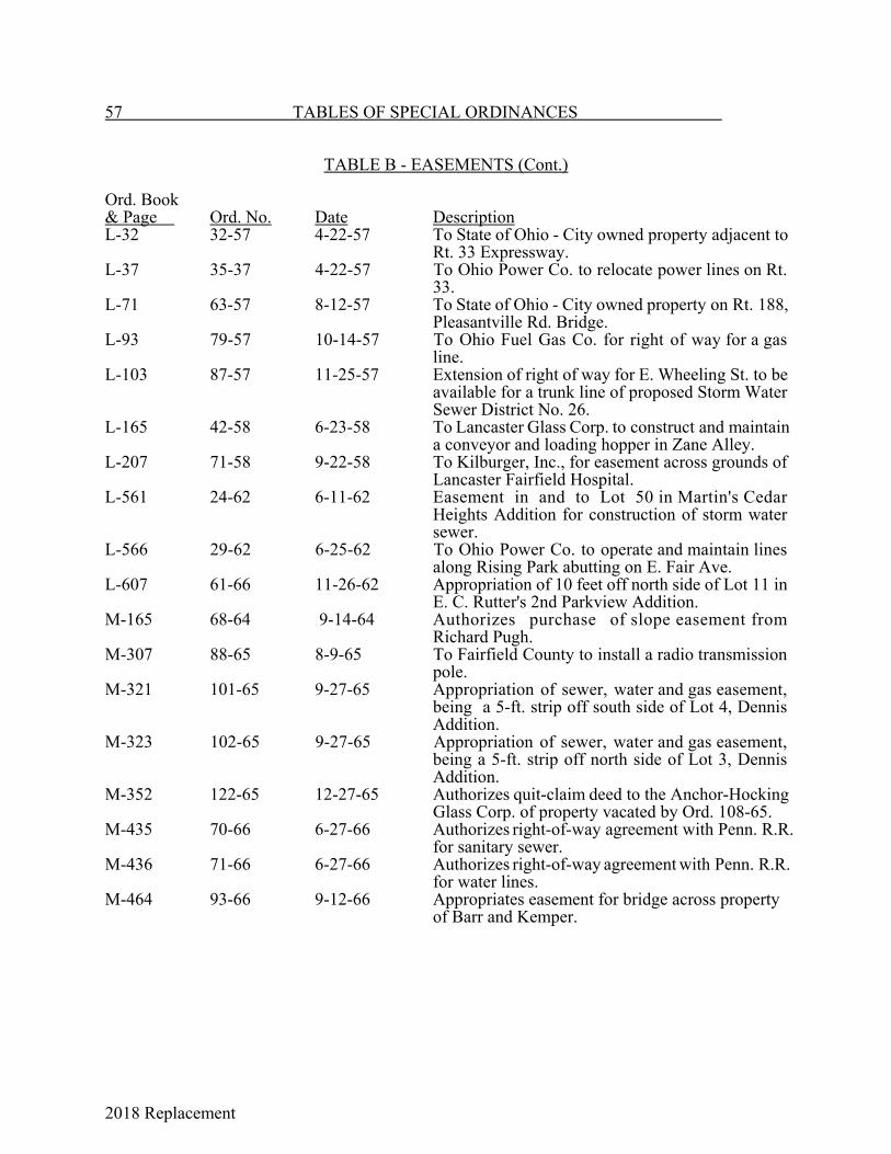
2018 Replacement
57 TABLES OF SPECIAL ORDINANCES
TABLE B - EASEMENTS (Cont.)
Ord. Book& Page Ord. No. Date DescriptionL-32 32-57 4-22-57 To State of Ohio - City owned property adjacent to
Rt. 33 Expressway.L-37 35-37 4-22-57 To Ohio Power Co. to relocate power lines on Rt.
33.L-71 63-57 8-12-57 To State of Ohio - City owned property on Rt. 188,
Pleasantville Rd. Bridge.L-93 79-57 10-14-57 To Ohio Fuel Gas Co. for right of way for a gas
line.L-103 87-57 11-25-57 Extension of right of way for E. Wheeling St. to be
available for a trunk line of proposed Storm WaterSewer District No. 26.
L-165 42-58 6-23-58 To Lancaster Glass Corp. to construct and maintaina conveyor and loading hopper in Zane Alley.
L-207 71-58 9-22-58 To Kilburger, Inc., for easement across grounds ofLancaster Fairfield Hospital.
L-561 24-62 6-11-62 Easement in and to Lot 50 in Martin's CedarHeights Addition for construction of storm watersewer.
L-566 29-62 6-25-62 To Ohio Power Co. to operate and maintain linesalong Rising Park abutting on E. Fair Ave.
L-607 61-66 11-26-62 Appropriation of 10 feet off north side of Lot 11 inE. C. Rutter's 2nd Parkview Addition.
M-165 68-64 9-14-64 Authorizes purchase of slope easement fromRichard Pugh.
M-307 88-65 8-9-65 To Fairfield County to install a radio transmissionpole.
M-321 101-65 9-27-65 Appropriation of sewer, water and gas easement,being a 5-ft. strip off south side of Lot 4, DennisAddition.
M-323 102-65 9-27-65 Appropriation of sewer, water and gas easement,being a 5-ft. strip off north side of Lot 3, DennisAddition.
M-352 122-65 12-27-65 Authorizes quit-claim deed to the Anchor-HockingGlass Corp. of property vacated by Ord. 108-65.
M-435 70-66 6-27-66 Authorizes right-of-way agreement with Penn. R.R.for sanitary sewer.
M-436 71-66 6-27-66 Authorizes right-of-way agreement with Penn. R.R.for water lines.
M-464 93-66 9-12-66 Appropriates easement for bridge across property of Barr and Kemper.

2018 Replacement
TABLES OF SPECIAL ORDINANCES 58
TABLE B - EASEMENTS (Cont.)
Ord. Book& Page Ord. No. Date DescriptionM-474 101-66 9-12-66 Appropriates easement for bridge across Fraizer
property.M-475 102-66 9-12-66 Appropriates easement for bridge across property of
Albert Russell.M-480 105-66 9-12-66 Appropriates sanitary sewer easements across
property of Molar, Kennedy, Moore, Fox and Crist.M-553 41-67 4-25-67 Appropriates right of way for street purposes over
land of Kemper and Barr (7 feet off east side of Lots5 to 9, Block 24, Chapin Addition).
M-554 42-67 4-25-67 Appropriates right of way for street purposes overland of Frank Graf (7 feet off west side of Lots 10and 11, Block 23, Chapin Addition).
N-57 10-68 2-26-68 Appropriation of permanent easement for streetpurposes over property of Hedges.
N-126 54-68 11-25-68 Appropriation of sanitary sewer easement fromBaltz.
N-127 55-68 12-2-68 Appropriation of sanitary sewer easement fromAlvis over Lot 1 in Lenmar Subdivision l.
N-238 52-69 8-25-69 Appropriation of sanitary sewer easements fromBaker, Lehman, Bailey, Hixon, Boring, Neel andWright.
N-285 74-69 12-8-69 Appropriation of sanitary sewer easement overproperty of the Lancaster Jaycees.
N-286 75-69 12-22-69 Appropriation of storm sewer easement overproperty of Taylor.
P-115 45-71 9-13-71 To Turner for use of all of Reserve B of the formercanal lands.
P-116 46-71 9-27-71 To Lancaster Horseshoe Pitchers Assn. for propertylocated at intersection of Memorial Dr., ArlingtonAve. and Edgewood Ave.
P-165 1-72 1-10-72 Appropriation of sanitary sewer line easement overHayes property.
P-287 64-72 12-11-72 Appropriation of right of way for street purposesover Grimm property.
Q-I0 7-73 2-12-73 Appropriates permanent easements and rights ofway for street and storm sewer purposes overproperty of Collins, Davis, Lutheran Church of OurSavior, Woodard, Cox, Haynes, Kane, Younger,Joos, Kehrer, Swartz and Hardy.
Q-80 42-73 9-24-73 Appropriates storm sewer easement over Grimmproperty.
35-75 11-24-75 Appropriates easements of properties owned byEvelyn Clark and Somerford Square II, Ltd. andSomerford Square, Ltd. for street purposes.
40-76 8-30-76 Appropriates permanent easement and right of wayand a temporary easement for sanitary sewer overproperty which is part of Range 18, Township 15,Section 29.
59 TABLES OF SPECIAL ORDINANCES

2018 Replacement
TABLE B - EASEMENTS (Cont.)
Ord. No. Date Description49-79 8-27-79 Accepts utility easement from Pleasant Development Corp.57-79 10-22-79 Accepts sanitary sewer easement from K. Michael Deem.58-79 10- 22-79 Accepts sanitary sewer easement from G . T . C . Development .22-81 6-8-81 Accepts sanitary sewer easement from John D. and Mary E.
VanGundy.23-81 6-8-81 Accepts sanitary sewer easement from Anchor Co., Inc.24-81 6-8-81 Accepts sanitary sewer easement from Board of Education.25-81 6-8-81 Accepts sanitary sewer easement from Charles R. and Mary A.
Coleman.26-81 6-8-81 Accepts sanitary sewer easement from David B. and Emogene M.
Faigley.27-81 6-8-81 Accepts sanitary sewer easement from Mary R. Sepanski, W. C.
Miller and The Huntington National Bank.28-81 6-8-81 Accepts sanitary sewer easement from Laroco Industries.9-83 2-28-83 To Fairfield Cablevision and Associates for a satellite signal
reception antenna.13-84 4-23-84 Vacates utility right-of-way on Lot 20 of the Northshire Addition.15-84 5-14-84 Accepts a deed of easement from the Board of Education, Lancaster
City School District.26-85 8-26-85 Appropriation of flooding easement for temporary water storage from
the Tarhe Dam in the North Hocking Watershed Work Plan.23-86 6-23-86 Appropriates easement for roadway purposes on Pierce Ave. in River
Valley project area from Donald Grubb.24-86 6-23-86 Appropriates easement for roadway purposes and slope easements
along Pierce Ave. and State Route 33 in River Valley project area.25-86 6-23-86 Appropriates easement for roadway purposes on Pierce Ave. in River
Valley project area.27-86 8-l1-86 Vacants portion of utility right-of-way on Lot 9 in SecondNorthshire
Addition.38-86 10-27-86 Appropriates temporary easement for pole removal and loop detector
installation.39-86 10-27-86 Appropriates easement for roadway purposes from Birdella
Mondhank.40-86 10-27-86 Appropriates easement for roadway purposes from G. Spires, C.
Hammack, H. Hogan, V. Pizzato and M. Pizzato.07-87 4-13-87 Accepts street and public services easement from Robert L. and
Penny L. Roush in SE quarter of Section 31, Township 15, Range 18.08-87 4-13-87 To Fairfield Cablevision and Associates for satellite signal reception
antenna.22-88 6-13-88 Abandons slope easements once used to support Pierce Ave. and
River Valley Blvd. improvements.31-88 10-24-88 Accepts River Valley easement plat.35-89 9-11-89 Temporary easement to Sun Refining and Marketing Co. for
installation of ground water monitoring wells.03-90 1-22-90 Temporary easement to Sun Refining and Marketing Co. for
installation of ground water monitoring wells. 12-90 6-4-90 Temporary easement to Sun Refining and Marketing Co. for
installation of ground water monitoring wells.
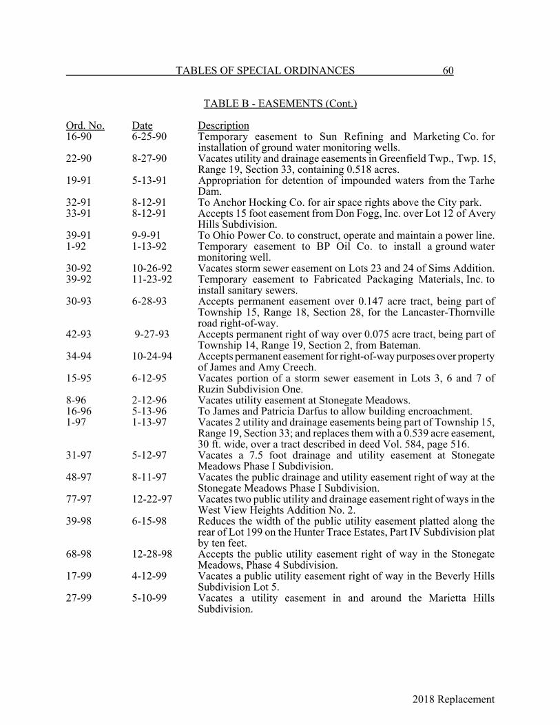
2018 Replacement
TABLES OF SPECIAL ORDINANCES 60
TABLE B - EASEMENTS (Cont.)
Ord. No. Date Description16-90 6-25-90 Temporary easement to Sun Refining and Marketing Co. for
installation of ground water monitoring wells.22-90 8-27-90 Vacates utility and drainage easements in Greenfield Twp., Twp. 15,
Range 19, Section 33, containing 0.518 acres.19-91 5-13-91 Appropriation for detention of impounded waters from the Tarhe
Dam.32-91 8-12-91 To Anchor Hocking Co. for air space rights above the City park.33-91 8-12-91 Accepts 15 foot easement from Don Fogg, Inc. over Lot 12 of Avery
Hills Subdivision.39-91 9-9-91 To Ohio Power Co. to construct, operate and maintain a power line.1-92 1-13-92 Temporary easement to BP Oil Co. to install a ground water
monitoring well.30-92 10-26-92 Vacates storm sewer easement on Lots 23 and 24 of Sims Addition.39-92 11-23-92 Temporary easement to Fabricated Packaging Materials, Inc. to
install sanitary sewers.30-93 6-28-93 Accepts permanent easement over 0.147 acre tract, being part of
Township 15, Range 18, Section 28, for the Lancaster-Thornvilleroad right-of-way.
42-93 9-27-93 Accepts permanent right of way over 0.075 acre tract, being part ofTownship 14, Range 19, Section 2, from Bateman.
34-94 10-24-94 Accepts permanent easement for right-of-way purposes over propertyof James and Amy Creech.
15-95 6-12-95 Vacates portion of a storm sewer easement in Lots 3, 6 and 7 ofRuzin Subdivision One.
8-96 2-12-96 Vacates utility easement at Stonegate Meadows.16-96 5-13-96 To James and Patricia Darfus to allow building encroachment.1-97 1-13-97 Vacates 2 utility and drainage easements being part of Township 15,
Range 19, Section 33; and replaces them with a 0.539 acre easement,30 ft. wide, over a tract described in deed Vol. 584, page 516.
31-97 5-12-97 Vacates a 7.5 foot drainage and utility easement at StonegateMeadows Phase I Subdivision.
48-97 8-11-97 Vacates the public drainage and utility easement right of way at theStonegate Meadows Phase I Subdivision.
77-97 12-22-97 Vacates two public utility and drainage easement right of ways in theWest View Heights Addition No. 2.
39-98 6-15-98 Reduces the width of the public utility easement platted along therear of Lot 199 on the Hunter Trace Estates, Part IV Subdivision platby ten feet.
68-98 12-28-98 Accepts the public utility easement right of way in the StonegateMeadows, Phase 4 Subdivision.
17-99 4-12-99 Vacates a public utility easement right of way in the Beverly HillsSubdivision Lot 5.
27-99 5-10-99 Vacates a utility easement in and around the Marietta HillsSubdivision.
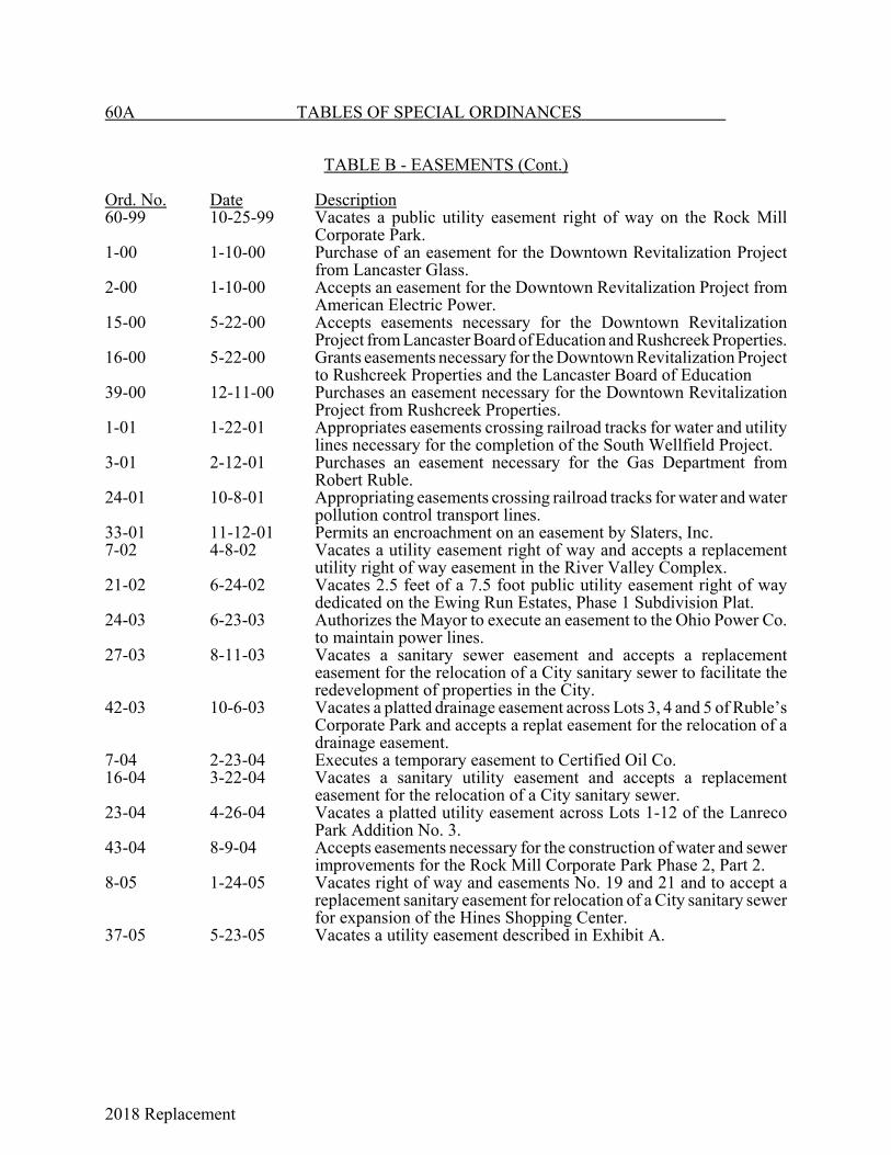
2018 Replacement
60A TABLES OF SPECIAL ORDINANCES
TABLE B - EASEMENTS (Cont.)
Ord. No. Date Description60-99 10-25-99 Vacates a public utility easement right of way on the Rock Mill
Corporate Park.1-00 1-10-00 Purchase of an easement for the Downtown Revitalization Project
from Lancaster Glass.2-00 1-10-00 Accepts an easement for the Downtown Revitalization Project from
American Electric Power.15-00 5-22-00 Accepts easements necessary for the Downtown Revitalization
Project from Lancaster Board of Education and Rushcreek Properties.16-00 5-22-00 Grants easements necessary for the Downtown Revitalization Project
to Rushcreek Properties and the Lancaster Board of Education39-00 12-11-00 Purchases an easement necessary for the Downtown Revitalization
Project from Rushcreek Properties.1-01 1-22-01 Appropriates easements crossing railroad tracks for water and utility
lines necessary for the completion of the South Wellfield Project.3-01 2-12-01 Purchases an easement necessary for the Gas Department from
Robert Ruble.24-01 10-8-01 Appropriating easements crossing railroad tracks for water and water
pollution control transport lines.33-01 11-12-01 Permits an encroachment on an easement by Slaters, Inc.7-02 4-8-02 Vacates a utility easement right of way and accepts a replacement
utility right of way easement in the River Valley Complex.21-02 6-24-02 Vacates 2.5 feet of a 7.5 foot public utility easement right of way
dedicated on the Ewing Run Estates, Phase 1 Subdivision Plat.24-03 6-23-03 Authorizes the Mayor to execute an easement to the Ohio Power Co.
to maintain power lines.27-03 8-11-03 Vacates a sanitary sewer easement and accepts a replacement
easement for the relocation of a City sanitary sewer to facilitate theredevelopment of properties in the City.
42-03 10-6-03 Vacates a platted drainage easement across Lots 3, 4 and 5 of Ruble’sCorporate Park and accepts a replat easement for the relocation of adrainage easement.
7-04 2-23-04 Executes a temporary easement to Certified Oil Co. 16-04 3-22-04 Vacates a sanitary utility easement and accepts a replacement
easement for the relocation of a City sanitary sewer.23-04 4-26-04 Vacates a platted utility easement across Lots 1-12 of the Lanreco
Park Addition No. 3.43-04 8-9-04 Accepts easements necessary for the construction of water and sewer
improvements for the Rock Mill Corporate Park Phase 2, Part 2.8-05 1-24-05 Vacates right of way and easements No. 19 and 21 and to accept a
replacement sanitary easement for relocation of a City sanitary sewerfor expansion of the Hines Shopping Center.
37-05 5-23-05 Vacates a utility easement described in Exhibit A.
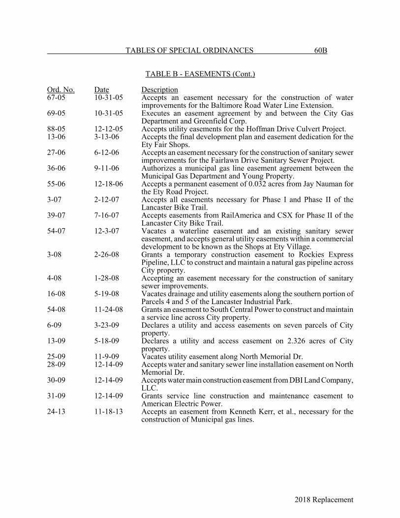
2018 Replacement
TABLES OF SPECIAL ORDINANCES 60B
TABLE B - EASEMENTS (Cont.)
Ord. No. Date Description67-05 10-31-05 Accepts an easement necessary for the construction of water
improvements for the Baltimore Road Water Line Extension.69-05 10-31-05 Executes an easement agreement by and between the City Gas
Department and Greenfield Corp.88-05 12-12-05 Accepts utility easements for the Hoffman Drive Culvert Project.13-06 3-13-06 Accepts the final development plan and easement dedication for the
Ety Fair Shops.27-06 6-12-06 Accepts an easement necessary for the construction of sanitary sewer
improvements for the Fairlawn Drive Sanitary Sewer Project.36-06 9-11-06 Authorizes a municipal gas line easement agreement between the
Municipal Gas Department and Young Property.55-06 12-18-06 Accepts a permanent easement of 0.032 acres from Jay Nauman for
the Ety Road Project.3-07 2-12-07 Accepts all easements necessary for Phase I and Phase II of the
Lancaster Bike Trail.39-07 7-16-07 Accepts easements from RailAmerica and CSX for Phase II of the
Lancaster City Bike Trail.54-07 12-3-07 Vacates a waterline easement and an existing sanitary sewer
easement, and accepts general utility easements within a commercialdevelopment to be known as the Shops at Ety Village.
3-08 2-26-08 Grants a temporary construction easement to Rockies ExpressPipeline, LLC to construct and maintain a natural gas pipeline acrossCity property.
4-08 1-28-08 Accepting an easement necessary for the construction of sanitarysewer improvements.
16-08 5-19-08 Vacates drainage and utility easements along the southern portion ofParcels 4 and 5 of the Lancaster Industrial Park.
54-08 11-24-08 Grants an easement to South Central Power to construct and maintaina service line across City property.
6-09 3-23-09 Declares a utility and access easements on seven parcels of Cityproperty.
13-09 5-18-09 Declares a utility and access easement on 2.326 acres of Cityproperty.
25-09 11-9-09 Vacates utility easement along North Memorial Dr.28-09 12-14-09 Accepts water and sanitary sewer line installation easement on North
Memorial Dr.30-09 12-14-09 Accepts water main construction easement from DBI Land Company,
LLC.31-09 12-14-09 Grants service line construction and maintenance easement to
American Electric Power.24-13 11-18-13 Accepts an easement from Kenneth Kerr, et al., necessary for the
construction of Municipal gas lines.
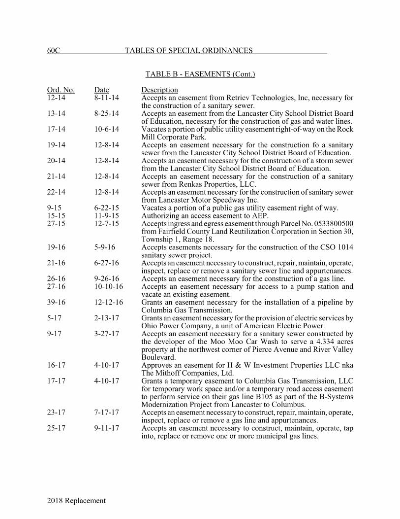
2018 Replacement
60C TABLES OF SPECIAL ORDINANCES
TABLE B - EASEMENTS (Cont.)
Ord. No. Date Description12-14 8-11-14 Accepts an easement from Retriev Technologies, Inc, necessary for
the construction of a sanitary sewer.13-14 8-25-14 Accepts an easement from the Lancaster City School District Board
of Education, necessary for the construction of gas and water lines.17-14 10-6-14 Vacates a portion of public utility easement right-of-way on the Rock
Mill Corporate Park.19-14 12-8-14 Accepts an easement necessary for the construction fo a sanitary
sewer from the Lancaster City School District Board of Education.20-14 12-8-14 Accepts an easement necessary for the construction of a storm sewer
from the Lancaster City School District Board of Education.21-14 12-8-14 Accepts an easement necessary for the construction of a sanitary
sewer from Renkas Properties, LLC.22-14 12-8-14 Accepts an easement necessary for the construction of sanitary sewer
from Lancaster Motor Speedway Inc.9-15 6-22-15 Vacates a portion of a public gas utility easement right of way.15-15 11-9-15 Authorizing an access easement to AEP.27-15 12-7-15 Accepts ingress and egress easement through Parcel No. 0533800500
from Fairfield County Land Reutilization Corporation in Section 30,Township 1, Range 18.
19-16 5-9-16 Accepts easements necessary for the construction of the CSO 1014sanitary sewer project.
21-16 6-27-16 Accepts an easement necessary to construct, repair, maintain, operate,inspect, replace or remove a sanitary sewer line and appurtenances.
26-16 9-26-16 Accepts an easement necessary for the construction of a gas line.27-16 10-10-16 Accepts an easement necessary for access to a pump station and
vacate an existing easement.39-16 12-12-16 Grants an easement necessary for the installation of a pipeline by
Columbia Gas Transmission.5-17 2-13-17 Grants an easement necessary for the provision of electric services by
Ohio Power Company, a unit of American Electric Power.9-17 3-27-17 Accepts an easement necessary for a sanitary sewer constructed by
the developer of the Moo Moo Car Wash to serve a 4.334 acresproperty at the northwest corner of Pierce Avenue and River ValleyBoulevard.
16-17 4-10-17 Approves an easement for H & W Investment Properties LLC nkaThe Mithoff Companies, Ltd.
17-17 4-10-17 Grants a temporary easement to Columbia Gas Transmission, LLCfor temporary work space and/or a temporary road access easementto perform service on their gas line B105 as part of the B-SystemsModernization Project from Lancaster to Columbus.
23-17 7-17-17 Accepts an easement necessary to construct, repair, maintain, operate,inspect, replace or remove a gas line and appurtenances.
25-17 9-11-17 Accepts an easement necessary to construct, maintain, operate, tapinto, replace or remove one or more municipal gas lines.

2018 Replacement
TABLES OF SPECIAL ORDINANCES 60D
TABLE B - EASEMENTS (Cont.)
Ord. No. Date Description26-17 9-11-17 Accepts an access easement necessary for use as a vehicle
turnaround.32-17 11-13-17 Accepts an easement necessary to construct, repair, maintain, operate,
inspect, replace or remove a gas line and appurtenances.33-17 11-13-17 Accepts an easement necessary to construct, repair, maintain, operate,
inspect, replace or remove a gas line and appurtenances.11-18 9-10-18 Grants an easement necessary for the provision of electric services by
Ohio Power Company, a unit of American Electric Power.13-18 9-24-18 Approves an easement for Fairfield Homes, Inc.
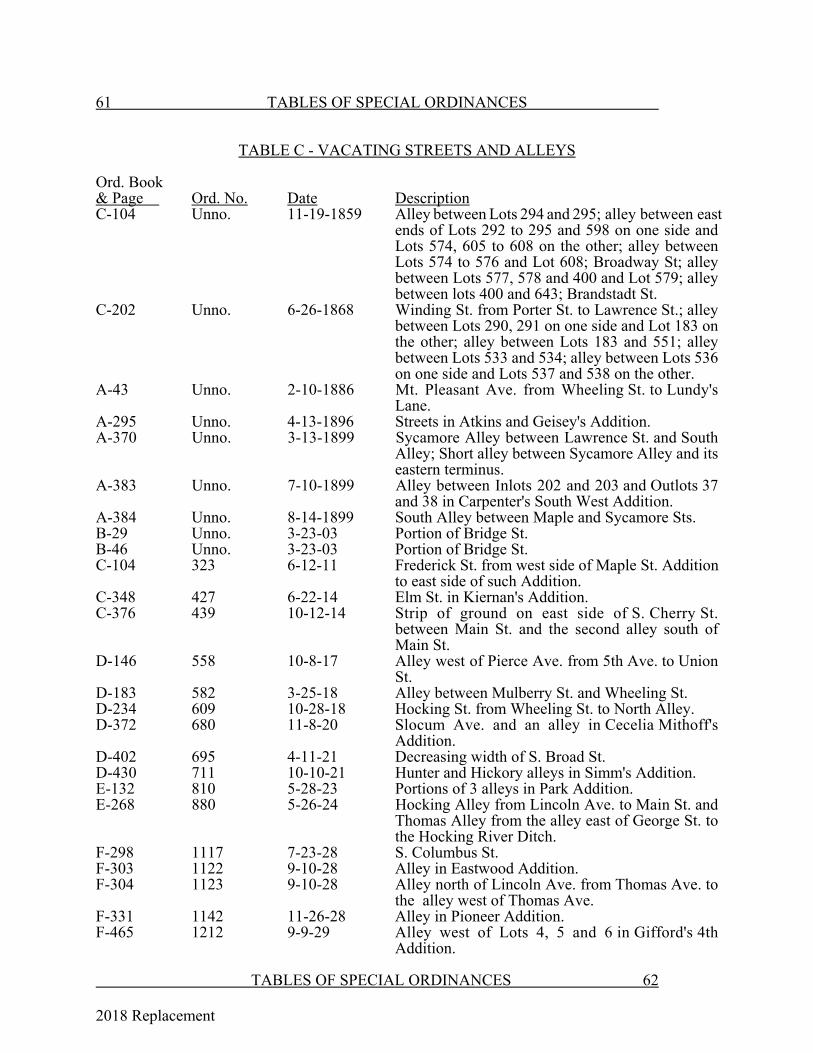
2018 Replacement
61 TABLES OF SPECIAL ORDINANCES
TABLE C - VACATING STREETS AND ALLEYS
Ord. Book& Page Ord. No. Date DescriptionC-104 Unno. 11-19-1859 Alley between Lots 294 and 295; alley between east
ends of Lots 292 to 295 and 598 on one side andLots 574, 605 to 608 on the other; alley betweenLots 574 to 576 and Lot 608; Broadway St; alleybetween Lots 577, 578 and 400 and Lot 579; alleybetween lots 400 and 643; Brandstadt St.
C-202 Unno. 6-26-1868 Winding St. from Porter St. to Lawrence St.; alleybetween Lots 290, 291 on one side and Lot 183 onthe other; alley between Lots 183 and 551; alleybetween Lots 533 and 534; alley between Lots 536on one side and Lots 537 and 538 on the other.
A-43 Unno. 2-10-1886 Mt. Pleasant Ave. from Wheeling St. to Lundy'sLane.
A-295 Unno. 4-13-1896 Streets in Atkins and Geisey's Addition.A-370 Unno. 3-13-1899 Sycamore Alley between Lawrence St. and South
Alley; Short alley between Sycamore Alley and itseastern terminus.
A-383 Unno. 7-10-1899 Alley between Inlots 202 and 203 and Outlots 37and 38 in Carpenter's South West Addition.
A-384 Unno. 8-14-1899 South Alley between Maple and Sycamore Sts.B-29 Unno. 3-23-03 Portion of Bridge St.B-46 Unno. 3-23-03 Portion of Bridge St.C-104 323 6-12-11 Frederick St. from west side of Maple St. Addition
to east side of such Addition.C-348 427 6-22-14 Elm St. in Kiernan's Addition.C-376 439 10-12-14 Strip of ground on east side of S. Cherry St.
between Main St. and the second alley south ofMain St.
D-146 558 10-8-17 Alley west of Pierce Ave. from 5th Ave. to UnionSt.
D-183 582 3-25-18 Alley between Mulberry St. and Wheeling St.D-234 609 10-28-18 Hocking St. from Wheeling St. to North Alley.D-372 680 11-8-20 Slocum Ave. and an alley in Cecelia Mithoff's
Addition.D-402 695 4-11-21 Decreasing width of S. Broad St.D-430 711 10-10-21 Hunter and Hickory alleys in Simm's Addition.E-132 810 5-28-23 Portions of 3 alleys in Park Addition.E-268 880 5-26-24 Hocking Alley from Lincoln Ave. to Main St. and
Thomas Alley from the alley east of George St. tothe Hocking River Ditch.
F-298 1117 7-23-28 S. Columbus St.F-303 1122 9-10-28 Alley in Eastwood Addition.F-304 1123 9-10-28 Alley north of Lincoln Ave. from Thomas Ave. to
the alley west of Thomas Ave.F-331 1142 11-26-28 Alley in Pioneer Addition.F-465 1212 9-9-29 Alley west of Lots 4, 5 and 6 in Gifford's 4th
Addition.
TABLES OF SPECIAL ORDINANCES 62
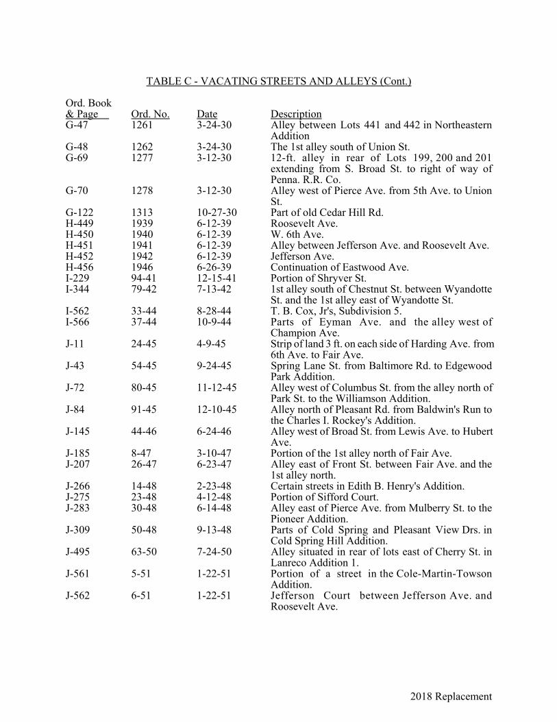
2018 Replacement
TABLE C - VACATING STREETS AND ALLEYS (Cont.)
Ord. Book& Page Ord. No. Date DescriptionG-47 1261 3-24-30 Alley between Lots 441 and 442 in Northeastern
AdditionG-48 1262 3-24-30 The 1st alley south of Union St.G-69 1277 3-12-30 12-ft. alley in rear of Lots 199, 200 and 201
extending from S. Broad St. to right of way ofPenna. R.R. Co.
G-70 1278 3-12-30 Alley west of Pierce Ave. from 5th Ave. to UnionSt.
G-122 1313 10-27-30 Part of old Cedar Hill Rd.H-449 1939 6-12-39 Roosevelt Ave.H-450 1940 6-12-39 W. 6th Ave.H-451 1941 6-12-39 Alley between Jefferson Ave. and Roosevelt Ave.H-452 1942 6-12-39 Jefferson Ave.H-456 1946 6-26-39 Continuation of Eastwood Ave.I-229 94-41 12-15-41 Portion of Shryver St.I-344 79-42 7-13-42 1st alley south of Chestnut St. between Wyandotte
St. and the 1st alley east of Wyandotte St.I-562 33-44 8-28-44 T. B. Cox, Jr's, Subdivision 5.I-566 37-44 10-9-44 Parts of Eyman Ave. and the alley west of
Champion Ave.J-11 24-45 4-9-45 Strip of land 3 ft. on each side of Harding Ave. from
6th Ave. to Fair Ave.J-43 54-45 9-24-45 Spring Lane St. from Baltimore Rd. to Edgewood
Park Addition.J-72 80-45 11-12-45 Alley west of Columbus St. from the alley north of
Park St. to the Williamson Addition.J-84 91-45 12-10-45 Alley north of Pleasant Rd. from Baldwin's Run to
the Charles I. Rockey's Addition.J-145 44-46 6-24-46 Alley west of Broad St. from Lewis Ave. to Hubert
Ave.J-185 8-47 3-10-47 Portion of the 1st alley north of Fair Ave.J-207 26-47 6-23-47 Alley east of Front St. between Fair Ave. and the
1st alley north.J-266 14-48 2-23-48 Certain streets in Edith B. Henry's Addition.J-275 23-48 4-12-48 Portion of Sifford Court.J-283 30-48 6-14-48 Alley east of Pierce Ave. from Mulberry St. to the
Pioneer Addition.J-309 50-48 9-13-48 Parts of Cold Spring and Pleasant View Drs. in
Cold Spring Hill Addition.J-495 63-50 7-24-50 Alley situated in rear of lots east of Cherry St. in
Lanreco Addition 1.J-561 5-51 1-22-51 Portion of a street in the Cole-Martin-Towson
Addition.J-562 6-51 1-22-51 Jefferson Court between Jefferson Ave. and
Roosevelt Ave.
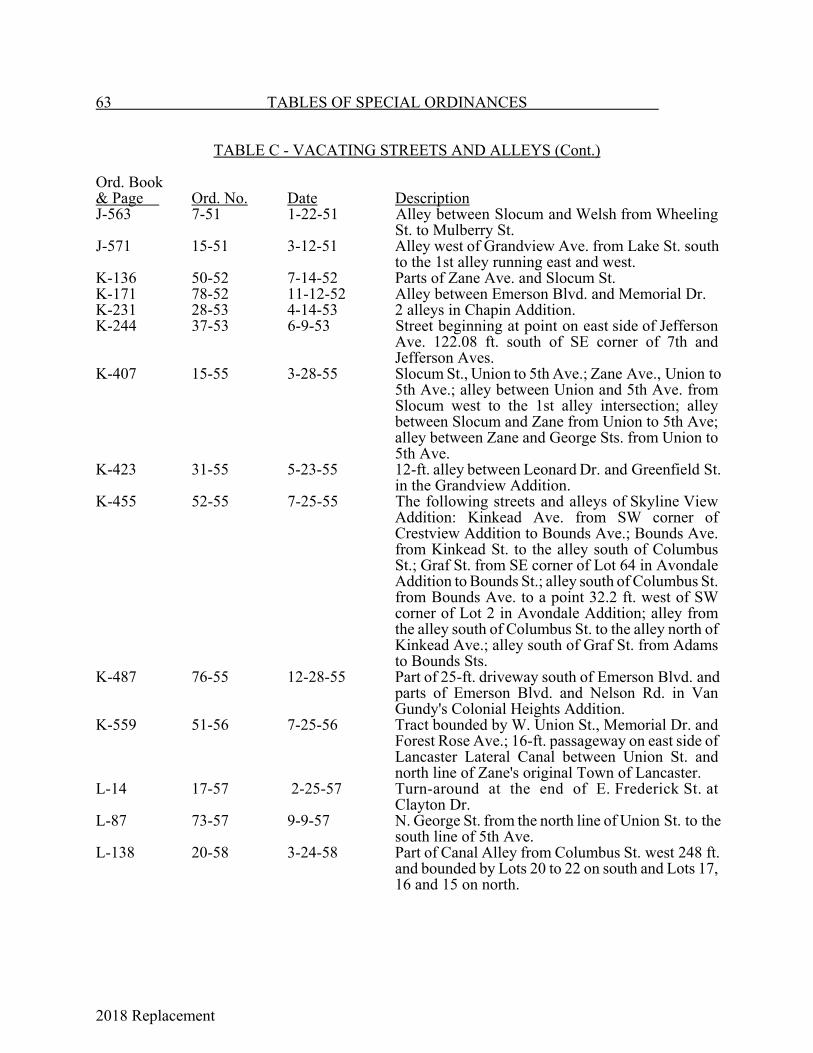
2018 Replacement
63 TABLES OF SPECIAL ORDINANCES
TABLE C - VACATING STREETS AND ALLEYS (Cont.)
Ord. Book& Page Ord. No. Date DescriptionJ-563 7-51 1-22-51 Alley between Slocum and Welsh from Wheeling
St. to Mulberry St.J-571 15-51 3-12-51 Alley west of Grandview Ave. from Lake St. south
to the 1st alley running east and west.K-136 50-52 7-14-52 Parts of Zane Ave. and Slocum St.K-171 78-52 11-12-52 Alley between Emerson Blvd. and Memorial Dr.K-231 28-53 4-14-53 2 alleys in Chapin Addition.K-244 37-53 6-9-53 Street beginning at point on east side of Jefferson
Ave. 122.08 ft. south of SE corner of 7th andJefferson Aves.
K-407 15-55 3-28-55 Slocum St., Union to 5th Ave.; Zane Ave., Union to5th Ave.; alley between Union and 5th Ave. fromSlocum west to the 1st alley intersection; alleybetween Slocum and Zane from Union to 5th Ave;alley between Zane and George Sts. from Union to5th Ave.
K-423 31-55 5-23-55 12-ft. alley between Leonard Dr. and Greenfield St.in the Grandview Addition.
K-455 52-55 7-25-55 The following streets and alleys of Skyline ViewAddition: Kinkead Ave. from SW corner ofCrestview Addition to Bounds Ave.; Bounds Ave.from Kinkead St. to the alley south of ColumbusSt.; Graf St. from SE corner of Lot 64 in AvondaleAddition to Bounds St.; alley south of Columbus St.from Bounds Ave. to a point 32.2 ft. west of SWcorner of Lot 2 in Avondale Addition; alley fromthe alley south of Columbus St. to the alley north ofKinkead Ave.; alley south of Graf St. from Adamsto Bounds Sts.
K-487 76-55 12-28-55 Part of 25-ft. driveway south of Emerson Blvd. andparts of Emerson Blvd. and Nelson Rd. in VanGundy's Colonial Heights Addition.
K-559 51-56 7-25-56 Tract bounded by W. Union St., Memorial Dr. andForest Rose Ave.; 16-ft. passageway on east side ofLancaster Lateral Canal between Union St. andnorth line of Zane's original Town of Lancaster.
L-14 17-57 2-25-57 Turn-around at the end of E. Frederick St. atClayton Dr.
L-87 73-57 9-9-57 N. George St. from the north line of Union St. to thesouth line of 5th Ave.
L-138 20-58 3-24-58 Part of Canal Alley from Columbus St. west 248 ft.and bounded by Lots 20 to 22 on south and Lots 17,16 and 15 on north.
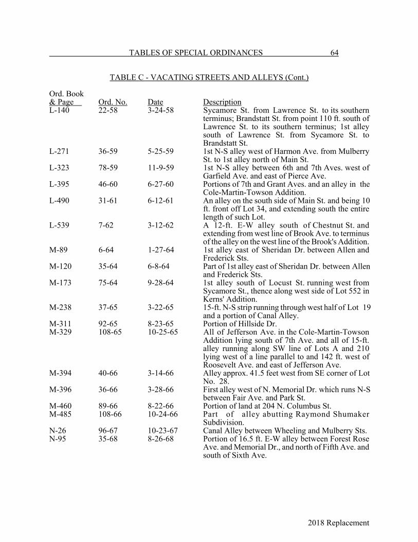
2018 Replacement
TABLES OF SPECIAL ORDINANCES 64
TABLE C - VACATING STREETS AND ALLEYS (Cont.)
Ord. Book& Page Ord. No. Date DescriptionL-140 22-58 3-24-58 Sycamore St. from Lawrence St. to its southern
terminus; Brandstatt St. from point 110 ft. south ofLawrence St. to its southern terminus; 1st alleysouth of Lawrence St. from Sycamore St. toBrandstatt St.
L-271 36-59 5-25-59 1st N-S alley west of Harmon Ave. from MulberrySt. to 1st alley north of Main St.
L-323 78-59 11-9-59 1st N-S alley between 6th and 7th Aves. west ofGarfield Ave. and east of Pierce Ave.
L-395 46-60 6-27-60 Portions of 7th and Grant Aves. and an alley in theCole-Martin-Towson Addition.
L-490 31-61 6-12-61 An alley on the south side of Main St. and being 10ft. front off Lot 34, and extending south the entirelength of such Lot.
L-539 7-62 3-12-62 A 12-ft. E-W alley south of Chestnut St. andextending from west line of Brook Ave. to terminusof the alley on the west line of the Brook's Addition.
M-89 6-64 1-27-64 1st alley east of Sheridan Dr. between Allen andFrederick Sts.
M-120 35-64 6-8-64 Part of 1st alley east of Sheridan Dr. between Allenand Frederick Sts.
M-173 75-64 9-28-64 1st alley south of Locust St. running west fromSycamore St., thence along west side of Lot 552 inKerns' Addition.
M-238 37-65 3-22-65 15-ft. N-S strip running through west half of Lot 19and a portion of Canal Alley.
M-311 92-65 8-23-65 Portion of Hillside Dr.M-329 108-65 10-25-65 All of Jefferson Ave. in the Cole-Martin-Towson
Addition lying south of 7th Ave. and all of 15-ft.alley running along SW line of Lots A and 210lying west of a line parallel to and 142 ft. west ofRoosevelt Ave. and east of Jefferson Ave.
M-394 40-66 3-14-66 Alley approx. 41.5 feet west from SE corner of LotNo. 28.
M-396 36-66 3-28-66 First alley west of N. Memorial Dr. which runs N-Sbetween Fair Ave. and Park St.
M-460 89-66 8-22-66 Portion of land at 204 N. Columbus St.M-485 108-66 10-24-66 Part of alley abutting Raymond Shumaker
Subdivision.N-26 96-67 10-23-67 Canal Alley between Wheeling and Mulberry Sts.N-95 35-68 8-26-68 Portion of 16.5 ft. E-W alley between Forest Rose
Ave. and Memorial Dr., and north of Fifth Ave. andsouth of Sixth Ave.
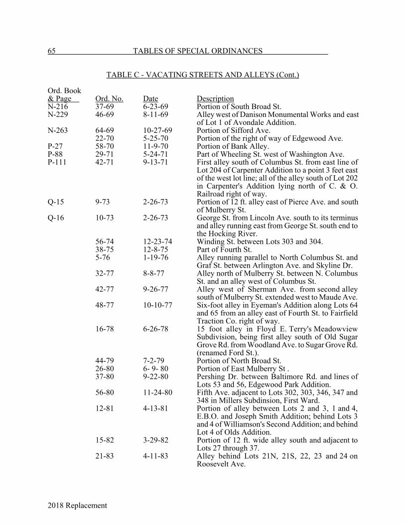
2018 Replacement
65 TABLES OF SPECIAL ORDINANCES
TABLE C - VACATING STREETS AND ALLEYS (Cont.)
Ord. Book& Page Ord. No. Date DescriptionN-216 37-69 6-23-69 Portion of South Broad St.N-229 46-69 8-11-69 Alley west of Danison Monumental Works and east
of Lot 1 of Avondale Addition.N-263 64-69 10-27-69 Portion of Sifford Ave.
22-70 5-25-70 Portion of the right of way of Edgewood Ave.P-27 58-70 11-9-70 Portion of Bank Alley.P-88 29-71 5-24-71 Part of Wheeling St. west of Washington Ave.P-111 42-71 9-13-71 First alley south of Columbus St. from east line of
Lot 204 of Carpenter Addition to a point 3 feet eastof the west lot line; all of the alley south of Lot 202in Carpenter's Addition lying north of C. & O.Railroad right of way.
Q-15 9-73 2-26-73 Portion of 12 ft. alley east of Pierce Ave. and southof Mulberry St.
Q-16 10-73 2-26-73 George St. from Lincoln Ave. south to its terminusand alley running east from George St. south end tothe Hocking River.
56-74 12-23-74 Winding St. between Lots 303 and 304.38-75 12-8-75 Part of Fourth St.5-76 1-19-76 Alley running parallel to North Columbus St. and
Graf St. between Arlington Ave. and Skyline Dr.32-77 8-8-77 Alley north of Mulberry St. between N. Columbus
St. and an alley west of Columbus St.42-77 9-26-77 Alley west of Sherman Ave. from second alley
south of Mulberry St. extended west to Maude Ave.48-77 10-10-77 Six-foot alley in Eyeman's Addition along Lots 64
and 65 from an alley east of Fourth St. to FairfieldTraction Co. right of way.
16-78 6-26-78 15 foot alley in Floyd E. Terry's MeadowviewSubdivision, being first alley south of Old SugarGrove Rd. from Woodland Ave. to Sugar Grove Rd.(renamed Ford St.).
44-79 7-2-79 Portion of North Broad St.26-80 6- 9- 80 Portion of East Mulberry St .37-80 9-22-80 Pershing Dr. between Baltimore Rd. and lines of
Lots 53 and 56, Edgewood Park Addition.56-80 11-24-80 Fifth Ave. adjacent to Lots 302, 303, 346, 347 and
348 in Millers Subdinsion, First Ward.12-81 4-13-81 Portion of alley between Lots 2 and 3, 1 and 4,
E.B.O. and Joseph Smith Addition; behind Lots 3and 4 of Williamson's Second Addition; and behindLot 4 of Olds Addition.
15-82 3-29-82 Portion of 12 ft. wide alley south and adjacent toLots 27 through 37.
21-83 4-11-83 Alley behind Lots 21N, 21S, 22, 23 and 24 onRoosevelt Ave.
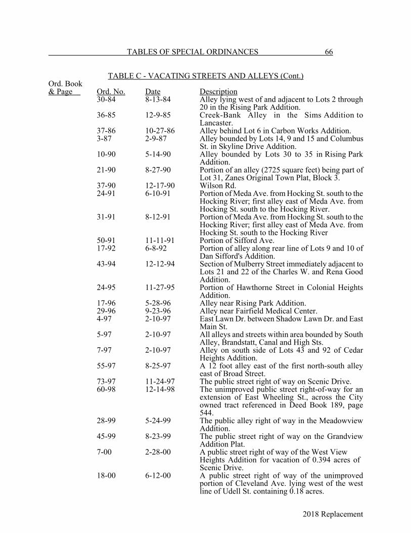
2018 Replacement
TABLES OF SPECIAL ORDINANCES 66
TABLE C - VACATING STREETS AND ALLEYS (Cont.)Ord. Book& Page Ord. No. Date Description
30-84 8-13-84 Alley lying west of and adjacent to Lots 2 through20 in the Rising Park Addition.
36-85 12-9-85 Creek-Bank Alley in the Sims Addition toLancaster.
37-86 10-27-86 Alley behind Lot 6 in Carbon Works Addition.3-87 2-9-87 Alley bounded by Lots 14, 9 and 15 and Columbus
St. in Skyline Drive Addition.10-90 5-14-90 Alley bounded by Lots 30 to 35 in Rising Park
Addition.21-90 8-27-90 Portion of an alley (2725 square feet) being part of
Lot 31, Zanes Original Town Plat, Block 3.37-90 12-17-90 Wilson Rd.24-91 6-10-91 Portion of Meda Ave. from Hocking St. south to the
Hocking River; first alley east of Meda Ave. fromHocking St. south to the Hocking River.
31-91 8-12-91 Portion of Meda Ave. from Hocking St. south to theHocking River; first alley east of Meda Ave. fromHocking St. south to the Hocking River
50-91 11-11-91 Portion of Sifford Ave.17-92 6-8-92 Portion of alley along rear line of Lots 9 and 10 of
Dan Sifford's Addition. 43-94 12-12-94 Section of Mulberry Street immediately adjacent to
Lots 21 and 22 of the Charles W. and Rena GoodAddition.
24-95 11-27-95 Portion of Hawthorne Street in Colonial HeightsAddition.
17-96 5-28-96 Alley near Rising Park Addition.29-96 9-23-96 Alley near Fairfield Medical Center.4-97 2-10-97 East Lawn Dr. between Shadow Lawn Dr. and East
Main St.5-97 2-10-97 All alleys and streets within area bounded by South
Alley, Brandstatt, Canal and High Sts.7-97 2-10-97 Alley on south side of Lots 43 and 92 of Cedar
Heights Addition.55-97 8-25-97 A 12 foot alley east of the first north-south alley
east of Broad Street.73-97 11-24-97 The public street right of way on Scenic Drive.60-98 12-14-98 The unimproved public street right-of-way for an
extension of East Wheeling St., across the Cityowned tract referenced in Deed Book 189, page544.
28-99 5-24-99 The public alley right of way in the MeadowviewAddition.
45-99 8-23-99 The public street right of way on the GrandviewAddition Plat.
7-00 2-28-00 A public street right of way of the West ViewHeights Addition for vacation of 0.394 acres of Scenic Drive.
18-00 6-12-00 A public street right of way of the unimprovedportion of Cleveland Ave. lying west of the westline of Udell St. containing 0.18 acres.
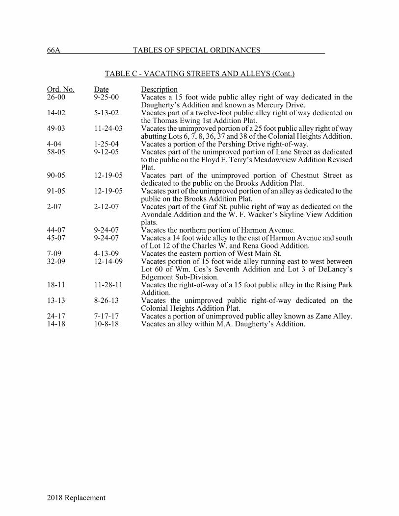
2018 Replacement
66A TABLES OF SPECIAL ORDINANCES
TABLE C - VACATING STREETS AND ALLEYS (Cont.)
Ord. No. Date Description26-00 9-25-00 Vacates a 15 foot wide public alley right of way dedicated in the
Daugherty’s Addition and known as Mercury Drive.14-02 5-13-02 Vacates part of a twelve-foot public alley right of way dedicated on
the Thomas Ewing 1st Addition Plat.49-03 11-24-03 Vacates the unimproved portion of a 25 foot public alley right of way
abutting Lots 6, 7, 8, 36, 37 and 38 of the Colonial Heights Addition.4-04 1-25-04 Vacates a portion of the Pershing Drive right-of-way.58-05 9-12-05 Vacates part of the unimproved portion of Lane Street as dedicated
to the public on the Floyd E. Terry’s Meadowview Addition RevisedPlat.
90-05 12-19-05 Vacates part of the unimproved portion of Chestnut Street asdedicated to the public on the Brooks Addition Plat.
91-05 12-19-05 Vacates part of the unimproved portion of an alley as dedicated to thepublic on the Brooks Addition Plat.
2-07 2-12-07 Vacates part of the Graf St. public right of way as dedicated on theAvondale Addition and the W. F. Wacker’s Skyline View Additionplats.
44-07 9-24-07 Vacates the northern portion of Harmon Avenue.45-07 9-24-07 Vacates a 14 foot wide alley to the east of Harmon Avenue and south
of Lot 12 of the Charles W. and Rena Good Addition.7-09 4-13-09 Vacates the eastern portion of West Main St.32-09 12-14-09 Vacates portion of 15 foot wide alley running east to west between
Lot 60 of Wm. Cos’s Seventh Addition and Lot 3 of DeLancy’sEdgemont Sub-Division.
18-11 11-28-11 Vacates the right-of-way of a 15 foot public alley in the Rising ParkAddition.
13-13 8-26-13 Vacates the unimproved public right-of-way dedicated on theColonial Heights Addition Plat.
24-17 7-17-17 Vacates a portion of unimproved public alley known as Zane Alley.14-18 10-8-18 Vacates an alley within M.A. Daugherty’s Addition.

2018 Replacement
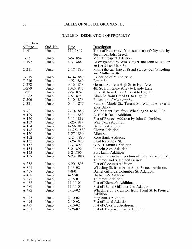
2018 Replacement
67 TABLES OF SPECIAL ORDINANCES
TABLE D - DEDICATION OF PROPERTY
Ord. Book& Page Ord. No. Date DescriptionI-141 Unno. 112-1849 Tract of New Grave Yard southeast of City held by
deed from John Creed.C-53 Unno. 6-5-1854 Mount Prospect Addition.C-197 Unno. 4-3-1868 Alley granted by Wm. Geiger and John M. Miller
on Lot 34 on Main St.C-211 Unno. 2-17-1869 Fixing the east line of Broad St. between Wheeling
and Mulberry Sts.C-215 Unno. 4-14-1869 Extension of Mulberry St.C-216 Unno. 4-22-1869 Porter St.C-278 Unno. 9-16-1873 German St. from High St. to Hop Ave.C-279 Unno. 10-2-1873 4th St. from Zane Alley to Lundy Lane.C-281 Unno. 2-5-1874 Lake St. from Broad St. east to High St.C-282 Unno. 2-5-1874 Allen St. from Broad St. to High St.C-306 Unno. 3-10-1876 Extension of Mulberry St.C-321 Unno. 6-11-1877 Parts of Maple St., Tenant St., Walnut Alley and
Short Alley.A-43 Unno. 2-10-1886 Mt. Pleasant Ave. from Wheeling St. to Mill St.A-129 Unno. 3-11-1889 A. H. Chaffee's Addition.A-130 Unno. 3-11-1889 Plat of Pioneer Addition by John G. Deshler.A-133 Unno. 3-25-1889 Wm. Cox's Addition.A-134 Unno. 4-29-1889 Barrett's Addition.A-148 Unno. 11-25-1889 Chapin Addition.A-150 Unno. 1-27-1890 Allen St.A-152 Unno. 2-24-1890 Rose Bank Addition.A-152 Unno. 2-26-1890 Land for Maple St.A-153 Unno. 3-3-1890 G.W.H. Smith's Addition.A-154 Unno. 5-2-1890 Lincoln Ave. Addition.A-155 Unno. 6-2-1890 East Lawn Addition.A-157 Unno. 6-23-1890 Streets in southern portion of City laid off by M.
Thimmes and S. Herbert Geisey.A-358 Unno. 6-20-1898 Plat of Slocum's Addition.A-341 Unno. 1-13-02 Wheeling St. from Front St. to Pioneer Addition.A-457 Unno 4-8-01 Daniel Gifford's Columbus St. Addition.A-458 Unno. 4-22-01 Harbaugh's Addition.A-477 Unno. 2-18-01 Thimmes' Addition.A-488 Unno. 11-11-01 Plat of Kiernan's Addition.A-489 Unno. 11-11-01 Plat of Daniel Gifford's 2nd Addition.A-492 Unno. 1-13-02 Wheeling St. extension from Front St. to Pioneer
Addition.A-493 Unno. 2-10-02 Singleton's Addition.A-494 Unno. 2-10-02 Plat of Isabel Addition.A-499 Unno. 2-10-02 Plat of Cox's 3rd Addition.A-501 Unno. 5-26-02 Plat of Thomas B. Cox's Addition.
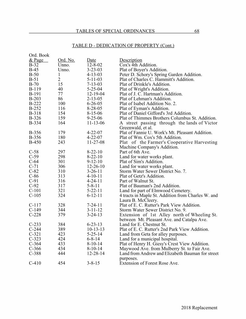
2018 Replacement
TABLES OF SPECIAL ORDINANCES 68
TABLE D - DEDICATION OF PROPERTY (Cont.)
Ord. Book& Page Ord. No. Date DescriptionB-32 Unno. 12-8-02 Cox's 4th Addition.B-45 Unno. 3-23-03 Plat of Boyer's Addition.B-50 1 4-13-03 Peter D. Schory's Spring Garden Addition.B-51 2 5-11-03 Plat of Charles C. Hammitt's Addition.B-70 15 7-13-03 Plat of Drinkle's Addition.B-119 40 5-25-04 Plat of Wright's Addition.B-191 77 12-19-04 Plat of J. C. Hartman's Addition.B-203 86 2-13-05 Plat of Lehman's Addition.B-222 100 6-26-05 Plat of Isabel Addition No. 2.B-252 116 8-28-05 Plat of Eyman's Addition.B-318 154 8-15-06 Plat of Daniel Gifford's 3rd Addition.B-326 159 9-25-06 Plat of Thimmes Brothers Columbus St. Addition.B-334 164 11-13-06 A street passing through the lands of Victor
Greenwald, et al.B-356 179 4-22-07 Plat of Fannie U. Work's Mt. Pleasant Addition.B-356 180 4-22-07 Plat of Wm. Cox's 5th Addition.B-450 243 11-27-08 Plat of the Farmer's Cooperative Harvesting
Machine Company's Addition.C-58 297 8-22-10 Part of 6th Ave.C-59 298 8-22-10 Land for water works plant.C-64 301 9-12-10 Plat of Sim's Addition.C-71 306 12-26-10 Land for water works plant.C-82 310 3-26-11 Storm Water Sewer District No. 7.C-86 313 4-10-11 Plat of Getz's Addition.C-91 316 4-24-11 Part of Walnut St.C-92 317 5-8-11 Plat of Bauman's 2nd Addition.C-101 321 5-22-11 Land for part of Elmwood Cemetery.C-105 324 6-12-11 4 tracts in Maple St. Addition from Charles W. and
Laura B. McCleery.C-117 328 7-24-11 Plat of E. C. Rutter's Park View Addition.C-149 344 3-11-12 Storm Water Sewer District No. 9.C-228 379 3-24-13 Extension of 1st Alley north of Wheeling St.
between Mt. Pleasant Ave. and Catalpa Ave.C-233 384 6-23-13 Land for E. Chestnut St.C-244 389 10-13-13 Plat of E. C. Rutter's 2nd Park View Addition.C-321 423 5-25-14 Land from Geta for alley purposes.C-323 424 6-8-14 Land for a municipal hospital.C-364 433 8-10-14 Plat of Henry H. Giesy's Crest View Addition.C-366 434 8-10-14 Maywood Ave. from Mulberry St. to Fair Ave.C-388 444 12-28-14 Land from Andrew and Elizabeth Bauman for street
purposes.C-410 454 3-8-15 Extension of Forest Rose Ave.
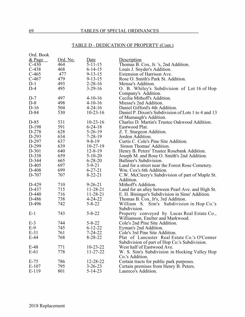
2018 Replacement
69 TABLES OF SPECIAL ORDINANCES
TABLE D - DEDICATION OF PROPERTY (Cont.)
Ord. Book& Page Ord. No. Date DescriptionC-430 464 5-11-15 Thomas B. Cox, Jr. 's, 2nd Addition.C-438 468 6-14-15 Louis J. Snyder's Addition.C-465 477 9-13-15 Extension of Harrison Ave.C-467 479 9-13-15 Rose O. Smith's Park St. Addition.D-1 493 2-28-16 Meisse's Addition.D-4 495 3-29-16 O. B. Whiley's Subdivision of Lot 16 of Hop
Company's Addition.D-7 497 4-10-16 Cecilia Mithoff's Addition.D-8 498 4-10-16 Miesse's 2nd Addition.D-16 504 4-24-16 Daniel Gifford's 4th Addition.D-84 530 10-23-16 Daniel P. Dixon's Subdivision of Lots 1 to 4 and 13
of Mumaugh's Addition.D-85 531 10-23-16 Charles D. Martin's Trustee Oakwood Addition.D-198 591 6-24-18 Eastwood Plat.D-278 628 5-26-19 Z. T. Sturgeon Addition.D-293 634 7-28-19 Jordon Addition.D-297 637 9-8-19 Curtis C. Cole's Pine Site Addition.D-299 639 10-27-19 Simon Thomas' Addition.D-301 640 12-8-19 Henry B. Peters' Trustee Rosebank Addition.D-338 659 5-10-20 Joseph M. and Rose O. Smith's 2nd Addition.D-344 665 6-28-20 Ballmer's Subdivision.D-405 697 5-9-21 Land for a street near the Forest Rose Cemetery.D-408 699 6-27-21 Wm. Cox's 6th Addition.D-707 707 8-22-21 C.W. McCleery's Subdivision of part of Maple St.
Addition.D-429 710 9-26-21 Mithoff's Addition.D-437 715 11-28-21 Land for an alley between Pearl Ave. and High St.D-440 716 11-28-21 E. H. Bininger's Subdivision in Sims' Addition.D-486 738 4-24-22 Thomas B. Cox, Jr's, 3rd Addition.D-496 742 5-8-22 William S. Sim's Subdivision in Hop Co.'s
Subdivision.E-1 743 5-8-22 Property conveyed by Lucas Real Estate Co.,
Williamson, Enelter and Markwood.E-3 744 5-8-22 Cole's 2nd Pine Site Addition.E-9 745 6-12-22 Eyman's 2nd Addition.E-31 761 7-24-22 Cole's 3rd Pine Site Addition.E-44 768 8-28-22 Plat of Lancaster Real Estate Co.'s O'Conner
Subdivision of part of Hop Co.'s Subdivision.E-48 771 10-23-22 West half of Eastwood Ave.E-61 778 11-27-22 W. S. Sim's Subdivision in Hocking Valley Hop
Co.'s Addition.E-75 786 12-28-22 Certain tracts for public park purposes.E-107 795 3-26-23 Certain premises from Henry B. Peters.E-119 801 5-14-23 Laureco's Addition.
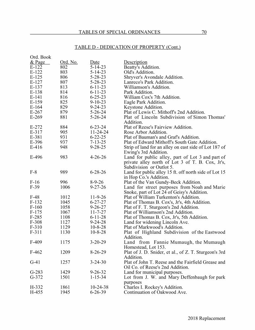
2018 Replacement
TABLES OF SPECIAL ORDINANCES 70
TABLE D - DEDICATION OF PROPERTY (Cont.)
Ord. Book& Page Ord. No. Date DescriptionE-122 802 5-14-23 Beatty's Addition.E-122 803 5-14-23 Old's Addition.E-125 806 5-28-23 Shryver's Avondale Addition.E-127 807 5-28-23 Lanreco's Park Addition.E-137 813 6-11-23 Williamson's Addition.E-138 814 6-11-23 Park Addition.E-141 816 6-25-23 William Cox's 7th Addition.E-159 825 9-10-23 Eagle Park Addition.E-164 829 9-24-23 Keystone Addition.E-267 879 5-26-24 Plat of Lewis C. Mithoff's 2nd Addition.E-269 881 5-26-24 Plat of Lincoln Subdivision of Simon Thomas'
Addition.E-272 884 6-23-24 Plat of Reese's Fairview Addition.E-317 905 11-24-24 Rose Arbor Addition.E-381 931 6-22-25 Plat of Bauman's and Graf's Addition.E-396 937 7-13-25 Plat of Edward Mithoff's South Gate Addition.E-416 948 9-28-25 Strip of land for an alley on east side of Lot 187 of
Ewing's 3rd Addition.E-496 983 4-26-26 Land for public alley, part of Lot 3 and part of
private alley north of Lot 3 of T. B. Cox, Jr's,Subdivision or Outlot 5.
F-8 989 6-28-26 Land for public alley 15 ft. off north side of Lot 15in Hop Co.'s Addition.
F-16 996 8-9-26 Plat of the Van Gundy-Beck Addition.F-39 1006 9-27-26 Land for street purposes from Noah and Marie
Snoke, part of Lot 24 of Geisy's Addition.F-48 1012 11-9-26 Plat of William Turkenton's Addition.F-132 1045 6-27-27 Plat of Thomas B. Cox's, Jr's, 4th Addition.F-160 1058 9-26-27 Plat of F. T. Sturgeon's 2nd Addition.F-175 1067 11-7-27 Plat of Williamson's 2nd Addition.F-285 1108 6-11-28 Plat of Thomas B. Cox, Jr's, 5th Addition.F-308 1127 9-24-28 Land for widening Lincoln Ave.F-310 1129 10-8-28 Plat of Markwood's Addition.F-311 1130 10-8-28 Plat of Highland Subdivision of the Eastwood
Addition.F-409 1175 3-20-29 Land from Fannie Mumaugh, the Mumaugh
Homestead, Lot 153.F-462 1209 8-26-29 Plat of J. D. Snider, et al., of Z. T. Sturgeon's 3rd
Addition.G-41 1257 3-24-30 Plat of John T. Reese and the Fairfield Grease and
Oil Co. of Reese's 2nd Addition.G-283 1429 9-26-32 Land for municipal purposes.G-372 1501 1-15-34 Lot from J. W. and Mary Deffenbaugh for park
purposesH-332 1861 10-24-38 Charles I. Rockey's Addition.H-455 1945 6-26-39 Continuation of Oakwood Ave.
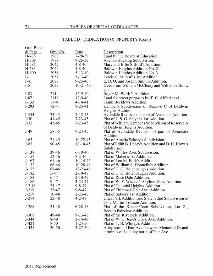
2018 Replacement
71 TABLES OF SPECIAL ORDINANCES
TABLE D - DEDICATION OF PROPERTY (Cont.)
Ord. Book& Page Ord. No. Date DescriptionH-478 1963 7-28-39 Land by the Board of Education.H-508 1989 9-25-39 Anchor-Hocking Subdivision.H-581 2042 4-8-40 Mary and Effie Sifford's Addition.H-583 2044 4-8-40 Baldwin Heights Addition No. 2.H-600 2056 5-13-40 Baldwin Heights Addition No. 3.I-1 2057 5-13-40 Lewis C. Mithoff's 3rd Addition.I-41 2087 9-23-40 E. B. O. and Joseph Smith's Addition.I-51 2093 10-21-40 Deed from William McCleery and William S.Sims,
et al.I-83 2114 12-9-40 Roger M. Work 's Addition.I-87 2118 12-9-40 Land for street purposes by T. C. Alfred et al.I-133 17-41 4-14-41 Frank Beckley's Addition.I-203 72-41 8-25-41 Kemper's Subdivision of Reserve C of Baldwin
Heights Addition.I-454 34-43 7-12-43 Avondale Revision of a part of Avondale Addition.J-30 41-45 7-23-45 Plat of U.S. G. Salyer's 1st Addition.J-32 43-45 7-23-45 Plat of William Kemper's Subdivision of Reserve A
of Baldwin Heights Addition.J-49 58-45 9-24-45 Plat of Avondale Revision of part of Avondale
Addition.J-63 71-45 10-22-45 Plat of Amelia Schory's Subdivision.J-83 90-45 12-10-45 Plat of Edith B. Henry's Addition and D. H. Howe's
Subdivision.J-138 39-46 6-10-46 Plat of Whiley Ave. Subdivision.J-157 52-46 8-2-46 Plat of Maher's 1st Addition.J-167 61-46 10-14-46 Plat of Leo M. Bash's Addition.J-172 66-46 10-28-46 Plat of William S. Donnelly's Addition.J-175 68-46 12-23-46 Plat of C. G. Bolenbaugh's Addition.J-182 5-47 2-10-47 Plat of C. G. Bolenbaugh's Addition.J-183 6-47 2-10-47 Plat of Rose Dale Addition.J-186 9-47 3-24-47 Plat of W. F. Wacker's Skyline View Addition.J-2 18 34-47 9-8-47 Plat of Colonial Heights Addition.J-219 35-47 9-8-47 Plat of Thimmes' Fair Ave. Addition.J-259 10-48 2-23-48 Plat of Salyer's 1st Addition.J-274 22-48 4-2-48 Utica Park Addition and Slater's 2nd Subdivision of
Cole-Martin-Towson Addition.J-288 34-48 6-28-48 Plat of the Kiener-Coen Subdivision, Lot 21,
Reese's Fairview Addition.J-308 49-48 9-13-48 Plat of the Riverside Addition.J-344 8-49 2-14-49 Plat of W. C. Jone's Clark Ave. Addition.J-421 8-50 1-23-50 Plat of T. B. Whiley's Addition.J-435 20-50 3-27-50 Alley north of Fair Ave. between Memorial Dr.and
terminus of 1st alley north of Fair Ave.
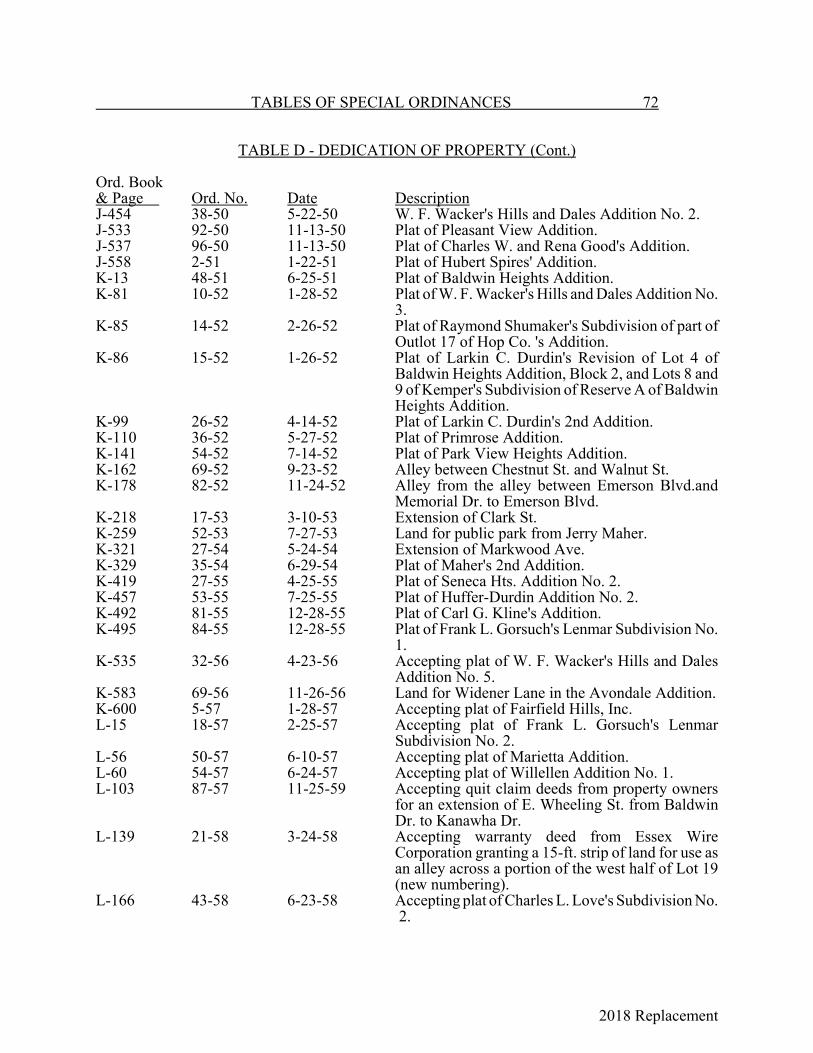
2018 Replacement
TABLES OF SPECIAL ORDINANCES 72
TABLE D - DEDICATION OF PROPERTY (Cont.)
Ord. Book& Page Ord. No. Date DescriptionJ-454 38-50 5-22-50 W. F. Wacker's Hills and Dales Addition No. 2.J-533 92-50 11-13-50 Plat of Pleasant View Addition.J-537 96-50 11-13-50 Plat of Charles W. and Rena Good's Addition.J-558 2-51 1-22-51 Plat of Hubert Spires' Addition.K-13 48-51 6-25-51 Plat of Baldwin Heights Addition.K-81 10-52 1-28-52 Plat of W. F. Wacker's Hills and Dales Addition No.
3.K-85 14-52 2-26-52 Plat of Raymond Shumaker's Subdivision of part of
Outlot 17 of Hop Co. 's Addition.K-86 15-52 1-26-52 Plat of Larkin C. Durdin's Revision of Lot 4 of
Baldwin Heights Addition, Block 2, and Lots 8 and9 of Kemper's Subdivision of Reserve A of BaldwinHeights Addition.
K-99 26-52 4-14-52 Plat of Larkin C. Durdin's 2nd Addition.K-110 36-52 5-27-52 Plat of Primrose Addition.K-141 54-52 7-14-52 Plat of Park View Heights Addition.K-162 69-52 9-23-52 Alley between Chestnut St. and Walnut St.K-178 82-52 11-24-52 Alley from the alley between Emerson Blvd.and
Memorial Dr. to Emerson Blvd.K-218 17-53 3-10-53 Extension of Clark St.K-259 52-53 7-27-53 Land for public park from Jerry Maher.K-321 27-54 5-24-54 Extension of Markwood Ave.K-329 35-54 6-29-54 Plat of Maher's 2nd Addition.K-419 27-55 4-25-55 Plat of Seneca Hts. Addition No. 2.K-457 53-55 7-25-55 Plat of Huffer-Durdin Addition No. 2.K-492 81-55 12-28-55 Plat of Carl G. Kline's Addition.K-495 84-55 12-28-55 Plat of Frank L. Gorsuch's Lenmar Subdivision No.
1.K-535 32-56 4-23-56 Accepting plat of W. F. Wacker's Hills and Dales
Addition No. 5.K-583 69-56 11-26-56 Land for Widener Lane in the Avondale Addition.K-600 5-57 1-28-57 Accepting plat of Fairfield Hills, Inc.L-15 18-57 2-25-57 Accepting plat of Frank L. Gorsuch's Lenmar
Subdivision No. 2.L-56 50-57 6-10-57 Accepting plat of Marietta Addition.L-60 54-57 6-24-57 Accepting plat of Willellen Addition No. 1.L-103 87-57 11-25-59 Accepting quit claim deeds from property owners
for an extension of E. Wheeling St. from BaldwinDr. to Kanawha Dr.
L-139 21-58 3-24-58 Accepting warranty deed from Essex WireCorporation granting a 15-ft. strip of land for use asan alley across a portion of the west half of Lot 19(new numbering).
L-166 43-58 6-23-58 Accepting plat of Charles L. Love's Subdivision No. 2.
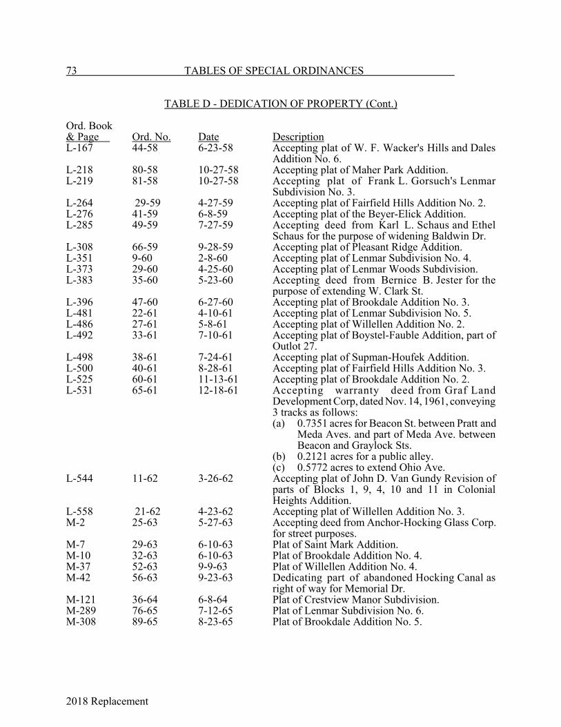
2018 Replacement
73 TABLES OF SPECIAL ORDINANCES
TABLE D - DEDICATION OF PROPERTY (Cont.)
Ord. Book& Page Ord. No. Date DescriptionL-167 44-58 6-23-58 Accepting plat of W. F. Wacker's Hills and Dales
Addition No. 6.L-218 80-58 10-27-58 Accepting plat of Maher Park Addition.L-219 81-58 10-27-58 Accepting plat of Frank L. Gorsuch's Lenmar
Subdivision No. 3.L-264 29-59 4-27-59 Accepting plat of Fairfield Hills Addition No. 2.L-276 41-59 6-8-59 Accepting plat of the Beyer-Elick Addition.L-285 49-59 7-27-59 Accepting deed from Karl L. Schaus and Ethel
Schaus for the purpose of widening Baldwin Dr.L-308 66-59 9-28-59 Accepting plat of Pleasant Ridge Addition.L-351 9-60 2-8-60 Accepting plat of Lenmar Subdivision No. 4.L-373 29-60 4-25-60 Accepting plat of Lenmar Woods Subdivision.L-383 35-60 5-23-60 Accepting deed from Bernice B. Jester for the
purpose of extending W. Clark St.L-396 47-60 6-27-60 Accepting plat of Brookdale Addition No. 3.L-481 22-61 4-10-61 Accepting plat of Lenmar Subdivision No. 5.L-486 27-61 5-8-61 Accepting plat of Willellen Addition No. 2.L-492 33-61 7-10-61 Accepting plat of Boystel-Fauble Addition, part of
Outlot 27.L-498 38-61 7-24-61 Accepting plat of Supman-Houfek Addition.L-500 40-61 8-28-61 Accepting plat of Fairfield Hills Addition No. 3.L-525 60-61 11-13-61 Accepting plat of Brookdale Addition No. 2.L-531 65-61 12-18-61 Accepting warranty deed from Graf Land
Development Corp, dated Nov. 14, 1961, conveying3 tracks as follows:(a) 0.7351 acres for Beacon St. between Pratt and
Meda Aves. and part of Meda Ave. betweenBeacon and Graylock Sts.
(b) 0.2121 acres for a public alley.(c) 0.5772 acres to extend Ohio Ave.
L-544 11-62 3-26-62 Accepting plat of John D. Van Gundy Revision ofparts of Blocks 1, 9, 4, 10 and 11 in ColonialHeights Addition.
L-558 21-62 4-23-62 Accepting plat of Willellen Addition No. 3.M-2 25-63 5-27-63 Accepting deed from Anchor-Hocking Glass Corp.
for street purposes.M-7 29-63 6-10-63 Plat of Saint Mark Addition.M-10 32-63 6-10-63 Plat of Brookdale Addition No. 4.M-37 52-63 9-9-63 Plat of Willellen Addition No. 4.M-42 56-63 9-23-63 Dedicating part of abandoned Hocking Canal as
right of way for Memorial Dr.M-121 36-64 6-8-64 Plat of Crestview Manor Subdivision.M-289 76-65 7-12-65 Plat of Lenmar Subdivision No. 6.M-308 89-65 8-23-65 Plat of Brookdale Addition No. 5.

2018 Replacement
TABLES OF SPECIAL ORDINANCES 74
TABLE D - DEDICATION OF PROPERTY (Cont.)
Ord. Book& Page Ord. No. Date DescriptionM-386 30-66 3-14-66 From Thomas R. Gillooly for 12.5 feet bounded by
Oakwood and Wheeling Sts.M-411 51-66 3-28-66 Dedication of Edgewood Ave.M-417 56-66 4-25-66 Plat of Little Brook Estates No. 1.M-421 60-66 5-23-66 Deed from J. Wilbert Olive et al. for alley purposes,
part of Lot 7 in Reese's Fairview Addition.M-422 61-66 5-23-66 Deed from George H. Alten, being 15.0 feet
adjacent and parallel to east line of Lot 31.M-502 119-66 11-28-66 Deed from Helen Kidd for 1.575 acres in Maher
Park Addition.M-577 63-67 6-26-67 Plat of Conner Land.M-600 80-67 7-24-67 Revised plat of Knollwood Hts.N-120 49-68 9-23-68 Plat of Somerford Square.N-131 57-68 1-13-69 Plat of Lenmar Subdivision No.7.N-215 36-69 6-23-69 Plat of Willellen Subdivision No. 5.O-54 29-70 6-3-70 Accepting deed from Trails End, Inc. of 0.462
acres.O-59 32-70 6-8-70 Deed from Dykes of 4500 square feet.O-70 35-70 6-22-70 Deed from Lancaster National Bank for part of
Outlot 8.O-72 36-70 6-22-70 Deed from Sater for part of Outlot 9.P-112 43-71 9-13-71 Deed from Turner being a 3 foot strip off entire NW
side of the second alley south of Lot 204 ofCarpenter Addition.
P-214 26-72 5-8-72 Plat of Lenmar Subdivision No. 8.P-248 42-72 8-28-72 Plat of Lenmar Subdivision No. 9.Q-50 30-73 8-27-73 Plat of Hunter Trace Estates Part I.Q-81 43-73 9-24-73 Plat of College Green Subdivision.
Ord. No. Date Description7-74 2-11-74 Dedication of Trace Dr. and various easements inHunter Trace
Estates.10-74 2-25-74 Plat of Avery Hills Subdivision Phase One.14-74 3-11-74 Plat of Galeco Hts. Subdivision.36-74 6-24-74 Plat of Harley E. Miller Subdivision.37-74 6-24-74 Plat of Briar Cliff Addition.1-76 1-12-76 .045 acre for alley off of Broad St., being 15 ft. out of the middle of
Lot 5.56-76 12-13-76 .32 acre from Hocking Valley National Bank for street purposes.20-77 4-25-77 Plats of Sheridan-Rainbow Divisions 1 and 2.21-77 5-9-77 Deed from Fairfield County Agricultural Society for street purposes.24-77 6-13-77 Plat of Independence Commons, Phase I.31-77 6-27-77 Plat of Northshire Addition.33-77 8-22-77 Plat of College Ave.38-77 9-12-77 Plat of Hunter Trace, Part II.

2018 Replacement
75 TABLES OF SPECIAL ORDINANCES
TABLE D - DEDICATION OF PROPERTY (Cont.)
Ord. No. Date Description55-77 12-12-77 Deed of 1.64 acres from Jemo Associates, Inc. for street purposes.57-77 12-12-77 Plat of Sheridan-Rainbow Division 5.58-77 12-12-77 Plats of Sheridan-Rainbow Divisions 3 and 4.61-77 12-19-77 Deed from Charles F. Alley for park purposes.15-78 6-26-78 Plat of Hunter-Trace Estates, Section 3.18-78 6-26-78 Plat of Hocking Meadows, Section 1.23-78 8-28-78 Accepting Hawkshire Manor Subdivision.35-78 12-11-78 Accepts 17.66 acres from Mary Cenci for public park purposes.2-79 1-22-79 Accepts deed for 1.086 acres from Clark and DorWart for street
purposes.10-79 2-12-79 Accepts deed for 0.092 acres from Simmons for street purposes.11-79 2-2-79 Accepts deed for 0.037 acres from Finnefrock for street purposes.17-79 3-26-79 Plat of Commerce St. from Quarry Rd. 2586.80 ft. west.18-79 3-26-79 Plat of Second Northshire Addition.25-79 4-23-79 Plat of Sheridan - Rainbow Division 6.36-79 5-21-79 Plat of Briarcliff Subdivision.45-79 8-13-79 Accepts deed for 490 sq. ft. from Equitable Federal Savings and Loan
Assoc. for street purposes.48-79 8-13-79 Accepts deed for 0.138 acres from Washington Ave. Church of Christ
for street purposes.55-79 9-24-79 Plat of Northshire Addition Section 3.61-79 11-12-79 Accepts gift from Charles and Madge Alley for park purposes.63-79 12-3-79 Plat of Second Ave. Subdivision.1-80 1-28-80 Plat of Avery Hills, Section 2.3-80 1-28-80 Plat of East Lancaster Townhouses.42-80 9-22-80 Accepts deed for 0.64 acres from Windsor Place, Ltd. for street
purposes.16-81 6-1-81 Accepting final plat of Hunter Trace Estates, Part IV.35-81 8-10-81 Deed from Windsor Place, Ltd. for street purposes.36-81 8-10-81 Deed from Howard J. and Nancy A. Alspach for street purposes.48-81 9-28-81 Accepts deed from Fairfield County Automobile Club for street
purposes.56-81 11-9-81 Accepts plat of Avery Hills Phase III.59-81 11-9-81 Accepts deed from Lancaster City School District for street purposes.47-82 12-13-82 Accepts deed from Marko Inc. for street purposes.51-82 12-27-82 Accepts deed from Frick Gallager Manufacturing Co. of the west half
of Faulkerson Ave. for street purposes.28-83 8-22-83 Accepts deed from Paul W. Wacker for street purposes.35-83 10-10-83 Accepts the final plat of Avery Hills #4.29-84 8-13-84 Accepts deed from Pleasant Development Corp. for street purposes.53-84 12-17-84 Accepts gift of two parcels comprising 18.94 acres from it Olivedale
Foundation for park purposes.

2018 Replacement
TABLES OF SPECIAL ORDINANCES 76
TABLE D - DEDICATION OF PROPERTY (Cont.)
Ord. No. Date Description9-85 3-11-85 Accepts gift of Lots 1 and 2 of Edith B. Henry Addition from
Columbia Gas Transmission Corp. for public park purposes.10-85 3-11-85 Plat of Deerfield Subdivision.12-85 3-25-85 Plat of Fourth Northshire Addition.30-86 8-25-86 Accepts plat of Avery Hills V.25-87 8-24-87 Accepts plat of Fifth Northshire Subdivision.1-89 1-9-89 Accepts plat of JLA Subdivision.2-89 1-9-89 Accepts plat of Briarcliffe Subdivision.3-89 1-9-89 Accepts plat of Heiber Subdivision.15-89 3-13-89 Accepts plat for public streets and drainage and utility easements in
Rock Mill Industrial Park.19-89 4-10-89 Accepts gift of land from Jack Supman, a 60 foot right of way on
Sheridan Dr.29-89 6-26-89 Accepts plat of Frear Heights Subdivision.30-89 8-14-89 Accepts plat for Sheridan Rainbow No. 7 Subdivision.34-89 9-11-89 Accepts rededication plat of Carbon Works Addition Alley Right- of-
Way.28-90 9-10-90 Plat of Beverly Hills Subdivision.22-91 5-20-91 Plat of Avery Hills No. 6 Subdivision.28-91 6-24-91 Plat of Pairan Woods Subdivision.52-91 11-25-91 Plat of Deacon Hill Phase I Subdivision.37-92 11-23-92 Accepts final plat of Four Seasons Subdivision.38-92 11-23-92 Accepts final plat of Rozin Subdivision I.20-93 5-24-93 Accepts dedication plat for Schorrway Drive.28-93 6-28-93 Accepts final plat of Avery Hills No. 7 Subdivision.29-93 6-28-93 Accepts final plat of Creekside Estates, Phase I Subdivision.34-93 8-9-93 Repeals Ord. 20-93; accepts revised plat of Schorrway Drive.35-93 8-1-93 Accepts dedication of an alley north of Lot No. 6, Block 4, Chapin
Addition.39-93 9-13-93 Accepts Chartwell Section One.22-94 6-13-94 Accepts revised Chartwell Section One Plat dedicating a public street
right of way and drainage and utility easements; Repeals Ordinance39-93.
24-94 6-13-94 Accepts final plat of Sheridan Rainbow Number 8 Subdivision anddedication of streets and utility rights of way.
25-94 6-27-94 Accepts final plat of Pleasant Springs Subdivision.28-94 8-22-94 Accepts final plat of River Valley Highlands Section 1 Subdivision.34-94 10-24-94 Deed from James and Amy Creech for right-of-way purposes.42-94 11-28-94 Plat of Stonegate Meadows Phase I Subdivision.1-95 1-9-95 Plat of Deacon Hill Phase 2 Subdivision.
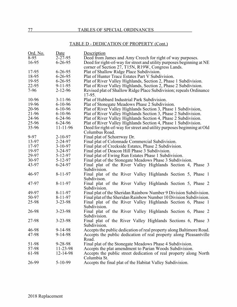
2018 Replacement
77 TABLES OF SPECIAL ORDINANCES
TABLE D - DEDICATION OF PROPERTY (Cont.)
Ord. No. Date Description8-95 2-27-95 Deed from James and Amy Creech for right of way purposes.16-95 6-26-95 Deed for right-of-way for street and utility purposes beginning at NE
corner of Section 27, T15N, R19W, Congress Lands.17-95 6-26-95 Plat of Shallow Ridge Place Subdivision.18-95 6-26-95 Plat of Hunter Trace Estates Part V Subdivision.19-95 6-26-95 Plat of River Valley Highlands, Section 2, Phase 1 Subdivision.22-95 9-11-95 Plat of River Valley Highlands, Section 2, Phase 2 Subdivision.7-96 2-12-96 Revised plat of Shallow Ridge Place Subdivision; repeals Ordinance
17-95.10-96 3-11-96 Plat of Hubbard Industrial Park Subdivision.19-96 6-10-96 Plat of Stonegate Meadows Phase 2 Subdivision.20-96 6-10-96 Plat of River Valley Highlands Section 3, Phase 1 Subdivision,21-96 6-10-96 Plat of River Valley Highlands Section 3, Phase 2 Subdivision.24-96 6-24-96 Plat of River Valley Highlands Section 4, Phase 2 Subdivision.25-96 6-24-96 Plat of River Valley Highlands Section 4, Phase 1 Subdivision.35-96 11-11-96 Deed for right-of-way for street and utility purposes beginning at Old
Columbus Road.9-97 2-10-97 Final plat of Schorrway Dr.13-97 2-24-97 Final plat of Colonnade Commercial Subdivision.17-97 3-10-97 Final plat of Creekside Estates, Phase 2 Subdivision.19-97 3-24-97 Final plat of Deacon Hill Phase 3 Subdivision.29-97 5-12-97 Final plat of Ewing Run Estates Phase 1 Subdivision.30-97 5-12-97 Final plat of the Stonegate Meadows Phase 3 Subdivision.43-97 6-24-97 Final plat of the River Valley Highlands Section 4, Phase 3
Subdivision.46-97 8-11-97 Final plat of the River Valley Highlands Section 5, Phase 1
Subdivison.47-97 8-11-97 Final plat of the River Valley Highlands Section 5, Phase 2
Subdivision.49-97 8-11-97 Final plat of the Sheridan Rainbow Number 9 Division Subdivision.50-97 8-11-97 Final plat of the Sheridan Rainbow Number 10 Division Subdivision.25-98 3-23-98 Final plat of the River Valley Highlands Section 6, Phase 1
Subdivision.26-98 3-23-98 Final plat of the River Valley Highlands Section 6, Phase 2
Subdivision.27-98 3-23-98 Final plat of the River Valley Highlands Sections 6, Phase 3
Subdivision.46-98 9-14-98 Accepts the public dedication of real property along Baltimore Road.47-98 9-14-98 Accepts the public dedication of real property along Pleasantville
Road.51-98 9-28-98 Final plat of the Stonegate Meadows Phase 4 Subdivision.57-98 11-23-98 Accepts the plat amendment to Parian Woods Subdivision.61-98 12-14-98 Accepts the public street dedication of real property along North
Columbia St.26-99 5-10-99 Accepts the final plat of the Habitat Valley Subdivision.
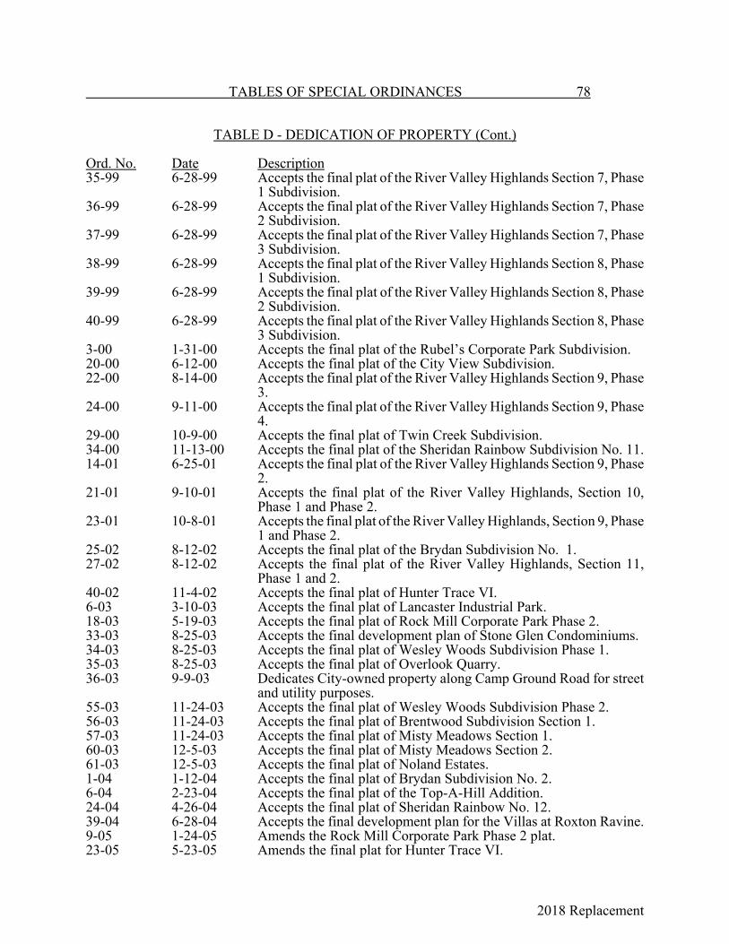
2018 Replacement
TABLES OF SPECIAL ORDINANCES 78
TABLE D - DEDICATION OF PROPERTY (Cont.)
Ord. No. Date Description35-99 6-28-99 Accepts the final plat of the River Valley Highlands Section 7, Phase
1 Subdivision.36-99 6-28-99 Accepts the final plat of the River Valley Highlands Section 7, Phase
2 Subdivision.37-99 6-28-99 Accepts the final plat of the River Valley Highlands Section 7, Phase
3 Subdivision.38-99 6-28-99 Accepts the final plat of the River Valley Highlands Section 8, Phase
1 Subdivision.39-99 6-28-99 Accepts the final plat of the River Valley Highlands Section 8, Phase
2 Subdivision.40-99 6-28-99 Accepts the final plat of the River Valley Highlands Section 8, Phase
3 Subdivision.3-00 1-31-00 Accepts the final plat of the Rubel’s Corporate Park Subdivision.20-00 6-12-00 Accepts the final plat of the City View Subdivision.22-00 8-14-00 Accepts the final plat of the River Valley Highlands Section 9, Phase
3.24-00 9-11-00 Accepts the final plat of the River Valley Highlands Section 9, Phase
4.29-00 10-9-00 Accepts the final plat of Twin Creek Subdivision.34-00 11-13-00 Accepts the final plat of the Sheridan Rainbow Subdivision No. 11.14-01 6-25-01 Accepts the final plat of the River Valley Highlands Section 9, Phase
2.21-01 9-10-01 Accepts the final plat of the River Valley Highlands, Section 10,
Phase 1 and Phase 2.23-01 10-8-01 Accepts the final plat of the River Valley Highlands, Section 9, Phase
1 and Phase 2.25-02 8-12-02 Accepts the final plat of the Brydan Subdivision No. 1.27-02 8-12-02 Accepts the final plat of the River Valley Highlands, Section 11,
Phase 1 and 2.40-02 11-4-02 Accepts the final plat of Hunter Trace VI.6-03 3-10-03 Accepts the final plat of Lancaster Industrial Park.18-03 5-19-03 Accepts the final plat of Rock Mill Corporate Park Phase 2.33-03 8-25-03 Accepts the final development plan of Stone Glen Condominiums.34-03 8-25-03 Accepts the final plat of Wesley Woods Subdivision Phase 1.35-03 8-25-03 Accepts the final plat of Overlook Quarry.36-03 9-9-03 Dedicates City-owned property along Camp Ground Road for street
and utility purposes.55-03 11-24-03 Accepts the final plat of Wesley Woods Subdivision Phase 2.56-03 11-24-03 Accepts the final plat of Brentwood Subdivision Section 1.57-03 11-24-03 Accepts the final plat of Misty Meadows Section 1.60-03 12-5-03 Accepts the final plat of Misty Meadows Section 2.61-03 12-5-03 Accepts the final plat of Noland Estates.1-04 1-12-04 Accepts the final plat of Brydan Subdivision No. 2.6-04 2-23-04 Accepts the final plat of the Top-A-Hill Addition.24-04 4-26-04 Accepts the final plat of Sheridan Rainbow No. 12.39-04 6-28-04 Accepts the final development plan for the Villas at Roxton Ravine.9-05 1-24-05 Amends the Rock Mill Corporate Park Phase 2 plat.23-05 5-23-05 Amends the final plat for Hunter Trace VI.
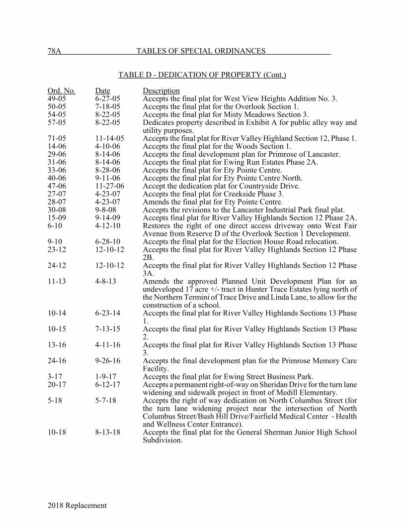
2018 Replacement
78A TABLES OF SPECIAL ORDINANCES
TABLE D - DEDICATION OF PROPERTY (Cont.)
Ord. No. Date Description49-05 6-27-05 Accepts the final plat for West View Heights Addition No. 3.50-05 7-18-05 Accepts the final plat for the Overlook Section 1.54-05 8-22-05 Accepts the final plat for Misty Meadows Section 3.57-05 8-22-05 Dedicates property described in Exhibit A for public alley way and
utility purposes.71-05 11-14-05 Accepts the final plat for River Valley Highland Section 12, Phase 1.14-06 4-10-06 Accepts the final plat for the Woods Section 1.29-06 8-14-06 Accepts the final development plan for Primrose of Lancaster.31-06 8-14-06 Accepts the final plat for Ewing Run Estates Phase 2A.33-06 8-28-06 Accepts the final plat for Ety Pointe Centre.40-06 9-11-06 Accepts the final plat for Ety Pointe Centre North.47-06 11-27-06 Accept the dedication plat for Countryside Drive.27-07 4-23-07 Accepts the final plat for Creekside Phase 3.28-07 4-23-07 Amends the final plat for Ety Pointe Centre.30-08 9-8-08 Accepts the revisions to the Lancaster Industrial Park final plat.15-09 9-14-09 Accepts final plat for River Valley Highlands Section 12 Phase 2A.6-10 4-12-10 Restores the right of one direct access driveway onto West Fair
Avenue from Reserve D of the Overlook Section 1 Development.9-10 6-28-10 Accepts the final plat for the Election House Road relocation.23-12 12-10-12 Accepts the final plat for River Valley Highlands Section 12 Phase
2B.24-12 12-10-12 Accepts the final plat for River Valley Highlands Section 12 Phase
3A.11-13 4-8-13 Amends the approved Planned Unit Development Plan for an
undeveloped 17 acre +/- tract in Hunter Trace Estates lying north ofthe Northern Termini of Trace Drive and Linda Lane, to allow for theconstruction of a school.
10-14 6-23-14 Accepts the final plat for River Valley Highlands Sections 13 Phase1.
10-15 7-13-15 Accepts the final plat for River Valley Highlands Section 13 Phase2.
13-16 4-11-16 Accepts the final plat for River Valley Highlands Section 13 Phase3.
24-16 9-26-16 Accepts the final development plan for the Primrose Memory CareFacility.
3-17 1-9-17 Accepts the final plat for Ewing Street Business Park.20-17 6-12-17 Accepts a permanent right-of-way on Sheridan Drive for the turn lane
widening and sidewalk project in front of Medill Elementary.5-18 5-7-18 Accepts the right of way dedication on North Columbus Street (for
the turn lane widening project near the intersection of NorthColumbus Street/Bush Hill Drive/Fairfield Medical Center - Healthand Wellness Center Entrance).
10-18 8-13-18 Accepts the final plat for the General Sherman Junior High SchoolSubdivision.

2018 Replacement

2018 Replacement
79 TABLES OF SPECIAL ORDINANCES
TABLE E - SALE OF PROPERTY
Ord. Book& Page Ord. No. Date DescriptionA-391 Unno. 10-9-99 Lot 52 to M. A. Daugherty.A-402 Unno. 1-22-1900 Lot 3 in William Cox's King St. Addition to W.
McCleery; strip of land on south end of a 14-acretract west of Lancaster and Groveport Turnpike inFirst Ward to Rev. G. W. Mechling.
A-404 Unno. 1-22-1900 Land beginning 3 chains and 10 links south 88degrees west from the NE corner of Lot 2.
B-471 254 2-8-09 10-acre tract in Section 2, Twp. 14, Range 19.D-147 559 11-12-17 Lot 11 of Hop Co.'s Addition of 1866.E-232 826 3-10-24 Part of Lot 46 in Danehy's Maple St. Addition.E-172 834 11-12-23 Portion of Lot 45 in Danehy's Maple St. Addition.E-182 841 1-14-24 Portion of Lot 45 in Danehy's Maple St. Addition.F-101 1032 2-28-27 Part of Lot 107 in Carter's 3rd Addition, known as
the Starret St. Engine House.G-255 1404 4-25-32 Tracks along Front St. from Fair Ave. to Schryver
St. H-464 1954 7-10-39 Lot on E. Main St. known as the Gas Reducing
Station.H-466 1956 7-24-39 Portion of Tract 28 of the Hocking Canal property.I-167 42-41 6-9-41 Lot 5, Block 13, Chapin Addition; Lots 42 and 43
of Maple St. Addition; Lots 61 and 62 of Barrett'sAddition.
I-231 96-41 12-15-41 Land to Margaret Kirn.I-540 10-44 4-24-44 Exchange of real estate with Jacob Keller Kirn, Jr.I-589 6-45 1-25-45 Repealed Ord. 1954.J-343 7-49 2-14-49 Lot 5, Block 13, Chapin Addition; Lots 42 and 43
Maple St. Addition; Lot 61 and 62, Barrett'sAddition.
J-403 56-49 11-28-49 Gift to State of birthplace of William TecumsehSherman.
J-510 72-50 8-24-50 Real estate of estate of Emma Cook.K-224 23-53 - 8-room frame house and garage on Lot 483, Pioneer
Subdivision.K-330 36-54 6-28-54 Narrow strip of land along the north side of
Edgewood Ave.L-44 42-57 5-27-57 Authorizing execution of quit claim deed for
disputed canal land to George H. Alten.M-352 122-65 12-27-65 Quit claim deed to Anchor Hocking Glass for
property vacated by Ord. 108-65.M-560 46-67 4-25-67 Authorizes conveyance of hospital real estate to the
County Commissioners.N-22 93-67 10-9-67 Quit claim deed to Walter Graf for City's interest in
a 12-foot alley along west side of Lot 675.N-40 108-67 12-26-67 Amends Ord. 46-67 to terminate authority to
transfer on 12-31-67.N-183 25-69 5-12-69 Conveyance of hospital to Board of County
Commissioners.O-12 7-70 3-9-70 Authorizes sale of Lancaster Market House
grounds.

2018 Replacement
TABLES OF SPECIAL ORDINANCES 80
TABLE E - SALE OF PROPERTY (Cont.)
Ord. Book& Page Ord. No. Date DescriptionO-13 8-70 3-9-70 Portion of Elmwood Cemetery across Walnut St.
from the cemetery proper.O-55 30-70 6-8-70 Lancaster Market Grounds at SE corner of
Wheeling and Front Sts. to Alten Foundry andMachine Works, Inc.
P-95 33-71 7-12-71 Quit claim deed to Fisher for land recorded in Vol.174, Page 142 of County Deed Records.
57-81 11-9-81 Quit claim deed to Fairfield County HeritageSociety for William Tecumseh Sherman birthplaceand museum.
02-90 1-8-90 Authorizes conveyance of property to Scott LumberCo. in connection with Revenue Bonds.
6-01 3-12-01 Authorizes sale of three acres more or less of Cityowned South Wellfield and Water Plant Property.
18-01 8-13-01 Amends Ord. 6-01 to increase the amount of land tobe sold to Berne Township from 3 to no more than5 acres.
27-04 5-10-04 Authorizes the sale of one acre to Berne Townshipon which to construct an information center.
52-04 9-13-04 Amends Ord. 27-04 to increase the amount of landto be sold to Berne Township from one acre to6.245 acres.
21-05 4-25-05 Amends Ord. 18-01 to increase the amount of landto be sold to Berne Township to 5.010 acres.
76-05 11-28-05 Authorizes the sale of 6.245 acres to the FairfieldCounty Park Board.
18-14 11-24-14 Authorizes the Mayor to deed the Mithoff Building,162-168 West Main Street, Lancaster, FairfieldCounty, Ohio (Parcel No. 0535803940) for onedollar ($1.00) to the Lancaster Port Authority.
25-14 12-8-14 Authorizes the Mayor to deed 20.771 acres, more orless, of property situated in Sections 5 and 8,Townships 14 North, Range 18, Berne Township,Back to Lancaster Glass Corporation for one dollar($1.00) excepting any and all easements granted toCity.
8-16 3-14-16 Authorizes the Mayor to deed approximately 4.495acres of the approximately 18.182 acres of theformer Anchor Hocking Plant 2 site located at 911Lawrence Street for one dollar ($1.00) to theLancaster Port Authority.
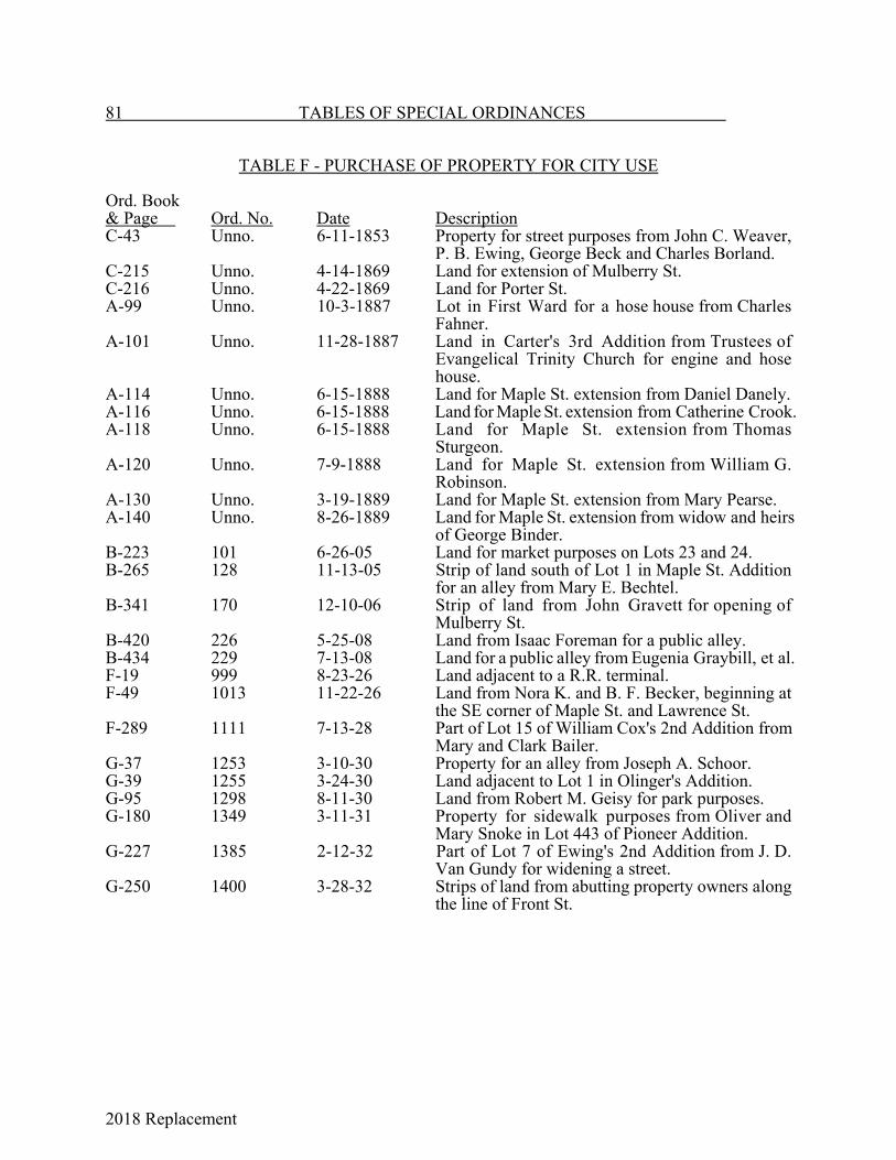
2018 Replacement
81 TABLES OF SPECIAL ORDINANCES
TABLE F - PURCHASE OF PROPERTY FOR CITY USE
Ord. Book& Page Ord. No. Date DescriptionC-43 Unno. 6-11-1853 Property for street purposes from John C. Weaver,
P. B. Ewing, George Beck and Charles Borland.C-215 Unno. 4-14-1869 Land for extension of Mulberry St.C-216 Unno. 4-22-1869 Land for Porter St.A-99 Unno. 10-3-1887 Lot in First Ward for a hose house from Charles
Fahner. A-101 Unno. 11-28-1887 Land in Carter's 3rd Addition from Trustees of
Evangelical Trinity Church for engine and hosehouse.
A-114 Unno. 6-15-1888 Land for Maple St. extension from Daniel Danely.A-116 Unno. 6-15-1888 Land for Maple St. extension from Catherine Crook.A-118 Unno. 6-15-1888 Land for Maple St. extension from Thomas
Sturgeon.A-120 Unno. 7-9-1888 Land for Maple St. extension from William G.
Robinson.A-130 Unno. 3-19-1889 Land for Maple St. extension from Mary Pearse.A-140 Unno. 8-26-1889 Land for Maple St. extension from widow and heirs
of George Binder.B-223 101 6-26-05 Land for market purposes on Lots 23 and 24.B-265 128 11-13-05 Strip of land south of Lot 1 in Maple St. Addition
for an alley from Mary E. Bechtel.B-341 170 12-10-06 Strip of land from John Gravett for opening of
Mulberry St.B-420 226 5-25-08 Land from Isaac Foreman for a public alley.B-434 229 7-13-08 Land for a public alley from Eugenia Graybill, et al.F-19 999 8-23-26 Land adjacent to a R.R. terminal.F-49 1013 11-22-26 Land from Nora K. and B. F. Becker, beginning at
the SE corner of Maple St. and Lawrence St.F-289 1111 7-13-28 Part of Lot 15 of William Cox's 2nd Addition from
Mary and Clark Bailer.G-37 1253 3-10-30 Property for an alley from Joseph A. Schoor.G-39 1255 3-24-30 Land adjacent to Lot 1 in Olinger's Addition.G-95 1298 8-11-30 Land from Robert M. Geisy for park purposes.G-180 1349 3-11-31 Property for sidewalk purposes from Oliver and
Mary Snoke in Lot 443 of Pioneer Addition.G-227 1385 2-12-32 Part of Lot 7 of Ewing's 2nd Addition from J. D.
Van Gundy for widening a street.G-250 1400 3-28-32 Strips of land from abutting property owners along
the line of Front St.
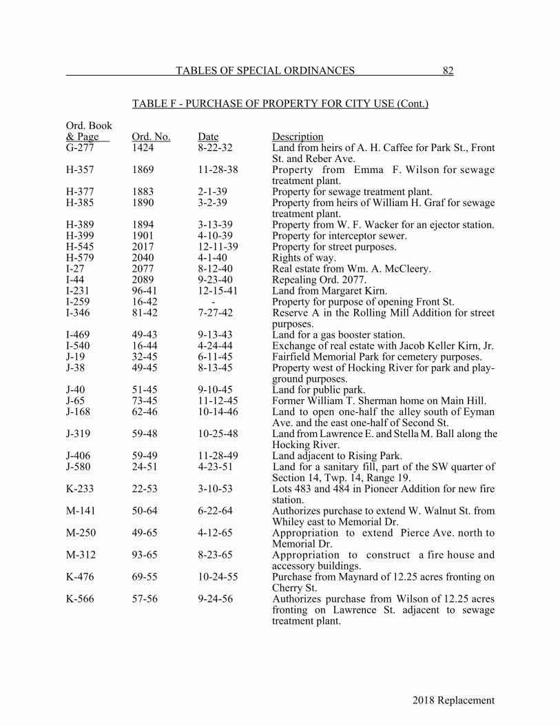
2018 Replacement
TABLES OF SPECIAL ORDINANCES 82
TABLE F - PURCHASE OF PROPERTY FOR CITY USE (Cont.)
Ord. Book& Page Ord. No. Date DescriptionG-277 1424 8-22-32 Land from heirs of A. H. Caffee for Park St., Front
St. and Reber Ave.H-357 1869 11-28-38 Property from Emma F. Wilson for sewage
treatment plant.H-377 1883 2-1-39 Property for sewage treatment plant.H-385 1890 3-2-39 Property from heirs of William H. Graf for sewage
treatment plant.H-389 1894 3-13-39 Property from W. F. Wacker for an ejector station.H-399 1901 4-10-39 Property for interceptor sewer.H-545 2017 12-11-39 Property for street purposes.H-579 2040 4-1-40 Rights of way.I-27 2077 8-12-40 Real estate from Wm. A. McCleery.I-44 2089 9-23-40 Repealing Ord. 2077.I-231 96-41 12-15-41 Land from Margaret Kirn.I-259 16-42 - Property for purpose of opening Front St.I-346 81-42 7-27-42 Reserve A in the Rolling Mill Addition for street
purposes.I-469 49-43 9-13-43 Land for a gas booster station.I-540 16-44 4-24-44 Exchange of real estate with Jacob Keller Kirn, Jr.J-19 32-45 6-11-45 Fairfield Memorial Park for cemetery purposes.J-38 49-45 8-13-45 Property west of Hocking River for park and play-
ground purposes.J-40 51-45 9-10-45 Land for public park.J-65 73-45 11-12-45 Former William T. Sherman home on Main Hill.J-168 62-46 10-14-46 Land to open one-half the alley south of Eyman
Ave. and the east one-half of Second St.J-319 59-48 10-25-48 Land from Lawrence E. and Stella M. Ball along the
Hocking River.J-406 59-49 11-28-49 Land adjacent to Rising Park.J-580 24-51 4-23-51 Land for a sanitary fill, part of the SW quarter of
Section 14, Twp. 14, Range 19.K-233 22-53 3-10-53 Lots 483 and 484 in Pioneer Addition for new fire
station.M-141 50-64 6-22-64 Authorizes purchase to extend W. Walnut St. from
Whiley east to Memorial Dr.M-250 49-65 4-12-65 Appropriation to extend Pierce Ave. north to
Memorial Dr.M-312 93-65 8-23-65 Appropriation to construct a fire house and
accessory buildings.K-476 69-55 10-24-55 Purchase from Maynard of 12.25 acres fronting on
Cherry St.K-566 57-56 9-24-56 Authorizes purchase from Wilson of 12.25 acres
fronting on Lawrence St. adjacent to sewagetreatment plant.
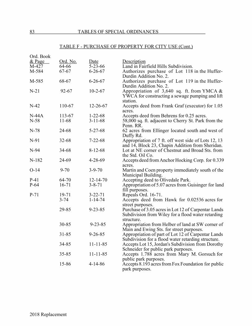
2018 Replacement
83 TABLES OF SPECIAL ORDINANCES
TABLE F - PURCHASE OF PROPERTY FOR CITY USE (Cont.)
Ord. Book& Page Ord. No. Date DescriptionM-427 64-66 5-23-66 Land in Fairfield Hills Subdivision.M-584 67-67 6-26-67 Authorizes purchase of Lot 118 in the Huffer-
Durdin Addition No. 2.M-585 68-67 6-26-67 Authorizes purchase of Lot 119 in the Huffer-
Durdin Addition No. 2.N-21 92-67 10-2-67 Appropriation of 3,640 sq. ft. from YMCA &
YWCA for constructing a sewage pumping and liftstation.
N-42 110-67 12-26-67 Accepts deed from Frank Graf (executor) for 1.05acres.
N-44A 113-67 1-22-68 Accepts deed from Behrens for 0.25 acres.N-58 11-68 3-11-68 58,000 sq. ft. adjacent to Cherry St. Park from the
Penn. RR.N-78 24-68 5-27-68 62 acres from Ellinger located south and west of
Duffy Rd.N-91 32-68 7-22-68 Appropriation of 7 ft. off west side of Lots 12, 13
and 14, Block 23, Chapin Addition from Sheridan.N-94 34-68 8-12-68 Lot at NE corner of Chestnut and Broad Sts. from
the Std. Oil Co.N-182 24-69 4-28-69 Accepts deed from Anchor Hocking Corp. for 0.339
acres.O-14 9-70 3-9-70 Martin and Coen property immediately south of the
Municipal Building.P-41 64-70 12-14-70 Accepting deed to Olivedale Park.P-64 16-71 3-8-71 Appropriation of 5.07 acres from Guisinger for land
fill purposes.P-71 19-71 3-22-71 Repeals Ord. 16-71.
3-74 1-14-74 Accepts deed from Hawk for 0.02536 acres forstreet purposes.
29-85 9-23-85 Purchase of 3.05 acres in Lot 12 of Carpentar LandsSubdivision from Wiley for a flood water retardingstructure.
30-85 9-23-85 Appropriation from Helber of land at SW corner ofMain and Ewing Sts. for street purposes.
31-85 9-26-85 Appropriation of part of Lot 12 of Carpentar LandsSubdivision for a flood water retarding structure.
34-85 11-11-85 Accepts Lot 15, Jordan's Subdivision from DorothySchneider for public park purposes.
35-85 11-11-85 Accepts 1.788 acres from Mary M. Gorsuch forpublic park purposes.
15-86 4-14-86 Accepts 8.193 acres from Fox Foundation for publicpark purposes.

2018 Replacement
TABLES OF SPECIAL ORDINANCES 84
TABLE F - PURCHASE OF PROPERTY FOR CITY USE (Cont.)
Ord. No. Date Description24-86 6-23-86 Appropriation for roadway purposes along Pierce Ave. and State
Route 33 in River Valley project area.01-87 1-26-87 Accepts gift of land from Raymond L. Cramblit.31-87 9-14-87 Accepts gift of land for right-of-way purposes on Sells Rd. from
Raymond L. and Stephanie Jo Cramblit.17-91 4-8-91 Appropriation for detention of impounded waters from the Tarhe
Dam.18-92 6-8-92 Appropriation of permanent easement and right-of-way interests for
levee and fill behind levee at Tarhe Dam.38-98 6-15-98 Authorizes the Community Development Department to purchase
property at 113 West Walnut St.3-03 2-10-03 Authorizes purchase of 4.997 acres located at 815 Lawrence St. for
$1.00.48-03 10-27-03 Purchase of 16.69 acres located at 403 South Ewing St. for $1.00.68-03 12-22-03 Purchase of 1.494 acres located at 403 South Ewing St. for $1.00.56-04 10-4-04 Purchase of two parcels totaling 25 acres for $1,000,000.60-04 10-18-04 Authorizes the purchase of 10 City lots to obtain a safe crossing point
across Fair Ave. at Thomas Ewing Jr. High.52-05 7-18-05 Authorizes the appropriation of fee simple interests in certain real
property for the purpose of environmental conservation andrevitalization.
75-05 11-28-05 Purchase of a 0.0052 acre parcel on West Fair Ave. for $3,000.28-06 7-17-06 Authorizes the purchase of 698 Lawrence St. from Warthman
Investment Properties, Ltd.60-07 12-17-07 Accepts quit claim deeds for public street right-of-way and public
utility purposes for the property described in Exhibits A-1, A-2, B-1and B-2.
26-13 12-3-13 Authorizes the Service-Safety Director to accept five (5) acres, moreor less, of property situated in Section 28, Township 14 North, Range18 from Berne Township.
6-14 4-14-14 Authorizes the Service-Safety Director to accept 0.678 acres, moreor less, of property situated in Fairfield City Zane’s Original TownPlat, Seventh Square, Plat Book 1, Page 2.
26-15 12-7-15 Authorizes the Service-Safety Director to accept 2.164 acres, moreor less, from the Fairfield County Board of Commissioners situatedin Section 30, Township 15, Range 18 of Parcel No. 0533181100 andknown as the Infirmary Cemetery.
39-17 12-11-17 Authorize the Service-Safety Director to accept approximately 26acres, more or less, of property situated in Sections 27 and 34,Township 15 North, Range 19 West, Greenfield Township, FairfieldCounty, from the Fairfield County Land Reutilization Corporation.
5-18 3-26-18 Authorizes the Mayor to accept 2.495 acres, more or less, of propertylocated within Parcel Number 05350231.92 from Fair-Com Rentals,Ltd.

2018 Replacement
85 TABLES OF SPECIAL ORDINANCES
TABLE G - LEASE OF PROPERTY
Ord. Book& Page Ord. No. Date DescriptionF-161 590 6-24-18 Land fronting on Front St. between Wheeling St.
and Main St.F-161 1059 9-26-27 The Hocking Canal lands from the State.J-35 46-45 8-13-45 Grounds for City dump from Mrs. Alva Erick.D-197 590 6-24-18 Land fronting on Front St. between Wheeling St.
and Main St.J-122 25-46 3-25-46 To State for a radio antenna on water reservoir Lot.J-331 70-48 12-27-48 Market House property.J-339 3-49 1-24-49 Gravel bank south of City.J-434 19-50 3-13-50 Land for off-street parking from Ohio Bell
Telephone Co. on W. Wheeling St.K-41 71-51 11-12-51 Market House property.K-204 4-53 1-26-53 Market House property.K-384 77-54 12-27-54 Part of the Lancaster Lateral Canal and the passage
way along the east side.M-153 58-64 8-10-64 Lots 15 to 25, inclusive, in the Carbon Works
Addition from Ray-O-Vac Div. of Electric StorageBattery Co. for park purposes.
N-81 26-68 6-10-68 Authorizes lease for Market House property.O-56 31-70 6-8-70 With Houdaille Industries, Inc. for plastic industrial
plant location.O-79 39-70 6-22-70 Deed acceptance and lease for location of Houdaille
Industries, Inc.Q-46 28-73 7-11-73 With Scott Lumber Co. for commercial facility.Q-58 37-73 9-10-73 With Scott Lumber Co. for commercial facility.
17-74 3-11-74 Terminates lease with Fairfield County DistrictLibrary.
38-76 8-23-76 Authorizes lease for library facilities in City Hall toFairfield County District Library.
28-77 6-27-77 Accepts realty and authorizes lease to LancasterGlass Corp. for industrial development.
15-80 4-14-80 Amends Ord. 39-70.31-82 8-2-82 With Society Bank for a parking lot on Chestnut St.16-86 4-28-86 With Federal Government for l00 square foot parcel
at Water Plant.31-89 8-14-89 Lease for City property described in Schedule A.

2018 Replacement

2018 Replacement
87 TABLES OF SPECIAL ORDINANCES
TABLE H - GRADE LEVELS AND CURB LINES
Ord. Book& Page Ord. No. Date DescriptionI-110 Unno. 3-28-1839 Main St.I-112 Unno. 4-9-1839 Bruce, 2nd, Columbus, 4th, Mulberry, Wheeling,
Chestnut and Mill Sts.C-69 Unno. 7-16-1855 Changing grade of those parts of Broad St. north of
Main St. between Main and Wheeling Sts. andbetween Wheeling and Mulberry Sts.
C-111 Unno. 10-10-1860 Walnut St. between 4th and Maple Sts.C-162 Unno. 2-2-1866 Chestnut St. between Broad Alley and Maple St.C-191 Unno. 9-5-1867 Broad St. between Wheeling and Mulberry Sts.;
repealing Section 2 and parts of Sections 3 and 4 ofOrd. of 7-16-1855.
C-251 Unno. 11-23-1870 Alley in rear of the Tallmadge and Shaeffer Blockson Main St.
A-6 Unno. 6-16-1879 Main St. east of Maple St.A-19 Unno. 8-28-1882 That part of High St. lying between North Alley and
Lundy's Lane.A-20 Unno. 11-13-1882 E. Wheeling St. from Zane's Section to Diagonal St.A-24 Unno. 2-26-1883 E. Wheeling St. from Zane's Section to Diagonal St.A-55 Unno. 8-23-1886 Sidewalks and curbing on both sides of Main St.
from the canal to Maple St.A-67 Unno. 10-18-1886 Maple St.A-76 Unno. 10-25-1886 Mulberry St. east.A-152 Unno. 2-26-1890 Repealing parts of Ord. of 10-18-1886 re Maple St.
and condemning additional property.A-159 Unno. 8-11-1890 Columbus St. north from Lundy's Lane through
Caffee's Addition.A-162 Unno. 11-24-1890 Maple St. between Main St. and Wheeling St.A-218 Unno. 5-9-1892 Curb grade on Lake St. between Broad St. and High
St.A-233 Unno. 9-12-1892 Alley between Wheeling and Mulberry Sts.A-233 Unno. 9-12-1892 Walnut St. from Maple St. to Mt. Pleasant Ave.A-239 Unno. 4-7-1893 Mt. Prospect Alley between Walnut St. and
Carpenter's Alley.A-245 Unno. 12-4-1893 Mulberry St. from Broad St. to a point 120-1/2 ft.
east of Broad St.A-245 Unno. 12-11-1893 Curb grade of Pearl Ave. on east side.A-248 Unno. 1-22-1893 Locust St. from Maple St. to Mt. Pleasant Ave.A-253 Unno. 4-15-1894 Tenant St. from Main St. to Walnut St.A-254 Unno. 4-15-1894 Curb grade on Mill St. from east side of Broad St.
to a point 380 ft. east of Broad St.A-256 Unno. 8-17-1894 Broad St. from Perry and Columbus Sts. to Lundy's
Lane.A-263 Unno. 8-17-1894 Canal St. from Mulberry St. to Lundy's Lane.
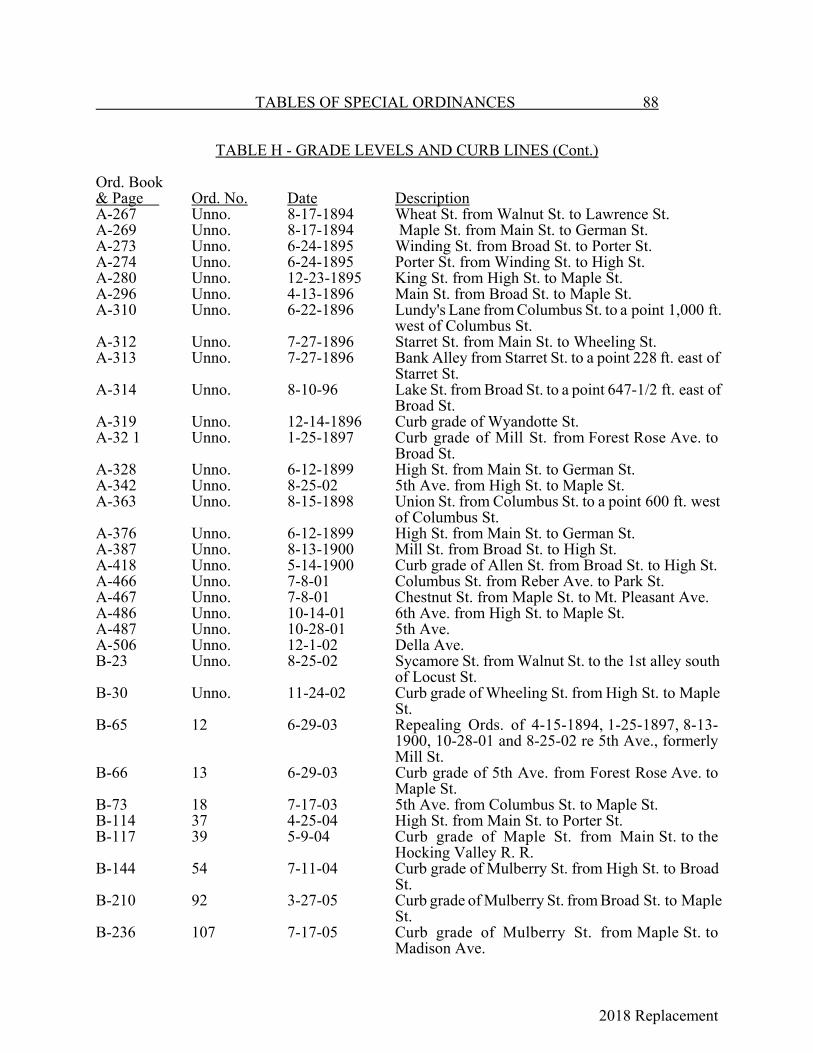
2018 Replacement
TABLES OF SPECIAL ORDINANCES 88
TABLE H - GRADE LEVELS AND CURB LINES (Cont.)
Ord. Book& Page Ord. No. Date DescriptionA-267 Unno. 8-17-1894 Wheat St. from Walnut St. to Lawrence St.A-269 Unno. 8-17-1894 Maple St. from Main St. to German St.A-273 Unno. 6-24-1895 Winding St. from Broad St. to Porter St.A-274 Unno. 6-24-1895 Porter St. from Winding St. to High St.A-280 Unno. 12-23-1895 King St. from High St. to Maple St.A-296 Unno. 4-13-1896 Main St. from Broad St. to Maple St.A-310 Unno. 6-22-1896 Lundy's Lane from Columbus St. to a point 1,000 ft.
west of Columbus St.A-312 Unno. 7-27-1896 Starret St. from Main St. to Wheeling St.A-313 Unno. 7-27-1896 Bank Alley from Starret St. to a point 228 ft. east of
Starret St.A-314 Unno. 8-10-96 Lake St. from Broad St. to a point 647-1/2 ft. east of
Broad St.A-319 Unno. 12-14-1896 Curb grade of Wyandotte St.A-32 1 Unno. 1-25-1897 Curb grade of Mill St. from Forest Rose Ave. to
Broad St.A-328 Unno. 6-12-1899 High St. from Main St. to German St.A-342 Unno. 8-25-02 5th Ave. from High St. to Maple St.A-363 Unno. 8-15-1898 Union St. from Columbus St. to a point 600 ft. west
of Columbus St.A-376 Unno. 6-12-1899 High St. from Main St. to German St.A-387 Unno. 8-13-1900 Mill St. from Broad St. to High St.A-418 Unno. 5-14-1900 Curb grade of Allen St. from Broad St. to High St.A-466 Unno. 7-8-01 Columbus St. from Reber Ave. to Park St.A-467 Unno. 7-8-01 Chestnut St. from Maple St. to Mt. Pleasant Ave.A-486 Unno. 10-14-01 6th Ave. from High St. to Maple St.A-487 Unno. 10-28-01 5th Ave.A-506 Unno. 12-1-02 Della Ave.B-23 Unno. 8-25-02 Sycamore St. from Walnut St. to the 1st alley south
of Locust St.B-30 Unno. 11-24-02 Curb grade of Wheeling St. from High St. to Maple
St.B-65 12 6-29-03 Repealing Ords. of 4-15-1894, 1-25-1897, 8-13-
1900, 10-28-01 and 8-25-02 re 5th Ave., formerlyMill St.
B-66 13 6-29-03 Curb grade of 5th Ave. from Forest Rose Ave. toMaple St.
B-73 18 7-17-03 5th Ave. from Columbus St. to Maple St.B-114 37 4-25-04 High St. from Main St. to Porter St.B-117 39 5-9-04 Curb grade of Maple St. from Main St. to the
Hocking Valley R. R.B-144 54 7-11-04 Curb grade of Mulberry St. from High St. to Broad
St.B-210 92 3-27-05 Curb grade of Mulberry St. from Broad St. to Maple
St.B-236 107 7-17-05 Curb grade of Mulberry St. from Maple St. to
Madison Ave.

2018 Replacement
89 TABLES OF SPECIAL ORDINANCES
TABLE H - GRADE LEVELS AND CURB LINES (Cont.)
Ord. Book& Page Ord. No. Date DescriptionB-305 148 6-11-06 Pearl Ave. from Mulberry St. to North Alley.B-331 162 10-26-06 Curb grade of Garfield Ave. from Mulberry St. to
Thurman St.B-349 172 2-11-07 Alley in the Daugherty Addition.B-357 181 4-22-07 Mt. Pleasant Ave. from Main St. to King St.B-359 182 5-13-07 Mulberry St. from Madison Ave. to Cherry St.B-360 183 6-24-07 Madison Ave. from Wheeling St. to 6th Ave.B-378 195 9-9-07 Reber Ave. from Columbus St. to the 2nd alley west
of Forest Rose Ave.B-379 196 9-9-07 Pearl Ave. from Walnut St. to North Alley.B-382 198 9-9-07 The alley south of 5th Ave. from Tenant St. to
Maple St.B-384 200 9-23-07 Allen St. west of Columbus St.B-386 202 10-14-07 Columbus St. from Park St. to a point 1634.5 ft.
north of Park St.B-387 203 10-14-07 Zane Alley west of Columbus St.B-388 204 10-28-07 King St. east of Maple St.B-389 205 10-28-07 6th Ave. from Forest Rose to Madison Aves.B-425 227 6-8-08 Harrison Ave. from Main St. to 6th Ave.B-440 234 9-14-08 6th Ave. from Madison Ave. to Boyd St.C-1 266 7-26-09 Park St. from Columbus St. to Caffee's Addition.C-2 267 7-26-09 Thayer St.C-35 289 5-9-10 Maple St. from Main St. to 1st alley north of Allen
St.C-38 290 5-23-10 Wheeling St. from High St. to Front St.C-89 315 4-24-11 E. Wheeling St. from Maple St. to Cherry St.C-140 340 2-26-12 King St. from Broad St. to Madison Ave.C-145 342 2-11-12 High St. from 6th Ave. to Fair Ave.C-147 343 3-11-12 Fair Ave. from Columbus St. to High St.C-155 348 4-22-12 Washington Ave. from 6th Ave. to Fair St.C-207 371 - Porter, Locust and Perry Sts. from the circle to
Winding St.C-292 412 2-23-14 N. Columbus St. from Park St. to Forest Rose
Cemetery.C-350 428 6-22-14 Zane Alley from High St. to Broad St.C-417 459 4-26-15 Alley north of 5th Ave. from Broad St. to High St.C-446 470 7-26-15 Harrison Ave. from Main St. to Hocking River
Ditch.C-458 474 7-26-15 W. Wheeling St. from Front St. to Washington Ave.C-470 482 9-27-15 Lincoln Ave. from Front St. southwesterly.C-472 483 9-27-15 Grade of East St. from Fair Ave.D-12 501 4-24-16 E. King St. from Madison Ave. to East St.D-17 505 5-8-16 Mt. Ida Ave. from Broad St. to the west corporation
line.
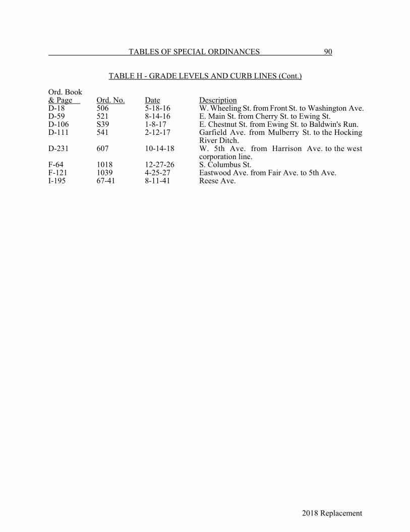
2018 Replacement
TABLES OF SPECIAL ORDINANCES 90
TABLE H - GRADE LEVELS AND CURB LINES (Cont.)
Ord. Book& Page Ord. No. Date DescriptionD-18 506 5-18-16 W. Wheeling St. from Front St. to Washington Ave.D-59 521 8-14-16 E. Main St. from Cherry St. to Ewing St.D-106 S39 1-8-17 E. Chestnut St. from Ewing St. to Baldwin's Run.D-111 541 2-12-17 Garfield Ave. from Mulberry St. to the Hocking
River Ditch.D-231 607 10-14-18 W. 5th Ave. from Harrison Ave. to the west
corporation line.F-64 1018 12-27-26 S. Columbus St.F-121 1039 4-25-27 Eastwood Ave. from Fair Ave. to 5th Ave.I-195 67-41 8-11-41 Reese Ave.
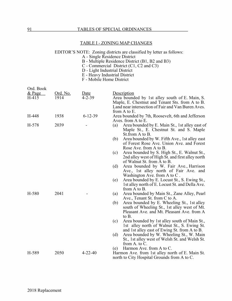
2018 Replacement
91 TABLES OF SPECIAL ORDINANCES
TABLE I - ZONING MAP CHANGES
EDITOR’S NOTE: Zoning districts are classified by letter as follows:A - Single Residence DistrictB - Multiple Residence District (B1, B2 and B3)C - Commercial District (C1, C2 and C3)D - Light Industrial DistrictE - Heavy Industrial DistrictF - Mobile Home District
Ord. Book& Page Ord. No. Date DescriptionH-415 1914 4-2-39 Area bounded by 1st alley south of E. Main, S.
Maple, E. Chestnut and Tenant Sts. from A to B.Land near intersection of Fair and Van Buren Aves.from A to E.
H-448 1938 6-12-39 Area bounded by 7th, Roosevelt, 6th and JeffersonAves. from A to E.
H-578 2039 - (a) Area bounded by E. Main St., 1st alley east ofMaple St., E. Chestnut St. and S. MapleSt.from A to B.
(b) Area bounded by W. Fifth Ave., 1st alley eastof Forest Rose Ave. Union Ave. and ForestRose Ave. from A to B.
(c) Area bounded by S. High St., E. Walnut St.,2nd alley west of High St. and first alley northof Walnut St. from A to B.
(d) Area bounded by W. Fair Ave., HarrisonAve., 1st alley north of Fair Ave. andWashington Ave. from A to C .
(e) Area bounded by E. Locust St., S. Ewing St.,1st alley north of E. Locust St. and Della Ave.from A to B.
H-580 2041 - (a) Area bounded by Main St., Zane Alley, PearlAve., Tenant St. from C to A.
(b) Area bounded by E. Wheeling St., 1st alleysouth of Wheeling St., 1st alley west of Mt.Pleasant Ave. and Mt. Pleasant Ave. from Ato B.
(c) Area bounded by 1st alley south of Main St.,1st alley north of Walnut St., S. Ewing St.and 1st alley east of Ewing St. from A to B.
(d) Area bounded by W. Wheeling St., W. MainSt., 1st alley west of Welsh St. and Welsh St.from A. to C.
(e) Harmon Ave. from A to C.H-589 2050 4-22-40 Harmon Ave. from 1st alley north of E. Main St.
north to City Hospital Grounds from A to C.
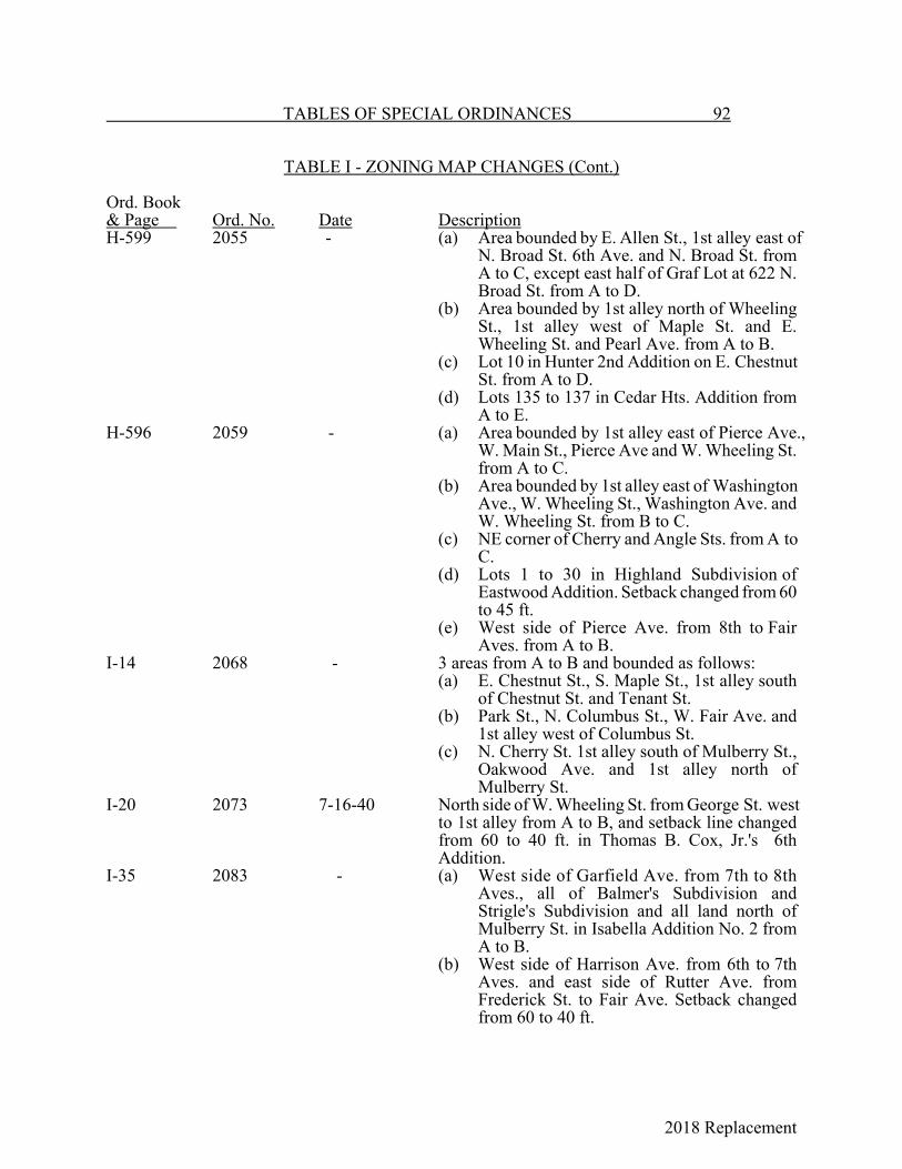
2018 Replacement
TABLES OF SPECIAL ORDINANCES 92
TABLE I - ZONING MAP CHANGES (Cont.)
Ord. Book& Page Ord. No. Date DescriptionH-599 2055 - (a) Area bounded by E. Allen St., 1st alley east of
N. Broad St. 6th Ave. and N. Broad St. fromA to C, except east half of Graf Lot at 622 N.Broad St. from A to D.
(b) Area bounded by 1st alley north of WheelingSt., 1st alley west of Maple St. and E.Wheeling St. and Pearl Ave. from A to B.
(c) Lot 10 in Hunter 2nd Addition on E. ChestnutSt. from A to D.
(d) Lots 135 to 137 in Cedar Hts. Addition fromA to E.
H-596 2059 - (a) Area bounded by 1st alley east of Pierce Ave.,W. Main St., Pierce Ave and W. Wheeling St.from A to C.
(b) Area bounded by 1st alley east of WashingtonAve., W. Wheeling St., Washington Ave. andW. Wheeling St. from B to C.
(c) NE corner of Cherry and Angle Sts. from A toC.
(d) Lots 1 to 30 in Highland Subdivision ofEastwood Addition. Setback changed from 60to 45 ft.
(e) West side of Pierce Ave. from 8th to FairAves. from A to B.
I-14 2068 - 3 areas from A to B and bounded as follows:(a) E. Chestnut St., S. Maple St., 1st alley south
of Chestnut St. and Tenant St.(b) Park St., N. Columbus St., W. Fair Ave. and
1st alley west of Columbus St.(c) N. Cherry St. 1st alley south of Mulberry St.,
Oakwood Ave. and 1st alley north ofMulberry St.
I-20 2073 7-16-40 North side of W. Wheeling St. from George St. westto 1st alley from A to B, and setback line changedfrom 60 to 40 ft. in Thomas B. Cox, Jr.'s 6thAddition.
I-35 2083 - (a) West side of Garfield Ave. from 7th to 8thAves., all of Balmer's Subdivision andStrigle's Subdivision and all land north ofMulberry St. in Isabella Addition No. 2 fromA to B.
(b) West side of Harrison Ave. from 6th to 7thAves. and east side of Rutter Ave. fromFrederick St. to Fair Ave. Setback changedfrom 60 to 40 ft.
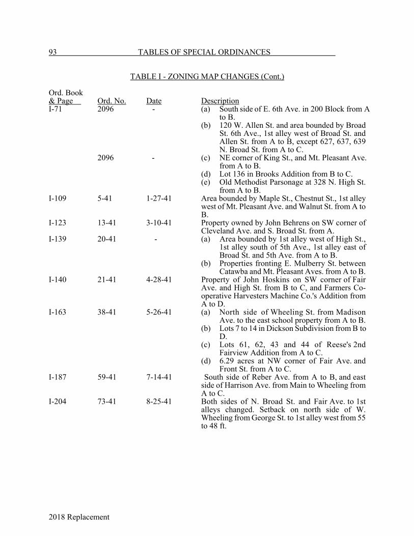
2018 Replacement
93 TABLES OF SPECIAL ORDINANCES
TABLE I - ZONING MAP CHANGES (Cont.)
Ord. Book& Page Ord. No. Date DescriptionI-71 2096 - (a) South side of E. 6th Ave. in 200 Block from A
to B.(b) 120 W. Allen St. and area bounded by Broad
St. 6th Ave., 1st alley west of Broad St. andAllen St. from A to B, except 627, 637, 639N. Broad St. from A to C.
2096 - (c) NE corner of King St., and Mt. Pleasant Ave.from A to B.
(d) Lot 136 in Brooks Addition from B to C.(e) Old Methodist Parsonage at 328 N. High St.
from A to B.I-109 5-41 1-27-41 Area bounded by Maple St., Chestnut St., 1st alley
west of Mt. Pleasant Ave. and Walnut St. from A toB.
I-123 13-41 3-10-41 Property owned by John Behrens on SW corner ofCleveland Ave. and S. Broad St. from A.
I-139 20-41 - (a) Area bounded by 1st alley west of High St.,1st alley south of 5th Ave., 1st alley east ofBroad St. and 5th Ave. from A to B.
(b) Properties fronting E. Mulberry St. betweenCatawba and Mt. Pleasant Aves. from A to B.
I-140 21-41 4-28-41 Property of John Hoskins on SW corner of FairAve. and High St. from B to C, and Farmers Co-operative Harvesters Machine Co.'s Addition fromA to D.
I-163 38-41 5-26-41 (a) North side of Wheeling St. from MadisonAve. to the east school property from A to B.
(b) Lots 7 to 14 in Dickson Subdivision from B toD.
(c) Lots 61, 62, 43 and 44 of Reese's 2ndFairview Addition from A to C.
(d) 6.29 acres at NW corner of Fair Ave. andFront St. from A to C.
I-187 59-41 7-14-41 South side of Reber Ave. from A to B, and eastside of Harrison Ave. from Main to Wheeling fromA to C.
I-204 73-41 8-25-41 Both sides of N. Broad St. and Fair Ave. to 1stalleys changed. Setback on north side of W.Wheeling from George St. to 1st alley west from 55to 48 ft.

2018 Replacement
TABLES OF SPECIAL ORDINANCES 94
TABLE I - ZONING MAP CHANGES (Cont.)
Ord. Book& Page Ord. No. Date DescriptionI-212 79-41 9-22-41 North side of W. 6th Ave. from 1st alley west of
Broad St. to Maywood Ave. and south side of E.Allen from 1st to 2nd alley east of Broad St.: fromA to B.
I-216 83-41 10-27-41 Land beginning at NW corner of Forest Rose and5th Aves. from A and B to C.
I-217 84-41 10-27-41 Area bounded by Wheeling St., Harrison Ave.,Mulberry St. and Welsh Ave. from B to C.
I-279 26-42 4-27-42 Area on east side of Welsh Ave. from Main St. toWheeling St. from A to D.
I-402 130-42 12-28-42 Lot 5 in Curtis C. Cole's Pine Site Addition from Cto D.
I-466 46-43 9-13-43 Setback line on north side of W. 8th Ave. betweenJefferson and Grant from 60 to 45 ft.
I-492 68-43 11-8-43 Area on south side of E. Wheeling St. from Mt.Pleasant Ave. to Starret St. from A to C.
I-529 5-44 2-14-44 Lots 7, 8 and 9 in Block 4 of Chapin Addition fromA to D.
I-530 6-44 2-14-44 Lots 5 to 26, inclusive, of Bauman's Addition fromC to D.
J-64 72-45 11-12-45 Area bounded by Chestnut St., Pearl Ave., WalnutSt. and High St. from A to C; 0.303 acres on N.Columbus St. from C to D.
J-90 97-45 12-20-45 Lots 182 and 183 in Timmes' Addition from A to C.J-111 14-46 2-25-46 Area bounded by Chestnut St., south corporation
line, Fulkerson Ave. and Penna. R.R. from A to E.J-114 17-46 3-11-46 2nd lot north of Angle St. on east side of N. Cherry
St. from A to C.J-115 18-46 3-11-46 Lot 11 in Maple St. Addition from A to C.J-127 29-46 4-8-46 Change of classification from A to E.J-134 35-46 5-13-46 Lots 321 to 324 in Reber's Addition, Lots A, B and
C in Delaney's Subdivision, Lots 671 to 673 inTenant's Addition, Lots 773 to 776 in Garaghty'sAddition and Lot 6 in Hettinger's Subdivision fromB to C; 2nd lot west of alley west of Madison onsouth side of King St. from A to B.
J-160 55-46 8-26-46 Area bounded by Mt. Pleasant Ave., Lot 112, ZaneAlley and Chestnut St. from A to C.
J-169 63-46 10-14-46 Lots 1 to 3 in Frank Berkley Addition from A to D.J-170 64-46 10-14-46 Lot 9 in East Lawn Addition from A to B.J-171 65-46 10-14-46 Lot 770 in Peter's Addition from A to C.J-176 69-46 12-23-46 Part of Lot 796 in Philip Rising Addition from A to
C.
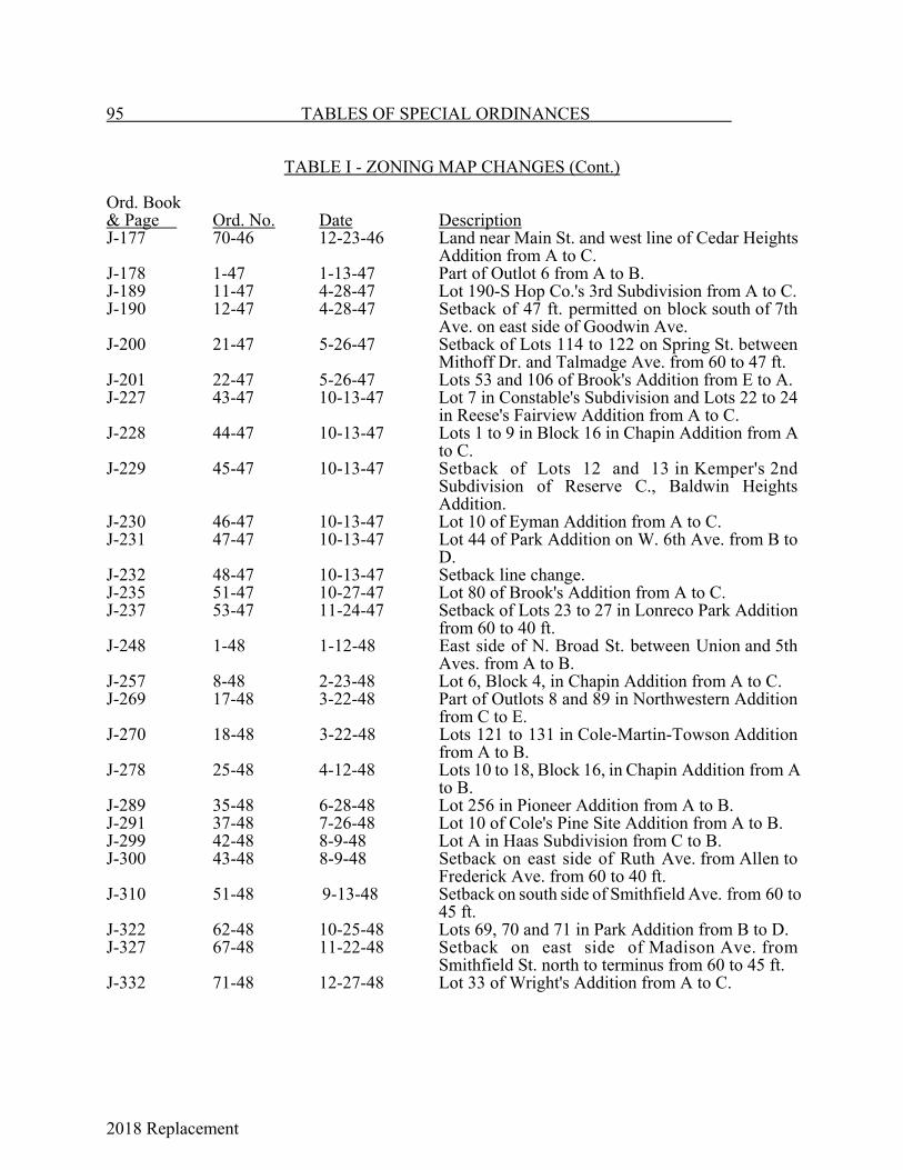
2018 Replacement
95 TABLES OF SPECIAL ORDINANCES
TABLE I - ZONING MAP CHANGES (Cont.)
Ord. Book& Page Ord. No. Date DescriptionJ-177 70-46 12-23-46 Land near Main St. and west line of Cedar Heights
Addition from A to C.J-178 1-47 1-13-47 Part of Outlot 6 from A to B.J-189 11-47 4-28-47 Lot 190-S Hop Co.'s 3rd Subdivision from A to C.J-190 12-47 4-28-47 Setback of 47 ft. permitted on block south of 7th
Ave. on east side of Goodwin Ave.J-200 21-47 5-26-47 Setback of Lots 114 to 122 on Spring St. between
Mithoff Dr. and Talmadge Ave. from 60 to 47 ft.J-201 22-47 5-26-47 Lots 53 and 106 of Brook's Addition from E to A.J-227 43-47 10-13-47 Lot 7 in Constable's Subdivision and Lots 22 to 24
in Reese's Fairview Addition from A to C.J-228 44-47 10-13-47 Lots 1 to 9 in Block 16 in Chapin Addition from A
to C.J-229 45-47 10-13-47 Setback of Lots 12 and 13 in Kemper's 2nd
Subdivision of Reserve C., Baldwin HeightsAddition.
J-230 46-47 10-13-47 Lot 10 of Eyman Addition from A to C.J-231 47-47 10-13-47 Lot 44 of Park Addition on W. 6th Ave. from B to
D.J-232 48-47 10-13-47 Setback line change.J-235 51-47 10-27-47 Lot 80 of Brook's Addition from A to C.J-237 53-47 11-24-47 Setback of Lots 23 to 27 in Lonreco Park Addition
from 60 to 40 ft.J-248 1-48 1-12-48 East side of N. Broad St. between Union and 5th
Aves. from A to B.J-257 8-48 2-23-48 Lot 6, Block 4, in Chapin Addition from A to C.J-269 17-48 3-22-48 Part of Outlots 8 and 89 in Northwestern Addition
from C to E.J-270 18-48 3-22-48 Lots 121 to 131 in Cole-Martin-Towson Addition
from A to B.J-278 25-48 4-12-48 Lots 10 to 18, Block 16, in Chapin Addition from A
to B.J-289 35-48 6-28-48 Lot 256 in Pioneer Addition from A to B.J-291 37-48 7-26-48 Lot 10 of Cole's Pine Site Addition from A to B.J-299 42-48 8-9-48 Lot A in Haas Subdivision from C to B.J-300 43-48 8-9-48 Setback on east side of Ruth Ave. from Allen to
Frederick Ave. from 60 to 40 ft.J-310 51-48 9-13-48 Setback on south side of Smithfield Ave. from 60 to
45 ft.J-322 62-48 10-25-48 Lots 69, 70 and 71 in Park Addition from B to D.J-327 67-48 11-22-48 Setback on east side of Madison Ave. from
Smithfield St. north to terminus from 60 to 45 ft.J-332 71-48 12-27-48 Lot 33 of Wright's Addition from A to C.
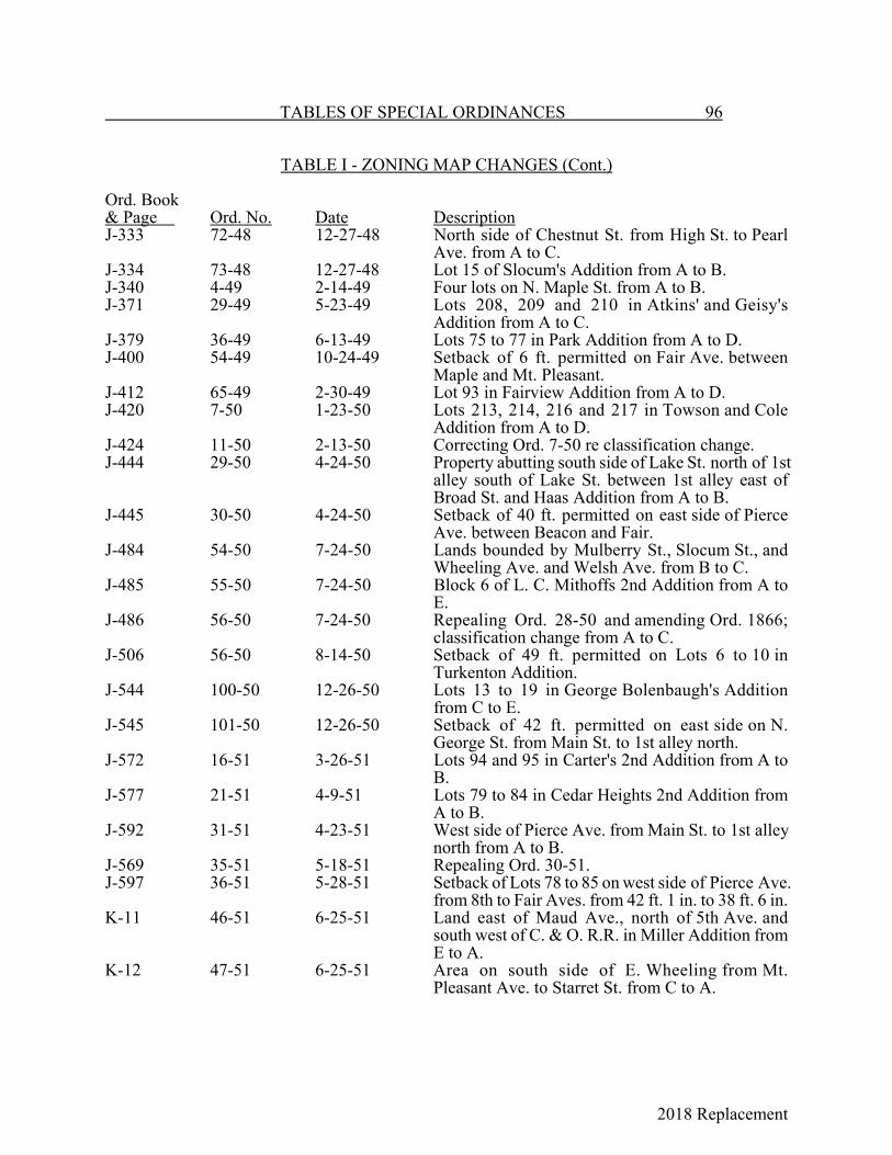
2018 Replacement
TABLES OF SPECIAL ORDINANCES 96
TABLE I - ZONING MAP CHANGES (Cont.)
Ord. Book& Page Ord. No. Date DescriptionJ-333 72-48 12-27-48 North side of Chestnut St. from High St. to Pearl
Ave. from A to C.J-334 73-48 12-27-48 Lot 15 of Slocum's Addition from A to B.J-340 4-49 2-14-49 Four lots on N. Maple St. from A to B.J-371 29-49 5-23-49 Lots 208, 209 and 210 in Atkins' and Geisy's
Addition from A to C.J-379 36-49 6-13-49 Lots 75 to 77 in Park Addition from A to D.J-400 54-49 10-24-49 Setback of 6 ft. permitted on Fair Ave. between
Maple and Mt. Pleasant.J-412 65-49 2-30-49 Lot 93 in Fairview Addition from A to D.J-420 7-50 1-23-50 Lots 213, 214, 216 and 217 in Towson and Cole
Addition from A to D.J-424 11-50 2-13-50 Correcting Ord. 7-50 re classification change.J-444 29-50 4-24-50 Property abutting south side of Lake St. north of 1st
alley south of Lake St. between 1st alley east ofBroad St. and Haas Addition from A to B.
J-445 30-50 4-24-50 Setback of 40 ft. permitted on east side of PierceAve. between Beacon and Fair.
J-484 54-50 7-24-50 Lands bounded by Mulberry St., Slocum St., andWheeling Ave. and Welsh Ave. from B to C.
J-485 55-50 7-24-50 Block 6 of L. C. Mithoffs 2nd Addition from A toE.
J-486 56-50 7-24-50 Repealing Ord. 28-50 and amending Ord. 1866;classification change from A to C.
J-506 56-50 8-14-50 Setback of 49 ft. permitted on Lots 6 to 10 inTurkenton Addition.
J-544 100-50 12-26-50 Lots 13 to 19 in George Bolenbaugh's Additionfrom C to E.
J-545 101-50 12-26-50 Setback of 42 ft. permitted on east side on N.George St. from Main St. to 1st alley north.
J-572 16-51 3-26-51 Lots 94 and 95 in Carter's 2nd Addition from A toB.
J-577 21-51 4-9-51 Lots 79 to 84 in Cedar Heights 2nd Addition fromA to B.
J-592 31-51 4-23-51 West side of Pierce Ave. from Main St. to 1st alleynorth from A to B.
J-569 35-51 5-18-51 Repealing Ord. 30-51.J-597 36-51 5-28-51 Setback of Lots 78 to 85 on west side of Pierce Ave.
from 8th to Fair Aves. from 42 ft. 1 in. to 38 ft. 6 in.K-11 46-51 6-25-51 Land east of Maud Ave., north of 5th Ave. and
south west of C. & O. R.R. in Miller Addition fromE to A.
K-12 47-51 6-25-51 Area on south side of E. Wheeling from Mt.Pleasant Ave. to Starret St. from C to A.
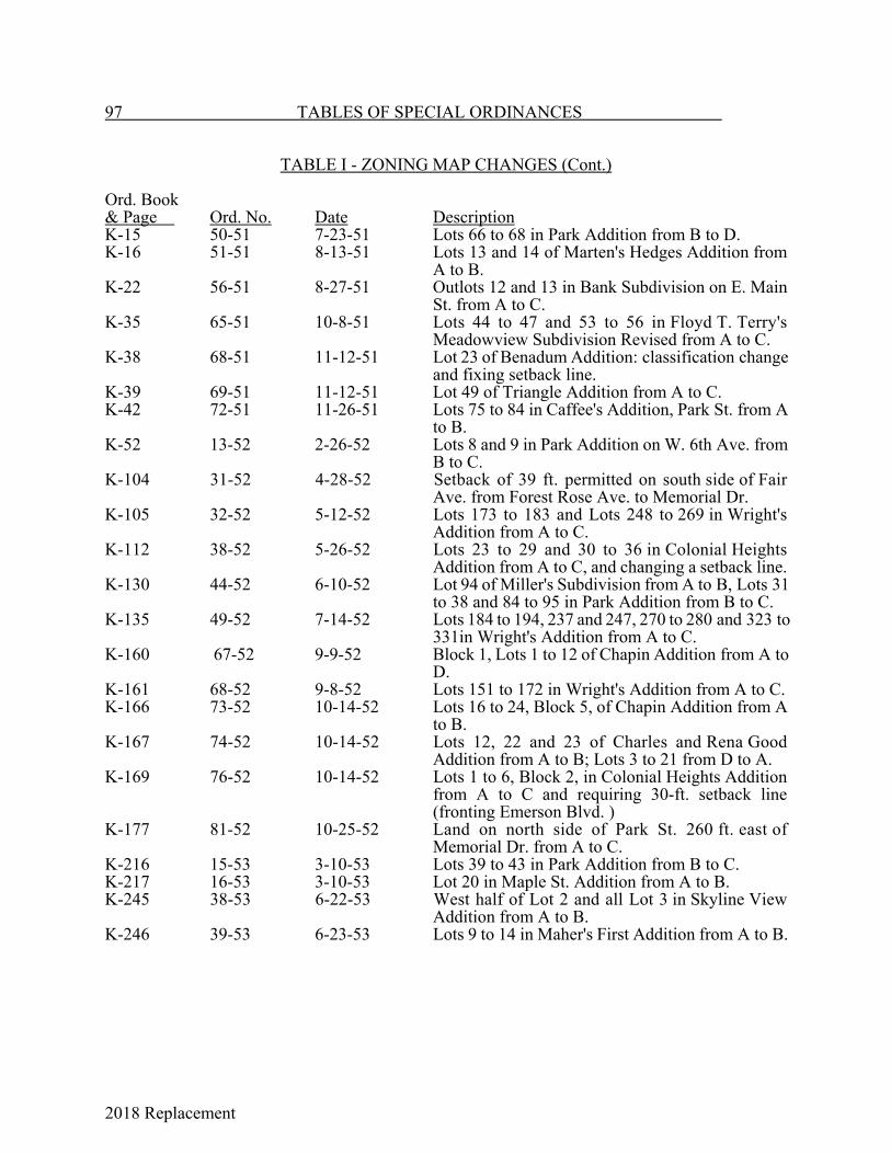
2018 Replacement
97 TABLES OF SPECIAL ORDINANCES
TABLE I - ZONING MAP CHANGES (Cont.)
Ord. Book& Page Ord. No. Date DescriptionK-15 50-51 7-23-51 Lots 66 to 68 in Park Addition from B to D.K-16 51-51 8-13-51 Lots 13 and 14 of Marten's Hedges Addition from
A to B.K-22 56-51 8-27-51 Outlots 12 and 13 in Bank Subdivision on E. Main
St. from A to C.K-35 65-51 10-8-51 Lots 44 to 47 and 53 to 56 in Floyd T. Terry's
Meadowview Subdivision Revised from A to C.K-38 68-51 11-12-51 Lot 23 of Benadum Addition: classification change
and fixing setback line.K-39 69-51 11-12-51 Lot 49 of Triangle Addition from A to C.K-42 72-51 11-26-51 Lots 75 to 84 in Caffee's Addition, Park St. from A
to B.K-52 13-52 2-26-52 Lots 8 and 9 in Park Addition on W. 6th Ave. from
B to C.K-104 31-52 4-28-52 Setback of 39 ft. permitted on south side of Fair
Ave. from Forest Rose Ave. to Memorial Dr.K-105 32-52 5-12-52 Lots 173 to 183 and Lots 248 to 269 in Wright's
Addition from A to C.K-112 38-52 5-26-52 Lots 23 to 29 and 30 to 36 in Colonial Heights
Addition from A to C, and changing a setback line.K-130 44-52 6-10-52 Lot 94 of Miller's Subdivision from A to B, Lots 31
to 38 and 84 to 95 in Park Addition from B to C.K-135 49-52 7-14-52 Lots 184 to 194, 237 and 247, 270 to 280 and 323 to
331in Wright's Addition from A to C.K-160 67-52 9-9-52 Block 1, Lots 1 to 12 of Chapin Addition from A to
D. K-161 68-52 9-8-52 Lots 151 to 172 in Wright's Addition from A to C.K-166 73-52 10-14-52 Lots 16 to 24, Block 5, of Chapin Addition from A
to B.K-167 74-52 10-14-52 Lots 12, 22 and 23 of Charles and Rena Good
Addition from A to B; Lots 3 to 21 from D to A.K-169 76-52 10-14-52 Lots 1 to 6, Block 2, in Colonial Heights Addition
from A to C and requiring 30-ft. setback line(fronting Emerson Blvd. )
K-177 81-52 10-25-52 Land on north side of Park St. 260 ft. east ofMemorial Dr. from A to C.
K-216 15-53 3-10-53 Lots 39 to 43 in Park Addition from B to C.K-217 16-53 3-10-53 Lot 20 in Maple St. Addition from A to B.K-245 38-53 6-22-53 West half of Lot 2 and all Lot 3 in Skyline View
Addition from A to B.K-246 39-53 6-23-53 Lots 9 to 14 in Maher's First Addition from A to B.
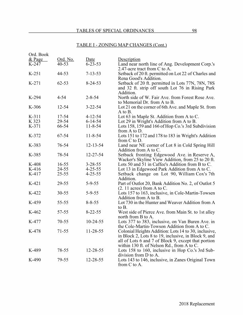
2018 Replacement
TABLES OF SPECIAL ORDINANCES 98
TABLE I - ZONING MAP CHANGES (Cont.)
Ord. Book& Page Ord. No. Date DescriptionK-247 40-53 6-23-53 Land near north line of Ang. Development Corp.'s
2.47-acre tract from C to A.K-251 44-53 7-13-53 Setback of 20 ft. permitted on Lot 22 of Charles and
Rena Good's Addition.K-271 62-53 8-24-53 Setback of 20 ft. permitted in Lots 77N, 78N, 78S
and 32 ft. strip off south Lot 76 in Rising ParkAddition.
K-294 4-54 2-8-54 North side of W. Fair Ave. from Forest Rose Ave.to Memorial Dr. from A to B.
K-306 12-54 3-22-54 Lot 21 on the corner of 6th Ave. and Maple St. fromA to B.
K-311 17-54 4-12-54 Lot 63 in Maple St. Addition from A to C.K 323 29-54 6-14-54 Lot 29 in Wright's Addition from A to B.K-371 66-54 11-8-54 Lots 158, 159 and 166 of Hop Co.'s 3rd Subdivision
from A to D.K-372 67-54 11-8-54 Lots 151 to 172 and 178 to 183 in Wright's Addition
from C to D.K-383 76-54 12-13-54 Land near NE corner of Lot 8 in Cold Spring Hill
Addition from A to C.K-385 78-54 12-27-54 Setback fronting Edgewood Ave. in Reserve A,
Wacker's Skyline View Addition, from 25 to 20 ft.K-408 16-55 3-28-55 Lots 50 and 51 in Caffee's Addition from B to C.K-416 24-55 4-25-55 Lot 13 in Edgewood Park Addition from A to C.K-417 25-55 4-25-55 Setback change on Lot 90, William Cox's 7th
Addition.K-421 29-55 5-9-55 Part of Outlot 20, Bank Addition No. 2, of Outlot 5
(2. 11 acres) from A to C.K-422 30-55 5-9-55 Lots 157 to 163, inclusive, in Cole-Martin-Towsen
Addition from A to B.K-459 55-55 8-8-55 Lot 730 in the Hunter and Weaver Addition from A
to B.K-462 57-55 8-22-55 West side of Pierce Ave. from Main St. to 1st alley
north from B to A.K-477 70-55 10-24-55 Lots 377 to 383, inclusive, on Van Buren Ave. in
the Cole-Martin-Towson Addition from A to C.K-478 71-55 11-28-55 Colonial Heights Addition: Lots 14 to 30, inclusive,
in Block 2, Lots 8 to 19, inclusive, in Block 9, andall of Lots 6 and 7 of Block 9, except that portionwithin 130 ft. of Nelson Rd., from A to C.
K-489 78-55 12-28-55 Lots 158 to 160, inclusive in Hop Co.'s 3rd Sub-division from D to A.
K-490 79-55 12-28-55 Lots 143 to 146, inclusive, in Zanes Original Townfrom C to A.

2018 Replacement
99 TABLES OF SPECIAL ORDINANCES
TABLE I - ZONING MAP CHANGES (Cont.)
Ord. Book& Page Ord. No. Date DescriptionK-491 80-56 12-28-55 Lots 124 to 127, inclusive, and east half of Lots 133
to 135, inclusive, in Zanes Original Town from C toA.
K-514 15-56 2-27-56 Lots 84 and 85 in Hop Co. 's Subdivision from A toC.
K-534 31-56 4-23-56 Reserve A (1.817 acres) in Lenmar Subdivision No.1 from A to C.
K-575 64-56 10-8-56 Classification change from "C" Commercial to "D"Light Industrial. Lots 90 and 91 in Park Additionfrom C to D.
L-11 14-57 2-25-57 Setback change in Miller Addition Lots 31, 32, 33and 34.
L-68 60-57 7-22-57 Lot 1 in Pioneer Addition from A to C.L-69 61-57 7-22 57 Lots 1, 2 and 3, Block 2, in Chapin's Addition from
A to C.L-78 67-57 8-12-57 Change in setback line on Lot 11 in C. B. Whiley's
Subdivision.L-141 23-58 4-14-58 (a) Lots 13 to 21, inclusive (except that area lying
east of a line 105 ft. west of Harmon Ave.),and Lot 24 in Good's Addition, from A to C.
(b) Outlot 8 (lying north of an alley north of MainSt.), Outlot 9 (4.32 acres) and 1.33 acres ofOutlot 10 except a 32-ft. front lot on N.Cherry St.) in the Bank Subdivision from A toC.
L-70 62-57 8-12-57 Consenting to a side yard waiver for the LancasterMeter Parts Co.'s property on Baldwin Dr.
L-195 61-58 8-11-58 Waiving the side lot and intensity of userequirements on a Class A area 60 ft. off the rear ofLot 625 in Latta's Addition.
L-201 65-58 9-8-58 Lots 1, 2 and 3 in Terry's Meadowview Subdivision,Revised, and also 0.40 acres immediately eastthereof from A to C.
L-205 69-58 9-8-58 Changing the setback from 60 to 54 ft. on Lot 15 inHighland Subdivision.
L-216 78-58 10-13-58 Lots 93 and 94 in the Brooks Addition from A to B.L-244 15-59 3-9-59 Changing the setback from 60 to 40 ft. on the west
side of Eastwood Ave. (Frederick St. to Fair Ave.)on Lots 12 through 22 in Rutter's 2nd ParkviewAddition.
L-245 16-59 3-9-59 Changing the setback from 60 to 40 ft. on Lots 25and 26 in the Edgewood Park Addition.
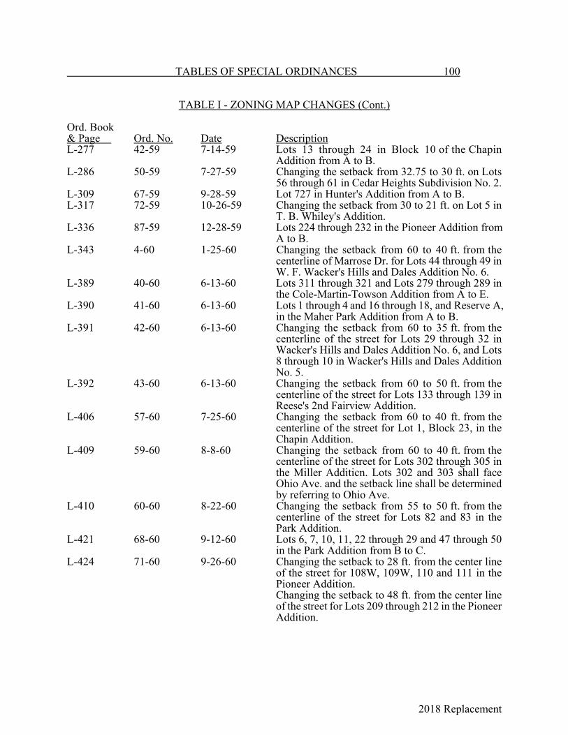
2018 Replacement
TABLES OF SPECIAL ORDINANCES 100
TABLE I - ZONING MAP CHANGES (Cont.)
Ord. Book& Page Ord. No. Date DescriptionL-277 42-59 7-14-59 Lots 13 through 24 in Block 10 of the Chapin
Addition from A to B. L-286 50-59 7-27-59 Changing the setback from 32.75 to 30 ft. on Lots
56 through 61 in Cedar Heights Subdivision No. 2.L-309 67-59 9-28-59 Lot 727 in Hunter's Addition from A to B.L-317 72-59 10-26-59 Changing the setback from 30 to 21 ft. on Lot 5 in
T. B. Whiley's Addition.L-336 87-59 12-28-59 Lots 224 through 232 in the Pioneer Addition from
A to B.L-343 4-60 1-25-60 Changing the setback from 60 to 40 ft. from the
centerline of Marrose Dr. for Lots 44 through 49 inW. F. Wacker's Hills and Dales Addition No. 6.
L-389 40-60 6-13-60 Lots 311 through 321 and Lots 279 through 289 inthe Cole-Martin-Towson Addition from A to E.
L-390 41-60 6-13-60 Lots 1 through 4 and 16 through 18, and Reserve A,in the Maher Park Addition from A to B.
L-391 42-60 6-13-60 Changing the setback from 60 to 35 ft. from thecenterline of the street for Lots 29 through 32 inWacker's Hills and Dales Addition No. 6, and Lots8 through 10 in Wacker's Hills and Dales AdditionNo. 5.
L-392 43-60 6-13-60 Changing the setback from 60 to 50 ft. from thecenterline of the street for Lots 133 through 139 inReese's 2nd Fairview Addition.
L-406 57-60 7-25-60 Changing the setback from 60 to 40 ft. from thecenterline of the street for Lot 1, Block 23, in theChapin Addition.
L-409 59-60 8-8-60 Changing the setback from 60 to 40 ft. from thecenterline of the street for Lots 302 through 305 inthe Miller Additicn. Lots 302 and 303 shall faceOhio Ave. and the setback line shall be determinedby referring to Ohio Ave.
L-410 60-60 8-22-60 Changing the setback from 55 to 50 ft. from thecenterline of the street for Lots 82 and 83 in thePark Addition.
L-421 68-60 9-12-60 Lots 6, 7, 10, 11, 22 through 29 and 47 through 50in the Park Addition from B to C.
L-424 71-60 9-26-60 Changing the setback to 28 ft. from the center lineof the street for 108W, 109W, 110 and 111 in thePioneer Addition. Changing the setback to 48 ft. from the center lineof the street for Lots 209 through 212 in the PioneerAddition.

2018 Replacement
101 TABLES OF SPECIAL ORDINANCES
TABLE I - ZONING MAP CHANGES (Cont.)
Ord. Book& Page Ord. No. Date DescriptionL-425 72-60 9-26-60 Lots 10 through 15, Block 4, in the Chapin Addition
from A to C.L-429 75-60 9-26-60 Lots 1 through 3 and 84 through 89 in Wright's
Addition, except the east 40 ft. on Lots 84, 85 and86, from A to C.
L-459 3-61 2-27-61 Changing the setback from 60 to 35 ft. from thecenter line of the street for Lot 55 in the EdgewoodPark Addition.
L-499 39-61 8-14-61 Changing the setback from 60 ft. to the followingnumber of ft. from the center line of Union St. in theMiller Subdivision:Lot 376 - 53 ft. on the west lot line to 45 ft. on theeast lot line. Lots 377 through 385 - 45 ft.
L-508 46-61 9-11-61 Lots 7 through 15 Block 3 of the Chapin Additionfrom A to C.
L-519 55-61 10-23-61 Outlot 91, Auditor's Tract 12 (171 E. 6th Ave.) fromA and C to C.
L-520 56-61 10-23-61 Changing the setback from 45 to 38 ft. from thecenterline of the street for Lots 76-S and 77-N in theRising Park Addition.
L-526 61-61 12-11-61 Lots 2 through 7 on E. Fair Ave. in John Widener'sAddition from B to C.
L-533 1-62 1-8-62 Changing the setback of Lot 766 on S. High St.,between Perry and Walnut Sts. in Carpenter'sAddition, to 31.5 ft. from the center line of WalnutSt. by changing the setback to 35 ft. from the centerline of Perry St. and to 8 ft. from the center line ofthe alley west of High St.
L-555 18-62 4-23-62 Lot 81 in the Brooks Addition from A to C.L-556 19-62 4-23-62 40 ft. of the north side of Lot 771 in Peters' 2nd
Addition from A to C.L-562 25-62 6-11-62 Lots 1 through 9, Block 18, in the Chapin Addition
from A to B.L-564 27-62 6-25-62 Changing the setback from 60 to 45 ft. from the
center line of the street for Lot 1 and part of Lot 2 inConstable's Subdivision (corner of Hubert Ave. andBoving Rd. ).
L-567 30-62 7-9-62 Lots 26 through 38 in the Brooks Addition from Ato B.
L-570 32-62 7-9-62 The north side of W. Mulberry St. between ForestRose Ave. and N. Columbus St. from A to C.
L-572 34-62 7-23-62 Changing the setback from 60 to 30 ft. from thecenterline of Pershing Dr. and from 60 to 45 ft.from the center line of Claredon St. for Lots 22through 24 in Edgewood Addition.

2018 Replacement
TABLES OF SPECIAL ORDINANCES 102
TABLE I - ZONING MAP CHANGES (Cont.)
Ord. Book& Page Ord. No. Date DescriptionL-599 53-62 9-24-62 Lots A, B and C of Ed. DeLancy's Subdivision from
B to C.L-603 57-62 9-24-62 Changing setback on north side of W. Chestnut St.
between Dean Ave. and the alley west from 60 to 32ft.
L-611 64-62 11-26-62 3.04 acres facing Tarhee and S. Broad Sts. from Ato C.
L-612 65-62 12-17-62 Lots 3 and 4 and west part of Lot 5 in E. B. Henry'sAddition from A to C.
L-613 1-63 1-28-63 Rear portions of properties between Memorial Dr.and Edgewood Ave. from A to C.
L-614 2-63 2-11-63 Lots 321W, 321E, 322, 323 and 324 in Reber'sAddition from B to C.
L-615 3-63 2-11-63 Lots 203M, 203W, 204N and 204S in Hop Co.'sAddition from A to C.
L-624 12-63 3-11-63 Lot 46 and west half of Lot 47 in Louis Snyder'sAddition from A to B.
M-25 43-63 8-12-63 Lots 616 and 617 in Caffee's Addition from B to C.M-108 22-64 4-13-64 Lot 1 in Hop Co.'s Addition and Lots 1 through 6
in Isabel Addition No. 2 from A to C.M-114 28-64 5-11-64 East and west sides of High St. from 5th Ave. to
alley north of 5th Ave.M 135 45-64 6-22-64 Lots 4, 5 and 6 in the Chapin Addition from A to C.M-136 46-64 6-22-64 Corner of S. Maple and Walnut Sts. from B to C.M-143 52-64 7-27-64 Lots 4, 5 and 6 in Carbon Works Addition from A
to B.M-152 57-64 8-10-64 Lots 564, 565, 557 and 558 in the City from A to C.M-161 64-64 8-24-64 Changing setback to 36 ft. from St. center line of
Lot 360 in Northwest Addition.M-163 66-64 8-24-64 Auditor's Tracts 14, 15 and 16 from A to B.M-174 76-64 9-28-64 East side of Forest Rose Ave. from North to W.
Allen Sts. and north side of W. Allen St. to the 2ndalley east of Forest Rose Ave. from A to B.
M-187 85-64 10-26-64 Lots 72, 73 and 74 in the Parks Addition on SlocumSt. from B to D.
M-193 91-64 11-9-64 Lots 34 through 38 in Carter's Addition from A toB.
M-227 26-65 2-22-65 Lots 12 SW, 13W, 13E and 14 in the AvondaleAddition from A to B.
M-309 90-65 8-23-65 Outlots 6-1 and 6-1-NW from A to B.M-324 104-65 10-11-65 Lot 8, Maher's 1st Addition from A to B.
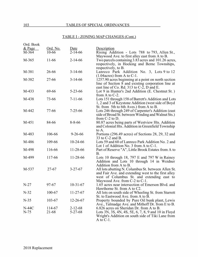
2018 Replacement
103 TABLES OF SPECIAL ORDINANCES
TABLE I - ZONING MAP CHANGES (Cont.)
Ord. Book& Page Ord. No. Date DescriptionM-364 10-66 2-14-66 Rising Addition - Lots 788 to 793, Allen St.,
Maywood Ave. to first alley east from A to B.M-365 11-66 2-14-66 Two parcels containing 3.83 acres and 101.26 acres,
respectively, in Hocking and Berne Townships,respectively, to B.
M-381 26-66 3-14-66 Lanreco Park Addition No. 3, Lots 9 to 12(1.04acres) from A to C-1.
M-382 27-66 3-14-66 1257.90 acres beginning at a point on north sectionline of Section 8 and existing corporation line ateast line of Co. Rd. 313 to C-2, D and E.
M-433 69-66 5-23-66 Lot 9 in Hunter's 2nd Addition (E. Chestnut St. )from A to C-2.
M-438 73-66 7-11-66 Lots 151 through 158 of Barrett's Addition and Lots1, 2 and 3 of Keystone Addition (west side of BoydSt. from 5th to 6th Aves.) from A to B.
M-442 77-66 7-25-66 Lots 246 through 249 of Carpenter's Addition (eastside of Broad St. between Winding and Walnut Sts.)from C-2 to D.
M-451 84-66 8-8-66 80.87 acres being parts of Westview Hts. Additionand Colonial Hts. Addition in Greenfield Townshipto A.
M-483 106-66 9-26-66 Portions (296.49 acres) of Sections 28, 29, 32 and33 to C-2 and B.
M-486 109-66 10-24-66 Lots 59 and 60 of Lanreco Park Addition No. 2 andLot 1 of Addition No. 3 from A to C-1.
M-498 116-66 11-28-66 Part of Reserve "A", Little Brook Estates from A toB.
M-499 117-66 11-28-66 Lots 10 through 18, 797 E and 797 W in RaineyAddition and Lots 10 through 14 in WeidnerAddition from A to B.
M-537 27-67 3-27-67 All lots abutting N. Columbus St. between Allen St.and Fair Ave. and extending west to the first alleywest of Columbus St. and extending east toMaywood Ave. from C-2 to C-1.
N-27 97-67 10-31-67 1.65 acres near intersection of Emerson Blvd. andHawthorne St. from A to C2.
N-32 100-67 11-27-67 All lots on south side of Wheeling St. from StarrettSt. to Eastwood Ave. from A to B.
N-35 103-67 12-26-67 Property bounded by Pure Oil bunk plant, LewisAve., Talmadge Ave. and Mithoff Dr. from E to B.
N-44C 114-67 2-12-68 6.826 acres on Sheridan Dr. from A to B.N-75 21-68 5-27-68 Lots 3N, 3S, 4N, 4S, 5E, 6, 7, 8, 9 and 10 in Floyd
Wright's Addition on south side of Tiki Lane fromA to C-1.
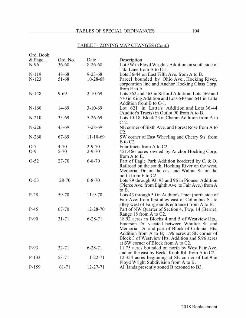
2018 Replacement
TABLES OF SPECIAL ORDINANCES 104
TABLE I - ZONING MAP CHANGES (Cont.)
Ord. Book& Page Ord. No. Date DescriptionN-96 36-68 8-26-68 Lot 5W in Floyd Wright's Addition on south side of
Tiki Lane from A to C-1.N-119 48-68 9-23-68 Lots 36-44 on East Fifth Ave. from A to B.N-123 51-68 10-28-68 Parcel bounded by Ohio Ave., Hocking River,
corporation line and Anchor Hocking Glass Corp.from E to A.
N-148 9-69 2-10-69 Lots 562 and 563 in Sifford Addition, Lots 569 and570 in King Addition and Lots 640 and 641 in LattaAddition from B to C-1.
N-160 14-69 3-10-69 Lot 621 in Latta's Addition and Lots 36-44(Auditor's Tracts) in Outlot 90 from A to B.
N-210 33-69 5-26-69 Lots 10-18, Block 23 in Chapin Addition from A toC-2.
N-226 43-69 7-28-69 NE corner of Sixth Ave. and Forest Rose from A toC2.
N-268 67-69 11-10-69 SW corner of East Wheeling and Cherry Sts. fromB to C2.
O-7 4-70 2-9-70 Four tracts from A to C2.O-9 5-70 2-9-70 451.466 acres owned by Anchor Hocking Corp.
from A to E.O-52 27-70 6-8-70 Part of Eagle Park Addition bordered by C. & O.
Railroad on the south, Hocking River on the west,Memorial Dr. on the east and Walnut St. on thenorth from E to C2.
O-53 28-70 6-8-70 Lots 89 through 93, 95 and 96 in Pioneer Addition(Pierce Ave. from Eighth Ave. to Fair Ave.) from Ato B.
P-28 59-70 11-9-70 Lots 43 through 50 in Auditor's Tract (north side ofFair Ave. from first alley east of Columbus St. toalley west of Fairgrounds entrance) from A to B.
P-45 67-70 12-28-70 Part of NW Quarter of Section 4, Twp. 14 (Berne),Range 18 from A to C2.
P-90 31-71 6-28-71 18.92 acres in Blocks 4 and 5 of Westview Hts.,Emerson Dr. vacated between Whittier St. andMemorial Dr. and part of Block of Colonial Hts.Addition from A to B; 1.96 acres at SE corner ofBlock 3 of Westview Hts. Addition and 5.96 acresat SW corner of Block from A to C2.
P-93 32-71 6-28-71 11.75 acres bounded on north by West Fair Ave.and on the east by Becks Knob Rd. from A to C2.
P-133 53-71 11-22-71 12.354 acres beginning at SE corner of Lot 9 inFloyd Wright Subdivision from A to B.
P-159 61-71 12-27-71 All lands presently zoned B rezoned to B3.
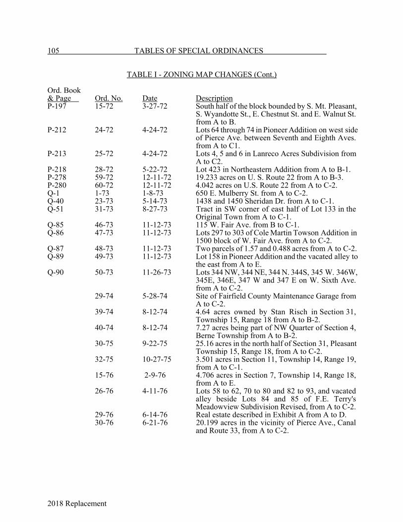
2018 Replacement
105 TABLES OF SPECIAL ORDINANCES
TABLE I - ZONING MAP CHANGES (Cont.)
Ord. Book& Page Ord. No. Date DescriptionP-197 15-72 3-27-72 South half of the block bounded by S. Mt. Pleasant,
S. Wyandotte St., E. Chestnut St. and E. Walnut St.from A to B.
P-212 24-72 4-24-72 Lots 64 through 74 in Pioneer Addition on west sideof Pierce Ave. between Seventh and Eighth Aves.from A to C1.
P-213 25-72 4-24-72 Lots 4, 5 and 6 in Lanreco Acres Subdivision fromA to C2.
P-218 28-72 5-22-72 Lot 423 in Northeastern Addition from A to B-1.P-278 59-72 12-11-72 19.233 acres on U. S. Route 22 from A to B-3.P-280 60-72 12-11-72 4.042 acres on U.S. Route 22 from A to C-2.Q-1 1-73 1-8-73 650 E. Mulberry St. from A to C-2.Q-40 23-73 5-14-73 1438 and 1450 Sheridan Dr. from A to C-1.Q-51 31-73 8-27-73 Tract in SW corner of east half of Lot 133 in the
Original Town from A to C-1.Q-85 46-73 11-12-73 115 W. Fair Ave. from B to C-1.Q-86 47-73 11-12-73 Lots 297 to 303 of Cole Martin Towson Addition in
1500 block of W. Fair Ave. from A to C-2.Q-87 48-73 11-12-73 Two parcels of 1.57 and 0.488 acres from A to C-2.Q-89 49-73 11-12-73 Lot 158 in Pioneer Addition and the vacated alley to
the east from A to E.Q-90 50-73 11-26-73 Lots 344 NW, 344 NE, 344 N. 344S, 345 W. 346W,
345E, 346E, 347 W and 347 E on W. Sixth Ave.from A to C-2.
29-74 5-28-74 Site of Fairfield County Maintenance Garage fromA to C-2.
39-74 8-12-74 4.64 acres owned by Stan Risch in Section 31,Township 15, Range 18 from A to B-2.
40-74 8-12-74 7.27 acres being part of NW Quarter of Section 4,Berne Township from A to B-2.
30-75 9-22-75 25.16 acres in the north half of Section 31, PleasantTownship 15, Range 18, from A to C-2.
32-75 10-27-75 3.501 acres in Section 11, Township 14, Range 19,from A to C-1.
15-76 2-9-76 4.706 acres in Section 7, Township 14, Range 18,from A to E.
26-76 4-11-76 Lots 58 to 62, 70 to 80 and 82 to 93, and vacatedalley beside Lots 84 and 85 of F.E. Terry'sMeadowview Subdivision Revised, from A to C-2.
29-76 6-14-76 Real estate described in Exhibit A from A to D.30-76 6-21-76 20.199 acres in the vicinity of Pierce Ave., Canal
and Route 33, from A to C-2.

2018 Replacement
TABLES OF SPECIAL ORDINANCES 106
TABLE I - ZONING MAP CHANGES (Cont.)
Ord. No. Date Description31-76 6-28-76 Lot 81 In Terry's Meadowview Subdivision Revised, from A to C-2.32-76 7-2-76 15.32 acres and 7.99 acres of Ralph Sharpnack’s property located on
East Main St. at Sells Rd., from Residential to C-2.42-76 9-27-76 Lot 30 on Cedar Hill Rd. and Lot 39 on West Chestnut St. from E to
C-2.46-76 10-11-76 Site purchased by City from LeRoy E. Ellinger in 1969 in vicinity of
Lawrence St, and Ewing St, from A to E.9-77 2-28-77 Lots 773, 774, 775 and 776 of Garaghty's Addition, Lots 671, 672
and 673 of Tennant' s Addition and the south side of East Main St,between Tennant St. and the Perry & Co. building from B-3 to C-1.
10-77 3-14-77 10.311 acres located approximately one mile east of the intersectionof Rainbow and Sheridan Drs, from A to C-2.
11-77 3-14-77 10.048 acres located approximately one mile east of the intersectionof Rainbow and Sheridan Drs. from A to B-3.
25-77 6-13-77 Parcel One, Tracts 1 (1.9463 acres) and 2 (11.67 acres) and ParcelTwo, Tracts 1 (6.45 acres), 2 (0.64 acres) and 3 (37 acres) from ClassA single residential and nonconforming industrial to Class D LightIndustrial; Parcel Two, Tracts 4 (23.97 acres) and 5 (11.20 acres)zoned Class E Heavy Industrial.
53-77 11-14-77 16.63 acres on Fair Ave. and another 1 acre tract from Class ASingle-Family Residence to Class C-2 Commercial.
3-78 1-23-78 Lot 11 of Ewings Second Addition (415 Wheat St. ) from Class EHeavy Industrial to Class C-2 Commercial.
6-78 3-13-78 1242 S. Broad St. from Class A Residential to Class C-1Commercial.
7-78 3-27-78 Two tracts of 1 and 0.75 acres in Section 7 of Berne Twp. No. 14,Range 18 from Class A Single-Family to Class D Light Industrial.
19-78 8-14-78 Part of NW Quarter of Section 4, Township 14, Range 18, CongressLands from Class A and C-2 to Class B-3.
27-78 9-25-78 Lots 53 to 63 in Pioneer Addition from Class A Single Residence toClass C-2 Commercial.
36-78 12-11-78 Lots 12 to 19 in Sixth Ward, Bowman and Graf Subdivision fromClass A Single Residence to Class B-3 Multiple.
14-79 2-26-79 Lots 82 through 85 in Pioneer Addition from Class B-3 MultipleResidence to Class C-2 Commercial.
42-79 7-2-79 Parcel in Pleasant Twp., Twp. 15, Range 18, SE quarter of Section 30from Class A Single Residence to Class C-2 Commercial.
5-80 2-25-80 Lots 5 through 16 in Block 24, Chapin Addition from Residential toClass C-2 Commercial.
7-80 3-10-80 Lots 149 through 161 in Brooks Addition, 1100 Block of East LocustSt. from Class A Residential to Class B-1 Multi-Families.
11-80 4-14-80 Lot 4 in Block 24 of Chapin Addition from Class A Residential toClass C-2 Commercial.
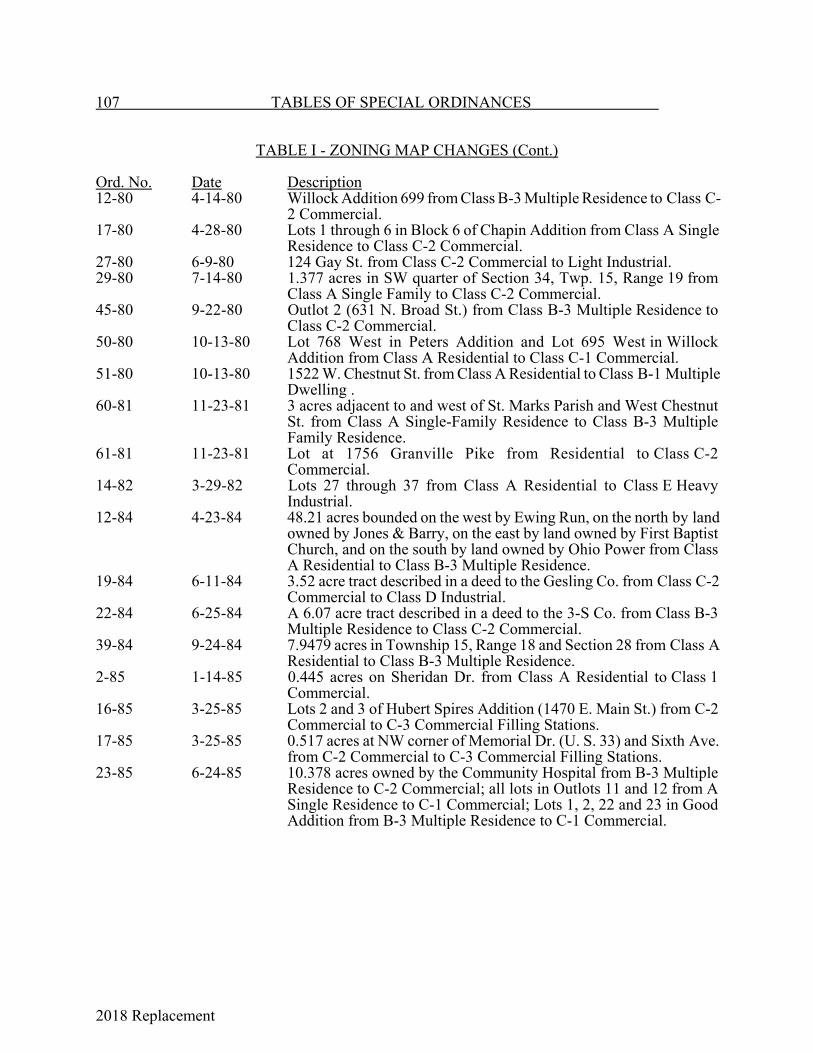
2018 Replacement
107 TABLES OF SPECIAL ORDINANCES
TABLE I - ZONING MAP CHANGES (Cont.)
Ord. No. Date Description12-80 4-14-80 Willock Addition 699 from Class B-3 Multiple Residence to Class C-
2 Commercial.17-80 4-28-80 Lots 1 through 6 in Block 6 of Chapin Addition from Class A Single
Residence to Class C-2 Commercial.27-80 6-9-80 124 Gay St. from Class C-2 Commercial to Light Industrial.29-80 7-14-80 1.377 acres in SW quarter of Section 34, Twp. 15, Range 19 from
Class A Single Family to Class C-2 Commercial.45-80 9-22-80 Outlot 2 (631 N. Broad St.) from Class B-3 Multiple Residence to
Class C-2 Commercial.50-80 10-13-80 Lot 768 West in Peters Addition and Lot 695 West in Willock
Addition from Class A Residential to Class C-1 Commercial.51-80 10-13-80 1522 W. Chestnut St. from Class A Residential to Class B-1 Multiple
Dwelling .60-81 11-23-81 3 acres adjacent to and west of St. Marks Parish and West Chestnut
St. from Class A Single-Family Residence to Class B-3 MultipleFamily Residence.
61-81 11-23-81 Lot at 1756 Granville Pike from Residential to Class C-2Commercial.
14-82 3-29-82 Lots 27 through 37 from Class A Residential to Class E HeavyIndustrial.
12-84 4-23-84 48.21 acres bounded on the west by Ewing Run, on the north by landowned by Jones & Barry, on the east by land owned by First BaptistChurch, and on the south by land owned by Ohio Power from ClassA Residential to Class B-3 Multiple Residence.
19-84 6-11-84 3.52 acre tract described in a deed to the Gesling Co. from Class C-2Commercial to Class D Industrial.
22-84 6-25-84 A 6.07 acre tract described in a deed to the 3-S Co. from Class B-3Multiple Residence to Class C-2 Commercial.
39-84 9-24-84 7.9479 acres in Township 15, Range 18 and Section 28 from Class AResidential to Class B-3 Multiple Residence.
2-85 1-14-85 0.445 acres on Sheridan Dr. from Class A Residential to Class 1Commercial.
16-85 3-25-85 Lots 2 and 3 of Hubert Spires Addition (1470 E. Main St.) from C-2Commercial to C-3 Commercial Filling Stations.
17-85 3-25-85 0.517 acres at NW corner of Memorial Dr. (U. S. 33) and Sixth Ave.from C-2 Commercial to C-3 Commercial Filling Stations.
23-85 6-24-85 10.378 acres owned by the Community Hospital from B-3 MultipleResidence to C-2 Commercial; all lots in Outlots 11 and 12 from ASingle Residence to C-1 Commercial; Lots 1, 2, 22 and 23 in GoodAddition from B-3 Multiple Residence to C-1 Commercial.
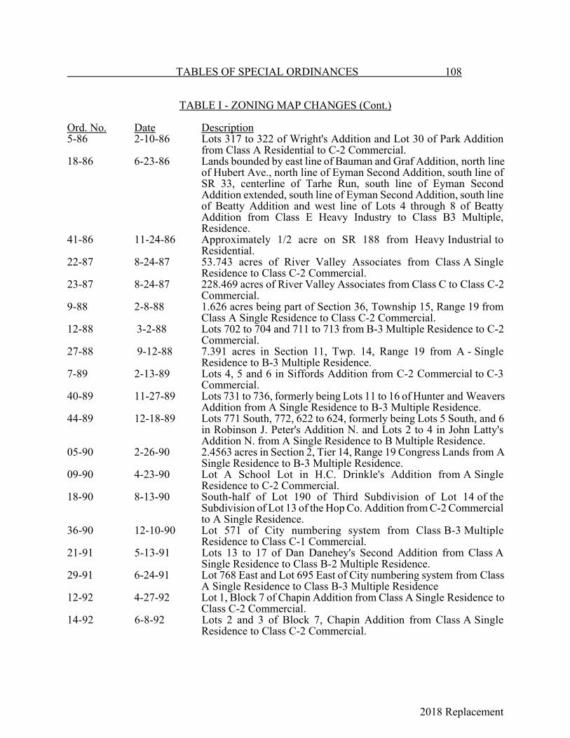
2018 Replacement
TABLES OF SPECIAL ORDINANCES 108
TABLE I - ZONING MAP CHANGES (Cont.)
Ord. No. Date Description5-86 2-10-86 Lots 317 to 322 of Wright's Addition and Lot 30 of Park Addition
from Class A Residential to C-2 Commercial.18-86 6-23-86 Lands bounded by east line of Bauman and Graf Addition, north line
of Hubert Ave., north line of Eyman Second Addition, south line ofSR 33, centerline of Tarhe Run, south line of Eyman SecondAddition extended, south line of Eyman Second Addition, south lineof Beatty Addition and west line of Lots 4 through 8 of BeattyAddition from Class E Heavy Industry to Class B3 Multiple,Residence.
41-86 11-24-86 Approximately 1/2 acre on SR 188 from Heavy Industrial toResidential.
22-87 8-24-87 53.743 acres of River Valley Associates from Class A SingleResidence to Class C-2 Commercial.
23-87 8-24-87 228.469 acres of River Valley Associates from Class C to Class C-2Commercial.
9-88 2-8-88 1.626 acres being part of Section 36, Township 15, Range 19 fromClass A Single Residence to Class C-2 Commercial.
12-88 3-2-88 Lots 702 to 704 and 711 to 713 from B-3 Multiple Residence to C-2Commercial.
27-88 9-12-88 7.391 acres in Section 11, Twp. 14, Range 19 from A - SingleResidence to B-3 Multiple Residence.
7-89 2-13-89 Lots 4, 5 and 6 in Siffords Addition from C-2 Commercial to C-3Commercial.
40-89 11-27-89 Lots 731 to 736, formerly being Lots 11 to 16 of Hunter and WeaversAddition from A Single Residence to B-3 Multiple Residence.
44-89 12-18-89 Lots 771 South, 772, 622 to 624, formerly being Lots 5 South, and 6in Robinson J. Peter's Addition N. and Lots 2 to 4 in John Latty'sAddition N. from A Single Residence to B Multiple Residence.
05-90 2-26-90 2.4563 acres in Section 2, Tier 14, Range 19 Congress Lands from ASingle Residence to B-3 Multiple Residence.
09-90 4-23-90 Lot A School Lot in H.C. Drinkle's Addition from A SingleResidence to C-2 Commercial.
18-90 8-13-90 South-half of Lot 190 of Third Subdivision of Lot 14 of theSubdivision of Lot 13 of the Hop Co. Addition from C-2 Commercialto A Single Residence.
36-90 12-10-90 Lot 571 of City numbering system from Class B-3 MultipleResidence to Class C-1 Commercial.
21-91 5-13-91 Lots 13 to 17 of Dan Danehey's Second Addition from Class ASingle Residence to Class B-2 Multiple Residence.
29-91 6-24-91 Lot 768 East and Lot 695 East of City numbering system from ClassA Single Residence to Class B-3 Multiple Residence
12-92 4-27-92 Lot 1, Block 7 of Chapin Addition from Class A Single Residence toClass C-2 Commercial.
14-92 6-8-92 Lots 2 and 3 of Block 7, Chapin Addition from Class A SingleResidence to Class C-2 Commercial.

2018 Replacement
109 TABLES OF SPECIAL ORDINANCES
TABLE I - ZONING MAP CHANGES (Cont.)
Ord. No. Date Description22-92 8-10-92 Lots 11 to 17 in Outlot 11 of the Bank Addition from Class C-1
Commercial to Class C-2 Commercial27-92 9-28-92 Land on State Route 37 from Class A Single Residence to Class C-2
Commercial.28-92 10-12-92 Approves conditional use of single residence use in Lots 27 to 30 in
Carbon Works Addition being in a Class E Heavy Industry District.36-92 11-9-92 Rear 166 feet of Auditor's Parcels 12 and 13 of Outlot 20, Banks
Second Addition from Class A Single Residence to Class C-2Commercial.
13-93 2-8-93 Newly annexed Sections 26, 27 and 35 of Greenfield Twp. from B 1Business to C-2 Commercial; I-1 Industrial to E Heavy Industrial andA-1 Restricted Agricultural to A Single Residence.
17-93 5-10-93 1.006 acres on Memorial Dr. from Class A Single Residence to ClassC-2 Commercial.
32-93 8-9-93 Lots 348 through 351 of Northwestern Addition from Class A SingleResidence to Class B-1 Multiple Residence.
15-94 4-11-94 Lots 1 through 12 of Lanreco Park Addition No. 3 from Class ASingle Residence to Class C-2 Commercial.
21-94 5-23-94 96.977 acres being in Greenfield Township, Section 27, Township15, Range 19, Congress Lands from Class E Heavy Industrial toClass A Residence, from Class E Heavy Industrial to Class A SingleResidence.
23-94 6-13-94 Charles and Rena Good Additional from Class C-1 Commercial to C-2 Commercial.
32-94 10-10-94 Lot 16 of Boystel-Fauble Addition from Class A Single Residence toClass C-2 Commercial.
38-94 11-14-94 10 acres in Section 2, Township 14, Range 19, lying SW of IndianaOhio Rail System, west of Brumfield Road and south of Fair Avenuefrom Class A Single Residence to Class C-2 Commercial.
41-94 11-28-94 Crites two property tracts from Class B-2 Multiple Residence toClass C-2 Commercial.
2-95 1-9-95 3.78 acres beginning at intersection of South Maple St. and SWcorner of White’s Addition from Class A Single Residence to ClassC-2 Commercial.
13-95 4-10-95 Lots 725 and 726 of Hunter Weaver Addition from Class A SingleResidence to Class C-1 Commercial; Lot 727 from Class B-3Multiple Residence to Class C-1 Commercial.
33-96 10-28-96 78.153 acres annexed by Ordinance 14-96 from Class I-1 Industrialto Class C-2 Commercial.
34-96 10-28-96 Property annexed by Ordinance 27-96:Tracts A (79.873 acres), B (100 acres) and C (58.722 acres) fromClass RR Rural Residential to Class E Heavy Industrial; Tract D(33.896 acres) from Class GB General Business to Class E HeavyIndustrial; Tract E (203.29 acres) from Class RR Rural Residential toClass D Light Industrial.
3-97 1-27-97 2.701 acres on State Rt. 37 from A Single Residence to C-2Commercial.
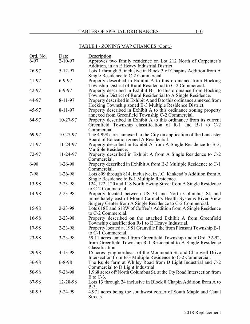
2018 Replacement
TABLES OF SPECIAL ORDINANCES 110
TABLE I - ZONING MAP CHANGES (Cont.)
Ord. No. Date Description6-97 2-10-97 Approves two family residence on Lot 212 North of Carpenter’s
Addition, in an E Heavy Industrial District.26-97 5-12-97 Lots 1 through 5, inclusive in Block 3 of Chapins Addition from A
Single Residence to C-2 Commercial.41-97 6-9-97 Property described in Exhibit A to this ordinance from Hocking
Township District of Rural Residential to C-2 Commercial.42-97 6-9-97 Property described in Exhibit B-1 to this ordinance from Hocking
Township District of Rural Residential to A Single Residence.44-97 8-11-97 Property described in Exhibit A and B to this ordinance annexed from
Hocking Township zoned B-3 Multiple Residence District.45-97 8-11-97 Property described in Exhibit A to this ordinance zoning property
annexed from Greenfield Township C-2 Commercial.64-97 10-27-97 Property described in Exhibit A to this ordinance from its current
Greenfield Township classification of R-1 and B-1 to C-2Commercial.
69-97 10-27-97 The 4.998 acres annexed to the City on application of the LancasterBoard of Education zoned A Residential.
71-97 11-24-97 Property described in Exhibit A from A Single Residence to B-3,Multiple Residence.
72-97 11-24-97 Property described in Exhibit A from A Single Residence to C-2Commercial.
6-98 1-26-98 Property described in Exhibit A from B-3 Multiple Residence to C-1Commercial.
7-98 1-26-98 Lots 809 through 814, inclusive, in J.C. Kinkead’s Addition from ASingle Residence to B-1 Multiple Residence.
13-98 2-23-98 124, 122, 120 and 118 North Ewing Street from A Single Residenceto C-2 Commercial.
14-98 2-23-98 Property located between US 33 and North Columbus St. andimmediately east of Mount Carmel’s Health Systems River ViewSurgery Center from A Single Residence to C-2 Commercial.
15-98 2-23-98 Lots 618E and 618W of Coffee’s Addition from A Single Residenceto C-2 Commercial.
16-98 2-23-98 Property described on the attached Exhibit A from GreenfieldTownship classification R-1 to E Heavy Industrial.
17-98 2-23-98 Property located at 1981 Granville Pike from Pleasant Township B-1to C-1 Commercial.
23-98 3-23-98 59.11 acres annexed from Greenfield Township under Ord. 32-92,from Greenfield Township R-1 Residential to A Single ResidenceClassification.
29-98 4-13-98 15 acres lying northeast of the Monmouth St. and Chartwell DriveIntersection from B-3 Multiple Residence to C-2 Commercial.
36-98 6-8-98 The Ruble farm at Whiley Road from D Light Industrial and C-2Commercial to D Light Industrial.
50-98 9-28-98 1.968 acres off North Columbus St. at the Ety Road Intersection fromE to C-3.
67-98 12-28-98 Lots 13 through 24 inclusive in Block 8 Chapin Addition from A toB-3.
30-99 5-24-99 4.971 acres being the southwest corner of South Maple and CanalStreets.
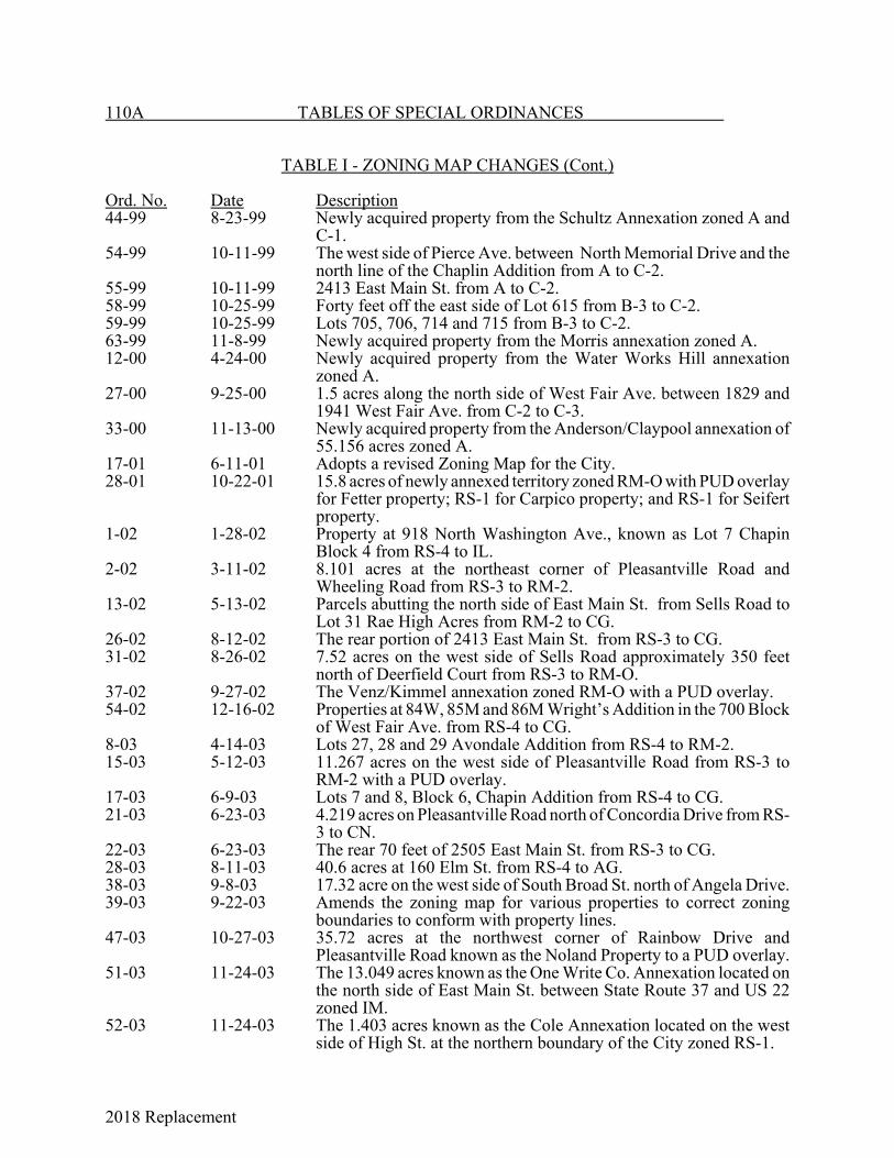
2018 Replacement
110A TABLES OF SPECIAL ORDINANCES
TABLE I - ZONING MAP CHANGES (Cont.)
Ord. No. Date Description44-99 8-23-99 Newly acquired property from the Schultz Annexation zoned A and
C-1.54-99 10-11-99 The west side of Pierce Ave. between North Memorial Drive and the
north line of the Chaplin Addition from A to C-2.55-99 10-11-99 2413 East Main St. from A to C-2.58-99 10-25-99 Forty feet off the east side of Lot 615 from B-3 to C-2.59-99 10-25-99 Lots 705, 706, 714 and 715 from B-3 to C-2.63-99 11-8-99 Newly acquired property from the Morris annexation zoned A.12-00 4-24-00 Newly acquired property from the Water Works Hill annexation
zoned A.27-00 9-25-00 1.5 acres along the north side of West Fair Ave. between 1829 and
1941 West Fair Ave. from C-2 to C-3.33-00 11-13-00 Newly acquired property from the Anderson/Claypool annexation of
55.156 acres zoned A.17-01 6-11-01 Adopts a revised Zoning Map for the City.28-01 10-22-01 15.8 acres of newly annexed territory zoned RM-O with PUD overlay
for Fetter property; RS-1 for Carpico property; and RS-1 for Seifertproperty.
1-02 1-28-02 Property at 918 North Washington Ave., known as Lot 7 ChapinBlock 4 from RS-4 to IL.
2-02 3-11-02 8.101 acres at the northeast corner of Pleasantville Road andWheeling Road from RS-3 to RM-2.
13-02 5-13-02 Parcels abutting the north side of East Main St. from Sells Road toLot 31 Rae High Acres from RM-2 to CG.
26-02 8-12-02 The rear portion of 2413 East Main St. from RS-3 to CG.31-02 8-26-02 7.52 acres on the west side of Sells Road approximately 350 feet
north of Deerfield Court from RS-3 to RM-O.37-02 9-27-02 The Venz/Kimmel annexation zoned RM-O with a PUD overlay.54-02 12-16-02 Properties at 84W, 85M and 86M Wright’s Addition in the 700 Block
of West Fair Ave. from RS-4 to CG.8-03 4-14-03 Lots 27, 28 and 29 Avondale Addition from RS-4 to RM-2.15-03 5-12-03 11.267 acres on the west side of Pleasantville Road from RS-3 to
RM-2 with a PUD overlay.17-03 6-9-03 Lots 7 and 8, Block 6, Chapin Addition from RS-4 to CG.21-03 6-23-03 4.219 acres on Pleasantville Road north of Concordia Drive from RS-
3 to CN.22-03 6-23-03 The rear 70 feet of 2505 East Main St. from RS-3 to CG.28-03 8-11-03 40.6 acres at 160 Elm St. from RS-4 to AG.38-03 9-8-03 17.32 acre on the west side of South Broad St. north of Angela Drive.39-03 9-22-03 Amends the zoning map for various properties to correct zoning
boundaries to conform with property lines.47-03 10-27-03 35.72 acres at the northwest corner of Rainbow Drive and
Pleasantville Road known as the Noland Property to a PUD overlay.51-03 11-24-03 The 13.049 acres known as the One Write Co. Annexation located on
the north side of East Main St. between State Route 37 and US 22zoned IM.
52-03 11-24-03 The 1.403 acres known as the Cole Annexation located on the westside of High St. at the northern boundary of the City zoned RS-1.
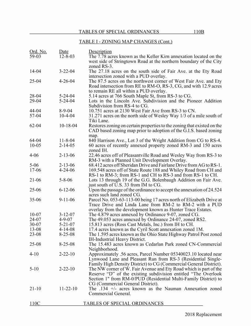
2018 Replacement
TABLES OF SPECIAL ORDINANCES 110B
TABLE I - ZONING MAP CHANGES (Cont.)
Ord. No. Date Description59-03 12-8-03 The 7.78 acres known as the Keller Kirn annexation located on the
west side of Stringtown Road at the northern boundary of the Cityzoned RS-3.
14-04 3-22-04 The 27.18 acres on the south side of Fair Ave. at the Ety Roadintersection zoned with a PUD overlay.
25-04 4-26-04 The 87.5 acres on the northwest corner of West Fair Ave. and EtyRoad intersection from RE to RM-O, RS-3, CG, and with 12.9 acresto remain RE all within a PUD overlay.
28-04 5-24-04 5.14 acres at 766 South Maple St, from RS-3 to CG.29-04 5-24-04 Lots in the Lincoln Ave. Subdivision and the Pioneer Addition
Subdivision from RS-4 to CG.44-04 8-9-04 10.751 acres at 2130 West Fair Ave from RS-3 to CN.57-04 10-4-04 31.271 acres on the north side of Wesley Way 1/3 of a mile south of
Tiki Lane.62-04 10-18-04 Restores zoning on certain properties to the zoning that existed on the
CAD based zoning map prior to adoption of the G.I.S. based zoningmap.
64-04 11-8-04 840 Harrison Ave., Lot 3 of the Wright Addition from CG to RS-4.10-05 2-14-05 60 acres of recently annexed property zoned RM-3 and 150 acres
zoned IH.4-06 2-13-06 22.46 acres off of Pleasantville Road and Wesley Way from RS-3 to
RM-3 with a Planned Unit Development Overlay.5-06 2-13-06 68.412 acres off Sheridan Drive and Fairlane Drive from AG to RS-1.17-06 4-24-06 169.548 acres off of State Route 188 and Whiley Road from CH and
RS-1 to RM-3; from RS-1 and CH to RS-3 and from RS-1 to CH.21-06 5-8-06 Lots 13 through 19 of the G.G. Bolenbaugh Addition on Fair Ave.
just south of U.S. 33 from IM to CG.25-06 6-12-06 Upon the passage of the ordinance to accept the annexation of 24.524
acres such land zoned CG.35-06 9-11-06 Parcel No. 053-63-113-00 being 17 acres north of Elizabeth Drive at
Trace Drive and Linda Lane from RM-2 to RM-2 with a PUDoverlay from the development known as Hunter Trace Estates.
10-07 3-12-07 The 4.879 acres annexed by Ordinance 9-07, zoned CG.24-07 4-9-07 The 49.053 acres annexed by Ordinance 24-07, zoned RS2.30-07 5-21-07 15.813 acres (Ross Cast Metals, Inc.) from IH to CH.13-08 4-14-08 17.4 acres known as the Cyril Scott annexation zoned 1M.23-08 8-25-08 The 1.595 acres known as the Ohio State Highway Patrol Post zoned
IH-Industrial Heavy District.25-08 8-25-08 The 15.483 acres known as Cedarlan Park zoned CN-Commercial
Neighborhood.4-10 2-22-10 Approximately .56 acres, Parcel Number 05340023.10 located near
Lynwood Lane and Pleasant Run from RS-3 (Residential Single-Family High Density District) to CG (Commercial General District).
5-10 2-22-10 The NW corner of W. Fair Avenue and Ety Road which is part of theReserve “D” of the existing subdivision entitled “The OverlookSection 1" from RM-0/PUD (Residential Multi-Family District) toCG (Commercial General District).
21-10 11-22-10 The .134 +/- acres known as the Nauman Annexation zonedCommercial General.
110C TABLES OF SPECIAL ORDINANCES
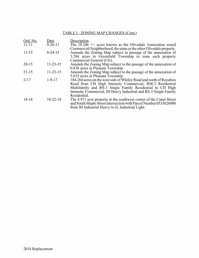
2018 Replacement
TABLE I - ZONING MAP CHANGES (Cont.)
Ord. No. Date Description11-11 9-26-11 The 10.246 +/- acres known as the Olivedale Annexation zoned
Commercial Neighborhood, the same as the other Olivedale property.11-15 8-24-15 Amends the Zoning Map subject to passage of the annexation of
3.284 acres in Greenfield Township to zone such propertyCommercial General (CG).
20-15 11-23-15 Amends the Zoning Map subject to the passage of the annexation of0.838 acres in Pleasant Township.
21-15 11-23-15 Amends the Zoning Map subject to the passage of the annexation of5.633 acres in Pleasant Township.
2-17 1-9-17 184.264 acres on the west side of Whiley Road and north of RoyaltonRoad from CH High Intensity Commercial, RM-3 ResidentialMultifamily and RS-3 Single Family Residential to CH HighIntensity Commercial, IH Heavy Industrial and RS-3 Single FamilyResidential.
18-18 10-22-18 The 4.971 acre property at the southwest corner of the Canal Streetand South Maple Street intersection with Parcel Number 0535026000from IH Industrial Heavy to IL Industrial Light.

2018 Replacement

2018 Replacement
111 TABLES OF SPECIAL ORDINANCES
TABLE J - ANNEXATION OR DETACHMENT OF TERRITORY
Ord. Book& Page Ord. No. Date DescriptionC-256 Unno. 3-2-1871 Territory in Berne, Hocking, Greenfield and
Pleasant Twps. contiguous to the City.A-151 Unno. 6-27-1890 Land beginning at a point on the range line between
Hocking and Berne Twps.A-160 Unno. 8-11-90 Land beginning at a point on the range line between
Hocking and Berne Twps.A-293 Unno. 4-13-1896 A portion of the Forest Rose Cemetery.A-354 Unno. 9-27-1897 Territory beginning at the intersection of the
Cincinnati and Muskingum Valley R.R. and theexisting east corporation line.
A-355 Unno. 2-14-1898 Territory beginning at a point in the old corporationline in the center of Cleveland Ave.
E-123 804 5-14-23 19.53 acres in Berne Twp., part of the NW quarterof Section 5, Twp. 14, Range 18.
E-245 870 4-28-24 Application of Mary Taylor, et al., for land west ofCity in Hocking Twp.
E-394 935 7-13-25 Application of George C. Callahan, et al., for landeast of City in Section 5, Twp. 14, Range 18.
F-468 1214 9-23-29 (a) Part of NE and SE Quarters of Section 2,Twp. 14, Range 19, in Hocking Twp.
(b) Part of SW Quarter of Section 5, Twp. 14,Range 18, in Berne Twp.
(c) Part of Section 5, Twp. 14, Range 18, inBerne Twp.
G-254 1403 4-25-32 All that part of Edgewood Park and AvondaleAdditions not now a part of the City.
I-40 2086 8-26-40 38 acres being part of east half of Section 2, Twp.14, Range 19.
I-219 86-41 10-27-41 38 acres being east half of Section 2, Twp. 14,Range 19.
I-434 18-43 3-22-43 25.48 acres beginning at the SW corner of the SEQuarter of Section 31.
J-304 46-48 8-23-48 Application of W. F. Wacker for 67.03 acres inGreenfield Twp., being part of Sections 35 and 36,Twp. 15, Range 19.
K-76 6-52 1-28-52 Application of Anchor-Hocking Glass Corp. for64.4385 acres being part of Section 35, Twp. 15(Greenfield), Range 19.
K-290 77-53 12-28-53 Application of Thomas C. Taylor, et al., for part ofSection 5, Twp. 14, Range 18, in Berne Twp.
K-341 44-54 7-26-54 Application of Robert S. Grandstaff, et al., for 98acres being part of Section 32, Twp. 15, Range 18.

2018 Replacement
TABLES OF SPECIAL ORDINANCES 112
TABLE J - ANNEXATION OR DETACHMENT OF TERRITORY (Cont.)
Ord. Book& Page Ord. No. Date DescriptionK-399 10-55 2-22-55 Annexation application of Johnson and Griffith, et
al., for 30.798 acres near Baltimore Rd. at NWcorner of Forest Rose Cemetery.
K-484 73-55 11-28-55 Annexation application of Wacker for 13.9 acres inSection 25 and 30.54 acres in Section 26, Twp. 15,Range 19, and Lots 16 to 20, inclusive, and part ofLots 11 to 15 and 21 to 31, inclusive, in Wacker'sHills and Dales Addition No. 3.
K-486 75-55 12-12-55 Annexation application of Nabergal for 201.59acres being part of Section 2, Twp. 14, Range 19and part of Section 35, Twp. 15, Range 19.
K-574 63-56 10-8-56 Application of Sitterley, Nusbaum and Paulin for3.58 acres in Pleasant Twp. beginning at the NEcorner of Rising Park.
K-584 70-56 11-26-55 Application of Fairfield Hills, Inc., for 80.29 acresin Pleasant Twp. beginning 110.22 ft. west of theSE corner of Section 32.
L-41 39-57 5-27-57 Application of Van Gundy and Turner for 60.053acres, being part of Sections 26 and 35, GreenfieldTwp. beginning at a stone at the NE corner ofSection 35.
L-224 86-58 11-24-58 Application of Board of Education for 28.673 acresbeing part of Section 31, Twp. 15, Range 18,Fairfield C ounty.
L-275 40-59 6-8-59 Application of Board of Education for 37.93 acres,being part of Section 32, Twp. 15, Range 18, andbeginning at the NE corner of the Huffer-DurdinAddition, except the right of way of Sheridan Dr.and Pleasantville Rd.
L-434 78-60 10-10-60 Application of Supman for 7.03 acres, being part ofthe SW Quarter, Section 12, Twp. 14, Range 19,except a 25-ft. roadway right of way along the northside thereof.
L-545 12-62 4-9-62 Application of Pratt for 9.01 acres, being part of thenorth half of Section 7, Twp. 14, Range 18, andbeginning at the SE corner of the Alkire-HornbeckAddition and west line of Maple St.
L-594 50-62 8-27-62 Application of Brown for 149.70 acres being part ofSections 2 and 11, Twp. 14, Range 19.
M-35 51-63 9-9-63 Annexation application of Kermit C. Sitterley for0.516 acres near NE corner of Rising Park.
M-102 18-64 3-23-64 Accepting annexation application of Jack Supmanfor 2 tracts (12.3 and 34.460 acres).
M-341 111-65 11-22-65 Annexation application of Chas. E. Reed for 15.60acres being a portion of Floyd E. Terry'sMeadowview Subdivision Revised.
M-351 121-65 12-27-65 Annexation application of Robt. U. Hastings, Jr., for2 tracts containing 2.16 acres.

2018 Replacement
113 TABLES OF SPECIAL ORDINANCES
TABLE J - ANNEXATION OR DETACHMENT OF TERRITORY (Cont.)
Ord. Book& Page Ord. No. Date DescriptionM-365 11-66 2-14-66 Annexation of 2 parcels containing 3.83 acres and
101.26 acres, respectively, in Hocking and BerneTownships, respectively.
M-382 27-66 3-14-66 Annexation of 1257.90 acres beginning at a pointon the north section line of Section 8 and existingcorporation line at east line of Co. Rd. 313.
M-419 58-66 5-9-66 Annexation of part of Section 11 and part of Section12, including all of Lottie Starner's Subdivision.
M-451 84-66 8-8-66 Annexation of 80.87 acres being parts of WestviewHts. Addition and Colonial Hts. Addition inGreenfield Township.
M-483 106-66 9-26-66 Annexation application of H.R. Byrd for 296.49acres in Sections 28, 29, 32 and 33 of PleasantTownship.
M-563 49-67 4-25-67 Annexation of 20.85 acres being part of Section 3,Township 14, Range 19, Fairfield County.
M-569 55-67 6-12-67 Annexation of 47.95 acres in Sections 25 and 26,Township 15, Range 19, Fairfield County.
N-33 101-67 12-11-67 Annexation application of Walter Graf for 39.65acres in Sections 25 and 36, Twp. 15, Range 19,Fairfield County.
N-34 102-67 12-11-67 Annexation of 20.85 acres in Section 3, Twp. 14,Range 19, Fairfield County.
N-36 104-67 12-26-67 Annexation application of Walter Graf for 15.48acres in SE Quarter of Section 12, Twp. 14, Range19, Fairfield County.
N-37 105-67 12-26-67 Annexation application of James Ross for 11.15acres in Section 31, Twp. 15, Range 18, FairfieldCounty.
N- 44 112-67 1-8-68 Annexation application of Walter Graf for 4.80acres in SW Quarter of Section 12, Twp. 14, Range19, Fairfield County.
N-44D 115-67 2-12-68 Annexation application of Kermit Sitterley for143.95 acres in Section 31 and 90.29 acres inSection 30, Pleasant Twp.
N-97 37-68 8-26-68 Annexation application of Walter Graf for 166.15acres in Hocking Twp.
N-98 38-68 8-26-68 Annexation application of Charles Reed for 62acres in Section 25 and 31.04 acres in Section 36,Greenfield Twp.
N-177 21-69 4-28-69 Annexation application of Kermit Sitterley for146.71 in Pleasant Twp.
N-234 49-69 8-11-69 Annexation application of Walter Graf for 1410.60acres in Greenfield and Hocking Twps., FairfieldCounty.
N-236 50-69 8-25-69 Annexation application of E. R. Lentz for 101.53acres in Pleasant Twp.
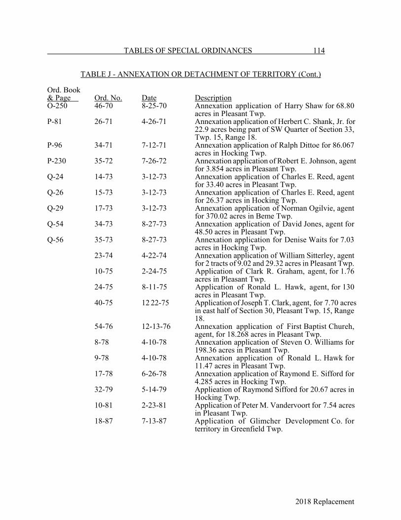
2018 Replacement
TABLES OF SPECIAL ORDINANCES 114
TABLE J - ANNEXATION OR DETACHMENT OF TERRITORY (Cont.)
Ord. Book& Page Ord. No. Date DescriptionO-250 46-70 8-25-70 Annexation application of Harry Shaw for 68.80
acres in Pleasant Twp.P-81 26-71 4-26-71 Annexation application of Herbert C. Shank, Jr. for
22.9 acres being part of SW Quarter of Seetion 33,Twp. 15, Range 18.
P-96 34-71 7-12-71 Annexation application of Ralph Dittoe for 86.067acres in Hocking Twp.
P-230 35-72 7-26-72 Annexation application of Robert E. Johnson, agentfor 3.854 acres in Pleasant Twp.
Q-24 14-73 3-12-73 Annexation application of Charles E. Reed, agentfor 33.40 acres in Pleasant Twp.
Q-26 15-73 3-12-73 Annexation application of Charles E. Reed, agentfor 26.37 acres in Hocking Twp.
Q-29 17-73 3-12-73 Annexation application of Norman Ogilvie, agentfor 370.02 acres in Beme Twp.
Q-54 34-73 8-27-73 Annexation application of David Jones, agent for48.50 acres in Pleasant Twp.
Q-56 35-73 8-27-73 Annexation application for Denise Waits for 7.03acres in Hocking Twp.
23-74 4-22-74 Annexation application of William Sitterley, agentfor 2 tracts of 9.02 and 29.32 acres in Pleasant Twp.
10-75 2-24-75 Application of Clark R. Graham, agent, for 1.76acres in Pleasant Twp.
24-75 8-11-75 Application of Ronald L. Hawk, agent, for 130acres in Pleasant Twp.
40-75 12 22-75 Application of Joseph T. Clark, agent, for 7.70 acresin east half of Section 30, Pleasant Twp. 15, Range18.
54-76 12-13-76 Annexation application of First Baptist Chureh,agent, for 18.268 acres in Pleasant Twp.
8-78 4-10-78 Annexation application of Steven O. Williams for198.36 acres in Pleasant Twp.
9-78 4-10-78 Annexation application of Ronald L. Hawk for11.47 acres in Pleasant Twp.
17-78 6-26-78 Annexation application of Raymond E. Sifford for4.285 acres in Hocking Twp.
32-79 5-14-79 Applieation of Raymond Sifford for 20.67 acres inHocking Twp.
10-81 2-23-81 Application of Peter M. Vandervoort for 7.54 acresin Pleasant Twp.
18-87 7-13-87 Application of Glimcher Development Co. forterritory in Greenfield Twp.
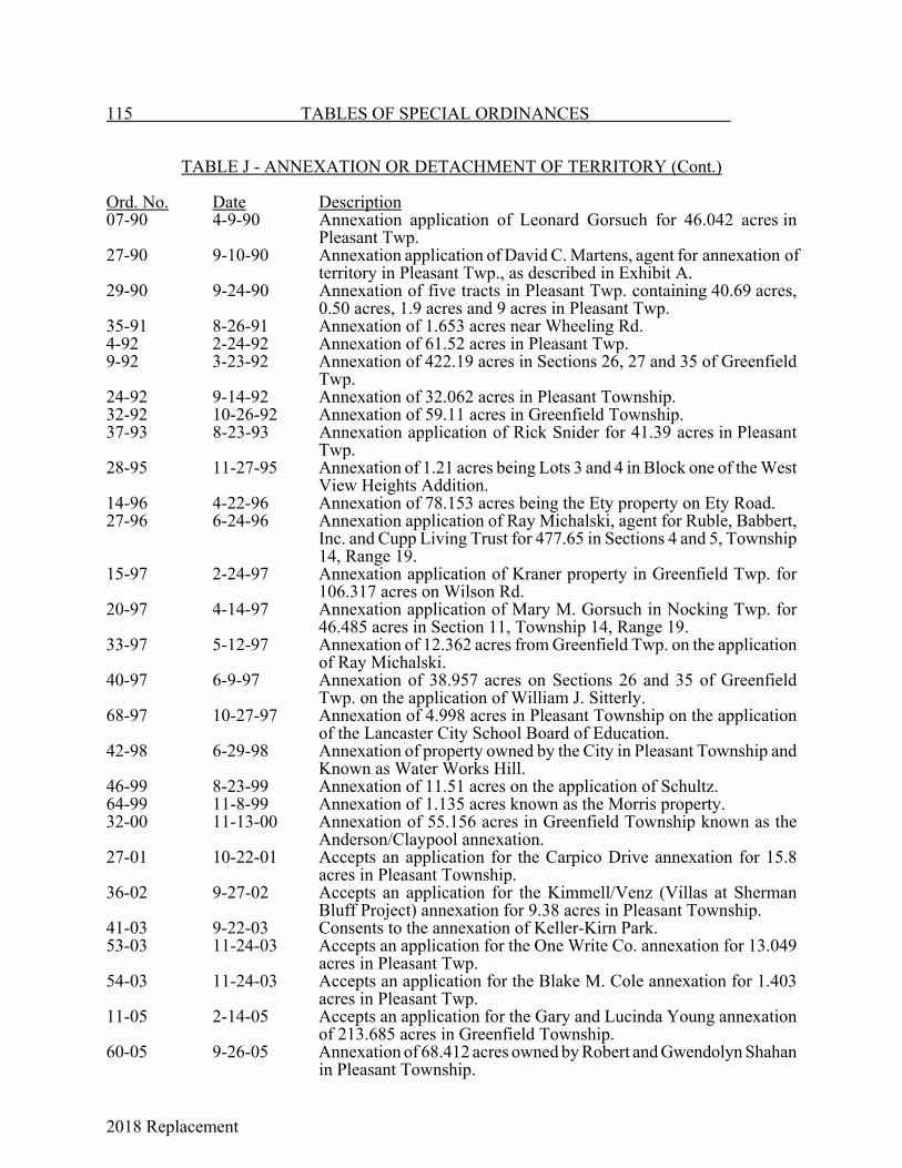
2018 Replacement
115 TABLES OF SPECIAL ORDINANCES
TABLE J - ANNEXATION OR DETACHMENT OF TERRITORY (Cont.)
Ord. No. Date Description07-90 4-9-90 Annexation application of Leonard Gorsuch for 46.042 acres in
Pleasant Twp.27-90 9-10-90 Annexation application of David C. Martens, agent for annexation of
territory in Pleasant Twp., as described in Exhibit A.29-90 9-24-90 Annexation of five tracts in Pleasant Twp. containing 40.69 acres,
0.50 acres, 1.9 acres and 9 acres in Pleasant Twp. 35-91 8-26-91 Annexation of 1.653 acres near Wheeling Rd.4-92 2-24-92 Annexation of 61.52 acres in Pleasant Twp.9-92 3-23-92 Annexation of 422.19 acres in Sections 26, 27 and 35 of Greenfield
Twp.24-92 9-14-92 Annexation of 32.062 acres in Pleasant Township.32-92 10-26-92 Annexation of 59.11 acres in Greenfield Township.37-93 8-23-93 Annexation application of Rick Snider for 41.39 acres in Pleasant
Twp.28-95 11-27-95 Annexation of 1.21 acres being Lots 3 and 4 in Block one of the West
View Heights Addition.14-96 4-22-96 Annexation of 78.153 acres being the Ety property on Ety Road.27-96 6-24-96 Annexation application of Ray Michalski, agent for Ruble, Babbert,
Inc. and Cupp Living Trust for 477.65 in Sections 4 and 5, Township14, Range 19.
15-97 2-24-97 Annexation application of Kraner property in Greenfield Twp. for106.317 acres on Wilson Rd.
20-97 4-14-97 Annexation application of Mary M. Gorsuch in Nocking Twp. for46.485 acres in Section 11, Township 14, Range 19.
33-97 5-12-97 Annexation of 12.362 acres from Greenfield Twp. on the applicationof Ray Michalski.
40-97 6-9-97 Annexation of 38.957 acres on Sections 26 and 35 of GreenfieldTwp. on the application of William J. Sitterly.
68-97 10-27-97 Annexation of 4.998 acres in Pleasant Township on the applicationof the Lancaster City School Board of Education.
42-98 6-29-98 Annexation of property owned by the City in Pleasant Township andKnown as Water Works Hill.
46-99 8-23-99 Annexation of 11.51 acres on the application of Schultz.64-99 11-8-99 Annexation of 1.135 acres known as the Morris property.32-00 11-13-00 Annexation of 55.156 acres in Greenfield Township known as the
Anderson/Claypool annexation.27-01 10-22-01 Accepts an application for the Carpico Drive annexation for 15.8
acres in Pleasant Township.36-02 9-27-02 Accepts an application for the Kimmell/Venz (Villas at Sherman
Bluff Project) annexation for 9.38 acres in Pleasant Township.41-03 9-22-03 Consents to the annexation of Keller-Kirn Park.53-03 11-24-03 Accepts an application for the One Write Co. annexation for 13.049
acres in Pleasant Twp.54-03 11-24-03 Accepts an application for the Blake M. Cole annexation for 1.403
acres in Pleasant Twp.11-05 2-14-05 Accepts an application for the Gary and Lucinda Young annexation
of 213.685 acres in Greenfield Township.60-05 9-26-05 Annexation of 68.412 acres owned by Robert and Gwendolyn Shahan
in Pleasant Township.
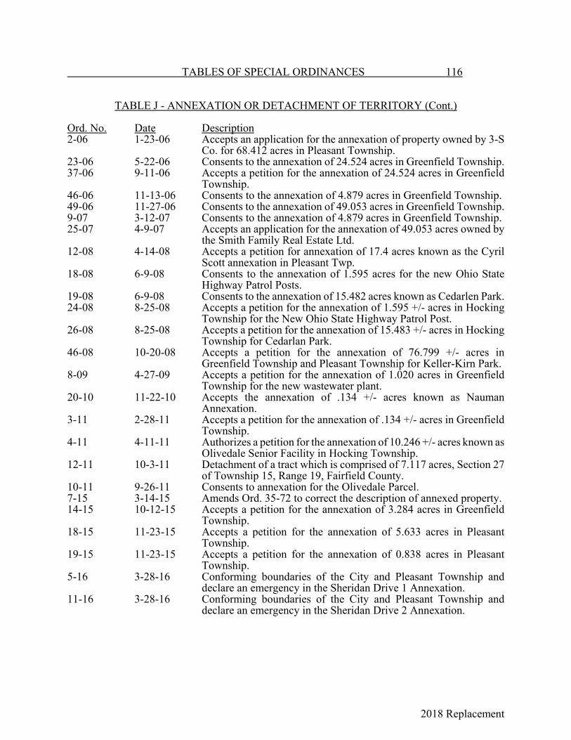
2018 Replacement
TABLES OF SPECIAL ORDINANCES 116
TABLE J - ANNEXATION OR DETACHMENT OF TERRITORY (Cont.)
Ord. No. Date Description2-06 1-23-06 Accepts an application for the annexation of property owned by 3-S
Co. for 68.412 acres in Pleasant Township.23-06 5-22-06 Consents to the annexation of 24.524 acres in Greenfield Township.37-06 9-11-06 Accepts a petition for the annexation of 24.524 acres in Greenfield
Township.46-06 11-13-06 Consents to the annexation of 4.879 acres in Greenfield Township.49-06 11-27-06 Consents to the annexation of 49.053 acres in Greenfield Township.9-07 3-12-07 Consents to the annexation of 4.879 acres in Greenfield Township.25-07 4-9-07 Accepts an application for the annexation of 49.053 acres owned by
the Smith Family Real Estate Ltd.12-08 4-14-08 Accepts a petition for annexation of 17.4 acres known as the Cyril
Scott annexation in Pleasant Twp.18-08 6-9-08 Consents to the annexation of 1.595 acres for the new Ohio State
Highway Patrol Posts.19-08 6-9-08 Consents to the annexation of 15.482 acres known as Cedarlen Park.24-08 8-25-08 Accepts a petition for the annexation of 1.595 +/- acres in Hocking
Township for the New Ohio State Highway Patrol Post.26-08 8-25-08 Accepts a petition for the annexation of 15.483 +/- acres in Hocking
Township for Cedarlan Park.46-08 10-20-08 Accepts a petition for the annexation of 76.799 +/- acres in
Greenfield Township and Pleasant Township for Keller-Kirn Park.8-09 4-27-09 Accepts a petition for the annexation of 1.020 acres in Greenfield
Township for the new wastewater plant.20-10 11-22-10 Accepts the annexation of .134 +/- acres known as Nauman
Annexation.3-11 2-28-11 Accepts a petition for the annexation of .134 +/- acres in Greenfield
Township.4-11 4-11-11 Authorizes a petition for the annexation of 10.246 +/- acres known as
Olivedale Senior Facility in Hocking Township.12-11 10-3-11 Detachment of a tract which is comprised of 7.117 acres, Section 27
of Township 15, Range 19, Fairfield County.10-11 9-26-11 Consents to annexation for the Olivedale Parcel.7-15 3-14-15 Amends Ord. 35-72 to correct the description of annexed property.14-15 10-12-15 Accepts a petition for the annexation of 3.284 acres in Greenfield
Township.18-15 11-23-15 Accepts a petition for the annexation of 5.633 acres in Pleasant
Township.19-15 11-23-15 Accepts a petition for the annexation of 0.838 acres in Pleasant
Township.5-16 3-28-16 Conforming boundaries of the City and Pleasant Township and
declare an emergency in the Sheridan Drive 1 Annexation.11-16 3-28-16 Conforming boundaries of the City and Pleasant Township and
declare an emergency in the Sheridan Drive 2 Annexation.

2018 Replacement
117 TABLES OF SPECIAL ORDINANCES
TABLE K - CHANGE OF NAME
Ord. Book& Page Ord. No. Date DescriptionI-35 Unno. 4-6-1847 That part of Johnstown Rd. lying north of Broad St.
and the Greenfield Twp. line to Broad St.C-194 Unno. 2-21-1868 2nd St. to Columbus St.; Jackson and 4th Sts. to
High St.A-210 Unno. 7-27-1891 Hop Ave. to Madison Ave.; Diagonal St. to Cheny
St.; New St. to Chestnut St.A-320 Unno. 12-14-1896 Lundy's Lane to Fair Ave.A-320 Unno. 1-25-1897 Canal St. to Forest Rose Ave.A-445 Unno. 1-8-01 German St. to 6th Ave.A-446 Unno. 1-28-01 Mill St. to 5th Ave.A-483 Unno. 9-9-01 Hoover Ave. to Harrison Ave.; Danehy Ave. to
Garfield Ave.; Deshler Ave. to Washington Ave.;Sinks Ave. to Pierce Ave.
B-28 Unno. 10-16-02 Thurman St. to 7th Ave.; Stansberry St. to 8th Ave.C-231 382 6-9-13 Columbus Rd. to Maywood Ave.C-283 407 2-9-14 Thayer St. to Wilson Ave.C-414 457 4-10-15 Wilson Ave. to Kinkead Ave.D-75 527 10-9-16 Blackoler St. to Oakwood Ave.; East St. to
Eastwood Ave.F-429 1189 6-10-29 1st Court to Weil Ave.; 2nd Court to Grand View
Ave.; 3rd Court to Edgemont Ave.J-80 87-45 12-10-45 Fairview Ave. to Fairview Dr; Cowden Ave. to
Baldwin Dr.; Baldwin St. to Brooks Ave.J-313 54-48 9-27-48 Front St. to Memorial Dr.J-355 15-49 3-14-49 Ohio Ave. in Olinger Addition to Olinger Ave.; Elm
St. from the 1st street north of Main St. to WheelingSt.
K-283 71-53 11-23-53 Pershing Dr. to Neoso Ave.K-298 8-54 2-8-54 Neoso Ave. to Pershing Dr.K-387 80-54 1-10-55 Hunter Blvd. between E. Main St. and Pleasantville
Rd., to Kanawha Rd.K-547 43-56 6-11-56 Virginia Alley to Clark Alley.L-547 48-57 6-10-57 Wacker Dr. to Berwick Dr.L-290 54-59 8-10-59 Bounds Ave. to Skyline Dr.M-383 28-66 3-14-66 East Wilson Ave. to Woodcliffe Lane.M-597 78-67 7-24-67 Naming 12-foot alley off Reese Ave. north to the
Penn. RR. as Olive Lane.N-23 94-67 10-9-67 Alley west of Front St. from South St. to the C. &
O. RR. named Bradford Court.4-80 2-11-80 1500 Block of East Fair Ave. to Sha Lane.3-81 1-12-81 Coventry Place North and Chancer Dr. to Coventry
Circle.17-84 5-14-84 Cherry St. Park to Mary Burnham Park.
TABLES OF SPECIAL ORDINANCES 118
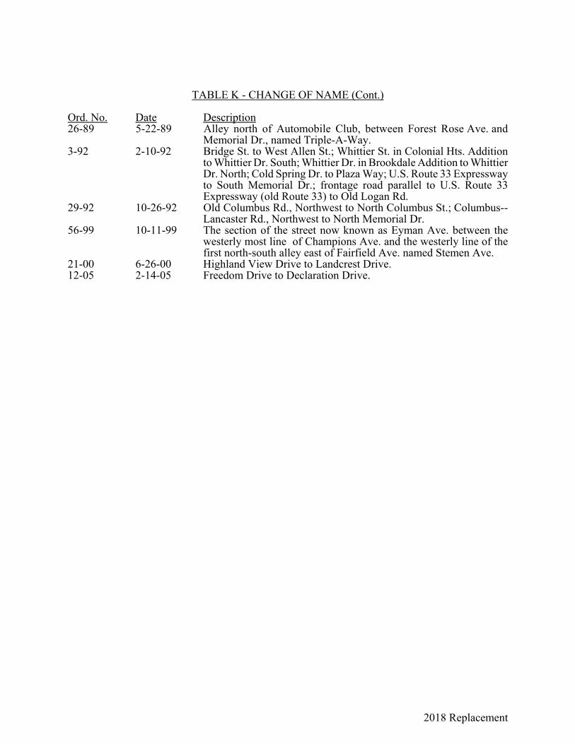
2018 Replacement
TABLE K - CHANGE OF NAME (Cont.)
Ord. No. Date Description26-89 5-22-89 Alley north of Automobile Club, between Forest Rose Ave. and
Memorial Dr., named Triple-A-Way.3-92 2-10-92 Bridge St. to West Allen St.; Whittier St. in Colonial Hts. Addition
to Whittier Dr. South; Whittier Dr. in Brookdale Addition to WhittierDr. North; Cold Spring Dr. to Plaza Way; U.S. Route 33 Expresswayto South Memorial Dr.; frontage road parallel to U.S. Route 33Expressway (old Route 33) to Old Logan Rd.
29-92 10-26-92 Old Columbus Rd., Northwest to North Columbus St.; Columbus--Lancaster Rd., Northwest to North Memorial Dr.
56-99 10-11-99 The section of the street now known as Eyman Ave. between thewesterly most line of Champions Ave. and the westerly line of thefirst north-south alley east of Fairfield Ave. named Stemen Ave.
21-00 6-26-00 Highland View Drive to Landcrest Drive.12-05 2-14-05 Freedom Drive to Declaration Drive.
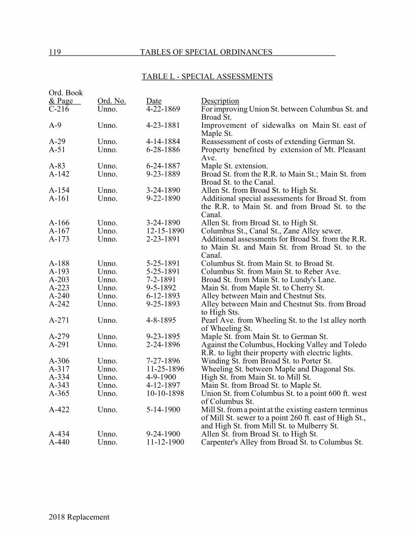
2018 Replacement
119 TABLES OF SPECIAL ORDINANCES
TABLE L - SPECIAL ASSESSMENTS
Ord. Book& Page Ord. No. Date DescriptionC-216 Unno. 4-22-1869 For improving Union St. between Columbus St. and
Broad St.A-9 Unno. 4-23-1881 Improvement of sidewalks on Main St. east of
Maple St.A-29 Unno. 4-14-1884 Reassessment of costs of extending German St.A-51 Unno. 6-28-1886 Property benefited by extension of Mt. Pleasant
Ave.A-83 Unno. 6-24-1887 Maple St. extension.A-142 Unno. 9-23-1889 Broad St. from the R.R. to Main St.; Main St. from
Broad St. to the Canal.A-154 Unno. 3-24-1890 Allen St. from Broad St. to High St.A-161 Unno. 9-22-1890 Additional special assessments for Broad St. from
the R.R. to Main St. and from Broad St. to theCanal.
A-166 Unno. 3-24-1890 Allen St. from Broad St. to High St.A-167 Unno. 12-15-1890 Columbus St., Canal St., Zane Alley sewer.A-173 Unno. 2-23-1891 Additional assessments for Broad St. from the R.R.
to Main St. and Main St. from Broad St. to theCanal.
A-188 Unno. 5-25-1891 Columbus St. from Main St. to Broad St.A-193 Unno. 5-25-1891 Columbus St. from Main St. to Reber Ave.A-203 Unno. 7-2-1891 Broad St. from Main St. to Lundy's Lane.A-223 Unno. 9-5-1892 Main St. from Maple St. to Cherry St.A-240 Unno. 6-12-1893 Alley between Main and Chestnut Sts.A-242 Unno. 9-25-1893 Alley between Main and Chestnut Sts. from Broad
to High Sts.A-271 Unno. 4-8-1895 Pearl Ave. from Wheeling St. to the 1st alley north
of Wheeling St.A-279 Unno. 9-23-1895 Maple St. from Main St. to German St.A-291 Unno. 2-24-1896 Against the Columbus, Hocking Valley and Toledo
R.R. to light their property with electric lights.A-306 Unno. 7-27-1896 Winding St. from Broad St. to Porter St.A-317 Unno. 11-25-1896 Wheeling St. between Maple and Diagonal Sts.A-334 Unno. 4-9-1900 High St. from Main St. to Mill St.A-343 Unno. 4-12-1897 Main St. from Broad St. to Maple St.A-365 Unno. 10-10-1898 Union St. from Columbus St. to a point 600 ft. west
of Columbus St.A-422 Unno. 5-14-1900 Mill St. from a point at the existing eastern terminus
of Mill St. sewer to a point 260 ft. east of High St.,and High St. from Mill St. to Mulberry St.
A-434 Unno. 9-24-1900 Allen St. from Broad St. to High St.A-440 Unno. 11-12-1900 Carpenter's Alley from Broad St. to Columbus St.

2018 Replacement
TABLES OF SPECIAL ORDINANCES 120
TABLE L - SPECIAL ASSESSMENTS (Cont.)
Ord. Book& Page Ord. No. Date DescriptionA-448 Unno. 3-25-01 High St. from Main St. to 5th Ave.A-459 Unno. 5-14-01 High St. from 5th Ave. to 6th Ave.A-472 Unno. 7-8-01 Maple St. from Main St. to Walnut St.; Walnut St.
from Maple St. to Mt. Pleasant Ave.; Wheat St.from Walnut St. to Lawrence St.
A-502 Unno. 6-6-02 Columbus St. from Reber Ave. to Park St.B-15 Unno. 6-23-02 Zane Alley from Pearl Ave. to Maple St.B-127 47 6-13-04 Wheeling St. from High St. to Maple St.B-158 66 9-12-04 Carpenter Alley from Pearl Ave. to Maple St.B-166 71 11-14-04 High St. from Main St. to Porter St.B-170 72 12-1-04 Maple St. from Main St. to Hocking Valley R.R.B-184 76 12-19-04 Broad St., Columbus St. and Water St. from
Chestnut St. to Hocking River.B-270 131 12-11-05 Mulberry St. from Broad St. to Maple St.B-286 134 1-8-06 5th Ave. from Columbus St. to Maple St.B-324 160 10-8-06 5th Ave. from Broad St. to Hocking River.B-339 168 12-10-06 Chestnut St. from Maple St. to Front St.B-416 223 4-27-08 Broad St. from Chestnut St. to Carpenter Circle.B-451 244 11-27-08 Storm Water Sewer District No. 3.B-453 245 12-14-08 Amending Sections 2 and 3 of an Ord. 244.B-469 252 1-11-09 Amending Sections 2 and 3 of Ord. 245.B-474 256 3-8-09 Construction of sewers in Storm Water Sewer
District No. 1.C-11 275 10-25-09 Mulberry St. from Broad St. to Front St. and Forest
Rose Ave. to Union St.C-13 276 10-25-09 Columbus St.C-31 287 2-14-10 Storm Water Sewer District No. 4.C-33 288 3-28-10 Elm St. Sewer.C-40 291 5-23-10 Storm Water Sewer District.C-42 292 7-11-10 6th Ave. sewer.C-83 311 3-26-11 Storm Water Sewer District No. 5.C-87 314 4-10-11 Maple St. from Main St. to the 1st alley north of
Allen St.C-102 322 5-22-11 Wheeling St. from High St. to Front St.C-135 335 1-22-12 Storm Water Sewer District No. 7.C-160 350 5-27-12 Storm Water Sewer District No. 8.C-164 353 5-27-12 Storm Water Sewer District No. 6.C-172 356 6-10-12 Storm Water Sewer District No. 3.C-185 359 8-12-12 E. Wheeling from Maple to Cherry Sts.C-187 360 8-12-12 Perry St. sewer.C-203 369 10-14-12 Pearl Ave. from Walnut St. to North Alley.C-205 370 11-25-12 Storm Water Sewer District No. 10.C-250 392 10-13-13 High St. from 6th Ave. to Fair Ave. and Fair Ave.
from High St. to Columbus St.C-253 393 10-13-13 King St. from Broad St. to Madison Ave.C-263 400 8-12-13 Storm Water Sewer District Nos. 1 and 4.C-285 409 2-9-14 Porter, Locust and Perry Sts.

2018 Replacement
121 TABLES OF SPECIAL ORDINANCES
TABLE L - SPECIAL ASSESSMENTS (Cont.)
Ord. Book& Page Ord. No. Date DescriptionC-288 410 2-9-14 6th Ave. from Forest Rose Ave. to East St.C-351 429 7-13-14 Sidewalks for Lots 198 and 199 of Pioneer
Addition, Lot 16 of Sherrick's Addition, Lot 142 ofMain St., and Lot 675 of Tenant's Addition.
C-370 437 10-12-14 Washington Ave. from Wheeling St. to Fair Ave.C-382 442 12-14-14 Columbus St. from Park St. to Forest Rose
Cemetery.C-385 443 12-14-14 Arnold Ave. from Columbus St. to Broad St.C-391 447 12-28-14 Center Alley and Union St.C-407 452 2-8-15 Columbus St.C-435 467 6-14-15 Wheeling St.C-450 471 7-26-15 Storm Water Sewer District No. 5.C-455 473 7-26-15 Storm Water Sewer District No. 3.C-485 490 1-10-16 Winding St. from Columbus St. to Broad St.C-488 491 1-10-16 Perry St. from Winding St. to High St.D-56 520 8-14-16 Union St. from Columbus St. to Broad St.D-64 523 8-28-16 Walnut St. from Columbus St. to Mt. Pleasant Ave.D-72 526 9-25-16 Sewer in alley west of S. Columbus St.D-76 528 10-23-16 Chestnut St. from Maple St. to Wyandotte St.D-80 529 10-23-16 Fair Ave. from Columbus St. to the Old Canal.D-98 535 1-8-17 Zane Alley from High St. to Broad St.D-101 536 1-8-17 Canal Alley from Columbus St. to Broad St.D-143 556 7-23-17 Storm Water Sewer District Nos. 1 to 11.D-149 561 11-26-17 E. Main St. from Cherry St. to Ewing St.D-196 589 5-28-18 Sewer District No. 12.D-233 608 10-28-18 E. Main St. between Cherry St. and Ewing St.D-239 613 12-23-18 W. Wheeling St. from Front St. to Washington Ave.D-243 614 12-23-18 S. High St. sewer.D-257 617 2-10-19 Sewer District No. 12; Repeals Ord. 589.D-261 620 3-10-19 1st alley north of Mulberry St. from Maple St. to
High St. and 1st alley south of E. Main St. fromWyandotte St. to Mt. Pleasant Ave. in Storm WaterSewer District No. 3.
D-263 621 3-10-19 Storm Water Sewer District No. 5.D-339 660 6-14-20 Park St.D-341 662 6-14-20 Sewer District No. 13.D-342 663 6-14-20 Sewer District No. 1.D-371 674 10-25-20 Sewer District No. 14.D-419 703 7-11-21 Carpenter Alley between High and Broad Sts.D-420 704 7-11-21 S. Center Alley in Carpenter Addition.D-436 714 11-14-21 S. Broad St. from Main St. to the C. & H. V. R.R.
Co. right of way.D-441 720 1-23-22 Lincoln Ave. between Front St. and west
corporation line.D-456 723 1-23-22 Storm Water Sewer District No. 8.
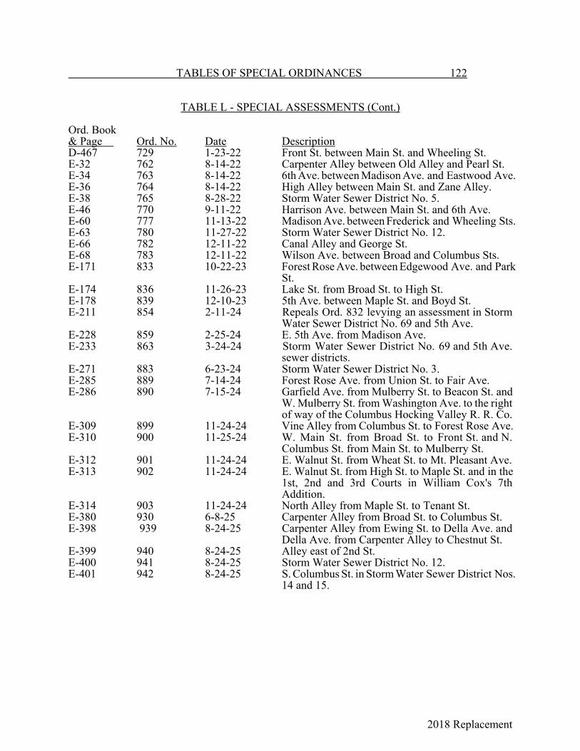
2018 Replacement
TABLES OF SPECIAL ORDINANCES 122
TABLE L - SPECIAL ASSESSMENTS (Cont.)
Ord. Book& Page Ord. No. Date DescriptionD-467 729 1-23-22 Front St. between Main St. and Wheeling St.E-32 762 8-14-22 Carpenter Alley between Old Alley and Pearl St.E-34 763 8-14-22 6th Ave. between Madison Ave. and Eastwood Ave.E-36 764 8-14-22 High Alley between Main St. and Zane Alley.E-38 765 8-28-22 Storm Water Sewer District No. 5.E-46 770 9-11-22 Harrison Ave. between Main St. and 6th Ave.E-60 777 11-13-22 Madison Ave. between Frederick and Wheeling Sts.E-63 780 11-27-22 Storm Water Sewer District No. 12.E-66 782 12-11-22 Canal Alley and George St.E-68 783 12-11-22 Wilson Ave. between Broad and Columbus Sts.E-171 833 10-22-23 Forest Rose Ave. between Edgewood Ave. and Park
St.E-174 836 11-26-23 Lake St. from Broad St. to High St.E-178 839 12-10-23 5th Ave. between Maple St. and Boyd St.E-211 854 2-11-24 Repeals Ord. 832 levying an assessment in Storm
Water Sewer District No. 69 and 5th Ave.E-228 859 2-25-24 E. 5th Ave. from Madison Ave.E-233 863 3-24-24 Storm Water Sewer District No. 69 and 5th Ave.
sewer districts.E-271 883 6-23-24 Storm Water Sewer District No. 3.E-285 889 7-14-24 Forest Rose Ave. from Union St. to Fair Ave.E-286 890 7-15-24 Garfield Ave. from Mulberry St. to Beacon St. and
W. Mulberry St. from Washington Ave. to the rightof way of the Columbus Hocking Valley R. R. Co.
E-309 899 11-24-24 Vine Alley from Columbus St. to Forest Rose Ave.E-310 900 11-25-24 W. Main St. from Broad St. to Front St. and N.
Columbus St. from Main St. to Mulberry St.E-312 901 11-24-24 E. Walnut St. from Wheat St. to Mt. Pleasant Ave.E-313 902 11-24-24 E. Walnut St. from High St. to Maple St. and in the
1st, 2nd and 3rd Courts in William Cox's 7thAddition.
E-314 903 11-24-24 North Alley from Maple St. to Tenant St.E-380 930 6-8-25 Carpenter Alley from Broad St. to Columbus St.E-398 939 8-24-25 Carpenter Alley from Ewing St. to Della Ave. and
Della Ave. from Carpenter Alley to Chestnut St.E-399 940 8-24-25 Alley east of 2nd St.E-400 941 8-24-25 Storm Water Sewer District No. 12.E-401 942 8-24-25 S. Columbus St. in Storm Water Sewer District Nos.
14 and 15.
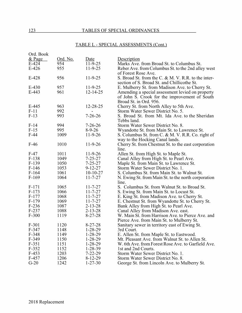
2018 Replacement
123 TABLES OF SPECIAL ORDINANCES
TABLE L - SPECIAL ASSESSMENTS (Cont.)
Ord. Book& Page Ord. No. Date DescriptionE-424 954 11-9-25 Marks Ave. from Broad St. to Columbus St.E-426 955 11-9-25 Reber Ave. from Columbus St. to the 2nd alley west
of Forest Rose Ave.E-428 956 11-9-25 S. Broad St. from the C. & M. V. R.R. to the inter-
section of S. Broad St. and Chillicothe St.E-430 957 11-9-25 E. Mulberry St. from Madison Ave. to Cherry St.E-443 961 12-14-25 Amending a special assessment levied on property
of John S. Crook for the improvement of SouthBroad St. in Ord. 956.
E-445 963 12-28-25 Cherry St. from North Alley to 5th Ave.F-11 992 - Storm Water Sewer District No. 5.F-13 993 7-26-26 S. Broad St. from Mt. Ida Ave. to the Sheridan
Tebbs land.F-14 994 7-26-26 Storm Water Sewer District No. 8.F-15 995 8-9-26 Wyandotte St. from Main St. to Lawrence St.F-44 1009 11-9-26 S. Columbus St. from C. & M. V. R.R. Co. right of
way to the Hocking Canal lands.F-46 1010 11-9-26 Cherry St. from Chestnut St. to the east corporation
line.F-47 1011 11-9-26 Allen St. from High St. to Maple St.F-138 1049 7-25-27 Canal Alley from High St. to Pearl Ave.F-139 1050 7-25-27 Maple St. from Main St. to Lawrence St.F-146 1053 9-12-27 Storm Water Sewer District No. 1.F-164 1061 10-10-27 S. Columbus St. from Main St. to Walnut St.F-169 1064 11-7-27 N. Ewing St. from Main St. to the north corporation
line.F-171 1065 11-7-27 S. Columbus St. from Walnut St. to Broad St.F-173 1066 11-7-27 S. Ewing St. from Main St. to Locust St.F-177 1068 11-7-27 E. King St. from Madison Ave. to Cherry St.F-179 1069 11-7-27 E. Chestnut St. from Wyandotte St. to Cherry St.F-236 1087 2-13-28 Bank Alley from High St. to Pearl Ave.F-237 1088 2-13-28 Canal Alley from Madison Ave. east.F-300 1119 8-27-28 W. Main St. from Harrison Ave. to Pierce Ave. and
Pierce Ave. from Main St. to Mulberry St.F-301 1120 8-27-28 Sanitary sewer in territory east of Ewing St.F-347 1148 1-28-29 3rd Court.F-348 1149 1-28-29 E. Allen St. from Maple St. to Eastwood.F-349 1150 1-28-29 Mt. Pleasant Ave. from Walnut St. to Allen St.F-351 1151 1-28-29 W. 6th Ave. from Forest Rose Ave. to Garfield Ave.F-352 1152 1-28-39 1st and 2nd Courts.F-453 1203 7-22-29 Storm Water Sewer District No. 1.F-457 1206 8-12-29 Storm Water Sewer District No. 8.G-20 1242 1-27-30 George St. from Lincoln Ave. to Mulberry St.

2018 Replacement
TABLES OF SPECIAL ORDINANCES 124
TABLE L - SPECIAL ASSESSMENTS (Cont.)
Ord. Book& Page Ord. No. Date DescriptionG-29 1249 2-13-30 Sanitary sewer in S. Broad St. and Mt. Ida Ave.G-93 1296 7-28-30 Storm Water Sewer District No. 3.G-162 1338 3-9-31 Storm Water Sewer District No. 16.G-163 1339 3-9-31 Sewers in alley west of Slocum St, alley south of
Walnut St., 8th Ave., alley west of Garfield Ave.,Main St. and Cedar Hill Pike.
G-165 1340 3-9-31 W.6th Ave., Forest Rose Ave., Front St. and CedarHill Road.
G-166 1341 3-9-31 Jefferson Ave. from Fair Ave. to 6th Ave.G-167 1342 3-9-31 Pierce Ave. from Cedar Hill Pike to Fair Ave.G-186 1355 6-22-31 Amending Ord. 1339.G-325 1459 7-10-33 Zane Ave. from Main St. to Lincoln Ave.G-499 1595 9-23-35 W. Mulberry St. from Pierce Ave. to Maude Ave.H-299 1836 7-25-38 Roosevelt Ave. from 6th Ave. to Fair Ave.H-400 1902 4-10-39 E. 6th Ave. from Eastwood Ave. to Fetters Run
Bridge.H-401 1903 4-10-39 Madison Ave. from Frederick St. to Fair Ave.H-402 1904 4-10-39 Sheridan Dr. from 6th Ave. to Fair Ave.H-403 1905 4-10-39 Storm water sewer in Madison Ave. from Frederick
St. to Fair Ave.H-411 1910 4-24-39 Repeals Ord. 1824.H-430 1926 5-22-39 E. Fair Ave. from 2nd alley east to 3rd alley east of
High St.H-431 1927 5-22-39 W. Main St. from George St. to the west side of
Zane Ave.H-432 1928 5-22-39 7th Ave. from alley west of Pierce Ave. to
McKinley Ave., and McKinley Ave. from 6th Ave.to Fair Ave.
H-433 1929 5-22-39 W. Mulberry St. from C. & O. R.R. to Maude Ave.H-492 1972 8-28-39 Frederick St. from Mt. Pleasant Ave. to Eastwood
Ave.H-495 1973 8-28-39 Eyman Ave. from 2nd St.H-498 1976 8-28-39 N. Pierce Ave.H-499 1977 8-28-39 W. Mulberry St.H-500 1978 8-28-39 Grant Ave.H-501 1979 8-28-39 Edgewood Ave. from Columbus St. to Olds Ave.H-502 1980 8-28-39 McKinley Ave. and 7th Ave.H-503 1981 8-28-39 W. Main St. from George St. to Zane Ave.H-493 1982 8-28-39 Washington Ave. from Fair Ave. to Beacon St., and
Beacon St. from Washington Ave. to Garfield Ave.

2018 Replacement
125 TABLES OF SPECIAL ORDINANCES
TABLE L - SPECIAL ASSESSMENTS (Cont.)
Ord. Book& Page Ord. No. Date DescriptionH-590 2051 4-22-40 Lake St. from Maple St. to Edgemont Ave.; Maple
St. from Lake St. to Fair Ave.; Jefferson Ave. fromAnchor-Hocking Glass Subdivision to Fair Ave.;Miller Ave. from Mulberry St. to Union St.; W.Main St. from Zane Ave. to the C. & O. R.R.,Walnut St. from Ewing St. to Della Ave.
H-593 2053 4-22-40 Graylock St.; Greene Ave.; alley east of BusbyAve.; Miller Ave. from Union St. to C. & O. R.R.;W. Main St.; Ohio Ave.; Markwood Ave.; FrederickSt. from Mt. Pleasant Ave. to Rutter Ave.; N. MapleSt. from Frederick St. to Fair Ave.; N. High St.;Medill Ave. from Fair Ave. to 6th Ave.; HardingAve. from 6th Ave. to Fair Ave.
I-174 46-41 6-23-41 Mt. Pleasant Ave. from Allen St. to Fair Ave.I-175 47-41 6-23-41 W. Union St. from Harrison Ave. to Pierce Ave.I-176 48-41 6-23-41 Monroe Ave. from 8th Ave. to Fair Ave.I-177 49-41 6-23-41 Olds Ave. from Park St. to Edgewood Ave.I-178 50-41 6-23-41 Baldwin Dr., Lanreco Blvd. and Kemper Dr.I-179 51-41 6-23-41 Goodwin Ave. from 6th Ave. north.I-180 52-41 6-23-41 Welsh Ave. from Wheeling St. to Main St.I-181 53-41 6-23-41 8th Ave. from Harrison Ave. to Washington Ave.I-182 54-41 6-23-41 Sanitary sewer and Parkview Dr.I-183 55-41 6-23-41 Sanitary sewer in Rutter Ave. from Allen St. to
Frederick St.I-184 56-41 6-23-41 Sanitary sewer in Rutter Ave. from Frederick St. to
Fair Ave.I-185 57-41 6-23-41 Sanitary sewer in Pioneer Alley, Zane Alley and
Franklin Ave.I-186 58-41 6-23-41 Sanitary sewer in Eagle Park Addition and Reese's
Fairview Addition.I-296 27-42 4-27-42 Della Ave. from Main to Locust Sts.I-294 35-42 4-27-42 Locust St.I-295 36-42 4-27-42 E. Fair Ave. from the 3rd alley east of High St. to
Maple St.I-297 38-42 4-27-42 Oakwood Ave. from King Ave. to 6th Ave.I-298 39-42 4-27-42 7th Ave. from Harrison to Pierce.I-299 40-42 4-27-42 Harding and Medill Aves.I-300 41-42 4-27-42 Sanitary sewers in Sherman and Dewey Aves.I-301 42-42 4-27-42 Sanitary sewers in Grant Ave.I-302 43-42 4-27-42 Sanitary sewers in Charles Court.I-303 44-42 4-27-42 Sanitary sewers in Lanreco Blvd.I-304 45-42 4-27-42 Sanitary sewers in Ohio Ave.I-305 46-42 4-27-42 Sanitary sewers in the Rosebank Addition.I-306 47-42 4-27-42 Sanitary sewers in Cedar Heights.
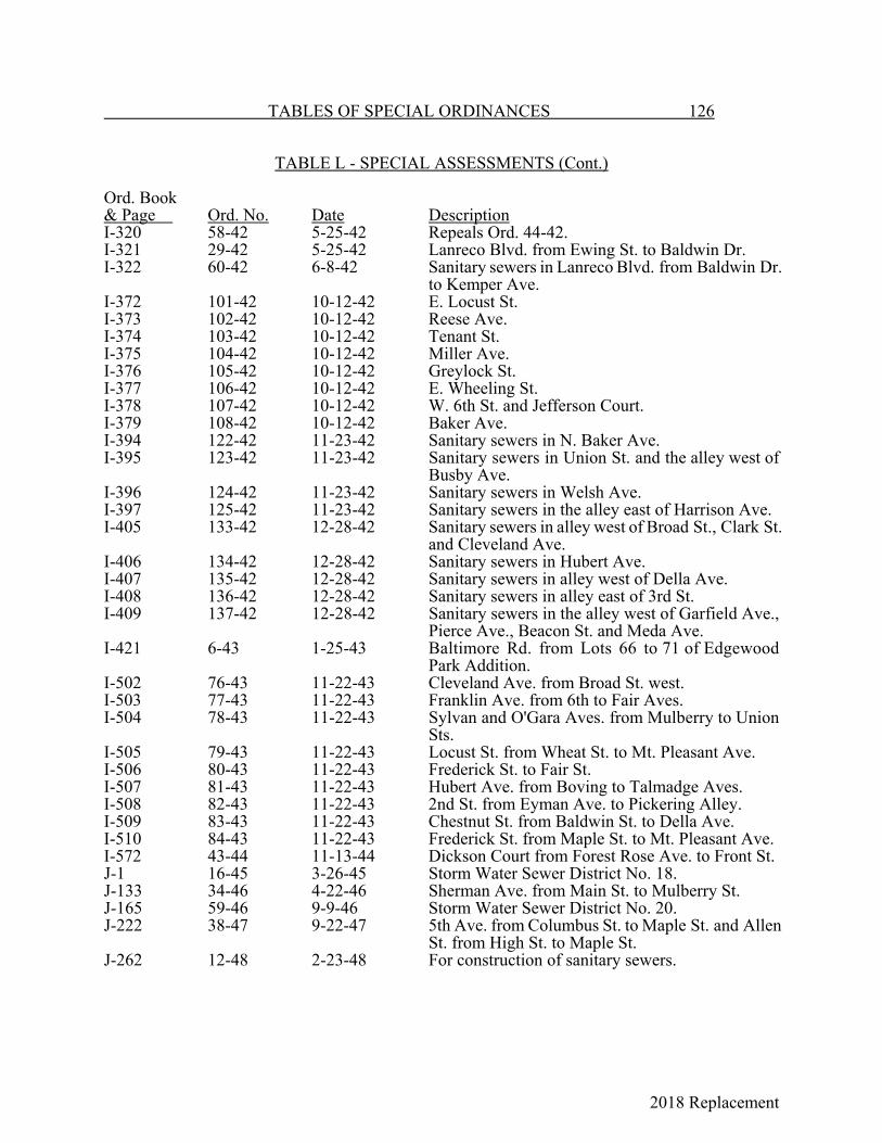
2018 Replacement
TABLES OF SPECIAL ORDINANCES 126
TABLE L - SPECIAL ASSESSMENTS (Cont.)
Ord. Book& Page Ord. No. Date DescriptionI-320 58-42 5-25-42 Repeals Ord. 44-42.I-321 29-42 5-25-42 Lanreco Blvd. from Ewing St. to Baldwin Dr.I-322 60-42 6-8-42 Sanitary sewers in Lanreco Blvd. from Baldwin Dr.
to Kemper Ave.I-372 101-42 10-12-42 E. Locust St.I-373 102-42 10-12-42 Reese Ave.I-374 103-42 10-12-42 Tenant St.I-375 104-42 10-12-42 Miller Ave.I-376 105-42 10-12-42 Greylock St.I-377 106-42 10-12-42 E. Wheeling St.I-378 107-42 10-12-42 W. 6th St. and Jefferson Court.I-379 108-42 10-12-42 Baker Ave.I-394 122-42 11-23-42 Sanitary sewers in N. Baker Ave.I-395 123-42 11-23-42 Sanitary sewers in Union St. and the alley west of
Busby Ave.I-396 124-42 11-23-42 Sanitary sewers in Welsh Ave.I-397 125-42 11-23-42 Sanitary sewers in the alley east of Harrison Ave.I-405 133-42 12-28-42 Sanitary sewers in alley west of Broad St., Clark St.
and Cleveland Ave.I-406 134-42 12-28-42 Sanitary sewers in Hubert Ave.I-407 135-42 12-28-42 Sanitary sewers in alley west of Della Ave.I-408 136-42 12-28-42 Sanitary sewers in alley east of 3rd St.I-409 137-42 12-28-42 Sanitary sewers in the alley west of Garfield Ave.,
Pierce Ave., Beacon St. and Meda Ave.I-421 6-43 1-25-43 Baltimore Rd. from Lots 66 to 71 of Edgewood
Park Addition.I-502 76-43 11-22-43 Cleveland Ave. from Broad St. west.I-503 77-43 11-22-43 Franklin Ave. from 6th to Fair Aves.I-504 78-43 11-22-43 Sylvan and O'Gara Aves. from Mulberry to Union
Sts.I-505 79-43 11-22-43 Locust St. from Wheat St. to Mt. Pleasant Ave.I-506 80-43 11-22-43 Frederick St. to Fair St.I-507 81-43 11-22-43 Hubert Ave. from Boving to Talmadge Aves.I-508 82-43 11-22-43 2nd St. from Eyman Ave. to Pickering Alley.I-509 83-43 11-22-43 Chestnut St. from Baldwin St. to Della Ave.I-510 84-43 11-22-43 Frederick St. from Maple St. to Mt. Pleasant Ave.I-572 43-44 11-13-44 Dickson Court from Forest Rose Ave. to Front St.J-1 16-45 3-26-45 Storm Water Sewer District No. 18.J-133 34-46 4-22-46 Sherman Ave. from Main St. to Mulberry St.J-165 59-46 9-9-46 Storm Water Sewer District No. 20.J-222 38-47 9-22-47 5th Ave. from Columbus St. to Maple St. and Allen
St. from High St. to Maple St.J-262 12-48 2-23-48 For construction of sanitary sewers.
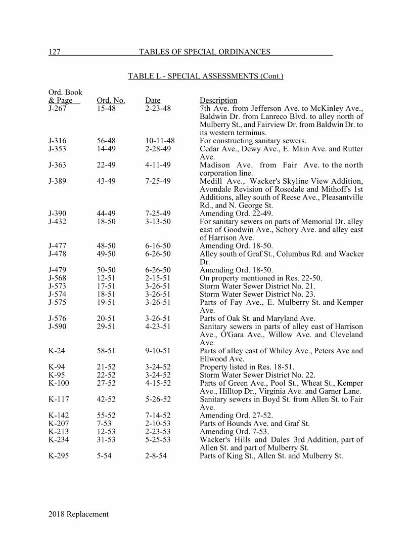
2018 Replacement
127 TABLES OF SPECIAL ORDINANCES
TABLE L - SPECIAL ASSESSMENTS (Cont.)
Ord. Book& Page Ord. No. Date DescriptionJ-267 15-48 2-23-48 7th Ave. from Jefferson Ave. to McKinley Ave.,
Baldwin Dr. from Lanreco Blvd. to alley north ofMulberry St., and Fairview Dr. from Baldwin Dr. toits western terminus.
J-316 56-48 10-11-48 For constructing sanitary sewers.J-353 14-49 2-28-49 Cedar Ave., Dewy Ave., E. Main Ave. and Rutter
Ave.J-363 22-49 4-11-49 Madison Ave. from Fair Ave. to the north
corporation line.J-389 43-49 7-25-49 Medill Ave., Wacker's Skyline View Addition,
Avondale Revision of Rosedale and Mithoff's 1stAdditions, alley south of Reese Ave., PleasantvilleRd., and N. George St.
J-390 44-49 7-25-49 Amending Ord. 22-49.J-432 18-50 3-13-50 For sanitary sewers on parts of Memorial Dr. alley
east of Goodwin Ave., Schory Ave. and alley eastof Harrison Ave.
J-477 48-50 6-16-50 Amending Ord. 18-50.J-478 49-50 6-26-50 Alley south of Graf St., Columbus Rd. and Wacker
Dr.J-479 50-50 6-26-50 Amending Ord. 18-50.J-568 12-51 2-15-51 On property mentioned in Res. 22-50.J-573 17-51 3-26-51 Storm Water Sewer District No. 21.J-574 18-51 3-26-51 Storm Water Sewer District No. 23.J-575 19-51 3-26-51 Parts of Fay Ave., E. Mulberry St. and Kemper
Ave.J-576 20-51 3-26-51 Parts of Oak St. and Maryland Ave.J-590 29-51 4-23-51 Sanitary sewers in parts of alley east of Harrison
Ave., O'Gara Ave., Willow Ave. and ClevelandAve.
K-24 58-51 9-10-51 Parts of alley east of Whiley Ave., Peters Ave andEllwood Ave.
K-94 21-52 3-24-52 Property listed in Res. 18-51.K-95 22-52 3-24-52 Storm Water Sewer District No. 22.K-100 27-52 4-15-52 Parts of Green Ave., Pool St., Wheat St., Kemper
Ave., Hilltop Dr., Virginia Ave. and Garner Lane.K-117 42-52 5-26-52 Sanitary sewers in Boyd St. from Allen St. to Fair
Ave.K-142 55-52 7-14-52 Amending Ord. 27-52.K-207 7-53 2-10-53 Parts of Bounds Ave. and Graf St.K-213 12-53 2-23-53 Amending Ord. 7-53.K-234 31-53 5-25-53 Wacker's Hills and Dales 3rd Addition, part of
Allen St. and part of Mulberry St.K-295 5-54 2-8-54 Parts of King St., Allen St. and Mulberry St.

2018 Replacement
TABLES OF SPECIAL ORDINANCES 128
TABLE L - SPECIAL ASSESSMENTS (Cont.)
Ord. Book& Page Ord. No. Date DescriptionK-296 6-54 2-8-54 Storm Water Sewer District No. 21.K-297 7-54 2-8-54 Part of Fay Ave.K-305 11-54 2-22-54 Part of Brumfield Rd.K-348 49-54 8-9-54 Storm Water Sewer District No. 24.K-349 50-54 8-9-54 Sewers for part of Cedar Hill Rd. and an alley west
of Slocum St.K-357 58-54 9-27-54 Sanitary sewer in E. Walnut St. from Brooks Ave.
to Della Ave.K-358 59-54 9-27-54 Sanitary sewer for Terry's Meadow View Addition.K-359 60-54 9-27-54 Parts of Oakwood Ave. and Frederick St.K-390 3-55 1-10-55 Nelson Rd. and Burns Ave.K-420 28-55 4-25-55 Resurfacing: E. 5th Ave. from N. Maple to N.
Cherry Sts.; George St. from W. Main St. to LincolnAve.; Forest Rose Ave. from Park St. to EdgewoodAve.; Lake St. from N. Broad to N. High Sts.
K-497 2-56 1-9-56 Resurfacing Oakwood Ave. from King St. to 5thAve.
K-498 3-56 1-9-56 Resurfacing Mt. Pleasant Ave. from Main to AllenSts.
K-499 4-56 1-9-56 Resurfacing Allen St. from Mt. Pleasant to MadisonAves.
K-512 13-56 2-27-56 Sanitary sewer construction in Brumfield Rd. andOhio Ave. and territory adjacent thereto.
K-597 3-57 1-28-57 (a) Grading and constructing curbs and gutters inLewis Ave. from Talmadge Ave. to MaherPark; Hubert Ave. from Hunter Ave. to westline of Maher's 2nd Addition, Lanreco Blvd.from Kemper Ave. to Marietta Rd. andKanawha Rd. from Pleasantville Rd. to a point575 ft. south thereof.
(b) Resurfacing Lake St. from High St. to a point590 ft. east thereof; Pierce Ave. from CedarHill Rd. to the C. & O. R.R., and WyandotteSt. from Walnut St. to Lawrence St.
L-1 6-57 1-28-57 Storm Water Sewer District No. 25 in Kemper's 3rdSubdivision and Baldwin Heights Addition.
L-39 37-57 5-13-57 Sanitary sewer in territory north of the Penna.R.R.,east of Kemper Ave., south of Lanreco Blvd. andwest of the Fairfield County Children's Home.
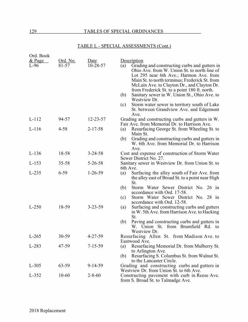
2018 Replacement
129 TABLES OF SPECIAL ORDINANCES
TABLE L - SPECIAL ASSESSMENTS (Cont.)
Ord. Book& Page Ord. No. Date DescriptionL-96 81-57 10-28-57 (a) Grading and constructing curbs and gutters in
Ohio Ave. from W. Union St. to north line ofLot 295 near 6th Ave.; Harmon Ave. fromMain St. to north terminus; Frederick St. fromMcLain Ave. to Clayton Dr., and Clayton Dr.from Frederick St. to a point 180 ft. north.
(b) Sanitary sewer in W. Union St., Ohio Ave. toWestview Dr.
(c) Storm water sewer in territory south of LakeSt. between Grandview Ave. and EdgemontAve.
L-112 94-57 12-23-57 Grading and constructing curbs and gutters in W.Fair Ave. from Memorial Dr. to Harrison Ave.
L-116 4-58 2-17-58 (a) Resurfacing George St. from Wheeling St. toMain St.
(b) Grading and constructing curbs and gutters inW. 6th Ave. from Memorial Dr. to HarrisonAve.
L-136 18-58 3-24-58 Cost and expense of construction of Storm WaterSewer District No. 27.
L-153 35-58 5-26-58 Sanitary sewer in Westview Dr. from Union St. to6th Ave.
L-235 6-59 1-26-59 (a) Surfacing the alley south of Fair Ave. fromthe alley east of Broad St. to a point near HighSt.
(b) Storm Water Sewer District No. 26 inaccordance with Ord. 17-58.
(c) Storm Water Sewer District No. 28 inaccordance with Ord. 12-58.
L-250 18-59 3-23-59 (a) Surfacing and constructing curbs and guttersin W. 5th Ave. from Harrison Ave. to HackingSt.
(b) Paving and constructing curbs and gutters inW. Union St. from Brumfield Rd. toWestview Dr.
L-265 30-59 4-27-59 Resurfacing Allen St. from Madison Ave. toEastwood Ave.
L-283 47-59 7-15-59 (a) Resurfacing Memorial Dr. from Mulberry St.to Arlington Ave.
(b) Resurfacing S. Columbus St. from Walnut St.to the Lancaster Circle.
L-305 63-59 9-14-59 Grading and constructing curbs and gutters inWestview Dr. from Union St. to 6th Ave.
L-352 10-60 2-8-60 Constructing pavement with curb in Reese Ave.from S. Broad St. to Talmadge Ave.

2018 Replacement
TABLES OF SPECIAL ORDINANCES 130
TABLE L - SPECIAL ASSESSMENTS (Cont.)
Ord. Book& Page Ord. No. Date DescriptionL-353 11-60 2-8 60 Surface treatment of:
StreetsBoyd St. from Allen to Fair;Boyd St. from 6th to Fetters Run;Frederick St. from Boyd to alley east;Allen St. from Franklin to Fetters Run;8th Ave. from Slocum to Goodwin;Charles Court from Hubert to Reese;Virginia Ave. from Boving, east 250 ft.;Beacon St. from Harrison to Goodwin;Salyer's Court from Chestnut south Alleys1st alley N. Walnut from Mt. Pleasant to a
point 200 ft. west;Alley E. Mt. Pleasant from Wheeling to
Bank Alley;Alley S. Hubert from Talmadge to Mithoff;Alley E, Wyandotte from Chestnut to Zane Alley;Alley S. Main from Della to Brooks;Alley S. Chestnut from Ewing west 400 ft.Alley N. 6th from Franklin to Sheridan;Alley W. Sheridan from Fair to Frederick;Alley E. Medill from Fair to alley N. 6th;Alley W. Medill from Fair to Alley N. 6th;Alley W. Harding from Fair to Alley N. 6th;Alley W. Franklin from Fair to Allen;Alley W. Penna. R. R. from Talmadge to Hunter.
L-355 12-60 2-8-60 (a) Curbs and gutters in Eastwood Ave. fromFrederick St. to Fair Ave.
(b) Curbs and gutters in E. Mulberry St. from the1st alley east of Ewing St. to Baldwin Dr.
(c) Paving Slocum St. from 5th Ave. to 6th Ave.L-362 19-60 3-14-60 Curbs and gutters in Goodwin Ave. from 7th Ave.
to 8th Ave.L-456 1-61 2-13-61 (a) Concrete pavement in Fair Ave. from Maple
St.to Mt. Pleasant Ave.(b) Concrete pavement and sanitary sewer in W.
Union St. from Harrison Ave. to Hocking St.
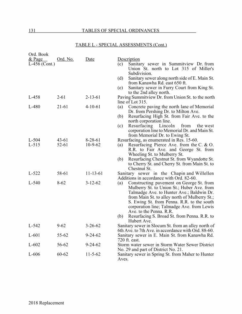
2018 Replacement
131 TABLES OF SPECIAL ORDINANCES
TABLE L - SPECIAL ASSESSMENTS (Cont.)
Ord. Book& Page Ord. No. Date DescriptionL-456 (Cont.) (c) Sanitary sewer in Summitview Dr. from
Union St. north to Lot 315 of Miller'sSubdivision.
(d) Sanitary sewer along north side of E. Main St.from Kanawha Rd. east 650 ft.
(e) Sanitary sewer in Furry Court from King St.to the 2nd alley north.
L-458 2-61 2-13-61 Paving Summitview Dr. from Union St. to the northline of Lot 315.
L-480 21-61 4-10-61 (a) Concrete paving the north lane of MemorialDr. from Pershing Dr. to Milton Ave.
(b) Resurfacing High St. from Fair Ave. to thenorth corporation line.
(c) Resurfacing Lincoln from the westcorporation line to Memorial Dr. and Main St.from Memorial Dr. to Ewing St.
L-504 43-61 8-28-61 Resurfacing, as enumerated in Res. 15-60.L-515 52-61 10-9-62 (a) Resurfacing Pierce Ave. from the C. & O.
R.R. to Fair Ave. and George St. fromWheeling St. to Mulberry St.
(b) Resurfacing Chestnut St. from Wyandotte St.to Cherry St. and Cherry St. from Main St. toChestnut St.
L-522 58-61 11-13-61 Sanitary sewer in the Chapin and WillellenAdditions in accordance with Ord. 82-60.
L-540 8-62 3-12-62 (a) Constructing pavement on George St. fromMulberry St. to Union St.; Huber Ave. fromTalmadge Ave. to Hunter Ave.; Baldwin Dr.from Main St. to alley north of Mulberry St.;S. Ewing St. from Penna. R.R. to the southcorporation line; Talmadge Ave. from LewisAve. to the Penna. R.R.
(b) Resurfacing S. Broad St. from Penna. R.R. toHubert Ave.
L-542 9-62 3-26-62 Sanitary sewer in Slocum St. from an alley north of6th Ave. to 7th Ave. in accordance with Ord. 88-60.
L-601 55-62 9-24-62 Sanitary sewer in E. Main St. from Kanawha Rd.720 ft. east.
L-602 56-62 9-24-62 Storm water sewer in Storm Water Sewer DistrictNo. 29 and part of District No. 21.
L-606 60-62 11-5-62 Sanitary sewer in Spring St. from Maher to HunterAves.
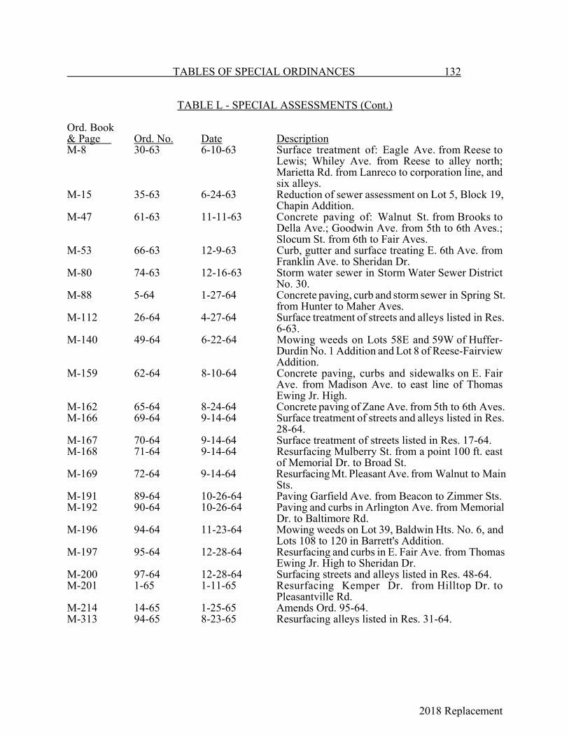
2018 Replacement
TABLES OF SPECIAL ORDINANCES 132
TABLE L - SPECIAL ASSESSMENTS (Cont.)
Ord. Book& Page Ord. No. Date DescriptionM-8 30-63 6-10-63 Surface treatment of: Eagle Ave. from Reese to
Lewis; Whiley Ave. from Reese to alley north;Marietta Rd. from Lanreco to corporation line, andsix alleys.
M-15 35-63 6-24-63 Reduction of sewer assessment on Lot 5, Block 19,Chapin Addition.
M-47 61-63 11-11-63 Concrete paving of: Walnut St. from Brooks toDella Ave.; Goodwin Ave. from 5th to 6th Aves.;Slocum St. from 6th to Fair Aves.
M-53 66-63 12-9-63 Curb, gutter and surface treating E. 6th Ave. fromFranklin Ave. to Sheridan Dr.
M-80 74-63 12-16-63 Storm water sewer in Storm Water Sewer DistrictNo. 30.
M-88 5-64 1-27-64 Concrete paving, curb and storm sewer in Spring St.from Hunter to Maher Aves.
M-112 26-64 4-27-64 Surface treatment of streets and alleys listed in Res.6-63.
M-140 49-64 6-22-64 Mowing weeds on Lots 58E and 59W of Huffer-Durdin No. 1 Addition and Lot 8 of Reese-FairviewAddition.
M-159 62-64 8-10-64 Concrete paving, curbs and sidewalks on E. FairAve. from Madison Ave. to east line of ThomasEwing Jr. High.
M-162 65-64 8-24-64 Concrete paving of Zane Ave. from 5th to 6th Aves.M-166 69-64 9-14-64 Surface treatment of streets and alleys listed in Res.
28-64.M-167 70-64 9-14-64 Surface treatment of streets listed in Res. 17-64.M-168 71-64 9-14-64 Resurfacing Mulberry St. from a point 100 ft. east
of Memorial Dr. to Broad St.M-169 72-64 9-14-64 Resurfacing Mt. Pleasant Ave. from Walnut to Main
Sts.M-191 89-64 10-26-64 Paving Garfield Ave. from Beacon to Zimmer Sts.M-192 90-64 10-26-64 Paving and curbs in Arlington Ave. from Memorial
Dr. to Baltimore Rd.M-196 94-64 11-23-64 Mowing weeds on Lot 39, Baldwin Hts. No. 6, and
Lots 108 to 120 in Barrett's Addition.M-197 95-64 12-28-64 Resurfacing and curbs in E. Fair Ave. from Thomas
Ewing Jr. High to Sheridan Dr.M-200 97-64 12-28-64 Surfacing streets and alleys listed in Res. 48-64.M-201 1-65 1-11-65 Resurfacing Kemper Dr. from Hilltop Dr. to
Pleasantville Rd.M-214 14-65 1-25-65 Amends Ord. 95-64.M-313 94-65 8-23-65 Resurfacing alleys listed in Res. 31-64.

2018 Replacement
133 TABLES OF SPECIAL ORDINANCES
TABLE L - SPECIAL ASSESSMENTS (Cont.)
Ord. Book& Page Ord. No. Date DescriptionM-316 96-65 9-27-65 Mowing weeds in Lots 108 to 120 of Barrett's
Addition.M-342 112-65 11-22-65 Mowing weeds in Lots 11 to 14 of Jordan's
Subdivision.M-345 115-65 12-13-65 Mowing weeds on Lots 108 to 120 of Barrett's
Addition.M-349 119-65 12-13-65 Constructing sidewalks for Lots 4, 6, 7 and 10 of
Block 1 of L.C. Mithoff's 2nd Addition.M-374 20-66 2-28-66 Paving streets listed in Res. 39-65.M-375 21-66 2-28-66 Paving Reber Ave.M-376 22-66 2-28-66 Paving alleys listed in Res. 56-65.M-377 23-66 2-28-66 Paving streets listed in Res. 20-65 and 51-65.M-379 24-66 2-28-66 Paving of streets and alleys listed in Res. 40-65.M-395 39-66 3-14-66 Construction of sewer in Cedar Hts. area.M-445 80-66 7-25-66 Resurfacing Union St. from N. Broad St. to Forest
Rose Ave.M-447 81-66 7-25-66 Resurfacing alley south of Allen St. from Maple St.
to Mt. Pleasant Ave.M-457 87-66 8-8-66 Improving Busby Ave. from Mulberry to Union Sts.M-466 95-66 9-12-66 Improving 3 alleys listed in Res. 54-66.M-468 96-66 9-12-66 Resurfacing Fair Ave. from N. Columbus to N.
High Sts.M-471 99-66 9-12-66 Resurfacing Graf St. from Arlington to Wildwood
Aves.M-487 110-66 10-24-66 Water line in Lynwood Lane.M-526 19-67 2-27-67 Street improvements for following Ords.
determining to proceed: 47-66, 48-66, 62-66, 63-66,65-66, 80-66, 81-66, 62-66 and 95-66.
M-544 34-67 3-27-67 Mowing weeds on Lots 13 and 14, AvondaleAddition.
M-545 35-67 3-27-67 Street improvements for following Ords.determining to proceed: 50-65 and 65 -66.
M-552 40-67 4-25-67 Water line in Lynwood Lane from Main St. to thecorporation line.
M-568 54-67 6-12-67 Reduces E. Fair Ave. street improvementassessment levied against Lots 41 and 120 inBarrett's Addition.
N-48 4-68 2-12-68 Mowing weeds on Lot 742.N-49 5-68 2-12-68 Street improvements per Ords. 87-66, 96-66, 65-67,
80-66, 85-67 and 87-67.N-52 7-68 2-12-68 Water lines in Cedar Hill Rd. and Pleasantville Rd.

2018 Replacement
TABLES OF SPECIAL ORDINANCES 134
TABLE L - SPECIAL ASSESSMENTS (Cont.)
Ord. Book& Page Ord. No. Date DescriptionN-108 43-68 9-9-68 Mowing weeds on Lots 684, 685 and 686, Tenants
Addition, and Lots 13 and 14, Avondale Addition.N-138 5-69 2-10-69 Water lines in Spring St., Sunset Dr., Highland
Ave., Boving Rd. and Knollwood Court.N-140 6-69 2-10-69 Sanitary sewers to serve Block 5, Colonial Hts.
Addition, in Spring St., Boving Rd., Highland Ave.,Sunset Dr. and Smithfield St.
N-142 7-69 2-10-69 Mowing weeds in Lots 9 and 10, Block 10, ColonialHts. Addition.
N-143 8-69 2-10-69 Street and alley improvements per Ords. 46-66, 63-66, 99-66, 74-67, 85-67, 99-67, 86-67, 98-67, 95-67, 20-68, 29-68, 25-68, 28-68, 33-68, 50-68 and42-68.
O-3 3-70 2-9-70 Street and alley improvements per Ords. 38-69, 31-68, 39-69, 32-69, 31-69, 48-69 and 47-69.
P-16 54-70 10-26-70 Water line along Sheridan Dr. from Grandstaff Ave.to Beechwood Dr.; water line along Tiki Lane fromSheridan Dr. to Pleasantville Rd.; water line alongBarr Dr. from West Fair Ave. to the south terminus;water line along Nolder Dr. from West Fair Ave. tothe south terminus.
P-18 55-70 10-26-70 Street and alley improvements per Ords. 12-70 and25-70.
P-40 63-70 12-14-70 Amends Ord. 54-70 re Nolder Dr. water line.P-42 65-70 12-28-70 Water line along Hoffman Dr. from West Fair Ave.
to the south terminus.P-49 3-71 2-15-71 Repairing sidewalks along various streets
enumerated in Res. 56-68.P-50 4-71 2-15-71 Street and alley improvements per Ords. 70-69, 26-
70, 42-70 and 52-70.P-76 22-71 4-12-71 Amends Ord. 3-71 re sidewalks in Zane's Original
Town.P-77 23-71 4-12-71 Constructing sidewalks along various streets
enumerated in Res. 56-68.P-120 49-71 10-11-71 Street improvements per Ord. 24-70.P-167 2-72 1-10-72 Street and alley improvements per Ords. 28-71, 44-
71 and 55-71.P-171 3-72 1-10-72 Eight-inch sanitary sewer in Cleveland Ave. per
Ord. 47-71.Q-16 12-73 2-26-73 Sanitary sewer in Shawnee Dr. from Cedar Hill Rd.
to Union St. per Ord. 19-72.Q-27 16-73 3-12-73 Sanitary sewer in E. Main St. from 215 ft. west of
Homestead Court to 1807 ft. east of HomesteadCourt per Ord. 31-72.

2018 Replacement
135 TABLES OF SPECIAL ORDINANCES
TABLE L - SPECIAL ASSESSMENTS (Cont.)
Ord. Book& Page Ord. No. Date DescriptionQ-45 27-73 6-25-73 Street improvement on Starrett St. from Main to
Wheeling Sts.Q-49 29-73 8-27-73 Water line in Beck's Knob Rd. from W. Fair Ave.
1320 ft. south.Q-52 32-73 8-27-73 Street improvement on Whittier Dr. from Memorial
Dr. to Columbus St.Q-107A 54-73 12-10-73 Sanitary sewer in Quarry Rd. from Main St. to Penn
Railroad and E. Main St. from Quarry Rd. 2400 ft.east per Ord. 18-72.
2-74 1-14-74 Sanitary sewers in Nolder Dr., Hoffman Dr. and W.Fair Ave.
6-74 1-28-74 Sanitary sewer in Barr Dr. from W. Fair Ave. tosouth City limits per Ord. 38-73.
8-74 2-11-74 Street improvement in Shawnee Dr. from Cedar HillRd. to Union St.
11-74 2-25-74 Sanitary sewers in alley north of Greenfield St. andin Baltimore Rd. per Ords. 32-72 and 48-72.
22-74 4-22-74 Sanitary sewer in Baltimore Rd. per Ord. 6-73.27-74 5-13-74 Sanitary sewer in W. Fair Ave. per Ord. 21-73.41-74 8-26-74 Street improvement in E. Chestnut St. from Della
Ave. to Ewing St. per Ord. 44-73.42-74 8-26-74 Sanitary sewer in Beck's Knob Rd. from the
existing manhole in Beck's Rd. trunk sewer north toW. Fair Ave.
50-74 10-28-74 Water line in Pleasantville Rd. from presentcorporation line to Tiki Lane.
52-74 11-25-74 Frederick St. from Sheridan Dr. to McLain Blvd.10-76 2-9-76 Sanitary sewer in Meadowview Addition along the
old service road from Woodland Ave. eastwardly tothe corporation line.
2018 Replacement
TABLES OF SPECIAL ORDINANCES 136
TABLE L - SPECIAL ASSESSMENTS (Cont.)
Ord. No. Date Description20-76 3-8-76 Sanitary sewer along Fetters Run.48-76 10-25-76 Sanitary sewer in Meadowview Addition along old service road from
Logan St. to Lane St.4-77 1-24-77 Ewing Run Intercepter sanitary sewer from Tiki Lane Shopping
Center to Rainbow Dr.17-77 4-11-77 Curbs, gutters and paving of East Fair Ave. from Sheridan Dr. to
McLain Blvd.41-77 9-12-77 Sanitary sewer on W. Chestnut St. from Gay to Concord Sts.51-77 11-14-77 Water line in Meadowview Ave. from Kinzler to Lane Sts.52-77 11-14-77 Water lines on Sheridan Dr. from Beechwood to Rainbow Drs. and
on Rainbow Dr. from Sheridan Dr. to Ewing Run.22-78 8-28-78 Curbs, gutters and asphalt paving on Eastwood Ave. from Sixth Ave.
to Frederick St.9-79 1-22-79 Curbs, gutters and asphalt paving on Eastwood Ave. from Sixth-Ave.
to King St.52-79 9-10-79 Amends Ord. 2- 74.68-79 12-10-79 Sanitary sewer in Rainbow Dr. from Independence Blvd. 1940 ft.
east.69-79 12-10-79 Curbs, gutters and asphalt paving on Cleveland Ave. from S. Broad
to Udell St.52-80 10-27-80 Curbs, gutters and asphalt paving on Shasta Dr. from Fair Ave. to
Grove St.30-81 6-22-81 Sanitary sewer in Lane St. from access road to Terry St.34-81 6-22-81 Water line in Rainbow Dr. from Independence Blvd. to Pleasantville
Rd.4-82 2-8-82 Waterline in Lane St. from Old Service Rd. to Terry St. and in Terry
St. from Lane to Logan St.5-82 2-8-82 Sanitary sewer in Sells Rd. from manhole in Sells Rd. to Marietta
Rd., then 35 ft. west of manhole #4.29-83 8-22-83 Curbs, gutters, asphalt and sidewalks on Oakwood Ave. between
Sixth Ave. and Allen St.37-84 9-24-84 Curbs, gutters and asphalt paving on Third St. from Eyman Ave.
south 423 ft. to the south terminus.42-84 10-8-84 Revised assessments for sanitary sewer extension in Rainbow Drive.