coastal resource - Government of Nunavut |
168
NUNAVUT COASTAL RESOURCE INVENTORY ᐊᕙᑎᓕᕆᔨᒃᑯᑦ Avatiliqiyikkut Department of Environment Ministère de l’Environnement Arctic Bay
-
Upload
khangminh22 -
Category
Documents
-
view
1 -
download
0
Transcript of coastal resource - Government of Nunavut |

NUNAVUTCOASTAL RESOURCEINVENTORY
ᐊᕙᑎᓕᕆᔨᒃᑯᑦ AvatiliqiyikkutDepartment of EnvironmentMinistère de l’Environnement
Arct ic Bay

Nunavut Coastal Resource Inventory – Arctic Bay September 2010
Department of Environment Fisheries and Sealing DivisionBox 1000 Station 1310Iqaluit, Nunavut, X0A 0H0
ISBN: 978-55325-176-7

ARCTIC BAY
1
EXECUTIVE SUMMARYThis report is derived from the hamlet of Arctic Bay, and
represents one component of the second phase of the
Nunavut Coastal Resource Inventory (NCRI). The term
“coastal inventory”, as used here, refers to the collection
of information on coastal resources and activities, gained
from community interviews, research, reports, maps, and
any other available resources, presented in map format.
Coastal resource inventories have been conducted in
many jurisdictions throughout Canada, notably along
our Atlantic and Pacific coasts. These inventories have
been used as a means of gathering reliable information
on coastal resources to permit their strategic assessment,
leading to the promotion of economic development,
coastal management, and conservation opportunities. In
Nunavut, the coastal resource inventory has two additional
applications: the preservation of traditional knowledge
(Inuit Qaujimajatuqangit, or IQ), and the anticipation of
forthcoming environmental changes, particularly those
driven by climate change.
The Fisheries and Sealing Division, Department of the
Environment, initiated this inventory by conducting a
feasibility study, followed by a pilot project, in Iglulik,
Nunavut. Upon completion of the pilot (Phase I), four
additional communities (Kugluktuk, Chesterfield Inlet,
Arctic Bay and Kimmirut) were approached to assess their
interest in participating in the inventory (Phase II). All
four agreed, and interviews for Arctic Bay were completed
in February 2009.
Inventory deliverables include the:
• provision of a final report that provides coastal
resource data in a GIS database;
• provision of resource inventory maps for each
community;
• provision of all documents used, and methodology
employed, throughout the coastal inventory process;
and,
• thorough evaluation of the methodology and
supporting materials that were used to carry out the
entire inventory process.
The interview team was made up of five individuals: the
interviewer, a translator, a recorder, an oceanographer,
and a student observer. The interviews lasted between two
to six hours, depending on the amount of detail elicited
in the responses, and the amount of clarification required
during the interview. The entire interview followed a
predefined survey, where the first round of questions
elicited information on the interviewee’s early life history.
These questions were followed by resource-based topics,
in a specific order, that were directly tied to photographs
of species. Responses were documented in real-time, with
data amenable to mapping drawn on the charts provided,
and all proceedings were recorded using audio and video
equipment. Upon completion of the interviews, data was
compiled into spreadsheets, and the map information was
scanned, digitized, and prepared for analysis.
An array of maps, aggregated into categories (Archaeological
Sites, Mammals, Fish, Birds, Invertebrates, Marine
Plants, Areas of High Diversity and Other), are provided
in this report. Additional maps illustrate Nunavut, the
extent of the interview area, a reproduction of the study
area extracted from the Nunavut Atlas, and the survey
area with place names in Inuktitut (both syllabics and
transliteration). The map format was chosen, given the
broad geographic reach of the interviewee’s responses, to
provide a synoptic view of the collected data. Every effort
was made to keep the scale of the maps the same and with
the same extent in order to permit convenient comparisons
to be made from one map to another. In addition, the maps
are complemented by extensive tabular information.

NUNAVUT COASTAL RESOURCE INVENTORY
2

ARCTIC BAY
3
TABLE OF CONTENTS EXECUTIVE SUMMARY ................................................................................................................... 1
TABLE OF FIGURES ......................................................................................................................... 4
INTRODUCTION ............................................................................................................................. 6
METHODOLOGY ............................................................................................................................ 8
PHYSICAL SETTING ....................................................................................................................... 11
RESOURCE INVENTORY ................................................................................................................14
MAPS AND TABLES ......................................................................................................................17
FINAL THOUGHTS ........................................................................................................................ 84
ACKNOWLEDGMENTS .................................................................................................................. 86
COLLECTED REFERENCES ............................................................................................................... 87
APPENDIX 1 INTERVIEWEE BIOGRAPHIES ................................................................................... 90
APPENDIX 2 ACRONYMS AND ABBREVIATIONS ......................................................................... 91
APPENDIX 3 BIRD SIGHTINGS COMMENTARY ............................................................................ 92
APPENDIX 4 FIELD GUIDE ........................................................................................................... 97
APPENDIX 5 SURVEY ................................................................................................................105
APPENDIX 6 SPECIES LIST AND MAPPING CODESFISH .....................................................................................................................................117INVERTEBRATES ................................................................................................................... 126MARINE MAMMALS ............................................................................................................. 128SEAWEED AND MARINE PLANTS .......................................................................................... 130BIRDS .................................................................................................................................. 131TERRESTRIAL ANIMALS ......................................................................................................... 152
APPENDIX 7 SPECIES PHOTOSFISH .................................................................................................................................... 153INVERTEBRATES ................................................................................................................... 155MARINE MAMMALS ............................................................................................................. 156SEAWEED AND MARINE PLANTS .......................................................................................... 156BIRDS .................................................................................................................................. 157
APPENDIX 8 SAMPLE CONTACT CALLING PROTOCOL ................................................................. 161
APPENDIX 9 HANDOUT ON COASTAL INVENTORIES .................................................................162
APPENDIX 10 PARTICIPANT CONSENT FORM ..............................................................................164
APPENDIX 11 DATA RELEASE FORM ............................................................................................165

NUNAVUT COASTAL RESOURCE INVENTORY
4
TABLE OF FIGURES
Contextual MapsFigure 1. Map of Nunavut. ....................................................................................................................................................... 6
Figure 2. Extent of study area with selected place names. ...................................................................................................... 9
Figure 3. Map of known polynas in the Canadian Arctic (Hannah et al 2009). .................................................................. 12
Figure 4. Travel routes and areas of greatest familiarity. ...................................................................................................... 20
Figure 5. Archaeological sites and areas of cultural significance. ......................................................................................... 22
Figure 6. Areas with significant diversity and areas important for other reasons. .............................................................. 26
FishFigure 7. Areas of occupation for Arctic Char ...................................................................................................................... 28
Figure 8. Areas of occupation for Land Locked Char ........................................................................................................... 32
Figure 9. Areas of occupation for Wolfish, Arctic Cod, Arctic Ocean Pout, Arctic Flounder, Capelin,
Atlantic Herring, Ninespine Stickleback and Threespine Stickleback. ................................................................ 34
Figure 10. Areas of occupation for Deepwater Sculpin, Arctic Staghorn Sculpin,
Slimy Sculpin, Arctic Skate and Arctic Lamprey. .................................................................................................. 36
Figure 11. Areas of occupation for Greenlandic Shark. .......................................................................................................... 38
Figure 12. Areas of occupation for Round Whitefish, Broad Whitefish, Burbot,
White Sucker, Trout Perch, Rainbow Smelt, Brook Trout, and Least Cisco. ....................................................... 40
InvertebratesFigure 13. Areas of occupation for Clam, Mussel, Cockle, Whelk, Tortoiseshell Limpet,
Mysid Shrimp, Polar Sea Star, Mud Star, Amphipod, Naked Sea Butterfly, Ctenophore,
Jellyfish, Sea Anemone, Sea Cucumber and Sea Urchin. ...................................................................................... 42
PlantsFigure 14. Areas of occupation for Sea Colander, Spiny Sour Weed, Sea Lungwort,
Hollow-stemmed Kelp, Edible Kelp, Dulse and Bladder Wrack. .......................................................................... 46
Marine MammalsFigure 15. Areas of occupation for Ringed Seal ...................................................................................................................... 50
Figure 16. Areas of occupation for Bearded Seal ..................................................................................................................... 54
Figure 17. Areas of occupation for Harp Seal and Hooded Seal ............................................................................................ 56
Figure 18. Areas of occupation for Walrus .............................................................................................................................. 58
Figure 19. Areas of occupation for Polar Bear ......................................................................................................................... 60
Figure 20. Areas of occupation for Beluga ............................................................................................................................... 62
Figure 21. Areas of occupation for Bowhead .......................................................................................................................... 64
Figure 22. Areas of occupation for Killer Whale and Right Whale ........................................................................................ 66
Figure 23. Areas of occupation for Narwhal............................................................................................................................ 68

ARCTIC BAY
5
Birds Figure 24. Areas of occupation for Red Throated Loon, Yellow Billed Loon, King Eider,
Common Eider, Long-tailed Duck, Rock Ptarmigan, Willow Ptarmigan,
Common Raven and Peregrine Falcon. .................................................................................................................. 70
Figure 25. Areas of occupation for Snow Goose ..................................................................................................................... 72
Historic AreasFigure 26. Areas of occupation for Arctic Tern, Thick Billed Murre, Black Guillemot,
Northern Fulmar, Ross’s Gull, Ivory Gull, Glaucous Gull, and Gulls (unknown species). ................................. 74
Figure 27. Nunavut Atlas: Admiralty Inlet .............................................................................................................................. 78
Figure 28. Nunavut Atlas: Bernier Bay ..................................................................................................................................... 82

NUNAVUT COASTAL RESOURCE INVENTORY
6
INTRODUCTIONThis document is one in a series of reports produced by the
Nunavut Coastal Resource Inventory (NCRI). The overall
goal of this initiative is to conduct inventories in all 26 of
Nunavut’s coastal communities. Even though interviews
with elders have become commonplace throughout the
Territory, community differences are sufficiently important
to warrant a focused approach in the manner in which
this information is elicited. Each community is unique in
terms of its physical environment, oceanographic setting,
the organisms present and the interests and approaches
of its hunters and trappers. One might even suggest that
each community has been treated as one in a series of
“pilot projects”. This approach significantly limits those
things that can be “taken for granted” and simultaneously
encourages a continuous process of refinement in interview
materials and methodologies.
THE COASTAL RESOURCE INVENTORY
“Coastal Resource Inventory”, as used in this report, is
an information compendium on coastal resources and
activities, gained principally from interviews with elders
in each community. Coastal resources are defined as
the animals and plants that live near the coast, on the
beaches, on and around islands, above and below the
surface of the ocean, above and below sea ice, and on the
sea floor. Consequently, the extent of the survey varied by
community, and “near the coast” can include species and
activities up to 50 and sometimes 100 miles inland (mainly
lakes and river systems).
The information obtained was then augmented with
additional data obtained from scientific articles,
unpublished reports, government documents,
environmental assessments, maps, etc. All of the
community-specific data was then digitized and spatially
mapped using a Geographic Information System (GIS).
This approach can be an effective tool to assist with
management, development and conservation of coastal
areas.
Resource inventories have been conducted along Canada’s
margins, notably on our Atlantic and western coasts, where
the information gained from this approach provided:
the foundation for integrated coastal management plans;
essential insights to protect important coastal areas; and,
information facilitating environmental impact assessments,
sensitivity mapping, and community planning. Coastal
resource inventories have also provided different levels
of government with the tools to engage in strategic
assessments, informed development and enlightened
stewardship.
The principle source of information for community-
based coastal inventories is traditional knowledge (Inuit
Qaujimajatuqangit in Inuktitut, or IQ) gathered through
interviews. Over the past fifty years, the Inuit have gone
from a resource-based nomadic life style to a wage-based
economy. Nevertheless, coastal and land-based activities
are still extremely important, contributing to Inuit quality
of life, providing income and food, and as a significant part
Figure 1 Map of Nunavut
ARCTIC BAY
7
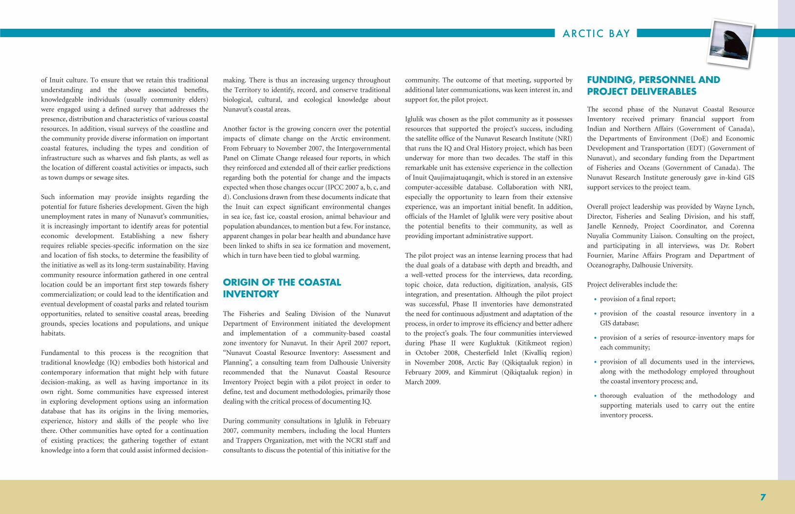
of Inuit culture. To ensure that we retain this traditional
understanding and the above associated benefits,
knowledgeable individuals (usually community elders)
were engaged using a defined survey that addresses the
presence, distribution and characteristics of various coastal
resources. In addition, visual surveys of the coastline and
the community provide diverse information on important
coastal features, including the types and condition of
infrastructure such as wharves and fish plants, as well as
the location of different coastal activities or impacts, such
as town dumps or sewage sites.
Such information may provide insights regarding the
potential for future fisheries development. Given the high
unemployment rates in many of Nunavut’s communities,
it is increasingly important to identify areas for potential
economic development. Establishing a new fishery
requires reliable species-specific information on the size
and location of fish stocks, to determine the feasibility of
the initiative as well as its long-term sustainability. Having
community resource information gathered in one central
location could be an important first step towards fishery
commercialization; or could lead to the identification and
eventual development of coastal parks and related tourism
opportunities, related to sensitive coastal areas, breeding
grounds, species locations and populations, and unique
habitats.
Fundamental to this process is the recognition that
traditional knowledge (IQ) embodies both historical and
contemporary information that might help with future
decision-making, as well as having importance in its
own right. Some communities have expressed interest
in exploring development options using an information
database that has its origins in the living memories,
experience, history and skills of the people who live
there. Other communities have opted for a continuation
of existing practices; the gathering together of extant
knowledge into a form that could assist informed decision-
making. There is thus an increasing urgency throughout
the Territory to identify, record, and conserve traditional
biological, cultural, and ecological knowledge about
Nunavut’s coastal areas.
Another factor is the growing concern over the potential
impacts of climate change on the Arctic environment.
From February to November 2007, the Intergovernmental
Panel on Climate Change released four reports, in which
they reinforced and extended all of their earlier predictions
regarding both the potential for change and the impacts
expected when those changes occur (IPCC 2007 a, b, c, and
d). Conclusions drawn from these documents indicate that
the Inuit can expect significant environmental changes
in sea ice, fast ice, coastal erosion, animal behaviour and
population abundances, to mention but a few. For instance,
apparent changes in polar bear health and abundance have
been linked to shifts in sea ice formation and movement,
which in turn have been tied to global warming.
ORIGIN OF THE COASTAL INVENTORY
The Fisheries and Sealing Division of the Nunavut
Department of Environment initiated the development
and implementation of a community-based coastal
zone inventory for Nunavut. In their April 2007 report,
“Nunavut Coastal Resource Inventory: Assessment and
Planning”, a consulting team from Dalhousie University
recommended that the Nunavut Coastal Resource
Inventory Project begin with a pilot project in order to
define, test and document methodologies, primarily those
dealing with the critical process of documenting IQ.
During community consultations in Iglulik in February
2007, community members, including the local Hunters
and Trappers Organization, met with the NCRI staff and
consultants to discuss the potential of this initiative for the
community. The outcome of that meeting, supported by
additional later communications, was keen interest in, and
support for, the pilot project.
Iglulik was chosen as the pilot community as it possesses
resources that supported the project’s success, including
the satellite office of the Nunavut Research Institute (NRI)
that runs the IQ and Oral History project, which has been
underway for more than two decades. The staff in this
remarkable unit has extensive experience in the collection
of Inuit Qaujimajatuqangit, which is stored in an extensive
computer-accessible database. Collaboration with NRI,
especially the opportunity to learn from their extensive
experience, was an important initial benefit. In addition,
officials of the Hamlet of Iglulik were very positive about
the potential benefits to their community, as well as
providing important administrative support.
The pilot project was an intense learning process that had
the dual goals of a database with depth and breadth, and
a well-vetted process for the interviews, data recording,
topic choice, data reduction, digitization, analysis, GIS
integration, and presentation. Although the pilot project
was successful, Phase II inventories have demonstrated
the need for continuous adjustment and adaptation of the
process, in order to improve its efficiency and better adhere
to the project’s goals. The four communities interviewed
during Phase II were Kugluktuk (Kitikmeot region)
in October 2008, Chesterfield Inlet (Kivalliq region)
in November 2008, Arctic Bay (Qikiqtaaluk region) in
February 2009, and Kimmirut (Qikiqtaaluk region) in
March 2009.
FUNDING, PERSONNEL AND PROJECT DELIVERABLES
The second phase of the Nunavut Coastal Resource
Inventory received primary financial support from
Indian and Northern Affairs (Government of Canada),
the Departments of Environment (DoE) and Economic
Development and Transportation (EDT) (Government of
Nunavut), and secondary funding from the Department
of Fisheries and Oceans (Government of Canada). The
Nunavut Research Institute generously gave in-kind GIS
support services to the project team.
Overall project leadership was provided by Wayne Lynch,
Director, Fisheries and Sealing Division, and his staff,
Janelle Kennedy, Project Coordinator, and Corenna
Nuyalia Community Liaison. Consulting on the project,
and participating in all interviews, was Dr. Robert
Fournier, Marine Affairs Program and Department of
Oceanography, Dalhousie University.
Project deliverables include the:
• provision of a final report;
• provision of the coastal resource inventory in a
GIS database;
• provision of a series of resource-inventory maps for
each community;
• provision of all documents used in the interviews,
along with the methodology employed throughout
the coastal inventory process; and,
• thorough evaluation of the methodology and
supporting materials used to carry out the entire
inventory process.

NUNAVUT COASTAL RESOURCE INVENTORY
8
METHODOLOGYThis section is composed of two parts: a broad introductory
overview of the philosophy, approach and execution of the
interview process, followed by a more detailed examination
of the methodology as implemented in Arctic Bay. Refer
to Appendix 4 for an in-depth Field Guide of all the
methods employed.
AN OVERVIEW OF THE PROCESS
The process began with the selection of a community that
would be prepared to participate in the interview process.
Criteria to assist in this selection were devised early in the
development of the project and, as one might expect, have
since undergone continuous revision. Once a provisional
choice was made each community was visited with the
purpose of determining whether it wished to participate
in the inventory, and if so, then who were the individuals
that would be most appropriate for the interviews. The
above questions were directed principally at the local
Hunter-Trapper Organization (HTO), where agreement
was quickly reached and an annotated list of potential
candidates was provided. Further, queries were made
and discussions held with individuals who might serve
as interpreters and translators, in conjunction with the
interview process. Suitable dates and venues were then
selected for the interviews.
The interview team was made up of five individuals: the
interviewer, a translator, a recorder, a science consultant,
and a student observer. The process varied from 2-6
hours, depending on the amount of detail elicited in
the response and the amount of clarification required
during the interview. Each interview followed the same
format (refer to Survey in appendices). The first round of
questions requested information about the interviewee’s
early life history and general knowledge and familiarity
of the local area. These were followed by questions that
referred to specific animals in a set order. Responses were
documented using maps prepared in advance that could
be annotated by the interviewee. The entire proceedings,
with permission, were recorded using audio and video
equipment. Upon completion of all the interviews planned
for the community, data was compiled into spreadsheets,
and the map information was scanned, digitized and
prepared for data analysis.
DETAILS OF THE PROCESS
Community SelectionCriteria to guide community selection were established
prior to the start of the interview process and were based
on a series of interviews with a broad range of individuals,
all of whom had some prior experience working with
traditional knowledge and/or communities. Criteria
underwent continuous refinement as knowledge and
insights improved. Community selection did not depend
on a suitable response to every single criterion, but rather
on the general picture conveyed by the responses to these
queries. The present criteria are as follows:
• Is the selected community willing to participate in the
project?
• Is the community considered to be an important
source of data on coastal resources?
• Are any other projects underway in the community
that might be considered to be complementary to the
coastal inventory?
• Does the community possess an existing repository
of oral history that could be made available to the
project?
• Does the community have a strong but under-utilized
or under-managed connection with a particular
resource animal, such that inventory data could prove
to be useful?
• Does the community wish to acquire or use any of the
coastal inventory data produced by the project?
• Is the community presently involved in a commercial
fishery?
• Is the community currently seeking infrastructure
for which the coastal inventory study might prove
supportive?
• Does the community have a strong and broadly
acceptable leadership available to the project?
• Does the community have a close association with a
park or a protected area?
Initial Community Visit Communities are visited on three occasions; an initial
scoping/consultation meeting, followed by a visit of
7-10 days during which interviews are conducted and
finally a follow-up trip to present the finished report and
support materials to the community. The scoping session
was designed to put in place the elements that would be
required to conduct the planned interviews. This process
depended on the support and participation of the Hunter-
Trapper Organizations (HTOs) and the Hamlet office.
Both the HTO and the Hamlet were asked at the outset
to formally support this initiative through the provision
of names of potential interviewees. They provided
annotated lists of local Inuit hunters and trappers which,
in their opinion, were among the most knowledgeable
and accomplished members of the community and could
best satisfy the requirements of the interview process.
The final selection was made by NCRI project personnel.
These individuals were contacted and tentative interview
schedules were established. In addition, HTO and Hamlet
personnel also provided the names of individuals who
could act as student observers and be used as translators.
The final order of business was to select a venue that would
accommodate the interview process.
Interview PreparationPreparations for the planned interviews were focused on
the definition and acquisition of all the information that
was necessary to compile the resource inventory. This
ranged from digital voice and video recorders to coloured
pencils. The latter would be used by both interviewees and
project personnel to draw and code information directly
on prepared maps. It also involved the definition of the

ARCTIC BAY
9
subject matter that would be addressed in the interviews,
including: contextual material such as early life history
or the location of camp sites, the geographic extent of
the maps, the species of interest (animal and plant), and
supporting environmental information such as time of
occurrence, condition on occurrence (breeding, migrating,
feeding etc). Once these decisions were made the results
were translated into maps that covered the area normally
used by hunters and fishers (Fig. 2), into photos of the
target species and into questions that would later be posed
(refer to appendices for photos and species list).
Interview StrategyThe manner in which the interviews were to be conducted
was repeatedly discussed over a considerable period,
and ultimately reflected the advice that NCRI personnel
received from many different sources. The goal of this
process is to allow Inuit hunters to speak in comfortable
surroundings on the subject of living coastal resources,
based on their life experiences. Recording this information
recognizes the finite nature of human life, the wealth of
information that is contained within individuals, and the
importance of that information from both cultural and
management standpoints. With this in mind considerable
attention was devoted to the realization of these goals. Two
related issues are worthy of some comment: Inuit hunters
have often been interviewed over the years but they were
pleased to learn that for the first time the process would
comprehensively embrace a broad range of living marine
resources; and, in addition, a promise by NCRI staff to
provide each HTO with a copy of all data collected from
the interviews in its community was viewed as a very
positive contribution.
The InterviewsSix persons were present during each interview: the
interviewee, interviewer, translator, recorder, science
consultant, and student observer. The interviewer followed a defined protocol that placed a strong emphasis on: a
series of predetermined questions and photographs of
various living resources known to occur in the area. Maps,
covering the area of interest, were provided in order to
allow the interviewees to write directly on them and
thereby to annotate their verbal remarks. Questions were
asked and the interviewees responded both verbally and
by drawing on the maps before them. Specific categories
addressed in the interviews included: interviewee
life-history information; location of outpost camps;
archaeological sites; travel routes; hunting/fishing areas
frequented; the geographic occurrence of mammals, fish,
birds, invertebrates and plants; and finally, some discussion
about the linkages between coastal resources, present and
future environmental changes and potential economic
development (e.g. the possibility of an emergent fishery).
Because of the fundamental importance to the interview
process of the annotated maps every annotation to those
documents was accompanied by the immediate application
of a code that would enable future identification and
reference. Follow-up questions were asked of the
interviewee, clarifications were elicited and, if appropriate,
discussion ensued about the information presented.
The entire process was recorded using audio and video
equipment, while selective portions were immediately
recorded manually. Manual recording was used to maintain
a running record of all map annotations and codes. This
permitted work to proceed with the maps without the need
for transcription of the audio tapes. The interview process
varied from 2-6 hours, depending on the individual being
interviewed.
Post-Interview MethodologyDuring and immediately following each interview rigorous
file management protocols were employed. All recording
modes (Audio, Video and Manual) were carefully
synchronized with the information noted on the maps. All
of the manually recorded data was entered on a spreadsheet
which was updated as information became available. The
Figure 2: Extent of study area with selected place names..
80°0'0"W
82°0'0"W
82°0'0"W
84°0'0"W
84°0'0"W
86°0'0"W
86°0'0"W
88°0'0"W
88°0'0"W
90°0'0"W
90°0'0"W
74°0
'0"N 74
°0'0
"N
73°0
'0"N 73
°0'0
"N
72°0
'0"N 72
°0'0
"N
71°0
'0"N 71
°0'0
"N
Full extent of study area
1:1,350,000
B e r n i e r B a yB e r n i e r B a y
L a n c a s t e r S o u n dL a n c a s t e r S o u n d
D E V O N I S L A N DD E V O N I S L A N D
A r c t i c B a yA r c t i c B a y
B R O D E U R B R O D E U R
P E N I N S U L AP E N I N S U L A
S i r m i l i k ( N o r t h B a f f i n ) S i r m i l i k ( N o r t h B a f f i n ) N a t i o n a l P a r kN a t i o n a l P a r k

NUNAVUT COASTAL RESOURCE INVENTORY
10
maps used in the interviews were scanned and the hand-
drawn data was digitized. The end result was the creation
of a coherent and workable database, which when used
with the maps provides a complementary visualization of
that data. The maps were planned from the outset as the
cornerstone of the interview process and the resulting
community reports.
Non-Interview Data AcquisitionData on marine resources can be found scattered
throughout many different sources that range from
scientific papers, government reports, environmental
impact assessments and maps. However, three surveys exist,
with similar geographic breadth and goals, have proven to
be especially useful. There is the three-volume “Inuit Land
Use and Occupancy Study”, which was undertaken in the
early 70’s and published in 1976 by Indian and Northern
Affairs. It grew out of the documentation required by
the land claim process and was used to substantiate Inuit
claims as to residency and land use. The resulting study
contains detailed information on traditional land use up
to that time. It focused on hunting, trapping and fishing
and used topographic maps to outline fishing, hunting
and trap line regions associated with each community
in Nunavut over three periods: pre-contact, the trading
period up to the 1950s, and the present (early 1970s). One
of the volumes is an atlas that maps the results, based on
interviews with Inuit in each community. The original
research is available in Ottawa at the National Archives.
A copy of the three volume report is also available in the
Legislative Library in Iqaluit.
A second document is the one volume Nunavut Atlas co-
published in 1992 by the Canadian Circumpolar Institute
and the Tungavik Federation of Nunavut. This atlas
relies largely on data collected for the Inuit Land Use and
Occupancy Study and although the presentation of resource
data and maps is reasonably accessible the information
provided is approximately 35 years old. Relevant maps
from this volume are presented in this report (refer to the
Reource Inventory – end of this section).
The third document is the Nunavut Wildlife Harvest
Study produced by the Nunavut Wildlife Management
Board in August 2004. This study was mandated by
the Nunavut Land Claim Agreement. Harvest data was
collected monthly from Inuit hunters for a total of five
years from 1996 to 2001. The purpose of the study was “to
determine (the then) current harvesting levels and patterns
of Inuit use of wildlife resources.” Once completed this
information was to be used to manage wildlife resources
in Nunavut.
Data Management and AnalysisData collected through interviews and research were
plotted, when appropriate, on working maps, while the
final representations occur on all inventory maps. The
scale is large, in keeping with the size of the geographic area
under discussion. Keeping a scale common to all maps was
done to permit relatively easy inter-comparability. Also, on
the inventory maps information was separated according
to resource categories, and all information associated
with a specific geographic location was entered into a
tabular database. The development, care and maintenance
of this tabular database are extremely important, not
only as a storage facility for information, but as an active
repository that will be effectively accessed by users with
diverse interests.
Data management also includes protecting the
confidentiality of the data. Each interviewee provided
their consent to be interviewed, as well as audio and video
taped (see Appendix 10 – for consent form used). Post
interview, if any person or organization wishes to access
the data collected they must provide written justification
to the NCRI Steering Committee and agree to the terms
outlined in the Data Release Form (see Appendix 11 – for
sample of data release form).
GIS InterfaceOnce the inventory maps and database are complete they
are entered into a Geographic Information System (GIS),
leading to the creation of computer-generated maps.
It also links information to the geographic locations
contained in the database. Attributes associated with each
piece of data include information such as species name,
source, population level, etc. Mapped data are linked to
additional information in the corresponding database.
Photos accompany the data where applicable.

ARCTIC BAY
11
MARINE RESOURCES IN AN OCEANOGRAPHIC CONTEXT(Arctic Bay)
INTRODUCTIONThe coastal communities of Nunavut are diverse. They
extend over 27° of latitude and 60° of longitude, so in
addition to different geomorphologies, climates and wildlife,
they also experience widely different ocean environments.
These include significant differences in residual circulation,
tidal range, tidal currents, tidal mixing, shore-fast leads, ice-
edge upwelling, topographic upwelling and polynyas, all of
which influence the abundance, diversity and concentration
of marine animals and plants. The oceanographic context
in which these organisms occur, especially the causal
mechanisms that contribute to population dynamics, are
essential to understanding changes that occur over time.
One of the stated goals of this initiative is to develop the
capacity to monitor Nunavut’s marine resources within the
context of impending climate change. Many organisms will
experience the impact of global warming directly through
changes in their physiology; but many others will also
receive indirect indications from their surrounding physical
and biological environments. Responsible monitoring of
marine resources will require more than just a quantitative
assessment of certain species; it will require an ecosystem
approach that, by definition, includes the physical factors at
play in that system.
RECURRENT OPEN WATER AND ARCTIC BIOLOGY
Recurring open water sites extend across a continuum that
reflects local geography and ice conditions, and includes
large polynyas, pack ice edges, shore-fast leads, and smaller
polynyas driven by upwelling or tidal mixing. Positive
correlations between open water in ice-covered seas and
abundance of marine organisms have been noted for some
time. In fact, Stirling (1980, 1997) specifically identified
increases in abundance of birds, seals, and whales with
proximity to ice edges, polynyas, and pack ice. The reasons
for this observed correlation are many, varied, and not
mutually exclusive. For instance, animals may be drawn to
these sites for practical reasons such as the availability of
breathing holes, a platform to haul out, predator avoidance,
pupping, or moulting (Stirling, 1997). What they all have
in common is that they encourage a non-homogeneous
distribution of animals, which is ultimately linked to greater
biological productivity.
Ultimately, the availability of food, the product of primary
production in phytoplankton or ice algae, is a major
contributing force. Both algal groups are important,
although their relative contributions can vary depending
on ice conditions and available light. In some locations,
ice algae represent 5% of the total primary production,
while in others it could be as high as 30% (Alexander, 1974;
Harrisson and Cota, 1991; Legendre et al., 1992). With the
thinning of ice in the spring, sunlight sufficient to drive
photosynthesis - especially ice algae - is available sooner,
thereby extending both the growing and grazing seasons, in
some cases by as much as two months. Bradstreet and Cross
(1982) believe that the aggregation of food items preferred
by or acceptable to invertebrates and vertebrates, on the ice
under-surface is also a factor of some significance. Once
plant material is available it is grazed and enters into the
food web where it becomes available to invertebrates (e.g.
copepods, amphipods or shellfish), who in turn feed fish
(e.g. arctic cod), mammals (seals, narwhal, walrus or polar
bears) and birds (such as thick billed murres, northern
fulmars, black legged kittiwakes or black guillemots). This
results in a form of “oasis” or “hotspot” in an otherwise ice-
covered area.
In addition, these open water sites appear to have been of
some importance to native peoples who have occupied
the Arctic for several thousand years. Zooarchaeological
data obtained from historic Inuit habitation sites, coupled
with modern sea-ice extremes, have been used to infer a
strong causal relationship between polynyas and historic
Inuit settlement patterns (Henshaw 2003). Schledermann
(1980) drew attention to the fact that the early settlers of
present-day Nunavut did not create settlements in random
fashion. Since they depended almost entirely on food
resources obtained through hunting, a close association
usually existed between the location of settlements and
reasonable proximity of game, which often meant areas
of recurrent open water. Schledermann also found a close
correlation between the distribution of recurring polynyas
in the eastern Canadian high Arctic and the abundance
of archaeological sites from the Thule culture, which
specialized in hunting marine mammals.
OCEANOGRAPHIC FACTORS THAT CONTRIBUTE TO OPEN WATER
The presence of open water in winter can be a chance
occurrence that reflects ephemeral conditions. Sites formed
in this manner would be largely unpredictable and of limited
usefulness to animals and humans. On the other hand,
recurrent open water sites are the physical manifestation of
one or several predictable physical processes that result in
spatial and temporal reliability. The different processes that
contributing to this reliability are reviewed below.
Admiralty InletThe community of Arctic Bay, unlike others involved in
this series (to date - Igloolik, Kugluktuk, Chesterfield Inlet
and Kimmirut), is not directly associated with a major
body of water. Admiralty Inlet, which is the major focus for
most community hunting/fishing activities, is an offshoot
of Lancaster Sound, and as such, it is only peripherally
impacted by the oceanographic influences that occur in the
latter body. In addition, limited research has been carried
out in Admiralty Inlet, making it difficult to develop as
complete a picture of physical phenomena as in the earlier
communities.
Arctic Bay and its surroundings have been occupied for
nearly 5000 years by nomadic peoples moving from the
west. The town is located in the northern part of Borden
Peninsula on Baffin Island. Its Inuit name is Ikpiarjuk,
which means “the pocket”, because of the high hills that
surround the almost landlocked bay. Arctic Bay opens to
the south on Adams Sound, which, in turn, connects to
Admiralty Inlet, sandwiched between Brodeur and Borden
Peninsulas. Admiralty Inlet is between 3 and 32 kilometres
wide and between 200 and 400 metres deep, and extends
approximately 370 kilometres south from Lancaster Sound.
It contains a number of smaller inlets, bays and sounds,
as well as many islands. Shoreline relief around Admiralty
Inlet reaches heights of up to 500 metres.
NUNAVUT COASTAL RESOURCE INVENTORY
12
Residual CirculationLancaster Sound, Jones Sound, and Hudson Strait are three
important conduits in the Canadian Arctic Archipelago for
water flowing from the Arctic Ocean to the Atlantic via
Baffin Bay and the Labrador Sea (Ingram et al., 2005). This
water movement occurs principally because of differences
in sea level between the two oceans (Michel et al., 2006).
Actual flow rates are not well known because ice cover
makes year-round observations exceedingly difficult. In
addition, a westward-directed flow, coming from northern
Baffin Bay and Smith Sound, moves in along the south
coast of Devon Island.
Since Admiralty Inlet is sealed at its southern end, it does
not permit any flow-through, thereby largely removing
the influence of residual circulation. However, Lancaster
Sound does influence the timing and extent of polynyas
throughout Admiralty Inlet, through the action of tidal
currents and tidal mixing. In addition, Welch et al. (1992)
suggest that Lancaster Sound has a higher rate of primary
production relative to other areas in the Canadian Arctic
Archipelago, due to a significant influx of nutrients in
currents flowing from the east.
Tidal Range and CurrentsThe tidal range and tidal currents in Admiralty Inlet are not
routinely monitored, but both can be reasonably predicted
using the Web Tide model created by Department of
Fisheries and Oceans scientists (DFO, 2009). The model
predicts varying tidal elevations between 0.5 metres and
1.25 metres over the length of the inlet, with the highest
values at the southern end, tapering closer to Lancaster
Sound. Tidal currents are predicted in the range of 3-15
cm/s (0.06 – 0.3 knots), and these too are greatest in the
south, and decrease towards Lancaster Sound.
Tidal MixingTidal currents can, under the right circumstances, produce
sufficient turbulence to generate vertical mixing capable of
forming and maintaining a polynya (Hannah et al., 2009).
A slow-moving tidal current that encounters shallow water
and/or a narrow strait will increase its velocity, which
promotes vertical mixing. Mixing can move warmer
subsurface water to the surface, where it slows or eliminates
ice formation. It also delivers nutrients that promote plant
growth whenever sufficient light is available. Examples of
this phenomenon are the well-known polynyas in Fury
and Hecla Straits at the head of Foxe Basin (Hannah et
al., 2009) and the Roes Welcome polynya in Hudson Bay
(Greenberg, 2009). In each case, tidal currents interact with
irregularities on the ocean bottom, resulting in sufficient
turbulence to produce nearly homogeneous water
throughout the water column. Water depths in Lancaster
Sound and most of Admiralty Inlet are sufficiently deep to
preclude this type of mixing. However, the lower third of
Admiralty Inlet is shallower, tidal currents are higher, and
a number of ice-free locations were reported during the
interview process.
Polynyas If the Arctic were covered with a thick, seamless layer of
sea ice, many of the organisms that currently exist there,
and contribute to the region’s productivity, would find
it impossible to survive. Polynyas and leads provide the
necessary breaks in the ice that: permit sunlight to penetrate
and photosynthesis to proceed (in both planktonic and
ice-based algae); allow mammals to breathe; and permit
over-wintering birds to feed. Wind, water movement,
and heat transfer are among the primary factors that
contribute to the establishment and maintenance of these
open water sites.
Polynyas have long been viewed as extraordinary because
of the obvious contradiction of open water occurring in
conditions that promote ice. The explanation for this
phenomenon is twofold: in some cases, the introduction
of heat forestalls ice formation, while in others the newly
formed ice is rapidly removed. These mechanisms are not
mutually exclusive and sometimes work in concert. The first
process involves a continuous transfer of warmer, deeper
waters to the surface, to slow or eliminate ice formation.
In the second, once ice has formed, wind and/or ocean
currents remove this ice from the site. Additionally, some
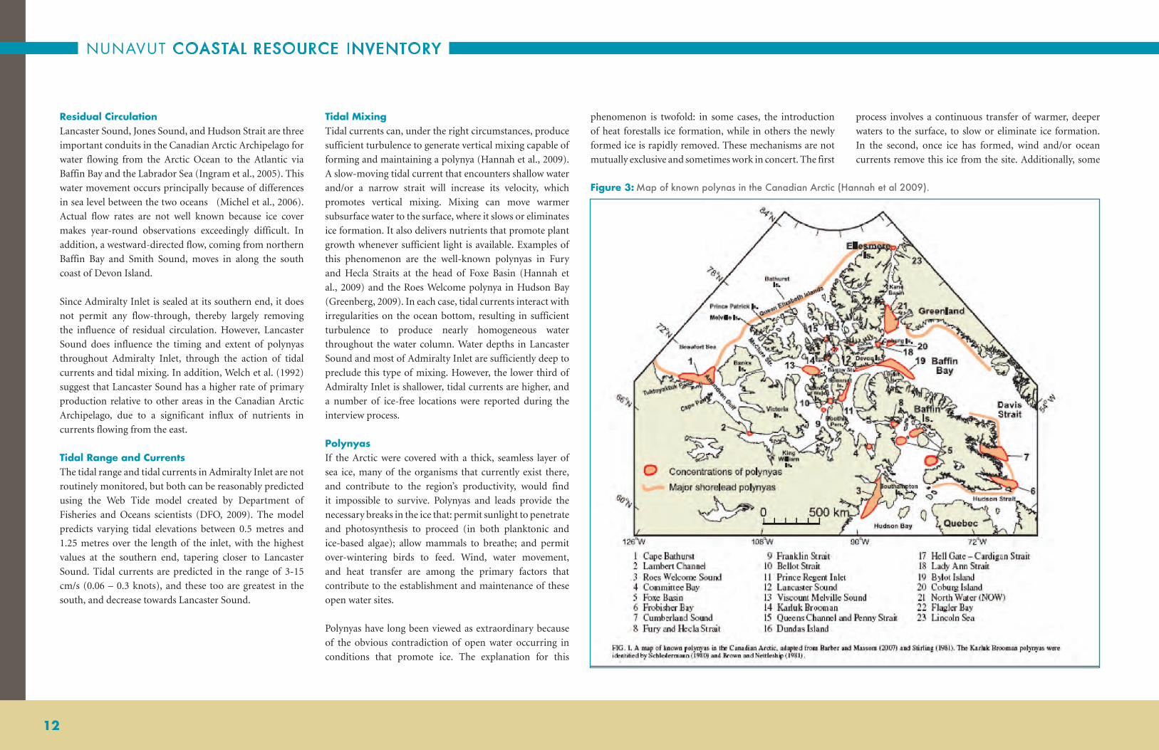
Figure 3: Map of known polynas in the Canadian Arctic (Hannah et al 2009).

ARCTIC BAY
13
heat is given off during the process of ice formation, which
further slows subsequent ice-making activities. Hannah et
al. (2009) review these mechanisms and point out several
additional factors, such as turbulence from surface waves
or currents that can inhibit ice formation, and adjacent
coastlines, shore-fast ice or ice bridges that can prevent ice
from drifting into the polynya site.
Recurring polynyas are present throughout the Canadian
Arctic Archipelago (see Figure 3).
Several have been identified in Lancaster Sound, with the
largest at the eastern end where the Sound joins Baffin
Bay. Extending westward from the polynya, along the
southern coast of Devon Island to approximately Prince
Regent Inlet, is an extensive landfast lead. Depending on
the source (Smith and Rigby, 1981), this extensive lead
has been reported to circle back in an easterly direction,
passing through a large polynya at the mouth of Admiralty
Inlet to cover essentially the entire perimeter of Lancaster
Sound. The above polynya was noted by many elders in
their interviews.
Admiralty Inlet has not been well studied, so very little
information on polynyas or landfast leads is available in
the scientific literature. However, interviews with elders
repeatedly mentioned both, and it was emphasized that
they play an important role within the context of wildlife
availability for the elders hunting activities. These locations
are identified on the accompanying maps (see section
Maps and Tables).
Landfast Leads (Flaw Leads)Extensive systems of landfast leads occur throughout
the Arctic. Stirling (1981) nicely summarizes their many
characteristics. Landfast ice is generally composed of first-
year ice, possibly mixed with multi-year remnants, that
is fixed to the coast. This ice platform extends outward,
eventually merging with offshore pack ice. George (2004)
suggests that the physical presence of this ice cover
modifies tidal and wind energy such that circulation
changes dramatically. At some point, a fracture or crack
may develop between the attached ice and the free-floating
pack due to wind blowing offshore, or to a lesser extent the
actions of coastal currents. These leads are normally linear
in shape and run parallel to shorelines. They are recurrent
and predictable in their location and are among the areas
where open water is found most consistently during winter
and early spring. Because of these factors, landfast leads are
of enormous biological importance.
The boundary between the ice-edge and the beginning of
the lead is an ecosystem that is very important, extremely
interesting, and a place that many observers have identified
as biologically rich and diverse. Below is a sampling of
observations:
• The landfast ice edge is an important Inuit hunting
site (Crawford and Jorgenson, 1990)
• During late spring and early summer, large numbers
of sea birds and marine mammals congregate at the
edges of landfast ice (McLaughlin et al., 2005)
• Ringed seals and polar bears are the only marine
animals that regularly occupy extensive landfast
coastal ice (Tynan and DeMaster, 1997)
• Bearded seals prefer relatively shallow water (<150m)
with thin, shifting ice and leads kept open by strong
currents (Tynan and DeMaster, 1997)
• Along with polynyas, shore-lead systems and ice
edges play key roles in influencing the abundance
and distribution of marine mammals and sea birds
(McLaughlin et al., 2005)
• Near the ice edge, the diet of adult ringed seals and
narwhal was composed primarily of arctic cod, while
amphipods and copepods were consumed in smaller
numbers (Bradstreet and Cross, 1982)
• Satellite observations show that polar bears in multi-
year ice are often associated with leads (Stirling, 1997)
• Admiralty Inlet has the highest densities of arctic
cod immediately below the edge of landfast sea
ice, apparently due to the availability of high
concentrations of copepod prey (Crawford and
Jorgenson, 1990)
The reasons for greater biological abundance and diversity
associated with landfast leads and ice edges are largely the
same as those outlined above when discussing recurrent
open water. However, one additional mechanism,
upwelling, also appears to operate at landfast or pack ice
edges, and is discussed below.
Elder interviews were very clear that leads in Admiralty
Inlet were generally located perpendicular to points of
land. The process (physical or tidal) that creates leads at
these points is not known. However, the interviewees were
emphatic that both seal breathing holes and polar bears
were readily found at these leads.
UpwellingUpwelling is a mechanism whereby warmer, deeper water is
moved to the surface, thereby creating and/or maintaining
ice-free open water. Topographic upwelling occurs where
a current moving through warmer subsurface water is
deflected (“welled upward”) by some bottom structure
(such as a sill, bank, or ridge) toward the surface, where it
can melt ice or help maintenance an ice-free area (Tee et
al., 1993).
Ice-edge upwelling has been observed in the Bering Sea
(Alexander and Niebauer, 1981), the Arctic Ocean (Buckley
et al., 1979, (Johannesen et al., 1983) and off the coast of
Newfoundland (Tang and Ikeda, 1989). This occurs when
wind blows parallel to the ice edge and causes surface water
to move away from the edge. It is then replaced by water
moving from below (Tang and Ikeda, 1989). The upwelling
zone can be several kilometres wide and draw subsurface
water from depths of up to 100 metres.
In addition to a greater heat flux to the surface, upwelling
water usually carries nutrients into the upper layer where,
with sufficient light, both phytoplankton and ice algae can
grow and provide a strong stimulus to the local food web.
This is one explanation for why polynyas and shore-fast
leads are so productive. Several locations were identified
in the southern end of Admiralty Inlet where the water is
shallower and tidal currents are faster, where tidal mixing
or topographic upwelling could be creating open water
conditions.
MARINE RESOURCES IN THE CONTEXT OF CLIMATE CHANGE
Many Arctic researchers over the past 20 years have
commented on the impending probability of global
warming, with its expected impact on the marine
environment as well as the abundance, diversity, and well-
being of marine organisms (Tynan and DeMaster, 1997;
Michel, Ingram and Harris, 2006; Moore and Huntington,
2008). Many changes will occur, both positive and negative,
that directly affect the role that recurrent open water sites
play in the overall success of marine coastal resources.
Impacts can be expected on water stratification and its role
in nutrient renewal, the balance between multi-year and
annual ice, the relative importance of ice algae, the timing,
and magnitude of primary and secondary production,
changes in traditional species and sites, amongst others.
Each of these changes could exert some influence on the
food web and the state of the resources as they are presently
defined. In other words, we can expect change to occur in
our physical world that will in turn, alter the biological
system, including the human component.

NUNAVUT COASTAL RESOURCE INVENTORY
14
RESOURCE INVENTORY
Interviews obtained from each community contain two
kinds of information: that which has been elicited from
direct questions; and that offered anecdotally for greater
context, to provide additional depth or breadth, to “colour”
a response, or simply to offer some causal interpretation
regarding the species under discussion. The first type has
specific geographic coordinates or involves quantitative
estimates that lend themselves to eventual representation
within a GIS format. The second, in the form of individual
opinions, assumptions and conclusions, offers qualitative
information that helps to humanize the responses and
mappings. These observations were generally made
without any additional information or corroboration,
although some were accompanied by a correlation to some
other environmental change (however, a correlation does
not necessarily signify causality, despite the convictions
of the interviewee). Even though they often require
additional observation and investigation, these comments
nevertheless provide highly personal and sometimes very
useful insights.
The following comments are loosely grouped into categories to facilitate their review.
AREAL EXTENT• The geographic locus of almost every interview
was Admiralty Inlet and its contiguous environs.
Occasionally, Inuit hunters described travels to Devon
Island in the north, the Gulf of Boothia in the west,
Foxe Basin in the south or Navy Board Inlet in the
east. However, their attention was overwhelmingly
directed at Admiralty Inlet, extending from the ice
edge with Lancaster Sound at its mouth, down to –
and often including – Bernier Bay and its approaches.
Conversely, very little attention was paid to the land
adjacent to the marine environment – except for
the Char fishery in freshwater lakes, and a few travel
routes to Polar Bear hunting grounds – now that cyclic
migrations of Caribou have greatly reduced their
numbers in the vicinity. Further north, on both the
Brodeur and Borden peninsulas, the adjacent lands
were least used, due to fewer lakes, rougher terrain,
and more permanent ice cover.
• Big lakes are considered less desirable places to fish
relative to smaller lakes, for reasons that are not
clear. One suggestion offered was that big lakes are
less productive, that is, contain fewer fish; while
an alternative view is that smaller lakes were
“designated” by elders, and continue to be used in
a traditional manner. The latter explanation begs
additional information.
SEA ICE• Landfast leads in Admiralty Inlet are extensive cracks
and openings that run perpendicular to the shore.
They are commonly used by seals for breathing
holes in the otherwise solid ice cover. The leads were
routinely patrolled by Polar Bears looking for seals
that were attempting to surface for a breath. Leads are
reportedly associated with points of land along the
coast, although no mechanism was suggested as to
why ice would fracture specifically at those locations.
ARCHAEOLOGICAL REMAINS• As with reports from other communities,
archaeological sites are abundant and widely
distributed over much of the coastline. This is not
surprising, considering that many authorities suggest
that this area has been occupied by human hunters and
fishers for between 3500 and 5000 years, embracing
Thule, Dorset and Inuit cultures.
HUNTING/FISHINGMAMMALS
• Ringed Seals are the single most important species
to the Inuit hunters of Arctic Bay. One interviewee
suggested that they might be viewed as a reliable
indicator of the general health of the ocean.
• Ringed Seals prefer annual landfast ice, although they
are found in multiyear ice.
• Bearded Seals are often observed in and around
drifting ice floes, although they also frequent shallower
water, where they feed on benthic crustaceans and
molluscs.
• Walrus were generally located near bivalve feeding
sites in winter, where recurrent open water and haul-
out sites were available. These conditions occurred at
the mouth of Admiralty Inlet, near points of land at
the ice floe edge.
• Killer Whales generally avoid adult Walrus because of
the latter’s size and ability to inflict severe injury with
their tusks. However, smaller, less mature Walrus are
frequently attacked.
• Killer Whales are not hunted. One suggestion offered
was that they were too difficult to approach. Another
was that they had greater value as herders of Narwhal.
Apparently, Narwhal occur regularly in Lancaster
Sound and Admiralty Inlet. Killer Whales influence
their movement and minimize their potential for
escape by driving them closer to shore. This benefits
both the Killer Whales and Inuit hunters.
• A Narwhal’s diet is thought to be predominantly
Arctic Cod, Greenland Halibut, cephalopods and
crustaceans.
• Polar Bears have never been as abundant on Baffin
Island as the present, but many hunters report that
a significant number appear emaciated. This may be
due to intense competition for food as a direct result
of the higher numbers. As they do not eat significant
amounts of terrestrial food, even when forced on land,
their ecology is tied to that of Ringed Seals.
• Polar Bears are closely linked to the shear zones
between shore-fast and multi-year ice pack floes,
where the likelihood of encountering a Ringed Seal is
considerably higher.
FISH • One report suggested that two fjords, Strathcona
Sound and Adams Sound, do not appear to contain
any fish at their upper ends. However, their
innermost reaches were said to contain large numbers
of an unknown swimming invertebrate. Whether
the presence of one is a cause for the absence of the
other is moot. For the moment it appears that unusual
conditions exist that warrant some additional scrutiny.
• Every lake considered in these interviews contains
Landlocked Char, unless the lake is so shallow that it
freezes entirely to the bottom.
• Sea-run Arctic Char are not considered common
in the high Arctic, but they sometimes occur where
outflows are substantial enough to ensure a return
migration in August.
• Some interviewees reported that there are variations
in the taste, size and color of Arctic Char. Lakes may
vary in their chemistry across the reporting area in

ARCTIC BAY
15
a manner that could affect the color and/or taste of
the Arctic Char. Changes in chemistry would most
likely reflect variations in the underlying geology of
individual lakes. Fish eaten from lakes further north
are considered more desirable.
• One interviewee reported that seriously disturbing a
site will drive the fish out for good, for example, when
local prospectors used dynamite to fish in a lake. No
one fishes in that lake any longer.
INVERTEBRATES• Amphipods appear to play a sizable role in the local
food web. There is ample evidence from observation
and stomach analyses that they are important
secondary producers, supporting a variety of
organisms such as birds, fish and especially seals.
Seal stomachs filled with amphipods are sometimes
tied off at both ends, cooked, and then eaten. This is
considered a delicacy.
• A form of amphipod, “cyamids” or “whale lice”,
colonizes thickened patches of hard skin on Bowhead
Whales.
• Bottom-dwelling invertebrates are not important
in the diets of Arctic Bay hunters, due partly to the
considerable depth of Admiralty Inlet
BIRDS• The presence or absence of birds is difficult to establish
given their highly mobile nature. Knowledgeable
birders draw attention to the presence of “accidentals”,
that is, birds that have been displaced outside of their
normal range. These can be considered false positives
until disproved by additional sightings.
• Over-wintering bird populations frequently use
polynyas as feeding areas.
HEALTH, SIZE AND PRESENCE• The marine mammals commonly observed near
Arctic Bay are Killer Whales, Bowhead Whales, Beluga,
Ringed Seals, Narwhal, and Walrus.
• Bowhead Whales are plankton feeders. They draw
in large volumes of water and filter out euphausids
(krill), copepods and Hyperiid amphipods. Each of
these organisms has an especially high lipid content
with a high caloric value. Stomach contents also show
that Bowhead Whales also consume mysids, fish,
isopods and cumaceans (sea cucumbers).
• Caribou undergo 30-50 year cyclic migrations that
greatly influence local abundances. Presently, their
numbers are greatly reduced on the Brodeur and
Bordon Peninsulas.
• Clams have a strong correlation with the presence of
Walrus and Bearded Seals, since they form a significant
component in the diets of each species.
CHANGES REPORTED/ANTICIPATED• Although presently abandoned, the Nanasivik mine
(lead and zinc ore), when fully operational, was
thought to be responsible for some observations of
liver problems in seals. Subsequent analyses by experts
acknowledge that increases in these heavy metals were
in fact noticed in sediments and biota near the effluent
from the mine.
• Some concern was registered about the possible future
loss of ice in summer in the Northwest Passage, and
the potential impact of increased ship traffic on
the wildlife in the area. Increased ship traffic could
contribute higher levels of ambient noise, chemical
pollution (including hydrocarbons), solid waste, open
water, and invasive species (transported attached to
ship hulls or through the discharge of ballast water).
• Ringed Seals have been observed to replace the hair
they shed in the spring at a much slower rate than
previously noted. One suggestion was that this might
be due to a warmer summer, or a warmer spring/
fall with warmer water temperatures. No qualitative
changes were noted in seal meat or fat.
POTENTIAL COMMERCIAL OPPORTUNITIES
• Among respondents, the almost unanimous response
to this question was to maximize tourism. The
ramifications of this goal are the need to develop
supporting infrastructure and persons trained in the
hospitality trade.
• Several mentions were made of the potential to
provide authentic cultural experiences not only to
tourists but also to local youth and researchers.

NUNAVUT COASTAL RESOURCE INVENTORY
16

ARCTIC BAY
17
MAPS AND TABLESThe following group of maps brings together geographic
context, species locations, and a brief look at some earlier
studies (derived from the Nunavut Atlas). The following
maps are numbered sequentially. Each map is accompanied
by data in tabular form that provides additional detail as
well as descriptive information, when available. Captions
below each map provide a description as well. All historic
data is presented at the end of this section. Use Table 1 to
interpret Map Codes provided in the tables accompanying
the maps.
MAPPING CODES GUIDE
Anything unsure or unreliable Appended with a lower case 'u'
Changes from one spot to another (same group of animals) Appended with lower case 'c'
Present {since year 2000} Appended with 'P'
Historic {before year 2000} Appended with an 'H'
Everywhere (seen all over/no specific place/only where they go)
Appended with a lower case 'e'— Note that an asterisk (*) has been placed after species names in map titles to indicate that the species is also seen ‘everywhere’.
High Abundance Appended with an 'A'
Migration (use arrows to indicate direction) Appended with an 'M'
Spawning / Nesting / Denning / Calving / Pupping areas Appended with an 'S'
Nursery Area Appended with an ‘N’
Feeding Areas Appended with an ‘F’
Significant Area of High Diversity SADP
Significant Unique Area SAUP
Significant Area for Other Reason SAOP
Archeological / Historic / Camp Site (old and very old) ARCH
Other OTH
Area Known Best (area most familiar with or a travel route) AKB
Camp / Cabin (typically modern) CAMP
Example: CHAR_1_AP: First Arctic Char area drawn by interviewee that is also presently (after year 2000) an area of high abundance.
Table 1: Guide to map codes

NUNAVUT COASTAL RESOURCE INVENTORY
18
Generally, maps comprise groupings of several species
or a single species as reported in multiple interviews.
Species and interviews are normally color-coded and both
locations are accompanied by a numeric label. The first
number in the label refers to a specific interview while the
second is a location identifier. These labels can be used to
look-up relevant information in the table associated with
each map.
Locations reported by the interviewee as “unsure” have not
been included in this report.
In some cases no locations were drawn on a map because
one or more interviewees considered the distribution to be
classified as “everywhere”. The designation of “Everywhere”
was used when interviewees felt that the organism under
discussion had been observed everywhere throughout their
travels and places they are very familiar with. Giving a
species an “everywhere” designation does not confer any
information about abundance nor should it be presumed
to be ubiquitous; it is only a measure of distribution
relative to where the interviewee has been. “Everywhere
only” data is not represented on the map, but is provided
as a table of data following the map.
In addition to “everywhere only” designations, some species
were described by interviewees as being “everywhere” and
some interviewees provided locations for them. In these
cases, where the species have been drawn on the map by
some, but considered “everywhere” by others, an asterisk
has been placed after the species name in the title of the
map. For example; Arctic Char is written as “Arctic Char*”
in the map title because it was reported in specific locations,
as well as, being “everywhere”. The asterisk simply provides
a visual cue that the species has two designations.
Please note that the data presented on birds has been
further qualified in Appendix 3. Of all species presented
to an interviewee, those in the bird category present the
greatest challenge in proper identification; a challenge
often encountered by even the most keen observer of birds
(e.g. sandpipers or gulls). To assist in the interpretation of
the data the additional appendix compares observations
recorded for the inventory with literature and sightings by
other authors. In the future, inventory work will endeavor
to qualify all species reported in a similar way.
Note: The asterisk (*) after some species names in the
titles of the Maps indicates that the species was “also”
considered to be seen Everywhere. Species identified
as being “Everywhere Only” are shown by the use of a
solid bullet in the Map legend.

ARCTIC BAY
19

NUNAVUT COASTAL RESOURCE INVENTORY
20
Figure 4: Travel routes and areas of greatest familiarity.
1_3
1_1
1_8
1_2
1_4
1_7
1_5
1_6
2_1
2_13
0
2_3
2_2
2_13
1
2_12
9
2_13
4
2_12
8
5_16
5_24
4
5_24
6
5_14
5_24
5
5_13
5_15
5_24
2
5_17
5_2
5_19
5_9
5_18
5_24
3
5_10
5_7
5_8
5_11
5_21
5_4
5_6
5_5
5_20
5_12
5_3
6_46_
3
6_2
7_4
7_2
7_3
7_5
9_5
9_3
9_4
9_2
10_1
80°0
'0"W
82°0
'0"W
82°0
'0"W
84°0
'0"W
84°0
'0"W
86°0
'0"W
86°0
'0"W
88°0
'0"W88
°0'0
"W
90°0
'0"W
90°0
'0"W
74°0'0"N
74°0'0"N
73°0'0"N
73°0'0"N
72°0'0"N
72°0'0"N
71°0'0"N
71°0'0"N
Trav
el ro
utes
and
are
as o
f gre
ates
t fam
iliar
ity*
1:1,
350,
000
Dat
a S
ourc
e: N
TDB
1:25
0 00
0; A
rctic
Bay
inte
rvie
ws
Inte
rvie
w1 2 5 6 7 9 10
Be
rnie
r B
ay
Be
rnie
r B
ay
La
nc
as
ter
So
un
dL
an
ca
ste
r S
ou
nd
DE
VO
N I
SL
AN
DD
EV
ON
IS
LA
ND

ARCTIC BAY
21
Table
2:
Trav
el r
oute
s an
d ar
eas
of g
reat
est f
amili
arity
.
Map C
ode
Map L
abel
Pres
ent
– P
H
isto
ric
– H
Com
men
ts
AK
B_8
1_8
PC
omm
on t
rave
l rou
te to
Pon
d In
let.
AK
B_4
1_4
PT
rave
l rou
te to
a fi
shin
g ar
ea.
AK
B_2
1_2
PA
rea
whe
re s
eal a
re h
un
ted.
AK
B_1
1_1
PN
arw
hal h
un
tin
g at
floe
edg
e.
AK
B_3
1_3
PA
rea
whe
re n
arw
hal a
re h
un
ted.
AK
B_7
1_7
PW
inte
r fi
shin
g ar
ea.
AK
B_5
1_5
PA
rea
whe
re g
oose
egg
s ar
e co
llect
ed /
Gee
se a
re h
un
ted.
AK
B_6
1_6
PSp
rin
g /
Sum
mer
fish
ing
area
.
AK
B_4
2_12
8P
The
inte
rvie
wee
was
bor
n o
n S
outh
east
ern
par
t of
Byl
ot I
slan
d. H
e sa
w A
rcti
c Fl
oun
der
floa
tin
g on
su
rfac
e of
the
ic
e in
Spr
ing,
the
re w
ere
big
pile
s of
Cod
an
d Fl
oun
der;
so
big
they
tho
ugh
t it
was
a s
mal
l isl
and.
AK
B_8
2_13
4P
AK
B_3
2_3
PT
rave
l rou
te to
hu
nt
cari
bou
.
AK
B_6
2_13
0P
AK
B_5
2_12
9P
AK
B_7
2_13
1P
AK
B_2
2_2
HT
rave
l rou
te to
hu
nt
pola
r be
ar.
AK
B_1
2_1
PT
rave
l rou
te.
AK
B_1
35_
13P
Tra
vel r
oute
.
AK
B_1
85_
18P
Tra
vel r
oute
.
AK
B_1
45_
14P
Tra
vel r
oute
.
AK
B_1
05_
10P
Tra
vel r
oute
to I
gloo
lik.
AK
B_1
65_
16P
Tra
vel r
oute
to h
un
t ca
ribo
u.
AK
B_7
5_7
PT
rave
l rou
te.
AK
B_6
5_6
PT
rave
l rou
te.
AK
B_1
55_
15P
Tra
vel r
oute
.
AK
B_5
5_5
PT
rave
l rou
te to
Pon
d In
let.
AK
B_2
15_
21P
Tra
vel r
oute
.
AK
B_4
5_4
PT
rave
l rou
te; w
arm
er a
re t
han
Arc
tic
Bay
.
AK
B_8
5_8
PT
rave
l rou
te to
a la
ke.
AK
B_2
5_2
PT
rave
l rou
te d
own
to I
gloo
lik.
AK
B_9
5_9
PT
rave
l rou
te.
AK
B_1
95_
19P
Tra
vel r
oute
.
AK
B_1
15_
11P
Tra
vel r
oute
.
AK
B_3
5_3
PT
rave
l rou
te.
AK
B_1
25_
12P
Tra
vel r
oute
.
AK
B_1
75_
17P
Tra
vel r
oute
.
AK
B_2
05_
20P
Tra
vel r
oute
.
AK
B_2
25_
242
P
AK
B_2
45_
244
P
AK
B_2
35_
243
P
AK
B_2
55_
245
P
AK
B_2
65_
246
P
AK
B_2
6_2
PA
Cab
in in
the
are
a.
AK
B_3
6_3
PT
here
is d
og te
am t
rail
to h
un
t po
lar
bear
s.
AK
B_4
6_4
PT
rave
l rou
te to
hu
nt
nar
wha
l; B
oati
ng
area
du
rin
g th
e su
mm
er.
AK
B_3
7_3
PT
rave
l rou
te to
fish
ing
area
.
AK
B_2
7_2
PH
un
tin
g ar
ea.
AK
B_4
7_4
PT
rave
l rou
te to
hu
nt
pola
r be
ar.
AK
B_5
7_5
PFi
shin
g tr
avel
rou
te.
AK
B_5
9_5
PT
rave
l rou
te.
AK
B_4
9_4
PT
rave
l rou
te.
AK
B_3
9_3
PT
rave
l rou
te to
fish
ing
area
.
AK
B_2
9_2
PT
rave
l rou
te in
win
ter.
AK
B_1
10_1
PYe
ar r
oun
d tr
avel
rou
te.
Inte
rvie
wM
ap C
ode
Pres
ent
– P
H
isto
ric
– H
Com
men
ts
3A
KB
_1_e
PH
un
tin
g ar
ea. W
hole
map
an
d m
ore.
4A
KB
_1_e
PT
rave
l are
a; w
hole
map
.
8A
KB
_1_e
PH
un
tin
g ar
ea. T
he w
hole
are
a an
d ev
en m
ore.
9A
KB
_1_e
PE
very
whe
re o
n m
ap, e
xcep
t th
e to
p of
Bro
deu
r Pe
nin
sula
.
11A
KB
_1_e
PH
un
tin
g ar
ea /
Cam
p si
te. E
very
whe
re o
n t
he m
ap a
nd
mor
e.
“Eve
ryw
here
” Co
ded
Data
— T
rave
l rou
tes
and
area
s of
gre
ates
t fam
iliar
ity.

NUNAVUT COASTAL RESOURCE INVENTORY
22
Figure 5: Archaeological sites and areas of cultural significance.
7_22
5_28
6_19
11_4
1
1_25
1_9
1_17
1_15
1_201_
22
1_162_
25
2_23
2_18
2_32
2_30
2_5
2_4
2_31
2_28
4_21
4_15
4_16
4_17
4_18
5_22
6_21
6_11
7_21
7_17
7_8
7_19
7_15
8_5
8_4
8_2
9_16
9_14
9_13
9_9
9_8
9_7
9_12
10_2
2
10_2
7
10_1
9
10_1
4
10_1
5
10_3
10_6
10_7
10_1
110
_17
10_1
6
10_2
0 10_2
1
11_5
11_3
11_4
11_4
5
11_2
11_6
11_4
2
11_1
5
11_1
3
11_1
7
11_1
9
11_2
0
11_2
2
11_2
6
11_2
3
11_3
911
_40
11_3
6
11_3
8
11_3
7
11_3
4
11_4
411_3
111
_32
11_2
9
11_7
11_1
0
11_1
2
11_9
11_8
11_2
810
_10
10_1
2
10_1
3
10_1
8
1_21
1_19
1_18
1_14 1_
13
1_12
1_11
1_10
11_4
3
11_3
5
11_3
3
11_3
0
11_2
7
11_2
5
11_2
4
11_2
1
11_1
8
11_1
6
11_1
4
11_1
1
10_9
10_8
10_5
10_4
10_2
9
10_2
8
10_2
610
_25
10_2
4
10_2
3
6_22
6_20
6_18
6_17
6_16
6_15
6_14
6_13
6_12
6_10
5_33
5_32
5_31
5_30
5_29
5_27
5_26
5_25
5_24
5_23
4_9
4_8
4_7
4_6
4_5
4_4
4_3 4_22
4_20
4_2
4_19
4_14
4_13
4_12
4_11
4_10
3_5
3_4
3_3
3_2
2_9
2_8
2_72_
6
2_29
2_27
2_26
2_24
2_22
2_21
2_20
2_19
2_17
2_16
2_15
2_14
2_12
2_11
2_10
1_29
1_28
1_27
1_26
1_24
1_23
9_6
9_15
9_11
9_10
8_8
8_7
8_6
8_3
7_9
7_7
7_6
7_27
7_26
7_25
7_24
7_23
7_20
7_18
7_16
7_14
7_13
7_12
7_11
7_10
6_9
6_8
6_7
6_6
6_5
10_2
80°0
'0"W
82°0
'0"W
82°0
'0"W
84°0
'0"W
84°0
'0"W
86°0
'0"W
86°0
'0"W
88°0
'0"W88
°0'0
"W
90°0
'0"W
90°0
'0"W
74°0'0"N
74°0'0"N
73°0'0"N
73°0'0"N
72°0'0"N
72°0'0"N
71°0'0"N
71°0'0"N
Arch
aeol
ogia
l site
s an
d ar
eas
of c
ultu
ral s
igni
fican
ce
1:1,
350,
000
Dat
a S
ourc
e: N
TDB
1:25
0 00
0; A
rctic
Bay
inte
rvie
ws
Inte
rvie
w1 2 3 4 5 6 7 8 9 10 11
Be
rnie
r B
ay
Be
rnie
r B
ay
La
nc
as
ter
So
un
dL
an
ca
ste
r S
ou
nd
DE
VO
N I
SL
AN
DD
EV
ON
IS
LA
ND

ARCTIC BAY
23
Table
3:
Arc
haeo
logi
cal s
ites
and
area
s of
cul
tura
l sig
nific
ance
.
Map C
ode
Map L
abel
Pres
ent
– P
H
isto
ric
– H
Com
men
ts
Arc
h_5
1_13
HFi
shin
g w
eir
/ Sp
ears
in t
he s
oil.
Arc
h_15
1_23
HSo
d ho
use
s /
Cam
p si
te.
Arc
h_4
1_12
HSo
d ho
use
s.
Arc
h_17
1_25
HC
ircl
e of
roc
ks w
here
gee
se a
re t
rapp
ed.
Arc
h_3
1_11
HSo
d ho
use
s.
Arc
h_10
1_18
HSo
d ho
use
/ L
andl
ocke
d C
har.
Arc
h_11
1_19
HSo
d ho
use
s.
Arc
h_1
1_9
HR
ow o
f In
uks
uga
it u
sed
to b
lind
cari
bou
.
Arc
h_2
1_10
HSo
d ho
use
s at
Mu
miq
vik.
The
inte
rvie
wee
gre
w u
p at
thi
s lo
cati
on. H
e re
mem
bers
usi
ng
Pete
rhea
d bo
ats,
row
ing
boat
s, a
nd
qaja
q w
hen
hu
nti
ng.
Arc
h_6
1_14
HSo
d ho
use
s w
here
inte
rvie
wee
live
d.
Arc
h_9
1_17
HSo
d ho
use
s.
Arc
h_7
1_15
HSo
d ho
use
s.
Arc
h_12
1_20
HSo
d ho
use
s /
Cam
p si
te.
Arc
h_13
1_21
HSo
d ho
use
s /
Cam
p si
te.
Arc
h_14
1_22
HSo
d ho
use
s /
Cam
p si
te.
Arc
h_18
1_26
HSo
d ho
use
s.
Arc
h_20
1_28
HSo
d ho
use
s.
Arc
h_19
1_27
HSo
d ho
use
s.
Arc
h_21
1_29
HSo
d ho
use
s.
Arc
h_16
1_24
HSo
d ho
use
s /
Spri
ng
cam
p si
te.
Arc
h_8
1_16
HT
un
iitju
at s
od h
ouse
s /
Cam
p si
te.
Arc
h_22
2_25
HSo
d ho
use
/ C
amp
site
/ G
rave
sit
e /
Mea
t ca
che.
Arc
h_26
2_29
HSt
one
stru
ctu
res.
Arc
h_21
2_24
HSo
d ho
use
/ C
amp
site
at
Aqv
aaqt
uu
q.
Arc
h_23
2_26
HSo
d ho
use
/ C
amp
site
.
Arc
h_24
2_27
HC
amp
site
.
Arc
h_16
2_19
HC
amp
site
.
Arc
h_20
2_23
HSo
d ho
use
/ C
amp
site
.
Arc
h_19
2_22
HSo
d ho
use
/ C
amp
site
.
Arc
h_18
2_21
HSo
d ho
use
.
Arc
h_14
2_17
HC
amp
site
.
Arc
h_15
2_18
HC
amp
site
.
Arc
h_17
2_20
HSo
d ho
use
/ C
amp
site
.
Arc
h_13
2_16
HSo
d ho
use
/ C
amp
site
.
Arc
h_12
2_15
HSo
d ho
use
s /
Cam
p si
te a
t It
tukk
uvik
.
Arc
h_11
2_14
HSo
d ho
use
s /
Win
ter
cam
p /
Seal
hu
nti
ng.
Arc
h_9
2_12
HO
ld c
amp
site
.
Arc
h_8
2_11
HO
ld c
amp
site
.
Arc
h_7
2_10
HSo
d ho
use
s /
Ston
e st
ruct
ure
s /
Inu
ksu
gait
; The
sod
hou
ses
can
be
fou
nd
alon
g th
e le
ngt
h of
the
coa
st.
Arc
h_29
2_32
HFi
shin
g w
eir;
196
9.
Arc
h_27
2_30
HFi
shin
g w
eir.
Arc
h_2
2_5
HSo
d ho
use
/ C
amp
site
.
Arc
h_3
2_6
HSo
d ho
use
/ C
amp
site
.
Arc
h_4
2_7
HSo
d ho
use
/ C
amp
site
.
Arc
h_1
2_4
HSo
d ho
use
/ C
amp
site
.
Arc
h_6
2_9
HSo
d ho
use
/ C
amp
site
.
Arc
h_5
2_8
HSo
d ho
use
/ C
amp
site
.
Arc
h_28
2_31
HFi
shin
g w
eir.
Arc
h_25
2_28
HO
ld c
amp
site
.
Arc
h_2
3_3
HSo
d ho
use
at
Ittu
kkuv
ik.
Arc
h_3
3_4
HSo
d ho
use
.
Arc
h_1
3_2
HSo
d ho
use
fram
e at
An
guga
atia
qtal
ik.
Arc
h_4
3_5
HSo
d ho
use
; Thi
s lo
cati
on is
the
gra
ve s
ite
of t
he in
terv
iew
ee's
gra
ndp
aren
ts a
nd
fath
er.
Arc
h_13
4_14
HSp
rin
g ca
mp.
Arc
h_11
4_12
HSo
d ho
use
/ C
amp
site
.
Arc
h_12
4_13
HSo
d ho
use
/ C
amp
site
.
Arc
h_10
4_11
HSo
d ho
use
/ C
amp
site
.
Arc
h_9
4_10
HSo
d ho
use
/ C
amp
site
.
Arc
h_8
4_9
HSo
d ho
use
/ C
amp
site
.
Arc
h_6
4_7
HSo
d ho
use
s.
Arc
h_7
4_8
HSo
d ho
use
s; I
glu
lik t
rave
lers
’ cam
p in
thi
s ar
ea.
Arc
h_20
4_21
HT
ent
rin
gs.
Arc
h_5
4_6
HSo
d ho
use
s.
Arc
h_21
4_22
HC
amp
site
.
Arc
h_1
4_2
HSo
d ho
use
s.
Arc
h_4
4_5
HSo
d ho
use
s.
Arc
h_14
4_15
HM
issi
onar
y es
tabl
ishm
ent
/ C
hurc
h; W
here
the
y ce
lebr
ated
Chr
istm
as a
nd
New
Yea
rs.
Arc
h_3
4_4
HSo
d ho
use
s.
Arc
h_2
4_3
HSo
d ho
use
s.
Arc
h_15
4_16
HH
uds
on B
ay C
ompa
ny T
radi
ng
Post
.
Arc
h_16
4_17
HC
amp
site
.
Arc
h_18
4_19
HC
amp
site
.
Arc
h_17
4_18
HC
amp
site
.
Arc
h_19
4_20
HC
amp
site
.
Arc
h_9
5_30
HSo
d ho
use
at
Iqal
ulik
.
Arc
h_3
5_24
HSo
d ho
use
at
Ikpi
kitu
arju
k.
Arc
h_12
5_33
HSo
d ho
use
.
Arc
h_11
5_32
HSo
d ho
use
.
Arc
h_4
5_25
HSo
d ho
use
at
Nuv
uku
taaq
.

NUNAVUT COASTAL RESOURCE INVENTORY
24
Map C
ode
Map L
abel
Pres
ent
– P
H
isto
ric
– H
Com
men
ts
Arc
h_2
5_23
HSo
d ho
use
.
Arc
h_10
5_31
HSo
d ho
use
.
Arc
h_7
5_28
HSo
d ho
use
.
Arc
h_1
5_22
HO
ld b
arre
l / T
rave
l mar
ker.
Arc
h_5
5_26
HSo
d ho
use
.
Arc
h_6
5_27
HSo
d ho
use
.
Arc
h_8
5_29
HO
ldes
t so
d ho
use
at
Uu
kat.
Arc
h_14
6_18
HSo
d ho
use
.
Arc
h_16
6_20
HSo
d ho
use
.
Arc
h_11
6_15
HSo
d ho
use
.
Arc
h_1
6_5
HSo
d ho
use
s.
Arc
h_9
6_13
HT
hree
sod
hou
ses.
Arc
h_10
6_14
HSo
d ho
use
.
Arc
h_18
6_22
HSo
d ho
use
.
Arc
h_2
6_6
HSo
d ho
use
s.
Arc
h_17
6_21
HSo
d ho
use
.
Arc
h_3
6_7
HIn
terv
iew
ee's
par
ent's
sod
hou
se a
t Im
iq.
Arc
h_5
6_9
HSo
d ho
use
.
Arc
h_4
6_8
HSo
d ho
use
.
Arc
h_6
6_10
PSo
d ho
use
.
Arc
h_8
6_12
HSo
d ho
use
.
Arc
h_7
6_11
HA
lot
of s
od h
ouse
s, v
ery
beau
tifu
l.
Arc
h_15
6_19
HSo
d ho
use
.
Arc
h_12
6_16
HSo
d ho
use
.
Arc
h_13
6_17
HSo
d ho
use
.
Arc
h_16
7_21
HSo
d ho
use
/ C
amp.
Arc
h_22
7_27
HSo
d ho
use
/ C
amp.
Arc
h_5
7_10
HT
rave
l rou
te to
hu
nt
cari
bou
.
Arc
h_6
7_11
HSo
d ho
use
/ C
amp.
Arc
h_12
7_17
HSo
d ho
use
/ C
amp.
Arc
h_7
7_12
HSo
d ho
use
/ C
amp.
Arc
h_3
7_8
HSo
d ho
use
/ C
amp.
Arc
h_4
7_9
HSo
d ho
use
/ C
amp.
Arc
h_2
7_7
HO
lder
sod
hou
ses.
Arc
h_14
7_19
HSo
d ho
use
/ C
amp.
Arc
h_13
7_18
HSo
d ho
use
/ C
amp.
Arc
h_15
7_20
HSo
d ho
use
/ C
amp.
Arc
h_1
7_6
HSo
d ho
use
/ C
amp.
Arc
h_11
7_16
HSo
d ho
use
/ C
amp.
Arc
h_8
7_13
HSo
d ho
use
/ C
amp.
Arc
h_9
7_14
HSo
d ho
use
/ C
amp
at S
irm
ik.
Arc
h_10
7_15
HSo
d ho
use
/ C
amp.
Arc
h_21
7_26
HSo
d ho
use
/ C
amp.
Arc
h_20
7_25
HSo
d ho
use
/ C
amp.
Arc
h_18
7_23
HSo
d ho
use
/ C
amp.
Arc
h_17
7_22
HSo
d ho
use
/ C
amp.
Arc
h_19
7_24
HSo
d ho
use
/ C
amp.
Arc
h_7
8_8
HSo
d ho
use
; In
terv
iew
ee li
ved
ther
e; it
was
his
last
tim
e liv
ing
in a
sod
hou
se.
Arc
h_6
8_7
HSo
d ho
use
; In
terv
iew
ee li
ved
ther
e fo
r a
few
yea
rs.
Arc
h_5
8_6
HSo
d ho
use
at
Tik
iraa
qju
q.
Arc
h_4
8_5
HSo
d ho
use
; In
terv
iew
ee li
ved
ther
e fo
r a
few
yea
rs.
Arc
h_2
8_3
HSo
d ho
use
/ M
eat
cach
e at
Im
iq.
Arc
h_3
8_4
HSo
d ho
use
at
Qu
nn
guq.
Arc
h_1
8_2
HSo
d ho
use
/ F
ish
cach
e at
Sap
uti
.
Arc
h_11
9_16
HSo
d ho
use
s at
Qag
gita
lik.
Arc
h_10
9_15
HSo
d ho
use
s at
Aqv
aatu
uq.
Arc
h_9
9_14
HSo
d ho
use
s.
Arc
h_8
9_13
HSo
d ho
use
s.
Arc
h_6
9_11
HSo
d ho
use
s.
Arc
h_5
9_10
HSo
d ho
use
s.
Arc
h_4
9_9
HT
hule
sod
hou
ses.
Arc
h_3
9_8
HSo
d ho
use
s
Arc
h_2
9_7
HC
ache
mar
kers
, car
ibou
blin
d, fi
shin
g ar
ea, t
rail
mar
ker,
a m
ark
to s
how
som
eon
e w
as t
here
; lot
s of
In
uks
uga
it.
Arc
h_1
9_6
HSo
d ho
use
s.
Arc
h_7
9_12
HO
lder
sod
hou
ses.
Arc
h_23
10_2
4H
Hig
h ab
un
dan
ce o
f an
imal
s, t
hat
is w
hy I
nu
it li
ved
ther
e; s
od h
ouse
s ar
e pr
esen
t.
Arc
h_21
10_2
2H
Sod
hou
ses.
Arc
h_22
10_2
3H
Sod
hou
ses.
Arc
h_24
10_2
5H
Hig
h ab
un
dan
ce o
f an
imal
s, t
hat
is w
hy I
nu
it li
ved
ther
e; s
od h
ouse
s ar
e pr
esen
t.
Arc
h_25
10_2
6H
Inte
rvie
wee
sti
ll re
lies
on o
lder
cam
p si
tes
for
hun
tin
g; o
lder
sod
hou
ses
are
still
pre
sen
t.
Arc
h_26
10_2
7H
Old
er s
od h
ouse
s ar
e th
ere.
Arc
h_18
10_1
9H
Sod
hou
se a
nd
mea
t ca
che.
Arc
h_17
10_1
8H
Sod
hou
ses;
Too
ls t
here
are
mad
e of
bon
e on
ly.
Arc
h_28
10_2
9H
Sod
hou
se.
Arc
h_8
10_9
HSo
d ho
use
s.
Arc
h_13
10_1
4H
Sod
hou
ses.
Arc
h_14
10_1
5H
Sod
hou
ses.
Arc
h_12
10_1
3H
Spri
ng
cam
ps a
nd
olde
r so
d ho
use
s.
Table
3 (
cont
inue
d):
A
rcha
eolo
gica
l site
s an
d ar
eas
of c
ultu
ral s
igni
fican
ce.

ARCTIC BAY
25
Map C
ode
Map L
abel
Pres
ent
– P
H
isto
ric
– H
Com
men
ts
Arc
h_2
10_3
HC
arib
ou a
ntl
ers
are
fou
nd
here
.
Arc
h_1
10_2
HSo
d ho
use
s; I
nu
ksu
gait
in a
row
to b
lind
cari
bou
.
Arc
h_4
10_5
HA
cam
p w
here
a lo
t of
peo
ple
died
of
sick
nes
s or
sta
rvat
ion
; old
er s
od h
ouse
s ar
e al
so p
rese
nt.
Arc
h_3
10_4
HSo
d ho
use
s.
Arc
h_5
10_6
HFi
sh c
ache
are
a.
Arc
h_7
10_8
HO
lder
In
uks
uga
it; n
ot a
s m
any
as o
ther
are
as.
Arc
h_6
10_7
HSa
w a
bu
nch
of
fish
cac
hes
toge
ther
.
Arc
h_9
10_1
0H
Sod
hou
ses.
Arc
h_10
10_1
1H
Sod
hou
ses.
Arc
h_11
10_1
2H
Sod
hou
ses.
Arc
h_16
10_1
7H
Sod
hou
ses.
Arc
h_15
10_1
6H
Sod
hou
ses.
Arc
h_19
10_2
0H
Old
er te
nt
rin
gs a
nd
Inu
ksu
gait
.
Arc
h_20
10_2
1H
Old
er s
od h
ouse
s.
Arc
h_27
10_2
8H
Sod
hou
se.
Arc
h_4
11_5
HSo
d ho
use
s.
Arc
h_2
11_3
HSo
d ho
use
ow
ned
by
inte
rvie
wee
's g
ran
dpar
ents
.
Arc
h_3
11_4
HSo
d ho
use
s.
Arc
h_44
11_4
5H
Sod
hou
ses
from
Tu
niit
(T
hule
) an
d In
uit
.
Arc
h_1
11_2
HSo
d ho
use
s.
Arc
h_5
11_6
HSo
d ho
use
s.
Arc
h_41
11_4
2H
Sod
hou
ses.
Arc
h_42
11_4
3H
Sod
hou
ses.
Arc
h_15
11_1
6H
Win
teri
ng
area
.
Arc
h_14
11_1
5H
Sod
hou
ses.
Arc
h_13
11_1
4H
Sod
hou
ses.
Arc
h_12
11_1
3H
Sod
hou
ses
at I
ttu
kkuv
ik.
Arc
h_16
11_1
7H
Sod
hou
ses.
Arc
h_18
11_1
9H
Sod
hou
ses.
Arc
h_17
11_1
8H
Sod
hou
ses.
Arc
h_19
11_2
0H
Sod
hou
ses.
Arc
h_20
11_2
1H
Sod
hou
ses.
Arc
h_21
11_2
2H
Sod
hou
ses.
Arc
h_25
11_2
6H
Sod
hou
ses.
Arc
h_23
11_2
4H
Sod
hou
ses.
Arc
h_22
11_2
3H
Sod
hou
ses.
Arc
h_24
11_2
5H
Fish
ing
wei
r /
Sod
hou
ses.
Arc
h_38
11_3
9H
Sod
hou
ses.
Arc
h_39
11_4
0H
Sod
hou
ses.
Arc
h_35
11_3
6H
Sod
hou
ses
at A
gu B
ay.
Arc
h_37
11_3
8H
Sod
hou
ses.
Arc
h_36
11_3
7H
Sod
hou
ses.
Arc
h_34
11_3
5H
Sod
hou
ses.
Arc
h_33
11_3
4H
Sod
hou
ses.
Arc
h_43
11_4
4H
Sod
hou
ses.
Arc
h_32
11_3
3H
Sod
hou
ses.
Arc
h_30
11_3
1H
Sod
hou
ses.
Arc
h_31
11_3
2H
Sod
hou
ses.
Arc
h_29
11_3
0H
Sod
hou
ses.
Arc
h_28
11_2
9H
Sod
hou
ses
/ In
terv
iew
ee's
cam
p.
Arc
h_6
11_7
HSo
d ho
use
s.
Arc
h_9
11_1
0H
Sod
hou
ses.
Arc
h_10
11_1
1H
Sod
hou
ses.
Arc
h_11
11_1
2H
Sod
hou
ses.
Arc
h_8
11_9
HSo
d ho
use
s.
Arc
h_7
11_8
HSo
d ho
use
s.
Arc
h_26
11_2
7H
Sod
hou
ses.
Arc
h_27
11_2
8H
Sod
hou
ses.
Arc
h_40
11_4
1H
Sod
hou
ses.
Table
3 (
cont
inue
d):
A
rcha
eolo
gica
l site
s an
d ar
eas
of c
ultu
ral s
igni
fican
ce.
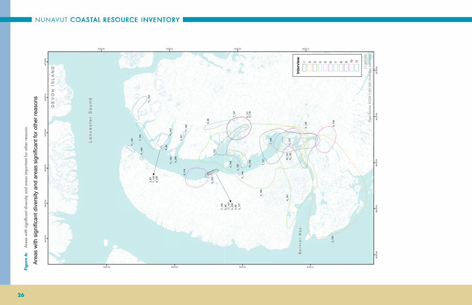
NUNAVUT COASTAL RESOURCE INVENTORY
26
Figur
e 6
: A
reas
with
sig
nific
ant d
iver
sity
and
area
s im
port
ant f
or o
ther
rea
sons
.
1_12
2
1_12
1
2_12
72_
126
2_12
4
2_12
5
3_83
4_14
7
4_14
8
4_14
8
5_24
0
5_24
1
6_13
7
6_13
8
7_15
0
7_14
7
7_14
6
7_14
8
8_94
8_96
8_95
9_11
89_
117
9_12
0
9_11
9
10_1
52
10_1
5110
_150
11_1
42
11_1
45
11_1
44
11_1
49
11_1
47
11_1
48
11_1
46
11_1
43
7_14
9
5_23
8
5_23
9
3_82
80°0
'0"W
82°0
'0"W
82°0
'0"W
84°0
'0"W
84°0
'0"W
86°0
'0"W
86°0
'0"W
88°0
'0"W88
°0'0
"W
90°0
'0"W
90°0
'0"W
74°0'0"N
74°0'0"N
73°0'0"N
73°0'0"N
72°0'0"N
72°0'0"N
71°0'0"N
71°0'0"N
Area
s w
ith s
igni
fican
t div
ersi
ty a
nd a
reas
sig
nific
ant f
or o
ther
reas
ons
1:1,
350,
000
Dat
a S
ourc
e: N
TDB
1:25
0 00
0; A
rctic
Bay
inte
rvie
ws
Inte
rvie
w1 2 3 4 5 6 7 8 9 10 11
Be
rnie
r B
ay
Be
rnie
r B
ay
La
nc
as
ter
So
un
dL
an
ca
ste
r S
ou
nd
DE
VO
N I
SL
AN
DD
EV
ON
IS
LA
ND

ARCTIC BAY
27
Table
4:
Are
as w
ith s
igni
fican
t div
ersit
y an
d ar
eas
impo
rtan
t for
oth
er r
easo
ns.
Map C
ode
Map L
abel
Pres
ent
– P
His
tori
c –
HM
onth
sCo
mm
ents
SAD
P_2
1_12
2P
Year
-rou
nd
Rin
ged
Seal
, Nar
wha
l, H
arp
Seal
s, B
eard
ed S
eals
, an
d fi
sh o
bser
ved.
SAD
P_1
1_12
1P
Jun
e, Ju
ly, A
ugu
st a
nd
Sept
embe
rM
ostl
y bi
rds
obse
rved
her
e. I
n M
offe
t In
let
, bir
ds, f
ish,
sea
ls, a
nd
pola
r be
ars
can
be
seen
.
SAO
P_2
2_12
7P
SAO
P_1
2_12
6P
Year
rou
nd;
Igl
uqj
uaq
(pl
ace
nam
e).
The
inte
rvie
wee
live
d at
Igl
uqj
uaq
bet
wee
n t
he a
ges
of 2
1 an
d 23
, wit
h hi
s w
ife.
The
y ar
rive
d w
ith
not
hin
g, b
ut
cau
ght
a se
al t
he n
ext
day.
The
y su
rviv
ed t
he w
inte
r by
hu
nti
ng
at t
he p
olyn
as.
SAD
P_1
2_12
4P
July
, Au
gust
an
d Se
ptem
ber
A w
etla
nd
area
whe
re m
any
bird
s n
est.
Dif
fere
nt
bird
s, n
arw
hal a
nd
seal
s ob
serv
ed
alon
g th
e co
ast.
SAD
P_2
2_12
5P
Jun
e to
Oct
ober
Fish
, sea
ls, a
nd
bird
s ob
serv
ed.
SAO
P_1
3_82
PM
ay to
Sep
tem
ber
Sau
niq
siu
ti. T
he h
igh
clif
fs a
re g
ood
for
mou
nta
in c
limbi
ng
and
are
very
sce
nic
.
SAO
P_2
3_83
P
Scen
ic, u
nu
sual
roc
k fo
rmat
ion
s; "
Cow
boy
Lan
d".
SAD
P_1
4_14
7P
G
eese
, Du
cks,
Gu
lls, A
rcti
c T
ern
s, S
eals
, Fis
h, a
nd
Nar
wha
l obs
erve
d.
SAD
P_2
4_14
8P
G
eese
, Du
cks,
Gu
lls, A
rcti
c T
ern
s, S
eals
, Fis
h, a
nd
Nar
wha
l obs
erve
d.
SAO
P_1
4_14
9P
Apr
il, M
ay a
nd
Jun
eH
is fa
mily
goe
s ba
ck to
the
are
a ev
ery
spri
ng.
The
re’s
sea
ls, b
irds
, an
d fi
sh
SAO
P_2
5_23
9P
Jun
e to
Sep
tem
ber
Hoo
doos
pre
sen
t, v
ery
scen
ic a
rea;
"C
owbo
y La
nd"
.
SAO
P_1
5_23
8P
Jun
e to
Sep
tem
ber
Bea
uti
ful s
cen
ery
at S
aun
iqsi
uti
.
SAO
P_3
5_24
0P
W
ater
fall
from
the
top
of c
liff
righ
t to
the
sho
re; v
ery
scen
ic.
SAO
P_4
5_24
1P
W
ater
fall
and
deep
lake
; ver
y sc
enic
.
SAO
P_1
6_13
7P
July
, Au
gust
an
d Se
ptem
ber
Are
a w
here
the
inte
rvie
wee
gre
w u
p, a
nd
retu
rns
ever
y su
mm
er fo
r fi
shin
g an
d ca
mpi
ng.
SAO
P_2
6_13
8P
Au
gust
You
can
tra
vel b
y A
TV
, it
is v
ery
flat
an
d sc
enic
.
SAO
P_4
7_15
0P
Dif
fere
nt
scen
ery
from
eve
ry c
liff.
SAO
P_3
7_14
9P
"Cow
boy
Lan
d"; D
iffe
ren
t ro
ck fo
rmat
ion
s.
SAO
P_1
7_14
7P
July
, Au
gust
an
d Se
ptem
ber
San
d du
nes
an
d H
oodo
os. A
ver
y sc
enic
are
a.
SAD
P_1
7_14
6P
Jun
eFi
shin
g ar
ea w
here
gee
se a
nd
seal
s ar
e hu
nte
d an
d eg
gs a
re c
olle
cted
.
SAO
P_2
7_14
8P
Year
rou
nd
"Cow
boy
Lan
d"; D
iffe
ren
t ro
ck fo
rmat
ion
s.
SAO
P_1
8_94
P
Are
a w
here
inte
rvie
wee
gre
w u
p. A
lot
of s
od h
ouse
s in
thi
s ar
ea.
SAO
P_3
8_96
P
Sau
niq
siu
ti (
plac
e n
ame)
. It
is p
ossi
ble
to b
oat
thro
ugh
the
roc
k fo
rmat
ion
s. A
ver
y sc
enic
are
a.
SAO
P_2
8_95
P
Ver
y Sc
enic
are
a. H
oodo
os a
nd
diff
eren
t ro
ck fo
rmat
ion
s; "
Cow
boy
Lan
d".
SAO
P_1
9_11
8P
V
ery
scen
ic. T
hule
sod
hou
ses
in t
his
area
.
SAD
P_1
9_11
7P
Lo
ts o
f fi
sh, b
irds
, an
d se
als
in t
his
area
.
SAO
P_3
9_12
0P
Sa
un
iqsi
uti
(pl
ace
nam
e). V
ery
scen
ic a
rea,
dif
fere
nt
rock
form
atio
ns.
SAO
P_2
9_11
9P
T
he in
terv
iew
ee o
bser
ved
Kill
er w
hale
s he
rdin
g N
arw
hal a
lon
g th
e sh
ore.
Als
o a
good
fish
ing
spot
an
d ve
ry s
cen
ic.
SAO
P_2
10_1
52P
Jun
e, Ju
ly a
nd
Au
gust
Inte
rvie
wee
's w
ife
does
not
wan
t th
is a
rea
to b
e di
stu
rbed
bec
ause
the
re is
a s
od
hou
se w
here
her
par
ents
live
d. T
here
is a
lso
an a
bun
dan
ce o
f fi
sh a
nd
lan
d pl
ants
su
ch a
s bl
ueb
erri
es a
nd
blac
kber
ries
her
e.
SAO
P_1
10_1
51P
Jun
e, Ju
ly a
nd
Au
gust
Thi
s is
a g
reat
spo
t to
tak
e to
uri
sts
to s
ee t
he w
ildlif
e, a
nd
wou
ld a
lso
mak
e a
grea
t w
ildlif
e sa
nct
uar
y.
SAD
P_1
10_1
50P
Jun
e, Ju
ly a
nd
Au
gust
Fish
, bir
ds, B
eard
ed S
eals
, Nar
wha
l, an
d B
owhe
ad W
hale
s w
ere
obse
rved
her
e.
SAO
P_1
11_1
42P
So
d ho
use
s fr
om P
re-D
orse
t to
Thu
le to
mor
e re
cen
t oc
cupa
tion
are
loca
ted
in t
his
area
.
SAO
P_4
11_1
45P
P
re-D
orse
t ar
cheo
logi
cal s
ite.
Ver
y sc
enic
; Wou
ld m
ake
a gr
eat
tou
rist
spo
t.
SAO
P_3
11_1
44P
A
par
t of
the
Sir
mili
k N
atio
nal
Par
k is
ver
y sc
enic
.
SAO
P_8
11_1
49P
B
eau
tifu
l riv
er a
nd
old
cam
ps; P
ulla
tau
jaq
(pla
ce n
ame)
.
SAO
P_6
11_1
47P
July
Cav
es, d
iffe
ren
t co
lou
r st
ones
an
d fo
ssile
s at
Sau
niq
siu
ti (
plac
e n
ame)
; Pos
sibl
e to
uri
st s
pot.
SAO
P_7
11_1
48P
Fo
ssils
of
inve
rteb
rate
s an
d pl
ants
on
top
of a
mou
nta
in; P
usi
nga
juja
q (p
lace
nam
e).
SAO
P_5
11_1
46P
A
gre
at s
ite
for
mou
nta
in c
limbe
rs; P
ossi
ble
tou
rist
spo
t.
SAO
P_2
11_1
43P

NUNAVUT COASTAL RESOURCE INVENTORY
28
1_35
1_38
1_33
1_36
1_37
1_32
1_39
1_45
1_43
1_31
1_41
1_34
2_41
2_47
2_38
2_46 2_
37
2_36
2_35 2_
332_34
3_20
3_6
3_7
3_15
3_12
3_13
3_21
3_10
3_23
3_9
3_22
4_47
4_28
4_27
4_36
4_34
4_31
4_30
4_32
4_29
4_38
4_374_
43
4_42
4_46
4_45
5_45
5_51
5_47
5_35
5_34
5_53
5_37
5_38
5_48
5_49
5_39
5_40
5_50
5_43
5_54
5_42
5_46
5_55
5_44
6_26
6_23
6_44
6_24
6_28
6_306_
31
6_32
6_27
6_35
6_36
6_37
6_38
6_39
6_40
6_41
6_42
6_43
6_34
7_15
6
7_15
8
7_15
7
7_15
4
7_15
9
7_15
3
7_36
7_37
7_15
5
7_35
7_34
7_16
5
7_33
7_1 6
3
7_28
7_16
4
7_16
0
7_15
1
7_38
7_30
8_12 8_
19
8_15
8_16
8_17
8_18
8_36
8_10
8_11
8_14
8_13
9_23
9_24
9_21
9_25
9_19
9_18
9_26
9_17
9_22
10_4
7
10_4
0
10_4
1
10_4
4
10_4
3
10_3
6
10_3
5
10_4
5
10_3
2
10_3
1
10_3
0
10_3
3
10_3
4
10_4
6
10_1
57
10_3
910
_38
10_3
7
11_6
3
11_6
4
11_7
3
11_7
1
11_7
2
11_6
6
11_6
5
11_6
8
11_6
9
11_6
7
11_7
0
11_8
0
11_7
6
11_7
7
11_7
8
11_7
9
11_7
4
11_7
5
10_4
2
7_15
2
6_33
6_29
6_25
5_41
5_36
5_52
4_26
4_44
4_41
4_39
4_40
4_35
4_25
4_24
3_19
3_16
3_18
3_17
3_8
3_14
3_11
2_39
2_40
2_42
2_45
2_43
2_44
1_44
1_40
1_30
9_20
80°0
'0"W
82°0
'0"W
82°0
'0"W
84°0
'0"W
84°0
'0"W
86°0
'0"W
86°0
'0"W
88°0
'0"W88
°0'0
"W
90°0
'0"W
90°0
'0"W
74°0'0"N
74°0'0"N
73°0'0"N
73°0'0"N
72°0'0"N
72°0'0"N
71°0'0"N
71°0'0"N
Arct
ic C
har
1:1,
350,
000
Dat
a S
ourc
e: N
TDB
1:25
0 00
0; A
rctic
Bay
inte
rvie
ws
Inte
rvie
w1 2 3 4 5 6 7 8 9 10 11
Be
rnie
r B
ay
Be
rnie
r B
ay
La
nc
as
ter
So
un
dL
an
ca
ste
r S
ou
nd
DE
VO
N I
SL
AN
DD
EV
ON
IS
LA
ND
Figur
e 7:
Are
as o
f occ
upat
ion
for
Arc
tic C
har.

ARCTIC BAY
29
Table
5:
Are
as o
f occ
upat
ion
for
Arc
tic C
har.
Map C
ode
Map L
abel
Spec
ies
Pres
ent
– P
H
isto
ric
– H
Spec
ial
Codin
gM
onth
sCo
mm
ents
Cha
r_6
1_35
Arc
tic
Cha
rP
Ja
nu
ary
to Ju
ne
Cha
r_9
1_38
Arc
tic
Cha
rP
A
ugu
st, S
epte
mbe
r an
d O
ctob
er
Cha
r_4
1_33
Arc
tic
Cha
rP
Ju
ne,
July
an
d A
ugu
st
Cha
r_7
1_36
Arc
tic
Cha
rP
A
ugu
st, S
epte
mbe
r an
d O
ctob
er
Cha
r_8
1_37
Arc
tic
Cha
rP
A
ugu
st, S
epte
mbe
r an
d O
ctob
er
Cha
r_3
1_32
Arc
tic
Cha
rP
Ju
ne,
July
an
d A
ugu
st
Cha
r_10
1_39
Arc
tic
Cha
rP
A
ugu
st, S
epte
mbe
r an
d O
ctob
er
Cha
r_16
1_45
Arc
tic
Cha
rP
Ju
ly, A
ugu
st a
nd
Sept
embe
r
Cha
r_14
1_43
Arc
tic
Cha
rP
Ju
ly, A
ugu
st a
nd
Sept
embe
r
Cha
r_2
1_31
Arc
tic
Cha
rP
Ju
ne,
July
an
d A
ugu
st
Cha
r_1
1_30
Arc
tic
Cha
rP
Ju
ne,
July
an
d A
ugu
st
Cha
r_12
1_41
Arc
tic
Cha
rP
Ye
ar r
oun
d
Cha
r_11
1_40
Arc
tic
Cha
rP
Ye
ar r
oun
d
Cha
r_15
1_44
Arc
tic
Cha
rP
Ju
ly, A
ugu
st a
nd
Sept
embe
r
Cha
r_5
1_34
Arc
tic
Cha
rP
Ye
ar r
oun
d
Cha
r_12
2_44
Arc
tic
Cha
rP
Ju
ly, A
ugu
st a
nd
Sept
embe
rT
he in
terv
iew
ee s
aw t
hese
fish
du
rin
g th
e n
arw
hal h
un
tin
g se
ason
.
Cha
r_11
2_43
Arc
tic
Cha
rP
M
ay, O
ctob
er a
nd
Nov
embe
r
Cha
r_13
2_45
Arc
tic
Cha
rP
Ju
ly, A
ugu
st a
nd
Sept
embe
rT
he in
terv
iew
ee c
augh
t th
ese
Arc
tic
char
whi
le b
oati
ng.
Cha
r_9
2_41
Arc
tic
Cha
rP
M
ay to
Sep
tem
ber
Cha
r_10
2_42
Arc
tic
Cha
rP
M
ay to
Sep
tem
ber
Cha
r_8
2_40
Arc
tic
Cha
rP
M
ay to
Sep
tem
ber
Cha
r_7
2_39
Arc
tic
Cha
rP
M
ay to
Sep
tem
ber
Cha
r_15
2_47
Arc
tic
Cha
rP
T
he fi
sh fr
om t
his
area
oft
en h
ave
tape
wor
m. Q
aku
qtaq
tuyu
q fo
un
d in
the
Cha
r’s
air
blad
der.
Cha
r_6
2_38
Arc
tic
Cha
rP
Ju
ly, A
ugu
st a
nd
Sept
embe
r
Cha
r_14
_SP
2_46
Arc
tic
Cha
rP
SM
ay a
nd
Jun
e
Cha
r_5_
SP2_
37A
rcti
c C
har
PS
Oct
ober
to t
he
follo
win
g A
pril.
Cha
r_4_
H2_
36A
rcti
c C
har
H
May
to S
epte
mbe
r
Cha
r_3_
H2_
35A
rcti
c C
har
H
May
to S
epte
mbe
r
Cha
r_1_
H2_
33A
rcti
c C
har
H
May
to S
epte
mbe
r
Cha
r_2_
H2_
34A
rcti
c C
har
H
May
to S
epte
mbe
r
Cha
r_15
_AP
3_20
Arc
tic
Cha
rP
AO
ctob
er to
the
fo
llow
ing
May
Cha
r_6
3_11
Arc
tic
Cha
rP
O
ctob
er to
the
fo
llow
ing
Apr
il
Cha
r_1
3_6
Arc
tic
Cha
rP
M
ayT
he A
rcti
c ch
ar w
ere
obse
rved
at
Tas
ialu
k.
Cha
r_2
3_7
Arc
tic
Cha
rP
Se
ptem
ber
Cha
r_9
3_14
Arc
tic
Cha
rP
M
ay a
nd
Jun
eT
hese
Arc
tic
char
wer
e ob
serv
ed a
t T
ulu
kaat
.
Cha
r_10
_SP
3_15
Arc
tic
Cha
rP
SA
pril,
May
an
d N
ovem
ber
The
inte
rvie
wee
obs
erve
d th
ese
Arc
tic
char
at
Ku
ura
aju
t.
Cha
r_7
3_12
Arc
tic
Cha
rP
Ju
ly, A
ugu
st a
nd
Sept
embe
rT
he A
rcti
c ch
ar fo
un
d at
Kin
gair
ut
have
whi
te m
eat.
Cha
r_8
3_13
Arc
tic
Cha
rP
Ju
ly, A
ugu
st a
nd
Sept
embe
r
Cha
r_3
3_8
Arc
tic
Cha
rP
Ye
ar r
oun
d
Cha
r_16
3_21
Arc
tic
Cha
rP
Ju
ly a
nd
Au
gust
Cha
r_12
3_17
Arc
tic
Cha
rP
A
ugu
st
Cha
r_13
3_18
Arc
tic
Cha
rP
A
ugu
stT
hese
Arc
tic
char
mov
e be
twee
n t
he o
cean
an
d th
e la
ke.
Cha
r_11
3_16
Arc
tic
Cha
rP
A
pril
to O
ctob
erT
hese
Arc
tic
char
wer
e ob
serv
ed a
t K
akia
k.
Cha
r_14
3_19
Arc
tic
Cha
rP
M
ay to
Au
gust
Cha
r_5
3_10
Arc
tic
Cha
rP
O
ctob
er to
the
fo
llow
ing
Apr
il
Cha
r_18
_SP
3_23
Arc
tic
Cha
rP
SSe
ptem
ber
and
Oct
ober
Cha
r_4
3_9
Arc
tic
Cha
rP
M
ay to
Au
gust
T
hese
Arc
tic
char
wer
e ob
serv
ed a
t A
nn
uga
atia
qtal
ik.
Cha
r_17
3_22
Arc
tic
Cha
rP
A
ugu
stT
he in
terv
iew
ee o
bser
ved
thes
e A
rcti
c ch
ar o
n D
evon
Isl
and.
Cha
r_25
4_47
Arc
tic
Cha
rP
Ju
ne,
July
an
d A
ugu
st
Cha
r_2
4_24
Arc
tic
Cha
rP
Ju
ly, A
ugu
st a
nd
Sept
embe
r
Cha
r_3
4_25
Arc
tic
Cha
rP
Ju
ly, A
ugu
st a
nd
Sept
embe
rA
rcti
c C
har
have
tap
e w
orm
s in
thi
s ar
ea.
Cha
r_6
4_28
Arc
tic
Cha
rP
M
ayFi
shin
g de
rby
area
.
Cha
r_5
4_27
Arc
tic
Cha
rP
M
ay
Cha
r_13
4_35
Arc
tic
Cha
rP
N
ovem
ber
to t
he
follo
win
g M
ay
Cha
r_14
4_36
Arc
tic
Cha
rP
Ju
ly, A
ugu
st a
nd
Sept
embe
r
Cha
r_12
4_34
Arc
tic
Cha
rP
M
ay to
Au
gust
T
he in
terv
iew
ee fi
shes
by
boat
in t
his
area
.
Cha
r_9
4_31
Arc
tic
Cha
rP
Ju
ly a
nd
Au
gust
Cha
r_8
4_30
Arc
tic
Cha
rP
Ju
ly a
nd
Au
gust
Cha
r_10
_SP
4_32
Arc
tic
Cha
rP
SJu
ne,
July
an
d A
ugu
st
Cha
r_7
4_29
Arc
tic
Cha
rP
Ju
ly a
nd
Au
gust
Nal
laqt
urv
ik. S
hallo
w r
iver
, the
refo
re, f
ish
swim
dow
n r
iver
on
th
eir
side
s.
Cha
r_16
4_38
Arc
tic
Cha
rP
Ju
ly a
nd
Au
gust
Cha
r_15
4_37
Arc
tic
Cha
rP
Ju
ly a
nd
Au
gust
Cha
r_18
4_40
Arc
tic
Cha
rP
Ju
ly a
nd
Au
gust
Cha
r_17
4_39
Arc
tic
Cha
rP
Ju
ly a
nd
Au
gust
Cha
r_19
4_41
Arc
tic
Cha
rP
Ye
ar r
oun
d
Cha
r_21
4_43
Arc
tic
Cha
rP
Ju
ly a
nd
Au
gust

NUNAVUT COASTAL RESOURCE INVENTORY
30
Map C
ode
Map L
abel
Spec
ies
Pres
ent
– P
H
isto
ric
– H
Spec
ial
Codin
gM
onth
sCo
mm
ents
Cha
r_20
4_42
Arc
tic
Cha
rP
Ju
ly a
nd
Au
gust
Cha
r_24
_H4_
46A
rcti
c C
har
H
Jun
e, Ju
ly a
nd
Au
gust
Whi
le N
arw
hal h
un
tin
g th
e in
terv
iew
ee a
lso
fish
es.
Cha
r_23
4_45
Arc
tic
Cha
rP
Ju
ne,
July
an
d A
ugu
st
Cha
r_22
4_44
Arc
tic
Cha
rP
M
ay to
Au
gust
Cha
r_4
4_26
Arc
tic
Cha
rP
A
pril
and
May
Cha
r_12
5_45
Arc
tic
Cha
rP
A
pril
Cha
r_18
5_51
Arc
tic
Cha
rP
M
ayW
hen
the
inte
rvie
wee
was
you
ng
he w
ould
fish
in t
his
area
be
fore
the
fish
wen
t do
wn
str
eam
. Cha
r fi
shin
g de
rby
area
for
the
com
mu
nit
y.
Cha
r_14
5_47
Arc
tic
Cha
rP
M
ay a
nd
Nov
embe
rFi
shin
g in
May
bef
ore
char
go
dow
n r
iver
. Fis
h in
Nov
embe
r be
fore
ice
gets
too
thic
k. N
um
bers
of
char
incr
easi
ng
and
gett
ing
bigg
er.
Cha
r_19
5_52
Arc
tic
Cha
rP
Ju
ne
and
Au
gust
Seen
in la
te Ju
ne,
als
o in
Au
gust
whi
le fi
sh a
re g
oin
g do
wn
ri
ver.
Cha
r_2_
SP5_
35A
rcti
c C
har
PS
Au
gust
Mid
dle
of A
ugu
st.
Cha
r_1_
SP5_
34A
rcti
c C
har
PS
Au
gust
Seen
in la
te A
ugu
st.
Cha
r_20
5_53
Arc
tic
Cha
rP
A
ugu
stSe
en in
late
Au
gust
.
Cha
r_3_
SP5_
36A
rcti
c C
har
PS
Year
rou
nd
Cha
r_4
5_37
Arc
tic
Cha
rP
A
ugu
st, O
ctob
er a
nd
Nov
embe
r
Cha
r_5
5_38
Arc
tic
Cha
rP
N
ovem
ber
to t
he
follo
win
g M
arch
Cha
r_15
5_48
Arc
tic
Cha
rP
A
ugu
stSe
en in
late
Au
gust
.
Cha
r_16
5_49
Arc
tic
Cha
rP
A
ugu
stSe
en in
late
Au
gust
.
Cha
r_6
5_39
Arc
tic
Cha
rP
A
ugu
st a
nd
Sept
embe
rFi
shin
g du
rin
g la
te A
ugu
st a
nd
earl
y Se
ptem
ber
befo
re t
he
Cha
r go
bac
k u
p ri
ver.
Cha
r_7
5_40
Arc
tic
Cha
rP
A
pril
and
Nov
embe
r
Cha
r_8_
SAP
5_41
Arc
tic
Cha
rP
A, S
Apr
il
Cha
r_17
5_50
Arc
tic
Cha
rP
M
ay a
nd
Nov
embe
rFi
shin
g la
te N
ovem
ber
befo
re t
he ic
e ge
ts to
o th
ick
to fi
sh.
Cha
r_10
5_43
Arc
tic
Cha
rP
A
ugu
stT
he C
har
have
red
mea
t.
Cha
r_21
5_54
Arc
tic
Cha
rP
M
aySe
en in
late
May
aft
er fi
sh g
o do
wn
riv
er.
Cha
r_9
5_42
Arc
tic
Cha
rP
A
pril
The
bes
t ch
ar, b
ig w
ith
dark
red
mea
t.
Cha
r_13
5_46
Arc
tic
Cha
rP
M
ay a
nd
Nov
embe
rFi
shin
g m
idd
le o
f N
ovem
ber
befo
re t
he ic
e ge
ts to
o th
ick.
Cha
r_22
5_55
Arc
tic
Cha
rP
Se
ptem
ber
and
Oct
ober
Seen
in la
te S
epte
mbe
r/ e
arly
Oct
ober
.
Cha
r_11
5_44
Arc
tic
Cha
rP
A
ugu
st a
nd
Sept
embe
r
Cha
r_4
6_26
Arc
tic
Cha
rP
Ye
ar r
oun
d
Cha
r_1
6_23
Arc
tic
Cha
rP
Ye
ar r
oun
d
Cha
r_22
6_44
Arc
tic
Cha
rP
Ye
ar r
oun
d
Cha
r_2
6_24
Arc
tic
Cha
rP
Ye
ar r
oun
d
Cha
r_3
6_25
Arc
tic
Cha
rP
Ye
ar r
oun
d
Cha
r_7
6_29
Arc
tic
Cha
rP
Ye
ar r
oun
d
Cha
r_6
6_28
Arc
tic
Cha
rP
Ye
ar r
oun
d
Cha
r_8
6_30
Arc
tic
Cha
rP
Ye
ar r
oun
d
Cha
r_9
6_31
Arc
tic
Cha
rP
Ye
ar r
oun
d
Cha
r_10
6_32
Arc
tic
Cha
rP
Ye
ar r
oun
d
Cha
r_5
6_27
Arc
tic
Cha
rP
Ye
ar r
oun
d
Cha
r_13
6_35
Arc
tic
Cha
rP
Ye
ar r
oun
d
Cha
r_14
6_36
Arc
tic
Cha
rP
Ye
ar r
oun
d
Cha
r_15
6_37
Arc
tic
Cha
rP
Ye
ar r
oun
d
Cha
r_16
6_38
Arc
tic
Cha
rP
Ye
ar r
oun
d
Cha
r_17
6_39
Arc
tic
Cha
rP
Ye
ar r
oun
d
Cha
r_18
6_40
Arc
tic
Cha
rP
Ye
ar r
oun
d
Cha
r_19
6_41
Arc
tic
Cha
rP
Ye
ar r
oun
d
Cha
r_20
6_42
Arc
tic
Cha
rP
Ye
ar r
oun
d
Cha
r_21
6_43
Arc
tic
Cha
rP
Ye
ar r
oun
d
Cha
r_11
6_33
Arc
tic
Cha
rP
Ye
ar r
oun
d
Cha
r_12
6_34
Arc
tic
Cha
rP
Ye
ar r
oun
d
Cha
r_17
7_15
6A
rcti
c C
har
P
Year
rou
nd
Cha
r_19
7_15
8A
rcti
c C
har
P
Year
rou
nd
Cha
r_18
7_15
7A
rcti
c C
har
P
Year
rou
nd
Cha
r_15
7_15
4A
rcti
c C
har
P
Year
rou
nd
Cha
r_20
7_15
9A
rcti
c C
har
P
Year
rou
nd
Cha
r_14
7_15
3A
rcti
c C
har
P
Year
rou
nd
Cha
r_9
7_36
Arc
tic
Cha
rP
Ye
ar r
oun
d
Cha
r_10
7_37
Arc
tic
Cha
rP
Ye
ar r
oun
d
Cha
r_13
7_15
2A
rcti
c C
har
P
Year
rou
nd
Cha
r_16
7_15
5A
rcti
c C
har
P
Year
rou
nd
Cha
r_8
7_35
Arc
tic
Cha
rP
Ye
ar r
oun
d
Cha
r_7
7_34
Arc
tic
Cha
rP
Ye
ar r
oun
d
Cha
r_5
7_16
5A
rcti
c C
har
P
Year
rou
nd
Cha
r_6
7_33
Arc
tic
Cha
rP
Ye
ar r
oun
d
Cha
r_2
7_16
3A
rcti
c C
har
P
Year
rou
nd
Cha
r_1
7_28
Arc
tic
Cha
rP
Ye
ar r
oun
d
Cha
r_4
7_16
4A
rcti
c C
har
P
Year
rou
nd
Cha
r_21
7_16
0A
rcti
c C
har
P
Year
rou
nd
Cha
r_12
7_15
1A
rcti
c C
har
P
Year
rou
nd
Cha
r_11
7_38
Arc
tic
Cha
rP
Ye
ar r
oun
d
Cha
r_3
7_30
Arc
tic
Cha
rP
Ye
ar r
oun
d
Cha
r_4
8_12
Arc
tic
Cha
rP
Ye
ar r
oun
d
Cha
r_11
8_19
Arc
tic
Cha
rP
Ye
ar r
oun
d
Cha
r_7
8_15
Arc
tic
Cha
rP
Ye
ar r
oun
d
Table
5 (
cont
inue
d):
A
reas
of o
ccup
atio
n fo
r A
rctic
Cha
r.

ARCTIC BAY
31
Map C
ode
Map L
abel
Spec
ies
Pres
ent
– P
H
isto
ric
– H
Spec
ial
Codin
gM
onth
sCo
mm
ents
Cha
r_8
8_16
Arc
tic
Cha
rP
Ye
ar r
oun
dC
har
seen
at
Ittu
kkuv
ik.
Cha
r_9
8_17
Arc
tic
Cha
rP
Ye
ar r
oun
d
Cha
r_10
8_18
Arc
tic
Cha
rP
Ye
ar r
oun
d
Cha
r_1_
H8_
36A
rcti
c C
har
P
Year
rou
nd
Cha
r_2_
H8_
10A
rcti
c C
har
H
Year
rou
nd
Cha
r_3
8_11
Arc
tic
Cha
rP
Ye
ar r
oun
d
Cha
r_6
8_14
Arc
tic
Cha
rP
Ye
ar r
oun
dC
har
mea
t is
whi
ter
now
tha
n it
was
in t
he p
ast.
Cha
r_5
8_13
Arc
tic
Cha
rP
Ye
ar r
oun
d
Cha
r_7
9_23
Arc
tic
Cha
rP
Ye
ar r
oun
d
Cha
r_8
9_24
Arc
tic
Cha
rP
Ju
ne,
July
an
d A
ugu
st
Cha
r_5_
SP9_
21A
rcti
c C
har
PS
Jun
e, Ju
ly a
nd
Au
gust
Cha
r_9
9_25
Arc
tic
Cha
rP
Ye
ar r
oun
d
Cha
r_3
9_19
Arc
tic
Cha
rP
N
ovem
ber
to t
he
follo
win
g M
arch
Cha
r_2
9_18
Arc
tic
Cha
rP
Ju
ne,
July
an
d A
ugu
st
Cha
r_10
9_26
Arc
tic
Cha
rP
Ju
ly, A
ugu
st, a
nd
Oct
ober
to t
he
follo
win
g M
arch
Cha
r_1_
H9_
17A
rcti
c C
har
H
Nov
embe
r to
the
fo
llow
ing
Apr
il
Cha
r_6_
H9_
22A
rcti
c C
har
H
Apr
il to
Au
gust
Se
en to
war
ds P
ond
Inle
t in
197
0.
Cha
r_4
9_20
Arc
tic
Cha
rP
Ju
ne,
July
an
d A
ugu
stT
he C
har
go u
p ri
ver
mid
Au
gust
.
Cha
r_19
10_1
57A
rcti
c C
har
P
July
, Au
gust
an
d Se
ptem
ber
Cha
r_11
10_4
0A
rcti
c C
har
P
Jun
e, Ju
ly a
nd
Au
gust
Cha
r_12
10_4
1A
rcti
c C
har
P
Jun
e, Ju
ly a
nd
Au
gust
Cha
r_13
10_4
2A
rcti
c C
har
P
Jun
e, Ju
ly a
nd
Au
gust
Cha
r_15
10_4
4A
rcti
c C
har
P
Jun
e, Ju
ly a
nd
Au
gust
Cha
r_14
10_4
3A
rcti
c C
har
P
Jun
e, Ju
ly a
nd
Au
gust
Cha
r_7
10_3
6A
rcti
c C
har
P
Jun
e, Ju
ly a
nd
Au
gust
Cha
r_6_
AP
10_3
5A
rcti
c C
har
PA
Jun
e, Ju
ly a
nd
Au
gust
Cha
r_16
_AP
10_4
5A
rcti
c C
har
PA
Oct
ober
an
d N
ovem
ber
Cha
r_3
10_3
2A
rcti
c C
har
P
Jun
e, Ju
ly a
nd
Au
gust
Cha
r_2
10_3
1A
rcti
c C
har
P
Jun
e, Ju
ly a
nd
Au
gust
The
Cha
r go
up
rive
r m
id A
ugu
st.
Cha
r_1
10_3
0A
rcti
c C
har
P
Jun
e, Ju
ly a
nd
Au
gust
The
Cha
r go
up
rive
r m
id A
ugu
st.
Cha
r_4
10_3
3A
rcti
c C
har
P
Jun
e, Ju
ly a
nd
Au
gust
Cha
r_5
10_3
4A
rcti
c C
har
P
Jun
e, Ju
ly a
nd
Au
gust
The
Cha
r go
up
rive
r m
id A
ugu
st.
Cha
r_17
10_4
6A
rcti
c C
har
P
Oct
ober
an
d N
ovem
ber
Cha
r_18
10_4
7A
rcti
c C
har
P
Oct
ober
an
d N
ovem
ber
Cha
r_10
10_3
9A
rcti
c C
har
P
Jun
e, Ju
ly a
nd
Au
gust
Cha
r_9
10_3
8A
rcti
c C
har
P
Jun
e, Ju
ly a
nd
Au
gust
Cha
r_8
10_3
7A
rcti
c C
har
P
Jun
e, Ju
ly a
nd
Au
gust
Cha
r_1
11_6
3A
rcti
c C
har
P
Sept
embe
r, O
ctob
er a
nd
Nov
embe
r
Cha
r_2_
SP11
_64
Arc
tic
Cha
rP
SSe
ptem
ber,
Oct
ober
an
d N
ovem
ber
Cha
r_11
11_7
3A
rcti
c C
har
P
Cha
r_9
11_7
1A
rcti
c C
har
P
Cha
r_10
11_7
2A
rcti
c C
har
P
Cha
r_4_
H11
_66
Arc
tic
Cha
rH
A
ugu
st
Cha
r_3_
H11
_65
Arc
tic
Cha
rH
A
ugu
st
Cha
r_6_
H11
_68
Arc
tic
Cha
rH
A
ugu
st
Cha
r_7_
H11
_69
Arc
tic
Cha
rH
A
ugu
st
Cha
r_5_
H11
_67
Arc
tic
Cha
rH
A
ugu
stG
reat
fish
ing
area
.
Cha
r_8_
H11
_70
Arc
tic
Cha
rH
A
ugu
st
Cha
r_18
11_8
0A
rcti
c C
har
P
Cha
r_14
11_7
6A
rcti
c C
har
P
Sept
embe
r, O
ctob
er a
nd
Nov
embe
r
Cha
r_15
11_7
7A
rcti
c C
har
P
Sept
embe
r, O
ctob
er a
nd
Nov
embe
r
Cha
r_16
11_7
8A
rcti
c C
har
P
Sept
embe
r, O
ctob
er a
nd
Nov
embe
r
Cha
r_17
_H11
_79
Arc
tic
Cha
rH
Cha
r_12
11_7
4A
rcti
c C
har
P
Cha
r_13
_H11
_75
Arc
tic
Cha
rH
Table
5 (
cont
inue
d):
A
reas
of o
ccup
atio
n fo
r A
rctic
Cha
r.

NUNAVUT COASTAL RESOURCE INVENTORY
32
1_47
1_48
1_49
1_46
2_48 4_
48
4_50
4_514_
55
4_57
5_56
6_46
8_25 8_
22 8_21
8_269_
309_
31
9_32
9_28
9_29
9_27
9_33
9_34
10_5
3
10_5
1
10_4
9
10_5
4
10_5
5
11_4
8
11_6
2
11_5
511
_56
11_5
8
11_6
0
11_6
1
11_5
1
11_5
3
11_5
0
11_5
2
11_5
9
11_4
9
11_5
7
11_5
4
11_4
7
10_5
0
10_5
2
9_35
8_20
8_24
8_23
6_45
6_48
5_58
5_57
5_60
5_59
4_56
4_54 4_
53
4_52
4_49
3_24
80°0
'0"W
82°0
'0"W
82°0
'0"W
84°0
'0"W
84°0
'0"W
86°0
'0"W
86°0
'0"W
88°0
'0"W88
°0'0
"W
90°0
'0"W
90°0
'0"W
74°0'0"N
74°0'0"N
73°0'0"N
73°0'0"N
72°0'0"N
72°0'0"N
71°0'0"N
71°0'0"N
Land
lock
ed C
har*
1:1,
350,
000
Dat
a S
ourc
e: N
TDB
1:25
0 00
0; A
rctic
Bay
inte
rvie
ws
Inte
rvie
w1 2 3 4 5 6 8 9 10 11
Be
rnie
r B
ay
Be
rnie
r B
ay
La
nc
as
ter
So
un
dL
an
ca
ste
r S
ou
nd
DE
VO
N I
SL
AN
DD
EV
ON
IS
LA
ND
Figur
e 8
: A
reas
of o
ccup
atio
n fo
r La
nd L
ocke
d C
har

ARCTIC BAY
33
Table
6:
Are
as o
f occ
upat
ion
for
Land
Loc
ked
Cha
r.
Map C
ode
Map L
abel
Spec
ies
Pres
ent
– P
H
isto
ric
– H
Mon
ths
Com
men
ts
LLC
_21_
47La
nd
Lock
ed C
har
PYe
ar r
oun
d
LLC
_31_
48La
nd
Lock
ed C
har
PA
pril
to D
ecem
ber
The
inte
rvie
wee
fish
ed a
t th
is lo
cati
on in
Apr
il 20
08.
LLC
_41_
49La
nd
Lock
ed C
har
PYe
ar r
oun
d
LLC
_11_
46La
nd
Lock
ed C
har
PO
ctob
er to
the
follo
win
g Ju
ne.
LLC
_12_
48La
nd
Lock
ed C
har
PO
ctob
er to
the
follo
win
g A
pril.
LLC
_13_
24La
nd
Lock
ed C
har
PO
ctob
er a
nd
Nov
embe
r
LLC
_14_
48La
nd
Lock
ed C
har
PYe
ar r
oun
dT
he in
terv
iew
ee o
nly
fish
ed t
here
tw
ice.
LLC
_24_
49La
nd
Lock
ed C
har
PA
pril
and
May
The
inte
rvie
wee
had
a lo
t of
fun
fish
ing
La
nd
Lock
ed C
har.
LLC
_34_
50La
nd
Lock
ed C
har
PYe
ar r
oun
d
LLC
_54_
52La
nd
Lock
ed C
har
PYe
ar r
oun
dM
ost
abu
nda
nt
in M
ay a
nd
Jun
e.
LLC
_64_
53La
nd
Lock
ed C
har
PJu
ly a
nd
Au
gust
LLC
_44_
51La
nd
Lock
ed C
har
PYe
ar r
oun
d
LLC
_74_
54La
nd
Lock
ed C
har
PYe
ar r
oun
d
LLC
_84_
55La
nd
Lock
ed C
har
PYe
ar r
oun
d
LLC
_94_
56La
nd
Lock
ed C
har
PYe
ar r
oun
d
LLC
_10
4_57
Lan
d Lo
cked
Cha
rP
Nov
embe
r an
d D
ecem
ber
LLC
_45_
59La
nd
Lock
ed C
har
P
Aro
un
d al
l yea
r.
LLC
_55_
60La
nd
Lock
ed C
har
P
Aro
un
d al
l yea
r.
LLC
_15_
56La
nd
Lock
ed C
har
PYe
ar r
oun
d
LLC
_25_
57La
nd
Lock
ed C
har
PO
ctob
erSe
en in
late
Oct
ober
.
LLC
_35_
58La
nd
Lock
ed C
har
PSe
ptem
ber
Seen
in la
te S
epte
mbe
r.
LLC
_46_
48La
nd
Lock
ed C
har
PYe
ar r
oun
d
LLC
_26_
46La
nd
Lock
ed C
har
PYe
ar r
oun
d
LLC
_16_
45La
nd
Lock
ed C
har
PYe
ar r
oun
d
LLC
_48_
23La
nd
Lock
ed C
har
PYe
ar r
oun
d
LLC
_58_
24La
nd
Lock
ed C
har
PYe
ar r
oun
d
LLC
_68_
25La
nd
Lock
ed C
har
PYe
ar r
oun
d
LLC
_38_
22La
nd
Lock
ed C
har
PYe
ar r
oun
d
LLC
_18_
20La
nd
Lock
ed C
har
PYe
ar r
oun
d
LLC
_28_
21La
nd
Lock
ed C
har
PYe
ar r
oun
d
LLC
_78_
26La
nd
Lock
ed C
har
PYe
ar r
oun
d
LLC
_99_
35La
nd
Lock
ed C
har
PO
ctob
er a
nd
Nov
embe
r
LLC
_49_
30La
nd
Lock
ed C
har
PO
ctob
er a
nd
Nov
embe
r
LLC
_59_
31La
nd
Lock
ed C
har
PO
ctob
er a
nd
Nov
embe
r
LLC
_69_
32La
nd
Lock
ed C
har
PO
ctob
er a
nd
Nov
embe
r
LLC
_29_
28La
nd
Lock
ed C
har
PO
ctob
er a
nd
Nov
embe
rLa
rge
indi
vidu
als.
LLC
_39_
29La
nd
Lock
ed C
har
PO
ctob
er a
nd
Nov
embe
r
LLC
_19_
27La
nd
Lock
ed C
har
PN
ovem
ber
to t
he fo
llow
ing
Mar
ch
LLC
_79_
33La
nd
Lock
ed C
har
PO
ctob
er a
nd
Nov
embe
r
LLC
_8_H
9_34
Lan
d Lo
cked
Cha
rH
Oct
ober
an
d N
ovem
ber
LLC
_510
_53
Lan
d Lo
cked
Cha
rP
Oct
ober
an
d N
ovem
ber
LLC
_410
_52
Lan
d Lo
cked
Cha
rP
Oct
ober
an
d N
ovem
ber
LLC
_310
_51
Lan
d Lo
cked
Cha
rP
Oct
ober
an
d N
ovem
ber
LLC
_210
_50
Lan
d Lo
cked
Cha
rP
Jun
e, Ju
ly a
nd
Au
gust
The
Cha
r go
up
rive
r m
id A
ugu
st.
LLC
_110
_49
Lan
d Lo
cked
Cha
rP
Jun
e, Ju
ly a
nd
Au
gust
T
he C
har
go u
p ri
ver
mid
Au
gust
.
LLC
_610
_54
Lan
d Lo
cked
Cha
rP
Oct
ober
an
d N
ovem
ber
LLC
_710
_55
Lan
d Lo
cked
Cha
rP
July
, Au
gust
an
d Se
ptem
ber
LLC
_311
_48
Lan
d Lo
cked
Cha
rP
Sept
embe
r, O
ctob
er a
nd
Nov
embe
r
LLC
_211
_47
Lan
d Lo
cked
Cha
rP
Sept
embe
r, O
ctob
er a
nd
Nov
embe
r
LLC
_17
11_6
2La
nd
Lock
ed C
har
P
LLC
_911
_54
Lan
d Lo
cked
Cha
rP
Sept
embe
r, O
ctob
er a
nd
Nov
embe
r
LLC
_10_
H11
_55
Lan
d Lo
cked
Cha
rH
Sept
embe
r, O
ctob
er a
nd
Nov
embe
r
LLC
_11_
H11
_56
Lan
d Lo
cked
Cha
rH
Sept
embe
r, O
ctob
er a
nd
Nov
embe
r
LLC
_13_
H11
_58
Lan
d Lo
cked
Cha
rH
Sept
embe
r, O
ctob
er a
nd
Nov
embe
r
LLC
_12_
H11
_57
Lan
d Lo
cked
Cha
rH
Sept
embe
r, O
ctob
er a
nd
Nov
embe
r
LLC
_15_
H11
_60
Lan
d Lo
cked
Cha
rH
Au
gust
LLC
_16_
H11
_61
Lan
d Lo
cked
Cha
rH
Au
gust
LLC
_611
_51
Lan
d Lo
cked
Cha
rP
Sept
embe
r, O
ctob
er a
nd
Nov
embe
r
LLC
_811
_53
Lan
d Lo
cked
Cha
rP
Sept
embe
r, O
ctob
er a
nd
Nov
embe
r
LLC
_511
_50
Lan
d Lo
cked
Cha
rP
Sept
embe
r, O
ctob
er a
nd
Nov
embe
r
LLC
_411
_49
Lan
d Lo
cked
Cha
rP
Sept
embe
r, O
ctob
er a
nd
Nov
embe
r
LLC
_711
_52
Lan
d Lo
cked
Cha
rP
Sept
embe
r, O
ctob
er a
nd
Nov
embe
r
LLC
_14_
H11
_59
Lan
d Lo
cked
Cha
rH
Sept
embe
r, O
ctob
er a
nd
Nov
embe
r
Inte
rvie
wM
ap C
ode
Spec
ies
Pres
ent
– P
H
isto
ric
– H
Mon
ths
Com
men
ts
7LL
C_1
_eLa
ndl
ocke
d C
har
PYe
ar r
oun
d
11LL
C_1
_eLa
ndl
ocke
d C
har
PSe
ptem
ber
to
Nov
embe
rA
s lo
ng
as t
he la
ke d
oes
not
free
ze a
ll th
e w
ay to
the
bot
tom
La
ndl
ocke
d ch
ar c
an b
e fo
un
d.
“Eve
ryw
here
” Co
ded
Data
— L
and
Lock
ed C
har.

NUNAVUT COASTAL RESOURCE INVENTORY
341_
531_51
1_55 2_
51
3_28
5_64
8_28
9_12
1
10_6
0
10_5
810
_62
10_5
910
_63
11_8
5
10_6
1
6_54
5_62
4_60
3_29
1_54
1_50
3_30
1_67
2_58
2_59
11_9
5
1_63
3_32
7_16
1
7_16
7
8_309_
42
10_6
9
11_8
6
4_74
9_43
10_7
3
4_73
8_31
8_32
1_65
11_9
8 10_7
4
1_66
80°0
'0"W
82°0
'0"W
82°0
'0"W
84°0
'0"W
84°0
'0"W
86°0
'0"W
86°0
'0"W
88°0
'0"W88
°0'0
"W
90°0
'0"W
90°0
'0"W
74°0'0"N
74°0'0"N
73°0'0"N
73°0'0"N
72°0'0"N
72°0'0"N
71°0'0"N
71°0'0"N
Wol
fish,
Arc
tic C
od*,
Arc
tic O
cean
Pou
t*, A
rctic
Flo
unde
r, C
apel
in*,
Atla
ntic
Her
ring*
, N
ines
pine
Stic
kleb
ack
and
Thre
espi
ne S
tickl
ebac
k
1:1,
350,
000
Dat
a S
ourc
e: N
TDB
1:25
0 00
0; A
rctic
Bay
inte
rvie
ws
Spec
ies
Wol
fish
Arc
tic C
od
Arc
tic O
cean
Pou
t
Arc
tic F
loun
der
Cap
elin
Atla
ntic
Her
ring
Nin
espi
ne S
tickl
ebac
k
Thre
espi
ne S
tickl
ebac
k
Be
rnie
r B
ay
Be
rnie
r B
ay
La
nc
as
ter
So
un
dL
an
ca
ste
r S
ou
nd
DE
VO
N I
SL
AN
DD
EV
ON
IS
LA
ND
10_6
0
2_51
11_8
5
5_64
1_55
1_51
2_59
Figur
e 9
: A
reas
of o
ccup
atio
n fo
r W
olfis
h, A
rctic
Cod
, Arc
tic O
cean
Pou
t, A
rctic
Flo
unde
r, C
apel
in, A
tlant
ic H
errin
g,
Nin
espi
ne S
tickl
ebac
k an
d Th
rees
pine
Stic
kleb
ack.

ARCTIC BAY
35
Table
7:
Are
as o
f occ
upat
ion
for
Wol
fish,
Arc
tic C
od, A
rctic
Oce
an P
out,
Arc
tic F
loun
der,
Cap
elin
, Atla
ntic
Her
ring,
N
ines
pine
Stic
kleb
ack
and
Thre
espi
ne S
tickl
ebac
k.
Map C
ode
Map L
abel
Spec
ies
Pres
ent
– P
H
isto
ric
– H
Spec
ial
Codin
gM
onth
sCo
mm
ents
Wol
f_2_
H4_
74W
olfi
shH
Ju
ly, A
ugu
st a
nd
Sept
embe
r
Wol
f_1_
H4_
73W
olfi
shH
Ju
ly, A
ugu
st a
nd
Sept
embe
r
Wol
f_1_
H9_
43W
olfi
shH
N
ovem
ber
to t
he fo
llow
ing
May
Wol
f_1_
H10
_73
Wol
fish
H
July
, Au
gust
an
d Se
ptem
ber
Mos
tly
on/a
rou
nd
rock
s an
d se
awee
d.
AO
P_1
_H1_
67A
rcti
c O
cean
Pou
tH
Ju
ly, A
ugu
st a
nd
Sept
embe
r
AO
P_3
2_59
Arc
tic
Oce
an P
out
P
July
, Au
gust
an
d Se
ptem
ber
The
inte
rvie
wee
obs
erve
d th
ese
Arc
tic
ocea
n p
outs
in
200
6.
AO
P_1
_H2_
57A
rcti
c O
cean
Pou
tH
Ju
ly, A
ugu
st a
nd
Sept
embe
r
AO
P_2
_H2_
58A
rcti
c O
cean
Pou
tH
Ju
ly, A
ugu
st a
nd
Sept
embe
r
AO
P_2
_H11
_95
Arc
tic
Oce
an P
out
HSe
ptem
ber
to A
ugu
st
AFl
_11_
63A
rcti
c Fl
oun
der
P
Oct
ober
to t
he fo
llow
ing
Jun
e.T
he in
terv
iew
ee s
aw a
n A
rcti
c fl
oun
der
in a
sea
l hol
e.
AFl
_13_
32A
rcti
c Fl
oun
der
P
Nov
embe
r to
the
follo
win
g M
arch
AFl
_27_
161
Arc
tic
Flou
nde
rP
N
ovem
ber
to th
e fo
llow
ing
Apr
il
AFl
_17_
167
Arc
tic
Flou
nde
rP
N
ovem
ber
to th
e fo
llow
ing
Apr
il
AFl
_18_
30A
rcti
c Fl
oun
der
P
Year
rou
nd
The
inte
rvie
wee
fou
nd
one
dead
in s
eal h
ole.
AFl
_1_H
9_42
Arc
tic
Flou
nde
rP
N
ovem
ber
to th
e fo
llow
ing
Apr
il
AFl
_1_H
10_6
9A
rcti
c Fl
oun
der
H
Fou
nd
in w
inte
r in
a s
eal h
ole.
AFl
_1_H
11_8
6A
rcti
c Fl
oun
der
H
Nov
embe
r to
the
follo
win
g Ju
ne
The
inte
rvie
wee
fou
nd
one
dead
in s
eal h
ole.
Cap
e_1
8_31
Cap
elin
P
Year
rou
nd
Mos
tly
obse
rved
in t
he s
um
mer
. On
a c
lear
day
you
ca
n s
ee t
hem
on
the
su
rfac
e.
AH
err_
18_
32A
tlan
tic
Her
rin
gP
Ye
ar r
oun
d
NSt
b_1
1_65
Nin
espi
ne
Stic
kleb
ack
P
July
, Au
gust
an
d Se
ptem
ber
NSt
b_1_
H10
_74
Nin
espi
ne
Stic
kleb
ack
H
Fou
nd
in s
um
mer
.
NSt
b_1_
H11
_98
Nin
espi
ne
Stic
kleb
ack
H
Nov
embe
r to
the
follo
win
g Ju
ne
TSt
b_1
1_66
Thr
eesp
ine
Stic
kleb
ack
P
July
, Au
gust
an
d Se
ptem
ber
Cod
_4_H
1_53
Arc
tic
Cod
H
May
an
d Ju
ne
Cod
_2_A
P1_
51A
rcti
c C
odP
AJu
ne
Cod
_1_A
P1_
50A
rcti
c C
odP
AJu
ne
Inte
rvie
wee
rec
eive
d in
com
e fr
om c
od in
su
mm
er
2008
. He
also
sen
t fi
sh s
ampl
es to
DFO
(pu
rpos
e u
nkn
own
).
Cod
_5_A
P1_
55A
rcti
c C
odP
AJu
ne
Inte
rvie
wee
rec
eive
d in
com
e fr
om c
od in
su
mm
er
2008
. He
also
sen
t fi
sh s
ampl
es to
DFO
(pu
rpos
e u
nkn
own
).
Cod
_3_A
P1_
54A
rcti
c C
odP
AJu
ne
Cod
_1_A
P2_
51A
rcti
c C
odP
AM
ay to
Sep
tem
ber
Arc
tic
cod
are
espe
cial
ly a
bun
dan
t in
the
spr
ing.
Cod
_23_
29A
rcti
c C
odP
Ju
ly, A
ugu
st a
nd
Sept
embe
rB
oth
seal
s an
d n
arw
hal f
eed
on c
od, d
epen
din
g on
the
se
ason
.
Cod
_13_
28A
rcti
c C
odP
Ju
ne
and
July
The
Arc
tic
cod
wer
e se
en a
t th
e fl
oe e
dge.
Cod
_33_
30A
rcti
c C
odP
Ju
ly, A
ugu
st a
nd
Sept
embe
rT
he A
rcti
c co
d fo
llow
the
lead
s be
twee
n t
he ic
e fl
oes.
Cod
_2_A
P4_
60A
rcti
c C
odP
AYe
ar r
oun
d N
arw
hal f
eed
on t
he a
bun
dan
t co
d in
the
inle
t.
Cod
_2_A
P5_
64A
rcti
c C
odP
AM
ay a
nd
Jun
e
Cod
_1_A
P5_
62A
rcti
c C
odP
AM
ay a
nd
Jun
eSe
en in
late
May
an
d ea
rly
Jun
e.
Cod
_1_A
P6_
54A
rcti
c C
odP
AA
pril,
May
an
d Ju
ne
Cod
_18_
28A
rcti
c C
odP
Ye
ar r
oun
dSo
met
imes
fou
nd
dead
in s
eal h
oles
.
Cod
_29_
121
Arc
tic
Cod
P
Yea
r ro
un
d
Cod
_4_A
P10
_61
Arc
tic
Cod
P
Jun
e to
Sep
tem
ber
Cod
_3_A
P10
_60
Arc
tic
Cod
PA
See
n in
all
lead
s.
Cod
_1_A
P10
_58
Arc
tic
Cod
PA
Jun
e to
Sep
tem
ber
Cod
_5_A
P10
_62
Arc
tic
Cod
PA
Cod
_2_A
P10
_59
Arc
tic
Cod
PA
Jun
e to
Sep
tem
ber
Cod
_6_A
P10
_63
Arc
tic
Cod
PA
Cod
_211
_85
Arc
tic
Cod
P
Nov
embe
r to
the
follo
win
g M
ay
Inte
rvie
wM
ap C
ode
Spec
ies
Pres
ent
– P
H
isto
ric
– H
Mon
ths
Com
men
ts
1A
OP
_2_e
Arc
tic
Oce
an P
out
PJu
ly, A
ugu
st a
nd
Sept
embe
rFo
un
d al
ong
the
shor
e af
ter
a st
orm
.
7A
OP
_1_e
Arc
tic
Oce
an P
out
P
10A
OP
_1_H
eA
rcti
c O
cean
Pou
tH
July
, Au
gust
an
d Se
ptem
ber
Arc
tic
Oce
an P
out
are
fou
nd
mos
tly
on/a
rou
nd
rock
s an
d se
awee
d.
11A
OP
_1_e
Arc
tic
Oce
an P
out
PJu
ne
to S
epte
mbe
rW
here
eve
r th
ere
is e
xpos
ed b
edro
ck A
rcti
c O
cean
Pou
t ca
n
be fo
un
d.
1C
ape_
1_e
Cap
elin
PJu
ly to
Sep
tem
ber
4C
ape_
1_e
Cap
elin
PJu
ly to
Sep
tem
ber
10C
ape_
1_e
Cap
elin
PSp
rin
g/Su
mm
er.
11C
ape_
1_e
Cap
elin
PM
ay a
nd
Jun
e
10A
herr
_1_e
Atl
anti
c H
erri
ng
PSp
rin
g/Su
mm
er.
11A
herr
_1_e
Atl
anti
c H
erri
ng
PM
ay a
nd
Jun
eT
he in
terv
iew
ee u
sual
ly s
ees
them
aro
und
and
in th
e le
ads.
1C
od_3
_eA
rcti
c C
odP
Jun
eSe
als
and
Nar
wha
l fee
d on
the
Arc
tic
Cod
.
2C
od_1
_eA
rcti
c C
odP
May
an
d Ju
ne
Arc
tic
Cod
can
be
seen
in c
rack
s in
the
ice
duri
ng s
prin
g, a
nd
also
in th
e st
omac
h co
nten
ts o
f Nar
wha
l and
Rin
ged
seal
.
2C
od_2
_eA
rcti
c C
odP
May
to S
epte
mbe
r
4C
od_1
_eA
rcti
c C
odP
Year
rou
nd
5C
od_3
_eA
rcti
c C
odP
Jun
e an
d Ju
lyE
arly
July
.
6C
od_1
_eA
rcti
c C
odP
Year
rou
nd
Arc
tic
Cod
see
n in
Adm
iral
ty I
nle
t.
7C
od_1
_eA
rcti
c C
odP
8C
od_1
_eA
rcti
c C
odP
Year
rou
nd
9C
od_1
_eA
rcti
c C
odP
Year
rou
nd
Arc
tic
Cod
is fo
un
d al
l alo
ng
the
coas
t.
9C
od_2
_eA
rcti
c C
odP
Year
rou
nd
10C
od_3
_Ape
Arc
tic
Cod
PA
pril,
May
an
d Ju
ne
11C
od_1
_eA
rcti
c C
odP
Nov
embe
r to
the
follo
win
g Ju
ne
10P
herr
_1_e
Paci
fic
Her
rin
gP
Spri
ng/
Sum
mer
.
11P
herr
_1_e
Paci
fic
Her
rin
gP
May
an
d Ju
ne
The
inte
rvie
wee
usu
ally
see
s th
em a
rou
nd
and
in le
ads.
“Eve
ryw
here
” Co
ded
Data
— A
rctic
Cod
, Arc
tic O
cean
Pou
t, C
apel
in, A
tlant
ic H
errin
g, P
acifi
c H
errin
g

NUNAVUT COASTAL RESOURCE INVENTORY
36
1_59
4_63
11_9
3
11_9
2
5_68
5_67
1_71
3_37
6_57
4_72
80°0
'0"W
82°0
'0"W
82°0
'0"W
84°0
'0"W
84°0
'0"W
86°0
'0"W
86°0
'0"W
88°0
'0"W88
°0'0
"W
90°0
'0"W
90°0
'0"W
74°0'0"N
74°0'0"N
73°0'0"N
73°0'0"N
72°0'0"N
72°0'0"N
71°0'0"N
71°0'0"N
Dee
pwat
er S
culp
in*,
Arc
tic S
tagh
orn
Scu
lpin
*, S
limy
Scu
lpin
*,Ar
ctic
Ska
te a
nd A
rctic
Lam
prey
1:1,
350,
000
Dat
a S
ourc
e: N
TDB
1:25
0 00
0; A
rctic
Bay
inte
rvie
ws
Spec
ies
Dee
pwat
er S
culp
in
Arc
tic S
tagh
orn
Scu
lpin
Slim
y S
culp
in
Arct
ic S
kate
Arc
tic L
ampr
ey
Be
rnie
r B
ay
Be
rnie
r B
ay
La
nc
as
ter
So
un
dL
an
ca
ste
r S
ou
nd
DE
VO
N I
SL
AN
DD
EV
ON
IS
LA
ND
Figur
e 1
0:
A
reas
of o
ccup
atio
n fo
r D
eepw
ater
Scu
lpin
, Arc
tic S
tagh
orn
Scul
pin,
Slim
y Sc
ulpi
n, A
rctic
Ska
te a
nd A
rctic
Lam
prey
.

ARCTIC BAY
37
Table
8:
Are
as o
f occ
upat
ion
for
Dee
pwat
er S
culp
in, A
rctic
Sta
ghor
n Sc
ulpi
n, S
limy
Scul
pin,
Arc
tic S
kate
and
Arc
tic L
ampr
ey.
Map C
ode
Map L
abel
Spec
ies
Pres
ent
– P
H
isto
ric
– H
Spec
ial
Codin
gM
onth
sCo
mm
ents
DSc
ul_
11_
59D
eepw
ater
Scu
lpin
P
Jun
e an
d Ju
ly
DSc
ul_
24_
63D
eepw
ater
Scu
lpin
P
July
an
d A
ugu
st
DSc
ul_
1_H
11_9
3D
eepw
ater
Scu
lpin
H
Year
rou
nd
Live
s in
dee
p w
ater
s; s
een
in 1
946.
SScu
l_2_
AP
11_9
2Sl
imy
Scu
lpin
PA
ASS
_3_A
P5_
68A
rcti
c St
agho
rn
Scu
lpin
PA
Jun
e an
d Ju
lyA
ll ye
ar b
ut
mos
tly
seen
du
rin
g th
e su
mm
er;
Hea
lthi
er in
ear
ly fa
ll be
fore
free
ze u
p.
ASS
_2_A
P5_
67A
rcti
c St
agho
rn
Scu
lpin
PA
Jun
e an
d Ju
lyA
ll ye
ar b
ut
mos
tly
seen
du
rin
g th
e su
mm
er;
Hea
lthi
er in
ear
ly fa
ll be
fore
free
ze u
p.
Lam
p_1_
H4_
72A
rcti
c La
mpr
eyH
Ju
ly, A
ugu
st a
nd
Sept
embe
r
Skat
e_1
1_71
Arc
tic
Skat
eP
Skat
e_1_
H3_
37A
rcti
c Sk
ate
H
July
, Au
gust
an
d Se
ptem
ber
Skat
e_1_
H6_
57A
rcti
c Sk
ate
H
Au
gust
The
inte
rvie
wee
saw
an
Arc
tic
Skat
e w
hile
wor
kin
g fo
r an
Arc
tic
Flou
nde
r te
st fi
sher
y.
Inte
rvie
wM
ap C
ode
Spec
ies
Pres
ent
– P
H
isto
ric
– H
Mon
ths
Com
men
ts
2D
scu
l_1_
eD
eepw
ater
Scu
lpin
PM
ay to
Sep
tem
ber
4D
scu
l_1_
eD
eepw
ater
Scu
lpin
PYe
ar r
oun
d
7D
scu
l_1_
eD
eepw
ater
Scu
lpin
P
10D
scu
l_1_
eD
eepw
ater
Scu
lpin
PYe
ar r
oun
d
2Ss
cul_
1_e
Slim
y Sc
ulp
inP
May
to S
epte
mbe
r
4Ss
cul_
1_e
Slim
y Sc
ulp
inP
Year
rou
nd
11Ss
cul_
1_e
Slim
y Sc
ulp
inP
Year
rou
nd
Fou
nd
mos
tly
from
Jun
e to
Sep
tem
ber,
on
san
dy b
otto
ms.
1A
SS_1
_eA
rcti
c St
agho
rn S
culp
inP
Apr
il to
Dec
embe
rA
rcti
c St
agho
rn S
culp
ins
are
hard
er to
cat
ch d
uri
ng
the
win
ter,
als
o th
ey a
re fo
un
d al
ong
the
coas
t.
2A
SS_1
_eA
rcti
c St
agho
rn S
culp
inP
May
to S
epte
mbe
r
3A
SS_1
_eA
rcti
c St
agho
rn S
culp
inP
5A
SS_1
_eA
rcti
c St
agho
rn S
culp
inP
Year
rou
nd
Seen
all
year
bu
t m
ostl
y Ju
ne
to e
arly
July
. The
y ar
e he
alth
ier
in e
arly
fall
befo
re fr
eeze
up.
6A
SS_1
_eA
rcti
c St
agho
rn S
culp
inP
7A
SS_1
_eA
rcti
c St
agho
rn S
culp
inP
8A
SS_1
_eA
rcti
c St
agho
rn S
culp
inP
Year
rou
nd
9A
SS_1
_eA
rcti
c St
agho
rn S
culp
inP
Year
rou
nd
10A
SS_1
_eA
rcti
c St
agho
rn S
culp
inP
Year
rou
nd
11A
SS_1
_eA
rcti
c St
agho
rn S
culp
inP
Year
rou
nd
Arc
tic
Stag
hor
n S
culp
ins
are
fou
nd
mos
tly
on r
ocky
bo
ttom
su
bstr
ate.
“Eve
ryw
here
” Co
ded
Data
— D
eepw
ater
Scu
lpin
, Slim
y Sc
ulpi
n, A
rctic
Sta
ghor
n Sc
ulpi
n.

NUNAVUT COASTAL RESOURCE INVENTORY
38
6_53
1_70
1_69
3_34
3_33
3_36
4_69
4_70
5_69
5_71
5_70
5_72
8_35
8_34
9_38
9_40
9_39
10_7
5
11_1
02
11_1
03
11_1
01
4_71 4_
68
80°0
'0"W
82°0
'0"W
82°0
'0"W
84°0
'0"W
84°0
'0"W
86°0
'0"W
86°0
'0"W
88°0
'0"W88
°0'0
"W
90°0
'0"W
90°0
'0"W
74°0'0"N
74°0'0"N
73°0'0"N
73°0'0"N
72°0'0"N
72°0'0"N
71°0'0"N
71°0'0"N
Gre
enla
ndic
Sha
rk*
1:1,
350,
000
Dat
a S
ourc
e: N
TDB
1:25
0 00
0; A
rctic
Bay
inte
rvie
ws
Inte
rvie
w1 3 4 5 8 9 10 11
Be
rnie
r B
ay
Be
rnie
r B
ay
La
nc
as
ter
So
un
dL
an
ca
ste
r S
ou
nd
DE
VO
N I
SL
AN
DD
EV
ON
IS
LA
ND
Figur
e 1
1:
Are
as o
f occ
upat
ion
for
Gre
enla
ndic
Sha
rk.

ARCTIC BAY
39
Table
9:
Are
as o
f occ
upat
ion
for
Gre
enla
ndic
Sha
rk.
Map C
ode
Map L
abel
Spec
ies
Pres
ent
– P
H
isto
ric
– H
Spec
ial
Codin
gM
onth
sCo
mm
ents
GS_
11_
69G
reen
lan
dic
Shar
kP
A
ugu
stG
reen
lan
dic
shar
ks w
ere
seen
fee
din
g on
nar
wha
l in
m
id-A
ugu
st.
GS_
21_
70G
reen
lan
dic
Shar
kP
A
ugu
st
GS_
23_
34G
reen
lan
dic
Shar
kP
A
ugu
st a
nd
Sept
embe
r
GS_
1_A
P3_
33G
reen
lan
dic
Shar
kP
AA
ugu
st a
nd
Sept
embe
r
GS_
43_
36G
reen
lan
dic
Shar
kP
A
ugu
st a
nd
Sept
embe
r
GS_
14_
68G
reen
lan
dic
Shar
kP
Ju
ly, A
ugu
st a
nd
Sept
embe
r
GS_
44_
71G
reen
lan
dic
Shar
kP
Ju
ly, A
ugu
st a
nd
Sept
embe
r
GS_
24_
69G
reen
lan
dic
Shar
kP
Ju
ly, A
ugu
st a
nd
Sept
embe
r T
he in
terv
iew
ee o
bser
ved
the
Gre
enla
ndi
c sh
ark
whi
le
Nar
wha
l hu
nti
ng.
GS_
34_
70G
reen
lan
dic
Shar
kP
Ju
ly, A
ugu
st a
nd
Sept
embe
r
GS_
15_
69G
reen
lan
dic
Shar
kP
Ju
ly a
nd
Au
gust
Seen
in la
te A
ugu
st.
GS_
35_
71G
reen
lan
dic
Shar
kP
A
ugu
st a
nd
Sept
embe
rSe
en in
late
Au
gust
/ ea
rly
Sept
embe
r.
GS_
2_A
P5_
70G
reen
lan
dic
Shar
kP
AA
ugu
st a
nd
Sept
embe
rSe
en la
te A
ugu
st/
earl
y Se
ptem
ber.
GS_
45_
72G
reen
lan
dic
Shar
kP
A
ugu
st a
nd
Sept
embe
rSe
en in
late
Au
gust
/ ea
rly
Sept
embe
r.
GS_
26_
53G
reen
lan
dic
Shar
kP
A
ugu
st a
nd
Sept
embe
rT
he w
hole
of
Adm
iral
ty I
nle
t.
GS_
2_H
8_35
Gre
enla
ndi
c Sh
ark
H
Year
rou
nd
In 1
983,
whi
le d
oin
g re
sear
ch, t
he in
terv
iew
ee s
aw a
G
reen
lan
dic
Shar
k.
GS_
18_
34G
reen
lan
dic
Shar
kP
Ye
ar r
oun
dT
he in
terv
iew
ee s
aw a
Gre
enla
ndi
c sh
ark
in 2
008.
GS_
19_
38G
reen
lan
dic
Shar
kP
Ju
ne
to S
epte
mbe
r G
reen
lan
dic
shar
k se
en e
atin
g se
als.
GS_
39_
40G
reen
lan
dic
Shar
kP
Ju
ne
to S
epte
mbe
r O
ne
shar
k w
as c
augh
t in
a n
et in
200
0.
GS_
2_A
P9_
39G
reen
lan
dic
Shar
kP
AJu
ne
to S
epte
mbe
r
GS_
110
_75
Gre
enla
ndi
c Sh
ark
P
Year
rou
nd
Dog
team
ow
ner
s so
met
imes
mak
e a
hole
in t
he ic
e to
th
aw o
ut
seal
mea
t an
d G
reen
lan
dic
shar
k w
ill o
ften
fe
ed o
n
the
mea
t.
GS_
211
_102
Gre
enla
ndi
c Sh
ark
P
GS_
311
_103
Gre
enla
ndi
c Sh
ark
P
GS_
1_A
P11
_101
Gre
enla
ndi
c Sh
ark
PA
T
he in
terv
iew
ee h
as s
een
the
m in
the
pas
t, w
hile
n
arw
hal h
un
tin
g, d
uri
ng
th
e su
mm
er.
Inte
rvie
wM
ap C
ode
Spec
ies
Pres
ent
– P
H
isto
ric
– H
Mon
ths
Com
men
ts
2G
S_1_
eG
reen
lan
dic
Shar
kP
July
to S
epte
mbe
rG
reen
lan
dic
Shar
k ca
n b
e fo
un
d in
Adm
iral
ty I
nle
t du
rin
g N
arw
hal h
un
tin
g se
ason
.
6G
S_1_
eG
reen
lan
dic
Shar
kP
Au
gust
an
d Se
ptem
ber
In A
dmir
alty
In
let.
7G
S_1_
eG
reen
lan
dic
Shar
kP
Fou
nd
in A
dmir
alty
In
let.
10D
scu
l_1_
eD
eepw
ater
Scu
lpin
PYe
ar r
oun
d
2Ss
cul_
1_e
Slim
y Sc
ulp
inP
May
to S
epte
mbe
r
“Eve
ryw
here
” Co
ded
Data
— D
eepw
ater
Scu
lpin
, Slim
y Sc
ulpi
n, A
rctic
Sta
ghor
n Sc
ulpi
n.

NUNAVUT COASTAL RESOURCE INVENTORY
401_
61
2_50
3_26
4_58
5_61
4_66
4_65
11_9
7
1_57
2_49
3_25
7_16
2
7_16
6
8_27
10_1
55
11_8
1
11_8
2
1_62
2_64
6_59
6_58
8_33
9_36
9_37
11_9
9
9_41 1_
64
6_60
80°0
'0"W
82°0
'0"W
82°0
'0"W
84°0
'0"W
84°0
'0"W
86°0
'0"W
86°0
'0"W
88°0
'0"W88
°0'0
"W
90°0
'0"W
90°0
'0"W
74°0'0"N
74°0'0"N
73°0'0"N
73°0'0"N
72°0'0"N
72°0'0"N
71°0'0"N
71°0'0"N
Rou
nd W
hite
fish,
Bro
ad W
hite
fish,
Bur
bot*
, Whi
te S
ucke
r, Tr
out P
erch
*, R
ainb
ow S
mel
t, Br
ook
Trou
t, an
d Le
ast C
isco
1:1,
350,
000
Dat
a S
ourc
e: N
TDB
1:25
0 00
0; A
rctic
Bay
inte
rvie
ws
Spec
ies
Rou
nd W
hite
fish
Bro
ad W
hite
fish
Bur
bot
Whi
te S
ucke
r
Trou
t Per
ch
Rai
nbow
Sm
elt
Bro
ok T
rout
Leas
t Cis
co
Be
rnie
r B
ay
Be
rnie
r B
ay
La
nc
as
ter
So
un
dL
an
ca
ste
r S
ou
nd
DE
VO
N I
SL
AN
DD
EV
ON
IS
LA
ND
Figur
e 1
2:
Are
as o
f occ
upat
ion
for
Roun
d W
hite
fish,
Bro
ad W
hite
fish,
Bur
bot,
Whi
te S
ucke
r, Tr
out P
erch
, Rai
nbow
Sm
elt,
Br
ook
Trou
t, an
d Le
ast C
isco.

ARCTIC BAY
41
Table
10
: A
reas
of o
ccup
atio
n fo
r Ro
und
Whi
tefis
h, B
road
Whi
tefis
h, B
urbo
t, W
hite
Suc
ker,
Trou
t Per
ch, R
ainb
ow S
mel
t,
Broo
k Tr
out,
and
Leas
t Cisc
o.
Map C
ode
Map L
abel
Spec
ies
Pres
ent
– P
H
isto
ric
– H
Mon
ths
Com
men
ts
RW
h_1_
H1_
61R
oun
d W
hite
fish
HM
ay a
nd
Jun
e, a
nd
Oct
ober
an
d N
ovem
ber
RW
h_1
2_50
Rou
nd
Whi
tefi
shP
Oct
ober
to t
he fo
llow
ing
Apr
il.
RW
h_1
3_26
Rou
nd
Whi
tefi
shP
Mar
ch
BW
h_1
4_58
Bro
ad W
hite
fish
PYe
ar r
oun
dT
he in
terv
iew
ee o
nly
fish
ed t
here
tw
ice.
BW
h_1
5_61
Bro
ad W
hite
fish
PA
pril
and
Nov
embe
r
Bu
r_2_
H4_
66B
urb
otH
July
an
d A
ugu
st
Bu
r_1_
H4_
65B
urb
otH
July
an
d A
ugu
st
Bu
r_2_
H11
_97
Bu
rbot
HJu
ne
to S
epte
mbe
r
Wsu
_11_
57W
hite
Su
cker
PA
pril
Wsu
_12_
49W
hite
Su
cker
PO
ctob
er to
the
follo
win
g A
pril
Wsu
_13_
25W
hite
Su
cker
PM
ay
Wsu
_27_
162
Whi
te S
uck
erP
Nov
embe
r to
the
follo
win
g A
pril
Wsu
_17_
166
Whi
te S
uck
erP
Wsu
_1_H
8_27
Whi
te S
uck
erP
Year
rou
nd
Wsu
_110
_155
Whi
te S
uck
erP
Jun
e, Ju
ly a
nd
Au
gust
The
Cha
r go
up
rive
r m
id A
ugu
st.
Wsu
_1_H
11_8
1W
hite
Su
cker
HYe
ar r
oun
d
Wsu
_2_H
11_8
2W
hite
Su
cker
HA
ugu
st
TP
_11_
62T
rou
t Pe
rch
PJu
ly, A
ugu
st a
nd
Sept
embe
r
TP
_12_
64T
rou
t Pe
rch
PO
ctob
er to
the
follo
win
g A
pril
TP
_26_
59T
rou
t Pe
rch
PA
ugu
st a
nd
Sept
embe
r
TP
_16_
58T
rou
t Pe
rch
PA
ugu
st a
nd
Sept
embe
r
TP
_18_
33T
rou
t Pe
rch
PYe
ar r
oun
d
TP
_19_
36T
rou
t Pe
rch
PJu
ne,
July
an
d A
ugu
st
TP
_29_
37T
rou
t Pe
rch
PJu
ne,
July
an
d A
ugu
st
TP
_1_H
11_9
9T
rou
t Pe
rch
HT
rou
t Pe
rch
was
obs
erve
d to
live
in r
iver
s w
here
th
ere
are
rock
s.
RB
S_1_
H9_
41R
ain
bow
Sm
elt
HJu
ne,
July
an
d A
ugu
st
BT
r_1_
H1_
64B
rook
Tro
ut
HJu
ne
The
lake
whe
re t
he b
rook
tro
ut
wer
e ob
serv
ed is
to
o sm
all t
o se
e on
the
map
.
LEC
_16_
60Le
ast
Cis
coP
May
Inte
rvie
wM
ap C
ode
Spec
ies
Pres
ent
– P
H
isto
ric
– H
Mon
ths
Com
men
ts
7B
ur_
1_e
Bu
rbot
PB
urb
ot is
not
as
visi
ble
in s
alt
wat
er.
11B
ur_
1_e
Bu
rbot
PJu
ne
to S
epte
mbe
r
7T
P_1
_eT
rou
t Pe
rch
PT
rou
t Pe
rch
can
be
fou
nd
in a
lake
as
lon
g as
it d
oes
not
fr
eeze
to t
he b
otto
m.
11T
P_2
_eT
rou
t Pe
rch
PN
ovem
ber
to t
he fo
llow
ing
Jun
eFo
un
d in
cha
r la
kes.
“Eve
ryw
here
” Co
ded
Data
— B
urbo
t and
Tro
ut P
erch
.

NUNAVUT COASTAL RESOURCE INVENTORY
42
1_72
2_69
2_68
2_67
2_66
4_77
4_76
4_75
5_74
5_73
6_59
6_13
9
6_58
9_48
10_7
6
10_7
711
_120
2_70
5_75
8_40
10_7
9
2_72
10_7
8
2_71
10_8
0
2_82
2_83
5_77
5_79
9_55
11_1
055_
80
5_81
8_44
5_85
5_86
8_47
9_60
9_61
9_62
5_83
5_82
8_45
9_57
9_58
9_59
11_1
07
2_81
5_84
1_76
1_75
2_74
2_76
8_41
9_52
9_51
9_53
11_1
19
5_76
80°0
'0"W
82°0
'0"W
82°0
'0"W
84°0
'0"W
84°0
'0"W
86°0
'0"W
86°0
'0"W
88°0
'0"W88
°0'0
"W
90°0
'0"W
90°0
'0"W
74°0'0"N
74°0'0"N
73°0'0"N
73°0'0"N
72°0'0"N
72°0'0"N
71°0'0"N
71°0'0"N
Cla
m*,
Mus
sel*,
Coc
kle*
, Whe
lk*,
Tor
tois
e-sh
ell L
impe
t*, M
ysid
Shr
imp,
Pol
ar S
ea S
tar*
, M
ud S
tar*
, Am
phip
od*,
Nak
ed S
ea B
utte
rfly*
, Cte
noph
ore*
, Jel
lyfis
h*, S
ea A
nem
one*
, Se
a C
ucum
ber a
nd S
ea U
rchi
n*
1:1,
350,
000
Dat
a S
ourc
e: N
TDB
1:25
0 00
0; A
rctic
Bay
inte
rvie
ws
Spec
ies
Cla
m
Mus
sel
Coc
kle
Whe
lk
Torto
ise-
shel
l Lim
pet
Mys
id S
hrim
p
Pol
ar S
ea S
tar
Mud
Sta
r
Am
phip
od
Nak
ed S
ea B
utte
rfly
Cte
noph
ore
Jelly
fish
Sea
Ane
mon
e
Sea
Cuc
umbe
r
Sea
Urc
hin
Be
rnie
r B
ay
Be
rnie
r B
ay
La
nc
as
ter
So
un
dL
an
ca
ste
r S
ou
nd
DE
VO
N I
SL
AN
DD
EV
ON
IS
LA
ND
Figur
e 1
3:
Are
as o
f occ
upat
ion
for
Cla
m, M
usse
l, C
ockl
e, W
helk
, Tor
toise
shel
l Lim
pet,
Mys
id S
hrim
p, P
olar
Sea
Sta
r, M
ud S
tar,
A
mph
ipod
, Nak
ed S
ea B
utte
rfly,
Cte
noph
ore,
Jel
lyfis
h, S
ea A
nem
one,
Sea
Cuc
umbe
r an
d Se
a U
rchi
n.
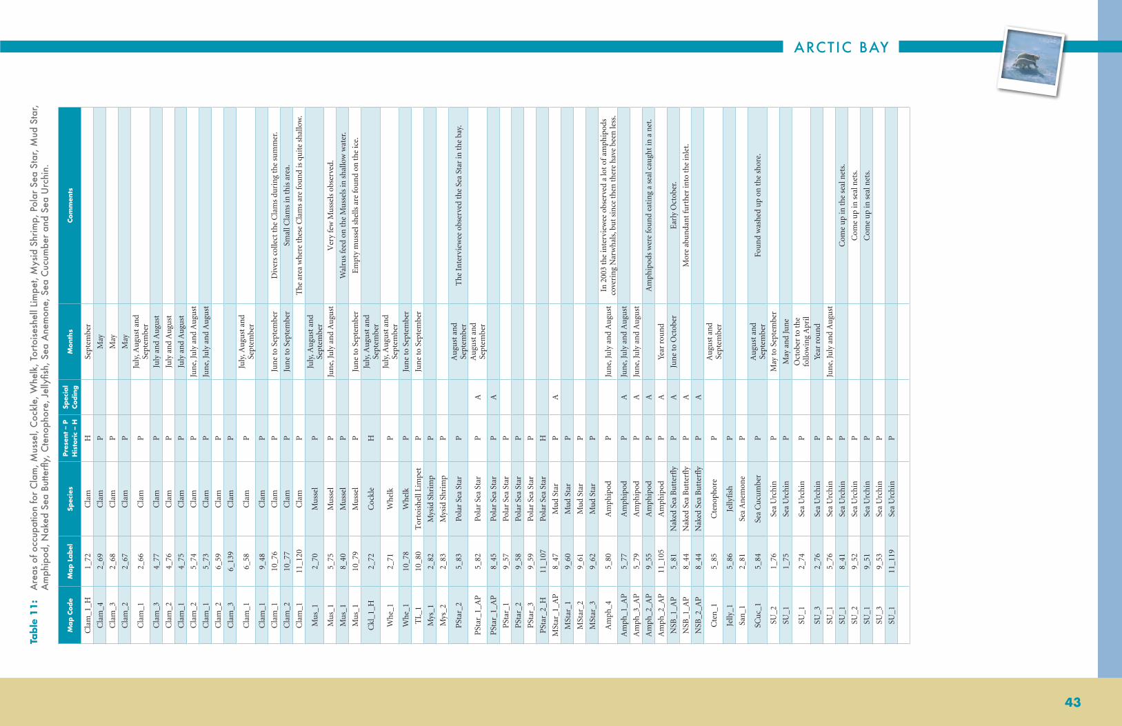
ARCTIC BAY
43
Table
11
: A
reas
of o
ccup
atio
n fo
r C
lam
, Mus
sel,
Coc
kle,
Whe
lk, T
orto
isesh
ell L
impe
t, M
ysid
Shr
imp,
Pol
ar S
ea S
tar,
Mud
Sta
r, A
mph
ipod
, Nak
ed S
ea B
utte
rfly,
Cte
noph
ore,
Jel
lyfis
h, S
ea A
nem
one,
Sea
Cuc
umbe
r an
d Se
a U
rchi
n.
Map C
ode
Map L
abel
Spec
ies
Pres
ent
– P
H
isto
ric
– H
Spec
ial
Codin
gM
onth
sCo
mm
ents
Cla
m_1
_H1_
72C
lam
H
Sept
embe
r
Cla
m_4
2_69
Cla
mP
M
ay
Cla
m_3
2_68
Cla
mP
M
ay
Cla
m_2
2_67
Cla
mP
M
ay
Cla
m_1
2_66
Cla
mP
Ju
ly, A
ugu
st a
nd
Sept
embe
r
Cla
m_3
4_77
Cla
mP
Ju
ly a
nd
Au
gust
Cla
m_2
4_76
Cla
mP
Ju
ly a
nd
Au
gust
Cla
m_1
4_75
Cla
mP
Ju
ly a
nd
Au
gust
Cla
m_2
5_74
Cla
mP
Ju
ne,
July
an
d A
ugu
st
Cla
m_1
5_73
Cla
mP
Ju
ne,
July
an
d A
ugu
st
Cla
m_2
6_59
Cla
mP
Cla
m_3
6_13
9C
lam
P
Cla
m_1
6_58
Cla
mP
Ju
ly, A
ugu
st a
nd
Sept
embe
r
Cla
m_1
9_48
Cla
mP
Cla
m_1
10_7
6C
lam
P
Jun
e to
Sep
tem
ber
Div
ers
colle
ct t
he C
lam
s du
rin
g th
e su
mm
er.
Cla
m_2
10_7
7C
lam
P
Jun
e to
Sep
tem
ber
Smal
l Cla
ms
in t
his
area
.
Cla
m_1
11_1
20C
lam
P
The
are
a w
her
e th
ese
Cla
ms
are
fou
nd
is q
uit
e sh
allo
w.
Mu
s_1
2_70
Mu
ssel
P
July
, Au
gust
an
d Se
ptem
ber
Mu
s_1
5_75
Mu
ssel
P
Jun
e, Ju
ly a
nd
Au
gust
Ver
y fe
w M
uss
els
obse
rved
.
Mu
s_1
8_40
Mu
ssel
P
Wal
rus
feed
on
the
Mu
ssel
s in
sha
llow
wat
er.
Mu
s_1
10_7
9M
uss
elP
Ju
ne
to S
epte
mbe
r E
mpt
y m
uss
el s
hells
are
fou
nd
on t
he ic
e.
Ckl
_1_H
2_72
Coc
kle
H
July
, Au
gust
an
d Se
ptem
ber
Whe
_12_
71W
helk
P
July
, Au
gust
an
d Se
ptem
ber
Whe
_110
_78
Whe
lkP
Ju
ne
to S
epte
mbe
r
TL_
110
_80
Tor
tois
hell
Lim
pet
P
Jun
e to
Sep
tem
ber
Mys
_12_
82M
ysid
Shr
imp
P
Mys
_22_
83M
ysid
Shr
imp
P
PSt
ar_2
5_83
Pola
r Se
a St
arP
A
ugu
st a
nd
Sept
embe
rT
he I
nte
rvie
wee
obs
erve
d th
e Se
a St
ar in
the
bay
.
PSt
ar_1
_AP
5_82
Pola
r Se
a St
arP
AA
ugu
st a
nd
Sept
embe
r
PSt
ar_1
_AP
8_45
Pola
r Se
a St
arP
A
PSt
ar_1
9_57
Pola
r Se
a St
arP
PSt
ar_2
9_58
Pola
r Se
a St
arP
PSt
ar_3
9_59
Pola
r Se
a St
arP
PSt
ar_2
_H11
_107
Pola
r Se
a St
arH
MSt
ar_1
_AP
8_47
Mu
d St
arP
A
MSt
ar_1
9_60
Mu
d St
arP
MSt
ar_2
9_61
Mu
d St
arP
MSt
ar_3
9_62
Mu
d St
arP
Am
ph_4
5_80
Am
phip
odP
Ju
ne,
July
an
d A
ugu
stIn
200
3 th
e in
terv
iew
ee o
bser
ved
a lo
t of
am
phip
ods
cove
rin
g N
arw
hals
, bu
t si
nce
the
n t
here
hav
e be
en le
ss.
Am
ph_1
_AP
5_77
Am
phip
odP
AJu
ne,
July
an
d A
ugu
st
Am
ph_3
_AP
5_79
Am
phip
odP
AJu
ne,
July
an
d A
ugu
st
Am
ph_2
_AP
9_55
Am
phip
odP
AA
mph
ipod
s w
ere
fou
nd
eati
ng
a se
al c
augh
t in
a n
et.
Am
ph_2
_AP
11_1
05A
mph
ipod
PA
Year
rou
nd
NSB
_1_A
P5_
81N
aked
Sea
Bu
tter
fly
PA
Jun
e to
Oct
ober
Ear
ly O
ctob
er.
NSB
_1_A
P8_
44N
aked
Sea
Bu
tter
fly
PA
Mor
e ab
un
dan
t fu
rthe
r in
to t
he in
let.
NSB
_2_A
P8_
44N
aked
Sea
Bu
tter
fly
PA
Cte
n_1
5_85
Cte
nop
hore
P
Au
gust
an
d Se
ptem
ber
Jelly
_15_
86Je
llyfi
shP
San
_12_
81Se
a A
nem
one
P
SCu
c_1
5_84
Sea
Cu
cum
ber
P
Au
gust
an
d Se
ptem
ber
Fou
nd
was
hed
up
on t
he s
hore
.
SU_2
1_76
Sea
Urc
hin
P
May
to S
epte
mbe
r
SU_1
1_75
Sea
Urc
hin
P
May
an
d Ju
ne
SU_1
2_74
Sea
Urc
hin
P
Oct
ober
to t
he
follo
win
g A
pril
SU_3
2_76
Sea
Urc
hin
P
Year
rou
nd
SU_1
5_76
Sea
Urc
hin
P
Jun
e, Ju
ly a
nd
Au
gust
SU_1
8_41
Sea
Urc
hin
P
Com
e u
p in
the
sea
l net
s.
SU_2
9_52
Sea
Urc
hin
P
Com
e u
p in
sea
l net
s.
SU_1
9_51
Sea
Urc
hin
P
Com
e u
p in
sea
l net
s.
SU_3
9_53
Sea
Urc
hin
P
SU_1
11_1
19Se
a U
rchi
nP

NUNAVUT COASTAL RESOURCE INVENTORY
44
Inte
rvie
wM
ap C
ode
Spec
ies
Pres
ent
– P
H
isto
ric
– H
Mon
ths
Com
men
ts
7C
lam
_1_e
Cla
mP
Bu
ried
in m
udd
y ar
eas.
4M
us_
1_e
Mu
ssel
PJu
ly to
Sep
tem
ber
Fou
nd
on t
he s
hore
.
6M
us_
1_e
Mu
ssel
PFo
un
d w
ashe
d u
p on
the
sho
re.
7M
us_
1_e
Mu
ssel
P
9M
us_
1_e
Mu
ssel
PFo
un
d al
ong
the
shor
e an
d so
met
imes
on
th
e la
nd.
11M
us_
1_e
Mu
ssel
P
11C
kl_1
_eC
ockl
eP
4W
he_1
_eH
Whe
lkH
July
to S
epte
mbe
rO
nly
em
pty
shel
ls w
ere
fou
nd.
7W
he_1
_eW
helk
P
9W
he_1
_eW
helk
PE
mpt
y sh
ells
fou
nd
alon
g th
e sh
ore.
11W
he_1
_eW
helk
P
2T
L_1_
euT
orto
ishe
ll Li
mpe
tP
July
to S
epte
mbe
rFo
un
d al
l alo
ng
the
shor
e.
7T
L_1_
eT
orto
ishe
ll Li
mpe
tP
11T
L_1_
eT
orto
ishe
ll Li
mpe
tP
Fou
nd
was
hed
up
on b
each
es.
2Ps
tar_
1_e
Pola
r Se
a St
arP
July
to S
epte
mbe
r
3Ps
tar_
1_e
Pola
r Se
a St
arP
Year
rou
nd
Fou
nd
mos
tly
from
Jun
e to
Au
gust
.
4Ps
tar_
1_e
Pola
r Se
a St
arP
July
to S
epte
mbe
r
6Ps
tar_
1_e
Pola
r Se
a st
arP
Fou
nd
was
hed
up
on t
he s
hore
.
7Ps
tar_
1_e
Pola
r Se
a St
arP
8Ps
tar_
2_e
Pola
r Se
a St
arP
10Ps
tar_
1_e
Pola
r Se
a St
arP
Jun
e to
Sep
tem
ber
Fou
nd
anyw
here
on
the
bot
tom
.
11Ps
tar_
1_e
Pola
r Se
a St
arP
1M
star
_1_e
Mu
d St
arP
July
to S
epte
mbe
r
2M
star
_1_e
Mu
d St
arP
July
to S
epte
mbe
r
3M
star
_1_e
Mu
d St
arP
Year
rou
nd
Fou
nd
mos
tly
from
Jun
e to
Au
gust
.
4M
star
_1_e
Mu
d St
arP
July
to S
epte
mbe
r
6M
star
_1_e
Mu
d St
arP
Fou
nd
was
hed
up
on t
he s
hore
.
8M
star
_2_e
Mu
d St
arP
10M
star
_1_e
Mu
d St
arP
Jun
e to
Sep
tem
ber
Fou
nd
anyw
here
on
the
bot
tom
.
11M
star
_1_e
Mu
s St
arP
1A
mph
_Ape
Am
phip
odP
Year
rou
nd
Fou
nd
all a
lon
g th
e co
ast.
2A
mph
_1_e
Am
phip
odP
Year
rou
nd
3A
mph
_1_e
Am
phip
odP
Year
rou
nd
Furt
her
out
of t
he I
nle
t th
ere
are
mor
e am
phip
ods
and
they
are
big
ger,
fu
rthe
r in
to t
he in
let
ther
e ar
e fe
wer
.
4A
mph
_1_e
Am
phip
odP
Year
rou
nd
5A
mph
_2_e
Am
phip
odP
Jun
e, Ju
ly a
nd
Au
gust
6A
mph
_1_e
Am
phip
odP
7A
mph
_1_e
Am
phip
odP
8A
mph
_1_e
Am
phip
odP
9A
mph
_1_e
Am
phip
odP
10A
mph
_1_e
Am
phip
odP
Jun
e to
Sep
tem
ber
11A
mph
_1_e
Am
phip
odP
1N
SB_1
_eN
aked
Sea
B
utt
erfl
yP
July
to S
epte
mbe
r
2N
SB_1
_eN
aked
Sea
B
utt
erfl
yP
Year
rou
nd
3N
SB_1
_eN
aked
Sea
B
utt
erfl
yP
Year
rou
nd
Fou
nd
mos
tly
from
Jun
e to
Au
gust
.
4N
SB_1
_eN
aked
Sea
B
utt
erfl
yP
Year
rou
nd
6N
SB_1
_eN
aked
Sea
B
utt
erfl
yP
Jan
uar
y to
May
, O
ctob
er a
nd
Nov
embe
rSe
en in
lead
s.
7N
SB_1
_eN
aked
Sea
B
utt
erfl
yP
Sept
embe
r an
d O
ctob
er
9N
SB_1
_eN
aked
Sea
B
utt
erfl
yP
Fou
nd
alon
g th
e sh
ore.
10N
SB_1
_eN
aked
Sea
B
utt
erfl
yP
Jun
e to
Sep
tem
ber
11N
SB_1
_eN
aked
Sea
B
utt
erfl
yP
Oft
en fo
un
d w
ashe
d u
p on
bea
ches
. The
re a
re n
ot a
s m
any
as in
the
pas
t.
6C
ten
_1_e
Cte
nop
hore
PSe
en g
low
ing
in t
he w
ater
.
7C
ten
_1_e
Cte
nop
hore
PJu
ly to
Nov
embe
r
8C
ten
_1_e
Cte
nop
hore
P
9C
ten
_1_e
Cte
nop
hore
P
10C
ten
_1_e
Cte
nop
hore
PJu
ly to
Sep
tem
ber
11C
ten
_1_e
Cte
nop
hore
P
1Je
lly_1
_eJe
llyfi
shP
2Je
lly_1
_eJe
llyfi
shP
3Je
lly_1
_eJe
llyfi
shP
Year
rou
nd
Pro
babl
y ye
ar r
oun
d, b
ut
mos
tly
Jun
e to
Sep
tem
ber.
6Je
lly_1
_eJe
llyfi
shP
Year
rou
nd
7Je
lly_1
_eJe
llyfi
shP
8Je
lly_1
_eJe
llyfi
shP
9Je
lly_1
_eJe
llyfi
shP
10Je
lly_1
_eJe
llyfi
shP
Jun
e to
Sep
tem
ber
App
ears
to fo
llow
the
cu
rren
ts.
11Je
lly_1
_eJe
llyfi
shP
6Sa
n_1
_eSe
a A
nem
one
PSe
en in
dee
per
wat
ers.
“Eve
ryw
here
” Co
ded
Data
— C
lam
, Mus
sel,
Coc
kle,
Whe
lk, T
orto
ishel
l Lim
pet,
Pola
r Se
a St
ar, M
ud s
tar,
Am
phip
od, N
aked
se
a Bu
tterfl
y, C
teno
phor
e, J
elly
fish,
Sea
Ane
mon
e, S
callo
p, S
ea U
rchi
n, N
orth
ern
Krill
, and
Nor
ther
n Sh
rimp.
Table
11
(co
ntin
ued):
A
reas
of o
ccup
atio
n fo
r C
lam
, Mus
sel,
Coc
kle,
Whe
lk, T
orto
isesh
ell L
impe
t, M
ysid
Shr
imp,
Pol
ar S
ea S
tar,
Mud
Sta
r, A
mph
ipod
, Nak
ed S
ea B
utte
rfly,
Cte
noph
ore,
Jel
lyfis
h, S
ea A
nem
one,
Sea
Cuc
umbe
r an
d Se
a U
rchi
n.
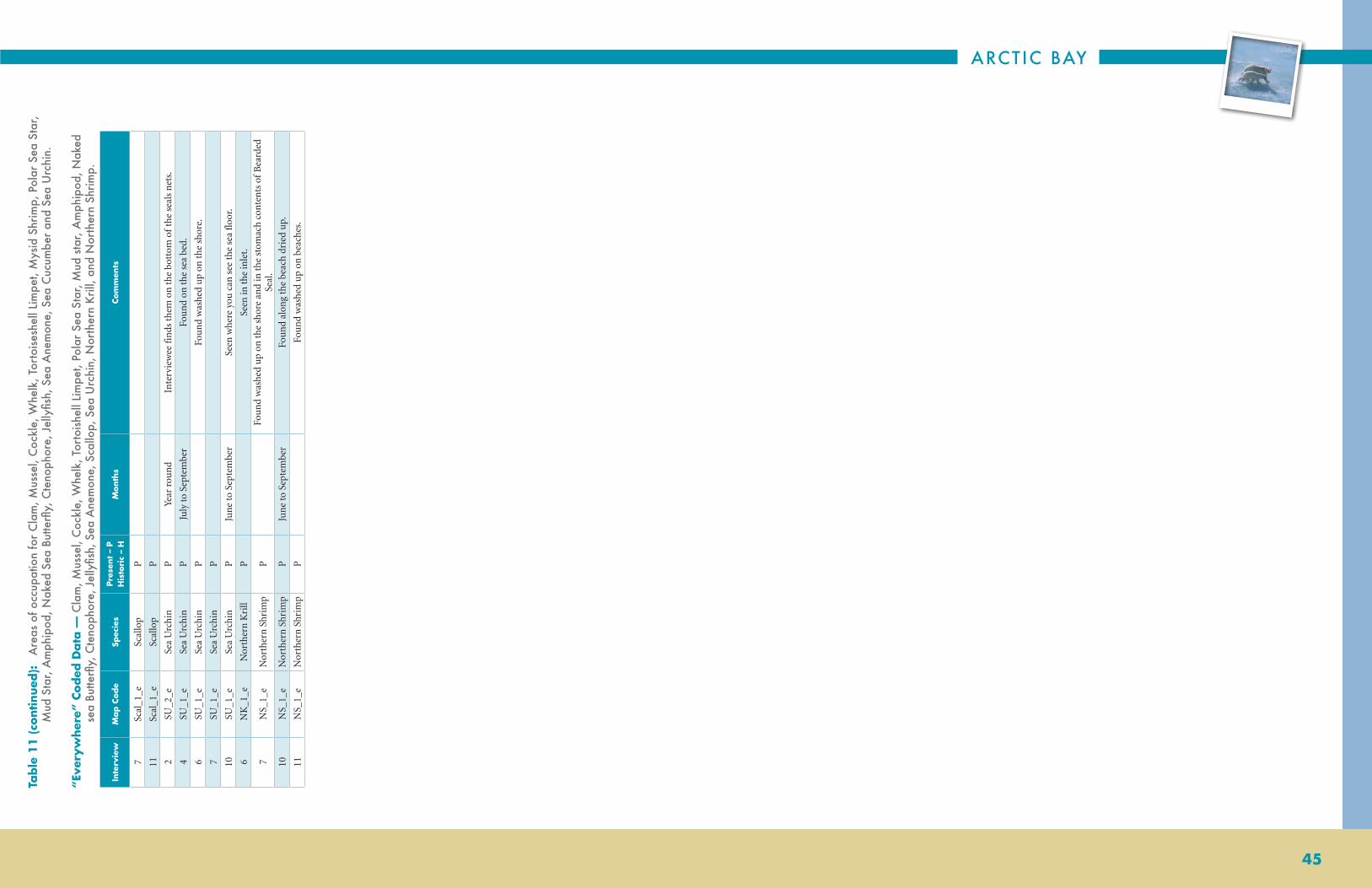
ARCTIC BAY
45
Inte
rvie
wM
ap C
ode
Spec
ies
Pres
ent
– P
H
isto
ric
– H
Mon
ths
Com
men
ts
7Sc
al_1
_eSc
allo
pP
11Sc
al_1
_eSc
allo
pP
2SU
_2_e
Sea
Urc
hin
PYe
ar r
oun
dIn
terv
iew
ee fi
nds
the
m o
n t
he b
otto
m o
f th
e se
als
net
s.
4SU
_1_e
Sea
Urc
hin
PJu
ly to
Sep
tem
ber
Fou
nd
on t
he s
ea b
ed.
6SU
_1_e
Sea
Urc
hin
PFo
un
d w
ashe
d u
p on
the
sho
re.
7SU
_1_e
Sea
Urc
hin
P
10SU
_1_e
Sea
Urc
hin
PJu
ne
to S
epte
mbe
rSe
en w
here
you
can
see
the
sea
floo
r.
6N
K_1
_eN
orth
ern
Kri
llP
Seen
in t
he in
let.
7N
S_1_
eN
orth
ern
Shr
imp
PFo
un
d w
ashe
d u
p on
the
sho
re a
nd
in t
he s
tom
ach
con
ten
ts o
f B
eard
ed
Seal
.
10N
S_1_
eN
orth
ern
Shr
imp
PJu
ne
to S
epte
mbe
rFo
un
d al
ong
the
beac
h dr
ied
up.
11N
S_1_
eN
orth
ern
Shr
imp
PFo
un
d w
ashe
d u
p on
bea
ches
.
“Eve
ryw
here
” Co
ded
Data
— C
lam
, Mus
sel,
Coc
kle,
Whe
lk, T
orto
ishel
l Lim
pet,
Pola
r Se
a St
ar, M
ud s
tar,
Am
phip
od, N
aked
se
a Bu
tterfl
y, C
teno
phor
e, J
elly
fish,
Sea
Ane
mon
e, S
callo
p, S
ea U
rchi
n, N
orth
ern
Krill
, and
Nor
ther
n Sh
rimp.
Table
11
(co
ntin
ued):
A
reas
of o
ccup
atio
n fo
r C
lam
, Mus
sel,
Coc
kle,
Whe
lk, T
orto
isesh
ell L
impe
t, M
ysid
Shr
imp,
Pol
ar S
ea S
tar,
Mud
Sta
r, A
mph
ipod
, Nak
ed S
ea B
utte
rfly,
Cte
noph
ore,
Jel
lyfis
h, S
ea A
nem
one,
Sea
Cuc
umbe
r an
d Se
a U
rchi
n.

NUNAVUT COASTAL RESOURCE INVENTORY
46
2_11
56_
103
6_10
4
6_10
5
6_10
6
9_94
9_95
10_1
18
10_1
17
2_11
4
2_13
2
5_21
3
6_10
8
6_10
7
10_1
54
10_1
56
1_10
81_10
7
2_10
5
2_10
4
4_11
2
5_20
7
5_20
6
6_95
6_98
6_96
6_97
8_75
8_76
8_77
8_78
9_88
9_89
10_1
12
10_1
11
6_94
5_20
52_
106
1_10
9
1_10
5
1_10
6
3_72
5_20
4
5_20
3
6_91
6_92
6_93
8_73
8_74
9_86
10_1
08
10_1
09
9_85
8_72
8_71
6_90
5_20
23_
712_
103
2_11
6
2_11
3
2_11
2
2_11
0
2_10
9
5_21
1
5_20
9
6_10
0
6_10
1
6_10
2
8_80
9_92
10_1
14
10_1
15
9_91
6_99
5_21
0
5_20
82_
111
80°0
'0"W
82°0
'0"W
82°0
'0"W
84°0
'0"W
84°0
'0"W
86°0
'0"W
86°0
'0"W
88°0
'0"W88
°0'0
"W
90°0
'0"W
90°0
'0"W
74°0'0"N
74°0'0"N
73°0'0"N
73°0'0"N
72°0'0"N
72°0'0"N
71°0'0"N
71°0'0"N
Sea
Col
ande
r*, S
piny
Sou
r Wee
d, S
ea L
ungw
ort*
, Hol
low
-ste
mm
ed K
elp*
, Edi
ble
Kelp
*,
Dul
se*,
and
Bla
dder
Wra
ck*
1:1,
350,
000
Dat
a S
ourc
e: N
TDB
1:25
0 00
0; A
rctic
Bay
inte
rvie
ws
Spec
ies
Sea
Col
ande
r
Spi
ny S
our W
eed
Sea
Lun
gwor
t
Hol
low
-ste
mm
ed K
elp
Edi
ble
Kel
p
Dul
se
Bla
dder
Wra
ck
Be
rnie
r B
ay
Be
rnie
r B
ay
La
nc
as
ter
So
un
dL
an
ca
ste
r S
ou
nd
DE
VO
N I
SL
AN
DD
EV
ON
IS
LA
ND
Figur
e 1
4:
Are
as o
f occ
upat
ion
for
Sea
Col
ande
r, Sp
iny
Sour
Wee
d, S
ea L
ungw
ort,
Hol
low
-stem
med
Kel
p, E
dibl
e Ke
lp,
Dul
se a
nd B
ladd
er W
rack
.

ARCTIC BAY
47
Table
12
: A
reas
of o
ccup
atio
n fo
r Se
a C
olan
der,
Spin
y So
ur W
eed,
Sea
Lun
gwor
t, H
ollo
w-st
emm
ed K
elp,
Edi
ble
Kelp
, Dul
se
and
Blad
der
Wra
ck.
Map C
ode
Map L
abel
Spec
ies
Pres
ent
– P
H
isto
ric
– H
Spec
ial
Codin
gM
onth
sCo
mm
ents
BW
ra_1
2_11
5B
ladd
er W
rack
P
July
, Au
gust
an
d Se
ptem
ber
BW
ra_1
6_10
3B
ladd
er W
rack
P
BW
ra_2
6_10
4B
ladd
er W
rack
P
BW
ra_3
6_10
5B
ladd
er W
rack
P
BW
ra_4
6_10
6B
ladd
er W
rack
P
Swee
t ta
stin
g B
ladd
er W
rack
.
BW
ra_1
9_94
Bla
dder
Wra
ckP
Ju
ly, A
ugu
st a
nd
Sept
embe
r
BW
ra_2
9_95
Bla
dder
Wra
ckP
Ju
ly, A
ugu
st a
nd
Sept
embe
r
BW
ra_1
_AP
10_1
18B
ladd
er W
rack
PA
BW
ra_2
_AP
10_1
17B
ladd
er W
rack
PA
Du
l_1
2_11
4D
uls
eP
Ju
ly, A
ugu
st a
nd
Sept
embe
r
Du
l_1
2_13
2D
uls
eP
Ju
ly, A
ugu
st a
nd
Sept
embe
r
Du
l_1
5_21
3D
uls
eP
Ju
ly, A
ugu
st a
nd
Sept
embe
r
Du
l_2
6_10
8D
uls
eP
Ju
ly, A
ugu
st a
nd
Sept
embe
r
Du
l_1
6_10
7D
uls
eP
Ju
ly, A
ugu
st a
nd
Sept
embe
r
Du
l_3
10_1
54D
uls
eP
Du
l_2
10_1
56D
uls
eP
EK
_31_
109
Edi
ble
Kel
pP
A
ugu
st a
nd
Sept
embe
r
EK
_21_
108
Edi
ble
Kel
pP
A
ugu
st a
nd
Sept
embe
r
EK
_11_
107
Edi
ble
Kel
pP
A
ugu
st a
nd
Sept
embe
r
EK
_22_
105
Edi
ble
Kel
pP
Ju
ly, A
ugu
st a
nd
Sept
embe
r
EK
_12_
104
Edi
ble
Kel
pP
Ju
ly, A
ugu
st a
nd
Sept
embe
r
EK
_32_
106
Edi
ble
Kel
pP
Ju
ly, A
ugu
st a
nd
Sept
embe
r
EK
_24_
112
Edi
ble
Kel
pP
A
ugu
st a
nd
Sept
embe
r
EK
_15_
205
Edi
ble
Kel
pP
Ju
ly, A
ugu
st a
nd
Sept
embe
r
EK
_35_
207
Edi
ble
Kel
pP
Ju
ly, A
ugu
st a
nd
Sept
embe
r
EK
_25_
206
Edi
ble
Kel
pP
Ju
ly, A
ugu
st a
nd
Sept
embe
rH
igh
curr
ent
area
.
EK
_16_
94E
dibl
e K
elp
P
EK
_26_
95E
dibl
e K
elp
P
EK
_56_
98E
dibl
e K
elp
P
Swee
t ta
stin
g E
dibl
e K
elp.
EK
_36_
96E
dibl
e K
elp
P
EK
_46_
97E
dibl
e K
elp
P
Swee
t ta
stin
g E
dibl
e K
elp.
EK
_18_
75E
dibl
e K
elp
P
EK
_28_
76E
dibl
e K
elp
P
EK
_38_
77E
dibl
e K
elp
P
EK
_48_
78E
dibl
e K
elp
P
EK
_19_
88E
dibl
e K
elp
P
July
, Au
gust
an
d Se
ptem
ber
EK
_29_
89E
dibl
e K
elp
P
July
, Au
gust
an
d Se
ptem
ber
EK
_3_A
P10
_112
Edi
ble
Kel
pP
A
EK
_2_A
P10
_111
Edi
ble
Kel
pP
A
HSK
_11_
105
Hol
low
-Ste
mm
ed
Kel
pP
A
ugu
st a
nd
Sept
embe
rH
ollo
w-s
tem
med
kel
p ob
serv
ed to
gro
w in
an
ar
ea w
ith
stro
ng
curr
ents
.
HSK
_21_
106
Hol
low
-Ste
mm
ed
Kel
pP
Ju
ly, A
ugu
st a
nd
Sept
embe
rH
ollo
w-s
tem
med
kel
p ob
serv
ed to
gro
w in
an
ar
ea w
ith
stro
ng
curr
ents
.
HSK
_22_
103
Hol
low
-Ste
mm
ed
Kel
pP
Ju
ly, A
ugu
st a
nd
Sept
embe
r
EK
_23_
72H
ollo
w-S
tem
med
K
elp
P
July
an
d A
ugu
st
EK
_13_
71H
ollo
w-S
tem
med
K
elp
P
July
an
d A
ugu
st
HSK
_15_
202
Hol
low
-Ste
mm
ed
Kel
pP
Ju
ly, A
ugu
st a
nd
Sept
embe
r
HSK
_35_
204
Hol
low
-Ste
mm
ed
Kel
pP
Ju
ly, A
ugu
st a
nd
Sept
embe
r
HSK
_25_
203
Hol
low
-Ste
mm
ed
Kel
pP
Ju
ly, A
ugu
st a
nd
Sept
embe
rH
igh
curr
ent
area
.
HSK
_16_
90H
ollo
w-S
tem
med
K
elp
P
HSK
_26_
91H
ollo
w-S
tem
med
K
elp
P
HSK
_36_
92H
ollo
w-S
tem
med
K
elp
P
HSK
_46_
93H
ollo
w-S
tem
med
K
elp
P
Swee
t ta
stin
g H
ollo
w S
tem
med
Kel
p.
HSK
_18_
71H
ollo
w-S
tem
med
K
elp
P
July
, Au
gust
an
d Se
ptem
ber
HSK
_28_
72H
ollo
w-S
tem
med
K
elp
P
HSK
_38_
73H
ollo
w-S
tem
med
K
elp
P
HSK
_48_
74H
ollo
w-S
tem
med
K
elp
P
HSK
_19_
85H
ollo
w-S
tem
med
K
elp
P
July
, Au
gust
an
d Se
ptem
ber
HSK
_29_
86H
ollo
w-S
tem
med
K
elp
P
July
, Au
gust
an
d Se
ptem
ber
HSK
_3_A
P10
_109
Hol
low
-Ste
mm
ed
Kel
pP
A
HSK
_2_A
P10
_108
Hol
low
-Ste
mm
ed
Kel
pP
A
SLW
_12_
116
Sea
Lun
gwor
tP
Ju
ly, A
ugu
st a
nd
Sept
embe
rT
he s
ea lu
ngw
ort
was
obs
erve
d at
Pam
iuja
q.
SSW
_22_
113
Spin
y So
ur
Wee
dP
Ju
ly, A
ugu
st a
nd
Sept
embe
r
SSW
_12_
112
Spin
y So
ur
Wee
dP
Ju
ly, A
ugu
st a
nd
Sept
embe
rT
he in
terv
iew
ee d
oes
not
oft
en s
ee s
piny
sou
r w
eed.
SCol
_32_
110
Sea
Col
ande
rP
Ju
ly, A
ugu
st a
nd
Sept
embe
r
SCol
_22_
109
Sea
Col
ande
rP
Ju
ly, A
ugu
st a
nd
Sept
embe
r
SCol
_42_
111
Sea
Col
ande
rP
Ju
ly, A
ugu
st a
nd
Sept
embe
r
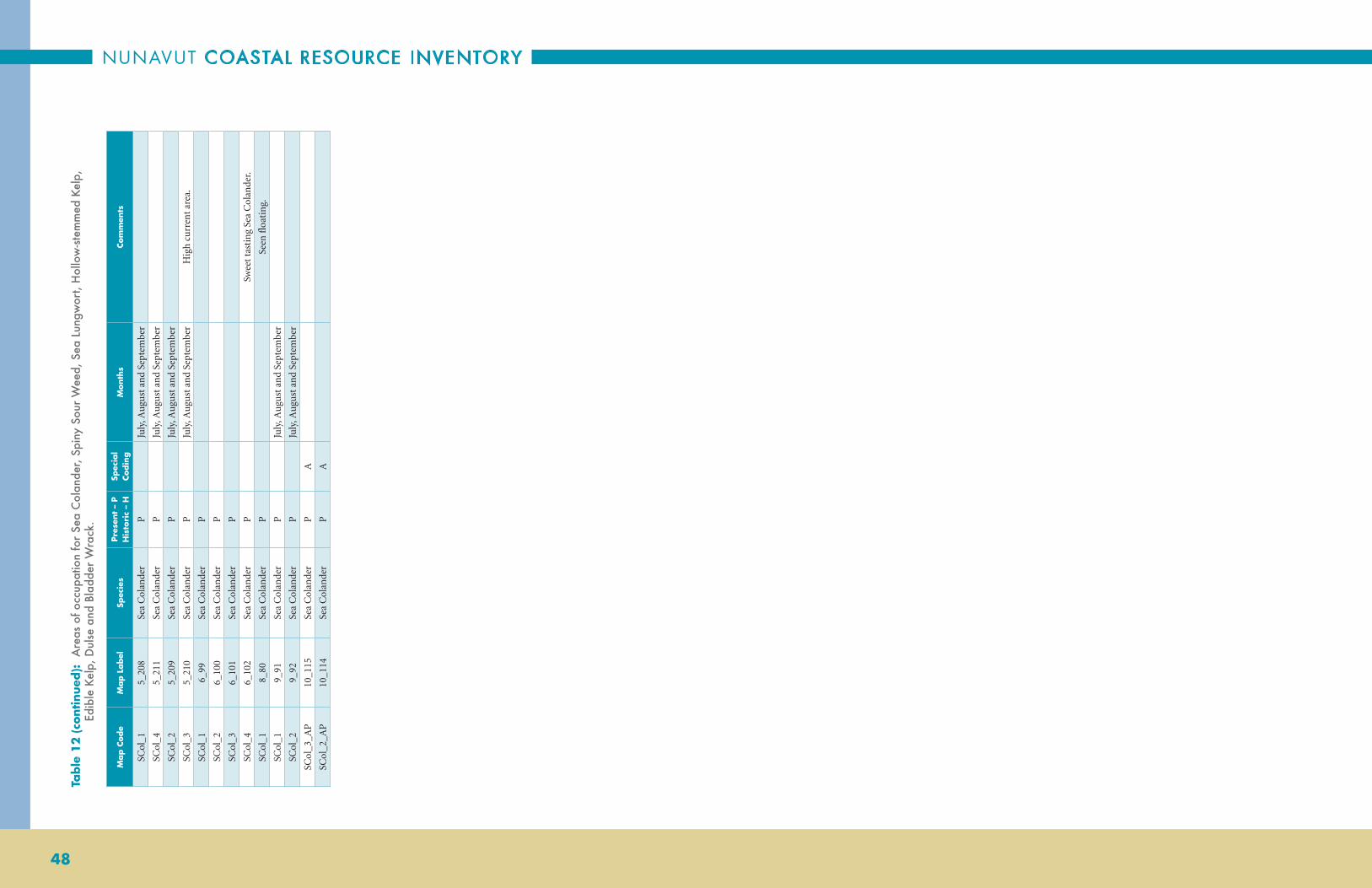
NUNAVUT COASTAL RESOURCE INVENTORY
48
Map C
ode
Map L
abel
Spec
ies
Pres
ent
– P
H
isto
ric
– H
Spec
ial
Codin
gM
onth
sCo
mm
ents
SCol
_15_
208
Sea
Col
ande
rP
Ju
ly, A
ugu
st a
nd
Sept
embe
r
SCol
_45_
211
Sea
Col
ande
rP
Ju
ly, A
ugu
st a
nd
Sept
embe
r
SCol
_25_
209
Sea
Col
ande
rP
Ju
ly, A
ugu
st a
nd
Sept
embe
r
SCol
_35_
210
Sea
Col
ande
rP
Ju
ly, A
ugu
st a
nd
Sept
embe
rH
igh
curr
ent
area
.
SCol
_16_
99Se
a C
olan
der
P
SCol
_26_
100
Sea
Col
ande
rP
SCol
_36_
101
Sea
Col
ande
rP
SCol
_46_
102
Sea
Col
ande
rP
Sw
eet
tast
ing
Sea
Col
ande
r.
SCol
_18_
80Se
a C
olan
der
P
Seen
floa
tin
g.
SCol
_19_
91Se
a C
olan
der
P
July
, Au
gust
an
d Se
ptem
ber
SCol
_29_
92Se
a C
olan
der
P
July
, Au
gust
an
d Se
ptem
ber
SCol
_3_A
P10
_115
Sea
Col
ande
rP
A
SCol
_2_A
P10
_114
Sea
Col
ande
rP
A
Table
12
(co
ntin
ued):
A
reas
of o
ccup
atio
n fo
r Se
a C
olan
der,
Spin
y So
ur W
eed,
Sea
Lun
gwor
t, H
ollo
w-st
emm
ed K
elp,
Ed
ible
Kel
p, D
ulse
and
Bla
dder
Wra
ck.

ARCTIC BAY
49

NUNAVUT COASTAL RESOURCE INVENTORY
50
1_10
0
2_88
3_50
3_52
4_92
4_91
5_13
55_
116
5_12
5
5_97
5_10
35_
126
5_96
5_12
7
5_10
45_
105
5_10
65_
136
5_10
7
5_10
85_
93
5_92
5_91
5_94
5_95
5_12
0
5_11
9
5_13
25_
110 5_
98
5_10
9
5_12
25_
111
5_10
2
5_11
55_
885_
114
5_11
3
5_24
8 5_99
5_89
5_13
0
5_90
5_12
4
5_12
3
5_12
8
5_12
9
5_13
4
5_24
9
6_76
5_10
15_
133
5_10
0
5_13
1
5_11
7
5_11
8
5_12
1 5_11
2
3_51
80°0
'0"W
82°0
'0"W
82°0
'0"W
84°0
'0"W
84°0
'0"W
86°0
'0"W
86°0
'0"W
88°0
'0"W88
°0'0
"W
90°0
'0"W
90°0
'0"W
74°0'0"N
74°0'0"N
73°0'0"N
73°0'0"N
72°0'0"N
72°0'0"N
71°0'0"N
71°0'0"N
Rin
ged
Sea
l*
1:1,
350,
000
Dat
a S
ourc
e: N
TDB
1:25
0 00
0; A
rctic
Bay
inte
rvie
ws
Inte
rvie
w1 2 3 4 5 6
Be
rnie
r B
ay
Be
rnie
r B
ay
La
nc
as
ter
So
un
dL
an
ca
ste
r S
ou
nd
DE
VO
N I
SL
AN
DD
EV
ON
IS
LA
ND
Figur
e 1
5:
Are
as o
f occ
upat
ion
for
Ring
ed S
eal.

ARCTIC BAY
51
Table
13
: A
reas
of o
ccup
atio
n fo
r Ri
nged
Sea
l.
Map C
ode
Map L
abel
Spec
ies
Pres
ent
– P
H
isto
ric
– H
Spec
ial
Codin
gM
onth
sCo
mm
ents
RS_
2_SP
1_10
0R
inge
d Se
alP
SJu
ne
RS_
1_A
P2_
88R
inge
d Se
alP
AM
ay to
Sep
tem
ber
The
rin
ged
seal
s w
ere
obse
rved
in t
he in
let,
whe
re
they
wer
e sh
elte
rin
g fr
om k
iller
wha
les.
RS_
2_A
P3_
50R
inge
d Se
alP
ASe
ptem
ber
and
Oct
ober
Poss
ibly
mat
ing
seas
on d
uri
ng
the
fall.
RS_
4_A
P3_
52R
inge
d Se
alP
ASe
ptem
ber
and
Oct
ober
RS_
3_A
P3_
51R
inge
d Se
alP
ASe
ptem
ber
and
Oct
ober
RS_
3_A
P4_
92R
inge
d Se
alP
AJu
ly, A
ugu
st a
nd
Sept
embe
r
RS_
2_A
FP4_
91R
inge
d Se
alP
A, F
July
, Au
gust
an
d Se
ptem
ber
Feed
ing.
RS_
495_
135
Rin
ged
Seal
P
Nov
embe
r to
the
follo
win
g M
arch
RS_
305_
116
Rin
ged
Seal
P
Mar
ch
RS_
395_
125
Rin
ged
Seal
P
Nov
embe
r to
the
follo
win
g M
arch
RS_
115_
97R
inge
d Se
alP
A
ugu
st a
nd
Sept
embe
rSe
en in
late
Au
gust
/ ea
rly
Sept
embe
r.
RS_
175_
103
Rin
ged
Seal
P
Nov
embe
r to
the
follo
win
g M
arch
RS_
405_
126
Rin
ged
Seal
P
Nov
embe
r to
the
follo
win
g M
arch
RS_
105_
96R
inge
d Se
alP
A
ugu
st a
nd
Sept
embe
rSe
en in
late
Au
gust
/ ea
rly
Sept
embe
r.
RS_
415_
127
Rin
ged
Seal
P
Nov
embe
r to
the
follo
win
g M
arch
RS_
185_
104
Rin
ged
Seal
P
Nov
embe
r to
the
follo
win
g M
arch
RS_
195_
105
Rin
ged
Seal
P
Nov
embe
r to
the
follo
win
g M
arch
RS_
205_
106
Rin
ged
Seal
P
Nov
embe
r to
the
follo
win
g M
arch
RS_
505_
136
Rin
ged
Seal
P
Nov
embe
r to
the
follo
win
g M
arch
RS_
215_
107
Rin
ged
Seal
P
Nov
embe
r to
the
follo
win
g M
arch
RS_
225_
108
Rin
ged
Seal
P
Nov
embe
r to
the
follo
win
g M
arch
RS_
75_
93R
inge
d Se
alP
A
ugu
st a
nd
Sept
embe
r
RS_
65_
92R
inge
d Se
alP
A
ugu
st a
nd
Sept
embe
r
RS_
55_
91R
inge
d Se
alP
A
ugu
st a
nd
Sept
embe
r
RS_
85_
94R
inge
d Se
alP
A
ugu
st a
nd
Sept
embe
r
RS_
95_
95R
inge
d Se
alP
A
ugu
st a
nd
Sept
embe
r
RS_
345_
120
Rin
ged
Seal
P
Nov
embe
r to
the
follo
win
g M
arch
RS_
265_
112
Rin
ged
Seal
P
Nov
embe
r to
the
follo
win
g M
arch
RS_
355_
121
Rin
ged
Seal
P
Nov
embe
r to
the
follo
win
g M
arch
RS_
335_
119
Rin
ged
Seal
P
Nov
embe
r to
the
follo
win
g M
arch
RS_
325_
118
Rin
ged
Seal
P
Nov
embe
r to
the
follo
win
g M
arch
RS_
315_
117
Rin
ged
Seal
P
Nov
embe
r to
the
follo
win
g M
arch
RS_
455_
131
Rin
ged
Seal
P
Nov
embe
r to
the
follo
win
g M
arch
RS_
145_
100
Rin
ged
Seal
P
Au
gust
Seen
in la
te A
ugu
st.
RS_
475_
133
Rin
ged
Seal
P
Nov
embe
r to
the
follo
win
g M
arch
RS_
155_
101
Rin
ged
Seal
P
Au
gust
Seen
in la
te A
ugu
st.
RS_
465_
132
Rin
ged
Seal
P
Nov
embe
r to
the
follo
win
g M
arch
RS_
245_
110
Rin
ged
Seal
P
Nov
embe
r to
the
follo
win
g M
arch
RS_
125_
98R
inge
d Se
alP
A
ugu
st a
nd
Sept
embe
rSe
en in
late
Au
gust
, ear
ly S
epte
mbe
r.
RS_
235_
109
Rin
ged
Seal
P
Nov
embe
r to
the
follo
win
g M
arch
RS_
365_
122
Rin
ged
Seal
P
Nov
embe
r to
the
follo
win
g M
arch
RS_
255_
111
Rin
ged
Seal
P
Nov
embe
r to
the
follo
win
g M
arch
RS_
165_
102
Rin
ged
Seal
P
Nov
embe
r to
the
follo
win
g M
arch
RS_
295_
115
Rin
ged
Seal
P
Nov
embe
r to
the
follo
win
g M
arch
RS_
2_A
P5_
88R
inge
d Se
alP
ASe
ptem
ber
In e
arly
Sep
tem
ber,
just
bef
ore
the
Cha
r go
up
rive
r,
seal
s ar
e "t
een
ager
s".
RS_
285_
114
Rin
ged
Seal
P
Nov
embe
r to
the
follo
win
g M
arch
RS_
275_
113
Rin
ged
Seal
P
Nov
embe
r to
the
follo
win
g M
arch
RS_
515_
248
Rin
ged
Seal
P
RS_
135_
99R
inge
d Se
alP
A
ugu
st a
nd
Sept
embe
rSe
en in
late
Au
gust
, ear
ly S
epte
mbe
r.
RS_
3_A
P5_
89R
inge
d Se
alP
AA
ugu
stSe
en in
late
Au
gust
.
RS_
445_
130
Rin
ged
Seal
P
Nov
embe
r to
the
follo
win
g M
arch
RS_
45_
90R
inge
d Se
alP
A
ugu
st a
nd
Sept
embe
rSe
en in
late
Au
gust
/ ea
rly
Sept
embe
r.
RS_
385_
124
Rin
ged
Seal
P
Nov
embe
r to
the
follo
win
g M
arch
RS_
375_
123
Rin
ged
Seal
P
Nov
embe
r to
the
follo
win
g M
arch
RS_
425_
128
Rin
ged
Seal
P
Nov
embe
r to
the
follo
win
g M
arch
RS_
435_
129
Rin
ged
Seal
P
Nov
embe
r to
the
follo
win
g M
arch
RS_
485_
134
Rin
ged
Seal
P
Nov
embe
r to
the
follo
win
g M
arch
RS_
15_
249
Rin
ged
Seal
P
RS_
2_A
P6_
76R
inge
d Se
alP
AYe
ar r
oun
d

NUNAVUT COASTAL RESOURCE INVENTORY
52
Inte
rvie
wM
ap C
ode
Spec
ies
Pres
ent
– P
H
isto
ric
– H
Mon
ths
Com
men
ts
2R
S_2_
eR
inge
d Se
alP
year
rou
nd
3R
S_1_
eR
inge
d Se
alP
Sept
embe
r an
d O
ctob
erT
he in
terv
iew
ee t
hin
ks t
he m
atin
g se
ason
mig
ht b
e in
the
fall.
4R
S_1_
eR
inge
d Se
alP
Year
rou
nd
Rin
ged
seal
s co
ngr
egat
e in
the
lead
s du
rin
g th
e w
inte
r. T
here
are
le
ads
on a
ll po
ints
an
d th
at is
whe
re h
e go
es s
eal h
un
tin
g.
5R
S_1_
eR
inge
d Se
alP
Jun
e to
Oct
ober
6R
S_1_
eR
inge
d Se
alP
Year
rou
nd
7R
S_1_
eR
inge
d Se
alP
Year
rou
nd
8R
S_1_
eR
inge
d Se
alP
Year
rou
nd
Fou
nd
in A
dmir
alty
In
let.
9R
S_1_
eR
inge
d Se
alP
Year
rou
nd
Fou
nd
in A
dmir
alty
In
let.
10R
S_1_
eR
inge
d Se
alP
Year
rou
nd
11R
S_1_
eR
inge
d Se
alP
“Eve
ryw
here
” Co
ded
Data
— R
inge
d Se
al.
Table
13
(co
ntin
ued):
A
reas
of o
ccup
atio
n fo
r Ri
nged
Sea
l.

ARCTIC BAY
53

NUNAVUT COASTAL RESOURCE INVENTORY
54
1_10
2
9_73
2_92
3_55
3_56
4_96
5_15
2
5_15
1
5_15
5
5_15
4
5_14
9
5_15
0
5_15
3
6_77
6_78
7_78
8_59
8_57
9_71
10_9
8
10_9
7
11_1
31
80°0
'0"W
82°0
'0"W
82°0
'0"W
84°0
'0"W
84°0
'0"W
86°0
'0"W
86°0
'0"W
88°0
'0"W88
°0'0
"W
90°0
'0"W
90°0
'0"W
74°0'0"N
74°0'0"N
73°0'0"N
73°0'0"N
72°0'0"N
72°0'0"N
71°0'0"N
71°0'0"N
Bear
ded
Sea
l*
1:1,
350,
000
Dat
a S
ourc
e: N
TDB
1:25
0 00
0; A
rctic
Bay
inte
rvie
ws
Inte
rvie
w1 9 2 3 4 5 6 7 8 9 10 11
Be
rnie
r B
ay
Be
rnie
r B
ay
La
nc
as
ter
So
un
dL
an
ca
ste
r S
ou
nd
DE
VO
N I
SL
AN
DD
EV
ON
IS
LA
ND
Figur
e 1
6:
Are
as o
f occ
upat
ion
for
Bear
ded
Seal
.
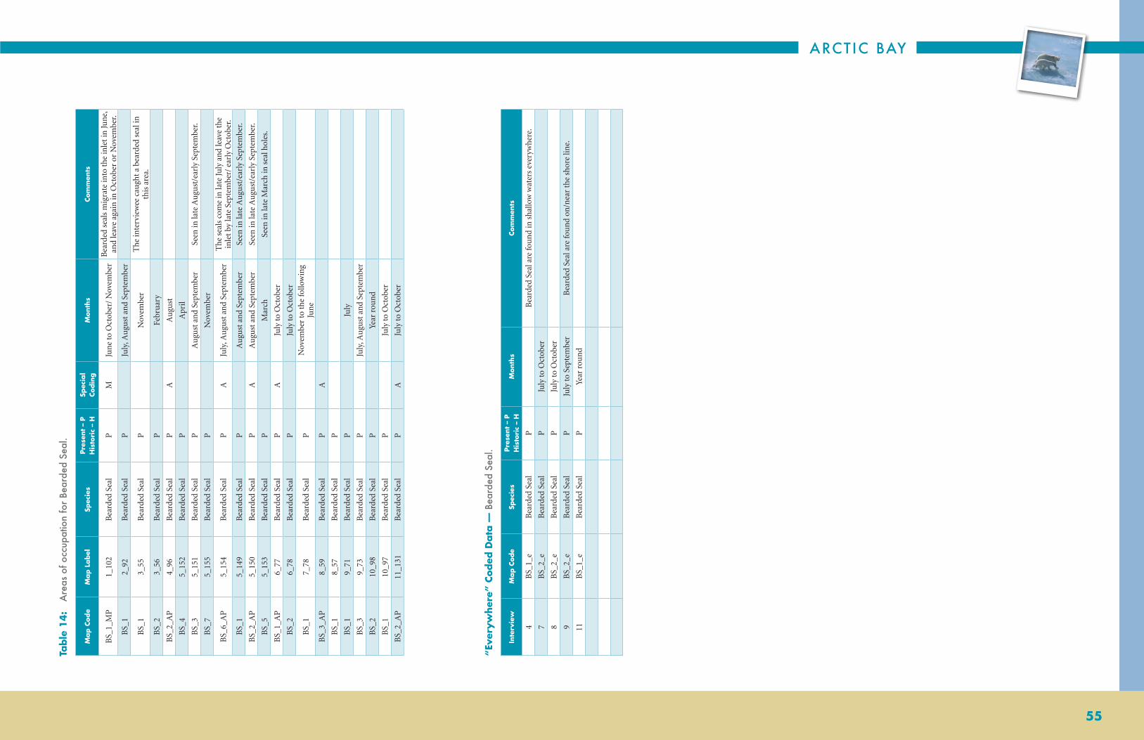
ARCTIC BAY
55
Table
14
: A
reas
of o
ccup
atio
n fo
r Be
arde
d Se
al.
Map C
ode
Map L
abel
Spec
ies
Pres
ent
– P
H
isto
ric
– H
Spec
ial
Codin
gM
onth
sCo
mm
ents
BS_
1_M
P1_
102
Bea
rded
Sea
lP
MJu
ne
to O
ctob
er/
Nov
embe
rB
eard
ed s
eals
mig
rate
into
the
inle
t in
Jun
e,
and
leav
e ag
ain
in O
ctob
er o
r N
ovem
ber.
BS_
12_
92B
eard
ed S
eal
P
July
, Au
gust
an
d Se
ptem
ber
BS_
13_
55B
eard
ed S
eal
P
Nov
embe
rT
he in
terv
iew
ee c
augh
t a
bear
ded
seal
in
this
are
a.
BS_
23_
56B
eard
ed S
eal
P
Febr
uar
y
BS_
2_A
P4_
96B
eard
ed S
eal
PA
Au
gust
BS_
45_
152
Bea
rded
Sea
lP
A
pril
BS_
35_
151
Bea
rded
Sea
lP
A
ugu
st a
nd
Sept
embe
rSe
en in
late
Au
gust
/ear
ly S
epte
mbe
r.
BS_
75_
155
Bea
rded
Sea
lP
N
ovem
ber
BS_
6_A
P5_
154
Bea
rded
Sea
lP
AJu
ly, A
ugu
st a
nd
Sept
embe
rT
he s
eals
com
e in
late
July
an
d le
ave
the
inle
t by
late
Sep
tem
ber/
ear
ly O
ctob
er.
BS_
15_
149
Bea
rded
Sea
lP
A
ugu
st a
nd
Sept
embe
rSe
en in
late
Au
gust
/ear
ly S
epte
mbe
r.
BS_
2_A
P5_
150
Bea
rded
Sea
lP
AA
ugu
st a
nd
Sept
embe
rSe
en in
late
Au
gust
/ear
ly S
epte
mbe
r.
BS_
55_
153
Bea
rded
Sea
lP
M
arch
Seen
in la
te M
arch
in s
eal h
oles
.
BS_
1_A
P6_
77B
eard
ed S
eal
PA
July
to O
ctob
er
BS_
26_
78B
eard
ed S
eal
P
July
to O
ctob
er
BS_
17_
78B
eard
ed S
eal
P
Nov
embe
r to
the
follo
win
g Ju
ne
BS_
3_A
P8_
59B
eard
ed S
eal
PA
BS_
18_
57B
eard
ed S
eal
P
BS_
19_
71B
eard
ed S
eal
P
July
BS_
39_
73B
eard
ed S
eal
P
July
, Au
gust
an
d Se
ptem
ber
BS_
210
_98
Bea
rded
Sea
lP
Ye
ar r
oun
d
BS_
110
_97
Bea
rded
Sea
lP
Ju
ly to
Oct
ober
BS_
2_A
P11
_131
Bea
rded
Sea
lP
AJu
ly to
Oct
ober
Inte
rvie
wM
ap C
ode
Spec
ies
Pres
ent
– P
H
isto
ric
– H
Mon
ths
Com
men
ts
4B
S_1_
eB
eard
ed S
eal
PB
eard
ed S
eal a
re fo
un
d in
sha
llow
wat
ers
ever
ywhe
re.
7B
S_2_
eB
eard
ed S
eal
PJu
ly to
Oct
ober
8B
S_2_
eB
eard
ed S
eal
PJu
ly to
Oct
ober
9B
S_2_
eB
eard
ed S
eal
PJu
ly to
Sep
tem
ber
Bea
rded
Sea
l are
fou
nd
on/n
ear
the
shor
e lin
e.
11B
S_1_
eB
eard
ed S
eal
PYe
ar r
oun
d
“Eve
ryw
here
” Co
ded
Data
— B
eard
ed S
eal.

NUNAVUT COASTAL RESOURCE INVENTORY
56
2_90
2_91
3_53
3_54
4_93
4_94
5_14
4
5_14
7
5_14
5
5_14
6
5_14
8
8_55
9_69
9_70
11_1
28
8_56
10_9
6
11_1
29
7_80
80°0
'0"W
82°0
'0"W
82°0
'0"W
84°0
'0"W
84°0
'0"W
86°0
'0"W
86°0
'0"W
88°0
'0"W88
°0'0
"W
90°0
'0"W
90°0
'0"W
74°0'0"N
74°0'0"N
73°0'0"N
73°0'0"N
72°0'0"N
72°0'0"N
71°0'0"N
71°0'0"N
Har
p* S
eal a
nd H
oode
d S
eal
1:1,
350,
000
Dat
a S
ourc
e: N
TDB
1:25
0 00
0; A
rctic
Bay
inte
rvie
ws
Har
p Se
al b
y in
terv
iew
2 3 4 5 8 9 11
Hoo
ded
Seal
Hoo
ded
Sea
l
Be
rnie
r B
ay
Be
rnie
r B
ay
La
nc
as
ter
So
un
dL
an
ca
ste
r S
ou
nd
DE
VO
N I
SL
AN
DD
EV
ON
IS
LA
ND
Figur
e 17
: A
reas
of o
ccup
atio
n fo
r H
arp
Seal
and
Hoo
ded
Seal
.
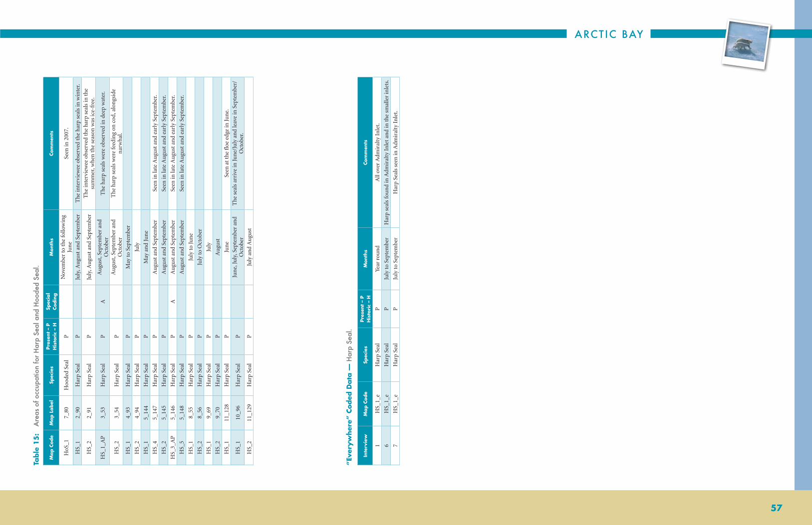
ARCTIC BAY
57
Table
15
: A
reas
of o
ccup
atio
n fo
r H
arp
Seal
and
Hoo
ded
Seal
.
Map C
ode
Map L
abel
Spec
ies
Pres
ent
– P
H
isto
ric
– H
Spec
ial
Codin
gM
onth
sCo
mm
ents
HoS
_17_
80H
oode
d Se
alP
N
ovem
ber
to t
he fo
llow
ing
Jun
eSe
en in
200
7.
HS_
12_
90H
arp
Seal
P
July
, Au
gust
an
d Se
ptem
ber
The
inte
rvie
wee
obs
erve
d th
e ha
rp s
eals
in w
inte
r.
HS_
22_
91H
arp
Seal
P
July
, Au
gust
an
d Se
ptem
ber
The
inte
rvie
wee
obs
erve
d th
e ha
rp s
eals
in t
he
sum
mer
, whe
n t
he s
easo
n w
as ic
e-fr
ee.
HS_
1_A
P3_
53H
arp
Seal
PA
Au
gust
, Sep
tem
ber
and
Oct
ober
The
har
p se
als
wer
e ob
serv
ed in
dee
p w
ater
.
HS_
23_
54H
arp
Seal
P
Au
gust
, Sep
tem
ber
and
Oct
ober
The
har
p se
als
wer
e fe
edin
g on
cod
, alo
ngs
ide
nar
wha
l.
HS_
14_
93H
arp
Seal
P
May
to S
epte
mbe
r
HS_
24_
94H
arp
Seal
P
July
HS_
15_
144
Har
p Se
alP
M
ay a
nd
Jun
e
HS_
45_
147
Har
p Se
alP
A
ugu
st a
nd
Sept
embe
rSe
en in
late
Au
gust
an
d ea
rly
Sept
embe
r.
HS_
25_
145
Har
p Se
alP
A
ugu
st a
nd
Sept
embe
rSe
en in
late
Au
gust
an
d ea
rly
Sept
embe
r.
HS_
3_A
P5_
146
Har
p Se
alP
AA
ugu
st a
nd
Sept
embe
rSe
en in
late
Au
gust
an
d ea
rly
Sept
embe
r.
HS_
55_
148
Har
p Se
alP
A
ugu
st a
nd
Sept
embe
rSe
en in
late
Au
gust
an
d ea
rly
Sept
embe
r.
HS_
18_
55H
arp
Seal
P
July
to Ju
ne
HS_
28_
56H
arp
Seal
P
July
to O
ctob
er
HS_
19_
69H
arp
Seal
P
July
HS_
29_
70H
arp
Seal
P
Au
gust
HS_
111
_128
Har
p Se
alP
Ju
ne
Seen
at
the
floe
edg
e in
Jun
e.
HS_
110
_96
Har
p Se
alP
Ju
ne,
July
, Sep
tem
ber
and
Oct
ober
The
sea
ls a
rriv
e in
Jun
e/Ju
ly a
nd
leav
e in
Sep
tem
ber/
Oct
ober
.
HS_
211
_129
Har
p Se
alP
Ju
ly a
nd
Au
gust
Inte
rvie
wM
ap C
ode
Spec
ies
Pres
ent
– P
H
isto
ric
– H
Mon
ths
Com
men
ts
1H
S_1_
eH
arp
Seal
PYe
ar r
oun
dA
ll ov
er A
dmir
alty
In
let.
6H
S_1_
eH
arp
Seal
PJu
ly to
Sep
tem
ber
Har
p se
als
fou
nd
in A
dmir
alty
In
let
and
in t
he s
mal
ler
inle
ts.
7H
S_1_
eH
arp
Seal
PJu
ly to
Sep
tem
ber
Har
p Se
als
seen
in A
dmir
alty
In
let.
“Eve
ryw
here
” Co
ded
Data
— H
arp
Seal
.

NUNAVUT COASTAL RESOURCE INVENTORY
58
1_83
1_84
1_85
1_81
1_82
2_85
2_87
3_46
3_44
3_45
3_43
3_48
4_89
4_85
4_86
4_87
4_88
5_13
7
5_14
2
5_14
1
5_13
8
5_13
9
5_14
0
5_14
3
6_73
6_71
6_74
6_72
7_73
7_75
7_74 8_
51
8_52
8_53
9_66
9_67
10_9
1
10_9
2
10_9
0
10_9
3
11_1
2411
_123
11_1
25
11_1
22
11_1
21
11_1
26
1_86
80°0
'0"W
82°0
'0"W
82°0
'0"W
84°0
'0"W
84°0
'0"W
86°0
'0"W
86°0
'0"W
88°0
'0"W88
°0'0
"W
90°0
'0"W
90°0
'0"W
74°0'0"N
74°0'0"N
73°0'0"N
73°0'0"N
72°0'0"N
72°0'0"N
71°0'0"N
71°0'0"N
Wal
rus
1:1,
350,
000
Dat
a S
ourc
e: N
TDB
1:25
0 00
0; A
rctic
Bay
inte
rvie
ws
Inte
rvie
w1 2 3 4 5 6 7 8 9 10 11
Be
rnie
r B
ay
Be
rnie
r B
ay
La
nc
as
ter
So
un
dL
an
ca
ste
r S
ou
nd
DE
VO
N I
SL
AN
DD
EV
ON
IS
LA
ND
Figur
e 1
8:
Are
as o
f occ
upat
ion
for
Wal
rus.

ARCTIC BAY
59
Table
16
: A
reas
of o
ccup
atio
n fo
r W
alru
s.
Map C
ode
Map L
abel
Spec
ies
Pres
ent
– P
H
isto
ric
– H
Spec
ial
Codin
gM
onth
sCo
mm
ents
Wal
_31_
83W
alru
sP
Wal
_41_
84W
alru
sP
Wal
_51_
85W
alru
sP
Wal
_11_
81W
alru
sP
Wal
_21_
82W
alru
sP
Wal
_61_
86W
alru
sP
Se
ptem
ber
and
Oct
ober
The
wal
rus
wer
e ob
serv
ed le
avin
g A
dmir
alty
In
let.
Wal
_12_
85W
alru
sP
M
ay
Wal
_22_
86W
alru
sP
M
ay
Wal
_32_
87W
alru
sP
M
ay
Wal
_43_
46W
alru
sP
Ju
ly, A
ugu
st a
nd
Sept
embe
rT
he in
terv
iew
ee o
bser
ved
appr
oxim
atel
y th
ree
wal
rus,
ea
tin
g se
als.
Wal
_23_
44W
alru
sP
Ju
ly, A
ugu
st a
nd
Sept
embe
rT
he w
alru
s w
ere
obse
rved
eat
ing
seal
s.
Wal
_33_
45W
alru
sP
Ju
ly, A
ugu
st a
nd
Sept
embe
rT
he w
alru
s w
ere
obse
rved
eat
ing
seal
s.
Wal
_13_
43W
alru
sP
A
pril,
May
an
d Ju
ne
The
wal
rus
wer
e ob
serv
ed e
atin
g cl
ams.
Wal
_63_
48W
alru
sP
A
pril
and
May
The
wal
rus
wer
e ob
serv
ed e
atin
g cl
ams.
Wal
_54_
89W
alru
sP
A
ugu
st
Wal
_14_
85W
alru
sP
A
ugu
st
Wal
_24_
86W
alru
sP
Ju
ly a
nd
Au
gust
The
inte
rvie
wee
cau
ght
a w
alru
s in
thi
s ar
ea.
Wal
_34_
87W
alru
sP
M
ay
Wal
_44_
88W
alru
sP
Ju
ly
Wal
_15_
137
Wal
rus
P
May
an
d Ju
ne
The
inte
rvie
wee
saw
fou
r or
five
wal
rus
from
May
to E
arly
Ju
ne.
Wal
_65_
142
Wal
rus
P
May
an
d Ju
ne
Seen
at
the
floe
edg
e.
Wal
_55_
141
Wal
rus
P
Sept
embe
r an
d O
ctob
erT
he in
terv
iew
ee s
aw t
wo,
bot
h ca
ugh
t in
200
4.
Wal
_25_
138
Wal
rus
P
Au
gust
Seen
in la
te A
ugu
st; a
mot
her
and
baby
.
Wal
_35_
139
Wal
rus
P
Au
gust
Seen
in la
te A
ugu
st; a
mot
her
and
baby
.
Wal
_45_
140
Wal
rus
P
Au
gust
Seen
in la
te A
ugu
st; a
bab
y W
alru
s w
ashe
d u
p on
sho
re.
Wal
_75_
143
Wal
rus
P
Oct
ober
Seen
thr
ough
cra
cks
in t
he ic
e.
Wal
_36_
73W
alru
sP
A
pril,
May
an
d Ju
ne
Wal
_16_
71W
alru
sP
A
pril,
May
an
d Ju
ne
Wal
_46_
74W
alru
sP
A
pril,
May
an
d Ju
ne
Wal
_26_
72W
alru
sP
A
pril,
May
an
d Ju
ne
Wal
_1_A
P7_
73W
alru
sP
AN
ovem
ber
to t
he fo
llow
ing
Mar
ch
Wal
_37_
75W
alru
sP
Ju
ne
to S
epte
mbe
r
Wal
_2_A
P7_
74W
alru
sP
AN
ovem
ber
to t
he fo
llow
ing
Mar
ch
Wal
_18_
51W
alru
sP
Fe
bru
ary
to Ju
ne
Wal
_28_
52W
alru
sP
A
ugu
st
Wal
_38_
53W
alru
sP
A
ugu
st
Wal
_19_
66W
alru
sP
Ju
lySe
en a
t th
e fl
oe e
dge.
Wal
_29_
67W
alru
sP
A
ugu
st
Wal
_210
_91
Wal
rus
P
Apr
ilT
he in
terv
iew
ee s
aw o
ne
craw
ling
on t
he ic
e to
war
ds o
pen
w
ater
at
Lan
cast
er S
oun
d.
Wal
_310
_92
Wal
rus
P
July
, Au
gust
an
d Se
ptem
ber
The
inte
rvie
wee
cau
ght
a m
othe
r an
d ba
by w
alru
s.
Wal
_110
_90
Wal
rus
P
Apr
il an
d M
ayW
alru
s co
me
and
go in
thi
s ar
ea.
Wal
_410
_93
Wal
rus
P
July
, Au
gust
an
d Se
ptem
ber
Wal
_411
_124
Wal
rus
P
Year
rou
nd
Wal
_311
_123
Wal
rus
P
Jun
e
Wal
_511
_125
Wal
rus
P
Mar
ch a
nd
Apr
il
Wal
_211
_122
Wal
rus
P
Year
rou
nd
Wal
_111
_121
Wal
rus
P
Year
rou
nd
Wal
_6_H
11_1
26W
alru
sH
N
ovem
ber

NUNAVUT COASTAL RESOURCE INVENTORY
601_
103
2_96
2_95
2_94
2_93
3_60
3_59
3_57
5_16
3
5_16
8
5_16
4
5_16
5
5_17
1
5_16
2
5_16
0 5_16
1
5_16
9
5_15
8
5_15
7
5_15
9
5_17
0
5_16
6
5_16
7
6_81
9_74
9_75
11_1
33
2_97
8_61
1_10
4
80°0
'0"W
82°0
'0"W
82°0
'0"W
84°0
'0"W
84°0
'0"W
86°0
'0"W
86°0
'0"W
88°0
'0"W88
°0'0
"W
90°0
'0"W
90°0
'0"W
74°0'0"N
74°0'0"N
73°0'0"N
73°0'0"N
72°0'0"N
72°0'0"N
71°0'0"N
71°0'0"N
Pola
r Bea
r*
1:1,
350,
000
Dat
a S
ourc
e: N
TDB
1:25
0 00
0; A
rctic
Bay
inte
rvie
ws
Inte
rvie
w
Be
rnie
r B
ay
Be
rnie
r B
ay
La
nc
as
ter
So
un
dL
an
ca
ste
r S
ou
nd
DE
VO
N I
SL
AN
DD
EV
ON
IS
LA
ND
Figur
e 1
9:
Are
as o
f occ
upat
ion
for
Pola
r Be
ar.

ARCTIC BAY
61
Table
17
: A
reas
of o
ccup
atio
n fo
r Po
lar
Bear
.
Map C
ode
Map L
abel
Spec
ies
Pres
ent
– P
H
isto
ric
– H
Spec
ial
Codin
gM
onth
sCo
mm
ents
PB
_1_S
P1_
103
Pola
r B
ear
PS
Jan
uar
y an
d D
ecem
ber
Pola
r be
ars
retr
eat
to a
den
bet
wee
n
Dec
embe
r an
d Fe
bru
ary.
PB
_2_S
MP
1_10
4Po
lar
Bea
rP
S, M
PB
_42_
96Po
lar
Bea
rP
Ye
ar r
oun
d
PB
_32_
95Po
lar
Bea
rP
Ye
ar r
oun
d
PB
_22_
94Po
lar
Bea
rP
Ye
ar r
oun
d
PB
_12_
93Po
lar
Bea
rP
Ye
ar r
oun
dPo
lar
bear
nu
mbe
rs in
the
inle
t ar
e in
crea
sin
g. T
hey
are
fou
nd
mos
tly
in a
reas
w
ith
stro
ng
curr
ents
.
PB
_52_
97Po
lar
Bea
rP
Ye
ar r
oun
dT
his
area
is w
here
pol
ar b
ears
are
tr
adit
ion
ally
hu
nte
d.
PB
_43_
60Po
lar
Bea
rP
Fe
bru
ary
PB
_33_
59Po
lar
Bea
rP
Fe
bru
ary
PB
_13_
57Po
lar
Bea
rP
Fe
bru
ary
PB
_85_
163
Pola
r B
ear
P
Nov
embe
r to
the
follo
win
g M
arch
A m
ajor
hu
nti
ng
grou
nd
in M
arch
.
PB
_13
5_16
8Po
lar
Bea
rP
M
arch
, Apr
il an
d M
ay
PB
_95_
164
Pola
r B
ear
P
Sept
embe
r an
d O
ctob
er
PB
_10
5_16
5Po
lar
Bea
rP
Se
ptem
ber,
Oct
ober
an
d N
ovem
ber
PB
_16
5_17
1Po
lar
Bea
rP
PB
_75_
162
Pola
r B
ear
P
Au
gust
an
d Se
ptem
ber
PB
_55_
160
Pola
r B
ear
P
Au
gust
an
d Se
ptem
ber
PB
_65_
161
Pola
r B
ear
P
Nov
embe
r to
the
follo
win
g M
arch
PB
_14
5_16
9Po
lar
Bea
rP
PB
_3_A
P5_
158
Pola
r B
ear
PA
Nov
embe
r
PB
_2_A
P5_
157
Pola
r B
ear
PA
Mar
ch a
nd
Apr
il
PB
_4_A
P5_
159
Pola
r B
ear
PA
Nov
embe
r
PB
_15
5_17
0Po
lar
Bea
rP
M
arch
, Apr
il an
d N
ovem
ber
PB
_11
5_16
6Po
lar
Bea
rP
M
arch
, Apr
il an
d M
ay
PB
_12
5_16
7Po
lar
Bea
rP
M
arch
, Apr
il an
d M
ay
PB
_2_A
P6_
81Po
lar
Bea
rP
AYe
ar r
oun
d
PB
_2_A
P8_
61Po
lar
Bea
rP
A
PB
_19_
74Po
lar
Bea
rP
Ye
ar r
oun
d
PB
_2_A
P9_
75Po
lar
Bea
rP
A
PB
_2_A
P11
_133
Pola
r B
ear
PA
Jan
uar
y an
d Fe
bru
ary
Inte
rvie
wM
ap C
ode
Spec
ies
Pres
ent
– P
H
isto
ric
– H
Mon
ths
Com
men
ts
3P
B_2
_ePo
lar
Bea
rP
Febr
uar
y
4P
B_1
_ePo
lar
Bea
rP
Year
rou
nd
Sin
ce t
he q
uot
a sy
stem
was
intr
odu
ced
sigh
tin
g of
pol
ar b
ears
has
in
crea
sed.
5P
B_1
_ePo
lar
Bea
rP
Year
rou
nd
6P
B_1
_ePo
lar
Bea
rP
July
to O
ctob
erSe
en m
ore
ofte
n a
t se
al h
oles
an
d le
ads.
7P
B_1
_ePo
lar
Bea
rP
Year
rou
nd
8P
B_1
_ePo
lar
Bea
rP
10P
B_1
_ePo
lar
Bea
rP
Year
rou
nd
11P
B_1
_ePo
lar
Bea
rP
Year
rou
nd
“Eve
ryw
here
” Co
ded
Data
— P
olar
Bea
r.

NUNAVUT COASTAL RESOURCE INVENTORY
62
6_84
6_53
4_10
4
3_62
1_94
1_92
1_90
1_91
1_93
2_10
0
3_61
4_10
3
5_18
15_17
8
5_17
9
5_18
0
7_84
7_85
8_65
8_66
9_78
9_79
10_1
00 10_1
0111_1
3611
_135
80°0
'0"W
82°0
'0"W
82°0
'0"W
84°0
'0"W
84°0
'0"W
86°0
'0"W
86°0
'0"W
88°0
'0"W88
°0'0
"W
90°0
'0"W
90°0
'0"W
74°0'0"N
74°0'0"N
73°0'0"N
73°0'0"N
72°0'0"N
72°0'0"N
71°0'0"N
71°0'0"N
Belu
ga
1:1,
350,
000
Dat
a S
ourc
e: N
TDB
1:25
0 00
0; A
rctic
Bay
inte
rvie
ws
Inte
rvie
w1 2 3 4 5 7 8 9 10 11 1 3 4 6
Be
rnie
r B
ay
Be
rnie
r B
ay
La
nc
as
ter
So
un
dL
an
ca
ste
r S
ou
nd
DE
VO
N I
SL
AN
DD
EV
ON
IS
LA
ND
Figur
e 2
0:
Are
as o
f occ
upat
ion
for
Belu
ga.

ARCTIC BAY
63
Table
18
: A
reas
of o
ccup
atio
n fo
r Be
luga
.
Map C
ode
Map L
abel
Spec
ies
Pres
ent
– P
H
isto
ric
– H
Spec
ial
Codin
gM
onth
sCo
mm
ents
Bel
_31_
92B
elu
gaP
A
pril
Bel
_11_
90B
elu
gaP
A
pril
Bel
_21_
91B
elu
gaP
Ju
lyT
he b
elu
gas
wer
e ob
serv
ed o
n Ju
ly 7
, 200
9.
Bel
_41_
93B
elu
gaP
Bel
_5_M
P1_
94B
elu
gaP
MA
pril,
Sep
tem
ber
and
Oct
ober
Bel
_12_
100
Bel
uga
P
Jun
e an
d Ju
ly
Bel
_13_
61B
elu
gaP
A
pril
Obs
erve
d at
the
floe
edg
e w
hile
mig
rati
ng
in
Apr
il.
Bel
_2_M
P3_
62B
elu
gaP
MA
pril
Bel
_14_
103
Bel
uga
P
Au
gust
Bel
_2_M
P4_
104
Bel
uga
PM
Jun
e
Bel
_45_
181
Bel
uga
P
Mar
chSe
en in
late
Mar
ch.
Bel
_15_
178
Bel
uga
P
Mar
chO
bser
ved
thro
ugh
ope
n c
rack
s in
the
ice,
in
mid
-Mar
ch.
Bel
_25_
179
Bel
uga
P
Oct
ober
In e
arly
Oct
ober
bel
uga
wer
e ob
serv
ed fe
edin
g.
Bel
_35_
180
Bel
uga
P
Au
gust
Seen
in la
te A
ugu
st, o
ne
belu
ga t
rave
ling
wit
h n
arw
hal.
Bel
_26_
84B
elu
gaP
A
ugu
st a
nd
Sept
embe
r
Bel
_1_M
P6_
53B
elu
gaP
MM
ay a
nd
Jun
e
Bel
_17_
84B
elu
gaP
A
pril,
May
an
d Ju
ne
Bel
_27_
85B
elu
gaP
Ju
ly, A
ugu
st a
nd
Sept
embe
r
Bel
_18_
65B
elu
gaP
A
pril,
May
an
d Ju
ne
Bel
uga
are
the
firs
t w
hale
s to
com
e in
.
Bel
_2_A
H8_
66B
elu
gaH
A
Bel
_19_
78B
elu
gaP
Ju
ne
Bel
_29_
79B
elu
gaP
Ju
ly, A
ugu
st a
nd
Sept
embe
r
Bel
_110
_100
Bel
uga
P
July
to O
ctob
er
Bel
_210
_101
Bel
uga
P
Apr
il an
d M
ay
Bel
_211
_136
Bel
uga
P
Jun
e, Ju
ly a
nd
Au
gust
Bel
_111
_135
Bel
uga
P
May
, Ju
ne
and
July

NUNAVUT COASTAL RESOURCE INVENTORY
64
4_10
5
8_70
3_69
10_1
05
2_10
1
3_70
4_10
6
5_20
0
5_19
9
5_19
65_19
7
5_19
8
5_20
1
6_88
6_87
6_89
9_84
9_83
10_1
04
10_1
06
11_1
39
11_1
41
11_1
40
80°0
'0"W
82°0
'0"W
82°0
'0"W
84°0
'0"W
84°0
'0"W
86°0
'0"W
86°0
'0"W
88°0
'0"W88
°0'0
"W
90°0
'0"W
90°0
'0"W
74°0'0"N
74°0'0"N
73°0'0"N
73°0'0"N
72°0'0"N
72°0'0"N
71°0'0"N
71°0'0"N
Bow
head
Wha
le*
1:1,
350,
000
Dat
a S
ourc
e: N
TDB
1:25
0 00
0; A
rctic
Bay
inte
rvie
ws
Inte
rvie
w2 3 4 5 6 9 10 11 3 4 8 10
Be
rnie
r B
ay
Be
rnie
r B
ay
La
nc
as
ter
So
un
dL
an
ca
ste
r S
ou
nd
DE
VO
N I
SL
AN
DD
EV
ON
IS
LA
ND
Figur
e 2
1:
Are
as o
f occ
upat
ion
for
Bow
head
.

ARCTIC BAY
65
Table
19
: A
reas
of o
ccup
atio
n fo
r Bo
whe
ad.
Map C
ode
Map L
abel
Spec
ies
Pres
ent
– P
H
isto
ric
– H
Mon
ths
Com
men
ts
BW
_12_
101
Bow
head
Wha
leP
July
, Au
gust
an
d Se
ptem
ber
BW
_23_
70B
owhe
ad W
hale
PN
ovem
ber
to M
arch
Ove
r w
inte
red
in a
pol
ynya
.
BW
_13_
69B
owhe
ad W
hale
PM
ay
BW
_14_
105
Bow
head
Wha
leP
July
, Au
gust
an
d Se
ptem
ber
BW
_2_H
4_10
6B
owhe
ad W
hale
HN
ovem
ber
to t
he fo
llow
ing
Apr
il
BW
_55_
200
Bow
head
Wha
leP
Jun
e an
d Ju
ly
BW
_45_
199
Bow
head
Wha
leP
Au
gust
Seen
in la
te A
ugu
st.
BW
_15_
196
Bow
head
Wha
leP
Au
gust
BW
_25_
197
Bow
head
Wha
leP
Au
gust
an
d Se
ptem
ber
Seen
in la
te A
ugu
st a
nd
earl
y Se
ptem
ber.
BW
_35_
198
Bow
head
Wha
leP
Au
gust
Seen
in la
te A
ugu
st.
BW
_65_
201
Bow
head
Wha
leP
May
BW
_26_
88B
owhe
ad W
hale
PSe
ptem
ber
BW
_16_
87B
owhe
ad W
hale
PJu
ly, A
ugu
st a
nd
Sept
embe
r
BW
_36_
89B
owhe
ad W
hale
PA
ugu
st a
nd
Sept
embe
r
BW
_18_
70B
owhe
ad W
hale
P
The
DFO
/IQ
was
doi
ng
a pr
ojec
t th
at in
volv
ed s
tudy
ing
Bow
head
Wha
les
whe
n t
his
one
was
see
n.
BW
_29_
84B
owhe
ad W
hale
PJu
ly to
Oct
ober
N
ot s
een
ver
y of
ten
.
BW
_19_
83B
owhe
ad W
hale
PJu
ly to
Oct
ober
BW
_110
_104
Bow
head
Wha
leP
Nov
embe
r to
the
follo
win
g A
pril
BW
_310
_106
Bow
head
Wha
leP
Apr
il an
d M
ay
BW
_210
_105
Bow
head
Wha
leP
July
, Au
gust
an
d Se
ptem
ber
BW
_111
_139
Bow
head
Wha
leP
Jun
e
BW
_3_H
11_1
41B
owhe
ad W
hale
HN
ovem
ber
to t
he fo
llow
ing
May
BW
_211
_140
Bow
head
Wha
leP
July
to O
ctob
er
Inte
rvie
wM
ap C
ode
Spec
ies
Pres
ent
– P
H
isto
ric
– H
Mon
ths
Com
men
ts
7B
W_1
_eB
owhe
ad W
hale
PJu
ly to
Oct
ober
Bow
head
sig
htin
g w
ere
rare
bu
t ar
e n
ow s
een
mor
e fr
equ
entl
y.
“Eve
ryw
here
” Co
ded
Data
— B
owhe
ad.

NUNAVUT COASTAL RESOURCE INVENTORY
661_
98
3_63
1_87
1_88
1_89
2_98
4_10
1
4_10
25_
174
5_17
75_
175
5_17
35_
176
5_17
2
6_827_
83
7_82
8_62
8_64
8_63
9_76 9_
77
10_9
9
11_1
34
80°0
'0"W
82°0
'0"W
82°0
'0"W
84°0
'0"W
84°0
'0"W
86°0
'0"W
86°0
'0"W
88°0
'0"W88
°0'0
"W
90°0
'0"W
90°0
'0"W
74°0'0"N
74°0'0"N
73°0'0"N
73°0'0"N
72°0'0"N
72°0'0"N
71°0'0"N
71°0'0"N
Kille
r Wha
le a
nd R
ight
Wha
le
1:1,
350,
000
Dat
a S
ourc
e: N
TDB
1:25
0 00
0; A
rctic
Bay
inte
rvie
ws
Kill
er W
hale
by
inte
rvie
w1 2 4 5 6 7 8 9 10 11
Rig
ht W
hale
Be
rnie
r B
ay
Be
rnie
r B
ay
La
nc
as
ter
So
un
dL
an
ca
ste
r S
ou
nd
DE
VO
N I
SL
AN
DD
EV
ON
IS
LA
ND
Figur
e 2
2:
Are
as o
f occ
upat
ion
for
Kille
r W
hale
and
Rig
ht W
hale
.

ARCTIC BAY
67
Table
20
: A
reas
of o
ccup
atio
n fo
r Ki
ller
Wha
le a
nd R
ight
Wha
le.
Map C
ode
Map L
abel
Spec
ies
Pres
ent
– P
H
isto
ric
– H
Mon
ths
Com
men
ts
RW
_1_H
1_98
Rig
ht W
hale
HN
ovem
ber
to t
he fo
llow
ing
July
A R
ight
Wha
le w
as s
tran
ded
in a
pol
ynya
in 1
980.
KW
_11_
87K
iller
Wha
leP
Au
gust
The
inte
rvie
wee
obs
erve
d a
pod
of K
iller
wha
les
whi
le
retu
rnin
g to
Arc
tic
Bay
, whi
ch fo
rced
him
to d
etou
r.
KW
_21_
88K
iller
Wha
leP
Au
gust
KW
_31_
89K
iller
Wha
leP
Au
gust
KW
_12_
98K
iller
Wha
leP
July
, Au
gust
an
d Se
ptem
ber
Kill
er w
hale
s w
ere
obse
rved
hu
nti
ng
nar
wha
l.
KW
_13_
63K
iller
Wha
leP
Au
gust
an
d Se
ptem
ber
The
kill
er w
hale
s co
me
into
the
inle
t in
Au
gust
an
d in
crea
se in
nu
mbe
rs b
y Se
ptem
ber.
KW
_14_
101
Kill
er W
hale
PA
ugu
st
KW
_24_
102
Kill
er W
hale
PA
ugu
st T
he in
terv
iew
ee s
aw 8
.
KW
_35_
174
Kill
er W
hale
PA
ugu
stT
he in
terv
iew
ee o
bser
ved
mor
e th
an s
ix to
a d
ozen
in
late
Au
gust
.
KW
_65_
177
Kill
er W
hale
PSe
ptem
ber
The
inte
rvie
wee
obs
erve
d th
ree
in m
id S
epte
mbe
r.
KW
_45_
175
Kill
er W
hale
PA
ugu
st a
nd
Sept
embe
rT
he in
terv
iew
ee o
bser
ved
kille
r w
hale
s fe
edin
g on
n
arw
hal.
KW
_25_
173
Kill
er W
hale
PA
ugu
stT
he in
terv
iew
ee o
bser
ved
kille
r w
hale
s in
late
Au
gust
.
KW
_55_
176
Kill
er W
hale
PA
ugu
st
KW
_15_
172
Kill
er W
hale
PM
arch
an
d A
pril
The
inte
rvie
wee
obs
erve
d ki
ller
wha
les
hun
tin
g an
d ci
rclin
g n
arw
hal.
KW
_16_
82K
iller
Wha
leP
Au
gust
an
d Se
ptem
ber
Not
see
n o
ften
.
KW
_27_
83K
iller
Wha
leP
July
, Au
gust
an
d Se
ptem
ber
Seen
mor
e of
ten
tha
n u
sual
.
KW
_17_
82K
iller
Wha
leP
July
, Au
gust
an
d Se
ptem
ber
Seen
mor
e of
ten
tha
n u
sual
.
KW
_18_
62K
iller
Wha
leP
Au
gust
KW
_38_
64K
iller
Wha
leP
Au
gust
KW
_28_
63K
iller
Wha
leP
Au
gust
KW
_19_
76K
iller
Wha
leP
July
KW
_29_
77K
iller
Wha
leP
July
, Au
gust
an
d Se
ptem
ber
KW
_110
_99
Kill
er W
hale
PJu
ly to
Oct
ober
KW
_111
_134
Kill
er W
hale
PA
ugu
st, S
epte
mbe
r an
d O
ctob
er

NUNAVUT COASTAL RESOURCE INVENTORY
68
8_69
4_98
3_64
10_1
03
1_95
1_97
1_96
2_99
3_67
3_66
3_68
3_65
4_97
4_99
5_18
2
5_18
4
5_18
6
5_18
7
5_19
3
5_18
5
5_18
9
5_18
8
5_19
0
5_19
1
5_19
2
5_18
3
5_19
5
5_19
46_85
6_86
7_86
7_87
8_67
8_68
9_80
9_82
9_81
10_1
0211_1
38
11_1
37
80°0
'0"W
82°0
'0"W
82°0
'0"W
84°0
'0"W
84°0
'0"W
86°0
'0"W
86°0
'0"W
88°0
'0"W88
°0'0
"W
90°0
'0"W
90°0
'0"W
74°0'0"N
74°0'0"N
73°0'0"N
73°0'0"N
72°0'0"N
72°0'0"N
71°0'0"N
71°0'0"N
Nar
wha
l
1:1,
350,
000
Dat
a S
ourc
e: N
TDB
1:25
0 00
0; A
rctic
Bay
inte
rvie
ws
Inte
rvie
w1 2 3 4 5 6 7 8 9 10 11
Be
rnie
r B
ay
Be
rnie
r B
ay
La
nc
as
ter
So
un
dL
an
ca
ste
r S
ou
nd
DE
VO
N I
SL
AN
DD
EV
ON
IS
LA
ND
Figur
e 2
3:
Are
as o
f occ
upat
ion
for
Nar
wha
l.

ARCTIC BAY
69
Table
21
: A
reas
of o
ccup
atio
n fo
r N
arw
hal
Map C
ode
Map L
abel
Spec
ies
Pres
ent
– P
H
isto
ric
– H
Spec
ial
Codin
gM
onth
sCo
mm
ents
NW
_3_S
P1_
97N
arw
hal
PS
Jun
eT
he in
terv
iew
ee o
bser
ved
nar
wha
l fee
din
g, c
alvi
ng,
an
d n
urs
ing
thei
r yo
un
g. T
he n
arw
hal l
eft
the
inle
t in
Sep
tem
ber.
NW
_2_S
P1_
96N
arw
hal
PS
Jun
eT
he in
terv
iew
ee o
bser
ved
nar
wha
l fee
din
g, c
alvi
ng,
an
d n
urs
ing
thei
r yo
un
g. T
he n
arw
hal l
eft
the
inle
t in
Sep
tem
ber.
NW
_1_M
AP
1_95
Nar
wha
lP
A,M
Jun
eT
he in
terv
iew
ee o
bser
ved
15 n
arw
hals
at
this
lo
cati
on.
NW
_12_
99N
arw
hal
P
July
, Au
gust
an
d Se
ptem
ber
Nar
wh
al a
re u
sual
ly fo
un
d in
dee
p w
ater
, an
d on
ly
ente
r sh
allo
w w
ater
s w
hen
the
y ar
e hu
ngr
y.
NW
_4_F
P3_
67N
arw
hal
PF
Au
gust
an
d Se
ptem
ber
NW
_3_F
P3_
66N
arw
hal
PF
Au
gust
an
d Se
ptem
ber
The
nar
wha
l wer
e ob
serv
ed fe
edin
g in
Sep
tem
ber.
NW
_5_F
P3_
68N
arw
hal
PF
Au
gust
an
d Se
ptem
ber
NW
_2_F
P3_
65N
arw
hal
PF
Au
gust
an
d Se
ptem
ber
The
nar
wha
l wer
e ob
serv
ed fe
edin
g in
Sep
tem
ber.
NW
_13_
64N
arw
hal
P
May
In L
ate
May
the
nar
wha
l mov
e in
as
ice
brea
ks u
p.
NW
_24_
98N
arw
hal
P
Jun
e
NW
_1_H
4_97
Nar
wha
lH
A
ugu
st
NW
_34_
99N
arw
hal
P
July
, Au
gust
an
d Se
ptem
ber
NW
_15_
182
Nar
wha
lP
M
ay, J
un
e an
d Ju
ly
NW
_35_
184
Nar
wha
lP
A
ugu
st a
nd
Sept
embe
rSe
en in
late
Au
gust
an
d ea
rly
Sept
embe
r of
200
4.
NW
_55_
186
Nar
wha
lP
M
arch
an
d A
pril
NW
_65_
187
Nar
wha
lP
A
ugu
st
NW
_12
5_19
3N
arw
hal
P
Sept
embe
rSe
en in
late
Sep
tem
ber.
NW
_45_
185
Nar
wha
lP
A
ugu
st a
nd
Sept
embe
rSe
en in
mid
Sep
tem
ber,
for
the
past
six
yea
rs.
NW
_85_
189
Nar
wha
lP
A
ugu
stSe
en in
late
Au
gust
.
NW
_75_
188
Nar
wha
lP
A
ugu
st a
nd
Sept
embe
rSe
en in
late
Sep
tem
ber,
for
the
past
six
yea
rs.
NW
_95_
190
Nar
wha
lP
A
ugu
stSe
en in
late
Au
gust
.
NW
_10_
AP
5_19
1N
arw
hal
PA
Au
gust
Seen
in la
te A
ugu
st.
NW
_11
5_19
2N
arw
hal
P
Au
gust
Seen
in la
te A
ugu
st.
NW
_25_
183
Nar
wha
lP
Ju
ne
Seen
in la
te Ju
ne.
NW
_14_
H5_
195
Nar
wha
lH
Ju
lyN
ot s
een
in t
he a
rea
any
lon
ger
beca
use
of
boat
tr
affi
c. T
he n
arw
hal u
sed
to c
ome
into
the
are
a in
th
e se
con
d w
eek
of Ju
ly.
NW
_13
5_19
4N
arw
hal
P
Sept
embe
rSe
en in
ear
ly S
epte
mbe
r.
NW
_16_
85N
arw
hal
P
Apr
il, M
ay a
nd
Jun
e
NW
_26_
86N
arw
hal
P
July
, Au
gust
an
d Se
ptem
ber
The
Nar
wha
l m
ove
into
the
inle
t as
the
ice
erod
es.
NW
_17_
86N
arw
hal
P
Apr
il, M
ay a
nd
Jun
e
NW
_27_
87N
arw
hal
P
July
to O
ctob
er
NW
_18_
67N
arw
hal
P
NW
_28_
68N
arw
hal
P
NW
_3_H
8_69
Nar
wha
lH
NW
_19_
80N
arw
hal
P
July
to O
ctob
er
NW
_3_A
P9_
82N
arw
hal
PA
July
, Au
gust
an
d Se
ptem
ber
NW
_29_
81N
arw
hal
P
July
, Au
gust
an
d Se
ptem
ber
NW
_110
_102
Nar
wha
lP
A
pril
and
May
NW
_210
_103
Nar
wha
lP
Ju
ne
to O
ctob
er
Leav
e th
e in
let
in O
ctob
er.
NW
_211
_138
Nar
wha
lP
M
ay to
Oct
ober
NW
_111
_137
Nar
wh
alP
Ju
ne,
July
an
d A
ugu
st

NUNAVUT COASTAL RESOURCE INVENTORY
70
6_12
6
6_12
5
6_12
8
6_12
71_
115
4_11
5
4_11
7
4_11
6
4_11
8
4_11
9
4_12
0
5_21
9
5_24
7
5_22
0
5_22
1
6_11
6
6_11
8
6_11
7
6_11
5
7_11
2
7_11
77_
118
7_11
5
7_11
67_
119
7_11
3
7_11
4
8_83
8_86
8_85
8_84
9_10
2
10_1
29
10_1
28
10_1
27
10_1
25
10_1
26
7_11
11_
116
4_12
14_
123
4_12
2
5_23
1
5_23
2
9_10
5
10_1
31
10_1
306_11
9
4_12
6
4_12
5
4_12
4
1_11
7
10_1
34
10_1
32
10_1
33
10_1
35
10_1
4910
_148
6_13
5
5_23
6
5_23
5 5_23
4
80°0
'0"W
82°0
'0"W
82°0
'0"W
84°0
'0"W
84°0
'0"W
86°0
'0"W
86°0
'0"W
88°0
'0"W88
°0'0
"W
90°0
'0"W
90°0
'0"W
74°0'0"N
74°0'0"N
73°0'0"N
73°0'0"N
72°0'0"N
72°0'0"N
71°0'0"N
71°0'0"N
Red
Thr
oate
d Lo
on, Y
ello
w B
illed
Loo
n, K
ing
Eid
er, C
omm
on E
ider
, Lon
g-ta
iled
Duc
k,R
ock
Pta
rmig
an, W
illow
Pta
rmig
an, C
omm
on R
aven
and
Per
egrin
e Fa
lcon
1:1,
350,
000
Dat
a S
ourc
e: N
TDB
1:25
0 00
0; A
rctic
Bay
inte
rvie
ws
Spec
ies
Red
Thr
oate
d Lo
on
Yello
w B
illed
Loo
n
Kin
g E
ider
Com
mon
Eid
er
Long
Tai
led
Duc
k
Roc
k P
tarm
igan
Will
ow P
tarm
igan
Com
mon
Rav
en
Per
egrin
e Fa
lcon
Be
rnie
r B
ay
Be
rnie
r B
ay
La
nc
as
ter
So
un
dL
an
ca
ste
r S
ou
nd
DE
VO
N I
SL
AN
DD
EV
ON
IS
LA
ND
Figur
e 2
4:
Are
as o
f occ
upat
ion
for
Red
Thro
ated
Loo
n, Y
ello
w B
illed
Loo
n, K
ing
Eide
r, C
omm
on E
ider
, Lon
g-ta
iled
Duc
k,
Rock
Pta
rmig
an, W
illow
Pta
rmig
an, C
omm
on R
aven
and
Per
egrin
e Fa
lcon
.

ARCTIC BAY
71
Table
22
: A
reas
of o
ccup
atio
n fo
r Re
d Th
roat
ed L
oon,
Yel
low
Bill
ed L
oon,
Kin
g Ei
der,
Com
mon
Eid
er, L
ong-
taile
d D
uck,
Roc
k Pt
arm
igan
, Will
ow P
tarm
igan
, Com
mon
Rav
en a
nd P
ereg
rine
Falc
on.
Map C
ode
Map L
abel
Spec
ies
Pres
ent
– P
H
isto
ric
– H
Spec
ial
Codin
gM
onth
sCo
mm
ents
RT
L_1
6_12
5R
ed-T
hroa
ted
Loon
P
Jun
e, Ju
ly a
nd
Au
gust
YB
L_1
6_12
7Ye
llow
-Bill
ed L
oon
P
Jun
e, Ju
ly a
nd
Au
gust
KE
_1_S
P1_
115
Kin
g E
ider
PS
Jun
e, Ju
ly, A
ugu
st a
nd
Sept
embe
r
KE
_1_S
AP
4_11
5K
ing
Eid
erP
A, S
KE
_3_S
AP
4_11
7K
ing
Eid
erP
A, S
KE
_2_S
AP
4_11
6K
ing
Eid
erP
A, S
KE
_4_S
AP
4_11
8K
ing
Eid
erP
A, S
KE
_5_S
AP
4_11
9K
ing
Eid
erP
A, S
KE
_6_S
P4_
120
Kin
g E
ider
PS
KE
_1_S
P5_
219
Kin
g E
ider
P
Jun
eN
esti
ng
Kin
g E
ider
du
cks.
KE
_45_
247
Kin
g E
ider
P
May
an
d Ju
ne
KE
_2_S
P5_
220
Kin
g E
ider
PS
Jun
e
KE
_3_S
P5_
221
Kin
g E
ider
PS
Jun
e
KE
_26_
116
Kin
g E
ider
P
Jun
e, Ju
ly a
nd
Au
gust
KE
_4_S
P6_
118
Kin
g E
ider
PS
KE
_36_
117
Kin
g E
ider
P
KE
_16_
115
Kin
g E
ider
P
Jun
e, Ju
ly a
nd
Au
gust
KE
_2_S
AP
7_11
2K
ing
Eid
erP
A, S
KE
_1_S
AP
7_11
1K
ing
Eid
erP
A, S
KE
_7_S
P7_
117
Kin
g E
ider
PS
KE
_8_S
P7_
118
Kin
g E
ider
PS
KE
_5_S
AP
7_11
5K
ing
Eid
erP
A, S
KE
_6_S
AP
7_11
6K
ing
Eid
erP
A, S
KE
_9_S
P7_
119
Kin
g E
ider
PS
KE
_3_S
AP
7_11
3K
ing
Eid
erP
A, S
KE
_4_S
AP
7_11
4K
ing
Eid
erP
A, S
KE
_1_S
P8_
83K
ing
Eid
erP
S
KE
_4_S
P8_
86K
ing
Eid
erP
S
KE
_3_S
P8_
85K
ing
Eid
erP
S
KE
_2_S
P8_
84K
ing
Eid
erP
S
KE
_1_S
P9_
102
Kin
g E
ider
PS
KE
_5_S
P10
_129
Kin
g E
ider
PS
KE
_4_S
P10
_128
Kin
g E
ider
PS
KE
_3_S
P10
_127
Kin
g E
ider
PS
KE
_1_S
P10
_125
Kin
g E
ider
PS
KE
_2_S
P10
_126
Kin
g E
ider
PS
CE
_2_S
P1_
117
Com
mon
Eid
erP
SJu
ne,
July
, Au
gust
an
d Se
ptem
ber
CE
_1_S
P1_
116
Com
mon
Eid
erP
SJu
ne,
July
, Au
gust
an
d Se
ptem
ber
CE
_1_S
AP
4_12
1C
omm
on E
ider
PA
, S
CE
_3_S
AP
4_12
3C
omm
on E
ider
PA
, S
CE
_2_S
AP
4_12
2C
omm
on E
ider
PA
, S
CE
_4_S
AP
4_12
4C
omm
on E
ider
PA
, S
CE
_5_S
AP
4_12
5C
omm
on E
ider
PA
, S
CE
_6_S
P4_
126
Com
mon
Eid
erP
S
CE
_25_
231
Com
mon
Eid
erP
M
ay a
nd
Jun
e
CG
_15_
232
Com
mon
Eid
erP
CE
_1_S
P6_
119
Com
mon
Eid
erP
S
CE
_1_S
P9_
105
Com
mon
Eid
erP
S
CE
_1_S
P10
_130
Com
mon
Eid
erP
S
CE
_2_S
P10
_131
Com
mon
Eid
erP
S
OS_
4_SP
10_1
35Lo
ng-
Tai
led
duck
PS
OS_
3_SP
10_1
34Lo
ng-
Tai
led
duck
PS
OS_
1_SP
10_1
32Lo
ng-
Tai
led
duck
PS
OS_
2_SP
10_1
33Lo
ng-
Tai
led
duck
PS
RP
tar_
110
_149
Roc
k P
tarm
igan
P
WP
tar_
110
_148
Will
ow P
tarm
igan
P
CR
_16_
135
Com
mon
Rav
enP
PF_
3_SP
5_23
6Pe
regr
ine
Falc
onP
SJu
ne
to S
epte
mbe
r
PF_
2_SP
5_23
5Pe
regr
ine
Falc
onP
SJu
ne
to S
epte
mbe
r
PF_
1_SP
5_23
4Pe
regr
ine
Falc
onP
SJu
ne
to S
epte
mbe
rSe
en e
very
su
mm
er.
RT
L_2
6_12
6R
ed-T
hroa
ted
Loon
P
Jun
e, Ju
ly a
nd
Au
gust
YB
L_2
6_12
8Ye
llow
-Bill
ed L
oon
P
Jun
e, Ju
ly a
nd
Au
gust

NUNAVUT COASTAL RESOURCE INVENTORY
72
1_11
4
2_12
2
2_12
32_12
1
3_79
3_78
3_77
3_76
4_13
6
4_13
7
4_13
84_
140
4_13
9
4_14
1
4_14
2
4_14
3
5_21
7
5_21
6
5_21
8
6_11
2
6_11
3
6_11
4
6_10
9
6_11
0
6_11
4
7_10
8
7_10
9
7_10
0
7_10
1
7_10
7
7_10
6
7_96
7_97
7_10
27_99 7_
98
7_10
4
7_10
3
7_10
5
8_829_
98
9_97
9_99
9_10
09_
101
10_1
2110_1
22
10_1
20
10_1
23
10_1
24
80°0
'0"W
82°0
'0"W
82°0
'0"W
84°0
'0"W
84°0
'0"W
86°0
'0"W
86°0
'0"W
88°0
'0"W88
°0'0
"W
90°0
'0"W
90°0
'0"W
74°0'0"N
74°0'0"N
73°0'0"N
73°0'0"N
72°0'0"N
72°0'0"N
71°0'0"N
71°0'0"N
Snow
Goo
se
1:1,
350,
000
Dat
a S
ourc
e: N
TDB
1:25
0 00
0; A
rctic
Bay
inte
rvie
ws
Inte
rvie
w1 2 3 4 5 6 7 8 9 10
Be
rnie
r B
ay
Be
rnie
r B
ay
La
nc
as
ter
So
un
dL
an
ca
ste
r S
ou
nd
DE
VO
N I
SL
AN
DD
EV
ON
IS
LA
ND
Figur
e 2
5:
Are
as o
f occ
upat
ion
for
Snow
Goo
se.

ARCTIC BAY
73
Table
23
: A
reas
of o
ccup
atio
n fo
r Sn
ow G
oose
.
Map C
ode
Map L
abel
Spec
ies
Pres
ent
– P
H
isto
ric
– H
Spec
ial
Codin
gM
onth
sCo
mm
ents
SG_1
_SP
1_11
4Sn
ow G
oose
PS
Jun
e to
Sep
tem
ber
The
inte
rvie
wee
obs
erve
d go
slin
gs in
Sep
tem
ber.
SG_2
_SP
2_12
2Sn
ow G
oose
PS
May
to S
epte
mbe
r
SG_3
_SP
2_12
3Sn
ow G
oose
PS
May
to S
epte
mbe
r
SG_1
_SP
2_12
1Sn
ow G
oose
PS
May
to S
epte
mbe
r
SG_4
_H3_
79Sn
ow G
oose
H
May
to S
epte
mbe
r
SG_3
_SA
P3_
78Sn
ow G
oose
PA
, SM
ay to
Sep
tem
ber
SG_2
_SA
P3_
77Sn
ow G
oose
PA
, SM
ay to
Sep
tem
ber
SG_1
_SA
P3_
76Sn
ow G
oose
PA
, SM
ay to
Sep
tem
ber
SG_1
_SP
4_13
6Sn
ow G
oose
PS
SG_2
_SP
4_13
7Sn
ow G
oose
PS
SG_3
_SP
4_13
8Sn
ow G
oose
PS
SG_5
_SA
P4_
140
Snow
Goo
seP
A, S
SG_4
_SP
4_13
9Sn
ow G
oose
PS
SG_6
_SP
4_14
1Sn
ow G
oose
PS
SG_7
_SP
4_14
2Sn
ow G
oose
PS
SG_8
_SA
P4_
143
Snow
Goo
seP
A, S
SG_2
_SP
5_21
7Sn
ow G
oose
PM
ay, J
un
e an
d Ju
ly
SG_1
_SA
P5_
216
Snow
Goo
seP
A, S
May
, Ju
ne
and
July
The
Sn
ow G
eese
arr
ive
in M
ay a
nd
nes
t in
Jun
e.
SG_3
5_21
8Sn
ow G
oose
P
May
, Ju
ne
and
July
SG_4
6_11
2Sn
ow G
oose
P
Jun
e, Ju
ly a
nd
Au
gust
SG_5
6_11
3Sn
ow G
oose
P
SG_1
6_10
9Sn
ow G
oose
P
Jun
e, Ju
ly a
nd
Au
gust
SG_2
6_11
0Sn
ow G
oose
P
Jun
e, Ju
ly a
nd
Au
gust
SG_6
6_11
4Sn
ow G
oose
P
SG_1
3_SP
7_10
8Sn
ow G
oose
PS
Jun
e
SG_1
4_SP
7_10
9Sn
ow G
oose
PS
Jun
e
SG_5
_SP
7_10
0Sn
ow G
oose
PS
Jun
eSo
d ho
use
/ C
amp.
SG_6
_SP
7_10
1Sn
ow G
oose
PS
Jun
e
SG_1
2_SP
7_10
7Sn
ow G
oose
PS
Jun
e
SG_1
1_SP
7_10
6Sn
ow G
oose
PS
Jun
e
SG_1
_SP
7_96
Snow
Goo
seP
SJu
ne
SG_2
_SP
7_97
Snow
Goo
seP
SJu
ne
SG_7
_SP
7_10
2Sn
ow G
oose
PS
Jun
e
SG_4
_SP
7_99
Snow
Goo
seP
SJu
ne
SG_3
_SP
7_98
Snow
Goo
seP
SJu
ne
SG_9
_SP
7_10
4Sn
ow G
oose
PS
Jun
e
SG_8
_SP
7_10
3Sn
ow G
oose
PS
Jun
e
SG_1
0_SP
7_10
5Sn
ow G
oose
PS
Jun
e
SG_1
_SP
8_82
Snow
Goo
seP
S
SG_2
_SP
9_98
Snow
Goo
seP
S
SG_1
_SP
9_97
Snow
Goo
seP
S
SG_3
_SP
9_99
Snow
Goo
seP
S
SG_4
_SP
9_10
0Sn
ow G
oose
PS
SG_5
_SP
9_10
1Sn
ow G
oose
PS
SG_2
_SP
10_1
21Sn
ow G
oose
PS
SG_3
_SP
10_1
22Sn
ow G
oose
PS
SG_1
_SP
10_1
20Sn
ow G
oose
PS
SG_4
_SP
10_1
23Sn
ow G
oose
PS
SG_5
_SP
10_1
24Sn
ow G
oose
PS

NUNAVUT COASTAL RESOURCE INVENTORY
74
Figur
e 2
6:
Are
as o
f occ
upat
ion
for
Arc
tic T
ern,
Thi
ck B
illed
Mur
re, B
lack
Gui
llem
ot, N
orth
ern
Fulm
ar, R
oss’
s G
ull,
Ivor
y G
ull,
Gla
ucou
s G
ull,
and
Gul
ls (u
nkno
wn
spec
ies)
.
4_14
4
4_14
5
5_22
7
6_12
4
6_12
2
6_12
3 6_12
1
7_13
1
7_13
2
7_12
8
7_12
9 7_13
3
7_12
7
7_13
0
8_92
9_10
4
10_1
39
10_1
38
10_1
36
10_1
37
1_11
9
5_22
9
10_1
46
3_75
5_22
8
10_1
471_
113
4_11
4
5_21
5
5_21
46_
134
7_11
0
8_90
9_10
6
10_1
45
4_11
33_
80
2_11
7
5_23
3
5_22
6
5_22
5
9_11
6
2_11
8
2_11
9
2_12
0
1_11
8
4_13
04_
133
4_13
1
4_13
2
4_13
5
5_22
4
5_22
3
6_13
16_
132
6_13
06_12
9
7_14
0
7_14
1
7_13
4
7_14
5
7_13
5
7_13
8
7_13
6
7_13
7
7_14
4
8_88
9_11
0
9_11
1
9_10
8
9_11
5
9_11
4
9_11
3
9_10
7
9_11
2
10_1
42
10_1
43
10_1
40
10_1
41
10_1
44
9_10
9
8_87
8_89
7_14
3
7_13
9
7_14
2
6_13
3
5_22
24_
134
4_12
9
80°0
'0"W
82°0
'0"W
82°0
'0"W
84°0
'0"W
84°0
'0"W
86°0
'0"W
86°0
'0"W
88°0
'0"W88
°0'0
"W
90°0
'0"W
90°0
'0"W
74°0'0"N
74°0'0"N
73°0'0"N
73°0'0"N
72°0'0"N
72°0'0"N
71°0'0"N
71°0'0"N
Arct
ic T
ern,
Thi
ck B
illed
Mur
re, B
lack
Gui
llem
ot, N
orth
ern
Fulm
ar, R
oss'
s G
ull,
Ivor
y G
ull,
Gla
ucou
s G
ull,
and
Gul
ls (u
nkno
wn
spec
ies)
1:1,
350,
000
Dat
a S
ourc
e: N
TDB
1:25
0 00
0; A
rctic
Bay
inte
rvie
ws
Spec
ies
Arct
ic T
ern
Thic
k B
illed
Mur
re
Blac
k G
uille
mot
Nor
ther
n Fu
lmar
Gla
ucou
s G
ull
Ivor
y G
ull
Ros
s's
Gul
l
Gul
ls -
unkn
own
spec
ies
Be
rnie
r B
ay
Be
rnie
r B
ay
La
nc
as
ter
So
un
dL
an
ca
ste
r S
ou
nd
DE
VO
N I
SL
AN
DD
EV
ON
IS
LA
ND

ARCTIC BAY
75
Table 23: Areas of occupation for Arctic Tern, Thick Billed Murre, Black Guillemot, Northern Fulmar, Ross’s Gull, Ivory Gull, Glaucous Gull, and Gulls (unknown species).
Map C
ode
Map L
abel
Spec
ies
Pres
ent
– P
H
isto
ric
– H
Spec
ial
Codin
gM
onth
sCo
mm
ents
AT
_1_S
AP
4_14
4A
rcti
c T
ern
PA
, S
AT
_2_S
P4_
145
Arc
tic
Ter
nP
S
AT
_1_A
H5_
227
Arc
tic
Ter
nH
A, S
Jun
e O
bser
ved
in 1
999.
AT
_4_S
P6_
124
Arc
tic
Ter
nP
S
AT
_26_
122
Arc
tic
Ter
nP
AT
_36_
123
Arc
tic
Ter
nP
AT
_16_
121
Arc
tic
Ter
nP
Ju
ly
AT
_5_S
P7_
131
Arc
tic
Ter
nP
S
AT
_6_S
P7_
132
Arc
tic
Ter
nP
S
AT
_2_S
P7_
128
Arc
tic
Ter
nP
S
AT
_3_S
P7_
129
Arc
tic
Ter
nP
S
AT
_7_S
P7_
133
Arc
tic
Ter
nP
S
AT
_1_S
P7_
127
Arc
tic
Ter
nP
S
AT
_4_S
P7_
130
Arc
tic
Ter
nP
S
AT
_1_S
AP
8_92
Arc
tic
Ter
nP
A, S
The
who
le I
slan
d is
cov
ered
wit
h G
ulls
.
AT
_1_S
P9_
104
Arc
tic
Ter
nP
S
AT
_4_S
P10
_139
Arc
tic
Ter
nP
S
AT
_3_S
P10
_138
Arc
tic
Ter
nP
S
AT
_1_S
P10
_136
Arc
tic
Ter
nP
S
AT
_2_S
P10
_137
Arc
tic
Ter
nP
S
TB
M_1
_AP
1_11
9T
hick
-Bill
ed M
urr
eP
A
TB
M_1
_AP
5_22
9T
hick
-Bill
ed M
urr
eP
AM
ay to
Sep
tem
ber
TB
M_1
_SP
10_1
46T
hick
-Bill
ed M
urr
eP
S
BG
_1_S
P3_
75B
lack
Gu
illem
otP
SM
ay to
Sep
tem
ber
BG
_1_A
P5_
228
Bla
ck G
uill
emot
PA
May
to S
epte
mbe
r
BG
_1_S
P10
_147
Bla
ck G
uill
emot
PS
NF_
1_SP
1_11
3N
orth
ern
Fu
lmar
PS
Apr
il, M
ay a
nd
Jun
eN
orth
ern
fulm
ars
nes
t he
re b
etw
een
mid
-Apr
il an
d Ju
ne.
NF_
1_SP
2_11
7N
orth
ern
Fu
lmar
PS
May
to S
epte
mbe
rLe
ss n
um
erou
s in
the
pas
t su
mm
er.
NF_
1_SA
P3_
80N
orth
ern
Fu
lmar
PA
, SM
ay to
Sep
tem
ber
NF_
1_SA
P4_
113
Nor
ther
n F
ulm
arP
A, S
NF_
24_
114
Nor
ther
n F
ulm
arP
NF_
25_
215
Nor
ther
n F
ulm
arP
May
, Ju
ne
and
July
NF_
1_SP
5_21
4N
orth
ern
Fu
lmar
PS
Apr
il to
Au
gust
The
Nor
ther
n F
ulm
ars
nes
t in
July
.
NF_
1_SA
P6_
134
Nor
ther
n F
ulm
arP
A, S
Jun
e, Ju
ly a
nd
Au
gust
NF_
1_SA
P7_
110
Nor
ther
n F
ulm
arP
A, S
NF_
1_SP
8_90
Nor
ther
n F
ulm
arP
S
NF_
1_SP
9_10
6N
orth
ern
Fu
lmar
PA
, S
NF_
1_SA
P10
_145
Nor
ther
n F
ulm
arP
A, S
RG
_15_
233
Ros
s's
Gu
llP
IG_2
_H5_
226
Ivor
y G
ull
H
May
an
d Ju
ne
Use
d to
be
Abu
nda
nt.
IG_1
5_22
5Iv
ory
Gu
llP
IG_1
_H9_
116
Ivor
y G
ull
H
GG
_1_S
P2_
118
Gla
uco
us
Gu
llP
SM
ay to
Sep
tem
ber
GG
_2_S
P2_
119
Gla
uco
us
Gu
llP
SM
ay to
Sep
tem
ber
GG
_32_
120
Gla
uco
us
Gu
llP
M
ay to
Sep
tem
ber
Gu
lls_1
1_11
8G
ulls
P
Gu
lls_1
4_12
9G
ulls
P
Gu
lls_2
4_13
0G
ulls
P
Gu
lls_5
_SA
P4_
133
Gu
llsP
A, S
Gu
lls_3
4_13
1G
ulls
P
Gu
lls_4
_SP
4_13
2G
ulls
PS
Gu
lls_6
4_13
4G
ulls
P
Gu
lls_7
_SP
4_13
5G
ulls
PS
Gu
lls_3
5_22
4G
ulls
P
May
, Ju
ne
and
July
Gu
lls_2
_SP
5_22
3G
ulls
PS
Jun
e
Gu
lls_1
_SP
5_22
2G
ulls
PS
Jun
eT
he G
ulls
inha
bit
the
oppo
site
sid
e of
the
Isl
and
to
the
duck
s.
Gu
lls_3
6_13
1G
ulls
P
Jun
e, Ju
ly a
nd
Au
gust
Gu
lls_4
6_13
2G
ulls
P
Jun
e, Ju
ly a
nd
Au
gust
Gu
lls_2
6_13
0G
ulls
P
Jun
e, Ju
ly a
nd
Au
gust
Gu
lls_1
6_12
9G
ulls
P
Jun
e, Ju
ly a
nd
Au
gust
Gu
lls_5
_SP
6_13
3G
ulls
PS
Gu
lls_7
_SA
P7_
140
Gu
llsP
A, S
Gu
lls_9
_SA
P7_
142
Gu
llsP
A, S
Gu
lls_8
_SA
P7_
141
Gu
llsP
A, S
Gu
lls_6
_SA
P7_
139
Gu
llsP
A, S
Gu
lls_1
_SA
P7_
134
Gu
llsP
A, S
Gu
lls_1
2_SA
P7_
145
Gu
llsP
A, S
Gu
lls_1
0_SA
P7_
143
Gu
llsP
A, S
Gu
lls_2
_SA
P7_
135
Gu
llsP
A, S
Gu
lls_5
_SA
P7_
138
Gu
llsP
A, S
Gu
lls_3
_SA
P7_
136
Gu
llsP
A, S
Gu
lls_4
_SA
P7_
137
Gu
llsP
A, S
Gu
lls_1
1_SA
P7_
144
Gu
llsP
A, S
Gu
lls_2
_SP
8_88
Gu
llsP
S
Gu
lls_3
_SP
8_89
Gu
llsP
S
Gu
lls_1
_SP
8_87
Gu
llsP
S
Table
24
: A
reas
of o
ccup
atio
n fo
r A
rctic
Ter
n, T
hick
Bill
ed M
urre
, Bla
ck G
uille
mot
, Nor
ther
n Fu
lmar
, Ros
s’s
Gul
l, Iv
ory
Gul
l, G
lauc
ous
Gul
l, an
d G
ulls
(unk
now
n sp
ecie
s).

NUNAVUT COASTAL RESOURCE INVENTORY
76
Map C
ode
Map L
abel
Spec
ies
Pres
ent
– P
H
isto
ric
– H
Spec
ial
Codin
gM
onth
sCo
mm
ents
Gu
lls_3
_SP
9_10
9G
ulls
PS
Gu
lls_4
_SP
9_11
0G
ulls
PS
Gu
lls_5
_SP
9_11
1G
ulls
PS
Gu
lls_2
_SP
9_10
8G
ulls
PS
Gu
lls_9
_SP
9_11
5G
ulls
PS
Gu
lls_8
_SP
9_11
4G
ulls
PS
Gu
lls_7
_SP
9_11
3G
ulls
PS
Gu
lls_1
9_10
7G
ulls
P
Gu
lls_6
_SP
9_11
2G
ulls
PS
Gu
lls_5
_SP
10_1
44G
ulls
PS
Gu
lls_3
_SP
10_1
42G
ulls
PS
Gu
lls_4
_SP
10_1
43G
ulls
PS
Gu
lls_1
_SP
10_1
40G
ulls
PS
Gu
lls_2
_SP
10_1
41G
ulls
PS
Table
24
(co
ntin
ued):
A
reas
of o
ccup
atio
n fo
r A
rctic
Ter
n, T
hick
Bill
ed M
urre
, Bla
ck G
uille
mot
, Nor
ther
n Fu
lmar
, Ros
s’s
Gul
l, Iv
ory
Gul
l, G
lauc
ous
Gul
l, an
d G
ulls
(unk
now
n sp
ecie
s).

ARCTIC BAY
77

NUNAVUT COASTAL RESOURCE INVENTORY
78
Figure 27: Nunavut Atlas: Admiralty Inlet

ARCTIC BAY
79
Admiralty Inlet
1. Polar Bears
Polar bears concentrate on the ice along the north coasts
of Bylot Island, Borden and Brodeur peninsulas and at
the mouth of Admiralty Inlet in spring. The mouths of
Navy Board and Admiralty inlets and the offshore areas of
Lancaster Sound are important spring habitats where bears
hunt seals and breed along the floe edges and in unstable
offshore ice.
2. Seabirds
A large numbers of seabirds, which include northern
fulmars, thick-billed murres, black guillemots, black-
legged kittiwakes, and dovekies, feed intensively during
summer and fall throughout the northern marine area.
3. Polar Bears
The north and west coasts of Bylot Island and the northern
tips of Borden and Brodeur peninsulas, extending inland
for approximately 25 km, are used by polar bears for
maternity denning in the fall and winter. These areas also
provide summer sanctuary when the disappearance of ice
forces bears onto land. Summer sanctuaries maybe part
of particular importance to pregnant females and family
groups.
4. Seabirds
The high, steep cliffs between Baillarge Bay and Elwin
Inlet provide critical nesting habitat for a large population
of northern fulmars, estimated at approximately 25,000
breeding pairs.
5. Seabirds
Seabirds, thought to be primarily black-legged kittiwakes
of unknown numbers, nest on the cliffs along the southern
edge of these cliffs.
6. Seabirds
The steep coastal cliffs west of Cape Hay provide critical
nesting habitat for one of the largest colonies of thick-
billed murres and black-legged kittiwakes in Lancaster
Sound. The colony is estimated to contain approximately
20,000 breeding pairs of murres. Small numbers of glacous
gulls and black guillemots also nest in the area.
7. Waterfowl
Small numbers of greater snow geese often use these areas
for nesting and molting. The areas around eclipse sound
and Milne Inlet are generally well-vegetated and the coastal
portions of these areas may be particularly important as
fall staging areas for snow geese.
8. Polar Bears
The east coast of the Brodeur Peninsula and the east
and west coasts of Borden Peninsula, extending inland
for approximately 20 km, and the ice in Admiralty Inlet,
provide summer retreats for polar bears. Milne Inlet is also
a summer area for polar bears. Ice remains well into the
summer, allowing bears to prolong their hunting of seals.
9. Seabirds
A nesting colony of the rare ivory gull, visited many years
ago for egg collection, has been reported by Inuit from
Arctic Bay. The colony was thought to be somewhere in
this northeastern portion of the Brodeur Peninsula. There
is no current information as to its location, size or actual
existence.
10. Seabirds
A small colony of Thayer’s gulls is reported to be nesting
on the cliffs in this area.
11. Raptors
The numerous cliff faces throughout most of southwestern
Borden Peninsula provide optimal nesting habitat for
raptors, primarily rough-legged hawks and gyrfalcons.
Small numbers of the rare and endangered peregrine
falcons may also be found in the area, and their nesting
areas are considered critical. Little is presently known
about the raptor populations within this region.
12. Caribou
The barren-ground caribou of northern Baffin Island
are thought to be non-migratory although they make
local seasonal shifts in their ranges. The entire caribou
population of northern Baffin Island is thought to be
small and may number at most s few thousand. Only small
numbers of caribou are likely to be found throughout
this area, with the most being found in Moffet Inlet. On
occasion small numbers of caribou may be found in winter
along the east coast of Brodeur Peninsula.
13. Polar Bears
The west coast of Steensby Peninsula, extending inland for
approximately 15 km, provides suitable habitat for polar
bears in fall and winter.
14. Polar Bears
The Ragged Island area in Eclipse Sound provides polar
bear fall and winter denning habitat.
15. Waterfowl
The southwest portion of Bylot Island is a well-vegetated
outwash plain that supports a large proportion if the
world’s populations of greater snow geese and a variety
of other birds. Thousands of greater snow geese use this
critical habitat for nesting and molting. These snow geese
nest in small loose colonies, ranging in size from 25-300
nests which area usually located within several kilometers
if the coast. During summer, the geese gradually disperse
throughout the entire area, whenever suitable feeding
meadows are available. Large numbers of red-throated
loons, oldsquaws (long-tailed duck), king eiders and
many species of shorebirds nest in this area. Snowy owls
are particularly abundant within the area. Abundance
and nesting activity of this species are likely regulated by
the availability of the cyclic prey species, primarily the
lemming.
16. Bowheads
A few bowhead whales summer and feed in the open waters
of Lancaster Sound.
17. Seabirds
Small nesting colonies of gulls are found on the cliffs in
these areas.
18. Narwhals, Seals, Belugas and Walruses
Narwhals enter Lancaster Sound in small numbers in May
and reach peak migration though the area in mid-July. An
estimated 8,000-10,000narwhals move westward past Cape
Hay on Bylot Island in late June and July. Their destinations
are deep inlets and fiords of northern Baffin Island and the
central Arctic Archipelago, such as Admiralty Inlet, Navy
Board Inlet, Prince Regent Inlet, and Peel Sound. During
migration, about half of the whales travel offshore, while
the remainder travels along both coasts of Lancaster Sound.
The return eastward movement follows similar routes in
September. In addition, as many as 150,000 harp seals may
enter Lancaster Sound in summer, traveling westward past
Cape Hay in July, and returning eastward in September.
19. Bowheads
A small number of endangered bowhead as well as some
killer whales enter Admiralty Inlet in the summer to feed
in the deep water. Come concentrate along the ice floe
edge. A few of these whales move further west offshore,
and return in September or October.
20. Bowheads
Small numbers of endangered bowhead whales occur in
the southern Admiralty Inlet in the summer. Killer whales
are also encountered in this area in late summer where they
hunt narwhals and seals.

NUNAVUT COASTAL RESOURCE INVENTORY
80
Figure 27 (continued): Nunavut Atlas: Admiralty Inlet
21. Narwhals and Seals
A large number of narwhals enter Navy Board Inlet as the
ice breaks up in July to summer in this inlet and in Eclipse
Sound. Many harp seals follow a similar route in July. Both
narwhals and harp seals return to the northeast before
freeze-up.
22. Bowheads
Small numbers of endangered bowhead whale and some
killer whales move into Eclipse Sound and Milne Inlet
from the east each summer. They leave the area before
freeze-up in the fall.
23. Bowheads
A small number of endangered bowhead whales move
westward past Cape Hay in June and July. Some remain
in open waters of Lancaster Sound during the summer
while others continue to Navy Board Inlet and Admiralty
Inlet. Bowheads return in September and October, moving
eastward into Baffin Bay.
24. Narwhals, Belugas, Walruses and Seals
Large numbers of narwhals gather at the ice floe edge near
the mouth of Admiralty Inlet in June, while awaiting break-
up of the ice in the inlet. Other species which concentrate
here in late spring include beluga whales, walruses, ringed
seals, bearded seals and harp seals.
25. Narwhals
Thousands of narwhals move south along the west side of
Admiralty Inlet in late July and August with the ice break-
up. Some narwhals may also migrate along the east side of
the inlet. In September these whales return north along
similar routes before freeze-up.
26. Narwhals and Seals
Narwhals occur in large numbers in Navy Board Inlet in
summer. Many harp seals also are found in the inlet in the
summer, particularly near the entrance to the inlet.
27. Narwhals and Seals
Admiralty Inlet supports a major summer concentration
of whales (an estimated 8,000-10,000). Calving may occur
in these waters. The area is an important post-calving
ground and a summer locale for adults. Some narwhals
move to the southern end of the inlet and are common
around Yeoman Island and also Iglorsuit Island. Intensive
feeding with Arctic cod being the main prey, also occurs at
this time. Hundreds of harp seals are found in the southern
part of the inlet in summer, particularly in the waters
adjoining Peter Richards Islands, Moffet Inlet, and Yeoman
Island.
28. Seals
Numerous harp seals travel along the east side of Admiralty
Inlet towards the southern end of the inlet in summer. The
return movement occurs in September before freeze-up.
29. Seals and Narwhals
Several thousand harp seals travel along the east side of
Admiralty Inlet in the summer and return along a similar
route in fall. Some narwhals also migrate along this route.
30. Seals
Ringed seals are found year-round throughout the marine
areas, particularly in the fast ice of the numerous sheltered
bays and inlets. They feed on Arctic cod and crustaceans.
Smaller numbers of bearded seals occur throughout, but
particularly in Navy Board Inlet, during summer. They
feed in shallow waters in Arctic cod and benthic organisms
such as molluscs and sea cucumbers.
31. Narwhals
Thousands of narwhals concentrate in Milne Inlet, Eclipse
Sound, Tremblay Sound and Kotuktoo Bay in July and
August. Kotuktoo Bay in particular supports very large
numbers of these whales in summer. These areas may
function as calving grounds and are important post-calving
and feeding grounds. Narwhals feed intensively during this
period, with Arctic cod as the main prey. Squid, shrimps
and mysid crustaceans are also important food items.
32. Walruses
walruses are frequently found along the ice edge in the
mouth of Navy Board Inlet in July. The Wollaston Islands
provide a haul-out site for some walruses in late summer
when the ice has disappeared.

ARCTIC BAY
81

NUNAVUT COASTAL RESOURCE INVENTORY
82
Figure 28: Nunavut Atlas: Bernier Bay
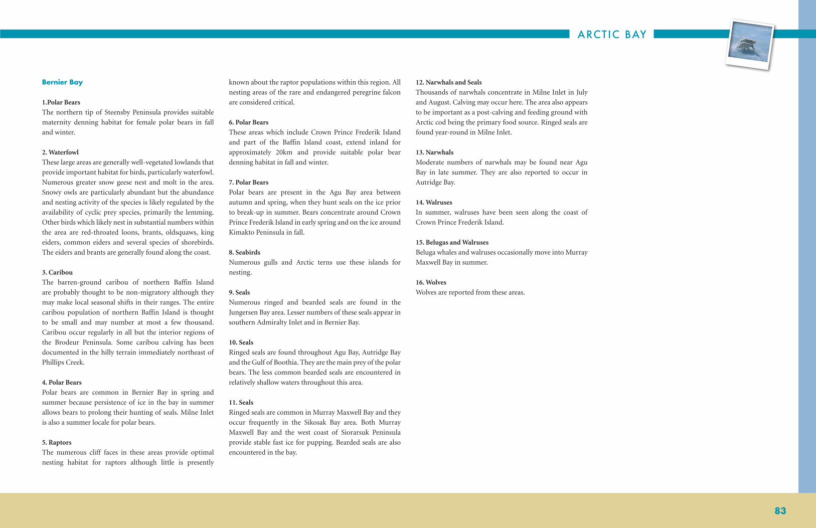
ARCTIC BAY
83
Bernier Bay
1.Polar Bears
The northern tip of Steensby Peninsula provides suitable
maternity denning habitat for female polar bears in fall
and winter.
2. Waterfowl
These large areas are generally well-vegetated lowlands that
provide important habitat for birds, particularly waterfowl.
Numerous greater snow geese nest and molt in the area.
Snowy owls are particularly abundant but the abundance
and nesting activity of the species is likely regulated by the
availability of cyclic prey species, primarily the lemming.
Other birds which likely nest in substantial numbers within
the area are red-throated loons, brants, oldsquaws, king
eiders, common eiders and several species of shorebirds.
The eiders and brants are generally found along the coast.
3. Caribou
The barren-ground caribou of northern Baffin Island
are probably thought to be non-migratory although they
may make local seasonal shifts in their ranges. The entire
caribou population of northern Baffin Island is thought
to be small and may number at most a few thousand.
Caribou occur regularly in all but the interior regions of
the Brodeur Peninsula. Some caribou calving has been
documented in the hilly terrain immediately northeast of
Phillips Creek.
4. Polar Bears
Polar bears are common in Bernier Bay in spring and
summer because persistence of ice in the bay in summer
allows bears to prolong their hunting of seals. Milne Inlet
is also a summer locale for polar bears.
5. Raptors
The numerous cliff faces in these areas provide optimal
nesting habitat for raptors although little is presently
known about the raptor populations within this region. All
nesting areas of the rare and endangered peregrine falcon
are considered critical.
6. Polar Bears
These areas which include Crown Prince Frederik Island
and part of the Baffin Island coast, extend inland for
approximately 20km and provide suitable polar bear
denning habitat in fall and winter.
7. Polar Bears
Polar bears are present in the Agu Bay area between
autumn and spring, when they hunt seals on the ice prior
to break-up in summer. Bears concentrate around Crown
Prince Frederik Island in early spring and on the ice around
Kimakto Peninsula in fall.
8. Seabirds
Numerous gulls and Arctic terns use these islands for
nesting.
9. Seals
Numerous ringed and bearded seals are found in the
Jungersen Bay area. Lesser numbers of these seals appear in
southern Admiralty Inlet and in Bernier Bay.
10. Seals
Ringed seals are found throughout Agu Bay, Autridge Bay
and the Gulf of Boothia. They are the main prey of the polar
bears. The less common bearded seals are encountered in
relatively shallow waters throughout this area.
11. Seals
Ringed seals are common in Murray Maxwell Bay and they
occur frequently in the Sikosak Bay area. Both Murray
Maxwell Bay and the west coast of Siorarsuk Peninsula
provide stable fast ice for pupping. Bearded seals are also
encountered in the bay.
12. Narwhals and Seals
Thousands of narwhals concentrate in Milne Inlet in July
and August. Calving may occur here. The area also appears
to be important as a post-calving and feeding ground with
Arctic cod being the primary food source. Ringed seals are
found year-round in Milne Inlet.
13. Narwhals
Moderate numbers of narwhals may be found near Agu
Bay in late summer. They are also reported to occur in
Autridge Bay.
14. Walruses
In summer, walruses have been seen along the coast of
Crown Prince Frederik Island.
15. Belugas and Walruses
Beluga whales and walruses occasionally move into Murray
Maxwell Bay in summer.
16. Wolves
Wolves are reported from these areas.

NUNAVUT COASTAL RESOURCE INVENTORY
84
FINAL THOUGHTS
INTERVIEW PROCESSThe interview process was judged to be reasonably effective,
even though both format and execution were quite relaxed.
The process was well defined, and the use of photos and
maps ensured that the same material was considered
from one interview to the next. This provided a solid,
reproducible structure that encouraged rigor, permitted
immediate interviewee inter-comparisons, and allowed
for future community assessments. Interviews took from
2-6 hours, depending on a number of factors, such as the
depth of the individual’s knowledge, or the amount of
marine-specific information they possessed, and the extent
to which responses prompted supplementary questions.
Since the process was focused on coastal resources,
it generally excluded mammals considered primarily
terrestrial, such as, Caribou, Muskoxen or Arctic Fox,
while embracing Polar Bears and a broad array of birds
that range widely over both.
Despite general satisfaction with the process, some prior
reservations warrant comment. First, the interview process
initially was conducted in the present tense, with the
implicit assumption that all responses were addressing
contemporary, immediate or very recent experience with
the organism under discussion. However, unless explicitly
excluded, there can be some question as to whether the
information offered represents temporal integration
over some indeterminate period. Hunters who have
traveled and hunted these areas for decades could provide
responses drawn from observations made indiscriminately
from the short, medium or long term. For these reasons,
interviewees were routinely informed that contemporary
data was that collected since 2000, and data offered from
observations before that date should be accompanied
with an indication of the observation date. These latter
observations were analyzed, identified, and archived
independently of contemporary data.
A second issue was whether the geographic location
presented for an organism represents the place at which
it was caught or collected or whether it was intended to
indicate a much broader range. The former case could
lead to an overestimate of abundance and locations while
the latter could underestimate the areal coverage. Both
ambiguities have subsequently been corrected through
adjustments to the survey document and more specifically
through the questions addressed to the interviewee.
The final issue addresses the designation “everywhere”.
Sometimes an interviewee, in response to a question about
an animal’s distribution, indicated that they were observed
to be present “everywhere”. Everywhere is a very subjective
descriptor that, without additional qualifiers, is not very
useful. Essentially, it refers to the geographic extent of
the respondent’s knowledge, and unless that knowledge
is further defined, its utility is limited. Consequently, all
interviewees were asked at some point to delineate the
extent of their travels. That information was recorded
and subsequently displayed (see Figure 4) where it can be
located and used to identify what is meant by “everywhere”
for a specific interviewee.
MAPS AND DATA The map format was chosen, given the broad geographic
reach of the interviewee’s responses, to provide a synoptic
view of the collected data. Every effort was made to keep
a common scale for all maps in this document, in order
to permit comparisons between maps. For some species,
the scale showed the breadth of the distribution and the
interconnectedness of seeming disparate locations. While
for others, especially where distributions were modest or
localized, the advantages were less obvious.
The scale used on maps obtained from the Nunavut Atlas
(1992) is smaller because the geographic area of interest is
also smaller. In addition, one must keep in mind that the
data collected for the Nunavut Atlas was actually collected
in the early 70’s and so it represents conditions that were
extant 35 years ago. Some comparisons are possible but
they must be handled with caution.
Harvest data available from the Nunavut Wildlife
Management Board (NWMB) Study (2004) is not
represented in this report. The difference between these
two studies is that the Coastal Inventory was attempting to
ascertain the qualitative geographic distribution of species
while the NWMB’s primary concern was harvest statistics.
Additional inventories conducted in the future, should,
where possible, document harvest data from any fishery in
the study area.
The present data set was never conceived as a stand-alone
product. It represents a snapshot in time drawn from
observations made by individuals within a community
who have considerable experience hunting, fishing and
trapping in the region surrounding that community. These
data have been considered within the comparative context
provided by other studies but it has limitations, just as with
those that preceded it. For a fully rounded picture it would
be necessary to view these findings as one data set of many,
all of which are mutually complementary.
GOVERNANCECollection of resource information through the process
of IQ interviews can have many different values to
a community such as cultural, social, historical and
economic values. All of these, with the exception of the
economic value, are more or less self evident. However,
translating a living marine resource into an economic
benefit, while simultaneously addressing the issue of
sustainability, requires some thought given to the subject
of resource governance.
Acquiring knowledge about available resources can be
empowering, and the acquisition of those resources could
lead to prosperity and well being. The NCRI is attempting
to identify the location and abundance of mammals, fish,
birds, invertebrates and plants so that this information can
be used for a number of reasons, among them economic
development. However, the exploitation of a resource
requires important decision- making, a reasonable
definition of expectations and limits, empowerment
of individuals and accountability. In other words, a
sustainable approach to resource utilization requires a
vision or goals, coupled with an implementation plan. The
resource should be thoughtfully governed from the outset.
One example of the need for governance emerged from
earlier interviews. Shallow areas off Iglulik are known
to contain clams in some abundance, which are known
to be an important source of food for walrus. Inuit
hunters are aware of their presence but acknowledge that
they are difficult to obtain because of their inhospitable
location on/in sea floor sediment under cold water. Each
interviewee was initially asked about their distribution and
abundance, then later about whether this was a resource
that might be harvested for commercial purposes. Most of
the responses supported the concept of a commercial clam
fishery, even though almost no information was available
on the total size of the resource, its detailed distribution,
reproductive capacity, or growth rates. In addition, one
must also consider the importance of clams to the walrus
and what impact the depletion of clams might have on
the distribution and well-being of this large, highly prized
mammal. A sustainable approach would ensure a balance
between these two apparently competing interests such
that both resources would be governed using reliable
knowledge about these organisms, an accepted plan and
clear responsibilities for all parties.

ARCTIC BAY
85
CLIMATE CHANGE
Over the past 20 years, a growing chorus of arctic
researchers has commented on the looming possibility of
climate change and global warming, and their expected
impacts on the marine environment (Tynan and DeMaster
1997; Michel, C., R. Ingram and L.R. Harris 2006; Ford et al
2008a, 2008b, Moore and Huntington 2008). Many positive
and negative changes will occur in recurrent open water
sites, undoubtedly influencing many coastal resources.
Specific impacts can be expected on water stratification
and its role in nutrient renewal, the balance between
multi-year and annual ice, the duration and location of
open water, the impacts of tidal mixing and topographic
upwelling. The impact of these physical changes could
then influence some facet of the marine food web, such
as, the relative importance of ice algae, the timing, and
magnitude of primary and secondary production, changes
in the distribution, abundance, and success of traditional
species. In other words, we can expect change to occur in
our physical world that will, in turn, alter the biological
system, including the human component.
The Nunavut Coastal Resource Inventory initiative was
undertaken to provide information that could inform
decision-making in the areas of resource management,
economic development, conservation, environmental
assessment, and the mitigation of anticipated climate
change effects. In order to be effective, each intervention
will require baseline resource information plus knowledge
about the factors that are driving change. Change will
be divided between direct human (resource extraction)
and significant systemic changes (climate change).
Climate change will exert its influence through warmer
average temperatures, altered wind patterns, changes
in precipitation, increasing fresh water input, and
modified ocean circulation. These will, in turn, directly
affect the physical marine environment which will then
influence coastal marine resources. In order to mitigate,
ameliorate, or influence these anticipated changes, a
considerable amount of information about the factors
that drive both the physical and biological environments,
as well as their interconnectedness is required. There are
two immediate sources for that information, traditional
ecological knowledge and scientific knowledge.
COMBINING TRADITIONAL ECOLOGICAL KNOWLEDGE (IQ) AND SCIENTIFIC KNOWLEDGE
Inuit Qaujimajatuqangit or Traditional Inuit Ecological
Knowledge is unique in that it is qualitative, intuitive,
holistic, spiritual, empirical, personal, and often based
on long time series of observations (Berkes 2002).
Some of these characteristics are sometimes cited as
limitations, such as a reliance on long-term memory or
the fact that it is qualitative and subjective. Conversely,
they also qualify as positive since they represent a long
time-series unattainable in any other manner. Perhaps as
the sole device to fully understand and manage coastal
resources traditional knowledge might be found lacking,
while a complementary coupling with western science
could produce important synergies resulting in a very
powerful tool.
The scientific approach embraces all available evidence
and postulates a theory that attempts to predict future
changes. The correctness of the prediction is a measure
of the completeness of scientific understanding.
Understanding the reasons for change is important because
that information is central to any attempt to mitigate
or influence long term effects, such as climate change.
Addressing the root cause is a more certain approach
than attempting to influence symptoms. A critical factor
in the scientific method is the availability and reliability
of data available for analysis. The arctic, because of
size, complexity and manpower limitations, does not
often have a plentiful supply of scientific observations.
However, one underutilized data source is in the form of
traditional knowledge where species, locations, processes
and events have been monitored, sometimes for decades.
Bringing traditional knowledge and science together into
a complementary working relationship could provide
significant benefits for all parties.

NUNAVUT COASTAL RESOURCE INVENTORY
86
ACKNOWLEDGEMENTSThe NCRI research team received assistance from many
sources, both institutional and individual, throughout
this initiative through the provision of advice, technical
assistance and documentation, review of project materials,
essential services and interviews. We thank all for their
very generous support.
Community of Arctic Bay
Hamlet of Arctic Bay
Meeki Kalluk, HTO Manager
HTO Board Members and Chairpersons
Mishak Allurut, Interpreter
Angela Allurut, Student Intern
Evelin Kalluk, Student Intern
Kiggavik Bed and Breakfast
Dalhousie University, Halifax, Nova Scotia
Department of Culture, Language, Elders and Youth,
Government of Nunavut
Department of Environment,
Government of Nunavut, Iqaluit
Department of Economic Development and
Transportation, Government of Nunavut
Environment Canada
Fisheries and Oceans Canada
Interviewees – Arctic Bay
Tommy Tatatuapik, Ikey and Olayuk Kigutikarjuk, Issac
Shooyook, Qaumayuq Oyukuluk, Olayuk Naqitarvik,
Jobie and Sarah Issigaitok, Esau Tatauapik, David Kalluk,
Moses Koonoo, Ipeelee Koonoo, Koonoo Oyukuluk,
and Clare Kines.
Indian and Northern Affairs Canada, Iqaluit
Inuit Heritage Trust (IHT), Iqaluit
Jim Richards
Arctic Bird Specialist, Ontario, Canada
Jim is credited with providing valuable advice as well as
most of the photos of birds in Appendix 7.
Legislative Library, Iqaluit
NOAA/NMFS Auke Bay Laboratory, Juneau, Alaska
Nunavut Research Institute, Iqaluit
Nunavut Tunngavik Incorporated, Iqaluit
Nunavut Wildlife Management Board, Iqaluit
Parks Canada, Iqaluit
Qikiqtani Inuit Association

ARCTIC BAY
87
COLLECTED REFERENCESSpecies Photo references are available upon request. They
have been excluded from this list due to length and issues
with keeping links updated. All document references are
listed in this section.
Ainley, G.A., C.T. Tynan and I. Stirling. 2003. Sea Ice: A
Critical Habitat for Polar Marine Mammals and Birds.
In: Sea Ice: an Introduction to its Physics, Chemistry
and Geology, Thomas, D.N. and G.S. Dieckmann (eds.),
Blackwell Publishers, 240-266.
Alexander, V. 1974. Primary productivity regimes of the
nearshore Beaufort Sea, with reference to the potential
role of ice biota. In: J.C. Reed and J.E. Sater (Editors), The
Coast and Shelf of the Beaufort Sea. Arctic Institute of
North America, Arlington, Va. Pp. 604-635.
Alexander, V. and H.J. Niebauer. 1981. Oceanography of
the eastern Bering Sea ice edge zone in spring. Limnology
and Oceanography 26: 1111-1125.
American Ornithologists Union. 1998. The A.O.U.
Checklist of North American Birds (Seventh Edition).
Washington, D.C. and supplements thereto through the
49th supplement, 2008.
Ashkui Project. Combining Traditional Ecological
Knowledge and Western Science: URL: http://www.ec.gc.
ca/EnviroZine/english/issues/26/print_version_e.cfm
Berkes, F. 1993. Traditional Ecological Knowledge in
Perspective. Pp 1-10, In: Inglis, J.T. (ed.) Traditional
Ecological Knowledge: Concepts and Cases. International
Program on Traditional Ecological Knowledge,
Canadian Museum of Nature, Ottawa and International
Development Research Centre, Ottawa. 150 pp.
Berkes, F, R., Huebert, H. Fast, M. Manseau and A.
Diduck. 2005. Breaking Ice: Renewable Resource and
Ocean Management in the Canadian North. University of
Calgary Press, 396 pp.
Bradstreet, M.S.W. and W.E. Cross. 1982. Trophic
Relationships at High Arctic Edges. Arctic 35: 1-12.
Bray, R. 1943. Notes on the Birds of Southampton Island,
Baffin Island and Meleville Peninsula. Auk 60:504-536
Brook, R., M. M’Lot and S. McLachlan. 2006. Pitfalls to
avoid when linking traditional and scientific knowledge.
pp 13-20 In : (Riewe, R. and J. Oakes, eds.) Climate
Change: linking traditional and scientific knowledge.
Aboriginal Issues Press.
Buckley, J.R., T. Gammelsrod, J.A. Johannessen, O.M.
Johannessen 1979 and L.P. Roed. 1979.
Science 203: 165-167.
Canadian Wildlife Service, 2007. Northwest Territories/
Nunavut Bird Checklist Survey program data. Available
online at http://www.pnr-rpn.gc.ca/checklist
Committee on the Status of Endangered Wildlife in
Canada (COSEWIC). Wildlife Species Search.
Available online: http://www.cosewic.gc.ca/eng/sct1/
searchform_e.cfm
Acessed online: 28/06/2011. Last updated:01/06/2011
Crawford, R. and J.Jorgenson. 1990. Density Distribution
of Fish in the Presence of Whales at the Admiralty Inlet
Landfast Ice Edge. Arctic 43: 215-222.
Csanady, G.T. 1982. Circulation in the coastal ocean.
D. Reidel, Dordrecht, The Netherlands, 279 pp.
Department of Fisheries and Oceans. Aquatic Species
at Risk. Accessed online at: http://www.dfo-mpo.gc.ca/
species-especes/search-location-recherche-endroit-eng.
htm. Last updated; 02/06/2011.
DFO 2009. Web Tide Model http://www.mar.dfo-mpo.
gc.ca/science/ocean/ coastal_hydrodynamics/WebTide/
webtide.html
Dyke, A.S., J. Hooper and J.M. Savelle. 1996. A History
of sea ice in the Canadian Arctic Archipelago based on
post-glacial remains of the bowhead whale (Balaena
mysticetus). Arctic 49: 235-255.
Dyke, A.S. and J.M. Savalle. 2001. Holocene History of
the Bering Sea Bowhead Whale (Balaena mysticetus) in its
Beaufort Sea Summer Grounds off Southwestern Victoria
Island, Western Canadian Arctic. Quaaterney Research
55: 371-379.
Ellis, D. V. 1956. Observations on the migration,
distribution and breeding of birds in the Canadian Arctic
during 1954 and 1955. Dansk Ornithologisk Forenings
Tidesskrift 50:207-230
Ford, J.D., B. Smit, J. Wandel, M. Allurut, K. Shappa, H.
Ittusarjuat, and K. Qrunnut. 2008a. Climate change in
the Arctic: current and future vulnerability in two Inuit
communities in Canada. Geographical Journal
174: 45 – 62.
Ford, J.D., T. Pearce, J. Gilligan, B. Smit and J. Oakes.
2008b. Climate change and hazards associated with ice use
in northern Canada. Arctic, Antarctic and Alpine Research
40: 647- 659.
George, J.C.C., H.P. Huntington, K. Brewster, H. Eicken,
D.W. Norton and R. Glenn. 2004. Observations on
Shorefast Ice Dynamics in Arctic Alaska and the Responses
of the Inupiat Hunting Community.
Arctic 57(4): 363-374.
Gilligan, J., J. Clifford-Pena, J. Edye-Rowntree, K.
Johansson, R. Gislason, T. Green and G. Arnold with
J. Heath and R. Brook. 2006. The value of integrating
traditional, local and scientific knowledge.
pp 3-12 In: Riewe, R. and J. Oakes, (eds.) Climate Change:
linking traditional and scientific knowledge. Aboriginal
Issues Press.
Godfrey, W. Earle. 1986. The Birds of Canada (Revised
Edition). National Museum of Natural Sciences,
Ottawa, Canada.
Hannah, C.G., F. Dupont and M. Dunphy. 2009. Polynyas
and Tidal Currents in the Canadian Arctic Archipelago.
Arctic 62 (1): 83-95.
Harrisson, W.G. and G.F. Cota 1991. Primary production
in polar waters: relation to nutrient availability, In: E.
Sakshaug, C.C.E. Hopkins and N.A. Oritsland (Editors),
Proc. Pro Mare Symp. On Polar Marine Ecology
(Trondheim, 12-16 May 1990. Polar Res. 10(1): 87-104.
Hay, K. 2000. Final Report of the Inuit Bowhead
Knowledge Study. 2000. Nunavut Wildlife Management
Board.
Henshaw, A. 2003. Polynyas and Ice Edge Habitats in
Cultural Context: Archaeological Perspectives from
Southeast Baffin Island. Arctic 56 (1): 1-13.
Hohn, E. Otto. 1968. The Birds of Chesterfield Inlet,
District of Keewatin, NWT, Canada. Canadian Field
Naturalist 82(4):224-262.

NUNAVUT COASTAL RESOURCE INVENTORY
88
Huntington, H.P. 2000. Using traditional Ecological
knowledge in science: methods and applications.
Ecological Applications 10(5): 1270-1274.
Ingram, R.G., J. Bacle, D.G. Barber, Y. Gratton, and H.
Melling. 2002. An overview of physical processes in the
North Water. Deep Sea Research II, 49: 4893-4906.
Ingram, R.G., E. Carmack, F. Mclaughlin and S. Nicol.
2005. Polar Ocean Coastal Boundaries Pan-Regional
Overview. In: Robinson, A.R., Brink, K.H. (Eds.) The Sea,
Vol. 14: The Global Coastal Ocean, Regional Studies and
Syntheses, Wiley, New York, pp 61-81.
Ingram, R.G. and S. Prinsenberg. 1998. Coastal
Oceanography of Hudson Bay and Surrounding Eastern
Canadian Arctic Waters. In: Robinson, A.R., Brink,
K.H. (eds.) The Sea, Vol. 11: The Global Coastal Ocean,
Regional Studies and Syntheses, Wiley, New York, pp 835
-862.
Inuit Land Use and Occupancy Project (1976), Volumes
1-3; Indian and Northern Affairs ISBN 0-660-00-401-1
Inuit Qaujimajatuqangit of Climate Change in Nunavut.
2005. (Four Volumes: North Baffin Region; South Baffin
Region; Kivalliq Region; and, Kitikmeot Region)
IPCC 2007a. Summary for Policy Makers. In: Climate
Change 2007: The Physical Science Basis. (February 2007)
Working Group I to the Fourth Assessment Report of the
Intergovernmental Panel on Climate Change. IPCC
Secretariat, c/o WMO 7bis, Avenue de la Paix. C.P. No
2300, 1211 Geneva 2, Switzerland, 18 pp. (www.ipcc.ch/)
International Union for Conservation of Nature (IUCN).
The IUCN red list of endangered species. Available
Online at: http://www.iucnredlist.org/apps/redlist/search
Acessed online; 28/06/2011
IPCC 2007b. Summary for Policy Makers. In: Climate
Change 2007: Climate Change Impacts, Adaption and
Vulnerability. (April 2007). Working group II to the
Fourth Assessment Report of the Intergovernmental
Panel on Climate Change. IPCC Secretariat, c/o WMO
7bis Avenue de la Paix, C.P. No 2300, 1211 Geneva 2,
Switzerland, 23 pp. (www.ipcc.ch/)
IPCC 2007c. Summary for Policy Makers. In: Climate
Change 2007: Mitigation. Contribution of Working Group
III to the Fourth Assessment. (August 2007) Report of the
Intergovernmental Panel on Climate Change. Cambridge
University Press, Cambridge, United Kingdom and New
York. (www.ipcc.ch/)
IPCC 2007d. Summary for Policy Makers. In Climate
Change 2007: Synthesis Report. Approved in detail at
IPCC Plenary XXVII (Valencia, Spain 12 – 17 November
2007). (www.ipcc.ch/)
Johannessen, O.M., J.A. Johannessen, M. Morison, B.A.
Farrelly and E.A.S. Svendsen. 1983. The Mesoscale
oceanographic conditions in the marginal ice zone north
of Svalbard in early fall 1979. J. Geophysical Research 88:
2755-2769.
Legendre, L., S.F. Ackley, G.S. Dieckmann, B. Gulliksen,
R. Horner, T. Hoshia, I.A. Melnikov, W.S. Reeburgh, M.
Spindler, and C.W. Sullivan. 1992. Ecology of sea ice biota.
2. Global significance. Polar Biol. 12: 429-444.
McGhee, R. 1993. Ancient Peoples of the Arctic. UBC
Press, in association with the Canadian Museum of
Civilization, Vancouver.
McLaughlin, F.A., E.C. Carmack, R.G. Ingram and W.J.
Williams, 2005. Oceanography of the Northwest Passage
In The Sea, Vol. 14: The Global Coastal Ocean, Regional
Studies and Syntheses, A.R. Robinson and K.H. Brink, eds.
John Wiley and Sons, Inc., New York, pp 1213-1244.
Melling, H. 2000. Exchanges of freshwater through the
shallow straits of the North American Arctic. In: The
Freshwater Budget of the Arctic Ocean, E.L. Lewis et al
(eds.), Kluwer Academic Publishers, Dordrecht., 479-502.
Michel, C., R.G. Ingram and L.R. Harris. 2006. Variability
in oceanographic and ecological processes in the Canadian
Arctic Archipelago. Progress in Oceanography 71: 379-
401.
Moller, H., F. Birkes, P. O’Brian Lyver and M. Kislalioglu.
2004. Combining science and traditional ecological
knowledge: monitoring populations for co-management.
Ecology and Society 9(3): [online]. http://www.
ecologyandsociety.org/vol9/iss3/art2
Moore, S. and H.P. Huntington. 2008. Arctic marine
mammals and climate change: impacts and resilience.
Ecological Applications 18(2), Supplement: S157-S165.
O’Brien, J. P., M.D. Bishop, K.S. Regular, F.A. Bowdring,
T.C. Anderson. 1998. Community-Based Coastal Resource
Inventories in Newfoundland and Labrador – Procedures
Manual. Fisheries and Oceans, St. John’s, Newfoundland
Priest, H. 2004. The Nunavut Wildlife Harvest Study.
2004. Nunavut Wildlife Management Board.
Prinsenberg, S.J. 1986a. The circulation pattern and
current structure of Hudson Bay. Pp. 187-204, In: Martin,
I.P. (ed.) Canadian Inland Seas. Elsevier Oceanography
Series.
Prinsenberg, S.J. 1986b. On the physical oceanography of
Foxe Basin. Pp. 217-236, In: Martin, I.P. (ed.) Canadian
Inland Seas. Elsevier Oceanography Series.
Prinsenberg, S. 1988. Ice ridge contributions to the
freshwater contents of Hudson Bay and Foxe Basin. Arctic,
41:6-11.
Prinsenberg, S.J. and N.G. Freeman. 1986. Tidal heights
and currents in Hudson Bay and James Bay. Pp. 205-
216, In: Martin, I.P. (ed.) Canadian Inland Seas. Elsevier
Oceanography Series.
Pyle, Peter and David F. DeSante. 2006. English and
Scientific Alpha
Codes for North American Birds through the 47th AOU
Supplement. The Institute for Bird Populations, Pt. Reyes,
CA.
Renaud, Wayne E., Stephen R. Johnson and P. Dianne
Hollingdale. 1979. Breeding Birds of Arctic Bay,
Baffin Island, N.W.T., with notes in the Biogeographic
Significance of the Avifauna. Arctic. 32(2):122-134
Richard, Pierre. 2001. Marine Mammals of Nunavut.
Qikitqtani School Operations, Box 1330, Iqaluit, Nunavut,
X0A 0H0.
Richards, Jim, and Tony White. 2008. Birds of Nunavut: A
Checklist (private publication, sponsored by Environment
Canada).
Riewe, R. 1992. Nunavut Atlas. 1992. Canadian
Circumpolar Institute (co-published by Tungavik
Federation of Nunavut. ISBN 0838-133X

ARCTIC BAY
89
Saville, D.B.O. 1951. Bird Observations at Chesterfield
Inlet, Keewatin, in 1950. Canadian Field Naturalist
65(4):145-157.
Schledermann, P. 1980. Polynyas and prehistoric
settlement patterns. Arctic 33 (2): 292-302
Schledermann, P. 1990. Crossroads to Greenland, Arctic
Institute of North America, Calgary, 364 pp.
Shortt, T. M., and H. S. Peters. 1942. Some recent bird
records from Canada’s Eastern Arctic. Canadian Journal of
Research 20:338-348
Sibley, David Allen. 2004. Identification of Canada and
Cackling Goose, Updated, October 7, 2004 http://www.
sibleyguides.com/canada_cackling.htm
Smith, M. and B. Rigby. 1981. Distribution of polynyas
in the Canadian Arctic. Pp. 6-28, In: Polynyas in the
Canadian Arctic. Stirling, I. and H. Cleator (eds.)
Occasional Paper, Number 45, Canadian Wildlife Service.
Soper, J. D. 1928 A faunal investigation of southern Baffin
Island. National Museum of Canada Bulletin 53: 76-116
Stewart, D.B. and W.L. Lockhart. 2004. Summary of the
Hudson Bay Marine Ecosystem Overview. Prepared by
Arctic Biological Consultants, Winnipeg, for Canada
Department of Fisheries and Oceans, Winnipeg, Mb.
Draft vi + 66 pp.
Stirling, I. 1980. The Biological Importance of Polynyas in
the Canadian Arctic. Arctic 33: 303-315.
Stirling, I. 1997. The importance of polynyas, ice edges,
and leads to marine mammals and birds. J. of Marine
Systems 10: 9-21.
Stirling, I., H. Cleator. And T.G. Smith. 1981. Marine
Mammals. pp. 45-58, In: Polynyas in the Canadian Arctic
(Stirling, I. and H. Cleator (eds.). Occasional Paper,
Number 45, Canadian Wildlife Service.
Sutton, George Miksch. 1931. Notes on Birds Observed
Along the West Coast of Hudson Bay. Condor 33:154-159.
Tang, C.L. and M.Ikeda.1989. Ice-Edge Upwelling off the
Newfoundland Coast during LIMEX. Atmosphere-Ocean
27: 658-681.
Tee, K.T., P.C. Smith and D. Levaivre. 1993. Topographic
Upwelling off the Coast of Nova Scotia. J. Physical
Oceanography 23(8): 1703-1726.
Tynan, C.T. and D.P. DeMaster. 1997. Observations and
Predictions of Arctic Climate Change: Potential Effects on
Marine Mammals. Arctic 50: 308-322.
Welch, H.E., M.A. Bergmann, T.D. Siferd, K.A. Martin,
M.F. Curtis, R.E. Crawford, R.J. Conover, and H. Hop.
1992. Energy flow through the marine ecosystem of
the Lancaster Sound region, Arctic Canada.
Arctic, 45: 343-357.

NUNAVUT COASTAL RESOURCE INVENTORY
90 APPENDIX 1
APPENDIX 1 BIOGRAPHIES OF ARCTIC BAY INTERVIEWEES
Interview Code Interviewee Profile
AB_1 Tommy Tatatuapik Chair of the Arctic Bay Elder’s Committee, lay preacher in the Catholic Church, organizer of community country-food feasts and counselor of offenders referred by courts.
AB_2Ikey and Olayuk
KigutikarjukHusband and wife formerly weekend hunters but since retirement, they have become active full-time. Olayuk is a member of the Elder Committee.
AB_3 Issac Shooyook An Elder and a full-time hunter who often uses an outpost camp. He is the initiator of the sport Polar Bear hunt.
AB_4 Qaumayuq Oyukuluk Born in the southern end of Admiralty Inlet but raised in Strathcona Sound. An active HTO member, fisherman and full-time hunter who hunts seals and Polar Bear.
AB_5 Olayuk NaqitarvikBorn and raised in area of Admiralty Inlet just south of Yeoman’s Island. Lived in Arctic Bay since 1962. Began hunting at 12 years of age and continues to hunt and fish most available animals
over a very wide area. A member of the Hamlet Council, Pastor in the Full Gospel Evangelical Church, full-time hunter that has a special interest in Narwhal and Polar Bears.
AB_6 Jobie and Sarah IssigaitokHusband and wife active in the community; he is Chair of the Hamlet Housing Association. They are full-time hunters who conduct sport hunts out of their out[post camp for Polar Bears. In
addition they hunt seals and Narwhal.
AB_7 Esau Tatauapik
Born at the southern end of Admiralty Inlet near Easter Sound but grew up near Strathcona Sound and has lived in Arctic Bay since 1963. Has been a hunter since about 10 years of age and is
presently a year-round hunter seeking seals much of the time and animals with a quota during their season. Active in the community as Chair of the Alcohol Committee, he is also the owner
of North Baffin Outfitting, which is used by sport hunters and photographers. He hunts Narwhal and runs a dog team.
AB_8 David KallukBorn on western side of Brodeur Peninsula near Cresswell Bay. Lived in Arctic Bay since 1967. Hunted since he was 8 years old he continues to hunt most animals tear round. In addition, he
is very involved in community affairs: lay preacher in the Anglican Church, member of Elder’s Committee, HTO, and the economic development committee.
AB_9 Moses KoonooBorn near Admiralty Inlet just south of Yeoman’s Island but grew up in Arctic Bay and Pond Inlet. He has lived in Arctic Bay since about 30 years old. A younger hunter who hunts most
available animals shares with the community. He is involved with regional organizations.
AB_10 Ipeelee KoonooBorn on Bylot Island but has been a member of Arctic Bay community since 1988. Hunted since 11 years when he killed his first bear. Today he hunts most animals except caribou which are
no longer in the area. An outfitter, Elder and full-time hunter who conducts a Polar Bear sport hunt. He also runs a dog team.
AB_11 Koonoo Oyukuluk
Lived in Arctic Bay since 1953. Member of the HTO and a respected advisor on cultural and traditional life. He started hunting at age 12 and remains active year-round with interest in
Narwhal, Walrus, seals, Musk Ox and Polar Bear. Bearded seals and Polar Bear not hunted as much due to government restrictions and fewer dog teams. He supports the community by
sharing his catch.
AB_12 Clare Kines Local businessman and former member of the RCMP who is not Inuit but who is an avid and knowledgeable birding enthusiast.

ARCTIC BAY
APPENDIX 2 91
APPENDIX 2ACRONYMS AND ABBREVIATIONS
CBCRI - Community-Based Coastal Resource Inventory
CLEY - Department of Culture, Language, Elders and Youth
CWS - Canadian Wildlife Service
DFO - Department of Fisheries and Oceans
DOE - Department of the Environment
DSD - Department of Sustainable Development
ED & T - Department of Economic Development and Transportation
GC - Government of Canada
GN - Government of Nunavut
HTO - Hunter/Trapper Organization
INAC - Indian and Northern Affairs, Government of Canada
IQ - Inuit Qaujimajatuqangit
IPCC - Intergovernmental Panel on Climate Change
NRCan - Natural Resources Canada
NRI - Nunavut Research Institute
NTI - Nunavut Tunngavik Incorporated
NWMB - Nunavut Wildlife Management Board
TK - Traditional Knowledge
TEK - Traditional Ecological Knowledge

NUNAVUT COASTAL RESOURCE INVENTORY
92 APPENDIX 3
APPENDIX 3ARCTIC BAY – BIRD SIGHTINGS COMMENTARYThe following table stacks the community interview findings with several literary sources and consultant expectations. The list begins with those that interviewees stated seeing and has some additional species that were not mentioned but have been
reported by others. These have been graded on their range status according to Godfrey, 1986 and occupancy type by Richards and White, 2008. The next column covers the NWT/NU Checklist Survey databank. The next five columns identify species
known in the area and identify those that breed. Renaud et al, 1979 is based on Arctic Bay research that took place from May 1st to September 28th, 1976. Bray, 1943, provides information from hours spent in Arctic Bay in May 1936 and September
1937. Ellis, 1956, spent September 1954 to February 1955, not the most productive time of year, in Arctic Bay. Shortt and Peters, 1942, gathered information in Arctic Bay on August 28/29 and September 3/4, 1938. Soper, 1928, covers Arctic Bay on
August 18/19, 1932. The second to last column identifies birds that are included in the specimen collection of the Royal Ontario Museum. The final column gives the reaction of Jim Richards to the interview findings with the other sources in mind. The
checklist databank is assumed valid. The miscellaneous literature sources are valid.
Hopefully this comparative chart contextualizes the knowledge gained through the Nunavut Coastal Resource Inventory.
Birds reported in interviews:
Is the bird within normal breeding
range?
What status does the bird have
within the area?
NWT/Nunavut Bird Checklist Survey: CWS
Renaud, et al, 1979
Bray, 1943
Ellis, 1956
Shortt & Peters, 1942
Soper, 1928
Royal Ontario Museum Specimen
Comments from Jim Richards on the likelihood of bird sighting frequency and
interview findings.Buff-breasted Sandpiper No Migrant, Breed Yes migrant only; likely seen
Stilt Sandpiper No Migrant, Breed Breed odd the only one reported by locals
White-Rumped Sandpiper Yes Migrant, Breed Breed Yes odd the only one reported by locals
Baird’s Sandpiper Yes Migrant, Breed Breed Yes seen as expected
Least Sandpiper No Migrant, Breed likely seen
Semi-palmated Sandpiper No Migrant, Breed likely seen
Purple Sandpiper No Migrant, Breed migrant only; likely seen
American Golden-Plover Yes Migrant, Breed Breed seen as expected
Black-bellied Plover Yes Migrant, Breed Yes seen as expected
Common Ringed Plover Yes Migrant, Breed Breed Yes seen as expected
Semi-palmated Plover No Migrant, Breed likely seen
Wilson’s Snipe No Accidental highly unlikely; perhaps a dowitcher spp.
Sanderling Yes Migrant, Breed migrant only; likely seen
Red Knot No Migrant, Breed Yes seen as expected
Ruddy Turnstone No Migrant, Breed Yes seen as expected
Horned Lark Yes Migrant, Breed Breed Breed Yes Yes surprised only seen by one local
Lapland Longspur Yes Migrant, Breed Breed Breed Yes seen as expected

ARCTIC BAY
APPENDIX 3 93
Birds reported in interviews:
Is the bird within normal breeding
range?
What status does the bird have
within the area?
NWT/Nunavut Bird Checklist Survey: CWS
Renaud, et al, 1979
Bray, 1943
Ellis, 1956
Shortt & Peters, 1942
Soper, 1928
Royal Ontario Museum Specimen
Comments from Jim Richards on the likelihood of bird sighting frequency and
interview findings.
Killdeer No doubtful; no Nunavut records
American Bittern No doubtful; no Nunavut records
Snow Bunting Yes Migrant, Breed Breed Breed Yes seen as expected
American Pipit Yes Migrant, Breed Yes Yes Yes Breed can't explain why only seen by one local
Northern Shrike No doubtful; no Nunavut records
Fox Sparrow No Accidental highly unlikely
Sandhill Crane Yes Migrant, Breed seen as expected
Pomarine Jaeger No Migrant, Breed migrant only; likely seen
Parasitic Jaeger YesMigrant, Breed,
wintertimeseen as expected
Long Tailed Jaeger Yes Migrant, Breed Breed seen as expected
Rock Ptarmigan Yes Permanent, Breed Breed Yes Yes seen as expected
Willow Ptarmigan Yes Permanent, Breed quite likely seen
Snowy Owl Yes Permanent, Breed Yes Yes seen as expected
Short Eared Owl No Migrant, Breed likely seen
European Starling No Accidental doubtful; but possible
Common Raven Yes Permanent, Breed Yes Breed Yes Yes Yes seen as expected
Red Phalarope Yes Migrant, Breed Yes seen as expected
Red-necked Phalarope No Migrant, Breed possible
Peregrine Falcon Yes Migrant, Breed Breed Yes surprised not seen by all
Gryfalcon Yes Permanent, Breed Breed Yes Breed Yes seen as expected
Glaucous Gull YesMigrant, Breed,
wintertimeBreed Breed Yes surprised not seen by all
Herring Gull No Migrant, Breed Yes seen as expected
Thayer’s Gull Yes Migrant, Breed Yes Breed seen as expected
Mew Gull No Accidental no doubt they saw Iceland Gull

NUNAVUT COASTAL RESOURCE INVENTORY
94 APPENDIX 3
Birds reported in interviews:
Is the bird within normal breeding
range?
What status does the bird have
within the area?
NWT/Nunavut Bird Checklist Survey: CWS
Renaud, et al, 1979
Bray, 1943
Ellis, 1956
Shortt & Peters, 1942
Soper, 1928
Royal Ontario Museum Specimen
Comments from Jim Richards on the likelihood of bird sighting frequency and
interview findings.
Ivory Gull YesMigrant, Breed,
wintertimeYes Yes surprised not seen by all
Ross’ Gull No Migrant, Breed quite likely seen
Sabine’s Gull No Migrant, Breed possible; as a vagrant
Bonaparte’s Gull No Accidental highly unlikely, but possible
Iceland Gull Yes Migrant, Breed Yes seen as expected
Black-legged Kittiwake Yes Migrant, Breed Yes Yes should have been seen by all
Snow Goose Yes Migrant, Breed Breed Breed Yes seen as expected
Ross’s Goose No Migrant, Breed quite possible
Canada Goose No Migrant, Breed Yes seen as expected
Cackling Goose No Migrant, Breed seen as expected
White-fronted Goose No Migrant, Breed seen as expected
Tundra Swan No Migrant, Breed seen as expected
Dovekie NoMigrant, Breed,
wintertimeYes seen as expected
Arctic Tern Yes Migrant, Breed seen as expected
Thick-Billed Murre YesMigrant, Breed,
wintertimeYes seen as expected
Black Guillemot YesMigrant, Breed,
wintertimeYes Yes seen as expected
Razorbill No Migrant, Breed seen as expected
Northern Fulmar YesMigrant, Breed,
wintertimeYes Yes Yes Yes seen as expected
King Eider Yes Migrant, Breed Yes Yes Yes Breed seen as expected
Common Eider Yes Migrant, Breed Yes Yes seen as expected
Long Tailed Duck Yes Migrant, Breed Yes Breed Yes seen as expected
Arctic Loon No they were seeing Pacific Loons
Common Loon No Migrant, Breed possible

ARCTIC BAY
APPENDIX 3 95
Birds reported in interviews:
Is the bird within normal breeding
range?
What status does the bird have
within the area?
NWT/Nunavut Bird Checklist Survey: CWS
Renaud, et al, 1979
Bray, 1943
Ellis, 1956
Shortt & Peters, 1942
Soper, 1928
Royal Ontario Museum Specimen
Comments from Jim Richards on the likelihood of bird sighting frequency and
interview findings.
Red-throated Loon Yes Migrant, Breed Breed should have been seen by all
Yellow-billed Loon No Migrant, Breed Yes seen as expected
Pacific Loon No Migrant, Breed Yes seen as expected
Species reliably noted by others; not on above list
Rough-legged Hawk Yes Migrant, Breed Breed would have expected sightings from interview
Pectoral Sandpiper Yes Migrant, Breed Breed would have expected sightings from interview
Northern Wheatear Yes Migrant, Breed Yes Yes Yes would have expected sightings from interview
Hoary Redpoll YesMigrant, Breed,
wintertimeYes Yes would have expected sightings from interview
Whimbrel No Vagrant Yes not to be expected
Bank Swallow No Accidental Yes not to be expected
Wilson's Warbler No Accidental Yes not to be expected
Barn Swallow No Vagrant not to be expected
White-throated Sparrow No Accidental not to be expected
Species not on above list, but should have been seen
Brant Yes Migrant, Breed Yes can't explain why this species was not seen
Red-breasted Merganser Yes Migrant, Breed Yes can't explain why this species was not seen

NUNAVUT COASTAL RESOURCE INVENTORY
96 APPENDIX 3

ARCTIC BAY
APPENDIX 4 97
APPENDIX 4NCRI FIELD GUIDE
INTRODUCTIONThis Field Guide is a chronological account of tasks
conducted during the 2008-2009 project year. In addition,
this document can be used as a template to guide actions in
future inventories.
The Guide is organized into four levels:
• Level 1 involves consultations, interviewee selection,
and preparations required prior to the start of
interviews.
• Level 2 contains interview protocols and all steps that
result from their completion.
• Level 3 addresses GIS data digitization and image
production.
• Level 4 addresses report completion and delivery back
to the community, along with planning follow-up on
project outcomes.
Information provided in all four levels must be available
in both English and Inuktitut, which means that time
required for document translation is an important
consideration in the overall project work plan.
In addition, the establishment of a presence in each
community is an important contributor to the project’s
ultimate success. Spending some time on each visit to get
to know people, attend community events, and become
familiar with local services and community resources (e.g.
wharves, schools, government offices, etc.) will greatly
reward the process.
LEVEL 1
Level 1 involved the development of a community profile
(such as labourers, resources and infrastructure), along
with the community consultations, preparation of locally
relevant interview materials, selection of interviewees and
training of local personnel.
Community ProfileBefore beginning work in a community, and preferably
before approaching potential interviewees, information
about the study site was compiled. This information was
used: to assist the literature review; to identify additional
data that might be useful in the mapping process; to ensure
that data collection would not be duplicated; and, to
facilitate the report-writing process.
Information sought, included:
• Demographics
• Geography (location, description of coast)
• History of community, including government
presence, points of interest, early settlement,
traditional movements
• Current Institutions (local government, HTO, GN,
schools, etc.)
• Current community activities, organizations,
important events and activities
• Current community projects, e.g., economic
development activity
• Land/sea based activities, reliance on traditional food
sources, hunting territories
• Occupations and income profiles
• Reports of pollutants or other environmental
accidents
• Perceived changes in climate (sea ice, winter camp
locations and winter coast line)
• Changes in habitat, bird counts , fish, animals, marine
environment
• Tourism resources
• Government reports and wildlife studies
• Common coastal/marine species found in the area
The desired output from such an exercise was a concise
summary of the information gathered, that included:
an annotated bibliography (using the Chicago Manual
of Style) of important documents and data; a detailed
contact list (name, contact, affiliation, etc.); a list and/
or description of information that would be suitable for
mapping; a binder/folder of all hard copies of information
and an electronic backup of available files and web links.
Invitation and ConsultationCommunities were invited to participate initially, with a
letter of invitation that provided a detailed explanation
of the coastal inventory, its objectives, timelines, and the
manner in which the proposed work would be carried
out. The invitation made clear that an initial community
consultation was essential and would take place as soon as
possible after agreement had been reached.
The initial meeting included all available Inuit hunters/
trappers, Government representatives, youth groups,
local researchers and non-profit organizations. This
event was the first opportunity for the project team
to establish a presence in the community, to identify
community labour/service providers, to establish a short
list of potential interviewees, to assess project risks and to
organize administrative procedures related to community
participation. In addition, it was important to establish
very early the geographic extent of Inuit movement over
the land. This information would be used to prepare maps
of the proper size and scale that would later be used in the
planned interviews.
Next, the project team spent a minimum of a half-day
touring the area that would be considered in the interviews.
In most cases, a complete tour was impossible, but at the
least, it covered important fishing/hunting areas, popular
tourist attractions, and cultural sites within range of the
community. Often, the guide was an excellent source of
information on the area and its resources, and it provided
the project team with a sense of place and involvement
that had continuing benefits. It also sent an important
message to the community that the project team was
making an effort to become familiar with the places that
would later be discussed in the interviews. These outings
provided important material for the initial trip, and later
final reports.
Finally, by end of the initial visit the team identified dates
when it would return to the community to conduct the
planned interviews. This also permitted the development
of a realistic schedule for project deliverables.
Service ProvidersVarious services were required throughout the project
lifecycle. These included interpreters, translators,
transcribers, printers, student interns, and local outfitters.
It was important that they were identified early and, if
possible, used in some capacity before interviews were
underway, in order to assess competence and reliability.
Establishing early contact helped to identify schedule
conflicts and important deadlines.
First Steps:
� When meeting with community organizations and
other knowledgeable persons, a list of people was
created. Information was gathered on each candidate
(e.g. availability, cost, experience, knowledge

NUNAVUT COASTAL RESOURCE INVENTORY
98 APPENDIX 4
� background). Particular attention was paid to
their relationship with service providers and other
members of the community. Any causes for concern
were addressed immediately.
� A determination was made as to appropriate levels
of remuneration, which were then used in a standard
manner across all communities involved in the
inventory.
� Scheduling conflicts or important deadlines that could
impact the project were explored in order to prevent
unwanted interruptions in the project.
� Training and guidance were provided to those who
signed on; for example, interviewers and translators
required instructions as to the proper use of the
interview survey, interview protocols and other
methodologies required during the interview process.
This was normally done the day before interviews
began so that the information provided was immediate
and relevant.
IntervieweesInterviewees are the subject-matter experts that contribute
their knowledge to the project, guided by a semi-
structured interview that provokes them to draw from
their experiences information about species, such as their
geographic location, when they occupy those locations,
their migration routes, spawning areas or nesting sites. The
number of interviewees selected in a community depended
on many variables; such as, availability, community size,
funding, and the data quality plateau (where information
return was minimal with increasing numbers of
interviews).
The preliminary selection of potential interviewees was
made with the advice of community organizations and
local knowledgeable persons. The project team then
created a final list of interviewees who were consistent with
the objectives of a coastal resource inventory. Questions
asked about each included:
• the nature of their hunting experience;
• their general area of interest;
• their geographic and species familiarity;
• the manner in which they travel over the land;
• the type of gear they use to harvest wildlife;
• their status - elder, experienced youth, retired or
active hunter;
• whether they could provide historical or
contemporary information;
• whether their focus was primarily terrestrial or
marine; and,
• the degree to which they were esteemed within their
community.
The final list was first reviewed with people/organizations
in the community and then by the project team. Checks
were then made to determine if they had previously been
interviewed by others, resulting in transcriptions, maps,
or audio files. If so, the information was summarized in a
word document, noting species and locations so that the
information could be included in the GIS project.
The overall objective was to gather as much information
as possible about each potential interviewee, to gauge their
‘fit’ against project objectives, while maintaining awareness
of cultural sensitivities.
Once an interviewee had been confirmed then initial
contact was guided using the First Contact Calling
Protocol (see Appendix 8). These pages were then
photocopied for archival purposes while the originals
were kept nearby during the interview setup, since they
contain important contact and background information.
Whenever possible the interview setup was carried out by
a community member, usually the interpreter. This was
always done on the assumption that that individual chosen
was fully capable of clearly communicating project goals
and objectives.
Interview Team Four essential personnel, in addition to the interviewee,
participated in each interview: the Interviewer, Recorder,
Scientist, Translator. Whenever possible a local student
intern was hired to observe the interviews and take notes,
thereby providing useful insights to the team as well as
gaining experience and training. All personnel contributed
to the setup and takedown of the interview, including
maintenance of equipment (e.g. video camera, voice
recorders). The role and responsibility of each individual
is outlined below:
• Interviewer: responsible for posing survey questions
to the interviewee via the translator (if necessary);
assisting with drawing objects on map, when
necessary; assigning codes to mapped items; clarifying
questions; and, facilitating the overall interview
process.
• Recorder: Throughout the interview, the recorder
maintained a continuous written record, bridging
information drawn on maps with that which was
spoken; sometimes map codes were entered along with
the question asked; since the Recorder was Inuktitut-
speaking it was possible to provide a preliminary form
of quality control during the exchanges between the
interviewer, translator and interviewee; and, due to the
“real time” nature of this process, this initial detailed
account allowed rapid and precise data analysis well
before the completion of final transcriptions and
translations.
• Scientist: the scientist’s role was that of an objective
third party capable of focusing on the flow of the
interview, identifying problems early, and beginning
the process of contextualizing the data, something that
proved to be very useful in both the data analysis and
report writing phases; ensuring that data regarding
species, abundances and location were set within
an oceanographic context; and, wherever possible
tried to link traditional knowledge and science in a
complementary manner.
• Interpreter: the interpreter posed the Interviewer’s
question as precisely as possible, then translated and
delivered the resulting response; clarification was
often necessary to avoid unnecessary embellishment
in either question or response and to encourage
discussion whenever possible.
• Student Intern: local youths played an important role
assisting in the interview process by also manually
recording as much of the dialogue as possible around
the mapping work, especially whenever questions
were posed that were not part of the survey format;
they also assisted the interpreter and recorder with
translation. Intern and Recorder note taking were
later consolidated to provide a complete record of the
interview.
Interview Kit The Interview Kit is the assemblage of materials required
to conduct an interview (where all documents were
available in both English and Inuktitut). Following is a list
of materials and documents (most available as appendices)
that together comprise an Interview Kit:
� Maps: the maps used in the interview were prepared
using GIS and were constructed using freely available
NTDB 1: 250 000 data. They were simple in style and
included scale, latitude and longitude, lakes, rivers,
contours, and key place names for orientation. Large

ARCTIC BAY
APPENDIX 4 99
format maps were considerably easier to draw and
print on and allowed the interviewee to see more
detail over a larger geographic extent. The standard to
date has been 64 inches by 42 inches. A map case was
also essential, large enough to hold the blank maps
and completed interviews. Folding maps was avoided
as creases or tears can adversely impact their ability to
be scanned later on.
� Interviewer Binder: contained an interview consent
form, copies of the survey, species photos, species
list/mapping codes, honorarium receipts, and service
contract forms.
� Recorder Binder: contained a copy of the survey,
species photos, species list and mapping codes.
� Student Intern Binder: contained a copy of the survey,
species photos, species list and mapping codes, as
well as a large notepad for documenting non-survey
related dialogue.
� Equipment: batteries, battery chargers, user manuals,
data cables, digital voice recorder, video camera with
external microphone, tripod, card reader, multi-port
surge protector, extension cords, markers, erasable
color pencils, rubber bands, pencils, pens, tape,
and other general office supplies. A computer with
internet access to reference materials was helpful but
not critical.
� Reference Materials: these documents included
relevant research papers, species information sheets,
wildlife identification books and community related
information.
LEVEL 2
Level II addresses the immediate pre-interview period, the
interviews, and the immediate post-interview period.
Pre-InterviewBefore the interview began, the following preparations
were essential:
� Attendance of the interviewee was confirmed, and
transportation or assistance was provided, if needed.
� The interview kit, binders, equipment and maps were
available and ready to go.
� Interview codes were entered on each page of the
survey and the map sheet was coded. The interview
code adhered to the following format - “Community”,
“Interview Number”, and “Month and Year”, for
example, “IG_3_1207” refers to Igloolik interview #3,
during December, 2007. Map codes are similar, but
with “Map #” placed before the interview code; for
example, “Map_2 of 2_IG_3_1207” would refer to the
second of two map sheets used during interview three
in Iglulik during December 2007. Names were NOT
written on the surveys or maps; names of interviewees
were only recorded on the Consent Forms to protect
privacy.
InterviewFollowing introductions, the consent form was reviewed
with the interviewee. Once the contents were clear and
understood the form was signed by the interviewee and
the interview code was written on the document, along
with the interviewee’s name in clear print. Assuming
the interviewee consented to the use of audio and video
recording, the devices were turned on.
The Recorder played an important role in the interview
process. Following are some examples of those
responsibilities:
• Identifying questions that were unanswered for
whatever reason;
• Ensuring chart numbers and map codes were written
into the spaces provided.
• Ensuring that “lines” drawn are noted as such;
• Interrupting the interview process whenever
clarification was required or if some portion of a
question was overlooked;
• Listening to the interview and interrupting if the
translation was incorrect, communication was poor
or clarity was lacking;
• Ensuring that all responses and corrections were
accurately reflected in the survey;
• Ensuring that additional comments were recorded
properly in allotted locations and when space was
insufficient ensuring that a constant line of continuity
was maintained between them and the relevant maps
and map codes; and, .
• Providing guidance and assistance to student interns
throughout the interview process.
The interviewer and interpreter kept close and continuous
communication throughout the interview while strong eye
contact was maintained with the interviewee. The language
of the interviewee was used as much as possible.
The survey guides the interview process but the interviewer
never hesitated to open the discussion in other directions,
while still moving the process along. Interviews varied
in length from 2-6 hours, but averaged approximately
four hours.
Mapping was a key element of the interview process
and required attention to detail and proper coding. The
interviewer ensured the following:
• Separate codes were required for every area addressed
and sometimes multiple codes for specific areas were
needed, for example, if a location contains both arctic
char and tundra swans the two codes must be affixed
to that site;
• Care was taken to clarify whether the information
presented was modern or historical. When some
doubt existed then the year of observation was
requested; and,
• Interviewees were prompted to respond, as much as
possible, by drawing on the provided map as opposed
to a verbal answer alone.
Post-InterviewThe post-interview procedures are summarized in the
following checklist:
Interviewee
� Two consent forms signed (one remained with the
interviewee).
� Two honorarium receipts signed (one given to
interviewee with agreement on method of payment).
� Token gift provided to interviewee.
� Points agreed to with the interviewee have been noted
(e.g. provision of reports, contact information).
� Details of every interviewee (e.g. consent form
information, address, and biography details) were
logged into an excel file.

NUNAVUT COASTAL RESOURCE INVENTORY
100 APPENDIX 4
Translator
� Two Contract Service receipts were updated
with hours worked and later signed (one given to
translator). This was done at the end of all interviews,
rather than after each one, but in either case it is
essential to keep track of interview hours.
Maps
� Checked for labelling interview codes.
� Checked for color-coding and darkened where needed.
� Ensured that all areas drawn had codes.
� All codes checked for accuracy in style and numbering.
� Maps scanned into TIFF files and given to the person
responsible for the GIS.
� Maps taped along top and bottom edges to protect
them, and labelled to ensure reliable recovery once in
storage.
� Maps placed in storage location.
Survey
� Interview codes were entered on every page of
the survey and any additional pages. Names of
interviewees were not recorded on the survey.
� Chart numbers accompanied map codes in the survey,
especially if more than one map was used in an
interview.
� All information on additional note pages was
incorporated into the survey; by placing a check mark
and the reviewer’s initials on each page to indicate
that the notes had been incorporated. Maps were then
reviewed for notes that may have been written directly
on the map.
� Survey was checked against video/audio files and
transcription.
Audio
� All audio files were properly named and stored on a
computer.
� Two sets of CD/DVD copies of audio were created
and labelled for each interview; one for project
archives and one set to be returned to the community
(typically the HTO).
� Audio files/transcriptions were reviewed and any
missing information was entered into the survey and
final data entry.
Video
� All video files were properly named and stored on a
computer.
� Two sets of CD/DVD copies of video were created and
labelled for each interview; one for project archives
and one set to be returned to the community (typically
the HTO).
� Videos were reviewed and missing information was
entered into the survey and final data entry.
General
� All data was backed up according to protocols (see end
of this section).
� Interview kit was refreshed by inserting new
documents.
� A tracking document was created for each community.
It records the participant’s name, address, email,
consent form details (e.g. whether they agreed to be
video taped or not) and a brief description of the
interviewee. This information can be useful later when
attempting to contact an interviewee, readily access
the details of their consent, or write up a biography
of the person for the final report. This document can
also be used to list people who were not interviewed,
but recommended, names of translators or students,
contact information for community organizations or
any other community data.
� A tracking document was created for the final
report. This was similar to a draft table of contents
that allowed each report section to be tracked for
completion, when it was sent for translation, when
translation was complete, and finally, when it was sent
to the printers for final layout. This document was
very useful when compiling and finalizing the report
for the community.
Transcription (optional)
� A blank MS Word document was opened and saved
using the interview code followed by ‘trans’; for
example, “IG_4_0108_trans.doc”.
� The beginning of each transcription was identified
with: Interview Code, Interview Date, Interviewer
Name, Duration of Transcription, Duration of
Interview Transcribed, identification of all persons on
the tape, along with any other general comments.
� Transcriptions were verbatim; English as English and
Inuktitut translated into English. Key Inuit words
were kept (un-translated) in the body of the text
in Inuktitut and a glossary created to append to the
transcription. This was done because some words
cannot be translated well and/or they have extended
meanings that cannot be captured in the flow of the
translation.
� Verbatim translations did not include irrelevant
conversation; such as, meaningless cross-talk.
� Additional comments were added to a transcription
using Track Changes in MS Word.
� Questions from the survey were used as they were
written, as much as possible, to save time and
introduce uniformity throughout the process.
� Dialogue was coded in the following way: “I-“ to
indicate what the Interviewer said, “E-“ to indicate
what the Interviewee said, “T-“ for the Translator,
“A-“ for additional respondents on the tape (e.g. wife,
son, uncle), “O-“ for the Observer, and “R-“ for what
the Recorder said.
� Important passages were highlighted for later data
analysis.
Excel Data Entry
� All data recorded on paper during the interview must
be entered into an excel spreadsheet (see example
template on CD). This spreadsheet should be updated
after video/audio files are reviewed, and the GIS
and transcription is completed. Complete the data
entry as soon as possible following the completion
of the interview so that if there are any remaining
uncertainties concerning data then the Transcribers
(if being used) should be notified so they can check
for clarification when completing the transcription.
This will also assist the person doing the GIS so that
issues or changes can be identified early.
� Ensure that the map data and survey data correlate
prior to data entry; for example, do not list four map

ARCTIC BAY
APPENDIX 4 101
� codes in the survey if only one is on the chart). This
check should occur immediately after the interview
has been completed. To do this, each question, chart
number and map code should be double-checked.
� Insert an ‘NA’ into all cells that were not used in
each worksheet so that it is clear it was not left blank
mistakenly.
� When recording months please use the month’s
number, followed by a comma. For example, May,
June and July would be “5, 6, 7”. No space is required
following the commas. If entering a range of months
enter “7 to 12”, do not write “7-12” as this will be
converted to a date in the cell.
� When recording time intervals please use the entire
year, e.g. ‘1980-1985.’ If only one year was given write
out the entire year, e.g. ‘1987’.
� Write comments in complete sentences whenever
possible as this information will/may be used in reports
later on. Put quotation marks around comments that
were word-for-word what the interviewee said.
� In cases where a husband and wife are interviewed
together, distinguish information about a husband
or wife by prefixing the data entered with a “H:” or
a “W:”. For example; H: born in Arviat; W: born in
Rankin Inlet.
� Wherever species names are given in Inuktitut be sure
to update the Species List for the project with this
information.
Data Backup and Archiving
� Electronic File Back-up: All project related files were
backed up in two locations (e.g. Desktop and external
hard drive or network) onsite and one offsite (e.g.
external hard drive). In addition, CDs and DVDs were
burned as hard copy backups that were included in
archive boxes. Note: electronic files, especially audio
and video, take up a great deal of space so forethought
was given to acquiring the necessary storage capacity
(e.g. video files can be 10 to 100 Gigabytes).
� All project documents were copied and stored in an
archive box for each community. Originals were stored
in the project office.
� Team members were diligent about signing in and
out all materials from any storage location. Whenever
possible, sign out copies of materials, not originals.
LEVEL 3
The GIS component of a coastal resource inventory is
time consuming, technical and must be completed prior
to writing the bulk of the final report. Data drawn on
the maps must be organized, scanned, geo-referenced,
digitized, queried, formatted and exported. The personnel
responsible for the GIS work must be trained in the use of
the software; otherwise the work will have to be contracted
out as it is highly technical. This part of the guide is an
outline of what was done to complete the GIS work, but
it is also written in a way that it could be followed step-
by-step to replicate it. Note that all of the GIS guide that
follows is subject to change and is relevant to the coastal
inventory and users of ArcGIS 9.3 (later versions of
software may not comply).
Getting StartedThe maps, surveys and excel data entry is critical to have
completed and checked for accuracy before starting the
GIS component. The excel data entry in particular is very
important since it contains all the data that will become
associated with the GIS project. The excel file outlines
how many objects are to be drawn for each interview, the
necessary labels that will be associated with each object
and is also the source for the most complete and up to date
assemblage of interview data.
The following checklist will assist in getting the GIS project
underway:
� Compile all notes from the project team into the
survey document. Notes can also often be made on the
paper map itself so ensure that the map is also checked
and include any notes in the survey document.
� Double check that the map codes in the paper survey
match up with the codes on the interview maps.
Address discrepancies and discuss issues with the
project team. Catching mistakes and ensuring the
survey data is complete at this stage will save a lot of
time in later stages.
� Using the updated survey document, complete the
excel data entry for each interview. The template
provided on the CD provides details on what data
goes into each column. Ensure that all fields are filled
in. Where no data exists enter “na”.
� Print the excel data entry for reference when mapping.
Check items off as they are digitized and make note of
any discrepancies.
- Note: After mapping is completed update the
data entry with any notes/changes that were
written on the printed worksheets. For example,
if an object was discovered on the map that was
not included in the data entry then it must be
added to the excel data entry as well. Or if a map
code was present in the data entry that did not
exist on the map, ensure it is deleted or clarify
with the project team.
Digitizing and Exporting Data Every object drawn during an interview must be digitized
into a GIS project. The data is then organized into groups
(e.g. by species), formatted and exported as a PDF image to
be analyzed and included in the final report. The following
is a guideline, listed in chronological order, for how this
can be achieved.
� Scan the map into a TIFF file format.
� Create a new GIS project (this should be done for each
community’s data).
� Set data source pathways to be relative.

NUNAVUT COASTAL RESOURCE INVENTORY
102 APPENDIX 4
� Set the Dataframe Properties for the appropriate
coordinate system.
� Import each scanned map image into the GIS project
and select ‘yes’ when prompted to build pyramids.
� Ensure that each imported image is assigned a
compatible coordinate system to the Dataframe.
� Georeference the TIFF files by creating control points;
this must be done for every map scanned.
� Modify the coordinate system, if necessary.
� Using ArcCatalog, create two shapefiles; one for
polygons and one for lines. Migration routes, for
example, are typically digitized into the shapefile for
lines and all other areas drawn will be digitized into
the shapefile for polygons. This is essential for being
able to perform the ‘join’ function with the excel data
entry later on.
- Note! Add the ‘Label_Num’ and ‘Map Code’
attribute field to each shapefile; make the fields a
text field of at least 50 characters.
� Add the shapefiles to the GIS project.
� Select the target shapefile and digitize the objects
drawn in each interview’s TIFF file. It is recommended
to do all polygons first and then lines.
- Try to digitize lines in the direction of their
arrows, if applicable, as this makes setting the
line style easier later on.
- It is helpful to digitize all objects at the same scale
(e.g. 1:250,000) and to keep the lines smooth by
using enough vectors to capture the true shape
of the object to be drawn.
� After an object is drawn, right click on it and enter
the Label Number (‘Label_Num) and Map Code
(Map_Code) into the available attribute field. These
fields must have data entered so that a Join can be
performed later on with the excel data entry.
� Once all objects are digitized, review the Attribute
tables for both the polygons and lines. Compare the
data with the data entry that was printed off and
ensure that map codes are entered in the exact same
way. For example, Char_1 in the attribute table is
Char_1 in the data entry. Address all discrepancies
and update the excel data entry or the attribute tables
as needed.
� Revisit the Excel data entry and do the following:
- Modify the original excel data entry so that it is
in a format that can be used for joining in the
GIS project.
- Delete all columns before the one labelled ‘Res_
Num’ and after the first one labelled ‘Comments’.
Leaving columns: Label_Num, Object_Num,
Inter_Code, Gen_Com, Chart_Num, mapcode,
Species, Category, Pres_Hist, Abund, Year,
Months, and Comments.
- Delete all irrelevant or blank rows.
- Delete worksheets that do not have mapping
codes in them; leaving only Life History, Fish,
Invertebrates, Marine Mammals, Marine Plants,
Birds, and Special Places
- Consolidate the remaining worksheets into one
worksheet; do this in order by category, not
interview (e.g. Life History first, followed by
Fish).
- Save the modified file as “GIS Data_Polygons”
- Very carefully check every record in the file to
ensure that numbering and spelling is correct
and that all fields have been filled out properly.
If any data is missing (e.g. a Category or Label
Number) it must be filled out before proceeding;
otherwise all other use of the data will be
affected.
- Create new excel files by making two copies of the
“GIS Data_Polygons” file: rename one to “GIS_
Everywhere” for data coded with an appended ‘e’
indicating that the species are found everywhere;
and the other “GIS Data_Lines” for data that is
line data.
- Open each of the Excel files and delete all
irrelevant data from them. In the “GIS Data_
Polygons” file remove all line data and data
coded as everywhere. In the “GIS Data_Lines”
file remove all data except those areas coded
as migration routes or lines. In the “GIS_
Everywhere” file remove all data that does not
have an “e” in the mapping code.
- Save the line and polygon Excel files as Comma
Separated Value files (.csv). This format will be
used to import into the GIS project.
- Keep the “GIS_Everywhere” file for use later.
� Use the Join/Relate feature to join the data in the excel
data entry for polygons with the polygon shapefile in
the GIS project. Do the same for the lines data entry
and the lines shapefile.
- Make sure the shapefile attribute table and
the excel file match up and have two fields in
common (Map Code and Label Number). Map
Code is best to use for a join, but make sure the
names are written differently (mapcode in excel,
Map_Code in GIS attribute table) so that when
the tables are joined the data is not overwritten,
it is appended.
- Add the .csv file to the GIS project by right
clicking on the target shapefile and selecting
Join. In order of appearance in the data window:
choose ‘Map_Code’, choose the appropriate
‘CSV’ file, choose ‘mapcode’, and press ‘OK’.
The join is temporary at this stage.
- To finalize the join: right click on the target
shapefile, Export the data, click OK, and say ‘Yes’
when asked to add the exported data as a new
Layer. This new layer is now the file to be used;
the original one can be removed from the GIS
project (but do not delete it).
� Open the attribute table for the new shapefile and,
after checking the map codes, delete the map code
column you don’t need (i.e. the incomplete column).
Repeat this procedure for the excel data entry for lines
and the line shapefile in the GIS project.
- If there are codes that are not linked to data,
review the excel data entry and even the maps to
address any discrepancies.
- If data collected was coded with a “u”,
representing “unsure” data, then decide if this
data will be included in the final report. If is it
not going to be included, delete each record now
from the attribute table for the polygon and
line layers so that it is no longer included in any
future data processing. Otherwise, move on to
the next step.
� Prior to querying out data to build maps from it is
helpful to create a list of all the species mentioned
and also to create a preliminary outline for how many
maps will be created and with what data on them
for the final report. This is referred to as creating the
“Images List”.

ARCTIC BAY
APPENDIX 4 103
- Refer to the three excel data entries that were
created (polygons, lines and everywhere) and
compile a list, organized by category, of all the
species (or data types) mentioned. For example,
a list of fish may be made up of Char, Whitefish,
Bull Trout, Lake Trout and Land Locked Char.
- Now organize the list into groups that are most
probably going to be represented together in the
final report. For example, group Trout together,
or put all Sandpipers in a group under birds.
- Note which species are also listed as “everywhere”.
For example, a species may be drawn by 9 of 10
interviewees, but the 10th interviewee codes the
species as being “everywhere” they travel. Place
an asterisk or note next to this species so that it is
clear that it has also been coded as “everywhere”.
This helps in ensuring that the text associated
with each image in the final report will include
data coded as being “everywhere”.
- In some cases; for example, with Canada Geese,
there may be no objects drawn and every
participant codes the information as being
“everywhere”. Be sure to note these instances
as “everywhere only”. Species or data that is
referenced as “everywhere only” can still be
added to the final report images by creating
empty shapefiles of Point type and ensuring that
reference is made to the data via the legend and
also the image caption.
� Query the polygon file for data that will be represented
in the final report; use the Images List, created in
the last step, as a guide. For example; query out all
Char data and save it as a new layer so that data set
can be used to create the final image of all the Char
areas in the report. Repeat these queries and layer
creation until all the data subsets have been addressed.
Data subsets could be “All Char”, “All Historic Clam
Locations”, “All Present Denning sites for Polar Bear”,
etc. Each data subset created will become part of a
map in the final report.
� Add the necessary base layers to the GIS project.
These can come from many sources; the inventory
used NTS map sheet data available on the NRCAN
(Natural Resources Canada) website. Base layers are
the ‘background’ upon which the interview data is
displayed.
� Layout each image, again using the Images List as
a guide and modify as needed. In layouts be sure
to set the symbology (color, line width etc.), label
each object, check titles, legends, scale, data source
reference, geographic extent, etc. After each image’s
layout is complete it is convenient to save the project
as a new project with the same name as the data subset
(e.g. All Char_Kugluktuk). Doing so allows the image
to be opened and edited later on without having to
revisit all the layout tasks.
- When symbolizing data the important thing
is to keep color coding consistent; for example,
so that Soft Shell Clams are the same color on
all maps showing Soft Shell Clams. This can
be a challenge when it comes to the birds, so a
suggestion is to group the birds by type and color
code within the subcategories (e.g. Sandpipers).
- The scale and geographic extent used in exported
images for the report is a trade off between
consistency of the image produced and the detail
that can be shown on each image. This can be
decided by the project team based on the needs
of the report.
- Use Extent Rectangles to zoom in on areas that
need more scrutiny or for areas that are heavily
congested with data.
� Before exporting images, check the following: image
title, labels, legend, line widths, object colors, legend
title, legend contents, scale, scale bar, data source, and
geographic extent. Also ensure that the data associated
with the image is complete. For example, if 9 char
areas are visible, but there are 11 in the attribute table
then address these discrepancies. Some areas may be
overlapping making them seem invisible on the map.
LEVEL 4
Delivering the report and associated project results back
to the community was a ceremonial event that included
as many stakeholders as possible (e.g. public officials,
interviewees, local government, youth etc.). A formal
invitation was made and corresponded with delivery
of the report, in both English and Inuktitut, along with
supporting project materials (e.g. archive materials) to
the HTO.
This can be an excellent opportunity to:
� Request letters of support from key groups for future
use which can be included in the project files.
� Address any outstanding project budget or financial
details.

NUNAVUT COASTAL RESOURCE INVENTORY
104 APPENDIX 5

ARCTIC BAY
APPENDIX 5 105
APPENDIX 5NUNAVUT COASTAL RESOURCE INVENTORY SURVEY
Interview code: ________________________________
Interview date: ________________________________
Interview location: _____________________________
This project has been initiated by the Fisheries and Sealing Division. The members of our team here today are _______
(introduce interview team).
Our project is a mapping project to take an inventory of coastal and marine resources. Coastal resources are the animals
and plants that live near the coast, on the beaches, on and around islands, above and below the surface of the ocean, above
and below sea ice, and on the sea floor. To do this inventory we will be asking you about the location of animals that you
know about, where you see them, and what time of year you see them. We will be using different colored pencils to draw on
the maps and for each area drawn we will be asking a series of questions.
All of the data we collect here today will come back to the community for use by the community. It will also help government
identify economic development and conservation opportunities that can be explored with yourself and the community.
During the interview, there will be regular breaks, about every 20 minutes or so, but feel free to ask for a break at any time.
Do you have any questions before we begin?
Yes……….1
No………..2
Comments:
_________________________________________________________________________________________________
_________________________________________________________________________________________________
Interview Start Time: _______________
TABLE OF CONTENTSSection 1 – Participant History ................................................................................................................................................ 106
Section 2 – Travel Routes, Familiar Areas, Archeological Sites/Camp Sites/Other ............................................................... 106
Section 3 – Species .................................................................................................................................................................... 107
Fish .................................................................................................................................................................................... 107
Invertebrates ..................................................................................................................................................................... 108
Marine Mammals ............................................................................................................................................................. 110
Marine Plants .................................................................................................................................................................... 111
Birds .................................................................................................................................................................................. 113
Section 4 – Special Places.......................................................................................................................................................... 114
Section 5 – Other Reason ......................................................................................................................................................... 115
Section 6 – Economic Development ........................................................................................................................................ 115
Section 7 – Change and the Future .......................................................................................................................................... 116
Closing Questions ..................................................................................................................................................................... 116

NUNAVUT COASTAL RESOURCE INVENTORY
106 APPENDIX 5
SECTION 1
Participant HistoryTo begin with we would like to ask you several questions about yourself and your fishing and hunting background.
1. What year were you born? _____________________________________________________________________
2. Where were you born? [encourage use of map]______________________________________________________
3. Where did you grow up? [encourage use of map]____________________________________________________
4. How long have you lived in [community name]?____________________________________________________
5. How old were you when you started fishing and hunting? _____________________________________________
6. Are you still actively fishing and hunting? [seasonally or year-round]
Yes…1 No…2 [go to next question]
Comments: _________________________________________________________________________________
7. (optional) If No, when did you stop fishing and hunting [year]? _________________________________________
8. Can you list all of the animals that you fish and hunt?
[since year 2000; recently; capture which ones are commercially harvested]
Yes…1 No…2
Comments: _________________________________________________________________________________
9. Are there any animals that you don’t fish and hunt anymore? If so, why?
[is it because you can’t, you don’t want to, or you are not allowed to]
Yes…1 No…2 Not Sure…3 Skipped…4
Comments: _________________________________________________________________________________
SECTION 2
Travel Routes, Familiar Areas, Archeological Sites/Camp Sites/Other10. Can you circle the area(s) on the map that you are most familiar with (areas that you have spent a lot of time in,
travel routes, hunted frequently, feel you know better than any other areas)?
Yes…1 No…2 Not Sure…3 Skipped…4
Chart # Map Code Type Comments
_____________________________________________________________________
_____________________________________________________________________
11. Can you show us the locations of archaeological sites (traditional sites, gathering places, camp sites, or other sites
of importance to you and/or your community? [e.g. places where you find good Ulu making material, places with
good soap stone, sod houses, rock houses, tenting places, anchoring places]
Yes…1 No…2 Not Sure…3 Skipped…4
If yes, please draw the area(s) on the map and tell us about each place.
Chart # Map Code Type Comments
_____________________________________________________________________
_____________________________________________________________________

ARCTIC BAY
APPENDIX 5 107
SECTION 3
SpeciesNow we are going to talk about different animals. There are five parts to this section: fish, invertebrates, marine mammals,
birds, and marine plants. I am going to show you photos and ask you to tell me which species you recognize, what you call
them and to show me where you see them and at what time of year. I will also be asking you about areas where you find a
lot of each species, their spawning areas, nursery areas and possible migration routes.
FISH 12. I’m going to show you some photos of fish. Please let me know if there is any that we do not have a picture of.
LIST OF SPECIES KNOWN:
__________________________________________________________________________
__________________________________________________________________________
Chart # Map Code Year Months
_________ __________ ________Jan Feb Mar Apr May Jun Jul Aug Sep Oct Nov Dec
_________ __________ ________Jan Feb Mar Apr May Jun Jul Aug Sep Oct Nov Dec
_________ __________ ________Jan Feb Mar Apr May Jun Jul Aug Sep Oct Nov Dec
_________ __________ ________Jan Feb Mar Apr May Jun Jul Aug Sep Oct Nov Dec
_________ __________ ________Jan Feb Mar Apr May Jun Jul Aug Sep Oct Nov Dec
_________ __________ ________Jan Feb Mar Apr May Jun Jul Aug Sep Oct Nov Dec
_________ __________ ________Jan Feb Mar Apr May Jun Jul Aug Sep Oct Nov Dec
_________ __________ ________Jan Feb Mar Apr May Jun Jul Aug Sep Oct Nov Dec
Comments: _____________________________________________________________________
_______________________________________________________________________________
13. Can you identify areas where these animals are found in particularly high abundance? Areas where you find more
than anywhere else? [these can be areas they have already identified]
Yes…1 No…2 Not Sure…3 Skipped…4
If yes, please list:
Chart # Map Code Year Months
_________ __________ ________Jan Feb Mar Apr May Jun Jul Aug Sep Oct Nov Dec
14. Can you identify areas where these animals are spawning/nesting? These are areas where animals go to reproduce
or have their babies. [these can be areas they have already identified]
Yes…1 No…2 Not Sure…3 Skipped…4
If yes, please list:
Chart # Map Code Year Months
_________ __________ ________Jan Feb Mar Apr May Jun Jul Aug Sep Oct Nov Dec
15. Can you identify nursery areas for these animals? These are areas where animal go to raise their young or where
young animals congregate until they are adults/older. [these can be areas they have already identified]
Yes…1 No…2 Not Sure…3 Skipped…4
If yes, please list:
Chart # Map Code Year Months
_________ __________ ________Jan Feb Mar Apr May Jun Jul Aug Sep Oct Nov Dec
16. (optional) Do these animals migrate? If they do, can you draw arrows indicating the direction of their migration
and at what time of year? [these can be areas they have already identified]
Yes…1 No…2 Not Sure…3 Skipped…4
If yes, please list:
Chart # Map Code Year Months
_________ __________ ________ Jan Feb Mar Apr May Jun Jul Aug Sep Oct Nov Dec
17. Has anything changed about your harvests (decreased, increased or remained consistent) over the years?
Yes…1 No…2 Not Sure…3 Skipped…4
If yes, why do you think it has changed?
Comments Why
_____________________________________________________________________
_____________________________________________________________________

NUNAVUT COASTAL RESOURCE INVENTORY
108 APPENDIX 5
18. Has anything changed about the animal itself? Do they taste different or have a different texture; are they smaller,
bigger, or skinnier? Are they producing more or fewer young?
Yes…1 No…2 Not Sure…3 Skipped…4
If yes, why do you think they have changed?
Comments Why
_____________________________________________________________________
_____________________________________________________________________
19. Do you think there is enough of any of these animals that they could be used to create income or jobs for people
in your community? Or is there only enough for personal use?
Yes…1 No…2 Not Sure…3 Skipped…4
Comments Why
_____________________________________________________________________
_____________________________________________________________________
20. Would you want to see any of these animals used in a commercial way?
Yes…1 No…2 Not Sure…3 Skipped…4
If not, why?
Comments Why
_____________________________________________________________________
_____________________________________________________________________
21. Are there other animals commonly found in these areas?
Yes…1 No…2 Not Sure…3 Skipped…4
If yes, please list:
Chart # Map Code Species Comments
_____________________________________________________________________
_____________________________________________________________________
22. Can you describe the habitat that these animals are found in (sandy bottom, high cliffs, high current, islands etc.).
[link map codes already used to descriptions of habitat, or use codes]
Yes…1 No…2 Not Sure…3 Skipped…4
Chart # Map Code Species Comments
_____________________________________________________________________
_____________________________________________________________________
23. Are there any that we have not asked you about? Describe them/tell us about it.
Yes…1 No…2 Not Sure…3 Skipped…4
Chart # Map Code Species Comments
_____________________________________________________________________
_____________________________________________________________________
24. Are you seeing any different types of these animals now than you used to see? Are there any that you have never
seen before? Describe them/tell us about it.
Yes…1 No…2 Not Sure…3 Skipped…4
Chart # Map Code Species Comments
_____________________________________________________________________
_____________________________________________________________________
INVERTEBRATES25. I’m going to show you some photos of invertebrates. Please let me know if there is any that we do not have a
picture of.
LIST OF SPECIES KNOWN:
__________________________________________________________________________
__________________________________________________________________________
Chart # Map Code Year Months
_________ __________ ________ Jan Feb Mar Apr May Jun Jul Aug Sep Oct Nov Dec
_________ __________ ________ Jan Feb Mar Apr May Jun Jul Aug Sep Oct Nov Dec
_________ __________ ________ Jan Feb Mar Apr May Jun Jul Aug Sep Oct Nov Dec
_________ __________ ________ Jan Feb Mar Apr May Jun Jul Aug Sep Oct Nov Dec
_________ __________ ________ Jan Feb Mar Apr May Jun Jul Aug Sep Oct Nov Dec
_________ __________ ________ Jan Feb Mar Apr May Jun Jul Aug Sep Oct Nov Dec
_________ __________ ________ Jan Feb Mar Apr May Jun Jul Aug Sep Oct Nov Dec
_________ __________ ________ Jan Feb Mar Apr May Jun Jul Aug Sep Oct Nov Dec
Comments
_____________________________________________________________________
_____________________________________________________________________

ARCTIC BAY
APPENDIX 5 109
26. Can you identify areas where these animals are found in particularly high abundance? Areas where you find more
than anywhere else? [these can be areas they have already identified]
Yes…1 No…2 Not Sure…3 Skipped…4
If yes, please list:
Chart # Map Code Year Months
_________ __________ ________ Jan Feb Mar Apr May Jun Jul Aug Sep Oct Nov Dec
27. Can you identify areas where these animals are spawning/nesting? These are areas where animals go to reproduce
or have their babies. [these can be areas they have already identified]
Yes…1 No…2 Not Sure…3 Skipped…4
If yes, please list:
Chart # Map Code Year Months
_________ __________ ________Jan Feb Mar Apr May Jun Jul Aug Sep Oct Nov Dec
28. Can you identify nursery areas for these animals? These are areas where animal go to raise their young or where
young animals congregate until they are adults/older. [these can be areas they have already identified]
Yes…1 No…2 Not Sure…3 Skipped…4
If yes, please list:
Chart # Map Code Year Months
_________ __________ ________Jan Feb Mar Apr May Jun Jul Aug Sep Oct Nov Dec
29. (optional) Do these animals migrate? If they do, can you draw arrows indicating the direction of their migration
and at what time of year? [these can be areas they have already identified]
Yes…1 No…2 Not Sure…3 Skipped…4
If yes, please list:
Chart # Map Code Year Months
_________ __________ ________Jan Feb Mar Apr May Jun Jul Aug Sep Oct Nov Dec
30. Has anything changed about your harvests (decreased, increased or remained consistent) over the years?
Yes…1 No…2 Not Sure…3 Skipped…4
If yes, why do you think it has changed?
Comments Why
_____________________________________________________________________
_____________________________________________________________________
31. Has anything changed about the animal itself? Do they taste different or have a different texture; are they smaller,
bigger, or skinnier? Are they producing more or fewer young?
Yes…1 No…2 Not Sure…3 Skipped…4
If yes, why do you think they have changed?
Comments Why
_____________________________________________________________________
_____________________________________________________________________
32. Do you think there is enough of any of these animals that they could be used to create income or jobs for people
in your community? Or is there only enough for personal use?
Yes…1 No…2 Not Sure…3 Skipped…4
Comments Why
_____________________________________________________________________
_____________________________________________________________________
33. Would you want to see any of these animals used in a commercial way?
Yes…1 No…2 Not Sure…3 Skipped…4
If not, why?
Comments Why
_____________________________________________________________________
_____________________________________________________________________
34. Are there other animals commonly found in these areas?
Yes…1 No…2 Not Sure…3 Skipped…4
If yes, please list:
Chart # Map Code Species Comments
_____________________________________________________________________
_____________________________________________________________________
35. Can you describe the habitat that these animals are found in (sandy bottom, high cliffs, high current, islands etc.).
[link map codes already used to descriptions of habitat, or use codes]
Yes…1 No…2 Not Sure…3 Skipped…4
Chart # Map Code Species Comments
_____________________________________________________________________
_____________________________________________________________________
36. Are there any that we have not asked you about? Describe them/tell us about it.
Yes…1 No…2 Not Sure…3 Skipped…4
Chart # Map Code Species Comments
_____________________________________________________________________
_____________________________________________________________________

NUNAVUT COASTAL RESOURCE INVENTORY
110 APPENDIX 5
37. Are you seeing any different types of these animals now than you used to see? Are there any that you have never seen
before? Describe them/tell us about it.
Yes…1 No…2 Not Sure…3 Skipped…4
Chart # Map Code Species Comments
_____________________________________________________________________
_____________________________________________________________________
MARINE MAMMALS38. I’m going to show you some photos of marine mammals. Please let me know if there is any that we do not have
a picture of.
LIST OF SPECIES KNOWN:
__________________________________________________________________________
__________________________________________________________________________
Chart # Map Code Year Months
_________ __________ ________Jan Feb Mar Apr May Jun Jul Aug Sep Oct Nov Dec
_________ __________ ________Jan Feb Mar Apr May Jun Jul Aug Sep Oct Nov Dec
_________ __________ ________Jan Feb Mar Apr May Jun Jul Aug Sep Oct Nov Dec
_________ __________ ________Jan Feb Mar Apr May Jun Jul Aug Sep Oct Nov Dec
_________ __________ ________Jan Feb Mar Apr May Jun Jul Aug Sep Oct Nov Dec
_________ __________ ________Jan Feb Mar Apr May Jun Jul Aug Sep Oct Nov Dec
_________ __________ ________Jan Feb Mar Apr May Jun Jul Aug Sep Oct Nov Dec
_________ __________ ________Jan Feb Mar Apr May Jun Jul Aug Sep Oct Nov Dec
Comments
_____________________________________________________________________
_____________________________________________________________________
39. Can you identify areas where these animals are found in particularly high abundance? Areas where you find more
than anywhere else? [these can be areas they have already identified]
Yes…1 No…2 Not Sure…3 Skipped…4
If yes, please list:
Chart # Map Code Year Months
_________ __________ ________Jan Feb Mar Apr May Jun Jul Aug Sep Oct Nov Dec
40. Can you identify areas where these animals are spawning/nesting? These are areas where animals go to reproduce
or have their babies. [these can be areas they have already identified]
Yes…1 No…2 Not Sure…3 Skipped…4
If yes, please list:
Chart # Map Code Year Months
_________ __________ ________Jan Feb Mar Apr May Jun Jul Aug Sep Oct Nov Dec
41. Can you identify nursery areas for these animals? These are areas where animal go to raise their young or where
young animals congregate until they are adults/older. [these can be areas they have already identified]
Yes…1 No…2 Not Sure…3 Skipped…4
If yes, please list:
Chart # Map Code Year Months
_________ __________ ________Jan Feb Mar Apr May Jun Jul Aug Sep Oct Nov Dec
42. (optional) Do these animals migrate? If they do, can you draw arrows indicating the direction of their migration
and at what time of year? [these can be areas they have already identified]
Yes…1 No…2 Not Sure…3 Skipped…4
If yes, please list:
Chart # Map Code Year Months
_________ __________ ________Jan Feb Mar Apr May Jun Jul Aug Sep Oct Nov Dec
43. Has anything changed about your harvests (decreased, increased or remained consistent) over the years?
Yes…1 No…2 Not Sure…3 Skipped…4
If yes, why do you think it has changed?
Comments Why
_____________________________________________________________________
_____________________________________________________________________
44. Has anything changed about the animal itself? Do they taste different or have a different texture; are they smaller,
bigger, or skinnier? Are they producing more or fewer young?
Yes…1 No…2 Not Sure…3 Skipped…4
If yes, why do you think they have changed?

ARCTIC BAY
APPENDIX 5 111
Comments Why
_____________________________________________________________________
_____________________________________________________________________
45. Do you think there is enough of any of these animals that they could be used to create income or jobs for people in
your community? Or is there only enough for personal use?
Yes…1 No…2 Not Sure…3 Skipped…4
Comments Why
_____________________________________________________________________
_____________________________________________________________________
46. Would you want to see any of these animals used in a commercial way?
Yes…1 No…2 Not Sure…3 Skipped…4
If not, why?
Comments Why
_____________________________________________________________________
_____________________________________________________________________
47. Are there other animals commonly found in these areas?
Yes…1 No…2 Not Sure…3 Skipped…4
If yes, please list:
Chart # Map Code Species Comments
_____________________________________________________________________
_____________________________________________________________________
48. Can you describe the habitat that these animals are found in (sandy bottom, high cliffs, high current, islands etc.).
[link map codes already used to descriptions of habitat, or use codes]
Yes…1 No…2 Not Sure…3 Skipped…4
Chart # Map Code Species Comments
_____________________________________________________________________
_____________________________________________________________________
49. Are there any that we have not asked you about? Describe them/tell us about it.
Yes…1 No…2 Not Sure…3 Skipped…4
Chart # Map Code Species Comments
_____________________________________________________________________
_____________________________________________________________________
50. Are you seeing any different types of these animals now than you used to see? Are there any that you have never seen
before? Describe them/tell us about it.
Yes…1 No…2 Not Sure…3 Skipped…4
Chart # Map Code Species Comments
_____________________________________________________________________
_____________________________________________________________________
MARINE PLANTS51. I’m going to show you some photos of marine plants. Please let me know if there is any that we do not have a
picture of.
LIST OF SPECIES KNOWN:
__________________________________________________________________________
__________________________________________________________________________
Chart # Map Code Year Months
_________ __________ ________Jan Feb Mar Apr May Jun Jul Aug Sep Oct Nov Dec
_________ __________ ________Jan Feb Mar Apr May Jun Jul Aug Sep Oct Nov Dec
_________ __________ ________Jan Feb Mar Apr May Jun Jul Aug Sep Oct Nov Dec
_________ __________ ________Jan Feb Mar Apr May Jun Jul Aug Sep Oct Nov Dec
_________ __________ ________Jan Feb Mar Apr May Jun Jul Aug Sep Oct Nov Dec
_________ __________ ________Jan Feb Mar Apr May Jun Jul Aug Sep Oct Nov Dec
_________ __________ ________Jan Feb Mar Apr May Jun Jul Aug Sep Oct Nov Dec
_________ __________ ________Jan Feb Mar Apr May Jun Jul Aug Sep Oct Nov Dec
Comments
_____________________________________________________________________
________________________________________________________________________
52. Can you identify areas where these animals are found in particularly high abundance? Areas where you find more
than anywhere else? [these can be areas they have already identified]
Yes…1 No…2 Not Sure…3 Skipped…4
If yes, please list:
Chart # Map Code Year Months
_________ __________ ________Jan Feb Mar Apr May Jun Jul Aug Sep Oct Nov Dec

NUNAVUT COASTAL RESOURCE INVENTORY
112 APPENDIX 5
53. Can you identify areas where these animals are spawning/nesting? These are areas where animals go to reproduce
or have their babies. [these can be areas they have already identified]
Yes…1 No…2 Not Sure…3 Skipped…4
If yes, please list:
Chart # Map Code Year Months
_________ __________ ________Jan Feb Mar Apr May Jun Jul Aug Sep Oct Nov Dec
54. Can you identify nursery areas for these animals? These are areas where animal go to raise their young or where
young animals congregate until they are adults/older. [these can be areas they have already identified]
Yes…1 No…2 Not Sure…3 Skipped…4
If yes, please list:
Chart # Map Code Year Months
_________ __________ ________Jan Feb Mar Apr May Jun Jul Aug Sep Oct Nov Dec
55. (optional) Do these animals migrate? If they do, can you draw arrows indicating the direction of their migration
and at what time of year? [these can be areas they have already identified]
Yes…1 No…2 Not Sure…3 Skipped…4
If yes, please list:
Chart # Map Code Year Months
_________ __________ ________Jan Feb Mar Apr May Jun Jul Aug Sep Oct Nov Dec
56. Has anything changed about your harvests (decreased, increased or remained consistent) over the years?
Yes…1 No…2 Not Sure…3 Skipped…4
If yes, why do you think it has changed?
Comments Why
_____________________________________________________________________
_____________________________________________________________________
57. Has anything changed about the animal itself? Do they taste different or have a different texture; are they smaller,
bigger, or skinnier? Are they producing more or fewer young?
Yes…1 No…2 Not Sure…3 Skipped…4
If yes, why do you think they have changed?
Comments Why
_____________________________________________________________________
_____________________________________________________________________
58. Do you think there is enough of any of these animals that they could be used to create income or jobs for people in
your community? Or is there only enough for personal use?
Yes…1 No…2 Not Sure…3 Skipped…4
Comments Why
_____________________________________________________________________
_____________________________________________________________________
59. Would you want to see any of these animals used in a commercial way?
Yes…1 No…2 Not Sure…3 Skipped…4
If not, why?
Comments Why
_____________________________________________________________________
_____________________________________________________________________
60. Are there other animals commonly found in these areas?
Yes…1 No…2 Not Sure…3 Skipped…4
If yes, please list:
Chart # Map Code Species Comments
_____________________________________________________________________
_____________________________________________________________________
61. Can you describe the habitat that these animals are found in (sandy bottom, high cliffs, high current, islands etc.).
[link map codes already used to descriptions of habitat, or use codes]
Yes…1 No…2 Not Sure…3 Skipped…4
Chart # Map Code Species Comments
_____________________________________________________________________
_________________________________________________________________________
62. Are there any that we have not asked you about? Describe them/tell us about it.
Yes…1 No…2 Not Sure…3 Skipped…4
Chart # Map Code Species Comments
_____________________________________________________________________
________________________________________________________________________
63. Are you seeing any different types of these animals now than you used to see? Are there any that you have never seen
before? Describe them/tell us about it.
Yes…1 No…2 Not Sure…3 Skipped…4
Chart # Map Code Species Comments
_____________________________________________________________________
_____________________________________________________________________

ARCTIC BAY
APPENDIX 5 113
BIRDS64. I’m going to show you some photos of birds. Please let me know if there is any that we do not have a picture of.
LIST OF SPECIES KNOWN:
_____________________________________________________________________
_____________________________________________________________________
Chart # Map Code Year Months
_________ __________ ________Jan Feb Mar Apr May Jun Jul Aug Sep Oct Nov Dec
_________ __________ ________Jan Feb Mar Apr May Jun Jul Aug Sep Oct Nov Dec
_________ __________ ________Jan Feb Mar Apr May Jun Jul Aug Sep Oct Nov Dec
_________ __________ ________Jan Feb Mar Apr May Jun Jul Aug Sep Oct Nov Dec
_________ __________ ________Jan Feb Mar Apr May Jun Jul Aug Sep Oct Nov Dec
_________ __________ ________Jan Feb Mar Apr May Jun Jul Aug Sep Oct Nov Dec
_________ __________ ________Jan Feb Mar Apr May Jun Jul Aug Sep Oct Nov Dec
_________ __________ ________Jan Feb Mar Apr May Jun Jul Aug Sep Oct Nov Dec
Comments
_____________________________________________________________________
_____________________________________________________________________
65. Can you identify areas where these animals are found in particularly high abundance? Areas where you find more
than anywhere else? [these can be areas they have already identified]
Yes…1 No…2 Not Sure…3 Skipped…4
If yes, please list:
Chart # Map Code Year Months
_________ __________ ________Jan Feb Mar Apr May Jun Jul Aug Sep Oct Nov Dec
66. Can you identify areas where these animals are spawning/nesting? These are areas where animals go to reproduce
or have their babies. [these can be areas they have already identified]
Yes…1 No…2 Not Sure…3 Skipped…4
If yes, please list:
Chart # Map Code Year Months
_________ __________ ________Jan Feb Mar Apr May Jun Jul Aug Sep Oct Nov Dec
67. Can you identify nursery areas for these animals? These are areas where animal go to raise their young or where
young animals congregate until they are adults/older. [these can be areas they have already identified]
Yes…1 No…2 Not Sure…3 Skipped…4
If yes, please list:
Chart # Map Code Year Months
_________ __________ ________Jan Feb Mar Apr May Jun Jul Aug Sep Oct Nov Dec
68. (optional) Do these animals migrate? If they do, can you draw arrows indicating the direction of their migration
and at what time of year? [these can be areas they have already identified]
Yes…1 No…2 Not Sure…3 Skipped…4
If yes, please list:
Chart # Map Code Year Months
_________ __________ ________Jan Feb Mar Apr May Jun Jul Aug Sep Oct Nov Dec
69. Has anything changed about your harvests (decreased, increased or remained consistent) over the years?
Yes…1 No…2 Not Sure…3 Skipped…4
If yes, why do you think it has changed?
Comments Why
_____________________________________________________________________
_____________________________________________________________________
70. Has anything changed about the animal itself? Do they taste different or have a different texture; are they smaller,
bigger, or skinnier? Are they producing more or fewer young?
Yes…1 No…2 Not Sure…3 Skipped…4
If yes, why do you think they have changed?
Comments Why
_____________________________________________________________________
_____________________________________________________________________
71. Do you think there is enough of any of these animals that they could be used to create income or jobs for people in
your community? Or is there only enough for personal use?
Yes…1 No…2 Not Sure…3 Skipped…4
Comments Why
_____________________________________________________________________
_____________________________________________________________________
72. Would you want to see any of these animals used in a commercial way?
Yes…1 No…2 Not Sure…3 Skipped…4
If not, why?
Comments Why
_____________________________________________________________________
_____________________________________________________________________
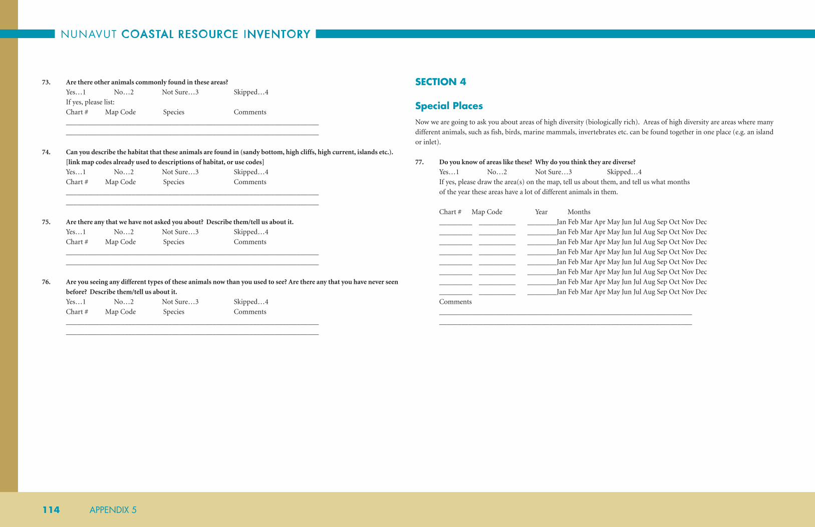
NUNAVUT COASTAL RESOURCE INVENTORY
114 APPENDIX 5
73. Are there other animals commonly found in these areas?
Yes…1 No…2 Not Sure…3 Skipped…4
If yes, please list:
Chart # Map Code Species Comments
_____________________________________________________________________
_____________________________________________________________________
74. Can you describe the habitat that these animals are found in (sandy bottom, high cliffs, high current, islands etc.).
[link map codes already used to descriptions of habitat, or use codes]
Yes…1 No…2 Not Sure…3 Skipped…4
Chart # Map Code Species Comments
_____________________________________________________________________
_____________________________________________________________________
75. Are there any that we have not asked you about? Describe them/tell us about it.
Yes…1 No…2 Not Sure…3 Skipped…4
Chart # Map Code Species Comments
_____________________________________________________________________
_____________________________________________________________________
76. Are you seeing any different types of these animals now than you used to see? Are there any that you have never seen
before? Describe them/tell us about it.
Yes…1 No…2 Not Sure…3 Skipped…4
Chart # Map Code Species Comments
_____________________________________________________________________
_____________________________________________________________________
SECTION 4
Special PlacesNow we are going to ask you about areas of high diversity (biologically rich). Areas of high diversity are areas where many
different animals, such as fish, birds, marine mammals, invertebrates etc. can be found together in one place (e.g. an island
or inlet).
77. Do you know of areas like these? Why do you think they are diverse?
Yes…1 No…2 Not Sure…3 Skipped…4
If yes, please draw the area(s) on the map, tell us about them, and tell us what months
of the year these areas have a lot of different animals in them.
Chart # Map Code Year Months
_________ __________ ________Jan Feb Mar Apr May Jun Jul Aug Sep Oct Nov Dec
_________ __________ ________Jan Feb Mar Apr May Jun Jul Aug Sep Oct Nov Dec
_________ __________ ________Jan Feb Mar Apr May Jun Jul Aug Sep Oct Nov Dec
_________ __________ ________Jan Feb Mar Apr May Jun Jul Aug Sep Oct Nov Dec
_________ __________ ________Jan Feb Mar Apr May Jun Jul Aug Sep Oct Nov Dec
_________ __________ ________Jan Feb Mar Apr May Jun Jul Aug Sep Oct Nov Dec
_________ __________ ________Jan Feb Mar Apr May Jun Jul Aug Sep Oct Nov Dec
_________ __________ ________Jan Feb Mar Apr May Jun Jul Aug Sep Oct Nov Dec
Comments
_____________________________________________________________________
_____________________________________________________________________

ARCTIC BAY
APPENDIX 5 115
Section 5
Other ReasonNow we are going to ask you about areas that are important to you for any other reason than we have already discussed.
These areas could be scenic areas, areas you consider particularly beautiful or pristine (e.g. waterfall, view, secluded).
78. Do you know of areas like these?
Yes…1 No…2 Not Sure…3 Skipped…4
If yes, please draw the area(s) on the map, tell us about them, and tell us what months
of the year these areas have a lot of different animals in them.
Chart # Map Code Year Months
_________ __________ ________Jan Feb Mar Apr May Jun Jul Aug Sep Oct Nov Dec
_________ __________ ________Jan Feb Mar Apr May Jun Jul Aug Sep Oct Nov Dec
_________ __________ ________Jan Feb Mar Apr May Jun Jul Aug Sep Oct Nov Dec
_________ __________ ________Jan Feb Mar Apr May Jun Jul Aug Sep Oct Nov Dec
_________ __________ ________Jan Feb Mar Apr May Jun Jul Aug Sep Oct Nov Dec
_________ __________ ________Jan Feb Mar Apr May Jun Jul Aug Sep Oct Nov Dec
_________ __________ ________Jan Feb Mar Apr May Jun Jul Aug Sep Oct Nov Dec
_________ __________ ________Jan Feb Mar Apr May Jun Jul Aug Sep Oct Nov Dec
Comments
_____________________________________________________________________
_____________________________________________________________________
SECTION 6
Economic DevelopmentList of types of businesses or economic development to guide discussion:
• Guiding: camps, fishing, military, transportation, training, capacity building, knowing the land
• Tourism: cultural, landscape, wildlife
• Commercial Fishery: infrastructure (e.g. Turbot fishery)
• Small Business: local harvest (e.g. clams), crafts
• Military: northern rangers
• Climate Change/Water Quality etc.: environmental monitoring activities
• Education: teachers, youth programs
• Mining
• Oil and Gas
79. Describe what the infrastructure is currently like in the community as it relates to the marine environment
(e.g. wharves, boats, storage, anchoring sites, freezers).
_____________________________________________________________________
_____________________________________________________________________
80. What infrastructure do you think is needed or could be improved in order for your community to continue current
hunting, fishing and commercial activities?
_____________________________________________________________________
_____________________________________________________________________
81. What do you think would have economic development potential in your community? What are some of your ideas?
_____________________________________________________________________
_____________________________________________________________________
82. Do you think Tourism would be a good business to have in your community? Tell us what you think about Tourism.
Yes…1 No…2 Not Sure…3 Skipped…4
_____________________________________________________________________
_____________________________________________________________________

NUNAVUT COASTAL RESOURCE INVENTORY
116 APPENDIX 5
SECTION 7
Change and the Future83. Have there been any changes you could discuss that you are concerned about? Change can be related to the animals
or your community; such things as climate change, pollution, erosion, sea ice, community, economy or quality of
country food.
______________________________________________________________________
___________________________________________________________________
84. How have these changes impacted you and your community?
___________________________________________________________________
___________________________________________________________________
85. What do you think needs to be done about those changes that have had a negative impact?
(e.g. erosion, climate change)
___________________________________________________________________
___________________________________________________________________
86. What would you like to see for the future of your community and the animals in the area?
___________________________________________________________________
___________________________________________________________________
87. What concerns do you have about increasing marine transportation? [impacts of ballast water, emissions, garbage,
shipping lanes, construction of ports, noise pollution, ice break-up]
_________________________________________________________________________
_________________________________________________________________________
Closing Questions
Before we finish, we would like to find out what you think about this kind of research and we would like to give you the
opportunity to make any further comments.
88. Do you have any questions, comments, or suggestions for us about this interview? (Y/N)
______________________________________________________________________
______________________________________________________________________
89. Is there anything that you would like to discuss that we have not already covered? (Y/N)
______________________________________________________________________
______________________________________________________________________
90. Have you ever done an interview like this before? (Y/N)
______________________________________________________________________
______________________________________________________________________
91. Did you enjoy the interview? (Y/N)
______________________________________________________________________
______________________________________________________________________
Time Interview Completed: ________________________
(optional) Time and Date of Second Appointment __________________

ARCTIC BAY
APPENDIX 6 117
APPENDIX 6SPECIES LIST AND MAPPING CODES
NUNAVUT COASTAL RESOURCE INVENTORY: SPECIES LIST
*Some species are missing Inuktitut/Inuinnaqtun names FW= Fresh Water SW= Salt Water
SARA = Department of Fisheries and Oceans. Aquatic Species at Risk.
COSEWIC = Committee on the Status of Endangered Wildlife in Canada (COSEWIC).
IUCN = International Union for Conservation of Nature (IUCN).
SPECIES COMMON NAME INUKTITUT TRANSLITERATION FRENCH INUINNAQTUN MAP
CODE NOTES
FISH SQUALIFORMES DOGFISH SHARK
Somniosus microcephalus Greenlandic Shark ᐃᖃᓗᒃᔪᐊᖅ; ᐃᖃᓗᒡᔪᐊᖅ Iqalukjuaq; Ekalugssuak; Ekalugssup piara;
Eqalugssuaq; Eqaluksuaq; Eqalukuak;
Eqalusuaq; Iqalugjuaq; Iqalujjuaq; Iqalukuak
Requin du Groenland, laimargue
Iqalugyuaq GS SW; IUCN–Near Threatened.
Centroscyllium fabricii Black Dogfish ??? ??? Aiguillat noir ??? BD SW
RAJIFORMES SKATES
Amblyraja hyperborea Arctic Skate ᒥᑎᖅ Mitiq Raie boréale Iqaluk Skate SW
Amblyraja radiata Thorny Skate SW
The list is divided into fish, invertebrates, marine
mammals, marine plants, and birds (note that each
division is further separated by a higher level of
classification). Not all species are asked about in every
community. The information for each species includes
the scientific name, common English, Inuktitut (in roman
orthography and syllabics) and Inuinnaqtun names,
mapping code and helpful notes. The purpose of the list
is to assist during our research and community interviews.
This means that all possible names, and sometimes
descriptions, of a species are included to make correct
identification in any given community more likely. The list
continues to grow and be updated, with primary sources
of information ranging from individual interviewees
to government publications, books, and independent
consultants. Hopefully, some of the complications of
regional language differences can be resolved in this way.
As a work in progress, effort is made on an on-going
basis to maintain an up-to-date and thorough list; fixing
gaps, in terms, spelling and information. Please also refer
to Appendix 7 for photos of each species represented in
the list.

NUNAVUT COASTAL RESOURCE INVENTORY
118 APPENDIX 6
SPECIES COMMON NAME INUKTITUT TRANSLITERATION FRENCH INUINNAQTUN MAP
CODE NOTES
SALMONIFORMES SALMON, TROUT, CHARS, FRESHWATER WHITEFISHES AND GRAYLINGS
Salvelinus alpinus Arctic Char ᐃᖃᓗᒃ; ᑕᕆᐅᕐᒥᐅᑕᖅ; ᐃᕕᓵᕈᖅ; ᑲᕙᓯᓕᒃ; ᑲᕕᓯᓕᒃ; ᐃᕕᑖᕈᖅ; ᐃᕕᓵᕈᖅ; ᑕᕆᐅᕐᒧᐊᕈᓐᓇᓐᖏᑦᑐᖅ; ᓯᑐᐊᔪᖅ; ᑭᓱᐊᔪᖅ; ᓯᑐᓕᖅᑐᖅ; ᑎᓱᐊᔪᖅ; ᒪᔪᖅᑐᖅ; ᒪᔪᓕᖅᑐᖅ; ᐃᕿᓗᒐᖅ
Iqaluk; Tariurmiutaq; Ivisaaruq; Kavasilik;
Kavisilik; Ivitaaruq; Tariurmuarunnanngittuq;
Situajuq; Kisuajuq; Situliqtuq; Tisuajuq;
Majuqtuq; Majuliqtuq; Iqalugaq
Omble chevalier; omble de l’Arctique
Ikaliviit; Ikalukpik;
Ivitaaruq
Char FW/SW
Salvelinus alpinus subsp.
alpinus
Land Locked Char,
Red Lake Trout
ᐃᕕᓵᕈᖅ;ᓄᑎᓕᐊᕐᔪᒃ; ᑎᓱᔪᐃᑦᑐᖅ Nutibli; Nutilli; Akalukpik; Angmalook;
Aniaq; Aopalayak; Aoparktulayoq; Aupalijaat;
Eekalook; Egaluk; Ekalluk; Ekaluk; Ekalupik;
Ekaluppik; Ekralugak; Eqalugdlukaq;
Eqalukakaq; Eqaluqaq; Eqaluk; Erlakukpik;
Hiwiterro; I ha look; Ihkaluk; Ikalopik;
Ikalukpik; Ikalupik; Ikaluq; Ikaluqpik; Iloraq;
Ilorarzuk; Iqalugaq; Iqaluk; Iqalukpiaryuk;
Iqalukpik; Iqaluppik; Iqluq; Irkaluk; Ivatarak;
Iviksarok; Ivisaaruq; Ivisaruk; Ivisaroq;
Ivitaaruq; Ivitagok; Ivitaroq; Ivitaruk;
Kaloarpok; Kalukpik; Kavasilik; Kavisilik;
Kaitilik; Kisuajuq; Lixtaa; Majuliqtuq;
Majuliqtuq; Majuqtuq; Nutidilik; Nutidleq;
Nutiliarjuk; Nutilliajuk; Nutilliq; Situajuq;
Situliqtuq; Suvaliviniq; Tadlulik; Tariurmiutaq;
Tariurmuarunnanngittuq; Tisuajuk; Tisuajuq;
Tisujuittuq
Omble chevalier dulcicole; omble chevalier d’eau douce
Ikalupik LLC FW
Salvelinus fontinalis Brook Trout ??? Aanaatlik; Aanak; Ana; Anakleq; Anokik; Anuk;
I ha luk; Iqaluk; Iqaluk tasirsiutik;
Omble de fontaine Ihuuqiq BTr FW/SW; Not known to be in Nunavut;
however, reported and said to have
thicker skin than Lake Trout.
Salvelinus confluentus Bull Trout ]ᐊᓇ ᐃᓲᕋᓕᑦᑕᖅ Aana Isuuralittaaq Omble à tête plate Aanaaqhiiq BT FW; IUCN–Vulnerable; Not known in
Nunavut;

ARCTIC BAY
APPENDIX 6 119
SPECIES COMMON NAME INUKTITUT TRANSLITERATION FRENCH INUINNAQTUN MAP
CODE NOTES
Salvelinus namaycush Lake Trout ᐃᖢᒐᖅ ᐃᖣᒐᖅ; ᐃᖣᕋᖅ; ᐃᓲᕋᖅ I&ugaq; I&uuq; Akalukpik; Col-lic-puk;
Iluuraq; Iclook; Idlorak; Ihok; Ikalukpik;
Ikhiloktok; Ikhlorak; Ilortoq; Iqluq;
Ishioraliktaq; Islorak; Isok; Isuuq; Isuuqiaq;
Isuuqiq; Isuuraaryuk; Isuuraq; Ivitaruk;
Keyteeleek; Milaqkkayoq; Naaqtuuq; Nauktoq;
Naluarryuk; Sigguayaq; Siuktuuk; Siyuktuuq;
I&uuraq
Touladi, truite grise Ikalupik, Ehok; Ihuuq LT FW
Salvelinus malma Dolly-Varden ᐃᖃᓗᒃᐱᒃ Iqalukpik Dolly-Varden; omble du Pacifique
Iqalukpik; Imaulluk DV FW/SW; Often confused with Land
Locked Char or Spawning Char. Not
known in Nunavut, but still under
investigation.
Salmo salar Atlantic Salmon ᐃᖃᓗᒃᐱᒃ Iqalukpik; Kapisalirksoak; Kapisilik;
Kavisilik; Kebleriksorsoak; Kumaliq; Saama;
Saamakutaak; Saamarug; Sama
Saumon de l’Atlantique Iqalukpik ASal FW/SW; Possible in southeastern
Nunavut; reported in Cape Dorset,
Ellesmere, Coral Harbor. Known to
occur in Kugluktuk.
Coregonus clupeaformis Lake Whitefish ᖃᑯᖅᑕᖅ; ᐊᒻᒥᕐᓗᒃᑐᖅ; ᑲᕕᓯᓕᒃ; ᐊᒥᓗᖅᓗᒃᑯᖅ; ᑲᕙᓯᓕᒃ
Qakuqtaq; Ammiurluktuq; Kavisilik;
Amiraqluktuq; Anadleq; Anahik; Anadlerk;
Jikuktok; Kakiviaktok; Kakiviartut;
Kakkiviartoq; Kalupiat; Kapihilik; Kapisilik;
Kavasilik; Kaviselik; Kavisilak; Kavisilik; Keki-
yuak-tuk; Pi-kok-tok; Pikuktuuq; Qelaluqaq
Grand corrégone, corrégone de lac
Kapihiliit; Tasirmiutaq;
Tahirmiuttat Kapihilik
LWh FW
Coregonus nasus Broad Whitefish ᓯᓕᑦᑐᖅ ᑲᕕᓯᓕᒃ; ᑲᒃᑭᕕᐊᖅᑐᖅ; ᑲᕙᓯᓕᒃ Silittuq kavisilik; Kakkiviaqtuq; Aanaaksiiq;
An-ark-hlirk; Anah’lih’; Anaklek; Anaklik;
Ananaaklik; Kausriluk; Kavasilik; Kavisilik
Corrégone tschir Hiliktut Kapihiliit BWh FW/SW; May be considered the same
as Lake Whitefish – might be found
near Kugluktuk only.
Coregonus artedi Lake Cisco ᐃᖃᓗᑐᐃᓐᓇᖅ Iqalutuinnaq; Arnarqsleq; Kapisilik; Kaviselik;
Kavisilik
Cisco de lac Kapihilik; Tahirmiuttat
Kapihilik
LaC FW/SW
Coregonus sardinella Least Cisco ᐃᖃᓗᒐᖅ Iqalugaq; Kalushak; Kapahilik; Kraaktak;
Qaqtak
Cisco sardinelle Kapihilik LeC mostly FW; May find near Kugluktuk
and probably confused with Arctic
Cisco; Known to occur in the Queen
Maud Gulf and Viscount Melville
Ecozones

NUNAVUT COASTAL RESOURCE INVENTORY
120 APPENDIX 6
SPECIES COMMON NAME INUKTITUT TRANSLITERATION FRENCH INUINNAQTUN MAP
CODE NOTES
Coregonus autumnalis Arctic Cisco ᐃᖃᓗᒃ Iqaluk; Kakatak; Kapisilik; Kraaktak; Qaqtak Cisco arctique Kapihilik ArcC FW/SW; May find near Kugluktuk
and probably confused with least
Cisco; Known to occur in the Queen
Maud Gulf, Viscount Melville and
Lancaster Sound Ecozones.
Coregonus nigripinnis Blackfin Cisco ??? ??? Cisco à nageoires noires ??? BfC FW; Possibly only northern Ontario
and Manitoba. Not known in
Nunavut.
Prosopium cylindraceum Round Whitefish
(Frost Fish)
ᒥᓗᒋᐊᖅ; ᑲᕕᓯᓕᒃ; ᑲᕙᓯᓕᒃ Milugiaq; Kavisilik; Kapisilik; Kavasilik;
Okeugnak; Osungnak
Ménomini rond Kigalik; Kaimalluriktut
Kapihiliit
RWh FW
Prosopium williamsoni Mountain Whitefish ᐱᑯᒃᑑᖅ Pikuktuuq Ménomini des montagnes Pikuktuk; Mayuqqami;
Hiuryuktuut;
Mayuqqamiuttat
Kapihilik
MWh FW; Not known in Nunavut, but
reported by interviewees.
Stenodus leucichthys Inconnu ??? Si; Si-airryuk; Sierak; Sii; Teirark; Tiktalerk Inconnu Anakhiik; Aanakhiiq Inc FW/SW; Should not occur in study
area Only known to occur in the
Beaufort Sea-Amundsen Gulf
Ecozone
Thymallus arcticus Arctic Grayling ᓱᓗᒃᐸᐅᒐᖅ Sulukpaugaq Ombre arctique Hulupaugaq ArcG FW
CYPRINIFORMES SUCKERS
Catostomus commersoni White Sucker ᖁᖅᓱᐳᖅ Quqsupuq Meunier noir, mullet Kapihilik Wsu mostly FW; Not known in Nunavut.
Reported to be seen occasionally in
Kugluktuk area.
Catostomus catostomus Longnose Sucker ᖁᖅᓱᔪᖅ Qusujuq; Quusujuuq Meunier rouge Miluqiak; Quhuyuq Lsu mostly FW
Couesius plumbeus Lake Chub ??? ??? Méné de lac Hiuryuktuut LCh FW; A large minnow, likely absent
from entire study area.

ARCTIC BAY
APPENDIX 6 121
SPECIES COMMON NAME INUKTITUT TRANSLITERATION FRENCH INUINNAQTUN MAP
CODE NOTES
GADIFORMES COD, ROCKLINGS, BURBOT, GRENADIERS
Gadus morhua Atlantic Cod ᐅᒐᖅ Ogac; Uugaq; Kabliac; Ovak; Saraudlik;
Saraudlirksoak; Sarugdligaraq; Sarugdlik;
Saugdlik; Ugak;
Morue, morue franche ??? ACod SW; IUCN-Vulnerable; COSEWIC-
Special Concern; Known to exist in
Ogac Lake (Ney Harbour, Frobisher
Bay) and in two lakes (Qasigialiminiq,
Tarijuarusiq) in NW Cumberland
Sound (Hardie et al. 2006. Can J Fish
Aquat Sci). The species might also
occur in Frobisher Bay proper and
Cumberland Sound.
Gadus ogac Greenland Cod ᐊᑯᑭᑦᑐᒥᓐᖓᕐᓯᒪᔪᖅ ᐅᒐᖅ Ogac; Owuk; Ovak; Ugak; Uugaatsuk; Uugavik;
Uugavik; Uugayak; Oarsuk; Uvak
Ogac ??? GCod SW; Found in a number of lakes on
Baffin Island, including Soper Lake in
Kimmirut.
Boreogadus saida; Arctogadus
glacialis
Arctic or Polar Cod ᐅᒐᖅ; ᐆᒐᖅ Uugaq; Uugaalaaq; Ekalluak; Ekalugak;
Equaluaq; Itok; Ogac; Ogaq; Ordlek; Ordlerit;
Ovac; Uugak; Uugaq; Ogark; Uvak
Saïda franc; saïda imberbe, morue polaire, morue arctique
Uugaq; Hiovoktok;
Uugaq; Angmagiak
Cod SW; The most abundant and widely
distributed fish in the Arctic.
Arctogadus borisovi Toothed Cod ??? ??? Saïda barbu ??? TCo SW
Lota lota Burbot ᑎᒃᑖᓕᒃ Tiktaalik; Nettarnak; Natarrnaq; Shulukpaoluk;
Tiktaalik; Tiktaaliq; Tiktabek; Tiktailik;
Tiktalaq; Tiktalik; Titale; Titalik; Titaliq;
Tittaalik
Lotte, lotte de rivière Tiktaaliq Bur FW
Gaidropsarus ensis Threebeard Rockling ??? ??? Mustèle arctique à trios barbillons
??? TR SW
Gaidropsarus argentatus Arctic Rockling ??? ??? Musèle argentée ??? AR SW
Coryphaenoides rupestris Rock Grenadier ??? ??? Grenadier de roche ??? RG SW
SCORPAENIFORMES SCULPINS, LUMPSUCKERS, SNAILFISH, POACHERS
Gymnocanthus tricuspis Arctic Staghorn
Sculpin
ᑲᓇᔪᖅ Kanajuq Tricorne arctique Kanayuq ASS SW
Myoxocephalus quadricornis Fourhorn Sculpin Itijurmiutaq Chaboisseau à quatre cornes
FW/SW; COSEWIC- Special Concern

NUNAVUT COASTAL RESOURCE INVENTORY
122 APPENDIX 6
SPECIES COMMON NAME INUKTITUT TRANSLITERATION FRENCH INUINNAQTUN MAP
CODE NOTES
Myoxocephalus thompsonii Deepwater Sculpin ᐃᑎᔪᕐᒥᐅᑕᖅ ᑲᓇᔪᖅ Kanajuq Chabot de profondeur Kanavak; Kanayuq;
Itingayumi Kanayuq
DScul FW; Only found in very deep lakes –
not present in study area; This species
is caught in trawls and gill nets in the
nearshore (50m) of the Beaufort Sea –
there is a marine Arctic form and they
are considered very abundant across
the Arctic (the glacial relic lake forms).
Myoxocephalus scorpioides Arctic Sculpin ᑲᓇᔪᖅ Kanayuk, Kanajuk, Tivaqiq Chaboisseau arctique ASc SW
Myoxocephalus scorpius Shorthorn Sculpin ᑲᓇᔪᖅ Qanirkuutuk, Kaniok, Kanayuk, Kanajuk Chaboisseau à épines courtes, crapeau de mer
??? ShS SW
Cottus cognatus Slimy Sculpin ᑲᓇᔪᖅ Kanajuq; Kanaiyok Chabot visqueux Kanayuq SScul FW
Cottus ricei Spoonhead Sculpin ᑲᓇᔪᖅ Kanajuq Chabot à tête plate Kanayuq; Aluutut
Niaqulgit Kanayuq
SpScul FW; Might be found near Chesterfield,
but small and benthic, unlikely to be
captured
Artediellus scaber Hamecon, Pough,
Rough Hookear
Sculpin
ᑲᓇᔪᖅ Kanajuq Hameçon rude ??? RHS SW
Icelus bicornis Twohorn Sculpin ᑲᓇᔪᖅ Kanajuq Icèle à deux cornes ??? TS SW
Icelus spatula Spatulate Sculpin ᑲᓇᔪᖅ Kanajuq Icèle spatulée SpS SW
Triglops nybelini Bigeye Sculpin ᑲᓇᔪᖅ Kanajuq Faux-trigle à grands yeux ??? BSc SW
Triglops pingelii Ribbed Sculpin ᑲᓇᔪᖅ Kanajuq Faux-trigle bardé ??? RSc SW
Triglops murrayi Mailed Sculpin ??? ??? Faux-trigle armé ??? MS SW
Liparis cyclostigma OR
Liparis gibbus
Variegated Snailfish,
Dusky Seasnail,
Polka-Dot Snailfish
??? Amersulak Limace marbrée ??? DSS SW
Liparis tunicatus OR Liparis
herschelinus
Bartail Seasnail,
Greenland Seasanil,
Kelp Snailfish
??? Nipishah, Nipi-sak, Nee-fitz-shak Limace des laminaires ??? BSS SW
Liparis koefoedi OR Liparis
fabricii
Gelatinous Seasnail,
Gelatinous Snailfish
??? ??? Limace gélatineuse ??? GSS SW
Liparis atlanticus Atlantic Seasnail ??? Nipi-shah, Nipisak Limace atlantique ??? AS SW

ARCTIC BAY
APPENDIX 6 123
SPECIES COMMON NAME INUKTITUT TRANSLITERATION FRENCH INUINNAQTUN MAP
CODE NOTES
Cyclopterus lumpus Lumpsucker,
Lumpfish
ᓂᐱᓴ Qorkshuyoq, Nipisa, Nepisa, Lepisuk,
Arnardluk, Arnardlok, Angusedlok,
Angusatdluk
Lompe, Grosse poule de mer
??? Lump SW
Cyclopteropsis jordani Smooth Lumpfish ᓂᐱᓴ Nipisa Petite poule de mer douce ??? SLu SW
Eumicrotremus derjugini Leatherfin
Lumpsucker
??? ??? Petite poule de mer arctique
??? LL SW
Eumicrotremus spinosus Atlantic Spiny
Lumpsucker
??? Nepisardluk, Nepisardluarsuk, Man-iktoe Petite poule de mer atlantique
??? ASL SW
Ulcina olrikii Arctic Alligator Fish ??? ??? Poisson-aligator arctique AAF SW
Leptagonus decgonus Atlantic Sea Poacher ??? Kaniordluk, Kanajordlak Agone atlantique ??? ASP SW
Sebastes marinus Ocean Perch, Golden
Redfish
??? Sulugpâvaq, Sulugpavak, Sullupaugak,
Iterdlarnat
Sébaste orangé ??? OP SW
Sebastes mentella Deepwater Redfish ??? ??? Sébaste atlantique ??? DR SW
PERCIFORMES EELPOUTS, SHANNIES, SANDLANCE, WOLFISH, GUNNELS
Sander vitreus Walleye ᓱᓗᒃᐸᐅᒐᖅ Sulukpaugaq Doré jaune Uugaq WE SW; Not known in Nunavut.
Lycodes reticulatus Arctic Eelpout ᖁᔾᔭᐅᓐᓇᖅ Qujjaunnaq; Sulupavak Lycode arctique Quliiligaq AOP SW; There is tons of Lycodes spp.
They are very difficult to ID and
I believe there are approximately
15 possible species with the most
diverse collections located in Davis
Strait-Baffin Bay. Reported to be seen
occasionally in Kugluktuk area. Ocean
pout.
Lycodes mcallisteri McAllister’s Eelpout ??? ??? Lycode de McAllister ??? McE SW
Lycodes jugoricus Shulupaoluk ??? ??? Lycode plume ??? Shu SW
Lycodes adolfi Adolf ’s Eelpout ??? ??? Lycode d’Adolf ??? AE SW
Lycodes mucosus Saddled Eelpout ??? Kuxrauna, Kugrauna Lycode à selles ??? SaE SW
Lycodes pallidus Pale Eelpout ??? ??? Lycode pâle ??? PalE SW
Lycodes polaris Canadian Eelpout ??? ??? Lycode polaire ??? CE SW
Lycodes rossi Threespot Eelpout ??? ??? Lycode à trios taches ??? TE SW
Lycodes seminudus Longear Eelpout ??? ??? Lycode à oreilles ??? LEe SW

NUNAVUT COASTAL RESOURCE INVENTORY
124 APPENDIX 6
SPECIES COMMON NAME INUKTITUT TRANSLITERATION FRENCH INUINNAQTUN MAP
CODE NOTES
Lycodes paamiuti Paamiut Eelpout ??? ??? Lycode de Paamiut ??? PaaE SW
Lycodes tuneri Polar Eelpout ??? ??? Lycode polaire ??? PE SW
Lycodes luetkenii Lutken’s Eelpout ??? ??? Lycode de Lutken ??? LE SW
Gymnelus barsukovi Barsukov’s Pout ??? ??? Unerrnak de Barsukov ??? BP SW
Gymnelus retrodorsalis Aurora Unernak,
Aurora Pout
??? ??? Unernak aurore ??? AP SW
Gymnelus viridis Fish Doctor ??? Coogjannernak; Koupjhaun-ohuk; Kugsaunak;
Unernak
Unernak caméléon, anguille de mer
Kuukkap Iqalungi FD SW
Lumpenus fabricii Slender Eelblenny ᐊᒻᒪᔪᖅ Ammajuq; Hutdaun; Tejarnak Lompénie de Fabricus, lompénie élancée
Angmayuq Seel SW; There are a lot of other Stichaeids
that are present in the study areas as
well.
Lumpenus masculatus Daubed Shanny ??? ??? Lompénie tachetée ??? DS SW
Anisarchus medius Stout Eelblenny ??? Shalup-pau-gah Lompénie naine ??? StE SW
Eumesogrammus praecisus Fourline Snakeblenny ??? ??? Quatre-lignes atlantique ??? FSb SW
Ammodytes hexapterus Pacific Sand Lance ᖁᓪᓕᓕᒐᖅ Quliiligaaq Lançon gourdeau, lançon du Pacifique
Iqaluk Sndl SW
Ammodytes dubius Northern Sand Lance ??? Putorutôk Lançon du Nord ??? NSL SW
Anarhichas denticulatus Northern Wolfish ᓂᐱᓴ Nipisa; Kerak; Qeraq Loup à tête large Iqaluk Wolf SW; SARA; COSEWIC–Threatened
Anarhichas minor Spotted Wolfish SW; SARA; COSEWIC–Threatened
Anarhichas lupus Atlantic Wolfish SW
Pholis fasciata Banded Gunnel ??? Quvsaunaq, Kurksaunak, Kugsaunak Sigouine rubannée ??? BG SW
PLEURONECTIFORMES FLOUNDERS, HALIBUT
Platichthys stellatus Starry Flounder ᐅᓪᓗᕆᐊᑐᑦ ᓇᑕᕐᓇᖅ Ubluriatut Nataarnaq ; Ikkahnalook;
Ipkelnokto; Ipkuknaluk; Nadalna; Nataktook;
Natanak; Natangnok; Natarnak; Natarnaq
Flet étoilé Ubluriatut Nataarnaq StF SW
Liopsetta glacialis,
Pleuronectes glacialis
Arctic Flounder ᓇᑕᕐᓇᖅ Natarrnaq Plie arctique Nataarnaq AFl mostly SW
Pseudopleuronectes
americanus
Winter Flounder/
Black-back Flounder
ᓇᑕᕐᓇᖅ; ᐅᑭᐅᑉ ᓇᑕᕐᓇᖅ\ᕿᖕᓇᕆᒃᑐᖅ ᓇᑕᕐᓇᖅ
Natarrnaq Plie rouge Natanak; Ukiup
Nataarnaq/
Qingnariktuq
Nataarnaq
WFl SW
Reinhardtius hippoglossoides Greenland Halibut/
Turbot
ᖃᓕᕋᓕᒃ; ᓇᑕᕐᓇᖅ; ᑎᒃᑲᓕᒃ Qaliralik; Nattarnaq; Kaleralik; Nat-ah-nuh;
Natarnak; Natarnaq; Netarnarak; Qaleralik;
Tikkalik
Flétan du Groenland, flétan noir
Qaliralik GHal SW

ARCTIC BAY
APPENDIX 6 125
SPECIES COMMON NAME INUKTITUT TRANSLITERATION FRENCH INUINNAQTUN MAP
CODE NOTES
OSMERIFORMES SMELTS
Mallotus villosus Capelin ᐃᒡᓕᒐᖅ; ᐃᒡᓕᓐᓇᖅ Igligaq (Baffin); Iglinnaq (Chesterfield);
Quliiligaq; Amagiak; Angmaggeuck;
Angmagsaat; Angmagsak; Anmugrun;
Axmagaiaq; Holili-gah; Ko le le kuk; Nulilighuk;
Qoliiligaq; Qulilirraq; Igliraq
Capelan, capelin Angmagiaq Cape FW/SW
Osmerus mordax Rainbow Smelt ᐃᖃᓗᒃ ??? Éperlan, éperlan arc-en-ciel, éperlan de lac
Iqaluk RBS FW/SW
CULPEIFORMES HERRINGS
Clupea harengus Atlantic Herring ᑲᐱᓯᓕᒃ Kapisilik Hareng, hareng atlantique Angmagiaq; Kapihilik AHerr SW; Not known in Nunavut, but
reported by interviewees.
Clupea pallasii Pacific Herring ᑲᐱᕼᐃᓕᒃ Kapihilik Hareng du Pacifique Kapihilik PHerr SW; Not known in Nunavut, but
reported by interviewees.
PERCOPSIFORMES TROUT-PERCHES
Percopsis omiscomaycus Trout-perch ᐃᖃᓗᒐᖅ Iqalualaaq Omisco Hiuryuktuut TP FW; Not known in Nunavut.
ESOCIFORMES PIKES
Esox lucius Northern Pike ᓯᒡᒍᓕᒃ Siggulik; Siulik; Idlulukak; Ihok; Kikiyuk;
Kiqyoq; She; Sheoak; Siilik; Siolik; Siulik; Siun;
Sjulik; Tchukvak
Brochet du Nord, grand brochet
Hiulik NP FW
GASTEROSTEIFORMES STICKLEBACKS
Pungitius pungitius Ninespine Stickleback ᐃᖃᓗᒐᖅ; ᑲᑭᓚᓴᒃ; ᑲᑭᓕᓴᒃ Kakilasak; Kakelashuk; Kakidlautidlik;
Kakilahaq; Kakilasak; Kakilisak; Kakilishek;
Kakilusuk; Kakiva; Kakkilasak; Natagnak
Épinoche à neuf épines Iqalugaq NStb Very small fish
Gasterosteus aculeatus Threespine
Stickleback
ᐃᖃᓗᒐᖅ Kakilasak Épinoche à trois épines Iqalugaq TStb FW/SW; Chesterfield Inlet only – very
small fish; Known to occur in the
Queen Maud Gulf, Baffin Bay-Davis
Strait Nearshore and the High Arctic
ecozones.
MYCTOPHIFORMES LANTERNFISHES
Benthosema glaciale Glacier Lantern Fish ᐊᐅᓚᕿᐅᔭᖅ Aulaqiujaq; Kapisalingoak; Kapisilik; Keblernak;
Mikiapic kapisilik
Lanterne glaciaire Iqaluk GLF SW
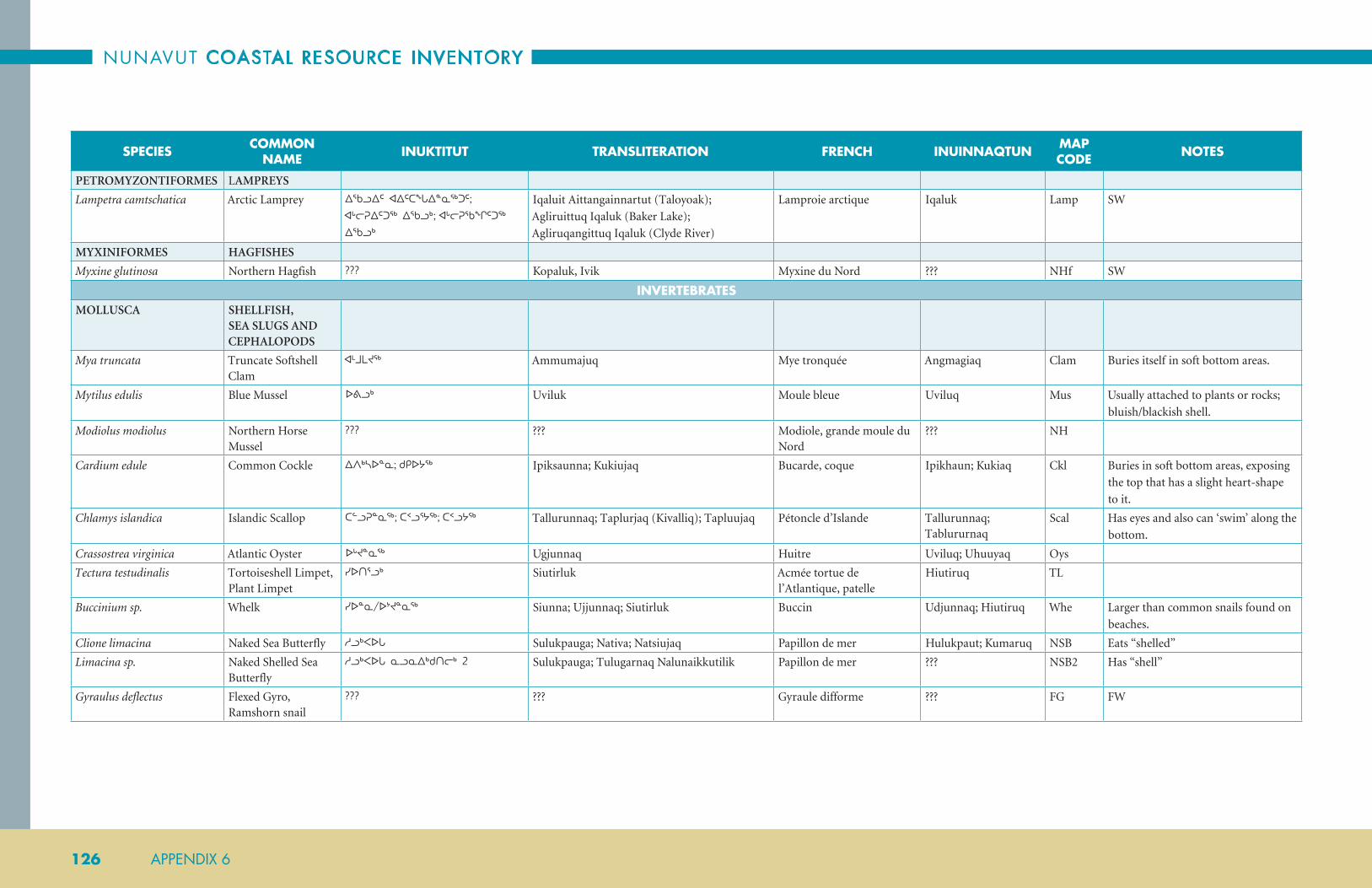
NUNAVUT COASTAL RESOURCE INVENTORY
126 APPENDIX 6
SPECIES COMMON NAME INUKTITUT TRANSLITERATION FRENCH INUINNAQTUN MAP
CODE NOTES
PETROMYZONTIFORMES LAMPREYS
Lampetra camtschatica Arctic Lamprey ᐃᖃᓗᐃᑦ ᐊᐃᑦᑕᖓᐃᓐᓇᖅᑐᑦ; ᐊᒡᓕᕈᐃᑦᑐᖅ ᐃᖃᓗᒃ; ᐊᒡᓕᕈᖃᖏᑦᑐᖅ ᐃᖃᓗᒃ
Iqaluit Aittangainnartut (Taloyoak);
Agliruittuq Iqaluk (Baker Lake);
Agliruqangittuq Iqaluk (Clyde River)
Lamproie arctique Iqaluk Lamp SW
MYXINIFORMES HAGFISHES
Myxine glutinosa Northern Hagfish ??? Kopaluk, Ivik Myxine du Nord ??? NHf SW
INVERTEBRATESMOLLUSCA SHELLFISH,
SEA SLUGS AND CEPHALOPODS
Mya truncata Truncate Softshell Clam
ᐊᒻᒧᒪᔪᖅ Ammumajuq Mye tronquée Angmagiaq Clam Buries itself in soft bottom areas.
Mytilus edulis Blue Mussel ᐅᕕᓗᒃ Uviluk Moule bleue Uviluq Mus Usually attached to plants or rocks;
bluish/blackish shell.
Modiolus modiolus Northern Horse Mussel
??? ??? Modiole, grande moule du Nord
??? NH
Cardium edule Common Cockle ᐃᐱᒃᓴᐅᓐᓇ; ᑯᑭᐅᔭᖅ Ipiksaunna; Kukiujaq Bucarde, coque Ipikhaun; Kukiaq Ckl Buries in soft bottom areas, exposing
the top that has a slight heart-shape
to it.
Chlamys islandica Islandic Scallop ᑕᓪᓗᕈᓐᓇᖅ; ᑕᑉᓗᕐᔭᖅ; ᑕᑉᓗᔭᖅ Tallurunnaq; Taplurjaq (Kivalliq); Tapluujaq Pétoncle d’Islande Tallurunnaq; Tablururnaq
Scal Has eyes and also can ‘swim’ along the
bottom.
Crassostrea virginica Atlantic Oyster ᐅᒡᔪᓐᓇᖅ Ugjunnaq Huitre Uviluq; Uhuuyaq Oys
Tectura testudinalis Tortoiseshell Limpet, Plant Limpet
ᓯᐅᑎᕐᓗᒃ Siutirluk Acmée tortue de l’Atlantique, patelle
Hiutiruq TL
Buccinium sp. Whelk ᓯᐅᓐᓇ/ᐅᔾᔪᓐᓇᖅ Siunna; Ujjunnaq; Siutirluk Buccin Udjunnaq; Hiutiruq Whe Larger than common snails found on
beaches.
Clione limacina Naked Sea Butterfly ᓱᓗᒃᐸᐅᒐ Sulukpauga; Nativa; Natsiujaq Papillon de mer Hulukpaut; Kumaruq NSB Eats “shelled”
Limacina sp. Naked Shelled Sea Butterfly
ᓱᓗᒃᐸᐅᒐ ᓇᓗᓇᐃᒃᑯᑎᓕᒃ 2 Sulukpauga; Tulugarnaq Nalunaikkutilik Papillon de mer ??? NSB2 Has “shell”
Gyraulus deflectus Flexed Gyro, Ramshorn snail
??? ??? Gyraule difforme ??? FG FW

ARCTIC BAY
APPENDIX 6 127
SPECIES COMMON NAME INUKTITUT TRANSLITERATION FRENCH INUINNAQTUN MAP
CODE NOTES
Arctic Moonsnail
Gonatus fabricii Boreal Armhook Squid
ᐊᒥᒡᒍᖅ Amigguq Encornet atlantoboréal Amilguit; Amigguq BAS
ECHINODERMATA URCHINS, STARFISH AND SEA CUCUMBERS
Strongylocentrotus pallidus Pale Sea Urchin ᒥᖅᑯᓕᒃ; ᐃᑎᐅᔭ Miqqulik; Itiuja; Nuvaqqiq Itiq Oursin Mitqulik SU
Leptasterias polaris Polar Sea Star ᐅᓪᓗᕆᐊᙳᐊᖅ Ullurianguaq Étoile de mer polaire Ubluringuat; Algauyaq PStar
Ctenodiscus crispatus Mud Star ᐅᓪᓗᕆᐊᙳᐊᖅ Ullurianguaq Étoile de vase Ublurianguat; Marluk Algauyaq
MStar
Gorgonocephalus arcticus Northern Basket Star ᓄᕙᖅᑭᖅ Nuvaqqiq Fausse étoile de mer Ublurianguat; Algauyaq
BStar
Cucumaria frondosa North Atlantic Sea Cucumber
??? ??? Holothurie, concombre de mer
Algauyaq SCuc
ARTHROPODA CRUSTACEANS AND ZOOPLANKTON
Chionoecetes opilio Snow Crab ᓂᐅᒐᓚᒃᑐᖅ Niugalaktuq Crabe des neiges Uviguit; Illiriq SnC Large crab; not likely in Nunavut.
Hyas araneus Toad Crab ᐳᔾᔪᑦ Pujjuut Crabe lyre de l’Atlantique, crabe araignée
Illiriq TC
Pagurus Sp. Hermit Crab ᐳᔾᔪᑦ Huumit Putjjuti Bernard l’ermite Uvigyuit; Illiriq HC
Lithodes maja Deep Sea King Crab ᐃᑎᔪᕐᒥᐅᖅ ᐳᔾᔪᑎ Itijurmiuq Pujjuuti Crabe épineux Uvigyuit; Illiriq DSKC
Austropotamobius pallipes Crayfish ᓇᐅᓚᕐᓇᖅ Naularnaq; Pujjuuti (marine) Écrevisse Naularnaq; Pojogak CRF
Pandalus borealis Northern Shrimp ᑭᖑᒃᐸᒃ Kingukpak Crevette nordique Kinguk NS
Pandalus montagui Striped Shrimp ??? Kingukpak Crevette ésope ??? SSh
Amphipoda Amphipod ᑭᖑ Kingu Amphipode Kinguk; Kingunnuit Amph Abundant everywhere; even in ice
cracks. Seals apparently eat them as
well.
Meganyctiphanes norvegica Northern Krill ᑭᖑ Kingu Krill subarctique, euphausiacés
Kinguk; Kumaruq NK
Americamysis Mysid Shrimp ᑭᖑ Kingu Mysis Kinguk MyS
Balanus Sp. Acorn Barnacle ᖃᐅᒐᓕᐊᖅ Qaugaliaq Balane, pouce-pied, anatife Qaugaliaq Barn
Pycnogonida Sea Spider ? ? ? ?

NUNAVUT COASTAL RESOURCE INVENTORY
128 APPENDIX 6
SPECIES COMMON NAME INUKTITUT TRANSLITERATION FRENCH INUINNAQTUN MAP
CODE NOTES
ANNELIDA WORMS
Chaetopterus variopedatus Parchment Worm ᑎᓂᓐᓂᕐᒥᐅᖅ ᖁᐱᕐᕈᖅ Tininnirmiuq Qupirruq Ver à tube de parchemin Imarmaiuttat Nuulaittut Kumaruit
PWorm
Tomopteris helgolandica Plankton Worm ᐃᒪᕐᒥᐅᑕᖅ ᓄᒍᓐᓇᖏᑦᑐᑦ ᐃᒻᒥᓂᒃ Imarmiutaq Nuugunnangittut Imminik Ver planctonique Angmagiaq PLW
CNIDARIA SEA ANENOMES AND JELLYFISH
Actinaria Sea Anemone ᐃᑎᖅ Itiq Actinie, anémone de mer Itiq; Puuqaluaq San
Scyphozoa Jellyfish ᐃᒃᐱᐊᕐᔪᔭᖅ Ikpiarjujaq; Nuvaliq; Nuvaqqiq Méduse Haittuq; Itquyaq Jf
OTHER: CHAETOGNATHA, CTENOPHORA, PORIFERA
WORMS, CTENPHORES AND SPONGES
Chaetognath Arrow Worm ᓴᐃᑦᑐᖅ Saittuq Chétognathe Quipirruq AWorm
Ctenophora Ctenophore ??? Ippiarjuujaq Cténophores, cténaires ??? Ct Many different types. First mentioned
in Arctic Bay.
Neoesperiopsis rigida Orange Finger Sponge
ᐊᒡᒐᔭᓐᖑᐊᑦ Aggajaannguaq Éponge digitée Algauyaq FS
MARINE MAMMALSURSIDAE BEARS
Ursus maritimus Polar Bear ᓇᓄᖅ; ᐊᑎᖅᑕᓛᖅ; ᐊᑎᖅᑕᖅ; ᓇᓄᐊᓛᖅ; ᐊᑎᖅᑕᓕᒃ; ᐊᖑᔾᔪᐊᖅ
Nanuq; Aatiqtaq; Nanualaaq; Atiqtalik; Angujjuaq
Ours blanc, ours polaire Nanuq PB COSEWIC – Special Concern;
IUCN- Vulnerable.
PINNIPEDS WALRUS, SEALS AND SEA LIONS
Odobenus rosmarus Walrus ᐊᐃᕕᖅ; ᐊᐃᕕᐊᓛᖅ; ᐃᓴᐅᒐᖅ; ᓄᑲᑐᒐᕐᔪᐊᖅ; ᓄᑲᑐᒐᖅ; ᑎᖕᒥᖅᑎ; ᐅᕕᖏᐊᔪᖅ; ᕿᕐᓇᓗᒃ
Aiviq; Aivialaaq; Isaugaq; Nukatugarjuaq; Nukatugaq; Tingmiqti; Timmiqti; Uvingiajuq; Qirnaluk
Morse Aiviq Wal
Phoca hispida Ringed seal ᓇᑦᓯᖅ; ᓇᑦᑎᖅ; ᒥᖅᑯᖅᑐᓕᑦ; ᓇᑦᓯᐊᖅ; ᓇᑦᑎᐊᖅ; ᐹᓐᖑᓕᐊᖅ; ᓇᑦᓯᐊᕕᓂᖅ; ᓇᑦᑎᐊᕕᓂᖅ; ᐱᕕᓂᖅ; ᓇᑦᓯᐊᓕᒃ; ᓇᑦᑎᐊᓕᒃ; ᓄᓂᖅ; ᑎᒡᒐᖅ; ᒥᖅᑭᐊᖅ; ᒪᒫᖅᑐᖅ; ᓇᔭᓇᖅ
Natsiq; Nattiq; Miqquqtulik; Natsiaq; Nattiaq; Paannguliaq; Natsiaviniq; Nattiaviniq; Piviniq; Natsialik; Nattialik; Nuniq; Tiggaq; Miqqiaq; Mamaaqtuq; Najanaq
Phoque annelé Natiinat; Nattiq RS
Phoca groenlandica ORPagophilus groenlandicus
Harp seal ᖃᐃᕈᓕᒃ Qairulik Phoque du Groenland Qairulik HS
Erignathus barbatus Bearded seal ᐅᒡᔪᒃ; ᑎᕆᒡᓗᒃ; ᑎᕆᒡᓛᖅ; ᐅᒡᔪᒐᓛᖅ Ugjuk Tirilluk; Tirigluk; Tiriglaaq; Ugjugalaaq Phoque barbu Ukyuk; Ugyuk BS

ARCTIC BAY
APPENDIX 6 129
SPECIES COMMON NAME INUKTITUT TRANSLITERATION FRENCH INUINNAQTUN MAP
CODE NOTES
Cystophora cristata Hooded seal, Crested seal
ᐊᐸ; ᓇᑦᓯᕙᒃ Apa; Natsiva; Natsivak Phoque à capuchin, phoque à crête
Nahakakaktututittut; Nattivak
HoS IUCN–Vulnerable.
Phoca vitulina Harbour Seal, Ranger Seal
ᖃᓯᒋᐊᖅ Qasigiaq Phoque commun Qahigiak HbS (formerly recorded as ‘SpSeal’)
Seen in and near rivers in summer.
Sometimes referred to as Spotted Seal.
Phocoena phocoena Harbour Porpoise ??? ??? Marsouin commun ??? HP
CETACEANS TOOTHED WHALES AND BALEEN WHALES
Lagenorhynchus acutus Atlantic White-Sided Dolphin
??? Tikaagullik Dauphin à flancs blancs ??? AWSD
Lagenorhynchus albirostris White-Beaked Dolphin
??? Tikaagullik Dauphin à nez blanc ??? WBD
Hyperoodon ampullatus Northern Bottlenose Whale
??? ??? Baleine à bec commune ??? NBD
Globicephala melas Long-Finned Pilot Whale
??? ??? Globicéphale noir ??? LFPW
Orcinus orca Killer Whale ᐊᕐᓗᒃ; ᐋᕐᓗᖅ; ᐋᕐᓗ Aarluk; Aarluq; Aarlu Épaulard, orque KW COSEWIC–Special Concern.
Delphinapterus leucas Beluga ᕿᓚᓗᒐᖅ; ᕿᓇᓗᒐᖅ; ᖃᐅᓗᖅᑕᖅ; ᐃᔅᓱᖅᑲᖅ
Qilalugaq; Qinalugaq; Qauluqtaq; Issuqqaq Béluga Bel; COSEWIC- Endangered;
IUCN- near threatened.
Monodon monoceros Narwhal ᑐᒑᓕᒃ;ᑑᒑᓕᒃ; ᕿᕐᓕᖅᑕᖅ ᕿᓚᓗᒐᖅ; ᐊᓪᓚᖑᐊᖅ; ᐊᕐᓇᓪᓗᐊᖅ; ᐊᕐᓇᓪᓗᖅ
Tuugaalik; Tualiq; Qirniqtaq qilalugaq; Allanguaq; Arnalluaq: Arnalluq
Narval Tuugaaq; Tuugaalik NW COSEWIC – Special Concern;
IUCN – Near threatened.
Balaena mysticetus Bowhead Whale ᐊᕐᕕᒃ Arvik Baleine boréale, baleine du Groenland
Arviq; Paulatuk BW COSEWIC- Endangered.
Eubalaena glacialis North Atlantic Right Whale
ᐊᐸᒃ Ipak Baleine noire, baleine noire de l’atlantique Nord
Arvik RW Very unlikely to be seen in Nunavut;
COSEWIC- Endangered; SARA;
IUCN-Endangered.
Balaenoptera acutorostrata Common Minke Whale
ᑎᑲᒍᓪᓕ Tikaagulliq Qilalugaq Qilalugaq MW
Balaenoptera physalus Fin Whale ??? ??? Rorqual commun ??? FW IUCN- Endangered.
Balaenoptera musculus Blue Whale ᐃᐸᒃ Ipak Rorqual bleu, baleine bleue ??? BlW IUCN – Endangered.
Balaenoptera borealis Sei Whale ??? ??? Rorqual boréal ??? Sei
Physeter macrocephalus/catodon
Sperm Whale ᑭᒍᑎᓕᒃ Kigutilik Cachalot ??? SpW IUCN- Vulnerable.

NUNAVUT COASTAL RESOURCE INVENTORY
130 APPENDIX 6
SPECIES COMMON NAME INUKTITUT TRANSLITERATION FRENCH INUINNAQTUN MAP
CODE NOTES
Megaptera novaeangliae Humpback Whale ??? ??? Rorqual à bosse ??? HW
SEAWEED AND MARINE PLANTSPHAEOPHYCEAE BROWN SEAWEED
Alaria marginata Edible Kelp ᑯᐊᓐᓂ Kuanni Alarie comestible Kuani; Nirilaat Qiqquat
EK Ujamiruti (ᐅᔭᒥᓯᑎ) – lower leaf
Saccharina longicrurus Hollow Stemmed Kelp
ᕿᖅᑯᐊᖅ Qiqquaq Laminaire à long stipe Qiqquat; Haalukkaat Qiqquat
HSK
Agarum clathratum Sea Colander ᖃᓪᓗᓐᓂᐅᑎ Qallunniuti Agare criblé Qallunniutit; Taryup Qalunniut
Scol
Desmarestia aculeata Spiny Sour Weed ᐃᖂᑎ Iquuti Algue desmarestia Aqayat; Kuannik SSW
Fucus vesiculosus Bladder Wrack, Rockweed
ᐃᖂᑎ Iquti Fucus vésiculeux Aqayat; Iquutit BWra
RHODOPHYTA RED ALGAE
Codium fragile Green sea fingers ᐊᖃᔭ Aqaja Algue codium fragile Aqayat; Hungayaaqtut Taryup Qikquat
GSF Was arctic kelp. Reported in deeper waters where freshwater meets salt water.
Palmaria palmata Dulse ᐃᖂᑎᑦ Iquutit Rodyménie palmé Aqayat; Quannik Dul
LILIOPSIDA MONOCOT PLANTS
Zostera marina Eel Grass ??? ??? Zostère marine ??? EG
Potamogeton robbinsii Robbin’s Pondweed ??? ??? Potamot de Robbins ??? RP
Potamogeton alpinus Alpine Pondweed ??? ??? Potamot alpin ??? APw
Potamogeton gramineus Variableleaf Pondweed
??? ??? Potamot à feuilles de graminées
??? VP
Potamogeton praelongus Whitestem Pondweed ??? ??? Potamot à long pédoncule ??? WP
Pleuropogon sabinei Semaphore Grass ??? ??? ???
Puccinellia phryganodes Goose Grass ᓄᑭᖁᐊᑦ Nakiruat ???
MAGNOLIOPSIDA EUDICOT PLANTS
Mertensia maritima Sea Lungwort ᕿᖅᑯᐊᑦ Qiqquat; Siurap uqaujangit Mertensia maritime Qiqquat; Taryup nauttiangit
SL Color of flower varies.
Ranunculus hyperboreus Floating Buttercup ??? Iguttait niqingita ajjikasingit ???
Hippuris vulgaris Mare’s Tail ??? ??? ???

ARCTIC BAY
APPENDIX 6 131
SPECIES COMMON NAME INUKTITUT TRANSLITERATION FRENCH INUINNAQTUN MAP
CODE NOTES
BIRDSANATIDAE GEESE, SWANS &
DUCKS
Anser albifrons Greater White-fronted Goose
ᓂᕐᓕᒃ; ᓂᕐᓕᕕᒃ; ᓂᕐᓕᓐᓇᖅ Nirlik Oie rieuse, oie à fronc blanc Nirlivik GWFG (WFG)
Orange bill and feet. White patch on face at base of bill. Variable black bars on belly. Generally found near water in open grassy tundra. Widespread breeder on mainland, also present on Victoria Isl.
Chen caerulescens Snow Goose ᑲᖑᖅ; ᑲᕐᒍᐊᕌᓗᒃ; ᑲᕕᒃ; ᑲᒐᑦᔪᒃ; ᑲᖑᖅ; ᑲᕋᕐᔪᒃ; ᖃᕕᖅ
Kanguq; Kararjuk; Qaviq Oie des neiges, oie blanche Kanguq SNGO (SG)
A white phase with black wingtips with pinkish bill and feet, and a dark (or ‘blue’) phase; very dark with white head. Grin patch on bill. On open tundra; usually in colonies. Present throughout arctic islands with scattered colonies on mainland.
Chen rossii Ross's Goose ᖃᕌᕐᔭᒃ Qaaraarjak Oie de Ross Kakat; Qaqat ROGO (RG)
Smaller than Snow Goose. No grin patch. Stubby bill. Usually associate with Snow Goose. Breeds mainly in Perry River area on gulf as well as Southampton Isl.
Branta bernicla Brant ᓂᕐᓕᖕᓇᖅ; ᓂᑉᓕᒃ; ᓂᕐᓕᕐᓇᖅ; ᓂᕐᓕᕐᓈᕐᔪᒃ Nirlingnaq; Nirlirnaq; Nirlirnaarjuk Bernache ctavant Nirlirnaq BRAN (Bran)
Black chest, head and neck with white patch on neck. Nests on islets or at water edge. Present along gulf coast and throughout the arctic islands.
Branta hutchinsii Cackling Goose ᓂᕐᓕᕐᓇᖅ; ᓂᕐᓕᕌᕐᔪᒃ Nirliknaq Bernache de Hutchins Niklivik; Nirlivinnuaq CACG (CacG)
Black neck; white chinstrap. Smaller version of a Canada Goose. Usually near water. Found from southern Victoria Isl. south and eastwards on mainland. Also present on Southampton and s.w. Baffin.
Branta canadensis Canada Goose ᓂᕐᓕᒃ;ᓂᑉᓕᒃ;ᐅᓗᐊᒍᓚᖅ; ᑎᒻᒥᐊᖅ; ᓂᕐᓕᖅ; ᐅᓪᓗᐊᓪᓕᒃ
Nirlik; Nirliq; Ulluagullik Bernache du Canada, outarde
Nikliknik; Olagalik; Niqlirniq
CANG (CG)
Very large goose. Black neck with white chinstrap. Usually near water. Widespread throughout mainland Nunavut as well as Southampton, Victoria and southern Baffin Isl.

NUNAVUT COASTAL RESOURCE INVENTORY
132 APPENDIX 6
SPECIES COMMON NAME INUKTITUT TRANSLITERATION FRENCH INUINNAQTUN MAP
CODE NOTES
Cygnus columbianus Tundra Swan ᖁᒡᔪᒃ Qugjuk Cygne siffleur Kukyuk; Qukyuk TUSW (TS)
Very large, white bird. Black bill and legs. Widespread throughout mainland portions of Nunavut and on Victoria and Baffin islands.
Anas clypeata Northern Shoveler ??? ??? Canard souchet, souchet ??? NSHO
Anas americana American Wigeon ᐊᖑᑎᕕᐊᖅ Angutiviaq Canard siffleur d’Amérique, canard d’Amérique
Angutiviaq; Alrinnaaq AMWI (AWig)
Male with white patch on forehead, green patch on side of head. Female has brown and gray head. Usually near water. Breeding records only from mainland.
Anas platyrynchos Mallard ᕿᖓᓛᖅ Qingalaaq Canard colvert, canard mallard
Alrinnaaq MALL (Mall)
Glossy green head, chestnut breast with white neck ring. Yellow bill. Female a mottled brown. Patched bill (orange/black). Breeds on mainland and in Bay islands. Nests on mainland.
Anas acuta Northern Pintail ᖁᒻᒧᐊᔫᒃ; ᑦᑲᓄᑑᒃ; ᖁᒻᒧᐊᔫᖅᖁᒻᒧᕐᔪᒃ; ᐊᕐᓇᕕᐊᖅ
Qummuajuuq; Qummukaijuuq (Chesterfield); Qummuarjuk; Arnaviaq
Canard pilet Arnaviaq; Kikaq NOPI (NPin)
Slim neck. Long pointed tail Brown head with white breast which extends to side of head. Female a mottled brown. Nests in long grass. Breeds on Victoria and Southampton islands and throughout the mainland. Rare breeding records from other island locations.
Anas crecca Green-winged Teal ᒥᑎᓪᓗᒃ ??? Sarcelle d’hiver, sarcelle à ailes vertes
Alrinnaaq; Mitilluk GWTE (GWT)
Small size. Brown head with green patch and green speculum. White vertical mark at front of wing noted when swimming. Female a mottled brown with green speculum. Generally a visitor only to most of Nunavut. Sporadic nesting on mainland and in James Bay. Absent as a breeder in arctic islands. Has bred on mainland and in Bay islands.
Aythya marila Greater Scaup ᒥᑎᕐᓗᒃ Mitirluk Filigule milouinan, grand morillon
Mitilluk GRSC (GrS)
Gray back, white sides, dark (greenish) head. Gray bill. Female is a rich brown. Nests in long grass. Breeds only on lower mainland.

ARCTIC BAY
APPENDIX 6 133
SPECIES COMMON NAME INUKTITUT TRANSLITERATION FRENCH INUINNAQTUN MAP
CODE NOTES
Aythya affinis Lesser Scaup ??? ??? Petit filigule, petit morillon ??? LESC
Somateria spectabilis King Eider ᕿᖓᓕᒃ; ᒥᑎᖅ; ᐊᖕᑯᑎᕕᐊᖅ; ᕿᖓᓛᖅ; ᕿᖓᓕᐅᑉ ᐊᕐᓇᓪᓗᖓ; ᕿᖓᓕᐅᑉ ᓄᓕᐊᔮᖓ; ᐊᕐᓇᕕᐊᖅ
Qingalik; Amaulik; Mitiq; Qingalaaq; Qingaliup arnallunga; Qingaliup nuliajaanga; Arnaviaq
Eider à tête grise, eider remarquable
Kingalik; Qingalik KIEI (KE)
Orange bill and facial shield. White chest and neck. Black body with much white on wings. Female a rich brown and heavily barred pattern. Usually in short grass near water. Breeds throughout the arctic islands and along the mainland coasts. Floe edge.
Somateria mollissima Common Eider ᐊᒪᐅᓕᕐᔪᐊᖅ; ᒥᑎᕕᐊᕐᔪᒃ; ᒥᑎᖅ; ᐊᒪᐅᓕ; ᐊᒪᐅᓕᒡᔪᐊᖅ; ᐊᒪᐅᓕᒃ; ᐊᒪᐅᓕᒡᔪᐅᑉᐊᕐᓇᓪᓗᖓ; ᐊᒪᐅᓕᔪᐊᑉᓄᓕᐊᔮᖓ; ᐊᕐᓇᕕᐊᖅ
Amaulirjuaq; Amaulik; Mitiq; Amauligjuaq arnallunga; Amauligjuaq nuliajaanga; Arnaviaq
Eider à duvet, eider commun
Mitiq; Hokloktok; Angut
COEI (CE)
Black belly, white upper body and throat. White head with black crown. Yellow bill. Female dusky brown with barred pattern. Usually in short grass near water. Breeds along the coastal zones of the mainland and most of the islands. Floe edge.
Histrionicus histrionicus Harlequin Duck ᐃᕕᒡᒐ; ᑐᓚᔪᓄᖅ; ᑐᓚᔪᓄᒃ Ivigga; Tulajunuk Arlequin plongeur, canard arlequin
Taqhalik Mitiq HADU (HQD)
COSEWIC–Special Concern; Male has chestnut sides. Many white markings on wings, neck and head. Female is brownish with three white spots on head and cheeks. Breeding restricted mainly to southern Baffin Isl.
Melanitta perspicillata Surf Scoter ᐱᑦᑎᐅᓚᖅ Pittiulaq Macreuse à front blanc, macreuse à lunettes
Pittiulaaq SUSC (SurfS)
Black with white patch on crown and nape. Bill orange/black/white. Female, is brownish and shows light patches on cheek and back of head. Breeds sparingly throughout Nunavut. Breeding records only from mainland.
Melanitta fusca White-winged Scoter ᐱᑦᓯᐅᓚᖅᐸᖅ Pitsiulaqpaq Macreuse brune, macreuse à ailes blanches
Pittiulaaq WWSC (WWS)
Male black with white spot below eye. White wing patch. Orange and black bill with basal knob. Female brownish with white wing patch. Breeding records only from mainland.
Melanitta nigra Black Scoter, American Scoter
ᐱᑦᑎᐅᓚᖅ Pittiulaq Macreuse noire, macreuse à bec jaune
Piuttiulaaq BLSC (BScot)
Male all black. Yellow/orange knob at base of bill. Female brownish with light cheeks. Has bred on mainland. Arviat/Rankin Inlet only.

NUNAVUT COASTAL RESOURCE INVENTORY
134 APPENDIX 6
SPECIES COMMON NAME INUKTITUT TRANSLITERATION FRENCH INUINNAQTUN MAP
CODE NOTES
Anas rubripes American Black Duck ??? ??? Canard noir ??? ABDU
Clangula hyemalis Long-tailed Duck ᐊᒡᒋᐊᕐᔪᒃ; ᐊᒡᒋᖅ; ᐋᐋᖏᖅ;ᐊᕐᓇᕕᐊᖅ Aggiarjuk; Aggiq; Aa’aangiq; Arnaviaq Harelde kakawi, kakawi, cacaoui
Aahangik LTDU (OS)
Long thin tail on male. Various plumages would be encountered in Nunavut. Nests in short grass; sometimes amid brush. Breeds throughout Nunavut. Formerly Oldsquaw. Lakes.
Mergus merganser Common Merganser ᓄᔭᕋᓕᒃ; ᓄᔭᓪᓕᒃ;ᓄᔭᓕᐊᖅ Nujaralik; Nujalik Grand harle, grand bec-scie Nuyaralik COME (CMer)
Both sexes have arrow, reddish, serrated bill. White sides, white chest, green head. Female is a light gray color, with crested, rusty head, white throat patch and white chest. Breeding records only from mainland.
Mergus serrator Red-breasted Merganser
ᑲᔾᔨᖅᑑᖅ; ᓄᔭᓪᓕᒃ;ᒪ ᓄᔭᓕᐊᖅ; ᐸᐃᖅ; ᓄᔭᕋᓕᒃ; ᑲᔾᔨᖅᑐᖅ; ᐊᕐᓇᕕᐊᖅ
Kajjuqtuuq; Paiq; Nujaralik; Kajjiqtuq; Arnaviaq
Harle huppé, bec-scie à poitrine rousse
Nuyaralik RBME (RBM)
Glossy green head with crests. White throat, rusty breast. Female is gray with crested, rusty head. Female similar to female Common Merganser. Both sexes have reddish, serrated bill. Breeds throughout mainland. Also on southern Victoria and southern Baffin.
Lophodytes cucullatus Hooded Merganser ??? ??? Harle couronné, bec-scie couronné
??? HOME
Bucephala clangula Common Goldeneye ??? ??? Garrot à oeil d’or, garrot commun
??? COGO
Bucephala islandica Barrow’s Goldeneye ??? ??? Garrot d’Islande, garrot de Barrow
??? BAGO
PHASIANIDAE PTARMIGAN & GROUSE
PHASIANIDÉS
Lagopus lagopus Willow Ptarmigan ᐊᕿᒡᒋᕕᖅ Aqiggiq; Ukiulik; Aujalik Lagopède des saules Akilgik WIPT (WPtar)
Rusty head and neck (male) brown head neck and belly (female) with white sides and wings – in breeding plumage. All white with black tail in winter. Red eyebrow in male. Nests in long or short grass. Breeds throughout Nunavut.

ARCTIC BAY
APPENDIX 6 135
SPECIES COMMON NAME INUKTITUT TRANSLITERATION FRENCH INUINNAQTUN MAP
CODE NOTES
Lagopus muta Rock Ptarmigan ᐊᕿᒡᒋᖅ; ᐊᕿᒡᒋᕕᐊᓛᖅ; ᓂᒃᓵᒃᑐᒃ; ᐊᑦᑭᒃᒋᕕᐊᖅ; ᐅᑭᐅᓕᒃ; ᐊᐅᔭᓕᒃ
Aqiggiqvik; Ukiulik; Aujalik Lagopède alpin, lagopède des rochers
Akilgik; Aqilgiq ROPT (RPtar)
Both male and female a motley brown in breeding plumage with white wings. All white with black tail in winter. Usually shows a distinctive eyeline, and a red eyebrow in male. Nests in exposed areas; sometimes amid willow shrubs. Breeds throughout Nunavut; even farther north than Willow Ptarmigan.
Lagopus leucura White-Tailed Ptarmigan
ᐊᕿᒡᒋᐊᕐᔪᒃ Aqiggiarjuk Lagopède à queue blanche Aqilgiaq WTPT Motley black/brown head, neck and breast in breeding plumage. All white in winter, with black tail. Red eyebrow in male. Is an accidental in Nunavut; no breeding records.
Falcipennis canadensis Spruce Grouse ??? ??? Tétras du Canada, tetras des savanes
??? SPGR
GAVIIDAE LOONS GAVIIDÉS
Gavia stellata Red-throated Loon ᖃᖅᓴᐅᖅ; ᖃᖕᕋᐅᖅ Qaqsauq Plongeon catmarin; huard à gorge rousse
Kakhaok; Qaghauq; Qaqhauk
RTLO (RTL)
Thin bill. Gray head. Rufous throat patch. Nests at water edge; frequently on small islands. Widespread breeder throughout Nunavut.
Gavia arctica Arctic Loon ᑭᒡᒍᓕᒃ;ᖃᖕᕋᐅᖅ; ᑲᒡᓗᓕᒃ; ᑲᒡᖢᓕᒃ Kiggulik; Kagulik; Kaglulik Plongeon arctique, huard arctique
Maliriq ARLO (AL)
Not recorded in Nunavut! Looks almost identical to Pacific Loon.
Gavia pacifica Pacific Loon ᑐᓕᖅ Tulik Plongeon du Pacifique; huard du Pacifique
Tuulik PALO (PLoon)
Pale gray head and nape. Checkered back. Nests at water edge; on islands or mainland. Widespread breeder throughout mainland and southern islands.
Gavia immer Common Loon ᑐᓪᓕᐊᕐᔪᒃ;ᑑᓪᓕᐊᕐᔪᒃ; ᑑᓪᓕᒡᔪᐊᖅ; ᑑᓪᓕᒃ Talliarjuk;Tuulligjuaq; Tuullik Plongeon huard; huard à collier
Tuulik COLO (CL)
Dark green head. Broken throat collar. Checkered back. Nests at water edge. Breeds on mainland and southern Baffin.
Gavia adamsii Yellow-billed Loon ᑐᓪᓕᒐᕐᔪᒃ Tuulligjuaq; Tuligaaqjuk Plongeon à bec blanc, huard à bec blanc
Tuulik YBLO (YBL)
Similar to Common Loon only much larger and with ivory bill. Nests at water edge; usually on islands. Breeds on mainland, Victoria Island and Prince of Wales. Also present on Boothia and Melville pens.

NUNAVUT COASTAL RESOURCE INVENTORY
136 APPENDIX 6
SPECIES COMMON NAME INUKTITUT TRANSLITERATION FRENCH INUINNAQTUN MAP
CODE NOTES
PODICIPEDIDAE GREBES PODICIPÉDIDÉS
Podiceps auritus Horned Grebe ??? ??? Grèbe esclavon ; grèbe cornu
Angutiviaq HOGR (HGr)
Chestnut neck; golden ear tufts. Nests amid tall grasses and willow shrubs in shallow water. Has bred on mainland only.
PROCELLARIIDAE SHEARWATERS PROCELLARIIDÉS
Puffinus gravis Greater Shearwater ??? ??? Puffin majeur; grand puffin ??? GRSH
Fulmarus glacialis Northern Fulmar ᖃᖁᓪᓗᖅ Qaqulluq Fulmar boréal Qaqulluq; Nauyaq NOFU (NF)
Grayish in appearance with white undersides.. Dark phase has gray head, light phase has white head. Yellow legs and bill (with tube). Nests on cliff faces. Breeds at specific locations along the coasts of Baffin, Devon and Ellesmere.
SULIDAE GANNETS SULIDÉS
Morus bassanus Northern Gannet ??? ??? Fou de Bassan Takatagiaq NOGA (NGan)
Large white bird with yellow on back of head and neck. Black primaries. Grayish bill. Nests on cliff faces. No breeding records for Nunavut; considered accidental/visitor only.
PHALACROCORACIDAE CORMORANTS PHALACROCORACIDÉS
Phalacrocorax auritus Double-crested Cormorant
??? ??? Cormoran à aigrettes Tingmiaq DCCO (DCC)
Large black bird, with yellow throat patch and hooked bill. Breeds only in James Bay islands. Accidental/visitor elsewhere.
ARDEIDAE HERONS & BITTERNS
ARDÉIDÉS
Botaurus lentiginosus American Bittern ??? ??? Butor d’amérique Qupanuaq AMBI (ABit)
Large brown bird with vertical streaks on buffy breast. Greenish legs. Black stripe on neck. Breeding records only from mainland.
ACCIPITRIDAE HAWKS & EAGLES ACCIPITRIDÉS
Haliaeetus leucocephalus Bald Eagle ᓇᒃᑐᕋᓕᒃ; ᓇᒃᑐᕋᓕ; ᑲᔪᖅᑐᖅ Nakturalik Pygargue à tête blanche Kopaniupak; Nakturalik
BAEA (BE)
Large brown bird. White head and tail. Birds are generally uniform brown. Yellow bill and feet. Nests on cliff faces. Rare breeder on mainland only.

ARCTIC BAY
APPENDIX 6 137
SPECIES COMMON NAME INUKTITUT TRANSLITERATION FRENCH INUINNAQTUN MAP
CODE NOTES
Buteo lagopus Rough-legged Hawk ᕿᓐᓄᐊᔪᐊᖅ; ᕿᓪᓕᖅᑳᔫᖅ; ᑳᔫᖅ Qinuajuaq; Qinnuajuaq; Kaajuuq Buse pattue Kalak; Kilgavigyuaq; Kiglugik
RLHA (RLH)
Light phase is brown with white tail tipped in black and a streaked breast with belly band. Dark phase is charcoal color. Both show a distinctive dark wrist patch on underwing. Nests on high elevated mounds and hills. Widespread breeder throughout Nunavut.
Accipiter striatus Sharp-Shinned Hawk ??? ??? Épervier brun ??? SSHA
Accipiter gentilis Northern Goshawk ᑳᔫᖅ Kaajuuq Autour des palombes NOGO
Circus cyaneus Northern Harrier ??? ??? Busard St-Martin; busard des marais
??? NOHA
Aquila chrysaetos Golden Eagle ᖁᐸᓄᐊᖅᐸᒃ; ᓇᒃᑐᕋᓕ; ᖁᐸᓄᐊᖅᐸᖅ; ᓇᒃᑐᓕᒐᖅ; ᓇᒃᑐᕋᓕᒃ
Qupanuaqpak; Qupanuaqpaq; Naktuligaq Aigle royal; aigle doré Kopaniupak; Qupanuaqpak; Nakturalik
GOEA (GE)
Large brown bird. Shows a ‘golden wash’ to head in certain light. Tail shows much white with blackish tips. Nests on cliff faces. Breeds only on mainland.
FALCONIDAE FALCONS FALCONIDÉS
Falco sparverius American Kestrel ᑭᒡᒐᕕᐊᕐᔪᒃ Kiggaviarjuk Crécelle d’Amérique Kilgavigyuk MAKE (AKes)
Small falcon. Both sexes are russet color with lighter and speckled breast/belly and a barred back. They have two sideburns. Tail of male is uniformly rusty with black tip. Female is rusty with horizontal stripes. Has bred on mainland and on bay islands.
Falco columbarius Merlin ᑭᒡᒐᕕᐊᕐᕋᖅ Kilgaviaraq Faucon émérillon Kilgaviaraq MERL (Mer)
Small falcon. Male is gray with a buffy breast/belly; streaked. Female is brownish but otherwise similar. They have a single sideburn. Breeds on mainland and bay islands.
Falco rusticolus Gyrfalcon ᑭᒡᒐᕕᒃ; ᑭᒡᒐᕕᐊᕐᔪᒃ; ᕿᓐᓄᐊᔪᐊᖅ; ᖃᑯᖅᑕᖅ
Kiggavik; Kayou; Qinnuajuaq; Kiggaviarjuk; Qakuqtaq
Faucon gerfault; gerfault Kilgavikpak; Kilgavik GYRF (Gyr)
Large falcon. Dark (blackish) phase, light (gray) phase and a white phase. Nests on cliff faces. Widespread breeder throughout Nunavut.

NUNAVUT COASTAL RESOURCE INVENTORY
138 APPENDIX 6
SPECIES COMMON NAME INUKTITUT TRANSLITERATION FRENCH INUINNAQTUN MAP
CODE NOTES
Falco peregrinus Peregrine Falcon ᑭᒡᒐᕕᐊᕐᔪᒃ; ᕿᓐᓄᐊᔪᐊᖕ; ᑭᒡᒐᕕᐊᕋᖅ; ᑲᒃᑲᔫᖅ
Kiggaviarjuk; Kakkajuuq Faucon pellerin Kilgavigyuk PEFA (PF)
COSEWIC–Special Concern; Medium sized falcon. Dark gray back with horizontal steaks on breast/belly. One sideburn; dark head. Birds are uniformly brown with vertical streaks on breast/belly. Nests on cliff faces or on high hillsides amid rock rubble. Widespread breeder throughout most of Nunavut
Falco peregrinus anatum Peregrine Falcon anatum
ᑭᒡᒐᕕᐸᕐᔪᖅ Kiggaviarjuk Faucon pellerin de la sous-espèce anatum
??? PEFAa COSEWIC–Threatened
Falco peregrinus pealei Peale’s Peregrine Falcon
ᑭᒡᒐᕕᒃ Kiggavik Faucon pellerin de la sous-espèce palei
??? PPEFA
GRUIDAE CRANES GRUIDÉS
Grus canadensis Sandhill Crane ᑕᑎᒡᒐᕐᔪᐊᖅ; ᑕᑎᒡᒐᖅ Tatiggarjuaq; Tatiggaq Grue du Canada Tatilgaq SACR (SCrn)
Very large gray bird; 4’ tall, with long black legs, red crown patch and white cheek. Nests in wet areas. Widespread breeder throughout mainland and southern arctic islands.
Charadrius vociferus Killdeer ᖁᐸᓄᐊᖅ Qupanuaq Pluvier kildir Kokikolik; Qupanuaq KILL (KD)
Similar but larger than Semipalmated Plover. Has two black breast bands. Shows rusty rump in flight. Medium sized shorebird. Has only bred on the James Bay islands.
SCOLOPACIDAE SANDPIPERS & PHALAROPES
ᓵᕐᕋᖅSCOLOPACIDÉS
Tringa flavipes Lesser Yellowlegs ??? ??? Petit chevalier à pattes jaunes; petit chevalier
Tingmiaq LEYE (LesY)
Sleek grayish shorebird with ‘short’ bill and long, yellow legs. Large shorebird. Nests in low grasses, sometimes amid willow shrubs. Only breeds on mainland and in James Bay islands. Has bred on mainland only.
Tringa melanoleuca Greater Yellowlegs ??? ??? Grand chevalier à pattes jaunes, grand chevalier
??? GRYE
Numenius borealis Eskimo Curlew ᐊᑐᓇᖅᓯᐅᑦ; ᑐᓪᓕᒐᕐᔪᒃ; ᑭᐊᓯᒑᑦᑎᐊᖅ; ᓵᕐᕋᕐᔪᐊᖅ; ᓵᕐᕋᓪ
Aqqunaqsiut; Kiasigaattiaq Courlis esquimau Atunnaqhiut; Tuulligiaryuk
ESCU (EC)
COSEWIC–Endangered; Brownish bird. Bill shorter than Whimbrel. Large shorebird. Probably extinct.

ARCTIC BAY
APPENDIX 6 139
SPECIES COMMON NAME INUKTITUT TRANSLITERATION FRENCH INUINNAQTUN MAP
CODE NOTES
Numenius phaeopus Whimbrel ᑐᓐᖓᕕᐊᖅ; ᑭᐅᓯᒑᑦᑎᐊᖅ Tuungaviaq; Kiasigaattiaq Courlis corlieu Tuungaviaq; Tuullik WHIM (WHM)
Slightly larger than Eskimo Curlew with longer, down-curved bill. Dark gray legs. Very large shorebird. Nests in tall grasses in wet areas. Breeds on mainland only. Locally called the ‘Thunder Bird’ or ‘Rain Bird’ as it flies high and makes a distinct call before a storm.
Limosa haemastica Hudsonian Godwit ᓴᑦᓴᒋᐊᖅ; ᓵᕙᕐᔪᐊᖅ, ᓯᒡᒍᕋᐅᔭᖅᑯᖅᑐᔪᐊᖅ Satsagiaq; Saavarjuaq ; Sigguraujaqquqtujuaq Barge hudsonnienne Hattagiaq HUGO (HGod)
Large dark brown shorebird with rusty breast/belly and white rump patch. Long narrow bill is black but turns yellowish near base. Fairly large shorebird. Nests in tussock tundra. No breeding records for Nunavut.
Arenaria interpres Ruddy Turnstone ᑐᕕᑎᑎᕿᐅᖅ; ᑕᓪᓕᕙᖅ Tuvvititiqiuq; Tallivaq Tournepierre à collier; tournepierre roux
Havgak; Tuvvititqiuq; Qulliquliq; Tuvvititqiyuq
RUTU (RT)
Plump appearance. Orange legs. Very orange/rust back. White belly. Head and neck with black pattern. Very colorful in flight. Rather large shorebird. Nests in dry areas with sparse cover. Breeds extensively throughout Nunavut. Further north.
Calidris canutus Red Knot ᓴᐅᕐᕋᖅ Saurraq Bécasseau maubèche; bécasseau à poitrine rousse
Hauggaq REKN (RK)
Very plump appearance. Rusty throat, breast and belly. Greenish legs. Fairly large shorebird. Nests at high elevations in barren ground situations. Breeds on Victoria and Southampton at throughout the ‘high’ arctic. Two subspecies; one on COSEWIC.
Calidris alba Sanderling ᓯᒡᔭᕆᐊᕐᔪᒃ Sigjariarjuk Bécasseau Sanderling; bécasseau des sables
Higgariaryuk SAND (Sand)
Generally gray bird with lighter breast/belly in winter plumage. Very rusty mottled appearance in breeding plumage. Black legs and short black bill. Medium sized shorebird. Nests in short vegetation. Breeds throughout the arctic islands.
Limnodromus griseus Short-Billed Dowitcher
??? ??? Bécassin roux; bécasseau roux
??? SBDO

NUNAVUT COASTAL RESOURCE INVENTORY
140 APPENDIX 6
SPECIES COMMON NAME INUKTITUT TRANSLITERATION FRENCH INUINNAQTUN MAP
CODE NOTES
Actitis macularius Spotted Sandpiper ᓯᒡᔭᕆᐊᖅ Sigjariaq Chevalier grivelé; chevalier branlequeue
Higyariaq SPSA (SpoS)
Brown back, creamy breast/belly with large round spots. Yellow/green legs. ‘Teeters’ when walking. Small shorebird.
Calidris pusilla Semipalmated Sandpiper
ᓯᒡᔭᕆᐊᖅ; ᓵᕐᕋᖅ; ᓯᔾᔭᕆᐊᕐᔪᒃ Sigjariaq Bécasseau semipalmé Higyariaq SESA (SPS)
Small brownish shorebird. Lightly streaked breast. Black legs. Short bill. Small shorebird. Nests in wet or dry grassy areas. Breeds on the mainland and the southern portions of the arctic islands. Small.
Calidris minutilla Least Sandpiper ᓯᒡᔭᕆᐊᕐᔪᒃ Sigjariarjuk Bécasseau miniscule Higyariaryuk LESA (LSand)
Small brownish shorebird. Buffy breast. Greenish legs. Short bill. Small shorebird. Nests in wet or dry grassy areas. Breeds on the mainland and Southampton Isl. Some records for arctic islands and bay islands. Small.
Calidris fuscicollis White-rumped Sandpiper
ᓯᒡᔭᕆᐊᕐᔪᒃ Sigjariarjuk Bécasseau à croupion blanc Higyariaryuk WRSA (WRS)
Similar to two preceding species but has darker markings on side of belly and shows a distinct white rump patch. Small shorebird. Nests in wet vegetation. Breeds along the gulf coast and throughout the arctic islands. Majority.
Calidris bairdii Baird's Sandpiper ᓯᒡᔭᕆᐊᕐᔪᒃ; ᑐᐃᑦᓇᖅ; ᓕᕕᓕᕕᓛᖅ Sigjariarjuk;Tuitnaq; Livilivilaaq Bécasseau de Baird Higyariaryuk BASA (BSand)
Similar to Least Sandpiper only larger. Wings extend beyond tail when at rest. Back coloration is more scaled in appearance. Small shorebird. Nests in open gravel/rock flats. Breeds along gulf coast and throughout the arctic islands. Majority.
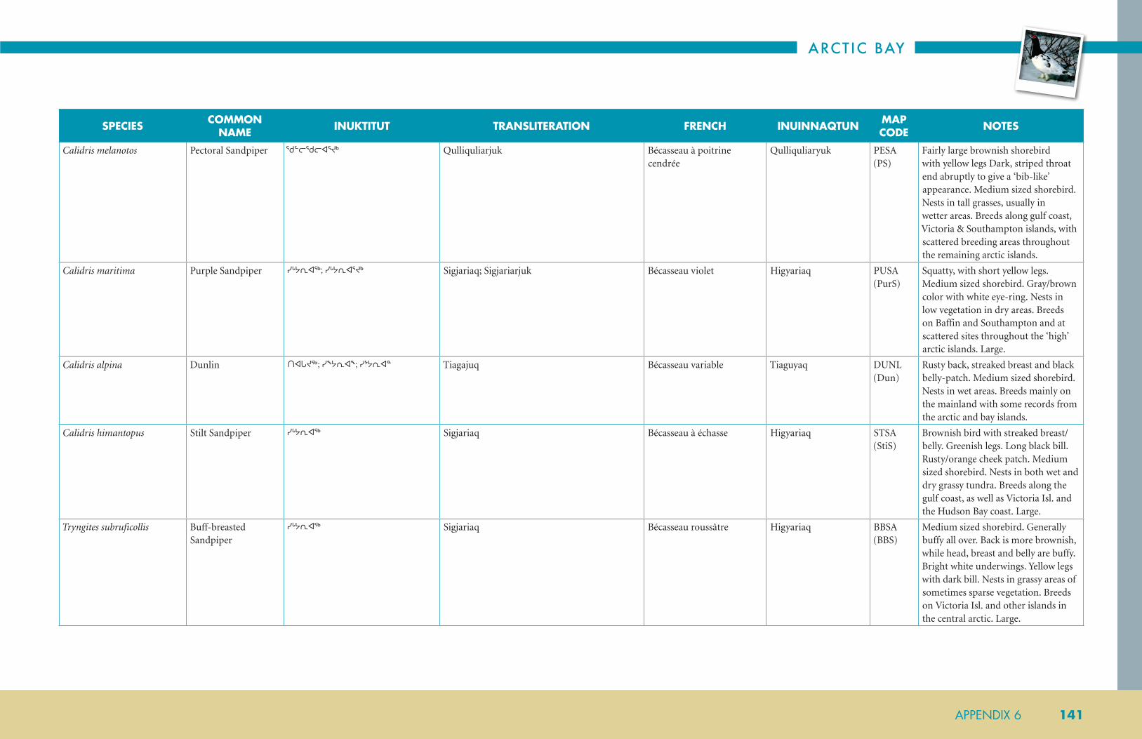
ARCTIC BAY
APPENDIX 6 141
SPECIES COMMON NAME INUKTITUT TRANSLITERATION FRENCH INUINNAQTUN MAP
CODE NOTES
Calidris melanotos Pectoral Sandpiper ᖁᓪᓕᖁᓕᐊᕐᔪᒃ Qulliquliarjuk Bécasseau à poitrine cendrée
Qulliquliaryuk PESA (PS)
Fairly large brownish shorebird with yellow legs Dark, striped throat end abruptly to give a ‘bib-like’ appearance. Medium sized shorebird. Nests in tall grasses, usually in wetter areas. Breeds along gulf coast, Victoria & Southampton islands, with scattered breeding areas throughout the remaining arctic islands.
Calidris maritima Purple Sandpiper ᓯᒡᔭᕆᐊᖅ; ᓯᒡᔭᕆᐊᕐᔪᒃ Sigjariaq; Sigjariarjuk Bécasseau violet Higyariaq PUSA (PurS)
Squatty, with short yellow legs. Medium sized shorebird. Gray/brown color with white eye-ring. Nests in low vegetation in dry areas. Breeds on Baffin and Southampton and at scattered sites throughout the ‘high’ arctic islands. Large.
Calidris alpina Dunlin ᑎᐊᒐᔪᖅ; ᓯᖕᔭᕆᐊᖕ; ᓯᔾᔭᕆᐊᓐ Tiagajuq Bécasseau variable Tiaguyaq DUNL (Dun)
Rusty back, streaked breast and black belly-patch. Medium sized shorebird. Nests in wet areas. Breeds mainly on the mainland with some records from the arctic and bay islands.
Calidris himantopus Stilt Sandpiper ᓯᒡᔭᕆᐊᖅ Sigjariaq Bécasseau à échasse Higyariaq STSA (StiS)
Brownish bird with streaked breast/belly. Greenish legs. Long black bill. Rusty/orange cheek patch. Medium sized shorebird. Nests in both wet and dry grassy tundra. Breeds along the gulf coast, as well as Victoria Isl. and the Hudson Bay coast. Large.
Tryngites subruficollis Buff-breasted Sandpiper
ᓯᒡᔭᕆᐊᖅ Sigjariaq Bécasseau roussâtre Higyariaq BBSA (BBS)
Medium sized shorebird. Generally buffy all over. Back is more brownish, while head, breast and belly are buffy. Bright white underwings. Yellow legs with dark bill. Nests in grassy areas of sometimes sparse vegetation. Breeds on Victoria Isl. and other islands in the central arctic. Large.

NUNAVUT COASTAL RESOURCE INVENTORY
142 APPENDIX 6
SPECIES COMMON NAME INUKTITUT TRANSLITERATION FRENCH INUINNAQTUN MAP
CODE NOTES
Gallinago delicata Wilson’s Snipe ᓯᒡᒍᑑᖅ Siggutuuq Bécassine de Wilson;
bécassine des maraisHigguktuuq WISN
(CS)Gray/brown shorebird, medium sized. Stripes on head and back. Very long bill. Nests in wet grassy areas. Breeds on the mainland and in bay islands. Was Common Snipe.
Phalaropus lobatus Red-necked Phalarope (Northern Phalarope)
ᓴᐅᕐᕋᖅ; ᓴᐅᕝᕋᖅ; ᑲᐃᕙᑦᓚᒎᔪᐊᓘ; ᓯᒡᖓᖅ Saurraq; Siggaq Phalarope à bec étroit; phalarope hyperboréen
Hauggaq RNPH (RNP)
Grayish bird. Dark on back with two stripes. Light breast/belly. Reddish neckband and white chin. Head is dark. Female is brighter color than male. Medium sized shorebird. Dark bill and legs. Nests in grassy edges to ponds and lakes. Breeds throughout the mainland as well as Victoria, Southampton and southern Baffin; also in bay islands.
Phalaropus fulicarius Gray Phalarope (Red Phalarope)
ᓴᐅᕐᕋᖅ; ᓵᕐᕋᖅ; ᐊᐅᐸᓗᒃᑐᐊᕐᔪᒃ; ᓯᒡᖓᖅ Saurraq; Siggaq Phalarope à bec large;
phalarope rouxHauggaq REPH
(RP)Black back with buffy feather edges gives a scaled appearance. Very rusty neck, breast/belly. White facial patch. Black cap. Black-tipped yellow bill and yellow legs. Female is more brightly colored than male. Nests in grassy areas on edges of ponds and lakes. Breeds along Hudson Bay coast and throughout the arctic islands.
LARIDAE GULLS & TERNS LARIDÉS
Rissa tridactyla Black-legged Kittiwake
ᓇᐅᔭᕕᒃ; ᓇᐅᓗᒃᑐᐊᐱᒃ Nauluktuapik Mouette tridactyle Nauyavik BLKI (BLK)
Dark gray back and wings; black tipped. Yellow bill, dark eye. Black legs. Medium sized gull. Nests on cliff faces and rocky crags. Breeds on north Baffin Isl. and a few scattered locations in ‘high’ arctic.
Pagophila eburnea Ivory Gull ᓇᐅᔭᖅ; ᓇᐅᔭᕚᖅ; ᓇᐅᔭᖕᐸᒃ; ᓇᐅᔭᕋᒃ Naujaq; Naujavaaq Mouette blanche; mouette ivoire; goéland sénateur
Nauyaq IVGU (IG)
COSEWIC–Special Concern; Pure white. Small gull with black legs. Black bill is yellow-tipped. Nests in open areas. Breeds at few locations in ‘high’ arctic islands (Baffin, Ellesmere, Prince Patrick, Polynia, Meighen, Seymore, & Devon).
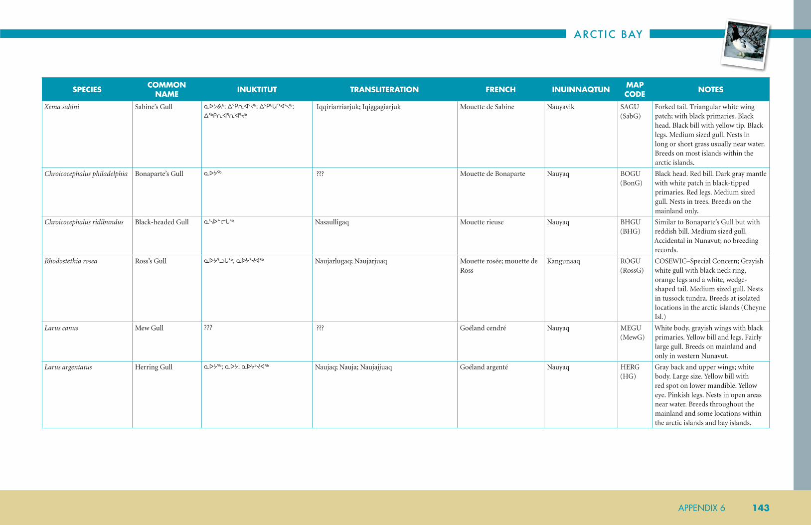
ARCTIC BAY
APPENDIX 6 143
SPECIES COMMON NAME INUKTITUT TRANSLITERATION FRENCH INUINNAQTUN MAP
CODE NOTES
Xema sabini Sabine’s Gull ᓇᐅᔭᕕᒃ; ᐃᕿᕆᐊᕐᔪᒃ; ᐃᕿᒡᒐᒋᐊᕐᔪᒃ; ᐃᖅᑭᕆᐊᕐᕆᐊᕐᔪᒃ
Iqqiriarriarjuk; Iqiggagiarjuk Mouette de Sabine Nauyavik SAGU (SabG)
Forked tail. Triangular white wing patch; with black primaries. Black head. Black bill with yellow tip. Black legs. Medium sized gull. Nests in long or short grass usually near water. Breeds on most islands within the arctic islands.
Chroicocephalus philadelphia Bonaparte’s Gull ᓇᐅᔭᖅ ??? Mouette de Bonaparte Nauyaq BOGU (BonG)
Black head. Red bill. Dark gray mantle with white patch in black-tipped primaries. Red legs. Medium sized gull. Nests in trees. Breeds on the mainland only.
Chroicocephalus ridibundus Black-headed Gull ᓇᓴᐅᓪᓕᒐᖅ Nasaulligaq Mouette rieuse Nauyaq BHGU (BHG)
Similar to Bonaparte’s Gull but with reddish bill. Medium sized gull. Accidental in Nunavut; no breeding records.
Rhodostethia rosea Ross’s Gull ᓇᐅᔭᕐᓗᒐᖅ; ᓇᐅᔭᕐᔪᐊᖅ Naujarlugaq; Naujarjuaq Mouette rosée; mouette de Ross
Kangunaaq ROGU (RossG)
COSEWIC–Special Concern; Grayish white gull with black neck ring, orange legs and a white, wedge-shaped tail. Medium sized gull. Nests in tussock tundra. Breeds at isolated locations in the arctic islands (Cheyne Isl.)
Larus canus Mew Gull ??? ??? Goéland cendré Nauyaq MEGU (MewG)
White body, grayish wings with black primaries. Yellow bill and legs. Fairly large gull. Breeds on mainland and only in western Nunavut.
Larus argentatus Herring Gull ᓇᐅᔭᖅ; ᓇᐅᔭ; ᓇᐅᔭᔾᔪᐊᖅ Naujaq; Nauja; Naujajjuaq Goéland argenté Nauyaq HERG (HG)
Gray back and upper wings; white body. Large size. Yellow bill with red spot on lower mandible. Yellow eye. Pinkish legs. Nests in open areas near water. Breeds throughout the mainland and some locations within the arctic islands and bay islands.

NUNAVUT COASTAL RESOURCE INVENTORY
144 APPENDIX 6
SPECIES COMMON NAME INUKTITUT TRANSLITERATION FRENCH INUINNAQTUN MAP
CODE NOTES
Larus thayeri Thayer’s Gull ??? ??? Goéland de Thayer Nauyaq THGU (ThG)
Similar to Herring Gull but with brownish eyes; not yellow. Pinkish legs. Flesh-colored legs. Medium sized. Nests on cliff faces and rocky crags. Breeds on mainland (coast) and throughout the same range as the following species.
Larus glaucoides Iceland Gull ᓇᐅᔭᕕᒃ Naujavik Goéland arctique; goéland à ailes blanches
Nauyavik ICGU (IceG)
Similar to Glaucous Gull only smaller. Flesh-colored legs. Large gull. Nests near water. Breeds on Victoria Isl., eastern Baffin, southern Ellesmere and at scattered locations within the arctic islands.
Larus hyperboreus Glaucous Gull ᓇᐅᔭᕕᒡᔪᐊᖅ; ᓇᐅᔭᖅ; ᓇᐅᔭ; ᓇᐅᔭᔾᔪᐊᖅ; ᑲᐅᒪᐅᒃ
Naujavigjuaq; Naujaq; Nauja; Naujajjuaq; Kaumauk
Goéland bourgmestre Nauyaryuaq GLGU (GG)
All white plumage. Lighter primaries. Red spot on lower mandible which is yellow. Very large gull. Nests near water, sometimes on small islands. Prolific along the gulf coast and throughout the arctic islands.
Larus delawarensis Ring-Billed Gull ??? ??? Goéland à bec cerclé ??? RBGU
Larus californicus California Gull ??? ??? Goéland de Californie ??? CAGU
Larus fuscus Lesser Black-Backed Gull
??? ??? Goéland brun ??? LBBG
Larus marinus Great Black-Backed Gull
??? ??? Goéland marin; goéland à mateau noir
??? GBBG
Sterna hirundo Common Tern ??? ??? Sterne pierregarin; sterne commune; hirondelle de mer
??? COTE
Sterna dougallii Roseate Tern ᐃᒥᖅᑯᑕᐃᓚᖅ Imiqqutailaq Sterne de Dougall; sterne rosée
??? ROST
Sterna paradisaea Arctic Tern ᐃᒥᖁᑕᐃᓚᖅ Immiqutaila; Imiqqutailaq Sterne arctique Emmikutailiak; Imitqutailaq
ARTE (AT)
Small white tern. Black cap and red bill. Pointed wings and forked tail. Nests near water in both wet and dry tundra. Extensive and widespread breeder throughout Nunavut.

ARCTIC BAY
APPENDIX 6 145
SPECIES COMMON NAME INUKTITUT TRANSLITERATION FRENCH INUINNAQTUN MAP
CODE NOTES
STERCORARIIDAE SKUAS & JAEGERS STERCORARIIDÉS
Stercorarius pomarinus Pomarine Jaeger ᐃᓱᓐᖓᖅ Isunngaq Labbe pomarin Ehagak; Ihunngaq POJA (PoJ)
Large size. Central tail feathers project beyond square tail, and are twisted. Hooked bill. Usually near water on elevated ground. Breeds along gulf coast and on most of the arctic islands.
Stercorarius parasiticus Parasitic Jaeger ᐃᓱᓐᖓᖅ; ᐃᓱᓐᖓᕐᓗᒃ Isungaq; Isunngarluk; Isunngaq Labbe parasite Ihunngaq PAJA (PaJ)
Central tail feathers are sharply pointed. Hooked bill. Usually near water in wet grassy areas. Widespread breeder throughout Nunavut.
Stercorarius longicaudus Long-tailed Jaeger ᐃᓱᓐᖓᖅ;ᑲᒥᒐᓕᒃᑯᐊᓗᒃ; ᐃᓱᖕᒐᖅ; ᑲᒥᒐᓕᒃ; ᐃᓱᓐᖓᕐᓗᒃ
Isungaq; Isunngarluk; Isunngaq; Kamigalik ILabbe à longue queue Ihunngaq LTJA (LTJ)
Very long central tail feathers. Hooked bill, pointed wings. Usually near water in dry tundra. With short vegetation. Extensive breeder throughout Nunavut.
ALCIDAE AUKS, MURRES & PUFFINS
ALCIDÉS
Alle alle Dovekie ᐊᒃᐸᓕᐊᕐᔪᒃ Akpaliarjuk Mergule nain Appaq DOVE (Dove)
Black above, white below. Very small. Very stubby bill. On rocky cliffs. Only known to breed in one location within Nunavut (Home Bay, Baffin Isl.)
Uria lomvia Thick-billed Murre ᐊᒃᐸ;ᐊᓪᐸ; ᐊᑉᐸ Akpa Guillemot de Brünnich, marmette de Brünnich
Akpak; Apparyuaq TBMU (TBM)
Black above, white below. Pointed bill with white gape line. On rocky cliffs. Breeds along the east coast of Baffin Isl., and at scattered locations elsewhere in ‘high’ arctic. Floe edge.
Alca torda Razorbill ??? ??? Petit pingouin, gode Akparyuat RAZO (RZB)
Black above, white below. Large head. White mark on black bill. In rocky crags. Breeds mainly at one location on east Baffin Isl., and on Digges Isl.
Fratercula arctica Atlantic Puffin ??? ??? Macareux moine; macareux arctiuque, macareux de l’Atlantique
??? ATPU

NUNAVUT COASTAL RESOURCE INVENTORY
146 APPENDIX 6
SPECIES COMMON NAME INUKTITUT TRANSLITERATION FRENCH INUINNAQTUN MAP
CODE NOTES
Cepphus grylle Black Guillemot ᐱᑦᑎᐅᓛᖅ; ᐱᑦᓯᐅᓛᖅ; ᐱᑦᓯᐅᓛᖅᔪᐊᖅ; ᕿᖕᓇᕆᒃᑐᖅ ᐊᒃᐸᐃᑦ
Pittiulaaq; Pitsiulaaq; Pitsiulaaqjuaq Guillemot à miroir; guillemot noir
Pittuulaaq; Qingnariktuq Akpait
BLGU (BG)
Black with white wing patch. Bright orange/red feet. In/on rocky crags. Mainly confined to the eastern arctic islands and Southampton as well as a few coastal locations on eastern mainland. Floe edge. Winter: pale grey with black wing and white under.
STRIGIDAE OWLS STRIGIDÉS
Bubo scandiacus Snowy Owl ᐅᒃᐱᒃᔪᐊᖅ; ᐅᒃᐱᒡᔪᐊᖅ; ᐅᒃᐱᒃ Ukpikjuaq; Ukpigjuaq Harfang des neiges Ukpik SNOW (Sowl)
Large white owl. Adults are generally white with black flecks. Imm. shows more spotting. Nests in dry tundra on elevated mounds. Widespread breeder throughout Nunavut.
Asio flammeus Short-eared Owl ᐃᒃᐱᒃ; ᓂᐸᐃᓐᓇᖅᑖᓗᒃ; ᑖᖅᔪᐅᑉ; ᐅᓐᓄᐊᖅᓯᐅᑦ; ᐅᓐᓄᐊᖅᓯᐅᑎ
Masilli; Unnuaqsiuti Hibou des marais Ukpik SEOW (SEO)
COSEWIC–Special Concern; Medium sized owl. Generally brown with vertical streaks Buffy wing linings show a dark wrist patch in flight. Nests in long grass usually in wet areas. Breeds on mainland and at a few arctic island locations.
CAPRIMULGIDAE GOATSUCKERS CAPRIMULGIDÉS
Chordeiles minor Common Nighthawk ᑭᒡᒐᕕᒃ Kiggavik Engoulevent d’Amérique Kilgavik CONI (CNH)
Gray/brown bird with pointed wings. Shows a white throat patch and white bar in wings in flight. Accidental in Nunavut; no breeding records.
LANIIDAE SHRIKES LANIIDÉS
Lanius excubitor Northern Shrike ᖁᐸᓄᐊᖅ Qupanuaq Pie-grièche grise; pie-grièche boréale
Qupanuaq; Mitilluk NSHR (NSh)
Grayish bird. Black face mask. Black wings with white wrist mark, and dark tail edged in white. Hooked bill. Nests in trees and is restricted as a breeder to lower mainland, and perhaps bay islands.

ARCTIC BAY
APPENDIX 6 147
SPECIES COMMON NAME INUKTITUT TRANSLITERATION FRENCH INUINNAQTUN MAP
CODE NOTES
CORVIDAE CROWS & JAYS
Corvus corax Common Raven ᑐᓗᒐᖅ Tulugaq Grand corbeau Tuluqakjuak; Tulugaq CORA (CR)
Large black bird. Rounded tail. Croaking call. Nests on cliff faces, rocky crags or manmade structures. Extensive and widespread throughout Nunavut.
Perisoreus canadensis Gray Jay ??? ??? Mésangeai du Canada; geai du Canada
??? GRAJ
ALAUDIDAE LARKS ALAUDIDÉS
Eremophila alpestris Horned Lark ᖁᐸᓄᐊᖅᐸᖅ; ᖁᐸᓄᐊᕐᔪᒃ Qupanuaqpaq; Qupanuarjuk Alouette hausse-col; alouette cornue
Konaniqpajuk; Qupanuaqpaaq; Qupanuaqpak
HOLA (HL)
Generally brownish bird with lighter belly. Black breast band. Dark sideburn on yellowish face. Underside of tail is black. Nests in dry tundra with sparse vegetation. Widespread breeder throughout Nunavut. Open, dry tundra.
HIRUNDINIDAE SWALLOWS HIRUNDINIDÉS
Riparia riparia Bank Swallow ᖁᐸᓄᐊᖅ Qupanuaq Hirondelle de ravage; hirondelle des sables
Qupanuaq BANS (BnkS)
Generally brownish bird with white underparts and a brown chest band. Pointed wings and notched tail. Accidental in Nunavut; no breeding records.
Tachycineta bicolor Tree Swallow ??? ??? Hirondelle bicolore ??? TRES
Petrochelidon pyrrhonota Cliff Swallow ??? ??? Hirondelle à front blanc ??? CLSW
Hirundo rustica Barn Swallow ??? ??? Hirondelle rustique; hirondelle des granges
Qupanuaq BARS (BrnS)
Metallic blue on back, buffy/orange underparts. Rusty throat patch. Forked tail. Has nested rarely on mainland and in bay islands.
TURDIDAE THRUSHES TURDIDÉS
Oenanthe oenanthe Northern Wheatear ᖁᐸᓄᐊᖅᐸᖅ; ᐃᕐᑯᓕᒐᖅ Iquligaq Traquet motteux Qupanuaqpaaq NOWH (Nwh)
Gray bird with white breast/belly. Black face mask, edged in white. White tail with black tips. White rump patch. Imm. birds are similar but are buffier, with brownish back. Nests in rocky areas. Breeds mainly on Baffin and Ellesmere with infrequent nestings elsewhere in ‘high’ arctic islands and on mainland.
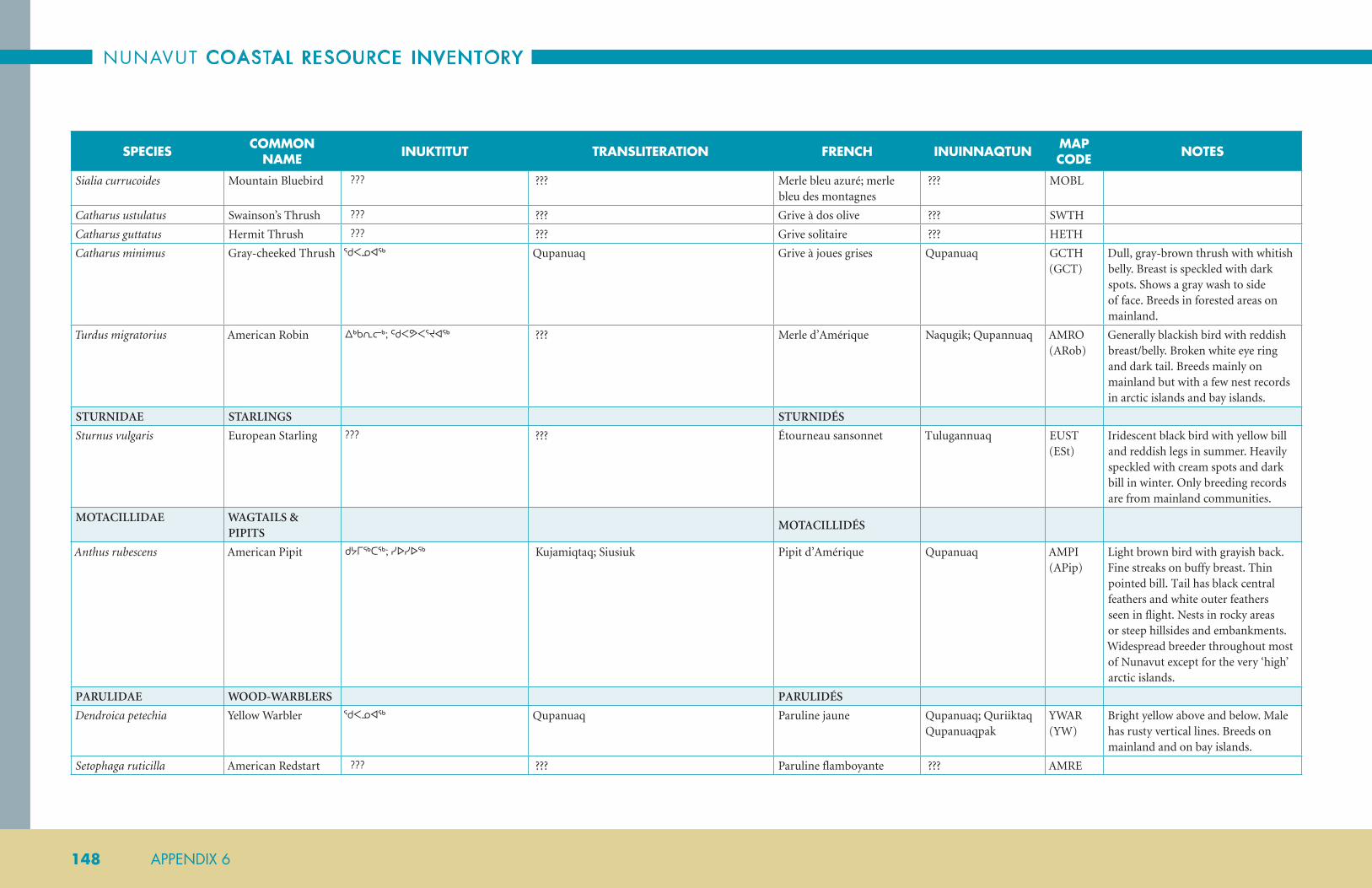
NUNAVUT COASTAL RESOURCE INVENTORY
148 APPENDIX 6
SPECIES COMMON NAME INUKTITUT TRANSLITERATION FRENCH INUINNAQTUN MAP
CODE NOTES
Sialia currucoides Mountain Bluebird ??? ??? Merle bleu azuré; merle bleu des montagnes
??? MOBL
Catharus ustulatus Swainson’s Thrush ??? ??? Grive à dos olive ??? SWTH
Catharus guttatus Hermit Thrush ??? ??? Grive solitaire ??? HETH
Catharus minimus Gray-cheeked Thrush ᖁᐸᓄᐊᖅ Qupanuaq Grive à joues grises Qupanuaq GCTH (GCT)
Dull, gray-brown thrush with whitish belly. Breast is speckled with dark spots. Shows a gray wash to side of face. Breeds in forested areas on mainland.
Turdus migratorius American Robin ᐃᒃᑲᕆᓕᒃ; ᑦᑯᐸᕗᐸᕐᔪᐊᖅ ??? Merle d’Amérique Naqugik; Qupannuaq AMRO (ARob)
Generally blackish bird with reddish breast/belly. Broken white eye ring and dark tail. Breeds mainly on mainland but with a few nest records in arctic islands and bay islands.
STURNIDAE STARLINGS STURNIDÉS
Sturnus vulgaris European Starling ??? ??? Étourneau sansonnet Tulugannuaq EUST (ESt)
Iridescent black bird with yellow bill and reddish legs in summer. Heavily speckled with cream spots and dark bill in winter. Only breeding records are from mainland communities.
MOTACILLIDAE WAGTAILS & PIPITS
MOTACILLIDÉS
Anthus rubescens American Pipit ᑯᔭᒥᖅᑕᖅ; ᓯᐅᓯᐅᖅ Kujamiqtaq; Siusiuk Pipit d’Amérique Qupanuaq AMPI (APip)
Light brown bird with grayish back. Fine streaks on buffy breast. Thin pointed bill. Tail has black central feathers and white outer feathers seen in flight. Nests in rocky areas or steep hillsides and embankments. Widespread breeder throughout most of Nunavut except for the very ‘high’ arctic islands.
PARULIDAE WOOD-WARBLERS PARULIDÉS
Dendroica petechia Yellow Warbler ᖁᐸᓄᐊᖅ Qupanuaq Paruline jaune Qupanuaq; Quriiktaq Qupanuaqpak
YWAR (YW)
Bright yellow above and below. Male has rusty vertical lines. Breeds on mainland and on bay islands.
Setophaga ruticilla American Redstart ??? ??? Paruline flamboyante ??? AMRE
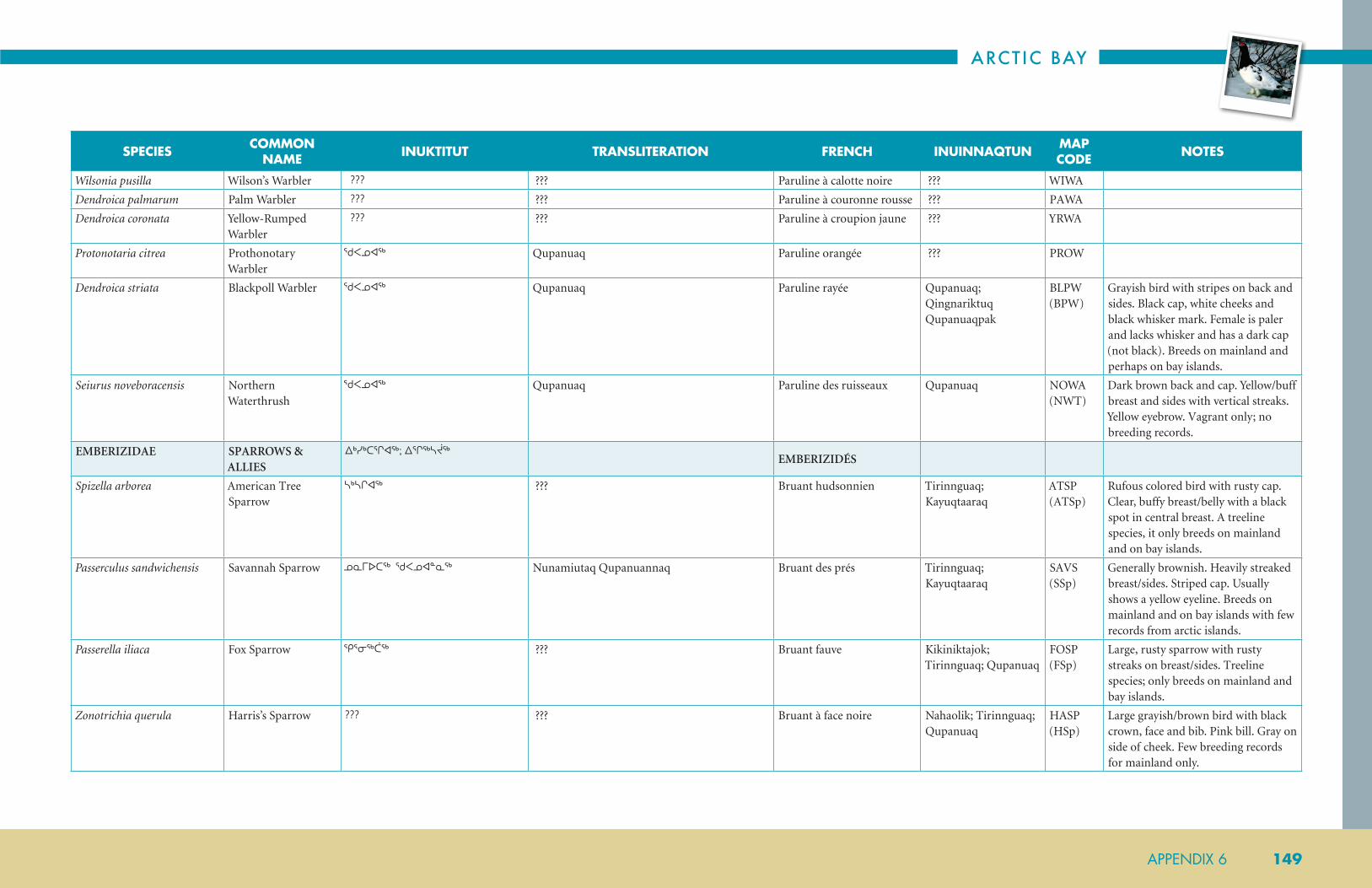
ARCTIC BAY
APPENDIX 6 149
SPECIES COMMON NAME INUKTITUT TRANSLITERATION FRENCH INUINNAQTUN MAP
CODE NOTES
Wilsonia pusilla Wilson’s Warbler ??? ??? Paruline à calotte noire ??? WIWA
Dendroica palmarum Palm Warbler ??? ??? Paruline à couronne rousse ??? PAWA
Dendroica coronata Yellow-Rumped Warbler
??? ??? Paruline à croupion jaune ??? YRWA
Protonotaria citrea Prothonotary Warbler
ᖁᐸᓄᐊᖅ Qupanuaq Paruline orangée ??? PROW
Dendroica striata Blackpoll Warbler ᖁᐸᓄᐊᖅ Qupanuaq Paruline rayée Qupanuaq; Qingnariktuq Qupanuaqpak
BLPW (BPW)
Grayish bird with stripes on back and sides. Black cap, white cheeks and black whisker mark. Female is paler and lacks whisker and has a dark cap (not black). Breeds on mainland and perhaps on bay islands.
Seiurus noveboracensis Northern Waterthrush
ᖁᐸᓄᐊᖅ Qupanuaq Paruline des ruisseaux Qupanuaq NOWA (NWT)
Dark brown back and cap. Yellow/buff breast and sides with vertical streaks. Yellow eyebrow. Vagrant only; no breeding records.
EMBERIZIDAE SPARROWS & ALLIES
ᐃᒃᓯᒃᑕᕐᒋᐊᖅ; ᐃᕐᒋᖅᓴᔫᖅEMBERIZIDÉS
Spizella arborea American Tree Sparrow
ᓴᒃᓴᒋᐊᖅ ??? Bruant hudsonnien Tirinnguaq; Kayuqtaaraq
ATSP (ATSp)
Rufous colored bird with rusty cap. Clear, buffy breast/belly with a black spot in central breast. A treeline species, it only breeds on mainland and on bay islands.
Passerculus sandwichensis Savannah Sparrow ᓄᓇᒥᐅᑕᖅ ᖁᐸᓄᐊᓐᓇᖅ Nunamiutaq Qupanuannaq Bruant des prés Tirinnguaq; Kayuqtaaraq
SAVS (SSp)
Generally brownish. Heavily streaked breast/sides. Striped cap. Usually shows a yellow eyeline. Breeds on mainland and on bay islands with few records from arctic islands.
Passerella iliaca Fox Sparrow ᕿᕐᓂᖅᑖᖅ ??? Bruant fauve Kikiniktajok; Tirinnguaq; Qupanuaq
FOSP (FSp)
Large, rusty sparrow with rusty streaks on breast/sides. Treeline species; only breeds on mainland and bay islands.
Zonotrichia querula Harris’s Sparrow ??? ??? Bruant à face noire Nahaolik; Tirinnguaq; Qupanuaq
HASP (HSp)
Large grayish/brown bird with black crown, face and bib. Pink bill. Gray on side of cheek. Few breeding records for mainland only.
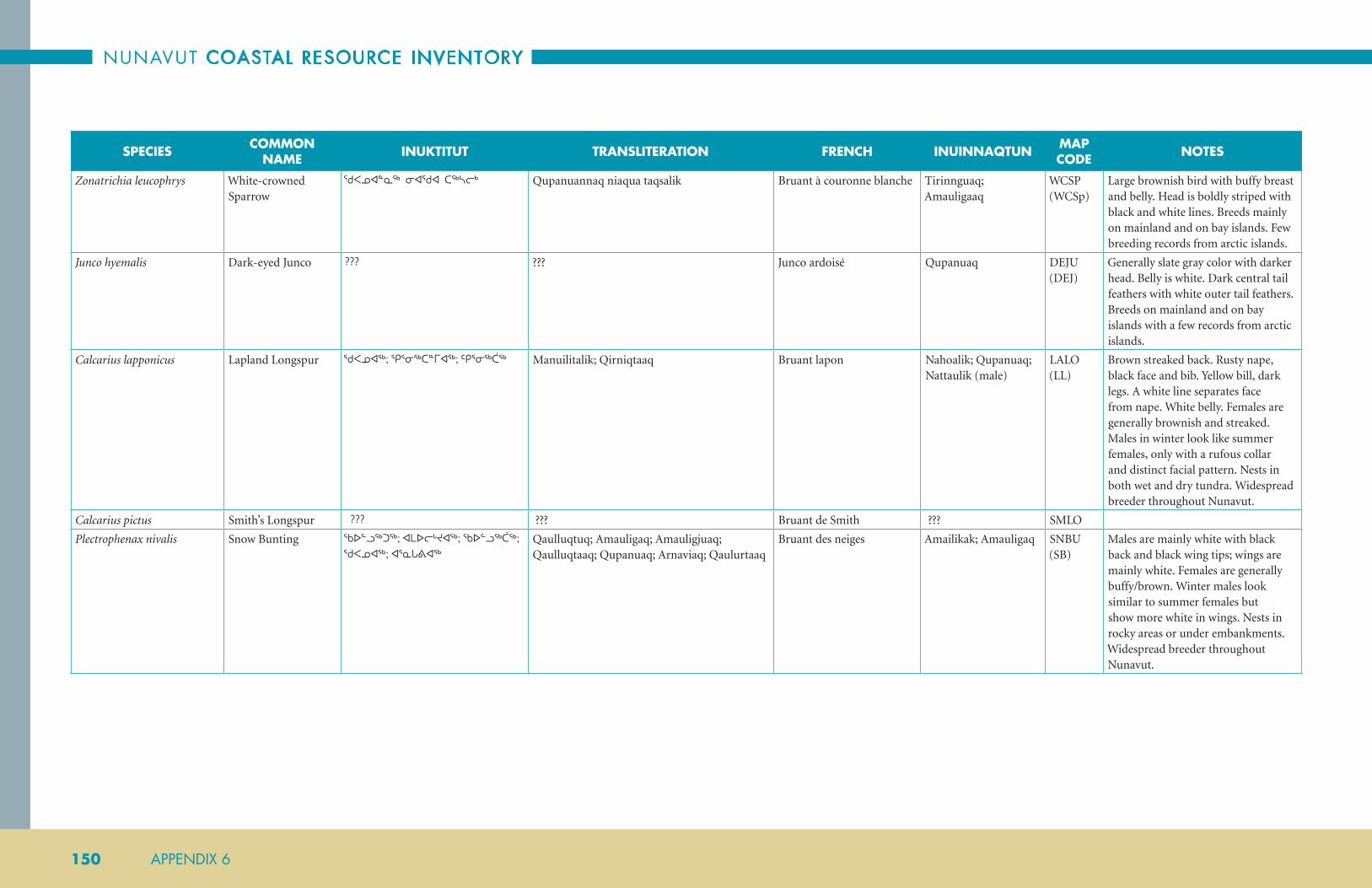
NUNAVUT COASTAL RESOURCE INVENTORY
150 APPENDIX 6
SPECIES COMMON NAME INUKTITUT TRANSLITERATION FRENCH INUINNAQTUN MAP
CODE NOTES
Zonatrichia leucophrys White-crowned Sparrow
ᖁᐸᓄᐊᓐᓇᖅ ᓂᐊᖁᐊ ᑕᖅᓴᓕᒃ Qupanuannaq niaqua taqsalik Bruant à couronne blanche Tirinnguaq; Amauligaaq
WCSP (WCSp)
Large brownish bird with buffy breast and belly. Head is boldly striped with black and white lines. Breeds mainly on mainland and on bay islands. Few breeding records from arctic islands.
Junco hyemalis Dark-eyed Junco ??? ??? Junco ardoisé Qupanuaq DEJU (DEJ)
Generally slate gray color with darker head. Belly is white. Dark central tail feathers with white outer tail feathers. Breeds on mainland and on bay islands with a few records from arctic islands.
Calcarius lapponicus Lapland Longspur ᖁᐸᓄᐊᖅ; ᕿᕐᓂᖅᑕᓐᒥᐊᖅ; ᑦᑭᕐᓂᖅᑖᖅ Manuilitalik; Qirniqtaaq Bruant lapon Nahoalik; Qupanuaq; Nattaulik (male)
LALO (LL)
Brown streaked back. Rusty nape, black face and bib. Yellow bill, dark legs. A white line separates face from nape. White belly. Females are generally brownish and streaked. Males in winter look like summer females, only with a rufous collar and distinct facial pattern. Nests in both wet and dry tundra. Widespread breeder throughout Nunavut.
Calcarius pictus Smith’s Longspur ??? ??? Bruant de Smith ??? SMLO
Plectrophenax nivalis Snow Bunting ᖃᐅᓪᓗᖅᑐᖅ; ᐊᒪᐅᓕᒡᔪᐊᖅ; ᖃᐅᓪᓗᖅᑖᖅ; ᖁᐸᓄᐊᖅ; ᐊᕐᓇᒐᕕᐊᖅ
Qaulluqtuq; Amauligaq; Amauligjuaq; Qaulluqtaaq; Qupanuaq; Arnaviaq; Qaulurtaaq
Bruant des neiges Amailikak; Amauligaq SNBU (SB)
Males are mainly white with black back and black wing tips; wings are mainly white. Females are generally buffy/brown. Winter males look similar to summer females but show more white in wings. Nests in rocky areas or under embankments. Widespread breeder throughout Nunavut.

ARCTIC BAY
APPENDIX 6 151
SPECIES COMMON NAME INUKTITUT TRANSLITERATION FRENCH INUINNAQTUN MAP
CODE NOTES
FRINGILLIDAE FINCHES FRINGILLIDÉS
Carduelis flammea Common Redpoll ᖁᐸᓄᐊᖅ; ᓴᖅᑯᐊᕆᐊᖅ; ᓯᖅᓯᒋᐊᖅ Qupanuaq; Saqquariaq; Siqsigiaq Sizerin flammé Hikinitjuak; Qupanuaq. Qupanuaqpak
CORE (CRP)
Brownish bird with heavy streaks on back and sides. Male has a red forehead, black bib and rosy breast. Female is similar but lacks the rosy breast. Both sexes have yellow bills. Nests in willow shrubs in wet areas. Common breeder on mainland as well as southern Baffin and scattered locations elsewhere.
Carduelis hornemanni Hoary Redpoll ᖁᐸᓄᐊᖅ; ᓴᖅᑯᐊᕆᐊᖅ; ᓯᖅᓯᒋᐊᖅ Qupanuaq; Saqquariaq; Siqsigiaq Sizerin blanchàtre Qupanuaq; Qupanuaqpak
HORE (HRP)
Very similar to Common Redpoll but generally lighter color. Faint to absent streaks on sides and usually shows a distinct white rump patch. Nests in willow shrubs in wet areas. Prolific breeder on mainland as well as on Baffin, Ellesmere, Devon and southern Victoria islands.
Loxia leucoptera White-Winged Crossbill
??? ??? Bec-croisé bifascié; bec-croisé à ailes blanches
??? WWCR
ICTERIDAE BLACKBIRDS AND ORIOLES
ICTERIDÉS
Euphagus carolinus Rusty Blackbird ??? ??? Quiscale rouilleux ??? RUBL
Xanthocephalus xanthocephalus
Yellow-Headed Blackbird
??? ??? Carouge à tête jaune ??? YHBL
BOMBYCILLIDAE WAXWINGS BOMBYCILLIDÉS
Bombycilla garrulus Bohemian Waxwing ??? ??? Jaseur boréal ??? BOWA
REGULIDAE KINGLETS REGULIDÉS
Regulus calendula Ruby-Crowned Kinglet
??? ??? Roitelet à couronne rubis ??? RCKI
CERYLIDAE KINGFISHERS CERYLIDÉS
Megaceryle alcyon Belted Kingfisher ??? ??? Martin-pêcheur d’Amérique
??? BEKI
PELECANIDAE PELICANS PÉLÉCANIDÉS
Pelecanus erythrorhynchos American White Pelican
??? ??? Pélican d’Amérique; pelican blanc d’Amérique
??? AWPE

NUNAVUT COASTAL RESOURCE INVENTORY
152 APPENDIX 6
SPECIES COMMON NAME INUKTITUT TRANSLITERATION FRENCH INUINNAQTUN MAP
CODE NOTES
TERRESTRIAL ANIMALSUrsus arctos horribilis Grizzly Bear ᐊᒃᖤ Ak&a Grizzli; grizzly Akhaq GBear Could be considered marine since
it was reported in Kugluktuk to be swimming to Victoria Island and hunting marine animals.
Gulo gulo Wolverine ᖃᕕᖅ Qavviq Carcajou; glouton Qalvik Wolv
Rangifer tarandus groenlandicus
Barren-ground Caribou
ᑐᒃᑐ Tuktu Caribou de la toundra Tuktu BGCar
Rangifer tarandus pearyi Peary Caribou ᑐᒃᑐ Tuktu Caribou de Peary Tuktu PCar
Vulpes lagopus Arctic Fox ᑎᕆᒐᓂᐊᖅ Turiganniaq; Tiriganiaq Renard arctique Tiriganniaq AFox
Vulpes vulpes Red Fox ᑲᔪᖅ ᑎᕆᒐᓐᓂᐊᖅ Kajuq Renard roux Kayuqtuq RFox
Ovibos moschatus Muskox ᐅᒥᖕᒪᒃ Umingmak Boeuf musqué Umingmak MOx
Canis lupus Arctic Wolf ᐊᒪᕈᖅ Amaruq Loup, loup gris Amaruq AWolf
Lepus arcticus Arctic Hare ᐅᑲᓕᖅ Ukaliq Lièvre arctique Ukaliq AHare
Mustela erminea Ermine ᑎᕆᐊᖅ Tiriaq hermine Tiriaq ERM
Lemmus trimucronatus Brown Lemming ᑲᔪᖅ ᐊᕕᖓᖅ Kajuq Avingaq Lemming brun Avin’ngaq BrLem
Dicrostonyx Collared Lemming ᐊᐅᐸᔮᖅᑐᖅ ᐊᕕᖓᖅ Aupajaaqtuq Avingaq Lemming variable; lemming des neiges; lemming à colier
Avin’ngaq CoLem
Mustela vison Mink ᑎᕆᐊᒃᐊᖕ; ᑎᕆᐊᕐᔪᐊᖅ ??? Vison d’Amérique ??? M
Ondata zibethicus Muskrat ᑭᕝᑲᓗᒃ ??? Rat musqué ??? Mr
Spermophilus parryii Arctic Ground Squirrel
ᓯᒃᓯ Siksik Spermophile arctique Hikhik AGSq

ARCTIC BAY
APPENDIX 7 153
APPENDIX 7SPECIES PHOTOS
FISH
Greenlandic Shark
arctic Skate
Black doGfiSh
thorny Skate
arctic char
Brook trout
Bull trout
lake trout
dolly-Varden
atlantic Salmon
lake WhitefiSh
Broad WhitefiSh
lake ciSco
leaSt ciSco
arctic ciSco
Blackfin ciSco
round WhitefiSh
mountain WhitefiSh
inconnu
arctic GraylinG
White Sucker
lonGnoSe Sucker
lake chuB
atlantic cod
Greenland cod
arctic or Polar cod
toothed cod
BurBot
threeBeard rocklinG
arctic rocklinG
rock Grenadier
arctic StaGhorn SculPin
deePWater SculPin
fourhorn SculPin
arctic SculPin
Shorthorn SculPin
Slimy SculPin
SPoonhead SculPin
hamecon
tWohorn SculPin
SPatulate SculPin
BiGeye SculPin
riBBed SculPin
mailed SculPin
VarieGated SnailfiSh
Bartail SeaSnail
GelatinouS SeaSnail
atlantic SeaSnail
lumPSucker
Smooth lumPfiSh

NUNAVUT COASTAL RESOURCE INVENTORY
154 APPENDIX 7
leatherfin lumPSucker
atlantic SPiny lumPSucker
arctic alliGator fiSh
atlantic Sea Poacher
ocean Perch
deePWater redfiSh
Walleye
arctic eelPout
mcalliSter’S eelPout
ShuluPaoluk
adolf’S eelPout
Saddled eelPout
Pale eelPout
canadian eelPout
threeSPot eelPout
lonGear eelPout
Paamiut eelPout
Polar eelPout
lutken’S eelPout
BarSukoV’S Pout
fiSh doctor
Slender eelBlenny
dauBed Shanny
Stout eelBlenny
fourline SnakeBlenny
Pacific Sand Lance
northern Sand Lance
northern WolfiSh
SPotted WolfiSh
atlantic WolfiSh
Banded Gunnel
Starry flounder
arctic flounder
Winter flounder
Greenland haliBut
caPelin
rainBoW Smelt
atlantic herrinG
Pacific herrinG
trout-Perch
northern Pike
nineSPine StickleBack
threeSPine StickleBack
Glacier lantern fiSh
arctic lamPrey
northern haGfiSh

ARCTIC BAY
APPENDIX 7 155
INVERTEBRATES
truncate SoftShell clamS
Blue muSSel
northern horSemuSSel
common cockle
iSlandic ScalloP
atlantic oySter
tortoiSeShell limPet
Whelk
naked Sea Butterfly
naked Shelled Sea Butterfly
flexed Gyro
arctic moonSnail
Boreal armhook Squid
Pale Sea urchin
Polar Sea Star
mud Star
BaSket Star
north atlantic Sea cucumBer
SnoW craB
toad craB
hermit craB
deeP Sea kinG craB
crayfiSh
northern ShrimP
StriPed ShrimP
amPhiPod
northern krill
mySid ShrimP
acorn Barnacle
Sea SPider
Parchment Worm
Plankton Worm
Sea anemone
JellyfiSh
arroW Worm
ctenoPhore
oranGe finGer SPonGe

NUNAVUT COASTAL RESOURCE INVENTORY
156 APPENDIX 7
MARINE MAMMALS
Polar Bear
WalruS
rinGed Seal
harP Seal
Bearded Seal
hooded Seal
harBour Seal
harBour PorPoiSe
atlantic White-Sided
dolPhin
White-Beaked dolPhin
northern BottlenoSe
Whale
lonG-finned Pilot Whale
killer Whale
BeluGa
narWhal
BoWhead Whale
north atlantic
riGht Whale
common minke Whale
fin Whale
Blue Whale
Sei Whale
SPerm Whale
humPBack Whale
SEAWEED AND MARINE PLANTS
ediBle kelP
holloW Stemmed kelP
Sea colander
SPiny Sour Weed
Bladder Wrack
Green Sea finGerS
dulSe
eel GraSS
roBBin’S PondWeed
alPine PondWeed
VariaBleleaf PondWeed
WhiteStem PondWeed
SemaPhore GraSS GooSe GraSS Sea lunGWort floatinG ButtercuP mare’S tail

ARCTIC BAY
APPENDIX 7 157
BIRDS
White-fronted GooSe
SnoW GooSe
roSS’S GooSe
Brant
cacklinG GooSe
canada GooSe
tundra SWan
northern ShoVeler
american WiGeon
mallard
northern Pintail
Green-WinGed teal
Greater ScauP
leSSer ScauP
kinG eider
common eider
harlequin duck
Surf Scoter
White-WinGed Scoter
Black Scoter
american Black duck
lonG-tailed duck
common merGanSer
red-BreaSted merGanSer
hooded merGanSer
common Goldeneye (male)
BarroW’S Goldeneye
WilloW PtarmiGan
rock PtarmiGan
White-tailed PtarmiGan
SPruce GrouSe (male)
red-throated loon
arctic loon
Pacific loon
common loon
yelloW-Billed loon
horned GreBe
Greater ShearWater
northern fulmar
nothern Gannet
douBle-creSted cormorant
american Bittern
Bald eaGle
rouGh-leGGed haWk
SharP-Shinned haWk
northern GoShaWk
northern harrier
Golden eaGle
american keStrel
merlin

NUNAVUT COASTAL RESOURCE INVENTORY
158 APPENDIX 7
Gryfalcon
PereGrine falcon
PereGrine falcon anatum
Peale’S PereGrine falcon
Sandhll crane
WhooPinG crane
Black-Bellied PloVer
american Golden-PloVer
common rinGed PloVer
SemiPalmated PloVer
PiPinG PloVer meloduS
PiPinG PloVer
killdeer
leSSer yelloWleGS
Greater yelloWleGS
eSkimo curleW
WhimBrel
hudSonian GodWit
ruddy turnStone
red knot
SanderlinG
Short-Billed doWitcher
SPotted SandPiPer
SemiPalmated SandPiPer
leaSt SandPiPer
White-rumPed SandPiPer
Baird’S SandPiPer
Pectoral SandPiPer
PurPle SandPiPer
dunlin
Stilt SandPiPer
Buff-BreaSted SandPiPer
WilSon’S SniPe
red-necked PhalaroPe
red PhalaroPe
Black-leGGed kittiWake
iVory Gull
SaBine’S Gull
BonaParte’S Gull
Black-headed Gull
roSS’S Gull
meW Gull
herrinG Gull
thayer’S Gull
iceland Gull
GlaucouS Gull
rinG-Billed Gull
california Gull
leSSer Black-Backed Gull
Great Black-Backed Gull

ARCTIC BAY
APPENDIX 7 159
common tern
roSeate tern
arctic tern
Pomarine JaeGer
ParaSitic JaeGer
lonG-tailed JaeGer
doVekie
thick-Billed murre
razorBill
atlantic Puffin
Black Guillemot
SnoWy oWl
Short-eared oWl
common niGhthaWk
northern Shrike
common raVen
Gray Jay
horned lark
Bank SWalloW
tree SWalloW (male)
cliff SWalloW
Barn SWalloW
northern Wheatear
mountain BlueBird
SWainSon’S thruSh
hermit thruSh
Gray-cheecked thruSh
american roBin
euroPean StarlinG
american PiPit
yelloW WarBler
american redStar
WilSon’S WarBler
Palm WarBler
yelloW-rimPed WarBler
Prothonotary WarBler
BlackPoll WarBler
northern WaterthruSh
american tree SParroW
SaVannah SParroW
fox SParroW
harriS’S SParroW
White-croWned SParroW
dark-eyed Junco
laPland lonGSPur
Smith’S lonGSPur
SnoW BuntinG
common redPoll
hoary redPoll
White-WinGed croSSBill

NUNAVUT COASTAL RESOURCE INVENTORY
160 APPENDIX 7
ruSty BlackBird
yelloW-headed BlackBird
Bohemian WaxWinG
ruBy-croWned kinGlet
Belted kinGfiSher
american White Pelican

ARCTIC BAY
APPENDIX 8 161
APPENDIX 8NCRI FIRST CONTACT CALLING PROTOCOL
INTRODUCTION
Hello, may I please speak to ?
If they are home then proceed, if not then ask when would be
a convenient time to call back …
My name is and I am calling about a Marine
Resource Inventory project being undertaken by the
Fisheries and Sealing Division. You have been identified
by members of your community as someone who is very
knowledgeable. We would like to ask you to participate in
our project. Do you have a few minutes now so that I can
tell you about the project, or is there a better time that I
can call you back?
Yes: proceed with the interview
No: determine when would be a better time to call
OK, great.
This project is a multi-community project intended to
develop an inventory of coastal resources. To develop
such an inventory we will be asking you to discuss a
variety of topics; including descriptions and locations
of marine animals and habitats. We will be asking you
about the location of species that you know about, what
time of year you see them and to describe what habitat
they are associated with. We hope the outcomes of the
project will be the sustainable use of the coastal resources
in your area, the protection of sensitive areas or special
places, the preservation of invaluable local knowledge, and
also the ability of your community to meet its economic
development needs now and in the future. All information
that we record and maps we create will remain in the
community for the benefit of the community.
Our survey will take a few hours depending upon how
much time you have to offer and the amount of knowledge
you are willing to share with us. We would ideally begin
with a 2 to 3 hour interview and following this it will be
your decision as to whether we continue or meet again and
complete the survey in more detail.
We recognize that the knowledge you have from your
hunting and fishing experience would be a great asset in
furthering our overall knowledge of marine resources. We
would greatly appreciate any time you could commit to
help us in this project and your time will be compensated
at a rate of $50 per hour of interview.
Would you be willing to participate in this survey?
Yes: proceed with rest of protocol
No: ask them… Would you mind telling me why you don’t
want to participate?
Thank you very much for your time. We would like to let
you know that if you change your mind or find time to do
the survey later then you are more than welcome to still
participate. You can contact me at ____________________
if you change your mind or you are able to find the time.
TRAVEL ARRANGEMENT
We will be coming to
from to . Can you meet
with us on one of these days?
Yes: proceed to set it up
No: ask them when would be a good time to call back and
arrange the travel part
What day and time works best for you?
We have a house rented where we will be hosting the
interview and we can arrange transportation if you need.
We will give you a call in a few days and let you know the
address for the house.
No: proceed to arranging time
Do you need transportation? [get address]
Thank you very much for your time today. We will
call ahead of our arrival. If for any reason you need to
reschedule or cancel our meeting please let us know as
soon as possible.
If you have any questions or need to contact me I can be
reached at . Thank you again for
your time today and I am looking forward to our meeting.

NUNAVUT COASTAL RESOURCE INVENTORY
162 APPENDIX 9
APPENDIX 9WHAT IS A COASTAL RESOURCE INVENTORY?Community-based coastal inventories are often undertaken
by community groups with the support and help of
government and other agencies. Since many communities
in Nunavut are lacking the resources and capacity to carry
out such work, the GN has set out to develop this project
and encourage and financially help communities to do so.
A coastal inventory is a collection of information on
coastal resources and activities, gained from community
interviews, research, reports, maps, etc., which can be
mapped, to assist in management, development and
conservation of coastal areas. Inventories of coastal and
marine resources will allow communities and governments
to use the information to better understand and plan
future activities in coastal areas.
Coastal Zone: there are many definitions of what
the “coastal zone” consists of. In simple terms and
for the purpose of this project it is “the coastal
waters and adjacent land which are influenced by
each other.”
Community-based: This project is described as
community-based, and for our purposes this
means that the data collected will fall within the
area that surrounds a particular community and
will be collected with the community and for the
communities use.
Community-based coastal inventories are also a way to
gather, record and map Inuit Qaujimajatuqangit in a
central database and link it with other scientific research
and knowledge. Due to the social and economic changes
over the years, there is a growing need to record, protect
and conserve Nunavut’s traditional coastal biological,
cultural and ecological knowledge before it disappears
with the present generation.
In addition, there is a growing concern over the impact
that climate change will have on the Arctic environment
and on Nunavut society. Having IQ recorded will allow
for monitoring of changes in species populations, patterns
and behaviours, as a result of the changes in climate and
ice conditions.
What information will be collected?
A community-based coastal inventory for Nunavut will
include (but not limited to):
• fishery resources and fish habitat;
• fish species information;
• community infrastructure;
• marine mammals;
• aquatic plants;
• birds;
• shellfish resource information;
• cultural, recreational and tourism-related resources;
• significant or unique coastal features;
• shoreline classification;
• sources of pollution;
• and others.
How will this information be collected?
InterviewsThe main source of information and knowledge will be
collected through community interviews. There will be a
standard list of questions to answer and guide discussion
(including information on the items listed above), as well
as, any and all information community members feel is
important to note.
Community members will also be asked to locate on maps,
locations of species and specific activities such as species
breeding grounds, hunting routes, etc, and to comment
on trends in distribution, abundance, predation, animal
behaviour, etc.
The actual number of interviews (group or individual) per
community will vary, as the population, scale of traditional
hunting areas, and geography is factored in to the sample
size. The amount of coastline included in the survey for
each community will vary per community and depend
on the type/amount of information gathered during
interviews and research.
ResearchResearch will be conducted to identify what information
already exists (such as data collected by other organizations,
reports, documents, maps, and other materials), as to
not duplicate efforts, or over-interview individuals. This
inventory will build on what has already been done and
will aim to include as much information as available.
Visual SurveysSite visits will be conducted to identify resources such as
wharves, fish plants and other infrastructure, to provide
first hand information. This will be necessary to verify
data. Photographs will be taken to document condition of
structures.
What will the information be used for and how
will it benefit the community?
The information gathered from the coastal inventory can
be used for a number of purposes including:
Economic development - fisheries development relies
on sound knowledge of the numbers and location of fish
stocks and species. Gathering this type of information in
one central location will be the foundation for fisheries
development. It will help in determining where fish
resources are located, areas to conduct test fisheries, where
to develop new fisheries, where there is a need to gather
more data, etc. Information may also lead to identification
and development of coastal parks, and related tourism
opportunities and economic development in coastal areas.
Management plans – in order to properly manage
resources it is important to know the population and
harvest levels, locations of herds/breeding grounds/etc.
Having this information collected and mapped will better
allow for management of resources (such as the fisheries),
developing management zones, and for management
of land based activities that may affect coastal resources
(location of community dumps, etc.).
Conservation efforts - information collected will be useful
in identifying sensitive terrestrial and marine coastal areas,
breeding grounds, species locations and populations,
habitats, significant landscape features, etc. It will help
understand trends in global warming, and the effects on
species migration, populations, behaviours, etc. Having
this type of information in one central location will better
allow for protecting species and the land.

ARCTIC BAY
APPENDIX 9 163
The project itself will also provide direct benefits such as:
Employment – This project will employ members of the
community to help conduct the interviews and gather
the data (translators, student intern, guides). As well, to
oversee and facilitate the entire project across Nunavut a
Project Coordinator and Project Liaison will be employed
by the GN.
Capacity and Resource Building – It is intended that the
communities be involved in the process throughout, and
that all final products be available for the community
to use for their purposes, including land-use planning,
fisheries development, generating maps for community
projects, etc.
What are the Objectives and Outcomes of the inventory?
• Identify and obtain existing information and sources
about Nunavut’s coastal resources from reports,
documents, maps, and from agencies, organizations
and departments.
• Identify and record IQ through discussion and
documentation from local residents.
• Produce a useable database of coastal resources in
Nunavut, utilizing GIS (Geographic Information
System) capabilities, for resource management,
economic development and conservation.
• Identify information gaps in the existing
knowledgebase and determine opportunities for
future research.
• Attempt to Integrate IQ and modern science using
overlays, reference points, and data collaboration.
• Produce and publish informational materials, such as
regional summary documents of the project, maps,
posters, and report/articles on the project including
methodology, results, and analysis of the information
collected. An interactive website may also be developed
in the future.
What costs are involved in completing an inventory?
Each community varies in the total project costs because
of different travel costs. However, on average, each
community costs $150, 000 to complete an inventory.
This amount covers partial salary dollars for 2 full time
staff (GN), travel costs, equipment, community labour
(including honorariums and site visits), consulting fees
and consultant travel, production and printing of the final
report, and delivery of the report back to the community
and other stakeholders.
Currently inventory costs are shared between the
community and GN Department of Environment.
Secondary funding comes from partnerships with Federal
agencies, such as, INAC or DFO.

NUNAVUT COASTAL RESOURCE INVENTORY
164 APPENDIX 10
APPENDIX 10NUNAVUT CRI PARTICIPANT CONSENT FORMThank you for agreeing to participate in our study. This
project is an important opportunity for Inuit knowledge
to be recognized and included in marine science, planning
and management.
Please review this consent form to ensure you understand
the purpose of the project and the meaning of your
participation. This consent form explains how the data
collected is managed and it gives you an opportunity to
refuse any aspect of our work. If you have any questions at
any time please do not hesitate to ask.
Participant SelectionParticipants are selected by asking members of the
community who they consider to be local experts on
marine animals and plants. Each person nominated is
selected based on how long they have been a hunter, how
much experience they have in the marine environment
and what geographic area they are familiar with. Your
participation is voluntary; however an honorarium is
offered at a rate of $50 per hour of interview, which is paid
upon completion of the interview.
ExpectationsThe interview is a series of questions about your local
hunting and fishing areas and about the distribution
and abundance of fish, invertebrates, mammals, birds
and plants. We have brought maps that we will draw the
locations of animals on. After something is drawn on the
map we will discuss it and code it properly. We encourage
you to discuss the species in as much detail as you can.
Confidentiality of DataThis project has been designed from the outset to benefit
the people of Nunavut. The Fisheries and Sealing Division
is committed to protecting your knowledge so that it is
not used inappropriately, but also acknowledges that it
must be shared with others for improved decision-making
in support of better management, conservation and
economic development.
The data collected in this study will be securely stored
indefinitely by the Fisheries and Sealing Division and
will also be given to an appropriate organization within
the community; such as, the Hunter’s and Trapper’s
Organization. The organization chosen in the community
will be capable of storing the materials properly and
representing the best interests of the community members.
Data may be used in future projects within the Fisheries
and Sealing Division, as well as by the participating
members of the project’s Steering Committee. Outside of
this group (e.g. private companies or non-Nunavut based
researchers or organizations) data access may be granted
upon written request and only after consultation with the
project’s Steering Committee. No charges will be levied for
these materials when permission has been granted.
The community organization holding copies of data
collected can distribute the information as they wish and,
if they desire, require fees to be paid to the organization for
access to the data.
You will also be given copies of your interview and the
maps we create with you, which you can share as you wish.
The results will be published in a public report which
is shared with project partners, the project Steering
Committee, and the Iqaluit Public Library.
During the interview you may ask us to shut off the video
camera and/or turn off the voice recorders at any point in
the interview if you feel uncomfortable, or if you feel it
inappropriate to record any particular information.
Questions? If you have any questions regarding this research,
please feel free to contact Janelle Kennedy, Project
Coordinator, Phone #867.975.7706 or Corenna Nuyalia,
Community Liaison, Phone #867.975.7702. Department
of Environment, Fisheries and Sealing Division, Box 1000,
Station 1390, Iqaluit, NU, X0A 0H0.
CONSENT
I have understood the details of this project and my
involvement in it. I have been given the opportunity to ask
questions and they have been answered to my satisfaction.
I realize that my participation in this survey is voluntary
and that I am free to withdraw from the survey at any time.
I hereby consent to take part in this study.
I also consent to the following:
Audio recording the interview. Yes…..1 No…...2
Video recording the interview. Yes…..1 No…...2
Including my name in the acknowledgements of this
report or any report related to this project? Yes…..1
No…...2
Participant Signature: _____________________________
Witness: _________________________________
To what address should we send you a copy of your
interview?
______________________________________________
______________________________________________
______________________________________________
______________________________________________
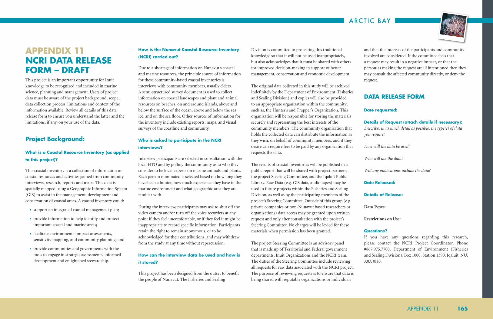
ARCTIC BAY
APPENDIX 11 165
APPENDIX 11 NCRI DATA RELEASE FORM – DRAFTThis project is an important opportunity for Inuit
knowledge to be recognized and included in marine
science, planning and management. Users of project
data must be aware of the project background, scope,
data collection process, limitations and context of the
information available. Review all details of this data
release form to ensure you understand the latter and the
limitations, if any, on your use of the data.
Project Background:
What is a Coastal Resource Inventory (as applied
to this project)?
This coastal inventory is a collection of information on
coastal resources and activities gained from community
interviews, research, reports and maps. This data is
spatially mapped using a Geographic Information System
(GIS) to assist in the management, development and
conservation of coastal areas. A coastal inventory could:
• support an integrated coastal management plan;
• provide information to help identify and protect
important coastal and marine areas;
• facilitate environmental impact assessments,
sensitivity mapping, and community planning; and
• provide communities and governments with the
tools to engage in strategic assessments, informed
development and enlightened stewardship.
How is the Nunavut Coastal Resource Inventory
(NCRI) carried out?
Due to a shortage of information on Nunavut’s coastal
and marine resources, the principle source of information
for these community-based coastal inventories is
interviews with community members, usually elders.
A semi-structured survey document is used to collect
information on coastal landscapes and plant and animal
resources on beaches, on and around islands, above and
below the surface of the ocean, above and below the sea
ice, and on the sea floor. Other sources of information for
the inventory include existing reports, maps, and visual
surveys of the coastline and community.
Who is asked to participate in the NCRI
interviews?
Interview participants are selected in consultation with the
local HTO and by polling the community as to who they
consider to be local experts on marine animals and plants.
Each person nominated is selected based on how long they
have been a hunter, how much experience they have in the
marine environment and what geographic area they are
familiar with.
During the interview, participants may ask to shut off the
video camera and/or turn off the voice recorders at any
point if they feel uncomfortable, or if they feel it might be
inappropriate to record specific information. Participants
retain the right to remain anonymous, or to be
acknowledged for their contributions, and may withdraw
from the study at any time without repercussion.
How can the interview data be used and how is
it stored?
This project has been designed from the outset to benefit
the people of Nunavut. The Fisheries and Sealing
Division is committed to protecting this traditional
knowledge so that it will not be used inappropriately,
but also acknowledges that it must be shared with others
for improved decision-making in support of better
management, conservation and economic development.
The original data collected in this study will be archived
indefinitely by the Department of Environment (Fisheries
and Sealing Division) and copies will also be provided
to an appropriate organization within the community;
such as, the Hunter’s and Trapper’s Organization. This
organization will be responsible for storing the materials
securely and representing the best interests of the
community members. The community organization that
holds the collected data can distribute the information as
they wish, on behalf of community members, and if they
desire can require fees to be paid by any organization that
requests the data.
The results of coastal inventories will be published in a
public report that will be shared with project partners,
the project Steering Committee, and the Iqaluit Public
Library. Raw Data (e.g. GIS data, audio tapes) may be
used in future projects within the Fisheries and Sealing
Division, as well as by the participating members of the
project’s Steering Committee. Outside of this group (e.g.
private companies or non-Nunavut based researchers or
organizations) data access may be granted upon written
request and only after consultation with the project’s
Steering Committee. No charges will be levied for these
materials when permission has been granted.
The project Steering Committee is an advisory panel
that is made up of Territorial and Federal government
departments, Inuit Organizations and the NCRI team.
The duties of the Steering Committee include reviewing
all requests for raw data associated with the NCRI project.
The purpose of reviewing requests is to ensure that data is
being shared with reputable organizations or individuals
and that the interests of the participants and community
involved are considered. If the committee feels that
a request may result in a negative impact, or that the
person(s) making the request are ill intentioned then they
may consult the affected community directly, or deny the
request.
DATA RELEASE FORM
Date requested:
Details of Request (attach details if necessary):Describe, in as much detail as possible, the type(s) of data
you require?
How will the data be used?
Who will use the data?
Will any publications include the data?
Date Released:
Details of Release:
Data Types:
Restrictions on Use:
Questions? If you have any questions regarding this research,
please contact the NCRI Project Coordinator, Phone
#867.975.7700, Department of Environment (Fisheries
and Sealing Division), Box 1000, Station 1390, Iqaluit, NU,
X0A 0H0.

NUNAVUT COASTAL RESOURCE INVENTORY
166 APPENDIX 11
SignaturesI have understood the details of this project and the details
of the release of this data to me. I have been given the
opportunity to ask questions and they have been answered
to my satisfaction. All information that I have provided
in my request is true and I will notify the NCRI Project
Coordinator of any changes.
Researcher:
Date:
Contact Information:
Coordinator:
Date:
Witness:
Date: