City of Phoenix, Oregon Land Development Code
286
City of Phoenix, Oregon Land Development Code $37.75
-
Upload
khangminh22 -
Category
Documents
-
view
0 -
download
0
Transcript of City of Phoenix, Oregon Land Development Code
City of Phoenix, Oregon
Land Development Code
$37.75


Table of Contents
Chapter 1.1 How to Use the Development Code ......................................................................... 3 Chapter 1.2 General Administration ............................................................................................ 5
1.2.1 Severability..................................................................................................................... 5 1.2.2 Compliance and Scope ................................................................................................... 5 1.2.3 Consistency with Plan and Laws.................................................................................... 5 1.2.4 Use of a Development .................................................................................................... 5 1.2.5 Pre-Existing Approvals .................................................................................................. 6 1.2.6 Building Permit and Certificate of Occupancy .............................................................. 6 1.2.7 Official Action................................................................................................................ 6
Chapter 1.3 Definitions ................................................................................................................ 7 Chapter 1.4 Enforcement............................................................................................................ 17
1.4.1 Provisions of this Code Declared to be Minimum Requirements ................................ 17 1.4.2 Violation of Code Prohibited ....................................................................................... 17 1.4.3 Penalty .......................................................................................................................... 17 1.4.4 Complaints Regarding Violations ................................................................................ 17 1.4.5 Abatement of Violations .............................................................................................. 18 1.4.6 Stop-Order Hearing ...................................................................................................... 18
Chapter 2.1 Land Use District Administration........................................................................... 21 2.1.1 Classification of Land Use Districts............................................................................. 21 2.1.2 Land Use District Map ................................................................................................. 21 2.1.3 Determination of Land Use District Boundaries .......................................................... 21
Chapter 2.2 Residential Districts (R-1, R-2, R-3, HO) .............................................................. 23 2.2.1 Purpose ......................................................................................................................... 23 2.2.2 Permitted Land Uses .................................................................................................... 23 2.2.3 Building Setbacks......................................................................................................... 25 2.2.4 Lot Dimensions ............................................................................................................ 26 2.2.5 - Maximum Lot Coverage ............................................................................................... 26 2.2.6 Building Height ............................................................................................................ 27 2.2.7 Building Orientation..................................................................................................... 27 2.2.8 Architectural Standards ................................................................................................ 28 2.2.9 Special Standards for Certain Uses .............................................................................. 30
Chapter 2.3 City Center District (C-C) ...................................................................................... 39 2.3.1 Purpose ......................................................................................................................... 39 2.3.2 Permitted Land Uses .................................................................................................... 39 2.3.3 Building Setbacks......................................................................................................... 41 2.3.4 Lot Coverage ................................................................................................................ 41 2.3.5 Open Space................................................................................................................... 42 2.3.6 Block Layout and Building Orientation ....................................................................... 43 2.3.7 Building Height ............................................................................................................ 45 2.3.8 Architectural Guidelines and Standards ....................................................................... 46 2.3.9 Pedestrian and Transit Amenities................................................................................. 49 2.3.10 Special Standards for Certain Uses ............................................................................ 50
Chapter 2.4 Commercial Highway (C-H) .................................................................................. 55 2.4.1 Purpose ......................................................................................................................... 55
2.4.2 Permitted and Conditionally Permitted Land Uses ...................................................... 55 2.4.3 Development Standards................................................................................................ 57 2.4.4 Architectural Guidelines and Standards ....................................................................... 59 2.4.5 Special Standards for Certain Uses .............................................................................. 60
Chapter 2.5 General Industrial (GI) District .............................................................................. 63 2.5.1 Purpose ......................................................................................................................... 63 2.5.2 Permitted Land Uses .................................................................................................... 63 2.5.3 Development Setbacks ................................................................................................. 64 2.5.4 Lot Coverage ................................................................................................................ 65 2.5.5 Lot Area and Dimensions............................................................................................. 65 2.5.6 Development Orientation ............................................................................................. 65 2.5.7 Building Height ............................................................................................................ 65 2.5.8 Special Standards for Certain Uses .............................................................................. 65 2.5.9 Industrial Design Standards.......................................................................................... 67
Chapter 2.6 Light Industrial District (LI)................................................................................... 71 2.6.1 Purpose ......................................................................................................................... 71 2.6.2 Permitted Land Uses .................................................................................................... 71 2.6.3 Development Setbacks ................................................................................................. 73 2.6.4 Lot Coverage ................................................................................................................ 73 2.6.5 Lot Area and Dimensions............................................................................................. 73 2.6.6 Building Height ............................................................................................................ 73 2.6.7 Building Orientation..................................................................................................... 74 2.6.8 Special Standards for Certain Uses .............................................................................. 74 2.6.9 Industrial Design Standards.......................................................................................... 75
Chapter 2.7 Historic Preservation Overlay Zone ....................................................................... 79 2.7.1 Description and Purpose............................................................................................... 79 2.7.2 Definitions .................................................................................................................... 79 2.7.3 Historic Review Board ................................................................................................. 80 2.7.4 Designation of Historic Buildings or Sites................................................................... 80 2.7.5 Exterior Remodeling of a Historic Building ................................................................ 81 2.7.6 Demolition and Condemnation of Historic Buildings.................................................. 81 2.7.7 General Provisions ....................................................................................................... 83
Chapter 2.8 Bear Creek Greenway District................................................................................ 85 2.8.1 Purpose ......................................................................................................................... 85 2.8.2 Permitted Uses.............................................................................................................. 85 2.8.3 Lot Requirements ......................................................................................................... 85 2.8.4 Height Limitations........................................................................................................ 86 2.8.5 Signs ............................................................................................................................. 86 2.8.6 Fences, Walls, Hedges, and Screen Plantings .............................................................. 86 2.8.7 Off-street Parking ......................................................................................................... 86 2.8.8 General Requirements .................................................................................................. 86
Chapter 3.1 Design Standards Administration........................................................................... 89 3.1.1 Applicability ................................................................................................................. 89 3.1.2 Types of Design Standards........................................................................................... 89
Chapter 3.2 Access and Circulation ........................................................................................... 91 3.2.1 Purpose ......................................................................................................................... 91
3.2.2 Vehicular Access and Circulation ................................................................................ 91 3.2.3 Pedestrian Access and Circulation ............................................................................... 97
Chapter 3.3 Landscaping, Street Trees, Fences, and Walls ..................................................... 101 3.3.1 Purpose ....................................................................................................................... 101 3.3.2 Landscape Conservation............................................................................................. 101 3.3.3 New Landscaping ....................................................................................................... 103 3.3.4 Street Trees................................................................................................................. 106 3.3.5 Fences and Walls........................................................................................................ 107
Chapter 3.4 Vehicle and Bicycle Parking ................................................................................ 109 3.4.1 Purpose ....................................................................................................................... 109 3.4.2 Applicability ............................................................................................................... 109 3.4.3 Vehicle Parking Standards ......................................................................................... 109 3.4.4 Bicycle Parking Requirements ................................................................................... 113 3.4.5 Recreational Vehicles................................................................................................. 115
Chapter 3.5 Street and Public Facilities Standards .................................................................. 117 3.5.1 Purpose and Applicability .......................................................................................... 117 3.5.2 Transportation Standards............................................................................................ 118 3.5.3 Public Use Areas ........................................................................................................ 124 3.5.4 Sanitary Sewer and Water Service Improvements ..................................................... 125 3.5.5 Utilities ....................................................................................................................... 125 3.5.6 Easements ................................................................................................................... 125 3.5.7 Construction Plan Approval and Assurances ............................................................. 126 3.5.8 Installation .................................................................................................................. 126
Chapter 3.6 Signs ..................................................................................................................... 127 3.6.1 Purpose ....................................................................................................................... 127 3.6.2 Sign Permits ............................................................................................................... 127 3.6.3 Definitions and Calculation Standards ....................................................................... 130 3.6.4 Prohibited Signs for All Districts ............................................................................... 133 3.6.5 Nonconforming Sign and Abandoned Signs .............................................................. 134 3.6.6 Zoning District Sign Standards .................................................................................. 134 3.6.7 Sign Variance Criteria ................................................................................................ 140
Chapter 3.7 Environmental Constraints ................................................................................... 143 3.7.1 Purpose ....................................................................................................................... 143 3.7.2
Riparian Setbacks Protection of Class 1 & 2 Streams............................................. 143 3.7.3
Flood Damage Prevention Regulations...................................................................... 145 3.7.4 Hillside Lands............................................................................................................. 154
Chapter 3.8 Storm and Surface Water Management Standards ............................................... 163 3.8.1 Purpose and Applicability .......................................................................................... 163 3.8.2 Stormwater Management Plan Submittal................................................................... 164 3.8.3 General Requirements ................................................................................................ 164 3.8.4 Surface Water Conveyance Standards........................................................................ 165 3.8.5 Pollution Reduction and Flow Control Standards ...................................................... 166 3.8.6 Review Process........................................................................................................... 168
Chapter 3.9 Erosion Prevention and Sediment Control ........................................................... 169 3.9.1 Applicability and Purpose .......................................................................................... 169 3.9.2 Approval Standards .................................................................................................... 170
3.9.3 Erosion Prevention and Sediment Control Plan Submission Requirements .............. 170 3.9.4 Erosion Control Plan Standards ................................................................................. 170 3.9.5 Plan Implementation Requirements ........................................................................... 172 3.9.6 Security....................................................................................................................... 173 3.9.7 Enforcement ............................................................................................................... 174 3.9.8 Review Process........................................................................................................... 174
Chapter 3.10 Other Design Standards ...................................................................................... 175 3.10.1 Wireless Communication Facilities.......................................................................... 175
Chapter 4.1 Types of Applications and Review Procedures.................................................... 181 4.1.1 Purpose ....................................................................................................................... 181 4.1.2 Description of Permit/Decision-making Procedures .................................................. 181 4.1.3 Type I Procedure (Ministerial) ................................................................................... 182 4.1.4 Type II Procedure (Administrative) ........................................................................... 183 4.1.5 Type III Procedure (Quasi-Judicial)........................................................................... 187 4.1.6 Type IV Procedure (Legislative) ................................................................................ 193 4.1.7 General Provisions ..................................................................................................... 197 4.1.8 Special Procedures ..................................................................................................... 201
Chapter 4.2 Development Review and Site Design Review.................................................... 203 4.2.1 Purpose ....................................................................................................................... 203 4.2.2 Applicability ............................................................................................................... 203 4.2.3 Development Review Approval Criteria .................................................................... 204 4.2.4 Site Design Review Application Review Procedure .................................................. 205 4.2.5 Site Design Review Application Submission Requirements ..................................... 205 4.2.6 Site Design Approval Criteria .................................................................................... 208 4.2.7 Bonding and Assurances ............................................................................................ 209 4.2.8 Development in Accordance with Permit Approval .................................................. 209
Chapter 4.3 Land Divisions and Lot Line Adjustments........................................................... 211 4.3.1 Purpose ....................................................................................................................... 211 4.3.2 General Requirements ................................................................................................ 211 4.3.3 Approvals Process ...................................................................................................... 213 4.3.4 Preliminary Plat Submission Requirements ............................................................... 214 4.3.5 Approval Criteria for Preliminary Plat ....................................................................... 216 4.3.6 Variances Authorized ................................................................................................. 220 4.3.7 Final Plat Submission Requirements and Approval Criteria...................................... 220 4.3.8 Public Improvements.................................................................................................. 221 4.3.9 Performance, Maintenance Guarantee and Development Agreement ....................... 222 4.3.10 Filing and Recording ................................................................................................ 224 4.3.11 Replatting and Vacation of Plats .............................................................................. 224 4.3.12 Lot Line Adjustments ............................................................................................... 225
Chapter 4.4 Conditional Use Permits....................................................................................... 227 4.4.1 Purpose ....................................................................................................................... 227 4.4.2 Approvals Process ...................................................................................................... 227 4.4.3 Application Submission Requirements ...................................................................... 227 4.4.4 Criteria, Standards, and Conditions of Approval ....................................................... 228 4.4.5 Additional Development Standards for Conditional Use Types ................................ 229 4.4.6 Modifications.............................................................................................................. 229
4.4.7 Revocation of Conditional Use Permits ..................................................................... 230 Chapter 4.5 Planned Unit Developments ................................................................................. 231
4.5.1 Purpose ....................................................................................................................... 231 4.5.2 Applicability ............................................................................................................... 231 4.5.3 Review and Approval Process.................................................................................... 231 4.5.4 Permitted Uses............................................................................................................ 232 4.5.5 Applicability of the Land Use District Standards ...................................................... 232 4.5.6 Applicability of Certain Design Standards................................................................. 233 4.5.7 Pad Lot Development ................................................................................................. 233 4.5.8 Density Transfers ....................................................................................................... 234 4.5.9 Overlay Zone and Concept Plan Submission ............................................................. 235 4.5.10 Overlay Zone and Concept Plan Approval Criteria ................................................. 236 4.5.11 Administrative Procedures ....................................................................................... 238 4.5.12 Detailed Development Plan Submission Requirements ........................................... 238 4.5.13 Detailed Development Plan Approval Criteria......................................................... 238
Chapter 4.6 Modifications to Approved Plans and Conditions of Approval ........................... 241 4.6.1 Purpose ....................................................................................................................... 241 4.6.2 Applicability ............................................................................................................... 241 4.6.3 Major Modifications................................................................................................... 241 4.6.4 Minor Modifications................................................................................................... 242
Chapter 4.7 Land Use District Map and Text Amendments .................................................... 243 4.7.1 Purpose ....................................................................................................................... 243 4.7.2 Legislative Amendments ............................................................................................ 243 4.7.3 Quasi-Judicial Amendments....................................................................................... 243 4.7.4 Conditions of Approval .............................................................................................. 244 4.7.5 Record of Amendments.............................................................................................. 244 4.7.6 Transportation Planning Rule Compliance ................................................................ 244
Chapter 4.8 Code Interpretations ............................................................................................. 245 4.8.1 Purpose ....................................................................................................................... 245 4.8.2 Code Interpretation Procedure.................................................................................... 245
Chapter 4.9 Miscellaneous Permits.......................................................................................... 247 4.9.1 Temporary Use Permits.............................................................................................. 247 4.9.2 Home Occupation Permits.......................................................................................... 248
Chapter 4.10 Conversion Plan Regulations.............................................................................. 251 4.10.1 Purpose and Requirements ....................................................................................... 251 4.10.2 Procedure for Approval ............................................................................................ 251
Chapter 5.1 Introduction .......................................................................................................... 257 Chapter 5.2 Variances .............................................................................................................. 259
5.2.1 Purpose ....................................................................................................................... 259 5.2.2 Type II Variances ....................................................................................................... 259 5.2.3 Type III Variance ....................................................................................................... 261 5.2.4 Variance Application and Appeals............................................................................. 262
Chapter 5.3 Non-Conforming Uses and Developments........................................................... 263 5.3.1 Nonconforming Uses.................................................................................................. 263 5.3.2 Non-conforming Development................................................................................... 263 5.3.3 Exemptions................................................................................................................. 264
Chapter 6.1 Measure 37 Procedures......................................................................................... 267 6.1.1 Purpose ....................................................................................................................... 267 6.1.2 Definitions .................................................................................................................. 267 6.1.3 Pre-filing Conference ................................................................................................. 268 6.1.4 Demand Requirements ............................................................................................... 269 6.1.5 Demand Review Process ............................................................................................ 271 6.1.6 Ex Parte Contacts, Conflict of Interest and Bias ........................................................ 274 6.1.7 Attorney Fees ............................................................................................................. 275 6.1.8 Private Cause of Action.............................................................................................. 275 6.1.9 Availability of Funds to Pay Claims .......................................................................... 275 6.1.10 Severability............................................................................................................... 275 6.1.11 Applicable State Law ............................................................................................... 275
Chapter 6.2 Emergency Clause and Effective date .................................................................. 277
City of Phoenix Land Development Code 1
Chapter 1 Introduction
Chapter 1.1 How to Use the Development Code ......................................................................... 3 Chapter 1.2 General Administration ............................................................................................ 5
1.2.1 Severability..................................................................................................................... 5 1.2.2 Compliance and Scope ................................................................................................... 5 1.2.3 Consistency with Plan and Laws.................................................................................... 5 1.2.4 Use of a Development .................................................................................................... 5 1.2.5 Pre-Existing Approvals .................................................................................................. 6 1.2.6 Building Permit and Certificate of Occupancy .............................................................. 6 1.2.7 Official Action................................................................................................................ 6
Chapter 1.3 Definitions ................................................................................................................ 7 Chapter 1.4 Enforcement............................................................................................................ 17
1.4.1 Provisions of this Code Declared to be Minimum Requirements ................................ 17 1.4.2 Violation of Code Prohibited ....................................................................................... 17 1.4.3 Penalty .......................................................................................................................... 17 1.4.4 Complaints Regarding Violations ................................................................................ 17 1.4.5 Abatement of Violations .............................................................................................. 18 1.4.6 Stop-Order Hearing ...................................................................................................... 18

City of Phoenix Land Development Code 2
City of Phoenix Land Development Code 3
Chapter 1.1 How to Use the Development Code
Welcome to the City of Phoenix Development Code. This comprehensive land use and development code governs all of the land within the incorporated limits of Phoenix. The five chapters of the code are used together to review land use applications. They are organized as follows:
Chapter 1
In addition to this brief introduction, Chapter 1 provides definitions for selected terms and information on the legal construct of the code. It also explains the city s authority to enforce the Development Code.
Chapter 2
Every parcel, lot, and tract of land within the city s incorporated boundaries is also within a land use district.
(Land use districts are shown on the city s official zoning map.) Chapter 2 identifies the land uses that are permitted within each district, and the standards that apply to each type of land use such as lot standards, setbacks, and use-specific design standards. As required by state law, the zones or land use districts conform to the City of Phoenix s Comprehensive Plan. The districts reserve land for planned land uses, provide compatibility between different uses, and implement planned housing densities.
Chapter 3
The design standards contained in Chapter 3 apply throughout the city. They are used in preparing development plans, and reviewing applications, to ensure compliance with city standards for access and circulation, landscaping, parking, public facilities, sign regulations, environmental standards, stormwater management, erosion prevention and other design standards.
Chapter 4
Chapter 4 provides all of the application requirements and procedures for obtaining permits required by this code. Four types of permit procedures are covered: Type I (non-discretionary, ministerial decision), Type II (discretionary, administrative decision), Type III (discretionary, administrative decision with public hearing), and Type IV ( legislative decision by City Council).
Chapter 5
Chapter 5 provides standards and procedures for variances and non-conforming situations (i.e., existing uses or development that do not comply with the code). This code cannot provide standards to fit every potential development situation. The city s varied geography, and complexities of land development, requires flexibility. Chapter 5 provides that flexibility, while maintaining the purposes and intent of the code.

City of Phoenix Land Development Code 4
City of Phoenix Land Development Code 5
Chapter 1.2 General Administration
Sections:
1.2.1 Severability 1.2.2 Compliance and Scope 1.2.3 Consistency with Plan and Laws 1.2.4 Use of a Development 1.2.5 Pre-Existing Approvals 1.2.6 Building Permit and Certificate of Occupancy 1.2.7 Official Action
1.2.1 Severability
The provisions of this title are severable. If any section, sentence, clause, or phrase of this title is adjudged to be invalid by a court of competent jurisdiction, that decision shall not affect the validity of the remaining portion of this title.
1.2.2 Compliance and Scope
A. Compliance with the provisions in the Development Code. Land and structures may be used or developed by construction, reconstruction, alteration, occupancy, and use or otherwise, only as this Development Code or any amendment thereto permits. No plat shall be recorded or no building permit shall be issued without compliance with the provisions of this Code.
B. Obligation by successor. The requirements of this Code apply to the owners of record, persons undertaking the development or the use of land, and to those persons successors in interest.
C. Most restrictive regulations apply. Where this Code imposes greater restrictions than those imposed or required by other rules or regulations, the most restrictive or that imposing the higher standard shall govern.
D. Variances. Variances shall be governed by the provisions of Chapter 5.2 Variances.
E. Transfer of development standards prohibited. No lot area, yard or other open space or off-street parking or loading area that is required by this Code for one use shall qualify as a required lot area, yard or other open space or off-street parking or loading area for another use, except as otherwise specifically allowed by this Code.
1.2.3 Consistency with Plan and Laws
Each development and use application and other procedure initiated under this Code shall be consistent with the adopted Comprehensive Plan of the City of Phoenix as implemented by this Code, and with applicable state and federal laws and regulations. All provisions of this Code shall be construed in conformity with the adopted Comprehensive Plan.
1.2.4 Use of a Development
A development shall be used only for a lawful use. A lawful use of a development is one that is permitted by this Code (including non-conforming uses, subject to Chapter 5.3 Non-Conforming Uses and Developments), has received approval from the City of Phoenix Planning
City of Phoenix Land Development Code 6
Department and/or the Planning Commission and/or the City Council, is compliant with the approved plans and stated conditions, and has completed all conditions of approval, and is not prohibited by law.
1.2.5 Pre-Existing Approvals
A. Legality of pre-existing approvals. Developments, including subdivisions, projects requiring development review or site-design review approval, or other development applications for which approvals were granted prior to the effective date of this Code, may occur pursuant to such approvals, except that modifications to development approvals shall comply with Chapter 4.6 Modifications to Approved Plans and Conditions of Approval.
B. Subsequent development applications. All development proposals received by the Planning Department after the effective date of this Code shall be subject to review for conformance with the standards under this Code or as otherwise provided by state law.
1.2.6 Building Permit and Certificate of Occupancy
A. Building permit. A building permit shall not be issued until the Planning Department has issued a development permit in accordance with the provisions of Chapter 4, or otherwise found that a development permit is not required.
B. Certificate of occupancy required. To ensure completion of a development or use in the manner approved, a development shall not be occupied and a use shall not begin until the Planning Department has verified completion of the conditions of approval and the Building Official has issued a certificate of occupancy following completion of the work in substantial conformance to the applicable land use and building permits.
C. Prior to final completion. Prior to the completion of all work, a certificate of occupancy may be issued for a portion of the structure conditioned upon further work being completed by a date certain.
1.2.7 Official Action
A. Official Action. All officials, departments, employees (including contractor-officials), of the City vested with authority to issue permits or grant approvals shall adhere to and require conformance with this Code, and shall issue no permit or grant approval for any development or use that violates or fails to comply with conditions or standards imposed to carry out this Code.
B. Severability. Any permit or approval issued or granted in conflict with the provisions of this Code shall be void.
C. Notice. The failure of any person to receive mailed notice or failure to post a notice shall not invalidate any actions pursuant to this Code. (See noticing requirements in Chapter 4.)
City of Phoenix Land Development Code 7
Chapter 1.3 Definitions
Abutting: Contiguous or adjoining. It shall include the terms adjacent, adjoining, and contiguous.
Access: The place, means or way by which pedestrians and vehicles shall have adequate and usable ingress and egress to a property or use See Chapter 3.2.2 Vehicular Access and Circulation.
Access easement: An easement recorded for the purpose of providing vehicle, bicycle, and/or pedestrian access from a public street to a parcel across intervening property under separate ownership from the parcel being provided access.
Access management: The control of street (or highway) access to improve the efficiency, safety, and/or operation of the roadway for vehicles. Access management may include prohibiting, closing, or limiting direct vehicle access to a roadway from abutting properties, either with physical barriers (curbs, medians, etc.) or by land dedication or easement. See also Chapter 3.2.2 Vehicular Access and Circulation.
Accessible: Approachable and useable by people with disabilities. Complies with the Americans With Disabilities Act.
Accessory dwelling: A small, secondary housing unit on a single-family lot, usually the size of a studio apartment. The additional unit can be a detached cottage, a unit attached to a garage, or in a portion of an existing house. See also Chapter 2.2.9 Special Standards for Certain Uses, Section A.
Accessory use/Accessory structure: Accessory uses and structures are uses or structures that are incidental and subordinate to the principal use or structure on the same lot. See also Chapter 2.2.9 Special Standards for Certain Uses, Section H.
Adjacent: Abutting or located directly across a street right-of-way.
Administrative: A discretionary action or permit decision made without a public hearing, but requiring public notification and an opportunity for appeal. See also Chapter 4.1.4 Type II Procedure (Administrative).
Adverse impact: Negative affect of development (e.g., noise, air pollution, vibration, dust, etc.).
Affordable: Means housing affordable to a certain percentage of the population earning a specified level of income and spending no more than 30 percent of their income on housing expenses. For more information, refer to the Federal Department of Housing and Urban Development and the Oregon Department of Housing and Community Services.
Agriculture: As used in this Code, agriculture is the same as farm use. [See also, ORS 215.203(2)(a).]
Alley: A narrow street. See Chapter 3.5.2 Transportation Standards, Section F.
Arcade: An arched or covered passageway, often along building fronts or between streets.
Arterial: An arterial street. See Chapter 3.5.2 Transportation Standards, Section F.
Articulate/articulation: The jointing and interrelating of building spaces through offsets, projections, overhangs, extensions, and similar features.
City of Phoenix Land Development Code 8
Automobile-oriented use: Means automobiles and/or other motor vehicles are an integral part of the use. See Chapter 2.3.10 Special Standards for Certain Uses, Section E.
Bed and breakfast inn: An operator or owner occupied home within a residential district or an inn within a commercial district that provides accommodations plus breakfast on a daily or weekly basis.
Block: A parcel of land or group of lots bounded by intersecting streets.
Bollard: A post of metal, wood, or masonry that is used to separate or direct traffic (vehicles, pedestrians and/or bicycles). Bollards are usually decorative, and may contain sidewalk or pathway lighting.
Boulevard: A street with broad open space areas; typically with planted medians. See Chapter 3.5.2 Transportation Standards, Section F.
Building envelope: A portion of a site where the building may be placed.
Building footprint: The outline of a building, as measured around its foundation.
Building height: See Height of building
Building mass: The aggregate size of a building, or the total height, width, and depth of all its parts.
Building pad: The level or graded area of a lot designated for the placement of the building.
Building scale: The dimensional relationship of a building and its component parts to other buildings.
Building setback: The distance between a building and a property line, measured from the foundation to the property line. Minimum and maximum setbacks may be required for front, side and rear yards. See Chapter 2.2.3 Building Setbacks.
Capacity: Maximum holding or service ability, as used for transportation, utilities, parks and other public facilities.
Centerline radius: The radius of a centerline of a street right-of-way.
Childcare center, family childcare: Facilities that provide care and supervision of minor children for periods of less than 24 hours. Family child care providers provide care for not more than 12 children in a home. See also, ORS 657A for certification requirements.
Clear and objective: Relates to decision criteria and standards that do not involve substantial discretion or individual interpretation in their application.
Collector: Type of street. See Chapter 3.5.2 Transportation Standards, Section F.
Commercial: Land use that involves buying and selling of goods or services as the primary activity.
Common area: Land commonly owned to include open space, landscaping, or recreation facilities (e.g., typically owned by homeowners associations).
Conditional use: A use that requires a Conditional Use Permit. See Chapter 4.4 Conditional Use Permits.
Consensus: Agreement or consent among participants.
City of Phoenix Land Development Code 9
Conservation easement: An easement that protects identified conservation values of the land, such as wetlands, woodlands, significant trees, floodplains, wildlife habitat, and similar resources.
Cornice: The projecting horizontal element that tops a wall or flat roof.
Cottage: A small house that may be used as an accessory dwelling, in conformance with Chapter 2.2.9 Special Standards for Certain Uses, Section A.
Dedication: The designation of land by its owner for any public use as shown on a subdivision plat or deed. The term may also be used for dedications to a private homeowners association.
Density: A measurement of the number of dwelling units in relationship to a specified amount of land. As used in this Code, density does not include land devoted to street right-of-way. Density is a measurement used generally for residential uses.
Developable: Buildable land, as identified by the City s Comprehensive Plan. Includes both vacant land and land likely to be redeveloped, per ORS 197.295(1).
Development: All improvements on a site, including buildings, other structures, parking and loading areas, landscaping, paved or graveled areas, grading, and areas devoted to exterior display, storage, or activities. Development includes improved open areas such as plazas and walkways, but does not include natural geologic forms or landscapes.
Development Permit: Approval permit by final order or development agreement on which a land use decision action or limited land use has been approved.
Development review: A non-discretionary or ministerial review conducted by the Planning Director without a public hearing. See Chapter 4.2 Development Review and Site Design Review.
Discontinued/abandoned use: A nonconforming use of land that is discontinued for any reason for a period of more than 6 months. See Chapter 5.3 Non-Conforming Uses and Developments.
Discretionary: Describes a permit action or decision that involves substantial judgment or discretion.
Drip-line: Imaginary line around a tree or shrub at a distance from the trunk equivalent to the canopy (leaf and branch) spread.
Drive lane/travel lane: An improved driving surface for one line of vehicles.
Driveway: Areas providing vehicular access to a site that are not part of a public or private street. A driveway begins at the property line and extends into the site. Driveways do not include parking, maneuvering, or circulation areas in parking space areas.
Driveway apron/approach: The edge of a driveway where it abuts a public way, usually constructed of concrete. See Figure 3.2.2.J.
Duplex: A building with two attached housing units on one lot or parcel.
Dwelling unit: A dwelling unit is a living facility that includes provisions for sleeping, eating, cooking and sanitation, as required by the Building Code as amended, for not more than one family, or a congregate residence for 10 or less persons.
City of Phoenix Land Development Code 10
Easement: A right of usage of real property granted by an owner to the public, which stays with the property regardless of changes in ownership.
Elevation: Refers to a building face, or scaled drawing of the same, from grade to roof ridgeline.
Evidence: Application materials, plans, data, testimony, and other information used to demonstrate compliance or non-compliance with a code standard or criterion.
Fire apparatus lane: As defined by the Fire Code as amended.
Flag lot: A lot or parcel that has access to a street by means of a narrow strip of lot measured by the total surface area within lot, excluding the pole portion, as part of the total square footage. The pole portion of the lot is the portion accessing the street and extending the entire depth of the lot. See Chapter 4.3.5 Approval Criteria for Preliminary Plat, Section D.
Frontage: The dimension of a property line abutting a public or private street.
Frontage street or road: A minor street which parallels an arterial street in order to provide access to abutting properties and minimize direct access onto the arterial.
Functional classification: The classification given to streets (e.g., local/collector/arterial ) by the City s Comprehensive Plan, by adopted County plans, and Oregon Department of Transportation.
Grade: (Adjacent Ground Elevation) The lowest point of elevation of the natural surface of the ground, paving or sidewalk within the area between the building and the property line, or, when the property line is more than five feet from the building, between the building and a line five feet from the building.
Ground cover: A plant material or non-plant material (e.g., mulch, bark chips/dust) that is used to cover bare ground. See also, Chapter 3.3 Landscaping, Street Trees, Fences, and Walls.
Hammerhead turnaround: A T or L shaped dead-end street that allows vehicles to turn around.
Hardscape: Non-plant landscape materials, including pathways, decorative pavers, benches, drinking fountains, arbors, pergolas, playgrounds, plazas, and similar amenities.
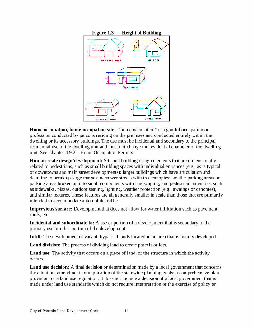
Height of building: The vertical distance from the grade to the highest point of the coping of a flat roof or to the deck line of a mansard roof or to the point midway between the ridge and the eves of a pitch or hip roof.
City of Phoenix Land Development Code 11
Figure 1.3 Height of Building
Home occupation, home-occupation site: home occupation is a gainful occupation or profession conducted by persons residing on the premises and conducted entirely within the dwelling or its accessory buildings. The use must be incidental and secondary to the principal residential use of the dwelling unit and must not change the residential character of the dwelling unit. See Chapter 4.9.2 Home Occupation Permits.
Human-scale design/development: Site and building design elements that are dimensionally related to pedestrians, such as small building spaces with individual entrances (e.g., as is typical of downtowns and main street developments); larger buildings which have articulation and detailing to break up large masses; narrower streets with tree canopies; smaller parking areas or parking areas broken up into small components with landscaping; and pedestrian amenities, such as sidewalks, plazas, outdoor seating, lighting, weather protection (e.g., awnings or canopies), and similar features. These features are all generally smaller in scale than those that are primarily intended to accommodate automobile traffic.
Impervious surface: Development that does not allow for water infiltration such as pavement, roofs, etc.
Incidental and subordinate to: A use or portion of a development that is secondary to the primary use or other portion of the development.
Infill: The development of vacant, bypassed lands located in an area that is mainly developed.
Land division: The process of dividing land to create parcels or lots.
Land use: The activity that occurs on a piece of land, or the structure in which the activity occurs.
Land use decision: A final decision or determination made by a local government that concerns the adoption, amendment, or application of the statewide planning goals; a comprehensive plan provision, or a land use regulation. It does not include a decision of a local government that is made under land use standards which do not require interpretation or the exercise of policy or
City of Phoenix Land Development Code 12
legal judgment, which is a limited land use decision, or which is an expedited land division as described in ORS 197.360;
Land use district: As used in this code, a land use district is the same as a zone district.
Landscaping: Any combination of living plants such as trees, shrubs, plants, vegetative ground cover or turf grasses, and may include structural features such as walkways, fences, benches, plazas, works of art, reflective pools, fountains or the like. Landscaping also includes irrigation systems, mulches, topsoil, and revegetation or the preservation, protection and replacement of existing trees.
Lane, mid-block lane: A narrow, limited use roadway facility usually used to access a limited number of dwelling units. Comparable to a minimum access street. Similar to an alley in design. See Chapter 4.3.5 Approval Criteria for Preliminary Plat, Section D.
Legislative: A legislative action or decision is the making of law, as opposed to the application of existing law to a particular use (e.g., adoption of, or amendment to, a comprehensive plan or development regulation). See Chapter 4.1.6 Type IV Procedure (Legislative).
Level of service: For transportation, a standard of a street s carrying capacity, based upon prevailing roadway, traffic and traffic control conditions during a given time period. The Level of Service range, from LOS A (free flow) to LOS F (forced flow) describes operational conditions within a traffic stream and their perception by motorists/passengers. Level of Service is normally measured for the peak traffic hour, at intersections (signalized or unsignalized) or street segments (between signalized intersections).
Light manufacture: Light manufacture means production or manufacturing of small-scale goods, such as crafts, electronic equipment, bakery products, printing and binderies, furniture, and similar goods.
Livestock: Domestic animal types customarily raised or kept on farms.
Local Improvement District (LID): A public district formed to carry out local improvements (paving of streets, construction of storm sewers, development of a park, etc.). Property owners within the LID are assessed for the cost of the improvements in accordance with ORS 223.387-223.485. See also Chapter 3.5.2 Transportation Standards, Section A.
Lot: A lot is a unit of land that is created by a subdivision of land (ORS 92.010(3)). See also, Chapter 4.3 Land Divisions and Lot Line Adjustments.
Lot area: The total surface area within the lot lines of a lot.
Lot coverage: The area of a lot covered by a building or buildings expressed as a percentage of the total lot area.
Lot line adjustment: The adjustment of a property line by the relocation of a common line where no additional lots are created. This development code also defines the consolidation of lots as a lot line adjustment.
Manufactured home: A transportable single-family dwelling conforming to the Manufactured Housing Construction and Safety Standards Code of the US Dept. of Housing and Urban Development, but is not regulated by the Oregon State Structural Specialty Code and Fire Life Safety Regulations, and is intended for permanent occupancy.
City of Phoenix Land Development Code 13
Manufactured home park: As defined by ORS 446, Manufactured home park means any place where four or more manufactured dwellings are located within 500 feet of one another on a lot, tract or parcel of land under the same ownership, the primary purpose of which is to rent or lease space.
Ministerial: A routine governmental action or decision that involves little or no discretion. The issuance of a building permit is such an action. See also, Chapter 4.1.3 Type I Procedure (Ministerial).
Mitigation: To avoid, rectify, repair, or compensate for negative impacts that result from other actions (e.g., Improvements to a street may be required to mitigate for transportation impacts resulting from development. )
Mixed-use building/development: A building or development with a mix of residential, commercial, or public uses. See Chapter 2.3.10 Special Standards for Certain Uses, Section A.
Multi-family housing: Housing that allows more than three dwellings on an individual site. See Chapter 2.2.9 Special Standards for Certain Uses, Section E.
Multi-use pathway: Accessways intended to serve both pedestrians and bicycles. See Chapter 3.2.3 Pedestrian Access and Circulation, Section A.
Natural hazard: Areas that are subject to natural events that are known to result in death or endanger the works of man, such as stream flooding, ground water, erosion and deposition, landslides, earthquakes, weak foundation soils and other hazards unique to local or regional areas.
Neighborhood: A geographic area lived in by neighbors and usually having distinguishing character.
Neighborhood commercial: Small-scale commercial allowed as a conditional use in Residential Districts. See Chapter 2.2.2 Permitted Land Uses and 2.2.9 Special Standards for Certain Uses, Section I.
Non-conforming use/non-conforming development: An existing land use that would not be permitted by the Development Code and that was lawful at the time it was established. See Chapter 5.3 Non-Conforming Uses and Developments.
Off-street parking: All off-street areas designed, used, required, or intended to be used for the parking of motor vehicles. Off-street parking areas shall conform to the requirements of Chapter 3.4 Vehicle and Bicycle Parking.
On-street parking: Parking in the street right-of-way, typically in parking lanes or bays. Parking may be parallel or angled in relation to the edge of the right-of-way or curb. See also Chapter 3.4 Vehicle and Bicycle Parking.
Open space (common/private/active/passive): Land within a development that is held in common or is public that provides places for recreation, conservation, or other open space uses.
Orientation: To cause to face toward a particular point of reference (e.g., A building oriented to the street ).
Outdoor commercial use: A use supporting a commercial activity that provides goods or services, either wholesale or retail, where the amount of site area used for outdoor storage of
City of Phoenix Land Development Code 14
materials or display of merchandise exceeds the total floor area of all buildings on the site. Examples of outdoor commercial uses include automobile sales or services, nurseries, lumberyards and equipment rental businesses.
Parcel: A parcel is a unit of land that is created by a partitioning of land (ORS 92.010(6)). See also, Chapter 4.3 Land Divisions and Lot Line Adjustments.
Partition: To divide an area or tract of land into two or three parcels within a calendar year when such area or tract of land exists as a unit or contiguous units of land under single ownership at the beginning of such year. (See also, ORS 92.010(8)).
Pathway/walkway/access way: See Chapter 3.2.3 Pedestrian Access and Circulation, Section A. As defined in this code, a pathway or multi-use pathway may be used to satisfy the requirements for accessways in the Transportation Planning Rule. (OAR 660-012-045). Pathway refers to an access that provides for pedestrian circulation only. See also Multi-use
pathway.
Pedestrian amenity: Facilities that encourage people to walk or shop along a public right-of-way by creating a pedestrian-friendly atmosphere. These include areas and objects that enhance the pedestrian experience by providing activity and interest to the streetscape. See Chapter 2.3.9 Pedestrian and Transit Amenities.
Planned Unit Development. A Planned Unit Development designation is an overlay zone that may be applied over any of the City s land use districts, subject to the standards in Chapter 4.5
Planned Unit Developments.
Planter strip, tree cutout: A landscape area for street trees and other plantings within the public right-of-way, usually between the street and a sidewalk.
Plat: A map of a subdivision, prepared as specified in ORS 92.080, and recorded with the Jackson County Assessor s Office. All plats shall also conform to Chapter 4.3 Land Divisions and Lot Line Adjustments.
Plaza: A public square or extra-wide sidewalk that allows for special events, outdoor seating, sidewalk sales, and similar pedestrian activity. See Chapter 2.3.9 Pedestrian and Transit Amenities.
Pocket park: A small park, usually less than one-half acre.
Primary: The largest or most substantial element on the property, as in primary use, residence, entrance, etc. All other similar elements are secondary in size or importance.
Private Driveway: A private road that is part of and provides access to one lot only.
Property line: The official boundary line of a property. See Figure 2.2.4.
Quasi-judicial: Refers to an action or decision that requires substantial discretion or judgment in applying the standards or criteria of this Code, and involves a public hearing. See Chapter 4.1.5
Type III Procedure (Quasi-Judicial).
Residence: Same as dwelling unit.
Residential care home/Residential care facility: Residential care homes and facilities are residential treatment or training homes or adult foster homes licensed by the State of Oregon.

City of Phoenix Land Development Code 15
Homes provide care for five or fewer individuals and facilities provide care for six to 15 individuals. See Chapter2.2.9 Special Standards for Certain Uses, Section F.
Ridge line (building): The top of a roof at its highest elevation.
Right-of-way: Land that is owned in fee simple by the public, usually for transportation facilities.
Roof pitch: The slope of a roof, usually described as ratio (e.g., one foot of rise per two feet of horizontal distance).
Senior housing: Housing designated and/or managed for persons over the age of 55. (Specific age restrictions vary.)
Sensitive lands: Wetlands, significant trees, steep slopes, flood plains, and other natural resource areas designated for protection or conservation by the Comprehensive Plan.
Setback: See Building Setback.
Shared driveway: When land uses on two or more lots or parcels share one driveway. An easement or tract (owned in common) may be created for this purpose.
Shared parking: Joint use of parking facilities for two or more uses, structures, or parcels of land. See Chapter 3.4.3 Vehicle Parking Standards, Section C.4.
Significant trees, significant vegetation: Individual trees and shrubs with a trunk diameter of six inches or greater, as measured four feet DBH (diameter at breast height) above the ground, and all plants within the drip line of such trees and shrubs. See Chapter 3.3.2 Landscape Conservation, Section B.1.
Single-family attached housing (townhomes): Two or more single-family dwellings with common walls. See also, Chapter 2.2.2 Permitted Land Uses and 2.2.9 Special Standards for Certain Uses.
Single-family detached house: A single-family dwelling that does not share a wall with any other building. See also Chapter 2.2.2 Permitted Land Uses.
Site: A property (or group of adjacent parcels or lots) that is subject to a permit application under this Code.
Site design review: A discretionary review conducted by the Planning Director and/or the Planning Commission with or without a public hearing. See Chapter 4.2 Development Review and Site Design Review.
Standards and criteria: Standards are code requirements. Criteria are the elements required to comply with a particular standard.
Steep slopes: Slopes of greater than 35 percent.
Storefront character: The character expressed by buildings placed close to the street with ground-floor display windows, weather protection such as awnings or canopies, corner building entrances or recessed entries, and similar features.
Storm water facility: A detention pond, swale, or other surface water feature that provides storage during high-rainfall events and/or water quality treatment.
City of Phoenix Land Development Code 16
Street/road: A public or private way for travel by vehicles, bicycles, and pedestrians that meets the city standards in Chapter 3.5.2 Transportation Standards.
Street connectivity: Street connections within a specific geographic area. Higher levels of connectivity provide for more direct transportation routes and better dispersion of traffic, resulting in less traffic on individual streets and potentially slower speeds through neighborhoods.
Street furniture/furnishings: Benches, lighting, bicycle racks, drinking fountains, mailboxes, kiosks, and similar pedestrian amenities located within a street right-of-way. See also, Chapter 2.3.9 Pedestrian and Transit Amenities.
Street stub: A temporary street ending, which is used when the street will be extended through adjacent property in the future, as those properties develop. Not a permanent street-end or dead-end street.
Street tree: A tree planted in a planter strip or tree cutout, usually within or adjacent to the edge of a street right-of-way.
Subdivision: To divide land into four or more lots within a single calendar year. (ORS 92.010(13)).
Swale: A type of storm water facility. Usually a broad, shallow depression with plants that filter and process contaminants.
Tract: private/public: Land held in common ownership.
Transportation facilities: The physical improvements used to move people and goods from one place to another; i.e., streets, sidewalks, pathways, bike lanes, airports, transit stations and bus stops, etc.).
Transportation mode: The method of transportation (e.g., automobile, bus, walking, bicycling, etc.)
Triplex: A building with three attached housing units on one lot or parcel.
Vacate plat/street: To abandon a subdivision or street right-of-way. For example, vacation of a public right-of-way that is not needed or cannot be used for a street or other public purpose. A plat may be vacated, returning the property to an undivided condition.
Variance: An administrative or quasi-judicial decision to lessen or otherwise modify the requirements of this Code. See Chapter 5.2 Variances.
Vision clearance area: See Figure 3.2.2.M.
Wetland: Wetlands are land areas where water is the dominant factor determining the nature of soil development and the types of plant and animal communities. They are defined more specifically by the Federal Clean Water Act (Section 404) and Oregon Administrative Rules (OAR 141-85-010). For more information, contact the Oregon Division of State Lands.
Wireless communication equipment: Includes cell towers, antennae, monopoles, and related facilities used for radio signal transmission and receiving.
Yard: The area defined by setbacks (i.e., between the setback line and respective property line).
Zero-lot line house: A single family detached house with one side yard setback equal to zero.
City of Phoenix Land Development Code 17
Chapter 1.4 Enforcement
Sections:
1.4.1 Provisions of this Code Declared to be Minimum Requirements 1.4.2 Violation of Code Prohibited 1.4.3 Penalty 1.4.4 Complaints Regarding Violations 1.4.5
Abatement of Violations 1.4.6 Stop-Order Hearing
1.4.1 Provisions of this Code Declared to be Minimum Requirements
A. Minimum requirements intended. In their interpretation and application, the provisions of this Code shall be held to be minimum requirements, adopted for the protection of the public health, safety, and general welfare.
B. Most restrictive requirements apply. When the requirements of this Code vary from other provisions of this Code or with other applicable standards, the most restrictive or that imposing the highest standard shall govern.
1.4.2 Violation of Code Prohibited
No person shall erect, construct, alter, maintain, or use any building or structure or shall use, divide, or transfer any land in violation of this Code or any amendment thereto.
1.4.3 Penalty
A. Class 1 penalty. A violation of this Code shall constitute a Class 1 civil infraction that shall be processed accordingly.
B. Each violation a separate infraction. Each violation of a separate provision of this Code shall constitute a separate infraction, and each day that a violation of this Code is committed or permitted to continue shall constitute a separate infraction.
C. Abatement of violation required. The penalties imposed by this Section are in addition to and not in lieu of any remedies available to the City. If a property owner or the responsible party is found in violation of this Code, the property owner or the responsible party shall pay the fines and shall abate the violation so that they are found to be in conformance with the development code.
D. Responsible party. If a provision of this Code is violated by a firm or corporation, the officer or officers, or person or persons responsible for the violation shall be subject to the penalties imposed by this Section.
1.4.4 Complaints Regarding Violations
A. Filing written complaint. Whenever a violation of this Code occurs, or is alleged to have occurred, any person may file a signed, written complaint.
B. File complaint with Planning Director. Such complaints, stating fully the causes and basis thereof, shall be filed with the Planning Director. The Planning Department shall properly record such complaints, investigate, and take action thereon as provided by this Code.
City of Phoenix Land Development Code 18
1.4.5
Abatement of Violations
Any development or use that occurs contrary to the provisions of this Code or contrary to any permit or approval issued or granted under this Code is unlawful, and may be abated by appropriate proceedings.
1.4.6 Stop-Order Hearing
A. Stop order issued. Whenever any work is being done in violation of the provisions of the Code or a condition of any permit or other approval granted pursuant hereto, the Building Official and/or the Planning Director may order the work stopped by notice in writing served on persons engaged in doing such work or causing such work to be done. All work under the permit or approval shall cease until it is authorized to continue.
B. Stop-order hearing. The Building Official and/or the Planning Director shall schedule a hearing if requested on the stop order for the earliest practicable date, but not more than 30 days after the effectiveness of any required notice. At the discretion of the City Official, such hearing may be:
1. Part of a hearing on revocation of the underlying development approval; or
2. Solely to determine whether a violation has occurred. The Planning Commission and/or City Council shall hold this hearing and shall make written findings as to the violation within 60 days. Upon finding a violation, the stop order shall continue to be effective until the violating party furnishes sufficient proof to the Building Official and/or Planning Director that the violation has been abated. Any Planning Commission and/or City Council decision is subject to review under 4.1.5 Type III Procedure (Quasi-Judicial).
City of Phoenix Land Development Code 19
Chapter 2 Land Use Districts
Chapter 2.1 Land Use District Administration........................................................................... 21 2.1.1 Classification of Land Use Districts............................................................................. 21 2.1.2 Land Use District Map ................................................................................................. 21 2.1.3 Determination of Land Use District Boundaries .......................................................... 21
Chapter 2.2 Residential Districts (R-1, R-2, R-3, HO) .............................................................. 23 2.2.1 Purpose ......................................................................................................................... 23 2.2.2 Permitted Land Uses .................................................................................................... 23 2.2.3 Building Setbacks......................................................................................................... 25 2.2.4 Lot Dimensions ............................................................................................................ 26 2.2.5 - Maximum Lot Coverage ............................................................................................... 26 2.2.6 Building Height ............................................................................................................ 27 2.2.7 Building Orientation..................................................................................................... 27 2.2.8 Architectural Standards ................................................................................................ 28 2.2.9 Special Standards for Certain Uses .............................................................................. 30
Chapter 2.3 City Center District (C-C) ...................................................................................... 39 2.3.1 Purpose ......................................................................................................................... 39 2.3.2 Permitted Land Uses .................................................................................................... 39 2.3.3 Building Setbacks......................................................................................................... 41 2.3.4 Lot Coverage ................................................................................................................ 41 2.3.5 Open Space................................................................................................................... 42 2.3.6 Block Layout and Building Orientation ....................................................................... 43 2.3.7 Building Height ............................................................................................................ 45 2.3.8 Architectural Guidelines and Standards ....................................................................... 46 2.3.9 Pedestrian and Transit Amenities................................................................................. 49 2.3.10 Special Standards for Certain Uses ............................................................................ 50
Chapter 2.4 Commercial Highway (C-H) .................................................................................. 55 2.4.1 Purpose ......................................................................................................................... 55 2.4.2 Permitted and Conditionally Permitted Land Uses ...................................................... 55 2.4.3 Development Standards................................................................................................ 57 2.4.4 Architectural Guidelines and Standards ....................................................................... 59 2.4.5 Special Standards for Certain Uses .............................................................................. 60
Chapter 2.5 General Industrial (GI) District .............................................................................. 63 2.5.1 Purpose ......................................................................................................................... 63 2.5.2 Permitted Land Uses .................................................................................................... 63 2.5.3 Development Setbacks ................................................................................................. 64 2.5.4 Lot Coverage ................................................................................................................ 65 2.5.5 Lot Area and Dimensions............................................................................................. 65 2.5.6 Development Orientation ............................................................................................. 65 2.5.7 Building Height ............................................................................................................ 65 2.5.8 Special Standards for Certain Uses .............................................................................. 65 2.5.9 Industrial Design Standards.......................................................................................... 67
Chapter 2.6 Light Industrial District (LI)................................................................................... 71 2.6.1 Purpose ......................................................................................................................... 71 2.6.2 Permitted Land Uses .................................................................................................... 71
City of Phoenix Land Development Code 20
2.6.3 Development Setbacks ................................................................................................. 73 2.6.4 Lot Coverage ................................................................................................................ 73 2.6.5 Lot Area and Dimensions............................................................................................. 73 2.6.6 Building Height ............................................................................................................ 73 2.6.7 Building Orientation..................................................................................................... 74 2.6.8 Special Standards for Certain Uses .............................................................................. 74 2.6.9 Industrial Design Standards.......................................................................................... 75
Chapter 2.7 Historic Preservation Overlay Zone ....................................................................... 79 2.7.1 Description and Purpose............................................................................................... 79 2.7.2 Definitions .................................................................................................................... 79 2.7.3 Historic Review Board ................................................................................................. 80 2.7.4 Designation of Historic Buildings or Sites................................................................... 80 2.7.5 Exterior Remodeling of a Historic Building ................................................................ 81 2.7.6 Demolition and Condemnation of Historic Buildings.................................................. 81 2.7.7 General Provisions ....................................................................................................... 83
Chapter 2.8 Bear Creek Greenway District................................................................................ 85 2.8.1 Purpose ......................................................................................................................... 85 2.8.2 Permitted Uses.............................................................................................................. 85 2.8.3 Lot Requirements ......................................................................................................... 85 2.8.4 Height Limitations........................................................................................................ 86 2.8.5 Signs ............................................................................................................................. 86 2.8.6 Fences, Walls, Hedges, and Screen Plantings .............................................................. 86 2.8.7 Off-street Parking ......................................................................................................... 86 2.8.8 General Requirements .................................................................................................. 86
City of Phoenix Land Development Code 21
Chapter 2.1 Land Use District Administration
Sections:
2.1.1 Classification of Land Use Districts 2.1.2 Land Use District Map 2.1.3 Determination of Land Use District Boundaries
2.1.1 Classification of Land Use Districts
All areas within the urban growth boundary of the City of Phoenix are divided into land use districts on the City s Comprehensive Plan Land Use Map. Upon annexation into the City, the use of each lot, parcel, and tract of land is limited to the uses permitted by the applicable land use district. The applicable land use district shall be determined based on the Land Use District Map, and the provisions of this Chapter.
2.1.2 Land Use District Map
A. Consistency with land use district map. The boundaries of each of the land use districts contained within this Chapter shall coincide with the land use district boundaries identified on the City s official zoning map, retained by the City Recorder. Said map by this reference is made a part of this Land Development Code. A certified print of the adopted land-use district map, and any map amendments, shall be maintained by the City.
B. Applicability of zoning requirements. Each lot, tract, and parcel of land or portion thereof within the land-use district boundaries as designated and marked on the zoning map, is classified, zoned, and limited to the uses as hereinafter specified and defined for the applicable district classification.
C. Land use district map amendments. All amendments to the City land-use district (zoning) map shall be made in accordance with the provisions of Chapter 4.7 Land Use District Map and Text Amendments.
1. Copies of all map amendments shall be dated with the effective date of the ordinance adopting the map amendment, and shall be maintained without change, together with the adopting documents, on file at the City; and
2. The City shall make available for public inspection an up-to-date copy of the revised land-use district map, so that it accurately portrays changes of zone boundaries or classification, as applicable.
2.1.3 Determination of Land Use District Boundaries
Where due to the scale, lack of scale, lack of detail, or illegibility of the City zoning district map, or due to any other reason, there is uncertainty, contradiction, or conflict as to the intended location of district boundary lines, the boundary lines shall be determined by the Planning Director in accordance with the following:
A. Boundaries indicated as approximately following the centerlines of streets, highways, railroad tracks, or alleys shall be constructed to follow such centerlines;
B. Boundaries indicated as approximately following the boundaries of a parcel, lot, or tract shall be construed as following such boundaries;
City of Phoenix Land Development Code 22
C. Boundaries indicated as approximately following a City boundary, or the Urban Growth Boundary shall be constructed as following said boundary;
D. Boundaries indicated as approximately following river, stream, drainage channels or basins shall be constructed as following river, stream, drainage channels or basins, as applicable; and
E. Whenever any public right-of-way is lawfully vacated, the lands formerly within the vacated right-of-way shall automatically be subject to the same land-use district designation that is applicable to lands abutting the vacated area. In cases where the right-of-way formerly served as a land-use district boundary, the lands formerly within the vacated right-of-way shall be allocated proportionately between the subject land-use districts.
City of Phoenix Land Development Code 23
Chapter 2.2 Residential Districts (R-1, R-2, R-3, HO)
Sections:
2.2.1 Purpose 2.2.2 Permitted Land Uses 2.2.3 Building Setbacks 2.2.4 Lot Dimensions 2.2.6 Building Height 2.2.7 Building Orientation 2.2.8 Architectural Standards 2.2.9 Special Standards for Certain Uses
2.2.1 Purpose
The Residential Districts are intended to promote the livability, stability, and improvement of the City s neighborhoods. This Chapter provides standards for the orderly expansion and improvement of neighborhoods.
2.2.2 Permitted Land Uses
A. Permitted Uses. The land uses listed in Table 2.2.2 are permitted in the Residential Districts, subject to the provisions of this Chapter. Only land uses that are specifically listed in Table 2.2.2 and land uses that are approved as similar to those in Table 2.2.2 may be permitted. The land uses identified with a CUP in Table 2.2.2 require Conditional Use Permit approval prior to development or a change in use, in accordance with Chapter 4.4 Conditional Use Permits.
B. Determination of Similar Land Use. Similar use determinations shall be made in conformance with the procedures in Chapter 4.8 Code Interpretations.
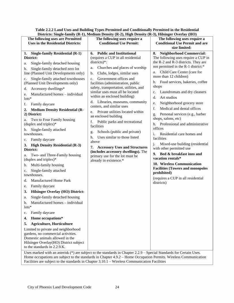
City of Phoenix Land Development Code 24
Table 2.2.2 Land Uses and Building Types Permitted and Conditionally Permitted in the Residential Districts: Single-family (R-1), Medium Density (R-2), High Density (R-3), Hilsinger Overlay (HO)
The following uses are Permitted Uses in the Residential Districts:
The following uses require a Conditional Use Permit:
The following uses require a Conditional Use Permit and are
size limited:
1. Single-family Residential (R-1) District: a. Single-family detached housing
b. Single-family detached zero lot line (Planned Unit Developments only)
c. Single-family attached townhouses (Planned Unit Developments only)
d. Accessory dwellings*
e. Manufactured homes individual lots*
f. Family daycare
2. Medium Density Residential (R-2) District: a. Two to Four Family housing (duplex and triplex)*
b. Single-family attached townhouses.
c. Family daycare
3. High Density Residential (R-3) District: a. Two- and Three-Family housing (duplex and triplex)*
b. Multi-family housing
c. Single-family attached townhouses.
d. Manufactured Home Park
e. Family daycare
3. Hilsinger Overlay (HO) District: a. Single-family detached housing
b. Manufactured homes individual lots*
c. Family daycare
4. Home occupations*
5. Agriculture, Horticulture Limited to private and neighborhood gardens, no commercial activities. Domestic animals allowed in the Hilsinger Overlay(HO) District subject to the standards in 2.2.9.K.
6. Public and Institutional (requires a CUP in all residential districts)*:
a. Churches and places of worship
b. Clubs, lodges, similar uses
c. Government offices and facilities (administration, public safety, transportation, utilities, and similar uses must all be located within an enclosed building)
d. Libraries, museums, community centers, and similar uses
e. Private utilities located within an enclosed building
f. Public parks and recreational facilities
g. Schools (public and private)
h. Uses similar to those listed above
7. Accessory Uses and Structures (includes accessory dwellings). The primary use for the lot must be already in existence.*
8. Neighborhood Commercial: The following uses require a CUP in the R-2 and R-3 districts. They are not permitted in the R-1 district:*
a. Child Care Center (care for more than 12 children)
b. Food services, bakeries, coffee shops
c. Laundromats and dry cleaners
d. Art studios
e. Neighborhood grocery store
f. Medical and dental offices
g. Personal services (e.g., barber shops, salons, etc)
h. Professional and administrative offices
i. Residential care homes and facilities
j. Mixed-use building (residential with other permitted use
9. Bed & breakfast inns and vacation rentals*
10. Wireless Communication Facilities (Towers and monopoles prohibited) (requires a CUP in all residential districts)
Uses marked with an asterisk (*) are subject to the standards in Chapter 2.2.9 Special Standards for Certain Uses. Home occupations are subject to the standards in Chapter 4.9.2 Home Occupation Permits. Wireless Communication Facilities are subject to the standards in Chapter 3.10.1 Wireless Communication Facilities
City of Phoenix Land Development Code 25
2.2.3 Building Setbacks
Building setbacks provide space for private yards and building separation for fire protection/security, building maintenance, sunlight, and air circulation. This Section is also intended to promote human-scale design and traffic calming by downplaying the visual presence of garages along the street and encouraging the use of extra-wide sidewalks and pocket parks in front of markets and other non-residential uses. The standards encourage placement of residences close to the street for public safety and neighborhood security.
Building setbacks are measured from the foundation to the respective property line (See Chapter 2.2.3 Building Setbacks, Section D for exceptions.) Setbacks for decks and porches are measured from the edge of the deck or porch to the property line. The setback standards, as listed on the following page and illustrated above, apply to primary structures as well as accessory structures. A Variance is required in accordance with Chapter 5.2 Variances to modify any setback standard.
Temporary and prefabricated structures are not allowed in setbacks.
A. Front Yard Setbacks
1. Residential Uses (single-family, duplex and triplex, multi-family housing types).
a. A minimum setback of 20 feet is required for single-family uses, except that an unenclosed porch may be within 15 feet, as long as it does not encroach into a public utility easement.
b. A minimum setback of 10 feet is required for multi-family uses. If garages face the street, then the garages must be set back 20 feet from the back of the sidewalk.
c. When garages face the street, they shall be recessed behind the front elevation (i.e., living area or covered front porch) by a minimum of four feet and shall be setback 20 feet from the back of the sidewalk.
d. Multi-family developments with over five units must be accessed from the rear.
e. Multi-family housing shall also comply with the building orientation standards in Chapter 2.2.7 Building Orientation.
2. Neighborhood Commercial Buildings. A minimum setback of 15 feet is required, except as necessary to comply with the vision clearance standards in Chapter 3.2.2 Vehicular Access and Circulation, Section M. Parking is to be located to the rear of the building.
3. Public and Institutional Buildings. The standards in Subsection 2, above, (Neighborhood Commercial Buildings) shall also apply to Public and Institutional Buildings.
B. Rear yard Setbacks. Rear yard setbacks shall be a minimum of ten feet, (plus one half foot of setback for every foot of height of building over fifteen feet except when the requirement is waived by the decision-making body because the subject property is significantly downslope of the adjacent property to the rear). If a home is being remodeled, then any additional stories shall meet the setback requirements for buildings over 15 feet. Rear yard setbacks shall be determined using the definition of Height of Building in Chapter Chapter 1.3 Definitions. Setbacks are based on the height of the building nearest to the rear property line.
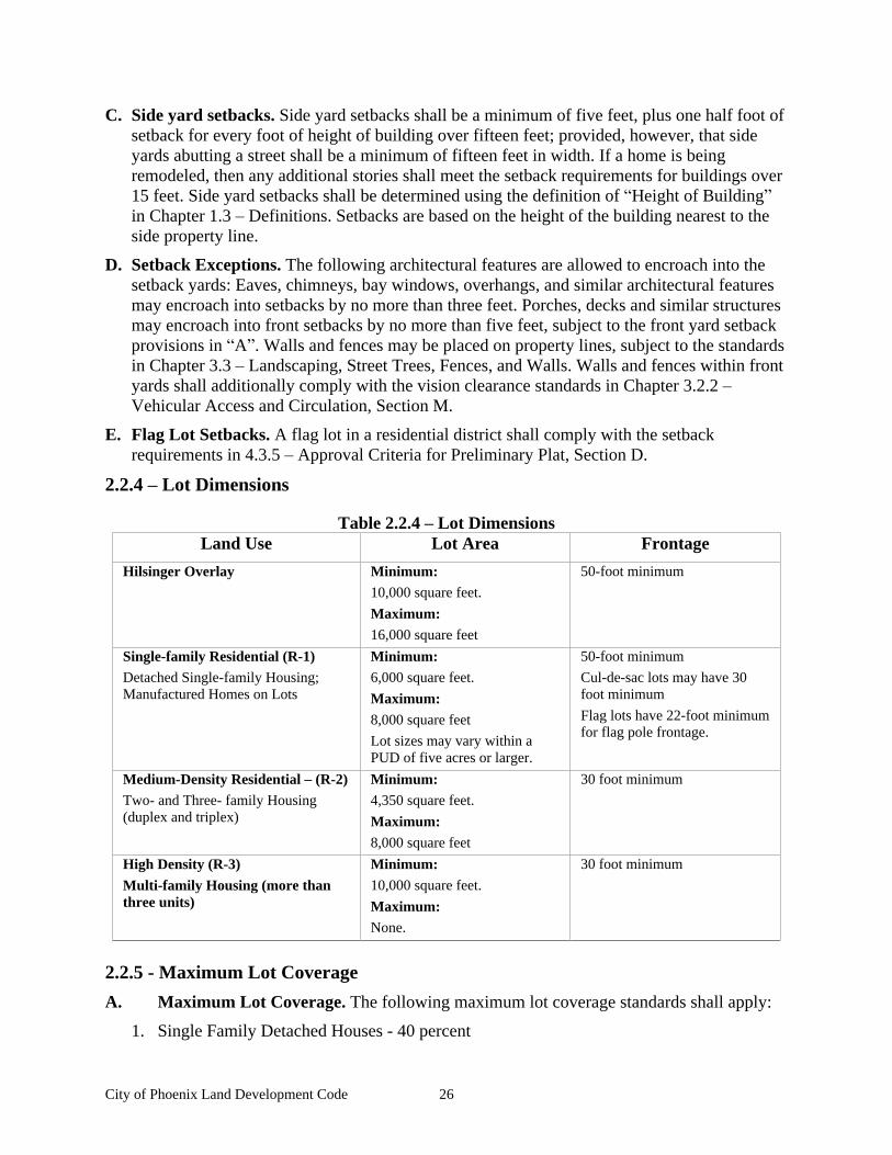
City of Phoenix Land Development Code 26
C. Side yard setbacks. Side yard setbacks shall be a minimum of five feet, plus one half foot of setback for every foot of height of building over fifteen feet; provided, however, that side yards abutting a street shall be a minimum of fifteen feet in width. If a home is being remodeled, then any additional stories shall meet the setback requirements for buildings over 15 feet. Side yard setbacks shall be determined using the definition of Height of Building in Chapter 1.3 Definitions. Setbacks are based on the height of the building nearest to the side property line.
D. Setback Exceptions. The following architectural features are allowed to encroach into the setback yards: Eaves, chimneys, bay windows, overhangs, and similar architectural features may encroach into setbacks by no more than three feet. Porches, decks and similar structures may encroach into front setbacks by no more than five feet, subject to the front yard setback provisions in A . Walls and fences may be placed on property lines, subject to the standards in Chapter 3.3 Landscaping, Street Trees, Fences, and Walls. Walls and fences within front yards shall additionally comply with the vision clearance standards in Chapter 3.2.2
Vehicular Access and Circulation, Section M.
E. Flag Lot Setbacks. A flag lot in a residential district shall comply with the setback requirements in 4.3.5 Approval Criteria for Preliminary Plat, Section D.
2.2.4 Lot Dimensions
Table 2.2.4 Lot Dimensions Land Use Lot Area Frontage
Hilsinger Overlay Minimum: 10,000 square feet.
Maximum: 16,000 square feet
50-foot minimum
Single-family Residential (R-1) Detached Single-family Housing; Manufactured Homes on Lots
Minimum: 6,000 square feet.
Maximum: 8,000 square feet
Lot sizes may vary within a PUD of five acres or larger.
50-foot minimum
Cul-de-sac lots may have 30 foot minimum
Flag lots have 22-foot minimum for flag pole frontage.
Medium-Density Residential (R-2) Two- and Three- family Housing (duplex and triplex)
Minimum: 4,350 square feet.
Maximum: 8,000 square feet
30 foot minimum
High Density (R-3)
Multi-family Housing (more than three units)
Minimum: 10,000 square feet.
Maximum: None.
30 foot minimum
2.2.5 - Maximum Lot Coverage
A. Maximum Lot Coverage. The following maximum lot coverage standards shall apply:
1. Single Family Detached Houses - 40 percent
City of Phoenix Land Development Code 27
2. Duplexes and Triplexes - 50 percent
3. Single Family Attached Townhomes - 60 percent
4. Multiple Family Housing - 60 percent
5. Neighborhood Commercial and Public/Institutional Uses - 80 percent
B. Compliance with other sections of this code may preclude development of the maximum lot coverage for some land uses.
2.2.6 Building Height
A. Purpose. The following building height standards are intended to promote land use compatibility and support the principle of neighborhood-scale design:
B. Building Height Standard. Buildings within the R-1 and R-2 Residential Districts shall be no more than 35 feet in height, and buildings within the R-3 Multi-family District may be up to 45 feet or three stories.
2.2.7 Building Orientation
A. Purpose. The following standards are intended to orient buildings close to streets to promote human-scale development, slow traffic down, and encourage walking in neighborhoods. Placing residences and other buildings close to the street also encourages security and safety by having more eyes-on-the-street.
B. Applicability. This Section applies to Single-family Attached townhouses that are subject to Site Design Review (3 or more attached units); Multi-Family Housing; Neighborhood Commercial buildings; and Public and Institutional buildings, except that the standard shall not apply to buildings which do not receive the public (e.g., buildings used solely for storage or for housing mechanical equipment, and similar uses.)
C. Building orientation standards. All developments subject to this subsection shall be oriented to a street when the lot is sufficient in size to allow for this. The building orientation standard is met when all of the following criteria are met:
1. Compliance with the setback standards in Chapter 2.2.3 Building Setbacks.
2. All buildings shall have their primary entrances oriented to the street. Multi-family and neighborhood commercial building entrances may include entrances to individual units, lobby entrances, or breezeway/courtyard entrances (i.e., to a cluster of units or commercial spaces). Alternatively, a building may have its entrance oriented to a side yard when a direct pedestrian walkway is provided between the building entrance and the street in accordance with the standards in Chapter 3.2 Access and Circulation. In this case, at least one entrance shall be provided not more than 20 feet from the closest sidewalk or street.
3. Parking shall be located in the rear of the building unless lot configuration makes this impracticable. If parking is not located in the rear, it shall be located on the side of the building. Side parking shall be set back 20 feet from the street right-of-way and screened from view with landscaping.
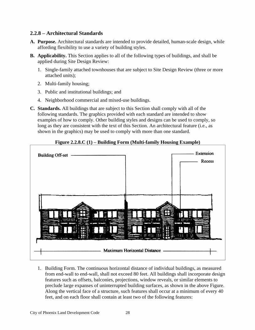
City of Phoenix Land Development Code 28
2.2.8 Architectural Standards
A. Purpose. Architectural standards are intended to provide detailed, human-scale design, while affording flexibility to use a variety of building styles.
B. Applicability. This Section applies to all of the following types of buildings, and shall be applied during Site Design Review:
1. Single-family attached townhouses that are subject to Site Design Review (three or more attached units);
2. Multi-family housing;
3. Public and institutional buildings; and
4. Neighborhood commercial and mixed-use buildings.
C. Standards. All buildings that are subject to this Section shall comply with all of the following standards. The graphics provided with each standard are intended to show examples of how to comply. Other building styles and designs can be used to comply, so long as they are consistent with the text of this Section. An architectural feature (i.e., as shown in the graphics) may be used to comply with more than one standard.
Figure 2.2.8.C (1) Building Form (Multi-family Housing Example)
1. Building Form. The continuous horizontal distance of individual buildings, as measured from end-wall to end-wall, shall not exceed 80 feet. All buildings shall incorporate design features such as offsets, balconies, projections, window reveals, or similar elements to preclude large expanses of uninterrupted building surfaces, as shown in the above Figure. Along the vertical face of a structure, such features shall occur at a minimum of every 40 feet, and on each floor shall contain at least two of the following features:
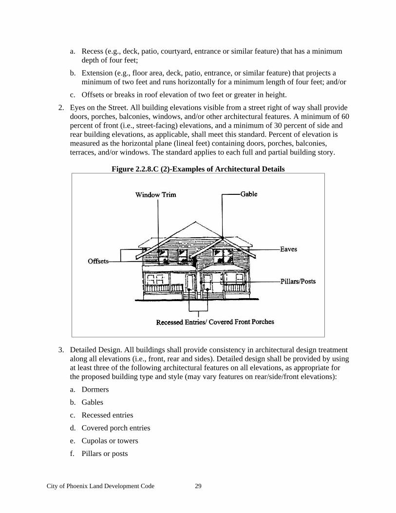
City of Phoenix Land Development Code 29
a. Recess (e.g., deck, patio, courtyard, entrance or similar feature) that has a minimum depth of four feet;
b. Extension (e.g., floor area, deck, patio, entrance, or similar feature) that projects a minimum of two feet and runs horizontally for a minimum length of four feet; and/or
c. Offsets or breaks in roof elevation of two feet or greater in height.
2. Eyes on the Street. All building elevations visible from a street right of way shall provide doors, porches, balconies, windows, and/or other architectural features. A minimum of 60 percent of front (i.e., street-facing) elevations, and a minimum of 30 percent of side and rear building elevations, as applicable, shall meet this standard. Percent of elevation is measured as the horizontal plane (lineal feet) containing doors, porches, balconies, terraces, and/or windows. The standard applies to each full and partial building story.
Figure 2.2.8.C (2)-Examples of Architectural Details
3. Detailed Design. All buildings shall provide consistency in architectural design treatment along all elevations (i.e., front, rear and sides). Detailed design shall be provided by using at least three of the following architectural features on all elevations, as appropriate for the proposed building type and style (may vary features on rear/side/front elevations):
a. Dormers
b. Gables
c. Recessed entries
d. Covered porch entries
e. Cupolas or towers
f. Pillars or posts
City of Phoenix Land Development Code 30
g. Eaves (min. 6-inch projection)
h. Off-sets in building face or roof (minimum 16 inches)
i. Window trim (minimum 4-inches wide)
j. Bay windows
k. Balconies
l. Decorative patterns on exterior finish (e.g., scales/shingles, wainscoting, ornamentation, and similar features)
m. Decorative cornices and roof lines (e.g., for flat roofs)
n. An alternative feature providing visual relief, similar to options a - m.
2.2.9 Special Standards for Certain Uses
This Section supplements the standards contained Sections 2.2.1 through 2.2.8. It provides standards for the following land uses in order to control the scale and compatibility of those uses within the Residential District:
A. Accessory dwelling (attached, separate cottage, or above detached garage). An accessory dwelling is a small, secondary housing unit on a single-family lot, usually the size of a studio apartment. The additional unit can be a detached cottage, a unit attached to a garage, or in a portion of an existing house. The housing density standard of the Residential District does not apply to accessory dwellings, due to the small size and low occupancy level of the use. The following standards are intended to control the size and number of accessory dwellings on individual lots to promote compatibility with adjacent land uses. Accessory dwellings shall comply with all of the following standards:
1. Oregon Structural Specialty Code. The structure complies with the Oregon Structural Specialty Code.
2. One Unit. A maximum of one accessory dwelling unit is allowed per lot.
3. Floor Area. The maximum floor area of the accessory dwelling shall not exceed 50% of the primary unit, with an 800 square foot maximum.
4. Building Height. The building height of detached accessory dwellings (i.e., separate cottages) shall not exceed building height requirements in Chapter 2.2.6 Building Height, as measured in accordance with the definition of Height of Building in Chapter 1.3 Definitions.
5. Buffering. A minimum 6-foot hedge or fence may be required to buffer a detached accessory dwelling from dwellings on adjacent lots, when buffering is necessary for the privacy and enjoyment of yard areas by either the occupants or adjacent residents.
6. Setbacks. Setbacks shall meet the Residential District requirements.
7. Architectural Compatibility. Architectural compatibility with the main residence is required.
8. Parking. One off-street, paved parking space shall be required in addition to off-street parking required by the primary residence.
City of Phoenix Land Development Code 31
B. Manufactured homes on individual lots. Manufactured homes are permitted on individual lots, subject to all of the following design standards, consistent with ORS 197.307(5).
1. Floor Plan. The manufactured home shall be multi-sectional and have an enclosed floor area of not less than 1,000 sq. feet;
2. Roof. The manufactured home shall have a pitched roof with a slope not less than three feet in height for each 12 feet in width (14 degrees);
3. Residential Building Materials. The manufactured home shall have exterior siding and roofing which in color, material, and appearance are similar to the exterior siding and roof material used on nearby residences;
4. Garages and Carports. The manufactured home shall have a garage or carport constructed of materials to match the primary residence;
5. Thermal Envelope. The manufactured home shall be certified by the manufacturer to meet the thermal envelope requirements equivalent to those for a single-family dwelling constructed under the State Building Code;
6. Placement. The manufactured home shall be placed on an excavated and back-filled foundation and enclosed at the perimeter such that the manufactured home is located not more than 16 inches above grade, and complying with the minimum set-up standards of the adopted state Administrative Rules for Manufactured Dwellings, Chapter 918. Where the building site has a sloped grade, no more than 16 inches of the enclosing material shall be exposed on the uphill side of the home;
7. Foundation Skirt. The foundation area of the manufactured home shall be fully skirted; and with concrete masonry block stem wall or decorative material.
C. Manufactured Home Park. Manufactured home parks are permitted on parcels of one acre or larger, subject to compliance with subsections 1-6, below:
1. Permitted uses: Single-family residences, manufactured home park manager s office, home occupations, and accessory structures which are necessary for the operation and maintenance of the manufactured home park (e.g., landscape maintenance). Home occupations shall comply with Chapter 4.9.2 Home Occupation Permits.
2. Building pad. The minimum size building pad for each home is 2,500 square feet, and the overall density of the park shall not exceed 12 units per acre. Each building pad shall be at least 30 feet wide and shall be at least 40 feet long, in accordance with ORS 446.100(c).

City of Phoenix Land Development Code 32
3. Setbacks and Building Separation. The minimum setback between park structures and abutting properties is five feet, in accordance with ORS 446.100(b). The minimum setback between park structures and public street right-of-way is between 15 feet to 20 feet, with a requirement of varied setbacks within the park. At least a 10-foot separation shall be provided between all dwellings. Dwellings shall be placed a minimum of 14 feet apart where flammable or combustible fuel is stored between units. Park structures shall be placed no closer than five feet to a park street or sidewalk/pathway. An accessory structure shall not be located closer than six feet to any other structure or dwelling, except that a double carport or garage may be built which serves two dwellings. When a double carport/garage is built, the carport/garage shall be separated from all adjacent structures by at least three feet.
4. Perimeter landscaping. When manufactured homes are oriented with their back or side yards facing a public right-of-way, the City may require installation of fencing and planting of a 15 foot wide landscape buffer between the right-of-way and a manufactured home park for the privacy and security of residents or aesthetics of the streetscape.
5. House design (parks smaller than three acres). Manufactured homes in parks shall meet the following design standards, consistent with ORS 197.314(6):
a. The manufactured home shall have a pitched roof with a slope not less than three feet in height for each 12 feet in width (14 degrees);
b. The manufactured home shall have exterior siding and roofing which in color, material, and appearance are similar or superior to the exterior siding and roof material used on nearby residences;
c. Exception: Subsections a-b, above, do not apply to manufactured homes that existed within the City prior to the effective date of this ordinance.
6. Play Area. The manufactured home park shall provide, in accordance with ORS 446.095(3), a separate general play area restricted to that use, if the park accommodates children who are under 14 years of age. No separate play area shall be less than 2,500 square feet in area. At least 100 square feet of play area shall be provided for each manufactured dwelling occupied by children.
D. Single-family attached (townhouses), Duplexes, and Triplexes. Single-family attached housing (townhouse units on individual lots), duplex and triplex developments shall comply with the standards in 1-4, below. The standards are intended to control development scale; avoid or minimize impacts associated with traffic, parking, and design compatibility; and ensure management and maintenance of common areas.
1. As necessary, the City shall require dedication of right-of-way or easements and construction of pathways between townhouse lots (e.g., between building breaks) to implement the standards in Chapter 3.2 Access and Circulation.
2. Building Mass Supplemental Standard. Within the R-2 and R-3 Districts, the maximum number and width of consecutively attached townhouses (i.e. with attached walls at property line) shall not exceed six units, or 130 feet (from end-wall to end-wall), whichever is less.
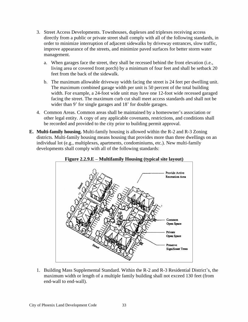
City of Phoenix Land Development Code 33
3. Street Access Developments. Townhouses, duplexes and triplexes receiving access directly from a public or private street shall comply with all of the following standards, in order to minimize interruption of adjacent sidewalks by driveway entrances, slow traffic, improve appearance of the streets, and minimize paved surfaces for better storm water management.
a. When garages face the street, they shall be recessed behind the front elevation (i.e., living area or covered front porch) by a minimum of four feet and shall be setback 20 feet from the back of the sidewalk.
b. The maximum allowable driveway width facing the street is 24 feet per dwelling unit. The maximum combined garage width per unit is 50 percent of the total building width. For example, a 24-foot wide unit may have one 12-foot wide recessed garaged facing the street. The maximum curb cut shall meet access standards and shall not be wider than 9 for single garages and 18 for double garages.
4. Common Areas. Common areas shall be maintained by a homeowner s association or other legal entity. A copy of any applicable covenants, restrictions, and conditions shall be recorded and provided to the city prior to building permit approval.
E. Multi-family housing. Multi-family housing is allowed within the R-2 and R-3 Zoning districts. Multi-family housing means housing that provides more than three dwellings on an individual lot (e.g., multiplexes, apartments, condominiums, etc.). New multi-family developments shall comply with all of the following standards:
Figure 2.2.9.E Multifamily Housing (typical site layout)
1. Building Mass Supplemental Standard. Within the R-2 and R-3 Residential District s, the maximum width or length of a multiple family building shall not exceed 130 feet (from end-wall to end-wall).

City of Phoenix Land Development Code 34
2. Common open space standard. Inclusive of required setback yards, a minimum of 20 percent of the site area shall be designated and permanently reserved as common open space in all multiple family developments. The site area is defined as the lot or parcel on which the development is planned, after subtracting any required public land dedication and public and private streets. Sensitive lands and historic buildings or landmarks open to the public and designated by the Comprehensive Plan may be counted toward meeting the common open space requirements.
3. Private open space standard. Private open space areas shall be required for ground-floor and upper-floor housing units based on all of the following standards:
a. All ground-floor housing units shall have front or rear patios or decks measuring at least 48 square feet. Ground-floor housing means the housing unit entrance (front or rear) is within five feet of the finished ground elevation (i.e., after grading and landscaping);
b. All upper-floor housing units shall have balconies or porches measuring at least 48 square feet. Upper-floor housing means housing units that are more than five feet above the finished grade;
c. Private open space areas shall be oriented toward common open space areas and away from adjacent single-family residences, trash receptacles, parking and drives to the greatest extent practicable; and
4. Exemptions. Exemptions may be granted when these developments are within one-quarter mile (measured walking distance) of a public park; and there is a direct, accessible (i.e., Americans With Disabilities Act-compliant), and maintained pedestrian trail or sidewalk between the site and the park. An exemption shall be granted only when the nearby park provides an active recreation area such as a ball field, children s play area, sports court, track, or similar facility.
5. Trash receptacles. Trash receptacles shall be oriented away from adjacent residences and shall be screened with a solid masonry wall of not less than six feet in height.
F. Residential care homes and facilities. Residential care homes are residential treatment or training homes or adult foster homes licensed by the State of Oregon. They may provide residential care alone, or in conjunction with treatment and/or training, for five or fewer individuals (homes) or six to 15 individuals (facilities) who need not be related. Staff persons required to meet state licensing requirements shall not be counted in the number of facility residents and need not be related to each other or the residents. Residential care homes and facilities shall comply with the following standards, consistent with ORS 197.660-670:
1. Licensing. All residential care homes shall be duly licensed by the State of Oregon.
2. Parking. Parking shall be provided in accordance with Chapter 3.4 Vehicle and Bicycle Parking requirements.
3. Development Review. Development review shall be required for new structures to be used as residential care homes or facilities, and for conversion of an existing residence to be used as a residential care home, to ensure compliance with the licensing, parking, and other requirements of this Code.
City of Phoenix Land Development Code 35
G. Public and Institutional Land Uses. Public and institutional uses (as listed in Table 2.2.2) are allowed in the Residential Districts as a Conditional Use and subject to the following land use standards, which are intended to control the scale of these developments and their compatibility with nearby residences:
1. Development Site Area. The maximum development site area shall be three acres, except that this standard shall not apply to parks and open space uses. Larger developments may be approved as a Conditional Use, in accordance with Chapter 4.4 Conditional Use Permits, or as part of a Planned Unit Development, in accordance with Chapter 4.5
Planned Unit Developments.
2. Building Mass. The maximum width or length of a building shall not exceed 130 feet (from end-wall to end-wall), except that this standard may be increased through the approval of a Conditional Use Permit, or as part of a Planned Unit Development.
3. Vehicle Areas and Trash Receptacles. All vehicle areas and trash receptacles shall be oriented away from adjacent residences to the greatest extent practicable, and shall be screened with a solid masonry wall of not less than six feet in height.
H. Accessory Uses and Structures Accessory uses and structures are of a nature customarily incidental and subordinate to the principal use or structure on the same lot. Typical accessory structures in the Residential District include detached garages, sheds, workshops, green houses, and similar structures. (For standards applicable to Accessory Dwellings, please refer to Chapter 2.2.9 Special Standards for Certain Uses, Section A.) All accessory structures shall comply with the all of following standards:
1. Primary use required. An accessory structure shall not be allowed without another permitted use (e.g., as listed in Table 2.2.2).
2. Restrictions. A structure shall not be placed over an easement that prohibits such placement. No structure shall encroach into the public right-of-way.
3. Compliance with land division standards. The owner may be required to remove an accessory structure as a condition of land division approval when removal of the structure is necessary to comply with setback standards.
4. Floor Area. The maximum floor area of the accessory structure shall not exceed 330 square feet;
5. Building Height. The building height of detached accessory structure shall comply with Chapter 2.2.6 Building Height, as measured in accordance with the definition of Height of Building in Chapter 1.3 Definitions.
I. Neighborhood Commercial Land Use. Small-scale neighborhood commercial uses are allowed as a Conditional Use in the R-2 and R-3 Residential Districts. All neighborhood commercial uses shall comply with the following standards, which are intended to promote land use compatibility and transition between neighborhood commercial and residential uses:
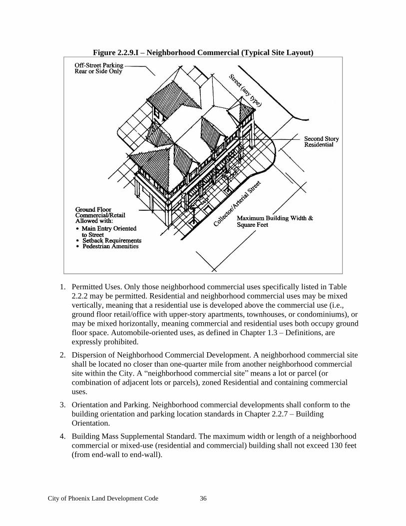
City of Phoenix Land Development Code 36
Figure 2.2.9.I Neighborhood Commercial (Typical Site Layout)
1. Permitted Uses. Only those neighborhood commercial uses specifically listed in Table 2.2.2 may be permitted. Residential and neighborhood commercial uses may be mixed vertically, meaning that a residential use is developed above the commercial use (i.e., ground floor retail/office with upper-story apartments, townhouses, or condominiums), or may be mixed horizontally, meaning commercial and residential uses both occupy ground floor space. Automobile-oriented uses, as defined in Chapter 1.3 Definitions, are expressly prohibited.
2. Dispersion of Neighborhood Commercial Development. A neighborhood commercial site shall be located no closer than one-quarter mile from another neighborhood commercial site within the City. A neighborhood commercial site means a lot or parcel (or combination of adjacent lots or parcels), zoned Residential and containing commercial uses.
3. Orientation and Parking. Neighborhood commercial developments shall conform to the building orientation and parking location standards in Chapter 2.2.7 Building Orientation.
4. Building Mass Supplemental Standard. The maximum width or length of a neighborhood commercial or mixed-use (residential and commercial) building shall not exceed 130 feet (from end-wall to end-wall).
City of Phoenix Land Development Code 37
5. Floor Area Supplemental Standards. The maximum commercial floor area shall not exceed 5,000 square feet total per neighborhood commercial site within the Residential Districts. Floor area is measured by totaling the exterior floor area of all building stories.
6. Hours of Operation. Neighborhood commercial land uses shall be limited to the following hours of operation 7 a.m. to 10 p.m.
7. Neighborhood commercial sites shall front onto an arterial or collector street.
J. Bed and Breakfast Inns.
1. Applicability. This Section applies to all proposed Bed and Breakfast Inns as defined Chapter 1.3 Definitions.
2. Use and Development Standards.
a. One guest room is permitted for every 400 square feet of gross floor living area, plus one unit for the proprietor of the business. Total number of guest rooms shall not exceed 5. For calculation purposes, the outside dimension of each eligible structure may be used. Living area includes any structure on the lot lawfully used for residential purposes. Living area does not include: garages, garage conversion where the conversion has resulted in noncompliance with off-street parking requirements, utility shops, basements, storage sheds and other similar nonresidential structures.
b. Length of stay may not exceed 15 days in any 30-day period.
c. One off-street parking space for each guest room and one space for the proprietor s unit shall be required. All parking shall be located to the rear of the principal structure and screened from view from the road and adjacent property. The Planning Commission may modify the locational requirements upon demonstration by the owner that an alternate location for parking is more appropriate based on the particular conditions of the site.
d. One sign is permitted and must conform to the standards in Chapter 3.6.6 Zoning District Sign Standards.
e. Structure Type and Appearance.
(1) Existing Structures. Single-family dwellings are the only eligible structures for conversion to Bed and Breakfast Inns. Apartment dwellings and non-residential structures, such as institutional buildings, warehouses, and churches are not eligible.
(2) The architecture of new structures shall resemble single-family dwellings.
f. Access. The street serving the Bed and Breakfast Inn shall have adequate capacity and turnaround area to serve the additional traffic.
g. Bed and Breakfast operator must reside at the Bed and Breakfast Inn.
h. An accurate and up-to-date guest register must be maintained and available for review by the City.
i. Breakfast is the only meal to be provided and shall be served only to guests of the Bed and Breakfast Inn. For the purpose of this Section, Breakfast is considered any meal served before 12:00 noon.
City of Phoenix Land Development Code 38
j. Evidence of compliance with the Building Code as amended, Fire Code as amended and standards of the state and local health departments.
K. Animals. (This provision applies to development in the Hilsinger Overlay (HO) District only. See table 2.2.2.A.) The non-commercial keeping of domesticated animals under 100 pounds that do not pose a danger or threat to the community is allowed provided that all animals are confined to the property, and any compound, pen, run, shed, or fenced area of confinement is not located closer than ten feet to any property line and thirty feet to a dwelling on any contiguous property. The weight limitation shall not apply to dogs.
L. Garages. A garage or carport is required for all Single-Family Residential (R-1) housing.
City of Phoenix Land Development Code 39
Chapter 2.3 City Center District (C-C)
Sections:
2.3.1 Purpose 2.3.2 Permitted Land Uses 2.3.3 Building Setbacks 2.3.4 Lot Coverage 2.3.5 Open Space 2.3.6 Block Layout and Building Orientation 2.3.7 Building Height 2.3.8 Architectural Guidelines and Standards 2.3.9 Pedestrian and Transit Amenities 2.3.10 Special Standards for Certain Uses
2.3.1 Purpose
A city goal is to strengthen the City Center District as the heart of the community and as the logical place for people to gather and create a business center. The District is intended to support this goal through elements of design and appropriate mixed-use development. This Chapter provides standards for the orderly development and improvement of the City Center District based on the following principles:
Efficient use of land and urban services;
A mixture of land uses to encourage walking as an alternative to driving, and providing more employment and housing options;
City Center District provides both formal and informal community gathering places;
There are distinct storefront characteristics that identify the City Center District;
The City Center District is connected to neighborhoods and other employment areas;
Provide visitor accommodations and tourism amenities;
Transit-oriented development reduces reliance on the automobile and reduces parking needs in the City Center District;
2.3.2 Permitted Land Uses
A. Permitted Uses. The land uses listed in Table 2.3.2.A are permitted in the City Center District, subject to the provisions of this Chapter. Only land uses which are specifically listed in Table 2.3.2.A, and land uses which are approved as similar to those in Table 2.3.2, may be permitted. The land uses identified with a CUP in Table 2.3.2.A require a Conditional Use Permit approval prior to development or a change in use.
B. Determination of Similar Land Use. Similar use determinations shall be made in conformance with the Interpretation Procedures.
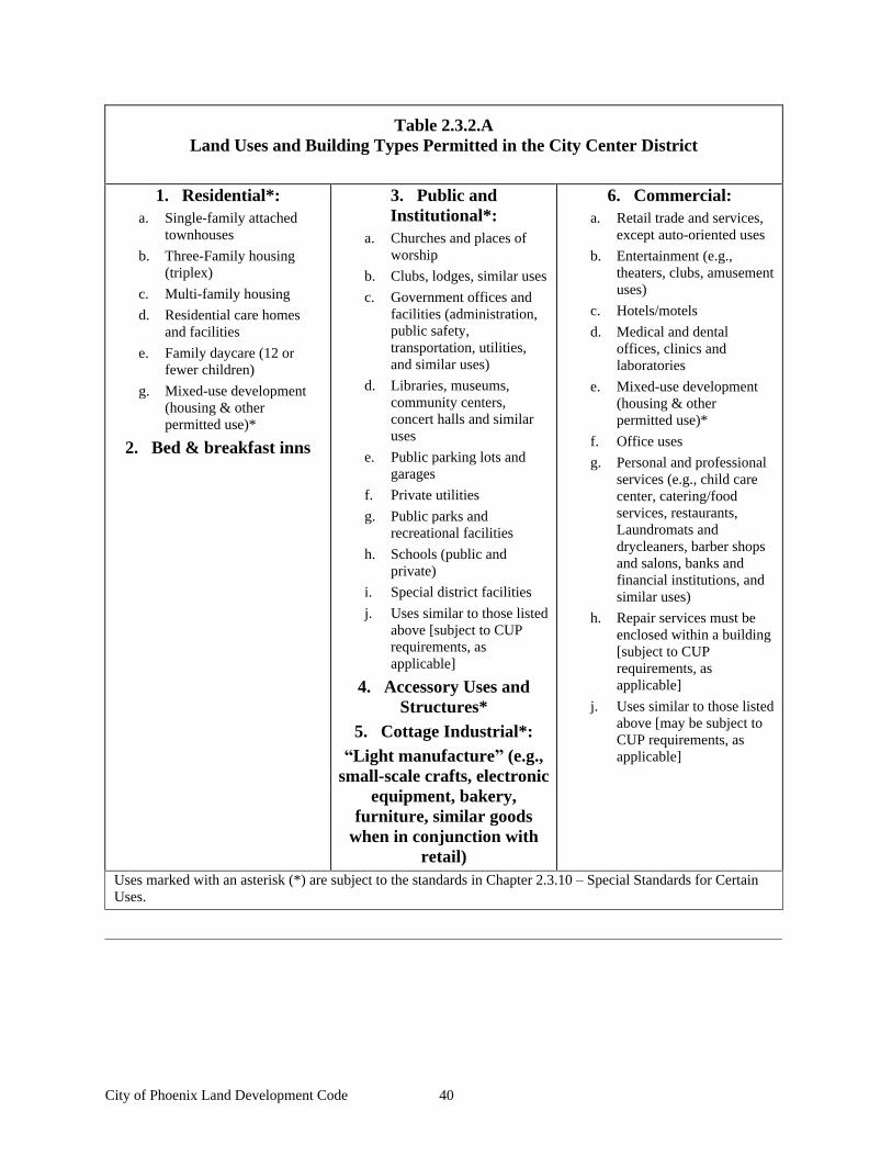
City of Phoenix Land Development Code 40
Table 2.3.2.A Land Uses and Building Types Permitted in the City Center District
1. Residential*: a. Single-family attached
townhouses
b. Three-Family housing (triplex)
c. Multi-family housing
d. Residential care homes and facilities
e. Family daycare (12 or fewer children)
g. Mixed-use development (housing & other permitted use)*
2. Bed & breakfast inns
3. Public and Institutional*:
a. Churches and places of worship
b. Clubs, lodges, similar uses
c. Government offices and facilities (administration, public safety, transportation, utilities, and similar uses)
d. Libraries, museums, community centers, concert halls and similar uses
e. Public parking lots and garages
f. Private utilities
g. Public parks and recreational facilities
h. Schools (public and private)
i. Special district facilities
j. Uses similar to those listed above [subject to CUP requirements, as applicable]
4. Accessory Uses and Structures*
5. Cottage Industrial*: Light manufacture (e.g.,
small-scale crafts, electronic equipment, bakery,
furniture, similar goods when in conjunction with
retail)
6. Commercial: a. Retail trade and services,
except auto-oriented uses
b. Entertainment (e.g., theaters, clubs, amusement uses)
c. Hotels/motels
d. Medical and dental offices, clinics and laboratories
e. Mixed-use development (housing & other permitted use)*
f. Office uses
g. Personal and professional services (e.g., child care center, catering/food services, restaurants, Laundromats and drycleaners, barber shops and salons, banks and financial institutions, and similar uses)
h. Repair services must be enclosed within a building [subject to CUP requirements, as applicable]
j. Uses similar to those listed above [may be subject to CUP requirements, as applicable]
Uses marked with an asterisk (*) are subject to the standards in Chapter 2.3.10 Special Standards for Certain Uses.
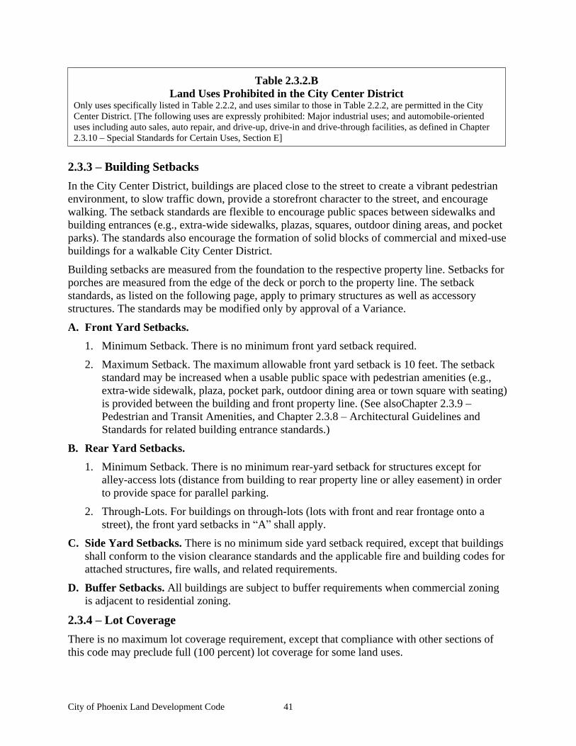
City of Phoenix Land Development Code 41
Table 2.3.2.B Land Uses Prohibited in the City Center District
Only uses specifically listed in Table 2.2.2, and uses similar to those in Table 2.2.2, are permitted in the City Center District. [The following uses are expressly prohibited: Major industrial uses; and automobile-oriented uses including auto sales, auto repair, and drive-up, drive-in and drive-through facilities, as defined in Chapter 2.3.10 Special Standards for Certain Uses, Section E]
2.3.3 Building Setbacks
In the City Center District, buildings are placed close to the street to create a vibrant pedestrian environment, to slow traffic down, provide a storefront character to the street, and encourage walking. The setback standards are flexible to encourage public spaces between sidewalks and building entrances (e.g., extra-wide sidewalks, plazas, squares, outdoor dining areas, and pocket parks). The standards also encourage the formation of solid blocks of commercial and mixed-use buildings for a walkable City Center District.
Building setbacks are measured from the foundation to the respective property line. Setbacks for porches are measured from the edge of the deck or porch to the property line. The setback standards, as listed on the following page, apply to primary structures as well as accessory structures. The standards may be modified only by approval of a Variance.
A. Front Yard Setbacks.
1. Minimum Setback. There is no minimum front yard setback required.
2. Maximum Setback. The maximum allowable front yard setback is 10 feet. The setback standard may be increased when a usable public space with pedestrian amenities (e.g., extra-wide sidewalk, plaza, pocket park, outdoor dining area or town square with seating) is provided between the building and front property line. (See alsoChapter 2.3.9
Pedestrian and Transit Amenities, and Chapter 2.3.8 Architectural Guidelines and Standards for related building entrance standards.)
B. Rear Yard Setbacks.
1. Minimum Setback. There is no minimum rear-yard setback for structures except for alley-access lots (distance from building to rear property line or alley easement) in order to provide space for parallel parking.
2. Through-Lots. For buildings on through-lots (lots with front and rear frontage onto a street), the front yard setbacks in A shall apply.
C. Side Yard Setbacks. There is no minimum side yard setback required, except that buildings shall conform to the vision clearance standards and the applicable fire and building codes for attached structures, fire walls, and related requirements.
D. Buffer Setbacks. All buildings are subject to buffer requirements when commercial zoning is adjacent to residential zoning.
2.3.4 Lot Coverage
There is no maximum lot coverage requirement, except that compliance with other sections of this code may preclude full (100 percent) lot coverage for some land uses.
City of Phoenix Land Development Code 42
2.3.5 Open Space
A. General
1. Common open spaces shall be designed to accommodate a variety of activities and users ranging from active play by children to passive contemplation by adults, but shall generally be able to accommodate a variety of uses.
2. They shall be pedestrian-friendly, with amenities such as benches, water fountains, landscaping, and ornamental lighting.
3. Common open spaces shall be built and landscaped by the developer.
B. Open Space Location
1. Common open spaces shall be located within walking distance of all those living, working and shopping in the City Center district.
2. Common open spaces shall be easily and safely accessed by pedestrians and bicyclists.
3. For security purposes, common open spaces shall be visible from nearby residences, stores, or offices.
4. Common open space shall be located within all residential and all mixed-use areas with four or more dwelling units, as well as all non-residential areas on sites exceeding one-half acre. Alternatively, common open space for a development may be located within 300 feet of the development. However, if common open space for a residential development is located off-site, users shall not be required to cross an arterial street to access the site.
5. Common open space in a residential development shall be located so that windows from the living areas (kitchens, family rooms, living rooms but not bedrooms or bathrooms) of a minimum of four residences face onto the common open space.
C. Open Space Amount & Size
1. All residential and mixed-use development shall be required to reserve, improve, and establish commitments to maintaining common open space.
2. Common open spaces shall have a minimum dimension of 20 linear feet.
3. For three or four-plex, and townhouse units: 100 square feet of common open space shall be provided for each residential dwelling.
4. For multi-family projects larger than 20 units: 75 square feet of common open space shall be provided for each dwelling.
5. Common open space in a mixed-use and non-residential development shall equal at least two percent of the development's site area.
D. Open Space Design
1. Common open spaces shall include at least two of the following improvements:
a. benches for seating;
b. public art such as a statue;
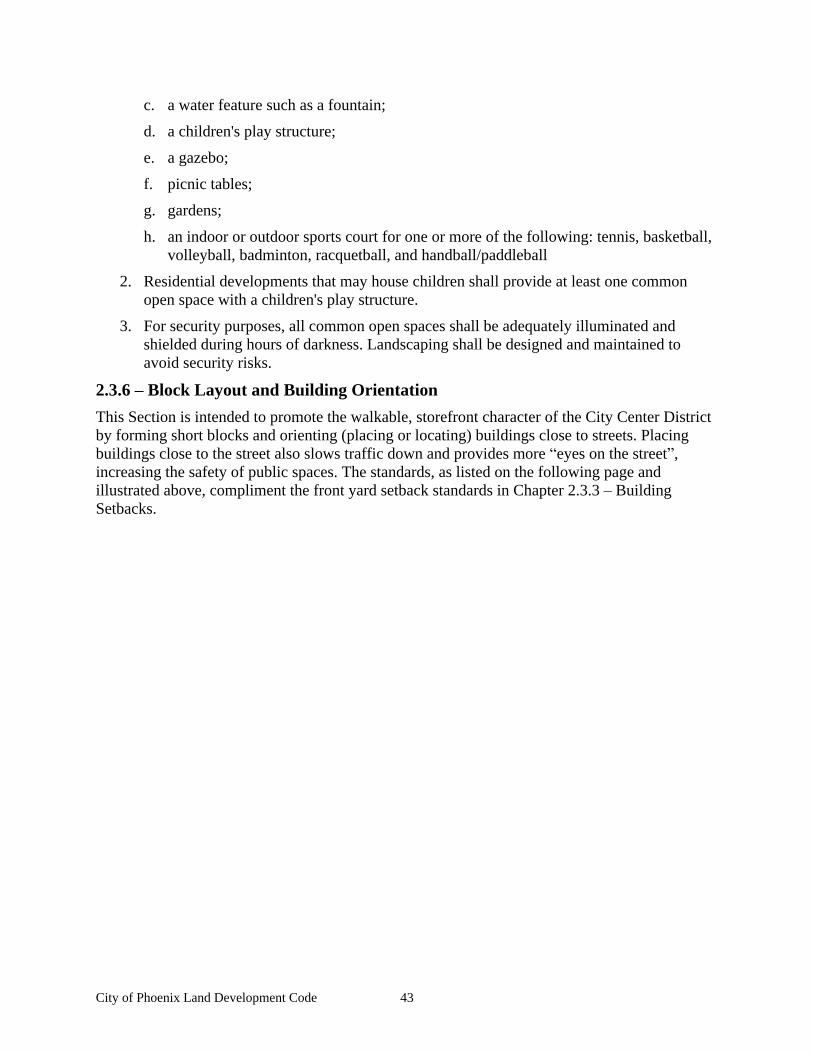
City of Phoenix Land Development Code 43
c. a water feature such as a fountain;
d. a children's play structure;
e. a gazebo;
f. picnic tables;
g. gardens;
h. an indoor or outdoor sports court for one or more of the following: tennis, basketball, volleyball, badminton, racquetball, and handball/paddleball
2. Residential developments that may house children shall provide at least one common open space with a children's play structure.
3. For security purposes, all common open spaces shall be adequately illuminated and shielded during hours of darkness. Landscaping shall be designed and maintained to avoid security risks.
2.3.6 Block Layout and Building Orientation
This Section is intended to promote the walkable, storefront character of the City Center District by forming short blocks and orienting (placing or locating) buildings close to streets. Placing buildings close to the street also slows traffic down and provides more eyes on the street , increasing the safety of public spaces. The standards, as listed on the following page and illustrated above, compliment the front yard setback standards in Chapter 2.3.3 Building Setbacks.
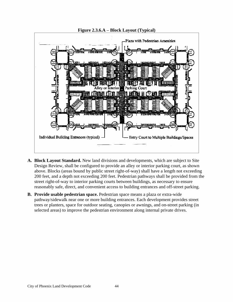
City of Phoenix Land Development Code 44
Figure 2.3.6.A Block Layout (Typical)
A. Block Layout Standard. New land divisions and developments, which are subject to Site Design Review, shall be configured to provide an alley or interior parking court, as shown above. Blocks (areas bound by public street right-of-way) shall have a length not exceeding 200 feet, and a depth not exceeding 200 feet. Pedestrian pathways shall be provided from the street right-of-way to interior parking courts between buildings, as necessary to ensure reasonably safe, direct, and convenient access to building entrances and off-street parking.
B. Provide usable pedestrian space. Pedestrian space means a plaza or extra-wide pathway/sidewalk near one or more building entrances. Each development provides street trees or planters, space for outdoor seating, canopies or awnings, and on-street parking (in selected areas) to improve the pedestrian environment along internal private drives.
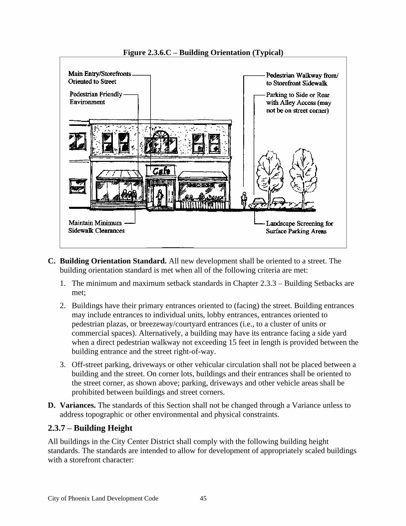
City of Phoenix Land Development Code 45
Figure 2.3.6.C Building Orientation (Typical)
C. Building Orientation Standard. All new development shall be oriented to a street. The building orientation standard is met when all of the following criteria are met:
1. The minimum and maximum setback standards in Chapter 2.3.3 Building Setbacks are met;
2. Buildings have their primary entrances oriented to (facing) the street. Building entrances may include entrances to individual units, lobby entrances, entrances oriented to pedestrian plazas, or breezeway/courtyard entrances (i.e., to a cluster of units or commercial spaces). Alternatively, a building may have its entrance facing a side yard when a direct pedestrian walkway not exceeding 15 feet in length is provided between the building entrance and the street right-of-way.
3. Off-street parking, driveways or other vehicular circulation shall not be placed between a building and the street. On corner lots, buildings and their entrances shall be oriented to the street corner, as shown above; parking, driveways and other vehicle areas shall be prohibited between buildings and street corners.
D. Variances. The standards of this Section shall not be changed through a Variance unless to address topographic or other environmental and physical constraints.
2.3.7 Building Height
All buildings in the City Center District shall comply with the following building height standards. The standards are intended to allow for development of appropriately scaled buildings with a storefront character:
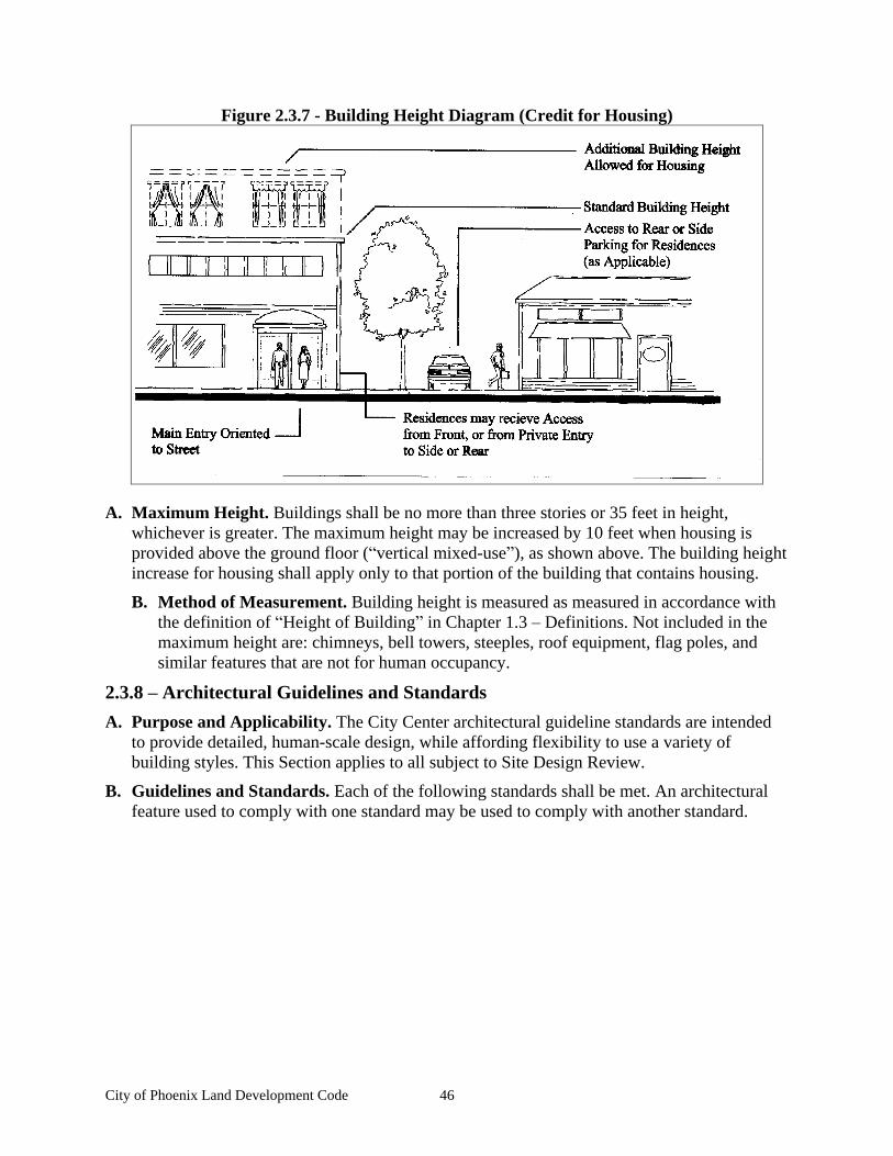
City of Phoenix Land Development Code 46
Figure 2.3.7 - Building Height Diagram (Credit for Housing)
A. Maximum Height. Buildings shall be no more than three stories or 35 feet in height, whichever is greater. The maximum height may be increased by 10 feet when housing is provided above the ground floor ( vertical mixed-use ), as shown above. The building height increase for housing shall apply only to that portion of the building that contains housing.
B. Method of Measurement. Building height is measured as measured in accordance with the definition of Height of Building in Chapter 1.3 Definitions. Not included in the maximum height are: chimneys, bell towers, steeples, roof equipment, flag poles, and similar features that are not for human occupancy.
2.3.8 Architectural Guidelines and Standards
A. Purpose and Applicability. The City Center architectural guideline standards are intended to provide detailed, human-scale design, while affording flexibility to use a variety of building styles. This Section applies to all subject to Site Design Review.
B. Guidelines and Standards. Each of the following standards shall be met. An architectural feature used to comply with one standard may be used to comply with another standard.
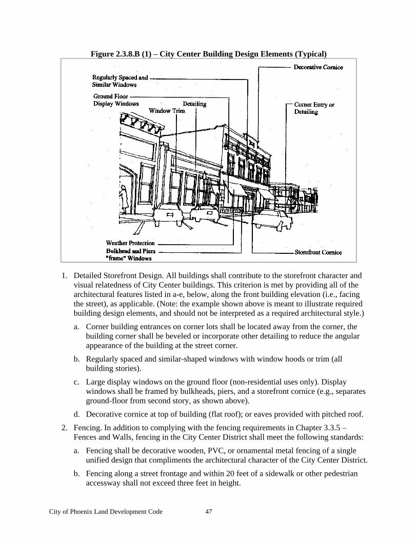
City of Phoenix Land Development Code 47
Figure 2.3.8.B (1) City Center Building Design Elements (Typical)
1. Detailed Storefront Design. All buildings shall contribute to the storefront character and visual relatedness of City Center buildings. This criterion is met by providing all of the architectural features listed in a-e, below, along the front building elevation (i.e., facing the street), as applicable. (Note: the example shown above is meant to illustrate required building design elements, and should not be interpreted as a required architectural style.)
a. Corner building entrances on corner lots shall be located away from the corner, the building corner shall be beveled or incorporate other detailing to reduce the angular appearance of the building at the street corner.
b. Regularly spaced and similar-shaped windows with window hoods or trim (all building stories).
c. Large display windows on the ground floor (non-residential uses only). Display windows shall be framed by bulkheads, piers, and a storefront cornice (e.g., separates ground-floor from second story, as shown above).
d. Decorative cornice at top of building (flat roof); or eaves provided with pitched roof.
2. Fencing. In addition to complying with the fencing requirements in Chapter 3.3.5
Fences and Walls, fencing in the City Center District shall meet the following standards:
a. Fencing shall be decorative wooden, PVC, or ornamental metal fencing of a single unified design that compliments the architectural character of the City Center District.
b. Fencing along a street frontage and within 20 feet of a sidewalk or other pedestrian accessway shall not exceed three feet in height.
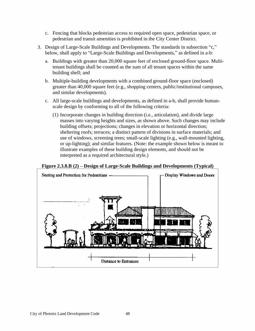
City of Phoenix Land Development Code 48
c. Fencing that blocks pedestrian access to required open space, pedestrian space, or pedestrian and transit amenities is prohibited in the City Center District.
3. Design of Large-Scale Buildings and Developments. The standards in subsection c, below, shall apply to Large-Scale Buildings and Developments, as defined in a-b:
a. Buildings with greater than 20,000 square feet of enclosed ground-floor space. Multi-tenant buildings shall be counted as the sum of all tenant spaces within the same building shell; and
b. Multiple-building developments with a combined ground-floor space (enclosed) greater than 40,000 square feet (e.g., shopping centers, public/institutional campuses, and similar developments).
c. All large-scale buildings and developments, as defined in a-b, shall provide human-scale design by conforming to all of the following criteria:
(1) Incorporate changes in building direction (i.e., articulation), and divide large masses into varying heights and sizes, as shown above. Such changes may include building offsets; projections; changes in elevation or horizontal direction; sheltering roofs; terraces; a distinct pattern of divisions in surface materials; and use of windows, screening trees; small-scale lighting (e.g., wall-mounted lighting, or up-lighting); and similar features. (Note: the example shown below is meant to illustrate examples of these building design elements, and should not be interpreted as a required architectural style.)
Figure 2.3.8.B (2) Design of Large-Scale Buildings and Developments (Typical)
City of Phoenix Land Development Code 49
(2) Every building elevation adjacent to a street with a horizontal dimension of more than 100 feet, as measured from end-wall to end-wall, shall have a building entrance; except that buildings elevations that are unable to provide an entrance due to the internal function of the building space (e.g., mechanical equipment, areas where the public or employees are not received, etc.) may not be required to meet this standard. Pathways shall connect all entrances to the street right-of-way.
2.3.9 Pedestrian and Transit Amenities
A. Purpose and Applicability. This Section is intended to complement the building orientation standards in Chapter 2.3.6 Block Layout and Building Orientation and the street standards in Chapter 3.2 Access and Circulation, by providing comfortable and inviting pedestrian spaces within the City Center District. Pedestrian amenities serve as informal gathering places for socializing, resting, and enjoyment of the City s downtown and contribute to a walkable district. This Section applies to all buildings subject to Site Design Review.
B. Guidelines and Standards. Every development shall provide two or more of the pedestrian amenities listed below, and illustrated below. [Note: the example shown below is meant to illustrate examples of pedestrian amenities. Other types of amenities and designs may be used.] Pedestrian amenities may be provided within a public right-of-way when approved by the applicable jurisdiction.
1. A plaza, courtyard, square, or extra-wide sidewalk next to the building entrance (minimum width of eight feet);
2. Sitting space (i.e., dining area, benches or ledges between the building entrance and sidewalk (minimum of 16 inches in height and 30 inches in width);
3. Building canopy, awning, pergola, or similar weather protection (minimum projection of four feet over a sidewalk or other pedestrian space).
4. Public art that incorporates seating (e.g., fountain, sculpture, etc.).
5. Transit-oriented development (TOD), such as a bus shelter or pullout, shall be designed in accordance with the guidelines established in the City s Transportation Plan and the Regional Transportation Plan.
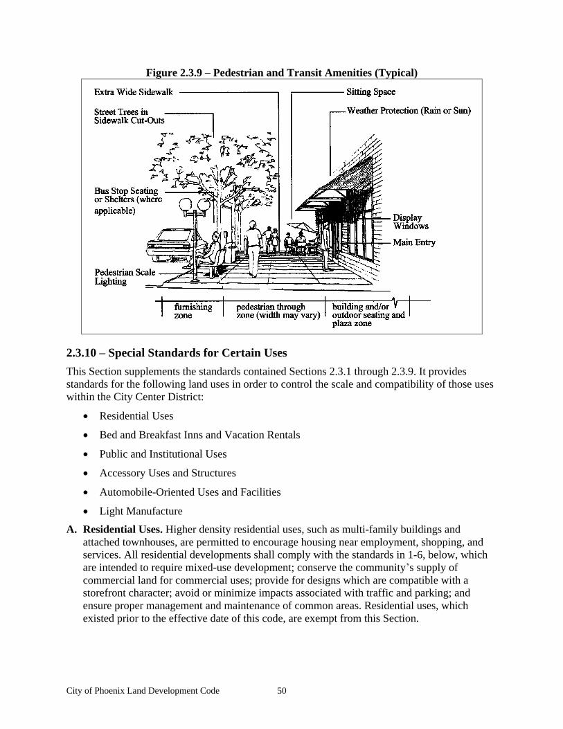
City of Phoenix Land Development Code 50
Figure 2.3.9 Pedestrian and Transit Amenities (Typical)
2.3.10 Special Standards for Certain Uses
This Section supplements the standards contained Sections 2.3.1 through 2.3.9. It provides standards for the following land uses in order to control the scale and compatibility of those uses within the City Center District:
Residential Uses
Bed and Breakfast Inns and Vacation Rentals
Public and Institutional Uses
Accessory Uses and Structures
Automobile-Oriented Uses and Facilities
Light Manufacture
A. Residential Uses. Higher density residential uses, such as multi-family buildings and attached townhouses, are permitted to encourage housing near employment, shopping, and services. All residential developments shall comply with the standards in 1-6, below, which are intended to require mixed-use development; conserve the community s supply of commercial land for commercial uses; provide for designs which are compatible with a storefront character; avoid or minimize impacts associated with traffic and parking; and ensure proper management and maintenance of common areas. Residential uses, which existed prior to the effective date of this code, are exempt from this Section.
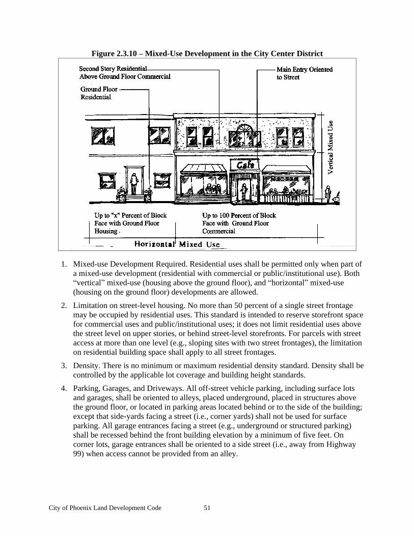
City of Phoenix Land Development Code 51
Figure 2.3.10 Mixed-Use Development in the City Center District
1. Mixed-use Development Required. Residential uses shall be permitted only when part of a mixed-use development (residential with commercial or public/institutional use). Both vertical mixed-use (housing above the ground floor), and horizontal mixed-use
(housing on the ground floor) developments are allowed.
2. Limitation on street-level housing. No more than 50 percent of a single street frontage may be occupied by residential uses. This standard is intended to reserve storefront space for commercial uses and public/institutional uses; it does not limit residential uses above the street level on upper stories, or behind street-level storefronts. For parcels with street access at more than one level (e.g., sloping sites with two street frontages), the limitation on residential building space shall apply to all street frontages.
3. Density. There is no minimum or maximum residential density standard. Density shall be controlled by the applicable lot coverage and building height standards.
4. Parking, Garages, and Driveways. All off-street vehicle parking, including surface lots and garages, shall be oriented to alleys, placed underground, placed in structures above the ground floor, or located in parking areas located behind or to the side of the building; except that side-yards facing a street (i.e., corner yards) shall not be used for surface parking. All garage entrances facing a street (e.g., underground or structured parking) shall be recessed behind the front building elevation by a minimum of five feet. On corner lots, garage entrances shall be oriented to a side street (i.e., away from Highway 99) when access cannot be provided from an alley.
City of Phoenix Land Development Code 52
5. Creation of Alleys. When a subdivision (e.g., four or more townhouse lots) is proposed, a public or private alley shall be created for the purpose of vehicle access. Alleys are not required when existing development patterns or topography makes construction of an alley impracticable. As part of a subdivision, the City may require dedication of right-of-way or easements, and construction of pathways between townhouse lots (e.g., between building breaks) to provide pedestrian connections through a development site.
6. Common Areas. All common areas (e.g., walkways, drives, courtyards, private alleys, parking courts, etc.) and building exteriors shall be maintained by a homeowners association or other legal entity. Copies of any applicable covenants, restrictions, and conditions shall be recorded and provided to the city prior to building permit approval.
7. Bed and Breakfast Inns and Vacation Rentals are permitted with the above standards.
8. Non-conforming residential dwellings, as defined by Chapter 5.3.2 Non-conforming Development, within the City Center Zoning District are exempt from Chapter 5.3.3
Exemptions criteria, in addition the following standards shall apply:
a. The dwelling structure may used for commercial or residential, and may be used interchangeably.
b. Driveways shall not be extended into front yard parking lots. The commercial use shall show shared parking per the parking requirements. Existing residential parking shall be paved prior to any commercial use.
C. Accessory Uses and Structures. Accessory uses and structures are of a nature customarily incidental and subordinate to the principal use or structure on the same lot. Typical accessory structures in the City Center District include small workshops, greenhouses, studios, storage sheds, and similar structures. Accessory uses and structures are allowed for all permitted land uses within the City Center District, as identified in Table 2.3.2.A. Accessory structures shall comply with the following standards:
1. Primary use required. An accessory structure shall not be allowed before or without a primary use, as identified in Table 2.3.2.A.
2. Setback standards. Accessory structures shall comply with the setback standards in Chapter 2.3.3 Building Setbacks, except that the maximum setback provisions shall not apply.
3. Design guidelines. Accessory structures shall comply with the City Center design guidelines, as provided in Chapter 2.3.8 Architectural Guidelines and Standards.
4. Restrictions. A structure shall not be placed over an easement that prohibits such placement. No structure shall encroach into the public right-of-way.
5. Compliance with subdivision standards. The owner may be required to remove an accessory structure as a condition of land division approval when removal of the structure is necessary to comply with setback standards.
E. Automobile-Oriented Uses and Facilities. Automobile-oriented uses and facilities that are allowed require a Conditional Use Permit and shall conform to all of the following standards in the City Center District. The standards are intended to provide a vibrant storefront character, slow traffic down, and encourage walking.
City of Phoenix Land Development Code 53
1. Parking, Garages, and Driveways. All off-street vehicle parking, including surface lots and garages, shall be accessed from alleys, placed underground, placed in structures above the ground floor, or located in parking areas located behind or to the side of a building; except that side-yards on corner lots shall not be used for surface parking. All garage entrances facing a street (e.g., underground or structured parking) shall be recessed behind the front elevation by a minimum of five feet. On corner lots, garage entrances shall be oriented to a side street (i.e., away from Highway 99) when vehicle access cannot be provided from an alley. Individual surface parking lots shall not exceed 35 parking spaces, or one-half city block, whichever is smaller; larger parking areas shall be in multiple story garages.
2. Automobile-Oriented Uses. Automobile-oriented use means automobiles and/or other motor vehicles are an integral part of the use. These uses are restricted because, when unrestricted, they detract from the pedestrian-friendly, storefront character of the district and can consume large amounts of land relative to other permitted uses. Automobile-oriented uses shall comply with the following standards:
a. Vehicle repair, sales, rental, storage, service. Businesses that repair, sell, rent, store, or service automobiles, trucks, motorcycles, buses, recreational vehicles/boats, construction equipment, small motor repair, retail of auto-parts or tires, and similar vehicles and equipment are prohibited.
b. Drive-up, drive-in, and drive-through facilities. Drive-up, drive-in, and drive-through facilities (e.g., associated with restaurants, banks, car washes, and similar uses) are prohibited.
c. Warehouses and storage lockers are prohibited.
d. Tow trucks and towing services are prohibited.
F. Sidewalk Displays. Sidewalk display of merchandise and vendors shall be limited to cards, plants, gardening/floral products, food, books, newspapers, bicycles, and similar small items for sale or rental to pedestrians (i.e., non-automobile oriented). A minimum clearance of four feet shall be maintained. Displays of larger items, such as lawnmowers, appliances, hot tubs etc. are prohibited.
G. Cottage Industrial. Light manufacture uses are allowed in the City Center District. Light manufacture means production or manufacturing of small-scale goods, such as crafts, electronic equipment, bakery products, printing and binderies, furniture, and similar goods. Light manufacture uses shall conform to all of the following standards that are intended to protect the pedestrian-friendly, storefront character of the City Center District:
1. Light manufacture is allowed only when it is in conjunction with a permitted retail or service use and does not exceed 75 percent of the gross floor area.
2. The light manufacture use shall be enclosed within a building.
3. The light manufacture use shall not create noise that can be heard on the exterior of the building nor create any vibration beyond the building walls.
4. The light manufacture use shall not create any measurable water or air pollution beyond state and federal acceptable levels.

City of Phoenix Land Development Code 54
5. The light manufacture use shall not create significant additional truck traffic (more than five van-sized trucks per day).
6. The light manufacture use shall not store significant amounts of dangerous or toxic substances (more than three 50-gallon barrels).
City of Phoenix Land Development Code 55
Chapter 2.4 Commercial Highway (C-H)
Sections:
2.4.1 Purpose 2.4.2 Permitted and Conditionally Permitted Land Uses 2.4.3 Development Standards 2.4.4 Architectural Guidelines and Standards 2.4.5 Special Standards for Certain Uses
2.4.1 Purpose
A. Purpose. The purpose of the Commercial Highway district to provide for the development of easily accessible commercial areas that are intended to accommodate a mixture of retail businesses, services, and professional offices to serve the commercial and retail needs of the community and surrounding areas. In addition, this district will accommodate uses served by vehicles, such as auto repair or auto sales, which are not compatible with the City Center. Development shall satisfy all of the Phoenix Comprehensive Plan s Goals and Policies. All new development is subject to site plan review in accord with this code.
2.4.2 Permitted and Conditionally Permitted Land Uses
A. Permitted and Conditionally Permitted Uses. Permitted and conditionally permitted land uses within the Commercial Highway zone district are listed in Table 2.4.2, subject to the provisions of this Chapter. Only land uses that are specifically listed in Table 2.4.2, and those uses that are approved as similar to those in Table 2.4.2, may be permitted.
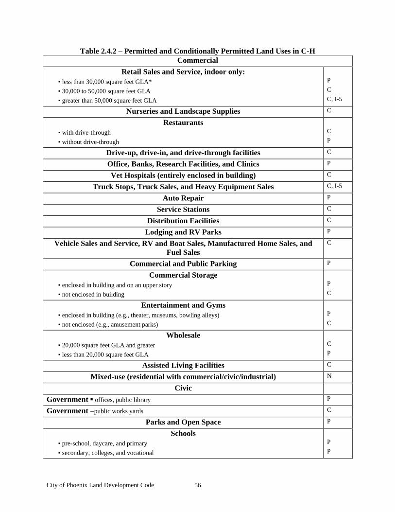
City of Phoenix Land Development Code 56
Table 2.4.2 Permitted and Conditionally Permitted Land Uses in C-H Commercial
Retail Sales and Service, indoor only: less than 30,000 square feet GLA*
30,000 to 50,000 square feet GLA
greater than 50,000 square feet GLA
P
C
C, I-5
Nurseries and Landscape Supplies C
Restaurants with drive-through
without drive-through
C
P
Drive-up, drive-in, and drive-through facilities C
Office, Banks, Research Facilities, and Clinics P
Vet Hospitals (entirely enclosed in building) C
Truck Stops, Truck Sales, and Heavy Equipment Sales C, I-5
Auto Repair P
Service Stations C
Distribution Facilities C
Lodging and RV Parks P
Vehicle Sales and Service, RV and Boat Sales, Manufactured Home Sales, and Fuel Sales
C
Commercial and Public Parking P
Commercial Storage enclosed in building and on an upper story
not enclosed in building
P
C
Entertainment and Gyms enclosed in building (e.g., theater, museums, bowling alleys)
not enclosed (e.g., amusement parks)
P
C
Wholesale 20,000 square feet GLA and greater
less than 20,000 square feet GLA
C
P
Assisted Living Facilities C
Mixed-use (residential with commercial/civic/industrial) N
Civic
Government offices, public library P
Government public works yards C
Parks and Open Space P
Schools pre-school, daycare, and primary
secondary, colleges, and vocational
P
P
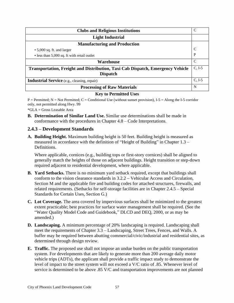
City of Phoenix Land Development Code 57
Clubs and Religious Institutions C
Light Industrial
Manufacturing and Production 5,000 sq. ft. and larger
less than 5,000 sq. ft with retail outlet
C
P
Warehouse C
Transportation, Freight and Distribution, Taxi Cab Dispatch, Emergency Vehicle Dispatch
C, I-5
Industrial Service (e.g., cleaning, repair) C, I-5
Processing of Raw Materials N
Key to Permitted Uses P = Permitted; N = Not Permitted; C = Conditional Use (without sunset provision), I-5 = Along the I-5 corridor only, not permitted along Hwy. 99
*GLA = Gross Leasable Area
B. Determination of Similar Land Use. Similar use determinations shall be made in conformance with the procedures in Chapter 4.8 Code Interpretations.
2.4.3 Development Standards
A. Building Height. Maximum building height is 50 feet. Building height is measured as measured in accordance with the definition of Height of Building in Chapter 1.3
Definitions.
Where applicable, cornices (e.g., building tops or first-story cornices) shall be aligned to generally match the heights of those on adjacent buildings. Height transition or step-down required adjacent to residential development, where applicable.
B. Yard Setbacks. There is no minimum yard setback required, except that buildings shall conform to the vision clearance standards in 3.2.2 Vehicular Access and Circulation, Section M and the applicable fire and building codes for attached structures, firewalls, and related requirements. (Setbacks for self-storage facilities are in Chapter 2.4.5 Special Standards for Certain Uses, Section G.)
C. Lot Coverage. The area covered by impervious surfaces shall be minimized to the greatest extent practicable; best practices for surface water management shall be required. (See the Water Quality Model Code and Guidebook, DLCD and DEQ, 2000, or as may be
amended.)
D. Landscaping. A minimum percentage of 20% landscaping is required. Landscaping shall meet the requirements of Chapter 3.3 Landscaping, Street Trees, Fences, and Walls. A buffer may be required between abutting commercial/civic/industrial and residential sites, as determined through design review.
E. Traffic. The proposed use shall not impose an undue burden on the public transportation system. For developments that are likely to generate more than 200 average daily motor vehicle trips (ADTs), the applicant shall provide a traffic impact study to demonstrate the level of impact to the street system will not exceed a V/C ratio of .85. Whenever level of service is determined to be above .85 V/C and transportation improvements are not planned
City of Phoenix Land Development Code 58
within the planning horizon, the applicant shall mitigate improvements to be completed prior to development. The Site design shall assure that the property access does not adversely affect traffic by creating dangerous conditions or congestion.
F. Drive-up, drive-in, and drive-through facilities. Drive-up, drive-in, and drive-through facilities (e.g., associated with restaurants, banks, car washes, and similar uses) shall conform to all of the following standards:
1. Circulation shall not conflict with other on-site vehicular and pedestrian circulation patterns.
2. Circulation shall not conflict with access from street.
3. The development shall be in accordance with Chapter 3.2 Access and Circulation.
4. Play structures must be located along the side or rear of the building and be enclosed within building.
G. Sidewalk Displays. A minimum walkway clearance of six feet shall be maintained. Display of larger items, such as automobiles, trucks, motorcycles, buses, recreational vehicles/boats, construction equipment, building materials, and similar vehicles and equipment, is prohibited.
H. Light Manufacture. Light manufacture uses are allowed in the Commercial Highway District. Light manufacture means production or manufacturing of small-scale goods, such as crafts, electronic equipment, bakery products, printing and binderies, furniture, and similar goods. Light manufacture uses shall conform to all of the following standards:
1. The use includes the assembly of premanufactured parts or preprocessed materials only.
2. The use does not generate excessive noise, harmful pollutants, or odors.
3. The use is conducted entirely within an enclosed building or solid screen.
I. Parking. On-site vehicle and bicycle parking shall be provided in accord with the City s Parking Ordinance. (The ordinance includes both minimum and maximum numbers of parking spaces.)
J. Promotional Outdoor Events. Promotional outdoor events are allowed subject to compliance with the following:
1. Events that take place within designated parking areas may occur up to four times per calendar year for a maximum of 10 days per event.
2. Events that take place outside of buildings but not within designated parking or circulation areas may occur up to 12 times per calendar year for a maximum of 4 days per event.
3. If the event is to be conducted within a designated parking area, a site plan must be submitted to the Planning Department a minimum of one week prior to the event, showing the specific location of the event and how it will impact the remaining parking and circulation areas.
4. Events shall not encroach upon more than 20% of the required parking areas.
City of Phoenix Land Development Code 59
2.4.4 Architectural Guidelines and Standards
A. Architectural Continuity and Quality. New and remodeled buildings may have their own architectural style but there must be some architectural continuity with the other structures located within the area. All building designs located within the Commercial Highway District must be of a high architectural quality and shall incorporate the following:
1. Continuous building walls of greater than 50 feet shall be avoided. Breaks in the wall plane shall be incorporated into the building design.
2. Entrances to the buildings shall be clearly defined architecturally. Entrances shall include decorative pavement treatments in order to tie into the parking lot pedestrian circulation systems.
3. Exterior building materials shall be of high quality and shall be selected based upon their weathering properties. Generally, materials such as stucco, brick, or masonry block should be used for exterior walls.
4. When the building is part of a larger complex, continuity of materials and design shall be required.
B. Lighting. Project lighting shall be provided for security reasons. Fixture types shall be down mounted or shielded when located adjacent to residential development.
C. Roof-mounted equipment. Roof-mounted mechanical equipment is not allowed unless completely screened within an equipment well or screened by a parapet wall.
D. Detailing. Architectural detailing shall be consistent on all elevations.
E. Trash Enclosures. Trash enclosures shall be constructed of 6-foot high masonry walls with solid metal gates. The floor of the enclosure shall be constructed of concrete with a 6-foot by 10-foot concrete apron placed in front of the enclosure. The masonry materials used shall be selected to match the materials used in the building or buildings that it serves. Trash enclosures shall not be located within 25 feet of a public entrance or a required pedestrian walkway.
F. Parking lot lighting. Parking lot lighting shall be provided for parking lots containing more than 10 spaces. The light fixtures shall be designed to light the parking area using down-mounted, low profile light fixtures. Parking lots with more than 10 vehicle parking spaces shall also include low profile lighting of pedestrian walkways and bicycle parking areas.
G. Bicycle Parking. Bicycle parking shall be integrated into the design for development within the C-H zone district. The location of the spaces must be coordinated with the location and orientation of vehicle parking, bicycle lanes, and pedestrian walkways. Enclosed bicycle parking shall be designed to be architecturally compatible with the design of the building or buildings located on the site. (See the Parking chapter of this development code for other bicycle parking requirements.)
H. Pedestrian Circulation. Projects that require more than 50 vehicle parking spaces shall also be required to provide the following separate pedestrian circulation improvements:
1. Covered walkways, a trellis structure planted with vines or other solution that is designed to provide pedestrians with shade and protection from the weather.
City of Phoenix Land Development Code 60
2. All pedestrian circulation areas must be lighted with pedestrian scale light fixtures.
3. Transit stops, on-site connections to transit stops, or designated passenger pick up areas shall be required if deemed appropriate by the Planning Department based upon the size of the project and input from the Rogue Valley Transit District (RVTD) or if requested by RVTD.
4. Driveway Improvements. Parking lots over three acres in size shall provide street improvements, including curbs, sidewalks, and street trees, in compliance with the local street standards in Table 3.5.2.
2.4.5 Special Standards for Certain Uses
A. Vehicle Service. All vehicle service must be enclosed within a building. Storage of inoperable vehicles must be within an enclosed and screened area.
B. Fueling Stations and Truck Stops. Truck stops shall be required to separate semi-truck and other large vehicle parking and circulation from that of regular vehicles.
C. Major Truck or Auto Repair. The following special conditions apply to this land use:
1. The use shall be conducted completely within an enclosed building.
2. The building shall be oriented on the site so that the service bays are not visible from a public street.
3. No inoperative vehicles are allowed to be stored outside of the building.
4. No equipment or merchandise may be stored or displayed outside of the building.
D. Light Manufacturing. The following special conditions apply to this land use:
1. The use includes the assembly of premanufactured parts only.
2. The use does not generate excessive noise, odor, or harmful pollutants.
3. The use is conducted entirely within an enclosed building or solid screen.
E. Research and Development Facilities. These uses may be approved if it has been shown that the use does not produce any visual clutter, toxic pollutants, or unpleasant odors.
F. Vehicle, Truck, Boat, Motorcycle, or RV Sales. These uses may be approved if it has been shown that the use incorporates the following:
1. Sales lots must include a minimum of a 20-foot landscape setback between the back of sidewalk and the edge of the vehicle parking, display area, or building.
2. No vehicle display will be allowed in the required landscape setback area.
3. Vehicle display areas shall not encroach upon the required customer and employee parking spaces.
4. Outside project lighting must be designed to minimize light spillage onto adjacent properties. Pole lighting must not be higher than 15 feet and must be shielded from the surrounding public streets and from I-5.
5. All repair and detailing activities must be conducted within an enclosed building.
City of Phoenix Land Development Code 61
G. Self-Storage Facilities. These uses may be approved if it has been shown that the following design requirements have been provided:
1. Architectural Standards:
a. Exterior materials used in the construction of the storage units shall be concrete masonry block with a decorative finish such as split-faced or fluted block.
b. Long exterior walls shall be broken up with masonry pilasters or insets or pop outs in the wall plane at a minimum of 30 feet on center.
c. The roof material may be metal but it shall have a non-glaring finish.
d. The roof eaves shall be finished and shall incorporate rain gutters and down spouts.
e. Security fencing shall be provided. The fencing shall be decorative wrought iron or other decorative metal. Chain link fencing is not permitted.
2. Site Development Standards:
a. The following minimum building setbacks shall apply:
(1) Front: 20 feet
(2) Side and rear: 0, except when adjacent to another street frontage in which case the minimum would be 15 feet or in the case where the development would be adjacent to a residential land use, in which case the minimum setback would be 5 feet.
b. Landscaping: A dense landscape screen must be included on all elevations that abut a street frontage or abut residential land uses. The landscape treatment must include a combination of trees, shrubs, and ground cover. The area must be served by an automatic underground irrigation system. All landscaping shall meet the requirements of Chapter 3.3 Landscaping, Street Trees, Fences, and Walls.
c. Project Lighting: All project lighting shall be designed not to spill onto adjacent properties.
H. Motels. Motels are limited to a maximum height of four stories.
I. Fast Food Restaurants
1. Play structures shall not be located between the building and the street and must be fully enclosed and integrated into the design of the restaurant.
2. Drive-through lanes must provide a minimum of 3 vehicle-stacking spaces between the menu board and the pick up window and 3 spaces between the menu board and the closest parking space. (i.e. The stacking spaces cannot block parking spaces.)

City of Phoenix Land Development Code 62
City of Phoenix Land Development Code 63
Chapter 2.5 General Industrial (GI) District
Sections: 2.5.1 Purpose 2.5.2 Permitted Land Uses 2.5.3 Development Setbacks 2.5.4 Lot Coverage 2.5.5 Lot Area and Dimensions 2.5.6 Development Orientation 2.5.7 Building Height 2.5.8 Special Standards for Certain Uses 2.5.9 Industrial Design Standards
2.5.1 Purpose
The General Industrial District accommodates a range of light and heavy industrial land uses. It is intended to segregate incompatible developments from other districts, while providing a high-quality environment for businesses and employees. This Chapter guides the orderly development of industrial areas based on the following principles:
A. Provide for efficient use of land and public services
B. Provide transportation options for employees and customers
C. Locate business services close to major employment centers
D. Ensure compatibility between industrial uses and nearby commercial and residential areas.
E. Provide appropriate design standards to accommodate a range of industrial users, in conformance with the Comprehensive Plan.
2.5.2 Permitted Land Uses
A. Permitted Uses. The land uses listed in Table 2.5.2.A are permitted in the General Industrial District, subject to the provisions of this Chapter. Only land uses which are specifically listed in Table 2.5.2.A, and land uses which are approved as similar to those in Table 2.5.2, may be permitted. The land uses identified with a CU in Table 2.5.2.A require Conditional Use Permit approval prior to development or a change in use, in accordance with Chapter 4.4
Conditional Use Permits.
B. Determination of Similar Land Use. Similar use determinations shall be made in conformance with the procedures in Chapter 4.8 Code Interpretations.

City of Phoenix Land Development Code 64
Table 2.5.2.A-Land Uses Types Permitted in the General Industrial District
1. Industrial:
Heavy manufacturing, assembly, and processing of raw materials* [CUP]
Light manufacture (e.g., electronic equipment, printing, bindery, furniture, and similar goods)
Warehousing and distribution (this does not include Mini-Warehouse Storage facilities)
Uses similar to those listed above
2. Commercial:
Offices and other commercial uses are permitted when they are integral to a primary industrial use (e.g., administrative offices, wholesale of goods produced on location, and similar uses).
3. Public and institutional uses
Government facilities (e.g., public safety, utilities, school district bus facilities, public works yards, transit and transportation, and similar facilities where the public is generally not received.)
Private Utilities (e.g., natural gas, electricity, telephone, cable, and similar facilities)
Special district facilities (e.g., irrigation district, and similar facilities)
Vocational schools co-located with parent industry or sponsoring organization
Uses similar to those listed above.
4. Accessory Uses and Structures
5. Wireless communication equipment CUP*
6. Residential Uses for security purposes only
One caretaker unit shall be permitted for each development, subject to the standards in Chapter 2.5.8 Special Standards for Certain Uses. Other residential uses are not permitted, except that residences existing prior to the effective date of this Code may continue.
* Land uses with an asterisk (*) shall require a Conditional Use Permit subject to the procedure and standards in Chapter 4.4 Conditional Use Permits.
Table 2.5.2.B Land Uses Prohibited in General Industrial District
Only uses specifically listed in Table 2.5.2.A, and uses similar to those in Table 2.5.2.A, are permitted in this district. The following uses are expressly prohibited: new housing, churches and similar facilities, schools, junk yards, mini-ware housing storage facilities, tow truck businesses and vehicle storage yards.
2.5.3 Development Setbacks
A. Building Setbacks. There are no required building setbacks.
B. Other Yard Requirements
1. Buffering. 30 feet shall be required between development and any adjacent Residential Districts. The City may require landscaping, walls, or other buffering in setback yards to mitigate adverse noise, light, glare, and aesthetic impacts to adjacent properties.
City of Phoenix Land Development Code 65
2. Neighborhood Access. Construction of pathways within setback yards may be required to provide pedestrian connections to adjacent neighborhoods or other districts, in accordance with Chapter 3.2 Access and Circulation.
3. Building and Fire Codes. All developments shall meet applicable fire and building code standards, which may require setbacks different from those listed above (e.g., combustible materials, etc.).
2.5.4 Lot Coverage
There is no maximum lot coverage requirement, except that compliance with other sections of this code may preclude full (100 percent) lot coverage for some land uses.
2.5.5 Lot Area and Dimensions
There shall be no minimum lot area, lot width or lot depth in the General Industrial District.
2.5.6 Development Orientation
Industrial developments shall be oriented on the site to minimize adverse impacts (e.g., noise, glare, smoke, dust, exhaust, vibration, etc.) and protect the privacy of adjacent uses to the extent possible. The following standards shall apply to all development in the General Industrial District:
A. Mechanical equipment, lights, emissions, shipping/receiving areas, and other components of an industrial use that are outside enclosed buildings, shall be located away from residential areas, schools, parks and other non-industrial areas to the maximum extent practicable; and
B. The City may require a landscape buffer, or other visual or sound barrier (fence, wall, landscaping, or combination thereof) to mitigate adverse impacts that cannot be avoided through building orientation standards alone.
2.5.7 Building Height
The following building height standards are intended to promote land use compatibility and flexibility for industrial development at an appropriate community scale:
A. Height. The allowable building height may be 60 feet. The development approval may require additional setbacks, stepping-down of building elevations, visual buffering, screening, and/or other appropriate measures to provide a height transition between industrial development and adjacent non-industrial development. Smoke stacks, cranes, roof equipment, and other similar features which are necessary to the industrial operation may not exceed 60 feet in height without approval of a Conditional Use Permit.
B. Method of Measurement. See definition for Height of Building in Chapter 1.3
Definitions.
2.5.8 Special Standards for Certain Uses
A. Uses with Significant Noise, Light/Glare, Dust, Vibration, or Traffic Impacts. The determination of significant shall be allowed through a Code Interpretation subject to the standards in Chapter 4.8 Code Interpretations. Any use determined to meet the above significant description shall be reviewed with the following criteria in addition to a
Conditional Use Permit approval, Development Review and/or Site Design Review:
City of Phoenix Land Development Code 66
1. Uses with Significant Noise, Light/Glare, Dust, and Vibration Impacts. Uses that are likely to create significant adverse impacts beyond the Industrial District boundaries, such as noise, light/glare, dust, or vibration, shall require conditional use approval, in conformance with Chapter 4.4 Conditional Use Permits. The applicant shall submit findings prior to the approval of the CUP that the following criteria shall be used and can be met through development conditions in determining the adverse impacts of a use which are likely to be significant :
a. Noise. The use shall comply with ORS 457, Noise Control. Uses that do not comply with the ORS are in violation of the Conditional Use Permit.
b. Light/glare. Lighting and/or reflected light from the development exceeds ordinary ambient light and glare levels (i.e., levels typical of the surrounding area).
c. Dust and/or Exhaust. Dust and/or exhaust emissions from the development exceeds ambient dust or exhaust levels, or levels that existed prior to development.
d. Vibration. Vibration (e.g., from mechanical equipment) is sustained and exceeds ambient vibration levels (i.e., from adjacent roadways and existing land uses in the surrounding area).
e. The approval of the Conditional Use Permit shall include a recorded agreement that the approved use shall be monitored by the applicant and records shall be kept showing the degree of compliance with the standards agreed upon per the CUP approval. When a Use is determined to be in violation of the CUP agreement, it shall be declared a public nuisance and the use shall be brought into conformance or the CUP will be forfeited.
f. A nuisance includes, but is not necessarily limited to, any of the following conditions: Any use, excluding reasonable construction activity, that emits dust, sweepings, dirt or cinders into the atmosphere, discharges liquid, solid wastes, or other matter onto the land or into any waterway, and that, in the discretion of the City, may adversely affect the health, safety, comfort, of properties neighboring the Industrial property.
2. Traffic. Uses that are likely to generate unusually high levels of vehicle traffic due to shipping and receiving. Unusually high levels of traffic means that the average number of daily trips on any existing street would increase by 10 percent or more as a result of the development. The city may require a traffic impact analysis prepared by a qualified professional prior to deeming a land use application complete, and determining whether the proposed use requires conditional use approval. Applicants may be required to provide a traffic analysis for review by ODOT for developments that increase traffic on state highways.
B. Residential Caretakers. One residential caretaker unit shall be permitted for each primary industrial use, subject to the following conditions:
1. The unit shall be served with public water and sanitary sewerage disposal, in conformance with city engineering requirements.
2. Caretaker units shall not be a temporary recreational vehicle and shall be required to meet applicable fire safety and building code requirements, in addition to the applicable setback standards of this Chapter.

City of Phoenix Land Development Code 67
C. Wireless communication equipment. Wireless communication equipment includes radio (i.e., cellular), television, and similar types of transmission and receiving facilities. The requirements for wireless communication equipment are provided in Chapter 3.10.1
Wireless Communication Facilities, and Conditional Use Permit requirements. Wireless communication equipment shall also comply with required development setbacks, lot coverage, and other applicable standards of the Industrial District.
2.5.9 Industrial Design Standards
A. Architectural Guidelines and Standards. All developments in the Light Industrial District shall be evaluated during Site Design Review for conformance with the criteria in A-B. [Note: the example shown below is meant to illustrate typical building design elements, and should not be interpreted as a required architectural style.]:
Figure 2.5.9 Architectural Features (Typical)
1. Building Mass. Where building elevations are oriented to the street in conformance with Chapter 2.6.7 Building Orientation, architectural features such as windows, pedestrian entrances, building offsets, projections, detailing, change in materials or similar features, shall be used to break up and articulate large building surfaces and volumes.
2. Pedestrian-Scale Building Entrances. Recessed entries, canopies, and/or similar features shall be used at the entries to buildings in order to create a pedestrian-scale.
City of Phoenix Land Development Code 68
3. Building Design. In addition to applicable provisions contained elsewhere in this land use code, the development standards listed below shall apply to all development. In cases of conflict, the standards specifically applicable in Industrial districts shall apply. In order to receive approval, all new or substantially remodeled building designs shall incorporate the following:
a. Perimeter landscaping of either natural or man made, including landscaped lawns, courtyards, and/or plazas consistent with Chapter 3.3 Landscaping, Street Trees, Fences, and Walls.
b. Location of buildings shall be towards the front of the site with parking to the rear or sides of the site.
c. An overall them with a variety of building façade designs shall be achieved through a mix of building heights, roof pitches, window or entrance treatments, wall articulation, overhangs, projections, and/or finish materials. All buildings that face a public street or residential district shall be ornamented to increase visual interest, using at least one of the following.
B. Screening. Loading docks, solid waste/recycling facilities and other service uses should be located in visually unobtrusive areas and screened from view from adjacent properties and streets.
C. Parking. Employee and visitor parking areas shall be internalized within the development and shall meet the parking standards in Chapter 3.4 Vehicle and Bicycle Parking. Parking lots shall not be located between a public street and a building unless no other feasible alternative exists. A 10 ft. wide landscaping area shall be required. All parking lots shall have at least 5% of their area planted with interior landscaping; required perimeter landscaping shall not apply towards the required 5% interior landscaping.
D. Outdoor Storage. Outdoor storage, including merchandise display, equipment and materials storage, when permitted in any Industrial zone shall comply with the following requirements:
1. Fencing and Screening Required. Sight-obscuring fencing or screening is required around all portions of a lot utilized for outdoor storage of component merchandise, equipment and materials, except for component merchandise which is stored and displayed only during business hours. All fencing and screening shall be installed in accordance with the following requirements:
a. Building Setbacks. All fencing and screening shall comply with the buffer or building setback requirements for the zone in which it is located unless specified otherwise.
b. Minimum Screening Requirements. When required, all outdoor storage areas shall be screened from adjoining properties and public rights-of-way by a wall, fence, landscaping and/or structure. Such screening shall serve the purpose of concealing and obscuring the storage area from view. Landscape screening shall consist of plantings designed and installed in such a manner to provide year-round screening in terms of vegetation density and height within three years of planting, and shall be maintained in a healthy, growing condition. Landscape plantings installed to screen outdoor storage from public rights-of-way shall be installed on the right-of-way side of any wall, fence or structure.
City of Phoenix Land Development Code 69
c. Maximum Fence Height. Fencing and walls surrounding outdoor storage areas which are not part of a building wall shall not exceed a maximum height of eight feet.
d. Maintenance Required. Fences, walls and landscaping surrounding outdoor storage areas shall be maintained and kept free of litter, posters, signs, trash or stored items.
e. Outdoor Storage Height Limitations. Outdoor storage shall not exceed the height of required screening.
2. Exemption from Fencing and Screening Requirements. Fencing and screening is not required around those portions of a lot utilized for "complete" merchandise display, or the display of "component" merchandise when said merchandise is stored within a structure or fenced and screened area during the hours the business is closed.
3. Improvement and Maintenance of Outdoor Storage Areas. All outdoor storage areas and access to them shall be paved or otherwise surfaced and maintained so as to eliminate dust or mud. All outdoor storage areas shall be graded and storm drainage facilities installed to collect and dispose of all surface runoff in accordance with city requirements.
4. Outdoor Storage of Materials Prohibited. No outdoor storage of materials such as fertilizers, pesticides, etc. which potentially pose a threat to water quality, shall be permitted.
5. Outdoor Storage Prohibited in Required Parking Areas and Walkways. No outdoor storage shall be permitted to occur in required parking areas, access drives, or walkways.
6. Truck Parking and Loading/Unloading Areas. Truck parking and loading/unloading areas shall be considered a form of outdoor storage, and shall be screened from adjoining properties and public right-of-way in accordance with the fencing and screening requirements for outdoor storage
E. Outdoor Lighting. Building-mounted lighting and aerial-mounted floodlighting shall be shielded from above in such a manner that the bottom edge of the shield shall be below the light source. Ground-mounted floodlighting or light projection above the horizontal plane is prohibited between midnight and sunrise. All lighting shall be shielded so that the direct illumination shall be confined to the property boundaries of the light source.
F. Trash and Recycling Receptacles. Trash and recycling receptacles shall be screened from adjacent properties and public rights-of-way by an opaque visual barrier no lower than the highest point of the receptacles.

City of Phoenix Land Development Code 70
City of Phoenix Land Development Code 71
Chapter 2.6 Light Industrial District (LI)
Sections:
2.6.1 Purpose 2.6.2 Permitted Land Uses 2.6.3 Development Setbacks 2.6.4 Lot Coverage 2.6.5 Lot Area and Dimensions 2.6.6 Building Height 2.6.7 Building Orientation 2.6.8 Special Standards for Certain Uses 2.6.9 Industrial Design Standards
2.6.1 Purpose
The Light Industrial District accommodates a range of light manufacturing, industrial-office uses, automobile-oriented uses (e.g., lodging, restaurants, auto-oriented retail), and similar uses. The district s standards are based on the following principles:
Ensure efficient use of land and public services
Provide a balance between jobs and housing
Provide transportation options for employees and customers
Provide business services close to major employment centers
Ensure compatibility between industrial uses and nearby residential areas
Provide appropriately zoned land with a range of parcel sizes for industry
Provide for automobile-oriented uses, while preventing strip-commercial development in highway corridors.
2.6.2 Permitted Land Uses
A. Permitted Uses. Land uses listed in Table 2.6.2.A are permitted in the Light Industrial District, subject to the provisions of this Chapter. Only land uses which are specifically listed in Table 2.6.2.A, and land uses which are approved as similar to those in Table 2.6.2, may be permitted. The land uses identified with a CU in Table 2.6.2.A require Conditional Use Permit approval prior to development or a change in use, in accordance with Chapter 4.4
Conditional Use Permits.
B. Determination of Similar Land Use. Similar use determinations shall be made in conformance with the procedures in Chapter 4.8 Code Interpretations.

City of Phoenix Land Development Code 72
Table 2.6.2.A Land Use Types Permitted in the Light Industrial District
1. Industrial:
Light manufacture (e.g., electronic equipment, printing, bindery, furniture, and similar goods)
Research facilities
Light fabrication and repair shops such as blacksmith, cabinet, electric motor, heating, machine, sheet metal, stone monuments, upholstery, welding, auto body, and auto and truck repair.
Warehousing and distribution (this does not include Mini-Warehouse Storage facilities)
Similar uses
2. Commercial:
Offices and other commercial uses are permitted when they are integral to a primary industrial use (e.g., administrative offices, wholesale of goods produced on location, and similar uses).
Automobile-oriented uses (vehicle repair, sales, rental, storage, service; and drive-up, drive-in, and drive-through facilities)
Entertainment (e.g., theaters, amusement uses)
Medical and dental clinics and laboratories
Outdoor commercial uses (e.g., outdoor storage and sales)* (CUP)
Personal and professional services (e.g., child care, catering/food services, restaurants, laundromats and dry cleaners, barber shops and salons, and similar uses)
Kennels* (CUP)
Repair services
Retail trade and services, not exceeding 25% of floor area per building
Wholesale trade and services
Uses similar to those listed above
3. Civic and Semi-Public Uses
Government facilities (e.g., public safety, utilities, school district bus facilities, public works yards, transit and transportation, and similar facilities)
Utilities (e.g., natural gas, electricity, telephone, cable, and similar facilities)
Special district facilities (e.g., irrigation district, and similar facilities)
Vocational schools
Uses similar to those listed above.
4. Accessory Uses
5. Wireless communication equipment CUP*
6. Residential Uses for security purposes only
* Land uses with an asterisk (*) shall require a Conditional Use Permit subject to the procedure and standards in Chapter 4.4 Conditional Use Permits.
City of Phoenix Land Development Code 73
Table 2.6.2.B Land Uses Prohibited in Light Industrial District
Only uses specifically listed in Table 2.6.2.A, and uses similar to those in Table 2.6.2.A, are permitted in this district. The following uses are expressly prohibited: housing (other than on-site residential intended for security), churches and similar facilities, and non-vocational schools
2.6.3 Development Setbacks
A. Building Setbacks. There are no required building setbacks.
B. Other Yard Requirements
1. Buffering. 30 feet shall be required between development and any adjacent Residential Districts. The City may require landscaping, walls, or other buffering in setback yards to mitigate adverse noise, light, glare, and aesthetic impacts to adjacent properties.
2. Neighborhood Access. Construction of pathways within setback yards may be required to provide pedestrian connections to adjacent neighborhoods or other districts, in accordance with Chapter 3.2 Access and Circulation.
3. Building and Fire Codes. All developments shall meet applicable fire and building code standards, which may require setbacks different from those listed above (e.g., combustible materials, etc.).
2.6.4 Lot Coverage
There is no maximum lot coverage requirement, except that compliance with other sections of this code may preclude full (100 percent) lot coverage for some land uses.
2.6.5 Lot Area and Dimensions
There shall be no minimum lot area, lot width or lot depth in the Light Industrial District.
2.6.6 Building Height
The following building height standards are intended to promote land use compatibility and flexibility for industrial development at an appropriate community scale:
A. Height. The allowable building height may be 60 feet. The development approval may require additional setbacks, stepping-down of building elevations, visual buffering, screening, and/or other appropriate measures to provide a height transition between industrial development and adjacent non-industrial development. Smoke stacks, cranes, roof equipment, and other similar features which are necessary to the industrial operation may not exceed 60 feet in height without approval of a Conditional Use Permit.
B. Roof Equipment. Roof equipment and other similar features that are necessary to the industrial operation shall be screened. Screening either shall be by an approved equipment screen or located within an equipment well that is architecturally integrated into the building design.
C. Method of Measurement. See definition for Height of Building in Chapter 1.3
Definitions.
City of Phoenix Land Development Code 74
2.6.7 Building Orientation
All of the following standards shall apply to new development within the Light Industrial district in order to reinforce streets as public spaces and encourage alternative modes of transportation, such as walking, bicycling, and use of transit.
A. Building Entrances. All buildings shall have a primary entrance oriented to a street. Oriented to a street means that the building entrance faces the street, or is connected to the
street by a direct and convenient pathway not exceeding 50 feet in length. Streets used to comply with this standard may be public streets, or private streets that contain sidewalks and street trees, in accordance with the design standards in Chapter 3.
B. Corner Lots. Buildings on corner lots shall have their primary entrance oriented to the street corner, or within 20 feet of the street corner (i.e., as measured from the lot corner). In this case, the street corner shall provide an extra-wide sidewalk or plaza area with landscaping, seating, or other pedestrian amenities. The building corner shall provide architectural detailing or beveling to add visual interest to the corner.
C. Pathway Connections. Pathways shall be placed through yard setbacks as necessary to provide direct and convenient pedestrian circulation between developments and neighborhoods. Pathways shall conform to the standards in Chapter 3.
D. Arterial Streets. When the only street abutting a development is an arterial street, the building s entrances may be oriented to an internal drive. The internal drive shall provide a raised pathway connecting the building entrances to the street right-of-way. The pathway shall conform to the standards in Chapter 3.
E. Commercial Developments. Commercial buildings and uses comprising more than 40,000 square feet of total ground-floor building space shall additionally conform to the block layout and building orientation standards for City Center District, as contained in Chapter 2.3.6
Block Layout and Building Orientation.
2.6.8 Special Standards for Certain Uses
A. Uses with Significant Noise, Light/Glare, Dust, Vibration, or Traffic Impacts. The determination of significant shall be allowed through Chapter 4.8 Code Interpretations. Any use determined to meet the above significant description shall be reviewed with the following criteria in addition to a Conditional Use Permit approval, Development Review and/or Site Design Review:
1. Uses with Significant Noise, Light/Glare, Dust, and Vibration Impacts. Uses that are likely to create significant adverse impacts beyond the Industrial District boundaries, such as noise, light/glare, dust, or vibration, shall require conditional use approval, in conformance with Chapter 4.4 Conditional Use Permits. The applicant shall submit findings prior to the approval of the CUP that the following criteria shall be used and can be met through development conditions in determining the adverse impacts of a use which are likely to be significant :
a. Noise. The use shall comply with ORS 457, Noise Control. Uses that do not comply with the ORS are in violation of the Conditional Use Permit.
b. Light/glare. Lighting and/or reflected light from the development exceeds ordinary ambient light and glare levels (i.e., levels typical of the surrounding area).
City of Phoenix Land Development Code 75
c. Dust and/or Exhaust. Dust and/or exhaust emissions from the development exceeds ambient dust or exhaust levels, or levels that existed prior to development.
d. Vibration. Vibration (e.g., from mechanical equipment) is sustained and exceeds ambient vibration levels (i.e., from adjacent roadways and existing land uses in the surrounding area).
e. Approval of the Conditional Use Permit shall include a recorded agreement that the approved use shall be monitored by the applicant and records shall be kept showing the degree of compliance with the standards agreed upon per the CUP approval. When a Use is determined to be in violation of the CUP agreement, it shall be declared a public nuisance and the use shall be brought into conformance or the CUP will be forfeited.
f. A nuisance includes, but is not necessarily limited to, any of the following conditions: Any use, excluding reasonable construction activity, that emits dust, sweepings, dirt or cinders into the atmosphere, discharges liquid, solid wastes, or other matter onto the land or into any waterway, and that, in the discretion of the City, may adversely affect the health, safety, comfort, of properties neighboring the Industrial property.
2. Traffic. Uses that are likely to generate unusually high levels of vehicle traffic due to shipping and receiving. Unusually high levels of traffic means that the average number of daily trips on any existing street would increase by 10 percent or more as a result of the development. The city may require a traffic impact analysis prepared by a qualified professional prior to deeming a land use application complete, and determining whether the proposed use requires conditional use approval. Applicants may be required to provide a traffic analysis for review by ODOT for developments that increase traffic on state highways.
B. Residential Caretakers. One residential caretaker unit shall be permitted for each primary industrial use, subject to the following conditions:
1. The unit shall be served with public water and sanitary sewerage disposal, in conformance with city engineering requirements.
2. Caretaker units shall not be a temporary recreational vehicle and shall be required to meet applicable fire safety and building code requirements, in addition to the applicable setback standards of this Chapter.
C. Wireless Communication Equipment. Wireless communication equipment, including radio (i.e., cellular), television and similar types of transmission and receiving facilities are permitted, subject to the standards in Chapter 3.10.1 Wireless Communication Facilities and to Conditional Use Permit requirements. Wireless communication equipment shall also comply with required setbacks, lot coverage, and other applicable standards of the Light Industrial District.
2.6.9 Industrial Design Standards
A. Architectural Guidelines and Standards. All developments in the Light Industrial District shall be evaluated during Site Design Review for conformance with the criteria in A-B. [Note: the example shown below is meant to illustrate typical building design elements, and should not be interpreted as a required architectural style.]:
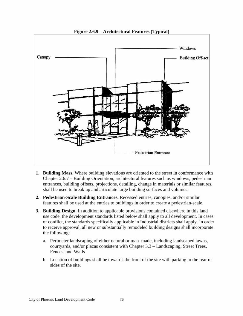
City of Phoenix Land Development Code 76
Figure 2.6.9 Architectural Features (Typical)
1. Building Mass. Where building elevations are oriented to the street in conformance with Chapter 2.6.7 Building Orientation, architectural features such as windows, pedestrian entrances, building offsets, projections, detailing, change in materials or similar features, shall be used to break up and articulate large building surfaces and volumes.
2. Pedestrian-Scale Building Entrances. Recessed entries, canopies, and/or similar features shall be used at the entries to buildings in order to create a pedestrian-scale.
3. Building Design. In addition to applicable provisions contained elsewhere in this land use code, the development standards listed below shall apply to all development. In cases of conflict, the standards specifically applicable in Industrial districts shall apply. In order to receive approval, all new or substantially remodeled building designs shall incorporate the following:
a. Perimeter landscaping of either natural or man made, including landscaped lawns, courtyards, and/or plazas consistent with Chapter 3.3 Landscaping, Street Trees, Fences, and Walls.
b. Location of buildings shall be towards the front of the site with parking to the rear or sides of the site.
City of Phoenix Land Development Code 77
c. An overall them with a variety of building façade designs shall be achieved through a mix of building heights, roof pitches, window or entrance treatments, wall articulation, overhangs, projections, and/or finish materials. All buildings that face a public street or residential district shall be ornamented to increase visual interest, using at least one of the following.
B. Screening. Loading docks, solid waste/recycling facilities and other service uses should be located in visually unobtrusive areas and screened from view from adjacent properties and streets.
C. Parking. Employee and visitor parking areas shall be internalized within the development and shall meet the parking standards in Chapter 3.4 Vehicle and Bicycle Parking. Parking lots shall not be located between a public street and a building unless no other feasible alternative exists. A 10 ft. wide landscaping area shall be required. All parking lots shall have at least 5% of their area planted with interior landscaping; required perimeter landscaping shall not apply towards the required 5% interior landscaping.
D. Outdoor Storage. Outdoor storage, including merchandise display, equipment and materials storage, when permitted in any Industrial zone shall comply with the following requirements:
1. Fencing and Screening Required. Sight-obscuring fencing or screening is required around all portions of a lot utilized for outdoor storage of component merchandise, equipment and materials, except for component merchandise which is stored and displayed only during business hours. All fencing and screening shall be installed in accordance with the following requirements:
a. Building Setbacks. All fencing and screening shall comply with the buffer or building setback requirements for the zone in which it is located unless specified otherwise.
b. Minimum Screening Requirements. When required, all outdoor storage areas shall be screened from adjoining properties and public rights-of-way by a wall, fence, landscaping and/or structure. Such screening shall serve the purpose of concealing and obscuring the storage area from view. Landscape screening shall consist of plantings designed and installed in such a manner to provide year-round screening in terms of vegetation density and height within three years of planting, and shall be maintained in a healthy, growing condition. Landscape plantings installed to screen outdoor storage from public rights-of-way shall be installed on the right-of-way side of any wall, fence or structure.
c. Maximum Fence Height. Fencing and walls surrounding outdoor storage areas which are not part of a building wall shall not exceed a maximum height of eight feet.
d. Maintenance Required. Fences, walls and landscaping surrounding outdoor storage areas shall be maintained and kept free of litter, posters, signs, trash or stored items.
e. Outdoor Storage Height Limitations. Outdoor storage shall not exceed the height of required screening.
2. Exemption from Fencing and Screening Requirements. Fencing and screening is not required around those portions of a lot utilized for "complete" merchandise display, or the display of "component" merchandise when said merchandise is stored within a structure or fenced and screened area during the hours the business is closed.
City of Phoenix Land Development Code 78
3. Improvement and Maintenance of Outdoor Storage Areas. All outdoor storage areas and access to them shall be paved or otherwise surfaced and maintained so as to eliminate dust or mud. All outdoor storage areas shall be graded and storm drainage facilities installed to collect and dispose of all surface runoff in accordance with city requirements.
4. Outdoor Storage of Materials Prohibited. No outdoor storage of materials such as fertilizers, pesticides, etc. which potentially pose a threat to water quality, shall be permitted.
5. Outdoor Storage Prohibited in Required Parking Areas and Walkways. No outdoor storage shall be permitted to occur in required parking areas, access drives, or walkways.
6. Truck Parking and Loading/Unloading Areas. Truck parking and loading/unloading areas shall be considered a form of outdoor storage, and shall be screened from adjoining properties and public right-of-way in accordance with the fencing and screening requirements for outdoor storage
E. Outdoor Lighting. Building-mounted lighting and aerial-mounted floodlighting shall be shielded from above in such a manner that the bottom edge of the shield shall be below the light source. Ground-mounted floodlighting or light projection above the horizontal plane is prohibited between midnight and sunrise. All lighting shall be shielded so that the direct illumination shall be confined to the property boundaries of the light source.
F. Trash and Recycling Receptacles. Trash and recycling receptacles shall be screened from adjacent properties and public rights-of-way by an opaque visual barrier no lower than the highest point of the receptacles.
City of Phoenix Land Development Code 79
Chapter 2.7 Historic Preservation Overlay Zone
Sections
2.7.1 Description and Purpose 2.7.2 Definitions 2.7.3 Historic Review Board 2.7.4 Designation of Historic Buildings or Sites 2.7.5 Exterior Remodeling of a Historic Building 2.7.6 Demolition and Condemnation of Historic Buildings 2.7.7 General Provisions
2.7.1 Description and Purpose
A. It is public policy of the City of Phoenix that the protection, enhancement, perpetuation, and continued use of sites and improvements of a special historical or aesthetic interest or value is in the best interests of the community. Also, the preservation of significant historic sites and buildings is a community responsibility and related implementing measures are required by the State of Oregon and by statewide planning goal #5. The purposes of this Section are to:
B. Provide for the preservation and protection of sites and improvements within the community of Phoenix that reflect or represent elements of the City s cultural, social, economic, political, or architectural history;
C. Safeguard the City s historic, aesthetic and cultural heritage as embodied and reflected in such improvements and areas;
D. Complement the efforts of the Southern Oregon Historical Society, State of Oregon, and other organizations or individual efforts aimed at historical preservation;
E. Foster civic pride in the beauty and accomplishments of the past;
F. Carry out the provision of LCDC Goal #5.
2.7.2 Definitions
For the purposes of this Section, the following terms are defined as follows:
A. Alteration. The addition to, removal of or from, or physical modification or repair of, any exterior part or portion of a landmark or structures in a Historic District including signs.
B. Architectural Significance. To have architectural significance, the site or structure
1. portrays the environment of a group of people in an era of history characterized by a distinctive architectural style;
2. embodies those distinguishing characteristics of an architectural-type specimen;
3. is the work of an architect or master builder whose individual work has influenced the development of the City; or
4. contains elements of architectural design, detail, materials or craftsmanship that represent a significant innovation.
C. Board. The word Board shall mean the Historic Review Board.
City of Phoenix Land Development Code 80
D. Demolish. To raze, destroy, dismantle, deface or in any other manner cause partial or total ruin of a designated landmark or structure in a Historic District or elsewhere in the community.
E. Exterior. Any portion of the outside of a landmark or building or structure, or any addition thereto. Any portion of the building that is visible from the outside.
F. Historical Significance. The structure or district (1) has character, interest or value, as part of the development, heritage or cultural characteristics of the city, state, or nation; (2) is the site of a historic event with an effect upon society or of notable interest; (3) is identified with a person or group of persons who had some influence on society; or (4) exemplifies the cultural, political, economic, social or historic heritage of the community.
2.7.3 Historic Review Board
The Phoenix Planning Commission will function in the capacity of Historic Review Board, until the City Council determines that a separate body is needed for this purpose. The Planning Commission will accept and schedule items of historical interest on its regular meeting agenda and act on them accordingly.
2.7.4 Designation of Historic Buildings or Sites
A. All sites listed in Section VI. HISTORIC RESOURCES of the Phoenix Comprehensive Plan as (1) State of Oregon Inventory, (2) Southern Oregon Historical Society Markers, or (3) Other Significant Sites, and included on the City s Historic Inventory Map are considered to be designated buildings or sites in Phoenix.
B. The City Council, after recommendation by the Historic Review Board, may designate new historic buildings or sites and direct that they be included on the Historic Inventory Map. New designations shall be made through the following procedure:
1. Upon receipt of a request to have a particular building or site designated a Site of Historical Significance, the Board shall schedule a public hearing, shall advertise the hearing in a newspaper of local distribution, and shall notify the owners of all tax lots that fall within a radius of 200 feet of the subject property by letter.
2. The Historic Review Board shall conduct the public hearing and provide adequate opportunity for comments from all interested parties. Any written correspondence pertaining to the issue shall also be entered into the record and considered by the Board.
3. The Board shall consider the proposal based on the five criteria listed as the purposes of this Section under Chapter 2.7.1 Description and Purpose and shall submit its recommendation to the City Council, along with minutes of the meeting and any additional documentation.
4. The City Council may conduct a public hearing or choose to agree with the findings and recommendation of the Board in lieu of a public hearing. If the City Council determines that the building or site meets the review requirements set forth in Chapter 2.7.1
Description and Purpose, it may designate the building or site as Historic.
5. Following designation of a new building or site, City staff shall add that building or site to the City s Historic Inventory Map in the Comprehensive Plan in accordance with the City s minor amendment procedures and schedule.
City of Phoenix Land Development Code 81
City designation of a historic site or structure shall not be interpreted as a recommendation for state, national or other formal recognition as a historic site or structure.
2.7.5 Exterior Remodeling of a Historic Building
A. Before a building permit is issued for the enlargement or any exterior alteration or remodeling of any designated historic building, the applicant shall be subject to a Site Plan review in accordance with the requirements and procedures of Chapter 4.2 Development Review and Site Design Review and conducted by the Historic Review Board. If the Board determines that the proposed alterations constitute a significant change in the appearance of the building that may conflict with its original character or architectural style, the Board may schedule a public hearing in accordance with Chapter 2.7.4 Designation of Historic Buildings or Sites, Section B above.
B. At least 14 days prior to the scheduled Site Review, the applicant shall submit three copies of plans drawn to scale and showing the following:
1. Architectural rendering showing the exterior appearance of the building following the remodeling or alterations.
2. Floor plans and list of materials and specifications of work to be done.
3. Plans and photos or renderings of all exterior landscaping, lighting, (location, direction and type) and signing.
C. The Board shall render a decision to grant, grant with conditions, or deny the remodeling proposal. The decision shall be based on findings that pertain to the criteria listed in Chapter 2.7.1 Description and Purpose of this Section. Failure of the board to act and make a decision on this request within 45 days of submittal of a complete application shall constitute approval of the plans as submitted by the applicant.
D. All modifications or enlargements or other exterior alteration to a historic building shall include designs, materials, and finishes that are of a type that will be similar to the original design, materials or finishes and that will enhance or preserve the historic character and value of the building.
E. All remodeling shall be done in accord with approved plans. Any changes in approved plans shall be submitted to the City for consideration by the Board.
F. The applicant may appeal a decision of the Historic Review Board to the City Council, if the appeal is in writing and submitted within 15 calendar days of the Board s decision.
G. An appeal may also be made to the City Council of a Board decision by a person or persons other than the applicant, if presented in the same manner as specified in item F above. Building permits shall not be issued during the 15-day appeal period.
2.7.6 Demolition and Condemnation of Historic Buildings
A. No historic building or other structure shall be demolished unless so authorized by the City Council. The applicant for the demolition of a historic structure shall submit the following items to the City as part of the application:
City of Phoenix Land Development Code 82
1. Names and addresses of the applicant, owners of the structure, owners of the property, and other persons involved.
2. Tax lot description and map showing the location of the structure within the City.
3. A statement explaining the reason or reasons why the building is proposed for demolition.
4. Photographs of each elevation (side) of the building with the dates the photographs were taken. One copy is sufficient.
B. The Historic Review Board shall schedule and conduct a public hearing to consider the request and to provide opportunities for public input.
C. The Board, in arriving at its decision, shall take into consideration at least the following criteria:
1. The present state of repair of the building and the reasonableness of estimated restoration costs.
2. The character of the neighborhood in which the structure is located and its influence on or importance to other historic structures.
3. The City s Comprehensive Plan for the area and the importance to the community of other planned land uses.
4. Alternative to demolition, including preservation and relocation.
D. The Board will submit its decision, recommendation, findings, and other supporting documentation to the City Council, which will either:
1. Permit the building to be demolished; or
2. Suspend issuance of permission to demolish for a fixed number of days not to exceed 120 days from the date of application when it is determined that:
a. It is in the best interests of preserving community historical values; and,
b. There is reason to believe that a program or project may be undertaken that could result in public or private acquisition of the building or which could cause the building to be restored or preserved.
3. Deny the request to demolish the building based on the criteria in Chapter 2.7.6
Demolition and Condemnation of Historic Buildings, Section C.
E. The City Council, upon request, may extend the suspension period for an additional 180 days, if there is reason to believe that a program or project may be undertaken to save the historic structure.
F. If the suspension period has elapsed and the applicant has not withdrawn the application to demolish, then the applicant may demolish the historic building in accordance with City ordinances pertaining to demolition and public safety.
G. If a historic building, for which permission has been granted for demolition, has not been demolished within one year from the date permission was granted, then permission to demolish has become null and void and the applicant may request an extension of time for a period not to exceed six months from the date the permission becomes null and void.
City of Phoenix Land Development Code 83
2.7.7 General Provisions
A. Condemnation. Before the City takes any action to condemn a building or structure designated as a historic building, the Historic Review Board shall review the report of the City Council relating to the building s condition. The Board shall then provide a recommendation to the City Council prior to the Council s final decision.
B. Records of Demolished Buildings. If a designated historic building is to be demolished, the City shall first:
1. Attempt to gather a pictorial or graphic history of the building or site with any additional data as may be available.
2. Upon permission of the owner, obtain artifacts from the building or site that it deems worthy of preservation. Such items may be submitted to the City museum or other appropriate location.
3. Notify persons or agencies, such as the Jacksonville Museum, or the Southern Oregon Historical Society, who may be interested in the historical significance of the building
C. Removal of Designation. Removal of a historic site or building from the list or Historic Inventory Map of Section VI of the Comprehensive Plan shall be subjected to the provisions of Chapter 2.7.4 Designation of Historic Buildings or Sites and shall include public hearings, as determined by the Board.
D. Signs and Plaques. The owner of a designated historical building or site may install, or approve the installation, of an identification plaque or marker indicating the name, date, architect or other appropriate information about the property provided that the size, materials, design, location, and text of such plaque or marker is approved by the Historic Review Board

City of Phoenix Land Development Code 84
City of Phoenix Land Development Code 85
Chapter 2.8 Bear Creek Greenway District
Sections
2.8.1 Purpose 2.8.2 Permitted Uses 2.8.3 Lot Requirements 2.8.4 Height Limitations 2.8.5 Signs 2.8.6 Fences, Walls, Hedges, and Screen Plantings 2.8.7 Off-street Parking 2.8.8 General Requirements
2.8.1 Purpose
To provide for environmental preservation and limited development within the portion of the Bear Creek Greenway that lies within the City limits and urban growth boundary of Phoenix. The district is intended to protect the public health and safety, preserve the natural environment of the Bear Creek corridor, encourage the implementation of the Bear Creek Greenway Plan, provide for limited recreational uses, and ensure the continued preservation of fish and wildlife habitat within the riparian environment of the creek.
2.8.2 Permitted Uses
The following uses are permitted in the BCG zoning district:
A. Public parks and nature study areas.
B. Paths and trail systems for the use of pedestrians, bicyclists, and equestrians, but not including motorized vehicles.
C. Uses or structures that are customarily appurtenant to a permitted use, such as off-street parking, maintenance buildings, etc.
The following uses may be conditionally permitted in the BCG zoning district, in accordance with the provisions of Chapter 4.4 Conditional Use Permits.
A. Recreational or stream-oriented facilities or activities that the Planning Commission may find to be compatible with the purpose of this Section and with the Bear Creek Greenway Plan.
B. Public or municipally owned facilities that the Planning Commission determines to be compatible with the purpose of this Section.
C. Agricultural uses other than livestock.
D. Mining or aggregate removal.
2.8.3 Lot Requirements
The area included in this overlay district is in public ownership, or proposed for public acquisition. No minimum lot requirements are necessary for the types of development that might occur within this district.
City of Phoenix Land Development Code 86
2.8.4 Height Limitations
Any structure proposed to exceed 15 feet in height shall be subject to Planning Commission review and approval.
2.8.5 Signs
Signs shall be permitted for identification, information, or direction only. In no case shall a sign be permitted that advertises products or services of any kind. All signs shall be designed for maximum visual and aesthetic compatibility with the Greenway environment and are subject to Planning Commission review and approval.
2.8.6 Fences, Walls, Hedges, and Screen Plantings
Physical improvements that are obviously man-made and would impair the free movement of people or wildlife within the Greenway are discouraged, but may be permitted when required to solve a specific problem or serve a special purpose, and when designed to be visually and aesthetically compatible with the Greenway environment. Any fence, wall, hedge, or screen planting is subject to review and approval by the Planning Commission.
2.8.7 Off-street Parking
Off-street parking shall be required as a part of any recreational or other facility that could reasonably be expected to generate automobile trips or require automobile access. The number of parking spaces will be determined by the Planning Commission based on statistical or other evidence provided by City staff or the applicant.
2.8.8 General Requirements
The area designated on the Comprehensive Plan Map and Zoning Map of the City of Phoenix as Bear Creek Greenway shall be preserved to the maximum extent practicable in its natural condition. No person, firm, or corporation, whether public or private, shall cause or permit any excavation, fill, stream diversion, removal of vegetation, or other alteration of the natural environment of the Greenway, nor encroach upon any part thereof with buildings, footings, retaining walls, bridges, piers, abutments, dams, diversion weirs, rip-rap, or any other physical feature without first securing the express written consent of the Phoenix Planning Commission. Application for such consent shall be made in writing and any conditions of approval shall be based on the purposes of this Section.
City of Phoenix Land Development Code 87
Chapter 3 Design Standards
Chapter 3.1 Design Standards Administration........................................................................... 89 3.1.1 Applicability ................................................................................................................. 89 3.1.2 Types of Design Standards........................................................................................... 89
Chapter 3.2 Access and Circulation ........................................................................................... 91 3.2.1 Purpose ......................................................................................................................... 91 3.2.2 Vehicular Access and Circulation ................................................................................ 91 3.2.3 Pedestrian Access and Circulation ............................................................................... 97
Chapter 3.3 Landscaping, Street Trees, Fences, and Walls ..................................................... 101 3.3.1 Purpose ....................................................................................................................... 101 3.3.2 Landscape Conservation............................................................................................. 101 3.3.3 New Landscaping ....................................................................................................... 103 3.3.4 Street Trees................................................................................................................. 106 3.3.5 Fences and Walls........................................................................................................ 107
Chapter 3.4 Vehicle and Bicycle Parking ................................................................................ 109 3.4.1 Purpose ....................................................................................................................... 109 3.4.2 Applicability ............................................................................................................... 109 3.4.3 Vehicle Parking Standards ......................................................................................... 109 3.4.4 Bicycle Parking Requirements ................................................................................... 113 3.4.5 Recreational Vehicles................................................................................................. 115
Chapter 3.5 Street and Public Facilities Standards .................................................................. 117 3.5.1 Purpose and Applicability .......................................................................................... 117 3.5.2 Transportation Standards............................................................................................ 118 3.5.3 Public Use Areas ........................................................................................................ 124 3.5.4 Sanitary Sewer and Water Service Improvements ..................................................... 125 3.5.5 Utilities ....................................................................................................................... 125 3.5.6 Easements ................................................................................................................... 125 3.5.7 Construction Plan Approval and Assurances ............................................................. 126 3.5.8 Installation .................................................................................................................. 126
Chapter 3.6 Signs ..................................................................................................................... 127 3.6.1 Purpose ....................................................................................................................... 127 3.6.2 Sign Permits ............................................................................................................... 127 3.6.3 Definitions and Calculation Standards ....................................................................... 130 3.6.4 Prohibited Signs for All Districts ............................................................................... 133 3.6.5 Nonconforming Sign and Abandoned Signs .............................................................. 134 3.6.6 Zoning District Sign Standards .................................................................................. 134 3.6.7 Sign Variance Criteria ................................................................................................ 140
Chapter 3.7 Environmental Constraints ................................................................................... 143 3.7.1 Purpose ....................................................................................................................... 143 3.7.2
Riparian Setbacks Protection of Class 1 & 2 Streams............................................. 143 3.7.3
Flood Damage Prevention Regulations...................................................................... 145 3.7.4 Hillside Lands............................................................................................................. 154
Chapter 3.8 Storm and Surface Water Management Standards ............................................... 163 3.8.1 Purpose and Applicability .......................................................................................... 163 3.8.2 Stormwater Management Plan Submittal................................................................... 164
City of Phoenix Land Development Code 88
3.8.3 General Requirements ................................................................................................ 164 3.8.4 Surface Water Conveyance Standards........................................................................ 165 3.8.5 Pollution Reduction and Flow Control Standards ...................................................... 166 3.8.6 Review Process........................................................................................................... 168
Chapter 3.9 Erosion Prevention and Sediment Control ........................................................... 169 3.9.1 Applicability and Purpose .......................................................................................... 169 3.9.2 Approval Standards .................................................................................................... 170 3.9.3 Erosion Prevention and Sediment Control Plan Submission Requirements .............. 170 3.9.4 Erosion Control Plan Standards ................................................................................. 170 3.9.5 Plan Implementation Requirements ........................................................................... 172 3.9.6 Security....................................................................................................................... 173 3.9.7 Enforcement ............................................................................................................... 174 3.9.8 Review Process........................................................................................................... 174
Chapter 3.10 Other Design Standards ...................................................................................... 175 3.10.1 Wireless Communication Facilities.......................................................................... 175
City of Phoenix Land Development Code 89
Chapter 3.1 Design Standards Administration
Sections
3.1.1 Applicability 3.1.2 Types of Design Standards
3.1.1 Applicability
All developments within the City must comply with the provisions of Chapters 3.1 through 3.10. Some developments, such as major projects requiring land division and/or site design review approval, may require detailed findings demonstrating compliance with each chapter of the code. For smaller, less complex projects, fewer code provisions may apply. Though some projects will not require land use or development permit approval (e.g., building of single-family houses on platted lots), they are still required to comply with the provisions of this Chapter.
3.1.2 Types of Design Standards
The City s development design standards are contained in both Chapter 2 and Chapter 3.
A. Chapter 3. The design standards contained within the following chapters apply throughout the City, for all land use types:
Chapter 3.1 Design Standards Administration
Chapter 3.2 Access and Circulation
Chapter 3.3 Landscaping, Street Trees, Fences, and Walls
Chapter 3.4 Vehicle and Bicycle Parking
Chapter 3.5 Street and Public Facilities Standards
Chapter 3.6 Signs
Chapter 3.7 Environmental Constraints
Chapter 3.8 Storm and Surface Water Management Standards
Chapter 3.9 Erosion Prevention and Sediment Control
Chapter 3.10 Other Design Standards
B. Chapter 2. Each land use district provides design standards that are specifically tailored to the district. For example, the Residential District contains building design guidelines that are different than those provided in the City Center District, due to differences in land use, building types, and compatibility issues. In addition, each district provides special standards that are meant to address the impacts or characteristics of certain land uses.

City of Phoenix Land Development Code 90

City of Phoenix Land Development Code 91
Chapter 3.2 Access and Circulation
Sections:
3.2.1 Purpose 3.2.2 Vehicular Access and Circulation 3.2.3 Pedestrian Access and Circulation
3.2.1 Purpose
The purpose of this Chapter is to ensure that developments and land divisions provide safe and efficient access and circulation, for pedestrians and vehicles. Section 3.2.2 provides standards for vehicular access and circulation. Section 3.2.3 provides standards for pedestrian access and circulation. Standards for transportation improvements are provided in 3.5.2 Transportation Standards.
3.2.2 Vehicular Access and Circulation
A. Intent and Purpose. The intent of this Section is to manage vehicle access to development through a connected street system, while preserving the flow of traffic in terms of safety, roadway capacity, and efficiency. Access shall be managed to maintain an adequate level of service and to maintain the functional classification of roadways as required by the City s Transportation System Plan. Major roadways, including highways, arterials, and collectors, serve as the primary system for moving people and goods. Access management is a primary concern on these roads. Local streets and alleys provide access to individual properties. If vehicular access and circulation are not properly designed, these roadways will be unable to accommodate the needs of development and serve their transportation function. This Section attempts to balance the right of reasonable access to private property with the right of the citizens of the City and the State of Oregon to safe and efficient travel. It also requires all developments to construct planned streets (arterials and collectors) and to extend local streets.
To achieve this policy intent, state and local roadways have been categorized in the Transportation System Plan by function and classified for access purposes based upon their level of importance and function. (See Chapter 3.5.2 Transportation Standards) Regulations have been applied to these roadways to reduce traffic accidents, personal injury, and property damage attributable to access systems, and to thereby improve the safety and operation of the roadway network. This will protect the substantial public investment in the existing transportation system and reduce the need for expensive remedial measures. These regulations also further the orderly use of land, protect community character, and conserve natural resources by promoting well-designed road and access systems and discouraging the unplanned subdivision of land.
B. Applicability. This ordinance shall apply to all public streets within the City and to all properties that abut these streets. Access to state highway facilities shall be consistent with Oregon s Access Management Standards (Oregon Administrative Rule, OAR 734-051).
C. Traffic Study Requirements. The City or other agency with access jurisdiction may require a traffic study prepared by a licensed traffic engineer to determine access, circulation, and other transportation requirements. (See also, Chapter 3.5.2 Transportation Standards.)
City of Phoenix Land Development Code 92
D. Conditions of Approval. The City or other agency with access permit jurisdiction may require the closing or consolidation of existing curb cuts or other vehicle access points, recording of reciprocal access easements (i.e., for shared driveways), development of a frontage street, installation of traffic control devices, and/or other mitigation as a condition of granting an access permit, to ensure the safe and efficient operation of the street and highway system. Access to and from off-street parking areas shall not permit backing onto a public arterial or collector street.
E. Access Options.
1. When new vehicle access is required for development, access shall be provided by one of the following methods (a minimum of 10 feet per lane is required). These methods are options to the developer/subdivider, unless one method is specifically required by Chapter 2 (i.e., under Special Standards for Certain Uses ).
a. Option 1. Access is from an existing or proposed alley or mid-block lane.
b. Option 2. Access is from a private street or driveway connected to an adjoining property that has direct access to a public street (i.e., shared driveway). A public access easement covering the driveway shall be recorded in this case to assure access to the closest public street for all users of the private street/drive.
If it is not possible to provide access by one of the above methods, access may be provided from a public street adjacent to the development parcel. If possible, the owner/developer may be required to close or consolidate an existing access point as a condition of approving a new access. Street accesses shall comply with the access spacing standards in Sections F and H, below. Owner/developer may be required to create a common access easement to allow joint use of a driveway, parking area, or other circulation as a condition of development approval.
3. Land Divisions. New residential land divisions fronting onto an arterial street shall be required to provide alleys or secondary (local or collector) streets for access to individual lots. When alleys or secondary streets cannot be constructed due to topographic or other physical constraints, access may be provided by consolidating driveways for clusters of two or more lots (e.g. mid-block lanes).
4. Double-Frontage Lots. When a lot has frontage onto two or more streets, access shall be provided first from the street with the lowest classification. For example, access shall be provided from a local street before a collector or arterial street. Except for corner lots, the creation of new double-frontage lots shall be prohibited in the Residential District, unless topographic or physical constraints require the formation of such lots. When double-frontage lots are permitted in the Residential District, a landscape buffer with trees and/or shrubs and ground cover not less than 10 feet wide shall be provided between the back yard fence/wall and the sidewalk or street, and maintenance shall be assured by the owner (i.e., through homeowner s association, etc.).
5. The following standards apply within the City Center District:
a. No private driveways are permitted unless all the following criteria have been met:
(1) The City concludes that inadequate off-street, leased, shared, or public parking is available to serve the development.

City of Phoenix Land Development Code 93
(2) The property owner records a public access easement allowing cross access to and from adjacent properties that could potentially be served by the driveway. The easement vests with the City.
(3) The property owner records a joint maintenance agreement with the deed defining maintenance responsibilities of property owners that could logically be served by the common driveway.
b. Driveways to public parking are permitted when consistent with the City Center Plan.
Important cross-references to other code sections: Chapters 2 and 3 may require buildings placed at or near the front property line and driveways and parking areas oriented to the side or rear yard. The City may require the dedication of public right-of-way and construction of a street (e.g., frontage road, alley or other street) when the development impact is proportionate to the need for such a street, and the street is identified by the Comprehensive Plan, the Transportation System Plan, or the adopted Local Street Plan. (Please refer to Chapter 3.5.2 Transportation Standards.)
F. Access Spacing. Access to and from off-street parking areas shall not permit backing onto a public street, with the exception of single-family driveway with access onto local streets only. Driveway accesses shall be separated from other driveways and street intersections in accordance with the following standards and procedures:
General Driveway/Intersection Spacing Standards
Street Classification
Minimum Driveway Spacing
Minimum Driveway Separation from Public
Street Intersection Arterial Street 400 400
Collector Street 150 150
Local Street N.A. 75
State Highway Reference OAR 734-051-0115, Access Management Spacing
Standards for Approaches
1. Minimum driveway spacing is measured from the edge of the driveway at the curb line to the edge of the next driveway at the curb line. Driveway separation from public street intersections is measured from the nearest edge of the driveway at the curb line to the intersecting street right-of-way.
2. If a development is unable to meet the access spacing standards in Subsection F, above, then the driveway must be as far from the other driveway or street intersection as possible. The Planning Commission shall require, at a minimum, that driveways be located outside the functional area of the intersection, even if such a distance would be greater than that set forth in the above table.
City of Phoenix Land Development Code 94
3. Arterial and Collector Streets. Access spacing on collector and arterial streets, and at controlled intersections (i.e., with four-way stop sign or traffic signal) shall be determined based on the above chart and the standards contained in the City s Transportation System Plan. Access to Interstate 5 and Highway 99 shall be subject to the applicable standards and policies contained in the Oregon Highway Plan, Oregon s Access Management Standards (Oregon Administrative Rule, OAR 734-051), and/or other applicable state access laws and regulations.
4. Special Provisions for All Streets. Direct street access may be restricted for some land uses, in conformance with the provisions of Chapter 2 Land Use Districts. For example, access consolidation, shared access, and/or access separation greater than that specified by subsections 1-2, may be required by the City, County, or ODOT to protect the function, safety, and operation of the street for all users. (See Section H , below.) Where no other alternatives exist, the permitting agency may allow construction of an access connection along the property line farthest from an intersection. In such cases, directional connections (i.e., right in/out, right in only, or right out only) may be required.
G. Number of Access Points. For single-family (detached and attached), two-family, and three-family housing types, one street access point is permitted per lot, when alley access cannot otherwise be provided; except that two access points may be permitted for housing on corner lots (i.e., no more than one access per street), subject to the access spacing standards in Section F , above. The number of street access points for multiple family, commercial, industrial, and public/institutional developments shall be minimized to protect the function, safety, and operation of the streets and sidewalks for all users. Shared access may be required, in conformance with Section H, below, in order to maintain the required access spacing, and minimize the number of access points.
H. Shared Driveways. The number of driveway and private street intersections with public streets shall be minimized by the use of shared driveways with adjoining lots where feasible. The City shall require shared driveways as a condition of land division or site design review, as applicable, for traffic safety and access management purposes in accordance with the following standards:
1. Shared driveways and frontage streets may be required to consolidate access onto a collector or arterial street. When shared driveways or frontage streets are required, they shall be stubbed to adjacent developable parcels to indicate future extension. Stub means that a driveway or street temporarily ends at the property line, but may be extended in the future as the adjacent parcel develops. Developable means that a parcel is either vacant or it is identified as redevelopable in the City s Buildable Land Inventory.
2. Access easements (i.e., for the benefit of affected properties) shall be recorded for all shared driveways, including pathways, at the time of final plat approval (Chapter 4.3
Land Divisions and Lot Line Adjustments) or as a condition of site development approval (Chapter 4.2 Development Review and Site Design Review).
3. Exception. Shared driveways are not required to be stubbed when existing development patterns or physical constraints (e.g., topography, parcel configuration, and similar conditions) prevent extending the street/driveway in the future.
City of Phoenix Land Development Code 95
I. Street Connectivity. In order to promote efficient vehicular and pedestrian circulation throughout the city, land divisions and large site developments shall be bounded by a connecting network of public and/or private streets. Public and private streets shall also conform to Chapter 3.5.2 Transportation Standards, Section 3.2.3 Pedestrian Access and Circulation, and applicable Americans with Disabilities Act (ADA) design standards.
J. Driveway Openings. Driveway openings shall be the minimum width necessary to provide the required number of vehicle travel lanes (10 feet for each travel lane). The following standards (i.e., as measured where the front property line meets the sidewalk or right-of-way) are required to provide adequate site access, minimize surface water runoff, and avoid conflicts between vehicles and pedestrians:
1. Single-family, two-family, and three-family uses shall have a minimum driveway width of 10 feet, and a maximum width of 24 feet, except that one recreational vehicle pad driveway may be provided in addition to the standard driveway for lots containing more than 6000 square feet of area.
2. Multiple family uses with between four and seven dwelling units shall have a minimum driveway width of 20 feet, and a maximum width of 24 feet.
3. Multiple family uses with more than eight dwelling units, and off-street parking areas with 16 or more parking spaces, shall have a minimum driveway width of 24 feet, and a maximum width of 30 feet. These dimensions may be increased if the Planning Director determines that more than two lanes are required based on the number of trips generated or the need for turning lanes.
4. Access widths for all other uses shall be based on 10 feet of width for every travel lane, except that driveways providing direct access to parking spaces shall conform to the parking area standards in Chapter 3.4 Vehicle and Bicycle Parking.
5. Driveway Aprons. Driveway aprons (when required) shall be constructed of concrete and shall be installed between the street right-of-way and the private drive. Driveway aprons shall conform to ADA standards for sidewalks and pathways, which require a continuous route of travel that is a minimum of three feet in width, with a cross slope not exceeding two percent.
K. Fire Access and Parking Area Turn-arounds. Parking areas shall provide adequate aisles or turn-around areas for public safety, service, and delivery vehicles so that all vehicles may enter the street in a forward manner. (The City s Fire Chief may exempt turn-around requirements for fire trucks if compliance with the Fire Code is maintained.) For requirements related to cul-de-sacs, please refer to Chapter 3.5.2 Transportation Standards, Section M.
L. Vertical Clearances. Driveways, private streets, aisles, turn-around areas, and ramps shall have a minimum vertical clearance of 13 feet 6 inches for their entire length and width.
M. Vision Clearance. No signs, structures, or vegetation in excess of three feet in height shall be placed in vision clearance areas, as shown below. The Planning Director may increase the minimum vision-clearance area upon finding that more sight distance is required (i.e., due to Police Department requirements, traffic speeds, roadway alignment, topography, etc.).
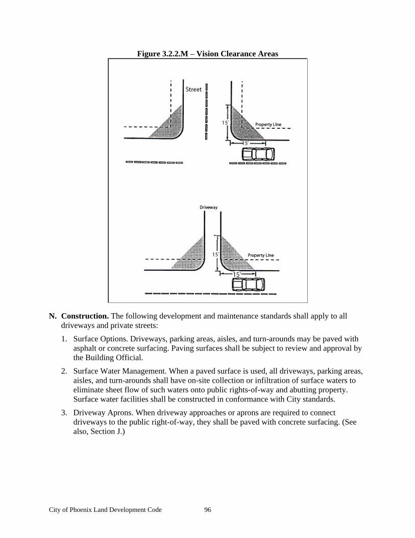
City of Phoenix Land Development Code 96
Figure 3.2.2.M Vision Clearance Areas
N. Construction. The following development and maintenance standards shall apply to all driveways and private streets:
1. Surface Options. Driveways, parking areas, aisles, and turn-arounds may be paved with asphalt or concrete surfacing. Paving surfaces shall be subject to review and approval by the Building Official.
2. Surface Water Management. When a paved surface is used, all driveways, parking areas, aisles, and turn-arounds shall have on-site collection or infiltration of surface waters to eliminate sheet flow of such waters onto public rights-of-way and abutting property. Surface water facilities shall be constructed in conformance with City standards.
3. Driveway Aprons. When driveway approaches or aprons are required to connect driveways to the public right-of-way, they shall be paved with concrete surfacing. (See also, Section J.)
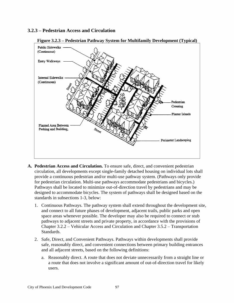
City of Phoenix Land Development Code 97
3.2.3 Pedestrian Access and Circulation
Figure 3.2.3 Pedestrian Pathway System for Multifamily Development (Typical)
A. Pedestrian Access and Circulation. To ensure safe, direct, and convenient pedestrian circulation, all developments except single-family detached housing on individual lots shall provide a continuous pedestrian and/or multi-use pathway system. (Pathways only provide for pedestrian circulation. Multi-use pathways accommodate pedestrians and bicycles.) Pathways shall be located to minimize out-of-direction travel by pedestrians and may be designed to accommodate bicycles. The system of pathways shall be designed based on the standards in subsections 1-3, below:
1. Continuous Pathways. The pathway system shall extend throughout the development site, and connect to all future phases of development, adjacent trails, public parks and open space areas whenever possible. The developer may also be required to connect or stub pathways to adjacent streets and private property, in accordance with the provisions of Chapter 3.2.2 Vehicular Access and Circulation and Chapter 3.5.2 Transportation Standards.
2. Safe, Direct, and Convenient Pathways. Pathways within developments shall provide safe, reasonably direct, and convenient connections between primary building entrances and all adjacent streets, based on the following definitions:
a. Reasonably direct. A route that does not deviate unnecessarily from a straight line or a route that does not involve a significant amount of out-of-direction travel for likely users.
City of Phoenix Land Development Code 98
b. Safe and convenient. Bicycle and pedestrian routes that are reasonably free from hazards and provide a reasonably direct route of travel between destinations.
c. For commercial, industrial, mixed use, public, and institutional buildings, the primary entrance is the main public entrance to the building. In the case where no public entrance exists, street connections shall be provided to the main employee entrance.
d. For residential buildings, the primary entrance is the front door (i.e., facing the street). For multifamily buildings in which each unit does not have its own exterior entrance, the primary entrance may be a lobby, courtyard, or breezeway that serves as a common entrance for more than one dwelling.
3. Connections within Development. For all developments subject to Site Design Review, pathways shall connect all building entrances to one another. In addition, pathways shall connect all parking areas, storage areas, recreational facilities and common areas (as applicable), and adjacent developments to the site, as applicable.
4. Pathways shall have adequate lighting for safety purposes. The City may require lighting as a condition of development review.
5. Pathways (for pedestrians and bicycles) shall be provided at or near mid-block where the block length exceeds 400 feet in the City Center District, 600 feet in the Residential Districts, or 800 feet in the Industrial Districts. Pathways shall also be provided where cul-de-sacs or dead-end streets are planned, to connect the ends of the streets together, to other streets, and/or to other developments, as applicable. Pathways used to comply with these standards shall conform to all of the following criteria:
a. Multi-use pathways (i.e., for pedestrians and bicyclists) are no less than 6 feet wide and located within a 10-foot-wide right-of-way or easement that allows access for emergency vehicles;
b. If the streets within the subdivision or neighborhood are lighted, the pathways shall also be lighted;
c. Stairs or switchback paths using a narrower right-of-way/easement may be required in lieu of a multi-use pathway where grades are steep;
d. The City may require landscaping within the pathway easement/right-of-way for screening and the privacy of adjoining properties;
e. The Planning Commission may determine, based upon facts in the record, that a pathway is impracticable due to: physical or topographic conditions (e.g., freeways, railroads, extremely steep slopes, sensitive lands, and similar physical constraints); buildings or other existing development on adjacent properties that physically prevent a connection now or in the future, considering the potential for redevelopment; and sites where the provisions of recorded leases, easements, covenants, restrictions, or other agreements recorded as of the effective date of this Code prohibit the pathway connection.
City of Phoenix Land Development Code 99
B. Design and Construction. Pathways shall conform to all of the standards in 1-5:
1. Vehicle/Pathway Separation. Where pathways are parallel and adjacent to a driveway or street (public or private), they shall be raised six inches and curbed, or separated from the driveway/street by a five-foot minimum strip with bollards, a landscape berm, or other physical barrier. If a raised path is used, the ends of the raised portions must be equipped with curb ramps.
2. Housing/Pathway Separation. Pedestrian pathways shall be separated a minimum of five feet from all residential living areas on the ground floor, except at building entrances. Separation is measured as measured from the pathway edge to the closest dwelling unit. The separation area shall be landscaped in conformance with the provisions of Chapter 3.3 Landscaping, Street Trees, Fences, and Walls. No pathway/building separation is required for commercial, industrial, public, or institutional uses.
3. Crosswalks. Where pathways cross a parking area, driveway, or street, they shall be clearly marked with contrasting paving materials, humps/raised crossings, or painted striping. An example of contrasting paving material is the use of a concrete crosswalk through an asphalt driveway. If painted striping is used, it shall consist of thermo-plastic striping or a similar type of durable application.
Crosswalks on state highway facilities shall be developed in coordination with the Oregon Department of Transportation (ODOT), shall be designed to state standards, and may require an Intergovernmental Agreement (IGA) to address maintenance responsibilities.
4. Pathway Surface. Pathway surfaces shall be concrete, asphalt, brick/masonry pavers, or other durable surface, at least six feet wide, and shall conform to ADA requirements. Multi-use paths shall be the same materials, at least 10 feet wide. (See also Chapter 3.5.2
Transportation Standards for public, multi-use pathway standard.)
5. Accessible routes. Pathways shall comply with the Americans with Disabilities Act, which requires accessible routes of travel.

City of Phoenix Land Development Code 100
City of Phoenix Land Development Code 101
Chapter 3.3 Landscaping, Street Trees, Fences, and Walls
Sections:
3.3.1 Purpose 3.3.2 Landscape Conservation 3.3.3 New Landscaping 3.3.4 Street Trees 3.3.5 Fences and Walls
3.3.1 Purpose
The purpose of this Chapter is to promote community health, safety, and welfare by protecting natural vegetation, and setting development standards for landscaping, street trees, fences, and walls. Together, these elements of the natural and built environment contribute to the visual quality, environmental health, and character of the community. Trees provide climate control through shading during summer months and wind screening during winter. Trees and other plants can also buffer pedestrians from traffic. Walls, fences, trees, and other landscape materials also provide vital screening and buffering between land uses. Landscaped areas help to control surface water drainage and can improve water quality, as compared to paved or built surfaces.
The Chapter is organized into the following sections:
A. Section 3.3.2
Landscape Conservation prevents the indiscriminate removal of significant trees and other vegetation, including vegetation associated with streams, wetlands, and other protected natural resource areas.
B. Section 3.3.3
New Landscaping sets standards for and requires landscaping of all development sites that require Site Design Review. This Section also requires buffering for parking and maneuvering areas, and between different land use districts. Note that other landscaping standards are provided in Chapter 2 Land Use Districts, for specific types of development.
C. Section 3.3.4
Street Trees sets standards for and requires planting of trees along all streets for shading, comfort and aesthetic purposes.
D. Section 3.3.5
Fences and Walls sets standards for new fences and walls, including maximum allowable height and materials, to promote security, personal safety, privacy, and aesthetics.
3.3.2 Landscape Conservation
A. Applicability. All development sites containing Significant Vegetation, as defined below, shall comply with the standards of this Section. The purpose of this Section is to incorporate significant vegetation into the landscapes of development and protect significant existing vegetation. The use of mature, native vegetation within developments is a preferred alternative to removal of vegetation and re-planting. Mature landscaping provides summer shade and wind breaks, and allows for water conservation due to larger plants having established root systems.
City of Phoenix Land Development Code 102
B. Significant Vegetation. Significant vegetation means:
1. Significant Trees and Shrubs. Individual trees and shrubs with a trunk diameter of six inches or greater, as measured four feet DBH (diameter at breast height) above the ground, and all plants within the drip line of such trees and shrubs, shall be protected.
2. Exception: Protection shall not be required for plants listed as non-native, invasive plants by the Oregon State University Extension Service in the applicable OSU bulletins for Jackson County.
C. Mapping and Protection Required. Significant vegetation shall be mapped as required by Chapter 4.2 Development Review and Site Design Review. Significant trees shall be mapped individually and identified by species and size (diameter at four feet above grade, or DBH ). A protection area shall be defined around the edge of all branches (drip-line) of
each tree (drip lines may overlap between trees). The City also may require an inventory, survey, or assessment prepared by a qualified professional when necessary to determine vegetation boundaries, building setbacks, and other protection or mitigation requirements.
D. Protection Standards. All of the following protection standards shall apply to significant vegetation areas:
1. Protection of Significant Trees (Section B.1) Significant trees identified as meeting the criteria in Section B.1 shall be retained whenever practicable. Preservation may become impracticable when it would prevent reasonable development of public streets, utilities, or land uses permitted by the applicable land use district.
2. Conservation Easements and Dedications. When necessary to implement the Comprehensive Plan, the City may require dedication of land or recordation of a conservation easement to protect sensitive lands, including groves of significant trees.
E. Construction. All areas of significant vegetation shall be protected before, during, and after construction. Grading and operation of vehicles and heavy equipment is prohibited within significant vegetation areas, except as approved by the City for installation of utilities or streets. Such approval shall only be granted after finding that there is no other reasonable alternative to avoid the protected area.
F. Exemptions. The protection standards in D shall not apply in the following situations:
1. Dead, Diseased, and/or Hazardous Vegetation. Vegetation that is dead or diseased, or poses a hazard to personal safety, property, or the health of other trees, may be removed. Prior to tree removal, the applicant shall provide a report from a certified arborist or other qualified professional to determine whether the subject tree is diseased or poses a hazard, and any possible treatment to avoid removal, except as provided by subsection 2, below.
2. Emergencies. Significant vegetation may be removed in the event of an emergency without land use approval pursuant to Chapter 4, when the vegetation poses an immediate threat to life or safety, as determined by a city official. The city official shall prepare a notice or letter of decision within seven days of the trees being removed. The decision letter or notice shall explain the nature of the emergency and be on file and available for public review at City Hall.
City of Phoenix Land Development Code 103
3.3.3 New Landscaping
A. Applicability. This Section shall apply to all developments requiring Site Design Review, and other developments with required landscaping.
B. Landscaping Plan Required. A landscape plan is required. All landscape plans shall conform to the requirements in 4.2.5 Site Design Review Application Submission Requirements, Section B.5 (Landscape Plans). All landscape and irrigation plans must be reviewed and approved by the Planning Director, unless the conditions of the project specifically require Planning Commission approval.
C. Landscape Area Standards. The minimum percentage of required landscaping equals:
1. Residential Districts. 20 percent of the site.
2. City Center District. 10 percent of the site.
3. Commercial Districts. A minimum of 20 percent of the site shall be landscaped.
4. Industrial Districts. 20 percent of the site.
D. Landscape Materials. Landscape materials include trees, shrubs, ground cover plants, non-plant ground covers, and outdoor hardscape features, as described below:
1. Natural Vegetation. Natural vegetation shall be preserved or planted where practicable.
2. Plant Selection. A combination of deciduous and evergreen trees, shrubs, and ground covers shall be used for all planted areas, the selection of which shall be based on local climate, exposure, water availability, and drainage conditions. As necessary, soils shall be amended to allow for healthy plant growth.
3. Non-native, invasive plants, as per Chapter 3.3.2 Landscape Conservation, Section B, shall be prohibited.
4. Hardscape features, such as patios, decks, plazas, etc., may cover up to 20 percent of the required landscape area; except in the City Center District where hardscape features may cover up to 50 percent of the landscape area. Swimming pools, sports courts, and similar active recreation facilities may not be counted toward fulfilling the landscape requirement.
5. Non-plant Ground Covers. Bark dust, chips, aggregate or other non-plant ground covers may be used, but shall cover no more than 20 percent of the area to be landscaped. Coverage is measured based on the size of plants at maturity or after two years of growth, whichever comes sooner.
6. Tree Size. Trees shall have a minimum caliper size of 1.5 inches at DBH or greater, or be six feet or taller, at time of planting.
7. Shrub Size. Shrubs shall be planted from 5-gallon containers or larger.
8. Ground Cover Size. Ground cover plants shall be sized and spaced so that they grow together to cover a minimum of 75 percent of the underlying soil within three years.
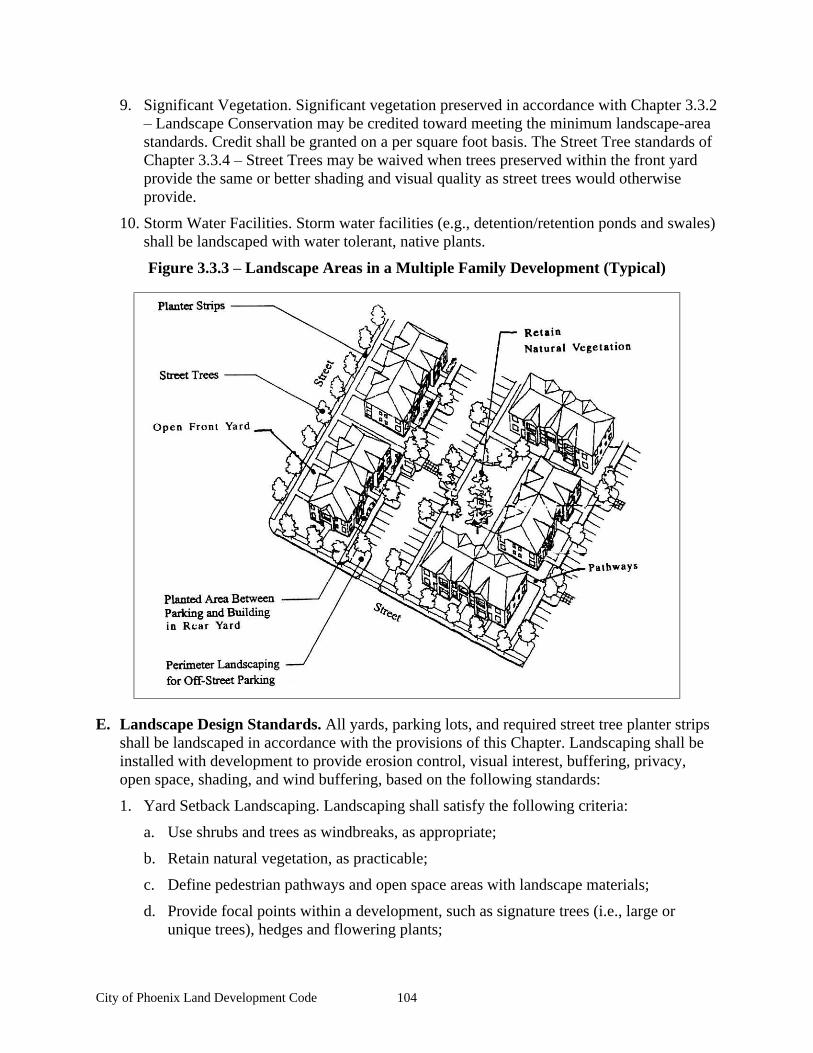
City of Phoenix Land Development Code 104
9. Significant Vegetation. Significant vegetation preserved in accordance with Chapter 3.3.2 Landscape Conservation may be credited toward meeting the minimum landscape-area
standards. Credit shall be granted on a per square foot basis. The Street Tree standards of Chapter 3.3.4 Street Trees may be waived when trees preserved within the front yard provide the same or better shading and visual quality as street trees would otherwise provide.
10. Storm Water Facilities. Storm water facilities (e.g., detention/retention ponds and swales) shall be landscaped with water tolerant, native plants.
Figure 3.3.3 Landscape Areas in a Multiple Family Development (Typical)
E. Landscape Design Standards. All yards, parking lots, and required street tree planter strips shall be landscaped in accordance with the provisions of this Chapter. Landscaping shall be installed with development to provide erosion control, visual interest, buffering, privacy, open space, shading, and wind buffering, based on the following standards:
1. Yard Setback Landscaping. Landscaping shall satisfy the following criteria:
a. Use shrubs and trees as windbreaks, as appropriate;
b. Retain natural vegetation, as practicable;
c. Define pedestrian pathways and open space areas with landscape materials;
d. Provide focal points within a development, such as signature trees (i.e., large or unique trees), hedges and flowering plants;
City of Phoenix Land Development Code 105
e. Use trees to provide summer shading within common open space areas, and within front yards when street trees cannot be provided;
f. Use a combination of plants for yearlong color and interest;
g. Use landscaping to screen outdoor storage and mechanical equipment areas, and to enhance graded areas such as berms, swales, and detention/retention ponds.
h. If the applicant is able to prove that the view shed is impaired, the shrubs may be used instead of trees.
2. Parking areas. A minimum of eight percent of the combined area of all parking areas, as measured around the perimeter of all parking spaces and maneuvering areas, shall be landscaped. Such landscaping shall consist of an evenly distributed mix of shade trees with shrubs and/or ground cover plants. Evenly distributed means that the trees and other plants are distributed around the parking lot perimeter and between parking bays to provide a partial canopy. At a minimum, one tree per five parking spaces total shall be planted to create a partial tree canopy over and around the parking area. All parking areas with more than 20 spaces shall include landscape islands with trees to break up the parking area into rows of not more than 12 contiguous parking spaces. All landscaped areas shall have minimum dimensions of eight feet by 19 feet and all tree wells shall have minimum dimensions of four feet by four feet to ensure adequate soil, water, and space for healthy plant growth. Trees planted within parking areas shall be a minimum of 2-inch caliper trees, unless the landscape plan includes a dense planting of varying sized trees.
3. Buffering and Screening Required. Buffering and screening are required under the following conditions:
a. Parking/Maneuvering Area Adjacent to Building. Where a parking or maneuvering area, or driveway, is adjacent to a building, the area shall be separated from the building by a raised pathway, plaza, or landscaped buffer no less than eight feet in width. Raised curbs, bollards, wheel stops, or other design features shall be used to protect buildings from being damaged by vehicles. When parking areas are located adjacent to residential ground-floor living space, a landscape buffer is required to fulfill this requirement.
b. Screening of Mechanical Equipment, Outdoor Storage, Service and Delivery Areas, and Automobile-Oriented Uses. All mechanical equipment, outdoor storage and manufacturing, and service and delivery areas, shall be screened from view from all public streets and Residential districts. Screening shall be provided by one or more of the following: decorative wall (i.e., masonry or similar quality material), evergreen hedge, non-see through fence, or a similar feature that provides a non-see through barrier. Walls, fences, and hedges shall comply with the vision clearance requirements and provide for pedestrian circulation, in accordance with Chapter 3.2
Access and Circulation. (See also Chapter 3.3.5 Fences and Walls)
F. Agricultural lands special setback requirements. The purpose of establishing standards for buffering urban development from agricultural lands is to reduce the potential for conflict between farming activities and urban (principally residential) uses.
1. Buffering standards seek to achieve the following objectives:
City of Phoenix Land Development Code 106
a. To protect the use of farming practices that are in accordance with associated industry-specific guidelines and, where appropriate, with state guidelines.
b. To minimize the scope of potential conflict by developing, where possible, a well-defined boundary between agricultural and urban uses. The best boundary will be one that provides a sound transition in both directions.
c. To minimize the impacts of urban development on agricultural production activities.
d. To minimize the potential for complaints about agricultural practices and activities.
e. To provide acceptable environmental and quality of life conditions in urbanizing areas located in proximity to agricultural land.
2. All new livable space located adjacent to the district boundary of a County zoned resource land zoning designation shall be setback a minimum of 200 feet from the county zoning boundary line.
3. If the zoning boundary lies in the centerline of a city, county, or state roadway, the entire width of the dedicated roadway may be calculated as part of the special setback.
4. The 200-foot setback may be reduced through the Variance or PUD process if the subject property would not be able to develop with the buffer setback through a PUD development process. Planning Commission may require additional vegetative screen or other mitigation as part of this PUD or Variance process.
G. Maintenance and Irrigation. Automatic irrigation systems shall be provided for all landscaping. The use of drought-tolerant plant species is encouraged. If the plantings fail to survive, the property owner shall replace them with an equivalent specimen (i.e., evergreen shrub replaces evergreen shrub, deciduous tree replaces deciduous tree, etc.). All landscape features required by this Code shall be maintained in good condition or otherwise replaced by the owner.
3.3.4 Street Trees
Street trees shall be planted for all developments that are subject to Land Division or Site Design Review. Requirements for street tree planting strips are provided in Chapter 3.5.2
Transportation Standards. Planting of unimproved streets shall be deferred until the construction of curbs and sidewalks. Street trees shall conform to the following standards and guidelines:
A. Growth Characteristics. Trees shall be selected based on growth characteristics and site conditions, including available space, overhead clearance, soil conditions, exposure, and desired color and appearance. The following should guide tree selection:
1. Provide a broad canopy where shade is desired.
2. A minimum of two tree species is required to prevent total loss of tree cover in case of disease.
2. Use low-growing trees for spaces under utility wires.
3. Select trees that can be limbed-up where vision clearance is a concern.
4. Use narrow or columnar trees where awnings or other building features limit growth, or where greater visibility is desired between buildings and the street.
City of Phoenix Land Development Code 107
5. Use species with similar growth characteristics on the same block for design continuity.
6. Avoid using trees that are susceptible to insect damage, and avoid using trees that produce excessive seeds or fruit.
7. Select trees that are well adapted to the environment, including soil, wind, sun exposure, and exhaust. Drought-resistant trees should be used in areas with sandy or rocky soil.
8. Use deciduous trees for summer shade and winter sun.
B. Caliper Size. The minimum caliper size at planting shall be 1.5 inches at DBH, based on the American Association of Nurserymen Standards.
C. Spacing and Location. Street trees shall be planted within existing and proposed planting strips, and in sidewalk tree wells on streets without planting strips. Street tree spacing shall be based upon the type of trees selected and the canopy size at maturity. In general, trees shall be spaced no more than 30 feet apart, except where planting a tree would conflict with existing trees, retaining walls, utilities and similar physical barriers.
D. Soil Preparation, Planting, and Care. The developer shall be responsible for planting street trees, including soil preparation, ground cover material, staking, and temporary irrigation for two years after planting. Street trees shall be planted after the house is finished. The developer shall also be responsible for street tree care (pruning, watering, fertilization, and replacement as necessary) during the first two years after planting. The lot or parcel landscaping shall be completed within six months of occupancy. If the lot or parcel is to be landscaped by the developer, the developer shall have the option of having an account for landscaping which would allow the home owner to decide on types of vegetation.
E. Assurances. The City shall require the developer to provide a performance and maintenance bond in an amount determined by the City Planner, to ensure the planting of the trees and care during the first two years after planting.
F. Prohibited Street Tree List. No person shall plant in any public strip the following trees: poplar, willow, conifer, cottonwood, fruit trees, nut trees, ailanthus, or bamboo. No person shall plant willow, cottonwood, or poplar trees anywhere in the City unless the City Council or their duly authorized representative approves the site as one where the tree roots will not interfere with a public sewer.
G. State Agency Coordination. The City shall require the developer to coordinate landscape plan review with the Oregon Department of Transportation (ODOT) on all projects proposing street trees and/or vegetation along state transportation facilities. Coordination is necessary to ensure ODOT s safety, operations, and maintenance responsibilities.
3.3.5 Fences and Walls
The following standards shall apply to all fences and walls:
A. General Requirements. All fences and walls shall comply with the standards of this Section. The City may require installation of walls and/or fences as a condition of development approval, in accordance with Chapter 4.2 Development Review and Site Design Review or Chapter 4.4 Conditional Use Permits. Walls built for required landscape buffers shall comply with Chapter 3.3.3 New Landscaping.
City of Phoenix Land Development Code 108
B. Dimensions
1. The maximum allowable height of fences and walls is six feet as measured from the lowest grade at the base of the wall or fence, except that retaining walls and terraced walls may exceed six feet when permitted as part of a site development approval or as necessary to construct streets and sidewalks. A building permit shall be obtained when required by the Building Code as amended.
2. The height of fences and walls within a front yard setback shall not exceed four feet (except decorative arbors or gates) as measured from the grade closest to the street right-of-way.
3. Walls and fences to be built for required buffers shall comply with Chapter 3.3.3 New Landscaping.
4. Fences and walls shall comply with the vision clearance standards of Chapter 3.2.2
Vehicular Access and Circulation, Section M.
C. Materials. All materials are acceptable except for barbed wire fences. Chain link fences must be powder-coated or vinyl coated.
D. Maintenance. For safety and for compliance with the purpose of this Chapter, walls and fences required as a condition of development approval shall be maintained in good condition, or otherwise replaced by the owner.
City of Phoenix Land Development Code 109
Chapter 3.4 Vehicle and Bicycle Parking
Sections:
3.4.1 Purpose 3.4.2 Applicability 3.4.3 Vehicle Parking Standards 3.4.4 Bicycle Parking Requirements 3.4.5 Recreational Vehicles
3.4.1 Purpose
The purpose of this Chapter is to provide basic and flexible standards for development of vehicle and bicycle parking. The design of parking areas is critically important to the viability of some commercial areas, pedestrian and driver safety, the efficient and safe operation of adjoining streets, and community image and livability. Historically, some communities have required more parking than is necessary for some land uses, paving extensive areas of land that could be put to better use. Because vehicle-parking facilities can occupy large amounts of land, they must be planned and designed carefully to use the land efficiently while maintaining the visual character of the community. This Chapter recognizes that each development has unique parking needs by providing a flexible approach for determining parking space requirements. This Chapter also provides standards for bicycle parking because many people use bicycles for recreation, commuting, and general transportation. Children as well as adults need safe and adequate spaces to park their bicycles throughout the community.
3.4.2 Applicability
All developments subject to site design review (Chapter 4.2 Development Review and Site Design Review), including development of parking facilities, shall comply with the provisions of this Chapter.
3.4.3 Vehicle Parking Standards
A. Number of Spaces Required. The minimum number of required off-street vehicle parking spaces (i.e., parking that is located in parking lots and garages and not in the street right-of-way) shall be determined based on the standards in Table 3.4.3.A.
The minimum number of off-street parking spaces required in the City Center District may be reduced by one-third, however, the maximum parking standard of this Chapter apply.
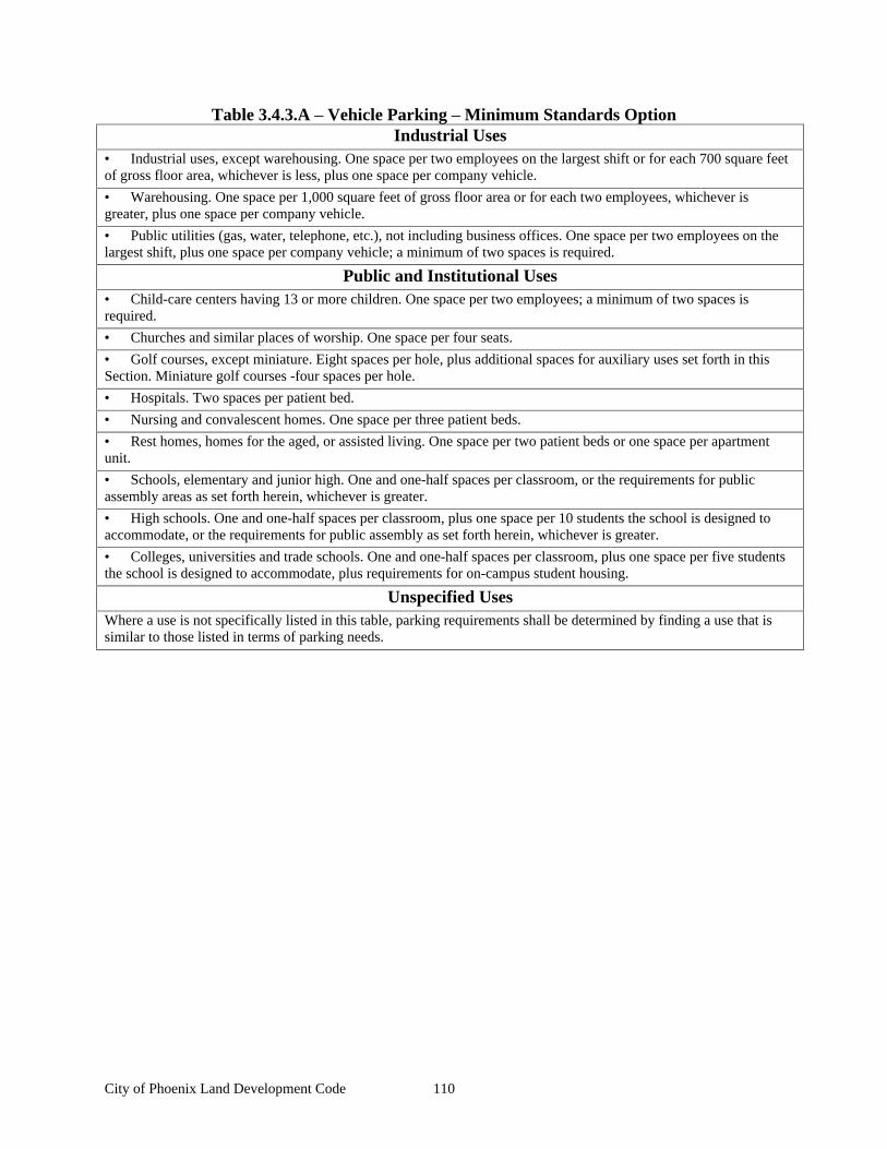
City of Phoenix Land Development Code 110
Table 3.4.3.A Vehicle Parking Minimum Standards Option Industrial Uses
Industrial uses, except warehousing. One space per two employees on the largest shift or for each 700 square feet
of gross floor area, whichever is less, plus one space per company vehicle.
Warehousing. One space per 1,000 square feet of gross floor area or for each two employees, whichever is
greater, plus one space per company vehicle.
Public utilities (gas, water, telephone, etc.), not including business offices. One space per two employees on the
largest shift, plus one space per company vehicle; a minimum of two spaces is required.
Public and Institutional Uses
Child-care centers having 13 or more children. One space per two employees; a minimum of two spaces is required.
Churches and similar places of worship. One space per four seats.
Golf courses, except miniature. Eight spaces per hole, plus additional spaces for auxiliary uses set forth in this Section. Miniature golf courses -four spaces per hole.
Hospitals. Two spaces per patient bed.
Nursing and convalescent homes. One space per three patient beds.
Rest homes, homes for the aged, or assisted living. One space per two patient beds or one space per apartment unit.
Schools, elementary and junior high. One and one-half spaces per classroom, or the requirements for public assembly areas as set forth herein, whichever is greater.
High schools. One and one-half spaces per classroom, plus one space per 10 students the school is designed to accommodate, or the requirements for public assembly as set forth herein, whichever is greater.
Colleges, universities and trade schools. One and one-half spaces per classroom, plus one space per five students the school is designed to accommodate, plus requirements for on-campus student housing.
Unspecified Uses Where a use is not specifically listed in this table, parking requirements shall be determined by finding a use that is similar to those listed in terms of parking needs.
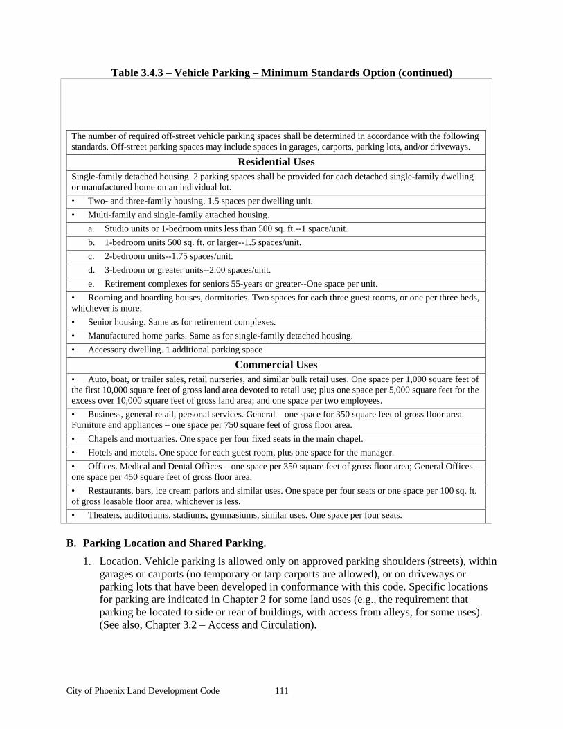
City of Phoenix Land Development Code 111
Table 3.4.3 Vehicle Parking Minimum Standards Option (continued)
The number of required off-street vehicle parking spaces shall be determined in accordance with the following standards. Off-street parking spaces may include spaces in garages, carports, parking lots, and/or driveways.
Residential Uses Single-family detached housing. 2 parking spaces shall be provided for each detached single-family dwelling or manufactured home on an individual lot.
Two- and three-family housing. 1.5 spaces per dwelling unit.
Multi-family and single-family attached housing.
a. Studio units or 1-bedroom units less than 500 sq. ft.--1 space/unit.
b. 1-bedroom units 500 sq. ft. or larger--1.5 spaces/unit.
c. 2-bedroom units--1.75 spaces/unit.
d. 3-bedroom or greater units--2.00 spaces/unit.
e. Retirement complexes for seniors 55-years or greater--One space per unit.
Rooming and boarding houses, dormitories. Two spaces for each three guest rooms, or one per three beds, whichever is more;
Senior housing. Same as for retirement complexes.
Manufactured home parks. Same as for single-family detached housing.
Accessory dwelling. 1 additional parking space
Commercial Uses
Auto, boat, or trailer sales, retail nurseries, and similar bulk retail uses. One space per 1,000 square feet of the first 10,000 square feet of gross land area devoted to retail use; plus one space per 5,000 square feet for the excess over 10,000 square feet of gross land area; and one space per two employees.
Business, general retail, personal services. General one space for 350 square feet of gross floor area. Furniture and appliances one space per 750 square feet of gross floor area.
Chapels and mortuaries. One space per four fixed seats in the main chapel.
Hotels and motels. One space for each guest room, plus one space for the manager.
Offices. Medical and Dental Offices one space per 350 square feet of gross floor area; General Offices
one space per 450 square feet of gross floor area.
Restaurants, bars, ice cream parlors and similar uses. One space per four seats or one space per 100 sq. ft. of gross leasable floor area, whichever is less.
Theaters, auditoriums, stadiums, gymnasiums, similar uses. One space per four seats.
B. Parking Location and Shared Parking.
1. Location. Vehicle parking is allowed only on approved parking shoulders (streets), within garages or carports (no temporary or tarp carports are allowed), or on driveways or parking lots that have been developed in conformance with this code. Specific locations for parking are indicated in Chapter 2 for some land uses (e.g., the requirement that parking be located to side or rear of buildings, with access from alleys, for some uses). (See also, Chapter 3.2 Access and Circulation).
City of Phoenix Land Development Code 112
2. Off-site parking. Except for single-family dwellings, the vehicle parking spaces required by this Chapter may be located on another parcel of land, provided the parcel is within 500 feet of the use it serves. The distance from the parking area to the use shall be measured from the nearest parking space to a building entrance, following a sidewalk or other pedestrian route. The right to use the off-site parking must be evidenced by a recorded deed, lease, easement, or similar written instrument.
3. Mixed uses. If more than one type of land use occupies a single structure or parcel of land, the total requirements for off-street automobile parking shall be the sum of the requirements for all uses, unless it can be shown that the peak parking demands are actually less (i.e., the uses operate on different days or at different times of the day). In that case, the total requirements shall be reduced accordingly as approved by the Planning Director.
4. Shared parking. Required parking facilities for two or more uses, structures, or parcels of land may be satisfied by the same parking facilities used jointly, to the extent that the owners or operators show that the need for parking facilities does not materially overlap (e.g., uses primarily of a daytime versus nighttime nature), and provided that the right of joint use is evidenced by a recorded deed, lease, contract, or similar written instrument establishing the joint use.
5. Availability of facilities. Owners of off-street parking facilities may post a sign indicating that all parking on the site is available only for residents, customers and/or employees, as applicable. Signs shall conform to the standards of Chapter 3.6 Signs.
D. Maximum Number of Parking Spaces. The number of parking spaces provided by any particular use in ground surface parking lots shall not exceed the required minimum number of spaces provided by this Section by more than 5%.
E. Parking Stall Standard Dimensions and Compact Car Parking. All off-street parking stalls shall be improved to conform to City standards for surfacing, stormwater management, and striping. Standard parking spaces shall conform to the dimensions in Figure 3.4.3.E.
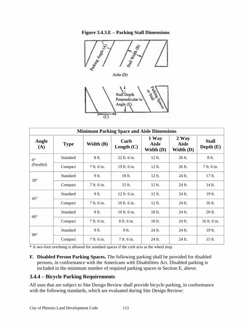
City of Phoenix Land Development Code 113
Figure 3.4.3.E Parking Stall Dimensions
Minimum Parking Space and Aisle Dimensions
Angle (A) Type Width (B) Curb
Length (C)
1 Way Aisle
Width (D)
2 Way Aisle
Width (D)
Stall Depth (E)
Standard 8 ft. 22 ft. 6 in. 12 ft. 26 ft. 8 ft. 0
(Parallel) Compact 7 ft. 6 in. 19 ft. 6 in. 12 ft. 26 ft. 7 ft. 6 in.
Standard 9 ft. 18 ft. 12 ft. 24 ft. 17 ft. 30
Compact 7 ft. 6 in. 15 ft. 12 ft. 24 ft. 14 ft.
Standard 9 ft. 12 ft. 6 in. 12 ft. 24 ft. 19 ft. 45
Compact 7 ft. 6 in. 10 ft. 6 in. 12 ft. 24 ft. 16 ft.
Standard 9 ft. 10 ft. 6 in. 18 ft. 24 ft. 20 ft. 60
Compact 7 ft. 6 in. 8 ft. 6 in. 18 ft. 24 ft. 16 ft. 6 in.
Standard 9 ft. 9 ft. 24 ft. 24 ft. 19 ft. 90
Compact 7 ft. 6 in. 7 ft. 6 in. 24 ft. 24 ft. 15 ft.
* A two-foot overhang is allowed for standard spaces if the curb acts as the wheel stop.
F. Disabled Person Parking Spaces. The following parking shall be provided for disabled persons, in conformance with the Americans with Disabilities Act. Disabled parking is included in the minimum number of required parking spaces in Section E, above.
3.4.4 Bicycle Parking Requirements
All uses that are subject to Site Design Review shall provide bicycle parking, in conformance with the following standards, which are evaluated during Site Design Review:
City of Phoenix Land Development Code 114
A. Number of Bicycle Parking Spaces. The following additional standards apply to specific types of development:
1. Multi-Family Residences. Every residential use of four or more dwelling units provides at least one sheltered bicycle parking space for each dwelling unit. Sheltered bicycle parking spaces may be located within a garage, storage shed, basement, utility room, or similar area. In those instances in which the residential complex has no garage or other easily accessible storage unit, the bicycle parking spaces shall be sheltered from sun and precipitation under an independent structure.
2. Commercial and Industrial Use Parking Lots. A minimum of one sheltered bicycle parking spaces is required for all uses with less than 10 vehicle parking spaces, otherwise, sheltered bicycle parking spaces shall be equal to 10% of the number of motorized vehicle parking spaces.
3. Schools. Elementary and middle schools, both private and public, provide four sheltered bicycle parking space for every classroom. High schools provide eight sheltered bicycle parking spaces for every classroom.
4. City Center District. Individual uses shall provide their own parking, or spaces may be clustered if located within 50 feet of the business it serves. Bicycle parking spaces shall be located in front of the stores along the street, either on the sidewalks or in specially constructed areas such as pedestrian curb extensions. Inverted U-style racks are recommended. Bicycle parking shall not interfere with pedestrian passage, leaving a clear area of at least 36 inches between bicycles and other existing and potential obstructions. Sheltered bicycle parking shall be provided at a rate of one space per 10 employees, with a minimum of one space per store.
5. Multiple Uses. For buildings with multiple uses (such as a commercial or mixed use center), bicycle-parking standards shall be calculated by using the total number of motor vehicle parking spaces required for the entire development. A minimum of one bicycle parking space for every 10 motor vehicle parking spaces is required.
B. Exemptions. This Section does not apply to single-family, two-family, and three-family housing (attached, detached or manufactured housing), home occupations, agriculture, and livestock uses.
C. Location and Design. Bicycle parking shall be conveniently located with respect to both the street right-of-way and at least one building entrance (e.g., no farther away than the closest parking space). Bicycle parking must be sheltered. (Spaces may be located under an eave, overhang, an independent structure, or similar cover.) The bike parking structure shall be placed on an all weather surface. It should be incorporated whenever possible into building design and landscaping plan and coordinated with the design of street furniture when it is provided. Street furniture includes benches, streetlights, planters, and other pedestrian amenities.
D. Visibility and Security. Bicycle parking shall be visible to cyclists from street sidewalks or building entrances, so that it provides sufficient security from theft and damage;
E. Options for Storage. Bicycle parking requirements for long-term and employee parking can be met by providing a bicycle storage room, bicycle lockers, racks, or other secure storage space inside or outside of the building;
City of Phoenix Land Development Code 115
F. Lighting. Bicycle parking shall be least as well lit as vehicle parking for security.
G. Reserved Areas. Areas set aside for bicycle parking shall be clearly marked and reserved for bicycle parking only.
H. Hazards. Bicycle parking shall not impede or create a hazard to pedestrians. Parking areas shall be located so as not to conflict with vision clearance standards (Chapter 3.2 Access and Circulation).
3.4.5 Recreational Vehicles
The following regulations pertain to recreational vehicles other than those parked in recreational vehicle parks, mobile home parks, or other areas that are specifically designed for such vehicles;
A. It shall be unlawful to occupy a recreational vehicle for sleeping or living purposes in a public street or right-of-way for any length of time within the City of Phoenix.
B. A recreational vehicle may be parked on private property and used for sleeping and cooking purposes by guest of the residents of the premises for a period not to exceed two weeks per year. Such recreational vehicles shall have self-contained sewage facilities, or the visitors shall utilize the facilities of the host s residence.
C. Additionally, all RV vehicles parked or stored on residential property must be parked upon an improved surface (asphalt, concrete, brick or gravel). Parking on front lawn areas is strictly prohibited and all RV s, Boats, Trailers etc, used for sleeping and cooking purposes on the property must be operational, have current tags and be attached to the site only by temporary utility and security devices.
D. No person having ownership or other responsibility for property in Phoenix shall occupy or allow the occupancy of any recreational vehicle upon the premises as permanent living quarters.
E. Any unoccupied recreational vehicle that is not in use shall not be stored on any roadway, within any public right-of-way, or upon any public property
F. A recreational vehicle shall not be used as a guesthouse, a caretaker s residence, nor as a sole residence on any tax lot, nor shall it be used as a temporary residence during the period of construction of a permanent dwelling on the property, except for City use during municipal projects.
G. A recreational vehicle shall not occupy a space within an approved manufactured housing park unless that space has been specially approved by the city for short-term recreational vehicle use.

City of Phoenix Land Development Code 116
City of Phoenix Land Development Code 117
Chapter 3.5 Street and Public Facilities Standards
Sections:
3.5.1 Purpose and Applicability 3.5.2 Transportation Standards 3.5.3 Public Use Areas 3.5.4 Sanitary Sewer and Water Service Improvements 3.5.5 Utilities 3.5.6 Easements 3.5.7 Construction Plan Approval and Assurances 3.5.8 Installation
3.5.1 Purpose and Applicability
A. Purpose. The purpose of this Chapter is to provide planning and design standards for public and private transportation facilities and utilities. Streets are the most common public spaces, touching virtually every parcel of land. Therefore, one of the primary purposes of this Chapter is to provide standards for attractive and safe streets that can accommodate vehicle traffic from planned growth, and provide a range of transportation options, including options for driving, walking bus transit and bicycling. This Chapter is also intended to implement the City s Transportation System Plan.
Important cross-reference to other standards: The City requires that streets provide direct and convenient access, including regular intersections. Chapter 3.2 Access and Circulation provides standards for intersections and blocks, and requires pedestrian access ways to break up long blocks.
B. When Standards Apply. Unless otherwise provided, the standard specifications for construction, reconstruction, or repair of transportation facilities, utilities, and other public improvements within the City shall occur in accordance with the standards of this Chapter. No development or land division may occur unless the public facilities related to development comply with the public facility requirements established in this Chapter.
Standards for state transportation facilities shall be developed in coordination with the Oregon Department of Transportation (ODOT), per the requirements of Oregon s transportation policies, regulations, and guidelines. Standards for these facilities shall require ODOT coordination, review, and approval.
C. Standard Specifications. The City Engineer shall establish standard construction specifications consistent with the design standards of this Chapter and application of engineering principles. They are incorporated in this code by reference.
D Conditions of Development Approval. No development may occur unless required public facilities are in place or guaranteed in conformance with the provisions of Chapter 4.3.9
Performance, Maintenance Guarantee and Development Agreement. All public improvement plans must be approved by the City in accord with the process defined in Chapter 4.3.8
Public Improvements. Improvements required as a condition of development approval, when not voluntarily accepted by the applicant, shall be roughly proportional to the impact of development. Findings in the development approval shall indicate how the required improvements are roughly proportional to the impact.
City of Phoenix Land Development Code 118
3.5.2 Transportation Standards
A. Development Standards. No development shall occur unless the development has frontage or approved access to a public street, in conformance with the provisions of Chapter 3.2
Access and Circulation, and the following standards are met:
1. Streets within or adjacent to a development shall be improved in accordance with the Transportation System Plan and the provisions of this Chapter.
2. Development of new streets, and additional street width or improvements planned as a portion of an existing street, shall be improved in accordance with this Section, and public streets shall be dedicated to the applicable city, county or state jurisdiction;
3. New streets, alleys and drives connected to a collector or arterial street shall be paved; and
4. The City may accept a Deferred Improvement Agreement or a future improvement guarantee [e.g., owner agrees not to remonstrate against the formation of a local improvement district in the future] in lieu of street improvements if one or more of the following conditions exist:
a. A partial improvement may create a potential safety hazard to motorists or pedestrians;
b. Due to the developed condition of adjacent properties, it is unlikely that street improvements would be extended in the foreseeable future and the improvement associated with the project under review does not, by itself, provide increased street safety or capacity, or improved pedestrian circulation;
c. The improvement would be in conflict with an adopted capital improvement plan; or
d. The improvement is associated with an approved land partition on property zoned residential and the proposed land partition does not create any new streets.
B. Variances. Variances to the transportation design standards in this Section may be granted by means of a Type III Variance, as governed by Chapter 5.2 Variances.
C. Creation of Rights-of-Way for Streets and Related Purposes. Streets shall be created through the approval and recording of a final subdivision or partition plat; except the City may approve the creation of a street by acceptance of a deed, provided that the street is deemed essential by the City Council for the purpose of implementing the Transportation System Plan, and the deeded right-of-way conforms to the standards of this Code. All deeds of dedication shall be in a form prescribed by the City Attorney and shall name "the public," as grantee.
D. Creation of Access Easements. The City may approve an access easement established by deed when the easement is necessary to provide for access and circulation in conformance with Chapter 3.2 Access and Circulation. Access easements shall be created and maintained in accordance with the Fire Code as amended.
E. Street Location, Width, and Grade. Except as noted below, the location, width and grade of all streets shall conform to the Transportation System Plan, an approved street plan or subdivision plat. Street location, width and grade shall be determined in relation to existing
City of Phoenix Land Development Code 119
and planned streets, topographic conditions, public convenience and safety, and in appropriate relation to the proposed use of the land to be served by such streets:
1. Street grades shall be approved by the City Engineer; and
2. Where the location of a street is not shown in an existing street plan (See Section H ), the location of streets in a development shall either:
a. Provide for the continuation and connection of existing streets in the surrounding areas, conforming to the street standards of this Chapter, or
b. Conform to a street plan adopted by the City Council, if it is impractical to connect with existing street patterns because of particular topographical or other existing conditions of the land. Such a plan shall be based on the type of land use to be served, the volume of traffic, the capacity of adjoining streets, and the need for public convenience and safety.
F. Minimum Rights-of-Way and Street Sections. Street rights-of-way and improvements shall be the widths in Table 3.5.2. A variance shall be required in conformance with Chapter 3.5.2 Transportation Standards, Section B to vary the standards in Table 3.5.2. Where a range of width is indicated, the width shall be determined by the decision-making authority based upon the following factors:
1. Street classification in the Transportation System Plan;
2. Anticipated traffic generation;
3. On-street parking needs;
4. Sidewalk and bikeway requirements based on anticipated level of use;
5. Requirements for placement of utilities;
6. Street lighting;
7. Minimize drainage and slope lands impacts;
8. Street tree location, as provided for in 3.3.4 Street Trees;
9. Protection of significant vegetation, as provided for in 3.3.2 Landscape Conservation;
10. Safety and comfort for motorists, bicyclists, and pedestrians;
11. Street furnishings (e.g., benches, lighting, bus shelters, etc.), when provided;
12. Access needs for emergency vehicles; and
13. Transition between different street widths (i.e., existing streets and new streets), as applicable.
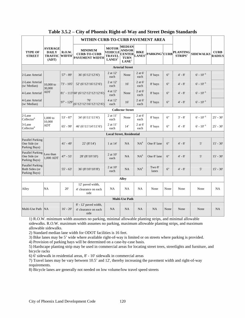
City of Phoenix Land Development Code 120
Table 3.5.2 City of Phoenix Right-of-Way and Street Design Standards
WITHIN CURB-TO-CURB PAVEMENT AREA
TYPE OF STREET
AVERAGE DAILY
TRAFFIC (ADT)
R.O.W. WIDTH1
MINIMUM
CURB-TO-CURB PAVEMENT WIDTH
MOTOR
VEHICLE TRAVEL LANES7
MEDIAN AND/OR CENTER
TURN LANE2
BIKE LANES3
PARKING4
CURB
PLANTING
STRIPS5 SIDEWALKS
CURB
RADIUS
Arterial Street
2-Lane Arterial 57' - 89'
36' (6'/12'/12'/6') 2 at 12'
each None
2 at 6' each
8' bays 6" 4' - 8' 6' - 10' 6
2-Lane Arterial (w/ Median)
73' - 105'
52' (6'/12'/16'/12'/6') 2 at 12'
each 16'
2 at 6' each
8' bays 6" 4' - 8' 6' - 10' 6
4-Lane Arterial 81 - 113'
60' (6'/12'/12'/12'/12'/6')
4 at 12' each
None 2 at 6' each
8' bays 6" 4' - 8' 6' - 10' 6
4-Lane Arterial (w/ Median)
10,000 to 30,000 ADT
97' - 129'
76' (6'/12'/12'/16'/12'/12'/6')
4 at 12' each
16' 2 at 6' each
8' bays 6" 4' - 8' 6' - 10' 6
Collector Street
2-Lane Collector8 53' - 87'
34' (6'/11'/11'/6') 2 at 11'
each None
2 at 6' each
8' bays 6" 3' - 8' 6' - 10' 6 25' - 30'
3-Lane Collector8
1,000 to 10,000 ADT 65' - 99'
46' (6'/11'/14'/11'/6') 2 at 11'
each 14
2 at 6' each
8' bays 6" 4' - 8' 6' - 10' 6 25' - 30'
Local Street, Residential
Parallel Parking One Side (or Parking Bays)
41' - 49'
22' (8'/14') 1 at 14' NA NA8 One 8' lane
6" 4' - 8' 5' 15' - 30'
Parallel Parking One Side (or Parking Bays)
47' - 55'
28' (8'/10'/10') 2 at 10'
each NA NA8 One 8' lane
6" 4' - 8' 5' 15' - 30'
Parallel Parking Both Sides (or Parking Bays)
Less than 1,000 ADT
55' - 63'
36' (8'/10'/10'/8') 2 at 10'
each NA NA8 Two 8'
lanes 6" 4' - 8' 5' 15' - 30'
Alley
Alley NA 20' 12' paved width,
4' clearance on each side
NA NA NA None None
None None NA
Multi-Use Path
Multi-Use Path NA 16' - 20'
8' - 12' paved width,
4' clearance on each side
NA NA NA NA None
None None NA
1) R.O.W. minimum width assumes no parking, minimal allowable planting strips, and minimal allowable sidewalks. R.O.W. maximum width assumes no parking, maximum allowable planting strips, and maximum allowable sidewalks. 2) Standard median lane width for ODOT facilities is 16 feet. 3) Bike lanes may be 5 wide where available right-of-way is limited or on streets where parking is provided. 4) Provision of parking bays will be determined on a case-by-case basis. 5) Hardscape planting strip may be used in commercial areas for locating street trees, streetlights and furniture, and bicycle racks 6) 6' sidewalk in residential areas, 8' - 10' sidewalk in commercial areas 7) Travel lanes may be vary between 10.5 and 12', thereby increasing the pavement width and right-of-way requirements. 8) Bicycle lanes are generally not needed on low volume/low travel speed streets
City of Phoenix Land Development Code 121
G. Traffic Signals and Traffic Calming Features
1. Traffic-calming features, such as roundabouts, curb extensions, narrow residential streets, and special paving may be used to slow traffic in neighborhoods and areas with high pedestrian traffic.
2. Traffic signals shall be required with development when traffic signal warrants are met, in conformance with the Highway Capacity Manual, and Manual of Uniform Traffic Control Devices. The location of traffic signals shall be noted on approved street plans. Where a proposed street intersection will result in an immediate need for a traffic signal, a signal meeting approved specifications shall be installed. The developer s cost and the timing of improvements shall be included as a condition of development approval.
H. Future Street Plan and Extension of Streets
1. A future street plan shall be filed by the applicant in conjunction with an application for a subdivision in order to facilitate orderly development of the street system. The plan shall show the pattern of existing and proposed future streets from the boundaries of the proposed land division and shall include other parcels within 600 feet surrounding and adjacent to the proposed land division. The street plan is intended to show potential future street extensions with future development
2. Streets shall be extended to the boundary lines of the parcel or tract to be developed, when the Planning Commission determines that the extension is necessary to give street access to, or permit a satisfactory future division of, adjoining land. The point where the streets temporarily end shall conform to a-c, below:
a. These extended streets or street stubs to adjoining properties are not considered to be cul-de-sacs since they are intended to continue as through streets when the adjoining property is developed.
b. A barricade (e.g., fence, bollards, boulders or similar vehicle barrier) shall be constructed at the end of the street by the subdivider and shall not be removed until authorized by the City or other applicable agency with jurisdiction over the street. The cost of the barricade shall be included in the street construction cost.
c. Temporary turnarounds (e.g., hammerhead or bulb-shaped configuration) shall be constructed for stub streets over 150 feet in length.
I. Street Alignment and Connections
1. Staggering of streets making "T" intersections at collectors and arterials shall not be designed so that jogs of less than 300 feet on such streets are created, as measured from the centerline of the street.
2. Spacing between local street intersections shall have a minimum separation of 125 feet, except where more closely spaced intersections are designed to provide an open space, pocket park, common area or similar neighborhood amenity. This standard applies to four-way and three-way (offset) intersections.
City of Phoenix Land Development Code 122
3. All local and collector streets that abut a development site shall be extended within the site to provide through circulation unless prevented by environmental or topographical constraints, existing development patterns, or compliance with other standards in this code. This exception applies when it is not possible to redesign or reconfigure the street pattern to provide required extensions. Land is considered topographically constrained if the slope is greater than 15% for a distance of 250 feet or more. In the case of environmental or topographical constraints, the mere presence of a constraint is not sufficient to show that a street connection is not possible. The applicant must show why the environmental or topographic constraint precludes some reasonable street connection.
4. Proposed streets or street extensions shall be located to provide direct access to existing or planned commercial services and other neighborhood facilities, such as schools, shopping areas and parks.
J. Sidewalks, Planter Strips, Bicycle Lanes. Sidewalks, planter strips, and bicycle lanes shall be installed in conformance with the standards in Table 3.5.2, applicable provisions of the Transportation System Plan and the adopted streetscape plans. Maintenance of sidewalks, curbs, and planter strips is the continuing obligation of the adjacent property owner.
K. Intersection Angles. Streets shall be laid out so as to intersect at an angle as near to a right angle as practicable, except where topography requires a lesser angle or where a reduced angle is necessary to provide an open space, pocket park, common area or similar neighborhood amenity. In addition, the following standards shall apply:
1. Streets shall have at least 25 feet of tangent adjacent to the right-of-way intersection unless topography requires a lesser distance;
2. Intersections which are not at right angles shall have a minimum corner radius of 20 feet along the right-of-way lines of the acute angle; and
3. Right-of-way lines at intersection with arterial streets shall have a corner radius of not less than 20 feet.
L. Existing Rights-of-Way. Whenever existing rights-of-way adjacent to or within a tract are of less than standard width, additional rights-of-way shall be provided at the time of subdivision or development, subject to the provision of Chapter 3.5.1 Purpose and Applicability, Section D.
M. Cul-de-sacs. Cul-de-sacs and dead-end streets shall not be allowed unless street extension is impossible due to environmental or topographical constrains or existing development patterns. A dead-end street shall be no more than 200 feet long:
1. All cul-de-sacs shall terminate with a circular or hammer-head turnaround. Circular turnarounds shall have a radius of 40 feet (i.e., from center to edge of pavement); except that turnarounds may be larger when they contain a landscaped island or parking bay in their center. When an island or parking bay is provided, there shall be a fire apparatus lane of 20 feet in width; and
2. The length of the cul-de-sac shall be measured along the centerline of the roadway from the near side of the intersecting street to the farthest point of the cul-de-sac.
City of Phoenix Land Development Code 123
N. Grades and Curves. Grades shall not exceed 10 percent on arterials, 12% on collector streets, or 12% on any other street (except that local or residential access streets may have segments with grades up to 15% for distances of no greater than 250 feet), and:
1. Centerline curve radii shall not be less than 700 feet on arterials, 500 feet on major collectors, 350 feet on minor collectors, or 100 feet on other streets; and
2. Streets intersecting with a minor collector or greater functional classification street, or streets intended to be posted with a stop sign or signalization, shall provide a landing with a slope averaging five percent or less. A landing is that portion of the street within 20 feet of the edge of the intersecting street at full improvement.
O. Curbs, Curb Cuts, Ramps, and Driveway approaches. Concrete curbs, curb cuts, wheelchair, bicycle ramps and driveway approaches shall be constructed in accordance with standards specified in Chapter 3.2 Access and Circulation.
P. Development Adjoining Arterial Streets. Where a development adjoins or is crossed by an existing or proposed arterial street, the development design shall separate residential access and through traffic, and shall minimize traffic conflicts. The design shall include one or more of the following:
1. A parallel access street along the arterial with a landscape buffer separating the two streets;
2. Deep lots abutting the arterial or collector to provide adequate buffering with frontage along another street. Double-frontage lots shall conform to the buffering standards in Chapter 3.2.2 Vehicular Access and Circulation, Section E;
3. Screen planting at the rear or side property line to be contained in a non-access reservation (e.g., public easement or tract) along the arterial; or
4. Other treatment suitable to meet the objectives of this subsection;
5. If a lot has access to two streets with different classifications, primary access shall be from the lower classification street, in conformance with Chapter 3.2.2 Vehicular Access and Circulation.
Q. Alleys, Public, or Private. Alleys shall conform to the standards in Table 3.5.2. While alley intersections and sharp changes in alignment shall be avoided, the corners of necessary alley intersections shall have a radius of not less than 12 feet.
R. Private Streets. Private streets shall not be used to avoid connections with public streets. Design standards for private streets shall conform to all applicable street standards.
S. Street Names. No street name shall be used which will duplicate or be confused with the names of existing streets in Jackson County except for extensions of existing streets. Street names, signs, and numbers shall conform to the established pattern in the surrounding area, except as requested by emergency service providers. The City must approve all street names and will assign all addresses.
T. Survey Monuments. Upon completion of a street improvement and prior to acceptance by the City, it shall be the responsibility of the developer's registered professional land surveyor to provide certification to the City that all boundary and interior monuments shall be reestablished and protected.
City of Phoenix Land Development Code 124
U. Street Signs. The city, county, or state with jurisdiction shall install all signs for traffic control and street names. The cost of signs required for new development shall be the responsibility of the developer. Street name signs shall be installed at all street intersections. Stop signs and other signs may be required.
V. Mailboxes. Plans for mailboxes to be used shall be approved by the United States Postal Service. The developer shall be responsible for installing the mailboxes at the time of development. The placement of mailboxes shall not encroach into sidewalk areas.
W. Street Light Standards. Streetlights shall be installed in accordance with City standards.
X. Street Cross-Sections. The final lift of asphalt or concrete pavement shall be placed on all new constructed public roadways prior to final City acceptance of the roadway and within one year of the conditional acceptance of the roadway unless otherwise approved by the City Engineer. The final lift shall also be placed no later than when 50% of the structures in the new development are completed or two years from the commencement of initial construction of the development, whichever is less.
1. Sub-base and leveling course shall be of select crushed rock;
2. Surface material shall be of Class C or B asphaltic concrete;
3. The final lift shall be Class C asphaltic concrete as defined by A.P.W.A. standard specifications; and
5. No lift shall be less than 1-1/2 inches in thickness.
3.5.3 Public Use Areas
A. Dedication Requirements
1. Where a proposed park, playground or other public use shown in a plan adopted by the City is located in whole or in part in a subdivision, the City may require the dedication or reservation of this area on the final plat for the subdivision.
2. If determined by the Planning Commission or the City Council to be in the public interest in accordance with adopted comprehensive plan policies or where an adopted plan of the City does not indicate proposed public use areas, the City may require the dedication or reservation of areas within the subdivision of a character, extent, and location suitable for the development of parks and other public uses.
3. All required dedications of public use areas shall conform to Chapter 3.5.1 Purpose and Applicability, Section D (Conditions of Development Approval).
B. Acquisition by Public Agency. If the developer is required to reserve land area for a park, playground, or other public use, the land shall be acquired by the appropriate public agency within two years following final plat approval, at a price agreed upon prior to approval of the plat, or the reservation shall be released to the property owner.
C. System Development Charge Credit. Dedication of land to the City for public use areas shall be eligible as a credit toward any required system development charge.
City of Phoenix Land Development Code 125
3.5.4 Sanitary Sewer and Water Service Improvements
A. Sewers and Water Mains Required. Sanitary sewers and water mains shall be installed to serve each new development and to connect developments to existing mains in accordance with the City s construction specifications and the applicable Comprehensive Plan policies.
B. Sewer and Water Plan approval. Development permits for sewer and water improvements shall not be issued until the City Engineer has approved all sanitary sewer and water plans in conformance with City standards.
C. Over-sizing. Proposed sewer and water systems shall be sized to accommodate additional development within the area as projected by the Comprehensive Plan. The developer shall be entitled to system development charge credits for the over-sizing.
D. Permits Denied. Development permits may be restricted by the City where a deficiency exists in the existing water or sewer system which cannot be rectified by the development and which if not rectified will result in a threat to public health or safety, surcharging of existing mains, or violations of state or federal standards pertaining to operation of domestic water and sewerage treatment systems. Building moratoriums shall conform to the criteria and procedures contained in ORS 197.505.
3.5.5 Utilities
A. Underground Utilities. All utility lines including, but not limited to, those required for electric, communication, lighting and cable television services and related facilities shall be placed underground, except for surface mounted transformers, surface mounted connection boxes and meter cabinets which may be placed above ground, temporary utility service facilities during construction, and high capacity electric lines operating at 50,000 volts or above. The following additional standards apply to all new subdivisions, in order to facilitate underground placement of utilities:
1. The developer shall make all necessary arrangements with the serving utility to provide the underground services. Care shall be taken to ensure that above ground equipment does not obstruct vision clearance areas for vehicular traffic. (Chapter 3.2.2 Vehicular Access and Circulation, Section M);
2. The City reserves the right to approve the location of all surface mounted facilities;
3. All underground utilities, including sanitary sewers and storm drains installed in streets by the developer, shall be constructed prior to the surfacing of the streets; and
4. Stubs for service connections shall be long enough to avoid disturbing the street improvements when service connections are made.
B. Easements. Easements shall be provided for all underground utility facilities.
C. Variances to Under-Grounding Requirement. The standard applies only to proposed subdivisions. A variance to the under-grounding requirement may be granted due to physical constraints, such as steep topography or existing development conditions.
3.5.6 Easements
Easements for sewers, storm drainage and water quality facilities, water mains, electric lines or other public utilities shall be dedicated on a final plat, or provided for in the deed restrictions.
City of Phoenix Land Development Code 126
See also, Chapter 4.2 Development Review and Site Design Review, and Chapter 4.3 Land Divisions and Lot Line Adjustments. The developer or applicant shall arrange with the City, the applicable district, and each utility franchise for the provision and dedication of utility easements necessary to provide full services to the development. The City's standard width for public main line utility easements shall be 10 feet unless otherwise specified by the utility company, applicable district, Public Works Director, or City Engineer.
3.5.7 Construction Plan Approval and Assurances
No public improvements, including sanitary sewers, storm sewers, streets, sidewalks, curbs, lighting, parks, or other requirements shall be undertaken except after the plans have been approved by the City, permit fee paid, and permit issued. The permit fee is required to defray the cost and expenses incurred by the City for construction and other services in connection with the improvement. The permit fee shall be set by City Council. The City may require the developer or subdivider to provide bonding or other performance guarantees to ensure completion of required public improvements. All public improvement construction must follow the procedure in Chapter 4.3.8 Public Improvements, Section B.
3.5.8 Installation
A. Conformance Required. Improvements installed by the developer either as a requirement of these regulations or at his/her own option, shall conform to the requirements of this Chapter, approved construction plans, and to improvement standards and specifications adopted by the City.
B. Adopted Installation Standards. The Standard Specifications for Public Works Construction, Oregon Chapter A.P.W.A. shall be a part of the City's adopted installation standards; other standards may also be required upon recommendation of the City Engineer.
C. Commencement. Work shall not begin until the City has been notified in advance.
D. Resumption. If work is discontinued for more than one month, it shall not be resumed until the City is notified.
E. City Inspection. Improvements shall be constructed under the inspection and to the satisfaction of the City. The City may require minor changes in typical sections and details if unusual conditions arising during construction warrant such changes in the public interest. Modifications requested by the developer shall be subject to land use review under Chapter 4.6 Modifications to Approved Plans and Conditions of Approval. Any monuments that are disturbed before all improvements are completed by the subdivider shall be replaced prior to final acceptance of the improvements.
F. Engineer s Certification and As-Built Plans. A registered civil engineer shall provide written certification in a form required by the City that all improvements, workmanship, and materials are in accord with current and standard engineering and construction practices, conform to approved plans and conditions of approval, and are of high grade, prior to City acceptance of the public improvements, or any portion thereof, for operation and maintenance. The developer s engineer shall also provide two sets of as-built plans, in conformance with the City Engineer s specifications, for permanent filing with the City.
City of Phoenix Land Development Code 127
Chapter 3.6 Signs
Sections:
3.6.1 Purpose 3.6.2 Sign Permits 3.6.3 Definitions and Calculation Standards 3.6.4 Prohibited Signs for All Districts 3.6.5 Nonconforming Sign and Abandoned Signs 3.6.6 Zoning District Sign Standards 3.6.7 Sign Variance Criteria
3.6.1 Purpose
It is the purpose of this Chapter to regulate signs in a manner which recognizes and balances the commercial need for signs with other visual, aesthetic and safety concerns of the community and to establish standards for the design, construction, placement, number, height, size and maintenance of all signs and sign structures. The provisions of the Phoenix sign code shall apply to all signs located within the jurisdiction of the city.
3.6.2 Sign Permits
A. Permits Required
Except as otherwise provided in this Chapter, it shall be unlawful for any person to construct, erect, alter or relocate a sign, or direct an employee or agent to do same within the city without first obtaining a permit for each separate sign from the Planning Department as required by this Chapter.
The Oregon Motorist Information Act regulates the location of signs visible to state highways and transportation facilities. Outdoor Advertising Signs (OAS) visible from state transportation facilities, exclusive of on-premise and temporary signs, shall require OAS permits from the Oregon Department of Transportation (ODOT), as administered by the ODOT Sign Program.
B. Application.
No application shall be considered, nor permit issued, until the applicant has submitted a complete application. When required, the applicant shall submit proof that work will be done by a contractor licensed in compliance with local or state law to perform the specialized tasks required for construction of the proposed sign.
Application for a permit shall be made to the Planning Department upon a form provided by the City with signatures of the property owner of record, the business owner, and the sign company. A complete application shall include the following:
1. Single Business Signs shall submit the following:
a) A set of plans for the proposed sign and structural calculations where required.
b) Location of the sign on the building or building site.
c) Dimensions of the sign.
d) Construction materials and a color rendering or photograph of each sign.
City of Phoenix Land Development Code 128
e) Method of attachment and character of structural members to which attachment is to be made.
f) Electrical wiring and components or U.L. approved number.
g) Ingress and Egress and sight visibility triangles.
2. Master Sign Programs are required for all multi-business or multi-building sites and shall submit the following:
a) An accurate plot plan of the parcel at scale.
b) Elevations and square footage computations of the buildings.
c) Ingress and Egress and sight visibility triangles.
d) An accurate location of each present and future sign.
e) Computation of the total number of ground signs, total sign area, and the elevation and height of the ground signs.
f) Computation of the maximum number of wall signs and total sign area.
g) To scale drawings, sign lettering, dimensions, color renderings, method of attachment, footings and electrical wiring and components or U.L. approved number requirements for each sign.
The Building Safety Official may also require that a licensed engineer furnish information concerning structural design and proposed attachments. Signs more than 10 feet above grade, except wall signs painted on walls, shall be structurally designed by an architect or engineer licensed in the state of Oregon and bearing the architect's or engineer's seal. All signs, except for signs painted directly upon a building, are also subject to Building Department requirements.
C. Processing Permit Applications.
1. The Planning and Building Departments shall approve a sign permit upon finding that the applicant has met all requirements of the sign standards.
2. No sign construction shall begin unless the approved permit has been issued and the applicant has paid all fees.
3. Unless the permit holder requests an extension of the permit and demonstrates good cause for such an extension, a sign permit shall expire if the sign construction or other work authorized by a sign permit is not completed within one year of the date of issue.
4. No sign construction shall be considered complete until the permit holder has notified the city that work is finished and the city is satisfied that the sign construction has been completed in conformity with the approved plans and otherwise complies with the sign standards.
5. If a permit is denied, the applicant shall receive a notice of denial in writing, setting forth the reasons for the denial. A decision granting or denying a sign permit may be appealed to the Planning Commission in accord with the variance and appeal process defined in Chapter 5 of the Development Code.
City of Phoenix Land Development Code 129
6. No additional permits shall be issued for signs on businesses or uses with signs not already in compliance with the sign code unless the applicant can prove existing signs are legal nonconforming.
D. Indemnification of City. As a condition to the issuance of a sign permit as required by this Chapter, all persons engaged in the hanging or painting of signs, which involves, in whole or in part, the erection, alteration, relocation, maintenance, or other sign work in, over, or immediately adjacent to a public right-of-way or public property if used or encroached upon by the sign hanger or painter in the said sign work, shall agree to hold harmless and indemnify the City, its officers, agents, and employees from liability for damages resulting from said erection, alteration, relocation, maintenance or other sign work.
E. Exemptions to sign permits. The following signs and related activities may be allowed and shall be exempt from the need to obtain a sign permit. These signs are permitted signs in all sign districts, except as otherwise noted. Use of these signs does not affect the amount or type of signage otherwise allowed by the sign standards.
1. Maintenance that does not alter a sign or sign structure shall not require a sign permit. This also includes change of face, where an existing sign is modified by change of message or design on the sign face, without any change to size or shape of the sign framework or structure.
2. Contractor/consultant signs. One sign per contractor/consultant while a building permit is active and work is proceeding on the premises. The total amount of signage shall not exceed 36 square feet.
3. Flags of national, state, or local government.
4. Holiday decorations and lights in place during National and local Holidays.
5. Mosaic, mural, painting, or graphic art, flags (excluding pennants), and fabric wall decorations that do not contain copy, advertising/hallmark symbols, lettering or references to any product, service, or goods, do not require a permit, however, they will require permission from the Planning Commission and may be counted towards the business's sign allotment.
6. Parking lot signs up to three square feet in area and up to five feet in height may be constructed or placed within a parking lot for the purpose of directing traffic, parking, and towing. Parking lot signs shall not include any corporate wording or logos unless they are included in the allotted project signage.
7. Public signs. Signs constructed or placed in a public right-of-way by or with the approval of a governmental agency having legal control or ownership over the right-of-way, signs owned or constructed under the direction of the city, and signs placed by a public utility for the purpose of providing information concerning a pole, line, pipe, or other facility belonging to the public utility may be allowed.
City of Phoenix Land Development Code 130
8. Real Estate Signs. One sign per street frontage may be allowed; residential is limited to 12 square feet or less in area, and must be located on the development site where the property is for sale or lease. Commercial and Industrial District signs are not to exceed 32 square feet in area when advertising the sale, rental, or lease of the premises on which they are located. Open house signs are allowed off-site for one day provided they are not located on City right-of-way, including pedestrian areas, or with-in sight visibility triangles.
9. Signs during elections. Signs 12 square feet or less in area, located on private property during the period from 60 days before to five days after any public election to be held in Oregon.
10. Stadium signs. Signs located within a sport stadium that are intended for viewing primarily by persons within such stadium.
11. Vehicular signs. Any sign permanently or temporarily placed on or attached to a motor vehicle, where the vehicle is used in the regular course of business for purposes other than the display of signs, subject to compliance with the following conditions:
a) The Vehicle/equipment is in operating condition, currently registered and licensed to operate on public streets when applicable, and actively used in the daily function of a business/or use.
b) Vehicles and equipment are not used as static displays, for more than 24 hours in any location, nor utilized as storage, shelter or distribution points for commercial products or services for the general public.
c) Vehicles and equipment engaged in active construction projects and the on-premise storage of equipment and vehicles offered to the general public for rent or lease shall not be subjected to this condition.
d) The parking of the vehicle at the owner's residence is exempt from the above criteria.
12. Wall signs located within a commercial center or multi-family development that cannot be viewed from the street or adjacent properties and are intended for persons already on the development site.
13. Temporary signs announcing the opening of a new business are allowed upon notification to the City, for period of 60 days starting with the day application is made for the permanent sign with the potential for an additional 30-day extension.
3.6.3 Definitions and Calculation Standards
For the purposes of calculation of all areas and distances under the sign standards, the following definitions and standards apply:
City of Phoenix Land Development Code 131
A. Definitions
1. Abandoned Sign. Any sign which no longer gives correct directions to, location of, description of a business, service or activity performed, or product sold or a sign not being properly maintained. Any sign that is related to a business, service, activity or product that has not been operating for a period of 90 days or that is related to a business activity that has relocated, shall be considered an abandoned sign. A sign associated with a vacant business or property that is advertised and marketed for sale or lease shall not be considered abandoned.
2. Business frontage. The lineal footage of a building or portion thereof, devoted to a specific business or enterprise.
3. Ground or Pole Signs. A sign erected on a freestanding frame, mast, or pole and not attached to any building, also known as a freestanding sign.
4. Monument Sign. A freestanding sign that does not have exposed pole or pylon and is attached to a continuous structural base. The base is not less than half the width of the message portion of the sign and is permanently affixed to the ground. Monument sign bases include material consistent with the principle structure, including brick, block, and concrete, but excluding metal.
5. Nonconforming Sign. An existing sign, lawful at the time of the enactment of this ordinance, which does not conform to the requirements of this code.
6. Projecting and Suspended Signs. Projected signs are attached to a building or wall in such a manner that its leading edge extends more than six inches beyond the surface of such building. Suspended signs are suspended from the underside of a horizontal plane surface.
7. Sign. Any message, identification, description, illustration, symbol, device, or sculptured matter, including forms shaped to resemble any human, animal, or product, which is affixed directly or indirectly upon a building, vehicle, structure, or land.
8. Sign Height. The sign height is the vertical distance from the grade to the highest point of a sign or sign structure.
9. Sign structure. The supports, uprights, braces, framework, and other structural components of the sign.
10. Temporary Sign. A sign that is used only temporarily and is not permanently mounted.
11. Wall Signs. A sign painted or attached to any part of a building, or mounted/painted upon the inside of windows within all commercial or industrial zoning districts. Wall signs include parapet signs, awning/canopy signs, projecting/suspended signs, and marquee signs that are attached to the marquee.
B. Criteria for Definitions and Measurement Standards
1. Wall Signs
a. No part of the sign shall extend vertically above the highest portion of the roof's calculated elevations (except for parapet signs).
City of Phoenix Land Development Code 132
b. Marquee signs. A marquee is any permanent roof-like structure projecting beyond the perimeter wall of a building, and signs shall not be located above the top of the marquee.
c. Parapet Signs. Parapets or false fronts are measured by the linear frontage of the parapet.
d. Roof Elevations. Signs are not allowed above the roofline's elevation, which is determined by the highest point of the roof surface for flat roofs; and to the average height between eaves and ridges for gable, hip, gambrel roofs, and mansard roofs.
e. The area of a wall sign without a border shall be computed by enclosing the entire sign within sets of parallel lines touching the outer limits of the sign message.
f. Perimeter walls. The exterior wall of a building shall be measured at the floor level of each floor, including the ground floor. Alcoves, entryways and extruding portions shall be treated by measuring through such areas as though along the flat wall of a building.
2. Projecting and Suspended Signs.
a. Projecting and suspended signs are considered part of the aggregate for wall signs.
b. The area of projecting sign or a suspended sign shall be calculated by adding the outer area of all the faces presenting a sign message. Double-faced signs will be calculated as one sign and may not be more than 18 inches in width.
3. Ground or Pole Signs.
a. The area of a ground or projecting sign shall be calculated by adding the outer area of all the faces presenting a sign message. Pole covers, and columns shall not be included in the area of the measurement if they do not bear advertising copy. Double-faced signs will be calculated as one sign only when placed back to back and are not separated by more than 18 inches.
b. Street frontage. Street frontage is calculated for ground/pole signs only. Development sites fronting on two or more streets are allowed the number of signs permitted for each street frontage. However, the total number of signs that are oriented toward a particular street may not exceed street frontage allotment. Interstate 5 is not considered a street for sign purposes, and cannot be counted towards frontage allotments.
4. Flags. Any fabric, banner, or bunting flags containing distinctive colors, patterns, or symbols, other than U.S., state, and local government flags, shall be limited to the wall and ground/pole sign allotments, unless otherwise approved by the Planning Commission. Flags on poles may be counted towards the ground sign allotment. Flags on buildings (not on poles) may be calculated as part of the building's or business's linear footage allotment and may not be placed above the roofline.
C. Illumination Standards
1. Maximum exposed illumination. No single light source element, which exceeds 15 watts, shall be used in connection with a sign or to illuminate a sign in a way that exposes the face of the bulb, light, or lamp when viewed from a public street.
City of Phoenix Land Development Code 133
2. Glare reduction. No sign may be illuminated or use lighting where such lighting is directed at any portion of a traveled street or will otherwise cause glare or impair the vision of the driver of a motor vehicle or otherwise interfere with the operation thereof.
3. Illumination from signs on nonresidential property. Illumination resulting from all signs and lighting on any property in a non-residential zoning district shall not cause glare towards the residential zoning districts. External illumination shall be shielded so that the light source elements are not directly visible from property in a residential zoning district that is adjacent to or across a street from the property in the non-residential zoning district.
4. Illumination from signs on residentially zoned property. No internally illuminated sign shall be allowed on property in a residential zoning district. Lighting from all light sources operated for the purposes of sign illumination on property in a residential zoning district shall be shielded from other property in the residential zoning district.
D. Electronic Message Centers
Except electronic message centers operated as public signs by governmental agencies, no electronic message center, or portion of a sign used as an electronic message center shall be larger than 12 square feet in area, and shall not change the image or any movement at intervals of less than once every 60 seconds.
E. Vision Clearance and Safety Standards
1. Signs must comply with the sight visibility standards within the Development Code.
2. The minimum clearance of all signs projecting over a pedestrian way shall be eight feet.
3. Clearance over vehicle use area. The minimum clearance of all signs projecting over any portion of a vehicle use area shall be 17 feet.
3.6.4 Prohibited Signs for All Districts
The following signs are prohibited for all zoning districts; are unlawful, and shall be considered nuisances:
A. Any sign constructed, maintained, or altered in a manner not in compliance with the sign standards.
B. A ground or pole sign may not be placed on undeveloped property (property without a permanent occupiable structure) nor can a wall sign be placed on a vacant structure unless it is a for sale or lease sign for that structure.
C. Any sign constructed or maintained that, because of its size, location, movement, coloring or manner of illumination, may be confused with or construed as a traffic control device or which hides from view any traffic control device.
D. Permanent & roof mounted Balloons. Anchored balloons, and Inflatable signs are prohibited.
E. Flashing signs (except electronic message centers). A sign incorporating intermittent electrical impulses to a source of illumination or revolving in a manner which creates the illusion of flashing, or which changes colors or intensity of illumination.
F. Portable signs, except warning signs.
City of Phoenix Land Development Code 134
G. Strings of lights are not permitted unless they qualify as holiday decorations that are in place during National and local Holidays.
H. Signs in the public right-of-way not authorized by a governmental agency.
I. Moving or rotating signs are prohibited.
J. Paper signs are prohibited.
K. Pennants which are defined as any lightweight plastic, fabric, or other material, whether or not containing a message of any kind, suspended from a rope, wire, or string, usually in series, designed to move in the wind are prohibited.
L. Roof Signs are not allowed to extend vertically above the highest portion of the roof. Roof signs must follow 3.6.3.B for measuring roof elevations.
M. Any ground sign that is to be installed as to extend through a portion of a building or roof, with the sign being mounted above the roof, and appearing similar to a roof sign is prohibited.
3.6.5 Nonconforming Sign and Abandoned Signs
A. Nonconforming Signs
1. Nonconforming signs may be maintained subject to the following conditions:
a. No additions or enlargements may be made to a nonconforming sign except additions or enlargements required by law.
b. If any nonconforming sign is moved voluntarily, that sign shall thereafter conform to the requirements of the sign standards as a newly constructed sign.
c. Any sign that is constructed to replace a nonconforming sign shall be constructed in compliance with all applicable provisions of the sign standards.
2. Except where only a change in display copy is made, any nonconforming sign, which is structurally altered (excluding routine maintenance), shall be brought into compliance with all applicable provisions of the sign standards within 90 days of written notice sent by the City and shall thereafter be kept in compliance with the sign standards.
3. Any nonconforming abandoned sign and supporting structure shall be removed by the owner of the sign or owner of the premises within three months following a business closure or event that has been closed for more than 30 days.
B. Maintenance. All signs, together with all of their supports, braces, guys, anchors and electrical equipment, shall be kept fully operable, in good repair and maintained in safe condition, free from excessive rust, corrosion, peeling paint or other surface deterioration.
3.6.6 Zoning District Sign Standards
No sign permit shall be issued for any sign unless specifically identified as an allowable sign within the zoning district or otherwise allowed under Chapter 3.6.5 Nonconforming Sign and Abandoned Signs, Section A or under Chapter 3.6.2 Sign Permits, Section E (Exemptions).
City of Phoenix Land Development Code 135
A. Signs in the Residential Zoning District
1. Signage Objectives in the Residential Sign District. The residential sign district is hereby created and applied to all land zoned for residential and for mixed-uses as set forth below.
2. Basic Standards. Signage is limited to preserve the residential character of the districts by allowing signs only for multi-family residential, subdivision identification signs, neighborhood identification sign and for those uses that are allowed under conditional use permits such as churches, schools, bed and breakfasts, and community centers.
a. Signs within a residential sign district shall be limited to the following types:
1) Ground signs within a landscaped bed.
2) Wall signs.
3) Temporary signs (real estate and construction signs).
b. Maximum Number of Signs. The number of signs on property in a residential sign district shall be based on the number of street frontages and shall be limited to no more than the following amounts for each street frontage:
1) One wall sign per building frontage or street frontage, with a total not to exceed two signs.
2) One ground sign for each development site or parcel.
3) One temporary subdivision sign or planned unit development sign for each development site planned or used as subdivision or planned unit development. Such temporary sign must be constructed in connection with the offer for sale of any parcel or unit and may remain in place for one year, subject to renewal for no more than one additional year at a time where parcels or units remain unsold.
c. Maximum Sign Area and Maximum Height. Signs in the residential and mixed-use sign districts shall be subject to the size limitations below:
1) Ground or monument signs shall be no more than 16 square feet per face with a limit of two faces no more than 18" in depth, and shall be no more than five feet in height, and setback a minimum of five feet from any street right-of-way.
2) Wall signs shall be no more than 12 square feet in area.
3) Temporary undeveloped Subdivision/Planned Unit Development Signs: Two non-illuminated ground signs, not exceeding 32 square feet in area, and 8 feet in height and setback a minimum of 20 feet from any property line are permitted within an undeveloped subdivision/ planned unit development. Such signs may be installed on the undeveloped subdivision/planned unit development property after approval of the tentative plat by the Planning Commission. However, the sign must be removed no later than two years after installation, unless the Planning Commission, upon due application prior to expiration of the two-year period, determines that the continued maintenance of the sign is consistent with the purpose of this code, in which case an extension for an additional year may be granted.
City of Phoenix Land Development Code 136
4) Public Use Signs: Each lot occupied by public uses, including schools and churches, are allowed a maximum of 28 square feet of sign area per street frontage. The maximum area may include a combination of wall and monument signs. If a monument sign is included, the sign shall not be located within 15 feet of any property line, and be no more than 18 inches in depth, with a maximum height of eight feet. Signs within public parks, schools, or stadiums, which are generally placed and located so as not to be viewed from a street, are exempt from this provision.
5) One banner may be installed on the exterior wall of an approved conditional use (schools, churches, public buildings, etc.) where an event (grand opening, promotional opening etc.) is being held. The banner may be installed for up to 15 days for the event and shall be removed after the event. It shall be a flat wall mounted plastic or canvas sign, and may be up to 32 square feet in surface area. Banners may not be paper and cannot be used to advertise products.
6) One permanent neighborhood identification sign is allowed per neighborhood. This sign shall be a monument sign and shall be a maximum of 16 square feet and a maximum of five feet in height.
7) A Bed and Breakfast Inn may have one sign. This sign shall be attached to the dwelling, shall not be internally illuminated, and shall not be in excess of three square feet in area.
B. Signs In Bear Creek Greenway District (BCG). The designation of lands within the BCG ensures the protection of wildlife habitat and open space. Signs shall be permitted for identification, information, or direction only. In no case shall a sign be permitted that advertises products or services of any kind. All signs shall be designed for maximum visual and aesthetic compatibility with the Greenway environment.
C. Signs in the Commercial C-H, Commercial Highway District
1. Wall Signs, Awning/Canopy and Marquee Signs: These signs are permitted, subject to using the calculation standards set forth in Chapter 3.6.3 Definitions and Calculation Standards, Section B, and the following limitations:
a. The aggregate area of all signs shall not exceed one and one-half square feet for each linear foot of business frontage, except if the building is set back more than 20 feet from the right-of-way, in which case the aggregate area of all signs shall not exceed two square feet for each linear foot of business frontage.
b. No part of any sign shall be higher than the roof height as defined in Chapter 3.6.3
Definitions and Calculation Standards, Section B.
2. Projecting Signs: These signs are permitted, subject to using the calculation standards set forth in Chapter 3.6.3 Definitions and Calculation Standards, Section B, and the following limitations:
a. No sign shall project more than 18 inches into the public right-of-way.
b. The sign is less than 25 square feet in area.
City of Phoenix Land Development Code 137
c. No part of any sign shall be higher than the approved roof height as defined in Chapter 3.6.3 Definitions and Calculation Standards, Section B.
3. Ground/Pole Signs. Each parcel of land is permitted one ground/pole sign per street frontage, locating only one sign on each street frontage, with a maximum of two signs per parcel, subject to using the calculation standards set forth in Chapter3.6.3 Definitions and Calculation Standards, Section B, and the following limitations:
a. Maximum Height: 18 feet
b. Maximum Square Footage: 32 square feet per sign with a maximum of two faces not more than 18 inches in depth.
c. Minimum Setback: Shall not project into public right-of-way.
4. Retail/Shopping Center and Business Complex Master Sign Program. A Retail/Shopping Center or Business Complex is a group of two or more commercial establishments having common parking facilities. The shopping center sign limitations are created to accommodate the commercial needs and must take into consideration the residential areas that are in close proximity to most shopping centers. A Master Sign Program should be established to provide consistent and equitable signing for all tenants in a complex or development. The Master Sign Program must comply with the submittal requirements in Chapter 3.6.2 Sign Permits, Section B.
5. Retail/Shopping Center, and Business Complex Ground Signs Criteria. In the case of shopping centers or business complexes that are developed as a unit with common parking areas, one ground sign, and one monument sign are permitted per center/complex, and also requires joint use of the signs. The master sign program for the center shall indicate the ability for all tenants to use the monument sign for business identification. The pole/ground sign shall identify the center. The size of the ground signs shall be determined as follows: For centers/complexes that have more than 10,000 square feet but less than 25,000 square feet of gross floor area, one sign may be up to 40 square feet in area and 20 feet in height. For centers/complexes that have gross floor area between 25,000 square feet and 50,000 square feet, one sign may be up to 75 square feet in area and 35 feet in height. For centers/complexes that have gross floor area that exceeds 50,000 square feet, two signs may be placed up to 75 square feet in area each at a maximum of 35 feet in height, and no less than 50 feet apart. The monument sign shall be no larger than 32 square feet and eight feet in height and shall be located in a landscaped bed.
D. I-5 Overlay District. The I-5 (Interstate 5) overlay zone is established to permit signs visible to travelers on the freeway. It recognizes a special dependence of freeway-oriented businesses to this market. Freeway signs shall be regulated in order to avoid adverse scenic impacts on the vista east of Phoenix and the Bear Creek Greenway. The I-5 overlay zone shall be applied to lots within one quarter of a mile of the center of Interstate 5 interchange that are zoned Commercial Highway.
I-5 is not considered a street and cannot be counted as a street frontage. A larger alternative sign (not in addition to the number of ground signs allowed in the underlay district) shall be permitted. In addition to the freeway sign, a monument sign for business identification and
City of Phoenix Land Development Code 138
addressing shall be permitted. A ground or pole sign in the freeway overlay zone is subject to the basic regulations in the underlying zone with the following exceptions:
1. One ground sign not exceeding 150 square feet in area and 50 feet in height is permitted on each parcel of land with street frontage located within the Freeway Overlay District. Businesses that have more than one parcel and are developed as a center/complex (more than two businesses) must share the sign pole and are allowed one freeway and one monument sign.
2. Signs with more than two sides are prohibited.
3. If Freeway signs are lit, they shall be internally illuminated. Flashing lights and electronic reader boards are prohibited.
4. The monument sign shall be no larger than 32 square feet and eight feet in height and shall be located in a landscaped bed.
E. Sign standards in the City Center. (These standards were taken from the adopted City Center Plan). The City Center Plan provides for mixed residential and commercial land uses and provides linkages to the Bear Creek Greenway and to older established residential neighborhoods located adjacent to the downtown core. The overall design guidelines are based upon the retention of the City's farm community identity.
1. Signage Objectives:
a. To include a non-obtrusive variety of signs that are designed at both pedestrian and vehicular scales.
b. Signs should be in the character of a small town, usually painted on buildings or painted on signboards hung off buildings with metal or wood brackets.
2. Wall Signs, Awning/Canopy, and Marquee signs. These signs are permitted, subject to using the calculation standards set forth in Chapter 3.6.3 Definitions and Calculation Standards, Section B, and the following limitations:
a. Signs are to be painted metal, wood or canopy signs.
b. The aggregate area of all signs shall not exceed one square foot for each linear foot of business frontage, except if the building is set back more than 20 feet from the right-of-way, in which case the aggregate area of all signs shall not exceed one and one-half square foot for each linear foot of business frontage. No part of any sign shall be higher than the roof height as defined in Chapter 3.6.3 Definitions and Calculation Standards, Section B.
3. Projecting Signs: These signs are permitted, subject to using the calculation standards set forth in Chapter 3.6.3 Definitions and Calculation Standards, Section B, and the following limitations:
a. No sign shall project more than eight inches into the public right-of-way.
b. The sign is less than 10 square feet in area.
c. No part of any sign shall be higher than the approved roof height as defined in Chapter 3.6.3 Definitions and Calculation Standards, Section B.
City of Phoenix Land Development Code 139
d. Signs for pedestrian visibility at right angles to the building shall be suspended by metal or wood brackets.
4. Ground/Monument Signs: Each parcel of land is permitted one ground/monument sign per street frontage to be located within a landscaped bed, is subject to using the calculation standards set forth in Chapter 3.6.3 Definitions and Calculation Standards, Section B, and the following limitations:
a. Maximum Height: eight feet
b. Maximum Square Footage: 20 square feet per sign with a maximum of two faces not more than 18 inches in depth.
c. Minimum Setback: Shall not project into public right-of-way.
F. Additional Special Signs for Commercial/Business Districts
a. Service Station Signs: One additional ground sign for the advertisement of gasoline prices, not to exceed 50 square feet in area and nine feet in height for any single parcel of land occupied by a service station. Such signs may not project into public right-of-way.
b. Drive-up Window Business Sign: Two additional ground signs not to exceed 32 square feet in area and six feet in height for the food menus located by a drive-up window business. Such signs may not project into public right-of-way. Portable signs advertising specials etc. are forbidden.
c. Construction Sign: Up to two additional non-illuminated signs may be installed after a building permit has been obtained for a construction project and must be removed not later than one year after issuance of the building permit for the project or upon completion of the project, whichever is sooner. Each sign shall have an area not exceeding 75 square feet, and the top of the sign shall not be more than 10 feet above the general surface of the ground. Not more than two such signs shall be erected for each construction project and such signs shall be subject to the same setback requirements as are imposed for structures in this zone.
d. Temporary/Banner Signs: One Temporary sign may installed if the business owner has a valid sign permit but is waiting for the completion of the permanent sign. Display period is limited to 30 days, but may be extended with permission from the Planning Department.
One banner sign may be installed on the exterior wall of a business where an event (grand opening, promotional opening etc.) is being held. The area of any temporary sign shall not exceed 32 square feet. No part of any sign shall be higher than the roof height as defined in Chapter 3.6.3 Definitions and Calculation Standards, Section B, Display period is limited to 15 days and shall be removed after the event, a business is allowed four permits in one calendar year. Banners may not be paper, shall be a flat, wall-mounted, plastic or canvas sign, and cannot be used to advertise products.
G. Signs in the Industrial Zones
1. Ground Signs are subject to using the calculation standards set forth in Chapter 3.6.3
Definitions and Calculation Standards, Section B, and the following limitations:
City of Phoenix Land Development Code 140
a. Maximum Height: 24 feet
b. Maximum Square Footage: 100 square feet per sign
c. Minimum Setback: Sign shall not project into public right-of-way.
d. Maximum Number: No more than one free-standing sign shall be permitted on any single lot, except if the lot has more than one street frontage, two signs may be allowed, locating only one sign on each street.
2. Wall, Parapet, Awning/Canopy, or Marquee Signs. The aggregate area of all signs shall not exceed one and one-half square feet for each linear foot of business frontage, except if the building is set back more than 20 feet from the right-of-way, in which case the aggregate area of all signs shall not exceed two square feet for each linear foot of business frontage. No part of any sign shall be higher than the roof height as defined in Chapter 3.6.3 Definitions and Calculation Standards, Section B.
3. Projecting Signs:
a. No sign shall project more than 18 inches into the public right-of-way.
b. The sign must be less than 25 square feet in area.
c. No part of any sign shall be higher than the roof height as defined in Chapter 3.6.3
Definitions and Calculation Standards, Section B.
d. Construction Signs: Such a sign may be installed after a building permit has been obtained for a construction project and must be removed not later than two years after issuance of the building permit for the project or completion of the project, whichever is sooner. The non-illuminated sign shall have an area not exceeding 75 square feet, and the top of the sign shall not be more than 10 feet above the general surface of the ground. Not more than two such signs shall be erected for each construction project and such sign shall be subjected to the same setback requirements as are imposed for structures in this zone.
e. Temporary/Banner Signs: One Temporary sign may be installed if the business owner has a valid sign permit but is waiting for the completion of the permanent sign. Display period is limited to 30 days, but may be extended with permission from the Planning Department. One banner sign may be installed on the exterior wall of a business where an event (grand opening, promotional opening etc.) is being held. The area of any temporary sign shall not exceed 32 square feet. No part of any sign shall be higher than the roof height as defined in Chapter 3.6.3 Definitions and Calculation Standards, Section B. Display period is limited to 15 days and shall be removed after the event. A business is allowed four permits in one calendar year. Banners may not be paper, it shall be a flat wall mounted plastic or canvas sign, and cannot be used to advertise products.
3.6.7 Sign Variance Criteria
In order to obtain a Variance from the terms of the ordinance, the applicant must be able to show the following:
A. The Variance is necessary because of special circumstances relating to the size, shape, topography, location, or surroundings of the subject property to provide it with use rights and
City of Phoenix Land Development Code 141
privileges permitted to other properties in the vicinity and zone in which the subject property is located.
B. The special circumstances of the subject property are not the result of the actions of the applicant, the owner of the property, or a self induced hardship.
C. The authorization of such Variances will not be materially detrimental to the public welfare, not injurious to nearby property, nor essentially different from the provisions of the zoning district in which it is located;
D. The type of the proposed sign is not a type prohibited by these regulations;
E. The Variance would not result in a special advertising advantage in relation to neighboring businesses or businesses of a similar nature. The desire to match standard sign sizes (for example, chain store signs) shall not be listed or considered as a reason for a Variance.
F. Granting of the Variance would not obstruct views of other buildings or signs, cover unique architectural features of a building, or detract from landscape areas.
G. The granting of the Variance would not create a traffic or safety hazard.
The City may designate conditions to ensure conformance with the Development Code. Guarantees and evidence that such conditions will be complied with may be required.

City of Phoenix Land Development Code 142
City of Phoenix Land Development Code 143
Chapter 3.7 Environmental Constraints
3.7.1 Purpose 3.7.2
Riparian Setbacks Protection of Class 1 & 2 Streams
3.7.3
Flood Damage Prevention Regulations
3.7.4 Hillside Lands
3.7.1 Purpose
The purpose of this Chapter is to provide for safe, orderly and beneficial development of districts characterized by diversity of physiographic conditions and significant natural features; to limit alteration of topography and reduce encroachment upon, or alteration of, any natural environment and; to provide for sensitive development in areas that are constrained by various natural features. Physiographic conditions and significant natural features can be considered to include, but are not limited to: slope of the land, natural drainage ways, wetlands, soil characteristics, potential landslide areas, natural and wildlife habitats, forested areas, significant trees, and significant natural vegetation.
3.7.2
Riparian Setbacks Protection of Class 1 & 2 Streams
A. Purpose. To provide a buffer between Class 1 and Class 2 streams any type of development to preserve the streams visual, ecological, and environmental vitality.
B. Scope. This ordinance is intended to apply to all Class 1 and Class 2 streams located within the City of Phoenix. Class 1 streams are identified as Bear Creek, Coleman Creek, and Anderson Creek. The only Class 2 stream is Payne Creek. The identification and class rating of streams located within the City may change based upon studies prepared by the Oregon Department of Fish and Wildlife or other state agencies. This ordinance is intended to apply to the most recent stream rating identified by the State of Oregon.
C. Setbacks
1. No structures other than bridges, dams, or pumping or water treatment facilities shall be located closer than 50 feet to banks of any Class 1 stream, or 25 feet to the bank of a Class 2 water course, reservoir, or basin which contains water at least six months of the year. The stream bank shall be defined as the top of bank of the average high water line, whichever is higher. Any improvements permitted within the stream shall be designed to minimize the removal of riparian vegetation, and shall reclaim lands disturbed by development activities in accord with the standards of the Oregon Department of Fish and Wildlife.
2. In order to protect stream corridors and riparian habitat on Class 1 streams, all overstory vegetation or tree cover shall be retained for a distance of 50 feet from the top of the bank or a distance of three times the width of the stream, whichever is greater. This protected area shall not extend more than 100 feet from the stream bank. In addition, a minimum of 75 percent of the overstory that constitutes stream shade shall be retained, regardless of its distance from the stream bank. Overstory vegetation may consist of merchantable and non-commercial tree species as per the provisions of the Oregon Forest Practices Act. The stream bank shall be defined as the top of the bank or the average high water line, whichever is higher.
City of Phoenix Land Development Code 144
3. All understory vegetation adjacent to Class 1 streams shall be retained to protect stream and habitat quality for a distance of 75 feet from the stream bank or a distance of three times the width of the stream, whichever is greater. This protected area shall not extend more than 100 feet from the stream bank.
4. All overstory and understory vegetation within 50 feet of the bank of Class 2 water courses, reservoirs, or basins which contain water at least six months of the year shall be retained.
5. Understory materials for both Class 1 and Class 2 streams may be supplemented with native horticultural varieties of plant species according to a landscape plan approved by the Oregon Department of Fish and Wildlife and the State Department of Forestry, as required under conditions of approval for all land use actions. The stream bank shall be defined as the top of bank or the average high water line, whichever is higher.
6. All bridge and stream crossings, and removal or fill operations in excess of 50 cubic yards are subject to review for impacts on fish and wildlife habitat by the State Department of Fish and Wildlife. The Division of State Lands and Army Corps of Engineers also require permits for such operations.
D. Determination of Stream Bank Location. The applicant shall provide a stamped engineer s description showing the location of the stream bank. The bank location shall be determined by reviewing the latest available flood maps and through visual inspection of the stream. The Planning Director or the owner of the property affected by these regulations may refer the identification of the stream bank to the Oregon Department of Fish and Wildlife.
E. Exceptions. Exceptions to the understory and overstory setback requirements of this ordinance may be granted to allow the following:
1. Minor maintenance of understory vegetation including the control of vine growth;
2. Development of trails and other passive recreational usage of property adjacent to Class 1 and 2 streams.
Requests for exceptions must be made in writing to the City Recorder and must include a detailed description of the activity that is proposed within the setback area. Information submitted shall include a detailed maintenance plan; or, if improvements are planned, detailed landscape and improvement plans. The number of copies submitted shall be determined by the Planning Director of the City. Requests for exceptions must be approved by both the City and the Oregon Department of Fish and Wildlife in order for the exception to be granted.
The City and State Department of Fish and Wildlife shall approve a request for an exception only when both agencies have determined that the purpose and scope provisions of this ordinance have not been compromised.
If the City and State Department of Fish and Wildlife cannot agree to approve or deny the exception, the request shall be considered denied. If a request for an exception is denied, the applicant has the right to request a variance in accord with the variance provisions of the City's zoning ordinance.
City of Phoenix Land Development Code 145
The exception provisions are not intended to apply to building setback requirements of this ordinance. Exceptions to building setback requirements shall be considered in accord with the variance provisions of the zoning ordinance.
F. Severability. The invalidity of a section or subsection of this ordinance shall not affect the validity of the remaining sections or subsections.
3.7.3
Flood Damage Prevention Regulations
A. Authorization and Purpose
1. Statutory Authorization. The Legislature of the State of Oregon has delegated the responsibility to local governmental units to adopt regulations designed to promote the public health, safety, and general welfare of its citizenry. Therefore, the City of Phoenix has adopted these regulations.
2. Purpose. The purpose of these regulations is to promote the public health, safety, and general welfare, and to minimize public and private losses due to flood conditions in specific areas by provisions designed:
a. To protect human life and health;
b. To minimize expenditure of public money and costly flood control projects;
c. To minimize the need for rescue and relief efforts associated with flooding and generally undertaken at the expense of the public;
d. To minimize prolonged business interruptions;
e. To minimize damage to public facilities and utilities such as water and gas mains, electric, telephone and sewer lines, streets, and bridges located in areas of special flood hazard;
f. To help maintain a stable tax base by providing for the sound use and development of areas of special flood hazard to minimize future flood blight areas;
g. To ensure that potential buyers are notified that property is in an area of special flood hazard;
h. To ensure that those who occupy the areas of special flood hazard assume responsibility for their actions;
i. To conserve wetlands; and
j. To protect sensitive fish and wildlife habitat.
B. Definitions
Unless specifically defined below, words or phrases used in these regulations shall be interpreted so as to give them the meaning they have in common usage and to give these regulations their most reasonable application.
ACCESSORY STRUCTURES
are non-inhabitable residential structures (e.g. shed, detached garages, green houses, etc.) with a low initial cost of construction and are no larger than 500 square feet.
City of Phoenix Land Development Code 146
AREA OF SPECIAL FLOOD HAZARD
means the land in the flood plain within a community subject to a one percent or greater chance of flooding in any given year. Designation on maps always includes the letters A or V.
BASE FLOOD means the flood having a one percent chance of being equaled or exceeded in any given year. Also referred to as the "100-year flood. Designation on maps always includes the letters A or V.
DEVELOPMENT means any man-made change to improved or unimproved real estate including, but not limited to, buildings or other structures, mining, dredging, filling, grading, paving, excavation or drilling operations located within the area of special flood hazard.
EXISTING MANUFACTURED HOME PARK OR SUBDIVISION
means a manufactured home park or subdivision for which the construction of facilities for servicing the lots on which the manufactured homes are to be affixed (including, at a minimum, the installation of utilities, the construction of streets, and either final site grading or the pouring of concrete pads) is completed before the effective date of the floodplain management regulations adopted by a community.
EXPANSION OF EXISTING MANUFACTURED HOME PARK OR SUBDIVISION
means the preparation of additional sites by the construction of facilities for servicing the lots on which the manufactured homes are to be affixed (including the installation of utilities, the construction of streets, and either final site grading or the pouring of concrete pads).
"FLOOD" OR "FLOODING"
means a general and temporary condition of partial or complete inundation of normally dry land areas from: (1) The overflow of inland or tidal waters and/or (2) The unusual and rapid accumulation of runoff of surface waters from any source.
FLOOD INSURANCE RATE MAP (FIRM)
means the official map on which the Federal Insurance Administration has delineated both the areas of special flood hazards and the risk premium zones applicable to the community.
FLOOD INSURANCE STUDY
means the official report provided by the Federal Insurance Administration that includes flood profiles, the Flood Boundary-Floodway Map, and the water surface elevation of the base flood.
FLOODWAY means the channel of a river or other watercourse and the adjacent and areas that must be reserved in order to discharge the base flood without cumulatively increasing the water surface elevation more than one foot.
LOWEST FLOOR means the lowest floor of the lowest enclosed area (including basement). An unfinished or flood resistant enclosure, usable solely for parking of vehicles, building access or storage, in an area other than a basement area, is not considered a building's lowest floor, provided that such enclosure is not built so as to render the structure in violation of the applicable non-elevation design requirements of these regulations, found in Section E.2.a.
City of Phoenix Land Development Code 147
MANUFACTURED HOME
means a structure, transportable in one or more sections, which is built on a permanent chassis and is designed for use with or without a permanent foundation when connected to the required utilities. For flood plain management purposes, the term "manufactured home: also includes recreational vehicles. For insurance purposes, the term "manufactured home" does not include recreational vehicles.
MANUFACTURED HOME PARK OR SUBDIVISION
means a parcel (or contiguous parcels) of land divided into two or more manufactured home lots for rent or sale.
NEW CONSTRUCTION
means structures for which the "start of construction" commenced on or after the effective date of these regulations.
RECREATIONAL means a vehicle which is:
(1) Built on a chassis,
(2) 400 square feet or less when measured at the largest horizontal projection,
(3) Designed to be self-propelled or permanently towable by a light-duty truck, and
(4) Designed primarily not for use as a permanent dwelling but as a temporary living quarters for recreational, camping, travel or seasonal use.
START OF CONSTRUCTION
includes substantial improvement, and means the date the building permit was issued, provided the actual start of construction, repair, reconstruction, placement or other improvement was within 180 days of the permit date. The actual start means either the first placement of permanent construction of a structure on a site, such as the pouring of slab or footings, the installation of piles, the construction of columns, or any work beyond the stage of excavation; or the placement of a manufactured home on a foundation. Permanent construction does not include land preparation, such as clearing, grading and filling; nor does it include the installation of streets and/or walkways; nor does it include excavation for a basement, footings, piers, or foundation or the erection of temporary forms; nor does it include the installation on the property of accessory buildings, such as garages or sheds not occupied as dwelling units or not part of the main structure.
STRUCTURE means a walled and roofed building including a gas or liquid storage tank that is principally above ground.
City of Phoenix Land Development Code 148
SUBSTANTIAL IMPROVEMENT
means any repair, reconstruction, or improvement of a structure, the cost of which equals or exceeds 50 percent of the market value of the structure either:
(1) Before the improvement or repair is started, or
(2) If the structure has been damaged and is being restored, before the damage occurred. For the purposes of this definition, substantial improvement is considered to occur when the first alteration of any wall, ceiling, floor, or other structural part of the building commences, whether or not that alteration affects the external dimensions of the structure.
Substantial Improvement does not, however, include either:
(1) Any project for improvement of a structure to comply with existing state or local health, sanitary or safety code specifications which are solely necessary to assure safe living conditions, or
(2) any alteration of a structure listed on the National Register of Historic Places or a State Inventory of Historic Places.
C. General Provisions
1. Lands to which these Regulations Apply. These regulations shall apply to all areas of special flood hazards within the jurisdiction of the City of Phoenix, Oregon.
2. Basis for Establishing Area of Special Flood Hazard. The areas of special flood hazard identified by the Federal Insurance Administration in a scientific and engineering report entitled The Flood Insurance Study for the City of Phoenix, Oregon, dated November 3, 1981, with accompanying Flood Insurance Maps has been adopted as a part of these regulations, or as may be amended. The Flood Insurance Study is on file at Phoenix City Hall, 510 W. First Street, Phoenix, Oregon.
D. Administration
1. Development Permit Required. A development permit shall be obtained before construction or development begins within any area of special flood hazard established in Section C.2. The permit shall be for all structures including manufactured homes, as set forth in the Definitions and for all development including fill and other activities, also as set forth in the Definitions.
2. Administration of Development Permit. The City Engineer is hereby appointed to administer and implement these regulations by granting or denying development permit applications in accordance with its provisions. The City Engineer shall coordinate with the City Building Official and the Planning Director as necessary in order to process the development permit.
City of Phoenix Land Development Code 149
The property owner of land subject to the development permit shall be responsible for submitting a request for a "Special Flood Hazard Area Development Permit" as provided by the City. The application shall be filed in the City of Phoenix Planning Department. The Planning Department shall then forward the completed application to the City Engineer for processing. The request for a development permit shall not be considered complete until all required technical data is included with the application.
Once a completed application is submitted, the City Engineer shall review the application for compliance with these regulations. The City Engineer shall notify the applicant, the City Building Official, and the Planning Director of the outcome of the review. The development permit may be issued by the City Engineer as soon as compliance with these provisions is shown.
After construction is completed, the applicant shall have prepared an Elevation Certificate to certify that the development complies with the development permit and these regulations. The Flood Hazard Permit is considered complete only after submittal and City acceptance of a FEMA Elevation Certificate. Occupancy of buildings subject to the issuance of a development permit shall not be occupied until issuance of an Elevation Certificate and a Certificate of Occupancy by the City.
3. Development Permit Fees. A fee for the issuance of a development permit shall be established by Resolution of the City Council. The fee shall be based upon the actual time spent on the processing of the permit by the City Engineer, Building Official, and the Planning Director.
4. Duties and Responsibilities of City Engineer. The duties of the City Engineer shall include, but not be limited to:
a. Permit Review:
(1) Review all development permits to determine that the permit requirements of this ordinance have been satisfied.
(2) Review all development permits to determine that all necessary permits have been obtained from those federal, state, or local governmental agencies from which prior approval is required.
(3) Review all development permits to determine if the proposed development is located in the floodway. If located in the floodway, assure that the encroachment provisions of Section E.3 are met.
b. Use of Other Base Flood Data. When base flood elevation data has not been provided in accordance with Section C.2 Basis for Establishing Area of Special Flood Hazard, the City Engineer shall obtain, review, and reasonably utilize any base flood elevation and floodway data available from a federal, state or other source, in order to administer Sections E.2 (Specific Standards) and E.3 (Floodways).
c. Information to be Obtained and Maintained:

City of Phoenix Land Development Code 150
(1) Where base flood elevation data is provided through the Flood Insurance Study or required as in Section D.4, obtain and record the actual elevation (in relation to mean sea level) of the lowest floor (including basement) of all new or substantially improved structures, and whether or not the structure contains a basement.
(2) For all new or substantially improved floodproofed structures:
(a) verify and record the actual elevation (in relation to mean sea level) to which the structure was floodproofed, and
(b) maintain the floodproofing certifications required in Section D.1.
(3) Maintain for public inspection all records pertaining to the provisions of these regulations.
d. Alteration of Watercourses:
(1) Notify adjacent communities and the Oregon Department of Land Conservation and Development prior to any alteration or relocation of a watercourse, and submit evidence of such notification to the Federal Insurance Administration.
(2) Assure that the flood carrying capacity of any altered watercourse is not diminished and that the channel will be maintained.
e. Interpretation of FIRM Boundaries. Make interpretations where needed, as to exact location of the boundaries of the areas of special flood hazards (for example, where there appears to be a conflict between a mapped boundary and actual field conditions). The person contesting the location of the boundary shall be given a reasonable opportunity to appeal the interpretation. Such appeals shall be granted consistent with the standards of Section 60.6 of the rules and regulations of the National Flood Insurance Program (44 CFR 59-76).
E. Provisions for Flood Hazard Reduction
1. General Standards. In all areas of special flood hazards, the following standards are required:
a. Anchoring:
(1) All new construction and substantial improvements shall be anchored to prevent flotation, collapse, or lateral movement of the structure.
(2) All manufactured homes must likewise be anchored to prevent flotation, collapse, or lateral movement, and shall be installed using methods and practices that minimize flood damage. Anchoring methods may include, but are not limited to, use of over-the-top or frame ties to ground anchors (Reference FEMA's "Manufactured Home Installation in Flood Hazard Areas" guide book for additional techniques).
b. Construction Materials and Methods:
(1) All new construction and substantial improvements shall be constructed with materials and utility equipment resistant to flood damage.
City of Phoenix Land Development Code 151
(2) All new construction and substantial improvements shall be constructed using methods and practices that minimize flood damage.
(3) Electrical, heating, ventilation, plumbing, and air-conditioning equipment and other service facilities shall be designed and/or otherwise elevated or located so as to prevent water from entering or accumulating within the components during conditions of flooding.
c. Utilities:
(1) All new and replacement water supply systems shall be designed to minimize or eliminate infiltration of flood waters into the system;
(2) New and replacement sanitary sewage systems shall be designed to minimize or eliminate infiltration of flood waters into the systems and discharge from the systems into flood waters; and
(3) On-site waste disposal systems shall be located to avoid impairment to them or contamination from them during flooding.
d. Subdivision Proposals:
(1) All subdivision proposals shall be consistent with the need to minimize flood damage.
(2) All subdivision proposals shall have public utilities and facilities such as sewer, gas, electrical, and water systems located and constructed to minimize flood damage;
(3) All subdivision proposals shall have adequate drainage provided to reduce exposure to flood damage; and
(4) Where base flood elevation data has not been provided or is not available from another authoritative source, it shall be generated for subdivision proposals and other proposed developments which contain at least 50 lots or five acres (whichever is less).
e. Review of Building Permits. Where elevation data is not available either through the Flood Insurance Study or from another authoritative source (Section D.3), applications for building permits shall be reviewed to assure that proposed construction will be reasonably safe from flooding. The test of reasonableness is a local judgment and includes use of historical detail, high water marks, photographs of past flooding, etc., where available. Failure to elevate at least two feet above grade in these zones may result in higher insurance rates.
2. Specific Standards. In all areas of special flood hazards where base flood elevation data has been provided as set forth in Section C.2, Basis for Establishing Areas of Special Flood Hazard or Section D.4.b, Use of Other Base Flood Data, the following provisions are required:
a. Residential Construction (not including Manufactured Homes):
City of Phoenix Land Development Code 152
(1) New construction and substantial improvement of any residential structure shall have the lowest floor, including basement, elevated to at least one foot above base flood elevation.
(2) Fully enclosed areas below the lowest floor that are subject to flooding are prohibited, or shall be designed to automatically equalize hydrostatic flood forces on exterior walls by allowing for the entry and exit of floodwaters. Designs for meeting this requirement must either be certified by a registered professional engineer or architect or must meet or exceed the following minimum criteria:
(a) A minimum of two openings having a total of not less than one square inch for every square foot of enclosed area subject to flooding shall be provided.
(b) The bottom of all openings shall be no higher than one foot above grade.
(c) Openings may be equipped with screens, louvers, or other coverings or devices provided that they permit the automatic entry and exit of floodwaters.
(3) Residential accessory structures shall:
(a) Not be used for human habitation,
(b) Be designed to have low flood damage potential,
(c) Be constructed and placed on the building site so as to offer the minimum resistance to the flow of floodwaters,
(d) Be firmly anchored to prevent flotation pursuant to the provisions of Section E.1.a, and
(e) Service facilities such as electrical and heating equipment shall be elevated or floodproofed.
b. Nonresidential Construction:
(1) New construction and substantial improvement of any commercial, industrial or other nonresidential structure shall either have the lowest floor, including basement, elevated to or above the level of the base flood elevation, or,
(2) Together with attendant utility and sanitary facilities shall:
(a) be floodproofed so that below the base flood level the structure is watertight with walls substantially impermeable to the passage of water;
(b) have structural components capable of resisting hydrostatic and hydrodynamic loads and effects of buoyancy;
(c) be certified by a registered professional engineer or architect that the design and methods of construction are in accordance with accepted standards of practice for meeting provisions of this subsection based on their specifications and plans. Such certifications shall be provided to the official as set forth in Section D.
(1) Nonresidential structures that are elevated, not floodproofed, must meet the same standards for space below the lowest floor as described in Section E.2.a.
City of Phoenix Land Development Code 153
(2) Applicants floodproofing nonresidential buildings shall be notified that flood insurance premiums will be based on rates that are one foot below the floodproofed level (e.g. a building constructed to the base flood level will be rated as one foot below that level).
c. Manufactured Homes:
(1) Manufactured homes to be placed or substantially improved in an existing manufactured home park or subdivision within Zones A1 - 30, AH, and AE on the community's FIRM shall be:
(a) Elevated on a permanent foundation such that the lowest floor of the manufactured home is at least one foot above the base flood elevation and be securely anchored to an adequately anchored foundation system in accordance with the provisions of subsection E.1.a, or
(b) The manufactured home chassis shall be supported by reinforced piers or other foundation elements of at least equivalent strength that are no less than 36 inches in height above grade and be securely anchored to an adequately anchored foundation system in accordance with the provisions of subsection E.1.a.
(2) Manufactured homes to be placed outside a manufacture home park or subdivision in a new manufactured home park or subdivision, or in an expansion to an existing manufactured home park or subdivision must be elevated on a permanent foundation such that the lowest floor of the manufactured home is at least one foot above the base flood elevation and be securely anchored to an adequate foundation system in accordance with the provisions of Section E.1.a.
(3) Manufactured homes to be placed or substantially improved in an existing manufactured home park within Zones A1-30 , AH, and AE on sites that have incurred substantial damage shall meet the standards in Section E.2.c.
d. Recreational Vehicles. Recreational vehicles placed on sites within Zones A1-30, AH, and AE must be fully licensed and ready for highway use on its wheels or jacking system, attached to the site only by quick disconnect type utilities and have no permanently attached additions.
3. Floodways. Located within areas of special flood hazard established in this Chapter are areas designated as floodways. Since the floodway is an extremely hazardous area due to the velocity of floodwaters that carry debris, potential projectiles, and erosion potential, the following provisions apply:
a. Prohibit encroachments, including fill, new construction, substantial improvements, and other development unless certification by a registered professional engineer or architect is provided demonstrating that encroachment shall not result in any increase in flood levels during the occurrence of the base flood discharge.
b. If Section E.3.a is satisfied, all new construction and substantial improvements shall comply with all applicable flood hazard reduction provisions of Section E, Provisions for Flood Hazard Reduction.
City of Phoenix Land Development Code 154
4. Encroachment Standard. The cumulative effect of any proposed development, when combined with all other existing and anticipated development, shall not increase the water surface elevation of the base flood more than one foot at any point.
3.7.4 Hillside Lands
A. Purpose. It is the purpose of the Hillside Lands to provide supplementary development regulations to underlying zones to ensure that development preserves the value of these areas and the public health, safety, and general welfare by insuring that development does not create soil erosion, sedimentation of lower slopes, slide damage, flooding problems, and severe cutting or scarring.
B General Requirements. The following general requirements shall apply in Hillside Lands:
1. All development shall occur on lands defined as having buildable area. Slopes greater than 35% shall be considered unbuildable except as allowed below:
a. Existing parcels without adequate buildable area less than or equal to 35% slope shall be considered buildable for one unit.
b. Existing parcels without adequate buildable area less than or equal to 35% slope cannot be subdivided or partitioned.
2. All newly created lots, either by subdivision or partition, shall contain a building envelope with a slope of 35% or less.
3. New streets, flag drives, and driveways shall be constructed on lands of less than or equal to 35% slope with the following exceptions:
a. The street is indicated on the City's Transportation System Plan.
b. The portion of the street, flag drive, alleyway, mid-block lane, or driveway on land greater than 35% slope does not exceed a length of 100 feet.
4. Geotechnical Studies. For all applications on Hillside Lands involving subdivisions or partitions a geotechnical study prepared by a geotechnical expert indicating that the site is stable for the proposed use and development is required. The study shall include the following information:
a. Index map.
b. Project description to include location, topography, drainage, vegetation, discussion of previous work, and discussion of field exploration methods.
c. Site geology, based on a surficial survey, to include site geologic maps, description of bedrock and surficial materials, including artificial fill, locations of any faults, folds, etc., and structural data including bedding, jointing and shear zones, soil depth and soil structure.
d. Discussion of any off-site geologic conditions that may pose a potential hazard to the site, or that may be affected by on-site development.
e. Suitability of site for proposed development from a geologic standpoint.
f. Specific recommendations for cut and fill slope stability, seepage and drainage control or other design criteria to mitigate geologic hazards.
City of Phoenix Land Development Code 155
g. If deemed necessary by the engineer or geologist to establish whether an area to be affected by the proposed development is stable, additional studies and supportive data shall include cross-sections showing subsurface structure, graphic logs with subsurface exploration, results of laboratory test and references.
h. Signature and registration number of the engineer and/or geologist.
i. Additional information or analyses as necessary to evaluate the site.
j. Inspection schedule for the project.
k. Location of all irrigation canals and major irrigation pipelines.
C. Hillside Grading and Erosion Control. All development on lands classified as Hillside shall provide plans conforming to the following items:
1. All grading, retaining wall design, drainage, and erosion control plans for development on Hillside Lands shall be designed by a geotechnical expert. All cuts, grading, or fills shall conform to the Building Code as amended. Erosion control measures on the development site shall be required to minimize the solids in runoff from disturbed areas.
2. For development other than single-family homes on individual lots, all grading, drainage improvements, or other land disturbances shall only occur from May 1 to October 31. Excavation shall not occur during the remaining wet months of the year. Erosion control measures shall be installed and functional by October 31. Up to 30-day modifications to the October 31 date, and 45-day modification to the May 1 date may be made by the Planning Director, based upon weather conditions and in consultation with the City Engineer and the project geotechnical expert. The modification of dates shall be the minimum necessary, based upon evidence provided by the applicant, to accomplish the necessary project goals.
3. Retention in natural state. On all projects on Hillside Lands involving partitions and subdivisions, and existing lots with an area greater than one-half acre, an area equal to 25% of the total project area, plus the percentage figure of the average slope of the total project area, shall be retained in a natural state. Lands to be retained in a natural state shall be protected from damage with temporary construction fencing or the functional equivalent. For example, on a 25,000 sq. ft. lot with an average slope of 29%, 25%+29%=54% of the total lot area shall be retained in a natural state. The retention in a natural state of areas greater than the minimum percentage required here is encouraged.
4. Grading - cuts. On all cut slopes on areas classified as Hillside lands, the following standards shall apply:
a. Cut slope angles shall be determined in relationship to the type of materials of which they are composed. Where the soil permits, limit the total area exposed to precipitation and erosion. Steep cut slopes shall be retained with stacked rock, retaining walls, or functional equivalent to control erosion and provide slope stability when necessary. Where cut slopes are required to be laid back (1:1 or less steep), the slope shall be protected with erosion control netting or structural equivalent installed per manufacturers specifications, and revegetated.

City of Phoenix Land Development Code 156
b. Exposed cut slopes, such as those for streets, driveway accesses, or yard areas, greater than seven feet in height shall be terraced. Cut faces on a terraced section shall not exceed a maximum height of five feet. Terrace widths shall be a minimum of three feet to allow for the introduction of vegetation for erosion control. Total cut slopes shall not exceed a maximum vertical height of 15 feet.
The top of cut slopes not utilizing structural retaining walls shall be located a minimum setback of one-half the height of the cut slope from the nearest property line.
Cut slopes for structure foundations encouraging the reduction of effective visual bulk, such as split pad or stepped footings shall be exempted from the height limitations of this section.
c. Revegetation of cut slope terraces shall include the provision of a planting plan, introduction of topsoil where necessary, and the use of irrigation if necessary. The vegetation used for these areas shall be native or species similar in resource value that will survive, help reduce the visual impact of the cut slope, and assist in providing long-term slope stabilization. Trees, bush-type plantings, and cascading vine-type plantings may be appropriate.
5. Grading - fills. On all fill slopes on lands classified as Hillside Lands, the following standards shall apply:
a. Fill slopes shall not exceed a total vertical height of 20 feet. The toe of the fill slope area not utilizing structural retaining shall be a minimum of six feet from the nearest property line.
b. Fill slopes shall be protected with an erosion control netting, blanket, or functional equivalent. Netting or blankets shall only be used in conjunction with an organic mulch such as straw or wood fiber. The blanket must be applied so that it is in complete contact with the soil so that erosion does not occur beneath it. Erosion netting or blankets shall be securely anchored to the slope in accordance with manufacturer's recommendations.
c. Utilities. Whenever possible, utilities shall not be located or installed on or in fill slopes. When determined that it necessary to install utilities on fill slopes, all plans shall be designed by a geotechnical expert.
d. Revegetation of fill slopes shall utilize native vegetation or vegetation similar in resource value and which will survive and stabilize the surface. Irrigation may be provided to ensure growth if necessary. Evidence shall be required indicating long-term viability of the proposed vegetation for the purposes of erosion control on disturbed areas.
6. Revegetation requirements. Where required by this Chapter, all required revegetation of cut and fill slopes shall be installed prior to the issuance of a certificate of occupancy, signature of a required survey plat, or other time as determined by the Planning Director. Vegetation shall be installed in such a manner as to be substantially established within one year of installation.
7. Maintenance, Security, and Penalties for Erosion Control Measures.
City of Phoenix Land Development Code 157
a. Maintenance. All measures installed for the purposes of long-term erosion control, including but not limited to vegetative cover, rock walls, and landscaping, shall be maintained in perpetuity on all areas which have been disturbed, including public rights-of-way. The applicant shall provide evidence indicating the mechanisms in place to ensure maintenance of measures.
b. Security. After an Erosion Control Plan is approved by the hearing authority and prior to construction, the applicant shall provide a performance bond or other financial guarantees in the amount of 120% of the value of the erosion control measures necessary to stabilize the site. Any financial guarantee instrument proposed other than a performance bond shall be approved by the City Attorney. The financial guarantee instrument shall be in effect for a period of at least one year, and shall be released when the Planning Director and City Engineer determine, jointly, that the site has been stabilized. All or a portion of the security retained by the City may be withheld for a period up to five years beyond the one year maintenance period if it has been determined by the City that the site has not been sufficiently stabilized against erosion.
8. Site Grading. The grading of a site on Hillside Lands shall be reviewed considering the following factors:
a. No terracing shall be allowed except for the purposes of developing a level building pad and for providing vehicular access to the pad.
b. Avoid hazardous or unstable portions of the site.
c. Building pads should be of minimum size to accommodate the structure and a reasonable amount of yard space. As much of the remaining lot area as possible should be kept in the natural state of the original slope.
9. Inspections and Final Report. Prior to the acceptance of a subdivision by the City, signature of the final survey plat on partitions, or issuance of a certificate of occupancy for individual structures, the project geotechnical expert shall provide a final report indicating that the approved grading, drainage, and erosion control measures were installed as per the approved plans, and that all scheduled inspections were conducted by the project geotechnical expert periodically throughout the project.
D. Surface and Groundwater Drainage. All facilities for the collection of stormwater runoff shall be required to be constructed on the site and according to the following requirements:
1. Stormwater facilities shall include storm drain systems associated with street construction, facilities for accommodating drainage from driveways, parking areas and other impervious surfaces, and roof drainage systems.
2. Stormwater facilities, when part of the overall site improvements, shall be, to the greatest extent feasible, the first improvements constructed on the development site.
3. Stormwater facilities shall be designed to divert surface water away from cut faces or sloping surfaces of a fill.
4. Existing natural drainage systems shall be utilized, as much as possible, in their natural state, recognizing the erosion potential from increased storm drainage.
City of Phoenix Land Development Code 158
5. Flow-retarding devices, such as detention ponds and recharge berms, shall be used where practical to minimize increases in runoff volume and peak flow rate due to development. Each facility shall consider the needs for an emergency overflow system to safely carry any overflow water to an acceptable disposal point.
6. Stormwater facilities shall be designed, constructed, and maintained in a manner that will avoid erosion on-site and to adjacent and downstream properties.
7. Alternate stormwater systems, such as dry well systems, detention ponds, and leach fields, shall be designed by a registered engineer or geotechnical expert and approved by the City's Public Works Department, City Engineer, or City Building Official.
E. Tree Conservation, Protection, and Removal
1. Inventory of Existing Trees. A tree survey at the same scale as the project site plan shall be prepared, which locates all significant vegetation, as defined in 3.3.2. In addition, for areas proposed to be disturbed, existing tree base elevations shall be provided. Dead or diseased trees shall be identified. Groups of trees in close proximity (i.e. those within five feet of each other) may be designated as a clump of trees, with the predominant species, estimated number and average diameter indicated. All tree surveys shall have an accuracy of plus or minus two feet. The name, signature, and address of the site surveyor responsible for the accuracy of the survey shall be provided on the tree survey.
Portions of the lot or project area not proposed to be disturbed by development need not be included in the inventory.
2. Evaluation of Suitability for Conservation. All trees indicated on the inventory of existing trees shall also be identified as to their suitability for conservation. When required by the hearing authority, the evaluation shall be conducted by a landscape professional. Factors included in this determination shall include:
a. Tree health. Healthy trees can better withstand the rigors of development than non-vigorous trees.
b. Tree Structure. Trees with severe decay or substantial defects are more likely to result in damage to people and property.
c. Species. Species vary in their ability to tolerate impacts and damage to their environment.
d. Potential longevity.
e. Variety. A variety of native tree species and ages.
f. Size. Large trees provide a greater protection for erosion and shade than smaller trees.
3. Tree Conservation in Project Design. Significant trees shall be protected and incorporated into the project design whenever possible.
a. Streets, driveways, buildings, utilities, parking areas, and other site disturbances shall be located such that the maximum number of existing trees on the site are preserved.
b. Building envelopes shall be located and sized to preserve the maximum number of trees on site while recognizing and following the standards for fuel reduction if the development is located in Wildfire Lands.
City of Phoenix Land Development Code 159
c. Layout of the project site utility and grading plan shall avoid disturbance of tree protection areas.
4. Tree Protection. On all properties where trees are required to be preserved during the course of development, the developer shall follow the following tree protection standards:
a. All trees designated for conservation shall be clearly marked on the project site. Prior to the start of any clearing, stripping, stockpiling, trenching, grading, compaction, paving or change in ground elevation, the applicant shall install fencing at the drip line of all trees to be preserved adjacent to or in the area to be altered. Temporary fencing shall be established at the perimeter of the drip line. Prior to grading or issuance of any permits, the fences may be inspected and their location approved by the Public Works Director or Planning Director.
b. Construction site activities, including but not limited to parking, material storage, soil compaction and concrete washout, shall be arranged to prevent disturbances within tree protection areas.
c. No grading, stripping, compaction, or significant change in ground elevation shall be permitted within the drip line of trees designated for conservation unless indicated on the grading plans, as approved by the City, and landscape professional. If grading or construction is approved within the drip line, a landscape professional may be required to be present during grading operations, and shall have authority to require protective measures to protect the roots.
d. Changes in soil hydrology and site drainage within tree protection areas shall be minimized. Excessive site run-off shall be directed to appropriate storm drain facilities and away from trees designated for conservation.
e. Should encroachment into a tree protection area occur which causes irreparable damage, as determined by a landscape professional, to trees, the trees shall be replaced.
5. Tree Removal. Development shall be designed to preserve the maximum number of trees on a site. When justified by findings of fact submitted by the applicant, the hearing authority may approve the removal of trees for one or more of the following conditions:
a. The tree is located within the building envelope.
b. The tree is located within a proposed street, driveway, or parking area.
c. The tree is located within a water, sewer, or other public utility easement.
d. The tree is determined by a landscape professional to be dead or diseased, or it constitutes an unacceptable hazard to life or property.
e. The tree is located within or adjacent to areas of cuts or fills that are deemed threatening to the life of the tree, as determined by a landscape professional.
6. Tree Replacement. Trees approved for removal, with the exception of trees removed because they were determined to be diseased, dead, or a hazard, shall be replaced by the developer or property owner in compliance with the following standards:
City of Phoenix Land Development Code 160
a. Replacement trees shall be indicated on a tree-replanting plan. The replanting plan shall include all locations for replacement trees, and shall also indicate tree planting details.
b. Replacement trees shall be planted such that the trees will in time result in canopy equal to or greater than the tree canopy present prior to development of the property. The canopy shall be designed to mitigate of the impact of paved and developed areas, reduce surface erosion, and increase slope stability. The hearing authority shall have the discretion to adjust the proposed replacement tree canopy based upon site-specific evidence and testimony.
c. Maintenance of replacement trees shall be the responsibility of the property owner. Required replacement trees shall be continuously maintained in a healthy manner. Trees that die within the first five years after initial planting must be replaced in kind. Replanting must occur within 30 days of notification unless otherwise noted.
7. Enforcement
a. All tree removal shall be done in accord with the approved tree removal and replacement plan. No trees designated for conservation shall be removed without prior approval of the City.
b. Should the developer or developer's agent remove or destroy any tree that has been designated for conservation, the developer may be fined up to three times the current appraised value of the replacement trees and cost of replacement or up to three times the current market value, as established by a professional arborist, whichever is greater.
c. Should the developer or developer's agent damage any tree that has been designated for protection and conservation, the developer shall be penalized $50.00 per scar. If necessary, a professional arborist's report, prepared at the developer's expense, may be required to determine the extent of the damage. Should the damage result in loss of appraised value greater than determined above, the higher of the two values shall be used.
F. Building Location and Design Standards
1. Building Envelopes. All newly created lots, either by subdivision or partition, shall contain building envelopes conforming to the following standards:
a. The building envelope shall contain a buildable area with a slope of 35% or less.
b. Building envelopes and lot design shall address the retention of a percentage of the lot in a natural state.
c. Building envelopes shall be designed and located to maximize tree conservation.
d. It is recommended that building envelope should be located to avoid ridgeline exposures, and designed such that the roofline of a building within the envelope does not project above the ridgeline.
2. Building Design. To reduce hillside disturbance using slope responsive design techniques, buildings on Hillside Lands shall incorporate the following into the building design and indicate features on required building permits:
City of Phoenix Land Development Code 161
a. Hillside Building Height. The height of all structures shall be measured vertically from the natural grade to the uppermost point of the roof edge or peak, wall, parapet, mansard, or other feature perpendicular to that grade. Maximum building height shall be 35 feet.
b. Cut buildings into hillsides to reduce effective visual bulk.
(1) Split pad or stepped footings shall be incorporated into building design to allow the structure to more closely follow the slope.
(2) Reduce building mass by utilizing below grade rooms cut into the natural slope.
c. A building stepback shall be required on all downhill building walls greater than 20 feet in height, as measured above natural grade. Stepbacks shall be a minimum of six feet. No vertical walls on the downhill elevations of new buildings shall exceed a maximum height of 20 feet above natural grade.
d. Continuous horizontal building planes shall not exceed a maximum length of 36 feet. Planes longer than 36 feet shall include a minimum offset of six feet.
e. It is recommended that color selection for new structures be coordinated with the predominant colors of the surrounding landscape to minimize contrast between the structure and the natural environment.
f. Downhill building walls greater than ten feet in height shall have windows and doors to match the building design.
3. All structures on Hillside Lands shall have foundations that have been designed by an engineer or architect with demonstrable geotechnical design experience. A designer, as defined, shall not complete working drawings without having foundations designed by an engineer.
G. Subdivisions and lot line adjustments in the Hillside Lands . All newly created lots or lots modified by a lot line adjustment must include a building envelope on all lots that contains a buildable area less than 35% slope of sufficient size to accommodate the uses permitted in the underlying zone, unless the division or lot line adjustment is for open space or conservation purposes.
H. Administrative Variance from Development Standards for Hillside Lands. A Type II variance may be granted with respect to the development standards for Hillside Lands if all of the following circumstances are found to exist:
1. There is demonstrable difficulty in meeting the specific requirements of this Chapter due to a unique or unusual aspect of the site or proposed use of the site;
2. The variance will result in equal or greater protection of the resources protected under this Chapter;
3. The variance is the minimum necessary to alleviate the difficulty.

City of Phoenix Land Development Code 162

City of Phoenix Land Development Code 163
Chapter 3.8
Storm and Surface Water Management Standards
3.8.1 Purpose and Applicability 3.8.2 Stormwater Management Plan Submittal 3.8.3 General Requirements 3.8.4 Surface Water Conveyance Standards 3.8.5 Pollution Reduction and Flow Control Standards 3.8.6 Review Process
3.8.1 Purpose and Applicability
A. Purpose. Detention of stormwater collected from impervious surfaces on a given property, or within public right-of-way, is essential to the management of stormwater in Phoenix. This ordinance includes standards for conveyance of surface water to streams, creeks, and channels. It also addresses pollution reduction and flow control for stormwater generated from new and redevelopment. For the purpose of this ordinance, "new" and "redevelopment" refers to any man-made change to improved or unimproved real estate including, but not limited to the placement of buildings or other structures, dredging, filling, grading, or paving. The ordinance provides standards for addressing infiltration, treatment, and detention of stormwater separately as well as an option for a combined approach to mitigating the water quality impacts of developments that fall below a certain size threshold.
B. Applicability. No permit for construction of new development or tenant improvements that result in impervious cover greater than 500 square feet within the city and urban growth boundary shall be issued until effects on stormwater management are evaluated. The level of review varies according to the affected area:
1. 500-1999 square feet. No stormwater management measures beyond any mitigation measures for pollution reduction or flow control are required.
2. 2000-4999 square feet. Conceptual plans that conform to the stormwater management manual shall be submitted for approval.
3. 5000+ square feet. A comprehensive stormwater study that conforms to the stormwater management manual shall be submitted for approval.
4. Areas smaller than 500 square feet may require review, and a greater level of review for properties between 500 and 4999 square feet may be necessary when the site is identified as having especially sensitive conditions, including but not limited to wetlands and steep slopes.
Separate applicability thresholds for Pollution Reduction and Flow Control Standards are listed in Chapter 3.8.5 Pollution Reduction and Flow Control Standards. Development projects shall not be phased or segmented in such a manner to avoid the requirement of these Rules and Regulations.
The Oregon Department of Transportation (ODOT) shall require stormwater and water quality management plan coordination, design approval to state standards, and applicable permits for all development impacting state transportation drainage facilities.
City of Phoenix Land Development Code 164
3.8.2 Stormwater Management Plan Submittal
A. Site plans shall included the following analyses and descriptions:
1. A description of stormwater mitigation strategies to increase infiltration and evapotranspiration (use of water by plants) and reduce the amount of stormwater runoff generated from the site.
2. Calculations of the amount of impervious surface before development and the amount of impervious surface after development. Impervious surface refers only to strictly impervious surfaces including roofs of buildings, impervious asphalt and concrete pavements, and other specifically impervious pavement materials such as mortared masonry and gravel.
3. An analysis of vegetative and other treatment methods used to reduce pollutants.
4. An analysis of flow reduction methods including, infiltration, and detention and techniques.
5. Statement of consistency with City stormwater management objectives stated in Chapter 2.8.1 Purpose, Section A and, if applicable, the watershed management plan for the basin and/or requirements of a pollutant load reduction plan for a water quality limited stream.
B. Post-construction plans shall include the following information:
1. As-built plans, stamped by a hydrologist, civil engineer, or other qualified person recognized by the City, indicating all stormwater mitigation and management strategies are installed per approved plans and approved changes.
2. Maintenance plans for all stormwater treatment facilities installed to comply with this ordinance. The maintenance program shall be subject to a recorded agreement with the City that outlines the stormwater treatment facility responsibilities of property owners and the City.
3.8.3 General Requirements
A. Intent and Purpose. All development shall be planned, designed, constructed and maintained to provide a system by which storm/surface water within the development will be managed without causing damage or harm to the natural environment, or to property or persons and to protect property from flood hazards.
B. Criteria. Plans shall be submitted to the jurisdiction for review. All plans and calculations for areas 5000 square feet or larger must be stamped and signed by a hydrologist, civil engineer, or other qualified person recognized by the City. Plan approval will be based on the following criteria:
1. Design, construction and maintenance of proposed stormwater management plan will result in post construction stormwater volumes flowing off site which are substantially the same as pre construction volumes for all storms less than or equal to the design storm, as defined in the Stormwater Design Manual.
City of Phoenix Land Development Code 165
2. All in-stream culvert installations must allow fish passage in accordance with Division of State Lands (DSL) and the US Army Corps of Engineering (COE) and any other authorized federal, state, or local agency.
3. Installation of culverts, spans, or stormwater outfalls along natural water features shall be designed to emphasize preservation of natural flow conditions and pursue stream enhancement opportunities.
4. Stormwater mitigation strategies, such as retention of existing trees, and use of porous paving surfaces, as well as stormwater treatment and flow control facilities used to meet the requirements of this code must be included in the plans.
5. Stormwater management plan shall be consistent with the City s most current Stormwater Management Plan or most current Stormwater Design Manual.
6. In areas of high pollutant load, stormwater infiltration shall incorporate, or be preceded by treatment as necessary to prevent siltation of the infiltration facility, protect ground water, and prevent toxic accumulations of pollutants in the soil.
7. All vegetation used for the installation and landscaping of stormwater facilities shall be selected from a plant list approved by the City. The planting schedule and a vegetation maintenance plan shall be approved by the City.
8. All storm conveyance pipes, vaults and stormwater infiltration, treatment and detention facilities shall be built to specifications of the City, as described in the Stormwater Design Manual.
9. The plan shall demonstrate compliance with the standards of Chapter 3.8.4 Surface Water Conveyance Standards
10. The plan shall demonstrate compliance standards of Chapter 3.8.5 Pollution Reduction and Flow Control Standards.
C. Infiltration Facilities. The City reserves the right to restrict the use of infiltration facilities in high risk areas including those with steep slopes, unstable soils, high water tables, or sites known to be contaminated by hazardous substances.
1. Infiltration facilities which fall under the jurisdiction of DEQ's Underground Injection Control (UIC) Program must be registered with the state and meet the requirements of the UIC Program.
2. Security. Applicants shall provide cash or a letter of credit acceptable to the City to assure successful installation and initial maintenance of surface pollution reduction and flow control facilities.
3. Contingency for system failure. If the storm drainage system fails due to lack of maintenance or breakage, and there are impacts to downstream water quality or quantity as a result of the failure, the City may perform the maintenance or repair and has the authority to charge the owner of the facility.
3.8.4 Surface Water Conveyance Standards
The following measures are designed to efficiently convey stormwater.
City of Phoenix Land Development Code 166
A. Culverts in and spans of streams, creeks, gulches, and other natural drainage channels shall maintain a single channel conveyance system.
B. Culverts and/or spans are to be sized for the 24-hour post-developed tributary conditions of the 10-year storm on streams with an average flow less than 200 cfs. For Bear Creek, facilities shall be designed using 50-year storm conditions.
C. Conveyance calculations shall use the following methods for analysis:
1. Projects smaller than 20 acres: The Rational Method, Santa Barbara Urban Hydrograph, SCS TR-55, HEC-1, or SWMM.
2. Projects 20 acres or larger: Any of the methods except the Rational Method. Exceptions must be documented and approved by the City.
D. Credit will not be given for in-stream and in-line detention.
E. It shall be the responsibility of the owner that the new drainage system shall not negatively impact any natural water conditions. The owner is responsible for providing a drainage system for all surface water, springs, and groundwater on site and for water entering the property as well as management of springs and groundwater that surface during construction.
3.8.5 Pollution Reduction and Flow Control Standards
A. Applicability. These standards shall apply to all subdivisions or site plan applications creating greater than 500 square feet of impervious surface or redevelopment footprint area, unless eligible for an exemption or granted a waiver by the City. Additionally, these standards apply to land development activities that are smaller than the minimum applicability criteria if such activities are part of a larger common plan of development that meets the applicability criteria, even though multiple separate and distinct land development activities may take place at different times and at different schedules.
B. Waivers. The City at its discretion can waive in whole or in part minimum requirements for stormwater management, provided the applicant can prove with submitted findings that at least one of the following conditions applies:
1. It can be demonstrated that the proposed development is not likely to impair attainment of the objectives of this plan or the City s Stormwater Management Program.
2. Alternative minimum requirements for on-site management of stormwater discharges have been established in a stormwater management plan that has been approved by the City.
3. Provisions are made to manage stormwater by an off-site facility. The off-site facility is required to be in place, to be designed and adequately sized to provide a level of stormwater control that is equal to or greater than that which would be afforded by on-site practices and there is a legally obligated entity responsible for long-term operation and maintenance of the stormwater practice.
4. The City finds that meeting the minimum on-site management requirements is not feasible due to the nature or existing physical characteristics of a site.
City of Phoenix Land Development Code 167
5. Non-structural practices will be used on the site that reduce: a) the generation of stormwater from the site, b) the size and cost of stormwater storage and c) the pollutants generated at the site. These non-structural practices are explained in detail in the current design manual and the amount of credit available for using such practices shall be determined by the City.
C. Infiltration, Treatment, and Detention. Proper management of stormwater includes a combination of infiltration, treatment, and detention. This Section establishes the review standards for each method.
1. Infiltration
a. Infiltration systems are to infiltrate a minimum of one-half inch of rainfall in 24 hours.
b. Stormwater treatment, in accordance with subsection C.2 of this Section, shall occur prior to or concurrent with infiltration.
c. Infiltration systems shall be designed to overflow to conveyance systems.
d. Infiltration may be waived, or reduced, if it can be demonstrated by a registered professional engineer that infiltration will destabilize the soil, cause structural problems, or provide negative impacts to the environment, or due to site constraints such as high groundwater or soil contamination. In such cases, findings shall demonstrate that stormwater runoff will not adversely affect adjacent properties, or if runoff is determined to occur, the developer shall be in-lieu-of fees for regional treatment or off-site mitigation.
2. Treatment
a. Water quality facilities shall be designed to capture and treat runoff for all flows up to the 80th percentile storm event.
b. The water quality system shall use vegetation for treatment. Accepted types of vegetated treatment facilities and sizing criteria are described in Stormwater Design Manual. Alternative systems may be used with approval of the City Engineer and shall be designed to provide equivalent treatment as is provided with a vegetated system.
c. Systems treating stormwater from over 5,000 square feet of impervious area and all systems that deviate from the sizing and design criteria in the Stormwater Design Manual must be designed by a registered engineer and be approved by the city engineer.
3. Detention. On-site storm quantity detention facilities shall be designed to capture and detain runoff as follows:
a. 2-year, 24-hour, post-developed runoff rate to a 2-year, 24-hour pre-developed discharge rate;
b. Sites with infiltration systems designed to handle storms in excess of that specified by subsection C.3.a (above) of this Section will be permitted to reduce on-site detention requirements by a volume equal to 100% of the excess infiltration capacity.
City of Phoenix Land Development Code 168
4. Combined stormwater infiltration, treatment and detention facilities receiving stormwater from impervious areas less than 5,000 square feet and designed in accordance with the sizing and construction standards contained in the Stormwater Design Manual are presumed to comply with the City s infiltration, treatment and detention requirements of this code.
5. Conveyance. Infiltration, treatment, and detention facilities shall be constructed to convey stormwater that exceeds their design capacity. Conveyance systems shall be sized to meet the following conditions:
a. Stormwater drainpipes draining less than 640 acres, 25-year 24-hour design storm.
b. Stormwater drain pipes draining greater than 640 acres, 50-year 24-hour design storm.
3.8.6 Review Process
The requirements of this Chapter must be approved by the Public Works Director and City Engineers
City of Phoenix Land Development Code 169
Chapter 3.9 Erosion Prevention and Sediment Control
3.9.1 Applicability and Purpose 3.9.2 Approval Standards 3.9.3 Erosion Prevention and Sediment Control Plan Submission Requirements 3.9.4 Erosion Control Plan Standards 3.9.5 Plan Implementation Requirements 3.9.6 Security 3.9.7 Enforcement 3.9.8 Review Process
3.9.1 Applicability and Purpose
A. Purpose. The purpose of these standards is to reduce the amount of sediment and pollutants resulting from development, construction, grading, excavating, clearing, and any other activity which accelerates erosion or increases water pollution, from reaching the public storm and surface water system or from directly entering surface waters. The objective is to prevent and control erosion and pollution at its source in order to maintain and improve water quality and reduce downstream impacts.
B. Applicability. An erosion prevention and sediment control plan shall be required and approved by the city engineer under any of the following circumstances:
1. Prior to final plat approval for any subdivision, in accordance with Chapter 4.3 Land Divisions and Lot Line Adjustments
2. Prior to Site Design Review, in accordance with Chapter 4.2 Development Review and Site Design Review.
3. Prior to approval of any building or grading permit that results in:
a. Disturbance of 500 square feet or more of land surface.
b. Land or native vegetation disturbance within 50 horizontal feet of top of bank of any wetland, stream, river or storm drain inlet.
4. Upon a finding that visible or measurable erosion has entered, or is likely to enter, the public storm and surface water system. As used in this Section, visible or measurable erosion shall include the following:
a. Depositions of soil or sediment exceeding two cubic feet in volume on a public or private street, adjacent property, or into the surface water management system either by direct deposit, dropping, discharge or as a result of erosion.
b. Flows of water over bare soils, turbid or sediment-laden flows, or evidence of on-site erosion such as rivulets or bare soil slopes, where the flow of water is not filtered or captured on the site.
c. Earth slides, mudflows, earth sloughing, or other earth movement that leaves the property of origin.
Nothing in this Section shall relieve any person from the obligation to comply with the regulations or permits of any federal, state, or local authority.
City of Phoenix Land Development Code 170
3.9.2 Approval Standards
A. For sites smaller than one acre, the City Engineer shall make the following affirmative findings prior to approval of an erosion control plan:
1. The project has been designed to minimize disturbance of natural topography, native vegetation, and soils, consistent with applicable provisions of Chapter 3.7.4 Hillside Lands and Chapter 3.7.3
Flood Damage Prevention Regulations.
2. The site design maximizes the preservation of healthy trees, understory shrubs, and ground cover.
3. The plan complies with the applicable technical guidelines, as determined by the Public Works Director. In the case of erosion control and prevention standards, the adopted erosion control manual shall be the recognized authority.
B. Sites larger than one acre require DEQ approval. This process will be administered by Rogue Valley Sewer.
3.9.3 Erosion Prevention and Sediment Control Plan Submission Requirements
The required erosion prevention and sediment control plan shall include a narrative description and scaled drawings that address the following issues: A. The physical characteristics of the site, including a map of existing topography at 2-foot
contour intervals, the location of water areas, and a narrative description of soil characteristics. The requirement for a 2-foot contour map may be waived by the Planning Director where this information is not readily available, and erosion potential is minor.
B. The nature of the proposed development, including any phasing plans, which may affect soils or create soil erosion. Areas of excavation, grubbing, clearing, stockpiling, or vegetation removal shall be specifically identified.
C. Specific erosion control measures and practices to be used to demonstrate compliance with Chapter 3.9.4 Erosion Control Plan Standards of this ordinance.
D. Submitted plans shall be prepared by a certified professional erosion and sediment control specialist, a hydrologist, or other professional recognized by the City.
3.9.4 Erosion Control Plan Standards
In addition to compliance with relevant portions of Chapter 3.7.4 Hillside Lands and Chapter 3.7.3
Flood Damage Prevention Regulations, the required Erosion Prevention and Sediment Control Plan shall comply with the following standards: A. Control Measures. Specific methods of soil erosion and sediment control shall be used
during construction to minimize visible and measurable erosion. In no case shall soil erosion and sediment transport from the site exceed the rate of one ton per acre per year. These methods shall include all of the following:
1. The land area to be grubbed, stripped, used for temporary placement of soil, or to otherwise expose soil shall be confined to the immediate construction site only.
City of Phoenix Land Development Code 171
2. The duration of exposure of soils shall be kept to a minimum during construction. Exposed soils shall be covered by mulch, sheeting, temporary seeding or other suitable material following grading or construction, until soils are stabilized. During the rainy season (November through May), soils shall not be exposed for more than seven consecutive days. All disturbed land areas that will remain unworked for 21 days or more during construction, shall be mulched and seeded.
3. During construction, runoff from the site shall be controlled, and increased runoff and sediment resulting from soil disturbance shall be retained on-site. Temporary diversions, sediment basins, barriers, check dams, or other methods shall be provided as necessary to hold sediment and runoff.
4. A stabilized pad of gravel shall be constructed and maintained at all entrances and exits to the construction site to prevent soil deposits on the roadway or in the drainage ways. The stabilized gravel pad shall be the only allowable entrance or exit to the site.
5. The removal of all sediments that are carried into the streets, or on to adjacent property, are the responsibility of the developer. The applicant shall be responsible for cleaning and repairing streets, catch basins, and adjacent properties, where such properties are affected by sediments or mud. In no case shall sediments be washed into storm drains, ditches, drainage ways, streams, or wetlands.
6. Any other relevant provision of the adopted erosion control manual, required by the City.
B. Restoration of Vegetation. The developer shall be responsible for re-vegetating public and private open spaces, utility easements, and undeveloped rights-of-way in accordance with an approved Schedule of Installation.
1. Non-native or invasive vegetation removed during development shall be replaced with native or non-invasive plant species.
2. Temporary measures used for initial erosion control shall not be left in place permanently.
3. Work areas on the immediate site shall be carefully identified and marked to reduce potential damage to trees and vegetation.
4. Trees shall not be used as anchors for stabilizing working equipment.
5. During clearing operations, trees and vegetation shall not be permitted to fall or be placed outside the work area.
6. In areas designated for selective cutting or clearing, care in falling and removing trees and brush shall be taken to avoid injuring trees and shrubs to be left in place.
7. Stockpiling of soil, or soil mixed with vegetation, shall be removed prior to completion of the project.
C. Schedule of Installation. A schedule of planned erosion control and revegetation measures shall be provided, which sets forth the progress of construction activities, and mitigating erosion control measures.
D. Responsible Person. The developer shall designate a specific person to be responsible for carrying out the Erosion Prevention and Sediment Control Plan.
City of Phoenix Land Development Code 172
E. Reference Authority. The erosion prevention and sediment control manual shall be the primary guide for the City in establishing and reviewing erosion control techniques, methods, and requirements.
3.9.5 Plan Implementation Requirements
An approved Erosion Prevention and Sediment Control Plan shall be implemented and maintained as follows:
A. Plan Approval Required Prior to Clearing or Grading. No grading, clearing or excavation of land requiring an Erosion Prevention and Sediment Control Plan shall be undertaken prior to approval of the Erosion Prevention and Sediment Control Plan.
B. Implementation. The developer shall implement the measures and construct facilities contained in the approved Erosion Prevention and Sediment Control Plan in a timely manner.
1. During active construction, the developer shall inspect erosion prevention and control measures daily during rainy periods. In all cases, the developer shall be responsible for maintenance, adjustment, repair, and replacement of erosion control measures to ensure that they are functioning properly without interruption.
2. Eroded sediment shall be removed immediately from pavement surfaces, off-site areas, and from the surface water management system, including storm drainage inlets, ditches, and culverts. In the event that sediment is inadvertently deposited in a wetland or stream, the developer shall immediately contact and coordinate remedial actions with the City.
3. Water containing sediment shall not be flushed into the surface water management system, wetlands, or streams without first passing through an approved sediment filtering facility or device.
4. When required by the City, the developer shall maintain written records of all site inspections of erosion control measures, which shall be provided to the Planning Director upon request.
5. The developer shall call for City inspection, prior to the foundation inspection for any building, to certify that erosion control measures are installed in accordance with the Erosion Prevention and Sediment Control Plan.
C. Correction of Ineffective Measures. If the facilities and techniques approved in the Erosion Prevention and Sediment Control Plan are not effective or sufficient to meet the purpose of this Section, based on an on-site inspection, the City may require a revised plan.
1. The revised Erosion Prevention and Sediment Control Plan shall be provided within five working days of written notification by the City.
2. The developer shall implement fully the revised plan within five working days of approval by the City.
3. In cases where serious erosion is occurring, the City may require the developer to install interim control measures immediately, before submittal of the revised Erosion Prevention and Sediment Control Plan.
D. Additional Standards. The following additional standards shall apply:
City of Phoenix Land Development Code 173
1. Construction between stream banks shall be prohibited, unless necessary to construct required public facilities. Any such activities must be performed in accordance with Oregon Department of Fish and Wildlife and other state regulations.
2. Pollutants such as fuels, lubricants, raw sewage, and other harmful materials shall not be discharged into or near rivers, streams, or impoundments, and shall be properly stored and disposed.
3. Discharge of water into a stream, wetland, or impoundment shall not result in violation of the state temperature standard.
4. All sediment-laden water from construction operations shall be routed through tilling basins, filtered, or otherwise treated to reduce the sediment load, and prevent violation of the state turbidity rule.
E. Storage. All erodible or toxic materials delivered to the job site shall be covered and protected from the weather and stored according to appropriate health and safety guidelines.
1. Such materials shall not be exposed during storage.
2. Waste material, rinsing fluids, and other such material shall be disposed of in such manner that pollution of groundwater, surface water, or air does not occur.
3. In no case shall toxic materials be dumped into drainage ways or onto land.
F. Contaminated Soils. Where the construction process reveals soils contaminated with hazardous materials or chemicals, the Contractor shall stop work immediately; ensure that no contaminated material is hauled from the site; remove the work force from the contaminated area; leave all machinery and equipment; secure the area from access by the public until such time as a mitigation team has relieved the Contractor of that responsibility; notify the City of the situation upon its discovery; and prohibit employees who may have come in contact with the contaminated material from leaving the site until released by the City.
G. Duration of Maintenance. Continuing maintenance after development pursuant to the Erosion Prevention and Sediment Control Plan, including re-vegetation of all graded areas, shall be the responsibility of the developer, subsequent developers or property owners.
1. Erosion prevention and control measures shall be maintained during construction and for one year after development is completed.
2. The City may, upon a finding that soils are completely stabilized, reduce this period.
3.9.6 Security
After an Erosion Prevention and Sediment Control Plan is approved by the Planning Director and prior to construction or grading, the applicant shall provide a letter of credit or cash in the amount of 120% of the value of the erosion prevention/control necessary to stabilize the site and maintain water quality.
A. Duration. The financial guarantee instrument shall be in effect for a period of at least one year, and shall be released when the City Engineer determines that the site has been stabilized. All or a portion of the security retained by the City may be withheld for a period of up to five years beyond the one-year maintenance period, if it has been determined by the City Engineer that the site has not been sufficiently stabilized against erosion.
City of Phoenix Land Development Code 174
B. Exemptions. Individual lots zoned for single-family and multi-family residential use prior to the effective date of this Section shall be exempt from these security requirements.
C. Conflict. Due to the immediate threat to the public health, safety and welfare posed by failure to comply with the strict provisions of the erosion control measures required under this Section, this Section shall supersede the more general provisions in other sections of the zoning ordinance where they exist.
3.9.7 Enforcement
Each violation of any provision of this Section, or any failure to carry out the conditions of any approval granted pursuant to this Section, shall be unlawful and a civil infraction subject to the enforcement provisions in Chapter 1.4 Enforcement.
A. Additional Penalties. In addition to those penalties available under Chapter 1.4
Enforcement, the City may enforce the following additional penalties:
1. Issue a stop work order where erosion control measures are not being properly maintained or are not functioning properly due to faulty installation or neglect.
2. Refuse to accept any development permit application, revoke or suspend any development or building permit, or deny occupancy of the subject property until erosion control measures have been installed properly and maintained in accordance with this Section.
B. The owner of the property from which the erosion occurs, together with any person or parties who cause such erosion, shall be responsible for mitigating the impacts of the erosion and for preventing future erosion.
C. At the direction of the City Council, the City Attorney may institute appropriate action in any court to enjoin development of a site or building project that is in violation of this Section, or to require conformance with this Section.
3.9.8 Review Process
The requirements of this Chapter must be approved by the Public Works Director and City Engineers
City of Phoenix Land Development Code 175
Chapter 3.10 Other Design Standards
Sections:
3.10.1 Wireless Communication Facilities
3.10.1 Wireless Communication Facilities
A. Purpose, Intent, and Available Locations. The purpose of this Section is to establish standards that regulate the placement, appearance, and impact of wireless communication facilities, while providing residents with the ability to access and adequately utilize the services that these facilities support. Because of the physical characteristics of wireless communication facilities, the impact imposed by these facilities affect not only the neighboring residents, but also the community as a whole. The standards are intended to ensure that the visual and aesthetic impacts of wireless communication facilities are mitigated to the greatest extent possible, especially near residential areas.
Residential Districts. Wireless Communication Facilities shall be permitted only as a conditional use in the residential districts when co-located on existing structures such as multi-story buildings or church steeples. Freestanding towers and monopoles shall be prohibited in these districts.
The requirements of this Chapter shall not apply to amateur radio facilities owned and operated by a federally licensed amateur radio operator or used exclusively as non-commercial, receive only antennas. However, such facilities may not co-locate a Wireless Communication Facility.
B. Submittals. In addition to the submittals required for a Type III Site Plan Review in Chapter 4.2 Development Review and Site Design Review the following items shall be provided as part of the application for a wireless communication facility.
1. A photo of each of the major components of a similar installation, including a photo layout of the overall facility as proposed.
2. Exterior elevations of the proposed wireless communication facility with a minimum scale of 1"=10'.
3. A set of manufacturers specifications of the support structure, antennas, and accessory buildings with a listing of materials being proposed including colors of the exterior materials.
4. A site plan indicating all structures, land uses and zoning designation within 200 feet of the site boundaries, or 500 feet if the height of the structure is greater than 80 feet.
5. A map showing existing wireless communication facility sites operated by the applicant within a eight-mile radius of the proposed site.
6. A copy of the lease agreement for the proposed site.
7. Documentation detailing the general capacity of the tower in terms of the number and type of antennas it is designed to accommodate.
8. Any additional documentation that the Planning Director requires that is relevant to comply with the applicable design standards.
City of Phoenix Land Development Code 176
C. Design Standards. All wireless communication facilities shall be located, designed, constructed, treated, and maintained in accordance with the following standards:
1. General Provisions
a. All facilities shall be installed and maintained in compliance with the requirements of the Building Code. At the time of building permit application, written statements from the Federal Aviation Administration (FAA), the Aeronautics Section of the Oregon Department of Transportation, and the Federal Communication Commission that the proposed wireless communication facility complies with regulations administered by that agency, or that the facility is exempt from regulation.
b. All associated transmittal equipment must be housed in a building, above or below ground level, which must be designed and landscaped to achieve minimal visual impact with the surrounding environment.
c. Wireless communication facilities shall be installed at the minimum height and mass necessary for its intended use. A licensed engineer shall prepare a submittal verifying the proposed height and mass.
d. Signage for wireless communication facilities shall consist of a maximum of two non-illuminated signs, with a maximum of two square feet each stating the name of the facility operator and a contact phone number.
e. Applicant is required to remove all equipment and structures from the site and return the site to its original condition, or condition as approved by the Planning Director, if the facility is abandoned for a period greater than six months. Removal and restoration must occur within 90 days of the end of the six-month period.
2. Preferred Designs
a. Where possible, co-location of new facilities on existing facilities shall be required. The applicant must submit a study showing that co-location is not feasible before using option b, below.
b. If a, above, is not feasible, Wireless communication facilities shall be attached to pre-existing structures when feasible.
c. If a or b , above, are not feasible, alternative structures shall be used with design features that conceal, camouflage or mitigate the visual impacts created by the proposed wireless communication facility.
d. If a, b, or c, listed above, are not feasible, a monopole design shall be used with the attached antennas positioned in a vertical manner to lessens the visual impact compared to the antennas in a platform design. Platform designs shall be used only if it is shown that the use of an alternate attached antenna design is not feasible.
e. Lattice towers are prohibited as freestanding wireless communication support structures.
3. Landscaping. The following standards apply to all wireless communication facilities with any primary or accessory equipment located on the ground and visible from a residential use or the public right-of-way:
City of Phoenix Land Development Code 177
a. Vegetation and materials shall be selected and sited to produce a drought resistant landscaped area.
b. The perimeter of the wireless communication facility shall be enclosed with a security fence or wall. Such barriers shall be landscaped in a manner that provides a natural sight-obscuring screen around the barrier to a minimum height of six feet.
c. The outer perimeter of the wireless communication facility shall have a 10-foot landscaped buffer zone.
d. The landscaped area shall be irrigated and maintained to provide for proper growth and health of the vegetation.
e. One tree shall be required per 20 feet of the landscape buffer zone to provide a continuous canopy around the perimeter of the wireless communication facility. Each tree shall have a caliper of two inches, measured at breast height, at the time of planting.
4. Visual Impacts
a. Antennas, if attached to a structure, shall be integrated into the existing building architecturally and, to the greatest extent possible, shall not exceed the height of the structure.
b. Wireless communication facilities shall be located to create minimal visual impact within the site while allowing the facility to function consistent with its purpose.
c. Antennas, if attached to a structure shall have a non-reflective finish and color that blends with the color and design of the structure to which it is attached.
d. Wireless communication facilities, in any zone, must be set back from any residential zone a distance equal to twice its overall height. The setback requirement may be reduced if, as determined by the Planning Commission, it can be demonstrated through findings of fact that increased mitigation of visual impact can be achieved within of the setback area. Underground accessory equipment is not subject to the setback requirement.
e. Exterior lighting for a wireless communication facility is permitted only when required by a federal or state authority.
f. The exterior finish of the monopole shall be bronze anodized or powder-coated metal or other non-glare finish as approved by the City.
g. Should it be deemed necessary by the Planning Commission for the mitigation of visual impact of the wireless communication facility, additional design measures may be required. These may include, but are not limited to: additional camouflage materials and designs, facades, specific colors and materials, masking, shielding techniques.
5. Standards for Alterations
a. Each addition of an antenna to an existing wireless communication facility requires a building permit, unless the additional antenna increases the height of the facility more than ten feet.

City of Phoenix Land Development Code 178
b. Addition of antennas to an existing wireless communication facility that increases the overall height of the facility more than ten feet is subject to a site review.
City of Phoenix Land Development Code 179
Chapter 4 Applications and Review Procedures
Chapter 4.1 Types of Applications and Review Procedures.................................................... 181 4.1.1 Purpose ....................................................................................................................... 181 4.1.2 Description of Permit/Decision-making Procedures .................................................. 181 4.1.3 Type I Procedure (Ministerial) ................................................................................... 182 4.1.4 Type II Procedure (Administrative) ........................................................................... 183 4.1.5 Type III Procedure (Quasi-Judicial)........................................................................... 187 4.1.6 Type IV Procedure (Legislative) ................................................................................ 193 4.1.7 General Provisions ..................................................................................................... 197 4.1.8 Special Procedures ..................................................................................................... 201
Chapter 4.2 Development Review and Site Design Review.................................................... 203 4.2.1 Purpose ....................................................................................................................... 203 4.2.2 Applicability ............................................................................................................... 203 4.2.3 Development Review Approval Criteria .................................................................... 204 4.2.4 Site Design Review Application Review Procedure .................................................. 205 4.2.5 Site Design Review Application Submission Requirements ..................................... 205 4.2.6 Site Design Approval Criteria .................................................................................... 208 4.2.7 Bonding and Assurances ............................................................................................ 209 4.2.8 Development in Accordance with Permit Approval .................................................. 209
Chapter 4.3 Land Divisions and Lot Line Adjustments........................................................... 211 4.3.1 Purpose ....................................................................................................................... 211 4.3.2 General Requirements ................................................................................................ 211 4.3.3 Approvals Process ...................................................................................................... 213 4.3.4 Preliminary Plat Submission Requirements ............................................................... 214 4.3.5 Approval Criteria for Preliminary Plat ....................................................................... 216 4.3.6 Variances Authorized ................................................................................................. 220 4.3.7 Final Plat Submission Requirements and Approval Criteria...................................... 220 4.3.8 Public Improvements.................................................................................................. 221 4.3.9 Performance, Maintenance Guarantee and Development Agreement ....................... 222 4.3.10 Filing and Recording ................................................................................................ 224 4.3.11 Replatting and Vacation of Plats .............................................................................. 224 4.3.12 Lot Line Adjustments ............................................................................................... 225
Chapter 4.4 Conditional Use Permits....................................................................................... 227 4.4.1 Purpose ....................................................................................................................... 227 4.4.2 Approvals Process ...................................................................................................... 227 4.4.3 Application Submission Requirements ...................................................................... 227 4.4.4 Criteria, Standards, and Conditions of Approval ....................................................... 228 4.4.5 Additional Development Standards for Conditional Use Types ................................ 229 4.4.6 Modifications.............................................................................................................. 229 4.4.7 Revocation of Conditional Use Permits ..................................................................... 230
Chapter 4.5 Planned Unit Developments ................................................................................. 231 4.5.1 Purpose ....................................................................................................................... 231 4.5.2 Applicability ............................................................................................................... 231 4.5.3 Review and Approval Process.................................................................................... 231 4.5.4 Permitted Uses............................................................................................................ 232
City of Phoenix Land Development Code 180
4.5.5 Applicability of the Land Use District Standards ...................................................... 232 4.5.6 Applicability of Certain Design Standards................................................................. 233 4.5.7 Pad Lot Development ................................................................................................. 233 4.5.8 Density Transfers ....................................................................................................... 234 4.5.9 Overlay Zone and Concept Plan Submission ............................................................. 235 4.5.10 Overlay Zone and Concept Plan Approval Criteria ................................................. 236 4.5.11 Administrative Procedures ....................................................................................... 238 4.5.12 Detailed Development Plan Submission Requirements ........................................... 238 4.5.13 Detailed Development Plan Approval Criteria......................................................... 238
Chapter 4.6 Modifications to Approved Plans and Conditions of Approval ........................... 241 4.6.1 Purpose ....................................................................................................................... 241 4.6.2 Applicability ............................................................................................................... 241 4.6.3 Major Modifications................................................................................................... 241 4.6.4 Minor Modifications................................................................................................... 242
Chapter 4.7 Land Use District Map and Text Amendments .................................................... 243 4.7.1 Purpose ....................................................................................................................... 243 4.7.2 Legislative Amendments ............................................................................................ 243 4.7.3 Quasi-Judicial Amendments....................................................................................... 243 4.7.4 Conditions of Approval .............................................................................................. 244 4.7.5 Record of Amendments.............................................................................................. 244 4.7.6 Transportation Planning Rule Compliance ................................................................ 244
Chapter 4.8 Code Interpretations ............................................................................................. 245 4.8.1 Purpose ....................................................................................................................... 245 4.8.2 Code Interpretation Procedure.................................................................................... 245
Chapter 4.9 Miscellaneous Permits.......................................................................................... 247 4.9.1 Temporary Use Permits.............................................................................................. 247 4.9.2 Home Occupation Permits.......................................................................................... 248
Chapter 4.10 Conversion Plan Regulations.............................................................................. 251 4.10.1 Purpose and Requirements ....................................................................................... 251 4.10.2 Procedure for Approval ............................................................................................ 251
City of Phoenix Land Development Code 181
Chapter 4.1 Types of Applications and Review Procedures
Sections:
4.1.1 Purpose 4.1.2 Description of Permit/Decision-making Procedures 4.1.3 Type I Procedure (Ministerial) 4.1.4 Type II Procedure (Administrative) 4.1.5 Type III Procedure (Quasi-Judicial) 4.1.6 Type IV Procedure (Legislative) 4.1.7 General Provisions 4.1.8 Special Procedures
4.1.1 Purpose
The purpose of this Chapter is to establish standard decision-making procedures that will enable the City, the applicant, and the public to reasonable review of applications and participation in the local decision-making process in a timely and effective way.
4.1.2 Description of Permit/Decision-making Procedures
All land use and development permit applications, except building permits, shall be decided by using the procedures contained in this Chapter. General procedures for all permits are contained in Chapter 4.1.7 General Provisions. Specific procedures for certain types of permits are contained in Chapters 4.1.2 through 4.1.6. The procedure type assigned to each permit governs the decision-making process for that permit. There are four types of permit/decision-making procedures: Type I, II, III, and IV. These procedures are described in subsections A-D below. In addition, Table 4.1.2 lists all of the City s land use and development applications and their required permit procedures. Projects that require separate development applications shall require separate application fees.
A. Type I Procedure (Ministerial). Type I decisions are made by the Planning Director, without public notice and without a public hearing. The Type 1 procedure is used when there are clear and objective approval criteria, and applying city standards and criteria requires no use of discretion. Such decisions include, but are not limited to, Sign Permits, Lot Line Adjustments, and Zone Clearances on submitted Site Plans for development not subject to Site Development Plan Review.
B. Type II Procedure (Administrative). Type II decisions are made by the Planning Director with public notice and an opportunity for a public hearing. The appeal of a Type II decision is heard by the Planning Commission.
C. Type III Procedure (Quasi-Judicial). Type III decisions are made by the Planning Commission after a public hearing, with appeals reviewed by the City Council. Type III decisions generally use discretionary approval criteria.
D. Type IV Procedure (Legislative). Type IV procedures apply to legislative matters. Legislative matters involve the creation, revision, or large-scale implementation of public policy (e.g., adoption of land use regulations, zone changes, and comprehensive plan amendments which apply to entire districts). Type IV matters are considered initially by the Planning Commission with final decisions made by the City Council.
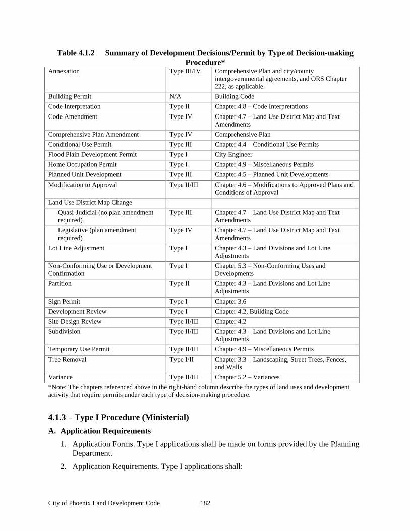
City of Phoenix Land Development Code 182
Table 4.1.2 Summary of Development Decisions/Permit by Type of Decision-making Procedure*
Annexation Type III/IV Comprehensive Plan and city/county intergovernmental agreements, and ORS Chapter 222, as applicable.
Building Permit N/A Building Code
Code Interpretation Type II Chapter 4.8 Code Interpretations
Code Amendment Type IV Chapter 4.7 Land Use District Map and Text Amendments
Comprehensive Plan Amendment Type IV Comprehensive Plan
Conditional Use Permit Type III Chapter 4.4 Conditional Use Permits
Flood Plain Development Permit Type I City Engineer
Home Occupation Permit Type I Chapter 4.9 Miscellaneous Permits
Planned Unit Development Type III Chapter 4.5 Planned Unit Developments
Modification to Approval Type II/III Chapter 4.6 Modifications to Approved Plans and Conditions of Approval
Land Use District Map Change
Quasi-Judicial (no plan amendment required)
Type III Chapter 4.7 Land Use District Map and Text Amendments
Legislative (plan amendment required)
Type IV Chapter 4.7 Land Use District Map and Text Amendments
Lot Line Adjustment Type I Chapter 4.3 Land Divisions and Lot Line Adjustments
Non-Conforming Use or Development Confirmation
Type I Chapter 5.3 Non-Conforming Uses and Developments
Partition Type II Chapter 4.3 Land Divisions and Lot Line Adjustments
Sign Permit Type I Chapter 3.6
Development Review Type I Chapter 4.2, Building Code
Site Design Review Type II/III Chapter 4.2
Subdivision Type II/III Chapter 4.3 Land Divisions and Lot Line Adjustments
Temporary Use Permit Type II/III Chapter 4.9 Miscellaneous Permits
Tree Removal Type I/II Chapter 3.3 Landscaping, Street Trees, Fences, and Walls
Variance Type II/III Chapter 5.2 Variances
*Note: The chapters referenced above in the right-hand column describe the types of land uses and development activity that require permits under each type of decision-making procedure.
4.1.3 Type I Procedure (Ministerial)
A. Application Requirements
1. Application Forms. Type I applications shall be made on forms provided by the Planning Department.
2. Application Requirements. Type I applications shall:
City of Phoenix Land Development Code 183
a. Include the information requested on the application form;
b. Address the criteria in sufficient detail for review and action; and
c. Be filed with the required fee.
B. Zoning Clearance and Planning Inquiry. Some planning requests are simply requests for information regarding a specific property that require staff time in excess of that necessary to answer land use questions on the phone or over the counter. These activities are not land use decisions requiring notice or an opportunity to appeal.
1. A Zoning Clearance is a written statement of facts regarding the application of this or other land use ordinances to a specific parcel or tract of land. Answering Zoning Clearance questions is a basic service of the Planning Department. The City shall charge a fee reasonably related to the amount of time needed for staff to write findings for the applicant and the property address file. For example, an applicant who wishes to build an addition or convert a garage into an accessory dwelling unit would need a zoning clearance.
2. A Planning Inquiry is a request for a written statement of information about a specific parcel or tract of land. Such information may be in response to a specific question, or may be in response to a general question about the history or characteristics of the site. The City shall charge a fee reasonably related to the cost of staff time to research the question at hand and to make a written statement of findings that will be maintained in the property address file.
B. Ministerial Decision Requirements. The Planning Director s decision shall address all of the approval criteria. Based on the criteria and the facts contained within the record, the Planning Director shall approve, approve with conditions, or deny the requested permit or action. A written record of the decision shall be provided to the applicant and kept on file at City Hall.
C. Final Decision. The decision shall be final on the date it is mailed or otherwise provided to the applicant, whichever occurs first. The decision is the final decision of the City. It cannot be appealed to City officials. The applicant shall apply for a variance if it is permissible.
D. Effective Date. The decision is effective the day after it is final.
4.1.4 Type II Procedure (Administrative)
A. Pre-application. A pre-application conference is required for Type II applications. Pre-application conference requirements and procedures are in Chapter 4.1.7 General Provisions.
B. Scope of appeal. The appeal shall be a de novo hearing and shall be the initial evidentiary hearing required under ORS 197.763 as the basis for an appeal to the Land Use Board of Appeals.
C. Application requirements
1. Application Forms. Type II applications shall be made on forms provided by the Planning Department;
2. Submittal Information. The application shall:
City of Phoenix Land Development Code 184
a. Include the information requested on the application form;
b. Be filed with two copies of a narrative statement that explains how the application satisfies each and all of the relevant criteria and standards in sufficient detail for review and decision-making;
c. Be accompanied by the required fee;
d. Include two sets of mailing labels for all real property owners of record who will receive a notice of the application as required in Chapter 4.1.4 Type II Procedure (Administrative), Section C. The records of the Jackson County Department of Assessment and Taxation are the official records for determining ownership. The applicant shall demonstrate that the most current assessment records have been used to produce the notice list;
e. Include an impact study for all land division applications. The impact study shall quantify/assess the effect of the development on public facilities and services. The study shall address, at a minimum, the transportation system, including pedestrian ways and bikeways, the drainage system, the parks system, the water system, the sewer system, and the noise impacts of the development. For each public facility system and type of impact, the study shall propose improvements necessary to meet City standards and to minimize the impact of the development on the public at large, public facilities systems, and affected private property users. In situations where this Code requires the dedication of real property to the City, the applicant shall either specifically agree to the dedication requirement, or provide evidence that shows that the real property dedication requirement is not roughly proportional to the projected impacts of the development.
D. Notice of Application for Type II Administrative Decision
1. Before making a Type II Administrative Decision, the Planning Department shall provide noticing in the following forms:
a. By mail, all owners of record of real property within 200 feet of the subject site;
b. Any person who submits a written request to receive a notice; and
c. Any governmental agency that is entitled to notice under an intergovernmental agreement entered into with the City. The City may notify other affected agencies, as appropriate, for review of the application.
2. The purpose of the notice is to give nearby property owners and other interested people the opportunity to submit written comments about the application, before the Type II decision is made. The goal of this notice is to invite people to participate early in the decision-making process;
3. Notice of a pending Type II Administrative Decision shall:
a. Provide a 14-day period for submitting written comments before a decision is made on the permit;
b. List the relevant approval criteria by name and number of code sections;
City of Phoenix Land Development Code 185
c. State the place, date and time the comments are due, and the person to whom the comments should be addressed;
d. Include the name and telephone number of a contact person regarding the Administrative Decision;
e. Identify the specific permits or approvals requested;
f. Describe the street address or other easily understandable reference to the location of the site;
g. State that if any person fails to address the relevant approval criteria with enough detail, they may not be able to appeal to the Land Use Board of Appeals or Circuit Court on that issue. Only comments on the relevant approval criteria are considered relevant evidence;
h. State that all evidence relied upon by the Planning Director to make this decision is in the public record, available for public review. Copies of this evidence can be obtained at a reasonable cost from the City;
i. State that after the comment period closes, the Planning Director shall issue a Type II Administrative Decision. The decision shall be mailed to the applicant and to anyone else who submitted written comments or who is otherwise legally entitled to notice;
j. Contain the following notice: Notice to mortgagee, lien holder, vendor, or seller: The City of Phoenix Development Code requires that if you receive this notice it shall be promptly forwarded to the purchaser.
E. Administrative Decision Requirements. The Planning Director shall make Type II written decisions addressing all of the relevant approval criteria and standards. Based upon the criteria and standards, and the facts contained within the record, the Planning Director shall approve, approve with conditions, or deny the requested permit or action.
F. Public Hearing Option. Applicant may request a public hearing with the Planning Commission in lieu of administrative review. The City will charge a fee for a Type III Procedure if the applicant requests a public hearing.
G. Notice of Decision
1. Within five days after the Planning Director signs the decision, a Notice of Decision shall sent by mail to:
a. All property owners of record with in 100 feet of the site;
b. The applicant and all owners or contract purchasers of record of the site that is the subject of the application;
c. Any person who submits a written request to receive notice, or provides comments during the application review period;
d. Any governmental agency that is entitled to notice under an intergovernmental agreement entered into with the City, and other agencies that were notified or provided comments during the application review period.
e. Any neighborhood or community organization recognized by the City whose boundaries include the site.
City of Phoenix Land Development Code 186
2. The Planning Department shall cause an affidavit of mailing and posting of the notice to be prepared and made a part of the file. The affidavit shall show the date the notice was mailed and posted, and shall demonstrate that the notice was mailed to the people and within the time required by law.
3. The Type II Notice of Decision shall contain:
a. A description of the applicant s proposal and the use or uses authorized by the City s decision on the proposal ;
b. The address or other geographic description of the property proposed for development;
c. The name of the planning official to be contacted and the telephone number where additional information on the decision may be obtained.
d. A statement that a copy of the application and decision, all documents and evidence submitted by or for the applicant, and the applicable criteria and standards can be reviewed at Phoenix City Hall at no cost and that copies shall be provided at a reasonable cost;
e. A statement that the decision will not become final until the period for filing a local appeal has expired and a statement that the person who is mailed written notice of the decision cannot appeal the decision directly to the Land Use Board of Appeals under ORS 197.830;
f. A statement that all persons entitled to notice or who are otherwise adversely affected or aggrieved by the decision may appeal the decision;
g. A statement briefly explaining how an appeal can be filed, the deadline for filing an appeal, and where further information can be obtained concerning the appeal process; and
H. Final decision and effective date. A Type II administrative decision is final for purposes of appeal, when it is mailed by the City. A Type II administrative decision is effective on the day after the appeal period expires. If an appeal is filed, the decision is effective when the appeal is decided.
I. Appeal. A Type II administrative decision may be appealed to the Planning Commission as follows:
1. The following people have legal standing to appeal a Type II Administrative Decision:
a. The applicant;
b. Any person who was mailed written notice of the Type II administrative decision;
c. Any other person who participated in the proceeding by submitting written comments.
2. Appeal procedure.
a. Notice of appeal. Any person with standing to appeal, as provided in subsection 1, above, may appeal a Type II Administrative Decision by filing a Notice of Appeal according to the following procedures;
City of Phoenix Land Development Code 187
(1) A Notice of Appeal shall be filed with the Planning Department within 14 days of the date the Notice of Decision was mailed;
(2) The Notice of Appeal shall contain:
(a) An identification of the decision being appealed, including the date of the decision;
(b) A statement demonstrating the person filing the Notice of Appeal has standing to appeal;
(c) A statement explaining the specific issues raised on appeal;
(d) Filing fee.
(3) The amount of the filing fee shall be established by the City. The maximum fee for an initial hearing shall be the City s cost for preparing and for conducting the hearing or the statutory maximum, whichever is less.
b. Appeal procedures. Type III notice and hearing procedures shall be used for all Type II Administrative Appeals, as provided in Sections 4.1.5 Type III Procedure (Quasi-Judicial), Sections C through G;
J. Appeal to City Council. The decision of the Planning Commission regarding an appeal of a Type II Administrative Decision is the final decision of the City unless appealed to City Council. An appeal to City Council shall follow the same notification and hearing procedures as for the Planning Commission appeal.
4.1.5 Type III Procedure (Quasi-Judicial)
A. Pre-application conference. A pre-application conference is required for all Type III applications. The requirements and procedures for a pre-application conference are described in Chapter 4.1.7 General Provisions, Section C.
B. Application requirements
1. Application forms. Type III applications shall be made on forms provided by the Planning Department.
2. Content. Type III applications shall:
a. Include the information requested on the application form;
b. Be filed with copies of a narrative statement that explains how the application satisfies each and all of the relevant criteria in sufficient detail for review and action;
c. Be accompanied by the required fee;
d. Include two sets of mailing labels for all property owners of record as specified in Chapter 4.1.5 Type III Procedure (Quasi-Judicial), Section C (Notice of Hearing). The records of the Jackson County Department of Assessment and Taxation are the official records for determining ownership. The applicant shall demonstrate that the most current assessment records have been used to produce the notice list;
City of Phoenix Land Development Code 188
e. Include an impact study for all Type III applications. The impact study shall quantify/assess the effect of the development on public facilities and services. The study shall address, at a minimum, the transportation system, including pedestrian ways and bikeways, the drainage system, the parks system, the water system, and the sewer system. For each public facility system and type of impact, the study shall propose improvements necessary to meet City standards and to minimize the impact of the development on the public at large, public facilities systems, and affected private property users. In situations where this Code requires the dedication of real property to the City, the applicant shall either specifically agree to the dedication requirement, or provide evidence that shows that the real property dedication requirement is not roughly proportional to the projected impacts of the development.
C. Notice of Hearing
1. Notice of a Type III application hearing or Type II appeal hearing shall be given by the Planning Department in the following manner:
a. At least 20 days before the hearing date, notice shall be mailed to:
(1) The applicant and all owners or contract purchasers of record of the property which is the subject of the application;
(2) All property owners of record within 200 feet of the site;
(3) Any governmental agency that has entered into an intergovernmental agreement with the City that includes provision for such notice, or who is otherwise entitled to such notice;
(4) Any person who submits a written request to receive notice;
(5) For appeals, the appellant and all persons who provided testimony in addition to those listed above; and
(6) For a land-use district change affecting a manufactured home or mobile home park, all mailing addresses within the park, in accordance with ORS 227.175.
b. The Planning Department shall have an affidavit of notice prepared and made a part of the file. The affidavit shall state the date that the notice was mailed to the persons who must receive notice;
2. Content of Notice. Notice of appeal of a Type II Administrative decision or a Type III hearing to be mailed per Subsection 1 above shall contain the following information:
a. The nature of the application and the proposed land use or uses that could be authorized for the property;
b. The applicable criteria and standards from the development code that apply to the application;
c. The street address or other easily understood geographical reference to the subject property;
d. The date, time, and location of the public hearing;
City of Phoenix Land Development Code 189
e. A statement that the failure to raise an issue in person, or by letter at the hearing, or failure to provide statements or evidence sufficient to afford the decision-maker an opportunity to respond to the issue, means that an appeal based on that issue cannot be filed with the State Land Use Board of Appeals;
f. The name of the planning official to be contacted and the telephone number where additional information on the application may be obtained;
g. A statement that a copy of the application, all documents and evidence submitted by or for the applicant, and the applicable criteria and standards can be reviewed at Phoenix City Hall at no cost and that copies shall be provided at a reasonable cost;
h. A statement that a copy of the planning official s staff report and recommendation to the Planning Commission shall be available for review at no cost at least seven days before the hearing, and that a copy shall be provided on request at a reasonable cost;
i A general explanation of the requirements to submit testimony, and the procedure for conducting public hearings.
j. The following notice: Notice to mortgagee, lien holder, vendor, or seller: The City of Phoenix Development Code requires that if you receive this notice it shall be promptly forwarded to the purchaser.
D. Conduct of the Public Hearing
1. At the commencement of the hearing, the hearings body shall state to those in attendance:
a. The applicable approval criteria and standards that apply to the application or appeal;
b. A statement that testimony and evidence shall concern the approval criteria described in the staff report, or other criteria in the comprehensive plan or land use regulations which the person testifying believes to apply to the decision;
c. A statement that failure to raise an issue with sufficient detail to give the hearings body and the parties an opportunity to respond to the issue, means that no appeal may be made to the State Land Use Board of Appeals on that issue;
d. Before the conclusion of the initial evidentiary hearing, any participant may ask the hearings body for an opportunity to present additional relevant evidence or testimony that is within the scope of the hearing. The hearings body shall grant the request by scheduling a date to finish the hearing (a continuance ) per paragraph 2 of this subsection, or by leaving the record open for additional written evidence or testimony per paragraph 3 of this subsection.
2. If the hearings body grants a continuance, the completion of the hearing shall be continued to a date, time, and place at least seven days after the date of the first evidentiary hearing. An opportunity shall be provided at the second hearing for persons to present and respond to new written evidence and oral testimony. If new written evidence is submitted at the second hearing, any person may request, before the conclusion of the second hearing, that the record be left open for at least seven days, so that they can submit additional written evidence or testimony in response to the new written evidence;
City of Phoenix Land Development Code 190
3. If the hearings body leaves the record open for additional written evidence or testimony, the record shall be left open for at least seven days after the hearing. Any participant may ask the City in writing for an opportunity to respond to new evidence submitted during the period the record was left open. If such a request is filed, the hearings body shall reopen the record per this section;
a. When the Planning Commission re-opens the record to admit new evidence or testimony, any person may raise new issues that relates to that new evidence or testimony;
b. An extension of the hearing or record granted pursuant to Section D is subject to the limitations of ORS 227.178 (120-day rule), unless the continuance or extension is requested or agreed to by the applicant;
c. If requested by the applicant, the City shall allow the applicant at least seven days after the record is closed to all other persons to submit final written arguments in support of the application, unless the applicant expressly waives this right. The applicant s final submittal shall be part of the record but shall not include any new evidence.
4. The record
a. The record shall contain all testimony and evidence that is submitted to the City and the hearings body and not rejected;
b. The hearings body may take official notice of judicially cognizable facts under the applicable law. If the review authority takes official notice, it must announce its intention and allow persons participating in the hearing to present evidence concerning the noticed facts;
5. Participants in the appeal of a Type II Administrative decision or a Type III hearing are entitled to an impartial review authority as free from potential conflicts of interest and pre-hearing ex parte contacts (see Section 6 below) as reasonably possible. However, the public has a countervailing right of free access to public officials. Therefore:
a. At the beginning of the public hearing, hearings body members shall disclose the substance of any pre-hearing ex parte contacts (as defined in Section 6 below) concerning the application or appeal. He or she shall state whether the contact has impaired their impartiality or their ability to vote on the matter and shall participate or abstain accordingly;
b. A member of the hearings body shall not participate in any proceeding in which they, or any of the following, has a direct or substantial financial interest: Their spouse, brother, sister, child, parent, father-in-law, mother-in-law, partner, any business in which they are then serving or have served within the previous two years, or any business with which they are negotiating for or have an arrangement or understanding concerning prospective partnership or employment. Any actual or potential interest shall be disclosed at the hearing where the action is being taken;
c. Disqualification of a member of the hearings body due to contacts or conflict may be ordered by a majority of the members present and voting. The person who is the subject of the motion may not vote on the motion to disqualify;
City of Phoenix Land Development Code 191
d. If all members abstain or are disqualified, those members present who declare their reasons for abstention or disqualification shall be re-qualified to make a decision;
e. If a member of the hearings body abstains or is disqualified, the City shall provide a substitute in a timely manner subject to the impartiality rules in Section 6;
f. Any member of the public may raise conflict of interest issues prior to or during the hearing, to which the member of the hearings body shall reply in accordance with this Section.
6. Ex parte communications
a. Members of the hearings body shall not:
(1) Communicate, directly or indirectly, with any applicant, appellant, other party to the proceedings, or representative of a party about any issue involved in a hearing, except upon giving notice, per Section 5 above;
(2) Take official notice of any communication, report, or other materials outside the record prepared by the proponents or opponents in connection with the particular case, unless all participants are given the opportunity to respond to the noticed materials.
b. No decision or action of the hearings body shall be invalid due to ex parte contacts or bias resulting from ex parte contacts, if the person receiving contact:
(1) Places in the record the substance of any written or oral ex parte communications concerning the decision or action; and
(2) Makes a public announcement of the content of the communication and of all participants right to dispute the substance of the communication made. This announcement shall be made at the first hearing following the communication during which action shall be considered or taken on the subject of the communication.
c. A communication between City staff and the hearings body is not considered an ex parte contact.
7. Presenting and receiving evidence
a. The hearings body may set reasonable time limits for oral presentations and may limit or exclude cumulative, repetitious, irrelevant or personally derogatory testimony or evidence;
b. No oral testimony shall be accepted after the close of the public hearing. Written testimony may be received after the close of the public hearing, only as provided in Section D;
City of Phoenix Land Development Code 192
c. Members of the hearings body may visit the property and the surrounding area, and may use information obtained during the site visit to support their decision, if the information relied upon is disclosed at the hearing and an opportunity is provided to dispute the evidence. In the alternative, a member of the hearings body may visit the property to familiarize him or herself with the site and surrounding area, but not to independently gather evidence. In the second situation, at the beginning of the hearing, he or she shall disclose the circumstances of the site visit and shall allow all participants to ask about the site visit.
E. The Decision Process
1. Basis for decision. Approval or denial of an appeal of a Type II Administrative decision or a Type III application shall be based on standards and criteria in the development code. The standards and criteria shall relate approval or denial of a discretionary development permit application to the development regulations and, when appropriate, to the comprehensive plan for the area in which the development would occur and to the development regulations and comprehensive plan for the City as a whole;
2. Findings and conclusions. Approval or denial shall be based upon the criteria and standards considered relevant to the decision. The written decision shall explain the relevant criteria and standards, state the facts relied upon in rendering the decision, and justify the decision according to the criteria, standards, and facts;
3. Form of decision. The hearings body shall issue a final written order containing the findings and conclusions stated in subsection 2, which either approves, denies, or approves with specific conditions. The hearings body may also issue appropriate intermediate rulings when more than one permit or decision is required;
4. Decision-making time limits. A final order for any Type II Administrative Appeal or Type III action shall be filed with the City Recorder within ten business days after the close of the deliberation.
F. Notice of Decision. Written notice of a Type II Administrative Appeal decision or a Type III decision shall be mailed to the applicant and to all participants of record within 30 business days after the hearings body decision. Failure of any person to receive mailed notice shall not invalidate the decision, provided that a good faith attempt was made to mail the notice.
G. Final Decision and Effective Date. The decision of the hearings body on any Type II appeal or any Type III application is final for purposes of appeal on the date it is mailed by the City. The decision is effective on the day after the appeal period expires. If an appeal is filed, the decision becomes effective on the day after the appeal is decided by the City Council. The notification and hearings procedures for Type III applications on appeal to the City Council shall be the same as for the initial hearing.
H. Appeals. Type III decisions may be appealed to the City Council as follows:
1. Notice of appeal. Any person with standing to appeal may appeal a Type III Decision by filing a Notice of Appeal according to the following procedures;
a. A Notice of Appeal shall be filed with the Planning Department within 14 days of the date the Notice of Decision was mailed;
b. The Notice of Appeal shall contain:
City of Phoenix Land Development Code 193
(1) An identification of the decision being appealed, including the date of the decision;
(2) A statement demonstrating the person filing the Notice of Appeal has standing to appeal;
(3) A statement explaining the specific issues raised on appeal;
(4) If the appellant is not the applicant, a statement demonstrating that the appeal issues were raised during the comment period;
(5) Filing fee.
2. Scope of appeal. The appeal of a Type III Decision by a person with standing shall be limited to the specific issues raised during the written comment period, unless the City Council allows additional evidence or testimony concerning any other relevant issue. The City Council may allow such additional evidence if it determines that such evidence is necessary to resolve the case;
4.1.6 Type IV Procedure (Legislative)
A. Pre-Application conference. A pre-application conference is required for all Type IV applications. The requirements and procedures for a pre-application conference are described in Chapter 4.1.7 General Provisions. Section C.
B. Timing of requests. The City Planner shall not review non-City sponsored or state required proposed Type IV actions more than five times annually, based on a City Council Resolution approved schedule for such actions.
C. Application requirements
1. Application forms. Type IV applications shall be made on forms provided by the Planning Department;
2. Submittal Information. The application shall contain:
a. The information requested on the application form;
b. A map and/or plan addressing the appropriate criteria and standards in sufficient detail for review and decision (as applicable);
c. The required fee; and
d. Findings or a narrative statement that explains how the application satisfies each and all of the relevant approval criteria and standards.
e. mailing labels.
D. Notice of Hearing
1. Required hearings. A minimum of two hearings, one before the Planning Commission and one before the City Council, are required for all Type IV applications.
2. Notification requirements. Notice of public hearings for the request shall be given by the Planning Department in the following manner:
City of Phoenix Land Development Code 194
a. At least 20 days, but not more than 40 days, before the date of the first hearing on an ordinance that proposes to amend the Comprehensive Plan or any element thereof, or to adopt an ordinance that proposes to rezone property, a notice shall be prepared in conformance with ORS 227.175 and mailed to:
(1) Each owner whose property would be rezoned in order to implement the ordinance (i.e., owners of property subject to a Comprehensive Plan amendment shall be notified if a zone change would be required to implement the proposed comprehensive plan amendment);
(2) Any affected governmental agency.
(3) Recognized neighborhood groups or associations affected by the ordinance;
(4) Any person who requests notice in writing;
(5) For a zone change affecting a manufactured home or mobile home park, all mailing addresses within the park, in accordance with ORS 227.175.
b. The Planning Department shall file an affidavit of mailing in the record as provided by Subsection a.
b. The Department of Land Conservation and Development (DLCD) shall be notified in writing of proposed comprehensive plan and development code amendments at least 45 days before the first public hearing at which public testimony or new evidence will be received.
c. Notifications for annexation shall follow the provisions of this Chapter, except as required for local government boundary commissions (ORS 199).
3. Content of notices. The notices shall include the following information:
a. The number and title of the file containing the application, and the address and telephone number of the Planning Office where additional information about the application can be obtained;
b. A description of the location of the proposal reasonably calculated to give notice of the location of the geographic area;
c. A description of the proposal in enough detail for people to determine that a change is proposed, and the place where all relevant materials and information may be obtained or reviewed;
d. The time, place, and date of the public hearing; a statement that public oral or written testimony is invited; and a statement that the hearing will be held under this title and rules of procedure adopted by the Council and available at City Hall (See subsection E below); and
e. Each notice required by Section D shall contain the following statement: Notice to mortgagee, lien holder, vendor, or seller: The City of Phoenix Development Code requires that if you receive this notice it shall be promptly forwarded to the purchaser.
4. Failure to receive notice. The failure of any person to receive notice shall not invalidate the action, providing:
City of Phoenix Land Development Code 195
a. Personal notice is deemed given where the notice is deposited with the United States Postal Service;
b. Published notice is deemed given on the date it is published.
E. Hearing Process and Procedure
1. Unless otherwise provided in the rules of procedure adopted by the City Council:
a. The presiding officer of the Planning Commission and of the City Council shall have the authority to:
(1) Regulate the course, sequence, and decorum of the hearing;
(2) Direct procedural requirements or similar matters; and
(3) Impose reasonable time limits for oral presentations.
b. No person shall address the Commission or the Council without:
(1) Receiving recognition from the presiding officer; and
(2) Stating their full name and residence address.
c. Disruptive conduct such as applause, cheering, or display of signs shall be cause for expulsion of a person or persons from the hearing, termination or continuation of the hearing, or other appropriate action determined by the presiding officer.
2. Unless otherwise provided in the rules of procedures adopted by the Council, the presiding officer of the Commission and of the Council, shall conduct the hearing as follows:
a. The presiding officer shall begin the hearing with a statement of the nature of the matter before the body, a general summary of the procedures, a summary of the standards for decision-making, and whether the decision which will be made is a recommendation to the City Council or the final decision of the Council;
b. The Planning Director s report and other applicable staff reports shall be presented;
c. The public shall be invited to testify;
d. The public hearing may be continued to allow additional testimony or it may be closed; and
e. The body s deliberation may include questions to the staff, comments from the staff, and inquiries directed to any person present.
F. Continuation of the Public Hearing. The Planning Commission or the City Council may continue any hearing, and no additional notice of hearing shall be required if the matter is continued to a specified place, date, and time.
G. Decision-Making Considerations. The recommendation by the Planning Commission and the decision by the City Council shall be based on consideration of the following factors:
1. The Statewide Planning Goals and Guidelines adopted under Oregon Revised Statutes Chapter 197 (for comprehensive plan amendments only);
City of Phoenix Land Development Code 196
2. Comments from any applicable federal or state agencies regarding applicable statutes or regulations;
3. Any applicable intergovernmental agreements; and
4. Any applicable comprehensive plan policies and provisions of this Code that implement the comprehensive plan. Compliance with Chapter 4.7 Land Use District Map and Text Amendments shall be required for Comprehensive Plan Amendments, and Land Use District Map and Text Amendments.
H. Approval Process and Authority
1. The Planning Commission shall:
After notice and a public hearing, vote on and prepare a recommendation to the City Council to approve, approve with modifications, approve with conditions, deny the proposed change, or adopt an alternative.
2. If the Planning Commission fails to adopt a recommendation to approve, approve with modifications, approve with conditions, deny the proposed change, or adopt an alternative proposal, within 30 days of its first public hearing on the proposed change, the Planning Director shall:
a. Report the failure together with the proposed change to the City Council; and
b. Provide notice and put the matter on the City Council s agenda, a public hearing to be held, and a decision to be made by the Council. No further action shall be taken by the Commission.
4. The City Council shall:
a. Approve, approve with modifications, approve with conditions, deny, or adopt an alternative to an application for legislative change, or remand the application to the Planning Commission for rehearing and reconsideration on all or part of the application;
b. Consider the recommendation of the Planning Commission; however, it is not bound by the Commission s recommendation; and
c. Act by ordinance, which shall be signed by the Mayor after the Council s adoption of the ordinance.
I. Vote Required for a Legislative Change
1. A vote by a majority of the qualified voting members of the Planning Commission present is required for a recommendation for approval, approval with modifications, approval with conditions, denial, or adoption of an alternative.
2. A vote by a majority of the qualified members of the City Council present is required to decide any motion made on the proposal.
J. Notice of Decision. Notice of a Type IV decision shall be mailed to the applicant, all participants of record, and the Department of Land Conservation and Development, within five business days after the City Council decision is filed with the City Official. The City shall also provide notice to all persons as required by other applicable laws.
City of Phoenix Land Development Code 197
K. Final Decision and Effective Date. A Type IV decision, if approved, shall take effect and shall become final as specified in the enacting ordinance, or if not approved, upon mailing of the notice of decision to the applicant.
L. Record of the Public Hearing
1. A verbatim record of the proceeding shall be made by stenographic, mechanical, or electronic means. It is not necessary to transcribe an electronic record. The minutes and other evidence presented as a part of the hearing shall be part of the record;
2. All exhibits received and displayed shall be marked to provide identification and shall be part of the record;
3. The official record shall include:
a. All materials considered by the hearings body;
b. All materials submitted by the Planning Director to the hearings body regarding the application;
c. The verbatim record made by the stenographic, mechanical, or electronic means; the minutes of the hearing; and other documents considered;
d. The final ordinance;
e. All correspondence; and
f. A copy of the notices that were given as required by this Chapter.
4.1.7 General Provisions
A. 120-day Rule. The City shall take final action on permit applications that are subject to this Chapter, including resolution of all appeals, within 120 days from the date the application is deemed as complete. Any exceptions to this rule shall conform to the provisions of ORS 227.178. (The 120-day rule does not apply to Type IV legislative decisions plan and code amendments under ORS 227.178.)
B. Time Computation. In computing any period of time prescribed or allowed by this Chapter, the day of the act or event from which the designated period of time begins to run shall not be included. The last day of the period so computed shall be included, unless it is a Saturday or legal holiday, including Sunday, in which event, the period runs until the end of the next day which is not a Saturday or legal holiday.
C. Pre-application Conferences
1. Participants. When a pre-application conference is required, the applicant shall meet with the project Planner;
2. Information provided. At such conference, the City Planner shall:
a. Cite the comprehensive plan policies and map designations applicable to the proposal;
b. Cite the ordinance provisions, including substantive and procedural requirements applicable to the proposal;
c. Provide available technical data and assistance that will aid the applicant;
City of Phoenix Land Development Code 198
d. Identify other governmental policies and regulations that relate to the application; and
e. Reasonably identify other opportunities or constraints concerning the application.
3. Disclaimer. Failure of city officials to provide any of the information required by this Section C shall not constitute a waiver of any of the standards, criteria, or requirements for the application;
4. Changes in the law. Due to possible changes in federal, state, regional, and local law, the applicant is responsible for ensuring that the application complies with all applicable laws on the day the application is deemed complete.
D. Applications
1. Initiation of applications:
a. Applications for approval under this Chapter may be initiated by:
(1) Order of City Council;
(2) Resolution of the Planning Commission;
(3) Planning Director;
(4) A record owner of property (persons whose name is on the most recently recorded deed), or contract purchaser with written permission from the record owner.
b. Any person authorized to submit an application for approval may be represented by an agent authorized in writing to make the application on their behalf.
c. A transportation agency may submit an application to the Planning Department for a permit or zoning authorization required for a transportation project without landowner consent.
2. Consolidation of proceedings. When an applicant applies for more than one type of land use or development permit (e.g., Type II and III) for the same one or more parcels of land, the proceedings shall be consolidated for review and decision.
a. If more than one approval authority would be required to decide on the applications if submitted separately, then the decision shall be made by the approval authority having original jurisdiction over one of the applications in the following order of preference: the Council, the Commission, or the Planning Director.
b. When proceedings are consolidated:
(1) The notice shall identify each application to be decided;
(2) The decision on a plan map amendment shall precede the decision on a proposed land-use district change and other decisions on a proposed development. Similarly, the decision on a zone map amendment shall precede the decision on a proposed development and other actions; and
(3) Separate findings and decisions shall be made on each application.
3. Check for acceptance and completeness. In reviewing an application for completeness, the following procedure shall be used:
City of Phoenix Land Development Code 199
a. Acceptance. When an application is received by the City, the Planning Aide shall immediately determine whether the following essential items are present. If the following items are not present, the application shall not be accepted and shall be immediately returned to the applicant;
(1) The required form;
(2) The required fee;
(3) The signature of the applicant on the required form, and signed written authorization of the property owner of record if the applicant is not the owner.
b. Completeness.
(1) Review and notification. After the application is accepted, the project Planner shall review the application for completeness. If the application is incomplete, the project Planner shall notify the applicant in writing of exactly what information is missing within 30 days of receipt of the application and allow the applicant 180 days to submit the missing information;
(2) When application deemed complete for review. In accordance with the application submittal requirements of this Chapter, the application shall be deemed complete upon the receipt by the project Planner of all required information. The applicant shall have the option of withdrawing the application, or refusing to submit information requested by the project Planner in (1), above. For the refusal to be valid, the refusal shall be made in writing and received by the Planning Director no later than 14 days after the date on the project Planner s letter of incompleteness. If the applicant refuses in writing to submit the missing information, the application shall be deemed complete on 31st day after the project Planner first accepted the application.
(3) Standards and criteria that apply to the application. Approval or denial of the application shall be based upon the standards and criteria that were applicable at the time the application was first accepted.
(4) Ten copies of the site plan.
(5) Ten copies of the subdivision or partition plans.
(6) Findings.
4. Changes or additions to the application during the review period. Once an application is deemed complete:
a. All documents and other evidence relied upon by the applicant shall be submitted to the project Planner at least fourteen days before the notice of action or hearing is mailed. Documents or other evidence submitted after that date shall be received by the project Planner, and transmitted to the hearings body, but may be too late to include with the staff report and evaluation;
b. When documents or other evidence are submitted by the applicant during the review period, but after the application is deemed complete, the assigned review person or body shall determine whether or not the new documents or other evidence submitted by the applicant significantly change the application;

City of Phoenix Land Development Code 200
c. If the assigned reviewer determines that the new documents or other evidence significantly change the application, the reviewer shall include a written determination that a significant change in the application has occurred as part of the decision. In the alternate, the reviewer may inform the applicant either in writing, or orally at a public hearing, that such changes may constitute a significant change (see d , below), and allow the applicant to withdraw the new materials submitted, in
order to avoid a determination of significant change;
d. If the applicant's new materials are determined to constitute a significant change in an application that was previously deemed complete, the City shall take one of the following actions:
(1) Continue to process the existing application and allow the applicant to submit a new second application with the proposed significant changes. Both the old and the new applications will proceed, but each will be deemed complete on different dates and may therefore be subject to different criteria and standards and different decision dates;
(2) Suspend the existing application and allow the applicant to submit a new application with the proposed significant changes. Before the existing application can be suspended, the applicant must consent in writing to waive the 120-day rule (Section A., above) on the existing application. If the applicant does not consent, the City shall not select this option;
(3) Reject the new documents or other evidence that has been determined to constitute a significant change, and continue to process the existing application without considering the materials that would constitute a significant change. The City will complete its decision-making process without considering the new evidence;
e. If a new application is submitted by the applicant, that application shall be subject to a separate check for acceptance and completeness and will be subject to the standards and criteria in effect at the time the new application is accepted.
E. Amended Decision Process
1. The purpose of an amended decision process is to allow the Planning Director to correct typographical errors, rectify inadvertent omissions, and/or make other minor changes that do not materially alter the decision.
2. The Planning Director may issue an amended decision after the notice of final decision has been issued but before the appeal period has expired. If such a decision is amended, the decision shall be issued within 10 business days after the original decision would have become final, but in no event beyond the 120-day period required by state law. A new 10-day appeal period shall begin on the day the amended decision is issued.
3. Notice of an amended decision shall be given using the same mailing and distribution list as for the original decision notice.
City of Phoenix Land Development Code 201
4. Modifications to approved plans or conditions of approval requested by the applicant shall follow the procedures contained in Chapter 4.6 Modifications to Approved Plans and Conditions of Approval. All other requested changes to decisions that do not qualify as minor or major modifications shall follow the appeal process.
F. Re-submittal of Application Following Denial. An application which has been denied, or an application which was denied and which on appeal or review has not been reversed by a higher authority, including the Land Use Board of Appeals, the Land Conservation and Development Commission or the courts, may not be resubmitted as the same or a substantially similar proposal for the same land for a period of at least 12 months from the date the final City action is made denying the application, unless there is substantial change in the facts or a change in City policy which would change the outcome, as determined by the Planning Director.
4.1.8 Special Procedures
A. Expedited Land Divisions. An Expedited Land Division ( ELD ) shall be defined and may be used as in ORS 197.360, which is expressly adopted and incorporated by reference here.
1. Selection. An applicant who wishes to use an ELD procedure for a partition, subdivision or planned development instead of the regular procedure type assigned to it, must request the use of the ELD in writing at the time the application is filed, or forfeit his/her right to use it;
2. Review procedure. An ELD shall be reviewed in accordance with the procedures in ORS 197.365;
3. Appeal procedure. An appeal of an ELD shall be in accordance with the procedures in ORS 197.375.
B. Limited Land Use Hearings. The applicant may request a hearing before the Planning Commission on the appeal of a limited land use decision. Procedures will be in accordance with ORS 197.195 procedures. The hearing may be limited to the record developed pursuant to the initial hearing or may allow for the introduction of additional testimony or evidence. A hearing on appeal that allows the introduction of additional testimony or evidence shall comply with the requirements of ORS 197.763. Written notice of the decision rendered on appeal shall be given to all parties who appeared, either orally or in writing, before the hearing. The notice of decision shall include an explanation of the rights of each party to appeal the decision.

City of Phoenix Land Development Code 202

City of Phoenix Land Development Code 203
Chapter 4.2 Development Review and Site Design Review
Sections: 4.2.1 Purpose 4.2.2 Applicability 4.2.3 Development Review Approval Criteria 4.2.4 Site Design Review Application Review Procedure 4.2.5 Site Design Review Application Submission Requirements 4.2.6 Site Design Approval Criteria 4.2.7 Bonding and Assurances 4.2.8 Development in Accordance with Permit Approval
4.2.1 Purpose
The purpose of this Chapter is to:
A. Provide rules, regulations, and standards for efficient and effective administration of site development review.
B. Carry out the development pattern and plan of the City and its comprehensive plan policies;
C. Promote the public health, safety, and general welfare;
D. Lessen or avoid congestion in the streets, and secure safety from fire, flood, pollution and other dangers;
E. Facilitate adequate transportation, water supply, sewage, and drainage;
F. Encourage the conservation of energy resources;
G. Encourage efficient use of land resources, full utilization of urban services, mixed uses, transportation options, and detailed, human-scaled design.
4.2.2 Applicability
Development Review or Site Design Review shall be required for all new developments and modifications of existing developments, except that regular maintenance, repair, and replacement of materials (e.g., roof, siding, awnings, etc.), parking resurfacing, and similar maintenance and repair shall be exempt. The criteria for each type of review are as follows:
A. Development Review. Development Review is a non-discretionary or ministerial review conducted by the Planning Director without a public hearing. (See Chapter 4.1 Types of Applications and Review Procedures for review procedure.) It is for less complex developments and land uses that do not require Site Design Review approval. Development Review is based on clear and objective standards and ensures compliance with the basic development standards of the land use district, such as building setbacks, lot coverage, maximum building height, and similar provisions of Chapter 2. Development Review is required for all of the types of development listed below.
1. Single-family detached dwelling (including manufactured homes), when required by a condition of land division approval;
City of Phoenix Land Development Code 204
2. A new single duplex, up to two single family attached (townhome) units, or a single triplex that is not being reviewed as part of any other development, and accessory parking on the same lot;
3. Building additions of not more than 500 square feet, and Minor Modifications to development approvals as defined by Chapter 4.6 Modifications to Approved Plans and Conditions of Approval;
4. Any proposed development that has a valid conditional use permit. Major modifications to a development with a conditional use permit shall require review and approval in accordance with Chapter 4.4 Conditional Use Permits;
5. Home occupation, subject to review under Chapter 4.9.2 Home Occupation Permits;
6. Temporary use, except that temporary uses shall comply with the procedures and standards for temporary uses as contained in Chapter 4.9.1 Temporary Use Permits;
7. Accessory structures with less than 600 square feet of floor area, including accessory dwellings;
8. Other developments, when required by a condition of approval.
B. Site Design Review. Site Design Review is a discretionary review conducted by the Planning Director and/or the Planning Commission with or without a public hearing. (See Chapter 4.1
Types of Applications and Review Procedures for review procedure.) It applies to all developments in the City, except those specifically listed under B (Development Review). Site Design Review ensures compliance with the basic development standards of the land use district (e.g., building setbacks, lot coverage, maximum building height), as well as the more detailed design standards and public improvement requirements in Chapters 2 and 3. Site Design Review requires a pre-application conference in accordance with Chapter 4.1.7
General Provisions, Section C.
4.2.3 Development Review Approval Criteria
Development Review shall be conducted only for the developments listed in Chapter 4.2.2
Applicability, Section B, above, and it shall be conducted as a Type I procedure, as described in Chapter 4.1.3 Type I Procedure (Ministerial). Prior to issuance of building permits, the following standards shall be met:
1. The proposed land use is permitted by the underlying land use district (See Chapter 2);
2. The land use, building/yard setback, lot area, lot dimension, density, lot coverage, building height and other applicable standards of the underlying land use district and any sub-districts are met (See Chapter 2);
3. All provisions of Chapter 3 Design Standards are met;
4. All applicable building and fire code standards are met; and
5. The approval shall lapse, and a new application shall be required, if a building permit has not been issued within one year of Site Review approval, or if development of the site is in violation of the approved plan or other applicable codes.

City of Phoenix Land Development Code 205
4.2.4 Site Design Review Application Review Procedure
Site Design Review shall be conducted as a Type II or Type III procedure as specified in A below, using the procedures in Chapter 4.1 Types of Applications and Review Procedures, and using the approval criteria contained in Chapter 4.2.6 Site Design Approval Criteria.
A. Site Design Review. Determination of Type II and Type III Applications. Applications for Site Design Review shall be subject to Type II or Type III review, based on the following criteria:
1. Residential buildings with four or fewer dwelling units shall be reviewed as a Type II application, except when Development Review is allowed under Chapter 4.2.2
Applicability. Residential buildings with greater than five units shall be reviewed as a Type III application.
2. Mobile food vendors shall be reviewed as a Type II application. All other new commercial, industrial, public/semi-public, and institutional buildings shall be reviewed as a Type III application.
3. Developments with 10 or fewer off-street vehicle parking spaces, in conformance with Chapter 3.4 Vehicle and Bicycle Parking, shall be reviewed as Type II applications, and those with more than 11 off-street vehicle parking spaces shall be reviewed as Type III applications, notwithstanding the provisions contained in subsections 1-3 (above) and 5-6 (below).
5. Developments involving the clearing and/or grading of two acres or a larger area shall be reviewed as Type III applications, not withstanding the provisions contained in subsections 1-5 (above) and subsection 6 (below).
6. Site Design Review by a Type II procedure shall be required when an existing commercial or industrial site changes the site access or circulation patterns. All new access and circulation patterns shall meet current standards.
4.2.5 Site Design Review Application Submission Requirements
All of the following information is required for Site Design Review application submittal:
A. General Submission Requirements. The applicant shall submit an application containing all of the general information required by Chapter 4.1.4 Type II Procedure (Administrative) or Chapter 4.1.5 Type III Procedure (Quasi-Judicial), as applicable. The type of application shall be determined in accordance with subsection A of 4.2.4 Site Design Review Application Review Procedure. Site Design Review requires a pre-application conference in accordance with Chapter 4.1.7 General Provisions, Section C.
B. Site Design Review Information. An application for Site Design Review shall include the following information:
1. A map showing the applicant s entire property and the surrounding property to a distance sufficient to determine the location of the development in the City, and the relationship between the proposed development site and adjacent property and development. The property boundaries, dimensions, and gross area shall be identified;
2. Proposed site plan. The site plan shall contain the following information, if applicable:

City of Phoenix Land Development Code 206
a. North arrow and scale
b. The proposed development site, including boundaries, dimensions, and gross area;
c. The name and address of project designer, engineer, surveyor, and/or planner, if applicable.
d. The location, size, and species of trees having a 2" diameter that are proposed to be removed or modified by the development;
e. The location and dimensions of all proposed public and private streets, drives, rights-of-way, and easements;
f. The location and dimensions of all existing and proposed structures, utilities, pavement, and other improvements on the site. Setback dimensions for all existing and proposed buildings shall be provided on the site plan;
g. The location and dimensions of entrances and exits to the site for vehicular, pedestrian, and bicycle access;
h. The location and dimensions of all parking and vehicle circulation areas (show striping for parking stalls and wheel stops, as applicable);
i. Pedestrian and bicycle circulation areas, including sidewalks, internal pathways, pathway connections to adjacent properties, and any bicycle lanes or trails;
j. Loading and service areas for waste disposal, loading, and delivery;
k. Outdoor recreation spaces, common areas, plazas, outdoor seating, street furniture, and similar improvements;
l. Location, type, and height of outdoor lighting;
m. Location of mail boxes, if known;
n. Location of bus stops and other public or private transportation facilities.
o. Locations, sizes, and types of signs.
p. Location of trash enclosures or other waste storage areas.
q. Identification of slopes greater than 35 percent.
r. Potential natural hazard areas, including any areas identified as subject to a 100-year flood, areas subject to high water table, and areas mapped by the city, county, or state as having a potential for geologic hazards;
s. Resource areas, including marsh and wetland areas, streams, wildlife habitat identified by the City or any natural resource regulatory agencies as requiring protection;
t. Site features, including existing structures, pavement, drainage ways, canals and ditches;
u. Locally or federally designated historic and cultural resources on the site and adjacent parcels or lots;
City of Phoenix Land Development Code 207
v. Other information determined by the Planning Director to be pertinent. The City may require studies or exhibits prepared by qualified professionals to address specific site features (e.g., traffic, environmental features, natural hazards, etc.), in conformance with this Code.
3. Architectural drawings. Architectural drawings shall be submitted showing:
a. Building elevations with building height and width dimensions;
b. Building materials, color, and type.
c. The name of the architect or designer.
4. Preliminary grading plan. A preliminary grading plan prepared by a registered engineer shall be required for developments which would result in the grading (cut or fill) of 1,000 cubic yards or greater. The preliminary grading plan shall show the location and extent to which grading will take place, indicating general changes to contour lines, slope ratios, slope stabilization proposals, and location and height of retaining walls, if proposed. Surface water detention and treatment plans may also be required, in accordance with Chapter 3.8 Storm and Surface Water Management Standards.
5. Landscape plan. A landscape plan is required and shall show the following:
a. The location and height of existing and proposed fences and other buffering or screening materials;
b. The location of existing and proposed terraces, retaining walls, decks, patios, shelters, and play areas;
c. The location, size, and species of the existing and proposed plant materials (at time of planting);
d. Existing and proposed building and pavement outlines;
e. Specifications for soil at time of planting, irrigation plans, and anticipated planting schedule.
f. Other information as deemed appropriate by the Planning Director. An arborist s report may be required for sites with mature trees that are protected under Chapter 3.3
Landscaping, Street Trees, Fences, and Walls.
6. Sign drawings shall be required in conformance with Chapter 3.6 Signs.
7. Copies of all existing and proposed restrictions or covenants.
8. Letter or narrative report documenting compliance with the applicable approval criteria contained in Chapter 4.2.6 Site Design Approval Criteria.
City of Phoenix Land Development Code 208
9. Uses that are likely to generate significant levels of vehicle traffic (e.g., due to shipping, receiving, and/or customer traffic) shall require a Conditional Use Permit, in accordance with Chapter 4.4 Conditional Use Permits. Significant traffic means that the average number of daily trips, or the average number of peak hour trips, on any existing street would increase by 15 percent or greater as a result of the development. The city may require a traffic impact analysis prepared by a qualified professional prior to deeming a land use application complete, and determining whether the proposed use requires conditional use approval. Applicants may be required to provide a traffic analysis for review by Oregon Department of Transportation (ODOT) for developments that increase traffic on state highways. The Conditional Use Permit shall include appropriate transportation improvement requirements, as identified by the traffic analysis and/or ODOT, in conformance with Chapter 3.5.2 Transportation Standards.
4.2.6 Site Design Approval Criteria
The Planning Director shall make written findings with respect to all of the following criteria when approving, approving with conditions, or denying an application:
A. The application is complete, as determined in accordance with Chapter 4.1 Types of Applications and Review Procedures and Chapter 4.2.5 Site Design Review Application Submission Requirements, above.
B. The application complies with the all of the applicable provisions of the underlying Land Use District (Chapter 2), including: building and yard setbacks, lot area and dimensions, density and floor area, lot coverage, building height, building orientation, architecture, and other special standards as may be required for certain land uses;
C. The applicant shall be required to upgrade any existing development that does not comply with the applicable land-use district standards, in conformance with Chapter 5.3 Non-Conforming Uses and Developments;
D. The application complies with the Design Standards contained in Chapter 3. All of the following standards shall be met:
1. Chapter 3.2 Access and Circulation
2. Chapter 3.3 Landscaping, Street Trees, Fences, and Walls
3. Chapter 3.4 Vehicle and Bicycle Parking
4. Chapter 3.5 Street and Public Facilities Standards
5. Chapter 3.6 Signs
6. Chapter 3.7 Environmental Constraints
7. Chapter 3.8 Storm and Surface Water Management Standards
8. Chapter 3.9 Erosion Prevention and Sediment Control
9. Chapter 3.10 Other Design Standards
E. Conditions required as part of a Land Division (Chapter 4.3 Land Divisions and Lot Line Adjustments), Conditional Use Permit (Chapter 4.4 Conditional Use Permits), Planned Unit Developments (Chapter 4.5 Planned Unit Developments), or other approval shall be met.
City of Phoenix Land Development Code 209
F. Exceptions to criteria D.1-6, above, may be granted only when approved as a Variance (Chapter 5.2 Variances).
4.2.7 Bonding and Assurances
A. Performance Bonds for Public Improvements. On all projects where public improvements are required, the City shall require a bond in an amount of 120% or other adequate assurances as a condition of site development approval in order to guarantee the public improvements;
B. Release of Performance Bonds. The bond or assurance shall be released when the Planning Director finds the completed project conforms to the site development approval, including all conditions of approval.
C. Completion of Landscape Installation. Landscaping and irrigation shall be installed prior to issuance of occupancy permits, unless security equal to the cost of the landscaping and installation as determined by the Planning Director or a qualified landscape architect is filed with the City Recorder assuring such installation within six months after occupancy. If the installation of the landscaping is not completed within the six-month period, the security may be used by the City to complete the installation.
D. Any approved projects that require the City to accept public improvements and any approved project that has outstanding conditions of approval at the time of building permit request must comply with Chapter 4.3.9 Performance, Maintenance Guarantee and Development Agreement.
4.2.8 Development in Accordance with Permit Approval
Development shall not commence until the applicant has received all of the appropriate land use and development approvals (i.e., site design review approval) and building permits. Construction of public improvements shall not commence until the City has approved all required public improvement plans (e.g., utilities, streets, public land dedication, etc.). The City may require the applicant to enter into a development agreement (e.g., for phased developments and developments with required off-site public improvements), and may require bonding or other assurances for improvements, in accordance with Chapter 4.2.7 Bonding and Assurances. Development Review and Site Design Review approvals shall be subject to all of the following standards and limitations:
A. Modifications to Approved Plans and Developments. Minor modifications of an approved plan or existing development, as defined in Chapter 4.6 Modifications to Approved Plans and Conditions of Approval, shall be processed as a Type I procedure and require only Site Review. Major modifications, as defined in Chapter 4.6, shall be processed as a Type II or Type III procedure and shall require site design review. For information on Type I, Type II and Type III procedures, please refer to Chapter 4.1 Types of Applications and Review Procedures. For Modifications approval criteria, please refer to Chapter 4.6 Modifications to Approved Plans and Conditions of Approval.
B. Approval Period. Development Review and Site Design Review approvals shall be effective for a period of one year from the date of approval. The approval shall lapse if:
1. A building permit has not been issued within a one-year period; or
2. Construction on the site is in violation of the approved plan.
City of Phoenix Land Development Code 210
C. Extension. The Planning Director shall, upon written request by the applicant, grant an extension of the approval period not to exceed one year; provided that:
1. No changes are made on the original approved site-design review plan;
2. The applicant can show intent of initiating construction on the site within the one-year extension period;
3. There have been no changes to the applicable Code provisions on which the approval was based. If there have been changes to the applicable Code provisions and the expired plan does not comply with those changes, then the extension shall not be granted; in this case, a new site design review shall be required; and
4. The applicant demonstrates that failure to obtain building permits and substantially begin construction within one year of site design approval was beyond the applicant s control.
D. Phased Development. Phasing of development may be approved with the Site Design Review application, subject to the following standards and procedures:
1. A phasing plan shall be submitted with the Site Design Review application.
2. The Planning Commission shall approve a time schedule for developing a site in phases, but in no case shall the total time for all phases be greater than three years without reapplying for site design review.
3. Approval of a phased site-design review proposal requires satisfaction of all of the following criteria:
a. The public facilities required to serve each phase are constructed in conjunction with or prior to each phase;
b. The development and occupancy of any phase dependent on the use of temporary public facilities shall require City Council approval. Temporary facilities shall be approved only upon City receipt of bonding or other assurances to cover the cost of required public improvements, in accordance with Chapter 4.2.7 Bonding and Assurances. A temporary public facility is any facility not constructed to the applicable City or district standard, subject to review by the City Engineer;
c. The phased development shall not result in requiring the City or other property owners to construct public facilities that were required as part of the approved development proposal; and
d. An application for phasing may be approved after Site Design Review approval as a modification to the approved plan, in accordance with the procedures for minor modifications. (Chapter 4.6 Modifications to Approved Plans and Conditions of Approval)
City of Phoenix Land Development Code 211
Chapter 4.3 Land Divisions and Lot Line Adjustments
Sections:
4.3.1 Purpose 4.3.2 General Requirements 4.3.3 Approvals Process 4.3.4 Preliminary Plat Submission Requirements 4.3.5 Approval Criteria for Preliminary Plat 4.3.6 Variances Authorized 4.3.7 Final Plat Submission Requirements and Approval Criteria 4.3.8 Public Improvements 4.3.9 Performance, Maintenance Guarantee and Development Agreement 4.3.10 Filing and Recording 4.3.11 Replatting and Vacation of Plats 4.3.12 Lot Line Adjustments
4.3.1 Purpose
The purpose of this Chapter is to:
A. Provide rules, regulations, and standards governing the approval of subdivisions, partitions, and lot line adjustments.
1. Subdivisions involve the creation of four or more lots from one parent lot, parcel, or tract, within one calendar year.
2. Partitions involve the creation of three or fewer lots within one calendar year.
3. Lot line adjustments involve modifications to lot lines or parcel boundaries that do not result in the creation of new lots (includes consolidation of lots).
B. Carry out the City s development pattern, as envisioned by the Comprehensive Plan.
C. Encourage efficient use of land resources, full utilization of urban services, and transportation options;
D. Promote the public health, safety, and general welfare through orderly and efficient urbanization;
E. Lessen or avoid traffic congestion, and secure safety from fire, flood, pollution and other dangers;
F. Provide adequate light and air, prevent overcrowding of land, and facilitate adequate provision for transportation, water supply, sewage and drainage; and
G. Encourage the conservation of energy resources.
4.3.2 General Requirements
A. Subdivision and Partition Approval through Two-step Process. Applications for subdivision or partition approval shall be processed through a two-step process, the preliminary plat and the final plat.
City of Phoenix Land Development Code 212
1. The preliminary plat shall be approved before the final plat can be submitted for approval consideration; and
2. The final plat shall include all conditions of approval of the preliminary plat.
B. Compliance with ORS Chapter 92. All subdivision and partition proposals shall be in conformance to state regulations set forth in Oregon Revised Statute (ORS) Chapter 92, Subdivisions and Partitions.
C. Future Re-division Plan. When subdividing or partitioning tracts into large lots (i.e., greater than two times or 200 percent the minimum lot size allowed by the underlying land use district), the City shall require that the lots be of such size, shape, and orientation as to facilitate future re-division in accordance with the requirements of the land use district and this Code. A re-division plan shall be submitted which identifies:
1. Potential future lot divisions in conformance with the housing and density standards of Chapter 2;
2. Potential street right-of-way alignments to serve future development of the property and connect to adjacent properties, including existing or planned rights-of-way.
3. A disclaimer that the plan is a conceptual plan intended to show potential future development. It shall not be binding on the City or property owners, except as may be required through conditions of land division approval. For example, dedication and improvement of rights-of-way within the plan area may be required to provide needed secondary access and circulation.
D. Lot Size Averaging. Single-family residential lot size may be averaged to allow lots less than the minimum lot size in the Residential district, as long as the average area for all lots is not less than allowed by the district. No lot created under this provision shall be less than 75% of the minimum lot size allowed in the underlying district. If this provision is utilized, the project must be master planned under the provisions of Chapter 4.6 Modifications to Approved Plans and Conditions of Approval.
E. Temporary Sales Office. A temporary sales office in conjunction with a subdivision may be approved as set forth in Chapter 4.9.1 Temporary Use Permits.
F. Minimize flood damage. All subdivisions and partitions shall be designed based on the need to minimize the risk of flood damage. No new building lots shall be created entirely within a floodway. All new lots shall be buildable without requiring development within the floodway. Development in a 100-year flood plain shall comply with Federal Emergency Management Agency requirements, including filling to elevate structures above the base flood elevation. The applicant shall be responsible for obtaining such approvals from the appropriate agency before City approval of the final plat. Subdivisions and partitions must comply with Chapter 3.7.3
Flood Damage Prevention Regulations.
G. Determination of Base Flood Elevation. Where a development site is located in or near areas prone to inundation, and the base flood elevation has not been provided or is not available from another authoritative source, it shall be prepared by a qualified professional.
H. Need for Adequate Utilities. All lots created through land division shall have adequate public utilities and facilities such as sewer, gas, electrical, and water systems located and constructed to prevent or minimize flood damage to the extent practicable.
City of Phoenix Land Development Code 213
I. Need for Adequate Drainage. All subdivision and partition proposals shall have adequate surface water drainage provided to reduce exposure to flood damage. Water quality or quantity control improvements may be required; and
J. Floodplain, Park, and Open Space Dedications. Where land filling and/or development is allowed within or adjacent to the 100-year flood plain outside the zero-foot rise flood plain, and the Comprehensive Plan designates the subject flood plain for park, open space, or trail use, the City may require the dedication of sufficient open land area for a greenway adjoining or within the flood plain. When practicable, this area shall include portions at a suitable elevation for the construction of a pedestrian/bicycle pathway within the flood plain in accordance with the City s adopted trails plan or pedestrian and bikeway plans, as applicable. The City shall evaluate individual development proposals and determine whether the dedication of land is justified based on the development s impact to the park and/or trail system, consistent with Chapter 3.5 Street and Public Facilities Standards, and Chapter 3.5.1 Purpose and Applicability, Section D in particular.
4.3.3 Approvals Process
A. Review of Preliminary Plat. Review of a preliminary plat for a partition with three or fewer lots shall be processed by means of a Type II procedure, as governed by Chapter 4.1.4
Type II Procedure (Administrative). Preliminary plats with greater than four lots shall be processed with a Type III procedure under 4.1.5 Type III Procedure (Quasi-Judicial). All preliminary plats shall be reviewed using approval criteria contained in Chapter 4.3.5
Approval Criteria for Preliminary Plat. An application for subdivision may be reviewed concurrently with an application for a Planned Unit Development under Chapter 4.5
Planned Unit Developments.
B. Review of Final Plat. Review of a final plat for a subdivision or partition shall be processed by means of a Type I procedure under Chapter 4.1.3 Type I Procedure (Ministerial), using the approval criteria in Chapter 4.3.7 Final Plat Submission Requirements and Approval Criteria.
C. Preliminary Plat Approval Period. Preliminary plat approval shall be effective for a period of one year from the date of approval. The preliminary plat shall lapse if a final plat has not been submitted within a 1-year period.
D. Modifications and Extensions. The applicant may request changes to the approved preliminary plat or conditions of approval following the procedures and criteria provided in Chapter 4.6 Modifications to Approved Plans and Conditions of Approval. The Planning Director shall, upon written request by the applicant and payment of the required fee, grant one extension of the approval period not to exceed one year; provided that:
1. Any changes to the preliminary plat follow the procedures in Chapter 4.6;
2. The applicant has submitted written intent to file a final plat within the one-year extension period;
3. An extension of time will not prevent the lawful development of abutting properties;
4. There have been no changes to the applicable Code provisions on which the approval was based. If such changes have occurred, a new preliminary plat application shall be required; and
City of Phoenix Land Development Code 214
5. The extension request is made before expiration of the original approved plan.
E. Phased Development
1. The City may approve a time schedule for developing a subdivision in phases, but in no case shall the actual construction time period (i.e., for required public improvements, utilities, streets) for any partition or subdivision phase be greater than three years without reapplying for a preliminary plat;
2. The criteria for approving a phased land division proposal are:
a. Public facilities shall be constructed in conjunction with or prior to each phase;
b. The development and occupancy of any phase dependent on the use of temporary public facilities shall require City Council approval. Temporary facilities shall be approved only upon City receipt of bonding or other assurances to cover the cost of required permanent public improvements, in accordance with Chapter 4.3.9
Performance, Maintenance Guarantee and Development Agreement. A temporary public facility is any facility not constructed to the applicable City or district standard;
c. The phased development shall not result in requiring the City or a third party (e.g., owners of lots) to construct public facilities that were required as part of the approved development proposal; and
d. The application for phased development approval shall be reviewed concurrently with the preliminary plat application and the decision may be appealed in the same manner as the preliminary plat.
4.3.4 Preliminary Plat Submission Requirements
A. General Submission Requirements. For Type II partitions (3 lots or fewer), the applicant shall submit an application containing all of the information required under Chapter 4.1.4
Type II Procedure (Administrative). For Type III subdivisions (4 lots or greater), the application shall contain all of the information required under Chapter 4.1.5 Type III Procedure (Quasi-Judicial), except as required for Planned Unit Developments:
1. Planned Unit Development. Submission of a master plan,subject to the standards in Chapter 4.5 Planned Unit Developments, shall be required for development sites in the Residential District that are 20 acres or larger.
2. The Planned Unit Development shall be approved either prior to, or concurrent with, the preliminary plat application.
B. Preliminary Plat Information. In addition to the general information described in Subsection A above, the preliminary plat application shall consist of drawings and supplementary written material (i.e., on forms and/or in a written narrative) adequate to provide the following information:
1. General information:
a. Name of subdivision (not required for partitions). This name must not duplicate the name of another subdivision in the county in which it is located (please check with County surveyor);
City of Phoenix Land Development Code 215
b. Date, north arrow, and scale of drawing;
c. Location of the development sufficient to define its location in the city, boundaries, and a legal description of the site;
d. Names, addresses and telephone numbers of the owners, designer, and engineer or surveyor if any, and the date of the survey;
e. Identification of the drawing as a preliminary plat; and
f. Assessor parcel numbers.
2. Site analysis:
a. Streets: Location, name, and present width of all streets, alleys and rights-of-way on and abutting the site;
b. Easements: Width, location, and purpose of all existing easements of record on and abutting the site;
c. Utilities: Location and identity of all utilities on and abutting the site. If water mains and sewers are not on or abutting the site, indicate the direction and distance to the nearest ones;
d. Ground elevations shown by contour lines at 5-foot vertical intervals for ground slopes exceeding 10 percent and at 2-foot intervals for ground slopes of less than 10 percent. Such ground elevations shall be related to some established benchmark or other datum approved by the County Surveyor. This requirement may be waived for partitions when grades, on average, are less than five percent;
e. The location and elevation of the closest benchmarks within or adjacent to the site (i.e., for surveying purposes);
f. Potential natural hazard areas, including any flood plains, areas subject to high water table, landslide areas, and areas having high erosion potential;
g. Sensitive lands, including wetland areas, streams, wildlife habitat, and other areas identified by the City or natural resource regulatory agencies as requiring protection. (See also relevant portions of the Comprehensive Plan.);
h. Site features, including existing structures, pavement, drainage ways, canals and ditches;
i. The location, size and species of trees having a diameter of six inches or greater at four feet above grade in conformance with Chapter 3.3 Landscaping, Street Trees, Fences, and Walls;
j. North arrow, scale, and name and address of owner;
k. Name and address of project designer, if applicable; and
l. Other information, as deemed appropriate by the Planning Director. The City may require studies or exhibits prepared by qualified professionals to address specific site features and code requirements.
City of Phoenix Land Development Code 216
3. Proposed improvements:
a. Public and private streets, tracts, driveways, open space and park land; location, names, right-of-way dimensions, approximate radius of street curves; and approximate finished street center line grades. All streets and tracts that are being held for private use and all reservations and restrictions relating to such private tracts shall be identified;
b. Easements: location, width, and purpose of all easements;
c. Lots and private tracts (e.g., private open space, common area, or street): approximate dimensions, area calculation (e.g., in square feet), and identification numbers for all lots and tracts;
d. Proposed uses of the property, including all areas proposed to be dedicated to the public or reserved as open space for the purpose of surface water management, recreation, or other use;
e. Proposed improvements, as required by Chapter 3 Design Standards, and timing of improvements (e.g., in the case of streets, sidewalks, street trees, utilities, etc.);
f. The proposed source of domestic water;
g. The proposed method of sewage disposal, and method of surface water drainage and treatment if required;
h. The approximate location and identity of other utilities, including the locations of street lighting fixtures;
i. Proposed railroad crossing or modifications to an existing crossing, if any, and evidence of contact with Oregon Department of Transportation related to proposed railroad crossing;
j. Changes to navigable streams or other watercourses. Provision or closure of public access to these areas shall be shown on the preliminary plat, as applicable;
k. Identification of the base flood elevation and 100-year flood plain;
l. Evidence of contact with Oregon Department of Transportation (ODOT) for any development requiring access to a highway under the state s jurisdiction; and
m. Evidence of contact with the applicable natural resource regulatory agencies for any development within or adjacent to jurisdictional wetlands and other sensitive lands.
4.3.5 Approval Criteria for Preliminary Plat
A. General Approval Criteria. The City may approve, approve with conditions, or deny a preliminary plat based on the following approval criteria:
1. The proposed preliminary plat complies with all of the applicable Development Code sections and other applicable ordinances and regulations. At a minimum, the provisions of this Chapter, and the applicable sections of Chapter 2 Land Use Districts and Chapter 3 Design Standards shall apply. Where a variance is necessary to receive preliminary plat approval, the application shall also comply with the relevant sections of Chapter 5 Exceptions;
City of Phoenix Land Development Code 217
2. The proposed plat name is not already recorded for another subdivision, and satisfies the provisions of ORS Chapter 92;
3. The proposed streets, roads, sidewalks, bicycle lanes, pathways, utilities, and surface water management facilities are laid out so as to conform or transition to the plats of subdivisions and maps of major partitions already approved for adjoining property as to width, general direction and in all other respects. All proposed public improvements and dedications are identified on the preliminary plat; and
4. All proposed private common areas and improvements (e.g., home owner association property) are identified on the preliminary plat.
B. Housing Density. The subdivision meets the City s housing standards of Chapter 2.
C. Block and Lot Standards. All proposed blocks (i.e., one or more lots bound by public streets), lots, and parcels conform to the specific requirements below:
1. All lots shall comply with the lot area, setback, and dimensional requirements of the applicable land use district (See Chapter 2).
2. Setbacks shall be as required by the applicable land use district (See Chapter 2).
3. Each lot shall conform to the standards of Chapter 3.2 Access and Circulation.
4. Landscape or other screening may be required to maintain privacy for abutting uses. See also, Chapter 2 Land Use Districts and Chapter 3.3 Landscaping, Street Trees, Fences, and Walls.
5. In conformance with the Uniform Fire Code, a 20-foot width fire apparatus access drive shall be provided to serve all portions of a building that are located more than 150 feet from a public right-of-way or approved access drive. See also, Chapter 3.2 Access and Circulation.
6. Where a common drive is to be provided to serve more than one lot, a reciprocal easement that will ensure access and maintenance rights shall be recorded with the approved subdivision or partition plat.
D. Flag Lots and Lots Accessed by Mid-Block Lanes
As shown below, some lots in existing neighborhoods may have standard widths but may be unusually deep compared to other lots in the area. Essentially unused space at the back of a lot may provide room for one or more lots for infill housing. Flag lots will not be permitted in new subdivisions. Infill lots may be developed as flag lots or mid-block developments, as defined below:

City of Phoenix Land Development Code 218
Figure 4.3.5.D Mid-block Infill
1. Mid-block lanes. Lots may be developed without frontage onto a public street when lot access is provided by a series of mid-block lanes, as shown above. Mid-block lanes shall be required whenever practicable as an alternative to approving flag lots. The lanes shall meet the standards for alleys, per Chapter 3.5.2 Transportation Standards and subsections 3-5, below. The lanes may be public or private as approved by the City. The following standards shall be met for mid-block lanes:
a. Driveway and lane width. The minimum width of all shared drives shall be 18 feet; except as required by the Fire Code as amended.
b. The maximum drive lane length is subject to requirements of the Fire Code as amended, but shall not exceed 150 feet.
c. Building placement and alignment of shared drives shall be designed so that future street connections can be made as surrounding properties develop (i.e., as shown in the preceding graphic).

City of Phoenix Land Development Code 219
2. Flat lots. No flag lot shall be approved by the Review Body unless the following requirements are met:
a. A street cannot reasonably or practically be created to serve the property.
b. Abutting flag poles are not permitted, unless through a Variance approval.
c. Flag lots are not permitted when the result would be to increase the number of properties requiring direct and individual access connections to arterial or collector streets.
d. Flag lots may be permitted for residential development when necessary to achieve planning objectives, such as reducing direct access to roadways, providing internal platted lots with access to a residential street, or preserving natural or historic resources, under the following conditions:
(1) In no instance shall flag lots constitute more than 10 percent of the total number of building sites in a recorded or unrecorded plat, or three lots or more, whichever is greater.
(2) The lot area occupied by the flag driveway shall not be counted as part of the required minimum lot area of that zoning district.
(3) No more than one flag lot shall be permitted per private right-of-way or access easement.
(4) Culverts and curb cuts shall be minimized wherever possible using common driveways. Where two or more flag lots approved through the variance process will have abutting access strips, a joint access easement shall be created to provide a single access to the lots.
(5) A drive serving more than one lot shall have a reciprocal access and maintenance easement recorded for all lots.
(6). A flag lot driveway may serve no more than two dwelling units, including accessory dwellings and dwellings on individual lots, unless Fire Code standards are met for more units. When Fire Code standards are met, the maximum number of dwellings shall be four.
(7) Flag lots shall abut a street for no less than 22 feet. If the flag lot driveway serves more than one lot, the lots may have less than 22 feet of frontage, as long as the common driveway has a minimum 22-foot frontage.
(8) Minimum width of all flag drives shall be 18 feet; except as required by the Fire Code as amended. A two-foot wide landscape buffer on each side of the driveway is required. The Planning Commission may require screening with a site obscuring fence, wall, or evergreen hedge. All landscaping and screening must comply with vision clearance standards in Chapter 3.2.2 Vehicular Access and Circulation.
(9) The maximum drive lane length is subject to requirements of the Fire Code as amended, but shall not exceed 150 feet.
City of Phoenix Land Development Code 220
(10) Parking is not allowed on the pole portion of the lot. Each flag lot must have the required number of parking spaces (See Chapter 3.4.3 Vehicle Parking Standards, Section A), situated in such a manner as to eliminate backing onto the street.
(11) Front, side and rear setbacks shall be 10 feet for a flag lot in a residential district.
(12) No fence, structure, or other obstacle shall be placed within the drive area of a flag lot.
D. Conditions of Approval. The City may attach such conditions as are necessary to carry out provisions of this Code, and other applicable ordinances and regulations, and may require reserve strips be granted to the City for the purpose of controlling access to adjoining undeveloped properties. See also, Chapter 3.5.1 Purpose and Applicability, Section D.
4.3.6
Variances Authorized
Adjustments to the standards of this Chapter shall be processed in accordance with Chapter 5.2
Variances. Applications for variances can be submitted at the same time as an application for land division or lot line adjustment.
4.3.7 Final Plat Submission Requirements and Approval Criteria
A. Submission Requirements. Final plats shall be reviewed and approved by the City prior to recording with Jackson County. The applicant shall submit the final plat within one year of the approval of the preliminary plat as provided by Chapter 4.3.3 Approvals Process. Specific information about the format and size of the plat, number of copies and other detailed information can be obtained from the Planning Department.
B. Approval Criteria. By means of a Type I procedure, the Planning Director shall review the final plat and shall approve or deny the final plat based on findings regarding compliance with the following criteria:
1. The final plat complies with the approved preliminary plat, and all conditions of approval have been satisfied;
2. All public improvements required by the preliminary plat have been installed and approved by the city official and/or city engineer. Alternatively, the developer has provided a performance guarantee in accordance with 4.3.9 Performance, Maintenance Guarantee and Development Agreement.
3. The streets and roads for public use are dedicated without reservation or restriction other than revisionary rights upon vacation of any such street or road and easements for public utilities;
4. The streets and roads held for private use have been approved by the City as conforming to the preliminary plat;
5. The plat contains a dedication to the public of all public improvements, including but not limited to streets, public pathways and trails, access reserve strips, parks, sewage disposal storm drainage and water supply systems;
City of Phoenix Land Development Code 221
6. The applicant has provided copies of all recorded homeowners association Codes, Covenants, and Restrictions (CC&Rs); deed restrictions; private easements and agreements (e.g., for access, common areas, parking, etc.); and other recorded documents pertaining to common improvements recorded and referenced on the plat. The CC&Rs have been reviewed by the City and found to contain no conflicts with the City s development codes. A separate review fee will be charged for the review of the CC&R s.;
7. The plat complies with the applicable Sections of this code (i.e., there have been no changes in land use or development resulting in a code violation since preliminary plat approval);
8. Certification by the City or service district, as applicable, that water and sanitary sewer service is available to each and every lot depicted on the plat; or bond, contract or other assurance has been provided by the subdivider to the City that such services will be installed in accordance with Chapter 3.5 Street and Public Facilities Standards, and the bond requirements of Chapter 4.3.9 Performance, Maintenance Guarantee and Development Agreement. The amount of the bond, contract, or other assurance by the subdivider shall be determined by a registered professional engineer, subject to review and approval by the City;
9. The plat contains an affidavit by the surveyor who surveyed the land, represented on the plat to the effect the land was correctly surveyed and marked with proper monuments as provided by ORS Chapter 92, and indicating the initial point of the survey, and giving the dimensions and kind of such monument, and its reference to some corner established by the U.S. Geological Survey or giving two or more permanent objects for identifying its location.
4.3.8 Public Improvements
The following procedures apply to subdivisions and partitions when public improvements are required as a condition of approval:
A. Public Improvements Required. Before City approval is certified on the final plat, all required public improvements shall be installed, inspected, and approved. Alternatively, the subdivider shall provide a performance guarantee, in accordance with Chapter 4.3.9
Performance, Maintenance Guarantee and Development Agreement.
B. Procedure. Prior to the commencement of any construction work on any subdivision or land partition, the project improvement must be approved by the City in accord with the process defined below:
1. After receiving the required project approvals by the Planning Commission and City Council, the developer shall submit six complete sets of subdivision improvement plans to the City Planning Department. The Planning Director shall distribute one set each to the City Engineer, Public Works Director, and Fire Chief;
2. The City Engineer, Public Works Director, Planning Director, and Fire Chief shall review the improvement plans for compliance with City ordinances, standards, and conditions of approval within approximately 30 days of receipt of the plans;
City of Phoenix Land Development Code 222
3. After review of the improvement plans, the Planning Director, Public Works Director, and Fire Chief shall forward written comments to the City Engineer. The City Engineer shall then notify the developer by letter of any required changes that must be made to the improvement plans prior to commencement of construction. A copy of the City Engineers letter must be signed by the developer and the project engineer, concurring with the requirements stated in the letter. The signed letter must be submitted with amended improvement plans;
4. Once the improvement plans are found to be in satisfactory compliance with all City standards, policies and conditions and the City Engineer s letter is signed as noted in paragraph 3 above, the City Engineer, Public Works Director, Planning Director and Fire Chief shall formally approve the final improvement plans by signing each of six copies as provided for in the official City of Phoenix - Approved Improvement Plans stamp;
5. The City shall provide the project engineer two sets of the approved improvement plans, one set must be kept on the job site at all times when construction activities are taking place;
6. Improvements may commence after the final project improvement plans are signed by the City and the City is given notification 48 hours prior to commencement of construction;
7. All other requirements of subdivision or partition approval including recording of the final plat, execution of a subdivision agreement and related bonding, and any required Deferred Improvement Agreements must be satisfied prior to the issuance of any building permits.
4.3.9 Performance, Maintenance Guarantee and Development Agreement
A. Performance Guarantee
1. Performance Guarantee Required. When a performance guarantee is required under Chapter 4.3.8 Public Improvements, the subdivider shall file an assurance of performance with the City supported by one of the following:
a. An irrevocable letter of credit executed by a financial institution authorized to transact business in the state of Oregon;
b. A surety bond executed by a surety company authorized to transact business in the state of Oregon which remains in force until the surety company is notified by the City in writing that it may be terminated; or
c. Cash.
2. Determination of Sum. The assurance of performance shall be for a sum determined by the City as required to cover the cost of the improvements and repairs, including related engineering and incidental expenses.
3. Itemized Improvement Estimate. The developer shall furnish to the City an itemized improvement estimate, certified by a registered civil engineer, to assist the City in calculating the amount of the performance assurance.
4. Agreement. An agreement between the City and developer shall be recorded with the final plat that stipulates all of the following:
City of Phoenix Land Development Code 223
a. Specifies the period within which all required improvements and repairs shall be completed;
b. A provision that if work is not completed within the period specified, the City may complete the work and recover the full cost and expenses from the applicant;
c. Stipulates the improvement fees and deposits that are required.
d. (Optional) Provides for the construction of the improvements in stages and for the extension of time under specific conditions therein stated in the contract.
The agreement may be prepared by the City, or in a letter prepared by the applicant. It shall not be valid until it is signed and dated by both the applicant and the Public Works Director.
5. When Subdivider Fails to Perform. In the event the developer fails to carry out all provisions of the agreement and the City has un-reimbursed costs or expenses resulting from such failure, the City shall call on the bond, cash deposit or letter of credit for reimbursement.
6. Termination of Performance Guarantee. The developer shall not cause termination of nor allow expiration of the guarantee without having first secured written authorization from the City.
B. Maintenance Guarantee. The developer shall guarantee all materials and equipment furnished and work performed against any defect in materials and workmanship that becomes evident within three years after the acceptance of the work by the City. A warranty bond shall be submitted to the City in the amount of 20 percent of total project cost and remain in full force and effect during the guaranty period. Any deficiencies in construction and maintenance discovered and brought to the attention of the developer and surety during the three-year warranty period shall be corrected to the satisfaction of the City Engineer. Whenever a failure to perform under said agreement has not been corrected to the satisfaction of the City Engineer within 30 days after notice by mail to the developer and surety at the addresses given in the security agreement, the City may thereafter, without further notice, declare the security forfeited and cause all required construction, maintenance or repair to be done.
C. Development Agreement. If all other required improvements specified in the conditions of approval have not been satisfactorily completed before application for a building permit, the permit shall not be issued unless the owner and all other parties having an interest in the property enter into a written agreement with the City. The agreement shall be in a form supplied by the City and shall specify that, within six months after signing the agreement or such longer time period as specified by the review body, all improvement work shall be completed according to the approved plans. The Planning Director shall sign the agreement on behalf of the City. When the agreement is recorded in the Official Records of Jackson County, the burdens of the agreement shall run with the title of the affected property. The property affected by the agreement shall be the property depicted on the approved site plan. The agreement shall provide that, if the work is not completed in accordance with its terms within the allotted time, the property may not thereafter be occupied or used until all deficiencies are corrected. The agreement shall provide for enforcement by the City through a civil suit for injunction and provide that the prevailing party shall be awarded costs and
City of Phoenix Land Development Code 224
reasonable attorney's fees. When made in substantial compliance with this Section, such an agreement shall be enforceable according to its terms, regardless of whether it would be enforceable as a covenant at common law.
4.3.10 Filing and Recording
A. Filing plat with County. Within 60 days of the City approval of the final plat, the applicant shall submit the final plat to Jackson County for signatures of County officials as required by ORS Chapter 92.
B. Proof of recording. Upon final recording with the County, the applicant shall submit to the City a mylar copy and three paper copies of all sheets of the recorded final plat. This shall occur prior to the issuance of building permits for the newly created lots.
C. Prerequisites to recording the plat
1. No plat shall be recorded unless all ad valorem taxes and all special assessments, fees, or other charges required by law to be placed on the tax roll have been paid in the manner provided by ORS Chapter 92;
2. No plat shall be recorded until it is approved by the County surveyor in the manner provided by ORS Chapter 92.
4.3.11 Replatting and Vacation of Plats
A. Replatting and Vacations. Any plat or portion thereof may be replatted or vacated upon receiving an application signed by all of the owners as appearing on the deed.
B. Procedure. All applications for a replat or vacation shall be processed in accordance with the procedures and standards for a subdivision or partition (i.e., the same process used to create the plat shall be used to replat or vacate the plat). The same appeal rights provided through the subdivision and partition process shall be afforded to the plat vacation process. (See Chapter 4.1 Types of Applications and Review Procedures)
C. Basis for denial. A replat or vacation application may be denied if it abridges or destroys any public right in any of its public uses, improvements, streets or alleys; or if it fails to meet any applicable criteria.
D. Recording of vacations. All approved plat vacations shall be recorded in accordance with 4.3.10 and the following procedures:
1. Once recorded, a replat or vacation shall operate to eliminate the force and effect of the plat prior to vacation; and
2. Vacations shall also divest all public rights in the streets, alleys and public grounds, and all dedications laid out or described on the plat.
E. After sale of lots. When lots have been sold, the plat may be vacated only in the manner herein, and provided that all of the owners of lots within the platted area consent in writing to the plat vacation.
F. Vacation of streets. All street vacations shall comply with the procedures and standards set forth in ORS Chapter 271.
City of Phoenix Land Development Code 225
4.3.12 Lot Line Adjustments
Lot Line Adjustments include the consolidation of lots, and the modification of lot boundaries, when no new lots are created. The application submission and approvals process is as follows:
A. Submission Requirements. All applications for Lot Line Adjustment shall be made on forms provided by the City and shall include information required for a Type I application, as governed by Chapter 4.1.3 Type I Procedure (Ministerial). The application shall include a preliminary lot line map identifying all existing and proposed lot lines and dimensions; footprints and dimensions of existing structures (including accessory structures); location and dimensions of driveways and public and private streets within or abutting the subject lots; location of significant vegetation as defined and mapped in Chapter 3.3.2 Landscape Conservation, Sections B-C; existing fences and walls; and any other information deemed necessary by the Planning Director for ensuring compliance with City codes.
B. Approval Process
1. Decision-making process. Lot line adjustments shall be reviewed by means of a Type I procedure, as governed by Chapter 4.1.3 Type I Procedure (Ministerial), using approval criteria contained in subsection C, below.
2. Time limit on approval. The lot line adjustment approval shall be effective for a period of one year from the date of approval, during which time it must be recorded.
3. Lapsing of approval. The lot line adjustment approval shall lapse if:
a. The lot line adjustment is not recorded within the time limit in subsection 2;
b. The lot line adjustment has been improperly recorded with Jackson County without the satisfactory completion of all conditions attached to the approval; or
c. The final recording is a departure from the approved plan.
C. Approval Criteria. The Planning Director shall approve or deny a request for a lot line adjustment in writing based on findings that all of the following criteria are satisfied:
1. No additional parcel or lot is created by the lot line adjustment; however, the number of lots or parcels may be reduced.
2. Lot standards. All lots and parcels comply with the applicable lot standards of the land use district (Chapter 2) including lot area and dimensions.
3. Access. All lots and parcels comply with the standards or requirements of Chapter 3.2
Access and Circulation.
4. Setbacks. The resulting lots, parcels, tracts, and building locations comply with the standards of the land use district (Chapter 2).
5. Exemptions from Dedications and Improvements. A lot line adjustment is not considered a development action for purposes of determining whether right-of-way dedication or improvement is required.
City of Phoenix Land Development Code 226
D. Recording Lot Line Adjustments
1. Recording. Upon the City s approval of the proposed lot line adjustment, the applicant shall record the lot line adjustment with Jackson County within 60 days of approval (or the decision expires), and submit a copy of the recorded survey map to the City, to be filed with the approved application.
2. Time limit. The applicant shall submit the copy of the recorded lot line adjustment survey map to the City within 15 days of recording and prior to the issuance of any building permits on the re-configured lots.
E. Extension. The Planning Director shall, upon written request by the applicant and payment of the required fee, grant an extension of the approval period not to exceed one year provided that:
1. No changes are made on the original plan as approved by the City;
2. The applicant can show intent of recording the approved partition or lot line adjustment within the one-year extension period;
3. There have been no changes in the applicable Code or plan provisions on which the approval was based. In the case where the lot line adjustment conflicts with a code change, the extension shall be denied; and
4. The extension request is made before expiration of the original approved plan.
City of Phoenix Land Development Code 227
Chapter 4.4 Conditional Use Permits
Sections:
4.4.1 Purpose 4.4.2 Approvals Process 4.4.3 Application Submission Requirements 4.4.4 Criteria, Standards, and Conditions of Approval 4.4.5 Additional Development Standards for Conditional Use Types 4.4.6 Modifications 4.4.7 Revocation of Conditional Use Permits
4.4.1 Purpose
There are certain uses that, due to the nature of their impacts on surrounding land uses and public facilities, require a case-by-case review and analysis. These are identified as Conditional Uses in Chapter 2 Land Use Districts. The purpose of this Chapter is to provide standards and procedures under which a conditional use may be permitted, enlarged, or altered if the site is appropriate and if other appropriate conditions of approval can be met.
4.4.2 Approvals Process
A. Pre-application. A Pre-application Conference is required in accord with Chapter 4.1.7
General Provisions, Section C.
B. Initial Application. An application for a new conditional use shall be processed as a Type III procedure subject to the process in Chapter 4.1.5 Type III Procedure (Quasi-Judicial). The application shall meet submission requirements in Chapter 4.4.3 Application Submission Requirements and the approval criteria contained in Chapter 4.4.4 Criteria, Standards, and Conditions of Approval.
C. Modification of Approved or Existing Conditional Use. Modifications to approved or existing conditional uses shall be processed in accordance with Chapter 4.6 Modifications to Approved Plans and Conditions of Approval.
4.4.3 Application Submission Requirements
In addition to the submission requirements required in Chapter 4.1 Types of Applications and Review Procedures, an application for Conditional Use approval must include the following information, as applicable. For a description of each item, please refer to Chapter 4.2.5 Site Design Review Application Submission Requirements:
A. Existing site conditions;
B. Site plan drawn to scale;
C. Preliminary grading plan;
D. A landscape plan;
E. Elevations of all structures;
F. Elevations of all proposed signs;
G. A copy of all existing and proposed restrictions or covenants.
City of Phoenix Land Development Code 228
H. Narrative report or letter documenting compliance with all applicable approval criteria in Chapter 4.4.4 Criteria, Standards, and Conditions of Approval.
I. If applicable for residential care, a description of the proposed use, including the number of residents and the nature of the condition or circumstances for which care, or a planned treatment or training program will be provided.
J. The number of staff and the estimated length of stay per resident and the name of the agency responsible for regulating or sponsoring the use.
4.4.4 Criteria, Standards, and Conditions of Approval
The Planning Commission shall approve, approve with conditions, or deny an application for a conditional use or to enlarge or alter a Conditional Use based on findings of fact with respect to each of the following standards and criteria:
A. Use Criteria
1. The use is listed as a Conditional Use in the underlying district;
2. The characteristics of the site are suitable for the proposed use considering size, shape, location, topography, existence of improvements and natural features;
3. The site and proposed development are timely, considering the adequacy of transportation systems, public facilities and services existing or planned for the area affected by the use;
4. The proposed use will not alter the character of the surrounding area in a manner that substantially limits, impairs, or precludes the use of surrounding properties for the primary uses listed in the underlying district;
5. The proposal satisfies the goals and policies of the City Comprehensive Plan that apply to the proposed use.
B. Site Design Standards. The criteria in Chapter 4.2.6 Site Design Approval Criteria shall be met.
C. Conditions of Approval. The Planning Commission may impose conditions that are found necessary to ensure that the use is compatible with other uses in the vicinity, and that the negative impact of the proposed use on the surrounding uses and public facilities is minimized. These conditions include, but are not limited to, the following:
1. Limiting the hours, days, place, and/or manner of operation;
2. Requiring site or architectural design features that minimize environmental impacts such as noise, vibration, exhaust/emissions, light, glare, erosion, odor and/or dust, no roof-mounted equipment;
3. Requiring larger setback areas, lot area, and/or lot depth or width;
4. Limiting the building height, size or lot coverage, and/or location on the site;
5. Designating the size, number, location, and/or design of vehicle access points or parking areas and covered bicycle parking;
6. Requiring street right-of-way to be dedicated and streets, sidewalks, curbs, planting strips, pathways, or trails to be improved;
City of Phoenix Land Development Code 229
7. Requiring landscaping, screening, drainage, water quality facilities, and/or improvement of vehicle parking, covered bicycle parking and loading areas;
8. Limiting the number, size, location, height, and/or lighting of signs;
9. Limiting or setting standards for the location, design, and/or intensity of outdoor lighting;
10. Requiring berms, screening or landscaping and the establishment of standards for their installation and maintenance;
11. Requiring and designating the size, height, location, and/or materials for fences;
12. Requiring the protection and preservation of existing trees, soils, vegetation, watercourses, habitat areas, drainage areas, historic resources, cultural resources, and/or sensitive lands;
13. Requiring the dedication of sufficient land to the public, and/or construction of pedestrian/bicycle pathways in accordance with the adopted plans. Dedication of land and construction shall conform to the provisions of Chapter 3.2 Access and Circulation;
14. Trash enclosures shall be screened and located towards the rear of the site.
15. The applicant shall meet a defined time limit to meet development conditions.
16. The Planning Commission may require any other reasonable restriction, condition or safeguard that would mitigate the zoning ordinance, and adverse effects upon the neighborhood properties by reason of the use, extension, construction or alteration allowed as set forth in the findings of the Planning Commission.
17. The Planning Commission may specifically permit, upon approval of a conditional use, further expansion to a specified maximum designated by the Planning Commission without the need to return for additional review
4.4.5 Additional Development Standards for Conditional Use Types
A. Concurrent Variance Applications. A Conditional Use Permit shall not grant Variances to regulations otherwise prescribed by the Development Code. Variance applications may be filed in conjunction with the conditional use application and both applications may be reviewed at the same hearing.
B. Additional development standards. Development standards for specific uses are contained in Chapter 2 Land Use Districts.
C. Traffic studies. Traffic studies may be required for any applications that the Planning Department or the Planning Commission deems necessary.
D. In the case of a use existing prior to the effective date of this ordinance, any change of use expansion of lot area or expansion of structure shall conform with the requirements for conditional use.
4.4.6 Modifications
Any expansion to, alteration of, or accessory use to a conditional use shall require Planning Commission or the Planning Director s approval of a modification to the original Conditional Use Permit. If permitted, the modification shall be reviewed as a Site Plan Review. A minor
City of Phoenix Land Development Code 230
modification may be reviewed using the Type II procedures. Type III review procedures to an approved Conditional Use Permit is considered one of the following:
A. Modification to a structure that increases the square footage of the building or buildings included original site plan approval by 35% or more.
B. Revisions to parking alignment and/or related vehicle circulation patterns.
4.4.7 Revocation of Conditional Use Permits
The Planning Commission or the City Council may revoke any Conditional Use Permit previously issued by the city or, with regard to lands annexed by the city, those such permits issued by the county. The Planning Commission may revoke such permit upon determining:
A. One or more conditions attached to the grant of the Conditional Use Permit have not been fulfilled; and
B. The unfulfilled condition is substantially related to the issuance of the Conditional Use Permit.
City of Phoenix Land Development Code 231
Chapter 4.5 Planned Unit Developments
Sections:
4.5.1 Purpose 4.5.2 Applicability 4.5.3 Review and Approval Process 4.5.4 Permitted Uses 4.5.5 Applicability of the Land Use District Standards 4.5.6 Applicability of Certain Design Standards 4.5.7 Pad Lot Development 4.5.8 Density Transfers 4.5.9 Overlay Zone and Concept Plan Submission 4.5.10 Overlay Zone and Concept Plan Approval Criteria 4.5.11 Administrative Procedures 4.5.12 Detailed Development Plan Submission Requirements 4.5.13 Detailed Development Plan Approval Criteria
4.5.1 Purpose
The purposes of this Section are to:
A. Encourage innovative site planning and building design that results in more mixed-use development, improved protection of open spaces, and greater housing and transportation options;
B. Encourage developments that recognize the relationship between buildings, their use, open space, and transportation options, providing varied opportunities for innovative and diversified living environments;
D. Promote an efficient arrangement of land use, building design and type, circulation systems, open space, and utilities;
E. Preserve to the greatest extent possible the existing landscape features and amenities that may not otherwise be protected through conventional development;
F. Encourage energy conservation and improved air and water quality.
4.5.2 Applicability
The Planned Unit Development designation is an overlay zone that may be applied over any of the City s land use districts. An applicant may elect to develop a project as a Planned Unit Development in compliance with the requirements of this Chapter. A project that is considered for the Planned Unit Development overlay must satisfy the approval criteria contained in this ordinance.
4.5.3 Review and Approval Process
A. Review Steps. There are three required steps to planned development approval:
1. The approval of a planned development overlay zone and concept plan;
2. The approval of a detailed development plan; and
City of Phoenix Land Development Code 232
3. The approval of a preliminary subdivision plats and/or site design review applications.
B. Approval Process
1. The Planned Unit Development (PUD) overlay zone and Concept Plan shall be reviewed together using the Type III procedure in Chapter 4.1.5 Type III Procedure (Quasi-Judicial), the submission requirements in Chapter 4.5.9 Overlay Zone and Concept Plan Submission, and the approval criteria in Chapter 4.5.10 Overlay Zone and Concept Plan Approval Criteria.
2. The Detailed Development Plan shall be reviewed using the Type II procedure in Chapter 4.1.4 Type II Procedure (Administrative), to ensure substantial compliance with the approved concept plan.
3. Preliminary subdivision plats and site design review applications for approved Planned Unit Developments shall be reviewed using a Type II procedure, as governed by Chapter 4.1.4 Type II Procedure (Administrative). This variation from the standard procedures of Chapter 4.2 Development Review and Site Design Review, and Chapter 4.3 Land Divisions and Lot Line Adjustments is intended to streamline review for projects that have received the required planned development approvals. Land uses that require a Conditional Use Permit may be processed under the PUD permit approval and shall comply with the CUP criteria.
4. Steps 1-3, above, may be combined in any manner, so long as the decision-making sequence follows that in subsection A, above. Notification and hearings may be combined.
5. Appeals of an approval or denial of a Planning Commission action on a PUD shall be made to the City Council per Chapter 4.
4.5.4 Permitted Uses
A planned development shall contain only those uses allowed as a permitted or conditionally permitted use in the underlying district.
4.5.5 Applicability of the Land Use District Standards
A. Land Use District Standards. Planned Unit Developments shall conform to the provisions of the underlying land use district unless a deviation is granted subject to compliance with the Overlay Zone and Concept Plan Approval Criteria contained in Chapter 4.5.10 Overlay Zone and Concept Plan Approval Criteria of these provisions, except as noted below. A PUD permit shall not be granted to allow deviation of the following standards of the underlying zone district:
1. The maximum lot coverage standards must be met except for pad lot development subject to the standards in Chapter 4.5.7 Pad Lot Development.
2. The maximum building height standard.
3. Setbacks. In residential developments a minimum front yard setback of 20 feet is required for any garage structure that opens facing a public or private street. Garages shall be setback a minimum of 4 feet from the front of the residence.
City of Phoenix Land Development Code 233
4. Density transfers shall be allowed as part of the PUD per Chapter 4.5.8 Density Transfers.
5. Lot frontage may be reduced to accommodate topography and site design.
B. Street Standards. Streets within PUDs may be either city streets dedicated for public use or private streets owned and maintained by a homeowners association.
1. Whether adjacent to or within a PUD, collector and arterial streets shall be dedicated city streets, the existence and general location of which shall be determined by the comprehensive plan.
2. The City may require any proposed PUD street or segment thereof to be constructed and dedicated as a city street.
3. Private Streets shall meet street standards with respect to the amount, quality, and installation of construction materials.
4. The City Fire Marshall shall approve the design of all private streets for access by emergency vehicles before approval of the Preliminary PUD.
5. Private streets shall be posted as private streets and shall connect to the public street system. The applicant shall convey to the City and all appropriate utility companies a perpetual easement over the private streets for use by emergency vehicles, employees of the City, and utility companies in the maintenance of public facilities and utilities.
6. Street Lights: The City may authorize the use of private or non-city-standard street lights that are of a design for pedestrian scale street lighting.
C. Other Provisions of the District. All other provisions of the land use district shall apply, except where deviations are authorized by this Chapter.
D. More than one overlay zone. When more than one overlay zone applies to the development and standards conflict between the overlay zones, the more restrictive standards shall apply (i.e., those which afford the greatest protection to identified resources and amenities, compatibility between land uses, etc.).
4.5.6 Applicability of Certain Design Standards
The design standards of Chapter 3.7 Environmental Constraints, Chapter 3.8 Storm and Surface Water Management Standards, and Chapter 3.9 Erosion Prevention and Sediment Control apply to all Planned Unit Developments. The Planned Unit Development process cannot be used to deviate from these Design Standards, although such deviations may be processed under the standards and procedures of Chapter 5.2 Variances.
4.5.7 Pad Lot Development
When a proposal for a land division creates tax lots within an approved PUD the following pad lot development standards shall apply:
A. The parent parcel shall meet the minimum lot area and dimensions for the zoning district and proposed use, the pad lots are not required to meet minimum lot size, frontage, and internal setback standards.
City of Phoenix Land Development Code 234
B. All lot-lines created within the project area shall be located along a common or exterior building wall, or within ten feet of an exterior building wall, unless the Planning Commission allows a greater distance for special purposes, such as incorporating adjacent private outdoor yard space.
C. For pad lot developments subject to Site Plan review, the tentative plan shall be accepted for review by the Planning Director to determine compliance with the original approval and Final Order.
D. A pad lot development shall be identified as such on both the tentative plan and the final plat for the project. At the time of recording of the final plat, Covenants, Conditions, and Restrictions (CC&Rs) shall be approved by the city and recorded. The recorded CC&Rs shall provide:
1. The pad lots that are included as common space, open space, private access etc. shall be identified on the tentative plan and the final plat.
2. That the owners are jointly and severally responsible for the continued maintenance and repair of the common elements of the development, such as common portions of buildings, parking areas, access, fencing, entry features, landscaping, etc., and share equitably in the cost of such upkeep.
3. An association for the purpose of governing the operation of the common interests.
4. Maintenance access easements on individual lots where necessary for the purpose of property maintenance and repair.
5. The specific rights of, or limitations on, individual lot owners to modify any portion of a building or lot, including the provision that no common elements be modified without the consent of the association.
4.5.8 Density Transfers
A. Purpose. The purpose of this Chapter is to implement the comprehensive plan and encourage the protection of open spaces through the allowance of housing density transfers. Density transfers are the authorized transfer of allowed housing units from one portion of a property to another portion of the same property, or from one property to another property.
B. Determination of Allowable Housing Units. The number of allowed housing units on a property is based on the surface area of the property in square footage divided by the minimum square footage required by the zoning district.
C. Density Transfer Authorized. Allowed housing units may be transferred from one portion of a property to another portion of the same property, or from one property to another property. A density transfer shall not be approved unless it meets one or more of the criteria in 1-4 below, and it conforms to subsections D-E:
1. Protection of sensitive land areas listed below either by dedication to the public or a land trust, or by a non-revocable conservation easement. Sensitive land areas include:
a. Land within the 100-year floodplain;
b. Land or slopes exceeding 35%;
c. Drainage ways;
City of Phoenix Land Development Code 235
d. Wetlands;
2. Dedication of land to the public for park or recreational purposes; or
3. The density transfer is used to develop a mix of single-family and multi-family housing on the same property or development site.
4. The proposed development has been approved as a PUD.
D. Prohibited Density Transfers. Density shall not be transferred from land proposed for street right-of-way, stormwater detention facilities, private streets, and similar areas that do not provide open space or recreational values to the public.
E. Density Transfer Rules. All density transfers shall conform to all of the following rules:
1. Allowed housing units shall be transferred only to buildable lands ( receiving areas ). The number of allowed housing units shall be reduced on properties from which density is transferred ( sending areas ) based on the number of housing units transferred. The new number of housing units allowed on the sending area shall be recorded on a deed for the property that runs with the land. The deed shall state that the number of allowed housing units is subject to review and approval by the City, in accordance with the current provisions of this Development Code;
2. The number of units which can be transferred is limited to the number of units which would have been allowed on 100 percent of the unbuildable area if not for these regulations; and
3. The total number of housing units per property or development site shall not exceed 100 percent of the maximum number of units per gross acre permitted under the applicable comprehensive plan designation; except as otherwise permitted through the Planned Unit Development process (Chapter 4.5 Planned Unit Developments).
4. All density transfer development proposals shall comply with the development standards of the applicable land use district, except as otherwise allowed by the Planned Unit Development process (Chapter 4.5 Planned Unit Developments).
4.5.9 Overlay Zone and Concept Plan Submission
A. General submission requirements. The applicant shall submit an application containing all of the general information required for a Type III procedure, as governed by Chapter 4.1.5
Type III Procedure (Quasi-Judicial). In addition, the applicant shall submit the following:
1. A statement of planning objectives to be achieved by the planned development through the particular approach proposed by the applicant. This statement should include a description of the character of the proposed development and the rationale behind the assumptions and choices made by the applicant.
2. A development schedule indicating the approximate dates when construction of the planned development and its various phases are expected to be initiated and completed.
3. A statement of the applicant's intentions with regard to the future selling or leasing of all or portions of the planned development.
4. A narrative report or letter documenting compliance with the applicable approval criteria contained in Chapter 4.5.10 Overlay Zone and Concept Plan Approval Criteria.
City of Phoenix Land Development Code 236
5. Special studies prepared by qualified professionals may be required by the Planning Director, Planning Commission, or the City Council to determine potential traffic, geologic, noise, environmental, natural resource, and other impacts, and required mitigation.
B. Additional information. In addition to the general information described in Subsection A above, the concept plan, data, and narrative shall include the following exhibits and information:
1. Existing Conditions map, as defined in Chapter 4.2.5 Site Design Review Application Submission Requirements;
2. Conceptual site plan (e.g., general land use, building envelopes, circulation, open space, utility connections, and other information necessary to convey the concept plan);
3. Grading concept plan (for hillside or sloping properties, or where extensive grading is anticipated);
4. Landscape concept plan. A tree survey shall be included showing the location of all existing trees with a caliper size of three inches and larger.
5. Architectural concept (e.g., information sufficient to describe architectural styles, building heights, and general materials);
6. Sign concept (e.g., locations, general size, style and materials of signs);
7. Copy of all existing covenants and restrictions, and general description of proposed restrictions or covenants (e.g., for common areas, access, parking, etc.).
4.5.10 Overlay Zone and Concept Plan Approval Criteria
The City shall make findings that all of the following criteria are satisfied when approving or approving with conditions, the overlay zone and concept plan. The City shall make findings that not all of the criteria are satisfied when denying an application:
A. Comprehensive Plan. All relevant provisions of the Comprehensive Plan are met;
B. Land Division Chapter. All of the requirements for land divisions, as applicable, shall be met (Chapter 4.3 Land Divisions and Lot Line Adjustments);
C. Chapter 2 Land Use and Chapter 3 Design Standards. All of the land use and design standards contained in Chapter 2 and Chapter 3 are met except for deviations approved under the PUD Overlay Zone that are found to comply with the following criteria:
Deviation from the standard of the underlying zone district is not in conflict with the intent of the provisions of the district and in fact, results in a project that has a higher design quality than would otherwise be expected if the standard were applied.
D. Requirements for Common Open Space. Where common open space is designated, the following standards apply:
1. The open space area shall be shown on the final plan and recorded with the final plat or separate instrument; and
2. The open space shall be conveyed in accordance with one of the following methods:
City of Phoenix Land Development Code 237
a. By dedication to the City as publicly owned and maintained open space. Open space proposed for dedication to the City must be acceptable to the City Council with regard to the size, shape, location, improvement, environmental condition (i.e., the applicant may be required to provide a level one environmental assessment), and budgetary and maintenance abilities;
b. By leasing or conveying title (including beneficial ownership) to a corporation, home association, or other legal entity, with the City retaining the development rights to the property. The terms of such lease or other instrument of conveyance must include provisions for maintenance, property tax payment, liability etc.) suitable to the City.
E. PUD Amenity Criteria 1. In residential projects, at least two of the following amenities must be integrated into the
PUD:
a. A children s play area;
b. A common picnic area with barbeque and covered picnic tables;
c. A water feature or fountain;
d. A swimming pool;
e. Tennis or basketball courts;
f. A community meeting room with kitchen facilities
2. In commercial or industrial projects, at least three of the following amenities must be integrated into the PUD:
a. A major entry feature;
b. Decorative sidewalks and landscaping with design themes that are consistent throughout the project;
c. Theme street lighting;
d. A water feature or fountain;
e. The provisions of covered patios or other open space amenities designed to give employees and visitors a place to have lunch or take breaks;
f. Provision of decorative accent paving within the project area;
g. Provision of a children day care facility that caters primarily to businesses located with the project.
h. Incorporation of bicycle and pedestrian trails that are separated from streets.
i. Provision of public art or sculptures that are placed in areas that can be enjoyed by the community as well as employees and business patrons.
j. Provision of exercise equipment along a jogging course.
k. A public assembly facility.
F. Substantive findings demonstrate the PUD as a whole supports two or more aspects of the purpose statement of the land use district or districts in which it is located.
City of Phoenix Land Development Code 238
G. Densities must meet the underlying zone district requirements and may use the standards in Chapter 4.5.8 Density Transfers for density transfers.
4.5.11 Administrative Procedures
A. Land use district map designation. After a planned development overlay zone has been approved, the land-use district map shall be amended in accordance with Chapter 4.6
Modifications to Approved Plans and Conditions of Approval, to indicate the approved planned development designation for the subject development site. The approval of the planned development overlay zone shall not expire.
B. Time limit on filing of detailed development plan. Within 1½ years after the date of approval of the concept plan, the applicant or his or her successor shall prepare and file with the City a detailed development plan, in conformance with Chapter 4.5.12 Detailed Development Plan Submission Requirements.
C. Extension. The City shall, upon written request by the applicant and payment of the required fee, grant an extension of the approval period not to exceed one year provided that:
1. No changes have been made on the original conceptual development plan as approved;
2. The applicant can show intent of applying for detailed development plan review within the one-year extension period;
3. There have been no changes to the applicable Comprehensive Plan policies and ordinance provisions on which the approval was based; and
4. The extension request is made before expiration of the original approval period.
4.5.12 Detailed Development Plan Submission Requirements
The contents of the detailed development plan shall be determined based on the conditions of approval for the concept plan. At a minimum, the detailed development plan shall identify the final proposed location of all lots, tracts, parcels, open space, rights-of-way, building envelopes, parking and vehicle and pedestrian circulation and other features, prior to approval of a development permit (e.g., Land Division, Development Review, Site Design Review, etc.). The detailed development plan shall be reviewed using a Type III procedure.
4.5.13 Detailed Development Plan Approval Criteria
The Planning Commission shall approve the detailed development plan upon finding that the final plan conforms to the concept plan and required conditions of approval. Minor changes to the approved concept plan may be approved with the detailed plan, consistent with the following criteria:
A. Increased residential densities by no more than 10 percent, when such change conforms to the underlying zoning and the Comprehensive Plan;
B. A reduction to the amount of open space or landscaping by no more than 10 percent;
C. An increase in lot coverage by buildings or changes in the amount of parking by no more than 10 percent. Greater changes require a major modification (Chapter 4.6 Modifications to Approved Plans and Conditions of Approval);
City of Phoenix Land Development Code 239
C. No change in land use shall be permitted without approving a major modification to the concept plan (Chapter 4.6);
D. No change which places development within environmentally sensitive areas or areas subject to a potential hazard shall be approved without approving a major modification to the concept plan (Chapter 4.6); and
E. The location of buildings, proposed streets, parking lot configuration, utility easements, landscaping or other site improvements shall be in substantial conformance with the approved concept plan, or as modified through conditions of approval. Changes in the location or alignment of these features by more than 100 feet shall require approval of a major modification, in conformance with Chapter 4.6.
F. Other substantial modifications made to the approved conceptual development plan shall require approval of either a minor modification or major modification, in conformance with Chapter 4.6.
G. Where the PUD includes deviations from the Development Code in accordance with Chapters 4.5.5 Applicability of the Land Use District Standards and/or 4.5.6
Applicability of Certain Design Standards, the following criteria must be met for each deviation:
1. The deviation is not expected to result in significantly greater impacts to abutting and surrounding lands than would have otherwise been expected from strict application of the Development Code section.
2. Within the boundaries of the PUD, the code deviation is not expected to result in significantly greater impacts to the provision of City of Phoenix services than would have otherwise been expected from strict application of the Development Code section.
H. Common Elements. Where a PUD has open spaces, parking areas or other elements to be owned or maintained in common by the owners or future owners of land or improvements within the PUD, the Final PUD Plan shall not be approved and in no event shall any lot or unit be sold or conveyed until the PUD has been found to comply with the following requirements, as applicable:
1. If the PUD is a planned community under ORS Chapter 94, the declaration and plat for the planned community shall be submitted with the Final PUD Plan for approval by the Planning Commission before being recorded in the official records of Jackson County.
2. If the PUD is a condominium under ORS Chapter 100, the declaration and plat for the condominium shall have been recorded in the official records of Jackson County and a copy of the recorded declaration and plat shall be submitted with the Final PUD Plan. A condominium declaration and plat that has been approved by the Oregon Real Estate Commissioner and recorded in the official records of Jackson County is not required to be reviewed and approved by the Planning Commission and the Planning Commission shall have no authority under this Subsection to require changes thereto.
3. If the PUD contains elements intended for common ownership but ORS Chapters 94 and 100 do not apply, there shall be appropriate legal documents that assure that the common elements will be improved and perpetually maintained for their intended purposes.
City of Phoenix Land Development Code 240
The legal documents in such instance shall be submitted to the Planning Commission for approval as part of the Final PUD Plan before being recorded in the official records of Jackson County.
4. When a PUD is proposed to be developed in phases, the phased provision of improved common elements shall be roughly proportional with the development of housing and other elements intended for private ownership. Nothing in this Subsection shall prevent the provision of improved common elements at a rate that is proportionally greater than the development of housing and other elements intended for private ownership.
5. Land shown on the Final Development Plan as a common element shall be conveyed under one of the following options:
a. To a public entity that shall agree in writing to perpetually maintain the common element(s) being conveyed.
b. To an association of owners created pursuant to ORS Chapters 94 and 100.
City of Phoenix Land Development Code 241
Chapter 4.6 Modifications to Approved Plans and Conditions of Approval
Sections:
4.6.1 Purpose 4.6.2 Applicability 4.6.3 Major Modifications 4.6.4 Minor Modifications
4.6.1 Purpose
The purpose of this Chapter is to provide an efficient process for modifying land use decisions and approved development plans, in recognition of the cost and complexity of land development and the need to conserve City resources.
4.6.2 Applicability
A This Chapter applies to all development applications approved through the provisions of Chapter 4, including:
1. Site Design Review approvals;
2. Subdivisions, Partitions, and Lot Line Adjustments;
3. Conditional Use Permits;
4. Planned Unit Developments; and
5. Conditions of approval on any of the above application types.
B. This Chapter does not apply to land use district changes, text amendments, temporary use permits, or other permits.
4.6.3 Major Modifications
A. Major Modification Defined. The Planning Director shall determine that a major modification is required if one or more of the changes listed below are proposed:
1. A change in land use;
2. An increase in the number of dwelling units;
3. A change in the type and/or location of access ways, drives, or parking areas that affect off-site traffic;
4. An increase in the floor area proposed for non-residential use by more than 10 percent where previously specified;
5. A reduction of more than 10 percent of the area reserved for common open space and/or usable open space;
6. A reduction to specified setback requirements by more than 10 percent, or to a degree that the minimum setback standards of the land use district cannot be met; or
7. Changes similar to those listed in 1-6, which are likely to have an adverse impact on adjoining properties.

City of Phoenix Land Development Code 242
B. Major Modification Request. An applicant may request a major modification as follows:
1. Upon the Planning Director determining that the proposed modification is a major modification, the applicant shall submit an application for the major modification.
2. The modification request shall be subject to the same review procedure (Type I, II, or III) and approval criteria used for the initial project approval, however, the review shall limited in scope to the modification request. For example, a request to modify a parking lot shall require Site Design Review only for the proposed parking lot and any changes to associated pathways, lighting, and landscaping. Notice shall be provided in accordance with the applicable review procedure.
4.6.4 Minor Modifications
A. Minor modification defined. Any modification to a land use decision or approved development plan that is not within the description of a major modification as provided in Chapter 4.6.3 Major Modifications, above, shall be considered a minor modification.
B. Minor Modification Request. An application for approval of a minor modification is reviewed using Type II procedure in Chapter 4.1.4 Type II Procedure (Administrative). A minor modification shall be approved, approved with conditions, or denied by the Planning Director based on written findings on the following criteria:
1. The proposed development is in compliance with all applicable requirements of the Development Code; and
2. The modification is not a major modification as defined in Chapter 4.6.3 Major Modifications.
City of Phoenix Land Development Code 243
Chapter 4.7 Land Use District Map and Text Amendments
Sections:
4.7.1 Purpose 4.7.2 Legislative Amendments 4.7.3 Quasi-Judicial Amendments 4.7.4 Conditions of Approval 4.7.5 Record of Amendments 4.7.6 Transportation Planning Rule Compliance
4.7.1 Purpose
The purpose of this Chapter is to provide standards and procedures for legislative and quasi-judicial amendments to this Code and the land-use district map. These will be referred to as map and text amendments. Amendments may be necessary from time to time to reflect
changing community conditions, needs, and desires, to correct mistakes, or to address changes in the law.
4.7.2 Legislative Amendments
Legislative amendments are policy decisions made by City Council. They are reviewed using the Type IV procedure in Chapter 4.1.6 Type IV Procedure (Legislative) and shall conform to Chapter 4.7.6 Transportation Planning Rule Compliance, as applicable.
4.7.3 Quasi-Judicial Amendments
A. Quasi-Judicial Amendments. Quasi-judicial amendments are those that involve the application of adopted policy to a specific development application or Code revision. Quasi-judicial map amendments shall follow the Type III procedure, as governed by Chapter 4.1.5 Type III Procedure (Quasi-Judicial), using standards of approval in Subsection B below.
The approval authority shall be as follows:
1. The Planning Commission shall decide land use district map changes that do not involve comprehensive plan map amendments;
2. The Planning Commission shall make a recommendation to the City Council on an application for a comprehensive plan map amendment. The City Council shall decide such applications; and
3. The Planning Commission shall make a recommendation to the City Council on a land-use district change application that also involves a comprehensive plan map amendment application. The City Council shall decide both applications.
B. Criteria for Quasi-Judicial Amendments. A recommendation or a decision to approve, approve with conditions or to deny an application for a quasi-judicial amendment shall be based on all of the following criteria:
1. Demonstration of compliance with all applicable comprehensive plan policies and map designations. Where this criterion cannot be met, a comprehensive plan amendment shall be a prerequisite to approval;
City of Phoenix Land Development Code 244
2. Demonstration of compliance with all applicable standards and criteria of this Code, and other applicable implementing ordinances;
3. Evidence of change in the neighborhood or community or a mistake or inconsistency in the comprehensive plan or land use district map regarding the property that is the subject of the application; and the provisions of Chapter 4.7.6 Transportation Planning Rule Compliance, as applicable.
4.7.4 Conditions of Approval
A quasi-judicial decision may be for denial, approval, or approval with conditions. A legislative decision may be approved, modified, or denied.
4.7.5 Record of Amendments
The City Recorder shall maintain a record of amendments to the text of this Code and the land use districts map in a format convenient for public use.
4.7.6 Transportation Planning Rule Compliance
A. When a development application includes a proposed comprehensive plan amendment or land use district change, the proposal shall be reviewed to determine whether it significantly affects a transportation facility, in accordance with Oregon Administrative Rule (OAR) 660-012-0060. Significant means the proposal would:
1. Change the functional classification of an existing or planned transportation facility. This would occur, for example, when a proposal causes future traffic to exceed the capacity of collector street classification, requiring a change in the classification to an arterial street, as identified by the Comprehensive Plan and the Transportation System Plan; or
2. Change the standards implementing a functional classification system; or
3. Allow types or levels of land use that would result in levels of travel or access what are inconsistent with the functional classification of a transportation facility; or
4. Reduce the level of service of the facility below the minimum acceptable level identified in the Comprehensive Plan and the Transportation System Plan.
B. Amendments to the comprehensive plan and land use standards which significantly affect a transportation facility shall assure that allowed land uses are consistent with the function, capacity, and level of service of the facility identified in the Transportation System Plan. This shall be accomplished by one of the following:
1. Limiting allowed land uses to be consistent with the planned function of the transportation facility; or
2. Amending the Transportation System Plan to ensure that existing, improved, or new transportation facilities are adequate to support the proposed land uses consistent with the requirement of the Transportation Planning Rule; or,
3. Altering land use designations, densities, or design requirements to reduce demand for automobile travel and meet travel needs through other modes of transportation.
City of Phoenix Land Development Code 245
Chapter 4.8 Code Interpretations
Sections:
4.8.1 Purpose 4.8.2 Code Interpretation Procedure
4.8.1 Purpose
Some terms or phrases within the Code may have two or more reasonable meanings. This section provides a process for resolving differences in the interpretation of the Code text.
4.8.2 Code Interpretation Procedure
A. Requests. A request for a code interpretation shall be made in writing to the Planning Director.
B. Decision to Issue Interpretation. The Planning Director shall have the authority to review a request for an interpretation. The Planning Director shall advise the requester in writing within 14 days after the request is made, on whether or not the City will issue the requested interpretation.
C. Written Interpretation. If the Planning Director decides to issue an interpretation, it shall be issued in writing and shall be mailed or delivered to the person requesting the interpretation and any other person who specifically requested a copy of the interpretation. The written interpretation shall be issued within 14 days after the City advises the requester that an interpretation shall be issued. The decision shall become effective 14 days later, unless an appeal is filed in accordance with E-G below.
D. Appeals. The applicant and any party who received such notice or who participated in the proceedings through the submission of written or verbal evidence of an interpretation may appeal the interpretation to the Planning Commission within 14 days after the interpretation was mailed or delivered to the applicant. The appeal may be initiated by filing a notice of appeal with the Planning Director pursuant to Chapter 4.1.4 Type II Procedure (Administrative), Section G.
E. Appeal Procedure. The Planning Commission shall hear all appeals of a Planning Director interpretation as a Type III action pursuant to Chapter 4.1.5 Type III Procedure (Quasi-Judicial), except that written notice of the hearing shall be provided to the applicant, any other party who has filed a notice of appeal, and any other person who requested notice.
F. Final Decision/Effective Date. The decision of the Planning Commission on an appeal of an interpretation shall be final and effective when it is mailed to the applicant. If an appeal of the Planning Commission s decision is filed with the City Council, the decision of the City Council remains effective unless or until it is further appealed and modified by the Land Use Board of Appeals or a court of competent jurisdiction.
G. Interpretations on File. The Planning Department shall keep on file a record of all code interpretations.

City of Phoenix Land Development Code 246
City of Phoenix Land Development Code 247
Chapter 4.9 Miscellaneous Permits
Sections:
4.9.1 Temporary Use Permits 4.9.2 Home Occupation Permits
4.9.1 Temporary Use Permits
Temporary uses are characterized by their short term or seasonal nature and by the fact that permanent improvements are not made to the site. Temporary uses include, but are not limited to: construction trailers, leasing offices, temporary carnivals and fairs, parking lot sales, retail warehouse sales, and seasonal sales such as Christmas tree sales, fire works stands, and vegetable stands. Three types of temporary uses require permit approval. (See A, B and C)
A. Seasonal and Special Events. These types of uses occur only once in a calendar year and for no longer a period than 30 days. Using the Type I procedure under Chapter 4.1.3 Type I Procedure (Ministerial), the City shall approve, approve with conditions, or deny a temporary use permit based on findings that all of the following criteria are satisfied:
1. The applicant has proof of the property-owner's permission to place the use on his/her property;
2. The applicant shall submit a site plan for the event that shows the use and the parking arrangements. No required parking will be utilized by customers and employees of the temporary use unless pre-approved by the Planning Director;
3. The use provides adequate vision clearance, as required by Chapter 3.2.2 Vehicular Access and Circulation, and shall not obstruct pedestrian access on public streets;
4. Ingress and egress are safe and adequate when combined with the other uses of the property; as required by Chapter 3.2.2 Vehicular Access and Circulation;
5. The use does not create adverse off-site impacts including vehicle traffic, noise, odors, vibrations, glare or lights that affect an adjoining use in a manner which other uses allowed outright in the district do not affect the adjoining use; and
6. The use is adequately served by sewer or septic system and water, if applicable. (The applicant shall be responsible for obtaining any related permits.)
B. Temporary Sales Office or Model Home. Using a Type I procedure or a Type III procedure during the site review process, the Planning Director or the Planning Commission may approve, approve with conditions or deny an application for the use of any real property within the City as a temporary sales office, offices for the purpose of facilitating the sale of real property, or model home in any subdivision or tract of land within the City, but for no other purpose, based on the following criteria:
1. Temporary sales office. The temporary sales office shall be located within the boundaries of the subdivision or tract of land in which the real property is to be sold; and the property to be used for a temporary sales office shall not be permanently improved for that purpose.
City of Phoenix Land Development Code 248
2. Model house. The model house shall be located within the boundaries of the subdivision or tract of land where the real property to be sold is situated; and the model house shall be designed as a permanent structure that meets all relevant requirements of this Code.
C. Temporary Building. Using a Type II procedure, as governed by Chapter 4.1.4 Type II Procedure (Administrative), the City may approve, approve with conditions or deny an application for a temporary trailer or prefabricated building for use on any real commercial or industrial property within the City as a temporary commercial or industrial office or space associated with the primary use on the property, but for no other purpose, based on following criteria:
1. The temporary trailer or building shall be located within the boundaries of the parcel of land on which it is located;
2. The primary use on the property to be used for a temporary trailer is already approved and building permits have been obtained;
3. Ingress and egress are safe and adequate when combined with the other uses of the property; as required by Chapter 3.2.2 Vehicular Access and Circulation.
4. There is adequate parking for the customers or users of the temporary use as required by Chapter 3.4 Vehicle and Bicycle Parking.
5. The use will not result in vehicular congestion on streets;
6. The use will pose no hazard to pedestrians in the area of the use;
7. The use does not create adverse off-site impacts including vehicle traffic, noise, odors, vibrations, glare or lights that affect an adjoining use in a manner which other uses allowed outright in the district do not affect the adjoining use; and
8. The building complies with applicable building codes;
9. The use can be adequately served by sewer or septic system and water, if applicable. (The applicant shall be responsible for obtaining any related permits); and
10. The length of time that the temporary building will be used does not exceed 12 months. When a temporary building exceeds this time frame, the applicant shall be required to remove the building, or renew the temporary use permit.
4.9.2 Home Occupation Permits
The purpose of this Section is to encourage those who are engaged in small commercial ventures that are appropriate in scale and impact to be operated within a residence. Home occupations are encouraged for their contribution in reducing the number of vehicle trips often generated by conventional businesses. They are permitted by right in all residential units, subject to the following standards:
A. Appearance of Residence
1. The home occupation shall be restricted to lawfully built enclosed structures and be conducted in such a manner as not to give an outward appearance of a business.
2. The home occupation shall not result in any structural alterations or additions to a structure that will change its primary use or building code occupancy classification.
City of Phoenix Land Development Code 249
3. The home occupation shall not violate any conditions of development approval (i.e., prior development permit approval).
4. No products and or equipment produced or used by the home occupation may be displayed to be visible from outside any structure.
B. Storage
1. Outside storage, visible from the public right-of-way or adjacent properties, is prohibited.
2. On-site storage of hazardous materials (including toxic, explosive, noxious, combustible or flammable) beyond those normally incidental to residential use is prohibited.
3. Storage of inventory or products and all other equipment, fixtures, and activities associated with the home occupation shall be allowed in any structure.
C. Employees
1. Other than family members residing within the dwelling located on the home occupation site, there shall be no more than one full time equivalent employee at the home occupation site at any given time. As used in this Chapter, the term home occupation site means the lot on which the home occupation is conducted.
2. Additional individuals may be employed by or associated with the home occupation, so long as they do not report to work or pick up/deliver at the home.
3. The home occupation site shall not be used as a headquarters for the assembly of employees for instruction or other purposes, including dispatch to other locations.
D. Advertising and Signs. Signs are not permitted at a home occupation site.
E. Vehicles, Parking, and Traffic
1. One commercially licensed vehicle associated with the home occupation is allowed at the home occupation site. It shall be of a size that would not overhang into the public right-of-way when parked in the driveway or other location on the home occupation site.
2. There shall be no more than three commercial vehicle deliveries to or from the home occupation site daily. There shall be no commercial vehicle deliveries during the hours of 8 p.m. to 7 a.m.
3. There shall be no more than eight vehicles per day at the home occupation site.
F. Business Hours. There shall be no restriction on business hours, except that clients or customers are permitted at the home occupation from 7 a.m. to 8 p.m. only, subject Sections A and E, above.
G. Prohibited Home Occupation Uses
1. Any activity that produces radio or TV interference, noise, glare, vibration, smoke or odor beyond allowable levels as determined by local, state or federal standards, or that can be detected beyond the property line is prohibited.
City of Phoenix Land Development Code 250
2. Any activity involving on-site retail sales is prohibited, except that the sale of items that are incidental to a permitted home occupation is allowed. For example, the sale of lesson books or sheet music from music teachers, art or craft supplies from arts instructors, computer software from computer consultants, and similar incidental items for sale by home business are allowed subject to A-F, above.
3. Any uses described in this Section or uses with similar objectionable impacts because of motor vehicle traffic, noise, glare, odor, dust, smoke, or vibration, such as:
a. Ambulance service;
b. Animal hospital, veterinary services, kennels, or animal boarding;
c. Auto and other vehicle repair, including auto painting or tow trucks;
d. Repair, reconditioning or storage of motorized vehicles, boats, recreational vehicles, airplanes, or large equipment on-site.
e. Mobile food vendors.
H. Enforcement. The Planning Director may visit and inspect the site of home occupations in accordance with this Chapter periodically to insure compliance with all applicable regulations, during normal business hours, and with reasonable notice. The Planning Commission may revoke the Home Occupation Permit if the site is found to be in violation of this Chapter. Code violations shall be processed in accordance with Chapter 1.4
Enforcement.

City of Phoenix Land Development Code 251
Chapter 4.10 Conversion Plan Regulations
4.10.1 Purpose and Requirements 4.10.2 Procedure for Approval
4.10.1 Purpose and Requirements
All lands within the urban growth boundary of the City of Phoenix are intended for future annexation and development to urban standards and densities. In some cases, land divisions and limited development will occur prior to annexation. It is the intent of this ordinance to assure that any such land divisions will be designed to maximize the long-range urban development potential of the parcel and general area and will not preclude further divisions, development or urban use of adjacent properties. The required Conversion Plan will also assure that any development of streets or utilities will be easily integrated into the urban system when the property is eventually annexed to the City.
The applicant for any land division within the urban growth boundary of the City of Phoenix that will result in a lot or parcel smaller than ten acres is required to submit a Conversion Plan for City approval prior to application to Jackson County. Upon the City s approval of the Conversion Plan, Jackson County will accept and process the application for the subdivision, land partition, or other division in accordance with its Land Development Ordinance requirements. Jackson County, in consideration of the City s recommendations, may require standards or other conditions of approval that will assure that future development and subsequent partitioning are in accordance with the City s Comprehensive Plan or other specific development plans that may be in effect for the subject area.
4.10.2 Procedure for Approval
Any application to Jackson County for a land division within the Phoenix urban growth boundary shall include the City s prior approval of a Conversion Plan for the entire parcel to be divided. The City s recommendation shall be made a part of the application to the County and, if not included, the application will be considered incomplete and will not be processed.
The following process shall be completed by the City of Phoenix prior to application to the County for a land division within the Phoenix UGB:
A. Conversion Plan. There shall be submitted to the City of Phoenix three copies of a map, drawn to scale, at a size no smaller than 11 x 17 and in a clear black and white reproducible format. The map may be accompanied by a narrative or other documentation that cannot be easily shown on the map. The map and related documentation shall contain the following information:
1. The date, north point, scale, and Assessor s tax lot identification.
2. The boundaries and dimensions of the parcel to be divided.
3. Name and address of the owner of record, person representing the owner (if applicable), and person who prepared the map.
4. An indication of the total acreage or square footage of the parcel being divided.
City of Phoenix Land Development Code 252
5. The County zoning district in which the property is located and the City s Comprehensive Plan designation and future zoning district, as shown on the official Zoning Map of Phoenix.
6. Show the locations, names, pavement widths, and right-of-way widths of all public streets in the vicinity of the subject property. Also, show the locations, widths, and purposes of any other easements on or near the property.
7. Show the locations and sizes of any utilities, including water lines, sewer lines, storm drains, utility poles, etc., that are on or within 200 feet of the subject property.
8. Show the outline, dimensions and specific locations of all existing structures and indicate which, if any, will be removed.
9. In cases where the slope on any portion of the subject property exceeds ten percent, show topographic details (contour lines).
10. Show the proposed lots that would result from the proposed land division and clearly indicate those lot boundaries and dimensions.
11. Using dashed lines, show a proposal for the future subdivision or partitioning of the entire property to urban levels, in accordance with the City s future zoning of that property, or the density levels projected by the City s Comprehensive Plan. Those future lots shall be no smaller than allowed by the applicable zoning district, nor shall they exceed the minimum lot size requirement by more than fifty percent.
12. Show proposed building locations, if known or planned.
13. Show the locations of future streets, utility lines, and other features of the plan that will serve the future parcels and future development.
14. The following statement shall be included on the Conversion Plan map or in a related and attached agreement between the County and applicant:
Dashed lines represent future conversion plans to urban densities for lots and streets. All development will conform to setback and other lot development requirements of the City of Phoenix. This plan shall be binding on the property until the property is annexed to the City of Phoenix, or until this plan is amended.
15. If a subsurface sewage disposal system is planned or may be needed to serve the anticipated development prior to annexation, the applicant shall submit documentation to show those locations that are most and least suitable for such a system. Any proposed subsurface system shall be shown on the Conversion Plan.
B. City Review and Action. Upon receipt of the required maps and related information from the applicant, the City shall schedule a meeting of the Planning Commission to review the proposal in accordance with Chapter 4.2 Development Review and Site Design Review. Within thirty days of acceptance of the completed Conversion Plan application, the City shall provide the applicant with comments, recommendation, or other statement of consistency with local plans and the future zoning of the area. These comments shall include a written recommendation for County approval or denial of an application for the subject land division. A copy of the Planning Commission s report will be sent to Jackson County.
City of Phoenix Land Development Code 253
Upon approval of the Conversion Plan, the applicant will be instructed to proceed with the appropriate application to Jackson County in accordance with the County s Land Development Ordinance requirements. The City s written approval of the Conversion Plan, and any related comments or recommended conditions of approval, shall be included in that application.

City of Phoenix Land Development Code 254
City of Phoenix Land Development Code 255
Chapter 5 Exceptions to Code Standards
Chapter 5.1 Introduction .......................................................................................................... 257 Chapter 5.2 Variances .............................................................................................................. 259
5.2.1 Purpose ....................................................................................................................... 259 5.2.2 Type II Variances ....................................................................................................... 259 5.2.3 Type III Variance ....................................................................................................... 261 5.2.4 Variance Application and Appeals............................................................................. 262
Chapter 5.3 Non-Conforming Uses and Developments........................................................... 263 5.3.1 Nonconforming Uses.................................................................................................. 263 5.3.2 Non-conforming Development................................................................................... 263 5.3.3 Exemptions................................................................................................................. 264

City of Phoenix Land Development Code 256
City of Phoenix Land Development Code 257
Chapter 5.1 Introduction
This Chapter provides standards and procedures for variances and non-conforming situations (i.e., existing uses or development that do not comply with the Code). This code cannot provide standards to fit every potential development situation. The City s varied geography, and complexities of land development, requires flexibility. Chapter 5 provides that flexibility, while maintaining the purposes and intent of the Code. The variance procedures provide relief from specific code provisions when they have the unintended effect of preventing reasonable development in conformance with all other codes. The standards for non-conforming uses and development are intended to provide some relief from code requirements for older developments that do not comply.

City of Phoenix Land Development Code 258
City of Phoenix Land Development Code 259
Chapter 5.2 Variances
Sections:
5.2.1 Purpose 5.2.2 Type II Variances 5.2.3 Type III Variance 5.2.4 Variance Application and Appeals
5.2.1 Purpose
A. Purpose. The Planning Director, through an administrative review or the Planning Commission with a Public Hearing may grant a variance from strict compliance with standards contained in this Chapter in cases where documented evidence proves that it is impossible or impractical to comply with the standard for one or more of the reasons set forth in the following Subsections.
B. Applicability. The facts and conclusions relied upon to grant a variance from a particular standard shall clearly be set forth in the FINAL ORDER of the Administrative Review or the review by the Planning Commission.
1. The variance standards are intended to apply to individual platted and recorded lots only, and in the case of signs, the applicant may be the business agent with a written letter of consent from the property owner.
2. An applicant who proposes to vary a specification standard for lots yet to be created through a subdivision process may only utilize the Type II or Type III variance procedure.
3. A variance shall not be approved which would vary the permitted uses of a land use district (Chapter 2).
4. Exceptional or extraordinary conditions applying to the subject property which do not apply generally to other properties in the same zone or vicinity, which conditions are a result of lot size or shape, topography, or other circumstances over which the applicant has no control make strict compliance impossible or impractical; or,
5. A Variance from the design standard for reasons set forth, will result in equal or greater compatibility with the architectural and/or site planning style and features that exist in adjacent and nearby buildings; or the proposed design is a functional requirement of the proposed use.
5.2.2 Type II Variances
A. Type II variances. Due to their discretionary nature, the following types of variances shall be reviewed using a Type II administrative procedure, in accordance with Chapter 4.1.4
Type II Procedure (Administrative):
1. Variance to Lot Setbacks, Landscaping, or Sign Standards, including up to a 10 percent change to the setback standard required in the base land use district, up to 10 percent reduction in landscape area (overall area or interior parking lot landscape area), or up to a 10 percent difference is size (wall or cabinet, and height requirements). The Planning Director may grant a variance to the requirements after finding the following:
City of Phoenix Land Development Code 260
a. The variance is required due to the lot configuration or other conditions of the site;
b. The variance does not result in the removal of trees, or it is proposed in order to preserve trees.
2. Variance to minimum housing density standard (Chapter 2). The Planning Director may approve a variance after finding that the minimum housing density provided in Chapter 2 cannot be achieved due to physical constraint that limits the division of land or site development. Physical constraint means steep topography, unusual parcel configuration, or a similar constraint. The variances approved shall be the minimum variance necessary to address the specific physical constraint on the development and division of the site.
3. Variance to Chapter 3.2 Access and Circulation. Where vehicular access and circulation cannot be reasonably designed to conform to Code standards within a particular parcel, shared access with an adjoining property shall be considered. If shared access in conjunction with another parcel is not feasible, the Planning Director may grant a variance to the access requirements after finding the following:
a. There is not adequate physical space for shared access, or the owners of abutting properties do not agree to execute a joint access easement;
b. There are no other alternative access points on the street in question or from another street;
c. The access separation requirements cannot be met;
d. The request is the minimum adjustment required to provide adequate access;
e. The approved access or access approved with conditions will result in a safe access; and
f. The visual clearance requirements of Chapter 3.2 will be met.
4. Variances to Chapter 3.3 Landscaping, Street Trees, Fences, and Walls. The Planning Director may approve, approve with conditions, or deny a request for a variance to the street tree requirements in Chapter 3.3, after finding the following:
a. Installation of the tree would interfere with existing utility lines;
b. The tree would cause visual clearance problems; or
c. There is not adequate space in which to plant a street tree; and
d. Replacement landscaping is provided elsewhere on the site (e.g., parking lot area trees).
5. Variance to Chapter 3.4 Vehicle and Bicycle Parking
1. The Planning Director may approve variances to the minimum or maximum standards for off-street parking in Chapter 3.4.3 Vehicle Parking Standards upon finding the following:
(1) The individual characteristics of the use at that location require more or less parking than is generally required for a use of this type and intensity;
City of Phoenix Land Development Code 261
(2) The need for additional parking cannot reasonably be met through provision of on-street parking or shared parking with adjacent or nearby uses; and
(3) All other parking design and building orientation standards are met, in conformance with the standards in Chapter 2 and Chapter 3.
b. The Planning Director may approve a reduction of required bicycle parking per Chapter 3.4.4 Bicycle Parking Requirements, if the applicant can demonstrate that the proposed use by its nature would be reasonably anticipated to generate a lesser need for bicycle parking.
c. The Planning Director may allow a reduction in the amount of vehicle stacking area required in for drive-through facilities if such a reduction is deemed appropriate after analysis of the size and location of the development, limited services available and other pertinent factors.
6. Variance to Maximum or Minimum Yard Setbacks to Reduce Tree Removal or Impacts to Wetlands (Chapter 2 and Chapter 3.3 Landscaping, Street Trees, Fences, and Walls). The Planning Director may grant a variance to the applicable setback requirements of this Code for the purpose of preserving a tree or trees on the site of proposed development or avoiding wetland impacts. Modification shall not be more than is necessary for the preservation of trees on the site.
7. Variance to the required design standards for the proposed structure will result in a better function for the building, i.e. relief from the balcony standard in a multi-unit Alzheimer s facility.
5.2.3 Type III Variance
A. Purpose. The purpose of this Section is to provide standards for variances that exceed the Types II variance review procedure.
B. Approvals Process and Criteria
1. Type III variances shall be processed using a Planning Commission review procedure, as governed by Chapter 4.1.5 Type III Procedure (Quasi-Judicial), using the approval criteria in subsection 2, below. In addition to the application requirements contained in Chapter 4.1.5, the applicant shall provide a written narrative or letter describing the proposed variance, from which standards the variance is requested, why it is required, alternatives considered, and findings showing compliance with the criteria in subsection 2.
2. The Planning Commission shall approve, approve with conditions, or deny an application for a variance based on finding that all of the following criteria are satisfied:
a. The proposed variance will not be materially detrimental to the purposes of this Code, to any other applicable policies and standards, and to other properties in the same land use district or vicinity;
b. A hardship to development exists which is peculiar to the lot size or shape, topography, or other similar circumstances related to the property over which the applicant has no control, and which are not applicable to other properties in the vicinity (e.g., the same land use district);

City of Phoenix Land Development Code 262
c. The use proposed will be the same as permitted under this title and City standards will be maintained to the greatest extent that is reasonably possible while permitting reasonable economic use of the land;
d. Existing physical and natural systems, such as but not limited to traffic, drainage, natural resources, and parks will not be adversely affected any more than would occur if the development occurred as specified by the subject Code standard;
e. The hardship is not self-imposed;
f. The variance requested is the minimum variance that would alleviate the hardship.
5.2.4 Variance Application and Appeals
The variance application shall conform to the requirements for Type II or III applications (Chapters 4.1.4 Type II Procedure (Administrative) and 4.1.5 Type III Procedure (Quasi-Judicial)), as applicable. In addition, the applicant shall include findings that provide a narrative or letter explaining the reason for his/her request, alternatives considered, and why the subject standard cannot be met without the variance. Appeals to variance decisions shall be processed in accordance with the provisions of Chapter 4.1 Types of Applications and Review Procedures.
City of Phoenix Land Development Code 263
Chapter 5.3 Non-Conforming Uses and Developments
Sections:
5.3.1 Nonconforming Uses 5.3.2 Non-conforming Development 5.3.3 Exemptions
5.3.1 Nonconforming Uses
Where at the time of adoption of this Code a use of land exists which would not be permitted by the regulations imposed by this Code and was lawful at the time it was established, the use may be continued as long as it remains otherwise lawful, provided:
A. Expansion Prohibited. No such nonconforming use is enlarged, increased or extended to occupy a greater area of land or space than was occupied at the effective date of adoption or amendment of this Code. No additional structure, building, or sign shall be constructed on the lot in connection with such nonconforming use of land;
B. Location. No such nonconforming use shall be moved in whole or in part to any portion of the lot other than that occupied by such use at the effective date of adoption or amendment of this Code;
C. Discontinuation or Abandonment. For purposes of calculating the 6-month period, a use is discontinued or abandoned upon the occurrence of the first of any of the following events:
1. On the date when the use of land is physically vacated;
2. On the date the use ceases to be actively involved in the sale of merchandise or the provision of services;
3. On the date of termination of any lease or contract under which the nonconforming use has occupied the land; or
4. On the date a request for final reading of water and power meters is made to the applicable utility districts.
D. Application of Code Criteria and Standards. If the use is discontinued or abandoned for any reason for a period of more than 6 months, any subsequent use of land shall conform to the applicable standards and criteria specified by this Code for the land use district in which such land is located.
5.3.2 Non-conforming Development
Where a structure exists at the effective date of adoption or amendment of this title that could not be built under the terms of this title by reason of restrictions on lot area, lot coverage, height, yard, equipment, its location on the lot or other requirements concerning the structure; and the structure was lawful when constructed, the structure may remain on the site so long as it remains otherwise lawful, subject to the following provisions:
A. No such nonconforming structure may be enlarged or altered in a way that increases its nonconformity, but any structure or portion thereof may be enlarged or altered in a way that satisfies the current requirements of the Development Code or will decrease its nonconformity;
City of Phoenix Land Development Code 264
B. Should such nonconforming structure or nonconforming portion of structure be destroyed by any means to an extent more than 50 percent of its current value as assessed by the Jackson County assessor, it shall be reconstructed only in conformity with the Development Code; and
C. Should such structure be moved for any reason and by any distance, it shall thereafter conform to the regulations of the Development Code.
D. Routine or necessary repairs or maintenance to a nonconforming structure or premises is encouraged for health, safety, and aesthetic purposes. Repairs shall not include major rehabilitation or replacement of structural members with the intent of prolonging the life of a nonconforming structure (except for exempted structures listed under Chapter 5.3.3
Exemptions).
5.3.3 Exemptions
A. In order to protect historical structures and to provide for mixed-uses within the Residential and City Center Districts the following structures shall be waived from the non-conforming status with Planning Department Approval. The application process shall be a Type II administrative application.
B. All residential structures that were legally established and that are considered to be generally compatible with other residential uses in any residential zone.
C. Residential dwellings in the City Center Zoning District.
City of Phoenix Land Development Code 265
Chapter 6
Measure 37
Chapter 6.1 Measure 37 Procedures......................................................................................... 267 6.1.1 Purpose ....................................................................................................................... 267 6.1.2 Definitions .................................................................................................................. 267 6.1.3 Pre-filing Conference ................................................................................................. 268 6.1.4 Demand Requirements ............................................................................................... 269 6.1.5 Demand Review Process ............................................................................................ 271 6.1.6 Ex Parte Contacts, Conflict of Interest and Bias ........................................................ 274 6.1.7 Attorney Fees ............................................................................................................. 275 6.1.8 Private Cause of Action.............................................................................................. 275 6.1.9 Availability of Funds to Pay Claims .......................................................................... 275 6.1.10 Severability............................................................................................................... 275 6.1.11 Applicable State Law ............................................................................................... 275
Chapter 6.2 Emergency Clause and Effective date .................................................................. 277

City of Phoenix Land Development Code 266
City of Phoenix Land Development Code 267
Chapter 6.1 Measure 37 Procedures
Sections:
6.1.1 Purpose 6.1.2 Definitions 6.1.3 Pre-filing Conference 6.1.4 Demand Requirements 6.1.5 Demand Review Process 6.1.6 Ex Parte Contacts, Conflict of Interest and Bias 6.1.7 Attorney Fees 6.1.8 Private Cause of Action 6.1.9 Availability of Funds to Pay Claims 6.1.10 Severability 6.1.11 Applicable State Law
6.1.1 Purpose
The purpose of this section is to accomplish the following regarding demands for compensation under Oregon Revised Statutes Chapter 197, as amended by Ballot Measure 37, passed November 2, 2004: Process demands for compensation quickly, openly, thoroughly, and consistently with the law; enable present real Property Owners making demands for compensation to have an adequate and fair opportunity to present their demands to the city s decision- maker; provide the city s decision- maker with the factual and analytical information necessary to adequately and fairly consider demands for compensation, and take appropriate action under the alternatives provided by law; preserve and protect limited public funds; preserve and protect the interests of the community by providing for public input into the process of reviewing demands; and, establish a record of decisions capable of withstanding legal review.
6.1.2 Definitions
For purposes of this Section the following definitions shall apply:
A. Appraisal. Means a written statement prepared by an appraiser licensed by the Appraiser Certification and Licensure Board of the State of Oregon pursuant to ORS Chapter 674. In the case of commercial or industrial Property, the term Appraisal additionally means a written statement prepared by an appraiser holding the MAI qualification, as demonstrated by written certificate.
B. Demand. Means the written demand for compensation required to be made by an Owner of real Property under Oregon Revised Statutes Chapter 197, as amended by Ballot Measure 37, Passed November 2, 2004. Demands shall not be considered made under Ballot Measure 37 until the city accepts the Demand after the requirements for making a Demand under this Section are fulfilled by the Owner of real Property.
C. Exempt land use regulation. Means:
1. A regulation restricting or prohibiting activities commonly and historically recognized as public nuisances under common law, and the criminal laws of Oregon and other offenses enumerated in the Phoenix Development Code and Municipal Code;
City of Phoenix Land Development Code 268
2. A regulation restricting or prohibiting activities for the protection of public health and safety, including, but not limited to: fire and building codes; health and sanitation regulations; solid or hazardous waste regulations; a regulation, ordinance, policy, standard or specification that regulates construction and performance standards for water, wastewater, transportation or public utility systems; and pollution control regulations;
3. A regulation required to comply with federal law;
4. A system development charge;
5. A regulation restricting or prohibiting the use of a property for the purpose of selling pornography or performing nude dancing; or
6. A regulation enacted prior to the date of acquisition of the real Property by the Owner or a Family Member of the Owner who owned the subject Property prior to acquisition or inheritance by the Owner, whichever occurred first.
D. Family Member. Means the wife, husband, son, daughter, mother, father, brother, brother- in- law, sister, sister- in-law, son-in-law, daughter- in-law, mother- in- law, father-in-law, aunt, uncle, niece, nephew, stepparent, stepchild, grandparent, or grandchild of the Owner of the real Property, an estate of any of the foregoing Family Members, or a legal entity owned by any one or combination of these Family Members or the Owner of the real Property.
E. Land use regulation. Means any comprehensive plan, zoning ordinance, land division ordinance, or transportation ordinance of the City of Phoenix. The term Land use regulation does not include Exempt land use regulations as defined by Section 6.1.2.C.
F. Owner. Means the present Owner of real Property that is the subject of the Demand for compensation, or any interest therein. The Owner must be a person who is the sole fee simple Owner of the real Property or all joint Owners whose interests add up to a fee simple interest in Property including all persons who represent all recorded interests in Property, such as co-Owners, holders of less than fee simple interests, leasehold Owners, and security interest holders.
G. Property. Means any real Property or interest therein. It includes only a single parcel or contiguous parcels in single Ownership. It does not include contiguous parcels or parcels not contiguous that are under different Ownerships.
H. Reduction in Value. Means the difference in the fair market value of the Property before and after enactment, enforcement or application of a land use regulation.
I. Director. Means the Planning Director of Phoenix or his/her designee.
J. Measure 37. Means those amendments to Oregon Revised Statutes Chapter 197, made by Oregon Ballot Measure 37, Passed November 2, 2004.
6.1.3 Pre-filing Conference
A. Before submitting a Demand for compensation, the Owner must schedule and attend a pre-filing conference with the Director to discuss the Demand. The pre- filing conference shall follow the procedure set forth by the Director and may include a filing fee, and notice to neighbors, other organizations and agencies. The filing fee shall be set by council resolution.
City of Phoenix Land Development Code 269
B. To schedule a pre-filing conference, the Owner must contact the Director and pay the appropriate conference fee. The pre-filing conference is for the Owner to provide a summary of the Owner s Demand to the Director, and for the Director to provide information to the Owner about regulations that may affect the Demand. The Director may provide the Owner with a written summary of the pre-filing conference within 10 days after it is held.
C. The Director is not authorized to settle any Demand at a pre-filing conference. Any omission or failure by staff to recite to an Owner all relevant applicable regulations will not constitute a waiver or admission by the city.
D. A pre-filing conference is valid for six months from the date it is held. If no Demand is filed within six months of the conference, the Owner must schedule and attend another conference before the city will accept a Demand. The Director may waive the pre-filing requirements if, in the Director s opinion, the Demand does not warrant that step.
6.1.4 Demand Requirements
A. Form, Completeness, Completeness Review, Extension, and Tolling of 180-Day Period under Measure 37.
1. A Demand shall only be submitted and accepted for review upon forms established by the Director. A Demand shall consist of all materials required by Section 6.1. A Demand will not be accepted until found to be complete by the Director after all materials required by Section 6.1 have been submitted.
2. The Director shall conduct a completeness review within 15 days after submittal of the Demand and shall advise the Owner, in writing, of any material remaining to be submitted. The Owner shall submit the material needed for completeness within 30 days of the written notice that additional material remains to be submitted. If the Owner fails to provide the materials necessary to make the Demand complete within the 30 day period the Demand shall not be accepted for filing.
3. The 180-day period required to pass prior to any cause of action being available to Owner in circuit court specified under Measure 37, shall only commence on the date the Director deems the Demand complete, and accepts it for filing. The Director shall note the date of completeness and filing, in writing, upon the Demand.
B. Extention. The Owner may request up to two 30-day extensions for filing a complete Demand. A request for an extension or continuance shall be deemed to extend the 180-day period required to pass prior to any cause of action being available to the Owner in circuit court specified in Measure 37, and this Section 6.1.
C. Information and Other Matters Required to be Submitted as Part of the Demand. A Demand shall be for a single Property and shall be submitted on forms established by the Director, and shall consist of all materials required by this Section 6.1. A Demand will not be accepted for filing without all of the following information:
City of Phoenix Land Development Code 270
1. Fee. An application fee to be paid in advance of acceptance for filing to cover the costs of completeness review and Demand processing. The City shall record its actual costs for processing the Demand, and, in the event that the advance payment is not sufficient to cover all of the City s costs, then the Owner shall pay the balance owed, if any, upon receipt of an appropriate billing statement from the City. The City may send the Owner periodic billing statements. If the Owner does not pay on the billing statements when due, the Owner will be deemed to have abandoned the Demand. If the advance fee is more than the amount of the City s actual costs in processing the claim, then the excess shall be returned to the Owner. This fee shall be established by council resolution. In the event that the fee is not paid in full, the City of Phoenix shall have a lien against any Property owned by the Owner(s), and the City may take any enforcement actions to collect such fee as provided by law.
2. Form. A completed Demand form.
3. Identification of Owner. Identification of the name, physical address, street address, and phone number of the Owner. If the applicant is not the Owner, this information must also be provided for the Owner and authorization to act on behalf of the Owner must be provided.
4. Property Description. A legal description of the Property, a common address for the Property, and a copy of the latest Jackson County Assessor s map of the Property.
5. Proof of Present Property Ownership. Proof, acceptable to the Director, that the Property is in the exclusive fee simple Ownership of the Owner or that the Owner has the consent of all Owners of the Property. The name and mailing address of all Owners other than the Owner making the Demand must be provided.
6. Nearby Property Owner Information. The names and addresses of all Owners of property within 300 feet of the Property.
7. Listing of Nearby Owned Property. Identification of any other property owned by the Owner within 300 feet of the boundary of the Property.
8. Title Report. A title report, including the title history, a statement of the date the Owner acquired Ownership of the Property, and the Ownership interests of all Owners. The title report must also specify any restrictions on use of the Property unrelated to the land use regulation including, but not limited to, any restrictions established by Covenants, Conditions and Restrictions (CC&Rs), other private restrictions, or other regulations, restrictions or contracts.
9. Copy of Existing Regulation. A copy of the land use regulation that the Owner making the Demand claims restricts the use of the Property, or interest therein, that has had the effect of reducing the fair market value of the Property, including the date the Owner claims the land use regulation was first enacted, enforced or applied to the Property.
10. Copy of Prior Regulations. A copy of the land use regulation in existence, and applicable to the Property, when the Owner became the Owner of the Property, and a copy of the land use regulation in existence immediately before the regulation that was enacted or enforced or applied to the Property, that the Owner claims restricts the use of the Property and, the Owner claims, caused a reduction in fair market value due to the land use regulation in question being more restrictive.
City of Phoenix Land Development Code 271
11. Appraisals. A copy of a written Appraisal or Appraisals by an appraiser, qualified as such in the State of Oregon, indicating the amount of the alleged reduction in the fair market value of the Property by showing the difference in the fair market value of the Property before and after enactment, enforcement or application of the land use regulation in question, and explaining the rationale and factors leading to that conclusion. If the Demand is for more than $10,000, copies of two Appraisals by different appraisers must be included. If the Demand is for $10,000 or less, one Appraisal must be provided.
12. Narrative. The Owner shall provide a narrative describing the history of the Owner and/or Family Member s Ownership in the Property, the history of the relevant land use regulations applicable to the Demand, and how the enactment, enforcement or application of the land use regulation restricts the use of the Property, or any interest therein, and has the effect of reducing the fair market value of the Property, or any interest therein.
13. A statement Regarding Exceptions. A statement by the Owner making the Demand of why the land use regulation in question is not an Exempt land
use regulation as defined in Section 6.1.2.C.
14. A statement regarding date of acquisition of the Property by the Owner. The statement must explain how the subject land use regulation was enacted prior to the date of the acquisition of the Property by the Owner, or prior to acquisition by a Family Member of the Owner who owned the subject Property prior to the acquisition or inheritance by the Owner [if Family Member status is claimed it must also be addressed in the title report required by item (8) of this sub-section].
15. Statement of the Owner s Understanding of the Effect of Any Modification, Removal or Non-Application of Land Use Regulation. A statement by the Owner explaining their understanding of what effect a modification, removal or non-application of the land use regulation would have on the potential development of the Property, stating the greatest degree of development that the Owner believes would be permitted on the Property if the identified land use regulation were modified, removed or not applied.
16. Copies of Prior Permit Applications and Description of Enforcement and/or Application Actions by the City. Copies of any land use actions, development applications or other relevant applications for permits that have previously been filed in connection with the Property and the action taken. Any such actions that represent the required enforcement and/or application of the land use regulation that are prerequisites to making a Demand must be described and identified as such.
17. Site Plan and Drawings. A copy of the site plan and drawings related to the expected use of the Property should the land use regulation be modified, removed or not applied in a readable/legible 8 ½ by 11-inch format.
18. Statement of Relief Sought. A statement of the relief sought by the Owner.
6.1.5 Demand Review Process
A. The Director shall assess any Demand for compensation and make a recommendation to the city council on the disposition of the Demand.
B. The Director shall mail notice of the Demand to the Owner and to all Owners of record of property, and to all Owners of property within three hundred (300) feet of the Property that is
City of Phoenix Land Development Code 272
subject of the notice, as listed on the most recent property tax assessment roll where such Property is located. Additional mailed notice shall be sent to the Oregon Department of Land Conservation and Development, Oregon Department of Justice, and such others as the city may designate by council resolution. The Director may include the cost of this notice in the fee assessed under Section 6.1.4.C.1 and the Owner may be required to pay such fee prior
to notice being given.
C. The Director s notice under subsection B of this section shall:
1. State the basis of the Demand, the amount of the compensation sought and
the regulation that causes the compensation to be alleged to be due.
2. Identify the Property by the street address or other easily understood geographical reference;
3. State that persons notified may provide written comments on the Demand, and provide the date written comments are due or, if a hearing has been scheduled, the date, time and location of the hearing. Include a general explanation of the requirements for submission of written comments or, if a hearing is to be held, the requirements for submission of testimony and evidence and the procedure for conduct of hearings;
4. Identify the city representative and telephone number to contact to obtain additional information; and
5. State that a copy of the Demand and the supporting documents submitted by the Owner are available for inspection at no cost, and that copies will be provided at reasonable cost.
D. Written comments regarding a Demand may be submitted to the Director. Any such comments must be received by the Director within 14 days from the date identified in paragraph C.3, above. The Owner shall have an additional 7 days after the deadline set in paragraph C.3, above, to respond to any written comments received by the Director. It is the duty of the Owner to determine if comments have been received by the Director.
E. The Director shall schedule a public hearing after having an opportunity to review the Demand.
F. When a hearing is conducted:
1. All documents or evidence relied upon by the Owner shall be submitted to the Director as a part of the Demand. Persons other than the Owner may submit documents or evidence at the hearing.
2. Any staff report used at the hearing shall be available prior to the hearing.
3. The Director may reopen a record to admit new evidence or testimony, in the Director s discretion.
4. The failure of a person entitled to notice to receive notice as provided in this section shall not invalidate such proceedings. The notice provisions of this section shall not restrict the giving of notice by other means, including posting, newspaper publication, radio and television, or other electronic means.
G. The Director may make a recommendation, applying the standards of Measure 37 and this Section 6.1 to the city council based on all of the information presented.
City of Phoenix Land Development Code 273
H. The Director may, in the Director s discretion, retain the services of an appraiser to appraise the Property and evaluate the Demand to assist in determining the validity of a Demand. The appraiser s fee may be included in the fee required of the Owner under Section 6.1.4.C.1.
I. In making it s decision, the city council will consider the standards of Measure 37 and this Section 6.1; the benefit(s) accruing to the public arising as a result of application of the regulation; and the burden to the public in paying compensation to the Owner(s), taking into consideration the available financial resources of the city. The city council may take, but is not limited to taking, any one or more of the following actions on a Demand, as appropriate:
1. Deny the Demand based on, but not limited to, any one or more of the following findings:
a. The land use regulation does not restrict the use of the private real Property;
b. The fair market value of the Property is not reduced by the enactment, enforcement or application of the land use regulation;
c. The Demand was not timely filed;
d. The Owner failed to comply with the requirements for making a Demand as set forth in this Section 6.1;
e. The Owner is not the present Property Owner, or the Property was not owned by a Family Member if that is required for compensation, or was not the Property Owner at the time the land use regulation was enacted, enforced or applied;
f. The land use regulation is an Exempt land use regulation as defined in Measure 37 and Section 6.1.2.C;
g. The land use regulation in question is not an enactment of the city;
h. The city has not taken final action to enact, enforce or apply the land use regulation to the Property;
i. The Owner is not entitled to compensation under Measure 37, for a
reason other than those provided herein.
2. Award compensation, either in the amount requested, or in some other amount supported by the evidence in the record. Payment of any compensation is subject to the availability and appropriation of funds for that purpose.
3. Modify the regulation.
4. Remove the regulation.
5. Not apply the regulation.
6. Acquire the affected Property through negotiation or eminent domain.
7. Take such other actions as the city council deems appropriate consistent with Measure 37.
J. The Owner shall bear the burden of proof relating to the Demand and entitlement to just compensation. The city shall bear the burden of proof to show that the regulation is exempt under Measure 37, or this Section 6.1. The standard of proof shall be by a preponderance of the evidence.
City of Phoenix Land Development Code 274
K. A copy of the city council decision shall be sent by mail to the Owner and to each individual or entity that participated in the Director and city council review process, provided a mailing address was provided to the city as part of the review process. The city council may establish any relevant conditions of approval for compensation, should compensation be granted, or for any other action taken under this subsection.
L. Failure to comply with any condition of approval is grounds for revocation of the approval of the compensation for the Demand, grounds for recovering any compensation paid and grounds for revocation of any other action taken under this Section 6.1.
M. A decision to remove or modify a land use regulation is personal to the Owner, and shall automatically become void and invalid if the Owner conveys the Property to another person before development of the Property consistent with the removal or modification of the land use regulation is completed. Development of the Property under this sub-section shall not be deemed to be completed until a certificate of occupancy or other appropriate certificate indicating completion is issued by the City of Phoenix building official.
N. In the event the Owner (or the Owner s successor in interest, if the development is completed as described in subsection 6.1.5.M) fails to fully comply with all conditions of approval or otherwise does not comply fully with the conditions of approval, the city may institute a revocation or modification proceeding before the city council.
O. Unless otherwise stated in the city s decision (and only if the development described in subsection 6.1.5.M is completed before the Owner conveys the Property), any action taken under this Section 6.1 runs with the Property and is transferred with Ownership of the Property. All conditions, time limits or other restrictions imposed with approval of a Demand will bind all subsequent Owners of the subject Property.
6.1.6 Ex Parte Contacts, Conflict of Interest and Bias
The following rules govern any challenges to the Director s or member of the city councils participation in the review and recommendation motion, or hearings regarding Demands:
A. Any factual information obtained by the Director or a member of the city council outside the information provided by city staff, or outside of the formal written comments process or hearing will be deemed an ex parte contact. The Director or a member of the city council that has obtained any material factual information through an ex parte contact must declare the content of that contact, and allow any interested party to rebut the substance of that contact. This rule does not apply to contacts between city staff and the Director or member of the city council.
B. Whenever the Director or a member of the city council, or any member of their immediate family or household, has a direct financial interest in the outcome of a particular Demand or lives within the area entitled to notice of the Demand, that Director or member of the city council shall not participate in the deliberation or decision on that application.
C. All decisions on Demands must be fair, impartial, and based on the applicable review standards and the evidence in the record. Any Director or member of the city council who is unable to render a decision on this basis must refrain from participating in the deliberation or decision on that matter.
City of Phoenix Land Development Code 275
6.1.7 Attorney Fees
If a Demand under Measure 37, and this Section 6.1 is denied or not fully paid within 180 days of the date of filing a completed Demand, and the Owner commences suit or action to collect compensation, if the city is the prevailing party in such action, then city shall be entitled to any sum which a court, including any appellate court, may adjudge reasonable as attorney s fees. In the event the city is the prevailing party and is represented by in-house counsel, the prevailing party shall nevertheless be entitled to recover reasonable attorney fees based upon the reasonable time incurred and the attorney fee rates and charges reasonably and generally accepted in Jackson County for the type of legal services performed.
6.1.8 Private Cause of Action
If the city council s approval of a claim by removing or modifying a land use regulation causes a reduction in value of other property located in the vicinity of the Property, the owner(s) of the other property shall have a cause of action in the appropriate Oregon Circuit Court to recover from the Owner(s) (of the Property subject to the Demand) in the amount of such reduction in value. A person who recovers for a reduction in value of property under this section shall also be entitled to recover attorney s fees and disbursements from the Owner(s) (of the Property subject to the Demand). This section does not create a cause of action against the City of Phoenix.
6.1.9 Availability of Funds to Pay Claims
Compensation can only be paid based on the availability and appropriation of funds for this purpose.
6.1.10 Severability
If any phrase, clause, or other part or parts of this Section 6.1 is found to be invalid by a court of competent jurisdiction, the remaining phrases, clauses and other part or parts shall remain in full force and effect.
6.1.11 Applicable State Law
For all Demands filed with the City of Phoenix, the applicable state law is Measure 37 as amended, modified or clarified by subsequent amendments or regulations adopted by the Oregon State Legislature or Oregon State Administrative Agencies. Any Demand that has not been processed completely under this Section 6.1 shall be subject to any such amendments, modifications, clarifications or other actions taken at the state level and this Section 6.1 shall be read in a manner so as not to conflict with such amendments, modifications, clarifications or other actions taken at the state level. This Section 6.1 is adopted solely to address Demands filed under the authority of those provisions of Measure 37. Except as expressly provided in Section 6.1.8, no rights independent of said provisions are created by adoption of this Section 6.1.

City of Phoenix Land Development Code 276

City of Phoenix Land Development Code 277
Chapter 6.2 Emergency Clause and Effective date
This Ordinance, being essential to the preservation of the health, safety, welfare and financial integrity of the city with amendments to Oregon Revised Statutes Chapter 197, from Ballot Measure 37, passed November 2, 2004, becoming effective on December 2, 2004, and it is essential to have a process in place for reviewing Demands under the law on the effective date of Ballot Measure 37, an emergency is hereby declared to exist and this Ordinance is effective upon its adoption.
This document was created with Win2PDF available at http://www.daneprairie.com.The unregistered version of Win2PDF is for evaluation or non-commercial use only.