citizens' charter of department of space - NASA Spaceflight ...
121
-
Upload
khangminh22 -
Category
Documents
-
view
0 -
download
0
Transcript of citizens' charter of department of space - NASA Spaceflight ...
RISAT-1 inside Thermo-vacuum chamber for pre-launch tests


4
CITIZENS' CHARTER OFDEPARTMENT OF SPACE
Department of Space (DOS) has the primary responsibility of promoting the development of space science,
technology and applications towards achieving self-reliance and facilitating in all round development of the nation.
With this basic objective, DOS has evolved the following programmes:
• Indian National Satellite (INSAT) programme for telecommunication, television broadcasting, meteorology,
developmental education, societal applications such as tele-medicine, tele-education, tele-advisories and
similar such services.
• Indian Remote Sensing (IRS) programme for management of natural resources and various developmental
projects across the country using space based imagery
• Indigenous capability for design and development of satellite and associated technologies for communications,
navigation, remote sensing and space sciences
• Design and development of launch vehicles for access to space and orbiting INSAT, IRS satellite and space
science missions
• Research and development in space sciences and technologies as well as application programmes for
national development
The Department of Space is committed to:
• Carrying out research and development in satellite and launch vehicle technology with a goal to achieve
total self reliance
• Provide national space infrastructure for telecommunications and broadcasting needs of the country
• Provide satellite services required for weather forecasting, monitoring, etc.
• Provide satellite imagery required for the natural resources survey, management of natural disasters, public
good services and monitoring of environment in the country
• Provide satellite imagery and specific products and services required for the application of space science and
technology for developmental purposes through Central Government, State Governments, Quasi
Governmental Organisations, Non-Government Organisations (NGOs) and the private sectors
• Undertake proof of concept demonstration of space applications
• Promote research in space sciences and development of applications programme as per national needs
While implementing the above objectives, the Department of Space will:
• Provide the required satellite transponders and facilities to meet the communications, television broadcasting
and security requirements of our country
• Provide adequate earth observation capability in spectral, spatial and temporal domains
• Provide launch services to meet national requirements and commercial needs
• Provide its products and services in a prompt and efficient manner to all the users/clients
5
CONTENTS
Highlights 7
Organisation 12
Communication, Navigation and Meteorological Satellite System 23
Earth Observation System 31
Space Applications 38
Space Transportation System 59
Space Sciences 67
Sponsored Research 79
Indian Space Industry 81
Space Commerce 86
System Reliability and Safety 87
Human Resources 89
International Cooperation 96
'Space' in Parliament 99
Space Programme Publicity 100
Right to Information 103
Audit Observations 104
Milestones 107
Acronyms 112
6
7
HIGHLIGHTS
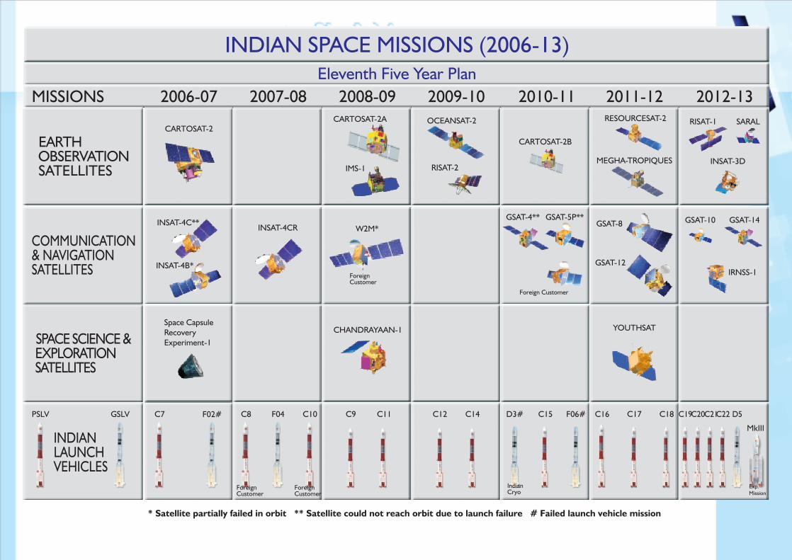
The year 2011 saw remarkable achievements in the Indian Space programme with three successful launches of
Polar Satellite Launch Vehicle (PSLV) from Sriharikota that orbited an Indian Remote Sensing Satellite
RESOURCEAT-2, a science Satellite YOUTHSAT, an Indo-French Satellite MEGHA-TROPIQUES for study of
tropical climate and an Indian Communication Satellite GSAT-12. Another advanced Indian Communication
Satellite GSAT-8 was launched from French Guyana using the European Launch vehicle ARIANE-V. These five
satellites are functioning well and they have significantly enhanced our national capabilities for space applications
and scientific studies
• RESOURCESAT-2, launched on April 20, 2011, is a follow on mission to RESOURCESAT-1 to provide
data continuity to Indian and global user community. It has three optical Remote sensing payloads, Linear
Imaging Self Scanner-3, Linear Imaging Self Scanner-4 and Advanced Wide Field Sensor, as in
RESOURCESAT-1. The satellite also carries an additional payload, known as Automatic Information
System for ship surveillance in Very High Frequency band to derive position, speed and other information
of ships. Compared to RESOURCESAT-1, Linear Imaging Self Scanner-4 multi-spectral swath is enhanced
to 70 km. Suitable changes including miniaturisation in payload electronics have been incorporated in
RESOURCESAT-2.
• Youthsat, an Indo - Russian collaboration, is India’s first small satellite carrying two Indian instruments for
scientific studies of terrestrial upper atmosphere along with one Russian instrument for measuring solar
radiation.
• Megha-Tropiques (Megha means cloud in Sanskrit and Tropiques means tropics in French) is a joint
Indo-French satellite mission for understanding the life cycle of convective systems and their role in the
associated energy and moisture budget of the atmosphere in the tropical regions. The satellite was
launched by PSLV-C18 on October 12, 2011.
• GSAT-12 satellite with 12 Extended C band transponders is designed for a mission life of 8 years and is
placed in 830 East longitude. In-orbit testing of the Payload has been completed and the satellite has been
declared as operational. GSAT-12 will enhance space based applications in the area of telemedicine, tele-
education and disaster management support.
• India's advanced communication satellite, GSAT-8, carrying 24 high power transponders in Ku-band and
a two-channel GPS Aided Geo Augmented Navigation (GAGAN) payload operating in L1 and L5 bands
was placed in the intended geostationary orbital slot of 550 East longitude. The transponders have
augmented the capacity in the INSAT system while the GAGAN payload provides the Satellite Based
Augmentation System through which the accuracy of the positioning information obtained from the GPS
Satellites is improved.
8
• After decommissioning of INSAT-2E in November 2011, ISRO is currently having a constellation of 8
communication satellites, 2 Meteorological satellites, 10 Earth observation satellites and 1 science satellite.
• Further, it is noteworthy that two satellites JUGNU (from IIT, Kanpur) and SRMSat (from SRM University,
Chennai) made by Indian students and two foreign satellites X-SAT and VesselSat-1 were also successfully
launched by PSLV as co-passengers in the year 2011.
Launch Vehicle Programme
• Activities for the realisation of Geosynchronous Satellite Launch Vehicle Mark II with indigenous cryogenic
engine and stage for launching communication and meteorological satellites of two ton class into
Geosynchronous Transfer Orbit and GSLV-Mark III capable of launching four ton satellites are progressing
satisfactorily.
• The S200 solid booster for GSLV Mark III, the heaviest built so far by the ISRO has undergone static test
successfully. The 110 ton liquid core stage of GSLV Mark III has also been successfully static tested for the
full flight duration.
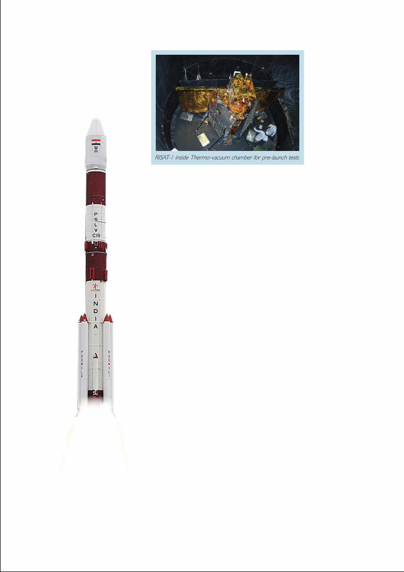
• Activities for the launch of PSLV-C19 carrying the first Indian microwave Radar Imaging Satellite
(RISAT-1) are in advanced stage. RISAT-1, using an active radar sensor system, namely a C-band Synthetic
Aperture Radar imager, is an important microwave complement to its optical IRS series of observation
missions. It is planned to be launched in the second quarter of 2012 from Satish Dhawan Space Centre,
Sriharikota.
• Research and development activities in semi-cryogenic propulsion engine, air breathing propulsion and
re-usable launch vehicle technology are also being pursued vigorously in an effort towards reducing the
cost of access to space. Development of critical technologies for undertaking human spaceflight has also
made progress.
Satellite Programme
• GSAT-7 envisaged as a multi-band satellite carrying payloads in Ultra High Frequency (UHF), S-band, C-
band and Ku-band, is planned to be launched onboard a procured launcher during 2012.
• GSAT-10, carrying 12 Ku Band, 12 C Band and 12 Extended C Band transponders, envisages to augment
the growing need for Ku and C band transponders It also carries a GAGAN payload.
• INSAT-3D is a state-of-the art meteorological satellite with 6 channel Imager and 19 channel Sounder
payloads. The satellite will be located at 820 E longitude in geostationary orbit. The satellite is planned to
be launched onboard a procured launcher during 2013.
• GSAT-14 satellite, envisaged to enhance extended C band and Ku band communication transponder
capacity, carries 6 Extended C band, 6 Ku band Transponders and 2 Ka Band Beacons and is planned to be
launched in the forthcoming of GSLV – D5 in 2012.
9
• Chandrayaan-2 is a follow on mission to Chandrayaan-1 with an Indian Orbiter and Rover and Russian
Lander. Chandrayaan-2 is designed to collect samples of lunar soil and conduct in-situ studies of chemical
and mineralogical content of the lunar soil. Towards this, India and Russia have signed a Memorandum of
Understanding. Chandrayaan-2 mission is targeted for launch on GSLV during 2014.
Societal Applications
• The hallmark of Indian space programme has been the application-oriented efforts and the benefits that
have accrued to the country. The societal services offered by INSAT satellites in the area of tele-education
and telemedicine were continued during the year. Today, tele-education network has more than
55,000 class rooms connected to various academic institutions and universities. Telemedicine network
facilities cover 382 hospitals connecting 306 rural hospitals and 16 mobile vans to 60 super speciality
hospitals providing health care to citizens, especially in rural areas.
• Village Resource Centre (VRC), a single window agency providing the services offered by INSAT and
IRS satellites to provide information on natural resources, land and water resources management,
telemedicine, tele-education, adult education, vocational training, health and family welfare programmes,
has been established. Already more than 473 VRCs in 22 states and union territories have been established
in the country.
Infrastructure development
• During the current year, ISRO built a supercomputer, which is considered to be India's fastest supercomputer
in terms of theoretical peak performance of 220 Trillion Floating Point Operations per second. The
supercomputing facility, named as Satish Dhawan Supercomputing Facility, is located at Vikram Sarabhai
Space Centre, Thiruvananthapuram and is being used for solving complex aerospace problems.
Space Commerce
• Antrix Corporation, the commercial arm of Department Of Space, has been marketing the space products
and services in the global market. Under a commercial contract with Antrix, in the year 2011,
two commercial satellites, namely, X-SAT of Singapore and VessalSat-1 of Luxemburg, have been launched
on board PSLV-C16 and PSLV-C18 missions respectively.
• Antrix has signed a commercial agreement with M/s EADS-Astrium for launch of a remote sensing satellite
SPOT-1 weighing 800 kg using our PSLV during 2012.
Indian Space Industry
• Involvement of Indian space industry continued during the year and has made significant contribution
towards the realisation of subsystems required for Indian space programme. Department Of Space has
associated more than 500 small, medium and large scale industries while implementing its various
1 0
programmes. So far, Department Of Space has transferred 298 technologies to Indian industries for
commercialisation and undertaken technical consultancies in various fields. Presently, ISRO has 254 patents,
39 copyrights and 10 trademarks.
International Cooperation
• International cooperation is an integral part of space activities, and ISRO continues to lay importance on
bilateral and multilateral relations with space agencies and space related bodies with the aim of taking up
new scientific and technological challenges, defining international frameworks for exploitation and utilisation
of outer space for peaceful purposes, refining space policies and building and strengthening existing ties
between countries. This year has been highly significant for ISRO’s international cooperation pursuits, as
two satellites jointly developed with other nations were launched from India. Megha-Tropiques Satellite,
a joint Indo–French mission, was launched on October 12, 2011 and YOUTHSAT, jointly built with
Russia, was launched on April 20, 2011 respectively.
Human Resources
• The achievements of Indian space programme are a result of the commitment, dedication and expertise
of its personnel who continue to play a key role. Recognising the importance of talented and motivated
personnel, the department has laid stress on recruitment, training and career progression features.
Department Of Space has complemented and continues to strive for providing its personnel with facilities
such as housing, medical, canteen and schooling for their children. In addition, the personnel have been
provided with additional compensation packages and rewarded with several incentives on the successful
realisation of space missions.
Indian Institute of Space Science and Technology
• Indian Institute of Space Science and Technology (IIST), a deemed university, was established towards
capacity building in human resources and to meet the growing demands of the Indian Space Programme.
The Institute has started functioning from its permanent campus at Valiamala in Thiruvananthapuram.
The annual intake of the Institute is about 150-200 students. The first batch of fresh graduates from the
institute has been inducted to various ISRO Centres/Units in August 2011.
Public Awareness on Space Programme
• During the year, ISRO organised 41 exhibitions at national and international conferences, important
public congregations like cultural festivals, trade fairs and events and also at academic institutions. Exhibitions
were also organised in association with Non-Governmental Organisations in various places for keeping
the public abreast of the Indian space programme.
1 1
Right to Information – Ensuring Transparency
• Strict compliance to the requirements of Right To Information (RTI) Act 2005 is practiced in the department.
Department Of Space has implemented RTI Act 2005 by identifying the Central Public Information
Officers, Assistant Public Information Officers and the Appellate Authority for stage one appeals. As required
under the Act, Department Of Space has published the requisite information on ISRO website
(www.isrio.gov.in). During the year, 518 applications were received under RTI on which appropriate
responses have been given. 73 appeals were received by the First Appellate Authority and 34 appellants
approached the Second Appellate Authority, i.e., Central Information Commission.

1 2
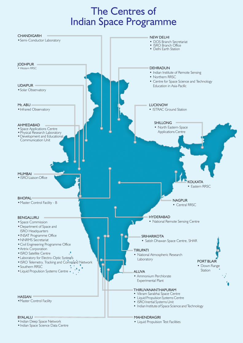
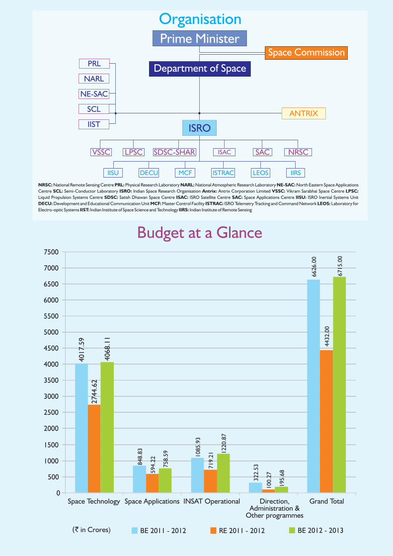
ORGANISATION
The space activities in the country were
initiated with the setting up of Indian National
Committee for Space Research (INCOSPAR)
in 1962. In the same year, the work on
Thumba Equatorial Rocket Launching Station
(TERLS) near Thiruvananthapuram was also
started. Indian Space Research Organisation
(ISRO) was established in August 1969.
Government of India constituted the Space
Commission and established the Department
of Space (DOS) in June 1972 and brought
ISRO under DOS in September 1972.
Space Commission formulates the policies and oversees the implementation of the Indian space programme
to promote the development and application of space science and technology for the socio-economic benefit
of the country. DOS implements these programmes mainly through, ISRO, Physical Research Laboratory
(PRL), National Atmospheric Research Laboratory (NARL), North Eastern-Space Applications Centre
(NE-SAC) and Semi-Conductor Laboratory (SCL). Antrix Corporation, established in 1992 as a government
owned company, markets the space products and services.
The establishment of space systems and their applications are coordinated by the national level committees,
namely, INSAT Coordination Committee (ICC), Planning Committee on National Natural Resources
Management System (PC-NNRMS) and Advisory Committee for Space Sciences (ADCOS).
The DOS Secretariat and ISRO Headquarters are located at Antariksh Bhavan in Bangalore. Programme offices
at ISRO Headquarters coordinate the programmes like satellite communication, earth observation, launch
vehicle, space science, disaster management support, sponsored research scheme, international cooperation,
safety, systems reliability, publications and public relations, budget and economic analysis and human resources
development. The major establishments of DOS and their area of activities are given in the following paragraphs:
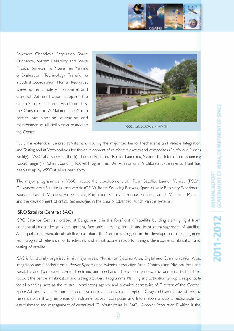
Vikram Sarabhai Space Centre (VSSC)
Vikram Sarabhai Space Centre at Thiruvananthapuram is the lead centre for the design and development of
launch vehicle technologies for the Indian Space Programme. The Centre pursues research and development
in the fields of Aeronautics, Avionics, Composites, Computer & Information, Control, Guidance & Simulation,
Launch Vehicle Design, Materials, Mechanical Engineering, Mechanisms, Vehicle Integration & Testing, Propellants,
Antariksh Bhavan - Headquarters of ISRO/DOS
1 3
Polymers, Chemicals, Propulsion, Space
Ordnance, System Reliability and Space
Physics. Services like Programme Planning
& Evaluation, Technology Transfer &
Industrial Coordination, Human Resources
Development, Safety, Personnel and
General Administration support the
Centre’s core functions. Apart from this,
the Construction & Maintenance Group
carries out planning, execution and
maintenance of all civil works related to
the Centre.
VSSC has extension Centres at Valiamala, housing the major facilities of Mechanisms and Vehicle Integration
and Testing and at Vattiyoorkavu for the development of reinforced plastics and composites (Reinforced Plastics
Facility). VSSC also supports the (i) Thumba Equatorial Rocket Launching Station, the International sounding
rocket range (ii) Rohini Sounding Rocket Programme. An Ammonium Perchlorate Experimental Plant has
been set up by VSSC at Aluva near Kochi.
The major programmes at VSSC include the development of: Polar Satellite Launch Vehicle (PSLV),
Geosynchronous Satellite Launch Vehicle (GSLV), Rohini Sounding Rockets, Space-capsule Recovery Experiment,
Reusable Launch Vehicles, Air Breathing Propulsion, Geosynchronous Satellite Launch Vehicle – Mark III
and the development of critical technologies in the area of advanced launch vehicle systems.
ISRO Satellite Centre (ISAC)
ISRO Satellite Centre, located at Bangalore is in the forefront of satellite building starting right from
conceptualisation, design, development, fabrication, testing, launch and in-orbit management of satellite.
As sequel to its mandate of satellite realisation, the Centre is engaged in the development of cutting-edge
technologies of relevance to its activities, and infrastructure set-up for design, development, fabrication and
testing of satellite.
ISAC is functionally organised in six major areas: Mechanical Systems Area, Digital and Communication Area,
Integration and Checkout Area, Power Systems and Avionics Production Area, Controls and Missions Area and
Reliability and Components Area. Electronic and mechanical fabrication facilities, environmental test facilities
support the centre in fabrication and testing activities. Programme Planning and Evaluation Group is responsible
for all planning, acts as the central coordinating agency and technical secretariat of Director of the Centre.
Space Astronomy and Instrumentations Division has been involved in optical, X-ray and Gamma ray astronomy
research with strong emphasis on instrumentation. Computer and Information Group is responsible for
establishment and management of centralized IT infrastructure in ISAC. Avionics Production Division is the
VSSC main building on Veli Hills
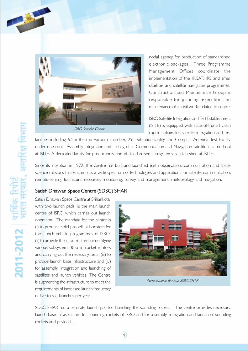
1 4
nodal agency for production of standardised
electronic packages. Three Programme
Management Offices coordinate the
implementation of the INSAT, IRS and small
satellites and satellite navigation programmes.
Construction and Maintenance Group is
responsible for planning, execution and
maintenance of all civil works related to centre.
ISRO Satellite Integration and Test Establishment
(ISITE) is equipped with state-of-the-art clean
room facilities for satellite integration and test
facilities including 6.5m thermo vacuum chamber, 29T vibration facility and Compact Antenna Test Facility
under one roof. Assembly Integration and Testing of all Communication and Navigation satellite is carried out
at ISITE. A dedicated facility for productionisation of standardised sub-systems is established at ISITE.
Since its inception in 1972, the Centre has built and launched earth observation, communication and space
science missions that encompass a wide spectrum of technologies and applications for satellite communication,
remote-sensing for natural resources monitoring, survey and management, meteorology and navigation.
Satish Dhawan Space Centre (SDSC) SHAR
Satish Dhawan Space Centre at Sriharikota,
with two launch pads, is the main launch
centre of ISRO which carries out launch
operation. The mandate for the centre is
(i) to produce solid propellant boosters for
the launch vehicle programmes of ISRO,
(ii) to provide the infrastructure for qualifying
various subsystems & solid rocket motors
and carrying out the necessary tests, (iii) to
provide launch base infrastructure and (iv)
for assembly, integration and launching of
satellites and launch vehicles. The Centre
is augmenting the infrastructure to meet the
requirements of increased launch frequency
of five to six launches per year.
SDSC-SHAR has a separate launch pad for launching the sounding rockets. The centre provides necessary
launch base infrastructure for sounding rockets of ISRO and for assembly, integration and launch of sounding
rockets and payloads.
ISRO Satellite Centre
Administrative Block at SDSC SHAR
1 5
As part of GSLV-Mark III Project, the Centre has created new facilities/augmented some of the existing facilities
viz. solid motor production facilities for processing S200 motor, launch vehicle integration facilities, new radars,
mission control centre, static testing facilities, liquid propellant and cryogenic propellant storage and stage
servicing facilities and satellite preparation facility for preparing various satellites.
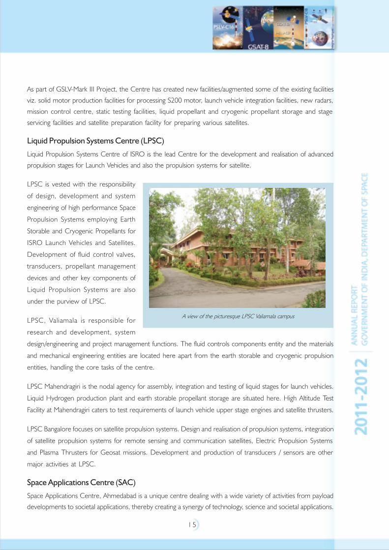
Liquid Propulsion Systems Centre (LPSC)
Liquid Propulsion Systems Centre of ISRO is the lead Centre for the development and realisation of advanced
propulsion stages for Launch Vehicles and also the propulsion systems for satellite.
LPSC is vested with the responsibility
of design, development and system
engineering of high performance Space
Propulsion Systems employing Earth
Storable and Cryogenic Propellants for
ISRO Launch Vehicles and Satellites.
Development of fluid control valves,
transducers, propellant management
devices and other key components of
Liquid Propulsion Systems are also
under the purview of LPSC.
LPSC, Valiamala is responsible for
research and development, system
design/engineering and project management functions. The fluid controls components entity and the materials
and mechanical engineering entities are located here apart from the earth storable and cryogenic propulsion
entities, handling the core tasks of the centre.
LPSC Mahendragiri is the nodal agency for assembly, integration and testing of liquid stages for launch vehicles.
Liquid Hydrogen production plant and earth storable propellant storage are situated here. High Altitude Test
Facility at Mahendragiri caters to test requirements of launch vehicle upper stage engines and satellite thrusters.
LPSC Bangalore focuses on satellite propulsion systems. Design and realisation of propulsion systems, integration
of satellite propulsion systems for remote sensing and communication satellites, Electric Propulsion Systems
and Plasma Thrusters for Geosat missions. Development and production of transducers / sensors are other
major activities at LPSC.
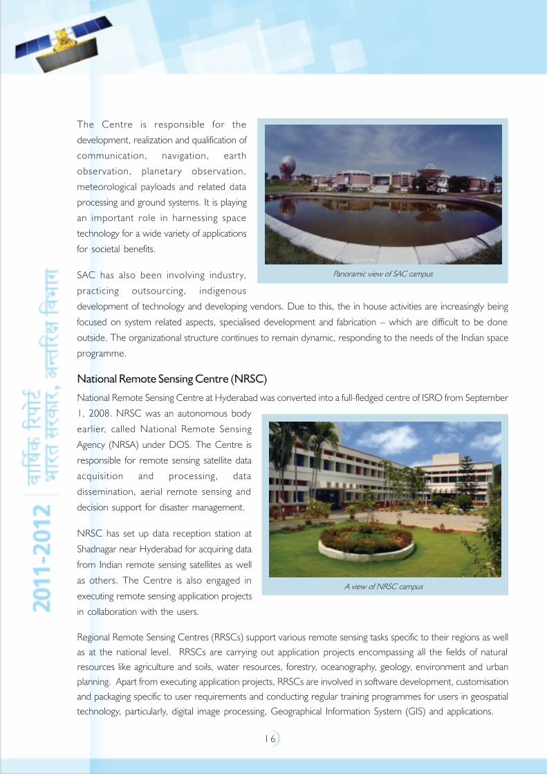
Space Applications Centre (SAC)
Space Applications Centre, Ahmedabad is a unique centre dealing with a wide variety of activities from payload
developments to societal applications, thereby creating a synergy of technology, science and societal applications.
A view of the picturesque LPSC Valiamala campus
1 6
The Centre is responsible for the
development, realization and qualification of
communication, navigation, earth
observation, planetary observation,
meteorological payloads and related data
processing and ground systems. It is playing
an important role in harnessing space
technology for a wide variety of applications
for societal benefits.
SAC has also been involving industry,
practicing outsourcing, indigenous
development of technology and developing vendors. Due to this, the in house activities are increasingly being
focused on system related aspects, specialised development and fabrication – which are difficult to be done
outside. The organizational structure continues to remain dynamic, responding to the needs of the Indian space
programme.
National Remote Sensing Centre (NRSC)
National Remote Sensing Centre at Hyderabad was converted into a full-fledged centre of ISRO from September
1, 2008. NRSC was an autonomous body
earlier, called National Remote Sensing
Agency (NRSA) under DOS. The Centre is
responsible for remote sensing satellite data
acquisition and processing, data
dissemination, aerial remote sensing and
decision support for disaster management.
NRSC has set up data reception station at
Shadnagar near Hyderabad for acquiring data
from Indian remote sensing satellites as well
as others. The Centre is also engaged in
executing remote sensing application projects
in collaboration with the users.
Regional Remote Sensing Centres (RRSCs) support various remote sensing tasks specific to their regions as well
as at the national level. RRSCs are carrying out application projects encompassing all the fields of natural
resources like agriculture and soils, water resources, forestry, oceanography, geology, environment and urban
planning. Apart from executing application projects, RRSCs are involved in software development, customisation
and packaging specific to user requirements and conducting regular training programmes for users in geospatial
technology, particularly, digital image processing, Geographical Information System (GIS) and applications.
Panoramic view of SAC campus
A view of NRSC campus
1 7
1 8
1 9
Indian Institute of Remote Sensing (IIRS)
The Indian Institute of Remote Sensing, a unit of ISRO, at Dehradun is a premier education, training and
research institute for capacity building in the field of Remote Sensing, Geo-information, positioning and navigation
technology and its applications. Indian Institute of Remote Sensing (IIRS), formerly known as Indian
Photo-Interpretation Institute (IPI), was set up in 1966 under the aegis of the Survey of India to provide
comprehensive training with hands on experience of the emerging technology. Institute was merged with
National Remote Sensing Agency (NRSA) in July 1976, and in the year 1980, NRSA came under the umbrella
of Department of Space (Government of India). Since September 1, 2008, IIRS, as part of NRSC was inducted
under the ISRO umbrella, and presently IIRS is reorganized as a separate entity of ISRO with effect from
April 30, 2011.
IRS endeavor has been to train thematic experts from user community including academic institutions in
Remote Sensing and Geographical Information System technology / applications at Post Graduate level with the
overall goal of 'technology transfer' and user awareness. The Institute has evolved many programs that are tuned
to the different needs of various target groups.
Development and Educational Communication Unit (DECU)
Development and Educational Communication Unit, Ahmedabad is involved in the system definition, planning,
implementation and socio-economic research/evaluation of satellite-based societal applications. The major
activities of DECU include: Tele-education, Telemedicine, Training and Development Communication Channel
(TDCC), Village Resource Centres (VRC) and Disaster Management Support Program, etc.
ISRO Telemetry, Tracking and Command Network (ISTRAC)
ISRO Telemetry, Tracking and Command Network provides satellite Telemetry Tracking and Command (TTC)
and mission control support to major Launch Vehicle and satellite missions of ISRO. This includes: carrying out
mission operations of all operational remote sensing and scientific satellites, providing TTC services from launch
vehicle lift-off till injection of satellite into orbit and to estimate its preliminary orbit in space and hardware and
software developmental activities that enhance the capabilities of ISTRAC for providing flawless TTC and Mission
Operations services.
ISTRAC has established a network of ground stations at Bangalore, Lucknow, Mauritius, Sriharikota, Port Blair,
Thiruvananthapuram, Brunei and Biak (Indonesia) and the Deep Space Network Stations DSN-32 and
DSN-18. The Mission Operations Complex located at Bangalore carries out round-the-clock mission operations
for all the remote sensing and science satellites. All network stations of ISTRAC are connected to the Mission
Operations Complex through dedicated high-performance satellite links along with terrestrial links.
ISTRAC has also been mandated to provide space operations support for Human Spaceflight and Deep Space
Missions of ISRO, undertake development of radar systems for launch vehicle tracking and meteorological
applications, establish and operationalise the ground segment for Indian Regional Navigational Satellite System,
provide Search and Rescue and Disaster Management Services and to host socially useful space based services
like telemedicine, VRC and tele-education.
2 0
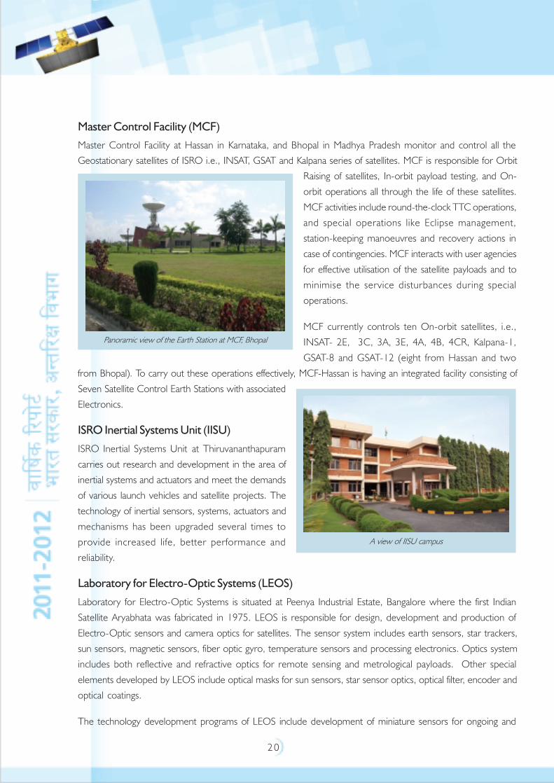
Master Control Facility (MCF)
Master Control Facility at Hassan in Karnataka, and Bhopal in Madhya Pradesh monitor and control all the
Geostationary satellites of ISRO i.e., INSAT, GSAT and Kalpana series of satellites. MCF is responsible for Orbit
Raising of satellites, In-orbit payload testing, and On-
orbit operations all through the life of these satellites.
MCF activities include round-the-clock TTC operations,
and special operations like Eclipse management,
station-keeping manoeuvres and recovery actions in
case of contingencies. MCF interacts with user agencies
for effective utilisation of the satellite payloads and to
minimise the service disturbances during special
operations.
MCF currently controls ten On-orbit satellites, i.e.,
INSAT- 2E, 3C, 3A, 3E, 4A, 4B, 4CR, Kalpana-1,
GSAT-8 and GSAT-12 (eight from Hassan and two
from Bhopal). To carry out these operations effectively, MCF-Hassan is having an integrated facility consisting of
Seven Satellite Control Earth Stations with associated
Electronics.
ISRO Inertial Systems Unit (IISU)
ISRO Inertial Systems Unit at Thiruvananthapuram
carries out research and development in the area of
inertial systems and actuators and meet the demands
of various launch vehicles and satellite projects. The
technology of inertial sensors, systems, actuators and
mechanisms has been upgraded several times to
provide increased life, better performance and
reliability.
Laboratory for Electro-Optic Systems (LEOS)
Laboratory for Electro-Optic Systems is situated at Peenya Industrial Estate, Bangalore where the first Indian
Satellite Aryabhata was fabricated in 1975. LEOS is responsible for design, development and production of
Electro-Optic sensors and camera optics for satellites. The sensor system includes earth sensors, star trackers,
sun sensors, magnetic sensors, fiber optic gyro, temperature sensors and processing electronics. Optics system
includes both reflective and refractive optics for remote sensing and metrological payloads. Other special
elements developed by LEOS include optical masks for sun sensors, star sensor optics, optical filter, encoder and
optical coatings.
The technology development programs of LEOS include development of miniature sensors for ongoing and
Panoramic view of the Earth Station at MCF, Bhopal
A view of IISU campus
2 1
future satellites, high resolution camera optics, optical coatings and development of Micro Electro Mechanical
System devices.
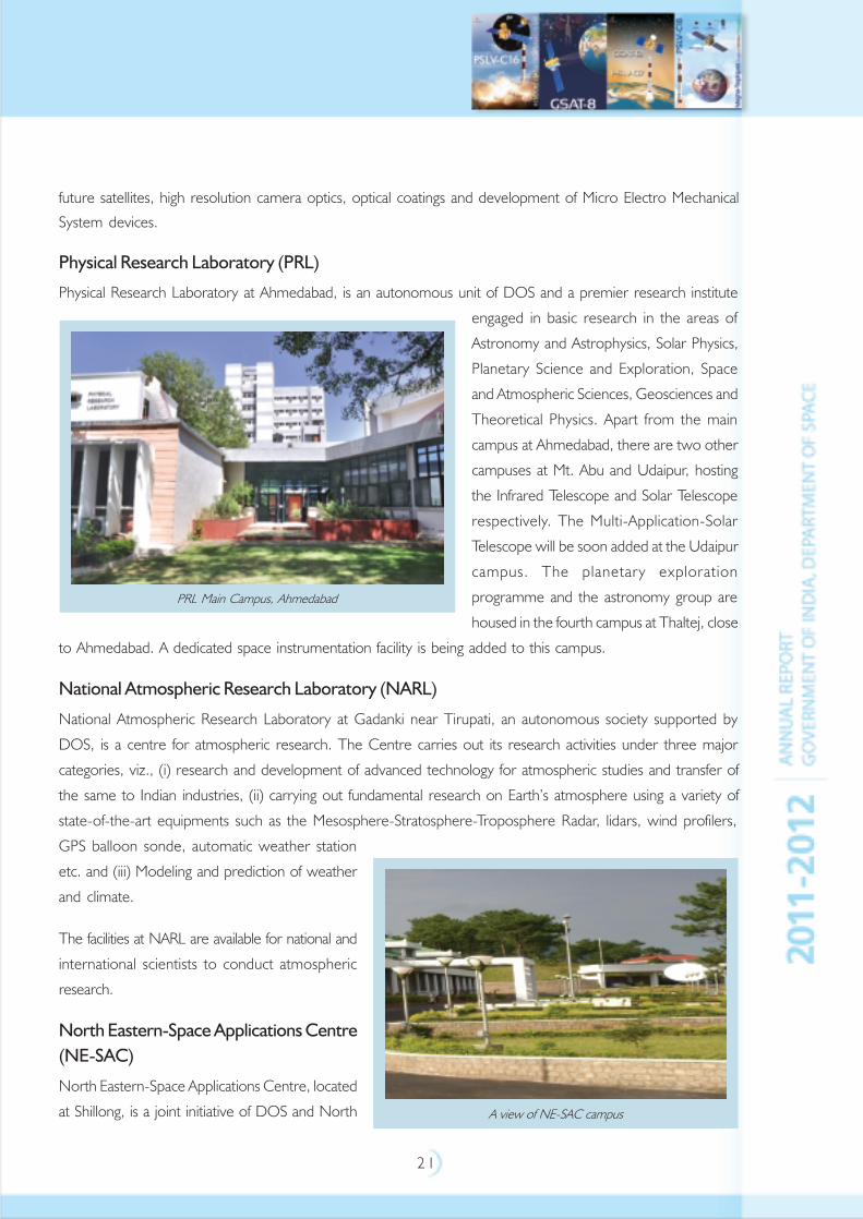
Physical Research Laboratory (PRL)
Physical Research Laboratory at Ahmedabad, is an autonomous unit of DOS and a premier research institute
engaged in basic research in the areas of
Astronomy and Astrophysics, Solar Physics,
Planetary Science and Exploration, Space
and Atmospheric Sciences, Geosciences and
Theoretical Physics. Apart from the main
campus at Ahmedabad, there are two other
campuses at Mt. Abu and Udaipur, hosting
the Infrared Telescope and Solar Telescope
respectively. The Multi-Application-Solar
Telescope will be soon added at the Udaipur
campus. The planetary exploration
programme and the astronomy group are
housed in the fourth campus at Thaltej, close
to Ahmedabad. A dedicated space instrumentation facility is being added to this campus.
National Atmospheric Research Laboratory (NARL)
National Atmospheric Research Laboratory at Gadanki near Tirupati, an autonomous society supported by
DOS, is a centre for atmospheric research. The Centre carries out its research activities under three major
categories, viz., (i) research and development of advanced technology for atmospheric studies and transfer of
the same to Indian industries, (ii) carrying out fundamental research on Earth’s atmosphere using a variety of
state-of-the-art equipments such as the Mesosphere-Stratosphere-Troposphere Radar, lidars, wind profilers,
GPS balloon sonde, automatic weather station
etc. and (iii) Modeling and prediction of weather
and climate.
The facilities at NARL are available for national and
international scientists to conduct atmospheric
research.
North Eastern-Space Applications Centre
(NE-SAC)
North Eastern-Space Applications Centre, located
at Shillong, is a joint initiative of DOS and North
PRL Main Campus, Ahmedabad
A view of NE-SAC campus
2 2
Eastern Council to provide developmental support to the North Eastern Region using space science and
technology. The centre has the mandate to develop high technology infrastructure support to enable North
Eastern states to adopt space technology inputs for their development. At present, NE-SAC is providing
developmental support by undertaking specific projects by utilising space technology inputs from remote sensing,
satellite communication and space science.
Semi-Conductor Laboratory (SCL)
The administrative control of Semi-Conductor Complex Limited, Chandigarh, a public sector undertaking
under Ministry of Communications and Information Technology was transferred to Department of Space during
March 2005. DOS has re-structured SCL Company and has registered SCL as a research and development
society in November 2005. SCL is entrusted with design and development of Very Large Scale Integration
(VLSI) devices and development of systems for telecommunication and space sectors. SCL has facilities
for fabrication of micro-electronic devices in 0.8 micron range and Micro Electro Mechanical Systems.
The Up-gradation of CMOS Fab and commensurate facilities and utilities to 0.18 micron is the major project
being carried out at SCL.
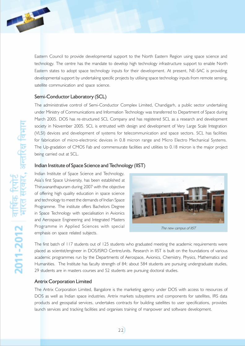
Indian Institute of Space Science and Technology (IIST)
Indian Institute of Space Science and Technology,
Asia’s first Space University, has been established at
Thiruvananthapuram during 2007 with the objective
of offering high quality education in space science
and technology to meet the demands of Indian Space
Programme. The institute offers Bachelors Degree
in Space Technology with specialisation in Avionics
and Aerospace Engineering and Integrated Masters
Programme in Applied Sciences with special
emphasis on space related subjects.
The first batch of 117 students out of 125 students who graduated meeting the academic requirements were
placed as scientist/engineer in DOS/ISRO Centre/units. Research in IIST is built on the foundations of various
academic programmes run by the Departments of Aerospace, Avionics, Chemistry, Physics, Mathematics and
Humanities. The Institute has faculty strength of 84; about 584 students are pursuing undergraduate studies,
29 students are in masters courses and 52 students are pursuing doctoral studies.
Antrix Corporation Limited
The Antrix Corporation Limited, Bangalore is the marketing agency under DOS with access to resources of
DOS as well as Indian space industries. Antrix markets subsystems and components for satellites, IRS data
products and geospatial services, undertakes contracts for building satellites to user specifications, provides
launch services and tracking facilities and organises training of manpower and software development.
The new campus of IIST
2 3
COMMUNICATION, NAVIGATION ANDMETEOROLOGICAL SATELLITE SYSTEM
Indian National Satellite (INSAT) system, established in 1983, is the largest domestic communication satellite
system in the Asia Pacific Region with ten satellites in operation INSAT-2E, INSAT-3A,
INSAT-3C, INSAT-3E, KALPANA-1, INSAT-4A, INSAT-4B, INSAT-4CR, GSAT-8 and GSAT-12. The overall
coordination and management of INSAT system rests with INSAT Coordination Committee.
SATELLITES IN SERVICE
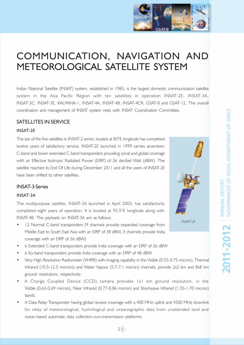
INSAT-2E
The last of the five satellites in INSAT-2 series, located at 83ºE longitude has completed
twelve years of satisfactory service. INSAT-2E launched in 1999 carries seventeen
C-band and lower extended C-band transponders providing zonal and global coverage
with an Effective Isotropic Radiated Power (EIRP) of 36 decibel Watt (dBW). The
satellite reached its End Of Life during December 2011 and all the users of INSAT-2E
have been shifted to other satellites.
INSAT-3 Series
INSAT-3A
The multipurpose satellite, INSAT-3A launched in April 2003, has satisfactorily
completed eight years of operation. It is located at 93.5ºE longitude along with
INSAT-4B. The payloads on INSAT-3A are as follows:
• 12 Normal C-band transponders (9 channels provide expanded coverage from
Middle East to South East Asia with an EIRP of 38 dBW, 3 channels provide India
coverage with an EIRP of 36 dBW)
• 6 Extended C-band transponders provide India coverage with an EIRP of 36 dBW
• 6 Ku-band transponders provide India coverage with an EIRP of 48 dBW
• Very High Resolution Radiometer (VHRR) with imaging capability in the Visible (0.55-0.75 micron), Thermal
Infrared (10.5-12.5 microns) and Water Vapour (5.7-7.1 micron) channels, provide 2x2 km and 8x8 km
ground resolutions, respectively.
• A Charge Coupled Device (CCD) camera provides 1x1 km ground resolution, in the
Visible (0.63-0.69 micron), Near Infrared (0.77-0.86 micron) and Shortwave Infrared (1.55-1.70 micron)
bands.
• A Data Relay Transponder having global receive coverage with a 400 MHz uplink and 4500 MHz downlink
for relay of meteorological, hydrological and oceanographic data from unattended land and
ocean-based automatic data collection-cum-transmission platforms.
INSAT-2E
2 4
• A Satellite Aided Search and Rescue payload having global receive coverage with
406 MHz uplink and 4500 MHz downlink with India coverage, for relay of signals from distress beacons in
sea, air or land.
INSAT-3C
Launched in January 2002, INSAT-3C is positioned at 74ºE longitude. INSAT-3C payloads include
24 Normal C-band transponders providing an EIRP of 37 dBW, six Extended C-band transponders with an EIRP
of 37 dBW, two S-band transponders to provide BSS services with 42 dBW EIRP, and an Mobile Satellite Service
(MSS) payload. All the transponders provide coverage over India. The satellite is continuing to provide satisfactory
service.
INSAT-3E
Launched in September 2003, INSAT-3E is positioned at 55ºE longitude along with
GSAT-8 and carries 24 Normal C-band transponders that provide an edge of coverage EIRP of
37 dBW over India and 12 Extended C-band transponders provide an edge of coverage EIRP of
38 dBW over India. The satellite is operating with reduced capacity due to onboard
power related anomaly.
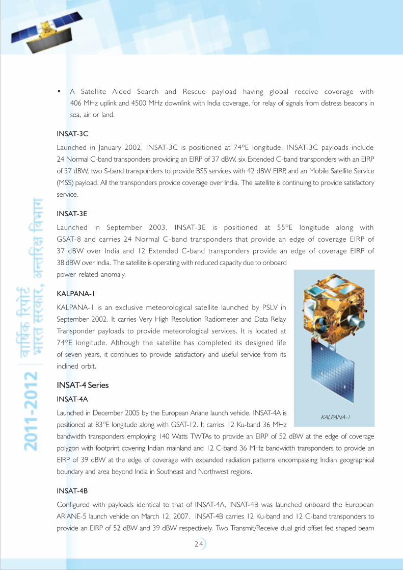
KALPANA-1
KALPANA-1 is an exclusive meteorological satellite launched by PSLV in
September 2002. It carries Very High Resolution Radiometer and Data Relay
Transponder payloads to provide meteorological services. It is located at
74ºE longitude. Although the satellite has completed its designed life
of seven years, it continues to provide satisfactory and useful service from its
inclined orbit.
INSAT-4 Series
INSAT-4A
Launched in December 2005 by the European Ariane launch vehicle, INSAT-4A is
positioned at 83ºE longitude along with GSAT-12. It carries 12 Ku-band 36 MHz
bandwidth transponders employing 140 Watts TWTAs to provide an EIRP of 52 dBW at the edge of coverage
polygon with footprint covering Indian mainland and 12 C-band 36 MHz bandwidth transponders to provide an
EIRP of 39 dBW at the edge of coverage with expanded radiation patterns encompassing Indian geographical
boundary and area beyond India in Southeast and Northwest regions.
INSAT-4B
Configured with payloads identical to that of INSAT-4A, INSAT-4B was launched onboard the European
ARIANE-5 launch vehicle on March 12, 2007. INSAT-4B carries 12 Ku-band and 12 C-band transponders to
provide an EIRP of 52 dBW and 39 dBW respectively. Two Transmit/Receive dual grid offset fed shaped beam
KALPANA-1
2 5
reflectors of 2.2 m diameter for Ku-band and 2 m diameter for C-band are used. INSAT-4B has augmented the
high power transponder capacity over India in Ku-band and over a wider region in C-band. INSAT-4B has been
co-located with INSAT-3A at 93.5ºE longitude. Due to a power anomaly the satellite is operating to half its
capacity.
INSAT-4CR
INSAT-4CR was launched on September 2, 2007 on GSLV from Sriharikota. INSAT-4CR with
12 high power Ku-band transponders with an EIRP of 51.5 dBW has been positioned at 74ºE longitude
co-located with INSAT-3C and KALPANA-1. INSAT-4CR is the third satellite in INSAT-4 series. INSAT-4CR is
designed to provide Direct-To-Home (DTH) television services, Video Picture Transmission and Digital Satellite
News Gathering.
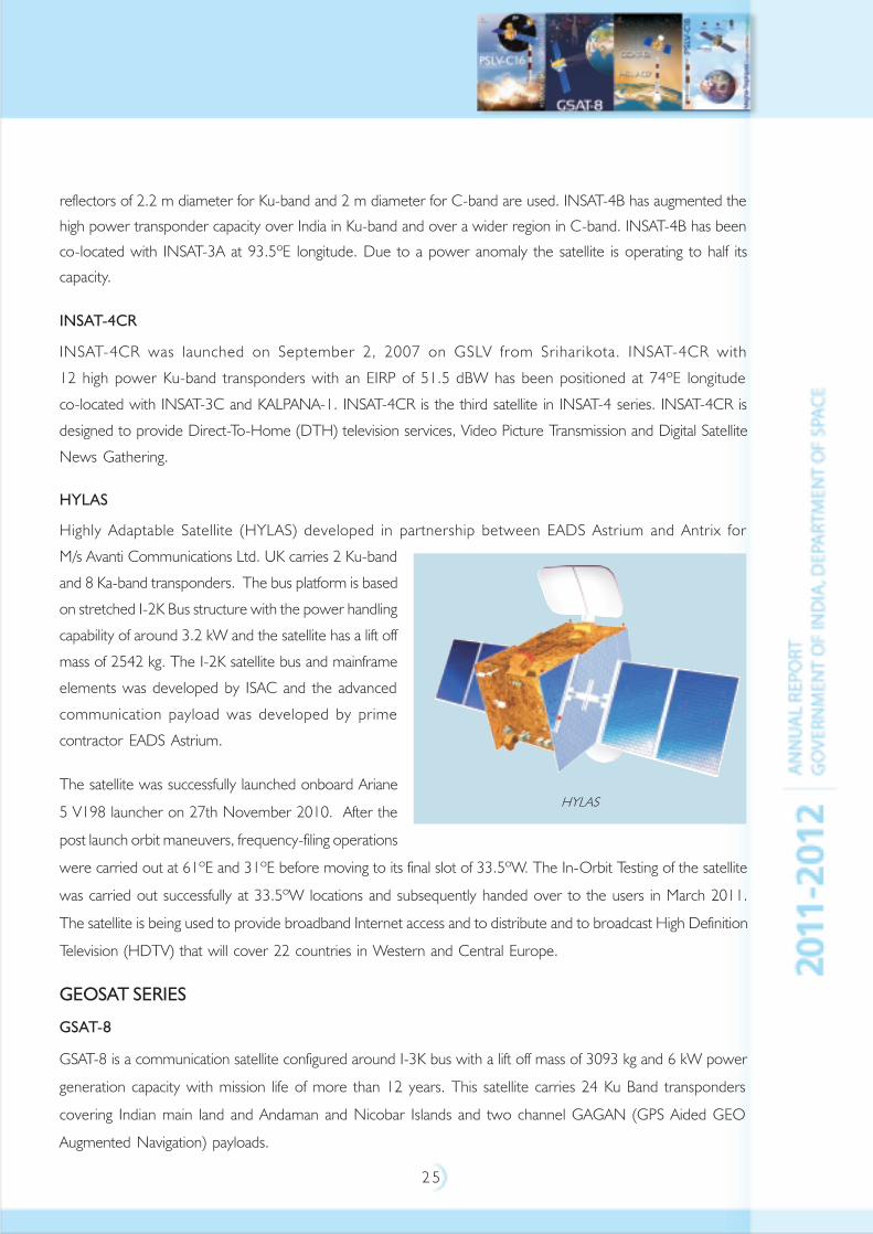
HYLAS
Highly Adaptable Satellite (HYLAS) developed in partnership between EADS Astrium and Antrix for
M/s Avanti Communications Ltd. UK carries 2 Ku-band
and 8 Ka-band transponders. The bus platform is based
on stretched I-2K Bus structure with the power handling
capability of around 3.2 kW and the satellite has a lift off
mass of 2542 kg. The I-2K satellite bus and mainframe
elements was developed by ISAC and the advanced
communication payload was developed by prime
contractor EADS Astrium.
The satellite was successfully launched onboard Ariane
5 V198 launcher on 27th November 2010. After the
post launch orbit maneuvers, frequency-filing operations
were carried out at 61ºE and 31ºE before moving to its final slot of 33.5ºW. The In-Orbit Testing of the satellite
was carried out successfully at 33.5ºW locations and subsequently handed over to the users in March 2011.
The satellite is being used to provide broadband Internet access and to distribute and to broadcast High Definition
Television (HDTV) that will cover 22 countries in Western and Central Europe.
GEOSAT SERIES
GSAT-8
GSAT-8 is a communication satellite configured around I-3K bus with a lift off mass of 3093 kg and 6 kW power
generation capacity with mission life of more than 12 years. This satellite carries 24 Ku Band transponders
covering Indian main land and Andaman and Nicobar Islands and two channel GAGAN (GPS Aided GEO
Augmented Navigation) payloads.
HYLAS
2 6
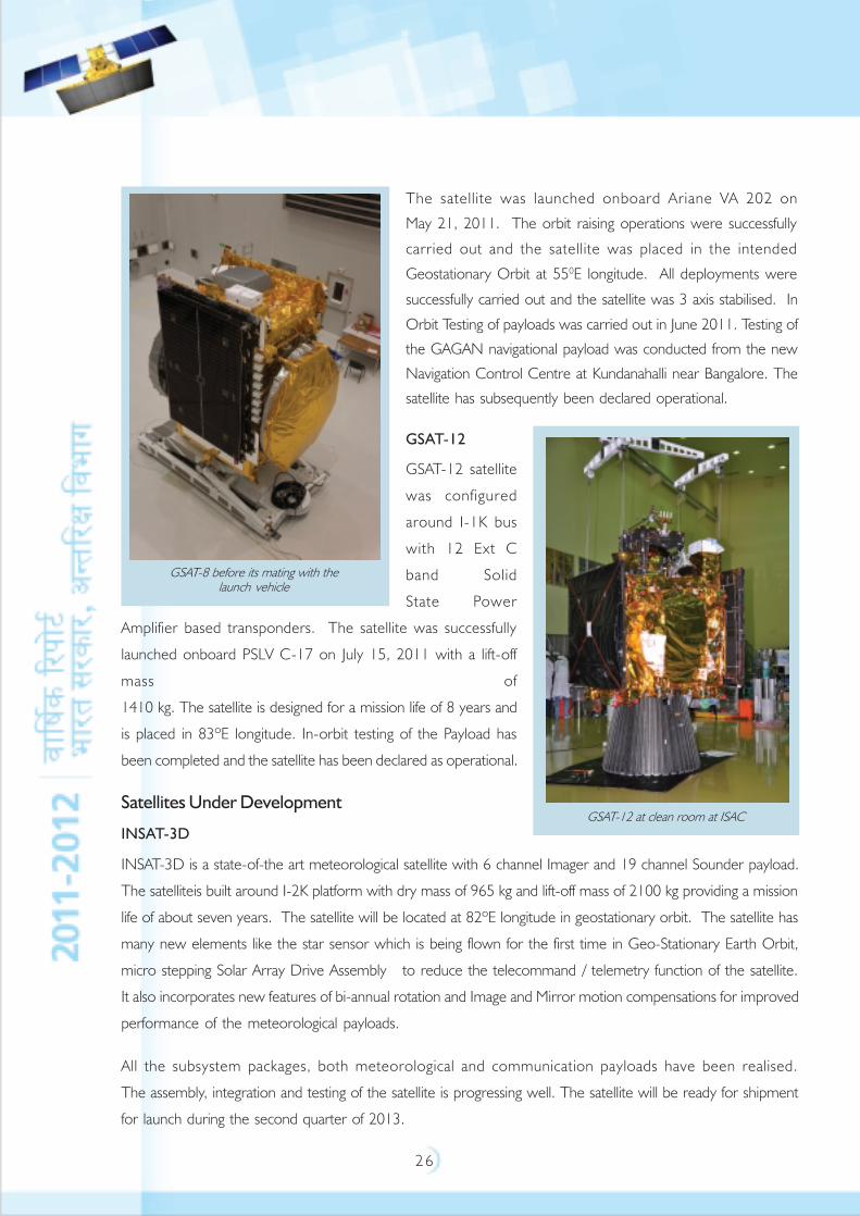
The satellite was launched onboard Ariane VA 202 on
May 21, 2011. The orbit raising operations were successfully
carried out and the satellite was placed in the intended
Geostationary Orbit at 550E longitude. All deployments were
successfully carried out and the satellite was 3 axis stabilised. In
Orbit Testing of payloads was carried out in June 2011. Testing of
the GAGAN navigational payload was conducted from the new
Navigation Control Centre at Kundanahalli near Bangalore. The
satellite has subsequently been declared operational.
GSAT-12
GSAT-12 satellite
was configured
around I-1K bus
with 12 Ext C
band Solid
State Power
Amplifier based transponders. The satellite was successfully
launched onboard PSLV C-17 on July 15, 2011 with a lift-off
mass of
1410 kg. The satellite is designed for a mission life of 8 years and
is placed in 83ºE longitude. In-orbit testing of the Payload has
been completed and the satellite has been declared as operational.
Satellites Under Development
INSAT-3D
INSAT-3D is a state-of-the art meteorological satellite with 6 channel Imager and 19 channel Sounder payload.
The satelliteis built around I-2K platform with dry mass of 965 kg and lift-off mass of 2100 kg providing a mission
life of about seven years. The satellite will be located at 82ºE longitude in geostationary orbit. The satellite has
many new elements like the star sensor which is being flown for the first time in Geo-Stationary Earth Orbit,
micro stepping Solar Array Drive Assembly to reduce the telecommand / telemetry function of the satellite.
It also incorporates new features of bi-annual rotation and Image and Mirror motion compensations for improved
performance of the meteorological payloads.
All the subsystem packages, both meteorological and communication payloads have been realised.
The assembly, integration and testing of the satellite is progressing well. The satellite will be ready for shipment
for launch during the second quarter of 2013.
GSAT-12 at clean room at ISAC
GSAT-8 before its mating with thelaunch vehicle

2 7
GSAT-7
GSAT-7 is envisaged as a multi-band satellite. The satellite employs the standard 2.5 ton bus platform with the
power handling capability of around 2600 W and lift off mass of 2550 kg.
All the mainframe elements and the Payload elements have been delivered. The satellite will be ready for
shipment for launch during 2012.
GSAT-10
GSAT-10 is a 3 axis body stabilized geostationary satellite based on ISRO’s 3 ton structure to provide
communication services/augment the existing services.
It carries 12 Normal C band, 6 Extended C band,
12 Ku band transponders along with GAGAN payload.
The lift-off mass of the satellite is 3400 kg and it generates
6.0 kilo Watt of Power. The satellite will be located at
83ºE and will have a minimum operational life of 15
years.
The satellite after completing all the integrated tests, is
undergoing thrmo-vacuum test. The satellite will be ready
for launch during the second quarter of 2012.
GSAT-6
This satellite with a lift-off mass of 2200 kg, is primarily configured with CxS and SxC transponders. The S-band
up and down links are having high G/T and Effective Isotropic Radiated Power to be able to communicate with
mobile instruments. This is achieved using five numbers of high power 235 W Traveling Wave Tube Amplifiers
and an indigenously developed high gain 6m Unfurable Antenna.
The mainframe structure has been delivered. Payload and mainframe subsystems are ready for Assembly Integration
and Testing activities. Integration of propulsion system has been completed. The disassembled mode – Integrated
Satellite Test has been initiated. The flight model of Unfurable Antenna has been realised. Final tests are
under progress.
The subsystem level Comprehensive Design Reviews have been completed. The satellite will be ready for
shipment for launch onboard GSLV during 2013.
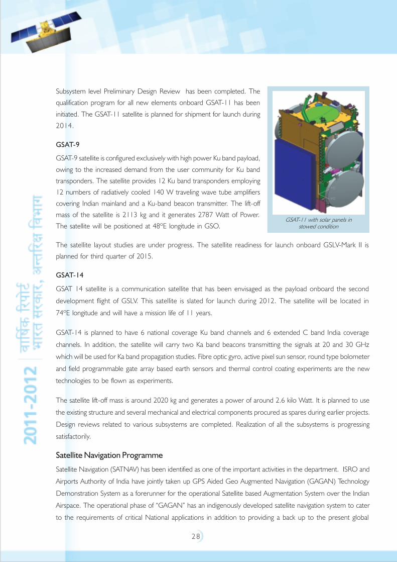
GSAT-11
GSAT-11 is an advanced communication satellite, employing a new Bus with 32 Ka x Ku Band – Forward Link
Transponders and 8 Ku x Ka Band Return Link Transponders. The satellite is having a lift off mass of 5000 kg and
the power handling capability of around 14 kilo Watt.
Artist’s concept of GSAT-10
2 8
Subsystem level Preliminary Design Review has been completed. The
qualification program for all new elements onboard GSAT-11 has been
initiated. The GSAT-11 satellite is planned for shipment for launch during
2014.
GSAT-9
GSAT-9 satellite is configured exclusively with high power Ku band payload,
owing to the increased demand from the user community for Ku band
transponders. The satellite provides 12 Ku band transponders employing
12 numbers of radiatively cooled 140 W traveling wave tube amplifiers
covering Indian mainland and a Ku-band beacon transmitter. The lift-off
mass of the satellite is 2113 kg and it generates 2787 Watt of Power.
The satellite will be positioned at 48ºE longitude in GSO.
The satellite layout studies are under progress. The satellite readiness for launch onboard GSLV-Mark II is
planned for third quarter of 2015.
GSAT-14
GSAT 14 satellite is a communication satellite that has been envisaged as the payload onboard the second
development flight of GSLV. This satellite is slated for launch during 2012. The satellite will be located in
74ºE longitude and will have a mission life of 11 years.
GSAT-14 is planned to have 6 national coverage Ku band channels and 6 extended C band India coverage
channels. In addition, the satellite will carry two Ka band beacons transmitting the signals at 20 and 30 GHz
which will be used for Ka band propagation studies. Fibre optic gyro, active pixel sun sensor, round type bolometer
and field programmable gate array based earth sensors and thermal control coating experiments are the new
technologies to be flown as experiments.
The satellite lift-off mass is around 2020 kg and generates a power of around 2.6 kilo Watt. It is planned to use
the existing structure and several mechanical and electrical components procured as spares during earlier projects.
Design reviews related to various subsystems are completed. Realization of all the subsystems is progressing
satisfactorily.
Satellite Navigation Programme
Satellite Navigation (SATNAV) has been identified as one of the important activities in the department. ISRO and
Airports Authority of India have jointly taken up GPS Aided Geo Augmented Navigation (GAGAN) Technology
Demonstration System as a forerunner for the operational Satellite based Augmentation System over the Indian
Airspace. The operational phase of “GAGAN” has an indigenously developed satellite navigation system to cater
to the requirements of critical National applications in addition to providing a back up to the present global
GSAT-11 with solar panels instowed condition
2 9
Satellite Navigation system being used by our commercial and other establishments in the country. In order to
organize and implement the above activities effectively, a Satellite Navigation Programme was constituted.
To implement the Satellite Navigation Programme, the organizational structure in various ISRO Centres has
been created and activities such as GAGAN Technology Demonstration System and Final Operational Phase and
Indian Regional Navigation Satellite System (IRNSS) will be part of this programme. ISAC is identified as the lead
centre for Satellite Navigation Programme activities.
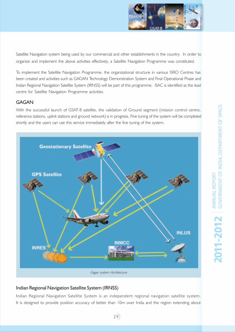
GAGAN
With the successful launch of GSAT-8 satellite, the validation of Ground segment (mission control centre,
reference stations, uplink stations and ground network) is in progress. Fine tuning of the system will be completed
shortly and the users can use this service immediately after the fine tuning of the system.
Indian Regional Navigation Satellite System (IRNSS)
Indian Regional Navigation Satellite System is an independent regional navigation satellite system.
It is designed to provide position accuracy of better than 10m over India and the region extending about
Gagan system Architecture
3 0
1500 km around India. It is designed to provide an accurate real time Position, Navigation and Time (PNT)
services to users on a variety of platforms with 24x7 service availability under all weather conditions. The IRNSS
system mainly consists of three components viz: Space Segment (Constellation of Satellites and
Signal–In–Space), Ground Segment and User Segment. IRNSS constellation consists of seven satellites.
Three Satellites will be placed in the Geostationary orbit (at 34ºE, 83ºE & 131.5ºE) and two satellites each will
be placed in the Geosynchronous orbit (GSO) with an equator crossing at 55ºE and 111.5ºE with an inclination
of 29º. IRNSS will have two types of signals in L5 & S-band and S-band. Both L5 and S-band consists of two
downlinks. IRNSS provides two basic services such as Standard Positioning Service (SPS) for common civilian
users and Restricted Service (RS) for special authorised users.
3 1
EARTH OBSERVATION SYSTEM
The Indian Remote Sensing satellite system has one of the largest constellations of remote sensing satellites in
operation in the world today. Currently, eleven operational satellites are in orbit – TES, RESOURCESAT-1,
CARTOSAT-1, CARTOSAT-2, CARTOSAT-2A, CARTOSAT-2B, IMS-1, RISAT-2, OCEANSAT-2,
RESOURCESAT-2 and MEGHA-TROPIQUES. The IRS series of satellites provide data in a variety of spatial,
spectral and temporal resolutions which are effectively used for resource management purposes. With these
in-orbit satellites and the planned missions of RISAT-1, SARAL and INSAT-3D during 2012, the Indian
Earth Observation (EO) system will be further strengthened to continue providing high quality diversified satellite
data products and services to the user community and hence enabling a host of applications for national development.
Earth Observation Missions accomplished in 2011
RESOURCESAT-2 is a follow on mission to RESOURCESAT-1 to provide data continuity to Indian and global user
community. It was launched by PSLV-C16 into 817 km Sun synchronous circular orbit on April 20, 2011. It has three
optical Remote sensing payloads, LISS-3, LISS-4 & AWIFS, as in RESOURCESAT-1. It also carried an additional
Announcement of Opportunities payload, known as AIS (Automatic Information System) from COMDEV, Canada as
an experimental payload for ship surveillance in Very High Frequency (VHF) band to derive position, speed and other
information of ships. Compared to RESOURCESAT-1, Linear Imaging Self Scanner-4 (LISS-4)
multi-spectral swath is enhanced to 70 km. Suitable changes including miniaturization in payload electronics have been
incorporated in RESOURCESAT-2.
Megha-Tropiques (Megha means cloud in Sanskrit and Tropiques means tropics in French) is a joint
ISRO - CNES mission in understanding the life cycle of convective systems and their role in the associated energy
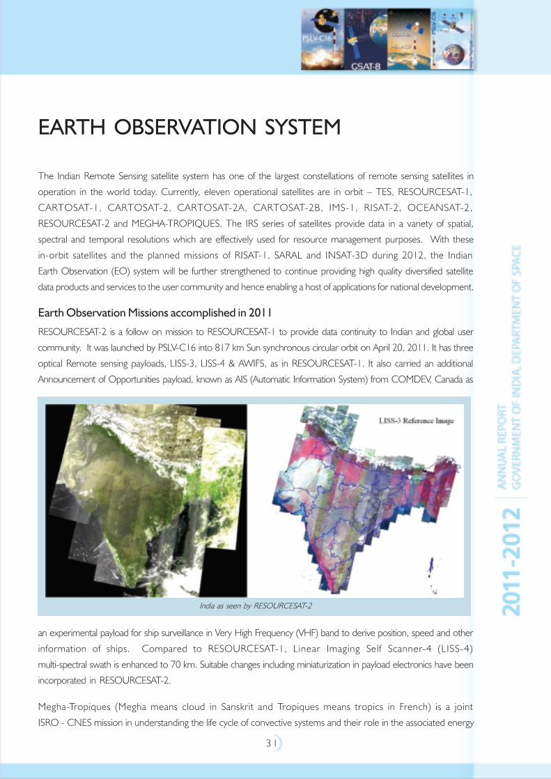
India as seen by RESOURCESAT-2
3 2
and moisture budget of the atmosphere in the tropical regions. The satellite was launched by PSLV-C18 on
October 12, 2011 into an 867 km orbit at an inclination of 20º with respect to the equatorial plane. Following
four scientific instruments were carried by the satellite:
• Microwave Analysis and Detection of Rain and Atmospheric Structures (MADRAS), an Imaging Radiometer
developed jointly by CNES and ISRO
• SAPHIR, a six channel Humidity Sounder
• SCARAB, a four channel Scanner for Radiation Budget Measurement
• GPS-ROS, a GPS Radio Occultation System to provide vertical profiles of temperature and humidity of the
earth’s atmosphere
All the payloads are performing satisfactorily and are providing useful scientific data for Research and analysis.
Earth Observation Satellites currently operational
CARTOSAT-1 was launched into a 617 km polar sunsynchronous orbit on May 5, 2005 on board PSLV-C6
from SDSC, SHAR, Shriharikota. Two panchromatic cameras, PAN (Fore) and PAN (Aft), with 2.5 m spatial
resolution and swath of 30 km is providing high quality images. The cameras are mounted with a tilt of +26º
and -5º along track with respect to nadir that provide stereo pairs for the generation of Digital Elevation Model
(DEM). Data from CARTOSAT-1 is being used for cartographic applications, cadastral level mapping,
Digital Elevation Model generation and other high resolution geospatial applications.
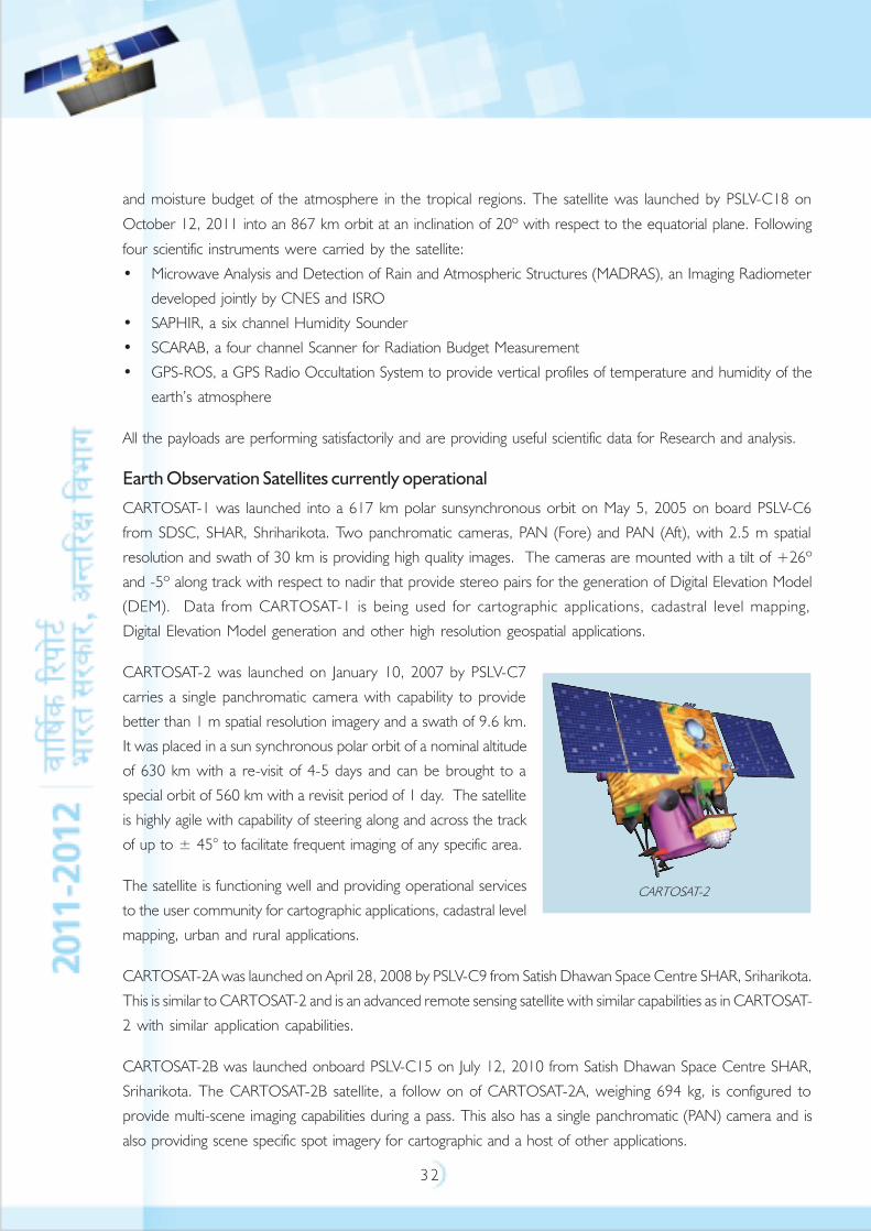
CARTOSAT-2 was launched on January 10, 2007 by PSLV-C7
carries a single panchromatic camera with capability to provide
better than 1 m spatial resolution imagery and a swath of 9.6 km.
It was placed in a sun synchronous polar orbit of a nominal altitude
of 630 km with a re-visit of 4-5 days and can be brought to a
special orbit of 560 km with a revisit period of 1 day. The satellite
is highly agile with capability of steering along and across the track
of up to ± 45° to facilitate frequent imaging of any specific area.
The satellite is functioning well and providing operational services
to the user community for cartographic applications, cadastral level
mapping, urban and rural applications.
CARTOSAT-2A was launched on April 28, 2008 by PSLV-C9 from Satish Dhawan Space Centre SHAR, Sriharikota.
This is similar to CARTOSAT-2 and is an advanced remote sensing satellite with similar capabilities as in CARTOSAT-
2 with similar application capabilities.
CARTOSAT-2B was launched onboard PSLV-C15 on July 12, 2010 from Satish Dhawan Space Centre SHAR,
Sriharikota. The CARTOSAT-2B satellite, a follow on of CARTOSAT-2A, weighing 694 kg, is configured to
provide multi-scene imaging capabilities during a pass. This also has a single panchromatic (PAN) camera and is
also providing scene specific spot imagery for cartographic and a host of other applications.
CARTOSAT-2
3 3
RESOURCESAT-1 was launched by PSLV-C5 on October 17, 2003. It was placed in 820 km polar
Sun Synchronous Orbit. The satellite carries three cameras, namely,
• Linear Imaging Self Scanner (LISS-4) in 3 spectral bands of Visible and Near Infrared Region (VNIR) with
5.8 m spatial resolution, 23 km (multi-spectral) and 70 km (mono) swath and steerable up to ±26º across
track to achieve five day revisit capability
• LISS-3 camera in 3 spectral bands in Visible and Near Infrared Region and one in Short Wave Infrared
(SWIR) band with 23.5 m spatial resolution and 141 km swath
• Advanced Wide Field Sensor (AWiFS) in 3 spectral bands in Visible and Near Infrared Region and one band
in SWIR with 56 m spatial resolution and a swath of 730 km.
IMS-1 was launched along with CARTOSAT-2A on April 28, 2008 by PSLV-C9 from SDSC, SHAR, Sriharikota.
The two payloads are Multi Spectral (MX) camera with 37 m spatial resolution with
151 km swath and a unique 64 channel Hyper Spectral imager (HySi) with 505 m spatial resolution and
130 km swath.
OCEANSAT-2, a follow on mission to OCEANSAT-1, was launched on September 23, 2009 onboard
PSLV-C14 from SDSC, SHAR, Shriharikota. OCEANSAT-2 was placed into a polar sun synchronous orbit at an
altitude of 720 km, with equatorial crossing of 1200 hrs+10 minutes. OCEANSAT-2 carries three sensors
onboard, viz., Ocean Colour Monitor (OCM), Ku-band pencil beam Scatterometer and a payload called
Radio Occultation Sounder for Atmospheric Studies (ROSA) developed by the Italian Space Agency (ASI).
• The 8 band Ocean Colour Monitor onboard Oceansat-2 provides Local Area Coverage (LAC) with a
spatial resolution of 360 m covering swath of 1420 km with a two-day repetivity. It also provides Global
Area Coverage (GAC) with 1 km resolution and 1420 km swath with 8 day coverage cycle.
• The pencil beam Scatterometer works in Ku-band with a ground resolution cell of 50 km x 50 km,
scans the earth surface conically with a swath of 1400 km. It provides the wind vector in the range of 4 to
24 m/ second with better than 10% accuracy in speed and 20º in wind direction. The Scatterometer data
is being used for deriving the global wind velocity (magnitude and direction) over ocean surface, which is
used as an input for weather forecasting, monitoring of cyclones and hurricanes and their trajectory, monitoring
of Polar Sea Ice changes and ocean state forecasting. Scatterometer is a unique instrument in space and
there is a significant demand for the data by the global community for ocean related applications. Orbit wise
Scatterometer data is downloaded, processed and the data products is disseminated through National
Remote Sensing Centre/ ISRO web portal and also through EUMetCast system of EUMETSAT, Darmstadt
to the global users in Europe, Africa, U.S and a few Asian countries within 160 minutes of data acquisition.
• ROSA Payload is designed and developed by ASI, Italy and was flown in OCEANSAT-2 to study temperature
and humidity profile of the atmosphere.
RISAT-2, the Radar Imaging Satellite, with all weather capability and ability to penetrate through clouds
was realised in association with Israel Aerospace Industries and launched onboard PSLV-C12 from
3 4
Satish Dhawan Space Centre, Sriharikota on April 20, 2009. RISAT-2 has enhanced country’s capability in the
management of disasters.
TES, Technology Experiment Satellite, was launched on board PSLV-C3 on October 22, 2001.
The satellite was intended to demonstrate and validate technologies that could be used in the future cartographic
satellite missions. Some of the technologies demonstrated in TES were: attitude and orbit control system, high
torque reaction wheels, new reaction control system with optimised thrusters and a single propellant tank, light
weight satellite structure, solid state recorder, X-band phased array antenna, improved satellite positioning system,
miniaturised TTC, power system and two-mirror-on-axis camera optics. TES carries a panchromatic
camera with a spatial resolution of less than 1m. The satellite continues to function well beyond the intended
mission life.
Forthcoming Earth Observation Missions
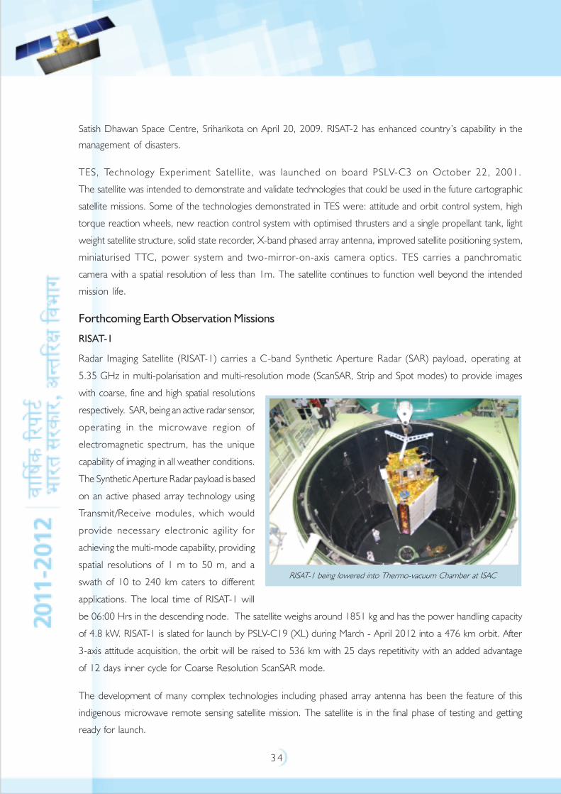
RISAT-1
Radar Imaging Satellite (RISAT-1) carries a C-band Synthetic Aperture Radar (SAR) payload, operating at
5.35 GHz in multi-polarisation and multi-resolution mode (ScanSAR, Strip and Spot modes) to provide images
with coarse, fine and high spatial resolutions
respectively. SAR, being an active radar sensor,
operating in the microwave region of
electromagnetic spectrum, has the unique
capability of imaging in all weather conditions.
The Synthetic Aperture Radar payload is based
on an active phased array technology using
Transmit/Receive modules, which would
provide necessary electronic agility for
achieving the multi-mode capability, providing
spatial resolutions of 1 m to 50 m, and a
swath of 10 to 240 km caters to different
applications. The local time of RISAT-1 will
be 06:00 Hrs in the descending node. The satellite weighs around 1851 kg and has the power handling capacity
of 4.8 kW. RISAT-1 is slated for launch by PSLV-C19 (XL) during March - April 2012 into a 476 km orbit. After
3-axis attitude acquisition, the orbit will be raised to 536 km with 25 days repetitivity with an added advantage
of 12 days inner cycle for Coarse Resolution ScanSAR mode.
The development of many complex technologies including phased array antenna has been the feature of this
indigenous microwave remote sensing satellite mission. The satellite is in the final phase of testing and getting
ready for launch.
RISAT-1 being lowered into Thermo-vacuum Chamber at ISAC
3 5
SARAL
The Satellite for ARGOS and ALTIKA (SARAL) is a joint ISRO - French Space Agency (CNES) mission, and will
be launched by the PSLV-C20 into a sun-synchronous orbit with a local time of 6 pm descending node
at an altitude of around 800 km. The Ka band altimeter, ALTIKA, provided by CNES, operates at
35.75 Giga Hertz (GHz) for ocean applications. A dual frequency total power type microwave radiometer
(23.8 and 37 GHz) is embedded in the altimeter to correct tropospheric effects on the altimeter measurement.
Doppler Orbitography and Radio-positioning Integrated by Satellite (DORIS) on board enables precise
determination of the orbit. A Laser Retroreflector Array helps to calibrate the precise orbit determination
system and the altimeter system several times throughout the mission.
SARAL/ ARGOS Data Collection System is a joint contribution of ISRO and CNES to the development and
operational implementation of the global ARGOS Data Collection System for a variety of data from ocean
buoys to transmit the same to the ARGOS Ground Segment for subsequent processing and distribution.
In addition, ARGOS Payload allows the transmission of short messages directly to Data Collection Platforms,
equipped with a receiver. SARAL payload will be accommodated in the mini-satellite bus, which weighs
400-450 kg class and a power generation of 800 Watt, named as SSB-1 (Small Satellite Bus).
SARAL will provide Data Products to the operational and research user communities, in support
of marine meteorology and sea state forecasting; operational oceanography; seasonal forecasting; climate
monitoring; ocean, earth system and climate research. Mainframe systems have been fabricated and are in the
advanced stage of testing. The satellite is scheduled for launch during last quarter of 2012.
Future Earth Observations Missions
India’s Future Earth Observation Programme will ensure the continuity of the thematic series of satellites,
viz., Resourcesat, Cartosat and RISAT series for land and water resources including all weather capability; Oceansat
series for study of ocean resources; INSAT and Megha-Tropiques for meteorology and atmosphere with specific
improvements in payloads. The advanced high resolution satellite Cartosat-3 with a spatial resolution of 0.25 m in
Panchromatic mode and 1 m in Multispatial mode will enhance high resolution mapping capabilities for meeting
future needs of RS application projects. The aim is to provide the continuity and enhanced services to the operational
workhorse missions; adapt and assimilate advances in technologies in the future missions; develop innovative
technologies both for on-board, ground systems and to partner with other space agencies to derive mutual benefits.
Ground Segment
ISTRAC provides TTC (Telemetry, Tracking and Command) and satellite control services for
11 remote sensing satellites in-orbit. The oldest satellite TES has completed 10 years in-orbit as on October
22, 2011 and the latest satellite Megha-tropiques, launched on October 12, 2011 is well-stabilised and the
payloads are under evaluation phase. Nominally, with eleven satellites in orbit (current scale of operations under
3 6
multi-mission scenario) ISTRAC tracks
more than 52,000 passes per annum
from its own Telemetry, Tracking and
Command network and Kongsberg
Satellite Services (KSAT) Svalbard,
Norway. In addition, about
12,000 payload operations per
annum are enabled by the multi
mission scheduling system. Routine
orbit maintenance and calibration
operations have been carried out as
per the requirements of each mission.
A full-fledged second control centre,
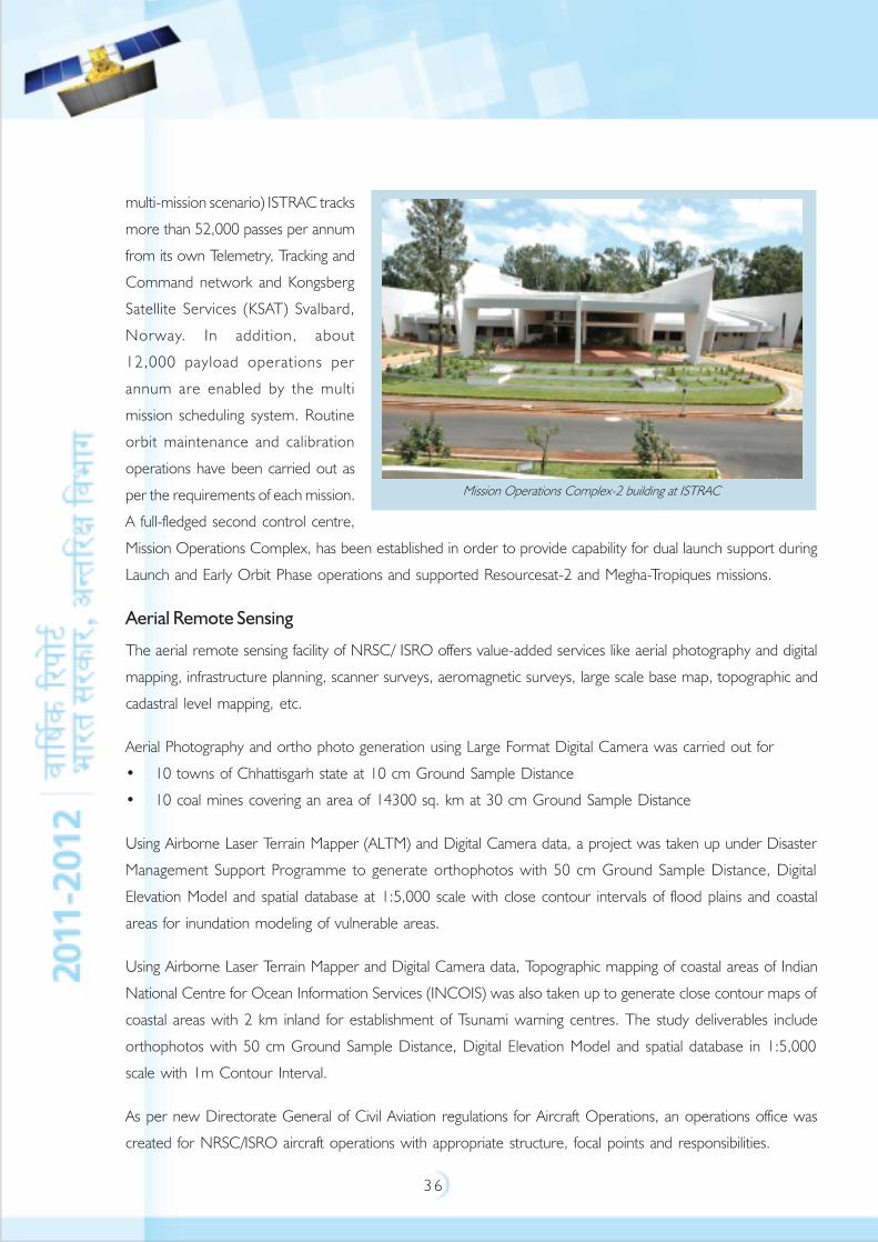
Mission Operations Complex, has been established in order to provide capability for dual launch support during
Launch and Early Orbit Phase operations and supported Resourcesat-2 and Megha-Tropiques missions.
Aerial Remote Sensing
The aerial remote sensing facility of NRSC/ ISRO offers value-added services like aerial photography and digital
mapping, infrastructure planning, scanner surveys, aeromagnetic surveys, large scale base map, topographic and
cadastral level mapping, etc.
Aerial Photography and ortho photo generation using Large Format Digital Camera was carried out for
• 10 towns of Chhattisgarh state at 10 cm Ground Sample Distance
• 10 coal mines covering an area of 14300 sq. km at 30 cm Ground Sample Distance
Using Airborne Laser Terrain Mapper (ALTM) and Digital Camera data, a project was taken up under Disaster
Management Support Programme to generate orthophotos with 50 cm Ground Sample Distance, Digital
Elevation Model and spatial database at 1:5,000 scale with close contour intervals of flood plains and coastal
areas for inundation modeling of vulnerable areas.
Using Airborne Laser Terrain Mapper and Digital Camera data, Topographic mapping of coastal areas of Indian
National Centre for Ocean Information Services (INCOIS) was also taken up to generate close contour maps of
coastal areas with 2 km inland for establishment of Tsunami warning centres. The study deliverables include
orthophotos with 50 cm Ground Sample Distance, Digital Elevation Model and spatial database in 1:5,000
scale with 1m Contour Interval.
As per new Directorate General of Civil Aviation regulations for Aircraft Operations, an operations office was
created for NRSC/ISRO aircraft operations with appropriate structure, focal points and responsibilities.
Mission Operations Complex-2 building at ISTRAC

3 7
Satellite Data Acquisition and Processing
The National Remote Sensing Centre , Hyderabad is the nodal agency for satellite remote sensing data reception,
archival, processing and dissemination in the country. NRSC Shadnagar Ground station acquires data from
various Indian remote-sensing satellites and a few foreign satellites. As per the Remote Sensing Data Policy,
NRSC is the national agency identified for acquisition and distribution of all the satellite data within India.
Accordingly, NRSC is disseminating satellite data from Indian and foreign satellites to Indian users.
Remote Sensing Data Policy of 2011 has been positioned and implemented to provide data up to one meter
spatial resolution to all users on request basis. The data better than 1 m resolution is disseminated as per
policy guidelines. During the year, more than 51,000 data products were disseminated to Indian as well as
foreign users.
Integrated Multi mission Ground segment for Earth Observation Satellites was successfully established by re-
engineering all processes under integrated environment at Shadnagar and was commissioned in
Nov 2011. Integrated multi mission data reception, processing, products, services, and archival chain was
established at a new location by exploiting advanced data reception systems, high speed processing, multi level
storage, high bandwidth network technology and successfully achieved automation of operations in data process
work flow and user services with in-house developed application software.
NRSC is establishing Antarctica Ground Segment to exploit the frequent visibility of satellites (at poles) to download
satellite-data from on-board recorder and use the data for emergency services and in near real-time applications.
The configuration of Antarctica Ground Station consists of a data reception ground station at Antarctica and a
two way communication link between Antarctica and India (NRSC, Shadnagar and National Centre for Ocean
and Antarctic Research) using Geo satellite link. During the 30th expedition to Antarctica, site identification and
pile foundation laying works were completed successfully. During 31st Antarctica Expedition, the installation of
infrastructure for Electrical power system is planned. During 32nd Antarctica Expedition, commissioning of
ground station facility is planned in 2012-13 time frame.
Operationalisation of the Oceansat-2 Scatterometer data processing software at Meteorological and Oceanographic
Satellite Data Archival Centre (MOSDAC) has been done. The data processing software was also installed at
Shadanagar and European Organisation for the Exploitation of Meteorological Satellites (EUMETSAT), while the
data dissemination to global users is automated with a turnaround time of less than three hours. Similarly for
Megha-Tropiques, installation is done for Level-1 software and Quick Look Display at Indian Space Science Data
Centre and Level-2 software at Meteorological and Oceanographic Satellite Data Archival Centre for MADRAS,
SAPHIR, SCARAB and ROSA payloads and achieved near real time processing capability for data products
generation.
3 8
SPACE APPLICATIONS
INSAT Applications
Tele-Education (EDUSAT Programme)
‘EDUSAT’, the India's first thematic satellite dedicated exclusively for educational services, has been used extensively
to cater to a wide range of interactive educational delivery modes like one-way TV broadcast, video conferencing,
computer conferencing, web-based instructions, etc. EDUSAT had manifold objectives - to supplement the
curriculum-based teaching, imparting effective teachers training, providing access to quality resource persons
and new technologies, thus finally resulting in taking education to every nook and corner of India. EDUSAT has
provided connectivity to schools, colleges and higher levels of education and also supported non-formal education
including development communication.
EDUSAT programme has been implemented in three phases, pilot, semi-operational and operational phases.
Pilot projects were conducted during 2004 in Karnataka, Maharashtra and Madhya Pradesh with 300 terminals.
The experience of pilot projects were adopted in semi-operational and operational phase. During semi-operational
phase almost all the states and major national agencies are covered under EDUSAT programme. Presently, the
networks are being expanded under operational phase with funding by state governments and other user agencies.
The networks implemented under EDUSAT programme comprises of two types of terminals, namely, Satellite
Interactive Terminals and Receive Only Terminals. So far, a total of 80 networks have been implemented
connecting to about 55000 schools and colleges (4209 Satellite Interactive Terminals and 51165 Receive Only
Terminals) covering 25 States and 3 Union Territories of the country. Uttarakhand and Jharkhand EDUSAT
networks were the latest additions of the current year. About 15 million students are getting benefited through
EDUSAT programme every year.
The EDUSAT (GSAT-3) satellite service was discontinued since September-2010 partially affecting the
Tele-education, Telemedicine and VRC projects of ISRO. After de-commissioning of GSAT-3, the traffic of
Tele-education networks is being migrated to other ISRO satellites. The department has already completed
about 80 percent migration of tele-education networks operating in Ku-band from GSAT-3 to INSAT-4CR and
partially migrated Extended C-band networks to INSAT-3A and INSAT-3C.
A ‘Technical Support and Training Centre’ is established at Guwahati, Assam to provide technical support on
continuous basis to all the Remote Sites, Hubs and Teaching-Ends of various state networks in the North East
Region. In future, it is planned to setup similar Technical Support and Training Centre for Northern parts of the
country namely, Uttarakhand, Jammu & Kashmir, etc.
Around 366 Satellite Interactive Terminals of national users like Indira Gandhi National Open University, Central
Institute of Educational Technology, All India Council for Technical Education, Vigyan Prasar/Department of Science

3 9
and Technology and Centre for Education and Communication were upgraded with classroom peripherals and
Learning Management System for better Audio-Visual interaction.
Also, established is a ‘Network Monitoring Facility’ at Development and Educational Communication Unit,
Ahmedabad to obtain the feedback on the utilisation and assess the quality of programs transmitted on EDUSAT
networks in INSAT-4CR (Ku Band). Presently, the overall monitoring capacity is for 30 tele-education networks;
however, at a time, any 10 networks can be monitored simultaneously by selection.
ISRO has also set up networks for users’ with special requirements like:
a) Blind People’s Association of Gujarat – for Visually challenged
b) Rehabilitation Council of India
c) Network of Central Institute of Mentally Retarded in Kerala
d) A network of Centre for the Development of Advanced Computing (C-DAC) for mentally challenged
in Kerala
Training and Developmental Communications Channel (TDCC)
TDCC is a service that has been operational since 1995 and provides 1-way video and 2-way audio system of
interactive education. The teaching-end includes a studio and an uplink facility for transmitting live or
Tele-education network activities
4 0
pre-recorded lectures. The participants at the classrooms located nationwide receive lectures through simple
dish antennas called Direct Reception Systems and have facility to interact with lecturers using telephone lines.
Several state governments and universities use the Training and Developmental Communication Channel system
extensively for Distance Education, Rural Development, Women and Child Development, Panchayat Raj, Health,
Agriculture, Forestry, etc.
Under Training and Developmental Communication Channel project, during FY 2010-11, a total of 948
Interactive Training Programmes were conducted with an average utilisation of about 23-26 days a month. On
an average, around 75-80 ITPs per month were conducted by around 39 departments of the various states.
However, from April 2011 only 39 ITPs could be conducted due to shortage of satellite bandwidth.
Telemedicine
Telemedicine is one of the unique applications of Space Technology for societal benefit. Telemedicine programme,
which started in 2001, has been connecting remote/rural/medical college hospitals and Mobile Units through the
Indian satellites to major specialty hospitals in cities and towns. Telemedicine network covers various states/regions
including Jammu and Kashmir, Ladakh, Andaman & Nicobar Islands Lakshdweep Islands, North Eastern States and
other mainland states. Many tribal districts of states like Kerala, Karnataka, Chhattisgarh, Punjab, West Bengal,
Orissa, Andhra Pradesh, Maharashtra, Jharkhand and Rajasthan are covered under Telemedicine Programme.
Presently, the Telemedicine network of ISRO covers about 382 hospitals with 60 specialty hospitals connecting
to 306 remote/rural/district/medical college hospitals and 16 Mobile Telemedicine units. The Mobile Telemedicine
units cover diverse areas of Ophthalmology, Cardiology, Radiology, Diabetology, Mammography, General
medicine, Women and Child healthcare.
While Department Of Space provides Telemedicine systems software, hardware and communication equipment
as well as satellite bandwidth, state governments and the speciality hospitals have to allocate funds for their part
of infrastructure, manpower and facility support. In this regard, technology development, standards and cost
effective systems have been evolved in association with various state governments, Non Governmental
Organisations, specialty hospitals and industry. Department Of Space interacts with state governments and
specialty hospitals for bringing an understanding between the parties through an Memorandum Of Understanding.
Due to de-commissioning of GSAT-3 (EDUSAT), some of these network operations were partially affected due
to shortage of satellite bandwidth. During the year, the activities under telemedicine involved migration and
operationalisation of nodes across the country. The traffic is being transferred to other satellites and already
168 nodes have been re-operationalised with maximum nodes (38 nodes) in Rajasthan. ISRO also provides
technical support for operations and maintenance of telemedicine nodes.
Television
INSAT has been a major catalyst for the expansion of television coverage in India. Satellite television now covers
100% area and 100% population. The terrestrial coverage is over 65 percent of the Indian land mass and over
4 1
90 percent of the population. At present 40 Doordarshan TV channels including news uplinks are operating
through C-band transponders of INSAT-3A, INSAT-4B, and INSAT-3C (Additionally INTELSAT IS-10 and
IS-906 leased). All of the Satellite TV channels are digitalised.
The following satellite television services are being operated by Doordarshan:
• National networking service (DD-1), DD News (DD-2), DD-Sports, DD-Urdu, DD-India and
DD-Bharati and DD-HD.
• Regional services in States of Kerala, Karnataka, Jammu & Kashmir, Tamil Nadu, West Bengal,
Andhra Pradesh, Gujarat, UP, Assam, Maharashtra, Punjab, Himachal Pradesh, Rajasthan, Tripura, Orissa,
Bihar, Madhya Pradesh, Uttarakhand (Uttaranchal), Haryana, Mizoram, Jharkhand, Chhatisgarh and
Lakshadweep Islands.
As on Nov 30, 2011, 1415 transmitters of Doordarshan are working in INSAT system out of which
1134 transmitters [131 High Power Transmitters (HPT), 725 Low Power Transmitters (LPT), 260 Very Low
Power Transmitters (VLPT) and 18 Transposers] are working in the DD-1 network and 169 TV Transmitters
(73 HPTs, 79 LPTs and 17 VLPTs) are working in the DD-News network. 108 Regional service transmitters
(6 HPTs, 8 LPTS and 94 VLPTs), 4 HPTs with digital transmissions are also operational in the Doordarshan
Network. Out of these 4 transmitters one located at Delhi is carrying 16 mobile TV services for experimental
purpose. 59 DD and Private TV channels are operational through Direct To Home (DTH) service
(“DD Direct+”). 10 channel DTH planned in C-Band for Andaman & Nicobar Islands has been commissioned
on Sept 17, 2009. Doordarshan High Definition Service has been started on October 3, 2010 with the start of
Common Wealth Games 2010.
Satellite News Gathering and Other Events
Satellite News Gathering using INSAT system enables on-the-spot real-time news coverage and important
events at different locations for transmission to a Central Station at Delhi or to State Capitals for rebroadcast
over respective Doordarshan channels. Prasar Bharati has 13 C-band and 18 Ku-band Digital Outdoor-Broadcast
Digital Satellite News Gathering terminals operating through INSAT. 9 more Digital Satellite News Gatherings
in C-Band are proposed to be introduced in the network.
Radio Networking
Radio Networking through INSAT provides a reliable high-fidelity programme channels for national as well as
regional networking. At present, 237 All India Radio (AIR) stations have been equipped with S-band receive terminals
out of which 185 AIR stations have been equipped to receive C-band Analogue and Digital Radio Networking
carriers. Remaining 52 stations are going to be equipped with digital C-band Radio Networking Terminals by the
end of 11th FYP.
A total of 85 Radio Networking channels are being up-linked at present. For this AIR is utilising one S-band
transponder (S2) and one C-band transponder (C-11) of INSAT-3C. A total of 90 carriers in CxC band are
being envisaged for up-linking by utilising full one transponder of INSAT-3C.
4 2
In AIR network, a total of 32 earth stations are equipped with facility to uplink in both CxS and CxC band.
The Central earth station at Broadcasting House, New Delhi, has been augmented to up-link 26 Radio Networking
carriers in CxS and CxC band.
At present AIR has 22 radio channels on Direct To Home platform in Ku-band being uplinked with TV carriers
from Todapur, New Delhi on INSAT-4B. Efforts are underway to augment this to 40 channels, and efforts are
also being made to uplink 6 nos. radio channel on Direct To Home C-Band to cover Andaman Nicobar areas.
Telecommunications
887 Satellite Earth Stations (BSNL - 103, Govt Users - 231, Closed User Group and Commercial Users - 553)
of different sizes having the capabilities of Telecommunication / Broadcasting applications are operating in Satellite
Network. 1,44,383 VSATs Telecommunication Terminals (Govt Users – 435, Closed User Group and Commercial
Users – 1,43,948) of various sizes and capabilities, working in Star / Mesh connectivity (excluding National Informatic
Centre Network, and Very Small Aperture Terminal (VSAT) Micro Terminals), are operating in Satellite Network.
9577 circuits providing transmission backhaul point to point connectivity by BSNL. 25 Single Channel per
Carrier Very Small Aperture Terminals and 42 Multiple Channels per Carrier Very Small Aperture Terminals and
5491 Ku Band Very Small Aperture Terminals under Digital Satellite Phone Terminal are working with BSNL.
Captive satellite-based networks for National Thermal Power Corporation, Gas Authority of India Ltd, Oil and
Natural Gas Corporation Ltd., National Fertilizers Limited, Coal India Limited, Education and Research Network,
Karnataka Power Transmission Corporation Limited, Indian Oil Corporation Limited, Bharat Petroleum
Corporation Limited, Jai Prakash Industries Ltd., Indian Railway Project Management Unit, Indian Council of
Agricultural Research and Infotel Satcom are operational in INSAT system. The Networks of National Stock
Exchange and Bombay Stock Exchange in Extended C-Band are operational INSAT system.
A number of other Captive Government Networks are also working with INSAT Satellites.
BSNL started services through IPSTAR Gateways working on Ka / Ku Band. Total no. of 5832 Very Small ATs
connectivity has been provided across the country.
Mobile Satellite Services
An S-band Mobile Satellite Service was added to INSAT system with the launch of INSAT-3C in 2002 and
GSAT-2 in 2003. The following two classes of services were identified for MSS:
INSAT Type-D Service
A small portable satellite terminal that works with INSAT for voice/data communication has been developed
with the participation of Indian industries. The terminal is useful for voice communication especially during
disasters when other means of communication break down. It can be used from any location in India for
emergency communication. Transmit and receive frequencies of the terminal are in S-band. This service is
mainly used by government users.
4 3
The portable terminal is connected to the Electronic Private Automatic Branch Exchange (EPABX) at central hub
station through satellite channel and hence could be considered as an extension of EPABX and call could be
made between any satellite terminals and local phones on EPABX. Central hub station is located at Delhi Earth
Station, New Delhi.
INSAT Reporting system
This consists of low bit rate one-way reporting service using shared channels with portable and hand-held
terminals. This unique one-way messaging from a remote location to user-headquarters operates with the
Delhi Earth Station of Department Of Space as the hub. This is an experimental service. Short messages from
user terminals are relayed through the satellite to the hub and are automatically forwarded to the respective user
headquarters via facsimile or data links. This reporting service is provided using small hand-held terminals.
There is a provision to attach a GPS receiver to the reporting terminal for position information.
MSS services are being support through INSAT-3C only, as the GSAT-2 completed its mission life.
Meteorology
The meteorological data of INSAT system is processed and disseminated by INSAT Meteorological Data Processing
System of India Meteorological Department (IMD) which is installed by M/s Antrix Corporation through an
Memorandum Of Understanding with India Meteorological Department. At present Kalpana-1 and INSAT-3A
satellites are operational. Kalpana-1 is the main operational satellite and 48 scans of this satellite, every half hour are
taken daily. The products derived from the satellite data include: cloud images in visible, infra-red and water vapour
channel, cloud motion vectors, water vapour winds, sea surface temperature, outgoing long-wave radiation,
quantitative precipitation estimates, upper tropospheric humidity and normalized difference vegetation index. The
satellite images and products are now a vital component of weather forecasting, both for synoptic and numerical
weather prediction. The monitoring of cyclone intensity, its location, and various other weather systems such as
Fog, Thunderstorms, Western disturbances and Norwesters, etc., are done by satellite images and data. A satellite
bulletin is prepared every 3–hourly describing the images and products generated by the data. In case of a cyclone
the special satellite bulletins are issued every hourly. All images and products generated by satellite data are
displayed on India Meteorological Department website satellite page for users in real-time.
INSAT-Very High Resolution Radiometer (VHRR) imageries are used by Doordarshan during news coverage
and by newspapers as part of weather reporting. INSAT VHRR images and data is made available in near real-
time at 40 Digital Meteorological Data Dissemination (DMDD) stations in various parts of the country as well
as in neighboring countries Nepal, Maldives and Srilanka through the C x S transponder on INSAT-3C. With the
commissioning of this direct satellite service for processed VHRR data, DMDD type of data can be provided at
any location in the country.
IMD has installed 649 Automatic Weather Stations (AWS) and other agencies have installed about 1000 AWS
all over the country. IMD has also installed 456 Automatic Rain Gauge (ARG) Stations. AWS and ARG services
are operational by using the Data Relay Transponders (DRT) of INSAT-3A. ISRO has taken up indigenous
development of low cost automatic weather station for deployment in the country in large numbers. The data
4 4
collection is mostly carried out in Time Division Multiple Access (TDMA) mode instead of the old
random access mode.
For quick dissemination of warnings against impending disaster from approaching cyclones, specially designed
receivers have been installed at the vulnerable coastal areas in Andhra Pradesh, Tamil Nadu, Odisha, West
Bengal and Gujarat for direct transmission of warnings to the officials and public in general using broadcast
capability of INSAT. India Meteorological Department’s Area Cyclone Warning Centres generate special warning
bulletins and transmit them every hour in local languages to the affected areas. Three hundred and fifty two such
receiver stations have been installed by IMD. Out of these 100 are Digital Cyclone Warning Dissemination
System based on advanced technology. Efforts are on to replace the network of CWDS/DCWDS by the ISRO
developed Direct To Home modified type CWDS. An MOU has been signed among ISRO, India Meteorological
Department and Doordarshan for replacement of the existing network of CWDS by new DTH modified type
Cyclone Warning and Dissemination System designed by ISRO.
Satellite Aided Search and Rescue (SAS and R)
India is a member of the international COSPAS-SARSAT programme for providing distress alert and position
location service through LEOSAR (Low Earth Orbit Search And Rescue) satellite system. Under this programme,
India has established two Local User Terminals (LUTs), one at Lucknow and the other at Bangalore. The Indian
Mission Control Centre (INMCC) is located at ISTRAC, Bangalore.
INSAT-3A located at 93.50E is equipped with 406 MHz Search and Rescue payload that picks up and relays alert
signals originating from the distress beacons of maritime, aviation and land users. INSAT and Geostationary Operational
Environmental Satellite (GOES) systems have become an integral part of the COSPAS-SARSAT system and they
complement the Low Earth Orbit Search And Rescue system.
Indian LUTs provide coverage to a large part of Indian Ocean region rendering distress alert services to Bangladesh,
Bhutan, Maldives, Nepal, Seychelles, Sri Lanka and Tanzania. The operations of Indian Mission Control Centre/
Local User Terminals are funded by the participating agencies, namely, Coast Guard, Airports Authority of India
(AAI) and Directorate General of Shipping and Services.
INSAT GEOSAR Local User Terminal (Geostationary Earth Orbit Search and Rescue LUT) is established at
ISTRAC, Bangalore and integrated with INMCC. The distress alert messages concerning the Indian service area,
detected at INMCC are passed on to Indian Coast Guard and Rescue Coordination Centres at Mumbai, Kolkata,
Delhi and Chennai. The search and rescue activities are carried out by Coast Guard, Navy and Air Force.
INMCC is linked to the RCCs and other International Mission Control Centres (MCCs) through Aeronautical
Fixed Telecommunication Network. The Indian LUTs and MCC provide service round the clock and maintain
the database of all 406 MHz registered beacons equipped on Indian ships and aircraft.
Development of indigenous search and rescue beacons has been completed, and is now in qualification phase.
Shortly it will be released to the Indian fishermen community.
During the year 2011, Indian Mission Control Centre provided search and rescue support to 4 distress incidents
in Indian service area through Indian system and contributed in saving 15 lives (within INSAT coverage).

4 5
During 2011, about 743 new radio beacons have been added in Indian database (234 on ships/boats, 406 on
aircraft, 103 Personal). Till date, there are about 600 registered user agencies (Maritime and Aviation) in India
with Indian beacon population more than 10200 in our database.
The Indian Mission Control Centre system at ISTRAC is under up-gradation, and will be in operation by end of
December 2011. Migration from Low Earth Orbit Search and Rescue (LEOSAR) and Geostationary Earth Orbit
Search and Rescue (GEOSAR) to Medium Earth Orbit Search and Rescue (MEOSAR) system has been undertaken.
Standard Time and Frequency Signal Dissemination Services
A Standard Time and Frequency Signal Dissemination Service using a Radio Networking type CxS carrier on
INSAT-3C is being operated by the National Physical Laboratory. This service is available round-the-clock in a
broadcast mode at a downlink frequency in S-band and is receivable on a set up consisting of a 2.4 m diameter
antenna, a front-end converter, an Frequency Modulation (FM) demodulator and a microprocessor controlled
signal decoder. The service consists of a train of 5 kHz bursts signal, which is frequency modulated on the carrier.
The time has a precision of better than one microsecond and accuracy of better than 20 microseconds.
GPS AIDED GEO AUGMENTED NAVIGATION (GAGAN)
The Indian Satellite Based Augmentation System, GAGAN is in the Final Operational Phase and is expected to
be ready for operation and certification by June 2013.
In the GAGAN-FOP, all the ground elements, viz., 15 Indian Navigation Reference Earth Stations (INRES),
2 Indian Navigation Master Control Centres (INMCC) and 2 Indian Navigation Land Uplink Stations (INLUS)
are established and integrated. In addition to the existing Optical Fibre Cable Data Communication Network,
VSAT link is also established between almost all INRES sites and INMCC. The establishment of third INLUS at
New Delhi and second Optical Fibre Cable network are in progress and expected to be completed by
March 2012.
The major milestone activity of Preliminary System Acceptance Test was conducted successfully after installation
and integration of all the ground elements.
The ISRO GIVE Model-Multi Layer Data Fusion (IGM-MLDF) algorithm developed by ISAC is selected through
technical consensus. The development and incorporation of this model with INMCC software is in progress.
After the launch of GSAT-8, the In-Orbit Test and Test and Evaluation of GAGAN navigation payload was carried
out and the integration of payload with Bangalore INLUS-West is completed. After completion of stability test
which is in progress now, the GAGAN signal without certification will be available for users.
The next major milestone events in the GAGAN are the launch of GSAT-10 and its integration with Bangalore
INLUS-East, integration of New Delhi INLUS with GSAT-8 and conduct of Final System Acceptance Test
during June 2012 followed by system certification during July 2013.
INDIAN REGIONAL NAVIGATION SATELLITE SYSTEM (IRNSS)
IRNSS constellation consists of seven satellites. Three satellites will be placed in Geostationary orbit (GEO) at
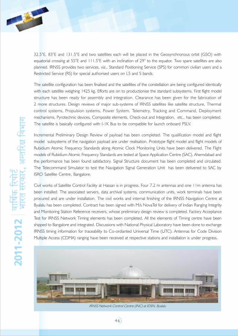
4 6
32.5°E, 83°E and 131.5°E and two satellites each will be placed in the Geosynchronous orbit (GSO) with
equatorial crossing at 55°E and 111.5°E with an inclination of 29° to the equator. Two spare satellites are also
planned. IRNSS provides two services, viz., Standard Positioning Service (SPS) for common civilian users and a
Restricted Service (RS) for special authorised users on L5 and S bands.
The satellite configuration has been finalised and the satellites of the constellation are being configured identically
with each satellite weighing 1425 kg. Efforts are on to productionise the standard subsystems. First flight model
structure has been ready for assembly and integration. Clearance has been given for the fabrication of
2 more structures. Design reviews of major sub-systems of IRNSS satellites like satellite structure, Thermal
control systems, Propulsion systems, Power System, Telemetry, Tracking and Command, Deployment
mechanisms, Pyrotechnic devices, Composite elements, Check-out and Integration, etc., has been completed.
The satellite is basically configured with I-1K Bus to be compatible for launch onboard PSLV.
Incremental Preliminary Design Review of payload has been completed. The qualification model and flight
model subsystems of the navigation payload are under realisation. Prototype flight model and flight models of
Rubidium Atomic Frequency Standards along Atomic Clock Monitoring Units have been delivered. The Flight
models of Rubidium Atomic Frequency Standards are tested at Space Application Centre (SAC), Ahemdabad and
the performance has been found satisfactory. Signal Structure document has been completed and circulated.
The Telecommand Simulator to test the Navigation Signal Generation Unit has been delivered to SAC by
ISRO Satellite Centre, Bangalore.
Civil works of Satellite Control Facility at Hassan is in progress. Four 7.2 m antennas and one 11m antenna has
been installed. The associated servers, data archival systems, communication units, work terminals have been
procured and are under installation. The civil works and internal finishing of the IRNSS Navigation Centre at
Byalalu has been completed. Contract has been signed with M/s NovaTel for delivery of Indian Ranging Integrity
and Monitoring Station Reference receivers, whose preliminary design review is completed. Factory Acceptance
Test for IRNSS Network Timing elements has been completed. All the elements of Timing centre have been
shipped to Bangalore and integrated. Discussions with National Physical Laboratory have been done to exchange
IRNSS timing information for traceability to Co-ordianted Universal Time (UTC). Antennas for Code Division
Multiple Access (CDMA) ranging have been received at respective stations and installation is under progress.
IRNSS Network Control Centre (INC) at IDSN, Byalalu
4 7
The navigation software for IRNSS is being indigenously developed at ISRO Satellite Centre. Software Requirement
Specifications for IRNSS is circulated and reviewed by the committee. Preliminary Design Review (PDR) of
Navigation Software is completed and Comprehensive Design Review is scheduled shortly. As a part of this
activity, many analysis modules have been developed and used in various studies like coverage studies, error
analysis, uplinking scheme for Navigation Parameters, CDMA Ranging Analysis, etc.
In-house development of single channel SPS and RS dual frequency receiver to facilitate the testing of Navigation
payload is under progress. The PDR of the User receiver has been completed. Efforts are on to realise the
IRNSS Signal Simulator. ISRO is collaborating with National Physical Laboratory to realise space qualified Rubidium
Atomic Frequency Standard.
Discussions with Scientific Analysis Group, Defence Research and Development Organisation (DRDO) have
been held to look into certification aspects for the Restricted Service. Frequency Coordination activities like
Frequency filings, discussions with other Global Navigation Satellite System (GNSS) service providers, participation
in International Committee for GNSS meet etc., are being pursued.
Technical Review Executive Board meetings and project management board meetings are held to monitor the
progress, schedule and resolve various technical issues.
Disaster Management Support (DMS) Programme
The Disaster Management Support Programme of ISRO provides continued support towards disaster management
in the country through products and services emanating from the space and airborne systems. The DMS-
Decision Support Centre (DMS-DSC) established at National Remote Sensing Centre is engaged in monitoring
natural disasters such as flood, cyclone, agricultural drought, landslides, earthquakes and forest fires. The information
generated from aero-space systems are disseminated to the concerned in near real-time for aiding in decision
making.
Floods: All the major floods in the States of Assam, Bihar, Uttar Pradesh, West Bengal, Orissa and Kerala states
were monitored and about 245 maps were disseminated to the concerned departments. The Flood Management
Information System (FMIS) developed for Bihar state was supported by providing software and database layers.
Development of FMIS for Orissa is in progress. The Assam flood hazard zonation atlas was released by Hon'ble
Chief Minister of Assam on July 18, 2011. Similar work on Bihar is on-going. Research and Development
(R&D) activities on flood inundation modelling using 0.5 m contour interval from Light Detection and Ranging
(LIDAR) data, and development of a flood alert system is being attempted for Godavari basin.
Drought: The prevalence and severity of agricultural drought in 13 states in the country is assessed at district and
sub-district level on a monthly basis, using satellite data and ground information, during the kharif season. Area
Favourable for Crop Sowing, derived from Shortwave Angle Slope Index (SASI) images from Moderate Resolution
Imaging Spectroradiometer (MODIS) data is being operationally disseminated. Area Favourable for Crop Sowing
is a direct indicator of early-season agricultural situation.
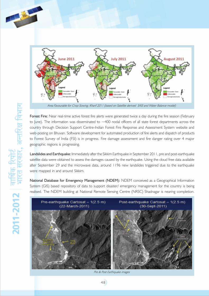
4 8
Forest Fire: Near real-time active forest fire alerts were generated twice a day during the fire season (February
to June). The information was disseminated to ~400 nodal officers of all state forest departments across the
country through Decision Support Centre-Indian Forest Fire Response and Assessment System website and
web-posting on Bhuvan. Software development for automated production of fire alerts and dispatch of products
to Forest Survey of India (FSI) is in progress. Fire damage assessment and fire danger rating over 4 major
geographic regions is progressing.
Landslides and Earthquake: Immediately after the Sikkim Earthquake in September 2011, pre and post-earthquake
satellite data were obtained to assess the damages caused by the earthquake. Using the cloud free data available
after September 29 and the microwave data, around 1196 new landslides triggered due to the earthquake
were mapped in and around Sikkim.
National Database for Emergency Management (NDEM): NDEM conceived as a Geographical Information
System (GIS) based repository of data to support disaster/ emergency management for the country is being
realised. The NDEM building at National Remote Sensing Centre (NRSC) Shadnagar is nearing completion.
Area Favourable for Crop Sowing, Kharif 2011 (based on Satellite derived SASI and Water Balance model)
Pre & Post Earthquake images
4 9
The database already collected from ISRO and few other organisations were organised into the interim server.
Decision Support Systems (DSS) development for flood, drought, Landslides and radiological disasters are
under progress. Mobile based applications for Geo-spatial database generation disaster and Relief Management
were developed and demonstrated.
Aerial Synthetic Aperture Radar (ASAR) Development: The flight model of the C-band ASAR integration is
completed and tested. On-board test flights are planned soon. The X-band ASAR integration is in progress for a
flight demonstration in 2012. The Near Real Time Processing system is upgraded with new generation TS201
@500 MHz Digital Signal Processing processors to improve the turn-around time.
Aerial Laser Terrain Mapping: The processing of Aerial Laser Terrain Mapping-Digital Camera (ALTM-DC)
data of 870 sq. km of Sabari Basin, AP and 12130 sq. km of Bihar is completed in 2011. Further data collection
of 3000 to 4000 sq. km of Assam is planned in this flying season.
Emergency Communication: INSAT Type-D terminals (two way portable voice communication terminal
operating in S-band) are continued to be used by Central Reserve Police Force (CRPF) for emergency operations.
1000 numbers of Distress Alert Transmitter - a low cost satellite transmitter for emergency communication of
alert messages from fishing boats – have been procured and distributed through Coast Guard in 2011.
The Direct To Home based Digital Disaster Warning System developed and demonstrated by ISRO is being
established in 500 locations in association with India Meteorological Department and Doordarshan.
International Initiatives: The Disaster Management System programme is supporting the disaster management
globally, by sharing data and information for the specific events through International Charter and Sentinel Asia
projects. ISRO has provided about 19 Indian Remote Sensing Satellites scenes in support of 9 disasters during
2011, including floods in Algeria, Cambodia and Bangkok, and earthquake and tsunami disaster in Japan.
Remote Sensing Applications
Remote sensing application projects at National, State and local levels are being carried out through well-
established multi-pronged implementation architecture of National Natural Resources Management System
(NNRMS) in the country. Major ISRO Centres, namely, National Remote Sensing Centre, Hyderabad and
Space Application Centre (SAC), Ahmedabad spearheads all such applications development and implementation
initiatives from ISRO/ DOS. Regional Remote Sensing Centres (RRSCs) of NRSC, North-Eastern Space Application
Centre (NE-SAC), Shillong, State Remote Sensing Application Centres play a major role in implementation and
reaching out to the grass- roots for effective utilisation of the technology. User Ministries of State and Central
Government departments and others institutions play a major role in utilising remote sensing technology in their
own departments. In addition, private sector, Non-Governmental Organisations and academia also play a
major role in the usage of this technology in different developmental sectors of the country. Some of the major
application projects carried out during the year 2011-12 are highlighted below:
Forecasting Agricultural output using Space, Agrometeorology and Land based observations (FASAL) is a
countrywide project, funded by the Ministry of Agriculture and Cooperation, executed by ISRO/DOS along with
various State Remote Sensing Applications Centres, State Departments of Agriculture and Agricultural Universities
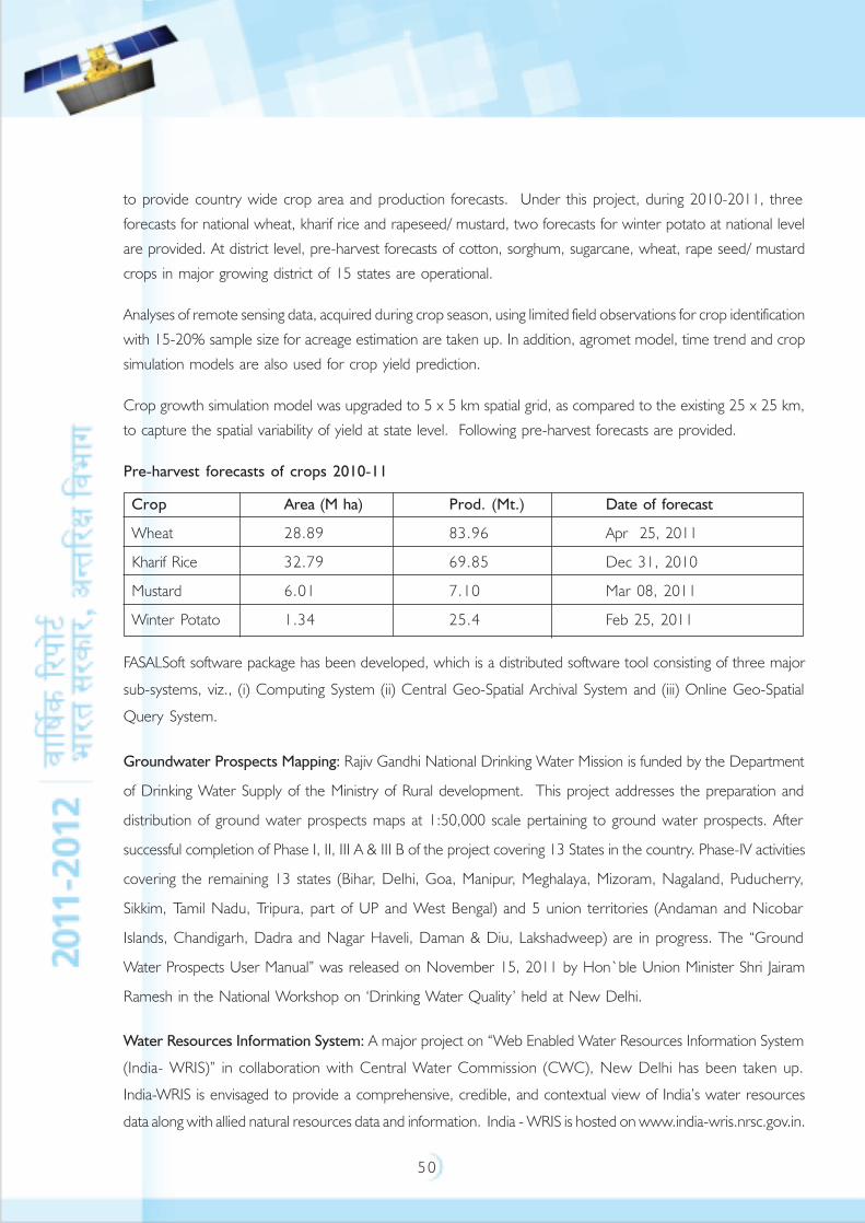
5 0
to provide country wide crop area and production forecasts. Under this project, during 2010-2011, three
forecasts for national wheat, kharif rice and rapeseed/ mustard, two forecasts for winter potato at national level
are provided. At district level, pre-harvest forecasts of cotton, sorghum, sugarcane, wheat, rape seed/ mustard
crops in major growing district of 15 states are operational.
Analyses of remote sensing data, acquired during crop season, using limited field observations for crop identification
with 15-20% sample size for acreage estimation are taken up. In addition, agromet model, time trend and crop
simulation models are also used for crop yield prediction.
Crop growth simulation model was upgraded to 5 x 5 km spatial grid, as compared to the existing 25 x 25 km,
to capture the spatial variability of yield at state level. Following pre-harvest forecasts are provided.
Pre-harvest forecasts of crops 2010-11
Crop Area (M ha) Prod. (Mt.) Date of forecast
Wheat 28.89 83.96 Apr 25, 2011
Kharif Rice 32.79 69.85 Dec 31, 2010
Mustard 6.01 7.10 Mar 08, 2011
Winter Potato 1.34 25.4 Feb 25, 2011
FASALSoft software package has been developed, which is a distributed software tool consisting of three major
sub-systems, viz., (i) Computing System (ii) Central Geo-Spatial Archival System and (iii) Online Geo-Spatial
Query System.
Groundwater Prospects Mapping: Rajiv Gandhi National Drinking Water Mission is funded by the Department
of Drinking Water Supply of the Ministry of Rural development. This project addresses the preparation and
distribution of ground water prospects maps at 1:50,000 scale pertaining to ground water prospects. After
successful completion of Phase I, II, III A & III B of the project covering 13 States in the country. Phase-IV activities
covering the remaining 13 states (Bihar, Delhi, Goa, Manipur, Meghalaya, Mizoram, Nagaland, Puducherry,
Sikkim, Tamil Nadu, Tripura, part of UP and West Bengal) and 5 union territories (Andaman and Nicobar
Islands, Chandigarh, Dadra and Nagar Haveli, Daman & Diu, Lakshadweep) are in progress. The “Ground
Water Prospects User Manual” was released on November 15, 2011 by Hon`ble Union Minister Shri Jairam
Ramesh in the National Workshop on ‘Drinking Water Quality’ held at New Delhi.
Water Resources Information System: A major project on “Web Enabled Water Resources Information System
(India- WRIS)” in collaboration with Central Water Commission (CWC), New Delhi has been taken up.
India-WRIS is envisaged to provide a comprehensive, credible, and contextual view of India’s water resources
data along with allied natural resources data and information. India - WRIS is hosted on www.india-wris.nrsc.gov.in.
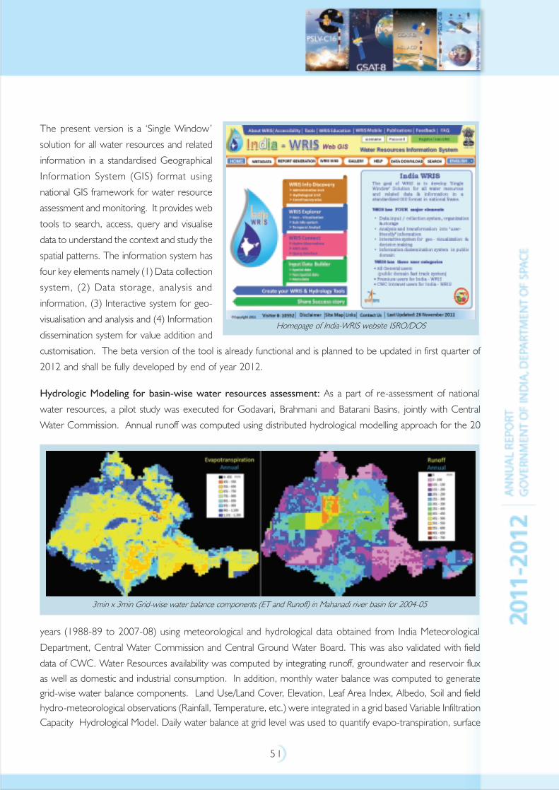
5 1
The present version is a ‘Single Window’
solution for all water resources and related
information in a standardised Geographical
Information System (GIS) format using
national GIS framework for water resource
assessment and monitoring. It provides web
tools to search, access, query and visualise
data to understand the context and study the
spatial patterns. The information system has
four key elements namely (1) Data collection
system, (2) Data storage, analysis and
information, (3) Interactive system for geo-
visualisation and analysis and (4) Information
dissemination system for value addition and
customisation. The beta version of the tool is already functional and is planned to be updated in first quarter of
2012 and shall be fully developed by end of year 2012.
Hydrologic Modeling for basin-wise water resources assessment: As a part of re-assessment of national
water resources, a pilot study was executed for Godavari, Brahmani and Batarani Basins, jointly with Central
Water Commission. Annual runoff was computed using distributed hydrological modelling approach for the 20
years (1988-89 to 2007-08) using meteorological and hydrological data obtained from India Meteorological
Department, Central Water Commission and Central Ground Water Board. This was also validated with field
data of CWC. Water Resources availability was computed by integrating runoff, groundwater and reservoir flux
as well as domestic and industrial consumption. In addition, monthly water balance was computed to generate
grid-wise water balance components. Land Use/Land Cover, Elevation, Leaf Area Index, Albedo, Soil and field
hydro-meteorological observations (Rainfall, Temperature, etc.) were integrated in a grid based Variable Infiltration
Capacity Hydrological Model. Daily water balance at grid level was used to quantify evapo-transpiration, surface
Homepage of India-WRIS website ISRO/DOS
3min x 3min Grid-wise water balance components (ET and Runoff) in Mahanadi river basin for 2004-05
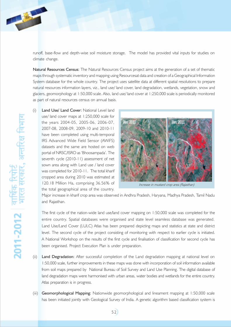
5 2
runoff, base-flow and depth-wise soil moisture storage. The model has provided vital inputs for studies on
climate change.
Natural Resources Census: The Natural Resources Census project aims at the generation of a set of thematic
maps through systematic inventory and mapping using Resourcesat data and creation of a Geographical Information
System database for the whole country. The project uses satellite data at different spatial resolutions to prepare
natural resources information layers, viz., land use/ land cover, land degradation, wetlands, vegetation, snow and
glaciers, geomorphology at 1:50,000 scale. Also, land use/ land cover at 1:250,000 scale is periodically monitored
as part of natural resources census on annual basis.
(i) Land Use/ Land Cover: National Level land
use/ land cover maps at 1:250,000 scale for
the years 2004-05, 2005-06, 2006-07,
2007-08, 2008-09, 2009-10 and 2010-11
have been completed using multi-temporal
IRS Advanced Wide Field Sensor (AWiFS)
datasets and the same are hosted on web
portal of NRSC/ISRO as ‘Bhoosampada’. The
seventh cycle (2010-11) assessment of net
sown area along with Land use / land cover
was completed for 2010-11. The total kharif
cropped area during 2010 was estimated at
120.18 Million Ha, comprising 36.56% of
the total geographical area of the country.
Major increase in kharif crop area was observed in Andhra Pradesh, Haryana, Madhya Pradesh, Tamil Nadu
and Rajasthan.
The first cycle of the nation-wide land use/land cover mapping on 1:50,000 scale was completed for the
entire country. Spatial databases were organised and state level seamless database was generated.
Land Use/Land Cover (LULC) Atlas has been prepared depicting maps and statistics at state and district
level. The second cycle of the project consisting of monitoring with respect to earlier cycle is initiated.
A National Workshop on the results of the first cycle and finalisation of classification for second cycle has
been organised. Project Execution Plan is under preparation.
(ii) Land Degradation: After successful completion of the Land degradation mapping at national level on
1:50,000 scale, further improvements in these maps was done with incorporation of soil information available
from soil maps prepared by National Bureau of Soil Survey and Land Use Planning. The digital database of
land degradation maps were harmonised with urban areas, water bodies and wetlands for the entire country.
Atlas preparation is in progress.
(iii) Geomorphological Mapping: Nationwide geomorphological and lineament mapping at 1:50,000 scale
has been initiated jointly with Geological Survey of India. A genetic algorithm based classification system is
Increase in mustard crop area (Rajasthan)

5 3
being adopted with about 360 landform units under 8 genetic classes. Nationwide geomorphological and
lineament mapping (1:50,000 scale) has been initiated jointly with Geological Survey of India with the
participation of partner institutes and around 700 maps are completed.
(iv) National Wetland Inventory: The mapping of wetlands of India at 1: 50,000 scale was a major highlight
of the year and the National Wetland Atlas and State-wise wetland atlases prepared under the
Ministry of Environment and Forests (MoEF) sponsored project “National Wetland Inventory and Assessment”
were released officially by the then Hon’ble Minister of Environment and Forests, on June 8, 2011 at SAC.
(v) Glacier Inventory: Glacier inventory was carried out in the Indus, Ganga and Brahmaputra river basins on
1:50,000 scale using recent images of Indian Remote Sensing Satellite for the first time in the country in a
Geographical Information System environment. The study has shown that there are 32392 glaciers covering
78040 sq km. Advance and retreat of Himalayan glaciers has been mapped and area computed. Work has
been taken up as Phase-II for Snow and Glacier Studies. In addition, an inventory of glacial lakes and water
bodies in the Himalayan region was carried out using Resourcesat-1 Advanced Wide Field Sensor (AWiFS)
data. Study reveals that there are 2028 glacial lakes and water bodies in the Himalayan region. Of these, 503
are glacial lakes and 1525 are water bodies. Brahmaputra basin has 294 glacial lakes and 1099 water bodies,
whereas Indus basin has 31 glacial lakes and 321 water bodies. There are 178 glacial lakes and 105 water
bodies under Ganga basin. It was observed that around 1600 glacial lakes/water bodies have water spread
area less than 50 ha, 200 water bodies have water spread area between 50 and 100 ha and 14 water bodies
cover an area over 10,000 ha.
(vi) Based on the expertise gained in the area of forestry using remote sensing, NRSC/ ISRO was invited to
present approaches to strengthen national forest cover change monitoring to the Planning Commission,
New Delhi on May 20, 2011. A project titled "Indian Forest Cover Change Alert System using
IRS multi-sensor data" has been initiated with the specific objectives of developing a semi automated sub
annual forest cover change detection methodology using multi temporal AWiFS data. Further, capacity
building and technology transfer for operational implementation by Forest Survey of India is also planned.
Wastelands Change Analysis: At the behest of Department of Land Resources (DoLR) of Ministry of Rural
Development, wasteland change analysis was completed using Resourcesat data of 2008-09. Results reveal that
there is a decrease of wastelands by 3.2 million hectares spread over 1,12,057 locations, while there is an
increase in wastelands by 2.7 million hectares in 42,886 locations. Thus, there is an overall decrease in
wastelands to the tune of 0.5 million hectares from 2005-06 to 2008-09 in the country. District and state-wise
wastelands change dynamics are presented in the form of Wastelands Atlas of India – 2011.
Space based Information System for Decentralised Planning (SIS-DP): This unique project was initiated at
the behest of Planning Commission, to prepare district resource atlases using remote sensing and Geographical
Information System techniques to strengthen various aspects of decentralised planning at district level through a
coordinated approach. The salient aspects of the project includes generation of natural resources database at
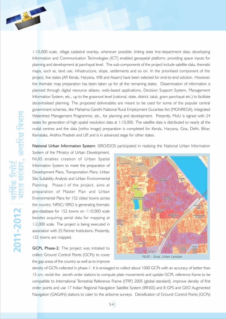
5 4
1:10,000 scale, village cadastral overlay, wherever possible; linking state line-department data; developing
Information and Communication Technologies (ICT) enabled geospatial platform; providing space inputs for
planning and development at panchayat level. The sub-components of the project include satellite data, thematic
maps, such as, land use, infrastructure, slope, settlements and so on. In the prioritised component of the
project, five states (AP, Kerala, Haryana, WB and Assam) have been selected for end-to-end solution. However,
the thematic map preparation has been taken up for all the remaining states. Dissemination of information is
planned through digital resource atlases, web-based applications, Decision Support System, Management
Information System, etc., up to the grassroot level (national, state, district, taluk, gram panchayat etc.) to facilitate
decentralised planning. The proposed deliverables are meant to be used for some of the popular central
government schemes, like Mahatma Gandhi National Rural Employment Gurantee Act (MGNREGA), Integrated
Watershed Management Programme, etc., for planning and development. Presently, MoU is signed with 24
states for generation of high spatial resolution data at 1:10,000. The satellite data is distributed to nearly all the
nodal centres and the data (ortho image) preparation is completed for Kerala, Haryana, Goa, Delhi, Bihar,
Karnataka, Andhra Pradesh and UP, and is in advanced stage for other states.
National Urban Information System: ISRO/DOS participated in realising the National Urban Information
System of the Ministry of Urban Development.
NUIS enables creation of Urban Spatial
Information System to meet the preparation of
Development Plans, Transportation Plans, Urban
Site Suitability Analysis and Urban Environmental
Planning. Phase-I of the project, aims at
preparation of Master Plan and Urban
Environmental Plans for 152 cities/ towns across
the country. NRSC/ ISRO is generating thematic
geo-database for 152 towns on 1:10,000 scale
besides acquiring aerial data for mapping at
1:2,000 scale. The project is being executed in
association with 25 Partner Institutions. Presently,
125 towns are mapped.
GCPL Phase-2: The project was initiated to
collect Ground Control Points (GCPs) to cover
the gap areas of the country as well as to improve
density of GCPs collected in phase-1. It is envisaged to collect about 1000 GCPs with an accuracy of better than
15 cm, revisit the zeroth order stations to compute plate movements and update GCPL reference frame to be
compatible to International Terrestrial Reference Frame (ITRF) 2005 (global standard), improve density of first
order points and use 17 Indian Regional Navigation Satellite System (IRNSS) and 8 GPS and GEO Augmented
Navigation (GAGAN) stations to cater to the airborne surveys. Densification of Ground Control Points (GCPs)
NUIS – Surat, Urban Landuse
5 5
was carried out through GPS surveys (Data collection and processing) spread over North East, J&K, East coast
and West Coast regions, Andaman and Lakshadweep islands. Zeroth order points were revisited to compute
plate movements and GCPL reference frame work was updated.
CartoDEM: Cartographic Digital Elevation Model
(CartoDEM) is one of the mission goals of Cartosat-1
stereo data utilisation. The project on CartoDEM was taken
up for generation of Digital Elevation Model (DEM) with a
posting of 1/3 arc-sec (~10m) interval and corresponding
ortho-image for the entire country, essentially to facilitate
large scale mapping and terrain modelling applications.
CartoDEM and ortho images for the entire country has
been generated. These datasets are realised in topographic
map tiles of 7.5’ x 7.5’ at 1:25000 scale in World Geodetic
System (WGS-84) system with vertical elevation
accuracies of 8m, and plannimetric accuracy of 15 m. 1
arc second CartoDEM has already been posted onto Bhuvan
geoportal for the benefit of researchers and for user
community.
Cal/Val Activities: As part of this activity, five sites - two in Thar desert and three in Kutchh salt lakes - were
identified for land applications using optical sensors. Ground characterisation for radiometric and temporal
stability, atmospheric characterisation for aerosol and radiative transfer modelling are in progress. Development
of an in-house Calibration site at Shadnagar is also in progress.
Natural Resources Database (NRDB): Natural Resources Database project has been successful in establishing
Geospatial data infrastructure with central node and seven regional nodes that are populated with national level
thematic database elements, generated under the National Natural Resources Management System Programme.
The repository is operational and provides necessary services to meet the needs of different user community.
The metadata for the entire database is posted on the NNRMS Web site for users to access, visualise and query
the same. The entire metadata is also made available to National Spatial Data Infrastructure (NSDI) and is
hosted on NSDI portal of the Department of Science and Technology.
Bhuvan: Bhuvan, ISRO’s Geoportal and Gateway to Indian Earth Observation Data Visualisation Services,
showcases Indian Earth Observation data up to 5.8 m spatial resolution seamlessly for the nation and 1 m spatial
resolution for selected towns. The Bhuvan Portal (www.bhuvan.nrsc.gov.in) which has completed more than
2 years has added a host of new functions and services including data download facilities. Bhuvan facilitates the
users to select, browse and download satellite data through NRSC Open EO Data Archive (NOEDA). Presently,
users can download Elevation data of Cartographic Digital Elevation Model (CartoDEM – 1) arc second and
CartoDEM
5 6
Advanced Wide Field Sensor data (56m) of the Indian region. It is also planned to provide the thematic services
and online geo processing services to the user community in the near future. Distinct achievements made in the
last year include implementation of Open Source Content Management System with
Multi-Lingual capability (English, Hindi, Telugu and Tamil), Central Authentication Service towards single sign on,
Online Discussion Forum to facilitate interaction with public for improvements, Indigenous Bhuvan-2D, Mobile
compatibility, Open Geospatial Consortium (OGC) Web Services towards interoperability, OGC Services to
Andhra Pradesh School Information System, Indian Forest Fire Response and Assessment System, India Geo-
portal (NSDI), Online Shape File Creation and User Data sharing, NRSC Open EO Data Archive (NOEDA),
High Resolution Data for 102 Cities and Bhuvan awareness workshops at 5 major cities covering about 2000
students in Shillong, Delhi, Pune, Chennai and Hyderabad.
Capacity Building: The Indian Institute of Remote Sensing, which has become a unit of ISRO, is a premier
institute imparting professional training and education in the field of Remote Sensing, Geoinformation technology
for Natural Resources and Disaster Management. In addition, NRSC and SAC also conduct training programme
as per the requirement of the user community. The technical support and training for various Central/State line
departments, academic institutions, Research and Development institutions towards better utilisation of space
inputs and geospatial technologies is being carried out regularly. Also, as a part of human resources development,
special training programs/workshops as well as setting up/ augmentation of computing infrastructure/ facilities at
various academic institutions in many states across the country has been carried out.
ISRO Geosphere Biosphere Programme
The ISRO Geosphere Biosphere Programme (ISRO-GBP) addresses questions related to the extent to which
anthropogenic forcing (e.g., aerosols, trace gases) interacts with the natural variability of Earth system in producing
abrupt changes that threaten sustainable development. The ISRO-GBP also provides inputs to policy makers in
the context of international protocols and conventions. Since the answers for these issues require multi-institutional
research effort, this programme is being implemented in a coordinated manner involving many ISRO/DOS
Centres and national laboratories and academic institutions.
Images of Bhuvan Web Portal

5 7
The Space Physics Laboratory (SPL) is implementing four projects, namely, Aerosol Radiative Forcing over
India, Integrated Campaign for Aerosols, gases, and Radiation Budget, Regional Aerosol Warming Experiment
and Atmospheric Boundary Layer-Network and Characterisation. The Physical Research Laboratory is
implementing three projects, namely, Atmospheric Trace gases Composition and Transport Modeling ,
Atmospheric Dust Composition and Transport Modeling and Multi-proxy Quantitative Paleomonsoon
Reconstruction for past 21,000 years. The Sapce Applications Centre is studying the Energy and Mass Exchanges
in Vegetative Systems. The Indian Institute of Remote Sensing is investigating the Land Use Land Cover Dynamics
and Impact of Human Dimensions in the Indian River Basins over the last 30 years. The National Remote
Sensing Centre is focusing on understanding the terrestrial Carbon Cycle through a ‘National Carbon Project’.
One of the significant achievements of this programme is that we are able to generate the primary data from a
nationwide network of observational sites to provide a better understanding of regional climate and atmospheric
composition. The programme has brought out several new findings: the persistence of the elevated aerosol
layers; the lower atmospheric warming due to aerosols and its meridional gradient., the role of natural processes
unique to tropics and frequently overlooked in models, the anomalous high absorption of Asian dust; the large
fraction of water soluble iron; the high Organic Carbon/Black Carbon ratio; significant contribution of sea-salt
aerosols and the resulting long wave radiative forcing, long-range transport of mixed aerosols from the west
Asia, east Africa and Europe to the Indian mainland (which contributes as much as 50% of the aerosol loading
during pre-monsoon) and the fine anthropogenic dominated aerosols from East Asia across Bay of Bengal during
winter. Another important result, from the climate perspective and national importance, has come from the
study of long-term trends at some locations (e.g., Thiruvananthapuram) where the aerosol optical depth has
been increasing consistently over the last 25 years but the concentration of black carbon, normally considered as
a tracer for human impact, shows a decreasing trend.
Under the project Atmospheric Dust Composition and Transport Modeling, the major research findings have
direct relevance to the international efforts that are directed to improve our understanding of the chemical
composition of troposphere, processes controlling the transport and transformation of chemical species within
the troposphere, and fluxes of chemical species into and out of the troposphere. The Sources and spatial
variability of mineral and anthropogenic aerosols over western India and Arabian Sea- atmospheric boundary
layer were studied and found that the water-soluble species account for 35% of total suspended particulate
(TSP) with dominant contribution of Ca2+ and SO42– followed by Na+ and minor contributions of K+, Mg2+,
Cl–, and NO3
–. On average, mineral dust accounts for 44% of TSP. The study also shows uptake of anthropogenic
SO4
2– by mineral dust (CaCO3). These results have implications to downwind transport of dust and pollutants
to the marine atmospheric boundary layer.
High-resolution monsoon reconstruction for the last 331 years, for the west coast of India has been completed.
Years of extreme events (drought/flood) occurred before instrumental period are identified. In this reconstruction
solar cycle (~21 year-magnetic cycle) is found which suggests significant association between sun and Indian
monsoon. Indian monsoon is found to have increasing trend during the Holocene period (last 10 k yr).
5 8
A multi-institutional national phytomass observation program consisting of 54 institutions and 74 principal
investigators was carried out under National Carbon Project. Several field plot data from forests and trees
outside forests was collected with defined sampling protocols. Many permanent sample plots (one at each
cluster) were identified for further monitoring as well as for quality assurance. Pilot studies in 16 test-sites in
different ecological regions in the country have been taken to test the methodology for biomass estimation and
spectral modeling using optical and microwave data in forest ecosystem. Estimation of seasonal crop biomass
and net primary production (NPP) using remote sensing and modeling and crop NPP (above and below ground)
from historical agricultural statistics data were carried out. As part of network to support flux estimation, ground
based CO2 sensors have been installed at many stations to monitor diurnal and seasonal measurements in
support of atmospheric CO2 retrieved from Atmospheric Infra Red Sounder on board Advanced Sounding Unit.
Analysis suggests that atmospheric CO2 concentration has increased linearly during the past
6 years with strong seasonal variation over the land and relatively weaker seasonal variability over the ocean.
Out of the planned network of 24 Agro-Met Stations (AMS), 19 AMS have been established under Energy Mass
Exchange project. Arrangements for evaluating the primary data and intermediate products have been made.
Integrated science plan for crop canopy characterisation through in-situ measurements on phenology, Leaf Area
Index, soil moisture, photosynthesis, biomass etc. are being carried out. The studies indicate a decrease in
albedo by 9% during 1981-2000 while there is an increase in the Net Primary Productivity in Maharashtra and
Karnataka. The project emphasizes on the NPP in the dominant agricultural areas. The project is developing a
methodology of up-scaling the in-situ observations to satellite sensor-based observations.
Creation of Land Use/Land Cover database at decadal interval (1985, 1995 and 2005) for all the 14 major
river basins (entire country) based on satellite image interpretation and legacy data was completed; validation in
progress. Creation of biophysical (topographic and climatic) and socio-economic (Population density; number of
households; infrastructure, drinking water, health and education facility, etc.) database was completed for two
river basins (Pennar and Narmada); work is in progress for the remaining basins.
5 9
SPACE TRANSPORTATION SYSTEM
The Indian Space Programme started in a humble way with the launch of modest Rohini sounding rockets from
Thumba near Thiruvananthapuram in the early 1960s. Initially, these sounding rocket launches were aimed at
conducting scientific investigations over the geomagnetic equator passing over Thumba. Since then, India has
made rapid strides in launch vehicle technology to achieve self reliance in satellite launch vehicle
programme with the operationalisation of Polar Satellite Launch Vehicle (PSLV) and Geosynchronous Satellite
Launch Vehicle (GSLV).
Major Accomplishments
Polar Satellite Launch Vehicle (PSLV)
PSLV, the workhorse launch vehicle of ISRO proved its reliability and versatility with three successful launches in
2011, viz., PSLV-C16, C17 and C18. The launches have taken place
in 3 variants – generic version with six S9 solid strap-on motors, core
alone version and XL version with six extended length S12 solid
strap-on motors. Of these, C17 was a sub-Geosynchronus Transfer
Orbit mission to place the communication satellite GSAT-12 into the
intended orbit. PSLV is a four stage vehicle with alternate solid and
liquid propulsion systems.
PSLV-C16/Resourcesat-2 mission had PSLV vehicle in the generic
configuration and was
successfully launched on
April 20, 2011. It carried
Resourcesat-2 (1206 kg)
along with two auxiliary
satellites Youthsat (92 kg)
and XSAT (105 kg) from Nanyang Technological University, Singapore,
which were placed into a Sun Synchronous Polar orbit of 809 x 822
km with an inclination of 98.7º.
PSLV C17/GSAT-12 mission was the second mission of PSLV with
PSOM-XL strap-on configuration and was successfully launched on
July 15, 2011. This mission placed the communication satellite
GSAT-12 into a sub-GTO orbit of 280 km perigee and 21,027 km
apogee with an inclination of 17.98º. Both prime and redundant flight PSLV C 17 Lift-off, July 15, 2011
PSLV C 16 Lift-off, April 20, 2011
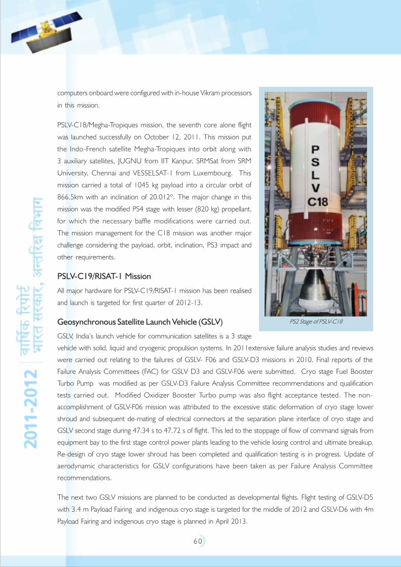
6 0
computers onboard were configured with in-house Vikram processors
in this mission.
PSLV-C18/Megha-Tropiques mission, the seventh core alone flight
was launched successfully on October 12, 2011. This mission put
the Indo-French satellite Megha-Tropiques into orbit along with
3 auxiliary satellites, JUGNU from IIT Kanpur, SRMSat from SRM
University, Chennai and VESSELSAT-1 from Luxembourg. This
mission carried a total of 1045 kg payload into a circular orbit of
866.5km with an inclination of 20.012º. The major change in this
mission was the modified PS4 stage with lesser (820 kg) propellant,
for which the necessary baffle modifications were carried out.
The mission management for the C18 mission was another major
challenge considering the payload, orbit, inclination, PS3 impact and
other requirements.
PSLV-C19/RISAT-1 Mission
All major hardware for PSLV-C19/RISAT-1 mission has been realised
and launch is targeted for first quarter of 2012-13.
Geosynchronous Satellite Launch Vehicle (GSLV)
GSLV, India’s launch vehicle for communication satellites is a 3 stage
vehicle with solid, liquid and cryogenic propulsion systems. In 2011extensive failure analysis studies and reviews
were carried out relating to the failures of GSLV- F06 and GSLV-D3 missions in 2010. Final reports of the
Failure Analysis Committees (FAC) for GSLV D3 and GSLV-F06 were submitted. Cryo stage Fuel Booster
Turbo Pump was modified as per GSLV-D3 Failure Analysis Committee recommendations and qualification
tests carried out. Modified Oxidizer Booster Turbo pump was also flight acceptance tested. The non-
accomplishment of GSLV-F06 mission was attributed to the excessive static deformation of cryo stage lower
shroud and subsequent de-mating of electrical connectors at the separation plane interface of cryo stage and
GSLV second stage during 47.34 s to 47.72 s of flight. This led to the stoppage of flow of command signals from
equipment bay to the first stage control power plants leading to the vehicle losing control and ultimate breakup.
Re-design of cryo stage lower shroud has been completed and qualification testing is in progress. Update of
aerodynamic characteristics for GSLV configurations have been taken as per Failure Analysis Committee
recommendations.
The next two GSLV missions are planned to be conducted as developmental flights. Flight testing of GSLV-D5
with 3.4 m Payload Fairing and indigenous cryo stage is targeted for the middle of 2012 and GSLV-D6 with 4m
Payload Fairing and indigenous cryo stage is planned in April 2013.
PS2 Stage of PSLV-C18
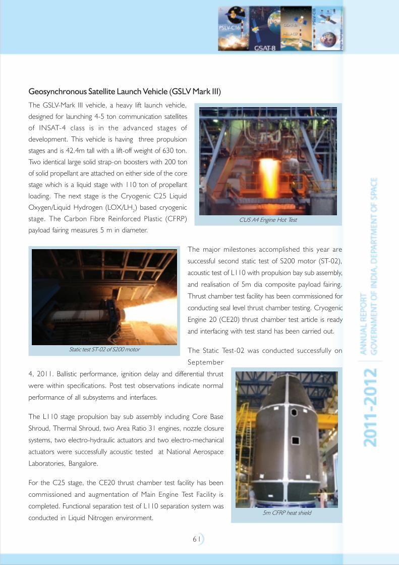
6 1
Geosynchronous Satellite Launch Vehicle (GSLV Mark III)
The GSLV-Mark III vehicle, a heavy lift launch vehicle,
designed for launching 4-5 ton communication satellites
of INSAT-4 class is in the advanced stages of
development. This vehicle is having three propulsion
stages and is 42.4m tall with a lift-off weight of 630 ton.
Two identical large solid strap-on boosters with 200 ton
of solid propellant are attached on either side of the core
stage which is a liquid stage with 110 ton of propellant
loading. The next stage is the Cryogenic C25 Liquid
Oxygen/Liquid Hydrogen (LOX/LH2) based cryogenic
stage. The Carbon Fibre Reinforced Plastic (CFRP)
payload fairing measures 5 m in diameter.
The major milestones accomplished this year are
successful second static test of S200 motor (ST-02),
acoustic test of L110 with propulsion bay sub assembly,
and realisation of 5m dia composite payload fairing.
Thrust chamber test facility has been commissioned for
conducting seal level thrust chamber testing. Cryogenic
Engine 20 (CE20) thrust chamber test article is ready
and interfacing with test stand has been carried out.
The Static Test-02 was conducted successfully on
September
4, 2011. Ballistic performance, ignition delay and differential thrust
were within specifications. Post test observations indicate normal
performance of all subsystems and interfaces.
The L110 stage propulsion bay sub assembly including Core Base
Shroud, Thermal Shroud, two Area Ratio 31 engines, nozzle closure
systems, two electro-hydraulic actuators and two electro-mechanical
actuators were successfully acoustic tested at National Aerospace
Laboratories, Bangalore.
For the C25 stage, the CE20 thrust chamber test facility has been
commissioned and augmentation of Main Engine Test Facility is
completed. Functional separation test of L110 separation system was
conducted in Liquid Nitrogen environment.
CUS A4 Engine Hot Test
Static test ST-02 of S200 motor
5m CFRP heat shield
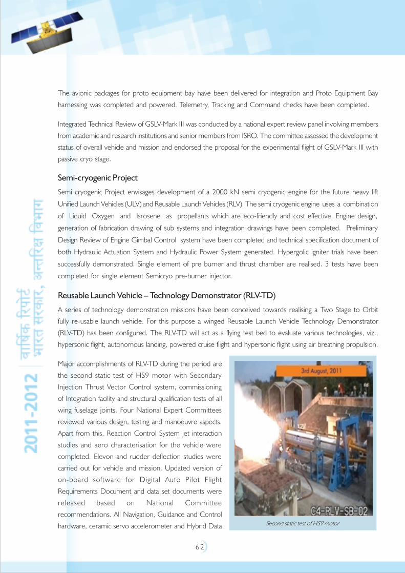
6 2
The avionic packages for proto equipment bay have been delivered for integration and Proto Equipment Bay
harnessing was completed and powered. Telemetry, Tracking and Command checks have been completed.
Integrated Technical Review of GSLV-Mark III was conducted by a national expert review panel involving members
from academic and research institutions and senior members from ISRO. The committee assessed the development
status of overall vehicle and mission and endorsed the proposal for the experimental flight of GSLV-Mark III with
passive cryo stage.
Semi-cryogenic Project
Semi cryogenic Project envisages development of a 2000 kN semi cryogenic engine for the future heavy lift
Unified Launch Vehicles (ULV) and Reusable Launch Vehicles (RLV). The semi cryogenic engine uses a combination
of Liquid Oxygen and Isrosene as propellants which are eco-friendly and cost effective. Engine design,
generation of fabrication drawing of sub systems and integration drawings have been completed. Preliminary
Design Review of Engine Gimbal Control system have been completed and technical specification document of
both Hydraulic Actuation System and Hydraulic Power System generated. Hypergolic igniter trials have been
successfully demonstrated. Single element of pre burner and thrust chamber are realised. 3 tests have been
completed for single element Semicryo pre-burner injector.
Reusable Launch Vehicle – Technology Demonstrator (RLV-TD)
A series of technology demonstration missions have been conceived towards realising a Two Stage to Orbit
fully re-usable launch vehicle. For this purpose a winged Reusable Launch Vehicle Technology Demonstrator
(RLV-TD) has been configured. The RLV-TD will act as a flying test bed to evaluate various technologies, viz.,
hypersonic flight, autonomous landing, powered cruise flight and hypersonic flight using air breathing propulsion.
Major accomplishments of RLV-TD during the period are
the second static test of HS9 motor with Secondary
Injection Thrust Vector Control system, commissioning
of Integration facility and structural qualification tests of all
wing fuselage joints. Four National Expert Committees
reviewed various design, testing and manoeuvre aspects.
Apart from this, Reaction Control System jet interaction
studies and aero characterisation for the vehicle were
completed. Elevon and rudder deflection studies were
carried out for vehicle and mission. Updated version of
on-board software for Digital Auto Pilot Flight
Requirements Document and data set documents were
released based on National Committee
recommendations. All Navigation, Guidance and Control
hardware, ceramic servo accelerometer and Hybrid Data Second static test of HS9 motor
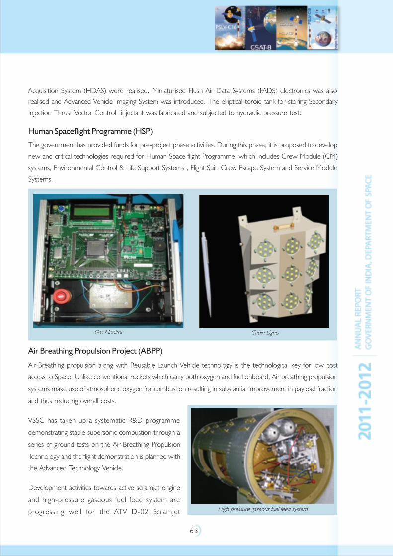
6 3
Acquisition System (HDAS) were realised. Miniaturised Flush Air Data Systems (FADS) electronics was also
realised and Advanced Vehicle Imaging System was introduced. The elliptical toroid tank for storing Secondary
Injection Thrust Vector Control injectant was fabricated and subjected to hydraulic pressure test.
Human Spaceflight Programme (HSP)
The government has provided funds for pre-project phase activities. During this phase, it is proposed to develop
new and critical technologies required for Human Space flight Programme, which includes Crew Module (CM)
systems, Environmental Control & Life Support Systems , Flight Suit, Crew Escape System and Service Module
Systems.
Air Breathing Propulsion Project (ABPP)
Air-Breathing propulsion along with Reusable Launch Vehicle technology is the technological key for low cost
access to Space. Unlike conventional rockets which carry both oxygen and fuel onboard, Air breathing propulsion
systems make use of atmospheric oxygen for combustion resulting in substantial improvement in payload fraction
and thus reducing overall costs.
VSSC has taken up a systematic R&D programme
demonstrating stable supersonic combustion through a
series of ground tests on the Air-Breathing Propulsion
Technology and the flight demonstration is planned with
the Advanced Technology Vehicle.
Development activities towards active scramjet engine
and high-pressure gaseous fuel feed system are
progressing well for the ATV D-02 Scramjet
Cabin LightsGas Monitor
High pressure gaseous fuel feed system
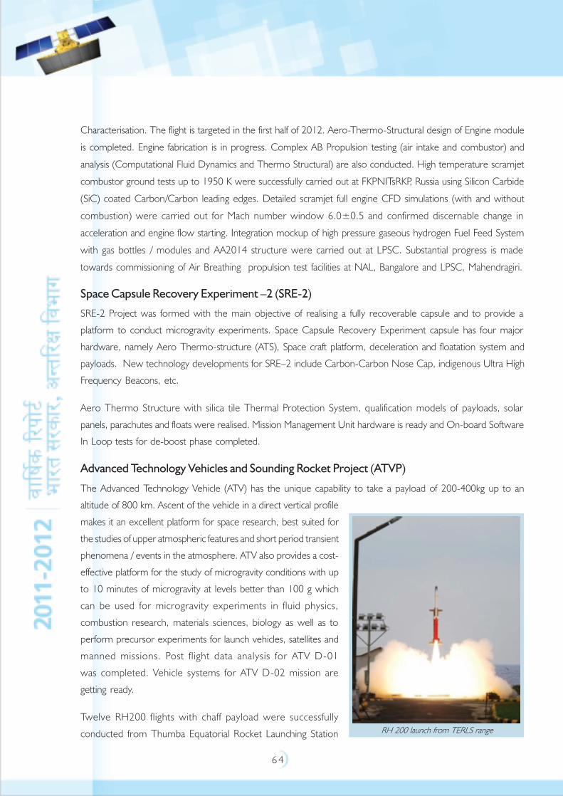
6 4
RH 200 launch from TERLS range
Characterisation. The flight is targeted in the first half of 2012. Aero-Thermo-Structural design of Engine module
is completed. Engine fabrication is in progress. Complex AB Propulsion testing (air intake and combustor) and
analysis (Computational Fluid Dynamics and Thermo Structural) are also conducted. High temperature scramjet
combustor ground tests up to 1950 K were successfully carried out at FKPNITsRKP, Russia using Silicon Carbide
(SiC) coated Carbon/Carbon leading edges. Detailed scramjet full engine CFD simulations (with and without
combustion) were carried out for Mach number window 6.0±0.5 and confirmed discernable change in
acceleration and engine flow starting. Integration mockup of high pressure gaseous hydrogen Fuel Feed System
with gas bottles / modules and AA2014 structure were carried out at LPSC. Substantial progress is made
towards commissioning of Air Breathing propulsion test facilities at NAL, Bangalore and LPSC, Mahendragiri.
Space Capsule Recovery Experiment –2 (SRE-2)
SRE-2 Project was formed with the main objective of realising a fully recoverable capsule and to provide a
platform to conduct microgravity experiments. Space Capsule Recovery Experiment capsule has four major
hardware, namely Aero Thermo-structure (ATS), Space craft platform, deceleration and floatation system and
payloads. New technology developments for SRE–2 include Carbon-Carbon Nose Cap, indigenous Ultra High
Frequency Beacons, etc.
Aero Thermo Structure with silica tile Thermal Protection System, qualification models of payloads, solar
panels, parachutes and floats were realised. Mission Management Unit hardware is ready and On-board Software
In Loop tests for de-boost phase completed.
Advanced Technology Vehicles and Sounding Rocket Project (ATVP)
The Advanced Technology Vehicle (ATV) has the unique capability to take a payload of 200-400kg up to an
altitude of 800 km. Ascent of the vehicle in a direct vertical profile
makes it an excellent platform for space research, best suited for
the studies of upper atmospheric features and short period transient
phenomena / events in the atmosphere. ATV also provides a cost-
effective platform for the study of microgravity conditions with up
to 10 minutes of microgravity at levels better than 100 g which
can be used for microgravity experiments in fluid physics,
combustion research, materials sciences, biology as well as to
perform precursor experiments for launch vehicles, satellites and
manned missions. Post flight data analysis for ATV D-01
was completed. Vehicle systems for ATV D-02 mission are
getting ready.
Twelve RH200 flights with chaff payload were successfully
conducted from Thumba Equatorial Rocket Launching Station

6 5
Range for wind measurement. Two proof motor tests were conducted for the propellant design and evaluation
of IIST Student Rocket Flight (Vyom), which is RH200 motor with revised grain design.
Launch Infrastructure
SDSC SHAR is augmenting the launch infrastructure at the centre to meet the requirements of increased launch
frequency of five to six launches per year. The following major facilities have been realised during the year:
The President of India
inaugurated the new
Mission Control Centre
(MCC), which has been
realised at Shriharikota
Centre and dedicated the
new MCC to the Nation.
For meeting the GSLV-Mark
III launch requirements and
future missions of ISRO.
This new Mission Control
Centre, with state-of-the-
art facilities, has been
realised at Satish Dhawan
Space Centre (SDSC) SHAR. The MCC, situated about 6 km away from the launch complex, monitors and
conducts the launch operations during the pre-countdown and countdown phases until the injection of the
satellite into orbit. It is linked to all the ground stations through communication links for voice, video and data
transmission. The launch preparations on the vehicle are monitored from MCC, using a multi-channel Closed
Circuit Television System (CCTV). The important facilities at MCC include Mission Control Hall, Launch
Control Centre, Real time Network, VIP Gallery, Video Conference, Mission Executives rooms, Commentator
rooms, etc. In addition, second mobile launch pedestal
for PSLV/GSLV and Computer and Communication
Centre have been established. A new Media Centre for
media personnel to watch launches and facilities for filing
of reports with all requisite communication facilities has
been established.
Satish Dhawan Supercomputing Facility
This fastest supercomputer in India with a peak
performance of 220 Terra Flops was commissioned at
VSSC during May 2011. This facility is based on the
New MCC building at SDSC SHAR
SAGA - 220 Supercomputer
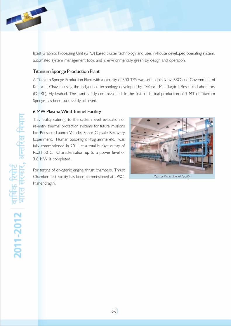
6 6
latest Graphics Processing Unit (GPU) based cluster technology and uses in-house developed operating system,
automated system management tools and is environmentally green by design and operation.
Titanium Sponge Production Plant
A Titanium Sponge Production Plant with a capacity of 500 TPA was set up jointly by ISRO and Government of
Kerala at Chavara using the indigenous technology developed by Defence Metallurgical Research Laboratory
(DMRL), Hyderabad. The plant is fully commissioned. In the first batch, trial production of 3 MT of Titanium
Sponge has been successfully achieved.
6 MW Plasma Wind Tunnel Facility
This facility catering to the system level evaluation of
re-entry thermal protection systems for future missions
like Reusable Launch Vehicle, Space Capsule Recovery
Experiment, Human Spaceflight Programme etc. was
fully commissioned in 2011 at a total budget outlay of
Rs.21.50 Cr. Characterisation up to a power level of
3.8 MW is completed.
For testing of cryogenic engine thrust chambers, Thrust
Chamber Test Facility has been commissioned at LPSC,
Mahendragiri.
Plasma Wind Tunnel Facility

6 7
SPACE SCIENCES
Space Science research has been an important element of Indian space programme. The space science research
activities are pursued at PRL, SPL, NARL, SAG and SSIF at ISAC. Specific individual, nationally coordinated,
multi-institutional, science payload instrumentation and science mission development projects in atmospheric
and space science areas are supported and implemented by ISRO through the recommendations of ISRO’s
Advisory Committee for Space Sciences (ADCOS). Some of the main activities carried out in space science
research projects/programmes through ADCOS are summarised below.
CHANDRAYAAN-1
Chandrayaan-1 mission launched on 22 October 2008, completed 312 days in orbit, made more than 3400
orbits around the Moon, studied the moon from different perspectives and provided excellent quality of high
resolution data. The Chandrayaan-1 mission successfully operated until 28 August 2009, when a communication
failure led to loss of contact and the mission was terminated.
The major findings from the scientific observation confirm that the envisaged objectives of the mission have
been achieved. The findings of Chandrayaan-1 relating to chemical, mineralogical and photogeological mapping
have been published in international journals.
CHANDRAYAAN-2
Chandrayaan-2 mission is planned to have an Orbiter/Lander/Rover configuration. The mission is expected to be
realised by 2014. It is an Indo-Russian collaborative mission. The scientific objectives of the mission are to further
improve our understanding of origin and evolution of the Moon using instruments onboard Orbiter and in-situ
analysis of lunar samples and studies of lunar regolith properties (remote and direct analysis) using Robotics/Rover.
Evolution of Chandrayaan-2 spacecraft configuration
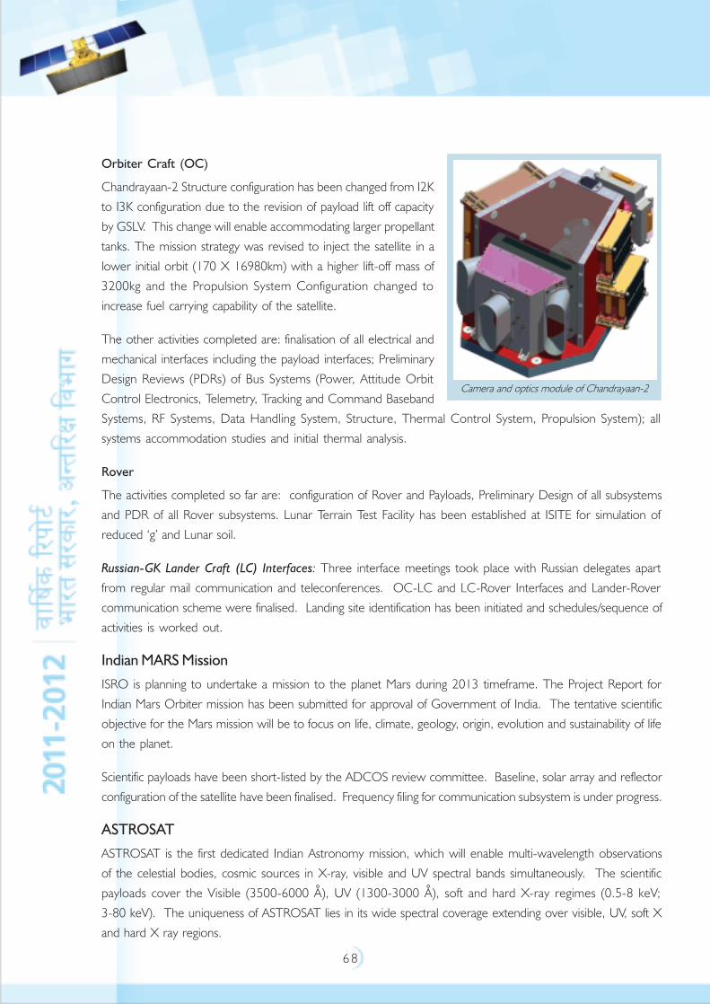
6 8
Orbiter Craft (OC)
Chandrayaan-2 Structure configuration has been changed from I2Kto I3K configuration due to the revision of payload lift off capacityby GSLV. This change will enable accommodating larger propellanttanks. The mission strategy was revised to inject the satellite in alower initial orbit (170 X 16980km) with a higher lift-off mass of3200kg and the Propulsion System Configuration changed toincrease fuel carrying capability of the satellite.
The other activities completed are: finalisation of all electrical andmechanical interfaces including the payload interfaces; PreliminaryDesign Reviews (PDRs) of Bus Systems (Power, Attitude OrbitControl Electronics, Telemetry, Tracking and Command BasebandSystems, RF Systems, Data Handling System, Structure, Thermal Control System, Propulsion System); allsystems accommodation studies and initial thermal analysis.
Rover
The activities completed so far are: configuration of Rover and Payloads, Preliminary Design of all subsystemsand PDR of all Rover subsystems. Lunar Terrain Test Facility has been established at ISITE for simulation ofreduced ‘g’ and Lunar soil.
Russian-GK Lander Craft (LC) Interfaces: Three interface meetings took place with Russian delegates apartfrom regular mail communication and teleconferences. OC-LC and LC-Rover Interfaces and Lander-Rovercommunication scheme were finalised. Landing site identification has been initiated and schedules/sequence ofactivities is worked out.
Indian MARS Mission
ISRO is planning to undertake a mission to the planet Mars during 2013 timeframe. The Project Report forIndian Mars Orbiter mission has been submitted for approval of Government of India. The tentative scientificobjective for the Mars mission will be to focus on life, climate, geology, origin, evolution and sustainability of lifeon the planet.
Scientific payloads have been short-listed by the ADCOS review committee. Baseline, solar array and reflectorconfiguration of the satellite have been finalised. Frequency filing for communication subsystem is under progress.
ASTROSAT
ASTROSAT is the first dedicated Indian Astronomy mission, which will enable multi-wavelength observationsof the celestial bodies, cosmic sources in X-ray, visible and UV spectral bands simultaneously. The scientificpayloads cover the Visible (3500-6000 Å), UV (1300-3000 Å), soft and hard X-ray regimes (0.5-8 keV;3-80 keV). The uniqueness of ASTROSAT lies in its wide spectral coverage extending over visible, UV, soft Xand hard X ray regions.
Camera and optics module of Chandrayaan-2
6 9
The scientific objectives of ASTROSAT are: Multiwavelength studies of cosmic sources, Monitoring the X-ray
sky for new transients, All sky survey in the hard X-ray and UV bands, Broadband spectroscopic studies of X-ray
binaries, AGN, SNRs, clusters of galaxies and stellar coronae, studies of periodic and non-periodic variability of
X-ray sources and monitoring intensity of known sources and detecting outbursts and luminosity variations.
The 1500 kg satellite is to be launched by the operational PSLV to an altitude of 650 km with 8º orbital
inclination in 2013 from Satish Dhawan Space Centre, Sriharikota. The useful life of the mission is expected to
be about five years.
ASTROSAT will carry a complement of astronomy instruments sensitive over a wide spectral range.
The payloads onboard ASTROSAT are:
1. Three Large Area Xenon-fil led Proportional Counters in 3-100 keV band for timing and
spectral studies
2. Cadmium Zinc Telluride array with coded mask aperture for hard X-ray imaging and spectral studies in
10-100 keV
3. Soft X-ray Telescope with CCD camera for timing and variability studies in the X-ray bandwidth of
0.3 to 10 keV
4. Scanning X-ray Sky Monitor for timescales and luminosity variations in 2-10 keV using proportional counter
system
5. Ultra Violet Imaging telescope will cover visible, near ultra violet and far ultra violet bands in
130-600 nm bands
6. Charge Particle Monitor is a 10 mm cube of Cesium Iodide (Tellurium) CsI (Tl) crystal viewed by a
Photodiode; it aims at detecting high-energy particles during the satellite orbital path and alerts the
instrumentation from possible damage
Flight Satellite Structure is fabricated and is in the clean room with dummy Top deck, Flight Bottom deck and
flight shear panels. Both the RCS Tank shells were fabricated and assembled on the satellite. Assembly of all the
8 numbers of 11 N thrusters completed. All Power electronics packages and core power electronics including
DC/DCs are realised, baking of the flight packages completed. The Qualification Model of Bus Management
Unit (onboard computer) is realised and all environmental qualification tests completed. Flight fabrication of
Sensors, Inertial Reference Unit, Reaction Wheel Assembly and Solar Array Drive Assembly completed and are
undergoing environmental tests.
The status of payloads onboard ASTROSAT are: (i) UVIT: Fabrication of flight mechanical components (both
Aluminum and the Invar) is completed; Bonding of heaters and thermistors on the Flight components of UVIT
payload completed; The MLI blanket for UVIT flight model also realised; The flight detector and electronics is
already received from Canadian Space Agency; Critical Design Review of the payload completed.(ii) Cadmium
Zinc Telluride: Fabrication of Flight Model mechanical parts of the payload completed; Flight Heat pipes, Radiator
7 0
panel, support brackets have been realised; Vibration and Thermo-vacuum qualification tests on the integrated
payload completed.(iii) SXT: The integration of engineering model completed and shifted to ISAC for environmental
tests; Qualification level vibration tests under progress; All flight mirrors are ready; The Flight optics assembly
completed; The flight model of Field Programmable Gate Array is realised and has undergone all environmental
tests; The fabrication of Carbon Fibre Reinforced Plastic (CFRP) tubes for flight structure is under progress.(iv)
LAXPC: Thermo-vacuum qualification tests completed on the EM; Assembly of all the three flight detectors
completed. Baking and gas filling completed for the first flight unit. The baking and gas filling for the remaining two
flight units is in progress; Functional tests of the flight processing electronics cards completed.(v) The QM of the
CFRP platform fabricated and received at ISAC; Thermo-vacuum cycling tests on the bare CFRP platform completed;
Fabrication of Flight processing electronics package completed and all the environmental tests completed.
ADITYA-1
ADITYA-1 is the first space based Solar Coronagraph intended to study the outermost region of the sun called
Corona. ADITYA-1 in the visible and near IR bands will study the Coronal Mass Ejection such as the coronal
magnetic field structures, evolution of the coronal magnetic field etc., and consequently the crucial physical
parameters for space weather.
The activities of ADITYA-1 are: MoU signed with the IIA for development and delivery of solar coronagraph
payload; preliminary design of the optical systems of ADITYA-1 finalized and design document generated;
Preliminary Design Review of the optical design completed; Trade-off studies on the selection of detector
system completed and the list of subsystem packages along with power and mass budget generated. Mechanical
reconfiguration of the satellite is in progress.
Planetary Science and Exploration (PLANEX)
The National programme in the Planetary Science and Exploration, PLANEX (short and long-term strategy)
initiated through ISRO’s Advisory Committee for Space Research (ADCOS) is visualised to undertake research
and related activities in the field of Planetary Science and Exploration.
The activities in the PLANEX program during the year are Centred around investigations on meteorites to
understand early solar system processes, analysis of remote sensing data from lunar missions to understand
surface features and surface processes on the Moon and development of laboratory prototypes of instruments
for planetary exploration.
Optical remote sensing data from payloads of Chandrayaan-1 (Hyperspectral Imager (HySI), Terrain Mapping
Camera (TMC), Moon Minerology Mapper (M3), Kaguya (Multispectral IR and Visible Imaging Spectrometer)
and Lunar Reconnaissance Orbiter (NAC) missions have been analysed to understand specific surface features
and evolutionary aspects through detailed morphological, chemical, mineralogical and physical parameters.
The morphology and composition of the central peak of Tycho crater has been studied to understand its
formation and subsequent modification. Volcanic vent, domes, pyroclastics, lava ponds and channels showing
7 1
distinct cooling cracks and flow fronts have been identified on the central peak. Insight to Potassium, Rare Earth
Elements and Phosphorus volcanism on the Moon has been gained by integrated analysis of M3, DIVINER and
Lunar Orbiter Laser Altimeter data. Unlike most other basins on the Moon, Orientale is relatively less flooded
by mare basalts, exposing much of the basin structure to view. The study concentrated to identify and estimate
the mineral abundance in the Orientale basin based on the absorption features and the linear spectral unmixing
hyperspectral techniques.
Two payloads for the Chandrayaan-2 mission, scheduled for launch in 2013 are under development. One of
the payloads, X-ray Solar Monitor is for the orbiter and the second one, Alpha Particle X-ray Spectrometer is
for the rover. A new technology of Wireless Sensor Network for Lunar and Planetary Exploration is also under
development.
In addition to the two annual meetings, PLANEX Workshop and the PLANEX PIs annual review meeting, two
data analysis workshops (both in collaboration with SAC, Ahmedabad) and a Brainstorming session on Mars
Science and Exploration have been organised.
PLANEX program has been funding research projects on planetary science topics, from universities and research
institutes. During the period, eight new projects have been funded and two projects are under processing.
Currently, there are 14 running projects. A review meeting of the PLANEX Principle Investigators has been
held during March 26-27, 2011 in which sixteen PIs have participated and presented their progress. The
results have been published in both national and international journals (18 papers) and also presented in both
national and international conferences.
The following national facilities, electron probe micro-analyzer, X-ray fluorescence and Inductively coupled
plasma mass spectrometry have been functional and the EPMA and XRF facilities are being routinely used by
both PLANEX Principal Investigators and Physical Research Laboratoty scientists. Several publications (both
peer-reviewed papers and conference abstracts) have been based on data obtained by using these facilities.
Recently an Neodymium-doped Yttrium Aluminium Garnet (Nd-YaG) laser has been procured as a heating
tool for gas extraction from single grains. The Laser Heating System has been integrated to the NOBLESS, the
multi collector noble gas mass spectrometer and the necessary sub systems fabricated and put in place. LHS
enables the extraction of noble gases from sub milligram samples (individual grains) with minimal blank
contribution.
PLANEX has started a publication “PLANEX News Letter”, with the objective of disseminating important and
recent events and discoveries in the fields of Planetary Science and Exploration to the Planetary Science community
in the country. The contents of this reflect the interests of PLANEX and its mandate. This issue will be a
quarterly and will only be an electronic version. The soft copy will be mailed to all interested people. The
inaugural issue has been released on January 03, 2011, during the 11th PLANEX Workshop. The inaugural
issue has been mailed to about 600 people and the feedback has been very positive and encouraging.
PLANEX also encourages visiting scientists. This year, under this program, there were two visitors.
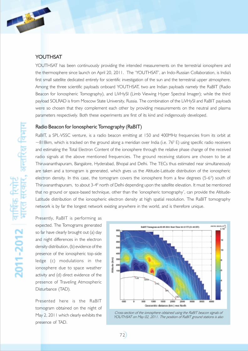
7 2
YOUTHSAT
YOUTHSAT has been continuously providing the intended measurements on the terrestrial ionosphere and
the thermosphere since launch on April 20, 2011. The ‘YOUTHSAT’, an Indo-Russian Collaboration, is India's
first small satellite dedicated entirely for scientific investigation of the sun and the terrestrial upper atmosphere.
Among the three scientific payloads onboard YOUTHSAT, two are Indian payloads namely the RaBIT (Radio
Beacon for Ionospheric Tomography), and LiVHySI (Limb Viewing Hyper Spectral Imager); while the third
payload SOLRAD is from Moscow State University, Russia. The combination of the LiVHySI and RaBIT payloads
were so chosen that they complement each other by providing measurements on the neutral and plasma
parameters respectively. Both these experiments are first of its kind and indigenously developed.
Radio Beacon for Ionospheric Tomography (RaBIT)
RaBIT, a SPL-VSSC venture, is a radio beacon emitting at 150 and 400MHz frequencies from its orbit at
~818km, which is tracked on the ground along a meridian over India (i.e. 760 E) using specific radio receivers
and estimating the Total Electron Content of the ionosphere through the relative phase change of the received
radio signals at the above mentioned frequencies. The ground receiving stations are chosen to be at
Thiruvananthapuram, Bangalore, Hyderabad, Bhopal and Delhi. The TECs thus estimated near simultaneously
are taken and a tomogram is generated, which gives us the Altitude-Latitude distribution of the ionospheric
electron density. In this case, the tomogram covers the ionosphere from a few degrees (5-60) south of
Thiruvananthapuram, to about 3-40 north of Delhi depending upon the satellite elevation. It must be mentioned
that no ground or space-based technique, other than the ‘ionospheric tomography’, can provide the Altitude-
Latitude distribution of the ionospheric electron density at high spatial resolution. The RaBIT tomography
network is by far the longest network existing anywhere in the world, and is therefore unique.
Presently, RaBIT is performing as
expected. The Tomograms generated
so far have clearly brought out (a) day
and night differences in the electron
density distribution, (b) evidence of the
presence of the ionospheric top-side
ledge (c) modulations in the
ionosphere due to space weather
activity and (d) direct evidence of the
presence of Traveling Atmospheric
Disturbance (TAD).
Presented here is the RaBIT
tomogram obtained on the night of
May 2, 2011 which clearly exhibits the
presence of TAD.
Cross-section of the ionosphere obtained using the RaBIT beacon signals ofYOUTHSAT on May 02, 2011. The position of RaBIT ground stations is also
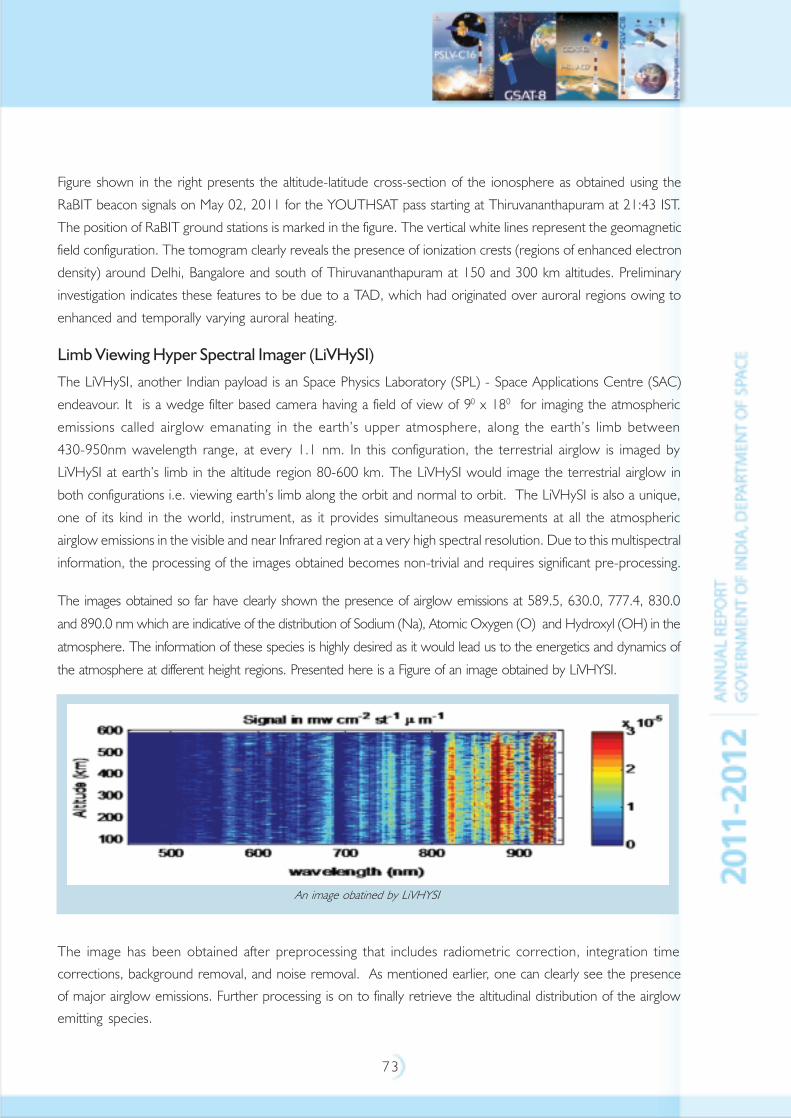
7 3
Figure shown in the right presents the altitude-latitude cross-section of the ionosphere as obtained using the
RaBIT beacon signals on May 02, 2011 for the YOUTHSAT pass starting at Thiruvananthapuram at 21:43 IST.
The position of RaBIT ground stations is marked in the figure. The vertical white lines represent the geomagnetic
field configuration. The tomogram clearly reveals the presence of ionization crests (regions of enhanced electron
density) around Delhi, Bangalore and south of Thiruvananthapuram at 150 and 300 km altitudes. Preliminary
investigation indicates these features to be due to a TAD, which had originated over auroral regions owing to
enhanced and temporally varying auroral heating.
Limb Viewing Hyper Spectral Imager (LiVHySI)
The LiVHySI, another Indian payload is an Space Physics Laboratory (SPL) - Space Applications Centre (SAC)
endeavour. It is a wedge filter based camera having a field of view of 90 x 180 for imaging the atmospheric
emissions called airglow emanating in the earth’s upper atmosphere, along the earth’s limb between
430-950nm wavelength range, at every 1.1 nm. In this configuration, the terrestrial airglow is imaged by
LiVHySI at earth’s limb in the altitude region 80-600 km. The LiVHySI would image the terrestrial airglow in
both configurations i.e. viewing earth’s limb along the orbit and normal to orbit. The LiVHySI is also a unique,
one of its kind in the world, instrument, as it provides simultaneous measurements at all the atmospheric
airglow emissions in the visible and near Infrared region at a very high spectral resolution. Due to this multispectral
information, the processing of the images obtained becomes non-trivial and requires significant pre-processing.
The images obtained so far have clearly shown the presence of airglow emissions at 589.5, 630.0, 777.4, 830.0
and 890.0 nm which are indicative of the distribution of Sodium (Na), Atomic Oxygen (O) and Hydroxyl (OH) in the
atmosphere. The information of these species is highly desired as it would lead us to the energetics and dynamics of
the atmosphere at different height regions. Presented here is a Figure of an image obtained by LiVHYSI.
The image has been obtained after preprocessing that includes radiometric correction, integration time
corrections, background removal, and noise removal. As mentioned earlier, one can clearly see the presence
of major airglow emissions. Further processing is on to finally retrieve the altitudinal distribution of the airglow
emitting species.
An image obatined by LiVHYSI
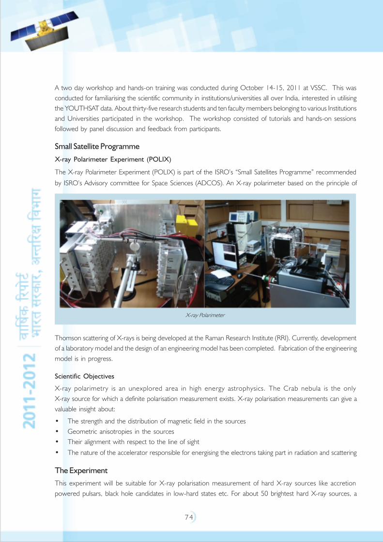
7 4
A two day workshop and hands-on training was conducted during October 14-15, 2011 at VSSC. This wasconducted for familiarising the scientific community in institutions/universities all over India, interested in utilisingthe YOUTHSAT data. About thirty-five research students and ten faculty members belonging to various Institutionsand Universities participated in the workshop. The workshop consisted of tutorials and hands-on sessionsfollowed by panel discussion and feedback from participants.
Small Satellite Programme
X-ray Polarimeter Experiment (POLIX)
The X-ray Polarimeter Experiment (POLIX) is part of the ISRO’s “Small Satellites Programme” recommended
by ISRO’s Advisory committee for Space Sciences (ADCOS). An X-ray polarimeter based on the principle of
Thomson scattering of X-rays is being developed at the Raman Research Institute (RRI). Currently, developmentof a laboratory model and the design of an engineering model has been completed. Fabrication of the engineeringmodel is in progress.
Scientific Objectives
X-ray polarimetry is an unexplored area in high energy astrophysics. The Crab nebula is the onlyX-ray source for which a definite polarisation measurement exists. X-ray polarisation measurements can give avaluable insight about:
• The strength and the distribution of magnetic field in the sources• Geometric anisotropies in the sources• Their alignment with respect to the line of sight
• The nature of the accelerator responsible for energising the electrons taking part in radiation and scattering
The Experiment
This experiment will be suitable for X-ray polarisation measurement of hard X-ray sources like accretionpowered pulsars, black hole candidates in low-hard states etc. For about 50 brightest hard X-ray sources, a
X-ray Polarimeter

7 5
Minimum Detectable Polarisation of 2-3% will be achieved. The instrument is made with a Lithium/Berylliumscatterer and surrounding proportional counter detectors and it is sensitive in the 5-30 keV energy band.
Development Status
A laboratory unit of the instrument has been built by RRI and X-ray polarisation measurements have beensuccessfully carried out with it. The figureprovided here shows the laboratory unitof the X-ray polarimeter.
Based on the test results obtained with thelaboratory unit, an engineering model hasbeen designed. Fabrication of theengineering model with funding from ISROis under progress. Detector electronics and signal processing electronics for the engineering model has alsobeen designed and is under development.
SENSE
SENSE is a twin satellite mission to probe the electromagnetic environment of the Earth's near space region.It is proposed to launch two small satellites in a low earth orbit of around 500 km, one with high inclination(~800) and the other at lower inclination (~300) for space weather related studies.
SENSE is part of ISRO’s “Small Satellites Programme”, recommended by ISRO’s Advisory committee for SpaceScience (ADCOS). SENSE aims to unravel the roles played by major large-scale drivers in determining the state ofthe Ionosphere-Thermosphere system and the weather of the near space environment at low latitudes.
A nonmagnetic Electro Magnetic Interference/Electro Magnetic Compatibility compatible shelter serving as aFaraday cage at very low frequencies (<50 kHz) was recently deployed at EGRL. This shelter houses a state-of-the-art calibration system for induction magnetometers. This is a major experimental facility and an asset forfuture space missions, and is also a valuable addition to the infrastructure being built up for development ofspace-borne instrumentation at the institute.
Engineering models of the electric and magnetic field probes chosen for the SENSE mission have already beentested in the lab and their frequency responses studied.
Space Science Promotion
ISRO’s Advisory Committee for Space Science (ADCOS) promotes and reviews indigenous, highquality internationally competitive research and development activities in the field of space science andrecommends on new initiatives with a long-term perspective and vision for space science research activities inthe country.
Considering the requirement of high quality manpower for the growth of space science activities as well as onthe issue of attracting more faculty and students participation in national space science research programmes,ISRO initiated a scheme based on ADCOS recommendations called “ISRO’s Space Science Promotion Scheme”
POLIX

7 6
ISRO-SSPS towards supporting these activities in a few selected universities having national representation andregional distribution. The basic criteria for the selection of the universities have been the heritage of spacescience and atmospheric research.
ISRO-SSPS supports recurring grant for a period not exceeding five years for augmentation of faculty positionsand engaging visiting/guest faculty, fellowship to M.Sc / M.Tech students to encourage them to pursue spacescience research and one time grant to Universities for laboratory augmentation towards conducting spacescience related experiments. One time grant has already been given to six Universities and the release ofrecurring grant is in progress.
The scheme has been implemented in the following Universities under the Phase-I activities of the scheme:1. Andhra University, Visakhapatnam2. Banaras Hindu University, Varanasi3. Bangalore University, Bangalore4. University of Calcutta, Kolkata5. Dibrugarh University, Dibrugarh6. Sri Venkateswara University, Tirupati7. Tezpur University, Tezpur
Currently, the phase-I activities are under review.
S.K. Mitra Centre for Research in Space Environment, Kolkata
ISRO has funded two research projects related to Atmospheric Studies and Space Environment for three yearsunder Phase-III activities at the S.K. Mitra Centre for Research in Space Environment, Calcutta University.The following two projects under Phase III are carrying out first year activities.
Integrated Studies on Water Vapour, Liquid Water Content and Rain of the Tropical Atmosphere and Their
Effects on Radio Environment
Study on Earth-Space Propagation and Radio Environment
The activities carried out in this area mainly involve the propagation of Ku-band satellite signal over earth-spacepath and related atmospheric parameters. The International Telecommunication Union (ITU-R) model of rainattenuation has been modified by incorporating an effective slant path model. Comparison with ITU-R andSimple Attenuation Model clearly demonstrates the improved predictive capability of the proposed model ofrain attenuation. A channel model is proposed to predict the time series of Ku-band rain attenuation during arain event at a tropical location. The model is based on considering the Gaussian distribution of the conditionaloccurrence of rain attenuation with a particular value of the attenuation occurring before. The channel modelhas tested well giving the predicted attenuation, which agrees with the measured value with a mean errorwithin 15% above 1 dB. The differential phase shifts, dominantly responsible for causing depolarisation atKu-band due to scattering by spheroidal raindrops, are computed by employing the point matching techniqueand using experimentally obtained rain drop size distribution (DSD) data. The differential phase shift is significantfor large drops (> 3mm). The simultaneous experimental measurements of rain DSD and the enhancement
7 7
of cross-polar component of the Ku-band signal, indicative of the depolarisation effect, show that the presenceof large drops significantly increases the depolarisation effect.
The analysis of the three years of Liquid Water Content (LWC) data (2005-2007) for the tropical location,Kolkata, shows that Salonen’s method gives higher values than that given by Karsten’s model. LWC data alsoshows a significant seasonal variation. A minimum threshold of water vapour is required to form cloud LWC.
Radiometric Observations on Inter-relation between Cloud Base Height and Precipitation
The association of precipitation with cloud base height during the SW monsoon of 2010 at an Indian tropicallocation, Kolkata has been studied using a humidity and temperature profiler (RPG-HATPRO). The time variationof CBH for each rain events has been obtained from the radiometer record. The study of different rain eventssuggests that the rain rate decreases with increasing cloud base height under low raining conditions. Experimentalresults show that the mean diameter of the largest drop increases with the lowering of cloud base height. Fourresearch papers have been published in refereed journals and three have been presented in conferences.
Space Weather
The deleterious effects of the phenomenon of Equatorial Spread F leading to scintillations are most severe in theequatorial region covering ±30° dip around the magnetic equator causing disruptions of transionospheric radiolinks. The generalised Rayleigh-Taylor instability process has been recognised as the most important destabilisingagent for development of ESF. However, the question of the source of initial excitation is still open. It has beensuggested that large-scale seed waves that drive the Rayleigh-Taylor instability to cause scintillations are generatedwithin the ionosphere system and perturb the bottom side of the F-layer. The large-scale periodic structures,which may be taken as precursors to the onset of ESF, are developed at ionospheric heights over the magneticequator in the post-sunset hours and map along the highly conducting geomagnetic field lines to higher latitudeswhere they may be observed with a finite time lag. The Giant Meterwave Radio Telescope provides an uniqueopportunity for conducting multi-frequency multi-antenna interferometric campaign for identification of precursorsto onset of Equatorial Spread F. Detailed analysis of such a campaign conducted by the Space Weather Group ofthe S.K. Mitra Centre for Research in Space Environment, University of Calcutta at GMRT(lat:19.10°N,long:74.05°E geographic; dip:23°N magnetic) near Pune on October 14, 16 and 17, 2010 arepresently being done. The radio source tracked was 3C446 (RA:22h25m47.259291s, DEC:-04d57’01.390730”)for 3 hour duration each day from 13:30-16:30UT. In this campaign, five sub-arrays were used at 150, 235,325, 610 and 1420 MHz. Patches of amplitude and phase scintillations could be observed across 150 m, 300 mand 400 m baselines aligned along east-west direction at 150,235 and 325MHz respectively during13.35-14.00UT, 14.30-14.40UT and finally around 15.30UT on October 14, 2010. Concentrating on thephase plots prior to occurrence of ESF on October 14, 2010, periodic structures were noted corresponding tothe time interval 13.15-13.35 UT at 150, 235 and 325MHz.
After the abnormally prolonged solar minima spanning 2008-2010, scintillation activities have dramaticallypicked up since February 2011 at locations like Calcutta situated near the northern crest of the EquatorialIonisation Anomaly (EIA). GPS phase scintillations recorded at Calcutta during February-April 2011 are presentlybeing studied to characterise cycle slips and study the hierarchy of equatorial ionisation irregularities. Threeresearch papers have been published in referred journals.
7 8
Astronomy Olympiad
Astronomy Olympiad is intended to encourage students with good foundation in Physics and Mathematics and an interestin Astronomy to pursue further studies in this field. It involves a five stage process leading to participation of Indian teamsin International Astronomy Olympiad. From the year 2007, India has been participating in International Olympiad inAstronomy and Astrophysics also.
The programme is being supported by ISRO and Department of Atomic Energy (DAE) and co-ordinated through HomiBhabha Centre for Science Education (TIFR), Mumbai in collaboration with Indian Association of Physics Teachers. The16th International Astronomy Olympiad was held at Almaty, Kazakhstan during 22nd to 30th September, 2011 and theIndian team has won three Medals (one Gold, one Silver and one Bronze).
National Space Science Symposium (NSSS-2012)
The 17th National Space Science Symposium is to be held during February 14-17, 2012 at Sri Venkateswara University,Tirupati, Andhra Pradesh. The symposium consisted of Parallel Sessions, Special Plenary Sessions, Interdisciplinary lecturesand a popular lecture.
The five Parallel Sessions (PS) planned are: Space based Meteorology, Oceanography and Geosphere-biosphere interactions;Middle Atmosphere, coupling, dynamics and Climate Change; Ionosphere, Magnetosphere, Thermosphere, Space Weatherand Sun-Earth relationship; Astronomy and Astrophysics and the Solar system bodies including Planetary System.The topics of the plenary sessions are: Advances in Astronomy, Megha-Tropiques and Polar Research.
To encourage the young scientists, students and research scholars, two best Oral presentation awards and two bestPoster presentation awards were to be given to each parallel session as decided by the special judges, which includes aCertificate and cash prize.
39th COSPAR Scientific Assembly (COSPAR-2012)
Committee on Space Research (COSPAR) is an interdisciplinary scientific organisation concerned with the promotion andprogress, on an international scale, of all kinds of scientific research carried out with space vehicles, rockets and balloons.
COSPAR Scientific Assembly is the largest conglomeration of Space Scientists in the world. It is a biennial assembly, whichis conducted in different countries around the globe.
The assembly consists of Interdisciplinary session, plenary sessions and parallel sessions. The assembly also consists ofPoster sessions of presentation of scientific results, Space exhibition from different space agencies of the world andCOSPAR Student Program, developed and supported by the members of the International Space Education Board, forlearning and meeting the members of space industry, academia and government bodies from countries around the worldduring the Scientific Assembly.
The 39th COSPAR Scientific Assembly (COSPAR-2012) is scheduled to be held in India at Narayana Murthy Centre ofExcellence, Mysore during July 14-22, 2012. This COSPAR assembly would be organised in India after three decades.More than 3000 participants from India and different countries of the world are expected to participate in this assembly.LOC-COSPAR-2012 has been constituted for the successful organisation of the assembly.

7 9
SPONSORED RESEARCH
RESPOND (Research Sponsored) programme started in the early 1970s aims at encouraging academia toparticipate and contribute in development of Space Science & Technology related activities. Under RESPOND,projects are taken up by universities/academic institutions in the areas of relevance to Space Programme. Apartfrom this, ISRO has also set up Space Technology Cells at premiere institutions like Indian Institute of Technologies(IITs) - Bombay, Kanpur, Kharagpur and Madras; Indian Institute of Science (IISc), Bangalore and with Universityof Pune (UoP) to carry out research activities in the areas of space technology and applications.
The main objectives of the RESPOND Programme is to establish strong linkage with academic institutions in thecountry to carry out research and development projects which are of relevance to space and derive usefuloutputs of such R&D to support ISRO programmes. RESPOND programme aims to enhance academic base,generate human resources and infrastructure at the academic institutes to support the space programme in thecountry. RESPOND provides support to research projects in space technology, space science and applicationsareas at universities / institutions. In addition conferences, workshops and publications, which are of relevance tospace research, are also being supported.
Activities
During the year, RESPOND programme supported 24 New Projects and 64 Ongoing Projects (from68 academic institutions) and 6 space technology cells. In addition ISRO Chairs and 109 conferences/symposia/publication and other scientific promotional activities have been supported. During the year, 10 projects sponsoredearlier under RESPOND have been successfully completed. A few high quality scientific publications have emergedout of these projects apart from fulfilling the objectives at individual project level. Principal Investigators (PI),Co-PIs and research fellows involved in various projects had interacted with various ISRO focal points/experts inrealising the projects.
RESPOND has supported 17 Universities /Colleges, 4 National Institutes and 3 Research Centres to take up 24new research projects. Further 35 Universities/colleges, 8 National Institutes and 6 Research Centres havebeen supported to continue the 64 ongoing RESPOND Projects. It is interesting to note that maximum numberof requests for sponsorships have been received from Universities/colleges. During the year RESPOND hassupported totally 50 Universities/colleges, 10 National Institutes and 8 Research Centres to take up RESPONDProjects both new and ongoing. During the year, a good number of projects have been supported in all threebroad areas, viz., Space Science (33), Space Applications (29) and Space Technology (26).
Projects at STC: During the year RESPOND has supported 56 new projects and 109 ongoing projects at fiveSpace Technology Cells - Indian Institute of Science, Bangalore (24 new Projects, 26 ongoing projects,10 completed projects); Indian Institute of Technology (IIT) Madras (2 new projects, 15 ongoing projects,6 completed projects); IIT Bombay (7 new projects, 15 ongoing projects,1 completed project); IIT Kanpur(7 new projects ,9 ongoing projects,4 completed projects); IIT Kharagpur (4 new projects, 23 ongoing projects,9 completed projects); and Joint Research Programme at University of Pune (12 New Projects,21 ongoing projects, 3 completed projects) to carry out Advanced R&D activities in selected areas of Space,33 projects have been completed during the year. The project proposals are reviewed by domain experts in
8 0
ISRO and later by Joint Policy Committees consisting of experts from ISRO and academia. In addition to theR&D Projects, ISRO under RESPOND programme has established research chairs to guide advanced researchin niche areas of space at IIT-Kharagpur, Indian Institute of Science (IISc), National Institute of Advanced Studies(NIAS), University of Pune (UoP) and Bangalore University.
Major Highlights of Some of the RESPOND Projects
• Strengthening of Aluminum Alloy 6061 Carbon Nanotubes composites: Under this project, AA 6061–Carbon nanotube composites were successfully synthesised and were characterised by optical microscopy,X-ray diffraction and Scanning Electron Microscope. Mechanical and electrical properties of nanocompositeswere evaluated. Arsenault’s thermal expansion mismatch model of nanocomposites was determined. Nanoindentation studies and texture analysis was carried out on the nanocomposites.
• Development of Nanoparticles of (Ba, Ca, Mg, Sr) TiO3 and their combinatorial ceramic oxides
through a novel modified combustion process, for microwave applications: The dielectric propertiesof Ca
1–xMg
xTiO
3[x=0.00 to 1.00] prepared through conventional solid state reaction method were studied.
The values of Qu *f increased from 6400 to 196400 GHz and εr decreased from 160.53 to 17.34 with
the increase of x. A lowest value of temperature coefficient of frequency is obtained for Ca0.05
Mg0.95
TiO3
ceramics. The excellent microwave dielectric properties of the ceramics can be utilised in antennas, highperformance substrates, microwave filters, resonators and temperature compensating type capacitors.
• Analysis of Satellite derived wind and wave parameters for coastal waters off Karnataka: The studyshows that Synthetic Aperture Radar (SAR) images acquired over coastal waters are valuable means to studythe wind fields in coastal regions. Furthermore, they can also be used to validate numerical models describingcoastal wind fields. These local winds are responsible for microclimate in coastal regions. Since most of theworld’s population lives in the coastal areas and most of the pollutants are released into the environmentnear coasts; the study of these local wind and waves is also of great relevance for environmental protectionpurposes. Under this project, algorithms have been developed to derive ocean parameters from SAR dataand provided to ISRO.
• MEMS based micro-propulsion devices for micro satellite programme: Proto model of micro thrusterand micro valve realised and tested successfully. Micro Electro Mechanical System based micro pump protohardware realised and testing is under progress. The devices can be used effectively in future Micro satelliteprogrammes.
• Detection of pests and diseases for precision crop management using remote sensing techniques:
Under the project, the spectral response pattern of crop plants affected by insect pests and diseases werecharacterised and the feasibility of using space-borne sensor data in the detection of the incidence of pestsand diseases was studied. The results showed that availability of cloud free satellite data was major constraint.Though the severely infested BPH (Brown Plant Hopper) fields could be detected using the high spatialresolution Linear Imaging Self Scanner (LISS-4) data, detection of early damage symptoms was not possible.Availability of few more narrow band sensors at Near Infrared Region (NIR) region, cloud free multispectraldata with spatial resolution of 5 m or less, and temporal resolution of 5 days or less could be very useful fordetection of biotic stress in crops.
• Polymer Nano composites for inflatable space structure: Under this project, prepared laminates usingUHMWPE (Ultra High Molecular Weight Polyethylene) fabric and evaluated the thermal and gas barrierproperties of the laminates.
8 1
INDIAN SPACE INDUSTRY
The Indian Space Program has evolved, over the years, into a multifaceted program providing essential infrastructureservices in telecommunications, broadcasting, space science, meteorology and natural resources management.In realising its goals, ISRO has pursued the conscious policy of building up and nurturing industrial capabilities inthe country to maximally support the space programme, both through technology transfer and utilisation of thetechnology and infrastructure available in the Indian industries. In the 12th five year plan of DOS, there is anincrease in the number of satellite and launch vehicle missions. In order to achieve the goals of 12th five yearplan, the role played by industry will be pivotal in realising advanced planetary missions, enhancing capability inrealising operational heavier class of communication satellites, cartographic and geo imaging satellites for earthobservation and in establishing a constellation of regional navigation system. In the launch vehicle area, to realisethe 12th five year plan, efforts will be on for increasing industry throughput for more number of PSLV launchesto meet the demands of domestic and commercial launches and also for the development of heavy lift launcher.Antrix Corporation Limited, the commercial arm of ISRO, with industry participation is geared up to meet thechallenges of competing in the global space market and also to seize the commercial opportunities unwrappedby the 12th plan.
TECHNOLOGY TRANSFER
During the year, the technologies licensed to industries for commercialisation include H Digital HolographicSoftware, Two Channel Monopulse Tracking Receiver, MSS Type C terminals and PEDCOAT liner system.H Digital Holographic Software, advanced image processing software for numerical reconstruction and processingof digitally sampled holograms, can also be used for interference pattern recognition and can be customised fornon destructive testing of defects in composites and components with in situ holographic equipments.
The licensing of Two Channel Monopulse Tracking Receiver to Indian industry paves the way for meeting therequirements of tracking receivers in India.
The Mobile Satellite Service Type C reporting terminal provides for one way transmission of short messagesfrom reporting terminals to a pre defined central location. The system will find commercial and societal applicationsin fleet monitoring, remote data acquisition and SOS messaging during distress. With a little modification, thisproduct can be tailored to meet the applications related to Global Positioning System (GPS) tracking for Indianroads, marine and railway markets.
Apart from the above, licensing agreements are expected to be concluded for software of QPad and otherproducts such as Applications Specific Integrated Circuit based Demodulator and Multilayer Printed Antenna.Industries have been identified and the process of licensing is in the final stages.
QPad is a menu driven mobile Geographical Information System (GIS)-GPS software and allows access andmanipulation of GIS data in field. The software is expected to be used in field verification of mapping data, In-situdata collection, field level disaster damage assessment and for GPS data collection. The indigenous software willcompete with other similar international products existing in the market. The Application Specific Integrated
8 2
Circuit based Demodulator will find applications in digital audio networking, disaster warning managementsystem and for news and data broadcast. There is an increasing demand for Multilayer Printed Antenna in mobilecommunications for applications in very sophisticated space qualified active phased array antenna systems. ISROis confident that industries will make use of ISRO developed technologies for meeting a multiplicity of commercialand societal applications.
PARAS, a general purpose flow analysis and simulation software is well received by the Industry and therecontinues to be an active interest from the user groups for this product.
The productionisation of technologies licensed to industries has been progressing satisfactorily. Industry has
supplied more than 1800 units of Distress Alert Transmitter to Indian users. With a significant annual production,
this technology is making a mark in the Indian market. Indigenous GIS (IGIS) Software is gaining popularity
among users in the remote sensing industry. The licensee has supplied more than 160 licenses. There is a
growing demand from educational institutions for the use of IGIS software. Licensee industry has successfully
developed Vibration Isolators using ISRO know how and delivered the pilot batch, which is undergoing qualification
tests. The Ternary Eutectic Chloride fire fighting powder for metallic fires has been successfully commercialised
by licensee industry.
Concerted efforts are being put in to identify products / process, that have a potential demand from industry.
Significant in pipeline include Dual Polarisation Light Detection and Ranging (LIDAR), Solid State Power Amplifier,
EPY 1061 coating compound, Lower Atmospheric Wind Profiler, GPS Radiosonde and various adhesives,
resins and thermal protection systems.
PATENTS & COPYRIGHTS
INTELLECTUAL PROPERTY RIGHTS
ISRO has always believed that strengthened Intellectual Property Rights (IPR) portfolio will not only add value to
ISRO’s endeavours but will also help in safeguarding use of novel technologies developed indigenously. The IPR’s
are expected to act as a cradle for potential technology transfer to industries. Efforts put in by ISRO has resulted
in filing of a large number of patents and copyrights for new products/processes and softwares developed by
ISRO. ISRO Scientists/ Engineers are being constantly encouraged and sensitised about the relevance of obtaining
IPRs for the innovative work being carried out by them. They are also encouraged to obtain appropriate copyright
protection for the software developed and being utilised for various applications. IPR workshops by renowned
IP firms at various ISRO Centres were organised during the year to propagate the need for IPR protection and
related issues.
Four Indian patents were granted during the year including portable real time digital holographic system, microwave
filter antenna, liquid depletion sensor and dual channel rotary joint for space borne scanning antenna. A Japanese
patent on control circuit for diode based RF circuits was granted during the year. Patents of thirteen new
products and processes developed by ISRO were filed during the year in diverse areas like machining, control
systems, welding technology, etc. Copyright protection for various software developed by ISRO for space and
non space application has being undertaken during the year. Concentrated efforts are on towards commercialising
the IPR assets.

8 3
TECHNICAL CONSULTANCY & MARKET SURVEYS
Using the special test facilities at various ISRO centres, testing and qualification of hardware and subsystems for
industries and R&D institutions were taken up. Some of the common test facilities on demand by industries are
mechanical shock, vibration, thermovacuum, Electro Magnetic Interference/Electro Magnetic Compatibility
(EMI/EMC) and Burn-In test facilities. Services offered to industry include EMI/EMC test for C band Monolithic
Microwave Integrated Circuit (MMIC) receiver, vibration test for Ultra High Frequency/Very High Frequency
(UHF/VHF) payload down converter and Intermediate Frequency (IF) sub channel units, gold plating on aluminium
boxes, etc. Technical consultancy for meteorological measurement and analysis for R&D activities in the field of
precision engineering was offered to a leading educational institution. MOU was signed with industry for the
realisation of foam product technologies.
Market survey on a variety of topics were conducted by management students prominent among them being
the survey on new material technologies like high emissivity silicone coating, water proofing compound, EPIFIL
9661 resin, etc.
TECHNOLOGY UTILISATION AND VENDOR DEVELOPMENT
Indian space programme has established a symbiotic relationship with Indian industry. Over the years, Indian
industry has matched the pace of ISRO in accomplishing a variety of experimental, operational and advanced
missions of national importance. ISRO has been able to strengthen the productionisation through industries by
adopting vendor development, vendor qualification and quality control approaches. The quantum of participation
of Indian industry is expected to grow significantly in view of growth in space transportation and satellite systems.
In the long run, the aim is to have industry as a risk sharing partner and this will be achieved by involving industry
from the preliminary stage of development of space systems. Strategies adopted on standardisation of subsystems
and farming out to industries with bulk ordering approach has paid rich dividends.
The magnitude of industry contribution in the launch vehicles area has grown apace to meet the need of PSLV,
GSLV and new developments of GSLV-Mark III. ISRO has made investments to develop strategic partnership
with the private sector. Active cooperation in the form of procurement control, know how transfers and provision
of technical consultancy has enabled ISRO to meet the increasing challenges of advanced technology and handling
complex manufacturing jobs in this area.
ISRO has embarked on a host of productionisation initiatives at external work centres to meet the ever increasing
requirements of our programme, keeping in view the quality, redundancy, reliability and shorter lead times that
are required for the space systems. The approach of Integrated Production of Components and Modules in
association with industries has been adopted in the private sector. The work under IPCM covers the delivery of
fully assembled and tested components and modules for PS2 stage of PSLV, GS2 and L40 stages of GSLV and
thruster valves for Geostationary Satellites (GEOSATs). The major achievements have been the delivery of
pneumatic connectors and safety couplers for flight segments. ISRO has also embarked on Integrated Production
of Control System Components and Modules at private industry. The facility establishment under
IPCM and IPCS at leading private industries are nearing completion. Facilities like vibration test facility,
8 4
EBW facility and spring calibration facility, liquid borne particle counter, pneumatic test console and high pressure
test facility have been established at industry.
ISRO continued to source its requirement of propellant tanks, water tanks, feed lines, Cryo structures, engines,
satellite propellant tanks and satellite thruster parts from external work centres – both in public and private
sector to meet the requirements of PSLV, GSLV and Cryo programme. Consortium partners in the private
industry have realised and supplied VIKAS engines for L40, PS2 and GS2 stages. Industry in the public sector has
realised and supplied L40 conical version VIKAS engines. During the year, PS4 engines, PS4 divergent and
PS4 RCT chambers were fabricated through private industry.
In launch vehicle avionics area, the services of multiple vendors for screening, testing and evaluation of packages
have been utilised. Long term contracts with industries have been established for regular supply of Stage Auxiliary
System (SAS) components. In the composites area, vendor base is being expanded for all subsystems. Alternate
sources for Kevlar 49, T1056, T 2200 fibre for HPS3 motor and silica fabric have been identified. As part of
vendor development, ISRO has been placing considerable efforts towards development and qualification of new
vendors. New vendors in the industry have been developed for the realisation of Aluminium alloy
AA2219-T8511 extruded profiles, pyro valves of Cryogenic Upper Stage (CUS), INSAT and Reusable Launch
Vehicle (RLV) actuators, S200 JM nozzle, PSLV thrust frame assembly, Reusable Launch Vehicle actuators, ullage
rockets, remote mounted safe arm components, Cryogenic Upper Stage bracket for GSLV, igniter cases, L and
S band helix array antenna tubes, RS1 retro rockets, PSLV aft end closure assembly, investment castings of
Cryogenic Upper Stage Project, explosive bonding of bimetallic plates, to name a few.
In the satellite area, industry continues to play a pivotal role in meeting the ever increasing and challenging
demands of our space programme. Process qualification and supply of low solar absorptance rigid Optical Solar
Reflector (OSR) was completed during the year by private industry. These OSRs have been used onboard
GSAT-4, GSAT-5P, Youthsat and Megha-tropiques satellites. Industry has been involved in developing the heat
shield for Liquid Apogee Motor (LAM), which is a critical component to protect the satellite during LAM firing.
The TM, TC packages for three satellites were outsourced for fabrication by external agencies with test systems,
procedures, result validation and guidance provided by ISRO. Industries actively participated in the supply of
X band and S band data transmitters, Temperature Controlled Crystal Oscillators, solar array simulators,
Quadrature Phase Shift Keying demodulator for payload checkout, Dual C band downconverters, S band
upconverters for IRS missions, TM-TC interface units, fabrication and screening of flight Hybrid Micro Circuits,
DC-DCs, Resistor etc.
Design and fabrication of Magnetic Torque Driver ASIC has been initiated with a leading public sector industry in
the electronic sector. The same industry is also involved in prototype Travelling Wave Tube fabrication based on
the design of central R&D lab in electronics areas. The industry is also involved in the development of Surface
Acoustic Wave filter for space application. Satellite power systems area is witnessing larger industry participation.
Bangalore based public sector industry has been entrusted with responsibility of fabrication and testing of solar
panels of 200 sq.m over a period of five years. The solar panel fabrication work for
INSAT-3D, GSAT-12, GSAT-8, GSAT-10 and GSAT-14 satellites were completed during the year. Batteries for

8 5
three satellites including Indian Regional Navigation Satellite System (IRNSS) were realised by the industry. ISRO
trained industry personnel in fabrication, assembly and testing of small satellite batteries using commercially off
the shelf cells.
End to end production of fully assembled, tested and calibrated pressure sensors have been planned through
long term collaborative arrangement with industries. This year services of four industries were undertaken to
realise more than 2000 transducers which included 21NA, DPT 84 and IDLV transducers.
In the inertial systems area, industries contributed in the realisation of miniature dynamically tuned gyroscope
hardware, mini Redundant Strapdown Inertial Navigation System hardware, IRS Solar Array Drive Assembly hardware
and in the fabrication of momentum wheel and reaction wheel hardware. The services of reputed Indian institutions
were utilised for photo detector wafer development and tunneling accelerometer design.
In the optics area, the approach of ISRO to go beyond industry utilisation through technology transfer is reaping
rich dividends. Industry is engaged in Silicon processing for detectors, high performance optical coatings, high
performance optics, fabrication of mechanical components for sensors and optics, Hybrid Micro Circuit design,
fabrication and packaging for Micro Electric Mechanical Systems devices, fabrication, assembly & testing of earth
sensors, sun sensors, magnetometers and sensor electronics.
The industry continued to complement the propellant requirement of ISRO by supplying liquid propellants.
HTPB production augmentation at private industry has been taken up. ISROSENE was produced from the pilot
plant established at a private industry.
ISRO pursued the indigenisation of strategic components / materials with industry participation to reduce the
dependence on import. Various Copper alloys, Copper Nickel alloys, Aluminium Bronze materials, forgings for
Cryo flow components, CE20 thrust chamber, turbine housing for CUS booster pump, forgings for VIKAS
engine- POGO corrector tibia, injector cover, main engine valve body forgings etc were realised and indigenised
in association with Govt. labs, private and public sector industries. During the year friction welded bimetallic
adaptor developed for C25 stage was developed through a leading Indian welding research institute.
During the year, with ISRO’s support, a Titanium Sponge Production Plant was fully commissioned. The trial
production was subsequently started and first lot of 3 MT of Titanium sponge was produced. Action has been
initiated to establish a third work centre for S139 segments and also for the productionisation of Lithium–ion
cells through external agency.
With the objective of achieving self reliance in space technology, ISRO Industry partnership has been carefully
nurtured. Considering the potential that exists for application of space in India and other markets as well, the role
of Indian industries is poised to grow further.
8 6
SPACE COMMERCE
Antrix Corporation Limited, a Wholly Owned Govt. of India Company under Dept. of Space, has been marketingthe space products and services in the global market. Sustained marketing efforts undertaken in the past haveresulted in Antrix registering growth in performance during the year.
The global distribution of Indian earth observation satellite data is being undertaken through a network of12 international ground stations. These ground stations are being served with data downlink from Resourcesat-1,Cartosat-1 and Cartosat-2 satellites. Current reseller’s network operates in South Korea, Canada, Brazil, Argentina,Turkey, Greece, Dubai, Nepal, USA, Russia, Japan, Vietnam and Turkey. In the future, the company plans tostrengthen infrastructure for international data sales and business development in value added services.
In the transponder leasing services, Antrix is supporting the ever increasing requirement of Indian users forsupporting services in Direct To Home, TV Broadcasting, Very Small Aperture Terminal and Digital SatelliteNews Gathering requirements. Emerging services, such as High Definition Television (HDTV) and 3DTV, havepropelled the demand for satellite bandwidth, particularly, in the Direct to Home (DTH)-Ku segment. Provisionsare being made towards meeting the demand of new and existing customers.
With PSLV proving its mettle by performing consecutive successful missions, there is an increasing demand fromforeign countries to launch their payloads on board PSLV. Under a commercial contract with Antrix, in the year,two commercial satellites namely XSAT of Singapore and Vessalsat-1 of Luxemburg have been launched onboard PSLV-C16 and PSLV–C18 missions respectively.
The W2M and HYLAS satellites, successfully delivered to the customers through the Antrix-EADS Astriumalliance, continue to perform well. Several proposals were submitted to satellite operators for manufacturingsatellites using the flight proven satellite platforms.
In the mission support services area, several business initiatives for TTC support have progressed well.The major achievement in this area was the Ka band Transfer Orbit Support Services for aKa band spot beam satellite provided to a leading international customer. Antrix also concluded the Agreement witha leading European agency for providing TTC support from ISTRAC stations. Ku band TOSS support and Ku bandRanging and Telemetry support was successfully provided from MCF earth station on a long term basis for a leadinginternational customer. The company continues to provide Telecommand, Control and Ranging Services, NetworkMonitoring and Control Services and TTC support for international customers. There is much demand fromsatellite operators to use our network of stations for supporting a variety of mission requirements.
Industry delegations and high level officials from leading global space companies visited Antrix to discuss commercialprojects of mutual interest. In recognition of its efforts in global marketing of space services, Antrix CorporationLimited has been awarded the “Silver Shield- Star Performer for 2009-10” by the Engineering Export PromotionCouncil, Southern Region.
Antrix Corporation Limited has entered into an agreement with Astrium-SAS, France for the launch of earthobservation satellite SPOT-6 using PSLV on a commercial basis during 2012.
8 7
SYSTEMS RELIABILITY AND SAFETY
Systems Reliability
Activities related to ensuring reliability of space systems through rigorous quality control, quality assurance and
test & evaluation activities continued at all DOS Centres. The Directorate of Systems Reliability & Quality
(DSRQ) setup at ISRO Head Quarters as the nodal agency provided the direction for the realisation of
quality systems.
Important quality issues were reviewed for PSLV C17, C18 and C19 and also for Satellite programmes
GSAT 8, GSAT 12, Meghatropiques and RISAT-1. During such reviews, it has been possible to establish a
common quality assurance approach among the ISRO centres and also towards effective quality practices. The
Reliability&Quality Assurance teams of DOS centres have been executing effective quality assurance practices in
establishing the quality and reliability of various space missions. The tasks executed cover Failure Modes Effects
and Criticality Analysis (FMECA), derating analysis, failure analysis, performance analysis of systems at various
stages, mission simulation and performance assessment, critical analysis during vibration testing, integrated
subsystem / system level checks, post flight analysis, etc.
DSRQ has developed a website to serve as a common platform for sharing quality related information across
ISRO centres. In addition, the site also features the important quality related articles, proceedings of Integrated
Product Assurance Board (IPAB), etc. The site was launched initially in the beta version and is now fully operational.
The latest addition to the site is eNewsletter, addressing important achievements in the R&QA area.
A three day workshop titled “Lessons Learned from ISRO Space Systems” was organised at ISRO HQ during the
month of August. The primary aim was to share the interesting experiences and problems encountered in the
areas of Launch Vehicle, Satellite, Payloads and on-orbit. This event was unique in its theme, and helped the
budding engineers of ISRO to realise the importance of identification of problems at an early stage, not to repeat
earlier errors committed in realising the space systems. This also brought out the importance of documentation,
information dissemination, and communication skills, etc. The proceedings have been brought out in two
DVDs covering the entire event with presentations, text and videos. They have been delivered to various
centres for further dissemination and follow up.
World Quality day was organised during the month of November at ISRO HQ with the primary theme of
R&QA challenges in Satellite data products and its applications. Advanced R&QA tasks towards future missions
were also discussed with interesting feedback from participants.
IPAB meetings have been arranged periodically to discuss the quality issues related to ongoing Satellite and
Launch Vehicle programmes. The deliberations primarily focus towards systemic quality issues across all ISRO
centres, related to design review mechanisms, effective failure analysis, non conformance management etc.

8 8
DSRQ also carried out an independent quality audit on external work-centres involved in the realisation of space
systems. The compliance of quality practices at these work-centres were verified and feedback given. The need
for functionally critical dimensions, processes, calibration of equipment, raw material traceability, storage and
handling of systems, etc., were focused during the audit.
Safety Services
The space programme continued to be free from any major incidents during the year. The launch of PSLV-C16,
PSLV-C17 and PSLV-C18 missions were carried out without any safety related problems. As in the case of
previous launches, a thorough safety and emergency preparedness plan was implemented to avoid unforeseen
incidence. Safety participation was ensured in the Launch campaign activities involving handling of solid rocket
motors, pyrotechnic materials, earth storable and cryogenic propellants and high-pressure gas servicing to launch
vehicle propulsion stages as well as preparation of satellites at launch site. The transportation of propellants,
liquid propulsion stages and rocket hardware were carried out under the umbrella of a well-coordinated safety
net, all along the route.
Successful second static testing of S200 solid motor at Satish Dhawan Space Centre SHAR, successful hot test of
indigenously developed cryogenic engine with modified fuel and oxidiser booster turbo pump at Liquid Propulsion
Systems Centre were the most significant achievements during the year.
The other major safety activities, i.e., flight acceptance test of steering engines in high altitude test facility, proof
pressure test of flight stage tanks, testing of various subsystems of GSLV-Mark III, qualification tests of Attitude
and Orbit Control System (AOCS), Liquid Apogee Motor (LAM) and Reaction Control System (RCS) were
conducted under rigorous safety surveillance.
Safety surveillance was in place during fabrication, integration, thermovac test, vibration tests and high-pressure
tests of GSAT-12, Megha-Tropiques and RISAT-1.
Rigorous safety inspections and audits, drills at various hazardous areas, preparations of safety manuals and
emergency preparedness plan, review of facilities before critical operations like hot test of cryogenic engine and
S-200 static test were carried out by safety groups.
Safety committees at the various DOS establishments reviewed and cleared locations, construction and
commissioning of new facilities. Safety awareness and promotional activities have continued through celebration
of national safety day, fire service day, issuing safety posters, organising safety training programme, etc.
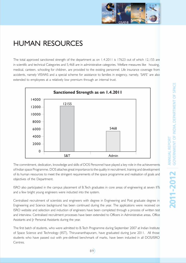
8 9
HUMAN RESOURCES
The total approved sanctioned strength of the department as on 1.4.2011 is 17623 out of which 12,155 arein scientific and technical Categories and 5,468 are in administrative categories. Welfare measures like housing,medical, canteen, schooling for children, are provided to the existing personnel. Life insurance coverage fromaccidents, namely VISWAS and a special scheme for assistance to families in exigency, namely, ‘SAFE’ are alsoextended to employees at a relatively low premium through an internal trust.
The commitment, dedication, knowledge and skills of DOS Personnel have played a key role in the achievementsof Indian space Programme. DOS attaches great importance to the quality in recruitment, training and developmentof its human resources to meet the stringent requirements of the space programme and realisation of goals andobjectives of the Department.
ISRO also participated in the campus placement of B.Tech graduates in core areas of engineering at seven IITsand a few bright young engineers were inducted into the system.
Centralised recruitment of scientists and engineers with degree in Engineering and Post graduate degree inEngineering and Science background has been continued during the year. The applications were received onISRO website and selection and induction of engineers have been completed through a process of written testand interview. Centralised recruitment processes have been extended to Officers in Administrative areas, OfficeAssistants and Jr Personal Assistants during the year.
The first batch of students, who were admitted to B.Tech Programme during September 2007 at Indian Instituteof Space Science and Technology (IIST), Thiruvananthapuram, have graduated during June 2011. All thosestudents who have passed out with pre-defined benchmark of marks, have been inducted in all DOS/ISROCentres.
9 0
The scheme of induction training programme for newly recruited scientists/engineers which was introduced in2002, has been continued during the year. The scheme is useful for youngsters to understand and appreciate thechallenges of the space programme. On similar lines, the induction training programme has been introduced tonewly recruited administrative staff wherein, the newly recruited personnel are introduced to various systemsand processes that are prevailing in the organisation. The scheme of induction training programme was alsointroduced in similar lines, to personnel in administrative areas who join the organisation.
The Department has introduced, for the first time, a structured training programme for Scientists/Engineers at‘Scientist E’ and ‘Scientist F’ level. The course curriculum has been developed in ten areas of technology whichare relevant to ISRO. Apart from this, several training programmes in various areas of technology, techno-management, computer, safety, administrative systems, etc., were organised during the year for the existingemployees at various Centres/Units. Customised and exclusive training programmes and ManagementDevelopment Programmes for middle level scientific, technical and administrative officers have been organisedwith tie-ups with reputed management institutes.
I APPRENTICE TRIANING
Under training programme of apprentices in the Technical and Commercial Trades, in the Centres/Units of theDepartment, 1292 apprentices were trained.
II RESERVATION IN SERVICES:
i) SCHEDULED CASTE AND SCHEDULED TRIBES
The Department has been observing the guidelines for recruitment, promotion and the welfare of ScheduledCastes and Scheduled Tribes. Table-I indicates the status of representations of persons belonging to ScheduledCastes and Scheduled Tribes.
ii) PERSONS WITH DISABILITIES
Position regarding appointment of Persons with Disabilities is given in Table–II.
iii) EX-SERVICEMEN
The status of representation of ex-servicemen is given in Table-III.
iv) OTHER BACKWARD CLASSES (OBCs)
2369 Persons belonging to Other Backward Classes are existing at present. Out of the 2369 OBCs, 236 wereappointed during the year.
v) WOMEN EMPLOYEES:
There are 1696 Women Employees belonging to Scientific and Technical categories and 1249 Women Employeesbelonging to administrative categories in the Department as per details in Table IV. They represent 19.82% ofpersonnel in the Department.
vi) JOINT CONSULTATIVE MACHINERY (JCM)
The Scheme of Joint Consultative Machinery (JCM) of the Department continued to function satisfactorily.The last meeting of Departmental Council was held on 25.01.2011.
9 1
TABLE - I STATUS OF SCHEDULED CASTE/SCHEDULED TRIBE PERSONNEL
Sl. CENTRE/UNIT TOTAL STRENGTH STRENGTH OF STRENGTH OF
No OF EMPLOYEES SC EMPLOYEES ST EMPLOYEES
2011-2012 2011-2012 2011-2012
1 DOS/ISRO HQ 437 85 28
2 VSSC 4273 341 76
3 ISAC 2519 293 91
4 SDSC-SHAR 2099 307 112
5 SAC & DECU 1827 217 114
6 LPSC 1754 239 32
7 NRSC 885 113 32
8 ISTRAC 445 68 16
9 MCF 326 36 13
10 ADRIN 170 21 5
11 IIRS 124 18 6
TOTAL 14859 1738 525
vii) CONFERENCES AND WORKSHOPS:
Inter Centre Hindi Technical Seminar – 2011 AT Satish Dhawan Space Centre-SHAR
A Hindi Technical Seminar with the theme “Indigenisation of Space Technology” was organised at the
Satish Dhawan Space Centre, Sriharikota on November 04, 2011. Twenty five articles were presented during
the seminar.
National Conference for ISRO Women on March 8, 2011 at NRSC
A National Conference for ISRO Women with the theme “Millennial make over: a paradigm shift in perception,
values and ideas” was organised at the National Remote Sensing Centre, Hyderabad on March 08, 2011,
more than 250 delegates participated in the conference and 22 papers were submitted.
Workshop on Scientific Research and Developments by SC/ST Scientists and Technologists of
DOS at VSSC
In order to provide a platform for recognising the salient contributions made by the Scientific/Technical personnel
belonging to the SC/ST community to the Indian Space Programme, a Conference on ‘Scientific Research and
Development by SC/ST Scientists and Technologists of Department of Space was organised at the Vikram
Sarabhai Space Centre, Thiruvananthapuram, during May 27-28, 2011. More than 350 delegates attended the
Conference and 50 papers were presented.
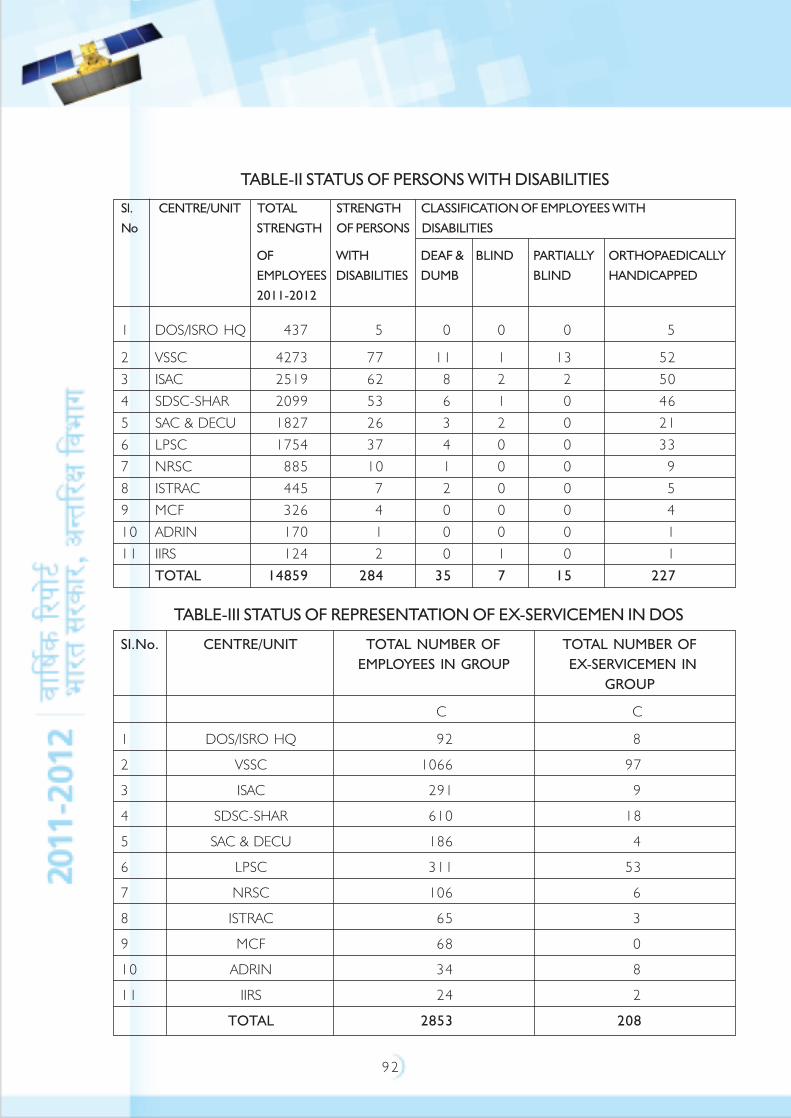
9 2
TABLE-III STATUS OF REPRESENTATION OF EX-SERVICEMEN IN DOS
Sl.No. CENTRE/UNIT TOTAL NUMBER OF TOTAL NUMBER OF
EMPLOYEES IN GROUP EX-SERVICEMEN IN
GROUP
C C
1 DOS/ISRO HQ 92 8
2 VSSC 1066 97
3 ISAC 291 9
4 SDSC-SHAR 610 18
5 SAC & DECU 186 4
6 LPSC 311 53
7 NRSC 106 6
8 ISTRAC 65 3
9 MCF 68 0
10 ADRIN 34 8
11 IIRS 24 2
TOTAL 2853 208
TABLE-II STATUS OF PERSONS WITH DISABILITIES
Sl. CENTRE/UNIT TOTAL STRENGTH CLASSIFICATION OF EMPLOYEES WITH
No STRENGTH OF PERSONS DISABILITIES
OF WITH DEAF & BLIND PARTIALLY ORTHOPAEDICALLY
EMPLOYEES DISABILITIES DUMB BLIND HANDICAPPED
2011-2012
1 DOS/ISRO HQ 437 5 0 0 0 5
2 VSSC 4273 77 11 1 13 52
3 ISAC 2519 62 8 2 2 50
4 SDSC-SHAR 2099 53 6 1 0 46
5 SAC & DECU 1827 26 3 2 0 21
6 LPSC 1754 37 4 0 0 33
7 NRSC 885 10 1 0 0 9
8 ISTRAC 445 7 2 0 0 5
9 MCF 326 4 0 0 0 4
10 ADRIN 170 1 0 0 0 1
11 IIRS 124 2 0 1 0 1
TOTAL 14859 284 35 7 15 227
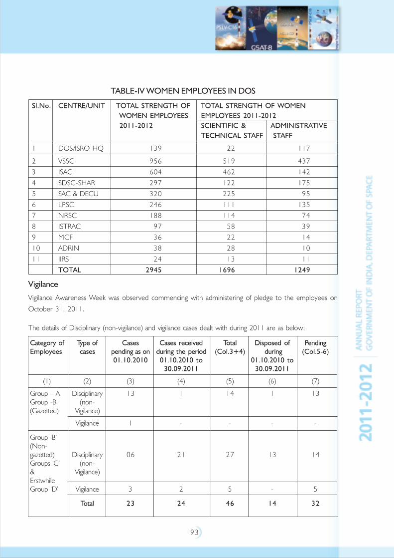
9 3
TABLE-IV WOMEN EMPLOYEES IN DOS
Sl.No. CENTRE/UNIT TOTAL STRENGTH OF TOTAL STRENGTH OF WOMEN
WOMEN EMPLOYEES EMPLOYEES 2011-2012
2011-2012 SCIENTIFIC & ADMINISTRATIVE
TECHNICAL STAFF STAFF
1 DOS/ISRO HQ 139 22 117
2 VSSC 956 519 437
3 ISAC 604 462 142
4 SDSC-SHAR 297 122 175
5 SAC & DECU 320 225 95
6 LPSC 246 111 135
7 NRSC 188 114 74
8 ISTRAC 97 58 39
9 MCF 36 22 14
10 ADRIN 38 28 10
11 IIRS 24 13 11
TOTAL 2945 1696 1249
Vigilance
Vigilance Awareness Week was observed commencing with administering of pledge to the employees on
October 31, 2011.
The details of Disciplinary (non-vigilance) and vigilance cases dealt with during 2011 are as below:
Category of Type of Cases Cases received Total Disposed of PendingEmployees cases pending as on during the period (Col.3+4) during (Col.5-6)
01.10.2010 01.10.2010 to 01.10.2010 to30.09.2011 30.09.2011
(1) (2) (3) (4) (5) (6) (7)
Group – A Disciplinary 13 1 14 1 13Group -B (non-(Gazetted) Vigilance)
Vigilance 1 - - - -
Group ‘B’(Non-gazetted) Disciplinary 06 21 27 13 14Groups ‘C’ (non-& Vigilance)ErstwhileGroup ‘D’ Vigilance 3 2 5 - 5
Total 23 24 46 14 32
9 4
Progressive Use of Hindi
• Implementation of Hindi in the Department of Space (DOS) continued with vigour during the year.
The Official Language Implementation Committees (OLICs) both at the Department level and at Centres/
Units held its quarterly meetings to review the progress in the use of Hindi. DOS/ISRO and its Centres and
Units have also participated in the meetings of Town OLIC constituted in respective Towns. DOS also
participated in the Central OLIC meetings held at New Delhi.
• The Second Sub Committee of Parliament on Official Language inspected Centres/Units of DOS/ISRO
viz., Delhi Earth Station (DES)-June 14, 2011, SAC & PRL Sept 29, 2011, VSSC Nov 4, 2011. with
regard to the progress made in the Implementation of Official language
• In order to implement Hindi in more meaningful and effective manner and to evaluate the progressive use
of Hindi in DOS/ISRO Centres/Units, an Annual Inspection Programme was drawn up by Department and
inspections were carried out. The Officers from Regional Implementation Offices of Department of Official
Language have also inspected the various Centres/Units to review the progressive use of Hindi.
• The training programme in Hindi through Hindi Teaching Scheme, Correspondence course and other
Departmental arrangements like Video Conferencing have been strengthened. The percentage of employees
possessing working knowledge of Hindi in all DOS/ISRO Centres/Units has considerably increased to more
than 80 per cent. The Centres/Units have been requested to prepare an action plan for imparting training
to the remaining employees and to complete the training programme at the earliest. Arrangements have
been made for imparting training in Hindi Stenography and Hindi Typewriting in all Centres/Units.
• With a view to refresh and update the knowledge of Official Language personnel, an ‘Official Language
Orientation Programme’ was organised in the Space Application Centre, (SAC) during August, 2011.
• Hindi Day, Hindi Week, Hindi Fortnight/Hindi Month and Hindi Workshops have been organised in all
DOS/ISRO Centres/Units, during which competitions in essay, noting and drafting, typewriting, quiz, poetry
recitation, story writing, news reading, memory, debate, etc., have been held. These competitions have
been organised for Hindi speaking and non-Hindi speaking employees separately. The prizes have also been
awarded separately for each category.
• During the year, DOS Secretariat intiated the publication of a Quarterly News Bulletin with regard to
progressive use of Hindi named ‘Antariksh Samachar’.
• World Hindi Day was celebrated on January 10 in all Centres/Units of the Department.
• Several pamphlets and stickers/posters on Indian Space Programme and Booklets on Glimpses of Indian
Space Programme, PSLV-C17, PSLV-C18, Megha-Tropiques, etc., were brought out in Hindi. “Antariksh
Bharat”, a quarterly technical magazine is brought out by Department in Hindi. In-house Hindi magazines
are brought out by various Centres/Units of the Department.
• During the year, Hindi Book Exhibitions were organised in the Department of Space along with English
Book Exhibitions and good and useful Hindi books were selected for ISRO Library.
9 5
• The Department’s Hindi Website has been revamped and loaded. Hindi Website in being updated regularly.
In addition to Department’s own Website, SAC, PRL, NRSA and NARL have their own Websites. ISAC,
VSSC also have internal web pages.
• A new scheme – Viz., Hindi Fortnight Incentive Scheme has been introduced under which the Officers/
Employees doing maximum work in Hindi during the Hindi month are awarded.
Apart from Technical Seminars in Hindi conducted by Centres/Units, SDSC-SHAR conducted an Inter-Centre
Technical Seminar in Hindi for all the Centres/Units of DOS/ISRO on November 4, 2011.
• The employees of DOS/ISRO Centres/Units have also participated in the activities on the progressive use
of Hindi organised by various voluntary organisations viz., Kendriya Sachivalya Hindi Parishad, New Delhi
and Mysore Hindi Prachar Parishad and also by Town OLIC.
• Hindi Implementation has been introduced as a part of Induction Programme in all the major Centres of
DOS/ISRO.
Awards
• Department has been awarded the II Place under Indira Gandhi Rajabhasha Puraskar for Best Implementation
of Hindi in the category of Scientific & Technical Departments.
• Also, the Department has been awarded III Place for Best Hindi Implementation in South & South Western
regions by regional Implementation office, Department of Official Language (DOL).
• ISRO Satellite Centre, Bangalore has been awarded III prize for Best Hindi Implementation by Town Official
Language Implementation Committee, Bangalore.
• SCL, Chandigarh has been awarded the II prize for Best Implementation of Official Language by
Town OLIC.

9 6
INTERNATIONAL COOPERATION
Sharing the knowledge and resources beyond the boundaries through international cooperation has been the
hallmark of Indian Space Programme. The space programme in the country pursues bilateral and multilateral
cooperative relations with space agencies and space related bodies. Through international cooperation, ISRO
continues to take-up new scientific and technological challenges; refine space policies and define international
frameworks for exploitation and utilisation of outer space for peaceful purposes, apart from sharing of space
products, services and technological expertise. With technological advancements among the space-faring nations
and the awareness among the rest, the scope of international cooperation has become wider and diverse
globally in recent time and ISRO strives to make use of such opportunities effectively.
Formal cooperative arrangements in the form of Agreements or Memoranda of Understanding (MoU) or
Framework Agreements have been signed with Argentina, Australia, Brazil, Brunei Darussalam, Bulgaria, Canada,
Chile, China, Egypt, European Centre for Medium Range Weather Forecasts (ECMWF), European Organisation
for Exploitation of Meteorological Satellites (EUMETSAT), European Space Agency (ESA), France, Germany,
Hungary, Indonesia, Israel, Italy, Japan, Kazakhstan, Kingdom of Saudi Arabia, Mauritius, Mongolia, Myanmar,
Norway, Peru, Republic of Korea, Russia, Spain, Sweden, Syria, Thailand, The Netherlands, Ukraine, United
Kingdom, United States of America and Venezuela.
Cooperative instruments signed during this year are: (i) MoU between ISRO and the United Kingdom Space
Agency regarding cooperation in the exploration and use of outer space for peaceful purposes; and (ii) MoU
between ISRO and the Centre National d'Études Spatiales (CNES) of France for cooperation in earth system
science and climate.
This year has been highly significant for ISRO’s international cooperation pursuits, as two satellites jointly
developed with other nations were launched from India, viz., MEGHA-TROPIQUES Satellite jointly built with
France - launched on October 12, 2011 and YOUTHSAT satellite, jointly built with Russia - launched on
April 20, 2011.
MEGHA-TROPIQUES: Towards improving the understanding of climate and weather systems, ISRO jointly
worked with CNES and developed MEGHA-TROPIQUES satellite to serve as an exclusive observational system
for the same. Of the four instruments that are flying in the satellite, two instruments are developed by CNES;
one instrument is jointly developed by CNES and ISRO; and one instrument is procured from Italy. Apart from
building and launching the satellite, ISRO is operating the satellite and continuously receiving the data from the
scientific instruments. Data from MEGHA-TROPIQUES, in combination with other contemporary satellites
would help in generating improved current-weather variables leading to better forecast not only for India and
but also for the entire tropical region. Other than the scientific community of India and France, 21 Scientific
teams from Australia, Brazil, Italy, Japan, Republic of Korea, Niger, Sweden, United Kingdom and United States
of America are awaiting data from this satellite. MEGHA-TROPIQUES would be the first of the constellation of

9 7
eight satellites meant for Global Precipitation Measurement (GPM). This satellite is considered as a joint
contribution from India and France, to the global scientific community - engaged in research on climate and
weather systems that affect the daily life of humankind the world over and particularly in the tropical region.
YOUTHSAT: Young scientists of ISRO Centres and Moscow State University in Russia had jointly developed
YOUTHSAT, a satellite for studying atmospheric constituents and space weather. YOUTHSAT carries two
scientific payloads from ISRO and one from Moscow State University. The Indian payloads are: (i) Limb Viewing
Hyper Spectral Imager (LiVHySI) to study the atmospheric constituents; and (ii) Radio Beacon for Ionospheric
Tomography (RaBIT) for space weather studies. Russian Payload is Solar Radiation Experiment (SOLRAD) to
study the solar flare activity, and to detect the bursts of X rays, Energetic electrons, protons and Gamma-rays.
The data would be distributed to the users after completing the calibration/ validation.
ISRO is also gearing up for launch of SARAL, being jointly built with France; and CHANDRAYAAN-2 being jointly
built with Russia.
SARAL: ISRO and CNES are jointly developing Satellite for ARGOS and ALTIKA (SARAL) carrying a radar
altimeter to study sea surface altitude (Ka band Altimeter - ALTIKA) and a data collection platform for collecting
data from ocean buoys and weather data centres (ARGOS). CNES is responsible for the instruments and ISRO
is responsible for satellite platform, launch using PSLV and operations. Both the agencies are working towards
reading the satellite for launch in 2012. Global scientific community has expressed interest in utilising the data
from SARAL. Already 82 projects are identified that includes 16 projects by France and 30 projects of other
countries.
CHANDRAYAAN-2: India and Russia are cooperating to realise a joint unmanned moon mission
‘CHANDRAYAAN–2’. India is responsible for launch, realisation of Moon Orbiter module and Rover; while
Russia is responsible for realisation of Moon Lander module. Significant progress has been achieved this year,
wherein both sides discussed the ‘Orbiter-Lander-Rover interfaces and mission operations’. The Indian instruments
on Orbiter and Rover have been finalised. Preliminary Design Reviews of the Orbiter, Rover and the instruments
are completed. Both the sides are working for launching CHANDRAYAAN-2 in 2014 using India’s GSLV.
ISRO and the Canadian Space Agency (CSA) are working on the development of the Ultraviolet Imaging Telescope
planned on ISRO’s multi wavelength astronomy satellite ASTROSAT.
ISRO is currently working with the secretariat of Association of South East Asian Nations (ASEAN) through
Ministry of External Affairs in making available data from Indian Remote Sensing satellites to all the 10 nations for
disaster management support under India-ASEAN cooperation. ISRO is also working with South Asian Association
for Regional Cooperation (SAARC) countries to establish a network of weather stations to support severe
thunderstorm predictions.
9 8
ISRO continues to contribute to the activities of the Asia-Pacific Regional Space Agency Forum (APRSAF) including
Sentinel Asia project and Satellite Technology for the Asia-Pacific Region (STAR) programme through the sharing
of satellite remote sensing data and expertise for the benefit of this region.
In the field of capacity building, ISRO continues to share their facilities, expertise and services in the application of
space technology through hosting of United Nations (UN) affiliated Centre for Space Science and Technology
Education in Asia and the Pacific (CSSTE-AP). As of now, more than 1000 scholars from 31 countries from the
Asia Pacific region and 28 scholars from 17 countries outside the Asia Pacific region are benefitted through the
courses conducted by CSSTE-AP.
ISRO, on behalf of India, continues to play an active role in deliberation of the United Nations Committee on
the Peaceful Uses of Outer Space (UN-COPUOS). ISRO also plays major role on behalf of India in various
other multilateral fora including United Nations Economic and Social Commission for Asia and the Pacific
(UN-ESCAP), International COSPAS-SARSAT system for search and rescue operations, International Astronautical
Federation (IAF), International Academy of Astronautics (IAA), Committee on Earth Observation Satellites (CEOS),
Committee on Space Research (COSPAR), Inter Agency Debris Coordination Committee (IADC), Space
Frequency Coordination Group (SFCG), Coordinating Group on Meteorological Satellites (CGMS), International
Global Observing Strategy (IGOS), International Society for Photogrammetry and Remote Sensing (ISPRS),
International Space Exploration Coordination Group (ISECG), International Committee for Global Navigation
Satellite Systems (ICG), International Charter ‘Space and Major Disasters’ and UN Platform for Space based
Disaster Management and Emergency Response (UNSPIDER).
In the year 2012, India will be hosting two major global events, the COSPAR Scientific Assembly and
CEOS Plenary.
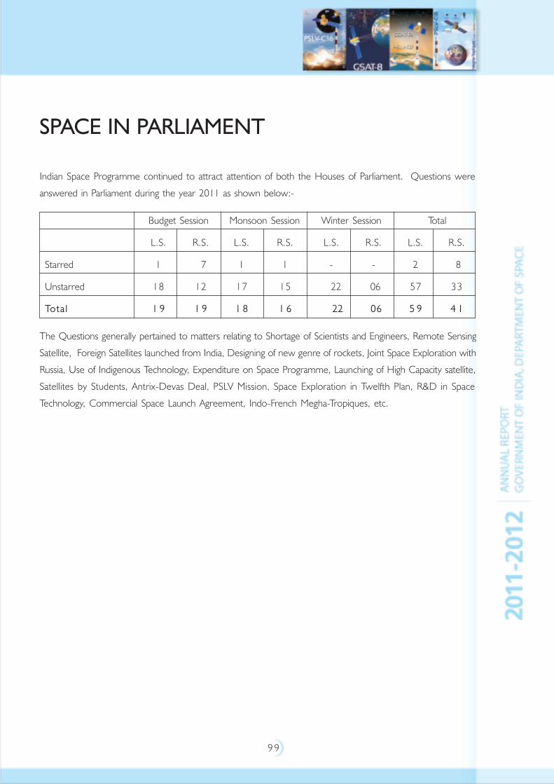
9 9
SPACE IN PARLIAMENT
Indian Space Programme continued to attract attention of both the Houses of Parliament. Questions were
answered in Parliament during the year 2011 as shown below:-
Budget Session Monsoon Session Winter Session Total
L.S. R.S. L.S. R.S. L.S. R.S. L.S. R.S.
Starred 1 7 1 1 - - 2 8
Unstarred 18 12 17 15 22 06 57 33
Tota l 1 9 1 9 1 8 1 6 22 06 5 9 4 1
The Questions generally pertained to matters relating to Shortage of Scientists and Engineers, Remote Sensing
Satellite, Foreign Satellites launched from India, Designing of new genre of rockets, Joint Space Exploration with
Russia, Use of Indigenous Technology, Expenditure on Space Programme, Launching of High Capacity satellite,
Satellites by Students, Antrix-Devas Deal, PSLV Mission, Space Exploration in Twelfth Plan, R&D in Space
Technology, Commercial Space Launch Agreement, Indo-French Megha-Tropiques, etc.
100
SPACE PROGRAMME PUBLICITY
Space based services are touching all facets of human life in the country. India has made tremendous progress in
the area of space science and technology. Creating awareness among the general public, especially students,
about the benefits that have accrued from India‘s application driven space programmes to the society and the
progress made by the country in space technology has been given utmost importance. Media campaigns on
important events, organisation of exhibitions, publications, educational activities like lectures, interactive sessions
with students, quiz programmes, water rocket making and launching events, etc., have helped in not only
keeping the public abreast of the space programme but also to evoke interest in them on the nuances of space
science and technology.
Publicity Through Media
Doordarshan and many private TV channels covered the launch of PSLV-C16/RESOURCESAT-2,
GSAT-8 launched onboard Ariane launch vehicle of Europe on May 21, 2011, PSLV-C17/GSAT-12 and PSLV-
C18/MEGHA-TROPIQUES on April 20, 2011, July 15, 2011 and October 12, 2011 respectively from Satish
Dhawan Space Centre SHAR, Sriharikota live. For these launches, media from Chennai, Nellore and Tirupati as
well as Sullurpetta were taken to Satish Dhawan Space Centre, Sriharikota to witness the launch. These events
were covered in all the leading newspapers and electronic media. Special video capsules on the Indian Space
Programme were produced and telecast. Besides media coverage on specific events of importance, several
articles have appeared in various regional and national newspapers and magazines about the Indian space
programme. This apart, many news agencies, newspapers and TV channels made and telecast programmes on
Indian Space activities, highlighting the accomplishments of the Indian Space Programme. Chandrayaan-1’s
discovery of water on the moon continued to get coverage from national and international media.
Exhibitions
During the year, DOS organised 41 exhibitions at national and international conferences, important public
congregations like cultural festivals, trade fairs and events and also at academic institutions. Exhibitions were also
organised in association with Non-Governmental Organisation in various places and at prestigious events like
Bangalore Space Expo-2011 (BSX-2011) in August 2011, and India Show at Toronto, Canada during
October 2011.
A large number of scientists, academicians and students from India as well as delegates from abroad visited many
of these exhibitions. World Space Week during October 4-10, 2011 and National Science Day on February 28
were organised towards creating awareness among the public about space. In order to create interest and
awareness on rocketry, a Water Rocket launching event was conducted at Ms Ramaiah College of Science,
Bangalore. Students and teachers enthusiastically participated in the event. The permanent exhibitions at Liquid
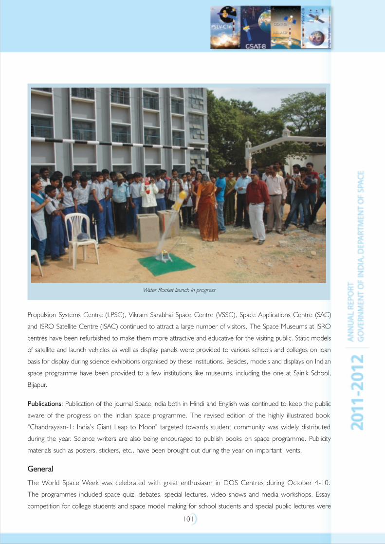
101
Propulsion Systems Centre (LPSC), Vikram Sarabhai Space Centre (VSSC), Space Applications Centre (SAC)
and ISRO Satellite Centre (ISAC) continued to attract a large number of visitors. The Space Museums at ISRO
centres have been refurbished to make them more attractive and educative for the visiting public. Static models
of satellite and launch vehicles as well as display panels were provided to various schools and colleges on loan
basis for display during science exhibitions organised by these institutions. Besides, models and displays on Indian
space programme have been provided to a few institutions like museums, including the one at Sainik School,
Bijapur.
Publications: Publication of the journal Space India both in Hindi and English was continued to keep the public
aware of the progress on the Indian space programme. The revised edition of the highly illustrated book
“Chandrayaan-1: India’s Giant Leap to Moon” targeted towards student community was widely distributed
during the year. Science writers are also being encouraged to publish books on space programme. Publicity
materials such as posters, stickers, etc., have been brought out during the year on important vents.
General
The World Space Week was celebrated with great enthusiasm in DOS Centres during October 4-10.
The programmes included space quiz, debates, special lectures, video shows and media workshops. Essay
competition for college students and space model making for school students and special public lectures were
Water Rocket launch in progress
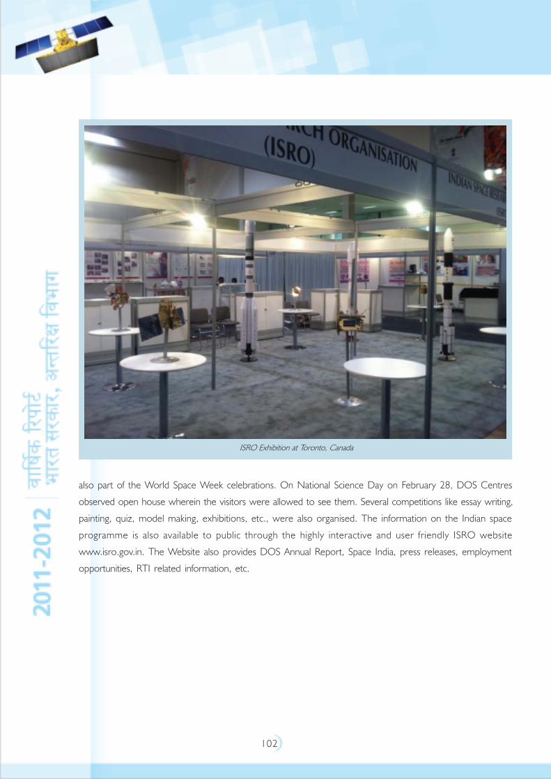
102
ISRO Exhibition at Toronto, Canada
also part of the World Space Week celebrations. On National Science Day on February 28, DOS Centres
observed open house wherein the visitors were allowed to see them. Several competitions like essay writing,
painting, quiz, model making, exhibitions, etc., were also organised. The information on the Indian space
programme is also available to public through the highly interactive and user friendly ISRO website
www.isro.gov.in. The Website also provides DOS Annual Report, Space India, press releases, employment
opportunities, RTI related information, etc.
103
RIGHT TO INFORMATION
Right To Information (RTI) Act 2005 is practiced in the department with strict compliance to the requirements
of the act. DOS has implemented RTI Act 2005 by identifying Central Public Information Officers (CPIO),
Assistant Public Information Officers (APIO) and the Appellate Authority for stage one appeals. As required
under the Act, DOS has published the requisite information on the web page www.isro.gov.in/Right to
Information.
The following information is available on the website:
• Organisation, functions and duties
• Powers and duties of the Officers and Employees
• Procedures followed in the decision making process, including channels of supervision and accountability
• Norms set by the Department of Space for the discharge of its functions
• Rules, regulations, instructions, manuals and records of the Department of Space used by its employees
for discharging their functions
• Statement of the categories of documents held by the Department of Space or under its control
• Particulars of arrangements for consultation with or representation by the public in relation to the formulation
of policies and implementation thereof by the Department of Space
• Statement of boards, councils, committees and other bodies, and as to whether meetings of such boards,
etc., are open to public, or the minutes of such meetings are accessible to public
• Directory of officers holding functional designations
• Number of Officers/Employees and structure of emoluments
• Budget 2010 – 11 of the Department of Space
• Manner of execution of subsidy programmes and details of beneficiaries of such programmes
• Particulars of recipients of concessions, permits or authorisations granted by the Department of Space
• Details of Information available to or held by the Department of Space, reduced in an electronic form
• Names, designations and other particulars of the Public Information Officers, Assistant Public Information
Officers and Appellate Authority (to decide first stage appeals)
• Achievements of the Department of Space/Indian Space Research Organisation
During the year, awareness programmes on RTI for senior engineers/scientists, APIOs and concerned officials
looking after RTI activities were conducted at ISRO Centres. 518 applications were received under RTI on
which appropriate responses have been given. 73 appeals were received by the First Appellate Authority and
34 appellants approached the Second Apellate Authority, i.e., Central Information Commission.
104
AUDIT OBSERVATIONSStatus of the Action Taken Note (ATN)
Sl. Year No. of Paras/ Details of the Paras/PA reports on which ATNs are pending
No PA reports on No. of ATNs No. of ATNs No. of ATNs No. of ATNs
which ATNs not sent by sent by the sent but which have
have been the Ministry Ministry and returned with been finally
submitted to even for the awaiting observations vetted by
PAC after first time vetting by and Audit is audit but
vetting by Audit awaiting their have not
Audit resubmission been
by the submitted
Ministry by the
Ministry to
PAC
1 2 3 4 5 6 7
1. 2006-2007 NIL NIL ONE NIL NIL
(Chapter V of
Report No.9
of 2006 – Non-
tax receipts –
issues relating
to receipts
of DOS
2. 2008-2009 NIL NIL NIL ONE NIL
(Chapter II of
Report No.
PA 2 of 2008-
Performance
Audit on
Procurement
of Stores and
Inventory
Control in
DOS)
105
3. 2010-2011 NIL NIL NIL ONE NIL
(Report No. 21
of 2010-2011 –
Performance
Audit of the
Activities of
NRSC)
4. 2011-2012 NIL ONE NIL NIL NIL
(Report No. 16
of 2011-12 -
Para No 19.1 -
Idle investment
on
development
of a linac tube)
5. 2011-2012 NIL ONE NIL NIL NIL
(Report No. 16
of 2011-12 -
Para No 19.2 –
Avoidable
payment of
electricity
duty and cess)
PERFORMANCE AUDIT OF NATIONAL REMOTE SENSING CENTRE (REPORT NO 21
OF 2010-11) FOR THE YEAR ENDING MARCH 2009 PRESENTED IN PARLIAMENT ON 18-03-2011
• Performance Audit on the activities of National Remote Sensing Centre (NRSC) revealed that performance
of three out of the seven remote sensing satellites was below their maximum capacity in terms of the
number of remote sensing satellite data captured by them. The revenue realised from seven satellites in
operation was not up to the desired level. The satellites were planned without adequate thematic data
need assessment. Idling of acquired IRS data was high due to non-adopting of appropriate marketing strategy.
While there was a need to review and augment data acquisition capacity of NRSC after conducting a
realistic data need assessment, there were also delays in data processing impacting the delivery of available
data products.
• The efforts of NRSC were not adequate in customising the data according to the needs of private users and
also in exploring the possibility of widening the customer base. The sale of data products to private users did
not improve as recommended by Standing Committee of Parliament of DOS. Further, there was scope
for enhancing the rates of IRS data products in line with international rates.
• NRSC was the sole civilian provider of aerial remote sensing services in the country. It had two beach
aircrafts in operation to attend to various aerial projects. These aerial projects were meant for remote
sensing in specific areas at required times, which was not possible from the remote sensing satellites.
We observed that aircrafts performing the task of aerial remote sensing could not be put to use to their
106
maximum capacity mainly due to non-availability of pilots and technical snags in the aircrafts. As a result,
one third of aerial projects test checked were found to have been delayed.
• NRSC was responsible for providing services to Government users by undertaking remote sensing application
projects aimed at achieving vital social objectives like food security, conversion of wastelands into usable
land, water security through drinking water missions, environment security through disaster management
support programmes, etc. NRSC also undertook operational projects directly from various users for
delivering processed remote sensing data and maps.
• Performance Audit of these projects revealed that NRSC did not adequately coordinate with various
agencies for effective implementation of these projects. Further, there were instances of deficiencies in
planning and implementation, non/partial achievement of the objectives, delays in completion of projects
etc., which adversely impacted on the success of these projects.
• Indian Institute of Remote Sensing (IIRS), Dehradun, a unit of NRSC conducted customised professional
courses towards capacity building in the application of remote sensing and geo informatics for natural
resource management. We observed that there was an overall increase in the number of students trained
by the IIRS. However, there was shortfall in the enrolment in long term courses. Further, the number of
private persons trained for promoting the sale of data products was lower than participants from the
Government sector. As a result, the objective of promoting the sale of data products to more and more
private entrepreneurs was not fully met.
• There were substantial amount of unutilised balances available with NRSC under Government projects,
despite which it continued to receive advances for special projects from DOS and from other government
users. Budgeting of NRSC was not realistic indicating lack of control on income and expenditure and poor
monitoring of projects. There was reduction of revenue/loss of interest due to irregular fixation / delayed
fixation of agency commission payable to Antrix Corporation Limited (ACL) in the sale of satellite data.
Internal control and internal audit were not commensurate with the requirement of NRSC and there was
a need to strengthen the same.
Department of Space
Idle investment on development of a Linac tube
A Linac tube was developed for Solid Propellant Space Booster Plant of Satish Dhawan Space Centre, Sriharikota
in March 2002 to improve performance of the existing 15 MeV Linear Accelerator system. Despite availability
of idle time of the main system, the Linac tube was not installed for eight years, leading to idle investment of Rs.
1.80 crore and additional maintenance cost of Rs. 32 lakh. Non replacement of the old Linac tube with the
new one led to a two fold increase in the time taken for inspection of rocket motors.
Avoidable payment of electricity duty and cess
Failure of two units of Department of Space to claim the available exemption of electricity duty
and cess resulted in additional expenditure of Rs. 1.49 crore which was avoidable. An amount of
Rs. 1.05 crore was refunded / adjusted at the instance of Audit.
107
MILESTONES
1962
Indian National Committee for Space Research formed and works on establishing Thumba Equatorial Rocket
Launching Station (TERLS) started.
1963
First sounding rocket launch from TERLS (November 21, 1963).
1965
Space Science and Technology Centre (SSTC) established in Thumba.
1967
Experimental Satellite Telecommunication Earth Station set up at Ahmedabad.
1968
TERLS dedicated to the United Nations (February 2, 1968).
1969
Indian Space Research Organisation (ISRO) formed (August 15, 1969).
1972
Space Commission and Department of Space set up. ISRO brought under DOS (June 1, 1972).
1972-76
Air-borne remote sensing experiments.
1975
ISRO becomes Government Organisation (April 1, 1975).
First Indian Satellite, Aryabhata, launched (April 19, 1975).
1975-76
Satellite Instructional Television Experiment (SITE) conducted.
1977-79
Satellite Telecommunication Experiments Project (STEP) carried out.
1979
Bhaskara-I, an experimental satellite for earth observations, launched (June 7, 1979).
First Experimental launch of SLV-3 with Rohini Technology Payload on board (August 10, 1979). Satellite could
not be placed in orbit.
1980
Second Experimental launch of SLV-3. Rohini satellite successfully placed in orbit (July 18,1980).
108
1981
First developmental launch of SLV-3. RS-D1 placed in orbit (May 31, 1981).
APPLE, an experimental geostationary communication satellite successfully launched (June 19, 1981).
Bhaskara-II launched (November 20, 1981).
1982
INSAT-1A launched (April 10, 1982). Deactivated on September 6, 1982.
1983
Second developmental launch of SLV-3. RS-D2 placed in orbit (April 17, 1983).
INSAT-1B, launched (August 30, 1983).
1984
Indo-Soviet manned space mission (April 1984).
1987
First developmental launch of ASLV with SROSS-1 satellite on board (March 24, 1987). Satellite could not be
placed in orbit.
1988
Launch of first operational Indian Remote Sensing satellite, IRS-1A (March 17, 1988).
Second developmental launch of ASLV with SROSS-2 on board (July 13, 1988). Satellite could not be placed in
orbit.
INSAT-1C launched (July 22, 1988). Abandoned in November 1989.
1990
INSAT-1D launched (June 12, 1990).
1991
Launch of second operational Remote Sensing satellite, IRS-1B (August 29, 1991).
1992
Third developmental launch of ASLV with SROSS-C on board (May 20, 1992). Satellite placed in orbit.
INSAT-2A, the first satellite of the indigenously-built second-generation INSAT series, launched
(July 10, 1992).
1993
INSAT-2B, the second satellite in INSAT-2 series, launched (July 23, 1993).
First developmental launch of (PSLV - D1) with IRS-1E on board (September 20, 1993). Satellite could not be
placed in orbit.
109
1994
Fourth developmental launch of ASLV with SROSS-C2 on board (May 4, 1994). Satellite placed in orbit.
Second developmental launch of PSLV (PSLV - D2) with IRS-P2 on board (October 15, 1994). Satellite successfully
placed in polar sun synchronous orbit.
1995
INSAT-2C, the third satellite in INSAT-2 series, launched (December 7, 1995).
Launch of third operational Indian Remote Sensing Satellite, IRS-1C (December 28, 1995).
1996
Third developmental launch of (PSLV - D3) with IRS-P3 on board (March 21, 1996). Satellite placed in polar
sunsynchronous orbit.
1997
INSAT-2D, fourth satellite in INSAT series, launched (June 4, 1997). Becomes inoperable on October 4, 1997.
(An in-orbit satellite, ARABSAT-1C, later renamed INSAT-2DT, was acquired in November 1997 to partly
augment INSAT system).
First operational launch of PSLV (PSLV - C1) with IRS-1D on board (September 29, 1997). Satellite placed in
orbit.
1998
INSAT system capacity augmented with the readiness of INSAT-2DT acquired from ARABSAT
(January 1998).
1999
INSAT-2E, the last satellite in the multipurpose INSAT-2 series, launched by Ariane from Kourou, French Guyana
(April 3, 1999).
Indian Remote Sensing Satellite, IRS-P4 (OCEANSAT-1), launched by Polar Satellite Launch Vehicle (PSLV-C2)
along with Korean KITSAT-3 and German DLR-TUBSAT from Sriharikota (May 26, 1999).
2000
INSAT-3B, the first satellite in the third generation INSAT-3 series, launched by Ariane from Kourou, French
Guyana (March 22, 2000).
2001
Successful flight test of Geosynchronous Satellite Launch Vehicle (GSLV - D1) (April 18, 2001) with an experimental
satellite GSAT-1 on board.
Successful launch of PSLV-C3 (October 22, 2001) placing three satellites – India's TES, Belgian PROBA and
German BIRD into Polar sun-synchronous orbit.
2002
Successful launch of INSAT-3C by Ariane from Kourou, French Guyana (January 24, 2002).
Successful launch of KALPANA-1 by ISRO's PSLV - C4 from SDSC, SHAR (September 12, 2002).

110
2003
Successful launch of INSAT-3A by Ariane from Kourou, French Guyana (April 10, 2003).
Successful launch of second developmental test flight of GSLV (GSLV-D2) with GSAT-2 on board from
SDSC SHAR (May 8, 2003).
Successful launch of INSAT-3E by Ariane from Kourou, French Guyana (September 28, 2003)
Successful launch of RESOURCESAT-1 by ISRO's PSLV-C5 from SDSC SHAR, (October 17, 2003)
2004
Successful first operational flight of GSLV (GSLV-F01) from SDSC-SHAR. EDUSAT placed in GTO (September
20, 2004).
2005
Successful launch of CARTOSAT-1 and HAMSAT by PSLV-C6 from the newly established Second Launch Pad at
SDSC SHAR (May 5, 2005).
Successful launch of INSAT-4A by Ariane from Kourou, French Guyana (December 22, 2005)
2006
Second operational flight of GSLV (GSLV-F02) from SDSC SHAR with INSAT-4C on board
(July 10, 2006). The satellite could not be placed in orbit.
2007
PSLV-C7 successfully launches four satellites India's CARTOSAT-2 and Space Capsule Recovery Experiment
(SRE-1) as well as Indonesia's LAPAN-TUBSAT and Argentina's PEHUENSAT-1 (January 10, 2007).
Successful recovery of SRE-1 after manoeuvring it to reenter the earth's atmosphere and descend over the Bay
of Bengal about 140 km East of Sriharikota (January 22, 2007).
Successful launch of INSAT-4B by Ariane launch vehicle from Korou, French Guyana on
March 12, 2007.
PSLV-C8 successfully launches an Italian satellite AGILE on April 23, 2007 under a commercial contract with
Antrix Corporation.
Successful launch of of GSLV (GSLV-F04) with INSAT-4CR on board from SDSC SHAR on
September 2, 2007.
2008
PSLV-C10 successfully launches TECSAR satellite on January 21, 2008 under a commercial contract with Antrix
Corporation.
PSLV-C9 successfully launches ten satellites on April 28, 2009. India's CARTOSAT-2A, Indian Mini Satellite 1
(IMS -1) and eight Nano Satellites for International Customers under a commercial contract with
Antrix Corporation.
PSLV-C11 successfully launches Chandrayaan - 1 satellite on October 22, 2008
European Ariane 5 launch vehicle successfully launches W2M satellite on December 21, 2008 jointly built by
Antrix/ISRO and EADS Astrium on a commercial basis
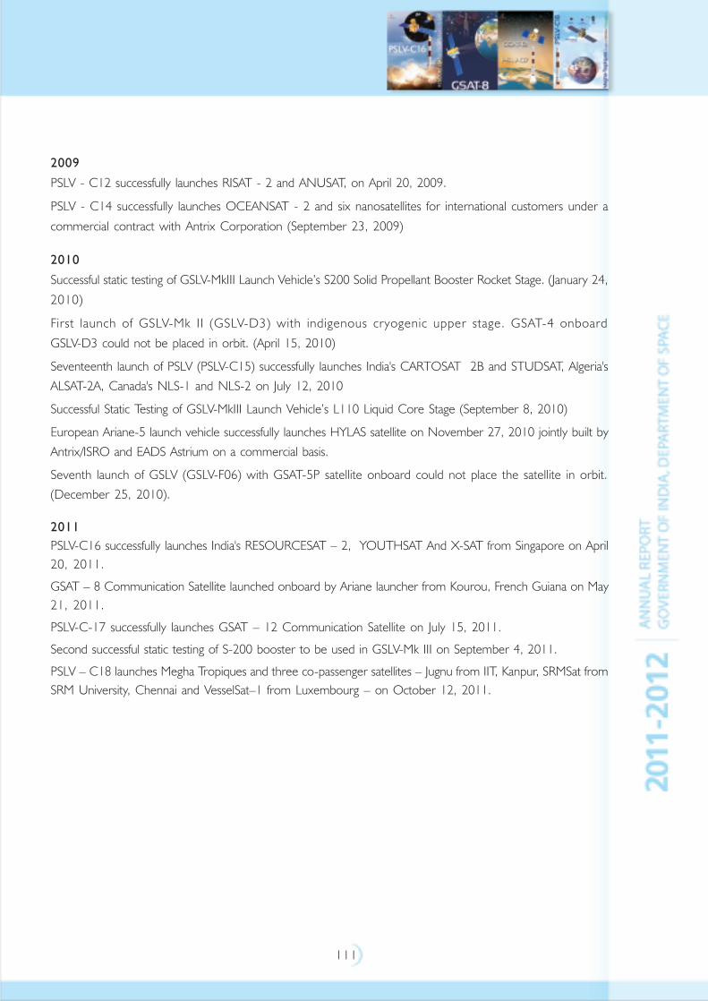
111
2009
PSLV - C12 successfully launches RISAT - 2 and ANUSAT, on April 20, 2009.
PSLV - C14 successfully launches OCEANSAT - 2 and six nanosatellites for international customers under a
commercial contract with Antrix Corporation (September 23, 2009)
2010
Successful static testing of GSLV-MkIII Launch Vehicle’s S200 Solid Propellant Booster Rocket Stage. (January 24,
2010)
First launch of GSLV-Mk II (GSLV-D3) with indigenous cryogenic upper stage. GSAT-4 onboard
GSLV-D3 could not be placed in orbit. (April 15, 2010)
Seventeenth launch of PSLV (PSLV-C15) successfully launches India's CARTOSAT 2B and STUDSAT, Algeria's
ALSAT-2A, Canada's NLS-1 and NLS-2 on July 12, 2010
Successful Static Testing of GSLV-MkIII Launch Vehicle’s L110 Liquid Core Stage (September 8, 2010)
European Ariane-5 launch vehicle successfully launches HYLAS satellite on November 27, 2010 jointly built by
Antrix/ISRO and EADS Astrium on a commercial basis.
Seventh launch of GSLV (GSLV-F06) with GSAT-5P satellite onboard could not place the satellite in orbit.
(December 25, 2010).
2011
PSLV-C16 successfully launches India's RESOURCESAT – 2, YOUTHSAT And X-SAT from Singapore on April
20, 2011.
GSAT – 8 Communication Satellite launched onboard by Ariane launcher from Kourou, French Guiana on May
21, 2011.
PSLV-C-17 successfully launches GSAT – 12 Communication Satellite on July 15, 2011.
Second successful static testing of S-200 booster to be used in GSLV-Mk III on September 4, 2011.
PSLV – C18 launches Megha Tropiques and three co-passenger satellites – Jugnu from IIT, Kanpur, SRMSat from
SRM University, Chennai and VesselSat–1 from Luxembourg – on October 12, 2011.
112
ACRONYMS
AAI : Airports Authority of India
ABLN&C : Atmospheric Boundary Layer-Network & Characterisation
ABPP : Air Breathing Propulsion Project
ADC&TM : Atmospheric Dust Composition & Transport Modelling
ADCOS : Advisory Committee for Space Sciences
ADRDE : Aerial Delivery Research & Development Establishment
AFCS : Area Favourable for Crop Sowing
AFTN : Aeronautical Fixed Telecommunication Network
AGN : Active Galactic Nucleus
AIR : All India Radio
AIRS : Atmospheric Infra Red Sounder
AIS : Automatic Information System
ALTIKA : Altimeter in Ka band
ALTM : Airborne Laser Terrain Mapper
AMS : Agro-Met Stations
AMSU-A : Advanced Sounding Unit
ANTRIX : Antrix Corporation Limited
AOCE : Attitude Orbit & Control Electronics
AOCS : Attitude and Orbit Control System
AOD : Aerosol Optical Depth
APEP : Ammonium Perchlorate Experimental Plant
APIO : Assistant Public Information Officer
APXS : Alpha Particle X-ray Spectrometer
ARFI : Aerosol Radiative Forcing over India
ARG : Automatic Rain Gauge
ASI : Italian Space Agency
ASIC : Application Specific Integrated Circuit
AT-CTM : Atmospheric Trace gases Composition and Transport Modelling
ATS : Aero Thermo Structure
ATV : Advanced Technology Vehicle
AVIS : Advanced Vehicle Imaging System
AWiFS : Advanced Wide Field Sensor
AWS : Automatic Weather Station
BC : Black Carbon
BMU : Bus Management Unit
BPA : Blind People’s Association
BPCL : Bharath Petroleum Corporation Limited
BPH : Brown Plant Hopper
113
BSNL : Bharath Sanchar Nigam Limited
BSS : Broadcast Satellite Services
C1XS : Chandrayaan-1 imaging X-ray Spectrometer
CARTOSAT : CARTOgraphic SATellite
CBH : Cloud Base Height
C-C : Carbon-Carbon
CCD : Charge Coupled Device
CCTV : Closed Circuit Television System
C-DAC : Centre for Development of Advanced Computing
CDR : Comprehensive Design Review/Critical Design Review
CEC : Centre for Education and Communication
CEOS : Committee on Earth Observation Satellites
CES : Crew Escape System
CFD : Computational Fluid Dynamics
CFRP : Carbon Fibre Reinforced Plastic
CGMS : Coordinating Group on Meteorological Satellites
CGWB : Central Ground Water Board
ChACE : Chandra’s Altitudinal Composition Explorer
CIET : Central Institute of Educational Technology
CIMR : Central Institute of Mentally Retarded
CM : Crew Module
CME : Coronal Mass Ejection
CMG : Construction and Maintenance Group
CMS : Content Management System
CNES : Centre National d’Etudes Spatiales (French Space Agency)
COSPAR : COmmittee on SPAce Research
CPM : Charge Particle Monitor
CRS mode : Coarse Resolution ScanSAR mode
CS : Cryogenic Stage
CSA : Canadian Space Agency
CSSTE-AP : Centre for Space Science and Technology Education for Asia
and the Pacific
CUSP : Cryogenic Upper Stage Project
CWC : Central Water Commission
CWDS : Cyclone Warning Dissemination System
CZT : Cadmium-Zinc-Telluride
DAE : Department of Atomic Energy
DAT : Distress Alert Transmitter
DC : Digital Camera
DCS : Data Collection System
DCWDS : Digital CWDS
114
DD : Door Darshan
DDWS : Digital Disaster Warning System
DECU : Development and Educational Communication Unit
DEM : Digital Elevation Model
DES : Delhi Earth Station
DGCA : Directorate General of Civil Aviation
DMDD : Digital Meteorological Data Dissemination
DMS : Disaster Management Support
DMSAR : Disaster Management Synthetic Aperture Radar
DMS-DSC : DMS- Decision support Centre
DOLR : Department of Land Resources
DORIS : Doppler Orbitography and Radio positioning Integrated by Satellite
DOS : Department Of Space
DRDO : Defence Research and Development Organisation
DRS : Direct Reception Systems
DRT : Data Relay Transponder
DSC : Decision Support Centre
DSD : Drop Size Distribution
DSNG : Digital Satellite News Gathering
DSS : Decision Support Systems
DTH : Direct To Home (TV)
EBW : Electron Beam Welding
ECLSS : Environmental Control & Life Support System
ECMWF : European Centre for Medium Range Weather Forecasts
EIA : Equatorial Ionization Anamoly
EIRP : Effective Isotropic Radiated Power
EMC : Electro Magnetic Compatibility
EME-VS : Energy and Mass Exchanges in Vegetative Systems
EMI : Electro Magnetic Interference environment
EO : Earth Observation
EOL : End Of Life
ERNET : Education and Research Network
ESA : European Space Agency
ESF : Equatorial Spread-F
ETV : Educational Television
EUMETSAT : European Organisation for Exploitation of Meteorological Satellite
FAC : Failure Analysis Committee
FADS : Flush Air Data Systems
FAS : Fire Alarm System
FASAL : Forecasting Agricultural output using Space Agro-meteorology and Land based
observations

115
FM : Flight Model
FMIS : Flood Management Information System
FOP : Final Operational Phase
FSAT : Final System Acceptance Test
FYP : Five Year Plan
GAC : Global Area Coverage
GAGAN : GPS Aided Geo Augmented Navigation
GBP : Geosphere Biosphere Programme
GCP : Ground Control Point
GCPL : Ground Control Points Library
GEO LUT : GEOSAR Local User Terminal
GEO : Geostationary Earth Orbit
GEOSAR : Geostationary Earth Orbit Search And Rescue
GIS : Geographical Information System
GMRT : Giant Meter Wave Radio Telescope
GNSS : Global Navigation Satellite System
GOES : Geostationary Operational Environmental Satellite
GPM : Global Precipitation Measurement
GPS : Global Positioning System
GSD : Ground Sampling Distance
GSLV : Geosynchronous Satellite Launch Vehicle
GSO : GeoSynchronous Orbit
GTO : Geosynchronous Transfer Orbit
HDAS : Hybrid Data Acquisition System
HDTV : High Definition Television
HEX : High Energy X-Ray Spectrometer
HILS : Hardware In-Loop Simulation
HMC : Hybrid Micro Circuits
HPT : High Power Transmitter
HSP : Human Space Flight Program
HYLAS : Highly Adaptable Satellite
HySi : Hyper Spectral imager
IADC : Inter Agency Debris Coordination Committee
IAF : International Astronautical Federation
IAO : International Astronomy Olympiad
ICAR : Indian Council of Agricultural Research
ICARB : Integrated Campaign for Aerosols, Gases and Radiation Budget
ICC : INSAT Coordination Committee
ICG : International Committee for GNSS
ICT : Information &Communication Technology
IDCA : Integrated Detector Cooler Assembly
116
IGCAR : Indira Gandhi Centre for Atomic Research
IGM-MLDF : ISRO GIVE Model-Multi Layer Data Fusion
IGNOU : Indira Gandhi National Open University
IGOS : International Global Observing Strategy
IIA : Indian Institute of Astrophysics
IIRS : Indian Institute of Remote Sensing
IISc : Indian Institute of Science
IIST : Indian Institute of Space Science and Technology
IISU : ISRO Inertial Systems Unit
IIT : Indian Institute of Technology
IMD : India Meteorological Department
IMDPS : INSAT Meteorological Data Processing System
IMGEOS : Integrated Multi mission Ground segment for Earth Observation
Satellite
IMS-1 : Indian Mini Satellite-1
INCOIS : Indian National Centre for Ocean Information Services
INCOSPAR : Indian National COmmittee for SPAce Research
INLUS : Indian Navigation Land Uplink Station
INMCC : Indian Mission Control Centre
INMCC : Indian Navigation Master Control Centres
INRES : Indian Navigation Reference Earth Stations
INSAT : Indian National Satellite
INTELSAT : International Telecommunications Satellite Organisation
IOAA : International Olympiad in Astronomy and Astrophysics
IOCL : Indian Oil Corporation Limited
IOT : In Orbit Testing
IPDR : Incremental Preliminary Design Review
IPR : Intellectual Property Rights
IR : Infra Red
IRIMS : Indian Ranging Integrity and Monitoring Station
IRNSS : Indian Regional Navigational Satellite System
IRNWT : IRNSS Network Timing
IRS : Indian Remote sensing Satellite
ISAC : ISRO SAtellite Centre
ISEB : International Space Education Board
ISECG : International Space Exploration Coordination Group
ISITE : ISRO Satellite Integration and Test Establishment
ISPRS : International Society for Photogrammetry and Remote Sensing
ISRO : Indian Space Research Organisation
ISRO-GBP : ISRO - Geosphere Biosphere Programme
ISRO-SSPS : ISRO Space Science Promotion Scheme
117
ISTRAC : ISRO Telemetry, Tracking and Command Network
ITP : Interactive Training Programme
ITR : Integrated Technical Review
ITRF : International Terrestrial Reference Frame
JCM : Joint Consultative Machinery
KMML : Kerala Minerals & Metals Limited
LAC : Local Area Coverage
LAI : Leaf Area Index
LAM : Liquid Apogee Motor
LAXPCs : Large Area Xenon-filled Proportional Counters
LC : Lander Craft module
LEOP : Launch & Early Orbit Phase
LEOS : Laboratory for Electro Optic Systems
LEOSAR : Low Earth Orbit Search And Rescue
LH2 : Liquid Hydrogen
LHS : Laser Heating System
LIDAR : Light Detection and Ranging
LISS : Linear Imaging Self Scanner
LiVHySI : Limb Viewing Hyper Spectral Imager
LLRI : Lunar Laser Ranging Instrument
LMS : Learning Management System
LN2 : Liquid Nitrogen
LOX : Liquid Oxygen
LPSC : Liquid Propulsion Systems Centre
LPT : Low Power Transmitter
LRA : Laser Retro reflector Array
LU/LC : Land Use / Land Cover
LUT : Local User Terminal
M3 : Moon Mineralogy Mapper
MADRAS : Microwave Analysis and Detection of Rain and Atmospheric structures
MAN : Marine Aerosol Network
MAST : Multi-Application-Solar Telescope
MCC : Mission Control Centre
MCF : Master Control Facility
MCIT : Ministry of Communication and Information Technology
MCPC : Multi-Channel Per Carrier
MDDC : Meteorological Data Dissemination Centre
MEMS : Micro Electro Mechanical Systems
MEOSAR : Medium Earth Orbit Search And Rescue
METF : Main Engine Test Facility
MIP : Moon Impact Probe
118
MIS : Management Information System
MMIC : Monolithic Microwave Integrated Circuit
MMU : Mission Management Unit
MOEF : Ministry of Environment Forests
MOSDAC : Meteorological and Oceanographic Satellite Data Archival Centre
MOU : Memorandum of Understanding
MOX : Mission Operations CompleX
MSS : Mobile Satellite Service
MT : Megha-Tropiques
MX : Multi Spectral
NAL : National Aerospace Laboratories
NARL : National Atmospheric Research Laboratory
NBSS&LUP : National Bureau of Soil Survey & Land Use Planning
NCP : National Carbon Project’
NDEM : National Data base for Emergency Management
NDMA : National Disaster Management Authority
NE-SAC : North Eastern-Space Applications Centre
NGO : Non Government Organisation
NHN : Nickel Hydrazine Nitrate
NIAS : National Institute of Advanced Studies
NICNET : National Informatics Centre Network
NIR : Near Infrared Region
NNRMS : National Natural Resources Management System
NOEDA : NRSC Open EO Data Archive
NPL : National Physical Laboratory
NPP : Net Primary Production
NRC : Natural Resources Census
NRDB : Natural Resources Data Base
NRSA : National Remote Sensing Agency
NRSC : National Remote Sensing Centre
NRTP : Near Real Time Processing
NSDI : National Spatial Data Infrastructure
NSGU : Navigation Signal Generation Unit
NUIS : National Urban Information System
OBC : Other Backward Classes
OBTP : Oxidizer Booster Turbo Pump
OC : Orbiter Craft
OCM : Ocean Colour Monitor
OFC : Optical Fibre Cable
OLIC : Official Language Implementation Committee
OSR : Optical Solar Reflector
119
PAN : Panchromatic Camera
PC-NNRMS : Planning Committee of NNRMS
PDR : Preliminary Design Review
PI : Principal Investigators
PIO : Public Information Officer
PLANEX : Planetary Science and Exploration
POLIX : X-ray Polarimeter Experiment
PRL : Physical Research Laboratory
PS : Parallel Sessions
PSAT : Preliminary System Acceptance Test
PSLV : Polar Satellite Launch Vehicle
QA : Quality Assurance
QM : Qualification Model
RaBIT : Radio Beacon for Ionospheric Tomography
RADOM : RAdiation DOse Monitor
RAWEX : Regional Aerosol Warming Experiment
RCC : Rescue Co-ordination Centres
RCI : Rehabilitation Council of India
RCS : Reaction Control System
RESPOND : Research Sponsored by ISRO
RH : Rohini
RISAT : Radar Imaging Satellite
RLV : Reusable Launch Vehicle
RLV-TD : RLV-Technology Demonstrator
RN : Radio Networking
ROS : Radio Occultation System
ROSA : Radio Occultation Sounder for Atmospheric Studies
ROTs : Receive Only Terminals
RRI : Raman Research Institute
RRSC : Regional Remote Sensing Centre
RS : Restricted Service
RTI : Right to Information
SAC : Space Applications Centre
SADA : Solar Array Drive Assembly
SAG : Scientific Analysis Group
SAPHIR : Sounder for Probing Vertical Profile of Humidity
SAR : Synthetic Aperture Radar
SARA : Sub keV Atom Reflecting Analyser
SARAL : Satellite with ARgos and ALtika
SAS&R : Satellite Aided Search and Rescue
SASI : Shortwave Angle Slope Index
120
SAW : Surface Acoustic Wave
SBAS : Satellite Based Augmentation System
SCARAB : Scanner for Radiation Budget Measurement
SCL : Semi-Conductor Laboratory
SCPC : Single Channel per Carrier
SDSC SHAR : SatishDhawanSpace Centre SHAR
SFCG : Space Frequency Coordination Group
SHARES : Sharing of Experience in Space
SIS-DP : Space based Information System for Decentralised Planning
SITs : Satellite Interactive Terminals
SITVC : Secondary Injection Thrust Vector Control
SNG : Satellite Navigation Group
SOLRAD : Solar Radiation Detector
SPL : Space Physics Laboratory
SPS : Standard Positioning Service
SRE : Space capsule Recovery Experiment
SRS : Software Requirement Specifications
SSB : Small Satellite Bus
SSIF : Space Science and Instrumentation Facility
SSM : Scanning X-ray Sky Monitor
SSPA : Solid State Power Amplifier
SSS : Small Satellite Systems
SST : Sea Surface Temperature
STC : Space Technology Cell
STFS : Standard Time and Frequency Signal
SWIR : Short Wave InfraRed
SXT : Soft X-ray Imaging Telescope System
TAD : Travelling Atmospheric Disturbance
TCA : Total Carbonaceous Aerosols
TCR : Telecommand Control and Ranging Services
TCXO : Temperature Controlled Crystal Oscillator
TDCC : Training and Development Communication Channel
TDMA : Time Division Multiple Access
TEC : Total Electron Content
TERLS : Thumba Equatorial Rocket Launching Station
TES : Technology Experiment Satellite
TGA : Total Geographical Area
TMC : Terrain Mapping stereo Camera
TOSS : Transfer Orbit Support Service
TSP : Total Suspended Particulate
121
TSTC : Technical Support and Training Centre
TSTO : Two Stage To Orbit
TTC : Telemetry, Tracking and Command
TTF : Terrain Test Facility
TWTA : Travelling Wave Tube Amplifier
UFA : Unfurlable Antenna
UHF : Ultra High Frequency
UHMWPE : Ultra High Molecular Weight Polyethylene
ULV : Unified Launch Vehicle
UN-COPUOS : United Nations Committee on Peaceful Uses of Outer Space
UN-ESCAP : United Nations Economic and Social Commission for Asia and the Pacific
UNSPIDER : UN Platform for Space based Disaster Management and Emergency Response
UoP : University of Pune
UTC : Coordinated Universal Time
UV : Ultra Violet
UVIT : Ultra Violet Imaging Telescope
VHF : Very High Frequency
VHRR : Very High Resolution Radiometer
VIC : Variable Infiltration Capacity
VLPT : Very Low Power Transmitter
VLSI : Very Large Scale Integration
VNIR : Visible and Near Infrared Region
VPT : Video Picture Transmission
VRC : Village Resource Centre
VSAT : Very Small Aperture Terminal
VSSC : Vikram Sarabhai Space Centre
WiFS : Wide Field Sensor
WOFOST : World Food Studies
WRIS : Water Resource Information System
WSIS : Water-Soluble Inorganic Species
XRF : X-ray Fluorescence