Chesapeake Bay plankton and fish abundance enhanced by Hurricane Isabel
8
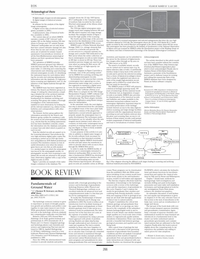
Hurricane Isabel made landfall east of Cape Lookout, North Carolina, as a Category 2 (Safford-Simpson scale) hurricane on 18 September 2003. The storm’s center tracked to the northwest, passing west of Chesapeake Bay (Figure 1) in the early morning of 19 September. Hurricane Isabel brought the highest storm surge and winds to the region since the Chesapeake-Potomac hurricane of 1933 and Hurricane Hazel in 1954 (http:// www.erh.noaa.gov/er/akq/wx_events/hur/ isabel_2003.htm). Storm surge was variable in the region, reaching a high of 2.7 m on the western side of the bay, where the heaviest rainfall occurred. The highest sustained wind in the bay region reached 30.8 m s -1 at Gloucester Point,Virginia, with gusts to 40.7 m s -1 . Overall, Hurricane Isabel was responsible for physical and biological changes in Chesapeake Bay on a variety of spatial and temporal scales. Short-term responses (e.g., the reduction of hypoxia by mixing, nutrient inputs to the upper water column, and a large-scale phytoplankton bloom) and long- term responses (e.g., early onset of hypoxia in spring 2004, high abundance of the cala- noid copepod Eurytemora affinis in spring 2004, and increased recruitment of Atlantic croaker) highlight the importance of hurri- canes to the function of a large, estuarine ecosystem. Physical Changes In the days preceding Hurricane Isabel’s landfall, northerly winds drove surface waters out of the bay and depressed sea level over the northern half of the estuary (Figure 2). Isabel arrived with strong south- easterly winds on 18 September and pro- duced an initial storm surge of 1.8 m at the bay’s entrance. The hurricane subsequently moved inland along a track to the west of the bay at a speed >10 m s -1 . This speed is of the same order as that of the bay’s long-wave propagation speed of ~7 m s -1 . The coinci- dence of storm movement with an associ- ated propagating surge enabled local winds and the transiting low-pressure center to be especially effective in creating large storm surges over the northern and western portions of the bay. As the storm moved northwestward, southeasterly winds blew directly up the Potomac River, driving a storm surge in Washington, D. C., that reached 2.7 m. The same winds forced a steep cross-estuary slope in sea surface off Baltimore, Maryland, with a 2.2 m surge at Baltimore on the bay’s western shore exceeding the surge on the eastern shore by 0.7 m. Currents measured at the Chesapeake Bay Observing System’s (CBOS; http://www.cbos. org) mid-bay buoy (latitude 38.3ºN) revealed strong flows associated with Hurricane Isabel superimposed on the regular ebb and flow of the semidiurnal tide (Figure 2). Prior to the storm, northerly winds drove a typical two-layer, wind-forced flow, with the upper layer flow moving seaward and the lower layer flow moving into the bay. In the afternoon of 18 September, the storm’s southeasterly and southerly winds became sufficiently strong to force the entire water column up the bay at speeds in excess of 1.5 m s -1 , mixing the water column in the process. This mixing event redistributed salt, nutrients, plankton, and fish within Chesapeake Bay, and the event brought with it a rapid (1.0 m s -1 or ~100 km d -1 ) intru- sion of ocean water. After the storm, the bay relaxed with a strong water column move- ment in the opposite direction that subse- quently reverted to a two-layer structure late on 19 September (Figure 2). Biological Responses Aircraft remote sensing of chlorophyll (chl a) on 11 and 24 September 2003 docu- mented a response of the middle to lower bay to the passage of Hurricane Isabel (http://www. cbrsp.org). Typical expressions of fall phytoplankton dynamics in Chesapeake Bay include low biomass as chl a (5–11 mg m -3 ; Figure 1a), modest primary productivity (265–1065 mg carbon m -2 d -1 ), and a flora dominated by diatoms and cryptophytes [cf. Harding et al., 2002]. Observations from air- craft six days after Hurricane Isabel showed VOLUME 86 NUMBER 28 12 JULY 2005 Raising the Ante on the Climate Debate, Pg. 262 Comment on “A Strategy to Rapidly Determine the Magnitude of Great Earthquakes, Pg. 263 Paleoclimate Modelling Intercomparison Project, Pg. 264 261 Chesapeake cont. on page 265 Chesapeake Bay Plankton and Fish Abundance Enhanced by Hurricane Isabel The digital preservation of the unique seismological heritage consisting of histori- cal seismograms and earthquake bulletins, and of related documentation (e.g., observa- tory logbooks, station books, etc.), is criti- cally important in order to avoid deteriora- tion and loss over time [Kanamori, 1988]. Dissemination of this seismological material in digital form is of equal importance, to allow reanalysis of past earthquakes using modern techniques and the reevaluation of seismic hazard. This is of particular interest for those areas where little or no earthquake activity has occurred since the last signifi- cant historical earthquake. In 2001, the Istituto Nazionale di Geofisica e Vulcanologia (INGV) started an innovative project, Progetto SISMOS (i.e., SISMOgrammi Storici), to scan (i.e., convert into digital form for storage on a computer), at very high resolution, and archive seis- mological paper records and related material. The Italian Ministry for the Environment origi- nally funded the project to encom- pass the digitization of seismogram records of the Italian seismic obser- vatories and of associated bulletins for the period 1895–1984 (i.e., from the early age of seismometry to the advent of the digital era). In 2002, the SISMOS activity was extended to seismograms and bulletins from observatories in 28 countries of the Euro-Mediterranean area through the European Seismological Commission Working Group on the History and Data of Instrumental Seismology, the EuroSeismos project (http://storing.ingv.it/es_web/). The participating partners gather histori- cal records at their observatories and send them to SISMOS for scanning, archiving, and dissemination. A parallel effort, SeismoArchives, has been initiated by W. H. K. Lee under the auspices of the International Association of Seismology and Physics of the Earth’s Interior (IASPEI) Committee for Preservation of the World- Wide Standardized Seismo- graph Network (WWSSN) and Historical Seismograms (ICPWHS), in collaboration with the Data Management Center (DMC) of the Incorporated Research Institutions for Seismology (IRIS) (http:// www.iris.edu/data/SeismoArchives/). SeismoArchives has gathered primarily long-period WWSSN recordings since the early 1960s, and its activity is currently ham- pered by a lack of dedicated funding and personnel. SISMOS, among others, has pro- vided funding to scan the microfilms of some significant earthquakes that occurred in Italy. Also, EuroSeismos and ICPWHS, which have many common participants, maintain an ongoing collaboration. Key SEISMOS Products INGV has designed and implemented a registered-user Web portal to the SISMOS archive of the Italian historical material. (Access to the EuroSeismos data also will be granted in the future as the digitization of all the records nears completion.) As of May 2005, more than 82,000 seismogram records have been scanned and made available. Similarly, historical seismic bulletins have been scanned and are available in Adobe® PDF [Portable Document Format] on the SISMOS Web site. The main products of SISMOS available through the Web server (http://sismos.ingv.it) include: Seismological Data cont. on page 266 BY M. R. ROMAN, J. E. ADOLF, J. BICHY , W. C. BOICOURT, L. W. HARDING, JR., E. D. HOUDE, S. JUNG, D. G. KIMMEL, W. D. MILLER, AND X. ZHANG Collecting, Digitizing, and Distributing Historical Seismological Data BY A. MICHELINI, B. DE SIMONI, A. AMATO, AND E. BOSCHI The SISMOS project of INGV will preserve a historical heritage spanning nearly 100 years of seismology. Fig. 1. Comparison of long-term average and post-Isabel concentrations of (a and b) phytoplankton biomass as chlorophyll (chl a) from aircraft remote sensing, (c and d) mesozooplankton as biovolume from an optical plankton counter, and (e and f) Atlantic croaker abundance from midwater trawls. Left panels represent fall averages for chl a, 1990–2003; biovolume, 1995–2000, for mesozooplankton; and numbers, 1996–2003, for Atlantic croaker. Right panels represent post- Isabel observations on 23 September 2003 for phytoplankton; 4–5 November 2003 for mesozoo- plankton; and 6–7 November 2003 for Atlantic croaker.
-
Upload
independent -
Category
Documents
-
view
0 -
download
0
Transcript of Chesapeake Bay plankton and fish abundance enhanced by Hurricane Isabel

Hurricane Isabel made landfall east of
Cape Lookout, North Carolina, as a Category
2 (Safford-Simpson scale) hurricane on 18
September 2003. The storm’s center tracked
to the northwest, passing west of Chesapeake
Bay (Figure 1) in the early morning of 19
September. Hurricane Isabel brought the
highest storm surge and winds to the region
since the Chesapeake-Potomac hurricane
of 1933 and Hurricane Hazel in 1954 (http://
www.erh.noaa.gov/er/akq/wx_events/hur/
isabel_2003.htm). Storm surge was variable
in the region, reaching a high of 2.7 m on
the western side of the bay, where the heaviest
rainfall occurred. The highest sustained wind
in the bay region reached 30.8 m s -1 at
Gloucester Point, Virginia, with gusts to 40.7 m s-1.
Overall, Hurricane Isabel was responsible
for physical and biological changes in
Chesapeake Bay on a variety of spatial and
temporal scales. Short-term responses (e.g.,
the reduction of hypoxia by mixing, nutrient
inputs to the upper water column, and a
large-scale phytoplankton bloom) and long-
term responses (e.g., early onset of hypoxia
in spring 2004, high abundance of the cala-
noid copepod Eurytemora affinis in spring
2004, and increased recruitment of Atlantic
croaker) highlight the importance of hurri-
canes to the function of a large, estuarine
ecosystem.
Physical Changes
In the days preceding Hurricane Isabel’s
landfall, northerly winds drove surface
waters out of the bay and depressed sea
level over the northern half of the estuary
(Figure 2). Isabel arrived with strong south-
easterly winds on 18 September and pro-
duced an initial storm surge of 1.8 m at the
bay’s entrance. The hurricane subsequently
moved inland along a track to the west of
the bay at a speed >10 m s -1. This speed is of
the same order as that of the bay’s long-wave
propagation speed of ~7 m s -1. The coinci-
dence of storm movement with an associ-
ated propagating surge enabled local winds
and the transiting low-pressure center to be
especially effective in creating large storm
surges over the northern and western
portions of the bay.
As the storm moved northwestward,
southeasterly winds blew directly up the
Potomac River, driving a storm surge in
Washington, D. C., that reached 2.7 m. The
same winds forced a steep cross-estuary
slope in sea surface off Baltimore, Maryland,
with a 2.2 m surge at Baltimore on the bay’s
western shore exceeding the surge on the
eastern shore by 0.7 m.
Currents measured at the Chesapeake Bay
Observing System’s (CBOS; http://www.cbos.
org) mid-bay buoy (latitude 38.3ºN) revealed
strong flows associated with Hurricane Isabel
superimposed on the regular ebb and flow
of the semidiurnal tide (Figure 2). Prior to
the storm, northerly winds drove a typical
two-layer, wind-forced flow, with the upper
layer flow moving seaward and the lower
layer flow moving into the bay.
In the afternoon of 18 September, the
storm’s southeasterly and southerly winds
became sufficiently strong to force the
entire water column up the bay at speeds in
excess of 1.5 m s -1, mixing the water column
in the process. This mixing event redistributed
salt, nutrients, plankton, and fish within
Chesapeake Bay, and the event brought with
it a rapid (1.0 m s -1 or ~100 km d -1) intru-
sion of ocean water. After the storm, the bay
relaxed with a strong water column move-
ment in the opposite direction that subse-
quently reverted to a two-layer structure late
on 19 September (Figure 2).
Biological Responses
Aircraft remote sensing of chlorophyll
(chl a) on 11 and 24 September 2003 docu-
mented a response of the middle to lower
bay to the passage of Hurricane Isabel
(http://www. cbrsp.org). Typical expressions
of fall phytoplankton dynamics in Chesapeake
Bay include low biomass as chl a (5–11 mg
m -3; Figure 1a), modest primary productivity
(265–1065 mg carbon m -2 d -1), and a flora
dominated by diatoms and cryptophytes [cf.
Harding et al., 2002]. Observations from air-
craft six days after Hurricane Isabel showed
VOLUME 86 NUMBER 28 12 JULY 2005
Raising the Ante on the Climate Debate, Pg. 262Comment on “A Strategy to Rapidly Determine the Magnitude of Great Earthquakes, Pg. 263Paleoclimate Modelling Intercomparison Project, Pg. 264
261
Chesapeake cont. on page 265
Chesapeake Bay Plankton and Fish Abundance Enhanced by Hurricane Isabel
The digital preservation of the unique
seismological heritage consisting of histori-
cal seismograms and earthquake bulletins,
and of related documentation (e.g., observa-
tory logbooks, station books, etc.), is criti-
cally important in order to avoid deteriora-
tion and loss over time [Kanamori, 1988].
Dissemination of this seismological material
in digital form is of equal importance, to
allow reanalysis of past earthquakes using
modern techniques and the reevaluation of
seismic hazard. This is of particular interest
for those areas where little or no earthquake
activity has occurred since the last signifi-
cant historical earthquake.
In 2001, the Istituto Nazionale di Geofisica e
Vulcanologia (INGV) started an innovative
project, Progetto SISMOS (i.e., SISMOgrammi
Storici), to scan (i.e., convert into digital form
for storage on a computer), at very
high resolution, and archive seis-
mological paper records and
related material. The Italian
Ministry for the Environment origi-
nally funded the project to encom-
pass the digitization of seismogram
records of the Italian seismic obser-
vatories and of associated bulletins for the
period 1895–1984 (i.e., from the early age of
seismometry to the advent of the digital era).
In 2002, the SISMOS activity was
extended to seismograms and bulletins
from observatories in 28 countries of the
Euro-Mediterranean area through the
European Seismological Commission
Working Group on the History and Data of
Instrumental Seismology, the EuroSeismos
project (http://storing.ingv.it/es_web/).
The participating partners gather histori-
cal records at their observatories and send
them to SISMOS for scanning, archiving, and
dissemination.
A parallel effort, SeismoArchives, has been
initiated by W. H. K. Lee under the auspices
of the International Association of Seismology
and Physics of the Earth’s
Interior (IASPEI) Committee
for Preservation of the World-
Wide Standardized Seismo-
graph Network (WWSSN) and
Historical Seismograms
(ICPWHS), in collaboration
with the Data Management
Center (DMC) of the Incorporated Research
Institutions for Seismology (IRIS) (http://
www.iris.edu/data/SeismoArchives/).
SeismoArchives has gathered primarily
long-period WWSSN recordings since the
early 1960s, and its activity is currently ham-
pered by a lack of dedicated funding and
personnel. SISMOS, among others, has pro-
vided funding to scan the microfilms of
some significant earthquakes that occurred
in Italy. Also, EuroSeismos and ICPWHS,
which have many common participants,
maintain an ongoing collaboration.
Key SEISMOS Products
INGV has designed and implemented a
registered-user Web portal to the SISMOS
archive of the Italian historical material.
(Access to the EuroSeismos data also will be
granted in the future as the digitization of all
the records nears completion.) As of May
2005, more than 82,000 seismogram records
have been scanned and made available.
Similarly, historical seismic bulletins have
been scanned and are available in Adobe®
PDF [Portable Document Format] on the
SISMOS Web site.
The main products of SISMOS available
through the Web server (http://sismos.ingv.it)
include:
Seismological Data cont. on page 266
BY M. R. ROMAN, J. E. ADOLF, J. BICHY, W. C.
BOICOURT, L. W. HARDING, JR., E. D. HOUDE, S. JUNG,
D. G. KIMMEL, W. D. MILLER, AND X. ZHANG
Collecting, Digitizing, and Distributing Historical Seismological Data
BY A. MICHELINI, B. DE SIMONI, A. AMATO,
AND E. BOSCHI
The SISMOS project of INGV will
preserve a historical heritage spanning nearly 100 years of seismology.
Fig. 1. Comparison of long-term average and post-Isabel concentrations of (a and b) phytoplankton biomass as chlorophyll (chl a) from aircraft remote sensing, (c and d) mesozooplankton as biovolume from an optical plankton counter, and (e and f) Atlantic croaker abundance from midwater trawls. Left panels represent fall averages for chl a, 1990–2003; biovolume, 1995–2000, for mesozooplankton; and numbers, 1996–2003, for Atlantic croaker. Right panels represent post-Isabel observations on 23 September 2003 for phytoplankton; 4–5 November 2003 for mesozoo-plankton; and 6–7 November 2003 for Atlantic croaker.
262
EOS VOLUME 86 NUMBER 28 12 JULY 2005
262
EOS VOLUME 86 NUMBER 28 12 JULY 2005
TRANSACTIONSAMERICAN GEOPHYSICAL UNION
The Newspaper of the Earth and Space Sciences
Editors
Keith Alverson: Intergovernmental Oceano-graphic Commission, UNESCO, Paris, France; [email protected]
John W. Geissman: Dept. of Earth and Plan-etary Science,University of New Mexico, Albu-querque, USA; [email protected]
Venkat Lakshmi: Dept. of Geological Sci-ences, University of South Carolina, Columbia USA; [email protected]
Editor in Chief
A. F. Spilhaus, Jr.: AGU, Washington, D.C., USA;
Corresponding Editors
Roland Burgmann (Tectonophysics): University of California at Berkeley, USA; burgmann@seismo. berkeley.edu
William E. Carter (History): Dept. of Civil Engineering, University of Florida, Gainesville, USA; [email protected]
Millard F. Coffin (Japan): Ocean Research Institute, University of Tokyo, Japan; mcoffin@ori. u-tokyo.ac.jp
Steven C. Constable (Geomagnetism and Paleomagnetism): Scripps Institution of Ocean-ography, La Jolla, California, USA; [email protected]
Richard S. Gross (Geodesy): Jet Propulsion Laboratory, Pasadena,California USA; richard.gross@ jpl.nasa.gov
Marguerite Kingston (Public Affairs): USGS (retired); [email protected]
Louise Prockter (Planetary Sciences): Applied Physics Laboratory, Laurel, Maryland, USA; [email protected]
Paul Renne (VGP): Berkeley Geochronology Center, Berkeley, California, USA;[email protected]
Justin S. Revenaugh (Seismology): University of Minnesota, Minneapolis, USA; [email protected]. edu
Jeffery J. Roberts (Mineral and Rock Physics): Lawrence Livermore National Labora-tory, Livermore, California, USA; [email protected]
Sarah L. Shafer (Paleoceanography and Paleoclimatology): U.S. Geological Survey, Corvallis, Oregon, USA; [email protected]
David Sibeck (Space Physics and Aerono-my): NASA/Goddard Space Flight Center, Green-belt, Maryland, USA; [email protected]
Ramesh P. Singh (India): Dept. of Civil Engi-neering, Indian Institute of Technology, Kanpur, India; [email protected]
Stephanie Ann Stockman (Education): Science Systems and Applications Inc., Lanham, Maryland, USA; [email protected]
Maribeth Stolzenburg (Atmospheric and Space Electricity): Dept. of Physics and Astronomy, University of Mississippi, University, USA; [email protected]
Jeffrey M. Welker (Biogeosciences): Environ- ment and Natural Resources Institute, University of Alaska, Anchorage, USA; [email protected]
Assistant Editors
Peter Folger: AGU, Washington, D.C., USA; [email protected]
Catherine O’Riordan: AGU, Washington, D.C.,
USA; [email protected]
Staff
Editorial: Stephen Cole, Publisher; Randy Showstack, Managing Editor; Shermonta Grant, Production Coor-dinator; Pamela Ingate, Editor’s Assistant Advertising: Carla Childres, Advertising Assistant; Tel: +1-202-777-7536; E-mail: [email protected]; Composition and Graphics: Habib Hastaie, Manager; Nancy Sims, and Valerie Bassett, Electronic Graphics Specialists
©2005 American Geophysical Union. Material in this issue may be photocopied by individual scientists for research or classroom use. Permission is also granted to use short quotes, figures, and tables for publication in scientific books and journals. For permission for any other uses,contact the AGU Pub-lications Office.
Eos, Transactions, American Geophysical Union (ISSN 0096-3941) is published weekly by the American Geophysical Union, 2000 Florida Ave., NW, Washington, DC 20009 USA. Periodical Class postage paid at Wash-ington, D.C., and at additional mailing offices. POST-MASTER: Send address changes to Member Service Center, 2000 Florida Ave., NW, Washington, DC 20009 USA.Member Service Center 8:00 a.m.–7 p.m. Eastern time; Tel: +1-202-462-6900; Fax: +1-202-328-0566; Tel. orders in U.S.:1-800-966-2481; E-mail: [email protected]. Information on institutional subscriptions is available from the Member Service Center.
Views expressed in this publication do not necessarily reflect official positions of the American Geophysical Union unless expressly stated.
www.agu.org/pubs/eos
Almost alone in the world of science,
there is a substantial U.S. effort to discredit
some basic conclusions in the global warm-
ing debate. There are always legitimate rea-
sons to query scientific conclusions, but the
tenor of the debate has taken on a flavor of
its own. Since the epicenter of the dispute is
in Washington, D. C., the suspicion arises that
not all of the discussion is business-as-usual
scientific disagreement.
The most recent example of the heightening
level of the dispute involves a 23 June 2005
letter from U.S. Rep. Joe Barton (R-Tex.),
chair of the House Committee on Energy
and Commerce, to Michael Mann (University
of Virginia) and his collaborators, Raymond
Bradley (University of Massachusetts) and
Malcolm Hughes (University of Arizona).
The dispute centers on the much discussed
Ahockey stick@ reconstruction of Mann et al.
[1998, 1999]. In those reconstructions, the
twentieth century warming stands well
above Northern Hemisphere temperature
fluctuations of the last 1000 years. Other
investigators, using some of the same data
but with different approaches, have also
reconstructed temperatures of the last mil-
lennium (see Mann et al. [2003] for a sum-
mary discussion). In general, there is more
agreement than disagreement among the
various reconstructions. The differences
stem mainly from the scaling of the oscilla-
tions, but in all cases the late twentieth cen-
tury is anomalous in a millennial context.
The discussions on the hockey stick would
require many pages to describe in detail, but
an apparent trigger for the 23 June develop-
ment goes back to a request about three
years ago by a Canadian investigator, Steven
McIntyre, for all the files, data sets, algorithms,
and source codes that went into the Mann et
al. reconstruction. McIntyre is a semi-retired
mineral trader with an interest in mathemat-
ics, and he wanted to test some of the results
of the Mann et al. studies. Although the data
were already available on a public FTP (file
transfer protocol) computer site, Mann pro-
vided them in a different format, as requested
by McIntyre. The algorithm was described in
the original 1998 Nature paper, but an
expanded version was added in 2004 on a
Nature supplementary Web site. The source
code was not provided because it is consid-
ered an intellectual property right.
McIntyre continues to press for more
information. Not all of this information was
provided, in part because of the sheer level
of work required. Because I had also pro-
duced a millennial climate reconstruction
[Crowley and Lowery, 2000], I too was a
recipient of a request from McIntyre. I can
attest that his initial message was of a some-
what peremptory character, requesting all
my files, programs, and documentation, and
that a quick follow-up by him had a more
threatening tone, implying that the director
of the U.S. National Science Foundation
(NSF) would be contacted if I did not com-
ply. Even after I belatedly supplied some
data, McIntyre sent a number of follow-up
requests asking for more details on my data
and analysis. These requests may have been
well-intentioned, but at some point I declined
to answer any more, because I was just too
busy to stop and respond to the repeated
questions and requests.
McIntyre and his co-author, Ross McKitrick,
an economist at the University of Guelph,
Ontario, Canada, subsequently published a
rebuttal paper [McIntyre and McKitrick,
2003] without showing Mann, the provider
of the data, a prepublication Acourtesy@ examination to screen for any possible
errors. The McIntyre and McKitrick paper
(referred to here as AMM@) showed an unex-
pectedly large warming in the 1400s, appar-
ently calling into question Mann=s analysis
and the uniqueness of the late twentieth
century warming. However, the consensus
among climate scientists most familiar with
the data is that the MM warming in the
1400s is due to an error in the MM analysis
method; it can also not be supported by an
examination of the data.
The debate continues. The most recent
development appears to have resulted from
someone requesting a favor from Rep.
Barton, for the content of the Barton letter
covers not only ongoing issues between
McIntyre and Mann, but also a level of detail
that seems to go well beyond that. Two
examples from the Barton letter to Mann, his
colleagues, NSF Director Arden Bement, Jr.,
and IPCC (Intergovernmental Panel on
Climate Change) Chairman Rajendra Pachauri
illustrate the magnitude of the requests.
Your curriculum vitae, including, but
not limited to, a list of all studies relating
to climate change research for which
you were an author or co-author and
the source of funding for those studies.
Provide the location of all data archives
relating to each published study for
which you were an author or co-author
and indicate: (a) whether this informa-
tion contains all the specific data you
used and calculations you performed,
including such supporting documenta-
tion as computer source code, valida-
tion information, and other ancillary
information, necessary for full evalua-
tion and application of the data, partic-
ularly for another party to replicate your
research results; (b) when this informa-
tion was available to researchers; (c)
where and when you first identified the
location of this information; (d) what
modifications, if any, you have made to
this information since publication of
the respective study; and (e) if neces-
sary information is not fully available,
provide a detailed narrative description
of the steps somebody must take to
acquire the necessary information to
replicate your study results or assess
the quality of the proxy data you used.
The letters are available online at
http://energycommerce.house.gov/108/
Letters/06232005_1570.htm.
Rep. Barton displayed a remarkable
grasp of some details of climate statistics
when, he further requested whether Mann
Acalculate[d] the [sic] R2 [i.e., r2] statistic
for the temperature reconstruction, particu-
larly for the 15th Century proxy record cal-
culations and what were the results?@ and
Awhat validation statistics did [Mann] calcu-
late for the reconstruction prior to 1820?@ These are virtually verbatim statements from
McIntyre=s earlier critiques that had been
posted on his own Web site.
At some point, one must ask why should
a member of the U.S. Congress get involved
in this matter which may have been raised
by a Canadian? I believe the purpose is two-
fold: (1) to send a signal of intimidation to
researchers who produce results that are
not consistent with some political prefer-
ences; and (2) to continue to dwell on the
hockey stick Ahot button@ by raising ques-
tions and fomenting uncertainty, with the
aim to discredit greenhouse science so
skeptics in government and their supporters
can continue to claim that there are too
many uncertainties to proceed with any
action to reduce greenhouse gas emissions.
U.S. Sen. James Inhofe (R-Okla.) has also
focused on the Mann et al. reconstruction
as a way of delegitimizing the conclusions
of the IPCC. The presumed logic is that if the
Mann et al. reconstruction can be proved
flawed, then so too is the general report of
the IPCC that highlights the Mann et al.
record. Of course, such Alogic@—basically,
guilt by association—conveniently ignores
the manifold evidence for global warming
summarized in the IPCC report, the fact that
the IPCC report represents a broad-based
consensus not dependent on any one
author, and that the final report was approved
not only by scientists, but also by political
representatives of the countries that signed
the report.
The broader scientific community should
be aware of these developments, because
the politicizing of data/file requests could
easily be expanded to other areas where sci-
ence intersects and conflicts with the inter-
ests of some political groups. For example,
requests could be made to paleontologists
and molecular biologists for all data and
files supporting evolution. Likewise, radio-
chemists could be entrained into pseudo-
scientific debate because of all the massive
and magnificent geochronological data that
have been gathered over the last few decades.
Hopefully, these extrapolations will not
happen and the Barton request will be an
anomaly. However, this development does
warrant attention, as it seems to be consis-
tent with the tenor of the day. Scientists and
the public need to be aware of, and resist,
any attempt to intimidate scientists who pro-
duce results not consistent with the position
of the political party presently in power.
Disclaimer
The statements in this Forum represent
my own views and understanding of the sit-
uation. Time invested in the Forum was not
supported by funds from any government
agency. Although I am friends with Michael
Mann, Raymond Bradley, and Malcolm
Hughes, I have not been involved with any
of their interactions and correspondence
with Steven McIntyre.
References
Crowley, T. J., and T. L. Lowery (2000), How warm
was the Medieval Warm Period? Ambio, 29, 51,054.
Mann, M. E., R. S. Bradley, and M. K. Hughes (1999),
Northern hemisphere temperatures during the last
millennium: Inferences, uncertainties, and limita-
tions. Geophys. Res. Lett., 26, 759–762.
Mann, M. E., R. S. Bradley, and M. K. Hughes (1998),
Global scale temperature patterns and climate forc-
ings over the past six centuries, Nature, 392, 779–787.
Mann, M. E., et al. (2003), On past temperatures and
anomalous late 20th century warmth, Eos, 84(27),
256–258.
McInytre, S., and R. McKitrick (2003), Corrections to
the Mann et al. 1998 proxy data base and northern
hemisphere average temperature series, Energy
and Environment, 14, 751–771.
—THOMAS J. CROWLEY, Nicholas School of the
Environment, Duke University, Durham, N. C
forumRaising the Ante on the Climate Debate
Forum cont. on next page

263
EOS VOLUME 86 NUMBER 28 12 JULY 2005
� 30 October–02 November 2005 Ridge 2000 Progress and Planning Workshop, Vancouver, British Columbia, Canada. Sponsor: The National Science Foundation. (P. Nordstrom; Tel: +1-814-865-7434; E-mail: [email protected]; Web Site: http://www.ridge2000.org/science/meetings/WorkshopInfo.php?workshopID=Vancouver5)
Abstract deadline is 19 September 2005. The meeting will provide a forum for exchange of infor-mation on the recent work and future goals of cur-rent Integrated Studies Sites.
� 13–16 November 2005 10th European Bio-solids and Biowastes Conference, Wakefield, West Yorkshire, England. Sponsors: Montgomery Watson Harza (MWH Global); Yara. (F. Eldon, Richmond House, 16 Blenheim Terrace, Leeds, West Yorkshire, England LS2 9HN; Tel: +011-44-113-2424200; Fax: +011-44-113-2442166; E-mail: [email protected]; Web Site: http://www.european-biosolids.com)
The conference will provide a forum for dis-cussion on biosolids and biowaste treatment and disposal including engineering, strategic planning, regulation, sustainability, soil science, and practical and innovative short and long-term solutions for handling, treating, recycling, and resource utilization of the ever-growing quantities of these residuals. The meeting will review the results of the past decade and the challenges, opportunities, and threats for biosolids and biowastes in the future.
� 16–18 November 2005 Climate Change, Sus-tainable Development and Risk – An Economic and Business View, Lutherstadt/Wittenberg, Germany. Sponsor: Stiftungsfond Dresdner Bank. (R. Antes, Martin-Luther-University, Faculty of Eco-nomics, Grobe Steinstrasse 73, Halle-Wittenberg, Germany D-06099; Tel: +011-49-345-5523-463; Fax: +011-49-345-5527-199; E-mail: [email protected]; Web Site: http://www.wiwi.uni-halle.de/lui/bwl/umwelt/)
Abstract deadline is 31 July 2005. The workshop will provide a forum to discuss corporate climate risk strategies, changing and emerging markets, risk profiles of sustainable companies, and climate change perceptions/behavior of economic actors.
� 28 November–02 December 2005 2005 MRS (Materials Research Society) Fall Meeting, Boston, Massachusetts, USA. Sponsor: Materials Research Society. (Materials Research Society, 506 Keystone Drive, Warrendale, Pennsylvania, USA
15086-7573; Tel: +1-724-779-3003; Fax: +1-724-779-8313; E-mail: [email protected]; Web Site: http://www.mrs.org/meetings/fall2005/)
The meeting will provide a forum for the materials community. Topics include energy and the environ-ment; bio-organic/inorganic composites; nano to microstructured materials; smart materials/devices; mechanical behavior; and electronics/photonics. The meeting will also feature a “fashion show” on wearable smart materials, as well as a hydrogen fuel cell car race for high school students and teachers.
� 01–02 December 2005 Congress on Assessing and Mitigating Environmental Impacts of Emerging Contaminants, Washington, DC, USA. Sponsor: U.S. Geological Survey. (R. Day, 5430 Gros-venor Lane, Bethesda, Maryland, USA 20814-2193; Tel: +1-301-493-9101; E-mail: [email protected]; Web Site: http://www.rnrf.org)
The congress will identify problems and unin-tended consequences of emerging contaminants. Specific issues to be examined include: efficacy of the existing regulatory framework; research and monitoring needs; impacts on human and wildlife health; and public information and education needs. Discussion will focus on nanoparticles; pharmaceuticals; pesticides and metabolites/degradates – synthetic pyrethroids; and industrial chemicals – brominated flame retardants.
� 14–19 May 2006 14th International Confer-ence on Aquatic Invasive Species, Key Biscayne, Florida, USA. Sponsors: U.S. Geological Survey; National Oceanic and Atmospheric Administration; U.S. Fish and Wildlife Service; others. (E. Muckle-Jeffs, 1027 Pembroke Street East, Suite 200, Pembroke, Ontario, Canada K8A 3M4; Tel: 1-800-868-8776; Fax: +1-613-732-3386; E-mail: [email protected]; Web Site: http://icais.org)
Abstract deadline is 16 September 2005. The conference will serve as a forum for the presenta-
tion of the latest field research; introduction of new technological developments for prevention, monitoring, and control; and discussion of policy, legislation, public education, and outreach initia-tives to raise awareness of the impacts of aquatic invasive species and prevent new introductions. Topics include policy and programs; ecological and ecosystem impacts; socioeconomic impacts, and education and outreach.
We appreciate W. Menke and L. Levin’s
comments (Eos, 86(19), pp.185, 189, 10 May
2005) on the need to develop new seismo-
logical techniques to more accurately deter-
mine the magnitude of great earthquakes
quickly. However, in the first few paragraphs,
Menke and Levin suggest that the many
thousands of people died because an accu-
rate assessment of the true nature of the 26
December 2004 Sumatra earthquake was
not known within the first hour after it
occurred. Although this may serve as a
wake-up call to seismologists on the impor-
tance of better and more rapid magnitude
estimation procedures, it should not be used
to obscure the most urgent need, which is
to establish an effective global tsunami
warning system.
The primary reason many thousands of
lives were lost in the Sumatra tsunami is that
there was no tsunami warning system for
the Indian Ocean. Rather than focusing on
the failure of seismologists to accurately
estimate the magnitude of the 26 December
earthquake, we should understand that what
the world needs to prevent another tsunami
tragedy on this scale is, first and foremost, a
global tsunami warning system. Faster seis-
mological techniques for more accurate
magnitude estimation and source character-
ization will certainly help the warning sys-
tem. However, such improvements will be of
little benefit to nations or regions where
there is still no tsunami warning system.
In the aftermath of the Sumatra tsunami,
there was considerable confusion about what
exactly a tsunami warning system is. Many
people still seem to believe that warning cen-
ters themselves are the warning system. This is
a misconception that we are trying to dispel.
A successful warning system is composed
of three main components: tsunami hazard
and risk assessment, warning guidance, and
preparedness. Each component must be
functioning; otherwise the system collapses.
Warning centers are the trip wires; the
centers’ responsibilities include determining
the location and magnitude of an earth-
quake as quickly as possible, evaluating
potential tsunami threat, issuing message
products, and monitoring sea level gauges
for evidence of tsunami activity.
Emergency managers evaluate warning
center message products (with the help of
local tsunami advisors, when possible), plan
evacuation routes and shelters, and develop
a communications system to alert the pub-
lic to a tsunami emergency.
Tsunami awareness also is vital. The pub-
lic needs to be educated about what actions
to take to save their lives during a tsunami
emergency. For example, if you are near the
shore and feel a strong earthquake, you
should immediately head inland and/or
uphill. Likewise, a proper understanding of
some basic properties of tsunamis and their
causes can save lives, even in the epicentral
region. One sure sign of an approaching
tsunami is the ocean draw-down, i.e., when
the ocean recedes in an unnatural way.
How would the Pacific tsunami warning
system react if a 26 December type event
were to occur in the Pacific Basin? With an
initial Mw estimate of 8.0, and based on pre-
determined conservative criteria, the U.S.
National Oceanic and Atmospheric
Administration’s Richard H. Hagemeyer
Pacific Tsunami Warning Center and the
agency’s West Coast/Alaska Tsunami Warning
Center would issue warnings, watches, and
advisories to their respective clients in the
Pacific.
(NOAA’s tsunami warning centers work
with a number of U.S. agencies, including
the U.S. Geological Survey and other NOAA
organizations. Internationally, the warning
centers work with Australia’s National Tidal
Center, Chile’s Servicio Hidrográfico y
Oceanográfico de la Armada, the Japan
Meteorological Agency, and other organiza-
tions. Through such collaborations, NOAA’s
warning centers obtain the information
needed to provide timely tsunami threat
warnings.)
To provide timely warnings, the earth-
quake must be evaluated as fast as possible.
Warning centers understand that evaluating
the first 100 seconds of signal may not indi-
cate the size of a great earthquake with a
rupture time of several hundred seconds.
However, the initial estimate can be used to
determine if an earthquake is over a warning
threshold.
Had the 26 December event occurred in
the Pacific, all regions within three hours of
tsunami travel time would have been placed
in a tsunami warning status based on the
initial determination of an Mw of 7.9 or
greater. More limited regional warning bulle-
tins are issued for earthquakes in the Pacific
with an Mw as small as 7.55, and local warn-
ings are issued for earthquakes with an Mw
as small as 6.8.
Although destructive tsunamis resulting
from an earthquake with an Mw as small as
6.8 are extremely rare, they are not impossi-
ble. For example, such an earthquake could
potentially trigger landslides, or the earth-
quake could be a “slow” earthquake (some-
times referred to as a “tsunami earthquake”)
resulting in a much larger than expected tsu-
nami given the earthquake’s seismic moment.
Fortunately, the tsunami warning system
of the Pacific has an extensive network of
over 130 remotely reporting sea level gauges
including several deep-ocean pressure sen-
sors. These gauges are a critical asset for tsu-
nami warning that was completely missing
in the Indian Ocean on 26 December.
The Pacific network of sea level gauges
allows warning centers to confirm the exis-
tence or nonexistence of tsunami waves fol-
lowing a warning based solely on the seis-
mic data. Most Pacific warnings are canceled
within 2–3 hours after they are issued, based
on the sea level data. Without the network
of sea level gauges, the entire Pacific Basin
would have unnecessarily been placed in a
warning status many times during the past
40 years over which the tsunami warning
system of the Pacific has been operational.
Aside from causing a significant disrup-
tion to normal activities in coastal zones,
frequent false warnings cause them to be
discredited, and make warnings of real
threats ineffective.
On 26 December 2004, there was no tsuna-
mi warning system in the Indian Ocean: there
was no warning center, inadequate regional
seismic networks, no network of remotely
reporting sea level gauges, no designated
national authorities for tsunami warnings, no
communications methods to reach potential
authorities, no tsunami-educated emergency
managers or local tsunami experts, no com-
munications to disseminate warnings to coastal
regions at risk, and painfully little tsunami
awareness.
We hope we have made it clear that what
is vitally important is a functioning tsunami
warning system. Better seismology for such
events is something that can help; but with
respect to mitigating loss of life from tsunamis,
it is of secondary importance to the establish-
ment of a global tsunami warning system.
We are always seeking ways to improve
the warning system. Currently, the tsunami
warning centers employ the Mwp, Mm, and Ms
methods to estimate the size of earthquakes
at teleseismic distances. In particular, the
Mwp (P -wave moment method [Tsuboi et al.,
1995]) and Mm (mantle magnitude method
[Okal and Talandier, 1988]) are methods that
are designed to reduce the effects of satura-
tion (underestimation of the earthquake mag-
nitude when source duration signifi cantly
exceeds the seismic wave period at which
the magnitude is measured) and yield quality
seismic moment estimates of great earth-
quakes in near real time. While these methods
underestimated the 26 December earthquake,
they performed superbly for the 28 March
2005 earthquake, a Harvard Seismology CMT
magnitude Mw = 8.6 event as estimated by
Harvard Seismology that the Pacifi c Tsunami
Warning Center reported in its initial bulletin
as an Mw 8.5 just 19 min after the event. Fur-
ther analysis by Weinstein and Okal [2005]
shows that extending the Mm method to lon-
ger periods gives a value for the 26 December
Sumatra earthquake of 8.9.
We appreciate Menke and Levin’s efforts
directed at developing new seismological
techniques that could improve the warning
system’s capability to more accurately assess
great earthquakes in a timely fashion, and
look forward to any other such advances that
may emerge from the scientifi c community at
large in the wake of the 26 December event.
References
Okal, E. A., and J. Talandier (1989), Mm: A variable
period magnitude, J. Geophys. Res., 94, 4169–4193.
Tsuboi S., K. Abe, K. Takano, and Y. Yamanaka (1995),
Rapid determination of Mw
from broadband P
waveforms, Bull. Seismol. Soc. Am., 85, 606–613.
Weinstein, S. A., and E. A. Okal (2005), The mantle
magnitude Mm and the slowness parameter Θ: Five
years of real-time use in the context of tsunami
warning, Bull. Seismol. Soc. Am., 95, 779–799.
—S. A. WEINSTEIN, C. MCCREERY, and B. HIRSHORN,
Richard H. Hagemeyer Pacific Tsunami Warning
Center, Ewa Beach, Hawaii; and P. WHITMORE, West
Coast/Alaska Tsunami Warning Center, Palmer
Comment on “A Strategy to Rapidly Determine the Magnitude of Great Earthquakes” by W. Menke and V. Levin
Forum cont. from page 262
A N N O U N C E M E N T SM E E T I N G

264
EOS VOLUME 86 NUMBER 28 12 JULY 2005
By devoting an entire chapter of the
fourth assessment report (AR4) to paleocli-
mates, the Intergovernmental Panel on
Climate Change (IPCC) has recognized that
studying past climates is essential for com-
prehending the climate system, and hence
for predicting its future evolution.
In particular, numerical simulations of
past climates, different from today, constitute
an independent test of the performance and
reliability of the general circulation models
commonly used for climate predictions. This
idea is the motivation for the Paleoclimate
Modelling Intercomparison Project (PMIP),
a long-standing initiative endorsed by the
World Climate Research Programme and the
International Geosphere and Biosphere
Programme. The focus has so far been on
two reference periods, chosen as being the
most representative of cold and warm cli-
mate intervals in the recent past: the Last
Glacial Maximum (LGM, 21,000 years ago)
and the mid-Holocene (6000 years ago).
The first phase of PMIP, launched in 1992,
was based on analysis of atmospheric gen-
eral circulation models. PMIP 1 met with con-
siderable success, with 67 model experiments
archived in a central database and over 70
papers published in the refereed literature.
One of the greatest achievements of PMIP 1
was to provide a framework for paleoclimate
modeling by bringing a community of cli-
mate modelers and field experts together. In
2002, the PMIP steering committee decided,
therefore, that the time had come to define
new numerical experiments that take advan-
tage of the new generation of atmosphere-
ocean-vegetation coupled models [Harrison
et al., 2002]. With these new simulations PMIP
2 also hopes to extract quantitative informa-
tion on climate sensitivity in order to better
predict the consequences of climate change
on human societies.
The first PMIP 2 workshop, held in April
2005, gathered most of the scientists involved
in the project. The attendance spanned the
different representative disciplines (climate
modeling, geophysics, biology, palynology,
geochemistry, and paleoceanography) with
65 scientists from five continents.
On the agenda were a discussion of
model results obtained so far (including a
comparison with paleodata), an overview of
newly available paleoclimate data syntheses,
and plans to widen the scope of PMIP 2 by
defining experimental protocols for other
periods in the past.
A Series of New Paleoclimate Simulations
Compared with PMIP 1, the PMIP 2 proj-
ect considers, for each period, a suite of
numerical experiments that differ by the
number of components of the Earth system
that are interactively taken into account:
AGCM simulations use atmosphere general
circulation models with prescribed sea sur-
face temperatures; OAGCMs have a compo-
nent calculating the dynamics of the ocean;
and OAVGCMs are coupled to a dynamic
vegetation model.
The high scientific potential of this
approach was highlighted in a series of pre-
sentations describing recent OAGCM and
OAVGCM simulations. Y. Zhao showed how
the shoaling of the mixed layer in the Indian
Ocean enhances the response of the Indian
monsoon to the changes in orbital forcing.
This is a good example of positive feedback
of the ocean response on the atmosphere
dynamics. Having interactive vegetation may
further enhance the response of the atmo-
sphere with, in turn, consequences to the
structure of the ocean mixed layer. Such an
ocean-vegetation synergy needs to be taken
into account to understand the abundant
monsoon rainfall in the Sahel
during the mid-Holocene
[Braconnot et al., 2004].
Another goal of PMIP 2 is to
maintain a database of model
results in which long-term
means and individual years are
archived. Information on inter-
annual and interdecadal vari-
ability can therefore be
extracted. Specifically, prelimi-
nary comparisons of the El Niño–Southern
Oscillation and North Atlantic Oscillation
signals in PMIP 2 experiments were shown
by U. Merkel and R. Gladstone. The first PMIP
2 model outputs also provided the opportu-
nity to illustrate some innovative analysis
techniques (quantification of cloud feed-
back based on regime analysis, simulations
of potential vegetation, lake-level modeling).
Apart from using more sophisticated cli-
mate models, PMIP 2 uses up-to-date infor-
mation to define the experiments, including
the latest reconstruction of the Last Glacial
Maximum topography (ICE-5G) and a river
routing scheme derived from geological evi-
dence complemented by hydrological mod-
eling. It is therefore essential to determine to
what extent these refinements improve the
ability of state -of - the -art climate models to
reproduce past climatic data.
This question was discussed at the work-
shop. On the one hand, a series of posters
was devoted to specific sensitivity experi-
ments analyzing the role of river routing,
horizontal resolution, and freshwater fluxes
on simulation results. On the other hand, a
scheme was developed during the meeting
(S. Harrison) that objectively determines the
level of agreement between models and
data on the basis of a series of qualitative
but robustly documented paleoclimatic fea-
tures, for example, abundant monsoon rain-
fall in the Sahel throughout the mid-Holocene.
It was also shown (A. Abe-Ouchi) how quan-
titative information produced from paleocli-
mate records, such as the amplitude of the
tropical Pacific cooling at the Last Glacial
Maximum, may be used to infer constraints
on climate sensitivity on the basis of a large
ensemble of climate simulations. This tech-
nique could provide a valuable contribution
to the IPCC.
Promising Advances in Data Reconstructions
The meeting was equally rich on the
data side. Pollen data and macrofossils
(M. Kerwin, M. Edwards) show that the
warmest epoch between the Last Glacial
Maximum and today (the Holocene thermal
optimum) occurred as early as 10,000 years
ago in the Alaska–eastern Siberia sector
(Beringia), while northeastern America sum-
mer temperatures hit their maximum less
than 6000 years ago. The late thermal opti-
mum in northeastern Canada is partly
linked to the presence of remainders of the
Laurentide Ice Sheet until about 7000 years
ago. Perhaps in connection with the disap-
pearance of the Laurentide Ice Sheet, cysts
of dynoflagellates reveal a sharp increase in
surface salinity and mixed-layer depth
around 7500 years ago in the
Labrador Sea (A. de Vernal).
When possible, a multi-proxy
approach is preferable for infer-
ring robust information on past
climate evolution. A good exam-
ple was given for southeastern
Brazil (B. Turcq), where lake-
level reconstructions, speleo-
themes (e.g., stalagmites), and
pollen fossils allow the docu-
mentation of a continuous increase in pre-
cipitation since the Last Glacial Maximum.
Progress has also been made about the
knowledge of past ice sheets. Geophysical
constraints on the history of the Laurentide
Ice Sheet (W. R. Peltier) allow the inferring
of the existence of large freshwater meltwa-
ter runoff flow into the Arctic during the
Younger Dryas (12,700–11,700 years ago).
There are also an increasing number of
attempts to extract indices of past climate
variability from high-resolution paleocli-
matic records, although it has not been pos-
sible so far to infer information on interan-
nual variability that is spatially consistent
(S. Brewer). Finally, detailed analysis of mod-
ern climate and pollen data remains essen-
tial, as illustrated by an extensive survey of
modern bioclimatic relationships presented
by B. Thompson.
Widening the Scope: New Targets
for PMIP Experiments
Although the mid-Holocene and LGM
continue to be of interest, other periods
pose interesting challenges. Specifically,
PMIP 2 has expanded the set of standard
experiments to include simulations of the
previous interglacial/glacial transition (this
is the “glacial inception,” 115,000 years ago),
the early Holocene (9000 years ago), the
Younger Dryas (the cold period observed in
different regions of the Northern Hemisphere
between 12,700 and 11,700 years ago), and
the abrupt cooling event 8200 years ago.
The focus on glacial inception is moti-
vated by some earlier experiments suggesting
that vegetation and ocean feedbacks are
essential for explaining year- to -year accu-
mulation of snow in northeastern America
at the end of the previous interglacial
period. With the PMIP community focusing
on fully coupled OAVGCMs, it is appropriate
to revisit this issue. Younger Dryas and 8.2
kyr experiments are an opportunity to obtain
information on the stability of the ocean
circulation, and the consequences of possi-
ble changes in its structure, by comparing
model outputs with paleoclimatic data. The
meeting has allowed the defining of the
corresponding experimental setups.
Several contributions also highlighted the
necessity of using Earth system models of
intermediate complexity to develop analysis
methods, explore the parameter space, and
analyze the response of climate over long
timescales. For example, it was shown that
several thousands of years are needed by
the climate system to recover from a pertur-
bation of the North Atlantic freshwater bal-
ance. Furthermore, the characteristic response
time differs for glacial and interglacial
conditions (I. Ross, E. Bauer).
A. Koutavas (LDEO, Columbia) and A.
Ganopolski (Potsdam Institute for Climate
Impact Research, Germany) were awarded
the best poster prizes. The meeting also pro-
vided the opportunity to tighten social links;
and an excursion to the nearby Porquerolles
Island nicely complemented the program.
Full details about the meeting, the project,
and how to be involved in result analysis
are available at http://www-lsce.cea.fr/pmip2.
The Paleoclimate Modelling Intercomparison
Project Workshop was held on 3–8 April
2005, in Giens (Var, France),
Acknowledgments
Financial support to the meeting was pro-
vided by Centre National de la Recherche
Scientifique (CNRS, France), Commissariat à
l’Énergie Atomique (CEA, France), the interna-
tional programs on climate variability and pre-
dictability (CLIVAR) and Past Global Changes
(PAGES). The local organization and the pro-
gram were settled by P. Braconnot and B. Otto-
Bliesner with the help of the PMIP 2 steering
committee and the Laboratoire des Sciences
de Climat et de l’Environnement (CEA-CNES,
France) climate modeling group. S. Galot
cared for the administration and French lan-
guage support. Travel funding for many of the
U.S. participants was provided by the U.S.
National Science Foundation’s Earth System
History program and U.S. National Oceanic
and Atmospheric Administration’s Office of
Global Programs.
References
Braconnot, P., S. P. Harrison, S. Joussaume, C. D. Hewitt,
A. Kitoh, J. E. Kutzbach, Z. Liu, B. Otto-Bliesner,
J. Syktus, and N. Weber (2004), Evaluation of PMIP
coupled ocean-atmosphere simulations of the
mid-Holocene, in Past Climate Variability Through
Europe and Africa, edited by R. W. Batterbee et al.,
pp. 515–533, Springer, New York.
Harrison, S. P., P. Braconnot, S. Joussaume, C. D. Hewitt,
and R. J. Stouffer (2002), Comparison of paleocli-
mate simulations enhances confidence in models,
Eos Trans. AGU, 83(40), 447.
—M. CRUCIFIX, Hadley Centre, Met Office,
Exeter, Devon, U.K.; P. BRACONNOT, Laboratoire des
Sciences du Climat et de l’Environnement, CEA-
CNRS, Gif-sur-Yvette, France; S. P. HARRISON, School
of Geographical Sciences, University of Bristol,
U.K.; and B. OTTO-BLIESNER, Climate and Global
Dynamics Division, National Center for
Atmospheric Research, Boulder, Colo.
For additional information, contact M. Crucifix;
E-mail: [email protected].
Second Phase of Paleoclimate Modelling Intercomparison Project
MEETINGS
Numerical simula-tions of past climates constitute an inde-pendent test of the
performance and reli-ability of the general circulation models commonly used for climate predictions.

265
EOS VOLUME 86 NUMBER 28 12 JULY 2005
Chesapeakecont. from page 261
a large phytoplankton bloom with high
chl a (14–20 mg m -3) covering more than
3000 km2 of the middle to lower bay (38.3º–
37.2ºN; Figure 1b). Additional flights and
shipboard sampling showed the bloom had
dissipated by early October. Phytoplankton
dynamics following Hurricane Isabel likely
were influenced by the strong mixing asso-
ciated with the sustained winds and storm
surge, introducing lower layer nutrients (>2
μM dissolved inorganic nitrogen) and seed
populations of phytoplankton from lower
layer waters into the photic zone.
Zooplankton biomass was measured with
an undulating optical plankton counter
(OPC) on cruises that took place three and
seven weeks after the passage of Hurricane
Isabel (5–6 October and 4–5 November
2003). October zooplankton biomass (not
shown) was similar to the fall average for
1995–2000 [Roman et al., 2005], whereas
November zooplankton was significantly
lower than average (Figures 1c and 1d).
Although zooplankton biomass on the
November post-Isabel cruise was depressed
in the middle and lower bay compared with
the fall averages, zooplankton biomass in
the upper bay was enhanced following
Isabel.
Zooplankton size distributions from OPC
data showed that abundances of larger zoo-
plankton size classes in the middle and
lower bay were lower than 1995–2000 aver-
ages. Depression of total biomass and a flat
size distribution are probably due to preda-
tion on mesozooplankton by the ctenophore
Mnemiopsis leidyi, a gelatinous predator that
was exceptionally abundant in fall 2003.
Zooplankton species composition did not
exhibit large differences from 1995–2000
averages, whereas copepod nauplii were
very abundant, particularly in the middle
bay; this suggests that the Isabel-induced
phytoplankton bloom enhanced zooplank-
ton production.
Midwater trawls collected 21 fish species
in waters of the upper bay after Isabel (21–
23 October), five more species than the
1995–2000 average [Jung and Houde, 2003].
The post-Isabel increase in species richness
included many previously uncommon fresh-
water fishes that were flushed into the bay
by surging freshwater flow from the Sus-
quehanna River. Post-Isabel abundances of
young-of-the-year (fish hatched in the calen-
dar year of the study) anadromous fishes
were well above the decadal mean, but high
abundances may have been due to prevailing
wet conditions in spring 2003 that signal
favorable reproductive conditions for anadro-
mous fishes [North and Houde, 2001].
In the lower bay, there was a dramatic
post-Isabel increase in abundance of the
ecologically important bay anchovy Anchoa
mitchilli near the bay mouth. Influx of age
one+ anchovy may have co-occurred with
the entrainment of shelf waters into the bay
or by downriver displacement from western
shore tidal tributaries after Hurricane Isabel.
Young-of-the-year Atlantic croaker,
Micropogonias undulatus, originating from
eggs spawned on the shelf, were remarkably
abundant in a post-Isabel survey (6–10
November), with peak abundance in the
lower bay >10 times higher than observed
in trawl surveys over the previous decade
(Figures 1e and 1f). The small mean size
(33 mm), high abundance, and concentra-
tion in the lower bay indicate a large import
of croaker larvae from the continental shelf
into the bay, either during the storm surge or
in its aftermath, probably from entrainment
in bottom waters during conditions of
enhanced estuarine circulation.
Sampling was conducted 5–7 weeks after
Hurricane Isabel, preventing observations of
immediate impacts on the bay’s fish com-
munity. Despite this constraint, shifts in distri-
butions and abundances of fishes elicited
by Hurricane Isabel were documented.
Effects mostly indicate enhanced abun-
dances, e.g., young-of-the-year Atlantic
croaker and adult bay anchovy. No obvious
negative effects of Hurricane Isabel on fish
populations or communities in the bay were
observed.
Hurricane Isabel mixed the water column
and resulted in a re-aeration of previously
low oxygen bottom waters. However, the
mixing event was short-lived, and hypoxia
soon re-established and persisted into
spring 2004 (http://www.chesapeakebay.net).
The impact of Isabel on low dissolved oxy-
gen appears to be similar to that of Tropical
Storm Agnes in 1972, a storm that was asso-
ciated with record rainfall and organic mat-
ter inputs into the bay and a large hypoxia
event during summer 1973. Isabel stimulated
a short-lived phytoplankton bloom by mix-
ing nutrients into the upper water column.
This event-scale diatom bloom resulted in
chl a >2 times that of the long-term average
(Figures 1a and 1b), followed six weeks
later by a previously unobserved fall dino-
flagellate bloom.
Zooplankton populations appeared to be
unaffected by Hurricane Isabel throughout
the lower bay, with biomass values similar to
the long-term average (Figures 1c and 1d),
whereas the upper-bay contained record
abundances of zooplankton. This zooplankton
response appears similar to 1996, an above-
average freshwater input year that saw the
fall passage of Hurricane Fran through the
bay region. In 1996, the copepod Eurytemora
affinis was found in high abundance in
spring, persisted into the fall, and occurred
in high numbers in the spring of 1997 [Kimmel
and Roman, 2004]. Elevated abundances of
young Atlantic croaker occurred in the bay
in the weeks following Hurricane Isabel, and
diversity and abundances of fishes were
either elevated or unaffected by the storm.
Acknowledgments
This work was supported by a U.S.
National Science Foundation’s Small Grants
for Exploratory Research program grant
OCE-0405022. Additional support for data
collection was provided by NSF grants OCE-
9981617 and DEB-9412113, the U.S. National
Oceanic and Atmospheric Administration’s
Chesapeake Bay Office, and the U.S.
Environmental Protection Agency’s Star
Grant R82867701.
References
Harding, L.W., Jr., M. E. Mallonee, and E. S. Perry
(2002), Toward a predictive understanding of
primary productivity in a temperate, partially strati-
fied estuary, Estuarine Coastal Shelf Sci., 55, 47–46.
Jung, S., and E. D. Houde (2003), Spatial and tem-
poral variabilities of pelagic fish community
structure and distribution in Chesapeake Bay, USA,
Estuarine Coastal Shelf Sci., 58, 335–351.
Kimmel, D. G., and M. R. Roman (2004), Long-term
trends in mesozooplankton abundance in Chesa-
peake Bay: Influence of freshwater input, Mar. Ecol.
Prog. Ser., 267, 71–83.
North, E. W., and E. D. Houde (2001), Retention of
white perch and striped bass larvae: Biological-
physical interactions in Chesapeake Bay estuarine
turbidity maximum, Estuaries, 24, 756–769.
Roman, M., X. Zhang, C. McGilliard, and W. Boicourt
(2005), Seasonal and annual variability in the spa-
tial patterns of plankton biomass in Chesapeake
Bay, Limnol. Oceanogr., 50, 480–492.
Author Information
M. R. Roman, W. C. Boicourt, D. G. Kimmel, and
W. D. Miller, Horn Point Laboratory, University of
Maryland Center for Environmental Science,
Cambridge; J. E. Adolf, Center of Marine Biotechnology,
University of Maryland Biotechnology Institute,
Baltimore; J. Bichy, Department of Marine, Earth, and
Atmospheric Sciences, North Carolina State
University, Raleigh; L. W. Harding, Jr., Horn Point
Laboratory, University of Maryland Center for
Environmental Science, Cambridge and Maryland
Sea Grant, University of Maryland, College Park;
E. D. Houde and S. Jung, Chesapeake Biological
Laboratory, University of Maryland Center for
Environmental Science, Solomons; and X. Zhang,
NOAA Cooperative Oxford Laboratory, Oxford, Md.
Fig. 2. Records of wind and current velocities for 14–22 September 2003. Wind was measured at Horn Point Laboratory meteorological station at 38.4ºN, 76.1ºW. Currents were measured at the mid-bay Chesapeake Bay Observing System buoy at 38.3ºN, 76.3ºW. Positive flow is directed out of Chesapeake Bay.
Earth and Space Scientists Visit Capitol Hill
AGU’s Office of Public Affairs organizes fre-
quent opportunities for members to meet with
Congress. Recently, AGU members participated
in two events: an annual Congressional Visits
Day and the Coalition for National Science
Funding congressional reception.
Over 200 scientists and engineers met
with key legislators and their staffs on Capitol
Hill in Washington, D.C. as part of the 10th
annual Science, Engineering, and Technology
Congressional Visits Day (CVD) held on 10–
11 May. In their meetings, participants advo-
cated this year’s CVD theme: Federally funded
research secures our nation’s future.
To prepare for the visits, AGU, the American
Geological Institute, and the Joint Oceanographic
Institutions invited 30 Earth and space scien-
tists to participate in briefings from represen-
tatives of key U.S. federal agencies: NASA,
National Science Foundation (NSF), National
Oceanic and Atmospheric Administration
(NOAA), and U.S. Geological Survey
(USGS). The briefers presented the Bush
Administration’s fiscal year 2006 budget
request and program priorities for their agen-
cies. Following the briefings, four current
Congressional Science Fellows led a panel
discussion about their role, and gave tips on
how scientists can best communicate with
members of Congress and their staffs.
At a later briefing with the full CVD group,
administration officials and congressional
staff underscored the importance of the visits
from the scientific community to providing
support for science funding. Kei Koizumi,
director of the American Association for the
Advancement of Science’s R&D Budget and
Policy Program, described the 2006 budget
constraints and the downward shift from
recent trends, and noted that federal research
funding would fall 1.4% in the Administration’s
proposed 2006 budget. The day concluded
with a reception honoring Sen. Jeff Bingaman
(D-N.M.) and Rep. Vernon Ehlers (R-MI), chair
of the House Science Subcommittee on
Environment, Technology, and Standards, for
their contributions to science and technology
legislation over the past year.
At the congressional breakfast on day two,
Rep. Jay Inslee (D-WA) described recent tsu-
nami warning legislation and also empha-
sized the significance of congressional visits.
A morning of visits followed, with noon
appointments curtailed by building evacua-
tions prompted by a Cessna jet venturing
into restricted airspace. However, many CVD
participants continued their meetings out-
doors and used the opportunity to approach
members of Congress they would not nor-
mally be able to meet.
Typically, CVD participants visit the offices
of their senators and representatives. In total,
Earth and space scientists visited offices of
26 senators and 19 representatives on 11 May.
Topics discussed in the meetings included
NSF appropriations, the USGS minerals pro-
grams, and NASA education programs.
CVD is held each spring. Scientists
who are unable to participate in the CVD
but who want to make visits at another
time, can find out more information at the
Web site: http://www.agu.org/sci_soc/
policy?sci_pol/html.
AGU Scientists at Congressional Reception
The Coalition for National Science Funding,
an advocacy group to which AGU belongs, held
its annual exhibit and reception on Capitol Hill
on 21 June. The event is designed to show
members of Congress and their staffs the value
of research conducted with funds from NSF.
The theme for this year’s AGU booth—
shared with the American Geological
Institute and the Geological Society of
America—was extreme environments.
Deborah Kelley of the University of
Washington showed images of recently dis-
covered seafloor hydrothermal vents where
hot magma and gas gushes from the vents
and makes a habitable environment for
unusual sea life. Robin Bell of the Lamont-
Doherty Earth Observatory of Columbia
University described recent investigations at
Lake Vostok, a submerged lake in Antarctica.
Remote sensing and drilling into the lake
has indicated that there may be life in this
extreme environment.
A record 380 people, including 15 mem-
bers of Congress, attended the exhibit. Those
who stopped by the AGU/AGI/GSA booth
included House of Representatives Science
Committee Chairman Rep. Sherwood
Boehlert (R-N.Y.) and Rep. Vernon Ehlers
(R-MI).
—CATHERINE O’RIORDAN, AGU Public Affairs
Manager
ABOUT AGU
House of Representatives Science Committee Chairman Rep. Sherwood Boehlert and Robin Bell of the Lamont-Doherty Earth Observatory of Columbia University at the 21 June Coalition for National Science Funding reception. Photo by Jonathan Lifland/AGU.
266
EOS VOLUME 86 NUMBER 28 12 JULY 2005
• digital images of paper record seismograms;
• digital images of historical seismic
bulletins;
• software for the analysis of the digital
image seismograms;
• digital vector data of selected seismo-
grams (available in 2006);
• alphanumeric data of historical bulle-
tins (available in 2006).
The current data set on which SISMOS
operates consists of 987 “relevant” earth-
quakes: 320 on the Italian territory, 530 else-
where in Europe, and 137 outside Europe.
“Relevant” earthquakes are not only those
that have caused extensive damage but also
those that, for size and vicinity to urban
areas, are of interest for seismic hazard
assessment. Concurrently, an inventory of
all the Euro-Mediterranean seismological
stations and their operational history has
been prepared.
The operation of SISMOS includes
SISMOS personnel grouped into different
units that have specific tasks. There are four
main tasks: (1) selecting and contacting the
observatories and obtaining (and returning)
relevant seismogram records; (2) identifying
the instrument types for each station, label-
ing the records, and entering alphanumeric
information into the database; (3) high-reso-
lution scanning and digitization; and (4) dis-
tribution of the digital material through the
Web server.
The SISMOS team has been organized as
follows. The Search and Retrieve group is in
charge of visiting the observatories, compil-
ing a detailed list of the archived material,
and bringing the material to the Rome
headquarters for database archiving and
scanning. This group also makes a thorough
investigation of the instrumentation
installed at each observatory by looking for
all the relevant material (e.g., station books,
bulletins, and correspondence with other
observatories).
The Seismic Archive group gathers the
information provided by the Search and
Retrieve group, verifies its consistency with
the actual record seismograms and bulletins
(e.g., checks that the recording instrumenta-
tion has been identified correctly), enters
the information into the database, and prints
a unique bar-code label which is pasted on
each record.
Next, the labeled records are passed on to
the “scanning laboratory” that produces the
very high resolution digital raster copies. The
scanning is carried out at 1016-dpi resolu-
tion using Eskoscan 2636 flatbed professional
scanners. This resolution ensures no loss of
useful information even when the seismo-
gram traces are very thin as with smoked
(i.e., smoked paper on which the seismogram
was traced by the seismograph needle) or
photographic records. Once scanning is com-
pleted, the records are returned to the propri-
etary observatory together with a copy of the
digital records on DVD.
Figure 1 provides an example of the raster
images contained in the database. The
example shows the 23 July 1930 Irpinia
M 6.7 earthquake in the Campania region
of southern Italy recorded by the vertical
Wiechert seismograph of the Athens obser-
vatory (Δ ≈ 800 km).
The 1016-dpi digital seismogram raster
images reach sizes ranging between 300 and
400 Mb, which requires very large storage
facilities. The enlarged details of Figure 1
reveal the high quality of the scanning.
The fourth and final stage of the process-
ing involves the distribution of the scanned
material through the SISMOS Web server.
SISMOS runs a 4-Tbytes Network Attached
Storage (NAS) (i.e., storage elements that
connect to a network and provide file
access services to computer systems) for
storage, and a smaller NAS dedicated to the
Web server where the entire collection of
traces (seismogram records as raster images
at 200 dpi) is stored at 200 dpi. These low-
resolution preview images are used for pre-
view when accessing the Web server. All
data is backed up on high-capacity car-
tridges and DVDs.
The flow diagram in Figure 2 provides a
schematic view of the processing carried
out by SISMOS for scanning, archiving, and
disseminating seismogram records.
Vectorization is the process that converts
a seismogram trace appearing on a two-
dimensional raster image into a series of
line segments to represent a digital wave-
form. For this purpose, SISMOS has devel-
oped the “Teseo” software [Pintore et al.,
2005]. Teseo is a plug-in for the GNU Image
Manipulation Program (GIMP) software that
works on many operating systems (http://
www.gimp.org). The Teseo plug-in includes
automatic digitization using Bezier interpo-
lation for interpolation.
In the automatic mode, the next digitiza-
tion step is determined from the calculation
of a weighted mean of the trace pixel dark-
ness/color. A version of the plug-in that
implements a neural network approach to
properly sample the seismogram trace is
under development. The techniques under
development can be valuable when the seis-
mogram traces intersect each other, as is
common on helicorder (seismogram traces
acquired on rotating drums) paper record-
ing (see Figure 1). Teseo is freely available
on the SISMOS Web site.
A main purpose of this activity is to pro-
vide, in addition to digital raster images of
the records, software tools necessary for
vectorization so that interested scientists
can promptly digitize SISMOS downloaded
records and later return the waveforms in
order to provide others with access to them
through the SISMOS Web server.
In order to make the SISMOS facility of
general use to seismologists interested in
historical earthquakes, Web access to the
data is fundamental. SISMOS has developed
a prototype registered-user interface that
allows for downloading raster records
(http://sismos.ingv.it/request). All seismo-
gram records are available online at 200-dpi
resolution, and requests can be submitted to
the server for the retrieval of higher-resolu-
tion images either through an ftp area on
the Web server or by DVD.
The search of available seismic records
can be carried out in various ways (e.g., by
station selection, date, or both). A user-friendly
interface helps to keep track of the selected
records and to preview the selected recording.
Once a choice of historical recordings to down-
load is made, the registered user places an
order of the sought high-resolution record
images, and is notified by e-mail when the
files are ready for download.
The SISMOS project of INGV will preserve
a historical heritage spanning nearly 100
years of seismology. All this material would
be otherwise lost, as degradation of paper
records is inevitable. SISMOS also provides
for dissemination of the historical records
and bulletins, and makes available to the
interested researchers software tools for
seismogram digitization. Important steps for
successful preservation of the heritage
include Internet access to the data, high-res-
olution scanning, and large storage facilities
combined with the organizational structure
providing record and bulletin retrieval, iden-
tification, and scanning. Easy access to col-
lections of these seismic records could prompt
modern reappraisals of historical earthquakes
and lead to reevaluations of seismic hazard.
Acknowledgments
The activity described in this article would
not have been possible without the contribu-
tion of the SISMOS Team (http://sismos.ingv.
it/index2.php?bframe=organization.php)
which is here acknowledged. Thanks also to
Graziano Ferrari of SGA Storia Geologia
Ambiente, a promoter of the EuroSeismos
project, and to Anthony Lomax for revising
and editing this manuscript. Parts of the
SISMOS database have been designed by
Finsiel, an Italian software company.
References
Kanamori, H. (1988), Importance of historical seis-
mograms for geophysical research, in Historical
Seismograms and Earthquakes of the World, edited
by W. H. K. Lee et al., pp. 16–63, Elsevier, New York.
Pintore, S., M. Quintiliani, and D. Franceschi (2005),
Teseo: A vectoriser of historical seismograms,
Comput. Geosci., 31, doi:10.1016/j.cageo.2005.
04.001, in press.
Author Information
Alberto Michelini, Bruno De Simoni, Alessandro Amato, and Enzo Boschi, Istituto Nazionale di Geofi sica e Vulcanologia, Rome
Fig. 1. Example of a scanned seismogram and selected enlargements that show the very high resolution attained at 1016 dpi. The seismogram shows the 23 July 1930 Irpinia M 6.7 earth-quake recorded by the vertical Wiechert seismograph of the Athens station about 800 km away. This seismogram has been provided by the Institute of Geodynamics of the National Observatory of Athens and was scanned by SISMOS within the EuroSeismos project of the Working Group on the History and Data of Instrumental Seismology of the European Seismological Commission.
Fig. 2. Flow diagram showing the different work stages leading to scanning and archiving historical material processed by INGV-SISMOS.
Seismological Data cont. from page 261
Fundamentals of Ground Water
FRANKLIN W. SCHWARTZ AND HUBAO
ZHANG
John Wiley; ISBN 0-471-13785-5; 583
pp.; 2003; $122.95.
The hydrologic sciences continue to grow
in importance as issues of drought, popula-
tion growth and pollution, and politics come
together to raise water issues to new levels.
While groundwater hydrology plays a cen-
tral role in the hydrologic sciences, relatively
few comprehensive textbooks cover this field.
Between 1959 and 1979, Ground Water
Hydrology (D. K. Todd) guided students and
professionals. In 1979, Groundwater (R. A.
Freeze and J. A. Cherry) integrated geology
and hydrology, physics and chemistry, and
science and engineering. That text was fol-
lowed in 1980 by Applied Hydrogeology
(C. W. Fetter). Addressing a need for a new
textbook, Physical and Chemical Hydrogeology
(P. A. Domenico and F. W. Schwartz) was
published in 1990.
Since the 1990s, the aforementioned texts
continue to provide students and profes-
sionals with a thorough grounding in the
science and technology of groundwater
hydrology. However, while Physical and
Chemical Hydrogeology continues as an
excellent textbook, its advanced level and
comprehensiveness make it a less than per-
fect fit for undergraduate courses.
To rectify this, Fundamentals of Ground
Water (F. W. Schwartz and H. Zhang) was
published in 2003. The book is written at an
introductory level to facilitate learning at
the upper division undergraduate or lower
division graduate level. It also serves as a
reference book for professionals. The intro-
ductory feel of the text does not come at
the expense of scientific depth.
Balance is maintained by using a process-
based approach with plenty of problem
solving. Readers are taken step-by-step
through mathematical and chemical con-
cepts and equations. The text is entirely
readable by those who have forgotten or
never had that elementary college chemis-
try or calculus class. Concepts are cemented
home and interest is maintained through
numerous case studies, example problems,
and several custom Windows-based com-
puter programs and spreadsheets for simu-
lating groundwater flow and transport pro-
cesses. These programs can be downloaded
from the publisher’s Web site. While some
minor tweaking of text content would bene-
fit the book, mainly in the well hydraulics
section, overall it is well written and organized.
The first two chapters effectively build the
foundation of knowledge in the hydrologic
sciences with a review of the hydrologic
cycle and the importance of groundwater in
this cycle. Chapters 3 and 4 explore the
media for groundwater flow: aquifers and
confining beds. Porosity, hydraulic conduc-
tivity, and mapping of flow in geological sys-
tems are all dealt with through applications
of Darcy’s law to natural systems.
Chapter 4 establishes the critical link
between geology and groundwater flow.
Those with little or no geology are intro-
duced to the complexity of the subsurface
domain hydrogeologists work in and to
issues of scale. Ample case studies examine
single aquifers on a local scale (tens of kilo-
meters) to regional-scale aquifer systems
(hundreds of kilometers). These case studies
provide a beautiful link between geology,
geological processes, and aquifers and con-
fining beds.
After a good dose of geology, the text
moves into a discussion of the governing
equations of groundwater flow, boundary
conditions, and flow net analysis. Conceptual/
mathematical flow models of regional
groundwater flow and groundwater/surface-
water interactions are enhanced with case
studies. Readers can download the program
FLOWNETz, which calculates the hydraulic-
head and stream functions for two-dimen-
sional flow, and explore the classical solu-
tions by Tóth and by Freeze and Witherspoon.
Chapter 7 details basic methods for
hydrogeologic field investigations and
includes drilling and push technologies,
piezometer and water table well installation
techniques, and hydrogeophysical tools for
site investigations. Power Point shows
enhance the detailed text graphics.
An exhaustive discussion of well hydrau-
lics and aquifer test interpretation is given
in chapters 9–14. The only criticism I have of
this section is the lack of smoothness in the
leaky type curves and an overabundance of
image well theory.
The last part of the book deals with con-
cepts of mass transport, aqueous chemistry,
and groundwater contamination. Again,
basic concepts of aqueous chemistry and
mathematical models for mass transport are
introduced at a fundamental level so the
reader can better understand natural
groundwater geochemistry and contami-
nated systems that are addressed in the final
chapters. Finally, while this book is priced
slightly above the competing texts, in my
experience the publisher was willing to
match prices for class adoptions.
—ROBERT A. SCHINCARIOL, University of
Western Ontario, London, Ontario, Canada
book review
267
EOS VOLUME 86 NUMBER 28 12 JULY 2005
POSITIONS AVAILABLE
Atmospheric Sciences
Postdoctoral Fellow (05-105). The Cooperative Institute for Research in the Atmosphere (www.cira.colostate.edu) at Colorado State University seeks to fill one Postdoctoral Fellowship to pursue work at its Fort Collins office in the area of microscale ensemble assimilation/prediction. For the com-plete position requirements, project background, description of duties, condition of employment, and application procedures, visit our web site at http://www.cira.colostate.edu/admin/jobs/05-105.html. Colorado State University is an EEO/AA employer.
Research Assistantship Positions. The Compara-tive Planetology Laboratory (CPL) has postdoctoral and graduate research assistantship positions open in the area of planetary atmospheric dynamics. Ongoing projects include modeling the interac-tion of vortices with atmospheric water and other condensables on Jupiter and Saturn and modeling the global circulation of Venus with full topography. Interested parties please contact the CPL Director, Timothy Dowling, [email protected], (502) 852-3927.
Biogeosciences
Postdoctoral Position. University of Georgia, Department of Microbiology/Savannah River Ecology Laboratory. Position available for individual inter-ested in areas of bacterial iron reduction and/or bacterial cell adhesion related to iron reduction and iron geochemistry. Previous experience with (or desire to learn) operation of flow reactors, reflected light microscopy and image analysis and physico-chemical description of the cell surface (including zeta potential and free energy measurement), as well as spectroscopic methods for surface analysis an advantage. Please send CV, desired starting date, and list of three references to Dr. Andrew Neal, P.O. Drawer E, Aiken, SC 29802. An Equal Opportunity/ Affirmative Action Employer.
Geochemistry
Canada Research Chair (Tier II), Solid Earth Geochemistry. The Department of Geology and Geophysics at the University of Calgary invites applications for a Tier II Canada Research Chair in Solid Earth Geochemistry. The successful candidate will have a Ph.D. and an outstanding track record in research and teaching.
The Chair will engage in research in solid earth geochemistry, geochronology and/or igne-ous petrology, with an emphasis on field-based studies of orogenic belts. The Chair will contribute to teaching at the undergraduate and graduate levels, including supervision of graduate students and post-doctoral fellows. It is anticipated that the appointment will be made at the Assistant or Asso-ciate Professor level to an emerging scholar who has received his/her Ph.D. within the last ten years.
The Department of Geology and Geophysics provides an outstanding research environment, bringing in ca. Can$4.5 million in external research funding. It has an internationally recognized record of excellence in petrology and tectonics research and hosts the Lithoprobe Seismic Processing Facility and University of Calgary Laboratory for Electron Beam Microanalysis. The University of Calgary is situated within an hour of the Front Ranges of the Canadian Cordillera. Additional information on the Department is available at our website (http://www.geo.ucalgary.ca).
The Canada Research Chairs Program has been established by the Canadian government to enable Canadian universities to foster research excellence and enhance their role as world class centres of research. Information on the Canada Research Chairs Program is available at the CRC website (http://www.chairs.gc.ca).
Applicants should submit a curriculum vitae, a statement explaining the applicant? vision for the evolution of the chair (including a research plan), statement of teaching philosophy, and the names of three referees to:
Dr. Larry Lines, HeadDepartment of Geology & GeophysicsUniversity of Calgary2500 University Drive N.W.Calgary, Alberta, Canada T2N 1N4Telephone: 403-220-2796 Fax: 403-284-0074E-mail: [email protected] deadline for applications is September 30,
2005 or until a suitable candidate is found. Nomina-tion to the Canada Research Chairs Program will occur after a candidate has been selected. The antic-ipated start date for the position is January 1, 2007.
All qualified candidates are encouraged to apply; however, Canadians and permanent residents will be given priority.
The University of Calgary respects, appreciates, and encourages diversity.
To see all University of Calgary academic posi-tions, please visit www.ucalgary.ca/hr/career
Two Post-doc Positions in Isotope Geochemistry University of Strasbourg, France. Applications are invited for two post-doctoral research positions in isotope geochemsitry at the Centre de Géochimie de la Surface of the University of Strasbourg to work on applications of U-series nuclides and/or stable isotope system (Ca, B, etc) to research on mechanisms of erosion, weathering or continental ecosystem processes. Both postdoctoral positions are available for an initial period of one year. Can-didates are sought with a good/strong research experience in mass spectrometry.
Candidates should mail their CV, a summary of research interest, and the name of three referees to François Chabaux, Centre de Géochimie de la Sur-face, 1 rue Blessig, 67084 Strasbourg Cedex, France. Tel 00 33 3 90 24 04 06; fax: 00 33 3 90 24 04 02; e-mail: [email protected]
Hydrology
Hydrologist. Sandia National Laboratories is one of the country’s largest research and engineering laboratories, employing nearly 8,600 people at major facilities in Albuquerque, New Mexico and Livermore, California. We apply our world class sci-entific and engineering creativity and expertise to comprehensive, timely and cost effective solutions to our nation’s greatest challenges. Please visit our website at www.sandia.gov. We are searching for a groundwater Hydrologist for the Repository Test and Analysis Department located at our Las Vegas, Nevada site. Salary is commensurate with experi-ence. A benefit and relocation package is available. Must be able to obtain and maintain a DOE Secu-rity Clearance.
Perform modeling activities to predict infiltra-tion and radionuclide flow and transport simu-lations for the Yucca Mountain Project (YMP). Perform reviews of saturated and unsaturated zone analyses conducted as part of the YMP license application process. Prepare analyses, reports, pre-sentations, and correspondence on technical issues.
A MS or Ph.D. in hydrology, geohydrology, soil mechanics, civil engineering, water resources man-agement, or related field is required. Proficient is required in the principles, theories, techniques, and practices of hydrology and transport phenomena in saturated and unsaturated media. Must possess a thorough understanding of water well production; mathematics and statistics; aquifer dynamics, hydrau-lics and water/soil chemistry. Must possess excellent communication skills with strong teaming ability, and able to deal with multiple and sometimes conflicting priorities. Some travel will be required.
Experience with hydrogeology, geochemis-try, and reactive transport processes is desired, and must fully embrace nuclear safety. Ability to work in demanding regulatory environments with emphasis on safety and quality assurance is strongly desired. Ability to cope with and prioritize ambiguous and seemingly overwhelming demands is also desired.
Please submit resume online at www.sandia.gov, under Employment/Career Opportunities/Current Jobs, then reference Job Requisition Number: 053223.
U.S. Citizenship Normally Required. Equal Opportunity Employer. M/F/D/V.
Research Fellow, Department of Civil and Environmental Engineering, The University of Melbourne ($41,677 to $70,699 + benefits). A motivated individual with a background in soil moisture remote sensing, land surface modelling and/or data assimilation is required to join a team of scientists working on high resolution soil mois-ture mapping from sensors such as AMSR-E, SMOS and Hydros.
The project is exploiting a new high resolu-tion airborne system and hydrological monitoring infrastructure in two Australian experimental catch-ments (see www.nafe.edu.au). This is a full-time (fixed-term) position available for 2 years.
See www.hr.unimelb.edu.au/jobs/ for advice on how to apply.
Contact Dr Jeffrey Walker, tel. +61 3 8344 5590, email [email protected] for specific enquiries.
Applications close 5 August 2005.
Ocean Sciences
ODASES Tenure Track Positions, College of Geo-sciences at Texas A&M University. The College of
Geosciences at Texas A&M University (http://geosci-ences.tamu.edu) is seeking applications for two faculty positions, preferably at the Assistant Professor level, but potentially at the Associate or Full Profes-sor level for a candidate with truly outstanding experience and credentials. These positions are part of eleven planned hires in the Ocean Drilling and Sustainable Earth Science (ODASES) program, which is an interdisciplinary, multi-college research and education program designed to maximize par-ticipation in the Integrated Ocean Drilling Program (IODP) (http://www.iodp.org). Successful candidates will be expected to develop and maintain a vigor-ous, externally-funded research program, which focuses on one or more of the central research themes of the IODP science plan, i.e. alternative energy, deep biosphere, climate change, and dynam-ics of active margins. We are particularly interested in Ph.D. scientists who have a track record of research with ODP/IODP, or who can develop such research, who will interact with faculty and research units of the College of Geosciences, and who will contribute to the teaching and mentoring of undergraduate and graduate students. Successful candidates will become members of one of four departments (Atmospheric Sciences, Geography, Geology and Geophysics, or Oceanography), depending on interest, academic background, and expertise. Both positions are tenure-track with 9-month per year state salary support. ODASES will complement the Vision 2020 Faculty Investment Plan in the College of Geosciences by hiring 20 additional tenure-track faculty by 2008 in three target areas: (i) climate change; (ii) oceans, atmospheres and human health; and (iii) environmental and hydrological geosci-ences. We encourage applications from candidates who will increase the exposure of our students to a diverse culture. Texas A&M University offers a highly interactive research environment, a strong modern infrastructure, and competitive startup packages. Applicants should send their current curriculum vitae, a statement of teaching and research interests, and the names, postal addresses, and e-mail address-es of three references to:
Dr. Luis Cifuentes, Professor and Executive Associate Dean for ResearchChair, ODASES Search CommitteeCollege of Geosciences, M.S. 3148Texas A&M UniversityCollege Station, TX 77843Review of applications will begin immediately,
and applications will be considered until the posi-tions are filled.
Texas A&M University is an Equal Opportunity Employer and has a policy of being responsive to the needs of an increasingly diverse faculty including the needs of dual-career partners (http://hr.tamu.edu/employment/dual-career.html).
Tsunami Hydrodynamic Numerical Modeler - Full-Time Position, Professional Staff, Research Scien-tist 3, Joint Institute for the Study of Atmosphere and Ocean (JISAO), University of Washington, Seattle, WA. JISAO is recruiting four Hydrody-namic Numerical Modelers to work with NOAA’s Pacific Marine Environmental Laboratory Tsunami Research Program on the development and appli-cation of hydrodynamic numerical models for coastal hazard mitigation and forecasting. The focus of this Program is the development of an operational NOAA Tsunami Forecast System that integrates real-time tsunami measurements with numerical simulations of tsunami generation, propagation and inundation to provide community-specific predica-tions of tsunami impact.
We seek candidates with a Ph.D. in Oceanogra-phy, other Earth or Physical Sciences, Mathematics or Engineering, with an emphasis on hydrodynam-ics and computational fluid dynamics. Preference will be given to those with experience in tsunami modeling. Interested individuals should visit the University of Washington employment website at http://www.washington.edu/admin/hr/jobs/ for more information and instructions on how to apply.
Tsunami Modeling Support Scientist Full-Time Position, Professional Staff, Research Scientist 2, Joint Institute for the Study of the Atmosphere and Ocean (JISAO), University of Washington, Seattle, WA. JISAO is recruiting four Modeling Sup-port Scientists to work with NOAA’s Pacific Marine Environmental Laboratory Tsunami Research Program on assisting with the application of hydro-dynamic numerical models for coastal hazard mitigation and forecasting. The focus of this Pro-gram is the development of an operational NOAA Tsunami Forecast System that integrates real-time tsunami measurements with numerical simulations of tsunami generation, propagation and inunda-tion to provide community-specific predications of tsunami impact.
We seek candidates with a Bachelor or Masters Degree in Oceanography, other Earth or Physical
Sciences, Mathematics or Engineering. Preference will be given to those familiar with numerical mod-els and with experience in a variety of scientific computing environments. Interested individuals should visit the University of Washington employ-ment website at http://www.washington.edu/admin/hr/jobs/for more information and instruc-tions on how to apply.
Solid Earth Geophysics
Advertisement - Laboratory, Geophysicist. The Coastal and Marine Geology Program of the U.S. Geological Survey, Woods Hole Science Center, located in Woods Hole, MA seeks a geophysicist to conduct research on the acoustic, thermal, and rock physics behavior of marine sediment contain-ing multiple pore-space phases, such as water, ice, gas or gas hydrate. The Program has the responsi-bility for conducting a wide range of geological, geophysical, and geochemical investigations of the continental margins and adjacent regions in the Atlantic Ocean, the Gulf of Mexico, the Caribbean Sea, the Great Lakes, and polar regions. The suc-cessful candidate will be part of an interdisciplin-ary team and apply knowledge of rock physics and experimental physics to carry out structured laboratory experiments on well-characterized samples of natural and synthetic sediment-fluid mixtures, develop new laboratory technologies for investigating sea-floor geophysical conditions, and integrate results into the broader Coastal and Marine research program. Issues addressed through this research range from understanding continental slope sediment stability to energy resource charac-terization to contaminant transport in the coastal zone. Candidates should have strong analytical backgrounds in experimental and theoretical phys-ics, geophysics, rock physics, sedimentology, and computer science. Candidates should demonstrate the ability to work within a research team and to communicate orally and in writing with a wide range of professional, governmental, and public audiences.
This is a full-time permanent position. Starting salary is $76,400 to $99,317 commensurate with experience. A Ph.D. or equivalent experience and a record of successful research and publication are desirable.
For detailed vacancy announcement, including specific qualification requirements & application procedures refer to Vacancy Announcement ER-2005-0206 at http://www.usajobs.opm.gov.
Deadline for applications: July 22, 2005The USGS is an equal opportunity employer.
Advertisement - Modeler, Geophysicist. The Coastal and Marine Geology Program of the U.S. Geological Survey, Woods Hole Science Center, located in Woods Hole, MA seeks a geophysicist to conduct research on the kinematics and geody-namics of sedimentary deposits containing mul-tiple pore-space fluid phases such as water, ice, gas or gas hydrate. The Program has the responsibility for conducting a wide range of geological, geophys-ical, and geochemical investigations of the conti-nental margins and adjacent regions in the Atlantic Ocean, the Gulf of Mexico, the Caribbean Sea, the Great Lakes, and polar regions. This position is a critical component of multidisciplinary field, labo-ratory, and modeling investigations of on-shore and off-shore energy resources, permafrost and marine gas hydrate studies, and coastal environmental studies. The successful candidate will be part of an interdisciplinary team and apply knowledge of geo-physics to multidisciplinary field experiments and numerical models to develop new insights into the formation of potential natural resources such as gas and gas hydrate, hydrocarbon migration through the sediment column, geohydrology in sedimentary basin and coastal settings, seafloor stability, and global carbon and climate cycles. Candidates should have strong analytical backgrounds in Earth Science, geophysics, geodynamics, geohydrology, and tectonics. Candidates should demonstrate the ability to work within a research team, lead a research investigation, and to communicate orally and in writing with a wide range of professional, governmental, and public audiences.
This is a full-time permanent position. Starting salary is $90,281 to $117,368 commensurate with experience. A Ph.D. or equivalent experience and a record of successful research and publication are necessary. For detailed vacancy announcement, including specific qualification requirements & application procedures refer to Vacancy Announce-ment ER-2005-0205 at http://www.usajobs.opm.gov.
Deadline for applications: July 22, 2005The USGS is an equal opportunity employer.
Classified cont. on page 268
CLASSIFIEDADVERTISING INFORMATION
Eos is published every Tuesday. For a classified or display advertisement to be published in a future issue of Eos, electronic copy must reach us by 4:30 PM, Eastern Time, 8 days prior (Monday) to publication. No cancellations accepted after deadline.
Ads with "Reply by" deadlines that are less than 14 days from the publication date will not be accepted.
Display and in-column advertising specs, pricing, and submission guidelines can be found on-line at www.agu.org/pubs/eosadinfo.html.
AGU has a nondiscrimination and freedom-of-access policy. All advertisers must attest to nondiscrimination regarding recruiting, hiring, and promoting. AGU acknowledges that citizenship can be recognized as a legitimate requirement for some positions.
Email: [email protected] Phone: +1-202-777-7536 Facsimile: +1-202-777-7399
"Positions Available" and "Student Opportunities" are updated every Tuesday and listed on our Web site, accessible to AGU members.
www.agu.org
268
EOS VOLUME 86 NUMBER 28 12 JULY 2005
Space Physics
Research Scientists in Space Plasma. The Labora-tory for Atmospheric and Space Physics (LASP) of the University of Colorado at Boulder invites appli-cations for research scientist positions in space plasma instrumentation, data analysis, and/or theory. Up to three positions are available. We are consid-ering applications at all levels from post-doctorate research scientists to research professor. Applicants should have a Ph.D. in space physics or related field and experience in space plasma instrumentation, data analysis or space plasma observations, and/or theory and simulation of space plasmas. The suc-cessful candidates will be expected to work on one or more of a wide variety of existing programs at LASP which include flight instrument programs on THEMIS and MMS and/or electric field instrument development, data analysis programs involving Polar, FAST or Cluster II satellites, and/or theory programs involving planetary magnetospheres, nonlinear plasma physics including electron space holes and double layers, and/or magnetic recon-nection. Applicants also may participate part-time in other space physics efforts. The level and salary of the appointment will be commensurate with the applicant’s experience.
Please send a curriculum vitae, publication list, a statement of research interest, and the names and contact information of three or more individuals who can be contacted as references. Resumes will be considered on an ongoing basis; we expect to fill the positions by October 2005. Submit applica-tions (attn: Research Scientist 6/05) via email to [email protected], or LASP, 1234 Innovation Drive, Boulder, CO 80303. Submit questions to Prof. Robert Ergun ([email protected]). For more information, visit http://lasp.colorado.edu.
The University of Colorado at Boulder is com-mitted to diversity and equality in education and employment.
Interdisciplinary/Other
Great Lakes Research Investigators. The Univer-sity of Michigan’s School of Natural Resources & Environment, in conjunction with NOAA’s Great Lakes Environmental Research Laboratory is seeking qualified candidates for two-year Joint Research Investigator positions in the following areas. Renewals for a second two-year appointment are possible provided satisfactory performance and proposal
writing success. The positions are: Environmental Toxicologists (effects of cyanobacterial toxins or other toxins on human health, ecology and food-webs), Watershed Hydrology (Spatially explicit models for watersheds), Statistical Modeling and Forecasting (Use of large spatial and temporal data-bases for statistically forecasting Great Lakes condi-tions (e.g. algal blooms, beach closings, physical hazards, fish recruitment, water quality), Near-shore Coastal Hydrodynamics and Particle Transport, (processes in the near shore zone and their impact on water quality), Coastal Observation (Apply real-time buoy-deployed chemical, biological, physical sensors and remote sensing), and Fish Ecology (Distribution, habitats, feeding ecology and bioener-getics of fishes in the Great Lakes and Chesapeake Bay using underwater acoustics and spatial bioen-ergetics modeling).
For more information, including a full descrip-tion of these areas of interest and individual con-tacts, visit http://www.glerl.noaa.gov/about/jobs/, send CV and statement of research objectives by July 22, 2005 to Dr. Donald Scavia, 520 Dana, Univer-sity of Michigan, Ann Arbor, Michigan 48109-1115 or [email protected].
Hardware Engineer for Seismology Support Operations at IRIS PASSCAL. The IRIS PASSCAL Instrument Center at New Mexico Tech solicits applications for a professional Hardware Engineer. Responsibilities include: development, integration, transportation, and maintenance of field instru-mentation and data; coordination of field logistics; coordination with seismological scientists and staff; and training of the user community.
The ability to work productively and collegially in team situations under demanding laboratory and field conditions is required. Electronic troubleshoot-ing experience is required. Experience with field data collection systems, time series data, and seis-mological fieldwork are desirable.
Applicants are required to have a B.S. or higher degree in engineering, physical science, or another appropriate field at the time of appointment, or 3 or more years of directly related experience relevant to the support of in-house and field seismology operations.
Applicants should submit a resume, official college transcripts, a letter of professional interests, and the names and addresses, email addresses, and phone numbers of three references to: IRIS PASS-CAL Hardware Engineer Staff Search, c/o Human
Resources, Box 78, New Mexico Institute of Mining and Technology, Socorro, New Mexico 87801.
To receive full consideration, all materials must be received by August 1, 2005. Appointments will begin on or after August 15, 2005.
New Mexico Tech is an equal opportunity/affir-mative action employer.
Post-Doctoral Fellowships. From time to time the Department of Earth and Planetary Sciences at Harvard University seeks to fill Post-Doctoral Fellow-ships in the broadly defined areas of atmospheric and climate studies, biogeochemistry, geochemistry, geophysics, and planetary science. Please forward a letter of interest and CV to Jason Miller at 20 Oxford Street, Cambridge, MA 02138 or by email to [email protected]. Harvard University is an affirmative action/equal opportunity employer and applications from women and minorities are encouraged.
STUDENT OPPORTUNITIES
Graduate Research Assistantship: Paleoclimatol-ogy, Stratigraphy, Stable Isotopes at the University of New Mexico (Earth & Planetary Sciences).Applications sought for MS or Ph.D. students researching the origins of 3rd-order (My-scale) Paleo-zoic sea-level fluctuations using oxygen isotopes from apatitic conodonts. Field and lab work. Contact Dr. Maya Elrick, [email protected], (505) 277-5077.
Ph.D. Position in Snow Physics. The Swiss Nation-al Science Foundation funds two Ph.D.-students for the project “Dynamics of snow metamorphism”. We are two international teams of scientists working
on modeling of snow metamorphism at SLF (www.slf.ch) and heterogeneous chemical processes on atmospheric aerosols and snow at PSI (www.psi.ch). We will combine state-of-the-art techniques such as time-lapse X-ray micro-tomography, chemi-cal ionization mass spectroscopy, and short-live radioactive tracers and numerical modeling to investigate microscopic mass flux and chemistry of snow. The position at SLF focuses on snow meta-morphism, the micro-structural characterization of the evolving snow using time-lapse micro-tomog-raphy, in combination with numerical simulations of the processes. The aim is to improve the physi-cal understanding of snow metamorphism under non-equilibrium conditions. The position requires a diploma or masters degree with excellent grades in physics, materials science, or a related field. We are seeking a talented and highly motivated indi-vidual who enjoys experimental work, has interest in theoretical aspects, and enjoys working in an international, multi-disciplinary team of scientists. Excellent communication skills, good written and spoken English as well as basic spoken German are required. For further information, please contact M. Schneebeli, ([email protected] , phone +41 81 417 0171). To apply, send your complete application to: WSL, Human Resources, Mrs. Monika Huber, ref. code 406, Zuercherstrasse 111, CH-8903 Birmensdorf, Switzerland.
SERVICES, SUPPLIES, COURSES AND ANNOUNCEMENTS
Linux Earthworm support with A/D hardware drivers. 24 bit PARxCH from $150. symres.com
Classified cont. from page 267