CHASER: Clouds, Hazards, and Aerosols Survey for Earth Researchers
9
A E R O S O L S I N C L O U D A N D C L I M A T E A QUEST FOR FUNDAMENTALS
Transcript of CHASER: Clouds, Hazards, and Aerosols Survey for Earth Researchers

AERO
SOLS IN CLOUD AND CLIMATEA QUEST FOR FUNDAMENTALS

CHASER proposes to revolutionize our understanding of the interactions of aerosols with
clouds by making the first global survey of the fundamental physical entity linking them:
activated cloud condensation nuclei.
CHASERAn Innovative Satellite Mission Concept to Measure the
Effects of Aerosols on Clouds and Climate
by NiltoN o. ReNNó, eaRle Williams, DaNiel RoseNfelD, DaviD G. fischeR, JüRGeN fischeR, tiboR KRemic, aRuN aGRaWal, meiNRat o. aNDReae, RosiNa bieRbaum, RichaRD blaKeslee, aNKo boeRNeR, Neil boWles,
huGh chRistiaN, aNN cox, JasoN DuNioN, aKos hoRvath, xiaNGlei huaNG, alexaNDeR KhaiN, stefaN KiNNe, maRia c. lemos, Joyce e. PeNNeR, ulRich Pöschl, JohaNNes Quaas, eleNa seRaN,
bJoRN steveNs, thomas Walati, aND thomas WaGNeR
T he formation of cloud droplets on aerosol particles, technically known as the activation of cloud condensation nuclei (CCN), is the funda-
mental process driving the interactions of aerosols with clouds and precipitation. Knowledge of these interactions is foundational to our understanding of weather and climate. The Intergovernmental Panel on Climate Change (IPCC) and the Decadal Survey (NRC 2007) indicate that the uncertainty in how clouds adjust to aerosol perturbations dominates the uncertainty in the overall quantification of the radiative forcing attributable to human activities. The Clouds, Hazards, and Aerosols Survey for Earth Researchers (CHASER) satellite mission concept responds to the IPCC and Decadal Survey concerns by studying the activation of CCN and their interac-tions with clouds and storms.
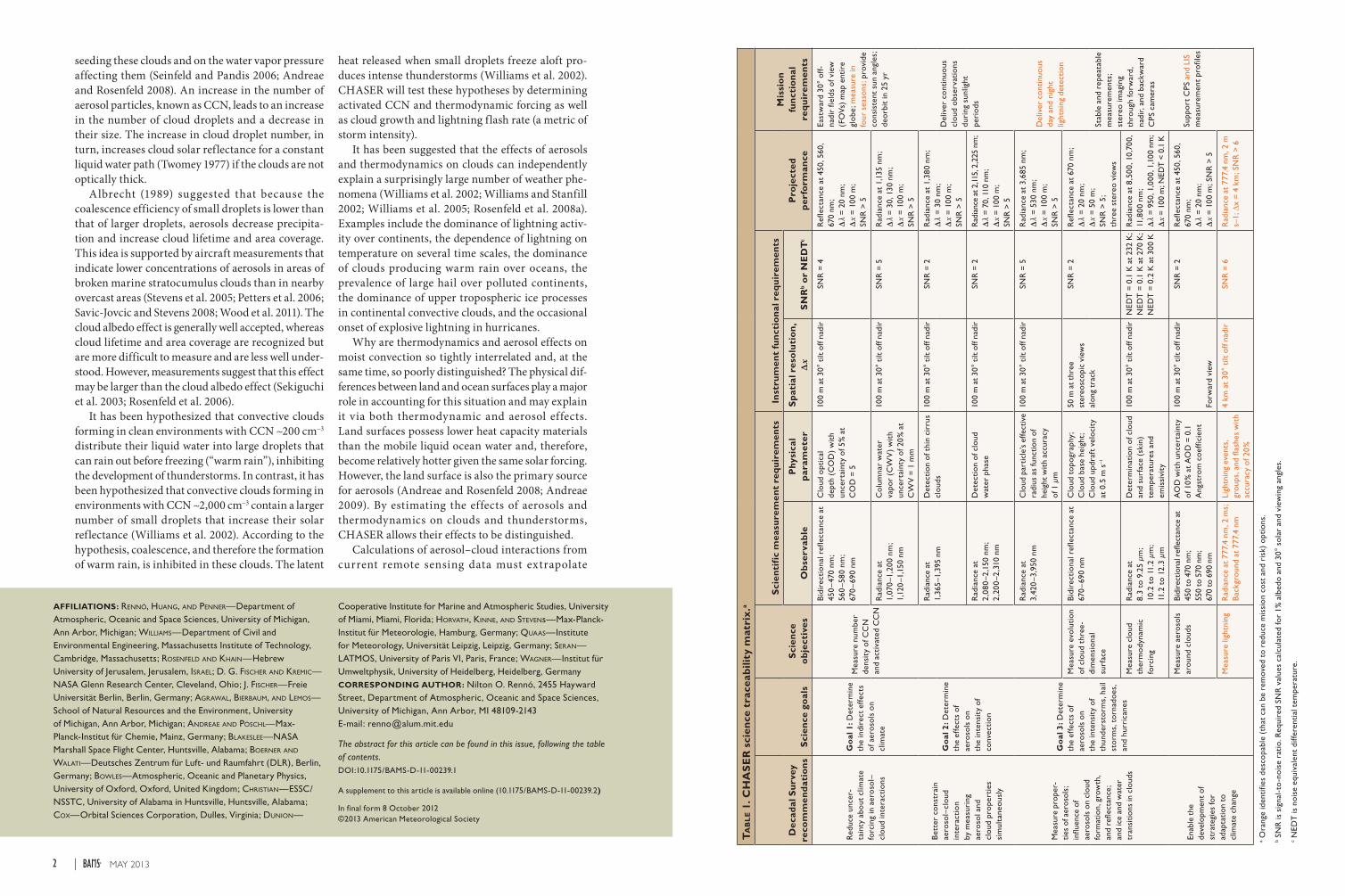
The CHASER satellite mission was developed to remotely sense quantities necessary for determining the interactions of aerosols with clouds and storms. The links between the Decadal Survey recommen-dations and the CHASER goals, science objectives, measurements, and instruments are described in Table 1. Measurements by current satellites allow a rough determination of profiles of cloud particle size
but not of the activated CCN that seed them. CHASER will use an innovative technique (Freud et al. 2011; Freud and Rosenfeld 2012; Rosenfeld et al. 2012) and high-heritage (flown in a previous spaceflight mission) instruments to produce satellite-based remotely sensed observations of activated CCN and the proper-ties of the clouds associated with them. CHASER will estimate updraft velocities at cloud base to calculate the number density of activated CCN as a function of the water vapor supersaturation. CHASER will determine the CCN concentration and cloud ther-modynamic forcing (i.e., forcing caused by changes in the temperature and humidity of the boundary layer air) simultaneously, allowing their effects to be distinguished. Changes in the behavior of a group of weather systems in which only one of the quanti-ties varies (a partial derivative of the intensity of the weather system with respect to the desirable quantity) will allow the determination of each effect statistically.
SCIENTIFIC BACKGROUND. Aerosols play an important role in cloud processes by providing nuclei for the condensation of water vapor into droplets. The nucleation of cloud droplets depends on the composition and size of the aerosol particles
1MAY 2013AMERICAN METEOROLOGICAL SOCIETY |
seeding these clouds and on the water vapor pressure affecting them (Seinfeld and Pandis 2006; Andreae and Rosenfeld 2008). An increase in the number of aerosol particles, known as CCN, leads to an increase in the number of cloud droplets and a decrease in their size. The increase in cloud droplet number, in turn, increases cloud solar reflectance for a constant liquid water path (Twomey 1977) if the clouds are not optically thick.
Albrecht (1989) suggested that because the coalescence efficiency of small droplets is lower than that of larger droplets, aerosols decrease precipita-tion and increase cloud lifetime and area coverage. This idea is supported by aircraft measurements that indicate lower concentrations of aerosols in areas of broken marine stratocumulus clouds than in nearby overcast areas (Stevens et al. 2005; Petters et al. 2006; Savic-Jovcic and Stevens 2008; Wood et al. 2011). The cloud albedo effect is generally well accepted, whereas cloud lifetime and area coverage are recognized but are more difficult to measure and are less well under-stood. However, measurements suggest that this effect may be larger than the cloud albedo effect (Sekiguchi et al. 2003; Rosenfeld et al. 2006).
It has been hypothesized that convective clouds forming in clean environments with CCN ~200 cm−3 distribute their liquid water into large droplets that can rain out before freezing (“warm rain”), inhibiting the development of thunderstorms. In contrast, it has been hypothesized that convective clouds forming in environments with CCN ~2,000 cm−3 contain a larger number of small droplets that increase their solar reflectance (Williams et al. 2002). According to the hypothesis, coalescence, and therefore the formation of warm rain, is inhibited in these clouds. The latent
heat released when small droplets freeze aloft pro-duces intense thunderstorms (Williams et al. 2002). CHASER will test these hypotheses by determining activated CCN and thermodynamic forcing as well as cloud growth and lightning flash rate (a metric of storm intensity).
It has been suggested that the effects of aerosols and thermodynamics on clouds can independently explain a surprisingly large number of weather phe-nomena (Williams et al. 2002; Williams and Stanfill 2002; Williams et al. 2005; Rosenfeld et al. 2008a). Examples include the dominance of lightning activ-ity over continents, the dependence of lightning on temperature on several time scales, the dominance of clouds producing warm rain over oceans, the prevalence of large hail over polluted continents, the dominance of upper tropospheric ice processes in continental convective clouds, and the occasional onset of explosive lightning in hurricanes.
Why are thermodynamics and aerosol effects on moist convection so tightly interrelated and, at the same time, so poorly distinguished? The physical dif-ferences between land and ocean surfaces play a major role in accounting for this situation and may explain it via both thermodynamic and aerosol effects. Land surfaces possess lower heat capacity materials than the mobile liquid ocean water and, therefore, become relatively hotter given the same solar forcing. However, the land surface is also the primary source for aerosols (Andreae and Rosenfeld 2008; Andreae 2009). By estimating the effects of aerosols and thermodynamics on clouds and thunderstorms, CHASER allows their effects to be distinguished.
Calculations of aerosol–cloud interactions from current remote sensing data must extrapolate
AFFILIATIONS: ReNNó, huaNG, aND PeNNeR—Department of Atmospheric, Oceanic and Space Sciences, University of Michigan, Ann Arbor, Michigan; Williams—Department of Civil and Environmental Engineering, Massachusetts Institute of Technology, Cambridge, Massachusetts; RoseNfelD aND KhaiN—Hebrew University of Jerusalem, Jerusalem, isRael; D. G. fischeR aND KRemic—NASA Glenn Research Center, Cleveland, Ohio; J. fischeR—Freie Universität Berlin, Berlin, Germany; aGRaWal, bieRbaum, aND lemos—School of Natural Resources and the Environment, University of Michigan, Ann Arbor, Michigan; aNDReae aND Pöschl—Max-Planck-Institut für Chemie, Mainz, Germany; blaKeslee—NASA Marshall Space Flight Center, Huntsville, Alabama; boeRNeR aND Walati—Deutsches Zentrum für Luft- und Raumfahrt (DLR), Berlin, Germany; boWles—Atmospheric, Oceanic and Planetary Physics, University of Oxford, Oxford, United Kingdom; chRistiaN—ESSC/NSSTC, University of Alabama in Huntsville, Huntsville, Alabama; cox—Orbital Sciences Corporation, Dulles, Virginia; DuNioN—
Ta
bl
e 1
. CH
AS
ER
sci
ence
tra
ceab
ility
mat
rix.
a
Dec
adal
Su
rvey
re
com
men
dat
ion
sS
cien
ce g
oal
sS
cien
ce
ob
ject
ives
Sci
enti
fic
mea
sure
men
t re
qu
irem
ents
Inst
rum
ent
fun
ctio
nal
req
uir
emen
ts
Pro
ject
ed
per
form
ance
Mis
sio
n
fun
ctio
nal
re
qu
irem
ents
Ob
serv
able
Ph
ysic
al
par
amet
erS
pat
ial r
eso
luti
on
, ∆x
SN
Rb o
r N
ED
Tc
Red
uce
unce
r-ta
inty
abo
ut c
limat
e fo
rcin
g in
aer
oso
l–cl
oud
inte
ract
ions
Go
al 1
: Det
erm
ine
the
indi
rect
effe
cts
of a
eros
ols
on
clim
ate
Mea
sure
num
ber
dens
ity
of C
CN
an
d ac
tiva
ted
CC
N
Bid
irec
tio
nal r
efle
ctan
ce a
t 45
0–
470
nm;
560
–580
nm
; 67
0–
690
nm
Clo
ud o
ptic
al
dept
h (C
OD
) w
ith
unce
rtai
nty
of 5
% a
t C
OD
= 5
100
m a
t 30
° ti
lt of
f nad
irSN
R =
4R
efle
ctan
ce a
t 45
0, 5
60,
670
nm;
∆λ
= 2
0 nm
; ∆
x =
100
m;
SNR
> 5
East
war
d 30
° of
f-na
dir
field
s of
vie
w
(FO
Vs)
map
ent
ire
glo
be; m
easu
re in
fo
ur s
easo
ns; p
rovi
de
cons
iste
nt s
un a
ngle
s;
deor
bit
in 2
5 yr
Rad
ianc
e at
1,
070
–1,2
00 n
m;
1,12
0–1
,150
nm
Co
lum
nar
wat
er
vapo
r (C
WV
) w
ith
unce
rtai
nty
of 2
0%
at
CW
V =
1 m
m
100
m a
t 30
° ti
lt of
f nad
irSN
R =
5R
adia
nce
at 1
,135
nm
; ∆
λ =
30,
130
nm
; ∆
x =
100
m;
SNR
> 5
Bet
ter
cons
trai
n ae
roso
l–cl
oud
in
tera
ctio
n by
mea
suri
ng
aero
sol a
nd
clo
ud p
rope
rtie
s si
mul
tane
ous
ly
Go
al 2
: Det
erm
ine
the
effe
cts
of
aero
sols
on
the
inte
nsit
y of
co
nvec
tio
n
Rad
ianc
e at
1,
365–
1,39
5 nm
Det
ecti
on
of t
hin
cirr
us
clo
uds
100
m a
t 30
° ti
lt of
f nad
irSN
R =
2R
adia
nce
at 1
,380
nm
; ∆
λ =
30
nm;
∆x
= 1
00 m
; SN
R >
5
Del
iver
co
ntin
uous
cl
oud
obs
erva
tio
ns
duri
ng s
unlig
ht
peri
ods
Rad
ianc
e at
2,
080
–2,1
50 n
m;
2,20
0–2
,310
nm
Det
ecti
on
of c
loud
w
ater
pha
se10
0 m
at
30°
tilt
off n
adir
SNR
= 2
Rad
ianc
e at
2,11
5, 2
,225
nm
; ∆
λ =
70,
110
nm
; ∆
x =
100
m;
SNR
> 5
Mea
sure
pro
per-
ties
of a
eros
ols;
in
fluen
ce o
f ae
roso
ls o
n cl
oud
form
atio
n, g
row
th,
and
refle
ctan
ce;
and
ice
and
wat
er
tran
siti
ons
in c
loud
s
Go
al 3
: Det
erm
ine
the
effe
cts
of
aero
sols
on
the
inte
nsit
y of
th
unde
rsto
rms,
hai
l st
orm
s, t
orna
does
, an
d hu
rric
anes
Rad
ianc
e at
3,
420
–3,9
50 n
mC
loud
par
ticl
e’s
effe
ctiv
e ra
dius
as
func
tion
of
heig
ht w
ith
accu
racy
of
1 µ
m
100
m a
t 30
° ti
lt of
f nad
irSN
R =
5R
adia
nce
at 3
,685
nm
; ∆
λ =
530
nm
; ∆
x =
100
m;
SNR
> 5
Del
iver
co
ntin
uous
da
y an
d ni
ght
light
ning
det
ecti
on
Mea
sure
evo
luti
on
of c
loud
thr
ee-
dim
ensi
ona
l su
rfac
e
Bid
irec
tio
nal r
efle
ctan
ce a
t 67
0–
690
nmC
loud
to
pogr
aphy
; C
loud
bas
e he
ight
; C
loud
upd
raft
vel
oci
ty
at 0
.5 m
s–1
50 m
at
thre
e st
ereo
scop
ic v
iew
s
alon
g tr
ack
SNR
= 2
Ref
lect
ance
at
670
nm;
∆λ
= 2
0 nm
; ∆
x =
50
m;
SNR
> 5
; th
ree
ster
eo v
iew
s
Stab
le a
nd r
epea
tabl
e m
easu
rem
ents
; st
ereo
imag
ing
thro
ugh
forw
ard,
na
dir,
and
back
war
d C
PS c
amer
as
Mea
sure
clo
ud
ther
mo
dyna
mic
fo
rcin
g
Rad
ianc
e at
8.
3 to
9.2
5 µm
; 10
.2 t
o 11
.2 µ
m;
11.2
to
12.3
µm
Det
erm
inat
ion
of c
loud
an
d su
rfac
e (s
kin)
te
mpe
ratu
res
and
emis
sivi
ty
100
m a
t 30
° ti
lt of
f nad
irN
EDT
= 0
.1 K
at
232
K;
NED
T =
0.1
K a
t 27
0 K
; N
EDT
= 0
.2 K
at
300
K
Rad
ianc
e at
8,5
00, 1
0,70
0,
11,8
00 n
m;
∆λ
= 9
50, 1
,000
, 1,1
00 n
m;
∆x
= 10
0 m
; NED
T <
0.1
K
Enab
le t
he
deve
lopm
ent
of
stra
tegi
es fo
r ad
apta
tion
to
clim
ate
chan
ge
Mea
sure
aer
oso
ls
aro
und
clo
uds
Bid
irec
tiona
l ref
lect
ance
at
45
0 to
470
nm
; 55
0 to
570
nm
; 67
0 to
690
nm
AO
D w
ith
unce
rtai
nty
of 1
0%
at
AO
D =
0.1
A
ngst
rom
co
effic
ient
100
m a
t 30
° ti
lt of
f nad
ir
Forw
ard
view
SNR
= 2
Ref
lect
ance
at
450,
560
, 67
0 nm
; ∆
λ =
20
nm;
∆x
= 1
00 m
; SN
R >
5
Supp
ort
CPS
and
LIS
m
easu
rem
ent
prof
iles
Mea
sure
ligh
tnin
gR
adia
nce
at 7
77.4
nm
, 2 m
s;
Bac
kgro
und
at 7
77.4
nm
Ligh
tnin
g ev
ents
, gr
oup
s, a
nd f
lash
es w
ith
accu
racy
of 2
0%
4 km
at
30°
tilt
off
nadi
rSN
R =
6R
adia
nce
at 7
77.4
nm
, 2 m
s–
1; ∆
x =
4 k
m; S
NR
> 6
a Ora
nge
iden
tifie
s de
sco
pabl
e (t
hat
can
be r
emov
ed t
o re
duce
mis
sio
n co
st a
nd r
isk)
opt
ions
.
b SN
R is
sig
nal-
to-n
oise
rat
io. R
equi
red
SNR
val
ues
calc
ulat
ed fo
r 1%
alb
edo
and
30°
sola
r an
d vi
ewin
g an
gles
.
c NED
T is
noi
se e
quiv
alen
t di
ffere
ntia
l tem
pera
ture
.
Cooperative Institute for Marine and Atmospheric Studies, University of Miami, Miami, Florida; hoRvath, KiNNe, aND steveNs—Max-Planck-Institut für Meteorologie, Hamburg, Germany; Quaas—Institute for Meteorology, Universität Leipzig, Leipzig, Germany; seRaN—LATMOS, University of Paris VI, Paris, France; WaGNeR—Institut für Umweltphysik, University of Heidelberg, Heidelberg, GermanyCORRESPONDING AUTHOR: Nilton O. Rennó, 2455 Hayward Street, Department of Atmospheric, Oceanic and Space Sciences, University of Michigan, Ann Arbor, MI 48109-2143E-mail: [email protected]
The abstract for this article can be found in this issue, following the table of contents.DOI:10.1175/BAMS-D-11-00239.1
A supplement to this article is available online (10.1175/BAMS-D-11-00239.2)
In final form 8 October 2012©2013 American Meteorological Society
3MAY 2013AMERICAN METEOROLOGICAL SOCIETY |2 MAY 2013|

information of cloud droplet effective radius (re) and the cloud droplet number density (Nd) solely at the cloud top where they are measured. The fact that Nd represents an average value that is affected by mix-ing of the cloudy air with its surroundings implies that it is only loosely correlated with the physical entity driving these interactions: the number density of activated CCN, here defined as Na. Moreover, these calculations use empirical statistical relation-ships to relate measurements of aerosol optical depth (AOD) in the cloud-free air near the clouds to Nd and re. These estimates are inaccurate because aerosols are not measured inside clouds; AOD is only weakly correlated with CCN (Andreae 2009), and AOD does not provide information about the verti-cal distribution of aerosols (Costantino and Bréon 2010). These inaccuracies decrease the inferred correlation of aerosol indirect effects with cloud properties and reduce the calculated value of aerosol indirect effects (Penner et al. 2011). CHASER’s study of CCN and cloud microphysics will help shed light on these effects.
Traditionally, CCN are measured either in the laboratory or in the field using cloud chambers where water vapor supersaturation (S) is controlled for the number of activated CCN to be counted as a function of S. CHASER’s study of aerosol–cloud interactions treats clouds as natural chambers in which activated CCN are counted while S is estimated simultaneously. The CHASER measurement technique is based on the fundamental principles described in the sidebar titled “What are the fundamental principles enabling the determination of the activated CCN?”
CHASER GOALS AND OBJECTIVES. CHASER’s science goals are to determine 1) the indirect effects of aerosols on climate, 2) the effects of aerosols on the intensity of convection, and 3) the effects of aerosols on extreme weather events such as hailstorms, tornadoes, and hurricanes. CHASER’s science objectives are to determine (i) the number density of activated CCN, (ii) the three-dimensional evolution of cloud surfaces, (iii) cloud thermodynamic forcing, (iv) aerosols around clouds, and (v) lightning.
CHASER will make the first global survey of Na, the activated CCN spectrum, and the vertical profiles of cloud properties directly affecting climate (Fig. 1). Previous attempts to use satellite measurements to quantify the effects of aerosols on clouds, such as the cloud albedo feedback, rely on estimates of cloud droplet number concentration from measurements of re at the cloud top and of the concentration of aerosols in nearby cloud-free areas (Sekiguchi et al. 2003; Marshak et al. 2008). The uncertainty in these calculations is due largely to a lack of simultaneous measurements of both the CCN concentration near the cloud base and other cloud properties. The limi-tations of previous approaches have been discussed extensively in the literature (Costantino and Bréon 2010; Penner et al. 2011; Marshak et al. 2006b; Quaas et al. 2008; Grandey and Stier 2010; McComiskey and Feingold 2008). CHASER’s innovative technique will overcome these limitations.
RELATIONSHIP TO PAST, CURRENT, AND FUTURE MISSIONS. CHASER will com-plement and transcend current National Aeronautics
and Space Administra-tion (NASA) Earth Sci-ence Missions studying aerosols, clouds, and thun-derstorms. The Clouds and Earth’s Radiant Energy System (CERES) measures s o l a r a n d t h e r m a l radiation to study energy f luxes and cloud radiative effects, but its estimation of radiative f luxes does not include retrievals of aerosols simultaneously to study their effects on these f luxes. Indeed, CER ES relies solely on the angular distribution model to con-vert radiance measure-ment s at a ny v iew i ng zenith angle into broad-ba nd rad iat ive f lu xes . The Moderate Resolution Imaging Spectroradiom-eter (MODIS) retrieves the properties of aerosols and clouds by making the assumption of one-dimensional plane parallel radiative transfer. Important three-dimensional effects such as the bluing of aerosols (Marshak et al. 2008; McComiskey and Feingold 2008) and biases in the retrieval of cloud droplet size (Lohmann et al. 2007; Zhang and Platnick 2011) are not accounted for. Moreover, these one-dimensional measurements can retrieve physical quantities only at the cloud top. The Multiangle Imaging SpectroRadiometer (MISR) uses multiangle, multispectral measurements to cal-culate aerosol optical depth, but it does not retrieve the microphysical properties of convective clouds. The Cloud–Aerosol Lidar and Infrared Pathfinder Satellite Observations (CALIPSO) provides informa-tion about aerosols as well as optically thin clouds, but it does not provide information on cloud particle sizes and concentrations. CloudSat measures the vertical structure of a cloud along a narrow swath (approximately 1 km) across the satellite track, but it does not measure aerosols.
Measurements by current instruments do not provide the aerosol properties required to develop reliable estimates of their CCN supersaturation activation spectrum. However, measurements of AOD by MODIS, for example, can be used to complement CHASER rough estimates of CCN
abundances (Andreae 2009). Further development of these capabilities could substantially improve global estimates of CCN abundances. None of the current satellites meet the requirements for estimating Na and the CCN spectrum. CHASER meets the requirements for the Decadal Survey recommendations for space-based measurements of aerosol–cloud interaction in the decade 2010–20.
MEASUREMENT CONCEPT. The concept of using remote sensing to determine vertical profiles of cloud microphysics was proposed by Rosenfeld and Lensky (1998) and later refined by others (Rosenfeld 1999; Ramanathan et al. 2001; Rudich et al. 2002; Williams et al. 2002; Rosenfeld et al. 2008c). Cloud profiling by aircraft validated the concept (Andreae et al. 2004; Rosenfeld et al. 2008). Subsequently, Marshak et al. (2006a) and Martins et al. (2007) showed that high-resolution cloud profilers could retrieve re and phase as a function of height, and they proposed an instrument to do it. Zinner et al. (2008) demonstrated the feasibility of this concept for cloud profilers with a resolution of 250 m.
Brenguier et al. (2000) developed the idea of using vertical profiles of re to calculate the value of Na at the base of shallow cumulus clouds. Freud et al. (2011)
HOW WILL CHASER HELP POLICY MAKERS?
Research has shown that the perception of a high level of uncertainty in climate predictions is one of the main
reasons why their use in decision making has lagged (Lemos and Rood 2010). It has also been suggested that the usability of climate knowledge can be enhanced through interaction between data producers and data users. This interaction improves the perception of knowledge fit (e.g., through visualization and customization) and enhances accessibil-ity by improving understanding (Kirchhoff 2010). CHASER will mitigate this problem by establishing a data application center for conducting science policy research focused on understanding the best ways to use, transfer, and commu-nicate mission data to decision makers. The CHASER Data Application Center will support the visions of the National Research Council and the Decadal Survey for an integrated program of observations from space that secures practi-cal benefits for humankind by developing data products for assessing risks due to severe weather and climate change.
The CHASER team will engage with stakeholders such as climate modelers, social scientists, and deci-sion makers to increase the usability of mission data. The CHASER team will survey what data products are needed and how to manage and disseminate them to better meet this need. For example, the team will leverage resources (especially human and network) with organizations involved with climate information dissemination and brokering such as NOAA’s Regional Integrated Sciences and Assessments (RISA) program (Lemos and Morehouse 2005). For close to 20 years, these programs have brokered climate knowledge between producers and users. CHASER will document potential uses of CHASER data by decision makers in responding to the impact of climate changes—such as hurricanes and flooding—and to foster networks of users that can enhance the usability of CHASER-generated data.
Fig. 1. CHASER will determine vertical profiles of cloud parameters and light-ning flashes pointing 30° off track toward sun-illuminated cloud surfaces, which minimizes shadowing. Each MAI pixel is 50 m 50 m, each MSI pixel is 100 m × 100 m, and the swath width is 102.4 km. The MAI pixels are represented by the blue overlays in the cloud images 50 s apart at t1 and t2.
5MAY 2013AMERICAN METEOROLOGICAL SOCIETY |4 MAY 2013|
and Rosenfeld et al. (2012) generalized the idea to deeper clouds. They demonstrated that measure-ments of Na and updraft velocities could be used to calculate the CCN concentration in the boundary layer air feeding these clouds.
Rosenfeld et al. (2012) showed that the calculation of Na requires images with resolution of about 100 m to probe cloud protuberances. Images of lower reso-lution cannot resolve individual convective updrafts close to the cloud base with the required accuracy of
about 0.5 m s–1, and further increases in resolution do not improve the results be-cause three-dimensional ef-fects predominate (Rosen-feld et al. 2004). Table 1 and Fig. 2 indicate that CHASER meets these mea-surement requirements.
CHASER wil l deter-mine vertical profiles of cloud parameters at 1400 local solar time by probing the sun-illuminated sur-faces of convective clouds. The orbit and v iewing geometry were chosen to provide global coverage while maximizing image resolution and minimizing shadowing.
C H A S E R w i l l u s e a h igh-her itage Cloud
Profiler Suite (CPS) consisting of two instruments pointing 30° off nadir across track toward sun-illuminated surfaces on the east. The Multispectral Imager (MSI) consists of several spectrally diverse imagers with 100-m resolution to probe activated CCN and determine the properties of clouds and their environment. The Multiangle Imager (MAI) consists of three visible imagers with 50-m resolution pointing forward, downward, and backward along the track as well as 30° off nadir across track. Cloud properties and the evolution of cloud protuberances will be determined from MAI stereo images taken at times t1, t2, and t3—each approximately 50 s apart (Fig. 1). The MAI and the MSI are high-heritage instruments based on Deutsches Zentrum für Luft- und Raumfahrt (DLR)’s Bispectral Infrared Detection (BIRD), Technology Experiment Carrier-1 (TET-1), Berlin Infrared Optical System (BIROS), and Envi-ronmental Mapping and Analysis Program (EnMAP). CHASER will also detect lightning with a high-heritage Lightning Imaging Sensor (LIS) (Buechler
et al. 2011). The design and characteristics of MSI, MAI, and LIS are described in the supplementary material archived online (http://dx.doi.org/10.1175/BAMS-D-11-00239.2).
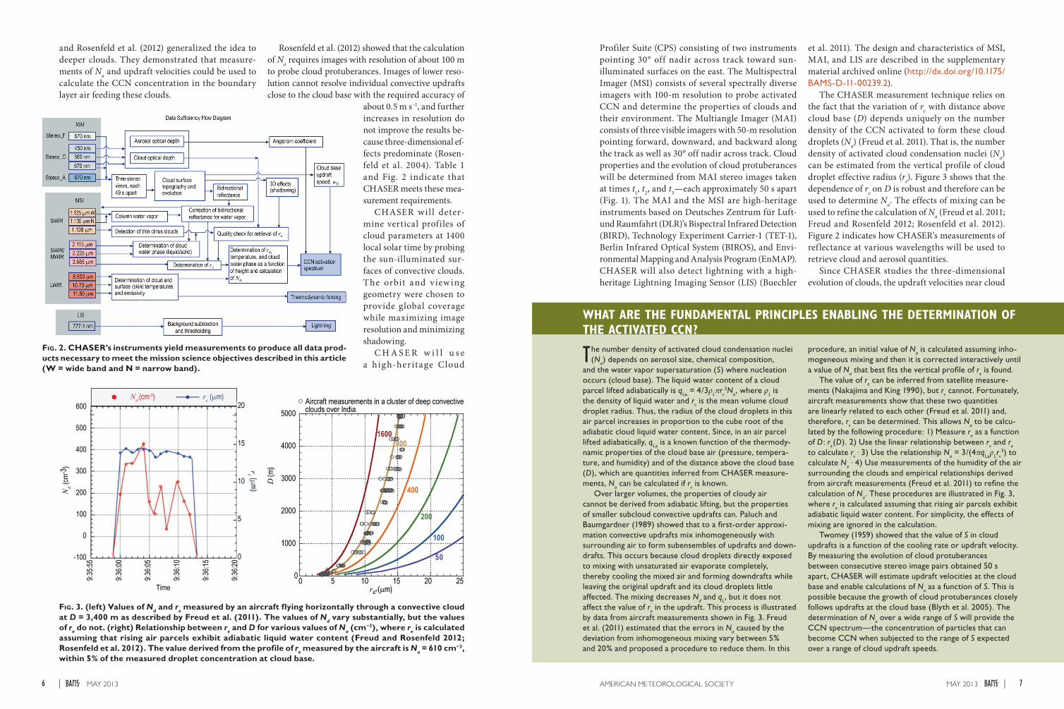
The CHASER measurement technique relies on the fact that the variation of re with distance above cloud base (D) depends uniquely on the number density of the CCN activated to form these cloud droplets (Na) (Freud et al. 2011). That is, the number density of activated cloud condensation nuclei (Na) can be estimated from the vertical profile of cloud droplet effective radius (re). Figure 3 shows that the dependence of re on D is robust and therefore can be used to determine Na. The effects of mixing can be used to refine the calculation of Na (Freud et al. 2011; Freud and Rosenfeld 2012; Rosenfeld et al. 2012). Figure 2 indicates how CHASER’s measurements of ref lectance at various wavelengths will be used to retrieve cloud and aerosol quantities.
Since CHASER studies the three-dimensional evolution of clouds, the updraft velocities near cloud
Fig. 2. CHASER’s instruments yield measurements to produce all data prod-ucts necessary to meet the mission science objectives described in this article (W = wide band and N = narrow band).
Fig. 3. (left) Values of Nd and re measured by an aircraft flying horizontally through a convective cloud at D = 3,400 m as described by Freud et al. (2011). The values of Nd vary substantially, but the values of re do not. (right) Relationship between re and D for various values of Na (cm−3), where re is calculated assuming that rising air parcels exhibit adiabatic liquid water content (Freud and Rosenfeld 2012; Rosenfeld et al. 2012). The value derived from the profile of re measured by the aircraft is Na = 610 cm−3, within 5% of the measured droplet concentration at cloud base.
WHAT ARE THE FUNDAMENTAL PRINCIPLES ENABLING THE DETERMINATION OF THE ACTIVATED CCN?
The number density of activated cloud condensation nuclei (N
a) depends on aerosol size, chemical composition,
and the water vapor supersaturation (S) where nucleation occurs (cloud base). The liquid water content of a cloud parcel lifted adiabatically is q
La = 4/3ρ
Lπrν
3Na, where ρ
L is
the density of liquid water and rν is the mean volume cloud droplet radius. Thus, the radius of the cloud droplets in this air parcel increases in proportion to the cube root of the adiabatic cloud liquid water content. Since, in an air parcel lifted adiabatically, q
La is a known function of the thermody-
namic properties of the cloud base air (pressure, tempera-ture, and humidity) and of the distance above the cloud base (D), which are quantities inferred from CHASER measure-ments, N
a can be calculated if rν is known.
Over larger volumes, the properties of cloudy air cannot be derived from adiabatic lifting, but the properties of smaller subcloud convective updrafts can. Paluch and Baumgardner (1989) showed that to a first-order approxi-mation convective updrafts mix inhomogeneously with surrounding air to form subensembles of updrafts and down-drafts. This occurs because cloud droplets directly exposed to mixing with unsaturated air evaporate completely, thereby cooling the mixed air and forming downdrafts while leaving the original updraft and its cloud droplets little affected. The mixing decreases N
d and q
L, but it does not
affect the value of re in the updraft. This process is illustrated
by data from aircraft measurements shown in Fig. 3. Freud et al. (2011) estimated that the errors in N
a caused by the
deviation from inhomogeneous mixing vary between 5% and 20% and proposed a procedure to reduce them. In this
procedure, an initial value of Na is calculated assuming inho-
mogeneous mixing and then it is corrected interactively until a value of N
a that best fits the vertical profile of r
e is found.
The value of re can be inferred from satellite measure-
ments (Nakajima and King 1990), but rν cannot. Fortunately, aircraft measurements show that these two quantities are linearly related to each other (Freud et al. 2011) and, therefore, r
v can be determined. This allows N
a to be calcu-
lated by the following procedure: 1) Measure re as a function
of D: re(D). 2) Use the linear relationship between r
v and r
e
to calculate rν . 3) Use the relationship Na = 3/(4πq
Laρ
Lrν
3) to calculate N
a . 4) Use measurements of the humidity of the air
surrounding the clouds and empirical relationships derived from aircraft measurements (Freud et al. 2011) to refine the calculation of N
a. These procedures are illustrated in Fig. 3,
where re is calculated assuming that rising air parcels exhibit
adiabatic liquid water content. For simplicity, the effects of mixing are ignored in the calculation.
Twomey (1959) showed that the value of S in cloud updrafts is a function of the cooling rate or updraft velocity. By measuring the evolution of cloud protuberances between consecutive stereo image pairs obtained 50 s apart, CHASER will estimate updraft velocities at the cloud base and enable calculations of N
a as a function of S. This is
possible because the growth of cloud protuberances closely follows updrafts at the cloud base (Blyth et al. 2005). The determination of N
a over a wide range of S will provide the
CCN spectrum—the concentration of particles that can become CCN when subjected to the range of S expected over a range of cloud updraft speeds.
7MAY 2013AMERICAN METEOROLOGICAL SOCIETY |6 MAY 2013|

base can be calculated and used to estimate the value of S. This is possible because S is a function of the cooling rate and, therefore, of the updraft velocity (Twomey 1959). Calculations of S and Na in convec-tive updrafts of different intensities make possible the determination of the concentration of activated CCN as a function of S. This important quantity is referred to in the cloud physics literature as the CCN spectrum.
CONCLUDING REMARKS. In order to achieve its top science goals, CHASER will make global surveys of activated CCN simultaneously with the determination of the properties of the clouds affected by them. This requires measurements of the vertical profiles of the ref lectance and the microphysical properties of incipient convective clouds (e.g., Freud et al. 2011; Rosenfeld et al. 2012). CHASER’s sun-synchronous orbit (SSO) timed to early afternoon and its eastward viewing geometry were chosen to satisfy these requirements. If selected for funding, CHASER will reduce the uncertainty in our knowledge of the
interaction of aerosols with clouds and precipitation by making global surveys capable of distinguishing the effects of aerosols from those of thermodynamics in clouds and storms.
ACKNOWLEDGMENTS. We thank NASA Glenn Research Center, the University of Michigan, the Deutsches Zentrum für Luft- und Raumfahrt (DLR), the Israeli Space Agency, and Orbital Sciences Corporation for supporting the development of the CHASER mission concept. Many engineers, managers, and technical staff played key roles on the development of the CHASER mission concept. N. Rennó was partially supported by NSF Award AGS 1118467.
REFERENCESAlbrecht, B. A., 1989: Aerosols, cloud microphysics,
and fractional cloudiness. Science, 245, 1227–1230, doi:10.1126/science.245.4923.1227.
Andreae, M. O., 2009: Correlation between cloud con-densation nuclei concentration and aerosol optical thickness in remote and polluted regions. Atmos. Chem. Phys., 9, 543–556.
—, and D. Rosenfeld, 2008: Aerosol–cloud–precipi-tation interactions. Part 1. The nature and sources of cloud-active aerosols. Earth-Sci. Rev., 89, 13–41.
—, —, P. Artaxo, A. A. Costa, G. P. Frank, K. M. Longo, and M. A. F. Silva-Dias, 2004: Smoking rain clouds over the Amazon. Science, 303, 1337–1342.
Blyth, A. M., S. G. Lasher-Trapp, and W. A. Cooper, 2005: A study of thermals in cumulus clouds. Quart. J. Roy. Meteor. Soc., 131, 1171–1190, doi:10.1256/qj.03.180.
Brenguier, J.-L., H. Pawlowska, L. Schüller, R. Preusker, J. Fischer, and Y. Fouquart, 2000: Radiative prop-erties of boundary layer clouds: Droplet effective radius versus number concentration. J. Atmos. Sci., 57, 803–821.
Buechler, D. E., H. J. Christian, W. J. Koshak, and S. J. Goodman, 2011: Assessing the lifetime performance of the Lightning Imaging Sensor (LIS): Implications for the Geostationary Lightning Mapper (GLM). Proc. XIV Int. Conf. on Atmospheric Electricity, Rio de Janeiro, Brazil, International Commission on Atmospheric Electricity.
Costantino, L., and F. M. Bréon, 2010: Analysis of aerosol-cloud interaction from multi-sensor satel-lite observations. Geophys. Res. Lett., 37, L11801, doi:10.1029/2009GL041828.
Freud, E., and D. Rosenfeld, 2012: Linear relation be-tween convective cloud drop number concentration and depth for rain initiation. J. Geophys. Res., 117, D02207, doi:10.1029/2011JD016457.
—, —, and J. R. Kulkarni, 2011: Resolving both entrainment-mixing and number of activated CCN in deep convective clouds. Atmos. Chem. Phys., 11, 12 887–12 900, doi:10.5194/acp-11-12887-2011.
Grandey, B. S., and P. Stier, 2010: A critical look at spa-tial scale choices in satellite-based aerosol indirect effect studies. Atmos. Chem. Phys., 10, 11 459–11 470, doi:10.5194/acp-10-11459-2010.
Jefferson, A., 2011: Aerosol observing system (AOS) handbook. U.S. Department of Energy, Office of Science Tech. Rep. DOE/SC-ARM/TR-014, 32 pp.
Kirchhoff, C. J., 2010: Integrating science and policy: Climate change assessments and water resources management. Ph.D. dissertation, University of Michigan, 293 pp.
Lemos, M. C., and B. J. Morehouse, 2005: The co-pro-duction of science and policy in integrated climate assessments. Global Environ. Change, 15, 57–68.
—, and R. B. Rood, 2010: Climate projections and their impact on policy and practice. Wiley Interdiscip. Rev.: Climate Change, 1, 670–682.
Lohmann, U., J. Quaas, S. Kinne, and J. Feichter, 2007: Different approaches for constraining global climate models of the anthropogenic indirect aerosol effect. Bull. Amer. Meteor. Soc., 88, 243–249.
Marshak, A., J. V. Martins, V. Zubko, and Y. J. Kaufman, 2006a: What does reflection from cloud sides tell us about vertical distribution of cloud droplet sizes. Atmos. Chem. Phys., 6, 5295–5305.
—, S. Platnick, T. Várnai, G. Wen, and R. F. Cahalan, 2006b: Impact of three-dimensional radiative effects on satellite retrievals of cloud droplet sizes. J. Geophys. Res., 111, D09207, doi:10.1029/2005JD006686.
—, G. Y. Wen, J. A. Coakley Jr., L. A. Remer, N. G. Loeb, and R. F. Cahalan, 2008: A simple model for the cloud adjacency effect and the apparent bluing of aerosols near clouds. J. Geophys. Res., 113, D14S17, doi:10.1029/2007JD009196.
Martins, J. V., and Coauthors, 2007: Remote sensing the vertical profile of cloud droplet effective radius, thermodynamic phase, and temperature. Atmos. Chem. Phys. Discuss., 7, 4481–4519.
McComiskey, A., and G. Feingold, 2008: Quantifying error in the radiative forcing of the first aerosol indirect effect. Geophys. Res. Lett., 35, L02810, doi:10.1029/2007GL032667.
Nakajima, T., and M. D. King, 1990: Determination of the optical thickness and effective particle radius of clouds from reflected solar radiation measurements. Part I: Theory. J. Atmos. Sci., 47, 1878–1893.
NRC, 2007: Earth Science and Applications from Space: National Imperatives for the Next Decade and Beyond. National Academies Press, 456 pp.
Paluch, I. R., and D. Baumgardner, 1989: Entrainment and fine scale mixing in a continental convective cloud. J. Atmos. Sci., 46, 261–278.
Penner, J. E., L. Xu, and M. Wang, 2011: Satellite meth-ods underestimate indirect climate forcing by aero-sols. Proc. Natl. Acad. Sci. USA, 108, 13 404–13 408, doi:10.1073/pnas.1018526108.
Petters, M. D., J. R. Snider, B. Stevens, G. Vali, I. Faloona, and L. M. Russell, 2006: Accumulation mode aerosol, pockets of open cells, and particle nucleation in the remote subtropical Pacific marine boundary layer. J. Geophys. Res., 111, D02206, doi:10.1029/2004JD005694.
Quaas, J., O. Boucher, N. Bellouin, and S. Kinne, 2008: Satellite-based estimate of the direct and indirect aerosol climate forcing. J. Geophys. Res., 113, D05204, doi:10.1029/2007JD008962.
Ramanathan, V., P. J. Crutzen, J. T. Kiehl, and D. Rosenfeld, 2001: Aerosols, climate and the hydrologi-cal cycle. Science, 294, 2119–2124.
Rosenfeld, D., 1999: TRMM observed first direct evi-dence of smoke from forest fires inhibiting rainfall. Geophys. Res. Lett., 26, 3105–3108.
—, and I. M. Lensky, 1998: Satellite-based insights into precipitation formation processes in continental and maritime convective clouds. Bull. Amer. Meteor. Soc., 79, 2457–2476.
—, E. Cattani, S. Melani, and V. Levizzani, 2004: Considerations on daylight operation of 1.6- versus 3.7-μm channel on NOAA and METOP satellites. Bull. Amer. Meteor. Soc., 85, 873–881.
—, Y. Kaufman, and I. Koren, 2006: Switching cloud cover and dynamical regimes from open to closed Benard cells in response to aerosols suppressing precipitation. Atmos. Chem. Phys., 6, 2503–2511.
—, U. Lohmann, G. B. Raga, C. D. O’Dowd, M. Kulmata, A. Reissell, and M. O. Andreae, 2008a: Flood or drought: How do aerosols affect precipita-tion? Science, 321, 1309–1313.
—, W. L. Woodley, D. Axisa, E. Freud, J. G. Hudson, and A. Givati, 2008b: Aircraft measurements of the impacts of pollution aerosols on clouds and precipi-tation over the Sierra Nevada. J. Geophys. Res., 113, D15203, doi:10.1029/2007JD009544.
—, —, A. Lerner, G. Kelman, and D. T. Lindsey, 2008c: Satellite detection of severe convective storms by their retrieved vertical prof i les of cloud particle effective radius and thermody-namic phase. J. Geophys. Res., 113, D04208, doi:10.1029/2007JD008600.
Rosenfeld D., E.Williams, M. O. Andreae, E. Freud1, U. Pöschl, and N. O. Rennó, 2012: The scien-tific basis for a satellite mission to retrieve CCN
An airborne instrument will be developed to test the CHASER measurement technique and retrieval
algorithms. Airborne in situ aerosol and cloud measurements will be used to evaluate the accuracy of the vertical profiles measured using the CHASER remote sensing technique. The U.S. Department of Energy (DOE) Atmospheric Radiation Measurement (ARM) sites in the Southern Great Plains (Oklahoma), the tropical western Pacific (with stations on the Nauru and Manus Islands and in Darwin, Australia—farther west), and on the North Slope of Alaska (Jefferson 2011) will also be used to validate the CHASER measurements. The ARM sites are located in regions covering the typical aerosol concentrations from clean maritime to polluted continental environments. The CHASER team will propose to fly its airborne instrument over all ARM sites. Comparisons of N
a between airborne and ground-
based sensors will be conducted while clouds develop in the vicinity of ground stations and, therefore, ingest boundary layer air that is being sampled simultaneously by the CHASER airborne instrument and in situ measure-ments of aerosols at the surface.
The ARM CCN measurements cover CCN concentrations over a range of supersaturation from <0.1% to >1% (Jefferson 2011), which is similar to the CHASER measurement range. The Southern Great Plains site has complementary information on aerosol size, composition, and relative humidity that can be used to predict the CCN.
TESTING THE CHASER MEASUREMENT TECHNIQUE THROUGH AIRBORNE AND GROUND MEASUREMENTS
9MAY 2013AMERICAN METEOROLOGICAL SOCIETY |8 MAY 2013|

concentrations and their impacts on convec-tive clouds. Atmos. Meas. Tech., 5, 2039–2055, doi:10.5194/amt-5-2039-2012.
Rudich, Y., D. Rosenfeld, and O. Khersonsky, 2002: Treating clouds with a grain of salt. Geophys. Res. Lett., 29, 2060, doi:10.1029/2002GL016055.
Savic-Jovcic, V., and B. Stevens, 2008: The struc-ture and mesoscale organization of precipitating stratocumulus. J. Atmos. Sci., 65, 1587–1605.
Seinfeld, J. H., and S. N. Pandis, 2006: Atmospheric Chemistry and Physics: From Air Pollution to Climate Change. 2nd ed. Wiley, 1203 pp.
Sekiguchi, M., T. Nakajima, K. Suzuki, K. Kawamoto, A. Higurashi, D. Rosenfeld, I. Sano, and S. Mukai, 2003: A study of the direct and indirect effects of aerosols using global satellite data sets of aerosol and cloud parameters. J. Geophys. Res., 108, 4699, doi:10.1029/2002JD003359.
Stevens, B., G. Vali, K. Comstock, R. Wood, M. VanZanten, P. H. Austin, C. S. Bretherton, and D. H. Lenschow, 2005: Pockets of open cells (POCs) and drizzle in marine stratocumulus. Bull. Amer. Meteor. Soc., 86, 51–57.
Twomey, S., 1959: The nuclei of natural cloud forma-tion: The supersaturation in natural clouds and the variation of cloud drops concentrations. Geofis. Pura. Appl., 43, 243–249.
—, 1977: The influence of pollution on the short wave albedo of clouds. J. Atmos. Sci., 34, 1149–1152.
Williams, E., and S. Stanfill, 2002: The physical origin of the land–ocean contrast in lightning activity. C. R. Phys., 3, 1277–1292.
—, and Coauthors, 2002: Contrasting convec-tive regimes over the Amazon: Implications for cloud electrification. J. Geophys. Res., 107, 8082, doi:10.1029/2001JD000380.
—, V. C. Mushtak, D. Rosenfeld, S. J. Goodman, and D. J. Boccippio, 2005: Thermodynamic conditions favorable to superlative thunderstorm updraft, mixed phase microphysics and lightning flash rate. Atmos. Res., 76, 288–306.
Wood, R., and Coauthors, 2011: The VAMOS Ocean-Cloud-Atmosphere-Land Study Regional Experi-ment (VOCALS-REx): Goals, platforms, and field operations. Atmos. Chem. Phys., 11, 627–654.
Zhang, Z., and S. Platnick, 2011: An assessment of differences between cloud effective particle radius retrievals for marine water clouds from three MODIS spectral bands. J. Geophys. Res., 116, D20215, doi:10.1029/2011JD016216.
Zinner, T., A. Marshak, S. Lang, J. V. Martins, and B. Mayer, 2008: Remote sensing of cloud sides of deep convection: Towards a three-dimensional retrieval of cloud particle size profiles. Atmos. Chem. Phys., 8, 4741–4757.
ABSTRACT
The formation of cloud droplets on aerosol particles, technically known as the activation
of cloud condensation nuclei (CCN), is the fundamental process driving the interactions of
aerosols with clouds and precipitation. The Intergovernmental Panel on Climate Change
(IPCC) and the Decadal Survey indicate that the uncertainty in how clouds adjust to aerosol
perturbations dominates the uncertainty in the overall quantification of the radiative forcing
attributable to human activities.
Measurements by current satellites allow the determination of crude profiles of cloud par-
ticle size, but not of the activated CCN that seed them. The Clouds, Hazards, and Aerosols
Survey for Earth Researchers (CHASER) mission concept responds to the IPCC and Decadal
Survey concerns, utilizing a new technique and high-heritage instruments to measure all
the quantities necessary to produce the first global survey maps of activated CCN and the
properties of the clouds associated with them. CHASER also determines the activated CCN
concentration and cloud thermodynamic forcing simultaneously, allowing the effects of each
to be distinguished.
11MAY 2013AMERICAN METEOROLOGICAL SOCIETY |10 MAY 2013|

U P P L E M E N T
This document is a supplement to “CHASER: An Innovative Satellite Mission Concept to Measure the Effects of Aerosols on Clouds and Climate,” by Nilton O. Rennó, Earle Williams, Daniel Rosenfeld, David G. Fischer, Jürgen Fischer, Tibor Kremic, Arun Agrawal, Meinrat O. Andreae, Rosina Bierbaum, Richard Blakeslee, Anko Boerner, Neil Bowles, Hugh Christian, Ann Cox, Jason Dunion, Akos Horvath, Xianglei Huang, Alexander Khain, Stefan Kinne, Maria C. Lemos, Joyce E. Penner, Ulrich Pöschl, Johannes Quaas, Elena Seran, Bjorn Stevens, Thomas Walati, and Thomas Wagner (Bull. Amer. Meteor. Soc., 93, xxx–xxx) • ©2013 American Meteorological Society • Corresponding author: Nilton O. Rennó, Department of Atmospheric, Oceanic and Space Sciences, University of Michigan, Ann Arbor, MI 48109-2143 • E-mail: [email protected] • DOI:10.1175/BAMS-D-11-00239.2
CHASERAn Innovative Satellite Mission Concept to Measure the
Effects of Aerosols on Clouds and Climate
by NiltoN o. ReNNó, eaRle Williams, DaNiel RoseNfelD, DaviD G. fischeR, JüRGeN fischeR, tiboR KRemic, aRuN aGRaWal, meiNRat o. aNDReae, RosiNa bieRbaum, RichaRD blaKeslee, aNKo boeRNeR, Neil boWles,
huGh chRistiaN, aNN cox, JasoN DuNioN, aKos hoRvath, xiaNGlei huaNG, alexaNDeR KhaiN, stefaN KiNNe, maRia c. lemos, Joyce e. PeNNeR, ulRich Pöschl, JohaNNes Quaas, eleNa seRaN,
bJoRN steveNs, thomas Walati, aND thomas WaGNeR
I NSTRUMENTATION. The Clouds, Hazards, and Aerosols Survey for Earth Researchers (CHASER) team selected high-heritage, low-
risk instruments capable of satisfying the mission science requirements while minimizing risks to cost and schedule. These instruments are the Multiangle Imager (MAI), the Multispectral Imager (MSI), and the Lightning Imaging Sensor (LIS). The MAI and the MSI together compose the Cloud Profiler Suite (CPS), which will be a contribution from Deutsches Zentrum für Luft- und Raumfahrt (DLR). The CPS is at technology readiness level 6 (TRL 6), and the LIS is at TRL 8. Figure S1 illustrates the position and orientation of the instrument payloads (P/Ls) on the spacecraft (S/C), as well as their respective field of views (FOVs).
CHASER meets its science goals employing only high-heritage, passive optical remote sensing instruments.
Fig. S1. The CHASER spacecraft uses high-heritage components, resulting in a low-risk mission.
1MAY 2013AMERICAN METEOROLOGICAL SOCIETY |

The MAI, MSI, and LIS meet the CHASER sci-entific requirements described in the traceability matrix (Table 1). As indicated by the projected per-formances listed in the traceability matrix, these three instruments exceed the CHASER mission functional requirements.
CLOUD PROFILER SUITE. The CPS contains the MAI (Fig. S2), the MSI (Fig. S3), and a payload control unit (PCU). The PCU is the interface between the S/C and the instruments; it provides power and clocking to the two instruments, as well as bidirec-tional communication and data transmission.
MULTIANGLE IMAGER. The MAI consists of three cameras, labeled stereo_F (forward), stereo_C (center), and stereo_A (aft). These cameras are used to capture stereo images, determine cloud geometry and evolution, and measure aerosol optical depth (AOD). They are identical in form, but differ in function. The center camera points 30° off nadir eastward. The other two cameras point 30° off nadir across track (eastward) and ±30° off nadir along track to achieve a stereo geometry with the sun at the back as illustrated in Fig.1 in the main text. Each camera has a spectral channel at 670 nm (red) for stereo imaging. In addition, the center camera has spectral channels at 450 nm (blue) and 560 nm (green) for aerosol retrieval. The FOV of each camera is 50 m by 102.4 km, with a spatial resolution of 50 m.
The MAI was chosen to satisfy the CHASER requirement of measuring cloud ref lectance and sampling cloud elements with sufficient reso-lution (50 m) to study their evolution and determine updraft speeds, as described in the main text.
MULTISPECTRAL IMAGER. The MSI consists of three cameras, labeled shortwave infrared (IR) (S W I R ) , S W I R /m i d w a v e I R (MWIR), and longwave IR (LWIR). These cameras are used to study cloud microphysics and thermody-namic forcing. Each camera points 30° off nadir eastward and contains three spectral channels. The SWIR camera has two spectral channels at
1.135 μm, one wideband and one narrowband, and one spectral channel at 1.380 μm. The SWIR/MWIR camera has spectral channels at 2.115, 2.225, and 3.685 μm. The LWIR camera has spectral channels at 8.50, 10.7, and 11.8 μm. The FOV of each camera is 100 m by 102.4 km, with a spatial resolution of 100 m.
The MSI was chosen to satisfy the CHASER requirements of determining the vertical profiles of cloud microphysical quantities with sufficient reso-lution to retrieve activated CCN and to measure the cloud thermodynamic environment, as described in the main text.
LIGHTNING IMAGING SENSOR. The LIS is a high-heritage, compact, solid-state optical imager that detects lightning from low-Earth orbit (LEO) with high detection efficiency and location accuracy. The LIS marks the lightning time of the occurrence, and it measures the radiant energy. Its major elements are an imaging system, a focal plane assembly, a real-time signal processor and background remover, an event processor and formatter, a power supply, and
Fig. S2. MAI. (top) Instrument concept. (bottom) Top-level architec-ture for its cameras. ADC is analog-to-digital converter.
Fig. S3. MSI. (top) Instrument concept. (bottom) Top-level architecture for its cameras.
interface electronics. The LIS has an FOV of 1,024 × 1,024 km2.
The LIS was chosen to satisfy the CHASER requirements of measuring lightning to quantify thunderstorm intensity, as described in the main text.
Fig. S4. LIS Functional block diagram. CCD is charge-coupled device.
Au: please in-sert a callout in text for Fig. S4
3MAY 2013AMERICAN METEOROLOGICAL SOCIETY |2 MAY 2013|