Characterizing the rural landscape during the Iron Age and Roman period (ca. 1200 B.C. – A.D....
16
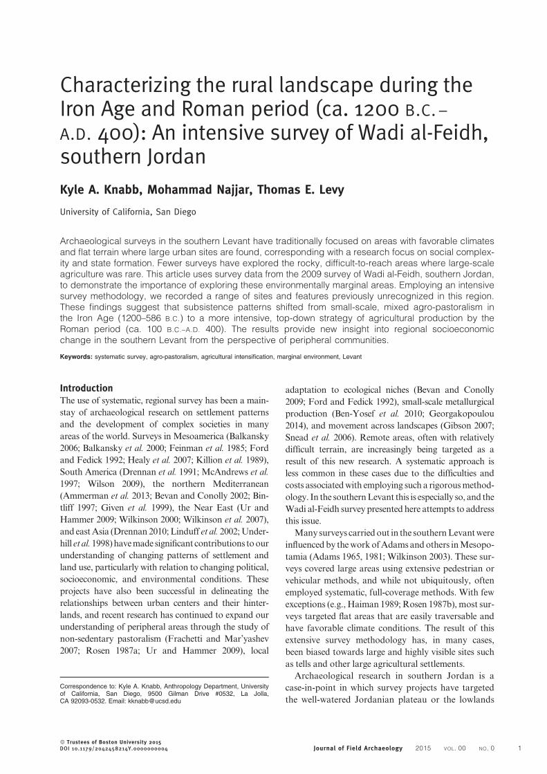
Characterizing the rural landscape during the Iron Age and Roman period (ca. 1200 B.C.– A.D. 400): An intensive survey of Wadi al-Feidh, southern Jordan Kyle A. Knabb, Mohammad Najjar, Thomas E. Levy University of California, San Diego Archaeological surveys in the southern Levant have traditionally focused on areas with favorable climates and flat terrain where large urban sites are found, corresponding with a research focus on social complex- ity and state formation. Fewer surveys have explored the rocky, difficult-to-reach areas where large-scale agriculture was rare. This article uses survey data from the 2009 survey of Wadi al-Feidh, southern Jordan, to demonstrate the importance of exploring these environmentally marginal areas. Employing an intensive survey methodology, we recorded a range of sites and features previously unrecognized in this region. These findings suggest that subsistence patterns shifted from small-scale, mixed agro-pastoralism in the Iron Age (1200–586 B.C. ) to a more intensive, top-down strategy of agricultural production by the Roman period (ca. 100 B.C.–A.D. 400). The results provide new insight into regional socioeconomic change in the southern Levant from the perspective of peripheral communities. Keywords: systematic survey, agro-pastoralism, agricultural intensification, marginal environment, Levant Introduction The use of systematic, regional survey has been a main- stay of archaeological research on settlement patterns and the development of complex societies in many areas of the world. Surveys in Mesoamerica (Balkansky 2006; Balkansky et al. 2000; Feinman et al. 1985; Ford and Fedick 1992; Healy et al. 2007; Killion et al. 1989), South America (Drennan et al. 1991; McAndrews et al. 1997; Wilson 2009), the northern Mediterranean (Ammerman et al. 2013; Bevan and Conolly 2002; Bin- tliff 1997; Given et al. 1999), the Near East (Ur and Hammer 2009; Wilkinson 2000; Wilkinson et al. 2007), and east Asia (Drennan 2010; Linduff et al. 2002; Under- hill et al. 1998) have made significant contributions to our understanding of changing patterns of settlement and land use, particularly with relation to changing political, socioeconomic, and environmental conditions. These projects have also been successful in delineating the relationships between urban centers and their hinter- lands, and recent research has continued to expand our understanding of peripheral areas through the study of non-sedentary pastoralism (Frachetti and Mar’yashev 2007; Rosen 1987a; Ur and Hammer 2009), local adaptation to ecological niches (Bevan and Conolly 2009; Ford and Fedick 1992), small-scale metallurgical production (Ben-Yosef et al. 2010; Georgakopoulou 2014), and movement across landscapes (Gibson 2007; Snead et al. 2006). Remote areas, often with relatively difficult terrain, are increasingly being targeted as a result of this new research. A systematic approach is less common in these cases due to the difficulties and costs associated with employing such a rigorous method- ology. In the southern Levant this is especially so, and the Wadi al-Feidh survey presented here attempts to address this issue. Many surveys carried out in the southern Levant were influenced by the work of Adams and others in Mesopo- tamia (Adams 1965, 1981; Wilkinson 2003). These sur- veys covered large areas using extensive pedestrian or vehicular methods, and while not ubiquitously, often employed systematic, full-coverage methods. With few exceptions (e.g., Haiman 1989; Rosen 1987b), most sur- veys targeted flat areas that are easily traversable and have favorable climate conditions. The result of this extensive survey methodology has, in many cases, been biased towards large and highly visible sites such as tells and other large agricultural settlements. Archaeological research in southern Jordan is a case-in-point in which survey projects have targeted the well-watered Jordanian plateau or the lowlands Correspondence to: Kyle A. Knabb, Anthropology Department, University of California, San Diego, 9500 Gilman Drive #0532, La Jolla, CA 92093-0532. Email: [email protected] ß Trustees of Boston University 2015 DOI 10.1179/2042458214Y.0000000004 Journal of Field Archaeology 2015 VOL. 00 NO.0 1
-
Upload
independent -
Category
Documents
-
view
3 -
download
0
Transcript of Characterizing the rural landscape during the Iron Age and Roman period (ca. 1200 B.C. – A.D....
Characterizing the rural landscape during theIron Age and Roman period (ca. 1200 B.C. –
A.D. 400): An intensive survey of Wadi al-Feidh,southern Jordan
Kyle A. Knabb, Mohammad Najjar, Thomas E. Levy
University of California, San Diego
Archaeological surveys in the southern Levant have traditionally focused on areas with favorable climatesand flat terrain where large urban sites are found, corresponding with a research focus on social complex-ity and state formation. Fewer surveys have explored the rocky, difficult-to-reach areas where large-scaleagriculture was rare. This article uses survey data from the 2009 survey of Wadi al-Feidh, southern Jordan,to demonstrate the importance of exploring these environmentally marginal areas. Employing an intensivesurvey methodology, we recorded a range of sites and features previously unrecognized in this region.These findings suggest that subsistence patterns shifted from small-scale, mixed agro-pastoralism inthe Iron Age (1200–586 B.C.) to a more intensive, top-down strategy of agricultural production by theRoman period (ca. 100 B.C.–A.D. 400). The results provide new insight into regional socioeconomicchange in the southern Levant from the perspective of peripheral communities.
Keywords: systematic survey, agro-pastoralism, agricultural intensification, marginal environment, Levant
IntroductionThe use of systematic, regional survey has been a main-
stay of archaeological research on settlement patterns
and the development of complex societies in many
areas of the world. Surveys in Mesoamerica (Balkansky
2006; Balkansky et al. 2000; Feinman et al. 1985; Ford
and Fedick 1992; Healy et al. 2007; Killion et al. 1989),
South America (Drennan et al. 1991; McAndrews et al.
1997; Wilson 2009), the northern Mediterranean
(Ammerman et al. 2013; Bevan and Conolly 2002; Bin-
tliff 1997; Given et al. 1999), the Near East (Ur and
Hammer 2009; Wilkinson 2000; Wilkinson et al. 2007),
and eastAsia (Drennan 2010;Linduff et al. 2002;Under-
hill et al.1998)havemadesignificant contributions toour
understanding of changing patterns of settlement and
land use, particularly with relation to changing political,
socioeconomic, and environmental conditions. These
projects have also been successful in delineating the
relationships between urban centers and their hinter-
lands, and recent research has continued to expand our
understanding of peripheral areas through the study of
non-sedentary pastoralism (Frachetti and Mar’yashev
2007; Rosen 1987a; Ur and Hammer 2009), local
adaptation to ecological niches (Bevan and Conolly
2009; Ford and Fedick 1992), small-scale metallurgical
production (Ben-Yosef et al. 2010; Georgakopoulou
2014), and movement across landscapes (Gibson 2007;
Snead et al. 2006). Remote areas, often with relatively
difficult terrain, are increasingly being targeted as a
result of this new research. A systematic approach is
less common in these cases due to the difficulties and
costs associatedwith employing such a rigorousmethod-
ology. In the southernLevant this is especially so, and the
Wadi al-Feidh survey presented here attempts to address
this issue.
Manysurveys carriedout in the southernLevantwere
influencedby theworkofAdamsandothers inMesopo-
tamia (Adams 1965, 1981; Wilkinson 2003). These sur-
veys covered large areas using extensive pedestrian or
vehicular methods, and while not ubiquitously, often
employed systematic, full-coverage methods. With few
exceptions (e.g., Haiman 1989; Rosen 1987b), most sur-
veys targeted flat areas that are easily traversable and
have favorable climate conditions. The result of this
extensive survey methodology has, in many cases,
been biased towards large and highly visible sites such
as tells and other large agricultural settlements.
Archaeological research in southern Jordan is a
case-in-point in which survey projects have targeted
the well-watered Jordanian plateau or the lowlands
Correspondence to: Kyle A. Knabb, Anthropology Department, Universityof California, San Diego, 9500 Gilman Drive #0532, La Jolla,CA 92093-0532. Email: [email protected]
� Trustees of Boston University 2015DOI 10.1179/2042458214Y.0000000004 Journal of Field Archaeology 2015 VOL. 00 NO. 0 1

of the Arabah Valley (Banning 1996). Extensive
survey methodologies are ill-suited for many parts
of modern day Jordan and Israel, where sites tend
to be smaller in size, and the terrain is less conducive
for visually locating sites using more extensive survey
techniques (i.e., w50–100 m spacing between sur-
veyors or ‘‘windshield surveys’’). In a similar vein,
though many projects have adopted an approach
that acknowledges the important role of hinterlands,
fewer have attempted to study the issue directly.
Some notable examples from the southern Levant
include el-Khouri’s study (2008) of the Roman coun-
tryside of northwest Jordan, Fall and colleagues’
research (1998) on Bronze Age rural economies in
the Jordan Rift Valley, and Barker’s study (2012)
of nomad-farmer interactions in southern Jordan.
In recent years, more research has begun to focus on
the role of peripheral societies and pastoral and agro-
pastoral communities in regional-scale socioeconomic
processes (Barker 2012; Frachetti 2012; Honeychurch
2013; Hritz 2013; Knapp 2003; Levy 2009; Porter
2012; Porter 2013; Rosen 1987a; Ur and Hammer
2009). Archaeologically, the diverse historical and
social evolutionary trajectories of these groups are
sometimes visible in regional surveys and excavations,
but more often their presence is inferred from historical
sources. With recent studies targeting these societies
directly, we now have a better understanding of their
basic social organization and varied responses to cli-
mate change and processes of environmental degra-
dation (Chepstow-Lusty 2011; Crumley 1994;
Hill 2004; Høgestøl and Prøsch-Danielsen 2006), as
well as the degree of variability and complexity of
these systems across time and space (Casana 2013;
Crumley 1994; Porter 2011). Despite the lack of archae-
ological studies in Jordan that directly address these
issues, Jordan is an excellent place to study the evolution
of non-urban communities because of its long history at
the periphery of ancient states and empires. Nomads
and farmers have resided here throughout history, and
although researchers working in the southern Levant
havegrappledover thenatureof the interactionbetween
nomadic and sedentary communities and how to ident-
ify shifts between nomadism and sedentism for some
time (Banning 1986; Finkelstein 1992; Finkelstein and
Perevolotsky 1990; Parker 1987; Rosen 1992), substan-
tial work remains to be done on the nature of the society
of those living in marginal zones on the periphery.
This article presents results from the 2009
Wadi al-Feidh Survey (wadi 5 Arabic for valley/river
valley) in southern Jordan—a rugged, mountainous
zone between the Arabah lowlands and the highland
Jordanian plateau (FIG. 1). Previous surveys have not
systematically covered this region (e.g., Hart and Fal-
kner 1985; Hubner 2004; MacDonald 1992), in part
because of the rough and rocky landscape. Due to
this terrain, alongwith the fact that sites here are smaller
and unobtrusive, traditional site-based survey methods
are ill-suited for this area. Based on new survey data, we
examine settlement patterns from Wadi al-Feidh in
relation to existing settlement patterns identified on
the Jordanian plateau.Our new results suggest that sub-
sistence patterns shifted from small-scale, mixed agro-
pastoralism in the Iron Age (1200{586 B.C.) to a
more intensive, top-down administrative strategy of
agricultural production in the Roman period (ca. 100
B.C.–A.D.400). Overall, these new data are inconsistent
with Iron Age settlement patterns from the Jordanian
Plateau, but they are fairly consistent with Roman
period settlement patterns throughout the southern
Levant. This discovery implies substantially more het-
erogeneity of the subsistence economics of Iron Age
societies, followed by a relatively homogenous strategy
of agricultural expansion and management. In both
cases, the results reflect human adaptations to local eco-
logical factors, albeit at different scales. Our approach
emphasizes the role of the local landscape and environ-
ment in howgroups structure andorganize their use and
occupation of places.
Regional BackgroundThe ecologicallymarginal zones of southern Jordanhave
received little attention compared towell knownpolitical
centers on the Jordanian plateau.We define ecologically
marginal as areas that are characterizedby aridity, rough
terrain, and little arable land. Until recently, most sur-
veys and excavations in southern Jordan focused on
examining the development of the Edomite and Naba-
taean kingdoms (Bennett and Bienkowski 1995;
Bienkowski 2002; Glueck 1939; Joukowsky 1998; Mac-
Donald et al. 2004). Based on historical sources, scholars
argued that these polities traced their origins from pas-
toral nomadic societies (Edelman 1995; Graf 1990).
No traces of these nomadic origins have been found in
Jordan, however, perhaps due to the lack of surveys tar-
geting this kind of ephemeral settlement.
300
N0 5 10 km
0 50 km
1500
0
00
2160
0
90
0
300
al-Aqabah
ArabahValley Bir Madhkur
Petra
KhirbatFaynan
SurveyLocation
JordanPlateau
Figure 1 Wadi al-Feidh survey area shown between the
Jordanian Plateau and the Arabah Valley. Inset shows
location of survey area within the southern Levant.
Knabb, Najjar, and Levy Characterizing the rural landscape during the Iron Age and Roman period (ca. 1200 B.C.–A.D. 400)
2 Journal of Field Archaeology 2015 VOL. 00 NO. 0

The Iron Age in southern Jordan marks the emer-
gence of the first indigenous kingdom (state-level
society) in the region, the Edomites (FIG. 2). The current
evidence from southern Jordan suggests that Edomite
settlements were composed of agricultural villages
founded at the beginning of the 8th century B.C., at
least 200 years later than those on the north and central
Jordanian plateau (Bienkowski and van der Steen 2001;
Herr and Najjar 2001; LaBianca and Younker 1998).
This late Iron Age society has been described as a
tribal state (LaBianca and Younker 1998; Levy 2009;
Porter 2004) that became a settled, agricultural society
in the highland plateau region of southern Transjordan
by the 8th century B.C.
These models, however, are based on surveys and
excavations at major Edomite centers on the plateau,
such as Busayra, Tawilan, and Umm al-Biyara (Bien-
kowski 1990). The early surveys on the Jordanian
plateau (Glueck 1935; Hart 1992; MacDonald 1988,
1992) were carried out using extensive, and often
unsystematic survey methodologies. Thus settlement
pattern data relies on unsystematic surveys and a
small number of excavations on the climatically
favorable areas of the plateau. While some reconnais-
sance surveys have identified a network of hilltop
sites and small agricultural villages in the mountai-
nous regions of Edom (Hart 1992; Lindner and
Farajat 1987; Lindner et al. 1997; Lindner et al.
1996a; Lindner et al. 1998), their relationship to the
Edomite kingdom is not well understood.
Following a brief gap in settlement, historical
sources describe how the Nabataean kingdom
emerged in southern Jordan during the end of the
Hellenistic period (ca. 3rd century B.C.) (FIG. 2)
(Graf 1990; Schmid 2001). The earliest archaeologi-
cal evidence for the Nabataean kingdom from their
capital city of Petra on the Jordanian plateau dates
to the 1st century B.C. (‘Amr et al. 1998; Graf
1992). This evidence reveals a complex, state level
society—one that minted coins, constructed monu-
mental architecture, trained expert hydraulic engin-
eers, and controlled the overland trade of spices
and incense from the Arabian Peninsula to the east-
ern Mediterranean (Schmid 2001).
The traditional model of hinterland settlement pat-
terns under the Nabataean state describes how the
flourishing economy of Petra led to the expansion
of hinterland agricultural settlements at the end of
the 1st century B.C. (Parr 2007; Schmid 2001). This
trend continued after the Roman annexation of the
Nabataean kingdom in A.D. 106, and it is further
attributed to the growing demands of Roman
annexation and the kingdoms’ increasing wealth
from long distance trade (Knodell and Alcock
2011; Kouki 2009; Sartre 2005; Schmid 2001). Near
the end of the late Roman period (ca. A.D. 400) agri-
cultural settlement in the Petra hinterlands began to
contract as the city’s economy declined. A major
part of this contraction was a reversion to ruralism
in the Petra region and the abandonment of many
B.C./A.D. Period Local Regional
1200
1100
1000Iron Age I Non-sedentary settlement,
copper production in Faynan Formation of local polities(Ammon, Moab, Israel, Judah)
900
800
700
Iron Age IIA/B Formation of Edomite polity Continuation of local complexpolities
600
500Iron Age IIC Edomite polity becomes tributary
state under Assyria Assyrian imperial expansion
400
300Iron Age III Neo-Babylonian and Persian
imperialism
Sparse and small-scalesettlement (influence of easternempires)
200
100Hellenistic
Formation of Nabatean kingdom,expansion of agricultural andtrade
Seleucids and Ptolemies contestsouthern Levant
0
100Early Roman Independent Nabatean kingdom,
Annexed by Rome in 106 A.D. Romans and Parthians contestsouthern Levant
200
300Late Roman Continuity of Nabatean material
culture under Roman empire
Romans andParthians/Sassanians contestsouthern Levant
400
500
600
Byzantine Decline of trade economy, shift tolocal agricultural production
Political and economic crisis inRoman Empire
*Compiled from (Bienkowski and van der Steen 2001; Graf 1990; Herr and Najjar 2001;Kouki 2009; LaBianca and Younker 1998; Schmid 2001)
Figure 2 Local and regional southern Levantine chronologies.
Knabb, Najjar, and Levy Characterizing the rural landscape during the Iron Age and Roman period (ca. 1200 B.C.–A.D. 400)
Journal of Field Archaeology 2015 VOL. 00 NO. 0 3

small sites (Fiema 2003). At present, our understand-
ing of this process relies on archaeological evidence
from Petra and its immediate hinterland, so intensive
surveys in the marginal zones can further add to our
understanding of the urban-rural relationship during
the Roman period.
The landscape of Wadi al-FeidhWadi al-Feidh is located approximately 90 km south
of the Dead Sea and 120 km north of the Red Sea
(FIG. 1). The area is close to the ancient settlements
Petra and Khirbat Faynan, whose origins trace
back to the Iron Age and earlier (Bienkowski
2011c; Mattingly et al. 2007). Wadi al-Feidh flows
in a westerly direction from the top of the plateau
in the east, which reaches an elevation of 1400
masl, down to the Arabah Valley more than 1000
m below. Altogether, the wadi is approximately
5 km long. The survey zone follows the entire
length of the wadi, extending 1 km on either side.
This 10 sq km area provided coverage of the wadi’s
many ecological zones, described below.
As precipitation is strongly influenced by topogra-
phy, Wadi al-Feidh encompasses a variety of ecologi-
cal zones ranging from Mediterranean woodland in
the east, to semi-arid desert in the west (Cordova
2007). It is also one of a few wadis in the area with
a perennial source of potable spring water. This
microenvironment provides an above ground source
of fresh water that encourages the growth of many
plant species, such as almond, Atlantic pistachio,
fig, olive, and wild grasses and herbs. The spring
also attracts a variety of animal species, including
carnivores, ungulates, small mammals, birds, reptiles,
amphibians, and freshwater crab.
The eastern half of the survey zone is characterized
by Mediterranean and steppe woodland climates,
with annual rainfall averages of up to 350 mm
(Palmer et al. 2007). The geology is composed of
beds of yellow and green limestone, green clay, and
marl, which make up the yellow Mediterranean
soils characteristic of the south Jordanian plateau
(Rabb’a 1994). Here the topography alternates
between flat terrain and steep slopes, creating a stair-
way up to the plateau (FIG. 3). Due to these factors,
the flat areas were productively farmed throughout
antiquity, while the steep slopes were terraced to
increase the amount of arable land.
The survey zone follows the steppe westward for
about 2.5 km, before reaching its western boundary at
the foothills. The foothills are a rugged, mountainous
terrain, difficult to navigate, and marked by high,
rocky outcrops, steep slopes and cliffs (FIG. 4).
Geologically, this area is composed of various types
of sandstone beds (Rabb’a 1994). The climate here is
semi-arid steppe-desert, with annual rainfall amounts
averaging 200 mm (Palmer et al. 2007). The amount
of arable land decreases in this area, though we
still observe agricultural terraces on some of the
surrounding hills and in small valleys.
Our survey boundaries end where the foothills
make a rapid descent toward the Arabah Valley.
Here, the geology changes abruptly to red and
purple rhyolite, quartz porphyry, and tuff that com-
prises the Ahaymir Volcanic Suite (Rabb’a 1994).
The paleo-topography of this formation has resulted
in jagged relief, making the area impassible except in
a few locations. From here, there is a descent of 800
m over approximately 2 km to the lowlands of Wadi
Arabah, where Pleistocene and Holocene alluvial
fans and aeolian sands continue to accumulate.
Survey MethodsMore intensive survey methods developed in other
areas of the eastern Mediterranean are often underu-
tilized in the southern Levant, and exceptions
(Barker et al. 2007; Dark 2008, 2013; Knodell and
Figure 4 View of the foothills, which are west of the steppe
and slightly lower in elevation. The terrain becomes much
more jagged and uneven in this area, resulting in many
small valleys, steep hills and cliffs. Lush vegetation from
the spring microenvironment is visible in the valley bottom.
Photo orientation is to the west.
Figure 3 View of steppe landscape. Flat areas have been
plowed for agricultural purposes while steeper slopes have
been terraced to expand agricultural land. Photo orientation
is to the north.
Knabb, Najjar, and Levy Characterizing the rural landscape during the Iron Age and Roman period (ca. 1200 B.C.–A.D. 400)
4 Journal of Field Archaeology 2015 VOL. 00 NO. 0
Alcock 2011) have not included terrain as severe as
the work reported here. While our survey would
not be considered a ‘‘siteless’’ survey, that is, a meth-
odological focus on the continuous distribution of
surface artifacts (Alcock and Cherry 2004; Caraher
et al. 2006; Dunnell and Dancey 1983), our method-
ology was certainly influenced by the work of these
intensive survey projects. In addition, the full-cover-
age methodologies developed in the New World
(Fish and Kowalewski 2009; Kowalewski 2008;
Sanders et al. 1979; Willey 1953) informed a great
deal of our survey planning.
We conducted an intensive pedestrian survey of 10 sq
km in the steppe and foothills of Wadi al-Feidh. The
survey zone was divided into 10 grid squares, each
1 sq km in size. Depending on the density of sites, we
spent approximately 4–5 days in each 1 sq km grid
square. Our team consisted of 4–5 surveyors who
were spaced at approximately 10–25 m intervals. After
some experimentation with the space between sur-
veyors, it seemed best not to insist on rigid intervals,
but to vary the spacing between us based on common
sense concerns such as topography, vegetation,
modern occupation, and the complexity of archaeologi-
cal remains. Sites were recorded on satellite photo-
graphs and by an Epoch 10 L1 differential GPS,
which allowed for quick and accurate recording of
spatial data.
Site boundaries were determined either by artifact
fall-off patterns or by the natural geography.
In many cases, these coincided. At most sites we
encountered low-density artifact scatters, which
were not clearly associated with architectural fea-
tures. Depending on the complexity of cultural
remains at a site, we would further subdivide each
site into smaller units to maintain better control
over the spatial variation of artifacts. Overall, our
collection strategy was to carefully document
artifacts and physical landscape features separately,
as the relationship between the two was not
often straightforward. The intensity of coverage
was much higher within a collection unit, with sur-
veyors spaced at 5–10 meter intervals, collecting
100% of the artifacts. Small finds included pottery,
lithics, glass, and metal. Pottery has been the basis
for dating sites, as most of the other materials are
not particularly diagnostic.
The definitions of survey intensity—usually
measured by the space between surveyors walking
transects (Schiffer et al. 1978: 13–14)—often vary
by region and the goals of the project, the nature
of the physical landscape, and other factors. Extre-
mely high-intensity surveys, such as siteless surveys
employed in parts of the northern Mediterranean
(Bevan and Conolly 2002; Bintliff et al. 2002; Cara-
her et al. 2006), place surveyors at 5–10 m intervals.
This level of intensity is necessary to document the
complexity of continuous artifact distributions in
contexts such as plowsoil assemblages (Francovich
et al. 2000; Schofield 1991). Many Levantine surveys,
by comparison, can be characterized as low-intensity,
in that they are often vehicular, cover hundreds of
square kilometers in one or two field seasons, and
seldom focus on off-site areas. Wadi al-Feidh does
not have the continuous artifact distributions of
plowsoil assemblages, so we did not opt for the
close spacing and recording strategy of siteless
surveys (Dunnell and Dancey 1983; Gallant 1986).
The goal was to strike a balance between the ability
to detect small sites while still managing to survey
the entire 10 sq km area within the two months
allotted. Therefore, our use of the term intensive
must be considered within the context of southern
Levantine surveys.
We also recorded the presence of terracing on
satellite photos of the area. Extensive terracing of
the eastern survey region was expected because
modern villages have been farming on the steppe
for at least the last hundred years. The terraces we
observed much farther west, however, where agricul-
ture would have been difficult due to the extreme
topography, were more surprising. Due to time con-
straints we were unable to conduct systematic surface
collections from the entirety of the terracing features.
Although, our sample of pottery from sites within the
terracing features provides a basic foundation for
interpreting the duration of agricultural activities,
and future fieldwork will address the history of the
terraces directly.
ResultsIn total, we recorded 123 sites ranging in size from
1.2 ha to as small as a few square meters (FIG. 5A).
Of these 123, we identified 11 sites dating to the
Iron Age and 27 sites dating to the Roman period
(TABLE 1). Three of these sites contained ceramics
from both periods. Due to the low-density ceramic
scatters that dot the landscape, the dates given for
many of the sites described below are based on a
small number of chronologically identifiable arti-
facts. We must recognize that many of the features
recorded during the survey (i.e., cairns, roads, rock
walls, and small structures) may not be contempora-
neous with the ceramics that were collected.
Iron Age settlementsDuring the late Iron Age, two settlement sites were
occupied in Wadi al-Feidh: Site 116 and Site 103
(FIG. 5B). We designated these as settlement sites
based on the high frequency of surface ceramics,
the dense clustering of rooms visible on the surface,
and the clear association between the two. Both of
Knabb, Najjar, and Levy Characterizing the rural landscape during the Iron Age and Roman period (ca. 1200 B.C.–A.D. 400)
Journal of Field Archaeology 2015 VOL. 00 NO. 0 5

these settlement sites appear to have no occupation
earlier than the Iron Age, and both were reoccupied
later in the Middle Islamic period between A.D. 1000–
1400 (Whitcomb 1992). The remainder of the Iron
Age sites are composed of artifact scatters and fea-
tures described above.
The first settlement site, Site 116 (Qurayat Mansur),
has been known to archaeologists for some time
(Hubner 2004). The site, which is approximately 1.2
ha, was built on a hilltop in the westernmost part of
the survey area, on the edge of the foothills described
above, and resembles a mesa overlooking the Arabah
valley (FIG. 6). Geologically, the site is situated at the
eastern boundary of the Ahaymir Volcanic Suite,
which is composed of quartz porphyry and granite.
This geological formation is characterized by narrow
wadis and aggressive relief (Rabb’a 1994: 12). Due to
this paleo-topography, when Site 116 was established
in the Iron Age, natural cliffs surrounded the site on
more than 75% of its circumference. These features
restrictedaccess to the site andprovidedanatural defen-
sibility for the site’s inhabitants.
Adjacent to Site 116, Wadi al-Feidh descends west-
ward into the Arabah Valley via a series of 12 water-
falls, some 50–60 m high (FIG. 7). This landscape is
impassible without rock climbing gear. Pools of
Spring
Spring
Spring
(a)
(c)
(b)
108114
103
116
050082
091
104114
082077
087088
123
093
038
063
027
024
060 055
007 001
002012
010013
014006
025024
021017
027034049
035053
SiteTerracingWadi
0 500 m
N
Figure 5 Map showing all recorded sites: A) sites mapped during the Wadi al-Feidh Survey; B) Iron Age; C) Roman period.
Sites specifically mentioned in the text are labeled in bold.
Knabb, Najjar, and Levy Characterizing the rural landscape during the Iron Age and Roman period (ca. 1200 B.C.–A.D. 400)
6 Journal of Field Archaeology 2015 VOL. 00 NO. 0

fresh water, fed by the perennial spring, accumulate
below the waterfalls year round. Our survey, which
included rappelling, of the area showed that it is
possible to access some of these pools from the
northern slope of Site 116, which would have pro-
vided the inhabitants a protected water source.
Approximately 100 m northeast of Site 116, we
recorded terracing in the valley bottom. These
Table 1 List of Iron Age and Roman period sites recorded during the Wadi al-Feidh survey.
Site Feature types Possible functionsTime periodsrepresented*
Area(sq m)
–Iron Age sites–024 Mortar, rectilinear/round structures,
terraces, wallAgriculture, processing,temporary shelter
IA, ER, B 8006
027 Round structure Agriculture, animal penning,temporary shelter
IA, ER, Rz 399
038 Cairns Field clearance, graves,territorial markers
IA 961
050 Cairns Field clearance, graves,territorial markers
IA 240
063 Rectilinear structure Animal penning,temporary shelter
IA, IAz 341
082 Campsite, mortars, round structure Animal penning, processing,temporary shelter
IA, ER, Rz, MIz 1095
091 Round structure Possible cistern, storage IA, MI-LI 265103 Petroglyphs, rectilinear structures, walls Settlement IA, MI 6387108 Rock shelter, walls Animal penning, check dams, storage,
temporary shelterIA 638
114 Rectilinear structure, terraces, walls Agriculture, animal penning, storage,temporary shelter
IA, ER, R, MI, MI-LI 3122
116 Rectilinear structures, walls Settlement IA, MI, MI-LI 9475–Roman period sites–001 Abandoned 20th century rock built house Unknown, prior remains likely
destroyedER, Rz 261
002 Terracing Agriculture R, Rz, MI, MI-LI 3504006 Round structures Agriculture, storage,
temporary shelterR, Rz, MI, MI-LI 823
007 Cairn Field clearance ER, Rz, MI-LI 129010 Mortar, rectilinear structure, terracing Agriculture, processing ER 1195012 Cairn Field clearance ER 167013 Cairn Field clearance R 302014 Cairn field Field clearance R 5942017 Cairns Field clearance ER 1516021 Campsite, cairns, walls Agriculture, animal penning,
field clearance, storage, temporary shelterER, Rz, LR-B, MI-LI 6372
024 Cairns, mortar, rectilinear/ round structures,wall
Agriculture, field clearance,processing
IA, IAz, ER, Rz, B, MI 27012
025 Cairns, round structure, wall Agriculture, animal penning,field clearance
ER, Rz, MI, MIz 21694
027 Cairns, round structure Animal penning,field clearance
IA, ER, Rz 9095
034 Cairns Field clearance, storage,territorial markers
ER 62
035 Campsite, round structures Animal penning, temporary shelter R, MI-LI 1958049 Cairns Field clearance, processing R 1792053 Cairns Field clearance ER, R, MI-LI 3855055 Rectilinear/round structures, walls Animal penning, check dams,
temporary shelterER, Bz 1102
060 Rectilinear structure Animal penning,temporary shelter
ER, B 252
077 Rock shelter, round structure Animal penning,temporary shelter
ER, MI, MIz 257
082 Campsite, mortars, round structure Animal penning, processing,temporary shelter
IA, ER, Rz, MIz 1095
087 Walls Agriculture, check dams ER 1044088 Rectillinear structure Animal penning, temporary shelter R, Rz, MI-LI 1531093 Wall Agriculture, check dam ER, MI 2289104 Rectilinear structure, rockshelter Processing, storage, temporary shelter ER, Rz, B, MI 1774114 Rectillinear structure, terraces, walls Agriculture, animal penning, storage,
temporary shelterIA, ER, R, MI, MI-LI 14459
123 Cairns, round structure Agriculture, animal penning,field clearance, temporary shelter
ER, R, Rz 1464
* IA5Iron Age, ER5Early Roman, R5Roman (early-late), LR5Late Roman, B5Byzantine, MI5Middle Islamic (A.D. 1000–1400),
LI5Late Islamic (A.D. 1400–1950), z 5 listed period or later
Knabb, Najjar, and Levy Characterizing the rural landscape during the Iron Age and Roman period (ca. 1200 B.C.–A.D. 400)
Journal of Field Archaeology 2015 VOL. 00 NO. 0 7

small plots provided land for irrigated agricultural
production. In addition, we recorded terracing on
many of the hillsides surrounding Site 116.
Figure 5B shows the relationship between these terra-
cing features and the Iron Age settlement.
Systematic surface collections at Site 116 showed
that late Iron Age ceramics represent a significant
majority of the total ceramic assemblage. The late
Iron Age assemblage is composed of undecorated
coarse-ware vessels for cooking and storage, includ-
ing various open-form bowls, rilled-rim kraters, and
jars (FIG. 8). These utilitarian vessel types are typical
of late Iron Age ceramic assemblages from sites
throughout southern Jordan (Bienkowski 2011b).
Architecturally, Site 116 is composed of clusters of
rectilinear rooms. Two small clusters are found at the
northern and eastern portions of the site, while the lar-
gest cluster of rooms is located in the southern part of
the site.Much of the site plan follows the natural topo-
graphy of the hilltop, which is quite uneven in some
places. All of the architecture is dry-stone construction
using locally available stones. The site’s entrance is
through a small cluster of rooms in the northeast.
Access to the site is limited to this one entrance.
A long wall runs along the eastern edge of the site,
above a cliff that, to the southeast, is well over 100 m
in height; the wall may have served as a windbreak or
a retaining wall (Bienkowski 2011a).
The second Iron Age settlement site was recorded
as Site 103 (locally known as Khirbat Gleah, after
the local toponym for the area). This previously
unknown site is located on a high plateau above
the spring and measures just under 1 ha. Similarly
to Site 116, access to the site is limited by topogra-
phy. The only entrance is along a winding path
from the south. Many small valleys with remnants
of ancient terracing surround Site 103.
While most of the ceramics we recovered from
Site 103 date to the Middle Islamic period (ca. A.D.
1000–1400), we also found strong evidence for Iron
Age II occupation in the northern and eastern
portions of the site. The Iron Age ceramic assem-
blage is composed of cooking and storage vessels,
resembling the ceramics found at Site 116.
The architectural features in the northern and east-
ern areas of Site 103 are distinct from other areas of
the site that date to a later occupation phase. Simi-
larly to Site 116, a long wall was built above the
cliffs along the site’s northern edge. Additional
poorly preserved stone structures were recorded in
Figure 7 Pools of water accumulate below the waterfalls
adjacent to Site 116. These waterfalls are fed by the Wadi al-
Feidh spring. Our survey, which included rappelling to
explore the waterfalls, demonstrated that these pools are
accessible from the north slope of Site 116.
Figure 6 Site 116 (Qurayat Mansur) in the foreground
(lower left). The site is constructed on a mesa on the bound-
ary between the foothills and the rugged cliffs above the
Arabah Valley, which is visible in the background. Photo
orientation is to the west.
1
4 65
2 3
9
7
10
13
19 20
8
21
1716 18
14
15
11
12
5 cm
Figure 8 Diagnostic ceramics: 1–3) Iron II bowls; 4–6) Iron
II jars; 7) Iron II cooking pot; 8) Iron II jug; 9–14) Early
Roman bowls; 15–17) Early-Late Roman jars; 18–19) Late
Roman/Early Byzantine transition jars; 20–21) Early-Late
Roman jugs.
Knabb, Najjar, and Levy Characterizing the rural landscape during the Iron Age and Roman period (ca. 1200 B.C.–A.D. 400)
8 Journal of Field Archaeology 2015 VOL. 00 NO. 0

this part of the site. Architecturally, the structures
are distinct from the later-phase rooms, and they
may be associated with the Iron Age occupation
of Site 103.
At the northwest tip of the settlement we recorded
a number of pictographs carved into the exposed
bedrock (FIG. 9). The imagery includes animal
figures, such as ibex and camels, and human figures.
Pictographs are difficult to date with certainty, but
many of the motifs have parallels with other ancient
southern Levantine sites ranging from the 3rd millen-
nium B.C. to the 7th century A.D. (Eisenberg-Degen
and Rosen 2013).
Roman period agricultural processing sitesBy the Roman period the major Iron Age settlement
sites in the survey area were abandoned. In fact, no
Roman settlement sites were recorded within the
survey boundaries. Sites 104 and 114, however,
have evidence of Roman period agricultural
production (FIG. 5C). Other than this, the majority
of Roman period sites we recorded are composed
of artifact scatters and off-site features.
Site 104 is located adjacent to the perennial spring
in the valley bottom. Fig, oleander, and tamarisk are
abundant around the spring and may have been in
antiquity as well. The processing site is small, less
than a quarter hectare, and while the remaining
architecture is badly disturbed, we observed many
ground stones (including one milling stone) on the
surface. The ceramic assemblage is composed of a
variety of undecorated coarse- and fine-ware vessels,
including plain Nabataean fine-ware bowls, plain jars
and jugs, and cooking pots (FIG. 8). These ceramics
date to the late 1st through late 2nd century A.D.
Based on these artifacts and the small size of the
site, it seems likely that the site was used for proces-
sing agricultural crops.
Perhaps the most interesting features of the site are
two rock-cut canals that begin immediately to the
west of Site 104 (FIG. 10). These canals are cut into
the sandstone 1–2 m above the current streambed.
They are approximately 20 cm wide by 20–30 cm
deep and are quite regular in their construction.
The canals continue along the valley for approxi-
mately 1 km and end at Site 114, where we also
found evidence of early Roman ceramics.
Site 114 (also known as Khirbat Feidh) was sur-
veyed unsystematically in the past (Hubner 2004).
Based on our systematic surface collections, the
Roman period is most abundantly represented here.
The architectural features of the site are badly
preserved, making it difficult to say more about the
spatial organization or the function of the site.
A number of wall lines are visible on the surface,
and the valley bottom adjacent to the site contains
the remains of terrace walls, suggesting that this
may be an agricultural installation.
Non-settlement sitesThe remainder of the Iron Age and Roman period
sites consists of what we describe as non-settlement
sites. This category includes features such as small
structures, cairns, walls and terraces, campsites,
rock shelters, and bedrock mortars (TABLE 1). Deter-
mining the function of these features is difficult, but
often such places reflect functions related to agricul-
ture and pastoralism, such as short lived settlements
(as in the case of campsites and rock shelters), pen-
ning for animals, tool storage, and structures for
trapping water and soil. While these features are
often physically associated with the small finds we
collected, it was often difficult to determine whether
Figure 9 Petroglyphs from Site 103 on the bedrock outcrop
at the north point of the site, overlooking the valley bottom
and the spring.
Figure 10 One of the rock-cut canals connecting Site 104
and 114. These canals are typical of Nabataean hydraulic
engineering and are cut directly into the sandstone bedrock
a few meters above the valley bottom. For reference, the
author is standing in the canal.
Knabb, Najjar, and Levy Characterizing the rural landscape during the Iron Age and Roman period (ca. 1200 B.C.–A.D. 400)
Journal of Field Archaeology 2015 VOL. 00 NO. 0 9

they are chronologically associated. Many of the fea-
tures appeared rather old, due to the presence of
lichen, the accumulation of sediment around them,
and their collapse and deterioration. The passage of
time indicated by these observations is impossible
to infer at this time.
We recorded nine non-settlement sites with Iron
Age ceramics (FIG. 5B). Spatially, these Iron Age
sites are spread throughout the entire survey area,
and are small compared to the size of Roman
period non-settlement sites. In most cases, they are
also located in close proximity to the terraces we
recorded during the survey. The features most com-
monly recorded at these sites were small structures
and cairns, but we also identified bedrock mortars,
campsites and rock shelters, and isolated walls and
terraces. These ephemeral structures are a common
landscape feature in southern Jordan and often
reflect the use of the terrain by agro-pastoralists.
Roman period non-settlement sites were far more
numerous in the survey; we recorded 27 with Roman
period ceramics (FIG. 5C). These sites tend to be concen-
trated in the eastern half of the survey area, where the
land is better for agricultural production, and their
size increased in comparison with earlier Iron Age
sites. Overall, the sites are also found in close proximity
to terraces, especially those recorded within the steppe
landscape described above. Small structures and
cairns were the most commonly recorded features at
these sites, in addition to a small number of bedrock
mortars, campsites and rock shelters, and isolated
walls and terraces.
Small round and rectilinear structures were the
most common features associated with both Iron
Age and Roman period sites. These features are no
more than a few courses in height, and range in
size from 2 m in diameter to as large as 8|15 m.
Most appear to have been unroofed, serving as
some type of enclosure. In some cases, they are
associated with isolated walls or terracing. These fea-
tures are found throughout the survey area, but are
most concentrated in the eastern region, on the
steppe, where site densities are highest overall.
Though it is difficult to identify their function specifi-
cally, these features may have been used as animal
enclosures, temporary shelter, for processing crops,
or for storing agricultural supplies and products.
The second most common features recorded
during the survey were cairns. Cairns are here defined
as large piles of rocks ranging in size from 1–5 m in
diameter with some reaching as high as 2 m. As is the
case with the small structures, cairns were concen-
trated in the steppe zone of the eastern survey area,
where they likely represent the clearing of rocks
from agricultural fields, many of which show signs
of recent plowing. Though some of the cairn sites
we recorded appeared to be fairly recent, others
appear to be heavily lichen coated and very eroded,
perhaps hinting at a much older age. The ceramic
assemblages associated with some of the cairn
features hint at possible Iron Age origins. Through-
out antiquity cairns have served a variety of purposes
that are hard to identify without excavation. Some of
the cairns we recorded were clearly related to the
clearance of agricultural fields, while others served
less obvious purposes. At Sites 38 and 50 we were
able to identify the function of the cairns as graves.
These features had been looted, leaving the interior
of the cairn exposed and some of its contents scat-
tered nearby. We observed an interior cist that had
been exposed by the looting, and human remains
around the cairn.
Roads and trails were also a common feature in the
landscape. Modern Bedouin goat herders use many of
these roads, although their antiquity is evident from
the ancient sites they connect. The dating of roads is dif-
ficult, and not something we attempted for this project.
However, other projects have been successful in
mapping Iron Age and Roman period roads and trails
from nearby regions from archaeological and historical
data (Kloner and Ben-David 2003; Roll 2007; Smith
et al. 1997). One of the major roads we explored begins
near Site 114 and runs westward over the mountains
and down into the Arabah Valley. Due to the extreme
topography of the foothills mentioned previously, this
is a unique feature in southern Jordan, and only a
small number of routes connecting the Arabah Valley
with the Jordanian plateau are known to have been
used during antiquity (Ben-Yosef et al. in press).
DiscussionThe results above demonstrate the ability of inten-
sive, systematic survey to recover a significant
amount of data from even the most environmentally
marginal areas. The small and ephemeral sites we
recorded are unlikely to be discovered using extensive
surveying methods, which have traditionally spaced
surveyors at much wider transect intervals or were
conducted from a vehicle. Such survey methods are
often employed to record large, agricultural settle-
ments, with little or no focus on the small sites and
features that are typical of non-sedentary groups.
Systematic survey of marginal regions such as Wadi
al-Feidh are also important for recovering data on
agro-pastoralism and other forms of semi-sedentary
lifestyles because these areas are frequently inhabited
for this purpose. Limited agricultural productivity,
difficult terrain, and semi-arid conditions placed a
number of restrictions on the settlement patterns
we observed through time, and over the span of a
millennium these patterns changed dramatically in
relation to broader regional-scale phenomena.
Knabb, Najjar, and Levy Characterizing the rural landscape during the Iron Age and Roman period (ca. 1200 B.C.–A.D. 400)
10 Journal of Field Archaeology 2015 VOL. 00 NO. 0
This data provides the foundation for a more
thorough and complex understanding of settlement
systems from two of the peak periods of cultural
development in the southern Levant—the Iron Age
and Roman periods.
The Iron Age settlement pattern and socialorganizationSurvey of Wadi al-Feidh has generated new lines of
evidence for understanding late Iron Age settlement
patterns. Whereas settlements on the plateau were
structured around a loosely organized agricultural
state, the settlements below (i.e., west of) the plateau
do not share this practice. The results from Sites 116
and 103 are rather more suggestive of the practice of
a mixed subsistence economy, and the limited
amount of arable land surrounding these sites
suggests that agricultural production was not a
major focus of subsistence. Land for small-scale
farming, grazing, as well as wild plant and animal
resources around the perennial spring, on the other
hand, are all within close proximity to these sites.
Given these factors, it is unlikely that Iron Age com-
munities living in Wadi al-Feidh procured their sub-
sistence from agricultural production alone. Instead,
the locations of these small settlements in areas that
provided access to multiple resources may reflect a
subsistence strategy of resource diversification and
mixed agro-pastoralism, a common practice amongst
groups inhabiting environmentally marginal areas
(Marston 2011; Spielmann et al. 2011).
While we do not have any excavation data from these
8th century B.C. settlements in Edom to present a
detailed reconstruction of their subsistence strategies,
published excavations from early Iron Age (ca. 1200–
1000 B.C.) settlements on the central Jordanian plateau
are an excellent analogy. The excavators of Khirbat al-
Mudayna al-Aliya (KMA) carried out a detailed study
of the palaeobotanical and archaeozoological remains
of the settlements. As expected, domesticated grains
and livestock were abundant. But in addition to these
staples, a significant amount of wild resources, such as
wild grasses and wetland weed species, were recovered
alongside domesticated barley. The excavators suggest
that cultivated crops were planted near the water
source, rather than near the settlement (Lev-Tov et al.
2011). In mountainous or broken landscapes it is
common for farmers to travel long distances to reach
their crops (Forbes 2007: 190–195), so this should not
come as a surprise. Furthermore, this could be an indi-
cation thatwildplantswere gatheredalongsidedomesti-
cated crops. In the case of Wadi al-Feidh, Iron Age
communities would have travelled a few hundred
meters to as much as a few kilometers to reach the clo-
sest agricultural terraces mapped by our survey.
The archaeozoological remains from KMA further
suggest that—in addition to domestic cattle, goat,
pig, and sheep—wild animals were also exploited
(Lev-Tov et al. 2011). Among the faunal remains col-
lected at the settlement were red deer, small and large
bird species, small fish, and freshwater crab—all
species also available around Wadi al-Feidh. Local
communities may have obtained these resources
through hunting and/or gathering. In any case, the
data demonstrate the diversity of subsistence prac-
tices in place at KMA, and the extent to which the
ancient inhabitants of the site took advantage of
the local environment to procure their food.
The two Iron Age settlements in Wadi al-Feidh
were built at locations with easy access to the
spring microenvironment, where fresh water, wild
resources, and agricultural land were readily
available. The off-site data further imply that Iron
Age groups built terraces and other water manage-
ment features for water and soil retention. These fea-
tures need not have been solely for the production of
food for human consumption, as animal fodder may
have also been an important agricultural crop
(Forbes 1998; Palmer 1998).
While we are unable to identify the exact function
of each of the off-site features we recorded, taken as
a whole, they appear to reflect the use of the land-
scape for activities such as agricultural production
and animal grazing. Numerous small structures, ter-
races and other walls, cairns and other features are
commonly associated with the practice of mixed
agro-pastoralism, including check dams (small dams
and retaining walls) for soil and water retention,
small plots of land for growing food or animal
fodder, temporary shelter, animal penning, and
food and tool storage. Altogether, the results suggest
that ancient communities took advantage of the
many subsistence options available to them, and
practiced a strategy of low-intensity agriculture, com-
bined with the utilization of locally available
resources. This is a common risk-buffering technique
often observed for small-scale societies (Butzer 1996;
Marston 2011; Zori and Brant 2012).
Site 116 has been compared to other hilltop sites
known throughout Edom. These sites are seen as
places of refuge, as their locations are easily defensi-
ble, and sometimes even seem secretive (Lindner and
Farajat 1987; Lindner et al. 1996b). Such sites, the
argument goes, would have been occupied tempor-
arily during times of political turmoil—perhaps
during skirmishes with neighboring polities such as
Moab or Judah, or with an Assyrian army collecting
tribute. This hypothesis is problematic. Despite their
defensible characteristics, Sites 116 and 103, along
with many of the other hilltop settlements, were
much more than temporary refuges. As the data
Knabb, Najjar, and Levy Characterizing the rural landscape during the Iron Age and Roman period (ca. 1200 B.C.–A.D. 400)
Journal of Field Archaeology 2015 VOL. 00 NO. 0 11

from Wadi al-Feidh suggests, the labor invested in
construction, and the density of surface ceramics,
point to at least a semi-regular occupation. Systema-
tic survey of the settlement and off-site features leads
to a very different interpretation of how these two
Iron Age settlements functioned. Microenvironments
like the one provided by Wadi al-Feidh spring are
not a common landscape feature in southern
Jordan. Extensive areas for pasturing, small plots
of arable land, perennial water, and wild resources
were readily available within a distance of a
kilometer or less. In this light, we argue that the
ancient Iron Age communities of Wadi al-Feidh
practiced small-scale agro-pastoralism and exploited
the unique ecological resources provided by the land-
scape. This environmental diversity was neither avail-
able, nor necessary, to the large agricultural villages
on the plateau, but was essential for the survival of
the inhabitants of Wadi al-Feidh.
The Roman period settlement pattern and socialorganizationDuring the Roman period, the traditional model of
hinterland settlement pattern expansion is
supported by our results. The data we collected in
Wadi al-Feidh support the idea of an expansion of
agriculture, with a peak near the beginning of the late
Roman period (the end of the 1st century A.D.). The
survey data suggest that Wadi al-Feidh was exploited
primarily for agricultural production and animal graz-
ing, as no settlement sites were recorded in the survey
boundaries and most of the artifact scatters and fea-
tures were recorded in close proximity to agricultural
terraces.Avastmajority of theRomanperiod ceramics
were collected in the eastern half of the survey area, in
the Mediterranean and Steppe climate zones, which
would have been the most productive for expanding
agricultural activities.
Nabataean agricultural production is well attested
throughout southern Jordan. Recent excavations and
dating of terraces near Petra confirm their Naba-
taean origin (Beckers et al. 2013). Common crops
produced by the Nabataeans included domesticated
grapes, olives, and wheat and barley. In addition,
they cultivated local plants used in the production
of unguents, such as rock rose, terebinth, and bala-
nos (Johnson 1987). While our results are consistent
with existing models of agricultural production, they
add to our understanding of the significant invest-
ments the Nabataeans made in the agricultural hin-
terlands. For instance, evidence of agriculture is
usually found in valleys higher up on the plateau,
therefore finding it in marginal zones such as the
western half of Wadi al-Feidh is unusual. Thus, the
terracing of many high relief areas deeper into
Wadi al-Feidh, along with the evidence of processing
that went on there, suggests a substantial investment
in the construction, maintenance, and labor output
in this area.
As the survey results demonstrate, Roman period
agricultural production extended farther down the
valley at processing sites 104 and 114. Abundant
ground stone artifacts and a single milling stone
recovered from Site 104 suggest that this site was
used by the Nabateans for processing agricultural
crops. This processing may have required a source
of water, which was in abundance here due to the
proximity to the spring.
Interesting features of Site 104 are the rock-cut
canals, which follow the length of the wadi until they
reach Site 114. Such features are typical of Nabataean
hydraulic engineering, the most famous examples of
which are found throughout the ancient city Petra.
The Site 104 canals, which were hand carved into the
bedrock for a length of approximately 1 km, imply
that Sites 104 and 114 were related in their functions.
Furthermore, the canals reflect the substantial labor
investment made by the Nabataeans at the two proces-
sing sites. Unfortunately, the sites are poorly preserved,
so any interpretation beyond this basic characterization
is impossible.
Although no Roman period settlements were
recorded in the valley itself, villas and farmsteads
have been recorded from regions nearby. For
example, in the nearby area of Jabal as-Sufaha, Lind-
ner and colleagues (1998) reported settlement sites
dating to the early and late Roman period. Based
on the results of our survey and other surveys from
this region, the settlements on Jabal as-Sufaha were
probably related to the management of agricultural
exploitation in Wadi al-Feidh by wealthy sub-elite
members of Nabataean society. The extension of
this system into Wadi al-Feidh reflects the effort to
which ancient cities, such as Petra, went to exploit
their agricultural hinterland.
ConclusionsThe research design for the Wadi al-Feidh survey was
aimed at providing a detailed examination of the
marginal environmental zone that connects the Med-
iterranean highland plateau and lowland desert zone
of southern Jordan’s Edom region. The research is
particularly unique for the region because it targeted
a valley in an ecologically marginal location with
rough topography. We have shown that intensive
and systematic survey is a feasible survey method in
this rough environment, and this method made it
possible for us to detect very local-scale and ephem-
eral activities that have often eluded traditional
survey work in the southern Levant. These activities
included small-scale agro-pastoralism, extensive
farming and cultivation, and animal grazing.
Knabb, Najjar, and Levy Characterizing the rural landscape during the Iron Age and Roman period (ca. 1200 B.C.–A.D. 400)
12 Journal of Field Archaeology 2015 VOL. 00 NO. 0

More specifically, we have found that late Iron
Age communities in Wadi al-Feidh took advantage
of local microenvironments to practice small-scale
agro-pastoralism. The perennial spring, in particu-
lar, must have played a key role in the choice of
settlement location for these groups. Although
settlement sites such as 116 and 103 have been inter-
preted as hilltop refuges, through our survey we
have shown that the locally available resources
could have supported the probable semi-permanent
occupation at those sites. Indeed, the survey results
suggest a more permanent occupation and use of
local landscape resources than has been previously
recognized. The locations of these settlements
provided ancient communities with easy access to
agricultural and pasture land, as well as wild plant
and animal resources.
We have also shown that by the Roman period these
settlements were abandoned. The survey results
suggest that agricultural production, and perhaps
animal husbandry, was the primary reason for the
exploitation of Wadi al-Feidh during this time.
Expanding agricultural production under the
Nabataean kingdom targeted the Mediterranean and
steppe woodland climate zones most heavily, as these
were the areas with the most agricultural potential.
While agricultural production is well attested during
this time in other regions, the presence of terraces in
the deeply incised portions of Wadi al-Feidh suggest
much more investment in agriculture than previously
recognized, and perhaps reflects the western extent of
agricultural production on the plateau. The wadi also
appears to have been used for the processing of
crops, as attested at processing sites 104 and 114. Fur-
thermore, rock-cut canals are a characteristic feature
of Nabataean hydraulic engineering, and they attest
to the amount of labor invested in resource extraction.
From the perspective of the rural hinterland, theNaba-
taean kingdomhad little trouble extending its influence
into this marginal zone.
Rugged terrain is often avoided or given less atten-
tion due to the costs associated with conducting a
survey project there. Pastoral landscapes and traces
of small-scale agricultural production, however, will
often be transformed or erased by large-scale cultiva-
tion. Difficult to reach places were often home to
groups who sought to maintain an alternative lifestyle,
and because of this are among the few places where
archaeologists can get a clear picture of aspects of the
local economy, such as subsistence practices and land
use. While many questions remain, we believe our pre-
liminary systematic survey results offer important
insights for a diachronic study of subsistence econom-
ies and social organization. Though the survey was
focused on a 10 sq km region, our ability to interpret
the results was aided by existing large-scale regional
surveys. Thus, our project also demonstrates the
importance of a multi-scalar approach to surveying,
echoed in many recent survey publications (Honey-
church et al. 2007; Ur and Hammer 2009). For archae-
ology in the southernLevant tomove beyond the study
of cities and tells to include a more robust understand-
ing of alternative forms of settlement, we must extend
our research into less hospitable locations.
AcknowledgmentsThe Wadi al-Feidh survey project gratefully
acknowledges the support of the Department of
Antiquities of Jordan and the American Center for
Oriental Research in Amman, Jordan. Funding for
this project was provided through National Geo-
graphic Society/Waitt Foundation grant #W56-09
and additional support from the University of Cali-
fornia, San Diego. The Wadi al-Feidh survey was a
part of the Edom Lowlands Regional Archaeology
Project, directed by Professor Thomas E. Levy and
Dr. Mohammad Najjar. In addition to the authors,
the field team consisted of Ian Jones, Gregory Hor-
vath, Jesse Wooton, Sata Masadeh, and Hawayath
Sayadin. We are grateful for their expertise and par-
ticipation. This manuscript benefited from critical
comments by Sarah Baitzel, Alicia Boswell, Ian
Jones, Jess Novak, Elizabeth Plunger, and two anon-
ymous reviewers.
Kyle A. Knabb (M.A. 2010, University of California,
San Diego) is a Ph.D. candidate in the Department
of Anthropology at the University of California, San
Diego. His dissertation examines settlement patterns
and environmental degradation in the marginal
environments of southern Jordan.
Thomas E. Levy (Ph.D. 1981, University of Sheffield) is
Distinguished Professor in the Department of Anthropol-
ogy at the University of California, SanDiego. He directs
the Levantine and Cyber-Archaeology Laboratory at the
University of California, San Diego.
Mohammad Najjar (Ph.D. 1981, Academy of
Sciences, USSR) is a researcher in the Levantine
and Cyber-Archaeology Laboratory, University of
California, San Diego and Academic and Curatorial
Advisor at the Museum with No Frontiers, Jordan.
His research interests focus on Levantine Archaeology
and world cultural heritage development.
References‘Amr, K., A. al-Momani, S. Farajat, and H. Falahat. 1998.
‘‘Archaeological Survey of the Wadi Musa Water Supplyand Wastewater Project Area,’’ Annual of the Department ofAntiquities of Jordan 42: 503–548.
Adams, R. M. 1965. Land Behind Baghdad. Chicago: University ofChicago Press.
Adams, R. M. 1981. Heartland of Cities. Chicago: University ofChicago Press.
Knabb, Najjar, and Levy Characterizing the rural landscape during the Iron Age and Roman period (ca. 1200 B.C.–A.D. 400)
Journal of Field Archaeology 2015 VOL. 00 NO. 0 13

Alcock, S. E., and J. F. Cherry, eds. 2004. Side-by-Side Survey:Comparative Regional Studies in the Mediterranean World.Oxford: Oxbow Books.
Ammerman, A. J., H. Koster, and E. Pfenning. 2013. ‘‘The Longi-tudinal Study of Land-Use at Acconia: Placing the Fieldworkof the Survey Archaeologist in Time,’’ Journal of Field Archae-ology 38: 291–307.
Balkansky, A. K. 2006. ‘‘Surveys and Mesoamerican Archaeology:The Emerging Macroregional Paradigm,’’ Journal of Archaeo-logical Research 14: 53–95.
Balkansky, A. K., S. A. Kowalewski, V. P. Rodrıguez, T.J. Pluckhahn, C. A. Smith, L. R. Stiver, D. Beliaev, J. F.Chamblee, V. Y. H. Espinoza, and R. S. Perez. 2000. ‘‘Archae-ological Survey in the Mixteca Alta of Oaxaca, Mexico,’’ Jour-nal of Field Archaeology 27: 365–389.
Banning, E. B. 1986. ‘‘Peasants, Pastoralists and ‘Pax Romana:’Mutualism in the Southern Highlands of Jordan,’’ Bulletin ofthe American Schools of Oriental Research: 261: 25–50.
Banning, E. B. 1996. ‘‘Highlands and Lowlands: Problems andSurvey Frameworks for Rural Archaeology in the NearEast,’’ Bulletin of the American School of Oriental Research301: 25–45.
Barker, G. 2012. ‘‘The Desert and the Sown: Nomad–FarmerInteractions in the Wadi Faynan, Southern Jordan,’’ Journalof Arid Environments 86: 82–96.
Barker, G., D. Gilbertson, and D. Mattingly, eds. 2007. Archaeol-ogy and Desertification: The Wadi Faynan Landscape Survey,Southern Jordan. Oxford: Oxbow Books.
Beckers, B., B. Schutt, S. Tsukamoto, and M. Frechen. 2013. ‘‘AgeDetermination of Petra’s Engineered Landscape–OpticallyStimulated Luminescence (OSL) and Radiocarbon Ages ofRunoff Terrace Systems in the Eastern Highlands ofJordan,’’ Journal of Archaeological Science 40: 333–348.
Ben-Yosef, E., T. Levy, T. Higham, M. Najjar, and L. Tauxe.2010. ‘‘The Beginning of Iron Age Copper Production in theSouthern Levant: New Evidence from Khirbat Al-Jariya,Faynan, Jordan,’’ Antiquity 84: 724–746.
Ben-Yosef, E., M. Najjar, and T. E. Levy. 2014. ‘‘Local Iron AgeTrade Routes in Northern Edom – from the Faynan CopperOre District and Beyond,’’ in T. E. Levy, M. Najjar, andE. Ben-Yosef, eds., New Insights into the Iron Age Archaeologyof Edom, Southern Jordan: Surveys, Excavations and Researchfrom the University of California, San Diego–Department ofAntiquities of Jordan, Edom Lowlands Regional ArchaeologyProject (Elrap). Los Angeles: University of California, LosAngeles Cotsen Institute of Archaeology Press, 493–575.
Bennett, C.-M., and P. Bienkowski. 1995. Excavations at Tawilanin Southern Jordan. Oxford: Oxford University Press.
Bevan, A., and J. Conolly. 2002. ‘‘GIS, Archaeological Survey, andLandscape Archaeology on the Island of Kythera, Greece,’’Journal of Field Archaeology 29: 123–138.
Bevan, A., and J. Conolly. 2009. ‘‘Modelling Spatial Heterogeneityand Nonstationarity in Artifact-Rich Landscapes,’’ Journal ofArchaeological Science 36: 956–964.
Bienkowski, P. 1990. ‘‘Umm El-Biyara, Tawilan, and Buseirah inRetrospect,’’ Levant 22: 91–109.
Bienkowski, P. 2002. Busayra: Excavations by Crystal-M. Bennett1971–1980. Oxford: Oxford University Press.
Bienkowski, P. 2011a. ‘‘The Iron Age Landscape of UmmAl-Biyara,’’ in P. Bienkowski, ed., Umm Al-Biyara: Exca-vations by Crystal-M. Bennett in Petra. Oxford: OxbowBooks, 114–126.
Bienkowski, P. 2011b. ‘‘The Pottery,’’ in P. Bienkowski, ed., UmmAl-Biyara: Excavations by Crystal-M. Bennett in Petra.Oxford: Oxbow Books, 55–78.
Bienkowski, P., ed. 2011c. Umm Al-Biyara: Excavations by Crys-tal-M. Bennett in Petra 1960-1965. Oxford: Oxbow Books.
Bienkowski, P., and E. van der Steen. 2001. ‘‘Tribes, Trade, andTowns: A New Framework for the Late Iron Age in SouthernJordan and the Negev,’’ Bulletin of the American School ofOriental Research 323: 21–47.
Bintliff, J. 1997. ‘‘Regional Survey, Demography, and the Rise ofComplex Societies in the Ancient Aegean: Core-Periphery,Neo-Malthusian, and Other Interpretive Models,’’ Journal ofField Archaeology 24: 1–38.
Bintliff, J., E. Farinetti, P. Howard, K. Sarri, and K. Sbonias.2002. ‘‘Classical Farms, Hidden Prehistoric Landscapes andGreek Rural Survey: A Response and an Update,’’ Journalof Mediterranean Archaeology 15: 259–265.
Butzer, K. W. 1996. ‘‘Ecology in the Long View: Settlement His-tories, Agrosystemic Strategies, and Ecological Performance,’’Journal of Field Archaeology 23: 141–150.
Caraher, W. R., D. Nakassis, and D. K. Pettegrew. 2006. ‘‘SitelessSurvey and Intensive Data Collection in an Artifact-RichEnvironment: Case Studies from the Eastern Corinthia,Greece,’’ Journal of Mediterranean Archaeology 19: 7–43.
Casana, J. 2013. ‘‘Radial Route Systems and Agro-Pastoral Strat-egies in the Fertile Crescent: New Discoveries from WesternSyria and Southwestern Iran,’’ Journal of AnthropologicalArchaeology 32: 257–273.
Chepstow-Lusty, A. 2011. ‘‘Agro-Pastoralism and Social Changein the Cuzco Heartland of Peru: A Brief History UsingEnvironmental Proxies,’’ Antiquity 85: 570–582.
Cordova, C. E. 2007. Millennial Landscape Change in Jordan:Geoarchaeology and Cultural Ecology. The University of Ari-zona Press: Tucson.
Crumley, C. L. 1994. ‘‘The Ecology of Conquest: ContrastingAgropastoral and Agricultural Societies’ Adaptation to Cli-mate Change,’’ in C. L. Crumley, ed., Historical Ecology: Cul-tural Knowledge and Changing Landscapes. Santa Fe: School ofAmerican Research, 183–201.
Dark, K. R. 2008. ‘‘Roman-Period and Byzantine Landscapesbetween Sepphoris and Nazareth,’’ Palestine ExplorationQuarterly 140: 87–102.
Dark, K. R. 2013. ‘‘Archaeological Evidence for a PreviouslyUnrecognised Roman Town Near the Sea of Galilee,’’ Pales-tine Exploration Quarterly 145: 1–18.
Drennan, R. 2010. ‘‘Chiefdoms and States in the Yuncheng Basinand the Chifeng Region: A Comparative Analysis of Settle-ment Systems in North China,’’ Journal of AnthropologicalArchaeology 29: 455–468.
Drennan, R. D., L. G. Jaramillo, E. Ramos, C. A. Sanchez,M. A. Ramırez, and C. A. Uribe. 1991. ‘‘Regional Dynamicsof Chiefdoms in the Valle De La Plata, Colombia,’’ Journalof Field Archaeology 18: 297–317.
Dunnell, R. C., and W. S. Dancey. 1983. ‘‘The Siteless Survey:A Regional Scale Data Collection Strategy,’’ Advances inArchaeological Method and Theory 6: 267–287.
Edelman, D. V. 1995. ‘‘Edom: A Historical Geography,’’ inD. V. Edelman, ed., You Shall Not Abhor an Edomite for HeIs Your Brother: Edom and Seir in History and Tradition.Atlanta: Scholars Press, 1–11.
Eisenberg-Degen, D., and S. Rosen. 2013. ‘‘Chronological Trendsin Negev Rock Art: The Har Michia Petroglyphs as a TestCase,’’ Arts 2: 225–252.
el-Khouri, L. 2008. ‘‘The Roman Countryside in North-WestJordan (63 BC–AD 324),’’ Levant 40: 71–87.
Fall, P. L., L. Lines, and S. E. Falconer. 1998. ‘‘Seeds of Civiliza-tion: Bronze Age Rural Economy and Ecology in the SouthernLevant,’’ Annals of the Association of American Geographers88: 107–125.
Feinman, G. M., S. A. Kowalewski, L. Finsten, R. E. Blanton, andL. Nicholas. 1985. ‘‘Long-Term Demographic Change:A Perspective from the Valley of Oaxaca, Mexico,’’ Journalof Field Archaeology 12: 333–362.
Fiema, Z. T. 2003. ‘‘Roman Petra (A.D. 106–363): A Neglected Sub-ject,’’ Zeitschrift des Deutschen Palastina-Vereins: 119(1): 38–58.
Finkelstein, I. 1992. ‘‘Invisible Nomads: A Rejoinder,’’ Bulletin ofthe American School of Oriental Research 287: 87–88.
Finkelstein, I., and A. Perevolotsky. 1990. ‘‘Processes of Sedentar-ization and Nomadization in the History of Sinai and theNegev,’’ Bulletin of the American Schools of Oriental Research279: 67–88.
Fish, S. K., and S. A. Kowalewski, eds. 2009. The Archaeology ofRegions: ACase for Full-Coverage Survey. NewYork: Percheron.
Forbes, H. 1998. ‘‘European Agriculture Viewed Bottom-SideUpwards: Fodder- and Forage-Provision in a TraditionalGreek Community,’’ Environmental Archaeology 1: 19–34.
Forbes, H. 2007. Meaning and Identity in a Greek Landscape: AnArchaeological Ethnography. Cambridge: Cambridge Univer-sity Press.
Ford, A., and S. Fedick. 1992. ‘‘Prehistoric Maya Settlement Pat-terns in the Upper Belize River Area: Initial Results of theBelize River Archaeological Settlement Survey,’’ Journal ofField Archaeology 19: 35–49.
Frachetti, M. D. 2012. ‘‘Multiregional Emergence of Mobile Pas-toralism and Nonuniform Institutional Complexity AcrossEurasia,’’ Current Anthropology 53: 2–38.
Knabb, Najjar, and Levy Characterizing the rural landscape during the Iron Age and Roman period (ca. 1200 B.C.–A.D. 400)
14 Journal of Field Archaeology 2015 VOL. 00 NO. 0
http://www.maneyonline.com/action/showLinks?crossref=10.1016%2Fj.jas.2008.11.023&isi=000264081100003
http://www.maneyonline.com/action/showLinks?crossref=10.1016%2Fj.jas.2012.06.041&isi=000311873000033
http://www.maneyonline.com/action/showLinks?crossref=10.1016%2Fj.jaa.2012.12.004&isi=000318961400007
http://www.maneyonline.com/action/showLinks?crossref=10.1016%2Fj.jaa.2010.09.001&isi=000284673400003
http://www.maneyonline.com/action/showLinks?crossref=10.1017%2FS0003598X00100195&isi=000282415900009
http://www.maneyonline.com/action/showLinks?crossref=10.1017%2FS0003598X0006796X&isi=000292615300019
Frachetti, M. D., and A. N. Mar’yashev. 2007. ‘‘Long-Term Occu-pation and Seasonal Settlement of Eastern Eurasian Pastoral-ists at Begash, Kazakhstan,’’ Journal of Field Archaeology 32:221–242.
Francovich, R., H. Patterson, and G. Barker, eds. 2000. ExtractingMeaning from Ploughsoil Assemblages. Oxford: Oxbow Books.
Gallant, T. W. 1986. ‘‘‘Background Noise’ and Site Definition:A Contribution to Survey Methodology,’’ Journal of FieldArchaeology 13: 403–418.
Georgakopoulou, M. 2014. ‘‘Metallurgical Remains fromRegional Surveys of ‘Non-Industrial’ Landscapes: The Caseof the Kythera Island Project,’’ Journal of Field Archaeology39: 67–83.
Gibson, E. 2007. ‘‘The Archaeology of Movement in a Mediterra-nean Landscape,’’ Journal of Mediterranean Archaeology 20:61–87.
Given, M., A. B. Knapp, N. Meyer, T. E. Gregory, V. Kassiani-dou, J. Noller, L. Wells, N. Urwin, and H. Wright. 1999.‘‘The Sydney Cyprus Survey Project: An InterdisciplinaryInvestigation of Long-Term Change in the North CentralTroodos, Cyprus,’’ Journal of Field Archaeology 26: 19–39.
Glueck, N. 1935. ‘‘Explorations in Eastern Palestine, II,’’ TheAnnual of the American Schools of Oriental Research 15: ix–202.
Glueck, N. 1939. ‘‘Explorations in Eastern Palestine, III,’’TheAnnualof the American Schools of Oriental Research 18: xi–288.
Graf, D. F. 1990. ‘‘The Origin of the Nabataeans,’’ ARAM Period-ical 2: 45–75.
Graf, D. F. 1992. ‘‘Nabataean Settlements and Roman Occupationin Arabia Petraea,’’ in A. Hadidi, ed., Studies in the Historyand Archaeology of Jordan IV. Amman: Department of Anti-quities, Jordan, 253–260.
Haiman, M. 1989. ‘‘Preliminary Report of the Western NegevHighlands Emergency Survey,’’ Israel Exploration Journal 39:173–191.
Hart, S. 1992. ‘‘Iron Age Settlement in the Land of Edom,’’ inP. Bienkowski, ed., Early Edom and Moab: The Beginning ofthe Iron Age in Southern Jordan. Sheffield: J. R. Collis.
Hart, S., and R. K. Falkner. 1985. ‘‘Preliminary Report on aSurvey in Edom, 1984,’’ Annual of the Department of Antiqui-ties of Jordan 29: 255–277.
Healy, P. F., C. G. B. Helmke, J. J. Awe, and K. S. Sunahara.2007. ‘‘Survey, Settlement, and Population History at theAncient Maya Site of Pacbitun, Belize,’’ Journal of FieldArchaeology 32: 17–39.
Herr, L. G., andM. Najjar. 2001. ‘‘The IronAge,’’ in B.MacDonald,R. Adams, and P. Bienkowski, eds., The Archaeology of Jordan.Sheffield: Sheffield Academic Press, 323–345.
Hill, J. B. 2004. ‘‘Land Use and an Archaeological Perspective onSocio-Natural Studies in the Wadi Al-Hasa, West-CentralJordan,’’ American Antiquity 69: 389–412.
Høgestøl, M., and L. Prøsch-Danielsen. 2006. ‘‘Impulses of Agro-Pastoralism in the 4th and 3rd Millennia BC on the South-Western Coastal Rim of Norway,’’ Environmental Archaeology11: 19–34.
Honeychurch, W. 2013. ‘‘The Nomad as State Builder: HistoricalTheory and Material Evidence from Mongolia,’’ Journal ofWorld Prehistory 26: 283–321.
Honeychurch, W., J. Wright, and C. Amartuvshin. 2007. ‘‘ANested Approach to Survey in the Egiin Gol Valley, Mongo-lia,’’ Journal of Field Archaeology 32: 369–383.
Hritz, C. 2013. ‘‘Urbanocentric Models and ‘Rural Messiness’:A Case Study in the Balikh River Valley, Syria,’’ AmericanJournal of Archaeology 117: 141–161.
Hubner, U. 2004. ‘‘Qurayyat El-Mansur Und Hirbet El-Faid inSudjordanien,’’ Zeitschrift des Deutschen Palastinavereins120: 141–156.
Johnson, D. J. 1987. Nabataean Trade: Intensification and CultureChange. Ph.D. Dissertation, University of Utah. Ann Arbor:University Microfilms.
Joukowsky, M. S. 1998. Petra Great Temple Volume I: Brown Uni-versity Excavations 1993–1997. Providence: Brown Univiver-sity Petra Excavation Fund.
Killion, T., J. Sabloff, G. Tourtellot, and N. Dunning. 1989.‘‘Intensive Surface Collection of Residential Clusters at Term-inal Classic Sayil, Yucatan, Mexico,’’ Journal of Field Archae-ology 16: 273–294.
Kloner, A., and C. Ben-David. 2003. ‘‘Mesillot on the Arnon: AnIron Age (Pre-Roman) Road in Moab,’’ Bulletin of the Amer-ican School of Oriental Research 330: 65–81.
Knapp, A. B. 2003. ‘‘The Archaeology of Community on BronzeAge Cyprus: Politiko ‘Phorades’ in Context,’’ American Jour-nal of Archaeology 107: 559–580.
Knodell, A. R., and S. E. Alcock. 2011. ‘‘Brown University PetraArchaeological Project: The 2010 Petra Area and Wadi Sulay-sil Survey,’’ Annual of the Department of Antiquities of Jordan55: 489–508.
Kouki, P. 2009. ‘‘Archaeological Evidence of Land Tenure in thePetra Region, Jordan: Nabataean-Early Roman to LateByzantine,’’ Journal of Mediterranean Archaeology 22: 29–56.
Kowalewski, S. A. 2008. ‘‘Regional Settlement Pattern Studies,’’Journal of Archaeological Research 16: 225–285.
LaBianca, Ø.S., and R. W. Younker. 1998. ‘‘The Kingdoms ofAmmon, Moab and Edom: The Archaeology of Society inLate Bronze/Iron Age Transjordan (ca. 1400–500 BCE),’’ inT. E. Levy, ed., The Archaeology of Society in the HolyLand. London: Leicester University Press.
Lev-Tov, J. S. E., B. W. Porter, and B. Routledge. 2011. ‘‘Measur-ing Local Diversity in Early Iron Age Animal Economies:A View from Khirbat Al-Mudayna Al-Aliya (Jordan),’’ Bulle-tin of the American Schools of Oriental Research 361: 67–93.
Levy, T. E. 2009. ‘‘Pastoral Nomads and Iron Age Metal Pro-duction in Ancient Edom,’’ in J. Szuchman, ed., Nomads,Tribes, and the State in the Ancient near East: Cross-Disciplin-ary Perspectives. Chicago: Oriental Institute of the Universityof Chicago, 147–177.
Lindner, M., and S. Farajat. 1987. ‘‘An Edomite MountainStronghold North of Petra (Ba’ja III),’’ Annual of the Depart-ment of Antiquities of Jordan 31: 175–185.
Lindner, M., E. A. Knauf, J. Hubl, and J. P. Zeitler. 1997. ‘‘AnIron Age (Edomite) Occupation of Jabal Al-Khubtha (Petra)and Other Discoveries on the ‘Mountain of Treachery andDeceit’,’’ Annual of the Department of Antiquities of Jordan41: 177–188.
Lindner, M., E. A. Knauf, U. Hubner, and J. Hubl. 1998. ‘‘FromEdomite to Late Islamic: Jabal as-Suffaha North of Petra,’’Annual of the Department of Antiquities of Jordan 42: 225–240.
Lindner, M., E. A. Knauf, and J. P. Zeitler. 1996a. ‘‘An EdomiteFortress and a Late Islamic Village Near Petra (Jordan): Khir-bat Al-Mu’allaq,’’ Annual of the Department of Antiquities ofJordan 40: 111–135.
Lindner, M., E. A. Knauf, J. P. Zeitler, and H. Hubl. 1996b.‘‘Jabal Al-Qseir: A Fortified Iron II (Edomite) MountainStronghold in Sothern Jordan, Its Pottery and Its HistoricalContext,’’ Annual of the Department of Antiquities of Jordan40: 137–166.
Linduff, K. M., R. D. Drennan, and G. Shelach. 2002. ‘‘EarlyComplex Societies in NE China: The Chifeng InternationalCollaborative Archaeological Research Project,’’ Journal ofField Archaeology 29: 45–73.
MacDonald, B. 1988. The Wadi El-Hasa Archaeological Survey1979–1983, West-Central Jordan. Ontario, Canada: WilfridLaurier University Press.
MacDonald, B. 1992. The Southern Ghors and Northeast ‘ArabahArchaeological Survey. Sheffield: J. R. Collins Publications.
MacDonald, B., L. G. Herr, M. P. Neely, T. Gagos, K. Moumani,and M. Rockman. 2004. The Tafila-Busayra ArchaeologicalSurvey 1999–2001, West-Central Jordan. Boston: AmericanSchools of Oriental Research.
Marston, J. M. 2011. ‘‘Archaeological Markers of AgriculturalRisk Management,’’ Journal of Anthropological Archaeology30: 190–205.
Mattingly, D., P. Newson, J. Grattan, R. Tomber, G. Barker,D. Gilbertson, and C. Hunt. 2007. ‘‘The Making of EarlyStates: The Iron Age and Nabatean Periods,’’ in G. Barker,D. Gilbertson and D. Mattingly, eds., Archaeology and Deser-tification: The Wadi Faynan Landscape Survey, SouthernJordan. Oxford: Oxbow Books, CBRL, 272–303.
McAndrews, T. L., J. Albarracin-Jordan, and M. Bermann. 1997.‘‘Regional Settlement Patterns in the Tiwanaku Valley of Boli-via,’’ Journal of Field Archaeology 24: 67–83.
Palmer, C. 1998. ‘‘The Role of Fodder in the Farming System:A Case Study from Northern Jordan,’’ Environmental Archae-ology 1: 1–10.
Palmer, C., D. Gilbertson, H. el-Rishi, C. Hunt, J. Grattan,S.McLaren, andB.Pyatt. 2007. ‘‘TheWadiFaynanToday:Land-scape, Environment, People,’’ in G. Barker, D. D. Gilbertsonand D. J. Mattingly, eds., Archaeology and Desertification: TheWadi Faynan Landscape Survey, Southern Jordan. Oxford:Oxbow Books, CBRL, 25–57.
Knabb, Najjar, and Levy Characterizing the rural landscape during the Iron Age and Roman period (ca. 1200 B.C.–A.D. 400)
Journal of Field Archaeology 2015 VOL. 00 NO. 0 15
http://www.maneyonline.com/action/showLinks?crossref=10.1007%2Fs10963-013-9069-2&isi=000328212400001
http://www.maneyonline.com/action/showLinks?crossref=10.1007%2Fs10814-008-9020-8&isi=000254774800001
http://www.maneyonline.com/action/showLinks?crossref=10.1016%2Fj.jaa.2011.01.002&isi=000290132100007

Parker, S. T. 1987. ‘‘Peasants, Pastoralists, and ‘Pax Romana’:A Different View,’’ Bulletin of the American Schools of OrientalResearch: 265: 35–51.
Parr, P. 2007. ‘‘The Urban Development of Petra,’’ in K. D. Politis,ed., The World of the Nabataeans. Volume 2 of the InternationalConference the World of Herods and the Nabataeans. Stuttgart:Franz Steiner, 273–300.
Porter, A. 2012. Mobile Pastoralism and the Formation of NearEastern Civilizations: Weaving Together Society. Cambridge:Cambridge University Press.
Porter, B. 2011. ‘‘Feeding the Community: Objects, Scarcity andCommensality in the Early Iron Age Southern Levant,’’ Jour-nal of Mediterranean Archaeology 24: 27–54.
Porter, B. W. 2004. ‘‘Authority, Polity, and Tenuous Elites in IronAge Edom (Jordan),’’ Oxford Journal of Archaeology 23:373–395.
Porter, B. W. 2013. Complex Communities: The Archaeology ofEarly Iron Age West-Central Jordan. Tucson: University ofArizona Press.
Rabb’a, I. 1994. ‘‘The Geology of the Al Qurayqira (Jabal HamraFadan) Map Sheet No. 3051 II,’’ Amman: Geology DirectorateGeological Mapping Division Bulletin 28.
Roll, I. 2007. ‘‘Crossing the Negev in Late Roman Times: TheAdministrative Development of Palaestina Tertia Salutarisand of Its Imperial Road Network,’’ in A. S. Lewin andP. Pellegrini, eds., The Late Roman Army in the near Eastfrom Diocletian to the Arab Conquest. B.A.R. InternationalSeries. Oxford: Archaeopress, 119–130.
Rosen, S. A. 1987a. ‘‘Byzantine Nomadism in the Negev: Resultsfrom the Emergency Survey,’’ Journal of Field Archaeology14: 29–42.
Rosen, S. A. 1987b. ‘‘Demographic Trends in the Negev High-lands: Preliminary Results from the Emergency Survey,’’ Bul-letin of the American Schools of Oriental Research: 266: 45–58.
Rosen, S. A. 1992. ‘‘Nomads in Archaeology: A Response to Fin-kelstein and Perevolotsky,’’ Bulletin of the American Schools ofOriental Research: 287: 75–85.
Sanders, W. T., J. R. Parsons, and R. S. Santley. 1979. The Basinof Mexico: Ecological Processes in the Evolution of a Civiliza-tion. New York: Academic Press.
Sartre, M. 2005. The Middle East under Rome. Cambridge: Har-vard University Press.
Schiffer,M.B.,A.P. Sullivan, andT.C.Klinger. 1978. ‘‘TheDesignofArchaeological Surveys,’’World Archaeology 10: 1–28.
Schmid, S. G. 2001. ‘‘The Nabateans: Travellers between Lifestyles,’’in B. MacDonald, R. Adams, and P. Bienkowski, eds.,
The Archaeology of Jordan. Sheffield: Sheffield Academic Press,367–426.
Schofield, A. J., ed. 1991. Interpreting Artefact Scatters: Contri-butions to Ploughzone Archaeology. Oxford: Oxbow Books.
Smith, A. M., M. Stevens, and T. M. Niemi. 1997. ‘‘The SoutheastAraba Archaeological Survey: A Preliminary Report of the1994 Season,’’ Bulletin of the American Schools of OrientalResearch 305: 45–71.
Snead, J. E., C. L. Erickson, and J. A. Darling, eds. 2006. Land-scapes of Movement: Trails, Paths, and Roads in Anthropologi-cal Perspective. Philedelphia: University of PennsylvaniaMuseum of Archaeology and Anthropology.
Spielmann, K. A., M. Nelson, S. Ingram, and M. A. Peeples. 2011.‘‘Sustainable Small-Scale Agriculture in Semi Arid Environ-ments,’’ Ecology and Society 16: 26.
Underhill, A. P., G. M. Feinman, L. Nicholas, G. Bennett, F. Cai,H. Yu, F. Luan, and H. Fang. 1998. ‘‘Systematic, RegionalSurvey in SE Shandong Province, China,’’ Journal of FieldArchaeology 25: 453–474.
Ur, J. A., and E. Hammer. 2009. ‘‘Pastoral Nomads of the 2ndand 3rd Millennia AD on the Upper Tigris River, Turkey:The Hirbemerdon Tepe Survey,’’ Journal of Field Archaeology34: 37–56.
Whitcomb, D. 1992. ‘‘Reassessing the Archaeology of Jordan ofthe Abbasid Period,’’ Studies in the History and Archaeologyof Jordan 4: 385–390.
Wilkinson, T. 2000. ‘‘Regional Approaches to MesopotamianArchaeology: The Contribution of Archaeological Surveys,’’Journal of Archaeological Research 8: 219–267.
Wilkinson, T. J. 2003. Archaeological Landscapes of the Near East.Tucson: University of Arizona.
Wilkinson, T. J., E. Peltenburg, A. McCarthy, E. B. Wilkinson,and M. Brown. 2007. ‘‘Archaeology in the Land of Carchem-ish: Landscape Surveys in the Area of Jerablus Tahtani, 2006,’’Levant 39: 213–247.
Willey, G. R. 1953. Prehistoric Settlement Patterns in the ViruValley, Peru. Washington, D.C.: United States GovernmentPrinting Office.
Wilson, D. J. 2009. ‘‘Full-Coverage Survey in the Lower SantaValley: Implications for Regional Settlement Studies on thePeruvian Coast,’’ in S. K. Fish and S. A. Kowalewski, eds.,The Archaeology of Regions: A Case for Full-CoverageSurvey. New York: Percheron Press, 117–145.
Zori, C., and E. Brant. 2012. ‘‘Managing the Risk of ClimaticVariability in Late Prehistoric Northern Chile,’’ Journal ofAnthropological Archaeology 31: 403–421.
Knabb, Najjar, and Levy Characterizing the rural landscape during the Iron Age and Roman period (ca. 1200 B.C.–A.D. 400)
16 Journal of Field Archaeology 2015 VOL. 00 NO. 0
http://www.maneyonline.com/action/showLinks?crossref=10.1016%2Fj.jaa.2012.03.005&isi=000304737600009