Chapter 26 – Land Development Regulations - City of Punta ...
372
Page 26- 1 Chapter 26 – Land Development Regulations ARTICLE 1 INTRODUCTORY PROVISIONS Section 1.1. Title This Ordinance is officially titled as “The Land Development Regulations of the City of Punta Gorda, Florida”, and shall be known as the “Land Development Regulations”. The official map designating the various regulating districts shall be titled, “City of Punta Gorda, Zoning Map”, and shall be known as the “Zoning Map”, an “official copy” of which shall be on file in the City Clerk’s office. Section 1.2. Authority This Ordinance is hereby adopted and may be amended from time to time in accordance with the powers granted and limitations imposed by the Charter of the City of Punta Gorda, Florida and under the authority and provisions of the Florida Statutes. Section 1.3. Jurisdiction This Ordinance governs the development and use of all land and structures within the corporate limits of the City of Punta Gorda, Florida. Section 1.4. Applicability No building, structure, land, or water shall hereafter be used or occupied, and no building, structure, or part thereof shall hereafter be erected, constructed, reconstructed, located, moved or structurally altered except in conformity with the regulations of this Ordinance or amendments thereof for the district in which it is located or as otherwise specified in this Ordinance. Section 1.5. Compliance It shall be unlawful to conduct, use or occupy any development or construct any structure until all applicable development review and approval processes have been followed, all applicable approvals have been obtained, and all required permits or authorizations to proceed have been issued. Section 1.6. Interpretation In the interpretation and application of this Ordinance, all provisions shall be liberally
-
Upload
khangminh22 -
Category
Documents
-
view
1 -
download
0
Transcript of Chapter 26 – Land Development Regulations - City of Punta ...

Page 26- 1
Chapter 26 – Land Development Regulations
ARTICLE 1
INTRODUCTORY PROVISIONS Section 1.1. Title This Ordinance is officially titled as “The Land Development Regulations of the City of Punta Gorda, Florida”, and shall be known as the “Land Development Regulations”. The official map designating the various regulating districts shall be titled, “City of Punta Gorda, Zoning Map”, and shall be known as the “Zoning Map”, an “official copy” of which shall be on file in the City Clerk’s office. Section 1.2. Authority This Ordinance is hereby adopted and may be amended from time to time in accordance with the powers granted and limitations imposed by the Charter of the City of Punta Gorda, Florida and under the authority and provisions of the Florida Statutes. Section 1.3. Jurisdiction This Ordinance governs the development and use of all land and structures within the corporate limits of the City of Punta Gorda, Florida. Section 1.4. Applicability No building, structure, land, or water shall hereafter be used or occupied, and no building, structure, or part thereof shall hereafter be erected, constructed, reconstructed, located, moved or structurally altered except in conformity with the regulations of this Ordinance or amendments thereof for the district in which it is located or as otherwise specified in this Ordinance. Section 1.5. Compliance It shall be unlawful to conduct, use or occupy any development or construct any structure until all applicable development review and approval processes have been followed, all applicable approvals have been obtained, and all required permits or authorizations to proceed have been issued. Section 1.6. Interpretation In the interpretation and application of this Ordinance, all provisions shall be liberally

Page 26- 2
construed in favor of the City of Punta Gorda. The provisions shall not be deemed to limit or repeal any other powers granted under state statutes. Section 1.7. Minimum requirements The standards of this Ordinance are minimum requirements. The issuance of any permit, certificate or approval in accordance with the standards and requirements of this Ordinance shall not relieve the recipient of the responsibility for complying with all other applicable requirements of any other City, County, State or Federal agency. Section 1.8. Conflicting provisions If the provisions of this Ordinance are inconsistent with those of the County, State or Federal government, the more restrictive provision will control, to the extent permitted by law. If the provisions of this Ordinance are inconsistent with one another, or if they conflict with provisions found in other adopted ordinances or regulations of the city, the more restrictive provision will control. This Ordinance is not intended to abrogate, annul, or otherwise interfere with any easement, covenant, or other private agreement or legal relationship otherwise in conformance with it. Section 1.9. Severability If any Court of competent jurisdiction rules any provision or standard of this Ordinance or any regulating district boundary that may exist in the future is found by a court to be invalid for any reason, the decision of the court shall not affect the validity of any other section, provision, standard, or district boundary of these regulations except the provision in question. The other portions of these regulations not affected by the decision of the court shall remain in full force and effect. Section 1.10. Permits and Certificates No development activity shall occur on any property within the jurisdiction subject to the regulations of this Ordinance until all applicable permits, approvals and certificates have been issued and approved by the appropriate officials. Section 1.11. Fees Reasonable fees sufficient to cover the costs of administration, inspection, publication of notice, and similar matters may be charged to applicants for permits, plats, amendments, appeals, variances, and other development applications. The amount of such fees shall be fixed by the Council from time to time. Section 1.12. Effective Date These regulations shall become effective on April 20, 2005. Upon such date, this Ordinance shall replace the Land Development Regulations adopted November 17, 1953, and any amendments to said ordinance made after said date.

Page 26- 3
A B
ARTICLE 2
PURPOSE AND INTENT Section 2.1. Purpose Existing patterns of urban development have seriously compromised sustainable growth, the quality of life, and economic viability of cities. The practices of land use segregation and automobile dependent design have resulted in wide-spread loss of open space; increased traffic congestion and air pollution; environmental degradation; increased housing and infrastructure costs; inadequate provision of schools and public services; and growing areas of declining property values, crime, and poverty. The resultant loss of community identity [see examples in Exhibit 2-A.] adds to these problems by discouraging citizen awareness of, and participation in, community affairs.
A. Existing land use segregation and inappropriate residential development pattern B. Auto dependent land uses/sprawled strip center Therefore, the purpose of these standards is not merely to provide the minimum regulations necessary to facilitate safe and orderly growth, but to also ensure that growth forms an integral part of a community of functional neighborhoods and retail centers; increases collective security and community identity to promote civic awareness and responsibility; and enhances the quality of life for the entire City to ensure the greatest possible economic and social benefits for all residents. To these ends, the Land Development Regulations, Districts, and Maps have been prepared with consideration of future growth; the promotion of a coherent built environment, which respects local and regional architecture; the promotion of an integrated and balanced transportation system based on pedestrian, transit, and automobile use; the adequate provision of water and sewer infrastructure, schools,
Exhibit 2-A.

Page 26- 4
parks, and other public necessities; and for the preservation and enhancement of the natural environment through the protection and replenishment of City forests by landscaping of the public realm and supplemental plantings for projects which reduce existing tree cover resources. Section 2.2. Intent This Ordinance is necessary and adopted to promote the public health, safety, convenience, comfort, amenities, prosperity and general welfare of persons within the planning jurisdiction of the City of Punta Gorda. More specifically, the regulations are intended to: (a) Implement the City of Punta Gorda Comprehensive Plan; (b) Preserve and protect land, air, water, environmental resources and property
values; (c) Promote land use patterns that provide efficiency in service provision as well as
wise use of fiscal resources and government expenditures; (d) Regulate the type and intensity of development; and (e) Provide protection from fire, flood and other dangers. Section 2.3. Implementation of the Comprehensive Plan This Land Development Regulations have been prepared in accordance with the City of Punta Gorda Comprehensive Plan. It is intended that decisions made pursuant to this Ordinance will implement and be consistent with the Comprehensive Plan. An amendment to the text of this Ordinance shall be considered consistent with the Comprehensive Plan if it complies with the Plan’s goals and policies. A map amendment shall be considered consistent with the Comprehensive Plan if the map amendment is consistent with the “Future Land Use Map” of the Comprehensive Plan.

Page 26- 5
ARTICLE 3
REGULATING DISTRICTS The Regulating Districts are established below in a hierarchy from “highest” to “lowest”. Under the hierarchy established by this Code, the Environmental Preserve District is the most restrictive base district, and the Public District is the least restrictive base district. The Overlay Districts and Planned Development Districts are not included in this hierarchy. Section 3.1. District Classification (a) Base Districts. The following general base districts are hereby established.
EP: Environmental Preserve District Residential MP: Marine Park District Residential GS: General Single-Family District Residential GM: General Multi-Family District Residential MH: Manufactured Home District Residential NR: Neighborhood Residential District Residential NC: Neighborhood Center District Mixed Use CC: City Center District Mixed Use HC: Highway Commercial District Commercial SP: Special Purpose District Commercial P: Public District Governmental
(b) Overlay Districts. The following overlay districts are hereby established.
SRO Special Residential Overlay District HO: Historic Overlay District MO: Medical Overlay District WO: Waterfront Overlay District APO: Airport Protection Overlay District EPCO: Emerald Pointe Condominium Overlay District IC: Interchange Commercial Overlay District
(c) Planned Development Districts. The following planned development districts are
hereby established.
PDN: Planned Development Neighborhood PDV: Planned Development Village PEC: Planned Employment Center
(Ord. No. 1463-07, <sec>1, 01-03-2007; Ord. No. 1527-07, <sec> 1, 12-05-07; Ord. No. 1896-18, <sec> 1, 05-02-2018; Ord. No. 1896-18, <sec> 1, 05-02-2018; Ord. No. 1901-18, <sec> 2, 06-06-2018; Ord. No. 1946-2020, <sec> 1, 8-19-2020) Section 3.2. EP, Environmental Preserve District This district is composed of environmentally sensitive areas. It is intended to preserve and protect open spaces, park lands, wilderness areas, marshlands, watersheds and

Page 26- 6
water recharge areas, scenic areas, beaches, and native flora and fauna. (a) Permitted Principal Uses and Structures.
(1) Public and private game preserves and wildlife management areas, fish
hatcheries, refuges, parks and open spaces. (2) Nature conservation areas, water reservoirs and control structures,
drainage, and water wells. (3) Noncommercial piers, docks, wharves. (4) Single-family homes, excluding mobile homes. (5) Any governmental use.
(b) Permitted Accessory Uses and Structures. Uses and structures which are
customarily incidental and subordinate to permitted uses. (c) Uses Permitted with Conditions.
(1) Accessory dwelling unit. (2) Cemetery. (3) Essential services 1 and 2. (4) Civic uses. (5) Recreational facilities. (6) Limited home occupations. (7) Permanent canopy shade structure associated with recreational facilities or
school playgrounds (d) Prohibited Uses and Structures. Any use or structure not specifically, provisionally
or by reasonable implication permitted herein. (e) General Requirements.
(1) Buildings are exempt from the requirements of Article 7. (2) Owners of property zoned EP may apply for approval of transfer of
development rights. (3) With the exception of single family residences, all permitted uses require
development plan approval. (f) Special Exceptions. The following uses are also subject to applicable provisions
of Article 4 of this Chapter. (1) Campgrounds, recreation areas and hunting or fishing camps. (2) Sports marinas and commercial fisheries. (3) Plant nurseries. (4) Riding academies and/or commercial stables. (5) Schools. (6) Churches, provided parcel area shall not be less than 2 acres [no temporary
revival establishments}. (7) Home occupations, other than “Limited Home Occupations”, including
music, art or similar instruction provided no sound or noise can be heard outside of the dwelling unit.

Page 26- 7
(8) And any such other uses as deemed appropriate in the district by the Zoning Official.
(g) Development Standards.
(1) Maximum residential density, 1 unit per 10 acres. Where a lot or parcel is
coded in part EP and the balance as any residential district, no permanent structure shall be located on that part coded EP; provided, however, that in determining the total number of residential units permitted on the residentially coded portions of the lot or parcel, the area of the entire tract, including the EP, may be utilized in computing the density permitted in the residential area. However, in no event shall the maximum density of the entire parcel exceed twice the maximum density permitted for the area zoned for residential use.
(2) Minimum lot area, 10 acres and a lot width of 250 feet. (3) Minimum front, side, and rear yard, 50 feet. (4) Maximum coverage by all buildings, 10 percent. (5) Maximum height, 35 feet above base flood elevation [BFE].
{Ord. No. 1458-06, <sec> 1, 12/6/06; Ord. No. 1518-07, <sec> 1, 11/7/07; Ord. No. 1613-09 <sec> 1, 9/2/09; Ord. No. 1638-10, <sec> 1, 6/2/10; Ord. No. 1770-13 <sec> 1, 11/6/13} Section 3.3. MP, Marine Park District Water orientation is of major importance to the City and its citizens. The economy of the City depends in considerable measure upon the water, and it is intended the Marine Park District be used for the purpose of protecting and preserving water areas within the jurisdiction of the City. All designated waters, including but not limited to all boat basins, bayous, canals, lakes, rivers, streams, waterways, and waters of Charlotte Harbor and Peace River, and all public or privately owned submerged lands thereunder extending from the mean high-water line or bulkhead line are included in this district. (a) Permitted Principal Uses and Structures. Structures are not permitted uses in this
district except as specified below: (1) Water-oriented recreational uses such as boating, swimming, fishing,
diving, waterskiing, surfboarding, wading and similar uses. (2) Piers and docks incidental to residential uses. (3) Piers and docks incidental to marinas, boat yards, or boat liveries, where
such activities are permitted uses on upland properties abutting an MP District. Development plan approval is required for all uses.
(b) Permitted Accessory Uses and Structures. Uses and structures which are
customarily incidental and subordinate to permitted uses. (c) Uses Permitted with Conditions. None. (d) Prohibited Uses and Structures. Any use or structure not specifically, provisionally
or by reasonable implication permitted herein, including mobile homes, remote

Page 26- 8
docking facilities, floating billboards, and mooring or anchoring of live-aboard vessels located outside of an approved live-aboard marina or mooring field. As used in this Section, “live-aboard vessel” shall be given the meaning as defined in Section 327.02, Florida Statutes.
(e) General Requirements. None. (f) Special Exceptions.
(1) Structures and uses which relate directly and immediately to permitted
uses in upland zoning classifications abutting an MP District. (2) Emergency and essential services. (3) And any such other uses as deemed appropriate in the district by the
Zoning Official. (g) Development Standards.
(1) Maximum residential density: None, except where a lot or parcel containing
a privately owned, artificially created freshwater lake is zoned in part as MP and the balance as any residential district, no permanent structure shall be located on that part zoned MP; provided, however, that in determining the total number of residential units permitted on the residentially coded portions of the lot or parcel, the area of the entire tract, including the MP, may be utilized at the density of that permitted by the residential district.
(2) Minimum lot requirements, N/A. (3) Maximum lot coverage by all buildings, N/A.
{Ord. No. 1690-11, <sec> 2, 9/21/11} Section 3.4. GS, General Single-Family Residential District The General Single-Family Residential District is coded to permit the completion and/or annexation of conventional single-family residential subdivisions existing or approved by the Punta Gorda City Council prior to the effective date of these regulations. The General Single-Family Residential District is established solely to accommodate completion of previously approved development of lands within the district. The district is not intended to be available for future rezonings, nor as a means of expanding the boundaries of existing GS Districts. (a) Permitted Principal Uses and Structures.
(1) Single-family homes, excluding mobile home. (2) Non-commercial docks and boat lifts. No utilities shall be supplied to said
docks and lifts until completion of a single family dwelling upon the adjacent upland property. Use of a generator to operate a lift shall be limited to the hours of 6:00 a.m. until 8:00 p.m. Owners or occupants of the adjacent upland property may not rent docks to be used by third parties.

Page 26- 9
(b) Permitted Accessory Uses and Structures.
(1) Non-commercial hobbies and crafts. (2) Other uses and structures which are customarily incidental and
subordinate to permitted uses. (c) Uses Permitted with Conditions.
(1) Essential services 1 and 2. (2) Limited home occupation. (3) Group home. (4) Permanent canopy shade structures associated with recreational facilities
or school playgrounds. d) Prohibited Uses and Structures. Any use or structure not specifically, provisionally
or by reasonable implication permitted herein. (e) General Requirements.
(1) Buildings are exempt from the architectural requirements of Article 7. (2) Development in the GS District which is approved but not yet built is
permitted minor modifications through the administrative process. Such development, if redesigned, must conform to all of the requirements of the GS District.
(3) With the exception of single family and two family residences, all permitted uses require development plan approval.
(f) Special Exceptions. The following uses are also subject to applicable provisions
of Article 4 of this Chapter. (1) Yacht clubs, golf courses, including executive or par-3 golf courses and
country clubs, not including miniature golf courses or practice driving ranges not associated with golf courses, provided that any required parking area or building is located at least 100 feet from any other residentially zoned property line.
(2) Schools, kindergarten through high school with educational curriculums. (3) Child care or day care facility. (4) Cluster housing. (5) Civic uses. (6) Neighborhood and outdoor recreation not associated with an approved
subdivision development plan. (7) Recreational facilities not associated with an approved subdivision
development plan. (8) Churches, provided lot is a minimum of 2 acres [no temporary revival
establishments]. (9) Home occupations, other than “Limited Home Occupations”, including
music, art or similar instruction provided no sound or noise can be heard outside of the dwelling.
(10) A third driveway for a single family property if a proposed home is located

Page 26- 10
on a minimum of 150 feet of street frontage on a single street. (11) And any such other uses as deemed appropriate in the district by the
Zoning Official. (g) Development Standards.
(1) Minimum lot area; 9,600 square feet for GS-3.5, 7,200 square feet for GS-
5. (2) Minimum front yard; 25 feet. (3) Minimum side yard, abutting another lot or greenbelt, 7.5 feet;
abutting a street or waterway, 25 feet. (4) Minimum rear yard, abutting another lot or greenbelt, 15 feet; abutting a
waterway, street, or a golf course, 25 feet. (5) Minimum lot width, 80 feet. (6) Maximum percentage of lot coverage; 55 percent. (7) Maximum height; 35 feet above BFE. (8) Maximum residential density [units/acre]; 3.5 in GS-3.5 and 5.0 in GS-5.
{Ord. No. 1458-06, <sec> 2, 12/6/06; Ord. No. 1481-07, <sec> 1, 4/4/07; Ord. No. 1482-07, <sec> 1, 5/2/07; Ord. No. 1613-09, <sec> 1, 9/2/09; Ord. No. 1638-10, <sec> 2, 6/2/10; Ord. No. 1762-13, <sec> 1, 7-3-13; Ord. No. 1770-13, <sec> 2, 11/6/13} Section 3.5. GM, General Multi-Family Residential District The General Multi-Family Residential District is coded to permit the completion and/or annexation of conventional multi-family residential development within the district. The district is intended to be medium to high-density residential, with emphasis on multi-family use. The district is not intended to be available for future code amendments, nor as a means of expanding the boundaries of existing GM Districts. (a) Permitted Principal Uses and Structures.
(1) Single-family dwellings, excluding mobile homes [Single-family homes
constructed on a single multiple-family zoned lot shall maintain all setback requirements as though it had been built on a GS zoned lot].
(2) Two-family dwellings/duplexes. (3) Multi-family dwellings [requires DRC approval]. (4) Cluster housing [requires DRC approval].
(b) Permitted Accessory Uses and Structures.
(1) Private greenhouses and growing of plants and the horticultural specialties
for on-premises use only. (2) Non-commercial hobbies and crafts. (3) Non-commercial boat docks and lifts. No utilities shall be supplied to said
docks and lifts until completion of a single family or multi-family dwelling upon the adjacent upland property. Use of a generator to operate a lift shall be limited to the hours of 6:00 a.m. until 8:00 p.m. Owners or occupants of the adjacent upland property may not rent docks to be used by third

Page 26- 11
parties. (4) Other uses and structures which are customarily incidental and
subordinate to permitted uses. (c) Uses Permitted with Conditions.
(1) Essential services 1 and 2. (2) Limited home occupation. (3) Group home. (4) Permanent canopy shade structures associated with recreational facilities
or school playgrounds. (d) Prohibited Uses and Structures. Any use or structure not specifically, provisionally
or by reasonable implication permitted herein. (e) General Requirements.
(1) Buildings are exempt from the architectural requirements of Article 7. (2) Development in the GM District which is approved but not yet built is
permitted minor modifications through the administrative process. Such development, if redesigned, must conform to all of the requirements of this Article for the GM District.
(3) With the exception of single family and two family residences, all permitted uses require development plan approval.
(f) Special Exceptions. The following uses are also subject to applicable provisions
of Article 4 of this Chapter. (1) Yacht clubs, golf courses, including executive or par-3 golf courses and
country clubs, not including miniature golf courses or practice driving ranges not associated with golf courses, provided that any required parking area or building is located at least one hundred feet from any other residentially zoned property.
(2) Schools, kindergarten through high school with educational curriculums. (3) Child care or day care facilities. (4) Nursing homes, provided no structure shall be closer than 50 feet to any
boundary line of the property and no off-street parking shall be located closer than 25 feet to any boundary line of the property.
(5) Rooming or boarding houses, subject to all the requirements as outlined in Article 8 of this Chapter.
(6) Buildings exceeding 200 feet in length or width. (7) Civic buildings. (8) Parks and playgrounds (9) Neighborhood and outdoor recreation not associated with an approved
development. (10) Recreational facilities not associated with an approved development. (11) Churches, provided parcel area shall not be less than 2 acres [no temporary
revival establishments]. (12) Home occupations, other than “Limited Home Occupations”, including
music, art or similar instruction provided no sound or noise can be heard

Page 26- 12
outside of the dwelling unit. (13) And any such other uses as deemed appropriate in the district by the
Zoning Official. (g) Development Standards.
(1) Minimum lot size; 8,000 square feet. (2) Minimum lot width; 80 feet. (3) Minimum front yard; 25 feet. (4) Minimum rear yard; abutting another yard, 25 feet; abutting a waterway, a
street, or a golf course, 25 feet. (5) Minimum side yard; abutting another lot and between buildings, one-half
building height but not less than 10 feet; abutting a street, 25 feet. (6) Maximum height; 40 feet above BFE to the top of the tie beam for flat,
gable, hip, mansard, and gambrel roofs. There shall be no more than 3 habitable floors below the tie beam. Pitched type roofs are limited to a maximum 6:12 pitch to the highest point of the roof line. All roof types shall not exceed a maximum height of 10 feet measured from the top of the tie beam to the highest point of the roof line.
(7) Maximum lot coverage; 55 percent. (8) Maximum density [units/acre]; GM-5, 5 units per acre; GM-10, 10 units
per acre; GM-15, 15 units per acre. (9) No multiple-family residential structure may exceed 200 feet in length or
width; except as approved by special exception. {Ord. No. 1458-06, <sec> 3, 12-06-06; Ord. No. 1491-07, <sec> 1, 06-06-07; Ord. No. 1613-09, <sec> 1, 9/2/09; Ord. No. 1638-10, <sec> 3, 6/2/10; Ord. No. 1770-13, <sec> 3, 11/6/13} Section 3.6. MH, Manufactured Home District The Manufactured Home District is established to provide for the development of neighborhoods which utilize manufactured housing as its principal building type. Manufactured housing may only occur in a MH District. The intent is to treat manufactured housing with the same design considerations applied to homes built to standards set forth in the building code and those codified in this Ordinance. The requirements herein are intended to ensure compatibility with existing housing stock by imposing supplemental appearance standards for manufactured housing. Additionally, regulations for recreational vehicle parks are included herein to ensure compatibility with adjacent properties and compliance with state regulations. (a) Permitted Principal Uses and Structures.
(1) Manufactured homes. (2) Modular homes. (3) Mobile homes. (4) Essential service 1 and 2. (5) Park office and maintenance facilities.
(b) Permitted Accessory Uses and Structures.

Page 26- 13
(1) Parking. (2) Swimming pools, parks and playgrounds, community rooms. (3) Workshop. (4) Enclosed storage structures and storage garage facilities, with use limited
to park residents. Any enclosed storage areas shall not exceed five (5) percent of the total park area.
(5) Marinas accessory to the residential uses. (6) Sale of groceries and sundries and coin operated laundry facilities
restricted in their use to the occupants of the district. Such establishments shall not occupy more than 2 percent of the area of the neighborhood and present no visible evidence from any street outside the neighborhood of its commercial character.
(7) Additions of mobile home type construction including cabanas, carports, and storage units. The length and height of such additions shall not exceed the length and height of the home to which it is attached.
(c) Uses Permitted with Conditions.
(1) Limited home occupations. (2) Group home. (3) Permanent canopy shade structures associated with recreational facilities
or school playgrounds. (d) Prohibited Uses and Structures. Any use or structure not specifically, provisionally
or by reasonable implication permitted herein. (e) General Requirements.
(1) Buildings shall comply with the manufactured housing principles of Article
7. (2) For proposed neighborhoods, an application to classify property to the MH
District shall require a site plan that shows the location and hierarchy of streets and public spaces, location of residential, non-residential, and civic building lots, street sections and/or plans, phasing, and any other information which may be required to evaluate the subdivision’s adherence to the standards of this Ordinance and the subdivision Ordinance.
(3) All permitted uses require development plan approval. (4) Streets shall be designed to the standards of Article 9.
(f) Special Exceptions. The following uses are also subject to applicable provisions
of Article 4 of this Chapter.
(1) Home occupations, other than “Limited Home Occupations”, including music, art or similar instruction provided no sound or noise can be heard outside of the dwelling unit.
(g) Development Standards – New Development.

Page 26- 14
(1) Minimum lot area; 8,000 square feet. (2) Minimum front yard, 20 feet;, side and rear yard, 5 feet; abutting a street,
20 feet. (3) Minimum lot width at building line; 40 feet. (4) Minimum lot width at R-O-W, 40 feet. (5) Maximum height, 26 feet above BFE. (6) Minimum development size; 3 acres for new developments. (7) Maximum development size; 25 acres for new developments. (8) Maximum density, 6 units per acre.
(h) Recreational Vehicle/Campsite Park Development Standards. In addition to the general development standards required under this Section 3.6, the following development standards are required for a recreational vehicle/campsite park: (1) Intent. This District is intended to provide for areas which have been
developed for the parking of recreational vehicles, travel trailers, motor homes, camping tents and park trailers, as defined in Section 320.01, Florida Statutes, occupied as temporary living quarters in an environment of outdoor recreation and limited residential character. It is intended to provide for an atmosphere which provides for recreational amenities, on-site conveniences and limited residential occupation. It is the further intent of these regulations that the individual lots not be subdivided for individual ownership, but be retained in a form of common ownership.
(2) Permitted and principal uses and structures. a. Recreational vehicles. b. Travel trailers. c. Motor homes. d. Camping tents. e. Park trailers.
f. Park recreational facilities including community rooms, courts for games, docks, piers, swimming pools, bath houses, boat launching areas, etc.
g. Management offices and maintenance facilities. h. Manager’s residence (a single mobile home may be allowed for a
manager’s residence only). i. Essential Services 1 and 2.
(3) Permitted accessory uses and structures. Accessory uses and structures
are permitted if they are customarily accessory to permitted uses and structures; are located on the same parcel as the recreational vehicle park; are not likely to attract visitors in large numbers; and involve operations of a recreational vehicle park including the following: a. Laundry facilities, sale of groceries and sundries, sale of LP
(liquefied petroleum) gas, all of which are subject to the following: 1. Such establishments and their associated parking areas
related primarily to their operations shall not occupy more

Page 26- 15
than two (2) percent of the area of the park; 2. Such establishment shall be used primarily by occupants of
the park; 3. The commercial nature of such establishment shall not be
visible from any street outside the park so as to attract customers other than the occupants of the park;
4. Such establishment shall not be located closer than one
hundred (100) feet from any public street and shall be accessible only from a street within the park.
b. Enclosed storage structures and garage facilities located on a
designated common area with the use to be limited to the park management and the residents, limited to no more than 5% of the total area of the park.
c. Detached and freestanding screen rooms and/or cabanas, provided
that such structures are totally independent from the recreational vehicle and shall be constructed and located in such a manner as not to impede the immediate removal of any recreational vehicle from its designated site. For purposes of this section, temporary flashing materials installed between the RV unit and free standing screen rooms shall not constitute an attachment. In addition, screening materials within RV Parks may include a traditional skeletal structure of aluminum or any engineered approved lightweight material designed to fasten screen, plastic, vinyl or acrylic.
d. Storage structures not exceeding 50 square feet may be allowed,
provided that they are detached and located as an improvement on all recreational vehicle lots. The location and size of the storage structures shall be uniform and the same on all lots.
e. Concrete slabs, decks and patios, provided such structures are
detached and structurally independent from the accompanying recreational vehicles and in no way impede the immediate removal of said recreational vehicles from the site.
f. Open storage areas for recreational equipment and vehicles, the use
of which is limited to the park residents, provided that said area is designated on the approved development plan for the recreational vehicle park and that no such area shall exceed two percent of the total park area and no such area shall be visible from the public right-of-way or adjacent properties.
(i) Prohibited uses and structures. Any use or structure not expressly or by
reasonable implication permitted herein or permitted by special exception, including, but not limited to:
Page 26- 16
(1) Year around occupation of a recreational vehicle. (2) Any recreational vehicle in excess of 400 square feet when constructed to
ANSI A-119.5 standards, and 500 square feet when constructed to United States Department of Housing and Urban Development Standards.
(3) Permanently attached screen rooms and/or cabanas including any form of
rigid awnings which are not designed for transportation down the highway. (4) All detached and freestanding, independent structures on the recreational
vehicle site must be removed within ten days of termination of the tenant’s lease or rental agreement.
(j) Development Standards.
(1) Minimum park area: 20 acres
(2) Minimum lot area: 2100 square feet (3) Minimum lot width: 35 feet (4) Minimum yard requirements:
a. No structure or recreational vehicle shall be located closer than 35
feet to any park boundary abutting a public road nor closer than 25 feet to an exterior park boundary.
b. No structure or recreational vehicle shall be located closer than 10
feet to any other structure or closer than 8 feet to the pavement line of any internal street, excluding driveways and patio slabs which are not in excess of 6 inches above the existing finished grade of the recreational vehicle site.
(5) Maximum height: 26 feet above BFE (6) Maximum density: 8 sites per acre (k) Development Standards – Existing Mobile Home Park Development Prior to April
20, 2005.
(1) Minimum lot area: 4,000 square feet. (2) Minimum yard requirements:
a. No structure or site shall be located closer than 25 feet to a park
boundary or setback buffer. b. No structure shall be located closer than 10 feet to any other
structure or to the pavement line of any internal street.
(3) Minimum lot width: 50 feet. (4) Maximum height, 26 feet measure above Base Flood Elevation. (5) Maximum density: 6 units per acre. {Ord. No. 1458-06, <sec> 4, 12/6/06; Ord. No. 1613-09, <sec>1, 9/2/09; Ord. No. 1638-10, <sec> 4,

Page 26- 17
6/2/10; Ord. No. 1679-11, <sec> 1, 5/4/11; Ord. No. 1716-12, <sec> 1, 7/7/12; Ord. No. 1761-13, sec <1>, 7/3/13; Ord. No. 1770-13, <sec> 4, 11/6/13} Section 3.7. NR, Neighborhood Residential District The Neighborhood Residential District provides for residential development surrounding the traditional town center and its regional extensions. The district preserves the traditional building pattern of mixed residential development, which historically has been integrated to form a vibrant, active, and cohesive neighborhood unit. The guidelines detailed in this section are coded to permit the construction of detached, attached, and apartment building types in close proximity to each other to encourage a traditional, pedestrian-friendly streetscape. (a) Permitted Principal Uses and Structures.
(1) Single family detached homes, excluding mobile homes. (2) Duplex homes. (3) Multi-family homes [multi-family homes are only permitted within NR-15
areas]. (b) Permitted Accessory Uses and Structures.
(1) Non-commercial hobbies and crafts. (2) Other uses and structures which are customarily incidental and
subordinate to permitted uses. (3) Detached garages or sheds shall be constructed in the rear yard only, or in
the instance of corner lots, shall be located closest to the interior lot line and furthest from the street and shall be setback a minimum of 3 feet from side and rear property lines.
a. The aggregate floor area of all accessory structures, with the exception
of pools, patios and open decks shall not exceed one-half of the total floor area of the principal structure.
b. With the exception of detached garages and fences, all other
accessory structures shall follow yard setback requirements. (c) Uses Permitted with Conditions.
(1) Bed and breakfast Inns. (2) Essential services, class 1 & 2. (3) Limited home occupations. (4) Rental cottages (in outbuildings). (5) Water-related structures. (6) Accessory dwellings.

Page 26- 18
(7) Group home. (8) Permanent canopy shade structures associated with recreational facilities
or school playgrounds. (d) Prohibited Uses and Structures. Any use or structure not specifically, provisionally
or by reasonable implication permitted herein. (e) General Requirements. Buildings within the boundaries of the area depicted on
the map contained in Section 3.16 of this Article shall comply with the following architectural provisions of Article 7.
(1) Side yard, rear yard, and courtyard lot types. (2) Frontage definition. (3) Building style. (4) Building principles where applicable by use. (5) With the exception of single family and two family residences, all permitted
uses require development plan approval. (f) Special Exceptions. The following uses are also subject to applicable provisions
of Article 4 of this Chapter.
(1) Structures up to 3 stories in height in NR-10 zoning (permitted by right in NR-15 zoning.
(2) Churches, provided parcel area shall not be less than 2 acres [no temporary revival establishments].
(3) Civic uses. (4) Country club. (5) Recreational facilities not associated with a residential multi-family
development. (6) Child care or day care facilities. (7) Home occupations, other than “Limited Home Occupations”, including
music, art or similar instruction provided no sound or noise can be heard outside of the dwelling unit.
(8) A third driveway for a single family property if a proposed home is located on a minimum of 150 feet of street frontage on a single street.
(9) And any such other uses as deemed appropriate in the district by the Zoning Official.
(g) Development Standards.
(1) Minimum lot area; 3,500 square feet or as identified on the original lot of record. For lots which have structures listed on the Florida Master Site File, the minimum lot area shall be the lot or combination of lots containing principal and accessory uses as a single building site.
(2) Minimum front yard is 10 feet; Maximum front yard is 25 feet; For corner
lots, the minimum front yard setback of 10 feet applies to all front yards abutting property lines adjacent to a street, and the maximum 25 foot front yard setback applies to only two of the property lines adjacent to a street.

Page 26- 19
(3) Minimum side yard is 5 feet. (4) Minimum rear yard is 15 feet; abutting a street, 10 feet. (5) Minimum setback from water areas is 25 feet. (6) Minimum lot width at the street, 25 feet. (7) Minimum lot width at the setback line, 40 feet for single-family residence;
60 feet for all other uses. (8) Maximum height:
NR-10 35 feet above BFE [may build to 3 stories with a Special Exception.] NR-15 40 feet above BFE to the top of the tie beam for flat, gable, hip, mansard and gambrel roofs. There shall be no more than 3 habitable floors below the tie beam. Pitched type roofs are limited to a maximum 6:12 pitch to the highest point of the roof line. All roof types shall not exceed a maximum height of 10 feet measured from the top of the tie beam to the highest point of the roof line.
(9) Maximum density [units/acre]; NR-10, 10 units per acre; NR-15, 15 units per acre. {Ord. No. 1425-05, <sec> 1, 10-19-05; Ord. No. 1454-06, <sec><sec> 1-2, 11-01-06; Ord. No. 1458-06, <sec> 5, 12-6-06; Ord. No 1491-07, <sec> 2, 06-06-07; Ord. No. 1613-09, <sec>1, 9/2/09; Ord. No. 1638-10, <sec> 5, 6/2/10; Ord. No. 1762-13, <sec> 2, 7/3/13; Ord. No. 1770-13, <sec> 5, 11/6/13; Ord. No. 1810-15, <sec> 1, 02-18-2015; Ord. No. 1819-15, <sec> 1, 06/03/2015} Section 3.8. NC, Neighborhood Center District The Neighborhood Center District is provided for the location of pedestrian scaled shops, services, small workplaces, and residential buildings central to a neighborhood [or grouping of neighborhoods] and within walking distance of dwellings. The neighborhood center district shall be developed on an interconnected pattern of streets and typically limited to approximately ¼ mile in radius. Uses in the neighborhood center district will have a primary market area of 1 mile and are intended to service the daily needs of the residents of the surrounding neighborhood. The pedestrian is expected to be able to walk from one end of the district to the other in 10-15 minutes. (a) Permitted Principal Uses and Structures.
(1) Commercial buildings up to 10,000 square feet in total floor area.
Additional floor area is permitted up to a maximum of 15,000 square feet provided residential uses are constructed on site at a minimum ratio of 1 dwelling unit for each 1,000 square feet of non-residential space over 10,000 square feet.
(2) Office buildings up to 10,000 square feet in total floor area. Additional floor area is permitted up to a maximum of 15,000 square feet provided residential uses are constructed on site at a minimum ratio of 1 dwelling unit for each 1,000 square feet of non-residential space over 10,000

Page 26- 20
square feet. (3) Restaurants, excluding drive through. (4) Conference centers. (5) Hospital and medical uses. (6) Bed and breakfast inns. (7) Single-family and duplex dwellings. (8) Multi-family projects up to 15,000 square feet. (9) Civic uses on lots not exceeding 3 acres. (10) Research and development. (11) Service organizations. (12) Indoor theaters. (13) Vocational and technical schools/centers. (14) Parks. (15) Recreation facilities. (16) Banks without drive through facility. (17) Essential services 1 and 2. (18) Pharmacies (19) Medical Marijuana Treatment Center Dispensing Facilities in accordance
with the provisions of Chapter 381, Florida Statutes. (b) Permitted Accessory Uses and Structures.
(1) Day care home serving 3 or fewer persons. (2) Drive through windows, excluding those associated with restaurants. (3) Limited home occupation. (4) Marinas accessory to residential uses. (5) Outdoor dining areas. (6) Multi-family homes. (7) Office space accessory to principal uses permitted in district. (8) Stalls or merchandise stands for outdoor sale of goods at street front
[encroachment onto sidewalk may be permitted by agreement with City; items for outdoor sales are returned to building at end of each business day; goods not brought in at close of business day are considered outdoor storage and are prohibited.]
(9) Retail, restaurant, personal services, branch banks, offices, conference
facilities, clinics and similar workplace support uses up to 10 percent of gross floor area within the project or 70,000 square feet, whichever is less.
(10) Other uses and structures which are customarily incidental and
subordinate to permitted uses. (c) Uses Permitted with Conditions.

Page 26- 21
(1) Accessory dwelling. (2) Churches. (3) Day care centers. (4) Car wash. (5) Wireless communication facilities. (6) Helistop. (7) Neighborhood commercial fueling stations. (8) Nightclubs and bars. (9) Sidewalk cafes. (10) Parking structures. (11) Civic uses exceeding 3 acres. (12) Mixed use buildings. (13) Hotels/Motels/Inns. (14) Essential services 1 and 2. (15) Group home. (16) Permanent canopy shade structures associated with recreational facilities
or school playgrounds. (17) Mobile food dispensing vehicles on developed property with the
permission of the property owner and subject to the applicable provisions of Article 4 of this Chapter.
(d) Prohibited Uses and Structures.
(1) Any use or structure not specifically, provisionally or by reasonable implication permitted herein.
(2) Adult establishment, automotive repair garages, pool halls and game
rooms. (e) General Requirements. Buildings shall comply with the following architectural
provisions of Article 7.
(1) Side yard, rear yard, and courtyard lot types. (2) Frontage definition. (3) Building style. (4) Building principles where applicable by use. (5) All permitted uses require development plan approval.
(f) Special Exceptions. The following uses may be permitted by Special Exception and
upon approval shall be subject to applicable provisions of Article 4 in this Chapter.
(1) Marinas. (2) Bank with drive through facility. (3) Eating establishment with drive through facility. (4) Emergency care facility. (5) Heliport. (6) Parking structure, private. (7) Service station. (8) Theatre, outdoor.

Page 26- 22
(9) And any such other uses as deemed appropriate in the district by the Zoning Official.
(g) Development Standards.
(1) Minimum lot area; No minimum. (2) Minimum front yard, 10 feet; Maximum front yard, 25 feet. (3) Minimum side yard, 0 feet; abutting a street, 10 feet. (4) Minimum rear yard, 20 feet [Exception: building which abuts an alley, 0
feet]. (5) Waterfront setback, 25 feet for all permanent and accessory structures. (6) Minimum setback for a detached garage, 3 feet, except for waterfront areas
as set forth above. (7) Frontage encroachment, 5 feet into the rights-of-way on second story only
for balconies, bay windows, arcades, porches and their supports at the ground level, together with awnings above head height. [Encroachments into the rights-of-way of state-maintained roads are not permitted without FDOT approval].
(8) Frontage build-out shall be 70 percent of the street face. When a parcel has more than one (1) street frontage and only one (1) side lot line, the frontage requirement may be on the primary street only.
(9) All lots must front along a minimum of 25 feet of publicly dedicated right-of-way in order to be built on.
(10) Minimum lot width at building line, 25 feet. (11) Minimum height of principal structure, 26 feet above BFE; Maximum height
of 2 stories, 35 feet above BFE [May be reduced in accordance with Section 7.5].
(12) Residential buildings shall be raised above the sidewalk a minimum of 2 feet.
(13) Maximum radius of neighborhood center, ¼ mile. (14) Maximum density, 15 units per acre. (15) Development standards for single-family and duplex dwelling units and
accessory structures shall be as outlined in Section 3.7, NR District. {Ord. No. 1450-06, <sec> 1, 10-04-06; Ord. No. 1458-06, <sec> 6, 12-06-06; Ord. No. 1613-09, <sec> 1, 9/2/09; Ord. No. 1770-13, <sec> 6, 11/6/13; Ord. No. 1796-14, <sec> 1, 10-01-2014; Ord. No. 1819-15, <sec2>, 06/03/2015; Ord. No. 1852-16, <sec> 1 – 2, 07-13-16; Ord. No. 1910-18, <sec> 1, 10-03-2018}
Section 3.9. CC, City Center District The City Center District is provided to encourage the redevelopment and expansion of the traditional town center. A broad array of uses is expected in a pattern which integrates shops, restaurants, services, work places, civic, educational, and religious facilities, and higher density housing in a compact, pedestrian-oriented environment. The City Center anchors the surrounding residential neighborhoods while also serving the broader community. The district is coded to accommodate the higher overall intensity of development required to support a City. It is to be expected that the City Center District will be expanded over time to meet growth in demand for downtown facilities and services.

Page 26- 23
(a) Permitted Principal Uses and Structures. (1) Commercial, retail uses which shall be conducted entirely within a
completely enclosed building unless otherwise specifically permitted. All products produced incidental to a permitted use which are to be sold at retail on the premises are permitted within the categories listed below: a. Retail outlets for sale of food, wearing apparel, toys, sundries and
notions, books and stationery, leather goods and luggage, jewelry (including watch repair but not pawnshop), art, cameras or photographic supplies, (including camera repair), sporting goods, bicycle shops (including repair), hobby shops, marina supplies, musical instruments, package stores for sale of alcoholic beverages, telecommunications (sales and service), electronic products (parts and supplies), televisions and radios, (including repair incidental to sales), tobacco products, hardware, florist or gift shops, delicatessens, bake shops, pharmacies and similar products, medical marijuana treatment center dispensing facilities in accordance with the provisions of Chapter 381, Florida Statutes, but not wholesale facilities, outdoor storage or warehouse facilities and similar activities.
b. Retail outlets for sale of home furnishings and appliances (including
repair incidental to sales inside a completely enclosed building), office equipment or furniture, antiques, pet shops and grooming (but not animal kennels), automotive parts sold from within a building (but not including installation) and similar uses.
c. Banks and financial services, small loan agencies, travel agencies,
employment offices, newspaper offices (but not printing or circulation) and similar establishments.
(2) Hotels. (3) Restaurants (excluding drive-in or drive-thru). (4) Indoor amusement, such as motion picture theaters, billiard and pool
establishments, swimming pools, bowling alleys and similar uses, dance facilities, musical entertainment, art galleries, libraries, museums, community centers, coin operated amusement devices, game parlors, arenas and skating rinks.
(5) Professional offices and medical offices. (6) Professional services within the categories listed below:
a. Service establishments such as State licensed barber or beauty shops or State licensed massage therapy, tattooing or permanent make-up establishments which meet the Florida Department of Health and State statutory requirements, shoe repair shops,

Page 26- 24
photographic studios, dance or music studios, self-service laundries, tailors, drapers or dressmakers, laundry or dry cleaning pickup stations and similar activities.
b. Establishments such as radio or television stations (but not wireless
communication facilities), funeral homes (but not crematoria), interior decorators, upholstery shops (furniture refinishing limited to small shops, not to include full scale manufacturing facilities), radio and television repair shops provided all work and materials are kept completely inside the enclosed building, health clubs, reducing salons or wellness centers, letter shops and printing establishments not involving linotype and large scale typesetting and similar uses.
c. Dry cleaning and laundry package plants in completely enclosed
buildings using nonflammable liquids such as perchlorethylene and with no odor, fumes or steam detectable to normal senses off the premises.
d. Animal hospitals with boarding of animals in completely enclosed
buildings. (7) Parks. (8) Restaurants more than 200 feet from a NR District boundary (Properties
zoned CC within the Bethel-St. Mark Historic Overlay District are exempt from these separation requirements.)
(9) Schools. (10) Government uses in existing structures (Also see Civic Uses with
Conditions). (11) Convention centers, auditoriums. (12) Motor bus or other transportation terminals. (13) Rent-to-own retail establishments. (14) Bail bonds services, provided that no on-site storage of vehicles or other
collateral is included outside of a completely enclosed building. (15) Single family residential dwelling units for those properties located within
the Bethel-St. Mark Historic Overlay District. (16) And any such other uses which are similar to those listed as deemed
appropriate in the district by the Zoning Official. (b) Permitted Accessory Uses.
(1) Accessory dwelling.

Page 26- 25
(2) Day care home for 3 or fewer persons. (3) Drive through windows, excluding those associated with restaurants. (4) Limited home occupation. (5) Outdoor dining area. (6) Stalls or merchandise stands for outdoor sale of goods at street front
[Encroachment onto sidewalk may be permitted by agreement with City Council. Items for outdoor sales are returned to building at end of each business day; goods not brought in at close of business day are considered outdoor storage and are prohibited.]
(7) Uses and structures which are customarily incidental and subordinate to permitted uses.
(c) Uses Permitted with Conditions.
(1) Bed and breakfast inns. (2) Sidewalk cafes. (3) Essential services 1 and 2. (4) Neighborhood commercial fueling stations, excluding major service and
repair of motor vehicles. (5) Parking lot as a principal use . (6) Temporary outdoor sales of seasonal agricultural products and customary
accessory products. (7) Mixed use buildings; up to 2 residential units; or with a 2 to 1 ratio of non-
residential floor area to residential floor area. (8) Parking structure. (9) Bars and nightclubs more than 200 feet from a NR District boundary. (10) Group home. (11) Permanent non-seating public food service establishments located within
200 feet from a Neighborhood Residential Zoning District boundary. (12) Convenience stores with limited food service located within 200 feet from
a Neighborhood Residential Zoning District boundary. (13) Convenience stores with significant food service located within 200 feet
from a Neighborhood Residential Zoning District boundary. (14) Food outlets with limited food service located within 200 feet from a
Neighborhood Residential Zoning District boundary. (15) Civic, such as governmental offices, post offices and non-profit or
charitable clubs and organizations and similar uses. (16) Permanent canopy shade structures associated with recreational facilities
or school playgrounds. (17) Mobile food dispensing vehicles on developed property with the
permission of the property owner and subject to the applicable provisions of Article 4 of this Chapter.
(d) Prohibited Uses and Structures. Any use or structure not specifically, provisionally
or by reasonable implication permitted herein. (e) General Requirements. Buildings shall comply with the following architectural
provisions of Article 7. (1) Side yard, rear yard, and courtyard lot types.

Page 26- 26
(2) Arcade, shopfront, stoop, forecourt, and dooryard frontage definition. (3) Building style. (4) Building principles where applicable by use. (5) Mixed-use buildings shall be vertically mixed in use. Retail uses shall be
placed at the street level. Office uses are permitted at the street level and on upper levels in combination with retail and/or residential use. Residential uses shall be placed on upper levels.
(6) When parking or loading spaces are provided, they shall be subject to all
parking/loading area design, construction and landscaping standards of this Code. All off-street parking, loading and service areas must be located behind the frontage of all buildings and be screened from view of pedestrians.
(7) For all construction requiring the installation or replacement of public
sidewalks, the surface material of the sidewalk must be made of brick or alternate material as approved by the City.
(8) All permitted uses require development plan approval.
(f) Special Exceptions. The following uses are also subject to applicable provisions
of Article 4 of this Chapter.
(1) Churches. (2) Marinas. (3) Pawn shops provided they are contained completely in enclosed buildings. (4) Drive-in; drive through facilities. (5) Single family residential projects. The provisions of this subsection shall
not apply to properties located within the Bethel-St. Mark Historic Overlay District.
(6) Ground floor residential in a mixed use building, unless such residential units are specifically designed as live-work units.
(7) Boarding or rooming houses for up to six roomers. (8) Congregate housing designed within “civic” building principles. (9) Any use which does not provide a 25 foot waterfront setback. (10) Restaurants, bars and nightclubs within 200 feet of NR District boundary. (11) Cemetery. (12) And any such other uses as deemed appropriate in the district by the
Zoning Official. (g) Development Standards.
(1) Minimum lot area, None. (2) Minimum front setback, 0 feet; Maximum front setback, 10 feet. (3) Minimum side setback, 0 feet. (4) Minimum rear setback, 20 feet [Exception: building which abuts an alley –
0 feet].

Page 26- 27
(5) Frontage encroachment, 5 feet into the rights-of-way on second or third story only for balconies, bay windows, arcades, porches and their supports at the ground level, together with awnings above head height. [Exceptions; Arcades and encroachment into the rights-of-way of state-maintained roads are not permitted without FDOT approval].
(6) Minimum lot width for attached housing, 16 feet. (7) Frontage build-out shall be 70 percent of the street face When a parcel has
more than one (1) street frontage and only one (1) side lot line, the frontage requirement may be on the primary street only.
(8) All lots must front along a minimum of 16 feet of publicly dedicated right-of-way in order to be built on.
(9) Minimum height of 2 stories, 26 feet above BFE; Maximum height of 50 feet above BFE.
(10) Maximum density, 15 units per acre . (11) For the purposes of measuring the setback from restaurants, bars and
nightclubs to an NR District boundary, measurement shall be made from the closest point of the structure within which a restaurant, bar or nightclub is located to the NR District boundary. In the case of multi-use structures, measurement shall be made from the closest point of that portion of the structure within which the restaurant, bar or nightclub is located to the NR District boundary.
(12) Development standards for single-family and duplex dwelling units and accessory structures shall be as outlined in Section 3.7, NR District.
(h) Decorative Exterior Lighting Standards
(1) Year around exterior electric or solar lighting shall be permitted on commercial structures within the City Center District subject to the following requirements: a. All exterior decorative lighting shall be designed to create a
constant glow and prevent glare. b. The lights shall consist of single strands, run in any of the following
configurations:
1. Following the architectural features of a building, doors, windows or rooflines;
2. Wrapped around columns, posts, or pillars on the building; 3. Wrapped around existing on-site features like trees, palms
or posts; 4. Placed around or across outdoor dining or outdoor seating
areas.
(i) Lighting shall maintain a minimum height of 10 feet above ourdoor dining and seating areas and associated pedestrian pathways.
(ii) Lighting shall be used to define the outdoor seating or
dining space and may not extend to encompass areas of landscaping or open space not associated with the dining

Page 26- 28
or seating area.
c. Icicle lights are not permitted unless used temporarily as holiday decorations.
d. The color of the lighting to be used for all commercial buildings
shall be white light in the color temperature range of not less than 2,700 K and not exceeding 4,200 K.
e. Neon lighting shall not be permitted for any exterior building
lighting; however, neon may be incorporated into signs. f. The lighting must be maintained in proper working order and must
be replaced, turned off or removed entirely if a portion of the lighting is not in property working order.
g. Flashing, blinking, flickering or scrolling lights or lights that change
in intensity or color are not permitted.
(2) Additional Requirements.
a. An electrical permit shall be required unless totally solar powered. Photo voltaic solar will require an electrical permit.
1. The power source must incorporate a GFCI or be hardwired. 2. An electrical inspection is required to ensure the power
source meets the electrical code. There will be a $50.00 electrical inspection fee.
b. All exterior lighting designs must be submitted for zoning review
and a no-charge zoning permit.
1. Submittal for the permit shall include the type and color of lighting to be used.
2. Location of the lighting on the building. 3. Two copies of pictures of the building and location of
proposed lights must be submitted with the zoning permit application.
{Ord. No. 1408-05, <sec> <sec> 1-2, 05/18/05; Ord. No. 1427-06, <sec> 1, 01/04/06; Ord. No. 1450-06, <sec> 2, 10-04-06; Ord. No 1458-06, <sec> 7, 12-06-06; Ord. No. 1534-09, <sec> 1, 01-02-08; Ord. No. 1613-09, <sec>1, 9/2/09; Ord. No. 1634-10, <sec> 1, 4/21/10; Ord. No. 1631-10, <sec> 1, 6/2/10; Ord. No. 1661-10, <sec> 2, 12/1/10; Ord. No. 1706-12, <sec> 1, 3/7/12; Ord. No. 1770-13, <sec> 7, 11/6/13; Ord. No. 1814-15, <sec> 1, 04/01/2015; Ord. No. 1819-15, <sec> 3, 06/03/2015; Ord. No. 1829-15, <sec> 1, 10-7-15; Ord. No. 1852-16, <sec> 3, 07-13-2016; Ord. No. 1894-18, <sec> 1, 04-04-2018; Ord. No. 1910-18, <sec> 2, 10-03-2018} Section 3.10. HC, Highway Commercial District

Page 26- 29
The Highway Commercial District is provided for the location of auto-oriented and auto-dependent uses and/or those uses which have a definable market area which extends beyond the scale of the Neighborhood or City Center. The intent of these provisions is to facilitate convenient access, minimize traffic congestion, and reduce visual clutter along designated commercial corridors such as US 41. The architectural provisions detailed in this section are enumerated to permit the construction of various styles which better relate to the character of Punta Gorda. Buildings are required to relate to the street with a pedestrian scale. (a) Permitted Principal Uses and Structures.
(1) Commercial projects listed hereunder up to 30,000 square feet in total
floor area. All such uses must be located entirely within the enclosed building unless specifically permitted herein.
a. Retail outlets for sale of antiques, appliances (including repair
incidental to sales inside a completely enclosed building), art, food, automotive parts (but not including installation), bake shops (for retail sales, not wholesale), books and stationery, cameras or photographic supplies (including camera repair), delicatessens, electrical products (parts and supplies), florist, gift shops, hardware, hobby shops, home furnishings, jewelry shops or gold buying (including watch and jewelry repair but not pawnshops), leather goods and luggage, marina supplies, musical instruments, office equipment or furniture, pet shops and grooming (but not animal kennels), pharmacies, medical marijuana treatment center dispensing facilities in accordance with the provisions of Chapter 381, Florida Statutes, sporting goods, sundries and notions, televisions and radios (including repair incidental to sales), tobacco products, telecommunications (sale and service), toys, wearing apparel and similar uses but not wholesale businesses.
b. Service establishments such as dance or music studios, health spas
and clubs, interior decorators, laundry (full service or self-serve), or dry cleaning pickup stations, dry cleaning and laundry package plants in completely enclosed buildings using nonflammable liquids such as perchlorethylene and with no odor, fumes or steam detectable to normal senses from the exterior of the building, and similar activities, photographic studios, printing or photocopying establishments not involving linotype or large scale typesetting, radio and television stations (but not wireless communications facilities, see uses with conditions below), shoe repair shops, State licensed barber or beauty shops, massage therapy, tattooing or permanent make-up establishments with meet the Florida Department of Health and State statutory requirements, tailors, drapers or dressmakers, upholstery shops.
c. Restaurants (excluding drive-in or drive-through).

Page 26- 30
d. Banks and financial institutions to include small loan agencies, employment offices, post offices, newspaper offices (but not printing or circulation), travel agencies and similar establishments.
e. Indoor commercial recreational facilities such as motion picture
theaters, billiard and pool parlors, swimming pools, bowling alleys and similar indoor amusement uses as defined herein.
f. Vocational, trade and business schools, provided all activities are
conducted in completely enclosed buildings.
g. Existing single-family or two-family dwellings. h. Union halls. i. Commercial and noncommercial piers, docks, etc.
j. Animal hospitals with associated boarding of animals only as necessary for medical treatment in completely enclosed buildings.
k. Art galleries, libraries, museums, community centers, publicly
owned and operated recreational facilities and theaters for live stage productions (amateur or professional).
l. Funeral homes without crematories.
m. Garden shops, including the sale of plants, fertilizers and customary garden supplies, equipment and furniture. Plants shall not be propagated or grown on the premises, but shall be in containers or otherwise readily movable upon sale. Storage and sales areas for plants and live vegetation may be outside the buildings. 1. Sales, display, preparation and repair incidental to sales and
storage to be conducted within a completely enclosed building, provided garden shops may display plants outside buildings.
2. Plants to be sold only at retail. (2) Professional and business office projects and medical or dental clinics up
to 30,000 square feet in total floor area with no associated outside on-site storage of related equipment.
(b) Permitted Accessory Uses.
(1) Warehousing, accessory to merchandise showroom, within an enclosed building, outdoor storage specifically prohibited unless approved by Special Exception.
(2) Outdoor dining areas. (3) Uses and structures which are customarily incidental and subordinate to

Page 26- 31
permitted uses. (c) Uses Permitted with Conditions.
(1) Commercial and office uses exceeding 30,000 square feet, within the categories listed in (a)(1) and (2) above.
(2) Automotive/Boat/ Manufactured home sales and/or service excluding tandem wheel or dual wheel vehicles usually associated with commercial or industrial uses and associated services, provided that all servicing or repair is done within a completely enclosed building.
(3) Convenience stores/service stations/repair garages. (4) Drive-through window facilities, including drive-through or fast food
restaurants. (5) Essential services, 1 & 2. (6) Hotels/Motels/Inns. (7) Parking structure. (8) Temporary uses and outdoor sales of seasonal agricultural products. (9) Mixed use projects when the mix of residential to non-residential is less
than 50% residential. (10) Permanent canopy shade structures associated with recreational facilities
or school playgrounds. (11) Mobile food dispensing vehicles on development property with the
permission of the property owner and subject to the applicable provisions of Article 4 of this Chapter.
(d) Prohibited Uses and Structures. Any use or structure not specifically, provisionally
or by reasonable implication permitted herein or permissible by special exception. (e) General Requirements: Building shall comply with the General and Highway
Commercial Building Principles of Article 7. (1) Lighting shall be designed to prevent glare, light spillage and hazardous
interference with automotive and pedestrian traffic on adjacent streets and adjacent properties. Lighting shall be integrated with the architectural character of the building through style and material for the entire development site. Mill finish is not permitted. See Section 8.4 for additional requirements.
(2) The mixture of one-way and two-way parking aisles or different degrees
of angled parking within any parking area is prohibited. Parking in excess by 25 percent of the minimum parking requirements is prohibited.
(3) All permitted uses require development plan approval.
(f) Special Exceptions: The following uses are also subject to applicable provisions
of Article 4 of this Chapter. (1) Churches. (2) Package stores for sale of alcoholic beverages. (3) Marinas.

Page 26- 32
(4) Bars and nightclubs. (5) Sales and display in other than completely enclosed buildings of any
merchandise otherwise allowed as a permitted use in this district. (6) And any such other uses as deemed appropriate in the district by the
Zoning Official. (7) Motor bus terminals. (8) Adult Establishments, subject to conditions as outlined in Article 4 of this
Chapter. (9) Sports marinas. (10) Miniature golf courses. (11) Helistop. (12) Wireless communication facilities. (13) Kennels, Indoor/outdoor. (14) Private clubs and lodges, and libraries (but not adult clubs, bottle clubs or
adult bookstores, or any other use that may be considered detrimental). (15) Permanent shade structures associated with auto-oriented and auto-
dependent uses. (g) Development Standards.
(1) Minimum lot area, all development, 20,000 square feet. (2) Minimum front yard, 10 feet; Maximum front yard, 25 feet. (3) Minimum side yard, 5 feet; abutting a street, 10 feet. (4) Minimum rear yard, 25 feet. (5) Accessory structure setback, 5 feet. (6) Waterfront setback, 25 feet for all permanent structures. (7) All lots must front along a minimum of 35 feet of publicly dedicated right-
of-way in order to be built on. Minimum lot width at the building line shall be 50 feet.
(8) Frontage build-out shall be 70 percent of the street face. When a parcel has more than one (1) street frontage and only one (1) side lot line, the frontage requirement may be on the primary street only.
(9) Maximum height of 2 stories, or 35 feet above BFE.
{Ord. No. 1450-06, <sec> 3, 10-04-06; Ord. No. 1453-06, <sec> 1, 11-01-06; Ord. No 1458-06, <sec> 8, 12-06-06; Ord. No. 1465-07, <sec> 1, 02-07-07; Ord. No. 1507-07, <sec> 1-2, 10-03-07; Ord. No. 1613-09, <sec> 1, 9/2/09; Ord. No. 1580-09, <sec> 1, 1/7/09; Ord. No. 1703-12, <sec> 1, 3/7/12; Ord. No. 1770-13, <sec> 8, 11/6/13; Ord. No. 1775-13, <sec> 1, 11/6/2013; Ord. No. 1796-14, <sec> 2, 10-01-2014; Ord. No. 1852-16, <sec> 4--5, 07-13-2016; Ord. No. 1903-18, <sec> 1, 07-03-18; Ord. No. 1910-18, <sec> 3, 10-03-2018} Section 3.11. SP, Special Purpose District The Special Purpose District is established to accommodate uses that may have greater than average impacts on the environment, or diminish the use and enjoyment of nearby property by generation of noise, smoke, fumes, odors, glare, commercial vehicle traffic, or similar nuisances. Because uses permitted in the Special Purpose District vary as to their impacts on the community, the districts are established to accommodate highly-specialized or unique uses and development types.

Page 26- 33
(a) Permitted Principal Uses and Structures.
(1) Agricultural. (2) Amusement facilities: indoor. (3) Commercial. (4) Contractor offices and accessory storage yards. (5) Laboratories. (6) Outdoor theatres. (7) Office. (8) Restaurant. (9) Automobile repair, paint and body shops.
(b) Permitted Accessory Uses and Structures.
(1) Day care center. (2) Outdoor dining areas. (3) Uses and structures which are customarily incidental and subordinate to
permitted uses. (c) Uses Permitted with Conditions.
(1) Amusement facilities. (2) Wireless communication facilities. (3) Commercial kennels, indoor and outdoor. (4) Essential services 1 and 2. (5) Helistop. (6) Outdoor storage. (7) Mixed use residential when the mix of residential to non-residential is less
than 50% residential. (8) Permanent canopy shade structures associated with recreational facilities
and school playgrounds. (9) Mobile food dispensing vehicles on developed property with the
permission of the property owner and subject to the applicable provisions of Article 4 of this Chapter.
(d) Prohibited Uses and Structures.
Any use or structure not specifically, provisionally or by reasonable implication permitted herein.
(e) General Requirements.
(1) Buildings shall comply with the Highway Commercial building principles of Article 7.
(2) All permitted uses require development plan approval.
(f) Special Exceptions. The following uses may be permitted by Special Exception and
upon approval shall be subject to applicable provisions of Article 4 in this Chapter.

Page 26- 34
(1) Airports. (2) Churches. (3) Construction and debris landfills. (4) Raceways and drag strips. (5) Sanitary landfill. (6) Lumber mills and storage yards. (7) Power generation plants. (8) Residential recycling center. (9) Yard waste intake and processing. (10) Petroleum storage facilities. (11) Solid waste incineration. (12) Transfer station for organic and inorganic waste products. (13) Light Industry. (14) And any such other uses as deemed appropriate in the district by the
Zoning Official. (g) Development Standards.
(1) Minimum lot area, all development, 10,000 square feet. (2) Minimum lot width, all development, 100 feet. (3) Minimum front, street and rear yards, 25 feet. Minimum side yard, 5 feet. (4) Minimum open space, 20 percent of site area. (5) Maximum building height, 35 feet above BFE. (6) Minimum zoning district area, 5 acres.
{Ord. No. 1445-06, <sec> 1, 08-16-06; Ord. No. 1453-06, <sec> 2, 11-01-06; Ord. No. 1458-06, <sec> 9, 12-06-06; Ord. No. 1613-09, <sec> 1, 9/2/09; Ord. No. 1580-09, <sec> 2, 1/7/09; Ord. No. 1770-13, <sec> 9, 11/6/13; Ord. No. 1796-14, <sec 3>, 10-01-2014; Ord. No. 1852-16, <sec> 6--7, 07-13-2016} Section 3.12. P, Public District This District is intended to apply to land owned by Municipal, County, State, Federal governments or their agencies. It is further intended not to prohibit, restrict, or hinder these governments or agencies from free use of such publicly owned properties. (a) Permitted Principal Uses and Structures.
(1) Schools. (2) Parks, tennis courts, athletic grounds. (3) Playgrounds. (4) Publicly owned utilities. (5) Public auditoriums. (6) All other civic uses.
(b) Permitted Accessory Uses and Structures. Uses and structures which are customarily incidental and subordinate to permitted uses.
(c) Uses Permitted with Conditions.

Page 26- 35
(1) Mixed use projects when the mix of residential to non-residential is less than 50% residential.
(2) Permanent canopy shade structures associated with recreational facilities or school playgrounds.
(d) Prohibited Uses and Structures. Any use or structure not specifically, provisionally
or by reasonable implication permitted herein. (e) Special Exceptions.
(1) Wireless communication facilities following Section 4.34 conditions. (2) Any such other uses as deemed appropriate in the district by the Zoning
Official.
(f) General Requirements. Buildings shall comply with the Civic building principles of Article 7.
(g) Development Standards.
(1) Minimum lot area; None. (2) Minimum front yard; None. (3) Minimum street yard; None. (4) Minimum side yard; None. (5) Minimum rear yard; None. (6) Minimum lot width; None. (7) Maximum percentage of lot coverage; None. (8) Maximum height above BFE; as approved by City Council.
{Ord. No. 1453-06, <sec> 3, 11-01-06; Ord. No. 1458-06, <sec> 10, 12-06-06; Ord. No. 1770-13, <sec> 10, 11/6/13} Section 3.13. SRO, Special Residential Overlay District The Special Residential Overlay District is established to provide control to land subdivided within the City through the approval and recording of several plats of subdivision entitled “Punta Gorda Isles,” Sections 1 through 12, 14, 15, 17, 18, 24, 26 and 27. (a) Minimum Area Requirements. The method of determining the square feet of
proposed buildings and structures or additions and enlargements thereto shall be to multiply the outside horizontal dimensions of the building or structure at each floor level. Garages, carports, roofed screened porches and the like shall not be taken into account in calculating the minimum square foot area as required by the zoning rules and regulations.
(1) Section 1-8, block 8 lots 3-17, block 9 lots 2-39, block 10 lots 7-25, block
11 lots 13-27, block 12 lots 1933, block 13 lots 2438, block 14 lots 3642, block 15 lots 118, and block 19 lots 4649; minimum of 1,500 square feet of living area.

Page 26- 36
(2) Section 10, block 90 lots 1-39; minimum of 2,000 square feet of living area.
(3) Section 9A, block 88 lots 15; minimum of 2,000 square feet per building,
with the living area of any single dwelling no less than 1,000 square feet. (4) Section 18, minimum of 800 square feet for multi-family and 1,000 square
feet for single-family. (5) All other lots, minimum of 1,200 square feet for single-family and 1,000
square feet for multi-family per unit. Square footage is defined as the area which is air conditioned.
(b) Roof Materials. Except in PGI Section 18, roofs shall be of concrete or clay tiles
or metal. However, multi-family structures may also have flat, built up roofs; and aluminum pan and built up roofs shall be allowed on attached accessory structures when they are less than a 3:12 pitch and are not visible from the public right-of-way. In addition, roof coverings on existing structures with roof coverings that are not in compliance with this Subsection, may be replaced using like kind material [i.e. asphalt shingle for asphalt shingle, etc.].
(c) Driveways. Driveways in single-family districts shall be constructed of concrete
and/or concrete pavers; driveways and parking lots in multiple-family districts may be constructed of asphalt.
(d) Setbacks. Provided the front setback of the principal structure is maintained at
25 feet, permits shall be issued for pools, patios, pool cages and patio cages in rear yards to within 20 feet of a waterway or golf course. Pool cages and patio cages as those terms are used herein are defined as a skeletal structure of aluminum or any engineered approved lightweight material designed to fasten screen.
(1) Additionally, aluminum or pre-finished vinyl pergolas, or pergolas
constructed of wood may not be permitted within 20 feet of a waterway or golf course. The overhang of the pergola cannot encroach more than one foot into the required 20’ setback.
(2) The term pergola as used herein is a structure formed by two rows of
vertical posts or columns to support an open framework of beams and cross rafters. Pergolas may have louvered beams and/or cross rafters which would allow the louvers to be partially or completely opened or closed to provide shade or protection from rain.
(3) Roof-overs are prohibited. Roof-overs as used herein means a solid roof
surface that does not have louvers or any method of movement and which includes aluminum pan roofs, tile or metal roofs or built-up roofs, or any other solid roof.
(4) No pergola may be enclosed or used as a carport, storage shed, boat
shelter or the like.

Page 26- 37
(e) Sod. No parking strips, drives or paved areas are allowed, except as shown on
the plot plan of the approved building plans and specifications. A minimum of 6 feet of sod shall abut any seawall. All City rights-of-ways shall be sodded. Underground sprinkler systems are required for maintenance of sodded or landscaped areas, except in PGI Section 18 where it shall be at the option of the residential owner. No areas of landscape shall be contoured as to allow the washing of materials from landscaped areas into canals and swales. No drainage configuration of impervious area shall be configured to create hydrostatic pressure against a seawall. Yards in which the owner has decided not to landscape must be fully sodded.
(f) Garages. Except in multiple-family districts, no garage or carport shall be erected
which is separated from the main building. (g) Parking of Vehicles and Trailers. No land, except that which is both zoned and
used for commercial or industrial purposes, shall be used for the parking of any commercial truck, trailer, cart, school bus, or any other commercial vehicle, or any converted private vehicle except as provided by this district. Converted private vehicles, by whatever name designated, include vehicles which have been partially or completely converted from a private vehicle to a vehicle used for transporting goods or articles [such as ladders, wheelbarrows, tools, equipment, supplies or other materials] if such vehicle so converted is used in or incidental to the operation of a business. This prohibition shall include all trailers except as otherwise permitted in this Section. This is not intended to prevent the parking of any such vehicle or trailer within a completely enclosed garage, nor temporary parking of vehicles or trailers when loading or unloading for a period of less than four hours.
“Truck’’ shall include any motor vehicle designed or used principally for carrying things other than passengers, except that a pickup truck used exclusively as a means of private transportation is excluded herefrom. This is not intended to prevent the parking of truck/s within a completely enclosed garage, nor the temporary parking of vehicles when a person is visiting a resident for less than 4 hours, or when construction is being done on the premises for work being done under a proper building permit during daylight hours or because of emergency at other times.
(h) Parking on Developed Property. No vehicle may be parked in the front, side or
rear yard of any developed property zoned for residential purposes, except in those areas designated as parking strips, drives or paved areas on the plot plan of the approved building plans and specifications for such property.
(i) Parking on Vacant Land or ROW. Except as provided herein, no vehicle shall be
kept or parked on vacant land zoned for residential purposes or on a public right-of-way in the special Residential Overlay District between the hours of 1:00 a.m. and 5:00 a.m. Within a 30 day period, a residence may have a single vehicle, other than a vehicle for human habitation, kept or parked off the paved road but within the public right-of-way on up to two occasions between the hours of 1:00 a.m. and 5:00 a.m., upon notification to the Punta Gorda Police Department,

Page 26- 38
identifying the residence by address and the vehicle by license number and description. Keeping or parking a single vehicle, other than a vehicle for human habitation, off the paved road but within the public right-of-way between the hours of 1:00 a.m. and 5:00 a.m., beyond the two occasions provided for above, but limited to a cumulative period not exceeding seven occasions within a thirty day period, shall require a permit issued by the City, the fee for which shall be set by resolution of the City Council. The permit shall be affixed in a conspicuous place on the street side of said vehicle. Residents or visiting non-residents may obtain a parking permit by filing an application at the City Code Compliance Division or, on evenings, weekends and holidays, by calling the Punta Gorda Police Department, identifying the residence by address and the vehicle by license number and description. No vehicle shall encroach upon or block a public sidewalk or paved roadway.
Government contractors engaged by the City of Punta Gorda, the Punta Gorda Isles or Burnt Store Isles Canal Maintenance Assessment Districts are hereby authorized to stage equipment overnight on vacant lands upon issuance of a temporary permit by the City Manager or his/her designee. The permit shall be affixed in a conspicuous place on said equipment. The duration of the temporary permit shall be determined by the City Manager or his/her designees based on the impending canal maintenance projects within a particular area.
(j) Parking of Camping Trailers, etc. A residence may have a single vehicle for human
habitation kept or parked on the premises, on the paved driveway within the front yard, or within the public right-of-way off the paved roadway between the hours of 7:00 am and 7:00 pm. No vehicle for human habitation shall be parked in a manner such that the vehicle encroaches upon or blocks a public sidewalk or paved roadway. No vehicle for human habitation, except vans 19 feet or less in length shall be kept or parked on a premises or within a public right-of-way between the hours of 7:00 pm and 7:00 am, unless parked entirely within the confines of a garage or carport, or upon obtaining a no-charge permit from the City. (1) Upon obtaining a permit the vehicle may be parked on the driveway of any
premises for a cumulative period not exceeding 7 nights in a 30-day period, with a “night” meaning from 7:00 p.m. to 7:00 a.m. The permit shall be affixed to the vehicle in a conspicuous place on the street side thereof. Residents or visiting non-residents may obtain a parking permit by filing an application at the City Code Compliance Division or, on weekends or evenings, by calling the Police Department and identifying the vehicle by license number and giving the description of the vehicle and location thereof.
(k) Advertising on Vehicles. The parking of passenger cars and pickup trucks used
primarily as vehicles for private transportation with commercial advertising signs thereon in residential areas outside the confines of a garage or carport is permitted providing that such signs do not exceed an overall dimension of 8 inches by 16 inches if permanently affixed. If larger, such sign must be removed [i.e., magnetic, snap-on, etc.] if vehicle is parked outdoors between the hours of
Page 26- 39
6:00 p.m. and 6:00 a.m. (l) Storage of Vehicles and Watercraft. Except as otherwise provided herein, it shall
be unlawful for any person to park, store, keep, maintain, or permit to be parked, stored, kept or maintained on the property of a single or multiple family residence, or on a vacant lot in a residential area, any watercraft, boat or empty boat trailer. Any watercraft, boat or empty boat trailer may be parked or stored entirely within the confines of a garage or carport, or as permitted below: (1) Small watercraft may be stored entirely on the dock, but not on the seawall
cap, rear, side or front yards of the premises. (2) Small watercraft such as kayaks, canoes and paddleboards may be stored
on a small watercraft storage rack which has been placed on the dock of the premises.
(3) A maximum of two (2) racks are permitted for docks up to eighty (80) linear feet in length and there shall be no limit on the number of racks for docks exceeding eighty (80) linear feet in length.
(4) A maximum of two (2) small watercraft can be stored on a single small watercraft storage rack.
(5) Small watercraft storage racks may be attached to the independent dock facility, but may not be attached to the seawall or seawall cap in any manner.
(6) The small watercraft storage racks must be kept in good repair. (7) Watercraft may only be stored waterward of the seawall, either on a lift or
davits, or in the water. (8) Small watercraft such as kayaks, paddleboards or canoes may be placed on
a roof rack on a vehicle parked in the driveway overnight; however, watercraft may not be left on the vehicles for more than two consecutive days.
(9) A residence may have a single watercraft kept or parked on the premises, on the paved driveway, or within the public right-of-way off of the paved roadway between the hours of 7:00 a.m. and 7:00 p.m.
(10) No watercraft shall be kept or parked on the premises, nor within a public right-of-way between the hours of 7:00 p.m. and 7:00 a.m., unless parked entirely within the confines of a garage or carport, or upon obtaining a permit without charge from the City. Upon obtaining a permit the watercraft may be parked on the driveway of any premises or in the right-of-way, off of the paved roadway for up to two nights (7:00 p.m. to 7:00 a.m.) on no more than four occasions per calendar year. The issued permit shall specify the date and time that the permit will expire. Permits may not be combined to allow a watercraft to remain on the driveway of any premises or in the right-of-way for more than two consecutive days. Upon the expiration, the watercraft must be removed from the property and right-of-way. No new permit shall be issued sooner than two days from the expiration of a prior permit. The permit shall be affixed to the watercraft in a conspicuous place on the street side thereof. No vehicle shall encroach upon or block a public sidewalk or paved roadway.
Residents or visiting non-residents may obtain a parking permit by phone or by

Page 26- 40
the internet from the City Code Compliance Division, or on weekends or evenings, by calling the Police Department and providing a description of the watercraft and location thereof. If the Police find a resident or visitor in violation of this Ordinance, they shall forward a report to the Code Compliance Division for follow-up on the next regular work day. The Code Compliance Division shall then make contact with the resident and inform them of the regulations.
The provisions of this paragraph shall not apply to vehicles parked on the premises of churches, clinics, schools, public libraries, public buildings, public and club swimming pools, private clubs, golf courses, utilities, and parks and recreational areas, while the persons transported thereby are attending or participating in activities or being treated or served on those premises, nor to business trucks or trailers permitted to be parked at any time in a space prepared or designated on said premises, if such vehicles are used or operated by or for the operation of the places or institutions designated, except that such vehicles cannot be used primarily for personal transportation.
(m) Fences, Walls and Hedges. No solid boundary wall shall be permitted. Hedges
shall be permitted to heights as provided in Chapter 26, Article 8, Section 8.5 of this Code. Fences shall be allowed in side and rear yards of any developed property but shall not be allowed in any front yard. Front yards extend from the architectural front of a building, on each front corner, to the fronting street or right-of-way.
(1) Fence panels shall not exceed forty-eight (48) inches in height and the
maximum vertical clearance between finished grade and the bottom of the panel shall be no more than four (4) inches. Fence posts shall not exceed fifty-four (54) inches above finished grade.
(2) Fence material shall be either vinyl coated chain link, aluminum, vinyl,
finished wood picket or wrought iron picket, decorative post with rope or plastic chain, or split rail. Agricultural grade welded wire, solid panel, lattice, shadowbox, uncoated chain link and slatted chain link fencing are specifically prohibited.
(3) Except for decorative post and split rail, fences shall be installed with the
structural supports facing inside the subject property and the finished surface facing adjacent properties and public rights-of-way.
(4) All wood fencing shall be constructed using new decay-resistant or
pressure-treated material and shall be finished with either a clear coat, wood stain or be painted and maintained without discolored or rotting wood, and shall not be missing pieces.
(5) All fences shall be maintained in sound condition and good repair no
matter when they were constructed. Any fence or privacy wall found to be in disrepair must be repaired or removed within 14 days of written notification to the property owner.

Page 26- 41
(6) Any fence or wall being used as a residential swimming pool barrier in
accordance with State law shall be permitted to meet the minimum barrier requirements required by the “Residential Swimming Pool Safety Act” codified as Chapter 515, Florida Statutes and Sections 454.2.17.1.1 through 454.2.17.14, Florida Building Code.
(n) Garbage Containers/Clothes Drying. All garbage and trash containers shall be
stored inside of the garage or behind a buffer screen which shall consist of a solid masonry wall architecturally compatible with the house or opaque panel fence material not to exceed six feet in height from finished grade, eight feet in length and four feet in width. Garbage and trash containers may also be screened with 100% landscape screening so that they are not visible at grade from the streets and adjoining properties at the time of installation and shall be maintained in such condition.
Oil tanks and bottle gas tanks shall be placed in the ground or landscaped with 100 percent landscape screening so that they are not visible from streets and adjoining properties at time of installation and shall be maintained in such condition. The landscape and buffer provisions as stated will be strictly enforced. On non-waterfront lots, no outdoor drying shall be allowed except in required rear yards, but not less than 40 feet from a street. On waterfront lots, the clothes drying area shall be in the required side yard and shall be shielded from view through the use of shrubbery.
(o) Water Wells. On all property except golf courses, digging or drilling of water wells
is prohibited. The installation of geothermal closed loop well systems are allowed in all zoning districts as an approved energy conservation system. This system is not to be confused with a conventional irrigation or water well which is prohibited in the special zoning districts.
(p) Accessory Buildings, Structures and Above Ground Swimming Pools. Except as
may be permitted elsewhere by the zoning rules and regulations, no tents, temporary or accessory buildings or structures, or above ground swimming pools shall be erected, assembled, inflated or installed in the SRO zoning district. This prohibition includes any type of storage container placed outside of the primary structure. This prohibition does not include solid waste disposal containers when used for their intended purpose, nor dock boxes, subject to the following limitations.
Dock boxes are only permitted if located on a dock. Dock boxes are not permitted
to be located or attached to a seawall or seawall cap. The height of the dock box shall not exceed 36 inches in height from the bottom of the box.
For the purposes of this subdivision, the term “above ground pool” shall mean
any pool the top of which exceeds 12 inches above the finished grade of the property. Pools constructed within concrete stem walls shall not be considered to be an above ground pool.

Page 26- 42
Spas and portable/temporary pools (e.g., “kiddie” pools) are allowed only if they are placed on a lanai or deck and meet all setback requirements. The term “kiddie pool” shall mean any pool that is capable of holding a maximum of 24 inches of water or less.
All swimming pools, spas and “kiddie” pools must be constructed and/or used in
accordance with all State, Federal and local regulations. (q) Utilities Service Lines. There shall be no new overhead street crossings for
secondary electrical, telephone service drops, and cable television service drops. The cost to place service underground shall be borne by the individual property owner, or other person or entity as required by state law.
(r) Watercraft. Any watercraft which is inoperative or unregistered or appears to be
in a state of decay and/or abandonment, or any watercraft which is disabled due to renovation or reconstruction to the extent it cannot reasonably return to open water within 14 days, as determined by the applicable department head, shall be prohibited on any waterway, shore, private and public property unless within a completely enclosed garage or building.
(s) Real Estate Signs. Real estate signs for residentially zoned property shall not
exceed six inches by eight inches and are limited to one per lot. Residential properties that abut a golf course or waterway may have one additional six inch by eight inch real estate sign on the side of the property that abuts the golf course or waterway provided that sign is not visible from the public road right-of-way. (1) Open House Signs. One open house sign may also be placed on the private
property within the limitations below:
a. One open house sign not to exceed three square feet in an area and thirty-six inches in height may be placed on the private property of the home that is for sale during the open house.
b. Open house signs are permitted only on Saturdays, Sundays and
holidays and shall be placed on the property no earlier than 11:30 a.m. and shall be removed no later than 5:30 p.m. on the day of the open house.
c. Such signs shall not contain any attachments such as, but not
limited to streamers, flags or balloons.
(t) Walkways in Rear Yards. Upon submittal and approval of a required building permit, a 5 foot in width, concrete, paver block, or other material walkway may be installed from the rear of the home to the seawall as per the following calculations:
(1) Up to 50’ frontage 1 sidewalk (2) Over 50’ to 190’ frontage 2 sidewalks (3) Over 190’ to 250’ frontage 3 sidewalks (4) Anything greater than 250’ frontage 4 sidewalks

Page 26- 43
No walk shall exceed five feet in width and walks shall be separated by at least ten linear feet. In the event the walkway must be removed to repair or maintain the seawall, the property owner shall be responsible for all costs and expenses associated with its removal and reconstruction.
(u) Unless expressly limited or prohibited in any Section of the Punta Gorda Code,
equipment for swimming pools, solar installations, air conditioning units, generators and similar equipment, cornices, eaves, and similar above ground architectural features and garbage receptacles with walls not exceeding six feet in height above finished grade elevation are permitted to encroach up to four feet in recorded drainage/utility easements. However, in no instance shall any permanent structures, other than roof overhangs or eaves which are at least eight feet above grade, encroach into any easement in use.
(Ord. No.1423-05, <sec> 1, 10-5-05; Ord. No. 1534-08, <sec> 2, 10-2-08; Ord. No. 1572-08, <sec> 1, 11-5-08; Ord. No. 1589-09, <sec> 1, 5-6-09; Ord. No. 1614-09, <sec. 1, 9/2/09; Ord. No. 1629-10, <sec> 1, 3-3-10; Ord. No. 1639-10, <sec> 1, 6/2/10; Ord. No. 1656-10, <sec> 1, 10-6-10; Ord. No. 1668-11, <sec> 1, 3-2-11; Ord. No. 1676-11, <sec> 1, 4-6-11; Ord. No. 1708-12, <sec> 1, 4-4-12; Ord. No. 1709-12, <sec> 1, 4/4/2012; Ord. No 1711-12, <sec> 1, 6-6-12; Ord. No. 1714-12, <sec> 1, 7-7-12; Ord. No. 1715-12, <sec> 1, 7-7-12; Ord 1752-13, <sec> 1, 6/5/2013; Ord. No. 1757-13, <sec> 1, 7/3/2013; Ord. No. 1760-13, <sec> 1, 7/3/2013; Ord. No. 1779-14, <sec> 1, 1/8/2014; Ord. No. 1790-14, <sec> 1, 8/13/2014; Ord. No. 1811-15, <sec> 1, 02-18-2015; Ord. No. 1815-15, <sec> 1, 04-01-2015; Ord. No. 1828-15, <sec> 1, 10-7-2015; Ord. No. 1837-16, <sec> 1, 03-02-2016; Ord. No. 1853-16, <sec> 1, 07-13-2016; Ord. No. 1897-18, <sec> 1, 05-02-2018; Ord. No. 1909-18, <sec> 1, 10-03-2018) Section 3.14. HO, Historic Overlay District The Historic Overlay (HO) District is established to preserve and protect Punta Gorda’s locally designated historic districts and landmarks, which are among the City’s most valued and important assets. (a) Purposes. The HO Districts are established for the following purposes:
(1) Protecting and conserving the heritage of the City of Punta Gorda and the
State of Florida. (2) Safeguarding the character and heritage of the historic districts and
historic landmarks by preserving the historic districts as a whole and any individual property therein or historic landmark that embodies important elements of its social, economic, cultural, political or architectural history.
(3) Promoting the conservation of such historic districts and historic
landmarks for the education, pleasure and enrichment of residents of the historic districts, historic landmarks, the City of Punta Gorda and the State as a whole.
(4) Fostering civic beauty. (5) Stabilizing and enhancing property values within historic districts and
historic landmarks, thus contributing to the improvement of the general

Page 26- 44
health and welfare of the City of Punta Gorda and the residents of the historic districts and historic landmarks.
(b) Establishment. The HO District is established as a series of areas which overlap
and overlay existing regulating districts, the boundaries of which are depicted on the Zoning Map. The HO District may be applied in combination with any underlying base regulating district. HO Districts shall be established in accordance with the map amendment procedures of this Ordinance. No HO District shall be established or implemented unless it is deemed and found by the Historic Preservation Advisory Board [HPAB] to be of special significance in terms of its historical, archaeological, architectural or cultural importance and to possess integrity of design, setting, workmanship, materials, feeling and/or association. (1) The HPAB shall make or cause to be made an investigation and report on
the historic, architectural, archaeological, educational or cultural significance of each building, structure, site, area or object proposed for designation or acquisition. Such investigation or report shall be forwarded to the Division of Historical Resources, State of Florida Department of State.
(2) The Division of Historical Resources shall either upon request or at the
initiative of the HPAB be given an opportunity to review and comment upon the substance and effect of the designation of any landmark or district pursuant to this Part. Any comments shall be provided in writing. If the Division does not submit its comments or recommendation in connection with any designation within 30 days following receipt by the Division of the investigation and report of the HPAB, the board and the City Council shall be relieved of any responsibility to consider such comments.
(3) The City Council shall hold a public hearing on the proposed ordinance.
Following the public hearing, the City Council may adopt the ordinance as proposed, adopt the ordinance with any amendments it deems necessary, or reject the proposed ordinance.
(4) Upon adoption of the ordinance, the owners and occupants of each
designated landmark or district shall be given written notification of such designation insofar as reasonable diligence permits. One copy of the ordinance and all amendments thereto shall be filed by the HPAB with the Clerk of the Circuit Court of Charlotte County, and the copy shall be made available for public inspection at any reasonable time. A second copy of the ordinance and all amendments thereto shall be given to the Zoning Official. The fact that a building, structure, site, area or object has been designated a landmark or district shall be clearly indicated on all Zoning Maps maintained by the City for such period as the designation remains in effect.
(5) Upon the adoption of the landmark or district ordinance or any amendment
thereto, it shall be the duty of the HPAB to give notice thereof to the Charlotte County Tax Assessor and Building Official of the City and County in which the property is located.

Page 26- 45
(c) Effect of HO District. The HO District regulations apply in combination with
underlying base regulating district regulations and all other applicable standards of this Ordinance. When HO District standards conflict with the underlying base district standards or other regulations of this Ordinance, the regulations of the HO District will always govern. When no special HO District standards are specified, all other applicable regulations of this Ordinance will govern.
(d) Allowed Uses. All uses permitted in the underlying regulating district, whether
by right or as a Special Exception, shall be permitted in the HO District in accordance with the procedures established for such uses.
(e) Conformance to Dimensional Regulations. Structures within HO Districts shall
observe the dimensional and other regulations of the Zoning Ordinance. (f) Restoration or Reconstruction. Where it is found by the HPAB that an application
for a Development Permit covers activity constituting an authentic restoration or reconstruction in the same location as the original location and in the original configuration of a structure of historic and/or architectural significance to the HO district, such activity may be approved by the City Council following approval by the HPAB, even though it does not meet dimensional regulations of the underlying code. (1) The City Council, in approving such authentic reconstruction or
restoration, may attach reasonable and appropriate conditions to the approval, such that the public health, safety and general welfare shall be protected.
(2) The City Council shall not be authorized, in action undertaken by this
section to approve a use of property which is not a use permitted by right or as a Special Exception within the district in which the property is located.
(3) In addition to any other condition the City Council may make regarding
such authorization, any items restored, reconstructed, or maintained on, over, or within a public sidewalk, public alley area, or other public way shall be the responsibility of the owner, his heirs and assigns. The owner's restoration, reconstruction, or maintenance of any such item within such area shall constitute the owner's agreement to protect and hold the City of Punta Gorda harmless against any and all liability, cost, damage, or expense suffered by the City of Punta Gorda as a result of or growing out of the restoration, reconstruction, or maintenance thereof. Such items, so approved may be lawfully restored, reconstructed, or maintained. Any such items projecting onto the vehicular travel way of a street or alley shall be, at its lowest point, 12 feet above the travel way.
(g) Parking waiver. Where the HPAB makes a written finding that the number of off-
street parking spaces required by the Zoning Ordinance for the building or structure for which a permit is requested would render the building incongruous with the historic aspects of the district it shall recommend to the City Council a waiver, in part or in whole, of the off-street parking requirements. The City

Page 26- 46
Council may authorize a lesser number of off-street parking spaces provided the Council finds, after public hearing, that the lesser number of off-street parking spaces will not create problems due to increased on-street parking, and will not constitute a threat to the public safety.
(h) Recommendation on Special Exception Applications. All Special Exception
applications within HO districts shall be reviewed by the HPAB at its next regular meeting after the application has been submitted in accord with the requirements of the Zoning Ordinance. The HPAB shall forward its comments and recommendations to the Punta Gorda Planning Commission, who will then forward to City Council for action.
(i) Recommendation on Variances. All Variance applications within HO districts shall
be reviewed by the HPAB at its next regular meeting after the application has been submitted in accord with the requirements of this Ordinance. The HPAB shall forward its comments and recommendations to the Punta Gorda Board of Zoning Appeal, who will then forward to City Council for action.
(j) Certain Changes Not Prohibited. Nothing in this Article shall be construed to
prevent the ordinary maintenance or repair of any exterior architectural features in HO districts which do not involve a substantial change in design, material, or outer appearance thereof (color is not to be regulated), nor to prevent the construction, reconstruction, alteration, restoration, or demolition of any such feature which the Zoning Official or similar official shall certify in writing to the board is required by the need to protect the public health and safety because of an unsafe or dangerous condition. Nothing herein shall be construed to prevent a property owner from making any use of his property not prohibited by other statutes, ordinance, or regulations. Nothing in this Ordinance shall be construed to prevent the maintenance or in the event of an emergency, the immediate restoration of any existing above-ground utility structure without approval by the HPAB.
(k) Application of Artificial Siding. The application of artificial siding, including
aluminum and vinyl siding, within HO districts shall not be permitted due to its inappropriateness, its potential to damage wood frame buildings and its destruction of the unique character of wood materials and craftsmanship. However, vinyl siding may be replaced on structures which, as of January 1, 2005, had vinyl siding. Vinyl siding shall meet or exceed the quality standards established under the Historic District Design Guidelines. The provisions of this subsection shall not apply within the “Bethel-St. Mark Historic Overlay District”.
{Ord. No. 1470-07, <sec> 2, 3-7-07; Ord. No. 1894-18, <sec> 2, 04-04-2018} Section 3.15. Establishment of Official Zoning Map The boundaries of all districts are hereby fixed and established as shown on the accompanying Official Map, which is to be considered a part of this Code as fully as if it were set out herein in detail. A copy of the Official Map shall be located at all times for inspection by the general public during regular business hours in the City Clerk’s office.

Page 26- 47
If pursuant to the requirements of this Code, amendments are made to the boundaries reflected on the Official Map, such amendments shall be entered on the Official Map by the Zoning Official or designee within 30 days following the amendment. Section 3.16. Boundary of Abolished Historic Neighborhood Overlay
District The following is the boundary of the area referenced in Sections 3.7(e) and 3.8(e) of this Article:
{Ord. No. 1425-05, <sec> 2, 10-19-05} Section 3.17. MO, Medical Overlay District The Medical Overlay (MO) District is established to provide for the logical expansion of the medical office needs necessary to accommodate the growing community and region. Because medical uses vary as to their needs and impacts on the community, the MO District is established to accommodate highly-specialized, unique uses and development types related to the medical field. By virtue of its location, it is intended that this District be allowed for future expansion only by annexation of property east of the existing city limits, north of LaVilla Road and South of Marion Avenue. It is the express intent of this MO District in newly developing areas to be as generous as possible in permitted uses while at the same time maintaining a clean, attractive community that provides an extension of the community primarily for medical practices. (a) Permitted Uses: The following uses and structures are permitted in this district:
(1) Medical offices. (2) Hospitals and nursing homes. (3) Medical and dental clinics. (4) Laboratories for medical and dental uses. (5) Funeral homes. (6) Animal hospitals, provided the boarding of animals occurs in completely
enclosed buildings. (7) Child and adult day care facilities and group home facilities.

Page 26- 48
(8) Adult congregate living facilities. (9) Helistop in conjunction with hospitals. (10) Emergency services. (11) Parking structures. (12) Colleges and universities. (13) Vocational, trade or business schools with all associated uses including
dormitory facilities related to the medical field. (14) Essential services. (15) Hospital related out-patient services (Ambulatory Surgery and Diagnostic
Clinics). (16) Independent Living Facilities. (17) Pharmacies (18) Medical Marijuana Treatment Center Dispensing Facilities in accordance
with the provisions of Chapter 381, Florida Statutes. (b) Permitted Accessory Uses and Structures.
(1) Uses and structures which are customarily incidental and subordinate to permitted uses.
(2) Such other uses as determined by the Zoning Official or his/her designee
to be: a. Appropriate by reasonable implication and intent of the district. b. Similar to another use either explicitly permitted in that district or
allowed by special exception. (c) Uses Permitted with Conditions.
(1) Commercial communication towers. (2) Detoxification centers and substance abuse centers associated primarily
with the primary medical facility. (3) Retail, restaurant, personal services, branch banks, offices, conference
facilities, clinics and similar workplace support uses when within any individual structure, gross floor area shall be limited to 10 percent of the total gross floor area.
(4) Mixed use with residential – No more than 25% of the gross floor area, on the upper floor only, shall be residential.
(5) Churches. (d) Prohibited Uses and Structures.
(1) Any use or structure not specially, provisionally or by reasonable implication permitted herein .
(2) Adult establishment, automotive repair garages, pool halls and game rooms.
(e) General Requirements. Buildings shall comply with the following architectural
provisions of Article 7:

Page 26- 49
(1) Buildings shall comply with the architectural provisions of Article 7. (2) Mixed-use buildings shall be vertically mixed in use. Retail uses shall be
placed at street level. (f) Special Exceptions. The following uses may be permitted by Special Exception and
upon approval shall be subject to applicable provisions of Article 4 of this Chapter.
(1) Research and development. (2) Hotel. (3) Crematoria. (4) And any such other uses as deemed appropriate in the district by the
Zoning Official.
The Planning Commission shall review a favorable determination of the Zoning Official under this provision at the time the special exception application is presented to the Planning Commission. An unfavorable determination of the Zoning Official or his/her designee shall be appealable pursuant to Article 16.2 of these regulations. (g) Development Standards.
The following development standards shall apply in this district: (1) Minimum lot area, all development. No minimum. (2) Minimum front yard. 0 feet minimum and 25 feet maximum. (3) Minimum rear yard. 20 feet, except where abutting an alley 0 feet. (4) Minimum side yard. 0 feet. (5) Frontage encroachment, 5 feet into the rights-of-way on second story only
for balconies, bay windows, arcades, porches and their supports at the ground level, together with awnings above head height. [Encroachments into the rights-of-way of state maintained roads are not permitted without FDOT approval].
(6) Frontage build-out shall be 70 percent of the street face. (7) All lots must front along a minimum of 25 feet of publicly dedicated right-
of-way in order to be built on. (8) Minimum lot width at building line, 25 feet. (9) Maximum height of principal structure, 60 feet above BFE to the highest
point of the roof structure. (10) Maximum density, 15 units per acre.
{Ord. No. 1463-07, <sec> 2, 01-03-07; Ord. No. 1796-14, <sec> 4, 10-01-2014; Ord. No. 1852-16, <sec> 8, 07-13-2016; Ord. No. 1910-18, <sec> 4, 10-03-2018} Section 3.18. WO, Waterfront Overlay District The Waterfront Overlay (WO) District is established to preserve the waterfront area for

Page 26- 50
the purposes or maritime uses, public access, environmental resource protection and the enhancement of traditional water dependent economic activities. Because the waterfront area of the City of Punta Gorda is so vital to the overall well being of the City, the WO district is established to recognize the economic, environmental, cultural and physical advantages of creating and preserving a fully accessible waterfront. The district is intended to be flexible in terms of acceptable maritime and non-maritime uses.
(a) Permitted Uses: The following are acceptable maritime and non-maritime uses
in this District. (1) Marinas, including industrial marinas and sports marinas. (2) Boat ramps including unimproved launch facilities for non-motorized
vessels. (3) Ferry or water taxi terminals. (4) Excursion and charter boat facilities. (5) Offshore mooring facilities. (6) Rental facilities for water oriented sports equipment. (7) Parks. (8) Public esplanades, bike paths and boardwalks. (9) Environmental educational facilities. (10) Recreational fishing piers. (11) Transit and pedestrian/bicycle facilities. (12) Mixed use facilities when greater than 50% non-residential. (13) Event/civic centers (public). (14) Marine dry storage facility.
(b) Permitted Accessory Uses and Structures.
(1) Uses and structures which are customarily incidental and subordinate to permitted uses.
(2) Such other uses as determined by the Zoning Official or his/her designee
to be:
a. Appropriate by reasonable implication and intent of the district. b. Similar to another use either explicitly permitted in the district or
allowed by special exception. (3) Exterior low voltage roof lighting shall be permitted on commercial
structures subject to the following requirements:
a. All exterior decorative roof lighting shall be low voltage, not to exceed 12 volts, with a maximum of 15 lumens per lamp LED light to create a constant glow that shall not impede navigation.
b. The lights shall run in a straight line, following the roofline with no deviations.
c. Icicle lights are not permitted unless used temporarily as holiday decorations.
d. The color of the LED lighting to be used for all commercial buildings shall be white [which may emit a light blue hue when illuminated].

Page 26- 51
e. Only the roofline areas of the building may be illuminated. The building walls, doors and windows are not permitted to be outlined in lighting.
f. Neon lighting shall not be permitted for any roof lighting. g. When roof lighting is used, it shall be installed in such a manner that
there shall be no areas of the roof line that has missing lights. h. The lighting must be maintained in proper working order and must
be replaced, turned off or removed entirely if a portion of the roof lighting is not in proper working order.
i. An electrical permit shall be required if a new power source is needed.
j. All roofline lighting designs must be submitted for zoning review and no-charge zoning permit.
1. Submittal for the permit shall include the type and color of
lighting to be used. 2. Location of the lighting on the roofline outlining how the
lighting conforms to the roofline. 3. Two copies of an architectural elevation of the building must
be submitted with the zoning permit application. (c) Development Standards.
(1) All new developments will be held to the Architectural Provisions of Article 7 of these Land Development Regulations.
(2) Any uses currently existing which would be deemed unacceptable under
these Regulations shall be allowed to continue. Any expansion of use or cessation of operations for greater than 90 days of any existing use deemed unacceptable shall be considered a new use and shall meet the requirements of the WO District.
{Ord. No. 1527-07, <sec> 2, 12-05-07; Ord. No. 1647-10, <sec> 1, 8-4-10} Section 3.19 APO, Airport Protection Overlay District The Airport Protection Overlay District for the City of Punta Gorda is hereby established. The short title of this section shall be the “Airport Protection Overlay District - APO”. The purpose of this section is to establish reasonable airport zoning regulations to implement the provisions of state and federal law relating to land uses and height of structures near airports; to provide for airspace protection and land use compatibility with airport operations; to protect the public health, safety and welfare in the vicinity of an airport by minimizing the exposure to hazards and noise levels generated by aircraft operations; to facilitate proper land use planning and to prohibit the location of incompatible land uses and structures in areas surrounding existing or future airports; to provide a process to issue or deny permits and enforcement thereof for airport obstructions or hazards; to provide for coordination and notification of airport protection permitting between municipalities and the City; and to provide for coordination of permit applications between the City and state.

Page 26- 52
(a) Applicability. The Airport Protection Overlay District shall apply to development
and redevelopment of all land uses within ten nautical miles from the Airport Reference Point and all other matters referenced in this Airport Protection Overlay District. The terms development and redevelopment shall be construed liberally and shall include any plat, special exception, variance, development review committee approval, site plan approval, building or sign permit, or any other official action of the City of Punta Gorda that has the effect of permitting development and redevelopment or any application for any of the preceding. The Airport Protection Overlay District shall apply to the preceding matters notwithstanding the application of another provision(s) of the Punta Gorda Code to said matter(s). In the event of a conflict between another provision of Punta Gorda Code and the Airport Protection Overlay District, the terms of the more restrictive regulations shall govern and prevail.
(b) Definitions. The following definitions shall apply in this section.
Aeronautical Study: A Federal Aviation Administration study, conducted in accordance with the standards of Title 14 Code of Federal Regulations part 77 and Federal Aviation Administration policy and guidance, on the effect of proposed construction or alteration upon the operation of air navigation facilities and the safe and efficient use of navigable airspace. Airport: Any area of land or water designed and set aside for the takeoff and landing of aircraft and used or to be used in the interest of the public for such purpose. Airport Elevation: The highest point of an airport's usable landing area measured in feet above mean sea level. The airport elevation at the Punta Gorda Airport is 26 feet. Airport Hazard Area: Any area of land or water upon which an airport hazard might be established. Airport Hazard: Any structure, object of natural growth, or use of land which would exceed the federal obstruction height standards as contained in Title 14 of the Code of Federal Regulations (C.F.R.) Chapter One, Subchapter E, Part 77 and which obstructs the airspace required for flight of aircraft in takeoff, maneuvering, or landing at an airport or is otherwise hazardous to such taking off, maneuvering, or landing of aircraft. Airport Layout Plan: A set of scaled drawings that provide a graphic representation of the existing and future development plan for the airport and demonstrate the preservation and continuity of safety, utility, and efficiency of the airport. Airport Notification Area for the Federal Aviation Administration (FAA): All lands within six statute miles of the airport reference point for public-use airports. Airport Notification Area for the Florida Department of Transportation (FDOT):

Page 26- 53
All lands within ten nautical miles of the airport reference point for public-use airport. Airport Notification Area for the Heliports: All lands within one statute miles of the airport reference point for heliports. Airport Operational Area: The area that includes all areas designated and used for landing, taking off, or surface maneuvering of aircraft. The area includes ramps, aprons, runways and taxiways. Airport Reference Point: An airport reference point (ARP) is the center point of an airport, located at the geometric center of all the usable runways. The ARP is computed as a weighted average of the end of runway coordinates. Approach Zone: An area longitudinally centered on the extended runway centerline and extending outward and upward from each end of a runway’s Primary Zone. An Approach Zone is determined for each runway based upon the type of approach available or planned for that runway end. Avigation Easement: The assignment of a right to an airport proprietor to a portion of the total benefits of the ownership of real property. The selected rights may be granted to the airport proprietor or may be purchased by him. Day-Night Sound Levels (DNL): A day-night 24-hour average sound level measurement, expressed in decibels, obtained after addition of ten decibels to sound levels during the nighttime period from 10:00 PM to 7:00 AM. Heliport: A landing facility to be used by helicopters only Nautical Mile: A nautical mile is equal to 6,076 feet. Noise Reduction (NR): Reduction in decibels of sound pressure levels between two designated locations or rooms for a stated frequency or band. Non-conforming Use: For purposes of airport protection and land development regulations in this section, any pre-existing structure, object of natural growth, or use of lands, which is inconsistent with these provisions. Non-precision Instrument Runway: A runway having a non-precision instrument approach procedure utilizing air navigation facilities with only horizontal guidance, or area type navigation equipment, for which a straight-in non-precision instrument approach procedure has been approved or planned, and for which no precision approach facilities are planned or indicated on an FAA planning document or military services’ military airport planning document. Precision Instrument Runway: A runway having an instrument approach procedure utilizing an instrument landing system (ILS) or a precision approach radar (PAR). It also means a runway for which a precision approach system is planned and is so indicated on an FAA-approved airport layout plan; a military services’ approved military airport layout plan; any other FAA planning document,

Page 26- 54
or military services’ military airport planning document. Private-Use Airport: A privately-owned airport not open to the public or operated for public benefit. Public-Use Airport: An airport, licensed by the state, which is open to public use without prior permission. It may or may not be publicly owned. The Punta Gorda Airport, also referred to as “PGD”, operated by the Charlotte County Airport Authority is a public-use airport. Qualified Acoustical Consultant: A person who, because of his training and experience in the science and technology of acoustics and his knowledge of construction methods and materials, is considered qualified to pass judgment on acoustical designs, materials and methods of construction for the attenuation of noise. Runway: A defined rectangular area on an airport prepared or suitable for the landing or takeoff of aircraft. Runway Protection Zone: An area at ground level beyond the runway end to enhance the safety and protection of people and property on the ground. Sound Level Reduction (SLR): Different in decibels between the sound level outside a building and the sound level inside a designated room of the building which is caused by exterior noise. Site-Specific Analysis (SSA): The process by which a proposed land use in a designated aircraft noise-impacted area is examined for compliance with the county land use plan, and the noise zone map or land use guidance chart contained herein. Site-specific analysis enables the permit or plot applicant to be advised of the type of construction needed to meet the sound level reduction requirements. Statute Mile: A statute mile is equal to 5,280 feet. Structure: Any object, constructed or installed by man, including but not limited to: buildings, towers, smoke stacks, utility poles and overhead transmission lines. Utility Runway: A runway that is constructed for and intended to be used by propeller driven aircraft of 12,500 pounds maximum gross weight and less. Visual Runway: A runway intended solely for the operation of aircraft using visual approach procedures and without an existing straight-in instrument approach.
(c) Permitting, Administration and Enforcement.
(1) Administration and Enforcement. It shall be the duty of the Zoning Official
to administer and enforce the requirements prescribed herein within the territorial limits over which the City of Punta Gorda has jurisdiction through the permitting process.

Page 26- 55
(2) Permit Required. Any person proposing to construct, alter, or allow an
obstruction in an airport hazard area, as determined by the FAA, must apply for a building or development permit, as applicable. Such permit may not be issued if it would allow the establishment or creation of an airport hazard or if it would permit a nonconforming obstruction to become a greater hazard to air navigation than it was when the applicable airport protection zoning regulation was adopted which allowed the establishment or creation of the obstruction, or than it is when the application for a permit is made.
(3) Permit Application. In addition to the standard submittal documents
associated with a building or development permit application, permit applications under this section shall include documentation showing compliance with the federal requirement for notification of proposed construction or alteration of structures and a valid aeronautical study. All such applications shall be accompanied by the appropriate review fee established by resolution.
(4) Review Criteria. The following criteria shall be considered when
determining whether to issue or deny a permit:
a. The safety of persons on the ground and in the air. b. The safe and efficient use of navigable airspace. c. The nature of the terrain and height of existing structures. d. The effect of the construction or alteration on the state licensing
standards for a public-use airport contained in Chapter 330, Florida Statutes, and rules adopted thereunder.
e. The character of existing and planned flight operations and
developments at public-use airports. f. Federal airways, visual flight rules, flyways and corridors, and
instrument approaches as designed by the Federal Aviation Administration.
g. The effect of the construction or alteration of an obstruction on the
minimum descent altitude or the decision height at the affected airport. h. The cumulative effects on navigable airspace of all existing structures
and all other known proposed structures in the area. i. Additional requirements adopted by the City of Punta Gorda or the
Charlotte County Airport Authority pertinent to evaluation and protection of airspace and airport operations.
j. Comments provided by other affected municipal jurisdictions, if any.

Page 26- 56
(5) Florida Department of Transportation (FDOT) Review. Upon receipt of a
complete permit application, a copy of the application shall be provided to the Florida Department of Transportation Aviation Office by certified mail, return receipt requested, or by a delivery service that provides a receipt evidencing delivery. Pursuant to Section 333.025(5), Florida Statutes, the Department of Transportation shall have 30-days to review the application and provide comments, if any, to the City of Punta Gorda, said time running concurrently with the review of the application by the City of Punta Gorda.
(6) Nonconforming Uses. This section may not require the removal, lowering,
or other change or alteration of any obstruction not conforming to the regulation when adopted or amended, or otherwise interfere with the continuance of any nonconforming use, except as provided in subsection (e)(1) above.
a. Application to Existing Buildings.
1. General buildings or structures to which additions, alterations, or repairs are made shall comply with all the requirements of this part except as specifically provided in this subsection.
2. When additions, alterations or repairs within any three-year
period exceed 50 percent of the value of an existing building or structure, such buildings or structures shall be made to conform to the requirements of this part.
3. Alterations or repairs, not exceeding 50 percent of the value of
an existing building or structure may be made with the same materials of which the building or structure is constructed.
4. Not more than 50 percent of the roof covering of any building
shall be replaced in any three-year period unless the next roof covering is made to reduce noise from aircraft overflights to less than 65 decibels measured inside the building.
5. Buildings in existence at the time of the passage of these
regulations may have their existing use or occupancy continued if such use or occupancy was legal at the time of passage of these regulations, provided such continued use is not dangerous to life.
b. Application to Moved Buildings. Buildings or structures moved into
an identified noise zone shall comply with applicable provisions of this section.
(7) Hazard Marking and Lighting. Notwithstanding other provisions on
lighting in this section, the owner of any structure over 200 feet above ground level or an airport hazard shall install, operate, and maintain, at his or her own expense, marking and lighting on such structure in accordance

Page 26- 57
with Federal Aviation Administration Advisory Circular 70/7460-1K and subsequent amendments.
(8) Abandonment. A nonconforming obstruction that has been abandoned or
is more than 50 percent torn down, destroyed, deteriorated, or decayed shall not be granted a permit if it would allow the obstruction to exceed the applicable height limit or otherwise deviate from the airport protection zoning regulations. Whether or not an application is made for a permit under this subsection, the owner of the nonconforming obstruction may be required, at his own expense, to lower, remove, reconstruct, alter, or equip such obstruction as may be necessary to conform to the current airport protection zoning regulations. If the owner of the nonconforming obstruction neglects or refuses to comply with such requirement for 30 days after notice, the County may proceed to have the obstruction lowered, removed, reconstructed, altered, or equipped, and assess the cost and expense thereof upon the owner of the obstruction or the land whereon it is, or was, located.
(9) Appeals. Any person desiring to appeal a decision or determination made
by the Zoning Official in accordance with this section may apply to the Board of Zoning Appeals for an appeal of Administrative Decision according to the provisions of Section 16.2 of this Chapter.
(10) Variances. Any person desiring to erect or increase the height of any
structures, or use his property not in accordance with this chapter, may apply to the Board of Zoning Appeals for a variance from the requirements of this section according to the provisions of Section 16.2 of this Chapter. No application for a variance to the requirements of this section may be considered by the Board of Zoning Appeals unless a copy of the application, along with a Site-Specific Analysis, has been furnished to the appropriate airport manager at least 30 day prior to the date of the Board of Zoning Appeals meeting date. In granting any variance, the Board of Zoning Appeals may prescribe appropriate conditions, requirements and safeguards in conformity with these regulations and the intent hereof including avigation easements or sound level reduction techniques, if deemed necessary.
(11) Exemptions. Notwithstanding any other provisions herein, the following
activities and structures shall be exempt from the permitting requirements of this section.
a. Existing structures that received construction permits from the Federal
Communications Commission (FCC) that exceed federal obstruction standards before May 20, 1975. A permit is not required for any necessary replacement or repairs to such existing structures if the height and location are unchanged.
b. Non-substantial improvements of existing residential structures and
parcels, and non-residential structures or parcels provided the principal use of the property has not been discontinued for a period of

Page 26- 58
no less than one year. c. Cranes, construction equipment, and other temporary structures in use
or in place for a period not to exceed 18 consecutive months are exempt from review by the Florida Department of Transportation, unless request by FDOT.
(12) Transmittal. Political subdivisions shall provide a copy of all airport
protection zoning regulations and airport land use compatibility zoning regulations, and any related amendments, to the FDOT’s aviation office within 30 days after adoption.
(d) Airport Protection Overlay District. To carry out the provisions of this section,
there are hereby created and established certain “protected zones” that include lands, in the unincorporated portions of Charlotte County and portions of the City of Punta Gorda, lying beneath the Primary, Approach, Transitional, Horizontal, and Conical Zones or imaginary surfaces as they apply to a public-use airport. The boundaries of the airport protection overlay district shall apply to all zoning classifications established in Chapter 26, Article 3. An area located in more than one of the airport protection overlay district is considered to be in the zone with the more restrictive height limitation. The airport protection overlay district are hereby established and defined as follows:

Page 26- 59
(1) Primary Zone: A rectangular area longitudinally centered on a runway,
extending 200 feet beyond each end of that runway with the width as specified below for each runway for the most precise approach existing or planned for either end of the runway. No structure or obstruction shall be permitted within the Primary Zone that is not part of the landing and

Page 26- 60
take-off area, and is of a greater height than the nearest point on the runway centerline. The width of the Primary Zone of a runway is as follows:
a. For precision instrument runways: 1,000 feet. b. For non-precision instrument runways: 500 feet. c. For public utility, visual runways: 250 feet. d. For private utility, visual runways: 100 feet.
(2) Runway Protection Zone: A trapezoidal area at ground level beginning at the end of the Primary Zone, 200 feet beyond the end of a runway, and centered about the extended runway centerline, with the shortest side of the trapezoid matching the width of the Primary Zone. The Runway Protection Zone dimension for a particular runway end is a function of the type of aircraft associated with that runway end. Its width corresponds to that Approach Zone. Its length varies as follows:
a. For precision instrument runways: 2,500 feet. b. For non-precision instrument runways: 1,500 feet. c. For public utility, visual runways: 1,000 feet.
(3) Horizontal Zone: The area around a runway with an outer boundary, the
perimeter of which is constructed by swinging arcs of specified radii from the center of each end of the Primary Zone of each runway and connecting the adjacent arcs by lines tangent to those arcs. The radius of each arc for the horizontal surface is 5,000 feet for visual approach runways, and 10,000 feet for all other approach types. The Horizontal Zone extends outward from the Transitional Zone to the edge of the Conical Zone. No structure or obstruction can extend 150 feet above the established airport elevation.
Note: See Horizontal Zone map on the following page.

Page 26- 61

Page 26- 62
(4) Conical Zone: The area extending outward from the periphery of the Horizontal Zone for a distance of 4,000 feet. Height limitations for structures in the Conical Zone are 150 feet above airport height at the inner boundary with permitted height increasing one foot vertically for every 20 feet of horizontal distance measured outward from the inner boundary to a height of 350 feet above airport height at the outer boundary.
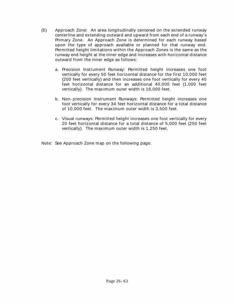
Page 26- 63
(5) Approach Zone: An area longitudinally centered on the extended runway centerline and extending outward and upward from each end of a runway’s Primary Zone. An Approach Zone is determined for each runway based upon the type of approach available or planned for that runway end. Permitted height limitations within the Approach Zones is the same as the runway end height at the inner edge and increases with horizontal distance outward from the inner edge as follows:
a. Precision Instrument Runway: Permitted height increases one foot
vertically for every 50 feet horizontal distance for the first 10,000 feet (200 feet vertically) and then increases one foot vertically for every 40 feet horizontal distance for an additional 40,000 feet (1,000 feet vertically). The maximum outer width is 16,000 feet.
b. Non-precision Instrument Runways: Permitted height increases one
foot vertically for every 34 feet horizontal distance for a total distance of 10,000 feet. The maximum outer width is 3,500 feet.
c. Visual runways: Permitted height increases one foot vertically for every
20 feet horizontal distance for a total distance of 5,000 feet (250 feet vertically). The maximum outer width is 1,250 feet.
Note: See Approach Zone map on the following page.

Page 26- 64
(6) Transitional Zone: The area extending outward and upward at a 7:1 slope
from the sides of the Primary Zones and Approach Zones connecting them to the Horizontal Zone. Height limits within the Transitional Zone are the same as the Primary Zones or Approach Zones at the boundary line where it adjoins and increases at a rate of one foot vertically for every seven feet horizontally, with the horizontal distance measured at right angles to the runway centerline and extended centerline, until the height matches the height of the Horizontal Zone or Conical Zone or for a horizontal distance of 5,000 feet from the side of the part of the precision approach zone that

Page 26- 65
extends beyond the Conical Zone. (e) Airport Land Use Restrictions. Notwithstanding any other provision of this
chapter, no use may be made of land or water within any zones established by this section in such a manner as to interfere with the operation of an airborne aircraft. The following special requirements shall apply to any proposed use: (1) Prohibited Uses in Runway Protection Zone. Notwithstanding the uses
permitted in the underlying zoning classifications as provided in Chapter 26, Article 3, the following uses are prohibited within any Runway Protection Zone.
a. Assisted Living Facilities. b. Group homes. c. Hospitals. d. Multifamily standard or manufactured modular dwellings. e. Schools, public, parochial, charter or private. f. Storage of explosive material. g. Uses that assemble large groups of people or any other use that could
produce a major catastrophe as a result of an aircraft crash.
(2) Restricted Areas for Residential Development and Educational Facilities. New residential development and educational facilities, as defined in § 333.01 F.S. as amended, shall be prohibited within an area contiguous to an airport runway measuring one-half the length of the longest runway on either side of and at the end of each runway centerline.
(3) Additional Restricted Areas for Educational Facilities. New educational
facilities, as defined in § 333.01 F.S. as amended, shall be prohibited within a rectangular area having a width of one-half of the runway length and a length of five statute miles. Said rectangular area shall be centered on the runway centerline as extended and begin at the physical end of the runway pavement.
(4) Lighting. All lights or illumination used in conjunction with streets,
parking, signs or uses of land or structures shall be arranged and operated in such a manner that they are not misleading or dangerous to aircraft operating from a public airport or in the vicinity thereof, by shielding, directing downwards, or other means as necessary.
(5) Visibility and Glare. No operations from any type of land use shall produce
smoke, glare or other visual hazards that endanger or interfere with the landing, takeoff, or maneuvering of aircraft intending to use the airport.
(6) Electrical Interference. No operations of any type shall produce electronic
interference with navigation signals or radio communication between the airport and aircraft.
(7) Wildlife Hazard Attractants. Landfills, waste disposal facilities, and other
facilities that store, handle, or process organic or any other material that

Page 26- 66
foster or harbor the growth of insects, rodents, amphibians, or other organisms that result in significant bird population increases above the normal background level, as well as storm-water management facilities, wetlands, and other areas containing aquatic life and vegetation also attract birds and other wildlife that may increase the potential for aircraft bird strikes, resulting in damage to aircraft and injury to occupants shall be subject to the following regulations. a. New landfills shall not be located:
1. Within 10,000 feet of the nearest point of any runway used or planned to be used by turbine aircraft; or
2. Within 5,000 feet of the nearest point of any runway used or planned to be used by only non-turbine aircraft.
3. Outside the perimeters described in subparagraphs 1 and 2 above, but within the lateral limits of the civil airport imaginary surfaces as defined by federal regulations, as amended from time to time, for approaching, departing, and circling aircraft.
b. All proposed and existing landfills shall be reviewed to determine
whether they attract or sustain hazardous bird movements from feeding, water, or roosting areas into or across the runways or approach and departure patterns of aircraft. The existence of such hazards shall be considered in deciding whether to permit a proposed landfill, and whether to require an existing or proposed landfill to use bird management techniques or other practices to minimize bird hazards to airborne aircraft.
c. Above-ground storm-water management facilities, including open
water features, canals, marsh areas, dry detention, and littoral zone areas should not be placed within airport operations areas due to their aquatic and vegetative environments and potential to attract wildlife. Where such facilities are unavoidable, best management practices shall be used to decrease the potential to attract wildlife, such as steep slopes, rip-rap lined detention areas, vegetation management, and use of dry detention areas.
(8) Transfer of Density Units. Properties within the Runway Protection Zone of
the Airport Protection Overlay district can only be used as sending sites for a transfer of density units and are strictly prohibited from becoming a “Receiving” site.
(Ord. No. 1896-18, <sec> 1, 05-02-2018; Ord. No. 1918-19, <sec><sec> 1-3, 05-01-2019)

Page 26- 67
Section 3.20 EPCO, Emerald Pointe Condominium Overlay District The Emerald Pointe Condominium Overlay District is established to provide control of land subdivided within the City through the approval and recording of several plats for the subdivision titled “Emerald Pointe Condominium”, Phases I through VI, as described herein. (a) Permitted Principal Uses and Structures
(1) Attached single-family dwellings, excluding mobile homes. (2) Two-family dwellings/duplexes. (3) Multi-family dwellings [requires DRC approval]. (4) Cluster housing [requires DRC approval].
(b) Permitted Accessory Uses and Structures
(1) Non-commercial hobbies and crafts. (2) Non-commercial boat docks and lifts. (3) Other uses and structures which are customarily incidental and
subordinate to permitted uses.
(c) Uses Permitted with Conditions
(1) Essential services 1 and 2. (2) Limited home occupation. (3) Group home. (4) Permanent canopy shade structures associated with recreational facilities
or school playgrounds. (d) Prohibited Uses and Structures. Any use or structure not specifically, provisionally
or by reasonable implication permitted herein. (e) Special Exceptions. The following uses are also subject to applicable provisions
of Article 4 of this Chapter.
(1) Yacht clubs, golf courses, including executive or par-3 golf courses and country clubs, not including miniature golf courses or practice driving ranges not associated with golf courses, provided that any required parking area or building is located at least one hundred feet from any other residentially zoned property.
(2) Parks and playgrounds. (3) Neighborhood and outdoor recreation. (4) Churches, provided parcel area shall not be less than 2 acres [no temporary
revival establishments].
(f) Development Standards.

Page 26- 68
(1) Phase I – Consisting of Buildings A, B and C, and common area structures located on the east side of development to include a clubhouse, management office, swimming pool/pool equipment building, tennis court and fencing, gate house, and docks. a. Repairs to or relocation or reconstruction of existing buildings and
structures within this area shall not extend beyond the building’s footprint as originally constructed or as they existed on December 31, 2017, whichever is greater.
b. Maximum height of 65 feet (or the then in effect maximum height
allowed for multi-family dwellings) above BFE to the top of the tie beam for flat, gable, hip, mansard, and gambrel roofs. There shall be no more than 4 habitable floors below the tie beam. The number of allowable habitable floors will adjust if the standard maximum height and number of habitable floors increases. Pitched type roofs are limited to a maximum 6:12 pitch to the highest point of the roof line. All roof types shall not exceed a maximum height of 10 feet measured from the top of the tie beam to the highest point of the roof line.
(2) Phase II and Phase III – Consisting of Villas 1-32, 33-37, 39, 41, 43, 45,
47 (42 units) and limited common area structures (finger docks) and common area structures (docks) located adjacent to the villas.
a. Peace River or Emerald Pointe Canal sides of road:
1. The required setback distance from the mean high water line of the waters of either the Peace River or Emerald Pointe canal shall be a minimum of 5 feet.
2. No additions are allowed to the side of the structure beyond
the existing wall or to the street side wall of the structure that is closest to the roadway, as the structures existed on or were permitted by December 31, 2017.
3. Maximum height; 35 feet above BFE to the highest point of
the roofline.
(3) Phase V – Consisting of Townhouses 1001 through 1046 (46 units) and common area structures adjacent to townhouses to include swimming pool/pool equipment building and docks.
a. The required setback distance from the mean high water line of the
waters of either the Peace River or from the Emerald Pointe canals shall be a minimum of 5 feet.
b. No additions are allowed to the side of the structure beyond the existing wall or to the street side wall of the structure that is closest to the roadway, as the structures existed on or were

Page 26- 69
permitted by date of the adoption of this ordinance. Additions to recessed entryways are permitted if they do not extend closer to the roadway than the outermost wall of the existing structure.
c. End-unit Townhouses (1001, 1007, 1008, 1015, 1016, 1017, 1018, 1022, 1023, 1031, 1032, 1039, 1040 and 1046) can be repaired or reconstructed with access to and the location of the entry doors as they existed as of the date of the adoption of this ordinance.
d. Maximum height; 35 feet above BFE to the highest point of the roofline.
(4) Phase IV and VI – Consisting of Buildings D, E and F, and common area
structures located on the west side of the development to include maintenance structures and sheds for use by the Association, swimming pool and pool equipment building, pavilion for tennis courts, tennis courts and fencing, restroom building, shade canopy by tennis courts, racquetball court building, gazebo and docks. a. Repairs to or relocation or reconstruction of buildings and
structures within this area shall not extend beyond the building’s footprint as originally constructed or as they existed on December 31, 2017, whichever is greater.
b. Residential buildings are permitted to be reconstructed with 4
habitable floors over parking to a maximum height of 65 feet (or the then in effect maximum height allowed for multi-family dwellings) above BFE to the top of the roof structure.
c. Maintenance structure(s) shall not exceed 35 feet above BFE to the
top of the roof structure and shall not exceed two stories.
(5) Repair, maintenance and reconstruction on existing structures are permitted when damage or improvements do not exceed 50% of the structure or structures’ value.
(6) Structures which existed on December 31, 2017, may be replaced with
similar structures provided all improvements meet the setback and height restriction provisions specified herein.
(7) Additions to structures in Phases II, III and V may be constructed provided
all improvements are within the unit’s property line, including any easements granted.
(8) Unit owners and the Emerald Pointe Condominium Association will be
required to obtain all applicable permits and comply with all other City of Punta Gorda zoning and building regulations.
(Ord. No. 1901-18, <sec> 2, 06-06-2018)

Page 26- 70
Section 3.21 IC, Interchange Commercial Overlay District The Interchange Commercial Overlay district is established to promote economic opportunity by attracting high quality development to the I-75 interchange commercial area. Businesses in this zoning category generally require large tracts of land convenient to the I-75 exit benefiting from interstate automotive traffic and are generally located along the N. Jones Loop Road corridor. This district is intended as an optional overlay to be available for use within the areas designated in the Interchange Commercial Overlay zone map. The existing or any future proposed underlying Zoning and Future Land Use designations are effective and may be used to govern development on those properties at the option of the property owner. (a) Permitted Principal Uses and Structures.
(1) Commercial located entirely within enclosed building/buildings unless
specifically permitted herein (2) Retail sales (3) Professional offices and services (4) Service establishments (5) Amusement facilities (indoor or outdoor)
(6) Hospital (7) School (8) Hotel/Motel/Inn (9) Bar (10) Restaurant (11) Adult Congregate Living Facility (12) Cemetery with or without a embalming and/or cremation facilities (13) Mausoleum, Columbarium above ground burial facilities
(b) Permitted Accessory Uses.
(1) Outdoor dining areas (2) Uses and structures which are customarily incidental and subordinate to
permitted uses (c) Uses Permitted with Conditions.
(1) Automotive/Boat/ Manufactured home sales and/or service including such
vehicles usually associated with commercial or industrial uses and associated services, provided that all servicing or repair is done within a completely enclosed building
(2) Temporary uses and outdoor sales and seasonal agricultural products. (3) Permanent canopy shade structures associated with recreational facilities
or school playgrounds.
(4) Mobile food dispensing vehicles on developed property with the permission of the property owner and subject to the applicable provisions

Page 26- 71
of Article 4 of this Chapter.
(5) Commercial projects over 30,000 square feet (6) Kennels (indoor or outdoor) (7) Warehousing and/or distribution centers (8) Outdoor storage and indoor/outdoor self-storage (9) Adult entertainment
(d) Prohibited Uses and Structures: Any use or structure not specifically, provisionally
or by reasonable implication permitted herein or permissible by special exception. (e) General Requirements: Building shall comply with the Interchange Commercial
Overlay District Principles of Article 7. (1) Site lighting is required for all uses, compliant with Section 8.4 (2) All permitted uses require development plan approval
(f) Special Exceptions: The following uses are also subject to applicable provisions
of Article 4 of this Chapter. (1) Churches (2) Wireless communication facilities (3) Any such other uses as deemed appropriate in the district by the Zoning
Official (g) Development Standards.
(1) Minimum lot area, none (2) Minimum front yard 25 feet (3) Minimum side yard 5 feet (4) Minimum rear yard 25 feet (5) Maximum height 6 stories not to exceed 100 feet provided it meets Airport
Protection Overlay District regulations of Section 3.19 (6) Maximum impervious area 70%
(Ord. No. 1946-2020, <sec> 1, 08-05-2020)

Page 26- 72
ARTICLE 4 USES PERMITTED WITH CONDITIONS
Section 4.1. Purpose The City of Punta Gorda finds that there are certain uses that exist which may be constructed, continued, and/or expanded provided they meet certain mitigating conditions specific to their design and/or operation. Such conditions ensure compatibility among building types so that different uses may be located in proximity to one another without adverse effects to either. Each use shall be permitted in compliance with the conditions listed in this Article. Section 4.2. Accessory Dwelling (a) An accessory dwelling may be attached, within, or separate from the principal
dwelling. (b) The principal use of the lot shall be a detached or attached single-family dwelling. (c) No more than one accessory dwelling shall be permitted on a single deeded lot in
conjunction with the principal dwelling unit. (d) The accessory dwelling shall be owned by the same person as the principal
dwelling. (e) The accessory dwelling shall not be served by a driveway separate from that
serving the principal dwelling unless the accessory dwelling is accessed from a rear alley and the principal dwelling is accessed from a street.
(f) A detached accessory dwelling shall be housed in a building not exceeding 650
square feet of first floor area [maximum footprint] or 50% of the first floor area of the principal dwelling, whichever is greater; the structure may be dwelling only or may combine dwelling with garage, workshop, studio, or similar use.
(g) A detached accessory dwelling shall be located in the established rear yard and
meet the standards for the applicable building and lot type of Article 7. Section 4.3. Adult Establishments Studies have shown that adult establishments tend to have serious deleterious effects upon nearby residential areas and uses where juveniles congregate, specifically schools, religious institutions, child care centers, parks and playgrounds. Further, studies have shown that lowered property values and increased crime tend to accompany geographic concentrations of adult establishments. It is the intent of this section to establish regulations to prevent the concentration of adult establishments and to separate adult establishments from residential areas, schools, religious institutions, child care centers, parks and playgrounds. (a) Adult establishments are permitted as a special exception in the HC zones and

Page 26- 73
require City Council approval. (b) Any structure in which an adult establishment is the principal or accessory use
shall be separated by a distance of at least 3,000 feet measured by direct airline from any residential or mixed use district and from the following principal or accessory uses, defined as protected uses for purposes of this section: dwelling units, elementary and secondary schools, religious institutions, child care centers, parks and playgrounds.
(c) Any structure in which an adult establishment is the principal or accessory use
shall be separated by a distance of at least 1,000 feet from any other adult establishment.
(d) The distance of separation from residential and mixed use zoning districts and
from the protected uses listed shall be measured from the closest point of the lot occupied by an adult establishment to the nearest residential or mixed use zoning district or the property line of a protected use. The distance of separation between adult establishments shall be measured from the closest points of the lots occupied by adult establishments utilizing an airline measurement.
(e) No more than one adult establishment may be located within the same structure
or on the same lot. (f) In the interest of public health and safety, mini-motion picture booths shall be
constructed without doors, and shall orient the customer entrance of each booth toward the principal sales counter.
(g) All openings shall have an opaque glazing to discourage visibility of the interior. (h) The maximum floor area of each use shall be 3,000 square feet. (i) No exterior signage or building element shall be pornographic in nature or convey
any such idea or element. (j) Establishments shall meet the architectural requirements of Article 7. Section 4.4. Amusement Facilities [Outdoor] (a) Outdoor amusement land parcels will be separated by an opaque screen at least
6 feet in height from any abutting property located in a residential or mixed use district.
(b) No amusement facilities, such as miniature golf courses, skateboard courses, or mechanical rides shall be located within 200 feet of any abutting property located in a residential district.
(c) Hours of operation will be no earlier than 6:00 a.m. and no later than 12:00 midnight.
Section 4.5. Group Homes (a) Five or less unrelated individuals other than the homeowner are allowed in a

Page 26- 74
group home. (b) These facilities may be located in any residential district. (c) They must be registered with the State of Florida Department of Human
Resources. (d) All adjacent property owners shall be notified. (e) Any establishment that houses more than five individuals or where the property
owner does not reside at the residence, or where there is not a permanent lessee who has obtained a lease agreement for at least one year, will be considered an institutional facility and shall only be permitted to operate in the NC and CC Districts.
(f) Group homes shall not be located within a ½ mile radius from another group home
or home similar in nature. (g) A Local Business Tax Receipt must be obtained prior to operating a group home. (Ord. No. 1474-07, <sec> 2, 04-04-07; Ord. No. 1638-10, <sec> 6, 6/2/10) Section 4.6 Automotive/Boat/Manufactured Home Sales and/or Service (a) Permitted in Highway Commercial and Interchange Commercial Overlay districts. (b) The size of any single surface parking lot shall be limited to 3 acres, unless
divided by a street, principal building, or 15 foot buffer area. (c) No outdoor public address system shall be permitted; all communication shall be
by pager, cell phone or other such personal electronic devices. (d) Maximum front yard may exceed 25 foot Highway Commercial principle when the
resulting area is designated to accommodate outside display of vehicles only. Area shall not exceed 165 feet in depth and surfaced with brick, concrete pavers or stamped concrete with a faux stone pattern. The outside display area must be separated from all adjacent streets and vehicular areas by a 2 to 3 foot in height continuous curvilinear hedge, planted with at least 35 shrubs and 4 trees per 100 linear feet. In no case may the display area encroach closer than 12 feet to the adjoining right-of-way.
(e) Vehicles may be stored on an approved parking surface without marked parking
stalls when such area is located to the rear of the site. Required internal landscaping is not required; however, such requirement shall be transferred towards increased landscaping along the perimeter of the storage area. In no case shall an individual storage area exceed 3 acres in area.
(f) Detached repair facilities, paint and body shops shall address street(s) and not a
parking lot, outside display area, storage area or residentially zoned property.

Page 26- 75
(g) Loading and unloading of vehicles shall be located to the rear of buildings to contain noise onsite. Deliveries shall not restrict traffic movements along primary street frontages or residential streets.
(h) The 70 percent frontage build-out provision of Section 3.10(g)(8) shall not apply. (Ord. No. 1461-07, <sec>1, 01-03-07; Ord. No. 1775-13, <sec>2, 11/6/2013; Ord. No. 1946-20, <sec> 2, 08-19-2020) Section 4.7. Bars and Nightclubs (a) No bar or nightclub shall be permitted within 300 feet of any off-site one or two
family residential dwelling unit, church, or other civic use building. (b) Parking requirements may be satisfied using shared parking, off-street parking
areas, or on-street parking. These types of arrangements require the submittal of a parking plan indicating method to prevent the encroachment of parking into any adjacent residential areas.
(Ord. No. 1474-07, <sec> 3, 04-04-07) Section 4.8. Bed and Breakfast Inns (a) Single family homes used as bed and breakfast inns shall be located in a historic
district, have a minimum conditioned floor area of 1,500 square feet and designated as a contributing structure to the district.
(b) Single family homes used as bed and breakfast inns may not subdivide existing
rooms into less than 200 square feet. (c) The bed and breakfast inn shall be owner-occupied. (d) All guest parking shall be to the rear of the home. Where on-street parking is
permitted, the length of the street in front of the lot may be counted as parking. There shall be one space per room of lodging.
Section 4.9. Car Wash The outdoor service area of a car wash shall be placed and landscaped in accordance with the standards for on-site parking. Section 4.10 Cemetery (a) Embalming or cremation facilities are not permitted except where permitted by
right. (b) Brick walls between 1.5 feet and 4 feet in height are permitted. (c) Wood or wrought iron fences between 2.5 feet and 8 feet are permitted. (d) Setbacks from all street rights-of-way and adjacent properties to a wall or grave
shall be a minimum of 8 feet.

Page 26- 76
Section 4.11. Churches (a) The scale and activity level of churches is a function of size and the range of
accessory uses associated with the institution. Very high activity levels have the potential to be disruptive to residential and small scale mixed use areas. To diminish disruptive impacts by ensuring appropriate location and design standards, the development and expansion of religious institutions and accessory uses in residential, CC, and NC districts shall meet the following standards: (1) Churches shall meet the standards for civic building and lot type as well as
all general building principles of Article 7.4. (2) Exterior lighting shall be directed or screened so as to protect the privacy
of the private living areas and associated open spaces of adjacent residential properties.
(3) Accessory dwelling units for persons associated with or employed by the
church may be provided at a ratio of 1 unit for each 3 acres of site; these limits do not apply to the placement of convents, rectories, parsonages or similar uses on the site.
(4) Accessory uses such as church offices, religious bookstores serving the
immediate congregation, parking lots, family life centers, multi-purpose facilities, outdoor recreational facilities, and day care centers on the same site or sites contiguous to the principal use shall be permitted wherever churches are permitted and shall meet the civic building and lot type principles of Article 7. Similar uses on non-contiguous sites or on a site separated from the principal use by a public street shall be considered principal uses in their own right and be regulated as such.
(5) Church accessory uses which are not permitted as principal uses in a
district shall adhere to the following restrictions: no merchandise or merchandise display shall be visible from outside the building and no business or identification sign pertaining to the accessory uses shall be visible from outside the building.
(6) Application for a building permit shall include a comprehensive site plan
which addresses the required standards and conditions for the main site and all abutting holdings.
Section 4.12. Civic Uses (a) Buildings incidental to the principal structure shall be behind a line a minimum of
20 feet from the front facade of the structure, and if more than one, shall be arranged to create secondary gathering spaces within the lot.
(b) Parking shall be located towards the interior of the lot. On-street parking may
be used to fulfill parking requirements. Parking may not occur within a front setback or corner side setback.

Page 26- 77
(c) Front setbacks may be altered to preserve views or significant trees. (d) Civic Use development over 3 acres shall provide 90% of the parking on-site. Section 4.13. Commercial and Office Structures Exceeding 30,000
Square Feet [individually or in combination] Required to provide a traffic impact analysis involving all streets within 1 mile of the site and indicate method intended to resolve the conflicts. These shall be accepted as determined by the City and/or Florida Department of Transportation. Section 4.14. Convenience Store/Service Station/Repair Garage (a) Major service and repair of motor vehicles is not permitted. (b) Buildings shall meet the building principles of Article 7. (c) Gasoline pumps, canopies, and associated service areas are prohibited in any
established yard abutting a street. Section 4.15. Country Club (a) A country club building shall form a central gathering place for a neighborhood. (b) Parking shall be to the rear and/or side of the principal building. (c) The principal building shall face the fronting street and shall not be setback a
distance that inhibits pedestrian access. Section 4.16. Day Care Centers (a) Day care centers for children can only be located on lots which provide ample
open area in the form of a rear yard a minimum of 2,500 square feet. Day care centers located adjacent to parks and adult day care centers are exempt from this provision.
(b) Paved and marked on-street parking may be used to fulfill parking requirements
where such on-street parking is available, unless otherwise prohibited by code. Parking off of the paved road, but within the grassed area of a right-or-way shall not be used to fulfill any parking requirements.
(c) Rear yards shall be fenced or walled for child care facilities. The minimum height
for such walls or fences shall meet all state requirements but shall not exceed 6 feet. Required recreational areas shall only be allowed within rear yards.
(d) All equipment shall be stored in the rear yard. Front yards shall not be used as
playground or recreational areas. (Ord. No. 1638-10, <sec> 6, 6/2/10) Section 4.17. Drive-Through Window Facilities (a) Drive-through windows located on the side of a building shall be limited to one
lane and screened from off-site view.

Page 26- 78
(b) Vehicle storage for drive-through window uses shall be located outside of and
physically separated from the right-of-way of any street. This area shall not interfere with the efficient internal circulation of traffic on the site, adjacent property, or adjacent street right-of-way.
(c) Drive-through window facilities shall be screened from off-site view and street
right of ways by a landscaped buffer with a minimum width of 10 feet, extending the entire length of the drive-through cueing or stacking area.
(d) A permanent porte-cochere structure may be constructed over the drive-through
and service window area. It shall be a minimum of 20-feet in width, extend the width of the drive, be integrated structurally into the building, and match the architectural design of the building. The porte-cochere may encroach into the side yard setback.
Section 4.18. Essential Service 1 and 2 (a) Utility distribution lines, which deliver service to the end user from a substation
fed by a transmission line providing service to an area larger than the individual parcel or project area, should be installed underground, unless subsurface conditions make underground installation not possible or practical.
(b) Facilities used for the operation of essential services should, whenever possible,
be located on interior properties rather than on properties aligned with other lots that have continuous street frontage.
(c) Buildings and other structures which cannot adhere to the scale, volume, spacing,
setback and typology of existing buildings along fronting streets shall provide an opaque screen to shield the view from all public rights-of-way and from abutting properties.
(Ord. No. 1474-07, <sec>5, 04-04-07) Section 4.19. Helistop A helistop shall be permitted provided it complies with all applicable Federal Aviation Administration regulations and guidelines. Section 4.20. Hotels/Motels/Inns (a) Shall be separated at least 750 feet from any residential district, measured from
the closest point of the lot occupied by the hotel or motel to the closest point of lots in residential districts.
(b) Hotels in the City Center district, Interchange Commercial Overlay district, and any Planned Development districts are not subject to the separation standards of this section.
(Ord. No. 1474-07, <sec> 6, 04-04-07; Ord. No. 1946-2020, <sec> 2, 08-19-2020)

Page 26- 79
Section 4.21. Kennels, Indoor/Outdoor (a) Require City Council approval except within the Interchange Commercial Overlay
district. (b) No outdoor kennels shall be located within a minimum of 600 feet from any
existing residence. (c) Kennels shall be designed to effectively buffer all noise audible to surrounding
properties. (Ord. No. 1946-2020, <sec> 2, 08-19-2020) Section 4.22 Limited Home Occupations (a) There is no traffic generated by the occupation. (b) The occupation is conducted by the resident owner or an authorized tenant only.
If said occupation is to be conducted by a non-owner tenant then written authorization shall be required from the property owner.
(c) There are no employees. (d) There is no signage allowed. (e) No change in residential character. (f) No advertising using the home address of the home occupation. (g) No on-site storage of goods and merchandise related to home occupation. (Ord. No. 1849-16, <sec> 1, 05-04-2016) Section 4.23. Mixed Use Buildings (a) All mixed use buildings shall have at least two occupiable stories with a minimum
of fifty percent of the street level floor area dedicated to retail use. Office uses are permitted at the street level and/or on upper levels in combination with retail and residential use. Residential uses shall be placed on upper floors.
(b) The building shall be architecturally compatible with buildings within 100 linear
feet and shall be located on a right-of-way a minimum of 60 feet in width with marked on-street parking.
(Ord. No. 1474-07, <sec> 8, 04-04-07) Section 4.24. Neighborhood and Outdoor Recreation (a) Buildings constructed in association with neighborhood recreation or outdoor
recreation shall meet the Building Styles provisions of Article 7. (b) Service areas will be separated by an opaque screen from the view from any street
and from abutting properties. (c) Chain link and similar fencing materials, if used, shall be planted on exterior side
with evergreen shrubs minimum three feet in height and six feet on center at installation.

Page 26- 80
(d) Outdoor lighting associated with outdoor recreational facilities shall not shine directly into yards of a residential use or into the windows of a residential structure.
(e) Hours of operation will be no earlier than 6:00 a.m. and no later than 12:00 p.m. Section 4.25. Neighborhood Commercial Fueling Stations (a) Neighborhood commercial fueling stations, by definition, permit retail sale of fuel
and convenience products and the minor service and repair of motor vehicles. (1) Neighborhood commercial fueling stations have no more than two fueling
pumps per service islands. (2) Buildings shall meet the design, building, and architectural provision of
Article 7. (3) Fueling pumps, canopies, and associated service areas are prohibited in
any required yard. (Ord. No. 1474-07, <sec> 9, 04-04-07) Section 4.26. Outdoor Storage (a) Outdoor storage shall not be placed in any established yard and no closer than
40 feet from an abutting street right-of-way. (b) The area of outdoor storage shall be screened from view from the street/s and
from all abutting properties by an opaque screen 30 feet in width following the buffer requirements of Article 12.
(Ord. No. 1474-07, <sec> 11, 04-04-07) Section 4.27. Parking Lot as a Principal Use Within Commercial and
Mixed Use Districts Parking lots not associated with a building shall adhere to the standards of Article 10, except that parking lots shall be constructed to the prevailing established setback line for structures within 300 feet in either direction on the same side of the street. The prevailing established setback applies for both the fronting street and any abutting side street. Within the City Center District parking lots shall adhere to the standards of 12.4.(a)(1) and be screened from public view using a solid 3 foot high masonry wall. Section 4.28. Parking Structure (a) Parking structures shall be wrapped by retail, office, and/or other permitted uses
along street edges. A minimum of 60 percent of any primary façade adjoining a street shall incorporate two of the following: (1) Transparent windows, with clear or lightly-tinted glass, where pedestrian
oriented businesses are located along the façade of the parking structure (2) Display windows

Page 26- 81
(3) Decorative metal grille-work or similar detailing which provides texture and partially and/or fully covers the parking structure openings
(4) Art or architectural treatment such as sculpture, mosaic, glass block, opaque art glass, relief work, or similar features
(5) Vertical trellis or other landscaping or pedestrian plaza area Section 4.29. Recreational Facilities All recreational facilities shall be treated as parks in design and landscaping. All structures associated with a recreational facility shall be located toward the perimeter of the lot. Recreational facilities are encouraged to be built adjoining school campuses, parks, greenbelts, parkways, greenways, or waterfronts. Parking shall be located behind structures, or along the perimeter of the lot. Section 4.30. Rental Cottage (a) Minimum floor area shall be 480 square feet. (b) The principal building shall be owner-occupied. Section 4.31. Sidewalk Café (a) Permitted hours of operation are from 6:00 am to 11:00 pm. (b) Shall maintain at least a four foot clear and unobstructed passageway between
the café and any obstructions; including but not limited to street trees, bike racks, lampposts, sign posts, and other existing fixtures. When located at a street corner, a ten foot setback from the corner shall be maintained along both frontages.
(c) No portion of an umbrella shall be less than seven feet above the sidewalk or
extend into or over the pedestrian right-of-way. (d) Individual metal tables and chairs shall be utilized to allow temporary removal
and use of the right-of-way for public events, construction activity, repair, or any other purpose.
(e) A sidewalk café shall not extend into the area in front of an adjoining structure
without the written consent of the adjoining property owner. (f) The café area shall be completely surrounded by an architecturally compatible,
three foot in height enclosure. No enclosures shall be required if the applicant proposes to limit the café area to one row of tables and chairs abutting the wall of the establishment and no alcohol will be served.
(g) Shall provide proof of liability insurance coverage in the amount of at least
$1,000,000 with the City named as an additional insured. (h) Outdoor seating less than 15% of interior seating is deemed accessory and
exempt from impact fees and additional parking requirements.

Page 26- 82
Section 4.32. Temporary Uses and Outdoor Sales of Seasonal Agricultural
(a) The establishment of temporary sales lots for farmers markets, Christmas trees,
and other seasonal agricultural products, plus related goods, are permitted upon the issuance of a temporary use permit by the Zoning Official. The following conditions apply: (1) Christmas tree sales, produce stands, and similar temporary retail sales are
permitted as temporary uses. (2) Truck trailers and flat beds are not permitted except for short-term
delivery services. (3) Temporary uses utilizing a tent or similar canopy shall secure approval
from the Punta Gorda Fire Department prior to approval. (4) Temporary uses shall be permitted for a maximum of 6 months. An
extension may be granted for an additional 6 months upon application to the Urban Design Division.
(5) Produce Stands may be permitted for a maximum of 6 months but may be re-permitted upon submission of a new application.
(6) Temporary uses shall present proof of property owner approval prior to the issuance of a Use Permit.
(7) Any and all uses herein shall be of a non-permanent nature. (Ord. No. 1946-2020, <sec> 2, 08-19-2020) Section 4.33. Water Related Structures See Chapter 6 of City Code of Ordinances. Section 4.34. Wireless Communication Facilities (a) Require City Council approval. (b) Wireless communications facilities may not exceed 40 feet in height in the NC
district and 110 feet in height in the HC, P and SP Districts. Facilities shall be constructed using a monopole design with all antenna installed on the interior of the facility.
(c) Alternate wireless communications facilities may be integrated into existing or
newly developed structures not intended for human occupancy (i.e. church bell towers, steeples, street lights, water towers, electrical transmission towers) in the NC, HC, P and SP districts. All such facilities shall be disguised, hidden and designed to detract attention of all components using stealth design elements. Alternate facility designs must be presented in full drawing, accompanied by an impact analysis of the proposed alternate facility indicating the structure’s visual impact on the surrounding environment prior to review by the City Council.
(d) Free standing wireless communications facilities in HC and SP Districts shall be
setback a distance equal to the total height measured from grade elevation from all adjoining properties of differing designation.

Page 26- 83
(e) No wireless communications facility shall be sited within 1 mile of another
wireless communications facility except as a component of existing public utility infrastructure.
(f) All ancillary structures shall be screened with a 6 foot in height opaque screen of
landscaping and wood fence, or wall, or any combination thereof. (g) All facilities shall be located outside of all front and side yards and shall provide
buffering around all ground facilities. (h) Each applicant for approval of an alternate facility shall provide the City an
inventory of its existing and future facilities that are either within the City or within 2 miles of the City. Information to be shown includes the location, height and design of each facility.
(i) All facilities will permit a minimum of 3 service providers, with all equipment for
same built internal to the facility design. (Ord. No. 1474-07, <sec> 13, 04-04-07) Section 4.35. Permanent Non-seating Public Food Service
Establishments Located Within 200 Feet From a Neighborhood Residential Zoning District Boundary
(a) There shall be no alcoholic beverage consumption on premises. (b) There shall be no music that can be heard outside the confines of the interior of
the establishment permitted with this use. (c) There shall be no entertainment associated with this use. (d) Covered trash receptacles of sufficient size to accommodate a day’s worth of trash
shall be supplied outside in order to ensure the site is maintained in a clean, litter free manner.
(e) There shall be no tables or seats provided for on-premises consumption of food or beverages.
(Ord. No. 1661-10, <sec> 3, 12/1/10) Section 4.36. Convenience Store with Limited Food Service Located
Within 200 Feet From a Neighborhood Residential Zoning District Boundary
(a) Up to four tables or one picnic table or equivalent seating of the appropriate size
for the site may be placed outside of the building on private property providing seating for no more than eight people, provided a minimum 48 inch clear pathway is maintained. All tables or seating shall be placed adjacent to the building and shall not be placed in such a manner to impede parking or pedestrian ingress/egress.
Page 26- 84
(b) Tables and chairs located outside of any store must be approved by Urban Design as to design and are required to be of a consistent style and color and maintained in a clean and orderly fashion.
(c) There shall be no alcoholic beverage consumption on premises. (d) There shall be no music that can be heard outside the confines of the interior of
the establishment permitted with this use. (e) There shall be no entertainment associated with this use. (f) Covered trash receptacles of sufficient size to accommodate a day’s worth of trash
shall be supplied outside in order to ensure the site is maintained in a clean, litter free manner.
(Ord. No. 1661-10, <sec> 3, 12/1/10) Section 4.37. Convenience Store with Significant Food Service Located
Within 200 Feet From a Neighborhood Residential Zoning District Boundary
(a) Up to four tables or one picnic table or equivalent seating of the appropriate size
for the site may be placed outside of the building on private property providing seating for no more than eight people, provided a minimum 48 inch clear pathway is maintained. All tables or seating shall be placed adjacent to the building and shall not be placed in such a manner to impede parking or pedestrian ingress/egress.
(b) Tables and chairs located outside of any store must be approved by Urban Design
as to design and are required to be of a consistent style and color and maintained in a clean and orderly fashion.
(c) Additionally, tables providing seating for up to 16 people may be located inside
the establishment. (d) There shall be no alcoholic beverage consumption on premises. (e) There shall be no music that can be heard outside the confines of the interior of
the establishment permitted with this use. (f) There shall be no entertainment associated with this use. (g) Covered trash receptacles of sufficient size to accommodate a day’s worth of trash
shall be supplied outside in order to ensure the site is maintained in a clean, litter free manner.
(Ord. No. 1661-10, <sec> 3, 12/1/10) Section 4.38. Food Outlet with Limited Food Service Located Within 200
Feet From a Neighborhood Residential Zoning District

Page 26- 85
Boundary (a) Tables and chairs located outside of any establishment must be approved by
Urban Design as to design and are required to be of a consistent style and color and maintained in a clean and orderly fashion.
(b) All tables or seating shall be placed adjacent to the building and shall not be
placed in such a manner to impede parking or pedestrian ingress/egress. (c) There shall be no consumption of alcoholic beverages on premises.
(d) There shall be no music that can be heard outside the confines of the interior of
the establishment permitted with this use. (e) There shall be no entertainment associated with this use. (f) Covered trash receptacles of sufficient size to accommodate a day’s worth of trash
shall be supplied outside in order to ensure the site is maintained in a clean, litter free manner.
(Ord. No. 1661-10, <sec> 3, 12/1/10) Section 4.39 Permanent Canopy Shade Structures Permanent canopy shade structures associated with recreational facilities or school playgrounds is a use permitted with conditions in the Environmental Preserve District (EP), General Single-Family Residential District (GS), General Multi-Family Residential District (GM), Manufactured Home District (MH), Neighborhood Residential District (NR), Neighborhood Center District (NC), City Center District (CC), Highway Commercial District (HC), Special Purpose District (SP) and Public District (P). In addition, permanent canopy shade structures associated with auto-oriented and auto-dependent is a use permitted by Special Exception in the Highway Commercial District (HC). (a) Recreational facilities means land, improvements and equipment, whether
publicly or privately owned, used for active or passive outdoor recreation by multiple families. It includes, but is not limited to tennis, bocce ball and shuffleboard courts, ball fields and picnic areas. Recreational facilities constructed as an accessory use or structure to single family residences shall not be considered recreational facilities for the purpose of this Section.
(b) School playground shall include public and private schools or pre-schools which provide a daily curriculum of study with breaks for outdoor recreation.
(c) Shade structures must meet all Florida Building Code requirements as determined by the Building Official as including but not limited to the following conditions: (1) The frame and the anchoring of the frame must meet Risk Category 1 for
our area (108 mph). (2) The fabric and method of attachment must be rated for winds of at least

Page 26- 86
75 mph. (3) The owner must submit a letter of agreement to remove the fabric
covering if winds are forecast to exceed 75 mph or upon the order of the Chief Building Official.
(d) The canopy providing shade shall be a tensioned fabric top shade which must be
UV fade resistant and unaffected by cleaning products and must be replaced when it becomes 25% discolored or unsightly as determined by the Zoning Official or designee. Additionally: (1) Fabric must be kept clean and free of mildew, mold or any other debris. (2) Fabric must be kept taut and not sag or flap in the wind. (3) Fabric must be replaced if it becomes torn or tattered as determined by the
Zoning Official or designee. (4) Fabric must meet all Fire Code requirements. The fabric covering shall
meet the flame propagation performance criteria contained in NFPA 701. This information must be contained on a label affixed to the fabric and a printed copy of the certification submitted with the permit application.
(e) The support structure must be made of corrosion-resistant metals such as
galvanized or stainless steel or aluminum and have a powder coated surface. Unfinished support structures are prohibited.
(f) Shade structure must have a sloped top, angled top, peaked top or be curvilinear. Flat topped structures are prohibited.
(g) Shade structure must meet all setback requirements.
(h) Pop-up tents or any structures which do not have a permanently anchored support structure which meets the above standards are specifically prohibited except when approved as part of a temporary special event or temporary business event with required tent permit issued by the Fire Department.
(i) In addition to paragraphs (c) through (h) above, the following apply to permanent canopy shade structures associated with auto-oriented and auto-dependent when permitted as a use by Special Exception in the Highway Commercial District (HC):
(1) Shade structure must be located behind the primary building and not
visible from any public right-of-way. (2) Shade structure shall be no taller in height than the primary structure on
the property. (3) Shade structure shall be setback a minimum of 50 feet from any side lot
line and 50 feet from the rear property line. (4) Canopy shall be square or rectangular in shape and no larger than 1,000

Page 26- 87
square feet in area. (5) Electrical power and plumbing are not permitted to be installed upon or
under any shade structure. (6) No more than one shade structure shall be permitted per property. (7) No text, graphic or other marking shall be on the canopy and no signage
is permitted on or hanging from any shade structure.
(Ord. No. 1770-13, <sec> 11, 11/6/13, Ord. No. 1903-18, <sec> 2, 07-03-2018) Section 4.40 Mobile Food Dispensing Vehicles (a) Definitions. The following words and phrases, when used in this Section shall
have the meanings respectively ascribed to them: (1) “Mobile Food Dispensing Vehicle” means a public food service
establishment mounted on wheels and axle(s) that is movable from place to place and which is regulated and licensed by the State of Florida Department of Business and Professional Regulation or the State of Florida Department of Agriculture and Consumer Affairs, or any successor agency, pursuant to Chapter 500, Florida Statutes and the rules and regulations promulgated thereunder. Such a vehicle may be self-propelled or mounted on a trailer, and includes bicycles and pushcarts.
(2) “Mobile Vendor” means a person, corporation, company, or business,
which owns or operates a Mobile Food Dispensing Vehicle, and includes employees of the vehicle’s owner.
(3) “License” means a current and valid license for a mobile food dispensing
vehicle granted by the State of Florida Department of Business and Professional Regulation, Division of Hotels and Restaurants, the State of Florida Department of Agriculture and Consumer Affairs, or any successor agency.
(b) Mobile Food Dispensing Vehicles Allowed. Notwithstanding any provision of the
Punta Gorda Code to the contrary, and subject to the requirements of this Section, Mobile Food Dispensing Vehicles may be operated within the City of Punta Gorda in the following areas:
(1) By staff approval on developed properties in the Neighborhood Center (NC)
Zoning District, the City Center Zoning District, the Highway Commercial (HC) Zoning District and the Special Purpose (SP) Zoning District.
(2) Any other zoning district within the City of Punta Gorda if expressly
approved as part of a Special Event, Business Event, Grand Opening Event, Temporary Promotional Event, Temporary Use permit, or public property concession services agreement granted by the City of Punta Gorda.
(3) A Mobile Food Dispensing Vehicle may also be operated in any zoning
district at an active construction site with a valid building permit provided the duration of selling food and beverages is limited to no more than one

Page 26- 88
hour per day at any one such site. (c) Mobile Food Dispensing Vehicle Requirements. Prior to the dispensing of any food
or beverage from any mobile food dispensing vehicle within the City of Punta Gorda, Mobile Vendors must have a valid Local Business Tax Receipt from the City of Punta Gorda for each mobile food dispensing vehicle. To obtain a Local Business Tax Receipt, or renewal thereof, Mobile Vendors must submit the following with a completed Local Business Tax Receipt application and annual renewal:
(1) Proof of a current and valid license for a mobile food dispensing vehicle
granted by the State of Florida Department of Business and Professional Regulation, Division of Hotels and Restaurants, the State of Florida Department of Agriculture and Consumer Affairs, or any successor agency, for each mobile food dispensing vehicle to be operated within the City.
(2) A site plan for each location the Mobile Vendor will operate a mobile food
dispensing vehicle, depicting the specific location on each property where the vehicle will be parked for the purposes of dispensing food and/or beverages. It shall be a violation of this Section to operate a mobile food dispensing vehicle at any location other than as depicted on the site plan approved and made a part of the Local Business Tax Receipt issued by the City of Punta Gorda.
(3) A notarized affidavit, on a form to be provided by the City Clerk, signed by
each owner of the property upon which a mobile food dispensing vehicle will be parked for the purposes of dispensing food and/or beverages, indicating that the Mobile Vendor has the owner’s permission to operate on the owner’s premises in the location depicted on the approved site plan. The owner’s notarized affidavit shall also include the following:
a. The property owner shall allow the Mobile Vendor, its employees,
and customers access to bathroom facilities on the property owner’s property, where available.
b. The property owner shall allow the Mobile Vendor access to solid
waste collection facilities on the subject property, where available. If solid waste collection facilities are not available at the subject property, the property owner will ensure that the Mobile Vendor removes all solid waste generated by its operation from the owner’s property daily.
c. The property owner shall ensure that the owner’s property will be
continuously maintained in a neat, clean, and orderly manner. d. That the location approved by the property owner for the parking of
a mobile food dispensing vehicle for the purposes of dispensing food and/or beverages is not otherwise allocated to another tenant of the subject property, and is not an area required for parking, loading or unloading, or vehicular access to such facilities under the

Page 26- 89
provisions of the City of Punta Gorda Land Development Regulations.
e. The property owner shall notify the City Clerk in writing at any time
that the owner revokes his/her authorization given to the Mobile Vendor.
f. An acknowledgement by the property owner that only mobile food
dispensing vehicles which have a current Local Business Tax Receipt issued by the City of Punta Gorda may be allowed to operate on the property and that the property owner will be deemed to be in violation of this Section if mobile food dispensing vehicles are allowed to operate on the owner’s premises without a currently valid Local Business Tax Receipt issued by the City of Punta Gorda.
g. Upon the sale of the property on which the Mobile Vendor has
permission to operate, the City’s authorization to operate a mobile food dispensing vehicle upon such property shall be suspended until the Mobile Vendor obtains and files with the City Clerk a notarized affidavit from the new owner of the property containing all of the information required in this Paragraph 3.
(4) The make, model and year of each mobile food dispensing vehicle for
which a Local Business Tax Receipt is sought. (d) Exemptions. Mobile food dispensing vehicles which are operated within the City
of Punta Gorda only when expressly approved as part of a Special Event, Business Event, Grand Opening Event Temporary Promotional Event, Temporary Use permit, are exempt from the requirements of Section 4.40(c), but shall be required to comply with the requirements outlined within the City of Punta Gorda Event Manual. Any Mobile Vendor operating under a public property concession services agreement approved by the City of Punta Gorda, is exempt from the requirements of Section 4.40(c), and shall be required to comply with the provisions of said agreement.
(e) Transfer or Change of Owner. A Mobile Vendor may apply for a transfer or change
of ownership of an issued Local Business Tax Receipt when necessary to change the prior approved ownership. The application for transfer or change of ownership shall include all of the information required in Section 4.40(c), together with the required transfer or change in ownership fee pursuant to Chapter 12, Section 12.9, Punta Gorda Code.
(f) Food Dispensing Vehicle Operating Standards. The following standards shall
apply to the operation of all mobile food dispensing vehicles within the City of Punta Gorda:
(1) No food or beverages may be dispensed from a mobile food dispensing
vehicle unless said vehicle is operating under staff approval and a current and valid Local Business Tax Receipt issued pursuant to the provisions of this Section and Chapter 12, Punta Gorda Code. This requirement shall not

Page 26- 90
apply to mobile food dispensing vehicles that are exempt under the provisions of Section 4.40(d).
(2) The current Local Business Tax Receipt must be prominently displayed on
the authorized mobile food dispensing vehicle at all times and must be presented for inspection upon the request of any City of Punta Gorda Code Compliance officer or Police officer. This requirement shall not apply to mobile food dispensing vehicles that are exempt under the provisions of Section 4.40(d).
(3) Mobile food dispensing vehicles shall only dispense food or beverages at
the location(s) specified on the approved site plan which was approved with the Special Exception and Local Business Tax Receipt application. This requirement shall not apply to mobile food dispensing vehicles that are exempt under the provisions of Section 4.40(d).
(4) Mobile Vendors shall keep mobile food dispensing vehicles and the
premises upon which food or beverages are dispensed in a sanitary, clean, neat, and orderly condition. Mobile Vendors shall be responsible for the removal of all litter in the vicinity of their vehicles.
(5) Mobile Vendors shall provide solid waste receptacles on or near mobile
food dispensing vehicles when dispensing food or beverages. (6) Mobile food dispensing vehicles shall not be parked in such a location so
as to interfere with required parking, loading and unloading zones, no parking zones, or the vehicular access to such spaces.
(7) No mobile food dispensing vehicle shall operate upon any premises where
the owner thereof has revoked prior authorization to the Mobile Vendor. (8) The use of sound equipment, bells or other devices that produce sound,
which is audible outside of a mobile food dispensing vehicle shall be prohibited. This requirement shall not apply to mobile food dispensing vehicles that are exempt under the provisions of Section 4.40(d).
(9) Mobile food dispensing vehicles may not dispense food or beverages in
any area that is a public right-of-way or City park or other public property unless expressly authorized by the City. This requirement shall not apply to mobile food dispensing vehicles that are exempt under the provisions of Section 4.40(d).
(10) Mobile Vendors shall operate mobile food dispensing vehicles in
accordance with all terms and conditions specified in the applicable license granted for said vehicle by the State of Florida Department of Business and Professional Regulation, Division of Hotels and Restaurants, the State of Florida Department of Agriculture and Consumer Affairs, or any successor agency.
(11) Except for mobile food dispensing vehicles which are operating as part of

Page 26- 91
a “Special Event”, “Business Event”, “Grand Opening Event”, “Temporary Promotional Event”, “Temporary Use” permit, or public property concession services agreement granted by the City of Punta Gorda, all mobile food dispensing vehicles must vacate the premises approved for their operation when not actively conducting business.
A mobile food dispensing vehicle shall be deemed to be “not actively conducting business” when said vehicle is unoccupied by an employee of the Mobile Vendor. Mobile food dispensing vehicles which are operating as part of a “Special Event”, “Business Event”, Grand Opening Event”, “Temporary Promotional Event”, “Temporary Use” permit, or public property concession services agreement granted by the City of Punta Gorda shall vacate the premises approved for their operation when required to do so in the document authorizing their activity.
(12) Mobile food dispensing vehicles are authorized to display a maximum of
one (1) City approved sign, no smaller than 1-foot by 1-foot, or larger than 3-foot by 3- foot that is attached to the mobile food dispensing vehicle. Additionally, a single portable sign shall be permitted within the parameters of the Punta Gorda Code regulations for portable signs.
(13) The use of any temporary canopies, tents or any other temporary shade
structure in conjunction with an approved mobile food dispensing vehicle is prohibited.
(14) The sale, dispensing or distribution of intoxicating beverages including but
not limited to liquor, wine and beer from a mobile food dispensing vehicle is prohibited.
(g) Prohibition. It shall be unlawful to operate, or allow to be operated, any mobile
food dispensing vehicle within the City of Punta Gorda, Florida except in full conformity with the provisions of this Section.
(h) Enforcement. In addition to all other remedies available for the enforcement of
the violations of the provisions of the City of Punta Gorda Code of Ordinances, any person who violates the provisions of this Section shall be guilty of a noncriminal infraction. Enforcement of the provisions of this Section may be through means of citations issued for non-criminal infractions. Such citations may be issued by any Police Officer or Code Compliance Officer of the City.
(1) The citation given to any violator shall specify the violation and the civil
penalty therefor and shall notify the violator:
a. That the civil penalty must be paid at the Office of the City Clerk no later than ten (10) days after the date the citation is issued unless the violation is appealed to the Code Enforcement Board, giving the address of the City Clerk's office;
b. That any appeal must be filed with the Code Compliance Division
within ten (10) days after the date the citation is issued, and

Page 26- 92
c. That, if found guilty of the violation by the Code Enforcement Board
on an appeal, the violator shall pay the assessed civil penalty as well as the cost of the appeal in the amount of Fifty Dollars $50.00.
(2) Any person who elects to contest a citation may appear before the City of
Punta Gorda Code Enforcement Board to present evidence, provided a hearing is requested in writing, through the Code Compliance Division within ten (10) days after the date of the citation. The Code Enforcement Board, after a hearing, shall make a determination as to whether a violation has been committed and, upon a finding that the violator is guilty, shall impose the civil penalty therefor, along with the cost of the appeal in the amount of Fifty Dollars $50.00. Any person who receives a citation for a violation of any provision of this Section and neither pays the civil penalty nor files a written appeal of the citation within ten (10) days after the date of the citation shall be deemed to have violated this Section.
(3) Any person who violates any provision of this Section shall be assessed a
civil penalty as follows:
a. First offense ............................................... $ 100.00 b. Second offense …........................................ $ 500.00 c. Each subsequent offense ............................ $1000.00
(i) Additional Remedies. In addition to all other enforcement remedies available to enforce violations of this Section, a finding by the City of Punta Gorda Code Enforcement Board during any hearing to enforce violations of this Section committed by a Mobile Vendor, that said Mobile Vendor is a repeat violator as that term is defined in Chapter 162, Florida Statutes, the City of Punta Gorda Code Enforcement Board shall be empowered to issue an Order to cease and discontinue all mobile food dispensing operations immediately. Said Order may be valid for a period of up to two (2) years; and shall order the City Clerk to revoke all Local Business Tax Receipts authorizing the use of mobile food dispensing vehicles within the City of Punta Gorda held by said Mobile Vendor for a period of two (2) years.
(Ord. No. 1796-14, <sec> 5, 10-01-2014; Ord. No. 1852-16, <sec> 9, 07-16-2016) Section 4.41 Warehouse/District Centers (a) Shall be separated at least 200 feet from any residential development, measured
from the closest point of the lot occupied by the warehouse/distribution center to the closest point of lots in residential development.
(Ord. No. 1946-2020, <sec> 2, 08-26-2020)

Page 26- 93
ARTICLE 5
PLANNED DEVELOPMENT These regulations are intended to promote and enhance the public health, safety and welfare by providing comprehensive regulations and requirements for unified planning and development of tracts of land held in common ownership or control. Planned Development provides for the development of new neighborhoods and the revitalization or extension of existing neighborhoods, structured upon a fine network of interconnecting pedestrian oriented streets and other public spaces. In considering petitions for concept plan approval, the City Council shall consider the extent to which the concept plan for the planned development fulfills the following objectives: (a) To promote a harmonious mixture of land uses and housing types and housing
cost which will allow people to work and shop in the neighborhood in which they live.
(b) To encourage creative and innovative design to complement and enhance the
City’s visual character. (c) To ensure adequate provision and efficient use of open space and recreational
facilities. (d) To provide for the enhancement and preservation of property with unique
features such as historic significance, sensitive environmental resources and scenic qualities.
(e) To promote good transportation design to minimize new traffic generation and
separate pedestrian, bicycle, local residential and through motor vehicle traffic. (f) To reduce public utility maintenance costs by encouraging efficient land use
patterns. (g) To promote energy-conserving buildings and site designs and land use patterns. Section 5.1. Applicability The provisions of this Article apply to Planned Development Districts approved by the City Council for Planned Development Neighborhoods [PDN]; Planned Development Villages [PDV]; and Planned Employment Centers [PEC]; all called “Planned Developments” in this Article. Section 5.2. Minimum Site Area (a) Each PDN District shall be a minimum of 1 acre and no larger than 40 acres. (b) Tracts larger than 40 acres shall be developed as a Planned Development Village.

Page 26- 94
(c) Each PDV District shall be a minimum of 40 acres and no larger than 200 acres in area.
(d) Tracts larger than 200 acres shall be developed as multiple districts. (e) Each PEC District shall be at least 5 acres in area unless the proposed planned
development is a logical extension of an existing commercial or employment area. {Ord. No. 1532-08, <sec> 1, 1-2-08} Section 5 .3. Development Standards (a) The area of the PD shall be divided into blocks, streets, lots, and open space. (b) Along existing streets, new buildings shall respect the general spacing of
structures, building mass, scale and street frontage relationships of existing buildings.
(c) New buildings which exceed the scale and volume of existing buildings may
demonstrate compatibility by varying the massing of buildings to reduce perceived scale and volume.
(d) On new streets, allowable buildings and lot types will establish the development
pattern. (e) Public streets or private platted, improved streets shall provide access to all tracts
and lots. (f) Streets and alleys shall, wherever practicable, terminate at other streets within the
neighborhood and connect to existing and projected streets outside the development.
(g) Cul-de sacs shall not exceed 250 feet in length, must be accessed from a street
providing internal or external connectivity, shall be permanently terminated by a vehicular turnaround, and are permitted where topography makes a street connection impracticable. Vehicular turnarounds of various configurations are acceptable so long as emergency access is adequately provided.
(h) No block face should have a length greater than 500 feet without a dedicated alley
or pathway providing through access. (i) A continuous network of rear alleys is recommended for all lots in a PD. (j) Rear alleys shall provide vehicular access to lots 60 feet or less in width. (k) Utilities may run along alleys. (l) In all PD Districts, residential building height shall be a maximum height of three
habitable floors, or a maximum height of 50 feet above Base Flood Elevation (BFE).

Page 26- 95
(m) For commercial or mixed-use structures, building height shall be limited to a
maximum of 60 feet above BFE except where additional height is approved by City Council based on one or more of the following conditions:
(1) Primary building use is a hotel.
(2) Land is dedicated to the City of Punta Gorda for uses including, but not limited to public safety facilities, public park, library or school.
(3) Site plans that exhibit a full integration of residential, shopfront and workplace uses while providing superior environmental sensitivity and diverse recreational opportunities.
(n) PD districts shall comply with the provisions of Articles 7, 9, 10, 11 and 12 of
Chapter 26. (o) To prevent the buildup of vehicular speed, disperse traffic flow, and create a sense
of visual enclosure, long uninterrupted segments of straight streets shall be avoided.
(p) Methods designed to calm the speed and disperse the flow of traffic shall be
utilized in the internal street network. These methods include, but are not limited to:
(1) Special paver and/or raised crosswalks or intersections. (2) Traffic circles. (3) Chicanes. (4) Center islands. Emergency access must be provided. (q) A minimum percentage build-out at the build-to-line shall be established on the
plan along all streets and public square frontages. (r) Civic lots shall be within or adjacent to a square or park or on a lot terminating a
street vista. (s) Land designated as shopfront may mix residential and commercial uses vertically
within structures which are a minimum of 26 feet in height. (t) Residential uses are not permitted on the ground floors of shopfront buildings. (u) Uses on the perimeter of a PD shall be compatible with surrounding development. (v) Setbacks for uses on the perimeter shall be consistent with the adjoining land use
where such use is developed for single-family residential purposes. {Ord. No. 1475-07, <sec> 1 04-04-07; Ord. No. 1532-08, <sec> 1, 01-02-08} Section 5.4. Lot Size

Page 26- 96
No Planned Development shall be approved which contains lots with areas or widths less than provided below for the dwelling types shown: (a) Single-Family Detached: Minimum lot area: 5,000 square feet Minimum lot width: 50 feet (b) Single-Family Attached: Minimum lot area: 2,000 square feet Minimum lot width: 20 feet (c) Duplex Minimum lot area: 8,000 square feet Minimum lot width: 75 feet (d) Multi-Family Minimum lot area: 10,000 square feet Minimum lot width: 75 feet (e) Commercial and mixed-use: Minimum lot area: No minimum Minimum lot width: No minimum {Ord. No. 1532-08, <sec> 1, 1-2-08} Section 5.5. Residential Density Limits Residential density limits shall be as expressed in the Comprehensive Plan.
(a) The lesser of the residential density range numbers established for land use
designations in the Plan or the density permitted by the existing zoning district, whichever is greater, represents “base density” allowed within a planned development, provided that the density permitted by the existing zoning district is consistent with the land use designation.
(b) Residential density shall not exceed the base density allowed, unless the City
Council finds that the proposed development offers “additional development public benefits.”
(1) Additional Development Public Benefits.
If the City Council finds that “additional development public benefits” will be provided, additional “bonus” density may be approved [above the base density] up to the maximum of the density range allowed by the underlying Comprehensive Plan land use designation.
(2) In order to approve the additional bonus density, the City Council, in its
sole discretion, must find that the proposed development plan offers additional development benefits to the public health, safety and welfare by

Page 26- 97
providing one or more of the following additional development benefits:
a. A net positive impact on the availability of public facilities and services in the City.
b. An increase in the supply of usable public open space in the City
from 25 percent to 40 percent. c. Design that makes a substantial contribution to the traditional
character of the town. Examples include: 1. Compact, pedestrian-oriented development patterns. 2. Mixed uses. 3. Grid street patterns. 4. Use of side loading or rear loading garages. 5. Front porches with reduced front building setbacks. 6. Mixed-use housing [residential dwelling units above retail
and office uses]. 7. Traditional architecture and building materials.
(2) Dwelling units meeting the State’s eligibility criteria for affordability.
(4) Elderly housing units within 1,320 feet of shopping, personal service and other necessary support services.
(5) Protection of natural resources at a much higher level than otherwise
required under existing regulations. (11) Appropriate use of a designated historic structure or site, or any other site
deemed worthy of preservation due to its historic value.
(12) Substantial employment opportunities in close proximity to residential areas and guarantee development of non-residential portions prior to or concurrently with the residential portions.
(c) Calculation of Density. The maximum number of dwellings permitted in a Planned
Development shall be calculated by multiplying the applicable Comprehensive Plan density limit or the density permitted by the existing zoning district, whichever is greater, [expressed in dwellings per acre] by the gross total acreage of the planned development. All lands included within the calculations must be under the ownership or control of the applicant.
{Ord. No. 1532-08, <sec> 1, 1-2-08; Ord. No. 1560-08, <sec> 1, 9-3-08} Section 5.6. PDN, Planned Development Neighborhood District Planned Development Neighborhood [PDN] Districts are intended to encourage the

Page 26- 98
development of a mixture of housing types and price ranges and to promote the organization of residential development into efficient neighborhoods with appropriate supportive community facilities and services. (a) Permitted Uses. The following uses are permitted in a PDN District:
(1) Single-family, two-family and multi-family. (2) Government/Office. (3) Neighborhood commercial/shopfront. (4) Cemetery. (5) Fire and/or rescue facility. (6) Group homes. (7) Park, public. (8) Place of worship. (9) Recreation facility. (10) School, general education. (11) School, public. (12) Essential services 1, 2 and 3. (13) Any other uses designated in the PD application with City Council approval.
(b) Open Space.
(1) Community recreational sites shall be provided at a rate of 0.25 acres for
each 100 dwelling units minimum. (2) Recreational areas and facilities such as playgrounds, tennis courts,
basketball courts, swimming pools and community buildings shall be provided to meet the anticipated needs of residents and occupants of the planned development.
(3) All open space including public recreational facilities shall be included in the development schedule and be constructed and fully improved by the developer at a rate equivalent or greater than the rate of construction of dwellings.
{Ord. No. 1532-08, <sec> 1, 1-2-08} Section 5.7. PDV, Planned Development Village District Planned Development Village [PDV] Districts are intended to promote the development of self-sufficient communities which are organized around a mixed-use center of commercial, employment, community facility and high density residential uses.
The intent of the PDV District is to encourage efficient land use patterns which conserve energy and natural resources and provide a variety of living and working environments integrated with adequate open space and recreational facilities. (a) Permitted Uses. The following uses are permitted in a PDV District:
(1) Single-family, two-family and multi-family. (2) Civic uses.

Page 26- 99
(3) Neighborhood commercial/shopfront. (4) Mixed Use Center, see (b) below. (5) Office. (6) Cemetery. (7) Fire and/or rescue facility. (8) Group homes. (9) Library. (10) Museum. (11) Nursing home. (12) Park, public. (13) Place of worship. (14) Recreation facility. (15) School, general education. (16) School, public. (17) Essential Services 1, 2 and 3. (18) Any other uses designated in the PD application with City Council approval.
(b) Mixed Use Centers required. In PDV Districts, a mixed used center is required.
(1) A minimum of five percent of the gross area of a PDV shall be designated
for shopfront or workplace buildings. The City Council may eliminate the requirement for lands used for shopfronts and/or workplaces subject to a finding that the proposed alternative arrangement more fully integrates the project into an existing neighborhood.
(2) Mixed use centers are a cluster of residential, commercial, employment and community facility uses designed to serve as the focus of a residential village. (3) Uses shall be supportive of and compatible with surrounding residential
development. (4) Non-residential uses shall be confined to the first two floors when located
in the same building as residential uses. (5) Residential uses shall be provided with separate entrances. (6) The negative effects of employment facilities, such as noise, dust and
fumes, shall be completely contained within individual buildings. (7) The transportation system shall not create conflicts between local and
regional uses or generate through traffic in residential areas. (c) Open Space.
(1) Open space shall be provided and maintained as required by this Article. (2) Community recreational sites shall be provided at a rate of 0.25 acres for
each 100 dwelling units.
Page 26- 100
(3) A minimum of 0.25 acres for each 100 dwelling units shall be dedicated for open space. City Council may eliminate or reduce this requirement subject to a finding that the proposed development plan offers additional development benefits to the public.
(4) Recreation areas and facilities, such as playgrounds, tennis courts,
basketball courts, swimming pools and community buildings should be provided to meet the anticipated needs of residents of the planned development.
(5) All common open space, including public recreational facilities, shall be
included in the development schedule and be constructed and fully improved by the developer at a rate equivalent to or greater than the construction of residential units.
{Ord. No. 1532-08, <sec> 1, 1-2-08} Section 5.8. PEC, Planned Employment Center District The Planned Employment Center [PEC] District is intended to encourage innovative and creative design of retail, office and industrial development. The PEC District regulations are designed to promote attractive employment areas which complement surrounding land uses through high quality layout, design and construction techniques. (a) Permitted Uses. The following principal uses are permitted in a PEC District:
(1) Convention center. (2) Hotel and motel, Inn. (3) Office [business, professional or government]. (4) Commercial, retail uses. (5) Recreational facility. (6) Light intensity industrial so long as use is rendered unobjectionable
because noise, heavy truck traffic, odor, fumes and other potential nuisances are effectively mitigated by performance standards set out in the ordinance establishing the use.
(7) Fire and/or rescue facility. (8) Group homes. (9) Park, public. (10) Recreation facility. (11) Hospitals, schools, technical and special instruction. (11) Essential services, classes 1, 2 and 3. (12) Any other uses designated in the PD application with City Council approval.
(b) Support Uses. The following support uses are permitted in a PEC District when
subordinate to principal office or industrial uses: (1) Service station. (2) Service and supply establishments. (3) Convenience retail food stores.

Page 26- 101
(4) Bank, with drive-in facility. (5) Health club or spa. (6) Parking structure, private. (7) Service, personal. (8) Pharmacies, retail pharmacies. (9) Repair service establishments. (10) Eating establishments and fast food. (11) All principal and accessory residential uses intended as living quarters for
employees or owners of establishments within the District if located and designed in a manner appropriate to the character and function of the District.
(c) Use Limitations. The following limitations apply to uses of land in a Planned
Employment Center in addition to any limitations provided in the ordinance establishing the District. (1) All operations shall be conducted within a fully enclosed building unless
the City Council finds that outdoor operations are compatible with the planned employment center.
(2) The gross land area of all residential uses shall not exceed 15 percent of
the total land area of the district. Land where residential uses occur over non-residential uses shall not be included in the calculation of this percentage.
(3) Automobile service stations may include accessory uses such as vehicle or
tool rental; however, shall not include the outdoor storage of any inoperable, wrecked or abandoned vehicles on the site for more than 72 hours.
(d) Open Space.
(1) At least 30 percent of the gross area of a Planned Employment Center shall
be open space. (2) Any common open space provided shall be maintained as required by this
Article. (3) All open space shall be included in the development schedule and be fully
improved by the developer at a rate equivalent to or greater than the construction of all structures.
{Ord. No. 1475-07, <sec> 2 04-04-07; Ord. No. 1532-08, <sec> 1, 01-02-08} Section 5.9. Procedures Planned Development Districts shall be established in accordance with the following standards and procedures: (a) Concept Plan. A concept plan of the proposed development shall be submitted
to the Urban Design Division to determine the plan’s consistency with the

Page 26- 102
Comprehensive Plan. The Concept Plan application shall include a map of the property and land area within 200 feet showing:
(1) The general location and arrangement of proposed uses, including open
space and recreational uses. (2) The general alignment of major arterials or primary thoroughfares, minor
arterials or major thoroughfares, through collector roads and general alignment of pedestrian ways.
(3) The location of sensitive and critical environmental features as defined in
the Comprehensive Plan [floodplains and wetlands]. (4) The approximate number of dwellings by type and the approximate floor
area of non-residential uses. (5) Such other information as is necessary and appropriate to show compliance
with Comprehensive Plan policies. If a concept plan is determined to be consistent with the Comprehensive Plan by the Urban Design Division, a Planned Development Plan [PD] may be prepared. If the Urban Design Division determines that the concept plan is not consistent with comprehensive plan, the applicant may appeal the decision to the City Council. (b) Planned Development [PD] Plans. A PD Plan is the detailed development plan for
the proposed planned development and must cover all of the land area to be included in the planned development.
(1) Application Filing. PD Plan applications shall be filed with the Urban Design
Division. The required application form must be completed and signed by the applicant and owner/s of the property. Upon receipt of an application, the Zoning Official shall acknowledge acceptance or rejection of the application in writing within ten working days from the date of submittal. Upon acceptance of a completed application, the application shall be forwarded to the DRC and applicable review agencies for review and comment. Once all comments have been received by the Urban Design Division, comments generated shall be forwarded to the applicant.
(2) Developer’s Statement. Each PD Plan application shall contain a statement
by the applicant describing how the proposed development departs from the otherwise applicable [conventional district] standards of this code and how the proposed development, on balance, will benefit the City as a whole more than would a development approved under otherwise applicable standards.
(3) Submittal Requirements. PD Plan applications shall include all of the
following information:
a. The proposed classification of the planned development, the existing district classification of the subject property and the

Page 26- 103
property adjacent to the subject property. b. Proposed maximum numbers and types of dwellings. c. Proposed non-residential uses by category. d. Proposed maximum floor area of non-residential buildings by type
of use. e. Proposed location and types of all uses, including open space. f. Proposed public facility sites, areas and locations. g. Proposed plan for landscaping all areas showing lawns, greens, tree
cover, landscape screens and buffers, including plans for peripheral areas.
h. Proposed maximum building heights. i. Proposed minimum lot areas, depth and width. j. Proposed minimum yard requirements, where applicable. k. Proposed maximum size, height and number of signs and proposed
limitations and requirements on private signs. l. A 1:200 [one inch=200 feet] scale planemetric and topographic map
of the property and land area within 200 feet and showing the boundary line and other features of the planned development, including the location of sensitive and critical environmental features as defined in the Comprehensive Plan and the location of all types of uses.
m. Proposed thoroughfare plan showing the general location and
typical sections, excluding pavement design, of major arterials or primary thoroughfares, minor arterials or major thoroughfares, through collector and local collector roads and the projected ultimate traffic volume and level of service for each.
n. Proposed plan for pedestrian circulation, paths, bikeways and trails. o. General location of off-street parking and loading facilities and
proposed requirements for number, design and maintenance of off-street parking and loading facilities.
p. Proposed limitations and requirements on buildings and land uses
including accessory buildings and uses, such as home occupations. q. Proposed requirements for screening of outdoor non-residential
uses.
Page 26- 104
r. Deed, legal description and survey of the boundary and existing
easements made and certified by a certified land surveyor. s. Names and mailing addresses of owners of the planned
development. t. Proposed name of the planned development. u. The names of all abutting subdivisions and the names and mailing
addresses of owners of record of abutting property. v. Location, names and width of existing and proposed streets, parks
and other public open spaces within and immediately adjacent to the proposed planned development.
w. All parcels of land and easements [existing or proposed to be
dedicated] for public use and the conditions of each dedication. x. Date, true north point, scale and a key map showing the general
location of the proposed planned development. y. The proposed plan for development phasing indicating the time
schedule for submittal of final development plans for the planned development.
z. Supporting calculations and documentation to support findings of
additional benefit to the public health, safety and welfare that justify additional residential density or floor area ratio of non-residential buildings.
aa. Plans, building elevations and architectural details sufficient to show
compliance with Article 7 of this Chapter.
(4) Code Modifications. The PD Plan shall include a detailed and complete listing of all proposed modifications of otherwise applicable code requirements. The request for code modifications shall be processed concurrently with the PD Plan and Zoning Amendment. The regulations of the PD District sought shall apply after the amendment is approved unless the City Council approves a modification to the requirements that would otherwise apply. No modification shall be approved unless the City Council finds that such modification to the regulations will achieve an innovative design, improve upon the existing regulations or otherwise exceed the public purpose of the existing regulation, such as but not limited to, provision of affordable housing. No modification will be granted for the primary purpose of achieving the

Page 26- 105
maximum density on a site. A request for modification shall include materials demonstrating how the modification will be used in the design of the project.
(5) PD Plan Approval Criteria. No PD Plan shall be considered unless the City
Council finds the proposed planned development promotes the public health, safety and welfare. To this end an applicant for approval of a planned development shall show and the City Council shall find that a proposed planned development:
a. Is in conformity with the Comprehensive Plan. b. Is compatible with the surrounding neighborhood. c. Mitigates conflicts of use with adverse impacts on existing and
planned development. d. Provides adequate public facilities and amenities. e. Adequately accommodates anticipated motor vehicle traffic
volumes, including emergency vehicle access. f. Preserves ecologically sensitive areas to the extent practical. g. Mitigates unfavorable topographic and geological conditions. h. Includes appropriate noise attenuation measures. i. Exhibits superior architectural treatment and site planning as
measured by the following criteria:
1. Architectural treatment should avoid massive, monolithic and repetitive building types and facades.
2. Landscaping should increase the visual quality of building
design, open space, vehicular and pedestrian areas and screen areas of low visual interest [such as storage and delivery areas] from public view.
3. Street and parking systems should contribute to the aesthetic
character of the development. 4. Signs shall be compatible with the design and scale of the
development and contribute to the visual character of the development.
5. Neighborhood retail commercial and office uses where
provided should blend architecturally with surrounding residential uses or be appropriately separated by distance,

Page 26- 106
screening or topography. 6. Open space, recreation and other public facilities should be
integrated with the organizational scheme of the planned development.
7. Pedestrian and bicycle circulation systems should be included
to assure safe and convenient access between properties and within the neighborhood.
8. Non-residential uses shall be located on arterial or collector
streets without creating through traffic in residential areas. 9. Development plan should be arranged to maximize the
opportunity for privacy and security by residents.
(6) Planned Development Map Amendment. Final approval for a Planned Development comes in the form of a Zoning Map Amendment, coding the subject property to the applicable Planned Development District. a. PD Map Amendment application shall be processed in accordance
with the procedures of this Article. b. PD Map Amendments shall be processed concurrently and approved
simultaneously with the PD Rezoning Plan. c. An ordinance approving a Planned Development Map Amendment
shall describe the tract of land by metes and bounds or survey plat prepared by a certified land surveyor or registered professional engineer and incorporate or include by reference writings, maps or other documents showing the following:
1. Maximum numbers and types of dwellings. 2. Non-residential uses by category. 3. Maximum floor area of non-residential space. 4. Locations and general character of all uses. 5. Locations and the character and plan for improvement of
public facility sites. 6. Plan for landscaping showing lawns, greens, tree cover,
landscape screens and buffers. 7. Maximum building height limitations. 8. Maximum lot area, depth and width requirements.

Page 26- 107
9. Minimum yard requirements, where applicable. 10. Maximum size, height and numbers of signs and proposed
limitations and requirements on private signs. 11. Thoroughfare plan showing the location and typical cross
sections, excluding pavement design of major arterials or primary thoroughfares, minor arterials or major thoroughfares, through collector and local collector roads.
12. Plan for pedestrian circulation, paths, bikeways, and trails. 13. Location of off-street parking and loading facilities and
proposed limitations and requirements on construction and maintenance of off-street parking and loading facilities.
14. Limitations and requirements on buildings and uses,
including accessory buildings and uses, such as home occupations.
15. Name of the planned development. 16. General location and size of parcels of land and easements
to be dedicated for public use and the conditions of each dedication.
17. Planned Development District designation for the planned
development [PDN, PDV, PEC]. 18. A phasing plan that identifies the stages of development
build-out.
i. The phasing plan shall identify the sequence of development for all proposed land uses.
ii. It shall include information regarding the timing of required plan submittals and plans for the phasing of internal and external traffic circulation systems, amenities and utility improvements that will be constructed to support the proposed development.
iii. The phasing plan shall also indicate the expected impact of the development on existing or proposed public facilities, including but not limited to, schools, water and sewer systems, transportation facilities and public safety services.
iv. The applicant shall provide assurances that all the use categories will be constructed and that the project will, in fact, result in the type of development proposed.
v. The City Council may require performance guarantees or such other measures, as it deems reasonable and necessary to assure the proper phasing of

Page 26- 108
development and to assure the provision of public amenities and public facilities upon completion of each phase or upon full development.
(7) Planned Development Map Amendment Approval.
a. No ordinance approving a Planned Development Map Amendment
shall become effective until the owner of the tract of land involved has signified acceptance and agreement to the terms and conditions of the ordinance.
b. The ordinance approving a Planned Development Map Amendment
shall supersede all provisions of this Article to the contrary. c. Any changes proposed in an approved planned development shall
be by amendment of the ordinance in accordance with procedure provided herein for adoption of such an ordinance.
{Ord. No. 1532-08, <sec> 1, 1-2-08}
The Remainder of This Page Left Blank Intentionally
Page 26- 109
ARTICLE 6
APPLICATION OF REGULATIONS Section 6.1. Use or Occupancy No building, structure, land, or water shall hereafter be used or occupied, and no building, structure, or part thereof shall hereafter be erected, constructed, reconstructed, located, moved or structurally altered except in conformity with the regulations of this Ordinance or amendments thereof for the district in which it is located or as otherwise specified in this Article. The regulations herein set out within each district shall be minimum or maximum limitations, as the case may be, and shall apply uniformly to each class or kind of structure, use, or land or water. Section 6.2. Height and Density No building or structure shall hereafter be erected or altered so as to exceed the height limits, or the density regulations of this Ordinance in any manner contrary to the provisions of this Ordinance. Section 6.3. Lot Size No lot or combination of lots held in single ownership nor yard existing at the effective date of these regulations shall thereafter be reduced in size, dimension, or area below the minimum requirement set out herein, except by reason of a portion being acquired for public use in any manner, including dedication, condemnation, purchase and the like. Lots or yards created after the effective date of this Ordinance shall meet at least the minimum requirements established herein. No permit shall be issued for any lot having an area less than 5,000 square feet or a width less than 50 feet, unless otherwise provided for in these regulations. Section 6. 4. Yard Limitations No part of a required yard or other required open space, or required off-street parking or off-street loading space, provided in connection with any building, structure or use, shall be included as meeting the requirements for any other building, structure or use, except where specific provision is made in the provisions of this Ordinance. Section 6.5. Forms of Ownership These regulations shall be construed and applied with reference to the nature of the use of such property and without regard to the form of ownership.

Page 26- 110
Section 6.6. Deed Restrictions No public agency shall be responsible for enforcing any deed restrictions or restrictive covenants. Section 6.7. Erection of More than One Principal Structure In any district, more than one structure is permitted, provided on a non-residential lot that each structure is a permitted or permissible principal use on the lot and provided that yard, area and other requirements of these regulations shall be met for each structure as though it were on an individual and separate lot. Section 6.8. Building Separation Interior side yard setbacks for multiple structures on a single property must be one-half the building height but not less than ten feet. Section 6.9. Permit Requirements (a) Survey Required. All new construction, including, but not limited to, additions,
swimming pools, sheds, lanai extensions, concrete slabs [regardless of size], garages or other accessory structures shall require submittal of two original signed and sealed boundary surveys, that are less than one year old that show the location and setbacks of all existing improvements and/or structure(s) on the building site or lot as part of the building permit application. Said survey shall be prepared by a qualified surveyor, licensed in the State of Florida. If the lot or building site is vacant, the survey shall so state.
(b) Foundation Location Survey Required. No building or structure shall be
constructed beyond the stemwall stage or foundation stage until such time as the foundation location has been inspected and approved by the Zoning Official or his/her designee. Any construction done prior to receiving approval as to location and setback from the Zoning Official is at the contractor’s risk.
(c) General Site Plan or Plot Plan. All permit applications shall include two (2) copies
of a “to scale” plot plan, as determined by the Zoning Official, indicating setbacks to property lines at the closest points on all proposed construction or reconstruction. For all new construction such as, but not limited to, building additions, swimming pools, sheds, lanai extensions, concrete slabs, sidewalks, driveway additions and the like, the total impervious area calculation must be included on the plot plan. Impervious area includes all areas of the property that are covered with an impervious surface, or partially impervious surface, such as, but not limited to, the house footprint, concrete or paver or other partially impervious surface driveways, walkways, equipment pads, swimming pool and deck, stairs,

Page 26- 111
etc. (d) Additional Data. The Zoning Official may require details, computations,
dimensioned diagrams and other data necessary to describe the construction or installation and the basis of calculations. All drawings, specifications and accompanying data required by the Zoning Official shall be prepared by an architect or engineer and shall be affixed with their official seal, unless specifically exempted by the Zoning Official.
{Ord. No. 1577-08, <sec> 1, 12-3-08} Section 6.10. Inspections
(a) A Certificate of Occupancy shall not be issued for any property until a final
inspection has been completed by the Zoning Official or his/her designee and the site is found in compliance with Chapter 26 of the Punta Gorda Code, also known as the Land Development Regulations, the approved building permit and site plan.
(b) The Zoning Official or designee may examine or cause to be examined any
building site for which an application has been received to enlarge, alter, repair, move, demolish, install or change the occupancy of any existing construction and for all new construction. The Zoning Official or designee shall inspect all buildings, structures and appurtenances upon completion of the work for which a permit has been issued to verify compliance with the City’s Land Development Regulations. A written record of every such examination and inspection, and all violations of the Punta Gorda Code shall be kept.
(c) The initial zoning inspection shall be included as part of the original permit fee.
If the site is found to be out of compliance with the City’s Land Development Regulations, the approved building permit or site plan, the owner agent shall be notified of the deficiency and the necessary action required to bring the site into compliance. Once the deficiency has been corrected, a reinspection may be requested by the owner/agent. A reinspection will be required in the event that any work, including the requested repairs or corrections, is incomplete at the time the inspection or reinspection is made, when any prior inspection has been turned down due to faulty construction, and for just cause as determined by the Zoning Official. The fee for each reinspection shall be $50 per site visit.
(Ord. No. 1745-13, <sec> 1, 5-1-13)

Page 26- 112
ARTICLE 7
ARCHITECTURAL PROVISIONS The architectural elements of building type, definition, style, and character serve as essential elements of City design. Setbacks, height, and use are components of a building’s frontage and type. This Article shall serve as the framework for the architectural and building design requirements noted throughout this Ordinance. The provisions of this Article shall not apply to any single family or duplex structure within the “Bethel-St. Mark Historic Overlay District”. (Ord. No. 1470-07, <sec> 2, 3-7-07; Ord. No. 1894-18, <sec> 2, 04-04-2018) Section 7.1. Lot Types The categories of buildings permitted reflect the residential, retail, and urban type structures common to Punta Gorda. Some buildings cannot be subjected to typological categorization such as manufacturing, industrial, and large campus type structures. Civic buildings, which must express the aspirations of the institutions they embody, are exempt from the discipline of type since they shall meet or exceed type requirements. (a) All-yard. This type of building occupies the center of the lot with setbacks on all
sides. It is the least urban of the types so it is usually assigned to areas away from Neighborhood Centers and the City Center. This building type is usually residential, but when parking is constrained to the rear yard it lends itself to limited office and retail uses. The front yard is intended to be semi-public green space and visually continuous with the yards of neighbors. The rear yard can be secured for privacy by fences well-placed outbuildings and/or landscaping.
(b) Side-yard. This type of building occupies one side of the lot with the primary
open space to the other side. The visual manifestation of the side yard on the street front causes this building type to appear freestanding, so that it may be interspersed with all-yard-type buildings in less urban locations. If the adjacent building is also a side-yard type with a blank party wall, the open space can be quite private. This type permits orientation with the long side-yard elevation facing the sun or the breeze.
(c) Rear-yard. This type of building occupies the front of its lot, full width,
eliminating most side yards and leaving the rear portion as a private space. This is a relatively urban type appropriate for Neighborhood Centers and the City Center. The building facade defines the edge of the public space while the rear elevation may be articulated for functional purposes. In its residential form, this type is represented by row houses with a rear garden and outbuilding creating privacy. In its commercial form, the depth of the rear yard can contain substantial parking for retail and office uses.
(d) Courtyard. This type of building occupies all or most of the edges of its lot while
internally defining one or more private spaces. This is the most urban of types as it is able to completely shield the private realm from a public realm of great intensity. Because of its ability to accommodate incompatible activities in close

Page 26- 113
proximity, it is recommended for large workplaces, hotels, and schools. A major focus of this type is the adjoining public realm from a landscape and pedestrian character.
Section 7.2. Frontage Definition The frontage of a building defines how the building interacts with the public space of the street or other public area. The frontage of a building is a function of its location. Arcades and shopfronts are pedestrian frontages and are appropriate in neighborhood and downtown settings. Their relationship to the public realm encourages a vertical mix of uses within a building. In contrast, front lawn frontages are generally appropriate for more rural and suburban residential buildings. The methods in which buildings may address the street are as follows: (a) Arcade. The facade overlaps the sidewalk while the shop front remains set back.
This type is excellent for retail use, but only when the sidewalk is fully absorbed so that the pedestrian cannot bypass the colonnade. An easement for private use of public property is required.
(b) Shopfront. The facade of a shop front is typically aligned directly on the frontage
line with the entrance at grade. This is for sidewalk retail. Shop fronts often have awnings or a colonnade.
(c) Stoop. The facade is aligned directly on or near the frontage line with the first
floor elevated to secure privacy for the windows. This type is suitable for residential uses such as row houses and apartment buildings. An easement may be necessary to accommodate the encroaching stoop.
(d) Forecourt. The facade sets back and is replaced by a low wall at the frontage line.
The forecourt is suitable for gardens, plazas, and car drop-offs associated with hotels and civic buildings. It should be used sparingly and in conjunction with shop fronts and stoops. Trees within the forecourt should be placed to have their canopies overhanging the sidewalks.
(e) Dooryard. The facade is set back from the frontage line with an elevated garden
or terrace in between. This type effectively removes the front yard from the sidewalk and keeps it private.
(f) Porch and Fence. The facade is set back from the frontage line. The porch should
be within conversational distance of the sidewalk. The fence at the frontage line establishes the demarcation of private from public use.
(g) Front Lawn. The facade is set back substantially from the frontage line. The front
lawn should be visually continuous with adjacent yards and should be unfenced. The large setback provides a good buffer from traffic and is an appropriate design for certain highway settings.
{Ord. 1775-13, <sec> 3, 11-6-2013}

Page 26- 114
Section 7.3. Building Style Buildings shall reflect the vernacular architecture of old Punta Gorda by incorporating the elements of one of the following styles described in City of Punta Gorda Historic District Design Guidelines Part II. (a) Frame Vernacular (b) Folk Victorian (c) Craftsman (d) Queen Anne [Revival] (e) Colonial/Georgian Revival (f) Neo-Classical Revival (g) Mission Style (h) Commercial Vernacular Section 7.4. Building Principles To perpetuate the unique building character of the City and its environs, and to re-establish its local identity, development shall generally employ building styles that are compatible with or complimentary to the historic architectural vocabulary of the area in their massing and external treatment. (a) General Building Principles.
(1) Along existing streets, new buildings shall respect the general spacing of
structures, building mass and scale, and street orientation and frontage relationships of existing buildings.
(2) Adjacent buildings shall be architecturally compatible through the
following: a. Similar silhouettes. b. Spacing between facades. c. Setbacks. d. Proportions and treatments. e. Exterior materials. f. Scale and massing. g. New buildings which exceed the scale and volume of adjacent
buildings may demonstrate compatibility by varying the massing of buildings to reduce perceived scale and volume.
(3) The front elevation of buildings shall:
a. Face the street with overall massing being pedestrian in scale. b. The site shall be organized so that buildings frame and reinforce
pedestrian circulation. c. The site shall be designed so that pedestrians walk along building
fronts rather than along or through parking lots and driveways. (4) The primary entrance shall be:

Page 26- 115
a. Both architecturally and functionally designed on the front facade of the building facing the primary public street to convey their prominence on the fronting facade.
b. The use of fire escapes or exit-only doors as primary entrances is explicitly prohibited.
(5) All equipment, including but not limited to mechanical, generators, pool
equipment: a. Shall be located to the rear or side yard and screened from off-site
view when viewed at grade, by creating an opaque landscape screen or architecturally compatible fence materials or wall, or a combination of landscaping and a fence or wall, approved by Urban Design staff.
b. All roof top equipment shall be enclosed in building material that matches the structure or is visibly compatible with the structure.
(6) Exterior lighting shall be:
a. Integrated with the architectural character of the building through
style and material for the entire development site. b. See Section 8.4 for additional lighting requirements.
(7) Exterior fixtures and furnishings attached to structures or affixed to the development site shall be: a. Compatible with the architecture of the primary structure through style,
material and finish. b. Finished with a surface coating, exposed metal or finished wood is
explicitly prohibited with the exception of the following: 1. Stainless Steel 2. Copper 3. Brass 4. Bronze
(b) Residential Principles.
(1) Entrances and access.
a. Main pedestrian access to the building and to individual units is
from the street. b. Secondary access may be from parking areas. c. The intention of buildings in all locations must be to relate the
principal facade to the sidewalk and public space of the street. d. All front entrances shall be raised from the finished grade [at the
building line] a minimum of two feet. (2) Porches.
a. Porches shall form a predominate motif of the building design.

Page 26- 116
b. Porches shall be located on the front and/or side of the home. c. Useable front porches are at least six feet deep. d. Useable front porches shall extend more than 50% of the facade.
(3) Setbacks.
a. Setback at street corners will generally replicate frontage conditions.
b. Along new streets, the build-to line will range from: 1. 10’ to 25’ behind street right-of-way for detached homes. 2. 0’ to 25’ for attached homes. 3. A minimum of 10’ for apartment homes.
c. Along existing streets, front build-to lines shall typically be equal
to the average setbacks for buildings on the same side of the street within 300 feet.
(4) A detached garage may be located only in the rear yard. Attached garages
are not permitted on sideyard houses. (5) Garages with front loading bays shall be recessed from the front facade of
the house and visually designed to form a secondary building volume. a. Garage doors visible from the street or adjacent properties must be
visually consistent with the architectural style of the structure and shall have a maximum width of ten feet per door.
b. All garages with more than two bays shall be turned such that the bays are not visible from the street.
c. At no time shall the width of an attached garage exceed 40% of the total building facade.
(6) Parking.
a. Parking shall be located to the rear of the building. b. Sideyard parking shall occupy no more than 25% of the primary
frontage line. c. Parking shall not be placed in any sideyard abutting an intersecting
street. (7) Trash containers shall be screened in one of the following ways:
a. By a wall architecturally compatible with the structure to create an opaque screen.
b. With a combination of fencing and landscaping to create an opaque screen.
(8) Residential roofs shall be clad in one of the following materials:
a. Standing seam metal. b. Slate.

Page 26- 117
c. Tile. d. 5V crimp metal. e. Architecturally integrated asphalt shingles or similar material.
(9) Main roofs on residential buildings shall be symmetrical gables or hips with
a pitch between 4:12 and 12:12. a. Shed roofs are allowed only if they are attached to the wall of the
main building. b. No shed roof shall be less than a 4:12 pitch.
(10) All equipment including but not limited to mechanical, generators, pool
equipment, etc. shall be screened and not visible from the street or public right-of-way when viewed from grade, by creating an opaque landscape screen or architecturally compatible fence materials or a wall, or a combination of landscaping and a fence or wall, approved by Urban Design staff.
(11) All rooftop equipment shall be enclosed in building material that matches
the structure or is visually compatible with the structure. (12) Prefabricated sheds must be approved by the Florida Department of
Community Affairs and bear a “DCA” insignia. All new sheds shall be designed and constructed to comply with the requirements of the Florida Building Code (including local wind designation requirements). Sheds must also meet the following minimum standards:
a. Roof pitch shall be a minimum of 3:12 on all sheds.
b. All new sheds to located within the National Register District or
accessory to those structures listed on the Florida Master Site File shall be architecturally compatible with the main structure through the use of like exterior materials, proportions and treatments.
(c) Manufactured Housing Principles [includes modular and mobile homes].
(1) The exterior siding shall consist of wood, hardboard, vinyl, brick or
aluminum and shall be comparable in composition, appearance, and durability to the exterior siding commonly used in standard residential construction.
(2) The roof shall be finished with a type of shingle that is commonly used in
standard residential construction. (3) A continuous, permanent mason or brick foundation or curtain wall,
unpierced except for required ventilation and access, shall be installed upon a poured concrete footer after placement on the lot, and before occupancy.
(4) The roof of the manufactured home shall have a minimum pitch of 4:12,

Page 26- 118
or the standard of each individual manufacturer’s equivalent to a 4:12 pitch.
(5) The roof of the manufactured home shall have an eave extending at least
ten inches from each vertical exterior wall. (6) The front facade of the building shall extend parallel to the frontage line. (7) The tongue, axles, transporting lights, and removable towing apparatus
are removed after placement on the lot and before occupancy. (8) The structure must be at least 14 feet in width along the majority of its
length. (9) All entrances shall be provided with permanent steps, porch or similar
suitable entry. (10) In nonconforming subdivisions or manufactured home parks, any
manufactured home may be replaced with another manufactured home of at least comparable width.
[NOTE: A single-wide home may be replaced with a home a minimum of 12 feet in width or with a larger home, while a double-wide home can be replaced only by another double-wide home. A replacement home shall have been manufactured no earlier than 1990 and, with the exception of width, shall meet all design and safety conditions of this Article.]
(d) Shopfront and Workplace Principles [mixed use].
(1) Balconies, bay windows, arcades, porches at an upper level and their
supports at ground level, together with awnings above head height are permitted to encroach into setbacks and 5 feet into the right-of-way. Encroaching arcades should cover the entire sidewalk.
(2) Drive-through customer services, if permitted in the district, must be
located at the rear or side of the building. (3) Windows shall be of square or vertical proportion. Special windows may be
circular or regular polygons. [See definition of special windows]. (4) All rooftop equipment shall be enclosed in a building material that matches
the structure or is visually compatible with the structure. (5) Parking shall be located to the rear and/or side of the building.
a. Side yard parking may occupy no more than 45% of the primary
frontage line. b. Parking shall not be placed in any yard abutting an intersecting
street. c. Parking shall be screened from the street by any combination of two

Page 26- 119
of the following: 1. Pedestrian plazas. 2. Landscaping. 3. Architectural treatments including but not limited to an
arcade or colonnade. (6) Parking areas on adjacent lots shall be connected wherever practicable. (7) Trash containers shall be:
a. Located in a gated enclosure constructed of materials architecturally
compatible with the primary structure. b. Located in a rear parking area.
(8) All equipment, including but not limited to mechanical, generators, etc.:
a. Shall be located to the rear or side yard and screened from off-site
view when viewed from grade by creating an opaque landscape screen or architecturally compatible fence materials or wall, or a combination of landscaping and a fence or wall, approved by Urban Design staff.
b. All rooftop equipment shall be enclosed in building material that matches the structure or is visibly compatible with the structure.
c. No mechanical equipment shall be mounted to a building façade visible from the public right-of-way or adjacent properties.
(9) Building walls shall be:
a. Brick. b. Cast concrete. c. Stucco. d. Stone. e. Marble. f. Other materials similar in appearance and durability. g. Regular block may only be used on building walls not visible from a
public street. h. All accessory buildings shall be clad in materials similar in
appearance to the principal structure. (10) Pitched roofs shall be clad in one of the following materials:
a. Standing seam metal. b. Corrugated metal. c. Slate. d. Tile. e. 5V crimp metal. f. Architecturally integrated asphalt shingles or similar material.
(11) The first floor of street level building facades shall be at least 50% in

Page 26- 120
windows or doorways. a. Faux or display casements are permitted in lieu of exterior window
treatments only for the secondary frontage elevation, or where actual windows are not technically feasible due to unavoidable interior configuration or design.
b. No frontage wall shall remain unpierced by a window or functional general access doorway for more than 16 feet.
c. Blank walls shall be treated with a logical pedestrian scale rhythm of pilasters, colonnades, arcades, trellises or other architectural features in keeping with the architectural style of the structure.
(12) No more than 45% of the total area of the façade may be comprised of glass
area or other openings. (13) Street level windows should be untinted.
a. Upper level windows may have tinted glass with a minimum visual
transmittance factor of 35. b. Mirrored or reflective glass is not permitted in any location.
(14) A change in roof design, doors, window rhythm and articulation, and
building materials and textures shall be required every 150 feet along a building’s street frontage. Minimum spacing between the same architectural composition shall be 300 feet.
(e) Highway Commercial Building Principles.
(1) Pedestrian sidewalks shall be provided from building entries to:
a. Surrounding streets. b. Parking spaces. c. External public or private sidewalks. d. Outparcels.
(2) Organize the site so that pedestrians walk along building fronts rather than
along or across parking lots and driveways. a. Shared pedestrian walkways are encouraged between adjacent
commercial projects. (3) Drive-throughs shall be located to the rear or side of the building. (4) Entrance canopies shall face the street.
a. Bays and garage entrances may not face the fronting street.
(5) All rooftop equipment shall be enclosed in building material that matches
the structure or is visually compatible with the structure.

Page 26- 121
(6) Maximum setback of 25 feet behind the frontage street right-of-way.
a. A frontage street may be: 1. An existing or newly platted public right-of-way 2. An internal private right-of-way designed to the standards of
Article 9. (7) Parking shall be located to the rear and/or side of the building.
a. Side yard parking may occupy no more than 45 percent of the
primary frontage line. b. Parking shall not be placed in any yard abutting an intersecting
street. c. Parking shall be screened from the street by any combination of two of the following:
1. Pedestrian plazas. 2. Landscaping. 3. Architectural treatments including but not limited to an
arcade or colonnade. (8) Trash containers shall be located in a gated enclosure constructed of
material architecturally compatible with the primary structure located in the rear parking area [see Parking Regulations].
(9) All equipment, including but not limited to mechanical, generators, etc.:
a. Shall be located to the rear or side yard and screened from off-site
view when viewed at grade by creating an opaque landscape screen or architecturally compatible fence materials or wall, or a combination of landscaping and a fence or wall, approved by Urban Design staff.
b. Roof top equipment shall be enclosed in building material that matches the structure or is visibly compatible with the structure.
c. No equipment shall be mounted to a building façade visible from the public right-of-way or adjacent properties.
(10) Building walls shall be:
a. Brick. b. Cast concrete. c. Stucco. d. Stone. e. Other materials similar in appearance and durability. f. Regular block may only be used on building walls not visible from a
public street. g. All accessory buildings shall be clad in materials similar in

Page 26- 122
appearance to the principal structure. (11) At least 50% of the street level frontages shall be in windows or doorways.
a. Street level windows shall be visually permeable. b. Mirrorized glass is not permitted in any location. c. Faux or display casements are permitted in lieu of exterior window
treatments only for the secondary frontage elevation, or where actual windows are not technically feasible due to unavoidable interior configuration or design.
(12) No frontage wall shall remain unpierced by a window or functional general
access doorway for more than 16 feet. (13) A change in roof design, doors, window rhythm and articulation, and
building materials and textures shall be required every 150 feet along a building’s street frontage. Minimum spacing between the same architectural composition shall be 300 feet.
(14) Buildings shall incorporate a minimum of eight of the following design
treatments: a. Canopies or portico integrated with the buildings massing and style. b. Overhangs a minimum of three feet. c. Arcades a minimum of eight feet clear in width. d. Sculptured artwork. e. Raised cornice or building banding with a minimum of two reliefs. f. Peaked roof forms. g. Consistent pattern of arches. h. Consistent rhythm of display windows. i. Ornamental and structural architectural details, other than cornices;
which are integrated into the building structure and overall design. j. Projected and covered entry a minimum of five feet in width. k. Metal or tile roof as the dominant roof material. l. Decorative landscape planters, a minimum of five feet wide, and
areas for shaded seating consisting of a minimum of 100 square feet.
m. Integration of specialty pavers, or stamped concrete along the building’s walkway. Said treatment shall constitute a minimum of 60% of walkway area.
n. Water elements must have a minimum of 150 square feet in area. o. Covered short-term bicycle parking as identified in Section 10.13 of
this Chapter. (f) Civic Building Principles.
(1) Schools, public and private, churches, and government buildings should
be built so that they terminate a street vista whenever possible, and shall be of sufficient design to create visual anchors for the community.
(2) Civic building walls shall be:

Page 26- 123
a. Stone b. Stucco c. Brick d. Marble e. Decorative cast concrete and wood may be used as a minority
element on facades facing public streets. (3) Civic roofs shall be:
a. Slate. b. Tile. c. Sheet metal. d. Standing seam. e. 5V crimp metal. f. Architecturally integrated asphalt shingles, or other material similar
in appearance and durability. (4) Stained glass window treatments or other decorative window treatments
are encouraged. (5) Principal civic buildings adjacent to residential structures are encouraged
to have pitched roofs or similar architectural features to ensure compatibility.
(6) Windows shall be set to the inside of the building face wall. (7) All rooftop equipment shall be enclosed in building material that matches
the structure or is visually compatible with the structure. a. All other equipment, including but not limited to mechanical,
generators, etc. shall be located to the rear or side yard and screened from off-site view when viewed from grade by creating an opaque landscape screen or architecturally compatible fence materials or wall, or a combination of landscaping and a fence or wall, approved by Urban Design staff.
b. No equipment shall be mounted to a building façade visible from
the public right-of-way or adjacent properties. (8) Maximum height of occupiable buildings shall be 50 feet. Uninhabitable
portions of buildings with foot print area of 1,000 square feet or less may exceed 50 feet [spire, cupola].
(9) Buildings along a corner must address both streets separately or have an
articulated corner entry. a. No street facade shall remain unpierced by a window or doorway for
more than 25 feet. b. Building facades shall have a human scale by using wood, stone,

Page 26- 124
brick, stucco or combination, not metal. c. Windows, bays, and doors opening should be proportioned so that
verticals dimensions dominate horizontals except for street-level storefront windows, which may be square.
(10) Blank walls on street fronts shall not exceed a length of 25 feet, or 30
percent of the total length of the building street façade, whichever is less. (11) Blank walls shall be treated with a logical pedestrian scale rhythm of
pilasters, colonnades, arcades, trellises or other architectural features in keeping with the architectural style of the structure.
(g) Interchange Commercial Overlay District Building Principles.
(1) Vehicular circulation
a. Driveway connections between parking lots on adjacent parcels
shall be provided b. Shared access driveways or internal streets shall provide secondary
routes for trips between parcels within the Interchange Commercial Overlay district
(2) Pedestrian sidewalks shall be provided from building entries to
a. Surrounding streets b. Parking spaces c. External public or private sidewalks d. Outparcels
(3) Site organization shall accommodate pedestrian movement
a. Walkways shall be along building fronts b. Walkways through or along parking lots shall prioritize pedestrian
safety above vehicular speed c. Shared pedestrian walkway connections are required between
adjacent properties within the Interchange Commercial Overlay district.
d. Any internal (private or public) streets and driveways shall be constructed in accordance with applicable provisions of Article 9
(4) Parking shall be
a. Constructed in compliance with the provisions of Article 10 Parking
and Loading b. Constructed in compliance with the provisions of Article 12
Landscaping Standards
(5) At least 50% of the ground level building facades shall be in windows, doorways, or other architectural features

Page 26- 125
a. Windows, doorways, and other architectural features shall be arranged on the façade in a pattern in keeping with the architectural style of the structure
b. No building façade visible from a public or private street or parking lot shall be uninterrupted by a window, doorway or other architectural feature for a distance of greater than 20 linear feet
c. Ground level windows shall be visually transparent d. Mirrored glass is not permitted in any location
(6) Buildings shall incorporate a minimum of eight of the following design
treatments a. Canopies or portico integrated with the buildings massing and style b. Covered walkways along the building façade(s) c. Sculptured artwork d. Raised cornice or building banding with a minimum of two reliefs e. Peaked roof forms f. Consistent pattern of arches g. Consistent rhythm of display windows h. Ornamental and structural architectural details, other than cornices;
which are integrated into the building structure and overall design i. Projected and covered entry a minimum of five feet in width j. Metal or tile roof as the dominant roof material k. Decorative landscape planters, a minimum of five feet wide, and
areas for shaded seating consisting of a minimum of 100 square feet
j. Integration of specialty pavers or stamped concrete along the building’s walkway; treatment shall constitute a minimum of 60% of walkway area
m. Water elements must have a minimum of 150 square feet in area n. Covered short-term bicycle parking as identified in Section 10.13 of
this Chapter
(7) Trash containers a. Dumpsters shall be
i. Located in a gated enclosure constructed of materials
architecturally compatible with the primary structure ii. Located in the rear parking area or other similar location on
the site b. Cans shall be screened from view from a public right-of-way or
adjacent property by:
i. A wall architecturally compatible with the primary structure; or
ii. Fencing which creates an opaque screen; or iii. Landscaping which forms an opaque screen.
(8) All equipment, including but not limited to mechanical systems,

Page 26- 126
generators, pool equipment a. Shall be located to the rear or side yard b. Screened from off-site view when viewed at grade, by creating:
i. An opaque landscape screen; or ii. Architecturally compatible fence materials or wall; or iii. A combination of landscaping and a fence or wall, approved
by Urban Design staff c. All roof top equipment shall be screened from view by:
i. A parapet wall; or ii. Mansard roof; or iii. Other building materials that are consistent with the
architectural style of the structure d. Façade mounted equipment visible from a public right-of-way,
internal private street or driveway, or adjacent property is prohibited (9) Building walls shall be either:
a. Brick b. Cast concrete c. Stucco d. Stone e. Wood siding [lap, shingle, board & batten or similar] f. Other materials similar in appearance and durability
(10) Plain concrete masonry units may only be used on building walls not visible
from a right-of-way or adjacent property (11) Split face or other decorative finish concrete masonry units may only be
used for a maximum of 25 percent of any building wall visible from a right-of-way or adjacent property
(12) All accessory buildings shall be clad in materials similar in appearance to
the principal structure (13) Pitched roofs shall be clad in one of the following materials
a. Standing seam metal b. Corrugated metal c. Slate d. Tile e. Metal [5v crimp, 3v crimp, metal tiles, standing seam or similar
styles] f. Architecturally integrated asphalt shingles or similar material
(14) Drive-through customer services, must be located at the rear or side of the

Page 26- 127
building (Ord. No. 1476-07, <sec> 1 04-04-07; Ord. No. 1531-08, <sec><sec> 1-5, 01/02/08; Ord. No. 1704-12, <sec> 1, 3-7-12; Ord. No. 1708-12, <sec>2, 4-4-12; Ord. No. 1775-13, <sec> 4, 11-20-2013; Ord. No. 1795-14, <sec 3>, 10-01-2014; Ord. No. 1798-14, <sec 1>, 11-05-2014; Ord. No. 1946-2020, <sec> 3, 08-19-2020)
Section 7.5. Modification of Provisions. All new construction shall conform to the architectural provisions of this Article. The Urban Design Manager may approve minor variations to this section provided similar materials, configurations, and/or techniques are used that fulfill the intent of this Code. Major variation to building facade requirements due to unique building use requirements may be approved by the City Council, provided the overall pedestrian nature of the street is maintained in accordance with all other standards. All variations shall be noted on the final approved plan. (Ord. No. 1476-07, <sec>2, 04-04-07)

Page 26- 128
ARTICLE 8
STANDARDS OF GENERAL APPLICABILITY Section 8.1. Demolition and Relocation of Historic Buildings An application for demolition or relocation of a structure on the National Register of Historic Places, Florida Master Site File, or a Local Historic Landmark shall be referred to the Historic Preservation Advisory Board for review and recommendation. In all instances the City Council shall have the first right of refusal to purchase or accept for dedication a historic structure prior to issuance of a final demolition permit. (a) Designated Buildings and Structures. An application for a Certificate of
Appropriateness authorizing the demolition or relocation of a landmark building or structure within a historic district may not be denied. However, the effective date of such a certificate may be delayed for a period of up to 18 months from the date of approval. The maximum period of delay authorized by this section shall be reduced by the City Council upon review and recommendation of the HPAB where it finds that the owner would suffer extreme hardship or be permanently deprived of all beneficial use of or return from such property by virtue of the delay. During such period, the Historic Preservation Advisory Board or its agent may consult with the owner and with any other parties in an effort to find a means of preserving the building. If the Historic Preservation Advisory Board finds that the building has no particular significance or value toward maintaining the character of the district it may recommend that City Council waive all or part of such period and authorize earlier demolition or removal.
(b) Non-designated Buildings and Structures. An application for a Demolition Permit
for non-designated structures [structures which are 50 years of age or older and/or listed on the Florida Master Site File but not located in a designated district] which do not constitute an emergency situation, shall be delayed for a period of up to 45 days from the date of approval. The maximum period of delay authorized by this section shall be reduced by the City Council upon review and recommendation of the HPAB where it finds that the owner would suffer extreme hardship or be permanently deprived of all beneficial use of or return from such property by virtue of the delay. During such period, the Historic Preservation Advisory Board or its agent may consult with the owner and with any other parties in an effort to find a means of preserving the building.
Section 8.2. Development Agreements The City Council, in its sole and exclusive discretion, may enter into development agreements with the legal and equitable owners of real property within the City limits as is provided in Chapter 163, Florida Statutes, and as is further set forth under the terms of this section. The entry into a development agreement by the said City shall in no way whatsoever limit or modify any legislative power by the said City to adopt ordinances, resolutions, regulations or to make executive, administrative or legislative decisions of any kind which it had the power to make prior to the entry of such development agreement, except to the degree that the development agreement, by its

Page 26- 129
express terms and not by implication, gives vested rights to the said property owner as to certain development permissions, requires improvements, and similar matters. No development agreement shall, by its express terms or by implication, limit the right of the City Council to adopt ordinances, regulations or to adopt policies that are of general application or specific as to the property subject to the development agreement in the City, except as is expressly provided by Chapter 163, Florida Statutes. (a) A property owner desiring to enter into a development agreement with the City
shall make a written request for such development agreement to the City Manager. Such written request shall identify the lands which are desired to be subject to the development agreement and shall identify all legal and equitable owners having any interest in such property, and such ownership interests shall be certified by a title company or an attorney at law licensed to practice in the State. In the event that any partnerships, corporations, joint ventures or other entities, other than individuals, own a legal or equitable interest in such property, all principals and other persons with interest in such partnerships, corporations, or joint ventures shall be revealed.
(b) Upon receipt of such a request, the City Manager shall place the matter on the
agenda of the City Council and the City Council shall, in its discretion, determine whether or not it desires the City Manager to pursue negotiations with the property owner relative to the entry into a development agreement.
(c) Upon the City Council determining that it desires to proceed with further
negotiations relative to a development agreement, the property owner shall promptly submit a development proposal for the subject property to include the following information:
(1) Legal description of the lands, to include identification of lands or out-
parcels to be exempt from the agreement. (2) The persons, firms or corporations having a legal or equitable interest in
the land. (3) The desired duration of the development agreement, but not exceeding
five years. (4) The development uses desired to be permitted on the land, including
population densities and building intensities and heights. (5) A description of all existing and proposed public facilities that will serve
the land. (6) Identification of zoning district modifications or land use plan district
amendments that will be required if the proposed development proposal were to be approved.
(7) The zoning and present land use categories of all abutting property. The
complete names and addresses of all property owners abutting or lying

Page 26- 130
within 200 feet of the subject property as currently listed in the County records 1 week prior to the agreement application.
(8) A certified property boundary survey prepared by a certified land surveyor
no more than six months prior to the property owner’s written request for the development agreement.
(9) All environmentally sensitive lands, jurisdictional wetlands and land
subject to the jurisdiction and regulations of the Southwest Florida Water Management District shall be shown on a survey of the property.
(10) All existing and proposed utilities and the manner in which existing utilities
will be extended to the site and/or expanded for the use of the development, including water, sewer, electricity, cable TV, and other utilities.
(11) A master drainage plan for the development indicating thereon the existing
drainage features and land topography along with and superimposed thereon the proposed drainage features, indicating clearly the means by which the final developed land will collect, regulate and conduct the drainage runoff from the lands developed and tributary thereto.
(12) The location, type, size and height of fencing, earth berms, retaining wall
or screen planting to buffer abutting properties or as is otherwise required by City regulations.
(13) A grading plan, and included therewith the elevation requirements of the
National Flood Insurance Program as applicable to the City. (14) A landscape plan and existing tree survey. (15) A list of all Federal, State and local permit requirements. (16) Private or public parklands required or proposed for parkland impact fee
purposes. (17) Any further information that the City Manager may require because of the
particular nature or location of the development. (d) The submission of a request for consideration of a development agreement, the
City Council’s willingness to pursue discussions, the resultant negotiations regarding a development agreement, the payment of any application fees for the submission of any applications, engineering plans, surveys and any other expenditures or efforts in prosecution of the development agreement provided for herein by a property owner shall not vest any rights whatsoever in any zoning or land use designation in such property owner, nor shall it in any manner whatsoever limit the City Council from undertaking any zoning or land use plan amendments that it would be otherwise legally entitled to undertake.
(e) The City Manager or designee shall review the development proposal of the

Page 26- 131
property owner and shall meet and negotiate with the property owner regarding the appropriate development of the property and the terms and conditions on which said property should be developed as the City Manager shall deem to be appropriate and necessary for the protection of the public interest. At such time as the property owner and the City Manager have reached tentative agreement as to the terms and conditions of a development agreement or the City Manager deems that no further negotiations would be useful because of the unlikely possibility of reaching a concurrence in the terms and conditions of a development agreement, the City Manager shall report the status of such negotiations to the City Council. Such tentative agreement shall not give rise to any development rights or equitable or legally vest any development rights in the property owner. In the event that the City Manager and the property owner have negotiated the terms of a mutually acceptable development agreement, the essential terms of the development agreement shall be presented in an outline form to the City Council. The City Council shall review the same and shall, if it determines to proceed further with completion of the development agreement by no less than three members of the City Council, direct the attorney to reduce the said development terms to contractual form for further consideration by the City Council. This direction shall in no manner whatsoever obligate the City Council to ultimately approve a development agreement or to approve any of the matters outlined to it by the City Manager as to any specific term or condition. In the event that the City Manager and the property owner have not negotiated a mutually satisfactory development agreement, the City Manager shall so notify the City Council that the development agreement process as to the particular land should be concluded. The City Council may direct that rather than concluding negotiations, negotiations may continue by vote of the Council. Any further development agreement application on the same property may be submitted no sooner than 180 calendar days from the date of the City Manager’s notification to the City Council that the previous development agreement application was terminated for failure to reach a mutually satisfactory agreement or the City Council has concluded consideration of the development agreement, whichever is later.
(f) At such time as the City Attorney has reduced the terms of the proposed
development agreement to written contractual form, the City Manager shall transmit such development agreement to the City Council with his written recommendation regarding adoption of the development agreement. The City Council shall then conduct not less than two public hearings on the question of entering into the said development agreement. Said public hearing shall be advertised in a newspaper of general circulation in the County, and such notice shall be advertised approximately 30 days before each public hearing. Notice of intent to consider said development agreement shall also be mailed to all property owners abutting the subject land or lying within 200 feet of the subject land, not less than 15 days prior to the first hearing. The City Clerk’s Office shall furnish an updated listing of the complete names and addresses of the affected owners. The day, time and place at which the second public hearing shall take place shall be announced at the first public hearing. The said notice shall specify the location of the land subject to the development agreement, the development uses proposed on the property, the proposed population densities and building heights, and shall specify where a copy of the proposed agreement can be

Page 26- 132
obtained. Prior to the first public hearing, the proposed development agreement shall have been reviewed by the Planning Commission [PC] and its recommendation shall have been provided to the City Council. In the event that the PC has failed to provide a recommendation to the City Council within 45 days from the date that such development agreement has been submitted to it for action, this requirement may be waived by the City Council. At public hearings, the City Council shall accept any public comment on the terms of the development agreement. At the meeting at which the second public hearing is held, or at any subsequent meeting thereafter, the City Council may, by vote of not less than three members of the City Council, approve the form and execution of a development agreement. Any development agreement approved under the provisions of this subsection shall contain not less than the following requirements:
(1) A legal description of the land subject to the agreement and the
identification of all persons having legal or equitable ownership therein. (2) The duration of the development agreement, which duration shall not
exceed 5 years but which may be extended by mutual consent of the City and the property owner, through Council action.
(3) The development uses permitted on the land, including population
densities, building intensities and building height. (4) A conceptual site plan containing such information as may be required by
the City Manager to properly consider the development proposal. In the event that a site plan is required in the zoning district designation in which the property will ultimately be developed, all the requirements of that site plan process and submittals shall be met prior to development.
(5) A description of the public facilities that will service the development,
including designation of the entity or agency that shall be providing such facilities. Additionally, if new facilities are needed to serve the project, the date by which such facilities will be constructed and a schedule to assure that public facilities shall be available concurrent with the impacts of the development will be provided. The development agreement may provide for a letter of credit to be deposited with the City to secure the construction of any new facilities that are required to be constructed. Alternatively, such construction of facilities may be a condition precedent to the issuance of any building permits or other development permissions. In the event that the new public facilities are in place and operating at the time development permits are requested, no such letter of credit shall be necessary unless such facilities are not adequate for the project.
(6) A description of any reservation or dedication of land for public purposes.
The development agreement shall provide specifically how the land dedication ordinance obligation for the project, if any, is to be met. In the event that land is to be conveyed to the City in discharge of the land dedication ordinance obligation, the development agreement will provide that such conveyance will be by warranty deed and will be accompanied by

Page 26- 133
a title insurance policy [at the expense of the property owner] in an amount not less than the fair market value of the land.
(7) A description of all local development permits approved or needed to be
approved for the development of the land, specifically to include at least the following: any required zoning amendments, any required land use plan amendments, any required submissions to the Southwest Florida Regional Planning Council, or the Department of Community Affairs, any required permissions of the State Department of Environmental Protection, the U.S. Army Corps of Engineers, the Southwest Florida Water Management District, the U.S. Environmental Protection Agency, and any other governmental permissions that are required for the project. The development agreement shall specifically provide that said development permissions will be obtained at the sole cost of the property owner and that, in the event that any development permissions are not received, that no further development of the property shall be allowed until such time as the City Council has reviewed the matter and determined whether or not to terminate the development agreement or to modify it in a manner consistent with the public interest. Under these conditions, action in reliance on the development agreement or expenditures in pursuance of its terms or any rights accruing to the property owner thereunder shall not vest any development rights in the property owner, nor shall it constitute partial performance entitling the property owner to a continuation of the development agreement.
(8) A specific finding in the development agreement that the development
permitted or proposed is consistent with the City’s Comprehensive Plan and the Land Development Regulations of the City or that, if amendments are necessary to the zoning district designations or land use plan designations on the subject property, that such development agreement is contingent upon those amendments being made and approved by the appropriate governmental agencies.
(9) The City Council may provide for any conditions, terms, restrictions or
other requirements determined to be necessary for the public health, safety or welfare of its citizens and such conditions, terms or restrictions may be more onerous or demanding than those otherwise specifically required by the land development standards then existing in the City and may provide for offsite improvements, screening, buffering, setbacks, building height restrictions, land coverage restrictions and similar types of matters that would not otherwise be required of the development under the existing City ordinances and regulations.
(10) A statement indicating that failure of the development agreement to
address a particular permit, condition, term or restriction shall not relieve the property owner of the necessity of complying with the law governing said permitting requirements, conditions, terms or restrictions and that any matter or thing required to be done under existing ordinances of the City shall not be otherwise amended, modified or waived unless such modification, amendment or waiver is expressly provided for in the said

Page 26- 134
development agreement, with specific reference to the Code provision so waived, modified or amended.
(11) At the City Council’s discretion, the development agreement may provide
that the entire development, or any phase thereof, be commenced or be completed within any specific period of time, and may provide for penalties in the nature of monetary penalties, the denial of future building permits, the termination of the development agreement or the withholding of Certificates of Occupancy for the failure of the property owner to comply with any such requirement.
(g) The ordinances and regulations of the City governing the development of the land
at the time of the execution of any development agreement provided for hereunder shall continue to govern the development of the land subject to the development agreement for the duration of the development agreement. At the termination of the duration of the development agreement, all then existing Codes shall become applicable to the project regardless of the terms of the development agreement and the said development agreement shall be modified accordingly. The application of such laws and policies governing the development of the land shall not include any fee structure, including any impact fees, then in existence or thereafter imposed. The City may apply ordinances and policies adopted subsequently to the execution of the development agreement to the subject property only if the City has held a public hearing and determined that such new ordinances and policies are: (1) Not in conflict with the laws and policies governing the development
agreement and do not prevent development of the land uses, intensities or densities as allowed under the terms of the development agreement;
(2) Essential to the public health, safety and welfare and expressly state that
they shall apply to a development that is subject to a development agreement;
(3) Specifically anticipated and provided for in the agreement; and the City
demonstrates that substantial changes have occurred in pertinent conditions existing at the time of the approval of the development agreement or the development agreement is based on substantially inaccurate information supplied by the developer. All development agreements shall specifically provide that subsequently adopted ordinances and policies of general application in the City, specifically including impact fees, shall be applicable to the land subject to the development agreement and that such modifications are specifically anticipated in the development agreement.
(h) The Urban Design Division shall review all lands within the City subject to a
development agreement not less than once every 12 calendar months to determine if there has been demonstrated good faith compliance with the terms of the development agreement. The City Manager shall report his findings to the City Council. In the event that the City finds, on the basis of substantial competent evidence, that there has been a failure to comply with the terms of the
Page 26- 135
development agreement, the agreement maybe revoked or modified by the City upon 30 days’ notice to the property owner as shown on the records of the Property Appraiser for the County. Such termination or amendment shall be accomplished only after a public hearing and notice as is herein required for the adoption of a development agreement. Amendment or cancellation of the development agreement by mutual consent of the City and the property owner may be accomplished following the notice requirements required for initial adoption of the development agreement as is above set forth.
(i) Not later than 14 days after the execution of a development agreement, the City
shall record the said agreement with the Clerk of the Circuit Court in the County, and a copy of the recorded development agreement shall be submitted to the State land planning agency within 14 days after the agreement is recorded. The burdens of the development agreement shall be binding upon, and the benefits of the agreement shall inure to, all successors in interest to the parties to the agreement.
(j) In the event that State and Federal laws are enacted after the execution of a
development agreement which are applicable to and preclude the parties’ compliance with the terms of the development agreement, such agreement shall be modified or revoked as is necessary to comply with the relevant state or federal laws, such modification or revocation to take place only after the notice provisions provided for the adoption of a development agreement have been complied with. Such persons as are defined by State law shall have standing to enforce the development agreement.
(k) All development agreements shall be executed by all persons having legal or
equitable title in the property, as shown by an ownership and encumbrance report or other title document accessible to the City Attorney.
{Ord. No. 1514-07, <sec> 1, 11/07/07} Section 8.3. Exclusions from Height Limits The height of habitable buildings and components is controlled by the building type and height limitations listed in Articles 3 and 5. These limitations do not apply to spires, belfries, cupolas, antennas, water tanks, fire towers, ventilators, chimneys, or to other appurtenances usually located above the roof line and not intended for human occupancy, provided such structures do not exceed the height limitations by 20 percent. These limitations do not apply to airport control towers, provided that the heights of these structures shall not exceed height limitations prescribed by the Federal Aviation Agency or airport zoning regulations within the flight approach zone of airports. These limitations do not apply to radio antenna, including associated support structures, utilized by Federal Communications Commission (FCC) licensed amateur radio operators or an operator licensed by the U.S. Department of Homeland Security, U.S. Department of Defense, U.S. Coast Guard Auxiliary, or FCC to assist in national security or emergency communications. {Ord. No. 1422-05, <sec> 1, 10/05/05; Ord. No. 1514-07, <sec> 2, 11/07/07; Ord. No. 1913-19, <sec> 1, 03/06/2019}

Page 26- 136
Section 8.4. Exterior Lighting Standards The purpose of this Section is to provide direction in controlling light spillage and glare from non-residential and multi-family development so as not to adversely affect motorists, pedestrians, and land uses of adjacent properties. Lighting intensities should be controlled to assure that excessive light spillage and glare are not directed at adjacent properties, neighboring areas, and motorists. (a) Type of Fixture. Exterior lighting for non-residential and multi-family
development shall be integrated with the architectural character of the building through style and material for the entire development site. Downcast or cutoff type lighting fixtures should be generally used to illuminate pedestrian or traffic circulation corridors. Upcast or cutoff type lighting fixtures are generally suited for pedestrian applications such as for pedestrian circulation or transitional areas. Determination of light fixtures and level of illumination to achieve a certain function or desired effect should also reduce or eliminate the hazardous aspects and nuisance of glare and light spill over. All exterior lighting for non-residential and multi-family development, with the exception of street lighting, that is used in and around buildings, recreation areas, parking lots, and signs, shall be designed to protect against the spill-over of light to adjacent properties. A photometric plan is required. Illumination levels at the property line shall range between zero foot candles and one foot candles when lighting is located next to residential.
(b) Fixture Height. Exterior lighting shall be designed, located and mounted at
heights no greater than 18 feet above grade for non-cut-off lights, or 35 feet above grade for cut-off lights; and located at least 10 feet from property lines defining rear and side yards or required perimeter landscaped areas required by this Code.
(c) Lighting Standards. All outdoor lighting for non-residential and multi-family
development shall conform to the following standards with the exception of public street lighting: (1) All exterior lighting for non-residential and multi-family development
shall be designed and located such that the maximum illumination measured in foot candles at the property line shall not exceed .3 for non cut-off lights and 1.5 for cut-off lights. The average intensity illumination for outdoor lighting shall not exceed 6-foot candles in intensity as measured at grade. Fixtures should be placed to provide uniform distribution of light and to avoid intense lighting that produces excessive glare.
(2) Lighting fixtures in scale with pedestrian activities shall provide for
uniform distribution of lighting to produce minimal shadows. (3) The quantity of fixtures to be provided shall be based upon the desired
level of uniform illumination as established by the current standards of the

Page 26- 137
Illuminating Engineering Society. Fixture locations should be chosen to minimize the hazards of glare.
(4) The level of illumination shall be based upon the primary activity in each
area to be lighted. (5) Because of their unique requirements for nighttime visibility and limited
hours of operation, the lighting of active recreation areas, such as for ball fields and tennis courts are not considered in this Article. Lighting conditions for such uses shall be approved by the City Engineer in accordance with approved standards and specifications.
(d) Additional Lighting Provisions. No flickering or flashing lights shall be permitted.
Light sources should not be located within any perimeter-landscaped areas except on pedestrian walkways. Holiday lighting shall be exempt from this section.
{Ord. No. 1514-07, <sec> 3, 11/07/07; Ord. No. 1848-16, <sec> 1, 05-04-2016} Section 8.5. Fences, Privacy Walls and Hedges. (a) Definitions Fence. Any artificially constructed barrier of any material or combination of materials constructed along the full length, or portion thereof, of any or all property line(s), or within the property for the purpose of protection or confinement or as a boundary or for the purpose of blocking part of the property from view or access that is not a privacy wall. Fence, Chain-Link. Fence made of steel wire woven to form a diamond-shaped mesh. Fence, Picket. A fence constructed of upright pickets or pales attached to horizontal stringers between upright posts made of finished wood, vinyl or metal, with the distance between each picket equaling or exceeding the width of each picket to create visibility between each picket. Fence, Stockade. A fence constructed of vertical wood strips or material similar in appearance placed close together so that it is opaque. Fence, Welded Wire or Wire Mesh. A steel fence using wire strands welded together in a square or rectangular shape which forms a high strength mesh. Welded wire is made of material that will not rust, rot, discolor or burn. Welded wire specifically excludes chain link fence. Gate. A movable frame or solid structure which swings, slides, or rolls controlling ingress and egress through an opening in a fence, wall, or vegetation. Hedge. A group or row of closely planted vegetation that forms a physical or visual fence, screen or boundary. A hedge can consist of any mixture of plant species that grows to a

Page 26- 138
height of three feet or more. Landscape and Xeriscape. Shall consist of grass, ground covers, shrubs, vines, hedges, trees, berms and decorative material such as mulch, concrete curbing and rock. Building and/or zoning permits are required for structural landscaping components such as decks, landscape walls, pergolas, fountains and retaining walls, etc. Privacy Wall. Any artificially constructed barrier of brick, concrete blocks or Styrofoam covered with stucco or other approved finish, constructed within the buildable area of property for the purpose of protection or confinement or as a boundary or for the purpose of blocking part of the property from view or access that is not a fence. Visibility Triangle. For purposes of this Section, the visibility triangle shall be the triangular area formed by a diagonal line connecting two points measured from the point of intersecting right-of-way lines at least 20 feet in each direction. (b) Regulations. Hedges, privacy walls and fences are permitted in required yards in accordance with the following restrictions: (1) In single-family residential districts, including the Special Residential Overlay
District, hedges and other landscaping located in front yards shall be permitted to any height except within any visibility triangle of any intersection or driveway.
a. Hedges and landscaping shall not be planted in the City right-of-way. Only
sod is permitted to be located in the City right-of-way and requires a permit be obtained from the Building Division.
b. Hedges and landscaping within the visibility triangle shall be maintained at
a height of no more than three feet, or shall be removed or trimmed back from the visibility triangle or clear visibility area to ensure public safety concerns are addressed.
c. Hedges and landscaping located near any driveway which creates a visual
sight barrier for vehicular or pedestrian traffic shall be maintained at a height of three feet or less for a distance of five feet on each side of the driveway and a distance of ten feet from the street yard property line measured toward the house or structure.
d. Individual trees shall be permitted in the visibility triangle or visibility area
provided that foliage is cut away between three and eight feet above
the average grade of the road as measured at the centerline. The placement of multiple trees in the visibility area that impair visibility is not permitted.
e. Hedges in side yards may be of any height, subject to the limitations for
tree location stated in Article 12, Section 12.15. Any conflict or objection from the adjacent property owner shall be a civil matter between the neighbors.
Page 26- 139
f. Hedges in rear yards of properties abutting a waterway may be of any
height but no hedges or other vegetation other than sod is permitted to be placed or maintained within 6 feet of the seawall.
g. On properties abutting a golf course, another lot or green belt, hedges in
the rear yard may be of any height. h. For residential properties adjacent to Burnt Store Road, a hedge or tree row
of any height shall be permitted to be placed in the yard closest to the right-of-way to serve as a sound and sight barrier.
i. Hedges and landscaping on all properties shall be maintained in a neat and
healthy condition, pruned or trimmed on a regular basis and maintained free from uncontrolled overgrowth and free of debris, weeds, insects, rodents, snakes or other types of pests and vermin.
j. Failure to maintain any hedges or landscaping on any property shall be a
violation of this Section.
These restrictions are applicable only to single-family or duplex residences. Multi-family and non-residential developments are subject to an approved landscape plan as part of the required Development Review process.
(2) In residential districts the maximum height for fences shall be four feet along
waterways, front yards or side yards; and six feet along rear yards, except as otherwise provided for in the Special Residential Overlay District. Fences placed within the buildable area of the property or for any residential yard which abuts the City’s Linear Park may be up to six feet in height. Fences which are six feet in height shall not extend beyond the architectural front of the structure in the street yard without City Council approval. a. For corner lots within the Neighborhood Residential Zoning District, fences
shall be permitted to a height of six feet and shall be permitted to be located on the property line when the fence is located behind the architectural rear of the house on the secondary street frontage. Fences located in side yards between properties may be up to six feet in height but must be held back a minimum of thirty-five feet from the primary street frontage. In no case shall a fence six feet in height extend beyond the architectural front of the structure without City Council approval. The primary street frontage shall be defined as the side of the structure that is the architectural front of the house. The secondary street frontage shall be defined as the architectural side of the house.
b. Fences along front, side, and street yards shall be finished wood, metal,
including welded wire with black or green finish when constructed as part of a post and rail fence, vinyl or similar material.
c. The use of unfinished or bare wood, chicken wire or agricultural grade
fence material is specifically prohibited. The use of chain link fencing along

Page 26- 140
street yards is prohibited, except as specifically permitted herein. d. Vinyl coated chain link fence may be approved in street yards for uses such
as school playgrounds and/or outdoor recreation areas, such as but not limited to tennis courts, pickleball courts, basketball courts and racquet ball courts upon City Council review and approval. Conditions including removal of said fence upon any change of use or ownership may be placed upon any approval. Fences for recreation areas which exceed 4 feet in height must be set back a minimum of 25 feet from the property line. Applications for such approval are available upon request at the Urban Design Division. Said requests shall be heard at the next regularly scheduled City Council meeting.
e. Fences shall be installed with the posts or structural supports inside and
the finished surfacing facing the adjacent properties and public rights-of-way.
f. All privacy walls and fences shall be maintained in sound condition and
good repair no matter when they were constructed. Any fence or privacy wall found to be in disrepair must be repaired or removed within 14 days of written notification to the property owner.
(3) In non-residential districts and for non-residential uses within residential
districts, fences and privacy walls shall not exceed eight feet in height in rear yards and four feet in height in other applications unless the fence or privacy wall is placed within the buildable area of the property. Fences or privacy walls within the buildable area of the property may not exceed six feet in height. Fences along front, side, and street yards shall be brick, stucco, wrought iron, stone, metal, vinyl, finished wood or similar combination.
(4) Security fencing, when required by the Fire Code, State or Federal laws, shall be
vinyl or finished wood solid panel, welded wire, metal mesh or metal picket and may be up to eight feet in height in any yard. Chain link, electrically charged and barbed wire are specifically prohibited. All metal fence types shall have a finish that is either black, bronze, brown, green or white.
(5) Measurement.
a. The height of a fence, hedge or privacy wall shall be measured from the
contour of ground at the fence, hedge or privacy wall location. However, if the Zoning Official determines that the ground level has been altered so as to provide for a higher fence, hedge or privacy wall, the Zoning Official shall determine the ground level for purposes of measuring the fence, hedge or privacy wall height.
b. In determining whether the ground level has been altered for the purpose
of increasing the height of the fence, hedge or privacy wall, the Zoning Official may consider, but is not limited to, consideration of the following facts:

Page 26- 141
(i) General ground elevation of the entire lot. (ii) In the case of a lot with varying ground elevations, the ground
elevation at the fence, hedge or privacy wall location and at points in the vicinity of the fence, hedge or privacy wall location.
(iii) The ground elevation on both sides of the fence, hedge or privacy
wall location. c. In measuring the fence, hedge or privacy wall height, the ground elevation
on the side of the fence, hedge or privacy wall location that is at the lowest elevation shall be used as the point from which the fence, hedge or privacy wall height is to be measured.
(6) All privacy walls, gates, fences, plant material, and all other landscaping
improvements shall be placed so as not to block any Fire Department appliances (fire hydrants and Fire Department Connections), when constructed or planted and/or mature. The minimum clearance around all Fire Department appliances shall be seven and one-half feet on each side, seven and one-half feet in front, and four feet in the rear.
(7) Visibility Triangle. Fences, hedges and privacy walls shall not be placed in a
manner that obstructs the visibility triangle. The Zoning Official or designee shall determine if the visibility triangle is adequate for roadway speed and intersection design. If the Zoning Official or designee determines the visibility triangle is insufficient for roadway speed and intersection design, the visibility triangle shall be adjusted to ensure pedestrian and vehicular safety.
(8) Landscaping. For any fence or privacy wall in excess of four feet in height, the
property owner shall landscape the area between the street side of the fence or privacy wall and the right-of-way line. The required landscaping shall include sufficient quantities, types, heights and densities of materials to provide at least 50% opacity within five years of planting, and shall be maintained at 50% or greater opacity thereafter. It shall include a minimum of three shrubs, twenty inches in height in a minimum three gallon container size for each fifteen linear feet of the fence or privacy wall. Alternative plant material providing equivalent opacity may be used with approval of the Zoning Official. It shall be the responsibility of the property owner to maintain the required landscaping. Existing vegetation or plant material in the landscape area may be used to satisfy all or part of the landscaping requirement.
(9) Wood Fencing. All wood fencing shall be constructed using new decay-resistant
or pressure-treated material and shall be finished with either a clear coat wood stain or be painted and maintained without discoloring or rotting wood.
(10) Masonry or Similar Materials. Masonry, stucco, or similar hard surfaces shall have
a decorative finish. Paint only shall not be considered a decorative finish. The decorative finish on a privacy wall shall be maintained in its original permitted condition.

Page 26- 142
(11) Drainage. No fence, hedge or privacy wall shall be constructed or installed in such a manner as to interfere with drainage on the parcel. Fences, hedges and privacy walls shall not be installed in curbing running the length of any property line.
{Ord. No. 1514-07, <sec> 4, 11/07/07; Ord. No. 1676-11, <sec> 2, 04/06/11; Ord. No. 1689-11, <sec> 1, 9/7/11; Ord. No. 1733-13,<sec> 1, 04/03/13; Ord. No. 1748-13,<sec> I & II, 05-15-13; Ord. No. 1759-13, <sec> 1, 7-3-13; Ord. No. 1800-14, <sec 1>, 11-05-2014; Ord. No. 1808-15, <sec> 1, 01-21-2015; Ord. No. 1837-16, <sec> 3, 03-02-2016} Section 8.6. Live-Aboard Boats, Houseboats, and Other Watercraft Living aboard is prohibited in any district except as provided in the MP zoning district or within a marina approved by the City Council in accordance with the following procedures and standards. All applications for approval of live-aboard marinas shall be filed with the Urban Design Manager in a form prescribed by the Manager, accompanied by such plans and specifications as may be required. If upon preliminary examination of the application the Manager finds that the proposed marina will meet all the requirements of this Ordinance, he shall forward the plans to the Development Review Committee for their approval so that the City Clerk shall cause the matter of approval to be set for public hearings by the Planning Commission and the City Council and shall advertise notice thereof in a newspaper of general circulation within the City not less than 15 days before the date set for public hearings by the Planning Commission and 30 days for the City Council. (a) Upon the holding of such hearings, such use may be allowed if it is determined
that the use as proposed will meet all the standards hereinafter set forth and it is also found that: (1) The use will not be detrimental to surrounding properties. (2) The use is suitable in its proposed location. (3) The use will not operate to the detriment of the transportation system upon
consideration of access control, traffic generation and road capacities. (4) The use will not result in any economic burdens on the public or demands
on utilities, community facilities and public services. (5) The use complies with the Comprehensive Plan for the City. (6) The use will not be detrimental to the safety, health, morals or general
welfare of the public. (b) No marina shall be approved for live-aboard use unless it provides:
(1) An adequate, safe and potable supply of water shall be provided in compliance with Chapter 17-22, Water Supplies, Florida Administrative Code. Whenever a municipal or public water supply is available to the marina, such water supply shall be used. At least one service connection shall be provided for each slip, consisting of at least a water hydrant and

Page 26- 143
the necessary appurtenances, protected against the hazards of backflow and siphonage.
(2) Not less than the following toilet and bathing facilities contained in central
units for men and women shall be provided in addition to those required for employees. For women: one toilet seat for each 15 women or fraction thereof; one lavatory for each 20 women or fraction thereof; one shower bath for each twenty 20 women or fraction thereof. For men: One toilet seat for each 20 men or fraction thereof; one urinal for each 25 men or fraction thereof; one lavatory for each 20 men or fraction thereof; one shower bath for each 20 men or fraction thereof. All must be maintained in a clean and sanitary condition at all times. Sinks, urinals and toilets, as well as floors, must be washed with a suitable cleaning agent each day. The number of men and women shall be estimated on the basis of 3 persons to each slip, the total population to be considered equally divided as to men and women.
(3) An adequate and safe method of sewage collection, treatment and disposal
shall be provided and shall be in compliance with Chapter 17-6, Florida Administrative Code, Sewage Works, or Chapter 10D-6, Florida Administrative Code, Individual Sewage Disposal, and with all other applicable State and Federal regulations. Whenever a municipal or public sewer system is available to the marina, such system shall be used. Equipment shall be provided for the pumping of sewage holding tanks and for the disposal of the effluent therefrom. No sewage shall be discharged at any time into the water. Marinas will be required to submit a comprehensive plan for insuring these discharges will not occur. It shall be mandatory for live-aboards to pump out at least once each week and the marina shall keep written records of such action.
(4) Storage, collection and disposal of garbage and refuse shall be so managed
as to prevent the creation of nuisances, odors, rodent harborages, insect breeding areas, accident hazards or air pollution. All garbage shall be stored in tightly covered impervious containers provided in sufficient number to prevent garbage from overflowing. Individual containers shall be kept in racks or holders so designed as to prevent containers from being tipped, to minimize spillage and container deterioration and to facilitate cleaning around them. Plastic bags may be used provided they meet the requirements above described and are used in a manner above described. All garbage shall be collected at least twice weekly and transported in covered vehicles or covered containers. Refuse shall be stored, transported and disposed of in accordance with the provisions of Chapter 17-7, Florida Administrative Code, and all applicable City regulations and ordinances.
(5) Live-aboard marinas shall be in the charge of and supervised by a
competent manager at all times. Each marina shall be provided with quarters for the use of the marina manager.
(6) All patrons shall be required to register immediately upon docking.
Registration records shall contain the name and street address of the

Page 26- 144
owner or operator, and the name, if any, and registration number of the boat. A copy of the State license of the boat is to be examined by the marina manager. Such records shall be preserved and available upon request of the Urban Design Manager, County Property Appraiser, or any law enforcement officer.
(7) Except as hereinafter provided, the time limit for live-aboards in the City
shall be six months measured cumulatively.
(c) Each marina owner or operator shall have posted in the marina and shall enforce rules providing for at least the following:
(1) Each occupant of the marina shall be encouraged to use the shore side
sanitary facilities furnished and shall comply with all applicable rules and regulations which may affect or concern their conduct.
(2) All boats or vessels shall be capable of moving under their own power within
24 hours, except for vessels docked for active repairs. (3) Before the 6 months’ time limit expires, the marina manager shall give 24-
hour written notice to the vessel owners requiring a testing of the vessels’ ability to, under their own power, leave the marina. The marina manager, along with the Zoning Official or designated representative, shall witness and certify each vessel upon the completion of the testing procedure. Failure of the vessel’s ability to leave the marina will cause the vessel to be towed out of the marina, the cost to be paid by the owner, and such vessel will not be permitted to reenter the marina.
(4) The Zoning Official is charged with the responsibility of verifying
compliance with live-aboard rules and regulations. As such, he or his authorized representative shall be authorized to enter approved marinas to inspect boats or vessels docked therein and/or to inspect records and facilities as required.
{Ord. No. 1514-07, <sec> 5, 11/07/07} Section 8.7. Manufactured Homes
Manufactured Homes in MH districts shall be limited to one-story units with customary additions including cabanas, carports and storage units which are manufactured for the specific purpose of combination. Recreation travel trailers, as defined in these regulations, shall be allowed only in a MH district. Manufactured Homes used for temporary construction offices [not used for a living unit] on a job site shall be permitted in any district during construction under a valid building permit, and shall be removed from the premises before the Certificate of Occupancy is issued. Commercial storage of unoccupied travel trailers and manufactured homes shall be allowed only in SP districts. Section 8.8. Miscellaneous Structures Upon approval of the City Council, school bus shelters may be located in any district. No

Page 26- 145
advertising sign shall be permitted on such structures in a residential district. Locations and setbacks shall be approved by the City Council with consultation with Planning Commission and City Engineer. Section 8.9. Model Homes, Apartment, and Condominiums A model home means a residential structure used for demonstration and sales purposes, not occupied as a dwelling unit, and open to the public for inspection. Model homes and models of rental apartments and condominiums may be permitted in areas coded residential, after obtaining a building permit in accordance with all lot and building requirements and requirements applicable to the district in which the model is located. Model homes, mobile homes or apartment offices, however, shall not be used as a contractor’s office, a general real estate office or a resale listing office, or any such type of office or business, unless such offices are located in zones permitting such operations. Signage for model homes shall be limited to one, double-sided, 16-square foot ground sign with indirect lighting. The sign shall architecturally compliment the structure through the use of like material and identification of architectural elements. In addition, flags shall be limited to one American flag.
In no event shall parking or loading areas be provided in a manner that requires vehicles to back out into the public rights-of-way, or that requires vehicles to enter or exit a site in a manner which would require them to make an unlawful maneuver within the public right-of-way. {Ord. No. 1734-13, <sec> 1, 04/03/13; Ord. No. 1809-15, <sec> 1, 02-04-2015} Section 8.10. Parking of Trucks, Trailers and Recreational Vehicles It shall be unlawful for any person, company or corporation to park any truck, trailer, wagon or recreational vehicle on any public right-of-way within any residential district except when such vehicle is being parked temporarily for the purpose of making deliveries or for the purpose of providing services to adjacent residential property. In no case may such vehicles be parked overnight. It shall be unlawful for any person, company or corporation to park trucks, recreational vehicles or trailers which have multiple axles (or two rear wheels per side) overnight on public or private property, in other than SP Zoning Districts for which a valid Local Business Tax Receipt has been issued for vehicle storage. Delivery or service vehicles used by local commerce and parked on the business property in a manner which does not violate any other provision of this Code and government vehicles are exempt from the provisions of this Section. This Section shall not apply to pickup trucks of one ton or less with or without two rear wheels on each side. Notwithstanding anything in this Section to the contrary, this Section shall not prohibit the parking of one recreational vehicle and one watercraft trailer with or without multiple axles, or a non-commercial utility trailer with no more than one axle, or a combination of no more than two trailers on the private residential property of the owner of said vehicle and trailer, unless otherwise prohibited elsewhere in this Code. It shall be necessary to obtain a Temporary Use Permit to park a truck, recreational vehicle or trailer at a time or location otherwise prohibited by this Section.

Page 26- 146
For the purposes of this Section, a commercial trailer or converted private vehicle, by whatever name designated, include vehicles which have been partially or completely converted from a private vehicle to a vehicle used for transporting goods or articles [such as ladders, wheelbarrows, tools, equipment, supplies or other materials] if such vehicle so converted is used in or incidental to the operation of a business. {Ord. No. 1651-10, <sec> 1, 09/01/10; Ord. No. 1731-13, <sec> 1, 03/06/13} Section 8.11. Property Maintenance The requirements contained herein shall become effective upon adoption of this Ordinance. (a) A structure shall have no more than 20 percent of its exterior roofs, or exterior
walls or other elements of the structure covered with dirt or mold, or be disfigured, cracked, or have peeling surface materials for a period of more than 30 consecutive days.
(b) A structure shall not be maintained with any of the following defects: broken
windows or holes in exterior surfaces including screens, or roofs or walls, or ripped awnings, or loose materials, or loose elements or other obvious exterior defects for a period of more than 30 consecutive days. Exterior materials shall form a weather tight surface with no holes, excessive cracks or decayed surfaces that permit air to penetrate rooms where such rooms are designed, used, permitted or intended for human occupancy or use.
(c) A yard structure shall not have grass, weeds, vines, or other vegetation growing
upon it greater than 12 inches in height in an untended manner for a period of more than 10 consecutive days.
(d) All site lighting, parking areas, including fences, railings, driveways, curbs, wheel
stops, sidewalks, gutters, storm water management areas and systems and other improvements and appurtenances shall be maintained in working order and reasonably free of defects.
(e) The owner or tenant shall maintain all required landscape areas, trees and shrubs
in a neat and healthy condition free of diseased, dead, or bare areas and free of debris and weeds.
1. It shall be unlawful to allow or permit dead trees and/or dead vegetation
to remain on any lot or parcel. 2. Tree stumps must be cut below existing grade or removed upon tree
removal by stump grinding or other appropriate method so that any remaining stump is at least two inches below grade. A tree stump hole must be filled with soil or combination of soil and mulch to match existing grade.

Page 26- 147
3. If a large area of the property is disturbed and has exposed soils after removal of the dead tree or dead vegetation, sod must be placed over the exposed soils.
4. If the removal is required to prevent or remedy a code violation, no tree
removal permit is necessary for the removal of the dead tree or dead vegetation.
5. Replacement of dead trees or vegetation is not required for vacant
undeveloped land.
(f) The owner or tenant shall maintain all landscaped areas in a manner consistent with the requirements of this Ordinance. Dead landscape shall be replaced as necessary to maintain compliance with the regulations contained herein.
(g) The property owner shall maintain the property and the exterior portions of any
structures thereupon free of accumulations of debris, junk, garbage, or trash including but not limited to discarded furniture and other household goods, inoperative appliances, inoperative vehicles, and inoperative equipment except within approved dumpsters or trash enclosures, enclosed storage areas or on land approved for the operation of a junk yard.
(Ord. 1791-14, <sec> 2, 08-13-2014; Ord. 1876-17, <sec> 1, 6-07-2017) Section 8.12. Sales within Public Right-of-Way or Other Public Places and Parks Except as otherwise authorized by this Chapter or by the City Council, the sale of merchandise from within the limits and confines of any public roads or street rights-of-way, park or any other public place lying within the jurisdiction of this Ordinance is prohibited. As used in this Section, the term “public place” means an area owned by any governmental entity or reserved for the use of members of the public and includes, but is not to limited to, streets, roads, rights-of-way, schools, parks and playgrounds. (Ord. No. 1796-14, <sec> 6, 10-01-2014) Section 8.13. Soil Conservation Erosion control devices [e.g., sediment barriers] shall be installed at the development site prior to any excavating, clearing, grading or filling activities. All excavated, cleared, graded, or filled areas, subject to any erosion by wind or water prior to the establishment of a finished grade, agricultural crops, or perennial vegetative cover shall be stabilized. Stabilization shall commence immediately following excavating, clearing, grading or filling activities. (a) Except within the Groundcover Exemption Area, all drainage facilities as defined
herein, located along the seawalls and in the rights-of-way shall be sodded.

Page 26- 148
Drainage facilities located in side yards shall be sodded or planted with approved ground cover or living plants that will provide adequate drainage.
(1) In lieu of sod or other approved living vegetation, draining facilities located
in side yards of single family residential properties may be covered in landscape rocks subject to the following limitations:
a. The landscape rock shall be confined so the rock does not extend
beyond the architectural front and rear of the structure. b. The rock area in the side yard must be bordered in the front and
rear yards by grass or other approved vegetation that will provide adequate filtration for stormwater.
c. Landscape rock in lieu of vegetation or approved groundcover is not
permitted in any street yard. d. Confining the rock by landscape border not exceeding 4 inches in
height is permitted in this area. e. The landscape rock area must be completely covered so that no
exposed soils are visible. f. The use of stepping stones in the side yard is permitted, provided
they are adequately spaced to allow stormwater drainage. g. Paver walkways or other permanent walkways must maintain the 3
foot side yard setback, unless otherwise specifically permitted herein.
(2) Landscape plans must be designed by a qualified professional such as
registered landscape architect, master gardener, certified arborist or certified landscape designer and submitted for approval along with the submission of an application for a building permit. All such plans shall be reviewed by the appropriate City departments including Public Works Engineering, Canal Maintenance, Urban Design and the Zoning Official or designee, pursuant to Article 12 of this Chapter, and approved before the issuance of a building permit.
(3) Groundcover Exemption Area is a geographical area of the City bounded
on the North by West Retta Esplanade, on the East by Cross Street, on the South by West Virginia Avenue and on the West by Shreve Street.

Page 26- 149
a. Within the Groundcover Exemption Area yards may be hardscaped or
xeriscaped for the entire yard area. Trees and shrubbery are required to be incorporated within the yard in accordance with the provisions herein. Plant material used within this Groundcover Exemption Area are limited to those species identified by the University of Florida IFAS Extension as native Florida Freshwater Wetland Plants or Florida Friendly Plants as pre-approved by Urban Design and the Zoning Official or designee.
(b) Mulch materials used in drainage areas around plants shall be organic mulch,
such as pine straw or needles, shredded eucalyptus or shredded melaleuca mulch or equivalent shredded organic mulch.

Page 26- 150
(c) Organic mulch in the drainage area shall be permitted only as needed around
living ground cover or living plants. Using only mulch, with no ground cover or living plant material is prohibited in any yard, except landscaping rock is permitted in side yards, as specifically permitted herein. Landscape planting must meet requirements found in Article 12 of this Chapter. No more than 10% of the required yard shall be covered in organic mulch unless the design is provided by a registered landscape architect and approved by Public Works Engineering, Canal Maintenance and Urban Design.
(d) Inorganic mulch, such as, but not limited to, stone and shell, etc. is not
recommended and shall not be permitted in the right-of-way or within six feet of the seawall or in any drainage area except landscape rock in side yards, as specifically permitted herein. (1) Inorganic mulch may be used as accent material within landscaped areas
of the yard; however, such use is limited to no more than ten percent of the total required yard area and shall not be placed in any drainage area, except landscape rock in side yards, as specifically permitted herein, but not within six feet of the seawall.
(e) Drainage facilities with seasonal ground water levels apparent shall be sodded to
the existing water elevation. All drainage leaving denuded development sites shall be filtered by sediment barriers. When natural drainage paths cross the site, temporary stormwater control measures such as turbidity screens/siltation barriers shall be used.
(f) For the purpose of this Section, drainage facilities are defined as follows:
(1) The street yard right-of-way area commonly known as the swale, which is
the land that lies between the street yard property line and the edge of the pavement;
(2) A three foot wide strip of land running along side yard property lines
between properties (creating a six foot wide drainage area); or
(3) Six feet of land running parallel with and along all seawalls.
(4) Multi-family and commercial development projects and private lands designated as “greenbelts” are regulated by a separate stormwater permit issued by the Southwest Florida Water Management District (SWFWMD) and are not subject to this Section.
(g) For the purpose of this Section, landscape rock is defined as:
(1) Loose rock, river rock or gravel, with each piece not exceeding 3 inches +/- in diameter, which allows stormwater to easily drain into the soil.
(h) All slopes shall be stabilized in accordance with best management practices and
this Code.

Page 26- 151
(i) Clearing of non-agricultural land shall conform to the parameters of this Section
unless a stricter development plan requirement applies. (j) Wetlands shall be protected from degradation of natural resources. (k) Any development exhibiting denuded soil shall employ dust control measures as
deemed appropriate by guidelines of the Department of Environmental Protection. (l) To the extent practicable, the topsoil which occurs on a site prior to development
shall be retained or stockpiled throughout development of the site such that it will not be buried during the placement of fill. Following fill placement, and prior to landscaping, stockpiled topsoils shall be redistributed over the exposed, filled portions of the site. In no event shall the preceding be interpreted to require grade change within the dripline of trees to be preserved, nor the stockpiling of topsoils from any portion of the site which will not be filled.
(m) Any development site which is identified by the DEP as devoid of native topsoils
shall be exempt from the requirements of this subsection. (Ord. No. 1582-09, <sec> 1, 02/04/09; Ord. No. 1751-13, <sec> 1, 06/05/13; Ord. No. 1830-15, <sec> 1, 10/7/2015; Ord. No. 1873-17, <sec> 1, 06-07-2017) Section 8.14. Structures and Uses Limited in Yards No principal building or structure shall be located within any required setback or yard, within any setback or yard established by a recorded plat or recorded easement, nor in any required buffer or screen as of the date of adoption of this Code, except as otherwise provided in the Special Residential Overlay District. Under appropriate circumstances, however, in order to reduce a particular hardship upon a property owner, the City Council may authorize the issuance of an Occupation of Easement to permit limited encroachments within recorded drainage/utility easements. In no instance shall any permanent structures, other than roof overhangs or eaves which are at least eight feet above grade, encroach into any easement in use. (a) Off-street parking areas, maneuvering areas for parking, and loading areas are
prohibited in the established front building setback, in any established side yard abutting a street, and in any required buffer or screen. This restriction shall not apply to: (1) A driveway which crosses a front yard to provide access from the street to
a parking area; or (2) An individual driveway, including conventional appurtenances thereto such
as basketball goals, designed to also serve as a parking area for a detached or duplex dwelling; or
(3) Plazas associated with civic buildings or campus quadrangles that have been designed and approved for occasional use as secondary parking areas;
(b) No outdoor storage of goods and materials or refuse containers shall be located

Page 26- 152
in any yard, as defined in this Chapter, which is visible from the public right-of-way or adjacent properties (when viewed at ground level), or abutting a street, nor in any required buffer or screen, except for the temporary placement of refuse for scheduled curb side collection.
(c) Non-permanent structures in required front and rear yards, such as patios and
walks made of paver blocks, landscape curbing and concrete curbing and other miscellaneous structures of an accessory nature are permittable. Structures shall not be elevated greater than two feet above existing grade, shall not exceed ten percent of the open space yard requirement and will require a no-charge permit to determine acceptability of the construction.
(d) Notwithstanding other provisions of this Section, architectural features such as
cornices, eaves, bays, awnings and gutters may project up to three feet into an established or required yard, provided that where the yard is five feet or less in width such projection shall not exceed one-half the width of the yard. Chimneys, fireplaces or pilasters may project not over two feet eight inches into a required yard.
(e) Above ground backflow preventers are expressly prohibited in the established
front yards of buildings where underground backflow preventers or a location outside of the established front yard is technically feasible according to the standards and requirements of the City of Punta Gorda Utility Department. Where there is no reasonable alternative to locating an above ground backflow preventer in the established front yard, the structure housing the device shall be covered in a non-reflective material and shall be surrounded on all sides visible from public streets and abutting properties, by an opaque landscaped screen.
(f) Fire escapes, stairways and balconies which are unroofed and unenclosed may
project not over five feet into a required yard provided that where the yard is five feet or less in width, such projection shall not exceed one-half the width of the yard. Balconies in side yards of multiple-family dwellings, hotels and motels, which are unroofed and unenclosed, may project not over four feet unless otherwise specifically permitted.
(g) Fences, hedges and children’s play equipment and other customary yard
accessories, ornaments, statuary and furniture, excluding decorative columns or walls, are permitted in any yard subject to all applicable provisions of this Code including but not limited to height limitations and requirements limiting obstructions to visibility. Man-made water features, such as small ponds and fountains are permitted in front or rear yards, but are required to adhere to the 25 foot rear yard setback when located on a property abutting a canal or waterway. Any such water feature must be maintained with aerators and/or chemicals and not be permitted to become breeding grounds for mosquitoes or become stagnant.
(h) Boat lifts, davits, walks, and yard lights are permitted subject to the following
limitations:
(1) Yard lights shall not exceed six feet in height from grade.

Page 26- 153
(2) Walks shall not exceed six inches above grade, shall not exceed five feet in
width and shall be setback at least three feet from any property line. Notwithstanding the foregoing, a no-charge zoning permit may be granted by Urban Design to allow a non-permanent paver or brick walkway from the side garage door to the closest point of the driveway that may encroach up to seven (7) feet into the required side yard, provided a minimum of six (6) inches remains between properties as an approved ground cover or sod. The zoning permit shall contain the condition that if any utility or drainage work is needed to be done in this area, the property owner shall bear all costs of removal and replacement of any walk which is located within the utility and drainage easement, or in absence of an easement, within 3.5 feet of the property line.
(i) Equipment for swimming pools, solar installations, air conditioning units,
generators and garbage receptacles are permitted to encroach four feet in side yards provided that where the yard is five feet or less in width, such projection shall not exceed one-half the width of the yard. Equipment for swimming pools, solar installations, generators and air conditioning units are permitted to encroach four feet in rear yards provided that where the yard is five feet or less in width, such projection shall not exceed one-half the width of the yard. For each new construction outside of the Special Residential Overlay district, equipment and garbage receptacles shall be screened from view at grade from the public right-of-way with one of the following screening methods, provided no wall or fence panel screened area shall exceed six feet in height above finished grade, eight feet in length or the length of the equipment, whichever is less, and four feet in width:
1. With 100% landscaping at time of installation and maintained in
such condition; 2. A combination of landscaping or architecturally compatible fence
material or wall; 3. A wall architecturally compatible with the structure or an opaque
fence panel. (j) Rain barrels are permitted to encroach four feet in side or rear yards provided
that where the yard is five feet or less in width, such projection shall not exceed one-half the width of the yard. Rain barrels must be covered with a screen to allow the water to get in, but to prevent the breeding of mosquitoes if the top is open and no lid is used. If the barrel has an overflow on the side, it must have screening as well. If the rain barrel lid is fitted to feed directly from a downspout, and there are no other openings, screening is not required.
A maximum of four rain barrels are permitted per property. Rain barrels may not
exceed 55 gallon in size. No more than two rain barrels shall be placed on any one side of the structure. Rain barrels shall be screened from view at grade of adjacent properties and the public right-of-way by landscaping to create an opaque screen at time of installation and maintained in such condition, or by painting the rain barrel the same color as the structure, or a combination of landscaping and painting.

Page 26- 154
(k) Nothing in this Code shall be so construed to prohibit landscaping or gardening
on any lot. (l) Planters in rear yards. Planters are permitted in rear yards only. Planters may
encroach a maximum of 2 feet into the required rear yard and may be on a permanent footer as long as the footer is below grade. Planters are limited to a maximum height of 29 inches lower than the elevation of the adjacent pool deck, patio, or residential structure.
(Ord. No. 1424-05, <sec> 1-3, 10/05/05; Ord. No. 1514-07, <sec> 6, 11/07/07; Ord. No 1707-12, <sec> 1, 04/04/12; Ord. No. 1714-12, <sec> 2, 7/7/12; Ord. No. 1779-14, <sec> 2, 1/8/2014; Ord. No 1790-14, <sec> 2, 8/13/2014; Ord. No. 1837-16, <sec> 2, 03-02-2016; Ord. No. 1854-16, <sec> 1, 08-24-2016; Ord. No. 1959-2020, <sec> 1, 11-04-2020) Section 8.15. Swimming Pools Swimming pools shall meet these regulations and any and all pertinent State or Federal regulations. All swimming pools shall be completely enclosed by a fence or wall not less than four feet high measured from the pool deck, or a screened enclosure. Screened enclosures over and around swimming pools shall comply with the yard and setback requirements of each individual zoning district within which they fall. Lights used to illuminate any swimming pool shall be so arranged and shadowed as to reflect light away from adjoining premises. Section 8.16. Transfer of Development Rights [TDRs] The Transfer of Development Rights means the transfer of the lawful development rights pertaining to the allowable density and/or intensity of use held by a property owner from one parcel of land which is targeted for limited development to another parcel of land, which can accommodate the added development density/intensity permitted on the first parcel. The protection and preservation of certain areas designated for limited development without denying a property owner reasonable use of his land is a valid public purpose and promotes the general health, safety, prosperity, and welfare of the people of the City. More specifically the intent of this Subsection is to promote the protection and conservation of environmentally sensitive areas of the City including, but not limited to, wetlands, mangrove clusters, aquifer recharge areas, endangered species habitats, etc.; to provide an incentive to property owners of historic structures to renovate, repair or restore them; and to establish an incentive for the dedication and/or discounted sale of property to the City for general public purposes such as parks, road rights-of-way, government services sites, public access to the waterfront, affordable housing, etc. (a) Sending Sites. A sending site means any parcel or area worthy of preservation
and/or dedication for public use and benefit. A property owner whose land falls into one of the categories of sending sites listed below is entitled to voluntarily apply for City approval to transfer, convey, or sell development rights to a planned unit development receiving site. In no case shall the City be required to approve a request for the transfer of development rights, and in fact may deny such a request without cause.

Page 26- 155
(1) Environmental Preserve. Any property designated EP on the Official Map
may be eligible for a transfer of up to one residential dwelling unit per ten acres of land to a receiving site.
(2) Historic Structures. Any property with a structure designated as a local
landmark; listed on the Florida Master Site File; or contained in the National Register of Historic Places may be eligible for a transfer of development rights to a receiving site equal to the residential density permitted on the sending site, or equal to the square footage of the historic structure if its predominant land use is commercial. In order to be eligible for the historic preservation TDR a property owner must do substantial rehabilitation, repair, or restoration work consistent with the City’s Historic Preservation Ordinance.
(3) Public purposes. Any property being dedicated or sold to the City, or any
other local, State or Federal government agency, at a reduced price for general public use in fee simple title without reverter, may be eligible for a transfer of development rights to a receiving site equal to the residential density permitted on the sending site. If the property being dedicated or sold is zoned for a non-residential use not permitting residential units, then an agreement shall be negotiated as part of the planned unit development process for the amount of commercial square footage to be transferred to the receiving site.
(4) Other Environmental Property. Any property not coded EP, but having an
environmental conservation problem, may be eligible for a transfer of development rights to a receiving site equal to the density permitted on the sending site. Other environmental problems may include preservation of groundwater recharge areas, mangrove stands, beach areas, endangered species habitats, etc.
(b) Receiving Site. Receiving site means the parcel or area suitable to accept added
development, usually beyond its permitted zoning density, which has been transferred from a sending site. In all cases receiving sites shall have recorded, in the Official Public Records of Charlotte County, Florida, a covenant identifying the parcel as a receiving site and the total net density increase provided for. All property being proposed as a receiving site for the transfer of development rights must apply for, receive approval of, and be developed under an approved final site plan or plat as set forth in the criteria of this Code.
(c) Application for TDR Approval. In order for a property owner to request approval
from the City to transfer development rights from one parcel to another the following procedures should be followed:
(1) Prior to filing an application for transfer of development rights approval, a
property owner shall initiate a meeting with the Urban Design Manager to receive guidance and information for verifying the property owner’s eligibility.

Page 26- 156
(2) The property owner should be prepared to provide a sketch plan indicating the owners name, address and phone number; proposed sending site location and size; proposed receiving site location and size; and proposed use/s to be placed on the receiving site.
(3) Following the TDR verification conference the property owner shall apply
for a final site plan or final plat for the proposed receiving site. (4) Upon final approval of the receiving site, the Urban Design Manager shall
issue a transfer of development rights voucher to the property owner of the sending site. This voucher shall serve as proof of the approval of the transfer, and shall clearly state the sending site location, receiving site location, and the development rights being transferred. The owner of the sending site may be different from the owner of the receiving site. Upon the issuance of a transfer of development rights voucher to the property owner of the sending site, said owner shall immediately record in the Public Records of Charlotte County, Florida a Notice in the form provided by the City, specifying the applicable reduction in zoning density for the sending site.
(d) Use of Transfer of Development Rights. Upon receipt of a TDR voucher the
property owner holding the voucher may dispose of the development rights represented by the voucher in several ways. (1) First, if the voucher holder is also the owner or agent of the approved
receiving site, then the rights can be transferred directly to the receiving site.
(2) Second, if the owner or agent of the approved receiving site is not the
holder of the TDR voucher, he or she may acquire or buy development rights held by someone else provided City staff has record of the TDR approval. An example of how this might occur is if several people renovate historic district homes they could be a party to the TDR approval process and then sell their density rights to the owner or agent who received TDR approval for the receiving site. All approved transfer of development rights must be used within one year of the final approval. The City Council may grant one extension to this time limit upon request by the TDR voucher holder.
(e) Recording of a Transfer of Development Rights. Upon final approval of a transfer
of development rights involving the dedication in fee simple of environmental preserve and/or public purpose lands, the TDR voucher shall be recorded with the transfer of title in order to establish the limits of the future use of the property. When a historic structure received TDR sending site approval a Historic Preservation Easement and the TDR voucher shall be recorded with the Charlotte County Clerk’s Office which shall require maintenance of the historic structure’s facade in perpetuity, and shall restrict the density of the property involved to that existing at the time of final TDR approval.
(f) Taxation. For the purposes of taxing a transfer of development rights, a

Page 26- 157
development right shall not be considered intangible personal property subject to ad valorem taxation under Chapter 199, Florida Statutes.
{Ord. No. 1455-06, <sec><sec><sec> 1-3, 11-01-06} Section 8.17. Underground Utilities The appearance of the streets in the City of Punta Gorda and adjacent areas is an important part of the image of the City of Punta Gorda. Aerial utilities add to the visual clutter along these streets and thereby detract from the aesthetics of the community. It is the intent of the City to require all new utility distribution and service lines in the community to be placed underground. (a) Distribution and Service Line Crossings. All new utility distribution line and
service line crossings of public rights-of-way and property shall be placed underground. No new public utility distribution or service line shall cross any public right-of-way within the City without first obtaining a written permit from the Director of Utilities, or designee, in compliance with the provisions of this Ordinance.
(b) Distribution Systems. All distribution systems, whether wire, pipeline, coaxial,
fiber-optic cable or other, shall be underground unless unfeasibility of such installation has been documented and the documentation accepted as satisfactory by the Development Review Committee (DRC). In making this decision on the adequacy of the documentation and appropriateness of the request, the DRC shall consider the following factors:
(1) Terrain (2) Impacts on other customers (3) Load characteristics (4) Reliability (5) Accessibility (6) System flexibility (7) Equipment availability (8) Safety (9) Timing (10) Excessive conflicts with other utilities (c) On-site Service. Within any new development, all utilities installed to serve the
project shall be placed underground without expense to the City. Section 8.18. Visibility at Street Intersections, Drives and Driveways The triangular area formed by a diagonal line connecting two points located on intersecting right-of-way lines [or a right-of-way line and the curb or a driveway], with one point ten feet and one point thirty-five feet from the point of intersection. The

Page 26- 158
Department of Transportation right triangle is different, with each point being ten feet and seventy feet. There shall be a clear space with no obstruction to vision between a height of three feet and a height of eight feet above the average grade of each road as measured at the centerline thereof. The requirements of this Subsection shall not be deemed to prohibit any necessary retaining wall. Trees shall be permitted in the clear space provided that foliage is cut away within the prescribed heights. Lampposts and street name signposts shall be permitted if illuminating fixtures and nameplates are not within the prescribed clear space. (Ord. No. 1514-07, <sec> 7, 11/07/07) Section 8.19. Waterfront Property On any lot abutting any creek, canal, river, lake or other body of water, natural or artificial, no building or structure shall be located less than the greater of the distance required by the district classification or 25 feet, [except as specified for special residential districts,] from any seawall, bulkhead or bulkhead line, except that marine business and waterfront industrial uses shall be permitted to build up to a seawall, bulkhead or bulkhead line. [See Chapter 6 of the City Code of Ordinances pertaining to boat docks.] Setbacks from seawalls will be determined by using property lines as certified by survey when those property lines fall on or waterside of the seawall. When the property lines fall landside of the seawall the center of the seawall will be used for setback measurements. When lot size, shape or site conditions make it infeasible to comply with this regulation, minor modifications of the setbacks from man-made stormwater retention ponds may be permitted if, in the opinion of the Zoning Official, the design and proposed encroachments are appropriate. Whenever the Zoning Official modifies these requirements, the justification for the modification must be entered upon the face of the permit and noted in the landfile. (Ord. No. 1514-07, <sec> 8, 11/07/07) Section 8.20. Yard Designation On lots which abut more than one street, building and lot shall generally front upon the more pedestrian oriented street, given the arrangement of existing and proposed streets and drives, and the orientation of buildings on adjoining lots. Where multiple buildings are permitted on a single platted lot, each building shall generally front upon a pedestrian oriented street, either external or internal to the development; side and rear yard designations shall be determined on the basis of building orientation. On irregularly shaped lots, the location of required front, side, and rear yards will be determined by the Zoning Official. The determination will be based on the spirit and intent of this Ordinance to achieve an appropriate spacing of buildings and orientation to the street(s). Section 8.21. Yard Sales Yard sale for purposes of this Article shall be defined to mean and include all general sales open to the public conducted on residential premises in any district for the purpose of disposing of personal property, including but not limited to all sales entitled “garage”,

Page 26- 159
“lawn”, “yard”, “attic”, “porch”, and/or “patio” sale; but which in no way shall be construed to include “flea market” which is specifically excluded herefrom. (a) A no charge four day permit shall be obtained at the Code Compliance Division.
The maximum number of “permits” which may be issued to any person or location per calendar year is two. Yard sales are limited to four consecutive days.
(b) Only personal property may be offered for sale. Personal property for purposes
of this Article is that which is owned, utilized, maintained and acquired during the course of living in and maintaining a residence by an individual or members of the household, and shall specifically exclude merchandise which was purchased for resale or obtained on consignment.
(c) Yard sale signage is permitted following the requirements of Section 11.3
Permitted Signs. (d) Off-premises directional signs are prohibited in all districts. (Ord. No. 1640-10, <sec> 1, 6/2/10) Section 8.22 Density, Adult Congregate Living Facilities Density for Adult Congregate Living Facilities shall not exceed a net of 30 supported dwelling units per acre. For the purpose of this Code a “supported dwelling unit” will mean a room or rooms connected together, constituting a separate, independent housekeeping establishment providing sleeping and sanitary facilities, but no kitchen, which are for rent or lease on a weekly, monthly or longer basis. Kitchens and dining areas shall be centralized to accommodate all residents. All such uses shall require State certifications by appropriate agencies. (Ord. No. 1514-07, <sec> 8, 11/07/07) Section 8.23 Foundation Location Survey Required No building or structure shall be constructed beyond the foundation stage until such time as the foundation location has been inspected and approved by the Zoning Official or designee. (Ord. No. 1514-07, <sec> 8, 11/07/07) Section 8.24 Rooming/Boarding House A single family home may be used as a rooming/boarding house, if approved by Special Exception in the General Multi-family and City Center zoning districts if:
(1) Single family homes used as a rooming/boarding house may not subdivide
existing rooms into less than 150 square feet.

Page 26- 160
(2) The rooming/boarding house shall be owner-occupied. (3) No more than one person or couple may inhabit a single room. (4) All parking shall be to the rear of the home. Where on-street parking is permitted,
the length of the street in front of the lot may be counted as parking. There shall be one space per room of lodging.
(Ord. No. 1514-07, <sec> 8, 11/07/07) Section 8.25 Street Frontage Required All lots shall have frontage on a public street or on an approved private street, the width of this required street frontage shall be determined by the zoning designation of the property. (Ord. No. 1514-07, <sec> 8, 11/07/07) Section 8.26 Temporary Structures Prohibited A structure without any foundation or footings and that is removed when the designated time period, activity or use for which the temporary structure was erected has ceased. This includes a moveable structure while it is located on land which can be used for housing, business, commercial or office purposes either temporarily or permanently. Temporary structures are prohibited in all zoning districts unless a temporary use application has been approved by the Zoning Official and a temporary use permit has been issued, as well as any other applicable permits or licenses are obtained. (Ord. No. 1514-07, <sec> 8, 11/07/07) Section 8.27 Outdoor Dining, Local Exemption to Allow Dogs in
Designated Areas Public restaurants that have a valid Business Tax Receipt, and have received a permit pursuant to this subsection are exempt from those sections of the Food and Drug Administration Food Code that prohibit live animals in restaurants. (a) Definitions:
(1) Restaurant, also called a food service establishment is an establishment where food and drink are prepared, served and consumed, mostly within the principal building.
(2) Outdoor Dining Area is that portion of a public food service establishment
which is predominantly or totally open on all sides with seats and/or tables located outdoors of the restaurant, coffee shop or other food service

Page 26- 161
establishment. The area is considered predominantly open on all sides if than 50% of the combined surface area of the sides creates a physical barrier which obstructs the free flow of air. The portion of the outdoor dining area that allows dogs must be able to be accessed without passing through other outdoor dining areas or the enclosed building in which the restaurant operates.
(3) Division shall mean the Florida Department of Business and Professional
Regulation, Division of Hotels and Restaurants.
(4) Department shall mean the Urban Design Division, Growth Management Department.
(5) Employee or employees shall include, but is not limited to, the owner or
owners of the restaurant, or any person hired to work for the restaurant or food service establishment.
(b) No dog shall be in a restaurant unless allowed by State law and the restaurant has
received and maintains an unexpired permit pursuant to this Subsection allowing dogs in designated outdoor areas of the restaurant.
(c) Restaurants must apply for and receive a permit from the City of Punta Gorda
Urban Design Division before patrons’ dogs are allowed on the premises. The City Council may adopt a reasonable fee by resolution to cover the cost of processing the initial application, permitting inspections, renewals and enforcement. The application for a permit shall require the following information:
(1) Name, location, mailing address and Division issued license number of the
restaurant.
(2) Title, name, mailing address and telephone contact information of the permit applicant. Applications are accepted from only the owner of the restaurant or the owner’s authorized agent, which authorization must be in writing and notarized. The name, mailing address and telephone contact information of the owner of the restaurant shall be provided if the owner is not the permit applicant.
(3) A diagram and description of the outdoor area which is requested to be
designed as available to patrons’ dogs, including dimensions of the designated area; a depiction of the number and placement to tables, chairs and restaurant equipment, if any; the entryways and exits to the designated outdoor area; the boundaries of the designated area and of the other outdoor dining areas not available for patrons’ dogs; any fences or other barriers; surrounding property lines and public rights-of-way, including sidewalks and common pathways.
(4) The diagram shall be accurate and to scale, but need not be prepared by a
licensed design professional. A copy of the approved diagram shall be attached to the permit.

Page 26- 162
(5) Days of the week and hours of operation that patrons’ dogs will be permitted in the designated outdoor area of the restaurant.
(d) Restaurants that receive a permit to allow dogs in a designated outdoor area
pursuant to this subsection shall require that:
(1) Employees must wash their hands promptly after touching, petting or otherwise handling any dog.
(2) Employees are prohibited from touching, petting or otherwise handling any
dog while serving food or beverages or handling tableware or before entering other parts of the restaurant.
(3) Patrons in a designated outdoor area be advised by appropriate signage,
at conspicuous locations, that they should wash their hands before eating and waterless hand sanitizer be provided at all tables in the designated outdoor area.
(4) Patrons keep their dogs under control and on a leash at all times.
(5) Employees and patrons shall not allow dogs to come into contact with
serving dishes, utensils, tableware, linens, paper products or any other items involved with food service operations.
(6) Employees and patrons shall not allow any part of a dog to be on chairs,
tables or other furnishings.
(7) Employees shall clean and sanitize all table and chair surfaces with an
approved product between seating of patrons.
(8) Employees shall remove all dropped food and spilled drink from the floor or ground as soon as possible but in no event less frequently tan between seating of patrons at the nearest table.
(9) Employees and patrons shall remove all dog waste immediately and the floor or ground shall immediately be cleaned and sanitized with an approved product. Employees shall keep a kit with the appropriate materials for this purpose near the designated outdoor area.
(10) Employees and patrons shall not permit dogs to be in, or travel through, indoor or non-designated outdoor portions of the restaurant.
(11) At all times while the designated outdoor portion of the restaurant is available to patrons and their dogs, at least one sign be posted in a conspicuous and public location near the entrance to the designated outdoor portion of the restaurant, notifying patrons that the designated outdoor portion of the restaurant is currently available to patrons accompanied by their dog or dogs. The mandatory sign shall be not less than eight and one-half inches in width and eleven inches in height and

Page 26- 163
printed in easily legible typeface of not less than twenty point font size.
(12) At least one sign reminding patrons of the applicable rules, including those contained in this part, and any permit conditions, which may be imposed by the Urban Design Division, be posted in a conspicuous location within the designated outdoor portion of the restaurant. The mandatory sign shall be not less than eight and one-half inches in width and eleven inches in height and printed in easily legible typeface.
(13) At least one sign reminding employees of the applicable rules, including those contained in this part, and any permit conditions, which may be imposed by the Urban Design Division, be posted in a conspicuous location frequented by employees within the restaurant. The mandatory sign shall be not less than eight and one-half inches in width and eleven inches in height and printed in easily legible typeface.
(14) Ingress and egress to the designated outdoor area shall not require entrance into or passage through any indoor area or non-designated outdoor portions of the restaurant.
(15) The restaurant and designated outdoor area shall comply with all permit conditions and the approved diagram.
(16) Employees and patrons shall not allow any dog to be in the designated outdoor areas of the restaurant if the restaurant is in violation of the requirements of this section.
(17) Permits are to be conspicuously displayed in the designated outdoor area. (e) A permit issued pursuant to this Subsection shall expire automatically upon the
sale of the restaurant and cannot be transferred to a subsequent owner. The subsequent owner may apply for a permit pursuant to this Subsection if the subsequent owner wishes to continue to allow patrons’ dogs in a designated outdoor area of the restaurant. All doggie dining permits shall expire on December 31 of each year and an application for renewal must be submitted prior to that date.
(f) Complaints and Reporting.
(1) Complaints may be made in writing to the Growth Management Department, Code Compliance Division. The Growth Management Department shall accept, document and respond to all complaints and shall timely report to the Division all complaints and the responses to such complaints.
(2) The Growth Management Department shall provide the Division with a copy
of all approved applications and permits issued. (3) All applications, permits and other related materials shall contain the
Division issued license number for the restaurant.

Page 26- 164
(g) It shall be unlawful to fail to comply with any of the requirements of this
subsection. Each instance of a dog on the premises of a restaurant that does not have a valid permit authorizing dogs at the restaurant is a separate violation.
(h) Enforcement and Penalties.
(1) It shall be the responsibility of the Growth Management Department to enforce the provisions of this subsection within the City of Punta Gorda.
(2) A permit may be revoked by the Growth Management Department if, after
notice and a reasonable time in which the grounds for revocation may be corrected as specified in the notice, the restaurant fails to comply with any condition of the permit, fails to comply with the approved diagram, fails to maintain any required State or local license or is found to be in violation of any provision of this Subsection. If the grounds for revocation is a failure to maintain any required state or local license, the revocation may take effect immediately upon giving notice of revocation to the permit holder.
(3) If a restaurant’s permit for allowing dogs at the restaurant is revoked, no
new permit may be approved for the restaurant until the expiration of 180 days following the date of revocation.
(4) Any restaurant that fails to comply with the requirements of this subsection shall be guilty of violating this part of the City of Punta Gorda Zoning Regulations and shall be subject to any and all enforcement proceedings consistent with the City of Punta Gorda Zoning Regulations and general law. Each day a violation exists shall constitute a distinct and separate offense.
(Ord. No. 1625-10, <sec> 1, 01-06-10) Section 8.28 Pedi-cabs and Horse Drawn Carriages (a) Definitions. For the purposes of this Section, the following words and terms used
shall be given the meanings as set forth below:
(1) Applicant means any person who makes application to the City of Punta Gorda for a non-motorized vehicle for hire permit.
(2) Driver or operator means any individual operating a non-motorized vehicle
for hire, either as an owner, agent, employee or otherwise. (3) Horse Drawn Carriage means any hack or carriage which is drawn by a
horse or mule for the transportation of passengers for hire or compensation.
(4) Non-motorized vehicle for hire means any pedi-cab or horse drawn
carriage operated by a driver which provides seating accommodations for

Page 26- 165
passengers for a fee. (5) Pedi-cab means any vehicle which is propelled solely by human/bicycle
power and which is used for transporting passengers. (6) Permit means a permit authorizing the holder thereof to engage in the
business of operating non-motorized vehicles for hire within the City limits.
(7) Permittee means the person issued a permit under the provisions of this
Section. (8) Permitted Route Area means a route or routes within the approved route
overlay area that have been specifically reviewed and approved by City staff.
(9) Person means all persons, partnerships, firms, companies, corporations
and any others whatsoever owning, controlling or having charge of a non-motorized vehicle for hire.
(10) Street means all rights-of-way, public streets, avenues, boulevards, alleys,
lanes, highways, sidewalks, public parks, parking roads and other places laid out for the use of motorized and non-motorized vehicles.
(11) Zoning Official shall mean the Zoning Official of the City of Punta Gorda
and his/her designee.
(b) Permit required.
(1) It is unlawful to operate any non-motorized vehicle for hire upon the public streets of the City of Punta Gorda without first having obtained a valid permit covering each such vehicle.
(2) Every non-motorized vehicle for hire operating within the City of Punta Gorda must have attached to the vehicle a currently valid permit issued by the City of Punta Gorda for said vehicle. Such permit shall be conspicuously displayed at the rear of the non-motorized vehicle for hire at all times. Permits are not transferrable between vehicles.
(c) Application for permit; approval, denial of application; permit fee.
(1) Any person desiring to obtain a permit to operate a non-motorized vehicle for hire in the City shall submit to the Zoning Official a written application on forms prescribed by the City together with a fee which shall be set by resolution of the City Council.
(2) Upon receipt and acceptance of a complete application for a permit, the Zoning Official shall forward copies of the application to the Development Review Committee (DRC) for review and approval. Each member of the DRC shall evaluate the application for public health, safety and welfare concerns as may pertain to his or her department for reasonable assurances that the

Page 26- 166
requirements of this Section can be satisfied by the applicant. The DRC shall advise the Zoning Official of their action with respect to each application for permit.
(3) Prior to approval, the City Police Chief or his/her designee can recommend
that the requested route for operation of the non-motorized vehicle for hire be modified if he or she finds it necessary due to public health, safety and welfare concerns.
(4) If the application does not meet the requirements for approval, the
applicant shall be provided a written notification which shall include the reason for denial.
(5) Once the application is approved by the DRC, the Zoning Official shall issue
a permit to the applicant. The permit shall be valid for one year from the date of issuance.
(d) Appeal.
(1) Any applicant aggrieved by any decision of the Development Review Committee may within 30 days after receipt of written notice of said decision, appeal in writing to the Zoning Official who shall schedule a hearing thereon at the next regularly scheduled City Council meeting. At the hearing before City Council, the applicant shall have the burden of demonstrating why the decision should be reversed or modified. Based upon the evidence, testimony and argument present at said hearing, City Council may reverse or affirm, wholly or in part, or may modify the decision.
(e) Adherence to approved route plan required; amendments and modifications to
route plan.
(1) The permittee and all agents and employees thereof must adhere to the routes, terms and conditions as specified in their approved permit. Any deviation from the routes, terms or conditions of the permit without the written consent of the City shall be a violation of this Article.
(2) The permittee may submit amendments to the applicant or route plan;
however, all such amendments shall undergo the same review and approval process as required for the initial application.
(3) The City reserves the right to modify the routes approved in the permit
whenever necessity dictates to ensure public health, safety and welfare are protected.
(f) Renewal of permits; lost, destroyed permits; permits non-transferable;
replacements and substitutions; dormant permits.
(1) Permittees may seek renewal of their permits from year to year; provided that permittee is in full compliance with the provisions of this Article and

Page 26- 167
such other ordinances, rules and regulations as shall be enacted or adopted from time to time by the City and applies for the renewal no later than 30 days prior to the expiration of the permit for which renewal is sought. Applications for renewal must be approved by the DRC prior to the renewal of the permit. Renewal of the permit shall be issued by the Zoning Official upon payment of the applicable permit fee.
(2) If a permit issued under this Section is lost or destroyed, the permittee may
obtain a duplicate upon payment of a ten dollar ($10.00) service charge. (3) Permits shall not be transferable; however, the permittee may make
replacements and substitutions of the non-motorized vehicles for hire designated in the issued permit, if the total number of non-motorized vehicles for hire does not exceed the total number provided for in the permit issued to such permittees, and provided that the substituted non-motorized vehicle for hire are the same or similar make and model of the non-motorized vehicles for hire approved in the initial permit.
(4) No permit may be transferred to another person.
(g) Business Tax Receipt. All permittees shall be required to obtain and maintain a
Local Business Tax Receipt pursuant to Chapter 12, Punta Gorda Code. (h) Prohibitions. No permittee or agent or employee thereof shall:
(1) Operate or allow to be operated, a non-motorized vehicle for hire in an unsafe condition or without the equipment required by this Section.
(2) Leave any non-motorized vehicle for hire unattended upon any street or sidewalk.
(3) Store, park or leave any non-motorized vehicle for hire overnight on any street.
(4) Operate a non-motorized vehicle for hire in an area or at a time other than those approved in their permit.
(5) Operate a non-motorized vehicle for hire in such a way as to intentionally impede automobile traffic or create a hazardous situation.
(6) Park a non-motorized vehicle for in a manner so as to disrupt the flow of automobile traffic on public streets, roads and thoroughfares, or so as to impede the flow of pedestrian traffic.
(7) Operate a non-motorized vehicle for hire in violation of any traffic control device or application State traffic laws.
(8) Operate a non-motorized vehicle for hire upon the sidewalk portion of a public right-of-way unless specifically approved at DRC review.
(9) Solicit patronage in a loud or annoying tone of voice or by sign or in any manner annoy any person or obstruct the movement of any persons, or follow any person for the purpose of soliciting patronage.
(10) Sleep, loiter or permit others to sleep or loiter within the passenger compartment of any non-motorized vehicle for hire while on a public street.
(11) Sell, distribute or solicit sales of any products, including food or drink while on a public street.

Page 26- 168
(12) Operate or allow a non-motorized for vehicle for hire to be operated without a valid driver’s license.
(13) Allow sound produced by a radio, tape player, CD player, DVD player or any other sound making device or instrument located within a non-motorized vehicle for hire to be operated such that sound is plainly audible at a distance of 25 feet or more from the vehicle.
(i) Passenger seating requirements.
(1) It is unlawful for any permittee to operate a non-motorized vehicle for hire while carrying a number of passengers that exceeds the number of authorized seats as stated on the permit.
(2) It is unlawful for a permittee to transport a child under four years of age
or under 40 pounds, without State required child or seat restraints. (j) Operating Zones. Permittees of non-motorized vehicles for hire may provide
service only on the streets approved in its permit. (1) The Police Chief or Zoning Official may, during special events or major
events, further limit permitted areas on a temporary basis. Permittees shall be given reasonable written notice of such limits to its permit.
(2) Upon written and/or verbal notification by the City’s Emergency
Management Director of a hurricane or other major weather event, or the issuance of a hurricane warning for Charlotte County by the National Weather Service, whichever occurs first, the permittee shall, within four hours of same, cease operations, remove all non-motorized vehicles for hire and animals from all public streets and areas, and secure all equipment and animals indoors.
(k) Non-motorized vehicle for hire equipment requirements. All non-motorized
vehicles for hire shall be equipped as specified below. Permittees shall maintain all non-motorized vehicles for hire in a uniform appearance, including consistency with company name, color and logo on all equipment and shall also maintain all equipment in a clean condition for public use. (1) The non-motorized vehicle for hire shall be equipped with side mounted
rearview mirrors affixed to the right and left side of the non-motorized vehicle for hire so located as to reflect to the driver a view of the street for a distance of at least 200 feet to the rear.
(2) A slow moving vehicle triangle shall be affixed on the rear of the vehicle or
marked with retro-reflective tape which outlines the rear of the non-motorized vehicle from edge to edge.
(3) The non-motorized vehicle for hire shall be equipped with a headlight
projecting a beam of white light for a distance of 300 feet and a tail light mounted on the right and left, respectively, at the same level on the rear exterior of the passenger compartment. Tail lights shall be red in color

Page 26- 169
and plainly visible from all distances within 500 feet of the rear of the non-motorized vehicle for hire. Said lights shall be used during all hours of operation of said vehicles.
(4) Every such vehicle shall be equipped with rear bumpers. (5) All equipment installed on any non-motorized vehicle for hire shall be
secured to prevent movement during transit or in the event of a collision or overturn.
(6) Each horse-drawn carriage must be equipped with a manure catcher or
other type of fecal collection device. All manure/fecal matter must be disposed of properly in an agricultural area outside of the City.
(7) All non-motorized vehicles for hire shall be kept clean and sanitary
throughout, shall be kept and maintained in sound operating condition, and shall be kept in such condition as to ensure safe operation.
(l) Passenger Loading/Unloading Areas; Parking.
(1) A non-motorized vehicle for hire may be parking in a regularly marked commercial loading zone while waiting for passengers. All applicable and/or posted commercial/passenger loading zone regulations shall apply. The City Council may designate certain areas for passenger loading and unloading which shall be posted by the City Manager or his/her designee.
(2) Parking, stopping, or standing in any area that is posted and/or marked as safety zones for crosswalks, fire hydrants, taxicab stands and sidewalks is not permitted.
(m) Emergency Suspension.
(1) In the event of a violation of this Section which results in an emergency situation whereby the continued operation of permittee’s non-motorized vehicle for hire on public streets endangers the health, welfare or safety of the public, the City may suspend such permit by the issuance of a Notice of Violation and Orders for Correction Action. Any such suspension may be made effective immediately and shall remain in force until further notice by the City.
(2) If the violation is corrected within the time specified in the Notice of Violation and Orders for Corrective Action, the permittee shall be notified that the permit suspension has been lifted. If the violation has not been corrected, the City shall enforce the violation pursuant to the provisions of Chapter 9A, Punta Gorda Code.
(n) Duties of Permittee. The permittee shall notify the Zoning Official of the names and addresses of all drivers in its employ. All changes of residence of the permittee or any drivers shall be reported

Page 26- 170
to the Zoning Official within ten days. Changes of location of the business shall be immediately reported to the Zoning Official. (o) Enforcement other than violations resulting in emergency suspension governed
by Section 13 hereof. Any person who violates the provisions of this Section shall be guilty of a noncriminal infraction. Enforcement of the provisions of this Section shall be through means of citations issued for non-criminal infractions. Such citations may be issued by any Police Officer or Code Enforcement Officer of the City and shall be in such form as may be adopted for such use by the Police Chief. The citation given to any violator shall specify the violation and the civil penalty therefor and shall notify the violator:
(1) The civil penalty must be paid at the Office of the City Clerk no later than ten days after the date the citation is issued unless the violation is appealed to the Code Enforcement Board, giving the address of the City’s Clerk’s office;
(2) Any appeal must be filed with the Code Enforcement Board Coordinator within ten days after the date the citation is issued;
(3) If found guilty of the violation by the Code Enforcement Board on an appeal, the violator shall pay the assessed civil penalty as well as the cost of the appeal in the amount of $50.00.
If any civil penalty (and appeal cost, if applicable) is not paid within ten days after the date the citation is issued or within ten days after an order of the Code Enforcement Board finding the violator to be guilty if an appeal is timely filed, the permit issued pursuant to this Section shall be revoked until such civil penalty (and any appeal cost, if applicable) is paid. (p) Penalties. Any person who violates any provision of this Section shall be assessed a civil penalty as follows: For the first offense………………..$25.00 For the second offense…………….$50.00 For the third offense………………$100.00

Page 26- 171
(Ord. No. 1765-13, <sec> 1, 08-28-2013)
Section 8.29 Outdoor Sales Prohibited
(a) Except as otherwise authorized pursuant to this Chapter, all sales of merchandise,
food, beverages, goods, or services on any private property within the City outside of a permanently constructed building are prohibited.
(b) Enforcement. In addition to all other remedies available for the enforcement of
the violations of the provisions of the City of Punta Gorda Code of Ordinances, any person who violates the provisions of this Section shall be guilty of a noncriminal infraction. Enforcement of the provisions of this Section may be through means of citations issued for non-criminal infractions. Such citations may be issued by any City Police Officer or Code Enforcement Officer of the City.
(c) Violations and Penalties. Any person who violates any provision of this Section
shall be assessed a civil penalty as follows:
(1) First offense………………..……..............Written warning

Page 26- 172
(2) Second offense …………………………….$100.00 (3) Third offense ………………………………$250.00 (4) Each subsequent offense………………….$500.00 Each time the violation occurs or continues shall be a separate offense.
(d) Any person who elects to contest a citation may appear before the City of Punta
Gorda Code Enforcement Board to present evidence, provided a hearing is requested in writing, through the Code Compliance Division within ten (10) days after the date of the citation. The Code Enforcement Board, after a hearing, shall make a determination as to whether a violation has been committed and, upon a finding that the violator is guilty, shall impose the civil penalty therefor, along with the cost of the appeal in the amount of Fifty Dollars $50.00. Any person who receives a citation for a violation of any provision of this Section and neither pays the civil penalty nor files a written appeal of the citation within ten (10) days after the date of the citation shall be deemed to have violated this Section.
THE REMAINDER OF THIS PAGE INTENTIONALLY LEFT BLANK.

Page 26- 173
ARTICLE 9
STREETS
Section 9.1. Purpose and Intent This Ordinance encourages the development of a network of interconnecting streets that work to disperse traffic while connecting and integrating neighborhoods with the existing urban fabric of the City. Equally important, the Ordinance encourages the development of a network of sidewalks and bicycle lanes that provide an attractive and safe mode of travel for cyclists and pedestrians. Interconnecting street networks encourage alternate modes of transportation to the automobile, enhance transit service opportunities, improve traffic safety through promoting slower speeds, and potentially reduce vehicle miles traveled within the street network. It is the intent of this Ordinance to build streets that are integral components of community design. Streets shall be detailed to compliment neighborhoods and commercial centers and shall be pedestrian in scale. Streets are encouraged to be designed with on-street parking. All streets shall be landscaped. Section 9.2. Spatial Relationship As the most prevalent and visual public spaces in Punta Gorda, streets should be spatially defined by buildings [see Exhibit 9-A]. Proper alignment and delineation of the public street space occurs when the facades of adjacent buildings are aligned much like the walls forming a room. Buildings that make up the street edges are aligned in a disciplined manner. The defined space observes a certain ratio of height to width. Building articulation must take place primarily in the vertical plane of the facade. Appendages such as porches, balconies, and bay windows are encouraged to promote the transition between the public street and the private dwelling. For good definition, the ratio of one increment of height to six of width is the absolute maximum, with one to three being a good effective minimum for Punta Gorda [see Exhibit 9.B]. As a general rule, the tighter the ratio, the stronger the sense of place. Very tight relationships of one to one can create special pedestrian places. In the absence of spatial definition by facades, disciplined tree planting is an alternative. Trees aligned for spatial enclosure are necessary on streets that have deep building setbacks, as is typical of conventional highway commercial corridors.

Page 26- 174
Article 12 A B C A. Existing example of strip center; parking frames the street B. Beginning of transformation; required build to line C. Buildings spatially define the street Transformation of sprawl into City fabric where buildings spatially define the street rather than parking lots Exhibit 9-B.
Exhibit 9-A.
Ratio I:6
Ratio I:I Ratio I:3

Page 26- 175
Section 9.3. Design Principles In an effort to protect this investment, the City views streets as the most important public space and therefore has developed a set of principles which permit this space to be used by both cars and people. (a) Streets shall interconnect within a development and with adjoining development.
Cul-de-sacs are permitted only where topographic conditions and/or exterior lot line configurations offer no practical alternatives for connection or through traffic. Street stubs should be provided with development adjacent to open land to provide for future connections. Streets shall be planned with due regard to the designated corridors shown in the Comprehensive Plan.
(b) Streets shall be designed as the main public space of the City and shall be scaled
to the pedestrian. (c) Streets are designed to be only as wide as necessary to accommodate the
vehicular mix serving adjacent land uses, while providing adequate access. (d) Whenever an irreconcilable conflict exists among vehicular and pedestrian usage,
the conflict should be resolved in favor of the pedestrian unless in the best interest of public safety.
(e) The use of traffic calming devices such as raised intersections, lateral shifts, and
traffic circles are encouraged as alternatives to conventional traffic control measures. City Council may permit minor variations and exceptions to street engineering and design specified. Such exceptions include variations to the pavement width, tree planting areas, street grade, sight distances, and centerline radii in accordance with principles above. Right-of-way widths should be preserved for continuity.
(f) Closed or gated streets are prohibited. Section 9.4. Design Specifications Designs should permit comfortable use of the street by motorists, pedestrians, and bicyclists. Street widths, design speeds, and the number of motor travel lanes should be minimized to enhance safety for motorists and non-motorists alike. The specific design of any given street must consider the building types which have frontage and the relationship of the street to the overall City street network. New development with frontages on existing publicly maintained streets shall be required to upgrade all their frontages to meet the standards of this Article. (a) Bike Paths. Bike lanes a minimum of five feet in width shall be installed by all
development with street frontage. Hybrid bicycle lane for motor vehicle and bicycle traffic may also be used to fulfill this requirement.

Page 26- 176
Hybrid Bicycle Lane
(b) Cul-de-sacs. Cul-de-sacs, if permitted, shall not exceed 250 feet in length from
the nearest intersection with a street that is not another cul-de-sac and that provides through access.
(c) Intersections. All streets shall intersect as nearly as possible at right angles and
no street shall intersect at less than 70 degrees. Where a centerline offset occurs at an intersection, the distance between centerlines of the intersecting streets shall not be less than 125 feet.
(d) Curb Radii. Curb radii shall be designed to reduce pedestrian crossing times
along all streets requiring sidewalks. In general, curb radii should not exceed 20 feet. At an angle of intersection of less than 90 degrees, a greater radius may be required.
(e) Block Lengths. Streets shall have block lengths between 200 and 500 feet.
Exceptions are permitted however, due to topography, environmental protection, protection of existing buildings, and similar conditions.
(f) Trees and Sidewalks. Street trees and sidewalks are required on both sides of
public streets except lanes, alleys, and the undeveloped edge of neighborhood parkways. Planting area for street trees should be a minimum of five feet in width and sidewalks shall at a minimum be five feet in width. Along commercial streets, sidewalks should be a minimum of seven feet in width. A ten-foot minimum width sidewalk with tree grates or cut-outs is encouraged along City Center commercial streets. Generally, canopy trees shall be planted at a spacing not to exceed 35 feet on center. Where overhead utility lines preclude the use of canopy trees, small maturing trees may be substituted, planted 30 feet on center. Commercial streets

Page 26- 177
shall have trees which compliment the face of the buildings and which shade the sidewalk. Residential streets shall provide for an appropriate canopy, which shades both the street and sidewalk, and serves as a visual buffer between the street and the home. All sidewalks shall be paved in brick pavers, concrete, or a similar material. All sidewalks shall be a minimum of four inches in depth.
(g) On-street Parking. On-street parking is recommended where building type and
use will generate regular parking use. Occasional on-street parking can be accommodated without additional pavement width. For streets which serve workplace and storefront buildings, on-street parking is required and should be marked as such. On-street parking on at least one side of the street is recommended on streets serving apartments, attached houses, and detached houses with lots 60 feet or less in width. On-street parking must also be provided on one side of any street adjacent to a square, park or other open space. Parallel on-street parking is 7 to 8 feet in width and 22 feet length. On-street parking should be parallel.
(h) Design Speed. Design speeds should not exceed 30 miles per hour on any street
serving residential uses. Only streets serving predominately commercial and non-residential land uses may exceed this design speed.
(i) Traffic Control Plans. Traffic control plans showing signage and pavement
markings shall be prepared in accordance with the guidance of the Manual on Uniform Traffic Control Devices. The developer is responsible for the initial installation of the devices or markings and the maintenance thereof until the public accepts the street for maintenance.
(j) Pedestrian Street Crossings. Mid block crossings, bulb outs, raised crosswalks
and similar techniques may be used to accommodate pedestrians when traffic and site conditions exist.
(k) Planting Strips. Planting strips should be located between the curb and sidewalk
and parallel to the street. Within commercial areas and other sidewalks with high pedestrian volumes, grated tree wells may be used in lieu of planting strips. The minimum width of all planting strips shall be five feet.
(l) Connectivity. All or most proposed streets within the network shall form an
interconnected pattern and shall connect with the adjacent street pattern. Connectivity shall be assessed by the ability to provide multiple routes, diffuse traffic, and shorten pedestrian walking distances. A properly designed street network, unless prohibited by the existing street layout should provide at least two routes of access for a given location. This affords a high level of accessibility for emergency vehicles and appropriate service routing for school buses and transit.
(m) Street Materials. Street materials shall conform to the provisions of the City of
Punta Gorda Engineering Standards Manual. Exceptions may be made for pedestrian crosswalks. Sidewalk material may vary according to the overall design and character of the development.
(n) Street Sections. Exhibit 9-C presents typical examples of ways in which a street

Page 26- 178
can be assembled. These specifications may be varied only in accordance with the design principles detailed above and as approved by the Director of Community Development in consultation with a transportation engineer.
Exhibit 9-C. Typical Street Sections
BOULEVARD Boulevards are urban in character and provide multilane access to commercial and mixed-use buildings, generally support all transportation modes [automobile, commercial vehicles, emergency vehicles, and transit] with high levels of efficiency, and carry regional traffic. Speeds [30-35 mph] and traffic volumes on these streets are higher. Widened perimeter travel lanes and sidewalks support pedestrians and bicyclists.
Design speed; 30-35 mph Pavement width; 24-16-24 feet Right-of-way width; 86 feet Curb radius; 15 feet Drainage; Curb and gutter On street parking; No Landscaped median; 16 foot width

Page 26- 179
AVENUE Avenues, as civic spaces, serve as the “gateways” of town, connecting neighborhoods to commercial centers and carry large and diverse traffic volumes as major transit routes. The Avenue is urban in character and generally operates at low to moderate speeds (20-30 mph) since these streetscapes function as vibrant pedestrian environments. Avenues connect neighborhoods to village and town centers and usually extend over a mile in length. On-street parking is generally permitted. Travel lanes are physically separated by a raised, landscaped median.
Design speed; 20-30 mph Pavement width; 20-14-20 feet Right-of-way width; 80 feet Curb radius; 15 ft Drainage; Curb and gutter On street parking; Yes Landscaped median; 14 feet

Page 26- 180
MAIN STREET Main streets are urban in character and provide low speed, pedestrian friendly access to neighborhoods as well as neighborhood commercial and mixed-use buildings. On-street parking and widened travel lanes to accommodate bicyclists is preferred.
Design speed; 25-30 mph Pavement width; 12 feet Right-of-way width; 80 feet Curb Radius; 15 feet Drainage; Curb and gutter On street parking; Yes

Page 26- 181
RESIDENTIAL MAIN STREET Residential Main Streets provide low-speed, pedestrian friendly access to higher density attached residential neighborhoods such as apartments and town houses. Residential Main Streets are the most urban in character of the residential street classifications.
Design speed; 20-25 mph Pavement width; 38 feet Right-of-way width; 60 feet Curb radius; 15 feet Drainage; curb and gutter On street parking; Yes Planting strip; 6 feet

Page 26- 182
LOCAL STREET Local streets are pedestrian oriented and residential in character, functioning primarily to provide access to neighborhood destinations and to provide connections within neighborhoods. Traffic speeds of 15 to 20 mph are appropriate since these streets should not move significant traffic volumes. On-street parking is generally permitted on one side of the street.
Design speed; 20-25 mph Pavement width; 28 feet Right-of-way width; 50 feet Curb radius; 15 feet Drainage; valley curb On street parking; Yes Planting strip; 6 feet
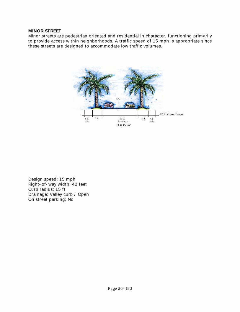
Page 26- 183
MINOR STREET Minor streets are pedestrian oriented and residential in character, functioning primarily to provide access within neighborhoods. A traffic speed of 15 mph is appropriate since these streets are designed to accommodate low traffic volumes.
Design speed; 15 mph Right-of-way width; 42 feet Curb radius; 15 ft Drainage; Valley curb / Open On street parking; No

Page 26- 184
LANE Lanes are narrow, short, privately maintained roads typically 16 to 18 feet wide and accessing single-family residences.
Design speed; 10-15 mph Right-of-way width; 40 feet Curb radius; 10 feet Drainage; open section On street parking; No Street trees; No Sidewalks; No

Page 26- 185
REAR ALLEY Alleys are privately maintained, low-speed service easements providing rear access for service, delivery, emergency access, utilities, and commercial uses.
Design speed; 10 mph Right-of-way width; 24 feet Curb radius; 5 feet Drainage; Curb and gutter On street parking; No Street trees; No Sidewalks; No {Ord. No. 1513-07, <sec> 1, 11-07-07}

Page 26- 186
ARTICLE 10
PARKING AND LOADING Section 10.1. Purpose and Intent The purpose of this Article is to ensure the provision of adequate pedestrian circulation and off-street parking and loading areas. It is further the intent to avoid urban congestion on public streets to protect the level of service and capacity of existing streets to avoid unnecessary conflicts between pedestrian and vehicles and to promote the general health, safety, and public welfare. These regulations shall apply to all parking and loading areas, including driveways for single-family and duplex dwellings, established within the City of Punta Gorda. Any plans for re-striping or modifying the number of parking or loading spaces shall be approved by the Zoning Official upon the submittal of a parking lot plan which complies with this Ordinance. Section 10.2. General Principles Off-street parking and loading areas should be designed to minimize breaks in the pedestrian environment along the public street and create safe and comfortable passage for pedestrians. The following standards shall be met. (a) Parking and loading areas shall be placed behind buildings; side of the building
parking will be permitted only as indicated by Building Type. Off-street parking and loading is not permitted in front of the primary building façade except in General Single Family Residential and General Multi-Family Residential Zoning.
(b) To the extent practicable, adjoining parking and loading areas serving non-
residential buildings shall be interconnected. (c) Off-street parking and loading areas shall be designed to facilitate adequate
movement and access by sanitation, emergency, and other public service vehicles without posing a danger to pedestrians or impeding the function of the parking area.
(d) Off-street parking and loading areas shall be designed so that parked vehicles do
not encroach upon or extend onto public rights-of-way, sidewalks or strike against or damage any wall, vegetation, utility, or other structure.
(e) Off-street parking and loading facilities shall be used solely for the parking of
vehicles in operating condition by the patrons, occupants or employees of the use to which such facilities are accessory. No motor vehicle repair work, except emergency service, shall be permitted in association with off-street parking and loading facilities. The storage of commercial vehicles or merchandise or the sale of vehicles shall be prohibited in a required off-street parking or loading area, except as specifically authorized in this Code.

Page 26- 187
(f) Facilities accessory to residential uses shall be used solely for the parking of non-commercial vehicles, which are owned by the occupants of the dwelling or their guests.
(g) In no event shall parking or loading areas be provided in a manner that requires
vehicles to back out into the public rights-of-way, or that requires vehicles to enter or exit a site in a manner which would require them to make an unlawful maneuver within the public right-of-way. This requirement does not apply to areas consisting of driveways serving single-family detached, or duplex dwellings, although direct access onto arterial roadways is discouraged.
(h) Parking and loading facilities shall be maintained in a clean, orderly and dust-free
condition at the expense of the owner or lessee. Parking and loading areas shall be resealed or repaved and pavement markings periodically repainted and on-site traffic control signs replaced, as necessary, to maintain a clear identification of individual parking and loading spaces and to facilitate the safe movement of pedestrian and vehicular traffic.
(Ord. No. 1459-06, <sec> 1, 12-06-06) Section 10.3. Parking Specifications (a) All parking lots shall be located behind the building frontage line of the principal
building served by the parking lot. (b) Parking lots should be visually and functionally segmented into several smaller
lots by use of landscaped areas in the following manner:
(1) A maximum of 10 parking spaces shall be permitted between landscape islands [Section 12.4(a)(2)].
(2) A maximum of 3 parking aisles shall be permitted between parking
perimeter buffers [Section 12.4(a)(1)].

Page 26- 188
(c) For all uses except single-family and two-family dwellings, standard curbing shall
be provided along the periphery of all driveways, parking and loading areas. (d) Off-street parking and loading areas and driveways shall be paved or contain a
similar type material approved by the Zoning Official. Gravel or other stabilization material without a permanent wearing surface is not permitted.
(e) Curb and gutter shall be installed where deemed necessary by the Public Works
Director, within off-street parking and loading areas in order to manage storm drainage, channelize traffic, protect buildings and landscaping areas, and separate pedestrian and vehicular circulation areas.
(f) Parking spaces shall meet the following dimensions:
(1) Standard parking spaces shall be a minimum of 18 feet long and 9 feet
wide; however, where a wheel stop is utilized, a minimum of 16 feet of pavement with a 2 foot overhang will be permitted.
(2) Parallel parking spaces shall be a minimum of 22 feet long and 8 feet wide. (3) Compact spaces shall be a minimum of 15 feet long and 8 feet wide. If
specifically designed and identified with a sign reading “For Compact

Page 26- 189
Only”, a maximum of 20 percent of the parking stalls required may be compact spaces.
(4) Handicap spaces shall meet the most current State and Americans with
Disabilities Act (ADA) requirements. (5) Motorcycle/Scooter spaces shall be a minimum of nine feet long and six
feet wide, and shall be counted toward meeting parking requirements of up to ten percent of the total parking requirement.
(g) Parking area aisle widths shall conform to the following table, which varies the
width requirement according to the angle of parking.
AISLE WIDTH IN FEET Angle of parking 0 30 45 60 90 One-Way Traffic 12 12 18 20 24 Two-Way Traffic 24 19 20 22 24
(h) Driveways are required for all improved properties having access to public or
private roads. It shall be unlawful to construct any driveway without a permit from the City Building Division. A permit application with a detailed driveway plan must be submitted to the City of Punta Gorda Building Division for approval prior to permit issuance for driveways. The driveway plan shall illustrate the proposed location and dimensions of the drive approach and its relationship with existing pavements.
(1) All driveway aprons within the City right-of-way must be a minimum of
four inch thick reinforced concrete construction. (2) All driveway material on private property shall be hard surface asphalt or
concrete or decorative pavers. Marl, shell or gravel driveways are not permitted.
(3) Any decorative additions to driveways in the public right-of-way over and
above the standard four inch thick reinforced concrete driveway, specifically, but not exclusively brick pavers, tile, cementations/decorative overlays and color coating or finishes will not be replaced by the City when the driveway in the right-of-way is removed and replaced in accordance with City authorized work.
(4) Any such decorative additions must be in addition to the required four inch
thick reinforced cement driveway. (5) Any improvements or decorative additions exceeding one-fourth an inch
in thickness and not constructed in conjunction with a permitted driveway so as to establish proper elevations for drainage, will require replacement of the existing driveway in the right-of-way.

Page 26- 190
(6) Total driveway width permitted for single family and duplex property shall be constructed in accordance with the following:
a. For property with up to 80 feet of street frontage on a single street,
total driveway width shall not exceed 28 feet, with no single driveway exceeding 24 feet in width at the property line and through the right-of-way.
b. For property with more than 80 feet of street frontage on a single
street, no single driveway shall exceed 24 feet in width at the property line and through the right-of-way and total driveway width shall not exceed 35 percent of the total street frontage up to a maximum of 48 feet total driveway width at the property line and through the right-of-way, unless a third driveway is approved by Special Exception as is permitted herein.
c. For properties that front on more than one street, the second street
front shall be allowed only one driveway not to exceed 24 feet in width at the property line and through the right-of-way.
(7) Non-residential and multi-family driveways shall be a maximum of 20 feet
in width for one-way traffic and 24 feet in width for two-way traffic. In no case shall a driveway width exceed 24 feet, except as required by the Florida Department of Transportation and Fire Safety requirements.
(8) Single-family residential driveways shall be constructed so that no part of
the driveway, excluding the flair, is closer than 25 feet to the intersection of the right-of-way lines of any nearby roadway intersection.
(9) For multi-family and commercial properties, no point of access shall be
allowed within 40 feet of the intersection of two right-of-way lines of any two intersecting public streets. The City Engineer shall determine that the location and design meets all safety and drainage requirements, and may require the distance to be increased to ensure public safety concerns are addressed; or the City Engineer may allow this distance to be reduced based on specific site conditions. The City Public Works Department or the Building Division may deny a permit application, or may require a modification to the proposed design when deemed appropriate in the interest of public safety.
(10) A maximum of two driveways may be permitted for ingress and egress
purposes to and from a single property or development on each road abutting the property. A third driveway may be permitted by Special Exception provided such third driveway does not exceed 24 feet in width at the property line and through the right-of-way, and the cumulative width of all driveways does not exceed 35 percent of street frontage at the property line and through the right-of-way, and if a proposed or existing residential structure is located on a minimum of one hundred and fifty feet of street frontage on a single street. This includes phased development if the minimum distance between the two driveways measured at the

Page 26- 191
property line is equal to or exceeds twenty feet in single family residential districts and fifty feet for all other districts.
(11) In tract development where the minimum distance between adjacent
driveways on a single street exceeds 100 feet, or the development exceeds two acres of land area, the number of driveways may be increased upon recommendation by Urban Design.
(12) No driveway shall be located closer than six feet from an adjoining lot
under other ownership or in a recorded easement in the Special Residential Overlay District, and no closer than five feet at the property line in other residential districts, and subject to setback requirements in the mixed use and commercial districts.
(13) Driveway flairs and any culvert drainage pipe shall not extend more than
three feet on each side of the driveway. In any event, driveway flairs may not extend beyond the property line. Flairs shall extend from the roadway up to the swale, or ten feet from the edge of the road, whichever is less.
(14) The surface area of all driveways located on private property shall be
included in the total impervious area calculation and must be included on all plans for new driveway construction or for driveway replacement.
(15) All driveways shall accommodate existing or planned sidewalks for ADA
accessibility, (ramp slope, cross slope, and crossing marking where necessary, as determined by Public Works and the Building Division.)
(i) Non-residential off-street parking areas which are provided in excess of the
requirements established in this Article shall be located on grassed or sodded surface. Alternative materials may be substituted for grass or sod with the approval of the City Council. Such parking area shall include curb stops, a paved driveway apron across the public right-of-way and required landscape screening per Article 12 of this Chapter.
Application for City Council approval of alternative materials must include signed
and sealed engineered drawings providing for applicable stormwater retention and compliance with the Southwest Florida Water Management District requirements. The site must also meet all Federal and State handicapped accessibility requirements.
(j) Definitions. The following definitions shall apply in this section.
(1) “Electric vehicle” shall mean any motor vehicle register to operate on public roadways that operates either partially or exclusively on electric energy. Electric vehicles include:
a. Battery-powered electric vehicles; b. Plug-in hybrid electric vehicles; c. Electric motorcycles; and d. Fuel cell vehicles

Page 26- 192
(2) “Electric vehicle charging level” shall mean the standardized indicator of
electrical force or voltage at which the battery of an electric vehicle is recharged, as follows:
a. AC Level 1 transfers 120 volts (1.4-1.0kW) of electricity to an
electric battery. b. AC Level 2 transfers 240 volts (up to 19.2kW) of electricity to an
electric vehicle battery. c. DC Fast Charging Levels 1 and 2 transfer a high voltage (typically
400-500 volts or 32-100kW, depending on the electrical current) of direct current electricity to an electric vehicle battery.
(3) “Electric vehicle parking space” shall mean an off-street parking space this
is equipped with an electric vehicle charging station.
(4) “Electric vehicle charging station” shall mean battery charging equipment that has as its primary purpose the transfer of electric energy (by conductive or inductive means) to a battery or other energy storage device in an electric vehicle.
(k) Electric vehicle parking. If specifically designed and identified with appropriate
markings and/or signage as outline in this Section, a maximum of twenty (20) percent of the parking spaces required may be electric vehicle parking and shall meet the following design standards, in addition to all other design standards set forth in this section.
(1) Electric vehicle parking spaces shall be painted green, or shall be marked
by green painted lines and curbs and/or wheel stops.
(2) Each electric vehicle parking space shall be marked by a sign designating the parking space as an electric vehicle parking space, in accordance with the Manual on Uniform Traffic Control Devised (MUTCD) of the Federal Highway Administration.
(3) Each electric vehicle charging station shall be subject to the architectural
provisions of Article 7, Section 7.4(a)(7). (4) Each electric vehicle charging station shall be equipped with a sign that
includes the following information: a. Voltage and amperage levels; b. Any applicable usage fees; c. Safety information; and
d. Contact information for the owner of the charging station to allow a consumer to report issues relating to the charging station.
(5) Electric vehicle charging stations shall contain a retraction device, coiled
cord, or a fixture to hang cords and connectors above the ground surface.

Page 26- 193
(6) Electric vehicle charging stations shall be screened from view from any abutting rights-of-way, with the exception of alleys.
(7) Electric vehicle charging stations shall be maintained in good condition,
appearance and repair. (l) Vehicular interconnection. Non-residential parking areas on adjacent lots shall
be connected wherever practicable.
(1) Purpose and intent. The purpose of requiring cross-access in certain situations is to reduce the necessity to use the existing public street system in order to move between adjacent and complementary land uses where such interchange of vehicular or pedestrian strips are likely to occur.
(2) Requirements. For uses requiring DRC approval of site plans the following
shall apply:
a. Traffic circulation and control patterns within the site shall be adequate to provide vehicular and pedestrian access to adjoining properties and streets;
b. Walkways, bike lanes and paths shall be located so that users may
move from store to store or building to building on the site and to adjacent properties, with the minimum possible conflicts with vehicular traffic and the maximum possible efficiency of pedestrian/bicycle circulation;
c. Walkways, travel lanes and driveways shall be connected with related
facilities in adjacent properties; d. All commercial, office, multi-family, recreation and community
facility uses shall be designed to require vehicular and pedestrian cross access to adjacent commercial, office, multi-family, recreation and community facility uses. Shared access points on public or private streets shall be required where determined to be necessary by the Urban Design Manager or his/her designee, to protect capacity on adjoining roadways or in the interest of public safety. i. If the adjacent site is developed, the developer shall design
and build the appropriate cross-access to the property line of the adjacent property.
ii. If the adjacent site is undeveloped, the developer shall
design and build the cross-access to the property line of the adjacent parcel in anticipation of future connection when that site is developed.
(Ord. No. 1459-06, <sec> 2, 12-06-06; Ord. No 1590-09, <sec> 1-2, 5-6-09; Ord. No. 1756-13, <sec> 1, 7-3-13; Ord. No. 1762-13, <sec> 3, 7-3-13; Ord. No. 1775-13, <sec> 5, 11-20-2013; Ord. No. 1805-15, <sec> 1, 01-07-2015; Ord. No. 1840-16, <sec> 1, 03-02-2016; Ord. No. 1914-19, <sec> 1, 03-06-2019; Ord. No. 1946-20, <sec> 4, 8-19-2020)

Page 26- 194
Section 10.4. Off-Site Parking Areas The City Council, upon review and recommendation of the Planning Commission, may authorize the utilization of off-site parking areas for uses within non-residential districts, and anywhere within the HC district. The owner of a site utilizing an off-site parking area shall provide evidence of the owner’s right to use the off-site parking area either by license, deed, easement, or by long term lease. Pedestrian access shall be available within a walking distance of 500 feet, measured from the nearest point of the building lot to an entrance to the parking area. Such separated parking areas shall be usable without causing unreasonable traffic congestion, detriment to any residential neighborhood, or hazard to pedestrians. Section 10.5. Shared Off-Street Parking The joint use of shared off-street parking between two uses may be made by contract between two or more adjacent property owners. Adjacent lots in the HC district shall be interconnected. Entities that operate at different times may jointly use or share the same parking spaces with a maximum of one-half of the parking spaces credited to both uses if one use is a church, theater, assembly hall or other non-residential use whose peak hours of attendance will be at night or on Sundays, and the other use or uses are ones that will be closed at night or on Sundays or upon the normal hours of operation. The City Council, upon review and recommendation of the Planning Commission, may authorize a reduction in the total number of required parking spaces when the City Council makes a determination that two or more uses can be adequately served by the same parking spaces by reason of the characteristics of the land uses and the hours of operation. The City Council is also authorized to require restrictions on the use and hours of operation of any uses that share parking spaces. Section 10.6 Parking in the CC District To encourage the continuing revitalization of the City’s downtown City Center Zoning District, the City has created a Parking Exemption Area as shown on the map below. Within this exemption area, buildings with a footprint of 10,000 square feet or less are not required to provide parking for the uses on the site.

Page 26- 195
For those buildings and uses in the City Center Zoning District located outside of the Parking Exemption Area and for those buildings and uses in the Parking Exemption Area but in excess of the 10,000 square foot building footprint size, the following are parking requirements. Existing or newly created on-street public parking directly abutting the development site may be used to fulfill this requirement. Additional parking may be provided on-site, not to exceed the number of spaces for the uses as listed in Section 10.7. Residential: 1 space per living unit All other uses: 1 space per 1,000 square feet, but not less than 1 space. NOTE: In the City Center District, existing buildings which were legally constructed without the provision of on-site parking and infill housing on existing lots of record will be considered conforming as to parking. Such buildings are eligible for change of use and renovation without providing additional parking. {Ord. No. 1509-07, <sec> 1, 10-03-07; Ord. No. 1677-11, <sec> 1, 04-06-11} Section 10.7. Parking Ratios for all Zoning Districts except City Center The parking recommendations as listed in the most recent Institute of Transportation Engineers (ITE) Parking Generation Manual for the associated land use may be substituted for specific uses in lieu of parking requirements listed herein upon approval of said request by the Zoning Official or designee. Supporting documentation from the ITE Parking Generation Manual shall be required to be submitted as part of the permit application. (a) Residential

Page 26- 196
(1) Apartment/Multi-family - 2 per unit (2) Attached and Detached Homes - 2 per unit (3) Workforce and Affordable Housing – 1 to 1.5 spaces per unit
(b) Institutional/Medical/Government
(1) Institutions of higher learning – 1.5 per 2 students and 1 per 2 residents (2) High schools – 1.5 per 5 students (3) All other schools – 1. 5 per classroom (4) Government and Civic institutions – 1 per 300 square feet and/or 1 per 4
seats of meeting area (5) General health – 1.2 per bed (6) Religious and cultural facilities – 1 per 4 seats (7) Civic / Social / Fraternal organizations – 1 per 200 square feet and/or 1
per 4 seats (8) Adult care and group home – 1 per 3 residents (9) Assisted Living/Nursing Homes, Long Term Care Facility - 1 per 4 beds
and 1 per employee (10) Child care – 1 per 10 children
(c) Office and Retail
(1) Offices – 1 per 400 square feet (2) Retail – 1 per 250 square feet (3) Theaters – 1 per 3 seats (4) Bed & Breakfast Inns/ Hotels/ Motels - 1 per room or suite (5) Convention facilities – 1 per 250 square feet (6) Night clubs / Lounges / Bars / Restaurants – 1 per 100 square feet (7) All other commercial – 1 per 300 square feet
(d) Industrial
(1) Manufacturing/Warehousing/Light Assembly - 1 per 4,000 square feet of non-office space and 1 per 400 square feet of office
(2) All other industrial uses – 1 per 400 square feet (e) All other industrial uses – 1 per 400 square feet (f) Miscellaneous
(1) Train station – 1 per 4 seats (2) Marinas - 1 per 2 boat slips
{Ord. No. 1459-06, <sec> 4, 12-06-06; Ord. No. 1509-07, <sec> 2, 10-03-07; Ord. No. 1775-13, <sec> 6, 11-20-2013} Section 10.8. Stacking Spaces Stacking spaces shall be a minimum of ten feet in width exclusive of gutter pans and

Page 26- 197
eighteen feet in length. All stacking areas must be separate from other circulation aisles and parking spaces. (a) Food Restaurants. A minimum of eight stacking spaces shall be required for fast
food restaurants with drive-up windows. The distance shall be measured from the drive-up window.
(b) Financial Institution Drive-up Windows. A minimum of five stacking spaces shall
be required per drive through lane. (c) Car Wash. A minimum of five stacking spaces per car wash bay shall be required. (d) Other Uses. For other uses not specifically provided for herein, the Zoning Official
shall make a determination regarding the number of stacking spaces required. {Ord. No. 1459-06, <sec> 5, 12-06-06} Section 10.9. Minimum Loading Space Ratio Notwithstanding the loading requirement set forth below, in no instance shall more than 5 off- street loading spaces be required for any given use or building. For each retail store, storage warehouse, wholesale establishment, industrial plant, factory, freight terminal, market, restaurant, mortuary, laundry, dry cleaning establishment or similar use which has an aggregate gross floor area of: AREA IN SQUARE FEET SPACES Over 5,000 but not over 15,000 1 Over 15,000 but not over 30,000 2 Over 30,000 but not over 60,000 3 Over 60,000 but not over 100,000 4 Over 100,000 5
Section 10.10. Loading Specification (a) Standard loading spaces shall be a minimum 15 feet in width and 30 feet in length
and provide a minimum vertical clearance of 15 feet; provided, however, that when loading spaces are located alongside each other, additional loading spaces need only be a minimum of 12 feet in width.
(b) Semi-Trailer loading spaces shall be a minimum of 15 feet in width and 55 feet
in length and provide a minimum vertical clearance of 15 feet. (c) No off-street loading area shall be located within any required front yard.
Furthermore, no off-street loading area shall be used to satisfy requirements for parking or stacking spaces. All loading areas shall be located and designed in a manner which does not interfere with the free circulation of vehicles within parking or stacking areas.

Page 26- 198
(d) Loading spaces may be provided cooperatively for two or more uses, subject to the approval by the Zoning Official of appropriate legal instruments to ensure the permanent availability of off-street loading for all such uses. The overall number of loading spaces provided may be reduced by the City Council in those instances where it is demonstrated that adjacent land uses can be adequately served by a shared loading facility. The Planning Commission shall make a recommendation to the City Council regarding any such proposed reduction in the number of required loading spaces. The City Council is also authorized to require restrictions on the use and hours of operation of any uses that share loading spaces.
Section 10.11. Valet Parking Valet parking may be utilized to meet with requirements of Section 10.7, providing the following conditions are complied with: (a) Valet parking contract must be made with a valet service or operator licensed by
the City, which allows for attendants to receive, park and deliver the automobiles for the patrons/clients of a facility.
(b) Any valet parking arrangement used to fulfill the requirement of Section 10.7.
shall remain in full force and effect for the entire time the owner of property seeks to provide parking by valet in lieu of providing required parking spaces, or in lieu of paying the required fee. All valet parking agreements must be reviewed and approved by the Development Review Committee for adequacy. Factors to be considered by the Development Review Committee include, but shall not be limited to: (1) the location of where valet parking will occur; (2) whether the valet company has a valid City of Punta Gorda Business Tax Receipt; and (3) whether the agreement provides for an adequate number of attendants. Any subsequent agreement or revisions must also be provided to the Development Review Committee for review and approval. All valet parking agreements shall remain in effect until the owner seeks approval by the Development Review Committee for an alternative parking arrangement which satisfies the parking requirements. Property owners providing valet parking under the provisions of this section shall provide evidence to the Development Review Committee by January 1 of each year that an annual valet parking agreement remains in effect for the next 12 month period. Any property owner who fails to provide such evidence will be required to appear before the Development Review Committee for approval of an alternative parking arrangement. Failure to provide valet parking under the terms of an approved valet parking agreement shall be deemed a violation of this Chapter.
(c) A valet drop-off/queuing area must be provided at a minimum length of 100 feet.
(1) Greater or lesser queuing area may be approved as a condition of site plan approval based on intensity of use.
(2) Queuing must occur on private property or as a condition of the
Development Review Committee site plan approval on a public right-of-way where such queuing does not impede normal traffic operation.

Page 26- 199
(3) There must be an adequate number of parking attendants available for vehicle retrieval during business hours to avoid queuing on public right-of-way which impedes normal traffic operation.
(4) All valet parking attendants shall have a valid Florida driver’s license.
(d) Valet parking may be utilized to fulfill ADA parking requirements provided that a
minimum of two ADA accessible spaces are provided adjacent to the queuing area or located as approved by the Building Division at the Development Review Committee site plan approval for vehicles that cannot be safely operated by a parking professional.
{Ord. No. 1459-06, <sec> 6, 12-06-06} Section 10.12. Valet Parking Facilities On-site or off-site parking facilities for the exclusive use of valet parking may be provided subject to Development Review Committee approval. The following standards shall apply to Valet Parking Facilities: (a) The dimensions for a valet parking space shall be a minimum of 8.5 feet wide and
16 feet in length with a maximum of two spaces along each side of an approved drive aisle.
(b) Landscape buffers and interior landscaping requirements of Section 12.4. shall
apply to all surface lots utilized for valet parking, with the option of transferring the interior requirements to the perimeter buffer areas.
(c) Property used for valet parking does not need to be under the ownership of the
business owner, but must have a valid contract for the property to be used for the approved parking agreement.
(d) Public parking spaces may not be utilized for valet parking unless approved
through a valid contract with the appropriate governmental entity owning such spaces.
{Ord. No. 1459-06, <sec> 6, 12-06-06} Section 10.13. Bicycle Parking Specifications
(a) All new non-residential and new multi-family developments shall include short
and/or long term bicycle parking as specified in this Section. In lieu of this requirement, the applicant may provide funding, at a fee level set by the City Council, for the purchase of community bicycle parking facilities. 1. A fee of $500 per bicycle rack loop may be paid to the City of Punta Gorda in
lieu of the bicycle rack facilities required by this Section. Fees shall be set aside to be used for the purchase, installation and/or maintenance of community bicycle parking facilities.

Page 26- 200
(b) The number of required bicycle parking spaces shall be determined on a case-
by-case basis by the City Manager, or his designee, based upon the following criteria: 1. Total number of residential units
2. Total non-residential square footage
3. Proximity to existing or planned bicycle infrastructure (bike paths, multi-use
paths, bicycle lanes, etc.)
4. The likelihood, based upon consideration of all relevant factors, that such bicycle parking spaces will be utilized.
a. Standard bicycle parking spaces shall be a minimum of six (6) feet long
and two (2) feet wide.
Figure 10.13(a)(1): Standard Bicycle Parking Space
b. A vertical clearance of seven (7) feet is required for any roof, overhang,
or other covering over the area. c. An access aisle a minimum of five (5) feet wide shall be required in each
bicycle parking facility.

Page 26- 201
Figure 10.13(a)(3): Example Bicycle Parking Layouts
d. Bicycle parking areas must be on the ground floor level unless
accessible by an elevator designed to safely accommodate riders and bicycles.

Page 26- 202
(c) Bicycle Rack Design Criteria. All bicycle racks required under this Section shall
meet the following design criteria:
1. Support the bicycle upright by its frame at two points.
Figure 10.13(b)(1): Supports Bicycle Frame in two points
2. Permit the use of a standard U-lock or lock and chain to secure the
frame and at least one wheel to the rack.
Figure 10.13(b)(1): U-lock secures the bicycle frame and one wheel to the rack

Page 26- 203
3. Be in-ground mounted or secured to a concrete pad with tamper
resistant fasteners.
Figure 10.13(b)(3): Examples of Appropriate Bicycle Rack Designs
Figure 10.13(b)(3): Examples of Prohibited Bicycle Rack Designs
(d) Short Term Bicycle Parking. Short term bicycle parking is designed for use by
customers or other visitors engaged in short stays of less than eight (8) hours on a particular property. Short Term Bicycle Parking consists of appropriately designed and placed Bicycle Racks. These facilities generally do not provide the same level of weather protection and theft deterrence as Long Term Bicycle Parking. 1. Is required for all non-residential development to encourage shoppers,
customers, and other visitors to use bicycles by providing secure, convenient and accessible place for parking bicycles;
2. Is required for all multi-family development that includes community recreational facilities that include additional vehicular parking;
3. Shall be within 50 feet of a primary (not a service or emergency) building entrance for each tenant;
4. Shall be located on a solid surface (asphalt, concrete pavers or brick)
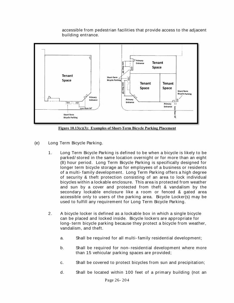
Page 26- 204
accessible from pedestrian facilities that provide access to the adjacent building entrance.
Figure 10.13(c)(3): Examples of Short-Term Bicycle Parking Placement
(e) Long Term Bicycle Parking.
1. Long Term Bicycle Parking is defined to be when a bicycle is likely to be
parked/stored in the same location overnight or for more than an eight (8) hour period. Long Term Bicycle Parking is specifically designed for longer term bicycle storage as for employees of a business or residents of a multi-family development. Long Term Parking offers a high degree of security & theft protection consisting of an area to lock individual bicycles within a lockable enclosure. This area is protected from weather and sun by a cover and protected from theft & vandalism by the secondary lockable enclosure like a room or fenced & gated area accessible only to users of the parking area. Bicycle Locker(s) may be used to fulfill any requirement for Long Term Bicycle Parking.
2. A bicycle locker is defined as a lockable box in which a single bicycle
can be placed and locked inside. Bicycle lockers are appropriate for long-term bicycle parking because they protect a bicycle from weather, vandalism, and theft.
a. Shall be required for all multi-family residential development; b. Shall be required for non-residential development where more
than 15 vehicular parking spaces are provided; c. Shall be covered to protect bicycles from sun and precipitation; d. Shall be located within 100 feet of a primary building (not an

Page 26- 205
emergency) entrance or otherwise centrally located if intended to serve multi-buildings;
e. Shall be located inside a securable enclosure or structure unless
bicycle lockers are utilized to fulfill this requirement; f. Shall be located on a solid surface (asphalt, concrete pavers or
brick) accessible from pedestrian facilities that provide access to the primary building entrance, parking area, or street.
Figure 10.13(d)(4): Examples of Long
Term Bicycle Parking

Page 26- 206
ARTICLE 11
SIGN STANDARDS Editors Note: Article 11, Sign Standards, was rewritten in its entirety and adopted via Ordinance 1966-2021 on June 2, 2021. Provisions relating to sign regulation within the following areas of the Punta Gorda Code are repealed as of the date of the adoption of the new ordinance: Chapter 26, Section 3.13(s) Real Estate Signs Chapter 26, Section 8.21, Yard Sales Chapter 26, Section 8.9 Model Homes, Apartments, and Condominiums Chapter 26, Article 13, Events, Section 13.1 Purpose Chapter 26, Section 13.2 Business Events and Business Promotions Chapter 26, Section 13.3 Grand Opening Event Chapter 26, Section 13.5(a)(2) Temporary Promotional Event Signs Section 11.1 Intent and Purpose (a) Intent. Signs have a strong visual impact on the character and quality of our
community. As a prominent part of the scenery, they attract or repel the viewing public, affect the safety of traffic on adjacent rights of way and their suitability or appropriateness helps to set the tone for our community. The City relies upon its physical setting and beauty to attract commerce and aesthetic considerations assume economic value. The intent of this Article is to protect and enhance both the City’s residential character and its economic base using appropriate and aesthetic signage.
(b) Purpose. The purpose of this Article is to promote the public health, safety, and
welfare through a comprehensive system of reasonable, effective, consistent, content-neutral, and nondiscriminatory sign standards and requirements that:
(1) Promote and accomplish the goals and policies of the City’s comprehensive
plan and land development regulations, and the City Council’s vision for the City;
(2) Provide minimum standards to safeguard life, health, property, and public
welfare, and promote traffic safety by controlling the design, quality of materials, construction, illumination, size, location, and maintenance of signs and sign structures and discouraging excessive numbers of signs;
(3) Recognize Constitutionally protected free speech rights by regulating signs
in a content-neutral manner; (4) Promote the safe flow of traffic and protect all roadway users from injury
and property damage caused by or which may be fully or partially attributable to cluttered, distracting, and/or illegible signage;
(5) Promote a positive visual image of the City and protect the beauty of the

Page 26- 207
City’s built environment by encouraging signs that are compatible with the architectural style, characteristics, and scale of the building to which they may be attached; appropriate to the size of the subject property and amount of street frontage adjacent to the subject property; and compatible with adjacent buildings and businesses;
(6) Protect property values, the local economy, and the quality of life by
preserving and enhancing the appearance of the City’s streetscape; (7) Provide consistent sign design standards; (8) Protect and encourage creative and innovative approaches to signage and
signs that are of a quality design, pleasing in appearance, and are appropriate in size, materials, and illumination to the surrounding neighborhood or commercial district;
(9) Provide an improved visual environment for the citizens and visitors of the
City; (10) Adopt clear, understandable regulations that will assure equal protection
and fair treatment under the law through consistent application of the regulations and consistent enforcement of this Article;
(11) Balance both public and private business needs with the specific objectives
of creating a community with an unmatched quality of life and a strong focus on economic well-being, aesthetics, community and family, the environment, and public infrastructure;
(12) Support and enhance the economic well-being of all businesses within the
City and recognize the needs of all businesses to identify their premises and advertise their products and services; and
(13) Recognize that the aesthetic value of the total environment affects
economic values and that an unrestricted proliferation of signs detracts from the economic value of the community.
Section 11.2 Applicability and Exclusions (a) Applicability. This Article applies to all signs within the jurisdictional limits of the
City of Punta Gorda, Florida (hereinafter referred to as “City”) regardless of the type or nature.
(b) The provisions of this Article do not supersede more stringent provisions in
community deed restrictions or other restrictive covenants. Citizens are advised to review any deed restrictions and restrictive covenants which may apply to their property, before the application for permit or placement of any sign(s) allowable under this Article.
(c) Exclusions. Except as where otherwise prohibited in Article 11, the following are
excluded from the regulations and requirements of this Article:

Page 26- 208
(1) Signs that are not visible from any public right-of-way (including public
waterways), public space, or another property. (2) Signs inside a building; however, signs inside windows or on the inside
surface of windows are not excluded if they are visible from any public right-of-way, public space, or another property.
(3) Signs required by any applicable local, State, or Federal law. (4) Signs installed by a City, County, State, Public Utility or Federal
governmental agency for the protection of the public health, safety, and general welfare, including, but not limited to, the following:
a. Emergency and warning signs necessary for public safety or civil
defense; b. Traffic and/or wayfinding signs erected and maintained by an
authorized public agency; c. Signs required to be displayed by law; d. Signs showing the location of public facilities; and e. Any sign, posting, notice, or similar sign placed by or required by a
governmental agency.
(5) Except as otherwise provided for herein, any sign on or in a vehicle, however, such signs may otherwise be regulated or prohibited pursuant to the provisions of Chapter 23, Section 23-22, Punta Gorda Code and Chapter 26, Article 3, Section 3.13(k), Punta Gorda Code.
(6) Outdoor art, including but not limited to statuary and fountains. Outdoor
murals on structures shall be regulated as Iconic signs pursuant to Section 11.15 of this Article.
(7) Temporary signs located on fences for screening of a construction site, as
long as there is an active development permit, grading permit, or building permit approval that includes external work or modifications of the site.
(8) Historic or memorial plaques, gravestones, and building marker signs.
Building marker signs are signs indicating the name of a building, the date of construction, and incidental information about the building’s construction. Building marker signs shall not exceed 5 square feet in area; shall be made of permanent material such as bronze or masonry permanently affixed to the building wall; and shall not exceed one sign on any single building.
(9) Signs supported, held, or worn by a person. (10) Public and private regulatory and warning signs, such as, but not limited
to, “no trespassing”, “no hunting”, “no parking”, “no soliciting”, “handicap parking only,” “entrance,” “exit,” “restrooms,” “loading zone,” “names and unit numbers for tenants of a building or development,” “tow away zone,”

Page 26- 209
“pesticide, fertilizer or other lawn applications,” and “security system signs.” Such signs may contain graphics to compliment the sign text. Such signs must be in conformance with Florida Statute requirements.
(11) Seasonal and Holiday decorations, including string lights and projected
image signs associated therewith. Projected image signs shall not be displayed from the hours of 11:00 p.m. to 8:00 a.m.
(12) A building’s street address. (13) Signs used in conjunction with athletic fields. (14) Flags used in conjunction with cemeteries.
Section 11.3 Interpretation (a) This Article is not intended to, and shall not be interpreted to, restrict speech
based on its content, viewpoint, or message. (b) No part of this Article shall be construed to favor commercial speech over
noncommercial speech. Section 11.4 Definitions (a) The following words, terms, and phrases, when used in this Article, shall have
meanings ascribed to them in this Section, except where the context clearly indicates a different meaning. All words and terms not specifically defined in this Section shall be given their common, ordinary meanings, as the context may reasonably suggest, unless defined in Chapter 26, Article 19, Section 19.2, Punta Gorda Code, in which case said definition may be used, if appropriate to the context. The reference for common, ordinary meanings shall be the online version of the Merriam-Webster dictionary found at www.merriam-webster.com.
(1) A-Frame (Sandwichboard, T-Frame or Sidewalk) sign means a self-
supporting sign which is ordinarily in the shape of an “A” or some variation thereof, which is readily movable, and is not permanently attached to the ground or any structure.
(2) Abandoned sign means any sign remaining in place after such sign has
not been maintained or, if the activity conducted on the subject property ceases, for 180 or more consecutive days. An abandoned sign is a sign that, because of passage of time, has faded, peeled, cracked, or otherwise become deteriorated or dilapidated, or is no longer affixed to the ground, or is missing the sign face. Unauthorized signs placed on public property including but not limited to public right-of-way shall be deemed abandoned signs. Any political advertisement regulated by Section 106.1435, Florida Statutes which has not been removed within thirty (30) days after a candidate has withdrawn from candidacy; after a candidate has been eliminated as a candidate; or after a candidate has been elected to office, shall be considered an abandoned sign.

Page 26- 210
(3) Air-Activated sign means a sign, all or any part of which is designed to be
moved by action of forced air so as to make the sign appear to be animated or otherwise to have motion.
(4) Alter means to change the copy, color, size, shape, illumination, position,
location, construction or supporting structure of a sign, but does not include ordinary maintenance or minor repairs.
(5) Animated sign means any sign, or any portion of the sign, affected by the
movement of air or other atmospheric or mechanical means, or that uses natural or artificial changes of lighting, to depict action or create a special effect or scene. Animated signs include, but are not limited to, flashing signs, inflatable signs, rotating signs, pennants, streamers, balloons, searchlights, spinners, and propellers. Changeable copy signs and electronic changeable copy signs are not considered animated signs for the purposes of this Article.
(6) Athletic field means facilities used for sporting activities such as softball,
baseball, football, soccer, running track, tennis, and other non-motorized sports. Athletic fields may include bleachers, concession stands, lights, restrooms, and other supporting facilities.
(7) Awning or canopy sign means a nonelectric sign that is printed on,
painted on, or attached to the surface or flap of an awning or canopy. An awning is a decorative or functional structure which is attached to, and wholly supported by a building providing shade or cover from rain. A canopy is similar in design to an awning but is freestanding or is not wholly supported by a building.
(8) Balloon sign means a sign that is an air inflated object, which may be of
various shapes, made of flexible fabric, resting on the ground or a structure, and equipped with a portable blower motor that provides a constant flow of air into the device. Balloon signs are restrained, attached, or held in place by a cord, rope, cable, or similar method.
(9) Banner sign means a sign composed of flexible material, such as fabric,
pliable plastic, or other similar non-rigid material, with no enclosing framework or electrical components and that is supported or anchored on two or more edges or at all four corners, or along either one edge or two corners with weights installed that reduce the reaction of the sign to wind. A special event banner is a banner expressly authorized as part of a special event permit.
(10) Bench sign means a sign painted on, located on, or attached to any part
of the surface of a bench, seat or chair placed on or adjacent to a public place or public roadway, and include bicycle racks installed by the City.
(11) Blade (Feather, Teardrop, Flag, or Flutter) sign means a sign that is
constructed of cloth, canvas, plastic fabric, or similar lightweight, non-
Page 26- 211
rigid material that is supported by a single vertical pole mounted into the ground or on a portable structure.
(12) Building-mounted sign means any sign attached to the face of a building,
including, without limitation, wall signs, marquee signs, under canopy signs, and projecting signs.
(13) Changeable copy sign means a sign with copy that can be changed or
altered by manual, electric, electromechanical, or electronic means and without changing or altering the sign frame, sign supports, or electrical parts.
(14) Copy means the graphic content of a sign surface, including, but not
limited to, graphics, letters, numbers, figures, symbols, and trademarks. (15) Copy Area means that area which displays the actual copy on a sign,
excluding any blank area surrounding the copy. (16) Drive/Bike/Walk-Thru sign means any sign to facilitate the use of a drive-
thru or walk up window for provision of a good or service. (17) Electric sign means a sign or sign structure in which electrical wiring,
connections, or fixtures are used. (18) Exposed building face means the building exterior wall of a single
occupant building or the building exterior wall of an individual tenant’s leased space in a multi-tenant complex, viewed as a vertical plane between the finished grade and the roofline or top of parapet wall. This vertical plane will be used to calculate the sign area for building-mounted signs. In the case of an interior business without a separate exterior entrance, the exposed building face will be the vertical plane of the entrance wall measured between the floor and ceiling. As an option, for those businesses having oblique walls, the exposed building face is that area between the finished grade and the roofline that is shown on the elevation drawing submitted with the required drawings for a building permit.
(19) Façade sign means a sign affixed to the exterior wall of a commercial
building, typically within a designated sign band located near the top of the building, which includes an occupant’s name and/or logo.
(20) Fighting words are words or graphics which by their very utterance have a
direct tendency to incite immediate breach of the peace by the person to whom, individually, the remark is addressed. The test is whether persons of common intelligence would understand such words would be likely to cause an ordinary addressee to fight. Fighting words include, but are not limited to, defamatory remarks made to private citizens and epithets based on the addressee’s race, color, religion, disability, national origin, ethnicity, or sex.

Page 26- 212
(21) Flag means any piece of cloth of individual size, color, and design, hoisted on a pole permanently affixed to the ground or displayed via a pole bracket permanently affixed to a building. If any single dimension of a flag is more than three times greater than any other single dimension, for the purposes of this Article such a flag is classified and regulated as a banner, regardless of how it is anchored or supported.
(22) Flashing sign means an electric sign or any portion of an electric sign that
changes light intensity in sudden transitory bursts or switches on and off in a repeated manner (e.g., strobe lights).
(23) Freestanding sign means a sign on a frame, pole, or other support
structure that is not attached to any building, located in a commercial zoning district.
(24) Frontage, building means the length of an outside building wall. (25) Frontage, street means the length of the property line along the public
right-of-way or private street on which it borders. (26) Graffiti means writing or drawings scribbled, scratched, or sprayed
illicitly on a wall or other surface in public right-of-way or public space, or on a private property viewable from a public right-of-way, public space, or another private property.
(27) Ground sign means a sign that is permanently attached to the ground
with the bottom of the sign base no more than 1 foot above finished grade.
(28) Height, sign means the vertical distance measured from the highest point
of the sign to either the grade of the adjacent street or the surface grade beneath the sign, whichever is less.
(29) Illuminated sign, internally, means a sign with an artificial light source installed internally with light visible thru a transparent or translucent sign face.
(30) Illuminated sign, externally, means a sign with an artificial light source
installed externally. (31) Illuminated sign, indirectly, means a sign with an artificial light source
installed internally to the sign structure with an opaque sign face, where the light shines onto a wall or other surface to highlight the outlines of the sign.
(32) Indecent speech is language or graphics that depict or describe sexual or
excretory activities or organs in a manner that is offensive as measured by contemporary community standards.
(33) Inflatable sign means any object enlarged or inflated by air or gas, and is
tethered in the air, or is located on the ground or on a building with or

Page 26- 213
without copy or other graphics. These signs include large single displays or a display of smaller inflatable items, such as balloons, connected in some fashion to create a larger display.
(34) International Maritime Signal Flags means a signal flag for each letter of
the alphabet, and pennant for numerals. Each flag (except the R flag) has an additional meaning when flown individually, and take on other meanings in certain combinations.
(35) Light Pole/Support Pole sign means a sign that is designed to be attached
to a permanent light pole or other pole structure (36) Maintenance means the cleaning, painting, changing of lighting fixtures,
or minor repair of a sign in a manner that does not alter the basic copy, design, or structure of the sign.
(37) Marquee sign means a sign attached to or mounted on top of a roof-like
structure that cantilevers from the wall of a building or its principal entrance and has no vertical supports other than the wall from which it cantilevers.
(38) Minor repair means fixing or replacement of broken or worn parts of a
sign. Replacement includes comparable materials only. Repairs may be made with the sign in position or with the sign removed.
(39) Multi-tenant sign means a sign used by more than tenant occupying the
same multi-use complex [Section 19.3(154)]. (40) Neon (outline tubing) sign means a sign consisting of glass tubing, filled
with neon gas or other similar gas, which glows when an electric current is sent through it.
(41) Nonconforming sign means any sign that was constructed, erected, and
maintained in conformance with all City of Punta Gorda rules and regulations in effect at the time the sign was established and that no longer conforms to the rules and regulations of this Article.
(42) Obscene means language or graphics that depict or describe sex or
sexual organs in a manner appealing to, or intended to appeal to the average viewer/reader’s visceral sexual (prurient) interests, and taken as a whole, lacks any justification from a political, literary, artistic, or scientific value.
(43) Parcel means any plot of land that has been assigned a “Parcel ID
Number” by the Charlotte County Property Appraiser. A parcel may consist of one or more platted lots. With respect to condominium developments, the term parcel shall mean only the land described as a “common element” and shall not apply to individual units which have been assigned a “Parcel ID Number.”

Page 26- 214
(44) Pennant sign means a triangular or irregular piece of fabric or other material attached in strings or supported on small poles intended to flap in the wind.
(45) Permanent means a sign attached to a building or structure, or to the
ground in a manner that precludes ready removal or movement of the sign.
(46) Person shall mean any natural person, firm, corporation, or other legal
entity. (47) Pole or pylon signs means self-supporting signs supported permanently
upon the ground by one or more solid bases. (48) Portable sign means a sign that is not permanently affixed and that is
designed for or capable of being moved, except those signs explicitly designed for people to carry on their persons or that are permanently affixed to motor vehicles, trailers, bicycles, or horse drawn carriages.
(49) Portable message center sign means a sign that is mobile in nature and
affixed to a trailer or vehicle. (50) Projected Image sign means a sign which involves an image projected on
the face of a wall, structure, sidewalk, or other surface from a distant electronic device, such that the image does not originate from the plane of the wall, structure, sidewalk, or other surface.
(51) Projecting sign means a sign, other than a wall sign, which is attached to
and projects from a building wall or other structure not specifically designed to support the sign.
(52) Right-of-way means land or water owned, dedicated, or conveyed by way
of easement to the public and used primarily for the movement of vehicles, bicycle, wheelchair, vessels and pedestrian traffic, and land privately owned and used primarily for the movement of vehicles, bicycle, wheelchair, and pedestrian traffic, so long as such privately owned land has been constructed in compliance with all applicable laws and standards for a public right-of-way.
(53) Roadway means the portion of a street that is improved for motor vehicle
or bicycle travel. Roadway includes vehicle travel lanes and on-street parking areas. Roadway does not include area devoted to curbs, utility or planting strips, or sidewalks.
(54) Roofline means that lowest portion of a pitched or flat roof visible from a
public right-of-way or adjacent property. (55) Rotating sign means sign faces or portions of a sign face which
mechanically revolve around a central axis as opposed to revolving around an imaginary axis created by a pattern of alternating lights which

Page 26- 215
convey an appearance of rotation. (56) Sign means any device, structure, item, thing, object, fixture, painting,
printed material, apparel and accoutrements, or visual image using words, graphics, symbols, numbers, or letters designed or used for the purpose of communicating a message or attracting attention.
(57) Sign face means the portion of a sign on which the copy is placed. (58) Snipe sign means a tacked, nailed, posted, pasted, glued, or otherwise
attached to trees, poles, stakes, fences, or other objects. (59) Special Event means a public event which includes the use of any public
facility or private property (e.g., park, meeting hall, gazebo, shelter, street right-of-way, parking lot, etc.) by a group which could limit the normal access and use of such facility by the general public. Special Events are more particularly described in Chapter 26, Article 13, Section 13.4, Punta Gorda Code.
(60) String light means small electric lights spaced evenly along a cable and
used for decoration. (61) Suspended sign means any sign suspended from the underside of a
horizontal plane surface and supported by the same surface. (62) Temporary means any sign not permanently attached, mounted, painted,
or otherwise affixed to the ground, a building or a structure, and includes but is not limited to any poster, banner, pennants, placard, stake sign or sign not placed in the ground with concrete or other means to provide permanent support or stability.
(63) Tenant space means a portion of a structure occupied by a single
commercial leaseholder with its own public entrance from the exterior of the building or through a shared lobby, atrium, mall, or hallway and separated from other tenant spaces by walls.
(64) Visibility Triangle means the triangular area formed by a diagonal line
connecting two points located on intersecting right-of-way lines [or a right-of-way line and the curb or a driveway], with one point 10 feet and one point 35 feet from the point of intersection. The Florida Department of Transportation right triangle is different, with each point being 10 feet and 70 feet. There shall be a clear space with no obstruction to vision between a height of 3 feet and a height of 8 feet above the average grade of each road as measured at the centerline thereof.
(65) Wall sign means either a sign applied with paint or similar substance on
the surface of a wall or a sign with no copy on the sides or edges and attached essentially flush with and extending not more than 6 inches from the wall of a building.

Page 26- 216
(66) Window signs mean all signs located inside and immediately adjacent to or affixed to a window and intended to be viewed from the exterior of the structure.
(67) Yard signs means signs located within the following zoning districts:
General Single-Family District (GS); General Multi-Family District (GM), which includes the Special Residential Overlay (SRO) Districts; Manufactured Home District (MH); Neighborhood Residential District (NR); Planned Development Neighborhood (PDN) and (PD-GS), and Environmental Preserve District (EP).Yard signs do not include ground signs.
Section 11.5 Prohibited Signs
Unless otherwise provided for in this Article, no person shall erect, display, wear, alter, maintain, or relocate any of the following signs in the City and such existing signs must be removed: (a) Signs without a Proper Permit. Signs erected, constructed, or structurally altered
that are required to have a permit for such action and that were erected, constructed, or altered without obtaining a permit for such action.
(b) Abandoned signs. (c) Air-activated, Inflatable, and Balloon signs. (d) A changeable copy sign where the text and/or graphics are displayed
electronically and changes its display more than once in a 24-hour period.
(e) Animated Signs. (f) Any sign that copies or imitates an official sign or purports to have official
status or could create a traffic safety hazard. (g) Any sign attached to an accessory structure if such sign is legible from a public
right-of-way or from other property. (h) Attachments to signs such as but not limited to streamers, balloons, and
pinwheels.
(i) Bench signs. (j) Blade signs. (k) Flashing signs, signs with flashing or reflective disks, signs with flashing lights
or lights of changing degree of intensity or color or signs with electrically scrolled messages, except signs which give time and temperature information.
Page 26- 217
(l) Graffiti. (m) Hazardous Signs. Any sign that is dangerous or confusing to motorists and
pedestrians, including any sign that by its color, wording, design, location, or illumination resembles or conflicts with any official traffic control device or that otherwise impedes the safe and efficient flow of traffic. Hazardous signs shall also include signs placed in such a manner such that the any portion of the sign obstructs visibility at street intersections, drives and driveways.
(n) Impediment to Access. No sign may impede free ingress and egress from any
sidewalk, pedestrian walkway, door, window, or exit way required by building and fire regulations.
(o) Light Pole/Support Pole signs. (p) Mechanically Moving Signs. Any environmentally activated sign or other display
with actual mechanical motion powered by natural, manual, mechanical, electrical, or other means, including by not limited to pennant strings, streamers, spinners, propellers, and search lights.
(q) Nuisance Signs. Any signs that emit smoke, visible particles, odors, and/or
sound, except that speakers in signs on the premises of a drive-through facility shall be allowed.
(r) Pole and pylon signs.
(s) Roof signs.
(t) Rotating signs and pennant signs.
(u) Signs within the public right-of-way, public property, public easements, or
structures, including, but not limited to, medians, roundabouts, sidewalks, utility poles and cabinets, streetlight poles, utility/planting strips, traffic control devices/support poles, and street trees.
(v) Snipe signs.
(w) Sound. No sign shall emit any sound that is intended to attract attention beyond
the boundaries of the lot on which it is located or that creates a public nuisance. (x) Unauthorized signs. Any sign not expressly authorized under the provisions of
this Article.
(y) Except as otherwise provided in this Article, any illuminated tubing, strings of lights, or strips of LED lights including but not limited to:
(1) Those outlining property lines.
(2) Outlining open sales areas, except as permitted by Section 8.4 Exterior
Lighting Standards.

Page 26- 218
(3) Outlining rooflines, doors or windows, or edges of walls, except as
specifically permitted in the Waterfront Overlay District.
(4) Landscaping, except low intensity constant glow rope lighting.
(z) Any sign which contains obscene language or graphics; and any sign containing fighting words or indecent speech which is legible from any public right-of-way or within any public space, and which can potentially be viewed by children under the age of 17. This provision includes signs or flags in or on any vehicle, vessel or on any apparel and accoutrements.
Section 11.6 Measurement of Signs (a) Freestanding Sign Face Area.
(1) The area of any sign face shall be computed by means of the smallest single regular geometric form (parallelogram, triangle, circle, semi- circle or other regular geometric shape) that will encompass the extreme limits of the following including the blank areas between display elements:
a. Writing. b. Representation. c. Emblem, logo, or other display.
d. Any material or color forming an integral part of the background of the display or used to differentiate the sign from the backdrop or structure against which it is placed.
e. All changeable copy area on a changeable copy sign.
(2) Freestanding Sign Face Area does not include any supporting framework, base, or bracing.
(3) For a single wall on a single-occupant building, or a single business name
on a ground sign, all pieces of information or other graphic representations on that wall shall be measured as though part of one sign, encompassed within one regular geometric form, which may not exceed the maximum permitted sign area. A separate geometric form may be used for each entrance to the business that is open to the public. The area of all signs combined shall not exceed the total signage area permitted as provided in this Article.
(b) Multi-Faced Sign.
(1) Where the sign faces of a double-faced sign are parallel or the interior angle formed by the faces is 60 degrees or less, only one display face shall be measured in computing sign area.
(2) If the two faces of a double- faced sign are of unequal area, the area of the

Page 26- 219
sign shall be the area of the larger face.
(3) In all other cases, the areas of all faces of a multi-faced sign shall be added together to compute the area of the sign.
(4) Sign area of multi- faced signs is calculated based on the principle that all
sign elements that can be seen at one time or from one vantage point should be considered in measuring that side of the sign.
(c) Wall Signs. Wall signs are measured by means of the smallest single regular geometric form (parallelogram, triangle, circle, semi- circle, or other regular geometric shape) that will encompass the complete message, including graphics. (d) Signs on Awnings, Canopies, and Marquees. Signs incorporated on awnings, canopies and marquees are measured by means of the smallest single regular geometric form (parallelogram, triangle, circle, semi- circle, or other regular geometric shape) that will encompass the complete message, including graphics. When the ends of awnings or marquees are parallel and contain sign faces, only one side is counted in addition to the sign face on the front. (e) Sign Height.
(1) The height of a sign shall be computed as the distance from the base of the sign at finished grade to the highest point of the sign, including any frame or supporting structure to which the sign is attached.
(2) Finished grade shall be construed to be the newly established grade after
construction, exclusive of any filling, berming, mounding or excavating not associated with stormwater management, landscape, or similar regulatory requirement and intended solely for the purpose of locating the sign.
(f) Building Frontage.
(1) Building frontage shall mean the horizontal length of a building on each side with right of way frontage.
(2) If the right of way frontage wall is a straight wall, then the building
frontage shall be the length of the wall. (3) If the right of way frontage wall is not a straight wall, then the building
frontage shall be the horizontal distance from the corner at one end of the side of the building to other corner of the same side of the building.
(4) For a multi-tenant building, the Building Frontage for each tenant will be
allocated based on the ground floor exterior wall frontage, when parallel to the street, of each tenant.
(5) In a multi-tenant building where the street frontage wall is not a straight
Page 26- 220
wall, then the building frontage shall be the horizontal distance from the corner at one end of the side of the building to other corner of the same side of the building.
(6) When the primary entrance is located in a building wall that is adjacent
to, at an angle from, and shorter than the street-facing wall, the building frontage will be measured as a combination of the street wall and the wall containing the entrance. Where the angled wall is on the corner of the building between two street-facing walls, the applicant for a sign permit may choose which street facing wall to combine with the wall containing the entrance to be considered the building frontage. The length of the building frontage will be measured in a straight line parallel to the street-facing wall.
Section 11.7 Sign Permits (a) Permit Required. Except as otherwise provided in this Article, no person shall
erect, alter, change the sign face, change the sign location, change the size, or replace any sign without first receiving an approved sign permit from the City pursuant to the requirements provided herein.
(b) Permit Application. Applications for Sign Permits may be obtained from the City’s
Zoning or Building Division or the City’s website. The application must be signed by the owner of the property upon which the sign is to be located, or by the owner’s authorized agent.
(c) Completed permit applications, together with required supporting
documentation, shall be submitted to the City’s Building Division together with the applicable permit fee, if any, as established by Resolution of the City Council of the City of Punta Gorda.
(d) Sign Permit Stickers. Permittees will be issued a sticker indicating the issuance of
a required sign permit and the date of expiration of said permit, if any. Said stickers must be affixed to the sign face containing the sign copy.
(e) Permit Fees. Fees for sign permits shall be established by Resolution adopted by
the City Council. The City Council may require no fee for certain types of signs but may not differentiate “No Fee” permits from “Fee” permits on the basis of the content of the sign.
Section 11.8 Sign Permit Exemptions The following signs, and activities relating to signs, are exempt from the permitting requirements of this Article: (a) Changes to the face or copy of changeable copy signs, digital signs, and electronic
copy signs, provided such changes do not change the material or appearance of the sign as originally permitted by the City.
(b) The minor repair and maintenance of conforming or legal nonconforming signs.

Page 26- 221
(c) Any signs excluded from regulation by this Article. Section 11.9 Signs; General Regulations The following provisions apply to all signs placed within the City: (a) Sign Placement. Except as otherwise authorized by this Article, all signs must be
placed totally within the boundaries of the site/property for which a permit has been issued.
(b) Materials – Construction. Signs must be made of such durable materials, and ink,
paint, or other form of lettering or graphics so as to be able to withstand the wind and rain effects of a typical thunderstorm. Additional structural details may be required to obtain a City of Punta Gorda Building Permit.
(c) Prohibited Placement. Except as otherwise provided for in this Article, signs are
prohibited as follows:
(1) No sign may be placed on a roof of a building or structure.
(2) No sign shall be so located as to physically obstruct any door or exit from a building.
(3) No sign shall be located to be hazardous to a motorist’s ingress and egress
to and from parking areas. (4) No sign shall be located to be hazardous to a pedestrian’s ingress and
egress to and from buildings.
(5) No sign shall be in any area which may obstruct the vision of motorists, bicyclists, and pedestrians so as to create a safety hazard.
(d) Abandoned Signs. Whenever a City Code Enforcement Officer finds an abandoned
sign is present on public property, including a public right-of-way, the Officer may take such sign into custody and shall make a reasonable attempt to ascertain the rightful owner. If the rightful owner can be contacted by telephone or email, the City shall advise the owner that the abandoned sign will be held for seven (7) days, after which time the sign will be disposed of by the City. The owner shall be advised how, where, and when the owner my retrieve the abandoned sign. If the City is unable to ascertain the owner, or if the City is unable to contact the owner, or if after contact the owner does not retrieve the sign within seven (7) days of notification, the City may dispose of the sign.
Section 11.10 Signs; Residential Properties

Page 26- 222
Except as otherwise provided for in this Article, no yard signs will require a permit from the City of Punta Gorda. Signs on property, within the following zoning districts are allowable pursuant to the regulations contained in this Section: General Single-Family District (GS); General Multi-Family District (GM), which includes the Special Residential Overlay (SRO) Districts; Manufactured Home District (MH); Neighborhood Residential District (NR); Planned Development Neighborhood (PDN) and (PD-GS), and Environmental Preserve District (EP). (a) Quantity. The number of allowable signs shall not exceed the maximum quantity
as provided herein. (b) A-Frame (Sandwichboard, T-Frame or Sidewalk) Signs. Require a permit and are
permittable only on property for which a Special Exception has been granted, or is otherwise authorized for use as clubs, country clubs, religious institutions, schools, civic uses, and recreational facilities, subject to the following:
(1) Sign shall not exceed 6 square feet per sign face. (2) Sign shall not exceed 3 feet in width. (3) No sign shall be closer than 6 feet to another such sign. (4) Signs are not allowed within any landscaping or streetscape area.
(5) Signs may only be displayed during normal business hours of operation of the permittee as indicated on the City issued permit.
(6) Signs shall not obstruct the vision or path of motorists, bicyclists, or
pedestrians so as to create a safety hazard. Any sign found to create a safety hazard may be removed by the City, and if possible, relocated to a safe location.
(c) Banner Signs. Require a permit and are permittable subject to the following:
(1) Must be attached to a permanent structure, building, or fence.
(2) If attached to a building, cannot be displayed above the roof line.
(3) Banners are limited in total area to 24 square feet per platted lot.
(4) Banners shall be displayed for a maximum of 20 days per occurrence, up to four times per calendar year. Banners may be displayed for consecutive occurrences.
(d) Flags. Are allowed provided that all flags must be hoisted on a pole permanently
affixed to the ground or displayed via a pole bracket permanently affixed to a building, and further subject to the following limitations:
(1) The maximum number of 2 flag poles or brackets, or 1 gaff/yard arm
style pole for each parcel.

Page 26- 223
(2) The maximum number of flags that may be displayed on a single pole is
2. The maximum number of flags on gaff/yardarm style flagpole is 4. This limitation does not apply to international code of signal flags on a gaff/yardarm style flagpole.
(3) Except as provided below, the maximum size of each flag shall not
exceed 24 square feet in area.
a. One flag on the property may be a maximum of 60 square feet in area.
(4) Flag poles shall not exceed 40 feet in height.
(5) Flags shall not be faded, tattered, or torn. (6) Flags shall be counted toward the maximum number of yard signs
permitted per parcel pursuant to Section 11.10 (h) of this Article, unless otherwise regulated by this Article.
(e) Ground Signs. Require a permit and are permittable subject to the following
limitations:
(1) When associated with property for which a Special Exception has been granted authorized for use as clubs, country clubs, religious institutions, schools, civic uses, and recreational facilities;
(2) Associated with recognized named subdivisions or neighborhoods;
(3) If the sign includes a base that is not part of the sign face, the width of the ground sign base shall be not less than 100% of the width of the sign face.
(4) Signs shall be made of construction materials such as brick, stucco, stonework, textured wood, tile, or textured concrete, and which are harmonious with the materials of the primary structure on the subject property.
(5) Setbacks shall be a minimum 8 feet from any ground sign to any public
right-of-way, any on site or off-site walkway or any parking space. (6) Only grass or groundcover no more than 18 inches tall shall be permitted
within the required sign setback area. (7) Other landscape requirements, 1 square foot of landscape area with
ground cover and shrubs for each square foot of sign face area.
(8) Both sides of a two-sided ground sign shall be identical in design.
(9) There shall be only one ground sign plus one additional ground sign for

Page 26- 224
street frontage on a second street, provided that the frontage on that street is at least 150 feet in length and an entrance to the project is located on such street.
(10) No two onsite ground signs shall be within 300 feet of each other on a
single parcel.
(11) Signs shall not exceed 32 square feet in area per sign face and shall not exceed 6 feet in height.
(12) Signs within the Environmental Preserve District (EP) shall not exceed 40
square feet in area per sign face and shall not exceed 10 feet in height.
(13) Signs located along the roadway entrance to a recognized named subdivision or neighborhood may be located within a public right-of-way upon the issuance of a right-of-way use permit from the City, subject to the following limitations:
a. Signs may be located on one side, both sides, or within a median
of each principal roadway entrance into the development or neighborhood.
b. Signs shall only be allowed where the entrance is divided by a median of not less than 50 feet in length and 10 feet in width.
c. Signs shall be located within the median and set back at least 10 feet from the public right-of-way line when projected across the entrance.
(f) Portable Message Center Signs. Require a permit and are permittable only on
property for which a Special Exception has been granted, or is otherwise authorized for use as clubs, country clubs, religious institutions, schools, civic uses, and recreational facilities, subject to the following:
(1) Size of any portable signage that exceeds 6 square feet in sign area
(2) Use of sign limited for a maximum of 14 days per occurrence, up to four
times per calendar year, sign can be displayed for consecutive occurrences.
(3) Message may not be changed more than once in a 24-hour period
(g) Signs at Construction Sites. Model Home signs require a permit, all other signs
are allowed on property for which a City of Punta Gorda Building Permit has been issued and remains active subject to the following:
(1) Signs may not be placed within 10 feet of the edge of the roadway
pavement. The distance from edge of pavement as set forth herein is not a determination as to whether the location is public right-of-way or

Page 26- 225
private property. (2) Signs shall not exceed 4 square feet in area per sign (3) Signs shall not exceed 6 feet in height.
(4) Signs shall not obstruct the vision or path of motorists, bicyclists, or
pedestrians so as to create a safety hazard. Any sign found to create a safety hazard may be removed by the City, and if possible, relocated to a safe location.
(5) A single sign shall be allowed as an accessory use to a model home, as
long as a permit for this use has been issued by the City. Such sign shall not exceed 16 square feet in area and 6 feet in height.
(6) Any contractor may erect a sign on the property with the permission of the
owner and shall be counted toward the maximum number of yard signs permitted per parcel pursuant to Section 11.10 (h) of this Article. Said sign shall not exceed 4 square feet in area and 3 feet in height and must be removed upon approval of final inspection or completion of work performed if no inspection is required.
(h) Yard Signs. Allowed with the following limitations:
(1) Signs may not be placed within 10 feet of the edge of the roadway pavement. (The distance from edge of pavement as set forth herein is not a determination as to whether the location is public right-of-way or private property.)
(2) Signs shall not exceed 4 square feet in area per sign. (3) Signs shall not exceed 3 feet in height. (4) Signs shall not obstruct the vision or path of motorists, bicyclists, or
pedestrians so as to create a safety hazard. Any sign found to create a safety hazard may be removed by the City, and if possible, relocated to a safe location.
(5) Signs shall be limited to 4 per parcel, this includes flags; except as
permitted in Sec. 11.10 (d)(6). (6) Signs may be placed on any parcel with the permission of the property
owner. (7) Signs placed water-ward of a seawall require approval by the Florida Fish
and Wildlife Conservation Commission (FWC). (8) Signs or flags on boats, which are on a lift or in the water, shall be
exempt from the total number of signs and/or flags allowed on a residential property. One flag may be a maximum of 60 square feet in

Page 26- 226
area, all others shall be a maximum of 24 square feet in area. All other signs shall be a maximum of 4 square feet each.
Section 11.11 Signs; Mixed Use and Commercial Properties Except as otherwise provided for in this Article, all signs require a permit. Signs on property within the following zoning districts are permittable pursuant to the regulations contained in this Section: Neighborhood Center District (NC); City Center District (CC); Highway Commercial District (HC); and Special Purpose District (SP): (a) A-Frame (Sandwichboard, T-Frame or Sidewalk) Signs. Require a permit and are
permittable subject to the following:
(1) Only one sign shall be permitted for each business, except as otherwise provided.
(2) Signs may only be displayed during normal business hours of operation of
the permittee as indicated on the City issued permit.
(3) Signs shall not exceed 8 square feet per sign face.
(4) Signs shall not exceed 3 feet in width.
(5) Signs together with frame including wheels and handles shall not exceed 4 feet in height as measured from finished grade.
(6) No sign shall be closer than 10 feet to another such sign. (7) Signs must be located in a manner as to not interfere with pedestrian or
vehicular traffic or the visibility triangle as defined in Chapter 26, Article 8, Section 8.18, Punta Gorda Code. A minimum 4-foot clear pedestrian walkway shall be maintained at all times.
(8) Signs may be placed in the public right-of-way provided they shall not be
placed within twelve inches of any curb or two feet from the edge of pavement in the absence of curbs, notwithstanding prohibition of Section 11.5 (u) of this Article.
(9) Signs shall not be located more than 20 feet from the wall of the building
within which the permittee’s business is located.
(10) Signs must be placed within the side lot lines of the property upon which the permittee’s establishment is located, or within the extension of said side lot lines, if the sign is to be located in the right- of- way.
(11) Signs shall not be placed in medians or traffic islands or where they
interfere with the opening of car doors or interfere with the use of any exit, fire hydrant, loading zone, bicycle rack, sidewalk ramp, wheelchair ramp or similar public facility.

Page 26- 227
(12) Before a permit may be issued for a sign to be located within a public right-
of- way, the business must provide the City of Punta Gorda with proof of Comprehensive General Liability insurance with limits of at least $300,000 per occurrence naming the City of Punta Gorda as an additional insured and an agreement to indemnify and hold the City harmless in any claim or cause of action against the City arising from the placement of such signs. Failure to maintain such insurance shall be grounds for revocation of the sign permit. The City must be provided with a 30- day written notice from the insurance carried if an insurance policy is cancelled.
(13) Businesses located on the interior of building shall not be allowed to
display signage outside of the confines of the building unless they have ground floor public street frontage to accommodate such signage.
a. For the purposes of this Sub-section, ground floor public street
frontage shall mean an entrance to the business on the ground floor that goes directly into the business without passing through a hallway or general reception area.
b. For businesses without ground floor public street frontage, the
building’s owner or landlord may submit an application for a permit for a sign on behalf of a tenant, or may apply for a permit to provide a rotation schedule for each business provided that at no time shall more than one sign per street front be permitted for that building.
(14) Any business located on the corner of two public streets or having frontage
on two public streets or alleys is allowed to have a sign on each street or alley side of the business.
(15) Physical attachment to public property prohibited. Signs placed in the
right-of-way must remain portable and may not be attached or anchored in any way to trees or to public property including but not limited to utility or light poles, parking meters, hand railings, the ground or pavement.
(16) Except as authorized by permit, signs shall not be placed in parking
spaces.
(17) Signs designed to spin, twirl, or rotate are prohibited.
(18) Signs must be professionally manufactured. (b) Awning and Canopy Signs. Permittable subject to the following:
(1) On a single-occupant property, one sign may be allowed in lieu of all other wall signs.
(2) On a multi-occupant property, one sign may be allowed over each
occupant entrance, in lieu of other wall signs.

Page 26- 228
(3) The maximum area of a sign shall not exceed ten percent of the total
canopy area.
(4) Signs may be externally illuminated only. Awning with signs must be made from an opaque material so that any illumination under the awning for safety of pedestrians is not visible thru the awning sign face.
(5) Signs on an awning shall not exceed 10 square feet in area.
(c) Marquee Signs. Permittable for theatres only:
(1) Changeable copy Marquee signs may cover no more than one square foot of sign area for each linear foot of theater building frontage.
(2) Such signs shall be subject to total wall sign area limits.
(d) Banner Signs. Permittable subject to the following:
(1) Must be attached to a building or permanent structure but not fences.
(2) If attached to a building, the banner cannot be displayed above the roof line.
(3) Banners are limited in total area to 32 square feet for each Local Business
Tax receipt.
(4) Banners may be displayed for a maximum of 84 days per calendar year for each Local Business Tax receipt. Banners may be displayed for consecutive occurrences.
(e) Changeable Copy Signs. Permittable only for theaters, service stations, churches,
public land, banks, recreational, and educational institutions subject to the following:
(1) No sign face shall be visible from any residentially zoned property.
(2) Copy on the sign face shall not change more than once during a 24-hour
period and shall remain static at all other times.
(3) Copy may occupy all of the sign area of a marquee sign, awning, or canopy, and only up to 1/2 of the area of a principal ground sign.
(4) Signs within the City Center Zoning District shall not be internally
illuminated. (f) Construction Site Signs. Permittable on property for which a City of Punta Gorda
Building Permit has been issued and remains active subject to the following:
(1) For new structures, a single sign per street front of not more than 6 feet

Page 26- 229
in height and 32 square feet in area. Such sign shall be removed on issuance of a Certificate of Occupancy.
(2) For structures being remodeled, a single sign per street front of not more
than 6 feet in height and 32 square feet in area. Such sign shall be removed upon approval of final inspection or completion of work performed if no inspection is required.
(3) Shall not be located within 10 feet of the edge of pavement. (g) Drive/Walk/Bike-Thru Signs. Permittable where a drive-thru has been authorized
subject to the following:
(1) Signs shall not exceed 32 square feet in area and 6 feet in height and shall not be legible from a public right-of-way or adjacent property.
(2) There shall be no more than 2 signs per site.
(3) The color of such signs shall have architectural ties to the main building.
(4) Signs may have changeable copy and may be internally illuminated.
(h) Façade Signs. Permittable only within the City Center (CC) Zoning District with a
permit subject to the following limitations:
(1) A single external sign band shall exist on the street frontage façade of each building not to exceed 1.5 square feet in area for each linear foot of right of way frontage. The cumulative total of permittable signage for both façade and wall signs cannot exceed 1.5 square feet of signage per each linear feet of right of way frontage.
(2) The sign band shall not exceed 3.5 feet in vertical dimension.
(3) The sign shall consist of letters and graphics applied directly on the façade
of the building and extending not more than 6 inches from an exterior wall.
(4) Letters and graphics shall be constructed of cast metal, bronze, brass, or
anodized aluminum, or similar materials.
a. Illuminated façade signs that are externally or indirectly illuminated are allowed.
b. Illuminated façade signs that are internally illuminated are
prohibited.
(5) The height of the top edge of the sign shall not exceed the height of the wall upon which the sign is installed.
(6) An additional façade sign, may be placed in the façade sign band area on

Page 26- 230
a side of a building not directly facing a street. The sign area shall not exceed 10 square feet in area.
(7) On buildings that exceed a height of 35 feet, as measured from base flood
elevation, the following may be permitted if the sign has more than one line of writing, representation, emblem or other display:
a. The sign band may be increased in vertical dimension up to 14% of
the building height. b. In no case shall the vertical dimension exceed 7 feet in height. c. In no case shall a single line of the sign exceed 3.5 feet in vertical
dimension. d. The sign band shall be located at a minimum of 24 feet above base
flood elevation.
(8) On a corner lot, additional façade sign area shall be permitted on the secondary street frontage side of the building, not to exceed 50 percent of the building frontage allowance.
(i) Flags. Allowed without the requirement for a permit provided that all flags must
be hoisted on a pole permanently affixed to the ground or displayed via a pole bracket permanently affixed to a building, and further subject to the following limitations:
(1) The maximum number of 2 flag poles or brackets or 1 gaff/yard arm
style pole for each parcel.
(2) The maximum number of flags that may be displayed on a single pole is 2. The maximum number of flags per parcel is 4. This limitation does not apply to international code of signal flags on a nautical pole.
(3) Flag poles shall not exceed 40 feet in height. (4) Flags shall not be faded, tattered, or torn.
(j) Freestanding Signs. Allowed without the requirement for a permit with the
following limitations:
(1) Signs may not be placed within 10 feet of the edge of the roadway pavement. (The distance from edge of pavement as set forth herein is not a determination as to whether the location is public right-of-way or private property.)
(2) Signs shall not exceed 32 square feet in area per sign. (3) Signs shall not exceed 6 feet in height.

Page 26- 231
(4) Signs shall not obstruct the vision or path of motorists, bicyclists, or pedestrians so as to create a safety hazard. Any sign found to create a safety hazard may be removed by the City, and if possible, relocated to a safe location.
(5) Signs shall be limited to 4 signs per acre. (6) Freestanding signs must be supported by posts secured to the ground, in
a non-permanent manner. (k) Ground Signs. Permittable subject to the following limitations:
(1) If the sign includes a base that is not part of the sign face, the width of the ground sign base shall be not less than 100% of the width of the sign face.
(2) Signs shall be made of construction materials such as brick, stucco,
stonework, textured wood, tile, or textured concrete, and which are harmonious with the materials of the primary structure on the subject property.
(3) Setbacks shall be a minimum 8 feet from any ground sign to any public
right-of-way, any on site or off site walkway or any parking space. (4) Only grass or groundcover no more than 18 inches tall shall be permitted
within the required sign setback area. (5) Other landscape requirements, 1 square foot of landscape area with
ground cover and shrubs for each square foot of sign face area.
(6) Both sides of a two-sided ground sign shall be identical in design.
(7) There shall be only one ground sign plus one additional ground sign for street frontage on a second street, provided that the frontage on that street is at least 150 feet in length and an entrance to the project is located on such street.
(8) No two onsite ground signs shall be within 300 feet of each other on a
single parcel.
(9) Primary ground signs shall not be allowed for outparcels in shopping and office centers.
(10) For locations within the Highway Commercial (HC) Zoning District, signs
shall not exceed 15 feet in height and 64 square feet in area.
(11) For locations within the Environmental Preserve Zoning District (EP), Neighborhood Center Zoning District (NC) and the Special Purpose Zoning District (SP), ground signs shall not exceed 10 feet in height and 40 square feet in area.

Page 26- 232
(12) For buildings within the City Center (CC) Zoning District with a setback of more than 10 feet from the fronting right-of-way, a single ground sign may be allowed subject to the following limitations:
a. Signs shall not exceed 16 square feet in area and a height of 5
feet. b. Signs shall be designed to architecturally match the associated
main building.
c. Internally illuminated ground signs are not allowed within the City Center Zoning District.
(l) Mini-Ground Signs. Permittable in addition to ground signs on the same parcel
subject to the following limitations: (1) Maximum sign height of 3 feet.
(2) Maximum sign area of 2 square feet.
(3) Must be located on the subject property not within a public right-of-way.
(4) Must be located within 10 feet of a vehicular or pedestrian entrance to the
property from a public right-of-way or private internal street meeting the provisions of Article 9 Streets.
(5) Must be architecturally consistent with the primary ground sign or primary
structures.
(6) No more than 2 mini-ground signs per vehicular or pedestrian property entrance.
(7) Internally illuminated mini-ground signs are not allowed within the City
Center Zoning District. (m) Projecting Signs. Permittable only within the City Center (CC) and Neighborhood
Center (NC) Zoning Districts subject to the following limitations:
(1) Signs shall have a minimum clearance of not less than 8 feet above finished grade when suspended over a pedestrian walkway.
(2) The height of the top edge of the sign shall not exceed the height of the
wall from which the sign projects, if attached to a single story building, or the height of the sill or bottom of any second story window, if attached to a multi- story building.
(3) The distance from the building wall to the sign shall not exceed one foot.
(4) Signs are limited to 1 sign per business per street frontage; shall be

Page 26- 233
limited to 10 square feet in area; and shall be architecturally compatible with the structure to which it is attached.
(5) Signs within the City Center Zoning District shall not be internally
illuminated. (n) Suspended Signs. Permittable subject to the following limitations:
(1) Signs shall not exceed 1 per building entrance and 9 square feet in area.
(2) Signs shall have a minimum clearance of not less than 8 feet above finished grade when suspended over a pedestrian walkway.
(3) May be located under an awning, canopy, or marquee for businesses
located on the first floor. (4) Signs within the City Center Zoning District shall not be internally
illuminated. (o) Wall Signs. Permittable subject to the following limitations:
(1) Signs shall be located only on the street frontage side of principal buildings and shall not be limited as to number.
(2) No wall sign shall project above the highest point of the building wall on
the same side of the building as the sign.
(3) On a corner lot, an additional wall sign shall be allowed on the secondary street frontage, not to exceed 50% of the building frontage allowance.
(4) All uses, outside the City Center zoning district, shall be allowed wall signs,
provided total area does not exceed 1 square foot of wall sign for each linear foot of building frontage.
(5) On a multi-tenant building, or multi-entrance building, each tenant with
an outside entrance, or each entrance to the business serving the general public may have a separate wall sign on the wall with the public entrance, subject to the following limitations: a. The total area of the sign shall not exceed 1 square foot of wall
sign for each linear foot of tenant wall frontage. b. One wall sign, not exceeding 4 square feet in area shall be allowed
on any side or rear entrance open to the public. Such sign may only be lighted during the operating hours of the business.
(6) Signs shall not have flashing lights, or lights of changing degree of
intensity or color or signs with electrically scrolled messages or have flashing or reflective disks. Neon signs are allowed provided they meet the foregoing conditions.

Page 26- 234
(7) In the City Center zoning district, the cumulative total of permittable
signage for both façade and wall signs shall not exceed 1.5 square feet of signage per each linear feet of right of way frontage.
a. Illuminated wall signs that are externally or indirectly illuminated
are allowed.
b. Illuminated wall signs that are internally illuminated are prohibited. (p) Window Signs. Permittable subject to the following limitations:
(1) Signs are allowed only on the window glass of the first and second floors of buildings.
(2) Signs shall be painted/applied, with individual lettering or other
transparent forms, on either the interior or exterior surface of a window or otherwise displayed from the inside of any window. Opaque and solid window graphic materials are prohibited.
(3) Signs shall not cover more than 33 percent of the total window area of each
window unit, not just of a section or pane therein.
(4) In the City Center (CC) Zoning District, signs may not exceed 12 square feet of each window unit, not just of a section or pane therein.
(5) Signs shall not have flashing lights, or lights of changing degree of
intensity or color or signs with electrically scrolled messages or have flashing or reflective disks. Neon signs are allowed provided they meet the foregoing conditions.
Section 11.12 Maintenance and Lighting (a) All signs shall be maintained in good structural condition and appearance, so as
not to constitute an abandoned sign as defined herein. (b) A sign shall not stand with bent or broken sign facing, with broken supports, with
loose appendages or struts, or more than 15 degrees from vertical for a period of more than 10 days.
(c) An internally illuminated sign shall not be allowed to stand with only partial
illumination for a period of more than 30 days. (d) Any sign allowed to be illuminated under this Article must be designed and
maintained such that lighting is directed toward the sign with shielding as necessary so as to illuminate only the face of the sign.
(e) Lighting on signs shall be consistent throughout a project, and no sign or portion
thereof shall be illuminated differently from any other sign.

Page 26- 235
(f) All wiring to electric signs or freestanding equipment that lights a sign shall be
installed underground. Section 11.13 Special Event Signs (a) Signs associated with Special Events are allowed subject to the following
additional limitations:
(1) When authorized as part of a Special Events Permit granted by the City, signs may be placed in the public right-of-way at locations approved as part of the Special Events Permit, notwithstanding the prohibition of Section 11.5 (u) of this Article, when authorized as part of a special event.
(2) All signs must be professionally made or have the appearance of a
professionally made sign.
(3) Signs may not exceed 3 square feet in area and may not be more than 3 feet in height.
(4) A maximum of 8 signs may be allowed for any event.
(5) All signs must be placed in the locations designated on the approved sign
permit.
(6) No sign shall have attention getting devices attached to the sign, including, but not limited to balloons, windsocks, flutter or feather flags, streamers.
(7) Each approved special event is allowed a maximum of 2 banners, up to 32 square feet each.
(8) Signs may be placed a maximum of 14 days prior to the special event
date and must be removed within 24 hours after the end of the special event. Any signs left more than 24 hours after the event has ended shall be considered a violation of this Code. Such signs shall also be deemed abandoned signs and shall be disposed of according to the provisions of Section 11.9 (d) of this Article.
(9) No signs shall be placed in a manner that impedes pedestrian or
vehicular traffic or creates a hazard. A minimum 4-foot-wide clear pathway must be maintained at all times
(10) Temporary signs are allowed provided they must be maintained so as not
to become faded or torn and shall be tied down, so it does not move or flap or flutter in the wind.
(11) Signs shall not be illuminated with any additional lighting that is not part
of the existing lighting located on the site.

Page 26- 236
(12) No sign prohibited by this Article may be utilized during a special event.
Section 11.14 Uniform Sign Plan An approved Uniform Sign Plan may be considered for all new development. All owners, tenants, subtenants, and purchasers of individual units with the approved development shall comply with the approved Uniform Sign Plan. (a) Elements. The Uniform Sign Plan shall consist of five elements that shall govern
all signs within the development: Location; Materials; Size; Color; and Illumination.
(1) The Uniform Sign Plan shall include details, specifications, dimensions, and
plans showing the proposed locations of signs and how such locations conform to the requirements of this Article.
(2) It shall also show the computations of the maximum total sign area
permitted for the site as well as any special computations regarding sign area.
(b) Allocation of Wall Sign Space. A Uniform Sign Plan shall show the allocation of
allowable wall sign space among tenants and any general building sign or signs. Where the Uniform Sign Plan does not show such an allocation, the City may issue permits for wall signs for tenant entrances, in accordance with this Article, in proportion to the frontage such tenant controls on the applicable wall, and the City may cease to issue permits for wall signs when all available wall sign area has been committed through permits.
(c) Review. A Uniform Sign Plan for a residential subdivision, multi-building or multi-
occupant commercial development, non- residential subdivision, planned unit development, or multi-family or public development shall not be approved until and unless the Zoning Official finds that:
(1) The plan provides that signs are of a similar type and function, having a
consistent color scheme and material construction. (2) The plan provides that signs meet the size limitations, location
requirements and other applicable requirements of this Article. (d) Amendment Procedures. The Plan may be amended by filing a new master plan
with the Zoning Official. The application may be filed only by the owner of the land affected by the proposed change; or an agent, lessee or contract purchaser specifically authorized by the owner to file such application.
Section 11.15 Iconic Signs The following provisions are not intended to regulate the content on signs, merely the

Page 26- 237
design of signs unrelated to content. Iconic signage creates visual interest for pedestrians and enhances the urban environment. Iconic signage is intended to be viewed from walkable distances. Typically one (1) sign per business may be allowed. (a) Purpose. This Section establishes standards and procedures for the design, review
and approval of Iconic Signs. The purposes of this iconic sign program are to:
(1) Encourage signs of unique design and that exhibit a high degree of thoughtfulness, imagination, inventiveness, and spirit.
(2) Provide a process for the application of sign regulations in ways that will
allow signs designed to make a positive visual contribution to the overall image of the City, while mitigating the impact of large or unusually designed signs.
(3) Ensure that the design criteria and decisions regarding Iconic signs are
content neutral. (b) Applicability. An applicant may request an Iconic Sign Approval under the Iconic
Sign Program to authorize on-site and portable signs that employ standards that differ from the other provisions of this Article but comply with the provisions of this Section.
(c) Approval Authority. City Staff shall review all complete applications for Iconic Sign
Approval within 10 business days of receipt. Applications that meet all requirements and criteria provided in this Section shall be approved by the City Urban Design Division.
(d) Application Requirements. Iconic Sign Approval application for an Iconic Sign shall
include all information and material required by the Urban Design Division and shall be submitted on a standard sign permit application. At a minimum, applicants for Iconic Sign Approval shall submit the following information:
(1) Letter of authorization from the property, building and/or unit owner.
(2) Two complete sets of drawings to include new sign detail showing sign
design, location, size, dimensions, depth of sign, square footage, and sign material.
(3) Architectural elevations drawn to scale showing the proposed sign and/or
building façade where the sign is proposed.
(4) If a ground sign is proposed, a site plan is required and ground sign site plans need to be to scale and indicate linear footage of the building frontage.
(5) Complete materials list, including method of attachment or engineering if
applicable.

Page 26- 238
(6) Photographs or drawings relating the proposed project to the surrounding
streetscape.
(7) Method of lighting, if applicable.
(8) Landscaping, if applicable
(9) Any existing sign(s) on the site or building, if applicable.
(e) Design Criteria. The Urban Design Manager or her/his designee shall review the Iconic Sign Application for completeness ensuring that the application addresses the following criteria: (1) Design Quality. Sign, type, materials, location:
a. Sign types permitted 1. Projecting 2. Ground 3. Murals
b. Materials permitted: All materials must be finished; such as
powder coated, painted, anodized, brushed or other alternative finish methods. 1. Permanent and durable materials 2. Aluminum 3. Bronze 4. Metal composites 5. Wood 6. Wrought iron 7. Glass 8. High quality manmade materials
c. Materials prohibited.
1. Reflective materials 2. Plastic faces 3. Internally illuminated signs 4. Box signs 5. Unfinished or bare metals
(2) Murals: A mural is a painting, mosaic, fresco, or other permanent artwork
attached or applied directly to the outside of a structure.
a. No more than 5% of the sign area can display the name or logo of the sponsoring organization/business.
b. Professional mural paint/materials required c. Mural must be sealed to prevent fading of the original paint
material for a minimum of five years

Page 26- 239
d. Maintenance, as needed or a minimum of every five years e. Limited to one mural per structure
(3) Minimum Treatments: Iconic Signs must incorporate a minimum of 4
treatments: a. Ornamental and architecturally compatible with primary structure b. Sculptured/shaped sign c. Three dimensional in design d. Consistent with pattern of building style e. Metal or bronze as primary sign material f. Appropriate landscaping for ground signs
(4) Architectural Criteria. With the exception of murals, the sign shall:
a. Utilize and/or enhance the architectural elements of the building, such as entrances, existing sign band, window or door openings.
b. Be placed in a logical location in relation to the overall composition of the building’s façade and not cover any key architectural features and/or details of the façade.
c. Be appropriately related in size, shape, materials, lettering,
illumination and character to the function and architectural character of the building or premises on which it will be displayed and compatible with existing adjacent activities.
(f) Decisions on Iconic Sign Applications. If the Urban Design Manager or her/his
designee determines that the proposed sign complies with the provisions of the Iconic Sign Criteria, the Iconic Sign Request shall be approved. If the proposed sign does not meet the Iconic Sign Criteria, City staff shall notify the applicant in writing of the deficiencies and deny the application.
(g) Appeals. An applicant may appeal City staff’s denial of an Iconic Sign request per
Chapter 26, Section 16.2, Appeal of Administrative Decision. (h) Expiration of Approval. A sign permit application must be submitted, approved
and the sign installed within six (6) months of the Iconic Sign request approval. If the sign is not installed within six (6) months of the approved permit, the Iconic Sign approval will expire.
Section 11.17 Nonconforming Signs (a) Nonconforming signs which have been issued a permit by the City of Punta Gorda,
that exist on June 2, 2021 may continue to exist except as otherwise provided herein.
(b) Nonconforming signs, for which no permit was required by the City of Punta
Gorda, prior to June 2, 2021 may continue to exist except as otherwise provided herein. All existing nonconforming flags shall be required to conform to the provisions of this Article. All existing nonconforming flag poles and the flags

Page 26- 240
hoisted thereon, may continue to exist except as otherwise provided herein. (c) Nonconforming signs, for which a permit was required by the City of Punta Gorda,
prior to June 2, 2021 but for which no permit was obtained, shall be removed within 30 days.
(d) Signs and sign structures that are moved, removed, replaced, or structurally
altered after June 2, 2021 must be brought into compliance with the requirements of this Article.
(e) Removable faces or sign panel inserts in a cabinet style sign may be changed by
right, and such change does not constitute a structural alteration nor trigger loss of legal nonconforming status.
(f) The status of a nonconforming sign is not affected by changes in ownership.
However, the change of the use of the property upon which a sign is located will trigger loss of legal nonconforming status and the sign must be removed or brought into compliance with the requirements of this Article within 180 days of the change in use.
(g) Once a sign is altered to conform to the requirements of this Article, or is replaced
with a conforming sign, the nonconforming rights for that sign are lost and a nonconforming sign may not be reestablished.
(h) Loss of legal nonconforming status will result upon the occurrence of the
following:
(1) If the sign is abandoned. (2) If the sign or sign structure is removed or intentionally destroyed.
Replacement signs must comply with the requirements of this Article. (i) A legal nonconforming sign or sign structure may be removed temporarily to
perform repairs or maintenance. However, a sign or sign structure that has been removed for 180 days, even if for repairs or maintenance, shall be considered abandoned.
(j) When more than 50% of a nonconforming sign or sign structure is damaged, the
damaged sign or sign structure must be rebuilt to conform with the requirements of this code.
Section 11.18 Variances The City Council, upon review and recommendation of the Board of Zoning Appeals, may grant a variance for dimensional requirements, sign setbacks and number of signs, if it concludes that strict enforcement of this Article would result in practical difficulties or unnecessary hardships for the applicant. The applicant for a variance must demonstrate: (a) That the applicant’s situation is unique and is not one that is shared by other

Page 26- 241
properties; and (b) Granting the variance will not deter from the original intent of the Uniform Sign
Plan or this Article for uniformity and aesthetic appeal between signs on the same and adjoining property. The City Council, in granting a variance, shall ensure that the spirit of this Article is maintained, public welfare and safety ensured, and substantial justice done.
Section 11.19 Revocation of Permit Unless otherwise expressly allowed by ordinance or state law, any violation of Article 11, shall be subject to the remedies and penalties provided for in Section 18.2 of Chapter 26, Punta Gorda Code. In addition, no work, alteration, improvement, rehabilitation, renovation, or maintenance of a sign shall be undertaken in the City which does not conform with the requirements of the Punta Gorda Code. The Zoning Official may revoke a sign permit if the sign does not comply with this Article.

Page 26- 242
ARTICLE 12
LANDSCAPING STANDARDS Section 12.1. Purpose The purpose and intent of this Article is to enhance the appearance and natural beauty of the City and to protect property values through preservation and planting of vegetation, screening, and landscape materials. These measures will help reduce excessive heat, glare, and accumulation of dust; provide privacy from noise and visual intrusion; prevent the erosion of soil, the excessive run-off of water, the consequent depletion of the ground water table and pollution of water bodies; and to protect other plant species from canker and other disease. A major emphasis of the City’s growth management efforts is on the design of the community. Careful attention to attractive and citizen friendly urban design is in the economic interest of the City, its citizens, and business owners. Attractive and integrated urban design features tend to improve a City’s image, raise overall property values, attract new business and residents, and improve the quality of life. Section 12.2. Modifications Where lot size, shape, topography, existing structures or site conditions make it infeasible to comply with the provisions of Section 12.4.(a)., 12.4.(c)., and .12.4.(f)., the Zoning Official or designee may modify these provisions provided the alternate proposal will afford a degree of landscaping, screening and buffering equivalent to or exceeding the requirements of this Article. Whenever the Zoning Official or designee varies these requirements, the justification for the modification shall be entered upon the face of the permit. Section 12.3. General Provisions Landscaping, trees, and plant material shall be planted and maintained in a healthy growing condition according to accepted horticulture practices. Any landscaping, trees, and plant material in a condition that does not fulfill the intent of these regulations, shall be replaced by the owner. (a) The selection of plants, planting methods, root ball, number of branches, and
width, shall conform with the most recent update of the Grades and Standards for Nursery Plants published by the Florida Department of Agriculture and Consumer Services for that type of tree or shrub at the time of installation and shall be of Florida #1 Standard or better.
(b) Adequate drainage and mulching shall be provided for planted medians and
islands. Each tree shall have a minimum pervious ground area of 100 square feet for root growth [exception: 12.4 - Street Trees] and should not be planted on slopes exceeding 4:1 horizontal to vertical distance.

Page 26- 243
(c) Nothing shall be planted or installed within an underground or overhead utility easement or a drainage easement without the consent of the City and the easement holder, excluding groundcover.
(d) Fences used to meet buffer requirements shall be supplemented with plantings following the requirements listed in Section 12.4(f)(1).
(e) All berms shall not exceed a 3:1 slope, horizontal to vertical distance. (f) No person may remove any landscaping from within a right-of-way without the
consent of the City of Punta Gorda. (g) For multi-family and commercial development, all required landscaped areas
shall be protected by curbing or wheelstops where immediately abutted by pavement. The width of all curbing shall be excluded from required landscaped areas and perimeter landscaping shall not be credited toward interior landscaping.
(h) Non-residential and residential trees required by this Article shall not be pruned
to maintain growth at a reduced height or spread. Hurricane cutting of palm trees is prohibited as a maintenance trim. Plants and trees shall only be pruned to promote healthy, safe, uniform, and natural growth of the vegetation and according to the American National Standards Institute (ANSI) 300 Series, in a manner that preserves the character of the crown. Root pruning shall be kept to an absolute minimum. Severely pruned trees and shrubs shall be replaced by the owner with comparable material.
(i) Maximum impervious surface area shall not exceed 70% of gross land area for
two-family, multi-family and non-residential development and 60% for single-family development. This provision shall not apply to areas zoned City Center District. Solid sod shall be required in swales or other areas subject to erosion unless otherwise permitted by Section 12.4(d)(4)(a).
(j) Prior to removal of any tree the owner shall give the City first right of refusal to
relocate the tree if the owner does not choose to relocate the landscaping. (k) No person shall cut down, destroy, damage, remove, or poison any native and
approved non-native tree 12 inches or larger in Diameter at Breast Height [DBH] within the City without an approved tree removal permit. A tree removal permit may be approved if one or more of the following circumstances exist and is evidenced by a report from an arborist: the tree constitutes a hazard to life or property which cannot be mitigated without removing; the tree is dying or dead so that its restoration to a sound condition is not practicable; or it has a disease which can be transmitted to other trees. Tree replacement shall be required pursuant to requirements in Section 12.14 should the tree removal cause the property to fall below minimum requirements.
(1) When it is necessary to expedite the removal of damaged, diseased or
destroyed trees in the interest of public health, safety and welfare, notification to the City by means of telephone or email shall be sufficient.

Page 26- 244
An after-the-fact permit must be obtained and site visit by the City shall be scheduled within 72 hours of the tree removal.
(l) It shall be unlawful for any person to cut down, destroy, remove, or relocate any
genus of mangrove in the City, without first receiving approval from the State Department of Environmental Protection, if required [in accordance with Chapter 17-27 of the Florida Administrative Code].
(m) Property owners shall ensure that all trees, sodded, landscaped and xeriscaped
areas are kept in healthy growing condition. (n) The use of artificial turf may be considered as an alternative to grass and ground
cover by submitting a landscape plan to Urban Design for review and approval.
(1) The landscape plan submittal must include the following information: a. Two copies of a detailed, signed and sealed site survey of the
property that is less than one year old that indicates the location of existing trees and shrubs and all other improvements on the property.
b. Two copies of the landscape plot plan indicating the proposed
location of the artificial turf and other landscape materials. Setbacks to the seawall will be required to be shown for any trees, large shrubs, curbing, areas of rock beds or boulder type landscape material that is planned. All landscape plans must meet minimum standards as denoted in this Article.
c. If the property is zoned commercial or multi-family, a copy of an
approved Southwest Florida Water Management District Permit shall be included in the permit application.
d. Evidence that the artificial turf proposed will have a minimum tufted
weight of 56 ounces per square foot, be a natural green in color, and have a minimum 8 year warranty. A sample of the turf proposed that meets these standards shall be submitted with the proposed landscape plan including a copy of the manufacturers’ specifications and warranty information.
e. Evidence that all artificial turf installations will have a minimum
permeability of 30 inches per hour per square yard and provide anchoring information as to the size and location of anchors to ensure the turf will withstand the effects of wind.
f. Consideration of the percentage of living plant materials versus
percentage of artificial turf proposed for any property shall be part of the review process. Evidence that living plant material will be drought tolerant and consist of 50 percent Florida native species including shrubs, vines, trees and ground covers.

Page 26- 245
(2) Any landscape plan approval to allow artificial turf shall include the following conditions:
a. Precautions for installation around existing trees shall be monitored
and may be restricted to ensure tree roots are not damaged with the installation of the base material.
b. Rubber, sand and any other weighting or infill material is prohibited. c. If artificial turf is planned to be installed next to the seawall, the
artificial turf shall be pinned or staked behind the seawall. Nothing shall be attached directly to or placed on the seawall or seawall cap.
d. A copy of the approved landscape plan with any applicable
conditions together with a signed and notarized Hold Harmless letter by the property owner seeking to use artificial turf shall be recorded in the Public Records of Charlotte County at the applicant’s expense so that any subsequent purchaser will be on notice regarding the special rules relating to the artificial turf.
e. A landscape inspection shall be conducted after the installation of
the artificial turf to ensure all living plant materials conform to the provided landscape plot plan and meet the drought tolerant and native species requirements.
f. If artificial turf is to be installed in the City right-of-way, a separate
right-of-way permit must be obtained prior to commencing work. g. Artificial turf shall be maintained in a green fadeless condition and
shall be maintained free of dirt, mud, stains, weeds, debris, tears, holes and impressions, as determined by Code Compliance. All edges of the artificial turf shall not be loose and must be maintained with appropriate edging or stakes.
h. Artificial turf must be replaced if it falls into disrepair with fading or
holes or loose areas, as determined by Code Compliance. Replacement shall be completed within 60 days of notification by Code Compliance.
i. If maintenance is required on the City right-of-way or utility
easement, it shall be the responsibility of the property owner to remove, replace and repair, at the owner’s expense, any artificial turf that has been placed in the right-of-way or utility easement within 60 days.
j. If maintenance is required on the seawall and/or seawall cap, it shall
be the responsibility of the property owner to remove, replace and repair, at the owner’s expense, any artificial turf that has been placed in the rear yard of the property abutting the seawall within 60 days.

Page 26- 246
k. The City of Punta Gorda shall not be held liable for any damage to
any artificial turf or other items placed within the right-or-way, within six feet of the seawall or within any area covering City utilities.
(o) All trees and other vegetation planted and maintained shall be kept out of the
visibility triangle. The visibility triangle shall be the triangular area formed by a diagonal line connecting two points measured from the point of intersecting right-of-way lines 20 feet in each direction as determined by the Zoning Official or designee.
(Ord. No. 1508-07, <sec> 1, 10-03-07; Ord. No. 1579-09, <sec> 1, 1-7-09; Ord. No. 1755-13, <sec> 1, 6-19-13; Ord. No. 1839-16, <sec> 1, 03-02-2016) Section 12.4. Types of Landscaping The provisions of this Section shall apply to all new development and to changes of use, additions and expansions that increase the intensity of existing development a minimum of 10 percent or 3,000 square feet, whichever is less. The types of landscaping are defined below and shall meet the following performance requirements. The provisions of 12.4(b), 12.4(e), and 12.4(f) below shall not apply to areas zoned City Center District. (a) Parking Area. Parking areas shall comply with the following minimum standards.
(1) A landscaped area shall be provided along the perimeter of all parking, loading, drive, and storage areas. The landscape area shall have a minimum width of 8 feet and shall be planted with 4 trees and 35 shrubs per 100 linear feet or fraction thereof of perimeter area. Plants comprising the perimeter landscape area shall be spread across the entire width of the area. [Calculation example, 101 feet of frontage divided by 100 linear feet = 1.01 times 3 trees = 3.03 trees or 4 trees for a lot 101 feet in width]
(2) Landscaped areas shall be provided at the ends of each parking aisle.
These areas shall be a minimum of 400 square feet in area for double parking stall lanes and 200 square feet for single parking stall lanes and have a minimum width of 10 feet. Interior landscaped areas shall be planted with a minimum of 1 tree and 10 shrubs per 200 square feet of area. The required number of parking spaces may be reduced by one parking space for each 150 square feet of interior planting area, not exceeding 10 percent.
(b) Building Perimeter. All multi-family and non-residential development shall
provide building perimeter planting along the façade of buildings in the amount of 200 square feet per 1,000 square feet of building ground floor area. The building perimeter area shall be planted with a minimum of 1 tree and 10 shrubs per 200 square feet of area and have a minimum width of 8 feet. Canopy trees shall not be planted within 10 feet of the building footprint or adjoining lot line to accommodate growth.

Page 26- 247
(c) Street Tree Canopy. A tree canopy shall be required along all streets serving
multi-family and non-residential uses as a unifying element to soften the transition from the public street to the private yard. Trees shall be spaced 35 feet on-center depending on the growth habit of the species, within the public right-of-way and within 6 feet of the property line.
(1) At a minimum, 3 trees shall be planted for each 100 linear feet or fraction
thereof of street frontage. Suggested species may include Royal Palm, Foxtail Palm and Black Olive “Shady Lady”. [Calculation example, 101 divided by 100 = 1.01 times 3 trees = 3.03 trees or 4 trees for a lot 101 feet in width]
(2) No street tree shall be planted closer than 30 feet of any street corner, 10
feet of any fire hydrant or within 5 lateral feet of any overhead utility wire, underground water line, sewer line, transmission line or other utility without Development Review Committee approval.
(3) No street tree with a 50% mature canopy of less than 450 square feet
[excluding palms] may be used to fulfill this requirement. (d) Residential Landscape Requirements. The landscape standards of this Section
shall apply to all new construction of single-family homes and duplexes. Each building site shall be provided with trees, shrubs and groundcovers in accordance with this Section and shall be landscaped to comply with the following standards:
(1) Plant material used to meet the requirements of this Article shall meet the
standards for Florida #1 or better, as set out in Grades and Standards for Nursery Plants, Part I and Part II, Department of Agriculture, State of Florida – as amended.
(2) For all new construction, at least 75% of the trees and 50% of the shrubs used to fulfill these requirements shall be native Southern Florida species. For updating landscape beds on existing properties, Florida Friendly species may be substituted with prior staff approval. In addition, at least 75% of the trees and shrubs used to fulfill these requirements shall be drought tolerant species. a. Trees and shrubs. All trees shall be at least 10-12 feet in height and
2.5 inches in diameter at breast height (DBH) at the time of installation. All shrubs shall be at least 3 gallons in container size and 2 feet in height for an upright growth habit shrub and 6-12 inches in height for a horizontal growth habit shrub.
(3) Tree Species Mix. When three or more trees are required to be planted to meet the requirements of this Article, a mix of species shall be provided. The number of species to be planted shall vary according to the overall number of trees planted. The minimum number of species to be planted is indicated below.

Page 26- 248
Required Number of Trees Minimum Number of Species 3 – 10 2 Species 11 – 20 3 Species
(4) Landscape Plan Required. Prior to the issuance of any building permit for
site development, a landscape plan shall be submitted to, reviewed by, and approved by the Zoning Official or designee. The landscape plan submitted for an individual single-family or duplex residence may be in the form of a plot or drawing prepared by the owner or his agent. The plan must designate plants by species name, pot size and height and show location of the plant material to be installed or preserved on the site.
a. Florida Friendly Landscape. If Florida Friendly landscape is desired,
the landscape plan must be designed by a qualified professional, such as a registered landscape architect, master gardener, certified arborist or certified landscape designer and shall be approved at building permit by the appropriate departments, Public Works Engineering, Canal Maintenance and Urban Design Divisions.
b. A Certificate of Occupancy shall not be issued until approval of the
landscaping plan and installation of all plants and materials consistent with that approved plan has been completed and inspected by the Zoning Official or designee.
(5) On waterfront properties trees as designed in Section 12.15 shall be
planted a minimum of eight feet from the seawall or with a twenty foot clearance if necessary to allow for future growth. All trees and shrubs shall be planted in a manner that said trees or shrubs do not grow closer than six feet to the seawall. In the event of seawall repair or replacement, any trees or shrubs that must be removed shall be replaced at the property owner’s expense.
(6) Tree Requirement: Building site requirements. One canopy tree per every 4,000 square feet or portion thereof is required per building site. Canopy trees shall not be planted within ten feet of the building footprint or adjoining lot line to accommodate growth. a. Two palms as listed below may be substituted for each required
canopy tree
i. Sable (Cabbage) Palm, Sabal palmetto ii. Everglades Palm, Acoelorrhaphe wrightii iii. Florida Thatch Palm, Thrinax radiate iv. Florida Royal Palm, Roystonea elata
b. A fee of $750 per tree may be paid to the City of Punta Gorda in lieu of planting a required tree or for voluntary removal of a required tree. Fees shall be set aside to be used for planting trees on City owned or controlled property or rights-of-way.

Page 26- 249
(7) Shrub requirement: One shrub per five linear feet of building frontage on any street. Structures with frontage on more than one street shall have one shrub per every five linear feet of frontage on each street.
(8) Groundcover requirement – all development: a. Entire building site, including properties within the Groundcover
Exemption Area, must be completely covered with suitable groundcovers including but not limited to sod, organic mulch and planting beds. No exposed soils shall be permitted. Organic mulch may only be used as provided in Subsection 8(e) and in no case may exceed ten percent of any yard unless specifically permitted herein. The use of rubberized pellets is specifically prohibited.
b. Groundcover plants shall be planted no more than 24 inches apart
for 1 gallon pots or 12 inches apart for 4 inch pots. Complete coverage must be maintained within 6 months. Zoning inspections shall be made at three month intervals. Any areas with exposed soils at the end of 6 months shall be covered with sod and maintained. All groundcovers must be maintained at a height of less than 12 inches at all times.
c. Wherever used, sod shall be installed with no gaps or overlaps, so
as to present a finished appearance and prohibit erosion of the planted area.
d. The use of any inorganic mulch, including but not limited to pebbles
or shells to cover the soil surface, is not recommended. In no case may inorganic mulch exceed ten percent of any yard area not covered by the building footprint, except as specifically permitted within Section 8.13 of this Code.
e. Organic or inorganic mulch may only be used as necessary around
trees and landscaped area and may not be used in lieu of sod or approved ground covers for lawn areas, except as specifically permitted within the Groundcover Exemption Area and as otherwise permitted in Section 8.13(a) of this Code.
f. Building sites exceeding ten percent organic mulch may be
permitted based on a design provided by a qualified professional, such as a registered landscape architect, master gardener, certified arborist or certified landscape designer. Alternative planting plans are subject to the review and approval of Public Works Engineering, Canal Maintenance and the Urban Design Divisions.
g. The Groundcover Exemption Area is a geographical area of the City
bounded on the North by West Retta Esplanade, on the East by Cross Street, on the South by West Virginia Avenue and on the West by Shreve Street.

Page 26- 250
1. Within the Groundcover Exemption Area, yards may be hardscaped or xeriscaped for the entire yard area. Trees and shrubbery are required to be incorporated within the yard in accordance with the provisions herein. Plant material used within this Groundcover Exemption Area are limited to those species identified by the University of Florida IFAS Extension as native Florida Freshwater Wetland Plants or Florida Friendly Plants as pre-approved by Urban Design and the Zoning Official or designee.
(9) Proper Landscape Maintenance.
The City will follow the Florida Friendly Landscaping categories created by the University of Florida for the Florida Yards and Neighbors program to determine compliance with proper maintenance standards. Said standards are hereby incorporated by reference as may from time to time be amended. Residential landscaping must meet the requirements below to be considered compliant: a. Landscape must be actively managed so that no area or plants
appears overgrown or unsightly. b. Appropriate pruning practices are being used to ensure the health
of the plants. c. Landscape beds are clearly defined. d. Landscape and household debris is properly disposed of or recycled. e. Any composting must be maintained in a completely enclosed area
out of view of adjacent properties and the public right-of-ways. f. The topping of sculpting of any required trees into a desired shape,
other than the natural shape is prohibited.
(10) Temporary Suspension of Landscape Installation Requirements. The installation of landscaping pursuant to the provisions of this Article may be temporarily suspended in individual cases at the discretion of the Zoning Official or designee if any of the following emergency conditions exist:
a. Freeze. After a freeze when required landscape materials are not
available.
b. Drought. During a period of drought in which the use of water for installation and establishment of new landscaping is restricted by the Southwest Florida Water Management District.
c. Written agreement required. The suspension of planting shall be
conditioned upon the signing by the applicant of a written agreement stating that installation of required landscaping will resume as soon as either of the above two emergency conditions cease to exist. Timeline shall be set by the Zoning Official or designee. Failure of the applicant to fulfill the terms of such agreement shall be deemed a violation of the Article.

Page 26- 251
(e) Site Canopy Coverage. All multi-family, planned developments and non-
residential developments shall provide site canopy coverage equal to 30% of the total site area. This coverage shall be calculated using the 50% mature canopy coverage allowances listed under Section 12.15, Native and approved Non-Native Trees.
(f) Buffer Area. A buffer area shall be required along all boundaries of a two-family,
multi-family, or a non-residential lot abutting a less intensive use. Such yard shall comply with the following minimum standards.
(1) The buffer area shall be located within the boundaries of the higher
intensity use property. However, a maximum of 50 percent of the buffer area may be located on abutting property, provided the owners of all abutting properties agree in writing to the proposal. Said agreement shall be created by the applicant, reviewed by the City, it must be recorded and provide stipulations for perpetual maintenance and upkeep.
(2) The buffer area shall consist of trees and shrubs of such a type, height,
spacing and arrangement to effectively transition the activity on the lot from the neighboring area. At a minimum, the planting shall consist of 6 trees and 20 shrubs per 100 linear feet for 15 foot areas, 10 trees and 30 shrubs per 100 linear feet for 20 foot areas, and 20 trees and 60 shrubs per 100 linear feet for 25-30 foot areas.
(3) An earthen berm, fence, or wall of a location, height, design, and material
approved by the Zoning Official or designee may be substituted to offset a portion of the required planting and/or buffer. Fences and walls, if substituted, shall be a minimum of 6 feet in height and constructed of materials congruous with the materials of the main building. Trees and shrubs shall supplement earthen berms, fences, or wall areas at a minimum of 50 percent of the landscape material indicated in Section 12.4(f)(2) above. The landscaping shall be installed along the outside wall.
(4) The minimum width of a buffer area shall follow the matrix below:
Proposed Land Use: Single-Family 0 0 0 0
Multi-Family 15’ 0 0 0 Mixed Use 20’ 15’ 0 0 Special Purpose 30’ 25’ 25’ 0 Adjacent Use SF MF MU SP
The existence of a canal or natural water body, alley, right-of-way, or easement shall not exempt property from the buffer requirements of this Article.
(g) Screening of Outdoor Storage Areas. Outdoor storage areas shall be screened
from view of adjacent streets, and from all residentially zoned land using landscape materials to form a continuous screen of at least six feet in height within two years of installation.

Page 26- 252
(h) Screening of Mechanical Equipment. All multi-family and non-residential uses
shall screen from view all mechanical equipment, such as but not limited to ground or roof mounted air conditioners or pumps, through the use of features such as berms, fences, false facades or dense landscaping compatible with the site.
(i) Screening of Public Utilities. All public utility appurtenances shall be screened
from view, such as lift stations, relay boxes, ground mounted transformers, etc. (j) Central Solid Waste Storage Area. All new buildings and uses, except for single-
family and two-family dwellings, shall provide facilities for the central storage of solid waste within the lot. Where such facilities are provided outside of a building, they shall be screened from adjacent property and streets by an enclosure constructed of materials congruous with the materials on the exterior wall of the main building.
(k) Unoccupied Lot Areas. All areas of a developed lot shall be appropriately
improved with ground cover, trees, shrubbery or mulch in accordance with this Section. Undeveloped lots or parcels shall be covered with sod. No exposed soils shall be permitted.
(l) Upon completion of any demolition of a single-family residence, or other single-
family structure such as but not limited to detached garages, swimming pools or sheds, all rights-of-way and drainage areas along side yards and property within six feet of the seawall shall be sodded completely. The remainder of the lot or property may be stabilized by the combined use of strip sodding and seeding provided each row of sod is separated by no more than 12 inches. In all cases, a minimum 32 inch wide strip of existing grass or newly placed sod shall form the perimeter of all disturbed areas.
(m) For demolition of any multi-family or commercial structure, all vacant land areas
are required to be completely sodded.
(1) The use of hydro-seeding to prevent soil erosion and promote grass growth may be permitted in lieu of sodding on parcels that are 100 feet or more in distance to an improved lot, provided the property is cleared of all debris, concrete, rocks and the grade has been leveled and is without ruts prior to seeding. All areas of the lot within 100 feet of an improved lot must be sodded.
(2) The hydro-seed slurry must be sprayed over the prepared ground in a thick
uniform layer that is easily visible. (3) Repeat applications will be required if the grass does not begin growing
within two weeks of the hydro-seeding, or if a healthy stand of grass, free of bare spots is not established.
(Ord. No. 1508-07, <sec> 2,10-03-07; Ord. No. 1667-11, <sec> 2, 02-02-11; Ord. No. 1755-13, <sec> 1, 6-19-13; Ord. No. 1830-15, <sec> 2, 10-7-2015; Ord. No. 1838-16, <sec> 1, 03-02-16;

Page 26- 253
Ord. No. 1873-17, <sec> 2, 06-07-2017) Section 12.5. Plant Material and Installation Plant material used to meet the requirements of this Article shall meet the standards for Florida Number 1 or better, as set out in Grades and Standards for Nursery Plants, part I and part II, Department of Agriculture, State of Florida – as amended. At least 75 percent of the trees and 50 percent of the shrubs used to fulfill these requirements shall be native Southern Florida species. In addition, at least 75 percent of the trees and shrubs used to fulfill these requirements shall be drought-tolerant species. (a) Trees and Shrubs. All trees shall be at least 10 to 12 feet in height and 2.5 inches
in DBH at the time of installation, except evergreen trees used for screening and buffering. Evergreen trees used in these instances shall be 6 to 7 feet in height. All shrubs shall be at least 3 gallons in container size and 2 feet in height for an upright growth habit shrub and 6 to 12 inches in height for a horizontal growth habit shrub.
(b) Tree Species Mix. When three or more trees are required to be planted to meet
the requirements of this Article, a mix of species shall be provided. The number of species to be planted shall vary according to the overall number of trees planted. The minimum number of species to be planted is indicated below:
Required Number of Trees Minimum Number of Species
3-10 2 11-20 3 21-30 4 31-40 5 41+ 6
(c) Tree Preservation Credits. Existing approved native species trees may be credited
equally towards meeting the planting requirements of this Article according to the matrix below:
Diameter at Breast Height Number of Tree Credits
26+ inches equal to 5, 2.5 inch caliper trees 20 to 25 inches equal to 4, 2.5 inch caliper trees 12 to 19 inches equal to 3, 2.5 inch caliper trees 5 to 11 inches equal to 2, 2.5 inch caliper trees NOTE: No credit shall be given for trees located in required natural preservation areas, required to be preserved by federal, state, or local laws, are prohibited species, or are located within areas of the site where trees are not required. Section 12.6. Landscape Plan Required For multi-family and commercial developments, prior to installation of any required landscape material, the applicant shall submit a landscape plan to the City unless

Page 26- 254
specifically exempted. (a) The landscape plan shall be drawn to a suitable scale and indicate the location of
existing and proposed parking spaces, access aisles, driveways, and the location, size, and description of all landscape materials, including the method proposed for required irrigation and maintaining the landscape area. In addition, a tabulation of the code required landscaping necessary to insure compliance with this code shall also appear.
(b) A Certificate of Occupancy shall not be issued until approval of the landscaping
plan and installation of plants and materials consistent with that approved plan has been completed and inspected by the City.
(c) The plan shall be prepared by and bear the seal of a landscape architect registered
in the State of Florida for multi-family and non-residential development over 10,000 square feet in land area.
Section 12.7. Irrigation Prior to installation of any irrigation, the applicant shall submit an irrigation plan to the City. The plan shall be drawn at the same scale as the landscape plan and indicate main, valve, and pump locations, pipe sizes and specifications, controller locations and specifications, backflow preventer and rain-sensing devices and include a typical sprinkler zone plan indicating type, specifications, spacing, and coverage. If drip irrigation or soaker hoses are proposed, their layout shall be shown. (a) Irrigation systems shall be designed to avoid impacts with existing vegetation.
Field changes may be made to avoid disturbances of such vegetation, such as line routing, sprinkler head placement, and spray direction adjustments.
(b) Within Punta Gorda Isles, Burnt Store Isles, and all multi-family and non-
residential uses outside of Punta Gorda Isles and Burnt Stores Isles, mechanical irrigation systems are required. Underground sprinkler systems are not required in all other residential single-family areas.
Section 12.8. Environmental Survey An environmental survey shall be provided by the applicant to identify existing trees, under story vegetation, known endangered species, wetlands, streams and creeks, floodplains and topographical features of a site prior to preparation of development plans. This enables the reasonable and practicable planned preservation of existing vegetation while considering unique conditions to improve the appearance of the development proposed and to encourage the use of the existing forest and tree canopy, specimen trees, and significant vegetation. The survey requirements are as follows: (a) Provide a general written description of the significant vegetation 12 inches in
DBH or greater and native species 4 inches or greater, including species, size, spacing between trees, and general health and vigor of the stand.
(b) Identify all free standing, open grown or field grown specimen trees, 18 inches

Page 26- 255
DBH or greater located on the site. (c) Show all other important natural features influencing site design such as the
location of wetlands, perennial streams, natural drainage ways, lakes, and other water bodies. To the maximum extent possible these site features shall be retained and protected.
(d) All development on-site, including public and private utilities, shall conform to
the provision of the environmental study. (e) Include location and type of any endangered or threatened species and provide a
plan acceptable to the City and State agencies for their protection. This shall include plans for the protection of the natural habitat of any endangered or threatened animals and/or their relocation. Endangered and threatened species are those listed by the most current publications of the United State Fish and Wildlife Service and the Florida Fish and Wildlife Conservation Commission, to include those designated as ‘species of concern’.
{Ord. No. 1755-13, <sec 1>, 6-19-13} Section 12.9. Removal of Significant Vegetation Removal of a healthy specimen tree over 18 inches in diameter, significant vegetation over 12 inches in diameter, and native species over 4 inches in diameter can only occur within the building footprint area, street right-of-way, driveways, utility easements, and drainage ways after plat or site plan approval is obtained. A tree and root preservation plan shall be incorporated for these trees. The plan shall consist of the following preventative measures: (a) Tree protection barriers shall be placed around all significant trees to be saved.
These barriers shall be installed prior to grading, construction, or other land disturbing activity and cannot be removed until after final inspection by the City. The barriers shall be constructed from any material substantial enough to protect the roots, trunk, and crown of the tree, such as 2x4 standards and 1x4 rails, silt fencing or orange silt fencing, a minimum 4 feet in height on metal or wood posts. The barriers shall be placed at least 1 foot from the tree trunk for each 1-inch in tree diameter, with a minimum distance of 10 feet required from the edge of the trunk.
(b) No soil disturbance or compaction, stock piling of soil or other construction
materials, vehicular traffic or storage of heavy equipment is allowed in the tree and root protection area or within the drip line of trees to be retained.
(c) Dead trees and undesirable scrub growth shall be cut flush with adjacent grade
and removed during construction. Stumps of trees greater than 3 inches in DBH shall be ground with stump grinder or removed and filled.
Section 12.10. Prohibited Plants Any tree or plant listed on the current Florida Exotic Pest Plant Council Invasive Plant List

Page 26- 256
as the same may be from time to time amended, are prohibited and shall be removed from any development sites prior to new development. In additional, all Eucalyptus and Ficus trees are prohibited to be sold or planted due to their invasive root system. Any person who sells or plants any tree or plant material in violation of this Section may be required to remove such prohibited tree or plant at their sole expense. Beginning July 13, 2011, all property owners shall be required to maintain their property so as to remove any Australian Pines that sprout on their property subsequent to said date. Failure to remove such Australian Pines shall constitute a violation of this Section. {Ord. No. 1683-11, <sec> 1, 7/13/11; Ord. No. 1755-13, <sec> 1, 6-19-13} Section 12.11. Administration All required landscaping, including mulching, seeding, or sod shall be completed in accordance with an approved landscape plan prior to issuance of a Certificate of Occupancy for the site. The City may grant exceptions and extensions due to unusual environmental conditions, such as drought, or over-saturated soil [deep mud], provided that the developer or property owner provides the City with a surety bond ensuring the installation of the remaining landscape materials. In such cases, the City may authorize a temporary Certificate of Occupancy for a period of 30 to 60 days. (a) Bonds. Any bond posted as surety for exceptions shall be accompanied by
documentation of the estimated cost of the remaining landscaping to be completed. This documentation may be a landscaping contractor's bid or contract, a nurseryman's bill, or a similar document. The amount of the bond shall be one and one-half times the cost of the plant material yet to be installed, based on the highest estimate received. The City Manager is authorized to release part of any security posted as the improvements are completed and approved by the City. Such funds shall be released within 10 days after the corresponding improvements have been approved.
Section 12.12. Annual Inspections- Commercial and Multi-Family Development A permanent Certificate of Occupancy for the development shall not be issued unless the landscaping required under this Article is installed in accordance with these standards and in accordance with the approved site plan or subdivision plat. The Code Compliance Division shall inspect the site on an annual basis to ensure compliance with the approved site plan and to ensure that the landscape is properly maintained in perpetuity. Corrective actions will be required to be commenced within 30 days of the notice of non-compliance and fully installed within 60 days. Section 12.13. Maintenance Responsibilities- All Development The owner shall be responsible for the installation, preservation, and maintenance of all plantings and physical features required by this Article in a healthy growing condition, for replacing them when necessary, and for keeping the area free of refuse and debris. Any dead, unhealthy, or missing vegetation, or vegetation disfigured by pruning, shall be replaced with locally adapted vegetation which conforms to the standards of this Article and to the approved site or subdivision plan. In the event that any vegetation or

Page 26- 257
physical element functioning to meet the standards of this Article is severely damaged due to an unusual weather occurrence or natural catastrophe, the owner shall have one growing season to replace or replant after reconstruction is complete. Section 12.14 Replacement of Disturbed and Damaged Vegetation The disturbance of any landscaped area or vegetation required by this Article shall constitute a violation of the site or subdivision plan and shall be required to be replaced within 90 days of citation. All disturbed landscaped areas and vegetation shall be replanted so as to meet the standards of this Article as well as the approved site plan. Where the vegetation that has been disturbed or damaged existed on the site at the time the development was approved, all replacement vegetation shall meet the standards set forth in this Article taking into account any unique site conditions and significant vegetation remaining within the landscaped area. (a) Trees or landscape vegetation that die or are severely stressed shall be removed
and replaced with new vegetation consisting of one or a combination of any of the following measures. (1) Replant according to the requirements of this Article. A replanting plan
denoting the proposed installation shall be submitted to the City for approval.
(2) Replace damaged vegetation with an equal amount of new vegetation according to the size of vegetation removed. Any tree with a DBH of at least 12 inches which is damaged or removed shall be replaced with one or more trees which have a cumulative DBH equal to or greater than the original tree. A revegetation plan denoting the proposed installation shall be submitted to the Zoning Official or designee for approval.
(3) For all other cases where existing vegetation is damaged or removed, the type and amount of replacement vegetation required shall be of the type and amount that is necessary to provide the type of landscaping required under this Article.
(b) Location of Replacement Trees. Replanting should be located within the vicinity
of the removed tree. If the area is too small for sufficient growth, a more suitable location on the site may be selected as permitted by the Zoning Official or designee.
(c) Stop Work Orders. Stop work orders shall also apply for damaging and/or destroying significant vegetation, interior specimen significant vegetation, landscape, or tree save areas.
Section 12.15. Native and Approved Non-Native Trees and Palms The species listed below shall constitute an approved native or non-native tree or palm. Trees or palms with a DBH of less than two and one-half inches and below 10 feet in height, and trees or palms which are diseased or weakened by age or injury shall not qualify as approved native or non-native trees or palms for the purpose of replacement. See also Urban Trees for Florida, Florida Department of Agriculture and Consumer Services. (a) Native and Approved Non-Native Canopy Trees. [Permitted in any yard.]

Page 26- 258
COMMON
NAME SCIENTIFIC
NAME NATIV
E
50% MATURE CANOPY
COMMENTS
1. Autograph Tree
Clusia rosea
YES 250 Evergreen, partial to full sun, salt & drought tolerant, height 20’ - 30’
2. Bay Cedar Suriana maritima YES 50
Evergreen, full sun, salt & drought tolerant, height 5’-20’
3. Black Haw/ Walter's Viburnum
Viburnum obovatum YES 75
Evergreen, part shade to full sun, white flower, very low salt tolerance, drought tolerant, height 8’-25’
4. Black Mangrove1
Avicennia germinans YES N/A
Protected species - see note below.
5. Cassia spp Cassia spp NO 75 Full sun, yellow or pink flowers, moderate salt tolerance & drought tolerant, height 15’- 45’
6. Dahoon Holly
Ilex cassine
YES 50 Evergreen, mostly shaded to full sun, moderate salt and drought tolerant, height 20’-30’
7. Geiger Tree Cordia sesbestena
YES 75
Evergreen, part shade to full sun, high salt tolerance, drought tolerant, orange flowers, height 25’
8. Green Buttonwood
Conocarpus erectus YES 350
Evergreen, full sun, salt & drought tolerant, height 30’-35’
9. Red Mangrove1
Rhizophora mangle YES N/A
Protected species – see note below
10. Satinleaf
Chrysophyllum oliviforme
YES 245
Evergreen, white inconspicuous flowers, part shade to full sun, moderate salt tolerance, drought tolerant, height 35’-70’
11. Seagrape
Coccoloba uvifera
YES 350
Evergreen, red to green leaves, part shade to full sun, high salt tolerance, drought tolerant, height 30’-40’
12.
Silver Buttonwood
Conocarpus erectus var. sericeus
YES 350 Evergreen, full sun, salt & drought tolerant, height 15’- 20’
13.
Southern Wax Myrtle
Myrica cerifera
YES 315 Evergreen, part shade to full sun, high salt tolerance, drought tolerant, height 15’-20’
14. Sweetbay Magnolia
virginiana YES 250
Evergreen, white fragrant showy flower, part shade to full sun, low salt tolerance, moderate drought tolerance, height 40’-50’

Page 26- 259
15. Varnish Leaf
Dodonaea viscosa YES 250
Evergreen, full sun, yellow flower, drought tolerant, height 10’-15’
16.
White Mangrove1
Laguncularia racemosa
YES N/A Protected species – see note below.
17.
Wild Cinnamon
Canella winterana
YES 75 Evergreen, part shade to full sun, white flower, salt & drought tolerant, height 20’-30’
18. Wild Lime
Zanthoxylum fagara YES 150
Evergreen, yellow flower, part shade to full sun, drought tolerant, height 15’-25’,thorns
19.
Yellow Tabebuia/ Trumpet tree
Tabebuia caraiba NO 175
Deciduous or semi-evergreen, yellow showy flowers, height 15’-35’
1 Protected species pruning and/or removal subject to the 1996 Mangrove Trimming and preservation Act (403.9321 - 403.9333 F.S.)
(b) Native and Approved Non-Native Canopy Trees. [Not permitted in side yards when
less than 20 feet of clearance is available or yards abutting a waterway.]

Page 26- 260
COMMON
NAME SCIENTIFIC
NAME NATIVE
50% MATURE CANOPY
COMMENTS
1. Bald Cypress Taxodium distichum YES 960
Deciduous, full sun, moderate salt tolerance, drought tolerant, height 60’- 80’
2.
Copperpod Tree/ Yellow poinciana
Peltophorum pterocarpum
NO 625
Semi-evergreen, flowers yellow & fragrant, moderate salt tolerance & drought tolerant, height 50’
3. Golden Shower
Cassia fistula NO 350
Evergreen, striking yellow flowers, full sun, moderate salt tolerance & drought tolerant, height 30’-40’
4. Gumbo Limbo Bursera simaruba
YES 1,410
Semi-evergreen, part sun to full sun, high salt tolerance, drought tolerant, height 25’-40’
5. Jacaranda Jacaranda mimosifolia NO 625
Deciduous, lavender fragrant flowers, full sun, moderately drought tolerant, height 35’-45’
6. Laurel Oak Quercus laurifolia YES 1,410
Deciduous, part – full sun, low salt tolerance, drought tolerant, height 60’-70’
7. Longleaf Pine Pinus palustris
YES 625 Evergreen, full sun, salt & drought tolerant height 80-125’
8. Myrtle Oak Quercus myrtifolia
YES 625 Evergreen, salt & drought tolerant, 15’-20’ spread, height 10’-25’
9. Pink Tabebuia/ Trumpet Tree
Tabebuia spp.
NO 490
Deciduous, pink showy flowers, full sun, moderate salt tolerance, drought tolerant, height 20’-50’
10. Pond Cypress Taxodium ascendens
YES 475
Deciduous, partial to full sun, moderate salt tolerance, drought tolerant, height 50’ – 60’
11. Royal Poinciana
Delonix regia NO 625
Semi-evergreen, orange to red showy flowers, full sun, low salt tolerance, drought tolerant, height 25’- 40’
12. Shady Lady/ Black Olive
Bucida buceras "Shady Lady"
YES 960
Evergreen, part shade to full sun, high salt tolerance, drought tolerant, height 40’ -50’

Page 26- 261
13. South Florida Slash Pine
Pinus elliottii
NO 705
Evergreen, part shade to full sun, moderate salt tolerance, drought tolerant, height 75’-100’
14. Southern Live Oak
Quercus virginiana YES 1,925
Evergreen to semi-evergreen, part shade to full sun, moderate to high salt tolerance, drought tolerant, height 60’-80’
15. Southern Red Cedar
Juniperus virginiana
YES 705 Evergreen, full sun, high salt tolerance, drought tolerant, height 40’-50’
16. Sweet Gum Liquidambar styraciflua
YES 975
Deciduous, part shade to full sun, low salt tolerance, moderate drought tolerance, height 75’
17. West Indies Mahogany
Swietenia mahogani YES 700
Semi-evergreen, part shade to full sun, high salt tolerance, drought tolerant, 30’ spread, height 30’- 75’,
18. Wild Tamarind Lysiloma latisiliqua YES 705
Evergreen, part shade to full sun, salt and drought tolerant, height 40’-60’
19. Yellow Poinciana/ Copperpod
Peltophorum pterocarpum
NO 625
Semi-evergreen, flowers yellow & fragrant, moderate salt tolerance, drought tolerant, height 50’
(c) Palms. [Permitted in any yard.]

Page 26- 262
COMMON
NAME SCIENTIFIC
NAME NATIVE
50% MATURE CANOPY
COMMENTS
1. Alexander Palm
Ptychosperma elegans NO N/A
Part sun, self-cleaning, slender trunk, low salt tolerance, drought tolerant, 6’-10’ spread, height 20-25’,
2. Buccaneer Palm
Pseudophoenix sargentii YES N/A
Full sun, self-cleaning trunk, salt tolerant, drought tolerant, 10’-15’ spread, height 10-40’
3. Cabbage Palm Sabal palmetto YES 115
Cold hardy palm-Trunk 10-15” in diameter, full sun, salt & drought tolerant, 10’-15’ spread, height 40’-50’
4. Carpentaria Palm
Carpentaria acuminata NO 75
Full sun, smooth trunk, low salt tolerance, moderate drought tolerant, 8’-10’spread, height 40’
5. Everglades palm/ Paurotis Palm
Acoelorrhaphe wrightii YES 115
Grows in clumps, full sun, moderate salt & drought tolerant, 10’-15’ spread, height 15’- 25’
6. Foxtail Palm Wodyetia bifurca NO 490
Full sun, self-cleaning trunk, moderate salt tolerance, not drought tolerant, 8’-20’spread, height 25-30’
7. Majesty Palm Ravenea rivularis NO N/A
Shade tolerant, moderate salt tolerant, drought tolerant, 10-15’ spread, height 20’
8. Thatch Palm Thrinax morrisii YES 25
Partial shade – full sun, slow growing, thin trunk, salt & drought tolerant, 6’-10’ spread, height 20’-30’
(d) Palms. [Not Permitted within eight feet of the seawall.]
COMMON
NAME SCIENTIFIC
NAME NATIVE
50% MATURE CANOPY
COMMENTS
1. Bismark Palm1 Bismarckia nobilis
NO 490 Full sun, moderate salt tolerance, drought tolerant, 10-15’ spread, height 40’- 60’
2. Royal Palm Roystonea spp.
YES 490
Partial shade - full sun, moderate salt & drought tolerant, self-cleaning, 15’-25’ spread, height 60-70‘
3. Yellow Butterfly Palm (Areca Palm)
Chrysalidocarpus lutescens
NO 115 Grows in dense clumps, forms privacy screen, full sun – shade, medium salt tolerance, drought

Page 26- 263
COMMON
NAME SCIENTIFIC
NAME NATIVE
50% MATURE CANOPY
COMMENTS
tolerant, 10’ spread, height 15’-25’
1 Requires a minimum 20’ clearance. {Ord. No. 1800-14, <sec> 2, 11-05-2014; Ord. No. 1838-16, <sec> 2, 03-02-2016} Section 12.16 Approved Shrubs (a) Large Shrubs
COMMON NAME
SCIENTIFIC NAME
NATIVE COMMENTS
1. Bay Cedar Suriana maritima YES
Evergreen, full sun, salt & drought tolerant, 5’-8’ spread, height 5’-20’, Beach stabilizer
2. Coastal Plain Willow
Salix caroliniana
YES Part shade, no salt tolerance, medium drought tolerant, height 25’ good for wet areas
3. Cocoplum Chrysobalanus icaco YES
Full to partial sun, salt tolerant for “horizontal” cultivar, lower salt tolerance for “Red Tip” cultivar, Height 15’, can be pruned to hedge height
4. Copper Leaf Acalypha wilkesiana
NO
Full sun, low salt tolerance , medium drought tolerant, 2’-5’ spread, height 3’-5’, Poisonous to animals
5. Croton Codiaeum variegatum
NO
Full sun, low salt tolerance , medium drought tolerant, 2’-5’ spread, height 3’-5’, Multi-colored leaves, many varieties
6. Dwarf Firebush 1
Hamelia patens var. glabra
YES Smaller than above, orange/yellow flowers
7. Firebush Hamelia patens
YES
Part shade, orange-red flower year round, low salt tolerance, moderate drought tolerant, 5’-8’ spread, height 6’-12’
8. Florida Fiddlewood
Citharexylum fruticosum
YES
Evergreen, part shade, moderate salt tolerance, high drought tolerance, white flowers, 8’-15’ spread, height 15’-25’

Page 26- 264
COMMON
NAME SCIENTIFIC
NAME NATIVE COMMENTS
9. Green Buttonwood
Conocarpus erectus YES
Full to partial sun, white flower, salt tolerant, drought tolerant once established, 15’-20’ spread, height 30’-40’ if not trimmed
10. Hibiscus Hibiscus spp. (grandiflorus)
NO
Part shade to full sun, flowering shrub, varied colors, some species salt tolerant, not drought tolerant, 4’-8’ spread, height 15’
11. Natal Plum Carissa grandiflora
NO
Part shade, glossy evergreen leaf, white flower, good salt & drought tolerance, 4’-10’ spread, height 6’-10’
12. Oleander Nerium oleander
NO
Poisonous cold hardy plants, full sun, moderate salt tolerance, high drought tolerant once established. Can grow to height 10’-18’ with 10’-15’ spread
13. Pigeon Plum Coccoloba diversifolia
YES
Evergreen, part shade-full sun, high salt & drought tolerant, 20’-30’spread, height 25’-30’, trim to desired height
14. Seagrape Coccoloba uvifera YES
Evergreen, part shade-full sun, high salt & drought tolerant, 20’-30’spread, height15’-25’, trim to desired height
15. Silver Buttonwood
Conocarpus erectus var. sericeus
YES Full sun, salt & drought tolerant, 15’-20’ width, height15’-25’, can be used as hedge
16. Snowberry Chiococca alba YES
Part shade, yellow flower, 6’-10’ spread, height depends on supporting structure, fruit provides food for birds, poisonous to humans
17. Yaupon Holly Ilex vomitoria 'Nana'
YES
Part shade, small orange/red fruits, moderate salt tolerance, high drought tolerance, 6’-10 spread, height 4’-7’
1 This species is non-native but counted as native due to the fact that the flower structure provides the same natural function to native nectar gathering insects as the native variety. (b) Medium and Small Shrubs

Page 26- 265
COMMON
NAME SCIENTIFIC
NAME NATIVE COMMENTS
1. Allamanda Allamanda spp. NO
Full sun, variety of colored flowers, high drought tolerance, grows to various heights depending on where it is planted and the structure it is on
2. Awabuki Viburnum
Viburnum odoratissimum var. Awabuki
NO
Partial to full sun, fragrant small white flowers, red berries, moderate drought, 15’-20’ spread, height 15’-20’
3. Bougainvillea Bougainvillea spp. NO
Full sun, sprawling thorny flowering shrub, can be trained on a trellis
4. Cardboard Plant
Zamia furfuracea
NO
Native to Mexico not Florida, part shade, salt & drought tolerant, slow growing shrub, 5’-8’ spread, height 2-5’
5. Coontie Zamia floridana YES Part shade, salt & drought tolerant, slow growing shrub, 3’-5’ spread, height 2-4’
6. Downy Jasmine Jasminum multiflorum
NO
Full sun, white fragrant blossoms low salt tolerance, medium drought tolerant, 5’-10’ spread, height 5’-10’, hardy fluffy shrub.
7. Dwarf Fakahatchee Grass
Tripsacum Floridanum YES
Part shade to full sun, medium salt & drought tolerant, 4’-6’ spread, clump forming grass used as shrub, height 3’
8. Dwarf Oleander Nerium oleander spp
NO
Poisonous cold hardy plants, full sun, moderate salt tolerance, high drought tolerance once established
9. Dwarf Pittopsporum
Pittopsporum tobira 'Wheeleri'
NO
Part shade, white fragrant flower, moderate salt & drought tolerant, 3’-5’ spread, height 2’-3’
10. Dwarf Schefflera
Schefflera arboricola NO
Shade tolerant, partial sun to full sun, moderate salt tolerance, high drought tolerance, dark green foliage, or variegated with yellow, 6’-15’ spread, height 10’, usually maintained at 4’ -6’

Page 26- 266
11. Fakahatchee Grass
Tripsacum dactyloides
YES
Full sun, medium salt & drought tolerant, large clump forming grass, flower spikes at top, 4’-6’ spread, height 4’-6’
12. Florida Privet Forestiera segregata
YES
Can grow 8-15’ height, evergreen with yellow bloom, drought tolerant, attracts bees, butterflies, birds
13. Inkberry Scaevola plumieri YES
Full sun, pink & white flowers, high salt & drought tolerance, Holly family, provides fruit/berries for some species of birds, nectar is used for honey production, 3’-8’ spread, height 2-4’
14. Ixora Ixora coccinea NO
Evergreen flowering bush, can be pruned for hedges, may have red, orange, yellow or pink flowers
15. Locust Berry Byrsonima lucida YES
Produces multi-colored flowers, drought tolerant once established, can be trimmed into a border shrub or hedge
16. Monkey Grass Liriope muscari NO 12”-15” height, clumping grass makes small shrub, sun or shade, drought tolerant
17. Muhly Grass Muhlenbergia capillaris YES
Full sun, bright pink/purple flowers in fall, high salt & drought tolerant, ornamental grass used as a shrub, 4-5’ spread, height 3’- 4’
18. Pittopsorum Pittosporum tobira NO
Part shade, white fragrant flower, moderate salt, high drought tolerance, 12’-18’ spread, height 8’-12’
19. Plumbago Plumbago auriciculata
NO
Full sun, white/blue/purple flowering shrub/vine, moderate drought tolerant, spreading round plant
20. Powderpuff spp.
Calliandra haematocephala
NO
Part shade – full sun, pink & white flowers, not salt tolerant, drought tolerant, 4’-8’ spread, height 3’-5’, fast grower
21. Sand Cord Grass
Spartina bakerii YES Full sun, salt & drought tolerant, 3’-5’ spread, height 3’-4’

Page 26- 267
22. Sandankwa Viburnum
Viburnum suspensum
NO
Evergreen, part shade-full sun, not salt tolerant, moderate drought tolerance, 15’-20’ spread, compact growing 6-12 feet in height if untrimmed. Used as hedge when kept trimmed.
23. Thryallis Galphimia glauca
NO
Sun, blooms in warm weather, best if kept pruned to 4-5’, drought tolerant, not salt tolerant
24. Varigated Pittosporum
Pittopsorum tobira 'variegata'
NO
Part shade, white fragrant flower, moderate salt tolerance, high drought tolerance, 12’-18’ spread, height 8’-12’, green leaves with white/cream tips
25. Wax Myrtle Myrica cerifera YES
Evergreen, shade to full sun, high salt tolerance, moderate drought tolerance, 20’-25’ spread, height 15’-25’, can be a shrub or small tree
26. White Indigoberry
Randia aculeata YES
Full sun to light shade, white flower, moderate salt tolerant, high drought tolerant, 5’-8’ spread, height 6’-10’, medium shrub, glossy leaves
27. Wild Coffee Psychotria nervosa
YES
Evergreen, partial sun to full shade, red berries, not salt tolerant, moderate drought tolerant, dense, round multi-stemmed shrub, 4-8’ spread, height 4-10’, moist soil preferred

Page 26- 268
(c) Groundcovers. All groundcover used must maintained at a height of 12 inches or
less and maintained in accordance with this Section.
COMMON
NAME SCIENTIFIC
NAME NATIVE COMMENTS
1. Algerian Ivy Hedera canariensis variegata
NO Green or variegated leaves, part sun to shade, moist soil, can also be climbing on trellis
2. Asian Jasmine Trachelospermum asiaticum
NO
Evergreen vine, small fragrant white, yellow or pink flowers, glossy leaves. Grows 6-12” high, each plant can spread 3’, prefers partial shade, but grows well in sun. Drought tolerant once established. Can be trimmed or mowed.
3. Aztec Gold Daylily
Hemerocallis spp NO
18-20” high, spread 18-22”, moderate growth, full sun to partial shade, can be mowed to be used as ground cover, otherwise would be small shrub
4. Bacopa1 Bacopa caroliniana
YES Lemon bacopa has a blue flower and a light fragrance, 10”-24”
5. Blue Daze Evolvulus glomeratus
NO Up to 12” tall and wide, full sun, regular watering, attracts butterflies, hummingbirds
6. Bulbine Bulbine frutescens
NO Drought tolerant, flowers up to 2’ tall, full sun.
7. Mondo Grass Ophiopogon japonicus NO
9-12” height, 12” spread, clumping ornamental grass

Page 26- 269
8. Perennial Peanut1 Arachis glabrata YES
Drought tolerant low-growing ground cover, full sun and partial shade, little or no mowing
9. Sunshine mimosa1 Mimosa strigillosa YES
Evergreen low-growing ground cover, 3-9”, can be mowed when not in bloom, pink powder-puff pom-pom blooms, full sun, drought tolerant once established.
1 May be used in drainage areas with prior approval of a landscape plan. {Ord. No. 1755-13, <sec> 1, 6-19-13; Ord. No. 1838-16, <sec> 2, 03-02-2016} Section 12.17. Modification of Provisions All new landscaping shall conform to the provisions of this Article. The Urban Design Manager may approve minor variations provided similar materials, configurations and/or techniques are used that fulfill the intent of this Code. All variations shall be noted on the final approved plan. Species listed above shall constitute an approved native or non-native tree. {Ord. No. 1508-07, <sec> 4, 10-03-07} Section 12.18. Definitions. (a) ANSI 300. The American National Standards Institute 300 Series which
provides standards for products and processes on a national and global setting. ANSI 300 requirements cover standard requirements for tree care practices. These guidelines cover general processes and procedures to prune, fertilize and transplant trees and shrubs.
(b) Building Footprint. Building footprint will include the gross area of exterior walls
of the primary structure, including the area of all windows and doors installed therein. Also included are the areas of required amenities, such as driveways, water lines, walks and equipment pads.
(c) Building Frontage.
(1) Building frontage shall mean the horizontal length of a building on the side
facing the street. If the building has more than one street front, each street front shall be included.
(2) If that side is a straight wall, then the building frontage shall be the length
of the wall.

Page 26- 270
(3) If the side is not a straight wall, the building frontage shall be the horizontal distance from the corner at one end of the side of the building facing a street to the other corner on the same side of the building.
(d) Building Site. The total land area used for the proposed development including
single family or duplex structures or commercial and multi-family development is a building site.
(e) DBH. Diameter at Breast Height. The caliper of a semi-mature or mature tree
measured at four feet above the existing ground level. (f) Florida Friendly Landscaping Program. A program administered by the University
of Florida that includes nine basic principles designed to help property owners prevent stormwater runoff, limit irrigation usage and preserve water quality.
(g) Florida Friendly Landscaping or Xeriscape. Quality landscapes that conserve water
and protect the environment and are adaptable to local conditions and which are drought tolerant. The principles of Xeriscape include planning and design, appropriate choice of plants and soil analysis which may include the use of solid waste compost, efficient irrigation, practical use of turf, appropriate use of mulches and proper maintenance. (Ref. §373.185 F.S.).
(h) Florida Native. Any plant recognized as occurring naturally in the State of Florida
prior to the 1500s, as identified in Atlas of Florida Vascular Plants by R.P. Wunderlin and B.F. Hansen. 2008. (http://www.plantatlas.usf.edu/), by the Institute for Systematic Botany, University of South Florida, Tampa, or other scientific documentation recognized by the City.
(i) Groundcover. Any low growing plant, 12 inches in height or less, that can be used
to cover areas where sod or turf is not desired or will not grow. (j) Hardscape. Tangible objects and features other than plant materials, including
but not limited to steps and ramps, fountains and pools, fences, screens, dividers and walls, overhead structures, i.e., trellis, decks, retaining walls, play equipment, benches and planters, drainage structures, lighting, pavement, curbs and site furnishings.
(k) Inorganic Mulch. A mulch that was never living such as shell or rock or lava rock,
or other synthetic materials such as plastic sheeting landscape fabric and pelletized bits of rubber.
(l) Landscaping. Landscaping shall consist of any of the following materials or
combination thereof: grass, groundcovers, shrubs, vines, hedges, trees or palms and nonliving durable material commonly used in landscaping but excluding paving, gravel, rock, shell and artificial flora. Building permits are required for structural landscaping components such as decks, landscape walls, fountain, retaining walls, pergolas, trellis’ or arbors, etc.
(m) Organic Mulch. Non-living organic materials placed in landscaped areas that aid
in moisture retention/detention and weed control.

Page 26- 271
(n) Ornamental Grass. A self-supporting, non-woody, perennial species of the plant
family, Poaceae, Juncaceae or Cyperaceae that is not mowed but is allowed to grow to its full potential and is used in the landscape in the same way as a shrub.
(o) Shrub. A low growing, self-supporting, woody deciduous or evergreen species of
plant. (p) Tree. A perennial, self-supporting, woody plant with a main trunk or multiple
trunks at least seven feet in height in a clean condition at maturity and branches forming a distinct elevated crown.
{Ord. No. 1755-13, <sec> 1, 6-19-13}
THE REMAINDER OF THIS PAGE LEFT BLANK INTENTIONALLY

Page 26- 272
ARTICLE 13
EVENTS Section 13.1 Purpose. The City of Punta Gorda in efforts to promote businesses, as well as to encourage visitors to the City, has developed the following descriptions and definitions for Business Events, Business Promotions, Grand Opening Events, Special Events, Temporary Promotional Events and associated signage requests for these events. Rules of Interpretation. Signage for all Business Events, Business Promotions, Grand Opening Events and Temporary Promotional Events listed herein are subject to the following conditions unless otherwise specifically permitted or prohibited. The term “event” as it is used in this section shall mean a Business Event, Business Promotion, Grand Opening Event or Temporary Promotional Event: (a) All signs must be professionally made or computer generated unless a portable
chalkboard is used. (b) The sign area of any “A” frame sign that is being utilized during any event as may
be permitted by City Code shall be counted as one of the signs permitted or the only sign if a single sign is permitted. The sign area of such sign shall be counted towards the total square feet in area of signage permitted for any event listed herein.
(c) Exterior temporary signage for events located with the City Center (CC) and
Neighborhood Center (NC) zoning districts shall be located within five feet of the business entrance or shall be placed on the façade of the building.
(d) Exterior temporary signage for events located within the Highway Commercial
(HC) and Special Purpose (SP) zoning districts shall be placed within 15 feet of the business entrance or shall be placed on the façade of the building.
(e) Exterior temporary signage for businesses located in shopping centers shall be
located no more than 15 feet from the main entrance door to their business; or if impractical, temporary signage may be placed no farther from the main entrance door than the far edge of the sidewalk or landscape island directly abutting the business frontage on the internal drive aisle.
(f) No temporary signage for any event shall be permitted to be located near US 41
or the primary public road abutting the commercial or residential property in these zoning districts, unless otherwise specifically permitted or regulated.
(g) No temporary signage shall be placed in a manner that impedes pedestrian or
vehicular traffic or creates a hazard. A minimum 48 inch wide clear pathway must be maintained at all times.

Page 26- 273
(h) Businesses located on the interior of an enclosed mall or building shall not be
permitted to display exterior temporary signage outside of the confines of the mall or building unless they have ground floor public street frontage to accommodate such temporary signage.
(i) No more than a total of 33% of a business’ windows may be obscured by exterior
or interior temporary signage, including any current permanent signage that may be covering the business window.
(j) Temporary promotional signage that is changed on a regular basis and is located
on the inside of a window shall be permitted at any time without obtaining an event permit or sign permit provided that such signage does not exceed 33% of the window pane, including the sign area of any permanent signage on that window.
(k) All temporary signage must be maintained so as not to become faded or torn and
shall be tied down so it does not move or flap or flutter in the wind. (l) Temporary signage shall not be illuminated with any additional lighting that is
not part of the existing lighting that is located on the site. (m) The following are prohibited advertising devices: Pennants, streamers, feather
flags or flutter flags or similar type advertising devices, windblown devices of any type, off-premise signs, electronic or electric signs, inflatable advertising devices, moving or non-stationary signs including signs being carried by a person and temporary signs placed on a vehicle.
{Ord. No. 1640-10, <sec> 5, 6/2/10} Section 13.2 Business Events and Business Promotions. (a) A Business Event is defined as a special outside exhibition or activity on the
exterior of a business’ premises or on a public sidewalk directly abutting the business’ premises. Activities such as, but not limited to, the use of a temporary tent, live music, ribbon cuttings, raffles and live radio promotions are considered to be a Business Event. A sale may be part of an event, but sales advertising alone does not constitute an event, it is considered a Business Promotion. A no-charge Business Event permit must be obtained from the Code Compliance Division prior to conducting any Business Event.
The above definition of a “Business Event” does not include businesses that utilize the permitted accessory use that allows merchandise to be placed outdoors in front of the business during business hours in the Neighborhood Center (NC) and City Center (CC) zoning districts which is permitted by right in Chapter 26, Article 3, Section 3.8(b)(8) (NC District), and 3.9(b)(6) (CC District). (1) All businesses shall be allowed to have a maximum of 12 Business Events
per calendar year.

Page 26- 274
a. Each event shall be no more than five days in duration per calendar
month. b. Two events can be combined to be a single event in a single month;
however, this shall be counted as two events of the twelve events permitted.
c. There shall be a minimum of five days between any Business Event and any Business Promotion as defined herein.
(2) There shall be no more than two signs for any Business Event.
a. The cumulative sign area of such signs shall not exceed 32 square
feet. b. Temporary signage for a Business Event may be displayed only for
the five days of the Business Event. c. No signage for a Business Event shall be located or placed close to
the US 41 corridor or other public roadway abutting the property.
(3) A temporary tent may be used as part of a Business Event. a. The use of a temporary tent is limited to no more than six times per
calendar year. b. Such tent may be put in place no more than 24 hours prior to the
Business Event and removed within 24 hours after the end of the event.
c. A separate tent permit must be obtained from the Fire Department before using a temporary tent as part of any event. A tent permit shall not be issued until the Business Event permit has been issued.
(b) A Business Promotion is a marketing promotion for a business for sales items or
advertising specials. Business Promotions are permitted in all commercially zoning districts. A no-charge zoning permit is required to be obtained from the Code Compliance Division for each Business Promotion.
(1) All businesses shall be allowed to have a maximum of 12 Business
Promotions per calendar year. a. Each Business Promotion shall last no more than seven days in
duration. b. A minimum of five days must elapse between each Business
Promotion and a minimum of five days must elapse between a Business Promotion and a Business Event.
(2) No more than one sign on the exterior of the business is permitted for a
Business Promotion.
a. Such sign shall not exceed ten square feet in area. b. Any business that is utilizing the “A” frame sign that is currently
permitted by City Code shall not be permitted to place additional temporary signage outside of the business for a Business

Page 26- 275
Promotion. c. No temporary signage shall be located along the US 41 corridor or
any public road that abuts the business for a Business Promotion. (3) A single outdoor display rack of merchandise on the exterior of the
business is permitted with any Business Promotion. Any display not brought inside of the business at the close of business day is considered outdoor storage and is prohibited.
{Ord. No. 1640-10, <sec> 5, 6/2/10} Section 13.3 Grand Opening Event. (a) Grand Opening events are permitted for any new or relocated business in the City.
A Grand Opening event is an event to allow potential clients and customers know that a new business has opened or relocated. A no-charge zoning permit must be obtained from the Code Compliance Division prior to conducting the Grand Opening Event.
(1) Grand Opening permits are valid for a period of sixty (60) days.
(2) Signage: a. Only one sign shall be allowed for a Grand Opening which shall not
exceed thirty-two (32) square feet in area. b. No temporary signage shall be located along the US 41 corridor or
along any other public road that abuts the business. (3) A temporary tent may be used in conjunction with a Grand Opening permit.
a. Such tent is allowed for no more than fourteen (14) days of the sixty
(60) days permitted for the Grand Opening. b. A separate tent permit must be obtained from the Fire Department
before using a temporary tent at any time. A tent permit shall not be issued until the Grand Opening Event permit has been issued.
(4) Temporary outside display of merchandise is permitted with a Grand
Opening Permit. a. Such display shall be located next to the building entrance door,
provided a minimum 48 inch clear and unobstructed walkway is maintained.
b. Any display not brought inside of the business at the close of business day is considered outdoor storage and are prohibited.
{Ord. No. 1640-10, <sec> 6, 6/2/10}

Page 26- 276
Section 13.4 Special Event. A special event is defined as a public event which includes the use of any public facility or private property (e.g., park, meeting hall, gazebo, shelter, street right-of-way, parking lot, etc.) by a group which could limit the normal access and use of such facility by the general public. A special event may include but is not limited to: (a) Any activity involving the use of a public or private facility where the activity is
advertised to attract participants and/or spectators; (b) Where the activity involves a planned contest involving prizes or awards; (c) Where the activity includes the advertising, display or sale of goods or services of
any type; (d) Where the activity would include the placement and use of tents, portable toilets,
sales booths, temporary parking areas, blocking of public rights-of-way, etc; (e) Where the activity will have an impact of City rights-of-way or could affect public
safety; (f) Activities involving private gatherings where a group of individuals desire
exclusive use of any public facility shall also qualify as a special event and shall require notification of the City’s Urban Design Division in advance in order to receive permission for such exclusive use.
The City of Punta Gorda’s Urban Design Division oversees the processing of applications to hold special events in City parks (e.g. Laishley, Gilchrist and Ponce de Leon Parks), on City rights-of-way (e.g. walk-a-thon, parades, etc.), and on all other City-owned property, or private property. Special events requiring a City event permit include, but are not limited to: (a) Weddings in the park (b) Festivals (c) Large family picnics (d) Walk-a-thons (e) Car shows (f) Road races (g) Fish fries (h) Bicycle races
(i) Fishing tournaments (j) Parades (k) Athletic tournaments or events (l) Community gatherings (m) Chess tournaments (n) Concerts (o) Boat shows (p) Arts and/or crafts shows
Whenever a group or individual is seeking exclusive use of all or part of a public park or roadway for any length of time, or planning a special event on private property, a Special Event permit is required. Event organizers should include both set-up and clean-up time in their total time request for Special Event approval. Special event organizers shall contact the Urban Design Division at least 90 days prior to their target date for the Special Event in order to determine the feasibility and approval process required. Requests for approval shall be submitted to the City at least 60 days prior to the Special Event. Special Events must receive approval at least 10 calendar days

Page 26- 277
in advance of the first day of the event. The City of Punta Gorda has established two distinct levels of approvals required for the various types of Special Events. The following text describes the criteria used by the Urban Design Division to determine whether or not a given event requires administrative approval or Development Review Committee (DRC) approval. (a) Administrative Approval.
This approval may be granted by the City Urban Design Manager or designee without a DRC meeting if all the following criteria are met. (1) The event will draw 200 or less guests during the entire event. (2) The event will last four hours or less. (3) The event will not involve the sale or distribution of alcoholic beverages to
the general public. This restriction does not apply to “by invitation only” private parties.
(4) The event will only occupy a small portion of a City park or have minimal impact on a City right-of-way/property.
(5) The event does not require Police security or Fire Department services. (6) The event does not include the set up and use of any “attractive nuisances”
such as a bounce house, trampoline, live animals, rock climbing wall, etc. If tents or canopies are to be used, a tent permit is required. Tent permits are issued by the Fire Prevention Division. (b) Development Review Committee Approval.
This approval will be required when ONE OR MORE of the following is true about a particular Special Event. (1) The event will draw more than 200 guests during the entire event.
(2) The event is scheduled for more than four hours and/or will span multiple
days.
(3) The event will involve the sale or distribution of alcoholic beverages to the general public.
(4) The event will require police security and/or fire department service. Public safety personnel to be used shall be hired from the Punta Gorda Police Department or Fire Department staff. This shall not preclude an event organizer from having additional on-site security at their discretion. Any required police or fire service may be exempted by the Chief of Police or the Fire Chief at their discretion.
(5) The event will require organized and monitored parking.
(6) The event involves the barricading or closure of any public roadways.
(7) The event will occupy the majority of the open space in the subject park.

Page 26- 278
(8) The event is being held by a for-profit group or individual or a for-profit
group is a major part of the event. (9) The event includes a carnival, circus or exhibition. Proof of compliance with
Chapter 616, Florida Statutes, must be submitted with application.
(10) The event might place an extreme burden on City work crews because of its nature, size or timing.
For special events requiring DRC approval, a series of standards have been developed to assist organizers in planning the operations of their event. These standards may be varied and/or waived upon appeal to the DRC by the applicant. However, these review standards are to serve as the minimum requirements to be met to insure a safe and successful event. The standards are outlined specifically in the City of Punta Gorda Event Manual, which can be obtained at the City’s Urban Design Division.
{Ord. No. 1813-15, <sec> 2, 04-01-2015} Section 13.5 Temporary Promotional Event. (Permitted only in
residentially zoned districts) (a) A Temporary Promotional Event means an inside or outside exhibition,
community breakfast, craft fair, vacation bible school, sale or similar activity. A Temporary Promotional Event requires a no-charge zoning permit that must be obtained from the Code Compliance Division prior to conducting the event. A Temporary Promotional Event permit may be issued for non-residential uses located in residential zoning districts, such as but not limited to churches, private clubs and golf courses.
(1) All non-residential facilities are allowed to have up to eight Temporary
Promotional events per calendar year per site. a. Each event shall not exceed seven days in duration however a facility
can combine two events for a time period not to exceed fourteen days.
b. There shall be a minimum of thirty days between each event unless
two events are combined to be a single event.
(2) Temporary Promotional Event Signs a. No more than two temporary signs are allowed for a Temporary
Promotional Event. b. The total combined area of such temporary signage shall not exceed
32 square feet. c. Such signage may be placed up to two days prior to the event and

Page 26- 279
must be removed immediately after the event has ended. d. Such signs shall be located entirely within the private property of
the facility that is holding the event and all signage shall be located a minimum distance of 15 feet from the fronting right-of-way.
(3) Temporary tents may be permitted in conjunction with a Temporary
Promotional Event. a. If a tent is used with the Temporary Promotional Event, the tent may
be in place no more than one day before and one day after the event. The tent must be removed by the end of the day following the event.
b. A separate tent permit must be obtained from the Fire Department
prior to using a temporary tent. A tent permit shall not be issued until the Temporary Promotional Event permit has been issued.
{Ord. No. 1640-10, <sec> 7, 6/2/10} Section 13.6 Conditions of Approval, Termination of Event, Revocation
of Event Permit and Appeal Process (a) The Zoning Official may impose such conditions on an event permit as is
necessary to meet the purposes of the Code and protect the public health, safety and welfare and adjacent uses. Conditions which may be imposed may include, but are not limited to: (1) Yard setback and open space requirements and visibility triangle.
(2) Parking. (3) Fences, walls or other screening. (4) Signs. (5) Vehicular and pedestrian ingress and egress. (6) Property maintenance during the course of the activity. (7) Control of illumination, noise, odor, vibration or other nuisances. (8) Hours of operation. (9) Exterior lighting. (b) Termination. At the end of the time period for which the event permit was issued,
the event shall be discontinued and all temporary structures and signs shall be removed at the end of the business day unless otherwise herein authorized to remain in place for an extended period of time. Failure to comply with this requirement shall be a violation of this Code.
(c) Revocation of Permit. The Zoning Official may revoke an Event Permit at any time
upon the failure of the owner or operator of the use covered by the permit to observe all requirements of the permit, this Section and other relevant provisions of law, including failure to obtain appropriate business licenses. Notice of such revocation shall be given in writing by the Zoning Official to the owner or operator of the use, by hand delivery or certified mail, setting forth the reasons for the
Page 26- 280
revocation, the date and time upon which the revocation is effective and the appeals procedure. This provision shall not preclude the use of any other remedy prescribed by law with respect to violations of the provisions of this Code.
(d) Appeal. Any person aggrieved by the action of the Zoning Official in granting,
denying or revoking an Event permit may appeal the decision pursuant to Chapter 26, Section 16.2 of the City Code. In the case of an appeal from the revocation of an Event permit, the aggrieved party may request a meeting with the Zoning Official. Within two business days of the meeting, the Zoning Official shall inform the aggrieved person, in writing, of the decision to affirm, modify or rescind revocation of the permit.
{Ord. No. 1640-10, <sec> 8, 6/2/10}
THE REMAINDER OF THIS PAGE LEFT BLANK INTENTIONALLY

Page 26- 281
ARTICLE 14 - RESERVED
___________ Editor’s Note: Ord. 1773-13, <sec> 2, adopted November 20, 2013, repealed and replaced Article 14, Flood Hazard Areas, adopted April 20, 2005 and amended Chapter 7, Punta Gorda Code, by adding a new Article V, Floodplain Management Code ---------

Page 26- 282
ARTICLE 15
REVIEW AUTHORITIES
Section 15.1. City Council The body established under and by the authority of the laws of the State of Florida for the enactment of ordinances and the enforcement thereof and having the ultimate authority for amendment or repeal of any provision of this code including the following powers and duties. (a) Powers and Duties.
(1) Review and take final action on applications for amendments to the text of this Ordinance.
(2) Review and take final action on applications for Comprehensive Plan amendments to the Zoning Map including Planned Developments.
(3) Responsible for taking final action on Minor Subdivision Final Plats. (4) Responsible for taking final action on Major Subdivision Preliminary Plats. (5) Responsible for taking final action on Major Subdivision Final Plats. (6) Responsible for taking final action on Certificates of Appropriateness. (7) Responsible for taking final action on Special Exceptions. (8) Responsible for taking final action on Variances.
(b) Appeal of Council Decisions. Any person or persons jointly or severally aggrieved
by any decision of the City Council may apply to the circuit court having jurisdiction in the City for judicial relief within 30 days after rendition of the decision by the City Council.
Section 15.2. Development Review Committee [DRC] The body established by City Council for the review of applications for development and subdivision of property. (a) Powers and Duties. The Committee shall have the following powers and duties
under this Ordinance.
(1) Responsible for determining and enforcing zoning, land development, and Code requirements, as they pertain to development issues within the City.
(2) The DRC shall be composed of City staff members, including the Community Development Director, Chief Building Official, Zoning Official, Public Works Director, Police Chief, Fire Chief, and Utilities Director; or their designees and other representation as may be required by the City Manager.
(b) Procedures. All meetings shall be open to the public and shall be conducted in
accordance with the rules of procedure adopted by the City Council. Such rules

Page 26- 283
of procedure may be amended by the City Council upon recommendation of the Committee. Any rules of procedure adopted shall be kept on file in the City Clerk’s Office and shall be made available to the public at any meeting or hearing of the Committee. The City Clerk or designee is authorized to administer oaths to any witnesses in any matter coming before the Committee.
(c) Meeting Minutes. The Committee shall keep permanent minutes of all its
meetings. The minutes shall record attendance of its members, its resolutions, findings, recommendations and actions. The minutes shall be a public record.
(d) Staff. The Director of Community Development or his/her designated appointee
shall serve as Chairman of the Committee and provide technical assistance as requested.
(e) Quorum and Vote Required. A quorum of the Committee, necessary to conduct
any business, shall consist of 4 members. The concurring vote of a majority of the members of the Committee, present for the hearing, shall be necessary in order to take any action on any matter.
Section 15.3. Board of Zoning Appeals (BZA) The body established by City Council for the administration of matters relating to the application of appeals for relief from undue hardships imposed by strict and literal enforcement of the requirements or restrictions of the City’s Land Development Regulations. (a) Powers and Duties. The BZA shall have the following powers and duties.
(1) To hear and recommend approval or denial of appeals where it is alleged there is error in any order, requirement, decision, determination or action of the Zoning Official or his staff in the enforcement of the zoning regulations.
(2) To recommend to the City Council, upon proper petition, approval or denial
of variances from the terms of the zoning regulations as shall not be contrary to the public interest, where in specific cases, owing to special circumstances, a literal enforcement of the zoning regulations would result in unnecessary and undue hardship.
(b) Procedures. All meetings shall be open to the public and shall be conducted in
accordance with the rules of procedure adopted by the City Council. Such rules of procedure may be amended by the City Council upon recommendation of the Board. Any rules of procedure adopted shall be kept on file in the City Clerk’s Office and shall be made available to the public at any meeting or hearing of the Board. The City Clerk or designee is authorized to administer oaths to any witnesses in any matter coming before the Board.
(c) Meeting Minutes. The Board shall keep permanent minutes of all its meetings.
The minutes shall record attendance of its members, its resolutions, findings,

Page 26- 284
recommendations and actions. The minutes shall be a public record. (d) Staff. The Director of Community Development or designee shall serve as staff
to the Board and shall provide technical assistance as requested. (e) Quorum and Vote Required. A quorum of the Board, necessary to conduct any
business, shall consist of four members. The concurring vote of a majority of the members of the Board, present for the hearing, shall be necessary in order to take any action on any matter.
Section 15.4. Historic Preservation Advisory Board [HPAB] The body established by City Council for the administration of matters relating to the preservation and designation of Punta Gorda’s historical, cultural, and/or archaeological resources. (a) Powers and Duties. The Board shall have the following powers and duties.
(1) Undertake an inventory of properties of historical, architectural, and/or cultural significance.
(2) Recommend to City Council individual structures, buildings, sites, areas,
or objects to be designated by ordinance as Historic Overlay districts [HO]. (3) Recommend to City Council the acquisition of properties within established
districts or any such properties designated as landmarks, to hold, manage, preserve, restore and improve the same, and to exchange or dispose of the property by public or private sale, lease or other legally binding restrictions which will secure appropriate rights or public access and promote the preservation of the property.
(4) Restore, preserve and operate historic properties with approval of City
Council. (5) Review and recommend for staff approval of applications for Certificates
of Appropriateness. (6) Develop and recommend for adoption design guidelines to be used in the
review of Certificates of Appropriateness. (7) Conduct an education program with respect to historic landmarks and
districts within its jurisdiction. (8) Recommend that City Council consult with the owner of a building,
structure, site, area or object on its acquisition or its preservation, when such action is reasonably necessary or appropriate.
(b) Procedures. All meetings shall be open to the public and shall be conducted in
accordance with the rules of procedure adopted by the City Council. Such rules

Page 26- 285
of procedure may be amended by the City Council upon recommendation of the Board. Any rules of procedure adopted shall be kept on file in the City Clerk’s Office and shall be made available to the public at any meeting or hearing of the Board. The City Clerk or designee is authorized to administer oaths to any witnesses in any matter coming before the Board.
(c) Meeting Minutes. The Board shall keep permanent minutes of all its meetings.
The minutes shall record attendance of its members, its resolutions, findings, recommendations and actions. The minutes of the Board shall be a public record.
(d) Staff. The Director of Community Development or designee shall serve as staff
to the Board and shall provide technical assistance as requested (e) Quorum and Vote Required. A quorum of the Board, necessary to conduct any
business, shall consist of four members. The concurring vote of a majority of the members of the Board, present for the hearing, shall be necessary in order to take any action on any matter.
Section 15.5. Planning Commission [PC] The body established by City Council for the administration of matters relating to planning and land use regulation and the provision of recommendations on a wide array of land use and land use policy issues. (a) Powers and Duties. The PC shall make recommendations to the City Council on
the following areas under this Code.
(1) Amending, extending or adding to the comprehensive plan for the physical development of the City.
(2) Platting or subdividing land within the City. (3) Adopting an official map/s of the City and recommend or disapprove
proposed changes in such map/s. (4) Adopting and amending a zoning ordinance and recommend or disapprove
proposed changes in such ordinance. (5) Adopting plans for the clearance and rebuilding of slum districts and
blighted areas within the City. (6) Adopting a plan for the replanning, improvement and redevelopment of
neighborhoods. (7) Adopting a plan for the replanning, reconstruction or redevelopment of
any area or district which may be destroyed in whole or in part or seriously damaged by fire, earthquake, flood or other disaster.
(b) Procedures. All meetings shall be open to the public and shall be conducted in

Page 26- 286
accordance with the rules of procedure adopted by the City Council. Such rules of procedure may be amended by the City Council upon recommendation of the Board. Any rules of procedure adopted shall be kept on file in the City Clerk’s Office and shall be made available to the public at any meeting or hearing of the Board. The City Clerk or designee is authorized to administer oaths to any witnesses in any matter coming before the Board.
(c) Meeting Minutes. The Board shall keep permanent minutes of all its meetings.
The minutes shall record attendance of its members, its resolutions, findings, recommendations and actions. The minutes shall be a public record.
(d) Staff. The Director of Community Development or designee shall serve as staff
to the Board and shall provide technical assistance as requested. (e) Quorum and Vote Required. A quorum of the Board, necessary to conduct any
business, shall consist of four members. The concurring vote of a majority of the members of the Board, present for the hearing, shall be necessary in order to take any action on any matter.
THE REMAINDER OF THIS PAGE LEFT BLANK INTENTIONALLY

Page 26- 287
ARTICLE 16
APPLICATION REVIEW AND APPROVAL REQUIREMENTS Section 16.1. General Requirements for Applications Applications required under this Article must be submitted in a form and in such numbers as specified below. Application forms and checklists of required submittal information are available from the official responsible for accepting the application. (a) Application Filing Fee. Applications must be accompanied by the fee that has been
established by the City Council. Fees are not required with applications initiated by the City Council or an advisory board of the City. In addition, application filing fees shall not be required of any public agency, whether local, county, regional, state or federal. Unless otherwise expressly stated in this Article, application fees are nonrefundable.
(b) Application Completeness and Accuracy. An application will be considered
complete if it is submitted in the required number and form, includes all mandatory information, is accompanied by the applicable fee, and all information material to the application is accurate. This provision does not preclude the identification and correction of inaccurate or misleading information submitted by the applicant after an application is accepted.
(c) Acceptance for Processing. Determination of application completeness shall be
made within ten business days of application filing. If an application is determined to be incomplete, the Zoning Official shall provide written notice to the applicant along with an explanation of the application’s deficiencies. No further processing of the application shall occur until the deficiencies are corrected. The deficiencies must be addressed by the applicant in writing within 30 days of the date of the deficiency notice provided by the Zoning Official. If all of the deficiencies are not addressed, the application shall be considered withdrawn. In the event an application is deemed withdrawn under this provision, the applicant shall be entitled to a refund of 90 percent of the application filing fee.
(d) Burden of Proof or Persuasion. In all cases, the applicant shall have the burden
of establishing that an application complies with applicable approval criteria. (e) Pre-Application Conference. A pre-application conference is required in the case
of Map Amendments, Special Exceptions and Comprehensive Plan Amendments. In all other cases, applicants are encouraged to schedule and attend a pre-application meeting with the appropriate Community Development Department staff prior to submitting an application for review under this Article. The purpose of a pre-application conference is to inform the applicant of review procedures, submittal requirements, development standards, and other pertinent matters before the applicant finalizes the development proposal. Staff opinions presented

Page 26- 288
during a pre-application meeting are informational only and do not represent a commitment on behalf of the City regarding the acceptability of the development proposal.
(f) Official Review. In conducting required reviews, the Zoning Official shall be
authorized to distribute the application and other submittals to other departments and agencies for the purpose of soliciting comments and ensuring that the proposal complies with all applicable standards and requirements.
(g) Notice Provisions. Upon receipt of a complete application, the City shall fix a date,
time and place for a public hearing(s) and publish notice of such hearing(s) in the following manner. Each notice shall describe the property involved by street address and/or property identification number along with the intent and purpose for the application and where additional information on the matter may be obtained.
(1) Newspaper notice. The City shall publish notice in a newspaper of general
circulation in the City, at least 15 days prior to the time set for the public hearing. Prior to final action on the application, the City Clerk shall be responsible for certifying that notices have been published.
(2) Mailed notice. The City shall prepare and mail notice of the hearing by first
class mail to all owners of record, whose name appears on the latest available tax rolls of the County and to all parcels within 200 feet of the boundary line of the property for which the application applies. The notice shall be mailed at least 10 days prior to the hearing. Where the land is part of, or adjacent to, land owned by the same person, the 200 foot distance shall be measured from the boundaries of the entire ownership, except that notice need not be mailed to any property owner located more than 600 feet from the land for which the application applies. Prior to the final action on the application, the City Clerk shall be responsible for certifying that notices have been mailed.
(3) Posted notice. The City shall post a notice which is no less than 1.5 square
feet in area in a manner clearly visible to neighboring residents and passers-by from each public street bordering the property involved. At least one sign shall be posted at least 15 days prior to the public hearing. Prior to final action on the application, the Urban Design Manager shall provide evidence that notices have been posted.
{Ord. No. 1478-07, <sec> 1, 04-04-07; Ord. No. 1578-08, <sec> 1, 12-3-08} Section 16.2. Application for Appeal of Administrative Decision Any person or persons claiming to be aggrieved on account of any ruling by an official charged with enforcing the land development regulations may appeal to the official involved and to the Board of Zoning Appeals (BZA). Any such appeal must be filed in writing within 30 days after the act or decision upon which any appeal is made and must specify the grounds thereof.

Page 26- 289
(a) Application Filing. The filing of a complete application for appeal from the Zoning
Official's ruling shall stay all proceedings and all work on the premises involved unless such stay shall be deemed to imperil life or property. In such cases, proceedings or work shall not be stayed except by an order granted by the City Council or by the Circuit Court if the same shall have been refused by the City Council.
(b) Record of Administrative Decision. Upon acceptance of a complete application of
the appeal of administrative ruling the Zoning Official shall transmit to the BZA all papers or other records upon which the action or decision of appeal was taken.
(c) Public Hearing by the BZA. The BZA shall hold a public hearing and thereafter
determine whether the relief should or should not be granted and an appropriate recommendation shall be made to the City Council. The public hearing requires newspaper notice as set out in Section 16.1(g). Any party in interest may appear in person or by agent or attorney.
(d) Public Hearing by City Council. Within 90 days of receipt of the recommendation
from the BZA, the City Council shall hold a public hearing. The public hearing requires newspaper notice as set out in Section 16.1(g). The City Council may reverse or affirm, wholly or partly, or may modify the order, requirement or decision or determination made by the City in the enforcement of any adopted zoning regulation or may make such decision or take such activities as the Zoning Official should have made or taken.
(e) Approval Criteria. An appeal shall be sustained only if the City Council finds that
the administrative official erred. The decision of the City Council shall be accompanied by written findings of fact and conclusions stating the reason for the decision. The Zoning Official shall serve a copy of the decision on the applicant and upon each other person who was a party of record at the hearing.
(1) Consideration for appeals.
In reaching a decision, the following criteria shall be considered as well as any other issues which are pertinent and reasonable: a. Whether or not the appeal is of a nature properly brought to them
for decision, or whether or not there is an established procedure for handling the request other than through the appeal process (i.e. variance, special exception, etc.)
b. The intent of the regulation in question. c. The effect the ruling will have when applied generally to the zoning
regulations. d. Staff recommendation, the testimony of the appellant and the
testimony of substantially interested parties shall also be considered.
(f) Appeal. Any person aggrieved by a decision of the City Council may appeal said
decision to the Circuit Court within 30 days from the date of the decision.

Page 26- 290
(g) Withdrawal of Appeal. An appeal may be withdrawn by the applicant at any time prior to the deadline of cancellation of the newspaper advertisement for the public hearing on the application; after this deadline an appeal may be withdrawn only with the permission of the City Council.
{Ord. No. 1478-07, <sec> 2, 04-04-07; Ord. No. 1545-08, <sec> 1, 04-02-08} Section 16.3. Application for Certificate of Appropriateness No structure, building, or sign shall be erected, reconstructed, altered, or restored on designated property until a Certificate of Appropriateness has been approved by the City in accordance with the procedures of this Section. A structure shall include anything man-made, including but not limited to outbuildings, fences, walls, lamp posts, light fixtures, signs, sign posts, driveways, walkways, and paving. The provisions of this Section shall not apply to the regular maintenance of structures, buildings, or signs. For the purposes of this Section, the term “designated property” shall be defined as property within the National Register Historic Overlay District, property individually listed on the National Register or property listed on the Florida Master Site File by the State of Florida Department of State, Bureau of Historic Preservation of the Division of Historic Resources.
All applications for a Certificate of Appropriateness shall be approved by the Zoning Official. Certain applications as specified below shall only be reviewed by the Zoning Official and certain applications shall be submitted to the Historic Preservation Advisory Board (HPAB) for review and recommendation to the Zoning Official. All decisions on an application for a Certificate of Appropriateness shall be based upon compliance with the provisions of the “Historic District Design Guidelines, June 2003”, incorporated herein by reference. A copy of said document is available from the City of Punta Gorda Urban Design Division, City Hall Annex, 3rd Floor, 326 W. Marion Avenue. (a) Zoning Official Approval without HPAB Review. For the purposes of this Section,
applications for Certificates of Appropriateness for the following activities on designated property may be approved or denied by the Zoning Official without HPAB review and recommendation: (1) Change in the exterior, appearance or material of existing buildings or
structures [color is not to be regulated]. (2) New construction. (3) Reconstruction of existing walls and fences, or construction of new walls
and fences. (4) Change in the exterior of commercial structures. (5) Outbuildings, lamp posts, light fixtures, sign posts, driveways, walkways,
paving and similar accessory structures. (b) HPAB Review Recommendation. For the purposes of this Section, applications for
Certificates of Appropriateness for the following activities on designated property shall be reviewed by the HPAB for recommendation purposes:
Page 26- 291
(1) Moving any building or structure. (2) Demolition of any building or structure, in whole or in part. (3) Signs. (4) Variances. (5) Special Exceptions.
(c) Required Contents of Applications. Applicants for a Certificate of Appropriateness
shall have the burden of demonstrating that the proposed activity complies with the provisions of the “Historic District Design Guidelines, June 2003”. At a minimum, applications for Certificate of Appropriateness shall submit the following information: (1) Architectural elevations drawn to scale. (2) Site plans. (3) Complete materials list. (4) Photographs or drawings relating the proposed project to the surrounding
streetscape. (5) Lighting. (6) Landscaping. (7) A scale drawing of any proposed sign, including proposed materials,
lighting method, style and size of lettering, and a sketch or photograph showing the proposed location of the sign on the building or site.
(8) Structural engineers analysis of structure. (d) Required Procedures. An application for a Certificate of Appropriateness shall be
obtained from and, when completed, filed with the Urban Design Division. (e) Decisions on Certificate of Appropriateness Applications. The HPAB shall review
all Certificate of Appropriateness applications required to come before them at their next regularly scheduled meeting, but no later than 45 days after a complete application has been filed. The HPAB shall make a recommendation on the matter presented at the public meeting or continue until the next regularly scheduled meeting. If the HPAB determines that the proposed improvement complies with the provisions of the “Historic District Design Guidelines, June 2003”, it shall recommend approval and issuance of the Certificate of Appropriateness to the Zoning Official. If the HPAB determines the proposed improvement does not comply with the provisions of the “Historic District Design Guidelines, June 2003”, the HPAB shall present its reasons for noncompliance on the record and shall make a recommendation to the Zoning Official that a Certificate of Appropriateness should not be issued. The Zoning Official shall review the application and the minutes of the HPAB meeting, which includes the HPAB’s recommendation, and shall thereafter determine whether the applicant demonstrated compliance with the provisions of the “Historic District Design Guidelines, June 2003”. The Zoning Official shall then issue or deny the Certificate of Appropriateness and notify the applicant of such determination, furnishing the applicant a copy of reasons and recommendations, if any, as they appear in the records of the HPAB and in the Zoning Official’s findings. In all matters coming before the HPAB, the applicant shall have the burden of providing clear, competent and substantial evidence in support of the application.

Page 26- 292
(f) Appeals. An appeal may be taken to the City Council from the Zoning Official’s action in granting or denying any Certificate, by the applicant by submitting a letter of appeal to the Urban Design Division requesting the appeal be scheduled to be heard at the next regularly scheduled City Council meeting for which the agenda has not yet been set.
(g) Preservation of Features in Public Right-of-Way. In order to prevent destroying
or seriously damaging the historic, architectural, or aesthetic values of the physical features lying within public rights-of-way, all public utility companies shall be required to obtain a Certificate of Appropriateness prior to initiating any changes to the character of streetscapes, pavings, and sidewalks.
(h) Interior Arrangements Not Considered. The HPAB shall not consider interior
arrangement nor take any action to restrict interior changes except for the purpose of preventing the construction, reconstruction, alteration, restoration, moving or demolition of buildings, structures, appurtenant features, or outdoor advertising signs in the HO districts which would be incongruous with the historic aspects.
(i) Reasons for HPAB Actions to Appear in Minutes. The HPAB shall cause to be
entered into the minutes of its meeting the basis for its recommendations, whether it be approval, approval with modifications, or denial.
(j) Submission of New Application. If the staff determines that a Certificate of
Appropriateness should not be issued, a new application affecting the same property may be submitted only if substantial change is made in plans for the proposed construction, reconstruction, alteration, restoration, or moving.
(k) Valid for 6 months. A Certificate of Appropriateness shall be valid for a period of
six months from the date of issuance. Failure to secure a building permit within a 6 month period shall be considered as a failure to comply with the Certificate of Appropriateness and the Certificate shall become null and void. If a building permit is not required, failure to complete the approved work within 6 months shall also cause the Certificate to expire. The Certificate may be renewed by the staff upon written request of the applicant if the request is received not more than 1 year from the date of original issuance.
{Ord. No. 1478-07, <sec> 3, 04-04-07; Ord. No.1546.-08<sec><sec> 1-4, 05-07-08; Ord. No. 1586-09, <sec><sec> 1-2, 3-4-09} Section 16.4. Application for Concurrency Prior to development plan application approval the Zoning Official shall make a finding and certify in writing that public facilities and services needed to support the development will be available concurrent with the impacts of the development upon such facilities and services. (a) Concurrency Verification. Concurrency review shall be limited to the availability
of roadway facilities, potable water service, sanitary sewerage service,

Page 26- 293
stormwater drainage facilities, solid waste removal service, public schools and park facilities. Concurrency verification shall be based upon maintaining the level of service for these public facilities and services as adopted and as may be amended in the City’s Comprehensive Plan. A development plan shall be approved only if one of the following conditions is met: (1) The necessary facilities are in place or will be in place when the impacts of
development occur. (2) The necessary facilities are under construction when a permit is issued. (3) The necessary facilities are subject to a binding contract/development
agreement for their construction. (4) The necessary facilities have been included in the local government’s
capital budget. (b) Concurrency Review. The Zoning Official through review and approval by the
responsible department shall initiate the review to certify that public facilities and services will be available concurrent with the impacts generated by the proposed development. Specifically, the Zoning Official shall proceed as follows with the review: (1) The current available capacity of roadway facilities, water service, sewerage
facilities, stormwater drainage, solid waste removal service, public schools and parklands shall be established [i.e., sewer plant capacity equals 800,000 gallons per day unreserved].
(2) The projected impact on each of the seven public services and facilities
listed above will be calculated for the proposed development using the required levels of service contained in the City’s Comprehensive Plan, and in this section, as may be amended from time to time [i.e., single-family home will use 190 gallons per day of the unreserved sewer plant capacity].
(3) The projected impacts on the seven public services and facilities shall be
subtracted from the current available capacity presented in A. above [i.e., 800,000 gallons per day in sewer plant minus 190 gallons per day equals 799,810 gallons per day new capacity].
(4) Certify that the new capacity of the seven public facilities and services is
not below zero. At such time the available capacity for any of the seven public facilities is less than 25 percent of the total capacity of the facility, then the Development Review Committee (DRC) shall be alerted to this fact [i.e., sewer plant total capacity equals 4,000,000 gallons per day, and the current available capacity equals 0.25 times 4,000,000, or 1,000,000 gallons per day]. If the available capacity of any of the seven public services falls below this 25 percent level then all concurrency shall be granted at the time a building permit is issued for the development. There shall be no reservation of capacity at the time of final development plan approval.

Page 26- 294
(5) A written statement certifying the availability, or lack of availability, of capacity in each of the seven public facilities and services shall be forwarded to the DRC prior to the issuance of a development permit, and to the Building Department prior to the issuance of a building permit for all one- and two-family dwellings.
(6) Upon issuance of a development plan or a building permit, the capacity of
the seven public services and facilities needed to meet the demands of the development being approved shall be reserved for a period of one year. The Zoning Official, upon a recommendation from the DRC, may reserve the public service capacities for a period no longer than one year, unless a valid and binding development agreement between the City and a developer is executed extending the time period.
(c) Concurrency Review Standards. When a development plan application or a
building permit request is submitted to the Zoning Official, the following criteria shall be applied to determine whether or not sufficient public services and facilities capacity exists. A finding that services and facilities will be available must be based upon a capital improvements project currently funded by the City and/or County that demonstrates there is a plan to construct or expand the required services and facilities with sufficient capacity to provide for the needs of the development proposed by the applicant, and for other developments in the service area which are occupied, available for occupancy, for which building permits are in effect, or for which capacity has been reserved. The proposed development shall be designed and constructed to provide adequate area and rights-of-way which may be necessary for the installation and maintenance of the roadway system, which meet all applicable federal, state and local regulations.
(1) Roadway Facilities. Roadway facilities must be available prior to occupancy
to provide for the needs of the proposed development. A finding must be made that the level of service standard for average peak hour and peak season traffic flows shall be maintained on the various types of roadways for the time period listed in Table 16.1. In considering whether the roadway has such capacity to maintain level of services, only the portion of the roadway within one mile of the applicant’s property shall be considered. Street capacities shall be determined by standards established by or approved by the Florida Department of Transportation as they may be amended from time to time.

Page 26- 295
(2) Potable Water Facilities. Potable water service from the City must be
available prior to occupancy to provide for the needs of the proposed development. The proposed development shall be designed and constructed to provide adequate areas and easements which are necessary for the installation and maintenance of potable water distribution systems which meet all applicable federal, state and local regulations. A finding must be made that the existing City water supply and distribution system has sufficient capacity to provide 141 gallons per person or 287 gallons per ERU per day for residential uses and at an equivalent residential unit rate established by the City for non-residential structures or uses. A finding must be made that the potable water supply needs of the service area for which building permits have been issued, which are occupied, available for occupancy, or for which water treatment capacities have been reserved, have sufficient existing water treatment.
(3) Sanitary Sewers Facilities Concurrency Findings. Sanitary sewer facilities
must be made available from the City prior to occupancy to provide for the needs of the proposed development. The proposed development shall be designed and constructed to provide adequate areas and easements which are necessary to the installation and maintenance of sanitary sewer distribution system. A finding must be made that the existing sanitary sewer facilities have sufficient capacity to provide 83 gallons per person per day per residential use or 169 gallons per ERU per day at an equivalent residential unit rate established by the City for non-residential
Time Period: Through 2010 Level of Service Standard Type of Roadway Classification Urbanized
Area Rural Area
State / County Limited access D C Principal
arterial D C
Major arterial D C Minor arterial D C Major collector D C Minor collector D C City Limited access D C Principal
arterial D C
Major arterial D C Minor arterial D C Major collector D C Minor collector D C
Table 16.1.

Page 26- 296
structures or uses. A finding must be made that the sanitary sewer facility needs of the service area for which building permits have been issued, which are occupied, available for occupancy, or for which sanitary sewer facilities have been reserved, have sufficient existing wastewater capacity.
(4) Stormwater and Drainage Facilities. Stormwater and drainage facilities
must be made available prior to occupancy to provide for the needs of the proposed development by the City where on-site retention is not required by Code. In the case where the City is required to provide stormwater facilities a finding will be made that such facilities will be made available. Where on-site stormwater retention is required of an applicant, the DRC shall ensure such facilities are in place prior to the impacts of the development. This shall be accomplished via a copy of the letter of substantial compliance from the engineer of record, and a copy of a letter of acceptance from the Southwest Florida Water Management District. The proposed development shall be designed and constructed to provide adequate areas and easements needed in the installation and maintenance of any public stormwater facilities. A finding must be made that the existing stormwater and drainage facilities, including any on-site facilities required of the applicant/developer, will retain a 25-year frequency design storm with a 24-hour duration in accordance with current Southwest Florida Water Management District regulations [type 2 modified storm with 7.5 inches of total rainfall]. A finding must be made that the stormwater retention needs of the service area for which building permits have been issued, or which are occupied, available for occupancy, or for which stormwater facilities capacity have been reserved, have sufficient existing retention capacity.
(5) Solid Waste Removal. Solid waste removal facilities must be made available
by the City prior to occupancy to provide for the needs of the proposed development. A finding that solid waste removal service will be made available must be based upon existing removal capacity or upon a capital improvement project currently funded by the City that demonstrates there will be sufficient removal service available at the time that the demand for service from the development will occur. In addition, a finding must be made that sufficient solid waste removal facilities exist for other developments in the service area which are occupied, available for occupancy, for which building permits are in effect or for which solid waste removal capacity has been reserved, prior to the issuance of a development order for a new development project. The existing City solid waste removal facilities shall be capable of removing up to 7.2 pounds per person per day for any new development. Criteria for the storage and removal of solid waste in a development project shall follow those standards contained in Chapter 10 of the City Code.
(6) Parks and Recreation. City-provided park and recreation facilities must be
made available by the City prior to occupancy to provide for the needs of any proposed residential development. A finding that parklands and recreation facilities will be made available must be based upon existing facilities or upon a capital improvements project currently funded by the

Page 26- 297
City that demonstrates there is a plan to acquire and/or develop such facilities which will meet the needs of the development proposed by the applicant. In addition, a finding must be made that sufficient parklands and recreation facilities exist for other developments in the service area which are occupied, available for occupancy, for which building permits are in effect or for which parkland and recreation facility capacity has been reserved. A finding must be made that the existing City parks and recreation inventory has sufficient capacity to provide five acres of parkland per thousand functional residents for any new residential development. The standards for provision of recreation facilities shall be those contained in the City comprehensive plan. The proposed development shall be designed to provide adequate access to and use of any adjacent public parks or recreation facilities. Private recreation facilities and open spaces shall be designed so that existing water bodies, vegetation, and other natural features are preserved. Area-wide accessibility by car, boat, or bike, environmental problems, and maintenance factors should also be considered in the design of any recreation or park facilities.
(7) Public Schools. Public School facilities must be in place at the time a residential development order or permit is issued, or the developer, prior to occupancy, provide for the needs of any proposed residential development. A finding that public school capacity must exist based upon existing facilities and services, currently in place or under construction; or the residential development is considered exempt from the requirements of school concurrency by meeting one or more of the following criteria: a. The residential development consists of single family lots of record
at the time the School Concurrency implementing ordinance becomes effective;
b. The residential development that has a site plan, subdivision plan,
preliminary or final plat approval or the functional equivalent for a site specific development order prior to the commencement date of the School Concurrency Program;
c. The residential development is an age restricted community with no
permanent residents under the age of 18. Exemption of an age restricted community must be subject to a restrictive covenant limiting the age of residents to 18 years and older;
d. The residential development, or the amendment to previously
approved residential development, is calculated to generate less than one student. Such development shall be subject to payment of school impact fees;
e. The development order or permit issued subject to the condition
that, at the time of site plan approval, subdivision approval, preliminary plat approval or functional equivalent, the school capacity necessary to serve the new residential development is

Page 26- 298
scheduled to be in place or under actual construction within the first three years of the School Board’s adopted 5-Year District Facility Work Program;
f. At the time the development order or permit is issued, the necessary
facilities and services (mitigation) are guaranteed in a binding and enforceable agreement with the School Board, County and City. Acceptable forms of mitigation may include, but are not limited to:
1. Contribution of land or payment for land acquisition in
conjunction with the provision of additional school capacity; or
2. Mitigation banking based on the construction of a public school facility in exchange for the right to sell capacity credits; or
3. Provision of additional student stations through the donation of buildings for use as a primary or alternative learning facility; or
4. Construction or expansion of permanent student stations or core capacity; or
5. Construction of a public school facility in advance of the time set forth in the School District’s 5 Year Work Program.
A finding must be made that at the time the development order or permit is issued Public Schools have sufficient capacity to provide a level of service as follows: 1. Elementary 95% utilization for any new residential
development. 2. Middle School 100% utilization for any new residential
development. 3. High School of 100% utilization for any new residential
development. The issuance of a School Concurrency Approval Determination Letter (SCADL) by School Board staff identifying that capacity exists within the adopted Level of Service (LOS) indicates only that school facilities are currently available, and capacity will not be reserved for the applicant’s proposed residential development until the City issues a Certificate of Concurrency (COC). The City shall not issue a COC for a residential development until receiving confirmation of available school capacity within the adopted level of service for each school type, in the form of a SCADL from the School Board staff. Once the City has issued a COC, school concurrency for the residential development shall be valid for the life of the COC. Expiration, extension or modification of a COC for a residential development shall require a new review for adequate school capacity to be performed by the School District. The City shall notify School Board staff within ten working days of

Page 26- 299
any official change in the validity (status) of a COC for a residential development. The City shall not issue a building permit or its functional equivalent for a non-exempt residential development without confirming that the development received a COC prior to site plan, subdivision plan, plat approval or functional equivalent, and the COC is still valid. Once the City has issued a COC, school concurrency for the residential development shall be valid for the life of the COC.
(d) Development Agreement Required. In the event a finding is made by the Zoning
Official and/or the Development Review Committee that adequate capacity to meet the needs of a development with regard to roadways, water, sewer, stormwater, solid waste, public schools or park facilities does not and will not exist at the projected time of occupancy, then a development agreement must be entered into to establish how the municipal service capacity for each of the seven facilities will be made available concurrent with the needs or impacts of the development.
(e) Capital Improvements Program Review. In order to ensure that proposed capital
improvement projects are being planned to meet the concurrency requirements outlined in this Section, the DRC shall draft and review the City’s 5-year capital improvements program [CIP]. Following the Development Review Committee’s drafting of the CIP, the chairman shall forward it to the Planning Commission for their review and amendment.
{Ord. No. 1587-09, <sec> <sec>1-3, 3-4-09} Section 16.5. Application for Demolition Permit Unless otherwise expressly exempted, a person shall not demolish, remove or begin demolition of a structure or part of a structure without review and approval of a demolition permit from the City. (a) Exemptions. A demolition permit is not required for demolition of a fence,
demolition work performed is in conjunction with remodeling, alteration, or repair of a structure for which a permit is obtained; or demolition of a structure with a total gross floor area of less than 150 square feet, unless specifically required in other sections of this code.
(b) Application Submittal. Every application for a demolition permit shall be
submitted to the City and be accompanied by plans in duplicate, drawn to scale, showing actual shape and dimensions of the lot upon which the demolition is to take place; the exact location, size, elevation and height of any building or structure to be removed or demolished; the existing and intended use of each building or structure or part thereof; the number of families or housekeeping units the building is designed to accommodate; and, such other information required by the Zoning Official with regard to the lot and neighboring lots as may be necessary for the enforcement of this Ordinance.

Page 26- 300
(c) Demolition Requirements.
(1) If the primary structure and use is being demolished, all other accessory
structures, such as but not limited to driveways and driveway aprons, sidewalks, swimming pools, sheds or detached garages must also be demolished and removed from the property.
(2) If a permit for a new primary structure is submitted in conjunction with the
demolition permit and construction of the new primary structure commences within six (6) months of the demolition, conforming accessory structures will not be required to be removed. Any non-conforming accessory structures will be required to be removed in any case.
(3) Extensions. The Urban Design Manager or his/her designee may grant an
extension of the time limits proposed by this subsection for an additional period of time where it is found that such additional period of time is necessary in order to avoid unnecessary hardship not caused by the petitioner and such extension is not contrary to the public interest. As a condition of any extension of time, the property owner shall be responsible for continued property maintenance to prevent any detrimental effect on the neighborhood.
(4) Any person aggrieved by the requirement to demolish all accessory
structures may appeal said decision pursuant to the provisions of Section 16.2 of this Chapter.
(5) Failure to complete required demolitions within six (6) months of issuance
of demolition of the primary structure shall be deemed guilty of a noncriminal infraction and the City of Punta Gorda Code Enforcement Board shall have jurisdiction to hear and decide cases when a violation is alleged.
(d) Display of Permit. Upon receipt, a demolition permit shall be posted in a
prominent place on the premises during the period of demolition or removal.
Before a demolition permit is issued the plans and intended use shall indicate conformity in all respects to the provisions of this Code.
(e) Lapse of Permit. Every demolition permit shall expire and become void unless the
activity authorized therein commences within 60 days of the date of issue. (f) Upon completion of any demolition of a single-family residence, or other single
family structure such as but not limited to detached garages, swimming pools or sheds, all rights-of-way and drainage areas along sideyards and property within six feet of the seawall shall be sodded completely. The remainder of the lot or property may be stabilized by the combined use of strip sodding and seeding provided each row of sod is separated by no more than 12 inches. In all cases, a minimum 32 inch wide strip of existing grass or newly placed sod shall form the perimeter of all disturbed areas.

Page 26- 301
(g) For demolition of any multi-family or commercial structure, all vacant land areas
are required to be completely sodded. (1) The use of hydro-seeding to prevent soil erosion and promote grass
growth may be permitted on parcels that are 100 feet or more in distance to an improved lot, provided the property is cleared of all debris, concrete, rocks and the grade has been leveled and is without ruts prior to seeding. All areas of the lot within 100 feet of an improved lot must be sodded.
(2) The hydro-seed slurry must be sprayed over the prepared ground in a thick
uniform layer that is easily visible. (3) Repeat applications will be required if the grass does not begin growing
within two weeks of the hydro-seeding, or if a healthy stand of grass, free of bare spots is not established.
{Ord. No. 1667-11, <sec><sec> 3-4, 02-02-11. Ord. No. 1705-12, <sec>1, 3-7-12} Section 16.6. Application for Development Plan There shall be no development activity until a Development Plan approval letter is issued by the Zoning Official verifying concurrence with the requirements of this Ordinance. Development Plan approval shall also be required for all land use requests and other action which would in effect grant permission for the use of land. If it is determined by the Zoning Official and/or the Development Review Committee (DRC) that physical or environmental problems may exist, they may, at their discretion, ask for additional reports from the developer. However, any member of the DRC may require additional information not specified herein, when it serves the health, safety or welfare of the community or is deemed pertinent to the approval. (a) Procedure. Where approval of a Development Plan is required prior to the
issuance of a building permit, such Development Plan shall be submitted to the Zoning Official. The Zoning Official shall circulate the Development Plan to the DRC, for review and comments. The recommendations of the DRC along with all pertinent comment and criticism shall be submitted to the Zoning Official. Prior to issuance of the final approval letter, final complete CAD Deliverables reflecting the final approved plans, including all boundary and property lines, all utilities (lines, hydrants, etc.) and the topographic survey shall be delivered to the Zoning Official as individual layers. CAD Deliverables shall include 2 points tied to the Stateplane Florida West-Zone 3626, Datum: NAD83, Units: meters. The points, datum and units may be amended as needed by the Urban Design Division. Development Plan approval shall be valid for a period of one year, and shall in effect reserve any existing water, sewer, solid waste removal, drainage, park, and roadway capacities needed to meet the needs of the approved project for the same one-year period.
(b) Plan Submission and Review. Any Development Plan required to be submitted
under the provisions of this Ordinance shall include the following elements,

Page 26- 302
unless the Zoning Official determines that one or more of said elements does not apply to the particular development: (1) Statement of ownership and control of the proposed development. (2) Statement describing in detail the character and intended use of the
development. (3) General location maps showing relation of the site for which development
plan approval is sought to major streets, schools, existing utilities, shopping areas, important physical features in and adjoining the projects site, and the like.
(4) If common facilities, such as recreation areas or structures, private streets,
common open space, etc., are to be provided, statements as to how such facilities are to be permanently maintained. Such statements may take the form of proposed deed restrictions, deeds of trust, homeowners association, surety arrangements, or other legal instruments providing adequate guarantees to the City that such common facilities will not become a future liability of the City.
(5) Storm drainage and sanitary sewage plans. (6) Architectural definitions for buildings in the development; exact number
of dwelling units, sizes and types. (7) Plans for signs, if any. (8) Landscaping plan, including types, sizes and locations of vegetation and
decorative shrubbery, and showing provisions for irrigation and maintenance.
(9) Plans for recreation facilities, marinas, docking facilities, both accessory
and principally permitted uses, and any buildings and/or structures related to such uses.
(10) The location and proposed use of any historic structures or artifacts as
defined by the City historic preservation ordinance. (11) A written natural resources impact statement disclosing any land use
activities proposed for the site which might degrade local air or water quality, alter any existing wetlands or designated environmentally sensitive areas, involve any mining or excavation, disturb or destroy existing wildlife habitats, and affect in any way a threatened or endangered plant or animal.
(12) Additional data, maps, plans, surveys or statements as may be required for
the particular use or activity involved. (13) Any additional data the applicant may believe is pertinent to the
Development Plan.

Page 26- 303
(14) A Development Plan containing the title of the project and the names of
the project planner and developer, date, and north arrow, and based on an exact survey of the property drawn to a scale of sufficient size to show: a. Boundaries of the project, any existing streets, buildings,
watercourses, natural features, vegetation and topography, easements, and section lines;
b. Exact location of all buildings and structures; c. Access and traffic flow and how vehicular traffic will be separated
from pedestrian and other types of traffic; d. On-site parking and loading areas; e. Recreation facilities locations; f. Refuse collection areas; and g. Access to utilities and points of utilities hookups. h. Tabulations of total gross acreage in the project, and the percentage
devoted to each proposed use, the ground coverage of each structure, and the total impervious surface area on the site.
i. Tabulations indicating the derivation of numbers of on-site parking and loading spaces
j. Total project density in dwelling units per acre. (c) Urban Design Findings. Before any Development Plan shall be approved,
approved with changes, or denied, the Urban Design Manager or designee shall make a written finding that the specific land use and development requirements governing the individual use have or have not been met and, further, that the development plan has or has not met the following standards: (1) Streets and roads shall conform to criteria and design characteristics
established in the comprehensive plan and this code. (2) Rights-of-way and streets which are located on the traffic circulation plan
maps of the City shall be conveyed to the City by deed, grant of easement or reserved to be acquired by the City at a later date. The minimum right-of-way for the various roadway types shall be:
Roadway Type Rural Urban Local 60 feet 50 feet Collector 80 feet 70 feet Minor arterial 100 feet 80 feet Major arterial 140 feet 100 feet
NOTE: Urban roadways are those which are constructed with curb and gutters and rural roadways are those constructed using swale drainage. In order to expand intersections of 2 major or minor arterials or collectors, additional right-of-way may be required. This requirement shall be consistent with standards on file with the City.
a. A maximum of two driveways may be permitted for ingress and

Page 26- 304
egress purposes to and from a single property or development on each road abutting the property, to include phased developments.
b. Two driveways may be allowed to enter a single street from a single property, to include phased developments if the minimum distance between the 2 driveways measured at the property line is equal to or exceeds 20 feet in residential districts and 50 feet for other districts.
c. In tract development where the minimum distance between adjacent driveways on a single street exceeds 100 feet or the development exceeds 2 acres of land area, the number of driveways may be increased upon the recommendation by Urban Design.
d. The minimum distance from the property line on any ingress or egress driveway to the outer edge of any interior drive or parking space shall be 10 feet.
(3) Building setbacks shall comply with the requirements of this Ordinance. (4) Landscaping and tree preservation shall comply with the standards of this
Ordinance. (5) Bikeways and walkways shall be required as part of any development plan
when in the judgment of the Urban Design Manager they will enhance the use and connection of adjoining areas.
(6) No parking stall shall directly abut a driveway. All on-site parking areas
shall be arranged and marked to provide orderly, safe loading and unloading and parking of vehicles. Individual parking stalls shall be clearly marked; directional arrows and traffic signs shall be provided as necessary. All parking aisles shall be connected to a driveway and shall not directly empty onto a public street. Requirements of the number, design, and location of on-site parking and loading facilities shall be as provided for in this Code.
(7) Conservation of natural resources shall be ensured by the submission of a
natural resources impact statement. The Zoning Official shall, at his discretion, call upon the county agricultural agent, urban forester, or other state officials to provide recommendations on the potential impacts of proposed developments upon the natural environment prior to plan approval, and shall consider the following standards for review: a. The performance standards contained in this Ordinance shall be
applied to all development projects. b. Development Plans submitted for review should seek to leave
natural drainage features, such as sloughs, wetlands, lakes, rivers, etc., unaltered.
c. Any alteration of natural drainage features, in particular wetlands and any parts of the estuarine system, must be mitigated to offset the wetland values lost.
d. Alterations of isolated wetlands greater than one-half acre in size

Page 26- 305
are subject to Southwest Florida Water Management District regulations.
e. Naturally vegetated upland buffers of a minimum width of 15 feet will be required around natural drainage features, particularly wetlands, except for those uses requiring access to the water such as docks and boat ramps. Bridges, utility crossings, removal of prohibited trees, etc., shall be some of the permitted activities in an upland buffer.
f. All mining or excavation activities shall be conducted in a manner which minimizes their detrimental effects on groundwater, surface water, wildlife and wildlife habitats, and shall be consistent with all applicable policies contained in the City Comprehensive Plan and State permitting requirements.
g. When endangered or threatened species of plants or animals are known to live on a development site the applicant must identify them, and provide a plan acceptable to the City and State agencies for their protection. This shall include plans for the protection of the natural habitat of any endangered or threatened animals, and/or their relocation. Endangered and threatened species are those listed by the most current publications of the United States Fish and Wildlife Service and the Florida Fish and Wildlife Conservation Commission, to include those designated as “species of concern.”
(8) Preservation of any historic structures, artifacts, or archeological sites shall
be reviewed by the Urban Design Division for compliance with provisions of this Code.
(9) Signage shall be based upon the standards contained in this Code. (10) The Urban Design Manager or designee has issued street numbers for all
buildings and unit numbers within buildings where required. (d) Public Works Findings. Before any development plan shall be approved, approved
with changes, or denied, the Public Works Director or designee shall make a written finding that the following standards have been met: (1) Access to arterials, collectors and local streets shall be designed to
facilitate the safe and efficient movement of vehicles between the City and/or County streets and the proposed development and shall comply with the following requirements: a. A minimum deceleration lane 12 feet wide with a 150 foot transition
taper shall be provided unless a traffic engineering study demonstrates the absence of such a lane will not adversely impact traffic conditions.
b. Acceleration lanes shall be constructed in compliance with Florida Department of Transportation standards and regulations based upon the posted speed limits of the roadway being accessed.
c. A left turn storage lane with a minimum 150 foot long storage lane and a 100 foot transition taper shall be provided for each driveway

Page 26- 306
when the average peak hour inbound left turn volume is 25 vehicles or more.
d. A joint access driveway will be considered as adequate access for any two adjacent developments. For any development where an additional driveway is requested and where the driveways do not meet the spacing requirements, the applicant/s shall be required to provide a written traffic statement justifying the need. This traffic statement will describe the internal circulation and parking arrangements and identify the apparent impact of the development on the operation of the adjacent street system.
e. Access to a lot is limited to streets other than major and minor arterials whenever possible. However, commercial and industrial development shall not be given access by a residential street. No new development shall be platted to be allowed to have direct driveway access to a major or minor arterial or a collector road unless it shall first receive a variance from the City Council.
f. On any properties where an applicant proposes development of an area abutting any street, a distance of 300 feet or more, the Public Works Department may require the applicant to construct a marginal access street, such street intended to provide limited access to streets and providing direct access to each business use along the property which it abuts. The cost of constructing marginal access streets shall be borne by the applicant.
g. No point of access shall be allowed within 40 feet of the intersection of 2 right-of-way lines of any 2 intersecting public streets.
(10) Signalization of any driveway or intersection shall conform to those
warrants specified in the manual of uniform traffic control devices. (11) A minor arterial may intersect a major arterial if aligned with and extending
an existing minor arterial as shown on the City traffic circulation map or if it is located a minimum distance of 2,640 feet from the nearest intersection of another existing minor arterial and major arterial. a. A collector may intersect an existing major or minor arterial if
aligned with and extending an existing collector street as shown on the City traffic circulation map or if it is located a minimum distance of 1,320 feet from the nearest intersection of another existing collector or arterial.
b. A collector may intersect another collector but only if aligned with an extending and existing collector as shown on the City traffic circulation map or if it is located a distance of 660 feet from the nearest intersection of another existing collector.
c. A local street may not intersect a major or minor arterial unless unavoidable, in which case the local street may intersect an arterial but only if aligned with and extending an existing local street which intersects the arterial at a minimum distance of 660 feet from the nearest intersection of the existing major or minor arterial.
d. A local street may intersect a collector if spaced at a minimum distance of 660 feet from any other intersection, or in the case of a

Page 26- 307
“T” type intersection, at a minimum distance of 330 feet from any other intersection.
e. The minimum spacing requirements may be reduced by the Public Works Department upon a finding that such reduction will not compromise operational or safety standards.
(12) No median opening shall be spaced at a distance less than 660 feet from
any other median opening unless approved by the City Engineer or [on] a finding that the particular conditions of the proposed development will not compromise traffic operations and safety. Where dedicated public streets intersect along a roadway having center medians, they are given priority considerations for new openings.
(13) Sight distance standards shall comply with standards of this Ordinance. (14) Traffic impact analysis shall be required for all projects larger than 5 acres.
The traffic impact analysis shall be prepared by a registered professional engineer according to guidelines acceptable to the City.
(15) Hurricane evacuation provisions for all development plans shall be
evaluated for their impact upon area-wide hurricane evacuation. The Development Review Committee’s review should consider the following information, to be submitted by the applicant: a. The traffic impact upon designated hurricane evacuation routes and
evacuation times, and any proposals to maintain acceptable times. b. The impact of residential developments in category 1 and category
2 storm zones on inland storm shelters, and identification of any available inland shelter space which could be used by residents of the development.
c. All matters related to Stormwater drainage requirements of and related to National Pollution Discharge Elimination System permit regulations and Southwest Florida Water Management District regulations.
(e) Utilities Department Findings. Before any Development Plan shall be approved,
approved with changes, or denied, the Utilities Director or designee shall make a written finding that the following standards have been met: (1) Utilities easement for water and wastewater lines to be maintained by the
City which are installed by a private company shall be installed in a dedicated easement or in a dedicated right-of-way as approved by the Utilities Director. The standards for such easements are as follows: a. A lot line easement shall be a minimum of 12 feet and may be shared
by adjoining lots or parcels. b. A minimum ten-foot separation shall be maintained between water
and wastewater lines, and should be considered in the design and acceptance of any easements, unless otherwise required by the City Engineer.

Page 26- 308
c. An easement adjacent to a dedicated road right-of-way shall be parallel to the road right-of-way and 12 feet in width, and shall not be part of the road dedication.
(2) All utility issues as they relate to Best Management Practices.
(f) Building Department Findings. Before any Development Plan shall be approved,
approved with changes, or denied, the Building Official or designee shall make a written finding that the following standards have been met: (1) Where site development leaves an area of land without vegetative cover
and exposed land shall be staked and entrenched with hay bales, siltation screens or other barriers designed to stop soil erosion and siltation into the adjacent water feature.
(2) FEMA Regulations will be enforced by the Building Department. (3) Handicap parking requirements will be enforced by the Building
Department. (4) DRC evaluations/approvals do not vest building permit approval.
(g) Fire and Police Department Findings. Before any development plan shall be
approved, approved with changes, or denied, the Police Chief and Fire Chief or designees shall make a written finding that the following standards have been met: (1) Fire flow and hydrant spacing shall be designed and constructed in
accordance with all state and federal standards, including the Standard Fire Code and all the appendices as referenced in Chapter 9C of the City Code.
(2) A plan for evacuation and/or sheltering of residents of a development
project who may have limited mobility and needs for special care [i.e., nursing home, ACLF, etc.].
(3) Public safety, health, and welfare issues.
{Ord. No. 1506-07, <sec> 1-3, 10-03-07; Ord. No. 1599-09, <sec><sec> 1-2, 06-03-09} Section 16.7. Application for Ordinance Text Amendments Whenever the public necessity, convenience, general welfare, or practice requires, the City Council may amend, supplement, change or repeal the regulations in this Ordinance in conformity with the provisions of this Article. Amendments to the text of this Ordinance may be initiated by City Council, motion of the Planning Commission, or as provided for in the Charter. The City Council shall either initiate the text amendment requested, or shall deny the petition. (a) Public Hearing Notice. The Planning Commission and City Council shall hold

Page 26- 309
public hearings on proposed Ordinance Text Amendments. Each public hearing requires notice as set out in Section 16.1(g).
(b) Planning Commission Review and Recommendation. The Zoning Official shall set
a time and a place for a public hearing by the Planning Commission on a proposed Ordinance Text Amendment. Following the public hearing, the Planning Commission shall forward the proposed amendment to the City Council, together with its recommendation and a statement setting forth its reasons for such recommendation. The Planning Commission shall make its recommendation within 60 days after the first meeting of the Commission after the proposed amendment has been referred to it unless the City Council specifies a shorter time period, or unless the proposed amendment has been withdrawn by the applicant prior to the expiration of the time period.
(c) City Council Review and Decision. Once the Planning Commission has forwarded
a recommendation to the City Council, the Zoning Official shall set a time and a place for a public hearing by the City Council. The City Council may act upon a text amendment within 60 days unless the applicant requests or consents to action beyond that period or unless the proposed amendment has been withdrawn.
(d) Approval Criteria. In acting on proposed text amendments, the Planning
Commission and City Council shall consider whether the proposal is consistent with the Comprehensive Plan and the stated purposes of this Ordinance.
{Ord. No. 1478-07, <sec> 4, 04-04-07} Section 16.8. Application for Special Exception The special exception process provides the City Council with the opportunity to exercise discretionary powers in considering the establishment of certain uses that, due to their nature, design or location, may have the potential for adverse impacts on adjacent land uses and/or the health, safety or welfare of the community. This Ordinance designates such uses “special exceptions.” When considering such uses, the City Council shall have the authority to impose conditions that are designed to remove or mitigate potentially adverse impacts upon the community or other properties in the vicinity of the proposed use. Special exception uses shall only be allowed if reviewed and approved in accordance with the procedures of this section. (a) Initiation of Application. An application for a special exception may be filed with
the Urban Design Division by a property owner, board or bureau of any government or their agent, or other parties provided by law.
(b) Pre-application Meeting. Prior to filing an application for a special exception, the
applicant shall meet with the Urban Design Division to discuss the requirements of this Section and the nature of the special exception use proposed. For the purposes of this meeting, the applicant may provide a concept plan of the proposed use drawn to scale, showing the general layout of the special exception and its relationship to the surrounding area.

Page 26- 310
(c) Application Filing. Special Exception applications shall be filed with the Urban
Design Division. The required application form must be completed and signed by the applicant and owner/s of the property or their agents. Upon receipt of an application, the Zoning Official shall acknowledge acceptance or rejection of the application within ten business days from the date of submittal. Upon acceptance of a completed application, the application shall be forwarded to all appropriate reviewing agencies for comment. Once the Urban Design Division has received all comments, the comments shall be forwarded to the applicant for resolution.
(d) Concurrent Review. If the property subject to the special exception application is
also under consideration for a map amendment, the special exception application will be reviewed concurrently with the amendment application. A separate application form and applicable fee must be submitted for each review process. A concurrent review of the special exception application and the amendment application shall automatically waive the specific time limitations otherwise applicable to special exception matters, but will not waive any of the time limitations applicable to a map amendment.
(e) Submittal Requirements. A special exception application shall be accompanied
by the following items: (1) An application on a form provided by the City, completed and signed by
the applicant and owner/s of the property or their agents. (2) Associated fee, payable to the City of Punta Gorda. (3) Written statement with supporting evidence regarding compliance with
subsection (k), (l) or (m) below as applicable, and use standards of Article 3, if applicable.
(4) A disclosure statement of the real parties in interest on a form provided by
the City, signed by the applicant and notarized. The applicant shall keep this information current at all times during processing of the application.
(5) Applications for Special Exception requests for all uses except home
occupations shall submit two (2) copies, or other number as determined by the Zoning Official, of a concept plan, drawn to a scale of 1 inch = 100 feet, or a scale agreed to by the City, containing the following information: a. Boundaries of the entire property; b. Total area of the property in square feet and acres; c. Location of all existing and proposed structures, including but not
limited to lighting, signs and buildings; d. Location and distance of all off-site structures within 50 feet of the
property, including but not limited to lighting, signs and buildings; e. All required minimum yards and the distances of all existing and
proposed structures to the lot lines; f. Public right/s of way, indicating names, route numbers, and width; g. Proposed means of ingress and egress to the property from a public

Page 26- 311
street; h. Parking spaces, existing and/or proposed, indicating minimum
distance from the nearest property line/s; i. Where applicable, seating capacity; usable outdoor recreation area,
emergency access, fencing, limits of clearing, landscaping and screening, outside lighting, loudspeakers and required and/or proposed improvements to public rights-of-way; and
j. Existing zoning designation and use of subject and adjacent properties.
(6) All Special Exception applications for home occupations to be considered
for any residential dwelling unit, shall submit two (2) copies of the following:
a. Boundaries of the entire property; b. Location of all existing and proposed structures; c. Public rights of way, indicating names, route numbers and width; d. Proposed means of ingress and egress to the property from a public
street; e. Parking spaces and/or driveway locations; f. Existing zoning designation and use of subject and adjacent properties; g. Any proposed changes to the exterior of the property, including any
site lighting.
(7) Written statement describing the proposed use and providing the following information: a. Type of operation; b. Hours of operation; c. Traffic impacts, including the maximum expected trip generation
and the distribution of such trips by mode and the time of day based on current Institute of Transportation Engineers [ITE] Manual, internal road network, and connection into the existing transportation network. A traffic study will be required for all applications that contain or are adjacent to roads that carry or are proposed to carry more than 800 vehicle trips per day [VPD]; and
d. Impacts on adjacent uses and measures proposed to mitigate such impacts.
(f) Waivers/Modifications of Submittal Requirements. Any submittal requirements
that accompany the application, with the exception of the applicable fee, may be waived by the Zoning Official. The applicant must clearly indicate by section and paragraph in the application or in a letter attached to the application, which waiver or modification is requested. To grant a waiver or modification the Zoning Official must determine that a requirement is not necessary for the full and adequate consideration of the application. The Zoning Official shall set forth in writing the reasons for such determination.
(g) Public Hearing Notice. The Planning Commission and City Council shall each hold
a public hearing on proposed Special Exception applications. Each public hearing

Page 26- 312
requires notice as set out in Section 16.1(g). (h) Planning Commission Review and Recommendation. Upon acceptance of a
completed application, the Zoning Official shall set a time and a place for a public hearing by the Planning Commission. Following the public hearing, the Planning Commission shall forward the proposed special exception to the City Council, together with its recommendation and a statement setting forth its reasons for such recommendation. The Planning Commission shall forward its recommendation within a reasonable time unless the City Council sets a specific time period or unless the application has been withdrawn by the applicant.
(i) City Council Review and Decision. Once the Planning Commission has forwarded
a recommendation to the City Council, the Zoning Official shall set a time and place for a public hearing by the City Council. The City Council shall take action to approve, approve with conditions or deny the application within a reasonable time of the public hearing.
(j) Withdrawal of Applications. Any application filed with the City may be withdrawn
upon written request by the applicant at any time. However, if the request for withdrawal is made after publication of the notice of hearing, such withdrawal shall be only with the consent of either the Planning Commission or the City Council, whichever body has advertised the hearing. No new application concerning any or all of the same property shall be filed within 12 months of the consent to withdrawal action unless the consent of action specifies that the time limitation shall not apply and permits the application to be withdrawn “without prejudice.” In the event an application is withdrawn, all action on the application will cease and the file will be closed out.
(k) Approval Criteria for Requests Other Than Home Occupations or an Additional
Driveway.
The Planning Commission and City Council shall use the following criteria, in addition to other reasonable considerations, in making their decision regarding approval or disapproval of a special exception application: (1) The proposed use will not adversely affect the use of neighboring
properties. (2) The use shall comply with applicable district regulations and applicable
provisions of the adopted Comprehensive Plan and downtown plans. (3) The location, size and height of buildings structures, walls and fences, and
the nature and extent of screening, buffering and landscaping shall be such that the use will not hinder or discourage the appropriate development and use of adjacent or nearby land and/or buildings.
(4) The proposed use will be such that pedestrian and vehicular traffic
generated will not be hazardous or conflict with the existing and anticipated traffic in the neighborhood and on the streets serving the site.

Page 26- 313
(l) Approval Criteria for Special Exception Requests for Home Occupations Located in Residential Dwelling Units. A Home Occupation is defined as a business operating out of a residential dwelling unit that does not qualify as a Limited Home Occupation, but satisfies the following criteria and is approved by a Special Exception. Additional conditions and safeguards may be added as part of the Special Exception approval if deemed necessary.
The Planning Commission and City Council shall use the following criteria, in
addition to other reasonable considerations, in making their decision regarding approval or disapproval of a special exception application. No Special Exception for a home occupation shall be approved unless the request meets all of the following criteria: (1) There shall be no more than two clients or customers or vehicle trips per
day generated by the home occupation, and all parking associated with the home occupation shall be off-street and located in the paved driveway of the residence.
(2) The occupation is conducted by the resident owner only and there are no
employees.
(3) There is no signage allowed. (4) There shall be no change in the residential character. (5) No advertising using the home address of the home occupation.
(6) No on-site storage of goods and merchandise related to the occupation is permitted other than materials incidental to the operation of the business.
(7) At the time of application, consideration shall be given to concerns and
objections raised by the neighbors as the request may affect the value of their property or may have a detrimental impact on the neighborhood due to noise, smells or other visual or audible concerns.
(8) All approved requests for a home occupation shall obtain a Local Business
Tax Receipt. (m) Approval Criteria for Special Exception Requests for three driveway
ingress/egress access for a single family property.
(1) Subject property must have a minimum of 150 linear feet of street frontage on a single street.
(2) The proposed driveways will not adversely affect the access or use of neighboring properties.
(3) The proposed driveways must maintain a minimum 20 foot separation through the right-of-way between each driveway.

Page 26- 314
(4) Maximum width. One driveway may be up to 24 feet in width through the
right-of-way. Driveways two and three shall not exceed 16 feet in width through the right-of-way.
(5) No driveway shall be located closer than 7.5 feet from an adjoining lot under other ownership or in a recorded easement.
(6) All driveways shall meet all other regulations as delineated in Chapter 26, Article 10, Punta Gorda Code.
(n) Compliance with Use Standards. As part of its special exception approval action,
the City Council shall have the authority to waive or modify applicable use standards for particular uses set forth in Article 3 when determined necessary to accommodate reasonable use of the subject property. The City Council shall have no authority to waive or disregard any of the Approval Criteria noted above.
(o) Conditions and Safeguards. The City Council may impose such additional
conditions and safeguards as deemed necessary for the protection of the general welfare and individual property rights, and to ensure compliance with the intent and objectives of this Ordinance. Additional conditions may include, but need not be limited to, the following: (1) Hours of operation;
(2) Landscaping, screening, buffer-yard and other site-related development
standards;
(3) Access to the subject property;
(4) Lighting of the site, to include intensity and shielding, so as not to adversely affect adjacent or nearby property owners;
(5) Noise limitations as necessary to protect nearby property owners;
(6) Location, size and height of buildings;
(7) Location and height of walls and fences;
(8) Timing or phasing of development;
(9) Control of smoke, dust and odors; and
(10) Bonds and other performance guarantees, as required to ensure standards are met, plans are met and plans are implemented.
(p) Amendments to Approved Special Exceptions. An amendment is a request for
any enlargement, expansion or increase in intensity, or relocation of any previously approved and currently valid special exception use or condition thereof. The application and review process for an amendment of a special

Page 26- 315
exception shall be the same as specified for the approval of the original exception. (q) Termination of Use. A special exception use shall be deemed terminated upon
the occurrence of any of the following conditions: (1) Two (2) years after the date of the approval by the City Council unless a
permit or occupancy permit has been issued for the use, if required. City Council shall have in its sole discretion the authority to grant additional time, not to exceed a total of five (5) years from the initial Special Exception approval date, if no less than ninety (90) days prior to the date of expiration of the Special Exception, the property owner makes application for an extension of the approved Special Exception. As part of the application, the property owner shall demonstrate that since the date of Special Exception approval it has been pursuing in good faith all required governmental authorizations for its proposed use and additional time is necessary to secure all such approvals.
(2) If the use is discontinued, vacant or inactive for any reason for a continuous
period of two years or more. The use shall be re-established only if a new Special Exception approval is obtained.
(r) Revocation. A special exception approval may be revoked by the City Council,
upon non-compliance and/or violation of any condition attached to the special exception, after notice and a public hearing pursuant to this Article.
(s) Successive Applications. No application for a special exception use, which has
been denied wholly or in part by the City Council, shall be resubmitted until the expiration of 12 months or more from the date of such denial, except on grounds of newly discovered evidence or proof of changed conditions found to be sufficient by City Council to justify consideration by the City Council.
{Ord. No. 1478-07, <sec> 5, 04-04-07; Ord. No. 1637-10, <sec> 1, 6-2-10; Ord. No. 1762-13, <sec> 4, 7-3-13; Ord. No. 1895-18, <sec> 1, 05-02-2018} Section 16.9. Temporary Use Permits (a) Uses Permitted with a Temporary Use Permit.
(1) Retail sales of Christmas Trees, produce stands and other seasonal
agricultural products and related goods on commercially zoned property, not to exceed 60 days.
(2) Temporary storage container on residential single family private property
during minor construction or renovation/repair, not to exceed 45 days. (3) Temporary office use, not to exceed six months; may be renewed if
conditions warrant. (4) Temporary construction office/sales center for associated development.
Page 26- 316
(5) If a State of Emergency is activated, the time allowances of temporary uses may be extended.
(6) Uses not otherwise permitted in the zone that can be made compatible for
periods of limited duration and/or frequency. (7) Limited expansion of any use that is otherwise allowed in the zone but
which exceeds the intended scope of the original land use approval. (8) Other temporary uses, which, in the opinion of the Zoning Official are
similar to the uses listed in this section or would be needed in a State of Emergency.
(b) Any person desiring to establish a temporary use shall submit an application for
a temporary use permit to the Zoning Official on an application provided by the City. The Zoning Official is hereby authorized to grant a temporary use permit under the terms of this section.
(c) Criteria for Approval:
(1) The proposed temporary use will be compatible with adjacent uses and will
not adversely affect the surrounding neighborhood by means of odor, noise, dust or other nuisances.
(2) If additional parking is required by the temporary use, the parking shall be
provided on site. (3) Increase in traffic caused by the temporary use will not adversely affect the
surrounding neighborhood or City at large. (4) The proposed site for the temporary use or structure is adequate in size
and shape to accommodate the temporary use. (5) The proposed site is adequately served by streets or highways having
sufficient width and improvements to accommodate the kind and quality of traffic that such temporary use will or could reasonably generate.
(6) Permanent alterations to the site are prohibited. (7) Permanent signs are prohibited. All approved temporary signs associated
with the temporary use shall be removed when the activity ends. (8) Placement of paper “flyers” on parked vehicles is prohibited. (9) No person who is a repeat violator of the provisions of this Section may be
issued a Temporary Use Permit for the use that was in violation. (d) General Regulations:
(1) Each temporary use shall be described in a permit thereby issued by the
Page 26- 317
Zoning Official prior to commencement of the use. This permit shall be in addition to all other licenses, permit or approvals otherwise required by any governmental entity.
(2) The number of additional parking spaces required for the temporary
activity shall be determined by the Zoning Official. (3) All sites shall be completely cleaned of debris and temporary structures
including, but not limited to: trash receptacles, signs, stands, poles, electrical wiring or any other fixtures and appurtenances or equipment connected therewith within twenty-four hours after the termination of the sale or temporary use.
(4) Sanitary facilities: either portable or permanent, shall be made available to
all employees, attendants and participants of the activity during its operation hours, as approved by the Zoning Official.
(5) No area of public right-of-way may be used without obtaining approval
from the City Council. (6) Proof of ownership or a notarized, signed letter from either the property
owner or their authorized representative, for the property on which the activity is to take place shall be presented at the time the temporary permit is requested.
(e) Conditions of Approval. The Zoning Official may impose such conditions on a
temporary use permit as is necessary to meet the purposes of the Code and protect the public health, safety and welfare and adjacent uses. Conditions which may be imposed may include, but are not limited to: (1) Yard setback and open space requirements and visibility triangle. (2) Parking. (3) Fences, walls or other screening. (4) Signs. (5) Vehicular and pedestrian ingress and egress. (6) Property maintenance during the course of the activity. (7) Control of illumination, noise, odor, vibration or other nuisances. (8) Hours of operation. (9) Exterior lighting.
(f) Termination. At the end of the time period for which the temporary use was
permitted, including any renewal or extension periods, the use shall be discontinued and all temporary structures and signs shall be removed within twenty-four (24) hours. Failure to comply with this requirement shall be a violation of this Ordinance. The Zoning Official reserves the right to terminate any temporary use permits to protect the public health, safety and welfare.
(g) Renewals, Extensions. Requests for the renewal or extension of a temporary use
permit shall be made to the Zoning Official. The procedure for the renewal of a temporary use permit shall be the same as specified in this section for the

Page 26- 318
approval of the original temporary use permit. (h) Revocation of Permit. The Zoning Official may revoke a temporary use permit at
any time upon the failure of the owner or operator of the use covered by the permit to observe all requirements of the permit, this section and other relevant provisions of law, including failure to obtain appropriate business licenses. Notice of such revocation shall be given in writing by the Zoning Official to the owner or operator of the use, by hand delivery or certified mail, setting forth the reasons for the revocation, the date and time upon which the revocation is effective and the appeals procedure. This provision shall not preclude the use of any other remedy prescribed by law with respect to violations of the provisions of this Ordinance.
(i) Appeal. Any person aggrieved by an action of the Zoning Official in granting,
denying or revoking a temporary use permit may appeal the decision pursuant to Chapter 26-16.2 of the City Code. In the case of an appeal from the revocation of a temporary use permit, the aggrieved party may request a meeting with the Zoning Official. Within two business days of the meeting, the Zoning Official shall inform the aggrieved person, in writing, of the decision to affirm, modify or rescind revocation of the permit.
{Ord. No. 1494-07, <sec> 1, 07-03-07} Section 16.10. Application for Variance Owners of lands or structures or their designated agents may appeal in writing to the Board of Zoning Appeals (BZA) for variance from the requirements or restrictions of the land development regulations; except that no appeal for use or density issues may be considered. Appeals should be submitted through the Zoning Official, stating specific variances requested. (a) Application. An application for a variance shall be filed with the Zoning Official
on forms within the Urban Design Division. Required application forms, completed and signed by the applicant and property owner, shall accompany each application. Upon receipt of an application, the Zoning Official shall acknowledge acceptance or rejection of the application within ten business days from the date of submission. Upon acceptance, the Zoning Official shall transmit a copy of the completed application to the BZA.
An application for a variance shall include a written statement with supporting evidence regarding compliance with the following approval criteria: (1) The particular provision of the Code which prevents the proposed
construction on, or use of the property. (2) The existing zoning of the property, including any previously approved
conditions, or modifications. (3) The special circumstances, conditions or characteristics of the land,
building or structure that prevent the use of the land in compliance with

Page 26- 319
the terms of this Ordinance. (4) The particular hardship that would result if the specified provisions of the
ordinance were to be applied to the subject property. (5) The extent to which it would be necessary to vary the provisions of this
Ordinance in order to permit the proposed construction on, or use of, the property.
(6) A disclosure statement of the real parties in interest signed by the applicant
and notarized. (b) Approval Criteria. No variance shall be approved unless all of the following
statements are true with respect to the subject property: (1) That special conditions or circumstances exist which are particular to the
size and characteristics of the land, structure or building involved which are not applicable to other lands, structures or buildings in the same zoning district.
(2) The strict and literal enforcement of the zoning regulations would create
an undue hardship as distinguished from a mere inconvenience on the property owners. Physical handicaps or disability of the applicant and other considerations may be considered where relevant to the request.
(3) That such hardship is not shared generally by other properties in the same
zoning district and in the same vicinity. (4) The granting of the variance would not be injurious to or incompatible with
contiguous uses, the surrounding neighborhood or otherwise detrimental to the public welfare.
(5) That the variance requested is the minimum modification of the regulation
at issue that will afford relief. (6) The condition giving rise to the requested variance has not been created
by any person presently having an interest in the property and/or the conditions cannot reasonably be corrected or avoided by the applicant.
(7) The variance requested does not involve any use which is prohibited in the
district where the property is located. (8) The requested variance is consistent with the City of Punta Gorda
Comprehensive Plan. (c) Burden of Persuasion. The burden of showing that a variance should be granted
to alleviate undue hardship shall be on the applicant. The applicant shall be required to demonstrate that the granting of a variance will alleviate a clearly demonstrable hardship approaching confiscation as distinguished from a special privilege or convenience sought by the applicant or that strict application of the

Page 26- 320
ordinance would effectively prohibit or unreasonably restrict reasonable use of the property by reason of any one of the following: (1) Exceptional narrowness, shallowness, size or shape of a specific piece of
property at the time of enactment of this Ordinance. (2) Exceptional topographic conditions or other extraordinary and exceptional
situation or condition of such property. (3) The condition situation or development of property immediately adjacent
to the subject property. (d) Public Hearing. The BZA and City Council shall each hold a public hearing on
proposed variance applications. In the event the variance request is for a structure or modification of the lands located within six feet of the seawall for structures other than the required six feet of sod, a public hearing shall also be held before the appropriate canal advisory board for recommendation to the BZA and City Council. In addition to the variance criteria contained in Subsection (b) of this Section, applicants for variances to allow structures within six feet of a seawall must present evidence demonstrating that the proposed structures will not be detrimental to the integrity of the seawall, tie rods or deadmen. Absent a finding that the proposed structure will not be detrimental to the integrity of the seawall, tie rods or deadmen, the variance must be denied. Each public hearing requires newspaper and mail notification as set out in Section 16.1(g) of this Article.
(e) BZA Review and Recommendation. Upon acceptance of a completed application,
the Zoning Official shall set a time and a place for a public hearing by the BZA. The Zoning Official shall investigate the conditions pertaining to the particular variance requested and shall submit a written report at the hearing giving the facts involved. The parties in interest may appear. Following the public hearing, the BZA shall forward the proposed variance to the City Council together with its recommendation and a statement setting forth its reasons for such recommendation. The BZA shall forward its recommendation within a reasonable time unless the City Council sets a specific time period or unless the application has been withdrawn by the applicant.
(f) City Council Review and Decision. Once the BZA has forwarded a recommendation
to the City Council, the Zoning Official shall set a time and place for a public hearing by the City Council. The City Council shall take action to deny the appeal or grant such variance from the terms of the regulations as appropriate within a reasonable time of the public hearing.
(g) Approval. A variance shall be sustained only if the City Council finds through
written findings of fact and conclusions that all of the conditions required by subsections (a), (b), and (c) above exist. The City Council shall file with the Zoning Official its findings and shall provide a copy of the decision to the applicant and upon each other person who was a party of record at the hearing.
(h) Conditions. In granting the variance, the City Council may prescribe appropriate
conditions and safeguards in conformity with the zoning regulations, including

Page 26- 321
but not limited to reasonable time limits within which the action for which variance is required shall be begun or completed, or both. Violation of such conditions and safeguards, when made a part of the terms under which the variance is granted, shall be deemed a violation of zoning regulations.
(i) Withdrawal of Application. A variance may be withdrawn by the applicant at any
time prior to the deadline for cancellation of the newspaper advertisement for the public hearing on the application. After that deadline, an application may be withdrawn only with the permission of the City Council.
(j) Re-Application. If a variance is denied by the City Council on its merits, no
application requesting the same relief with respect to all or part of the same property shall be considered by the City within 12 months after the date of such denial.
(k) Appeal. Any person aggrieved by the approval or denial of a variance by the
City Council may appeal said decision to the Circuit Court within 30 days from the date of the decision.
(l) Variance of 3 foot or less. If a variance is requested for relaxation of the minimum
yard requirements of these regulations by three foot or less for existing buildings, the Zoning Official shall, upon proper investigation, make a determination whether all of the conditions required by subsection (a), (b), and (c) above exist. If found that the conditions do exist and that the variance requested is for relaxation of the minimum yard requirements by three foot or less, the request may be granted in accordance with the following procedure. Notice of intention to grant the required variance, stating the description of the property affected, including a description by street address if possible, the nature of the variance requested, and the existence of the right of appeal, shall be published one time in a newspaper of general circulation published in the county, and mailed to the owners as revealed by the current tax roll of each contiguous parcel. Within 15 calendar days of the publication of notice, but not thereafter, any interested person may apply in writing stating his name, the nature of his interest, and the nature of his objection, for a hearing of the matter before the BZA and the City Council which shall conduct a public hearing on the matter in accordance with the procedures of subsections (d) through (k) above. Existing buildings, as it applies to variances, means a building that has had the Certificate of Occupancy issued and has received approval for all location surveys as required during construction or has had the Certificate of Occupancy issued for a minimum period of three years prior to the discovery of a setback encroachment.
(Ord. No. 1478-07, <sec> 2, 04-04-07; Ord. No. 1533-08, <sec><sec> 1-2, 01-02-08; Ord. No. 1668-11, <sec> 2, 3-2-11; Ord. No. 1875-17, <sec> 1, 06-07-2017) Section 16.11. Zoning Map Amendments Whenever the public necessity, convenience, general welfare, or practice requires, the City Council may amend, supplement, change or repeal the regulations in this Ordinance, or the boundaries or classification of property on the Zoning Map, in conformity with the

Page 26- 322
provisions of this section. (a) Initiation of Application. Amendments to the boundaries or classification of
property shown on the Official Map may be initiated by City Council, motion of the local Planning Commission, or petition of the owner, contract purchaser with the owner's written consent, or the owner's agent of the property which is the subject of the proposed map amendment The application must contain the consent of those with a legal ownership interest in the property under consideration.
(b) Pre-application Meeting. Prior to filing an application, the applicant shall meet
with representatives from the Department of Community Development to discuss the requirements and the nature of the proposal. For purposes of this meeting, the applicant may provide a sketch plan of the proposed use drawn to scale, showing the general layout of the development and the relationship to the surrounding area.
(c) Application Filing. Amendment applications shall be filed with the Department of
Community Development. The required application form must be completed and signed by the applicant and owner[s] of the property or their designated agent. Upon acceptance of a completed application, the application shall be forwarded to all appropriate reviewing agencies for comment.
(d) Submittal Requirements. All amendment applications shall be accompanied by
the following items: (1) An application, on a form provided by the City, completed and signed by
the applicant and owner[s] of the property or their designated agent. (2) A disclosure statement of the real parties in interest signed by the applicant
and notarized. The applicant shall keep this information current at all times during the processing of the application.
(3) A survey, signed and sealed by a certified land surveyor, completed not
longer than 12 months in advance of the date of the application that contains the following information:
a. Boundaries of the entire property, with bearings and distances of
the perimeter property lines and of each existing and proposed district classification.
b. Total area of the property and of each existing and proposed district classification presented in square feet and acres.
c. Scale and north arrow, with north, to the extent feasible, oriented to the top of the plat.
d. Location of all existing buildings and structures. e. Names and route numbers of all boundary roads or streets, and the
width of existing rights-of-way. (e) Planned Developments. Planned Development Districts shall be established in
accordance with the procedures of this Section, as supplemented by the standards

Page 26- 323
and procedures of Article 5. (f) Request for Waivers/Modifications of Submittal Requirements. Any submittal
requirements may be waived by the Zoning Official. The applicant must clearly indicate by section and paragraph in the application and in a letter attached to the application, which waiver or modification is requested. To grant a waiver or modification the Zoning Official must determine that a requirement is not necessary for the full and adequate consideration of the application. The Zoning Official shall set forth in writing the reasons for such determination.
(g) Consistency with City Plan. All amendment applications shall be reviewed for
consistency with the City’s Comprehensive Plan. Inconsistency with the Plan shall be one reason for denial of an application.
(h) Public Hearing Notice. The Planning Commission and City Council shall each hold
a public hearing. The public hearing requires notice as set out in Section 16.1(g). (i) Planning Commission Review and Recommendation. Upon acceptance of a
completed application, the Zoning Official shall set a time and a place for a public hearing by the Planning Commission. Following the public hearing, the Planning Commission shall forward the proposed amendment to the City Council, together with a statement setting forth its reasons for such recommendation.
(j) Withdrawal of Applications. Any application filed with the City of Punta Gorda
may be withdrawn upon written request by the applicant at any time. However, if the request for withdrawal is made after publication of the notice of hearing, such withdrawal shall be only with the consent of either the Planning Commission or the City Council, whichever body has advertised the hearing. No new application concerning any or all of the same property shall be filed within 12 months of the consent to withdrawal action unless the consent of action specifies that the time limitation shall not apply and permits the application to be withdrawn “without prejudice.” In the event an application is withdrawn, all action on the application will cease and the file will be closed out.
(k) Approval Criteria. The Planning Commission and City Council shall use the
following criteria, in addition to other reasonable considerations, in making their decision regarding approval or disapproval of an amendment application: (1) Consistency with the Comprehensive Plan, including but not limited to the
Land Use (2) Compatibility policies. (3) Consistency with any binding agreements with Charlotte County, as
amended, or any regional planning issues, as applicable. (4) Mitigation of traffic impacts. (5) Compatibility with surrounding neighborhood and uses.
Page 26- 324
(6) Provision of adequate public facilities. (l) Successive Applications. Upon denial by the City Council of any application, the
same application shall not be filed within 12 months of the date of denial. (m) Appeals. An action contesting a decision of the City Council, adopting or failing
to adopt a proposed map amendment, shall be filed within 30 days of the decision with the Circuit Court having jurisdiction of the land affected by the decision.
(n) Amendment to Official Map. No changes or amendments to the Official Map shall
be adopted, except in compliance and conformity with all procedures and requirements of this Ordinance. If, in accordance with procedures of this Ordinance, changes are made in district boundaries or other such information portrayed on the Official Map, such changes shall be made by the Zoning Official after adoption of the amendment. It shall be unlawful for any person to make any unauthorized change in the Official Map.
{Ord. No. 1478-07, <sec> 7, 04-04-07; Ord. No. 1506-07, <sec> 4, 10-03-07}

Page 26- 325
ARTICLE 17
NON-CONFORMITIES Section 17.1. Purpose The purpose of this Article is to regulate and limit the continued existence of uses and structures established prior to the effective date of this Ordinance, or any amendment thereto that do not conform to this Ordinance. Any nonconformity created by a change in the classification of property or the text of these regulations shall be regulated by the provisions of this Article. Many non-conformities may continue, but the provisions of this Article are designed to curtail substantial investment in nonconformities and to bring about eventual elimination and/or lessen their impact upon surrounding conforming uses in order to preserve the integrity of the area in which it is located and the intent of this Ordinance. Section 17.2. Uses of land Nonconforming uses of land or structures, and nonconforming structures that contain nonconforming uses, may continue only in accordance with the provisions of this Article. This Article shall only apply to the extent said nonconformities fully and clearly meet the definition of “non-conforming use” in Article 19 of this Ordinance. (a) Normal Structural Repair and Maintenance. Normal structural repair and
maintenance may be performed to allow the continuation of a nonconforming use. A nonconforming use may be re-established in case of damage to an extent of less than 50 percent of its assessed value, or other formula accepted by City Council, due to fire or other disaster event pursuant to the issuance of a permit by the City Council, upon recommendation of the Planning Commission. This shall include, as well, the repair or reconstruction of any structure or on-site utility, parking or street infrastructure in support of said nonconforming use. If said structure was also nonconforming, the reconstruction shall meet the setback requirements of the applicable district. An application must be filed for such building permit no later than 180 days after the use has been destroyed or damaged, or other period as approved by City Council, otherwise the use will not be allowed to be rebuilt.
(b) Nonconforming Non-Residential Use. A nonconforming non-residential use shall
not be expanded, changed or enlarged, nor shall such a nonconforming use be enlarged by additions to the structure in which the nonconforming use is located, either attached or detached. However, if a nonconforming non-residential use can expand within the existing structure, it may do so as long as the Zoning Official determines that the interior expansion will not have a negative impact upon surrounding conforming uses. Any occupation of additional lands beyond the boundaries of the lot on which said nonconforming use is located is prohibited. An existing nonconforming residential use located in a non-residential district may, however, be enlarged or altered. Any such enlargement or alteration shall be in compliance with all yard requirements of such structures as required in the

Page 26- 326
specific district. (c) Less intense Non-Conforming Use. A nonconforming use may be changed to
another equal or less intense nonconforming use pursuant to approval by the City Council, upon review and recommendation of the Planning Commission, when such change is not detrimental to the health, safety, and welfare of the surrounding area.
(d) Changed to a Conforming Use. Once a nonconforming use has been changed to
a conforming use, it shall not thereafter be used for any nonconforming use. (e) Nonconforming Use is Abandoned. If a nonconforming use is abandoned for 180
days or more, the use shall not be allowed to re-establish. All new uses in said structure shall thereafter be conforming. If said use is located in a structure which is destroyed [i.e. received damage to an extent of more than 50 percent of its assessed value at the time of destruction], a use may only be allowed to re-establish in accordance with the regulations in effect in the district in which it is located. Assessed value shall be determined by using tax assessment records provided by the Tax Assessor's Office for the year in which the structure was destroyed.
Section 17.3. Principal Structures A nonconforming principal structure containing a use permitted in the district in which it is located may continue only in accordance with the provisions of this Article. Normal repair and maintenance may be performed to allow the continuation of nonconforming principal structures. (a) Nonconforming Principal Structures. A nonconforming principal structure may
not, under any circumstances, be enlarged or altered in a way which increases its nonconformity.
(b) Nonconforming Non-Residential Principal Structures. If a nonconforming non-
residential principal structure is damaged to an extent greater than 50 percent of its assessed value for tax purposes it shall be rebuilt only after the issuance of a permit from the Zoning Official. A building permit for reconstruction of such structure must be secured no later than 180 days from the date of its destruction, or other period as approved by City Council,. In the issuance of said permit, the Zoning Official shall follow these standards:
(1) If the structure can be rebuilt on the same lot and meet all setback
requirements, it shall be allowed. (2) A nonconforming structure shall not be rebuilt in a manner, which
increases its nonconformity. (3) The reconstruction of a nonconforming structure, at the same or smaller
size, shall require the installation of sufficient parking, landscaping or buffering.

Page 26- 327
Section 17.4. Accessory Uses and Structures A nonconforming accessory use or accessory structure may be expanded only if the nonconforming features of that use or structure are not expanded so as to increase the degree of nonconformity. No nonconforming accessory use or accessory structure shall continue after the principal use or structure is terminated by abandonment, damage, or destruction unless such accessory use or accessory structure thereafter is made to conform to the standards for the zoning district in which it is located. No non-conforming accessory use or structure shall become or replace any terminated principal non-conforming use or structure. Section 17.5. Signs Except as herein provided, nonconforming signs that were otherwise lawful on the effective date of this Ordinance may be continued with the limitations below.
(1) No person may engage in any activity that causes an increase in the extent of nonconformity of a nonconforming sign or causes a previously conforming sign to become nonconforming.
(2) A nonconforming sign may not be moved or replaced except to bring the
sign into complete conformity with this Ordinance. (3) Once a nonconforming sign is removed from the premises or otherwise
taken down or moved, said sign may only be replaced with a sign which is in conformance with the terms of this Ordinance.
(a) Minor Repairs and Maintenance of Non-Conforming Signs.
(1) Minor repairs and maintenance activities necessary to keep a nonconforming sign for a particular use in sound condition are permitted so long as the nonconformity is not in any means increased.
(2) If a nonconforming sign is destroyed, it may not thereafter be repaired,
reconstructed, or replaced except in conformity with all the provisions of this Ordinance, and the remnants of the former sign structure shall be cleared from the land.
(3) For purposes of this Article, a nonconforming sign shall be considered
"destroyed" if it receives damage to an extent of more than 50 percent of the sign's value immediately prior to the sign having received said damage.
(4) Excepting message changes, non-conforming signs may not: a. Be structurally changed to another non-conforming sign
b. Be structurally altered to prolong the life of a sign, except to meet safety requirements
Page 26- 328
c. Be continued in use after cessation or change of the use or activity to which the sign pertains
d. Be continued in use when any land use to which the sign pertains has ceased for a period of thirty (30) consecutive days
e. Be re-established after damage or destruction if the estimated cost of reconstruction exceeds fifty percent (50%) of the appraised replacement cost
(b) Message Changes.
(1) The message of a nonconforming sign may be changed so long as this does not create any new nonconformity.
(2) If a nonconforming on premises sign which advertises a business, service,
commodity, accommodation, attraction or other enterprise or activity that has for a period of at least 30 days not been operated, conducted or offered, that sign shall be deemed abandoned and shall be removed or brought into compliance by the sign owner, property owner, or other party having control over such sign within 15 days after the 30 day period has expired.
(c) Change of Use. If there is a change of use or ownership on a particular piece of
property, and there were one or more on-premise nonconforming signs which advertised the use, all new signs for the use must meet all sign requirements.
(d) Blank Signs. If a nonconforming sign remains blank for a continuous period of
30 days, that sign shall be deemed abandoned and shall, within an additional 15 days after such abandonment, be altered to comply with this Ordinance or be removed by the sign owner, owner of the property where the sign is located, or other person having control over such sign. For purposes of this Article, a sign shall be deemed "blank" if any of the following exists:
(1) It advertises a business, service, commodity, accommodations, attraction,
or other enterprise or activity that is no longer operating or being offered or conducted.
(2) The advertising message it displays becomes illegible in whole or
substantial part. (3) It does not contain an advertising message. For such purposes, the terms
"Sign For Rent," "Sign For Lease," "Sign For Sale," etc. shall not be deemed to be an advertising message.
(e) Notwithstanding any provision of this subsection 26-17.5, the Urban Design
Manager or his/her designee may grant an extension of the time limits proposed by this subsection for an additional period of time where it is found that such additional period of time is necessary in order to avoid unnecessary hardship not caused by the petitioner and such extension is not contrary to the public interest.
{Ord. No. 1535-08, <sec> <sec> 1-5, 01-02-08; Ord. No. 1624-09, <sec> 1, 12-2-09}

Page 26- 329
Section 17.6. Nonconforming Lots of Record
(a) When a nonconforming lot of record can be used in conformity with all the regulations applicable to the intended use, except the lot is smaller than the required minimums set forth in Article 3, the lot may be used as proposed just as if it were conforming. However, no use that requires a greater lot size than the minimum lot size for a particular zone is permissible on a nonconforming lot.
(b) When the use proposed for a nonconforming lot of record is one that is
conforming in all respects but the applicable setback requirements cannot be reasonably complied with, the Board of Zoning Appeals may allow deviations from the applicable setback requirements based upon conditions found in Article 16.10.
{Ord. No. 1517-07, <sec> 1, 11-07-07}
THE REMAINDER OF THIS PAGE LEFT BLANK INTENTIONALLY

Page 26- 330
ARTICLE 18
VIOLATIONS, PENALTIES, AND ENFORCEMENT Section 18.1. Responsibility for Enforcement The Zoning Official or his designee shall have the authority and the duty to ensure that all buildings and structures and the use of all land complies with the provisions of this Ordinance. In acting to enforce this Ordinance, the Zoning Official or his designee, or authorized agent thereof, shall act in the name of the City of Punta Gorda. The Zoning Official or his designee shall have all necessary authority on behalf of the City Council to administer and enforce this Ordinance. Section 18.2. Violations Unless otherwise expressly allowed by this Ordinance or state law, any violation of this Ordinance, including but not limited to the following, shall be subject to the remedies and penalties provided for in this Ordinance. (a) To use land or buildings in any way not consistent with the requirements of this
Ordinance. (b) To erect a building or other structure in any way not consistent with the
requirements of this Ordinance. (c) To engage in the development or subdivision of land in any way not consistent
with the requirements of this Ordinance. (d) To transfer title to any lots or parts of a development unless the land development
plan or subdivision has received all approvals required and an approved plan or plat, if required, has been filed in the appropriate office.
(e) To submit for recording, any subdivision plat, land division or other land
development plan that has not been approved in accordance with the requirements of this Ordinance.
(f) To install or use a sign in any way not consistent with the requirements of this
Ordinance. (g) To engage in the use of a building or land, the use or installation of a sign, the
subdivision or development of land or any other activity requiring one or more permits or approvals under this Ordinance without obtaining all such required permits or approvals.
(h) To engage in the use of a building or land, the use or installation of a sign, the
subdivision or development of land or any other activity requiring one or more

Page 26- 331
permits under this Ordinance in any way inconsistent with any such permit or approval or any conditions imposed thereon.
(i) To violate the terms of any permit or approval granted under this Ordinance or
any condition imposed on such permit or approval. (j) To obscure, obstruct or destroy any notice required to be posted or otherwise
given under this Ordinance. (k) To violate any lawful order issued by any person or entity under this Ordinance. (l) To continue any violation as defined above, with each day of continued violation
to be considered a separate violation for purposes of computing cumulative civil or criminal penalties.
Section 18.3. Penalties and Remedies In case any structure is erected, constructed, reconstructed, altered, repaired, converted or maintained in violation of this Ordinance, or any lands or buildings are used in violation of this Ordinance, an action for injunction, mandamus, or other appropriate action or proceeding to prevent such violation may be instituted by the Zoning Official or designee. (a) Primary Remedy. The primary vehicle for enforcement of the Regulating
Ordinance will be vested within the Code Enforcement Board of the City of Punta Gorda, or a Special Master appointed by City Council.
(b) Secondary Remedy. The Zoning Official or designee may apply to a court of
competent jurisdiction for any appropriate equitable remedy to enforce the provisions of this Ordinance. It is not a defense to the Zoning Official or his designee’s application for equitable relief that there are other remedies provided under general law or this Ordinance.
(c) Injunction. Enforcement of the provisions of this Ordinance may also be achieved
by injunction. When a violation occurs, the Zoning Official or his designee may, either before or after the institution of other authorized action, apply to the Circuit Court for a mandatory or prohibitory injunction commanding the defendant to correct the unlawful condition or cease the unlawful use of the property.
(d) Order of Abatement. In addition to an injunction, the Zoning Official or his
designee may apply for an order of abatement as part of the judgment in the case. An order of abatement may direct any of the following actions:
(1) Buildings or other structures on the property be closed, demolished, or
removed (2) Fixtures, furniture or other moveable property be moved or removed
entirely.

Page 26- 332
(3) Improvements, alterations, modifications or repairs to be made. (4) Any other action be taken that is necessary to bring the property into
compliance with this Ordinance. (e) Criminal. Any person, firm or corporation convicted of a criminal act violating the
provisions of this Ordinance shall, upon conviction, be guilty of a misdemeanor and shall be fined an amount not to exceed $500 and/or imprisoned for a period not to exceed 30 days. Each day of violation shall be considered a separate offense, provided that the violation of this Ordinance is not corrected within 30 days after notice of said violation is given.
(f) Stop Work/Use Order Issuance and Revocation of Permits. Whenever a building,
structure or part thereof is being constructed, demolished, renovated, altered, or repaired or any lands or buildings are being used in substantial violation of any applicable provision of this Ordinance, the Zoning Official or his designee may order the specific use or part of the work that is in violation, or would be when the work is completed, to be immediately stopped. The stop work/use order shall be in writing, directed to the person performing or in charge of the use or doing the work, and shall state the specific use or work to be stopped, the specific reasons for cessation and the actions necessary to lawfully resume a use or work. The Zoning Official or his designee may revoke any permit by written notification to the permit holder when violations of this Ordinance have occurred. Permits may be revoked when false statements or misrepresentations were made in securing the permit, a use or work is being or has been done in substantial departure from the approved application or plan, there has been a failure to comply with the requirements of this Ordinance, or a permit has been mistakenly issued in violation of this Ordinance. Failure to comply with a Stop Work/Use Order is punishable as provided in Section 1-6, Chapter 9A, and Section 18.3, Chapter 26 of the City Code of Ordinances.
{Ord. No. 1469-07, <sec> 2, 3-7-07} Section 18.4. Liability The owner, tenant or occupant of any land or structure, or part thereof, or any architect, builder, contractor, agent or other person who participates in, assists, directs, creates or maintains any situation that is contrary to the requirements of this Ordinance shall be held jointly and severally responsible for the violation and be subject to the penalties and remedies provided herein. Section 18.5. Remedies and Enforcement Powers The City shall have the following remedies and enforcement powers: (a) Revoke Permits. Any permit or other form of authorization required under this
Ordinance may be revoked by Zoning Official or his designee when Zoning Official or his designee determines:

Page 26- 333
(1) That there is departure from the plans, specifications, or conditions as
required under terms of the permit. (2) That the development permit was procured by false representation or was
issued by mistake. (b) Stop Work/Use. Whenever a building or part thereof is being constructed,
reconstructed, altered or repaired or lands or buildings used in violation of this Ordinance, the Zoning Official or his designee may order the work or use to be immediately stopped. The stop-work/use order shall be in writing and directed to the person performing or in charge of the use or doing the work. The stop-work/use order shall state the specific use or work to be stopped, the specific reasons for the stoppage, and the conditions under which the use or work may be resumed. Failure to comply with a stop work/use order is punishable as provided in Section 1-6, Chapter 9A, and Section 18.3, Chapter 26 of the City Code of Ordinances.
(c) Injunctive Relief. The City may seek an injunction or other equitable relief in court
to stop any violation of this Ordinance or of a permit, certificate or other form of authorization granted hereunder.
(d) Abatement. The City may seek a court order in the nature of mandamus,
abatement, injunction or other action or proceeding to abate or remove a violation or to otherwise restore the premises in question to the condition in which they existed prior to the violation.
(e) Penalties. The City may seek such other penalties as are provided by law. (f) Other Remedies and Powers. The City shall have such other remedies and
enforcement powers as are and as may be from time to time provided by Florida law for the violation of zoning, subdivision, sign or related provisions.
{Ord. No. 1469-07, <sec> 2, 3-7-07} Section 18.6. Continuation of Previous Enforcement Actions Nothing in this Ordinance shall prohibit the continuation of previous enforcement actions, undertaken by the City pursuant to previous and valid ordinances and laws. Section 18.7. Remedies Cumulative The remedies and enforcement powers established in this Ordinance shall be cumulative, and the City may exercise them in any order. Section 18.8. Persons Subject to Penalties

Page 26- 334
The owner or tenant of any building, structure, premises, or part thereof, and any architect, builder, contractor, or agent, or other person who commits, participates in, assists in, or maintains such violations may each be found guilty of a separate offense and be subject to the above penalties.
THE REMAINDER OF THIS PAGE LEFT BLANK INTENTIONALLY

Page 26- 335
ARTICLE 19
DEFINITIONS Section 19.1. Intent Words and terms used in this Code shall be given the meanings set forth in this section. All words and terms not specifically defined in this section shall be given their common, ordinary meanings, as the context may reasonably suggest. The reference for common, ordinary meanings shall be the latest edition of Webster’s New World College Dictionary; Fourth Edition (published May 2004). {Ord. No. 1479-07, <sec> 1 ,4-4-07; Ord. No. 1713-12, <sec> 1, 6-20-12} Section 19.2. Interpretation (a) Words used in the present tense include the future tense. (b) Words used in the singular number include the plural, and words used in the
plural number include the singular. (c) Any word denoting gender includes the female and the male. (d) The word "person" includes a firm, association, organization, partnership
corporation, trust and company as well as an individual. (e) The word "lot" includes the word "plot" or "parcel" or "tract”. (f) The word "shall" is always mandatory and not merely directory. (g) The word "structure" shall include the word "building." (h) The word "District Map," or "Land Development Map," shall mean the Official
Zoning Map of Punta Gorda, Florida. (i) The term "City Council" shall mean the "City Council of the City of Punta Gorda,
Florida." (j) The term 'Planning Commission" shall mean the "Planning Commission of the City
of Punta Gorda, Florida." (k) The term "Zoning Official" shall mean the "Zoning Official of Punta Gorda, Florida." (l) The term "Department of Community Development" shall mean the "Department
of Community Development of the City of Punta Gorda, Florida."

Page 26- 336
(m) The terms “Ordinance”, “Code”, and “Land Development Code” shall be synonymous and refer to the “City of Punta Gorda Land Development Regulations.”
Section 19.3. Definitions For purposes of this section, the words and terms defined below shall have the following meaning:
(1) ABANDONMENT A use or structure which has been physically and objectively discontinued or vacated for a consecutive period of 180 or more days regardless of intent of the parties and regardless of any condition or circumstance beyond the control of the parties that prevent a continuation of the use or occupancy of the structure.
(2) ACCESSORY USE AND STRUCTURE
A structure subordinate or incidental to the principal structure on a lot in square footage, scale, and use. Accessory structures and uses include detached garages, storage buildings, pools and pool houses, tennis courts, decks, piers and other related structures, etc.
(3) ADULT CONGREGATE LIVING FACILITY
Adult congregate living facility means any State Department of Health and Rehabilitative Services licensed building or buildings, section of a building or distinct portion of a building, residence, private home, boarding home, home for the aged or other place whether (where) for a period exceeding twenty-four hours, housing food service and one or more personal services (are provided) for adult resident clients, not related to the owner or administrator by blood or marriage, who require such services.
(4) ADULT ESTABLISHMENT
Any place defined as an “Adult Establishment” as defined in the Florida Statutes, as such statute may be amended from time to time, including Adult Cabarets, except that the definition of “Massage Business” shall not include any establishment or business where massage is practiced that is a health club, exercise studio, hospital, physical therapy business or other similar health-related business. Adult Establishments specifically include any Massage Business where “massages” are rendered by any person exhibiting “Specified Anatomical Areas” and/or where “massages” are performed on any client’s “Specified Anatomical Areas”. “Specified Anatomical Areas” are those defined as such in the Florida Statutes, as may be amended from time to time.
(5) AGRICULTURAL USE OF WATER
The use of waters for stock watering, irrigation, and other farm purposes.
(6) AIRPORT A tract of land or water that is maintained for the landing and takeoff of

Page 26- 337
aircraft and for receiving and discharging passengers and cargo and that usually has facilities for the shelter, supply and repair of planes. Allowed in SP Zoning District by Special Exception if:
a. That the proposed use will not endanger the public health and
safety, nor substantially reduce the value of the nearby property. b. That the proposed use will not be in conflict with the objective of
the most detailed plan adopted for the area. c. That the proposed use will not constitute a nuisance to properties
located in residential or mixed use districts or developed for residential purposes with respect to noise, dust, fumes, light, vibration or traffic.
d. That the proposed use will comply with all applicable Federal Aviation Administration Regulations.
(7) ALTERATION
Any change or expansion in the size, configuration, or location of a structure; or any change or expansion in the use of a structure or lot, from a previously approved or legally existing size, configuration, location, or use.
(8) AMBULATORY SURGERY AND DIAGNOSTIC CLINIC
An establishment where patients are admitted for examination and treatment on an outpatient basis by one or more physicians, dentists or other medical personnel, psychologists or social workers and where patients are not usually lodged overnight.
(9) AMUSEMENT FACILITIES [OUTDOOR]
The provision of entertainment or games of skill to the general public for a fee, where any portion of the activity takes place outside of a building, including but not limited to a golf driving range, archery range, or miniature golf course. This use does not include outdoor stadiums.
(10) AMUSEMENT FACILITIES [INDOOR]
An indoor amusement facility is an establishment where the primary use is to provide entertainment within an enclosed building for a fee and including such activities as dance halls, musical entertainment, bowling alleys, billiard and pool establishments; commercial facilities, such as arenas, skating rinks, coin operated amusement devices, theaters and game parlors.
(11) ANIMAL HOSPITAL
A structure that is used solely for the practice of veterinary medicine. Veterinary medicine is the application of medical, diagnostic and therapeutic principles to companion, domestic or exotic animals.
(12) APPURTENANCE
The visible, functional or ornamental objects accessory to or part of a building.

Page 26- 338
(13) ARCADE A walkway adjacent to a building, covered by a roof, yet is not fully enclosed.
(14) ATTACHED HOME
Rear yard buildings which share common side walls. Attached homes may be town-homes or condominium units.
(15) AUTO DEPENDENT DESIGN [see also pedestrian oriented development]
The construction of buildings and development to accommodate the car as the predominant and most reasonably available method of transportation i.e.: drive through windows, plentiful parking located in front of entrances; wide road lanes with the elimination of on-street parking, sidewalks, and street trees; and large intersections. The codification of auto design standards in engineering regulations makes the car the principal means of transport for all necessary trips, thereby inhibiting the construction of mixed uses and compact development.
(16) AUTOMOBILE/BOAT/HEAVY EQUIPMENT/MANUFACTURED HOME SALES AND SERVICE
Any building, premises, and land, in which or upon the primary use of land is a business which involves the maintenance, servicing or sale of new or used automobiles, boats, heavy equipment and/or manufactured homes. This definition includes but is not limited to auto dealerships, auto body shops, auto service stations, boat repair or sales, car washes, convenience stores, gas stations, heavy equipment leasing, sales, or service, manufactured home sales or service, and oil/lube servicing. This does not include the sale of parts or related products [i.e. junk/junk yard].
(17) AWNING
A structure made of cloth, metal, or other material affixed to a building in such a manner that the structure may be raised or retracted from a building to a flat position against the building, but not a canopy.
(18) BANNER
A sign intended to be hung either with or without a frame, possessing characters letters, illustrations, or ornamentation’s applied to plastic or fabric of any kind excluding flags and emblems of political, professional, religious, educational, or corporate organizations.
(19) BAR
An area primarily devoted to the serving of alcoholic beverages and in which the service of food is only incidental to consumption of such beverages.
(20) BASE FLOOD ELEVATION
That elevation as established by the Federal Emergency Management Agency, expressed in feet above mean sea level, to which flooding can be expected to occur on a frequency of once in every 100 years, or which is subject to a 1 percent or greater chance of flooding in any given year.

Page 26- 339
(21) BED AND BREAKFAST INN A use that takes place within a building that prior to such an establishment, was a single family residence, that consists of renting one or more dwelling rooms on a daily basis to tourists, vacationers, and business people, where the provision of meals is limited only to guests. The homeowner shall reside on site and employment shall not exceed 2 full time employees not including the owner/s.
(22) BERM
A raised earth mound which is planted with ornamental vegetation
(23) BEST MANAGEMENT PRACTICES [BMP] The combination of conservation measures, structures, or management practices that reduces or avoids adverse impacts of development on a site or adjoining site’s land, water or waterways, and water bodies.
(24) BOAT
Any vessel, watercraft or other artificial contrivance used, or which is capable of being used, as a means of transportation, mode of habitation or as a place of business, professional or social association on waters of the City of Punta Gorda.
(25) BUFFER [NON-WATERSHED]
An area of land, plant material, fence, wall, or other similar structure used to separate adjacent land uses or to separate development from a stream or water body, or an area intended to preserve vegetation along a designated corridor.
(26) BUFFER [WATERSHED]
An area of natural or planted vegetation through which stormwater runoff flows in a diffuse manner so that the runoff does not become channelized and which provides for infiltration of the runoff and filtering of pollutants. The buffer is measured landward from the normal pool elevation of impounded structures and from the bank of each side of streams or rivers.
(27) BUILD OUT
The completed construction of all phases of a development as allowed by all Ordinances which regulate an area. The scale of build out can be from a single lot to the entire City’s jurisdiction.
(28) BUILD-TO LINE
The line at which construction of a building is to occur on a lot. A build-to line runs parallel to the front property line and is established to create an even building facade line on a street.
(29) BUILDABLE AREA
The portion of a lot remaining after required yards have been provided.
(30) BUILDING Any structure having a roof supported by columns or by walls, and

Page 26- 340
intended for shelter, housing or enclosure of persons, animals or property. The connection of two buildings by means of an open porch, breezeway, passageway, carport or other such open structure, with or without a roof, shall not be deemed to make them one building.
(31) BUILDING FOOTPRINT
The land area on which a building is located or proposed for location.
(32) BUILDING FRONTAGE LINE Building frontage line is a line parallel to the street right-of-way line
touching that part of a building closest to the street. (33) BUILDING LINE
The line formed by the facades of buildings which creates a frame defining the public realm. Respecting building lines means to place walls or landscaping in such a manner as to continue the frame where there is an absence of buildings.
(34) BUILDING PERMIT
A permit obtained from the City which sets the inspection schedule and construction techniques for a particular project and specified use in accordance with adopted building codes and other prevailing standards for construction, and includes the City’s necessary approval.
(35) BUILDING SETBACK LINE
A line establishing the minimum allowable distance between the nearest part of any building, including eaves and overhangs, but excluding porches, bay windows, covered porches, decks, and patios, to the nearest edge of a street right-of-way, property line, or easement line, when measured perpendicular thereto.
(36) BUILDING TYPE
The standard classification of building construction as Allyard, Side-yard, Rear-yard, Court-yard, and Special Purpose types.
(37) BUILT-UPON AREA
The portion of a development project that is covered by impervious or partially impervious cover including buildings, pavement, gravel areas [e.g. roads, parking lots, paths], recreation facilities [e.g. tennis courts], etc. [Note: Wooden slatted decks and the water area of a swimming pool are considered pervious.]
(38) CALIPER
The size of tree’s trunk diameter as measured six inches above the ground for trees four inches or less, and as measured twelve inches above the ground for trees larger than four inches.
(39) CANOPY, SERVICE STATION
A structure constructed of rigid materials which is either free-standing or

Page 26- 341
attached to a building that serves as an overhang intended to shield persons from the elements while using the service station.
(40) CARRYING CAPACITY
The amount of traffic which can be accommodated on a street without reducing the service level of the street as defined by the Florida Department of Transportation or street design standards of the Land Development Code. Carrying capacity is determined by the amount of traffic per lane per hour.
(41) CERTIFICATE OF APPROPRIATENESS
A certificate stating that work to be done on a landmark structure and/or within a Historic District meets the criteria which maintains the structure as historic and a contributing structure to the District.
(42) CERTIFICATE OF OCCUPANCY [CO]
A certificate allowing the occupancy or use of a building and certifying that the structure or use has been constructed or will be used in compliance with this Ordinance and all other applicable regulations.
(43) CHILD CARE FACILITY – SEE DAY CARE CENTERS
(44) CIVIC USES
Uses intended to serve as public gathering places. Such uses include governmental offices, post offices, and non-profit or charitable clubs and organizations.
(45) CLUSTER DEVELOPMENT
Cluster development means the grouping of buildings in order to conserve land resources and provide for innovation in the design of the project including minimizing stormwater runoff impacts. This term includes non-residential development as well as single-family residential and multi-family developments.
(46) CLUSTER HOUSING
A development design technique that concentrates buildings in specific areas on a site to allow remaining land to be used for recreation, common open space, or the preservation of historically or environmentally sensitive features.
(47) COLONNADE
A series of regularly spaced columns supporting an entablature and usually one side of a roof structure.
(48) COMMERCIAL USE
All retail sales or wholesale business establishments marketing goods and services. Examples include retail shops, restaurants, hotels/motels/inns, convenience stores, etc.
(49) COMMERCIAL VEHICLE

Page 26- 342
Includes any motor vehicle designed or used principally for carrying things other than passengers and includes a motor vehicle to which has been added a cabinet box, platform, rack or other equipment for the purpose of carrying merchandise or equipment other than the person or effects of the passengers.
(50) CONGREGATE HOUSING
Any Florida Department of Health and Rehabilitative Services licensed building or buildings, section of a building, or distinct portion of a building, residence, private home, boarding home, home for the aged, or other place, whether operated for profit or not, which undertakes through its ownership or management to provide, for a period exceeding 24 hours, housing, food service, and one or more personal services for adult resident clients, not related to the owner or administrator by blood or marriage, who require such services.
(51) CONSTRUCTION ACTIVITY AREA
An area 20 feet around the building foot print.
(52) CONSTRUCTION, ACTUAL Construction, actual, means the commencement and continuous uninterrupted process of construction pursuant to a permit, which includes the permanent [installation] and fastening of materials to the land or structure for which the permit has been issued. Where demolition, excavation or removal of an existing structure has been substantially begun preparatory to new construction, such excavation, demolition or removal shall be deemed to be actual construction, provided that work shall be continuously carried on until the completion of the new construction involved. Fill and the installation of the drainage facilities shall be considered a part of construction. Actual construction shall include only work begun under a valid building permit.
(53) CONTIGUOUS
Abutting directly or immediately adjacent to a boundary or separated only by a street, railroad or public utility right-of-way.
(54) CONTROLLED ACCESS HIGHWAY
A roadway, according to State and Federal guidelines, designed for through traffic only with access connections at selected interchanges of public roads, with no direct access from private roads or drives.
(55) CONVENIENCE STORE
A use where certain retail goods and vehicular fuels are sold at the retail level. Such a use may permit car washes as an accessory use, but shall not allow the installation of such automotive items as lubricants, tires, batteries, or minor automobile repair and maintenance work.
(56) COUNTRY CLUB
Land area and buildings containing recreational facilities, clubhouses and

Page 26- 343
customary accessory uses which are open to members and their guests, or to the general public on a fee basis.
(57) COURTYARD
An open space that may or may not have street access, and around which is arranged a single building or group of related buildings.
(58) CREMATORIA
An establishment containing a furnace for cremating. This use shall be limited for use by a single hospital and may not be used as a commercial facility.
(59) CUL-DE-SAC
A street designed with a closed end and does not intersect with another street which is terminated by a vehicular turnaround.
(60) DAY CARE CENTERS
A place licensed by the State, if applicable, where daytime care, which may include some instruction, is provided to 6 or more children or adults who do not reside in the facility, and who are not the legal wards or foster children or relatives of the attendant adult within an occupied residence.
(61) DAY CARE HOME [small] A facility in a dwelling unit; licensed by the State, if applicable; providing care for six or fewer children or adults who do not reside in the facility, are present during daytime hours, and do not stay overnight; and which may include some instruction.
(62) DEDICATION
A fee simple transfer of land ownership to a homeowners association, governmental unit or agency, or non-profit land trust or conservancy for a specified purpose. Because a transfer of property rights is entailed, dedication must be made by written instrument and is completed with an acceptance.
(63) DENSITY, GROSS
The number of dwelling units on the entire area of a tract or parcel of land.
(64) DENSITY, NET The number of dwelling units on a tract or parcel of land minus the area of public rights-of-way, areas of flood hazard, lakes or water bodies, or wetlands under the jurisdiction of the U.S. Army Corps of Engineers.
(65) DETACHED HOME Alley-yard or side-yard buildings which function as a principal residential for one or two families.
(66) DETOXIFICATION CENTER Detoxification center means a medical facility open twenty-four hours a

Page 26- 344
day meeting standards comparable to a hospital or nursing home. Such facility shall be for the temporary emergency shelter of intoxicated persons or those persons suffering from alcoholism, drug abuse or other similar condition, for the purpose of detoxification.
(67) DETRIMENTAL USE
Detrimental use means any use of property, premises or property and premises in combination, which for any reason excludes juveniles (persons seventeen (17) years of age or under) or excludes juveniles except when accompanied by a parent or legal guardian. Detrimental uses are further defined as those uses which could be construed as injurious to the health, safety, morals or welfare of the City, such as, but not limited to, adult bookstores, massage parlors, public gaming rooms and/or dance halls.
(68) DEVELOPER
The owner, occupant, person, or entity developing a parcel or tract of land.
(69) DEVELOPMENT The initiation, construction, change, or enlargement of any use or structure, the disturbance of land through the removal of ground cover, or the division of land into two or more parcels. Any land disturbing activity which adds to or changes the amount of impervious or partially impervious cover on a land area or which otherwise decreases the infiltration of precipitation into the soil
(70) DIAMETER AT BREAST HEIGHT [DBH]
The caliper of a semi-mature or mature tree measured at four feet above the existing ground level.
(71) DISTRICT
An area delineated on the Zoning Map which sets forth standards and guidelines for all development within.
(72) DISTURBED GROUND
Any area of ground on a site which during construction is dug up, filled, graded, built on or used for storage or parking.
(73) DOCK BOX
A small rectangular box that is located on a dock designed to hold miscellaneous boating or fishing supplies. The height of the dock box shall not exceed 36 inches in height from the bottom of the box.
(74) DOCKING FACILITIES
Docking facilities are permitted as an accessory use to residential development in the MP and P Zoning Districts provided:

Page 26- 345
a. No sale of goods or services or other commercial activities shall occur.
b. The number of boat slips shall not exceed 110 percent of the number of dwelling units in the residential development.
c. Areas for parking and service shall meet all applicable screening and landscaping requirements of this code.
d. Dry boat storage (indoor or outdoor) is not permitted except within a garage where no more than 2 boats are stored.
e. Any accessory docking facilities serving more than 50 dwelling units shall have a boat launching facility for use by residents only.
f. Accessory docking facility shall adhere to pier and water facilities development standards in Article 8.
(75) DRIP LINE
An imaginary vertical line extending from the outermost portion of the tree canopy to the ground.
(76) DRIVE-THROUGH FACILITY
A facility designed to enable a person to transact business while remaining in a motor vehicle.
(77) DRIVEWAY
A private corridor intended for ingress and egress to a property and for the off-street travel of automobiles. Parking areas are separate from driveways, though the two may be combined.
(78) DUPLEX
A detached single family structure containing 2 dwelling units located on a lot in common ownership.
(79) DWELLING
A building, or portion thereof, providing complete and permanent living facilities for one family. This term shall not apply to a hotel, motel, guest house, or other structures designed for transient residence.
(80) DWELLING UNIT
Dwelling unit means a room or rooms connected together containing sleeping and sanitary facilities and one kitchen constituting a separate, independent housekeeping establishment for a family, for owner occupancy or rental or lease on a weekly, monthly or longer basis, and physically separated from the other room or dwelling units which may be in the same structure.
(81) EASEMENT
A grant by the property owner of a strip of land for a specified purposes and use by the public, a corporation, or persons, such as for utilities.
(82) EASEMENT IN USE
A recorded or platted easement which is occupied by one or more of the following at grade, above grade or below grade: pipes, conduits, wires or

Page 26- 346
other drainage, utility or communications facilities. (83) ENCLAVE
Any unincorporated improved or developed area that is enclosed within and bounded on all sides by a single municipality.
(84) ENCROACHMENTS
Any portion of a structure or appurtenance extending beyond a designated zoning setback, easement, or public right-of-way.
(85) ENTERTAINMENT USE
Any establishment which provides active recreational opportunities such as miniature golf, batting cages, arcades, carnival games, go-cart or other motorized vehicle tracks, waterslides, or passive recreation such as movie theaters.
(86) ESPLANADE
A wide pedestrian walk formal in design which runs parallel to a waterfront. An esplanade may be made of pavers, asphalt, crushed gravel, grass, wood decking, or concrete.
(87) ESSENTIAL SERVICES
Publicly or privately owned facilities or systems for the distribution of gas, electricity, steam, or water, the collection and disposal of sewage or refuse; the transmission of communications; or similar functions necessary for the provision of public services. Radio transmission facilities for use by ham radio operators or two-way radio facilities for business or governmental communications shall be deemed accessory uses and not essential services, provided no transmitter or antenna tower exceed 180 ft in height. Essential Services are divided into 3 classes:
a. Class 1 - Transmission lines [above and below ground] including
electrical, natural, gas, and water distribution lines; pumping stations, lift stations and telephone switching facilities [up to 200 square feet].
b. Class 2 - Elevated water storage tanks; package treatment plants,
telephone switching facilities [over 200 square feet], substations, or other similar facilities in connection with telephone, electric, steam, and water facilities.
c. Class 3 - Generation, production, or treatment facilities such as power plants, water and sewage plants, and landfills.
(88) EVENT
a. Business Event. A Business Event is defined as a special outside exhibition or activity on the exterior of a business’ premises or on a public sidewalk directly abutting the business’ premises. Activities

Page 26- 347
such as, but not limited to, the use of a temporary tent, live music, ribbon cuttings, raffles and live radio promotions are considered to be a Business Event. A sale may be part of an event, but sales advertising alone does not constitute a Business Event. A no-charge zoning permit must be obtained from the Code Compliance Division prior to conducting any Business Event.
b. Business Promotion. A Business Promotion is a marketing promotion for a business for sales items or advertising specials. Business promotions are permitted in all commercially zoned districts. A no-charge permit must be obtained from the Code Compliance Division prior to conducting a Business Promotion.
c. Grand Opening Event. Grand Opening Events are permitted for any new or relocated business in the City. A Grand Opening Event is an event to allow potential clients and customers know that a new business has opened or relocated. A no-charge zoning permit must be obtained from the Code Compliance Division prior to conducting a Grand Opening Event.
d. Temporary Promotional Event. A Temporary Promotional Event means an inside or outside exhibition, community breakfast, craft fair, vacation bible school, sale or similar activity. A Temporary Promotional Event requires a no-charge Temporary Promotional Event permit that must be obtained from the Code Compliance Division prior to conducting the event. A Temporary Promotional Event permit may be issued for non-residential uses located in residential zoning districts, such as but not limited to, churches, private clubs and golf courses.
(89) EXISTING DEVELOPMENT
Structures, buildings, site specific plan or other projects that are completely built or that at a minimum have established a vested right as of the effective date of this Ordinance based on at least one of the following being satisfactorily proven to the Department of Community Development for the specific development in question: a. Question 1- Substantial expenditures of resources [time, labor,
money] based on a good faith reliance upon having received a valid local government approval to proceed with the development, or
b. Question 2 - Having an outstanding valid building permit, or c. Question 3 - Having an approved site specific or phased
development plan.
(90) EXISTING LOT [LOT OF RECORD] A lot which is part of a subdivision, a plat of which has been recorded in the Clerk of Court prior to the adoption of this Ordinance, or a lot described by metes and bounds, the description of which has been so recorded prior to the adoption of this Ordinance.
(91) FACADE
The vertical surface of a building. The elevation of a facade is the vertical

Page 26- 348
surface area. Facades are subject to visual definition by building height, setback lines, recess lines [a line prescribed for the full width of the facade above which the facade sets back, the location of which is determined by the desired height to width ratio of the fronting space or by a desired compatibility with existing buildings], and transition lines [a line prescribed for the full width of the facade expressed by a variation of material or by a limited projection such as a cornice or balcony].
(92) FAMILY
One or more persons occupying a single dwelling unit, provided that unless all members are related by blood or marriage or adoption, no such family shall contain over five persons, but further provided that domestic servants employed or living on the premises may be housed on the premises without being counted as a family or families.
(93) FEMA [FEDERAL EMERGENCY MANAGEMENT AGENCY]
The agency responsible for the promulgation and maintenance of official Flood Hazard Boundary Map and/or Flood Insurance Rate Maps.
(94) FENCE
A structure used to delineate or define a boundary, particularly for privacy or to delineate the public or private realm of a property.
(95) FIVE MINUTE WALK
The five minute walk is the basic increment of good traditional neighborhood design. An average adult can walk one quarter mile [1320 feet] in five minutes. For the purposes of this code, higher densities of residential development are encouraged within a five minute walk of a designated neighborhood, village, and town centers. Properties just outside [within 130 feet] of the one quarter mile radius may qualify for privileges associated with this measurement provided there is a qualified pedestrian connection [sidewalk required] to the designated center.
(96) FLAT ROOF
Refers to the silhouette formed by a roof line or a particular roof system. This is separate from the roof line which can be stepped or flat in appearance through architectural elements such as cornices, mansards, and parapets; or pitched as with residential homes.
(97) FLOODWAY AREA
Any site designated by the Federal Emergency Management Authority [FEMA] as susceptible to flooding, and shown on the official Flood Hazard Boundary Map and/or Flood Insurance Rate Maps for the Punta Gorda area. All development within a flood hazard area as so defined, shall conform to the provisions of this Ordinance.
(98) FLOODWAY FRINGE AREA The portion of the flood hazard area not in the floodway.
(99) FOUNDATION

Page 26- 349
A foundation shall be defined as that portion of the building consisting of the footers, slab, block, concrete or other building materials constructed under and upon the ground.
(100) FOUNDATION LOCATION SURVEY
A survey prepared by a professional surveyor registered in the State of Florida certifying the location and setbacks from all closest points of the foundation and all structural projections upon the property at grade.
(101) FRONTAGE LINE
The side of the lot abutting on a street; the front lot line.
(102) GARAGE An attached or detached structure to a residential building which may serve as an equipment storage building, parking enclosure, artist studio, or workshop.
(103) GAZEBO
A free standing, roofed, open sided structure providing a shady resting place.
(104) GRADE
The height of the top of the curb, or if no curb exists, the height of the edge of pavement in the lane of travel adjacent to a building, structure, or sign.
(105) GROUP HOMES
A building except for congregate housing, used as a dwelling for a group of unrelated persons living together as a unit under the supervision of a local or state agency as defined by the Fair Housing Act and enforced by the United States Department of Justice. Such facility includes the term foster care home.
(106) HABITABLE Habitable means a structure that is suitable for living, see Dwelling Unit. (107) HABITABLE VEHICLE
Habitable vehicle means any vehicle, motorized or otherwise, designed, converted or arranged in such manner as to be capable of being inhabited or dwelt in. Such vehicles shall include but are not limited to vans, step vans, conventional recreational vehicles, campers, motor homes and mobile homes.
(108) HEALTH CARE FACILITY
A facility or institution, whether public or private, principally engaged in providing services for health maintenance and the treatment of mental or physical conditions. Health care facilities include general or specialty hospitals, public health centers, diagnostic centers, treatment centers, rehabilitation centers, extended care facilities, long-term care facilities, residential health care facilities, outpatient clinics and dispensaries. They

Page 26- 350
may include laundries, cafeterias, gift shops, laboratories and medical offices as accessory uses.
(109) HEDGE
Hedge means a row of closely planted shrubs or low-growing trees forming a fence or boundary.
(110) HELISTOP
An area designed to be used for the landing or takeoff of one helicopter, the temporary parking of one helicopter, and other facilities as may be required by federal and state regulations, but not including operation facilities such as maintenance, storage, fueling or terminal facilities.
(111) HEIGHT
The vertical distance from the Base Flood Elevation [BFE] to the highest point of the roof structure in all districts unless otherwise defined.
(112) HISTORIC STRUCTURE
Any structure designated or eligible for designation on the National Register for Historic Places, Florida Master Site File, or local listing.
(113) HOME OCCUPATION [LIMITED]
An occupation carried on in a dwelling by the resident, provided that the use is limited in extent and incidental and secondary to the use of the dwelling for residential purposes and does not change the character thereof.
(114) HOTEL/MOTEL/INN
A building or group of buildings containing sleeping rooms for rental or occupancy to temporary guests.
(115) HYBRID BIKE PATH
A hybrid bike path shall be a minimum of 14 feet wide, but no wider than 14 feet 9 inches, not including the gutter. Hybrid bike paths must have standard FDOT markings.
(116) IMPERVIOUS COVER
All areas covered by buildings, pavement [not including ungrouted pavers for sidewalks], gravel, rooftops of stored merchandise i.e.: cars and manufactured housing displays, even if located on grass surfaces. Wooden slatted decks and pool surfaces are exempt.
(117) INDEPENDENT LIVING FACILITY
A residential development that is limited to occupancy by elderly persons and/or persons with disabilities. Such a facility shall provide: (a) dwelling units with complete kitchen facilities; (b) supportive services such as meals, personal emergency response systems, recreation and transportation services, and (c) design features such as wider doorways and hallways, accessible-ready bathrooms and lower light switches.

Page 26- 351
(118) INDOOR STORAGE OF HAZARDOUS MATERIALS All indoor storage of hazardous materials shall be in compliance with all state and federal regulations. Such material shall be listed and made known with the Charlotte County Fire Marshall’s and City of Punta Gorda Fire Chief’s Office.
(119) INDUSTRIAL USES AND DEVELOPMENT
Any non-residential use that requires a National Pollutant Discharge Elimination System [NPDES] permit for an industrial or stormwater discharge or involves the use or storage of any hazardous materials or substances or that is used for the purpose of manufacturing, assembling, finishing, cleaning or developing any product or commodity.
(120) INSTITUTIONAL USES
Large scale civic and semi-civic uses such as elementary and secondary schools, colleges, hospitals, assisted living residences, churches, convents, monasteries, hospices, and other long-term medical care facilities.
(121) INTERCONNECTED STREETS
Refers to streets which provide through access to other streets. Interconnected means the existence of a grid or grid pattern and may include either straight or curvilinear designs.
(122) INTERSTATE HIGHWAY
A controlled access highway which is part of the Federal Interstate Highway System.
(123) IRREGULARLY SHAPED LOTS
Lots which are located on comers or at intersections which create lots with three sides or lots with more than four sides, with corner angles greater or less than 90 degrees. The front yard of such lots shall be determined with respect to adjacent homes, and the maintenance of street vistas.
(124) JUNK
Junk means old or scrap copper, brass, rope, rags, batteries, paper, trash, rubber, debris, including construction and land clearing debris, and waste, and shall include wrecked, inoperative or partially dismantled motor vehicles, trailers, boats, machinery, refrigerators, washing machines, plumbing fixtures, furniture, iron, steel and other old scrap ferrous or nonferrous materials.
(125) JUNK YARD
Junkyard means a location, establishment or place of business which is maintained, operated or used for storing, keeping buying or selling junk and the term shall include all dumps and landfills except those operated under the term of a currently valid permit issued by the State Department of Environmental Regulation.
(126) LABORATORY
A facility equipped for medical testing and analysis. See Health Care

Page 26- 352
Facility. (127) LAND DISTURBING ACTIVITY
Any use or activity of the land that changes the natural topography or ground cover and that may contribute to sedimentation.
(128) LAND USE SEGREGATION
The practice of prohibiting mixed use development or close proximity of residential and non-residential uses. This is accomplished through standards which emphasize the separation of all uses and the buffering and screening of dissimilar uses from one another. The highly negative impacts of such practices result in auto dependent design which demands greater land area coverage to accommodate cars.
(129) LANDFILL
A facility for the disposal of solid waste on land in a sanitary manner in accordance with statutory laws or other applicable solid waste disposal statutes or rules. For the purpose of this Ordinance this term does not include composting facilities.
(130) LANDSCAPED AREAS
Any portion of a site or property containing vegetation following construction activity completion.
(131) LANDSCAPING
Landscaping shall consist of grass, ground covers, shrubs, vines, hedges, trees, berms and decorative material such as mulch and rock.
(132) LANDSCAPING PLAN
The Site Plan Application prescribed by this Ordinance which details pre-construction protection of existing vegetation and post-construction supplemental plantings.
(133) LARGE, MEDIUM, AND SMALL MATURING TREES
Tree height categories. Large Maturing trees grow to a minimum height of 40 feet. Medium Maturing trees grow to a minimum of 20 feet. Small Maturing trees grow to a minimum of 10 feet.
(134) LIGHT, CUTOFF Artificial exterior lighting fixture designed to ensure that no light is emitted above the fixture or below a horizontal plane parallel to the ground.
(135) LIGHT, NON-CUTOFF
Artificial exterior light fixture designed to emit light directly above the fixture or above a horizontal plane to the ground.
(136) LIVE WORK UNIT A building or single unit of a building which is specifically designed to
accommodate living quarters in combination with dedicated area for office, retail or craftsman/workshop space.

Page 26- 353
(137) LOT
A parcel of land of sufficient size to meet minimum zoning requirements for use, coverage and area and to provide such yards and other open spaces as are herein required (provided that certain nonconforming lots of record at the effective date of these zoning regulations or their amendment are exempt from certain of its provisions under the terms of Section 17.6). Lot boundaries have been established by some legal instrument such as a recorded deed or a recorded map and which is recognized as a separate legal entity for purposes of transfer of title which is occupied or capable of being occupied by a building or group of buildings devoted to a common use, together with the customary accessories and open spaces belonging to the same.
(138) LOT TYPES
a. Corner Lot. A lot located at the intersection of 2 or more streets. b. Interior Lot. A lot other than a corner lot with only one frontage on
a street. c. Through Lot (Double Frontage Lot). A lot other than a corner lot
with frontage on more than one street. Through lots abutting 2 streets may be referred to as double frontage lots.
d. Single-Tier Lot. A lot which backs upon a limited access highway, a railroad, a water body, a physical barrier, or another type of land use and to which access from the rear is usually prohibited.
(139) MAINTAINED EASEMENT
A recorded or legally established right of way or easement made of crushed gravel, pavement, or graded and cleared of brush, so as to permit access by all vehicles.
(140) MAJOR/ MINOR AUTOMOTIVE REPAIR
Major repair is an establishment primarily engaged in the general repair, rebuilding, or reconditioning of engines, motor vehicles, or trailers, collision service, including body, frame, or fender straightening or repair, overall painting or paint job, vehicle steam cleaning, etc., provided it is conducted within a completely enclosed building. Minor repair is an establishment primarily engaged in repair or maintenance of motor vehicles, trailers, and similar mechanical equipment, including brake, muffler, upholstery work, tire repair and change, lubrication, tune ups, and transmission work, provided it is conducted within a completely enclosed building.
(141) MANUFACTURED HOME PARK
A parcel or subdivision of land to accommodate manufactured housing per the provisions of this Ordinance.
(142) MANUFACTURED HOUSING
A closed structure, building assembly, or system or subassemblies, which
Page 26- 354
may include structural, electrical, plumbing, heating, ventilating or other service systems manufactured in manufacturing facilities for installation or erection, with or without other specified components, as a finished building or as part of a finished building, which shall include but not be limited to residential, commercial, institutional, storage and industrial structures. Manufactured housing may also mean, at the option of the manufacturer, any building of open construction made or assembled in manufacturing facilities away from the building site for installation, or assembly and installation, on the building site, and which has also been certified to comply with the state department of veteran and community affairs. The term manufactured housing does not include mobile homes. The term manufactured housing shall be synonymous with modular housing.
(143) MANUFACTURING, HEAVY
The assembly, fabrication, production or processing of goods and materials using processes that ordinarily have greater than average impacts on the environment, or that ordinarily have significant impacts on the use and enjoyment of other properties in terms of noise, smoke, fumes, odors, glare, or health or safety hazards, or that otherwise do not constitute “light manufacturing,” or any use where the area occupied by outdoor storage of goods and materials used in the assembly, fabrication, production or processing exceeds 25 percent of the floor area of all buildings on the lot. “Heavy manufacturing” shall include, but not be limited to, the following: enameling, lacquering, or the plating or galvanizing of metals; foundries or mills producing iron and steel products; industrial chemical manufacture; meat packing plants; mixing plants for concrete or paving materials, and manufacture of concrete products; oxygen manufacture and/or storage; pottery, porcelain, and vitreous china manufacture; poultry dressing for wholesale; pressure treating of wood; stonecutting; tire recapping and re-treading; tobacco products manufacture; tobacco stemming and re-drying plants. This shall include resource extraction and recycling and salvage operations.
(144) MANUFACTURING, LIGHT
The assembly, fabrication, production or processing of goods and materials using processes that ordinarily do not create noise, smoke, fumes, odors, glare, or health or safety hazards outside of the building or lot where such assembly, fabrication, production or processing takes place, where such processes are housed entirely within a building, or where the area occupied by outdoor storage of goods and materials used in the assembly, fabrication, production or processing does not exceed 25 percent of the floor area of all buildings on the lot. This shall not include uses that constitute “heavy manufacturing”, resource extraction, or recycling and salvage operations.
(145) MARINA
Marina means the placement and construction of structure and facilities on a parcel of land intended to establish as the principal use of such land the lease, rental or sale of boat docks located in a directly abutting Marine Park

Page 26- 355
(MP) zoning district. All marinas shall at a minimum provide for permanent, on-site amenities to include: Restroom facilities, shelter from inclement weather, phone service, water and sewer service, trash collection, security lighting, emergency vehicle access and such other amenities as shall be required by the Development Review Committee. All marinas must meet the development standards contained in these zoning regulations (e.g. lot size, lot width, lot depth, etc.) The following definitions are the types of marinas permitted by this code. (a) Marina Industrial means a marine-oriented establishment engaged
in the construction, manufacture, sale, maintenance, repair, docking and storage of commercial boats, barges and watercraft; and accessories including engines, motors, winches, mechanical equipment, supplies, the sale of fuel, lubricants and provisions; (or) receiving, processing, storage and distribution of seafood products. Boats and watercraft used for living purposes shall be in the water and shall meet the requirements of the State Board of Health.
(b) Marina Sports means dockage and storage, wet or dry, of boats and watercraft used for pleasure or sports purposes and accessories, including motors, trailers, equipment and supplies. The sale of fuel and lubricants, provisions, bait and tackle shall be permitted.
(146) MASSING
The shape and form a building takes on through architectural design.
(147) MECHANICAL EQUIPMENT All HVAC [heating, ventilation, and air conditioning] equipment located on the roof of a building or outside a home or building.
(148) MEDICAL OFFICE See Health Care Facility (149) MINI-STORAGE FACILITIES
A building containing separate enclosed storage spaces of varying sizes leased or rented on an individual basis.
(150) MIXED USE
The presence of residential and non-residential uses within the same complex or same building. Mixed use can also refer to different categories of non-residential uses such as institutional, retail, and office within the same complex of building. The advantage of mixed uses is the promotion of architectural compatibility and pedestrian scaled environments.
(151) MOBILE HOME
A structure transportable in one or more sections, which is eight body feet or more in width and which is built upon an interval chassis and designed to be used as a dwelling when connected to the required utilities and includes the plumbing, heating, air conditioning, and electrical systems contained therein. For the purpose of determining length, the length of a mobile home is the distance from the exterior wall nearest to the drawbar

Page 26- 356
and the coupling mechanism to the exterior of the wall at the opposite end of the home where such walls enclose living or other space.
(152) MODULAR HOME
A dwelling unit which is constructed in compliance with Building Code requirements and composed of components substantially assembled in an off site manufacturing plant and transported to the building site for final assembly on a permanent foundation. See manufactured housing.
(153) MULTI-FAMILY
Three or more attached single family dwelling units located on a single lot of record.
(154) MULTI-USE COMPLEX
A group of separate buildings operating under a common name or management; a single building containing multiple uses where there are specific exterior entrances for individual uses; or a group of uses on separate but adjoining properties that request treatment as a multi-use complex.
(155) NEIGHBORHOOD COMMERCIAL FUELING STATIONS
Neighborhood Fueling Stations, by definition, permit retail sale of fuel and convenience products and minor service and repair of motor vehicles. (a) Neighborhood Fueling Stations have no more than two fueling
pumps per service island. (b) Buildings shall meet the design, building and architectural provision
of Article 7. (c) Fueling pumps, canopies and associated service areas are
prohibited in any required yard. (156) NEIGHBORHOOD COMMERCIAL USE
Commercial activities which include retail sales establishments, restaurants, inns, and convenience stores which are designed and/or operated to service the daily needs of the residents of the surrounding neighborhood.
(157) NEIGHBORHOOD STORES
All neighborhood stores shall have at least two occupiable stories with at least 50% of the habitable area of the building dedicated to residential or office use. The remainder of the building may be used for neighborhood commercial uses. The building may contain additional uses including a cafe, a contract post office, an automatic bank teller and a newsstand. No uses associated with the operation of a gas station are permitted. All buildings constructed shall meet the requirements of Article 7.
(158) NIGHTCLUB
A commercial establishment in which music, dancing and/or entertainment is conducted as a principal use.

Page 26- 357
(159) NON-COMMERCIAL BOAT DOCK AND NON-COMMERCIAL BOAT LIFT A non-commercial boat dock is a single boat dock or boat lift that is privately owned by the owner of the upland property and may not be rented, leased or sold separately to another person or entity. [See exception in Chapter 6, Section 6-19]
(160) NON-CONFORMING LOT OF RECORD
A lot described by a plat or a deed that was recorded prior to the effective date of these regulations [or their amendments] that does not meet the minimum lot size or other development requirements of this Ordinance. [See Article 17, Section 17.6]
(161) NON-CONFORMING USES
Any actual and active use lawfully being made of any land, building, sign or structure not otherwise abandoned, which exists on the effective date of this Ordinance or on the effective date of any amendment thereto, and renders such existing use illegal within a district, or which does not comply in any fashion with any of the regulations of this Ordinance or any amendments thereto. If the property or structure is vacant or unused on the effective date of this Ordinance or any amendment thereto, it shall be conclusively presumed that the property or structure is subject to the provisions of this Ordinance or any amendments thereto.
(162) NON-PERMANENT STRUCTURE
Improvements that are easily removed by hand and are not joined together by any permanent bonding device such as nails, screws or mortar or by any other permanent bonding method.
(163) NON-RESIDENTIAL DEVELOPMENT
All development other than residential development, agriculture and silviculture.
(164) OFFICE USE Professional, service, and governmental occupations within a building or buildings which do not generally involve the on-site sale of goods to customers.
(165) OFF-STREET PARKING
Parking which occurs on a lot and not on a street or other public right of way.
(166) ON SITE, OFF SITE
Located on the lot relative to a use, or structure; or located off the lot relative to a use, or structure.
(167) OPEN DECKS AND PATIOS
Permanent uncovered construction which projects from an existing principal use.

Page 26- 358
(168) OPEN SPACE
Any area which does not consist of buildings, streets, right of ways, parking, or easements, and serves as a passive or active recreational area, as conservation land for important vistas and topographic features, or as pervious cover for watershed requirements. Definitions and design standards in this Ordinance categorize open space by type.
(169) ORDINANCE
A document of regulations enforceable as municipal law.
(170) OUTDOOR DINING AREA A dining area with seats and/or tables located outdoors of a restaurant, coffee shop, or other food service establishment, and which is located entirely on private property and outside the walls of the subject food service establishment.
(171) OUTDOOR SALES
The sale of products outside of a permanently constructed building. This does not include occasional “sidewalk” sales or promotions and outside dining activities.
(172) OUTDOOR STORAGE
The storage of goods, products, or vehicles by their owner or on a commercial basis for others outside of a permanently constructed building. This includes auto and boat sales and storage areas.
(173) OUTPARCEL
A parcel of land associated with and located within a shopping center or multi-tenant non-residential development, which is designated on an approved site plan as a location for a structure with an intended use such as, but not limited to banks, savings and loans, dry cleaners, service stations, vehicle repair garages, offices, restaurants, retail establishments, or combination of uses thereof.
(174) OUTPATIENT See Ambulatory Surgery (175) OVERLAY DISTRICT
A set of regulations which add an additional layer of design provisions to an underlying use district.
(176) PACKAGE STORE
Package store means a place where alcoholic beverages are sold in containers for consumption off of the premises. Package store shall not include a place where only beer or wine or both are sold for consumption off-premises.
(177) PARAPET

Page 26- 359
That portion of a building wall or false front that extends above the roof line.
(178) PARCEL
See LOT
(179) PARK
Land which is used or intended for use for active or passive public recreation.
(180) PARKING AREA
All the area in square footage of land designated for the storage of cars. The parking area also includes all areas for storage and trash facilities.
(181) PARKING SPACE
A space which is designed for the parking or temporary storage of an automobile as prescribed by the Ordinance.
(182) PAVED
Any surface area covered by concrete, asphalt, brick or stone pavers, or similar material in durability, appearance, and permeability.
(183) PAVEMENT
A paved surface or covering constructed of concrete, asphalt, brick stone pavers or similar material in durability, appearance and permeability.
(184) PEDESTRIAN ORIENTED DEVELOPMENT
Development which accommodates the needs of the pedestrian. Such development will have parking to the side or rear of a building, will mix uses and provide them in proximity to one another, will allow the pedestrian the option or choice of not having to use a car to accomplish certain trips, and will provide a variety of interesting and detailed streetscapes which balances the needs of the pedestrian and the car.
(185) PENNANT
See Banner
(186) PERENNIAL STREAM OR RIVER Steams or rivers which flow year round.
(187) PERMITTED USES
Uses allowed to occur by right within a designated zoning or other planning

Page 26- 360
district. (188) PIER AND PIER FACILITY
Any structure extending into the water from the shore, whether floating or fixed.
(189) PILOT PLANT – MEDICAL
An establishment or part thereof used to test out concepts and ideas and determine physical layouts, material flows, type of equipment required, costs and secure other information prior to full-scale production. If a pilot plant is switched to full production and operation and used for other than testing, it should be treated as a principal permitted use.
(190) PLAT
A map or plan of a parcel of land. (191) PLATTED
A lot surveyed and recorded at the County Clerk’s office.
(192) PORCH An attached open air projection from the outside wall of a dwelling covered by a roof used solely for ingress and egress and not for occupancy.
(193) PORTE-COCHERE
A porch or cover, under which a vehicle may be driven temporarily to protect the occupants. A porte-cochere shall not be construed to be a “carport”.
(194) PORTICO
An open porch or walkway covered by a roof and typically leading to the building entrance.
(195) PREMISES
All of a parcel of real property with a separate and distinct number and designation shown on a recorded plat, survey, parcel map, subdivision map, or a parcel legally created or established pursuant to this Ordinance. Outparcels of shopping centers shall be considered on the premises of the shopping center for the purpose of these regulations.
(196) PRINCIPAL BUILDING
A building in which the principal use of the premises is conducted.
(197) PRIVATE DRIVEWAY A privately maintained roadway serving 2 or fewer lots, building sites or other division of land and not intended to be public ingress or egress
(198) PRIVATE STREET
An undedicated private right-of-way or easement which affords access to abutting properties.

Page 26- 361
(199) PROMENADE See ESPLANADE
(200) PROPERTY
Real property and fixtures subject to the provisions of this Ordinance.
(201) PUBLIC Anything owned or operated by the Federal government, State government, or any political subdivision.
(202) PUBLIC ALLEY
A public way permanently reserved as a secondary means of access to abutting property.
(203) PUBLIC HEARING
A meeting advertised in the local printed media, or as otherwise required by statute, concerning proposed ordinances or amendments which require public input.
(204) PUBLIC SAFETY STATION
Police, fire and rescue stations
(205) PUBLIC STREET Any public right of way used for vehicular traffic that is permanently maintained by the City or State of Florida and is open to all traffic.
(206) PUBLIC UTILITIES
Above ground or underground publicly licensed utilities including water, sanitary sewer collection and distribution line, natural gas, cable television, stormwater drainage, or electrical services and any associated structures such as pumping stations, treatment plants, transformer stations.
(207) QUADRANGLES
A rectangular area, such as a courtyard, enclosed by buildings.
(208) RECREATIONAL FACILITIES An area of land or combination of land and water resources for public use that is developed for active and/or passive recreational pursuits with various manmade features that accommodate such activities. Such areas shall be designed in the form of playgrounds, parks, squares, greenbelts, and parkways. They shall be designed to serve the immediate neighborhood in which they are located, or can be regional in scope, serving several neighborhoods.
(209) RECREATIONAL VEHICLE
A vehicle designed primarily for use as a temporary living quarters for recreational, camping, travel, or seasonal use.
(210) REMOTE DOCKING FACILITIES
A dock or multiple docks where no principal use exists on the upland

Page 26- 362
property directly adjoining the facility, or the adjacent property does not meet the minimum development standards contained in these regulations for development. Remote docking shall also include the anchoring or docking of any live aboard boat in the MP district. A single non-commercial dock constructed in the MP zoning district abutting a vacant property zoned general single family (GS) that meets minimum development standards shall not be considered a remote docking facility and may only be used for a single boat owned by the upland property owner. [See exception in Chapter 6, Section 6-19.]
(211) RESEARCH AND DEVELOPMENT – MEDICAL USES
An establishment or other facility for carrying on investigations in the natural, physical or social sciences, which may include engineering and product development. Research laboratories imply physical activities usually associated with “wet” labs or places with running water, gases, special ventilation devices, chemical, special heating and electrical or electronic equipment or use of animals or human subjects under controlled conditions. Research facilities often include pilot plant operations which shall be limited to 25% of the floor area for the pilot plant use.
(212) RESERVATION
The setting aside of parcels of land for a specific purpose. Reservations of land are encouraged for future development of streets, parks, and civic buildings.
(213) RESIDENTIAL DEVELOPMENT
Buildings for residential use such as attached and detached single-family dwellings, apartment buildings, condominiums, townhouses, cottages, etc. and their associated outbuildings such as garages, storage buildings, gazebos, etc. Residential development includes group homes as defined in this chapter.
(214) RESTAURANTS
Public food service establishments that fit into one of the following categories: (a) Permanent non-seating public food service establishments which
are those fixed public food service establishments for which the sole service provided is intended as take-out or delivery, or which do not otherwise provide accommodations for consumption of food by customers on the premises, or premises under the control of the operator.
(b) Permanent seating public food service establishments which are those public food service establishments that provide and maintain accommodations for consumption of food on the premises of the establishment or under the control of the establishment. Permanent seating establishments are further divided into the following categories:

Page 26- 363
(1) Convenience store with limited food service. A convenience store where food is prepared and intended for individual portion service, but limited to the display of snack foods, and/or heating or cooking of prepackaged food items regardless of whether consumption is on or off the premises and where the total number of seats for customers indoors and outdoors does not exceed eight (8) seats.
(2) Convenience store with significant food service. A convenience store that in addition to the display of snack foods and/or heating or cooking of prepackaged food items, has retail food processing activities consisting of on-site cooking or other preparation of food consumption on or off the premises and has a combined seating, indoors and outdoors, of no greater than 24 people. The term also applies to establishments where the food is prepared off-site and brought to a location for sale on individual customer order or by buffet-style display.
(3) Food outlet with limited food service. Any commercial establishment other than a convenience store that has retail food processing activities consisting of on-site cooking or other preparation of food for consumption on or off the premises and does not include entertainment or the on-premises consumption of alcoholic beverages. The term also applies to establishments where the food is prepared off-site and brought to a location for sale on individual customer order or by buffet-style display. This category includes, but is not limited to such establishments as traditional sit-down restaurants, delicatessens, bakeries, meat and seafood markets, hot beverage shops, confectionaries, tea rooms and frozen dessert shops.
(4) Food outlet with significant food service. Any commercial establishment other than a convenience store that has retail food processing activities consisting of on-site cooking or other preparation of food for consumption on or off the premises and may include entertainment and/or the on-premises sale and consumption of alcoholic beverages. The term also applies to establishments where the food is prepared off-site and brought to a location for sale on individual customer order or by buffet-style display. This category includes, but is not limited to, such establishments as traditional sit-down restaurants, delicatessens, bakeries, pizzerias, meat and seafood markets, hot beverage shops, confectionaries, tea rooms and frozen dessert shops.
(215) RETENTION [DETENTION] BASIN
Engineered facilities for storing or detaining rain water runoff from a site. Retention delays the flow off a site to prevent flooding. Detention stores

Page 26- 364
water on a site to allow time for pollutants precipitate out of the runoff. This cleans the water before it is allowed to flow to nearby surface waters.
(216) ROOF LINE
The highest point of a flat roof and mansard roof and the highest point of a pitched roof, excluding any cupolas, chimneys or other minor projections.
(217) R-O-W [RIGHT OF WAY]
An area of land dedicated for public or private infrastructure such as streets, sidewalks, railroads, sewer lines, water lines, electric lines, and gas lines.
(218) SATELLITE DISH ANTENNA
Any antenna including any supporting structure designed to receive or transmit visual and/or verbal signals via orbiting satellites or similar sources, excluding microwave antennae.
(219) SCHOOL
A public or private institution for education or learning including athletic or recreational facilities, which does not include lodging.
(220) SEDIMENT
Solid particulate mineral or organic matter transported by water, air, or ice.
(221) SETBACK The shortest horizontal distance from the property line or right-of-way to the nearest point [leading edge] of the structure or its supporting member whichever is nearest to the property line or right-of-way.
(222) SHADE TREE
Any large maturing tree which provides a crown width sufficient to shade a minimum of 1,200 square feet.
(223) SHED
A small accessory structure used for storage or for a workshop and not designed or to be used for human habitation.
(224) SHOPFRONT
A business or retail use. The facade of a shopfront is aligned directly on the frontage line with the entrance at grade. This is typical for sidewalk retail. Shopfronts often have awnings or a colonnade. A transition line should separate the signage from the facade below.
(225) SIDEWALK CAFE
An outdoor dining area on a public sidewalk, abutting a restaurant. Such restaurant provides table service in the outdoor dining area.

Page 26- 365
(226) SIGHT DISTANCE TRIANGLE
The triangular area formed by a diagonal line connecting two points located on intersecting right-of-way lines [or a right-of-way line and the curb or a driveway], each point being 35 feet from the intersection along a major thoroughfare and 10 feet along the minor thoroughfare from the intersection, and the two intersecting right-of-way lines [or a right-of-way line and a driveway].
(227) SIGNIFICANT VEGETATION
A large canopy tree over 18 inches in diameter at breast height which displays a root zone, canopy, and structure characteristic of the particular species and is in good health and vigor.
(228) SINGLE FAMILY RESIDENTIAL
Any development where: no building contains more than one dwelling unit, every dwelling unit is on a separate lot, and where no lot contains more than one dwelling unit [exception: rental studios and apartments]. Such uses include group homes as defined in this chapter.
(229) SITE PLAN, SITE SPECIFIC PLAN
A diagram to scale showing the development plans for a project and containing all information required of Site Plans, or Subdivision Plats.
(230) SITE SURVEY
A map done by a surveyor accurately depicting the scale distances and measurements of all planned structures on a lot which may include topographical information and existing naturally occurring and constructed elements or structures, such as streams, wetlands, rock outcroppings, etc.
(231) SOD
Sod means a living non-invasive grass turf along with the part of the soil beneath it held together by the roots, that are cut out in blocks or strips to

Page 26- 366
stabilize underlying soils and quickly establish a lawn. (232) SPECIMEN TREE
Any healthy, existing tree over 18 inches in caliper measured at DBH, excluding invasive species found in a field or open grown condition, or along the edge of a forest stand or tree stand and displaying the root zone, canopy, and structure characteristic of the particular species.
(233) STORM WATER RUNOFF
Rain which falls onto impervious surfaces and is not absorbed into the ground immediately. Storm water runoff carries pollutants off of paved surfaces into streams and rivers, and causes flooding by speeding up the rate of water flow into streams and rivers.
(234) STORMWATER DRAINAGE FACILITIES
The system of inlets, pipes, channels, ditches and catch basin used to collect and transport stormwater.
(235) STORY
That portion of a building included between the upper surface of a floor and upper surface of the floor or roof next above that is habitable. A mezzanine in the front portion of the building is considered a habitable story for the purposes of this Code.
(236) STREET
A dedicated and accepted public right-of-way for vehicular traffic. The dedication of half streets at the perimeter of a new subdivision is prohibited. If circumstances render this impracticable, adequate provision for the concurrent dedication on the remaining half of the street must be furnished by the subdivider. Where there may exist a half street in an adjoining subdivision, the remaining half shall be provided by the proposed development.
(237) STREET ORIENTATION
The direction of the architectural front facade of a building in relation to the street.
(238) STREET VISTA
A view framed by buildings at the termination of the axis of a thoroughfare.
(239) STREET YARD The area of land along the front property line parallel to a R-O-W reserved for tree planting and landscaping.
(240) STRUCTURE
Anything constructed or erected, including but not limited to buildings, which requires location on the land or attachment to something having permanent location on the land.

Page 26- 367
(241) SUBDIVIDER Any person, firm, or corporation who subdivides or develops any land deemed to be a subdivision as herein described.
(242) SUBDIVISION
All divisions of a tract or parcel of land into 3 or more lots, building sites, or other divisions for the purpose of sale or building development and shall include all division of land involving the dedication of a new street or a change in existing streets.
(243) SUBURBAN SPRAWL
The name given to development designed according to segregated use zoning standards, and auto dependent criteria concerning access and parking. The resultant development provides for a low density landscape of independently designed uses connected by a system of hierarchical streets which do not provide through access. A majority of the land in this model is relegated to street and parking surfaces, and although the building density and population may be low, the amount of usable open space is minimal to none, and traffic congestion is common.
(244) SUSTAINABLE
Having the ability to accommodate and maintain population growth and economic expansion through efficient use of municipal infrastructure and services.
(245) TEMPORARY STRUCTURE
A structure without any foundation or footings and that is removed when the designated time period, activity or use for which the temporary structure was erected has ceased. This includes a moveable structure while it is located on land which can be used for housing, business, commercial or office purposes either temporarily or permanently.
(246) TEMPORARY USE
A use established for a fixed period of time, with the intent to discontinue such use upon the expiration of such time, and does not involve the construction or alteration of any permanent structure. Examples include monitoring stations, mobile classrooms or office space, construction trailers and guard houses, manufactured housing placed on a lot for temporary housing while principal home renovations are done and produce stands.
(247) THOROUGHFARE
See Street
(248) TINTING The coloring of a window such that all translucence of that window is more than 50% opaque.
(249) TOXIC SUBSTANCE
Any substance or combination of substances [including disease causing

Page 26- 368
agents], which after discharge and upon exposure, ingestion, inhalation, or assimilation into any organism, either directly from the environment or indirectly by ingestion through food chains, has the potential to cause death, disease, behavioral abnormalities, cancer, genetic mutations, physiological malfunctions [including malfunctions or suppression of reproduction or growth] or physical deformities in such organisms or their offspring or other adverse health effects.
(250) TRACT
All contiguous land and water bodies under single or diverse ownership being developed as a unit consisting of one or more parcels or lots.
(251) TRADITIONAL NEIGHBORHOOD
A Traditional Neighborhood incorporates the best in design principles to produce compact, mixed use, pedestrian scaled, sustainable communities. Traditional Neighborhoods pursue certain objectives through their design:
Objective 1 By bringing within walking distance most
of the activities of daily living, the elderly and the young gain independence of movement.
Objective 2 By reducing the number and length of
car trips, traffic congestion is minimized and road construction costs are reduced.
Objective 3 By organizing appropriate building
densities, alternative forms of transportation can be easily provided when appropriate.
Objective 4 By providing public open spaces such as
parks, squares, and streets, people can come to know each other and to watch over their collective security.
Objective 5 By providing a full range of housing
types and workplaces, age and economic class are integrated and the bonds of authentic community are formed.
Objective 6 By providing suitable sites for civic
buildings, community awareness and civic responsibility are encouraged.
(252) TREE AND ROOT PROTECTION AREA
The tree and root protection zone is that area of a lot which is not needed for building and driveway construction excluding the construction activity area, [an area 20 feet around the building foot print], any street right-of-way, utility easements, drainage ways, and soil absorption waste disposal

Page 26- 369
areas. No construction activity, movement and placement of equipment, or material storage shall be permitted on the tree and root protection area. The root protection area includes an area, generally, 18-24 inches deep and a distance from the trunk of a tree equal to 1/2 its height or its drip line, whichever is greater.
(253) TREE SURVEY
A description of the existing trees, understory vegetation, and topographical features on a site prior to development for the purpose of identification.
(254) TREE, CANOPY
A tree with a height at maturity greater than 30 feet and which produces significant shade due to the shape of the canopy tree.
(255) TREE, SMALL
A tree with an expected height at maturity no greater than 30 feet.
(256) USES PERMITTED WITH CONDITIONS This Ordinance lists all allowable uses by District. The allowable uses are split into 2 categories; uses permitted by right and uses permitted with conditions. The latter are provided with criteria which must be met in order for the use to be allowed within the district.
(257) VARIANCE
The relaxation of the strict terms of a specific provision of this Ordinance by the City Council in accordance with this Ordinance.
(258) VESTED RIGHT
The right to undertake and complete a development or use of property under the terms and conditions of an approved Site Specific Plan currently in effect or as otherwise allowed by law.
(259) VOCATIONAL SCHOOL
A secondary or higher educational facility primarily teaching usable skills that prepare students for jobs in a trade and meeting the state requirements as a vocational facility.
(260) WALK
A narrow strip of concrete, or other approved materials not to exceed five feet in width and extending from the rear property line to the rear of the required yard and used only for the purpose of getting from one point to another by a “direct” method.
(261) WAREHOUSE OR DISTRIBUTION
The operation of a facility for the principal use of storing of goods, materials, trailers, cars not currently for sale, or boats or for the distribution of goods and materials to another location. This shall include structures or buildings associated with the operation of such principal use but does not include manufacturing, or industrial incidental storage of raw

Page 26- 370
materials used by the business on-site or finished product of the business made on-site.
(262) WATERFRONT LOT
A lot which abuts a water body.
(263) WATER-RELATED STRUCTURE Any structure for which the use requires access to or proximity to or siting within surface waters to fulfill its basic purpose, such as boat ramps, boat houses, docks, marine railways, piers, floats and bulkheads. Ancillary facilities such as restaurants, outlets for boat supplies, parking lots and commercial boat storage areas are not water related structures.
(264) WETLANDS
Areas defined as wetlands under the jurisdiction of the US Army Corps of Engineers and subject to State and Federal regulation and protection. Wetlands, generally include, swamps, marshes, bogs, and similar areas characterized by alluvial soils, vegetation or groundwater saturation.
(265) WORKPLACE
The place of employment, base of operation, or predominant location of an employee.
(266) YACHT CLUB
A Yacht Club means the placement and construction of structure(s) and facilities on a parcel of land intended to be used as a facility for a group of people organized for the common purpose of boating and associated social gatherings characterized by certain membership qualifications, payment of fees and dues and regular meetings. Marinas are a common accessory use to a yacht club. Yacht clubs may be private or open to the general public for membership.
(267) YARD
A yard, generally, is a required open space unoccupied and unobstructed by any structure or portion of a structure above the general ground level of the graded lot upward; provided, however, that fences, walls, hedges, poles, posts, children’s play equipment and other customary yard accessories, ornaments, statuary and furniture may be permitted in any yard subject to height limitations and requirement limiting obstructions to visibility. Yards are broken into front, rear, and side. Front yards extend from the architectural front of a building to the fronting street or R-O-W. Side yards extend from the sides of a building to a street R-O-W or property line. Rear yards extend from the back of a building to a property line or R-O-W. Yard configuration establishes building typologies.

Page 26- 371
(268) ZONING DISTRICT
See District
(269) ZONING PERMIT Written permission issued by the City of Punta Gorda Department of Community Development for the construction, or enlargement of a structure, including signs, or the grading or excavation of a site in preparation of construction or for the installation of underground utilities.
(Ord. No. 1479-07, <sec> 2, 4-4-07; Ord. No. 1516-07, <sec> 1, 11-07-07: Ord. No. 1638-10, <sec> 7, 6/2/10; Ord. No. 1640-10, <sec> 9, 6-2-10; Ord. No. 1645-10, <sec> 8, 7-1-10; Ord. No. 1661-10, <sec. 1, 12-1-10; Ord. No. 1708-12, <sec> 3, 4-4-12; Ord. No. 1714-12, <sec> 3, 7-7-12; Ord. No. 1775-13, <sec> 8, 11-20-2013; Ord. No. 1805-15, <sec> 2, 01-07-2015; Ord. No. 1829-15, <sec> 2, 10-7-2015)

Page 26- 372
NOTE: THIS PAGE LEFT BLANK INTENTIONALLY