
Channel adjustments following two dam removals in Wisconsin
15
Channel adjustments following two dam removals in Wisconsin Martin W. Doyle Department of Geography, University of North Carolina, Chapel Hill, North Carolina, USA Emily H. Stanley Center for Limnology, University of Wisconsin, Madison, Wisconsin, USA Jon M. Harbor Department of Earth and Atmospheric Sciences, Purdue University, West Lafayette, Indiana, USA Received 13 September 2002; revised 27 September 2002; accepted 27 September 2002; published 17 January 2003. [1] We examined channel response following the removal of low-head dams on two low- gradient, fine- to coarse-grained rivers in southern Wisconsin. Following removal, channels eroded large quantities of fine sediment, resulting in deposition 3–5 km downstream. At one site (Baraboo River), upstream changes were rapid and included bed degradation, minimal bank erosion, and sediment deposition on channel margins and new floodplain. Sand was transported through the former impoundment and temporarily deposited downstream. At the second site (Koshkonong River), head-cut migration governed channel adjustments. A deep, narrow channel formed downstream of the head- cut, with negligible changes upstream of the head-cut. Fluvial changes were summarized in a conceptual channel evolution model that highlighted (1) similarities between adjustments associated with dam removal and other events that lower channel base-level, and (2) the role of reservoir sediment characteristics (particle size, cohesion) in controlling the rates and mechanisms of sediment movement and channel adjustment. INDEX TERMS: 1815 Hydrology: Erosion and sedimentation; 1824 Hydrology: Geomorphology (1625); 1857 Hydrology: Reservoirs (surface); KEYWORDS: dams, dam removal, channel evolution model Citation: Doyle, M. W., E. H. Stanley, and J. M. Harbor, Channel adjustments following two dam removals in Wisconsin, Water Resour. Res., 39(1), 1011, doi:10.1029/2002WR001714, 2003. 1. Introduction [2] Despite being considered and practiced for several decades [Miles, 1978; American Rivers et al., 1999], dam removal has recently emerged as a critical issue in the United States because of a convergence of science, management, and policy concerns [Grant, 2001]. Recent interest in dam removal has exposed a profound lack of fundamental infor- mation on the physical, chemical, or biological impacts of removing dams [Shuman, 1995]. Given that 85% of dams in the United States will be at the end of their operational design lives by 2020 [Evans et al., 2000], and that major policy decisions are considering dam removal as a viable river management alternative [Wik, 1995; Kareiva et al., 2000], the luxury of postponing the development of a scientific basis for approaching dam removal no longer exists. [3] Previous studies of dam removal have focused on dam failures, as opposed to planned removal, and thus have not been able to carefully document preremoval and post- removal conditions [Evans et al., 2000]. Numerical model- ing of sediment transport and channel adjustments provides some basis for understanding dam removal [e.g., Williams, 1977], but model predictions lack long-term validation [Rathburn and Wohl, 2001]. Important issues that have not yet been quantified include the rates and mechanisms of sediment removal from reservoirs; how watershed geo- morphology and hydrology affect these rates and mecha- nisms; how far and quickly sediment will be transported downstream; and how downstream sedimentation will affect channel morphology and biotic communities [American Society of Civil Engineers (ASCE ), 1997; Shuman, 1995]. [4] In cases where a reservoir is mostly filled with fine sediment, the geomorphic conditions of dam removal are analogous to those of an alluvial channel responding to base-level lowering, specifically, alluvial channel incision [Schumm et al., 1984]. As such, the forms and processes associated with dam removal should be analogous to those of incising channels, and existing models of channel inci- sion may be applicable to some dam removal cases [Doyle et al., 2002]. Further, if this analogy is accurate, then methods of managing incising channels [e.g., Shields et al., 1999] would be applicable to some dam removal cases. [5] In addition, geomorphic response to dam removal serves as an ideal experiment for studying channel response to disturbance. Dam removal constitutes a discrete lowering of local base-level for upstream reaches [Simon and Darby , 1997], as well as a step increase in sediment load to downstream reaches [Howard, 1982], and thus is analogous to classic geomorphic studies of disturbance and response [Gilbert, 1917]. Dam removal also permits the luxury of knowing when and where a disturbance will occur, allowing preremoval and postremoval disturbance monitoring. Copyright 2003 by the American Geophysical Union. 0043-1397/03/2002WR001714$09.00 ESG 2 - 1 WATER RESOURCES RESEARCH, VOL. 39, NO. 1, 1011, doi:10.1029/2002WR001714, 2003
Transcript of Channel adjustments following two dam removals in Wisconsin
Channel adjustments following two dam removals in Wisconsin
Martin W. Doyle
Department of Geography, University of North Carolina, Chapel Hill, North Carolina, USA
Emily H. Stanley
Center for Limnology, University of Wisconsin, Madison, Wisconsin, USA
Jon M. Harbor
Department of Earth and Atmospheric Sciences, Purdue University, West Lafayette, Indiana, USA
Received 13 September 2002; revised 27 September 2002; accepted 27 September 2002; published 17 January 2003.
[1] We examined channel response following the removal of low-head dams on two low-gradient, fine- to coarse-grained rivers in southern Wisconsin. Following removal,channels eroded large quantities of fine sediment, resulting in deposition 3–5 kmdownstream. At one site (Baraboo River), upstream changes were rapid and included beddegradation, minimal bank erosion, and sediment deposition on channel margins and newfloodplain. Sand was transported through the former impoundment and temporarilydeposited downstream. At the second site (Koshkonong River), head-cut migrationgoverned channel adjustments. A deep, narrow channel formed downstream of the head-cut, with negligible changes upstream of the head-cut. Fluvial changes were summarizedin a conceptual channel evolution model that highlighted (1) similarities betweenadjustments associated with dam removal and other events that lower channel base-level,and (2) the role of reservoir sediment characteristics (particle size, cohesion) in controllingthe rates and mechanisms of sediment movement and channel adjustment. INDEX TERMS:
1815 Hydrology: Erosion and sedimentation; 1824 Hydrology: Geomorphology (1625); 1857 Hydrology:
Reservoirs (surface); KEYWORDS: dams, dam removal, channel evolution model
Citation: Doyle, M. W., E. H. Stanley, and J. M. Harbor, Channel adjustments following two dam removals in Wisconsin, Water
Resour. Res., 39(1), 1011, doi:10.1029/2002WR001714, 2003.
1. Introduction
[2] Despite being considered and practiced for severaldecades [Miles, 1978; American Rivers et al., 1999], damremoval has recently emerged as a critical issue in the UnitedStates because of a convergence of science, management,and policy concerns [Grant, 2001]. Recent interest in damremoval has exposed a profound lack of fundamental infor-mation on the physical, chemical, or biological impacts ofremoving dams [Shuman, 1995]. Given that 85% of dams inthe United States will be at the end of their operational designlives by 2020 [Evans et al., 2000], and that major policydecisions are considering dam removal as a viable rivermanagement alternative [Wik, 1995; Kareiva et al., 2000],the luxury of postponing the development of a scientificbasis for approaching dam removal no longer exists.[3] Previous studies of dam removal have focused on
dam failures, as opposed to planned removal, and thus havenot been able to carefully document preremoval and post-removal conditions [Evans et al., 2000]. Numerical model-ing of sediment transport and channel adjustments providessome basis for understanding dam removal [e.g., Williams,1977], but model predictions lack long-term validation[Rathburn and Wohl, 2001]. Important issues that havenot yet been quantified include the rates and mechanisms
of sediment removal from reservoirs; how watershed geo-morphology and hydrology affect these rates and mecha-nisms; how far and quickly sediment will be transporteddownstream; and how downstream sedimentation will affectchannel morphology and biotic communities [AmericanSociety of Civil Engineers (ASCE ), 1997; Shuman, 1995].[4] In cases where a reservoir is mostly filled with fine
sediment, the geomorphic conditions of dam removal areanalogous to those of an alluvial channel responding tobase-level lowering, specifically, alluvial channel incision[Schumm et al., 1984]. As such, the forms and processesassociated with dam removal should be analogous to thoseof incising channels, and existing models of channel inci-sion may be applicable to some dam removal cases [Doyleet al., 2002]. Further, if this analogy is accurate, thenmethods of managing incising channels [e.g., Shields etal., 1999] would be applicable to some dam removal cases.[5] In addition, geomorphic response to dam removal
serves as an ideal experiment for studying channel responseto disturbance. Dam removal constitutes a discrete loweringof local base-level for upstream reaches [Simon and Darby,1997], as well as a step increase in sediment load todownstream reaches [Howard, 1982], and thus is analogousto classic geomorphic studies of disturbance and response[Gilbert, 1917]. Dam removal also permits the luxury ofknowing when and where a disturbance will occur, allowingpreremoval and postremoval disturbance monitoring.
Copyright 2003 by the American Geophysical Union.0043-1397/03/2002WR001714$09.00
ESG 2 - 1
WATER RESOURCES RESEARCH, VOL. 39, NO. 1, 1011, doi:10.1029/2002WR001714, 2003
[6] The purpose of this study was to examine the physicalchanges associated with low-head dam removal. Low-headdams comprise the vast majority of dams in the UnitedStates, are the only dams being systematically removed, andrepresent a first step in building our understanding of theenvironmental impacts of dam removal prior to undertakingremoval of more substantial structures [Heinz Center,2002]. Because of the paucity of detailed geomorphicstudies of any dam removal, we were interested in doc-umenting channel adjustments, classifying the forms andprocesses we observed, and quantifying the dominant pro-cesses of channel change. Further, in earlier work wedeveloped a conceptual model for predicting geomorphicresponse to dam removal [Doyle et al., 2002] and examinedthe effect of these geomorphic changes on some ecosystemprocesses [Stanley and Doyle, 2002]. Thus a secondarypurpose of this study was to test the accuracy of our earlierconceptual model, estimate the rate at which a channel willprogress through the model, and examine its applicabilityfor predicting geomorphic response to dam removal insettings comparable to those of our study.
2. Study Sites
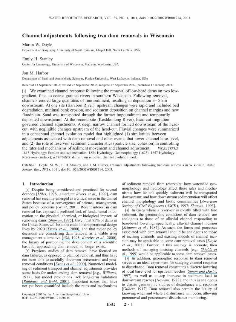
[7] The Koshkonong River at the Rockdale Dam (Figure1) drains approximately 360 km2 in the low-relief, glaciatedregion of south central Wisconsin. The channel contains amixture of sediment, ranging from silt to coarse gravel.Upstream of the reservoir, the channel is primarily sand andsilt-bedded, with sporadic fine and medium gravel in thethalweg. Immediately downstream of the dam the channel isgravel and cobble-bedded, and 1.2 km downstream of thedam, then gradually changes to bed conditions like thoseupstream of the reservoir. The dam was located on a distinctbreak in river long-profile slope (Figure 2), between anupstream low-gradient section (0.0007 slope) and a down-stream steeper section (0.004 slope).[8] The Baraboo River at the LaValle Dam (Figure 3)
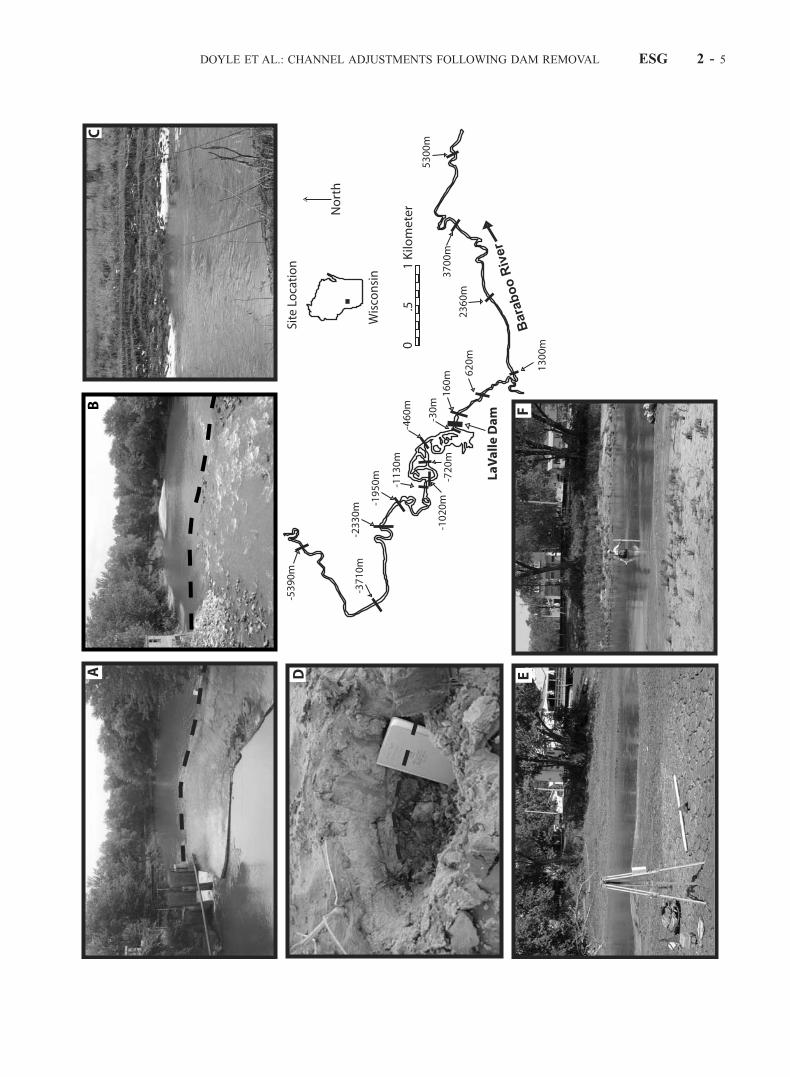
drains approximately 575 km2 at the edge of the Driftlessarea of southwestern Wisconsin, a region of unglaciatedterrain characterized by relatively steep hill slopes and highrelief [Trimble, 1983]. The channel in the study reachcontains a relatively uniform mixture of fine sand and siltwith no gravel. Channel slope through the study reachranges from 0.0005 upstream of the dam to 0.0002 down-stream of the dam (Figure 2). The primary land use in bothbasins is agriculture, and the hydrology of the region isdominated by thunderstorm frontal systems, resulting inrelatively flashy hydrology, although seasonal flooding iscommon in spring (March–May) due to snowmelt and rain-on-snow events.[9] The Rockdale Dam on the Koshkonong River was
originally constructed of rock and timber in 1848 to power agrain mill and was modified to a fixed-crest stone andconcrete dam in 1887. At the start of the study in August2000, the Rockdale Dam was 3.3 m high and created animpoundment of approximately 42 ha. The impoundmentwas approximately 2–3 m deep during the 1960s (personalcommunication with local landowners, 2000). In August2000, maximum depth had declined to 1.5 m and averagedepth was 0.6 m, indicating progressive infilling at a rate ofapproximately 0.04 m/yr. The pattern of sediment depositionwas characterized by fine sediment (silt and clay) throughout
most of the reservoir area and sand at the upstream end of thereservoir in the form of a prograding delta.[10] The Rockdale Dam was breached to grade on 12
September 2000. The remainder of the structure (i.e., thelateral portion) was removed during late June 2001. Noother attempts were made to stabilize the impoundmentsediment via structure through August 2001.[11] The LaValle Dam on the Baraboo River (Figure 3)
was constructed in the mid-1800s to power a grain mill. Theimpoundment was greater than 2 m deep in the early 1900s,but sedimentation decreased the depth of the impoundmentto less than 1 m by the 1970s (personal communication withlocal landowners, 2000). The impoundment was subse-quently dewatered by opening gates in the dam every 5–10 years to flush some of the stored sediment and/or tomake repairs on the dam, although the majority of thesediment remained in the impoundment.[12] The LaValle Dam reservoir was dewatered by open-
ing the gates on 11 July 2000, and the remaining structurewas removed during February 2001. Riprap was placed atthe former dam site to create a long, steep riffle that acted asa grade control. Like the Koshkonong River, no otherattempts were made to stabilize the impoundment sedimentthrough August 2001.[13] Because breaching on the Koshkonong and dewater-
ing on the Baraboo represented the dominant disturbancesof the river systems, we will hereinafter refer to these eventsas ‘‘removals.’’ Both channels were allowed to adjust to thedam removals through the summer of 2001 without anyanthropogenic modifications, after which some physicalmanipulations were begun (channel realignment, widening,and stabilization). This study encompasses only the naturalchannel adjustments that occurred during the first yearfollowing removal.
3. Methods
[14] A series of cross sections were surveyed from June2000 through August 2001 at both sites within reachesextending approximately 4–5 km upstream and down-stream of the dams (Figures 1 and 3). All cross sectionsare referred to by their distance relative to the dam, withupstream distances designated as negative and downstreamdistances designated as positive. Cross sections were spacedmore densely close to the dams where we expected channelform changes to be most pronounced. Cross sections werelocated to include both pools and riffles to test for possiblevariability in response to dam removal. Each cross sectionwas surveyed at least once before and after dam removal,with most being surveyed at least twice after removal. Weused the channel surveys and standard modeling analysis[Hydrologic Engineering Center, 1995] to quantify thehydraulic conditions of the channels throughout the study.[15] At several cross sections upstream and downstream
of each dam, we established sampling stations for waterdischarge measurement and suspended and bed load sedi-ment collection. At each sampling station, a DH-48 samplerwas used to collect a minimum of 10 depth-integratedsuspended sediment samples, which were evenly spacedacross the wetted channel following the protocol of Edwardsand Glysson [1999]. Samples were composited and thenfiltered onto preweighed 1.0-mm filters, dried for >48 hrs at60�C, and weighed to determine total suspended solids
ESG 2 - 2 DOYLE ET AL.: CHANNEL ADJUSTMENTS FOLLOWING DAM REMOVAL
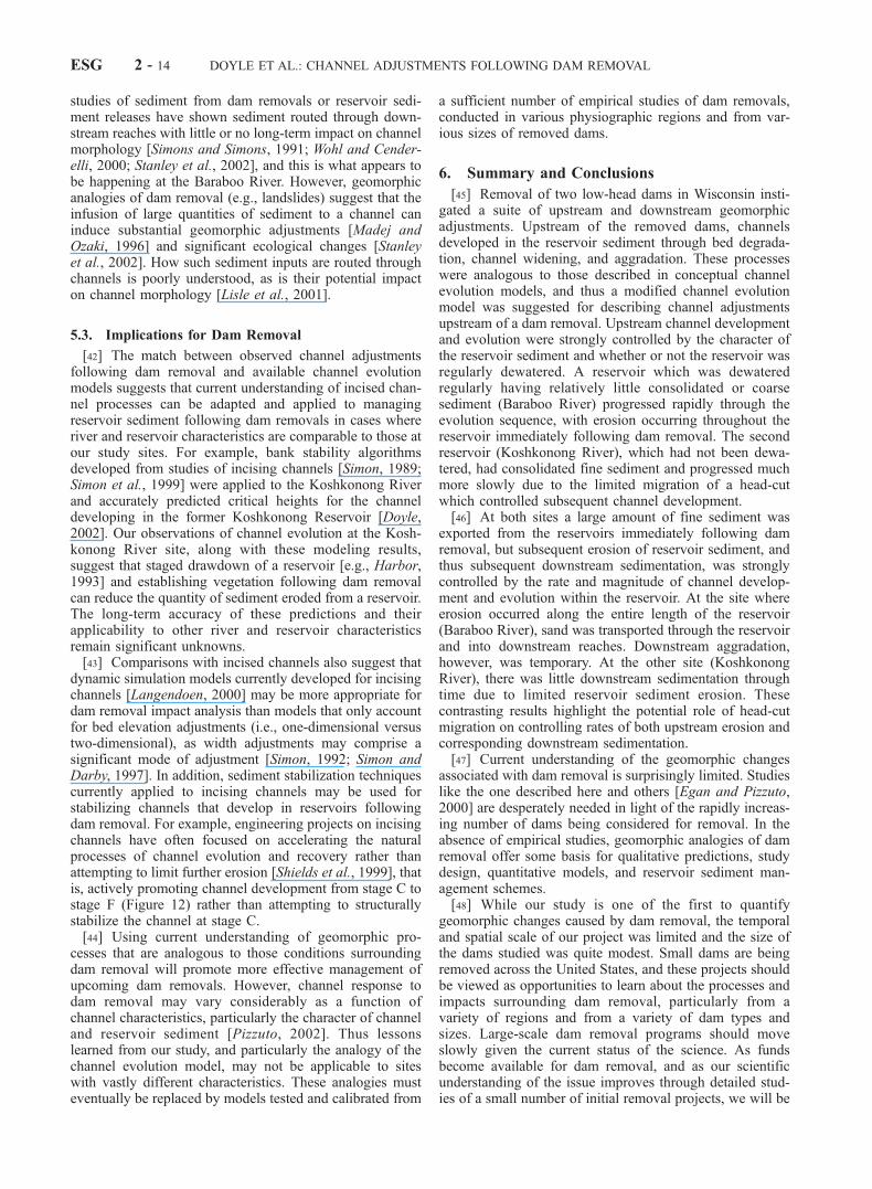
Figure 1. Rockdale Dam on the Koshkonong River. (a) Rockdale reservoir preremoval; view is facingupstream from dam, September 2000. (b) Rockdale reservoir, 24 hours postremoval. (c) Rockdalereservoir, November 2000. (d) Rockdale reservoir, May 2001. (e) Fine sediment deposition along rightchannel margin at section 1720, May 2001. The person is standing in approximately 70 cm of depositedsediment. (f ) Same as Figure 1e but in August 2001. Note that sediment has consolidated. (g) Finesediment deposition on floodplain at section 1720. Note leaf and organic matter below deposited sediment.
DOYLE ET AL.: CHANNEL ADJUSTMENTS FOLLOWING DAM REMOVAL ESG 2 - 3

(TSS) concentration. Also at each sampling station, a com-posited bed load sample was collected by sampling at least20 points across the wetted channel using a 76.2 � 76.2 mmHelley-Smith sampler [Edwards and Glysson, 1999]. Bulkbed material samples were collected at the sampling stationsby collecting samples of the top 10–15 cm of the bedsubstrate from three points across the channel and composit-ing these three samples. Composited bed material samplesgreatly exceeded the minimum sample size criteria for theresident sediment [Ferguson and Paola, 1997], with theexception of station 380 on the Koshkonong River, where apebble count (n > 100) was used due to the size of thematerial [Wolman, 1954]. Following floods, sediment depos-its along the channel margin or on the floodplain werecollected for grain size analysis. Automated water samplers(Isco samplers) were used intermittently at sampling stationsto collect 1-L point TSS samples at a greater temporalresolution. Intakes of the ISCO samplers were positionedapproximately 1 m from the toe of the channel bank and offof the channel bed so as not to collect bed sediment. Pointsamples for TSS determination were also collected at severalsampling stations throughout the study period. Sediment
cores were collected from the reservoirs using a 13-cmdiameter core. Descriptions of core material were recordedin the field, noting the size of material, and color of sedimentas well as the presence of organic debris. Subsamples of thecores were retained for laboratory particle size analysis.Reservoir stratigraphy and survey information were usedto estimate the volume of sediment deposited since damconstruction.[16] Following dam removal, aerial photographs were
taken on the Koshkonong River on 9 May 2001. We alsovisited several sites above and below the dam on at least abimonthly basis, and visual estimates were made of thelocation of any prominent changes in channel morphology.In particular, the formation and location of head-cuts wererecorded on maps.
4. Results
4.1. Predam Conditions
[17] Prior to dam removal, both reservoirs were sedimentsinks and had accumulated approximately 140,100 and287,000 m3 of sediment in the Baraboo and KoshkonongRiver reservoirs, respectively (Table 1). Within the Koshko-nong River reservoir the accumulated fine sediment wasapproximately 2 m in thickness from the dam to station�680, and approximately 1 m thick from station�680 to theprograding delta (approximately at �1500 m). In the down-stream 1000 m of the reservoir the sediment was highlyconsolidated. There was a distinct difference between thefine surface sediment (36% sand, 45% silt, 19% clay, basedon hydrometer analysis) and the underlying coarser sediment(gravel with d50 > 3 mm) (Table 2). This underlying gravellayer was interpreted as the predam channel substrate [Sto-fleth et al., 2001]. At all stations upstream of the reservoir thechannel was covered with approximately 10–20 cm of finesediment, which was comparable to the unconsolidatedsediment on the surface of the lower reservoir.[18] On the Baraboo River the accumulated fine sediment
varied in thickness from 1.4 to 1.7 m throughout thereservoir and was less consolidated compared with theKoshkonong River reservoir. This fine sediment (46% sand,41% silt, 13% clay) was underlain by a fine sand layer (d50 =0.21 mm) (Table 2) that was interpreted to be the predamchannel substrate. At all stations upstream of the reservoirthe channel was covered by approximately 20–40 cm of finesediment, which was comparable to the fine sediment on thesurface of the reservoir.[19] Ratios of total suspended solid (TSS) concentration at
a station to TSS concentration at the most upstream samplingstation were consistently less than or near unity, indicatingsediment retention in both reservoirs prior to removal(Figure 4). TSS values prior to dam removal were high inlate May and early June, 2000, during out-of-bank floodingon both rivers. At the Koshkonong River, TSS concentrationdecreased downstream in comparison with sediment enter-
Figure 2. Longitudinal profiles of the Koshkonong andBaraboo Rivers.
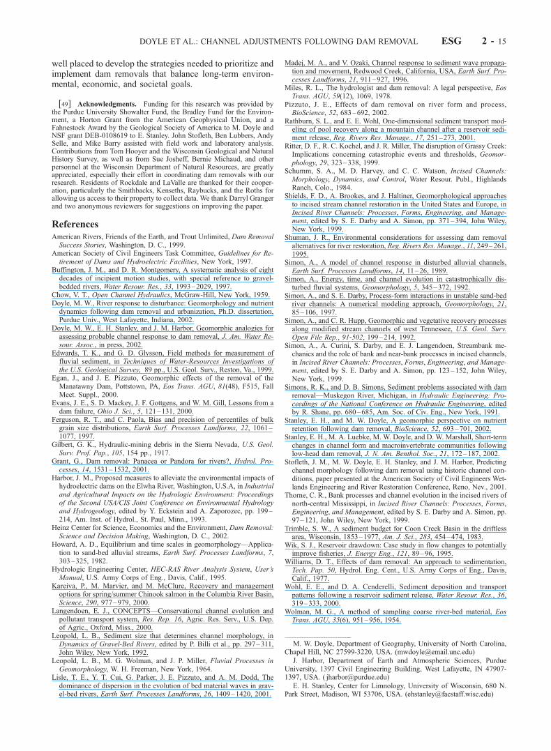
Figure 3. (opposite) LaValle Dam on the Baraboo River. (a) LaValle Dam during dewatering, facing downstream. Dottedline shows crest of dam. (b) LaValle Dam following removal in August 2001. Dotted line shows former crest of dam. Notepresence of large, light-colored sediment deposit downstream. (c) Bank slumping at �500 m in November 2000. (d)Deposition of sand on top of fine sediment on point bar at section �1020 in May 2001. Dotted line shows top of finesediment and organic layer. (e) Section �100 in August 2000. Note desiccation of fine sediment in foreground. (f ) Same asFigure 3e but in May 2001. Note sand has been deposited on top of fine sediment in foreground.
ESG 2 - 4 DOYLE ET AL.: CHANNEL ADJUSTMENTS FOLLOWING DAM REMOVAL
DOYLE ET AL.: CHANNEL ADJUSTMENTS FOLLOWING DAM REMOVAL ESG 2 - 5

ing the study reaches (Figure 4). The limited data on theBaraboo River do not allow the same determination. Flood-ing prior to removal caused fine-sediment deposition alongthe floodplains at both sites; 3–5 cm of deposition weremeasured on the floodplain upstream of the impoundmentsat stations �4180 and �2860 on the Koshkonong River andat stations �5390 and �2330 on the Baraboo River. No finesediment deposition was noted downstream of either damafter the flood. Other rivers in the region experiencedapproximately 10-year floods during this time period (simplerecurrence interval analysis [Leopold et al., 1964] of annualpeak flows of nearby stream gages with at least 50 years ofdata), and we expect that our study sites experienced floodsof comparable recurrence interval. Suspended sedimentsamples were collected at both sites during high flows,although not at the peak stage of the flood event (Table 3).In addition to fine-sediment deposition, patches of sand (�1m2 � 10 cm deep, Table 2) were deposited on the channel-floodplain boundary at station �2860 and other meanderbends in this area on the Koshkonong River. These patchesindicated that some fine sand was transported during theflood, although the volume was relatively small. Only finesediment was deposited on the Baraboo River channelmargins and floodplain.
4.2. Fine Sediment Export Following Dam Removal
[20] Removal of both dams resulted in (1) the export offine sediment from the reservoir as the reservoir dewatered
(Table 3, Figure 5), and (2) the conversion of the reservoirfrom a sediment sink to a sediment source (Figure 4).Downstream sediment concentrations immediately follow-ing removal exceeded the greatest concentrations recordedduring the preremoval June flooding by factors of 10 and 4for the Koshkonong and Baraboo, respectively (Table 3).Subsequent storm events remobilized fine sediment, but notto the degree observed immediately following removal(Figure 4).[21] Postremoval TSS concentrations were nearly always
greater downstream of the dam than upstream, indicating anet export of fine sediment from the reservoirs (Figure 4).TSS concentrations in the Koshkonong River were gener-ally greatest immediately below the dam and then decreasedwith distance downstream (Figure 4), suggesting net depo-sition of fine sediment along the channel.
4.3. Upstream Channel Morphology Changes
4.3.1. Baraboo River[22] In the Baraboo River the transport of unconsolidated
sediment out of the preexisting channel controlled sedimentexport from the reservoir as well as initial postremovalchannel development (Figure 6). Export of sedimentincreased depth and cross-sectional area within andupstream of the reservoir (Figure 7). Following this initialflushing, the channel incised vertically throughout the lengthof the reservoir within a period of weeks (Figure 7). Incisionof the channel bed occurred at all upstream sites, exposing
Table 1. Sediment Stored and Exported From Reservoirs on the Baraboo River and Koshkonong River, Wisconsina
Surface Area ofReservoir, ha
Volume ofSediment Stored in
Reservoir, m3
Volume ofSediment ErodedBetween Removaland May 2001,b m3
Volume of SedimentEroded From ReservoirBetween May 2001
and August 2001,b m3
LaValle Dam, Baraboo Riverc 12 140,100 10,200d (7.3%) 700 (0.5%)Rockdale Dam, Koshkonong Riverc 42 287,000e 40,000 (13.9%) 4,600 (1.6%)
aReservoir on Koshkonong River extends from dam to section �2040. Reservoir on Baraboo River extends from dam to section �1030.bNumber in parentheses is the value as a percentage of total stored sediment.cLaValle Dam was removed on 11 July 2000, and Rockdale Dam was removed on 12 September 2000.dBy August 2000, 8200 m3 (5.9%) were eroded.eDoes not include 109,000 m3 of coarse sediment in delta.
Table 2. Channel and Reservoir Sediment Characteristics on the Baraboo River and Koshkonong Rivera
RiverSample Location
in MetersD50 in Millimeters orPercent Coarse/Silt/Clay Date of Sample Description of Sample
Koshkonong River �4180 2.67 1 May 2001 bed surface�2860 0.20 25 May 2000 overbank flood deposit�2860 12.46 1 May 2001 bed surface�400 3.98 7 Aug. 2001 bed surface�300 3.19 16 March 2001 2.5 m below reservoir surfaceb
�150 4.92 16 March 2001 2.2 m below reservoir surfaceb
�40 36/45/19 1 May 2001 surface of reservoir�40 12.36 1 May 2001 bed surface380 40.6c 2 May 2001 bed surface1720 0.41 1 May 2001 bed surface3890 0.69 1 May 2001 bed surface
Baraboo River �1130 0.32 14 May 2001 bed surface�30 46/41/13 14 May 2001 surface of reservoir�30 0.21 14 May 2001 2.5 m below reservoir surfaceb
1950 0.33 14 May 2001 bed surface2360 0.41 14 May 2001 bed surface5300 0.31 14 May 2001 bed surface
aSamples with d50 presented had less than 1% of material finer than 0.062 mm; percent coarse/silt/clay are not presented for those samples.bCores were located approximately 10 m from channel bank.cDetermined using pebble count.
ESG 2 - 6 DOYLE ET AL.: CHANNEL ADJUSTMENTS FOLLOWING DAM REMOVAL

the underlying sand (Table 2). Bed degradation, coupledwith a lowering of the water surface, caused deep-seatedrotational slumping of channel banks near cross sectionscloser to the dam (Figure 3). However, such mass-wastingwas rare, and most of the slumped material remained inplace and became partially covered by subsequent sediment
deposition, resulting in little or no change of channel widththroughout the study reach.[23] Erosion at the upstream end of the reservoir exposed
coarse sediment (sand) on the bed, which was then availablefor transport downstream. Sand eroded from upstream wasdeposited within the reservoir along the channel margins
Figure 4. Ratio of total suspended solids (TSS) concentration at a sampling section to TSSconcentration at the most upstream sampling section. Vertical lines on plots indicate day of dam removal.Samples collected with ISCO automatic water samplers are indicated. All other samples were collectedwith DH-48 sampler. Ratios greater than unity indicate export of sediment from reservoir, and ratios lessthan unity indicate retention of sediment.
Table 3. Water and Sediment Discharge Characteristics of the Baraboo River and Koshkonong River
Bank-fullDischarge,
m3/s
Peak DischargeSampled forTSS, m3/s
PeakPreremovalTSS, g/L
PeakPostremovalTSS, g/L
Ratio of PeakPostremoval toPeak Preremoval
Sediment Concentration
Baraboo River 24.1 9.3a 0.4b 1.4d 4Koshkonong River 9.2 19.2a 0.3c 3.1e 10
aThis discharge was not the peak discharge of the flood event.bCollected on 1 June 1 2000 at station �5390.cCollected 2 June 2000 at station �2860 and 11 September 2000 at station �4180.dCollected during dam removal on 11July 2000 at station 160.eCollected during dam removal on 12 September 2001 at station 380.
DOYLE ET AL.: CHANNEL ADJUSTMENTS FOLLOWING DAM REMOVAL ESG 2 - 7
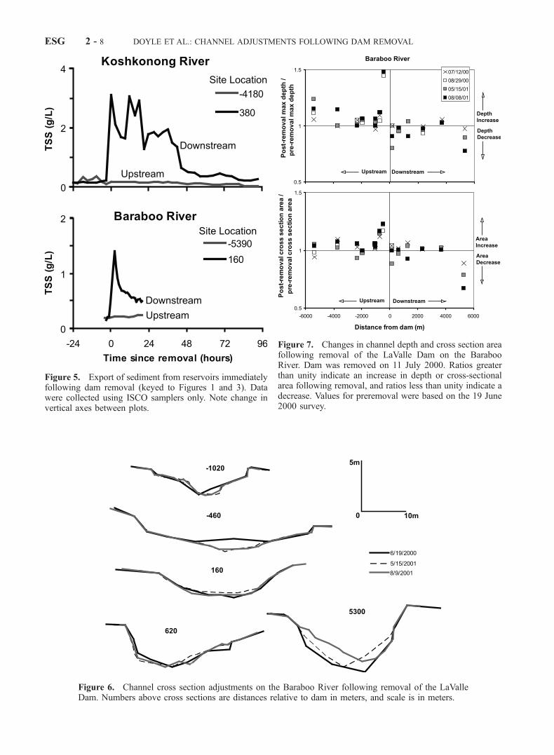
Figure 5. Export of sediment from reservoirs immediatelyfollowing dam removal (keyed to Figures 1 and 3). Datawere collected using ISCO samplers only. Note change invertical axes between plots.
Figure 6. Channel cross section adjustments on the Baraboo River following removal of the LaValleDam. Numbers above cross sections are distances relative to dam in meters, and scale is in meters.
Figure 7. Changes in channel depth and cross section areafollowing removal of the LaValle Dam on the BarabooRiver. Dam was removed on 11 July 2000. Ratios greaterthan unity indicate an increase in depth or cross-sectionalarea following removal, and ratios less than unity indicate adecrease. Values for preremoval were based on the 19 June2000 survey.
ESG 2 - 8 DOYLE ET AL.: CHANNEL ADJUSTMENTS FOLLOWING DAM REMOVAL
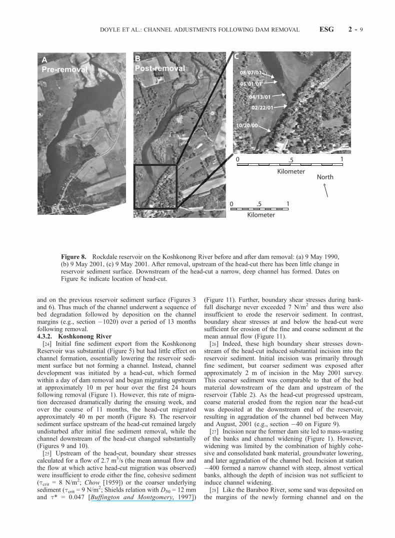
and on the previous reservoir sediment surface (Figures 3and 6). Thus much of the channel underwent a sequence ofbed degradation followed by deposition on the channelmargins (e.g., section �1020) over a period of 13 monthsfollowing removal.4.3.2. Koshkonong River[24] Initial fine sediment export from the Koshkonong
Reservoir was substantial (Figure 5) but had little effect onchannel formation, essentially lowering the reservoir sedi-ment surface but not forming a channel. Instead, channeldevelopment was initiated by a head-cut, which formedwithin a day of dam removal and began migrating upstreamat approximately 10 m per hour over the first 24 hoursfollowing removal (Figure 1). However, this rate of migra-tion decreased dramatically during the ensuing week, andover the course of 11 months, the head-cut migratedapproximately 40 m per month (Figure 8). The reservoirsediment surface upstream of the head-cut remained largelyundisturbed after initial fine sediment removal, while thechannel downstream of the head-cut changed substantially(Figures 9 and 10).[25] Upstream of the head-cut, boundary shear stresses
calculated for a flow of 2.7 m3/s (the mean annual flow andthe flow at which active head-cut migration was observed)were insufficient to erode either the fine, cohesive sediment(tcrit = 8 N/m2; Chow [1959]) or the coarser underlyingsediment (tcrit = 9 N/m2; Shields relation with D50 = 12 mmand t* = 0.047 [Buffington and Montgomery, 1997])
(Figure 11). Further, boundary shear stresses during bank-full discharge never exceeded 7 N/m2 and thus were alsoinsufficient to erode the reservoir sediment. In contrast,boundary shear stresses at and below the head-cut weresufficient for erosion of the fine and coarse sediment at themean annual flow (Figure 11).[26] Indeed, these high boundary shear stresses down-
stream of the head-cut induced substantial incision into thereservoir sediment. Initial incision was primarily throughfine sediment, but coarser sediment was exposed afterapproximately 2 m of incision in the May 2001 survey.This coarser sediment was comparable to that of the bedmaterial downstream of the dam and upstream of thereservoir (Table 2). As the head-cut progressed upstream,coarse material eroded from the region near the head-cutwas deposited at the downstream end of the reservoir,resulting in aggradation of the channel bed between Mayand August, 2001 (e.g., section �40 on Figure 9).[27] Incision near the former dam site led to mass-wasting
of the banks and channel widening (Figure 1). However,widening was limited by the combination of highly cohe-sive and consolidated bank material, groundwater lowering,and later aggradation of the channel bed. Incision at station�400 formed a narrow channel with steep, almost verticalbanks, although the depth of incision was not sufficient toinduce channel widening.[28] Like the Baraboo River, some sand was deposited on
the margins of the newly forming channel and on the
Figure 8. Rockdale reservoir on the Koshkonong River before and after dam removal: (a) 9 May 1990,(b) 9 May 2001, (c) 9 May 2001. After removal, upstream of the head-cut there has been little change inreservoir sediment surface. Downstream of the head-cut a narrow, deep channel has formed. Dates onFigure 8c indicate location of head-cut.
DOYLE ET AL.: CHANNEL ADJUSTMENTS FOLLOWING DAM REMOVAL ESG 2 - 9
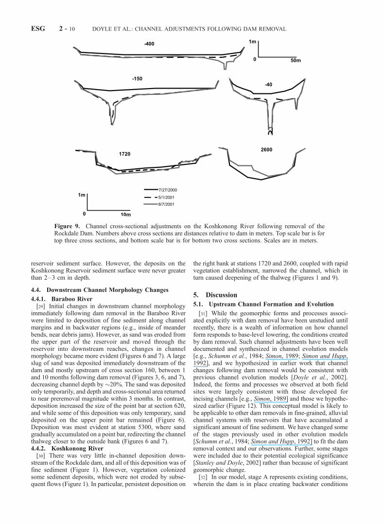
reservoir sediment surface. However, the deposits on theKoshkonong Reservoir sediment surface were never greaterthan 2–3 cm in depth.
4.4. Downstream Channel Morphology Changes
4.4.1. Baraboo River[29] Initial changes in downstream channel morphology
immediately following dam removal in the Baraboo Riverwere limited to deposition of fine sediment along channelmargins and in backwater regions (e.g., inside of meanderbends, near debris jams). However, as sand was eroded fromthe upper part of the reservoir and moved through thereservoir into downstream reaches, changes in channelmorphology became more evident (Figures 6 and 7). A largeslug of sand was deposited immediately downstream of thedam and mostly upstream of cross section 160, between 1and 10 months following dam removal (Figures 3, 6, and 7),decreasing channel depth by�20%. The sand was depositedonly temporarily, and depth and cross-sectional area returnedto near preremoval magnitude within 3 months. In contrast,deposition increased the size of the point bar at section 620,and while some of this deposition was only temporary, sanddeposited on the upper point bar remained (Figure 6).Deposition was most evident at station 5300, where sandgradually accumulated on a point bar, redirecting the channelthalweg closer to the outside bank (Figures 6 and 7).4.4.2. Koshkonong River[30] There was very little in-channel deposition down-
stream of the Rockdale dam, and all of this deposition was offine sediment (Figure 1). However, vegetation colonizedsome sediment deposits, which were not eroded by subse-quent flows (Figure 1). In particular, persistent deposition on
the right bank at stations 1720 and 2600, coupled with rapidvegetation establishment, narrowed the channel, which inturn caused deepening of the thalweg (Figures 1 and 9).
5. Discussion
5.1. Upstream Channel Formation and Evolution
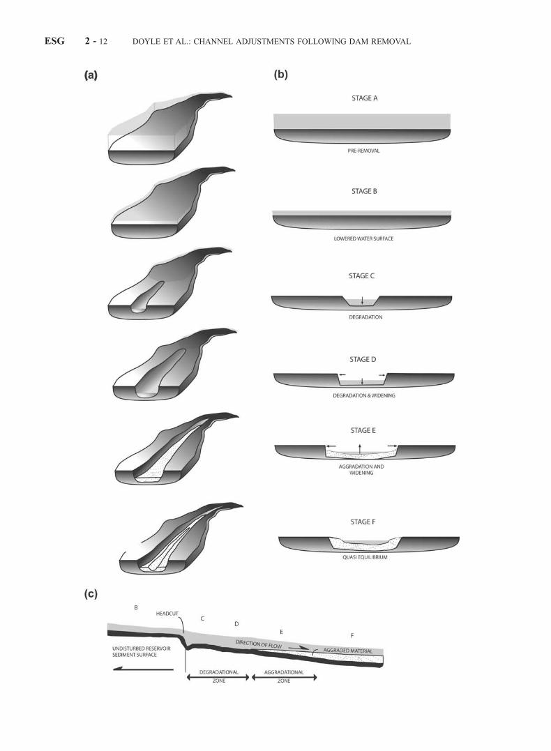
[31] While the geomorphic forms and processes associ-ated explicitly with dam removal have been unstudied untilrecently, there is a wealth of information on how channelform responds to base-level lowering, the conditions createdby dam removal. Such channel adjustments have been welldocumented and synthesized in channel evolution models[e.g., Schumm et al., 1984; Simon, 1989; Simon and Hupp,1992], and we hypothesized in earlier work that channelchanges following dam removal would be consistent withprevious channel evolution models [Doyle et al., 2002].Indeed, the forms and processes we observed at both fieldsites were largely consistent with those developed forincising channels [e.g., Simon, 1989] and those we hypothe-sized earlier (Figure 12). This conceptual model is likely tobe applicable to other dam removals in fine-grained, alluvialchannel systems with reservoirs that have accumulated asignificant amount of fine sediment. We have changed someof the stages previously used in other evolution models[Schumm et al., 1984; Simon and Hupp, 1992] to fit the damremoval context and our observations. Further, some stageswere included due to their potential ecological significance[Stanley and Doyle, 2002] rather than because of significantgeomorphic change.[32] In our model, stage A represents existing conditions,
wherein the dam is in place creating backwater conditions
Figure 9. Channel cross-sectional adjustments on the Koshkonong River following removal of theRockdale Dam. Numbers above cross sections are distances relative to dam in meters. Top scale bar is fortop three cross sections, and bottom scale bar is for bottom two cross sections. Scales are in meters.
ESG 2 - 10 DOYLE ET AL.: CHANNEL ADJUSTMENTS FOLLOWING DAM REMOVAL

upstream, (i.e., high water elevation but low velocity) andthe reservoir has accumulated a large amount of fine sedi-ment. Stage B represents conditions immediately followingremoval, when the water surface elevation decreases dra-matically but the reservoir sediment surface remains undis-turbed. Channel flow during this stage is wide and shallowand has relatively low velocity. Degradation characterizesstage C, wherein the channel bed incises, concentrating flow
into a narrow, deep channel with steep banks and high flowvelocity. A head-cut will often be the upstream terminus ofchannel adjustments. Large amounts of fine sediment areexported from the reservoir during this stage, and if degra-dation progresses to underlying coarse sediment, thencoarse sediment may also become mobilized and trans-ported downstream.[33] If incision continues beyond the critical bank height
[Thorne, 1999] of the reservoir sediment, then channelwidening begins via mass-wasting of banks and marks thebeginning of stage D. Large amounts of fine sediment areexported due to bank erosion, and there is continued transportof both fine and coarse sediment from the channel bed.Channel depths in excess of the critical bank height causewidening to continue during stage E, although sedimentderived from upstream fluvial erosion begins to be depositedas the local energy slope is reduced via vertical and lateralchannel adjustments. The sediment deposited is the coarsestfraction of sediment derived from upstream, as finer sedimentis transported through and out of the reach. Significantreduction of bank heights by channel bed aggradation,establishment of vegetation, and reduction in groundwaterelevation within the reservoir cause bank erosion to decrease,and equilibrium conditions develop, stage F.[34] The forms and processes described in the six stages
may not all appear at every dam removal site. For instance,if sediment is unconsolidated and easily eroded, then stageC may be absent because any degradation of the channelbed will induce widening as well, causing a direct transitionfrom stage B to stage D. Also, the aggradation described instages E and F may be temporary if upstream sedimentmoves through the reservoir as a wave [Lisle et al., 2001].[35] Although simply describing the forms and processes
likely to occur following dam removal is useful, it is alsoimportant to estimate how local environmental conditionsdetermine the rate of progression through the stages and themagnitude of changes that can be expected. The dominantcontrol on channel form evolution at our sites was thecharacter (i.e., size, cohesiveness, and consolidation) ofsediment stored in the reservoirs, particularly if sedimentcharacter led to head-cut formation and migration rather thanfluvial erosion of reservoir sediment. Channel evolution onthe Baraboo River was rapid, as degradation along theupstream reach occurred immediately following removal.In terms of the conceptual model, the transition from stage B
Figure 10. Changes in channel depth and cross sectionarea on the Koshkonong River following removal of theRockdale Dam. Dam was removed on 12 September 2000.Ratios greater than unity indicate an increase in depth orcross-sectional area following removal, and ratios less thanunity indicate a decrease. Values for preremoval were basedon the 27 July 2000 survey. A channel was not present inthe reservoir between the dam and section �2040 beforedam removal, so changes are not available.
Figure 11. Boundary shear stresses on the Koshkonong River within the Rockdale reservoir at 2.7 m3/s.Note that critical shear stress for erosion of the cohesive reservoir sediment is 8 N/m2 and formobilization of the gravel is 9 N/m2. Head-cut is located at 40 m for the postremoval, preerosion case, at150 m for 1 May 2001, and 400 m for 1 August 2001.
DOYLE ET AL.: CHANNEL ADJUSTMENTS FOLLOWING DAM REMOVAL ESG 2 - 11
ESG 2 - 12 DOYLE ET AL.: CHANNEL ADJUSTMENTS FOLLOWING DAM REMOVAL
to stage C on the Baraboo was immediate. Even thoughreservoir sediment was fine, sediment within the predamchannel did not become consolidated because of regularreservoir dewaterings and was easily eroded. Further, chan-nel morphology immediately following dam removalappeared to be very close to the predam channel, and thusthere were few bank adjustments in the months followingdam removal (e.g., sections�460 and�1020). In subsequentmonths (the winter and spring of 2001), high flows mobilizedsand in the upper reaches of the reservoir, and while some ofthis sediment was deposited on channel margins and thenewly forming floodplain, most was transported downstreamof the dam. In terms of the conceptual model the transitionfrom stage A to stage D on the Baraboo River occurredwithin a period of days to weeks following dam removal. Itcurrently appears that aggradation will not occur (i.e., stage Eis absent), so the current channel morphology may representthe long-term equilibrium channel morphology.[36] The consolidation of fine sediment in the reservoir
on the Koshkonong River caused drastically different ratesof channel evolution compared with the Baraboo River.Because boundary shear stresses upstream of the head-cutwere insufficient to mobilize the reservoir sediment, channelevolution rates were governed by the rate of head-cutmigration, which in our case averaged 40 m per month.Slow migration of the head-cut on the Koshkonong Riverresulted in a period of months between stages B and C atsections in the lower reservoir, and after a year, most of thereservoir remained in stage B because the head-cut had yetto reach the upper reservoir.[37] Slow head-cut migration rate on the Koshkonong
River also limited progression through latter stages of themodel, as only the most downstream station in the reservoirprogressed through stage E of the model. The transitionfrom stage D to E requires reduction in the energy slope viadegradation upstream, aggradation downstream, or both. Ifcoarse material is available for transport, then aggradation indownstream reaches can greatly enhance channel recovery[Simon, 1992] by reducing the local energy grade andreducing bank heights. In a reservoir, coarse material isprimarily stored in the upstream end of the reservoir. Duringthe time that the head-cut remains downstream of the delta,this coarse sediment will not be available for transport,leaving sediment in deeper strata as the only possible sourceof material for aggradation. Such conditions, then, wouldnecessitate greater reservoir degradation than if coarsematerial were transported from the delta to downstreamaggrading reaches. In all, if channel evolution is controlledby head-cut migration because of reservoir sediment con-ditions, as was the case on the Koshkonong River, then thetransition from stage D to stage E will take longer andrequire a greater degree of bed degradation.[38] In addition to vertical channel adjustments, lateral
adjustments are also highly sensitive to the reservoir sedi-ment conditions and the rate of migration of head-cuts. Thedegree of degradation before the onset of widening, i.e., thetransition from stage C to D, is a function of bank sedimentcharacteristics and sediment saturation conditions [Simon et
al., 1999]. Simon and Darby [1997] showed that channelswith sand banks respond to disturbance primarily throughwidening with limited incision, while channels with claybanks respond primarily through incision and very littlewidening. Bank saturation is also important in that saturatedbanks are much less stable than unsaturated banks [Thorne,1999; Simon et al., 1999]. Thus the magnitude of incisionbefore bank failure begins will be less for rapidly migratinghead-cuts because bed degradation will occur when reser-voir sediment is saturated and more vulnerable to mass-wasting [Simon et al., 1999]. Slower head-cuts will causebed degradation when sediment has been dewatered andthus will result in a deeper and narrower channel.
5.2. Downstream Channel Morphology
[39] Changes in channel morphology are driven by trans-port and storage of the coarser material in a system[Leopold, 1992]. In our study sites, coarser material wasin the sand and gravel range and stored in the deltas orburied strata of the reservoirs. The head-cut on the Kosh-konong River restricted access to coarse sediment, and therewere correspondingly few changes to downstream channelmorphology during our study. Presumably, if the head-cuton the Koshkonong River continues to migrate approxi-mately 1.3 m/d, then the coarse delta sediment will not beaccessed until the winter of 2004. Until then, channelchanges downstream of the dam will not occur, or will onlybe small, unless sufficient quantities of sediment are erodedfrom the underlying strata of the reservoir. In contrast,material eroded from the delta on the Baraboo River wasrapidly transported through the reservoir and into down-stream reaches, inducing clear changes in channel morphol-ogy. Thus the variation of upstream erosion processes at oursites, as controlled by reservoir sediment characteristics,exerted a strong control on the rate and magnitude ofdownstream channel adjustments.[40] In all dam removal cases, there will be a time lag
between when a dam is removed and when downstreamchanges begin to occur. Other studies in disturbed channelshave shown similar lags between the time of a channeldisturbance and the time of downstream channel responseand have attributed this time lag to the rate of upstreamchannel adjustments [Ritter et al., 1999]. At dam removalsites this time lag will be a function of the rate of reservoirsediment erosion, the thickness of the fine sediment layer,and the length of the reservoir. In cases like the BarabooRiver where reservoir sediment is easily transported, ero-sion may occur throughout the reservoir immediately fol-lowing dam removal, and so the time between removal anddownstream changes will be relatively short, i.e., of theorder of weeks or months [Wohl and Cenderelli, 2000]. Incontrast, if reservoir sediment is consolidated, or so coarsethat it is mobilized only by infrequent flows, then the timebetween dam removal and downstream geomorphic changesmay be of the order of years.[41] Once sediment is delivered to downstream reaches,
its effect on channel morphology can vary greatly in termsof magnitude and duration [Doyle et al., 2002]. Several
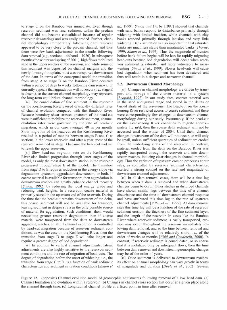
Figure 12. (opposite) Channel evolution model of geomorphic adjustments following removal of a low head dam. (a)Channel formation and evolution within a reservoir. (b) Changes in channel cross section that occur at a given place alongthe channel through time. (c) Longitudinal channel profile at a fixed point in time after removal.
DOYLE ET AL.: CHANNEL ADJUSTMENTS FOLLOWING DAM REMOVAL ESG 2 - 13
studies of sediment from dam removals or reservoir sedi-ment releases have shown sediment routed through down-stream reaches with little or no long-term impact on channelmorphology [Simons and Simons, 1991; Wohl and Cender-elli, 2000; Stanley et al., 2002], and this is what appears tobe happening at the Baraboo River. However, geomorphicanalogies of dam removal (e.g., landslides) suggest that theinfusion of large quantities of sediment to a channel caninduce substantial geomorphic adjustments [Madej andOzaki, 1996] and significant ecological changes [Stanleyet al., 2002]. How such sediment inputs are routed throughchannels is poorly understood, as is their potential impacton channel morphology [Lisle et al., 2001].
5.3. Implications for Dam Removal
[42] The match between observed channel adjustmentsfollowing dam removal and available channel evolutionmodels suggests that current understanding of incised chan-nel processes can be adapted and applied to managingreservoir sediment following dam removals in cases whereriver and reservoir characteristics are comparable to those atour study sites. For example, bank stability algorithmsdeveloped from studies of incising channels [Simon, 1989;Simon et al., 1999] were applied to the Koshkonong Riverand accurately predicted critical heights for the channeldeveloping in the former Koshkonong Reservoir [Doyle,2002]. Our observations of channel evolution at the Kosh-konong River site, along with these modeling results,suggest that staged drawdown of a reservoir [e.g., Harbor,1993] and establishing vegetation following dam removalcan reduce the quantity of sediment eroded from a reservoir.The long-term accuracy of these predictions and theirapplicability to other river and reservoir characteristicsremain significant unknowns.[43] Comparisons with incised channels also suggest that
dynamic simulation models currently developed for incisingchannels [Langendoen, 2000] may be more appropriate fordam removal impact analysis than models that only accountfor bed elevation adjustments (i.e., one-dimensional versustwo-dimensional), as width adjustments may comprise asignificant mode of adjustment [Simon, 1992; Simon andDarby, 1997]. In addition, sediment stabilization techniquescurrently applied to incising channels may be used forstabilizing channels that develop in reservoirs followingdam removal. For example, engineering projects on incisingchannels have often focused on accelerating the naturalprocesses of channel evolution and recovery rather thanattempting to limit further erosion [Shields et al., 1999], thatis, actively promoting channel development from stage C tostage F (Figure 12) rather than attempting to structurallystabilize the channel at stage C.[44] Using current understanding of geomorphic pro-
cesses that are analogous to those conditions surroundingdam removal will promote more effective management ofupcoming dam removals. However, channel response todam removal may vary considerably as a function ofchannel characteristics, particularly the character of channeland reservoir sediment [Pizzuto, 2002]. Thus lessonslearned from our study, and particularly the analogy of thechannel evolution model, may not be applicable to siteswith vastly different characteristics. These analogies musteventually be replaced by models tested and calibrated from
a sufficient number of empirical studies of dam removals,conducted in various physiographic regions and from var-ious sizes of removed dams.
6. Summary and Conclusions
[45] Removal of two low-head dams in Wisconsin insti-gated a suite of upstream and downstream geomorphicadjustments. Upstream of the removed dams, channelsdeveloped in the reservoir sediment through bed degrada-tion, channel widening, and aggradation. These processeswere analogous to those described in conceptual channelevolution models, and thus a modified channel evolutionmodel was suggested for describing channel adjustmentsupstream of a dam removal. Upstream channel developmentand evolution were strongly controlled by the character ofthe reservoir sediment and whether or not the reservoir wasregularly dewatered. A reservoir which was dewateredregularly having relatively little consolidated or coarsesediment (Baraboo River) progressed rapidly through theevolution sequence, with erosion occurring throughout thereservoir immediately following dam removal. The secondreservoir (Koshkonong River), which had not been dewa-tered, had consolidated fine sediment and progressed muchmore slowly due to the limited migration of a head-cutwhich controlled subsequent channel development.[46] At both sites a large amount of fine sediment was
exported from the reservoirs immediately following damremoval, but subsequent erosion of reservoir sediment, andthus subsequent downstream sedimentation, was stronglycontrolled by the rate and magnitude of channel develop-ment and evolution within the reservoir. At the site whereerosion occurred along the entire length of the reservoir(Baraboo River), sand was transported through the reservoirand into downstream reaches. Downstream aggradation,however, was temporary. At the other site (KoshkonongRiver), there was little downstream sedimentation throughtime due to limited reservoir sediment erosion. Thesecontrasting results highlight the potential role of head-cutmigration on controlling rates of both upstream erosion andcorresponding downstream sedimentation.[47] Current understanding of the geomorphic changes
associated with dam removal is surprisingly limited. Studieslike the one described here and others [Egan and Pizzuto,2000] are desperately needed in light of the rapidly increas-ing number of dams being considered for removal. In theabsence of empirical studies, geomorphic analogies of damremoval offer some basis for qualitative predictions, studydesign, quantitative models, and reservoir sediment man-agement schemes.[48] While our study is one of the first to quantify
geomorphic changes caused by dam removal, the temporaland spatial scale of our project was limited and the size ofthe dams studied was quite modest. Small dams are beingremoved across the United States, and these projects shouldbe viewed as opportunities to learn about the processes andimpacts surrounding dam removal, particularly from avariety of regions and from a variety of dam types andsizes. Large-scale dam removal programs should moveslowly given the current status of the science. As fundsbecome available for dam removal, and as our scientificunderstanding of the issue improves through detailed stud-ies of a small number of initial removal projects, we will be
ESG 2 - 14 DOYLE ET AL.: CHANNEL ADJUSTMENTS FOLLOWING DAM REMOVAL
well placed to develop the strategies needed to prioritize andimplement dam removals that balance long-term environ-mental, economic, and societal goals.
[49] Acknowledgments. Funding for this research was provided bythe Purdue University Showalter Fund, the Bradley Fund for the Environ-ment, a Horton Grant from the American Geophysical Union, and aFahnestock Award by the Geological Society of America to M. Doyle andNSF grant DEB-0108619 to E. Stanley. John Stofleth, Ben Lubbers, AndySelle, and Mike Barry assisted with field work and laboratory analysis.Contributions from Tom Hooyer and the Wisconsin Geological and NaturalHistory Survey, as well as from Sue Josheff, Bernie Michaud, and otherpersonnel at the Wisconsin Department of Natural Resources, are greatlyappreciated, especially their effort in coordinating dam removals with ourresearch. Residents of Rockdale and LaValle are thanked for their cooper-ation, particularly the Smithbacks, Kenseths, Raybucks, and the Roths forallowing us access to their property to collect data. We thank Darryl Grangerand two anonymous reviewers for suggestions on improving the paper.
ReferencesAmerican Rivers, Friends of the Earth, and Trout Unlimited, Dam RemovalSuccess Stories, Washington, D. C., 1999.
American Society of Civil Engineers Task Committee, Guidelines for Re-tirement of Dams and Hydroelectric Facilities, New York, 1997.
Buffington, J. M., and D. R. Montgomery, A systematic analysis of eightdecades of incipient motion studies, with special reference to gravel-bedded rivers, Water Resour. Res., 33, 1993–2029, 1997.
Chow, V. T., Open Channel Hydraulics, McGraw-Hill, New York, 1959.Doyle, M. W., River response to disturbance: Geomorphology and nutrientdynamics following dam removal and urbanization, Ph.D. dissertation,Purdue Univ., West Lafayette, Indiana, 2002.
Doyle, M. W., E. H. Stanley, and J. M. Harbor, Geomorphic analogies forassessing probable channel response to dam removal, J. Am. Water Re-sour. Assoc., in press, 2002.
Edwards, T. K., and G. D. Glysson, Field methods for measurement offluvial sediment, in Techniques of Water-Resources Investigations ofthe U.S. Geological Survey, 89 pp., U.S. Geol. Surv., Reston, Va., 1999.
Egan, J., and J. E. Pizzuto, Geomorphic effects of the removal of theManatawny Dam, Pottstown, PA, Eos Trans. AGU, 81(48), F515, FallMeet. Suppl., 2000.
Evans, J. E., S. D. Mackey, J. F. Gottgens, and W. M. Gill, Lessons from adam failure, Ohio J. Sci., 5, 121–131, 2000.
Ferguson, R. T., and C. Paola, Bias and precision of percentiles of bulkgrain size distributions, Earth Surf. Processes Landforms, 22, 1061–1077, 1997.
Gilbert, G. K., Hydraulic-mining debris in the Sierra Nevada, U.S. Geol.Surv. Prof. Pap., 105, 154 pp., 1917.
Grant, G., Dam removal: Panacea or Pandora for rivers?, Hydrol. Pro-cesses, 14, 1531–1532, 2001.
Harbor, J. M., Proposed measures to alleviate the environmental impacts ofhydroelectric dams on the Elwha River, Washington, U.S.A, in Industrialand Agricultural Impacts on the Hydrologic Environment: Proceedingsof the Second USA/CIS Joint Conference on Environmental Hydrologyand Hydrogeology, edited by Y. Eckstein and A. Zaporozec, pp. 199–214, Am. Inst. of Hydrol., St. Paul, Minn., 1993.
Heinz Center for Science, Economics and the Environment, Dam Removal:Science and Decision Making, Washington, D. C., 2002.
Howard, A. D., Equilibrium and time scales in geomorphology—Applica-tion to sand-bed alluvial streams, Earth Surf. Processes Landforms, 7,303–325, 1982.
Hydrologic Engineering Center, HEC-RAS River Analysis System, User’sManual, U.S. Army Corps of Eng., Davis, Calif., 1995.
Kareiva, P., M. Marvier, and M. McClure, Recovery and managementoptions for spring/summer Chinook salmon in the Columbia River Basin,Science, 290, 977–979, 2000.
Langendoen, E. J., CONCEPTS—Conservational channel evolution andpollutant transport system, Res. Rep. 16, Agric. Res. Serv., U.S. Dep.of Agric., Oxford, Miss., 2000.
Leopold, L. B., Sediment size that determines channel morphology, inDynamics of Gravel-Bed Rivers, edited by P. Billi et al., pp. 297–311,John Wiley, New York, 1992.
Leopold, L. B., M. G. Wolman, and J. P. Miller, Fluvial Processes inGeomorphology, W. H. Freeman, New York, 1964.
Lisle, T. E., Y. T. Cui, G. Parker, J. E. Pizzuto, and A. M. Dodd, Thedominance of dispersion in the evolution of bed material waves in grav-el-bed rivers, Earth Surf. Processes Landforms, 26, 1409–1420, 2001.
Madej, M. A., and V. Ozaki, Channel response to sediment wave propaga-tion and movement, Redwood Creek, California, USA, Earth Surf. Pro-cesses Landforms, 21, 911–927, 1996.
Miles, R. L., The hydrologist and dam removal: A legal perspective, EosTrans. AGU, 59(12), 1069, 1978.
Pizzuto, J. E., Effects of dam removal on river form and process,BioScience, 52, 683–692, 2002.
Rathburn, S. L., and E. E. Wohl, One-dimensional sediment transport mod-eling of pool recovery along a mountain channel after a reservoir sedi-ment release, Reg. Rivers Res. Manage., 17, 251–273, 2001.
Ritter, D. F., R. C. Kochel, and J. R. Miller, The disruption of Grassy Creek:Implications concerning catastrophic events and thresholds, Geomor-phology, 29, 323–338, 1999.
Schumm, S. A., M. D. Harvey, and C. C. Watson, Incised Channels:Morphology, Dynamics, and Control, Water Resour. Publ., HighlandsRanch, Colo., 1984.
Shields, F. D., A. Brookes, and J. Haltiner, Geomorphological approachesto incised stream channel restoration in the United States and Europe, inIncised River Channels: Processes, Forms, Engineering, and Manage-ment, edited by S. E. Darby and A. Simon, pp. 371–394, John Wiley,New York, 1999.
Shuman, J. R., Environmental considerations for assessing dam removalalternatives for river restoration, Reg. Rivers Res. Manage., 11, 249–261,1995.
Simon, A., A model of channel response in disturbed alluvial channels,Earth Surf. Processes Landforms, 14, 11–26, 1989.
Simon, A., Energy, time, and channel evolution in catastrophically dis-turbed fluvial systems, Geomorphology, 5, 345–372, 1992.
Simon, A., and S. E. Darby, Process-form interactions in unstable sand-bedriver channels: A numerical modeling approach, Geomorphology, 21,85–106, 1997.
Simon, A., and C. R. Hupp, Geomorphic and vegetative recovery processesalong modified stream channels of west Tennessee, U.S. Geol. Surv.Open File Rep., 91-502, 199–214, 1992.
Simon, A., A. Curini, S. Darby, and E. J. Langendoen, Streambank me-chanics and the role of bank and near-bank processes in incised channels,in Incised River Channels: Processes, Forms, Engineering, and Manage-ment, edited by S. E. Darby and A. Simon, pp. 123–152, John Wiley,New York, 1999.
Simons, R. K., and D. B. Simons, Sediment problems associated with damremoval—Muskegon River, Michigan, in Hydraulic Engineering: Pro-ceedings of the National Conference on Hydraulic Engineering, editedby R. Shane, pp. 680–685, Am. Soc. of Civ. Eng., New York, 1991.
Stanley, E. H., and M. W. Doyle, A geomorphic perspective on nutrientretention following dam removal, BioScience, 52, 693–701, 2002.
Stanley, E. H., M. A. Luebke, M. W. Doyle, and D. W. Marshall, Short-termchanges in channel form and macroinvertebrate communities followinglow-head dam removal, J. N. Am. Benthol. Soc., 21, 172–187, 2002.
Stofleth, J. M., M. W. Doyle, E. H. Stanley, and J. M. Harbor, Predictingchannel morphology following dam removal using historic channel con-ditions, paper presented at the American Society of Civil Engineers Wet-lands Engineering and River Restoration Conference, Reno, Nev., 2001.
Thorne, C. R., Bank processes and channel evolution in the incised rivers ofnorth-central Mississippi, in Incised River Channels: Processes, Forms,Engineering, and Management, edited by S. E. Darby and A. Simon, pp.97–121, John Wiley, New York, 1999.
Trimble, S. W., A sediment budget for Coon Creek Basin in the driftlessarea, Wisconsin, 1853–1977, Am. J. Sci., 283, 454–474, 1983.
Wik, S. J., Reservoir drawdown: Case study in flow changes to potentiallyimprove fisheries, J. Energy Eng., 121, 89–96, 1995.
Williams, D. T., Effects of dam removal: An approach to sedimentation,Tech. Pap. 50, Hydrol. Eng. Cent., U.S. Army Corps of Eng., Davis,Calif., 1977.
Wohl, E. E., and D. A. Cenderelli, Sediment deposition and transportpatterns following a reservoir sediment release, Water Resour. Res., 36,319–333, 2000.
Wolman, M. G., A method of sampling coarse river-bed material, EosTrans. AGU, 35(6), 951–956, 1954.
����������������������������M. W. Doyle, Department of Geography, University of North Carolina,
Chapel Hill, NC 27599-3220, USA. ([email protected])J. Harbor, Department of Earth and Atmospheric Sciences, Purdue
University, 1397 Civil Engineering Building, West Lafayette, IN 47907-1397, USA. ( [email protected])
E. H. Stanley, Center for Limnology, University of Wisconsin, 680 N.Park Street, Madison, WI 53706, USA. ([email protected])
DOYLE ET AL.: CHANNEL ADJUSTMENTS FOLLOWING DAM REMOVAL ESG 2 - 15