Erectile function durability following permanent prostate brachytherapy
Upload
khangminh22Category
view
4download
0
1
Durability in Diversity:
Survival Strategies in the Himalayan Country-side
by Minoti Chakravarty-Kaul
Introduction This paper maps changing patterns of communal forest control and management in the Punjab during the 19th and 20th century with a view to document how graziers and farmers mutually used the shamilat forests held jointly by communities of land-holders as buffers to stabilize and sustain their natural ecosystems. As against shamilat forests, Reserved and Protected forests were created and held categories of a forest department.Three case studies exemplify how state interactions beginning in the mid-19th century affected traditional communal resource use agreements and practices. The outcome has frequently been an erosion of confidence in local management capacities and conflict with the state. But the discussion concludes by observing how communities have survived in contemporary times by constantly integrating communal management traditions to emerging situation and policies such as those of joint forest management initiatives. India has a long ideological committment to grass-roots democracy. This has been most recently reaffirmed by the passing of the Panchayat Act of l993 which gave the power to the smallest political unit - the village to elect its representatives. The Punjab has further strengthened this committment by the announcement of a policy resolution for Joint Forest Management, following suit as the 15th state to support the JFM initiative. At issue is whether these policy instruments can serve to empower the self-organised community institutions which govern the shamilat forests and accommodate transhumancing shepherds who depend on them. The following case study analyses may offer insights into this question. In the shamilat forests of the Lower Siwalik hills, sedentary cultivators and nomadic pastoralists have ensured natural diversity through mutually devised, jointly monitored rules of access. When misuse occurred, sanctions were applied. Over time, this system became increasingly destabilized by the entrance and intervention of the Forest Department. The gradual extension of governmental control over shamilat forests has undermined cooperative systems of management. Yet, as illustrated in the following case studies, it is clear that some forms of communal management have survived, and continue to function with varying degrees of effectiveness. If new policies can endorse negotiation and consensus over customary partnerships between local people and migratory pastoralists, then indigenous systems of land-use may have a chance to continue their role in conserving the biotic diversity of forests inherited from the past.
© 2004 Minoti Chakravarty-Kaul Paper submitted for WOW3, Bloomington, Indiana University, June 2004.
2
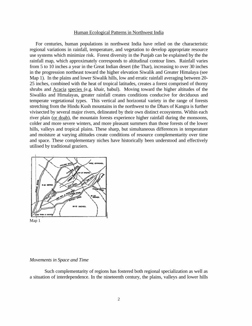
Human Ecological Patterns in Northwest India For centuries, human populations in northwest India have relied on the characteristic regional variations in rainfall, temperature, and vegetation to develop appropriate resource use systems which minimize risk. Forest diversity in the Punjab can be explained by the the rainfall map, which approximately corresponds to altitudinal contour lines. Rainfall varies from 5 to 10 inches a year in the Great Indian desert (the Thar), increasing to over 30 inches in the progression northeast toward the higher elevation Siwalik and Greater Himalaya (see Map 1). In the plains and lower Siwalik hills, low and erratic rainfall averaging between 20-25 inches, combined with the heat of tropical latitudes, creates a forest comprised of thorny shrubs and Acacia species (e.g. khair, babul). Moving toward the higher altitudes of the Siwaliks and Himalayas, greater rainfall creates conditions conducive for deciduous and temperate vegetational types. This vertical and horizontal variety in the range of forests stretching from the Hindu Kush mountains in the northwest to the Dhars of Kangra is further vivisected by several major rivers, delineated by their own distinct ecosystems. Within each river plain (or doab), the mountain forests experience higher rainfall during the monsoons, colder and more severe winters, and more pleasant summers than those forests of the lower hills, valleys and tropical plains. These sharp, but simultaneous differences in temperature and moisture at varying altitudes create conditions of resource complementarity over time and space. These complementary niches have historically been understood and effectively utilised by traditional graziers.
Map 1 Movements in Space and Time Such complementarity of regions has fostered both regional specialization as well as a situation of interdependence. In the nineteenth century, the plains, valleys and lower hills
3
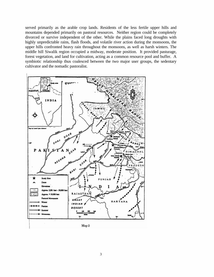
served primarily as the arable crop lands. Residents of the less fertile upper hills and mountains depended primarily on pastoral resources. Neither region could be completely divorced or survive independent of the other. While the plains faced long droughts with highly unpredictable rains, flash floods, and volatile river action during the monsoons, the upper hills confronted heavy rain throughout the monsoons, as well as harsh winters. The middle hill Siwalik region occupied a midway, moderate position. It provided pasturage, forest vegetation, and land for cultivation, acting as a common resource pool and buffer. A symbiotic relationship thus coalesced between the two major user groups, the sedentary cultivator and the nomadic pastoralist.

4
Many of the fodder requirements of plain and hill communities were met through grazing the stubble from cultivated fields during fallow periods, as well as grazing the community commons. However, seasonal shortfalls arose, especially when crops were still in the fields, effectively closing them to grazing. During these periods, grazing needs were primarily met from pasturage in the Siwalik hill forests. The Gujars would travel from the southern plains in summer to graze their animals in these forests, while in the winter, the Gaddi shepherds travelled down from the alpine ranges of the upper Himalayas. The Siwalik buffer forests served as the seasonal commons, supplementing fodder shortages in both north and south. The Siwalik forests were also perceived as a reserve, comparable to those lands which lay under long fallows. Sedentary cultivators would alternate their pastures between fields under short fallows (banjar jadid), and fields of uncultivated, long fallows (banjar kadim). In the plains, these longer fallows were maintained as the shamilat-deh or village commons. The Siwalik forests provided long fallow pastures throughout the year for both nomadic livestock from the mountains and plains, as well as for local farming communities. Functioning as a regional commons, access was well regulated. This allowed sustainable cycles of resource use and recovery. The region's natural ecology clearly provided the basis for complex land-use patterns and processes in the doabs. In the drier, pastoral lands to the south, as well as in the mountains to the north, open grazing was common. Cattle owners entrusted their livestock to graziers, who moved them in large herds (gols) across arid tracks, through riverine and forest fallows, and to the hills.i In each zone, productive pasturage was found (see Figure 1). The three regular seasonal movements of pastoralists occurred before the monsoons, after the kharif crop in winter, and after the rabi harvest in summer. Additional "stress" migrations were also practiced during floods, droughts, scarcities and famines. The landuse patterns in each area of the doabs was linked to the larger region by these seasonal pastoralist movements, as shown in Map 2 by arrows indicating winter and summer movements. The location of long fallow pastures for grazing in the sub-montane tract, above the Shamilat hill forests, determined these seasonal movements. In the spring, or after the rabi crop was harvested, animals could return to the fields to graze on the rabi stubble and grass. In the summer, cattle of the highland Gaddis would again move down to the hills and the mountain valleys (duns) in search of fodderii. The Gujars livestock would be herded up into the sub-montane forests to graze on medicinal shrubs such as artemezia. When the monsoons broke, the herders would
5
drive the cattle back from the forested tracts in the hills to the drier ridges of the doabs and then further to the lower Siwalik forests .iii Thus, the Siwalik hills, doabs and submontane forests all provided winter pastures for cattle from all three agricultural zones (ie.mountain, hill, plains).iv Reciprocal arrangements between cultivators and pastoralists frequently increased during unseasonal weather cycles and drought.v A shortfall in rain or excessive summer temperatures drove the cattle from water holes of the arid southern plains in the districts of Sirsa and Hissar to the riverine grasslands, or up to the Siwalik and lower Himalayan forests.viThe lower temperatures and greater rainfall of the hills created a natural refuge from scarcity or famine in the plains -- and a logical destination for graziers from the south. The sub-montane forest fallows, chambs and riverine grasslands were the most exploited areas, as they provided supplementary fodder resources to both the montane and plains regions. The fertile sub-montane zone, consisting of the districts of Hoshiarpur, Gurdaspur, Jullundur, Ambala and southern Kangra, was sandwiched between two pastoral areas (See Figure 2 CHECK). This zone met the pastoral demands of two adjoining regions, unless unusual scarcities occurred. Due to these multiple pressures, the management of sub-montane grazing grounds and forests required complex institutions to monitor access and impose sanctions when necessary. The shamilat forests had patches of cultivated fields which were kept as long fallows. Grazing access to crop stubble, as well as long grasses and forest areas, were shared with both Gujars and Gaddis by sedentary villages. Prior to 1961, 11 villages in the Hoshiarpur area shared their shamilat forest with Gaddi groupsvii. In the nearby Lohara forests, the scattered communities had specific winter use agreements for their shamilat forest pasturages with migrant cattle herders from as far off as Chamba, Lahul and the Dhaula Dharviii. The long fallow riverine grasslands were uniquely managed. The system consisted of "insecure" areas along the rivers as floods eroded and built up land along rivers. As a result of customary rules of management of both diluvion (erosion) and alluvion (accretion), villagers and outside herders typically used them without dispute. On the banks of the Sutlej and the Beas in Hoshiarpur district, a special collective tenure known as known as halsari ix or plough shares. While the riverine plain and the Siwalik hills continued to support the pastoral systems to the north and south throughout the colonial period, agricultural intensification in the plains, facilitated by canal irrigation, resulted in a shortening of fallows. At the same time, communal village pasturages (banjar kadim) were shrinking through privatization. These changes increased pressures on the sub-montane and Siwalik hill forests. The growing
6
number of civil court cases over grazing conflicts in the forest tracts indicate the rising pressures. x Three case studies described in Part II will document how different systems of management operated and changed over time, and assess their prospects for stabilizing forest resources in the future.
History of Communal Forest Institutions These complex ecological patterns were traditionally upheld by shamilat ban (common forest) use practices whose rationale had been to minimize conflicts between users, while ensuring the sustained availability of critical resources. To achieve these objectives, timber, fodder and fiber grasses were regulated and conserved through rules which were monitored by resource user groups. In the Siwaliks, pastoralists such as the Gujars of the plains and the Gaddis of the hills, depended upon a diverse range of forest species. The needs of these pastoralists were accommodated by the local farming communities, whose resource requirements were very different from the livestock breeders. The resource needs and management systems of both local farming communities and migratory herders were often overlaid with additional controls asserted by the 25 principalities in the Punjab Himalayas. Consequently, autonomous user groups had to live with a degree of political uncertainty, as well as contend with natural calamities. Resource users were well aware they could not survive in the face of chaos, and the only way order could be sustained was to organize a system of collective governance. In nineteenth century Punjab, collective control over "common access" natural resources was largely exercised by user communities. Customary rules jointly designed by different user communities minimized conflicts over critical resources. By establishing elaborate rules and regulations, pastoralists and farmers were able to turn "open access" forest and pasturelands into a system of controlled "common access" resources. These joint management systems covered not only the specific common lands (shamilat-deh) of the agricultural villages , but also extended widely to regional commons situated in the marshes of the flood plains (chhambs), the upland ridges (bar) between the rivers, the lowland riparian tracts (belas), the grazing runs of the forested hills of the Lower Siwaliks and the alpine meadows of the Upper Himalayas. Communal management did not rely upon state intervention, but rather on shared needs for secure access to productive forest and grasslands. Over the past two centuries, communal forest management systems of Northwest India have been affected by a combination of factors: by Partition of 1947 which bifurcated the Punjab between Pakistan and India; by extensive privatisation of the village commons; and by irrigation canals of the nineteenth century which have encouraged double and triple cropping, effectively shortening the grazing period for agricultural lands. Similarly, state intervention and statutory land reforms after 1947 have diluted the authority of local institutions of community control over both land-use and property rights in general, and forest rights, in particular. Pastoralists have been marginalised in the agrarian system, and
7
their relationship with sedentary cultivators working plots in the forests have been strained. Their role as partners in participatory management has been threatened and undermined. As a consequence, their commitment to managing bio-diversity and sustaining tree and grass cover has been under stress. The impact of this institutional breakdown of controls over "common access" forest resources has been further worsened by the intrusions of Forest Departments and the more politically powerful, urban-based private sector. How these factors affected the institutions of communal management is dealt with in the next section. Institutions of the Shamilat-Ban or Communal Forests In 1961, it was estimated that over 1500 square miles of shamilat-ban (communal forests) still covered the lower Siwaliks, representing much of the Punjab's remaining forest resources.xi Despite continuing extraction pressures from the state forest department, and the passing of national environmental legislation undercutting communal authority, the shamilat system of managing forests has persisted. This is largely a response to community needs for effective access controls and preventative strategies for natural threats. The isolation of these forest tracts, combined with their extreme geological dissection by rivers, flood plains, and low lying agricultural lands, makes monitoring problemmatic and illicit use or "free-riding" easier. The wildly erratic rainful, extreme temperatures, and unpredictable river flows of the Siwalik mountain range demand that vegetative cover be maintained to help stablize such natural geophysical fluctuations. Operationally, shamilat institutions have provided an effective structure of disincentives to counter tendencies of cheating, shirking, free-riding, and more generally, to dissuade the urge to overexploit forests. Access regulations have been designed to minimize supply and demand gaps caused by seasonal variations in product availabilities, as well as to share the uncertainty over time and space among a large number of users dependent on different forest products. A "forest ethic" or strategy has been followed which assumes that survival is dependent on minimizing risk, rather than optimizing returns from forest extraction.xii This approach has emphasized the stability of product flows and the sustainability of the forest as top priority -- rather than the maximization of short term productivity. The shamilat forests of the Siwaliks are of particular interest because they do not rely on the self-sufficiency model of "one-village-one-forest." Instead, their management integrates the needs of diverse communities across varying distances in a range of human-ecological systems. These management systems were founded on complementary needs and synergistic linkages between users, optimally tapping into the inherent characteristics of different ecological niches. For example, when J.B. Lyall visited the Kangra area of Himachel Pradesh in the 1870's, he noted the limited carrying capacity of livestock in the upper Himalayan pasturages. This forced the Lahuli pastoral nomads to use their summer grazing lands for very short periods and only for a limited number of sheep. To compensate, the Lahulis hired professional outside herders to graze their additional animals in the lower elevation commons.xiii Such co-management arrangements allowed the Lahulis more time
8
to trade and supplement their earnings, while also providing them with capital to negotiate and further reinvest in mutual resource use agreements. Without such agreements, the fragile alpine pastures would have been rapidly degraded through overexploitation. The survival of collaborative forest management stemmed from its function as a critical mediator between the farming communities of the plains and the pastoralists of the Himalayas. In the doab (land between two rivers) the shamilat forests of the foot hills complemented the vegetation of the upper hills and lower plains, serving as important buffer resources which absorbed the shocks of uncertainty in the two contrasting ecological zones. In the absence of access control agreements, potentially conflicting use patterns might have led to constant confrontation and social disruption. The shamilat tracts were also seasonally complementary to regions in the north and south. They provided moist and fertile soil which was suitable for cultivation and pasture. The small-scale agricultural lands needed for intensive use by local cultivators could be drawn from the forest stock buffer area, while needs of outside pastoralists for extensive sheep and goat pasturage could also be accommodated. The Imperial and National Forest Departments and the Shamilat-Ban Early on, the Imperial Revenue Settlement officials had great difficulties dealing with the complex rights of both cultivators and pastoralists to forest lands. Once they recorded these rights, the situation then assumed legal implications. Ultimately, legal realities had to be addressed by the officers of the Forest Department. These officials had trouble understanding the diverse and flexible institutional arrangements relied upon in communal agreements. The complexities of different user group needs frustrated FD's attempts to establish a uniform set of rules and regulations. Given so many different user groups, the implementation of enforcement and policing activities was nearly impossible. Unable to appreciate the critical nature of customary relationships between self-governing nomadic pastoralists and sedentary agriculturalists sharing the forest commons, standardized policy measures and procedures were adopted by the FD. Once adopted, such measures thwarted officials of the Forest Department from better understanding traditional controls used by agriculturalists and pastoralists to protect resources. For example, the FD simply assumed that all grazing practices were uncontrolled by community user groups. A 1959 report by the Himachel Pradesh Forest Department mentions: "...these graziers with their large flock, which are ever on the increase, have always been conspicuous enemies of the forests, particularly in hill tracts. In a forest tract, in which their flocks graze in concentrated manner or through which they pass, undergrowth vanishes, regeneration is no more, seedlings are eaten away, shrubs and bushes are munched and even the saplings cannot escape uninjured. They have been a constant headache to the Forest Department and in spite of the best efforts, their number had been on the steady increase." xiv
9
In the minds of these foresters, conservation meant total "closure," or strict grazing restrictions on forest use. Forest Departments of the colonial and the post-independence period have pursued a policy to halt grazing on forestlands, both by transhumant users and also by those who have had customary rights on them. Inconsistently, official policy did not at the same time restrict commercial (timber?) exploitation, instead exposing the forests to rapidly expanding market forces. The entrance of commercial utilization, encouraged by the FD at a time when traditional rights such as grazing were being curtailed, placed increasing strains on communal systems. Complementary forest resource-user relationships were forced to compete with the growing role of state-supported, commercial extraction. Ultimately, the eroded authority of traditional controls undermined confidence in old agreements, stimulating distrust and spurring conflicts between co-managers.
Part II
Three Case Studies Forest Commons in the Gurdaspur and Hoshiarpur Districts of The Siwaliks
Durability of the Shamilat Forests in the Siwaliks Collaborative forest management systems in the commons in the three case studies have evolved over the past century along different paths. [Of these only two will be dealt with in detail] This is accounted for by their varied historical background, forest species and inherited customary rights of both local elites and rural residents of the forests. The Karanpur and Brindaban were bamboo forests and had been used by the Sikhs as hunting grounds; the Shahpur Kandi were mixed species forests in Gurdaspur District, and was a traditional community shamilat forest held jointly by local people and shared with nomadic graziers; and the third case, the Panjaur forests located in the Una Tehsil of the erstwhile Hoshiarpur district (now in Himachal Pradesh ), involved community shamilat forests managed through a multi-village cooperative established in the late 19th century. Signficantly, all three systems have continued to function and arbitrate access, although their longer-term effectiveness is consistently vulnerable to governmental policy change and other political influences. The actual survival and sophisticated development of the community forest shamilat-ban management system in the Hoshiarpur and Gurdaspur districts during the late 19th and early 20th century is remarkable considering the economic situation and environment at that time. The Districts were experiencing endemic agrarian debtxv, rampant land alienation, and a high frequency of land disputes.xvi At the same time, communal resource management systems did not escape unscarred. The village common lands (shamilat-deh) were partitioned and greatly reduced as an outcome of agrarian change during this period. The shrinking of the village commons occurred not only in Hoshiarpur, but also throughout the Punjabxvii. This reality makes the survival of any Shamilat community forests even more extraordinary.
10
Further, in the early 20th century, the degradation and clearing of the reserve forests in the upper catchments of the Siwalik hills are reported to have exacerbated flash flooding, washing out 30,000 acres of revenue-paying cultivated land. Concerned over this loss of revenue, the Punjab Government passed legislation to strengthen access controls. xviii xix. Even though the new government regulations did little to slow deforestation or to solve the problems of erosion and degradation, yet, remarkably enough there were noticeable signs of survival. Grazing pressure on both village common pastures and remaining forest tracts continued. While traditional agreements still effectively controlled the use of some shamilat forests and pasture, riparian resources and much of the forests increasingly cleared for agricultural land. As illustration of this survival in the case of one of our case study [not dealt in detail in this paper] – Panjaur common forest – income from shamilat or common forests continued to the community and they collectively used the funds to start the first Co-operative Credit Society in the Punjab in 1892. With the passing of the Co-operative Credit Societies Act in 1912, the society was officially recognised and became a benchmark for the co-operative credit socieities movement started by the Punjab Government. In our second case we see the valuable bamboo forests of Brindaban and Karanpur provide valuable resources for paper mills. Our third forest continues to provide grazing resources despite inundation by a hydro-electirc project. Even more characterisitic is the tenacity to survive in certain communities, such as in village Bachhoi, which have maintained sizeable tracts of shamilat forests. Historical roots for Diversity of Rights in the Shamilat Forests : Much of the diversity we see in the shamilat forests of the Siwaliks is to do with Colonial allocation of rights and the system of reording institutional arrangements of forests held in common. Between 1848 and 1872, large forest areas were surveyed by the government, and later declared Reserved Forest in 1879 under the Indian Forest Act of 1878. xx In situations where newly imposed state management regulations clashed with community use practices, the forests suffered the worst degradation. Where use agreements between the state and the local user communities were more compatible, the forests were better managed. Intensity of use conflict was inversely correlated to sustainable management. In our case study forests the state (colonial state) gained authority over them as they acquired four forest ranges in the Siwaliks. Two were inherited from the former Sikh rulers (ie. the bamboo forests of Brindaban and Karanpur) and two were shamilat forests in Lohara and Punjal Khas which had been formerly controlled by 11 villages in Punjal Tappah (now in Himachal Pradesh). The Forest Department did not acquire the same rights in all four areas, even though they were each designated reserved forests because the British could not completely disregard customary rights. In the cases of shamilat Panjal Khas, and Karanpur and Brindaban, the advocate of unilateral state control Baden-Powell had argued in 1869
11
that the forests "are the property of Government both in soil and trees;... and the people have no rights therein," yet went on to note that, "by practice, grazing is allowed and the collecting of brushwood for fuel and grass." However, he concluded "It is perfectly clear that Government can place such restrictions on the exercise of these rights as it pleases." xxi In Lohara forest, these prior usufructs were not honored. In essence, the Forest Department could abrogate customary forest rights and treat them as "privileges" or indulgences- -- which the Government then could chose to honor or not. Yet, while the Forest Department could demonstrate the de-jure power to dictate access and use rules, it rarely had the presence on the ground for effective implementation. This reality left the local communities as the de-facto managers of the resource. For example, while the Brindaban and Karanpur bamboo forests were taken over by the state, local communities continued to use them for grazing and the collection of timber and nontimber products. The Forest Department could do little to stop them. This split between the government's legal rights and the community's customary rights on Shamilat required delicate negotiation and compromise, opportunities for which were frequently stymied. The situation was further complicated by inter-institutional tensions within the agency and by shifting policy positions.
I. Case Study In the Brindaban and Karanpur Forests state-negotiated management agreements varied for different portions of the shamilat bamboo forests. In the case of Bir Nandpir, the government simply leased out 1,803 acres to an individual at an annual rate of Rs 10. The Revenue Department showed far more interest in controlling the Brindaban (4,310 acres) and Karanpur (7,535 acres) forests, which were generously endowed with "gregarious" bamboo (Dendrocalamus strictus), and associated valuable trees such as khair (Acacia catechu) and teak (Tectona grandis).xxii Still, the settlement officer allowed cultivation by the neighboring villages for a user fee, eventually alloting nearly 300 acres. In addition, all thirty two adjacent villages were given grazing rights for ten months, and access to free bamboo harvest to meet subsistence needs. However, this benefit sharing arrangement changed radically on 1st May 1866, when these forest lands were officially transferred to the Forest Department.xxiii The state immediately questioned the rights of the forest cultivators, as well as the grazing and bamboo rights granted to the surrounding thirty two villages (see Map 3)xxiv. The Conservator of Forests contended that these were "merely permissive" privileges held by the villagers. In response, in 1872 the Deputy Conservator of Forests requested the settlement officer to draw up the new use agreements. However, the settlement officer found it "impossible to do so without injustice to the peoplexxv," declaring that while the forests may be viewed as Government property, the State's rights were subject to "certain modifications as regards cultivation, grazing, and the right of the zamindars to bamboos." xxvi Struggle between the settlement Officer and the FD continued nonetheless. The Conservator of Forests attempted to reduce grazing rights by extending closure to the entire
12
forests for three months, extending both the goegraphical area and period of closure. (In the prior agreement not more than one-half to two-thirds of the forest was closed to grazing for only two months). Fees on the transport of bamboo were also imposed. Consequently, while community forest rights were still recognized in 1872, they were reduced from those agreed to in 1850. In 1878, under the authority of the Forest Act, the forests were declared reserved. The final settlement agreements were recorded in the Wajib-ul-arz or the Village Administration Paper.xxvii Ever since the settlement of 1884,xxviii one individual was recognised as a zaildar of the Government, and leased the land to his tenants. Like many of India's state forest lands, current usufructs, management practices, and conflicts are rooted in the agreements made in the latter half of the 19th century. In Hoshiarpur, the gulf between the State's legal control and the community's de-facto control has continued to negatively influence resource use behavior. Subsequent attempts by the FD to enhance their authority and erode the rights of forest villages have further undermined the tenure security of community groups. This has led to free-riding. Meanwhile, the state's lack of confidence in its own control has resulted in corruption, and unsustainable and inequitable use practices. Hence, free-riding has not primarily been an outcome of population pressure, but a natural consequence of the erosion of faith in the system of customary control measures, and the failure of the Forest Department to compensate for the decline in indigenous access controls. As rule-making became increasingly centralised and the customary control of users declined, the erosion of local management systems occurred progressively. Disputes continued between the Revenue Department, which wished to generate funds through the leasing of pasturage, and the Forest Department which preferred to increase closure to protect bamboo and timber stocks for future profit. In 1903, the Forest Department agreed to give up its authority to close the forest to grazing in return for community agreements to relinquish their rights to lop trees and cut bamboo. This strengthened the agency's ability to contract commercial bamboo extraction without consultation with the community.xxix The FD used this authority advantageously in 1956 when it signed a contract with the Gopal Paper Mill. The concessional terms involved extention of the harvest period to six weeks and setting a highly subsidized rate of 6 paisa per bamboo in excess of the quota. This preferential treatment toward the paper industry stood in marked contrast to the Forest Department's relationship with community right holders. The latter were accused of misuse and assessed heavy fines.xxx Attempts were periodically made by the FD to increase its policing staff and to halt "illicit grazing." There was little recognition that the loose regulatory measures applied to commercial users were highly inconsistent with the heavy fines and penalities levied on local forest communities and pastoralists. In fact, outside contractors had much less incentive to manage the bamboo culms sustainably; given their mobility, they were less dependent on the long-term productivity of a particular bamboo forest than the villagers who lived there. Ultimately, such inequitable regulatory practices harmed the credibility of the Forest Department, raising serious questions regarding its sincerity in sustained forest protection and management.
13
The historical consequences of recognizing the forest rights of the 32 original villages in Brindaban and Karanpur, while ignoring those of over 50 neighbouring communities, continues to be a management problem. This exclusion has created an artificial juxtaposition in which the "unrecognised" villages have either overused their own shamilat grazing areas adjacent to the forests or sought access to them through informal agreements with older, right-holding villages. Further, when the neighboring grazing areas were reduced by the construction of the Pong Dam and the canals of the Kandi, increased degradation was visible in the bamboo tracts. This type of land-use displacement -- not growth in human and cattle numbers alone -- has contributed to problems of overgrazing and "other biotic interference" frequently cited by the Forest Department.xxxi Since Independence, the gap between de-jure rights and de-facto rights has widened. Forest Department rules of closure remain unclear to many local communities. While earlier rules described guidelines for seasonal and spatial closure, villagers report that they are no longer informed or able to discuss these decisions. Eighty-year old Amin Chand, a resident of Badla states, "We do not know when they open the forest plantations in Bir Nandpir and when they close them. We are not asking for favors, we ask for our rights, those which were laid down in the Wajib-ul-arz". He explains that his village has set up alternate grazing and bamboo areas because they are never certain about the area or time period when closure rules apply to the Reserved Forests. Because the old village leader speaks out against injustices to right-holders, the FD staff believes he is a communist organizer. Due to political disturbances in the Punjab, Panchayat elections have been delayed for years. This has undermined the effectiveness of local governance systems and their ability to respond to and arbitrate forest management conflicts.xxxii A number of villagers report that the panchayat is unrepresentative and unable to present community grievances effectively before the FD. At a gathering of villagers in Sahora Kandi, the discussion reflects community perceptions of the government's role, the villagers' dependencies, and their sense of futility in affecting positive change. "The watercourses from the Kandi Canal have broken down, and without water you cannot do anything with cattle. The White Revolution ( safed kranti) that the Government talks about is totally dead" (refering to a program to expand stall-fed, intensified dairying to reduce grazing pressues and boost incomes). Why don't you get together and repair them? "If one breaks down in somebody's field and he does not want to repair it, what can we do? " Adds another villager, "No, if it is a matter of a few bricks I would do it, but it is a technical problem (the English word 'technical' used here implies a complicated problem that only the government can handle)."
14
"Whom shall we complain to? The panchayat? No meeting has been called. Let the Government say that it is not its responsibility to repair the water course. The B.D.O. (Block Development Officer) has been appointed by the Government to look into our complaints, but the people in the village have not seen his face, he has not even set his foot in this village in the last five years." Why don't you complain or decide to change the panchayat? "How can we? Can we complain against the panchayat to the panchayat itself? The Government has to decide when the elections are to be. There has been a municipal election in thirteen years on the 6th (oct) and no panchayat election in the last nine years." "The grass of the shamilat forest is auctioned and it fetches two thousand rupees or so but goes to the panchayat." Why is that not used for the mending of the watercourse? "The amount is not sufficient for even the panchayat. We do not know what agreement has been made between the panchayat and the department." "Whom shall we complain to? The Chief Minister? In any case, he will mark it to the Chief Secretary. and then...?" "Koi sunta nahin hai, koi aata nahin hai, koi dekhta nahin hai" (Nobody listens, nobody comes, no one sees). These statements reflect the feeling of disempowerment that has developed within the forest communities of the Siwaliks. The process of alienation has resulted in a situation whereby the Forest Department is distrusted by the community, local government systems are ineffectual, and traditional systems of resource management have been disrupted and denied legitimacy.
II. Case Study
In the Shahpur Kandi Shamilat Forests in the Girdaspur district the communal traditions of the Ravi river valley continue to serve farming and pastoral communities. Unlike Hoshiarpur's Reserved Forests, where villages subsist on "old" concession rights, in Shahpur Kandi it is the Forest Department which is secondarily "accomodated."xxxiii. The communities' shamilat forests cover the original 17 mauzas (revenue estates) that comprised the Shahpur Kandi tract.xxxiv The Shahpur Kandi tract comprises part of the Siwalik buffer forest, covering over 26,800 hectares of low hills. The actual area of forest cover slightly exceeds 11,0000 hectares, distributed over three ranges . The area was controlled by Sikh
15
chieftains until it became part of Kangra in 1845. These common pasturage and forest lands were first acknowledged in 1849 when the Sikhs acceded to British rule. In 1904, the forests were demarcated, acknowledging their status as shamilat-ban. Ownership of the forest soils and wastes (common lands) was vested in the village co-proprietary (land-owners of the village) body, which acknowledged the reservation of rights of Gaddi shepherds and Gujar herdsmen. At that time, the government claimed ownership of ‘royal’ trees like the chil (pinus longifolia) growing on private land and the right to collect grazing fees from the Gaddis. The settlement officer who surveyed the land from 1869-1874 noted that approximately 40 percent of the area was under both sedentary and shifting (swidden) agriculture, making it impossible to demarcate compact blocks of forest land.xxxv He reported that the whole tract was criss-crossed with patches of cultivation, which likely constrained the state from designating larger tracts of reserve forests as they did in Hoshiarpur. For the existing 21 villages, covering an area of 34,577 acres, forests of 9,487 acres were demarcated as the common forest of the villages. Although the Punjab Government was unable to reserve any compact block of forests, it did not "intend to alienate the forest," instead stating its intention "to secure its proper management".xxxvi Dr. Schlich, the Conservator of Forests, urged the Lt. Governor to collaboratively manage the "owned forest waste land in which the village communities of the Shahpur Kandi taluqas (county) had joint interest," under Section 79 Chapter II of the Act of 1878. This legal maneouvre provided the state with a mechanism to inject its authority over the forest rights of the local communities. In 1904, the forests were declared "protected" and "enclosed" by using Section 31 of the Forest Act of 1878. Still, demarcated forest only covered a little more than one-eighth of the uncultivated area surrounding the 17 (above 21 villages?) villages of the Shahpur Kandi tract, and this land remained as undemarcated shamilat forests.xxxvii However, in 1910 and subsequently, the government has attempted to extend its control over these areas as well. Pastoralists and the Forest Department: As in so much of the Punjab Siwaliks, the grazing rights of the nomadic pastoralists from both the upper ranges and the lower plains in the Shahpur Kandi forests are based on customary practice and a system of reciprocal obligations and rights. In the past, pastoralists have paid for these rights in cash to the Forest Department and in the form of grazing services to the local farming communities. The Forest Department has long desired to exclude the graziers from the forests of the entire Dhar Block. The pastoralists normally herd approximately 30,000 head of cattle into the area each year. This adds to the 81,000 local cattle already dependent -- at least in part -- on forest grazing. Due to this overload on the region's carrying capacity, the Department has generally discouraged the development of

16
pastoral activity. It has proposed closing 33% of the area for three years to all cattle, and suggests efforts to settle pastoralists by encouraging them to shift into cottage industries. The Forest Department takes the position that both grazing and agriculture are unsuitable resource use systems for forest lands in the Punjab. While there is justification for the Department's position, exclusionary policies would create severe displacements and be extremely difficult to implement. Further, the Department has not sufficiently explored with user groups possible sustainable approaches to integrating livestock and agriculture within the larger forest management system. Nor has the FD attempted to learn from the communal management practices developed over past centuries. The exclusion of forest users will likely only transfer resource pressures to other overtaxed areas, and will not necessarily improve the access controls or management of any forest lands. [In fact, the cost of this move may generate more disruption to the larger ecosystem, outweighing the benefit it may bring to reducing pressure on the local forest environment.] Meanwhile, to protect their future rights to winter pasturage, the Gaddi are increasingly buying land in the forest mauzas. Their latest move has been to unionize; on August 15 1993, the Himachal Pradesh Gaddi Union was registered in Simla. In contrast to the view that nomads are destructive resource users, the sarpanch (headman) of Dhar village points out that while the nomads bring 900 cattle into their village each year, they also carefully monitor the condition of the trees when using the forested tracts for grazing. This statement echoes similar perceptions of Amin Chand from the Nandpir forests in Hoshiarpur. Again, the perceptions of the nomad by sedentary communities and forest officials differ markedly. The rights of the Forest Department to the Shahpur Kandi tract are inextricably linked with those of the villages. Forest guards have had some success in protecting the state's rights to the trees. However, in the process they have created opportunities for corruption, and have displaced community management systems which have protected the Shamilat forests. For example, the FD-imposed "blanket bans" on tree felling for a period of five years, both in the forest and on private lands, has usurped community resource management decision making authority. Villagers have responded by refusing to plant trees. The Department is now considering imposing an even more stringent ban on felling of trees for nine years. The community interprets the department's action as an attempt to usurp and alienate their rights to the forest, generating serious conflict between the Forest Department and villagers. Most of the Forest Department recommendations issued since 1985 have sought to exclude both local and nomadic forests users from the state forests. At the same time, pressures on the forests are expanding due to development activities in adjacent areas. Recently, dam construction has started on the Ravi river, a project which will eventually displace thousands with the inundation of the reservoir. Landless "oustees" frequently migrate to forested areas to seek a livelihood as fuelwood headloaders and graziers. Within the Shahpur Kandi communities, too, villagers have developed growing dependencies on government projects. Rather than taking control of their local environment and economy,
17
they await employment through government projects. The Forest Department's encroachment on traditional forest management systems is thus a reflection of the larger loss of control which communities are experiencing over their livelihoods and self-reliant institutions. Broad social-political trends have been dismantling community resource use systems for decades. On July 14th, 1993, following the lead of many other Indian states and the central government, the Punjab passed a resolution acknowledging the needs and rights of communities to play a role in the management of forests.xxxviii While this well-intentioned resolution supports a process to begin decentralizing controls and rights to public forest lands, the policy initiative fails to fully recognize the long and significant traditions of communal forest management in the Punjab. While the new resolution notes that 83 percent of the forest in the Kandi tract (constituting 52 percent of all Punjab forests), are communally or privately owned, it proceeds to state that the FD exercises full control over these areas under the Land Preservation Act of 1900. This contradiction is a reflection of the historical tensions between communities and the state over rights to shamilat forests. The resolution is also contradictory in its proclamation that "The entire income from these areas by way of sale of timber, fuelwood, and non-timber forest products goes to the owners and the State Government does not receive any part of such revenue," later stating that communities may obtain specific products for household consumption, but "not for sale or barter."xxxix The case of the Brindaban and Karanpur bamboo forests presented above demonstrates that the state has received considerable income for decades. The resolution is clearly inconsistent with the realities of traditional communal forest use rights and state behavior. New resolutions like the one from the Punjab also tend to incorporate conventional stereotypes and biases. For example, the Punjab resolution states that "a major reason for erosion and land degradation is non-sustainable exploitation of the forest resources by impoverished villagers due to overriding subsistence requirements."xl While this is probably the most commonly accepted explanation of forest degradation by government officials, this chapter suggests a different interpretation. Historical documentation indicates that the state undermined indigenous management systems, reducing the effectiveness of locally-specific access controls. This breakdown in local controls rendered the forests "unmanaged" and open to uncontrolled exploitation and successive degradation. Ultimately, the lack of a suitable match between state policy, even if well-intentioned, and field reality arises because the state seemingly refuses to recognise its important history. The Punjab Government must acknoweledge that its forests have been managed collaboratively -- and often successfully -- in the past by local agriculturalists in partnership with pastoral nomads. If the severe erosion problems of the Lower Siwaliks (where the vast majority of the Punjab's forests lie) can be attributed to nomadism, the most promising solutions would incorporate the nomads into new management agreements which better control their resource use patterns. While it is important to recognize problems of resource degradation and erosion caused by population growth and nomadic cattle, it is equally
18
important to address the issues of common property rights, community management traditions, and the role of the state. Summary This paper provides an analysis of traditional systems of "joint forest management" in the Siwalik forests of the Punjab. It documents how customary institutions controlled access to common forests. Communal forests were such an important element in the agro-ecosystems of both local agriculturalists and pastoralists to the north and south, that a mutual system of rights, rules, and responsibilites was devised by the users to ensure the survival of the forests. These resource use systems enabled communities to bear uncertainty and share risks. Indigenous management systems assumed a diversity of forms, reflecting the flexibility required to adapt to the dynamic environments in which these communities lived. It appears that this institutional flexibility allowed local management systems to endure through political upheavals and natural disasters. The collaborative management of the Siwalik forests successfully supported fragile ecosystems of the Upper Himalayas and relieved resource pressures on the plains and doabs. Despite the influences of the state forest department and commercial interests over the past century, the Shamilat forests of the Punjab Siwalik continue to function. The complex, time-tested agreements between agriculturalists and pastoralists are still operative in many areas. These management arrangements have been shaped by physical, social, and economic conditions. The recent effort of the government to encourage joint forest management through a policy resolution also carries its bureaucratic tendency to impose a uniform structure. This chapter warns of the danger in uniformity and rigidity given diverse, traditional resource management systems that have adapted to a highly dynamic and variable social and physical environment. Historically, in order to survive in the face of both natural and political uncertainties, communal resource management institutions has emerged. State intervention, by super-imposing uniformity on these diverse institutional arrangements of self-governing collectivities, can erode their capacity to co-manage, encouraging lawlessness and fostering overexploitation. Notes i. Land Revenue & Agriculture (Famine) Proceedings 3-4 A, Sept.
19
1885, p 324.
ii. Ibid.
iii. Ibid. Also Kangra Settlement Report, 1865-72, p 40.
iv. J.M. Douie, D.C. Karnal to Commissioner and Superintendent, Delhi Division, 8/8/1884, para 7, Land Revenue and Agriculture (Famine) Proceedings 3-4 A, Sept. 1885.
v. J.M.Douie, D.C. Karnal to Commissioner and Superintendent Delhi Division 8/8/1884, para 7, Land Revenue and Agriculture (Famine) Proceedings 3-4 A, September 1885.
vi. Revenue and Agriculture (Famine) Proceedings 3-4 A, September 1885.
vii. Una, Hoshiarpur Settlement Report, 1876, para 103.
viii. Ibid, para 108.
ix. Hoshiarpur Gazeteer, 1904 : 172.
x. See Minoti Chakravarty-Kaul, "Common Land : The Study of an Economic Asset with reference to Delhi, Haryana & Punjab." PhD dissertation submitted to the Delhi School of Economics, 1990.
xi. Punjab Forest Administration Report, 1960-61 : 1.
xii. I am borrowing the term "forest ethic" from Scott's use of the term "subsistence ethic". James C. Scott, The Moral Economy of the Peasant, (Yale University Press, New Haven, 1976, 1978) : 2.
xiii. Kangra Settlement Report, 1865-72.
xiv. B.S. Parmar, Report on the Grazing Problems and Policy of Himachal Pradesh. (Simla : Government Press, 1959 ) : 14.
xv. Malcolm Darling, The Punjab Peasant in Prosperity and Debt, 1925 : 25.
xvi. Report of the Administration of Civil Justice, 1892.
xvii. Settlement Report of the Hoshiarpur District, 1879-84 : 57.
xviii. R.Temple, Secretary Chief Commissioner Punjab to D.F. Mc.
20
Leod Financial Commissioner for Punjab, Hoshiarpur Settelement Report, 1856 : 77.
xix. Hoshiarpur Settlement Report, 1885 : 18. Census of India, 1901, Vol. XVII, Part I : 62.
xx. Hoshiarpur Gazeteer, 1904 : 129.
xxi. From Baden-Powell, Officiating Conservator of Forests, Punjab, to The Secretary to Financial Commissioner, Punjab, Letter No.335, dated Camp Simla, 27/7/1869, para 30, Revenue & Agriculture, Forest Department, pros 3-5 B, Oct. 1887.
xxii. From C.A. Roe, Settlement Officer, Hoshiarpur, To The Commissioner and Superintendent, Jalandhar Division, No 217, 13/11/1872, Revenue and Agriculture (Forests), Proceedings 3-5 B , Oct. 1887.
xxiii. Ibid.
xxiv. Ibid.
xxv. Ibid, para 28.
xxvi. Ibid, para 28.
xxvii. List of villages in the wajib-ul-arz of the Jama Bandi Basta for Mauza Karanpur and Brindaban signed by Charles Roe: 1883- 84. Karanpur: Talwara, Rajwal, Dhar, Bari, Hir Beh, Beh Lakhan, Beh Kittu, Beh Mawa, Fatehpur, Fatehpur,Pandian. Behjogan, Namoli, Bhatoli(Palli), Ram Nangal, Dauhar and Bhera. Brindaban:Rakri, Repur, Depur, Nathuwal, Beh Dulo, Beh Bidiya, Hardo Nek Nama, Mawa Patti, Mawa Bantha, Sahora Dadiyal and Sahora Kandi,Kagwal, Karora, Badla, Naurnol, Passi Karora and Beh Fatto.
xxviii. Wajib-ul-arz in the Jamabandi Basta for Mauza Karanpur and Brindiaban, 1883-84. Signed by Charles Roe.
xxix. Working Plan of Brindaban and Karanpur Government

21
Forests 1981-82 : 35.
xxx. The Working Plan of Brindaban and Karanpur Government Forests, 1981-82 : 21.
xxxi. Working Plan of Karanpur and Brindaban Government Forests 1981- 82 : 15.
xxxii. Elections were held soon after the author had come away from the area in October l992.
xxxiii. Forest rights of 32 villages were recorded in the wajib-ul-arz of the jamabandi basta of the bundobast of the Mauzas of Ban Brindaban, Bir Nandpir and Karanpur in 1883-84.
xxxiv. Letter of Alex Anderson, Settlement Officer, sent in letter dated Lahore, 6/1/1904, by the Offg. Revenue and Financial Secretary to Government, Punjab and its Dependancies to the Secretary to the Government of India, Revenue and Agriculture Department.
xxxv. Joint Report on the demarcation of the Shahpur Kandi Tract by J.C. Brown, Asst. Comm. Gurdaspur and Birnie Brownie Deputy Conservator of forests, Ravi Division, Madhopur, 5/4/1879 in Revenue, Agriculture and Commerce Deptt. (forests) Pros 3 A, February 1880.
xxxvi. Letter No. 489 From W.M. Young, Secretary to Government of Punjab, To Secretary to Financial Commissioner, Punjab : "Proposed Demarcation of the Shahpur Kandi Forests", Revenue Agriculture and Commerce (forests), Proceedings 3 A, Dec. 1880.
xxxvii. Gurdaspur Settlement Report, 1912 : 12.
xxxviii.Government of Punjab "Joint Forest Management: Resolution No. 46/27/93-FT-III/8284," Chandigarh, Department of Forests, 14 September, 1993.
xxxix.Ibid, p.2.
xl.Ibid, p.2.
Copyright © 2022 FDOKUMEN