Central Otago Heritage Site Review (COHSR) - Otago Goldfields ...
97
0 Central Otago Heritage Site Review (COHSR) Project Ophir DRAFT Prepared for Otago Goldfields Heritage Trust by Absolute Archaeology Ltd
-
Upload
khangminh22 -
Category
Documents
-
view
0 -
download
0
Transcript of Central Otago Heritage Site Review (COHSR) - Otago Goldfields ...

0
Central Otago Heritage Site Review (COHSR)
Project Ophir DRAFT
Prepared for Otago Goldfields Heritage Trust by
Absolute Archaeology Ltd

.
1
This report was prepared by Sharleen Briden. Absolute Archaeology Ltd 225 Hillingdon St Normanby Dunedin 9010 Report Draft 1 Sept 2021 Revised DRAFT 13 March 2022 Front cover images. Top: view west to Blacks/Ophir gold workings and the town of Ophir.
Bottom: McTavish’s hut Ida Valley Omakau Road. View west.

.
2
FOREWORD Project Ophir was chosen by Otago Goldfields Heritage Trust (OGHT) as the initial pilot area for a heritage site review in Central Otago and the Queenstown Lakes District. The project area encompasses the Ophir Historic Area extending from the Daniel O’Connell Bridge spanning the Manuherikia River east through the Ophir township to Blacks Hotel and Ida Valley Omakau Road (Figure 1). Figure 2 (SO 1718 - Prover: Custom Software Ltd) shows the boundaries of the Ophir Historic Area previously known as Blacks Commonage an area set aside for gold miners and their families to live once the gold rushes had died out. This report provides the detailed results of the field survey for ‘Project Ophir’ and is to be read in conjunction with the summary report ‘Summary Report for the Central Otago Heritage Site Review (COHSR), Project Ophir’ (Briden 2021A).
Figure 1. Red oval shows location of Blacks, Ophir, Central Otago.
The field survey component of Project Ophir was carried out 20 – 21st May 2020 within the Ophir Historic Area by two teams of people led by Archaeologist Shar Briden (Absolute Archaeology Ltd) with volunteers from Heritage NZ (Andrew Barsby, Nikole Wills and Sarah Gallagher), Kopuwai Consultants (Matthew Sole), a University of Otago student (Daniel Van den Kerkhof) and the OGHT Team (Terry Davis, Odette Hopgood-Bride and Rex Johnston). Logistics and communication with landowners to gain access was organised by Otago Goldfields Heritage Trust. The focus of Project Ophir is to research, survey and record heritage sites currently not recorded on the NZAA database (ArchSite) or listed with local council and to update and correlate existing records held by management agencies. A total of 31 sites were visited during the survey for Project Ophir. Of that total 6 existing sites had records updated (19.4%) and 25 new archaeological/heritage sites were recorded (80.6%). A second Phase 2 site review may be held in the near future for those sites not yet recorded or updated that lie within Ophir Historic Area.

.
3
Recording the current condition of heritage sites and threats impacting the stability of structures has led to intervention recommendations to achieve stable sites into the future. Sites considered significant or features/structures requiring immediate remediation will be prioritised for future actions. Recommended monitoring of sites will record changes to site fabric over time to ensure intervention and work tasks are sufficient to achieve that stable state (as per the pressure-state-response framework guiding the Central Otago Heritage Review (Quality Planning website, Ministry for the Environment).
Figure 2: Copped SO Plan (SO 1718) for Blacks Commonage Sections 69 – 96 Block II Tiger Hill dated
June 1922 (Prover: Custom Software Ltd). Funding sourced from the project partners has been essential in progressing this heritage inventory: Central Lakes Trust, Lotteries funding, The Trusts Community Foundation and Central Otago District Community Boards, and Otago Goldfields Heritage Trust. Signed: On behalf of the project partners:

.
4
CONTENTS FOREWORD ............................................................................................................................................. 2
CONTENTS ............................................................................................................................................... 4
1 EXECUTIVE SUMMARY .................................................................................................................... 7
2 LOCATION AND LAND STATUS ........................................................................................................ 8
3 RECORDED ARCHAEOLOGICAL SITES (ARCHSITE) ......................................................................... 12
4 METHODOLOGY ............................................................................................................................ 14
5 LOCAL HISTORY ............................................................................................................................. 15
6 GEOLOGY AND GOLD MINING ...................................................................................................... 18
7 CULTURAL PLANTINGS .................................................................................................................. 22
8 IMPLEMENTATION TO DATE ......................................................................................................... 23
9 RECORDED SITES NOT VISITED ...................................................................................................... 24
10 RECORDED SITES UPGRADED .................................................................................................... 24
10.1 Stone culvert (G41/595), Ophir............................................................................................. 25
10.2 Early Manuherikia footbridge abutment (G41/601), Ophir .................................................. 26
10.3 Golden Gate Water Race (G41/602), Ophir .......................................................................... 27
10.4 Sluiced ground (G41/610) Waldron’s/McLeod’s Gully mining, Ophir .................................. 29
10.5 Water races, Ophir ................................................................................................................ 31
10.6 Waldron’s hut site (G41/613), Waldron’s Gully, Ophir ......................................................... 32
10.7 St Andrew's Presbyterian Church (former G41/653), Swindon St, Ophir ............................. 33
11 NEW ARCHAEOLOGICAL SITES RECORDED ............................................................................... 34
11.1 Brandy Hill (G41/698), Ophir ................................................................................................ 35
11.2 Waldron’s Gully, Ophir .......................................................................................................... 38
11.2.1 Rock shelter tent site (G41/718), upper Waldron’s Gully ............................................. 38
11.2.2 Chinese Hotel? site (G41/709), Waldron’s Gully, Ophir ............................................... 40
11.2.3 Tent site (G41/715), lower Waldron’s Gully, Ophir ...................................................... 40
11.3 Tent site (G41/712), west of Blue Nose Gully, Ophir ............................................................ 41
11.4 Blacks Commonage, Ophir .................................................................................................... 41
11.5 Red Jacket Point (Red Jacket Gully), Ophir ........................................................................... 42
11.6 Specimen Hill/Specimen Gully, Ophir ................................................................................... 42
11.7 Green’s Reef (G41/695), Specimen Hill, Ophir ..................................................................... 42
11.8 Other Reefs, Ophir ................................................................................................................ 45
11.9 Green’s Reef East (G41/704), McLeod’s Gully, Ophir ........................................................... 46
11.10 Burren’s reef, McLeod’s Gully, Ophir ................................................................................ 46
11.11 Front Gully Reef (G41/705), Waldron’s Gully, Ophir ........................................................ 47
11.12 Near Reef (G41/720), McLeod’s Gully/Wet Gully, Ophir .................................................. 47
.
5
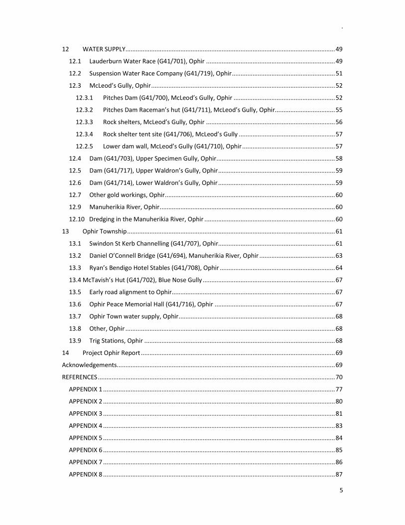
12 WATER SUPPLY .......................................................................................................................... 49
12.1 Lauderburn Water Race (G41/701), Ophir ........................................................................... 49
12.2 Suspension Water Race Company (G41/719), Ophir ............................................................ 51
12.3 McLeod’s Gully, Ophir ........................................................................................................... 52
12.3.1 Pitches Dam (G41/700), McLeod’s Gully, Ophir ........................................................... 52
12.3.2 Pitches Dam Raceman’s hut (G41/711), McLeod’s Gully, Ophir ................................... 55
12.3.3 Rock shelters, McLeod’s Gully, Ophir ........................................................................... 56
12.3.4 Rock shelter tent site (G41/706), McLeod’s Gully ........................................................ 57
12.2.5 Lower dam wall, McLeod’s Gully (G41/710), Ophir ...................................................... 57
12.4 Dam (G41/703), Upper Specimen Gully, Ophir ..................................................................... 58
12.5 Dam (G41/717), Upper Waldron’s Gully, Ophir .................................................................... 59
12.6 Dam (G41/714), Lower Waldron’s Gully, Ophir .................................................................... 59
12.7 Other gold workings, Ophir ................................................................................................... 60
12.9 Manuherikia River, Ophir ...................................................................................................... 60
12.10 Dredging in the Manuherikia River, Ophir ............................................................................ 60
13 Ophir Township ......................................................................................................................... 61
13.1 Swindon St Kerb Channelling (G41/707), Ophir .................................................................... 61
13.2 Daniel O’Connell Bridge (G41/694), Manuherikia River, Ophir ............................................ 63
13.3 Ryan’s Bendigo Hotel Stables (G41/708), Ophir ................................................................... 64
13.4 McTavish’s Hut (G41/702), Blue Nose Gully ............................................................................. 67
13.5 Early road alignment to Ophir ............................................................................................... 67
13.6 Ophir Peace Memorial Hall (G41/716), Ophir ...................................................................... 67
13.7 Ophir Town water supply, Ophir ........................................................................................... 68
13.8 Other, Ophir .......................................................................................................................... 68
13.9 Trig Stations, Ophir ............................................................................................................... 68
14 Project Ophir Report ................................................................................................................. 69
Acknowledgements ............................................................................................................................... 69
REFERENCES .......................................................................................................................................... 70
APPENDIX 1 ....................................................................................................................................... 77
APPENDIX 2 ....................................................................................................................................... 80
APPENDIX 3 ....................................................................................................................................... 81
APPENDIX 4 ....................................................................................................................................... 83
APPENDIX 5 ....................................................................................................................................... 84
APPENDIX 6 ....................................................................................................................................... 85
APPENDIX 7 ....................................................................................................................................... 86
APPENDIX 8 ....................................................................................................................................... 87

.
6
APPENDIX 9 ....................................................................................................................................... 87
APPENDIX 10 ..................................................................................................................................... 89
APPENDIX 11 ..................................................................................................................................... 90
APPENDIX 12 ..................................................................................................................................... 91
APPENDIX 13 ..................................................................................................................................... 92
.
7
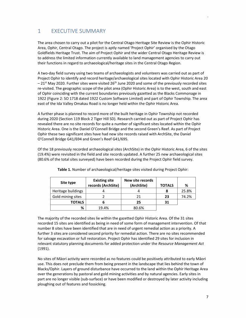
1 EXECUTIVE SUMMARY The area chosen to carry out a pilot for the Central Otago Heritage Site Review is the Ophir Historic Area, Ophir, Central Otago. The project is aptly named ‘Project Ophir’ organised by the Otago Goldfields Heritage Trust. The aim of Project Ophir and the wider Central Otago Heritage Review is to address the limited information currently available to land management agencies to carry out their functions in regard to archaeological/heritage sites in the Central Otago Region. A two-day field survey using two teams of archaeologists and volunteers was carried out as part of Project Ophir to identify and record heritage/archaeological sites located with Ophir Historic Area 20 – 21st May 2020. Further sites were visited 26th June 2020 and some of the previously recorded sites re-visited. The geographic scope of the pilot area (Ophir Historic Area) is to the west, south and east of Ophir coinciding with the current boundaries previously gazetted as the Blacks Commonage in 1922 (Figure 2: SO 1718 dated 1922 Custom Software Limited) and part of Ophir Township. The area east of the Ida Valley Omakau Road is no longer held within the Ophir Historic Area. A further phase is planned to record more of the built heritage in Ophir Township not recorded during 2020 (Section 119 Block 2 Tiger Hill SD). Research carried out as part of Project Ophir has revealed there are no site records for quite a number of significant sites located within the Ophir Historic Area. One is the Daniel O’Connell Bridge and the second Green’s Reef. As part of Project Ophir these two significant sites have had new site records raised with ArchSite, the Daniel O’Connell Bridge G41/694 and Green’s Reef G41/695. Of the 18 previously recorded archaeological sites (ArchSite) in the Ophir Historic Area, 6 of the sites (19.4%) were revisited in the field and site records updated. A further 25 new archaeological sites (80.6% of the total sites surveyed) have been recorded during the Project Ophir field survey.
Table 1. Number of archaeological/heritage sites visited during Project Ophir:
Site type Existing site records (ArchSite)
New site records (ArchSite) TOTALS %
Heritage buildings 4 4 8 25.8% Gold mining sites 2 21 23 74.2%
TOTALS 6 25 31 % 19.4% 80.6%
The majority of the recorded sites lie within the gazetted Ophir Historic Area. Of the 31 sites recorded 15 sites are identified as being in need of some form of management intervention. Of that number 8 sites have been identified that are in need of urgent remedial action as a priority. A further 3 sites are considered second priority for remedial action. There are no sites recommended for salvage excavation or full restoration. Project Ophir has identified 29 sites for inclusion in relevant statutory planning documents for added protection under the Resource Management Act (1991). No sites of Māori activity were recorded as no features could be positively attributed to early Māori use. This does not preclude them from being present in the landscape that lies behind the town of Blacks/Ophir. Layers of ground disturbance have occurred to the land within the Ophir Heritage Area over the generations by pastoral and gold mining activities and by natural agencies. Early sites in part are no longer visible (sub-surface) or have been modified or destroyed by later activity including ploughing out of features and fossicking.

.
8
Researching the written record provides a portion of site history of the people living and working at Black’s (Ophir) from the 1860’s through the 20th Century. The project aim is to carry out an archaeological survey to ground truth the results of research into the known record by placing individuals by name back into the past landscape where they lived and worked. Specific objectives of the Heritage Review are to update existing site records held by the NZ Archaeological Association (ArchSite) and to survey and record archaeological/heritage sites previously not recorded. Secondary objectives are to rectify the differing sites being protected by current heritage agencies and to assess current and potential threats and impacts to sites. This is followed by recommended management strategies to reduce risk by inappropriate development or land use and/or a lack of management to maintain a sites structural stability. Levels of recommended intervention (physical maintenance, stabilisation, fencing, vegetation management) follow that set out by ICOMOS NZ Charter (the International Council on Monuments and Sites) for sites requiring improved statutory protection or urgent remedial action. This report (Briden 2021B) provides results of the field survey and site recording including research and history of the sites and inhabitants. A second report (Briden 2021A) provides a summary of results from Project Ophir with recommendations for intervention tasks and ongoing monitoring frequency to acheive stable heritage sites and to align protective/management agency listings.
2 LOCATION AND LAND STATUS The Project Ophir work area is the Ophir Historic Area c. 29 kms north-east of Alexandra, Central Otago (Figures 1 – 4). The Ophir Historic Area is bounded by and includes the town of Ophir to the north, State Highway (SH) 85 to the east, Manuherikia River to the south-west and a boundary fence-line to the south running west to east along the c. 350m elevation.
Figure 3. Recorded archaeological sites (red and blue stars) listed with ArchSite around Ophir.
Red stars denote pending records awaiting confirmation by ArchSite.

.
9
The Ophir Historic Area was previously known as Blacks Commonage set aside and gazetted in 1922 (Heritage NZ list no. 7268). Jill Hamel (2001: 110) noted that a Commonage was declared adjacent to large mining settlements for miners and their families to live once the gold rushes died out. The land encompasses Sections 117 – 119 Block II Tiger Hill and various sections in Ophir Township (Figure 4). The Heritage NZ Pouhere Taonga Act (2014: 9) declares an Historic Area to mean the following (Excerpt 1):
Historic area means an area of land that – a) contains an inter-related group of historic places; and b) forms part of the historical and cultural heritage of New
Zealand; and c) lies within the territorial limits of New Zealand
Excerpt 1. Historic Area definition (Heritage NZ Pouhere Taonga Act 2014: 9).
Figure 4. Ophir Historic Area: Sections 117 – 119 and Sections 69 – 96 Town of Ophir Block II
Tiger Hill Survey District (Heritage NZ Listing).
The Ophir HA lies within the rohe (work area) of four Papatipu runanga (iwi). The Kai Tahu ki Otago (KTKO) Natural Resource Management Plan (2005: Aukaha) outlines the shared iwi interest over the Otago region:
Tangata whenua (Kāi Tahu whānui) are represented by Kā Papatipu Rūnaka and Te Rūnanga o Ngāi comprising people o Kāi Tahu, Ngāti Māmoe and Waitaha descent who hold manawhenua over the Otago Region (Aukaha). Many of Otago’s rivers and streams were sources of mahinga kai and cultivation and harvesting of plants. Suitable stone resources for tool making and working timber are present throughout Otago many of which can be found on most of the recorded iwi sites around the South Island.
The Te Rūnanga o Ngāi Tahu Act 19967 describes the takiwä of Kā Papatipu Rūnaka including Te Rūnanga o Moeraki (Moeraki), Kāti Huirapa Rūaka ki Puketeraki (Karitane), Te Rūnanga o Ōtākou (Otakou, Otago Peninsula) and Hokonui Rūnanga (Hokonui).

.
10
Ōmakau is the name of the wider region of Ophir, Blackstone Hill and Idaburn also the later settlement of Ōmakau on the west of Manuherikia River (Kā Huru Manu). Land within the Ophir Historic Area is managed by various agencies and in private freehold ownership:
Heritage NZ (HNZPT) Land Information NZ (LINZ) – Protected Areas and LINZ Managed Crown Property Department of Conservation (DOC) Central Otago District Council (CODC) Freehold ownership
The Leask family currently own Section 119 within the Ophir Historic Area under survey. The Leask family had previously owned all three Sections 117 – 119 within the Ophir Historic Area to the east behind the town of Ophir but have since sold Sections 117 -118 (Figure 4). The Leask family have lived at Blacks/Ophir since the early 1860’s. Protected Areas are shown in blue in Figure 5 and LINZ Managed Land in red in Figure 6. Figure 7 shows DOC (Department of Conservation) Managed Land in green and Stewartship Land in blue.
Figure 5. Protected Areas (blocked out in blue: Crown Property, Land Information NZ).
Table 1 (Appendix 1) lists the Heritage Inventory of 20 registered sites held with Heritage NZ and their current status. The Assessment of Criteria for the Ophir Historic Area registration report (Heritage NZ List Entry Information, List Number 7268 dated 27th October 1995) is provided in Appendix 2. Two sites within the Ophir Historic Area are registered Category I: Daniel O’Connell Bridge and Ophir Post Office, and four Category II sites: Ophir Courthouse, Jenkins Cottage and outbuildings, St Andrew’s Presbyterian Church (former) and Pitches Store. The Central Otago District Council (CODC) District Plan (page 19.14) lists 17 built heritage structures within the Ophir Heritage Precinct at Ophir on the Register of Heritage Buildings, Places, Sites & Objects and Notable Trees. Figure 8 (Appendix 3) shows the Heritage Precinct (shaded area bottom right of Map 25) with the built heritage structures listed in Table 2.

.
11
Figure 6. LINZ Managed Crown Property (blocked out in red: Land Information NZ).
Figure 7. Department of Conservation (DOC) Managed Land in Ophir Township in green, Stewartship
Land in blue. Eight sites registered with Heritage NZ in the Ophir HA are not listed on the CODC Schedule or in the Heritage Precinct. There are no listings for notable trees, areas of significant indigenous vegetation or wetlands in the Ophir Historic Area on the CODC District Plan (Schedule 19.4 Part B pages 19:38 - 19:39, Schedule 19.6.1 – 19.6A pages 19:41 – 19:43). The CODC District Plan notes the following Outstanding Natural Features (Schedule 19.6.2: A page 19:45) that lie in the immediate area south of the survey area:
Ophir Gorge is a steep sided rocky gorge landscape that contains the Manuherikia River adjacent to Tiger Hill
Tiger Hill is an important and distinctive feature which is visible from throughout the Manuherikia Valley.

.
12
3 RECORDED ARCHAEOLOGICAL SITES (ARCHSITE) There are no existing records of a Maori presence within the bounds of the Ophir Historic Area but this does not preclude sites or features related to their use being present. There are a cluster of recorded iwi sites at Crawford south-west of Ophir located east of Galloway. A chert flake was found at the Crawfords farm (G42/22) and silcrete quarries (G42/4 – G42/5, G42/23, G42/237 – G42/239) lie across the Crawford Hills. Table 3 (Appendix 4) lists recorded archaeological sites in the surrounding area of Ophir that include the following sites (in the direction away from Ophir Township):
north - Blacks Cemetery (G41/656), water race (G41/646), metal tank (G41/639) and Moa bone from a natural deposit recorded at G41/52
north-east - Poolburn camp for rail line workers (H41/233 – H41/234)
south-west - built heritage at Chatto Creek: Chatto Creek school (G41/392), Chatto Creek Bridge (G41/323) and Chatto Creek Hotel (G42/324)
south-east - scatter of Māori sites: midden and flakes (H42/4), middens and ovens (H42/30 and a Moa bone deposit (H42/58)
east - Hotel site (H41/12), Stone buildings (H42/96 and H42/97), hut sites (H42/89, H42/93, H42/894), gold mining sites (H42/90 - H42/92, H42/95) and dams (H42/98 – H42/100).
The Ophir Historic Area under this heritage site review contains 18 recorded archaeological/historic sites listed with ArchSite. The site records are briefly described in Table 4.
Table 4. Recorded archaeological sites within Ophir Historic Area listed with ArchSite:
NZAA Site Record Description CODC List No
G41/575 Post Office 117
G41/576 Water race
G41/577 Stone huts
G41/595 Stone culvert
G41/596 Prospecting pits
G41/597 Sluice faces and prospecting pits
G41/598 Flushing dam complex
G41/599 Water race and penstock
G41/600 Sluice faces
G41/601 Bridge stone abutment
G41/602 Water race
G41/610 Sluiced ground
G41/611 Sluiced ground
G41/612 Water races
G41/613 House site
G41/614 Pitches Store 113
G41/652 Rubbish pit

.
13
G41/653 St Andrew's Presbyterian Church 107 There are five built heritage structures in Ophir Township which are recorded archaeological sites (G41/575, G41/577, G41/614, G41/652 – G41/653) and one water race (G41/576, Figure 9). Only three correspond to those listed on the CODC District Plan (page 19:14, Table 1). The three corresponding sites are registered Cat I and Cat II with Heritage NZ:
Ophir Post Office (G41/575) Pitches Store (G41/614) St Andrew's Presbyterian Church (G41/653).
Figure 9. Reference identifiers provide approximate location of sites recorded at Ophir Township/Blacks and south of Ophir (ArchSite) within the Project Ophir survey area.
Figure 10. Reference identifiers provide approximate location of recorded sites (ArchSite) south-west of Ophir Township/Blacks within the Ophir Historic Area.

.
14
A further 12 site records exist to the west (G41/595 – G41/597, G41/597 – G41/602) and south (G41/610 – G41/613, Figures 9 - 10) of Ophir within the Heritage NZ Historic Area (Sections 117 – 119 Block II Tiger Hill). Sites G41/611 and G41/613 were not visited as landowner permission is not yet acquired for access to Section 118. The only recorded archaeological site visited in Section 117 of the Ophir Historic Area is the remnants of the early Manuherikia River footbridge (G41/601). The one remaining stacked schist abutment is located on the west (true right) bank of the Manuherikia River (north side of the river).
4 METHODOLOGY Only those archaeological/heritage sites located within the bounds of Ophir Historic Area are under consideration for Project Ophir. The areas known as Blacks Flat, Blacks No 2 and Blacks No 3 are excluded from this project as being outside the bounds of the Ophir Historic Area. The first step for field work was to research existing historic records and photograph collections held by various agencies and local landowners: NZAA site records, Heritage NZ, Otago Museum, Central Otago District Council, mining and residence applications (Archives NZ), Gold Warden reports (Atojs), Hocken Library, Central Stories Museum & Art Gallery, local generational knowledge, early newspapers (Paperspast), geological mapping and reports (GNS, New Zealand Petroleum & Minerals), Survey Office Plans and Deposited Plans (Prover: Custom Software Ltd/Landonline), online sources (retrolens aerials, Hocken SnapShop). The survey area was visually inspected by aerial photography prior to field work to identify sluice faces and water races/reservoirs, the visible obvious markers of human activity in a gold mining landscape. OGHT Terry Davis and Odette Hopgood-Bride organised landowner approvals to access Ophir Historic Area, organised all the food and drinks both in the field and at the procured accommodation in Ophir. A two day survey was carried out 20th- 21st May 2020 to ground test the written historic record with heritage sites remaining in the landscape. Two teams conducted the survey with one team focusing within Ophir Township and its built heritage and the second on the goldmining sites behind (north of) Ophir. The Ophir Township team was led by Andrew Barsby (Heritage NZ) and the goldfield team by Shar Briden (Absolute Archaeology Ltd) and Matthew Sole (Kopuwai Consulting). A second site visit was undertaken by the author Shar Briden and partner Audrey Heyzer 26th June 2020 to confirm location and threats to sites. Site locations were mapped using GPS Identifiers on a hand-held GPS unit and coordinates (NZTM) recorded. For goldmining sites it is the task of the lead archaeologist to correlate gold mining sites recorded on the ground with the historic record/s to confirm who carried out the activity and dates the site was worked and/or lived in. Local knowledge has proven to be essential for providing information on site location and names of creeks and gullies on the slopes above (south of) Ophir Township that no longer appear on topographic maps. The names of the local creeks and/or names of the people involved in gold mining related claims and residence areas are required in order to search information held at Archives NZ. The gullies may have been named after the local gold miners. Archives NZ hold records for residence areas and gold mining and quartz reef claims (including water supply infrastructure) applied for at Blacks (Ophir). Some of the names of these people are provided below in sections under named gullies that lie within the bounds of Ophir Historic Area/Blacks

.
15
Commonage. Sites with existing site records are detailed in the first section followed by those newly recorded during Project Ophir. Heritage sites may be referred to as archaeological or heritage sites. Archaeological sites generally refer to sites that date pre-1900 in human activity and historic to post European sites. Features that are clustered together have been recorded as a single site for lodging site record purposes. Mining applications for claims, water races, tail races and dams/reservoirs are noted on the day the application was lodged not the date granted or declined by the gold warden. The applications provide details regarding water and tail race width and depth, length of the races and descriptions of location on the ground. The set out of this report groups sites by where they are located in each gully (catchment) draining the northern flanks of the Raggedy Range to Swindon St, Blacks/Ophir. Secondary is the type of mining carried out on site: alluvial gold mining or quartz reef mining followed by descriptions of hut sites and tent sites, and water supply infrastructure. Site history is mentioned where research has been carried out and there are gold mining applications (for water supply/disposal and claim areas) to the Gold Warden of the time that are currently housed at Archives NZ, Dunedin. A clause in the Mining Act allowed the gold warden to grant Residence areas of one acre to gold miners (upon application) to live and mine for gold for which the miner paid £1 a year. Photographs provided in the reports were taken by the lead archaeologist Shar Briden if not otherwise stated.
5 LOCAL HISTORY Otago Museum (email 20th March 2020) holds Taoka (archaeological finds) that attest to the presence of early Māori along the foothills of Raggedy Range and Mt Ida Range in Central Otago. Otago Museum’s Catalogue Register of Taonga list 141 items deposited in their care from the wider area around Ophir Historic Area. The majority of Taoka relate to finds of silcrete and porcellanite flakes, and silcrete blades predominantly recovered from the foothills of Mt Ida Range (P George Collection). The collection of Taoka include an obsidian flake (D79.167) and two pieces of pounamu (nephrite Cat no. D79.171 and D79.172) one of which is polished. There is one item described as a chert adze (Cat no. D29.1423) recovered near the saddle on Raggedy Range. The location is not described nor the date of recovery. The adze was presented to the museum by W H Grant (Terrace School). A wooden bowl (D34.738) was found in a peatbog near the head of the Manor Burn in Ida Valley February 1870 and presented to the museum by Mr Stronach. Silcrete (orthoquartzite) quarry sites recorded along the slopes of Blackstone Hill and Oturehua where utilised by early Māori who mined the boulders and outcrops to knap (flake) the stone to make tools. Large blades were shaped to make tools for cutting and scraping tasks such as butchering and breaking down of Moa and other birds. Silcrete or orthoquartzite cores and flakes are recorded on many sites throughout the South Island that were likely sourced from stone located inland of Otago (ArchSite). The survey area, Ophir Historic Area, lies within the Tiger Hill District. It was John Turnbull Thompson who mapped and provided an English name of Tiger Hill during his survey pf the Otago Region 1857 – 1858 although his meaning for the name is not known. Herries Beattie does provide some suggestions (1948: 59).
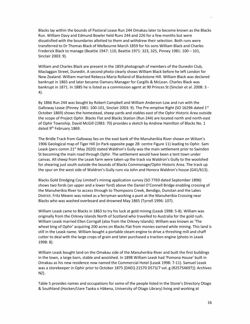
.
16
Blacks lay within the bounds of Pastoral Lease Run 244 Omakau later to become known as the Blacks Run. William Davy and Edmund Bowler held Runs 244 and 226 for a few months but were dissatisfied with the boundaries allotted to them and withdrew their selection. Both runs were transferred to Dr Thomas Black of Melbourne March 1859 for his sons William Black and Charles Frederick Black to manage (Beattie 1947: 110, Beattie 1971: 323, 325, Pinney 1981: 100 – 101, Sinclair 2003: 9). William and Charles Black are present in the 1859 photograph of members of the Dunedin Club, Maclaggan Street, Dunedin. A second photo clearly shows William Black before he left London for New Zealand. William married Rebecca Maria Rolland of Blackstone Hill. William Black was declared bankrupt in 1865 and later became Oamaru Manager for Cargills & McLean. Charles Black was bankrupt in 1871. In 1885 he is listed as a commission agent at 90 Princes St (Sinclair et al. 2008: 3 - 4). By 1866 Run 244 was bought by Robert Campbell and William Anderson Low and run with the Galloway Lease (Pinney 1981: 100-101, Sinclair 2003: 9). The Pre-emptive Right (SO 16296 dated 1st October 1869) shows the homestead, sheep yards and stables east of the Ophir Historic Area outside the scope of Project Ophir. Blacks Flat and Blacks Station (Run 244) are located north and north-east of Ophir Township. David McGill (1983: 70) provides a sketch by Andrew Hamilton of Blacks No. 1 dated 9th February 1869. The Bridle Track from Galloway lies on the east bank of the Manuherikia River shown on Wilson’s 1906 Geological map of Tiger Hill (in Park opposite page 28: centre Figure 11) leading to Ophir. Sam Leask (pers comm 21st May 2020) stated Waldron’s Gully was the main settlement prior to Swindon St becoming the main road through Ophir. The settlement would have been a tent town under canvas. All sheep from the Leask farm were taken up the track via Waldron’s Gully to the woolshed for shearing just south outside the bounds of Blacks Commonage/Ophir Historic Area. The track up the spur on the west side of Waldron’s Gully runs via John and Honora Waldron’s house (G41/613). Blacks Gold Dredging Coy Limited’s mining application survey (SO 7769 dated September 1896) shows two fords (an upper and a lower ford) above the Daniel O’Connell Bridge enabling crossing of the Manuherikia River to access through to Thompsons Creek, Bendigo, Dunstan and the Lakes District. Fritz Meann was noted as a ferryman working a punt at the Manuherikia Crossing near Blacks who was washed overboard and drowned May 1865 (Tyrrell 1996: 107). William Leask came to Blacks in 1863 to try his luck at gold mining (Leask 1998: 5-8). William was originally from the Orkney Islands North of Scotland who travelled to Australia for the gold rush. William Leask married Ellen Corrigall (also from the Orkney Islands). William was known as ‘The wheat king of Ophir’ acquiring 200 acres on Blacks Flat from monies earned while mining. This land is still in the Leask name. William bought a portable steam engine to drive a threshing mill and chaff cutter to deal with the large crops of grain and later purchased a traction engine (photo in Leask 1998: 8). William Leask bought land on the Omakau side of the Manuherikia River and built the first buildings in the town, a large barn, stable and woolshed. In 1898 William Leask had ‘Pomona House’ built in Omakau as his new residence now named the Commercial Hotel (Leask 1998: 7-11). Samuel Leask was a storekeeper in Ophir prior to October 1875 [DAEQ 21570 D573/7 vol. g (R25754697)]: Archives NZ). Table 5 provides names and occupations for some of the people listed in the Stone’s Directory Otago & Southland (Hocken/Uare Taoka o Hākena, University of Otago Library) living and working at

.
17
Blacks/Ophir in 1889. Table 6 lists those for 1905 (Stone’s Directory Otago & Southland 1905: 325). Table 7 provides names of other people resident in Blacks/Ophir after 1880 listed in local newspapers.
Table 5. Ophir listing in the Stone’s Directory Otago & Southland 1889:
William Burren Baker and storekeeper Charles Gallagher Blacksmith Archibald Gray Blacksmith Hangar Brothers Blacksmith Thomas Tate Blacksmith William Green Draper Mary Gavan Shamrock Hotel
William Macintosh Manager Bank of New South Wales
Rev John Sheehan Roman Catholic John McIntosh Black’s Hotel
John Pitches Storekeeper, farmer, butcher
Frank Raper Mechanical engineer John Sullivan Stonemason John Walton Police Constable
Table 6. Ophir listing in the Stone’s Directory Otago & Southland 1905: 325:
Robert Mitchell Storekeeper Ah Sing Storekeeper Sarah McGuckin Storekeeper Walter Hawson Manager Bank of NZ Elizabeth Donnelly Black's Hotel
William Leask Boarding housekeeper
John McKnight Justice of the Peace Ronald McRae Shamrock Hotel John Waldron Rabbiter
Table 7. Other residents in Blacks/Ophir and occupations listed in local newspapers:
Gavin Sandeman Saddler and harness maker Dunstan Times 30th July 1880: 3
M Fitzgerald Bootmaker taken over by P O’Connor Dunstan Times 7th January 1881: 1
James Rivers Storekeeper Gilbert Sinclair General Merchant James Graham General Merchant David Smith Farrier and blacksmith James McCaughan Saddler John W Moore Tailor John McKnight Coachbuilder Dunstan Times 8th June 1888: 2 FTB Walker Watchmaker Jeweller Bernard Flannery Bakery and store Donald and Alice Gunn Shopkeepers WJ Bloxham Boot & shoemaker Miss E Pitches Milliner Miss McNaughton Dressmaker David Arnold Saddlery John Hughes Blacksmith Mt Ida Chronicle 29 June 1882: 3

.
18
6 GEOLOGY AND GOLD MINING The geology of an area can help determine if sites of heritage interest are located in any given area. Geological reports provide information on land form with regard to mineral exploration and extraction that informs on the location of where people clustered around those resources. The Manuherikia River drops through rifts in the schist at Lauder and re-appears in its old channel c. 2 miles above Ophir. The river again drops through a deep narrow rift at Ophir Bridge to re-appear in its old course at Chatto Creek (Park 1906: 12). The geology of the Project Ophir area lies in a broad depression in the schist bedrock cut by the Manuherikia River flanked to the south by the Raggedy Range. The gentle north-western slopes formed as shallow deformed fold structures covered by 5 - 20 million year old river and lake sediments that are slowly being uplifted. Manuherikia River drains from the mountains north-east at St Bathans. The stone in the bed of Manuherikia River are predominantly made up of rounded greywacke gravels. Placer gold concentrations can build up in the bed of Manuherikia River hence the target for alluvial mining and dredging. Placer gold deposits are distinct from quartz vein-bearing gold in schist bedrock (Gold at Alexandra and Ophir: Department of Geology/Te Tari Tatai Arowhenua, University of Otago). Siliceous cement stones (silcrete or orthoquartzite) have been recorded along the flanks of Blackstone Hill and other areas on the flanks of Raggedy Range in the Manuherikia Basin (German Hill, Chatto Creek etc) and Central Otago. Donna Falconer’s (1985) geological map of Ophir Gorge notes scattered sarsen stones or Chinamen stones outcropping over the western side of Ophir Historic Area. Quality silcrete and orthoquartzite are a known stone resource for early Māori to knap out large blades for butchery tasks. Unknown quarry sites will exist across Central Otago. In 1862 Sir James Hector (Provincial Geologist) confirmed Dr W Lauder Lindsay’s opinion that Central Otago schist is the source of alluvial gold in the region (Provincial Government Gazette 3rd September). Gold was discovered at Black’s in 1863 and Black’s No 3 in 1865 (The Handbook of New Zealand Mines 1887: 71). Blacks Diggings was one of the earliest gold mining alluvial sites to be discovered with a small rush occurring in April 1863 on the Black’s pastoral run (atojs 1863: D-06: 6, atojs 1865: C-04a: 11). Sir James Hector examined the Pleistocene gravels at Blacks/Ophir and the mine workings at Green’s Reef in 1888 with a subsequent report published 1890 (pages 17 – 19). Hector (1890) provides a description and sketch of the workings at Green’s Reef and Captain’s Lode, Blacks/Ophir (Appendix 5). James Park was requested by Mr Pyke November 1888 to survey and report on points of geological interest throughout Otago for the New Zealand Geological Survey for the Department of Mines. Park’s 1906 compilation provides a geological map (Figure 11) and description of Green’s Reef at Blacks/Ophir (below) and a sketch section of the upper end of Green’s Reef workings (page 29):
An open breast cutting 3 chains long 15 feet high and 5 – 25 feet wide. In the upper or higher end of the cutting the main cross vein is called the Captain’s Lode. The vein varies from thin facing of stone to 6 inches thick and is said to carry gold in the casing.
Gold is dispersed through a considerable thickness of the decomposed mullocky schist. The material is conveyed to the mill situated on the flat by the roadside by means of an incline tramway 15 chains long. The crushing machine was a Cylcone roller-crusher ill adapted to cope with the material in this claim. The machine does not pulverise the material choking the tables and ripples. The rock of Green’s Reef is a grey micaceous quartz schist much

.
19
broken and shattered (Park 1906: 29). Mr Neil was the manager of the company at that time.
A stamper battery is stated as being located on the neighbouring property (Hector 1890: 19). A single stamper box for crushing the quartz material containing the gold stands on the intersection of Mt Ida Valley Road and Swindon St as a reminder of the early gold workings at Blacks (2s 1-2). It is not confirmed where the puddling machine or the later quartz battery was located to crush the stone from the various reefs located behind Ophir Township. The Handbook of New Zealand Mines (Galvin 1906: 180-181) provides some of the background to the mining that occurred at and around Green’s Reef at Blacks (Appendix 6). Park’s 1906 geological map (Figure 11) shows an approximate extent of gold workings at Blacks (Ophir) at that time of its publication (yellow shaded areas). The map does not show any water races feeding the gold workings within the Ophir Historic Area. GJ Williams (1974: 54, Excerpt 2) provides the average yield of gold and silver from Park’s 1906 assays of samples taken from six lodes in the Ophir area.
Plates 1 - 2. A single stamper box stands on the intersection of Mt Ida Valley Road and Swindon St as
a reminder of the early quartz crushing carried out at Blacks (M Sole).
Excerpt 2. Park’s 1906 gold assay samples from
the Ophir area (cited in Williams 1974: 54).
Plate 3. Sluicing claim on Ophir Hill undated
(Object no VOPO.23: NZ Museums). The location is not confirmed to a particular gully or hill slope.
Excerpt 3. Gold wash lay on the spurs not the gullies above Blacks/Ophir (Otago Daily Times
24th September 1889: 3).

.
20
Figure 11: Geological Map of Ophir Goldfield (G Wilson map in Park 1906: opposite page 28).

.
21
Hydraulic sluicing for gold occurred behind (south of) the town of Blacks/Ophir (Plate 3). Water worn gold bearing wash lies on the top or point of the low spurs above the township at an elevation c. 200 ft above the present river system (Excerpt 3: Otago Daily Times 24th September 1889 page 3). Sumpter (1948: 59) writes of speaking to John Sims junior re-telling what his father John Sims had told him about Blacks: ‘The diggers could get gold with a pick and shovel on this flat (Blacks Flat). I believe thirty-two tons of gold were taken from round about Black’s…”. The gold mining district of Blacks was divided 1st March 1872 with the St Bathans Division being added to Mount Ida district and Blacks to Clyde district (atojs C-01: 34). In that year the Gold Warden W Carew reported over 8,120 ounces of gold returned from the Blacks district for the year ended May. In 1873 the returns were over 9,450 ounces (atojs H-07: 33). There are reports of nuggets of gold being found at Blacks/Ophir. A nugget weighing 20oz was discovered at Blacks No 1 in September 1890 (Dunstan Times 26th page 2). A 6oz nugget was found by Love, Pitches and Millar one mile from Ophir 10th Sept 1897 (Dunstan Times page 2). Finding of gold nuggets always promoted new interest to the Blacks gold field. Blacks was renamed Ophir after the legendary King Solomon’s Goldmines where the gold was obtained to sheath the Temple of Jerusalem (Wikipedia). The area became known as Blacks No 1 following commencement of gold mining at new areas named Blacks No 2 followed by Blacks No 3 (on the Poolburn side of Raggedy Range). Blacks 3 is shown well south-east of Ophir Historic Area on the eastern face of Raggedy Range on Survey Office Plan 1711 dated 1885 (Figure 12) and a sketch of Town, Townships and Ghost Towns in Central Otago by Forrest (1965: 187).
Figure 12. Cropped Survey Office Plan SO 1711 dated 1885 (Prover: Custom Software
Ltd/Landonline) noting the gold mining field of Blacks (Ophir). Ophir appears as it was in the late 19th to early 20th Century without later modifications of new buildings and roads replacing the old. Modern town buildings became established at Omakau partly

.
22
due to the Otago Central line (railway) having been established on the north side of the Manuherikia River in 1904 bypassing Ophir Township (Galer 2005: 20 – 21). The Gold Warden in 1865 (atojs 1865: C-04a: 11) noted the following on the mining population present at Blacks: 140 miners with 48 using cradles, 50 miners sluicing, 5 ground sluicing, 15 puddling, 4 in quartz mining and 18 using gold mining methods not specified. James Ng ‘Windows on a Chinese Past’ (1993a Volume 1 and 1993b Volume 4) and gold mining and residence applications held in Archives NZ (Dunedin) reveal names of some of the Chinese people who were active at Blacks/Ophir either mining for gold, involved in gardening/cultivation or employed as labourers. Chinese are recorded hawking goods around the wider Ida Valley. Sue pe Kin was a gardener at Blacks 1886 recorded as gaining his letters of naturalisation (Mount Ida Chronicle 12th August: 2) and Chau Shong was one of the last two Chinese people living at Ophir in 1905 (Ng 1993a: 112 footnote 38). Ng (1993a: page 174 footnote 178) mentions Sue Kie who died at the Serpentine and was interred at Ophir. John Alloo estimated there were 50 Chinese at Blacks by January 1870 (cited in Ng 1993a: 144). Blacks No. 1 was one of the early centres where Chinese at some time or other were in the majority. There were 90 Chinese miners and 252 European miners active at Blacks in 1872. The almost deserted goldfield at Black No. 1 was revived by an influx of up to 260 Chinese miners 1873 – 1877. By 1875 Black No. 1 had 170 Chinese and 30 European miners. In 1876 there were 200 Europeans and 250 Chinese alluvial mining at Blacks. The renewed activity drew European’s miners back to the area, and businessmen and government agencies who built substantial premises as we see in Ophir today (Ng 1993a: 157, 181, 229 and 278, Atojs 1874 H-09: 42, Atojs 1875 H-03: 67, Atojs 1876 H-03: 37 and 44). Not all miners joined in the rushes that occurred as they raced from place to place in the quest for new gold finds. Constantine Hangari from Greece worked for gold at Blacks for nearly forty years and Carl Johan Wilhelmsen from Norway for nearly fifty years (Eldred-Grigg 2008: 457). Reports on modern mineral exploration carried out within the bounds of Ophir Historic Area (Open File Exploration reports held by Crown Minerals) is provided in Appendix 7. R Kilgour sampled Green’s Reef and Green’s Reef East in 1998 (MR3589). The New Zealand Petroleum & Minerals website which also notes two current mineral exploration permits over the Ophir Historic Area:
40427 Ophir Gold Limited granted 641.4 Hectares 11th March 1999 for 18 years (expired 10 March 2017) – Permit Status Date 20 December 2019 – gold and silver (Section 119)
60311 Matakanui Gold Limited granted 25162 Hectares 13th April 2018 for 5 years expires 12 April 2023 - Gold, silver, antimony, copper, ilmenite, rare earth elements, lead, tungsten, zinc, garnet (Sections 117 – 118).
7 CULTURAL PLANTINGS There is no current record of cultural plantings in the landscape of Blacks (gold mining and the expanding settlement of Ophir). Cultural plantings may be used for land boundaries and enclosures (garden and horse/stock enclosures). Smith (1987) notes cultural plantings show ideas of permanency and putting down roots rather than short term occupation. The Dunstan Times noted that Ophir Township was becoming more permanent in April 1877 (20th page 2).
.
23
Fruit trees and gardens can be a part of cultural plantings. One large pear tree is noted near the school grounds in Ken Leask’s published book on Ophir (1998: 50). The tree was a delight to the school pupils. A fruit tree (possibly pear) was noted in Waldron’s Gully close by the hut site at GPS 382 (Hopgood-Bride pers comm 21st May 2020). Chinese gardens mentioned in applications during research are not known to be located within the bounds of the Ophir Historic Area/Blacks Commonage although garden plots may have existed as the commonage was the area set aside for gold miners to use as a place to live and graze their stock and horses. The land put aside as a Commonage was not always productive at times being located on steep ground to avoid the gold bearing terraces and the wintering country crucial for the runholders stock.
8 IMPLEMENTATION TO DATE Project Ophir is the initial study area for the Central Otago Heritage Review and serves as model for the COHSR to follow for the wider Otago Region. Cycles of boom and bust dominated the colonial economy (Beattie 2015: 108). This is clearly evident in the historic record of Blacks/Ophir where a gold rush was followed by exodus to another rush elsewhere then back again to Blacks/Ophir for another rush. This pattern of short term occupation was to be repeated across gold fields throughout Otago and the wider South Island. It is the alterations to the landscape itself (ground works) that provide evidence of the activity carried out on a site (Lawrence 1995: 62). Neville Ritchie (1991: 37 - 38) notes that ‘…mining sites usually comprise groups of interrelated features with various mining episodes on the same reefs or alluvial deposits…’. ‘Mining sites evolved as a result of a succession of mining operations on the same claim’ at different times’. This would apply to various enterprises undertaken throughout Otago. Susan Lawrence (1995: 59) reiterates the repeated abandonment and re-occupation of house sites with the transcience of mining families on poor man’s diggings (deposits were low with steady returns). Blacks/Ophir gold workings have been considered a good poor man’s diggings. Metal and timber may have been re-used at times limiting identification of hut and tent sites in the field. The same applies to glass bottles and ceramics, that dating a site is problematic as items that may be present were probably re-used over time. Local history books tell stories of the individuals working and living in one of New Zealand’s most extreme weather towns ‘Ophir’: John Angus (1977) ‘One Hundred Years of Vincent County’, Jim Ng (1993) ‘Windows on a Chinese Past’, Ken Leask (1995) ‘Ophir Memories’, Lois Galer (2005) ‘Time to smell the roses’ and Gerald Cunningham ‘Illustrated History of Central Otago and the Queenstown Lakes District’ (2005). Research carried out as part of the initial area chosen for a heritage review ‘Project Ophir’ shows there are glaring gaps in the knowledge base of archaeological and heritage sites located within the Ophir Historic Area. The most surprising is a lack of a site record for the Daniel O’Connell Bridge spanning the Manuherikia River west of Ophir (Ophir Bridge Road). Neither are there existing site records for: the town road kerbing and channelling installed along both sides of Swindon St, Green’s Reef located at the east extent of Ophir Historic Area, the water supply infrastructure to feed Blacks No 1 gold mining sites including Pitches Dam and three water races spanning the Manuherikia River in fluming.

.
24
Ophir records one of the most extreme temperature differences in New Zealand. Fabric such as mud huts or stacked stone huts and buildings are impacted by severe frosts and extremes of heat. Recommendations for remedial work of built heritage must take into account the temperature extremes common at Ophir. A total of 31 sites were recorded within the Ophir Historic Area during Phase 1 of Project Ophir (Table 8). Of that total 25 sites (80.6%) have had new site records written up and 6 sites (19.4%) are existing site records that have been upgraded (ArchSite). Twenty-five of the 31 sites recorded relate to gold mining sites (74.2% including hut sites) and 8 sites (25.8%) are heritage buildings or features located in the town of Blacks/Ophir. Of the 25 new sites recorded (Table 9) 21 sites (84%) are related to gold mining with 4 sites (16%) being heritage buildings.
Table 8. Total number of sites surveyed during Project Ophir:
Site type Existing site records (ArchSite)
New site records (ArchSite) TOTALS %
Heritage buildings 4 4 8 25.8% Gold mining sites 2 21 23 74.2%
TOTALS 6 25 31 % 19.4% 80.6%
Table 9. Number of new sites recorded during Project Ophir:
Site type New site records (ArchSite) %
Heritage buildings 4 16.0% Gold mining sites 21 84.0%
TOTALS 25
9 RECORDED SITES NOT VISITED Nine heritage sites with existing site records held with ArchSite were not re-visited during Project Ophir. The sites are listed in Table 10 (Appendix 8) and approximate locations shown in Figures 9 - 10. The majority of these sites are located within the Ophir Historic Area west of Ophir Township/Blacks although not currently within the scope of Project Ophir Phase 1. Land owner consent will be required before survey and updating of these site records can occur.
10 RECORDED SITES UPGRADED The Project Ophir field survey resulted in upgrades to 7 existing NZAA site records and identification of 24 archaeological sites not previously recorded. Brief descriptions of each feature/site are given below. Coordinates for GPS identifiers locating sites recorded during field survey work are listed in Table 11 (May 2020) and Table 12 (June 2020: Appendix 9). Some of the sites are obscured by vegetation and shrub/tree growth. Stacked stone revetment or walling of some of the site features such as water races, aqueducts, dam walls and huts require some form of stabilisation, mud-packing or capping. Potential threats identified in the field will be discussed in the threats section.

.
25
Table 13 lists recorded archaeological sites (ArchSite) re-visited and upgraded during the field work within the bounds of Ophir Historic Area.
Table 13. List of recorded archaeological sites (ArchSite) re-visited during Project Ophir:
Knack entry no Existing site records held with ArchSite
NZAA site no
S26 Stacked culvert G41/595
S52 Early footbridge abutment G41/601
S56 Water race lower - Golden Gate Water Race G41/602
S50 Sluiced gully and tailings Waldron's Gully/McLeod's Gully G41/610
S35 Waldron's Hut/house site G41/613
S34 St Andrews Church G41/653
10.1 Stone culvert (G41/595), Ophir The stacked schist culvert (G41/595) west of Ophir Township beneath Ophir Bridge Road was relocated at GPS 376 (Figure 13). The culvert is no longer in operation as a new concrete culvert has been installed beside (east of) the stacked culvert that now provides drainage for Wai-iti Stream to Manuherikia River. The eastern channel of the stacked culvert (G41/595) is blocked as noted by Matthew Schmidt (on the site record) in 2006 prior to road sealing. The stacked walling on the lower side appears to be bowing outward. A construction date for this culvert has not yet been established but is assumed to be late 19th Century when culverts were made of stone and pitched on the bottom of the watercourse. Main routes were generally formed 24 feet wide and gravelled 18 feet to a depth 10 inches. By roads were 16 feet wide and gravelled 12 feet to a depth of 8 inches (Angus 1977: 80).
Figure 13. Early Manuherikia footbridge G41/601 (GPS 033) to left, Daniel O’Connell Bridge G41/694 (centre), stacked culvert G41/595 (GPS 376 Wai-iti Stream) to right.
Peter Petchey (2000: 3 – 4) notes a small gorge opening up upstream from the main road which this culvert used to drain. The lower part of the creek was ground sluiced for gold along most of its length. Gold tailings are evident on high ground on the eastern side of the creek.
Early footbridge (G41/601)
Culvert (G41/595)

.
26
Plate ?. View north to stacked culvert (G41/595,
GPS 376) beneath Ophir Bridge Road.
Plate ?. View west along Ophir Bridge Road. Stacked stone culvert in foreground and new
culvert in centre (north side of the road).
10.2 Early Manuherikia footbridge abutment (G41/601), Ophir The site record (G41/601) notes the early Manuherikia footbridge was located c. 250m downstream of the Daniel O’Connell Bridge. The bridge leads to a gold mining complex (G41/596 – G41/600 and G41/602) on the eastern (southern) side of Manukerikia River. Only one of the bridge abutments remains on site on the western side of the river (true right bank).
Plate 4. Early footbridge (G41/601) over Manuherikia River at Blacks (undated:
Asset ID19812 neg E1478/6 Hocken Snapshop). View south downstream.
Plate 5. Early footbridge in foreground and
Daniel O’Connell Bridge in background dated c. 1889 (held in Central Stories Museum & Art Gallery, Alexandra). View north upstream.
The early Manuherikia River bridge abutment (G41/601 was relocated at GPS 033 on the c.310m elevation on LINZ Managed Crown Property adjoining the Ophir Historic Area (Figure 13). Photographs held at Hocken Snapshop and Central Stories Museum in Alexandra show the footbridge with its superstructure intact (Plates 4-5). Green schist was used to construct the bridge abutments which was obtained in the vicinity of the works. The site where the stone was quarried is not known. Green schist outcrops throughout the west section of the Ophir HA. The landowner of Section 90 (where the early bridge abutment G41/601 is located on the true right bank) is Harris Lloyd Ronald (pers comm 21st May 2020) who

.
27
stated he had searched for a quarry site on his land over the past decades but had not found the quarry site for the green schist.
10.3 Golden Gate Water Race (G41/602), Ophir Peter Petchey’s (2000: Figure 14) sketch of archaeological features at the west extent of Ophir HA show two water races skirting the slopes above the gold workings. The water races appear to correlate with the two main races the Golden Gate Water Race (G41/602) and the Suspension Water Race (Walsh’s) bringing water in iron fluming across the Manuherikia River and the neighbouring sections east to Pitches Dam in McLeod’s Gully.
Figure 14. The Golden Gate Water Race (G41/602) and the Suspension Water Race cross
Sections 117 – 118 at the west extent of the Ophir Historic Area leading to Pitches Dam (to right out of sketch: Peter Petchey 2000).
Excerpt 4. Golden Gate water race (G41/602)
fluming completed (Dunstan Times 1st July 1865: 14).
Excerpt 5. Golden Gate Water Race (G41/602)
and Suspension Water Race span the Manuherikia River in iron fluming (Dunstan
Times 21st June 1867: 2).

.
28
The Golden Gate Water Race Company diverted water from Thompson’s Creek (Spottis Creek) through fluming supported across the Manuherikia River by high wooden trestles. The race completion was advertised 1st July 1865 (Excerpts 4 - 5: Dunstan Times page 14, Dunstan Times 21st June 1867: 2, McCraw 2000: 92). The site record (G41/602) notes three water races running across the north facing slope on the eastern bank of Manuherikia River. The middle of the three water races more than likely corresponds to the Golden Gate Water Race (G41/602) shown as the lower of two water races on SO 1711 feeding water to behind Ophir.
Figure 15. Waldron’s Gully (left), Pitches Dam (McLeod’s Gully), Green’s Reef (Specimen Gully).
West boundary fenceline of Leask’s farm at GPS 386. SO 1711 (Figure 12) shows the alignment of both the Golden Gate and Suspension water races where they cross Manuherikia River west of Blacks. William Arthur (Surveyor) sketched these two water races in his field notebook 10th December 1869 [Field Book 1868 – 1871 page 126: Dunedin ABWN 24967 D592 5/j 265 (R23192712): Archives NZ]. A sketch on the site record G41/602 shows the two water races. The water race alignments to Pitches Dam in McLeod’s Gully are not shown on Figure 12 (SO 1711). The Golden Gate water race (G41/602) was recorded at GPS 115 (Figure 15) and GPS 411, 426 and 428 (Figure 16). The race is stone lined and was recorded by Angela Middleton December 2006 above the lowest water race (G41/599). The highest water race of the three is likely to be the Suspension Water Race (Walsh & Co G41/719). This water race was recorded at Pitches Dam (G41/700) GPS 412, 414, 425 and 427 (Figure 16). The lowest of the three water races runs to a small dam/reservoir (G4/599) opposite the early bridge abutment (on the west side of Manuherikia River: noted on site record G41/601). Traces of the Golden Gate water race alignment can still be seen around the hill slopes above Ophir in aerial photography. The higher water race, the Suspension water race, has been mostly destroyed grading out and infilling the race channel. John McCraw (2000: 92 – 101) provides some of the background to the Golden Gate Water Race (G41/602). The McNally Brothers, Patrick and John, and
Waldron’s Gully
McLeod’s Gully
Specimen Gully
Water/Wet Gully

.
29
party (John Hastie, John Shepherd, R Block, Thomas Kenney and David McFerron) could see the need for water in this rich gold mining area either side of the upper Manuherikia River and they set out in mid-1864 to remedy the deficiency.
Figure 16. GPS identifiers locating sites 26th June 2020. Pitches Dam under willows in McLeod’s Gully (to right) and Front Gully Reef location in Waldron’s Gully (opposite west of Waldron’s hut site GPS
410 to left). The Golden Gate Water Race Company fluming (G41/602) was successfully erected across the Manuherikia River 1st July 1865 (Dunstan Times page 14: Excerpt 5) diverting water from Thompsons Creek. A share in the Golden Gate Claim and Water Race was advertised for sale 24th March 1866 (Dunstan Times page 3) as the owner was leaving the province. The company claimed the race contained 14 heads of water with a never ending supply. Leask (1998: 96) notes a prominent mining area not far from the Ophir swing bridge named ‘the Golden Gate’ mine using water piped over the gorge by a water race from Chatto Creek. Chinese miners worked the area and the remains of a spacious cook house were noted near-by. The flood of 1869 destroyed the Golden Gate fluming across two gullies at the Blacks Diggings (Dunstan Times 12th February page 2).
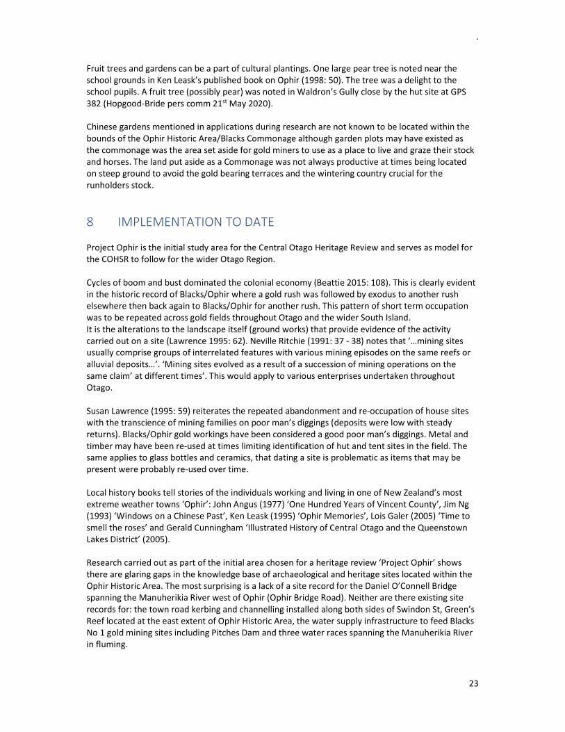
10.4 Sluiced ground (G41/610) Waldron’s/McLeod’s Gully mining, Ophir Peter Petchey recorded sites south of Ophir in 2000 (Figure 17, site records G41/610 – G41/613). Farm tracks run through the area and some of the associated water races (G41/612) have been ploughed out. The sluiced gold mining site (G41/610) is located on a spur behind the Ophir Playcentre between Waldron’s Gully and McLeod’s Gully (north and east of GPS 388: centre Figure 15). Early gold mining features (pot holing and ground sluicing) are evident along the banks of Waldron’s Gully behind Ophir Township and behind the old town reservoir.
.
30
Figure 17. Peter Petchey’s sketch NZAA site
records G41/610 - G41/613. Part of the survey area to right of central fenceline (from
Waldron’s Gully east to McLeod’s Gully).
Excerpt 6. Lauder Creek water race (Dunstan
Times 25th August 1876: 2).
Part of this site (G41/610) is a sluiced gulch located on the true left bank of Waldron’s Gully (GPS 385 – 387 Figure 15, Plate 6) that appears to be an extension of the alluvial gold workings carried out on the east side of Waldron's Gully east to McLeod's Gully. GPS 386 marks the west extent of the sluiced gulch (sluice face Plate 7) directly beside the west boundary fence. GPS 388 marks the southern tail race draining to Waldron’s Gully from the east area of the small gold sluicing field (between Waldron’s Gully and McLeod’s Gully). The gold tailings across this small tailing field are becoming overgrown with thyme limiting visibility of the gold workings. Sluiced gulches continue west of the boundary fence on the neighbouring land (Section 119) which is not part of this project.
Plate 6. View south-west of sluiced gulch (GPS
386) located behind old town reservoir true left of Waldron’s Gully.
Plate 7. View west to sluiced gulch and working face true left Waldron’s Gully (viewed from true
right at GPS 388).

.
31
The Otago Witness reported William Green purchasing an eight stamp turbine battery from Bendigo and moving it to Ophir 18th April 1888 (page 11). William Green applied for a machine site license on two acres at the mouth of McLeod’s Gully April 1888 [Blacks Mining Register 1887 – 1930 page 420: DAIV 26707 D531 47/1 (R8515545)]. The New Zealand Mines Department (1887: 73-77) mentions the reef material in McLeod’s Gully. A 500 yard branch water race (2 feet wide and 1 foot deep) was applied for by Mr Green commencing at the dam in connection with Deep Creek Race in Waldron’s Gully and terminating at William Green’s Battery in McLeod’s Gully dated 1888 [Blacks Mining Register 1887 - 1930 page 352: DAIV 26707 D531 47/1 (R8515545)]. The water race was transferred to W Pitches and party 16th September 1889 followed by Charles Gallagher 3rd August 1892. It is not clarified which water race is Deep Creek Water Race and the location of William Green’s battery/machine site has not been clarified in McLeod’s Gully. The gold tailings recorded between Waldron’s Gully and McLeod’s Gully may well be the remnants from the crushing of the material from the various reefs behind Ophir following earlier alluvial sluicing. William Green obtained a license for an 800 yard long water race (no. 3899) for domestic use 23rd October 1889 commencing 150 yards below Green’s Dam in McLeod’s Gully and terminating at the south-west corner of the School Property (Blacks Mining Register 1887 - 1930 Vol. 1, fol. 9). This water race is not evident on the ground by the south-west corner of the school grounds. The water race was originally in the name of Gerald Morris registered 7th December 1887.
10.5 Water races, Ophir The following information is from the site record G41/612. Blacks No 1 water races are associated with alluvial gold mining (G41/610 – G41/611) that skirt along the hillside above Ophir (to the south). At least four parallel water races were observed on one section. Some sections have been destroyed by ploughing. The four water races are evident in Plate 8 and shown in Petchey’s sketch for site record G41/612 (Figure 17). The site survey has confirmed that the water race bringing water from the east to the terraces behind Blacks/Ophir hills is the Lauder Creek Water Race known as the Lauderburn or Muddy Creek Water Race (G41/701: Plate 8). This water race was also known as Hilary & Co’s Water Race shown on SO 1711 dated 1885 (Figure 12) coming in from the east/right. Hilary was the supervisor in charge.
Plate 8. Four water races true right Waldron’s
Gully. View east from Waldron’s house site (GPS 120). Front Gully Reef to far right on
terrace at end of inclined dray track. An early photograph provided by Park (1906: facing page 30, Plate 9) shows a large water race running west above Blacks/Ophir viewed from the area where Green’s Reef is located. This water

.
32
race appears to correlate with the alignment of the Lauderburn Water Race (Muddy Creek water race G41/701) that fed water to Pitches Dam in McLeod’s Gully (at GPS 111 - 112). Pitches Dam supplied water to the gold mining claims in Blacks No 1 alluvial gold field (G41/610 – G41/611) along the hillside above Blacks/Ophir. It was reported in the Dunstan Times (25th August 1876 page 2: Excerpt 6) the Lauder Creek Water Race (Lauderburn Water Race G41/701) had passed into the hands of Chinese owners. Choie Sew Hoy had an interest in the Lauderburn Water Race from Lauder Creek to Blacks Township in 1879 (Ng 1993a: 315). Jenny and Trevor Agnew (2020: 111-113) provide some of the background of Choie Sew Hoy and his family involvement in the Lauderburn Water Race (G41/701) at Blacks.
Plate 9. View of Lauderburn Water Race (G41/701) in foreground looking south-west to Blacks/Ophir in the background (Park 1906: facing page 30).
One of the four visible water races in Plate 8 may correspond with the Robert Denham Water Race shown on Sam Leask’s annotated map (1933) diverting water from McLeod's Gully north to his Section (Section 74) on Swindon St. Robert Denham was known as Bob Martin who was employed by William Leask, Sam Leask’s grandfather, to keep drains and creeks free of weeds. Bob used to tend the water pump that pumped water up to the reservoir on the hill (Waldron’s Gully).
10.6 Waldron’s hut site (G41/613), Waldron’s Gully, Ophir Waldron’s hut (G41/613) once stood on the hillside on the true left of Waldron’s Gully overlooking the town of Blacks/Ophir that was relocated at GPS 120 (Figure 15, Plate 10). Waldron’s Gully (dashed line) runs down stream from the Waldron hut site (G41/613 GPS 120) to the right of the fence-line (centre) and the dis-used town reservoir (Peter Petchey sketch G41/611 – G41/613). John Waldron was the great great grandfather of Sam Leask (pers comm 20th May 2020) the current landowner of Section 119 under survey. Sam Leask led the survey team to the house site (GPS 120: Figure 15, Plate 10). Ken Leask (1998: 28) the father of the landowner notes the house remains are located on the hill c. 150m south-east of the old town reservoir. A small hut/out building floor with a collapsed schist wall lies 30m north-east of Waldron’s house site (G41/613) at GPS 121 (Figure 16). John Waldron was from Wiltshire in England who left for Victoria Australia in search of gold in his late teens. John and his Irish born wife Honora McLaughlin and their three children emigrated to New Zealand in 1866 (Cunningham 2005: 144). Archives NZ hold an application for a one acre residence area for John Waldron dated 30th March 1872 on the west side of Frenchman’s Gully below the Suspension Water Race [DADO 23179 D589 33/166 2643 (R24082090)]. This suggests Waldron’s Gully was named Frenchman’s Gully prior to John Waldron’s house being built at G41/613

.
33
(GPS 120). William Waldron ran a Blacksmiths at Ophir in partnership with Charles Gallagher which was dissolved January 1893 (Dunstan Times 20th page 2).
Plate 10. Waldron house site (GPS 120), true left
Waldron’s Gully. View north (M Sole).
Excerpt 7. Attempted murder-suicide at Ophir (Tuapeka Times Issue 492: 11th
January 1879 page 2). An interesting story is told in local newspapers of suicide and attempted murder involving John Waldron and Mrs Waldron 8th January 1879. The first report was 11th January 1879 (Excerpt 7: Tuapeka Times Issue 492: 2). Mr Waldron was presumed dead for a number of years but suddenly appeared on the road from Ophir and tried to shoot Mrs Waldron. He was later found dead after presumably shooting himself. The attempted murder-suicide story is re-told in Cunningham’s (2005: 144 - 145) along with a second incident of a successful murder-suicide in Ophir 100 years later in the 1990’s. The publican of Blacks Hotel suspected his wife was having an affair and deliberately returned unexpectedly to the hotel to find his wife was indeed having an affair. He killed his wife and then committed suicide.
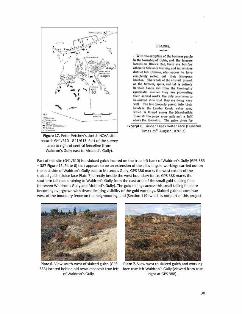
10.7 St Andrew's Presbyterian Church (former G41/653), Swindon St, Ophir The St Andrew’s Presbyterian Church (G41/653, GPS 432, Plates 11-12) is located at 13 Swindon Street. St Andrew’s Presbyterian Church (Former) is of architectural significance as a representative example of a typical, small, rural Gothic-style church (Heritage NZ registration report 3246: Bauchop 2012 page 8). The site was recorded by Matthew Sole November 2016 during monitoring of waste water trenching and septic tank and disposal field installation. Raising of the ground level around the building had affected site drainage and increased soil moisture. The church has undergone renovation and now operates as a Bed & breakfast. A new partition wall in the body of the church separates an added bathroom from the living area. The former vestry is now a bedroom with en-suite bathroom. Some of the original fabric has been retained.
.
34
Plate 11. View south-east to St Andrews
Presbyterian Church, Swindon St (S Gallagher).
Plate 12. View south to St Andrews
Presbyterian Church, Swindon St (S Gallagher). John McKnight built the St Andrew’s Presbyterian Church in 1926 (Leask 1995: 67). John was the funeral director and served on Vincent County for the Manuherikia Riding for most of 1911-1929 and was Chairman 1919-1921. The McKnight brothers ran the Blacksmith shop. The Heritage NZ registration report for St Andrew’s Presbyterian Church (Bauchop 2012: 3 - 7) provides detailed fabric of the building and some of the history associated with its construction in 1897 and use. The structure has retained its form: porch, nave and vestry. The original construction was a simple weatherboard building with a corrugated iron roof and small belfry, a single gable porch and a larger vestry at the rear. The nave was a later addition in 1931. The exterior was stuccoed and the belfry and decorative bargeboards removed post 1931. The Otago Foundation Board of Property sold the St Andrew’s site in 2009 and the owners in 2012 were operating the building as a collectibles shop. Exterior
The roof appears to be the original corrugated roofing iron. There is a patch on the roof where a spire was located. Gutters have been replaced in coloursteel and the weatherboards are covered in roughcast. The timber in the windows is in good condition and may be original in the gothic pointed style. Windows are 8 pane divided into two and possibly with the original glass panes. Interior
Exposed timber trusses and wall linings. The linings are matched tongue & groove that have been varnished and are original fabric. The floorboards are original and appear heavily sanded.
11 NEW ARCHAEOLOGICAL SITES RECORDED A total of 25 new archaeological sites were recorded within the bounds of the Ophir Historic Area during field survey for Project Ophir (Table 9). Four (16%) of the newly recorded sites relate to heritage buildings or features constructed in the early settlement of Blacks/Ophir. Twenty one (84%) sites relate to gold mining activity around the north-west facing slopes of the Raggedy Range behind Blacks/Ophir. Table 14 provides a list of these new sites and Figures 15 – 16 show the approximate location of each site. The reference numbers on the maps are GPS identifiers for these sites.

.
35
Table 14. List of newly recorded archaeological sites as part of Project Ophir:
Knack entry no New Site Recorded
New site record No GPS location
S4 Daniel O'Connell Bridge G41/694 408 S47 Green's Reef G41/695 104 - 105 S49 Brandy Hill gold workings and tail race G41/698 416 tail race S38 Pitches Dam G41/700 111 - 112 c.240m elev
S43, S46 Lauderburn Water Race & aqueduct G41/701 095, 096, 101 S32 MacTavish's Hut G41/702 097 S48 Dam wall Upper Specimen Gully G41/703 107 S36 Small water race G41/699 098
S45 Tent site and Lauderburn water race aqueduct? G41/712 tent site 099, causeway 100
S27 Green's Reef East G41/704 108 - 109 S44 Pitches Dam racemans hut G41/711 113 c.329m elev
S4015 Rock shelter/tent site McLeod's Gully G41/721 114, 423 S54 Suspension Water Race G41/719 412, 414, 425, 427 S55 Hut site McLeod's Gully G41/706 116 S41 Dam McLeod's Gully G41/710 119 S42 Chinese Hotel site Waldron's Gully G41/709 122 (334m elev) S37 Dam Waldron's Gully G41/717 123 - 124 S53 Rock shelter/tent site Upper Waldron's Gully G41/718 125
S31 Small dam and water race lower Waldron's Gully G41/714 378 S24 Tent site Waldron's Gully G41/715 380 S23 Peace Memorial Hall G41/716 377 S33 Rammed earth stables G41/708 375 S51 Front Gully Reef Waldron's Gully G41/705 431 S22 Swindon St kerb and channelling G41/707 various
S4013 Near Reef, McLeod's Gully G41/720 430
11.1 Brandy Hill (G41/698), Ophir Brandy Hill was one of the first areas to be mined for gold at Blacks/Ophir. Remnant mining evidence is visible around the periphery of Brandy Hill and behind (south of) Black’s/Ophir Township. The Agricultural Lease map for Run 244 (SO 7852) dated December 1869 shows these gold mining areas. The sluiced faces extending behind the town of Ophir have an appearance likened to a mini Bannockburn by Matthew Sole (Kopuwai Consulting pers comm. 21st May 2020). The Bannockburn Gold Mining Sluicings are one of New Zealand’s most impressive examples of hydraulic sluicing and tunnelling (Hamel 2001: 2, 132 – 133, Stephenson et al 2004). One lone Oak tree grows in the centre of Brandy Hill. Sam Leask (pers comm.) informed the field team the tree in the centre of Brandy Hill stands beside an old mining shaft and Brandy Hill at one stage was dotted with shafts which his family have filled in over the decades. Hard rock gold tailings

.
36
lifted from the shafts were piled all over Brandy Hill but these have been bulldozed flat and the area used to plant lucerne. Residence areas
David Isbister applied to occupy a residence area at Brandy Point 19th July 1886 [DADO 23179 D589 36/39 48/86 (R24083203)]. Brandy Point is located at the base of Water Gully and the Isbister family still reside in this house. Robert Denham (Bob Martin) lived in a two roomed hut on five acres of land on the sunny brow of Brandy Hill c. 3 chains (c. 60m) from the Isbister House (Leask 1998: 30 - 31). Francis Raper held a residence area at Brandy Hill (21st September 1885) adjoining the residence of James Garrick? [DADO 23179 D589 35/404 50/85 (R24083148)]. A second application is for a residence area in Blacks Commonage dated 1890 [DADO 23179 D589 37/175 46/90 (R24083592)]. The Raper family lived in Robert Denham’s hut at some point and an iron foundry was established by Mr Raper in 1884 (Dunstan Times 31st October page 2). The hut and shed were pulled down and the materials re-used elsewhere (Leask 1998: 30 - 31). Gold mining
The dam at the head of Brandy Gully was transferred to Peter Harrington, Patrick and Andrew Murphy and Samuel Halle 24th June 1873 [DADO 23179 D589 33/270 (R24082194)]. Archives NZ hold a hand written application from Peter Harrington for annual renewal of water rights (12449 – 12450) 25th April 1886 [DADO 23179 D589 36/65 14/87 (R24083229)]. It is not clear which gully is referred to as Brandy Gully: this could refer to what is now known as Water Gully or McLeod’s Gully.
Christian Spethman, James Pederson, George Walker, Malcolm McDonald, George Stringer and John Healy applied for a water race license 19th August 1873 at Brandy Hill [DADO 23279 D589 33/294 2939 (R24082218)]. Ah Tell (Ah Tee), Ah Chup and Ah Chow ran their claim above Brandy Hill using tail water in their 100 yard head race from Chinese workings located above Brandy Hill in 1874. The course of the race runs east [DADO 23179 D589 34/9 (R24082313)]. They applied for a dam/reservoir one acre in area at a gully close to Brandy Hill 6th July 1874. The dam wall is stated as 30 feet long to a height of 10 feet. G Sinclair objected to the application for a dam due to a possible flooding risk to his property [DADO 23179 D589 34/11 (R24082315)]. Their 100 yard tail race (3 feet x 3 feet) application states the tail race runs east to west being tunnelled under the road above Sinclair’s store [DADO 23179 D589/33 327 1817 (R24082251)]. Ah Chin, Ah Tu and Ah Chip applied for a three acre claim at Brandy Hill 7th July 1874 [DADO 23179 D589 33/329 1819 (R24082253)]. The exact location has not been determined on the ground. Choie Sew Hoy, Ah Shea, Ah Four, Ho King, Too Su (Too Sui) and Kum Yeck (Kum Jack) applied for a six acre extended claim and tail race at Brandy Hill 21st November 1876 [DADO 23179 D589 34/252 6653 (R24082556), DADO 23179 D589 34/251 6652 (R24082555)]. The tail race runs east by west 123 chains in length terminating at the gorge. Letters objecting to the tail race construction are held by Archives NZ (Dunedin office) from other Chinese parties. Three acres of ground between Sinclair’s store and the west side of Brandy Hill was applied for 24th November 1876 by Ah Jay, Ah Mang and Ah Ho [DADO 23179 D589 34/278 6649 (R24082582)]. Sinclair’s store was more than likely on Section 5 Block 3 Ophir (Figure 18: SO 14701 dated February 1871).
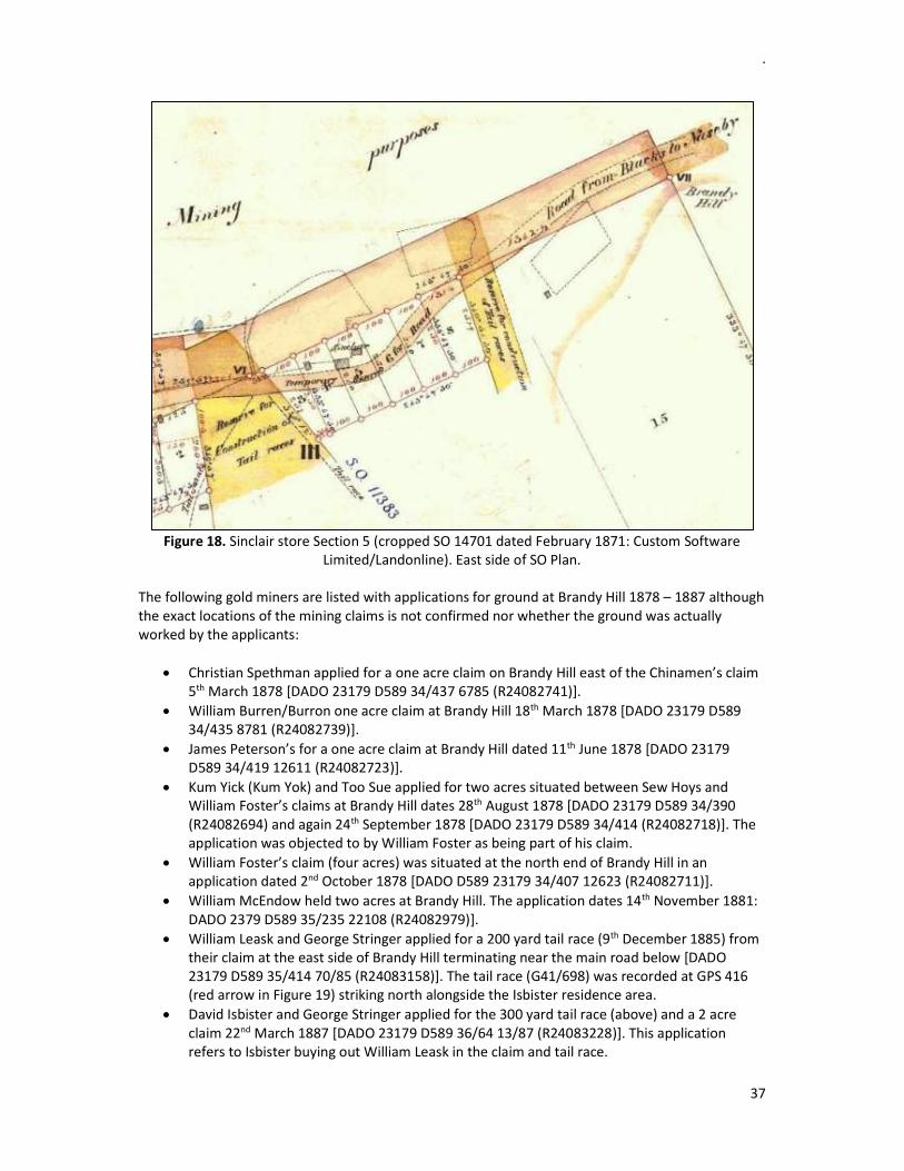
.
37
Figure 18. Sinclair store Section 5 (cropped SO 14701 dated February 1871: Custom Software
Limited/Landonline). East side of SO Plan. The following gold miners are listed with applications for ground at Brandy Hill 1878 – 1887 although the exact locations of the mining claims is not confirmed nor whether the ground was actually worked by the applicants:
Christian Spethman applied for a one acre claim on Brandy Hill east of the Chinamen’s claim 5th March 1878 [DADO 23179 D589 34/437 6785 (R24082741)].
William Burren/Burron one acre claim at Brandy Hill 18th March 1878 [DADO 23179 D589 34/435 8781 (R24082739)].
James Peterson’s for a one acre claim at Brandy Hill dated 11th June 1878 [DADO 23179 D589 34/419 12611 (R24082723)].
Kum Yick (Kum Yok) and Too Sue applied for two acres situated between Sew Hoys and William Foster’s claims at Brandy Hill dates 28th August 1878 [DADO 23179 D589 34/390 (R24082694) and again 24th September 1878 [DADO 23179 D589 34/414 (R24082718)]. The application was objected to by William Foster as being part of his claim.
William Foster’s claim (four acres) was situated at the north end of Brandy Hill in an application dated 2nd October 1878 [DADO D589 23179 34/407 12623 (R24082711)].
William McEndow held two acres at Brandy Hill. The application dates 14th November 1881: DADO 2379 D589 35/235 22108 (R24082979)].
William Leask and George Stringer applied for a 200 yard tail race (9th December 1885) from their claim at the east side of Brandy Hill terminating near the main road below [DADO 23179 D589 35/414 70/85 (R24083158)]. The tail race (G41/698) was recorded at GPS 416 (red arrow in Figure 19) striking north alongside the Isbister residence area.
David Isbister and George Stringer applied for the 300 yard tail race (above) and a 2 acre claim 22nd March 1887 [DADO 23179 D589 36/64 13/87 (R24083228)]. This application refers to Isbister buying out William Leask in the claim and tail race.

.
38
Thomas Taylor and party worked three acres at Brandy Hill (29th June 1887: DADO 23179 D589 36/78 27/87 (R24083242)).
Arol Gordon-Glassford would prospect for gold on Brandy Hill behind the Isbister house and ran a few beehives selling surplus honey (Leask 1998: 24-25, 29). J Glassfords ordinary claim of 100 x 100 feet lay partially within Section 74 (to left in red colour area Figure 20).
Figure 19. GPS identifiers of recorded sites at Green’s Reef and Specimen Gully to right. McLeod’s Gully at centre and Brandy Hill (flat top hill top centre). Red arrow Brandy Hill tail race (GPS 416).
Tail races that drained sludge from the mining claims discharging to the Manuherikia River have not been identified to individual parties apart from the Brandy Hill Tail Race (G41/698) noted above. Three tail race reserves were set aside through the town of Blacks/Ophir for the purpose of draining waste to the nearest river from the gold workings (Figures 18 – 19, 21). The SO Plans are based on William Arthur Surveyor’s Field Book 1868 – 1871 held at Archives. The tail race (G41/698) cuts diagonally across the Leask paddock to the main highway (GPS 416: Figure 16 and indicated by red arrow in Figure 19) is mostly hidden from view by vegetation growth within its channel. The tail race (G41/698) was owned by William Leask and George Stringer in 1885 followed by Isbister and Stringer in 1887.
11.2 Waldron’s Gully, Ophir
11.2.1 Rock shelter tent site (G41/718), upper Waldron’s Gully A rock shelter tent site (G41/718, GPS 125, Plate 13) located on the true left bank of Upper Waldron's Gully c.35m east of the dam abutment (GPS 124). The site is a schist buttress with a rough flat face to the north. There are rectangular rebated mortises cut in to the face of the rock outcrop about roof rafter height (1.8m above ground). The ground below and out from the shelter site is flat with no surface evidence of the shelter outline or physical construction. It has a large elderberry in front of the schist rock.

.
39
Figure 20. Map showing names of gullies at Blacks (Ophir) annotated by Sam Leask September 1933 (Sam Leask’s Grandfather: Leask Collection). Red shaded area is claim area (67Ac).

40
Plate 13. Rock shelter tent site (G41/718, GPS 380) located upstream of the dam wall at GPS 125 Upper Waldron’s Gully. View west (M Sole).
11.2.2 Chinese Hotel? site (G41/709), Waldron’s Gully, Ophir
A Chinese Hotel? site (G41/709) was recorded (GPS 122) below the Waldron’s house site (G41/120) in Waldron’s Gully (Figure 15). The structure consists of a large platform around 9.9 x 3.6m in size with large flat schist slab retaining walls on the east and south sides. There is a side addition built into the hill slope (north-west corner) with mortared stacked schist retaining walls on two sides (Plate 14). Mortise holes in the adjacent schist buttress were more than likely for roof supports. A wax vesta matchbox (measuring 7 x 3.8 x 2cm) was recorded from the floor of the site.
Plate 14. Chinese (Hotel?) site (G41/709, GPS 122) located between the dam wall and
Waldron’s House site Waldron’s Gully (M Sole). View north.
Plate 15. View south to Chinese (Hotel?) site
(G41/709, GPS 122) Waldron’s Gully.
11.2.3 Tent site (G41/715), lower Waldron’s Gully, Ophir A tent site (G41/715) was recorded lower down Waldron’s Gully (GPS 380) with schist foundations around three sides. Internal measurements of the tent site is c. 1.7m x 2.5m. A fossicked rectangular pit 1.8 x 0.8 and 0.6m deep is located c. 10m from this schist base tent site. There were many fragments of broken glass in the spoil from the pit including hand applied tops, push up mamelon bases and the tops of black gin bottles. The bottles with hand applied tops suggest a manufactured date to the late 1860's to 1880's (although some bottles may have been re-used). A second feature (GPS 379) is a raised rectangular earthen walled pit that may have been dug by a fossicker located c. 2.5 m south-east of the fossicked rectangular pit noted above. The pit measured c. 2.5 x 3m. Rabbits are digging into the feature. Scattered corrugated iron lies around this area along with other dumped rubbish. A fruit tree is growing by the stacked schist tent site (GPS 382) identified by Odette Hopgood-Bride. Nathan Peacock applied for a residence site on the east side of Waldron’s Gully dated 7th December 1887 (Blacks Mining Register 1887 – 1930 page 379). The location of the site is not clarified.

.
41
11.3 Tent site (G41/712), west of Blue Nose Gully, Ophir A tent site (G41/712, GPS 099) with a collapsed stacked stone foundation on the edge of a small flat platform located on the true left bank opposite the Lauderburn Water Race possible aqueduct (G41/701, GPS 100) in a gully west of Blue Nose Gully. The flat area was approximately 4m x 3m (Plate 16). A 5lb metal canister (30cm diameter x 43cm long) lies on the ground c. 8m west of the Lauderburn Water Race aqueduct on the opposite bank (true left).
Plate 16. Tent site (G41/712, GPS 099) platform in foreground with a collapsed stacked stone possible aqueduct of the Lauderburn Water Race (G41/701, GPS 100) to left on opposite bank in a gully west of Blue Nose Gully. View south-east (M Sole).
There are four parties listed with Archives for mining applications in Blue Nose Gully: Constantine Kenzei (1874, 1891), James Pederson (1878), George Stringer and Christian Spethman (1879), and Lockhart Mactavish (1888). The claim for Mactavish may provide a date for his occupation of the cottage known as Mactavish’s hut (GPS 097).
11.4 Blacks Commonage, Ophir A lengthy earthen sod wall is said to have demarcated the boundary of Blacks Commonage (Figure 2: SO 1718 dated June 1922). This feature has for the most part been levelled over the decades (Sam Leask pers comm 25th May 2020). Archives NZ hold the following applications for one acre Residence areas in Blacks Commonage:
James Croft 27th May 1890 near the residence area of William Bates? [DADO 23179 D589 37 /168 (R24083585)]. James Croft 11th June 1890 later transferred the residence area to John Pitches January 1891 [Blacks Mining Register 1887 – 1930 page 390: DAIV 26707 D531 47/1 (R8515545)].
John Pitches 1890 – 1892 near the residence of William Pitches [DADO 24424 D589 90/118 (R24693250)].
Sue Billy 24th December 1890 bounded on the east by Green’s Battery, north by the road leading to the Battery, south and west by Crown lands [DADO 23179 D589 37/174 (R24083591)].
Francis Raper in Long Gully adjoining the Pitches water race 16th December 1895 [DADO 23179 D589 108/192 (R24083829)].
William James Tonkin and Company 8th March 1903 [DADO 23179 D589 110/153 12/03 (R24084330)].
Daniel Sullivan applied for an extended claim of one acre in Long Gully in Blacks Commonage below Mr Pitches water race March 1895 [DADO 23179 D589 108/127 8/95 (R24083764)]. It is not confirmed which gully is named Long Gully. Daniel Sullivan held a license to prospect 15 acres in Blacks Commonage 21st September 1910 [Blacks Register of Mining Privileges Rent Nos. 689-1577 page 4: DAIV 20254 D531 49/a 4 (R8515548)].

.
42
11.5 Red Jacket Point (Red Jacket Gully), Ophir Ah Way, Ah Kay, Ah You, Jong Sung, Wan Gut and Ah Chew applied for a six acre claim below Red Jacket Point and a 400 yard tail race (5 ft x 5 ft running east to west) terminating to the Manuherikia Gorge dated 6th August 1872 [DADO 23179 D589 33/77 2670 (R24082001), DADO 23179 D589 33/76 2669 (R24082000)].
11.6 Specimen Hill/Specimen Gully, Ophir
Figure 21. Gold mining reef’s (red lines) east side of Ophir Historic HA (Christie and Youngson 2016: 165 cropped Fig 2).
The Christie and Youngson (2016: Fig 2 page 165) geology map (Figure 21) shows various gold bearing reefs (red lines) striking north-west to south-east within the Ophir Historic Area. The reefs are composed of decomposed schist on a spur above Blacks Township. The Ophir Lode (to left in Figure 21) appears to lie outside the boundary of the Ophir HA. Tables within the Christie and Youngson (2016) report detail the estimated gold production at Ophir (tonne of ore mined with the estimated weight of gold obtained) and descriptions of the prospects (taken from Torckler 1994: MR3349).
11.7 Green’s Reef (G41/695), Specimen Hill, Ophir William Green’s Licensed Holding for Green’s Reef Company to mine for gold at Specimen Hill (G41/695: Section 33 Block II dated 1887 - Figure 22) lies within the project area east of Ophir Township (Plates 17-18). Green’s Reef Company applied for 20 acres to work the land by shafts and drives granted 7th December 1887 [DADO 23179 D589 36/131 2/87 (R24083295)]. A copy of the application is provided in Appendix 10.
Plate 17. Green’s Reef to right and Lauderburn water race aqueduct below (centre left). View north-east with M Sole and D Van den Kerkhof in photo for scale.
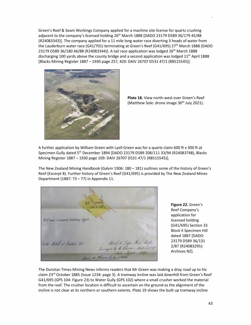
.
43
Green’s Reef & Seam Workings Company applied for a machine site license for quartz crushing adjacent to the company’s licensed holding 26th March 1888 [DADO 23179 D589 36/179 45/88 (R24083343)]. The company applied for a 11 mile long water race diverting 3 heads of water from the Lauderburn water race (G41/701) terminating at Green’s Reef (G41/695) 27th March 1888 (DADO 23179 D589 36/180 46/88 (R24083344)). A tail race application was lodged 26th March 1888 discharging 100 yards above the county bridge and a second application was lodged 11th April 1888 [Blacks Mining Register 1887 – 1930 page 257, 420: DAIV 26707 D531 47/1 (R8515545)].
Plate 18. View north-west over Green’s Reef (Matthew Sole: drone image 30th July 2021).
A further application by William Green with Lyell Green was for a quartz claim 600 ft x 300 ft at Specimen Gully dated 5th December 1894 [DADO 23179 D589 208/111 33/94 (R24083748), Blacks Mining Register 1887 – 1930 page 109: DAIV 26707 D531 47/1 (R8515545)]. The New Zealand Mining Handbook (Galvin 1906: 180 – 181) outlines some of the history of Green’s Reef (Excerpt 8). Further history of Green’s Reef (G41/695) is provided by The New Zealand Mines Department (1887: 73 – 77) in Appendix 11.
Figure 22. Green’s Reef Company’s application for licensed holding (G41/695) Section 33 Block II Specimen Hill dated 1887 [DADO 23179 D589 36/131 2/87 (R24083295): Archives NZ].
The Dunstan Times Mining News informs readers that Mr Green was making a dray road up to his claim 23rd October 1885 (Issue 1234: page 3). A tramway incline was laid downhill from Green’s Reef G41/695 (GPS 104: Figure 23) to Water Gully (GPS 102) where a small crusher worked the material from the reef. The crusher location is difficult to ascertain on the ground as the alignment of the incline is not clear at its northern or southern extents. Plate 19 shows the built up tramway incline
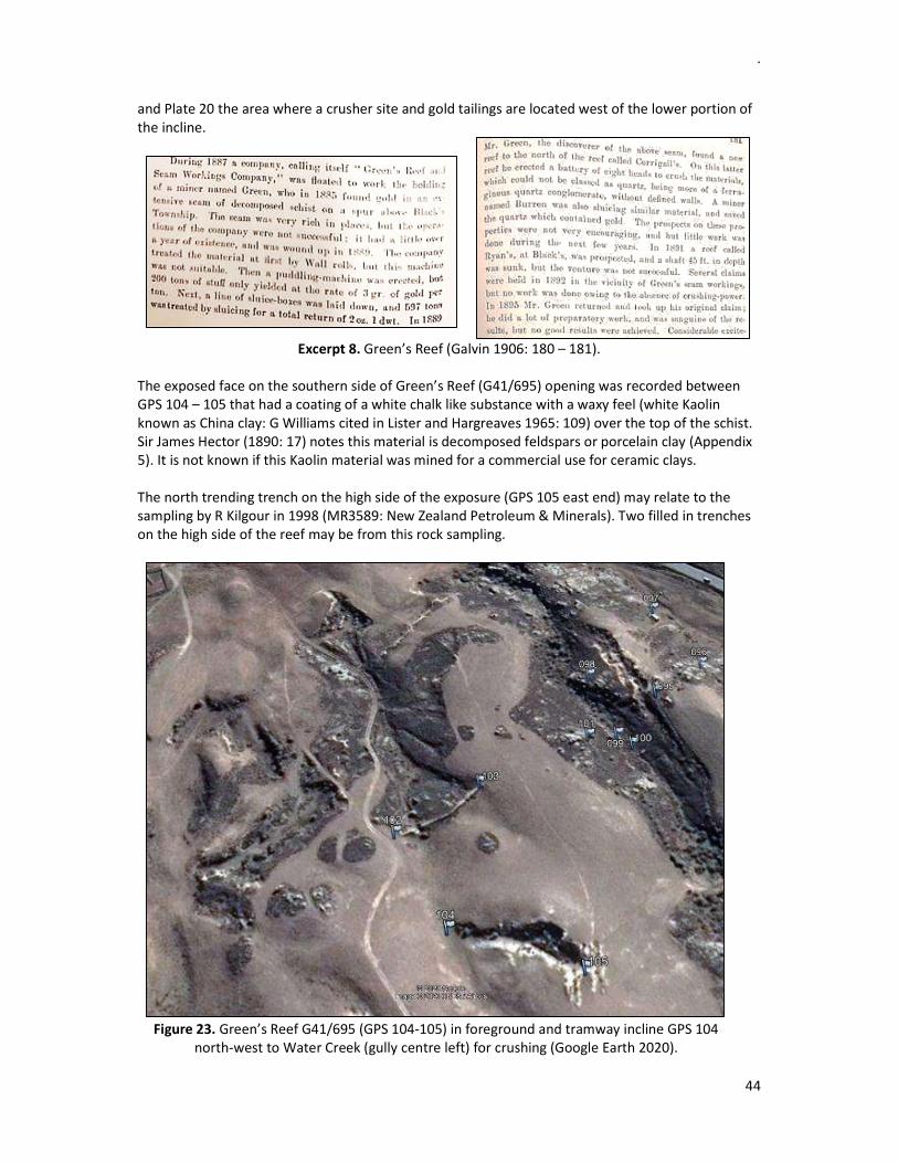
.
44
and Plate 20 the area where a crusher site and gold tailings are located west of the lower portion of the incline.
Excerpt 8. Green’s Reef (Galvin 1906: 180 – 181). The exposed face on the southern side of Green’s Reef (G41/695) opening was recorded between GPS 104 – 105 that had a coating of a white chalk like substance with a waxy feel (white Kaolin known as China clay: G Williams cited in Lister and Hargreaves 1965: 109) over the top of the schist. Sir James Hector (1890: 17) notes this material is decomposed feldspars or porcelain clay (Appendix 5). It is not known if this Kaolin material was mined for a commercial use for ceramic clays. The north trending trench on the high side of the exposure (GPS 105 east end) may relate to the sampling by R Kilgour in 1998 (MR3589: New Zealand Petroleum & Minerals). Two filled in trenches on the high side of the reef may be from this rock sampling.
Figure 23. Green’s Reef G41/695 (GPS 104-105) in foreground and tramway incline GPS 104 north-west to Water Creek (gully centre left) for crushing (Google Earth 2020).

.
45
Plate 19. View north of tramway incline from
Greens Reef (centre).
Plate 20. View north of gold tailings at base of
incline from Greens Reef (possible crusher site).
11.8 Other Reefs, Ophir Captain Laybold was a goldminer from Nova-Scotia working Captain’s Reef mine not far from Green’s Reef on a spur above Ophir Township. Laybold took over the Shamrock hotel in 1871 (Leask 1995: 58, 1998: 73). The exact location of the reef is not specified. The Ophir Quartz Mining Company (under the name of William Charles Pitches) applied for a Licensed Holding of 18 acres 28th November 1888 for Sections 35 [Figure 24: DADO 23179 D589 36/ 240 7/88 (R24083404)]. The survey plan held for this application shows neighbouring claims applied for under the names of F A Field (Section 36 Block II), Gerald Morris (Section 37 Block II and Section 1 Block XVIII), and R Sheppard (Section 38 and Section 2 Block II, and Sections 1 - 2 Block XVIII). R Sheppard, A Gray, S Hanger, William Bannerman, G Morris, George Mellor and T Duggan applied for an extended quartz claim of 18 acres ca 1/4 of a mile (c.402m) south-east of Green’s Reef & Seam Workings Company and extending towards the range [10th November 1888: DADO 23179 D589 36/228 (R24083392)].
Figure 24. Survey Plan showing quartz claims for Sections 33 – 38 Block II at Specimen Hill dated 1889 [DADO 23179 D589 36/240 7/88 (R24083392): Archives NZ].
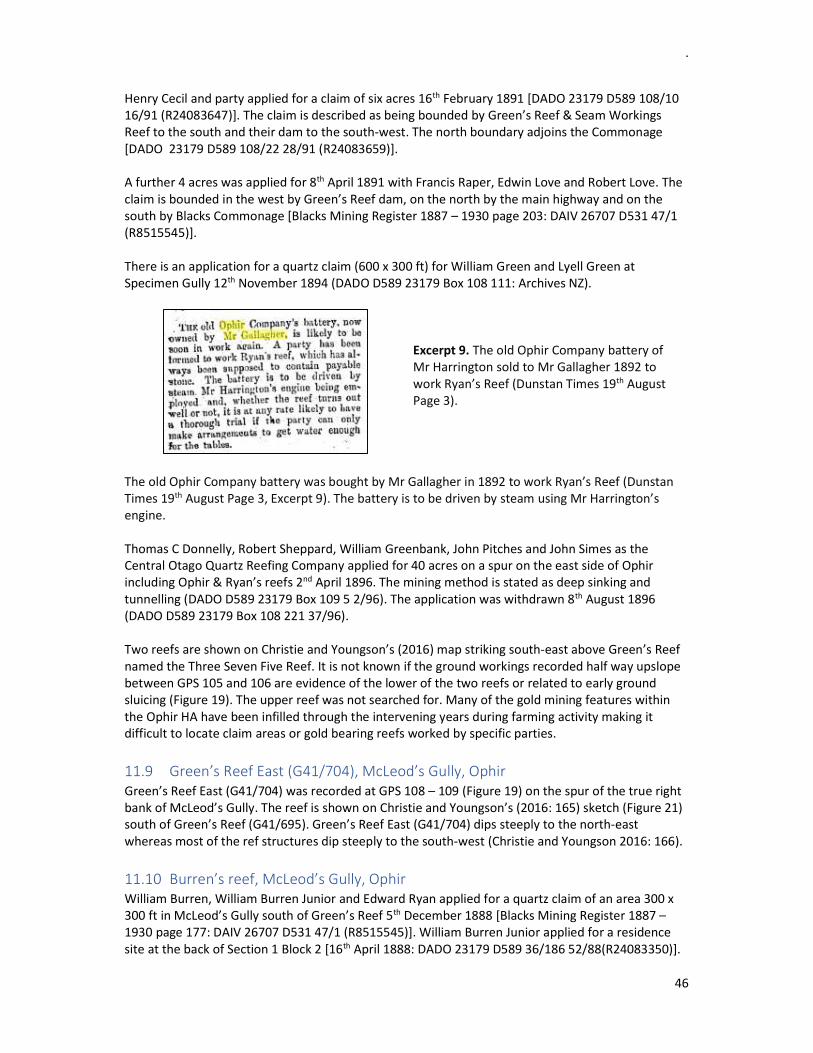
.
46
Henry Cecil and party applied for a claim of six acres 16th February 1891 [DADO 23179 D589 108/10 16/91 (R24083647)]. The claim is described as being bounded by Green’s Reef & Seam Workings Reef to the south and their dam to the south-west. The north boundary adjoins the Commonage [DADO 23179 D589 108/22 28/91 (R24083659)]. A further 4 acres was applied for 8th April 1891 with Francis Raper, Edwin Love and Robert Love. The claim is bounded in the west by Green’s Reef dam, on the north by the main highway and on the south by Blacks Commonage [Blacks Mining Register 1887 – 1930 page 203: DAIV 26707 D531 47/1 (R8515545)]. There is an application for a quartz claim (600 x 300 ft) for William Green and Lyell Green at Specimen Gully 12th November 1894 (DADO D589 23179 Box 108 111: Archives NZ).
Excerpt 9. The old Ophir Company battery of Mr Harrington sold to Mr Gallagher 1892 to work Ryan’s Reef (Dunstan Times 19th August Page 3).
The old Ophir Company battery was bought by Mr Gallagher in 1892 to work Ryan’s Reef (Dunstan Times 19th August Page 3, Excerpt 9). The battery is to be driven by steam using Mr Harrington’s engine. Thomas C Donnelly, Robert Sheppard, William Greenbank, John Pitches and John Simes as the Central Otago Quartz Reefing Company applied for 40 acres on a spur on the east side of Ophir including Ophir & Ryan’s reefs 2nd April 1896. The mining method is stated as deep sinking and tunnelling (DADO D589 23179 Box 109 5 2/96). The application was withdrawn 8th August 1896 (DADO D589 23179 Box 108 221 37/96). Two reefs are shown on Christie and Youngson’s (2016) map striking south-east above Green’s Reef named the Three Seven Five Reef. It is not known if the ground workings recorded half way upslope between GPS 105 and 106 are evidence of the lower of the two reefs or related to early ground sluicing (Figure 19). The upper reef was not searched for. Many of the gold mining features within the Ophir HA have been infilled through the intervening years during farming activity making it difficult to locate claim areas or gold bearing reefs worked by specific parties.
11.9 Green’s Reef East (G41/704), McLeod’s Gully, Ophir Green’s Reef East (G41/704) was recorded at GPS 108 – 109 (Figure 19) on the spur of the true right bank of McLeod’s Gully. The reef is shown on Christie and Youngson’s (2016: 165) sketch (Figure 21) south of Green’s Reef (G41/695). Green’s Reef East (G41/704) dips steeply to the north-east whereas most of the ref structures dip steeply to the south-west (Christie and Youngson 2016: 166).
11.10 Burren’s reef, McLeod’s Gully, Ophir William Burren, William Burren Junior and Edward Ryan applied for a quartz claim of an area 300 x 300 ft in McLeod’s Gully south of Green’s Reef 5th December 1888 [Blacks Mining Register 1887 – 1930 page 177: DAIV 26707 D531 47/1 (R8515545)]. William Burren Junior applied for a residence site at the back of Section 1 Block 2 [16th April 1888: DADO 23179 D589 36/186 52/88(R24083350)].
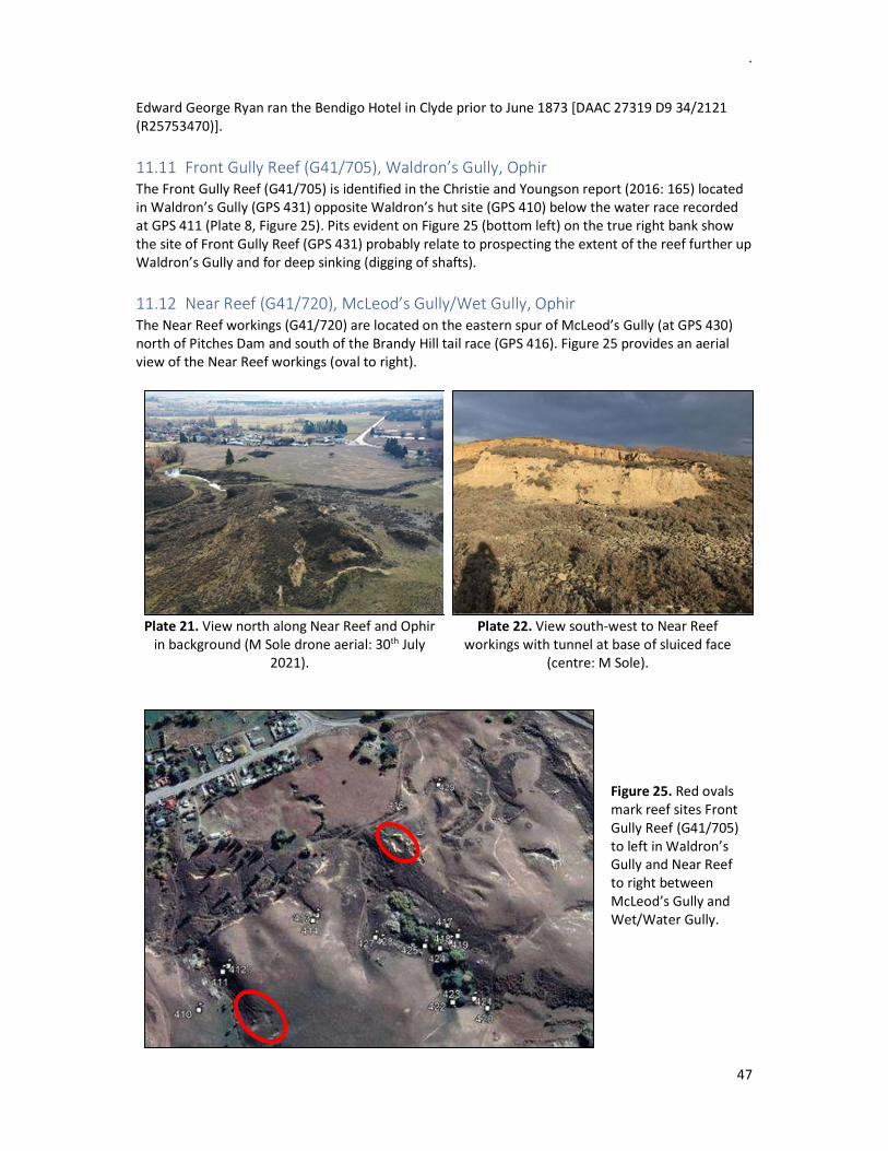
.
47
Edward George Ryan ran the Bendigo Hotel in Clyde prior to June 1873 [DAAC 27319 D9 34/2121 (R25753470)].
11.11 Front Gully Reef (G41/705), Waldron’s Gully, Ophir The Front Gully Reef (G41/705) is identified in the Christie and Youngson report (2016: 165) located in Waldron’s Gully (GPS 431) opposite Waldron’s hut site (GPS 410) below the water race recorded at GPS 411 (Plate 8, Figure 25). Pits evident on Figure 25 (bottom left) on the true right bank show the site of Front Gully Reef (GPS 431) probably relate to prospecting the extent of the reef further up Waldron’s Gully and for deep sinking (digging of shafts).
11.12 Near Reef (G41/720), McLeod’s Gully/Wet Gully, Ophir The Near Reef workings (G41/720) are located on the eastern spur of McLeod’s Gully (at GPS 430) north of Pitches Dam and south of the Brandy Hill tail race (GPS 416). Figure 25 provides an aerial view of the Near Reef workings (oval to right).
Plate 21. View north along Near Reef and Ophir in background (M Sole drone aerial: 30th July
2021).
Plate 22. View south-west to Near Reef workings with tunnel at base of sluiced face
(centre: M Sole).
Figure 25. Red ovals mark reef sites Front Gully Reef (G41/705) to left in Waldron’s Gully and Near Reef to right between McLeod’s Gully and Wet/Water Gully.

48
Figure 26. Near Reef workings (G41/720) true right of McLeod’s Gully (survey by Matthew Sole: Kopuwai Consulting).

49
The location was pinpointed in the Christie and Youngson report (2017: 165). Plate 21 shows the gold sluicing of the site from M Sole’s drone imagery and Plate 22 shows the sluiced face at the Near Reef workings and the mining tunnel at its base. Figure 26 shows the location of these gold mining features. The location of JB’s Reef and PC’s Reef shown on the Christie and Youngson’s (2016: Figure 21) geology map behind Ophir have not been clarified by the ground survey.
12 WATER SUPPLY Deciphering the water supply infrastructure feeding water to the Ophir Diggings requires identification of the gully names that no longer appear on topographic maps and names of the water race companies providing water to the gold mining claims. Sam Leask has provided a map that his grandfather Sam Leask (1933: Figure 20) annotated with names of the gullies on the south side of Swindon St. Without this information it would be extremely difficult to piece together mining claim areas with the individuals or parties who worked the claims. The names of the gold miners and residents of Blacks are required to enable searching of applications held at Archives NZ and those mentioned in old newspapers (Papers Past – advertisements or mining news). The 1885 SO Plan 1711 (Figure 12) shows three major water races bringing water to the Blacks No. 1 goldfield. Two water races carried water from Thompsons Gorge and across the Manuherikia River in metal fluming below the Daniel O’Connell Bridge: the Golden Gate Water Race (G41/602) and the Suspension Water Race (Walsh & Co, Excerpt 5: Dunstan Times 1st July 1865 page 14). The Lauderburn Water Race (Hilary & Co) is flumed across the Manuherikia River upstream of the Daniel O’Connell Bridge running water to Blacks from the east. The Lauderburn Water Race (G41/701) is also known as the Muddy Creek Water Race from where it diverts water. It is not known if there is any evidence remaining of the fluming or its support structures along the banks or bed of Manuherikia River. Table 15 (Appendix 12) lists the elevation of the water races where they have been GPSed by the survey teams to make it easier to read correlation between sections of water race where large sections have been ploughed out and cannot be followed on the ground or by viewing earlier aerials. It literally is putting pieces of a jigsaw puzzle together.
12.1 Lauderburn Water Race (G41/701), Ophir The Lauderburn Water Race (G41/701) also known as the Muddy Creek Water Race was located on the c. 314m contour east of Ophir (GPS 095, 096, 101: Figures 19 and 23). Two sections of stacked revetment supporting the water race were recorded at GPS 095 and GPS 096. A drill hole is evident on the outcrop alongside the water race at GPS 096 (Figure 19). A large raised stacked stone and earthen walled aqueduct to support the water race fluming lies west to east at GPS 102-103 (Figure 23, Plates 23-24) below the open cut of Green’s Reef. The aqueduct has been constructed in a semi-circular alignment on the c. 250 elevation, approximately 66m in length and c. 2.4m high. The top of the aqueduct wall measured c.0.6m and the base c.2.5m wide. The wall is shown on Wilson’s map in Park (1906). A possible second aqueduct (GPS 100) is located in the gully west of Blue Nose Gully (Plate 25). A small water race (G41/699, GPS 098: Figures 19 and 23) skirts the true right bank on the 325m
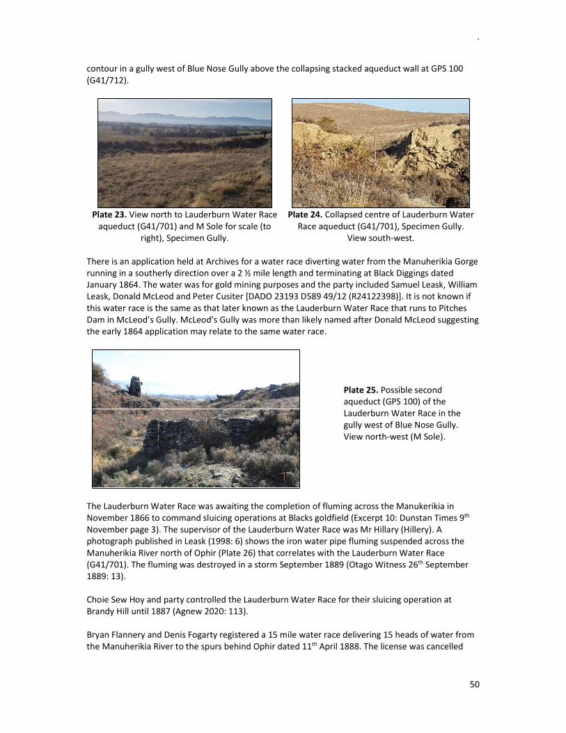
.
50
contour in a gully west of Blue Nose Gully above the collapsing stacked aqueduct wall at GPS 100 (G41/712).
Plate 23. View north to Lauderburn Water Race
aqueduct (G41/701) and M Sole for scale (to right), Specimen Gully.
Plate 24. Collapsed centre of Lauderburn Water
Race aqueduct (G41/701), Specimen Gully. View south-west.
There is an application held at Archives for a water race diverting water from the Manuherikia Gorge running in a southerly direction over a 2 ½ mile length and terminating at Black Diggings dated January 1864. The water was for gold mining purposes and the party included Samuel Leask, William Leask, Donald McLeod and Peter Cusiter [DADO 23193 D589 49/12 (R24122398)]. It is not known if this water race is the same as that later known as the Lauderburn Water Race that runs to Pitches Dam in McLeod’s Gully. McLeod’s Gully was more than likely named after Donald McLeod suggesting the early 1864 application may relate to the same water race.
Plate 25. Possible second aqueduct (GPS 100) of the Lauderburn Water Race in the gully west of Blue Nose Gully. View north-west (M Sole).
The Lauderburn Water Race was awaiting the completion of fluming across the Manukerikia in November 1866 to command sluicing operations at Blacks goldfield (Excerpt 10: Dunstan Times 9th November page 3). The supervisor of the Lauderburn Water Race was Mr Hillary (Hillery). A photograph published in Leask (1998: 6) shows the iron water pipe fluming suspended across the Manuherikia River north of Ophir (Plate 26) that correlates with the Lauderburn Water Race (G41/701). The fluming was destroyed in a storm September 1889 (Otago Witness 26th September 1889: 13). Choie Sew Hoy and party controlled the Lauderburn Water Race for their sluicing operation at Brandy Hill until 1887 (Agnew 2020: 113). Bryan Flannery and Denis Fogarty registered a 15 mile water race delivering 15 heads of water from the Manuherikia River to the spurs behind Ophir dated 11th April 1888. The license was cancelled

.
51
March 1889 (Blacks Mining Register 1887 – 1930: 14 Archives). It is not known if this water race corresponds to the Lauderburn water race or a seperate water race.
Excerpt 10: Lauderburn Water Race G41/701 (Dunstan Times 9th November
1866 Page 3).
Plate 26. Lauderburn Water Race fluming across the
Manuherikia River (undated). Con and Herbert Richardson are noted walking the wire rope (Leask 1998: 6).
In 1893 John Pitches applied (7th June) for the 11 mile long Lauderburn Water Race terminating at Green’s Reef, Ophir. The water race is recorded as 1 ft 6 inches wide and 3 ft 6 inches depth delivering 3 sluice heads of water [Blacks Mining Register 1887 – 1930 page 99: DAIV 26707 D531 47/1 (R8515545)].
12.2 Suspension Water Race Company (G41/719), Ophir Excerpt 11 provides details on the near completion of the Suspension Water Race Company dated 24th March 1866 (Dunstan Times 24th March 1866: 3). The Suspension Water Race Company’s registration was advertised 14th September 1866 (Dunstan Times page 3). Peter Walsh is the applicant named on the Schedule held at Archives, Dunedin [CBAT D480 1/u 37 (R3896728)]. Naylor Hilary held 7 shares in the company.
Excerpt 11. Walsh’s Water Race (Dunstan Times
24th March 1866: 3).
Patrick Wickham was appointed manager of the Suspension Water Race Company 11th May 1868 followed by Timothy Gilligan 15th August 1868. Patrick Minton took over the management 13th May 1869. Patrick Minton (storekeeper at Blacks Township) bought the Suspension Water Race 18th June 1869 (Dunstan Times page 2). The Suspension Water Race (G41/719) was registered for ten heads of water and was advertised for auction by Gallagher, Hunt and Co. with extended claims of four acres and plant, and a four-roomed cottage and two horses 16th December 1870 (Dunstan Times 1870

.
52
Issue 452: 3). The Murphy Brothers advertised the Suspension Flume across the Manuherikia River for auction 20th December 1872 (Dunstan Times page 3).
12.3 McLeod’s Gully, Ophir The major water races described above: Golden Gate (G41/602) and the Suspension Water Race (Walsh’s & Co) from the west and Muddy Creek (Hillary & Co) from the east, all fed water to Pitches Dam (G41/700) in McLeod’s Gully located south of Blacks/Ophir at GPS 419 (Figure 25, Sam Leask pers comm. 21 May 2020).
12.3.1 Pitches Dam (G41/700), McLeod’s Gully, Ophir There are two discrete dam sites in McLeod’s Gully, one in the lower gorge and one in the upper gorge. The two dams are shown on (Wilson’s map in Park 1906). The stacked schist dam wall in the upper gorge of McLeod’s Gully is locally known as Pitches Dam (G41/700) c.500m south of Swindon St. Pitches dam is the largest dam drawn on the Geological Map of Ophir Goldfield giving an indication of its size relative to other dams/reservoirs drawn on the map (Figure 11).
Plate 27. Remnant base of Pitches Dam wall
(GPS 419). View south-east (T Davis).
Plate 28. View north to the collapsing Pitches Dam wall from above (M Sole) standing inside
the dam (GPS 424). The intact remnant base of the stacked schist wall (GPS 424 at 330m elevation) has been constructed between stone massif outcrops measuring c. 4m wide and c. 3.4m high (Plates 27-28). The dam wall is aligned south-west north-east and a 28cm diameter metal pipe with a rivetted flange extends from the top part of the intact dam wall. There are three stacked plinths in the same alignment on a higher level above the stone massif and the base section of the lower dam wall. Two plinths are visible on the true left bank (GPS 419, 320 elevation) and one section beside the water race on the true right (at GPS 418, elevation 318m: Plate 29, Figure 27). These plinths of stacked walling would suggest these are sections of the original dam wall that could potentially have stood over 12m high and c.44 m wide. The stone of the plinth on the true right bank is collapsing (left foreground in Plate 29). The lower plinth on the true left bank measured 2.5m wide and 1.2m high. The visible stone of the two plinths was measured over a 7m length (background in Plate 29).

.
53
Figure 27. Pitches Dam (G41/700) lower wall in the gorge (GPS 424) and three stacked plinths (GPS
418 and 419) on the gully banks on the same alignment at a higher level above the stone massif and lower dam wall.
Plate 29. Upper stacked plinths of Pitches Dam (GPS 418 to left of ranging pole and two plinths at GPS 419 centre). Stacked retaining walls below the plinths on the true left bank support a dray track (to right).
The Golden Gate Water Race appears to drop water into the gorge directly below Pitches Dam on the true left side of the gorge (see sketch Figure 28, Plate 30). The Suspension Water Race is the higher water race (GPS 425). The dams, water races and hut site (GPS 116) appear to be those of Constantine Kenzei (Kinzari) who worked a claim in McLeod’s Gully prior to John Pitches acquisition of the water race license (No. 4068) October 1896 [Blacks Mining Register 1887 – 1930 page 75: DAIV 26707 D531 47/1 (R8515545)]. The first record held at Archives for McLeod’s Gully is Constantine Kenzei’s application for a claim in McLeod’s Paddock 2nd October 1877 [DADO 23179 D589 34/352 (R24082656)].
Plinths
Plinth
Retaining walls
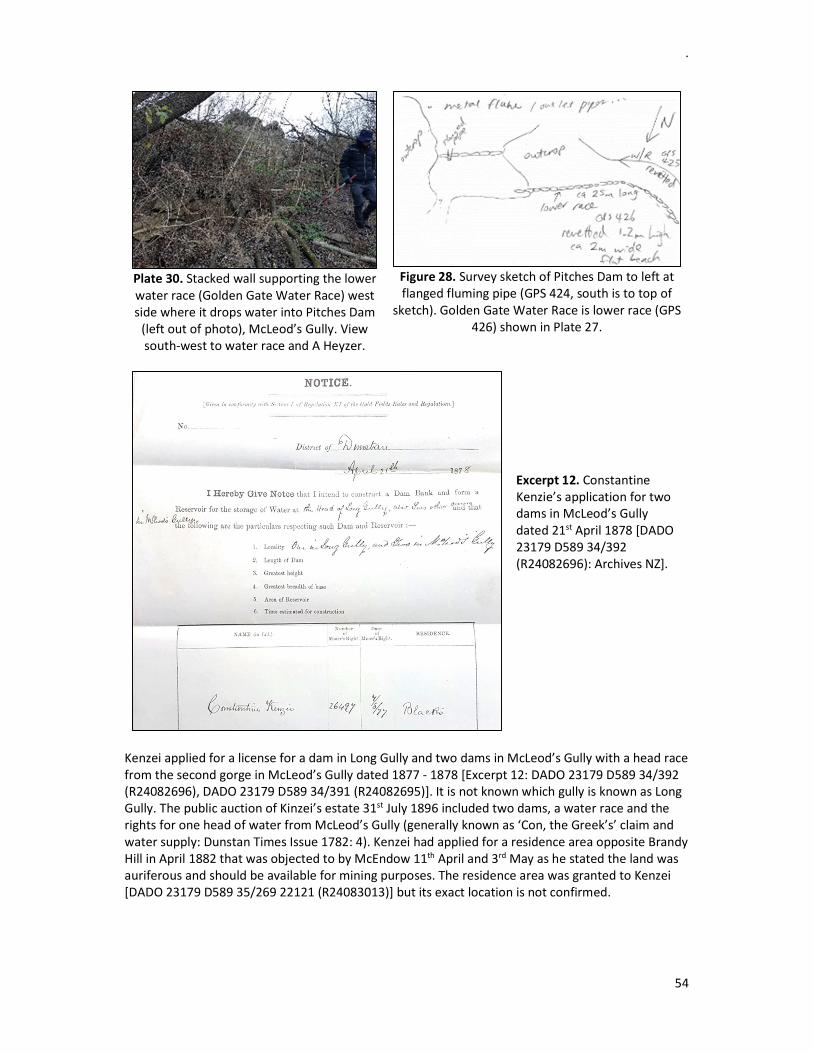
.
54
Plate 30. Stacked wall supporting the lower water race (Golden Gate Water Race) west side where it drops water into Pitches Dam
(left out of photo), McLeod’s Gully. View south-west to water race and A Heyzer.
Figure 28. Survey sketch of Pitches Dam to left at flanged fluming pipe (GPS 424, south is to top of
sketch). Golden Gate Water Race is lower race (GPS 426) shown in Plate 27.
Excerpt 12. Constantine Kenzie’s application for two dams in McLeod’s Gully dated 21st April 1878 [DADO 23179 D589 34/392 (R24082696): Archives NZ].
Kenzei applied for a license for a dam in Long Gully and two dams in McLeod’s Gully with a head race from the second gorge in McLeod’s Gully dated 1877 - 1878 [Excerpt 12: DADO 23179 D589 34/392 (R24082696), DADO 23179 D589 34/391 (R24082695)]. It is not known which gully is known as Long Gully. The public auction of Kinzei’s estate 31st July 1896 included two dams, a water race and the rights for one head of water from McLeod’s Gully (generally known as ‘Con, the Greek’s’ claim and water supply: Dunstan Times Issue 1782: 4). Kenzei had applied for a residence area opposite Brandy Hill in April 1882 that was objected to by McEndow 11th April and 3rd May as he stated the land was auriferous and should be available for mining purposes. The residence area was granted to Kenzei [DADO 23179 D589 35/269 22121 (R24083013)] but its exact location is not confirmed.

.
55
Constantine Kenzie held the license for the two dams in McLeod’s Gully followed by John Pitches. William Pitches water race application dated 27th October 1891 [Blacks Mining Register 1887 – 1930 page 91: DAIV 26707 D531 47/1 (R8515545)] notes the following (Excerpt 13):
Water race one mile long commencing from John Pitches Dam in McLeod’s Gully terminating at Red Jacket Gully near the Post Office. The race is recorded as 2 ft 6 inches wide x 4 ft depth bringing in 2 sluice heads of water. The course is east and west.
Excerpt 13. W Pitches water race application 27th October 1891 [Blacks Mining Register 1887 – 1930
page 91: DAIV 26707 D531 47/1 (R8515545)].
Figure 29. GPS Identifiers for features clustered around Pitches Dam in Upper McLeod’s Gully.
William Pitches and his wife ran the Shamrock Hotel and later they purchased Blacks Hotel. They later moved to the old Dressmaker’s shop and finally to the bungalow (Swindon St: Leask 1998: 74). 12.3.2 Pitches Dam Raceman’s hut (G41/711), McLeod’s Gully, Ophir Various features were recorded in association with Pitches Dam in Upper McLeod’s Gully (Pitches Dam Raceman’s hut and a tent site). Pitches Dam Raceman’s hut (G41/711, Plate 31) is sited at GPS 113 on the 329m elevation c.140m south-east of Pitches Dam wall. The hut is constructed to a high standard using green schist with double skin walling c.0.67m wide. The hut measured 4.75 x 3.02m externally with an internal fireplace in the southern wall. Vegetation is growing all over the hut obscuring it from view (Plate 32) and stone has collapsed from the walls requiring intervention to retain stability.

.
56
The green schist outcrop directly beside the hut (north-west of) appears to have been split to a square shape presumably to supply the stone for the hut (Plate 31) and possibly the dam walls, water race revetment and plinths.
Plate 31. Fireplace of Pitches Dam Raceman’s
hut (G41/711, GPS 113). View south.
Plate 32. Pitches Dam Raceman’s hut (G41/711 on right under vegetation GPS 113). View north-east. Green schist outcrop appears quarried to
left (north-west) of hut. 12.3.3 Rock shelters, McLeod’s Gully, Ophir A small shelter (GPS 421) to the north of Pitches Dam Raceman's hut contains a vertical drill hole on one side (to right of ranging pole Plate 33). The small shelter is located in the same large outcrop/buttress as that quarried beside the hut site. Presumably the buttress overhangs were quarried from this large schist outcrop and utilised for building/constructing the mining infrastructure and accommodation quarters.
Plate 33. Small shelter (GPS 421) with drill hole
to left of ranging pole. View south.
Plate 34. Flat area (GPS 422) c.28m north-west of Raceman’s hut possibly utilised for shelter.
View south. A flat area (GPS 422, Plate 34) c.2.9 x 1.7m in size c.28m north-west of the Raceman’s hut may possibly have been utilised for shelter similar to the site recorded further west (at GPS 423) in the same schist buttress. This tent rock shelter (G41/721, GPS 423, Plate 35) consists of two walls forming the rear walls of a platform 3.8 x 2.3m in size c.65m west of Pitches Dam Raceman’s hut (GPS 420). Two mortise holes (c.2m in height Plates 36-37) have been chiselled out of one of the schist walls suggesting wood supports for inserting of roofing timbers.

.
57
Plate 35. Tent site (G41/721,
GPS 423) between Pitches Dam (GPS 424) and Raceman’s hut
(GPS 420). View south-east to A Heyzer.
Plate 36. Two mortise holes in schist buttress (G41/721,
GPS 423, Matthew Sole). View east.
Plate 37. Close up of mortise
hole in schist butress (G41/721, GPS 423, Matthew
Sole). View east.
12.3.4 Rock shelter tent site (G41/706), McLeod’s Gully A tent site (G41/706) was noted at GPS 116 (Plates 38-39) on the true left bank of McLeod’s Gully below the two major water races coming into Pitches Dam from the west: the Golden Gate water race and Suspension water race (GPS 115: Figure 29).
Plate 38. View south-east to rock shelter tent site (G41/706, GPS 116, McLeod’s Gully).
Mortise holes in rear wall (M Sole).
Plate 39. View south to rock shelter tent site (G41/706, GPS 116, McLeod’s Gully). Mortise
holes in rear wall (M Sole). 12.2.5 Lower dam wall, McLeod’s Gully (G41/710), Ophir A second stacked schist dam wall (G41/710, GPS 119, Plates ??) was recorded in McLeod’s Gully below Pitches Dam (at GPS 424). This is a low stacked schist block dam between water races either side of the creek. Its take point for a water race on the true left heads off south-west contouring around into the next gully and the workings behind the town. A long retained stacked section of water race is the take point of the water on the true right bank (GPS 117). Around 3m above the water course are two stacked schist piers/plinths (GPS 118, Plate ??) for a water race pipe line/flume and the stone of the supporting wall of the race has been fitted snugly around the rock outcrop. It is not clarified which water race these stacked plinths are a part of. The alignment appears to feed water to the sluicings (G41/710) between McLeod’s Gully and Waldron’s Gully

.
58
Plate 40. Stacked schist dam wall (G41/710, GPS
119), McLeod’s Gully. View ??(M Sole).
Plate ?. View ?? to dam wall (G41/710, GPS
119), McLeod’s Gully (Terry Davis).
Plate ??. Stacked schist piers/plinths of water race pipeline/flume (G41/710, GPS 118). View
north-west: M Sole).
Plate ?. Stone stacking supporting the water
race pipeline/flume around an outcrop (G41/710, GPS 118). View north-west: M Sole).
12.4 Dam (G41/703), Upper Specimen Gully, Ophir A dam wall was recorded in Upper Specimen Gully (G41/703, GPS 107) measuring c. 2m wide and c. 2.1m high (Plates 42-43, Figure 19). This dam appears to correspond to the dam west of Pitches Dam in Upper Specimen’s Gully shown on Wilson’s map (Park 1906: Figure 11). The dam is fed water via a water race from a dam further upslope in a tributary of McLeod’s Gully. The map shows more dams located in the upper reaches of every gully (yet to be recorded). By comparing the Survey Plan drawn by the surveyor Macgeorge [Figure 24: DADO 23179 D589 36/240 7/88 (R24083392)] in 1889 with a modern aerial or topographic map, the claim areas for the reefs located above Green’s Reef can be approximately located. The dam shown on the west boundary of William Pitches Section 35 corresponds to the dam wall recorded in Upper Specimens Gully (GPS 107). The dam shown on Section 37 under the name of Gerald Morris would correspond to one located in the dog leg section of Upper Specimens Gully south of Green’s Reef (yet to be recorded). A small fuse box was recorded lying on the ground below the dam in Upper Specimens Gully (GPS 107) on the true left bank. Its purpose or use is not determined.

.
59
Plate 42. Dam wall Upper Specimen Gully (G41/703,
GPS 107). View west.
Plate 43. Dam wall Upper Specimen Gully
(G41/703, GPS 107). View south-west.
12.5 Dam (G41/717), Upper Waldron’s Gully, Ophir A low stacked dam wall (G41/717, GPS 123-124, Plates 43-45) c. 34m in length lies across Upper Waldron’s Gully (Figure 15 bottom centre).
Plate 44. Stacked stone dam wall (G41/717, GPS 123-124), Upper Waldron’s Gully. View
north-west (M Sole).
Plate 45. Stacked stone dam wall (G41/717,
GPS 123-124). Upper Waldron’s Gully. View ?? (M Sole).
12.6 Dam (G41/714), Lower Waldron’s Gully, Ophir A small dam wall (G41/714, GPS 378, Plate 46) was recorded in lower Waldron’s Gully north of the tent site (GPS 380: Figure 15). A stone (schist) lined water race (Plate 47) 1.8m wide strikes 318° north from the dam wall (in the bed of Waldron’s Gully) to Swindon St. The upright schist slabs stand 0.45m high. Some of the schist slabs lining the water race are missing.
Plate 46. Low stacked dam wall (G41/714, GPS
378), lower Waldron’s Gully. View west.
Plate 47. View north-east of water race from
small dam (G41/714, GPS 378), lower Waldron’s Gully.

.
60
12.7 Other gold workings, Ophir Archives hold the following gold mining applications although the exact location for some of the claims identified in the historic record is not confirmed. Six acres of ground was applied for at the back of the township by Ho Ming, Ah Chew, Ah Po, Ah Tem, Ah Ha and Ah Wa dated 4th September 1872 [DADO 23179 D589 33/111 2672 (R24082035)]. Detail of the claim area is not been verified. Ah Tui, Ah Chu and Ah Chow’s applied for a 3 acre claim situated behind McTavish’s hut and adjoining the surveyed sections of the township dated 9th June 1874 [DADO 23179 D589 33/359 (R24082283)]. This gold mining party claim may refer to the tent site and possible aqueduct (GPS 098 – 101: Figure 23) in the un-named gully west of McTavish’s hut. Hung Kee held a one acre claim at the head of Ah Tang’s claim near the Post Office 12th April 1876 [DADO 23179 D589 34/215 6616 (R24082519)]. Details of Ah Tang’s claim have not been clarified or the location. Francis Lee and John Lee’s two acre claim was situated between the mouth of Wet Gully and the foot bridge (application 3rd August 1887: DADO D589 23179 Box 36 89 35/87). Francis Lee applied for one acre extended claim 22nd January 1896 c.300 yards from the Daniel O’Connell Bridge adjoining the Golden Gate old workings [Blacks Mining Register 1887 – 1930 page 212: DAIV 26707 D531 47/1 (R8515545)]. This area was not surveyed. John Healy applied for a one acre claim on the south side of the Postmasters Residence 4th December 1889 [Blacks Mining Register 1887 – 1930 page 188: DAIV 26707 D531 47/1 (R8515545)].
12.9 Manuherikia River, Ophir Chinese miners worked in gangs along the rocky gorge of the Manuherikia River between Blacks/Ophir and Chatto Creek (Ng 1993a Volume 1: footnote 104b page 335, Otago Witness 30th May 1895: 20). The following people applied for gold mining claims or tail races on the Manuherikia River by Blacks Bridge. The bridge referred to would be the early footbridge (G41/601) located downstream of the Daniel O’Çonnell Bridge as the dates correspond to 1870’s – 1880’s. These sites were not visited during the first phase of Project Ophir.
Ah Chong, Young Wan, Ah Chew and Chung Sin applied (24th March 1879) to re-use an old abandoned tail race 400 yards long terminating near the bridge across the Manuherikia River [DADO 23179 D589 35/90 (R240872834)].
Chang Hoy and Sun Won applied for a 2 acre claim near Blacks Bridge (24th March 1880 [DADO 23179 D589 35/172 5618 (R24082916)].
Shin You, Young Ting, Ah Shew, Ah Chong and Ah Shee‘s application is for a five acre claim situated at and below the foot bridge [9th November 1882: DADO 23179 D589 35/253 22162 (R24082997)].
12.10 Dredging in the Manuherikia River, Ophir Dredging did occur in the Manuherikia River alongside the Ophir Historic Area. A small dredging plant was located at Blacks Bridge August 1893 (Dunstan Times 18th page 5). The Ophir dredge worked the Manuherikia River below Blacks Bridge in October 1894 (Lake County Press 11th page 3). The Ophir and Ind Gold Dredging Company Limited worked Section 42 Block II above the Daniel O’Connell Bridge (SO 7770 dated September 1896). The Ophir and Ind dredge still lies where it was abandoned in the Manuherkia River after sinking in an awkward position in the river (OW 11th July 1895: 19). The dredge is said to be partially visible at low water levels.

.
61
Blacks Gold Dredging Coy Limited carried out dredging of Section 47 Block II at Ophir (Tiger Hill) outside the Ophir HA. Leslie H Reynolds advertised his application (dated 25th August 1897) for a special claim of 70 acres to work part of the Manuherikia River including a part of the Ophir and Ind Gold Dredging Company’s surrendered claim [Section 42: DADO 23179 D589 109/97 5/97 (R24083974)].
13 Ophir Township 13.1 Swindon St Kerb Channelling (G41/707), Ophir Schist slab kerb channelling (guttering G41/707) has been laid along part of Ophir’s main street Swindon St. The kerbing lies west to east both sides of Swindon St between the following GPS points:
north side - GPS 359 - GPS 365 (outside Rapid no. 30 to Rapid no. 48 opposite the Post Office)
south side – GPS 366 - GPS 373 and (outside Rapid no. 37 to Rapid no. 59)
Figure 30. Schist slab kerb channeling and kerbstones (G41/707) Swindon St, Ophir (GPS 359 – 373).
Excerpt 14. Kerbing and gravelling
contract at Ophir March 1878 (Dunstan Times 29th page 2).
Plate ?. Example of schist slab kerbing and channelling, Rapid No 30 Swindon St, Ophir (Sarah Gallagher). View
south.

.
62
Plate ?. View east to schist slab kerbing and channelling, Swindon St, Ophir. Odette Hopgood-Bride and Nikole Wills in background, Rex Johnson and Andrew Barsby (centre) and Terry Davis to right (Sarah Gallagher). Peace Memorial Hall first building to right with Post Office next building.
Table 11 (Appendix 9) provides the GPS coordinates for the numerical identifiers (Figure 30). The road width measured ca 21.5m between the kerb channelling uprights outside the Post Office (GPS 369). The kerbing is a uniform single alignment of large stones (0.2 – 0.25 high) placed vertically along the road edge with stone retaining laid vertically 5 – 7 stones wide (0.5 – 0.6m) alongside the kerb stones providing the base channel (guttering). The channel on the north side of the road is scalloped up to 0.5m deep (providing a dish drain). The channel on the south side is not scalloped. Concrete has replaced the original channel retaining between GPS 366 – 369 where utility services were installed. Rabbit damage has occurred behind some of the kerbing stone alignment. A tender for forming and gravelling 13 chains of the Main Street, Ophir, and forming, kerbing and gravelling 220 chains of street leading to the Court House (Vincent County Contract 36) was advertised 16th March 1878 (Dunstan Times 29th March page 2: Excerpt 14). Later files from the Vincent County Council have not been searched. There is one other site record held in ArchSite for schist kerb guttering (kerbing and channelling) in Otago and two for Bluestone kerbing and channelling in Dunedin (Table 16).
Table 16. Kerbstones and channelling site records held with ArchSite:
NZAA_ID Description Name Update Date H41/161 Schist kerbstones and channelling St Bathans Main Street 28/10/2011 I44/633 Bluestone kerbstones and channelling Queen St, Dunedin 31/10/2016 I44/857 Bluestone kerbstones and channelling Canongate St, Dunedin 30/06/2020
The lack of recorded kerbing and channelling in small South Island towns is surprising as there are more examples present. The main shopping streets of Arrowtown and Clyde retain part of the 19th Century kerbing and channelling stones. There is an excellent example of cobbled stone gutters and kerbing in Berkshire St, Arrowtown that is listed a protected feature on the Queenstown District Council Operative Plan (Ref No 305) and with Heritage NZ as a Category II Historic Place.

.
63
There may be well be more examples of kerbing and channelling remaining beneath modern roads as seen outside the St Bathans Mud Brick Hall (H41/102), Loop Road, in 2008 during upgrade work of the Hall’s gravity feed system and auditorium sump/drainage work (Briden 2011: 24-25). A small section of upright cobbling (channelling of roadside kerbing) was uncovered.
13.2 Daniel O’Connell Bridge (G41/694), Manuherikia River, Ophir The Daniel O’Connell Bridge (G41/694) spans the Mauherikia River west of Ophir (GPS 408 true right bank) listed Category I with Heritage NZ (List entry 338). Heather Bauchop (ed. 2015) provides a summary report of the Daniel O’Connell Bridge based on a detailed heritage report by Astwood (2011: 3 IPENZ Engineering Heritage number 2274). IPENZ Engineering New Zealand consider the Daniel O’Connell Bridge to have sufficient engineering heritage significance to merit inclusion on the IPENZ Engineering Heritage Record:
In 1878 the Vincent County Engineer Leslie Duncan Macgeorge designed the 65.5 metre bridge which was constructed by J. S. Derby and R. Edgar of Timaru. The cost of the bridge was approximately £7,000 more than the £4,922 quoted for the work (Angus 1977: 54, Astwood 2011: 6, Thornton 2001: 183).
At the opening of this structure in May 1880 the bridge was named after Irish hero Daniel O’Connell in deference to the many Irish miners who lived around Ophir. By the early twentieth century the bridge’s timber transoms and stiffening truss had degraded. They were replaced with steel equivalents in 1905 by Watson Rhodes and Company. There has been little further alteration to the structure aside from several replacements of the timber deck. The timber was recycled in a new foot bridge over the Manukerikia River between the towns of Ophir and Omakau (Astwood 2011: 7) known as Leask’s crossing (Angus 1977: 99).
The Daniel O’Connell Bridge is a handsome and popular local landmark that is well-maintained and still in use (unlike its contemporaries the Alexandra, Shaky, and Kawarau Gorge Suspension Bridges). The Daniel O’Connell Bridge has some engineering importance as an example of the vernacular form of late 19th Century Central Otago bridge that notable engineer Macgeorge excelled in designing (Astwood 2011, Engineering New Zealand 2020, Hudson 1993: 21).
The Daniel O’Connell Bridge is one of only four suspension bridges in the Otago region constructed with cables carried on schist masonry towers designed by LD Macgeorge. The other three are listed below with location and dates of construction:
first bridge at Clyde over the Clutha River 1875 Shakey Bridge over the Manuherikia River Alexandra 1879 Alexandra Bridge over the Clutha River 1879 – 1882 (Astwood 2011: 6, Thornton 2001: 182 -
183).

.
64
Plate ?. Daniel O’Connell Bridge (G41/694, GPS
408). View south-east (Audrey Heyzer).
Plate ?. Daniel O’Connell Bridge platform and handrail (G41/694, GPS 408: Sarah Gallagher).
Plate ?. View to anchorings, Daniel O’Connell Bridge (G41/694, GPS 408). (Sarah Gallagher).
Plate ?. View south-east of rock cutting leading to Daniel O’Connell Bridge from Ophir. Bridge
behind photo taker (Audrey Heyzer). Only the stacked piers of the Alexandra Bridge remain today. Shakey Bridge is still intact serving as a footbridge. Only the Daniel O’Connell Bridge remains open to vehicle use. Part of the original bridge plans drawn by Macgeorge are held by the Hocken Library in Dunedin with a copy shown in Appendix 13. The bridge plans have previously been published in Angus (1977). June Wood (1974: 54) notes the stonemason was Edward Booth. NZ Museums hold a photo of the hand trowel used by Henry Blake during the construction of the Daniel O'Connell Bridge. A description of the bridge construction is provided in a newspaper article dated 14th May 1880 (Dunstan Times page 2). The bridge was re-decked in 1948 and placed under weight and speed restrictions (Angus 1977: 152). The Daniel O’Connell Bridge has previously been known under the following names: Blacks Bridge, Manuherikia River Suspension Bridge, Old Red, and Ophir Bridge. Photographs attached to the new site record (G41/694) show the current fabric of components of the bridge. The Bridge Reserve was gazetted in 1881 (New Zealand Gazette p673) Section 26 Block II and is owned by the Central Otago District Council (Bauchop ed. 2015: 1). Plates ? provide a view ?? of the rock cutting leading to the Daniel O’Çonnell Bridge (G41/694) behind photo taker. Are there current weight restrictions for the bridge?
13.3 Ryan’s Bendigo Hotel Stables (G41/708), Ophir Ryan’s Bendigo Hotel Stables (G41/708, Plates 48-49) has been recorded as part of Project Ophir. The stables are of rammed earth construction located behind the former Hotel site at the rear of Section 39 Swindon St (GPS 375: Figure 30).

.
65
Plate 48. Ryan’s Hotel Stables (G41/708, GPS 375). View east of the centre stall/bay of the
stable building.
Plate 49. Ryan’s Hotel Stables (G41/708, GPS
375). View north-east of the south-west side of the stable building.
The stables measure 10.8 x 5.4m externally and are divided internally into three bays. The external south wall measured 50cm thick and the internal wall thickness is 35cm. The two internal walls butt up to the external rammed earth wall to the south and the walls appear to be separating. The rammed earth rear walls (east and south walls) have eroded 15 – 18cm thickness due to exposure to rainfall. The stables are in poor condition. One of the rammed earth walls has severe cracking vertically (south rear wall).
Figure 31. Ryan’s Bendigo Hotel and Stables (G41/708) at Blacks (cropped sketch by Surveyor William Arthur 1868 – 1871: 181, Archives).

.
66
Excerpt 15. Robert Ryan
carrying out building additions to Bendigo Hotel, Blacks/Ophir January 1869 (Otago Witness
2nd page 2).
Excerpt 16. Ryan’s Bendigo Hotel for auction (Dunstan Times 13th April 1883: 2).
Excerpt 17. Ryan’s Hotel effects for auction (Dunstan Times 11th
May 1883: 2).
Ryan’s Hotel is named on the surveyor William Arthur’s sketch of Ophir dated 1868 (Figure 31). An article in the Otago Witness informs us that Robert Ryan owned the Bendigo Hotel at Blacks in January 1869 (2nd page 2: excerpt 15). Robert Ryan’s General Liquor License for Bendigo Hotel was renewed 1874 (15th May Dunstan Times page 2) and again in June 1881 (Dunstan Times 17th page 3). Bendigo Hotel in Blacks/Ophir was listed in the 1871 Business Directory under the name of EG Ryan (15th December Dunstan Times page 1). A Promote Dunstan pamphlet ‘Walk around Historic Ophir’ states Robert Ryan was the owner of Ryan’s Hotel 1873 – 1890. The next mention in early newspapers (PapersPast) is April and May 1883 when Ryan’s Bendigo Hotel and effects at Ophir were advertised for auction (Dunstan Times 13th April page 2 and 11th May page 2: Excerpts 16 - 17). Edward Ryan’s (Dunstan Publican) probate is dated 1865 [DAAC 9073 D239 16/302 (R22042965)] and all his possessions were left to his wife Catherine Ryan. Edward and Catherine had a son James Edward Ryan aged 3 months at the time of Edward’s death. It is not confirmed if Catherine Ryan took over the running of the Bendigo Hotel 1865 to 1883 or if it was sold to another party. An Edward Ryan is listed on a quartz claim with William Burren Senior and William Burren Junior in 1888 in McLeod’s Gully [DADO 23179 D589 36/221 88/88 (R24083385)] and John T Ryan and Edward Rayan were among a large party who applied for a dredging claim in 1889 [DADO 23179 37/76 89/89 (R24083493)]. Other mentions of a Mr Ryan in the area are Edmond Ryan who advertised his application for a Licensed holding of 16 acres under the name of The Great Expectation Quartz-mining Company 13th March 1881 (Dunstan Times page 2). The location of the claim is not confirmed. The mode of working was proposed to be sinking and driving. A John Ryan was granted a prospecting area for dredging 160 chains of the Manuherikia River upwards from the upper ford at Blacks (Dunstan Times 12th April 1895: 3). John Ryan is also named on an application for a gold mining claim in Cairn’s Gully
.
67
at Blacks in 1887 [DADO 23179 36/103 49/87 (R24083267)] and for Blacks Gold Dredging Company Limited on Blacks Flat in 1896 [DADO 23179 109/15 11/96 (R24083892)]. An undated photo of the stables is provided in Leask (1998: 54-55, 73) who notes that William (Bill) Hickey owned the stables for many years. One side of the stables was converted into a car garage that was used by Toey Levido to house his holden. Toey was a shearer, rabbiter and labourer. Allan and Carol Leask purchased the section including the stables followed by Owen and Val Butcher.
13.4 McTavish’s Hut (G41/702), Blue Nose Gully McTavish’s hut (G41/702) is located in Blue Nose Gully (GPS 097) c.630m east of Blacks Hotel and c.50m south-west of Ida Valley-Omakau Road (Cover page, Figure 23). The hut is of stacked schist construction with an external chimney (extending 0.57m from the south end) and a lean-to woodshed extending 1.75m north. The hut measures 5.27 x 3.95 externally. The chimney height was measured at 2.65m. The internal fabric was not recorded as access was not obtained. Concrete has been used in some of the mud packing of the walls. The roofing iron has been replaced at some point. There is a Redcliffe corrugated iron maker’s mark on one of the sheets. Daniels Clem (goldminer) lived in the hut built by Lockhart McTavish on a one acre section of land (Leask (1998: 27-28). Malcolm McDonald and Lockhart McTavish applied for a two acre claim in O’Hagan’s Paddock adjoining Healy Stringer’s claim in April 1876 [DADO 23179 D589 34/214 6615 (R24082518)]. The claim was located on Blacks Flat. The one acre residence area where McTavish’s hut is located is shown on Sam Leask’s map with the name S Leask adhered to it dated 1933 (Figure 20). Leask (1998: 27-28) mentions the Waldron family living in the hut at one time. A photo of the hut in Sam’s Leask book (1998) shows a freshly restored hut in good condition. McTavish’s (G41/702) hut is a visual delight when travelling to Blacks/Ophir and has featured in the TV production ‘Red Conroys Rose’.
13.5 Early road alignment to Ophir Sections of the early road alignment (now SH 85) on the east boundary of Ophir HA can be seen in aerial photographs (Figure 19). The road alignment sections were not visited or recorded.
13.6 Ophir Peace Memorial Hall (G41/716), Ophir The Ophir Peace Memorial Hall (Ophir Town Hall G41/716) is located at 55 Swindon St (GPS 377: Figure 15, Plates 40-53) built by John McKnight in 1926. The hall held dances and was noted for its excellent dancing floor. The hall flooring was two inches wide and still in good order in 1995. The hall also functioned as a movie theatre with school concerts and prize giving’s held there. Flush bowl toilets were installed and the building painted by volunteer labour (Leask 1995: 49, 68, Leask 1998: 61 – 62). The Ophir Peace Memorial Hall (G41/716) measures 13.21 x 19.7m externally not including the toilet extension at the rear of the building. The timber framed hall is cladded with corrugated iron with Bristol Crown makers marks evident on the outside of the side walls. There is one Lysaght makers mark visible. The hall sits on a concrete pad 20cm thick. The lower portion of the concrete base contains glass and ceramic fragments. Some of the paint on the wood elements (wood edges, windows, barge boards) is slightly peeling. The interior of the hall was accessed briefly on two occasions. Plate 50 shows the interior of the hall and the stage. The auditorium/hall has tongue & groove lining up to the bottom of the windows on the east wall. The stage appears freshly painted. Plate 51 shows the inside of the dining room.

.
68
Plate 50. Ophir Peace Memorial Hall (G41/716)
view to south (photo by Sarah Gallagher).
Plate 51. View north of the rear of Ophir Peace
Memorial Hall (G41/716).
Plate 52. Interior of hall facing the stage (view
south photo by Audrey Heyzer).
Plate 53. View north of dining room (west side
of hall, photo by Sarah Gallagher).
13.7 Ophir Town water supply, Ophir Macgeorge designed a windmill operated pump to lift water from a local well to a reservoir of 38,000 gallons on the terrace above the town. The plant was installed in 1898 distributing water to shops and houses in the settlement. The scheme did not work well and a new reticulation system was begun in 1974 (Angus 1977: 83, 105, 155). The Ophir town reservoir is shown on SO Plan 1718 dated 1922. ORC (Otago Regional Council) hold a water-race license for the water supply to the town of Ophir (WR736B) dated 17th October 1911 (email 15/6/2020).
13.8 Other, Ophir John Sullivan was listed as a stonemason in the 1889 Stone’s Directory Otago & Southland (page 159: Hocken Library) who may be responsible for some of the stacked stone features and buildings throughout the Ophir Historic Area. It is not known if peat cutting areas were ever located within the bounds of Ophir HA or in the mountains above. Timber for firewood may have been a scarce item in the cold winters especially when timber was required as props to shore up tunnels and reef mines.
13.9 Trig Stations, Ophir There does not appear to be any 19th Century trig stations located within Blacks/Ophir or the Ophir Historic Area in Tiger Hill Survey District. The Geodetic database (LINZ) shows two surveyors trig stations (order 5) located on Swindon St, Ophir, that are dated post 1900:

.
69
EWG5 (5): IT1 SO392137 Iron tube flush behind stone kerb (outside 45 Swindon St – established 2007)
EWG4: IT 111 SO 14705 Iron tube capped in grass berm (Swindon St intersection - established 1932)
There is no historic information included with these two trig station records. Neither of these two sites are pre-1900 in construction or use and are not considered further in this report.
14 Project Ophir Report This report provides detail of archaeological/heritage sites recorded during the first phase of Project Ophir at Blacks/Ophir, Central Otago, for the COHSR (Central Otago Heritage Review). A summary of the results (Briden 2021B) is to be read in conjunction with this more detailed survey report (Briden 2021A).
Acknowledgements Thank you to the following passionate people who helped and/or participated with this important mahi: The unfailing powerhouse that is OGHT - Rex Johnson, Terry Davis and Odette Hopgood-Bride and hard hitter GIS specialist Ina Kinksi for organising the database and input into knack. Sam Leask and his generosity in allowing the heritage survey to proceed across his family land. Simon Cox (GNS Science, Dunedin) for locating existing geological mapping information and reports and providing large scale maps for field survey work. Central Stories Museum & Art Gallery, Alexandra and their archival photograph collection. Archives staff in the Dunedin office who are just so helpful in searching out relevant records for historical information to corroborate features surveyed on the ground. Otago Museum, Dunedin and their holdings of Taoka/taonga/artefacts from Central Otago.

.
70
REFERENCES Agnew, J., and T, Agnew. 2020. Merchant Miner Mandarin: The Life and Times of the Remarkable Choie Sew Hoy. Christchurch: Canterbury University Press. Angus, J.H. 1977. One Hundred Years of Vincent County: A Centennial History of the Vincent County Council 1877 – 1977. Dunedin: Vincent County Council. Applied Petrologic Services & Research. 2012. Petrological studies of drill chips from OPH-005, 0-010, -013 & 014 of the Ophir Project Area. Report for Glass Earth (New Zealand Limited). Archives NZ. https://www.archway.archives.govt.nz/ViewFullAgencyHistory.do ArchSite. Archaeological site record database New Zealand. https://archsite.eaglegis.co.nz/ Astwood, K. 2011. Daniel O’Connell Bridge. IPENZ Engineering Heritage Record Report. IPENZ Engineers New Zealand. Atojs (Appendix to the Journals of the House of Representatives). https://atojs.natlib.govt.nz/cgi-bin/atojs:
1863. Report on the Otago Gold Fields. Session I, D-06. 1865. Further Papers Relative to the Otago Gold Fields. Session I, C-04a. 1872. Report on the Otago Gold Fields of New Zealand. Session I, G-04. 1873. Report on the Gold Fields of New Zealand. Session I, H-07. 1874. Report on the Otago Gold Fields. Session I, H-09. 1875. Report on the Gold Fields of New Zealand. Session I, H-03. 1876. Report on the Otago Gold Fields of New Zealand. Session I, H-03. 1910. Blacks Register of Mining Privileges Rent Nos. 689-1577. Dates 1910-1988.
Aukaha. Kāi Tahu Ki Otago (KTKO) Natural Resource Management Plan. 2005. https://aukaha.co.nz/resource-management/ Bartle, A. 2012. Technical Report for Exploration Permit 40427 – Ophir. Report for Glass Earth (New Zealand) Ltd. Beattie, J.H. 1947. Early Runholding in Otago. Dunedin: Otago Daily Times and Witness Newspapers Co. Ltd. Beattie, J.H. 1979. The Southern Runs. Invercargill: The Gore Historical Society. Beattie, J. 2015. ‘Hungry Dragons’: Expanding the Horizons of Chinese Environmental History – Cantonese Gold-miners in Colonial New Zealand, 1860s-1920s. International Review of Environmental History Vol 1. Black, T., S, Nowell., and B, Hayward. 1991. Inventory of Geologically-Related Historical Sites and Features of International, National and Regional Importance. Geological Society of New Zealand Miscellaneous Publication No. 52. Wellington: Geological Society of New Zealand. Briden, S. 2011. St Bathans Public Hall (H41/102) drainage works. Report for Department of Conservation. DOCDM-702457.

.
71
Briden, S. 2021. Project Ophir Summary Report for the Central Otago Heritage Site Review (COHSR). Report prepared for Otago Goldfields Heritage Trust by Absolute Archaeology Ltd. Brooks, E., C. Jacomb., and R. Walter. 2008. (SCHIP). Southland Coastal Heritage Inventory Project Waiparau Head to Rowallan Burn. Southern Pacific Archaeological Research. Brooks, E., and H. Bader. 2012. Report on Central Otago Cemeteries Geophysical Survey and Map Digitisation Project. Report to Central Otago District Council. Brooks, E., C. Jacomb. 2012. Southland Coastal Heritage Inventory Project (SCHIP): Action Plan and Strategic Overview. Prepared for the Southland Coastal Heritage Inventory Project Partners by Southern Pacific Archaeological Research. Central Otago District Plan. Central Otago District Council (CODC):
Register of Heritage Buildings, Places, Sites & objects and Notable Trees https://www.codc.govt.nz/SiteCollectionDocuments/Plans/District%20Plan/Maps%20-%20Updated%20May%202017/MAP25%20Ophir.pdf
District Plan Map 25 Ophir Heritage Precinct https://www.codc.govt.nz/SiteCollectionDocuments/Plans/District%20Plan/Maps%20-%20Updated%20May%202017/MAP25%20Ophir.pdf
Central Stories Museum & Art Gallery. Alexandra. Photographic Collection of Blacks/Ophir. Christie, A. and J, Youngson. 2016. Exploration of the Ophir Orogenic Gold Deposit, Central Otago. Mineral Deposits of New Zealand – Exploration and Research. https://www.researchgate.net/publication/331653678_Exploration_of_the_Ophir_Orogenic_Gold_Deposit_Central_Otago Crown Pastoral Lease Act (CPLA). 1998. New Zealand Legislation. Parliamentary Counsel Office Te Tari Tohutohu Pāremata. http://www.legislation.govt.nz/act/public/1998/0065/latest/DLM426894.html Cunningham, G. 2005. Illustrated History of Central Otago and the Queenstown Lakes District. Auckland: Reed Publishing (NZ) Ltd. Department of Conservation. 2020. Email Nicole Sutton 29th January and 8th September. Eldred-Grigg, S. 2008. Diggers Hatters & Whores. The Story of the New Zealand Gold Rushes.
Engineering New Zealand. 2020. Daniel O’Connell Bridge. https://www.engineeringnz.org/our-work/heritage/heritage-records/daniel-oconnell-bridge/ Falconer, D. M. 1985. Geology of the Ophir Gorge. A project submitted in partial fulfilment for a Degree of Bachelor of Science. University of Otago. Forrest, J. 1965. Settlement and Communications. In: Lister, R. G., and R. P. Hargreaves (eds). Central Otago: A Symposium to mark the Centenary of the ‘Golden Decade’ of the 1860s in Central Otago. New Zealand Geographical Society. Pp 174 – 188.
.
72
Galer, L. 1989. Historic Buildings of Otago and Southland: A register of classified buildings. New Zealand Historic Places Trust. Galer, L. 2005. Time to smell the roses: A new Life in Ophir. Dunedin: Longacre Press. Galvin, R 1906. The New Zealand Mining Handbook. Wellington: John Mackay, Government Printer. Hamel, J. 2001. The archaeology of Otago. Wellington: Department of Conservation. Hamel, J. 2001. A little archaeology at Ophir Post Office. A report to the New Zealand Historic Places Trust on Authority 2001/096. Hector, J. 1890. Reports of Geological Explorations During 1888 – 89 with Maps and Sections. Colonial Museum and Ecological Survey of New Zealand No. 20. Wellington: George Didsbury, Government Printer. Heritage NZ Pouhere Taonga (HNZPT). https://www.heritage.org.nz/:
- The List. https://www.heritage.org.nz/the-list
- 1995. Ophir Historic Area. Recommendation for Registration. List No 7268.
- 2007. Sustainable Management of Historic Heritage Guide No. 5. State of the Environment Reporting and Monitoring.
- 2007. Sustainable Management of Historic Heritage Guidance, Information Sheet 11.
- 2010. Archaeological Guidelines Series No. 8.
- 2012. Registration Report for a Historic Place: St Andrew’s Presbyterian Church (Former),
Ophir, (Register No. 3246). Heather Bauchop.
- 2014. Heritage NZ Pouhere Taonga Act.
- 2015. Upgrade Report Daniel O’Connell Bridge, Ophir. List No 338. Hocken Collections Uare Taoka o Hākena – University of Otago Library Ngā Whare Whakamārama o Te Whare Wānanga o Ōtākou. Dunedin. https://www.otago.ac.nz/library/hocken/ Hopgood-Bride, O. 2020. Personal communication 21st May. Hudson, P. 1993. Bridges of New Zealand. Wellington: IPL Books. ICOMOS New Zealand Charter. 2010. ICOMOS NZ Charter or the Conservation of Places of Cultural Heritage Value. Te Mana ō Nga Pouwhenua ō Te Ao. https://icomos.org.nz/charters/ Kā Huru Manu: Ngāi Tahu Cultural Atlas. 2020. Te Rūnanga o Ngāi Tahu. http://www.kahurumanu.co.nz/atlas
.
73
Kenex Knowledge Systems Ltd. 2004. Prospecting and Exploration Report MR4090 (Permits 40 427 and 40 682 Ophir). Report for HPD New Zealand Limited. Kilgour, R. 1998. MR3589. Final report on the findings of 40159 Ophir. Open File Exploration reports held by Crown Minerals. Leask, K. 1995. Ophir Memories. Alexandra, Central Otago: Central Otago News Print. Leask, K. 1998. Ophir Memories. Reprint Edition 2. Alexandra, Central Otago: Central Otago News Print. LINZ (Land Information New Zealand):
Crown Property Map. https://data.linz.govt.nz/data/category/crown-property/ LINZ Managed Crown Property
Geodetic database. https://www.geodesy.linz.govt.nz/gdb/ Lister, R.G. and R. P. Hargreaves (eds.). 1965. Central Otago: A symposium to mark the centenary of the ‘Golden Decade’ of the 1860’s in Central Otago. Christchurch New Zealand: Caxton Press. McGill, D. 1983. Ghost Towns of New Zealand. Wellington: AH and AW Reed Ltd. Middleton, A. 2007. Marshall Property Lot 2 DP362248 Ophir: Archaeological Assessment. Arch Hill Heritage Report No. 14. Middleton, A. 2011. Ophir Post Office. Final report on authority no. 2011/343. Arch Hill Heritage Report No. 91. Ministry for the Environment. 2014. A Framework for Environmental Reporting in New Zealand. Wellington: Ministry for the Environment. Publication reference number ME 1143. https://www.mfe.govt.nz/publications/environmental-reporting/framework-environmental-reporting-new-zealand Ng, J. 1993a. Windows on a Chinese Past Volume 1. Dunedin: Otago Heritage Books. Ng, J. 1993b. Windows on a Chinese Past Volume 4. Alexander Don’s Roll of Chinese. Dunedin: Otago Heritage Books. New Zealand Mines Department. 1887. The Handbook of New Zealand Mines: with Maps and Illustrations. Wellington: George Didbury, Government Printer. https://babel.hathitrust.org/cgi/pt?id=uc1.$b79720&view=1up&seq=120 New Zealand Petroleum & Minerals. Mineral Active Permits – Exploration Permit:
40427 Ophir Gold Limited http://data.nzpam.govt.nz/PermitWebMaps/os/Home/StaticMap?permit=40427
60311 Matakanui Gold Limited http://data.nzpam.govt.nz/PermitWebMaps/os/Home/StaticMap?permit=60311

.
74
NZ Museums. Sluicing claim on Ophir Hill. Object no VOPO.23. https://www.nzmuseums.co.nz/collections/3059/objects/50148/photograph-sluicing-claim-on-ophir-hill NZ Museums. Trowel used by Henry Blake during construction of the Daniel O’Connell Bridge. Object No XOPO.51. https://www.nzmuseums.co.nz/collections/3059/objects/49255/trowel Ophir Community Plan. 2015. https://www.codc.govt.nz/SiteCollectionDocuments/Plans/Community%20Plans/Ophir%20Community%20Plan.pdf ORC (Otago Regional Council). Ophir water supply water-race license (WR736B) dated 17th October 1911 (R Brennan email 15/6/2020). Otago Goldfields Heritage Trust (OGHT). Otago Museum. 2020. Email and Taoka spreadsheet 20th March 2020. Papers Past. https://paperspast.natlib.govt.nz/
1865. Dunstan Times. Latest Mining Intelligence. Issue 709. 1st July page 14 1866. Dunstan Times. Mining Intelligence. Issue 204. 24th March page 3 1866. Dunstan Times. Black’s. Issue 237. 9th November page 3 1867. Dunstan Times. Issue 269. 21st June page 2 1869. Otago Witness. Blacks. Issue 892. 2nd January page 2 1869. Dunstan Times. Issue 355. 12th February page 2 1869. Dunstan Times. Untitled. 18th June 1869 page 2. 1870. Dunstan Times. Advertisements Column 3. Issue 452. 16th December page 3 1871. Dunstan Times. Advertisements Column 1. Issue 504. 15th December page 1 1872. Dunstan Times. Advertisements Column 3. Issue 557. 20th December page 3 1874. Dunstan Times. Licensing Meeting Blacks No.1. Issue 630. 15th December page 2 1876. Dunstan Times. Issue 749. 25th August page 2 1878. Dunstan Times. Advertisements Column 2. Issue 832. 29th March page 2 1878. Dunstan Times. Advertisements Column 1. Issue 847. 12th July page 2 1879. Tuapeka Times. Local and General Intelligence. Issue 492. 11th January page 2 1880. Dunstan Times. Daniel O’Connell Bridge. Issue 943. 14th May page 2 1882. Dunstan Times. Advertisements Column 3. Issue 1070. 27th October page 3 1883. Dunstan Times. Advertisements Column 3. Issue 1089. 13th April page 2 1883. Dunstan Times. Advertisements Column 7. Issue 1093. 11th May page 2 1885. Dunstan Times. Mining News. Issue 1234. 23rd October page 3 1886. Mount Ida Chronicle. Volume XVI, Issue 879. 12th August. Page 2 1889. Otago Daily Times. Miscellaneous. Issue 8607. 24th September page 3 1889. Otago Witness. Miscellaneous. Issue 1975. 26th September page 13 1892. Dunstan Times. Issue 1592. 19th August page 3 1893. Dunstan Times. Advertisements Column 4. Issue 1613. 20th January page 2 1896. Dunstan Times. Advertisements Column 3. Issue 1782. 31st July page 4 1897. Dunstan Times. Advertisements Column 5. Issue 1833. 3rd September page 7 1908. Evening Star. Issue 13043. 29th August page 7 1923. Dunstan Times. Ophir. Issue 3161. 26th March page 4 1929. Otago Daily Times. Issue 20799. 19th August page 12

.
75
1937. Dunstan Times. Ophir Notes. 29th March page 5 Park, J. 1906. New Zealand Geological Survey Bulletin No. 2. The Geology of the Area covered by the Alexandra Sheet, Central Otago Division. Wellington: Government Printer. Petchey, P. 2000. Black’s No. 1 Diggings, Ophir. Archaeological Survey for Central Otago Stone Co. Ltd. And sketch ‘Gold Mining at Ophir’. Pinney, R. 1981. Early Northern Otago Runs. Auckland: William Collins Publishers Ltd. Promote Dunstan. Walk around Historic Ophir pamphlet. Walk Around Series – Brochure Two. http://www.promotedunstan.org.nz/PDWalkaroundOphir.html
Protected Objects Act. 1975. New Zealand Legislation. http://www.legislation.govt.nz/act/public/1975/0041/latest/DLM432116.html Prover: Custom Software Limited/Landonline. SO (Survey Office) and DP (Deposited) Plans (Landonline) http://www.prover.co.nz/ Quality Planning Resource. Ministry for the Environment. Historic Heritage. https://www.qualityplanning.org.nz/node/748 Resource Management Act (RMA). 1991. Parliamentary Counsel Office/Te Tari Tohutohu Pāremata. http://www.legislation.govt.nz/act/public/1991/0069/latest/DLM230265.html Ritchie, N. 1991. Is There an Optimum System?: The Recording and Assessment of Historic Mining Sites. Australian Journal of Historical Archaeology Vol. 9, pp. 37 – 44. Ronald, H. 2020. Personal communication 21st May. Sinclair, J., et al. 2008. The Squatters’ Club. Friends of the Hocken Collections. Bulletin Number 58. Sinclair, F.G. 2003. The early pastoral runs of Otago and Southland: a listing to provide quick reference to the runs by number and name and by name and number: with maps indicating the boundaries, for the most part drawn from the 1871 provincial map. Held in the Hocken Library, Dunedin, New Zealand. Smith, P. 1987. Abandoned Villages. Cultural Planting in the Relict Landscapes of Central Otago. Meanings and Management. Soengkono, S. 2009. Ground Magnetic, Gradient Array Resistivity and Conductivity Depth Imaging (CDI) of Airborne EM at Ophir Hard-rock Prospect. Report for Glass Earth (New Zealand) Ltd. Sole, M. 2020. Personal communication 21st May. Kopuwai Consulting, Chatto Creek. Sole, M. 2021. Drone aerials over Blacks No. 1 behind Ophir dated 30 July: Kopuwai Consulting. Southland Coastal Heritage Inventory Project (SCHIP). 2012. Action Plan and Strategic Overview. Prepared for the Southland Coastal Heritage Inventory Project Partners by Southern Pacific Archaeological Research.
.
76
Stone’s Directory Otago & Southland. 1889. Hocken/Uare Taoka o Hākena, Dunedin. University of Otago Library. https://www.otago.ac.nz/library/hocken/ Stone’s Directory Otago & Southland. 1905. Hocken/Uare Taoka o Hākena, Dunedin. University of Otago Library. https://www.otago.ac.nz/library/hocken/ Sumpter, G.H. 1948. In Search of Central Otago. Auckland, NZ: Whitcombe & Tombs Limited. New Zealand Mines Dept. 1887. The handbook of New Zealand mines: with maps and illustrations. Wellington: George Didbury, Government Printer. Hathi Trust Digital Library. Thornton, G. 1983. Cited in: Anon. Historic Buildings of New Zealand: South Island. NZ Historic Places Trust. Auckland: Methuen Publications Ltd. Thornton, G. 2001. Bridging the Gap: Early bridges in New Zealand 1830-1939. Auckland: Reed Books. Tyrrell, A. 1996. River Punts and Ferries of Southern New Zealand. No.6 in the ‘Southern Heritage 150’ series. Otago Heritage Books. Wikipedia. Ophir, New Zealand. https://en.wikipedia.org/wiki/Ophir,_New_Zealand Williams, G.J. 1965. The Useful Minerals. In Lister, R. G., and R. P. Hargreaves (eds). Central Otago: A Symposium to mark the Centenary of the ‘Golden Decade’ of the 1860s in Central Otago. New Zealand Geographical Society. Pp 103-119. Williams, G. 1974. Economic Geology of New Zealand. Australasian Institute of Mining and Metallurgy Monograph Series No.4. Wood, J. 1974. Gold Trails of Otago. Wellington: A.H. & A.W. Reed Ltd. 4th Edition.

77
APPENDIX 1 Table 2. Heritage NZ - Heritage List/Rārangi Kōrero for Ophir Historic Area:
Place Address
HNZPT HA (List No.7268)
HNZPT List
CODC Heritage Precinct
CODC Schedule
NZAA site Recommendations Notes
Roman Catholic Church (Former) and stone wall 59 Swindon St Yes No
NZAA, add to schedule and precinct 1880
Ophir Peace Memorial Hall 55 Swindon St Yes Yes 1926
Ophir Post Office 53 Swindon St Yes 341 Yes 117
G41/575 1886 Daniel O'Connell Bridge Yes 338 121 Ophir Courthouse (Former) 49 Swindon St Yes 2372 Yes 115 1884
St Andrews Presbyterian Church (Former) 13 Swindon St Yes 3246 No 107 G41/653 add to Heritage Precinct
Jenkins' Cottage and Outbuildings 28 Swindon St Yes 3230 Yes 120 Pitches Store (former) 45 Swindon St Yes 7282 Yes 113 Ophir Postmistresses House 51 Swindon St Yes Yes 116
Former Shop / Drapery and butchery 44 Swindon St Yes Yes
NZAA, add to schedule and precinct
Kintail House 17 Swindon St Yes No 108 update legal description 1917 Stone sided races Yes G41/576 add to schedule and precinct, HA Former Bakery 37 Swindon St Yes Yes 111 NZAA 1880s Former Policeman's House 47 Swindon St Yes Yes 114 NZAA 1870s

.
78
Former Shop / Ryan's Cottage 33 Swindon St Yes Yes 110 G41/577 NZAA
The Bungalow 31 Swindon St Yes No NZAA, add to schedule and precinct
McTavish's Hut Yes 211 NZAA, add to precinct
Former Bank of New South Wales 41 Swindon St Yes Yes 112 NZAA 1886
Former Blacks School site Yes No NZAA, add to schedule and precinct
Former Cottage Hospital and stone outbuildings 28 Swindon St Yes Yes 118 NZAA
update legal description
NOT Mentioned in HNZPT HA
Schist guttering No No NZAA, add to schedule and precinct, HA 1880s
Hollyhock Cottage 52 Swindon St No moved here in the 1940s
Redroost 50 Swindon St No NZAA, add to schedule and precinct, HA 1884
Stable ruins from Shamrock Hotel McDonald St No No
NZAA, add to schedule and precinct, HA
Former Library and Athenaeum/Larsen House 34 Swindon St No Yes 119 NZAA, HA Stone Barn 26 Swindon St No Yes NZAA, HA 1904? McKnight's Cottage 26 Swindon St No Yes NZAA, HA 1904
Malcom Ibster Shop 16 Swindon St ? NZAA, add to schedule and precinct, HA
Ibster House ? NZAA, add to schedule and precinct, HA
Blacks Hotel ? No 106

.
79
Jail Yes No NZAA, add to schedule and precinct, HA
1900 original site was beside policeman's house

80
APPENDIX 2 Heritage NZ List Entry Information, Assessment of Criteria for Ophir Historic Area (List Number 7268 dated 27th October 1995):
Historical Significance or Value
This historic area was registered under the Historic Places Act 1993. The following text is from the original Recommendation for Classification report considered by the NZHPT Board at the time of registration.
Historical:
Ophir possesses considerable historical significance as a typical Central Otago gold mining township. Its stagnation, after being by-passed by the railway, has led to the preservation of several structures.
The Ophir historic area with its variety of architectural styles and striking Central Otago scenery has great aesthetic appeal. It is historically significant depicting life in a Central Otago mining township and holds considerable archaeological remains that demonstrate past mining techniques.
This historic area was registered under the Historic Places Act 1993. The following text is from the original Recommendation for Classification report considered by the NZHPT Board at the time of registration.
Architectural:
While the earliest buildings in the historic area could be classed as utilitarian, i.e. simple structures erected hastily to meet an immediate need, without much consideration for actual style, an interesting comparison can be made between these and the more permanent structures that followed the initial rush for gold and Ophir's official designation as a town. Building styles range from two-cell colonial cottages and one room mud or schist stone huts to high Victorian public buildings constructed of dressed and pointed stone.
Technological:
The area demonstrates the different mining methods used over a period of approximately seventy years.
Aesthetic:
The overall character of the Ophir historic area is still determined to a significant degree by its gold mining past (I863). This is essentially defined by the visually apparent archaeological remains of gold mining, e.g. shafts, adits, races and by the uniform single storey height and vernacular stone and mud brick construction of some of the historic buildings in the area Ophir is set between the stark Raggedy Range and the willow shaded Manuherikia River.
Archaeological:
The archaeological remains of nineteenth century gold mining at Ophir are extensive and consist of adits, shafts, stone races, darns and building remains. Several of the buildings in the area are over one hundred years old and may have archaeological significance.
This historic area was registered under the Historic Places Act 1993. The following text is from the original Recommendation for Classification report considered by the NZHPT Board at the time of registration.
Cultural:
Over the last one hundred years the small Central Otago town has not changed significantly and still demonstrates the traditional gold fields way of life. The size and scale of the remaining miners' huts and cottages, and their construction, tell of a much humbler, harsher existence experienced in the past.
Social:
This area demonstrates three distinct eras; the early gold mining period, when the town was given official status (post 1875) and the period of decline which began after the coming of the Central Otago Railway on the other side of the Manuherikia River.
https://www.heritage.org.nz/the-list/details/7268

.
81
APPENDIX 3 Table 2. CODC District Plan Heritage listing and plan:
List No
Central Otago District Plan Heritage Listing Land status
Recorded archaeological
sites (ArchSite)
106 Blacks Hotel Sections 1 and 2 Block IV
107 St Andrews Church (Presbyterian) Sections 7 and 8 Block III G41/653
108 Kintail House Lot 2 and Part Lot 1 DP 9219
109 The Bungalow Section 2 Block III
110 Dressmaking Shop (former) Section I Block III
111 Flannery's Store (The Bakery) Sections 8 and 9 Block II
112 Bank of New South Wales (former) Section 6 Block II
113 Pitches Store Sections 4 and 5 Block II G41/614
114 Policeman's House (former) Section 12 Block II
115 Old Courthouse (former) Section 11 Block II
116 Postmaster's House (former) Section 2 and Part Section 12 Block II
117 Post Office Part Section 13 Block II G41/575
118 Cottage Hospital (former) Sections 4 and 15 and DP 1384 Block I
119 Two-cell Cottage (former library Athenaeum) Sections 8 and 9 Block I
120 Cottage, Stable and Out buildings Section 11 Block I
121 Daniel O'Connell Bridge
122 Rock Cutting entrance to Daniel O'Connell Bridge Section 26 Block II
211 McTavish's Stone Hut Section 130 Block II
Built heritage at Ophir listed on the Register of Heritage Buildings, Places, Sites & objects and Notable Trees with the CODC District Plan (page 19.14).
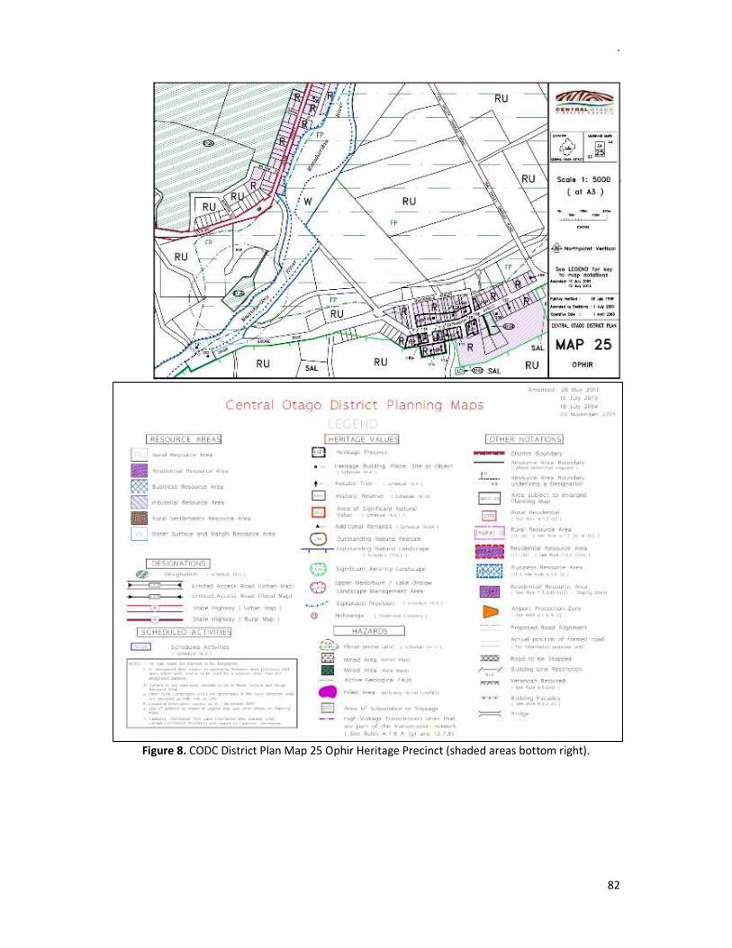
.
82
Figure 8. CODC District Plan Map 25 Ophir Heritage Precinct (shaded areas bottom right).

.
83
APPENDIX 4 Table 3. Recorded archaeological sites in the area:
NZAA New Site Record Recorded sites within 4km radius Old Site Record
North G41/646 Water race G41/639 Metal tank G41/656 Blacks Cemetery G41/52 Moa bone natural S134/7
North-east H41/233 Poolburn Viaduct Contractors Camp H41/234 Poolburn Gorge PWD Camp
South-west G42/392 Chatto Creek School G42/323 Chatto Creek Bridge G42/324 Chatto Creek Hotel
South -west G42/4 Silcrete quarry S144/2 G42/5 Quarry/work floor S144/3 G42/23 Quarry/work floor S134/6 G42/237 Quarry G42/238 Flake scatter G42/239 Gold mine and water race G42/22 Findspot S134/4 G42/247 Station building
South-east H42/4 Midden and flakes S134/5 G42/28 Gold workings S134/23 G42/380 Moa Creek Cemetery H42/105 Farmstead H42/148 Stone chimney H42/58 Moa bone deposit H42/3 Middens and ovens
East H41/12 Hotel site S134/20 H42/89 Miner’s hut H42/90 Gold mining H42/91 Gold mining H42/92 Gold mining H42/93 Miner’s hut H42/94 Miner’s hut H42/95 Gold mining H42/96 Stone building

.
84
H42/97 Stone hut H42/98 Dam H42/99 Mining dam H42/100 Mining dam
APPENDIX 5 Sir James Hector’s (1890) Geological Report on Green’s Reef:
Provincial Government Gazette 3rd September: 17-19

.
85
APPENDIX 6 Green’s Reef and Seam Workings Company (The Handbook of New Zealand Mines - Galvin 1906: 180 – 181):

.
86
APPENDIX 7 Modern Mineral Exploration
Reports on modern mineral exploration carried out within the bounds of Ophir Historic Area (Open File Exploration reports held by Crown Minerals):
MR1918. 1972. Earth Scientists Pty Ltd. Exploration of the Ophir district, Phase 2, Otago. JBL Exploration NZ Ltd. Rock chip and stream sampling
MR2008. 1988. Kerber, S. Exploration license 33321 Ophir, Otago New Zealand – Final report November, 1988. BHP Minerals NZ Ltd. Rock chip and stream sampling
1989. Mintago Investments Ltd. Rock chip and soil sampling 1991 – 1992. Kilgour and Pearson. Further trenching and air-core holes drilled on Green’s
Reef 1993. Welcome Gold Mines Ltd. Soil, rock and channel sampling and geological mapping MR3993. 1999 – 2004. Exploration Permit 40 427 “Ophir” Report on Work Carried out
11/03/99 to 10/03/04. Centago Mining Ltd. Bulk sampling MR3589. 1998. Kilgour, R. Final report on the findings of 40159 Ophir MR4090. 2004. Kenex Knowledge Systems Ltd. Prospecting and Exploration Report Permits
40 427 and 40 682 Ophir. Report for HPD New Zealand Ltd. GIS data compilation MR4505. 2009. Technical Report on Ophir. Glass Earth (New Zealand Limited). Rock chip and
soil sampling, geophysical magnetic surveying MR5581. 2009. Soengkono, S. Ground Magnetic, Gradient Array Resistivity and Conductivity
Depth Imaging (CDI) of Airborne EM at Ophir Hard-rock Project. Glass Earth (New Zealand) Limited
MR4791. 2011. Bartle, A. Technical Report for EP 40427 – Ophir. Glass Earth (New Zealand) Limited. Bulk sampling
2012. Applied Petrologic Services & Research. Glass Earth (New Zealand Limited). Petrological studies of drill chips.
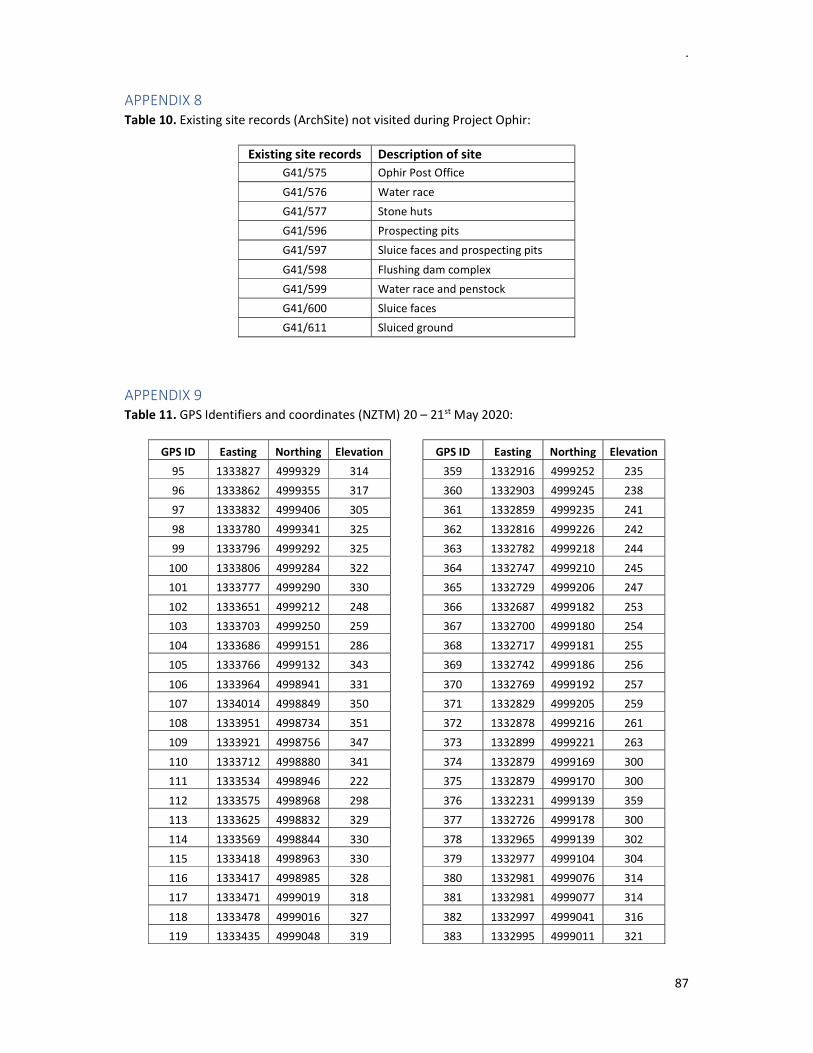
.
87
APPENDIX 8 Table 10. Existing site records (ArchSite) not visited during Project Ophir:
Existing site records Description of site
G41/575 Ophir Post Office
G41/576 Water race
G41/577 Stone huts
G41/596 Prospecting pits
G41/597 Sluice faces and prospecting pits
G41/598 Flushing dam complex
G41/599 Water race and penstock
G41/600 Sluice faces
G41/611 Sluiced ground
APPENDIX 9 Table 11. GPS Identifiers and coordinates (NZTM) 20 – 21st May 2020:
GPS ID Easting Northing Elevation GPS ID Easting Northing Elevation
95 1333827 4999329 314 359 1332916 4999252 235
96 1333862 4999355 317 360 1332903 4999245 238
97 1333832 4999406 305 361 1332859 4999235 241
98 1333780 4999341 325 362 1332816 4999226 242
99 1333796 4999292 325 363 1332782 4999218 244
100 1333806 4999284 322 364 1332747 4999210 245
101 1333777 4999290 330 365 1332729 4999206 247
102 1333651 4999212 248 366 1332687 4999182 253
103 1333703 4999250 259 367 1332700 4999180 254
104 1333686 4999151 286 368 1332717 4999181 255
105 1333766 4999132 343 369 1332742 4999186 256
106 1333964 4998941 331 370 1332769 4999192 257
107 1334014 4998849 350 371 1332829 4999205 259
108 1333951 4998734 351 372 1332878 4999216 261
109 1333921 4998756 347 373 1332899 4999221 263
110 1333712 4998880 341 374 1332879 4999169 300
111 1333534 4998946 222 375 1332879 4999170 300
112 1333575 4998968 298 376 1332231 4999139 359
113 1333625 4998832 329 377 1332726 4999178 300
114 1333569 4998844 330 378 1332965 4999139 302
115 1333418 4998963 330 379 1332977 4999104 304
116 1333417 4998985 328 380 1332981 4999076 314
117 1333471 4999019 318 381 1332981 4999077 314
118 1333478 4999016 327 382 1332997 4999041 316
119 1333435 4999048 319 383 1332995 4999011 321

.
88
120 1333096 4998810 345 384 1333002 4998969 322
121 1333106 4998839 336 385 1333015 4998916 323
122 1333201 4998652 334 386 1332935 4998959 331
123 1333284 4998545 338 387 1332976 4998954 328
124 1333311 4998563 341 388 1333095 4998980 330
125 1333346 4998566 341 389 1333086 4998950 329
Table 12. GPS Identifiers and coordinates 26th June 2020:
GPS ID Easting Northing Elevation GPS ID Easting Northing Elevation 407 1331779 4999066 298 421 1333601 4998851 328 408 1331810 4999064 306 422 1333562 4998843 332 409 1333201 4998648 331 423 1333565 4998851 330 410 1333100 4998809 336 424 1333536 4998944 330 411 1333132 4998882 330 425 1333507 4998947 336 412 1333141 4998893 336 426 1333484 4998948 333 413 1333297 4999000 338 427 1333424 4998954 336 414 1333290 4998989 340 428 1333412 4998961 332 415 1333074 4999345 320 429 1333523 4999300 311 416 1333442 4999241 288 430 1333449 4999157
417 1333549 4998991 317 431 1333204 4998982 418 1333569 4998970 318 432 1333112 4999303 419 1333555 4998957 320 033 1299044 5012709 310 420 1333625 4998834 325

89
APPENDIX 10 William Green’s 1887 application for licensed holdings ‘Green’s Reef Company’ 20 acres Section 33 Blk II, Specimen Hill, Blacks (Archives)

90
APPENDIX 11 The New Zealand Mines Department (1887: 73 – 77) provides further history of Green’s Reef (G41/695):
Regarding the extraction of the gold from the mullock, the softness and friability of the latter permit its quick conversion into thin mud by the action of water: and therefore the use of a puddling-machine with a plentiful supply of clear water and the crushing of the quartz portion remaining in the machine by means of a Chilian mill would in my opinion be the most advisable process to adopt.
Several chains westward, on the western side of another gully, Mr. Green obtained, from greenish rotten rock, fair prospects of fine gold, of a similar character as occurring in the soft rock of his workings. Prospecting further westward would, however, be rather difficult, as the line of strike of the fault runs across a drift-terrace into the flat, and extends through the Township of Ophir.
Only one of these trial-places called McLeod's workings deserves I think some further exploration as the run of rotten rock seems to strike nearly in the same direction as that of Green's and prospects of fine gold are said to be obtainable from it by tin-dish trials. Mr. H. A. Gordon, F.G.S., Inspecting Engineer, adds: " With regard to the method of working this deposit, I quite agree with Professor Ulrich that a puddling-machine would be the best method of first dealing with the material, and afterwards crushing the residue in either a Chilian mill or Wheeler's pans. The schist being extremely friable would be carried off by the action of puddling leaving only the small quartz-grit to be finally dealt with." When Mr. Gordon visited the claim in the early part of the year Mr. Green was taking the stuff out of a face and washing it in a cradle similar to those used in the early days: but even with such a primitive appliance he was getting an ounce of gold per day. Yet for many years this rich schist deposit was passed over by prospectors no one expecting to find gold in it. Even Mr. Green's discovery has to be attributed more to chance than to anything in the nature of scientific observation. The bearing of the lode is similar to the generality of quartz reefs in Otago being nearly east and west having an underlie to the north.

.
91
APPENDIX 12 Table 15. GPS identifiers of water races with approximate coordinates (NZTM) and elevation above sea level (in metres):
GPS ID
Easting NZTM
Northing NZTM
Elevation metres Location
95 1333827 4999329 314 Lauderburn water race 96 1333862 4999355 317 Lauderburn water race
101 1333777 4999290 330 Lauderburn water race
102 1333651 4999212 248 Aqueduct Lauderburn water race 103 1333703 4999250 259 Aqueduct Lauderburn water race
98 1333780 4999341 325 Water race west of Blue Nose Gully
100 1333806 4999284 322 Lauderburn water race aqueduct? west of Blue Nose Gully
107 1334014 4998849 350 Dam wall Upper Specimens Gully
111 1333534 4998946 222 Pitches Dam bottom of lower wall in gorge 424 1333536 4998944 330 Pitches Dam top of lower wall in gorge
112 1333575 4998968 298 Pitches Dam water race and plinth true right bank 418 1333569 4998970 318 Water race at Pitches Dam true right bank 417 1333549 4998991 317 Water race at Pitches Dam true right bank 419 1333555 4998957 320 Pitches Dam upper plinth true left bank
115 1333418 4998963 330 Golden Gate water race 411 1333132 4998882 330 Golden Gate water race 426 1333484 4998948 333 Golden Gate water race 428 1333412 4998961 332 Golden Gate water race
412 1333141 4998893 336 Suspension water race 425 1333507 4998947 336 Suspension water race 427 1333424 4998954 336 Suspension water race
117 1333471 4999019 318 Water race lower McLeod's Gully 118 1333478 4999016 327 Water race lower McLeod's Gully 119 1333435 4999048 319 Dam lower McLeod's Gully
123 1333284 4998545 338 Dam upper Waldron's Gully 124 1333311 4998563 341 Dam upper Waldron's Gully
378 1332965 4999139 302 Water race lower Waldron's Gully
Note: Elevation by hand held GPS is approximate height above sea level and may not be accurate.
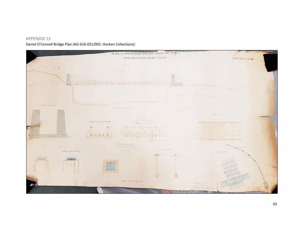
92
APPENDIX 13 Daniel O’Connell Bridge Plan (AG-616-021/001: Hocken Collections):

.
93
Cropped plan of Daniel O’Connell Bridge showing detail:

.
94
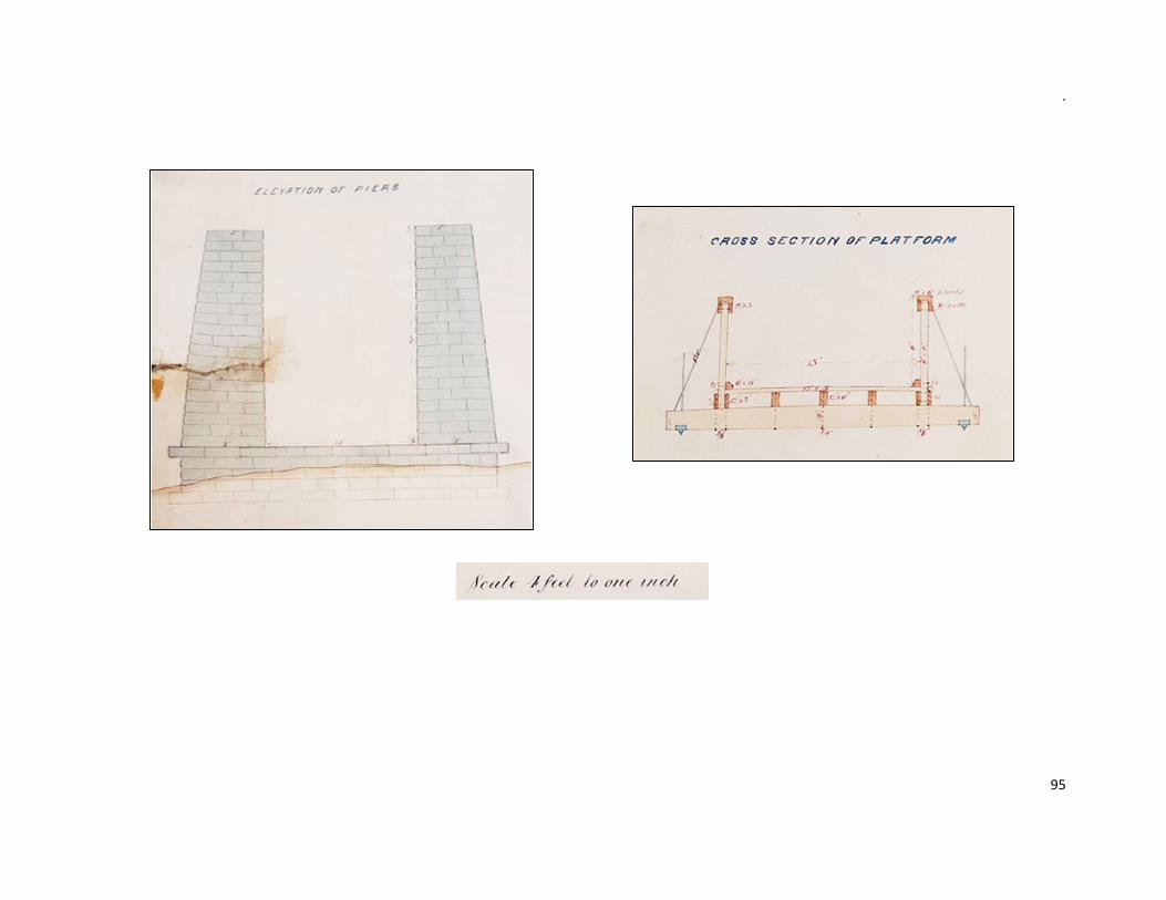
.
95
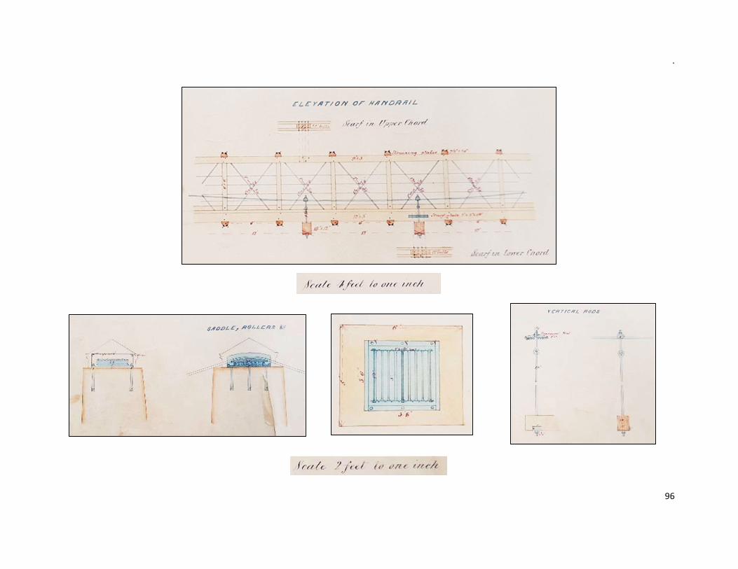
.
96