protection of author ' scopyright - OUR Archive (Otago University
377
THE UNIVERSITY LIBRARY August 2010 PROTECTION OF AUTHOR ’S COPYRIGHT This copy has been supplied by the Library of the University of Otago on the understanding that the following conditions will be observed: 1. To comply with s56 of the Copyright Act 1994 [NZ], this thesis copy must only be used for the purposes of research or private study. 2. The author's permission must be obtained before any material in the thesis is reproduced, unless such reproduction falls within the fair dealing guidelines of the Copyright Act 1994. Due acknowledgement must be made to the author in any citation. 3. No further copies may be made without the permission of the Librarian of the University of Otago.
-
Upload
khangminh22 -
Category
Documents
-
view
2 -
download
0
Transcript of protection of author ' scopyright - OUR Archive (Otago University
THE UNIVERSITY LIBRARY
August 2010
P R O T E C T I O N O F A U T H O R ’ S C O P Y R I G H T
This copy has been supplied by the Library of the University of Otago on the understanding that
the following conditions will be observed:
1. To comply with s56 of the Copyright Act 1994 [NZ], this thesis copy must only be used for
the purposes of research or private study.
2. The author's permission must be obtained before any material in the thesis is reproduced,
unless such reproduction falls within the fair dealing guidelines of the Copyright Act 1994.
Due acknowledgement must be made to the author in any citation.
3. No further copies may be made without the permission of the Librarian of the University of
Otago.

THE EXPLOITATION OF MAYOR
ISLAND OBSIDIAN IN
PREHISTORIC NEW ZEALAND
ANDREA C. SEELENFREUND-HIRSCH
A Thesis submitted for the degree of Doctor of Philosophy
at the University of Otago, Dunedin, New Zealand
1985
page i
ABSTRACT
Obsidian in New Zealand was eirploi ted from a
variety of sources, and has been found in the majority
of New Zealand archaeological sites. The presence of
obsidian from the Mayor Island sources in most sites
has been noted by archaeologists, and it has been
assumed that a complex exchange system was responsible
for its distribution. The purpose of the present
thesis has been to evaluate the importance of Mayor
Island as the· main supply source of obsidian in
prehistoric New Zealand, and to study the pattern of
exploitation and distribution of the obsidian.
The analysis employed two separate approaches:
site-oriented and regional. On a site-oriented basis,
the quarries on Mayor Island were examined,
particularly the production and procurement strategies.
Ethnographic and comparable archaeological data on
quarry exploitation were reviewed in order to test for
evidence of access restrictions to the resources.
For the regional analysis, archaeological
obsidian assemblages from 58 sites were sourced using
energy dispersive XRF spectroscopy. Scurci ng results
indicate a changing pattern of source utilization
throughout the temporal depth of New Zealand
prehistory. The pattern of source utilization also
varied according to site function.
page ii
The regional analysis of Mayor Island obsidian
investigated further the importance of the Mayor Island
obsidian in in the total_ 1 i thi c assemblages of the
sites studied, and the nature of· the manufacturing
techniques in relation to geographical distance from
the source, by means of fall-off curves.
Using this combined methodological approach it
was possible to conclude that the exploitation of Mayor
Island obsidian varied between the North and South
Islands of New Zealand. While direct access seems to
be the most probable way of acquiring the raw materials
in the North Island, down-the-line exchange seems to be
indicated for the South Island.

page iii
ACKNOWLEDGMENTS
During the course qf this study I have received
support, advice, encouragment and help from numerous
people and institutions both in New Zealand and in
Chile.
I should firstly like to thank in Chile: the
Direccion de Bibliotecas, Archivos y Museos and
especially Sergio Rapu, Director of the Easter Island
Museum for obtaining a scholarship to finance my
studies in New Zealand.
I am extremely grateful to UNESCO (UNDP)
through their offices in Santiago, Paris and
Wellington, for providing such a generous allowance
throughout my stay in New Zealand.
This study was supervised by Dr Foss Leach,
whose continuous encouragement, enthusiasm and support
for this project has proven invaluable.
A number of people and institutions have
provided assistance of various kinds. Financial
assistance for all stages of this research was received
from the University Grants Committee, the Otago
Research Committee and UNESCO, while financial support
for the fieldwork was obtained from the New Zealand
Historic Places Trust. This is gratefully
acknowledged.
page iv
The obsidian assemblages for the present study
were kindlv made available by the following people and
institutions: Nigel Prickett, Auckland Institute and
Museum; Steve Edson, Waikato .Art Museum; Betty
McFadgen, National Museum; Roger Fyfe, Taranaki Museum;
Michael Trotter, Canterbury Museum; Wendy Harsant,
Otago Museum; Lyn Williams, Southland Museum; Atholl
Anderson, Tony Batley, Robert Brassey, Aileen Fox,
Bruce McFadgen, Jim McKinlay and Don Millar.
I would particularly like to thank the Mayor
Island Trust Board for allowing access to Mayor Island.
To Bill and Hinemanu Ohia, of Tauranga, I express my
sincere thanks for providing much generous hospitality
and contacts that made the fieldwork possible. I am
indebted to Chuck Bollong, Simon Holdaway and Michiko
Intoh for their assistance in the field.
For her help during long and tedious hours of
laboratory work sorting through the daunting pile of
obsidian, I wish to thank Elssy Clavijo.
XRF analysis on the obsidian assemblages was
carried out at the Otago University Archaeometry
Laboratory. Foss Leach is responsible for initiating
the program of obsidian sourcing. Chuck Bol long set
the system up so that I could use it, and familiarized
me with the sample preparation and idiosyncrasies of
the beast. I am e}(tremel y grateful to Barry
Fankhauser, fellow graduate student, for all the
technical assistance I received from him throughout the
page v
stages of the sourcing work. Peter Jacquiery of the
Otago University North Campus Electronics Workshop
helped with electronics arid computing aspects of the
obsidian study. Bob Mewhi nney and Bi 11 Hastie of the
Otago University Central Mechanical Workshop bui 1 t an
additional sample-holder sled. Paul Armfeldt was
responsible for the system maintenance.
I am indebted to Bryan Manly, Department of
Biometrics, for much helpful advice and suggestions
regarding statistical aspects of this thesis. I would
also like to thank Atholl Anderson, Janet Davidson,
Helen Leach and Graeme Mason, staff members of the
Anthropology Department, and Brian Heenan, Geography
Department, for discussions on several points of this
thesis.
Martin Fisher and Richard Newall prepared the
maps and illustrations. For essential assistance with
English grammar, spelling and proofreading, I wish to
sincerely thank Sheridan Easdale, Chris Jacornb, Paul
Armfeldt, Moira White and Debbie Foster. I would also
1 ike to thank my f e 11 ow students in the Anthropo 1 ogy
Department, particularly Brian Kooyman, for support,
ideas and good companionship throughout these last four
years.
Finally, I wish to express my gratitude to my
parents, who unconditionally supported my University
~ducation, encouraged me, and never failed to be there
when needed.
page vi
TABLE OF CONTENTS
Abstract .•.....•....•...•. ~ •..•.....•...•.... , . • i Ack now 1 edgments. . • • • • • • . . . • • • • . . . • . . . . . . . • . . . • . • iii Table of Contents ...•.....•••....... ~ ..•.••..••. vi List of Tables.................................. ix List of Figures . . . . . . . . . . . . . . . . . . . . . . . . . . ! • • • • • • x i
Chapter I
Introduction • . . . • . . . . . . . . . . . . . . . . . . . . . . . . . . . . . . . . . 1 Organization of the Thesis ....••............ 14
Chapter II
The transfer of goods in prehistoric and protohistoric New Zealand: Ethnographical and irchaeological Evidence ........................... 17
Introductiori .................................. 17 Ethnographic evidence for trade and exchange • • . • . • . . . . . . . . . • . . . . . . . . . . . . . . . . . . . . . . 2 2 Archaeological evidence of movement of goods . . . . • . . . • . . . • . . . . • • • • . . . . . . . . . . . . . . . . . . • . 29 Summary and conclusions ....................... 40
Chapter III
The study of prehistoric exchange: Methodological and theoretical problems ........... 42
Introduction .................................... 42 The archaeological identification of exchange s:/stems ................................. 44 The study of the mechanisms of exchange ........ 48
Direct access .......................... lll. 49 Bilateral reciprocal trade ......•........ 50 Long distance trade ......•............... 51 Down-the-line exchange ......•........•..• 52
Analytical Perspectives in the study of trade ......................................... 53
Regional analysis ........................ 55 Distance fall-off studies ..•........•. 55 The gravity model ...•..•....... ~ ...... 66 Other models: Technological model and trade routes ................ 69 Implications of the regional studies for New Zealand prehistoric exchange .. 72
Single site analysis ..................... 74 Quantitative studies .................. 75 Spatial variability •.......•.......... 84 Formal analysis .......•..........•.... 88 Implications of single-site analyses to the New Zealand study of prehistoric exchange . . . . . . . . . . . . . . . . . . . . . . . . . . . . . . 8 9
page vii
Summary and Conclusion ...............•.•...•.• 91
Chapter IV
Quarry exploitation: theoretical issues and the obsidian exploitation on Mayor Island •............ 94
Introduction ....................... · ............... 94 Control over access and production at lithic quarries: theoretical discussion .•............ 96
Ethnographic examples of quarry exploitation ...............•............ 102
New Guinea Axe quarries . .. .. . . .. . • . . . 10 6 Obsidian quarrying and usage by Ethiopian hide workers .••......... 109 New Zealand Greenstone exploitatiort ......................... 110
Archaeological case studies ...........•...... 115 Prehistoric rhyolite quarrying at Mt Jasper, New Hampshire .......... 115 Mauna Kea adze quarry, Hawaii ......•. 119 The ·Maunga Orito obsidian quarry on Easter Island .......•...•......... 122 Prehistoric quarry exploitation in New Zealand ....................... 125
Oturehua silcrete quarry .......... 126 Argillite adze quarries •........•. 128
Tuhua or Mayor Island .............•.....•.... 133 Mayor Island physiography and geology ... Volcanic history .•.......•.....•..•..... 138 Traditional history of Mayor Island ..... 141 The Historic Period ....•................ 145 The Mayor Island obsidian deposits ...... 146 Archaeological fieldwork on Mayor Island .................................. 152
Description and discussion of sites .. 155 Pits ............................. 157 Pits and terraces ................ 158 Terraces and platforms •........•. 159 Middens .......................... 159 Pa ..............•.•.............. 160 Ditches ...•..........•........... 161 Gardening sites .•................ 161 Quarries . . . . . . . . . . . . . . . . • . . . . . • . . 1 6 2 Working floors ....•...•....•...•. 167
Discussion and conclusion .................... 169
Chapter V
The sourcing of New Zealand obsidian: the archaeological sample ..•....•..............•...•. 173
Intr·oduction ................................. 173 Materials and Methods .............•.......... 177
Sampling strategy .......•.....•..•...... 177 Chronological framework ..........•...... 181 The sourcing procedure .................. 188
pageviii
Instrumentation and procedure of energy dispersive XRF spectroscopy 188
The source utilization pattern ............... 194 Temporal variability .................... 203 Source utilization and site function •... 206
Summary and conclusion .......•.•............. 213
Chapter VI
A regional analysis of New Zealand obsidi~n Introduction ................................ . Mathematical Modelling of regional
217 217
e:{change ........................... ·· . . . . . . . . . 218 Measure of distance ....•..•............. 228 Measure of abundance •................... 232 Technological measure ................... 237
The percentage of obsidian in the total flaked lithic assemblage .......•............. 244 The utilization of Mayor Island obsidian ..... 250 Final remarks ................................. 270
Chapter VII Discussion and conclusions •..........••....... ~ .. 273
References . • • . . . . . . • . . . . • . . . . . . • . . . • . . . . . . . . . . . 2 8 3
Appendix 1 Description of archaeological sites mentioned in the text . . . . . . . . . . . . . . . . . . . . . . . . . . . . . . . . . . . . . . 31 9
Appendix 2 Description of sites recorded on Mayor Island .... 360
page ix
LIST OF TABLES
Table 3.1. Measures of abundance which have been used in the study of obsidian exchar1ge . . • . . . . . . . . . . . • . . . . . . . . . . . . . . . . 8 2
Table 4.1. Description of sampled obsidian ~ deposits on Mayor Island .............. 151
Table 4.2. Site types recorded on Mayor Island •.. 157
Table 5.1. Sourcing results from Group 3, 350 B.P. to present (expressed in numbers of pieces) ......................... 11 •••••• 196
Table 5.2 Sourcing results from Group 2, 630 B.P. to 350 B.P. (expressed in numbers of pieces) ............................... 197
Table 5.3. Sourcing results from Group 1, 630 B.P. and older (expressed in numbers of pieces) ................................ 198
Table 5.4. Classification of sites by site function .............................. 207
Table 5.5. Total weight (g) of obsidian from analyzed sites ....... 41 •••••••••••••••• 210
Table 6.1. Test models employed for predicting different modes of exchange ........... 227
Table 6.2. Number of obsidian flakes and other lithic flakes in analyzed sites (information from published sources), with percentage of obsidian flakes in flaked stone assemblage with distance to the nearest source . . . • . . . . . . . . . . . . . 2 3 5
Table 6.3. Associated F-values for abundance (percentage counts) of obsidian with distance .............................. 248
Table 6.4. Pearson-r value for regression analysis of distance with abundance (percentage
cour1ts) ·············"'················· 249
Table 6.5. Percentage of different artefact types, Mayor Island obsidian, 350 B.P. to present ............................... 259
Table 6.6. Percentage of different a~tefact types, Mayor Island obsidian, 630 B.P. to
page x
350 B.P. . ............................ . 260
Table 6.7. Percentage of different artefact types, Mayor Island obsidian, 630 B.P. and older ....................••........... 261
Table 6 . 8 . Mean weight of Mayor Island obsidian, 350 B.P. to present . ..................... 262
Table 6. 9. Mean weight of Mayor Island obsidian, 630 B.P. to 350 B.P • ••••••• ti .... ti ...... 263
Table 6.10.Mean weight of Mayor Isla'nd obsidian, 630 B.P. and older .....•.............. 264
Table 6.11.F-values for mean weight of artefact type with distance from the source .... 265

page xi
LIST OF FIGURES
Figure 1.1. Obsidian sources and source regions in l-lew Zealar1d .......................... 4
Figure 4.1. Physical map of Mayor Island~ .....•.. 140
Figure 4.2. Archaeological sites recorded on Mayor· Island ........................ 156
Figure 4,3, Approximate cross-section through "Staircase" obsidian quarry ......... 163
Figure 4,4.a The mined shaft at the Staircase obsidian quarry ..................... 165
Figure 4.4.b Lower obsidian flows exposed at Te Rangiora Bay •...•..•••••.••.•...••.. 165
Figure 4.5.a Upper obsidian flow at Taumou Pa ..... 166
Figure 4.5.b Obsidian flow at Taumou Pa with some quarrying scars 166
Figure 4.6. The mined shaft at Te Rangiora Bay quarry . . . . . . . . . . . . . . . . . . . . . . . . .. . . . . . 16 7
Figure 5.1. Map of New Zealand showing location of archaeological sites .•.•...•......... 174
Figure 5.2. Radiocarbon dates (in years B.P.) for North Island sites mentioned in the text ................................ 184
Figure 5.3. Radiocarbon dates (in years B.P.) for South Island sites mentioned in the text . . . . . . . . . . . . . . . . . . . . . . . . . . . . 18 5
Figure 5.4. Sourcing results in percentages for all sites analyzed, Group 3, 350 B.P. to present . . . . . . . . . . . . . . . . . . . .. . . . . . . . . . . 200
Figure 5.5. Sourcing results in percentages for all sites analyzed, Group 2, 630 B.P. to 350 B.P . ............................. 201
Figure 5,6, Sourcing results in percentages for all sites analyzed, Group 1, 630 B.P. and older ..... · .............. 111 .......... 202
Figure 6.1. Predicted fall-off curves for different
page xii
types of exchange (after Renfrew 1972) ................................ 221
Figure 6.2. The obsidian reduction sequence ...... 241
Figure 6.3. Fall-off curves for relative abundance of obsidian in the total flaked lithic assemblage ..............•.•.......... 245
Figure 6.4. Percentage (weight) of Mayor island obsidian in the total obsidian assemblage •..••.......•.....•.•....•• 252
Figure 6.5. Percentage (counts) of artefact types. 253
Figure 6.6. Fall-off for mean weight of artefact type with distance from the source Gr cup 1 . . . . . . . . . . . . . . . . . . . . . . . . . . . . . . 2 5 6
Figure 6.7. Fall-off for mean weight of artefact typ~ with distance from the source Group 2 .............................. 257
Figure 6.8. Fall-off for mean weight of artefact type with distance from the source Group 3 ............................... 258
Figure 6.9. Fall-off curve of total weight of obsidian (cores) with distance ..••.•. 267

page1
CHAPTER I
INTRODUCTION
In the past decade archaeological studies of
trade or exchange all over the world have significantly
increased. A growing number of publications treat
topics such as· exchange mechanisms and their role in
socio-political systems, or deal with detailed studies
of particular items exchanged in the past. This
growing interest is partly due to the increasing
importance and development of models of cultural
processes, but most importantly to the development of a
wide range of scientific techniques capable of
identifying sources of raw material. Only 16 years
ago, Ren£ rew (196 9a: 151) commented on the fact that
archaeology had almost completely neglected the role of
trade as an element of economic growth and cultural
change, or discussed prehistoric trade mechanisms or
attempted to set up the facts on a quantitative basis.
Since the new analytical techniques have become
available on a routine basis to the archaeologist, an
increasing number of studies have applied them to the
study of the distribution of traded i terns and
hypothesized on the probable exchange mechanisms.

page2
Obsidian, of all traded materials, is the item
that probably has received the greatest attention in
the last decade, in terms of the number and variety of
techniques applied to it, and the number of studies of
it as an important exchange i tern. Obsidian has been
the object of numerous characterization studies, and
most theoretical discussions of the
archaeological distriabutions and
relationship of
the surrounding
cultural processes in operation, have been based on the
results of obsidian exchange studies.
New Zealand archaeologists have not remained
aloof from these developments. The identification of
the sources of lithic materials found at archaeological
sites have been the focus of interest of numerous
studies in New Zealand archaeology in the past years,
and are becoming increasingly popular (Anderson n.d.;
Brassey 1985; Coster 1983; Fox 1982; McFadgen and
Sheppard 1984; Prickett 1975; Ritchie 1984; Sutton and
Campbell 1981). The increase in the number of sourcing
studies is probably directly related to the large
number of attempts by New Zealand archaeologists to
implement routine sourcing techniques, especial 1 y for
the sourcing of obsidian artefacts. No less than 12
different methods for sourcing obsidian in New Zealand
have been employed. ( For a complete summary of the
analytical techniques employed refer to Bollong
1983:35-50). Sourcing studies based on the physical
properties of obsidian have been carried out by Green
page3
(1962), and Reeves and Armitage (1973). On the basis
of element analysis the range of studies include
emission spectroscopy (Green et al. 1967), wavelength
dispersive XRF (Ward 1972, 1974a, 1974b, 1974c; Leach
1973, 1976; Leach and Anderson 1978; Chigdey 1981), and
neutron activation analysis (Leach and Warren 1981;
Chigdey 1981).
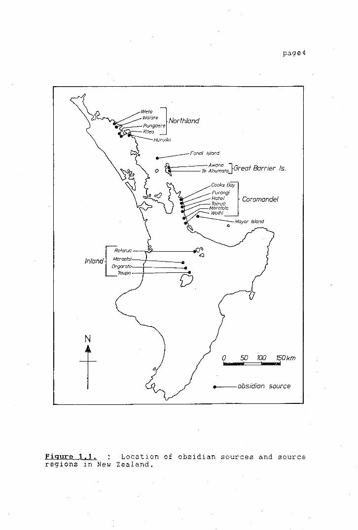
Obsidian in New Zealand was exploited from a
variety of sources and is nearly ubiquitous in New
Zealand archaeological sites. The prehistoric
Polynesian population had access to a particularly
abundant supply of obsidian sources, compared to other
prehistoric Oceanic people. Ward (1972:123-127)
identified 42 separate locations where obsidian occurs
naturally. On the basis of chemical similarity they
can be grouped into 1q major source regions. These 18
source areas are all located within a limited region of
the North Island of New Zealand (Figure 1.1).
page4
:::re ]Northland ,.--,,__ Pungaere
Kaeo .
-----Fanal Island
a. Awana JG f Ba . 0 ~----Te Ahumafa rea rrter Is.
Cooksoay Purangi Hahei Coromandel Tairua
Marafolo Waihi --------== Mayor Island
~ 0
Inland a:::::===~~:=======~-..... ~~ ngarofo,--+------e
Taupo D
N
0 50 100 150 km
---obsidian source
Figure 1.1. Location of obsidian sources and source regions in New Zealand.
page5
Obsidian was used mainly as a cutting tool.
Some of the ear 1 i est visitors to come to New Zea land
noticed that the Maori used a type of sharp stone as a
carving and cutting tool, Joseph Banks in 1772 (1962
Vol.2:25) on Captain Cook's first visit to New Zealand
remarked that,
their nicer work which requires nicer edge tools they do with fragments of Jasper, which they break and use the edges of it that are sharp like flints till they are blunt, after which they are thrown away as useless, for it is impossible ever again to sharpen them ...
A similar observation was made by Captain Cook on the
same voyage,
In working small work and carving I believe they use mostly peices of Jasper breaking small peices from a large lump they have for that purpose. As soon as the small peice is blunted they throw it a way and take another(1955:284).
It is quite probable that both Cook and Banks
saw obsidian tools being used for cutting and carving
of wood. Although no further descriptions of obsidian
usage were made during that or the following two
voyages, Johann George Forster noted during Cook's
second voyage the eagerness of the Queen Charlotte
Sound Maori to trade for bottles and bottle glass.
Glass bottles, which they called tawhaw, were however particularly valuable to them; and whenever they saw any of them, they always pointed to them, and then moved the hand to their breast, pronouncing the word mo.kb .• • (1777:205).
Later again he observed,
The chief object of their commerce were shirts and bottles, of which last they were remarkably fond ... (1777:220).
page6
This statement is also corroborated by Johann Reinhold
Forster's diary ·(1980:290-91) and by Captain Furneaux's
narrative (1961:738). The name bestowed on bottles and
bottle glass of tar..•/Jat,/, probably refers to tu/Jua the
Maori name for obsidian.
Very few further instances of the use of
obsidian are found in the early New Zealand literature.
Obsidian was often used for cutting hair and during
mourning, The earliest reference to this is probably
given in Anderson's Journal kept on the third of Cook's
voyages in 1777,
... [they] bewail them [the dead] with the most dolefull crys, at the same time cutting their foreheads and cheeks with a shel 1 or piece of flint in large gashes until the blood flows plentifully,,, (1967:815),
Other references of obsidian being used for such
purposes are almost 100 years later. The Reverend Mr
Taylor (1855:102) noted that as a sign of grief people
page7
cut their foreheads and faces with pieces of obsidian.
Obsidian was also used for the cutting of hair (ibid.).
J. White (1874:337-38) ob~erved at Hokianga the use of
obsidan flakes during a hair ~utting ceremony. Finally
Manning (1875:103) observed that obsidian flakes were
also used
for cutting of flax, flesh, hair and surgical operations, The edge soon came off, when another chip would be split off the large lump of obsidian, which every family that could afford it would have lying by the house, or concealed somewhere near at hand. These blocks were usually brought from the Island of Tuhua by the Ngapuhi, when returning from southern expeditions, and were articles which fetched a considerable price in the way of barter.
He further recalls that,
When I first came to the colony, in many inland villages the obsidian knife was still much used; it was merely a sharp chip, but when split off artistically extremely sharp (ibid.).
From the very first reports, ethnographic
accounts of New Zealand mentioned a long standing
network of communication. A large range of goods such
as .kum~t:J.ra, birds, preserved fish, berries and fern
roots were exchanged, as well as manufactured goods and
a variety of stone resources, including obsidian.
page8
The importance of obsidian to the prehistoric
population has long been recognized by archaeologists,
especially the obsidian frqm Mayor Island flows. Green
(1964) recognized that it could be easily distinguished
from all other New Zealand sources by its translucent
green colour under transmitted light.
inspection of obsidian flakes recovered
Initial
from
archaeological sites using the above technique showed
an apparent predominance of Mayor Island obsidian in
the early New Zealand sites. Green (ibid.) advanced
the thesis that the Mayor Island obsidian flows were
the first to be discovered by the Polynesian settlers;
the other sources were discovered later and started to
replace Mayor Island obsidian in archaeological sites.
Green (ibid. :137) also noted that the presence of
"obsidian in sites indicate an imbricated system of
regional and inter-regional trading networks which are
seemingly possible of definition given a sufficient
amount of quantitative information".
Although the spatial distribution of obsidian,
and in particular Mayor Island obsidian, has been noted
for some time, the cultural mechanisms responsible for
its spread have never been studied in New Zealand.
Proposals concerning the possible methods of exchange
have been put forward, but, so far, no attempt has been
made to document properly and test the validity of
theories using a systematic analysis of the existing ..
archaeological data. The changing proportions of
page9
obsidian through time have been noted, first by Green
(ibid.) and later by Leach (1978), but again no attempt
has been made to test the ~ata sets with the available
theoretical information on prehistoric exchange
mechanisms. Most studies in New Zealand have focused
on the documentation of the movement of particular
goods, especially of lithic resources, during the
prehistoric period. ( Leach 1978, Leach and Anderson
1978, Best 1972, Prickett 1975). However, the
fdentif ication of such movements does not provide the
information on· the actual exchange mechanisms. As
Leach and de Souza have commented,
Attempts to disclose prehistoric trade and communication patterns have been carried out with high expectations of results. After about a decade of active research in developing sourcing techniques in New Zealand it is a moot point just how much has been revealed about prehistoric social and economic relationships (ibid.:44).
At this point one may ask why no such study has
yet been attempted in New Zealand, as studies of lithic
source utilization have been carried out for a number
of years. The source allocation of a large number of
artefact assemblages from a wide range of dated sites
is one of the pre-requisites for attempting any study
of prehistoric trade or exchange.

page10
The lack of the regular use of source
characterization in New Zealand archaeological studies
has been mainly due to the complexity of some of the
techniques or the costs involved in using them on a
routine basis. The recent development and setting up
of an obsidian sourcing laboratory at Otago University,
capable of processing a large number of samples in a
non-destructive manner, has made it possible to source
a larger number of obsidian assemblages than previously
possible. The sourcing facility allows for the
distinction between several New Zealand sources as well
as between some Central and Eastern Pacific volcanic
glasses. Discrimination within the New Zealand sources
using the Otago University XRF facility, is clear
between the Mayor Island sources and those of Inland,
Coromandel and Great Barrier, although separation
within these last three is not so succesful (Bollong
1983:156-157). Separation between the Mayor Island and
Northland sources is clear, on the basis of relative
element concentrations. However, certain problems due
to source sampling were encountered (see Brassey 1985,
Brassey and Seelenfreund 1984). The system is
therefore best suited to discriminate accurately the
presence of Mayor Island obsidian from all other New
Zealand sources.
-r
page11
The sourcing facilities set up at the Otago
University .Archaeometry Laboratory have made possible
extensive sourcing of New Zealand archaeological
obsidian assemblages, and has therefore also provided
the materials for the study of the prehistoric obsidian
exchange mechanisms in New Zealand.
Al though several studies in New Zealand have
dealt with the lithic source utilization patterns, no
explanation of the factors involved in the acquisition
and exchange mechanisms have yet been attempted. The
presence of some type of exchange mechanism is usually
taken for granted, and the presence of foreign material
has been usually taken as evidence of communications
and external connections. The present research
attempts therefore to fill some of these gaps in our
understanding of prehistoric source utilization in New
Zealand. The main points on which the present research
is focused are:
1 ) the understanding of the
role that Mayor Island played as a
source of obsidian within a regional
exchange network, and its overall
importance in New Zealand prehistory.
2) Mayor Island was the largest
exploited source of obsidian in
prehistoric New Zealand. The process
of lithic procurement should be
reflected in the artefacts discarded at
the quarries. Working patterns there
should also be determined to a large
extent by the type of exchange
mechanism by which the raw material was
distributed. Therefore .. the study of
the patfern of source exploitation is
explored.
3) The present work also
attempts to examine some of the factors
involved in prehistoric obsidian
exchange in New Zealand, and attempts
to answer a number of questions
concerning the exchange mechanisms in
operation.
page12
The problems proposed here are not easy to
solve. The archaeological data necessary for this type
of research on a wide regional scale are not uniform.
Excavation techniques are of the most diverse types,
and the information of the site reports is often
incomplete for the purposes of this type of study (for
example data on abundance - absolute or relative - of
lithic artefacts). In addition the archaeological
page13
fieldwork proposed for Mayor Island as part of the
present research had to be cancelled, since permission
to excavate was refused by the Maori Trust Board which
administers the Island.
Given these factors, it was not possible to use
a number of methodologies employed by other researchers
to study obsidian exchange processes, and it became
necessary to find alternative ways to study the
importance of Mayor Island and its quarries in the New
Zealand wide exchange network.
Alternative methodologies were therefore
employed,
Using the
based
data
on existing
that could
theoretical frameworks.
be collected from the
archaeological assemblages, a deductive· framework was
developed in which the exchange network was seen as an
interlinking system directly related to human
behaviour, in which the quarries and workshops on Mayor
Island represented one end of a system and the obsidian
found in the archaeological sites the other. The study
of the obsidian dispersal and use should allow
predictions of the character of the system
to be made. Inferences made about the
as a whole
nature of
feedback among different components of the system
should shed light on the behaviour of the whole. Thus,
the process of lithic procurement and exchange should
be both reflected at the quarries and the
archaeological sites to which the raw material was
distributed to.
page14
For the present research a combined study of
the quarries of Mayor Island and the archaeological
obsidian assemblages was used. The obsidian studied
was obtained from a number of collections excavated
from as ear 1 y a 19 2 0, up unt i 1 the present _day. They
represent sites from all over the two main New Zealand
islands, covering different time periods and they
involve open settlements, temporary camps, defended
settlements and lithic workshops,
The lithic assemblages studied are made up of a
large quantity of small unretouched flakes, core
fragments, waste flakes and very few actual retouched
'tools', The analysis is based on the study of a very
large quantity of amorphous flakes, Few studies have
used this sort of information, but Torrence's (1981)
study on Aegean obsidian exchange is based largely on
the analysis of similar obsidian debitage,
ORGANIZATION OF THE THESIS
The study has been organized into seven
chapters, including the Introduction. Chapter II is
devoted to a study of the ethnographic background to
trade in New Zeal and. A review of the early contact
literature and later ethnographic sources is used to
page15
present a picture of the general exchange patterns
observed by Europeans. In this chapter, the
archaeological evidence relating to trade is also
examined.
In Chapter III a general analysis·and critical
review of the theories on prehistoric exchange put
forward by a number of scholars is undertaken. The
chapter delineates the main components of exchange
mechanisms 1) the institutions employed in the
transactions of exchanged goods and 2) the modes by
which these goods were transported and their
application to the study of archaeological materials.
The methods used by other authors to study prehistoric
exchange
discussed
on
in
regional
order to
and site oriented bases are
develop the analytical tools
appropriate for the study of obsidian exchange in New
Zealand.
Chapter IV discusses several aspects of quarry
analysis, such as the identification of quarry
ownership and type of exploitation. The chapter
further discusses the quarries and general settlement
pattern of Mayor Island in order to understand its
importance and role
network.
in the New Zealand exchange
Chapters V and VI are devoted to explaining the
methodology involved in the analysis of the obsidian
assemblages studied and the presentation of the
sourcing results, as well as the results of the
regional obsidian distribution
interpretation.
study and
page16
their
The final chapter returns to the main points
posed in this introduction.
Little previous analytical work on New Zealand
obsidian exchange is available on which to build. The
combined approach in which regional data and data from
a single site are used (particularly the study of the
sites of procurement) have been useful in providing
information on the functioning of the system as a
whole. It is ho~ed that future studies can refine the
analytical techniques and theoretical approach used in
this dissertation.
}..
page17
CHAPTER II
THE TRANSFER OF GOODS
IN PREHISTORIC AND PROTO
HISTORIC NEW ZEALAND:
ETHNOGRAPHICAL AND
ARCHAEOLOGICAL EVIDENCE
INTRODUCTION
The environmental diversity encountered in New
Zealand by the earliest Polynesian settlers provided a
large variety of resources that could be exploited.
Ethnohistorical records of New Zealand indicate that
lithic materials and other items, including foods, were
obtained from a variety of sources and by various
means. Captain Cook on his second visit to New Zealand
in 1773 met a group of North Island traders on a visit
to the South Island for the purpose of obtaining
greenstone. He reflects on the knowledge and
communications between the different areas of both the
North and South Islands. On his return to New Zealand
and arrival at Queen Charlotte Sound in 1773 he was
greeted by a group of Maori asking for Tupaia (Cooks'
page18
Tahitian interpreter on his first trip), whom they had
never met before but had knowledge of his first visit
to the Sound. He writes:
It may be ask'd, that if these people had never seen the Endeavour or any of her crew, how they became acquainted with the Name of Tupi a or to have in their possession such articles as they could only have got from that Ship, to this it may be answered that the Name of Tupia was at that time so popular among them that it would be no wonder if at this time it is known over great part of lie~ Zealand, the Name of Tupia may be as familiar to those who never saw him· as to those who did .•. by the same way of reasoning the Articles left here by the Endeavour may be now in possession of those who never saw her. I got from one of the people I am now with an Ear ornament made of glass very well form'd and polished (Cook 1961:172).
He also commented on what seemed to him a far reaching
network of communications which he had had the
opportunity to experience during his first visit to
Palliser Bay, reached after having landed only at a few
places on the east coast of the North Island, when he
remarked:
it appear' d from the behaver of these people that they had heared of our being upon the coast, for they came along side and some of them on board the Ship without shewing the least signs of fear: they were no sooner on board than they asked for nails: but when nails were given them they asked Tupia what they were which was plain that they had never seen any before ... These people asking so readily

for nails proves that their connections must extend as far North as Cape Kidnappers ... for that was the southermst place on this side of the coast we had any traffick with _the natives... we have no reason to think that the inhabitants of any part of this land had the least knowlidge of Iron before we came among them (Cook 1955:250).
page19
Cook was also surprised not to see any of the
items his people had given to the Maori in exchange for
fish, greenstone artefacts, and other 'curios' in the
houses on the several occasions he visited the native
villages. He remarked that these must be used in some
sort of transactions:
I beleive they must give away many of the things they have at different times got from us, to their friends and Neighbours, or else purchass Peace with them of their more power£ ul 1 Enemies; for we never see any of them after they are once in their posessi on and every time we have visited them, they have been as much in want of Hatchets, Nails ca to all appearence as if they never had had any amongst them (Cook 1961:578).
A year later Crozet (1891:48) commented on the
same fact when stopping at Queen Charlotte Sound after
arriving there from Tasmania.
It is very surprising that savages, who in the preceding year had seen and traded with a French and an English vessel [De Surville and Cook], and who must necessarily have obtained from these ships iron, cloth, and other European goods, should never have allowed us to notice anything about
this, ... It is true that the goods we gave them dai 1 y were never seen again by us, nor did we see traces of them in overrunning their villages and on visiting their houses.
page20
These early European visitors did not have much
of a chance to observe the manner in which transactions
were carried out among the Maori nor how foreign
non-European goods were acquired. They were usual 1 y
not much inclined to inquire about the sources of a
number of i terns they observed among them. The only
exception to this was in respect of greenstone, which
they noticed had a great value attached to it. Johann
Reinhold Forster on inquiry
greenstone was
was told that
brought by the natives from the interior parts of Queen Charlotte's Sound to the South West, in which direction they pointed. We asked for its native place and they called it Poenamoo from whence probably the abovementioned part of the country obtained the denomination of Tavai Poenamoo (J.R. Forster 1778:18-19).
the
Cook also recorded during the third voyage that
the stone was not only gathered somewhere from the West
Coast of the S04th Island but that it was traded to
localities in the North Island.
Thus it is that a trade £or Poenammoo or green talk is carried on throughout the whole Northerri island, for they tell us there is none of this Stone but at a place which bears it[s] name, some

-,-
where about the head of Queen Charlotte Sound. and not above one or two days Journey at most from where we lay with the Ships... (Cook 1967:72).
page21
Evidence of the extensive knowledge of the
country by the Maori surprised the first Europeans, and
indicates a high mobi 1 i ty of parts of the population.
On a visit to the Bay of Islands in 1822, Bishop
Marsden talked to some people who described to him the
mountains, lakes and hot springs to the south on the
North Island, about 400 km distant (Firth 1929:429-30).
Marsden also remarked that chiefs travelled often and
were absent at times for periods of almost a year.
Marsden's informants also described to him the
resources, people and the special skills of places as
far south as Tongariro and Roturua and Taupe, places
from where they obtained certain garments and carvings.
Similarily, Shortland (1851:205-07) was told
about the appearance of the interior of the South
Island by Huruhuru, when they met at the Waitaki River
on the East coast of the South Island.
He drew with a pencil, the outline of four lakes by his account, situated nine days journey inland of us, and only two from the West Coast, in a direction nearly due west of our position... I was persuaded that this information was to be relied on. as I had the benefit of hearing discussions between him and another old man, who also knew the country, on the propriety of halting at this or that place or1 account of either of them being more or less convenient for catching eels or

'
page22
wekas ...
Ethnohistorical records indicate that the goods
were obtained by various different mechanisms,
including exploitation of sources, inter- and
intra-group exchange, confiscation by warfare and
through the custom of muru (Firth 1972:400-01). From
the ethnohistorical record it is also evident that
groups often had exploitation rights over
geographically widespread areas (H. Leach 1969; Mair
1972; Shawcross 1966). In the following sections of
the present chapter the evidence on the type of
products exchanged and a summary of the exchange
mechanisms in existence as recorded by the New Zealand
ethnographers will be presented. It will be followed
by an examination of the archaeological evidence of
traded goods in pre historic archaeological sites over
New Zealand.
ETHNOGRAPHIC EVIDENCE OF TRADE AND EXCHANGE
The transfer of goods and the acquisition of
i terns produced at distant places was a common
occurrence among prehistoric and protohistoric Maori
communities. Firth has documented and analyzed the
page23
different ways by which goods were transferred between
individuals and groups in Maori society,
(1972:402-403) recognized_ the presence of
Firth
both
intra-group and extra-group e:-rchange, and that these
were carried out under what Firth has termed the
'gift-exchange', the main points of which will be
briefly referred to here.
Gift-exchanges were commonly made between
parties with the aim of strengthening political
relations or social ties between people or tribes. On
occasion they w~re also made for economic reasons. The
giving and receiving of gifts took the form of a
reciprocal exchange for every gift that was made a
return gift of at least the same value from the
recipient was expected. The return gift was usually
given at some later time, a few days after the original
gift had been given, and the time when this return gift
was given was decided upon by the receiver of the first
present (Firth 1972:409-11). Colenso (1868:354-355)
also states, when describing the exchange
foodstuffs, canoes and other items, that
a chief would give to one of his own, or a friendly tribe, some article as an acknowledgment or equivalent for building of a canoe, carving, etc., but always without any kind of stipulation or fixed price. Or he would make a present ... to some other chief, generally to one of higher, or equal rank than himself; but all without anything like price stated. And when the return gift was made, it was always
of
stated to be such, for if not so stated it would not be so considered. . . A return gift was always expected to be a larger one than the one which occasioned it.
page24
It was very rare for objects to be directly exchanged
for one another. On occasion though, special trips
were made with the particular objective of obtaining
certain goods by exchange at the spot. This apparently
was done when a certain type of object was desired
(Firth 1972:410-11). The return gift was usually a
just equivalent so that if the original giver desired a
particular item, he could express this in an indirect
manner, and in return the receiver could not refuse to
give that object. But etiquette also meant that an
unwanted return gift could not be refused, since it
would tarnish the social position of the receiver,
Firth (ibid.:402) distinguishes two types of gift
exchange; one, carried out for purely economic reasons
in which objects of practical utility were exchanged,
and a second one, ceremonial, in which the exchange of
goods was carried out to fulfil some kind of social
purpose. Firth suggests though that the distinction is
not clearcut, and exchanges often involved elements 6f
the former and vice versa (ibid.). Firth states that
intra-group exchanges were not common, and usually
affected certain craft specialists, 1 ike carvers and
tattooers. These would exchange their services for
other products. Transactions carried out extra-

,- 'y
page25
communally were commonly carried out. The main items
exchanged included foodstuffs, and lithic resources,
but cloaks, ornaments, feathers and other products were
also involved. The ramification and _variety of goods
exchanged in the protohistoric and early historic
exchange networks are described by Colenso (1868), Mair
(1972), Shortland (1844) and others.
Food was an important item of exchange. Along
the eastern coast of the South Island, for example,
people exchanged preserved muttonbirds, and dried fish
from the south· for .kauru ( prepared root of the t.i
( Cordyl.ine sp.)) .. for .!tum{1r~7 from the North Island, and
mats (Beattie 1920:67; Stack 1898:24). According to
Stack (ibid.) at a village he visited in inland
Canterbury, the inhabitants devoted time to planting of
kumara and preparation of .kauru for the e}tpress purpose
of exchanging them for other goods they required.
On a trip from Dunedin to Christchurch,
Shortland (1851) observed that some canoes hauled up on
a beach were packed full with casks of preserved
muttonbirds po.ha-t.it.i many ornamented with
feathers, destined as presents to relatives further
north on Banks peninsula. A lot of these, he states,
also would be sent north of Cook Strait (ibid.:224).
Short land (ibid.) also observed on the North
Island that certain villages of the interior obtained
some foods from the coast in exchange for inland
products. Preserved eels, forest birds, rats and other
page26
items were sent to the coastal settlements who in
return supplied fish and seaweeds.
Colenso (1868) also recorded the exchange of
food products between groups living · on the coast and
the interior parts of the North Island.
Dried sea-fish, or dried edible sea-weed, or shark oi 1, or A·ara.ka berries, would be given by natives living on the sea-coast to friendiy natives dwelling inland; who would afterwards repay with potted birds, or eels, or hinau cakes, or mats, or rouge [red ochre], or birds' feathers and skins (ibid. : 1 7) .
Some groups had exploitation rights
different ecological areas. Mair (1972:210)
in
for
example, mentions that in the Wai rarapa area, groups
had rights to exploit land over a widely scattered
area. Some of them, for example, had the right of
exploitation over certain areas where red ochre
existed, which they prepared and made available to
other groups. Gifts were sometimes sent to places at
considerable distances; the Wairarapa Maori for
example, would send presents to places as far away as
Napier (ibid:210).
On occasions, special inter-tribal meetings
were called at which a number of items were exchanged.
Servant ( 1973) was able to observe such a meeting at
Hokianga, Northland, between 1839 and 1842,
->----- >
T '
T )
During these kind of meetings, a pyramid is sometimes built, on a 20 square foot base, rising to 80 feet high, with a large number of poles, firmely fixed, forming several 'storeys', on the outside of which are hung edible provisions, baskets of potatoes, dried fish, .kum~'ln'ls and other commodities of this kind... Each portion is marked for each tribe. and each tribe, in its turn, makes a bali:arJ in the following years. (Servant 1973:23).
page27
Besides foods, garments, ornaments and 1 i thi c
materials were part of the exchange networks. Servant
(ibid.:7), also observed that a number of special
cloaks, mainly of dog-skin were obtained from the
South, as they were not made in the North. Feathers
were also an important i tern of exchange. The
preparation and transactions of white feathers for
exchange by the Bay of Island Maori were observed by
Nicholas (1817:398-99). He states that they were
prepared exclusively in the Bay of Islands, whence they are carried into other districts, and form a staple article of trade. These feathers are neatly dressed, and each of them has a small piece of wood tied round the quill end, which serves to stick in the hair ... (ibid.:398).
The ethnographic information of gift exchanges
and the i terns employed in these transactions clearly
show that a number of very different goods were
exchanged for each other. One of the least recorded
items of exchange, and, at the same time, one of the
-, )
page28
most conspicuous in the archaeological record, are
lithic materials. With the exception of greenstone,
which was probably the -item which took the most
attention from the European ethnographers, very little
information is to be obtained from the ethnographic and
ethnohi stori cal sources on the trans£ er of 1 i thi c raw
materials or lithic artefacts. The appearance of
greens tone at places far removed
recorded by the earliest visitors
Labbe 1982, Forster J.G. 1777;
from its source was
(De Surville 1982;
Forster J. R. 1778,
1982; Cook 1961; Crozet 1891). Overland east-west
patterns of movement of goods developed on the South
Island as a result of the localization of greenstone
sources on the West Coast, as well as North-South sea
based movements to the North Island. Beattie
(1912:143) affirms that no regular trade in greenstone
ever developed. West Coast natives, when visiting the
East Coast of the South Island
greenstone as gifts to their
Skinner (1912:149), foodstuffs,
would bring pieces of
hosts. According to
fine mats and perfumes
( taramea), made from the sap of grasses were among the
items that they received in exchange,
References to obsidian exchange are absent,
Best (1974:53) only quotes that cores of obsidian were
often carried by travellers, who could then flake off a
piece whenever needed.
page29
ARCHAEOLOGICAL EVIDENCE OF MOVEMENT OF GOODS
The exploration of the New Zealand ethnographic
and ethnohistorical sources shows a picture in which a
wide variety of goods changed hands by diverse means.
Nevertheless, the information is scanty in regard to
the exchange of lithic resources. Contrary to
ethnographic source
provides a wealth
data, the archaeological record
of information on the variety of
stone resources exploited and exchanged in prehistoric
New Zealand,
Interest in the sources of stone materials
found in archaeological sites
expressed by von Haast in 1871.
was perhaps first
Von Haast thought that
a number of stones found at a site on the Rakaia River
(South Island) originated as far away as the Dun
Mountains in Nelson, and others came probably from the
neighbourhood
1871:83-96).
von Haast
(1879:151-152).
of Banks
Foreign stones
Peninsula
were also
(von Haast
identified by
at the "Otokai kitchen midden"
Travers ( 18 75) also remarked on the
large quantities of foreign stones at a number of sites
he found on the South Island. Travers was probably one
of the first to speculate on the nature of the
communication routes along different regions of the
South Island and between the North and South Islands.
For example he noted
I-.
:- '
;;,._
-~ ).
+
in the ovens on the coast, besides flakes and rough knives of chert and flint, are found flake knives of obsidian, a rock which only occurs in the Volcanic District of the North Island (ibid.:69). -
page30
He also remarked on a number of other lithic
resources found at sites in Central Otago, which were
foreign to the area. For instance, he found chert
pieces in the Otago coastal middens which he assumed
came from "the same chert which occurs in situ in the
interior" (ibid.). He also observed at a site in
Central Otago a "hornstone cleaver [that] must have
been brought from a very great distance" (ibid.:68).
Archaeological research in New Zealand carried
out in the last 20 years or more has shown a remarkable
interest in the identification of stone materials
employed by the prehistoric Polynesian inhabitants.
Identification of foreign stone resources at
archaeological sites has been coupled with the
investigation and exploration of native stone quarries.
Lockerbie (1955, 1959) examined the geological sources
of stone materials of the sites he excavated in the
south of the South Island, and suggested possible
points of origin for the materials he encountered.
Much earlier Skinner (1914) initiated the recording of
argillite quarries exploited for the manufacture of
stone adzes. Duff (1946) recorded further argillite
quarries in the Nelson-Marlborough area.
\
- ~
page3'1
More extensive studies on the range of stone
resources employed began in the mid 1960 's by Green
(1964),
(1967).
lithic
Trotter
Trotter,
materials
(1967b), and
for example,
employed at
Wilkes and Scarlett
studied the range of
the Katiki Point site
(Canterbury) and computed the abundance of each type as
its percentage in the total stone tool assemblage
(Trotter 1967b:240-45). Similarly, Wilkes and Scarlett
at the Heaphy River Mouth site in southwest Nelson,
identified the different types of rocks employed by the
inhabitants of the site.
were employed at the
No other sourcing techniques
time than hand specimen
identification. Nonetheless, the authors went one step
further and suggested several possible sources from
where the materials might have been obtained, Although
the authors did not make any further inferences on the
results of their examinations of the stone assemblage,
this study was probably the first to show the great
potential in New Zealand of examining the rock sources
of the abundant stone assemblages from archaeological
sites.
In later years, Millar (1971) analyzed the
stone assemblage from the Tahunanui site near Nelson.
He attempted to identify the sources of several of the
different rock types recorded, by visual examination
and using these results he proposed that the pattern of
rock exploitation, particularly that of metamorphosed
argillite had changed throughout the occupational
f
page32
history of the site (Millar 1971:163-72).
The attention given to the identification of
rock types at archaeological sites is a direct result
of the increasing attempts by New Zealand
archaeologists to find suitable sourcin_g techniques.
One of the most important attempts in this respect was
the initiation by Green (1964) of an obsidian sourcing
programme in which a number of techniques were
developed. Research on the sourcing of lithic
~aterials has not just been restricted to obsidian
studies, More recent work by Brassey (1985), Prickett
( 1975), Leach ( 1978), Leach and Anderson ( 1978), and
Ritchie (1976), have focused their attention on a wide
variety of rock types. As Davidson (1984) has pointed
out, it has become increasingly clear that lithic
resources including obsidians, nephrite, argillites,
quarzites, etc. were transported over huge distances
during the prehistoric period.
The initiation of an intensive research
programme at Palliser Bay in 1972 (Leach 1976, Prickett
1975) provided the material for the most extensive
source identification study so far undertaken, More
recently the study of the rock resources used at
Pouerua, Northland has provided the same type of
information for another part of the country (Brassey
1985). Prickett (1975) has argued that lithic material
from sources up to 800 km to the north and 700 km to
the south of Pal 1 iser Bay was exploited and that at

I-~-,-
I, '
least 32
(ibid.:203),
different
of
lithotypes
which half
were
were
being
page33
used
imported.
Nevertheless, Prickett argues, the imported stones
constituted about 82 per cent of the assemblages. The
most important rocks in terms of their abundance in the
separate assemblages were cherts (36 per cent) and
obsidian (19,5 per cent), followed by argillites and
greywackes. Prickett's work is the first study to
speculate on the importance of the presence of foreign
lithic material in archaeological sites. The evidence
from the analysis of the Palliser Bay stone assemblages
showed that relationships extended to areas at
considerable distances. Argillites, nephrites and
schists were obtained from the Nelson-Marlborough area.
It is argued by the author, that most articles arrived
as finished pieces. The relationships with areas to
the south changed over time and in later periods the
variety of stones obtained from the south seemed to
have been 1 ess. Exchange relationships to the north
were strong also, and the materials obtained included
obsidian, cherts and limestones (ibid.:217-18),
The difficulty of relating the archaeological
evidence of traded materials with the ethnographic
records on exchange is fully understood by Prickett.
The ethnohistoric evidence on trade/exchange is hard to
relate to the archaeological evidence, and Prickett
only goes as far as to suggest the possible items which
might have been given in exchange for the lithic
_,,_
\
page34
materials received. No attempt is made by the author
to relate the archaeological evidence to the possible
exchange mechanisms in op-erat ion at the time. B. F.
Leach (1978) has also noted the practical difficulties
in relating the ethnohistoric evidence to the
archaeological picture. Based on the analysis of the
Washpool sites at Pal 1 iser Bay, B. F. Leach (ibid.)
concludes also that the large range of foreign
materials present at the sites were obtained by some
type of exchange. Changes in the proportions of stone
flakes are interpreted as shifts in the networks of
communications which linked the Palliser Bay area with
other parts of New Zealand. Leach (1~78:392) does not
believe that the actual social circumstances
responsible for the presence of foreign goods, can be
actually discerned from the archaeological data.
Further analysis by S. Best ( 1975, 1977) and
Davidson (1972) on
particularly on adze
sites on
material
the North
and to some
Island,
extend
obsidian has shown that a large number of the raw
material was obtained from the Coromandel-Bay of Plenty
area.
The analysis of obsidian distribution in New
Zealand has suffered from the same problems as the
sourcing studies of other lithic materials. Although
numerous studies have been carried out,· in which the
sources of obsidian used at particular sites have been
studied, no real advances have been made towards
-· . .L
page35
explaining the exchange mechanisms involved. The wide
distribution of obsidian was noted for a long time, but
more serious studies commenced with Green's obsidian
dating and sourcing program in 1964. More widespread
use of obsidian sourcing followed. Davidson's (1972)
study of Motutapu Island showed that at 1 east four
obsidian sources were exploited at a single time.
These included Huruiki (Northland), Great Barrier,
Mayor Island, and Whitianga. On the basis of the
obsidian data, Davidson concluded that the different
sources were ~iscovered and exploited in succesive
stages, as Green ('19 6 4) had already suggested.
However, these initial obsidian sourcing results have
to be treated with caution, as the source allocations
have been questioned (Leach and Manly 1982:106).
The study of another large assemblage from
Houhora (Mt Camel) in Northland showed also a number of
foreign materials at the site (Best 1975: 23-25,
1977:318; Best and Merchant 1976). Best believes that
close ties existed between the Northland group and the
Coromandel area. No further comments are made by the
author en the possible type of these relationships.
Almost 90 per cent of the obsidian was assigned by Best
to Mayor Island, on the basis of colour and density. A
re-analyis of the obsidian performed by Bollong
(1983: 148) using
showed that a
energy dispersive XRF
significantly higher
spec"t:roscopy,
proportion of
obsidian had been obtained from local sources. Leach

page36
(cited by Bollong 1983:137-138; see also Gillies 1978),
however, has questioned Best's allocations, and
believes that the proportions of Northland obsidians
was as high as 30 per cent. Bollong's (1983)
re-analysis showed, though, that the assemblage
contained only 17.4 per cent obsidian from the
Northland sources. This is still significantly higher
than Best's results. Brassey (1985) has questioned the
accuracy of these results on the basis of source
allocation problems encountered with the Pouerua site
assemblage (Brassey 1985; Brassey and Seelenfreund
1984). He believes that the proportion of Northland
obsidian in the Houhora assemblage could actually be as
high as 30 per cent, as Leach has suggested ( Brassey
1985:147).
By 1976 nearly 500 pieces of obsidian from
about 16 different sites in New Zealand had been
submitted to di verse sourcing procedures ( Reev,es and
Ward 1976:276).
Island obsidian
distribution of
The widespread distribution of Mayor
was again noted, but also the
obsidian from the Huruiki sources.
Reeves and Ward (ibid.) summarized the information on
obsidian usage for different areas of the country,
Thus, they concluded for example, that for the Auckland
and Coromandel area, Mayor Island and Huruiki obsidians
were exploited in the early phases, while later on a
greater variety of sources was exploited including
obsidians from Taupo and Great Barrier Islands

page37
(ibid.:279-281). In general, the authors noted that,
following initial settlement by the Polynesian
settlers, a significant nu~ber of lithic sources were
exploited. Subsequently, "great territoriality
developed" (ibid.:285) which inhibited the use of
widespread sources and, therefore, general use of local
resources was made. The authors argued that, during
the period of consolidation, mainly local resources
were exploited, but exchange networks with adjacent
groups developed, involving the movement of goods in
favor of the earlier movements of groups of people
(ibid.). Reeves and Ward's study does not suggest in
any way, how obsidian exchange could have been carried
out. The study examines mainly the evidence of
obsidian use through time in the different areas of New
Zealand.
Brassey (1985) studied the lithic assemblages
recovered from six archaeological sites in the Pouerua
area, Bay of Islands, in Northland. Identification of
lithic sources was attempted, and Brassey found that
some of the materials at the sites came from as far as
the Nelson and D'Urville Island area. Foreign lithic
materials included obsidians, argillites and nephrites,
but these stones did not represent a large proportion
of the lithic assemblage. Most of the materials used,
which included different types of rocks, were probably
obtained within close range from the site. It was
found by the author that rocks, such as cherts,
-- r
page38
sandstones, basal ts, petri£ ied wood and obsidian came
in large proportion from the Northland area
(ibid.:31-67). The small range of non-local stone
artefacts attributed to sources at quite considerable
distances is common to a number of New Zealand
archaeological sites.
Brassey (ibid.:133-144) attempted in his study
to explain the reason behind the acquisition and use of
the lithic materials. He proposed several alternative
explanations for the patterns of lithic usage found at
the Pouerua sites. Source allocations showed for
example, that obsidians were obtained mainly from the
local sources, but Mayor Island and other sources of
'grey' obsidian such as Fanal Island, Great Barrier
and/or Huruiki were also represented. Aproximately 74
per cent was obtained from the local sources and only
17 per cent from Mayor Island (ibid. 49-50, and Table
6). Some of the materials, he argued were obtained
because of the function they were intended for, while
others were obtained because of the better quality of
the materials. He argued, that in those cases where
non-local stones were used in preference to local
materials, this was mainly due the suitability of the
different rocks for the tasks they were intended to be
used for.

1
page39
In summary, the archaeological evidence points
in general towards a wide movement of goods over
considerable distances. Although some authors have
interpreted the presence of foreign goods as evidence
of direct communications or close relationships between
the different areas (Best 1975), there is no evidence
at present to sustain an argument of what form these
were. As Davidson (1982:19, 1984:201) has pointed out,
a constant link of interactions connected different
areas of the country and the inhabitants had all
special links with people in their surrounding areas,
as well as with groups further away.
page40
SUMMARY AND CONCLUSIONS
Ethnographic and ethnohistoric records have
shown that a variety of goods were exchanged in
pre-european Maori society. The ethnographic evidence
suggests several ways in which these materials could be
transfered
important one.
gift exchange being probably the most
Other ways of obtaining desired goods
are also recorded. The range of goods as described
from the ethno~raphic sources is expanded with the
archaeological evidence. Archaeological research
carried out in New Zealand has shown that besides the
perishable foodstuffs a range of lithic materials was
obtained from areas as far away as 800 km. Foreign
rocks recorded at sites included nephrites, basal ts,
obsidians, arg i 11 i tes and, to a lesser extent other
types of rocks such as cherts. So far, the a~alysis of
the range of uti 1 ized rock resources at New Zealand
archaeological sites has stopped short of ;i:dentifying
the exchange mechanisms involved in its acquisition.
Most studies have limited themselves to identifying the
occurrence of foreign lithic materials and their
probable sources, and suggesting that some sort of
communication links existed between the different areas
of the country. Brassey's study (1985) which proposes
to explain the reasons behind the presence of foreign
l i thi cs at Pouerua, marks an important step away from
page41
the initial sourcing studies in New Zealand. As
Brassey himself points out (ibid.:133) the significance
of the pattern of the range of sources used and how the
materials were obtained are not entirely separable.
In the following chapter a review of the
procedures and theoretical issues involved in
identifying exchange mechanisms from the archaeological
record will be discussed, in order to be able to
interpret the obsidian source utilization pattern on a
New Zealand wide basis.

page42
CHAPTER I I I
THE STUDY OF PREHISTORIC
EXCHANGE:
METHODOLOGICAL AND
THEORETICAL PROBLEMS
INTRODUCTION
One of the most interesting aspects in the
study of prehistoric people is the communication
networks which existed in the past. Increasing numbers
of studies in recent years have dealt with systems of
exchange in which material goods changed hands as part
of wider networks of trade or exchange, A number of
techniques have been developed to locate the geographic
sources of raw materials, and models have been proposed
to explain the processes involved in such exchanges.
One of the problems faced in this, and' other
previous work, concerns the means of archaeologically
identifying the mechanisms by which the goods in
question were exchanged. Increasing numbers of studies
of prehistoric exchange have used highly variable
methods to distinguish archaeologically betr,.;,een many

types of exchange mechanisms.
theoretical background and
page43
In this chapter the
analytical techniques
employed in previous studies of prehistoric obsidian
exchange will be evaluated. This will be followed by a
brief appraisal of these approaches in terms of which
ones could most profitably be employed for the study of
obsidian exchange in New Zealand.
Studies of obsidian exchange have been carried
out from two different perspectives - regional and site
oriented. When adopting a regional perspective ..
archaeologists · have studied the distribution of
obsidian or other resources over a large area. The
spatial distribution is then interpreted using a number
of models of prehistoric exchange. Site oriented
studies, on the other hand, have focused on the study
of imported goods in a single site, and used the
information on the location, provenance, abundance,
etc. of the goods to reconstruct the mechanisms by
which these objects arrived at the site. Both types of
studies offer a variety f o_ possibilities for the
investigation of the prehistoric obsidian distribution
in New Zealand, and are reviewed in the present
chapter.
I~
page44
THE ARCHAEOLOGICAL IDENTIFICATION OF EXCHANGE SYSTEMS
Anthropologists have described numerous ways in
which transactions are carried out in modern societies.
Several authors have tried to classify the patterns by
which goods change hands in different societies
(Polanyi 1957, Sahl ins 1972). The identification in
the archaeological record of the different ways in
which goods change hands is a difficult task. Some
archaeologists (Renfrew 1965, 1977a; Renfrew et al.
1966; Hodder 1974; Hodder and Orton 1976:98-124; Clark
1978, 1979; Pires-Ferreira 1975; Pires-Ferreira and
Flannery 1976) have tried to link different exchange
mechanisms to ethnographically described economic
institutions such
market exchange and
hypothetical mode ls ..
as reciprocity, redistribution,
others, in an initial series of
which they later tried to prove
using archaeological data. One of the main problems in
trying to correlate exchange mechanisms with economic
institutions is that there are no clear cut boundaries
between the different types of the latter categories;
indeed they are not mutually exclusive as has been
shown both ethnographically and ethnohistorically by a
number of authors ( Buechler 1983; Earl 1977; Earl and
Ericson 1977; Murra 1956, 1972). The distribution of
exchanged goods within a community, or outside it, may
well have been produced by different types of exchange.
I •
I.
page45
Sillitoe (1978:265-275) has shown, for example_. in his
study of the Wala of the Highlands of Papua New Guinea
that the presence of good_s in the community can be
ascribed to numerous types of transactions, which are
all individually distinguished in the Wola language.
Some authors have tried with moderate success
to find archaeological indicators that would help in
the definition of the economic institutions under which
the transactions were carried out. Pires-Ferreira
(1975:6) argues, for example .. that one way of
identifying reciprocal exchange from the archaeological
record is by the identification of a large range of
variabi 1 i ty of goods between households. She argues
that for Mesoamerica, where individual households
negotiated for their own goods in this case obsidian, a
great variability in the sources present could be
expected.
A similar argument has been employed to define
archaeologically a redistributive economy, in which a
central authority collects goods for payments and the
financing of its projects and expenses. For example,
Earle and D'Altroy (1982) have argued that reciprocal
exchange could be inferred through the absence of large
storage facilities since, as they believe, their
presence reflects some sort of redistribution of
products within the community. While this may be true
for certain cases; in general, the absence of large
storage facilities cannot be taken as an indication of

' '
page46
absence of redistribution. A large range of goods that
might be redistributed within a community may not need
large and elaborate storage_facilities. Pires-Ferreira
(1975) has further argued that redistribution could be
identified, in the case of Mesoamerican obsidian
exchange, by the uniform distribution among households
of local goods. The situation, she argues, might
reflect a centralized collection and pooling point and
later redistribution of goods among community mem,ebers.
The apparent uniformity of distribution in an
archaeological · site, for example the obsidian
distribution in the Valley of Oaxaca may, however, be
produced by other effects. The seeming uniformity
might be nothing more than the result of many years of
subsequent occupation where the same sources were
supplying the one area for a long period of time. As
Zeitlin (1979:133) argues, the archaeological remains
would approximate the average of various individual
acquisitions, and each household would show a similar
mix of sources even if obsidian were obtained
independently. When possible, other lines of evidence
should be used to support the distributional evidence.
Attempts to identify other specialized trading
institutions, such as administered trade or market
trade, from the archaeological record have not proved
very successful. For example, attempts have been made
to prove, archaeologically the existance of markets and
market trade, by the presence of an all purpose money

' '
page47
(Bohannan and Dalton 1971:153-154) or permanent market
place. l1arket exchange does not necessarily have to
take place 1n permanent ma~ket places, For this reason
the archaeological absence or presence of a permanent
market place site is not enough evidence to suggest the
non existence or existence of market trade. "Periodic
Trade Fairs" took place in parts of tropical lowland
South America,where the participants travelled long
distances, through usually non-friendly territory, to
obtain certain products (Lathrop 1973:173). Even if
these trading places could be identified
archaeologically, how do we know that a market type of
exchange took place? Meillasoux (1971:82-83) observes
that market exchange or markets often occur at the
border of complementary economic zones. He further
argues that the presence of currency or an all purpose
money is an indicator that the trade dealt with might
have been market exchange. The presence of money
facilitates market transactions by providing a
universal medium of exchange with a standard value
against which all goods can be measured. Adams (1974)
does not discount the possible existence of market
exchange by the absence of an all purpose money, as he
illustrates in his re-analysis of Assyrian trade. The
presence of all purpose money is certainly a helpful
indicator of market exchange, but where the currency
has not survived, or cannot be identified
archaeologically, other indicators must be found.

page48
Certain types of 'money' such as,. for example,
'red-feather' and shell and stone money' are frequently
found in Western Pacific archaeological sites and have
been well documented (Bellwood 1978a; Davenport 1962).
The presence of this type of money in an archaeological
site does not imply, in this case, the existence of
market type exchanges as suggested by Adams (1974).
From the above brief review.. it can be seen
that archaeology still lacks a way of unequivocally
identifying the ways in which transactions took place
between individuals, groups or larger communities.
Nonetheless., if these 'economic institutions of
exchange' cannot be identified, as yet, through the
archaeological record, archaeologists have
other ways in which the exchange mechanisms
identified archaeologically.
THE STUDY OF THE MECHANISMS OF EXCHANGE
explored
can be
The economic institutions under which exchange
can be carried out in different societies are linked to
the different 'mechanisms' or 'modes' of exchange.
Renfrew and others, as mentioned above, pioneered
mathematical models in which
relationships between the two,
they explored the
and these will be

discussed later in this chapter. Although
(1975:41) has defined at least ten different
page49
Renfrew
'modes of
exchange', basically four mechanisms by which people or
communities can acquire non-local goods can be isolated
1)direct access, also defined sometimes as
unilateral conveyance (Zeitlin 1979:142).
2)bilateral reciprocal trade.
3)long distance trade, carried
p'rofessional traders or organized expeditions.
4) down-the-line exchange.
out by
A brief examination of how each of these is
expressed ethnographically and archaeologically
follows. The correlation between modes of exchange and
the institutions of exchange will be described in order
to help in the prediction of the archaeologically
observed patterns when the New Zealand data are
e}rnmi ned.
DIRECT ACCESS
By definition this is not a type of exchange as
it does not involve a tr~nsaction between two groups or
individuals. It usually takes the form of a group
travelling to the source of the desired goods and
acquiring them under peaceful conditions. This type of
acquisition described ethnographically among certain
pageSO
groups of Australian aborigines (Berndt and Berndt
1964:111) and the Pomo Indians in California (Vayda
1966:495) is characteristic cf low populated areas
commonly of egalitarian groups of people, where it may
represent the only way of obtaining certain necessary
materials.
BILATERAL RECIPROCAL TRADE
As defined by Zeitlin (1979:144) this can occur
when two separate and independent communities meet on
special occasions (ceremonial, social or economic) on
which goods are exchanged. It has been described
ethnographically by Berndt and Berndt (1964:122) for
Western Australian aborigines and for the
Islanders in Northeast Papua New Guinea.
C, • .. 1ass1
(Harding
1967). Renfrew has defined this mode of exchange as
"boundary reciprocity" (1975:41). It is not
necessarily restricted to non complex societies, as it
can also be found in more complex societies, occuring
at certain transitory fairs or markets.

)-
page51
LONG DISTANCE TRADE
This is also known as Freelance Trading
(Renfrew 1975:44), or Expeditionary Conveyance (Zeitlin
1979:146), and is carried out by professional traders.
Goods are obtained by a trader at a distance in
exchange for goods or currency and then traded to one
or more communities which are permanently home-based.
Trade expeditions of this kind, organized either by a
single person or a group, are
among the Siassi and Trobriand
(Harding 1967; Malinowski
recorded, for example,
Islanders of Melanesia
1932). Such trading
expeditions have also been described in other areas of
the Western Pacific, such as the islands of Yap and
Santa Cruz. Special long-distance trips of this kind
were made in a more-or-less regular basis from the
outer islands to Yap in order to pay tributes and
fulfil other social and political obligations. The
fleets that travelled to Yap left from Ulithi atoll and
totalled 22 canoes representing each of the major
islands in the atoll (Lessa 1950:42). Green (1982:16)
believes that long-distance voyaging of this kind might
be the clue to the presence of imported goods in a
large range of the prehistoric Lapita sites in the
Western Pacific. Other such expeditions are recorded
outside the Pacific area, for example, among the Aztecs
in Mesoamerica (Sahagun 1959:14-19).
page52
DOWN-THE-LINE EXCHANGE
The term was used fjrst by Renfrew (1972, 1975)
to describe a distribution pattern of goods over long
di stances, when goods are passed from one point or
community to another through a number of intermediate
links. Zeitlin (1979:148) classifies it as "pass-along
conveyance', and sees it as a "reduplicated bi lateral
or expeditionary conveyance" (ibid.). Renfrew (1975)
and others (Webb 1974; Beale 1973) have associated
down-the-line e~change with balanced reciprocity.
The literature review presented in the
foregoing chapter, in which the ethnographic evidence
for trade in New Zealand was explored, does not allow
an d priori election of any of the above mentioned
'modes of exchange' to best describe the prehistoric
New Zealand situation. However.. certain i nsti tuti ons
can be ruled out as they are traditionally associated
with complex societies and have never been recorded in
New Zealand
Administrative
(for
trade).
example Market trade and
A decision on which type of
exchange was in operation can only be made by testing a
number of theories and models based on the study of
actual archaeological data. The following part of this
chapter will be devoted to the analysis of techniques
used to identify modes of distribution of exchanged
goods. An evaluation of these mode 1 s and techniques
will be followed by an appraisal of which would be most

profitable when applied
archaeological data.
to the New
page53
Zealand
ANALYTICAL PERSPECTIVES IN THE STUDY OF TRADE
In the studies of archaeological exchange which
have become more and more popular in the last 10 to 15
years, a big concern has been to find analytical
techniques which would allow the identification of
particular types of distribution.
Most analytical techniques have been introduced
from studies of human geography and the most widely
applied methods include regression analysis (Renfrew
1977a, 1977b; Sidrys 1977; Clark 1979) and gravity
models (Hodder 1974; Hallam,
Most of these studies
Warren and Renfrew 1976).
have approached the
archaeological evidence from one of two perspectives ..
either regional or site oriented.
studies using mathematical models have
Many regional
attempted to
identify regional trends in the distribution of
obsidian or other resources, using a small scatter of
sites over a very large area. By contrast, Ammerman
(1979) has shown that analyses over large areas can be
misleading, and that a detailed analysis of one region
can produce results contradicting large scale analysis.

page54
B.F. Leach (1976, 1978) reached a similar conclusion
in his study of the proportions of Mayor Island
obsidian in New Zealand. The limitations of the
mathematical models have been discussed by Hodder
(1982), and they have been criticized on the grounds of
two interlinked problems which concern the lack of
equivalence between prediction and explanations. The
best fit regression curve is not an explanation of the
reasons for certain distributions. Hodder argues that,
whilst the methods are adequate for describing the
distributions, the social processes that produced them
cannot be differentiated by the application of
mathematical equations.
Archaeological site oriented research carried
out in the last few years has concentrated on one site,
and studied the trends through time within that site.
Spatial intra-site analysis has also
ior the understanding
been a fruitful
of prehistoric enterprise
e}tchange. In the following sections regional and site
oriented research are discussed. The chapter is
concluded with an evaluation of how some of these
studies can be incorporated in the study of obsidian
exchange in New Zealand.

page55
REGIONAL ANALYSES
Distance Fall-off Studies
Pioneering studies using distance decay
analysis have been carried out by Renfrew, Diirnn and
Cann (1968), and Dixon et al. (1968). In these two
articles the authors note that beyond a 'supply zone',
immediately surrounding the geological source in
inatolia, the proportion of obsidian within the total
chipped stone ~ssemblage of sites declined in an
exponential way, in direct proportion to distance from
the source. Renfrew and other scholars noted that the
shape of the 1 ine describing · the relationship between
distance and quantity is almost flat up to a radius of
approximately 300 km from the obsidian source and after
this point it drops off steeply. The differences
between the two areas, named the 'supply zone and
'contact zone' (Renfrew et al. 1968:329; Dixon et al.
1968:45; Renfrew 1969a:157, 1975:46-47, 1977a:84), were
interpreted as being caused by two different exchange
mechanisms operating in the areas. Within the supply
zone communities acquired their own material from the
source, while in the contact zone they obtained the
required obsidian through exchange with their
neighbours. The analysis of the fall off curves led
Renfrew to postulate his down-the-line model of
exchange (Renfrew et al. 1968; Renfrew 1969a, 1972,
,'-
)-
page56
1975).
In these studies Renfrew tried to correlate
possible institutions _of exchange with the
archaeologically recoverable data. ·In later works he
tried further to link exchange mechanisms_ to different
shaped fall off curves, which led to the formulation of
a fundamental hypothesis that underlies all his
previous models. The
postulated by Renfrew
'Law of Monotonic Decrement"
(1977a:72), argues that "in
tircumstances of uniform loss or deposition and in the
absence of highly organized directional (i.e.
preferential non homogenous) exchange, the curve of
frequency or abundance of occurance of an e;cchanged
commodity against effective di stance from a localized
source will be a monotonic decreasing one". One of the
problems affecting Renfrew's Law of Monotonic Decrement
is the small number of variables it considers. Other
variables which affect the distribution, but which are
not taken into consideration by Renfrew's Law, can
seriously modify the observed fall off curves.
Nevertheless, Renfrew's model serves as a guideline for
comparing different exchange mechanisms. Deviations
from his law can be used to determine new factors
involved in prehistoric exchange. Directional trade,
for example, as
1975:48-51) does
deviation can as
defined by Renfrew
not conform to his
well be specified
(1977a:85-87.
law, but its
A number of
scholars have applied fall off studies to the study of
page57
prehistoric obsidian eirchange in different regions of
the world, as well as to other types of goods (HcBryde
1978, McBryde and Harrison 1981; Fry 1980; Earle and
D'Altroy 1982; Hodder and Lane 1982). The studies on
prehistoric obsidian exchange showed a number of
deviations from Renfrew's proposed law.
Ericson (1977a, 1981) in his study of
Californian obsidian exchange demonstrated that, from a
regional viewpoint, the quantity of obsidian decreased
with distance from the source. When he used population
density as a v~riable he found that, distance was not
the only variable affecting the obsidian distribution.
He found that for 70 per cent of the systems examined,
44 to 88 per cent of the variability of the exchange
could be explained using a multiple linear regression
model in which the percentage of the obsidian from one
source represented the dependent variable while
population density, distance from the source, and
distance to the next closest source were the
independent variables. He found that although distance
was the best predictor variable, the ef feet of the
population density, or some equivalent measure, should
not be ignored. The distance to the second nearest
obsidian source did not have a significant impact on
the distribution (Ericson 1981:53). The methodology
employed by Ericson to study the distribution was three
dimensional synagraphic mapping since, as he argues, in
a two-dimensional model only the magnitude of an

page58
observation and its distance from a source is
considered, but the spatial position of the observation
is not considered in _its local context. This
simplification often masks significant variability in
the data (ibid.:104).
The value in Ericson's study lies in his
identification of the importance of factors other than
quantities and their role in the interpretation of his
fall off data. This type of analysis requires a large
iuantity of archaeological and ethnohistoric dat~ to be
successful, and ~ight not be possible to undertake. It
nevertheless is of importance in pointing out the
influences of various factors which should be
considered in the final interpretation of
archaeological data.
Wright (1969) suggested other variables which
influenced the fall off patterns of exchange, when his
data did not quite fit the pattern predicted by
Renfrew. In his analysis of obsidian distribution in
the Zagros-Tauros area from the Near East he suggested
that the weight of the material was a more appropriate
measure than its proportion in the lithic assemblage,
si nee the material was transported by humans with out
the aid of pack animals. Other problems identified by
Wright which influenced the general pattern, were
temporal variations in the amounts of obsidian reaching
the site, the availability of alternative resources
(flint) in certain areas, and the change in the mode of
page59
transport of the obsidian through time. He also argued
that only sites with the same function should be
compared at any one time (Wright 1969:47-52, 1974:38).
The importance of site function has also been
discussed by Sidrys (1977), in his study of Maya
obsidian trade. When he plotted obsidian density
source, his data against linear distance from the
showed a poor fit Clow
re-examination of the sites
Pearson-r va 1 ues).
showed a large range
A
of
different sites, from agricultural hamlets to large
nucleated centres. Regression analysis performed on
sites divided into major and minor centres showed
highly significant Pearson-r values and that the bigger
centres were able to import up to six times more
obsidian than the smaller centres (1977: 97). In order
to compare economically dissimilar sites, Sidrys
(ibid.:98) established a Trade Index (defined as
obsidian density multiplied by the distance from site
to source). The regression analysis also showed that
the major centres had a higher Trade Index than the
smaller centres (ibid. :98-99). As a further result
of the diachronic study of Mayan obsidian distribution,
Sidrys observed distinct changes between the Classic
and Postclassic Periods. This was discovered using an
alternative trade measure: the ratio of obsidian to
pottery sherds. The fall off pattern using the
obsidian to sherd index on one axis and distance on the
other again showed a differentiation of sites below and

page60
above the least square regression line (ibid.:100-102).
To explain this, the author proposed that the shift was
due to changes in the tran$port routes, with transport
becoming more efficient as it shifted from overland
routes to primarily riverine and sea coast routes
(ibid, :103). The increased transport efficiency .. he
concluded, decreased the value of the foreign obsidian
making it more accessible and permitting its regular
utilitarian use (ibid.:104). Sea transport has also
been seen as easing the difficulties of overland cargo
transport . Ammerman (1979; Ammerman et al. 1978) has
pointed out that in Neolithic Calabria the sea did not
represent a barrier to exchange as had previously been
assumed by, for example, Hallam et al. (1976:100).
The work carried out in the Calabria region in
Southern Italy by Ammerman (1979) on obsidian exchange
networks raised some basic questions about the adequacy
of the down-the-line model and the Law of Monotonic
Decrement postulated by Renfrew. Systematic surface
collections of lithic material from sites in Calabria
contained a high percentage (90 per cent) of obsidian
while, in contrast, assemblages from sites on the east
coast had 1 ess than 4 0 percent. The fall off with
distance from the source is far more pronounced on the
sites on the east coast of Calabria. Sites located at
more or less the same distance from the obsidian source
showed very different values in the proportion of
obsidian (ibid.:100-101). Ammerman offers two possible
page61
explanations for the deviations from Renfrew's
down-the-line model, the availabity of local chert
resources, and the position of the site in the exchange
network. However, he does not exclude the possibility
of a range of other factors.
In an earlier study Ammerman et aJ.(1978;
Ammerman and Feldman 1974) discussed some other
problems apparent in Renfrew's studies (also discussed
by Wright (1969, 1970, 1974) which might be responsible
for distortions in the fall-off patterns. He found
that the effects of time were the most important factor
which eluded Renfrew's model. The authors set up a
simulated exchange system, in which an exchange process
operated over a large number of time steps. They
concluded that down-the-line exchange is a "dynamic
time et ,:ti. 1978:182)
since
dependent process" ( Ammerman
they could show that with the increase in time
the proportion of obsidian in sites distant from the
source increased, as did the area covered by the supply
zone. They applied this insight to the data sets used
by Renfrew et aJ.(1968:328) from Armenian and
Cappodocian obsidian sources, and showed
of the supply
that the
possible differences
both sources could
in size
be due
operation of the systems.
to
They
zones of
variations in
also included
the
two
additional parameters a dropping rate and passing
rate - which were developed by Ammerman and Feldman
(1974) and concluded that once a state of equilibrium
page62
was reached within the exchange system "the slope of
the fall off line is essentially the same as the ratio
of the dropping rate to the passing rate " (1978:186).
Another point they discussed was the potential
influence of geographic factors, such as location of
the obsidian source, and natural communication lines.
Finally Ammerman et al. ( 197 8) suggest certain 1 i nes
of inquiry to follow in obsidian trade studies. They
point out the importance of recording the form in which
trade is carried out (finished tools, prepared cores,
blocks), and of the examination of the site types and
their function within the region under examination, if
one wishes to carry out comparative regional studies
(ibid.:192).
In a study of obsidian distribution at Owens
Valley, California, Bettinger (1982) observed an
overlap between supply zone and territorial boundaries.
Although the observed pattern resembled Renfrew, Dixon
and Cann's (1968) model, where a resource shows a
supply area where obsidian is abundant and a fall off
area further removed from the source where it competes
with alternative resources, the distribution along the
fall off line 2.howed sharply differentiated zones of
supply and consumption. Due to the absence of
alternative obsidian resources within the study area,
it was argued that the break observed along the £ al 1
off line corresponded to boundary lines of aboriginal
territory (Bettinger 1982:121-123). Bettinger's
,-
page63
argument is based on the underlying assumption that if
obsidian distribution is affected by territorial
ownership a high frequency should be expected within
the territory where procurement would be by direct
access. Secondly, low frequencies of obsidian should
be expected in neighbouring territories. Thirdly the
boundary between the two areas would be marked by a
sharp cut in the observed frequencies (ibid.:112).
Findlow and Bolognese (1980a, 1980b, 1982) have
analyzed obsidian distributions in New Mexico and noted
the importance of political organization in the fall
off patterns observed. They stress the importance of
incorporating this and a number of other factors, such
as topography, site function and demography into the
analysis. In order to achieve the integration of these
factors into the regression analysis, improvements in
the measurement of cost factors are suggested by the
authors.
proposed
calculated
In an earlier paper (1980a) the authors
a distance/work coefficient which
"by first finding the line between the site and the source that at once minimized distance and topographic relief. The cost of using the path to and from the source was then measured as the integral under the line. the lower bounds of the area being s·et by the lowest elevation alonq the line" (1980a:239). -
was
This was replaced in a later paper by a measurement of
page64
movement cost, calculated using factor analysis. The
effects of topographic relief were standardized, using
factor analysis, in order to estimate the transport
costs involved in the movement of obsidian from the
source (1982:71). The improved measurement would allow
one to take into consideration "the subtle effects of
topography within a particular region", ignored by the
previous method (ibid.). In their research the authors
have tried to differentiate exchange systems by
applying a number of regression techniques. They
applied four different regression models to their data
on obsidian abundance: linear, hyperbolic, exponential,
and power function models. For every individual
source, each best
different exchange
fit regression line represents a
mechanism (ibid.:72). Different
regression models were found to best describe obsidian
distribution data for different periods. For example,
a linear model best fitted the Antelope Wells obsidian
distribution during the Archaic Period.while an
exponential model best fitted the distribution from
Basketmaker II to Pueblo II
Pueblo III and IV Periods were
hyperbolic model (ibid.:76).
Periods. Further the
best represented by a
Since each of these
models has been associated with a specific type of
exchange, the best fit model allowed the identification
of temporal and regional differences in the exchange
systems.

page6S
The most important conclusion to come out their
study was that sociopolitical factors are causative in
the formation of complex down-the-line exchange
systems. Social movements, (i.e~ increasing or
decreasing sociopolitical complexity) "would seem to
promote concomitant movement either towards or away
from direct access" (ibid.:80). A further implication
of their study is that mathematical models will not be
accurate and successful, unless the appropriate factors
and variables influencing the system are accounted for.
The combined use of regression analysis with
qualitative inspection of the data will yield the best
approach, as neither can operate successfully alone
(1980a:247).
The different approaches used to study regional
exchange described above have all started from the
initial exploratory hypothesis proposed by Renfrew, and
have shown the power and usefulness of fall off curves,
regression analysis and other techniques in the
evaluation of prehistoric exchange types. However, as
has been shown above, they can also be used to evaluate
the effect of other factors on obsidian distributions
(transport methods, technology, influence of
alternative resources). In the following two sections
an evaluation of two further models for use on a
regional basis will be made before concluding with an
appraisal of the relevance bf these models to the study
of obsidian exchange in New Zealand.
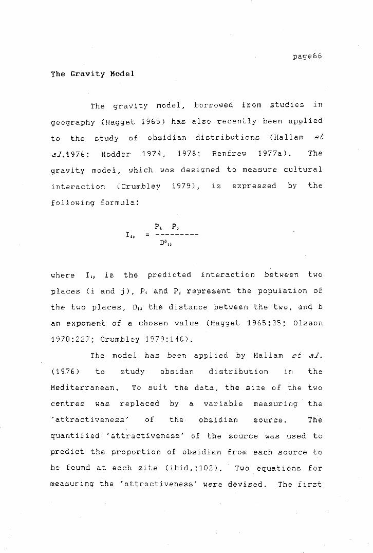
l-
,.
page66
The Gravity Model
The gravity model, borrowed from studies in
geography (Hagget 1965) has also recently been applied
to the study of obsidian distributions (Hallam et
al.1976; Hodder 1974, 1978; Renfrew 1977a). The
gravity model, iJhi ch was designed to measure cultural
interaction (Crumbley 1979),
following formula:
I ij = - - - - - - - - -
is expressed by the
where I 1j is the predicted interaction between two
places (i and j), P1 and Pj represent the population of
the two places, D1J the di stance between the two, and b
an exponent of a chosen value (Hagget 1965:35; Olsson
1970:227; Crumbley 1979:146).
The mode 1 has been applied by Ha 11 am et ~'t.l,
(1976) to study obsidan distribution in the
Mediterranean. To suit the data, the size of the two
centres was replaced by a variable measuring the
'attractiveness·· of the obsidian source. The
quantified 'attractiveness' of the source was used to
predict the proportion of obsidian from each source to
be found at each site (ibid.:102), Two equations for
measuring the 'attractiveness' were devised, The first
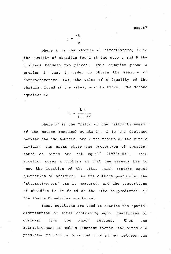
-A
D
page67
where A is the measure of atracti vness, 0 is
the quality of obsidian found at the site , and D the
distance between two places. This equation poses a
problem in that in order to obtain the measure of
'attractiveness' {A), the value of Q {quality of the
obsidian found at the site), must be known. The second
equation is
k d r =
1 - K2
where K2 is the "ratio of the 'attractiveness'
of the source { assumed constant), d is the distance
between the two sources, and r the radius of the circle
dividing the areas where the proportion of obsidian
found at sites are not equal" {1976:101). This
equation poses a problem in that one already has to
know the location of the sites which contain equal
quantities of obsidian. As the authors postulate, the
'attractiveness' can be measured, and the proportions
of obsidian to be found at the site be predicted, if
the source boundaries are known.
These equations are used to examine the spatial
distribution of sites containing equal quantities of
obsidian from two known sources. When the
attractiveness is made a cohstant factor, the sites are
predicted to fall on a curved line midway between the
page68
two sources, but when attractiveness is not the same
for the two sources, the sites will fall within two
circles separating the two sources.
The model in general presents
problems when applied to archaeological data.
practical
Firstly,
to solve the population equation, artefacts sensitive
to economic indicators have to be found, and secondly,
to solve the measure of distance, historical or other
evidence of interaction between a known and an unknown
centre has to be found. To resolve these basic
problems, well dated contemporaneous sites distributed
over a large area have to be used. The problem of
distance measures has been discussed by several authors
and will be referred to in Chapter VI.
Finally it has to be stressed that the gravity
model, when applied to archaeological problems, is
primarily designed to record spatial distributions,
rather than to document or explore exchange mechanisms.
Because the present research concentrates
mainly on the reconstruction of prehistoric exchange
mechanisms and not on a description of the spatial
distribution, the use of the gravity model is not
called for. Moreover, some of the variables which have
to be incorporated into the gravity model include
factors, such as population composition, which are not
purely economic (Crumbley '1979). They are cumbersome
or impossible to record from the archaeological data
and there is no assurance that they can actually help
11
Ii·-1
I. I -i 1' I
page69
in the reconstruction of prehistoric exchange.
Other Models: Technological Model and Trade Routes
There are two further approaches to the study
of obsidian distribution. The first was applied by
Sheets ( 1980a) to the study of obsidian trade in the
Valley of Zapotitan in El Salvador. A technological
approach was used to study the economic organization of
obsidian manufacture and usage. The aim of the study -
to record the position of each archaeological site
within the trade network and to describe the 1 i thi c
industry - was accomplished by recording a number of
descriptive variables for each site. The variables
selected to record technological aspects of the lithic
material are the proportion of artefact types, mean
weight per piece, the ratio of the cutting edge of
prismatic blades to their weight and the number of
hinge fractures on each piece. These data, recorded
for the total obsidian assemblage, were used to
reconstruct the mechanisms of obsidian exchange and the
process of obsidian manufacture in the area.
The technological study allowed Sheets to
observe that the obsidian was entering the sites in
different ways, and was related to the position of the
site in a settlement hierarchy. He observed seven
levels in the settlement hierarchy of the valley and
j
page70
noted that obsidian entered the valley at the top level
sites and was redistributed from these to the lower
level settlements and vill~ges. The obsidian found at
the sites from the top two levels showed a high
incidence of flakes with cortex in the assemblages,
higher mean weight values and lower ratio values for
cutting edge blades versus blade weight in relation to
the other sites. The specialization of the industry at
the top of the hierarchy was also indicated by the
smal 1 number of hinge fractures, which are directly
related to the · ski 11 of the knapper, and contrasted
sharply with the obsidian production at the smaller
villages, where obsidian production was carried out at
the level o.f a "small cottage industry" (1980a:12).
Further down in the settlement hierarchy obsidian was
obtained from itinerant craft specialists and was
harder to acquire, as was indicated by the high cutting
edge to weight ratio of the blades (ibid.).
Sheets' study is important in that it
demonstrates the possibilities of the analysis of
obsidian technology, and its role in understanding the
relationship between sites and quarries and between
specialized sites and distance from the source.
by
Technological
Renfrew (1969,
measures have also been employed
1977b; Si drys 1976b) to study
exchange. The main argument used by Renfrew in his
study was that sites distant from the source will have
access to less raw material and this should be

page71
reflected in the obsidian assemblage at the sites. If
it is a scarce and valued resource, more efficient use
of it will probably have baen made and one could expect
a smaller size of flakes and debitage at the site.
This kind of behaviour has been documented by Sidrys
(1976a) for the Mayan area, and Renfrew (1977b:295)
also argues for a reduction of size of the waste
material and re-use of artefacts. Other authors
recording such decrease in size are Evett (1973) on
Italian Neolithic greenstone axes, McBryde and Harrison
(1981) in Australia for ground stone axes, and
ethnographically Hughes (1977) and Strathern (1969)
have observed a similar situation for ground stone axes
in New Guinea.
A similar approach to Sheets (1980a), has been
used by Ammerman ( 1979) in the analysis of obsidian
production in Calabria. Ammerman recognizes the
importance of the technological variables, but his
analysis was not as sophisticated as Sheets' study.
Finally Hammond's (1976) attempt to trace the
trade routes by which the obsidian travelled in
Mesoamerica, should be mentioned. Hammond suggests
that the differential distribution of material from two
' different sources was related to their respective trade
routes. Obsidian from one source was supposed to have
travelled overland, while obsidian from the other
source was supposed to have been transported to the
coast and then distributed both along it and inland
J
through the coastal ports.
page72
Characterisation studies
carried out at a later date have given support to this
hypot~esis (Hammond 1972, 1976).
Implications of the Regional studies for New Zealand
prehistoric exchange
Distance fall off studies, even if they present
some problems, seem to offer a number of possibilities
for the study of prehistoric exchange in New Zealand.
One of the main problems faced by the archaeologist
when interpreting the fall off pattern has been
mentioned by Hodder (1974; Hodder and Orton 1976) and
involves the similarity of the fall off curves produced
by two different processes random walk and
down-the-1 i ne exchange. Renfrew ( 1977a) suggests the
use of additional data to solve the problem, and also
notes that, even so, direct access can be distinguished
from reciprocal exchange (ibid.:86).
Other problems faced by researchers
investigating distance decay arise from the variable
quality of the raw data. To construct plots which
measure the abundance of obsidian in relation to
distance from the source, it is necessary to choose an
appropriate abundance measure. In this respect the New
Zealand data share a problem with other places in the
world, notably the lack of information for a number of

.L
/
sites on
recovered.
on either
the quantities of other
The absence of sufficient
lithic
page73
materials
or adequate data
abundance of the absolute or relative
obsidian at a number of sites where obsidian has been
found makes the use of distance fall-off curves
difficult. It is possible to find different indices
which can be collected from the available assemblages.
~right has suggested the use of mean weights ( 196 9,
1970, 197 4) as an index of abundance, in the 1 i thi c
assemblage rather than percentages. Ammerman
(1978:193, 1979:103) has warned against this measure,
because the statistical means can be skewed towards the
smaller pieces. He suggests
frequencies. The problem of
overcome by classifying the
the use of cumulative
mean weights can be
data into different
categories, such as cores, flakes, and waste flakes and
then comparing the relationship of each of these
separate variables with distance from the source. In
this way the mean weight values will not be skewed
towards the smaller pieces. in the present study the
obsidian cores, flakes, blades and debi tage £ or the
selected sites on both the North and South Island of
New Zealand are investigated for the relationship of
the variables of size and weight with distance from the
source.
page74
The other methods reviewed appear to be of
little practical value for the present study. The
gravity model focuses mainly on the description of
spatial distributions instead of e}rchange mechanisms.
Trade routes can be of help in identifying
relationships in spatial patterns but do not in
themselves help in the clarification of prehistoric
exchange mechanisms. For these reasons neither model
is used in the present research.
SINGLE SITE ANALYSIS
Al 1 the above mentioned studies have a common
approach in their regional outlook on the study of
obsidian distribution. A number of other studies,
though few in number, have focused on the analysis of
obsidian distribution within one single site, and
attempted to explain the methods by which foreign goods
found at a site were acquired. Information such as
source of obsidian and its location within the site in
a spatial and temporal context has in some instances
been used to reconstruct the mechanisms of e}rchange.
Relatively few studies have been carried out using this
approach to elucidate the exchange mechanisms in terms
of actual trade or exchang~ theory.
I·-
page7S
Some of the techniques do not vary
signiiicantly from those commonly employed in the
analysis of archaeological assemblages. Time trend
analysis, spatial variability in the quantities of
different kinds of obsidi-:rn found at a. single site,
variability of source composition and, lastly, the
formal analysis of obsidian have been applied to the
problem by different researchers. The most relevant of
these studies are briefly summarized below.
Quantitative Studies
In this type of study a basic measure of
abundance must be found in order to monitor
quantitative changes through time. A number of methods
to measure the abundance of obsidian or its relative
proportion in a site have been developed. These record
the changes through time in the importation to. and use
of .. the raw material in the archaeologic3.l site in
comparison with other commonly occuring artefacts.
Renfrew, Di !rnn and Cann (1968) in their
analysis of Near East trade used the counts of flaked
obsidian relative to flaked flint. The value obtained
as a percentage was interpreted as a reflection of the
proportion of imported obsidian in the total lithic
assemblage.
\--
page76
Wright ( 1969: 48-50) criticized the use of raw
numerical counts, because, he argued, it overlooked
weight differences between artefact types. No
consideration was given to the fact that a small
quantity of large cores might represent considerably
more material in terms of volume and transport cost
than a large number of small flakes. Wright therefore
calculated an obsidian to flint percentage based on
weight. His use of data from other e:-rcavations was
obstructed by the poor and inconsistent recovery
techniques of many earlier projects. In the absence of
data on sample weight, Wright estimated the weights on
the basis of counts, having to ignore functional and
temporal variations within his samples.
Renfrew (1969b; 1977b) calculated values for
several variables which could measure the variation in
the obsidian supply for an area. Values for each phase
of occupancy in the Deh Luran plains were calculated
for the following variables:
1) Total number of pieces,
2) percentage of obsidian in the total chipped
stone assemblage,
3) number of pieces of obsidian per cubic meter
of excavated material, and
4) mean weight of obsidian pieces.
page77
He noted some problems with measuring some of
the above variables. The number of pieces of obsidian
per cubic metre of excavated material is susceptible to
the excavator's bias, due to selective sieving, size of
sieve mesh and selective recovery of material from
different areas of the site, as well as the nature of
the fill of the archaeological site (1969b:432).
Renfrew believed that the mean weight measure was a
more useful means of comparing the abundance of
~aterial with the ratio of the same material in other
sites. Nevertheless this can be influenced by
(1969b:432, functional and stylistic factors
1977b:296). The quantity of obsidian at the site can
also be affected by differential activities or
functions within the site.
In another study Cobean et al. (1971) utilized
several indices to quantify the obsidian found at San
Lorenzo Tenochtitlan in Mexico. The total number of
obsidian pieces (separated into flakes, blades and
waste material) were plotted for their abundance in the
site. This was then compared to the numbers of
grinding implements (manes and metates) in the site.
Each mano/metate unit was assumed to represent one
household. The two figures were then compared and
plotted against each other and the ratio of obsidian to
mano/metate • J.. uni 1...s would represent the actual
consumption of obsidian of each household. The authors
found the amount of obsidian in the site increased
r
T
page78
throuqh time and hypothesized that this represented a
"rise in prosperity or 'buying power' of the
individuals" (Cobean et al. 1971:666).
Zeitlin (1978; 1979) in his study of obsidian
procurement and the long distance exchange links at the
Isthmus of Tehuantepec, used the total weight of
obsidian against the total count of pottery in the
site. This ratio was an index to measure abundance of
obsidian at the site through time.
the use of obsidian, and these
shifts towards a more intensive
He notes changes in
are interpreted as
utilization of it
(1978:202). Pottery was used, since it was uniformly
abundant in the site and could be assumed to have a
relatively constant per capita consumption rate over
time. Changes were seen as alterations in the
intensity of use. Intra-site variation was smoothed
out by sampling areas of the site that represented all
its different occupational phases.
Alternatively, Sidrys (1976b:450) used obsidian
count per unit volume of excavated fill, while another
method of measuring abundance has been employed by
Moholy-Nagy (1975) at the Maya site of Tikal,
Guatemala. The ratio of obsidian flake-blades to flint
flake-blades was calculated for all obsidian found in a
non-ceremonial context. The gradual increase in the
value of the ratio from the Middle Period to the Late
Classic Period was interpreted as showing that obsidian
was available to all members of the population due to
>-
page79
an efficient procurement and distribution system. The
late drop after the Postclassic Period in the values of
the ratios, was seen as a drop in the accessibility of
the obsidian to the lower social groups of the
population, making obsidian an 'elite' item. It also
suggested difficulties in the importation of the
obsidian into the area (ibid.:517).
A different approach was employed by Torrence
(1981). In order to control for differences in site
function or in the contexts of the sampled deposits,
the mean weight measures were calculated separately for
each artefact type, but again, for intra-site
comparisons the total weight per unit volume of
excavated material was calculated (ibid.:281). This
measure was used to analyse the output of the obsidian
workshops at Phylakopi in the Aegean.
Irwin (1977a, 1977b) quantified the obsidian
found in his excavations on Mailu Island, Melanesia,
calculating the percentage (counts) of obsidian versus
chert artefacts. Irwin's study stands out in that it
is one of the few to attempt to predict the nature of
local and long distance trade through the duration of
the site's occupational history by quantifying the
obsidian data (1977b:22-23). Variations in the
relative proportions of chert and obsidian are
interpreted as a reflection of changes in the supply
network, rather than -of consumer preferences
(ibid.:23). Irwin found that obsidian was abundant

page80
during the Early Period of Mailu prehistory but later
decreased in importance, being almost totally replaced
by local chert (1977a:308-311). In the later Mayri
Period, chert is abundant in the early Period but is
steadily replaced by obsidian, and then. again looses
importance during the succeeding Mai 1 u Period ( 1977a:
308-311, 1977b:23-25). In spite of the observed
pattern, Irwin concluded that the documentation of long
distance movement of material did not help to clarify
6r explain any of the exchange mechanisms by which the
materials changed hands (1977b:26). Nevertheless,
despite Irwin's pessimistic conclusion, the combined
use of techniques such as fall-off studies, variability
in the abundance and technological analysis might lead
to an understanding of the e:{change mechanisms
involved,
Finally, Prickett (1975) in her study of stone
resources at Palliser Bay in New Zealand, used relative
percentages of different types of stones to record the
changing patterns of utilization within the area. The
importance of the non-local rocks in the area was noted
by Prickett (ibid.) and Leach (1976), leading to the
interpretation that the predominance of imported rocks,
including obsidian, was due to the build up of stronger
and more reliable exchange networks ( Leach 1976: 169).
Nevertheless, no further attempt was made to identify
exchange mechanisms, although Leach (ibid. :175) points
out the possibility of two different exchange networks
page81
operating simultaneously,
Research in New Zealand could take advantage of
some of the methods described above. It certainly
would be profitable to monitor the changes in obsidian
supply through time, in order to test hypotheses on the
changes in the system of exchange. It would be
possible, for example, to argue that a change in the
quantities of obsidian supplied to one site (or to an
area) over a period of time was due to different
systems of acquisition which might be directly related
to a shift in the exchange mechanisms. Renfrew,
Moholy-Nagy and Indn have made some important
theoretical propositions linking the abundance of
obsidian to the development of systems of exchange.
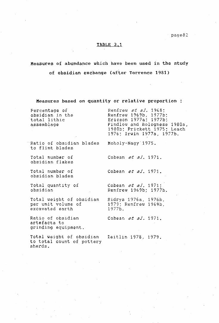
page82
TABLE 3.1
Measures of abundance which have been used in the study
of obsidian exchange (after Torrence 1981)
Measures based on quantity or relative proportion:
Percentage of obsidian in the total lithic a_ssemblage
Ratio of obsidian blades to flint blades
Total number of obsidian flakes
Total number of obsidian blades
Total quantity of obsidian
Total weight of obsidian per unit volume of excavated earth
Ratio of obsidian artefacts to grinding equipment.
Total weight of obsidian to total count of uotterv sherds. · · ·
Renfrew et al. 196 8; Renfrew 1969b, 1977b; Ericson 1977a; 1977b; Findlow and Bolognese 1980a. 1980b; Prickett 1975; Leach 1976; Irwin 1977a, 1977b.
Moholy-Nagy 1975.
Cobean et o"il. 1971.
Cobean et ,'ii. 1971.
Cobean et ,."iJ. 1971; Renfrew 1969b; 1977b.
Sidrys 1976a, 1976b, 1979; Renfrew 1969b, 1977b.
Cobean et al. 1971.
Zeitlin 1978, 1979.

Measures based on Technological differences:
Distribution of artefact weights
Relative percentage of debitage types
Relative percentage of 'cortikcal flakes
Number of hinge fractures
Mean blade width and thickness
Mean ratio of blades cutting length to weight
Mean weight of artefacts
Ammerman 1979.
Sheets 1980a, 1980b; Torrence 1981.
Sheets 1980a; 1980b,
Sheets 1980a; 1980b,
Sidrys 1976a; Torrence 1981.
Sidrys 1976a; Sheets 1978.
Renfrew 1969b; 1977b; Torrence 1981.
page83

page84
Spatial Variability
The analysis of _spatial variations in the
archaeological context has been widely carried out in
Mesoamer i can sites. For example, during the
Teotihuacan mapping project, large areas scattered with
obsidian artefacts were noted and sampled, as well as
the location of workshops. The history of obsidian
production at the site was reconstructed, based on
source composition and artefact types encountered
(Millon 1967, 1970). Another study was performed by
Sheets (1978) on the workshops at Chalchuapa, El
Salvador. At the site of Loma Torremonte in Mexico,
variations in the quantity and quality of the obsidian
assemblage were used to link specialized and
differential acquisition of raw material.
Lastly, in another study by Pires-Ferreira
(1975; Winter and Pires-Ferreira 1976; Winter 1972),
spatial variations of the obsidian sources within one
site were analyzed. The authors explored the obsidian
distribution at the two villages of Tierras Largas and
San Jose Mogote, assuming that a large variation
between households both in sources used and the
proportions used from each source would be a reflection
of a reciprocal economy (1976:306). On the other hand,
uniformity in obsidian distribution between households
was assumed to be the result of redistribution (ibid.).
page85
The analysis of the obsidian assemblages from
the Tierras Largas and San Jose Mogote household
clusters showed large intra-site variations in the
sources employed during the early Formative Period at
Tierras Largas but became more uniform during the
Middle Formative. Comparatively, the utilization at
San Jose Mogote was very uniform throughout its
occupation. On this basis, Winter and Pires-Ferreira
concluded that at the large early Formative villages,
obsidian was obtained from several sources, pooled by
the elite and later redistributed to the rest of the
population. In contrast, at the smaller sites,
households obtained their supplies directly through
reciprocal exchange. During the Middle Formative
Period this was replaced by pooling and redistribution
(ibid. :309-310).
Winter and Pires Ferreira's study is
particularly important in that it is the first one to
integrate data on source composition and intra-site
variability into the study of exchange mechanisms.
Archaeological research at San Lorenzo
Tenochtitlan indicated that with each occupational
phase increasing numbers of obsidian sources were used.
Cobean et al. (1971:670) concluded that trade played
an important role in the expansion of sources employed
and that this was due mainly to certain major changes
that occurred in the rnagni tude or the structure.. or
both, of the Olmec culture sphere (ibid.).
I
I',
page86
Renfrew (1977b:308) also notes the variation in
the relative abundance of two different kinds of
obsidian in the Deh Luran plains. Green obsidian is
more abundant during the Early Period and reached its
highest level of consumption very ~arly in the
occupational history of the area. Consumption was then
stable throughout several phases and dropped in the
last phases. Grey obsidian reached its maximum
consumption at a later stage but its use declined at
£he same time and rate as that of the green obsidian.
These changes in quantities and relative proportions of
obsidian consumption are interpreted as being caused by
differences in the effectivness of the down-the-line
trade network, or difficulties in access to the trade
networks for the two sources (ibid.: 309). The author
is more inclined to accept the latter view - a change
in supply due to transport or political factors.
The analysis of intra-site variability
performed at Palliser Bay, New Zealand by Prickett
( 1975) and Leach ( 1976) showed that at least seven
sources were utilized at one point in time. The trend
observed earlier by Green (1964:139), where obsidian
from one source (Mayor Island) was dominant in the
Early Periods in North Island sites and declined in
popularity at later sites further removed from the
source, was not confirmed by Prickett (1975) and Leach
(1976). Considerable variation from this trend was
observed by Leach (ibid.:171). Green (1964) did not
page87
attempt to use his information to analyze exchange
mechanisms, but rather as a relative dating technique.
Leach concluded from his analysis that, as a dating
device, the proportion of Mayor Island obsidian in a
site would only be applicable at a very ~eneral level.
Leach does consider the shifts in the proportions of
obsidian and other local and imported rock sources
found in the study area.
goes beyond noting the
However, none of the authors
existence of communication
networks and suggesting possible routes of
communication.
Reduced potential for consumer variation due to
a limited number of sources makes it difficult to
interpret changes in compositional variability in terms
of exchange. One of the main problems faced in the
study of source variability is that the household units
must be clearly recognizable. The unavailability of
these data for a number of New Zealand sites has
hampered some of the possible analyses making it
difficult to incorporate this approach in the present
study.
page88
Formal Analysis
Finally, Winter and Pires-Ferreira (1976) have
noted that it is important to record the form in which
a piece enters the site, since it might be related to
the type of eitchange. The authors suggest a general
relationship between exchange mechanisms and the farm
of objects, based on the observation of the association
of three different variables 1) the proportion of
obsidian from two sources of high quality material, 2)
the quantity of.prismatic blades and 3) the degree to
which pooling and redistribution might have taken
place. It is thought that the blades are alien to the
site and that their exchange was controlled by an elite
group (ibid.:310). This relationship between the form
of the object (for example prismatic blades) and the
exchange mechanism has been pursued to some degree by
Ammerman et al. (1978). The consideration is that the
more valuable an item, the more likely it is that its
exchange will be controlled by a special group.
Ammerman also argues that the differences in obsidian
use at a site reflect specialization. He has tried to
apply this line of argument to his research in southern
Italy, by recording the differences in weight of
obsidian debitage at the sites. Wright (1969) has also
proposed a specialized exchange for obsidian blades in
the Near East.
page89
Implications of single-site analyses to the Ne~ Zealand
study of prehistoric exchange
Most of the single-site analyses described
above could in some way be performed in New Zea land.
However, the nature of the sites in New Zealand does
not compare with the huge workshops in the Aegean or
large settlements of Hesoamerica, which were used over
a number of centuries. The sites in this study have
all been used for a short length of time, although some
have been used repeatedly. Nevertheless, time-trend
analysis on the variation in quantities of obsidian at
a s in g l e s i t e w o u l d be of l i t t 1 e use i n exp la i n i n g
exchange mechanisms for the whole country.
The differences in source utilization are
meaningful in sites like the villages of San Jose
Mogote or Teotihuacan in Mesoamerica. It is extremely
hard to record these differences for family groups in
temporary settlements or hunting camps such as those
used for this study. It might be rewarding to attempt
such a 1 i ne of research in the future on some of the
larger p~rmanent villages on the North Island, but at
present this approach cannot be used here.
For the present purpose, the
obsidian seems to be the most useful
form of the
of the four
techniques outlined above. This aspect has been given
attention in some studies, ~uch as Leahy's (1976) study
at Whakamoenga Cave in the North Is land, and it seems
page90
worthwhile to pursue it in particular for the analysis
of lithic workshops.
In this category o-ne might include the lithic
quarries and mines which represent the centre of
production. Quarry analyses are relatively new but
have proven an extremely fruitful line of inquiry.
They have been performed by a number of scholars all
over the world (Leach 1984; Gramly 1984; Torrence 1981,
1984; Purdy 1984; Gibson 1984; Luedtke 1984; McCoy
1977; Stevenson et al. 1984, Bosch 1979; and others).
Some of the most exciting research relevant to this
study has been carried out by Torrence (1981, 1984) on
the S~ Nychia and Demenegaki quarries on Melos in the
Aegean. Torrence was able to show that consumers
obtained their obsidian by direct access ( 1981: 425).
Singer and Ericson
possibilites of quarry
prehistoric exchange.
(1977) have
analysis for
stressed
studies
the
of
It was believed that the present study would
profit considerably by an analysis of the obsidian
sources.. quarries, and workshops on Mayor Island. A
site survey was carried out in May 1982 with this
purpose in mind. Several areas where the obsidian
flows were mined were found and these are described in
the following chapter. Further research on the
quarries, workshops, and mines was sadly hampered by
factors beyond control and cannot therefore be included
in the present study. It is hoped that in the future
page91
it will be possible to carry out a more detailed
e:,rnmination of the obsidian quarries_. mines and other
archaeological sites on Mayor Island.
SUMMARY AND CONCLUSION
The present chapter has discussed a range of
different appro6ches to the study of obsidian exchange
in different ar~as of the world. The applicability of
a number of regional and site oriented research
approaches employed in the study of prehistoric
exchange were discussed in order to investigate which
ones could profitably be applied to the study of New
Zealand obsidian exchange. A far larger range of
research has concentrated on regional aspects, focusing
on the relationship between abundance or size of
obsidian artefacts and distance from the source of
obsidian. Site oriented research has mainly been
carried out in Mesoamerica, but lately quarry research
has been carried out in a number of places. From the
foregoing review it is clear that a number of methods
can be employed, but due to a number of restrictions in
the Ne~ Zealand data it seems that the most profitable
approach for the present study is to integrate aspects
of several of the techniques reviewed.

page92
The main points concluded in the present
chapter may be summarized as follows:
1) Although attempts to identify archaeo
logically economic institutions such as reciprocity,
redistribution and others observed in· present day
societies have been made.. these have not been
con cl usi ve. There are at present no ways of
establishing unequivocally which of these was
responsible for the distribution of goods as found in
prehistoric sites.
2) The prospects of using reg i anal 1 y oriented
research in New Zealand seem encouraging. Fall-off
studies have been shown to be of use, even if there are
still problems in how to interpret specific patterns.
There is every chance that this type of analysis will
be profitable in New Zealand.
3) The technological approach employed by
Sheets (1980a, 198Gb) shows the important role of
understanding the technology of obsidian production in
relation to distance from the source and with respect
to the degree of craft specialization. This approach
can be applied in New Zealand and sufficient data seems
to be available to attempt it.
4) The gravity model employed by some authors,
does not seem of any use for the present study.

page93
5) A number of aspects of single site analyses
could be of use in the present study. Firstly the
formal analysis of the obsidian assemblages provides
some interesting results and has already been employed
in New Zealand. Of special importance is the analysis
of quarries and related workshops that can provide
information on the patterns of exploitation of a
resource and its subsequent transformation for
consumption.
The approach employed in the present study
draws on the methodology of other researchers. The
main focus of the thesis is on regional analysis. It
was believed that the study could also profit from the
analysis of certain sites on Mayor Island where the
main obsidian flows are located, and that fieldwork at
the quarries there could provide a number of answers
about prehistoric obsidian exploitation in New Zealand.
In the following chapter the results of the site survey
carried out on Mayor Island are discussed. The data
used here for the regional analysis were collected from
e}rcavated assemblages stored in New Zealand museums and
universities. The regional study deals with the
analysis of the fall off patterns of a number of
variables.
and VI.
This research is described in Chapters V
page94
CHAPTER IV
QUARRY EXPLOITATION:
THEORETICAL ISSUES AND THE
OBSIDIAN EXPLOITATION
ON MAYOR ISLAND
INTRODUCTION
When discussing the prospects of site oriented
analyses in Chapter I I I for the study of prehistoric
obsidian exchange in New Zealand it was found that this
type of analysis offers a number of possibilities. As
discussed in the previous chapter the study of the
sites of procurement the quarries can be of
assistance in providing answers to specific questions
relating to prehistoric obsidian exchange. In
particular the behaviour observed at the quarry sites
can be expected to reflect skills, production rate, and
methods of procurement of the people making and using
the final products, be it at the quarry itself or at
places far removed.
l
page95
Four major questions arise wh~n discussing the
exploitation of specific resources and will be
discussed in this section. If access to the source of
the raw material were controlled, certain behavioural
patterns might be expected to be present_at the sites.
How was the material obtained, who controlled access to
the resource areas, how was it enforced? How is this
expressed in the archaeological record? These are the
main questions which will be discussed in this section.
The following chapter will discuss how the
above points would be expressed archaeologically.
Firstly, a number of ethnographically documented
examples of quarry exploitation in different places of
the world and at different time periods will be
described. Secondly, a number of archaeological
studies of prehistoric quarries will be examined in
order to see if any of the studies can be of use in
predicting a particular type of behaviour at the quarry
sites. It is hoped that some of these examples will
provide insight into the pattern of exploitation
observed at Mayor Island.
The second part of the present chapter is
devoted to the description of Mayor Island, its geology
and the archaeological fieldwork carried out there.
The archaeological remains found on Mayor Island are
discussed in relation to the theoretical discussion of
quarry exploitation and production which follows.

page96
CONTROL OVER ACCESS AND PRODUCTION AT LITHIC QUARRIES:
THEORETICAL DISCUSSION
The concept of ownership of a quarry is of
paramount importance when discussing control over
access. In certain cases the exploitation of a quarry
will be open to all those who need it. In others it
may be controlled by local residents or a particular
kin group. If ownership does exist then the owners may
or may not maintain their rights on the quarry.
Several options are open for this. They may have
territorial boundaries which could be marked in some
way, In other cases they may need to assert ownership
by force so that some sort of fortifications or
defenses would be needed. In other instances the
1 ocati on of the resource may be kept a secret. It can
be expected that if ownership rights are exerted, the
owners will derive some sort of privileges or profits
from their control. This in turn may imply that the
owners have a monopoly over the resource and that other
groups must be willing to pay for this resource. In
order to maintain control it is frequently necessary
for people to reside permanently near the source, or
maintain a constant watch over the territory
surrounding the prized resource Spence and Parsons
(1972:28) believe that this might have been the case at
Teotihuacan, where large quantities of obsidian were
I /1
i \ _c
page97
used at the city. They believe that due to the size of
the industry and in order to maintain a high output it
was necessary for Teotihuacan to have had "control or
undisputed access" to both the local sources of grey
obsidian and the green obsidian from Hidalgo.
Restricted access to a quarry and tight control
directly imply that the resource exploited is
considered to be a valuable asset.
The behaviour observed at quarry sites has to
be seen as part of the larger economic system in which
it is embedded. Clearly the existence of any sort of
contra 1 over access is 1 inked to the basic economic
background under which exploitation is taking place.
As Torrence (1981, 1984) has observed, monopoly
exercised over a resource is strong 1 y 1 inked to the
later commercialization of the extracted produce and
that the monopoly over a resource is a prerequisite for
the creation of profits (Jacobs 1972: 27-29, Torrence
1981:178). Commercialization of a product in a
competitive market economy implies that it is of some
importance or has an inherent value. Nevertheless, the
output of a product is not necessarily always
correlated to 'market' factors, that is, with supply,
demand and price conditions. Output may be related to
other non-market factors, which are cultural,
ecological or other, as has been shown for example by
Nash (1961) and Cook (1970). Nash, in a study of
pottery manufacture and output in Chiapas, Mexico,
page98
reached the conclusion that "production is maximised
not at the time of highest prices on the market, but
rather in time with the r_hythm of sacred and secular
celebrations which require cash outlay and provide
opportunities for disposal without storage problems"
(Nash 1961:187). Cook's study of the metatero industry
in Oaxaca, Mexico, showed that the output of metates
(stone grinders) fluctuates regularly in accord with
the agricultural calendar as well as with market
factors (1970:788-789).
Archaeologists have proposed a number of ways
by which the type of exchanges in operation in a
cultural system could be predicted from the
distribution of traded goods (see Chapter III). In the
same way predictions concerning the economic structure
could be made by studying the behaviour at the points
of origin of the product. A number of archaeological
indicators can be expected to be found at quarry sites
which are distinctive for identifying control over
access or ownership.
The evidence of control over access to a quarry
could be expected to be found not only at the site
itself but also in the surrounding area. Possible
evidence could include territorial markers, defensive
constructions in the vicinity protecting access routes,
or domestic structures of people living on a full time
basis at the quarrie$.

page99
Controlled access to the quarries suggests that
they may be exploited by a single group of people,
consequently the labour force specializing in the
extraction of the raw material and its subsequent
stages of modification could be expected to be highly
skilled in their work. It is also likely that once the
raw material was extracted by workmen it was roughly
worked for easier transport and then finished somewhere
else. Archaeologically, the remains left at a quarry
by specialized workers, employed only on the extraction
of the raw material, might be different to those left
by a periodic visitor collecting some material on an
occasional expedition to it, when the quarry is open to
everybody's use.
Torrence (1981) has shown that some form of
limited access to resources
industries. The author
exists in commercial style
examined a number of
commercialized and non-commercialized stone working
industries (English and French gunflint industries,
Mexican metateros, New Guinea axe quarries, and others)
and found that if production for exchange is the
primary reason for the exploitation, access to the raw
material and/or the skills of manufacture will be
restricted, regardless of the type of economy in which
the objects are produced (Torrence 1981:241-244). She
argues, moreover, that the degree of restriction will
vary according to the nature of the products dependence
on the goods received in exchange. Torrence says,
I I
\_
page100
further, that if the final product is mainly going to
be used locally, there are no reasons for restricting
access to the resources;- only if the material is
quarried to produce goods for export is access to the
quarries restricted (ibid.) As an example, she cites
the quarries exploited for the production of ceremonial
axes in New Guinea, where access is restricted. In
contra2.t, in the quarries which are worked to extract
stone for the production of utilitarian axes, for local
use only, access is open to all groups. The author
concludes that if production at a quarry is chiefly for
the export market, the resource will be controlled and
one can expect full time specialist craftsmen, with a
monopoloy in the necessary skills, working at the
extraction sites, Torrence (ibid.) was not able to
find any archaeological indicators that would clearly
establish rights of ownership from any of the
ethnographic examples she studied. Nonetheless, the
identification of one of these aspects, such as the
existence of specialized craftsmen, may show that there
was coritrol over access or that the quarry was
exploited for export. These observations, based on the
study of a number of ethnographic test cases, do help
in establishing ways of measuring these aspects in
archaeological terms.
page101
Craft specialization as indicated above is
another factor present when exploitation is specialized
and oriented towards a specific goal. This can be
identified in the archaeological record as Sheets
(1980) has demonstrated. The number of knapping errors
such as hinge fractures observable on flakes are an
indication of the skill cf the craftsmen working. The
presence/absence of a specialized workshops at or near
the quarry sites can also be taken an an indicator of
the degree to which the raw material was modified for
local consumption or for export.
location
In
of
summary, boundary markers, fortifications,
settlements, skill of craftsmen and the
presence of a specialized workforce may be able to be
identified archaeologically and could indicate the
degree to which a quarry was controled. This in turn,
could indicate for what final purpose the products were
produced, whether for local use or for export.
In the following section a number of
ethnographic and archaeological case studies will be
examined in order to see if any additional indicators
can be found in the field. Ethnographic information on
quarry exploitation is extremely scarce, neither are
archaeological studies of prehistoric quarries
abundant, although they have increased considerably in
the last few years.
j
'T
l '
page102
ETHNOGRAPHIC EXAMPLES OP QUARRY EXPLOITATION
Gould's numerous studies (1968, 1978, 1980,
Gold, Koster and Sentz 1971) on the hunter/gatherer's
use and manufacture of stone tools provide the most
detailed information on quarry exploitation in the
Australian Central and Western Deserts. Gould observed
that material was extracted either from surface
quarries or mined for extraction of unweathered cherts.
~ehaviour at quarries, where material was extracted
from surface rock outcrops, consisted of reducing cores
by applying rock-to-rock percussion (to boulders,
nodules or outcrops), using the natural angles as
striking platforms. Wastage is high at such sites and
there is little spatial patterning of the waste
material (Gould 1980:124). Gould notes that, in
contrast, at quarries where the raw material has to be
laboriously mined out of the ground a more efficient
method of core reduction is employed direct
percussion with a hammerstone and careful preparation
of striking platforms. This system was extremely
economical in terms of the production of waste material
( ibid . =--1 2 6 ) . Small cores were carried away from
quarries that were never more than 32 km distant from
the habitation site (1980:124-126). Expeditions to
known quarries sometimes involved deliberate detours
and, at other times, special expeditions to the
quarries were organized. Cores removed from the
page103
quarries were usually fairly small in size, so that
they could be carried more conveniently back to the
camp.
At the Western Desert quarries, Gould
(1978:819) was able to distinguish between two activity
areas on the basis of the size of waste flakes. At the
larger quarries separate chipping stations consisting
of small circular or oval
rocks with occasional
(1978:819, 1980:123). At
shaped patches cleared from
hammerstones found nearby
small quarries small sized
waste flakes ar~ characteristic of percussion flaking,
and appear where the block-to-block percussion
technique was employed for core reduction.
It can be extracted from Gould's findings that
archaeologically activity areas can be differentiated
mainly due to the nature of the waste flakes. No
permanent habitation sites exist close to the quarrying
areas. The high percentage of waste material at the
quarries is due to on site preliminary core reductions
to reduce weight of the material to be taken away.
Gould does not mention any limitations or restrictions
of access to the quarries he studied. From his
description it seems that each group visited the
quarries within their own territory and no access
restrictions seem to have been observed.

I
page104
By contrast, McBryde's study of the Mt William
Axe Quarry in Southeast Australia has shown that some
restrictions were enf arced_ (McBryde 1978, 1979, Binns
and McBryde 1972, McBryde and Watchman 1976, McBryde
and Harri son 1981). Axes produced at the Mt W i 11 iam
Quarry were exclusively for exchange, and McBryde and
Harrison ( 1981: 191) argue that the quarry itself
acquired characteristics of a sacred-ceremonial place.
Access to Mt William was strictly limited, as reported
by Howitt (1904:72, 311-312) and its resources could
only be worked by specialists who possessed the
necessary status and kin associations. A similar
situation was reported by McBryde and Harrison for the
quartzite blade quarries in Arnhem Land (McBryde and
Harrison 1981).
The behaviour at the Mt William quarries was
initially recorded by Howitt
and is also described 1n
(1976:164). The quarry was
(1904) and Fison (1890)
McBryde
owned by
and Watchman
a group of the
Wurundjeri of the Yarra Valley and the quarrying was
the responsibility of one man, Billi-billari. Any
request for axe stones had to go through him; nobody
was allowed to work the outcrops by themselves.
Requirements had to be made known to Billi-billari, and
payments were also negotiated through him. He worked
by himself at the quarry, al though on occasion other
members of the group with ownership rights were also
a 11 owed to work on it during his absence. Apart f rem
/
j I
I
page105
this, there are no descriptions of the actual work at
the quarry. Archaeological research carried out by
McBryde (1978) at the quarry has identified separate
working areas, including flaking areas, separate from
the extraction sites. As most work at the quarry was
carried out at one time by only one man, in the opinion
of McBryde (ibid.) selection of activity areas is most
likely to reflect the preference of this craftman.
However, if these flaking floors were in use before his
time, they might reflect spatial separation of
activities of different craftsmen within the site.
Summarizing the information obtained from these
two e}rnmples, it is found that access restrict ions do
not necessarily leave any distinct archaeological
traces. In both cases where access was restricted, as
at the Mt Wi 11 iam Axe Quarry, and where there was no
restriction, as in the Central and Western Desert, no
habitation areas and physical remains of boundary
markers have been found to be associated with the
quarries. The working floors seem to provide the best
areas to identify differerential working patterns.
Although in both the examples, discrete working floors
were found, the nature of the waste material can be of
paramount importance in the identification of the
patterns of exploitation.

The absence of
restricted access to the
that restrictions were
boundary
site may
enforced
page106
markers to mark
be due to the fact
by other means or
simply that they were either not noticed by the early
recorders or have not survived. On the other hand, the
fact remains that they might not be a necessary feature
of a quarry site, even if access were restricted, since
it might have been enforced by other means which leave
no physical trace.
New Guinea Axe Quarries
The working of most quarries in the New Guinea
Highlands is open to everybody, whether the stone is to
be used locally or for exchange. Each local group
seems to work for their own needs, and no
specialization of tasks seems to exist. A similar
situation has been recorded for the New Guinea axe
quarries. Torrence (1981:232-236) in her analysis has
already noted that here, also, access is restricted to
quarries where axes for exchange were produced, and
also that no boundary markers are to be found. Stone
working quarries have been studied by Vial (1940),
Chapell (1966), Strathern (1965), Hughes (1977), but
few of these descriptions refer to the actual quarrying
process.
page107
Vial (1940) notes though that certain quarries
can be worked by specific groups. This is the case for
the Dom quarry, from where_special stone for bride-axes
were extracted, "only Dom Gondigu could work it"
(ibid.:161) while other quarries could be visited by a
number of villages (ibid.:159). The Dom quarry was
worked by workmen living at the quarry in huts besides
the shafts for long periods of time (5 months as
observed by Vial), while their families stayed in the
nearby villages and brought food daily. Vial obser·ved
the actual working at the quarries where axe blades
were obtained. Stone preforms were flaked out at the
quarry and then taken home for polishing. Stones at
this quarry were mined from a deep shaft and stored
until the end of the mining process. "Ji. number of them
were flaked out simultaneously and taken back to the
home camp to polish. They were later taken to the
village and distributed among the Dom and neighbouring
tribes (ibid.)
In the New Guinea quarries when access was
restricted to a group or group of tribes or when it was
open to any group, working patterris did not seem to
differ in essence. In both examples, ( as reported by
Vial (1940) and also by Chapell (1966)), workers either
mined the flows, excavating deep shafts or 'drives',
using sometimes only sharpened sticks, baskets and
other wooden implements, or the rock was simply broken
out of the outcrop using wooden po 1 es. In all cases
page108
the stones were worked to the required preform at the
quarry and then polished somewhere else, close to
source of water and sand (Vial 1940:159).
Wise (1981) has shown that manufacturing styles
can be iscilated between different axe quarries in New
Guinea. Differences in manufacture were shown to
reflect the type of production taking place at the
quarries. Manufacturing styles at quarries with
restricted access. and where axes were produced for
exchange, showed little variation in style. In
contrast, axes coming from quarries where material was
obtained by direct access by ·the consumers, showed a
higher variability in manufacturing styles. In this
case, as many styles of production as quarries
exploited were observed (ibid.:230-237).
In these cases, as well as in the case of the
Mt William axe quarry in Southeastern .Australia, it
seems to have been 'common knowledge' when access to
the quarry was restricted, and no physical boundary
markers were necessary or present near the quarries.
As there does not seem to be any differential approach
to the extraction work, or the reduction methods,
identification of these cannot necessarily bring us
closer to establishing restrictions of ownership of
access.
\
page109
Obsidian Quarrying and Usage by Ethiopian Hide Workers
As a final ethnographic e}rnmple from outside
New Zealand, the quarrying process of
Ethiopian hide workers will be examined.
In Central Ethiopia people belonging to three
separate ethnic groups - the Gurage, the Arussi-Galle
and the Sidama - are at present still engaged in the
preparation of hides using obsidian scrapers. One of
these groups was studied by Gallagher (1977a. 1977b).
The obsidian is extracted by them from a quarry a
half-day's walk away from the village, Trips are made
appro,dmately once a fortnight to once every two to
three months, and the quarry is not owned or controlled
by a particular group. The quarry resembles an
undifferentiated mass of obsidian debris which
Gallagher (1977a:263) says is "heaped almost knee
deep". Work at the quarry does not seem to follow a
systematic pattern. The obsidian is quarried from the
ground using
them. Large
long digging sticks with iron tips on
blocJrn are extracted in this way. Then
using a harnmerstone. which is always left at the quarry
site. flakes are detached to test the quality of the
obsidian block. If the block is of good flaking
quality, the desired number of flakes are detached and
are further reduced to the required size at the quarry,
because of the need to minimize carrying weight. The
final manufacture of the hide scrapers ia performed at
page110
the village (Gallagher 1977b:407-410). The flaking and
retouching of the scrapers, as well as the resharpening
of these is performed carefully over a container,
either a basket or hide. The waste material is, in
this way, carefully collected and later dumped in a pit
or dump away from the living area (1977b:411).
Obsidian flakes are occasionally traded to groups that
live more distant from the quarry.
The raw material quarried in this case is used
directly as a tool, and is in general not used in
itself for any transactions. There does not seem to be
much value attached to it outside the hide-working
community, which is formed by a small group of skilled
endogamous craftsmen. The skill has been protected and
is only performed by men of certain ethnic groups.
Extraction activities at the Ethiopian quarries
and the nature of the resulting debris left behind
there do not seem to differ much from the specialized
axe manufacturing quarry at Mt William, where access
was restricted.
New Zealand Greenstone Exploitation
Although no systematic study of greenstone
quarrying and working has yet been done in New Zealand,
ethnohistoric sources provide a picture of how this
rock used to be worked. Greenstone (nephrite and
page111
bowenite) is found at a number of locations on the West
Coast of the South Island of New Zealand, from Milford
Sound north to as far as_ Nelson/Marlborough (Ritchie
1976). Greenstone was used for the manufacture of
ornaments and certain tools, adzes and weapons, and was
traded widely over New Zealand. The first published
scientific description of Maori greenstone sources by
Hector (1863:460) mentions that it was obtained from
boulders lying on the beach. On his visit to Anita Bay
(Milford Sound) he wrote :
I landed to examine the beach from which the Maori procured the jade or greenstone for the manufacture of their ornaments and weapons. It is from among the shingle that this stone is obtained, occurring in rounded pebbles along with fragments of hornblendic gneiss and felstone... (Hector 1863:460).
Information on the possible sources exploited by the
Maori and on the greenstone trade is firstly given by
von Hochstetter (1864:467). He writes,
even now almost every year parties come from the Northern Island with money, coverings, clothing and so on to the Buller, Grey and Arahura to barter with the Maoris settled at the mouths of these rivers for partly worked and partly raw nephrite. Little is yet known concerning its occurrence in situ. As far as can be ascertained from the natives and others, there are three main places where nephrite is known to occur thus ... it was said to be so hard and firm, that they could not break it, and because of lack of
I I.
suitable tools, had to be content with the pieces they found in the river and on the beach.
page112
There is a large number of ethnohistorical
references indicating the knowledge of the Maori
population concerning the greenstone sources.
References to the working of greenstone are provided by
Heaphy (1959:241) on a trip to the West Coast where he
observed a group of people at a pa on the mouth of the
Teremakau River engaged in the working of the stone.
The inmates of each house were busily engaged making mere pounamu and ear pendants of that material for trade and presents to the northward. They saw the slab with a piece of mica slate, wet and afterwards polish it with a fine sandy limestone which they obtain in the vicinity. The hole is drilled with a stick, pointed with a piece of Pahutani flint. The natives here are principally of the Ngaitau or southern tribe, and located themselves at the Araura after being dispersed into the interior. On reaching the west coast they 1 ocated themselves at this place, where they imagined they would be safe from molestation and could work the greenstone, which is brought down the Araura river and in its bed after floods.
Other references to settlements engaged in the
exploitation of green.stone are given by Beattie
(1920:45). He describes the place names of some Maori
settlements used as a base to extract greenstone.
page113
From the ethnoh1storic records it can be
concluded that the nephrite and boweni te sources were
eirploited by a number of groups. Since they were not
obtained from specific quarries, but~ rather, picked up
at certain spots along rivers and beaches, it can be
concluded that there was no apparent restriction on who
could exploit these sources. Groups from the North
Island made occasional. trips to acquire it by
themselves or to trade for it. Captain Cook
(1967:72-73) specifically mentions meeting greenstone
traders on their way south. The presence of a
specialized village or settlement on the West Coast
where everybody was engaged in greenstone manufacturing
seems to be more of an exception. Most of the
exploitation seems to have been carried out mainly by
groups using
expeditions
base
to
camps
the
from where special
source areas were
periodic
made.
Archaeologically, greenstone exploitation would not
leave many remains. No quarries are to be found, since
the material is picked up from beaches and rivers, and
the later manufacturing carried out somewhere else.
Although the material was mainly exploited for trade,
no restrictions such as the ones observed in New Guinea
are apparent.
When comparing the above case studies it is not
possible to find substantial differences between
quarries to which access was restricted and those to
which access was open to everybody. Torrence ( 1981)
page114
has suggested that restrictions of access are enforced
when the material exploited is to be used for trade.
The exploitation of greenstone in New Zealand does not
agree with this observation, although the absence of
restrictions in New Zealand may be due to.the nature of
the sources of raw material. In summary, it is found
that quarries with restricted access (Mt William and
certain axe quarrries in New Guinea) do not show
evidence of:
1)protection of the skill
2)boundiry markers
3)permanent settlements
4)fortifications or defensive structures
S)secrecy of the quarry location
Discrete working areas are found at the Mt
William axe quarry, Quarries with no access
restrictions share the following factors with
restricted access quarries
1)absence of boundary markers
2)absence of fortifications
3)quarry location is not secret
In some cases discrete working areas are found,
such as at the central and western desert quarries in
Australia. Permanent settlements are not present, with
the exception of the New Zealand example, where it is
not known how common such a practice
group chose to protect the ~kill
workers), mainly due to the fact that
was. Only one
(Ethiopian hide
the resource in

page115
itself was used to manufacture a more valuable product.
Before examining the situation of the Mayor
Island quarries, a number of archaeological case
studies will be described. In these studies there has
been mostly a concentration on the technological
aspects of stone working rather then on establishing
the social and economic contexts of lithic
exploitation. Nevertheless, within these examples it
might be possible to find some evidence which can be
used to support socio-economic i nterpreta ti ons. The
examples chosen· are a rhyolite quarry in New England,
and one obsidian quarry on Easter Island as well as a
number of non-obsidian quarries from the Pacific area -
the Mauna Kea adze quarry in Hawaii, and two quarries
from New Zealand.
ARCHAEOLOGICAL CASE STUDIES
Prehistoric Rhyolite quarrying at Mount Jasper, Ne~
Hampshire
Archaeological research at the Mt Jasper
rhyolite source in northern New England was undertaken
by Gramly (1984, Gramly and Co;~ 1976). Research at
this source area showed that it had been exploited over
a period of more than 7000 years and all e}rtracti on
I
'~
page116
work was carried out directly by the consumers. The
best quality rhyolite appears on outcrops on the
mountain, on top of high, steep cliffs and a.lso as
lower grade material on the lower slopes of the
mountain.
Two prehistoric working and extracting areas
were identified. The older of these is located on the
top of the mountain, where a rather poor quality dike
was exploited, leaving large amounts of waste products
behind (Gramly 1984:12). Working was apparently later
extended to an area further down the slope where better
quality material was obtained. A 10 metre deep mine
shaft was located here, from which approximately 63
cubic metres of raw material had been extracted
(ibid.). More recent workshops, dating to the Late
Ceramic Period (approximately 1500 B. p. ) were located
at the base of the mountain. These had been used by
parties travelling up the valley by the river
(ibid.:13).
E;ccavations at the Hill Workshop on the top of
the mountain, showed no pattern of art~act
distribution or clustering. Three distinct classes of
stone tools were found both at this workshop and at the
later workshop at the bottom of the hill. Tool classes
·recognized include debitage and preforms (class I),
harnrnerstones, adzes and large scrapers (class II), and
lastly class I I I artefacts featured a wide range of
tools some heavily used, which had all been employed in
i'
page117
tasks unrelated to the manufacture of stone tools.
Most of these were made of foreign materials. (Gramly
1984:16), The analysis of the Hill workshop showed
that the deposition of artefacts was the result of a
repeated number of small operations that could not be
isolated from each other. The evidence suggests to
Gra,m)'.Jly (ibid.) that during the Archaic period the
source had been visited by small groups in order to
replenish their toolkits (ibid.:20).
Excavations carried out at the Dead River
workshop belonging to the Late Ceramic Period showed.
in contrast to the early workshop discrete
concentrations of debitage. Different classes of
artefacts were also found in the working areas.
separate working areas were distinguished, At
Three
first area (Alpha 1) a strong clustering of class
the
I I
artefacts was found with a high concentration of
debitage. The author believes that this area might
have been the result of a party of min~rs employed in
the processing of stones and mining implements
(ibid.:19), A similar situation was observed at Alpha
2. In the third area (Beta) .. class I artefacts were
smaller and large concentration of class III artefacts
were found. A larger amount of bifacial tools was also
produced at this spot. The different tools
manufactured at this last cluster was thought to be the
result of a group of people arriving at the site and
replenishing a large quantity of their toolkit (ibid.).
page118
The availability of boat transport by this late ceramic
group meant, in the author's opinion (ibid.:20), that
with their canoes, Ceramic Period hunters were not tied down to a few lithic resources. They could _range widely amd remain away from quarries for longer periods. On the other hand, by staying on the hunt for extended periods, more stone had to be extracted for toolmaking when they camped at a lithic workshop. Their entire toolkit and not just a few elements of it, needed replacing,
The archaeological research carried out at the
Mt Jasper quarry has shown that a number of factors can
influence prehistoric quarry exploitation. One
important factor in this case was the transport
available to the miners. With the use of canoes the
miners were able to extract more material during one
single visit .. and therefore return less often to the
quarries. Supply of stones was by direct access, the
consumers working the outcrops themselves and producing
the finished tools at the site. This is reflected in
the lack of differentiation of activities within a
working area. Archaeologically, this is reflected in
the l i thi c debi tage left at the quarry site and the
associated workshops, The presence of a wide range of
artefacts, but especially of class III tools (artefacts
manufactured of exotic materials) was of use for
establishing the pattern of exploitation of the
prehistoric quarry site. In addition, an estimate of
I•, I
I ,.-
page119
the total quarried material was made over the timespan
of exploitation of the quarry. This amounted to only
39 kg of stone per year (Gram,l2l'ly 1984:12) over a life
span of approximately 7000 years. Such a low rate of
extraction can only be expected if the quarry was
exploited merely once or twice a year by small parties.
The estimation of the volume of stone extracted by
mining and quarrying over the time span of its
occupation may yield an impression of the magnitude bf
the extraction industry and the magnitude of material
extracted at any one time. In this light the role of
the quarry in an exchange network, if any, might be
assessed.
Mauna Kea Adze Quarry, Hawaii
This impressive quarry situated on the slopes
of Mauna Kea volcano on the Island of Hawaii, was
studied by McCoy (1977, McCoy and Gould 1977) and
Cleghorn ( 1982). The quarried area extends from about
2800 metres to 4300 metres above sea level (McCoy
1977:223). It consists of a number of areas where
extracting activities and flaking-reduction activities
were carried out. Chipping stations are sometimes
clustered together in large areas, while others are
small and isolated. During the course of the site
survey, workshops, overhangs, rockshel ters open air
page'120
shelters and ceremonial shrines were recognized as
distinctive features at the quarry. Examination of the
site remains led to the conclusion that the Mauna Kea
adze quarry was a specialized adze manufacturing site.
Specific tasks were carried out at different parts of
the main quarry. Some areas contained mainly large
core blanks, while others such as the rockshelters, had
small adze preforms and small finishing flakes
(ibid.:24'1). At the same· time a number of smaller
working floors were found dispersed over a fairly large
area where a concentration of waste flakes and used
cores indicate isolated activity areas (ibid.:239).
Although identification of the specialized task areas
was made, the observed pattern of areal clustering of
certain types of materials at extraction sites and
rockshe l ters was be 1 i eved to be due to the need of
working in a more sheltered location of the exposed
quarrying areas (McCoy and Gould 1977:238). McCoy does
not believe that specialized skilled craftsmen were at
work at the quarry.. each per£ arming a separate task
(1977:241).
Cleghorn's (1982) analysis on the Mauna Kea
adze manufacturing technology showed, in contrast, that
adze production was the result of the presence of
skilled craftsmen working usually in groups of two
(ibid.:344). The technological analysis of mainly two
types of adzes (rectangular and trapezoidal) showed
that the craftsmen often used poor quality materials,
page121
because the raw material appeared in its natural stage
in a tabular form that facilitated the production of
these adzes. The author believes that they were mainly
produced for trade or exchange. Adze production was
highly standardized, following a set sequence in the
reduction work. Standardization was also extended to
size and forms of the adze preforms. (ibid.:343).
Small stone structures have been interpreted as
religious shrines. These are mainly located on top of
rock outcrops overlooking the more important working
areas.
The extraction work at the quarry was performed
using wedges and wooden levers to extract the basalt
slabs from the ground. Large slabs were broken up,
taking advantage of the natural cracks in the rock
produced by thermal action. Preliminary flaking of
adze preforms was done using different sized
hammerstones (McCoy and Gould 1977:238).
In addition to the basalt for adze manufacture,
a low quality glassy lava was quarried, which was
probably employed for a number of domestic tasks. The
source of this glassy basalt is close to the main waste
flake concentration area of the whole quarry. This
glassy rock was extracted and flaked on the spot
(ibid.:241). The archaeological evidence does not
supply many
the site.
out at the
c 1 ues on possible access res tr i cti ons to
Complete reduction of preforms was carried
site, while no evidence exists that the

1·.
,~
page122
final polishing was done there. The location of this
quarry is on the very inhospitable slopes of a high
mountain, and there is no. ethnographic information on
the use of the quarry. Although the adze manufacturing
was carried out by highly skilled craftsmen, there is
no evidence that they worked permanently at the quarry.
The only possible evidence present to supply clues on
acccess restrictions might be obtained from the
presence of craftsmen at the site. The presence of
1ull time specialists is postulated by Cleghorn (ibid.)
on the basis of a measure of flaking skill established
as the ratio between flake length to striking platform
thickness. If this factor does indeed measure the
ski 11 of the workmen at the site, as postulated by
Cleghorn, some sort of access restrictions to other
groups can be postulated. It is probable that sizeable
expeditions to obtain the raw material were planned in
advance. The finished adzes were traded to other
islands of the Hawaiian archipelago.
The Haunga Orito Obsidian Quarry on Easter Island
The Orito obsidian quarry on Easter Island is
1 ocated on the s 1 opes of a 1 ow vo 1 cani c cone on the
southwestern side of the Island. The quarry was
examined by Stevenson et al. (1984). Preliminary
research on the quarry established that the material
page123
was mined out of shallow pits from the hillside. The
obsidian in its natural state appears in blocks and
slabs the largest of whic_h are only about 30 cm in
length and about 10 cm thick.
Two
manufactured.
distinct types of artefacts were
The first class of tools made was the
mat,"la, a stemmed obsidian flake used as a spearhead.
These were manufactured from large unifacially worked
block cores (Stevenson et ,"ll. 1984:121). A large
riumber of these finished tools was recovered at the
quarry from stirface and excavation contexts. The
authors argue that these were produced and finished at
the site, and they propose that it would be preferable
to produce this type of tool at the quarry site, since
it reduced transport weight. One or two mat,"la could be
produced out of a single block (ibid.:122).
The other class of tools made of obsidian are
slightly modified flakes with one useable edge. A
large number of flakes have been utilized without any
edge modification. These flakes were struck from block
cores and slab cores which were prepared at the quarry
site. Core preparation consisted of the removal of
primary and secondary flakes to remove all traces of
natural cortex and weathering from the rock
Cibid.:121). Again, no structural indications are
present that
quarries. It
indicate restricted access
is notable that no habitation
to
or
the
food
preparation sites were found in the immediate vicinity
page124
of the quarry, which could directly be associated with
it.
The examination of the values of consumption of
obsidian in a residential context showed a pattern of
increasing consumption between about 1700 and 1800
A. D •• Since this period coincides with a politically
and socially unstable time, the authors hypothesize
that the trend might be due to a change in access to
the source produced by the unstable socio-political
scene. This
may have resulted in the inability of a specific group to control access to resources, such as obsidian, within its own territory. Thus greater access to the obsidian quarries may have promoted its use now that costs associated with acquiring the material had been reduced (ibid.: 124).
This final statement by the authors is
extremely important for the possible similarities we
might encounter with the Mayor Island quarries. The
analysis of lithic production, types of flakes, their
size and abundance, both at the quarry and at domestic
sites seems to show a way of isolating events that
affect quarry exploitation. The archaeological
correlation we might obtain from this case study
comprise

quarry,
page125
1) large number of prepared cores at the
2) large proportion of decortication flakes at
the quarry,
3) low frequency of cortex flakes.at habitation
sites,
4) high frequency of smal 1 'tertiary flakes'
and,
5) presence of exhausted cores at the domestic
sites.
This topic is discussed again later in Chapter VI.
Prehistoric Quarry Exploitation in New Zealand
A number of lithic quarries in New Zealand have
been described and studied. A wide range of stone
resources were exploited by the prehistoric inhabitants
of New Zealand for the manufacture of a variety of
artefacts including ornaments, adzes and other tools.
Adze manufacturers exploited a number of different
types of rocks, including basalt which is found for
example at Tahanga on the Coromandel Peninsula on the
North Island and near Brighton Island on the South
Island. In addition, metasomatised argillite sources
were often exploited for adze manufacture. The most
important quarries are located along the Nelson Mineral
Belt and at Bluff harbour and Riverton . In addition,

page126
Central Otago orthcquartzite (silcrete) blade quarries
have been exploited (Leach 1984). Two examples of
quarry exploitation in New Zealand will be described
below.
Oturehua Silcrete-Blade Quarry
This prehistoric silcrete blade quarry located
i~ the Ida Valley in Central Otago was studied by Leach
(1984). Associated workshops were also found nearby.
The raw material appears in well weathered boulders
which litter the surface of the hillside. To obtain
better quality stone the raw material was extracted
from pits up to 8,5 by 2.5 metres in size, but mainly
only three by two metres in size. Most were about 20
to 25 cm deep beneath the surface. Spatial analysis of I
the workshop areas was carried out in order to study
the spread of material during work and also the
movements of the knappers on the working floor.
The extracted blocks were split in situ to
determine the quality, The selected blocks were then
transported to the workshops, which were located just
below the main quarry area (Leach 1984:108-110).
Decortication. platform preparation and the production
of the blades was carried out at the workshops. These
were then taken away to be used later on.
cores and waste flakes were left behind.
Discarded
Blades were
page127
struck by direct percussion using a hammerstone. Only
three were found at the site, suggesting they were
carried away by the workers after the task was
completed (ibid.:111).
The blade production techniques observed at
Oturehua show quite considerable variations. Leach
(ibid.) describes the production approach as
'opportunistic'. Most cores show that blades were
struck from one prepared platform but some cores show
that blades were extracted from up to seven different
faces of the core. Previous blade scars were sometimes
used as fresh platforms.
The Oturehua quarry is seen as a specialized
site used almost exclusively for extracting and
manufacturing purposes, and was only occupied in the
author's opinion for a few days at a time (ibid.:117).
The later di stri buti on of the blades in almost al 1
coastal habitation sites and also the blade
manufacturing technology adapted from the adze making
technology favour, in Leach's (ibid.) opinion, the
hypothesis that these quarries were not worked by full
time knappers or were exploited exclusively by a single
group of people. The presence of habitation sites
close to the quarry can be taken as possible evidence
for the more permanent exploitation of the quarries.
The variations in core reduction and preparation can be
taken as an indication that a number of workers, each
with a slightly different approach worked at the site.
·r
page128
There is no evidence whether access was restricted to
particular groups of people or not.
Argillite Adze Quarries
A large number of argillite adze quarries in
the Nelson-D'Urville Island area have been reported by
S k i n n er ( 1 91 4), Du f f (1 9 4 6 ) , Jones ( 1 9 7 2 ) and , W a 11 s
(197 4). Fo;arty quarry sites have been recorded, whi 1 e
a further argillite adze quarry has been reported and
studied by Leach and Leach (1980, H. Leach 1984) at
Riverton, Foveaux Strait. The argillite exploited
ranges from black to black-veined pale grey in colour.
Argillite in the Nelson Mineral Belt appears in
a strip of land about two miles wide, reaching from
D'Urville Island in the north to the Matakitaki Valley
in the south (Walls 1974: 38). The outcrops take the
form of clusters of large boulders. Occassionally pits
were excavated to obtain less weathered material. A
prel::: ... ~,-.ary analysis of a number of quarries in this
area showed that the boulders were broken up using
large hammerstones of altered granodiori te carried in
from the Nelson Boulder Bank, or alternatively using
indurated sandstone hammerstones (ibid.:38).
quarries were worked to the same degree.
Not all
Walls
Cibid.:35) recognizes five ~eparate groups of quarries:
\
page129
1)Highly utilized quarries with a high
proportion of flaking activities and stone resources,
2) quarries with moderate resources but well
exploited,
3) quarries with limited resources intensively
exploited,
4) insignificant quarries with resources not
fully exploited and
5) worked boulders from a river or small
hillside source. Adze manufacturing, including
decortication and initial flaking to produce the
desired preforms was carried out mainly close to the
quarry site. According to Walls (ibid.:39) the adzes
were manufactured for tiding, and an important feature
of these quarries is the absence of any occupation
sites.
The Riverton adze quarry examined
(1964) and by Leach and Leach (1980, H.
by Groube
Leach 1984)
shows some close similarities to the Nelson quarries.
This site was an archaic adze manufacturing quarry and
workshop, where a variety of adzes was manufactured·
including side hafted, triangular and reverse
triangular, large quadrangular sectioned and many small
trapezoidal and lenticular sectioned adzes (Leach and
Leach 1980). The adze manufacturers used a more or
less
which
and
standarized procedure involving
"to some extent was 'f orma 1 i zed' ,
thus transmitted by generations"
several
set by
(H.
steps
custom
Leach

\
page130
1984:117). Quarrying, involving mainly the breaking up
of large naturally fractured boulders obtained from the
intertidal zone of the headland, beach cobbles and from
areas higher up behind the beach (H. Leach 1984:113), \
was followed by transportation to the working area.
Two ways of reducing cores were employed. If large
quadrilateral and trilateral adzes were · to be
manufactured cores were reduced to the required size
and shape. Many preforms were the result of the final
stages of reduction of the main cores, but more often
preforms were recognizable large flakes struck from the
parent core (ibid.:114). Following core decortication
and ridge preparation, triangular blades were removed
f ram the corners. At a later stage the edge overhang
was reduced (Leach and Leach 1980:117-137, Leach
1984:114-117).
Associated features found during the excavation
of the site included some midden material, faunal
remains and ovens, all indicative of subsistence
activities carried out during the course of the work at
the quarry (Leach and Leach 1980:107-110, 139).
The Riverton site and also the quarries at
Nelson were occupied primarily for the manufacture of
adzes from the local argillites and knappers showed a
high degree of skill in their work, employing a range
of techniques (ibid.:139). It appears that the final
working stages - hammering and polishing - were not
carried out at the sites. There is no information or
apparent
group of
contrary,
visited
page131
evidence that the quarries were worked by a
permanently 'employed' craftsmen. On the
it seems likely that the quarries were
by groups of men skilled in stone working
whenever they required adze material.
Summarizing the archaeological case studies we
find that the identification of working areas is
crucial for the isolation of craft specialization which
in turn might lead to the identification of ownership
and patterns of exploitation of a quarry. The analysis
of lithic debitage from a quarry and associated
workshops seems to provide the best way of identifying
this. The presence/absence of specialized tools,
discrete working areas and other associated
archaeological materials, such as midden refuse, are
useful for the identification of prehistoric patterns
of quarry exploitation. Lastly, the attempt by Gram~ly
(1984) to establish the amount of material extracted
from a quarry, shows a way of measuring the magnitude
of the quarrying effort performed.
The foregoing examples of quarrying in New
Zealand all show that, although a high degree of skill
was employed by the knapper~, no permanent groups seem
to have been employed in the manufacture of adzes or
other lithic materials. It is more likely that the
stone working techniques were taught and acquired by a
restricted number of individuals in each group, who
when required made special trips to the quarries to

\.
make the desired tools.
page132
None of the case studies
examined shows any evidence of restricted access .. but
as seen above this is very difficult to identify.
The identification of restricted access and
specialization of the workforce in the archaeological
record can possibly be done best with a detailed
analysis of the flaked stone industry. This data is
most easily acquired from the workshops, therefore the
identification of this particular type of specialized
camps is of great importance.
As seen from the above examples the measurement
of control over access to resources using
archaeological data is not easy to obtain. In light of
the evidence of the preceding case studies the obsidian
quarries of Mayor Island will be examined in the next
section of this chapter. The research reported below
is devoted to the description of the quarries and other
sites recorded on Mayor Island during the fieldwork
period, and which could be associated in any way to the
exploitation of the obsidian resources.

page133
TUHUA OR MAYOR ISLAND
Mayor Island, is a volcanic island situated 28
km east-northeast of the Tauranga Harbour in the Bay of
Plenty. The first general studies were carried out by
the surveyor, Gold-Smith, who visited the island in
1884 while people were still living there. He noted
the volcanic nature of the island, but erroneously
called the rocks basalt, and also studied its flora and
fauna. He made the first records on the historic
background of Mayor Island, describing a number of
sites, pa and living areas, some of which could easily
be identified when visiting the island in 1982. A
detailed study of its flora and fauna was later carried
out by Sladden (1926), Atkinson and Percy (1956) and
lastly by Bayly et al. (1956).
MAYOR ISLAND PHYSIOGRAPHY AND GEOLOGY
Mayor Island is the upper part of a volcanic
cone, more or less circular in plan at sea level, with
an average diameter of 5 km. The geology of the island
has been studied by several people: Von Wolfe ( 1904)
recognized the peralkaline composition of the lava
rocks: later studies by Thomson (1926), Bartum (1926),
Marshall (1932, 1935, 1936a, 1936b, 1937) expanded on

page134
the geologic knowledge of Mayor Island, with analyses
of rock forms and structure_. and chemical analysis.
Cotton (1941,1944) described Mayor Island landforms,
with particular reference to its volcanic history.
Later studies describing the volcanic history,
petrography of the lavas and detailed chemical analyses
of the lava rocks and their mineral constituents have
been performed by Brothers (1957), Ewart (1965), Ewart
et al. (1968), Nicholls and Carmichael (1969), Baily
and MacDonald (1976), Rutherford (1976) and, finally
Buck (1978, Buck et al. 1981).
Mayor Island comprises a main cone which forms
the main slopes of the island. The highest points of
the island are found here and are known as Opuahau (354
m) and Tuataretare (320m). Steep cliffs characterize
the seaward side of the main cone, while on the inland
side vertical cliffs form the roughly circular caldera
walls. The outward side of this cone has been deeply
eroded, especially on the northern coast, by radiating
water courses forming features like Ruawaipiro Pass
(Buck 1978:9). The interior of the caldera has an
approximate diameter of 4.5 km and the walls
surrounding it reach at its maximum point a height of
200 metres and only 20 metres at the lowest elevation
at Te Rangiora Bay.
page135
The main cone is traversed on its western side
by a fault line running northwest to southwest, which
is marked by a scarp crossing the caldera. Within the
caldera .. another three_. or possibly five .. fault lines
cross its floor in a north to north~ast line. The most
impressive and largest feature within the caldera is a
central dome, known as the· 'Young Dome', 251 metres in
height. The dome is a built up of a series of viscous
lava f 1 ows and its s 1 ope, though moderate, is covered
with huge lava blocks and crevasses. To the east, two
deep hollows have formed two lakes, which are joined by
a narrow swampy area. Both lake~ are about three
metres above sea level (Buck 1978).
On the northern side of the
narrow fan-shaped area, known as
island,
Te Ananui
lies a
Flat,
between the two northern extents of the caldera wall.
On the northern side steep cliffs fall 10 to 20 metres
down to the sea.
Another fault area, known as Panui Fl at, 1 i es
on the Otutuaroa Peninsula on the Southwest side of the
island. This narrow neck of flat land connects a small
parasitic cone, Te Panui, to the flanks of the rnai n
volcanic cone. High cliffs also surround this small
peninsula on the seaward side.
No streams are present on Mayor Island; except
for a few small natural springs no other fresh water
sources are found outside the two lakes inside the
caldera.
page136
The extremely dense vegetation on Mayor Island,
1 s composed largely of leptosper,77um scopdr ium and
leptosperm.ium ericoides, _ Netrosideros tormentosa,
Entel ea arborescens and Ar.istotel .i~q serr~q ta (Allan and
Dalrymple 1926) which mask the rock cover of the
island. Nevertheless, Buck (1978, Buck et <.'71. 1981)
has been able to identify a succession of separate
peralkaline ryholite lava flows and interbedded
pyroclastic deposits which built up the main cone of
the island. The pyroclastic deposits originated,
according to Buck (ibid. ) , both from flow pyroc lasti c
eruptions and
thick deposits
pyroclastic airflows. They occur
on the slopes of the main cone or
as
as
thinner sequences interbedded between the peralkaline
lavas of the cone.
Six main types of pyroclastic fragments are
identified by Buck: crystalline and glassy
pantellerites, obsidian (totally glassy pantellerite
with conchoidal fracture), glass shards, pumice,
accreti'-'onary lapilli and free crystals.
1) Pantel leri te fragments These exhibit a
large range of texture, colour and structural
variation. Being mainly black, grey, green, red pink,
or white, they vary from vesicular to amigdaloid
holocrystalline to hypocrystalline (Buck et al.
1981:455).
page137
2) Obsidian Many deposits of obsidian are
found. The obsidian ranges from green, black-green,
grey-brown to grey. A few obsidian fragments contain
vesicles, but mainly contain abundant crystallites and
some m1crolites. -occasionally it iz, also
microphenocrystic with anorthoclase .. aegirine and
aenigmatite microphenocrysts (Buck 1978:124, Buck et
al. 1981:455). The obsidian on Mayor Island is most
probably derived from the outer margins of the magma
c'hamber (ibid.)
3) Glass Shards: Glass shards occurring on !
Mayor Island assume three different types. 1. curved
fragments composed of glass which originally enclosed
globular bubbles, 2 . Flat glass plates platy
fragments- £ orrried by f ragmentat.i on of the walls which
enclose flattened lens shaped vesicles and 3.
Pumiceous fragments which are glass containing fine
pumice fragments (Buck 1978:126).
4)Pumice it occurs in angular to subround
fragments varying in colour from grey to white.
5) Accretitionary lapilli have probably formed
by the agglutination of ash in a moist ash cloud and
are generally spherical (Buck et al. 1981:456).
page138
VOLCANIC HISTORY
Mayor Island has a comple:{ volcanic history.
Buck ( 1978) recognizes 10 separate · events which are
responsible for the present features of the island.
This differs substantially from what Brothers (1957)
found in his study. The main sequence involves the
following events: A main eruption 42000 years or more
ago, which formed the main cone with thick lava flows.
s'ubsequently a period of quiescence occurred during
which the cone was extensively eroded. 42000 to 8000
years ago renewed lava flows covered parts of the
eroded main cone. At least three separate events are
recognizid during this period. Firstly, airfall
tephras and lava and pyroclastic flows, followed by
ignimbri te base surges and glowing pumice avalanches,
and finally renewed airfall tephras, pumice flows and
escape from vents formed on a developing ring fracture.
These periods are all separated by intermittent periods
of quiescence and soil formation. Between 8000 and
1000 years ago voluminous plinian type eruptions took
place. This caused the collapse of the caldera around
6340 years ago. The last of these events erupted
through a caldera lake. which had farmed after the
collapse of the caldera. This series of eruptions
expelled, in Buck's (1978, Buck et al. 1981) opinion,
large quantities of water f~om the lake over the crater
rim, flooding down radial gullies of the main cone.
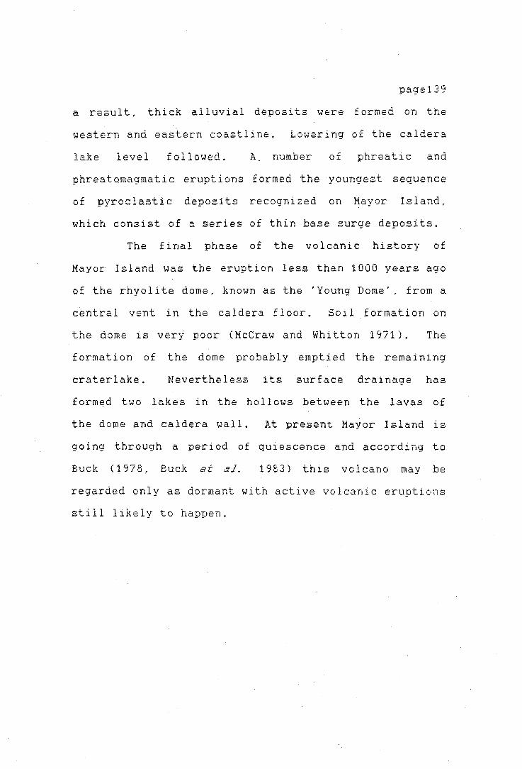
pagel39
a result, thick alluvial deposits were £ ormed on the
western and eastern coastline, Lowering of the caldera
lake level followed. A number of phreatic and
phreatomagmatic eruptions formed the youngest sequence
of pyroclastic deposits recognized on Mayor Island,
which consist of a series of thin base surge deposits.
The final phase of the vo 1 cani c hi story of
Mayor Island was the eruption less than 1000 years ago
of the rhyolite dome, known as the 'Young Dome', from a
central vent in the caldera floor. Soil formation on
the dome is very poor (Mccraw and Whitton 1971). The
formation of the dome probably emptied the remaining
crater lake. Nevertheless its surface drainage has
formed two lakes in the hollows between the lavas of
the dome and caldera wall. At present Mayor Island is
going through a period of quiescence and according to
Buck (1978, Buck et al. 1983) this volcano may be
regarded only as dormant with active volcanic eruptions
still likely to happen.
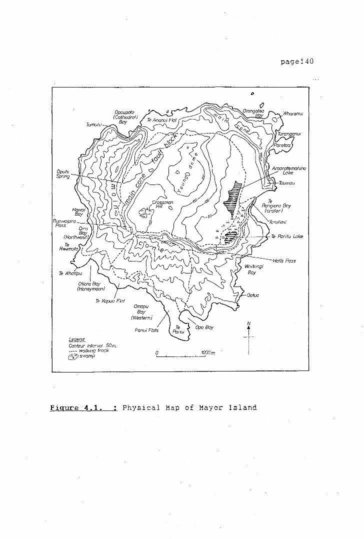
Opuhi Spring
~gend Cantaur interval 50 m. ---- walking track 6;)swamp
Figure 4.1.
Omapu Bay
(Western}
Panui Flats
0 1000m.
Physical Map of Mayor Island
page140
page141
TRADITIONAL HISTORY OF MAYOR ISLAND
Mayor Island has -been the territory of the
·Whanau a Tauwhao, a hapu of Ngaiterangi of the Mataatua
waka. Whanau a Tauwhao people claim not. only land on
Mayor Island, but also on Motiti Island, Rangiwaea and
Otawhiwhi (modern Bowentown) in the Tauranga District,
and some areas of the JUdermen Islands. The
traditional history of Mayor Island, or Tuhua, is
therefore closely interlinked with that of the mainland
areas in the Tauranga district. A detailed study of
the history of Whanau a Tauwhao, not only of Tuhua, but
from Motiti and the mainland areas has been compiled by
Stokes (1980) and Matheson (1971). Much of the
information presented here is based on Stokes (1980).
Whanau a Tauwhao trace their history back to
the Ngaiterangi who landed at Whakatane. After a
struggle with
people settled
the local Arawa people, Ngaiterangi
at Maketu. Nga1terangi people at a
later date conquered Maunganui
district, and later consolidated
in
this
the Tauranga
conquest by
intermarriage with Ngati Ranginui people of Tauranga.
Whanau a Tauwhao also trace their ~ncestry to
the Tangata Whenua before the arrival of the canoes
Mataatua, Te Arawa and Tainui.

page142
Wilson (1906:30-31) comments on the conquest of
the pa at Maunganui and the relationship between Whanau
a Tauwhao and Nga1 terang1 .. -
Thus about one hundred and fifty _years ago [c. A.D. 1700] Ngaiterangi obtained possession of Tauranga, and drove the remnant of its former people, Ngatipekekiore away into the hills, to the sources of the Wairoa and Te Puna rivers; where although now related to the conquerors they still live. Another hapu of Tauranga's ancient people are Te Whanau a Ngai Tauwhao .. also called Whitikiore. They hold Tuhua Mayor Island and in 1835 numbered· about 170 people. Their chief was Tangi teruru but now Tupaia (Hori Tupaea) .. chief of Ngai terangi proper, is also chief of both these tribes.
At a Land Court hearing in 1867 Hori Tupaea
established his claim to Motiti, in order to refute the
Arawa claim based on residence at Matarehua by
Ngatoroirangi, tohunga of Te Arawa (Stokes 1980:5).
Hori Tuapea stated:
I belong to the Whanau a Tauwhao. I belong also to Ngatiraukawa and al so Ngai terang i. The Ngai terang i are on shore and the Whanau · a Tauwhao are on two islands_. Motiti and Tuhua, 12 generations we have been here. My ancestors are buried at Motiti. I have also children born and died on Motiti. Te Ipu and Te Ninihi are living, they are my nephews. I have two children of my own born there.. .Akuhata and Hamiora. Tauwhao is the claimant to Motiti but the Ngatiawa are mixed ... I trace my claim from Hikutu (son of Tauwhao and Tamaoho) then Tahakura, then Kiriwhero, then Hinetehoro (mother) and then myse 1 f. ( quoted by
page143
Matheson 1971:85J.
At the same hearing a similar claim was
expressed by Te Patu:
The Ngaiterangi live on land and the Tauwhao live on two islands, Motiti and Tuhua. Ngaiterangi have nothing at all to do with Motiti. All the tribes know this. (Matheson 1971:85),
As Stokes ( 1980: 5) explains, Hori Tupaea does
riot actually refute his relationship with Ngaiterangi,
as he was a paramount chief of Ngai terangi. It was
important at that hearing to establish his prior claims
t~ Motiti Island. At present Whanau a Tauwhao regard
themselves as a mixture of Tangata Whenua tribes,
Ngaiterangi and Ngati Awa.
A number of traditions relate the story of the
origin of the obsidian or tuhua. Most of these relate
a struggle between the tuhua (obsidian) and pounamu
(greenstone) and tell how it came that the greenstone
is only found in the South Island. Different versions
are given by Hovell (1967), Best (1912), Colenso
(quoted in Best 1912), White (1897-90) and Grey (1956).
Colenso 's version gives also some background to the
volcanic history of Mayor Island:
This island appears to be of volcanic oriqin and abounds in ournice. obsidian. sla~ lava, pitchst;ne ~nd othe~ vitreous and volcanic substances. I use the word 'appears' in consequence
of a curious relation which some years ago I received from an old priest residing at Tauranga, in the Bay of Plenty. I had been inquiring of him the place where and the manner how, they in former days obtained the green jade or axe stone for orn~rnents and weapons of war. In answer to my inquiry he asserted that this stone was both a fish and a god ( atua, demon or supernatural thing); that it formerly lived at the Island of Tuhua, whither the skilled men of all the neighbouring tribes went to obtain it, which was done by diving, accompanied with several super st i ti ous ceremonies in order to appease its wrath, and to enable them to seize it without inJury to themselves; but that suddenly it made the whole island and surrounding sea its· cloaca maxima, covering every place thickly with excrementitious substances, which still remain, and swam away to the Middle Island (South Island) of New Zealand, where it has ever since resided, and whence they have been obliged to obtain it (Colenso 1845, quoted in Best 1912:203).
page144
Some of the local traditions refer also to old
inhabitants of Tuhua. Stokes (1980) collected a number
of different versions of these traditions. They tell
of a group of people Tangata Whenua, called Te Ananui,
that lived on the island. When people from Hawaiki
invaded the island they moved to the northern flats on
the coast - Te Ananui Flats - where they continued to
live and grow their kumara. Years later a group
decided to return to Hawaik i, and a group 1 eft under
Akakura, leaving the chief Te Whitikiore behind (~tokes
1980:12).

I
page145
THE HISTORIC PERIOD
In 1864 Mayor Island was included in the
Tauranga confiscation act, but was· later returned to
the· ot1nership of Whanau a Tauwhao. In 1888 a Crown
Grant was issued, under which the island was divided
under 95
purchased
share
some of
owners. Subsequently
the shares (AJHR G10
the Crown
1886:3 and
Apendix 1). At the time that Wilson visited the island
in 1835 only 170 people resided there permanently. In
1862 an epidemi·c killed about 60 people and by 1864
only 23 adult males were living on the island (AJHR E2,
1864). Tribal battles between Whanau a Tauwhao and the
Arawa and the Ngapuhi frpm the North in 1820 and later
in 1830 were also partly responsible for the population
decline. A number of the former residents left the
island to live on the mainland. Most settled around
Katikati. In 1884 Gold-Smith visited the island. He
reports that only nine people,
and two girls were living
(Gold-Smith 1884).
three
on the
men.
pa
four women,
at Te Panui
Since 1913 Tuhua has been a sanctuary declared
under the Animals Protection Act 1908 (New Zealand
Gazette 1913:1883). A further declaration in the
Gazette in 1919 (New Zealand Gazette 1919:1252) set
Mayor Island apart as a sanctuary and reserve for the
preservation of imported and native game. Under the
Wildlife Act of 1953 the island became a Wildlife
' )
page146
Refuge.
In the early 1940s the island was vested in a
Trust Board retpresenting the Maori landowners and the
Crown. In 1949 the Maori Land Court appointed a group
of 11 trustees ( 8 Maori representatives and 3 Crown,
representing the Departments of Maori Affairs and Lands
and Survey). These trustees have the authority to
administer the reserve as if it were a National Park.
THE MAYOR ISLAND OBSIDIAN DEPOSITS
At a number of localities on Mayor Island,
obsidian suitable for artefact manufacture is
available. The quality of the different flows is quite
distinct.
obsidian
At several points high quality flaking
with a minimum of microlites and
phenocrystaline inclusions is found. Each obsidian
variety , distinguished on the basis of its colour has,
traditionally, a separate maori name. Hata is the
common name for obsidian. It is also known as tuhua ..
hence the rnaori name for Mayor Island. Traditionally
four types of obsidian are thus distinguished. Tuhua
is the black variety, fila.iapu a light honey coloured
obsidian, P<'zretoa a greenish-black obsidian, and
Kahuran!)'i reddish-brown obsidian (Best 1912:197).

page147
Sladden (1926) and Thomson (1926) were the
first to properly survey Mayor Island. They noted "the
black glassy substance known as obsidian, with which
the island abounds.. and which is a product of its one
time volcanic activity " (Sladden 1926:195).
Sladden noted obsidian flows
on the northwestern side of the island, where the cliffs rise up sheer to a height of over 300 ft. or more here ar~ to be seen at intervals one above the other, several strata of a red crumbly substance resembling burnt earth "(ibid.:196).
Sladden also noted at the northern headland of
Omapu Bay the impressive archway "composed partly of
obsidian, its flat top being crowned with a straggling
growth of pohutukawa" (ibid.:197).
Thomson, who visited the island during the same
year, mentioned in a separate report the sources from
which high quality £laking obsidian could have been
extracted in former days. 1'.t Orongatea Bay he noted
that "sea-cliffs appear to be entirely composed of the
tuffs of more than one series, but the stacks known as
the Pinnacles are composed of dykes with vertical
obsidian .selvages" (Thomson 1926:211). He also
observed the large variability in the colour of the
obsidians, "although black obsidian is the commonest, a
great variety of colours can be collected, grading down
to pale salmon-pink and glasses resembling beeswax 1n

page148
coiour and lustre" (ibid.:212). He also mentioned that
the obsidian selvages at Orongatea Bay for the most
part contained fairly numerous phenocrysts of quartz
and feldspar. Other deposits described by Thomson are
the ones at Opo Bay on the north side of the bay and
also those on the east side of the island from Opo Bay
to Te Rangiora Head, where the obsidian flows are 20 to
30 feet in thickness Cibid.:212-213).
Marshall (1937) notes that all around the
island, except at Taratimi Bay., two separate obsidian
selvages are to be found, the formations have an upper
and lower selvage of obsidian. Lastly Brothers' (1957)
main interest when surveying the island was to
establish its volcanic history. He nonetheless noted a
number of the distinct flows of the main volcanic cone,
observing that "individual flows have no great vertical
thickness and rarely exceed 100 feet, but laterally
they sometimes extend for many hundreds of yards"
(ibid.:338). ObsidiaD selvages on both upper and lower
surfaces are a consistent feature of the £lows. The
upper surface invariably is extensively ruptured and
penetrated by less glassy lava which has welled up from
within the flows so that the top selvage rarely forms a
continuous sheet. On the other hand, the lower selvage
is usually of uniform thickness and is lateially
continuous. Lower selvages vary from several feet to 9
feet in thickness. Upper selvages are generally
thicker, even were unbroken, or where flow brecciation
page149
of the upper selvage has caused mixing of obsidian
blocks with stoney lava. This top zone may be up to 20
feet thick.
Brothers recognized a number of thin obsidian
selvages along the northern and western side of the
island following a ring shaped fault line. Brothers
(1957) believed these obsidian selvages and the fault
line, indicated the location of an "old dome" which
filled the present crater valley, Buck (1978, Buck et
al. 19 81) has shown that this feature never eid sted ..
but that the materials of the old dome, which were
"massive rhyolite flows, with numerou~. glassy phases ..
bearing thin selvages of obsidian " (Brothers
1957:553), escaped through a number of secondary vents
during the period of caldera collapse, between 8000 and
7000 years B.P. (Buck 1978:193, 197-198). True
obsidian is not found on the slopes of the "young dome"
in the caldera.. "for the glassy rocks invariably
contained 30 per cent or more of phenocrystic material
" (Brothers 1957:556).
Pas, in 1965
three localities on
collected obsidian samples from
Mayor Island which he named
'sources' • The three localities sampled had high
quality glassy obsidian, one located near Paretoa Pa
(N54/16), and one on the north side of Oira Bay. The
third locality sampled was an old prehistoric quarry
site on the crater wall,. known at present as the
'Staircase' (Pas 1965:108). None of the localities can
'T
page150
be truly called 'individual sources', since, as already
mentioned by Brothers ('1957), Thomson C 1926) and
others, the obsidian appear~ in more or less continuous
flows all along the walls of the main crater.
Ward (1971) for his obsidian characterization
study used obsidian collected from eight separate
localities around the island (Ward 1971:Apendix 1).
These are described individually and are included in
Table 4.1. below.
A number of other localities were found during
the 1982 survey where high quality glassy obsidian
could be extracted with relative ease. At the bottom
of the cliffs on the south side of Te Rangiora Bay the
lower obsidian seam was sampled. Obsidian here is of
high quality. High quality obsidian from the upper
selvage was also exposed on the crater rim behind
Taumou Pa. Obsidian with a high percentage of
phenocrysts can be. picked up at a number of places on
the interior slope of the main cone, especially around
Hall's Pass, and Rauwaipiro Pass. Along the ring fault
line on the western side of the island large
semi-glassy lava flows can be observed, some of which
contain sections of low quality flaking obsidian, and
some good quality obsidian boulders.

page151
TABLE 4.1 ..
Description of sampled obsidian deposits on Mayor Island
Locality Location Name
Te Raumata South end of Oira Bay
Oira Bay North End of Oira Bay
Taratimi Above the 'Staircase' and from the old q·uarry
Opo Bay
Okawa
Rangiora
Taumou
Halls Pass
Opuhi Spring
North end of Bay upper and lower selvages
Between Waitangi and Te Hora Bay
South tip of Okawa Point
South side of Te Rangiora Bay from loi;.:er selvage
On crater rim behind Taumou Pa
obsidian from the upper selvage, on the ins1e1e of the crater wall
500 m North of the spring
Obsidian Quality Description
banded flows, high vitreous lustrous
flows range in high colour from black to honey, lustrous
black vitreous high
black banded
honey coloured vitreous lustre
black vitreous
black to blackgreen vitreous,
black lustrous and vitreous
black with phenocryst inclusions
boulders on valley floor, green-black and black banded stratified flow
good
good
good
high
high
poor
good to poor
page152
ARCHAEOLOGICAL FIELDWORK. ON MAYOR ISLAND
Mayor Island was first surveyed by the
Government surveyor Gold-Smith in 18 8 4. Many of the
places visited by him can no longer be identified ..
since they are now overgrown by dense bush. The
population at that time was living at Te Panui pa,
which Gold-Smith described as occupying
a very strong position; from the seaward side it is only accessible by climbini up perpendicular cliffs of basalt, pumice and obsidian. The natives make use of a rough ladder, by which they descend to the foot of the cliffs, where hauled up on the beach they keep their canoes. The pa is situated about 100 feet above sea level (Gold-Smith 1884:420),
South of the pa on a flat area, occupying about
25 acres, Gold-Smith observed cultivations of potatoes,
kumara, corn and tobacco, strawberries and raspberries
(ibid.)
He also visited two further pa located on the
same bay - Okotore and Tikitikinahoa, both occupying
strong positions. Gold-Smith also mentions garden
areas in the inside of the crater on the south side of
the lakes (ibid.:422). He further mentioned a number
of other pa, some of which he visited. Taumou pa on
the north end of Te Rangiora Bay was in his opinion the
strongest on the island. On a 500 feet high crag "with
precipitous slopes on three sides, and with only a very

page153
narrow steep approach to it up a ridge of obsidian
which the pa commands. There are large quantities of
obsidian about the pa, in blocks of from a few pounds
weight up to many tons" (ibid.:423). A small spring
surfaces at the top of this pa. Tarawakaura, on the
top of the 'Young Dome' was not visited by him.
Gold-Smith observed a number of old gardens and
cultivated spots around the isl and. E:{tens i ve areas
had been cultivated at Wharenui Point, Te Ananui Flats,
and especially on the fiat land around Oira Bay
reaching to Opo ·Bay. The land from Otiora Bay to Opo
Bay "has all been cultivated and the ruins of old
whares are still to be found. Ruins of old houses are
to be found in every favourable spot ... " (ibid.:426).
Another small pa at Oira Bay took the attention of
Gold-Smith. · Located at the south end of the bay, Te
Raumata pa holds " a very strong position. The ditch
which cuts it off from the main island is very deep
This point is highly 'tapu' "(ibid.).
Surprisingly, Gold-Smith does not mention any
places were obsidian was actively quarried. His only
reference to obsidian usage is when ref erring to the
siege of Taumou pa by Ngapuhi warriors in the 19th
century .. hurling the blocks of obsidian down on
their heads as they rushed to the attack, •. "
(ibid:423). Most probably boulders of rhyol i te lava
were used and not obsidian.
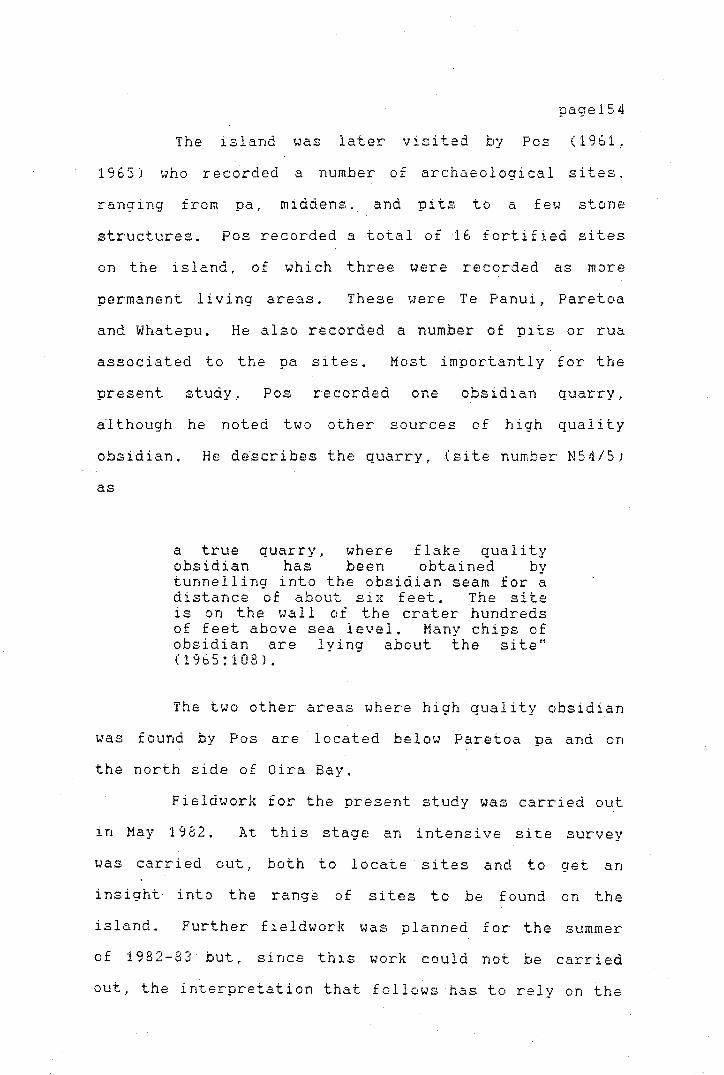
' /
page154
The island was later visited by Pas (1961,
1965) who recorded a number of archaeological sites.
ranging from pa, middens. and pits to a few stone
structures. Pos recorded a total of 16 fortified sites
on the island, of which three were recorded as more
permanent living areas. These were Te Panui, Paretoa
and Whatepu. He also recorded a number of pits or rua
associated to the pa sites. Most importantly for the
present study. Pos recorded one obsidian quarry,
a-1 though he noted two other sources of high quality
obsidian. He d~scribes the quarry, (site number N54/5)
as
a true quarry, where flake quality obsidian has been obtained by tunnelling into the obsidian seam for a distance of about six feet. The site is on the wall of the crater hundreds of feet above sea level. Many chips of obsidian are lying about the site" (1965:108).
The two other areas where high quality obsidian
was found by Pos are located below Paretoa pa and on
the north side of Oira Bay.
Fieldwork for the present study was carried out
in May 1982. At this stage an intensive site survey
was carried out.. both to locate sites and to get an
insight into the range of sites to be found on the
island. Further fieldwork was planned for the summer
of 1982-83 but, since this work could not be carried
out, the interpretation that follows has to rely on the

pagel55
information collected during the initial fieldwork
season.
Several of the sites described by Gold-Smith
and Pos were relocated and mapped, while others could
not be found or have been destroyed in the time which
has elapsed. The survey did not cover the entire
island as can be seen from figure 4.2. Some areas were
extensive 1 y surveyed ( Te Panui and Te Kopua Flats),
while others were only cursorily examined due to the
difficult terrain, dense vegetation and lack of time.
Areas not surveyed include parts of the Dome and
Crossman Hill, even though a brief reconnaissance of
these areas was made. Big lava blocks and thick
vegetation on a very thin soil, covers much of this
area.. which in places is extremely steep. The areas
between Oira Bay and Cathedral Bay on the north side as
well as the northeast area of the island could not be
surveyed in detail.
Description and Discussion of Sites
The sites will be.discussed in terms of their
type category rather than by geographical distribution.
A detailed description of each site with its site
record number and geographical coordinates can be found
in Apendix 2.
4 . 2 .
A list of site types is given in Table
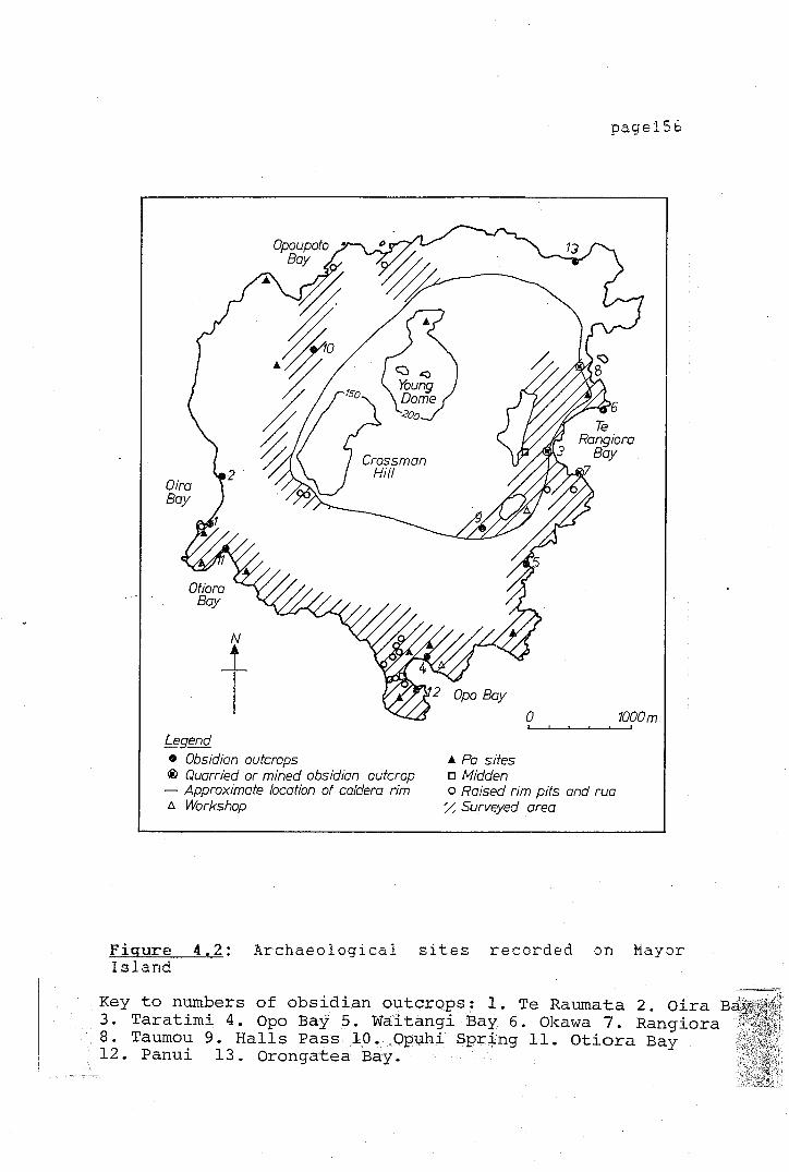
Legend • Obsidian outcrops ® Quarried or mined obsidian outcrop - Approximate location of caldera rim 1:,. Workshop
page156
0
..t. Pa sites o tvftdden o Raised rim pits and rua % Surveyed area
1000m.
Figure 4.2: Archaeological sites recorded on Mayor Island
Key to numbers of obsidian outcrops: 1. Te Raumata 2. Oira B ·· 3. Taratimi 4. Opo Bay 5. Waitangi Bay 6. Okawa 7. Rangiora
• 8. Taumou 9. Halls Pass 1.0. Opuhi Spr.:1-ng 11. Otiora Bay ' 12. Panui 13. Orongatea Bay.
iddda24p
Rectangle
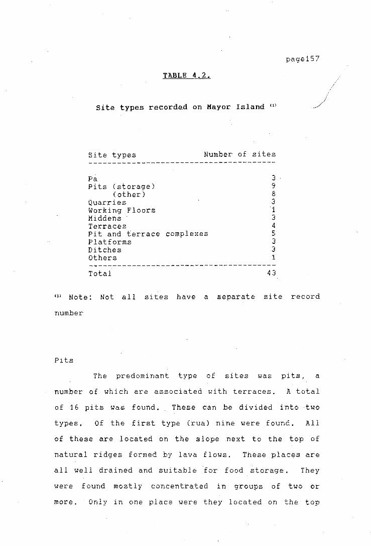
TABLE 4.2.
Site types recorde_d on Mayor Island w
Site types Number of sites
Pa Pits (storage)
(other) Quarries Working Floors Middens Terraces Pit and terrace complexes Platforms Ditches Others
Total
3 9 8 3 1 3 4 5 3 3 1
43
page157
m Note: Not al 1 sites have a separate site record
number
Pits
The predominant type of sites was pits, a
number of which are associated with terraces. A total
of 16 pits was found. These can be divided into two
types, Of the first type (rua) nine were found. All
of these are located on the s 1 ope ne:{t to the top of
natural ridges formed by lava flows. These places are
all well drained and suitable for food storage. They
were found mostly concentrated in groups of two or
more. Only in one place were they located on the top
iddda24p
Rectangle
page158
of the ridge itself (site N54/23) where they are
associated with a terrace complex.
Of the second typ~ of pits (rectangular} eight
were found. These are rectangular ·structures, with a
raised rim on at least three sides. Dimensions vary
from 2 metres wide to 7 metres wide and 3.5 metres long
to 10 metres in length. Three of them were found
isolated from other archaeological features, while two
were found together and associated with an apparently
defensive ditch nearby. These two are located on top
of the crater rim, while the others are on the flat
areas near the coast.
Pits and Terraces
Five complexes of pits and terraces were found.
The terraces have all been cut into the sides of
natural ridges or the top of these have been
artificially flattened. Some of the terraces are very
narrow, and might support at the most two houses
(N54/23). The pits are located on the sides of the
ridges and not on the terrace proper, as it is the case
for the isolated pits. The pits associated with these
terraces are all of the first type (rua) .. with one
exception (rectangular raised rim pit).
page159
Terraces and Platforms
Two types of platforms were found built on
natural lava ridges, or of artificially built up soil.
Two platforms built by flattening the top of natural
ridges were found over Parikoura Point. Gold-Smith
(1884) describes a pa in this vicinity. No
fortification remains are obvious on the surface, but
shell fragments indicate that the area has been used as
a living place. The other platform is an artificially
built up earth mound, surrounded by an artificial
ditch. It is possible that it supported some kind of
house structure. Two sma 11 terraces cut into a low
ridge were found along Te Kopua Flats. They resemble
rectangular pits, but the area has been artificially
levelled and the soil used to build a bank and rim
around the terraces. A ditch drains the upper terrace.
Middens
Three middens close to fresh water sources were
found as well as a few isolated shells in the vicinity
of some of the pi ts and terraces. Two middens were
located near the beach on the edge of a natural bank.
The upper one has been exposed by erosion of the bank
and the midden can be seen in the cut underneath the
roots of an old pohutukawa tree. The lower midden
could have been formed by dumping the refuse over the
bank, or through erosion of it. Midden remains include
Nerita sp., paua (lial.iot.is .fr.is ), limpets (Cellamr
'r
page160
str.i;ril.is and C. radians), Cook's turban ( Coo.kJa
su.l ca ta) .. and T.lh'7.is or.b.ita. Fi shbones are abundant in
the two coastal
flakes were found
middens
in all
and
of
charcoal and obsidian
them. Only one midden
deposit was found inside the crater at the shores of
the Green Lake ( Arolxrotam,"!.h.ine).. while some isolated
shells were found at the working floor inside the
crater described below.
Pa
Only three sites
category. Fifty per cent
recorded fall into this
of the sites recorded in
earlier surveys were pa, and two of the pa sites
recorded and mapped in 1982 had been recorded earlier.
Most of the sites recorded in previous years are almost
inaccessible due to the extremely dense vegetation that
has grown and obliterated many of their original
features. Taumou (N54/4) has been recorded earlier.
This is a fortified terraced pa built on top of the
crater rim on a high peak with almost vertical walls
and cliffs falling away on three sides. Only three of
supposedly seven terraces could be positively
identified.
The other two fortified sites include o~e
headland pa, built on a peninsula with cliffs on three
sides of it, overlooking Opo Bay (Panui). A defensive
ditch has been recorded for this site but a modern
tractor track has been cut along it. The other pa is
page161
built on a natural ridge with a defensive ditch on one
end, and a natural scarp surrounding the remainder of
the site.
Ditches
One ditch was found that cuts through the
crater rim and seems to serve a defensive purpose. It
is associated with two rectangular pi ts. One of the
obsidian quarries (Staircase) is a few hundred metres
further along the crater rim. Other small ditches were
found crossing through small ridges near some of the
storage pits. It is more likely that these served as
drains, since they were very shallow, narrow and short.
They cut across the top of these ridges and then
disappear.
Gardening sites
No positive identification of gardening areas
was made. A stone alignment enclosing the upper part
of one small valley or drainage was found. It is not
clear what function it might have served. Other
possible stone alignments were found in the flat areas
behind Te Panui, which according to Gold-Smith had been
cultivated.
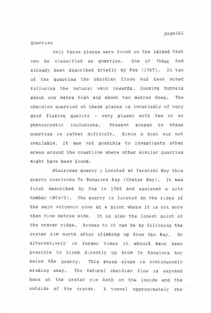
page162
Quarries
Only three places were found on the island that
can be classified as quarries. One ,:; O.!. t:he.se had
already been described briefly by Pas (1965). In two
of the quarries the obsidian flows had been mined
following the natural vein inwards, forming tunnels
about one metre high and about two metres deep. The
obsidian quarried at these places is invariably of very
good flaking quality
phenocrystic inclusions.
very glassy with few or no
Present access to these
quarries is rather difficult. Si nee a boat was not
available, it was not possible to investigate other
areas around the coastline where other similar quarries
might have been found.
Staircase quarry: Located at Taratimi Bay this
quarry overlooks Te Rangiora Bay (Crater Bay). It was
first described by Pas in 1965 and assigned a site
number (N54/5). The quarry is located on the ridge of
the main volcanic cone at a point where it is not more
than five metres wide, It is also the lowest point of
the crater ridge, Access to it can be by following the
crater rim north after c-1 imbi ng up from Opo Bay. Or
alternatively in former times it should have been
possible to climb directly up from Te Rangiora bay
below the quarry. This steep slope is continuously
eroding away. The natural obsidian flow is exposed
here at the crater rim both on the inside and the
outside of the crater. A tunnel approximately one

\
page'l63
metre wide and 1.5 metres deep has been mined into the
obsidian selvage on the outer wall of the outcrop. On
the inside overlooJung the caldera some pecking has
also been carried out. The ground around the outcrop
and in front of the 'shaft' is covered with small waste
flakes and irregular pieces of obsidian. not bigger
than 15 cm in length. The waste flakes do not cover
the ground thickly and are probably the result of the
mining activities. There is no evidence that the
blocks obtained were further worked at this site, and
no hammerstonei or worked cores were - found, The
material obtained from this selvage is of high quality
and since its surfaces are fresh, no decortication of
the cores would be necessary. (figure 4.3).
Outer wall of volcanic cone
0
Figure 4.3 : Aooroximate "Staircase" obsidian-quarry
1m
---Inside wall overlooking caldera of volcanic cone
cross-section through

page'l64
Taumou Pa Quarry : On the top of the rim of the
volcanic cone just behind Taumou Pa, the upper selvage
of obsidian is exposed. At this point the crater rim
is less than four metres wide. The obsidian outcrop
has been quarried here in several places~ Blocks have
been hammered out of the flow, but no tunnelling is
apparent. The area around the outcrop is also covered
with waste flakes (Figures 4.5a,4.5bl.
Te Rangiora Bay Quarry This quarry is located
at the end of a boulder beach at the south end of the
bay. Here, a mine drive has been quarried into the
cliff, the lowest part of which is mainly composed of
obsidian. The tunnel is about a metre wide and over a
metre in depth. It cuts obliquely into the rock
(plate 4.6 Small obsidian cores and waste flakes
surround the mining area.
have been mainly by sea.
Access to this quarry would
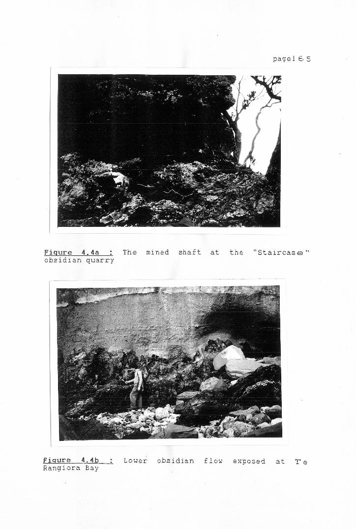
pagel 6 5
J
Figure 4,4a The mined shaft at the "Staircase" obsidian quarry
}-
Fiaure 4.4b Lower obsidian flow exposed at Te Rangiora Bay
I
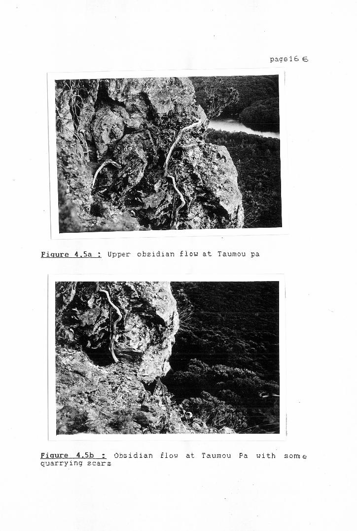
page16 6
.;
Figure 4,Sa Upper obsidian flow at Taumou pa
7 Figure 4, Sb Obsidian flow at Taumou Pa with some quarrying scars
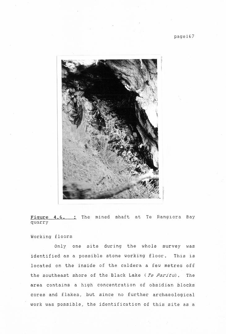
pagel67
Figure 4. 6. The mined shaft at Te Rangiora Bay quarry
Working floors
Only one site during the whole survey was
identified as a possible stone working floor. This is
located on the inside of the caldera a few metres off
the southeast shore of the Black Lake ( Te Paritu) . The
area contains a high concentration of obsidian b 1 ocks
cores and flakes, but since no further archaeological
work was possible, the identification of this site as a

1:-
page168
true working floor remains open, as well as the type of
work that was carried out there.
The occupation sites of Mayor Island do not
seem to be directly related to the extraction of
obsidian or the working of the quarries, Although the
raw materials are of excellent quality and abundant.,
archaeological sites associated with the extraction
work are not obvious. This is very strange in light of
the apparent importance of Mayor Island obsidian in New
Zealand prehistory. Further archaeological work on
Mayor Island was not possible during the course of the
present research since permission to carry out
excavations
Board. The
was refused by the Mayor Island Trust
archaeological potential of the quarries
and settlements is, nevertheless, not as promising as
could be expected from comparable archaeological sites
or quarries not only in New Zealand but other places of
the Pacific and further afield. For this reason, the
impossibility of carrying out further studies in the
area at the present stage does not seem a major setback
for the interpretation of the obsidian exploitation of
Mayor Island. However, if the decision by the Mayor
Island Trust Board should be reversed, further
archaeological fieldwork mig~ht focus particularly on
the relationships between the quarries and occupational
sites, as well as on the identification of lithic
workshops. An important aspect of any future research
on Mayor Island would be to establish the nature and
location of the earlier settlements.
paget6'3
At present the
archaeological evidence for early permanent and
intensive, or. even for p~riodic occupation on Mayor
Island is surprisingly poor.
survey
An
of
DISCUSSION AND CONCLUSIONS
unexpected result
Mayor Island was
of
the
the archaeological
absence of any
concentrated quarrying and flaking areas. From the
volume of obsidian collected in archaeological sites
throughout New Zealand it is surprising to find only
two or three areas where some sort of continuous
quarrying of obsidian took place. Nor are these
quarries extensive, especially if one considers that
they were probably exploited over several hundred
years. No other archaeological remains such as
middens, ovens.etc. were found at the quarries, which
suggests that only periodic visits were made to the two
main quarry areas. Since access to the quarry at
Taumou Pa is necessarily through the pa site, and the
quarrying at this poirit is not extensive .. one might
assume that this outcrop was only used during the
occupation of the pa; again unsystematic working of the
quarry is indicated.

page170
The technology employed by the prehistoric
quarry workers in extracting the obsidian cannot be
reconstructed in detail. The absence of known working
floors on the island and of major working debris at the
quarries, suggests that most of the material was
transported in blocks or cores to the rnai nl and from
where it was distributed to other parts of the country.
On the whole, the production and extraction industry of
the Mayor Island obsidian quarries, as can be
ieconstructed from this survey, does not seem to
provide any evidence to support restriction of access
to the quarries. No indication of specialization, or
intensive exploitation is present. This is coupled
with fairly unsystematic working patterns at the
quarries. Nevertheless, an important factor that
cannot be ignored is the fact that 30 per cent of the
recorded sites are defended settlements. It is
difficult to tell without further archaeological
fieldwork whether or not these belong to late Maori
occupation .. but traditional history suggests that the
defensive structures date from the later occupation.
It still remains to be found out if some of the
defended settlements date back to earlier periods. But
it is not known if the pa and quarrying sites are
contemporary or to what extent they are related.
,_
page171
The behaviour represented at the quarries does
not give any indication that a permanent workforce was
employed in extractive ta~ks for an ongoing e}rchange
system. This conclusion is also confirmed by the
evidence that cores and obsidian blocks were not
further worked on the is land. Since the material was
of such high quality, there was no need to test the
stone to ensure high quality obsidian was carried away.
At the same time, due to the nature of the material, it
is reasonable to argue that it was carried away in
whole cores fr·om which flakes could be struck as
needed, instead of transporting already struck flakes.
Travel by canoe also facilitates transport in the sense
that bigger loads could be carried.
It seems likely that e}tploitation of the raw
material was made for a number of different consumers,
such as, in the first instance,
themselves .. their relatives on
other groups more distantly
Mayor Island residents
the mainland, and for
related. Traditional
history shows that the people of Mayor Island had close
links with the mainland tribes, and it is therefore
probable that much of the quarrying and extraction work
was also performed to supply these groups with raw
material.
Special purpose visits could have been also
performed by groups from further afield. Maning
(1875:103) mentions that the Ngapuhi from Northland
went to Mayor Island from where they obtained their
r
obsidian.
page172
P.dams (1971:32) says that Mayor Island was
the subject of many raids by other tribes, Ngapuhi and
Rarawa from the north and -Ngatimaru from the west, Te
Arawa from the south and Ngatiwa from the east, all at
various times .. either in search of utu ,· or "just for
the devil of it" (ibid.). From this last statement it
appears quite possible that a number of these raids
could in actual fact have been carried out in order to
obtain obsidian.
When comparing the exploitation of obsidian
with that of other lithic resources in New Zealand one
finds some substantial differences. Most important is
the absence of large working floors and flaking debris
close to the quarries. It is hypothesized here that
most of the obsidian from Mayor Island was quarried
during periodic visits to the island for the specific
purpose of obtaining obsidian. Further research, such
as survey and excavation work on Mayor Island is needed
to fully confirm this.
In the next chapter the results of the sourcing
analysis of the obsidian assemblages found in
archaeological sites both in the North and South
Islands are given. The regional analysis should help
in the confirmation or refutation of this conclusion.
page173
CHAPTER V
THE SOURCING OF NEW ZEALAND
OBSIDIAN: THE
ARCHAEOLOGICAL SAMPLE
INTRODUCTION
The obsidian artefacts analyzed for the purpose
of this study came from 58 archaeological sites; most
of these come from dated contexts, either directly by
C14 dates, or through comparison of the site's
diagnostic artefacts with other dated sites in the
area. Thirty-seven of the sites are in the North
Island, and the remaining 21 are located in the South
Island. The size of the obsidian assemblages varied
from about 20 to over 5000 flakes in a single
assemblage. The assemblages were selected as far as
possible to represent all different geographical areas
within New Zealand. The location of the sites is shown
in Figure 5.1.
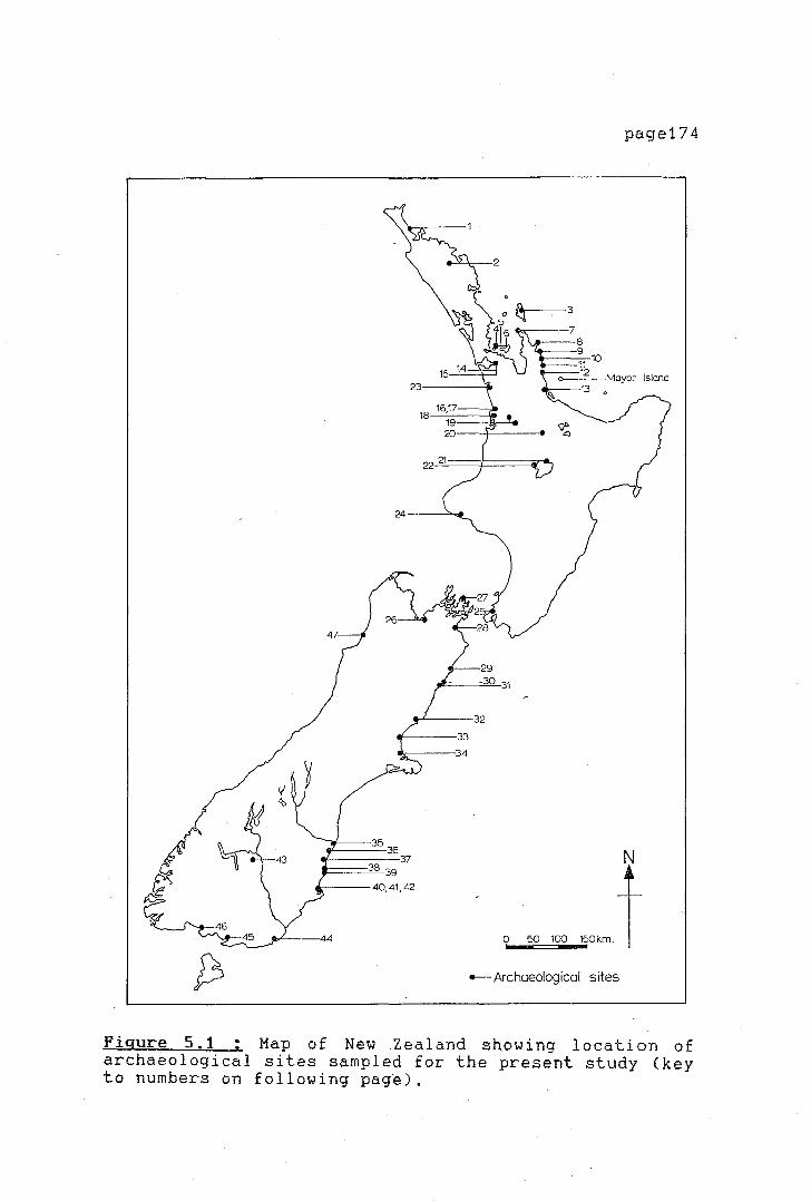
;.
24.--~~
35 36
-----37 38 39
---40,41,42
page174
0~50=1=-00-W~+
.-Archaeological sites
Figure 5.1 ; Map of New Zealand showing location of archaeological sites sampled for the present study (key to numbers on following pag~).

page175
Key to site numbers in Figure 5.1.
NORTH ISLAND SOUTH ISLAND
1. Houhora 26. Tahunanui 2. Pouerua 27. Titirangi Pits 3. Harataonga Middens and Sandhills
(N30/3, N30/4, N30/5) 28. Wairau Bar 4. Station Bay N38/30 29. Clarence River 5. Station Bay N38/37 30. Avoca 6. Sunde 31. Peketa 7. Port Jackson 32. Timpendean 8. Skippers Ridge I and II 33. Houhoupounamou 9. Hahei 34. Redcliffs
10. Hot Water Beach 35. Waitaki River Mouth 11. Tairua 36. Tai Rua 12. Whangamata 37. Waimataitai 13. Kauri Point Swamp 38. Shag River Mouth 14. Ellett's Mountain 39. Shag Point 15. Hamlin's Hill 40. Purakanui 16. Raglan N64/16 41. Long Beach 17. Raglan N64/18 42. Murdering Beach 18. Aotea: Koreromaiwaho 43. Hawksburn 19. Mangakaware; Ngaroto 44. Pounawea 20. Tokoroa 45. Tiwai Point 21. Whakamoenga Cave 46. Pahia 22. Waihora 47. Heaphy River Mouth 23. Maioro 24. Hingaimotu 25. Paremata
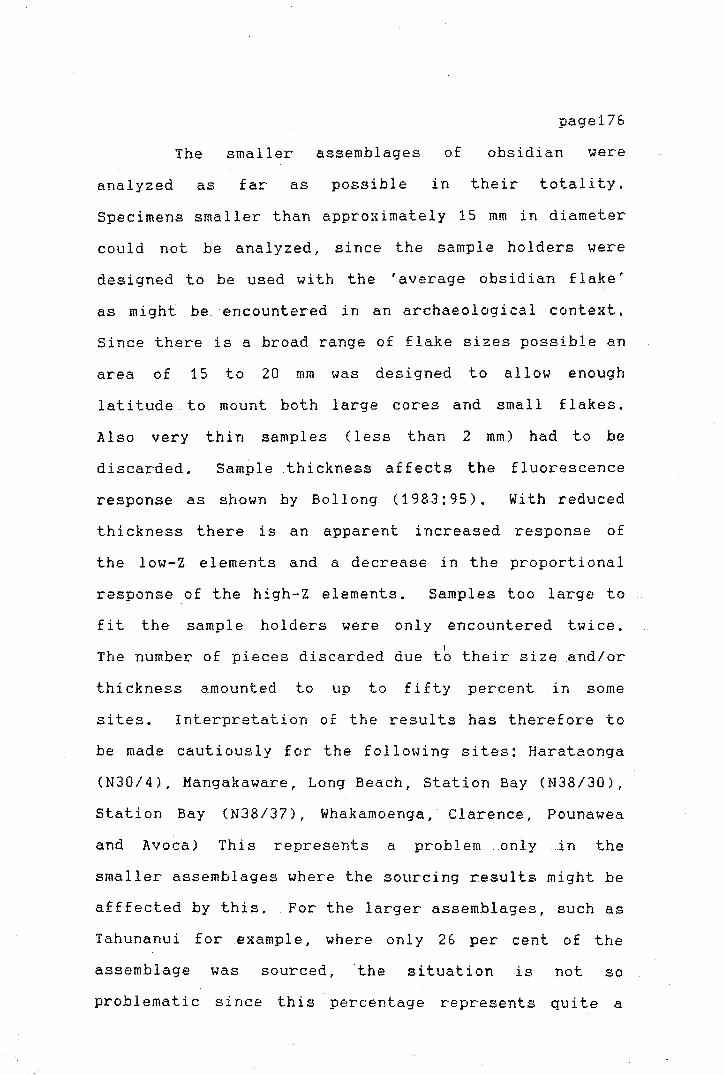
The smaller assemblages of
page176
obsidian were
analyzed as far as possible in their totality.
Specimens smaller than approximately 15 mm in diameter
could not be analyzed, since the sample holders were
designed to be used with the 'average obsidian flake'
as might be encountered in an archaeological context.
Since there is a broad range of flake sizes possible an
area of 15 to 20 mm was designed to allow enough
latitude to mount both large cores and smal 1 flakes.
Also very thin samples (less than 2 mm) had to be
discarded. Sample thickness affects the fluorescence
response as shown by Bollong (1983:95). With reduced
thickness there is an apparent increased response of
the low-Z elements and a decrease in the proportional
response of the high-Z elements. Samples too large to
fit the sample holders were only encountered twice. I
The number of pieces discarded due to their size and/or
thickness amounted to up to fifty percent in some
sites. Interpretation of the results has therefore to
be made cautiously for the following sites: Harataonga
(N30/4), Mangakaware, Long Beach, Station Bay (N38/30),
Station Bay (N38/37), Whakamoenga, Clarence, Pounawea
and Avoca) This represents a problem only in the
smaller assemblages where the sourcing results might be
afffected by this. For the larger assemblages, such as
Tahunanui for .example, where only 26 per cent of the
assemblage was sourced, the situation is not so
problematic since this percentage represents quite a
page177
large number of flakes. For the large assemblages a,
sampling strategy was adopted which is described below.
No attempt was made to select samples visually ..
according to colour variations in the obsidian, as this
would introduce observer bias,
MATERIALS AND METHODS
SAMPLING STRATEGY
Several of the obsidian assemblages contained
over 1000 obsidian pieces. It would take months with
the present efficiency of the equipment to analyze all
of them. It was therefore decided to take a sample.of
all assemblages of over 400 pieces of obsidian. To
determine the sample size an equation was used which
would allow the calculation of a sample size to
represent the obsidian population with an acceptable
margin of confidence (95 per cent). As a preliminary
step, the margin of error of the results of the
non-sampled obsidian assemblages already sourced was
calculated, It was found that at 95 per cent
confidence the margin of error obtained varied between
±4 per cent and as much as± 16 per cent. To calculate
approximate 95 per cent· confidence limits of the
results obtained by the isoprobe analyses the following
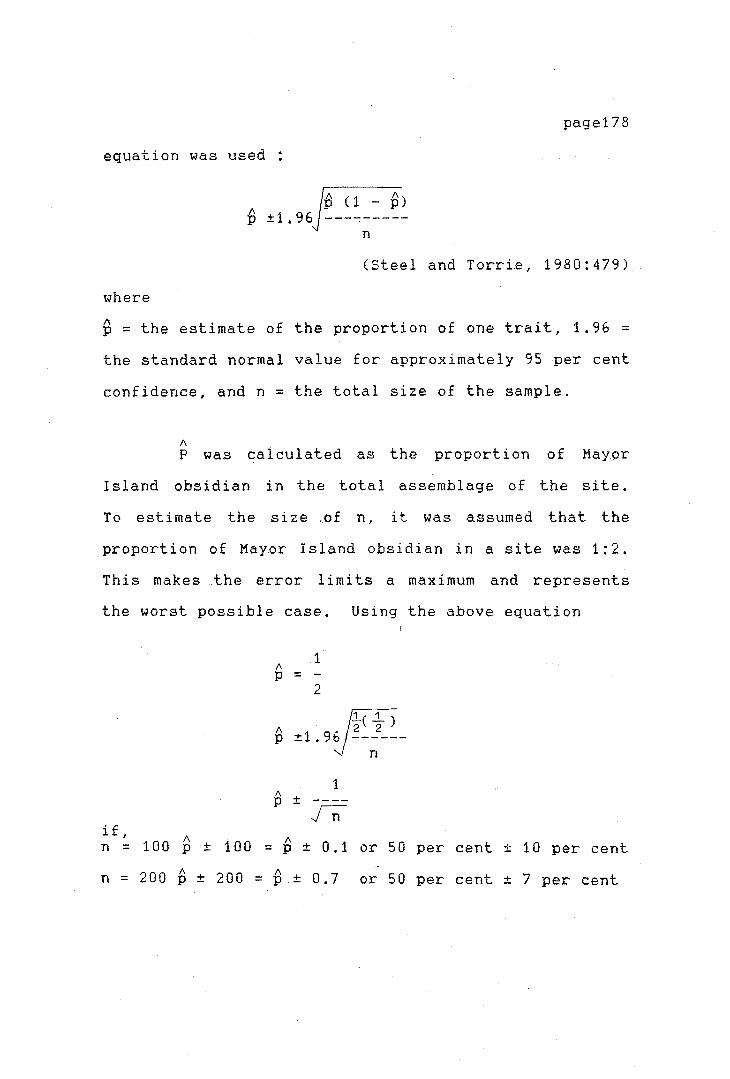
page178
equation was used:
(Steel and Torrie, 1980:479)
where
I\ p = the estimate of the proportion of one trait, 1.96 = the standard normal value for approximately 95 per cent
confidence, and n = the total size of the sample.
A P was calculated as the proportion of Mayor
Island obsidian in the total assemblage of the site.
To estimate the size of n, it was assumed that the
proportion of Mayor Island obsidian in a site was 1:2.
This makes _the error 1 irni ts a maximum and represents
the worst possible case. Using the above equation
if,
A p =
1
2
I\ - /Ft) p ±1. 9~ --~---
1 I\ p ± rr:
I\ I\ n = 100 p ± 100 = p ± 0.1 or 50 per cent± 10 per cent
n = 200 B ± 200 = B ± 0.7 or 50 per cent± 7 per cent

page179
The margin of error of ± 7 per cent obtained
with a sample of 200, satisfies the confidence limits,
since they are higher than in most cases where the
whole of the assemblage available was used. A sample
size of 200 is also a convenient number that can be
adequately run by the isoprobe facility in a reasonable
time.
The pieces were then selected using random
number tables. The method of selecting random numbers
varied between sites, depending on the cataloguing and
bagging system employed for each site. The sampling
strategy employed for each site sampled is discussed I
below. The sites which were sampled in this manner
were Hot Water Beach, Kauri Point Swamp, Whakarnoenga
Cave and Houhora.
Hot Water Beach
A 11 obsidian f 1 akes had individual accession
numbers. Random number tables were used to determine
which flake was to be sampled. From five digit numbers
the last three digits determined the sample chosen.
Houhora
The material from Houhora was analyzed by
Bollong (1983) when testing the setting up of the otago
University isoprobe facility. The Houhora material
contains over 3000 flakes; a sample of 400 flakes was
taken by Bollong (ibid.:137). The results of his
r
page180
analysis were checked against the modified program
SELECT, which allocates the individual pieces to a
reference source (see Brassey and Seelenfreund, 1984).
Kauri Point Swamp
The site contained over 10,000 flakes. The
obsidian pieces did not have individual accession
numbers which could be used for random selection, so
individually bagged specimens of about 200 at a time
were laid out in a line and every 20th bag chosen until
the desired sample size was reached. This procedure
was not strictly random, but there was no obvious
source for observer bias in the selection.
Whakamoenga Cave
Flakes for this site were selected using random
number tables. The flakes were all in separate
numbered bags representing separate excavation squares '-
and levels. The first two digits of the random number
determined the number of the bag to be sampled. and
the last digit determined the number of £ lakes taken
from each bag. These were then taken as a grab sample.
Some of the assemblages studied are extremely
small. This fact, and the under-representation of the
sites in the inland areas of the North Island, has to
be kept in mind when evaluating the results of the
fall-off studies.
page181
Nearly all the sites in the North and South
Islands are located very near or on the coast, and not
all the sites had the same functional status. Some are
large settlement sites, while others represent small
transitory camps, possibly occupied seasonally. The
absence of inland sites analyzed in the South Island,
except for Hawksburn, is due to the lack of obsidian
material in these sites, a significant fact in itself.
A short description of the archaeological sites
from which obsidian was analyzed is C"o.ntained, in
alphabetical order in Appendix 1. The number of
pieces of obsidian made available, and the number
sourced, is noted.
CHRONOLOGICAL FRAMEWORK
For the purpose of all subsequent analysis, the
archaeologicaL assemblages used in this study were
separated into groups of approximately contemporaneous
sites, to allow for a comparison of the sites on a
regional .. as well as on a local basis.
large enough to be subdivided on
The sample is
the basis of
chronology. This is a necessary step if changes in the
exchange system occurring during different times are to
be detected. It is highly desirable to group
assemblages into time periods for purposes of
time-trend analysis in exchange patterns. There is
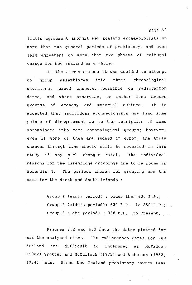
page182
little agreement amongst New Zealand archaeologists on
more than two general periods of prehistory, ana even
less agreement on more than two phases of cultural
change for New Zealand as a whole.
In the circumstances it was decided to attempt
to group assemblages into three chronological
divisions,
dates, and
grounds of
based whenever possible on radiocarbon
where otherwise, on rather less
economy and material culture.
secure.
It is
accepted that individual archaeologists may find some
points of disagreement as to the ascription of some
assemblages into some chronological groups; however,
even if some of them are indeed in er-ror, the broad
changes through time should still be revealed in this
study if any such changes exist. The individual
reasons for the assemblage groupings are to be found in
Appendix 1. The periods chosen for grouping are the
same for the North and South Islands:
Group 1 (early period) : older than 6JO B.P.;
Group 2 (middle period): 630 B.P. to 350 B.P.;
Group 3 (late period) : 350 B.P. to Present.
Figures 5.2 and 5.3 show the dates plotted for
all the analyzed sites. The radiocarbon dates for New
Zealand are difficult to interpret as McFadgen
(1982),Trotter and McCulloch (1975) and Anderson (1982,
1984) note. Since New Zealand prehistory covers less

than 1000 years, errors
proportionally large, e.g.
Some
more
page183
in radiocarbon dating are
errors of± 150 years at 95
charcoal samples seem to
years
per cent confidence.
produce dates 200 or
taken on bone collagen or marine
older than samples
shell from the same
sites. Trotter and McCulloch (ibid.:13) advise
ignoring the charcoal samples and relying mainly on
other dates, if available. The inconsistencies seem to
be greater for the earlier dates, while for dates
around 800 B.P. , the dates seem to be more in general
agreement. As McFadgen (1982:390) discusses, the time
elapsed between the date of death of the sample and the
date of an event are an important source of error. Due
to calibration curve errors and counting errors samples
less than 200 radiocarbon years apart cannot be
distinguished on either wood, charcoal or bone collagen
samples. For the purposes of this study, a mean date
has been calculated, or a date used for the site which
has been accepted by the excavators and is in general
agreement with the archaeological evidence from the
site, or the layer within the site.

zi ~ .... r+ C: :::n;
(I) ..... ~,v, Jl) •
::J N p..
(Q I-'•
let
r+ ::0 (D Ill (Q p.
I-'·
3 0 (D (1 :::i Jl) r+ ti 1-'· tr-0 0 ::J ::J (D p. p.
I-'· Ill ::J r+
(l)
r+ to ::," CD ,-..
I-'•
r+ ::J (1) :;,: rt-"<!
(I) p., I'"! (Q
to . 't1
'--"
l"h 0 I'"!
14 Ellett's Mt. (no date) 2 Pouerua (no date)
12 Whangamata 3a Harataonga Bay N30/4 8 Skipper's Ridge II
19a Mangakaware 19b Ngaroto 21a Whakamoenga (occupation 21a Whakamoenga (occupation 22 Waihora 23 Maioro phase 3 15 Hamlin's Hill (no date)
3b Harataonga N30/3 3c Harataonga N30/5
12 Whangamata 11 Tairua 10 IIot Water Beach 13 Kauri Point Swamp
9 Hahei 4 Station Bay N38/30
23 Maioro phase 2 18 Aotea 25 Paremata
5 Station Bay N38/37
4) 2)
21b Whakamoenga (occupation la) 21b Whakamoenga (occupation lb)
6 Sunde 8 Skipper's Ridge N40/7 7 Port Jackson l Jiouhora
16 Raglan N64/16 (no date) 23 Maioro phase 1 24 Hingaimotu (no date) 20 Tokoroa
7
I 21a
0
12 301 •••
8
21a 22
23 15
13 9
4
100 200 300
3b 3c1--~--<o--~----J
12 11
10
5 25
21b 21b
400
51 .... 8 ,__ ___ ___,
71----...-------,
23>-----t
201---~~~~~~~-1
500 600 700 800 900 1000 years BP 'd Pl IQ (l) ....,. 00 ,i:,..
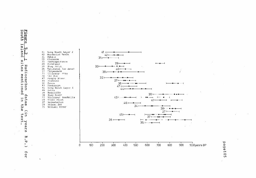
Uli g I-'• (+ c= :.:r 11
Cl) ,_,
~ IC.fl I'.}) • ::, w 0..
tr. I-'·
('T :u (D I'.)) tr. p..
l-'-3 0 Cl) (') ::, I'.}) ('T rs I-'• b" 0 0 ::, ::, (1)
0.. 0.. 1-'· I'.}) ::, ('T
Cl)
('T tr. :.:r (1) ;-..
I-'· ('T ::, (D ::,c: ('T '-<:
(1) l'.l) rj tr.
ttl . °'Cf
'-'
1-t)
0 Ii
);
41 Long Beach Layer 2 42 Murdering Beach 31 Peketa 29 Clarence 33 Houhoupounamou 40 Purakanui 39 Shag Point
,/
26 Tahunanui (no date) 32 Timpendean 27 Titirangi Pits 36 Tai Rua 47 Heaphy River 44 Pounawea 30 Avoca 43 Hawksburn 41 Long Beach Layer 4 46 Pahia 34 Redcliffs 38 Shag River 27 Titirangi Sandhills 45 Tiwai Point 3 7 l'/aima tai tai 28 Wairau Bar 35 l'/aitaki River
,,,.,.----c:--
'r
41 421
31
39
32
0 100 200
)' y
• ••
27, •• • 36
47 44
43, I
46 34
45
28
300 400 500
30 ,______... 41
I--37
35
600
1---.-----l
381 • • • 27
700 800 900 1000years BP 'd Ill u::i (1)
'""" 00 (Jl

1,
' -,
i .,_
I '
I .
I -
\_
T
These time divisions are not
page186
entirely
arbitrary, and some arguments can be advanced that they
may correspond with significant cultural and/or
economic changes in New Zealand prehistory. However,
this subject is beyond the scope of this thesis, and is
avoided whenever possible.
The divisions used here for separating the
sites are based on broad changes within the subsistence
strategies of both the North Island and South Island
Maori.
The first subdivision groups South Island sites
which are older than 630 years B.P .. The second group
includes sites in the range of 350 years B.P. to E, 30
years B.P., while the third group contains all sites
younger than 350 years B. P. The divisions are made
allowing for certain variations, some sites for example
have been grouped in the 630 years B.P and older group,
on account of their material culture and accepted
dates, even if some of their radiocarbon dates f al 1
outside the range given. Examples of this situation
are the Waitaki River Mouth and Pounawea sites.
The period of 630 B.P. and older coincides
with the settlement of the first sites on the South
Island, and the hunting of moas as a basic and
important subsistence activity. For the South Island,
Anderson (1983:47, 1984:734) argues for a peak in moa
hunting between 900 to 600 B.P., extending on the coast
to around 500 B.P. in the form of opportunistic

-r
·'\-
r
page187
hunting. On these grounds, as well as on evidence from
the North Islands sites, a division around 630 B.P.
seems reasonable.
The separation of the early North Island sites
is based on somewhat different criteria. The first
division contains the very early settlement sites of
630 years B.P. and older, grouping what probably
constitutes the first Polynesian settlement sites in
the North Island.
From 630 years B.P. to 350 years B.P. only a
few sites are represented. This di vision is taken to
mark a transition to the Classic Maori Phase. A trend
can be identified in subsistence pattern changes,
midden content, and increased number of storage pits.
The changing economic situation is also reflected in
the material culture in a decline in stone flakes size,
certain types of fishhooks, and a general shift in the
material culture.
The second group of North Is land sites, 63 0
years B. P. to 350 B.P., involves all sites with an
Archaic East Polynesian cultural assemblage. At the
same time, this classification keeps the sites on the
Coromandel Peninsula as one unit. As Law (1982:6)
notes that the Coromandel Peninsula sites are closely
related in their material culture and settlement layout
these sites show a fairly uniform cultural development
and material cultural and should be treated as a
contemporaneous unit.
The last group 350
present, covers what usually is
Maori occupation'. A fairly
identified between the dates
years B.P ..
termed the
marked gap
of Classic
page188
to the
'Classic
can be
Maori
occupation and the earlier sites in the South Island.
By 350 B.P. defended settlements on the North Island
are widespread, marking a change in subsistence.
patterns and in the general cultural assemblages.
THE SOURCING PROCEDURE
INSTRUMENTATION AND PROCEDURE OF ENERGY DISPERSIVE XRF
SPECTROSCOPY
The archaeological samples were analyzed using
energy dispersive X-ray fluorescence spectroscopy,
following the procedure detailed by Bollong (1983).
The obsidian samples were mounted whole on perspex
(cast acrylic) holders, which, in turn, are mounted on
a stainless steel rack using plastic magnetic strip.
Samples are brought into the irradiation position by
advancement of the rack. This can be control led by a
MDL microcomputer run under a CP /M operating system
connected to the sample · changer faci 1 i ty, as wel 1 as
manually.
page189
Sample preparation included surface washing and
brushing with acetone, technical grade ethanol, and
distilled water to remove, where necessary, labels and
surface contaminants.
Energy dispersive X-ray f 1 uorescence analysis
of the obsidian was carried out with an ORTEC model
7113-06175-S Si(Li) detector (effective diameter of 0.6
mm). Sensitivity is to a depth of 0.5 mm. Other
components of the system are a 0.05 mm beryllium window
that separates the detector diode from the atmosphere,
ORTEC 729-A liquid nitrogen level monitor, ORTEC 117-B
pre-amplifier, and an ORTEC 572 amplifier connected to
a NORLAND INO-TECH 5300 MCA. The amplifier gain
setting is of 0.61 x 100 and 1 u sec shaping time. The
amplifier setting had to be adjusted during the course
of the research due to minor changes in the element
peak positions. The analysis range is O - 60 KeV.
The radioisotope used for the analysis is a 50
mCi americium-oxide (isotope 241) source ceramic with
an active diameter of 6. 4
activity of 1554 mCi/cm
source is housed within a
mm. This gives a standard
squared. The radioactive
lead collimation container.
The collimation inserts are made from aluminium alloy
and capped with a 4 mm lead shielding to prevent the
transmission of uncollimated 59.57 KeV gamma radiation
(c.f. Bollong, 1983:64).

page190
Obsidian samples were analyzed for Rb, Sr, Y,
Zr, Ba, La, and Ce. To determine the analytical value
for the specified elements in the spectra, ratio
measures taken over the Compton/Rayleigh peaks were
employed, since these are within the spectrum and
independent of the trace element concentration.
Element ratios were not used since each of the possible
useabl e e 1 ements (Fe, Zr, and Ba) occur at zero 1 eve 1
in one or more particular source groups. The net
e 1 ement peaks were taken as ratios against the net
mid-Compton value and the ratio assigned as a measure
of the proportionate element presence (Bollong,
1983:108-110).
Samples were analyzed for 4000 seconds each and
assigned to sources using a special computer program.
FORTRAN program AUTOMCA developed at the University of.
Ota.go Archaeometry Laboratory controls the operation of
the automated sample changer facility and the transfer
of the collected spectra onto the microcomputer link.
Information is stored on 8" floppy disks and in
printout form. A separate program is used for
discriminating the spectra and matching them up with
the geological reference group. An outline of the
computer software employed follows; the two main
programs, AUTOMCA and SELECT are modified versions of
the software developed by Bollong (ibid.:80).
page191
FORTRAN program AUTOMCA records initial 1 y the
position of the samples on the stainless steel sled by
reference to a mounted s~ale. It records as well
literal information on the artefacts and run number
assigned by the onerator. - I
The program cross-checks
against possible duplication of existing run numbers
already present on the destination disk, as well as the
distances between samples as entered by the operator.
This information on the samples is kept on a separate
data file (SAMPLES.DAT).
Following this initial step the program
automates and runs the sample changer facility and
transfers the collected spectrum from the MCA to the
MDL. The program dumps the spectrum into the random
access memory (RAM) of the MDL and converts the 1024
channels into 512 by channel pair adding. This
sub-program incorporates the prepared data file
(SAMPLES.DAT). As the spectrum is transferred via the
MCA/MDL link, it is displayed on the graphics monitor.
The spectrum information is then written onto floppy
disk. AUTOMCA incorporates into one program features
of the separate programs MCA, NIGHT and CHANGER (c.f.
Bollong, 1983).
The spectra recorded on disk can be analyzed
using one of the following FORTRAN programs : AMSPEC as
described by Bollong (ibid.:83), which allows graphing
of the spectrum, determination of the energy of a
region or peak, integrate window areas and produce

}-
page192
counts per channel printouts of the spectrum displayed.
The sourcing of the obsidian is per£ ormed by
program SELECT, which is a- modified version of SCREEN
as developed and described by Bollong (ibid.:83,119).
The sourcing parameters are the same as in program
SCREEN. The modification resides in the reference
group file, where the mean and standard deviation
values for the Northland sources (Waiare, Pungaere,
Weta) were modified to reduce sampling error produced
through the inadequate representation in the reference
matrix of the· Northland sources. To reduce the
sampling error, which resulted in incorrect allocations
( see Brassey .1985, Brassey t. Seelenfreund, 1984), thirty
additional source samples were analyzed (samples were
obtained from the Otago University Archaeornetry
Laboratory and Auckland University Anthropology
Department comparative collections), and new values
calculated for the reference source matrix. The
ability of the system to discriminate between the Mayor
island and Northland sources improved, Nonetheless the
new set of source material was not obtained by
systematic re-sampling of the Northland sources; it is
therefore unlikely that the full range of intra source
variability is represented in the new sample
(ibid.:40). It is probable that source allocations to
the /JoyfJ./ah-d sources are still slightly higher.
This is only of particular importance for the sites in
the Northland area and will be discussed further below
)-
page193
when the sourcing results are described. The sourcing
program attempts to reject the unknown spectrum as
having come from one of t_he sources in the reference
group file against the two and three standard deviation
dispersion values for that element in a given source.
If the value does not fall within the two or three
standard deviation dispersion range for that element it
is rejected at a 99 per cent or 95 per cent confidence
level.
An additional set of ratios between elements is
used to increase the system's power to reject
inappropriate sources. Two sets of ratio tests were
used, one for the Mayor Island and Northland sources,
and one for al 1 other sources. Si nee both the Mayor
Island and Northland sources recorded had low to zero
Ba levels, this element could not be used to
discriminate between these two sources. Ratios in this
case were taken to the Zr peak. All other ratios are
taken to the Ba peak. During the actual running of the
program for the selection or screening process, each
element window value generated is compared element by
element with the reference source matrix, first at the
2 sigma dispersion level and then again at the 3 sigma
level. If any value beyond the standard range is
encountered the source is rejected. It then proceeds
to compare the ratio values for those sources which
have not been rejected on previous grounds.
page194
The only problem encountered with this method
was that due to the variability in surface texture of
the obsidian artefacts, the mid-Compton and Rayleigh
peaks varied sometimes in range far beyond the mean
values expected, as recorded by Bollong Cibid.:89-9A).
As a result of this, these spectra were
rejected as not belonging to any of the known obsidian
sources in the reference group. To overcome this
problem, the spectra were examined visually and the
proportional peak heights of the different element
concentrations were compared. On the basis of this
examination they could usually be assigned to a given
source.
THE SOURCE UTILIZATION PATTERN
The results of the sourcing procedures are
presented in Tables 5. 1 to 5. 3. Some comment on the
sample size is necessary here before interpreting the
sourcing results. The small sample size of some of the
sourced assemblages can pose a problem. The
interpretation of the sourcing results of the sites
with a sample size of fewer than 20 pieces is to be
taken cautiously. The margin of error for the relative
proportion of the sources used at these sites can be as
high as ±16 per cent (in the worst cases), In these
sites a variation of one or two pieces may change the
proportion of sources used quite drastically.
page195
Ideally
any sample size of fewer than, say, 20 pieces would be
discarded for reasons of statistical significance, but
this would reduce the number of sites by half; they '
have therefore to be used with caution.. These sites
are marked with an asterix in Figures 5.4 to 5.6 and
Tables 5.1 to 5.3. For this reason and for comparative
purposes the results have been standardized to
represent in all cases a sample size of n=20. The
standardization procedure does not in itself change the
proportions of the sourcing results when they are
expressed as percentages. Figures 5.4 to 5.6
graphically represent the percentages of each source of
obsidian in the total obsidian analyzed for each site.
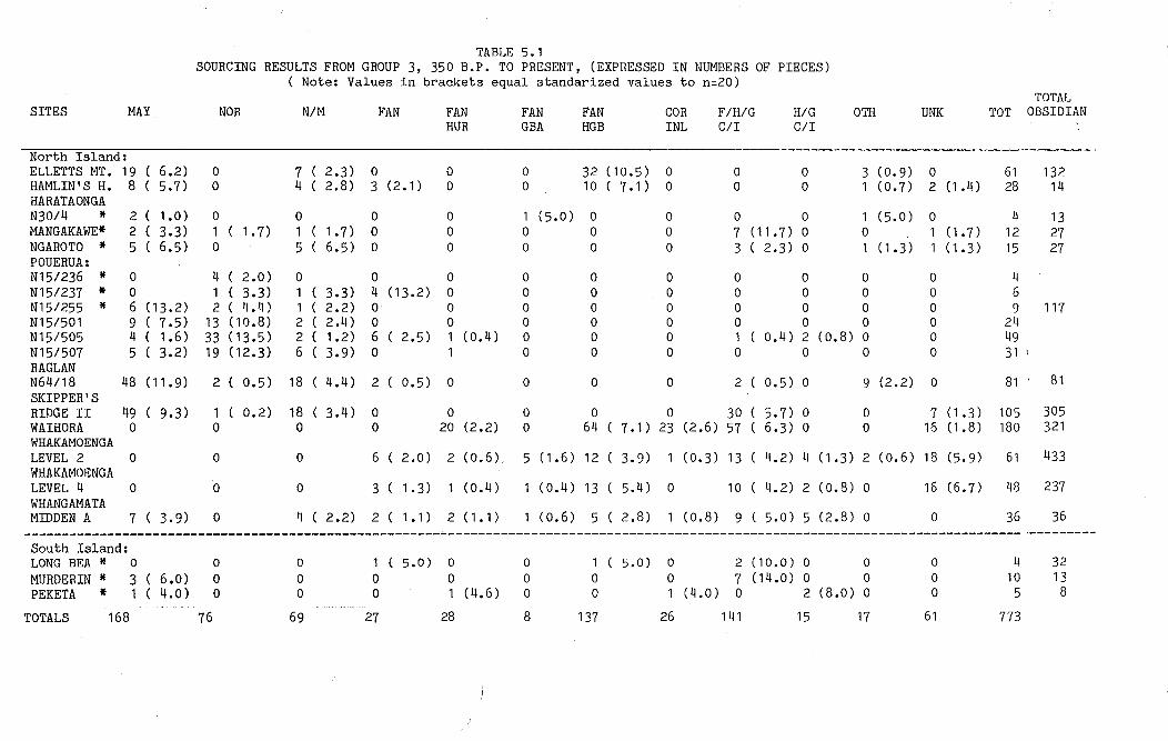
'" 'l 'j .,
)' >' " '11
"
TABLE 5.1 SOURCING RESULTS FROM GROUP 3, 350 B.P. TO PRESENT, (EXPRESSED IN NUMBERS OF PIECES)
Note: Values in brackets equal standarized values to n=20) TOTAL
SITES MAY NOR N/M FAN FAN FAN FAN COR F/H/G H/G 0TH UNK TOT OBSIDIAN HUR GBA HGB INL C/I C/I
North Island: ELLETTS MT. 19 ( 6.2) 0 7 C 2.3) 0 0 0 32 (10.5) 0 0 0 3 (0.9) 0 61 132 HAMLIN'S H. 8 C 5.7) 0 4 ( 2.8) 3 (2.1) 0 0 10 ( 7.1) 0 0 0 1 (0.7) 2 (1 .4) 28 14 HARATAONGA N30/4 * 2 ( 1.0) 0 0 0 0 1 (5.0) 0 0 0 0 1 (5.0) 0 4 13 MANGAKAWE* 2 ( 3.3) 1 ( 1.7) 1 ( 1.7) 0 0 0 0 0 7 (11.7) 0 0 1 (1.7) 12 27 NGAROTO * 5 ( 6.5) 0 5 C 6.5) 0 0 0 0 0 3 ( 2.3) 0 1 ( 1 , 3) 1 (1.3) 15 27 POUERUA: N15/236 * 0 4 ( 2.0) 0 0 0 0 0 0 0 0 0 0 4 N15/237 * 0 1 ( 3.3) 1 ( 3.3) 4 (13,2) 0 0 0 0 0 0 0 0 6 N15/255 * 6 (13.2) 2 ( 4.4) 1 ( 2.2) 0 0 0 0 0 0 0 0 0 9 117 N15/501 9 ( 7.5) 13 ( 10.8) 2 ( 2.4) 0 0 0 0 0 0 0 0 0 24 N15/505 4 ( 1.6) 33 (13.5) 2 ( 1.2) 6 ( 2.5) 1 (0.4) 0 0 0 1 ( 0.4) 2 (0.8) 0 0 49 N15/507 5 ( 3.2) 19 (12.3) 6 ( 3.9) 0 1 0 0 0 0 0 0 0 31 1
RAGLAN N64/18 48 ( 11. 9) 2 ( 0.5) 18 ( 4.4) 2 ( 0,5) 0 0 0 0 2 ( 0.5) 0 9 (2.2) 0 81 · 81 SKIPPER'S RIDGE II 49 C 9.3) 1 ( 0.2) 18 C 3,4) 0 0 0 0 0 30 ( 5.7) O 0 7 (1.3) 105 305 WAIHORA 0 0 0 0 20 (2,2) 0 64 ( 7,1) 23 (2.6) 57 ( 6.3) O 0 16 (1.8) 180 321 WHAKAMOENGA LEVEL 2 0 0 0 6 ( 2.0) 2 (0.6), 5 (1.6) 12 C 3,9) 1 (0.3) 13 ( 4.2) 4 (1,3) 2 (0.6) 18 (5,9) 61 433 WHAKAMOENGA LEVEL 4 0 ·o 0 3 C 1.3) 1 (0.4) 1 (0.4) 13 ( 5,4) 0 10 ( 4.2) 2 (0.8) 0 16 (6,7) 48 237 WHANG AMATA MIDDEN A 7 ( 3,9) 0 4 ( 2.2) 2 ( 1.1) 2 (1.1) 1 (0.6) 5 ( 2.8) 1 (0.8) 9 ( 5,0) 5 (2.8) 0 0 36 36
------------------------------------------------------------------------------------------------------------------------------------ ·---------South Island: LONG BEA* 0 0 0 1 ( 5.0) 0 0 1 ( 5.0) 0 2 (10.0) 0 0 0 4 32 MURDERIN * 3 ( 6.0) 0 0 0 0 0 0 0 7 (14.0) 0 0 0 10 13 PEKETA * 1 ( 4.0) 0 0 0 1 (4.6) 0 0 1 (4.0) 0 2 (8.0) 0 0 5 8
TOTALS 168 76 69 27 28 8 137 26 141 15 17 61 773
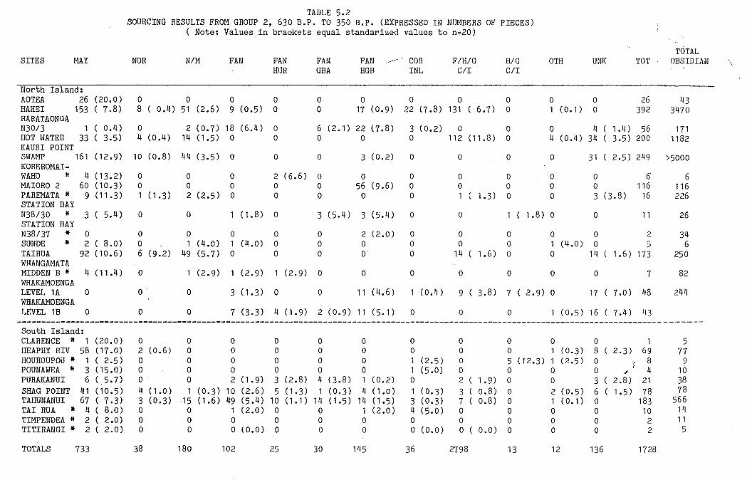
.,...,--1..~~
TABLE 5.2 SOURCING RESULTS FROM GROUP 2, 630 B.P. TO 350 B.P. (EXPRESSED IN NUMBERS OF PIECES)
( Note: Values in brackets equal standarized values to n=20)
TOTAL SITES MAY NOR N/M FAN FAN FAN FAN ,.,----- .. COR F/H/G H/G 0TH UNK TOT OBSIDIAN ' \
HUR GBA HGB INL C/I C/I
North Island: AOTEA 26 (20.0) 0 0 0 0 0 0 0 0 0 0 0 26 43 HAHEI 153 ( 7.8) 8 ( 0.4) 51 (2.6) 9 (0.5) 0 0 17 (0.9) 22 (7.8) 131 ( 6.7) 0 1 (0.1) 0 392 3470 HARATAONGA N30/3 1 ( 0.4) 0 2 (0.7) 18 (6.4) 0 6 (2.1) 22 (7.8) 3 ( o. 2) 0 0 0 4 ( 1.4) 56 171 HOT WATER 33 ( 3.5) 4 (0.4) 14 (1.5) 0 0 0 0 0 112 (11.8) 0 4 (0.4) 34 ( 3.5) 200 1182 KAUR! POINT SWAMP 161 (12.9) 10 (0.8) 44 (3.5) 0 0 0 3 (0.2) 0 0 0 0 31 ( 2.5) 249 >5000 KOREROMAI-WAHO * 4 (13.2) 0 0 0 2 (6.6) 0 0 0 0 0 0 0 6 6 MAIORO 2 60 (10.3) 0 0 0 0 0 56 (9.6) 0 0 0 0 0 116 116 PAREMATA * 9 (11.3) 1 ( 1.3) 2 (2.5) 0 0 0 0 0 1 ( 1.3) 0 0 3 (3.8) 16 226 STATION BAY N38/30 * 3 ( 5.4) 0 0 1 ( 1.8) 0 3 (5.4) 3 (5.4) 0 0 1(1.8)0 0 11 26 STATION BAY N38/37 * 0 0 0 0 0 0 2 (2.0) 0 0 0 0 0 2 34 SUNDE * 2 ( 8.0) 0 1 (4.0) 1 (4.0) 0 0 0 0 0 0 1 (4.0) 0 5 6 TAIRUA 92 (10.6) 6 (9.2) 49 (5,7) 0 0 0 0 0 14 ( 1.6) 0 0 14 ( 1 • 6) 173 250 WHANGAMATA MIDDEN B * 4 (11.4) 0 1 (2,9) 1 (2.9) 1 (2.9) 0 0 0 0 0 0 0 7 82 WHAKAMOENGA LEVEL 1A 0 0 0 3 (1.3) 0 0 11 (4.6) 1 (0.4) 9 ( 3.8) 7 ( 2.9) 0 17 ( 7,0) 48 244 WHAKAMOENGA LEVEL 1B 0 0 0 7 (3,3) 4 (1.9) 2 (0,9) 11 (5.1) 0 0 0 1 (0.5) 16 ( 7,4) 43
--------------------------------------------------------------------------------------------------------------------------------------------South Island: CLARENCE * 1 ( 20. 0) 0 0 0 0 0 0 0 0 0 0 0 1 5 HEAPHY RIV 58 (17.0) 2 (0.6) 0 0 0 0 0 0 0 0 1 (0.3) 8 ( 2.3) 69 77 HOUHOUPOU * 1 ( 2.5) 0 0 0 0 0 0 1 (2.5) 0 5 (12.3) 1 (2.5) 0 · .. ~ 8 9 POUNAWEA * 3 (15.0) 0 0 0 0 0 0 1 (5.0) 0 0 0 0 I 4 10 ,I
PURAKANUI 6 ( 5,7) 0 0 2 (1.9) 3 (2.8) 4 (3.8) 1 (0.2) 0 2 ( 1.9) 0 0 3 ( 2.8) 21 38 SHAG POINT 41 (10.5) 4 (1.0) 1 (0.3) 10 (2.6) 5 (1.3) 1 (0.3) 4 (1.0) 1 (0,3) 3 c o.8) 0 2 ( o. 5) 6 ( 1.5) 78 78 TAHUNANUI 67 ( 7.3) 3 (0,3) 15 (1.6) 49 (5,4) 10 (1.1) 14 (1.5) 14 (1.5) 3 (0.3) 7 c o.8) 0 1 ( 0.1) 0 183 566 TAI RUA * 4 ( 8,0) 0 0 1 (2.0) 0 0 1 (2.0) 4 (5.0) 0 0 0 0 10 14 TIMPENDEA * 2 ( 2.0) 0 0 0 0 0 0 0 0 0 0 0 2 11 TITIRANGI * 2 ( 2.0) 0 0 0 (0.0) 0 0 0 0 (0.0) 0 ( 0.0) 0 0 0 2 5
TOTALS 733 38 180 102 25 30 145 36 2798 13 12 136 1728

TABLE 5.3 SOURCING RESULTS FROM GROUP 1, 630 B.P. AND OLDER (EXPRESSED IN NUMBERS OF PIECES)
( Note: Values in brackets equal standarized values to n=20)
TOTAL SITES MAY NOR NIM FAN FAN FAN FAN COR F/H/G H/G 0TH UNK TOT OBSIDIAN
HUR GBA HGB INL C/I C/I
North Island: HARATAONGA N30/5 48 (14.3) 4 ( 1 • 2) 8 (2.4) 0 0 0 0 0 6 C 1.8) 0 0 1 (0.3) 67 113 HINGAIMOTU 9 C 3.9) 1 (0.4) 11 (4.7) 0 0 0 0 0 21 ( 9.1) 0 1 (0.4) 3 (1.3) 46 99 HOUHORA 191 ( 12. 7) 53 (3.5) 45 (3.0) 0 0 0 0 0 11 ( 0.7) 0 0 0 300 >3000 MAIORO 1 336 ( 8.4) 2 (0.1) 0 0 0 0 0 0 459 (11.5) 0 0 0 795 795 PORT JACKSON * 4 ( 8.0) 0 0 0 0 0 0 0 4 (8.0) 0 0 2 (4.0) 10 15 RAGLAN N64/16 * 3 (15.0) 1 (5.0) 0 0 0 0 0 0 0 0 0 0 4 16 SK.LAYER 2+ * 4 ( 6.7) 0 4 (6.7) 0 0 1 (1.7) 2 (3.4) 0 0 1 (1.7) 0 0 12 17 SK.LAYER 3+ * 2 (10.0) 0 1 (5.0) 0 0 0 0 0 0 0 0 1 (5.0) 4 4 TOKOROA 156 (11.6) 10 (0. 7) 76 (5.6) 0 0
i 0 0 0 14 (1.0) 0 0 14 (1 .O) 270 510
-----------------------------------------------------------·---------------------------------------------------------------------~------South Island: AVOCA * 2 (20.0) 0 0 0 0 0 0 0 0 0 0 0 2 20 HAWKSBURN 25 (20.0) 0 0 0 0 0 0 0 0 0 0 0 25 40 LONG BEA.+ * 1 ( 6.7) 0 0 0 0 0 0 0 1 (6.7) 0 0 1 (6.7) 3 4 LONG BEA.++* 5 ( 9.1) 1 ( 1.8) 1 (1.8) 0 0 0 0 0 3 (5.4) 0 0 1 ( 1.8) , 11 PAHIA * 2 (13.3) 0 0 0 0 0 0 0 0 1 (6.7) 0 0 3 2 REDCLIFF 68 (15.8) 1 (0.2) 5 (1.2) 3 (0. 7) 0 0 0 0 7 (1.6) 0 0 2 (0.5) 86 99 SHAG RIVER 14 ( 5.6) 1 (0.4) 6 (2.4) 0 1 (0.4) 0 1 (0.4) 2 (0.8) 7 (2.8) 0 0 3 (1.2) 35 19 TITIRANGI S * 2 ( 8.0) 0 0 1 (4.0) 0 0 0 1 (4.0) 1 (4.0) 0 0 0 5 26 TIWAI POINT 69 (15.9) 7 (1.6) 5 (1.1) 1 (0.2) 0 0 0 0 0 0 0 5 (1.1) 87 148 WAIMATAITAI * 1 ( 20. 0) 0 0 0 0 0 0 0 0 0 0 0 1 2 WAIRAU BAR * 8 (14.5) 2 (3.6) 0 0 1 0 0 0 0 0 0 0 11 11 WAITAKI RIV 21 ( 16.8) 2 ( 1.6) 1 (0.8) 0 0 0 0 0 0 0 0 1 (0.8) 25 25
TOTALS : 971 85 163 5 2 1 3 3 534 2 1 34 1802
Note: + SKIPPERS RIDGE (OPITO) N40/7 + LONG BEACH LAYER 4 ++LONG BEACH UNPROVENANCED
..
------ ' \
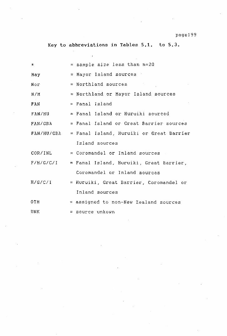
page199
Key to abbreviations in Tables 5.1. to 5.3.
*
May
Nor
NIM
FAN
FAN/HU
FAN/GBA
FAN/HU/GBA
COR/INL
F/H/G/C/I
H/G/C/I
0TH
UNK
= sample size less than n=20
= Mayor Island sources
= Northland sources
= Northland or Mayor Island sources
= Fanal Island
= Fanal Island or Huruiki sourced
= Fanal Island or Great Barrier sources
= Fanal Island, Huruiki or Great Barrier
Island sources
= Coromandel or Inland sources
= Fanal Island, Huruiki, Great Barrier,
Coromandel or Inland sources
= Huruiki, Great Barrier, Coromandel or
Inland sources
= assigned to non-New Zealand sources
= source unkown
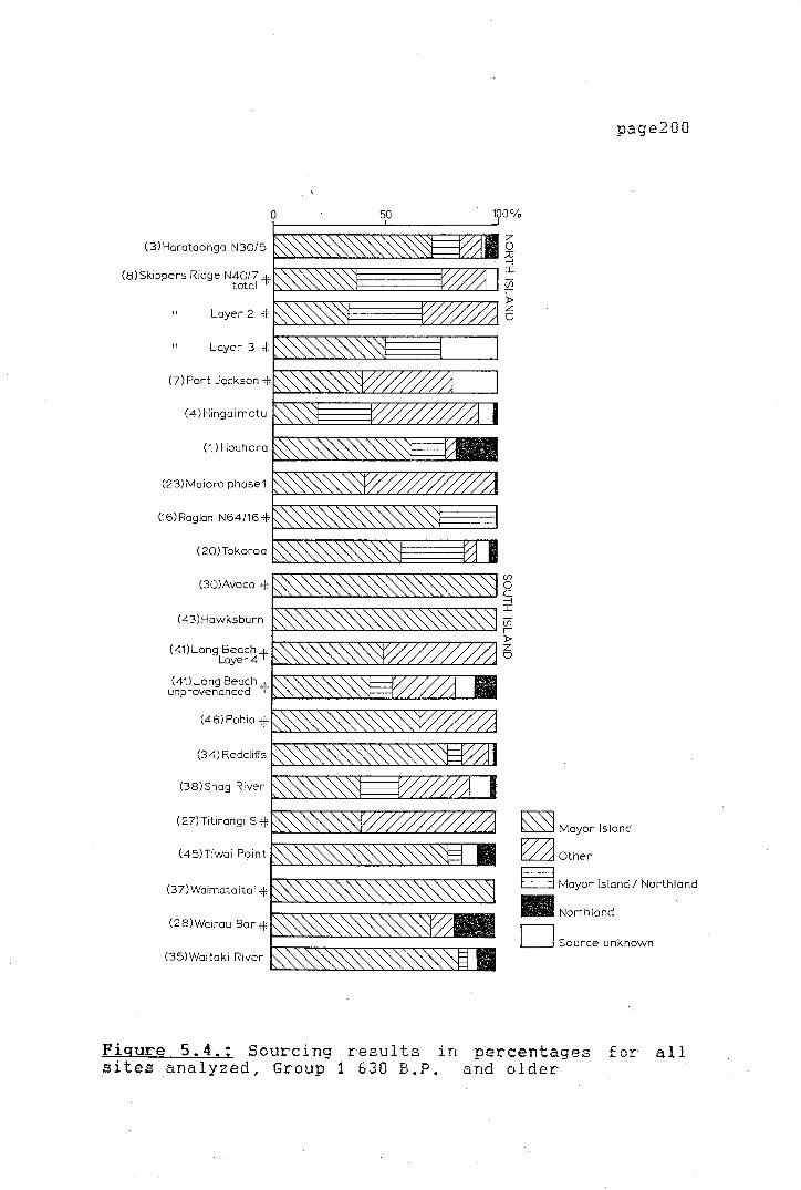
>-
50
( 3) Harataonga N30/5
(8)Skippers Ridge N40/7 + total · ·
Layer 2 +
"
(7) Port Jackson+
(4)Hingaimotu
(1) Houhora
(23)Maioro phose1
(16)Raglan N64/16+.
( 20) Tokoroa
(30)Avoca +
(43)Hawksburn
(41)Long Beach+ Layer4 · ·
(41) Long Beach+. unprovenanced · ·
(46)Pahia +
(34) Redcliffs
(38)Shag River
(27lTitirangi s+
(45)Tiwai Point
(37)Waimataitai +
(28)Wairau Bar+
(35)Waitaki River
Figure 5.4 .. ; Sourcing results in sites analyzed, Group 1 630 B.P.
page200
100%
z 0 ;o -I I
i7i r )> z CJ
(fl
0 C -I I
(fl
r )> z CJ
~ Mayor Island
~Other
~ Mayor Island/ Northland
Ill Northland
D Source unknown
percentages and older
for all

.L
page201
0 50 100°/o
(8)Aotea 6 t-'-~~-~-"--~~~-~~~- ~
"'"'°"°"'""~"=="7',~T7"7',~T77-:II I (9)Hahei V>
f>,->,....:......;"--"-..:......o~:.....>J'----'-"-'""""-"'-'-~'---'-'--'-...._. r
(3) Hara taonga N 30 / 3 i,,--,77"T7-rT7""7":~T7""7":~T7"'7"';~-r-;,.-, ~
(10)Hot Water Beach
(13) Kouri Pt Swamp
Koreromaiwaho f.
(23)Maioro Phase 2
(25)Paramata -f.
(4)Station Bay N38/30 f.
(5)Station Bay N38/37 f
(6)Sunde +.
(11)Tairua Layer 2
(12)Whangamata Midden B ..,._,._,_.,._,_-"-->.-"-->.-"-'s..,.,,,-"-'s...::...i.----''-"-~....<....'-'-"
(21)Whakamoenga occupation 1a and 1 b ~~~~~~~~~~-----
(29)Clarence + 8 _ ......... _~-~-..,_....,_,._,_..,.__, ........ ..,__,....,_~ ~
,.._.,.....,."""",-,,-""'"',-,,-"'C'""",-,,-..,.....,.....,-""°"...,...,,......,--r,...._ I (47) Heaphy River vi
~-->-.....,._~......,_....:......;....,_--'---',._,_..,_,-->-.,._,_-=-'-.__ r f.o-,,...........,,....,....,.....,..,.........,-.--,,...,,-.,...,.-.--,,...,,-.,...,.-,-,,.....,...,...,..., ~
(33) Houhoupounamou + o
(44) Pounawea+.
(40) Purakanui
(39)Shag Pt
(26) Tahunanui
(36)Tai Rua+.
(32)Timpendean +.
(27)Titirangi Pit -t
~ Mayor Island
~Other
~ Mayor Island/ Northland
• Northland
D Source unknown
Figure 5. 5.; Sourcing sites analyzed, Group 2
results in 630 B.P.
percentages to 350 B,P,
for all
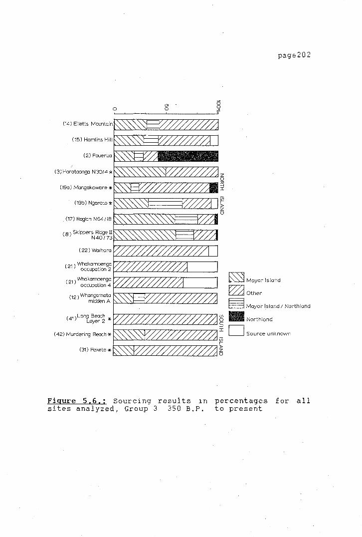
,_
<..
U1 0 0
(14) Elletts Mountain
(15) Hamlins Hill
(2) Pouerua
(3) Harataonga N30/4 *
( 19a) Mangakaware *
(19b) Ngaroto *
(17) Raglan N64/18
( 8 ) Skippers Ridge lI N40/73
( 22) Waihora
( 21 ) Whakamoenga occupation 2
( 21 ) Whakamoenga occupation 4
c12 ) Whangamata midden A
( 41 ) Long Beach Loyer 2 *
(42) Murdering Beach*
(31) Peketa *
Figure 5.6.: Sourcing results in sites analyzed, Group 3 350 B.P.
page202
0 0 .,,e
z 0 ::D --, I
Vi r )> z 0
~ Mayor Island
~Other
8 Mayor Island/ Northland
(/)
• Northland 0 C --, D Source unknown I
Vi r )> z 0
percentages to present
for all
)-
page203
TEMPORAL VARIABILITY
The results of the sourcing show a large range
of variability in the percentages of different sources
used in the various sites. The percentage of Mayor
Island obsidian in the total assemblages varies from
zero. to 100 per cent. Inspection of the sourcing
results show that at most sites more than a single
obsidian source was employed.
Group 1
The source utilization patterns from the early
sites (earlier than 630 B.P.) show that for the most
part Hayor Island obsidian was
proportions from various sources in
range from 20 to 100 per cent. The
employed. The
the assemblages
use of sources
other than Mayor Island is more common in the North
Island sites. The widespread distribution of obsidian
from the Northland area is of interest. Al though the
proportions of Northland obsidian are low (maximum 18
per cent) the obsidian is present in 58 per cent of the
early sites, compared to only 33 per cent and 20 per
cent of the middle and late period sites respectively.
The proportion of Northland obsidian outside its area
of natural occurrence, at sites as distant as Wairau
Bar in the South Island, is also of interest. It is as
high in this site (2 out of 11) as at Houhora (53 out
of 300), which is only a few kilometres from the

-I
t-
page204
source.
Group 2
The proportion of material from alternative
sources to Mayor Island, in Group 2 sites (630 to 350
B.P.), is quite marked in comparison to Group 1. A
number of sites containing obsidian do not have any
material from the Mayor Island sources. The percentage
of Mayor Island obsidian in the total obsidian
assemblage from North Island sites decreases in general
to about 70 per cent in this period and is replaced by
obsidians from the Coromandel, Auckland, Great Barrier
Island and Inland sources. In the South Island, on the
other hand, the proportions of Mayor Island obsidian
are still as high as 100 per cent in some sites, (but
see significance of proportions in small samples above)
although overall the introduction of alternative
sources becomes quite marked in this time group.
Sources other than Mayor Island and Northland comprise
up to 85 per cent of the obsidian of some assemblages.
Group 3
The predominance of Mayor Island obsidians
observed in the early period sites disappears in the
late sites (350 B.P. to the present). The pattern of
source utilization becomes increasingly varied and
Mayor Island obsidian only represents at most 67 per
cent of the total obsidian sourced. In most cases
l-
page205
though, its presence is limited to about 30 per cent or
even less. The presence of other sources is
particularly striking in the South Island sites, where
obsidian from other sources now· dominates. The
increase in the proportions of stone from sources other
than Mayor Island is probably due to the proximity of
some sites to alternative obsidian sources. For
instance, the Pouerua sites contain a high proportion
of stone from the nearby Kaeo sources, and the Waihora
and Wahakamoenga Cave sites contain exclusively
obsidian from the nearby Taupo sources. Mayor Island
obsidian seems to have been pref erred over obsidian
from other sources, except when an alternative source
was noticeably closer than Mayor Island. This is the
case for sites such as Ellett's Mountain, Whangamata,
and Harataonga. The proportions of Northland sources
(Kaeo, Waiare, Weta) remains consistently low or absent
outside the immediate area of origin. The obsidian
from the Northland sources contains a relatively high
occurrence of phenocrystic inclusions and its flaking
quality is not as high as that of Mayor Island obsidian
or some of the other sources (Brassey 1985:134-135).
As Brassey (ibid,) has proposed, it is therefore
possible that other sources would have been preferred
to the Northland sources outside their immediate area.

page206
SOURCE UTILIZATION AND SITE FUNCTION
Since the sites used in this study are
functionally variable, it may be useful to investigate
the source use pattern in relation to site function.
The sites studied here represent at least five
different functional categories:
1)open undefended sites
2)temporary hunting camps
3)defended sites
4)lithic workshops
S)special purpose sites
The ascription of sites to certain types can be
ambiguous, as archaeological sites were often used for
multiple purposes, The interpretation as to what the
main activities carried out at each site were can be
debatable. For the present classification, the
evidence from the published reports was used to define
the specific assignation of each site to any of the
categories. At some sites several differential
activity areas have been isolated, and there£ ore the
present classification may be subject to discussion by
other researchers. Categorization of the site types is
summarized in Table 5. 4. Examination of the source
utilization pattern shows that the proportions of
different types of obsidian are affected by the

page207
different function of the site.
TABLE 5.4.
Classification of sites by site function
OPEN I TEMPORARY I DEFENDED I WORKSHOPS I SPECIAL I I SETTLEMENTS I CAMPS I SETTLEMENTS I I SITES I I -------------I--------------I---------------I-----------I---------I-----I Hamlin's H. I Waihora I Ellett 1 s Mt. I I I I Murdering B. I Whakamoenga I Mangakaware I I I G I Harataonga- I I Peketa I I I R I N30/4 I I Ngaroto I I I 0 I Skippers R. I I Raglan N64/18 I I I u I Pouerua I I I I I p I Whangamata I I I I I I Long Beach I I I I I 1 I -------------I--------------I---------------I-----------I---------I-----I Aotea I Whakamoenga I Koreromaiwaho I Tahunanui I Kauri Pt I I Hahei I Timpendean I Maioro I I Swamp I G I Hot Water B. I Tai Rua I Harataonga- I I I R I
,, Paremata I Houhoupou- I N30/3 I I I 0 I Station Bay I namou I I I I u I N38/30 I I I I I p I Station Bay I I I I I I N38/37 I I I I I 2 I Sunde I I I I I I Tai Rua I I I I I I Whangamata I I I I I I Clarence I I I I I I Purakanui I I I I I I Shag Point I I I I I I Pounawea I I I I I I Heaphy R. I I I I I I Titirangi s. I I I I I I -------------I--------------I---------------I-----------I---------I-----I N30/5 I Raglan I I Titirangi I I I Hingaimotu I N64/16 I I Tiwai Pt I I G I Houhora I Tokoroa I I I I R I Maioro I Hawks burn I I I I 0 I Port Jackson I Pahia I I I I U I Skippers Rid I Waimataitai I I I I p I N40/7 I I I I I I Redcliffs I I I I I 3 I Avoca I I I I I I Shag River M I I I I I I Long Beach I I I I I I Waitaki R. I I I I I I Wairau Bar I I I I I I
-------------------------------------------------------------------------
In Group 1 (630 B.P.
settlements, temporary camps
page208
and older),
and workshops
open
are
represented. Temporary camps show an overal 1 higher
proportion of Mayor Island obsidian than, for example,
the more permanent open settlements (a range of 58 per
cent to 100 per cent with a mean value of 80 per cent,
compared to a range of 20 per cent to 100 per cent with
a mean percentage of 58,4 per cent in open
settlements). By weight the percentage of Mayor Island
obsidian in the temporary camps is also higher
(mean=66.4 per cent) while at the more permanent open
settlements the percentage expressed by weight is lower
(mean=58.7 per cent) (Table 5.5). The two lithic
workshops represented in Group 1 sites (Titirangi and
Tiwai Point) have very different proportions of
obsidian sources. While only two source groups are
represented at Titirangi (Mayor Island and
Fanal/Huruiki/ Great Barrier obsidian), at Tiwai Point,
Northland and Fanal Island/ Huruiki sources are
represented, in addition to the Mayor Island source
material.
In terms of total weight of material, obsidian
is found only in large quantities at Houhora,
Harataonga (N30/5) and at Tokoroa (Table 5,5). These
three sites have the overall highest quantities by
weight of obsidian regardless of source provenance.
The first two sites represent undefended settlements
while Tokoroa is a temporary moa hunter camp, The
page209
quantity of Mayor Island obsidian, for example, in
itself is only substantial at Houhora (about 1.5 kg of
material in the analyzed sample, representing an
approximate volume of 600 cc). The material from both
Harataonga (N30/5) and Tokoroa could represent, at the
most, obsidian struck from three or four average sized
cores. The total weight of the obsidian from the
remaining sites ranges from a few grams to about 200 to
300 grams. The quantities of obsidian found both at
Tiwai Point (n=148) and Titirangi (n=24) are extremely
small especially as it is considered that both sites
are specialized sites primarily dedicated to the
manufacture of lithic artefacts. The quantity of Mayor
Island obsidian, for example, while dominant at Tiwai
Point, is only 440 grams, which represents one or two
small sized cores of an approximate volume of 177 cc.
Quantities of obsidian from sources other than
Mayor Island are small at temporary hunting camps. At
these sites one, or at most, two sources are
represented. It is probable that the obsidian recorded
from these sites can be traced to two or three cores,
Northland obsidian is found only at Tokoroa and only in
small quantities in this class of sites. Northland·
material is not represented at all in hunting sites of
the South Island.
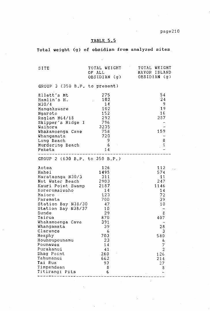
·;
.l
page210
TABLE 5.5
Total weight (g) of obsidian from analyzed sites
SITE TOTAL WEIGHT OF ALL OBSIDIAN (g)
GROUP 3 (350 B.P. to present)
Ellett's Mt 275 Hamlin's H. 102 N30/4 14 Mangakaware 102 Ngaroto 152 Raglan N64/18 292 Skipper's Ridge I 796 Waihora 3235 Whakamoenga tave 758 Whangamata 720 Long Beach 9 Murdering Beach 6 Peketa 14
GROUP 2 (630 B.P. to 350 B.P.)
Aotea Hahei Harataonga N30/3 Hot Water Beach Kauri Point Swamp Koreromaiwaho Maioro Paremata Station Bay N38/30 Station Bay N38/37 Sunde Tairua Whakamoenga Cave Whangamata Clarence Heaphy Houhoupounamu Pounawea Purakanui Shag Point Tahunanui Tai Rua Timpendean Titirangi Pits
126 1495
311 2903 2187
14 123 700
47 10 29
870 391
39 6
703 23 14 41
260 662
93 8 6
TOTAL WEIGHT MAYOR ISLAND OBSIDIAN (g)
54 24
9 19 16
287
159
8 1
112 574
11 247
1146 14 72 39 10
8 407
28 3
580 6 7 2
126 214
27 8
----------------------------------------------

I ,
I ,·
I ,
(Table S.S. continued)
SITE TOTAL WEIGHT OF ALL OBSIDIAN (g)
GROUP 1 (630 B.P. and older)
Harataonga N30/5 Hingaimotu Houhora Maioro 1 Port Jackson Raglan Archaic Skipper's Ridge II Tokoroa Avoca Hawksburn Long Beach Parda Redcliffs Shag River Mouth Titirangi Tiwai Point Wairnataitai Wairau Bar Waitaki River Mouth
345 217
2292 604
28 67 84
2402 9
29 6 8
534 233
20 441
0.4 48
270
page211
TOTAL WEIGHT MAYOR ISLAND OBSIDIJ.N (g)
307 93
1476 215
5 13 19
1167 6
28 3 6
394 133
4 325
0.4 40 21
·'-
',-,.-
The sites of Group 2 (630 B.P.
page212
350 B.P.)
include open settlements, temporary hunting camps,
defended settlements, workshops and one special purpose
site associated with a defended settlement. This last
one, represented by the Kauri Point Swamp assemblage,
has been interpreted as having a special ceremonial
character ( Shawcross 196 4, 1976) . The proportions of
Mayor Island obsidian in the different site types is
varied; no real pattern can be observed. Although, for
example, temporary hunting camps seem to have a
slightly higher. percentage of Mayor Island obsidian,
the variation is large within the sites and too few
sites are represented in the sample to draw definite
conclusions. The mean percentage, by weight, of Mayor
Island obsidian in temporary camps is 54.7, compared to
29.83 in open settlement sites and 53.8 for the
defended settlements. The defended sites use a smaller
range of obsidian sources, although again, due to small
sample size some of these patterns may be misleading.
For example, less obsidian is found at smaller hunting
camps, therefore it is not surprising that fewer
obsidian sources are represented. From the observed
pattern, it does appear that a larger range of obsidian
sources was employed at open settlements than at the
hunting camps. It is possible to assume that a hunting
party might carry one or two cores of obsidian to
strike flakes as needed and therefore a smaller variety
of sources would be represented at these sites,

·(
'
page213
compared to the more permanent ones (both defended and
undefended), where the full range of sources available
to a certain group might ba expected to be found.
Group 3 (350 B.P. to present) sites include
open settlements, temporary camp sites and defended
settlements. The defended settlements show a very
uneven distribution of sources. No general pattern of
differential obsidian use between open settlements and
defended settlements can be observed in this group of
sites. On the other hand, the two temporary hunting
camps represented in the sample both utilize the local
materials in favour of stone from further afield. The
two sites (Waihora and Whakamoenga Cave) were occupied
temporarily and only obsidian from nearby local sources
is found at these sites.
SUMMARY AND CONCLUSIONS
In summary, obsidian from 58 archaeological
sites was sourced. The sites included hunting camps,
workshops, undefended and defended sites, and special
purpose sites. In order to carry out time trend
analysis, the sites were divided into three
chronological groups. Sourcing results showed that
temporal variations existed in source utilization.
page214
From the source utilization pattern it can be
noted that although Mayor Island obsidian was the most
popular obsidian to be used in the early sites all over
New Zealand, other sources were also exploited, to a
lesser degree, during this time. The sourcing evidence
indicates that the earliest settlers in New Zealand
soon learned of most of the available sources present
in the country, and that, although their location was
known, some of these sources appear only to have been
utilized occasionally. Mayor Island obsidian appears
to have been the preferred material; this may well be
explained in terms of its excellent flaking quality,
although central location may have been a factor.
The increase in the use of other sources in
later periods is apparent from the examination of the
source utilization patterns from Group 2 sites (630 to
350 B.P.) and Group 3 sites (350 B.P. to the present),
( see Figures 5. 4 to 5. 6). The use of sources other
than Mayor Is 1 and seems to increase when the other
sources are close at hand and are of good quality. The
changes in the source utilization pattern may reflect
increasing difficulty in obtaining materials from Mayor
Island, particularly in the North Island.
Some ties between people of the South Island
and North Island seem to have existed in early times,
particularly as reflected by the presence of Northland
materials in the South Island (for example at Wairau
Bar and Tiwai Point), although Davidson (1984:197)

page215
argues that people did not know where their raw
material came from. These seem to have been maintained
through to the middle period. The increased use of
other sources in the South Island appear only during
the late period, In the middle period, (Group 2),
people of the North Island used less Mayor Island
obsidian, but in the South Island maintained the
dominant use of Mayor Island obsidian until later in
the sequence, although local differences are observed.
For example, at sites such as Maioro in the North
Island, the use of Mayor Island obsidian increases in
proportion through time. A similiar situation was
observed by Leach (1976) at the, Washpool sites in
Palliser Bay.
As suggested by other authors (Prickett 1975)
the increase in warfare and territoriality during the
later period probably made it more difficult to obtain
materials from areas previously exploited. Possible
restrictions
might have
on travel
encouraged
through
the use
non-traditional sources.
The source utilization
certain territories
of different or
pattern differs
according to the function of the sites. The pattern
found indicates that at temporary hunting camps a small
number of sources was employed. In general, only one
source is represented at these sites. This pattern is
observed in all three groups of sites from the early to
late periods. The use of Mayor Island obsidian appears
'}
also more frequent at temporary
particularly during the early period.
tend to fade out during later times.
page216
hunting sites,
These patterns
Particularly in
the late sites (350 B.P. to the present) no real
pattern
defended
of differential source utilization
and undefended settlements
distinguished.
between
can be
The following Chapter will look in more detail
at the use and geographical distribution of Mayor
Island obsidian in a regional perspective.
page217
CHAPTER VI
A REGIONAL ANALYSIS OF NEW
ZEALAND OBSIDIAN
INTRODUCTION
The present chapter has three main objectives:
to describe the prehistoric distribution of obsidian in
New Zeaiand; to analyse the procurement strategies in
light of the available data; to integrate these data
with the available theoretical body on mechanisms of
exchange and procurement of raw materials.
The study is focused on a regional perspective
and through the quantitative analysis of the data
collected, it should be possible to analyze prehistoric
obsidian use in New Zealand prehistory. With the
analysis of artefact distribution and the relationship
between abundance and distance from the source, the
different variables which affect regional exchange
networks will be evaluated and tested. The
quantitative analysis of the obsidian data is used to
isolate patterns that could provide an understanding of
the mechanisms of exchange involved.
page218
MATHEMATICAL MODELLING OF REGIONAL EXCHANGE
Mathematical models have been applied to the
study of regional exchange networks in the expectation
of isolating variables affecting exchange, and to
provide indications towards the nature of these
networks. Renfrew discussed the hypothetical
relationship between exchange types and the abundance
of a given item in a series of articles (1975; 1977a).
In his most recent detailed article on the subject,
Renfrew proposed a number of models to predict classes
of archaeologically identifiable trading mechanisms:
down-the-line, reciprocal exchange, directional trade
or central place distribution, prestige chain trade and
free lance trade. His proposition that each of these
types of exchange could be described and identified by
a characteristic and specific type of curve was shown
by Hodder (1978) to be ambiguous, as several different
types of exchange could be described by the same
fall-off curve.
Renfrew proposed four fall-off patterns (Figure
6.1) which ideally could each identify a different type
of exchange. By plotting distance on one axis and
abundance on the other axis, the resulting patterns
could be compared with his proposed curves and the type
of exchange involved could be identified. The shape
and steepness of the f al 1-of f curves would be
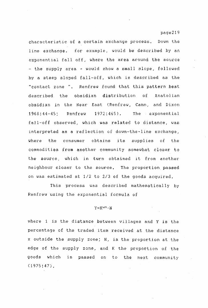
page219
characteristic of a certain exchange process. Down the
line exchange. for example, would be described by an
exponential fall off, where the area around the source
- the supply area - would show a sm~ll slope, followed
by a steep sloped fall-off, which is desGribed as the
"contact zone ". Renfrew found that this pattern best
described the obsidian distribution of 1.natolian
obsidian in the Near East (Renfrew, Cann, and Dixon
1968:44-45; Renfrew 1972:465). The exponential
fall-off observed, which was related to distance, was
interpreted as~ reflection of down-the-line exchange,
where the consumer obtains its supplies of the
commodities from another community somewhat closer to
the source, which in turn obtained it from another
neighbour closer to the source. The proportion passed
on was estimated at 1/2 to 2/3 of the goods acquired.
This process was described mathematically by
Renfrew using the exponential formula of
Y=K"11 • N
where 1 is the distance between villages and Y is the
percentage of the traded item received at the distance
x outside the supply zone; N, is the proportion at the
edge of the supply zone, and K the proportion of the
goods which is passed on to the next community
(1975:47).

page220
In directional trade, graphically described by
Renfrew as in Figure 6.1(d), the fall-off curve is
distorted by sudden peaks representing centres of
secondary distribution. Central place market exchange
would essentially produce the same picture. In a
prestige chain exchange system the drop-off in the
contact zone is attenuated. This slope would be
expected if the exchanged good were a very va 1 uabl e
item, though exchanged under conditions of reciprocity.
In contrast to the above. free lance trading is
described by Renfrew (1972: 468-470; 1975: 48-51) by a
gradual slope within the sphere of operation of the
traders, and a steep and sudden fall-off outside their
area of operation (Figure 6.1.(c)).
Hodder conducted a series of simulations
determine
proposed
which regression
fall-off curves.
model best
He simulated
described
a system
to
the
in
which a series of random walks were taken away from a
fixed source. He was able to generate a number of
fall-off curves which resembled closely Renfrew's down
the line predicted fall-off curve (1978:158-164; Hodder
and Orton 1976:127-154). By changing the number and
length of the randomly taken steps away from the source
he concluded that very similar curves could be produced
by simulating different conditions in the random walk
processes. The simulation study provided also
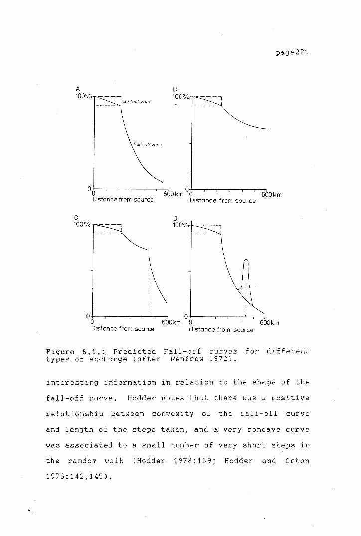
7
)
-:l ;-
' ! :-
A 100%
C 100%
Distance from source
B 100%
600km 0o
D 100%
Distance from source
page221
600km
o o----.-~--,--.-~-,-'--..-~~ 0 600km O 600km Distance from source Distance from source
Figure 6,1.: Predicted Fall-of£ curves for different types of exchange (after Renfrew 1972).
interesting information in relation to the shape of the
fall-off curve. Hodder notes that there was a positive
relationship between convexity of the fall-off curve
and length of the cteps taken, and a very concave curve
was associated to a small number of very short steps in
the random walk (Hodder 1978:159; Hodder and Orton
1976:142,145).
\,
,-
page222
Hodder also found that the value of exponent
alpha in the equation
Log Y= a-be>< +c
used to describe the fall-off pattern produced by each
of the random walks, was the most sensitive index when
step lengths and number of steps were modified. High
alpha values were associated with convex curves. In a
previous study Hodder had calculated a regression model
that best fits certain classes of archaeological goods
by finding the standard error associated with all
exponential equations in which the alpha values varied
from 0.1 to 2.5. The equation with the lowest standard
error was defined as the best fit model. The analysis
of archaeological case studies showed that goods with
low associated values, bulky objects or those whose
dispersal range away from the source was small were
best described by equations where the alpha values
varied between 0.1 and 0.6. On the other hand, alpha
values between 0.9 and 2.5 best fitted objects
exchanged over long distances and which were highly
valued goods (Hodder 1974:179-183; 1978:164; Hodder and
Orton 1976:113). From Hodder's work it is possible to
link the shape of a curve to a type of exchange.
From the trends identified by Hodder's study it
should be possible to link the shape of the fall-off
curve with exchange types and commodity exchanged. The
random walk model though is appropriate for all types
page223
of exchange excluding direct access, since it does not
involve transactions between two communities and
therefore in terms of Hodder's model, the number of
steps are necessarily small. A steep curve resembling
Renfrew's down-the-line exchange was related to a large
number of short steps, while a flattened fall-off
curve, associated with prestige exchange was associated
with an equation with high alpha values created by a
small number of large steps (Hodder 1978:159; Hodder
and Orton 1976:138-145). It should therefore be
possible in an empirical case to predict to a certain
point exchange type by the best fit alpha values of the
regression equation.
Findlow and Bolognese (1980a;1982) have added
another set of predictions for the analysis of distance
related fall-off curves. While their analysis is based
on Hodder's (1974; Hodder and Orton 1976) work and on
Renfrew's (1977a) discussion, their predictions vary.
In the first instance they predict that a linear
regression model can be used to identify "direct
access", whereas the other authors have employed an
exponential model where alpha = O. Findlow and
Bolognese (1980a:235; 1982:72-73) recognize that this
model is almost equivalent to the linear model, though
in cases when it does not fit, the pattern might
indicate a different situation w{th an exponential
fall-off from an exceptionally large supply area
(1982:74). The prediction that direct access would be
\.
,.
page224
best described by a linear model can be justified,
since the expected effect of distance on the abundance
in the absence of exchange can be expected not to be
magnified as distance increases, as it would be if an
exponential model were used.
Finally the hyperbolic model proposed by the
authors, depicts an exchange system intermediate
between a simple linear and an exponential system. In
the hyperbolic model the fall-off beyond the supply
z·one is much more attenuated. This model has not been
found to fit mo~t empirical data (Findlow and Bolognese
1980a; 1982).
The use of regression analysis can be useful
for identifying prehistoric exchange mechanisms, though
the results cannot be taken as final. The biggest
problem is that similar curves can be produced by
different trading systems. As Hodder has pointed out
there is a definite relationship between length of
steps, the number of steps from the source of
production and the site of consumption with the value
of the goods exchanged in the shape of the fall-off
curve. However, Hodder suggests the use of other types
of analysis, such as surf ace trend analysis and the
detection of spatial autocorrelation (1978:162; Hodder
and Orton 1976), instead of more detailed analysis of
the fall-off curves in terms of exchange mechanisms, as
these can be extremely ambiguous.

page225
Renfrew (1977a) has also pointed out that
different trading mechanisms can be present in several
types of commercial and non-commercial exchange
systems. For example, directional trade can be present
both in a redistributive exchange system and market
exchange. Other overlap could possibly be found in the
free lance trading system, where the f al 1-of f curve
could be duplicated either by a commercial system with
middlemen transporting the goods or a system of
balanced reciprocity. Hodder's solution to this uses
more sophisticated methods of analysis which cannot be
applied in the New Zealand case, since the data are not
available for the sites.
In addition to these problems, Clark (1979)
argues that there are a number of other factors,
besides the type of exchange, which can modify the
alpha exponent, mainly "distributional boundaries
associated to special social or economic cultural
meanings attached to goods, patterns generated by
economic competition between goods, and the size of the
supply zone" (1979:186). If regression analysis is to
be used to explain and measure prehistoric exchange,
Clark argues, the factors causing the variations in
alpha have to be controlled ~ither by exploring curves
not generated by alpha or alternatively explore
situations where the social value and the "nature of
economic competition" of the goods is known
(ibid.:187). A reexamination of Renfrew's (1977a)

>
page226
hypothesis concerning the predicted alpha values for
di f £ erent kinds of exchange systems, showed that they
were not valid when applied to specific examples.
Clark (1979:184) argues that additional variables are
masking the predicted values. But, because we must
first assume that the exchange mechanism is known
before testing the ocurrence of the predicted alpha
values, his results are not conclusive. It becomes
clear from Clark's study that a good deal more study
needs to be done to test the validity of either
Renfrew's (1977a) or Hodder's (1978; Hodder and Orton,
1976) models.
The use of regression analysis for the New
Zealand data can be useful for identifying certain
trends in the prehistoric behaviour, and for making an
initial set of predictions on aspects of regional
exchange, even though it cannot be conclusive. For
example, in the absence of any distinct decrease in the
quantities of obsidian with distance and low
correlation values, directional trade could be invoked,
Direct access to the source should be detectable by the
shape of the curve where a simple 1 i near model best
fits the data. On the other hand, a down-the-line
exchange should be more difficult to differentiate from
other types, such as free lance trading, though the
shape of the curve in the supply zone could be
indicative. The quantitative analysis of the New
Zealand data in conjunction with the study of the

page227
fall-off curves and regression analysis should provide
a basis for deducing possible exchange types in
operation in prehistoric New Zealand. The use of
regression analysis requires a measurement of the
abundance of any given goods and a measure of effective
distance from the site of production or source of raw
material to the place of consumption. The following
sections will discuss these aspects, and will be
followed by a quantitative analysis of the
archaeological data used for this study.
TABLE 6. L
Test models employed for predicting different modes of
exchange.
Model
Linear Exponential alpha=O
Mode of Exchange
Direct Access Reciprocity
Exponential Down the line alpha=1 or 2
Exponential alpha=2
Free lance trade (middlemen) Simultaneous exchange systems
Reference
Ericson 1977a;Hudson 1978; Renfrew 1975; Hodder 1978; Hodder & Orton 1976; Findlow & Bolognese 1980a,1980b,1982
Hodder 1974; Renfrew, Dixon & Cann 1968; Sidrys 1977; Torrence 1981
Hogg 1971; Renfrew 1977a
-----------------------------------------------------Hyperbolic Development
towards complex directional exchange
De Atley & Findlow 1979; Findlow & Bolognese 1982

page228
MEASURE OF DISTANCE
The choice of an effective distance measure in
the New Zealand scene has to take into account travel
both by land and sea. Torrence's (1981:136) factor of
two used to represent the extra cost involved in
overland travel was taken arbitrarjly. It is not
possible to establish the exact routes by which the
materials were transported. The ethnographic
literature mentions a combination of sea, river and
land travel for· journeys up and down the country in
protohistoric New Zealand. Best (1974:212), for
example, records sea voyages from Tauranga to Hastings
and Banks Peninsula. Nephrite was often obtained by
parties travelling by. canoe along the West Coast
(Skinner 1912). Firth (1929:432) mentions also that
people frequently preferred travel by canoe to overland
travel. Although sea travel could be a more hazardous
method of transport, it would have been more expedient
if sources were to be directly exploited. Overland
travel might have been easier, but possibly slower and
loads could become cumbersome. Based on ethnographic
information a factor can be calculated involving days
of travel over a certain distance by sea and overland.
This can then be used to calculate a more accurate
factor to account for differences in travel costs.

',._
page229
Doran (1976) studied the performance of a
single outrigger canoe - wa - of the Caroline Islands
and the double outrigger . canoe, v.inta, of the Sulu
Archipelago. The fy'a canoes commonly perform trips over
approximately
The v.int,"l is
distances up
300 km and up to approximately 900 km.
mainly used for fishing
to approximately 1000
expedi ti ans on
km. In their
performance he compares them favourably with a modern
day trimaran. Per£ ormance was measured in terms of
speed,
Though
progress against
boat speed was
wind and speed
measured, no
information from Doran's study is available.
downwind.
published
Research in the Arnphlett Islands by Lauer
(1976:71-89) showed that distances up to 75 km are
covered in about four days or less of sailing. The
average sailing speed for the larger sailing outrigger
canoes, with mast and sail, called a.idedeya, is 2.5
knots. His data show that under ideal wind conditions
67 km can be covered in a day's voyage (nine hours) at
a speed of about four knots. A distance of 25 to 30 km
at a speed of 2.1 to 2.3 knots can take six to seven
hours. Paddling is used if winds fail.
For comparable prehistoric European craft such
as the Sutton Hoo and Hyd,"lm boats, a rowing speed of
three knots (roughly five km per hour) for six hour
days is estimated. This makes about 30 km a day.
Under sail somewhat faster conditions are experienced.
The St Brenn,"ln a 12 metre long open boat of eel tic

page230
type - bui 1 t of hides stretched over wooden frames -
averaged only two to three knots crossing the Atlantic.
At times it reached five_ to seven knots for longer
periods and occasionally up to 12 knots (Anderson,
pers. comm.).
The double canoe bui 1 t in 196 6, the N .. <zl eb.i, a
replica of a Hawaiian canoe, can make 16 km an hour
sailing at its best performance. The Holtule 'a, built
mainly as a sailing canoe can reach up to 18.5 km an
hour. In tradewinds of 27 to 28 km/hr the HoA·uJe ','i
could make approximately 11 km/hr heading at about 70
degrees off the wind (Finney 1979).
Various types of river and ocean going craft
were in use in New Zealand at the initial .contact
period in the first decades of the nineteenth century.
The sea and numerous lakes and rivers facilitated
movement from one area to the other. A number of types
of craft of oceanic origin were used on the rivers,
lakes and on the sea. Raf ts, dugouts and catamarans
were used on lakes and rivers, while dugouts, built-up
canoes, double canoes and outriggers were used on the
sea (Bathgate 1969).
Some information on the speed of Maori
watercraft is available. Governor Grey (Cooper
1851:256-274) in his 1849-50 trip south across Lake
Taupo took three and three quarter hours to cross 13
lake miles and three and a half hours to reach a point
about 12 miles (19 km) south. This trip was faster

page231
than Bidwell's (1841) who took six hours to get from
Taupo to Motuere in a dugout canoe.
From this information a speed of about five
km/hour can be estimated for the average prehistoric
watercraft, with the exception of the large deep sea
voyaging canoes, which could probably average about 11
km/hour. A reasonably fit person is able to walk an
average of five km/hour, for six hours a day. This
agrees with Walter's (n.d., cited in Brassey
f985:130-131) observations on travel rates through
light bush. He calculated a rate of 35 km per day. It
therefore appears that land travel could almost be as
fast as travel by sea, provided reasonable tracks were
used, and a direct flat route chosen. However, it was
possibly more economical to travel by sea, as larger
loads could be carried in a boat.
On this evidence an equal coefficient for
overland and sea travel wi 11 be used. Certain routes
would have been easier covered by sea and vice versa,
A number of prehistoric tracks followed river valleys;
these would have been navigable at points.
For the purposes of the present work a 'maximum
distance' was calculated in favour of a straight line
'minimum distance'. The maximum distance represents a
better approximation of the real distance between two
places. Most sites used in this study are located on
the coast and therefore it is possible to assume that
most travel in a North-South direction was carried out
by sea.
page232
Distance was measured as the most direct sea
route between the obsidian sources (Mayor Island) to
the archaeological sites. In the case of the inland
sites the distance by sea to the nearest river mouth
was measured and then the direct distance inland to the
site along the river course.
MEASURE OF ABUNDANCE
The techniques· £ or measuring the abundance of
obsidian through time, discussed in Chapter I I I have
been used by Renfrew ( 1977b) to formulate hypotheses
about the systems of exchange involved. In the study
of the Deh Luran plains he suggests that the changes in
the amount of obsidian present can be interpreted as
changes in the exchange mechanism which supplied the
area. This, he argues, involved a shift from
reciprocal exchange to a redistributive economy and
reflects, as well, competition between the
redistributive centres (Renfrew, 1977b:310; Renfrew and
Dixon, 1976:147-149). All
recorded the abundance to
other studies
monitor the
have mainly
supply of
obsidian into the area of study (see Chapter III, Table
3. 1).
page233
The authors seem to accept that al 1 sites are
functionally, similar. However, there will most
certainly be a differential supply of raw material to
sites fullfilling different functions within an
exchange system; supply will be channelled
differentially to permanent settlements, hunting camps
or religious centers. No definite reference to this
problem is made by any of the authors concerned. This
problem is of particular importance in New Zealand,
where we are dealing with a large variety of sites,
including hunting camps, permanent settlements on the
coast or inland and fortified temporary and permanent
villages. Even if the supply to the area was constant,
one cannot expect the absolute abundance to be the same
for each of the above functional categories of sites.
Not all measures of abundance used by previous
authors are applicable to the New Zealand situation.
Obsidian from the New Zealand sites analyzed in this
study comprise from 100 per cent to less than ten per
cent of the total lithic assemblage. A number of
studies have used ratios of obsidian versus pottery or
flint to measure the changing patterns within a site at
various phases of its occupancy. Finding a measure of
abundance applicable to a wide range of sites is more
difficult if regional comparisons are to be attempted.
Possibly a combination of measurements would be the
most applicable in this case.
,-
page234
The recovery techniques and information
available on the archaeological sites considered in
this thesis vary enormously. For some sites sufficient
data are available to calculate an abundance ratio of
obsidian versus other flake material, while for other
sites very
available.
scant and incomplete information is
The absolute number of obsidian flakes is
not a good i ndi cat or of obsidian abundance, since it
. might be affected as discussed earlier by differential
recovery techniques and actual size of the excavations.
There are two ·possible artefacts against which the
obsidian ratio in this case could be measured: ground
stone tools (adzes) and/or all other flaked stone
flakes (porcellanite, silcrete, chert). The advantage
of using adzes as a comparable element is that they are
diagnostic artefacts in New Zealand sites. On the
other hand, early site reports often do not record
numbers of these artefacts. Finished adzes and adze
preforms are often not differentiated,
are, this separation can be ambiguous.
tools are often not well recorded
and when they
Flaked stone
either, and
information on their weight and number is not complete.
The scope of this dissertation research did not al low
complete re-analysis of all the flake stone tools in
the assemblages being studied, in addition to the
obsidian. However, enough and better data were
available from publishE¥d excavation reports on
quantities of flaked lithic materials than on adzes and

..
'
adze preforms, and these were used therefore.
page235
Table
6.2. presents the data of obsidian (numbers) against
the numbers of non-obsidian flakes found in the sites.
Information on the quantity of flaked stone
material in the archaeological sites is fragmentary and
consequently the percentages of obsidian in the total
flaked lithic assemblage cannot be calculated for all
sites.
Table 6.2,
Number of obsidian flakes and other lithic flakes in
analyzed sites·(information from published sources),
Yith percentage of obsidian flakes in flaked stone
assemblages, with distance to the nearest source.
Site Other Obsidian Per- Distance Flakes Flakes centage to nearest
Obsidian source
Group 3 350 B.P. to present
Ellett's Mountain ? 132 ? Hamlin's Hill 14 100 220 Harataonga N30/4 2 13 87 145 Mangakaware ? 27 ? Ngaroto 10 27 73 130 Pouerua 5822 117 20 23 Raglan N64/18 ? 74 ? Skippers Ridge II 305 100 75 Waihora 321 100 50 Whakamoenga Occupation 2 433 100 50 Whakamoenga Occupation 4 237 100 50 Whangamata midden A 36 100 36 Long Beach 486 32 6 1523 Murdering Beach ? 13 ? Peketa ? 8 ?

page236
(Table 6.2. continued)
site other obsidian per- distance flakes flakes centage to nearest
obsidian source
Group 2 630 B.P. - 350 B.P.
Aotea 1 43 98 350 Hahei 7617 3470 31 64 Harataonga N30/3 18 171 90 10 Hot Water Beach 606 1182 69 58 Kauri Point Swamp >5000 100 35 Koreromaiwaho 6 100 350 Maioro 116 100 230 Paremata 110 226 67 980 Station Bay ? 26 ? Station Bay ? 34 ? . Sunde 6 100 200
:>- Tairua 4 250 98 50 Whangamata 87 82 49 36 Whakamoenga 244 100 35 Clarence ? 5 ? Heaphy River ? 77 ? Houhoupounamou ? 9 ? Pounawea 1183 10 1 1620 Purakanui 97 38 28 1524 Shag Point 160 18 32 1484 Tahunanui 15000 566 36 1120 Tai Rua 800 14 2 1440 Timpendean 145 11 7 995 Titirangi ? 5 ?
\_
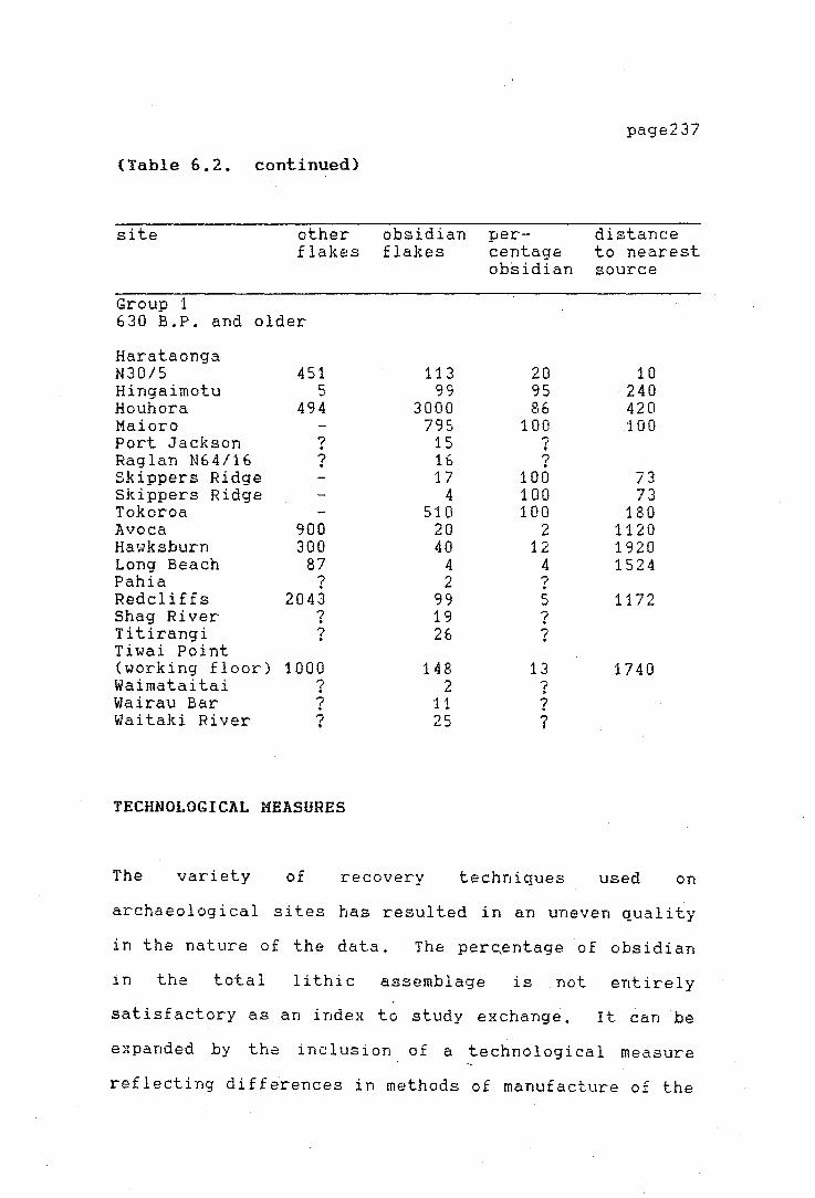
·'
'
page237
(Table 6.2. continued)
site other obsidian per- distance flakes flakes centage to nearest
obsidian source
Group 1 630 B.P. and older
Harataonga N30/5 451 113 20 10 Hingaimotu 5 99 95 240 Houhora 494 3000 86 420 Maioro 795 100 100 Port Jackson ? 15 7 . Raglan N64/16 ? 16 ? Skippers Ridge 17 100 73 Skippers Ridge 4 100 73 Tokoroa 510 100 180 Avoca 900 20 2 1120 Hawksburn 300 40 12 1920 Long Beach 87 4 4 1524 Pahia ? 2 ? Redcliffs 2043 99 5 1172 Shag River ? 19 ? Titirangi ? 26 ? Tiwai Point (working floor) 1000 148 13 1740 Waimataitai ? 2 ? Wairau Bar ? 11 ? Waitaki River ? 25 ?
TECHNOLOGICAL MEASURES
The variety of recovery techniques used on
archaeological sites has resulted in an uneven quality
in the nature of the data. The perc,entage of obsidian
in the total lithic assemblage is not entirely
satisfactory as an index to study exchange. It can be
expanded by the inclusion of a technological measure
reflecting differences in methods of manufacture of the
artefacts.
page238
In effect, the technology of obsidian
manufacture can be used to examine exchange types. If
sites distant to an obsidian source have access to
lesser amounts of raw material one would expect the raw
material to be treated differently when. it is scarce
than when it is abundant. As the raw material becomes
less plentiful, less wastage of the raw material could
be expected and the overall size of the debitage (waste
flakes) in the assemblages, could be expected to
decrease (cf. Renfrew 1977b: 295). Such a re-use and
re-working of
material gets
Evett (1973),
artefacts should occur where the raw
scarce. McBryde ar~ Harrison (1981),
Hughes (1977) and st>athern (1969) have
observed both archaeologically and ethnographically a
negative relationship between
distance from the quarry.
artefact size and
Although a general decline in size with
increasing distance can be expected for most types of
artefacts, several factors can determine the shape of
the distance fall-off curve. Artefact size can be
determined by factors other than the availability of
the raw material, such as functional and stylistic
variables imposed by the consumers.
General predictions on the shape of the
fa 11-of f curves can be made. For dire ct access the
fall-off curve should be linear, while a down-the-line
exchange should cause size to decline exponentially.
The use of size alone as an index to measure exchange
1-
page239
behaviour poses some other problems. Ammerman
(1979:107) has suggested that site function (measured
by the form in which the obsidian enters the site) is
of key importance in establishing the role of the site
in an exchange network. His argument, that only cores
and large flakes or blades are found at certain sites,
is mainly directed towards identifying site function.
He argues that sites a with greater proportion of
artefacts in the early stages of manufacture were
involved in direct trade with the source, or received
the raw material preferentially, and then it was passed
on to nearby sites. If Ammerman's hypothesis is
extended to the New Zealand data, it could be argued
that at permanent base settlements the greater amount
of imported raw material would be found, while at
temporary camps one would expect a 1 ower number of
artefacts in the early stages of manufacture, such as
cores and exhausted cores.
The use of size al one as an index to measure
exchange behaviour can be severely biased by selective
and differential recovery techniques during the
excavation of a site. Since there is no way in the
present case to allow for variations in sieving and
recovery techniques, the assemblages here have been
used in their totality. By using the largest possible
sample of obsidian it is hoped that the effect of the
differences in the context of the excavation of the
artefacts will be minimized. Measurements of size have
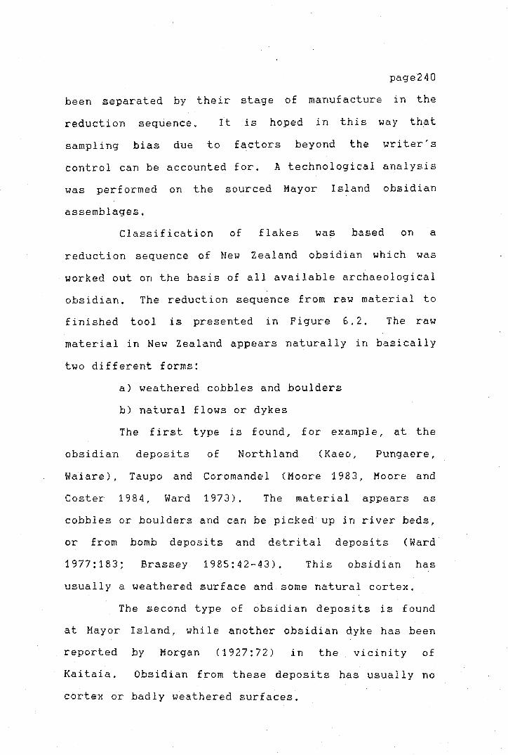
page240
been separated by their stage of manufacture in the
reduction sequence. It is hoped in this way that
sampling bias due to factors beyond the writer's
control can be accounted for. A technological analysis
was performed on the sourced Mayor Island obsidian
assemblages.
Classification of flakes was based on a
reduction sequence of New Zealand obsidian which was
worked out on the basis of all available archaeological
obsidian. The reduction sequence from raw material to
finished tool is presented in Figure 6.2. The raw
material in New Zealand appears naturally in basically
two different forms:
a) weathered cobbles and boulders
b) natural flows or dykes
The first
obsidian deposits
Wai are), Taupo and
Coster 1984, Ward
type is found, for example, at the
of Northland (Kaeo, Pungaere,
Coromandel (Moore 1983, Moore and
1973). The material appears as
cobbles or boulders and can be picked up in river beds,
or from bomb deposits and detrital deposits (Ward·
1977:183; Brassey 1985:42-43). This obsidian has
usually a weathered surface and some natural cortex.
The second type of obsidian deposits is found
at Mayor Island, while another obsidian dyke has been
reported by Morgan (1927:72) in the vicinity of
Kai taia. Obsidian from these deposits has usually no
cortex or badly weathered surfaces.

>
'r
page241
The initial stages of core preparation differ
for each type of obsidian, depending on the presence or
absence of cortex on the nodule available. In general,
no careful core preparation was carried out before
removing flakes from the cores. The flaking approach
could probably best be described as 'hit or smash' in
order to produce irregular flakes. Such a 'nodule
smashing' technique or approach has been recorded also
in Mesoamerica (Boksenbaum 1980). Obsidian flakes
struck in this way, constitute the larger bulk of the
assemblages of the Early and Middle artefact
Preclassic, In the nodule smashing technique, two or
more flakes are detached simultaneously (ibid.:12-15).
The general reduction sequence involves the following
steps.
raw material
natural cobble
1---
large multi-direcfional core
primary flakes and blades from core shaping debifage
debitage
secondary blades<
secondal]' ~ . flakes <.!:Jon --+- domesf!c fools_
secondarx. ~ bifacial/y flakes > 5cm reduced
fool secondary . blades ~ debdage
____.. domestic fools
~:di~a:t tool ~--~
clebifage
=P-i~q~u=r-e~~6~,u2L,~~= The obsidian reduction sequence

I ! '
page242
The natural cortex covered cobbles are split to
produce a flaking platform flakes may also be removed
from the edges. The removal of edge flakes produces a
multi-directional core from which further flakes can be
struck. From the cores and core fragments it appears
that flakes were struck in more than one direction.
Mined blocks do not present cortex, and
preparation of these blocks for flake removal may have
been minimal. Mining at the quarry site produced a
block with a usable shape and possibly striking
platform(s) from which the required flakes could be
struck.
Flake preparation from both types of core seems
to have been identical. Hard hammer percussion flakes
were removed from around the core, producing mostly
irregular shaped and sized flakes and an occasional
parallel sided blade. The lithic artefact assemblages
studied from New Zealand archaeological sites are
composed mainly of flake tools. These consist
primarily of flakes which were modified slightly to
produce a workable edge or a flake that was used
without edge modification. Eventual additional
percussion flaking was applied to the larger flakes to
produce more sophisticated bifacial flaked artefacts.
The archaeological obsidian was classified into
cores, core fragments, primary flakes, secondary
flakes, primary and secondary blades and debitage.
Each of these categories is defined below:
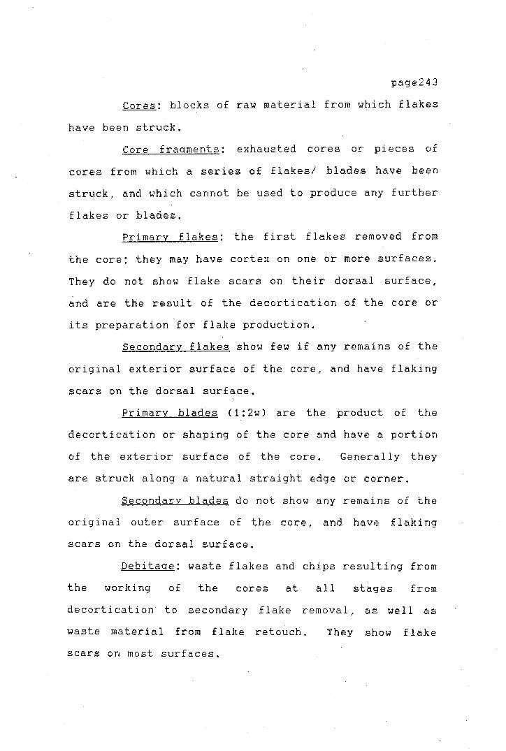
>
page243
Cores: blocks of raw material from which flakes
have been struck.
Core fraqments: exhausted cores or pieces of
cores from which a series of flakesi blades have been
struck, and which cannot be used to produce any further
flakes or blades.
Primary flakes: the first flakes removed from
the core; they may have cortex on one or more surfaces.
They do not show flake scars on their dorsal surface,
and are the result of the decortication of the core or
its preparation for flake production.
Secondary flakes show few if any remains of the
original exterior surface of the core, and have flaking
scars on the dorsal surface.
Primary blades C1:2w) are the product of the
decortication or shaping of the core and have a portion
of the exterior surface of the core. Generally they
are struck along a natural straight edge or corner.
Secondarv blades do not show any remains of the
original outer surface of the core, and have flaking
scars on the dorsal surface.
Debitaqe: waste flakes and chips resulting from
the world ng of the cores at al 1 stages from
decortication to secondary flake removal, as well as
waste material from flake retouch. They show . flake
scars on most surfaces,
)-
page244
THE PERCENTAGE OF OBSIDIAN IN THE TOTAL FLAKED LITHIC
ASSEMBLAGE
In order to consider the relative abundance and
the relationship with distance for each site studied, a
separate analysis for each individual source should
ideally be carried out. A separate fall-off curve,
abundance and technological study should be done for
each individual source exploited in prehistoric New
Zealand. However, a number of problems are present
which make this approach impossible at present.
1) Only Mayor Island obzidian and obsidian from
the Northland area can be isolated with any degree of
accuracy from the rest of the obsidian assemblages
using the present sourcing facilities at Otago
University,
2)
prehistoric
identified,
All other obsidian sources exploited in
individually New Zealand cannot be
Distance decay curves and other quantitative
studies can therefore only be attempted for the Mayor
Island and Northland assemblages.
of Northland obsidian is so
Since the proportion
insignificant in the
assemblagei outside its area of natural occurrence as ,
discussed in Chapter V, the present analysis will be
concentrated mainly on the Mayor Island obsidian
component of the assemblages.
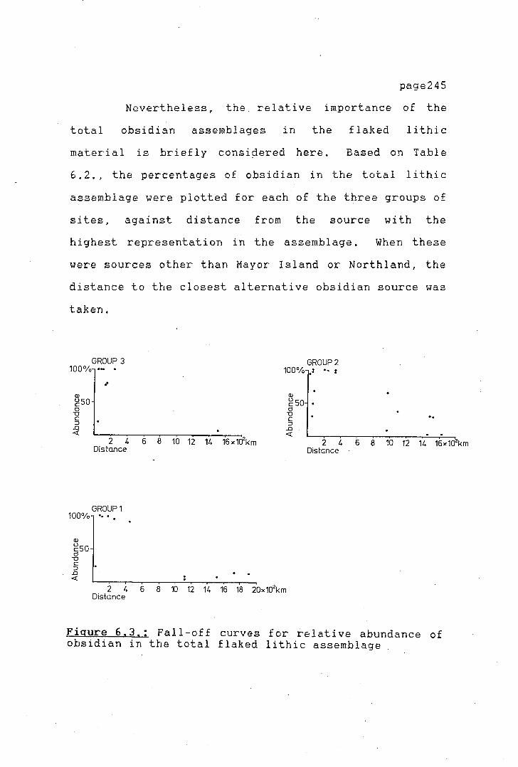
page245
Nevertheless, the. relative importance of the
total obsidian assemblages in the flaked lithic
material is briefly consi¢iered here. Based on Table
6.2., the percentages of obsidian in the total lithic
assemblage were plotted for each of the three groups of
sites, against distance from the source with the
highest representation in the assemblage. When these
were sources other than Mayor Island or Northland, the
distance to the closest alternative obsidian source was
taken.
GROUP 3 100%
(lJ
gso 0 -0 C :;J .0 <(
..
2 4 6 8 10 12 14 16x1a2km Distance
GROUP1 100% •• •
GROUP2 100% •• :
(lJ
g 50 • 0
-0 C :;J .0 <(
.. 2 4 6 8 10 12 14 16x102km
Distance
2 4 6 8 10 12 14 16 18 20x102km Distance
Figure 6.3,: Fall-off curves for relative abundance of obsidian in the total flaked lithic assemblage
page246
Initial inspection of the three plots in Figure
6. 3., shows a clear fall-off in the the abundance of
the obsidian after apprqximately 300 km from any
source. The fall-off pattern is different for the
three groups of s i te.s, but nonethe l_ ess, overall
similarities in the pattern can be observed. The
importance of obsidian in the majority of sites
decreases dramatically at distances of over 1000 km
from the quarries. Based on a purely qualitative
inspection of the data, either free lance trading or
down-the-line trading could be supported for the sites
located at distances of approximately 1000 km from the
sources. In all three plots a number of outlying
points can be observed. Their abnormal position in the
plots does not seem to be related to site function.
Qualitative inspection of the three plots shows that
within the approximate radius of 300 km from the
sources almost no fall-off can be detected.
In Group 1 sites (630 B.P. and older), the
percentage of obsidian in the total assemblage of
flaked stone artefacts is minimal (not higher than 19
per cent) at South Island sites (over 1000 km form the
source). In all these sites, obsidian does not play an
important role numerically. Silcrete blades are the
predominant lithic artefacts in these sites together
with occasional chert, porcellanite and argillite
flakes. Both chert and silcrete are available at
sources located closer to the sites than any of the
>--
'.
\
\ I, I,
obsidian quarries.
page247
All these sites, containing small
percentages of obsidian and located at over 1000 km
from the sources, are in the South Island of New
Zealand. In the North Island sites, obsidian plays a
major role in the lithic assemblages (85 to 100 per
cent) with only one exception (Harataonga N30/5).
In Group 2 sites (630 B.P. to 350 B.P.) the
abundance of obsidian in the sites further away from
the source increases quite substantially compared to
the earlier sites. At all the South Island sites, the
obsidian percentage increases to 36 per cent. In
general, in the North Island sites the percentages
remain as high as in the early period sites, with the
exception of three sites, where the decrease in
abundance seems to be more related to site function
than to distance to the source. For example, at Hahei
obsidian represents only 31 percent of the lithic
materials. Activities at this site are mainly oriented
towards the manufacture of basalt adzes and drills
(Harsant 1984).
Lastly, for the final group of sites (350 B.P.
to present) it is difficult to argue a definite
fall-off in obsidian abundance. Within the first 300
km the obsidian percentages are as high as in all the
earlier sites. Due to the lack of information on sites
at increasing distances no definite conclusions can be
made on the fall-off pattern. From the single site in
the sample (Long Beach), it appears that the fall-off

!> I >
I l I '
I ,-
\
'r
page248
is steep and obsidian is not an abundant artefact in
the tool kit.
Regression analysis performed on the data
showed that the fall-off patterns were highly
significant at 95 percent for the thr~e groups of
sites, as seen from Table 6.3.
TABLE 6,3,
Associated F values for abundance (percentage counts)
of obsidian with distance
F value Degrees Freedom
Group 1 5.88 7 Group 2 20.54 15 Group 3 13.65 9
Following Findlow and Bolognese (1980a, 1980b)
and Torrence (1981) the correlation coefficient was
used to identify the best fit equation for the fall-off
data of abundance with distance. The Pearson-r va 1 ue
was calculted for six regression models: one linear and
five exponential (using the equation Log Y=-bx« +a,
where the alpha values were varied from O. 1 to 2. 0).
The correlation values associated with each of the
models tested are given in table 6.4., for each of the
three groups of sites.
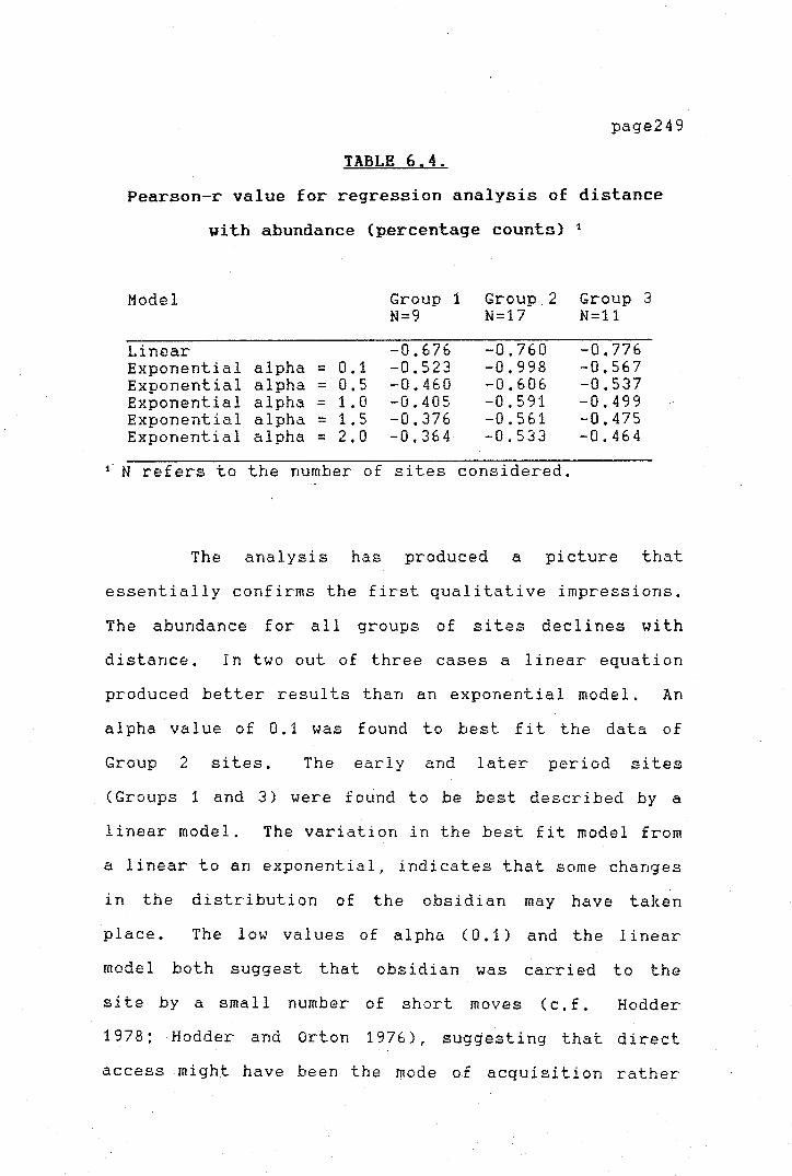
>
1
page249
TABLE 6.4.
Pearson-r value for regression analysis of distance
with abundance (percentage counts) 1
Model Group 1 Group_ 2 Group 3 N=9 N=17 N=11
Linear -0.676 -0.760 -0.776 Exponential alpha = 0.1 -0.523 -0.998 -0.567 Exponential alpha = 0.5 -0.460 -0,606 -0.537 Exponential alpha = 1. 0 -0.405 -0.591 -0.499 Exponential alpha = 1. 5 -0,376 -0.561 -0.475 Exponential alpha = 2.0 -0,364 -0.533 -0.464
N refers to the number of sites considered.
The analysis has produced a picture that
essentially confirms the first qualitative impressions.
The abundance for all groups of sites declines with
distance. In two out of three cases a linear equation
produced better results than an exponential model. An
alpha value of 0,1 was found to best fit the data of
Group 2 sites, The early and later period sites
(Groups 1 and 3) were found to be best described by a
linear model. The variation in the best fit model from
a linear to an exponential, indicates that some changes
in the distribution of the obsidian may have taken·
place. The low values of alpha (0,1) and the linear
model both suggest that obsidian was carried to the
site by a small number of short moves ( c, f. Hodder
1978; Hodder and Orton 1976), suggesting that direct
access might have been the mode of acquisition rather

page250
than down-the-line exchange (see also Table 6.1).
In a way, this sort of result is not completely
unexpected for the North Island sites. The almost
complete lack of fall-off within the first 300 km
radius from Mayor Island strongly suggests that direct
access was the main form of acquisition of the raw
material.
THE UTILIZATION OF MAYOR ISLAND OBSIDIAN
The following section considers the
geographical distribution and the technological aspects
of the utilization of Mayor Island obsidian. The
sourcing results presented in Chapter Vindicated that
the utilization of Mayor Island obsidian decreased in
the later periods of New Zealand prehistory. The
percentage of Mayor Island obsidian in the total
obsidian assemblages and its relationship with distance
from the source is considered here.
When the percentage (weight) of Mayor Island
obsidian in the total obsidian assemblage is plotted
against distance from Mayor Island, a significant
correlation between the two variables is only found for
the early sites (F=14.655 at P=0.05 with 17 DF). In
the early group of sites (Group 1) a distinct increase
in the proportion of Mayor Island obsidian is found

'
i ' i
;r
page251
with increasing distance. This relationship holds true
for all site types, Although, as discussed above, the
overall importance of obsidian in the total flaked
lithic assemblage decreases in these sites with
increasing distance from the source, .Mayor Island
obsidian was more popular at more distant places.
Since no particular differences can be detected in
relation to site function, distance and popularity of
Mayor Isl and obsidian ( see Figure 6. 4), it could be
argued that the increased percentage of Mayor Island
obsidian is related to its higher value in areas
further removed from the source.

page252
100 GROUP 3
0
50 C 0
0
d'g C 0 C 0
0 500 1000 1500 2000 distance ( km J
)·
:c 100 C • GROUP 2 }- -~ •
(l) 0 0
3:
C 0 (l) 50 A
0 0 0
Ol ·O
0 0 • • .....
0 Oco 0 0
C
(l) 500 1000 1500 2000
' distance ( km J
u L..
(l)
a. 100 • GROUP •
0 0
Oo •• 0 0
oO 50 •
0
0
I 0 0 • •
I >--0 \, 500 1000 15 0 --,'2000
distance ( km J
o undefended settlements c defended settlements
• temporary camps • workshops A special purpose site
Figure 6.4. ; Percentage (weight)of Mayor Island obsidian in the total obsidian assemblage,

'T.I ..... i:: 11 (1)
(J', . u,
'ti (0
Ii (1
ro :1 ("r
Pl lQ ro ,,-.. (1
0 C: :1 ("r (0 '-'
0 H)
Pl Ii ("r
ro H)
Pl (1 (1-
(1-'<! 'd (0 to
\7 ,,, ')
GROUP GROUP 2 GROUP 3 North Island Soulh Island North Island South Island North Island South
100] I I Debitage • w] I I • h I ~ I I • .. I .. I o •
Oebitage Debitage
~L Secondary blades 1 Secondary blades
100%
Secondary blodes I o~------------~~~--
'°°]11111111 1111 1111 Secondoryllakes
100]111111111111 I I. 1 I I II S&ondary flakes
100
] 1111 • II I I . I Secondary /Jokes
100] 100%1 100%L .I Primary flakes
0
Primary flakes • Primary flakes O
" • - . -100%]
o ••I I
I 100%1
• I • " I Core fragments O
I I I. I I
100%LL. I Core fragments
0 Core fragments
~- . I, I .• • ••1a1•ma ma4aMYeu~m
100% ~~] .
0 .. 1.,dl " 14153o19a19b16a12 4132
Cores Cores Cores 01
,a § ! 10 13 1sb2J ~s ~ ~ e ~ 29 41 33 40 39 i6 h32 i's 44
SITE NUMBERS SITE NUMBERS SITE NUMBERS
'c! i)> lQ ro N V1 w
page254
In later periods ( Groups 2 and 3) the
relationships between distance and percentage of Mayor
Island obsidian are not significant (F= 0.134 and F=
O. 158 respectively). The distribution is equally
random when individual site types are compared. It can
be argued that this was due to the larger variety of
good quality sources discovered as time went by, and
their increased exploitation; the relative importance
of Mayor Island obsidian decreased. Distance does not
seem to be an important factor
Mayor Island 6bsidian. Two
propositions can be made to
pattern.
1) Supply was 1 ef t to
in the acquisition of
possible alternative
explain the observed
'chance', and whatever
obsidian that was available was used.
2) Mayor Island obsidian lost its exclusive
value as more sources were made available.
The technological analysis that follows should
be helpful in testing these two propositions. If
technology was less wasteful in the earlier sites it
could be argued that Mayor Island obsidian was a more
valued item in this period than during the later
periods. The proportions of the various stages of
manufacture of artefacts in each site (cores.. flakes,
blades, debi tage) of the three groups of sites are
presented in Tables 6. 5 to 6. 7. The tables show the
technological breakdown for all the Mayor Island
obsidian recovered from the sites. Figure 6.5

page255
graphically represents the percentages of the different
types of artefacts recorded. Measures of distance,
from al 1 sites to Mayor Island and the values of the
mean weight of artefacts for all sites studied are
given in Tables 6.8 to 6.10.
The first point to establish is whether the
technological data, when plotted against distance, show
any evidence to support Renfrew's (1S72) Law of
Monotonic Decrement. An inspection of Tables 6. 8 to
6.10 and the graphs in Figures 6,6 to 6.8 indicate that
for the three groups of sites, the mean weight variable
does not decline monotonically with distance. The
relationship was investigated for only four artefact
types cores, core fragments, secondary flakes and
debi tage. Primary £lakes, and primary and secondary
blades were excluded from the analysis due to their
small representation in the samples,
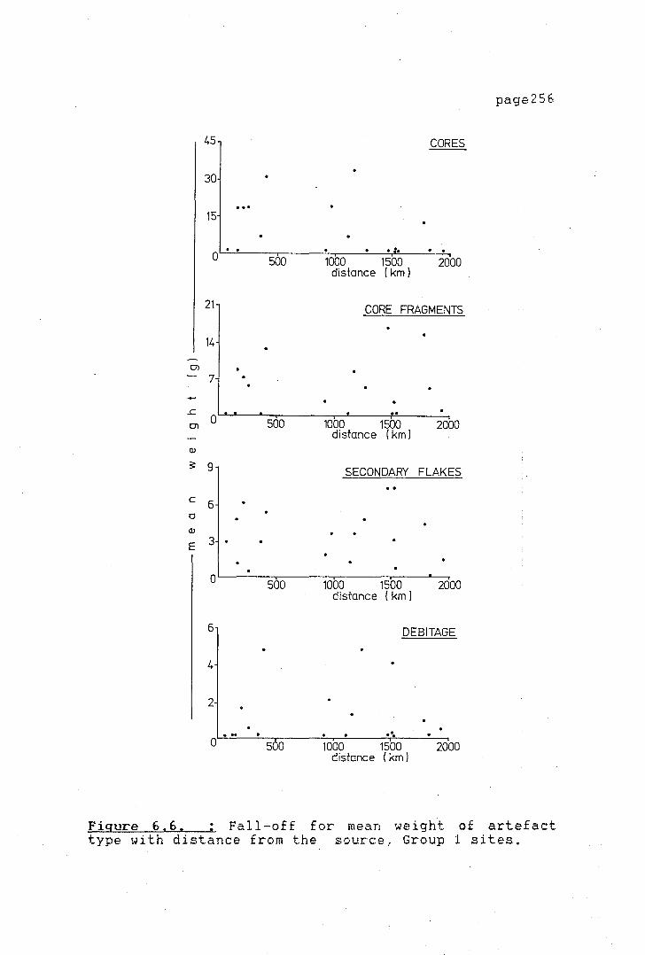
page256
45 CORES
30
... 15
. 0 . . . . . .
500 1000 1500 2000 distance ( km J
,_ 21 CORE FRAGMENTS
14 -~
CJ)
7 . - . ..c .. CJ)
0 500 1000 1500 2000 distance ( km)
a,
_,__ ~ 9 SECONDARY FLAKES .. C
6 > a a,
E 3 . >-
. 0 500 1000 1500 2000
distance ( km J
~
6 DEBITAGE
4
~ 2 . . .. . ..
-, 0 500 1000 1500 2000 distance ( km J
/
Figure 6.6. : Fall-off for mean weight of artefact type with distance from the source, Group 1 sites.

page257
45 CORES
30
15
~ :• I .. . . . 0 400 800 1200 1600 2000
'" distance ( km J
24 CORE FRAGMENTS
16
.. 8
),.
,;
•, . .. 0) 0 400 800 1200 1600 2000
distance (km) ' >
.....,
.c 0> 15 SECONDARY FLAKES a,
:s: 10 7 . .
C 5 0 . . . . a,
E 0 • 400 800 1200 1600 2000
distance ( km )
,_ 9 DEBITAGE
- >
-'- 6
3 . . . ..
0 400 800 1200 1600 2000 r distance ( km J
Figure 6.7. : Fall-off for mean weight of artefact type with distance from the source, Group 2 sites.

page258
30 CORES
20
. 10 . '
·( 0 400 8 0 1200 1600 2000
" distance ( km J
I-
30 SECONDARY FLAKES
20
10 en
0 -..c
I,. 400 800 1200 distance ( km )
1600 2000
en
(I)
3: 4·20 DEBITAGE
C 2·80 0
(I) 1>
I E 1-40
0 ..
400 800 1200 1600 2000 distance ( km J
~
,.'-
21 CORE FRAGMENTS
1 ''
" / 14
r 7 .
0 400 800 1200 1600 2000 distance ( km )
Figure 6,8. : Fall-off for mean weight of artefact type with distance from the source, Group 3 sites.

•r ,, ,,,- -,' y'-
V V
TABLE 6.5 Percentage of different artefact types, Mayor Island obsidian, 630 B.P. and older
Sites n cores % core % primary % secondary % secondary % debitage % distance frags. flakes flakes blades
North Island N30/5 48 3 ,-.~ 5 10.4 0 o.o 38 79.2 1 2. 1 0 o.o 142.0 Hingaimo 20 0 o.o 2 10.0 0 o.o 14 10.0 0 o.o 4 20.0 1240.0 Houhora 191 5 2.6 39 20.4 11 5.8 129 67 .5 0 o.o 7 3.7 420.0 Maioro 1 336 1 0.3 3 0.9 0 o.o 216 64.3 0 o.o 116 34.5 230.0 Prt Jack 4 0 o.o 0 o.o 0 o.o 4 100.0 0 o.o 0 o.o 152.0 N64/16 3 1 33.3 0 o.o 0 o.o 2 66.7 0 o.o 0 o.o 352.0 Skippers 6 0 o.o 0 o.o 0 o.o 6 100.0 0 o.o 0 o.o 73.0 Tokoroa 156 19 12.2 24 15.4 3 1.9 99 63.5 4 2.6 7 4~5 180.0
--------------------------------------------------------------------------------------------------------------- >-,
South Island Avoca 2 1 50.0 0 o.o 0 o.o 1 50.0 0 o.o 0 o.o 1120. 0 Hawksbu 25 0 o.o 2 8.0 0 o.o 18 72.0 0 o.o 5 20.0 1920.0 Long Be 1 0 o.o 0 o.o 0 o.o 1 100.0 0 o.o 0 o.o 1524.0 Pahia 1 0 o.o 1 100.0 0 o.o 0 o.o 0 o.o 0 o.o 1804.o Redclif 68 3 4.2 11 16.2 9 12.7 30 44. 1 0 o.o 15 22.1 1172.0 Shag Ri 20 0 o.o 1 5.0 0 o.o 16 80.0 1 5.0 2 10.0 1484.0 Titiran 2 0 o.o ,,, 50.0 0 o.o 1 5"0.0 0 o.o 0 o.o 920.0 :,•;
Tiwai P 69 0 o.o 3 4.3 1 1 • 4 55 79.7 5 7.2 4 5.8 1740 .o Waimata 1 0 o.o 0 o.o 0 o.o 1 100.0 0 o.o 0 o.o 1492.0 Wairau 8 1 12.5 0 o.o 0 o.o 5 62.5 0 o.o 2 25.0 932.0 Waitaki 21 0 o.o 6 28.6 1 4.8 14 66.7 0 o.o 0 o.o 1464.0 'd
Pl o.Q (D
l'-..l lf1 s.O
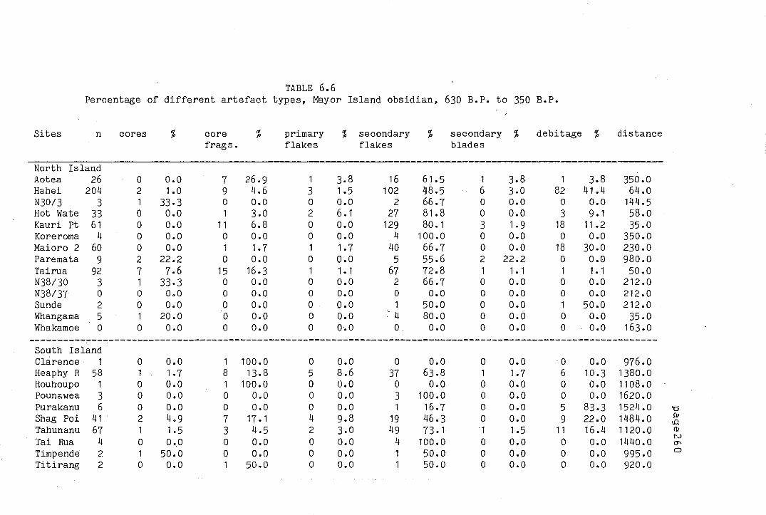
-, ·,-
TABLE 6.6 Percentage of different artefact types, Mayor Island obsidian, 630 B.P. to 350 B.P.
Sites n cores % core % primary % secondary % secondary % debitage % distance frags. flakes flakes blades
North Island Aotea 26 0 o.o 7 26.9 1 3.8 16 61. 5 1 3.8 1 3.8 350.0 Hahei 204 2 1.0 9 4.6 3 1 • 5 102 1s.5 6 3.0 82 41 .4 64.0 N30/3 3 1 33.3 0 o.o 0 o.o 2 66.7 0 o.o 0 o.o 144.5 Hot Wate 33 0 o.o 1 3.0 2 6. 1 27 81 .8 0 o.o 3 9. 1 58.o Kauri Pt 61 0 o.o 11 6.8 0 o.o 129 80. 1 3 1.9 18 11 • 2 35.0 Koreroma 4 0 o.o 0 o.o 0 o.o 4 100.0 0 o.o 0 o.o 350.0 Maioro 2 60 0 o.o 1 1.7 1 1. 7 40 66.7 0 o.o 18 30.0 230.0 Paremata 9 2 22.2 0 o.o 0 o.o 5 55.6 2 22.2 0 o.o 980.0 Tairua 92 7 7.6 15 16.3 1 1 • 1 67 72.8 1 1 • 1 1 1 • 1 50.0 N38/30 3 1 33.3 0 o.o 0 o.o 2 66.7 0 o.o 0 o.o 212.0 N38/37 0 0 o.o 0 o.o 0 o.o 0 o.o 0 o.o 0 o.o 212.0 Sunde 2 0 o.o 0 o.o 0 o.o 1 50.0 0 o.o 1 50.0 212.0 Whangama 5 1 20.0 0 o.o 0 o.o 4 80.0 0 o.o 0 o.o 35.0 Whakamoe 0 0 o.o 0 o.o 0 o.o 0 o.o 0 o.o 0 o.o 163.0
--------------------------------------------------------------------------------------------------------------South Island Clarence 1 0 o.o 1 100.0 0 o.o 0 o.o 0 o.o ·o o.o 976.0 Heaphy R 58 1 1. 7 8 13.8 5 8.6 37 63.8 1 1.7 6 10.3 1380.0 Houhoupo 1 0 o.o 1 100.0 0 o.o 0 o.o 0 o.o 0 o.o 1108.0 Pounawea 3 0 o.o 0 o.o 0 o.o 3 100.0 0 o.o 0 o.o 1620.0 Purakanu 6 0 o.o 0 o.o 0 o.o 1 16.7 0 o.o 5 83.3 1524.0 'tj
Shag Poi 41 · 2 4.9 7 17. 1 4 9.8 19 46.3 0 o.o 9 22.0 1484.0 Al t.Q
Tahunanu 67 1 1.5 3 4.5 2 3.0 49 73. 1 1 1.5 11 16.4 1120. 0 (D
4 o.o 4 1440.0 l'J
Tai Rua 0 o.o 0 o.o 0 100.0 0 o.o 0 o.o (J"\
Timpende 2 1 50.0 0 o.o 0 o.o 1 50.0 0 o.o 0 o.o 995.0 0
Titirang 2 0 o.o 1 50.0 0 o.o 1 50.0 0 o.o 0 o.o 920.0

'f \'
TABLE 6. 7. Percentage of different artefact types, Mayor Island obsidian, 350 B.P. to present
Site n cores % core % primary % secondary % secondary % -debitage % distance frags. flakes flak~ blades
North Island Elletts 19 0 o.o ~ 1 5.3 0 o.o 17 89.5 0 o.o 1 5.3 220.0 Hamlin's 8 0 0 .o - 0 o.o 1 12.5 6 75.0 0 o.o 1 12.5 220.0 N30/4 2 1 50.0 ~ 0 o.o 0 o.o 1 50.0 0 o.o 0 OlO 145.0 Mangakaw 2 0 o.o 1 50.0 0 o.o 1 50.0 0 o.o 0 o.o 130.0 Ngaroto 5 1 20.0 0 o.o 1 20.0 1 20.0 1 o.o 1 20.0 130.0 N64/18 48 1 2. 1 5 10.4 0 o.o 41- 85.4 0 o.o 1 2. 1 352.0 Skipp II 49 6 12.2 11 22.5 3 6. 1 25 51.0 2 4.1 2 4. 1 75.0 Waihora 0 0 o.o 0 o.o 0 o.o 0 o.o 0 o.o 0 o.o 164.o Whakamoe 0 0 o.o 0 o.o 0 o.o 0 0.0 0 o.o 0 o.o 163.0 Whangama 7 2 28.6 0 o.o 0 o.o 5 71.4 0 o.o 0 o.o 36.o
-----------------------------------------------------------------------------------------------------------South Island Long Bea 0 0 o.o 0 o.o 0 o.o 0 o.o 0 o.o 0 o.o 1523.0 Murderin 3 0 o.o 0 o.o 0 o.o 2 66.7 0 o.o 1 33.3 1524.0 Peketa 1 0 o.o 0 0.0 0 o.o 1 100.0 0 o.o 0 o.o 1140.0
'Cl p,
o.Q m N O'> .....

page262
TABLE 6.8.
Mean weight Mayor Island obsidian 630 B.P. and older
total core er fr Sites N mean SE SD mean SE SD mean SE SD -----------------------------------------------------------------------------North Island N30/5 48 6.40 1.0 6.4 17.9 * * . 7 .80 * *
> Hingaimo 20 4.65 0.9 4.2 o.o o.o o.o 5.05 * * Houhora 191 7.73 o.4 6 .1 29.8 * * 11.90 1. 0 6.3 ,. Maioro 1 336 0,64 0.1 1 • 3 18.6 * * 5.10 * * Prt. Jae 4 1.35 * * o.o o.o o.o o.oo o.o o.o N64/16 3 4 ,43 * * 6.8 * * o.oo o.o o.o Skippers 6 3.10 * * o.o 0,0 o.o o.oo o.o o.o Tokoroa 156 7 ,48 o.6 7,9 19.3 2.5 10.9 7.60 0.7 3,5
' -----------------------------------------------------------------------------South Island Avoca 2 3.15 * * 5.1 * * o.oo o.o o.o Hawksb 25 1.10 0.2 1.2 o.o 0 0 0.80 * * Long B 1 3.20 * * o.o 0 0 0,00 o.o o.o Pahia 1 5,70 * * o.o 0 0 5,70 * * Redcli 68 5,79 1.0 8,8 33.1 * * 8.30 1.4 4,9 Shag R 20 6,65 1, 1 4.8 o.o 0 0 3-40 * * Titira 2 2.20 * * o.o 0 0 2.40 * * Tiwai 69 4.71 0.7 5.3 11,7 * * 16.00 * * Waimat 1 o.4o * * o.o 0 0 o.oo o.o o.o Wairau 8 4.97 2,0 5,7 17 .9 * * o.oo o.o o.o Waitak 2 10.69 1.2 6.0 o.o 0 0 16.45 * *
' (Table 6.8. cont.)
pr fl sec fl sec bl debit Sites mean - SE SD mean SE SD mean SE SD mean SE SD ------------------------------------------------------------------------------North Island N30/5 o.o o.o o.o 4.7 0.80 4.3 4.6 * * o.o o.o o.o Hingai o.o o.o o.o 4.5 1.10 4.0 o.o 0 0 4.9 * * Houhor 9.6 1.7 5.5 5.6 0.20 2.7 o.o 0 0 4.7 * * Maioro o.o o.o o.o 0.7 0.05 o.8 o.o 0 0 0.2 0. 1 0.3
\_ Pt .Jae o.o o.o o.o 1.4 * * o.o 0 0 o.o o.o o.o N64/16 o.o o.o o.o 3.3 * * o.o 0 0 0,0 o.o o.o Skippe 0.0 o.o o.o 3, 1 * * o.o 0 0 o.o o.o * Tokoro 5,7 * * 5,9 0.60 6.4 2,8 * * ,. 7 * o.o
--------------------------------------------------------------------------------South Island Avoca o.o o.o o.o 1.2 * * 0,0 0 0 o.o o.o 0,0
', ,7 Hawksb 0,0 0,0 o.o 1. 3 0.30 1.3 o.o 0 0 0.5 * * Long B o.o o.o o.o 3.2 * * o.o 0 0 o.o o.o o.o Pahia o.o o.o 0,0 o.o 0,00 o.o o.o 0 0 o.o o.o 0,0 Redcli 8.5 * * 3,8 0,70 3,9 o.o 0 0 1,2 0,2 0.9 Shag R o.o 0,0 o.o 7, 1 1.40 5,2 7.9 * * 4.0 * * Titira o.o o.o o.o 2.0 * * o.o 0 0 o.o o.o 0,0 Tiwai 9.5 * * 4.2 0.60 4.0 4.4 * * 0.9 * * Waimat o.o o.o o.o 0,4 * * o.o 0 0 o.o o.o o.o Wairau o.o o.o o.o 3.7 * * o.o 0 0 1.8 * * Waitak 9.7 * * 7.3 0.88 3.4 o.o 0 0 o.o o.o o.o

page263
TABLE 6.9.
Hean weight Mayor Island obsidian 630 B.P. to 350 B.P.
total cores er fr pr fl Sites N mean SE SD mean SE SD mean SE SD mean
( -------------------------------------------------------------------------------North Island Aotea 26 4,29 0.6 3,2 o.o 0 0 7,7 * * 3,4 Hahei 198 2.90 0.3 3.8 19,5 * * 11 , 7 * * 2,7 N30/3 3 3,70 * * 3,7 * * o.o ·o.o o.o o.o Hot Wate 33 7,49 ,. 1 6.5 o.o 0 0 11 ,5 * * 17,6 ,, Kauri Pt 161 7 .12 0,4 4,7 o.o 0 0 12,6 0,8 2.9 o.o
,.. Koreroma 4 3.60 * * o.o 0 0 o.o o.o o.o o.o Maioro 2 60 1,20 0,2 1. 9 o.o 0 0 3.9 * * 0,4 Paremata 9 4,33 1,3 5,0 13,9 * * o.o o.o o.o o.o N38/30 3 3,46 * * 6.6 * * o.o o.o o.o o.o N38/37 0 o.oo o.o o.o o.o 0 0 0,0 o.o 0,0 o.o Sunde 2 4,20 * * o.o 0 0 o.o o.o o.o o.o
> Tairua 92 4.42 2.1 21,4 34,2 * * 15,5 3,3 13. 1 o.o Whakamoe 0 o.oo o.o o.o o.o 0 0 o.o o.o o.o o.o Whangama 5 5,52 * * 15,7 * * o.o o.o o.o 0,0
-------------------------------------------------------------------------------South Island Claren 1 3,30 * * o.o 0 0 3,3 * * o.o Heaphy 58 · 10.00 1.4 10.3 38,6 * * 18.6 * * 10.4 Houhou 1 5,70 *· * o.o 0 0 5.7 * * o.o Pounaw 3 2,23 * * o.o 0 0 o.o 0,0 o.o 0,0
>- Puraka 6 0.30 * * 0,0 0 0 o.o o.o o.o o.o Shag P 41 3.06 0,5 3.2 9,4 * * 13.4 * * 4,5 Tahuna 67 3.20 0,5 4.4 29.8 * * 4.1 * * 6,3 Tai Ru 4 6.65 * * o.o 0 0 o.o o.o o.o 0,0 Timpen 2 3.84 * * 5.5 * * o.o o.o o.o o.o Titira 2 2.00 o.o o.o o.o 0 0 :z .2. o.o o.o o.o
f-
(Table 6,9. cont.) sec fl sec bl debit
Site SE SD mean SE SD mean SE SD mean SE SD
------------------------------------------------------------------------------North Island Aotea * * 3.2 o.6 2,6 2.6 * * 0 .1 * * Hahei * * 3.2 o.4 3,8 3.4 * * 1,4 0, 1 1, 0 N30/3 0 0 0,9 * * 0,0 0 0 0,0 o.o o.o
\. Hot W * * 7,3 1 • 1 5,8 o.o 0 0 1. 1 * * Kauri 0 0 6,7 0,5 4.8 0,0 0 0 6.5 0,7 3,2 Korer 0 0 3,6 * * o.o 0 0 o.o o.o o.o Maior '* * 1.5 0,3 2.2 0,0 0 0 0,4 0,2 0,8 Parem 0 0 3,4 * * 1.4 * * o.o 0,0 o.o N38/30 0 0 1, 9 * * o.o 0 0 o.o o.o 0,0
7
N38/37 0 0 o.o o.o o.o o.o 0 0 o.o o.o 0,0 Sunde 0 0 5,6 * * 0,0 0 0 2,8 * * ;,-Tairu 0 0 12,4 1, 8 15,2 J.4 * * 2,9 * * Whaka 'O 0 o.o o.o o.o o.o 0 0 0,0 o.o 0,0 Whang 0 0 3,0 * * o.o 0 0 o.o 0,0 0,0
------------------------------------------------------------------------------South Island Claren 0 0 o.o o.o o.o o.o 0 0 o.o o.o o.o Heaphy * * 8,5 1,4 8,5 6,3 * * 3,5 * * Houhou 0 0 o.o o.o 0,0 o.o 0 0 0,0 o.o o.o Pounwe 0 0 2.2 * * o.o 0 0 o.o o.o 0,0
Puraka 0 0 0 .1 * * 0,0 0 0 0,4 * * -; Shag p * * 2,3 0,7 3,1 0,0 0 0 1, 3 * *
Tahuna * * 2,9 o.4 3. 1 3,2 '* * 1,5 0,4 1.4 Tai Ru 0 0 6,7 * * o.o 0 0 o.o o.o o.o Titira 0 0 1 ,B o.o o.o o.o 0 0 o.o o.o o.o Timpen 0 0 2,2 * * o.o 0 0 0,0 0,0 o.o
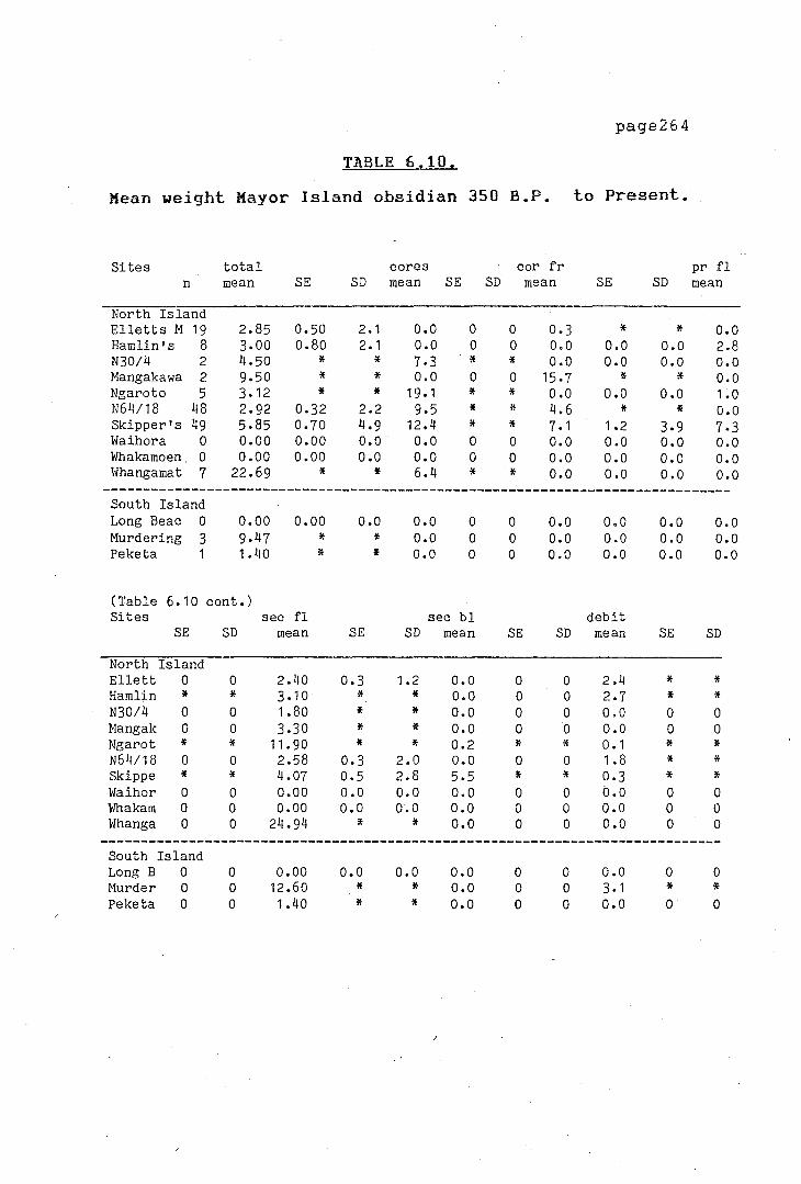
page264
TABLE 6.10.
Mean weight Mayor Island obsidian 350 B.P. to Present.
I I
I (
i1
( Sites total cores cor fr pr fl n mean SE SD mean SE SD mean SE SD mean
North Island Elletts M 19 2.85 0.50 2 .1 o.o 0 0 0.3 * * o.o Hamlin's 8 3.00 0.80 2. 1 o.o 0 0 o.o o.o o.o 2.8 N30/4 2 4.50 * * 7.3 * * o.o o.o o.o o.o Mangakawa 2 9.50 * * o.o 0 0 15.7 * * o.o Ngaroto 5 3.12 * * 19. 1 * * o.o o.o o.o 1.0 N64/18 48 2.92 0.32 2.2 9,5 * * 4.6 * * o.o Skipper's 49 5,85 0.70 4.9 12.4 * * 7. 1 1.2 3,9 7.3
' Waihora 0 o.oo o.oo o.o o.o 0 0 o.o o.o 0,0 o.o I' I - Whakamoen. 0 o.oo o.oo o.o o.o 0 0 o.o o.o o.o o.o
Whangamat 7 22.69 * * 6.4 * * o.o o.o o.o o.o -------------------------------------------------------------------------------
South Island Long Beac 0 o.oo o.oo o.o o.o 0 0 o.o o.o o.o o.o
I Murdering 3 9.47 * * o.o 0 0 o.o o.o o.o o.o Peketa 1 1,40 * * o.o 0 0 o.o o.o o.o o.o
r
.-
(Table 6. 10 cont.) Sites sec fl sec bl debit
~ '
SE SD mean SE SD mean SE SD mean SE SD
North Island ~ Ellett 0 0 2.40 0.3 1.2 o.o 0 0 2.4 * *
Hamlin * * 3 .10 * * o.o 0 0 2.7 * * N30/4 0 0 1.80 * * o.o 0 0 o.o 0 0 Mangak 0 0 3 ,30 * * o.o 0 0 o.o 0 0 Ngarot * * 11,90 * * 0.2 * * 0. 1 * * N64/18 0 0 2.58 0.3 2.0 o.o 0 0 1.8 * * Skippe * * 4.07 0,5 2.8 5,5 * * 0,3 * * ]>.
Waihor 0 0 o.oo o.o o.o o.o 0 0 b.o 0 0 Whakam 0 0 o.oo o.o o.o o.o 0 0 o.o 0 0 Whanga 0 0 24.94 * * o.o 0 0 o.o 0 0
------------------------------------------------------------------------------South Island Long B 0 0 o.oo o.o o.o o.o 0 0 o.o 0 0 Murder 0 0 12.60 * * o.o 0 0 3. 1 * * Peketa 0 0 1.40 * * o.o 0 0 o.o 0 0
I .
\ J i-, I ' I
/
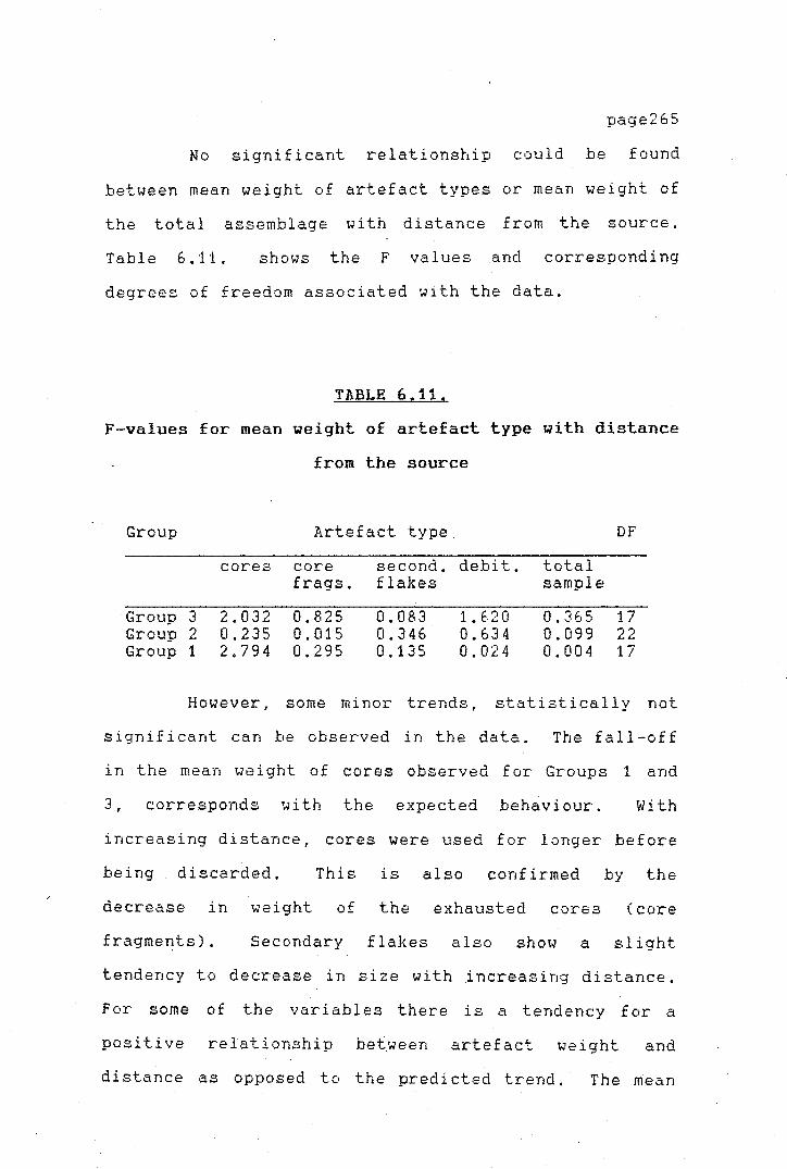
/ ·1 I
page265
No significant relationship could be found
between mean weight of artefact types or mean weight of
the total assemblage with distance from the source.
Table 6.11. shows the F values and corresponding
degrees of freedom associated with the data.
TABLE 6,11,
F-values for mean weight of artefact type with distance
from the source
Group Artefact type DF
cores core second. debit, total £rags. flakes sample
·Group 3 2.032 0.825 0.083 1. 620 0,365 17 Group 2 0.235 0.015 0.346 0.634 0,099 22 Group 1 2.794 0.295 0,135 0.024 0.004 17
However, some minor trends, statistically not
significant can be observed in the data. The fall-off
in the mean weight of cores observed for Groups 1 and
3, corresponds with the expected behaviour. With
increasing distance, cores were used for longer before
being discarded, This is also confirmed by the
decrease in weight of the exhausted cores (core
fragmef!ts). Secondary flakes also show a slight
tendency to decrease in size with increasing distance.
For some of the variables there is a tendency for a
positive relationship between artefact weight and
distance as opposed to the predicted trend.· The mean
page266
weight of cores for Group 2, for example, increases in
direct opposition to the predictions of the Law of
~onotonic Decrement. The relationship between debitage
mean weight and distance is also positive for both
Groups 3 and 1 sites. The tendency of the debitage to
show a positive relationship with distance, especially
in Group 3 sites, may be due to problems in site
representation in the sample, or even recovery
techniques employed during site excavations at
particular sites. Scarcity of the material does not
seem to have affected the way in which the material was
used. Although Mayor Island material might have been a
more valued obsidian, no special care seems to have
been taken to ensure maximum use of the material.
The absence of any definite relationship
between the mean weight of artefacts and distance and
the almost total absence of any distance decay pattern
in all three groups of sites is significant and rather
unusual. The explanation for this different and
'anomalous' pattern may be related to a high degree of
mobility of the prehistoric Maori population.
In addition to the investigation of the
relationship of the mean weight of artefact type with
distance, the relationship between the total weight of
obsidian of each artefact type with distance from Mayor
Island was investigated. Again, no significant
relationship between total weight of material and
distance was found for most cases. The only

}-
page267
significant relationship (F = 3.21 at P=0.01 and 17 DF)
was found for the total weight of cores of Group 1
sites (Figure 6.9.). The total weight of the obsidian
cores decreased with increasing distance. Although the
relationship for the other groups of sites is not
significant, the general pattern shows a decrease in
total weight of obsidian material as the distance from
the source increases. The Pearson r value using
different alpha exponents was again calculated for the
total weight of cores for Group 3 sites. It was found
that this relationship was best described by a linear
model (r= -0.399). In accordance with the predictions
this would be indicative of direct access as the most
likely method of procurement of the raw material.
450
0)
- 300 ::c 0)
-~ 150
0 •• 500
CORES
GROUP 1 sites.
. . . . . . . 1000 1500 2000
distance ( km J
Figure 6,9. : Fall-off curve for total weight of obsidian (cores) with distance.
The low correlation between the variables
con£ irms that the Law of Monotonic Decrement is not
operating in the case of Mayor Island obsidian
distribution in New Zealand. Directional trade cannot
be invoked for an explanation of the pattern because
>
)-
page268
individual sites are not receiving supplies
preferentially. Distance does not seem to affect the
technology of the artefact production, as the
assemblages are all relatively similar.
The mean values for the variables considered in
the study are quite similar among the sites studied.
It seems that even the most distant sites, such as
Hawksburn, Tiwai Point or Pahia, did not alter their
technology in response to the assumed high costs of
a~quisition. The lack of correlation between the
technological variables and distance could be due to
strong stylistic/functional constraints. It appears
that obsidian flakes were only used for certain tasks
which did not require any careful preparation or
elaboration. Especially in the South Island sites,
where alternative lithic materials were used
preferentially (silcrete and porcellanite), obsidian
seems to have played a minor role in the tool kit.
Detailed use wear analysis on newly excavated obsidian
assemblages could be a useful guide in clarifying some
of these points.
In general it seems that obsidian was not
exchanged through any elaborate exchange system. From
the different lines of evidence it seems that, for
example, within the North Island and within an
approximate radius of 300 km from the source on Mayor
Island, most obsidian was acquired either directly from
the source or from groups of people 1 iv i ng e:-{treme 1 y
·-'
. ).
page269
close to them who had access to a large supply of the
raw material.
The f al 1-of f exper-ienced in the abundance of
obsidian at places further than, say, 300 km from the
sources on Mayor Island, makes it clear that obsidian
was not of prime importance at these sites. The small
quantities of it in the sites do not encourage the
suggestion that special trips were made to acquire it.
Rather, on the odd occasion when long trips were
undertaken, obsidian was acquired together with other
items and taken south. Most commonly though, it
probably reached the more distant sites by way of a
down-the-line system. It should be mentioned also,
that a few huge blocks of obsidian have been found on
occasions at places along the South Island coast, for
example on the Otago Coast (Otago Museum accession
numbers D75.595; D75.207), North Canterbury and Milford
Sound. The North Canterbury block weighs 54 kg
(Anderson n.d.), and blocks of this size could only
have been transported by canoe. They were most
probably obtained on a trip north, or otherwise left by
a party who could acquire it from the source while on a
special visit to the south. The two blocks held at the
Otago Museum have been sourced by Leach and Manly
(1982:100-101) to Mayor Island. The block from Milford
Sound, one of the largest ever found in New Zealand was
found to be of an unknown N~w Zealand or Pacific source
(Leach, pers. comm.). Mayor Island obsidian, as

)
y
.>-
T
page270
mentioned before, seems to have had a higher value in
the South Island sites, and could therefore have been a
valued gift given in exchan_ge for some southern items.
Although, as mentioned, flake and debitage size
are not responsive to distance, the total weight and
there£ ore quantity of cores decreases with di stance.
Most excavated South Island sites have few or no cores
and a higher proportion of exhausted cores. Even if
the size of the final products does not seem to be
affected by the scarcity of the raw material, cores
were used until they were exhausted,
FINAL RE.MARKS
Based on the regional analysis of obsidian
distribution several important conclusions arise.
1) Obsidian was generally the most important
raw material for the manufacture of flaked tools in the
North Island sites considered. In contrast, at South
Island sites, obsidian was only marginally represented
and is not an essential part of the tool kit.
2) Mayor Island obsidian increasingly dominates
in the obsidian assemblages as one moves away from the
obsidian sources. South Island sites show a marked
preference for Mayor Island obsidian, especially during
the early period. The dominance of Mayor Island
page271
obsidian disappears in general during later times,
nevertheless it is still of greater importance in South
Island sites. It is argued that Mayor Island obsidian
was more valued at these places than obsidian from
other sources. Access to other sources may have been
more difficult in comparison as it involved travel
through possibly hostile territories.
3) From the technological analysis performed on
the obsidian assemblages it can be concluded that the
manufacturing technology of flakes did not change with
increasing distance· from the source. The obsidian
flaking was remarkably uniform all over New Zealand, as
it was used apparently for the manufacture of
multipurpose cutting/scraping tools. This also
explains partly the lack of any correlation between
artefact type and distance and the 'anomalous' fall-off
pattern observed from the artefactual analysis.
The explanation of the fairly even amounts of
obsidian found at North Island sites in a radius of
approximately 300 km from Mayor Island may lie in the
nature of the high mobility of the prehistoric
population. Long trips were apparently not a rare
occurrence in historic times. Numerous ethnographic
references recount long trips undertaken by groups of
people at which long stops for food gathering and other
reasons were made (Heaphy 1959). The collection of raw
materials during these voyages did not engender much
extra cost. The quantity of obsidian entering the
page272
sites would therefore not be related to distance but
would be a function of the degree to which trips were
made, their purpose and the number of stopovers made
during these trips.
4) Differences in the fall-off pattern of
obsidian abundance between the North and South Islands,
indicate that there were possibly two ways of acquiring
the raw materials, existing side by side. Direct
access, seems to have been the more common way of
obtaining obsidian in the North Island, although, this
does not exclude the distribution through a
down-the-line system between_ neighbouring communities.
A down-the-1 i ne system is more appropriate to explain
the South Island pattern.
Finally, in the following concluding chapter
(Chapter VII), the implications of these findings are
discussed.
iddda24p
Rectangle
iddda24p
Rectangle
I~
page273
CHAPTER VII
DISCUSSION AND CONCLUSION
The principal objective of the present thesis,
to understand the role of Mayor Island as the main
source of obsidian in prehistoric New Zealand and
identify the merihanisms of exchange responsable for its
distribution, has been met, within the limitations of
the archaeological data. The study of Mayor Island
obsidian exchange was
lines of research.
approached
In both
following two basic
cases a number of
conclusions
theoretical
have been reached, although several
and methodological problems were
encountered along the way. It remains now to integrate
the results of these two separate lines of inquiry, the
study of the quarries on Mayor Island, and the regional
di stance f al 1-of f studies, to reconstruct the picture
of prehistoric obsidian exchange in New Zealand.
Most significantly, all lines of evidence
pursued agreed, whether based on the regional data, or
the analysis of the Mayor Island sites, that obsidian
exploitation from the Mayor Island sources was not
highly organized. Looking ·first at the data from the
quarries themselves and the site survey carried out on
\
i '
I
I I
I
I.
I -I, .,_ I
page274
Mayor Island, the evidence points towards unspecialized
and unintensive exploitation and extraction of obsidian
from the flows. From the absence of extensive working
floors and quarry debris it appears that access to the
obsidian deposits was unrestricted and .that obsidian
was obtained by individual parties, who carried away
whole blocks elsewhere.
In addition, the evidence from the Mayor Island
obsidian distribution and the fall-off pattern support
the findings from the site oriented study.
The results from the sourcing of New Zealand
obsidian assemblages have shown a pattern of change,
both in source utilization throughout New Zealand and
in obsidian utilization from the early to the later
periods of occupation. Initially, Mayor Island seems
to have played an important role, since it provided the
best quality obsidian sources. Other available sources
were soon discovered and exploited to varying degrees.
Nevertheless, Mayor Island obsidian was the most
commonly used obsidian during the first few hundred
years, although in later times, other sources were
increasingly
communities.
used, particularly by North Island
On the basis of the various studies, an
approximation of the possible exchange mechanisms in
operation can be made. The identification of the
'precise' mode of exchange from among all the possible
types is impossible without further testing and data
\
;r
collection.
page275
The final results obtained from the
analysis of the Mayor Island obsidian distribution tend
to favour the suggestion that a substantial number of
communities located at considerable -distances from the
Mayor Island obsidian sources (up to approximately 300
to 400 km), obtained their raw materials through direct
access throughout the temporal depth of New Zealand
prehistory. The changes observed in the pattern of
source exploitation have been linked to changes in
political affiliation and increasing warfare placing
restrictions on travel and movement through certain
territories. If most communities within a 'contact
area' had obtained their raw materials directly from
the sources, and access to these became increasingly
more difficult, alternative sources had to be
exploited. The increasing proportions of Mayor Island
obsidian at certain sites (Washpool, Maioro) may have
been a direct result of changing political
affilitations. }.t South Island sites, 800 km or more
distant from any source, the obsidian did not play an
important role; other lithic materials replaced it.
The preference for Mayor Island obsidian was
particularly strong at places where no other readily
available obsidian existed.
Procurement for most consumers within a certain
radius by direct access to the obsidian sources is
S"l,Jpported by both the regional analysis (Chapter VI)
and the research carried out at the quarries themselves
j r
(Chapter IV).
page276
It appears that despite the apparent
simplicity of this model, the procurement strategy
might have been more complex. The temporal changes in
source utilization observed (Chapt~r V) between the
three groups of sites considered might be of some
importance for understanding changes in the
distribution pattern due to broader economic or
political changes taking place at the time. The data
examined in the previous chapter (VI), indicated that,
for a large number of consumers, the distance from the
quarries to the place of consumption was not the most
relevant factor in procurement costs. One may ask what
other possible reasons might be put forward to explain
this pattern. The fishing grounds surrounding Mayor
Island are some of the richest in New Zealand for the
presence of deep sea game species, within relative calm
waters. Even today Mayor Island is considered one of
the prime areas in New Zealand for deep sea fishing.
It is suggested, therefore, that stops on Mayor Island
may have been scheduled within other activities, such
as special fishing trips. Visits might therefore have
been undertaken for a variety of reasons as Mayor
Island may have offered several attractive prospects to
the visitors, obsidian being but one of them.
The obsidian fall-off study indicates further
that most obsidian at sites in the South Island
probably arrived through a down-the-line exchange
system. Whether it was received from some other
! I>-
r
page277
communities through gift-exchange or some other custom
cannot be established at present. Nevertheless, one
can assume that mostly high quality flaking obsidian
would have been given as a gift to visitors from the
South Island, or left by North Island parties on
special trips to the south. As increasingly more and
more varied sources were exploited in the North Island,
this would have been reflected to some e:{tent in the
materials reaching the South Island sites. However,
during the later periods of prehistoric occupation,
Mayor Island obsidian maintained its position as the
dominant type in the South Island.
It is by no means certain if obsidian in the
South Island was exclusively
down-the-line exchange mechanism.
of exchange is supported by the
data, the technological analysis
received by a
Al though this type
abundance fall-off
of the obsidian
artefacts does not completly agree with the predicted
behaviour. Strictly speaking, if down-the-line
exchange was the only system responsible for the
dispersion of obsidian, one would e:{pect that, as the
raw material was passed on through the system, unworked
blocks would be reduced to smaller and smaller forms '
or would be exchanged in ever decreasing quantities.
This would mean that only the sites close to the source
would have unworked blocks of obsidian, and a larger
amount of cores, and worked cores and flakes would
enter the m~re distant sites.
! }
J..
\
T
page278
None of these predictions proved to be strictly
correct for the New Zealand data since no significant
relationship between distance from the source and the
form of the raw material as it entered the sites was
found. It was found that the total weight of cores was
the only variable which was inversely correlated with
distance, and in accordance with the theoretical
predictions, direct access was again indicated by the
correlation coefficient. Ethnographic information
reviewed in Chapter I I shows that commodities were
acquired both . by direct access and by exchange.
Movements of people over 1000 km or more are also
documented (Anderson 1980). It can be suggested that
once the material had arrived in the South Island it
was distributed through reciprocal exchanges between
related groups,
The use of particular types of sources at
specific site types is supported by the data.
Differences, especially between permanent and temporary
sites, are observed. It is likely that parties on
special hunting journeys would select carefully the
pieces they would take and, therefore, one would expect
to find only few sources represented at these sites.
No technological differences in artefact
manufacture between functionally different sites could
be found from the examination of the data. The
technology to produce obsidian artefacts was remarkably
uniform throughout the region.

>
r
pa.ge279
An important implication of the finding that
obsidian was obtained by two systems is that fairly
large quantities of a resource can be distributed over
a large area without systematic exchange taking place.
Further implications are that costs of acquisition may
not necessarily be reflected in the technology of
artefact production, and that the distribution of a
resource is not necessarily the result of a complicated
exchange system.
It has also been assumed usually, that if a
resource was dt°stributed over a large area, ·+ 1~ must
have had a high value associated with it. However, the
cost of acquisition of the obsidian would be
considerably reduced if it was obtained by reciprocal
exchange or a down-the-line system and it would reduce
the procurement cost for people living further from the
area of supply. Other reasons for the apparent low
value of obsidian may be related to the form of
transport used. Travel by canoe was probably more
efficient and easy_. would reduce the associated cost of
overland travel and would have increased the area of
the supply zone, In addition, the cost incurred in
obtaining obsidian may have been reduced by the fact
that it was obtained in conjunction with other
activities. The examination of the relationship
between transport, di stance, demand and the type of
exchange may shed further light on the value of a given
resource.
(,-
\ !.
i 1.
i : A.
I'
l--
l 'r
i
7
page280
In retrospect. limitations of the present work
become evident. One of the most serious deficiencies
encountered was the lack _of sophisticated techniques
for measuring human behaviour. The theoretical review
presented in Chapter III demonstrates the state of our
current inability to predict and detect accurately
types of human behaviour. As Anderson (n.d.:17) has
pointed out it is not only the exchange mechanisms
themselves which elude archaeological demonstration but
the fact that the existence of transactions requiring
two way activities often cannot be demonstrated.
One of the major problems of the regional
analysis utilizing the fall-off curves proposed by
Renfrew (1972, 1975, 1977a) is that they cannot
adequately discriminate between different classes of
exchange. Probably the biggest problem in
archaeological exchange studies is the lack of a
theoretical background that could enable us to predict
exchange types. As the theoretical review showed, the
present state of exchange theory does not al low for
accurate discrimination in the field of any of the
exchange types described by anthropologists. Further
progress in this line of inquiry requires a better
theoretical basis for predicting the nature of exchange
and development of the methodological techniques.
These limitations are mainly reflected in the regional
analyses.
}-
' }_
,-
7
page281
However, something has been learned in this
study concerning the nature of obsidian exchange in New
Zealand. Although limitations in the archaeological
data were encountered, as discussed· in each Chapter,
several significant conclusions have been.made. It was
found that the site oriented study - the analysis of
the quarries proved extremely informative. Although no
sophisticated techniques were used, or more detai 1 ed
research carried out at this point, it is clear from
the highly informative results obtained from the
initial site survey, that quarry analysis can provide a
number of answers in the detection of the functioning
of prehistoric exchange systems. The relationship that
emerged between the quarry sites, types of production
and procurement has shown the value of the coTr.:::iined
regional and site oriented approach. More work
investigating the relationship to other obsidian source
utilization is needed before the total picture of
obsidian consumption in New Zealand can be fully
understood. Further work investigating the
relationship to other obsidian source utilization is
needed. The development of an accurate sourcing
procedure capable of discriminating between other New
Zealand sources should be a priority.
The present study is offered as an initial
attempt at solving some of the complicated aspects of
prehistoric human communic~tions. Future fieldwork and
analytical work should provide the required data to
..
1
I ~
7
.?
page282
confirm or, perhaps, alter the present conclusions .
The data f i 1 es from the pr sent research have
been stored in the Otago University Archaeology
Laboratory archive system, and can be consulted for
research purposes, prior consultation with the author.
\
iddda24p
Rectangle
I >
>
page 283
REFERENCES
Am. Antiq. A.P.A.O.
B.A.R. DSIR
J.P.S.
J. Arch. Sci.
J.R.S.N.Z.
N.Z.A.A.
N.Z.A.A.N.
N.Z.J.A.
N.Z.J.G.G.
N.Z.J.Sci.
N.Z.J.Sci.Tech.
Rec. Auck. Inst. Mus. Rec Cant. Mus.
T.N.Z.I.
T.P.N.Z.I.
T.P.R.S.N.Z.
T.R.S.N.Z.
ABBREVIATIONS
American Antiquity Archaeology and Physical Anthropology in Oceania British Archaeological Reports Department of Scientific and Industrial Research Journal of the Polynesian Society Journal of Archaeological Science Journal of the Royal Society of New Zealand. New Zealand Archaeological Association New Zealand Archaeological Association Newsletter New Zealand Journal of Archaeology New Zealand Journal of Geology and Geophysics New Zealand Journal of Science New Zealand Journal of Science and Technology Records of the Auckland Institute and Museum Records of the Canterbury Museum Transactions of the New Zealand Institute Transactions and Proceedings of the New Zealand Institute Transactions and Proceedings of the Royal Society of New Zealand Transactions of the Royal Society of New Zealand

'
I ,_ I
I '-
)-
t r-
\
page 284
Adams, E.L. 1971. Tuhua (Mayor Island). Historical Rev.i&w' .. 19 ( 1): 30-35.
Adams, R.H. 1974. Anthropological perspectives Ant/Jropol o{l_v,
on 1 5 : ancient trade. Current
239-258. I
Allan, H.H. and K.W. Dalrymple. flowering plants of Mayor T.H.Z.J., 56:34-36.
1926. Ferns and Island, New Zealand.
Alla, J. 1970. Analysis of midden from Motutapu Island, New Zealand. Znst. Hus., 7:83-91.
two sites on Rec. AucA·.
1972. The Whangamata wharf site (N49/2):excavat1ons midden. Rec. Auck.
on a Coromandel coastal Jn.st. Hus •.. 9:61-79.
Ambrose, W.R. 1962. The Kauri Point swamp. H.Z.A.A.N., 5(1):56-57.
---------, and R.C. Green. 1972. First millenium B.c.: transport of obsidian from New Britain to the Solomon Islands. H<-'iture, 237:31.
Ammerman, A.J. 1979. networks in 11:95-110.
A study Calabria.
of obsidian exchange world Arc/Jaeolo[ZV,
---------, and M.W. Feldman. 1974. On the "making" of an assemblage of stone tools. Am. Ant.iq., 39:610-616.
--------- and M.W. collection of 43:734-740.
Feldman. 1978. Replicated site surfaces. Am. Ant.iq.,
C. Matessi and L.L. Cavalli-Sforza. 1978. Some new approaches to the study of the obsidian trade in the Mediterranean and adjacent areas. In, Tile .spatial or{lan.izlit.ion oI culture, Hodder.. I. (Ed.), Pittsburgh. University of Pittsburgh Press. Pp.179-196.
and W. Andrefsky Jr. 1982. Reduction sequence and the exchange of obsidian in Neolithic Calabria. In., Contexts .For pre.hist or .ic e.!rchange, Ericson, J. and T. Earle (Eds.).. New York. Academic Press. Pp.149-172.

]' ~
I
i ?
T
page 285
Anderson, A. J. personal communication. Anth3:opology Department, University of Otago.
Anderson, 1' •• J. 1979. E:{Cavati ons at the Hawksburn moa-hunting site: an interim report. N. Z. A. A. N. , 2 2 ( 2) : 4 8-5 9.
--------- .. 1980. social amongst 2:3-23.
Towards an explanation of- protohistoric organization and settlement patterns the southern Ngai Tahu. H.Z.J.A ...
--------- 1981. A fourteenth century fishing camp at Purakanui Inlet, Otago. J.R.S.Jl.Z., 11(3): 201-21.
1982a. A review of the during the Archaic phase Zealand. N.Z.J.Jl., 4:45-75.
economic patterns in southern New
--------- 1982b. North and Central Otago. Inr :T.be .t".irst Jt.l!.70 _ve .. <Jrs: Reg.ion .. <Jl perspectives .in Ner., Zealand archaeology. Prickett.. N. {Ed.) N.Z.A.A. Monograph 13. Palmerston North. The Dunmore Press. Pp.112-128.
--------- 1983. The prehistoric hunting of moa (Aves:Dinornithidae) in the hiah country of souther·n New Zealand. In.. An.im,.9Js and archaeology: Tw10 shell middens? fishes and .birds. Grigson C. and J. Clutton-Brock (Eds.), B.1' .. R. International Series 183. Pp.33-52.
---------, 1984. The e:{tinction of moa in southern New Zealand. In. ()uat2rnar_v e.,d.inctions, Martin, O.S. and R.G. Klein (Eds.), Tucson: University of Arizona Press. Pp.728-740.
n.d. Supertramp science: some thoughts on archaeometry and archaeology in Oceania. Unpublished manuscript. Anthropolgy Department, University of Otago.
Anderson, W. 1967. A Journal of a vovage made in His Majestys sloop Resolution. In, Beaglehole, J .c. (Ed.) .. .The vo_vaqe of the Resolution dnd Discovery J 776-1780. Part 2. Cambridoe. Hakluyt Society. -
Append.ices to the Journals of the House of Representat.ive~c::E2, 1864. G10_. 1886,

I 1_
)-
:J-
I
/ ~
).
r
·r
page 286
Atkinson. I.A.E. and C.A. Percy. 1956. ~.n account of the vegetation of Mayor Island. Tane, 7:29-35.
Bailey, D.K. and G. MacDonald. 1976. A fluorine/chlorine discriminant between oceanic and continental peralkaline magmatism (Abstract). H.ineral 09'.ical .'h,c.iet_v .bul J etin 30: 3-4.
Banks, J. 1962. The Endeavour Jourm'll o[ Josepl.1 Ban.A·_c:. J/7 6"li-J;7,7J, 2 Vols. Beaglehole J.C. (Ed.) Sydney. Angus and Robertson.
Bartum, J.A. 1926. The pantellerite rocks New
of Mayor Zealand. Island, Bay of Plenty ..
N. Z. J,.,.,~c.i, Tech., 8:214-223.
Bathgate, M. 1969. Maori river and oceangoing crafts in southern New Zealand. J.P.S., 78:344-377.
Bayly, I.A.E. .. J.S. Edwards and T.C. Chambers. 1955-56. The crater lakes Tane, 7:36-46.
of Mayor Island.
Beaglehole, J.C. (Ed.). 1955-1967. The Journals oI Captain James Coo.k on bis Voyag-es o[ .Discovery. Vols. 1-3. Cambridge. Hakluyt Society.
Beale, T.W. 1973. from the 5:133-148.
Early trade in highland source area. k'or J d
Iran: a view ArcbaeoJ og-y,
Beattie, H. 1920. Nature-Lore of the Southern Maori.
Bell, R.
T.P.N.2.I., 52:53-77,
1956. Archaeological Murdering Beach, Otago, 65:35-40.
investigations at New Zealand. J.P. S.,
1957. New Zealand (Regional Perspectiv2s, 1(1-2):131-143.
Report) . /ls.ian
Bellwood, P.S. 1969. Excavations at Skinners Opito Bay, Coromandel Peninsula, North of New Zealand. Jl,P,A.O., 4:198-221.
Ridge, Island
197 8a. h~"ln -'s conquest o[ the preb.istory oI Sout/Je'""lst Asi,'1 Auckland. Collins.
Pacific. The
1978b. Arc/Jaeolo~·.,jcal researc/J at Laite Jfang-a.kar..1are., li'aika to., 1968-19,70, Ota go University Studies in Anthronoloqv 12 Monograph 9, N.Z. Archaeological- Ass-o-ciation.

i I
I'
I • \
I, /,-
1
)-
i.
I I
:L i \
\ .').
r
' ,-I i
v
page 287
Berndt, R.M. and C.H. Berndt. 1964. [irst Austrc'tl .ians. Chicago. Chicago Press.
J'.be r.1or 1 d 01:- tl1e
University of
Best, E. 1912. J'/Je _c::tone Jmplements o[ t/Je Haor.i.
Best, S.
Wellington, Dominion Museum Bulletin 4.
197 4. J'/Je stone .implements o[ t/Je Hc'lor.i. Dominion Museum Bulletin 4. Wellington. A.R. Shearer, Government Printer.
1975. Adzes, rocks and men. Unpublished MJ!. research essay, University of Auckland.
--------- 1977. change.
The Maori adze: an explanation for J.P.S., 86(3):307-317.
--------- and R. J. Merchant. 1976. Siliceous sinter early Maori. N.Z.A.A.H., 19(2): and the
106-110.
Bettinger.. R. 1982. Aboriginal exchange and territoriality in Owens Valley, California. In, Contexts for pre.bis tor .i c exck'WflB, Ericson, J. and T. Earle (Eds.). New York. Academic Press. Pp.103-128.
Bidwell, J.C. 1841. Ram.bles in Her., Zealand. London. Orr. viii.
Binns .. R.A. and I. McBryde. 1972. .it petrolo7.ical anaJ_vsis of ground-ed7e artefacts from northern New South #ales. Canberra. Australian Institute of Aboriginal Studies.
Birks, L. 1960. Pa Peninsula.
at Sarah's Gully, N.Z.A.A.N., 3(2):16-20.
Coromandel
---------, and H. Birks. 1970. Radiocarbon dates for a pa site at Sarah's Gully, Corornandel Peninsula. N. Z. A. A. N., 13 C 2): 63.
Bohannan P. and G. Dalton. 1972. Markets in J!.frica: introduction. In, Economic .. <inthropol ocrv and develo_pment. Essay on tr.i.baJ and peasant econom.ies, Dal ton .. G. ( Ed. ) . New York. Basic Books. Pp.143-166.
Boileau, J. 1980. The artefact assemblage from the Opito Beach midden, N40/3, Coromandel Peninsula. Rec. Auc.k. Inst. Hus., 17:65-95.

I )
I , I r
I ~
page 288
Boksenbaum, M.W. working: 9:12-15.
1980. nodule
Basic smashing?
mesoamerican stoneLith.ic J'echnoloq_;v,
Bollong, C.A. 1983. Automated isoprobe analysis of New Zealand and Oceanic volcanic glasses. Unpublished M.A. Thesis, Anthropology, University of Otago, New Zealand.
Bosch, P.W. 1979. A neolithic flint 240(6):98-104.
mine. _..,~c.ientiiic American,
Bradley, R. 1971. Trade competition and artifact
Brassey,
distribution. liorld Archaeology, 2: 34 7-352.
R. 1985. 'f-h-e analysis of some lithic artefact assemblages ~rom Pouerua, Northland. Unpublished M.}(j';,:' Thesis, Anthropology, University of-Auckland.
and A. Seelenfreund. 1984. Sources of obsidian artefacts from Pouerua, Bay of Islands district. H.Z.A.A.H., 27(1):39-42.
Brothers, R.N. 1957. The volcanic domes at Zealand. r. R. s. A' • .z.,
Mayor 84(3): Island, New
549-560.
Browman, D.L. 1975. Trade patterns in the central highlands of Peru in the first millenium B.C .. world .Archaeology, 6:322-329.
Buck, M.D. 1978. Pyroclastic deposits on Mayor Island, Bay of Plenty. Unpublished M.Sc. Thesis, Earth Sciences, University of Waikato, New Zealand.
--------- R.M. Briggs and C.S. Nelson. 1981. Pyroclastic deposits and volcanic history of Mayor Island. Her.,• Ze~tzland Journal of Geology and Geophysics, 24:449-467.
Buechler, J.M. 1983. Trade and market in Bolivia before 1955: An ethnologist in the garden of ethnohistory. Ethno.h.istor_v , 30 ( 2): 107-119.
Calder, A. and J. Calder. 1977 .. A headache or a pain in the neck? A small scale salvage excavaiion of a midden/burial at Opito Bay, Coromandel. N.Z.A.A.H., 20(1):39-40.
>
,i
,-
T
;,
page 289
Cann, J.R., J.E. Dixon, and C. Renfrew. 1970. Obsidian analysis and the obsidian trade. In, Science .in Archaeol og:_v, Brothwe 11 D. and E. Higgs (Eds.), New York. Praeger. Pp.578-591.
Chang, K.C. 1975. Ancient trade as economics or as ecology. In.. Ancient ci v.il ization and tr~"ide, Sabloff J.A. and C.C. Lamberg-Karlovsky. Albuquerque. University of New Mexico Press. Pp.211-224.
Chappell, J. 1966. Stone axe factories in the Highlands of New Guinea. Proceedinqs of the Prehistoric Socie(v, 32:96-116.
Chapman, A. M. 195 7. Ports of trade enclaves in Aztec and Maya Civilizations. In. J'rade and marltets .in the earl_v empires, Polanyi K., C.M. Arensberg, and H.W. Pearson (Eds.). New York. The Free Press. Pp. 114-153.
Chigdey, R. Y. 1981. Neutron activation analysis of New Zealand obsidian. Unpublished M.A. Thesis, University of Bradford.
Chowning, A. 1973. J'he people and Addison-Wesley
38.
cultures Module
of in Helane_c;.ia. An
Anthropology No.
Clark, G.C. 1965. Traffic in stone axes and blades. Economic H.istory Rev.ie;.,, 18:1-28.
adze
Clark, J.R. 1978. Measuring changes in the ease of trade with archaeological data: an anlvsis of coins found at Dura Europus, Syria. Professional Geographer, 30: 256-263.
--------- 1979. Modelling trade in non literate archaeological contexts. Journal of Antbropolop-.ic..'11 Resel'ircb, 35: 170-190.
Cleghorn, P. 198~. The Mauna Kea adze quarry:
Cobean,
Technological analysis and experimental tests. Unpublished PhD Dissertation, University of Hawaii.
R.H., M.D. Coe, E.A. Perry, K.K. Turkian. and D.P. Kharkar. 1971. Obsidian trade at San Lorenzo Tenochtitlan, Mexico. Science, 174:666-671.
i I i
>-
i ,_ !
,.
page 290
Coe, M.D. 1968. San Lorenzo and the Olmec civilization. In, .Dwn.berton Ol1.ks conference on the Olmec, Benson, E. (Ed.), Washington D.C •• Dumberton Oaks Research · Library and Collection. Pp.41-71.
Colenso, W. 1868. On the Maori races of New Zealand.
Cook, J.
T.P.N.Z.I., 1:339-424.
1955. The Beaglehole Society.
VOYl'ige J.C.
of the Endeavour (Ed. ) Cambridge.
1768-1.771. Hakluyt
1961. Adventure Cambridge.
The voyL''ige of t.be Resolution 1-'ind 1772-1775. Beaglehole J .c. (Ed.),
Hakluyt Society.
--------- 1967. T.be voyage of tile Resolution and Discovery 1776"-1780. 2 Vols. Beaglehole J.C. (Ed.) Cambridge. Hakluyt Society.
Cook, S. 1970. Price and output variability in a peasant-artisan stoneworking industry in Oaxaca, Mexico: An analytical essay in economic anthropology. American Ant..bropolog.ist, 72: 776-801.
Cooper, G. S. 1851. Journal of an e:~'ped.ition overland from Aucls.·Jand to Taranals:i... 1849-1850. Auckland. Williamson and Wilson.
Coster, J. 1983. The Aupouri Sand Dunes archaeological study: an interim report. N.Z.A.A.N., 26(3):174-191.
Cotton, C.A. 1941. Some volcanic landforms in New Zealand. Journal of Geo111orp.bology 4:297-306.
Crozet. 1891. Crozet 's voyage to Ta-t::m,.:1n.ia_. New Zeahind., the Ladrones Islands .:wd tile Phil 1j:;pines in tile years 1771-1772. Roth, L. (Ed.).. London. Truslove and Shirley.
Crumley, C. L. 1979. Three locational models: An epistemological assessment for anthropology and archaeology. In, AdVc'lnces in arcil,'1eoloc,icc"il methods and theory, Vol.2, Schiffer M. (Ed.). New York. Academic Press. Pp.141-173.
Dalton, G. 1971. Economic ant/JropoJoqv and development. New York. Basic Books, Inc.
t>.
r
page 291
Davenport, W. 1962. Red-feather money. Scientific
Davidson,
Americ.'m .. 206: 95-104.
J.M. site, Rec.
1970a. N38/37 A ucA·.
Excavation of an on Motutapu Island, Inst. }fus., 7:31-60.
'undefended' New Zealand.
--------- 197Gb. =,alvage excavations at N42/37, Auckland, New Zealand.
Harnlins Hill, Rec. Auck.
Inst. Jfus. .. 7 : 1 0 5 -1 2 2 •
--------- 1972. Archaeological investigations on Motutapu Island, New Zealand. Rec. Auclt. Inst. Hus., 9:1-14.
---------, 1974. A radiocarbon date from Skipper's Ridge (N40/7), Opito, Coromandel Peninsula. N.Z. A. A. N. , 1 7 ( 1 ) : 5 0 - 5 2 •
1975. (N40/7), and 1960.
The excavation of Skipper's Ridge Opito, Corornandel Peninsula in 1959
Rec. AucA·. Inst. Hus., 12:1-42.
--------- 1978a. Archaeological salvage excavations at Paremata, Wellington, New Zealand. Nat.ional Huseum o.f" New Zeahmd .. l?ecords, 1 ( 13): 203-236.
---------, 1978b. The prehistory of Motutapu Island, New Zealand. Five centuries of Polynesian occupation in a changing landscape. J.P.S., 87(4):327-337.
--------- 1978c. Western Polynesia and Fiji: The archaeological evidence. 383-390.
1979. Archaic region: a review. 62. Pp. 183-202.
middens B.A.R.
Han.kind, 11 ( 3):
of the Corornandel International Series
---------, 1982. Northland. In, Tbe first JOOL7 _vears. Prickett, N. (Ed. ) , Palmerston North. Dunmore Press. Pp.11-27.
--------- 1984. Auckland.
Tbe pre/J.istory oI Ner,,• Longman Paul, Ltd.
Zealc'lnd.
De Atley_. S.P. and F.J. Findlow. 1979. Community integration along the Casas Grandee frontier. Manuscript on file, Department of Anthropology, M.I.T.
)-
\
).
T
page 292
Diiton, J.E., J.R. Cann, and C. Renfrew. '1968.
Doran, E.
Obsidian and the origins of trade. Sc.ient.i[ic Ali1er.ican, 218: 38-46.
1976. Wa, nav.iqat.ion Wellington. Pp.29-45.
vi nta and trimaran. In, Pacific and voyaging, Finney, B. (Ed. ) , Polynesian Society Memoir No. 39.
Duff, R.S. '1942. Moa-hunters of the Wairau. Rec. C,:tnt. }/us., 5(1):1-42.
---------, 1946. Native quarries of baked argillite (New Zealand). Rec. Cant. Hus., 5(2):115-124.
--------- .. 1956. The }Joa Hunter Period of Haor.i Culture. Second edition. Wellington. Canterbury Museum Bulletin 1.
Earle, T.K. 1975. Redistribution: a reappraisal. of California Manuscript on file. University
at Los Angeles.
---------- 1977. A reappraisal of Complex Hawaiian chiefdoms. systems .in prehistory, Earle, Ericson, (Eds.), New York, Pp.213-229.
Earle .. T.K •.. and J.E. systems in Press.
Ericson (Eds. ) . pre.bistor_v, New
redistribution: In, £?change
T.K. and J.E. Academic Press.
1977. York.
Exc.b"'tn[le Academic
Earl, T.K., and T. D'Altroy. 1982. Storage facilities and state finance in the Upper Mantaro Valley, Peru. In, Contexts for prehistoric e.vc.ban[le, Ericson J.E. and T.K. Earle (Eds.), New York. Academic Press. Pp. 265-290.
Edson, S. personal communication. Waikato Art Museum, Hamilton.
Edwards, J.S. 1954. The crater lakes of Mayor Island. Tane, 6:70-79.
Edson, S. and D. Brown. 1977. Salvage excavation of an Archaic burial context, N44/97, at Hahei. Rec • .AucA·. Jnst. Hus., 14:25-36.
Ericson, J.E. 1977a. Egalitarian exchange svstems in California: P. preliminary view. In.. Exck1nge systems .in pre.history, Earle, T.K. and Ericson J.E. (Eds.), New York. Academic Press.

') '·
page 293
Pp.109-125.
---------- 1977b. The evolution of prehistoric exchange systems in California: Results of tracing and dating techniques. Unpublished PhD Dissertation, University of California at Los Angeles.
------- -- 1981. Exchange and Californian prehistory. Series 110.
production systems in B.A.R., International
Evett. D. 1973. A preliminary note on the typology, functional variability, and trade of Italian neolithic ground stone axes. l.7r.fg.in.i_. 7:35-47.
Ew~rt, A. 1965. Mayor Island. In, Hew vul canol ogy. Thomson, B. N. and L. D. (Eds.), NZDSIR Inf. Ser. 49.
Zealand Kermode
Ewart, A., S.R. Taylor and } .. c. Capp. 1968. Geochemistry of Island. H.Z. 17:116-140.
the pantellerites of Mayor Contr.ib. Hiner. Petrol.,
Ferguson, G.T. and T.A. Rafter. 1957. New Zealand C14 age measurements. H.Z.J.S.T., 38:732-749.
Finney, B.R. 1979. Voyaging. In, The preh.isto.r_v oI
Findlow,
Polynesia. Jennings, J. (Ed.), Canberra. Australian National University. Pp.323-351.
F.J. and M. Bolognese. 1980a. An initial examination of prehistoric obsidian exchange in Hidalgo County, New Mexico. The /(iva, 45:227-251.
1980b. Some methodological problems in the modelling of prehistoric exchange systems. Paper presented to the 45th Annual Meeting of the Society for American Archaeology, Philadelphia,
1982. Regional modelling of obsidian procourement in the American Southwest. In, Contexts .For preh.istor.ic exch,'inge, Ericson, L.E. and T.K. Earle (Eds.), New York. Academic Press. Pp,53-81,
Firth .. R. 1929. Pr.im.ft.ive economics o.f" the Hew Zealand }kior.i. London. George Routledge and Sons.

,_
T
.,.
Fison, L.
page 294
197 2. Economics of the Ner.1 Zealand Haor.i. Wellington. New Zealand Government Printer.
1890. The a.boriq.ines of Victoria. Handbook of the Australasian Association. Pp.45-55.
Flannery, K.V. 1968. The Olmec and the Valley of Oaxaca: A mode 1 for i nterreg i anal interaction in Formative times. In, Duill.berton Oa.ks conference on t.he Olmec, Benson E. (Ed.), Washington D. C.. Dumberton Oaks Research Library and Collection, Pp.79-110.
---------, 1972. Evolutionary trends in social exchange and interaction. In, S0ch1l exc.h .. 1n5:7es .. 1nd interaction, W i lmsen E. N. (Ed.). Ann Arbor. University of Michigan, Museum of Anthropology, Anthropological Papers No.46.
--------- 1976. ·York.
· T.he ear l_v meso .. 1mer .i can Academic Press.
New
Forster, J.G. 1777. A voy,.9qe around t.he frorld .in R.H. S • Resolution 1772-177S.
. • • with C'apta.in James Coo.It London. White
Forster, J.R. 1778. Observations made dur.inq a vo_vaqe round the IVorld.... London. Robinson.
--------- 1980. The Resolution Journt·tl Johann Re.in.hold Forster 17.72-177S. 4 Vols., Hoare, M. (Ed,) .. Cambridge. Hakluyt Society.
Foster, R. 1982. Archaeological investigations at site N35/88, Port Jackson, Coromandel. Unpublished M.A. Thesis, Anthropology, Univerity of Auckland, New Zealand.
Fox, A. 1982. Obsidian from excavations in Auckland and Hawkes Bay. N.Z.A .. 4.N., 25(3):208-209.
---------, and R. Green. '1982. N51 / 5, South Jl.uck land, Inst. Hus. , 1 9 : 5 3-8 0 •
---------, and R. Cassels, 1983. Waikato, 1972-75. Rec. 20:65-106.
Excavations at Maioro, 1965-66. Rec. AucA·.
Excavations at Aotea, Aue/(. Inst. Hus •..
Freeborn, J. S. 196 9. Houhoupounamu S76 /7. c~,mter.bury Hu.sewn Arc.haeolog.ical Society Newsletter, 18 .

\
r
r-
page 295
Fry, R. 1980. Models and methods in regional exchange. Soc.iet.F for Americsn Arch.'leoloq_v, Papers No. 1.
Furneaux. Cap. 1962. Captain Furneaux 's Journal. In, J'he voy,'lqe of the Resolution lmd Adventure J,772-1775. Beaglehole J .c. (Ed.), Cambridge. Hakluyt Society.
Fyfe, R. n.d. report Trust.
E}{cavations to the New
at N128/20, Preliminary Zealand Historic Places
Gallagher, J.P. 1977a. Contemporary stone tools in Ethiopia: Implications for archaeology. Journ,'il of" Field Archeoloqy 4:407-414.
--------- 1977b. Ethnoarchaeological and prehistoric investigations in the Ethiopian Rift Valley. Unpublished PhD Dissertation, Southern Methodist University.
Gibson.. E. C. 19 8 4. Reconstructing Corbiac: the context of manufacturing at an Upper Paleolithic quarry. In, Prehistoric quarr.ies and 1.ith.ic product.ion .. Ericson, J.E. and B.A. Purdy (Eds.), Cambridge. Cambridge University Press. Pp.139-146.
Gillies, K. 1978. The identification of Kaeo obsidian from Houhora (N6/4) by detection of natural radioactive emission. Unpublished research essay. University of Otago.
Gold-Smith, E.C. 1884. Description of Mayor Island.
Golson,
J'.P.R.S.H.Z., 17:417-427.
J. 1959. Zealand. Freeman, Plymouth.
Culture change in prehistoric New In, .Anthropoloqy .in the South Seas,
J.D. and W.R. Geddes (Eds.), New Thomas Avery Sons.
1961. Investigations at Kauri Point, Katikati, Western Bay of Plenty. H.Z . .A.A.H., 4(2):13-41.
Gould, R.A. 1968. Living archaeology: The Ngatatjara of Western Australia. Southwestern Journal of Anthropoloqy, 24:101-112.
1978. The anthropology of human residue. Amer .icL'in Anthropol oq.ist, 8 0: 815-8 3 5.
I._ I
I .\
I .,.
I
'
page 296
-------- 1980. .living archaeology. ridge University Press.
Cambridge. Camb-
D. Koster and F •• - Sontz. 1971. The l i thi c assemblage of the Western Desert Aborigines of Australia. Am. Antiq., 36(2):149-169.
Gramly, R.M. 1984. Mount Jasper: a direct.access lithic source area in the White Mountains of New Hampshire. In Prehistoric quarries lWd J.ith.ic product.ion, Ericson, J.E. and B.A. Purdy (Eds.), Cambridge. University of Cambridge Press. Pp.11-22.
--------- and S.L. Cox. 1976. A prehistoric quarry-workshop at Mount Jasper, Berl in, New Hampshire. H.'ln .in the Horthe.'lst, 11:71-74.
Green, R.C. 196_2. archaeology,
Obsidian: its application Al. Z. A. A. Al. , 5 : 18-16 .
to
--------- 1963a. Summaries of sites at Opi to, Sarah's Gully and Great Mercury Island. N.Z.A.A.H., 6(1):57-69.
1963b. An undefended Point. Tauranga District. 11(3):143-156.
settlement at Kauri B.istor.ical Reviet,l,
--------- 1964. Sources, ages and exploitation of New Zealand obsidian. An interim report. N. Z. A • A. N. , 7 ( 3 ) : 1 3 4 -1 4 3 •
---------, 1970. A review of the prehistoric sequence of the Auckland Province. H.Z.A.A. }fono51rl1ph_. 2:1-60.
1972, Additional evidence for settlements at Sarah's Gully, Peninsula . H. Z. A. A. H. , 1 5 ( 3 ) : 8 9- 9 3 .
the age of Coromandei
--------- 1978. Dating the Kauri Point sequence. H.istor.ical Review, 26 ( 1): 32-45.
---------, 1982. Models for the Lapita Cultural Complex: An evaluation of some current proposals. H.Z.J.A., 4:7-19,
1983, Radiocarbon dates for Maioro N51/5, South Auckland, 1965-1966. Anthropology Department, University of Auckland.

I>-
l I!
' r
page 297
R. Brooks and R.D. Reeves. 1967. Characterization of New Zealand obsidian by emission spectroscopy. H.Z.J. Sci., 10: 675-682.
Grey, G. 19 5 6. Pol_vne~c::ian m_vthol 07_v. Whitcombe and Tombs.
Groube, L.M. 1964. Settlement patterns New Zealand. Unpublished Anthropology, University of Zealand.
Christchurch.
in prehistoric M.A. Thesis, Auck 1 and, New
Haast, J. 1871. Moas and Moa-Hunters. :r. N. Z • .!. , 4:66-107.
---------.1879. Notes on an ancient manufactory of stone · imnlements at the mouth of the Otakai Creek, Brighton, Otago. T.H.Z . .l., 12:150-153.
Hagget, P. 1965. Locat.ion;.."l] analysis .in human 7eo7raphy, London. Edward Arnold, Ltd .•
Hallam, B.R., S.E. Warren and C. Renfrew. 1976. Obsidian in the western Mediterranean: Characterization by neutron activation analysis and optical emission spectroscopy. Proceedings of the Prehistoric Society, 42:85-110.
Hamel, G.E. 1976. report.
Subsistence at Pounawea: an interim N.Z.A.A.N .. 22(3):117-121.
--------- n.d. Pounawea, the last excavation. Typescript report. Dunedin, New Zealand.
---------, and H. Leach. 1979. Long Beach, Otago, New 22(3):128.
Radiocarbon dates from Zealand. H.Z.A.A.N.,
Hammond, N. 1972. Obsidian trade routes in the Mayan area. Science, 178:1092-1093.
---------, 1976. Maya obsidian trade in southern Belize. In. Hava lithic .studies: PalJers .from t.be 19,76" .Bel.ize - field s_vmposium. - (Center for Archaeological Research, University of Texas at San Antonio, Special Report, 4. Hester, T. R. and N. Hammond (Eds. ) . San Antonio: Center for Archaeological Research. Pp.71-82.
Harding, T.G. 1965. Trade and politics: a comparison of Papuan and New Guinea traders. In, £.ss."lys .in economic anthropo.lo7y, Helm J. (Ed.).

I )-
r
r
Harsant,
page 298
Proceedings of the 1965 Annual Spring Meeting of the American Ethnological Society. Pp.46-53.
1967. American Seattle.
Voyagers of the Vitiaz Strait. Ethnological Society,. Honograph 44. University of Washington Press.
W. 1979. Report to the NZHPT of pre 1 imi nary investiqation of lot 21, N44/97, Hahei, Coromandel Peninsula. Unpublished Report to the New Zealand Historic Places Trust. Wellington,
1983. Radiocarbon dates from N44/97, Hahei, Coromandel Peninsula. N.Z.A.A.N., 26(1):59-62.
__ ...: ______ , 1984. Archaic storage pi ts at N44/97, Hahei .. Coromandel Peninsula. N.Z.J.A., 6:23-36,
1985. The Hahei (N44/97) assemblage of archaic artefacts. N.Z.J.A., 7 (in press).
Heaphy, Ch. 1959. Expedition to Kawatiri and Araura in 1826. In, Early Travellers .in Ne1,,, Zel'tiand, Taylor, N.M. (Ed.), Oxford.
Hector, J. 1863. Geological expedition to the West Coast of Otago, New Zealand. Otago Prov.inci,'il Government Gazette, 6(274) No.5:453-468.
Hester, T.R. .. R.F. Heizer and R.N. Jack. 197'1. Technology and geologic sources of obsidian artifacts from Cerro de las Mesas.. Veracruz, Mexico, with observations on Olmec trade. Contr.i.butions of the Onivers.ity of C,<tliiornia Arc.haeological Research Fac.il.ity.. Ber.kley, 13:133-142.
Hjarno, J. 1967. Maori fish-hooks in southern New Zealand. Records of the Otago Huseum,. Anthropol og_v, 3.
Hodder, I. 197 4. Regression Analysis of some trade and marketing patterns. world Archaeology, 6:172-189.
(Ed. ) culture. Press.
1978a. The Pittsburgh.
spat.fa] org."inizat.ion of University of Pittsburgh
! I '
'.i
,, ,--
---------
1978b. of human
Some effects of interaction.
distance on In.. J'he Hodder, I.
page 299
organization Pittsburgh. Pp.155-178.
of culture. University of Pittsburgh
patterns spatial
( Ed. ) . Press.
1978c. The spatial structure of material "cultures": A review of some of the evidence. In, J'he sp,"lt.ial org,"ln.iz.s:i tion or culture, Hodder, I. (Ed. ) • Pittsburgh, University of Pittsburgh Press. Pp.93-111.
1982. Towards a contextual approach to prehistoric exchange. In, Contexts for preh2·storic exchange, Ericson J.E. and T.K. Earle (Eds.), New York. Academic Press. Pp.199-212.
Hodder, I • and P. Lane. 1982. A contextual examination Britain. exchange, (Eds. ) • Pp.213-236.
of neolithic axe distribution in In, Contexts for prehistoric
Ericson, J.E. and T.K. Earle New York. Academic Press.
Hodder, I. and C. Orton. 1976. archaeology. Cambridge. Press.
_c;p.s:itial ."in,s:ilysis .in Cambridge University
Hogg, A.H. A. 1971 . fieldwork. Jeson .. M. University 105-125.
Some applications of surface In, :The Iron Age and h.illforts.
and D. Hi 11 (Eds.), Southhampton. of Southhampton Press. Pp.
Hoskins .. T. 1962. Report Cave, Lake Taupo.
on excavation of Whakamoenga N.Z.A.A.N., 5(1):22-30.
---------, and A. Leahy. 1982. Investigations at rock shelter N93/5, Waihora Bay, Taupo, New Zealand. Rec. Aucli:. Inst. J1z.1s., 19:81-99.
Houghton, P. 1975. The people of Wairau Bar. C,'i n t. Hus. , 9 ( 3 ) : 2 31- 2 4 6 •
Hovell, S.T. 1967. New Zealand jade: The legend Tuhua and the Greenstone invaders from Ocean. Aquatic (}uarterly 1 ( 3): 11-12.
Rec.
of the
Howitt, A.W. 1904. Austral .ia.
.J'he native tri.bes of Sout.lJ East London. McMillan.

i I > !
page 300
Hudson, L. 1978. A quantitative analysis of prel1istor.ic e}{c.bange .in t.be sout.bJ.'est lin.ited States. Ann Arbor. University Microfilms.
Huffadine, M. 1978. To leave no stone unturned: an examination of a lithic assemblage from Tiwai Point. Southland. Unpublished research project PGD, Anthropology, University of Otago.
Hughes, I. .1977. New Cu.inea stone ,"lge tn"lde. ( Terra Australis 3). Canberra. Department of Prehistory, Australian National University.
Hughes, R. 1982. Age and exploitation from the Medicine
Irwin, G.
Lake Highland, California. J. Arch. 3c.i. 9:173-185.
1974. coastal approach.
The emerqence of a central place in Papuan Prehistory: a theoretical
Hl'inls:ind, 9: 268-272.
---------, 1975. Further salvage excavations on Harnlins Hill (N42/137), Auckland, New Zealand. Rec. Auck. Inst. Hus., 12:49-55.
--------- 1977a. The emergence of Mailu as a central place in the prehistory of coastal Papua. Unpublished PhD Dissertation, The Australian National University, Canberra.
--------- 1977b. The development of Mailu as a specialized trading and manufacturing centre in Papuan prehistory: The causes and the implications. Manuscript. Department of Anthropology. University of Auckland.
Irwin-Williams, C. 1977. A network model for the analysis of pre historic trade. In, £}{c.b .. "lnge systems .in prehistory. Earl T.K. and Ericson J.E. (Eds.). New York. Academic Press. Pp.141-150.
Jacobs, J. 1972. T.be economy of cities. Harmondsworth.
Johnson,
Penguin.
G.A. 1973. Local exchange and deve 1 opment in southwestern I ran. Huse um of Ant.bropol ogy Papers No.
early state Ann Jl.rbor.
51.
Jolly, R.G.W. and P, Murdock. 1973. Further excavations II. Z. A • • 4. II. ,
at site N40/2, Opito Bay. 16(2):66-72.

I ·'<
! ).
i_ -,
\ l
page 301
Jones, K. 1972 .. Prehistoric polynesian stone technology. Unpublished M.A. Thesis, Anthropology, University of Otago, New Zealand.
---------. 1973. Excavationi at Tairua (N44/2), 1958-64: a synthesis. .N.Z.A.A • .N., 16( ):143-150.
Keyes, I.W. 1975. metasomatised New Zealand 23(1):1-17.
The D'Urville Island-Nelson rocks and their significance in prehistory. H.istor.ical Revier..',
1976. Prehistoric trade .N.Z.A.A . .N., 19:160-170.
in New Zealand.
Lamberg-Karlovsky c.c. 1975. Third millenium modes of exchange and modes of production. In, Anc1·ent civili.z,'ition l1nd trade, Sabloff, .J.A. and Lamberg-Karlovsky C,C (Eds.). Albuquerque. University of New Mexico Press. Pp.341-368.
Lathrop, D.W. 1973. The antiquity and importance of long-distance trade relationships in the moist tropics of pre-Columbian South America. #orld Archaeoloq_v, 5:170-186.
Lauer, P.K. 1976. Sailing with the Amphlett islanders. In, P,'ici.f".ic na v.igat.ion and voyliging. Finney, B. (Ed.), Wellington. Polynesian Society Memoir No. 39. Pp.71-89.
Law, R.G. 1972. Archaeology at Barrier Island. Rec. 9:81-123.
Harataonga Bay, Aucls:. Inst.
Great Hus.,
1975a. C14 dates from Harataonga Bay, Great Barrier Island . .N.Z.A.A . .N., 18( ):48-52.
1975b. Motutapu, accuracy.
Radiocarbon dates from Rangi toto and a consideration of the dating
.N.Z.J.S., 18:441-451.
---------, 1982. Coromandel Peninsula and Great Barrier Island. In .The .First 1000 years. Prickett_. N. (Ed.), New Zealand Archaeological Associ.ation Monograph 13, Palmerston North. Dunmore Press. Pp.49-61. Leach, B.F. Personal communication. Anthropolgy Department, Otago University. Leach, B.F. 1973. Obsidian from the Chatham Islands. Af.Z.A.A.H., 16(3):104-106.

>
!.
r
/ i r
I r
i !
page 302
Lea~h,3.~ 1976~ Prehistoric Bay. Unpublished PhD of Otago, New Zealand.
communities in Palliser Dissertation .. University
---------. 1978. four centuries of community interaction · and trade in Cook Strait, New Zealand.
Han.kind, 11 ( 3) : 3 91-' 4 0 5.
and A.J. Anderson. 1973, The sources of Palliser Bay obsidian. Sci., 5:301-307.
prehistoric J. Arch.
---------. and A.J. Anderson. fish in prehistoric .N.Z.J.S., 6:1-15.
1979. The role of Labrid econorni cs in New Zealand.
1982. Minimum mahalanobis and B. Manly. distance function characterisation by .N.Z.J.Z,', 4:77-110.
and lithic source multi-element analysis.
and P. de Souza. 1979. The changing proportions of Mayor Island obsidian in New Zealand prehistory . .N.Z.J.A., 1:29-51.
Neutron activation Oceanic obsidians:
and S.E. Warren. 1981. analysis of New Zealand and towards a simple screening Archaeoloq.ical studies of resources, Leach B. F. and J.
technique. In, Pacific stone
M. Davidosn series 104. (Eds.), B.A.R. International
Oxford. Pp. 151-166.
Leach, H.M. 1969. Subsistence patterns in prehistoric New Zealand: A consideration of the implications of seasonal and regional variability of food resources for the study of prehistoric economies. Studies .in Prei1.istor.ic Anthropology_. 2 Anthropology Dept., University of Otago.
--------- 198 4. Jigsaw: reconstructi ve l i thi c technology. In, Preh.istor.ic quarries and lit.hie product.ion, Ericson J.E. and B.A. Purdy (Eds.). Cambridge. Cambridge University Press. Pp.107-118.
---------, and G.E. Hamel, 1978. Head and' other Classic prehistory of East 8(3):239-251.
The place of Taiaroa Maori sites in the
Otago. J. R. S • .N. Z.,
.,_
,,.
).-
\_
r
page 303
and G.E. Hamel. 1981. Archaic and Classic Maori relationships at Long Beach, Otago: the artefacts and activity areas. N.Z.J.A., 3:109-141.
---------. and B.F. Leach. 1980. The Riverton site: An ·archaic adze manufactory in eastern Southland,
New Zealand. N.Z.J.A., 2:99-140.
Leahy, A, 1972. Further excavations at site N38/30, Motutapu Island, New Zealand. .Rec. Auclt. Inst. }/us., 9:15-26.
--------- 1974. Excavations at Hot Water Beach (N44/69), Coromandel Peninsula. Rec. Auc.k. Inst. Hus ... 11:23-76.
--------- 1976. Whakamoenga Cave, Taupo, N49/7, A report on the stratigr·aphy. Rec. 13:29-75.
ecology, economy and Auel{. Inst. Hus.,
Lessa, W.A. 1950. Ulithi and the outer native world. American Ant.hropolog.ist, 52: 27-52.
Lockerbi e, L. 195 5. Otago Museum expedition to Hawksburn, Central Otago, J.P.S., 64:351-352,
1959. From Moa-hunter to Classic Maori in southern New Zealand. In Ant.hropol og_v in t.he Sout.h Sec'is. Freeman, J. D. and W.R. Geddes (Eds.), New Plymouth. Thomas Avery Sons.
Luedtke .. B.E. 1984. Lithic material demand and quarry production. In Pr2.h.istoric quarries and lit.hie product.ion, Ericson J, E. and B. A. Purdy (Eds.), Cambridge, Cambridge University Press. Pp.65-76.
Mair, G.M. 1972. The protohistoric period of Wairarapa culture history, Unpublished M.A. Thesis, Anthropology, University of Otago, New Zealand.
Mali nowsky, B. 193 2. Arg-onauts of t.he fies tern Pacif.ic. London. Routledge and Sons, Ltd.
Manning, F.E. 1875. Extracts from a letter read before Wellington Philosophical Society. 1875. J'.H.Z.I., 8:102-103.
Marshall, P. 1932. Notes on some volcanic rocks of the North Island of New Zealand. N.Z.J.Sci.J'ec.h., 13(4):198-202.
'\
I h,.
', ~
;,-
1935. The comendite rocks Bay of Plenty, New Zeal and Australas. Assn. Adv. Sci.
page 304
of Mayor Island, (Abstract). R~o.
22:144.
---------, 1936a. Geology of Mayor Island. 66(3):330-334.
J'. R. s. Af. z. I
Mason, G. and o. Wilkes. 1963. Tumbl~down Bay- A Banks Peninsula moa-hunter site (S94/30). Af. Z. A • .A. Af. , 8 ( 2) : 9 8-10 0.
Matheson, A.H. Motiti Island. Historical Rev.ie;;,, 19(1):1-20, 19(2):76-86.
McBryde, I. 1973. Stone arrangements and a quartzite quarry site at Brei.;,arrina. J1anls:.ind .. 9:118-121.
---------, 1978. Wil-irn-ee Moor-ring: Or, where do axes come fr~m? Han.kind, 11(3):354-382.
--------- 1979. Petrology and Prehistory: lithic evidence for exploitation of stone resources and exchange systems in Australia. In, Stone Age Studies, Clough T. and W. Cummins (Eds.), London. Council for British Archaeology.
--------- and G. Harrison. 1981. Valued good or valuable stone ? Considerations of some aspects of the distribution of greenstone artefacts in southeastern Australia. In, .Arc/J,.9eoloq.ical studies oI Pac.iI.ic stone resources, Leach B.F. and J.M. Davidson (Eds.). BP.R International Series 104. Pp.183-208,
---------, and A. Watchmann. greenstone axes in preliminary report.
1976. The distribution of southeastern Australia: A Hlmkind.. 1 0 ( 3 ) : 1 6 3 -1 7 4 •
McCoy, P. 1977a. The Mauna Kea adze quarry project: a summary of the 1975 field investigation. J.P.S., 86:223-244.
1977b. Alpine archaeology in Hawaii . .Archaeology, 30(4):234-243.
Mccullogh, B. and M. Trotter. 1975. The first twentv years. Radiocarbon dates for South Island Hoa-hunter site .... "'.. 1 q55-1974 u 7 J1 J1 ,r , • .IV• ..:;, , , , .IV• 1
18(1):2-17,

page 305
McFadgen, B. 1982. Dating New Zealand archaeology radiocarbon. N.Z.J.Sc.i ... 25:379-392.
by
--------- and R. A. Sheppard. 198 4. Ruah.i/J.i Pa: A Dre/J.i_c:tor.ic defended settlement .in the -south-eastern Bay of Plenty. National Museum of New Zealand, Bulletin 22.
McGraw, J.D. and J.S. Whitton. 1976. Island, Bay of Plenty, N.Z.J.Sc.i., 14(4):1009-10025.
Soils of Mayor New Zealand.
McKinlay, J. personal communication. New Zealand Historic Places Trust, Wellington.
Meillassoux, C. 1971. J'/Je development of .indigenous trade and mar/{ets .in #est Africa. London. Oxford University Press.
Millar, D.G.L. 1964. Preliminary report site at Tahunanui, Nelson. 7(3):120-123.
on an archaic N. Z. A. A. N . ..
--------- 1967. Recent archaeological excavations in the northern part of the South Island. Journal of the Neh=:on H.istor.icc'll Society, 11 C 2): 5-12.
--------- 1971. Excavations of an archaic S1Le at Tahunanui, S20/2, Nelson. N.Z.A.A.N., 14(4):161-172.
Millon, R. 1967. Teotihuacan. Sc.ient.if.ic Amer.ican .. 216:38-40.
---------, 1970. Teotihuacan: completion of the map of giant ancient city in the Valley of Mexico. Sc.ience, 170:1077-1082.
Moholy-Nagy, H. 1975. Actl1S .Ylf Amer.ican2·stas,
Obsidian Congreso
1:511-518.
at Tikal, Guatemala. Internc'lC.ion~'ll de
Moore, P.R. 1983. Geology and geochemistry of obsidian sources in the Cooks Beach-Hahei area. Coromandel Peninsula: a contribution to archaeological sourcing studies. N.Z.J.Sci., 26(4):523-33.
--------- and G.A. artefact N160/50), 325-329.
Challis. 1980. Analysis of a stone assemblage from Paremata (site
Wellington. J.R.S.N.Z., 10(4):

I !
I
page 306
and J. Coster. 1984. Obsidian denosi ts in the Woody Hi 11 area,. near Tairua, Coromandel Peninsula. N.Z.A.A.N., 27(3):144-55.
Morgan, P.G. 1927. Minerals and mineral substances in New Zealand. N. Z. G. S. bulletin, 32: 72-3.
Morris, C. 1974. Reconstructing patterns of non-agricultural production in the Inca economy: Archaeology and documents in institutional analysis. In, Reconstructing-complex societies: An arclh'ieological colloquium, Moore, C. M. (Ed.), Supplement to the Bulletin of American School of Oriental Research No. 20:49-68.
--------- 1978. The Archaeological study of Andean exchange systems. In, Soc.1\"ll arc/Jaeoloqy .beyond su.bsitt..'ince ,"ind datJng. Redman C. et al. (Eds.). New York. Academic Press.
Morwood, M.J. 1974. A functional analysis of obsidian flakes from three archaeological sites on Great Barri er Island and one at Tokoroa. Rec. Aucls:. Inst. Hus., 11:77-99.
Murra, J. 195 6. The economic organization of the Inca State. Unpublished PhD Dissertation. Univer-sity of Chicago.
--------- 1972. El 'control vertical' de un maximo de pi sos ecologicos en la economia de las sociedades andinas. In, V.is.ita de h'l Prov.inci,"l de Leon de Huanuco en 1562. Zuniga, I.O., Vol.2, Huanuco. Universidad Nacional Hermilio Valdizan. Pp.429-476.
New Zealand Gazette, 1913. Pp,1883,
New Zealand Gazette. 1919. Pp.1252.
Nichol, R. 198L Preliminary report the Sunde site, N38/24, N. Z. A. A. N. , 2 4 : 2 3 7 - 5 6 •
on excavations at Motutapu Island.
Nicholas, J.L. 1817. Narrative of a voyage to New Ze,"ll,"lnd. Vols 1 and 2, London. James Black and Sons.
Nicholls J. and I.S.E. acid 1 iquids Con tr .1'.but .ions 20:268-294.
Carmichael. 1969. Peralkaline a petrological study.
to · }f.ineralog_v ,"Ind Petrology,
I ; I ,
I
I ' !
\-
i i el
>-
I '
page 307
Olliver, I. and C, Hingles (Ed.). 1982. Extracts from Journals relating to the v.is.it to Her.1 Ze.'iland of the French Ship St. Jean Baptiste .in .Decem.ber i 76.9 under the command of J. F. de Surv.ille. Wellington, A. Turnbull Library Endowment Trust and National Library of New Zealand.
Olsson, G. 1970. variance: models. 223-233.
Explanation, prediction and meaning An assessment of distance interacfion Economic Ceogr,.tzph_v 46 ( 2 suppl. ) :
Park, G.S. 1969. Tiwai Point: a preliminary report. H.Z.A.A.H., 12(3):143-146.
1979. Radiocarbon dates from Tiwai Southland. H.Z.A.ll.N., 22(4):143-145.
Point,
Parker, H. 1959.· A new site at Opito. 2(2):18-20.
H. Z.A. A.H •..
--------- 1960. Reconnaissance at Skipper's Ridge. N. Z. A. JJ. N. , 3 ( 2 ) : 3 9 - 4 0 •
Parsons, L.A. and B.J. Price. 1971. Mesoamerican trade and its role in the emergence of civilization. {ln.ivers.ity of Californ.i.tz Research Fac.il.ity, No.11:169=195.
Pearce, P. 1977. Hamlins Hill. Unpublished M.A. Thesis, Anthropology, University of Auckland, New Zealand.
Phillipson, D.W. 1969. Gun-flint manufacture in northwestern Zambia. Antiquity, 43:301-304.
Pires-Ferreira.. J.W. 1973. Formative exchange networks. Unpublished tation. University of Michigan.
mesoamerican PhD Disser-
1975. Formative mesoamerican exchange networks with special reference to the Valley of Oaxaca. Ann ~.rbor: Hemo.irs of the }/useum of Anthropology_. lln.ivers.ity of H.ich.igan, No. 7.
1976a. Obsidian exchange in formative Mesoamerica. In, The early v.illage. Flannery K.V. (Ed.).
meso.<zmer .i c.tzn New· York
Academic Press. Pp.292-306.

)·
J.
r
r
page 308
1976b. Shell and iron-ore mirror exchange in f orrnat i ve Mesoameri ca, with comments on other commodities. In, The early mesoamerican villl:i;,e, Flannery K.V. (Ed.). New York. Academic Press. P~.311-328.
and K.V. Flannery. 1976. Ethnographic models for formative exchange. In, The early meso~'uneric.'zn village. Flannery ·K. V. (Ed.), Ne~ York. Academic Press. Pp.286-292.
Plog, F. 1977. Modelling economic exchange. In, £xchanc;re svstems in r;re.b.istorv. Ear 1 e, T. K. and J.E. Ericson (Ed·s.), New-York. Academic Press. Pp.127-139.
Polany i, K. 19 5 7. The economy as instituted process. In, Trade and m~'zrltet in t.be early empires. Polanyi, K., C,M, Arensberg and H. Pearson (Eds.). · New York. The Free Press. Pp.243-270,
Pos. H. 1961. Tuhua or Mayor Island. Its importance to Maori history, N.Z.A.A.N., 4(2):46-48.
--------- 1965. Site survey 8(2):104-109.
on Mayor Island. N. Z. A. A. N.
Prickett, K.E. 1975. The prehistoric exploitation and knowledge of geological resources in southern Wairarapa. Unpublished M.A. Thesis, Anthropology, University of Otago, New Zealand,
Purdy, B.A. 1984, Quarry studies: technological and chronological significance. In, Pre.bistor.ic quar.r.ies and J .it.hie production. Er1 cson. J.E. and B.A. Purdy (Eds,), Cambridge, Cambridge University Press. Pp.119-128.
Rappaport, R.A. 1967. Pigs fort.be ancestors: Ritual .in t.be ecology o[ a New' Cuine~'i people. New Haven. Yale University Press.
Rathje, W.L. and J.A. Sabloff. 1975. Theoretical
Reeves,
background: general models and questions. In, A study o[ c.b~'inging pre-Col um.bi~'zn commercial systems. Sabloff, J.A. and W.L. Rathje (Eds.). Cambridge. Monographs of the Peabody Museum, Harvard University No.3. Pp.6-20.
R.D. and G.C. measurements and identification of
Armitage. 1973. Density chemical analysis in the New Zealand archaeological
. )-
J-, I I i,.
r
page 309
obsidians. · N.Z.J. Sci., 16:561-572.
Renfrew, C. 196 5. Obsidian in the Aegean. Annual of the Br.it.ish School _of Archaeology at Athens 60.
1969a. Trade and cultural process in European prehistory. Current Anthropoloq.ist, 10: 151-169.
1969b. The sources and supply of the Deh Luran obsidian. In, Prehistory and human ecolocrv of t/Je LJeh Lur."ln Plain. University of Michi~;n, Museum of Anthropology, Memoirs 1 by F. Hole, K.V. Flannery and J.A. Neely. Ann Arbour. University of Michigan Press. Pp.429-433.
--------- 1972. Tile emergence or- c.ivJ'J .iz'-7t.1·on.: the Cyclades and the Aegean in the third m.illen.ium B.C .. London. Methuen.
--------- 1975. Trade as action at a distance. In, JJnc.ient c.i v.il .iz."lt.ion and tr."lde. Sabl off J. and C.C. Lamberg-Karlovsky (Eds.), Albuquerque. University of New Mexico Press. Pp.3-59.
1977a. Alternative models for exchange and spatial distribution. In, preh.istory. Earle T.K. (Eds.), New York. Academic
£xch,."lnge systems .in and J.E. Ericson Press. Pp.71-89.
---------, 1977b. The later obsidian of Deh Luran - the evidence of Chagha Sef id. In, Studies in the archaeolog.ical histor_v of the LJeh Lu.ran Plain. University of Michigan, Museum of Anthropolgy, Memoirs 9, by F. Hole. Ann Arbor. University of Michigan Press. Pp.289-311.
---------, - and J. Dixon. 1976. Obsidian in western Asia: a review. In, Problems .in economic c"lnd social anthropology. G. de G. Sieveking, I .H. Longworth and K.E. Wilson (Eds.), London. Duckworth. Pp.137-150.
---------, J.R. Cann, and J.E. Dixon. 1966. Obsidian and early culture contact in the Near East. Proceed.inqs of the Prehistor.ic Society, 32:30-72.
1968. Further analvsis obsidian. P.roceed.inqs of Soc i et Y, 3 4 : 3 1 9 - 3 3 1. -
of Near Eastern the Pre/1.istoric

l
I '
i I~
I ! ).
page 310
s. Sherman (Eds.). 198 2. Ran.king_. resouri: .. '~..,s c'7nd exck"lng-e. Cambridge. Cambridge University Press.
Ritchie, N. 1976. New Zealand greenstone sources. Unpublished M.A. Thesis, Anthropology, University of Otago, New Zeal~nd.
---------, 1984. lrn analysis of nephrite artefacts from Pouerua, Bay of Islands. H.Z.A . .A.N., 27(3):181-188.
Roe, N. 1967. An archaeological assemblage from Houhora, Northland. Unpublished M.A. Thesis. Anthropology, University of Auckland, New Zealand.
Rowland .. M.J. 1977. ~.easonality and the interpretation of the Tairua site, Coromandel Peninsula, New Zealand. A.P • .A.O., 12(2):135-150.
Sabloff, J.A. and C.C. Lamberg-Karlovsky, 1975 . .Ancient ci vii iz,"ltion ,'7nd trade. Albuquerque. University of New Mexico Press.
Sahagun, Fr. B. de 1959. Florentine codex - Cenerc"ll ll.istory of tile tll.ings of Hew Spa.in. Book 9, The merchants. Santa Fe. Monographs of the School of American Research and the Museum of New Mexico No.14, part X.
Sahlins, M.D. 1958. Social stratification 1·n Polynesia. Seattle. University of Washington Press.
---------. 1965. On the sociology of primitive exchange. In.. Tile relevance of models for soc.ic"ll antllropolog-y. Blanton M. (Ed.), London. Tavistock. Pp.139-236.
---------, 1972. Stone ag-e economics. Chicago. ,.ldi ne.
Scott, S.D. 1979. Excavations at the N38/24, Motutapu Island, New Aue.ls: • .Inst. Hus., 7:13-30.
'Sunde Zealand.
site' , Rec.
Servant, C. 1973. Customs 18]8-i 84.2.
and ha.b.i ts of Wellington.
tile A.H.
Hew and Zealander~c:
A.W. Reed
Service, E.R. 1962. Pr.im.itive social organ.izc'7t.ion. New York. Random House.

I i
)·
..
: ~
) ..
,..
page 311
1975. Orig.ins of the state and c.i v.i l .izat.ion. New York. W.W. Norton and Co ..
Shawcross, K. 1967. Maoris of the Bay of Islands 1769-1840: A study ·of changing Maori responses to european contact. Unpublished M.A. Thesis, Anthropology, University of Auckland, New Zealand.
Shawcross, W. 1964. Maori combs.
An archaeological assemblage of J.P.S., 73:382-398.
1968. The Ngaroto site. H. Z . .A.A.H. _. 11(1):2-29.
1972. Energy and ecology: thermodynamic models in archaeology. In, }fodels in .Arck"ieolo51y, Clarke, D.L. (Ed), London. Methuen and Co. Pp.577-622 .
1976. Kauri Point Swamp: the ethnographic interpretation of a prehistoric site. In, Problems .in econom.ic and soc.i,11 arc.baeolo51_v, Sieveking, I.H., I.H. Longworth and K.E. Wilson (Eds.), London. Duckworth. Pp.277-305.
---------, and N. Roe. 1966. 1'. note on the Houhora excavations. H.Z.A . .A.H., 9(2):47-48.
Sheets, P. 1975. A reassessment of the Precolurnbian obsidian industry of El Chayal, Guatemala. Am. Ant.iq., 40:89-103.
---------, 1977. The analysis of chipped stone artifacts in Mesoameri ca: an assesment. Lat.in American Rese,"irc.b Rev.ier-7, 12: 139-158.
--------- 1978. From craftsmen to cog: quantitative views of Mesoameri can l i thi c technology. In, Papers on the economy and arch.itecture of the ancient }faya. (UCLA Institute of Archaeology, Monograph VIII), Sidrys R. (Ed.), Los Angeles. University of California, Los Angeles. Pp.40-71.
---------, 1980a. stone.
Zapotitan Valley, El Salvador: chipped Lith.ic Technology 9:11-12.
--------- .. 1980b. Regional economic relationshins in the Zapotitan Valley, El Salvador, as indicated by obsidian analysis. Paper presented to the 45th Annual Meeting of the Society for American Archaeology, Philadelphia.
. {
I (
I I .L
I''-'
,..
i >
1·.
page 312
Shennan, S.J. 1978. Archaeological 'cultures': an empirical investigation. In, T/Je spatial org-an.ization of culture. Hodder I. (Ed.) Pittsburgh. University of Pittsburgh Press. Pp. 113-139 •
Shortland, E. 1844. General conditions of the natives of the Middle Island. In Mackay, A. (Ed.), 1872. A compendium of offic.ial documents relative to native affa.irs. Vol. 2, Nelson. Luckie and Collins. Pp.123-126.
Shortland, E. 1851. T/Je southern distr.icts of New• Zealand. London.
Sidrys, R.V. 1976a. Classic Maya obsidian trade. Am. Antiq. 41:449-464.
---------, 1976b. Mesoamerica: An archeological analysis of a low-energy civilization. Unpublished PhD Dissertation, University of California at Los Angeles.
--------- 1977. Mass-distance measure for the Maya obsidian trade. In, .Exc/Jang-e systems .in pre/J.istory. Earle T.K. and J.E. Ericson (Eds,). New York. Academic Press. Pp.91-105.
Sillitoe, P. 1978, Ceremonial exchange and trade: two contexts in which objects change hands in the Highlands of Papua New Guinea. Hanfr.ind 11(3):265-275,
Singer, C. and J. Ericson. 1977. Quarry analysis at Bodie Hills, Mono County, California: A case study. In, .E;r.rc!J<."lnge _crystems in pre/Jistor;v. Earle T.K. and J.E. ericson (Eds.), New York. Academic Press. Pp.171-190.
Skinner, H.D. 1912, Maori Life on the Poutini Coast, together with some traditions of the Natives. J.P.S., 21:----
--------- 1914. An ancient maori stone quarry. T.N.Z.I., 46:324-29.
---------, 1924. Results of the excavations at the Shag River sandhills. J.P.S., 33:12-24.
1959. Murdering Beach collecting and excavating: the first phase 1850-1950, J.P.S., 68:219-235.
A
;.
.)·
i
page 313
Sladden, B. 1926. Tuhua, or Mayor Island. N.Z.J.Sci.Tech._. 8(4):193-210.
Smart, c. and R. Green. 1962. A stratified dune site at Tairua .. Coromand-el. IJom.in.ion Huseum Records 2'n Ethnolof!Y, 1 (7): 243-266.
Smith .. I. 1978. Seasonal Sea Mammal exploitation and butchering patterns in an archaic· site (Tairua N44/2) on the Coromandel Peninsula. Rec. Auck. Inst. Hus~, 15:17-26.
Spence, M.W. and J.R. Parsons. 1972. Prehispanic obsidian exnloitation in Central America: a preliminary synthesis. 11.iscel laneous Studies 2·n He,"1·.ican Preh2'story, University of Michigan, Museum of Anthropology, Anthropological Papers, 45. Ann Arbor. University of Michigan Press. Pp.1-37.
Stack, J.W. 1898. South Island Haori: A sketch of their history and le9"endary lore. Christchurch. Whitcombe and Tombs.
Steel, R. and J.H. Torrie, 1980. Principles and procedures of stlltistics. A .b.iometr.ic,:U approach. New York. MacGraw-Hill Book Co.
Stevenson c., L. Shaw and C. Cristino. 1984. Obsidian procurement and consumption on Easter Island. Arch..-:ieo]of!y .in Ocean.i~-:i, 19(3):120-124.
Strathern, M. 196 5. Axe types and quarries. J.P. S • .. 74:182-191.
---------, 1969. Stone axes and flake tools: evaluation from New Guinea. Proceedint:1s of t.he Pre/J.istoric Society, 35:311-329. -
Stokes, E. 198 0. lil.hanau · a Tauwhao. A history of }l_qa.fterdnqi Hapu, Centre for Maori Studies and Research, Occasional Papers 8, University of Waikato.
Sutton, D. 1982. Procosed archaeological research in N. Z. A. A. Al. , the inland Bay
25(3):183-90.
1983, phase
The Pouerua I 1982-1983.
of Islands.
archaeological project: H. Z. A. A. N. , 2 6 ( 2) : 107 -18 .

i "
r
page 314
1984. The Pouerua project: phase II, an interim report. N.Z.A.A.H., 27(1):30-38.
Sutton, D.G. and H.J. Camp~ell. 1981. Patterns in the prehistoric distribution of stone resources in the Chatham Islands. In, Arcllaeoloq.ical Studies .in Paci.Fie Stone Resources.. Leach B. F. and J.M. Davidson (Eds.), B.A.R. International Series 104. Oxford. Pp.209-245.
and Y. M. Marshal 1. strategies in the N.Z.J.A., 2:28-50.
1980. Coastal sub-antarctic
hunting zone.
Tay 1 or, R. (Rev. ) 18 5 5. Te Ik~"i ~"i JJ:"iu.i.. or Ner.,• Zeallwd ~"ind .its .inhabitants. London. Wertheim and Macintosh. (Reprint: Wellington. A.H. and Ji •• w. Reed, 1974).
Teviotdale, D. 1924. Excavations near the mouth of the Shag 'River, Otago. J.P.S., 33:4-10.
---------, 1939. Excavations of a moa-hunter's camp near the mouth of the Waitaki River. J.P.S., 48:167-185.
Thomson .. D.F. 1949. ceremonial Melbourne.
Econom.ic structure and the excllanqe cycle in Arnl1em land.
McMillan.
Thomson, J.A. 1926. Geological notes on Mayor Island. N. Z. J. Sci. Tech., 8 ( 4) : 210-21 4.
Torlesse, C.O. 1851. Report on Canterbury l.._vt tel ton Times. 5 July, page 7.
Block.
Torrence, R. 1981. Obsidian in the Aegean: towards a methodology for the study of prehistoric exchange. Unpublished PhD Dissertation, The University of New Mexico.
---------, 1984. Monopoly or direct access? Industrial organization at the Melos obsidian quarries. In, Prehistoric quarr.ies and l .ithic product.ion. Ericson, J.E. and B.A. Purdy (Eds.), Cambridge. Cambridge University Press. Pp.49-64.
Trotter, M. 1955. First excavation of a mo~-hunter camp site at Waimatai tai, Katiki. J.P. s., 64:295-303.
·~ \
t
page 315
1967a~ Investigations of a moa-hunter site at Redcliffs.. Sumner. Rec. C'ant. Hus., 8:251-254.
1967b. Otago.
Excavations at Katiki Point, Rec. Cant. Hus., 8(3):231-245.
North
---------. 1970. Excavations at Shag Point .. North Otago. Rec. Cant. Hus., 8(5):469-485. ·
--------- 1972. Investigations of the Weka Pass Shelter, S61/4. N.Z.A.A.N., 15(1):42-50.
--------- 197 4. .Marlborough Sounds archaeological Canterbury Museum. survey. Christchurch.
--------- .. 1975a. Zealand.
Further excavations at Wairau Bar .. New As.fan Perspect.ives, 18: 75-80.
- -------- 1975b ~ Archaeological i nvesti gati ons at Redcliffs, Canterbury, New Zealand. Rec. L"'ct n t. Hus. .. 9 ( 3 ) : 18 9- 2 2 0 •
--------- 1977a. Moa-hunter research si nee 1956. In, The Ho.'1-hunter per.iod of H.'1or.i culture. R. Duff. Government Printer. Wellington. Pp.349-374.
--------- 1977b. report. Board.
J".it.irang-i Archaeology. An interim Marlborough Sounds Mari time Park
--------- 1979. Tai Otago. In, Pp.203-230.
Rua: A B.A.R.
moa-huriter site in North International Series 62.
--------- 1980. Point.
Archaeological investigations at Avoca Rec. Cant. Hus., 9(4):277-288.
1982. Canterbury and Marlborough. first 1000 years. Prickett, N. N.Z.A.A. Monograph 13, Palmerston Dunmore Press. Pp.83-102.
In • The (Ed. ) .. North.
1984. personal communication. Canterbury Museum, Christchurch.
--------- .. and B. Mccullogh. 1975. The first 20 years. radiocarbon dates for South Island moa hunter s it es , 1 9 5 5 -1 9 7 4 . N. Z. A • A. N. , 1 8 ( 1 ) : 2 -1 7 ,

r
page 316
--------- 1979. Pre/J.istor_v at Clarence Bridqe., Blenheim. Kaikoura Coastal Reserves Board.
Vayda, JI.. 1966. Pomo trade feasts. In, J'rfbal and peasl:nt economies. Read.in57s in economic ant./Jropol ogy. Dal ton, G. (Ed. ) , Garden City, New York. The Natural History Press. Pp.494-500.
Vial, L.G. 1940. Stone axes of Mount Hagen, New Guinea. 11(1):158-163. Oceania,
von Hochstetter, F. 186 4. On the occurrence and the different varieties of New Zealand nephrite ( The Punamu of the · Maoris). Oesterre.i c./J.isc/Je AA-adem.ie der flissensc/Jaften Hat./Jemat.isc./J-Hatur-
von
r..'.issensc/Jafftl .ic./Je Klasse. S.itzlmqs.ber.ic/Jte .. 49:466-480.
Wolff, F. 1904. Ueber eine pantellerithartige Liparitlava von Mayor Island in der Bay of Plenty, Neu Seeland. Centn"iJ.bl. }fin. Ceo]. Paleont., 1904:208-216.
Walls, J.Y. 1974. Argillite quarries of the Nelson mineral belt. H.Z.A.A • .N., 17(1):37-43.
Walter, R. n.d. (1984). Spatial perception in prehistoric New Zealand: in reference to the movement of lithic resources. Unpublished research paper. Department of Anthropology, University of Auckland.
Ward, G.K. 1972. Obsidian and New Zealand archaeology. Unpublished M.A. Thesis, Anthropology, University of Otago, New Zealand.
---------, 1973. Obsidian source localities in the North Island of New Zealand. H.Z.A.A.N., 16(3):85-103.
1974a. A paradigm for sourcing New Zealand archaeological obsidians. J.R.S.H.Z., 4(1): 47-62.
--------- 1974b. Source of obsidian from Niuatoputapu sites. In, Rogers, G. J.P.S., 83(3):308-348,
---------, 1974c. Sources of obsidian from the Motutapu undefended sites N38/37, Rec. Auc.k. Inst. Hus. , 11 : 1 3 -1 4 .

' '' !
I-;,
..,
' .,
r
1974d. A systematic definition of the sources Archaeometry, 16(1):41-53.
approach of raw
page 317
to the material.
---------, 1977. On the eas~ of 'sourcing' artefacts and the difficulty of knowing prehistory. N. Z. A. A. N. , 2 0 ( 1 0) : 1 8 8 -9 2 •
Webb, M.C. 1974. Exchange networks: prehistory. Annual Revief,/S .in Anthropolopy 3: 357-383.
White, J. 1874. Te Rou_, or the Jfaor.i at Rome. London. Sampson Low, Marston and Searle.
18 8 7-90. The ancient /J.istor_v of the }laor.i. (6 Vols.), Wellington. Government Printer.
White, J.P. and D.H. Thomas. 1972. What mean these stones ? In, Hodels .in ,'ircheolog_v. Clarke D.L. (Ed.) London. Methuen. Pp.275-308.
--------- and N. Modj eska. 197 8. Where do al 1 the stone tools go? Some examples and problems in their social and spatial distribution in the Papua New Guinea Highlands. In, The spatial orglmiz,'it.ion of culture. Hodder, I. (Ed.), Pittsburgh. The University of Pittsburgh Press. Pp.25-38.
Wilkes O.R. and R.J. Scarlett. 1967. Excavations of a moa-hunter site at the mouth of the Heaphy River. Rec. Cant. Hus., 8(3):177-208.
Wilson, J.A. 1906. The story of Te /Vak'iroa and sketches of anc.ient Haor.i l .ife ~'ind /Jistory. Christchurch. Whitcombe and Tombs.
Winter, M.C. 1972. Tierras Largas: A Formative community in the valley of Oaxaca. Unpublished PhD Dissertation, University of Michigan.
---------, and J.W. Pires-Ferreira. 1976. Distribution of obsidian among households in two Oaxacen villages. In, The early meso,'imer.icdn villape. Flannery K.V. (Ed.), New York. Academic Press. Pp.306-311.
Wise, T. 1981. Archaeological artefact dispersals: a new way to test them for evidence of prehistoric trade. In, Leach, B.F. and J. Davidson (Eds.), Arch,"leolog.ical studies of
P,'ic.iI.ic stone resources. B.A.R ... International Series 104. Pp.225-237.

)-
. ,
page 318
Wood, W.R. 1972. Contrastive features of native North American trade systems. l'n.iversity o.f" Ore{lon Ant/Jropolo{l.ical Papers, 4:153-169.
Wright, G.A. 1969. Obsidia~ analysis and prehistoric Near Eastern trade. 7500-3500 B.C. Huseum o.f" Ant/Jropolo{ly_. Ant/Jropolo{l.ic,'ll Papers 37, Ann Arbor. University of Michigan.
1970. On prehistory. 169-174.
trade and Current
culture process .Ant/Jropolo{list,
in 1 1 :
--------- 197 4. Arc/Jaeol ogy ,"lnd trade. An Addison Wesley Module in Anthropology 49.
and M. Zeder. 1977. The simulation of linear exchange systems under equilibrium conditions. In, £.xc/Jange systems .in pre/J.istory. Ear 1 e, T. K. and J.E. Ericson (Eds.), New York, Academic Press. Pp.223-254.
Zeitlin, R.N. 1978. Long Distance exchange and the growth of a regional center on the southern Isthmus of Tehuantepec, Mexico. In, Pre/J.istor.ic co,"lst,'ll .. tzd'-"lp .. "lt,"ltions : The economy and ecology o.f" maritime }.i.iddle America. Stack, B. and B. Voorhies (Eds.), New York. Academic Press. Pp.183-210.
--------- 1979. Prehistoric long-distance exchange on the southern Isthmus of Tehuantepec, Mexico. Unpublished PhD Dissertation, Yale University.
---------, 198 2. Towards a more cornprehensi ve mode 1 of interregional commodity distribution: Political variables and prehistoric obsidian procurement in Mesoamerica. Am Antiq., 42(2):260-275.
--------- and R.C. Heimbuch. 1978. Trace element analysis and the archaeological study of obsidian procurement in Precolumbian Mesoameri ca. In, Li t.h.ics and _c;u.bs.istence. The analys.is of stone tool use in pre.historic economies. Davies, D.D. (Ed.), Nashville, Tennessee. Vanderbilt University Publications in Anthropology 20. Pp.117-159 •

)'
page319
APPENDIX 1
DESCRIPTION OF ARCHAEOLOGICAL SITES MENTIONED IN THE
TEXT
The sites are listed in
according to the names used in the
the official site number of
alphabetical order
text, followed by
the New Zealand
Archaeological Association and, in brackets, the number
assigned to the site on the location map (Figure 5.1).
Radiocarbon dates are given in 'years before present'
and are cited using as far as possible the 'old half
life' of C14, uncorrected for secular variation.
Aotea N64/25 (18)
Aotea consists of a series of prehistoric
terraces on a slope of a shallow valley, on the Waikato
Coast near Aotea Harbour. The site corresponds to a
settlement which dates to the late fifteenth or early
sixteenth century A.D .. About 20 terraces are spread
out over the gentle slope: they tend to occur in
groups.. one large one with two or three small er ones.
Four terraces were excavated and were numbered Al to
A4. Terraces A1 and A2 have not been dated. Terrace
\
}-
1'.2 had two occupations on it.
page320
Terrace A4 featured
several occupations for which C14 dates are available :
1560± 50 B.P., 1520:t 50 B.P. Structural evidence on
the terraces belonged to sleeping and/or cooking
houses. Artefacts, besides 43 obsidian pieces, include
abraders, files, polishers, drills, one adze fragment,
one scraper and one greenstone flake (Fox and Cassels
1983). Twenty five pieces of obsidian from the site
were analyzed.
Avoca Point S49/46 (30)
The site is a small moa-hunter settlement
located at Avoca Point on the Kaikoura Peninsula,
northeast coast of the South Island. Occupational
remains were mainly found in one layer of black stained
soil and limestone gravel. Faunal material recovered
from the site included extinct birds, sea birds, seal
bones, rat and dog bones, as well as several species of
shellfish. The cultural assemblage recovered from the
site included mainly silicious rock flakes, 900 flint
flakes and 20 obsidian flakes, as well as one obsidian
core and three flint cores. Besides the above
artefacts,
recovered.
74 basalt and argillite flakes were
Historic records indicate that a burial
with a moa egg and adze· head was found late last
century. The excavations are discussed by Trotter

I>
·,
page321
(1980). The site is dated to around 866 B.P. on the
basis of radiocarbon dates (840± 60 B.P.; 880± 40 B.P.;
860::: 40 B.P.; 740± 90 B.P.) (ibid.:283-284). Two
obsidian flakes from the site were atialyzed.
Clarence S42/11 (Garden Complex sites C and D) (29)
The Clarence sites are located on the mouth of
the Clarence River. Four sites were investigated by
Trotter and Mcc·ulloch in 1979. On the raised beach
terrace and alluvial fan deposits, lies an extensive
gardening complex (site C), with pits, low walls and
raised terraces. The site covers an area of about 10
ha. Site D, a small hilltop pa, consists of a group of
pits and terraces, similar to site C. Both sites are
described in detail by Trotter and McCulloch (1979).
Trotter (pers. comm. 1984) believes that the sites
are about 400 years old. Five obsidian pieces were
made available; only one piece was analyzed.
Ellett's Mountain N42/23 (14)
A defended hillsite pa located on the Auckland
Isthmus for which no dates are available. Salvage
excavations were carried out by the New Zealand
Historic Places Trust in 1982. Obsidian from this site

c '
page322
was recovered from a Late Period context ( McKi nlay,
pers. comm. ) .
Hahei N44/97 (9)
The site is a coastal dune midden located on
the east coast of the Coromandel Peninsula and is
typical of Archaic sand dune middens in the area.
Salvage e;:rcavat ions were carried out on two occasi ans
(Edson and Brown 1977; Harsant 1979, 1984). The main
activities carried out at the site were the manufacture
of adzes, drill points and other lithic and bone
artefacts. Over 3000 flakes were recovered f ram the
site. Siliceous flakes were more abundant, but judging
from use-wear analysis, Harsant (ms) thinks that
obsidian tools were more important at the site. The
site has been dated to around 580 B.P. Five
radiocarbon dates were obtained. 300±45 B.P., 556:t64
B.P., 549±60 B.P., 700±60 B.P. Harsant (1983:60)
prefers the two intermediate dates for the site on the
basis of economic and artefactual evidence from the
site. Four hundred and fourty nine obsidian pieces
were analyzed and results were obtained for 397 pieces.

' '
l
! •
page323
Hamlin's Hill N42/137 (15)
Hamlin's Hill is located between the Tamaki
River and the upper reaches of the Manukau Harbour,
south of Auckland. An extensive area of pits and
terraces make up the site. Salvage excavation
conducted exposed the · interior of the pits, and
evidence for houses and cooking areas. The site is
located close to sea resources, and it is well placed
for exploitation of shellfish, both in the nearby
harbour and river. Few artefacts were recovered from
the site: one adze fragment and a few obsidian and
greywacke flakes (Davidson 1970b; Irwin 1975).
Structural and economic evidence place the site into
the Classic Maori Phase (Davidson 1970b:121).
eight obsidian flakes were analyzed.
Hingaimotu N128/20 (24)
Twenty
The site, 1 ocated in the sand dunes south of
Opunake, south Taranaki, was a small multi-activity
habitation site occupied for only a brief period of
time during the Archaic Phase. Excavations carried out
by Fyfe revealed a shallow occupational surface with a
hearth and an oven. No dates are available for the
site.
flakes,
Artefacts comprised Archaic adzes, obsidian
chert flakes, bone artefacts and stone
,-
page324
artefacts (drill, files) (Fyfe n.d.). Forty six
obsidian flakes were analyzed.
Harataonga Bay, Eastern Hidden N30/4 (3)
The site is a midden
side of the sandy Harataonga
Island. It is situated on a
located on the eastern
Bay on Great Barrier
low terrace behind the
beach. Eight and a half, two metre squares were
excavated. Stratigraphy on the site was simple, and
was composed of a surface midden layer which overlay,
in most places, a sterile layer of sand. A series of
ovens at the base of the midden layer was partly filled
with sand and charcoal. Five earlier cultural deposits
restricted to one area of the site were found beneath
the midden layer and were separated from it by a clean
sand layer. Very few artefacts were recovered from the
site, mainly obsidian flakes and some siliceous flakes
and worked bone. The site served as a base for food
preparation, prirnarilv of shellfish .. fish and birds.
Radiocarbon dates for the site are 216± 55 B.P. and
247± 55 B.P. (Law 1972; Law 1982). Four obsidian
flakes were analyzed.
'r
page325
Harataonga Bay, Western Hidden N30/5 (3)
The site is located on the western side of
Harataonga Bay, Great Barrier Island~ The midden lies
on the dunes behind the beach, and is part of a
generalised occupation site where many different
activities were carried out. No evidence of structures
was found at the site. Part of the site was stratified
into two layers (upper and lower). Artefacts from both
layers are Archaic, and the faunal material from both
layers is nearly identical. The artefacts are
therefore treated as a single period assemblage (Law
1972). No radiocarbon dates are available for the
site, but on the artefactual evidence a thirteenth
century date is postulated (ibid.:100). Artefacts from
the site include one-piece bone fishhooks, lure
fishhooks and points, needles and a bird spear. Stone
artefacts include adzes and adze pref arms, basalt and
siliceous flake material and obsidian flakes.
seven obsidian flakes were analyzed.
Harataonga Bay Pa N30/3 (3)
Sixty
This site is located on a low ridge above the
beach of Harataonga Bay on Great Barrier Island. The
only visible features of the pa were the pit and a
ditch, both of which were investigated. Except for
+
).-
obsidian, artefacts were rare on the site.
page326
The site
was mainly used for storage, defence, cooking and some
stone working. Its small surf ace area could not have
sustained more than three or four houses, and a storage
pit (Law 1972). One radiocarbon date for the site is
available of 441± 55 B.P.
obsidian flakes were analyzed.
Hawksburn S143/2 (43)
(Law 1982). Fifty two
The Hawksburn moa-hunting site is located in
Central Otago at an altitude of 660 metres above sea
level in the Carrick Mountains. The main occupation
area is quite large and was covered with porcellanite
and silcrete flakes. The site has one main cultural
layer, (it probably represents a camp-site which was
occupied several times for possibly short periods of
time), which is divided into distinct activity areas: a
cooking area, represented by ovens, moa-bone, stone
tools and flakes, a midden area containing moa, small
bird and dog bones~ some freshwater mussel, shell
fragments, and a row of three hut sites marked by stone
kerbed scooped hear:ths. Arte£ acts recovered from the
site are mainly silcrete blades, · porcellanite flakes
worked into scrapers and knives as well as argillite
adzes. There .were 40 small obsidian flakes almost
entirely from around the huts (Anderson 1979:48-59).
The site
(Anderson
analyzed.
is radiocarbon
1979). Twenty
Heaphy River Mouth S7/1 (47)
page327
dated to about 650 B.P.
six obsidian flakes were
The site is located at the mouth of the Heaphy
River, northwest Nelson. Excavations were carried out
in 1960 to 1963 (Wilkes and Scarlett 1967). The
occupational deposit was restricted to one layer of
blackened sand and crushed shell. Several pavements
were uncovered at the site, which were interpreted as
wood and stone working areas (op. cit.:198). The site
was a smal 1 · settlement with distinct activity areas,
including adze repair and flaking, and minnow lure
manufacturing. Stone flakes recovered include obsidian
and argillite (both used and waste flakes), adzes and a
grindstone, and silicified sandstone flakes used as
knives and scrapers. Several ovens were found at the
site. Bone (seal, moa and small birds) and shell
fragments were found associated with them. Faunal
material found in a separate midden included mussels
( myt.il us sp.) and pi pi ( pap/J.ies sp. ) , but no bone
remains. Artefacts recovered include bone minnow
lures, bone points, ornaments, abraders, adzes and
flakes. One radiocarbon date dates the site at 432± 70
B.P. Cop, cit.:210). Sixty nine obsidian flakes were

)-
.l
,-
page328
analyzed.
Hot Water Beach N44/69 (10)
The site is a beach midden situated on the east
coast of the Coromandel Peninsula.
were carried out in 1969 and
occupational layers (layers 3b,
Salvage excavations
uncovered three
4 and 5) • Adze
finishing was an important activity carried out at this
coastal site. Al 1 adze material came from the nearby
Tahanga basalt quarry. It was also a fishing camp
mainly confined to inshore fishing. No general changes
in the subsistence and exploitation pattern between
Layers 4 and 5 were found. Layer 3b, a later
occupation, suggests a more restricted exploitation of
resources. Bone working tools (drills) and other stone
flakes are few in number. Radiocarbon dates for the
site are all from Layer 4 and are 421± 40, 484± 79,
453± 40, 325± 78 B.P. The site was probably occupied
between A.D. 1350 and A.D. 1540 (Leahy 1974). One
hundred and ninety obsidian pieces were analyzed.

,-
page329
Houhora N6/4 (1)
The site is located on a low coastal platform
at the mouth of the Houhora Harbour, ·and at the foot of
Mt. Camel, by which name it is also known. The
excavation and the site have been discussed by
Shawcross and Roe ( 1966) and Roe ( 196 7).
material from the site was analyzed
The lithic
by Best
(1975,1977). Two radiocarbon dates from the lower
occupation are 796±56 B.P. and 690±40 B.P. (Shawcross
1972: 603-605). Shawcross suggests that the site
represents the first settlement of a 'virgin region'
(1972:611). Davidson (1984:169), in contrast .. argues
that the site is probably a typical early Polynesian
settlement in the far north, a summer hunting and
camp, and probably far from unique in the
Over 3000 obsidian
fishing
Northland
recovered
area.
from the site as part of
flakes
the
were
lithic
assemblage. Other diagnostic artefacts recovered from
the site include bi-perforate lure points and broad
tattooing chisels, fishhooks, bone artefacts and adzes.
Four hundred obsidian flakes were selected for
analysis.

page330
Houhoupounamu S76/7 (33)
The site is located in North Canterbury on the
inland side of dried up lagoon or. swamp, about two
kilometres from the beach, The bottom layer is formed
by a shell midden. The site was occupied twice between
250 B.P and 350 B.P. and around 500 B.P. (Trotter
1982:90). Nine obsidian flakes were analyzed.
Kauri Point Swamp N53/54-55 (13)
The obsidian assemblage analyzed for this study
comes from a swamp deposit adjacent to Kauri Point Pa,
located on the Katikati Peninsula in the Western Bay of
Plenty. The pa was first excavated by Golson and the
Auckland Archaeological Society in 1961. Golson's
report (1961) outlines three occupation periods for the
pa. Ambrose ( 196 2) in later excavations established
five periods of occupation. Shawcross in 1962 and 1963
searched the adjacent swamp for cultural deposits. It
yielded a large number of wooden artefacts, including
3 3 4 fragments of wooden combs, wooden figures,
horticultural tools, gourds, flutes, wooden vessels,
textiles and about 14,000 obsidian flakes. The
material recovered has been reported by Shawcross
( 196 4) and the excavation by Shawcross (1976). Seven
radiocarbon dates were initially obtained for the site.
)-
I ~
\-
I I ,
I • I
I
( ' ,
I ,,
page331
Problems in dating the sequence led to two additional
samples being analyzed. On the basis of these
additional samples Shawcro~s (op. cit.:296) concluded
that the initial deposits of the swamp dated to the
sixteenth century and that it was used until the
eighteenth century. Green (1978) re-assessed the dates
discarded by Shawcross and concluded that the probable
beginning of the sequence at the swamp is more likely
to have been around the end of the fifteenth century
A. D. He further argued that the upper 1 imi t of the
sequence is likely to have been before A.D. 1770 and
probably before 1 .. D. 1650. Correlating the sequence
with the construction of terraces of the pa (dated at
A.D. 1350 to 1570) allowed Green to conclude "that the
swamp deposit is not of long duration, at least in
relation to the entire pa which carries on into the
eighteenth century A.D." (Green, 1978:37). The
sequence for the site can be summarized as follows.
The swamp and pa were used for gardening, and terraces
were constructed on the headland. These activities
took place around A.D. 1500. The deposit of combs and
other objects in the swamp began probably shortly
afterwards and continued for about 200 years. At the
same time a ditch and palisade and pit were constructed
on the pa and a midden deposit farmed. Later a new
defensive system was constructed on the pa, which was
used until the eighteenth· century. Shawcross (1964,
1976) suggests that the swamp site represents a r?a.i

\
taou a dumD for sacred obiects rendered - ' - -
page332
tapu by their
associations. Two hundred and forty nine obsidian
flakes from the swamp were analyzed.
Koreromaiwaho Pa N64/8 (18)
This site is adjacent to the Aotea site. It is
a smal 1 headland pa 1 ocated on the crest of the sand
dunes. Surface finds recorded included patches of
shell midden and a scatter of artefacts. Some pits and
a ditch were visible. Some surface artefacts were
collected (Fox and Cassels 1983:93-94), and include
some obsidian flakes.
analyzed.
Long Beach S164/20 (41)
Six pieces of obsidian were
The Long Beach midden site is located at the
back of the sanddunes on the open bay of Long Beach,
Otago. It has two cultural layers separated by a
sterile sand layer. The ear 1 i er one ( layer 4) , dated
to the late Archaic by two radiocarbon dates, 490± 58
B.P. and 733± 59 B.P., produced a typical Archaic
artefact assemblage (bait and lure hooks, worked whale
bone, silcrete blades, adze fragments and four obsidian
flakes), as well as a transition barracouta point. The
..
page333
middle layer which separated the Archaic layer from the
later one, had some intrusive artefacts, including six
obsidian flakes, which with few exceptions could not be
assigned with certainty to one or oth~r of the adjacent
layers. The upper layer ( layer 2) cont~li ned several
Classic Maori artefacts (bone pendants, bone comb
teeth, tro 11 i ng 1 ures, composite bait
chalcedony, 32 obsidian and other stone flakes).
hooks,
There
is a general continuity in style in the site from the
late Archaic layer to the ca. 200 years later Classic
Maori layer (Leach and Hamel 1981). Seven flakes were
analyzed from a dated context and 11 £ lakes were
unprovenanced.
Maioro N51/5 (23)
The site is a def ended sett 1 ement on a kno 11
near the west coast of the North Island and close to
the Waikato River and the Manukau Harbour. Excavations
uncovered four phases of occupation, shown by
successive storage pi ts. The site began as an
undefended settlement in the thirteenth centurv which ... is known from a series of f i 11 ed storage pi ts which
underlie later defences. The second phase saw the
beginning of a palisaded enclosure; the earlier pits
were filled in, the naturil slopes of the knoll were
steepened, and a working floor was uncovered. In the
page334
third phase in the sixteenth century, the defences were
strengthened and reconditioned. Shortly thereafter,
the defences fell into disuse and the site became an
open settlement again. Large storage pi ts were dug.
Radiocarbon dates corrected for secular effects using
the new half life for Phase 1 are 873± 55 B.P. and
821± 47 B.P .. Green (1983), believes that the younger
range of these dates is a better estimate for the age
of Phase 1 occupation. Three dates for Phase 2 are
available (420± 52 B.P., 345± 51 B.P., and 293± 56
B.P.) of which the latter one is considered to be too
young (ibid.). Phase 3 is supposed to have been around
1510 to 1630 A.D., while the latest occupation, Phase
4, took place in the sixteenth to seventeenth century
(Green, 1983; Fox and Green, 1982). The obsidian from
the site had been previously analyzed by McFadgen (Fox
and Green 1982). The results were checked against the
Otago University sourcing results and seemed to be in
agreement, with a few exceptions, therefore the results
used here do not precisely coincide with the ones in
Fox and Green · (ibid. ) . Results were obtained for 9 31
obsidian pieces. In those cases were the f 1 akes could
not be analyzed by the Otago University facilities (due
to size), the results from McFadgen's analysis were
used.
j.
•
,,
f.
I·
page335
Mangakaware II N65/35 (19)
The site is a prehistoric swamp fortification
in the Central Waikato on the edge of Lake Mangakaware.
It comprised a palisaded enclosure which contained
houses and cooking areas built on sand lenses built up
over the original peat surface. It is dated mainly
within the sixteenth and seventeenth centuries A.D.
The settlement was defended by its palisades and its
location in the swamp. Eight to ten houses were
concentrated on· one side of the site, close to the
lake. The population
resources which were
of the
carried
site exploited
to the site by
marine
canoe.
Shellfish and fish remains were found. The site was
occupied throughout the year. Artefacts recovered from
the site belong to the 'Classic Maori Phase' (Golson
1959). These included stone adzes (type 2b), pounders
and grinders, wooden beaters, bone pendants, and other
bone and wooden artefacts. Thirty two obsidian pieces
were found originally at the site; some were
subsequently lost (Bellwood 1978b:40), The artefact
assemblage dates probably to between A. D. 1500 to
A.D.1700 (ibid.), Radiocarbon dates on wood fragments
place the initial occupation of the site at around A.D.
1450 to 1500 (424± 74 B.P. and 389± 54 B.P.) and the
two dates of 280= 76 B.P. and 232= 38 B.P. may define
the latest limit of the occupation. Bellwood (op.
cit.:71) believes that the site was occupied for
page336
probably less than 300 years and most probably between
the sixteenth and seventeenth centuries. Twelve flakes
from the site were analyzed.
Murdering Beach S164/16 (42)
The site is located on a small beach near
Dunedin. It is a late prehistoric settlement set in
the foredunes; earlier material was found inland. The
site was investigated by Lockerbie (1959) after it had
been fossicked for some time. Radiocarbon dates
suggest occupation about 300 years B.P.
Ngaroto N65/18 (19)
Ngaroto is a swamp pa located on the edge of
Lake Ngaroto in the Waikato area. Excavations were
carried out by the Waikato Archaeological Group and
later by W. Shawcross (Shawcross 1968), The site is a
def ended settlement with a number of
houses, and a palisaded enclosure.
continuously occupied
Artefacts recovered
for
belong
several
to a
plat£ arms with
The site was
hundred years.
Classic Maori
assemblage (Golson 1959), and include stone clubs,
patu, greenstone ornaments, pounders, pumice pots.
adzes and stone flakes. The site was occupi~d between
page337
A.D. 1500 and .LD. 1860 and was similar to, though
larger than, the LaJ-.e Mangakaware swamp pa. Fi £teen
flakes of obsidian were analyzed.
Paremata N160/5 (25)
The site lies at the entrance to Porirua
Harbour on the west cost of Wellington on extensive low
sind ~unes. The site rescue excavations were described
by Davidson (1978a:203-236). The site had been badly
disturbed .. and extensive mixing of its three layers
occurred. Nevertheless, three Maori occupations could
be identified: a moa-hunting occupation, a later
prehistoric one and a Maori-European occupation
Paremata Pa in the nineteenth century (op.
cit.:227). Because of the disturbance, the lithic
material was initially analyzed as a single assemblage
by Moore and Challis 0980:325-329). Green obsidian
dominates over all rock types, forming about 45% of the
total lithic assemblage. Other lithic material
includes chert (25%), metasomatised argillite (15?r.),
greywacke, basalt and other rocks. Obsidian was evenly
distributed among the layers. Thirty one flakes appear
to be late occupation, and 63 appear to be associated
with Layer 3 Cmoa-hunting period) (Davidson 1978a:224).
Other artefacts recovered include a number of bone
ornaments and tools. A radiocarbon date of 514± 80
B.P.
page338
obtained at a later date, can not be related to
any of the excavated layers (op. cit.:214).
Peketa S49/23 and S49/48 (31)
The site is a Kati Mamoe pa, dated at about 240
years B.P. (280± 50 B.P. and 340± 50 B.P.) (Trotter
1982:98). Seven flakes were analyzed, six from S49/23
and one from S49/48.
Port Jackson N35/88 (7)
Located on the north end of the Coromandel
Peninsula, the site was first excavated
An oven with associated burnt moa
mer.id.ional .is septentr.ional .is ( kaka)
by Davidson.
and Nestor
bones was
excavated. In 1981 further excavations were carried
out. An Archaic occupation was recorded and a later
Maori occupation in another area of the site. the
Jl.rchai c midden contained about 80% Nestor mer.id.ioanl .is
septentr.ionaJ is ( kaka) bones, and some seal and moa
bones, The later occupation contained exclusively
shells and no bone remains. A radiocarbon date on moa
bone collagen collected at the site gave a result of
650 B.P. The site has been described by Foster (1982),
and as he has commented (ibid.:13-19, 168-69), the site

page339
has been heavily def lated over the last years and
artefact representation (mainly surface collected) may
be affected. Obsidian analyzed was recovered from the
Archaic context of the site_. (areas B and C), a pebble
floor, and surface collected; they have to be treated
as a single sample (ibid.:89). Fifteen flakes were
analyzed.
Pouerua sites: N15/236, N15/237, N15/277, N15/501,
N15/505, N15/507,
(2)
These
Pouerua area.
archaeological sites,
in the inland Bay of
located in the
Islands, are all
open settlement sites surrounding the Pouerua cone pa.
The sites were investigated as part of the Pouerua
project (Sutton 1982, 1983, 1984; Brassey 1985), No
absolute dates for the site are available as yet, but
the sites date to the late prehistoric or possibly
early historic period (Brassey ibid.:13).
I-
page340
Pounawea S184/1 (44)
The site, located at Hanuka Point - Pounawea -
in southeast Otago, has been described by Lockerbie
(1959:75-110) and Hamel (n.d.). Initial radiocarbon
dates for the site were published by Fergusson and
Rafter (1957:732-749). The site is a deep stratified
midden, now interpreted as belonging to a single
cultural tradition with little or no change in its
subsistence activities or material culture.
Radiocarbon dates from the site range from 500 to 800
years B.P. Artefacts recovered from the site reflect
the subsistence activities carried out at the site, and
include fishhooks, lures, harpoons, stone adzes, and a
wide range of stone flakes and blades. Only three
obsidian flakes from the site were available for
analysis from the ten flakes excavated in 1979 (Hamel
n.d.:31),
Purakanui S164/8 (40)
This site, located on the western shore of
Purakanui Inlet, northwest of the Otago Heads, is dated
to the late fourteenth century A.D~ The site, a large
midden, had three occupational layers, all believed to
have been deposited within the space of a £ ew years.
The site was excavated 1n 1979 and the excavation and
'·
page341
artefacts are discussed by Anderson (1981:201-221).
The main function of the site was open-sea fishing,
mainly red cod and barracouta. Other faunal material
identified included some seal, dog, shellfish, and a
variety of fish. Artefactual material included a large
range of stone flakes and blades mainly of silcrete and
chert. Thirty eight obsidian flakes were recovered, of
which 17 were analyzed. Shell and bone implements
included fishhooks and awls. Of the five radiocarbon
d-ates .. two are regarded as secure.. 562± 30 B. P. and
571± 34 B.P. (rip. cit.:205).
Raglan Archaic Dune Site N64/16 (16)
Archaic site located on the northern edge of
the modern Raglan Golfcourse at G.R. N64/374446. A
large amount of basalt flakes and adze blade tools were
recovered from this site as well as some chert and bone
artefacts. The obsidian assemblage was surface
collected (Edson, pers. comm.).

1-
page342
Raglan N64/18 (17)
This site is likewise a surface collection made
from a dune site on the northern side of Raglan
Harbour.
grinding
Artefacts recovered
tools, sinkers and bone
pers. comm.).
Redcliffs S84/76 (34)
include sandstone
fishhooks (Edson,
Redcliffs comprises several archaeological
sites on flat ground adjacent to cliffs alongside the
estuary of the Heathcote and Avon Rivers, just north of
Christchurch. The material analyzed comes from a site
lying on old sand dunes which have accumulated along
the base of the cliffs. Evidence points to a single
occupation scattered over about 4 ha ... with a smaller
later occupation represented by a few artefacts.
Cooking activities and the disposal of food remains
appear to have been carried out throughout the site.
with artefact manufacture restricted to some areas.
Prehistoric
uncovered
1967a:251).
Archaic middens along
since 1851 (Torlesse ..
the area
1851:7;
had been
Trotter

>
)-
;-
page343
Part of the analyzed material (57 flakes) came
from a sewer trench dug in 1969. Bones of four species
of moa, extinct birds, rat, dogs and seals were found.
Artefacts present were cores and flakes of basalt
produced from adze manufacture. All these were
recovered from a single occupational deposit.
Radiocarbon dates on moa bone collected gave ages of
615± 40 B.P. and 581± 40 B.P. (Trotter 1975b: 199).
Further controlled excavations were carried out at the
Redcliffs School section, where under a disturbed
layer, a black· deposit containing artefacts, midden
shells, stones and bones was found. The main structure
found was a pit used as an oven. Artefacts indicated
food preparation, manufacturing and other activities
(Trotter 1975b).
analyzed.
Eighty two obsidian flakes were
Shag Point S146/5 (39)
Shag Point is a mid-sixteenth century A.D.
site located on the tip of the Shag Point Peninsula.,
North Otago. It lies about half a mile north of the
Archaic site at Shag River Mouth. The site was
excavated by Trotter in 1969. Artefacts recovered are
typologically similar and represent one single
occupational layer. A radiocarbon date on shell places
the site at 434~ 50 B.P. Artefacts recovered from the

·/
A
I :,.
,--
',_
page344
site were mainly stone flakes of chalcedony, obsidian
and orthoquartzite. Moa bone was used for
manufacturing fishhooks and lures. Activities carried
out at the settlement included fishhook manufacture,.
though the main activity at the site was food gathering
and preparation, as evidenced from the extensive midden
material. a number of stone abraders were manufactured
at the site, apparently for use elsewhere (Trotter
1970). Seventy ei9hl obsidian flakes were analyzed.
Shag River Mouth S155/5 (39)
Located on the south side of the Shag River
mouth beside some small fsand hills, the site produced
a substantial quantity of artefacts and moa bone
remains. Sporadic excavations have been carried out at
the site since 1872 (Teviotdale 1924; SJdnner 1924).
The site had, like the Waitaki River Mouth site.
remains of groups of houses containing stone-edged
hearths. A considerable number of stone artefacts
(about 200 adzes) and bone tools (fishhooks, awls,
etc.) were recovered from the site. It was probably a
settlement which was repeatedly occupied for long
periods of time (Anderson 1982b). The site represents
one of the earliest settlements in the South Island,
with two radiocarbon dates of 823±55 B.P. and 802±55
B.P. Thirty five obsidian pieces from different

page345
excavations (by Teviotdale and Trotter) were analyzed.
Skippers Ridge I (Opito) N40/7 (8)
The site is located on a ridge top behind the
beach and coastal flat at Opito Bay, east Coast of the
Coromandel Peninsula. The site consists of an
extensive settlement with storage and cooking areas. A
total of £our occupations was recorded at the site.
Radiocarbon dates from the first occupation date it to
807± 57 B.P. The first three occupations were probably
continuous and probably little time elapsed between
them. The main changes from occupation 1 to 3 involve
the building and rebuilding of storage structures.
Occupation 4 belongs possibly to a period before A.D.
1300. The settlement apparently was an adze worJ~ing
site, as shown by the large number of basalt flakes and
chips at the site, and a complete absence of bone
artefacts including fishing gear and si 1 i ceous stone
flakes. The portable material culture could not
generally be associated with any of the structures or
confidently associated with a particular occupation.
It was therefore regarded as a single assemblage,
broadly contemporary with the use of the pi ts.. The
material from Layer 2 ( occupation 4) represents
probably a separate
associated with only
assemblage and is probably
one occupation (Davidson 1974,
page346
1975; Bellwood 1969). Fifteen flakes of obsidian were
analyzed.
Skippers Ridge II N40/73 (8)
The site is located on a small ridge behind the
foredunes of Opito Bay, Coromandel Peninsula.
Excavations at the site were carried out by Bellwood in
1967 (Bellwood 1969), and are located about 200 metres
from a site eicavated by Parker in 1959-60 (Parker
1959, 1960) called Skippers Ridge I. The site was
composed of a series of pi ts and ditches. The pi ts
were both rectangular and circular in shape and served
a variety of purposes. Some were connected by drainage
ditches (for a description and discussion see Bellwood
1969:199-204). Artefactual material recovered from the
site comprised 139 worked basalt flakes,
obsidian pieces, 26 chert flakes, five
305 worked
basalt adze
roughouts and two finished adzes, as well as one basalt
polisher and some kauri gum. The artefacts from the
site seem to have been used for cutting and scraping of
fibres and wood, and the site as a whole seems to have
been used for food storage, stone tool manufacture and
the working of wood; fibre dressing might have taken
place as well. The site was dated to< 132 B.P. and<
213 B.P. [sic] (ibid.). It is close enough in age to
the prehistoric period for no European artefacts to be

>-
page347
found and for stone adzes and flakes still to have been
made and used. It was contemporaneous with the
neighbouring site, Skippers Ridge I.
five obsidian flakes were analyzed.
Station Bay, N38/30 (4)
One hundred and
The site_. located on Motutapu Island, is an
undefended settlement with pits, terraces, house floors
and midden material_. all set on a sloping ridge
overlooking the bay. One burial was also found. One
radjocarbon date on bone collagen of 600±50 B.P. from
the burial is interpreted as being too old (Leahy
1972). Twenty six obsidian flakes were analyzed.
Station Bay, N38/37 (5)
The site is an undefended settlement_. located
on Motutapu Island.
with pits, terraces
excavated by Davidson
It comprises a settlement area
and middens. The site was
(1970a). Si,[ radiocarbon dates
were obtained.
occupation at
Davidson estimates the
185±71 B.P. (1984:250).
most likely
Thirty four
obsidian pieces were analyzed.
)-
page348
Sunde Site, Motutapu Island N38/24 (6)
The Sunde site is a midden at Northwest Bay,
Motutapu Island, which was occupied before, between and
after the Rangitoto ash falls. The site was occupied
on at least three successive occas i ans by people with
an Archaic material culture as evidenced by adzes,
mostly in the process of manufacture, and some items of
fishing gear. The first occupation before the ash fall
period was abandoned apparently at the onset of the
eruption (A.D. .1350:t: 50), but the site was probably
resettled shortly thereafter. Two cultural layers
above the ash continue in the same tradition as the
pre-eruption occupation. During the last occupation
the site was only occupied for cooking. It lacks the
earlier artefacts and probably belonged to a separate
occupation phase.
The earliest C14 date is from below the ash
layer and dates the ocupation around 640± 60 B.P. A
second date from above the ash layer dates at 630± 60
B.P. (Scott 1979; Davidson 1974; Law 1975b; Nichol
1981). Five flakes were analyzed.
:..,
:r'
page349
Tahunanui S20/2 (26)
This is an archaic site.. located on the north
coast of the South Island, c 1 ose to Tahunanu i Beach,
Nelson. The site has only one cultural layer which was
deposited over a prolonged period of time, mainly as a
stone tool manufacturing place. An extremely high
density of flake material (argillite and obsidian
mainly) covered the site. Artefacts manufactured at
the site included adzes and fishing gear, which was
mainly made from· moa bone (Millar, 1964). The site has
been dated to 589± 70 B.P. The dates come from an oven
sample, which possibly predates the main occupation
(flaking activities) (Millar, 1967). One hundred and
seventy seven obsidian flakes were analyzed.
Tairua N44/2 (11)
Tairua is a littoral stratified midden located
on the dune at Tairua, Coromandel Peninsula. The
cultural layers at the site represent two temporarily
separate layers. There is also a clear differentiation
of activities at the site. The earlier layer at the
site (layer 2) contains a large range of artefacts and
fauna! material attributed to the Archaic Cultural
Phase (Golson, 1959). The material at the site is
consistent with artefactual evidence from other Archaic

'I·
1·
t'
page350
sites in the North Island. Green (1970) originally
believed that the earliest layer belonged to the
initial period of occupation of the Coromandel
Peninsula. The later occupation (layer 1) is different
from the one below. It is a midden composed mainly of
mudflat shellfish species.
Radiocarbon dates at the site are restricted to
three dates for layer 2, of which one is contaminated
(879± 49 B.P.). A further date of 443± 40 B.P. seems
questionable, and the last one, 570± 60 B.P. is taken
on shell. A date no later then the fourteenth century
A.D. is accepted for the site. (Green 1962; Jones 1973;
Rowland 1977; Smith 1978). One hundred andse."enty three
flakes were analyzed.
Tai Rua S136/1 (36)
The site is situated behind the modern beach of
the Waimakarua River in North Otago. The site was
excavated by Trotter and Gathercole and several reports
have been published (Trotter 1959, 1965a, 1965b, 1966,
1970; Gathercole 1961; Hjarno 1967). A total of seven
layers was uncovered
to early Archaic.
, ranging from modern occupation
The site was an undefended
settlement where a series of activities such as
butchering of moa, cooking, tool manufacturing.. etc.
took place, Stone tools comprised mainly siliceous and
>-
·-
I ...
,,_
'~
,-,
page351
greywake flakes, a few adzes, hammers, and sinkers.
Bone artefacts included a variety of fishhooks.
Trotter (1979) believes that settlement was less
permanent than at Wairau Bar. Radiocarbon dates place
the site at 500 B.P .. Nine dates were obtained from
rnoa bone collagen, marine shell, and charcoal (Trotter
1979:227). Eight pieces of obsidian from the site were
analyzed.
Timpendean S61/4 (32)
Shelter.
The site is also known as the Weka Pass
It is a rockshel ter located in a 1 imestone
outcrop, with a panel of rockdrawings on the inner
face. The shelter was excavated .first by Haast in 1&76
and later again by Trotter (1972). Trotter's
excavations revealed three periods of occupation, the
main occupation containing shells. moa bone, other
bird bones, stone artefacts (obsidian, siliceous
flakes, argillite, and adze pieces) and bone artefacts.
A high percentage of marine shells found suggests to
the authors direct contact with the coast. Radiocarbon
dates of this layer taken on marine and freshwater
shell are respectively 436±53 B.P. and 704±41 B.P .. A
date of 450 B.P. is accepted by the authors for the
site (Trotter 1972:49).
site were analyzed.
Two obsidian flakes from the
. '
' ./
,-l -:1
i I .,
' 1
I ;.
·'
·'
p-
7 r
page352
Titirangi Sandhill S16/83 (27)
This site.. located at the head of Titirangi
Bay, Marlborough Sounds, was occupied at least three
times. The main activities carried out during the
first occupation of the site were moa-hunting and adze
manufacture. This earliest occupation is dated to 830
B.P. Nineteen obsidian pieces were found.
A second occupation dated to 440 B.P., used the
site for adze manufacture. No big bird hunting was
recorded. Two 6bsidian pieces were recovered from this
context.
The last occupation was shortly after European
contact. European claypipes were recorded, but
otherwise the artefacts were manufactured of bone, wood
and stone (Trotter 1977b).
the site were analyzed.
Titirangi Pit S16/93 (27)
Five obsidian pieces from
This site is part of a series of pits, probably
used as dwellings, located on ridges overlooking
Titirangi Bay, Marlborough Sounds. The pit
investigated is adjacent to a small pa site (Trotter
1977b:10) Five obsidian pieces were found, two.of which
were analyzed.
'_j_ "'
1--
'i>
page353
Tiwai Point S181-2/16 (45)
The Tiwai Point site is located on a low gravel
and sand peninsula opposite Bluff, between Jl.warua Bay
and Foveaux Strait. The site was an e}{tensi ve stone
working area. Excavations were carried out in
1967-1968 in two separate areas. The first area was an
argillite and other stone material working floor. The
second area was also an extensive flaking floor which
was associated with a midden containing fish and bird
bones, including moa bones, as well as shellfish and
mammal bones. Both areas belong to a single
occupation. Finished artefacts recovered included
adzes, some chisels, lure shanks, fishhooks and some
dentalium beads (Park 1969; Sutton and Marshall 1980,
Huffadine 1978). The site has been dated by C14 to the
thirteenth century A.D. (770±80 B.P. .. 770±60 B.P.,
700±40 B.P., 640±40 B.P. and 442±53 B.P. which is
considered too late for the site) (Park 1979). Seventy
seven obsidian flakes were analyzed.
Tokoroa N75/1 {20)
This is an Archaic moa-hunting site from the
inland North Island. Green (1970) assigned it into the
Settlement Phase of the area. The site is located on a
streambed. It was only occupied for a short time by

I '
• L --f
' .
I ,. I
I).._,._,
..
people in transit.
page354
At the time of the initial
occupation of the site, forest grew in the area which
supplied food resources, b~rries, birds and fungi. The
exploitation of the resources was· however not very
significant, only two to three moa are represented at
the site. Artefacts recovered were 510 pieces of
obsidian and a few adze flakes. Morwood (1974) on the
basis of obsidian use-wear analysis believes that the
site was a base camp, but that not all activities
tarried out there were represented in the excavations .
He argues further that the tools used were not
manufactured at the site, or at least in the area
e:.rcavated.
analyzed.
Two hundred fifty
Waihora Rockshelter N93/5 (22)
four flakes were
The site is located on the western bay of Lake
Taupe. Excavations in 1956 established four
occupational layers in a total of eight layers of
deposition. The first five upper layers, except layer
two had cultural material. The three deeper layers
were all sterile and contained natural deposits. Layer
5 represents the most recent occupation on the site.
Artefacts included broken combs, woven material, lake
and marine shells, pumice artefacts, obsidian and other
stone flakes, and bone toggles. Layer 4 had obsidian
:- ),-
' '
! .~ I
I
i '> I
,,. .
I ~
I ';.
y
page355
charcoal, gourd remains and stone flakes associated, as
wel 1 as one adze and adze roughout. Faunal remains
included shells and dog, rat and bird bones. Layer 3
did not have any specific artefacts associated. Bird
and rat bones were also found. Layer 2 was sterile and
layer 1 contained only one adze.
All these occupations seem to have been
temporary; but during the last period the shelter might
have been used for the exposure of bodies and
deposition of personal artefacts (Hoskins and Leahy
1982). Besides the above artefacts, 32 obsidian flakes
covered with red ochre.. Js:o.kor.,~'li and two adzes, al 1
unprovenanced, were recovered from the site. The site
is dated by compariion of its artefactual material to
Whakamoenga Cave with the seventeenth to late
eighteenth century A.D. (ibid.). One hundred and
eighty flakes of obsidian were analyzed.
Waimataitai S146/2 (37)
Located at the mouth of the Waimataitai River,
Katiki, Otago; it was a moa-hunter camp site. The site
was excavated and described by Trotter ( 1955: 295-303;
1967b:137-142). Moa bone fishhook manufacturing debris
was present in some quantity. About half of the bone
artefact assemblage is made of moa bone. Lithic
material included silcrete blades. Two radiocarbon

./
l 1
. j,-
_,._ l'
r
page356
dates on shell gave a date of 626±30 B.P. and 701±47
B.P. One obsidian piece was analyzed.
Wairau Bar S29/7 (28)
Located on the shingle bar at the Wairau River,
Marlborough, it was described by Duff (1956) and Bell
(1957) and later by Trotter (1977a). Being one of the
richest South Island moa-hunter sites it has been
considered a 'site-type'
Zealand Prehistory (op.
within this period of New
cit. :75). Some 39 burials
with associated gravegoods were uncovered at the site
(Houghton 1975:231-246), separate from a habitation
area featuring postholes and ovens. Radiocarbon dates
place the site between 600 B.P. and 700 B.P. A large
assemblage of sophisticated adzes, artefacts and
ornaments, whale tooth pendants, and a large assemblage
of fish.books and minnow lures. The obsidian analyzed
from the site was recovered during Trotters's
excavations. A.total of eleven pieces was analyzed .
L f
' T
T
page357
Waitaki River Mouth S128/1 {35)
Located on the sea coast just south of the
Waitaki River mouth, the site lies on two river
terraces. The site represented in Teviotdale's view an
early moa-hunter site (Teviotdale 1939), and was
excavated on several occasions from 1931 to 1937 by
Skinner, Teviotdale and others (Teviotdale 1939).
Structural remains found at the site, suggest to
Anderson (1983) that the site was a frequently occupied
camp. The midden produced remains of not less than 68
meas, and probably many more. The site represents one
of the earliest settlements of the South Island (600±80
B.P.). The obsidian flakes from the site are all
unprovenanced. Twenty five flakes were analyzed.
Whakamoenga Cave N94/7 {21)
Whakamoenga Cave is located on the north shore
of Lake Taupe. The stratified deposits inside the cave
date from the Archaic to European times. Eleven layers
were found at the site which were grouped into three
occupations on the basis of a rockfall, a renewed
occupation and the appearance of European material.
Occupation 1 is dated to the fourteenth to fifteenth
century .LD. by two radiocarbon dates: 605±55 B.P.
and 479±55 B.P. This occupation was divided into two

I >
1. I)..
-y
I
' l i I
I).
I I
)
'~ . •
7 >
\ ~ I
I ,
page358
periods, separated only by a short time break. Moa
bone and other bush bird bones were recovered from this
layer; an obsidian working area was uncovered at the
back of the cave. Occupation 2 was dated by
radiocarbon to 279±55 B.P. and 249±59, B.P. Fewer
bushbird bones were found and numerous obsidian flakes
were prepared at the site. The material was probably
brought to the site by canoe from Whangamata Bay (Leahy
1976) to be worked and then removed. This a ct iv it i y
was carried on from the earlier occupation.
shells were abundant at this level.
Used
The latest occupation (4) is dated to the
ninteenth century A.D. It contained European material
mixed with obsidian flakes (Hoskins 1962; Leahy 1976).
One hundred and thirty nine obsidian flakes were
analyzed. Eighty three of these are from late
contexts, and the remaining 56 from Archaic contexts.
Whangamata Wharf N49/2 (12)
The site is located on the east coast of the
Coromandel Peninsula on a sandspit between a large
estuary and an ocean beach. The site was excavated in
1969.. and two main occupation layers were uncovered.
The top layer was a thick deposit of shell midden
(midden A), and beneath, separated by about one metre
of sterile sand.. a second layer of midden (midden B)
( ._
i- 1
! ,'J
r
I
I" I
-+
..
I ~ I
,. T
T
.,:
was found.
page359
The composition of midden A was mainly
shells (bivalves), while midden B contained a higher
percentage of bones over shell. A large number of dog
bones were found in midden B, as well as large
quantities of obsidian flakes. Only two adzes were
found and relatively few basalt flakes; the function of
the site is believed to have been habitation rather
than as workshop,
Midden B is an Archaic occupation, while the
later midden belongs to late prehistoric Classic
occupation (Allo 1972). Forty three obsidian flakes
were analyzed, thirty six from midden A, and seven from
midden B .

1
)
>
r
page360
APPENDIX 2
LIST OF SITES RECORDED ON MAYOR ISLAND
(Grid references are given for the NZMS map 260, Map No. U13, (1979))
Site number and'Grid Reference
N54/1 E:279900 N:642740
N54/2 E:279895 N:642790
N54/4 E:280055 N:643035
N54/5 E:280030 N:642975
N54/8 E:279895 N:642760
N54/23 E:279780 N:642937
Site description
Panui Pa. Headland pa with some terraces and pits.
Ridqe Pa defended on the northwest side by a ditch and a scarp on the other three faces. It has one platform somewhat elevated on the top and one terrace on the scarp, that overlooks the beach on South East Bay.
Taumou Pa. Hilltop terraced pa naturally fortified, with artificial terraces, now almost completely obliterated.
Quarry. Tunnel mined into an obsidian flow on top of the crater rim. Flakes are scattered on the ground.
Midden exposed by erosion of the natural terrace above South-East Bay. Midden material consists of Cellana sp... Nerita sp. , Hal iot.is sp. , a few cockles, Coo.k.ia sulcata, one mammal bone, charcoal and obsidian flakes, as well as a few fishbones. It is probably the same midden as site N54/8 recorded by H. Pos (1965).
Two pits with associated terraces. The pits have been described by P. Moore (N54/23), A third pit is on the scarp on the inside wall of the crater. Several terraces on the scarp
-~ ';--
I·
>
f
,,...... }-
,,.
-- 7
,--
'
N54/32 E:279820 N:643160
N54/33 E:280020 N:642940
N54/34 E:280020 N:642940
N54/35 E:280065 N:642940
N54/36 E:280050 N:642940
N54/37 E:280007 N:642960
N54/38 E:280017 N:642980
N54/39 E:280029 N:642900
N54/40 E:280025 N:643050
N54/41 E:279895 N:642760
page361
of the crater wall, both inside and outside were found. A ditch CN54/24) delimitates clearly this site to the northwest.
Sub-rectangular pit, without raised rim. (dimensions: 3m by 4m).
Two rectangular pits with taised rim, along the crater rim. Pit A: 6.5 x 5.0 m by 0.70 m deep; Pit B: 10.0 x 7.0 m by 0.50 m deep.
Ditch cutting across the crater rim. About 5 metres of the pits of site N54/33.
Two platforms on a natural ridge, senarated by a ditch. One shell was found on the side of the platform ( Cookia sulcata).
Series of three terraces on a natural ridge. One rectangular pits with raised rim on the lowest one. Two storage pits were found on the scarp of the uppermost terrace. Pit dimensions are: 1.0 x 1.5 m by 0.50 m deep.
Rectangular nit with raised rim. Pit dimensions: 2.0 x 3.5 to 4.0 m long.
Midden on a low mound near the shore of the Green Lake. Midden material includes #er.ita sp ... Haliotis sp., Cel 1 ana sp. , J'ba.is orb.i ta, and Cooli:ia sulcata, obsidian and charcoal.
Working floor. Obsidian flakes, cores and boulders are lying scattered on the ground. A few shell fragments were also seen.
Cave. A small, low natural cave with an artificial rock wall covering the low entrance. The cave is located on the lower slopes of the 'Dome'.
Midden exposed underneath~ natural bank or terrace on South-East Bay. Midden material seems to have been
i; I
I I} I'
.,.
N54/42 E:279890 N:642770
N54/43 E:279880 N:642760
N54/44 E:279880 N:642775
N54/45 E:279895 N:642755
N54/46 E:279890 N:642790
N54/47 E:279895 N:642785
N54/48 E:279880 N:642795
N54/49 E:279895 N:642795
N54/50 E:279895 N:642795
N54/51 E:279895 N:642795
page362
dumped from the top of the terrace on to the beach. Material consists of Ba.l .iot.is sp. , Neri ta sp. , Ce.l.lana sp,, Coo.k.ia su.lcat~"l, charcoal, fishbones and obsidian flakes.
Raised platform, oval shaped, with a surroun~ing ditch, 2.0 m wide and 1,0 m deep, The platform is 1.5 m high and 20 rn long and about 15 m wide.
Rectangular pit with raised rim on three sides.
Storage-pit (rua) with a round opening in the bottom of a small valley.
Rectangular pit with a raised rim on three sides. It is open to the north, and facing a small man-made terrace, Could be part of Panui Pa.
Two pits or rua with a round opening, located on a scarp.
Sub rectangular pit (rua), about 1.0 m deep. Caved in.
Two deep pits on a ridge top. Pit dimensions: Pit A: 1.20 m x 1.20 m by 1;0 m deep; Pit B: 0,60 m X 0,60 m by 1.0 to 1.2 m deep,
Two pits or rua located on the top of a ridge. Both pits are caved in. Pit dimensions are: 0,85 m x 1.30 m and 1.60 by 1.30 m .
Ditch cutting transversally across the above ridge (site N54/49) where the pits are. It could have been a drainage ditch. Another ditch on the ridge immediately to the west of the above, apparently serving the same purpose, was found.
Three storage pits (rua), two on top of a ridge and the third on the side of it. The three pits are located to the northwest of N54/49 .

,,_
I ~
N54/52 E:279895 N:642795
N54/53 E:279730 N:642865
N54/54 E:280050 N:642965
N54/55 E:280060 N:643055
N54/56 E:279920 N:643160
N54/57 E:279700 N:642900
N54/58 E:279700 N:642900
page363
Stone alignement, encircling the upper end of a small gully. The stones are rough lava blocks, standing about 50 cm tall.
Two aaJ01ning terraces with a raised rim and a drainage ditch coming out of the upper one, and running around the lower terrace.
Quarry. Tunnel mined into an obsidian flow at the outer base of the crater wall, on Te Bay.
Quarry. Obsidian flow on the crater rim, behind Taumou Pa. Flakes scattered on the ground, but there is no tunnelling.
Complex of three rectangular pits. Two ·are open on one end. They do not have a raised raim, The pits are between 2 m and 4 m long.
Storage pit, semi-circular in shape, located on the peninsula on the south end of Northwest Bay,
On the same peninsula where the above site is located, a flat stone in an upright position was found. It could be marking a burial place, since traditionally this area has been used for burials. It was therefore not further investigated.