Census of India 2011 - UTTAR PRADESH
198
UTTAR PRADESH SERIES-10 PART XII-B DISTRICT CENSUS HANDBOOK LALITPUR VILLAGE AND TOWN WISE PRIMARY CENSUS ABSTRACT (PCA) DIRECTORATE OF CENSUS OPERATIONS UTTAR PRADESH Census of India 2011
-
Upload
khangminh22 -
Category
Documents
-
view
1 -
download
0
Transcript of Census of India 2011 - UTTAR PRADESH
UTTAR PRADESH
SERIES-10 PART XII-B
DISTRICT CENSUS HANDBOOK
LALITPUR
VILLAGE AND TOWN WISE
PRIMARY CENSUS ABSTRACT (PCA)
DIRECTORATE OF CENSUS OPERATIONS UTTAR PRADESH
Census of India 2011

CENSUS OF INDIA 2011
UTTAR PRADESH
SERIES-10 PART XII - B
DISTRICT CENSUS HANDBOOK
LALITPUR
VILLAGE AND TOWN WISE PRIMARY CENSUS ABSTRACT (PCA)
Directorate of Census Operations UTTAR PRADESH
CONCEPTS AND DEFINITIONS Census concepts
Building: A ‘Building’ is generally a single structure on the ground. Usually a structure will have four walls and a roof. Sometimes it is made up of more than one component unit which are used or likely to be used as dwellings (residences) or establishments such as shops, business houses, offices, factories, workshops, work sheds, Schools, places of entertainment, places of worship, godowns, stores etc. It is also possible that building which have component units may be used fora combination of purposes such as shop-cum-residence, workshop-cum-residence, office-cum-residence etc. But in some areas the very nature of construction of houses is such that there may not be any wall. Such is the case of conical structures where entrance is also provided but they may not have any walls. Therefore, such of the conical structures are also treated as separate buildings.
Pucca houses: Houses, the walls and roof of which are made of permanent materials. The material of walls can be anyone from the following, namely, Stones(duly packed with lime or cement mortar), G.I/metal/asbestos sheets, Burnt bricks, Cement bricks, Concrete. Roof may be made of from any one of the following materials, namely, Machine-made tiles, Cement tiles, Burnt bricks, Cement bricks, Stone, Slate, G.I/Metal/Asbestos sheets, Concrete. Such houses are treated as Pucca house.
Kutcha houses: Houses in which both walls and roof are made of materials, which have to be replaced frequently. Walls may be made from any one of the following temporary materials, namely, grass, Unburnt bricks, bamboos, mud ,grass ,reeds, thatch, plastic /polythene, loosed packed stone, etc. Such houses are treated as Kutcha house.
Dwelling Room: A room is treated as a dwelling room if it has walls with a doorway and a roof and should be wide and long enough for a person to sleep in, i.e. it should have a length of not less than 2 meters and a breadth of atleast 1.5 meters and a height of 2 meters. A dwelling room would include living room, bedroom, dining room, drawing room, study room, servant’s room and other habitable rooms. Kitchen, bathroom, latrine, store room, passageway and verandah which are not normally usable for living are not considered as dwelling rooms. A room, used for multipurpose such as sleeping, sitting, dining, storing, cooking, etc., is regarded as a dwelling room. In a situation where a census house is used as a shop or office., etc., and the household also stays in it then the room is not considered as a dwelling room. But if a garage or servant quarter is used by a servant and if she/ he also lives in it as a separate household then this has been considered as a dwelling room available to the servant’s household. Tent or conical shaped hut if used for living by any household is also considered as dwelling room. A dwelling room, which is shared by more than one household, has not been counted for any of them. If two households have a dwelling room each but in addition also share a common dwelling room, then the common room has not been counted for either of the households.
i
Census House: A ‘census house’ is a building or part of a building used or recognized as a separate unit because of having a separate main entrance from the road or common courtyard or staircase, etc. It may be occupied or vacant. It may be used for residential or non- residential purpose or both. If a building has a number of Flats or Blocks/Wings, which are independent of one another having separate entrances of their own from the road or a common staircase or a common courtyard leading to a main gate, these are considered as a separate Census house.
Village: The basic unit for rural areas is the revenue village, which has definite surveyed boundaries. The revenue village may comprise of one or more hamlets but the entire village is treated as one unit for presentation of data. In unsurveyed areas, like villages within forest areas, each habitation area with locally recognized boundaries is treated as one village.
Rural-Urban area: The data in the census are presented separately for rural and urban areas. The unit of classification in this regard is ‘town’ for urban areas and ‘village’ for rural areas. The urban area comprises two types of towns viz; Statutory towns and Census towns. In the Census of India 2011, the definition of urban area adopted is as follows:
(a) Statutory Towns: All places with a municipality, corporation, cantonment board or notified town area committee, etc are known as statutory towns. (b)Census owns: All other places satisfying the following three criteria simultaneously are treated as Census Towns.
i) A minimum population of 5,000;ii) At least 75 per cent of male working population engaged in non-agriculturalpursuits; and iii) A density of population of at least 400 persq. km. (1,000 per sq. mile)
For identification of places which would qualify to be classified as ‘urban’ all villages, which, as per the2001 Census had a population of 4,000 and above, a population density of 400 persons per sq. km. and having at least 75 per cent of male working population engaged in non-agricultural activity were considered. To workout the proportion of male working population referred to above against b) (ii), the data relating to main workers were taken into account. In addition the above stated towns, urban areas also constitutes of OGs which are the parts of UAs.
Urban Agglomeration: An Urban Agglomeration is a continuous urban spread constituting a town and its adjoining urban out growths (OGs) or two or more physically contiguous towns together with or without urban outgrowths of such towns. In some cases, railway colonies, university campuses, port areas, military camps etc; may come up near a statutory town outside its statutory limits but within the revenue limits of a village or villages contiguous to the town. Each such individual area by itself may not satisfy the minimum population limit to qualify it to be treated as an independent urban unit but may qualify to be clubbed with the exiting town as their continuous urban spread (i.e., an Out Growth).Each such town together with its outgrowth(s) is treated as an integrated urban area and is designated as an ‘urban
ii
agglomeration’. For the purpose of delineation of Urban Agglomerations during Census of India 2011, following criteria has been adopted:
(a) The core town or at least one of the constituent towns of an urban agglomeration should necessarily be a statutory town; and
(b) The total population of an Urban Agglomeration (i.e. all the constituents put together) should not be less than 20,000 as per the 2001 Census.In varying local conditions, there were similar other combinations which have been treated as urban agglomerations satisfying the basic condition of contiguity.
Out Growth (OG): The outgrowth is a viable unit such as a village or a hamlet or an enumeration block and clearly identifiable in terms of its boundaries and location. While determining the outgrowth of a town, it has been ensured that it possesses the urban features in terms of infrastructure and amenities such as pucca roads, electricity, taps, drainage system for disposal of waste water etc., educational institutions, post offices, medical facilities, banks etc and physically contiguous with the core town of the UA.
City: Towns with population of 100,000 and above are called cities.
Household: A ‘household’ is usually a group of persons who normally live together and take their meals from a common kitchen unless the exigencies of work prevent any of them from doing so. Persons in a household may be related or unrelated or a mix of both. However, if a group of unrelated persons live in a census house but do not take their meals from the common kitchen, then they are not constituent of a common household. Each such person was to be treated as a separate household. The important link in finding out whether it was a household or not was a common kitchen/common cooking. There may be one member households, two member households or multi-member households.
Institutional Household: A group of unrelated persons who live in an institution and take their meals from a common kitchen is called an Institutional Household. Examples of Institutional Households are boarding houses, messes, hostels, hotels, rescue homes, observation homes, beggars homes, jails, ashrams, old age homes, children homes, orphanages, etc. To make the definition more clearly perceptible to the enumerators at the Census 2011, it was specifically mentioned that this category or households would cover only those households wherea group of unrelated persons live in an institution and share a common kitchen.
Houseless household :Households who do not live in buildings or census houses but live in the open or roadside, pavements, inhume pipes, under flyovers and staircases, or in the open in places of worship, mandaps, railway platforms, etc., are treated as Houseless Households.
iii
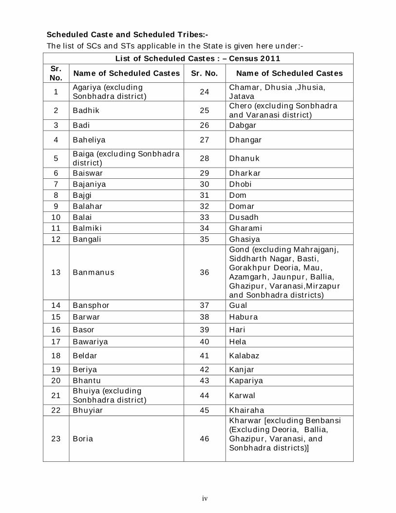
Scheduled Caste and Scheduled Tribes:- The list of SCs and STs applicable in the State is given here under:-
List of Scheduled Castes : – Census 2011 Sr. No. Name of Scheduled Castes Sr. No. Name of Scheduled Castes
1 Agariya (excluding Sonbhadra district) 24 Chamar, Dhusia ,Jhusia,
Jatava
2 Badhik 25 Chero (excluding Sonbhadra and Varanasi district)
3 Badi 26 Dabgar
4 Baheliya 27 Dhangar
5 Baiga (excluding Sonbhadra district) 28 Dhanuk
6 Baiswar 29 Dharkar 7 Bajaniya 30 Dhobi 8 Bajgi 31 Dom 9 Balahar 32 Domar
10 Balai 33 Dusadh 11 Balmiki 34 Gharami 12 Bangali 35 Ghasiya
13 Banmanus 36
Gond (excluding Mahrajganj, Siddharth Nagar, Basti, Gorakhpur Deoria, Mau, Azamgarh, Jaunpur, Ballia, Ghazipur, Varanasi,Mirzapur and Sonbhadra districts)
14 Bansphor 37 Gual 15 Barwar 38 Habura
16 Basor 39 Hari 17 Bawariya 40 Hela
18 Beldar 41 Kalabaz
19 Beriya 42 Kanjar 20 Bhantu 43 Kapariya
21 Bhuiya (excluding Sonbhadra district) 44 Karwal
22 Bhuyiar 45 Khairaha
23 Boria 46
Kharwar [excluding Benbansi (Excluding Deoria, Ballia, Ghazipur, Varanasi, and Sonbhadra districts)]
iv
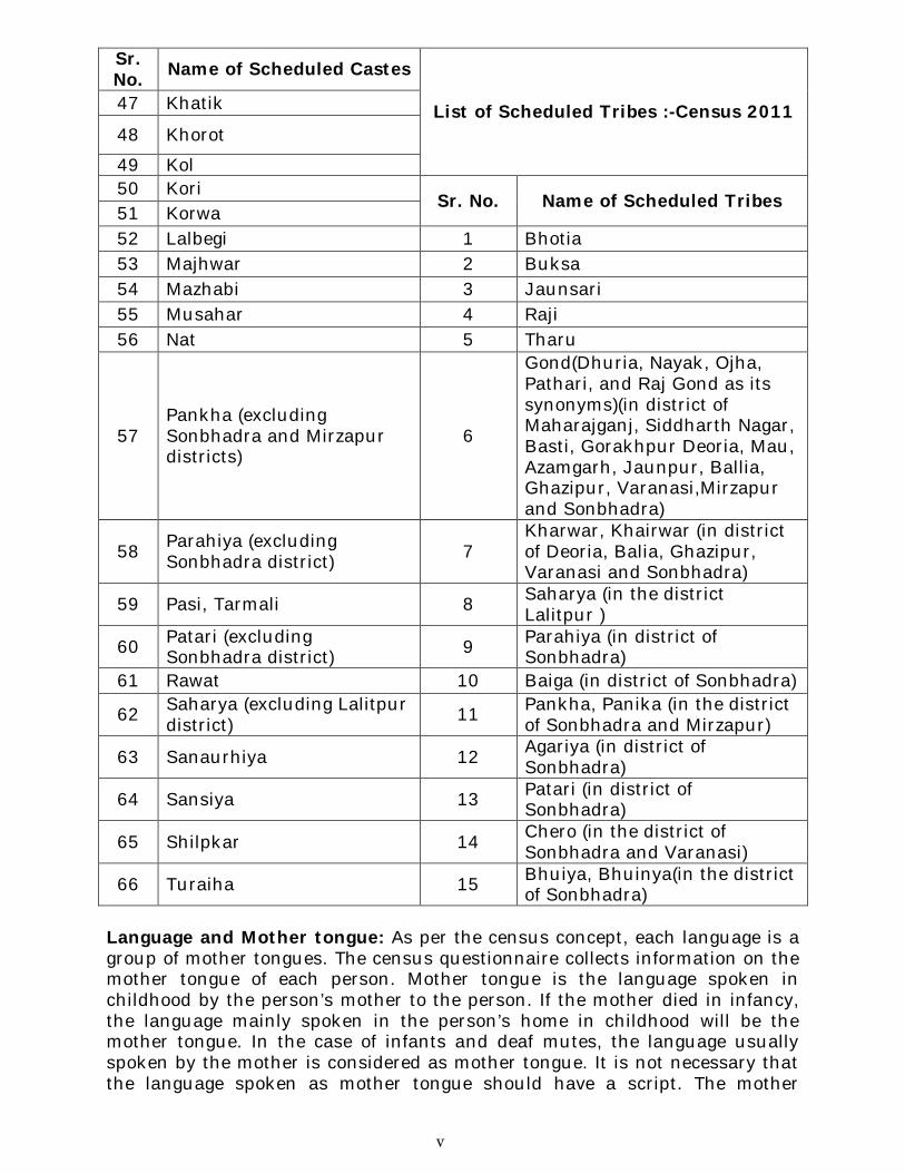
Sr. No. Name of Scheduled Castes
List of Scheduled Tribes :-Census 2011 47 Khatik
48 Khorot
49 Kol 50 Kori Sr. No. Name of Scheduled Tribes 51 Korwa 52 Lalbegi 1 Bhotia 53 Majhwar 2 Buksa 54 Mazhabi 3 Jaunsari 55 Musahar 4 Raji 56 Nat 5 Tharu
57 Pankha (excluding Sonbhadra and Mirzapur districts)
6
Gond(Dhuria, Nayak, Ojha, Pathari, and Raj Gond as its synonyms)(in district of Maharajganj, Siddharth Nagar, Basti, Gorakhpur Deoria, Mau, Azamgarh, Jaunpur, Ballia, Ghazipur, Varanasi,Mirzapur and Sonbhadra)
58 Parahiya (excluding Sonbhadra district) 7
Kharwar, Khairwar (in district of Deoria, Balia, Ghazipur, Varanasi and Sonbhadra)
59 Pasi, Tarmali 8 Saharya (in the district Lalitpur )
60 Patari (excluding Sonbhadra district) 9 Parahiya (in district of
Sonbhadra) 61 Rawat 10 Baiga (in district of Sonbhadra)
62 Saharya (excluding Lalitpur district) 11 Pankha, Panika (in the district
of Sonbhadra and Mirzapur)
63 Sanaurhiya 12 Agariya (in district of Sonbhadra)
64 Sansiya 13 Patari (in district of Sonbhadra)
65 Shilpkar 14 Chero (in the district of Sonbhadra and Varanasi)
66 Turaiha 15 Bhuiya, Bhuinya(in the district of Sonbhadra)
Language and Mother tongue: As per the census concept, each language is a group of mother tongues. The census questionnaire collects information on the mother tongue of each person. Mother tongue is the language spoken in childhood by the person’s mother to the person. If the mother died in infancy, the language mainly spoken in the person’s home in childhood will be the mother tongue. In the case of infants and deaf mutes, the language usually spoken by the mother is considered as mother tongue. It is not necessary that the language spoken as mother tongue should have a script. The mother
v
tongues returned by the respondents in census are classified and grouped under appropriate languages according to their linguistic characteristics.
Literate: A person aged 7 years and above who can both read and write with understanding in any language is taken as literate. A person who can only read but cannot write is not literate. It is not necessary that to be considered as literate, a person should have received any formal education or passed any minimum educational standard. Literacy could have been achieved through adult literacy classes or through any non-formal educational system. People who are blind and can read in Braille are treated as literates.
Literacy rate: Literacy rate of the population is defined as the percentage of literates in the age-group seven years and above. For different age-groups the percentage of literates in that age-group gives the literacy rate.
Educational level: The highest level of education a person has completed.
Work: Work is defined as participation in any economically productive activity with or without compensation, wages or profit. Such participation maybe physical and/or mental in nature. Work involves not only actual work but also includes effective supervision and direction of work. It even includes part time help or unpaid work on farm, family enterprise or in any other economic activity. All persons engaged in ‘work’ as defined above are workers. The main point to note is that the activity should be economically productive. Reference period for determining a person as worker and non-worker is one year preceding the date of enumeration.
Main worker: A person who has worked for major part of the reference period (i.e. six months or more during the last one year preceding the date of enumeration) in any economically productive activity is termed as ‘Mainworker’.
Marginal worker: A person who worked for 3 months or less but less than six months of the reference period (i.e. in the last one year preceding the date of enumeration) in any economic activity is termed as ‘Marginal worker’.
Non-worker: A person who has not worked at all in any economically productive activity during the reference period (i.e. last one year preceding the date of enumeration) is termed as ‘Non worker’.
Cultivator: For purposes of the Census, a person is classified as cultivator if he or she is engaged in cultivation of land owned or from government or from private persons or institutions for payment in money, kind or share. Cultivation also includes effective supervision or direction in cultivation. Cultivation involves ploughing, sowing, harvesting and production of cereals and millet crops such as wheat, paddy, jowar, bajra, ragi, etc., and other crops such as sugarcane, tobacco, ground-nuts, tapioca, etc., and pulses, raw jute and kindred fiber crop, cotton, cinchona and other medicinal plants, fruit growing, vegetable growing or keeping orchards or groves, etc. Cultivation does not include the plantation crops like– tea, coffee, rubber, coconut and betel
vi
nuts(areca). The workers engaged in Plantation crops are recorded under “other workers”.
Agricultural labourer: A person who works on another person’s land for wages in cash or kind or share is regarded as an agricultural labourer. She/he has no risk in the cultivation, but merely works on another person’s land for wages. An agricultural labourer has no right of lease or contract on land on which she/he works.
Household industry worker: Household industry is defined as an industry conducted by one or more members of the household at home or within the village in rural areas and only within the precincts of the house where the household lives in urban areas. The larger proportion of workers in household industry should consist of members of the household. The industry should not be run on the scale of a registered factory which would qualify or has to be registered under the Indian Factories Act and should be engaged in manufacturing, processing, servicing and repairs of goods. The activity relate to production, processing, servicing, repairing or making and selling of goods. It does not include professions such as a pleader, Doctor, Musician, Dancer, Waterman, Astrologer, Dhobi, Barber, etc. or merely trade or business, even if such professions, trade or services are run at home by members of the household.
Other worker: A person, who has been engaged in some economic activity during the last year of reference period but not as a cultivator or agricultural labourer or worker in Household Industry. The type of workers that come under this category include all government servants, municipal employees, teachers, factory workers, plantation workers, those engaged in trade, commerce, business, transport, banking, mining, construction, political or social work, priests, entertainment artists, etc. Infact, all those workers other than cultivators or agricultural labourers or household industry workers are ‘Other Workers’.
Work participation rate: Percentage of Workers (Main + Marginal) to total population.
Population density: Population density is the number of persons inhabited per square kilometer of the area.
Age: Age is measured in terms of the completed number of years.
Sex Ratio: Number of females per 1,000 males in a population.
Non-Census Concepts
Civic status of urban units: Civic Status of a town/city is determined on the basis of Civic Administrative Authority of the town e.g., Municipal Corporation/Corporation, Municipal Committee/Municipal council, Municipality etc.
vii
Size class of U.A./town: Size-class of U.A./Town is based on the population size of the U.A./City/Town. U.A.s/Towns with 100,000and above population are classified as Class I U.A.s/Towns. Towns with 50,000 to 99,999 population are classified as Class II towns, 20,000 to 49,999population are Class III towns, population with 10,000-19,999 are Class IV towns, population with 5,000 and9,999 are Class V towns and towns with less than5,000 population are Class VI towns.
Slum area: The Slum Areas (Improvement and Clearance)Act, 1956, which was enacted by the Central Government defined slums as (a) Areas where buildings are in any respect unfit for human habitation; or (b) are by reasons of dilapidation, overcrowding, faulty arrangement and design of such buildings, narrowness or faulty arrangement of streets, lack of ventilation, light or sanitation facilities, or any combination of these factors, are detrimental to safety, health or morals.
Mega city :The concept of ‘Mega city’ is a recent phenomenon in the Urban Sociology and is defined in term of metropolitan city in the form of large size, problem of management of civic amenities and capacity to absorb the relatively high growth of population. Indian Census in 1991 treated the population size of 5 million and above as the cutoff point to identify a place as the mega city. Whereas, for the purpose of inclusion in Centrally Sponsored Scheme for Infrastructure Development in Megacities the Ministry of Urban Affairs and employment, Department of Urban Development adopted the criteria of 4 million and above population as per 1991Census for Mega Cities. In 2001 Census, cities with10millions and above population have been treated as Mega cities and the same criteria of population has been adopted in 2011 census.
.
viii
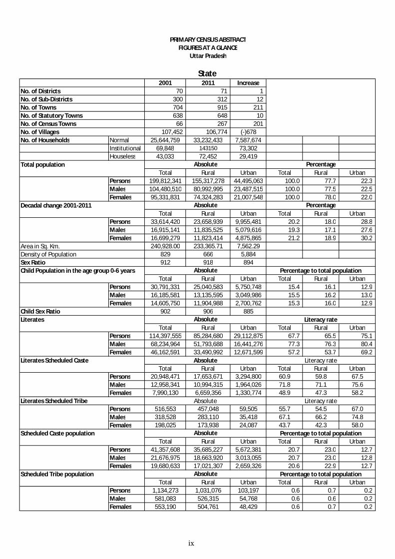
PRIMARY CENSUS ABSTRACTFIGURES AT A GLANCE
Uttar Pradesh
State 2001 2011 Increase
70 71 1 300 312 12 704 915 211 638 648 10
66 267 201 107,452 106,774 (-)678
No. of Households Normal 25,644,759 33,232,433 7,587,674Institutional 69,848 143150 73,302Houseless 43,033 72,452 29,419
Total Rural Urban Total Rural UrbanPersons 199,812,341 155,317,278 44,495,063 100.0 77.7 22.3 Males 104,480,510 80,992,995 23,487,515 100.0 77.5 22.5 Females 95,331,831 74,324,283 21,007,548 100.0 78.0 22.0
Total Rural Urban Total Rural UrbanPersons 33,614,420 23,658,939 9,955,481 20.2 18.0 28.8 Males 16,915,141 11,835,525 5,079,616 19.3 17.1 27.6 Females 16,699,279 11,823,414 4,875,865 21.2 18.9 30.2
240,928.00 233,365.71 7,562.29829 666 5,884912 918 894
Total Rural Urban Total Rural UrbanPersons 30,791,331 25,040,583 5,750,748 15.4 16.1 12.9 Males 16,185,581 13,135,595 3,049,986 15.5 16.2 13.0 Females 14,605,750 11,904,988 2,700,762 15.3 16.0 12.9
902 906 885
Total Rural Urban Total Rural UrbanPersons 114,397,555 85,284,680 29,112,875 67.7 65.5 75.1 Males 68,234,964 51,793,688 16,441,276 77.3 76.3 80.4 Females 46,162,591 33,490,992 12,671,599 57.2 53.7 69.2
Total Rural Urban Total Rural UrbanPersons 20,948,471 17,653,671 3,294,800 60.9 59.8 67.5Males 12,958,341 10,994,315 1,964,026 71.8 71.1 75.6Females 7,990,130 6,659,356 1,330,774 48.9 47.3 58.2
Persons 516,553 457,048 59,505 55.7 54.5 67.0Males 318,528 283,110 35,418 67.1 66.2 74.8Females 198,025 173,938 24,087 43.7 42.3 58.0
Total Rural Urban Total Rural UrbanPersons 41,357,608 35,685,227 5,672,381 20.7 23.0 12.7 Males 21,676,975 18,663,920 3,013,055 20.7 23.0 12.8 Females 19,680,633 17,021,307 2,659,326 20.6 22.9 12.7
Total Rural Urban Total Rural UrbanPersons 1,134,273 1,031,076 103,197 0.6 0.7 0.2 Males 581,083 526,315 54,768 0.6 0.6 0.2 Females 553,190 504,761 48,429 0.6 0.7 0.2
No. of DistrictsNo. of Sub-DistrictsNo. of Towns No. of Statutory Towns No. of Census Towns No. of Villages
Child Population in the age group 0-6 years Absolute Percentage to total population
Total population Absolute Percentage
Decadal change 2001-2011 Absolute Percentage
Area in Sq. Km.Density of Population Sex Ratio
Literates Scheduled Tribe Absolute Literacy rate
Child Sex Ratio Literates Absolute Literacy rate
Literates Scheduled Caste Absolute Literacy rate
Scheduled Caste population Absolute Percentage to total population
Scheduled Tribe population Absolute Percentage to total population
ix
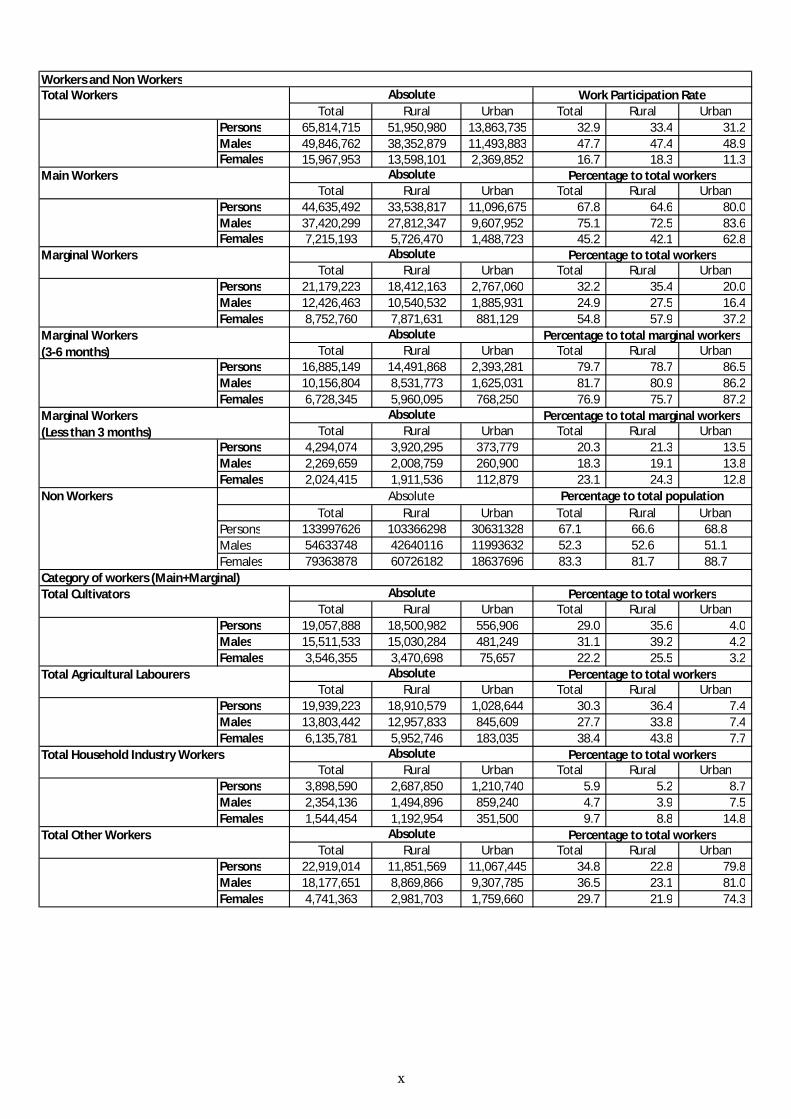
Total Rural Urban Total Rural UrbanPersons 65,814,715 51,950,980 13,863,735 32.9 33.4 31.2 Males 49,846,762 38,352,879 11,493,883 47.7 47.4 48.9 Females 15,967,953 13,598,101 2,369,852 16.7 18.3 11.3
Total Rural Urban Total Rural UrbanPersons 44,635,492 33,538,817 11,096,675 67.8 64.6 80.0 Males 37,420,299 27,812,347 9,607,952 75.1 72.5 83.6 Females 7,215,193 5,726,470 1,488,723 45.2 42.1 62.8
Total Rural Urban Total Rural UrbanPersons 21,179,223 18,412,163 2,767,060 32.2 35.4 20.0 Males 12,426,463 10,540,532 1,885,931 24.9 27.5 16.4 Females 8,752,760 7,871,631 881,129 54.8 57.9 37.2
Total Rural Urban Total Rural UrbanPersons 16,885,149 14,491,868 2,393,281 79.7 78.7 86.5 Males 10,156,804 8,531,773 1,625,031 81.7 80.9 86.2 Females 6,728,345 5,960,095 768,250 76.9 75.7 87.2
Total Rural Urban Total Rural UrbanPersons 4,294,074 3,920,295 373,779 20.3 21.3 13.5 Males 2,269,659 2,008,759 260,900 18.3 19.1 13.8 Females 2,024,415 1,911,536 112,879 23.1 24.3 12.8
Total Rural Urban Total Rural UrbanPersons 133997626 103366298 30631328 67.1 66.6 68.8Males 54633748 42640116 11993632 52.3 52.6 51.1Females 79363878 60726182 18637696 83.3 81.7 88.7
Total Rural Urban Total Rural UrbanPersons 19,057,888 18,500,982 556,906 29.0 35.6 4.0 Males 15,511,533 15,030,284 481,249 31.1 39.2 4.2 Females 3,546,355 3,470,698 75,657 22.2 25.5 3.2
Total Rural Urban Total Rural UrbanPersons 19,939,223 18,910,579 1,028,644 30.3 36.4 7.4 Males 13,803,442 12,957,833 845,609 27.7 33.8 7.4 Females 6,135,781 5,952,746 183,035 38.4 43.8 7.7
Total Rural Urban Total Rural UrbanPersons 3,898,590 2,687,850 1,210,740 5.9 5.2 8.7 Males 2,354,136 1,494,896 859,240 4.7 3.9 7.5 Females 1,544,454 1,192,954 351,500 9.7 8.8 14.8
Total Rural Urban Total Rural UrbanPersons 22,919,014 11,851,569 11,067,445 34.8 22.8 79.8 Males 18,177,651 8,869,866 9,307,785 36.5 23.1 81.0 Females 4,741,363 2,981,703 1,759,660 29.7 21.9 74.3
Workers and Non WorkersTotal Workers Absolute Work Participation Rate
Marginal Workers(Less than 3 months)
Absolute Percentage to total marginal workers
Main Workers Absolute Percentage to total workers
Marginal Workers Absolute Percentage to total workers
Marginal Workers(3-6 months)
Absolute Percentage to total marginal workers
Total Household Industry Workers Absolute Percentage to total workers
Non Workers Absolute Percentage to total population
Category of workers (Main+Marginal)Total Cultivators Absolute Percentage to total workers
Total Agricultural Labourers Absolute Percentage to total workers
Total Other Workers Absolute Percentage to total workers
x
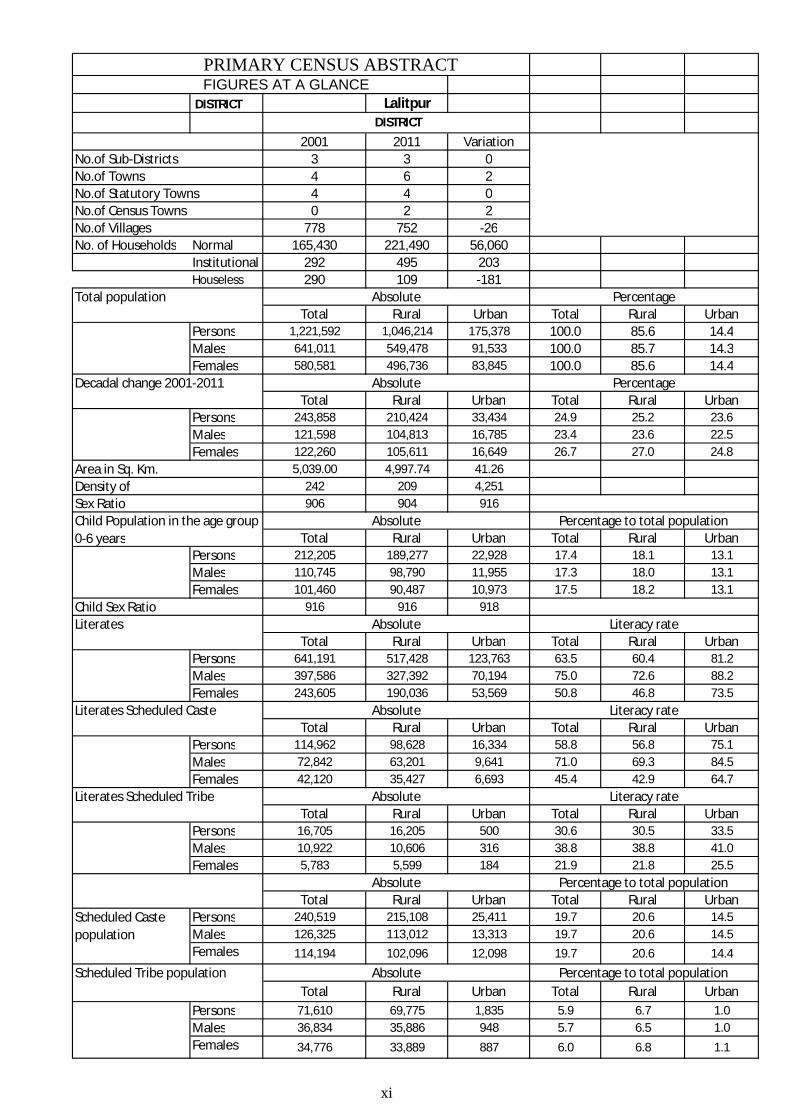
PRIMARY CENSUS ABSTRACTFIGURES AT A GLANCE
DISTRICT Lalitpur
2001 2011 Variation3 3 04 6 24 4 00 2 2
778 752 -26No. of Households Normal 165,430 221,490 56,060
Institutional 292 495 203Houseless 290 109 -181
Total Rural Urban Total Rural UrbanPersons 1,221,592 1,046,214 175,378 100.0 85.6 14.4Males 641,011 549,478 91,533 100.0 85.7 14.3Females 580,581 496,736 83,845 100.0 85.6 14.4
Total Rural Urban Total Rural UrbanPersons 243,858 210,424 33,434 24.9 25.2 23.6Males 121,598 104,813 16,785 23.4 23.6 22.5Females 122,260 105,611 16,649 26.7 27.0 24.8
Area in Sq. Km. 5,039.00 4,997.74 41.26Density of 242 209 4,251
906 904 916
Total Rural Urban Total Rural UrbanPersons 212,205 189,277 22,928 17.4 18.1 13.1Males 110,745 98,790 11,955 17.3 18.0 13.1Females 101,460 90,487 10,973 17.5 18.2 13.1
916 916 918
Total Rural Urban Total Rural UrbanPersons 641,191 517,428 123,763 63.5 60.4 81.2Males 397,586 327,392 70,194 75.0 72.6 88.2Females 243,605 190,036 53,569 50.8 46.8 73.5
Total Rural Urban Total Rural UrbanPersons 114,962 98,628 16,334 58.8 56.8 75.1Males 72,842 63,201 9,641 71.0 69.3 84.5Females 42,120 35,427 6,693 45.4 42.9 64.7
Total Rural Urban Total Rural UrbanPersons 16,705 16,205 500 30.6 30.5 33.5Males 10,922 10,606 316 38.8 38.8 41.0Females 5,783 5,599 184 21.9 21.8 25.5
Total Rural Urban Total Rural UrbanPersons 240,519 215,108 25,411 19.7 20.6 14.5Males 126,325 113,012 13,313 19.7 20.6 14.5Females 114,194 102,096 12,098 19.7 20.6 14.4
Total Rural Urban Total Rural UrbanPersons 71,610 69,775 1,835 5.9 6.7 1.0Males 36,834 35,886 948 5.7 6.5 1.0Females 34,776 33,889 887 6.0 6.8 1.1
DISTRICT
No.of Sub-DistrictsNo.of TownsNo.of Statutory TownsNo.of Census TownsNo.of Villages
Total population Absolute Percentage
Decadal change 2001-2011 Absolute Percentage
Sex RatioChild Population in the age group 0-6 years
Absolute Percentage to total population
Child Sex RatioLiterates Absolute Literacy rate
Literates Scheduled Caste Absolute Literacy rate
Literates Scheduled Tribe Absolute Literacy rate
Absolute Percentage to total population
Scheduled Caste population
Scheduled Tribe population Absolute Percentage to total population
xi
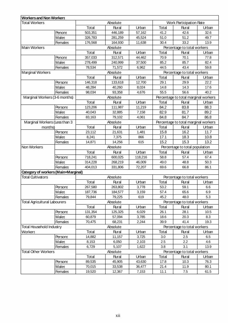
Total Rural Urban Total Rural UrbanPenons 503,351 446,189 57,162 41.2 42.6 32.6Males 326,783 281,259 45,524 51.0 51.2 49.7Females 176,568 164,930 11,638 30.4 33.2 13.9
Total Rural Urban Total Rural UrbanPenons 357,033 312,571 44,462 70.9 70.1 77.8Males 278,499 240,999 37,500 85.2 85.7 82.4Females 78,534 71,572 6,962 44.5 43.4 59.8
Total Rural Urban Total Rural UrbanPersons 146,318 133,618 12,700 29.1 29.9 22.2Males 48,284 40,260 8,024 14.8 14.3 17.6Females 98,034 93,358 4,676 55.5 56.6 40.2
Total Rural Urban Total Rural UrbanPersons 123,206 111,987 11,219 84.2 83.8 88.3Males 40,043 32,885 7,158 82.9 81.7 89.2Females 83,163 79,102 4,061 84.8 84.7 86.8
Total Rural Urban Total Rural UrbanPersons 23,112 21,631 1,481 15.8 16.2 11.7Males 8,241 7,375 866 17.1 18.3 10.8Females 14,871 14,256 615 15.2 15.3 13.2
Total Rural Urban Total Rural UrbanPersons 718,241 600,025 118,216 58.8 57.4 67.4Males 314,228 268,219 46,009 49.0 48.8 50.3Females 404,013 331,806 72,207 69.6 66.8 86.1
Total Rural Urban Total Rural UrbanPersons 267,580 263,802 3,778 53.2 59.1 6.6Males 187,736 184,577 3,159 57.4 65.6 6.9Females 79,844 79,225 619 45.2 48.0 5.3
Total Rural Urban Total Rural UrbanPersons 131,354 125,325 6,029 26.1 28.1 10.5Males 60,879 57,094 3,785 18.6 20.3 8.3Females 70,475 68,231 2,244 39.9 41.4 19.3
Total Rural Urban Total Rural UrbanPersons 14,882 11,157 3,725 3.0 2.5 6.5Males 8,153 6,050 2,103 2.5 2.2 4.6Females 6,729 5,107 1,622 3.8 3.1 13.9
Total Rural Urban Total Rural UrbanPersons 89,535 45,905 43,630 17.8 10.3 76.3Males 70,015 33,538 36,477 21.4 11.9 80.1Females 19,520 12,367 7,153 11.1 7.5 61.5
Workers and Non WorkersTotal Workers Absolute Work Participation Rate
Main Workers Absolute Percentage to total workers
Marginal Workers Absolute Percentage to total workers
Percentage to total workers
Marginal Workers (3-6 months) Absolute Percentage to total marginal workers
Marginal Workers (Less than 3 months)
Absolute Percentage to total marginal workers
Total Household Industry Workers
Absolute Percentage to total workers
Non Workers Absolute Percentage to total population
Category of workers (Main+Marginal)Total Cultivators Absolute
Total Other Workers Absolute Percentage to total workers
Total Agricultural Labourers Absolute Percentage to total workers
xii
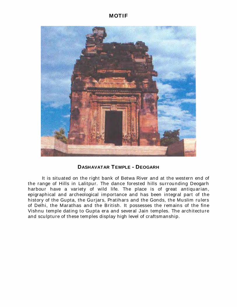
MOTIF
DASHAVATAR TEMPLE - DEOGARH
It is situated on the right bank of Betwa River and at the western end of the range of Hills in Lalitpur. The dance forested hills surrounding Deogarh harbour have a variety of wild life. The place is of great antiquarian, epigraphical and archeological importance and has been integral part of the history of the Gupta, the Gurjars, Pratihars and the Gonds, the Muslim rulers of Delhi, the Marathas and the British. It possesses the remains of the fine Vishnu temple dating to Gupta era and several Jain temples. The architecture and sculpture of these temples display high level of craftsmanship.
Pages
1 1
2 3
3 5
4 7
5 9
6 10
7 12
8 13
9
(i) 16
(ii) 21
(iii) 29
(iv) 39
(v) 47
(vi) 55
(vii) 147
10 Section –II Tables based on Households Amenities and Assets (Rural/Urban) at District and Sub-District level
(i) Table -1: Households by Ownership status and by Number of Dwellingrooms occupied in the District, 2011 163
Urban PCA-Town wise Primary Census Abstract
Section - I Primary Census Abstract (PCA)
Brief note on Primary Census Abstract
Primary Census Abstract for Scheduled Castes (SC)
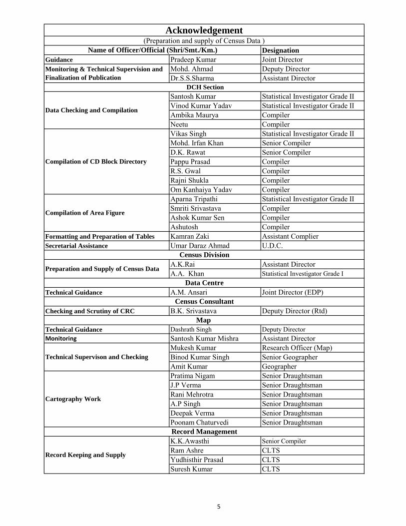
Acknowledgement
History and Scope of the District Census Handbook
Contents
Primary Census Abstract for Scheduled Tribes (ST)
Rural PCA-C.D. blocks wise Village Primary Census Abstract
Administrative Setup
Important Statistics
District Highlights - 2011 Census
Brief History of the District
Foreword
Preface
District Primary Census Abstract
Appendix to District Primary Census Abstract Total, Scheduled Castes and
Scheduled Tribes Population - Urban Block wise
(ii) Table -2: Percentage distribution of Households living in Permanent,Semi permanent and Temporary houses, 2011 164
(iii) Table -3: Number and Percentage of Households by main source ofDrinking water, 2011 166
(iv) Table -4: Number and Percentage of Households by main source ofLighting, 2011 168
(v) Table -5: Number and Percentage of Households by type of Latrinefacility, 2011 170
(vi) Table -6: Number and Percentage of Households by type of Drainageconnectivity for waste water outlet, 2011 172
(vii) Table -7: Number and Percentage of Households by availability ofKitchen facility, 2011 173
(viii) Table -8: Number and Percentage of Households by type of fuel used forCooking, 2011 174
(ix) Table -9:Number and Percentage of Households availing Bankingservices and number of Households having each of thespecified Assets, 2011
176
1
FOREWORD
The District Census Handbook (DCHB) is an important publication of the Census Organization since 1951. It contains both Census and non Census data of urban and rural areas for each District. The Census data provide information on demographic and socio-economic characteristics of population at the lowest administrative unit i.e. of each Village and Town and ward of the District. The Primary Census Abstract (PCA) part of this publication containsCensus data including data on household amenities collected during 1st.phase of the Census i.e. House Listing and Housing Census. The non Census data presented in the DCHB is in the form of Village Directory and Town Directory contain information on various infrastructure facilities available in the village and townviz; education, medical, drinking water, communication and transport, post and telegraph, electricity, banking, and other miscellaneous facilities. Lateron, the Telegraph Services were closed by the Government of India on 15th. July,2013.The data of DCHB are of considerable importance in the context of planning and development at the grass-root level.
2. In the1961 Census, DCHB provided a descriptive account of the District,administrative statistics, Census tables and Village and Town Directory including Primary Census Abstract. This pattern was changed in 1971 Census and the DCHB was published in three parts: Part-A related to Village and Town Directory, Part-B to Village and Town PCA and Part-C comprised analytical report, administrative statistics, District Census tables and certain analytical tables based on PCA and amenity data in respect of Villages. The 1981 Census DCHB was published in two parts: Part-A contained Village and Town Directory and Part-B the PCA of Village and Town including the SCs and STs PCA up to Tahsil/Town levels. New features along with restructuring of the formats of Village and Town Directory were added. In Village Directory, all amenities except electricity were brought together and if any amenity was not available in the referent Village, the distance in broad ranges from the nearest place having such an amenity, was given.
3. The pattern of 1981 Census was followed by and large for the DCHB of 1991 Censusexcept the format of PCA. It was restructured. Nine-fold industrial classification of main workers was given against the four-fold industrial classification presented in the 1981 Census. In addition, sex wise population in 0-6 age group was included in the PCA for the first time with a view to enable the data users to compile more realistic literacy rate as all children below 7 years of age had been treated as illiterate at the time of 1991 Census. One of the important innovations in the 1991 Census was the Community Development Block (CD Block) level presentation of Village Directory and PCA data instead of the traditional Tahsil/Taluk/PS level presentation.
4. As regards DCHB of 2001 Census, the scope of Village Directory was improved byincluding some other amenities like banking, recreational and cultural facilities, newspapers & magazines and `most important commodity’ manufactured in a Village in addition to prescribed facilities of earlier Censuses. In Town Directory, the statement on Slums was modified and its coverage was enlarged by including details on all slums instead of ‘notified slums’.
5. The scope and coverage of Village Directory of 2011 DCHB has been widened byincluding a number of new amenities in addition to those of 2001. These newly added amenities are: Pre-Primary School, Engineering College, Medical College, Management Institute, Polytechnic, Non-formal Training Centre, Special School for Disabled,
2
Community Health Centre, Veterinary Hospital, Mobile Health Clinic, Medical Practitioner with MBBS Degree, Medical Practitioner with no degree, Traditional Practitioner and faith Healer, Medicine Shop, Community Toilet, Rural Sanitary Mart or Sanitary Hardware Outlet in the Village, Community Bio- gas, Sub Post Office, Village Pin Code, Public Call Office, Mobile Phone Coverage, Internet Cafes/ Common Service Centre, Private Courier Facility, Auto/Modified Autos, Taxis and Vans, Tractors, Cycle-pulled Rickshaws, Carts driven by Animals, Village connected to National Highway, State Highway, Major District Road, and Other District Road, Availability of Water Bounded Macadam Roads in Village, ATM, Self-Help Group, Public Distribution System(PDS) Shop, Mandis/Regular Market, Weekly Haat, Agricultural Marketing Society, Nutritional Centers (ICDS), Anganwadi Centre, ASHA (Accredited Social Health Activist), Sports Field, Public Library, Public Reading Room, Assembly Polling station, Birth & Death Registration Office. In the TownDirectory, seven Statements containing the details and the data of each Town have been presented viz.; (i) Status and Growth History of Towns,(ii) Physical Aspects and Location of Towns, (iii) Civic and other Amenities, (iv) Medical Facilities, (v) Educational, Recreational & Cultural Facilities, (vi) Industry & Banking, and (vii) Civic & other amenities in Slums respectively. CD Block wise data of Village Directory and Village PCA have been presented in DCHB of 2011 Census as presented in earlier Census.
6. The data of DCHB 2011 Census have been presented in two parts, Part-A containsVillage and Town Directory and Part-B contains Village and Town wise Primary Census Abstract. Both the Parts have been published in separate volumes in 2011 Census.
7. The Village and Town level amenities data have been collected, compiled andcomputerized under the supervision of Smt. Neena Sharma,(IAS), Director of Census Operations, Uttar Pradesh. The task of Planning, Designing and Co-ordination of this publication was carried out by Dr. Pratibha Kumari, Assistant Registrar General (SS) under the guidance & supervision of Dr. R.C.Sethi, Ex-Addl. RGI and Shri Deepak Rastogi present Addl. RGI. Shri A.P. Singh, Deputy Registrar General, (Map) provided the technical guidance in the preparation of maps. Shri A.K. Arora, Joint Director of Data Processing Division under the overall supervision of Shri M.S.Thapa, Addl. Director (EDP) provided full cooperation in preparation of record structure for digitization and validity checking of Village and Town Directory data and the programme for the generation of Village Directory and Town Directory including various analytical inset tables as well as Primary Census Abstract (PCA). The work of preparation of DCHB, 2011 Census has been monitored in the Social Studies Division. I am thankful to all of them and others who have contributed to bring out this publication in time.
(C.Chandramouli) Registrar General &
Census Commissioner, India New Delhi. Dated:-16-06-2014
3
Preface The District Census Handbook (DCHB) published by Census
Organisation since 1951 census, is one of the important publications in the context of planning and development at gross-root level. The publication, which is brought out for each district, contains several demographic and socio-economic characteristics (village-wise and town-wise) of the district along with the status of availability of assets, amenities, infrastructural facilities, etc of Households.
The District Census Handbooks (DCHBs) are brought out in two parts giving village and town wise data for each district. The Part –A of DCHB will contain non census data of Village and Town Directories which is under process. This Data could be available to the Data user as soon as possible.
The Part-B provides census data for rural areas up to the village level and for urban areas up to the ward level for each town or city in the shape of Primary Census Abstracts. DCHB Part–B is called as “Primary Census Abstract (PCA) of Census 2011” for each Village and Town along with Housing amenities data. Data sets presented herein relate to Population, Child population in the age-group of 0-6 years, Scheduled Caste/Scheduled Tribe population, Literacy and Work status. The data sets relating to Work status presents data based on duration of work (main and marginal) as well as the broad category of work (Cultivators, Agricultural Labourers, Household Industry Workers and Other Workers). The gender composition and the residential status of each set of data have also been presented. The data at C.D. Block (Vikas Khand) wise rural/urban and village level are being presented in this volume. The primary Census Abstract on Schedule Castes and Schedule Tribes at CD Block (Vikas Khand)/Tahsil/Town level are also being presented in the volume.
The information contained in PCA was ready by April 2013. This data was collected through a specially designed schedule based on the ICR technology to facilitate scanning. There were 29 questions in the Population Enumeration schedule, asked from each and every individual, these are intended to collect personal information related to religion, SC/ST, disability, literacy, work status, migration and fertility.
Census 2011 field operations were conducted synchronously all over the country in two phases spread over a period of nearly one year. The first phase was the House-listing and housing census and the second phase was the Population Enumeration. The census of India 2011 is the 7th after Independence were conducted during 9 to 28 February 2011, with a revisional round from 1st March to 5th March 2011 with reference dates OO.OO hours of the 1st day of March 2011.
The tag line, "Our Census our future", aptly sums up the essence of the Census of India. Census data will be utilized not only by the policy makers, the planners and administrators but also by the corporate sector for formulating strategies at macro as well as micro levels. Despite taking all precautions, there exist some inaccuracies which is naturally inhalants in any field survey so the data should be seen in that context.
I am grateful to the Chief Secretary, Government of Uttar Pradesh and Principal Secretary and his team of General Administration Department
4
Government of Uttar Pradesh in facilitating the required administrative support by getting directions issued to the district authorities and issuance of all the necessary notifications for creating a framework required for effective conduct of this colossal task in the biggest state of the country in terms of population.
I am thankful to the Commissioner (Rural Development), all the District Magistrates, Additional District Magistrates (F/R), DPRO, DESTO, Tahsildars and Executive Officers of Uttar Pradesh Government along with their subordinate staff need to be especially thanked and commended for their full cooperation and strict execution of issued instructions by ensuring time-lines and regular compliance.
I extend my sincere gratitude to Dr.C. Chandramouli, Registrar General and Census Commissioner, India for his valuable guidance, insights and constant support despite heavy preoccupations at every stage of this publication. I am also thankful to Shri Deepak Rastogi, Additional Registrar General for their guidance and support.
I am also thankful to Dr. Pratibha Kumari, Assistant Registrar General, Social Studies and her team for guidance and co-ordination and great support. I acknowledge the support & co-operations of Shri Shri A.K. Arora, Joint Director (EDP) and his team for processing of data without their untiring efforts and supports we could not have completed the district census handbook within time.
The Director of Census Operations, Uttar Pradesh, Smt. Neena Sharma, lAS, under her guidance, the entire operations were carried out deserves all credit for its success, but she was repatriated to the State Government for taking up some other important assignments before this volume could be made available for the in-house printing.
The preparation of District Census Hand Book Part B is done under the supervision and guidance of Shri Mohammad Ahmad, Deputy Director, and Dr. S.S. Sharma, Assistant Director of Census Operations. I heartily acknowledge and appreciate their hard work to make this publication successful. The dedicated works of DCH Section of Directorate deserve all praise for their perseverance and dedication in preparation of DCHB Part-B. The members of staff in the Map Section did commendable job under guidance of Sri Dashrath Singh Deputy Director (Map) and Sri Mukesh Kumar Reserch Officer (Map) and their team of map section in bringing out various District and C.D Block level maps of the publication.
I am also thankful to Shri A.M. Ansari, Joint Director (EDP/DCH) and Shri A.K. Rai Assistant Director for providing valuable suggestions. The names of officers/officials associated with this project are given in the acknowledgment. I thank all of them for their unstinted support and co-operation.
Lucknow Pradeep Kumar
01'July, 2014 Joint Director/Controlling Officer Directorate of Census Operation,
Uttar Pradesh
Designation
Guidance Pradeep Kumar Joint DirectorMohd. Ahmad Deputy DirectorDr.S.S.Sharma Assistant Director
Santosh Kumar Statistical Investigator Grade IIVinod Kumar Yadav Statistical Investigator Grade IIAmbika Maurya CompilerNeetu CompilerVikas Singh Statistical Investigator Grade IIMohd. Irfan Khan Senior CompilerD.K. Rawat Senior CompilerPappu Prasad CompilerR.S. Gwal CompilerRajni Shukla CompilerOm Kanhaiya Yadav CompilerAparna Tripathi Statistical Investigator Grade IISmriti Srivastava CompilerAshok Kumar Sen CompilerAshutosh Compiler
Formatting and Preparation of Tables Kamran Zaki Assistant ComplierSecretarial Assistance Umar Daraz Ahmad U.D.C.
A.K.Rai Assistant DirectorA.A. Khan Statistical Investigator Grade I
Technical Guidance A.M. Ansari Joint Director (EDP)
Checking and Scrutiny of CRC B.K. Srivastava Deputy Director (Rtd)
Technical Guidance Dashrath Singh Deputy DirectorMonitoring Santosh Kumar Mishra Assistant Director
Mukesh Kumar Research Officer (Map)Binod Kumar Singh Senior GeographerAmit Kumar GeographerPratima Nigam Senior DraughtsmanJ.P Verma Senior DraughtsmanRani Mehrotra Senior DraughtsmanA.P Singh Senior DraughtsmanDeepak Verma Senior DraughtsmanPoonam Chaturvedi Senior Draughtsman
K.K.Awasthi Senior CompilerRam Ashre CLTSYudhisthir Prasad CLTSSuresh Kumar CLTS
Data Centre
Census Consultant
Map
Cartography Work
Technical Supervison and Checking
Acknowledgement
Preparation and Supply of Census Data
Compilation of Area Figure
Compilation of CD Block Directory
Monitoring & Technical Supervision and
Finalization of Publication
Data Checking and Compilation
DCH Section
Name of Officer/Official (Shri/Smt./Km.)
(Preparation and supply of Census Data )
Record Keeping and Supply
Record Management
Census Division
5

Shri Jaspal Singh Lamba Deputy DirectorMs. Usha Assistant DirectorShri Anurag Gupta DPA Grade ‘A’Shri Mukesh K.Mahawar DPA Grade ‘A’Ms. Shaghufta Nasreen Bhat DPA Grade ‘A’Ms. Shashi Seth Sr. SupervisorMs. Kiran Bala Saxena Sr. SupervisorShri Khem Verma Jadon Sr. ConsultantShri Yashwant Singh Sr. Consultant Ms. Archana Khare Jr. ConsultantShri Anuj Kumar Jr. ConsultantShri Shailender Kumar Vats Jr. ConsultantShri Pawan Kumar Sharma Jr. Consultant
Smt Neena Sharma, Director Chairman
Shri Pradeep Kumar, Joint Director Convener
Shri A.M. Ansari, Deputy Director (EDP) Member
Shri Mohammad Ahamad, Deputy Director Member
Shri A.K. Rai, Assistant Director Member
Dr. S.S. Sharma, Assistant Director Member
Shri A.K.S.Somvanshi (EDP) Member
Shri Binod Kumar Singh, Senior Geographer (Map) Member
Composition of the Task Force for Quality Assurance
Task Force
ORGI- Data Processing Division
ORGI- Data Processing Division
6

7
HISTORY AND SCOPE OF THE DISTRICT CENSUS HANDBOOK
The need of data at the grass root level for the administrative and planning purposes at sub micro level as well as academic studies prompted the innovation of District Census Handbook. District Census Handbook is a unique publication from the Census organization which provides most authentic details of census and non-census information from village and town level to district level. The District Census Handbook was firstly introduced during the 1951 Census. It contains both census and non census data of urban as well as rural areas for each district. The census data contain several demographic and socio-economic characteristics of the lowest administrative unit i.e. of each village and town and ward of the district. The non census data comprise of data on availability of various civic amenities and infrastructural facilities etc. at the town and village level which constitute Village Directory and Town Directory part of the DCHB. The data of DCHB are of considerable importance in the context of planning and development at grass-root level.
In 1961 census DCHB provided a descriptive account of the district, administrative statistics, census tables and village and town directory including Primary Census Abstract. This pattern was changed in 1971 Census and the DCHB was published in three parts: Part-A related to village and town directory, Part-B to village and town PCA and Part-C comprised analytical report, administrative statistics, district census tables and certain analytical tables based on PCA and amenity data in respect of villages. The 1981 census DCHB was published in two parts: Part-A contained village and town directory and Part-B the PCA of village and town including the SCs and STs PCA up to tahsil/town levels. New features along with restructuring of the formats of village and town directory were added into it. In Village Directory, all amenities except electricity were brought together and if any amenity was not available in the referent village, the distance in broad ranges from the nearest place having such an amenity, was given.
The pattern of 1981 census was followed by and large for the DCHB of 1991 Census except the format of PCA. It was restructured. Nine-fold industrial classification of main workers was given against the four-fold industrial classification presented in the 1981 census. In addition, sex wise population in 0-6 age group was included in the PCA for the first time with a view to enable the data users to compile more realistic literacy rate as all children below 7 years of age had been treated as illiterate at the time of 1991 census. One of the important innovations in the 1991 census was the Community Development Block (CD Block) level presentation of village directory and PCA data instead of the traditional tahsil/taluk/PS level presentation.
As regards DCHB of 2001 Census, the scope of Village Directory was improved by including some other amenities like banking, recreational and cultural facilities, newspapers & magazines and `most important commodity’ manufactured in a village in addition to prescribed facilities of earlier censuses.

8
In Town Directory, the statement on Slums was modified and its coverage was enlarged by including details on all slums instead of ‘notified slums’.
The scope and coverage of Village Directory of 2011 DCHB has been widened by including a number of new amenities in addition to those of 2001. In the Town Directory, seven Statements containing the details and the data of each town have been presented viz.; (i) Status and Growth History of towns, (ii) Physical Aspects and Location of Towns, (iii) Civic and other Amenities, (iv) Medical Facilities, (v) Educational, Recreational & Cultural Facilities, (vi) Industry & Banking, and (vii) Civic & other amenities in Slums respectively. CD Block wise data of Village Directory and Village PCA have been presented in DCHB of 2011 census as presented in earlier census. The data of DCHB 2011 Census have been presented in two parts, Part-A contains Village and Town Directory and Part-B contains Village and Town wise Primary Census Abstract. Both the Parts have been published in separate volumes in 2011 Census.
--------------------------------------------------------
9
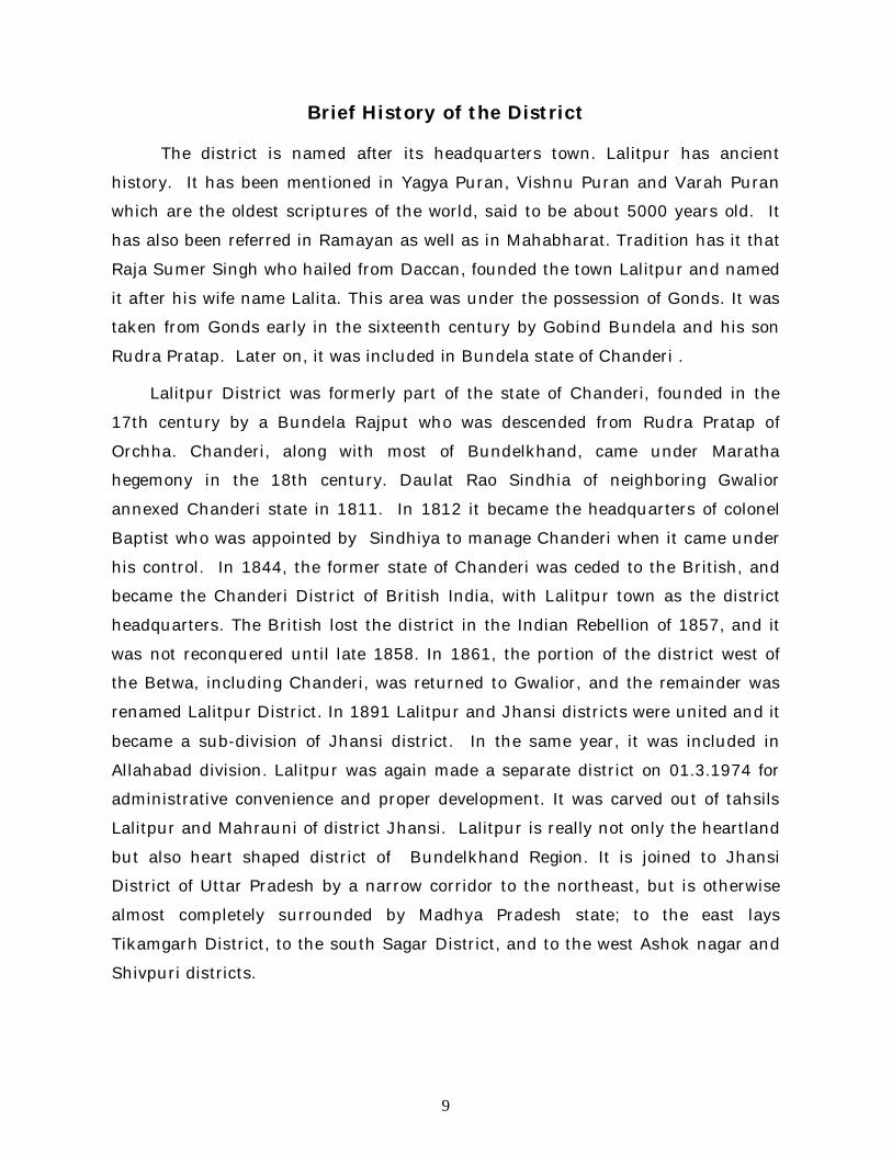
Brief History of the District
The district is named after its headquarters town. Lalitpur has ancient
history. It has been mentioned in Yagya Puran, Vishnu Puran and Varah Puran
which are the oldest scriptures of the world, said to be about 5000 years old. It
has also been referred in Ramayan as well as in Mahabharat. Tradition has it that
Raja Sumer Singh who hailed from Daccan, founded the town Lalitpur and named
it after his wife name Lalita. This area was under the possession of Gonds. It was
taken from Gonds early in the sixteenth century by Gobind Bundela and his son
Rudra Pratap. Later on, it was included in Bundela state of Chanderi .
Lalitpur District was formerly part of the state of Chanderi, founded in the
17th century by a Bundela Rajput who was descended from Rudra Pratap of
Orchha. Chanderi, along with most of Bundelkhand, came under Maratha
hegemony in the 18th century. Daulat Rao Sindhia of neighboring Gwalior
annexed Chanderi state in 1811. In 1812 it became the headquarters of colonel
Baptist who was appointed by Sindhiya to manage Chanderi when it came under
his control. In 1844, the former state of Chanderi was ceded to the British, and
became the Chanderi District of British India, with Lalitpur town as the district
headquarters. The British lost the district in the Indian Rebellion of 1857, and it
was not reconquered until late 1858. In 1861, the portion of the district west of
the Betwa, including Chanderi, was returned to Gwalior, and the remainder was
renamed Lalitpur District. In 1891 Lalitpur and Jhansi districts were united and it
became a sub-division of Jhansi district. In the same year, it was included in
Allahabad division. Lalitpur was again made a separate district on 01.3.1974 for
administrative convenience and proper development. It was carved out of tahsils
Lalitpur and Mahrauni of district Jhansi. Lalitpur is really not only the heartland
but also heart shaped district of Bundelkhand Region. It is joined to Jhansi
District of Uttar Pradesh by a narrow corridor to the northeast, but is otherwise
almost completely surrounded by Madhya Pradesh state; to the east lays
Tikamgarh District, to the south Sagar District, and to the west Ashok nagar and
Shivpuri districts.
10
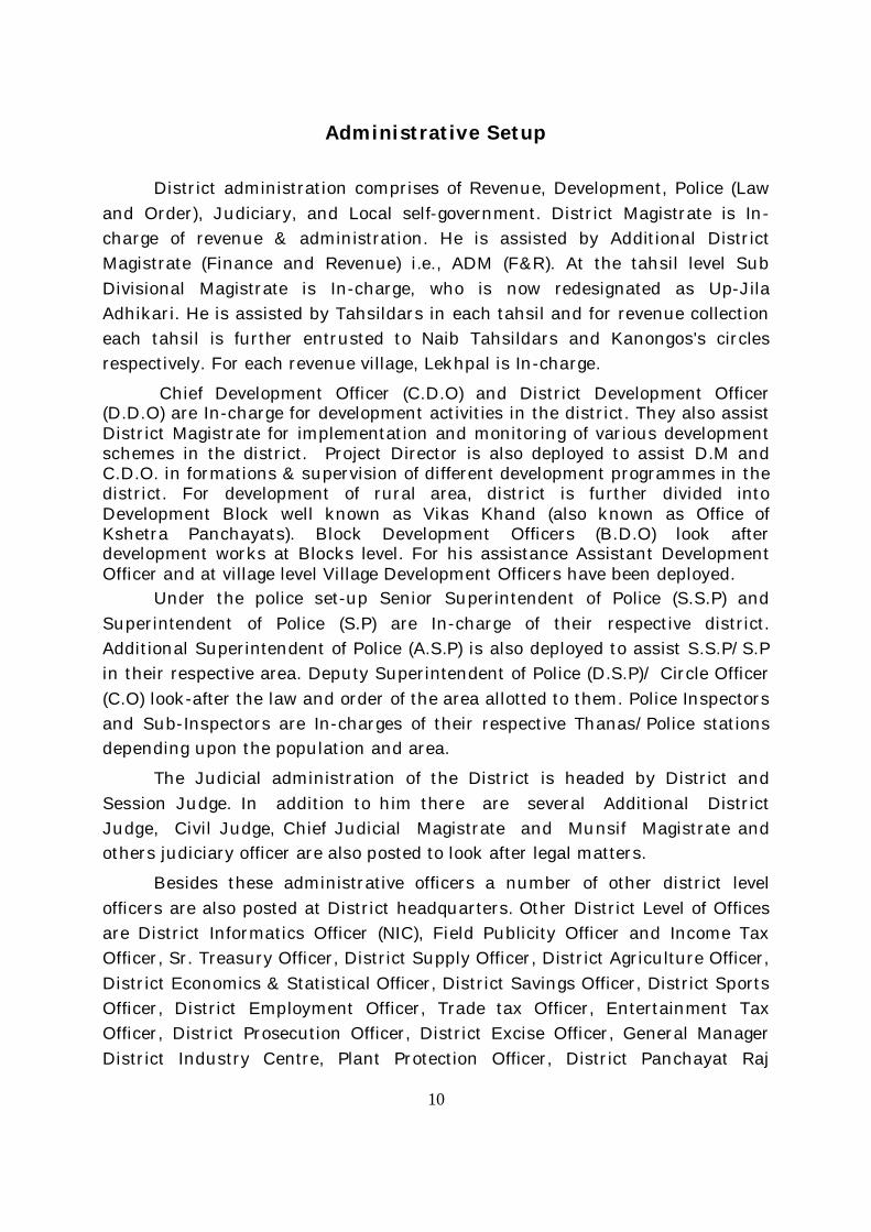
Administrative Setup
District administration comprises of Revenue, Development, Police (Law and Order), Judiciary, and Local self-government. District Magistrate is In-charge of revenue & administration. He is assisted by Additional District Magistrate (Finance and Revenue) i.e., ADM (F&R). At the tahsil level Sub Divisional Magistrate is In-charge, who is now redesignated as Up-Jila Adhikari. He is assisted by Tahsildars in each tahsil and for revenue collection each tahsil is further entrusted to Naib Tahsildars and Kanongos's circles respectively. For each revenue village, Lekhpal is In-charge.
Chief Development Officer (C.D.O) and District Development Officer (D.D.O) are In-charge for development activities in the district. They also assist District Magistrate for implementation and monitoring of various development schemes in the district. Project Director is also deployed to assist D.M and C.D.O. in formations & supervision of different development programmes in the district. For development of rural area, district is further divided into Development Block well known as Vikas Khand (also known as Office of Kshetra Panchayats). Block Development Officers (B.D.O) look after development works at Blocks level. For his assistance Assistant Development Officer and at village level Village Development Officers have been deployed.
Under the police set-up Senior Superintendent of Police (S.S.P) and Superintendent of Police (S.P) are In-charge of their respective district. Additional Superintendent of Police (A.S.P) is also deployed to assist S.S.P/S.P in their respective area. Deputy Superintendent of Police (D.S.P)/ Circle Officer (C.O) look-after the law and order of the area allotted to them. Police Inspectors and Sub-Inspectors are In-charges of their respective Thanas/Police stations depending upon the population and area.
The Judicial administration of the District is headed by District and Session Judge. In addition to him there are several Additional District Judge, Civil Judge, Chief Judicial Magistrate and Munsif Magistrate and others judiciary officer are also posted to look after legal matters.
Besides these administrative officers a number of other district level officers are also posted at District headquarters. Other District Level of Offices are District Informatics Officer (NIC), Field Publicity Officer and Income Tax Officer, Sr. Treasury Officer, District Supply Officer, District Agriculture Officer, District Economics & Statistical Officer, District Savings Officer, District Sports Officer, District Employment Officer, Trade tax Officer, Entertainment Tax Officer, District Prosecution Officer, District Excise Officer, General Manager District Industry Centre, Plant Protection Officer, District Panchayat Raj
11
Officer, District Programme Officer, Basic Shiksha Adhikari, District Inspector of Schools, Sp. Land acquisition Officer, District Social Welfare Officer, Minority Welfare Officer, Project Manager (U.P.L.D.C.), Asstt. Regional Transport Officer, Asstt. District Election Officer, and District Soldier welfare Officer are also deployed for monitoring and execution of various development activities in there district.
The Nucleus of the district body for self government is consisted of Mayor & Nagar Ayukat at Nagar Nigam level and Executive Officer (E.O) & Chairman of their respective Nagar Palika Parishad/ Nagar Panchayats. Similarly at Jila Parishad level Jila Panchayats Chairman & Apar Mukhya Adhikari (AMA) work as a public representative. Pramukh of Kshetra Samiti/Panchayat & B.D.O in Vikas Khand level, Gram Pradhan & Panchayat secretary in his Gram Panchayats comes under Local self-government. Other members of different local bodies also represent their respective area at ward and village level.
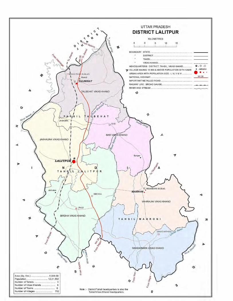
To provide efficient administration the district is administratively divided into 03 tahsils namely Lalitpur, Mahrauni and Talbehat. For implementation and monitoring of development scheme the district is divided into 06 Development Blocks namely Talbehat, Jakhaura, Bar, Birdha, Mahrauni and Mandawara. Total area of the district is 5039.0 Sq. Km. The rural area covers 4997.7 Sq. Km. and urban recorded 41.3 Sq. Km. There are 340 Gram Panchayats and 752 Revenue villages with 691 inhabited villages and 61 uninhabited villages in the district. In urban area there are 04 statutory Towns and 02 Census Towns. Statutory Towns comprises of 01 Nagar Palika Parishad and 03 Nagar Panchayats.
Jurisdictional Changes (2001-2011) The state Government administration has reported no jurisdictional changes
during the decade.
12
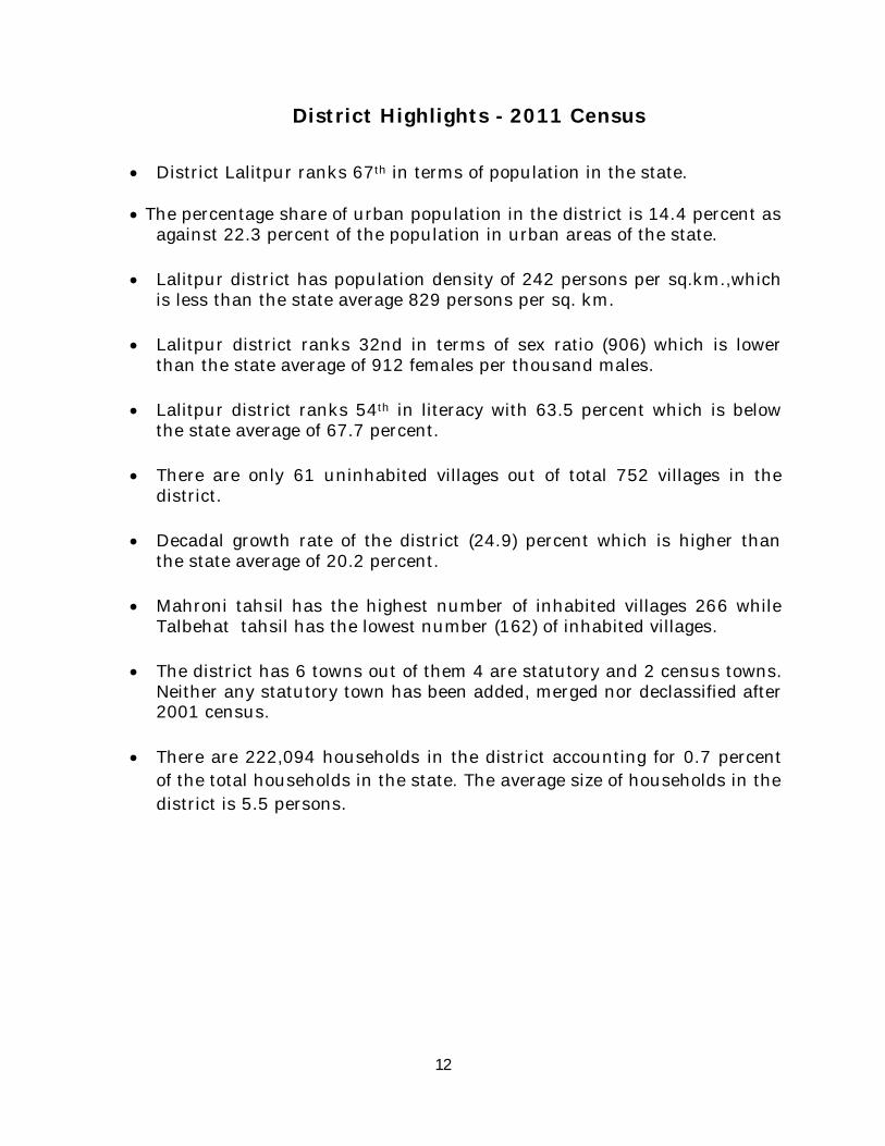
District Highlights - 2011 Census
District Lalitpur ranks 67th in terms of population in the state.
The percentage share of urban population in the district is 14.4 percent as against 22.3 percent of the population in urban areas of the state.
Lalitpur district has population density of 242 persons per sq.km.,which is less than the state average 829 persons per sq. km.
Lalitpur district ranks 32nd in terms of sex ratio (906) which is lower than the state average of 912 females per thousand males.
Lalitpur district ranks 54th in literacy with 63.5 percent which is below the state average of 67.7 percent.
There are only 61 uninhabited villages out of total 752 villages in the district.
Decadal growth rate of the district (24.9) percent which is higher than the state average of 20.2 percent.
Mahroni tahsil has the highest number of inhabited villages 266 while Talbehat tahsil has the lowest number (162) of inhabited villages.
The district has 6 towns out of them 4 are statutory and 2 census towns. Neither any statutory town has been added, merged nor declassified after 2001 census.
There are 222,094 households in the district accounting for 0.7 percent of the total households in the state. The average size of households in the district is 5.5 persons.
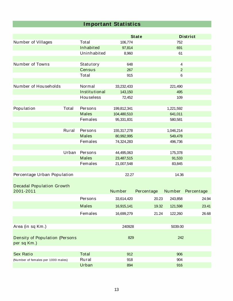
Number of Villages Total 106,774 752
Inhabited 97,814 691
Uninhabited 8,960 61
Number of Towns Statutory 648 4
Census 267 2
Total 915 6
Number of Households Normal 33,232,433 221,490
Institutional 143,150 495
Houseless 72,452 109
Population Total Persons 199,812,341 1,221,592
Males 104,480,510 641,011
Females 95,331,831 580,581
Rural Persons 155,317,278 1,046,214
Males 80,992,995 549,478
Females 74,324,283 496,736
Urban Persons 44,495,063 175,378
Males 23,487,515 91,533
Females 21,007,548 83,845
Percentage Urban Population 22.27 14.36
Number Percentage Number Percentage
Persons 33,614,420 20.23 243,858 24.94
Males 16,915,141 19.32 121,598 23.41
Females 16,699,279 21.24 122,260 26.68
Area (in sq Km.) 240928 5039.00
829 242
Sex Ratio Total 912 906
(Number of females per 1000 males) Rural 918 904
Urban 894 916
District
Important Statistics
Decadal Population Growth 2001-2011
Density of Population (Persons per sq Km.)
State
13
Important Statistics
Number Percentage Number Percentage
Literates Persons 114,397,555 67.68 641,191 63.52
Males 68,234,964 77.28 397,586 74.98
Females 46,162,591 57.18 243,605 50.84
Scheduled Castes Persons 41,357,608 20.7 240,519 19.69
Males 21,676,975 20.75 126,325 19.71
Females 19,680,633 20.64 114,194 19.67
Scheduled Tribes Persons 1,134,273 0.57 71,610 5.86
Males 581,083 0.56 36,834 5.75
Females 553,190 0.58 34,776 5.99
Workers and Non-WorkersPersons 65,814,715 32.94 503,351 41.20
Males 49,846,762 47.71 326,783 50.98
Females 15,967,953 16.75 176,568 30.41
(i) Main Workers Persons 44,635,492 22.34 357,033 29.23
Males 37,420,299 35.82 278,499 43.45
Females 7,215,193 7.57 78,534 13.53
(ii) Marginal Workers Persons 21,179,223 10.6 146,318 11.98
Males 12,426,463 11.89 48,284 7.53
Females 8,752,760 9.18 98,034 16.89
Non-Workers Persons 133,997,626 67.06 718,241 58.80
Males 54,633,748 52.29 314,228 49.02
Females 79,363,878 83.25 404,013 69.59
(i) Cultivators Persons 19,057,888 28.96 267,580 53.16
Males 15,511,533 31.12 187,736 57.45
Females 3,546,355 22.21 79,844 45.22
(ii)Agricultural Labourers Persons 19,939,223 30.3 131,354 26.10
Males 13,803,442 27.69 60,879 18.63
Females 6,135,781 38.43 70,475 39.91
Persons 3,898,590 5.92 14,882 2.96
Males 2,354,136 4.72 8,153 2.49
Females 1,544,454 9.67 6,729 3.81
(iv) Other Workers Persons 22,919,014 34.82 89,535 17.79
Males 18,177,651 36.47 70,015 21.43
Females 4,741,363 29.69 19,520 11.06
Total Workers (Main and Marginal)
Category of Workers (Main & Marginal)
(iii)Workers in household industry
State District
14

Section - I
Primary Census Abstract (PCA)
16
Brief Note on Primary Census Abstract
Introduction: The Indian Census has the reputation of being one of the best in the world. The first Census in India was conducted in the year 1872. This was conducted at different points of time in different parts of the country. In 1881 a Census was taken for the entire country simultaneously. Since then, Census has been conducted every ten years, without a break. Thus, the Census of India 2011 was the fifteenth in this unbroken series since 1872, the seventh after independence and the second census of the third millennium and twenty first century. The census has been uninterruptedly continued despite of several adversities like wars, epidemics, natural calamities, political unrest, etc.
The Census of India is conducted under the provisions of the Census Act 1948 and the Census Rules, 1990. In Censuses until 1931, a synchronous de-facto method was adopted wherein the Census was conducted throughout the country on a single night. This being a very costly affair and involved the deployment of very large force at one point of time was given up in 1941. Since then the same methodology has been followed in all the Censuses. It is a gigantic operation and considered to be the single largest, complex, peace time administrative exercise in the world.
The Census Operation in India is carried out in two distinct but inter connected phases - the House listing and Housing Census followed by the Population Enumeration. During the first phase of Census 2011 i.e., House listing and Housing Census, the buildings, census houses and households were identified and systematically listed in the House Listing and Housing Census Schedule during the period April to September, 2010 in different States/Union Territories. Apart from listing of houses, some useful data on the amenities available to the households was also collected for assessing condition of human settlements, housing deficits etc.
Censuses prior to Census 2001 had the system of collecting the information through Individual Slip which was a key schedule for every individual. The information collected through slip was then compiled for a household. Some information was also collected in addition to this for the household. During 2001 Census a comprehensive Household Schedule was adopted replacing the individual slip concept. In 2011 Census also similar household schedule was used for canvassing. The scope of demographic, socio-economic parameters has been widened in every census.
2. Population Enumeration - Census 2011: The field work of the second phase i.e. Population Enumeration was carried out during February-March, 2011. One of the essential features of Population Enumeration in the second phase was that each person was enumerated and her/his individual particulars were collected at a well-defined point of time.
17
The Census moment and the reference date for the Census of India 2011 was 00:00 hours of 1st March, 2011. The enumeration was conducted from 9th February to 28th February, 2011 along with a revisional round from 1st March, 2011 to 5th March, 2011 synchronously all over the country except for few specific areas of the Jammu & Kashmir, Himachal Pradesh and Uttarakhand states that remain snowbound in February. In these locations the population enumeration was done from 11th September, 2010 to 30th September, 2010 along with a revisional round from 1st October, 2010 to 5th October, 2010. The reference date for the census in snow bound non-synchronous areas of these states was 00.00 hours of the first day of October, 2010. In addition to the coverage during House listing & Housing Census, the enumeration of the Houseless population was carried out on the night of 28th February, 2011, as has been the usual practice. For the purpose of Census, certain areas where the access of the civilian enumerators was not permissible due to security reasons termed as ‘Special Charges’ such as the Defence and strictly Military/Para-Military areas, including operational areas were also covered. Such areas were not covered during the House listing & Housing Census. In addition to the defence/para-military areas, Special Charges also included certain factory areas, certain colonies, sensitive areas, scientific establishments, etc. These also formed Special Charges as these were not accessible by the usual census enumerator.
3. Quality Assurance: A Task Force for Quality Assurance (TFQA) functioned under the chairmanship of the RG & CCI. Experienced officers of the different divisions of the organization i.e. Heads and senior officers of the Census Division, Data Processing Division, Map Division, Demography Division and Social Studies Division comprised the TFQA. The Directors of Census Operations were co-opted as members whenever the TFQA discussed the data for their States/Union territories. The main objective of constituting the TFQA was to subject the data to stringent validation checks and ensure its quality before release as it was expedient to be satisfied itself about the quality of data before putting the same in public domain.
The Directors and their senior officers were involved at all levels with respect to the quality and the coverage of their states/Uts. The TFQA intensively scrutinized coverage and content parameters including edit and imputation logic. The most important aspect of the data quality was to ensure complete coverage of all geographical areas especially for the population enumeration phase where the data is disseminated right up to the village level in the rural areas and the ward level in the urban areas. Thus ensuring the complete coverage and correct geographical linkage of each enumeration block was one of the major planks of the quality control, especially for small area population statistics. The content was scrutinized mainly through the process of internal consistency, comparison with similar data in the past and also through validation with likewise data if available, from external sources. Quite often the local knowledge and perception was looked at to understand both the existing and the new emerging trends of

18
population distribution and characteristics. A very comprehensive check and edit mechanism was put in place to objectively examine the preliminary Census 2011 Population Enumeration results and finally clear them for use. The population data was cleared only after the full possible satisfaction of the TFQA.
The entire work relating to the data validation and scrutiny was completed by all the States/Union territories under the overall supervision and monitoring of the Census Division of the Office of the Registrar General, India with active cooperation and support of the Social Studies Division, Data Processing Division, Data Dissemination Division and Map Division.
4. Primary Census Abstract:
The Primary Census Abstract which is important publication of 2011 Census gives basic information on Area, Total Number of Households, Total Population, Scheduled Castes, Scheduled Tribes Population, Population in the age group 0-6, Literates, Main Workers and Marginal Workers classified by the four broad industrial categories, namely, (i) Cultivators, (ii) Agricultural Labourers, (iii) Household Industry Workers, and (iv) Other Workers and also Non-Workers. The characteristics of the Total Population include Scheduled Castes, Scheduled Tribes, Institutional and Houseless Population and are presented by sex and rural-urban residence.
In 1981 census main workers were presented into four categories. As regards 1991 Census, the nine-fold industrial classification of main workers has been given in the Primary Census Abstract. One of the important features of the Primary Census Abstract of 1991 Census was the presentation of population of the age group 0-6 which is continued in 2001 and 2011 Census. All the children of age 6 years or less have been treated as illiterate even if the child is going to a school and may have picked up reading and writing. This will help the data users in better analysis and understanding of the literacy data as the literacy rate is calculated with 7 years and above population and it is referred as effective literacy rate. In 2001 and 2011 census four categories of main workers have been given in the Primary Census Abstract.
5. Level of Presentation of PCA data in District Census Handbooks:
The format of Primary Census Abstract (PCA) adopted in the DCHB of 2001 Census has been continued for 2011 Census as the data on four categories of works have been presented similar to 2001 census. The Primary Census Abstract data in different PCAs are presented at different levels. The level of presentation of Primary Census Abstracts in DCHB is as under:
1. District Primary Census Abstract -District/C.D. Block/Town.2. Primary Census Abstract for Scheduled Castes- District/C.D. Block/Town.3. Primary Census Abstract for Scheduled Tribes -District/C.D. Block/Town.4. Village Primary Census Abstract -C.D. Block/Village wise.5. Urban Primary Census Abstract- Town/Ward level.
19
The PCA Data for villages was presented C.D. Block wise for the first time in 1991 Census. This practice is continued in 2001 and 2011 Census. The term ‘Total Population’ includes the Scheduled Castes, the Scheduled Tribes, the Institutional and the Houseless populations. An appendix to District Primary Census Abstract has also been furnished showing urban enumeration block-wise particulars on Total Population, the Scheduled Castes Population and the Scheduled Tribes Population for each town.
6. Area Figures:
The area figures supplied by local revenue authorities of the district in respect of tahsils, Police Stations and by the local bodies in respect of towns are given in square kilometers. The area figures of the villages supplied by the Tahsildars in acres have been converted and shown in hectares. The area figures of the C.D. Block are the total of the village areas coming under each C.D. Block. The area figures for the district are the same as adopted by the Surveyor General of India to maintain uniformity at the national level.
-----------------------------------------------------------------

District Primary Census Abstract
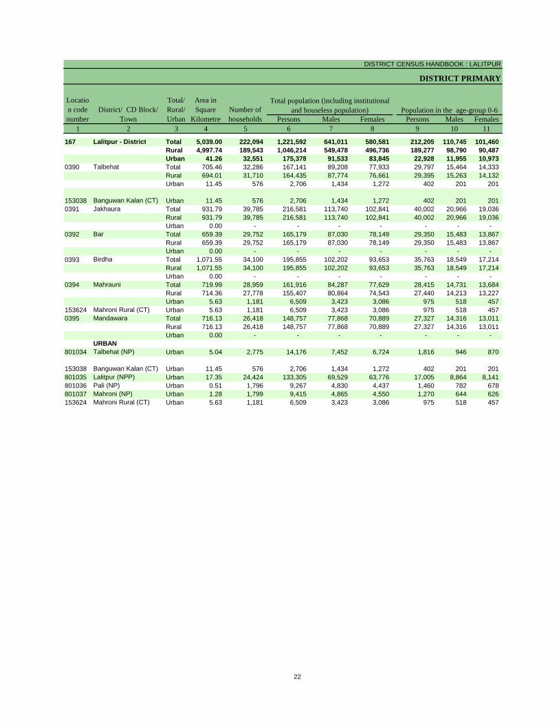
DISTRICT CENSUS HANDBOOK : LALITPUR
DISTRICT PRIMARY
Persons Males Females Persons Males Females1 2 3 4 5 6 7 8 9 10 11
167 Lalitpur - District Total 5,039.00 222,094 1,221,592 641,011 580,581 212,205 110,745 101,460 Rural 4,997.74 189,543 1,046,214 549,478 496,736 189,277 98,790 90,487 Urban 41.26 32,551 175,378 91,533 83,845 22,928 11,955 10,973
0390 Talbehat Total 705.46 32,286 167,141 89,208 77,933 29,797 15,464 14,333 Rural 694.01 31,710 164,435 87,774 76,661 29,395 15,263 14,132 Urban 11.45 576 2,706 1,434 1,272 402 201 201
153038 Banguwan Kalan (CT) Urban 11.45 576 2,706 1,434 1,272 402 201 201 0391 Jakhaura Total 931.79 39,785 216,581 113,740 102,841 40,002 20,966 19,036
Rural 931.79 39,785 216,581 113,740 102,841 40,002 20,966 19,036 Urban 0.00 - - - - - - -
0392 Bar Total 659.39 29,752 165,179 87,030 78,149 29,350 15,483 13,867 Rural 659.39 29,752 165,179 87,030 78,149 29,350 15,483 13,867 Urban 0.00 - - - - - - -
0393 Birdha Total 1,071.55 34,100 195,855 102,202 93,653 35,763 18,549 17,214 Rural 1,071.55 34,100 195,855 102,202 93,653 35,763 18,549 17,214 Urban 0.00 - - - - - - -
0394 Mahrauni Total 719.99 28,959 161,916 84,287 77,629 28,415 14,731 13,684 Rural 714.36 27,778 155,407 80,864 74,543 27,440 14,213 13,227 Urban 5.63 1,181 6,509 3,423 3,086 975 518 457
153624 Mahroni Rural (CT) Urban 5.63 1,181 6,509 3,423 3,086 975 518 457 0395 Mandawara Total 716.13 26,418 148,757 77,868 70,889 27,327 14,316 13,011
Rural 716.13 26,418 148,757 77,868 70,889 27,327 14,316 13,011 Urban 0.00 - - - - - - -
URBAN801034 Talbehat (NP) Urban 5.04 2,775 14,176 7,452 6,724 1,816 946 870
153038 Banguwan Kalan (CT) Urban 11.45 576 2,706 1,434 1,272 402 201 201 801035 Lalitpur (NPP) Urban 17.35 24,424 133,305 69,529 63,776 17,005 8,864 8,141 801036 Pali (NP) Urban 0.51 1,796 9,267 4,830 4,437 1,460 782 678 801037 Mahroni (NP) Urban 1.28 1,799 9,415 4,865 4,550 1,270 644 626 153624 Mahroni Rural (CT) Urban 5.63 1,181 6,509 3,423 3,086 975 518 457
Location code number
District/ CD Block/ Town
Total/ Rural/ Urban
Area in Square
KilometreNumber of households
Total population (including institutional and houseless population) Population in the age-group 0-6
22

PRIMARY CENSUS ABSTRACT
CENSUS ABSTRACT
Persons Males Females Persons Males Females Persons Males Females12 13 14 15 16 17 18 19 20 3 2
240,519 126,325 114,194 71,610 36,834 34,776 641,191 397,586 243,605 Total Lalitpur - District215,108 113,012 102,096 69,775 35,886 33,889 517,428 327,392 190,036 Rural25,411 13,313 12,098 1,835 948 887 123,763 70,194 53,569 Urban28,377 15,065 13,312 14,610 7,508 7,102 76,815 50,085 26,730 Total Talbehat27,657 14,694 12,963 14,039 7,209 6,830 75,382 49,184 26,198 Rural
720 371 349 571 299 272 1,433 901 532 Urban
720 371 349 571 299 272 1,433 901 532 Urban Banguwan Kalan (CT)44,007 23,166 20,841 18,617 9,565 9,052 106,229 67,729 38,500 Total Jakhaura44,007 23,166 20,841 18,617 9,565 9,052 106,229 67,729 38,500 Rural
- - - - - - - - - Urban31,826 16,885 14,941 9,192 4,764 4,428 79,855 50,532 29,323 Total Bar31,826 16,885 14,941 9,192 4,764 4,428 79,855 50,532 29,323 Rural
- - - - - - - - - Urban41,074 21,487 19,587 15,986 8,234 7,752 99,679 62,940 36,739 Total Birdha41,074 21,487 19,587 15,986 8,234 7,752 99,679 62,940 36,739 Rural
- - - - - - - - - Urban39,302 20,423 18,879 3,148 1,611 1,537 86,093 53,328 32,765 Total Mahrauni36,961 19,192 17,769 3,128 1,597 1,531 81,758 50,807 30,951 Rural2,341 1,231 1,110 20 14 6 4,335 2,521 1,814 Urban2,341 1,231 1,110 20 14 6 4,335 2,521 1,814 Urban Mahroni Rural (CT)
33,583 17,588 15,995 8,813 4,517 4,296 74,525 46,200 28,325 Total Mandawara33,583 17,588 15,995 8,813 4,517 4,296 74,525 46,200 28,325 Rural
- - - - - - - - - UrbanURBAN
2,702 1,388 1,314 33 15 18 9,814 5,543 4,271 Urban Talbehat (NP)
720 371 349 571 299 272 1,433 901 532 Urban Banguwan Kalan (CT)16,828 8,841 7,987 767 390 377 95,820 54,062 41,758 Urban Lalitpur (NPP)1,478 777 701 444 230 214 5,525 3,305 2,220 Urban Pali (NP)1,342 705 637 - - - 6,836 3,862 2,974 Urban Mahroni (NP)2,341 1,231 1,110 20 14 6 4,335 2,521 1,814 Urban Mahroni Rural (CT)
Scheduled Castes population Scheduled Tribes population LiteratesTotal/ Rural/ Urban
District/ CD Block/ Town
23
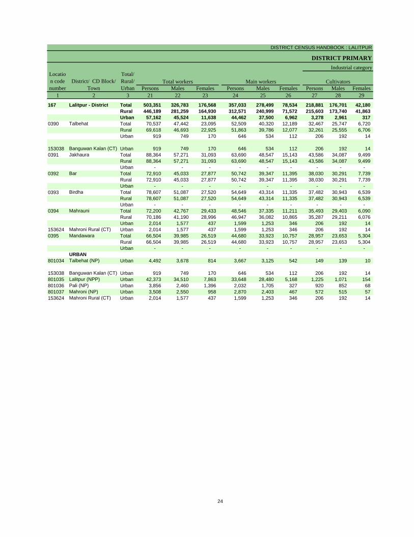
DISTRICT CENSUS HANDBOOK : LALITPUR
DISTRICT PRIMARY
Persons Males Females Persons Males Females Persons Males Females1 2 3 21 22 23 24 25 26 27 28 29
167 Lalitpur - District Total 503,351 326,783 176,568 357,033 278,499 78,534 218,881 176,701 42,180 Rural 446,189 281,259 164,930 312,571 240,999 71,572 215,603 173,740 41,863 Urban 57,162 45,524 11,638 44,462 37,500 6,962 3,278 2,961 317
0390 Talbehat Total 70,537 47,442 23,095 52,509 40,320 12,189 32,467 25,747 6,720 Rural 69,618 46,693 22,925 51,863 39,786 12,077 32,261 25,555 6,706 Urban 919 749 170 646 534 112 206 192 14
153038 Banguwan Kalan (CT) Urban 919 749 170 646 534 112 206 192 14 0391 Jakhaura Total 88,364 57,271 31,093 63,690 48,547 15,143 43,586 34,087 9,499
Rural 88,364 57,271 31,093 63,690 48,547 15,143 43,586 34,087 9,499 Urban - - - - - - - - -
0392 Bar Total 72,910 45,033 27,877 50,742 39,347 11,395 38,030 30,291 7,739 Rural 72,910 45,033 27,877 50,742 39,347 11,395 38,030 30,291 7,739 Urban - - - - - - - - -
0393 Birdha Total 78,607 51,087 27,520 54,649 43,314 11,335 37,482 30,943 6,539 Rural 78,607 51,087 27,520 54,649 43,314 11,335 37,482 30,943 6,539 Urban - - - - - - - - -
0394 Mahrauni Total 72,200 42,767 29,433 48,546 37,335 11,211 35,493 29,403 6,090 Rural 70,186 41,190 28,996 46,947 36,082 10,865 35,287 29,211 6,076 Urban 2,014 1,577 437 1,599 1,253 346 206 192 14
153624 Mahroni Rural (CT) Urban 2,014 1,577 437 1,599 1,253 346 206 192 14 0395 Mandawara Total 66,504 39,985 26,519 44,680 33,923 10,757 28,957 23,653 5,304
Rural 66,504 39,985 26,519 44,680 33,923 10,757 28,957 23,653 5,304 Urban - - - - - - - - -
URBAN801034 Talbehat (NP) Urban 4,492 3,678 814 3,667 3,125 542 149 139 10
153038 Banguwan Kalan (CT) Urban 919 749 170 646 534 112 206 192 14 801035 Lalitpur (NPP) Urban 42,373 34,510 7,863 33,648 28,480 5,168 1,225 1,071 154 801036 Pali (NP) Urban 3,856 2,460 1,396 2,032 1,705 327 920 852 68 801037 Mahroni (NP) Urban 3,508 2,550 958 2,870 2,403 467 572 515 57 153624 Mahroni Rural (CT) Urban 2,014 1,577 437 1,599 1,253 346 206 192 14
CultivatorsDistrict/ CD Block/ Town
Total/ Rural/ Urban
Total workers Main workers
Industrial categoryLocation code number
24
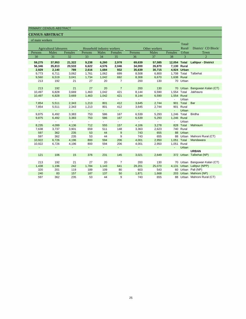
PRIMARY CENSUS ABSTRACT
CENSUS ABSTRACT
Persons Males Females Persons Males Females Persons Males Females30 31 32 33 34 35 36 37 38 3 2
59,275 37,953 21,322 9,238 6,260 2,978 69,639 57,585 12,054 Total Lalitpur - District56,346 35,813 20,533 6,622 4,576 2,046 34,000 26,870 7,130 Rural2,929 2,140 789 2,616 1,684 932 35,639 30,715 4,924 Urban9,773 6,711 3,062 1,761 1,062 699 8,508 6,800 1,708 Total Talbehat9,560 6,519 3,041 1,734 1,042 692 8,308 6,670 1,638 Rural
213 192 21 27 20 7 200 130 70 Urban
213 192 21 27 20 7 200 130 70 Urban Banguwan Kalan (CT)10,497 6,828 3,669 1,463 1,042 421 8,144 6,590 1,554 Total Jakhaura10,497 6,828 3,669 1,463 1,042 421 8,144 6,590 1,554 Rural
- - - - - - - - - Urban7,854 5,511 2,343 1,213 801 412 3,645 2,744 901 Total Bar7,854 5,511 2,343 1,213 801 412 3,645 2,744 901 Rural
- - - - - - - - - Urban9,875 6,492 3,383 753 586 167 6,539 5,293 1,246 Total Birdha9,875 6,492 3,383 753 586 167 6,539 5,293 1,246 Rural
- - - - - - - - - Urban8,235 4,099 4,136 712 555 157 4,106 3,278 828 Total Mahrauni7,638 3,737 3,901 659 511 148 3,363 2,623 740 Rural
597 362 235 53 44 9 743 655 88 Urban597 362 235 53 44 9 743 655 88 Urban Mahroni Rural (CT)
10,922 6,726 4,196 800 594 206 4,001 2,950 1,051 Total Mandawara10,922 6,726 4,196 800 594 206 4,001 2,950 1,051 Rural
- - - - - - - - - UrbanURBAN
121 106 15 376 231 145 3,021 2,649 372 Urban Talbehat (NP)
213 192 21 27 20 7 200 130 70 Urban Banguwan Kalan (CT)1,438 1,196 242 1,784 1,143 641 29,201 25,070 4,131 Urban Lalitpur (NPP)
320 201 119 189 109 80 603 543 60 Urban Pali (NP)240 83 157 187 137 50 1,871 1,668 203 Urban Mahroni (NP)597 362 235 53 44 9 743 655 88 Urban Mahroni Rural (CT)
Agricultural labourers Household industry workers Other workersTotal/ Rural/ Urban
District/ CD Block/ Town
of main workers
25
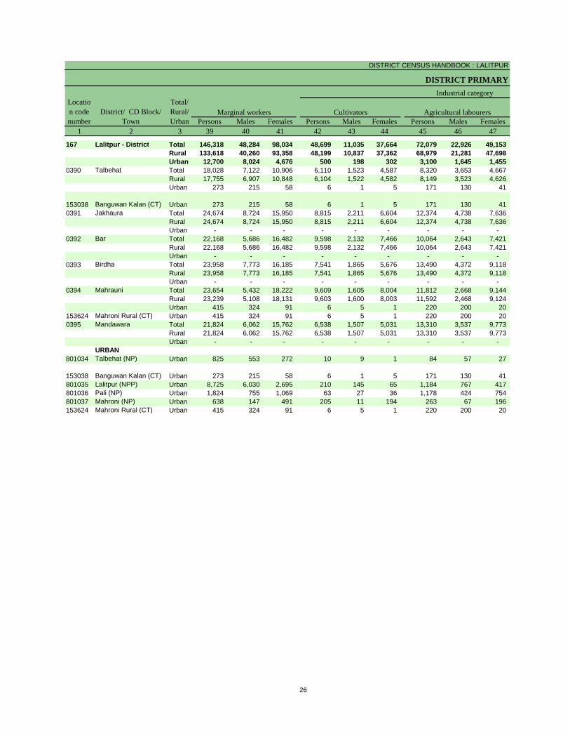
DISTRICT CENSUS HANDBOOK : LALITPUR
DISTRICT PRIMARY
Persons Males Females Persons Males Females Persons Males Females1 2 3 39 40 41 42 43 44 45 46 47
167 Lalitpur - District Total 146,318 48,284 98,034 48,699 11,035 37,664 72,079 22,926 49,153 Rural 133,618 40,260 93,358 48,199 10,837 37,362 68,979 21,281 47,698 Urban 12,700 8,024 4,676 500 198 302 3,100 1,645 1,455
0390 Talbehat Total 18,028 7,122 10,906 6,110 1,523 4,587 8,320 3,653 4,667 Rural 17,755 6,907 10,848 6,104 1,522 4,582 8,149 3,523 4,626 Urban 273 215 58 6 1 5 171 130 41
153038 Banguwan Kalan (CT) Urban 273 215 58 6 1 5 171 130 41 0391 Jakhaura Total 24,674 8,724 15,950 8,815 2,211 6,604 12,374 4,738 7,636
Rural 24,674 8,724 15,950 8,815 2,211 6,604 12,374 4,738 7,636 Urban - - - - - - - - -
0392 Bar Total 22,168 5,686 16,482 9,598 2,132 7,466 10,064 2,643 7,421 Rural 22,168 5,686 16,482 9,598 2,132 7,466 10,064 2,643 7,421 Urban - - - - - - - - -
0393 Birdha Total 23,958 7,773 16,185 7,541 1,865 5,676 13,490 4,372 9,118 Rural 23,958 7,773 16,185 7,541 1,865 5,676 13,490 4,372 9,118 Urban - - - - - - - - -
0394 Mahrauni Total 23,654 5,432 18,222 9,609 1,605 8,004 11,812 2,668 9,144 Rural 23,239 5,108 18,131 9,603 1,600 8,003 11,592 2,468 9,124 Urban 415 324 91 6 5 1 220 200 20
153624 Mahroni Rural (CT) Urban 415 324 91 6 5 1 220 200 20 0395 Mandawara Total 21,824 6,062 15,762 6,538 1,507 5,031 13,310 3,537 9,773
Rural 21,824 6,062 15,762 6,538 1,507 5,031 13,310 3,537 9,773 Urban - - - - - - - - -
URBAN801034 Talbehat (NP) Urban 825 553 272 10 9 1 84 57 27
153038 Banguwan Kalan (CT) Urban 273 215 58 6 1 5 171 130 41 801035 Lalitpur (NPP) Urban 8,725 6,030 2,695 210 145 65 1,184 767 417 801036 Pali (NP) Urban 1,824 755 1,069 63 27 36 1,178 424 754 801037 Mahroni (NP) Urban 638 147 491 205 11 194 263 67 196 153624 Mahroni Rural (CT) Urban 415 324 91 6 5 1 220 200 20
Location code number
District/ CD Block/ Town
Total/ Rural/ Urban
Industrial category
Agricultural labourersMarginal workers Cultivators
26
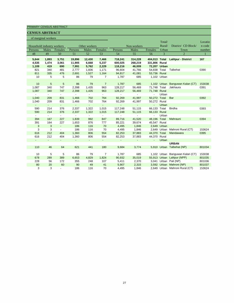
PRIMARY CENSUS ABSTRACT
CENSUS ABSTRACT
Persons Males Females Persons Males Females Persons Males Females48 49 50 51 52 53 54 55 56 3 2 1
5,644 1,893 3,751 19,896 12,430 7,466 718,241 314,228 404,013 Total Lalitpur - District 1674,535 1,474 3,061 11,905 6,668 5,237 600,025 268,219 331,806 Rural1,109 419 690 7,991 5,762 2,229 118,216 46,009 72,207 Urban
821 340 481 2,777 1,606 1,171 96,604 41,766 54,838 Total Talbehat 0390811 335 476 2,691 1,527 1,164 94,817 41,081 53,736 Rural10 5 5 86 79 7 1,787 685 1,102 Urban
10 5 5 86 79 7 1,787 685 1,102 Urban Banguwan Kalan (CT) 1530381,087 340 747 2,398 1,435 963 128,217 56,469 71,748 Total Jakhaura 03911,087 340 747 2,398 1,435 963 128,217 56,469 71,748 Rural
- - - - - - - - - Urban1,040 209 831 1,466 702 764 92,269 41,997 50,272 Total Bar 03921,040 209 831 1,466 702 764 92,269 41,997 50,272 Rural
- - - - - - - - - Urban590 214 376 2,337 1,322 1,015 117,248 51,115 66,133 Total Birdha 0393590 214 376 2,337 1,322 1,015 117,248 51,115 66,133 Rural- - - - - - - - - Urban394 167 227 1,839 992 847 89,716 41,520 48,196 Total Mahrauni 0394391 164 227 1,653 876 777 85,221 39,674 45,547 Rural
3 3 - 186 116 70 4,495 1,846 2,649 Urban3 3 - 186 116 70 4,495 1,846 2,649 Urban Mahroni Rural (CT) 153624
616 212 404 1,360 806 554 82,253 37,883 44,370 Total Mandawara 0395616 212 404 1,360 806 554 82,253 37,883 44,370 Rural- - - - - - - - - Urban
URBAN110 46 64 621 441 180 9,684 3,774 5,910 Urban Talbehat (NP) 801034
10 5 5 86 79 7 1,787 685 1,102 Urban Banguwan Kalan (CT) 153038678 289 389 6,653 4,829 1,824 90,932 35,019 55,913 Urban Lalitpur (NPP) 801035228 56 172 355 248 107 5,411 2,370 3,041 Urban Pali (NP) 80103680 20 60 90 49 41 5,907 2,315 3,592 Urban Mahroni (NP) 8010373 3 - 186 116 70 4,495 1,846 2,649 Urban Mahroni Rural (CT) 153624
Household industry workers Other workers Non-workers
of marginal workersTotal/ Rural/ Urban
District/ CD Block/ Town
Location code number
27

Appendix to District Primary Census Abstract Total, Scheduled Castes and
Scheduled Tribes Population - Urban Block wise
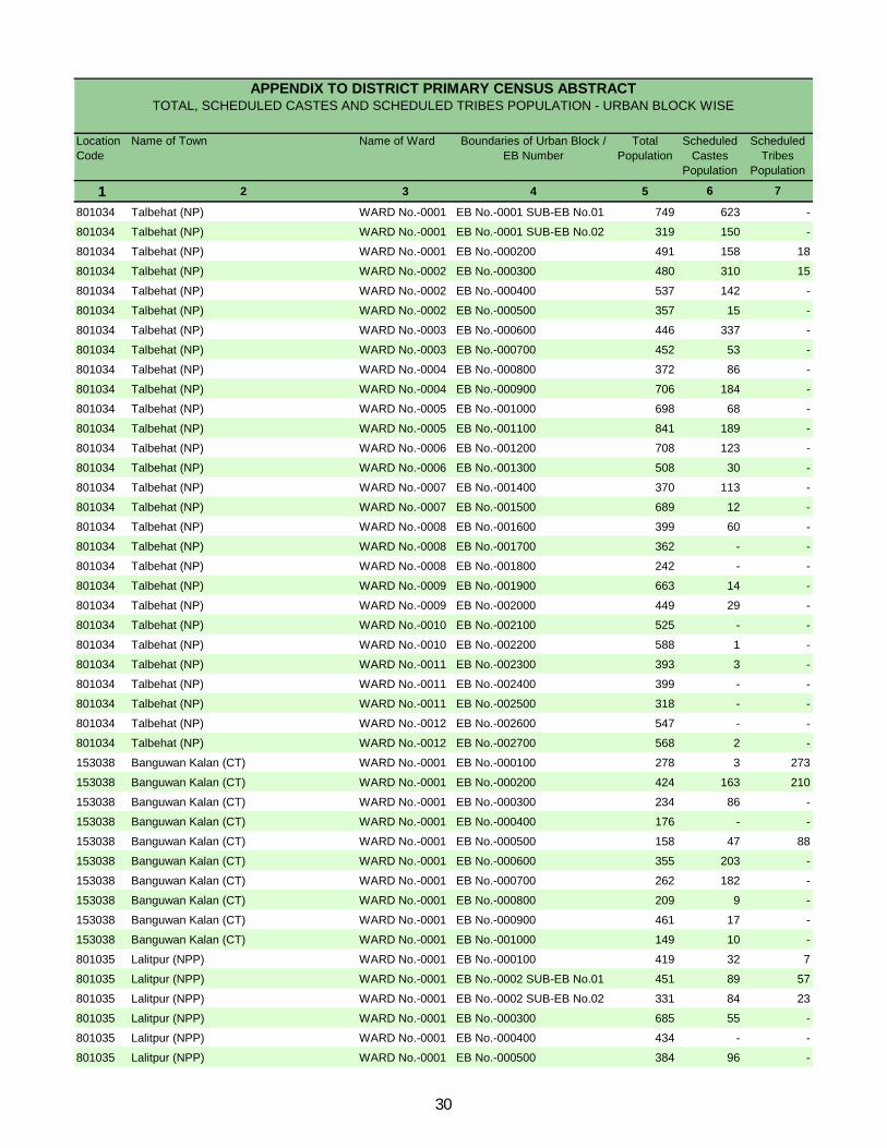
Location Code
Name of Town Name of Ward Boundaries of Urban Block / EB Number
Total Population
Scheduled Castes
Population
Scheduled Tribes
Population
1 2 3 4 5 6 7
801034 Talbehat (NP) WARD No.-0001 EB No.-0001 SUB-EB No.01 749 623 -
801034 Talbehat (NP) WARD No.-0001 EB No.-0001 SUB-EB No.02 319 150 -
801034 Talbehat (NP) WARD No.-0001 EB No.-000200 491 158 18
801034 Talbehat (NP) WARD No.-0002 EB No.-000300 480 310 15
801034 Talbehat (NP) WARD No.-0002 EB No.-000400 537 142 -
801034 Talbehat (NP) WARD No.-0002 EB No.-000500 357 15 -
801034 Talbehat (NP) WARD No.-0003 EB No.-000600 446 337 -
801034 Talbehat (NP) WARD No.-0003 EB No.-000700 452 53 -
801034 Talbehat (NP) WARD No.-0004 EB No.-000800 372 86 -
801034 Talbehat (NP) WARD No.-0004 EB No.-000900 706 184 -
801034 Talbehat (NP) WARD No.-0005 EB No.-001000 698 68 -
801034 Talbehat (NP) WARD No.-0005 EB No.-001100 841 189 -
801034 Talbehat (NP) WARD No.-0006 EB No.-001200 708 123 -
801034 Talbehat (NP) WARD No.-0006 EB No.-001300 508 30 -
801034 Talbehat (NP) WARD No.-0007 EB No.-001400 370 113 -
801034 Talbehat (NP) WARD No.-0007 EB No.-001500 689 12 -
801034 Talbehat (NP) WARD No.-0008 EB No.-001600 399 60 -
801034 Talbehat (NP) WARD No.-0008 EB No.-001700 362 - -
801034 Talbehat (NP) WARD No.-0008 EB No.-001800 242 - -
801034 Talbehat (NP) WARD No.-0009 EB No.-001900 663 14 -
801034 Talbehat (NP) WARD No.-0009 EB No.-002000 449 29 -
801034 Talbehat (NP) WARD No.-0010 EB No.-002100 525 - -
801034 Talbehat (NP) WARD No.-0010 EB No.-002200 588 1 -
801034 Talbehat (NP) WARD No.-0011 EB No.-002300 393 3 -
801034 Talbehat (NP) WARD No.-0011 EB No.-002400 399 - -
801034 Talbehat (NP) WARD No.-0011 EB No.-002500 318 - -
801034 Talbehat (NP) WARD No.-0012 EB No.-002600 547 - -
801034 Talbehat (NP) WARD No.-0012 EB No.-002700 568 2 -
153038 Banguwan Kalan (CT) WARD No.-0001 EB No.-000100 278 3 273
153038 Banguwan Kalan (CT) WARD No.-0001 EB No.-000200 424 163 210
153038 Banguwan Kalan (CT) WARD No.-0001 EB No.-000300 234 86 -
153038 Banguwan Kalan (CT) WARD No.-0001 EB No.-000400 176 - -
153038 Banguwan Kalan (CT) WARD No.-0001 EB No.-000500 158 47 88
153038 Banguwan Kalan (CT) WARD No.-0001 EB No.-000600 355 203 -
153038 Banguwan Kalan (CT) WARD No.-0001 EB No.-000700 262 182 -
153038 Banguwan Kalan (CT) WARD No.-0001 EB No.-000800 209 9 -
153038 Banguwan Kalan (CT) WARD No.-0001 EB No.-000900 461 17 -
153038 Banguwan Kalan (CT) WARD No.-0001 EB No.-001000 149 10 -
801035 Lalitpur (NPP) WARD No.-0001 EB No.-000100 419 32 7
801035 Lalitpur (NPP) WARD No.-0001 EB No.-0002 SUB-EB No.01 451 89 57
801035 Lalitpur (NPP) WARD No.-0001 EB No.-0002 SUB-EB No.02 331 84 23
801035 Lalitpur (NPP) WARD No.-0001 EB No.-000300 685 55 -
801035 Lalitpur (NPP) WARD No.-0001 EB No.-000400 434 - -
801035 Lalitpur (NPP) WARD No.-0001 EB No.-000500 384 96 -
APPENDIX TO DISTRICT PRIMARY CENSUS ABSTRACT TOTAL, SCHEDULED CASTES AND SCHEDULED TRIBES POPULATION - URBAN BLOCK WISE
30

Location Code
Name of Town Name of Ward Boundaries of Urban Block / EB Number
Total Population
Scheduled Castes
Population
Scheduled Tribes
Population
1 2 3 4 5 6 7
APPENDIX TO DISTRICT PRIMARY CENSUS ABSTRACT TOTAL, SCHEDULED CASTES AND SCHEDULED TRIBES POPULATION - URBAN BLOCK WISE
801035 Lalitpur (NPP) WARD No.-0001 EB No.-000600 652 515 -
801035 Lalitpur (NPP) WARD No.-0001 EB No.-000700 368 364 1
801035 Lalitpur (NPP) WARD No.-0001 EB No.-000800 710 654 -
801035 Lalitpur (NPP) WARD No.-0001 EB No.-000900 291 15 -
801035 Lalitpur (NPP) WARD No.-0001 EB No.-001000 381 25 -
801035 Lalitpur (NPP) WARD No.-0002 EB No.-001100 556 33 -
801035 Lalitpur (NPP) WARD No.-0002 EB No.-001200 762 226 4
801035 Lalitpur (NPP) WARD No.-0002 EB No.-001300 470 205 -
801035 Lalitpur (NPP) WARD No.-0002 EB No.-001400 532 215 -
801035 Lalitpur (NPP) WARD No.-0002 EB No.-0015 SUB-EB No.01 564 335 -
801035 Lalitpur (NPP) WARD No.-0002 EB No.-0015 SUB-EB No.02 523 122 -
801035 Lalitpur (NPP) WARD No.-0002 EB No.-001600 394 123 -
801035 Lalitpur (NPP) WARD No.-0002 EB No.-001700 453 60 21
801035 Lalitpur (NPP) WARD No.-0002 EB No.-0018 SUB-EB No.01 454 40 -
801035 Lalitpur (NPP) WARD No.-0002 EB No.-0018 SUB-EB No.02 396 119 -
801035 Lalitpur (NPP) WARD No.-0003 EB No.-0019 SUB-EB No.01 572 48 -
801035 Lalitpur (NPP) WARD No.-0003 EB No.-0019 SUB-EB No.02 552 46 -
801035 Lalitpur (NPP) WARD No.-0003 EB No.-002000 465 462 -
801035 Lalitpur (NPP) WARD No.-0003 EB No.-002100 718 568 -
801035 Lalitpur (NPP) WARD No.-0003 EB No.-0022 SUB-EB No.01 438 13 4
801035 Lalitpur (NPP) WARD No.-0003 EB No.-0022 SUB-EB No.02 428 3 -
801035 Lalitpur (NPP) WARD No.-0003 EB No.-0023 SUB-EB No.01 512 97 -
801035 Lalitpur (NPP) WARD No.-0003 EB No.-0023 SUB-EB No.02 457 60 -
801035 Lalitpur (NPP) WARD No.-0003 EB No.-002400 316 5 -
801035 Lalitpur (NPP) WARD No.-0003 EB No.-002500 216 51 1
801035 Lalitpur (NPP) WARD No.-0003 EB No.-002600 317 100 -
801035 Lalitpur (NPP) WARD No.-0004 EB No.-002700 321 7 -
801035 Lalitpur (NPP) WARD No.-0004 EB No.-002800 347 55 -
801035 Lalitpur (NPP) WARD No.-0004 EB No.-002900 425 34 -
801035 Lalitpur (NPP) WARD No.-0004 EB No.-003000 597 9 -
801035 Lalitpur (NPP) WARD No.-0004 EB No.-003100 714 100 -
801035 Lalitpur (NPP) WARD No.-0004 EB No.-003200 341 54 -
801035 Lalitpur (NPP) WARD No.-0004 EB No.-003300 483 300 -
801035 Lalitpur (NPP) WARD No.-0004 EB No.-003400 740 368 -
801035 Lalitpur (NPP) WARD No.-0004 EB No.-003500 603 421 -
801035 Lalitpur (NPP) WARD No.-0004 EB No.-003600 605 261 -
801035 Lalitpur (NPP) WARD No.-0004 EB No.-0037 SUB-EB No.01 696 217 -
801035 Lalitpur (NPP) WARD No.-0004 EB No.-0037 SUB-EB No.02 459 206 -
801035 Lalitpur (NPP) WARD No.-0004 EB No.-003800 128 - -
801035 Lalitpur (NPP) WARD No.-0005 EB No.-0039 SUB-EB No.01 618 72 -
801035 Lalitpur (NPP) WARD No.-0005 EB No.-0039 SUB-EB No.02 286 - -
801035 Lalitpur (NPP) WARD No.-0005 EB No.-004000 493 18 -
801035 Lalitpur (NPP) WARD No.-0005 EB No.-004100 522 54 -
801035 Lalitpur (NPP) WARD No.-0005 EB No.-004200 337 105 -
31
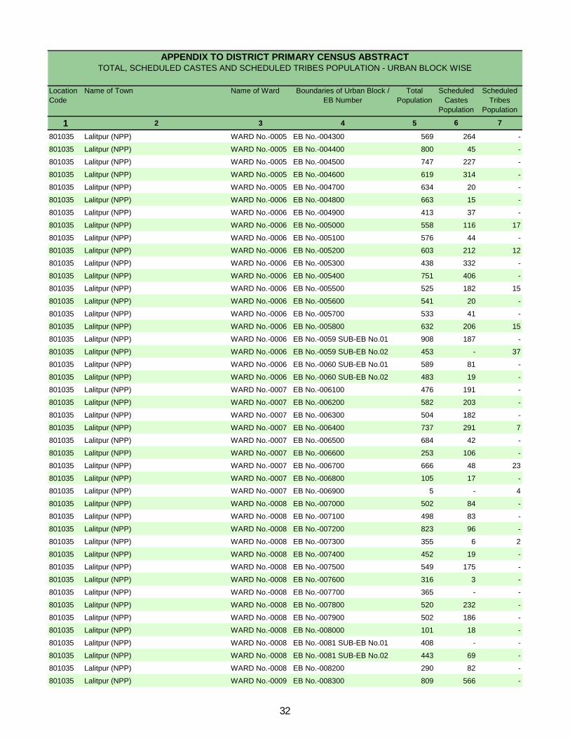
Location Code
Name of Town Name of Ward Boundaries of Urban Block / EB Number
Total Population
Scheduled Castes
Population
Scheduled Tribes
Population
1 2 3 4 5 6 7
APPENDIX TO DISTRICT PRIMARY CENSUS ABSTRACT TOTAL, SCHEDULED CASTES AND SCHEDULED TRIBES POPULATION - URBAN BLOCK WISE
801035 Lalitpur (NPP) WARD No.-0005 EB No.-004300 569 264 -
801035 Lalitpur (NPP) WARD No.-0005 EB No.-004400 800 45 -
801035 Lalitpur (NPP) WARD No.-0005 EB No.-004500 747 227 -
801035 Lalitpur (NPP) WARD No.-0005 EB No.-004600 619 314 -
801035 Lalitpur (NPP) WARD No.-0005 EB No.-004700 634 20 -
801035 Lalitpur (NPP) WARD No.-0006 EB No.-004800 663 15 -
801035 Lalitpur (NPP) WARD No.-0006 EB No.-004900 413 37 -
801035 Lalitpur (NPP) WARD No.-0006 EB No.-005000 558 116 17
801035 Lalitpur (NPP) WARD No.-0006 EB No.-005100 576 44 -
801035 Lalitpur (NPP) WARD No.-0006 EB No.-005200 603 212 12
801035 Lalitpur (NPP) WARD No.-0006 EB No.-005300 438 332 -
801035 Lalitpur (NPP) WARD No.-0006 EB No.-005400 751 406 -
801035 Lalitpur (NPP) WARD No.-0006 EB No.-005500 525 182 15
801035 Lalitpur (NPP) WARD No.-0006 EB No.-005600 541 20 -
801035 Lalitpur (NPP) WARD No.-0006 EB No.-005700 533 41 -
801035 Lalitpur (NPP) WARD No.-0006 EB No.-005800 632 206 15
801035 Lalitpur (NPP) WARD No.-0006 EB No.-0059 SUB-EB No.01 908 187 -
801035 Lalitpur (NPP) WARD No.-0006 EB No.-0059 SUB-EB No.02 453 - 37
801035 Lalitpur (NPP) WARD No.-0006 EB No.-0060 SUB-EB No.01 589 81 -
801035 Lalitpur (NPP) WARD No.-0006 EB No.-0060 SUB-EB No.02 483 19 -
801035 Lalitpur (NPP) WARD No.-0007 EB No.-006100 476 191 -
801035 Lalitpur (NPP) WARD No.-0007 EB No.-006200 582 203 -
801035 Lalitpur (NPP) WARD No.-0007 EB No.-006300 504 182 -
801035 Lalitpur (NPP) WARD No.-0007 EB No.-006400 737 291 7
801035 Lalitpur (NPP) WARD No.-0007 EB No.-006500 684 42 -
801035 Lalitpur (NPP) WARD No.-0007 EB No.-006600 253 106 -
801035 Lalitpur (NPP) WARD No.-0007 EB No.-006700 666 48 23
801035 Lalitpur (NPP) WARD No.-0007 EB No.-006800 105 17 -
801035 Lalitpur (NPP) WARD No.-0007 EB No.-006900 5 - 4
801035 Lalitpur (NPP) WARD No.-0008 EB No.-007000 502 84 -
801035 Lalitpur (NPP) WARD No.-0008 EB No.-007100 498 83 -
801035 Lalitpur (NPP) WARD No.-0008 EB No.-007200 823 96 -
801035 Lalitpur (NPP) WARD No.-0008 EB No.-007300 355 6 2
801035 Lalitpur (NPP) WARD No.-0008 EB No.-007400 452 19 -
801035 Lalitpur (NPP) WARD No.-0008 EB No.-007500 549 175 -
801035 Lalitpur (NPP) WARD No.-0008 EB No.-007600 316 3 -
801035 Lalitpur (NPP) WARD No.-0008 EB No.-007700 365 - -
801035 Lalitpur (NPP) WARD No.-0008 EB No.-007800 520 232 -
801035 Lalitpur (NPP) WARD No.-0008 EB No.-007900 502 186 -
801035 Lalitpur (NPP) WARD No.-0008 EB No.-008000 101 18 -
801035 Lalitpur (NPP) WARD No.-0008 EB No.-0081 SUB-EB No.01 408 - -
801035 Lalitpur (NPP) WARD No.-0008 EB No.-0081 SUB-EB No.02 443 69 -
801035 Lalitpur (NPP) WARD No.-0008 EB No.-008200 290 82 -
801035 Lalitpur (NPP) WARD No.-0009 EB No.-008300 809 566 -
32
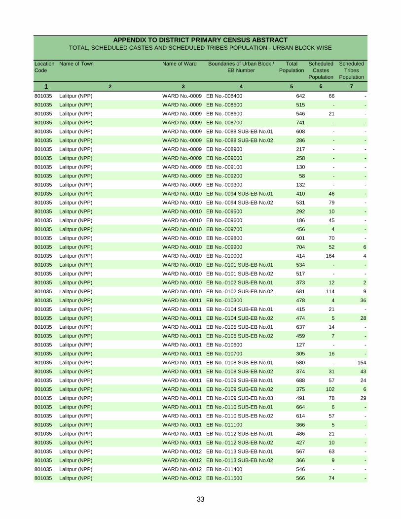
Location Code
Name of Town Name of Ward Boundaries of Urban Block / EB Number
Total Population
Scheduled Castes
Population
Scheduled Tribes
Population
1 2 3 4 5 6 7
APPENDIX TO DISTRICT PRIMARY CENSUS ABSTRACT TOTAL, SCHEDULED CASTES AND SCHEDULED TRIBES POPULATION - URBAN BLOCK WISE
801035 Lalitpur (NPP) WARD No.-0009 EB No.-008400 642 66 -
801035 Lalitpur (NPP) WARD No.-0009 EB No.-008500 515 - -
801035 Lalitpur (NPP) WARD No.-0009 EB No.-008600 546 21 -
801035 Lalitpur (NPP) WARD No.-0009 EB No.-008700 741 - -
801035 Lalitpur (NPP) WARD No.-0009 EB No.-0088 SUB-EB No.01 608 - -
801035 Lalitpur (NPP) WARD No.-0009 EB No.-0088 SUB-EB No.02 286 - -
801035 Lalitpur (NPP) WARD No.-0009 EB No.-008900 217 - -
801035 Lalitpur (NPP) WARD No.-0009 EB No.-009000 258 - -
801035 Lalitpur (NPP) WARD No.-0009 EB No.-009100 130 - -
801035 Lalitpur (NPP) WARD No.-0009 EB No.-009200 58 - -
801035 Lalitpur (NPP) WARD No.-0009 EB No.-009300 132 - -
801035 Lalitpur (NPP) WARD No.-0010 EB No.-0094 SUB-EB No.01 410 46 -
801035 Lalitpur (NPP) WARD No.-0010 EB No.-0094 SUB-EB No.02 531 79 -
801035 Lalitpur (NPP) WARD No.-0010 EB No.-009500 292 10 -
801035 Lalitpur (NPP) WARD No.-0010 EB No.-009600 186 45 -
801035 Lalitpur (NPP) WARD No.-0010 EB No.-009700 456 4 -
801035 Lalitpur (NPP) WARD No.-0010 EB No.-009800 601 70 -
801035 Lalitpur (NPP) WARD No.-0010 EB No.-009900 704 52 6
801035 Lalitpur (NPP) WARD No.-0010 EB No.-010000 414 164 4
801035 Lalitpur (NPP) WARD No.-0010 EB No.-0101 SUB-EB No.01 534 - -
801035 Lalitpur (NPP) WARD No.-0010 EB No.-0101 SUB-EB No.02 517 - -
801035 Lalitpur (NPP) WARD No.-0010 EB No.-0102 SUB-EB No.01 373 12 2
801035 Lalitpur (NPP) WARD No.-0010 EB No.-0102 SUB-EB No.02 681 114 9
801035 Lalitpur (NPP) WARD No.-0011 EB No.-010300 478 4 36
801035 Lalitpur (NPP) WARD No.-0011 EB No.-0104 SUB-EB No.01 415 21 -
801035 Lalitpur (NPP) WARD No.-0011 EB No.-0104 SUB-EB No.02 474 5 28
801035 Lalitpur (NPP) WARD No.-0011 EB No.-0105 SUB-EB No.01 637 14 -
801035 Lalitpur (NPP) WARD No.-0011 EB No.-0105 SUB-EB No.02 459 7 -
801035 Lalitpur (NPP) WARD No.-0011 EB No.-010600 127 - -
801035 Lalitpur (NPP) WARD No.-0011 EB No.-010700 305 16 -
801035 Lalitpur (NPP) WARD No.-0011 EB No.-0108 SUB-EB No.01 580 - 154
801035 Lalitpur (NPP) WARD No.-0011 EB No.-0108 SUB-EB No.02 374 31 43
801035 Lalitpur (NPP) WARD No.-0011 EB No.-0109 SUB-EB No.01 688 57 24
801035 Lalitpur (NPP) WARD No.-0011 EB No.-0109 SUB-EB No.02 375 102 6
801035 Lalitpur (NPP) WARD No.-0011 EB No.-0109 SUB-EB No.03 491 78 29
801035 Lalitpur (NPP) WARD No.-0011 EB No.-0110 SUB-EB No.01 664 6 -
801035 Lalitpur (NPP) WARD No.-0011 EB No.-0110 SUB-EB No.02 614 57 -
801035 Lalitpur (NPP) WARD No.-0011 EB No.-011100 366 5 -
801035 Lalitpur (NPP) WARD No.-0011 EB No.-0112 SUB-EB No.01 486 21 -
801035 Lalitpur (NPP) WARD No.-0011 EB No.-0112 SUB-EB No.02 427 10 -
801035 Lalitpur (NPP) WARD No.-0012 EB No.-0113 SUB-EB No.01 567 63 -
801035 Lalitpur (NPP) WARD No.-0012 EB No.-0113 SUB-EB No.02 366 9 -
801035 Lalitpur (NPP) WARD No.-0012 EB No.-011400 546 - -
801035 Lalitpur (NPP) WARD No.-0012 EB No.-011500 566 74 -
33
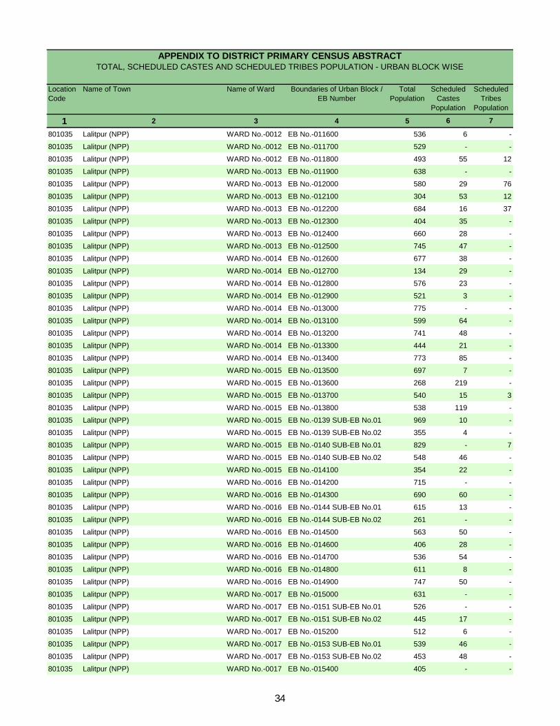
Location Code
Name of Town Name of Ward Boundaries of Urban Block / EB Number
Total Population
Scheduled Castes
Population
Scheduled Tribes
Population
1 2 3 4 5 6 7
APPENDIX TO DISTRICT PRIMARY CENSUS ABSTRACT TOTAL, SCHEDULED CASTES AND SCHEDULED TRIBES POPULATION - URBAN BLOCK WISE
801035 Lalitpur (NPP) WARD No.-0012 EB No.-011600 536 6 -
801035 Lalitpur (NPP) WARD No.-0012 EB No.-011700 529 - -
801035 Lalitpur (NPP) WARD No.-0012 EB No.-011800 493 55 12
801035 Lalitpur (NPP) WARD No.-0013 EB No.-011900 638 - -
801035 Lalitpur (NPP) WARD No.-0013 EB No.-012000 580 29 76
801035 Lalitpur (NPP) WARD No.-0013 EB No.-012100 304 53 12
801035 Lalitpur (NPP) WARD No.-0013 EB No.-012200 684 16 37
801035 Lalitpur (NPP) WARD No.-0013 EB No.-012300 404 35 -
801035 Lalitpur (NPP) WARD No.-0013 EB No.-012400 660 28 -
801035 Lalitpur (NPP) WARD No.-0013 EB No.-012500 745 47 -
801035 Lalitpur (NPP) WARD No.-0014 EB No.-012600 677 38 -
801035 Lalitpur (NPP) WARD No.-0014 EB No.-012700 134 29 -
801035 Lalitpur (NPP) WARD No.-0014 EB No.-012800 576 23 -
801035 Lalitpur (NPP) WARD No.-0014 EB No.-012900 521 3 -
801035 Lalitpur (NPP) WARD No.-0014 EB No.-013000 775 - -
801035 Lalitpur (NPP) WARD No.-0014 EB No.-013100 599 64 -
801035 Lalitpur (NPP) WARD No.-0014 EB No.-013200 741 48 -
801035 Lalitpur (NPP) WARD No.-0014 EB No.-013300 444 21 -
801035 Lalitpur (NPP) WARD No.-0014 EB No.-013400 773 85 -
801035 Lalitpur (NPP) WARD No.-0015 EB No.-013500 697 7 -
801035 Lalitpur (NPP) WARD No.-0015 EB No.-013600 268 219 -
801035 Lalitpur (NPP) WARD No.-0015 EB No.-013700 540 15 3
801035 Lalitpur (NPP) WARD No.-0015 EB No.-013800 538 119 -
801035 Lalitpur (NPP) WARD No.-0015 EB No.-0139 SUB-EB No.01 969 10 -
801035 Lalitpur (NPP) WARD No.-0015 EB No.-0139 SUB-EB No.02 355 4 -
801035 Lalitpur (NPP) WARD No.-0015 EB No.-0140 SUB-EB No.01 829 - 7
801035 Lalitpur (NPP) WARD No.-0015 EB No.-0140 SUB-EB No.02 548 46 -
801035 Lalitpur (NPP) WARD No.-0015 EB No.-014100 354 22 -
801035 Lalitpur (NPP) WARD No.-0016 EB No.-014200 715 - -
801035 Lalitpur (NPP) WARD No.-0016 EB No.-014300 690 60 -
801035 Lalitpur (NPP) WARD No.-0016 EB No.-0144 SUB-EB No.01 615 13 -
801035 Lalitpur (NPP) WARD No.-0016 EB No.-0144 SUB-EB No.02 261 - -
801035 Lalitpur (NPP) WARD No.-0016 EB No.-014500 563 50 -
801035 Lalitpur (NPP) WARD No.-0016 EB No.-014600 406 28 -
801035 Lalitpur (NPP) WARD No.-0016 EB No.-014700 536 54 -
801035 Lalitpur (NPP) WARD No.-0016 EB No.-014800 611 8 -
801035 Lalitpur (NPP) WARD No.-0016 EB No.-014900 747 50 -
801035 Lalitpur (NPP) WARD No.-0017 EB No.-015000 631 - -
801035 Lalitpur (NPP) WARD No.-0017 EB No.-0151 SUB-EB No.01 526 - -
801035 Lalitpur (NPP) WARD No.-0017 EB No.-0151 SUB-EB No.02 445 17 -
801035 Lalitpur (NPP) WARD No.-0017 EB No.-015200 512 6 -
801035 Lalitpur (NPP) WARD No.-0017 EB No.-0153 SUB-EB No.01 539 46 -
801035 Lalitpur (NPP) WARD No.-0017 EB No.-0153 SUB-EB No.02 453 48 -
801035 Lalitpur (NPP) WARD No.-0017 EB No.-015400 405 - -
34
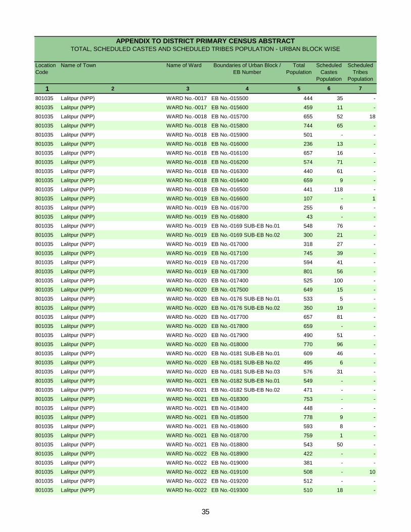
Location Code
Name of Town Name of Ward Boundaries of Urban Block / EB Number
Total Population
Scheduled Castes
Population
Scheduled Tribes
Population
1 2 3 4 5 6 7
APPENDIX TO DISTRICT PRIMARY CENSUS ABSTRACT TOTAL, SCHEDULED CASTES AND SCHEDULED TRIBES POPULATION - URBAN BLOCK WISE
801035 Lalitpur (NPP) WARD No.-0017 EB No.-015500 444 35 -
801035 Lalitpur (NPP) WARD No.-0017 EB No.-015600 459 11 -
801035 Lalitpur (NPP) WARD No.-0018 EB No.-015700 655 52 18
801035 Lalitpur (NPP) WARD No.-0018 EB No.-015800 744 65 -
801035 Lalitpur (NPP) WARD No.-0018 EB No.-015900 501 - -
801035 Lalitpur (NPP) WARD No.-0018 EB No.-016000 236 13 -
801035 Lalitpur (NPP) WARD No.-0018 EB No.-016100 657 16 -
801035 Lalitpur (NPP) WARD No.-0018 EB No.-016200 574 71 -
801035 Lalitpur (NPP) WARD No.-0018 EB No.-016300 440 61 -
801035 Lalitpur (NPP) WARD No.-0018 EB No.-016400 659 9 -
801035 Lalitpur (NPP) WARD No.-0018 EB No.-016500 441 118 -
801035 Lalitpur (NPP) WARD No.-0019 EB No.-016600 107 - 1
801035 Lalitpur (NPP) WARD No.-0019 EB No.-016700 255 6 -
801035 Lalitpur (NPP) WARD No.-0019 EB No.-016800 43 - -
801035 Lalitpur (NPP) WARD No.-0019 EB No.-0169 SUB-EB No.01 548 76 -
801035 Lalitpur (NPP) WARD No.-0019 EB No.-0169 SUB-EB No.02 300 21 -
801035 Lalitpur (NPP) WARD No.-0019 EB No.-017000 318 27 -
801035 Lalitpur (NPP) WARD No.-0019 EB No.-017100 745 39 -
801035 Lalitpur (NPP) WARD No.-0019 EB No.-017200 594 41 -
801035 Lalitpur (NPP) WARD No.-0019 EB No.-017300 801 56 -
801035 Lalitpur (NPP) WARD No.-0020 EB No.-017400 525 100 -
801035 Lalitpur (NPP) WARD No.-0020 EB No.-017500 649 15 -
801035 Lalitpur (NPP) WARD No.-0020 EB No.-0176 SUB-EB No.01 533 5 -
801035 Lalitpur (NPP) WARD No.-0020 EB No.-0176 SUB-EB No.02 350 19 -
801035 Lalitpur (NPP) WARD No.-0020 EB No.-017700 657 81 -
801035 Lalitpur (NPP) WARD No.-0020 EB No.-017800 659 - -
801035 Lalitpur (NPP) WARD No.-0020 EB No.-017900 490 51 -
801035 Lalitpur (NPP) WARD No.-0020 EB No.-018000 770 96 -
801035 Lalitpur (NPP) WARD No.-0020 EB No.-0181 SUB-EB No.01 609 46 -
801035 Lalitpur (NPP) WARD No.-0020 EB No.-0181 SUB-EB No.02 495 6 -
801035 Lalitpur (NPP) WARD No.-0020 EB No.-0181 SUB-EB No.03 576 31 -
801035 Lalitpur (NPP) WARD No.-0021 EB No.-0182 SUB-EB No.01 549 - -
801035 Lalitpur (NPP) WARD No.-0021 EB No.-0182 SUB-EB No.02 471 - -
801035 Lalitpur (NPP) WARD No.-0021 EB No.-018300 753 - -
801035 Lalitpur (NPP) WARD No.-0021 EB No.-018400 448 - -
801035 Lalitpur (NPP) WARD No.-0021 EB No.-018500 778 9 -
801035 Lalitpur (NPP) WARD No.-0021 EB No.-018600 593 8 -
801035 Lalitpur (NPP) WARD No.-0021 EB No.-018700 759 1 -
801035 Lalitpur (NPP) WARD No.-0021 EB No.-018800 543 50 -
801035 Lalitpur (NPP) WARD No.-0022 EB No.-018900 422 - -
801035 Lalitpur (NPP) WARD No.-0022 EB No.-019000 381 - -
801035 Lalitpur (NPP) WARD No.-0022 EB No.-019100 508 - 10
801035 Lalitpur (NPP) WARD No.-0022 EB No.-019200 512 - -
801035 Lalitpur (NPP) WARD No.-0022 EB No.-019300 510 18 -
35
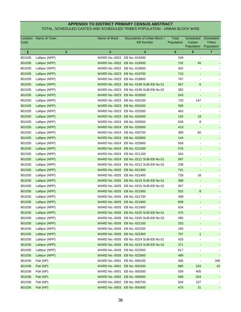
Location Code
Name of Town Name of Ward Boundaries of Urban Block / EB Number
Total Population
Scheduled Castes
Population
Scheduled Tribes
Population
1 2 3 4 5 6 7
APPENDIX TO DISTRICT PRIMARY CENSUS ABSTRACT TOTAL, SCHEDULED CASTES AND SCHEDULED TRIBES POPULATION - URBAN BLOCK WISE
801035 Lalitpur (NPP) WARD No.-0022 EB No.-019400 249 - -
801035 Lalitpur (NPP) WARD No.-0022 EB No.-019500 702 45 -
801035 Lalitpur (NPP) WARD No.-0022 EB No.-019600 452 - -
801035 Lalitpur (NPP) WARD No.-0023 EB No.-019700 710 - -
801035 Lalitpur (NPP) WARD No.-0023 EB No.-019800 767 - -
801035 Lalitpur (NPP) WARD No.-0023 EB No.-0199 SUB-EB No.01 567 6 -
801035 Lalitpur (NPP) WARD No.-0023 EB No.-0199 SUB-EB No.02 382 - -
801035 Lalitpur (NPP) WARD No.-0023 EB No.-020000 543 - -
801035 Lalitpur (NPP) WARD No.-0023 EB No.-020100 733 147 -
801035 Lalitpur (NPP) WARD No.-0023 EB No.-020200 505 - -
801035 Lalitpur (NPP) WARD No.-0023 EB No.-020300 463 - -
801035 Lalitpur (NPP) WARD No.-0023 EB No.-020400 155 19 -
801035 Lalitpur (NPP) WARD No.-0024 EB No.-020500 636 8 -
801035 Lalitpur (NPP) WARD No.-0024 EB No.-020600 419 - -
801035 Lalitpur (NPP) WARD No.-0024 EB No.-020700 389 50 -
801035 Lalitpur (NPP) WARD No.-0024 EB No.-020800 144 - -
801035 Lalitpur (NPP) WARD No.-0024 EB No.-020900 658 - -
801035 Lalitpur (NPP) WARD No.-0024 EB No.-021000 576 - -
801035 Lalitpur (NPP) WARD No.-0024 EB No.-021100 344 - -
801035 Lalitpur (NPP) WARD No.-0024 EB No.-0212 SUB-EB No.01 587 - -
801035 Lalitpur (NPP) WARD No.-0024 EB No.-0212 SUB-EB No.02 238 - -
801035 Lalitpur (NPP) WARD No.-0025 EB No.-021300 741 - -
801035 Lalitpur (NPP) WARD No.-0025 EB No.-021400 726 18 -
801035 Lalitpur (NPP) WARD No.-0025 EB No.-0215 SUB-EB No.01 388 - -
801035 Lalitpur (NPP) WARD No.-0025 EB No.-0215 SUB-EB No.02 457 - -
801035 Lalitpur (NPP) WARD No.-0025 EB No.-021600 552 8 -
801035 Lalitpur (NPP) WARD No.-0025 EB No.-021700 408 - -
801035 Lalitpur (NPP) WARD No.-0025 EB No.-021800 808 - -
801035 Lalitpur (NPP) WARD No.-0025 EB No.-021900 634 - -
801035 Lalitpur (NPP) WARD No.-0026 EB No.-0220 SUB-EB No.01 475 - -
801035 Lalitpur (NPP) WARD No.-0026 EB No.-0220 SUB-EB No.02 485 - -
801035 Lalitpur (NPP) WARD No.-0026 EB No.-022100 253 - -
801035 Lalitpur (NPP) WARD No.-0026 EB No.-022200 190 - -
801035 Lalitpur (NPP) WARD No.-0026 EB No.-022300 707 1 -
801035 Lalitpur (NPP) WARD No.-0026 EB No.-0224 SUB-EB No.01 425 - -
801035 Lalitpur (NPP) WARD No.-0026 EB No.-0224 SUB-EB No.02 371 - -
801035 Lalitpur (NPP) WARD No.-0026 EB No.-022500 617 - -
801035 Lalitpur (NPP) WARD No.-0026 EB No.-022600 489 - -
801036 Pali (NP) WARD No.-0001 EB No.-000100 496 - 345
801036 Pali (NP) WARD No.-0001 EB No.-000200 680 243 42
801036 Pali (NP) WARD No.-0001 EB No.-000300 509 405 -
801036 Pali (NP) WARD No.-0002 EB No.-000600 668 254 -
801036 Pali (NP) WARD No.-0002 EB No.-000700 504 157 -
801036 Pali (NP) WARD No.-0003 EB No.-000400 470 31 -
36
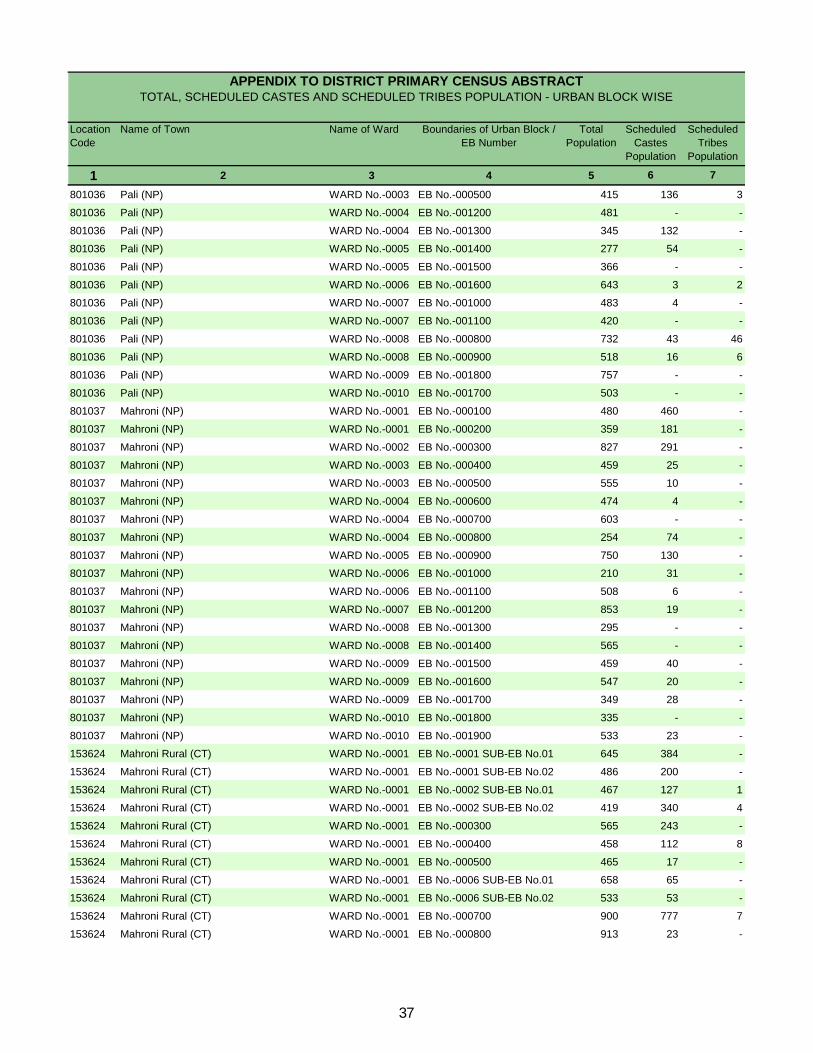
Location Code
Name of Town Name of Ward Boundaries of Urban Block / EB Number
Total Population
Scheduled Castes
Population
Scheduled Tribes
Population
1 2 3 4 5 6 7
APPENDIX TO DISTRICT PRIMARY CENSUS ABSTRACT TOTAL, SCHEDULED CASTES AND SCHEDULED TRIBES POPULATION - URBAN BLOCK WISE
801036 Pali (NP) WARD No.-0003 EB No.-000500 415 136 3
801036 Pali (NP) WARD No.-0004 EB No.-001200 481 - -
801036 Pali (NP) WARD No.-0004 EB No.-001300 345 132 -
801036 Pali (NP) WARD No.-0005 EB No.-001400 277 54 -
801036 Pali (NP) WARD No.-0005 EB No.-001500 366 - -
801036 Pali (NP) WARD No.-0006 EB No.-001600 643 3 2
801036 Pali (NP) WARD No.-0007 EB No.-001000 483 4 -
801036 Pali (NP) WARD No.-0007 EB No.-001100 420 - -
801036 Pali (NP) WARD No.-0008 EB No.-000800 732 43 46
801036 Pali (NP) WARD No.-0008 EB No.-000900 518 16 6
801036 Pali (NP) WARD No.-0009 EB No.-001800 757 - -
801036 Pali (NP) WARD No.-0010 EB No.-001700 503 - -
801037 Mahroni (NP) WARD No.-0001 EB No.-000100 480 460 -
801037 Mahroni (NP) WARD No.-0001 EB No.-000200 359 181 -
801037 Mahroni (NP) WARD No.-0002 EB No.-000300 827 291 -
801037 Mahroni (NP) WARD No.-0003 EB No.-000400 459 25 -
801037 Mahroni (NP) WARD No.-0003 EB No.-000500 555 10 -
801037 Mahroni (NP) WARD No.-0004 EB No.-000600 474 4 -
801037 Mahroni (NP) WARD No.-0004 EB No.-000700 603 - -
801037 Mahroni (NP) WARD No.-0004 EB No.-000800 254 74 -
801037 Mahroni (NP) WARD No.-0005 EB No.-000900 750 130 -
801037 Mahroni (NP) WARD No.-0006 EB No.-001000 210 31 -
801037 Mahroni (NP) WARD No.-0006 EB No.-001100 508 6 -
801037 Mahroni (NP) WARD No.-0007 EB No.-001200 853 19 -
801037 Mahroni (NP) WARD No.-0008 EB No.-001300 295 - -
801037 Mahroni (NP) WARD No.-0008 EB No.-001400 565 - -
801037 Mahroni (NP) WARD No.-0009 EB No.-001500 459 40 -
801037 Mahroni (NP) WARD No.-0009 EB No.-001600 547 20 -
801037 Mahroni (NP) WARD No.-0009 EB No.-001700 349 28 -
801037 Mahroni (NP) WARD No.-0010 EB No.-001800 335 - -
801037 Mahroni (NP) WARD No.-0010 EB No.-001900 533 23 -
153624 Mahroni Rural (CT) WARD No.-0001 EB No.-0001 SUB-EB No.01 645 384 -
153624 Mahroni Rural (CT) WARD No.-0001 EB No.-0001 SUB-EB No.02 486 200 -
153624 Mahroni Rural (CT) WARD No.-0001 EB No.-0002 SUB-EB No.01 467 127 1
153624 Mahroni Rural (CT) WARD No.-0001 EB No.-0002 SUB-EB No.02 419 340 4
153624 Mahroni Rural (CT) WARD No.-0001 EB No.-000300 565 243 -
153624 Mahroni Rural (CT) WARD No.-0001 EB No.-000400 458 112 8
153624 Mahroni Rural (CT) WARD No.-0001 EB No.-000500 465 17 -
153624 Mahroni Rural (CT) WARD No.-0001 EB No.-0006 SUB-EB No.01 658 65 -
153624 Mahroni Rural (CT) WARD No.-0001 EB No.-0006 SUB-EB No.02 533 53 -
153624 Mahroni Rural (CT) WARD No.-0001 EB No.-000700 900 777 7
153624 Mahroni Rural (CT) WARD No.-0001 EB No.-000800 913 23 -
37

Primary Census Abstract for Scheduled Castes (SC)
DISTRICT CENSUS HANDBOOK : LALITPUR
PRIMARY CENSUS ABSTRACT
Persons Males Females Persons Males Females1 2 3 4 5 6 7 8 9 10
167 Lalitpur - District Total 45,436 240,519 126,325 114,194 45,039 23,685 21,354 Rural 40,683 215,108 113,012 102,096 41,392 21,788 19,604 Urban 4,753 25,411 13,313 12,098 3,647 1,897 1,750
0390 Talbehat Total 5,738 28,377 15,065 13,312 5,266 2,757 2,509 Rural 5,592 27,657 14,694 12,963 5,155 2,703 2,452 Urban 146 720 371 349 111 54 57
0391 Jakhaura Total 8,444 44,007 23,166 20,841 8,482 4,516 3,966 Rural 8,444 44,007 23,166 20,841 8,482 4,516 3,966 Urban - - - - - - -
0392 Bar Total 6,039 31,826 16,885 14,941 5,988 3,214 2,774 Rural 6,039 31,826 16,885 14,941 5,988 3,214 2,774 Urban - - - - - - -
0393 Birdha Total 7,437 41,074 21,487 19,587 8,007 4,201 3,806 Rural 7,437 41,074 21,487 19,587 8,007 4,201 3,806 Urban - - - - - - -
0394 Mahrauni Total 7,336 39,302 20,423 18,879 7,540 3,855 3,685 Rural 6,915 36,961 19,192 17,769 7,148 3,654 3,494 Urban 421 2,341 1,231 1,110 392 201 191
0395 Mandawara Total 6,256 33,583 17,588 15,995 6,612 3,500 3,112 Rural 6,256 33,583 17,588 15,995 6,612 3,500 3,112 Urban - - - - - - -
URBAN801034 Talbehat (NP) Urban 521 2,702 1,388 1,314 406 200 206
153038 Banguwan Kalan (CT) Urban 146 720 371 349 111 54 57 801035 Lalitpur (NPP) Urban 3,129 16,828 8,841 7,987 2,263 1,198 1,065 801036 Pali (NP) Urban 287 1,478 777 701 258 135 123 801037 Mahroni (NP) Urban 249 1,342 705 637 217 109 108 153624 Mahroni Rural (CT) Urban 421 2,341 1,231 1,110 392 201 191
Location code
numberDistrict/ CD Block/
Town
Total/ Rural/ Urban
Number of households with SC as
head
Total population (including institutional and houseless population) Population in the age-group 0-6
40
PRIMARY CENSUS ABSTRACT
FOR SCHEDULED CASTES
Persons Males Females Persons Males Females Persons Males Females11 12 13 14 15 16 17 18 19 3 2
114,962 72,842 42,120 125,557 53,483 72,074 101,297 63,226 38,071 Total Lalitpur - District98,628 63,201 35,427 116,480 49,811 66,669 92,665 56,957 35,708 Rural16,334 9,641 6,693 9,077 3,672 5,405 8,632 6,269 2,363 Urban12,375 8,068 4,307 16,002 6,997 9,005 12,037 7,823 4,214 Total Talbehat11,932 7,807 4,125 15,725 6,887 8,838 11,821 7,652 4,169 Rural
443 261 182 277 110 167 216 171 45 Urban20,795 13,397 7,398 23,212 9,769 13,443 18,012 11,545 6,467 Total Jakhaura20,795 13,397 7,398 23,212 9,769 13,443 18,012 11,545 6,467 Rural
- - - - - - - - - Urban14,080 9,054 5,026 17,746 7,831 9,915 14,222 8,489 5,733 Total Bar14,080 9,054 5,026 17,746 7,831 9,915 14,222 8,489 5,733 Rural
- - - - - - - - - Urban19,347 12,415 6,932 21,727 9,072 12,655 16,399 10,560 5,839 Total Birdha19,347 12,415 6,932 21,727 9,072 12,655 16,399 10,560 5,839 Rural
- - - - - - - - - Urban18,716 11,802 6,914 20,586 8,621 11,965 17,670 10,309 7,361 Total Mahrauni17,363 10,988 6,375 19,598 8,204 11,394 16,842 9,739 7,103 Rural1,353 814 539 988 417 571 828 570 258 Urban
15,111 9,540 5,571 18,472 8,048 10,424 15,369 8,972 6,397 Total Mandawara15,111 9,540 5,571 18,472 8,048 10,424 15,369 8,972 6,397 Rural
- - - - - - - - - UrbanURBAN
1,507 870 637 1,195 518 677 949 680 269 Urban Talbehat (NP)
443 261 182 277 110 167 216 171 45 Urban Banguwan Kalan (CT)11,393 6,663 4,730 5,435 2,178 3,257 5,462 4,137 1,325 Urban Lalitpur (NPP)
832 526 306 646 251 395 624 375 249 Urban Pali (NP)806 507 299 536 198 338 553 336 217 Urban Mahroni (NP)
1,353 814 539 988 417 571 828 570 258 Urban Mahroni Rural (CT)
District/ CD Block/ Town
Total/ Rural/ Urban
Total workersLiterates Illiterates
41
DISTRICT CENSUS HANDBOOK : LALITPUR
PRIMARY CENSUS ABSTRACT
Persons Males Females Persons Males Females Persons Males Females1 2 3 20 21 22 23 24 25 26 27 28
167 Lalitpur - District Total 67,745 52,323 15,422 40,688 33,302 7,386 14,032 9,119 4,913 Rural 61,357 47,423 13,934 40,408 33,064 7,344 13,372 8,697 4,675 Urban 6,388 4,900 1,488 280 238 42 660 422 238
0390 Talbehat Total 8,884 6,491 2,393 5,273 4,035 1,238 1,891 1,310 581 Rural 8,733 6,367 2,366 5,247 4,009 1,238 1,851 1,274 577 Urban 151 124 27 26 26 - 40 36 4
0391 Jakhaura Total 12,101 9,315 2,786 7,687 6,078 1,609 2,618 1,835 783 Rural 12,101 9,315 2,786 7,687 6,078 1,609 2,618 1,835 783 Urban - - - - - - - - -
0392 Bar Total 9,101 7,053 2,048 6,143 4,941 1,202 1,659 1,209 450 Rural 9,101 7,053 2,048 6,143 4,941 1,202 1,659 1,209 450 Urban - - - - - - - - -
0393 Birdha Total 10,729 8,670 2,059 7,112 6,004 1,108 2,155 1,430 725 Rural 10,729 8,670 2,059 7,112 6,004 1,108 2,155 1,430 725 Urban - - - - - - - - -
0394 Mahrauni Total 11,351 8,843 2,508 7,959 6,822 1,137 2,497 1,334 1,163 Rural 10,772 8,467 2,305 7,923 6,789 1,134 2,112 1,118 994 Urban 579 376 203 36 33 3 385 216 169
0395 Mandawara Total 9,921 7,551 2,370 6,296 5,243 1,053 2,977 1,831 1,146 Rural 9,921 7,551 2,370 6,296 5,243 1,053 2,977 1,831 1,146 Urban - - - - - - - - -
URBAN801034 Talbehat (NP) Urban 790 592 198 13 12 1 11 10 1
153038 Banguwan Kalan (CT) Urban 151 124 27 26 26 - 40 36 4 801035 Lalitpur (NPP) Urban 4,185 3,303 882 81 60 21 176 134 42 801036 Pali (NP) Urban 240 180 60 40 38 2 20 18 2 801037 Mahroni (NP) Urban 443 325 118 84 69 15 28 8 20 153624 Mahroni Rural (CT) Urban 579 376 203 36 33 3 385 216 169
District/ CD Block/ Town
Total/ Rural/ Urban
Industrial category
Agricultural labourersMain workersLocation
code number
Cultivators
42
PRIMARY CENSUS ABSTRACT
FOR SCHEDULED CASTES
Persons Males Females Persons Males Females Persons Males Females29 30 31 32 33 34 35 36 37 3 2
2,746 1,605 1,141 10,279 8,297 1,982 33,552 10,903 22,649 Total Lalitpur - District2,046 1,260 786 5,531 4,402 1,129 31,308 9,534 21,774 Rural
700 345 355 4,748 3,895 853 2,244 1,369 875 Urban715 413 302 1,005 733 272 3,153 1,332 1,821 Total Talbehat696 400 296 939 684 255 3,088 1,285 1,803 Rural19 13 6 66 49 17 65 47 18 Urban
300 201 99 1,496 1,201 295 5,911 2,230 3,681 Total Jakhaura300 201 99 1,496 1,201 295 5,911 2,230 3,681 Rural- - - - - - - - - Urban660 411 249 639 492 147 5,121 1,436 3,685 Total Bar660 411 249 639 492 147 5,121 1,436 3,685 Rural- - - - - - - - - Urban157 99 58 1,305 1,137 168 5,670 1,890 3,780 Total Birdha157 99 58 1,305 1,137 168 5,670 1,890 3,780 Rural- - - - - - - - - Urban114 69 45 781 618 163 6,319 1,466 4,853 Total Mahrauni98 62 36 639 498 141 6,070 1,272 4,798 Rural16 7 9 142 120 22 249 194 55 Urban
135 87 48 513 390 123 5,448 1,421 4,027 Total Mandawara135 87 48 513 390 123 5,448 1,421 4,027 Rural- - - - - - - - - Urban
URBAN183 72 111 583 498 85 159 88 71 Urban Talbehat (NP)
19 13 6 66 49 17 65 47 18 Urban Banguwan Kalan (CT)334 178 156 3,594 2,931 663 1,277 834 443 Urban Lalitpur (NPP)103 57 46 77 67 10 384 195 189 Urban Pali (NP)45 18 27 286 230 56 110 11 99 Urban Mahroni (NP)16 7 9 142 120 22 249 194 55 Urban Mahroni Rural (CT)
of main workers
Other workersHousehold industry workers Marginal workersTotal/ Rural/ Urban
District/ CD Block/ Town
43

DISTRICT CENSUS HANDBOOK : LALITPUR
PRIMARY CENSUS ABSTRACT
Persons Males Females Persons Males Females Persons Males Females1 2 3 38 39 40 41 42 43 44 45 46
167 Lalitpur - District Total 10,087 2,184 7,903 17,889 5,768 12,121 1,516 480 1,036 Rural 9,976 2,159 7,817 17,276 5,396 11,880 1,304 406 898 Urban 111 25 86 613 372 241 212 74 138
0390 Talbehat Total 882 227 655 1,620 796 824 190 75 115 Rural 882 227 655 1,578 767 811 181 70 111 Urban - - - 42 29 13 9 5 4
0391 Jakhaura Total 1,761 448 1,313 3,144 1,293 1,851 332 122 210 Rural 1,761 448 1,313 3,144 1,293 1,851 332 122 210 Urban - - - - - - - - -
0392 Bar Total 1,870 420 1,450 2,506 768 1,738 436 97 339 Rural 1,870 420 1,450 2,506 768 1,738 436 97 339 Urban - - - - - - - - -
0393 Birdha Total 1,640 372 1,268 3,226 1,029 2,197 163 61 102 Rural 1,640 372 1,268 3,226 1,029 2,197 163 61 102 Urban - - - - - - - - -
0394 Mahrauni Total 2,267 297 1,970 3,478 858 2,620 66 16 50 Rural 2,265 295 1,970 3,338 731 2,607 66 16 50 Urban 2 2 - 140 127 13 - - -
0395 Mandawara Total 1,558 397 1,161 3,484 808 2,676 126 40 86 Rural 1,558 397 1,161 3,484 808 2,676 126 40 86 Urban - - - - - - - - -
URBAN801034 Talbehat (NP) Urban 1 1 - 9 5 4 39 7 32
153038 Banguwan Kalan (CT) Urban - - - 42 29 13 9 5 4 801035 Lalitpur (NPP) Urban 21 15 6 139 89 50 128 53 75 801036 Pali (NP) Urban 7 6 1 278 121 157 26 9 17 801037 Mahroni (NP) Urban 80 1 79 5 1 4 10 - 10 153624 Mahroni Rural (CT) Urban 2 2 - 140 127 13 - - -
Cultivators Household industry workersLocation
code number
District/ CD Block/ Town
Total/ Rural/ Urban
Agricultural labourers
Industrial category of
44

PRIMARY CENSUS ABSTRACT
FOR SCHEDULED CASTES
Persons Males Females Persons Males Females47 48 49 50 51 52 3 2 1
4,060 2,471 1,589 139,222 63,099 76,123 Total Lalitpur - District 1672,752 1,573 1,179 122,443 56,055 66,388 Rural1,308 898 410 16,779 7,044 9,735 Urban
461 234 227 16,340 7,242 9,098 Total Talbehat 0390447 221 226 15,836 7,042 8,794 Rural14 13 1 504 200 304 Urban
674 367 307 25,995 11,621 14,374 Total Jakhaura 0391674 367 307 25,995 11,621 14,374 Rural- - - - - - Urban309 151 158 17,604 8,396 9,208 Total Bar 0392309 151 158 17,604 8,396 9,208 Rural- - - - - - Urban641 428 213 24,675 10,927 13,748 Total Birdha 0393641 428 213 24,675 10,927 13,748 Rural- - - - - - Urban508 295 213 21,632 10,114 11,518 Total Mahrauni 0394401 230 171 20,119 9,453 10,666 Rural107 65 42 1,513 661 852 Urban280 176 104 18,214 8,616 9,598 Total Mandawara 0395280 176 104 18,214 8,616 9,598 Rural- - - - - - Urban
URBAN110 75 35 1,753 708 1,045 Urban Talbehat (NP) 801034
14 13 1 504 200 304 Urban Banguwan Kalan (CT) 153038989 677 312 11,366 4,704 6,662 Urban Lalitpur (NPP) 80103573 59 14 854 402 452 Urban Pali (NP) 80103615 9 6 789 369 420 Urban Mahroni (NP) 801037
107 65 42 1,513 661 852 Urban Mahroni Rural (CT) 153624
District/ CD Block/ Town
Location code
numberOther workers Non-workers
Total/ Rural/ Urban
marginal workers
45

Primary Census Abstract for Scheduled Tribes (ST)
DISTRICT CENSUS HANDBOOK : LALITPUR
PRIMARY CENSUS ABSTRACT
Persons Males Females Persons Males Females1 2 3 4 5 6 7 8 9 10
167 Lalitpur - District Total 13,933 71,610 36,834 34,776 17,018 8,703 8,315 Rural 13,574 69,775 35,886 33,889 16,675 8,525 8,150 Urban 359 1,835 948 887 343 178 165
0390 Talbehat Total 2,948 14,610 7,508 7,102 3,357 1,689 1,668 Rural 2,822 14,039 7,209 6,830 3,244 1,633 1,611 Urban 126 571 299 272 113 56 57
0391 Jakhaura Total 3,619 18,617 9,565 9,052 4,699 2,406 2,293 Rural 3,619 18,617 9,565 9,052 4,699 2,406 2,293 Urban - - - - - - -
0392 Bar Total 1,780 9,192 4,764 4,428 2,080 1,096 984 Rural 1,780 9,192 4,764 4,428 2,080 1,096 984 Urban - - - - - - -
0393 Birdha Total 3,124 15,986 8,234 7,752 3,776 1,919 1,857 Rural 3,124 15,986 8,234 7,752 3,776 1,919 1,857 Urban - - - - - - -
0394 Mahrauni Total 571 3,148 1,611 1,537 694 354 340 Rural 567 3,128 1,597 1,531 688 349 339 Urban 4 20 14 6 6 5 1
0395 Mandawara Total 1,662 8,813 4,517 4,296 2,188 1,122 1,066 Rural 1,662 8,813 4,517 4,296 2,188 1,122 1,066 Urban - - - - - - -
URBAN801034 Talbehat (NP) Urban 5 33 15 18 5 3 2
153038 Banguwan Kalan (CT) Urban 126 571 299 272 113 56 57 801035 Lalitpur (NPP) Urban 152 767 390 377 129 70 59 801036 Pali (NP) Urban 72 444 230 214 90 44 46 153624 Mahroni Rural (CT) Urban 4 20 14 6 6 5 1
Location code
numberDistrict/ CD Block/
Town
Total/ Rural/ Urban
Number of households with ST as
head
Total population (including institutional and houseless population) Population in the age-group 0-6
48

PRIMARY CENSUS ABSTRACT
FOR SCHEDULED TRIBES
Persons Males Females Persons Males Females Persons Males Females11 12 13 14 15 16 17 18 19 3 2
16,705 10,922 5,783 54,905 25,912 28,993 32,129 18,391 13,738 Total Lalitpur - District16,205 10,606 5,599 53,570 25,280 28,290 31,429 17,909 13,520 Rural
500 316 184 1,335 632 703 700 482 218 Urban3,007 2,008 999 11,603 5,500 6,103 6,553 3,879 2,674 Total Talbehat2,877 1,922 955 11,162 5,287 5,875 6,352 3,719 2,633 Rural
130 86 44 441 213 228 201 160 41 Urban3,933 2,577 1,356 14,684 6,988 7,696 8,321 4,708 3,613 Total Jakhaura3,933 2,577 1,356 14,684 6,988 7,696 8,321 4,708 3,613 Rural
- - - - - - - - - Urban1,907 1,254 653 7,285 3,510 3,775 4,307 2,461 1,846 Total Bar1,907 1,254 653 7,285 3,510 3,775 4,307 2,461 1,846 Rural
- - - - - - - - - Urban4,107 2,721 1,386 11,879 5,513 6,366 7,010 4,014 2,996 Total Birdha4,107 2,721 1,386 11,879 5,513 6,366 7,010 4,014 2,996 Rural
- - - - - - - - - Urban982 593 389 2,166 1,018 1,148 1,410 790 620 Total Mahrauni974 587 387 2,154 1,010 1,144 1,404 784 620 Rural
8 6 2 12 8 4 6 6 - Urban2,407 1,545 862 6,406 2,972 3,434 4,035 2,223 1,812 Total Mandawara2,407 1,545 862 6,406 2,972 3,434 4,035 2,223 1,812 Rural
- - - - - - - - - UrbanURBAN
11 7 4 22 8 14 7 6 1 Urban Talbehat (NP)
130 86 44 441 213 228 201 160 41 Urban Banguwan Kalan (CT)296 182 114 471 208 263 258 186 72 Urban Lalitpur (NPP)55 35 20 389 195 194 228 124 104 Urban Pali (NP)8 6 2 12 8 4 6 6 - Urban Mahroni Rural (CT)
District/ CD Block/ Town
Total/ Rural/ Urban
Total workersLiterates Illiterates
49

DISTRICT CENSUS HANDBOOK : LALITPUR
PRIMARY CENSUS ABSTRACT
Persons Males Females Persons Males Females Persons Males Females1 2 3 20 21 22 23 24 25 26 27 28
167 Lalitpur - District Total 20,496 13,940 6,556 7,156 5,303 1,853 10,399 6,630 3,769 Rural 19,979 13,579 6,400 7,148 5,295 1,853 10,114 6,443 3,671 Urban 517 361 156 8 8 - 285 187 98
0390 Talbehat Total 4,059 2,707 1,352 1,408 1,014 394 1,814 1,203 611 Rural 3,938 2,606 1,332 1,405 1,011 394 1,721 1,125 596 Urban 121 101 20 3 3 - 93 78 15
0391 Jakhaura Total 5,291 3,554 1,737 2,362 1,645 717 2,236 1,421 815 Rural 5,291 3,554 1,737 2,362 1,645 717 2,236 1,421 815 Urban - - - - - - - - -
0392 Bar Total 2,714 1,933 781 1,043 781 262 1,546 1,066 480 Rural 2,714 1,933 781 1,043 781 262 1,546 1,066 480 Urban - - - - - - - - -
0393 Birdha Total 4,655 3,121 1,534 1,235 908 327 2,542 1,541 1,001 Rural 4,655 3,121 1,534 1,235 908 327 2,542 1,541 1,001 Urban - - - - - - - - -
0394 Mahrauni Total 1,027 686 341 249 227 22 734 423 311 Rural 1,021 680 341 249 227 22 733 422 311 Urban 6 6 - - - - 1 1 -
0395 Mandawara Total 2,360 1,685 675 854 723 131 1,336 868 468 Rural 2,360 1,685 675 854 723 131 1,336 868 468 Urban - - - - - - - - -
URBAN801034 Talbehat (NP) Urban 7 6 1 - - - - - -
153038 Banguwan Kalan (CT) Urban 121 101 20 3 3 - 93 78 15 801035 Lalitpur (NPP) Urban 197 145 52 5 5 - 10 9 1 801036 Pali (NP) Urban 186 103 83 - - - 181 99 82 153624 Mahroni Rural (CT) Urban 6 6 - - - - 1 1 -
CultivatorsMain workersLocation
code number
District/ CD Block/ Town
Total/ Rural/ Urban
Industrial category
Agricultural labourers
50
PRIMARY CENSUS ABSTRACT
FOR SCHEDULED TRIBES
Persons Males Females Persons Males Females Persons Males Females29 30 31 32 33 34 35 36 37 3 2
111 67 44 2,830 1,940 890 11,633 4,451 7,182 Total Lalitpur - District110 67 43 2,607 1,774 833 11,450 4,330 7,120 Rural
1 - 1 223 166 57 183 121 62 Urban25 13 12 812 477 335 2,494 1,172 1,322 Total Talbehat25 13 12 787 457 330 2,414 1,113 1,301 Rural
- - - 25 20 5 80 59 21 Urban33 17 16 660 471 189 3,030 1,154 1,876 Total Jakhaura33 17 16 660 471 189 3,030 1,154 1,876 Rural
- - - - - - - - - Urban8 5 3 117 81 36 1,593 528 1,065 Total Bar8 5 3 117 81 36 1,593 528 1,065 Rural
- - - - - - - - - Urban37 28 9 841 644 197 2,355 893 1,462 Total Birdha37 28 9 841 644 197 2,355 893 1,462 Rural
- - - - - - - - - Urban1 - 1 43 36 7 383 104 279 Total Mahrauni1 - 1 38 31 7 383 104 279 Rural
- - - 5 5 - - - - Urban6 4 2 164 90 74 1,675 538 1,137 Total Mandawara6 4 2 164 90 74 1,675 538 1,137 Rural
- - - - - - - - - UrbanURBAN
- - - 7 6 1 - - - Urban Talbehat (NP)
- - - 25 20 5 80 59 21 Urban Banguwan Kalan (CT)1 - 1 181 131 50 61 41 20 Urban Lalitpur (NPP)
- - - 5 4 1 42 21 21 Urban Pali (NP)- - - 5 5 - - - - Urban Mahroni Rural (CT)
Household industry workers Marginal workersTotal/ Rural/ Urban
District/ CD Block/ Town
of main workers
Other workers
51
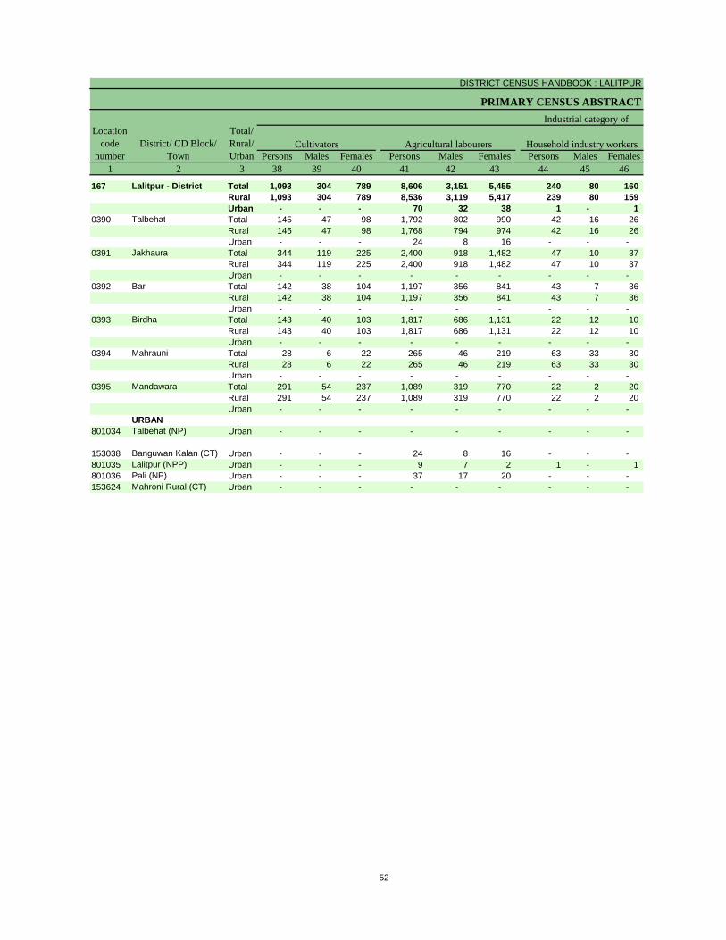
DISTRICT CENSUS HANDBOOK : LALITPUR
PRIMARY CENSUS ABSTRACT
Persons Males Females Persons Males Females Persons Males Females1 2 3 38 39 40 41 42 43 44 45 46
167 Lalitpur - District Total 1,093 304 789 8,606 3,151 5,455 240 80 160 Rural 1,093 304 789 8,536 3,119 5,417 239 80 159 Urban - - - 70 32 38 1 - 1
0390 Talbehat Total 145 47 98 1,792 802 990 42 16 26 Rural 145 47 98 1,768 794 974 42 16 26 Urban - - - 24 8 16 - - -
0391 Jakhaura Total 344 119 225 2,400 918 1,482 47 10 37 Rural 344 119 225 2,400 918 1,482 47 10 37 Urban - - - - - - - - -
0392 Bar Total 142 38 104 1,197 356 841 43 7 36 Rural 142 38 104 1,197 356 841 43 7 36 Urban - - - - - - - - -
0393 Birdha Total 143 40 103 1,817 686 1,131 22 12 10 Rural 143 40 103 1,817 686 1,131 22 12 10 Urban - - - - - - - - -
0394 Mahrauni Total 28 6 22 265 46 219 63 33 30 Rural 28 6 22 265 46 219 63 33 30 Urban - - - - - - - - -
0395 Mandawara Total 291 54 237 1,089 319 770 22 2 20 Rural 291 54 237 1,089 319 770 22 2 20 Urban - - - - - - - - -
URBAN801034 Talbehat (NP) Urban - - - - - - - - -
153038 Banguwan Kalan (CT) Urban - - - 24 8 16 - - - 801035 Lalitpur (NPP) Urban - - - 9 7 2 1 - 1 801036 Pali (NP) Urban - - - 37 17 20 - - - 153624 Mahroni Rural (CT) Urban - - - - - - - - -
Location code
numberDistrict/ CD Block/
Town
Total/ Rural/ Urban
Agricultural labourers
Industrial category of
Cultivators Household industry workers
52

PRIMARY CENSUS ABSTRACT
FOR SCHEDULED TRIBES
Persons Males Females Persons Males Females47 48 49 50 51 52 3 2 1
1,694 916 778 39,481 18,443 21,038 Total Lalitpur - District 1671,582 827 755 38,346 17,977 20,369 Rural
112 89 23 1,135 466 669 Urban515 307 208 8,057 3,629 4,428 Total Talbehat 0390459 256 203 7,687 3,490 4,197 Rural56 51 5 370 139 231 Urban
239 107 132 10,296 4,857 5,439 Total Jakhaura 0391239 107 132 10,296 4,857 5,439 Rural- - - - - - Urban211 127 84 4,885 2,303 2,582 Total Bar 0392211 127 84 4,885 2,303 2,582 Rural- - - - - - Urban373 155 218 8,976 4,220 4,756 Total Birdha 0393373 155 218 8,976 4,220 4,756 Rural- - - - - - Urban27 19 8 1,738 821 917 Total Mahrauni 039427 19 8 1,724 813 911 Rural
- - - 14 8 6 Urban273 163 110 4,778 2,294 2,484 Total Mandawara 0395273 163 110 4,778 2,294 2,484 Rural- - - - - - Urban
URBAN- - - 26 9 17 Urban Talbehat (NP) 801034
56 51 5 370 139 231 Urban Banguwan Kalan (CT) 15303851 34 17 509 204 305 Urban Lalitpur (NPP) 8010355 4 1 216 106 110 Urban Pali (NP) 801036
- - - 14 8 6 Urban Mahroni Rural (CT) 153624
Non-workersTotal/ Rural/ Urban
marginal workers
District/ CD Block/ Town
Location code
numberOther workers
53

Rural PCA-C.D. blocks wise Village Primary Census
Abstract
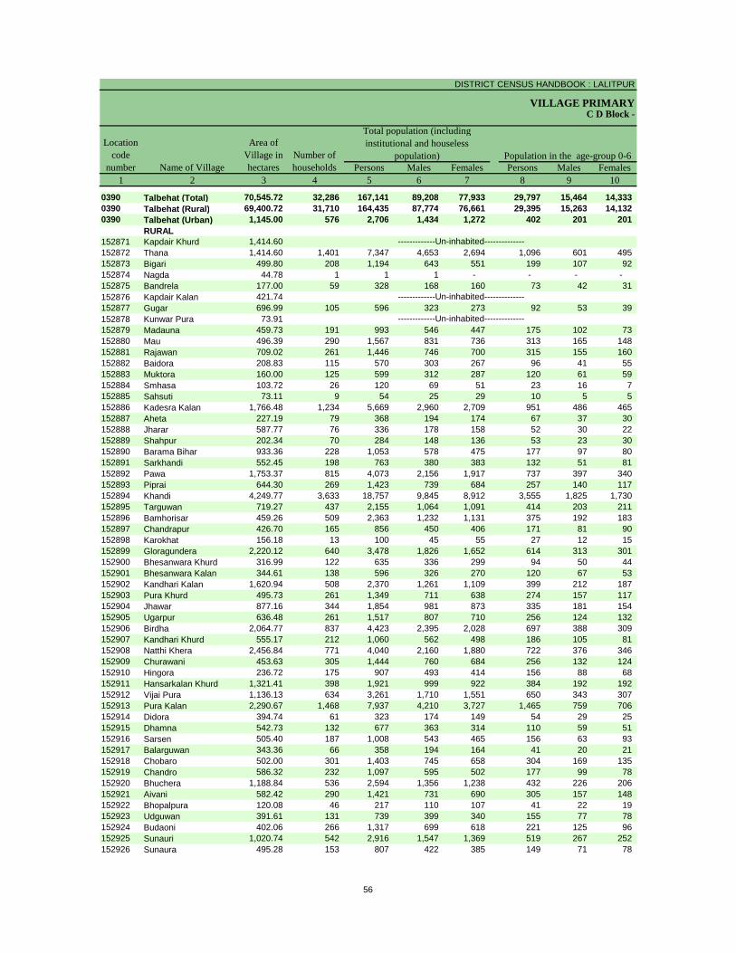
DISTRICT CENSUS HANDBOOK : LALITPUR
VILLAGE PRIMARY
Persons Males Females Persons Males Females1 2 3 4 5 6 7 8 9 10
0390 Talbehat (Total) 70,545.72 32,286 167,141 89,208 77,933 29,797 15,464 14,333 0390 Talbehat (Rural) 69,400.72 31,710 164,435 87,774 76,661 29,395 15,263 14,132 0390 Talbehat (Urban) 1,145.00 576 2,706 1,434 1,272 402 201 201
RURAL152871 Kapdair Khurd 1,414.60152872 Thana 1,414.60 1,401 7,347 4,653 2,694 1,096 601 495 152873 Bigari 499.80 208 1,194 643 551 199 107 92 152874 Nagda 44.78 1 1 1 - - - - 152875 Bandrela 177.00 59 328 168 160 73 42 31 152876 Kapdair Kalan 421.74152877 Gugar 696.99 105 596 323 273 92 53 39 152878 Kunwar Pura 73.91152879 Madauna 459.73 191 993 546 447 175 102 73 152880 Mau 496.39 290 1,567 831 736 313 165 148 152881 Rajawan 709.02 261 1,446 746 700 315 155 160 152882 Baidora 208.83 115 570 303 267 96 41 55 152883 Muktora 160.00 125 599 312 287 120 61 59 152884 Smhasa 103.72 26 120 69 51 23 16 7 152885 Sahsuti 73.11 9 54 25 29 10 5 5 152886 Kadesra Kalan 1,766.48 1,234 5,669 2,960 2,709 951 486 465 152887 Aheta 227.19 79 368 194 174 67 37 30 152888 Jharar 587.77 76 336 178 158 52 30 22 152889 Shahpur 202.34 70 284 148 136 53 23 30 152890 Barama Bihar 933.36 228 1,053 578 475 177 97 80 152891 Sarkhandi 552.45 198 763 380 383 132 51 81 152892 Pawa 1,753.37 815 4,073 2,156 1,917 737 397 340 152893 Piprai 644.30 269 1,423 739 684 257 140 117 152894 Khandi 4,249.77 3,633 18,757 9,845 8,912 3,555 1,825 1,730 152895 Targuwan 719.27 437 2,155 1,064 1,091 414 203 211 152896 Bamhorisar 459.26 509 2,363 1,232 1,131 375 192 183 152897 Chandrapur 426.70 165 856 450 406 171 81 90 152898 Karokhat 156.18 13 100 45 55 27 12 15 152899 Gloragundera 2,220.12 640 3,478 1,826 1,652 614 313 301 152900 Bhesanwara Khurd 316.99 122 635 336 299 94 50 44 152901 Bhesanwara Kalan 344.61 138 596 326 270 120 67 53 152902 Kandhari Kalan 1,620.94 508 2,370 1,261 1,109 399 212 187 152903 Pura Khurd 495.73 261 1,349 711 638 274 157 117 152904 Jhawar 877.16 344 1,854 981 873 335 181 154 152905 Ugarpur 636.48 261 1,517 807 710 256 124 132 152906 Birdha 2,064.77 837 4,423 2,395 2,028 697 388 309 152907 Kandhari Khurd 555.17 212 1,060 562 498 186 105 81 152908 Natthi Khera 2,456.84 771 4,040 2,160 1,880 722 376 346 152909 Churawani 453.63 305 1,444 760 684 256 132 124 152910 Hingora 236.72 175 907 493 414 156 88 68 152911 Hansarkalan Khurd 1,321.41 398 1,921 999 922 384 192 192 152912 Vijai Pura 1,136.13 634 3,261 1,710 1,551 650 343 307 152913 Pura Kalan 2,290.67 1,468 7,937 4,210 3,727 1,465 759 706 152914 Didora 394.74 61 323 174 149 54 29 25 152915 Dhamna 542.73 132 677 363 314 110 59 51 152916 Sarsen 505.40 187 1,008 543 465 156 63 93 152917 Balarguwan 343.36 66 358 194 164 41 20 21 152918 Chobaro 502.00 301 1,403 745 658 304 169 135 152919 Chandro 586.32 232 1,097 595 502 177 99 78 152920 Bhuchera 1,188.84 536 2,594 1,356 1,238 432 226 206 152921 Aivani 582.42 290 1,421 731 690 305 157 148 152922 Bhopalpura 120.08 46 217 110 107 41 22 19 152923 Udguwan 391.61 131 739 399 340 155 77 78 152924 Budaoni 402.06 266 1,317 699 618 221 125 96 152925 Sunauri 1,020.74 542 2,916 1,547 1,369 519 267 252 152926 Sunaura 495.28 153 807 422 385 149 71 78
-------------Un-inhabited--------------
-------------Un-inhabited--------------
-------------Un-inhabited--------------
C D Block -
Population in the age-group 0-6Number of householdsName of Village
Location code
number
Total population (including institutional and houseless
population)Area of
Village in hectares
56
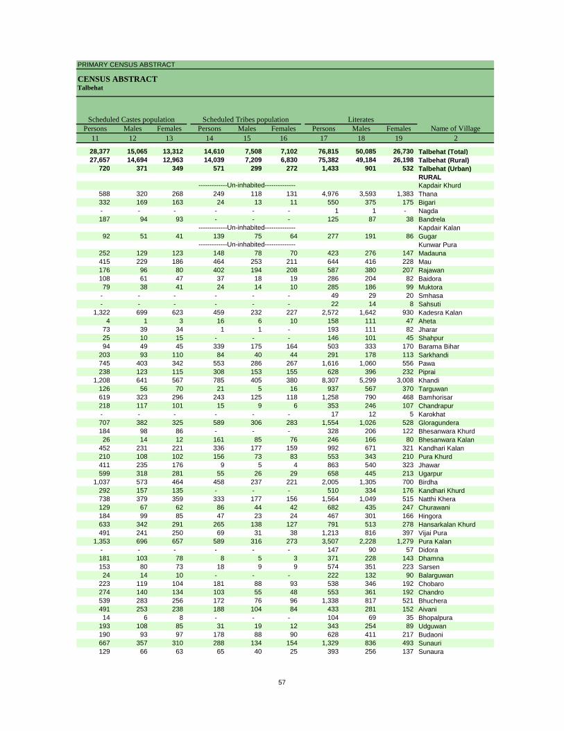
PRIMARY CENSUS ABSTRACT
CENSUS ABSTRACTTalbehat
Persons Males Females Persons Males Females Persons Males Females11 12 13 14 15 16 17 18 19 2
28,377 15,065 13,312 14,610 7,508 7,102 76,815 50,085 26,730 Talbehat (Total)27,657 14,694 12,963 14,039 7,209 6,830 75,382 49,184 26,198 Talbehat (Rural)
720 371 349 571 299 272 1,433 901 532 Talbehat (Urban)RURALKapdair Khurd
588 320 268 249 118 131 4,976 3,593 1,383 Thana332 169 163 24 13 11 550 375 175 Bigari- - - - - - 1 1 - Nagda187 94 93 - - - 125 87 38 Bandrela
Kapdair Kalan92 51 41 139 75 64 277 191 86 Gugar
Kunwar Pura252 129 123 148 78 70 423 276 147 Madauna415 229 186 464 253 211 644 416 228 Mau176 96 80 402 194 208 587 380 207 Rajawan108 61 47 37 18 19 286 204 82 Baidora79 38 41 24 14 10 285 186 99 Muktora
- - - - - - 49 29 20 Smhasa- - - - - - 22 14 8 Sahsuti
1,322 699 623 459 232 227 2,572 1,642 930 Kadesra Kalan4 1 3 16 6 10 158 111 47 Aheta
73 39 34 1 1 - 193 111 82 Jharar25 10 15 - - - 146 101 45 Shahpur94 49 45 339 175 164 503 333 170 Barama Bihar
203 93 110 84 40 44 291 178 113 Sarkhandi745 403 342 553 286 267 1,616 1,060 556 Pawa238 123 115 308 153 155 628 396 232 Piprai
1,208 641 567 785 405 380 8,307 5,299 3,008 Khandi126 56 70 21 5 16 937 567 370 Targuwan619 323 296 243 125 118 1,258 790 468 Bamhorisar218 117 101 15 9 6 353 246 107 Chandrapur- - - - - - 17 12 5 Karokhat707 382 325 589 306 283 1,554 1,026 528 Gloragundera184 98 86 - - - 328 206 122 Bhesanwara Khurd26 14 12 161 85 76 246 166 80 Bhesanwara Kalan
452 231 221 336 177 159 992 671 321 Kandhari Kalan210 108 102 156 73 83 553 343 210 Pura Khurd411 235 176 9 5 4 863 540 323 Jhawar599 318 281 55 26 29 658 445 213 Ugarpur
1,037 573 464 458 237 221 2,005 1,305 700 Birdha292 157 135 - - - 510 334 176 Kandhari Khurd738 379 359 333 177 156 1,564 1,049 515 Natthi Khera129 67 62 86 44 42 682 435 247 Churawani184 99 85 47 23 24 467 301 166 Hingora633 342 291 265 138 127 791 513 278 Hansarkalan Khurd491 241 250 69 31 38 1,213 816 397 Vijai Pura
1,353 696 657 589 316 273 3,507 2,228 1,279 Pura Kalan- - - - - - 147 90 57 Didora181 103 78 8 5 3 371 228 143 Dhamna153 80 73 18 9 9 574 351 223 Sarsen
24 14 10 - - - 222 132 90 Balarguwan223 119 104 181 88 93 538 346 192 Chobaro274 140 134 103 55 48 553 361 192 Chandro539 283 256 172 76 96 1,338 817 521 Bhuchera491 253 238 188 104 84 433 281 152 Aivani14 6 8 - - - 104 69 35 Bhopalpura
193 108 85 31 19 12 343 254 89 Udguwan190 93 97 178 88 90 628 411 217 Budaoni667 357 310 288 134 154 1,329 836 493 Sunauri129 66 63 65 40 25 393 256 137 Sunaura
-------------Un-inhabited--------------
-------------Un-inhabited--------------
-------------Un-inhabited--------------
Scheduled Castes population Scheduled Tribes populationName of Village
Literates
57
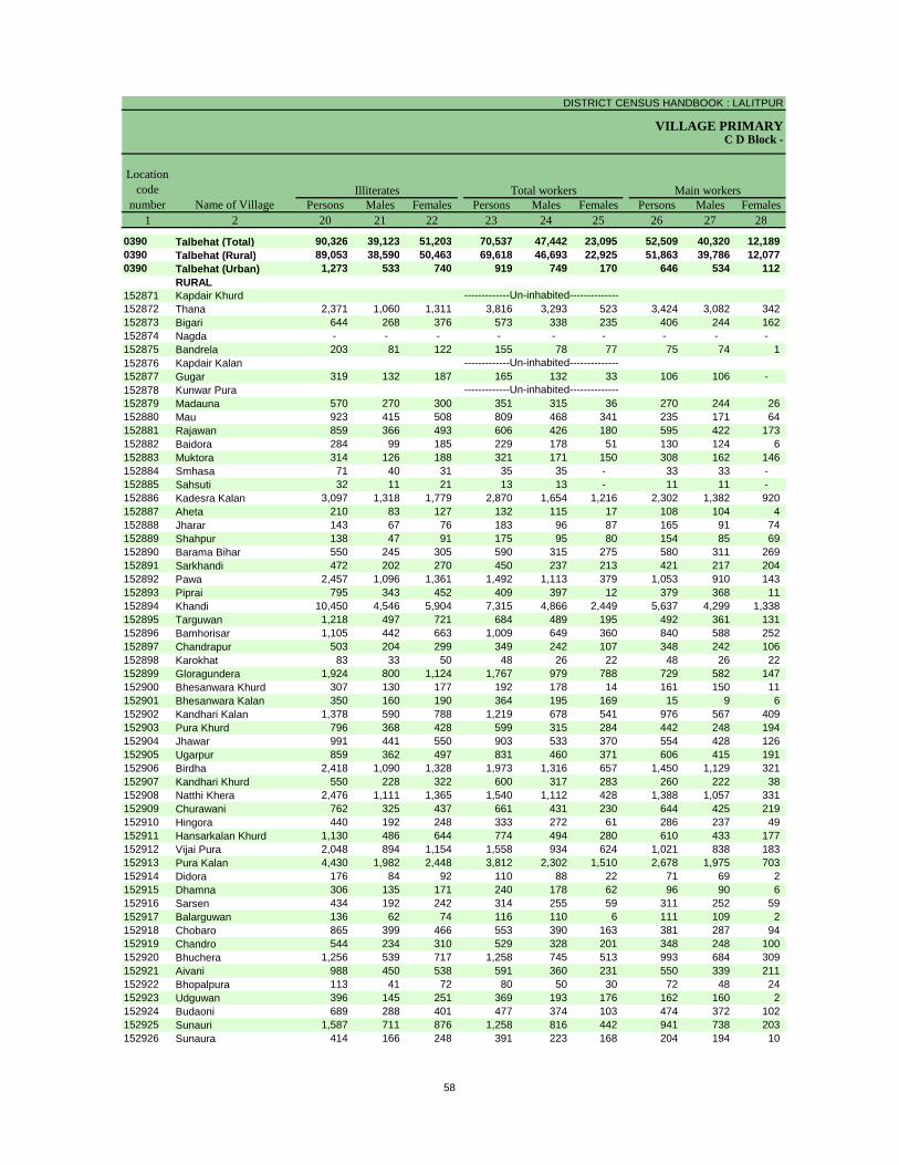
DISTRICT CENSUS HANDBOOK : LALITPUR
VILLAGE PRIMARYC D Block -
Persons Males Females Persons Males Females Persons Males Females1 2 20 21 22 23 24 25 26 27 28
0390 Talbehat (Total) 90,326 39,123 51,203 70,537 47,442 23,095 52,509 40,320 12,189 0390 Talbehat (Rural) 89,053 38,590 50,463 69,618 46,693 22,925 51,863 39,786 12,077 0390 Talbehat (Urban) 1,273 533 740 919 749 170 646 534 112
RURAL152871 Kapdair Khurd152872 Thana 2,371 1,060 1,311 3,816 3,293 523 3,424 3,082 342 152873 Bigari 644 268 376 573 338 235 406 244 162 152874 Nagda - - - - - - - - - 152875 Bandrela 203 81 122 155 78 77 75 74 1 152876 Kapdair Kalan152877 Gugar 319 132 187 165 132 33 106 106 - 152878 Kunwar Pura152879 Madauna 570 270 300 351 315 36 270 244 26 152880 Mau 923 415 508 809 468 341 235 171 64 152881 Rajawan 859 366 493 606 426 180 595 422 173 152882 Baidora 284 99 185 229 178 51 130 124 6 152883 Muktora 314 126 188 321 171 150 308 162 146 152884 Smhasa 71 40 31 35 35 - 33 33 - 152885 Sahsuti 32 11 21 13 13 - 11 11 - 152886 Kadesra Kalan 3,097 1,318 1,779 2,870 1,654 1,216 2,302 1,382 920 152887 Aheta 210 83 127 132 115 17 108 104 4 152888 Jharar 143 67 76 183 96 87 165 91 74 152889 Shahpur 138 47 91 175 95 80 154 85 69 152890 Barama Bihar 550 245 305 590 315 275 580 311 269 152891 Sarkhandi 472 202 270 450 237 213 421 217 204 152892 Pawa 2,457 1,096 1,361 1,492 1,113 379 1,053 910 143 152893 Piprai 795 343 452 409 397 12 379 368 11 152894 Khandi 10,450 4,546 5,904 7,315 4,866 2,449 5,637 4,299 1,338 152895 Targuwan 1,218 497 721 684 489 195 492 361 131 152896 Bamhorisar 1,105 442 663 1,009 649 360 840 588 252 152897 Chandrapur 503 204 299 349 242 107 348 242 106 152898 Karokhat 83 33 50 48 26 22 48 26 22 152899 Gloragundera 1,924 800 1,124 1,767 979 788 729 582 147 152900 Bhesanwara Khurd 307 130 177 192 178 14 161 150 11 152901 Bhesanwara Kalan 350 160 190 364 195 169 15 9 6 152902 Kandhari Kalan 1,378 590 788 1,219 678 541 976 567 409 152903 Pura Khurd 796 368 428 599 315 284 442 248 194 152904 Jhawar 991 441 550 903 533 370 554 428 126 152905 Ugarpur 859 362 497 831 460 371 606 415 191 152906 Birdha 2,418 1,090 1,328 1,973 1,316 657 1,450 1,129 321 152907 Kandhari Khurd 550 228 322 600 317 283 260 222 38 152908 Natthi Khera 2,476 1,111 1,365 1,540 1,112 428 1,388 1,057 331 152909 Churawani 762 325 437 661 431 230 644 425 219 152910 Hingora 440 192 248 333 272 61 286 237 49 152911 Hansarkalan Khurd 1,130 486 644 774 494 280 610 433 177 152912 Vijai Pura 2,048 894 1,154 1,558 934 624 1,021 838 183 152913 Pura Kalan 4,430 1,982 2,448 3,812 2,302 1,510 2,678 1,975 703 152914 Didora 176 84 92 110 88 22 71 69 2 152915 Dhamna 306 135 171 240 178 62 96 90 6 152916 Sarsen 434 192 242 314 255 59 311 252 59 152917 Balarguwan 136 62 74 116 110 6 111 109 2 152918 Chobaro 865 399 466 553 390 163 381 287 94 152919 Chandro 544 234 310 529 328 201 348 248 100 152920 Bhuchera 1,256 539 717 1,258 745 513 993 684 309 152921 Aivani 988 450 538 591 360 231 550 339 211 152922 Bhopalpura 113 41 72 80 50 30 72 48 24 152923 Udguwan 396 145 251 369 193 176 162 160 2 152924 Budaoni 689 288 401 477 374 103 474 372 102 152925 Sunauri 1,587 711 876 1,258 816 442 941 738 203 152926 Sunaura 414 166 248 391 223 168 204 194 10
-------------Un-inhabited--------------
-------------Un-inhabited--------------
-------------Un-inhabited--------------
Illiterates Total workers Main workersName of Village
Location code
number
58
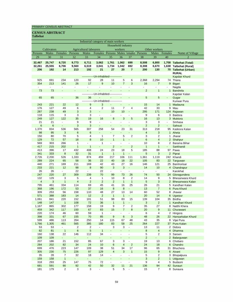
PRIMARY CENSUS ABSTRACT
CENSUS ABSTRACTTalbehat
Persons Males Females Persons Males Females Persons MalesFemales Persons Males Females29 30 31 32 33 34 35 36 37 38 39 40 2
32,467 25,747 6,720 9,773 6,711 3,062 1,761 1,062 699 8,508 6,800 1,708 Talbehat (Total)32,261 25,555 6,706 9,560 6,519 3,041 1,734 1,042 692 8,308 6,670 1,638 Talbehat (Rural)
206 192 14 213 192 21 27 20 7 200 130 70 Talbehat (Urban)RURALKapdair Khurd
925 691 234 120 92 28 11 5 6 2,368 2,294 74 Thana354 213 141 26 17 9 10 7 3 16 7 9 Bigari- - - - - - - - - - - - Nagda73 73 - - - - - - - 2 1 1 Bandrela
Kapdair Kalan65 65 - 36 36 - - - - 5 5 - Gugar
Kunwar Pura243 221 22 12 9 3 - - - 15 14 1 Madauna176 127 49 6 4 2 11 7 4 42 33 9 Mau287 238 49 3 3 - 10 10 - 295 171 124 Rajawan118 115 3 3 3 - - - - 9 6 3 Baidora249 127 122 35 19 16 8 3 5 16 13 3 Muktora21 21 - 9 9 - - - - 3 3 - Smhasa6 6 - 3 3 - - - - 2 2 - Sahsuti
1,370 834 536 565 307 258 54 23 31 313 218 95 Kadesra Kalan98 95 3 6 6 - - - - 4 3 1 Aheta
150 80 70 5 4 1 7 5 2 3 2 1 Jharar129 72 57 18 8 10 1 1 - 6 4 2 Shahpur569 303 266 1 - 1 - - - 10 8 2 Barama Bihar417 215 202 1 1 - 2 - 2 1 1 - Sarkhandi413 396 17 432 408 24 23 18 5 185 88 97 Pawa341 333 8 32 31 1 1 1 - 5 3 2 Piprai
2,726 2,200 526 1,333 874 459 217 106 111 1,361 1,119 242 Khandi289 224 65 58 36 22 40 18 22 105 83 22 Targuwan440 271 169 211 169 42 43 27 16 146 121 25 Bamhorisar233 221 12 98 8 90 3 3 - 14 10 4 Chandrapur26 26 - 22 - 22 - - - - - - Karokhat
247 220 27 309 239 70 99 73 26 74 50 24 Gloragundera132 129 3 5 4 1 10 8 2 14 9 5 Bhesanwara Khurd
4 3 1 4 2 2 2 1 1 5 3 2 Bhesanwara Kalan795 461 334 114 69 45 41 16 25 26 21 5 Kandhari Kalan368 196 172 53 37 16 8 8 - 13 7 6 Pura Khurd309 253 56 158 110 48 27 13 14 60 52 8 Jhawar571 388 183 14 12 2 1 1 - 20 14 6 Ugarpur
1,061 841 220 152 101 51 98 83 15 139 104 35 Birdha148 147 1 108 72 36 1 1 - 3 2 1 Kandhari Khurd
1,167 865 302 177 158 19 9 7 2 35 27 8 Natthi Khera459 342 117 150 67 83 15 7 8 20 9 11 Churawani220 174 46 60 59 1 - - - 6 4 2 Hingora398 331 67 155 70 85 9 6 3 48 26 22 Hansarkalan Khurd599 486 113 264 250 14 115 67 48 43 35 8 Vijai Pura
1,766 1,305 461 565 385 180 83 58 25 264 227 37 Pura Kalan53 53 - 2 2 - 3 3 - 13 11 2 Didora82 81 1 6 5 1 - - - 8 4 4 Dhamna
160 138 22 146 112 34 - - - 5 2 3 Sarsen109 109 - - - - - - - 2 - 2 Balarguwan207 186 21 152 85 67 3 3 - 19 13 6 Chobaro284 202 82 34 24 10 6 4 2 24 18 6 Chandro699 476 223 147 109 38 51 34 17 96 65 31 Bhuchera305 230 75 226 97 129 4 3 1 15 9 6 Aivani35 28 7 32 18 14 - - - 5 2 3 Bhopalpura
159 158 1 - - - - - - 3 2 1 Udguwan318 293 25 147 75 72 - - - 9 4 5 Budaoni681 591 90 92 42 50 32 11 21 136 94 42 Sunauri181 179 2 3 3 - 5 5 - 15 7 8 Sunaura
-------------Un-inhabited--------------
-------------Un-inhabited--------------
-------------Un-inhabited--------------
CultivatorsName of Village
Household industry workersAgricultural labourers
Industrial category of main workers
Other workers
59
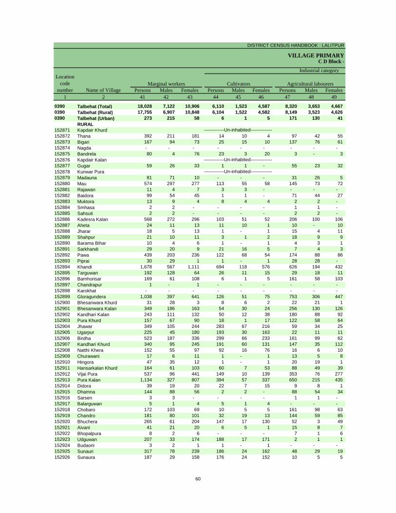
DISTRICT CENSUS HANDBOOK : LALITPUR
VILLAGE PRIMARYC D Block -
Persons Males Females Persons Males Females Persons Males Females1 2 41 42 43 44 45 46 47 48 49
0390 Talbehat (Total) 18,028 7,122 10,906 6,110 1,523 4,587 8,320 3,653 4,667 0390 Talbehat (Rural) 17,755 6,907 10,848 6,104 1,522 4,582 8,149 3,523 4,626 0390 Talbehat (Urban) 273 215 58 6 1 5 171 130 41
RURAL152871 Kapdair Khurd152872 Thana 392 211 181 14 10 4 97 42 55 152873 Bigari 167 94 73 25 15 10 137 76 61 152874 Nagda - - - - - - - - - 152875 Bandrela 80 4 76 23 3 20 3 - 3 152876 Kapdair Kalan152877 Gugar 59 26 33 1 1 - 55 23 32 152878 Kunwar Pura152879 Madauna 81 71 10 - - - 31 26 5 152880 Mau 574 297 277 113 55 58 145 73 72 152881 Rajawan 11 4 7 3 3 - - - - 152882 Baidora 99 54 45 1 1 - 71 44 27 152883 Muktora 13 9 4 8 4 4 2 2 - 152884 Smhasa 2 2 - - - - 1 1 - 152885 Sahsuti 2 2 - - - - 2 2 - 152886 Kadesra Kalan 568 272 296 103 51 52 206 100 106 152887 Aheta 24 11 13 11 10 1 10 - 10 152888 Jharar 18 5 13 1 - 1 15 4 11 152889 Shahpur 21 10 11 3 1 2 18 9 9 152890 Barama Bihar 10 4 6 1 - 1 4 3 1 152891 Sarkhandi 29 20 9 21 16 5 7 4 3 152892 Pawa 439 203 236 122 68 54 174 88 86 152893 Piprai 30 29 1 1 - 1 28 28 - 152894 Khandi 1,678 567 1,111 694 118 576 626 194 432 152895 Targuwan 192 128 64 26 11 15 29 18 11 152896 Bamhorisar 169 61 108 6 1 5 161 58 103 152897 Chandrapur 1 - 1 - - - - - - 152898 Karokhat - - - - - - - - - 152899 Gloragundera 1,038 397 641 126 51 75 753 306 447 152900 Bhesanwara Khurd 31 28 3 8 6 2 22 21 1 152901 Bhesanwara Kalan 349 186 163 54 30 24 256 130 126 152902 Kandhari Kalan 243 111 132 50 12 38 180 88 92 152903 Pura Khurd 157 67 90 18 1 17 122 58 64 152904 Jhawar 349 105 244 283 67 216 59 34 25 152905 Ugarpur 225 45 180 193 30 163 22 11 11 152906 Birdha 523 187 336 299 66 233 161 99 62 152907 Kandhari Khurd 340 95 245 191 60 131 147 35 112 152908 Natthi Khera 152 55 97 92 16 76 16 6 10 152909 Churawani 17 6 11 1 - 1 13 5 8 152910 Hingora 47 35 12 1 - 1 20 19 1 152911 Hansarkalan Khurd 164 61 103 60 7 53 88 49 39 152912 Vijai Pura 537 96 441 149 10 139 353 76 277 152913 Pura Kalan 1,134 327 807 394 57 337 650 215 435 152914 Didora 39 19 20 22 7 15 9 8 1 152915 Dhamna 144 88 56 2 2 - 88 54 34 152916 Sarsen 3 3 - - - - 1 1 - 152917 Balarguwan 5 1 4 5 1 4 - - - 152918 Chobaro 172 103 69 10 5 5 161 98 63 152919 Chandro 181 80 101 32 19 13 144 59 85 152920 Bhuchera 265 61 204 147 17 130 52 3 49 152921 Aivani 41 21 20 6 5 1 15 8 7 152922 Bhopalpura 8 2 6 - - - 7 1 6 152923 Udguwan 207 33 174 188 17 171 2 1 1 152924 Budaoni 3 2 1 1 - 1 - - - 152925 Sunauri 317 78 239 186 24 162 48 29 19 152926 Sunaura 187 29 158 176 24 152 10 5 5
-------------Un-inhabited--------------
-------------Un-inhabited--------------
-------------Un-inhabited--------------
Location code
number Name of VillageMarginal workers Cultivators Agricultural labourers
Industrial category
60

PRIMARY CENSUS ABSTRACT
CENSUS ABSTRACTTalbehat
Persons Males Females Persons Males Females Persons Males Females50 51 52 53 54 55 56 57 58 2 1
821 340 481 2,777 1,606 1,171 96,604 41,766 54,838 Talbehat (Total) 0390811 335 476 2,691 1,527 1,164 94,817 41,081 53,736 Talbehat (Rural) 039010 5 5 86 79 7 1,787 685 1,102 Talbehat (Urban) 0390
RURALKapdair Khurd 152871
22 7 15 259 152 107 3,531 1,360 2,171 Thana 1528723 1 2 2 2 - 621 305 316 Bigari 152873
- - - - - - 1 1 - Nagda 152874- - - 54 1 53 173 90 83 Bandrela 152875
Kapdair Kalan 1528761 - 1 2 2 - 431 191 240 Gugar 152877
Kunwar Pura 152878- - - 50 45 5 642 231 411 Madauna 15287955 29 26 261 140 121 758 363 395 Mau 1528803 - 3 5 1 4 840 320 520 Rajawan 152881
22 5 17 5 4 1 341 125 216 Baidora 152882- - - 3 3 - 278 141 137 Muktora 152883- - - 1 1 - 85 34 51 Smhasa 152884- - - - - - 41 12 29 Sahsuti 15288587 17 70 172 104 68 2,799 1,306 1,493 Kadesra Kalan 1528862 - 2 1 1 - 236 79 157 Aheta 1528871 1 - 1 - 1 153 82 71 Jharar 152888
- - - - - - 109 53 56 Shahpur 1528891 - 1 4 1 3 463 263 200 Barama Bihar 152890
- - - 1 - 1 313 143 170 Sarkhandi 15289146 20 26 97 27 70 2,581 1,043 1,538 Pawa 1528921 1 - - - - 1,014 342 672 Piprai 152893
41 17 24 317 238 79 11,442 4,979 6,463 Khandi 1528944 - 4 133 99 34 1,471 575 896 Targuwan 1528951 1 - 1 1 - 1,354 583 771 Bamhorisar 152896
- - - 1 - 1 507 208 299 Chandrapur 152897- - - - - - 52 19 33 Karokhat 15289858 11 47 101 29 72 1,711 847 864 Gloragundera 152899
- - - 1 1 - 443 158 285 Bhesanwara Khurd 15290033 23 10 6 3 3 232 131 101 Bhesanwara Kalan 1529016 6 - 7 5 2 1,151 583 568 Kandhari Kalan 1529027 2 5 10 6 4 750 396 354 Pura Khurd 152903
- - - 7 4 3 951 448 503 Jhawar 1529045 1 4 5 3 2 686 347 339 Ugarpur 1529059 2 7 54 20 34 2,450 1,079 1,371 Birdha 152906
- - - 2 - 2 460 245 215 Kandhari Khurd 1529079 8 1 35 25 10 2,500 1,048 1,452 Natthi Khera 1529083 1 2 - - - 783 329 454 Churawani 1529091 1 - 25 15 10 574 221 353 Hingora 152910
15 4 11 1 1 - 1,147 505 642 Hansarkalan Khurd 15291111 1 10 24 9 15 1,703 776 927 Vijai Pura 15291234 11 23 56 44 12 4,125 1,908 2,217 Pura Kalan 1529132 - 2 6 4 2 213 86 127 Didora 152914
43 24 19 11 8 3 437 185 252 Dhamna 1529152 2 - - - - 694 288 406 Sarsen 152916
- - - - - - 242 84 158 Balarguwan 152917- - - 1 - 1 850 355 495 Chobaro 152918
1 1 - 4 1 3 568 267 301 Chandro 15291915 8 7 51 33 18 1,336 611 725 Bhuchera 1529201 - 1 19 8 11 830 371 459 Aivani 152921
- - - 1 1 - 137 60 77 Bhopalpura 1529225 3 2 12 12 - 370 206 164 Udguwan 152923
- - - 2 2 - 840 325 515 Budaoni 15292413 3 10 70 22 48 1,658 731 927 Sunauri 1529251 - 1 - - - 416 199 217 Sunaura 152926
-------------Un-inhabited--------------
-------------Un-inhabited--------------
-------------Un-inhabited--------------
Non-workers
of marginal workersLocation
code number
Household industry workersName of Village
Other workers
61
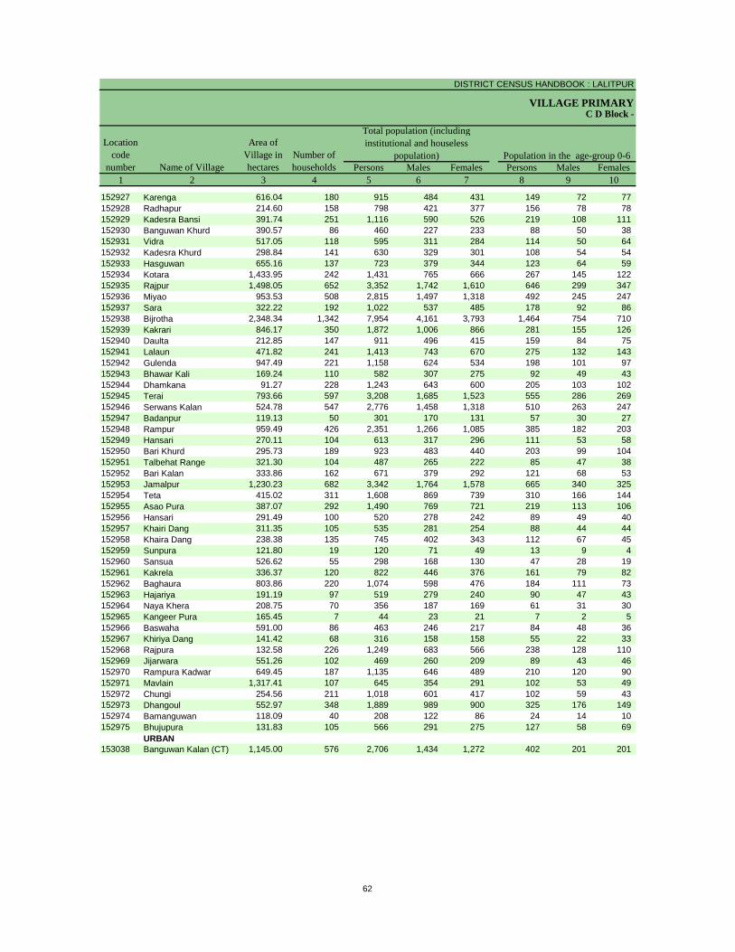
DISTRICT CENSUS HANDBOOK : LALITPUR
VILLAGE PRIMARY
Persons Males Females Persons Males Females1 2 3 4 5 6 7 8 9 10
C D Block -
Population in the age-group 0-6Number of householdsName of Village
Location code
number
Total population (including institutional and houseless
population)Area of
Village in hectares
152927 Karenga 616.04 180 915 484 431 149 72 77 152928 Radhapur 214.60 158 798 421 377 156 78 78 152929 Kadesra Bansi 391.74 251 1,116 590 526 219 108 111 152930 Banguwan Khurd 390.57 86 460 227 233 88 50 38 152931 Vidra 517.05 118 595 311 284 114 50 64 152932 Kadesra Khurd 298.84 141 630 329 301 108 54 54 152933 Hasguwan 655.16 137 723 379 344 123 64 59 152934 Kotara 1,433.95 242 1,431 765 666 267 145 122 152935 Rajpur 1,498.05 652 3,352 1,742 1,610 646 299 347 152936 Miyao 953.53 508 2,815 1,497 1,318 492 245 247 152937 Sara 322.22 192 1,022 537 485 178 92 86 152938 Bijrotha 2,348.34 1,342 7,954 4,161 3,793 1,464 754 710 152939 Kakrari 846.17 350 1,872 1,006 866 281 155 126 152940 Daulta 212.85 147 911 496 415 159 84 75 152941 Lalaun 471.82 241 1,413 743 670 275 132 143 152942 Gulenda 947.49 221 1,158 624 534 198 101 97 152943 Bhawar Kali 169.24 110 582 307 275 92 49 43 152944 Dhamkana 91.27 228 1,243 643 600 205 103 102 152945 Terai 793.66 597 3,208 1,685 1,523 555 286 269 152946 Serwans Kalan 524.78 547 2,776 1,458 1,318 510 263 247 152947 Badanpur 119.13 50 301 170 131 57 30 27 152948 Rampur 959.49 426 2,351 1,266 1,085 385 182 203 152949 Hansari 270.11 104 613 317 296 111 53 58 152950 Bari Khurd 295.73 189 923 483 440 203 99 104 152951 Talbehat Range 321.30 104 487 265 222 85 47 38 152952 Bari Kalan 333.86 162 671 379 292 121 68 53 152953 Jamalpur 1,230.23 682 3,342 1,764 1,578 665 340 325 152954 Teta 415.02 311 1,608 869 739 310 166 144 152955 Asao Pura 387.07 292 1,490 769 721 219 113 106 152956 Hansari 291.49 100 520 278 242 89 49 40 152957 Khairi Dang 311.35 105 535 281 254 88 44 44 152958 Khaira Dang 238.38 135 745 402 343 112 67 45 152959 Sunpura 121.80 19 120 71 49 13 9 4 152960 Sansua 526.62 55 298 168 130 47 28 19 152961 Kakrela 336.37 120 822 446 376 161 79 82 152962 Baghaura 803.86 220 1,074 598 476 184 111 73 152963 Hajariya 191.19 97 519 279 240 90 47 43 152964 Naya Khera 208.75 70 356 187 169 61 31 30 152965 Kangeer Pura 165.45 7 44 23 21 7 2 5 152966 Baswaha 591.00 86 463 246 217 84 48 36 152967 Khiriya Dang 141.42 68 316 158 158 55 22 33 152968 Rajpura 132.58 226 1,249 683 566 238 128 110 152969 Jijarwara 551.26 102 469 260 209 89 43 46 152970 Rampura Kadwar 649.45 187 1,135 646 489 210 120 90 152971 Mavlain 1,317.41 107 645 354 291 102 53 49 152972 Chungi 254.56 211 1,018 601 417 102 59 43 152973 Dhangoul 552.97 348 1,889 989 900 325 176 149 152974 Bamanguwan 118.09 40 208 122 86 24 14 10 152975 Bhujupura 131.83 105 566 291 275 127 58 69
URBAN153038 Banguwan Kalan (CT) 1,145.00 576 2,706 1,434 1,272 402 201 201
62

PRIMARY CENSUS ABSTRACT
CENSUS ABSTRACTTalbehat
Persons Males Females Persons Males Females Persons Males Females11 12 13 14 15 16 17 18 19 2
Scheduled Castes population Scheduled Tribes populationName of Village
Literates
306 171 135 200 102 98 468 298 170 Karenga197 110 87 78 39 39 363 250 113 Radhapur242 133 109 57 31 26 578 363 215 Kadesra Bansi40 23 17 - - - 236 135 101 Banguwan Khurd
- - - 174 89 85 286 191 95 Vidra15 8 7 86 44 42 316 213 103 Kadesra Khurd
162 94 68 120 62 58 279 188 91 Hasguwan307 161 146 298 159 139 654 428 226 Kotara839 448 391 542 270 272 1,341 918 423 Rajpur436 234 202 226 109 117 1,334 873 461 Miyao- - - 271 139 132 456 288 168 Sara
1,343 711 632 221 114 107 3,720 2,494 1,226 Bijrotha562 290 272 73 45 28 1,021 645 376 Kakrari227 128 99 71 33 38 471 321 150 Daulta340 184 156 219 104 115 635 413 222 Lalaun
43 23 20 241 133 108 434 283 151 Gulenda142 71 71 - - - 314 211 103 Bhawar Kali284 141 143 - - - 636 399 237 Dhamkana455 233 222 21 11 10 1,636 1,055 581 Terai428 226 202 701 351 350 1,353 847 506 Serwans Kalan- - - - - - 116 85 31 Badanpur212 115 97 179 83 96 1,073 721 352 Rampur61 28 33 6 3 3 312 198 114 Hansari
270 144 126 - - - 445 269 176 Bari Khurd8 2 6 - - - 221 154 67 Talbehat Range
190 109 81 20 11 9 385 257 128 Bari Kalan589 320 269 406 216 190 851 591 260 Jamalpur158 91 67 103 58 45 584 397 187 Teta430 223 207 - - - 916 528 388 Asao Pura
3 2 1 123 69 54 246 153 93 Hansari52 30 22 - - - 297 173 124 Khairi Dang33 19 14 31 18 13 401 250 151 Khaira Dang
- - - - - - 56 38 18 Sunpura31 19 12 - - - 121 75 46 Sansua21 11 10 119 67 52 330 208 122 Kakrela
306 162 144 - - - 410 254 156 Baghaura- - - 145 76 69 185 129 56 Hajariya49 24 25 85 42 43 116 72 44 Naya Khera
- - - - - - 21 11 10 Kangeer Pura40 24 16 - - - 213 134 79 Baswaha
- - - 121 56 65 122 83 39 Khiriya Dang392 211 181 45 29 16 557 366 191 Rajpura54 32 22 60 32 28 243 156 87 Jijarwara
194 113 81 227 115 112 532 355 177 Rampura Kadwar195 105 90 74 43 31 223 160 63 Mavlain142 88 54 - - - 438 314 124 Chungi183 107 76 - - - 986 612 374 Dhangoul
7 4 3 - - - 132 85 47 Bamanguwan41 19 22 - - - 209 135 74 Bhujupura
URBAN720 371 349 571 299 272 1,433 901 532 Banguwan Kalan (CT)
63
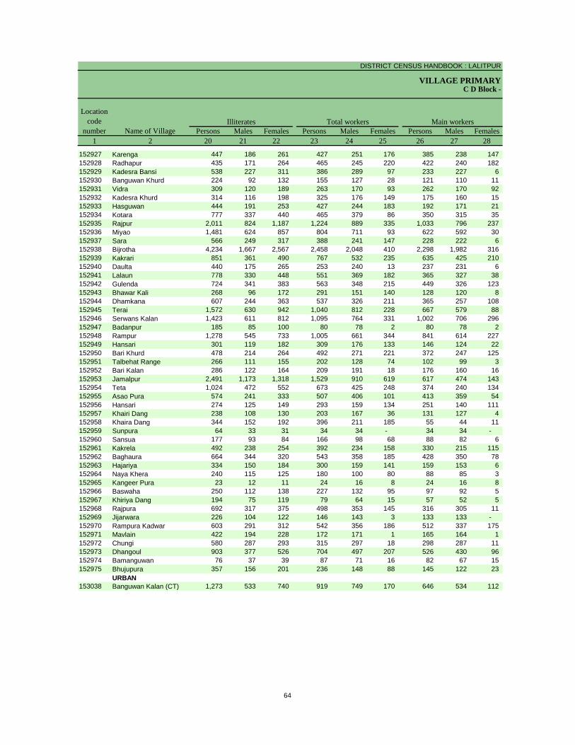
DISTRICT CENSUS HANDBOOK : LALITPUR
VILLAGE PRIMARYC D Block -
Persons Males Females Persons Males Females Persons Males Females1 2 20 21 22 23 24 25 26 27 28
Illiterates Total workers Main workersName of Village
Location code
number
152927 Karenga 447 186 261 427 251 176 385 238 147 152928 Radhapur 435 171 264 465 245 220 422 240 182 152929 Kadesra Bansi 538 227 311 386 289 97 233 227 6 152930 Banguwan Khurd 224 92 132 155 127 28 121 110 11 152931 Vidra 309 120 189 263 170 93 262 170 92 152932 Kadesra Khurd 314 116 198 325 176 149 175 160 15 152933 Hasguwan 444 191 253 427 244 183 192 171 21 152934 Kotara 777 337 440 465 379 86 350 315 35 152935 Rajpur 2,011 824 1,187 1,224 889 335 1,033 796 237 152936 Miyao 1,481 624 857 804 711 93 622 592 30 152937 Sara 566 249 317 388 241 147 228 222 6 152938 Bijrotha 4,234 1,667 2,567 2,458 2,048 410 2,298 1,982 316 152939 Kakrari 851 361 490 767 532 235 635 425 210 152940 Daulta 440 175 265 253 240 13 237 231 6 152941 Lalaun 778 330 448 551 369 182 365 327 38 152942 Gulenda 724 341 383 563 348 215 449 326 123 152943 Bhawar Kali 268 96 172 291 151 140 128 120 8 152944 Dhamkana 607 244 363 537 326 211 365 257 108 152945 Terai 1,572 630 942 1,040 812 228 667 579 88 152946 Serwans Kalan 1,423 611 812 1,095 764 331 1,002 706 296 152947 Badanpur 185 85 100 80 78 2 80 78 2 152948 Rampur 1,278 545 733 1,005 661 344 841 614 227 152949 Hansari 301 119 182 309 176 133 146 124 22 152950 Bari Khurd 478 214 264 492 271 221 372 247 125 152951 Talbehat Range 266 111 155 202 128 74 102 99 3 152952 Bari Kalan 286 122 164 209 191 18 176 160 16 152953 Jamalpur 2,491 1,173 1,318 1,529 910 619 617 474 143 152954 Teta 1,024 472 552 673 425 248 374 240 134 152955 Asao Pura 574 241 333 507 406 101 413 359 54 152956 Hansari 274 125 149 293 159 134 251 140 111 152957 Khairi Dang 238 108 130 203 167 36 131 127 4 152958 Khaira Dang 344 152 192 396 211 185 55 44 11 152959 Sunpura 64 33 31 34 34 - 34 34 - 152960 Sansua 177 93 84 166 98 68 88 82 6 152961 Kakrela 492 238 254 392 234 158 330 215 115 152962 Baghaura 664 344 320 543 358 185 428 350 78 152963 Hajariya 334 150 184 300 159 141 159 153 6 152964 Naya Khera 240 115 125 180 100 80 88 85 3 152965 Kangeer Pura 23 12 11 24 16 8 24 16 8 152966 Baswaha 250 112 138 227 132 95 97 92 5 152967 Khiriya Dang 194 75 119 79 64 15 57 52 5 152968 Rajpura 692 317 375 498 353 145 316 305 11 152969 Jijarwara 226 104 122 146 143 3 133 133 - 152970 Rampura Kadwar 603 291 312 542 356 186 512 337 175 152971 Mavlain 422 194 228 172 171 1 165 164 1 152972 Chungi 580 287 293 315 297 18 298 287 11 152973 Dhangoul 903 377 526 704 497 207 526 430 96 152974 Bamanguwan 76 37 39 87 71 16 82 67 15 152975 Bhujupura 357 156 201 236 148 88 145 122 23
URBAN153038 Banguwan Kalan (CT) 1,273 533 740 919 749 170 646 534 112
64

PRIMARY CENSUS ABSTRACT
CENSUS ABSTRACTTalbehat
Persons Males Females Persons Males Females Persons MalesFemales Persons Males Females29 30 31 32 33 34 35 36 37 38 39 40 2
CultivatorsName of Village
Household industry workersAgricultural labourers
Industrial category of main workers
Other workers
366 229 137 2 1 1 1 - 1 16 8 8 Karenga- - - 386 236 150 29 1 28 7 3 4 Radhapur210 209 1 6 6 - - - - 17 12 5 Kadesra Bansi101 96 5 3 3 - - - - 17 11 6 Banguwan Khurd164 155 9 1 - 1 - - - 97 15 82 Vidra104 99 5 51 48 3 2 1 1 18 12 6 Kadesra Khurd160 143 17 26 22 4 1 1 - 5 5 - Hasguwan215 205 10 108 91 17 15 13 2 12 6 6 Kotara843 662 181 114 86 28 20 12 8 56 36 20 Rajpur491 480 11 74 70 4 4 4 - 53 38 15 Miyao205 201 4 13 13 - - - - 10 8 2 Sara
1,353 1,234 119 525 376 149 58 43 15 362 329 33 Bijrotha574 385 189 5 4 1 4 1 3 52 35 17 Kakrari183 178 5 17 17 - 3 3 - 34 33 1 Daulta227 205 22 100 91 9 1 - 1 37 31 6 Lalaun235 193 42 66 53 13 17 10 7 131 70 61 Gulenda105 102 3 8 7 1 - - - 15 11 4 Bhawar Kali281 185 96 16 14 2 5 5 - 63 53 10 Dhamkana467 410 57 75 59 16 16 16 - 109 94 15 Terai239 212 27 342 170 172 154 98 56 267 226 41 Serwans Kalan78 77 1 - - - - - - 2 1 1 Badanpur
529 442 87 63 44 19 82 28 54 167 100 67 Rampur95 91 4 24 13 11 5 5 - 22 15 7 Hansari
104 72 32 233 146 87 10 8 2 25 21 4 Bari Khurd64 64 - - - - - - - 38 35 3 Talbehat Range96 95 1 3 3 - 11 7 4 66 55 11 Bari Kalan
370 312 58 66 54 12 85 50 35 96 58 38 Jamalpur153 120 33 154 76 78 21 10 11 46 34 12 Teta276 269 7 3 2 1 12 8 4 122 80 42 Asao Pura236 132 104 - - - 11 6 5 4 2 2 Hansari53 53 - 45 45 - 8 7 1 25 22 3 Khairi Dang46 41 5 2 2 - 5 1 4 2 - 2 Khaira Dang17 17 - 17 17 - - - - - - - Sunpura85 80 5 - - - - - - 3 2 1 Sansua
109 77 32 82 46 36 4 3 1 135 89 46 Kakrela410 335 75 6 6 - 3 3 - 9 6 3 Baghaura93 90 3 61 60 1 - - - 5 3 2 Hajariya68 65 3 8 8 - 8 8 - 4 4 - Naya Khera23 15 8 1 1 - - - - - - - Kangeer Pura94 91 3 - - - - - - 3 1 2 Baswaha56 52 4 1 - 1 - - - - - - Khiriya Dang
263 262 1 30 29 1 6 6 - 17 8 9 Rajpura127 127 - - - - 3 3 - 3 3 - Jijarwara157 146 11 306 172 134 41 14 27 8 5 3 Rampura Kadwar121 120 1 43 43 - - - - 1 1 - Mavlain292 283 9 - - - 1 1 - 5 3 2 Chungi385 320 65 67 54 13 25 20 5 49 36 13 Dhangoul33 30 3 32 25 7 - - - 17 12 5 Bamanguwan70 62 8 65 52 13 - - - 10 8 2 Bhujupura
URBAN206 192 14 213 192 21 27 20 7 200 130 70 Banguwan Kalan (CT)
65

DISTRICT CENSUS HANDBOOK : LALITPUR
VILLAGE PRIMARYC D Block -
Persons Males Females Persons Males Females Persons Males Females1 2 41 42 43 44 45 46 47 48 49
Location code
number Name of VillageMarginal workers Cultivators Agricultural labourers
Industrial category
152927 Karenga 42 13 29 2 1 1 34 10 24 152928 Radhapur 43 5 38 - - - 36 4 32 152929 Kadesra Bansi 153 62 91 96 31 65 32 20 12 152930 Banguwan Khurd 34 17 17 14 5 9 17 12 5 152931 Vidra 1 - 1 - - - - - - 152932 Kadesra Khurd 150 16 134 89 4 85 59 12 47 152933 Hasguwan 235 73 162 136 14 122 86 51 35 152934 Kotara 115 64 51 19 11 8 85 48 37 152935 Rajpur 191 93 98 49 25 24 123 60 63 152936 Miyao 182 119 63 21 16 5 134 82 52 152937 Sara 160 19 141 137 12 125 12 - 12 152938 Bijrotha 160 66 94 69 10 59 55 28 27 152939 Kakrari 132 107 25 83 73 10 33 19 14 152940 Daulta 16 9 7 6 4 2 6 3 3 152941 Lalaun 186 42 144 55 3 52 129 39 90 152942 Gulenda 114 22 92 17 12 5 88 5 83 152943 Bhawar Kali 163 31 132 7 4 3 152 27 125 152944 Dhamkana 172 69 103 123 36 87 29 19 10 152945 Terai 373 233 140 59 7 52 240 173 67 152946 Serwans Kalan 93 58 35 17 8 9 71 46 25 152947 Badanpur - - - - - - - - - 152948 Rampur 164 47 117 104 24 80 31 20 11 152949 Hansari 163 52 111 2 2 - 151 46 105 152950 Bari Khurd 120 24 96 57 2 55 47 11 36 152951 Talbehat Range 100 29 71 10 2 8 81 22 59 152952 Bari Kalan 33 31 2 2 2 - 17 17 - 152953 Jamalpur 912 436 476 62 17 45 659 295 364 152954 Teta 299 185 114 174 99 75 40 27 13 152955 Asao Pura 94 47 47 53 17 36 10 8 2 152956 Hansari 42 19 23 7 1 6 18 9 9 152957 Khairi Dang 72 40 32 - - - 2 2 - 152958 Khaira Dang 341 167 174 87 62 25 116 71 45 152959 Sunpura - - - - - - - - - 152960 Sansua 78 16 62 56 1 55 11 6 5 152961 Kakrela 62 19 43 5 - 5 13 6 7 152962 Baghaura 115 8 107 104 5 99 11 3 8 152963 Hajariya 141 6 135 81 1 80 57 4 53 152964 Naya Khera 92 15 77 56 6 50 23 6 17 152965 Kangeer Pura - - - - - - - - - 152966 Baswaha 130 40 90 111 27 84 16 10 6 152967 Khiriya Dang 22 12 10 - - - 19 9 10 152968 Rajpura 182 48 134 131 36 95 33 8 25 152969 Jijarwara 13 10 3 3 2 1 1 - 1 152970 Rampura Kadwar 30 19 11 - - - 20 16 4 152971 Mavlain 7 7 - - - - 1 1 - 152972 Chungi 17 10 7 10 7 3 2 - 2 152973 Dhangoul 178 67 111 79 17 62 78 43 35 152974 Bamanguwan 5 4 1 - - - 1 - 1 152975 Bhujupura 91 26 65 40 14 26 49 11 38
URBAN153038 Banguwan Kalan (CT) 273 215 58 6 1 5 171 130 41
66
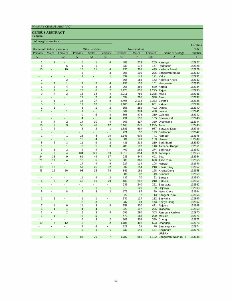
PRIMARY CENSUS ABSTRACT
CENSUS ABSTRACTTalbehat
Persons Males Females Persons Males Females Persons Males Females50 51 52 53 54 55 56 57 58 2 1
Non-workers
of marginal workersLocation
code number
Household industry workersName of Village
Other workers
1 1 - 5 1 4 488 233 255 Karenga 1529276 - 6 1 1 - 333 176 157 Radhapur 152928
10 - 10 15 11 4 730 301 429 Kadesra Bansi 152929- - - 3 - 3 305 100 205 Banguwan Khurd 152930- - - 1 - 1 332 141 191 Vidra 152931
2 - 2 - - - 305 153 152 Kadesra Khurd 1529324 3 1 9 5 4 296 135 161 Hasguwan 1529336 2 4 5 3 2 966 386 580 Kotara 1529346 2 4 13 6 7 2,128 853 1,275 Rajpur 1529359 7 2 18 14 4 2,011 786 1,225 Miyao 152936
- - - 11 7 4 634 296 338 Sara 1529371 1 - 35 27 8 5,496 2,113 3,383 Bijrotha 1529385 5 - 11 10 1 1,105 474 631 Kakrari 1529391 1 - 3 1 2 658 256 402 Daulta 1529401 - 1 1 - 1 862 374 488 Lalaun 152941
- - - 9 5 4 595 276 319 Gulenda 152942- - - 4 - 4 291 156 135 Bhawar Kali 152943
6 4 2 14 10 4 706 317 389 Dhamkana 15294416 7 9 58 46 12 2,168 873 1,295 Terai 1529452 2 - 3 2 1 1,681 694 987 Serwans Kalan 152946
- - - - - - 221 92 129 Badanpur 1529471 - 1 28 3 25 1,346 605 741 Rampur 152948
- - - 10 4 6 304 141 163 Hansari 1529495 2 3 11 9 2 431 212 219 Bari Khurd 1529501 - 1 8 5 3 285 137 148 Talbehat Range 1529515 3 2 9 9 - 462 188 274 Bari Kalan 1529527 3 4 184 121 63 1,813 854 959 Jamalpur 152953
24 15 9 61 44 17 935 444 491 Teta 15295421 17 4 10 5 5 983 363 620 Asao Pura 152955
- - - 17 9 8 227 119 108 Hansari 15295613 13 - 57 25 32 332 114 218 Khairi Dang 15295745 19 26 93 15 78 349 191 158 Khaira Dang 152958
- - - - - - 86 37 49 Sunpura 152959- - - 11 9 2 132 70 62 Sansua 152960
4 2 2 40 11 29 430 212 218 Kakrela 152961- - - - - - 531 240 291 Baghaura 152962
1 - 1 2 1 1 219 120 99 Hajariya 1529638 - 8 5 3 2 176 87 89 Naya Khera 152964
- - - - - - 20 7 13 Kangeer Pura 1529652 2 - 1 1 - 236 114 122 Baswaha 152966
- - - 3 3 - 237 94 143 Khiriya Dang 1529677 1 6 11 3 8 751 330 421 Rajpura 1529685 4 1 4 4 - 323 117 206 Jijarwara 1529692 - 2 8 3 5 593 290 303 Rampura Kadwar 1529701 1 - 5 5 - 473 183 290 Mavlain 152971
- - - 5 3 2 703 304 399 Chungi 15297219 7 12 2 - 2 1,185 492 693 Dhangoul 152973
- - - 4 4 - 121 51 70 Bamanguwan 152974- - - 2 1 1 330 143 187 Bhujupura 152975
URBAN10 5 5 86 79 7 1,787 685 1,102 Banguwan Kalan (CT) 153038
67
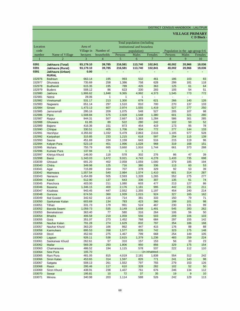
DISTRICT CENSUS HANDBOOK : LALITPUR
VILLAGE PRIMARY
Persons Males Females Persons Males Females1 2 3 4 5 6 7 8 9 10
0391 Jakhaura (Total) 93,179.10 39,785 216,581 113,740 102,841 40,002 20,966 19,036 0391 Jakhaura (Rural) 93,179.10 39,785 216,581 113,740 102,841 40,002 20,966 19,036 0391 Jakhaura (Urban) 0.00 - - - - - - -
RURAL152976 Badraun 663.14 195 993 532 461 186 103 83 152977 Dhurwara 735.69 258 1,386 758 628 299 181 118 152978 Budhendi 615.35 195 789 426 363 125 61 64 152979 Budero 508.12 86 623 330 293 105 54 51 152980 Jakhora 1,906.62 1,848 9,365 4,992 4,373 1,545 773 772 152981 Natrai 28.06 1 1 1 - - - - 152982 Vinekamafi 531.17 213 1,300 679 621 266 140 126 152983 Nagwans 651.14 297 1,510 810 700 270 137 133 152984 Sirsee 1,473.13 607 2,974 1,555 1,419 527 277 250 152985 Jamoramafi 295.16 209 1,075 548 527 205 107 98 152986 Pipra 1,508.84 575 2,928 1,548 1,380 601 321 280 152987 Raipur 944.31 507 2,667 1,383 1,284 586 301 285 152988 Ghuwara 61.85 89 522 280 242 102 50 52 152989 Bajano 416.36 151 873 454 419 173 95 78 152990 Chhipai 330.51 405 1,706 934 772 277 144 133 152991 Harshpur 4,355.82 1,032 5,479 2,863 2,616 1,105 577 528 152992 Karipahari 315.85 233 1,215 618 597 254 115 139 152993 Saurai 451.69 234 1,159 643 516 215 119 96 152994 Kalyan Pura 523.19 401 1,996 1,028 968 319 168 151 152995 Muhara 755.79 665 3,660 1,916 1,744 661 373 288 152996 Kunwar Pura 137.94 1 1 1 - - - - 152997 Khiriya Khurd 146.00 118 578 302 276 86 47 39 152998 Bansi 1,343.03 1,672 9,021 4,743 4,278 1,433 735 698 153039 Ghisauli 691.20 402 2,059 1,059 1,000 379 185 194 153040 Chitra 349.98 125 716 380 336 113 60 53 153041 Agar 715.89 154 707 378 329 92 53 39 153042 Mainwara 1,557.54 540 2,984 1,574 1,410 601 314 287 153043 Nanaura 1,454.89 505 2,593 1,328 1,265 552 275 277 153044 Karari 512.90 137 643 336 307 135 61 74 153045 Panchora 403.00 211 1,080 603 477 213 127 86 153046 Baswna 1,346.15 400 2,176 1,181 995 442 231 211 153047 Kisalwas 943.45 447 2,552 1,355 1,197 454 240 214 153048 Gursora 674.55 360 1,939 1,015 924 327 165 162 153049 Ikal Guwan 342.62 116 714 381 333 150 79 71 153050 Sankarwar Kalan 603.69 134 783 423 360 199 101 98 153051 Tilhari 331.73 179 991 524 467 230 131 99 153052 Baroda Swami 1,059.73 535 3,149 1,658 1,491 545 283 262 153053 Benakatoran 363.40 77 580 316 264 106 56 50 153054 Bhadra 406.58 219 1,059 556 503 209 106 103 153055 Gora 351.07 273 1,452 768 684 297 155 142 153056 Nauhar Kalan 791.28 274 1,629 832 797 354 186 168 153057 Nauhar Khurd 363.20 166 862 447 415 176 88 88 153058 Karmuharo 895.53 268 1,577 835 742 323 175 148 153059 Deori 452.93 275 1,467 799 668 254 149 105 153060 Lagaon 926.11 538 2,615 1,379 1,236 483 259 224 153061 Sankarwar Khurd 262.61 57 310 157 153 56 33 23 153062 Mailar 569.39 293 1,806 950 856 329 175 154 153063 Chamarauwa 486.52 194 1,115 578 537 222 112 110 153064 Sew Pura 105.70153065 Rani Pura 481.05 815 4,019 2,181 1,838 554 312 242 153066 Siron Kalan 453.65 314 1,597 826 771 241 143 98 153067 Satgata 508.13 261 1,552 797 755 279 153 126 153068 Rasoi 295.46 117 610 328 282 102 52 50 153069 Siron Khurd 438.91 238 1,437 761 676 246 134 112 153070 Sewar 195.81 10 72 37 35 19 9 10 153071 Minora 340.98 203 1,114 588 526 242 129 113
-------------Un-inhabited--------------
C D Block -
Population in the age-group 0-6Number of householdsName of Village
Location code
number
Total population (including institutional and houseless
population)Area of
Village in hectares
68
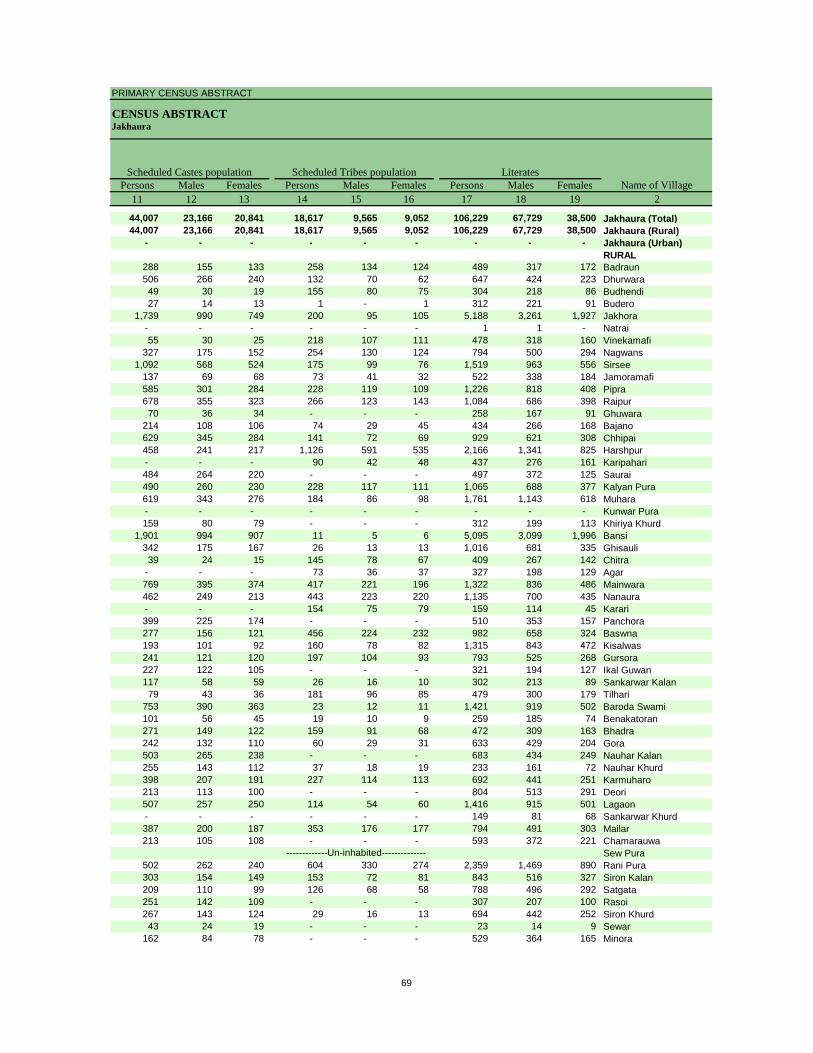
PRIMARY CENSUS ABSTRACT
CENSUS ABSTRACTJakhaura
Persons Males Females Persons Males Females Persons Males Females11 12 13 14 15 16 17 18 19 2
44,007 23,166 20,841 18,617 9,565 9,052 106,229 67,729 38,500 Jakhaura (Total)44,007 23,166 20,841 18,617 9,565 9,052 106,229 67,729 38,500 Jakhaura (Rural)
- - - - - - - - - Jakhaura (Urban)RURAL
288 155 133 258 134 124 489 317 172 Badraun506 266 240 132 70 62 647 424 223 Dhurwara49 30 19 155 80 75 304 218 86 Budhendi27 14 13 1 - 1 312 221 91 Budero
1,739 990 749 200 95 105 5,188 3,261 1,927 Jakhora- - - - - - 1 1 - Natrai55 30 25 218 107 111 478 318 160 Vinekamafi
327 175 152 254 130 124 794 500 294 Nagwans1,092 568 524 175 99 76 1,519 963 556 Sirsee
137 69 68 73 41 32 522 338 184 Jamoramafi585 301 284 228 119 109 1,226 818 408 Pipra678 355 323 266 123 143 1,084 686 398 Raipur70 36 34 - - - 258 167 91 Ghuwara
214 108 106 74 29 45 434 266 168 Bajano629 345 284 141 72 69 929 621 308 Chhipai458 241 217 1,126 591 535 2,166 1,341 825 Harshpur- - - 90 42 48 437 276 161 Karipahari484 264 220 - - - 497 372 125 Saurai490 260 230 228 117 111 1,065 688 377 Kalyan Pura619 343 276 184 86 98 1,761 1,143 618 Muhara- - - - - - - - - Kunwar Pura159 80 79 - - - 312 199 113 Khiriya Khurd
1,901 994 907 11 5 6 5,095 3,099 1,996 Bansi342 175 167 26 13 13 1,016 681 335 Ghisauli39 24 15 145 78 67 409 267 142 Chitra
- - - 73 36 37 327 198 129 Agar769 395 374 417 221 196 1,322 836 486 Mainwara462 249 213 443 223 220 1,135 700 435 Nanaura- - - 154 75 79 159 114 45 Karari399 225 174 - - - 510 353 157 Panchora277 156 121 456 224 232 982 658 324 Baswna193 101 92 160 78 82 1,315 843 472 Kisalwas241 121 120 197 104 93 793 525 268 Gursora227 122 105 - - - 321 194 127 Ikal Guwan117 58 59 26 16 10 302 213 89 Sankarwar Kalan79 43 36 181 96 85 479 300 179 Tilhari
753 390 363 23 12 11 1,421 919 502 Baroda Swami101 56 45 19 10 9 259 185 74 Benakatoran271 149 122 159 91 68 472 309 163 Bhadra242 132 110 60 29 31 633 429 204 Gora503 265 238 - - - 683 434 249 Nauhar Kalan255 143 112 37 18 19 233 161 72 Nauhar Khurd398 207 191 227 114 113 692 441 251 Karmuharo213 113 100 - - - 804 513 291 Deori507 257 250 114 54 60 1,416 915 501 Lagaon- - - - - - 149 81 68 Sankarwar Khurd387 200 187 353 176 177 794 491 303 Mailar213 105 108 - - - 593 372 221 Chamarauwa
Sew Pura502 262 240 604 330 274 2,359 1,469 890 Rani Pura303 154 149 153 72 81 843 516 327 Siron Kalan209 110 99 126 68 58 788 496 292 Satgata251 142 109 - - - 307 207 100 Rasoi267 143 124 29 16 13 694 442 252 Siron Khurd43 24 19 - - - 23 14 9 Sewar
162 84 78 - - - 529 364 165 Minora
-------------Un-inhabited--------------
Scheduled Castes population Scheduled Tribes populationName of Village
Literates
69

DISTRICT CENSUS HANDBOOK : LALITPUR
VILLAGE PRIMARYC D Block -
Persons Males Females Persons Males Females Persons Males Females1 2 20 21 22 23 24 25 26 27 28
0391 Jakhaura (Total) 110,352 46,011 64,341 88,364 57,271 31,093 63,690 48,547 15,143 0391 Jakhaura (Rural) 110,352 46,011 64,341 88,364 57,271 31,093 63,690 48,547 15,143 0391 Jakhaura (Urban) - - - - - - - - -
RURAL152976 Badraun 504 215 289 484 268 216 400 228 172 152977 Dhurwara 739 334 405 566 385 181 361 338 23 152978 Budhendi 485 208 277 401 254 147 392 251 141 152979 Budero 311 109 202 379 197 182 357 188 169 152980 Jakhora 4,177 1,731 2,446 3,503 2,541 962 2,337 1,899 438 152981 Natrai - - - - - - - - - 152982 Vinekamafi 822 361 461 704 372 332 693 365 328 152983 Nagwans 716 310 406 675 404 271 272 249 23 152984 Sirsee 1,455 592 863 1,386 755 631 876 660 216 152985 Jamoramafi 553 210 343 534 278 256 405 248 157 152986 Pipra 1,702 730 972 1,479 811 668 979 727 252 152987 Raipur 1,583 697 886 1,127 714 413 769 586 183 152988 Ghuwara 264 113 151 274 145 129 268 140 128 152989 Bajano 439 188 251 414 249 165 314 213 101 152990 Chhipai 777 313 464 551 453 98 233 205 28 152991 Harshpur 3,313 1,522 1,791 2,526 1,419 1,107 1,741 1,140 601 152992 Karipahari 778 342 436 527 333 194 257 240 17 152993 Saurai 662 271 391 510 326 184 507 325 182 152994 Kalyan Pura 931 340 591 1,020 579 441 627 456 171 152995 Muhara 1,899 773 1,126 1,691 946 745 1,324 863 461 152996 Kunwar Pura 1 1 - 1 1 - 1 1 - 152997 Khiriya Khurd 266 103 163 257 150 107 231 138 93 152998 Bansi 3,926 1,644 2,282 2,939 2,364 575 2,222 1,828 394 153039 Ghisauli 1,043 378 665 756 593 163 699 582 117 153040 Chitra 307 113 194 385 203 182 15 7 8 153041 Agar 380 180 200 324 192 132 324 192 132 153042 Mainwara 1,662 738 924 1,487 785 702 960 652 308 153043 Nanaura 1,458 628 830 1,225 747 478 955 656 299 153044 Karari 484 222 262 243 152 91 233 152 81 153045 Panchora 570 250 320 417 296 121 395 280 115 153046 Baswna 1,194 523 671 1,025 564 461 636 357 279 153047 Kisalwas 1,237 512 725 1,102 692 410 958 680 278 153048 Gursora 1,146 490 656 694 527 167 533 495 38 153049 Ikal Guwan 393 187 206 199 188 11 184 180 4 153050 Sankarwar Kalan 481 210 271 406 207 199 294 194 100 153051 Tilhari 512 224 288 453 243 210 242 231 11 153052 Baroda Swami 1,728 739 989 1,406 839 567 889 738 151 153053 Benakatoran 321 131 190 304 161 143 163 159 4 153054 Bhadra 587 247 340 466 268 198 291 238 53 153055 Gora 819 339 480 733 393 340 661 363 298 153056 Nauhar Kalan 946 398 548 824 430 394 589 382 207 153057 Nauhar Khurd 629 286 343 404 226 178 185 158 27 153058 Karmuharo 885 394 491 425 377 48 373 330 43 153059 Deori 663 286 377 643 436 207 524 407 117 153060 Lagaon 1,199 464 735 931 668 263 728 558 170 153061 Sankarwar Khurd 161 76 85 86 82 4 85 81 4 153062 Mailar 1,012 459 553 514 493 21 509 491 18 153063 Chamarauwa 522 206 316 546 321 225 467 288 179 153064 Sew Pura153065 Rani Pura 1,660 712 948 1,316 1,078 238 1,068 967 101 153066 Siron Kalan 754 310 444 836 437 399 803 433 370 153067 Satgata 764 301 463 627 410 217 499 350 149 153068 Rasoi 303 121 182 312 173 139 148 144 4 153069 Siron Khurd 743 319 424 736 375 361 722 371 351 153070 Sewar 49 23 26 33 18 15 18 16 2 153071 Minora 585 224 361 309 287 22 299 278 21
-------------Un-inhabited--------------
Illiterates Total workers Main workersName of Village
Location code
number
70
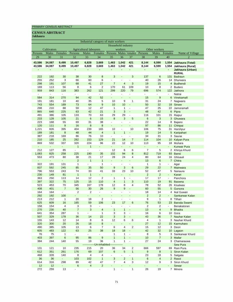
PRIMARY CENSUS ABSTRACT
CENSUS ABSTRACTJakhaura
Persons Males Females Persons Males Females Persons MalesFemales Persons Males Females29 30 31 32 33 34 35 36 37 38 39 40 2
43,586 34,087 9,499 10,497 6,828 3,669 1,463 1,042 421 8,144 6,590 1,554 Jakhaura (Total)43,586 34,087 9,499 10,497 6,828 3,669 1,463 1,042 421 8,144 6,590 1,554 Jakhaura (Rural)
- - - - - - - - - - - - Jakhaura (Urban)RURAL
222 192 30 38 30 8 3 - 3 137 6 131 Badraun255 252 3 66 60 6 - - - 40 26 14 Dhurwara298 191 107 68 41 27 7 4 3 19 15 4 Budhendi169 113 56 8 6 2 170 61 109 10 8 2 Budero959 843 116 383 262 121 299 220 79 696 574 122 Jakhora- - - - - - - - - - - - Natrai584 314 270 94 42 52 - - - 15 9 6 Vinekamafi191 181 10 40 35 5 10 9 1 31 24 7 Nagwans743 554 189 73 64 9 10 10 - 50 32 18 Sirsee298 210 88 59 12 47 1 1 - 47 25 22 Jamoramafi865 640 225 63 42 21 3 3 - 48 42 6 Pipra491 386 105 133 70 63 29 29 - 116 101 15 Raipur233 128 105 21 6 15 8 3 5 6 3 3 Ghuwara223 168 55 69 31 38 - - - 22 14 8 Bajano120 111 9 16 8 8 - - - 97 86 11 Chhipai
1,221 826 395 404 239 165 10 - 10 106 75 31 Harshpur189 181 8 48 44 4 1 1 - 19 14 5 Karipahari387 218 169 86 76 10 - - - 34 31 3 Saurai210 185 25 282 153 129 21 14 7 114 104 10 Kalyan Pura869 532 337 320 224 96 22 12 10 113 95 18 Muhara- - - 1 1 - - - - - - - Kunwar Pura212 127 85 - - - 12 6 6 7 5 2 Khiriya Khurd
1,083 825 258 225 190 35 102 94 8 812 719 93 Bansi553 473 80 38 21 17 28 24 4 80 64 16 Ghisauli- - - 2 1 1 - - - 13 6 7 Chitra322 191 131 1 - 1 - - - 1 1 - Agar837 592 245 85 35 50 9 3 6 29 22 7 Mainwara796 553 243 74 33 41 33 23 10 52 47 5 Nanaura230 149 81 1 1 - - - - 2 2 - Karari363 250 113 14 12 2 1 1 - 17 17 - Panchora397 322 75 125 15 110 4 1 3 110 19 91 Baswna523 453 70 345 167 178 12 8 4 78 52 26 Kisalwas408 401 7 56 30 26 9 9 - 60 55 5 Gursora164 164 - 2 2 - - - - 18 14 4 Ikal Guwan292 192 100 - - - - - - 2 2 - Sankarwar Kalan213 212 1 20 18 2 - - - 9 1 8 Tilhari625 609 16 165 59 106 23 17 6 76 53 23 Baroda Swami158 154 4 3 3 - - - - 2 2 - Benakatoran270 230 40 7 3 4 1 1 - 13 4 9 Bhadra641 354 287 1 - 1 3 3 - 16 6 10 Gora507 329 178 36 14 22 3 3 - 43 36 7 Nauhar Kalan155 143 12 14 8 6 12 6 6 4 1 3 Nauhar Khurd320 300 20 26 18 8 - - - 27 12 15 Karmuharo490 385 105 13 6 7 6 4 2 15 12 3 Deori605 483 122 63 25 38 18 18 - 42 32 10 Lagaon76 75 1 - - - 1 1 - 8 5 3 Sankarwar Khurd
403 397 6 95 86 9 1 1 - 10 7 3 Mailar384 244 140 55 19 36 1 1 - 27 24 3 Chamarauwa
Sew Pura131 121 10 235 215 20 36 34 2 666 597 69 Rani Pura612 351 261 176 69 107 6 5 1 9 8 1 Siron Kalan468 328 140 8 4 4 - - - 23 18 5 Satgata36 36 - 103 102 1 3 2 1 6 4 2 Rasoi
614 316 298 89 42 47 7 4 3 12 9 3 Siron Khurd12 12 - 6 4 2 - - - - - - Sewar
272 259 13 - - - 1 - 1 26 19 7 Minora
-------------Un-inhabited--------------
CultivatorsName of Village
Household industry workersAgricultural labourers
Industrial category of main workers
Other workers
71
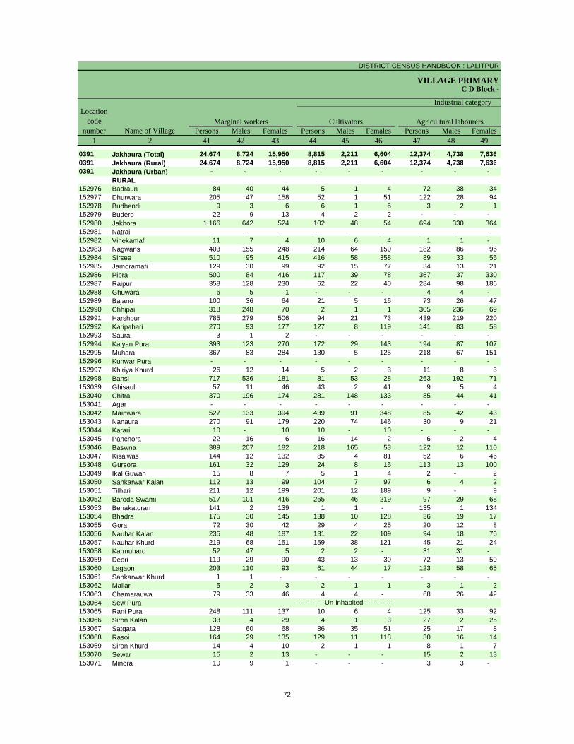
DISTRICT CENSUS HANDBOOK : LALITPUR
VILLAGE PRIMARYC D Block -
Persons Males Females Persons Males Females Persons Males Females1 2 41 42 43 44 45 46 47 48 49
0391 Jakhaura (Total) 24,674 8,724 15,950 8,815 2,211 6,604 12,374 4,738 7,636 0391 Jakhaura (Rural) 24,674 8,724 15,950 8,815 2,211 6,604 12,374 4,738 7,636 0391 Jakhaura (Urban) - - - - - - - - -
RURAL152976 Badraun 84 40 44 5 1 4 72 38 34 152977 Dhurwara 205 47 158 52 1 51 122 28 94 152978 Budhendi 9 3 6 6 1 5 3 2 1 152979 Budero 22 9 13 4 2 2 - - - 152980 Jakhora 1,166 642 524 102 48 54 694 330 364 152981 Natrai - - - - - - - - - 152982 Vinekamafi 11 7 4 10 6 4 1 1 - 152983 Nagwans 403 155 248 214 64 150 182 86 96 152984 Sirsee 510 95 415 416 58 358 89 33 56 152985 Jamoramafi 129 30 99 92 15 77 34 13 21 152986 Pipra 500 84 416 117 39 78 367 37 330 152987 Raipur 358 128 230 62 22 40 284 98 186 152988 Ghuwara 6 5 1 - - - 4 4 - 152989 Bajano 100 36 64 21 5 16 73 26 47 152990 Chhipai 318 248 70 2 1 1 305 236 69 152991 Harshpur 785 279 506 94 21 73 439 219 220 152992 Karipahari 270 93 177 127 8 119 141 83 58 152993 Saurai 3 1 2 - - - - - - 152994 Kalyan Pura 393 123 270 172 29 143 194 87 107 152995 Muhara 367 83 284 130 5 125 218 67 151 152996 Kunwar Pura - - - - - - - - - 152997 Khiriya Khurd 26 12 14 5 2 3 11 8 3 152998 Bansi 717 536 181 81 53 28 263 192 71 153039 Ghisauli 57 11 46 43 2 41 9 5 4 153040 Chitra 370 196 174 281 148 133 85 44 41 153041 Agar - - - - - - - - - 153042 Mainwara 527 133 394 439 91 348 85 42 43 153043 Nanaura 270 91 179 220 74 146 30 9 21 153044 Karari 10 - 10 10 - 10 - - - 153045 Panchora 22 16 6 16 14 2 6 2 4 153046 Baswna 389 207 182 218 165 53 122 12 110 153047 Kisalwas 144 12 132 85 4 81 52 6 46 153048 Gursora 161 32 129 24 8 16 113 13 100 153049 Ikal Guwan 15 8 7 5 1 4 2 - 2 153050 Sankarwar Kalan 112 13 99 104 7 97 6 4 2 153051 Tilhari 211 12 199 201 12 189 9 - 9 153052 Baroda Swami 517 101 416 265 46 219 97 29 68 153053 Benakatoran 141 2 139 1 1 - 135 1 134 153054 Bhadra 175 30 145 138 10 128 36 19 17 153055 Gora 72 30 42 29 4 25 20 12 8 153056 Nauhar Kalan 235 48 187 131 22 109 94 18 76 153057 Nauhar Khurd 219 68 151 159 38 121 45 21 24 153058 Karmuharo 52 47 5 2 2 - 31 31 - 153059 Deori 119 29 90 43 13 30 72 13 59 153060 Lagaon 203 110 93 61 44 17 123 58 65 153061 Sankarwar Khurd 1 1 - - - - - - - 153062 Mailar 5 2 3 2 1 1 3 1 2 153063 Chamarauwa 79 33 46 4 4 - 68 26 42 153064 Sew Pura153065 Rani Pura 248 111 137 10 6 4 125 33 92 153066 Siron Kalan 33 4 29 4 1 3 27 2 25 153067 Satgata 128 60 68 86 35 51 25 17 8 153068 Rasoi 164 29 135 129 11 118 30 16 14 153069 Siron Khurd 14 4 10 2 1 1 8 1 7 153070 Sewar 15 2 13 - - - 15 2 13 153071 Minora 10 9 1 - - - 3 3 -
-------------Un-inhabited--------------
Location code
number Name of VillageMarginal workers Cultivators Agricultural labourers
Industrial category
72
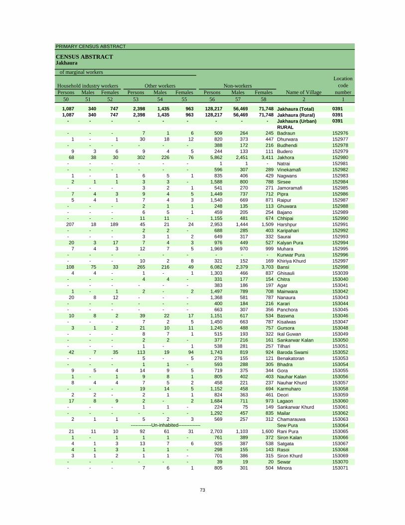
PRIMARY CENSUS ABSTRACT
CENSUS ABSTRACTJakhaura
Persons Males Females Persons Males Females Persons Males Females50 51 52 53 54 55 56 57 58 2 1
1,087 340 747 2,398 1,435 963 128,217 56,469 71,748 Jakhaura (Total) 03911,087 340 747 2,398 1,435 963 128,217 56,469 71,748 Jakhaura (Rural) 0391
- - - - - - - - - Jakhaura (Urban) 0391RURAL
- - - 7 1 6 509 264 245 Badraun 1529761 - 1 30 18 12 820 373 447 Dhurwara 152977
- - - - - - 388 172 216 Budhendi 1529789 3 6 9 4 5 244 133 111 Budero 152979
68 38 30 302 226 76 5,862 2,451 3,411 Jakhora 152980- - - - - - 1 1 - Natrai 152981- - - - - - 596 307 289 Vinekamafi 152982
1 - 1 6 5 1 835 406 429 Nagwans 1529832 1 1 3 3 - 1,588 800 788 Sirsee 152984
- - - 3 2 1 541 270 271 Jamoramafi 1529857 4 3 9 4 5 1,449 737 712 Pipra 1529865 4 1 7 4 3 1,540 669 871 Raipur 152987
- - - 2 1 1 248 135 113 Ghuwara 152988- - - 6 5 1 459 205 254 Bajano 152989- - - 11 11 - 1,155 481 674 Chhipai 152990207 18 189 45 21 24 2,953 1,444 1,509 Harshpur 152991- - - 2 2 - 688 285 403 Karipahari 152992- - - 3 1 2 649 317 332 Saurai 15299320 3 17 7 4 3 976 449 527 Kalyan Pura 1529947 4 3 12 7 5 1,969 970 999 Muhara 152995
- - - - - - - - - Kunwar Pura 152996- - - 10 2 8 321 152 169 Khiriya Khurd 152997108 75 33 265 216 49 6,082 2,379 3,703 Bansi 152998
4 4 - 1 - 1 1,303 466 837 Ghisauli 153039- - - 4 4 - 331 177 154 Chitra 153040- - - - - - 383 186 197 Agar 153041
1 - 1 2 - 2 1,497 789 708 Mainwara 15304220 8 12 - - - 1,368 581 787 Nanaura 153043
- - - - - - 400 184 216 Karari 153044- - - - - - 663 307 356 Panchora 15304510 8 2 39 22 17 1,151 617 534 Baswna 153046
- - - 7 2 5 1,450 663 787 Kisalwas 1530473 1 2 21 10 11 1,245 488 757 Gursora 153048
- - - 8 7 1 515 193 322 Ikal Guwan 153049- - - 2 2 - 377 216 161 Sankarwar Kalan 153050- - - 1 - 1 538 281 257 Tilhari 15305142 7 35 113 19 94 1,743 819 924 Baroda Swami 153052
- - - 5 - 5 276 155 121 Benakatoran 153053- - - 1 1 - 593 288 305 Bhadra 153054
9 5 4 14 9 5 719 375 344 Gora 1530551 - 1 9 8 1 805 402 403 Nauhar Kalan 1530568 4 4 7 5 2 458 221 237 Nauhar Khurd 153057
- - - 19 14 5 1,152 458 694 Karmuharo 1530582 2 - 2 1 1 824 363 461 Deori 153059
17 8 9 2 - 2 1,684 711 973 Lagaon 153060- - - 1 1 - 224 75 149 Sankarwar Khurd 153061- - - - - - 1,292 457 835 Mailar 153062
2 1 1 5 2 3 569 257 312 Chamarauwa 153063Sew Pura 153064
21 11 10 92 61 31 2,703 1,103 1,600 Rani Pura 1530651 - 1 1 1 - 761 389 372 Siron Kalan 1530664 1 3 13 7 6 925 387 538 Satgata 1530674 1 3 1 1 - 298 155 143 Rasoi 1530683 1 2 1 1 - 701 386 315 Siron Khurd 153069
- - - - - - 39 19 20 Sewar 153070- - - 7 6 1 805 301 504 Minora 153071
-------------Un-inhabited--------------
Non-workers
of marginal workersLocation
code number
Household industry workersName of Village
Other workers
73
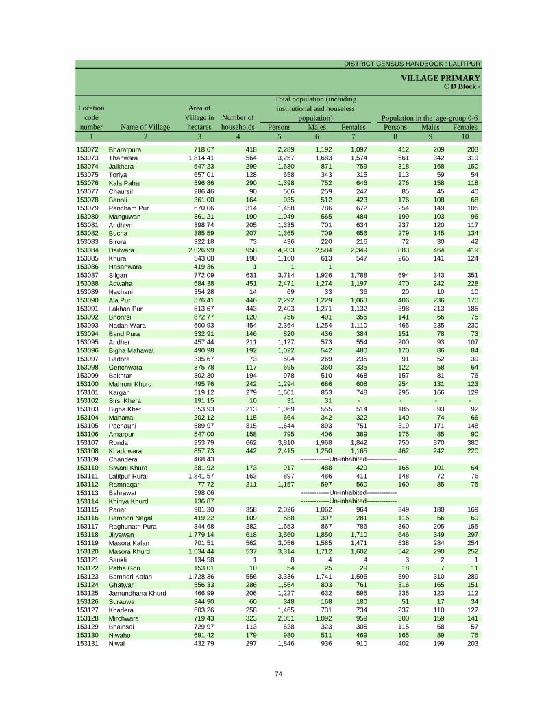
DISTRICT CENSUS HANDBOOK : LALITPUR
VILLAGE PRIMARY
Persons Males Females Persons Males Females1 2 3 4 5 6 7 8 9 10
C D Block -
Population in the age-group 0-6Number of householdsName of Village
Location code
number
Total population (including institutional and houseless
population)Area of
Village in hectares
153072 Bharatpura 718.67 418 2,289 1,192 1,097 412 209 203 153073 Thanwara 1,814.41 564 3,257 1,683 1,574 661 342 319 153074 Jaikhara 547.23 299 1,630 871 759 318 168 150 153075 Toriya 657.01 128 658 343 315 113 59 54 153076 Kala Pahar 596.86 290 1,398 752 646 276 158 118 153077 Chaursil 286.46 90 506 259 247 85 45 40 153078 Banoli 361.00 164 935 512 423 176 108 68 153079 Pancham Pur 670.06 314 1,458 786 672 254 149 105 153080 Manguwan 361.21 190 1,049 565 484 199 103 96 153081 Andhiyri 398.74 205 1,335 701 634 237 120 117 153082 Bucha 385.59 207 1,365 709 656 279 145 134 153083 Birora 322.18 73 436 220 216 72 30 42 153084 Dailwara 2,026.99 958 4,933 2,584 2,349 883 464 419 153085 Khura 543.08 190 1,160 613 547 265 141 124 153086 Hasanwara 419.36 1 1 1 - - - - 153087 Silgan 772.09 631 3,714 1,926 1,788 694 343 351 153088 Adwaha 684.38 451 2,471 1,274 1,197 470 242 228 153089 Nachani 354.28 14 69 33 36 20 10 10 153090 Ala Pur 376.41 446 2,292 1,229 1,063 406 236 170 153091 Lakhan Pur 613.67 443 2,403 1,271 1,132 398 213 185 153092 Bhonrsil 872.77 120 756 401 355 141 66 75 153093 Nadan Wara 600.93 454 2,364 1,254 1,110 465 235 230 153094 Band Pura 332.91 146 820 436 384 151 78 73 153095 Andher 457.44 211 1,127 573 554 200 93 107 153096 Bigha Mahawat 490.98 192 1,022 542 480 170 86 84 153097 Badora 335.67 73 504 269 235 91 52 39 153098 Genchwara 375.78 117 695 360 335 122 58 64 153099 Bakhtar 302.30 194 978 510 468 157 81 76 153100 Mahroni Khurd 495.76 242 1,294 686 608 254 131 123 153101 Kargan 519.12 279 1,601 853 748 295 166 129 153102 Sirsi Khera 191.15 10 31 31 - - - - 153103 Bigha Khet 353.93 213 1,069 555 514 185 93 92 153104 Maharra 202.12 115 664 342 322 140 74 66 153105 Pachauni 589.97 315 1,644 893 751 319 171 148 153106 Amarpur 547.00 158 795 406 389 175 85 90 153107 Ronda 953.79 662 3,810 1,968 1,842 750 370 380 153108 Khadowara 857.73 442 2,415 1,250 1,165 462 242 220 153109 Chandera 468.43153110 Siwani Khurd 381.92 173 917 488 429 165 101 64 153111 Lalitpur Rural 1,841.57 163 897 486 411 148 72 76 153112 Ramnagar 77.72 211 1,157 597 560 160 85 75 153113 Bahrawat 598.06153114 Khiriya Khurd 136.87153115 Panari 901.30 358 2,026 1,062 964 349 180 169 153116 Bamhori Nagal 419.22 109 588 307 281 116 56 60 153117 Raghunath Pura 344.68 282 1,653 867 786 360 205 155 153118 Jijyawan 1,779.14 618 3,560 1,850 1,710 646 349 297 153119 Masora Kalan 701.51 562 3,056 1,585 1,471 538 284 254 153120 Masora Khurd 1,634.44 537 3,314 1,712 1,602 542 290 252 153121 Sankli 134.58 1 8 4 4 3 2 1 153122 Patha Gori 153.01 10 54 25 29 18 7 11 153123 Bamhori Kalan 1,728.36 556 3,336 1,741 1,595 599 310 289 153124 Ghatwar 556.33 286 1,564 803 761 316 165 151 153125 Jamundhana Khurd 466.99 206 1,227 632 595 235 123 112 153126 Surauwa 344.90 60 348 168 180 51 17 34 153127 Khadera 603.26 258 1,465 731 734 237 110 127 153128 Mirchwara 719.43 323 2,051 1,092 959 300 159 141 153129 Bhainsai 729.97 113 628 323 305 115 58 57 153130 Niwaho 691.42 179 980 511 469 165 89 76 153131 Niwai 432.79 297 1,846 936 910 402 199 203
-------------Un-inhabited---------------------------Un-inhabited--------------
-------------Un-inhabited--------------
74

PRIMARY CENSUS ABSTRACT
CENSUS ABSTRACTJakhaura
Persons Males Females Persons Males Females Persons Males Females11 12 13 14 15 16 17 18 19 2
Scheduled Castes population Scheduled Tribes populationName of Village
Literates
443 224 219 370 193 177 1,243 793 450 Bharatpura574 301 273 159 83 76 1,626 1,001 625 Thanwara445 247 198 296 146 150 766 526 240 Jaikhara32 18 14 212 106 106 336 202 134 Toriya
247 134 113 408 217 191 618 397 221 Kala Pahar186 100 86 2 2 - 276 158 118 Chaursil77 43 34 - - - 364 244 120 Banoli
404 207 197 116 64 52 743 474 269 Pancham Pur224 124 100 370 189 181 422 282 140 Manguwan332 185 147 95 51 44 623 381 242 Andhiyri583 314 269 - - - 719 462 257 Bucha44 20 24 - - - 272 166 106 Birora
1,523 789 734 442 231 211 2,464 1,549 915 Dailwara34 22 12 303 157 146 414 258 156 Khura
- - - - - - - - - Hasanwara545 285 260 35 20 15 1,943 1,191 752 Silgan478 242 236 509 268 241 1,050 676 374 Adwaha- - - - - - 16 11 5 Nachani875 440 435 56 28 28 1,116 701 415 Ala Pur517 281 236 286 149 137 1,261 805 456 Lakhan Pur84 46 38 119 65 54 374 234 140 Bhonrsil
356 190 166 424 223 201 1,164 741 423 Nadan Wara156 80 76 - - - 419 284 135 Band Pura318 159 159 124 60 64 593 378 215 Andher319 165 154 - - - 576 379 197 Bigha Mahawat- - - - - - 283 193 90 Badora275 145 130 142 70 72 315 194 121 Genchwara239 132 107 26 14 12 516 336 180 Bakhtar431 232 199 172 91 81 590 399 191 Mahroni Khurd344 177 167 155 79 76 771 496 275 Kargan
4 4 - 1 1 - 30 30 - Sirsi Khera327 167 160 51 30 21 585 373 212 Bigha Khet10 4 6 167 92 75 315 206 109 Maharra
359 190 169 - - - 876 573 303 Pachauni69 36 33 - - - 257 180 77 Amarpur
991 507 484 184 100 84 1,827 1,140 687 Ronda899 472 427 144 70 74 1,213 760 453 Khadowara
Chandera- - - 130 77 53 525 329 196 Siwani Khurd46 23 23 42 23 19 453 299 154 Lalitpur Rural
235 129 106 - - - 724 443 281 RamnagarBahrawatKhiriya Khurd
317 172 145 260 128 132 1,068 664 404 Panari82 40 42 - - - 226 147 79 Bamhori Nagal
261 136 125 86 44 42 726 496 230 Raghunath Pura1,144 600 544 - - - 1,743 1,164 579 Jijyawan
537 284 253 103 51 52 1,855 1,144 711 Masora Kalan430 216 214 6 2 4 1,983 1,228 755 Masora Khurd- - - - - - 1 - 1 Sankli
7 3 4 6 3 3 20 12 8 Patha Gori1,416 727 689 322 168 154 1,734 1,083 651 Bamhori Kalan
322 161 161 325 170 155 715 455 260 Ghatwar180 91 89 326 160 166 660 419 241 Jamundhana Khurd- - - - - - 179 113 66 Surauwa216 109 107 - - - 731 487 244 Khadera212 104 108 4 3 1 1,259 818 441 Mirchwara- - - - - - 310 174 136 Bhainsai
6 3 3 252 136 116 489 297 192 Niwaho488 240 248 - - - 771 487 284 Niwai
-------------Un-inhabited---------------------------Un-inhabited--------------
-------------Un-inhabited--------------
75

DISTRICT CENSUS HANDBOOK : LALITPUR
VILLAGE PRIMARYC D Block -
Persons Males Females Persons Males Females Persons Males Females1 2 20 21 22 23 24 25 26 27 28
Illiterates Total workers Main workersName of Village
Location code
number
153072 Bharatpura 1,046 399 647 1,149 590 559 563 539 24 153073 Thanwara 1,631 682 949 1,338 860 478 1,215 807 408 153074 Jaikhara 864 345 519 756 438 318 755 437 318 153075 Toriya 322 141 181 255 172 83 212 161 51 153076 Kala Pahar 780 355 425 383 357 26 370 344 26 153077 Chaursil 230 101 129 169 111 58 71 66 5 153078 Banoli 571 268 303 401 220 181 211 194 17 153079 Pancham Pur 715 312 403 755 405 350 155 120 35 153080 Manguwan 627 283 344 478 295 183 111 105 6 153081 Andhiyri 712 320 392 504 347 157 300 244 56 153082 Bucha 646 247 399 649 373 276 318 286 32 153083 Birora 164 54 110 207 107 100 204 107 97 153084 Dailwara 2,469 1,035 1,434 1,656 1,256 400 1,121 971 150 153085 Khura 746 355 391 580 316 264 404 313 91 153086 Hasanwara 1 1 - 1 1 - 1 1 - 153087 Silgan 1,771 735 1,036 1,432 978 454 1,297 900 397 153088 Adwaha 1,421 598 823 1,126 581 545 730 412 318 153089 Nachani 53 22 31 33 17 16 19 17 2 153090 Ala Pur 1,176 528 648 844 610 234 630 527 103 153091 Lakhan Pur 1,142 466 676 1,024 686 338 673 551 122 153092 Bhonrsil 382 167 215 344 185 159 147 140 7 153093 Nadan Wara 1,200 513 687 959 568 391 579 517 62 153094 Band Pura 401 152 249 406 216 190 227 216 11 153095 Andher 534 195 339 439 297 142 377 261 116 153096 Bigha Mahawat 446 163 283 389 283 106 370 277 93 153097 Badora 221 76 145 238 126 112 127 126 1 153098 Genchwara 380 166 214 200 176 24 189 172 17 153099 Bakhtar 462 174 288 436 250 186 222 147 75 153100 Mahroni Khurd 704 287 417 629 367 262 134 108 26 153101 Kargan 830 357 473 669 441 228 458 349 109 153102 Sirsi Khera 1 1 - 31 31 - 31 31 - 153103 Bigha Khet 484 182 302 301 289 12 297 286 11 153104 Maharra 349 136 213 368 187 181 84 40 44 153105 Pachauni 768 320 448 861 471 390 247 226 21 153106 Amarpur 538 226 312 235 200 35 193 184 9 153107 Ronda 1,983 828 1,155 1,474 999 475 1,092 877 215 153108 Khadowara 1,202 490 712 748 637 111 637 617 20 153109 Chandera153110 Siwani Khurd 392 159 233 338 263 75 292 255 37 153111 Lalitpur Rural 444 187 257 323 225 98 237 153 84 153112 Ramnagar 433 154 279 327 292 35 308 280 28 153113 Bahrawat153114 Khiriya Khurd153115 Panari 958 398 560 1,105 578 527 1,094 568 526 153116 Bamhori Nagal 362 160 202 292 155 137 292 155 137 153117 Raghunath Pura 927 371 556 730 450 280 392 315 77 153118 Jijyawan 1,817 686 1,131 1,270 861 409 1,012 782 230 153119 Masora Kalan 1,201 441 760 853 743 110 828 730 98 153120 Masora Khurd 1,331 484 847 1,191 865 326 843 759 84 153121 Sankli 7 4 3 4 2 2 4 2 2 153122 Patha Gori 34 13 21 28 17 11 18 17 1 153123 Bamhori Kalan 1,602 658 944 1,524 903 621 935 728 207 153124 Ghatwar 849 348 501 429 390 39 412 383 29 153125 Jamundhana Khurd 567 213 354 625 323 302 429 279 150 153126 Surauwa 169 55 114 181 91 90 82 69 13 153127 Khadera 734 244 490 732 388 344 727 385 342 153128 Mirchwara 792 274 518 783 513 270 627 483 144 153129 Bhainsai 318 149 169 247 170 77 201 162 39 153130 Niwaho 491 214 277 334 251 83 230 200 30 153131 Niwai 1,075 449 626 600 485 115 486 469 17
-------------Un-inhabited---------------------------Un-inhabited--------------
-------------Un-inhabited--------------
76
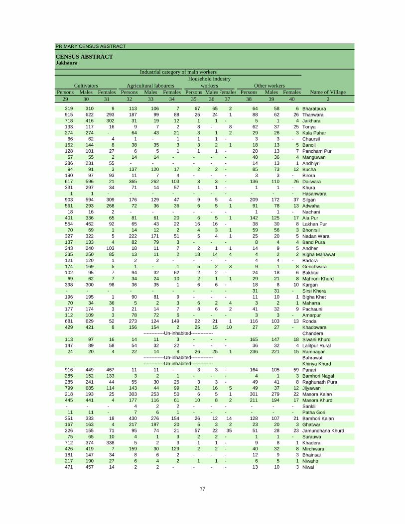
PRIMARY CENSUS ABSTRACT
CENSUS ABSTRACTJakhaura
Persons Males Females Persons Males Females Persons MalesFemales Persons Males Females29 30 31 32 33 34 35 36 37 38 39 40 2
CultivatorsName of Village
Household industry workersAgricultural labourers
Industrial category of main workers
Other workers
319 310 9 113 106 7 67 65 2 64 58 6 Bharatpura915 622 293 187 99 88 25 24 1 88 62 26 Thanwara718 416 302 31 19 12 1 1 - 5 1 4 Jaikhara133 117 16 9 7 2 8 - 8 62 37 25 Toriya274 274 - 64 43 21 3 1 2 29 26 3 Kala Pahar66 62 4 1 - 1 1 1 - 3 3 - Chaursil
152 144 8 38 35 3 3 2 1 18 13 5 Banoli128 101 27 6 5 1 1 1 - 20 13 7 Pancham Pur57 55 2 14 14 - - - - 40 36 4 Manguwan
286 231 55 - - - - - - 14 13 1 Andhiyri94 91 3 137 120 17 2 2 - 85 73 12 Bucha
190 97 93 11 7 4 - - - 3 3 - Birora617 596 21 365 262 103 3 3 - 136 110 26 Dailwara331 297 34 71 14 57 1 1 - 1 1 - Khura
1 1 - - - - - - - - - - Hasanwara903 594 309 176 129 47 9 5 4 209 172 37 Silgan561 293 268 72 36 36 6 5 1 91 78 13 Adwaha18 16 2 - - - - - - 1 1 - Nachani
401 336 65 81 61 20 6 5 1 142 125 17 Ala Pur554 462 92 65 43 22 16 16 - 38 30 8 Lakhan Pur70 69 1 14 12 2 4 3 1 59 56 3 Bhonrsil
327 322 5 222 171 51 5 4 1 25 20 5 Nadan Wara137 133 4 82 79 3 - - - 8 4 4 Band Pura343 240 103 18 11 7 2 1 1 14 9 5 Andher335 250 85 13 11 2 18 14 4 4 2 2 Bigha Mahawat121 120 1 2 2 - - - - 4 4 - Badora174 169 5 1 - 1 5 2 3 9 1 8 Genchwara102 95 7 94 32 62 2 2 - 24 18 6 Bakhtar69 62 7 34 24 10 2 1 1 29 21 8 Mahroni Khurd
398 300 98 36 35 1 6 6 - 18 8 10 Kargan- - - - - - - - - 31 31 - Sirsi Khera196 195 1 90 81 9 - - - 11 10 1 Bigha Khet70 34 36 5 2 3 6 2 4 3 2 1 Maharra
177 174 3 21 14 7 8 6 2 41 32 9 Pachauni112 109 3 78 72 6 - - - 3 3 - Amarpur681 629 52 273 124 149 22 21 1 116 103 13 Ronda429 421 8 156 154 2 25 15 10 27 27 - Khadowara
Chandera113 97 16 14 11 3 - - - 165 147 18 Siwani Khurd147 89 58 54 32 22 - - - 36 32 4 Lalitpur Rural24 20 4 22 14 8 26 25 1 236 221 15 Ramnagar
BahrawatKhiriya Khurd
916 449 467 11 11 - 3 3 - 164 105 59 Panari285 152 133 3 2 1 - - - 4 1 3 Bamhori Nagal285 241 44 55 30 25 3 3 - 49 41 8 Raghunath Pura799 685 114 143 44 99 21 16 5 49 37 12 Jijyawan218 193 25 303 253 50 6 5 1 301 279 22 Masora Kalan445 441 4 177 116 61 10 8 2 211 194 17 Masora Khurd- - - 4 2 2 - - - - - - Sankli11 11 - 7 6 1 - - - - - - Patha Gori
351 333 18 430 276 154 26 12 14 128 107 21 Bamhori Kalan167 163 4 217 197 20 5 3 2 23 20 3 Ghatwar226 155 71 95 74 21 57 22 35 51 28 23 Jamundhana Khurd75 65 10 4 1 3 2 2 - 1 1 - Surauwa
712 374 338 5 2 3 1 1 - 9 8 1 Khadera426 419 7 159 30 129 2 2 - 40 32 8 Mirchwara181 147 34 8 6 2 - - - 12 9 3 Bhainsai217 190 27 6 4 2 1 1 - 6 5 1 Niwaho471 457 14 2 2 - - - - 13 10 3 Niwai
-------------Un-inhabited---------------------------Un-inhabited--------------
-------------Un-inhabited--------------
77
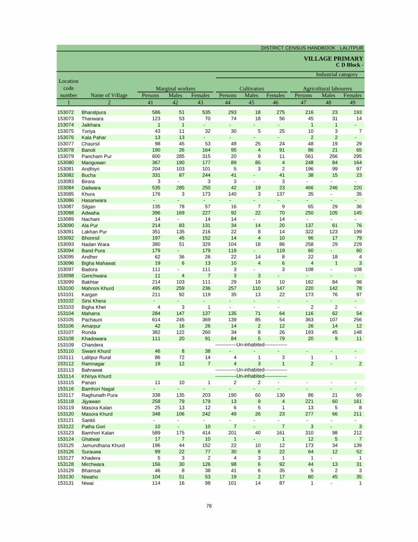
DISTRICT CENSUS HANDBOOK : LALITPUR
VILLAGE PRIMARYC D Block -
Persons Males Females Persons Males Females Persons Males Females1 2 41 42 43 44 45 46 47 48 49
Location code
number Name of VillageMarginal workers Cultivators Agricultural labourers
Industrial category
153072 Bharatpura 586 51 535 293 18 275 216 23 193 153073 Thanwara 123 53 70 74 18 56 45 31 14 153074 Jaikhara 1 1 - - - - 1 1 - 153075 Toriya 43 11 32 30 5 25 10 3 7 153076 Kala Pahar 13 13 - - - - 2 2 - 153077 Chaursil 98 45 53 49 25 24 48 19 29 153078 Banoli 190 26 164 95 4 91 86 21 65 153079 Pancham Pur 600 285 315 20 9 11 561 266 295 153080 Manguwan 367 190 177 89 85 4 248 84 164 153081 Andhiyri 204 103 101 5 3 2 196 99 97 153082 Bucha 331 87 244 41 - 41 38 15 23 153083 Birora 3 - 3 3 - 3 - - - 153084 Dailwara 535 285 250 42 19 23 466 246 220 153085 Khura 176 3 173 140 3 137 35 - 35 153086 Hasanwara - - - - - - - - - 153087 Silgan 135 78 57 16 7 9 65 29 36 153088 Adwaha 396 169 227 92 22 70 250 105 145 153089 Nachani 14 - 14 14 - 14 - - - 153090 Ala Pur 214 83 131 34 14 20 137 61 76 153091 Lakhan Pur 351 135 216 22 8 14 322 123 199 153092 Bhonrsil 197 45 152 14 4 10 96 17 79 153093 Nadan Wara 380 51 329 104 18 86 258 29 229 153094 Band Pura 179 - 179 119 - 119 60 - 60 153095 Andher 62 36 26 22 14 8 22 18 4 153096 Bigha Mahawat 19 6 13 10 4 6 4 1 3 153097 Badora 111 - 111 3 - 3 108 - 108 153098 Genchwara 11 4 7 3 3 - - - - 153099 Bakhtar 214 103 111 29 19 10 182 84 98 153100 Mahroni Khurd 495 259 236 257 110 147 220 142 78 153101 Kargan 211 92 119 35 13 22 173 76 97 153102 Sirsi Khera - - - - - - - - - 153103 Bigha Khet 4 3 1 - - - 2 2 - 153104 Maharra 284 147 137 135 71 64 116 62 54 153105 Pachauni 614 245 369 139 85 54 363 107 256 153106 Amarpur 42 16 26 14 2 12 26 14 12 153107 Ronda 382 122 260 34 8 26 193 45 148 153108 Khadowara 111 20 91 84 5 79 20 9 11 153109 Chandera153110 Siwani Khurd 46 8 38 - - - - - - 153111 Lalitpur Rural 86 72 14 4 1 3 1 1 - 153112 Ramnagar 19 12 7 4 3 1 2 - 2 153113 Bahrawat153114 Khiriya Khurd153115 Panari 11 10 1 2 2 - - - - 153116 Bamhori Nagal - - - - - - - - - 153117 Raghunath Pura 338 135 203 190 60 130 86 21 65 153118 Jijyawan 258 79 179 13 9 4 221 60 161 153119 Masora Kalan 25 13 12 6 5 1 13 5 8 153120 Masora Khurd 348 106 242 49 26 23 277 66 211 153121 Sankli - - - - - - - - - 153122 Patha Gori 10 - 10 7 - 7 3 - 3 153123 Bamhori Kalan 589 175 414 201 40 161 310 98 212 153124 Ghatwar 17 7 10 1 - 1 12 5 7 153125 Jamundhana Khurd 196 44 152 22 10 12 173 34 139 153126 Surauwa 99 22 77 30 8 22 64 12 52 153127 Khadera 5 3 2 4 3 1 1 - 1 153128 Mirchwara 156 30 126 98 6 92 44 13 31 153129 Bhainsai 46 8 38 41 6 35 5 2 3 153130 Niwaho 104 51 53 19 2 17 80 45 35 153131 Niwai 114 16 98 101 14 87 1 - 1
-------------Un-inhabited---------------------------Un-inhabited--------------
-------------Un-inhabited--------------
78
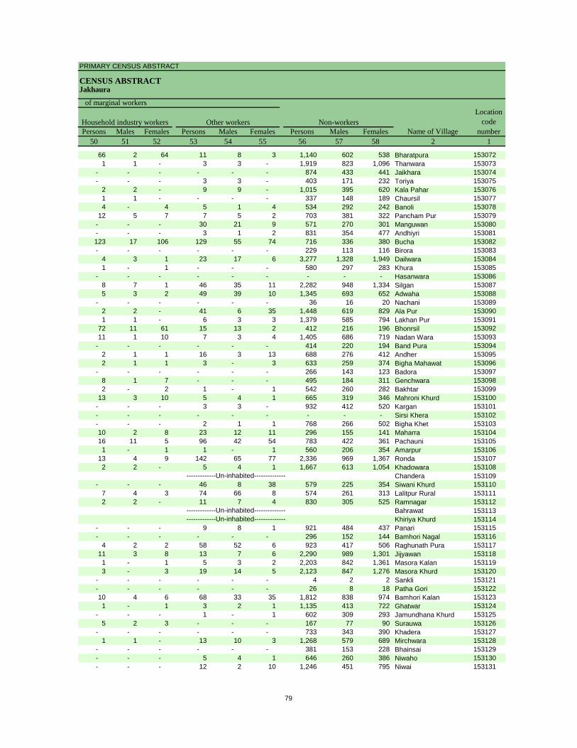
PRIMARY CENSUS ABSTRACT
CENSUS ABSTRACTJakhaura
Persons Males Females Persons Males Females Persons Males Females50 51 52 53 54 55 56 57 58 2 1
Non-workers
of marginal workersLocation
code number
Household industry workersName of Village
Other workers
66 2 64 11 8 3 1,140 602 538 Bharatpura 1530721 1 - 3 3 - 1,919 823 1,096 Thanwara 153073
- - - - - - 874 433 441 Jaikhara 153074- - - 3 3 - 403 171 232 Toriya 153075
2 2 - 9 9 - 1,015 395 620 Kala Pahar 1530761 1 - - - - 337 148 189 Chaursil 1530774 - 4 5 1 4 534 292 242 Banoli 153078
12 5 7 7 5 2 703 381 322 Pancham Pur 153079- - - 30 21 9 571 270 301 Manguwan 153080- - - 3 1 2 831 354 477 Andhiyri 153081123 17 106 129 55 74 716 336 380 Bucha 153082- - - - - - 229 113 116 Birora 153083
4 3 1 23 17 6 3,277 1,328 1,949 Dailwara 1530841 - 1 - - - 580 297 283 Khura 153085
- - - - - - - - - Hasanwara 1530868 7 1 46 35 11 2,282 948 1,334 Silgan 1530875 3 2 49 39 10 1,345 693 652 Adwaha 153088
- - - - - - 36 16 20 Nachani 1530892 2 - 41 6 35 1,448 619 829 Ala Pur 1530901 1 - 6 3 3 1,379 585 794 Lakhan Pur 153091
72 11 61 15 13 2 412 216 196 Bhonrsil 15309211 1 10 7 3 4 1,405 686 719 Nadan Wara 153093
- - - - - - 414 220 194 Band Pura 1530942 1 1 16 3 13 688 276 412 Andher 1530952 1 1 3 - 3 633 259 374 Bigha Mahawat 153096
- - - - - - 266 143 123 Badora 1530978 1 7 - - - 495 184 311 Genchwara 1530982 - 2 1 - 1 542 260 282 Bakhtar 153099
13 3 10 5 4 1 665 319 346 Mahroni Khurd 153100- - - 3 3 - 932 412 520 Kargan 153101- - - - - - - - - Sirsi Khera 153102- - - 2 1 1 768 266 502 Bigha Khet 15310310 2 8 23 12 11 296 155 141 Maharra 15310416 11 5 96 42 54 783 422 361 Pachauni 1531051 - 1 1 - 1 560 206 354 Amarpur 153106
13 4 9 142 65 77 2,336 969 1,367 Ronda 1531072 2 - 5 4 1 1,667 613 1,054 Khadowara 153108
Chandera 153109- - - 46 8 38 579 225 354 Siwani Khurd 153110
7 4 3 74 66 8 574 261 313 Lalitpur Rural 1531112 2 - 11 7 4 830 305 525 Ramnagar 153112
Bahrawat 153113Khiriya Khurd 153114
- - - 9 8 1 921 484 437 Panari 153115- - - - - - 296 152 144 Bamhori Nagal 153116
4 2 2 58 52 6 923 417 506 Raghunath Pura 15311711 3 8 13 7 6 2,290 989 1,301 Jijyawan 1531181 - 1 5 3 2 2,203 842 1,361 Masora Kalan 1531193 - 3 19 14 5 2,123 847 1,276 Masora Khurd 153120
- - - - - - 4 2 2 Sankli 153121- - - - - - 26 8 18 Patha Gori 15312210 4 6 68 33 35 1,812 838 974 Bamhori Kalan 1531231 - 1 3 2 1 1,135 413 722 Ghatwar 153124
- - - 1 - 1 602 309 293 Jamundhana Khurd 1531255 2 3 - - - 167 77 90 Surauwa 153126
- - - - - - 733 343 390 Khadera 1531271 1 - 13 10 3 1,268 579 689 Mirchwara 153128
- - - - - - 381 153 228 Bhainsai 153129- - - 5 4 1 646 260 386 Niwaho 153130- - - 12 2 10 1,246 451 795 Niwai 153131
-------------Un-inhabited---------------------------Un-inhabited--------------
-------------Un-inhabited--------------
79
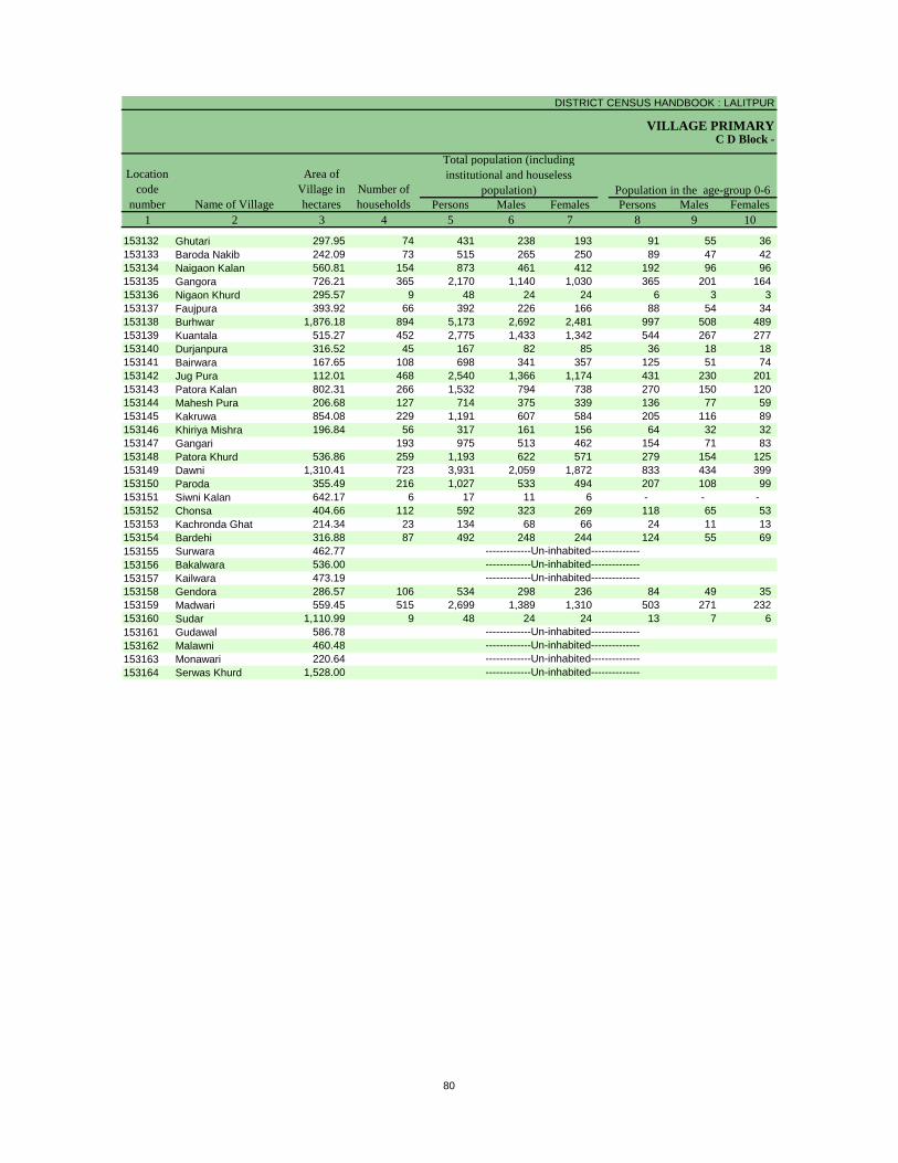
DISTRICT CENSUS HANDBOOK : LALITPUR
VILLAGE PRIMARY
Persons Males Females Persons Males Females1 2 3 4 5 6 7 8 9 10
C D Block -
Population in the age-group 0-6Number of householdsName of Village
Location code
number
Total population (including institutional and houseless
population)Area of
Village in hectares
153132 Ghutari 297.95 74 431 238 193 91 55 36 153133 Baroda Nakib 242.09 73 515 265 250 89 47 42 153134 Naigaon Kalan 560.81 154 873 461 412 192 96 96 153135 Gangora 726.21 365 2,170 1,140 1,030 365 201 164 153136 Nigaon Khurd 295.57 9 48 24 24 6 3 3 153137 Faujpura 393.92 66 392 226 166 88 54 34 153138 Burhwar 1,876.18 894 5,173 2,692 2,481 997 508 489 153139 Kuantala 515.27 452 2,775 1,433 1,342 544 267 277 153140 Durjanpura 316.52 45 167 82 85 36 18 18 153141 Bairwara 167.65 108 698 341 357 125 51 74 153142 Jug Pura 112.01 468 2,540 1,366 1,174 431 230 201 153143 Patora Kalan 802.31 266 1,532 794 738 270 150 120 153144 Mahesh Pura 206.68 127 714 375 339 136 77 59 153145 Kakruwa 854.08 229 1,191 607 584 205 116 89 153146 Khiriya Mishra 196.84 56 317 161 156 64 32 32 153147 Gangari 193 975 513 462 154 71 83 153148 Patora Khurd 536.86 259 1,193 622 571 279 154 125 153149 Dawni 1,310.41 723 3,931 2,059 1,872 833 434 399 153150 Paroda 355.49 216 1,027 533 494 207 108 99 153151 Siwni Kalan 642.17 6 17 11 6 - - - 153152 Chonsa 404.66 112 592 323 269 118 65 53 153153 Kachronda Ghat 214.34 23 134 68 66 24 11 13 153154 Bardehi 316.88 87 492 248 244 124 55 69 153155 Surwara 462.77153156 Bakalwara 536.00153157 Kailwara 473.19153158 Gendora 286.57 106 534 298 236 84 49 35 153159 Madwari 559.45 515 2,699 1,389 1,310 503 271 232 153160 Sudar 1,110.99 9 48 24 24 13 7 6 153161 Gudawal 586.78153162 Malawni 460.48153163 Monawari 220.64153164 Serwas Khurd 1,528.00 -------------Un-inhabited--------------
-------------Un-inhabited---------------------------Un-inhabited---------------------------Un-inhabited--------------
-------------Un-inhabited---------------------------Un-inhabited---------------------------Un-inhabited--------------
80
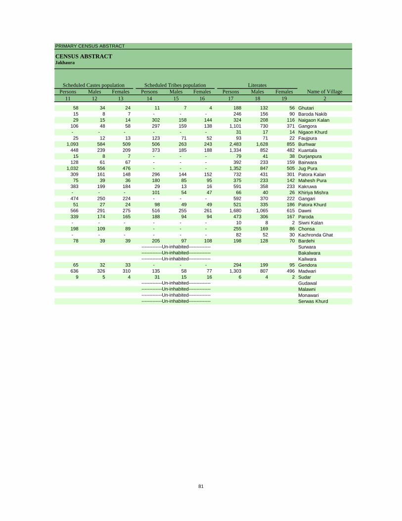
PRIMARY CENSUS ABSTRACT
CENSUS ABSTRACTJakhaura
Persons Males Females Persons Males Females Persons Males Females11 12 13 14 15 16 17 18 19 2
Scheduled Castes population Scheduled Tribes populationName of Village
Literates
58 34 24 11 7 4 188 132 56 Ghutari15 8 7 - - - 246 156 90 Baroda Nakib29 15 14 302 158 144 324 208 116 Naigaon Kalan
106 48 58 297 159 138 1,101 730 371 Gangora- - - - - - 31 17 14 Nigaon Khurd25 12 13 123 71 52 93 71 22 Faujpura
1,093 584 509 506 263 243 2,483 1,628 855 Burhwar448 239 209 373 185 188 1,334 852 482 Kuantala15 8 7 - - - 79 41 38 Durjanpura
128 61 67 - - - 392 233 159 Bairwara1,032 556 476 - - - 1,352 847 505 Jug Pura
309 161 148 296 144 152 732 431 301 Patora Kalan75 39 36 180 85 95 375 233 142 Mahesh Pura
383 199 184 29 13 16 591 358 233 Kakruwa- - - 101 54 47 66 40 26 Khiriya Mishra474 250 224 - - - 592 370 222 Gangari51 27 24 98 49 49 521 335 186 Patora Khurd
566 291 275 516 255 261 1,680 1,065 615 Dawni339 174 165 188 94 94 473 306 167 Paroda- - - - - - 10 8 2 Siwni Kalan198 109 89 - - - 255 169 86 Chonsa- - - - - - 82 52 30 Kachronda Ghat78 39 39 205 97 108 198 128 70 Bardehi
SurwaraBakalwaraKailwara
65 32 33 - - - 294 199 95 Gendora636 326 310 135 58 77 1,303 807 496 Madwari
9 5 4 31 15 16 6 4 2 SudarGudawalMalawniMonawariSerwas Khurd-------------Un-inhabited--------------
-------------Un-inhabited---------------------------Un-inhabited---------------------------Un-inhabited--------------
-------------Un-inhabited---------------------------Un-inhabited---------------------------Un-inhabited--------------
81
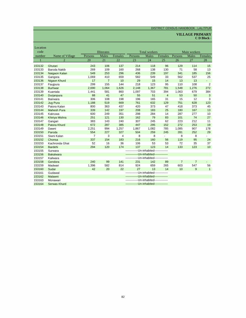
DISTRICT CENSUS HANDBOOK : LALITPUR
VILLAGE PRIMARYC D Block -
Persons Males Females Persons Males Females Persons Males Females1 2 20 21 22 23 24 25 26 27 28
Illiterates Total workers Main workersName of Village
Location code
number
153132 Ghutari 243 106 137 214 118 96 129 114 15 153133 Baroda Nakib 269 109 160 268 138 130 71 58 13 153134 Naigaon Kalan 549 253 296 436 239 197 341 185 156 153135 Gangora 1,069 410 659 582 549 33 562 537 25 153136 Nigaon Khurd 17 7 10 29 15 14 13 13 - 153137 Faujpura 299 155 144 218 123 95 110 108 2 153138 Burhwar 2,690 1,064 1,626 2,148 1,367 781 1,548 1,276 272 153139 Kuantala 1,441 581 860 1,097 703 394 1,063 679 384 153140 Durjanpura 88 41 47 55 51 4 53 50 3 153141 Bairwara 306 108 198 196 165 31 15 12 3 153142 Jug Pura 1,188 519 669 761 632 129 751 628 123 153143 Patora Kalan 800 363 437 420 373 47 418 373 45 153144 Mahesh Pura 339 142 197 208 183 25 180 167 13 153145 Kakruwa 600 249 351 298 284 14 287 277 10 153146 Khiriya Mishra 251 121 130 162 79 83 101 74 27 153147 Gangari 383 143 240 307 245 62 223 212 11 153148 Patora Khurd 672 287 385 447 295 152 272 253 19 153149 Dawni 2,251 994 1,257 1,867 1,082 785 1,085 907 178 153150 Paroda 554 227 327 504 259 245 281 252 29 153151 Siwni Kalan 7 3 4 8 8 - 8 8 - 153152 Chonsa 337 154 183 216 160 56 119 95 24 153153 Kachronda Ghat 52 16 36 106 53 53 72 35 37 153154 Bardehi 294 120 174 137 123 14 133 123 10 153155 Surwara153156 Bakalwara153157 Kailwara153158 Gendora 240 99 141 231 142 89 7 7 - 153159 Madwari 1,396 582 814 924 659 265 603 547 56 153160 Sudar 42 20 22 27 13 14 10 9 1 153161 Gudawal153162 Malawni153163 Monawari153164 Serwas Khurd -------------Un-inhabited--------------
-------------Un-inhabited---------------------------Un-inhabited---------------------------Un-inhabited--------------
-------------Un-inhabited---------------------------Un-inhabited---------------------------Un-inhabited--------------
82
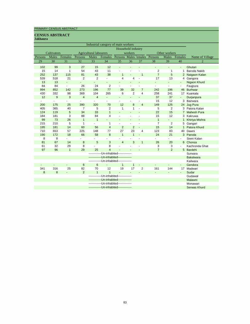
PRIMARY CENSUS ABSTRACT
CENSUS ABSTRACTJakhaura
Persons Males Females Persons Males Females Persons MalesFemales Persons Males Females29 30 31 32 33 34 35 36 37 38 39 40 2
CultivatorsName of Village
Household industry workersAgricultural labourers
Industrial category of main workers
Other workers
102 99 3 27 15 12 - - - - - - Ghutari15 14 1 54 43 11 - - - 2 1 1 Baroda Nakib
252 137 115 81 43 38 1 - 1 7 5 2 Naigaon Kalan539 518 21 2 2 - 4 4 - 17 13 4 Gangora13 13 - - - - - - - - - - Nigaon Khurd84 84 - 26 24 2 - - - - - - Faujpura
994 852 142 273 196 77 39 32 7 242 196 46 Burhwar430 332 98 369 104 265 6 2 4 258 241 17 Kuantala12 9 3 4 4 - - - - 37 37 - Durjanpura
- - - - - - - - - 15 12 3 Bairwara200 175 25 390 320 70 12 8 4 149 125 24 Jug Pura405 365 40 7 5 2 1 1 - 5 2 3 Patora Kalan124 119 5 34 33 1 - - - 22 15 7 Mahesh Pura184 181 3 88 84 4 - - - 15 12 3 Kakruwa99 73 26 1 1 - - - - 1 - 1 Khiriya Mishra
215 210 5 1 - 1 - - - 7 2 5 Gangari195 181 14 60 56 4 2 2 - 15 14 1 Patora Khurd710 653 57 225 148 77 27 23 4 123 83 40 Dawni190 172 18 66 58 8 1 1 - 24 21 3 Paroda
8 8 - - - - - - - - - - Siwni Kalan81 67 14 8 5 3 4 3 1 26 20 6 Chonsa61 32 29 8 - 8 - - - 3 3 - Kachronda Ghat97 96 1 29 25 4 - - - 7 2 5 Bardehi
SurwaraBakalwaraKailwara
- - - 6 6 - 1 1 - - - - Gendora341 316 25 82 70 12 19 17 2 161 144 17 Madwari
8 8 - 2 1 1 - - - - - - SudarGudawalMalawniMonawariSerwas Khurd-------------Un-inhabited--------------
-------------Un-inhabited---------------------------Un-inhabited---------------------------Un-inhabited--------------
-------------Un-inhabited---------------------------Un-inhabited---------------------------Un-inhabited--------------
83
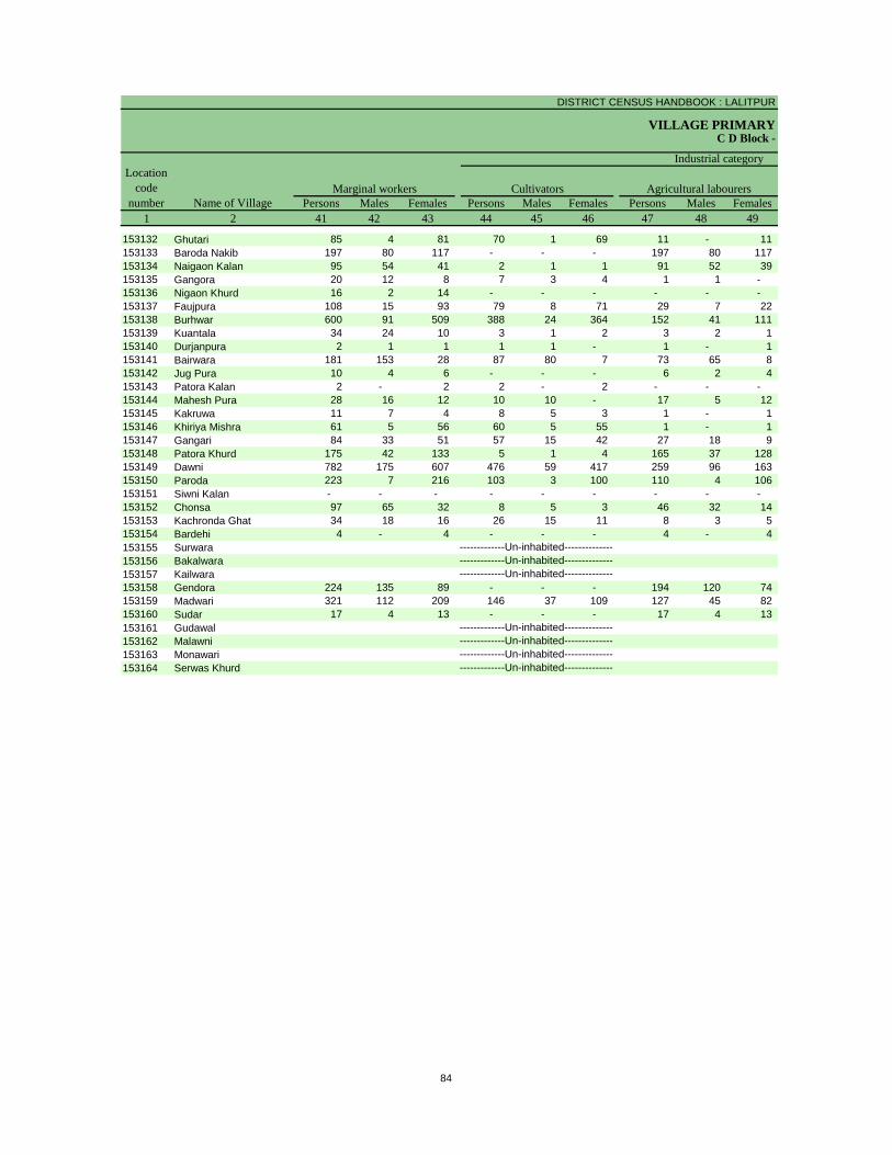
DISTRICT CENSUS HANDBOOK : LALITPUR
VILLAGE PRIMARYC D Block -
Persons Males Females Persons Males Females Persons Males Females1 2 41 42 43 44 45 46 47 48 49
Location code
number Name of VillageMarginal workers Cultivators Agricultural labourers
Industrial category
153132 Ghutari 85 4 81 70 1 69 11 - 11 153133 Baroda Nakib 197 80 117 - - - 197 80 117 153134 Naigaon Kalan 95 54 41 2 1 1 91 52 39 153135 Gangora 20 12 8 7 3 4 1 1 - 153136 Nigaon Khurd 16 2 14 - - - - - - 153137 Faujpura 108 15 93 79 8 71 29 7 22 153138 Burhwar 600 91 509 388 24 364 152 41 111 153139 Kuantala 34 24 10 3 1 2 3 2 1 153140 Durjanpura 2 1 1 1 1 - 1 - 1 153141 Bairwara 181 153 28 87 80 7 73 65 8 153142 Jug Pura 10 4 6 - - - 6 2 4 153143 Patora Kalan 2 - 2 2 - 2 - - - 153144 Mahesh Pura 28 16 12 10 10 - 17 5 12 153145 Kakruwa 11 7 4 8 5 3 1 - 1 153146 Khiriya Mishra 61 5 56 60 5 55 1 - 1 153147 Gangari 84 33 51 57 15 42 27 18 9 153148 Patora Khurd 175 42 133 5 1 4 165 37 128 153149 Dawni 782 175 607 476 59 417 259 96 163 153150 Paroda 223 7 216 103 3 100 110 4 106 153151 Siwni Kalan - - - - - - - - - 153152 Chonsa 97 65 32 8 5 3 46 32 14 153153 Kachronda Ghat 34 18 16 26 15 11 8 3 5 153154 Bardehi 4 - 4 - - - 4 - 4 153155 Surwara153156 Bakalwara153157 Kailwara153158 Gendora 224 135 89 - - - 194 120 74 153159 Madwari 321 112 209 146 37 109 127 45 82 153160 Sudar 17 4 13 - - - 17 4 13 153161 Gudawal153162 Malawni153163 Monawari153164 Serwas Khurd -------------Un-inhabited--------------
-------------Un-inhabited---------------------------Un-inhabited---------------------------Un-inhabited--------------
-------------Un-inhabited---------------------------Un-inhabited---------------------------Un-inhabited--------------
84
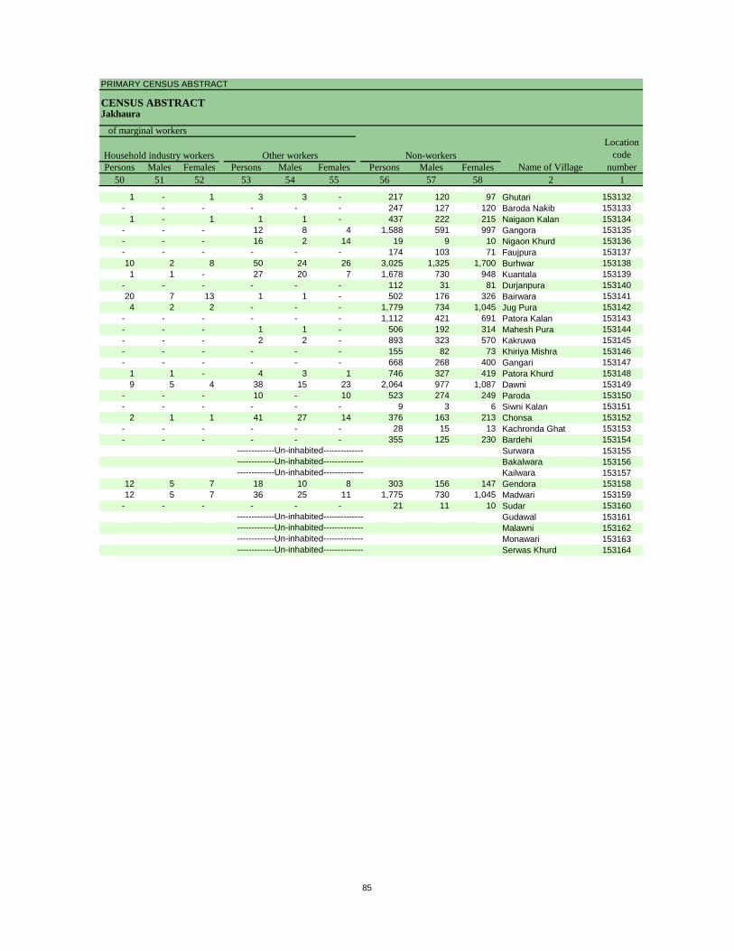
PRIMARY CENSUS ABSTRACT
CENSUS ABSTRACTJakhaura
Persons Males Females Persons Males Females Persons Males Females50 51 52 53 54 55 56 57 58 2 1
Non-workers
of marginal workersLocation
code number
Household industry workersName of Village
Other workers
1 - 1 3 3 - 217 120 97 Ghutari 153132- - - - - - 247 127 120 Baroda Nakib 153133
1 - 1 1 1 - 437 222 215 Naigaon Kalan 153134- - - 12 8 4 1,588 591 997 Gangora 153135- - - 16 2 14 19 9 10 Nigaon Khurd 153136- - - - - - 174 103 71 Faujpura 15313710 2 8 50 24 26 3,025 1,325 1,700 Burhwar 1531381 1 - 27 20 7 1,678 730 948 Kuantala 153139
- - - - - - 112 31 81 Durjanpura 15314020 7 13 1 1 - 502 176 326 Bairwara 1531414 2 2 - - - 1,779 734 1,045 Jug Pura 153142
- - - - - - 1,112 421 691 Patora Kalan 153143- - - 1 1 - 506 192 314 Mahesh Pura 153144- - - 2 2 - 893 323 570 Kakruwa 153145- - - - - - 155 82 73 Khiriya Mishra 153146- - - - - - 668 268 400 Gangari 153147
1 1 - 4 3 1 746 327 419 Patora Khurd 1531489 5 4 38 15 23 2,064 977 1,087 Dawni 153149
- - - 10 - 10 523 274 249 Paroda 153150- - - - - - 9 3 6 Siwni Kalan 153151
2 1 1 41 27 14 376 163 213 Chonsa 153152- - - - - - 28 15 13 Kachronda Ghat 153153- - - - - - 355 125 230 Bardehi 153154
Surwara 153155Bakalwara 153156Kailwara 153157
12 5 7 18 10 8 303 156 147 Gendora 15315812 5 7 36 25 11 1,775 730 1,045 Madwari 153159
- - - - - - 21 11 10 Sudar 153160Gudawal 153161Malawni 153162Monawari 153163Serwas Khurd 153164-------------Un-inhabited--------------
-------------Un-inhabited---------------------------Un-inhabited---------------------------Un-inhabited--------------
-------------Un-inhabited---------------------------Un-inhabited---------------------------Un-inhabited--------------
85
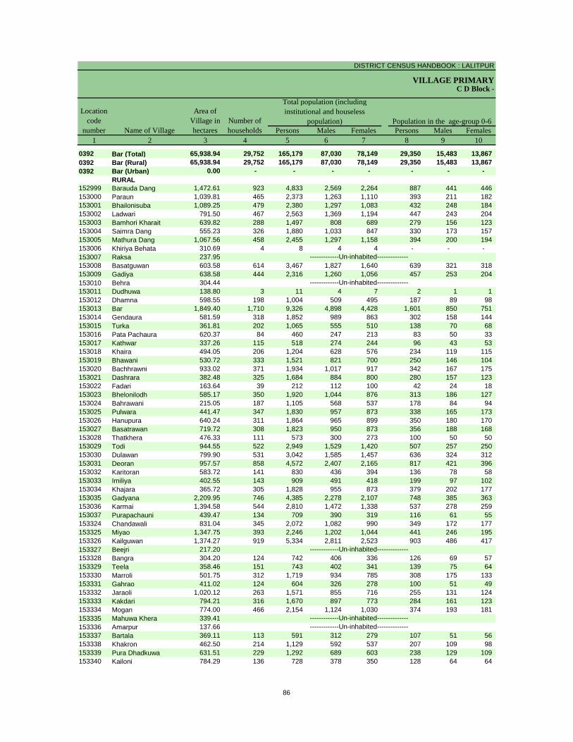
DISTRICT CENSUS HANDBOOK : LALITPUR
VILLAGE PRIMARY
Persons Males Females Persons Males Females1 2 3 4 5 6 7 8 9 10
0392 Bar (Total) 65,938.94 29,752 165,179 87,030 78,149 29,350 15,483 13,867 0392 Bar (Rural) 65,938.94 29,752 165,179 87,030 78,149 29,350 15,483 13,867 0392 Bar (Urban) 0.00 - - - - - - -
RURAL152999 Barauda Dang 1,472.61 923 4,833 2,569 2,264 887 441 446 153000 Paraun 1,039.81 465 2,373 1,263 1,110 393 211 182 153001 Bhailonisuba 1,089.25 479 2,380 1,297 1,083 432 248 184 153002 Ladwari 791.50 467 2,563 1,369 1,194 447 243 204 153003 Bamhori Kharait 639.82 288 1,497 808 689 279 156 123 153004 Saimra Dang 555.23 326 1,880 1,033 847 330 173 157 153005 Mathura Dang 1,067.56 458 2,455 1,297 1,158 394 200 194 153006 Khiriya Behata 310.69 4 8 4 4 - - - 153007 Raksa 237.95153008 Basatguwan 603.58 614 3,467 1,827 1,640 639 321 318 153009 Gadiya 638.58 444 2,316 1,260 1,056 457 253 204 153010 Behra 304.44153011 Dudhuwa 138.80 3 11 4 7 2 1 1 153012 Dhamna 598.55 198 1,004 509 495 187 89 98 153013 Bar 1,849.40 1,710 9,326 4,898 4,428 1,601 850 751 153014 Gendaura 581.59 318 1,852 989 863 302 158 144 153015 Turka 361.81 202 1,065 555 510 138 70 68 153016 Pata Pachaura 620.37 84 460 247 213 83 50 33 153017 Kathwar 337.26 115 518 274 244 96 43 53 153018 Khaira 494.05 206 1,204 628 576 234 119 115 153019 Bhawani 530.72 333 1,521 821 700 250 146 104 153020 Bachhrawni 933.02 371 1,934 1,017 917 342 167 175 153021 Dashrara 382.48 325 1,684 884 800 280 157 123 153022 Fadari 163.64 39 212 112 100 42 24 18 153023 Bhelonilodh 585.17 350 1,920 1,044 876 313 186 127 153024 Bahrawani 215.05 187 1,105 568 537 178 84 94 153025 Pulwara 441.47 347 1,830 957 873 338 165 173 153026 Hanupura 640.24 311 1,864 965 899 350 180 170 153027 Basatrawan 719.72 308 1,823 950 873 356 188 168 153028 Thatkhera 476.33 111 573 300 273 100 50 50 153029 Todi 944.55 522 2,949 1,529 1,420 507 257 250 153030 Dulawan 799.90 531 3,042 1,585 1,457 636 324 312 153031 Deoran 957.57 858 4,572 2,407 2,165 817 421 396 153032 Karitoran 583.72 141 830 436 394 136 78 58 153033 Imiliya 402.55 143 909 491 418 199 97 102 153034 Khajara 365.72 305 1,828 955 873 379 202 177 153035 Gadyana 2,209.95 746 4,385 2,278 2,107 748 385 363 153036 Karmai 1,394.58 544 2,810 1,472 1,338 537 278 259 153037 Purapachauni 439.47 134 709 390 319 116 61 55 153324 Chandawali 831.04 345 2,072 1,082 990 349 172 177 153325 Miyao 1,347.75 393 2,246 1,202 1,044 441 246 195 153326 Kailguwan 1,374.27 919 5,334 2,811 2,523 903 486 417 153327 Beejri 217.20153328 Bangra 304.20 124 742 406 336 126 69 57 153329 Teela 358.46 151 743 402 341 139 75 64 153330 Marroli 501.75 312 1,719 934 785 308 175 133 153331 Gahrao 411.02 124 604 326 278 100 51 49 153332 Jaraoli 1,020.12 263 1,571 855 716 255 131 124 153333 Kakdari 794.21 316 1,670 897 773 284 161 123 153334 Mogan 774.00 466 2,154 1,124 1,030 374 193 181 153335 Mahuwa Khera 339.41153336 Amarpur 137.66153337 Bartala 369.11 113 591 312 279 107 51 56 153338 Khakron 462.50 214 1,129 592 537 207 109 98 153339 Pura Dhadkuwa 631.51 229 1,292 689 603 238 129 109 153340 Kailoni 784.29 136 728 378 350 128 64 64
-------------Un-inhabited---------------------------Un-inhabited--------------
-------------Un-inhabited--------------
-------------Un-inhabited--------------
-------------Un-inhabited--------------
C D Block -
Population in the age-group 0-6Number of householdsName of Village
Location code
number
Total population (including institutional and houseless
population)Area of
Village in hectares
86
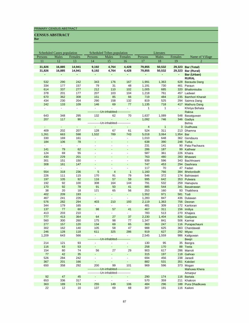
PRIMARY CENSUS ABSTRACT
CENSUS ABSTRACTBar
Persons Males Females Persons Males Females Persons Males Females11 12 13 14 15 16 17 18 19 2
31,826 16,885 14,941 9,192 4,764 4,428 79,855 50,532 29,323 Bar (Total)31,826 16,885 14,941 9,192 4,764 4,428 79,855 50,532 29,323 Bar (Rural)
- - - - - - - - - Bar (Urban)RURAL
532 290 242 343 176 167 1,991 1,363 628 Barauda Dang334 177 157 79 31 48 1,191 730 461 Paraun614 337 277 212 110 102 1,005 685 320 Bhailonisuba378 201 177 207 103 104 1,218 761 457 Ladwari670 362 308 151 85 66 719 484 235 Bamhori Kharait434 230 204 290 158 132 819 525 294 Saimra Dang242 133 109 146 69 77 1,135 718 417 Mathura Dang- - - - - - 1 1 - Khiriya Behata
Raksa643 348 295 132 62 70 1,637 1,089 548 Basatguwan207 117 90 - - - 1,092 746 346 Gadiya
Behra- - - - - - 4 1 3 Dudhuwa409 202 207 128 67 61 524 311 213 Dhamna
1,261 663 598 1,532 789 743 5,018 3,064 1,954 Bar330 169 161 - - - 1,010 648 362 Gendaura184 106 78 - - - 638 390 248 Turka- - - - - - 231 141 90 Pata Pachaura141 79 62 - - - 286 187 99 Kathwar124 69 55 - - - 587 361 226 Khaira430 229 201 - - - 763 480 283 Bhawani301 151 150 - - - 939 596 343 Bachhrawni308 161 147 - - - 747 453 294 Dashrara- - - - - - 117 70 47 Fadari554 318 236 5 4 1 1,160 766 394 Bhelonilodh226 111 115 170 91 79 546 372 174 Bahrawani197 105 92 116 57 59 995 642 353 Pulwara192 92 100 308 164 144 791 532 259 Hanupura170 92 78 91 50 41 885 544 341 Basatrawan38 20 18 121 65 56 253 160 93 Thatkhera
402 209 193 - - - 1,552 971 581 Todi467 241 226 - - - 1,283 847 436 Dulawan576 282 294 403 210 193 2,119 1,363 756 Deoran344 179 165 - - - 481 309 172 Karitoran137 77 60 98 57 41 467 311 156 Imiliya413 203 210 - - - 783 513 270 Khajara777 413 364 64 27 37 2,230 1,404 826 Gadyana560 300 260 175 98 77 1,347 841 506 Karmai277 157 120 134 69 65 363 247 116 Purapachauni302 162 140 105 58 47 988 625 363 Chandawali246 128 118 611 325 286 919 627 292 Miyao
1,209 643 566 - - - 2,545 1,559 986 KailguwanBeejri
214 121 93 - - - 130 95 35 Bangra116 63 53 - - - 258 170 88 Teela154 80 74 56 27 29 903 617 286 Marroli
77 42 35 - - - 315 197 118 Gahrao526 284 242 - - - 694 456 238 Jaraoli367 201 166 - - - 882 531 351 Kakdari650 358 292 200 99 101 969 596 373 Mogan
Mahuwa KheraAmarpur
92 47 45 - - - 290 174 116 Bartala653 336 317 - - - 570 359 211 Khakron363 189 174 255 149 106 484 296 188 Pura Dhadkuwa22 12 10 137 69 68 307 191 116 Kailoni
-------------Un-inhabited---------------------------Un-inhabited--------------
-------------Un-inhabited--------------
-------------Un-inhabited--------------
-------------Un-inhabited--------------
Scheduled Castes population Scheduled Tribes populationName of Village
Literates
87
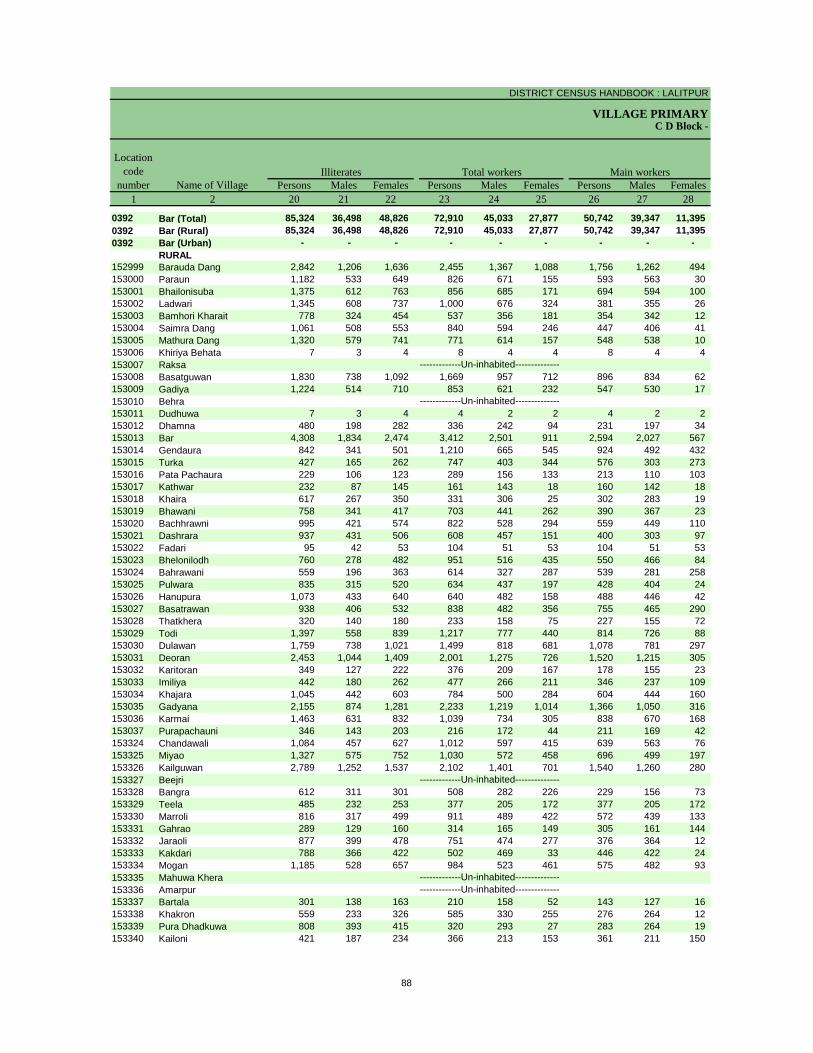
DISTRICT CENSUS HANDBOOK : LALITPUR
VILLAGE PRIMARYC D Block -
Persons Males Females Persons Males Females Persons Males Females1 2 20 21 22 23 24 25 26 27 28
0392 Bar (Total) 85,324 36,498 48,826 72,910 45,033 27,877 50,742 39,347 11,395 0392 Bar (Rural) 85,324 36,498 48,826 72,910 45,033 27,877 50,742 39,347 11,395 0392 Bar (Urban) - - - - - - - - -
RURAL152999 Barauda Dang 2,842 1,206 1,636 2,455 1,367 1,088 1,756 1,262 494 153000 Paraun 1,182 533 649 826 671 155 593 563 30 153001 Bhailonisuba 1,375 612 763 856 685 171 694 594 100 153002 Ladwari 1,345 608 737 1,000 676 324 381 355 26 153003 Bamhori Kharait 778 324 454 537 356 181 354 342 12 153004 Saimra Dang 1,061 508 553 840 594 246 447 406 41 153005 Mathura Dang 1,320 579 741 771 614 157 548 538 10 153006 Khiriya Behata 7 3 4 8 4 4 8 4 4 153007 Raksa153008 Basatguwan 1,830 738 1,092 1,669 957 712 896 834 62 153009 Gadiya 1,224 514 710 853 621 232 547 530 17 153010 Behra153011 Dudhuwa 7 3 4 4 2 2 4 2 2 153012 Dhamna 480 198 282 336 242 94 231 197 34 153013 Bar 4,308 1,834 2,474 3,412 2,501 911 2,594 2,027 567 153014 Gendaura 842 341 501 1,210 665 545 924 492 432 153015 Turka 427 165 262 747 403 344 576 303 273 153016 Pata Pachaura 229 106 123 289 156 133 213 110 103 153017 Kathwar 232 87 145 161 143 18 160 142 18 153018 Khaira 617 267 350 331 306 25 302 283 19 153019 Bhawani 758 341 417 703 441 262 390 367 23 153020 Bachhrawni 995 421 574 822 528 294 559 449 110 153021 Dashrara 937 431 506 608 457 151 400 303 97 153022 Fadari 95 42 53 104 51 53 104 51 53 153023 Bhelonilodh 760 278 482 951 516 435 550 466 84 153024 Bahrawani 559 196 363 614 327 287 539 281 258 153025 Pulwara 835 315 520 634 437 197 428 404 24 153026 Hanupura 1,073 433 640 640 482 158 488 446 42 153027 Basatrawan 938 406 532 838 482 356 755 465 290 153028 Thatkhera 320 140 180 233 158 75 227 155 72 153029 Todi 1,397 558 839 1,217 777 440 814 726 88 153030 Dulawan 1,759 738 1,021 1,499 818 681 1,078 781 297 153031 Deoran 2,453 1,044 1,409 2,001 1,275 726 1,520 1,215 305 153032 Karitoran 349 127 222 376 209 167 178 155 23 153033 Imiliya 442 180 262 477 266 211 346 237 109 153034 Khajara 1,045 442 603 784 500 284 604 444 160 153035 Gadyana 2,155 874 1,281 2,233 1,219 1,014 1,366 1,050 316 153036 Karmai 1,463 631 832 1,039 734 305 838 670 168 153037 Purapachauni 346 143 203 216 172 44 211 169 42 153324 Chandawali 1,084 457 627 1,012 597 415 639 563 76 153325 Miyao 1,327 575 752 1,030 572 458 696 499 197 153326 Kailguwan 2,789 1,252 1,537 2,102 1,401 701 1,540 1,260 280 153327 Beejri153328 Bangra 612 311 301 508 282 226 229 156 73 153329 Teela 485 232 253 377 205 172 377 205 172 153330 Marroli 816 317 499 911 489 422 572 439 133 153331 Gahrao 289 129 160 314 165 149 305 161 144 153332 Jaraoli 877 399 478 751 474 277 376 364 12 153333 Kakdari 788 366 422 502 469 33 446 422 24 153334 Mogan 1,185 528 657 984 523 461 575 482 93 153335 Mahuwa Khera153336 Amarpur153337 Bartala 301 138 163 210 158 52 143 127 16 153338 Khakron 559 233 326 585 330 255 276 264 12 153339 Pura Dhadkuwa 808 393 415 320 293 27 283 264 19 153340 Kailoni 421 187 234 366 213 153 361 211 150
-------------Un-inhabited---------------------------Un-inhabited--------------
-------------Un-inhabited--------------
-------------Un-inhabited--------------
-------------Un-inhabited--------------
Illiterates Total workers Main workersName of Village
Location code
number
88
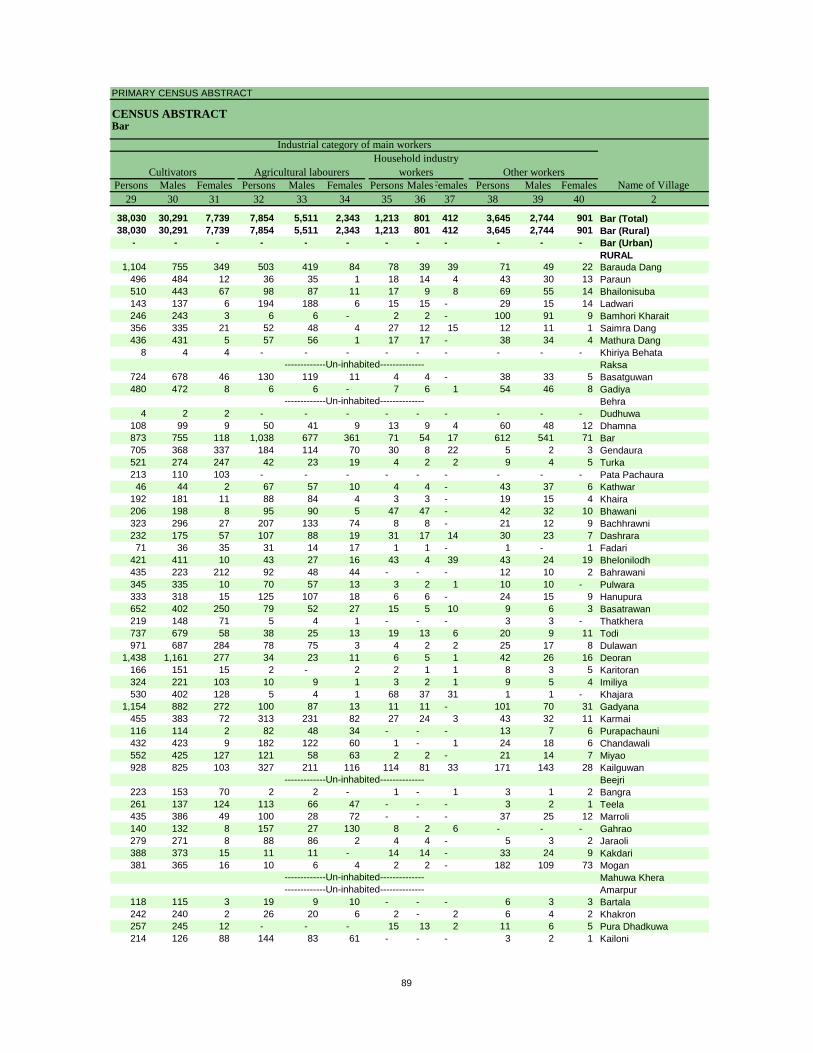
PRIMARY CENSUS ABSTRACT
CENSUS ABSTRACTBar
Persons Males Females Persons Males Females Persons MalesFemales Persons Males Females29 30 31 32 33 34 35 36 37 38 39 40 2
38,030 30,291 7,739 7,854 5,511 2,343 1,213 801 412 3,645 2,744 901 Bar (Total)38,030 30,291 7,739 7,854 5,511 2,343 1,213 801 412 3,645 2,744 901 Bar (Rural)
- - - - - - - - - - - - Bar (Urban)RURAL
1,104 755 349 503 419 84 78 39 39 71 49 22 Barauda Dang496 484 12 36 35 1 18 14 4 43 30 13 Paraun510 443 67 98 87 11 17 9 8 69 55 14 Bhailonisuba143 137 6 194 188 6 15 15 - 29 15 14 Ladwari246 243 3 6 6 - 2 2 - 100 91 9 Bamhori Kharait356 335 21 52 48 4 27 12 15 12 11 1 Saimra Dang436 431 5 57 56 1 17 17 - 38 34 4 Mathura Dang
8 4 4 - - - - - - - - - Khiriya BehataRaksa
724 678 46 130 119 11 4 4 - 38 33 5 Basatguwan480 472 8 6 6 - 7 6 1 54 46 8 Gadiya
Behra4 2 2 - - - - - - - - - Dudhuwa
108 99 9 50 41 9 13 9 4 60 48 12 Dhamna873 755 118 1,038 677 361 71 54 17 612 541 71 Bar705 368 337 184 114 70 30 8 22 5 2 3 Gendaura521 274 247 42 23 19 4 2 2 9 4 5 Turka213 110 103 - - - - - - - - - Pata Pachaura46 44 2 67 57 10 4 4 - 43 37 6 Kathwar
192 181 11 88 84 4 3 3 - 19 15 4 Khaira206 198 8 95 90 5 47 47 - 42 32 10 Bhawani323 296 27 207 133 74 8 8 - 21 12 9 Bachhrawni232 175 57 107 88 19 31 17 14 30 23 7 Dashrara71 36 35 31 14 17 1 1 - 1 - 1 Fadari
421 411 10 43 27 16 43 4 39 43 24 19 Bhelonilodh435 223 212 92 48 44 - - - 12 10 2 Bahrawani345 335 10 70 57 13 3 2 1 10 10 - Pulwara333 318 15 125 107 18 6 6 - 24 15 9 Hanupura652 402 250 79 52 27 15 5 10 9 6 3 Basatrawan219 148 71 5 4 1 - - - 3 3 - Thatkhera737 679 58 38 25 13 19 13 6 20 9 11 Todi971 687 284 78 75 3 4 2 2 25 17 8 Dulawan
1,438 1,161 277 34 23 11 6 5 1 42 26 16 Deoran166 151 15 2 - 2 2 1 1 8 3 5 Karitoran324 221 103 10 9 1 3 2 1 9 5 4 Imiliya530 402 128 5 4 1 68 37 31 1 1 - Khajara
1,154 882 272 100 87 13 11 11 - 101 70 31 Gadyana455 383 72 313 231 82 27 24 3 43 32 11 Karmai116 114 2 82 48 34 - - - 13 7 6 Purapachauni432 423 9 182 122 60 1 - 1 24 18 6 Chandawali552 425 127 121 58 63 2 2 - 21 14 7 Miyao928 825 103 327 211 116 114 81 33 171 143 28 Kailguwan
Beejri223 153 70 2 2 - 1 - 1 3 1 2 Bangra261 137 124 113 66 47 - - - 3 2 1 Teela435 386 49 100 28 72 - - - 37 25 12 Marroli140 132 8 157 27 130 8 2 6 - - - Gahrao279 271 8 88 86 2 4 4 - 5 3 2 Jaraoli388 373 15 11 11 - 14 14 - 33 24 9 Kakdari381 365 16 10 6 4 2 2 - 182 109 73 Mogan
Mahuwa KheraAmarpur
118 115 3 19 9 10 - - - 6 3 3 Bartala242 240 2 26 20 6 2 - 2 6 4 2 Khakron257 245 12 - - - 15 13 2 11 6 5 Pura Dhadkuwa214 126 88 144 83 61 - - - 3 2 1 Kailoni
-------------Un-inhabited---------------------------Un-inhabited--------------
-------------Un-inhabited--------------
-------------Un-inhabited--------------
-------------Un-inhabited--------------
CultivatorsName of Village
Household industry workersAgricultural labourers
Industrial category of main workers
Other workers
89
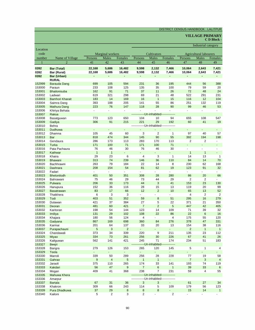
DISTRICT CENSUS HANDBOOK : LALITPUR
VILLAGE PRIMARYC D Block -
Persons Males Females Persons Males Females Persons Males Females1 2 41 42 43 44 45 46 47 48 49
0392 Bar (Total) 22,168 5,686 16,482 9,598 2,132 7,466 10,064 2,643 7,421 0392 Bar (Rural) 22,168 5,686 16,482 9,598 2,132 7,466 10,064 2,643 7,421 0392 Bar (Urban) - - - - - - - - -
RURAL152999 Barauda Dang 699 105 594 231 36 195 444 56 388 153000 Paraun 233 108 125 135 35 100 79 59 20 153001 Bhailonisuba 162 91 71 37 11 26 72 48 24 153002 Ladwari 619 321 298 69 21 48 522 291 231 153003 Bamhori Kharait 183 14 169 16 1 15 116 12 104 153004 Saimra Dang 393 188 205 141 55 86 251 132 119 153005 Mathura Dang 223 76 147 118 28 90 99 46 53 153006 Khiriya Behata - - - - - - - - - 153007 Raksa153008 Basatguwan 773 123 650 104 10 94 655 108 547 153009 Gadiya 306 91 215 221 29 192 60 41 19 153010 Behra153011 Dudhuwa - - - - - - - - - 153012 Dhamna 105 45 60 3 2 1 97 40 57 153013 Bar 818 474 344 145 90 55 392 194 198 153014 Gendaura 286 173 113 283 170 113 2 2 - 153015 Turka 171 100 71 171 100 71 - - - 153016 Pata Pachaura 76 46 30 76 46 30 - - - 153017 Kathwar 1 1 - - - - 1 1 - 153018 Khaira 29 23 6 4 3 1 14 13 1 153019 Bhawani 313 74 239 146 36 110 84 14 70 153020 Bachhrawni 263 79 184 22 14 8 230 62 168 153021 Dashrara 208 154 54 81 62 19 123 91 32 153022 Fadari - - - - - - - - - 153023 Bhelonilodh 401 50 351 308 28 280 86 20 66 153024 Bahrawani 75 46 29 73 44 29 2 2 - 153025 Pulwara 206 33 173 44 3 41 153 23 130 153026 Hanupura 152 36 116 28 15 13 119 20 99 153027 Basatrawan 83 17 66 12 2 10 65 13 52 153028 Thatkhera 6 3 3 - - - 4 2 2 153029 Todi 403 51 352 59 8 51 295 16 279 153030 Dulawan 421 37 384 27 5 22 371 21 350 153031 Deoran 481 60 421 7 2 5 447 42 405 153032 Karitoran 198 54 144 123 14 109 71 39 32 153033 Imiliya 131 29 102 108 22 86 22 6 16 153034 Khajara 180 56 124 4 - 4 175 55 120 153035 Gadyana 867 169 698 360 84 276 378 47 331 153036 Karmai 201 64 137 33 20 13 154 38 116 153037 Purapachauni 5 3 2 - - - 2 1 1 153324 Chandawali 373 34 339 220 9 211 135 23 112 153325 Miyao 334 73 261 256 30 226 67 41 26 153326 Kailguwan 562 141 421 245 71 174 234 51 183 153327 Beejri153328 Bangra 279 126 153 265 120 145 5 1 4 153329 Teela - - - - - - - - - 153330 Marroli 339 50 289 256 28 228 77 19 58 153331 Gahrao 9 4 5 1 1 - 7 3 4 153332 Jaraoli 375 110 265 174 33 141 193 74 119 153333 Kakdari 56 47 9 7 6 1 39 33 6 153334 Mogan 409 41 368 238 7 231 59 4 55 153335 Mahuwa Khera153336 Amarpur153337 Bartala 67 31 36 3 3 - 61 27 34 153338 Khakron 309 66 243 114 5 109 179 56 123 153339 Pura Dhadkuwa 37 29 8 8 8 - 15 14 1 153340 Kailoni 5 2 3 2 - 2 - - -
-------------Un-inhabited---------------------------Un-inhabited--------------
-------------Un-inhabited--------------
-------------Un-inhabited--------------
-------------Un-inhabited--------------
Location code
number Name of VillageMarginal workers Cultivators Agricultural labourers
Industrial category
90
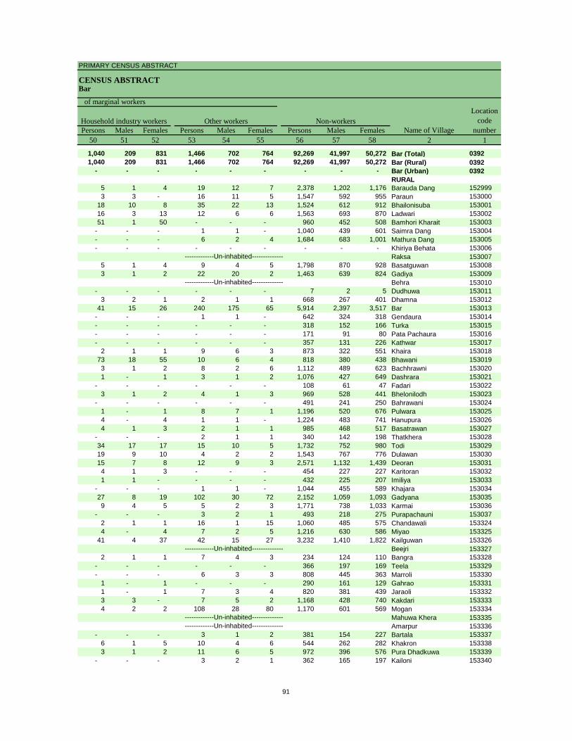
PRIMARY CENSUS ABSTRACT
CENSUS ABSTRACTBar
Persons Males Females Persons Males Females Persons Males Females50 51 52 53 54 55 56 57 58 2 1
1,040 209 831 1,466 702 764 92,269 41,997 50,272 Bar (Total) 03921,040 209 831 1,466 702 764 92,269 41,997 50,272 Bar (Rural) 0392
- - - - - - - - - Bar (Urban) 0392RURAL
5 1 4 19 12 7 2,378 1,202 1,176 Barauda Dang 1529993 3 - 16 11 5 1,547 592 955 Paraun 153000
18 10 8 35 22 13 1,524 612 912 Bhailonisuba 15300116 3 13 12 6 6 1,563 693 870 Ladwari 15300251 1 50 - - - 960 452 508 Bamhori Kharait 153003
- - - 1 1 - 1,040 439 601 Saimra Dang 153004- - - 6 2 4 1,684 683 1,001 Mathura Dang 153005- - - - - - - - - Khiriya Behata 153006
Raksa 1530075 1 4 9 4 5 1,798 870 928 Basatguwan 1530083 1 2 22 20 2 1,463 639 824 Gadiya 153009
Behra 153010- - - - - - 7 2 5 Dudhuwa 153011
3 2 1 2 1 1 668 267 401 Dhamna 15301241 15 26 240 175 65 5,914 2,397 3,517 Bar 153013
- - - 1 1 - 642 324 318 Gendaura 153014- - - - - - 318 152 166 Turka 153015- - - - - - 171 91 80 Pata Pachaura 153016- - - - - - 357 131 226 Kathwar 153017
2 1 1 9 6 3 873 322 551 Khaira 15301873 18 55 10 6 4 818 380 438 Bhawani 1530193 1 2 8 2 6 1,112 489 623 Bachhrawni 1530201 - 1 3 1 2 1,076 427 649 Dashrara 153021
- - - - - - 108 61 47 Fadari 1530223 1 2 4 1 3 969 528 441 Bhelonilodh 153023
- - - - - - 491 241 250 Bahrawani 1530241 - 1 8 7 1 1,196 520 676 Pulwara 1530254 - 4 1 1 - 1,224 483 741 Hanupura 1530264 1 3 2 1 1 985 468 517 Basatrawan 153027
- - - 2 1 1 340 142 198 Thatkhera 15302834 17 17 15 10 5 1,732 752 980 Todi 15302919 9 10 4 2 2 1,543 767 776 Dulawan 15303015 7 8 12 9 3 2,571 1,132 1,439 Deoran 1530314 1 3 - - - 454 227 227 Karitoran 1530321 1 - - - - 432 225 207 Imiliya 153033
- - - 1 1 - 1,044 455 589 Khajara 15303427 8 19 102 30 72 2,152 1,059 1,093 Gadyana 1530359 4 5 5 2 3 1,771 738 1,033 Karmai 153036
- - - 3 2 1 493 218 275 Purapachauni 1530372 1 1 16 1 15 1,060 485 575 Chandawali 1533244 - 4 7 2 5 1,216 630 586 Miyao 153325
41 4 37 42 15 27 3,232 1,410 1,822 Kailguwan 153326Beejri 153327
2 1 1 7 4 3 234 124 110 Bangra 153328- - - - - - 366 197 169 Teela 153329- - - 6 3 3 808 445 363 Marroli 153330
1 - 1 - - - 290 161 129 Gahrao 1533311 - 1 7 3 4 820 381 439 Jaraoli 1533323 3 - 7 5 2 1,168 428 740 Kakdari 1533334 2 2 108 28 80 1,170 601 569 Mogan 153334
Mahuwa Khera 153335Amarpur 153336
- - - 3 1 2 381 154 227 Bartala 1533376 1 5 10 4 6 544 262 282 Khakron 1533383 1 2 11 6 5 972 396 576 Pura Dhadkuwa 153339
- - - 3 2 1 362 165 197 Kailoni 153340
-------------Un-inhabited---------------------------Un-inhabited--------------
-------------Un-inhabited--------------
-------------Un-inhabited--------------
-------------Un-inhabited--------------
Non-workers
of marginal workersLocation
code number
Household industry workersName of Village
Other workers
91
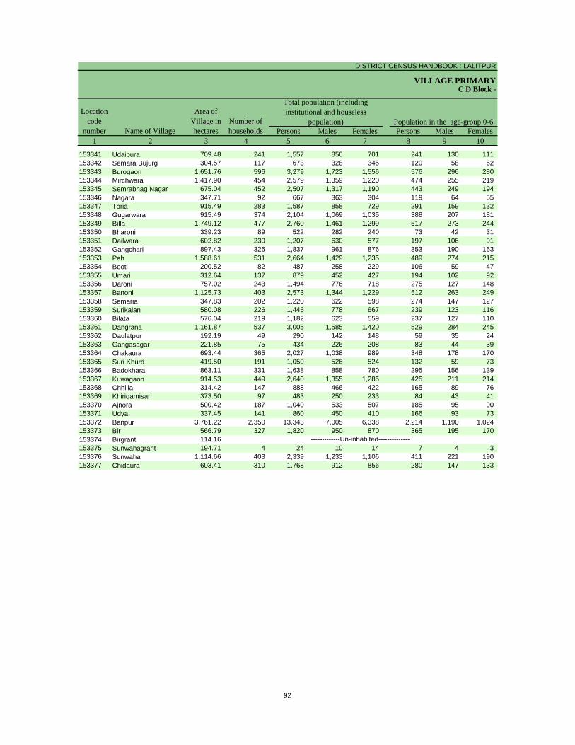
DISTRICT CENSUS HANDBOOK : LALITPUR
VILLAGE PRIMARY
Persons Males Females Persons Males Females1 2 3 4 5 6 7 8 9 10
C D Block -
Population in the age-group 0-6Number of householdsName of Village
Location code
number
Total population (including institutional and houseless
population)Area of
Village in hectares
153341 Udaipura 709.48 241 1,557 856 701 241 130 111 153342 Semara Bujurg 304.57 117 673 328 345 120 58 62 153343 Burogaon 1,651.76 596 3,279 1,723 1,556 576 296 280 153344 Mirchwara 1,417.90 454 2,579 1,359 1,220 474 255 219 153345 Semrabhag Nagar 675.04 452 2,507 1,317 1,190 443 249 194 153346 Nagara 347.71 92 667 363 304 119 64 55 153347 Toria 915.49 283 1,587 858 729 291 159 132 153348 Gugarwara 915.49 374 2,104 1,069 1,035 388 207 181 153349 Billa 1,749.12 477 2,760 1,461 1,299 517 273 244 153350 Bharoni 339.23 89 522 282 240 73 42 31 153351 Dailwara 602.82 230 1,207 630 577 197 106 91 153352 Gangchari 897.43 326 1,837 961 876 353 190 163 153353 Pah 1,588.61 531 2,664 1,429 1,235 489 274 215 153354 Booti 200.52 82 487 258 229 106 59 47 153355 Umari 312.64 137 879 452 427 194 102 92 153356 Daroni 757.02 243 1,494 776 718 275 127 148 153357 Banoni 1,125.73 403 2,573 1,344 1,229 512 263 249 153358 Semaria 347.83 202 1,220 622 598 274 147 127 153359 Surikalan 580.08 226 1,445 778 667 239 123 116 153360 Bilata 576.04 219 1,182 623 559 237 127 110 153361 Dangrana 1,161.87 537 3,005 1,585 1,420 529 284 245 153362 Daulatpur 192.19 49 290 142 148 59 35 24 153363 Gangasagar 221.85 75 434 226 208 83 44 39 153364 Chakaura 693.44 365 2,027 1,038 989 348 178 170 153365 Suri Khurd 419.50 191 1,050 526 524 132 59 73 153366 Badokhara 863.11 331 1,638 858 780 295 156 139 153367 Kuwagaon 914.53 449 2,640 1,355 1,285 425 211 214 153368 Chhilla 314.42 147 888 466 422 165 89 76 153369 Khiriqamisar 373.50 97 483 250 233 84 43 41 153370 Ajnora 500.42 187 1,040 533 507 185 95 90 153371 Udya 337.45 141 860 450 410 166 93 73 153372 Banpur 3,761.22 2,350 13,343 7,005 6,338 2,214 1,190 1,024 153373 Bir 566.79 327 1,820 950 870 365 195 170 153374 Birgrant 114.16153375 Sunwahagrant 194.71 4 24 10 14 7 4 3 153376 Sunwaha 1,114.66 403 2,339 1,233 1,106 411 221 190 153377 Chidaura 603.41 310 1,768 912 856 280 147 133
-------------Un-inhabited--------------
92
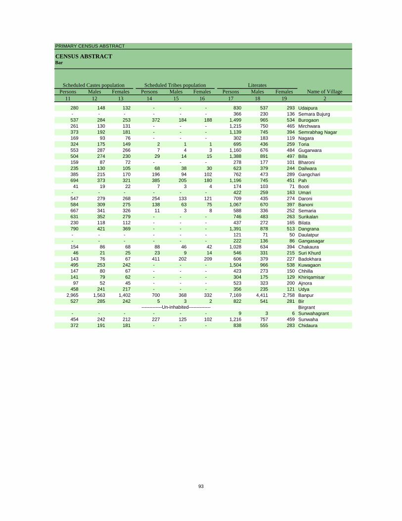
PRIMARY CENSUS ABSTRACT
CENSUS ABSTRACTBar
Persons Males Females Persons Males Females Persons Males Females11 12 13 14 15 16 17 18 19 2
Scheduled Castes population Scheduled Tribes populationName of Village
Literates
280 148 132 - - - 830 537 293 Udaipura- - - - - - 366 230 136 Semara Bujurg537 284 253 372 184 188 1,499 965 534 Burogaon261 130 131 - - - 1,215 750 465 Mirchwara373 192 181 - - - 1,139 745 394 Semrabhag Nagar169 93 76 - - - 302 183 119 Nagara324 175 149 2 1 1 695 436 259 Toria553 287 266 7 4 3 1,160 676 484 Gugarwara504 274 230 29 14 15 1,388 891 497 Billa159 87 72 - - - 278 177 101 Bharoni235 130 105 68 38 30 623 379 244 Dailwara385 215 170 196 94 102 762 473 289 Gangchari694 373 321 385 205 180 1,196 745 451 Pah41 19 22 7 3 4 174 103 71 Booti
- - - - - - 422 259 163 Umari547 279 268 254 133 121 709 435 274 Daroni584 309 275 138 63 75 1,067 670 397 Banoni667 341 326 11 3 8 588 336 252 Semaria631 352 279 - - - 746 483 263 Surikalan230 118 112 - - - 437 272 165 Bilata790 421 369 - - - 1,391 878 513 Dangrana- - - - - - 121 71 50 Daulatpur- - - - - - 222 136 86 Gangasagar154 86 68 88 46 42 1,028 634 394 Chakaura46 21 25 23 9 14 546 331 215 Suri Khurd
143 76 67 411 202 209 606 379 227 Badokhara495 253 242 - - - 1,504 966 538 Kuwagaon147 80 67 - - - 423 273 150 Chhilla141 79 62 - - - 304 175 129 Khiriqamisar
97 52 45 - - - 523 323 200 Ajnora458 241 217 - - - 356 235 121 Udya
2,965 1,563 1,402 700 368 332 7,169 4,411 2,758 Banpur527 285 242 5 3 2 822 541 281 Bir
Birgrant- - - - - - 9 3 6 Sunwahagrant454 242 212 227 125 102 1,216 757 459 Sunwaha372 191 181 - - - 838 555 283 Chidaura
-------------Un-inhabited--------------
93
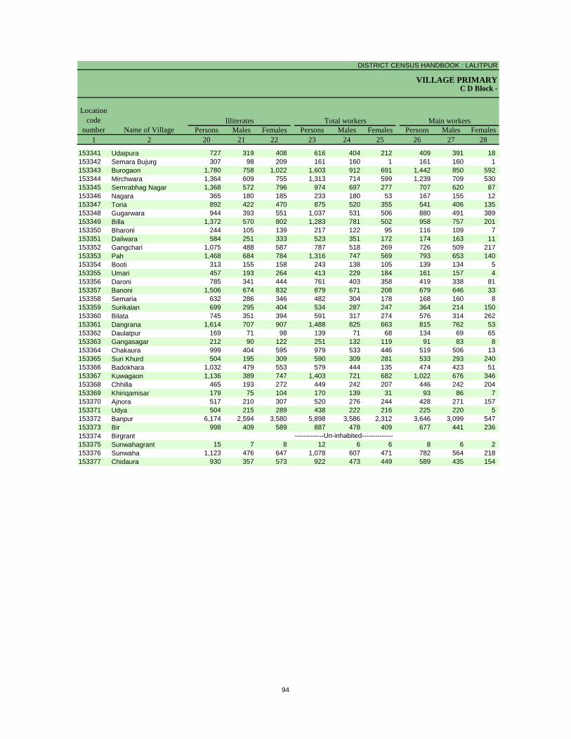
DISTRICT CENSUS HANDBOOK : LALITPUR
VILLAGE PRIMARYC D Block -
Persons Males Females Persons Males Females Persons Males Females1 2 20 21 22 23 24 25 26 27 28
Illiterates Total workers Main workersName of Village
Location code
number
153341 Udaipura 727 319 408 616 404 212 409 391 18 153342 Semara Bujurg 307 98 209 161 160 1 161 160 1 153343 Burogaon 1,780 758 1,022 1,603 912 691 1,442 850 592 153344 Mirchwara 1,364 609 755 1,313 714 599 1,239 709 530 153345 Semrabhag Nagar 1,368 572 796 974 697 277 707 620 87 153346 Nagara 365 180 185 233 180 53 167 155 12 153347 Toria 892 422 470 875 520 355 541 406 135 153348 Gugarwara 944 393 551 1,037 531 506 880 491 389 153349 Billa 1,372 570 802 1,283 781 502 958 757 201 153350 Bharoni 244 105 139 217 122 95 116 109 7 153351 Dailwara 584 251 333 523 351 172 174 163 11 153352 Gangchari 1,075 488 587 787 518 269 726 509 217 153353 Pah 1,468 684 784 1,316 747 569 793 653 140 153354 Booti 313 155 158 243 138 105 139 134 5 153355 Umari 457 193 264 413 229 184 161 157 4 153356 Daroni 785 341 444 761 403 358 419 338 81 153357 Banoni 1,506 674 832 879 671 208 679 646 33 153358 Semaria 632 286 346 482 304 178 168 160 8 153359 Surikalan 699 295 404 534 287 247 364 214 150 153360 Bilata 745 351 394 591 317 274 576 314 262 153361 Dangrana 1,614 707 907 1,488 825 663 815 762 53 153362 Daulatpur 169 71 98 139 71 68 134 69 65 153363 Gangasagar 212 90 122 251 132 119 91 83 8 153364 Chakaura 999 404 595 979 533 446 519 506 13 153365 Suri Khurd 504 195 309 590 309 281 533 293 240 153366 Badokhara 1,032 479 553 579 444 135 474 423 51 153367 Kuwagaon 1,136 389 747 1,403 721 682 1,022 676 346 153368 Chhilla 465 193 272 449 242 207 446 242 204 153369 Khiriqamisar 179 75 104 170 139 31 93 86 7 153370 Ajnora 517 210 307 520 276 244 428 271 157 153371 Udya 504 215 289 438 222 216 225 220 5 153372 Banpur 6,174 2,594 3,580 5,898 3,586 2,312 3,646 3,099 547 153373 Bir 998 409 589 887 478 409 677 441 236 153374 Birgrant153375 Sunwahagrant 15 7 8 12 6 6 8 6 2 153376 Sunwaha 1,123 476 647 1,078 607 471 782 564 218 153377 Chidaura 930 357 573 922 473 449 589 435 154
-------------Un-inhabited--------------
94
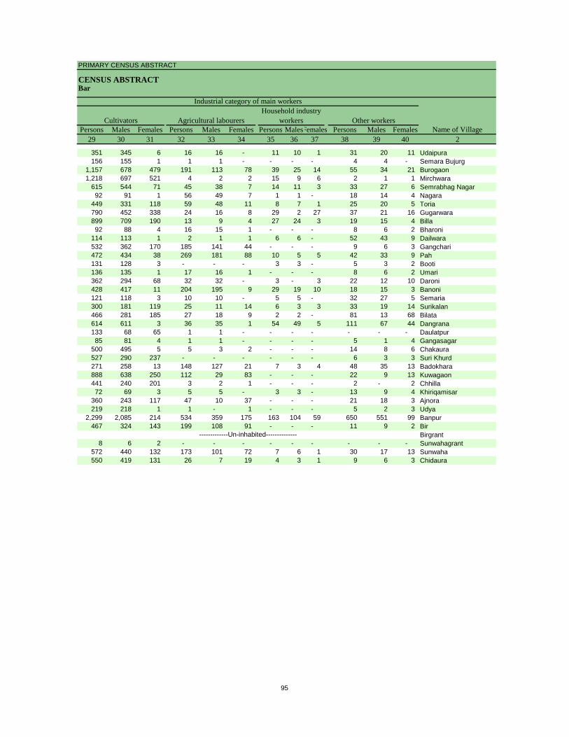
PRIMARY CENSUS ABSTRACT
CENSUS ABSTRACTBar
Persons Males Females Persons Males Females Persons MalesFemales Persons Males Females29 30 31 32 33 34 35 36 37 38 39 40 2
CultivatorsName of Village
Household industry workersAgricultural labourers
Industrial category of main workers
Other workers
351 345 6 16 16 - 11 10 1 31 20 11 Udaipura156 155 1 1 1 - - - - 4 4 - Semara Bujurg
1,157 678 479 191 113 78 39 25 14 55 34 21 Burogaon1,218 697 521 4 2 2 15 9 6 2 1 1 Mirchwara
615 544 71 45 38 7 14 11 3 33 27 6 Semrabhag Nagar92 91 1 56 49 7 1 1 - 18 14 4 Nagara
449 331 118 59 48 11 8 7 1 25 20 5 Toria790 452 338 24 16 8 29 2 27 37 21 16 Gugarwara899 709 190 13 9 4 27 24 3 19 15 4 Billa92 88 4 16 15 1 - - - 8 6 2 Bharoni
114 113 1 2 1 1 6 6 - 52 43 9 Dailwara532 362 170 185 141 44 - - - 9 6 3 Gangchari472 434 38 269 181 88 10 5 5 42 33 9 Pah131 128 3 - - - 3 3 - 5 3 2 Booti136 135 1 17 16 1 - - - 8 6 2 Umari362 294 68 32 32 - 3 - 3 22 12 10 Daroni428 417 11 204 195 9 29 19 10 18 15 3 Banoni121 118 3 10 10 - 5 5 - 32 27 5 Semaria300 181 119 25 11 14 6 3 3 33 19 14 Surikalan466 281 185 27 18 9 2 2 - 81 13 68 Bilata614 611 3 36 35 1 54 49 5 111 67 44 Dangrana133 68 65 1 1 - - - - - - - Daulatpur85 81 4 1 1 - - - - 5 1 4 Gangasagar
500 495 5 5 3 2 - - - 14 8 6 Chakaura527 290 237 - - - - - - 6 3 3 Suri Khurd271 258 13 148 127 21 7 3 4 48 35 13 Badokhara888 638 250 112 29 83 - - - 22 9 13 Kuwagaon441 240 201 3 2 1 - - - 2 - 2 Chhilla72 69 3 5 5 - 3 3 - 13 9 4 Khiriqamisar
360 243 117 47 10 37 - - - 21 18 3 Ajnora219 218 1 1 - 1 - - - 5 2 3 Udya
2,299 2,085 214 534 359 175 163 104 59 650 551 99 Banpur467 324 143 199 108 91 - - - 11 9 2 Bir
Birgrant8 6 2 - - - - - - - - - Sunwahagrant
572 440 132 173 101 72 7 6 1 30 17 13 Sunwaha550 419 131 26 7 19 4 3 1 9 6 3 Chidaura
-------------Un-inhabited--------------
95
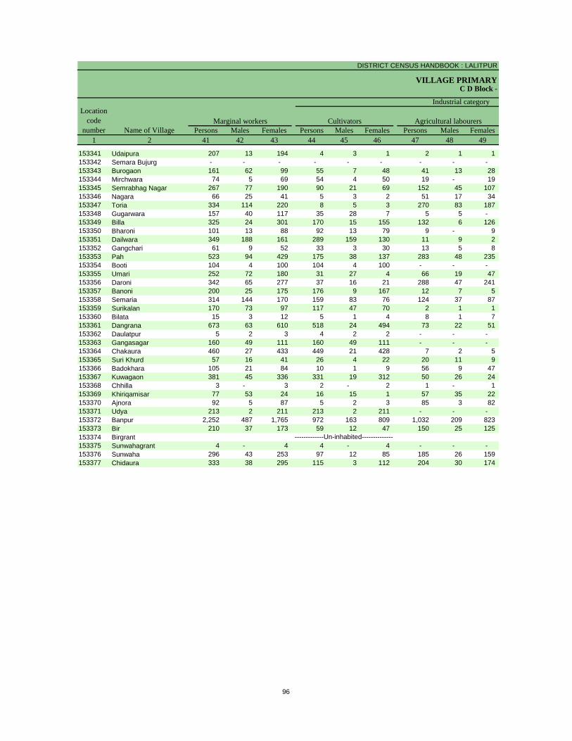
DISTRICT CENSUS HANDBOOK : LALITPUR
VILLAGE PRIMARYC D Block -
Persons Males Females Persons Males Females Persons Males Females1 2 41 42 43 44 45 46 47 48 49
Location code
number Name of VillageMarginal workers Cultivators Agricultural labourers
Industrial category
153341 Udaipura 207 13 194 4 3 1 2 1 1 153342 Semara Bujurg - - - - - - - - - 153343 Burogaon 161 62 99 55 7 48 41 13 28 153344 Mirchwara 74 5 69 54 4 50 19 - 19 153345 Semrabhag Nagar 267 77 190 90 21 69 152 45 107 153346 Nagara 66 25 41 5 3 2 51 17 34 153347 Toria 334 114 220 8 5 3 270 83 187 153348 Gugarwara 157 40 117 35 28 7 5 5 - 153349 Billa 325 24 301 170 15 155 132 6 126 153350 Bharoni 101 13 88 92 13 79 9 - 9 153351 Dailwara 349 188 161 289 159 130 11 9 2 153352 Gangchari 61 9 52 33 3 30 13 5 8 153353 Pah 523 94 429 175 38 137 283 48 235 153354 Booti 104 4 100 104 4 100 - - - 153355 Umari 252 72 180 31 27 4 66 19 47 153356 Daroni 342 65 277 37 16 21 288 47 241 153357 Banoni 200 25 175 176 9 167 12 7 5 153358 Semaria 314 144 170 159 83 76 124 37 87 153359 Surikalan 170 73 97 117 47 70 2 1 1 153360 Bilata 15 3 12 5 1 4 8 1 7 153361 Dangrana 673 63 610 518 24 494 73 22 51 153362 Daulatpur 5 2 3 4 2 2 - - - 153363 Gangasagar 160 49 111 160 49 111 - - - 153364 Chakaura 460 27 433 449 21 428 7 2 5 153365 Suri Khurd 57 16 41 26 4 22 20 11 9 153366 Badokhara 105 21 84 10 1 9 56 9 47 153367 Kuwagaon 381 45 336 331 19 312 50 26 24 153368 Chhilla 3 - 3 2 - 2 1 - 1 153369 Khiriqamisar 77 53 24 16 15 1 57 35 22 153370 Ajnora 92 5 87 5 2 3 85 3 82 153371 Udya 213 2 211 213 2 211 - - - 153372 Banpur 2,252 487 1,765 972 163 809 1,032 209 823 153373 Bir 210 37 173 59 12 47 150 25 125 153374 Birgrant153375 Sunwahagrant 4 - 4 4 - 4 - - - 153376 Sunwaha 296 43 253 97 12 85 185 26 159 153377 Chidaura 333 38 295 115 3 112 204 30 174
-------------Un-inhabited--------------
96
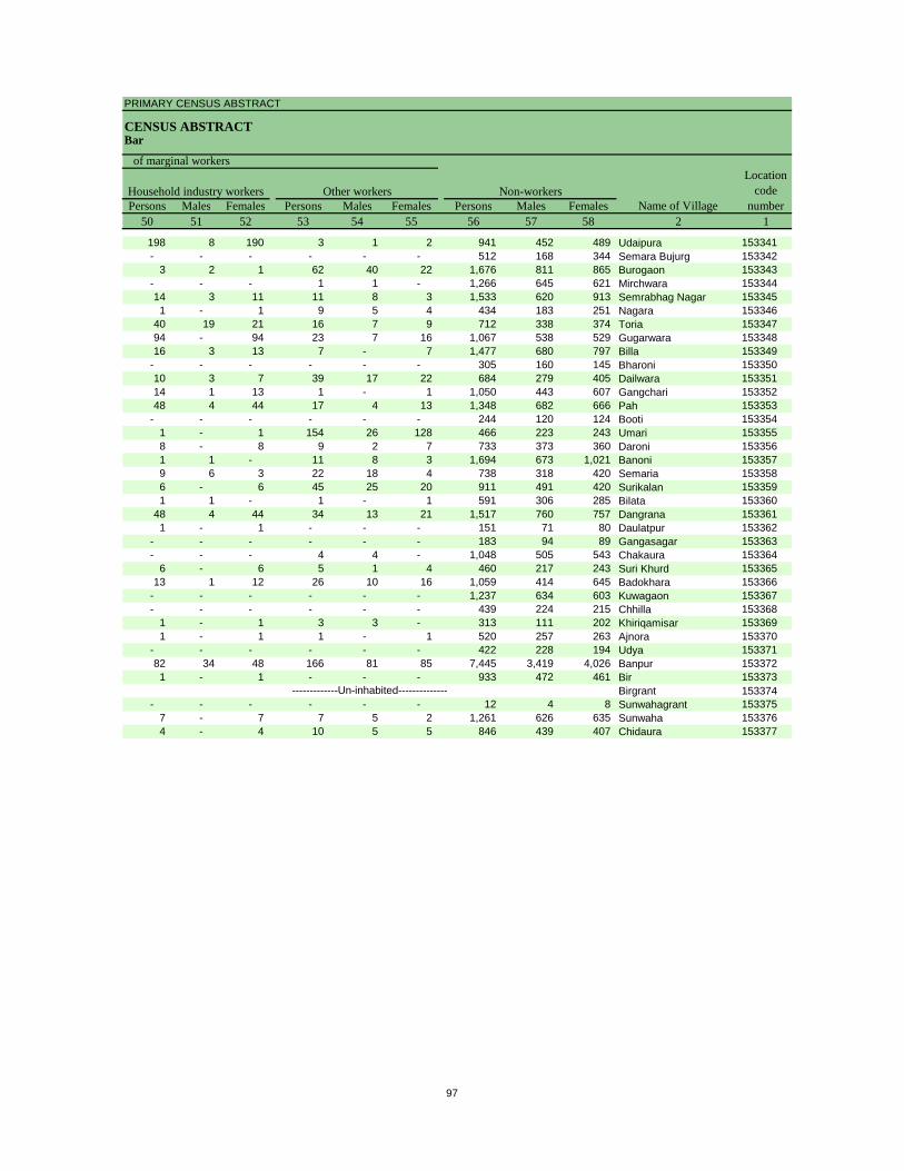
PRIMARY CENSUS ABSTRACT
CENSUS ABSTRACTBar
Persons Males Females Persons Males Females Persons Males Females50 51 52 53 54 55 56 57 58 2 1
Non-workers
of marginal workersLocation
code number
Household industry workersName of Village
Other workers
198 8 190 3 1 2 941 452 489 Udaipura 153341- - - - - - 512 168 344 Semara Bujurg 153342
3 2 1 62 40 22 1,676 811 865 Burogaon 153343- - - 1 1 - 1,266 645 621 Mirchwara 15334414 3 11 11 8 3 1,533 620 913 Semrabhag Nagar 1533451 - 1 9 5 4 434 183 251 Nagara 153346
40 19 21 16 7 9 712 338 374 Toria 15334794 - 94 23 7 16 1,067 538 529 Gugarwara 15334816 3 13 7 - 7 1,477 680 797 Billa 153349
- - - - - - 305 160 145 Bharoni 15335010 3 7 39 17 22 684 279 405 Dailwara 15335114 1 13 1 - 1 1,050 443 607 Gangchari 15335248 4 44 17 4 13 1,348 682 666 Pah 153353
- - - - - - 244 120 124 Booti 1533541 - 1 154 26 128 466 223 243 Umari 1533558 - 8 9 2 7 733 373 360 Daroni 1533561 1 - 11 8 3 1,694 673 1,021 Banoni 1533579 6 3 22 18 4 738 318 420 Semaria 1533586 - 6 45 25 20 911 491 420 Surikalan 1533591 1 - 1 - 1 591 306 285 Bilata 153360
48 4 44 34 13 21 1,517 760 757 Dangrana 1533611 - 1 - - - 151 71 80 Daulatpur 153362
- - - - - - 183 94 89 Gangasagar 153363- - - 4 4 - 1,048 505 543 Chakaura 153364
6 - 6 5 1 4 460 217 243 Suri Khurd 15336513 1 12 26 10 16 1,059 414 645 Badokhara 153366
- - - - - - 1,237 634 603 Kuwagaon 153367- - - - - - 439 224 215 Chhilla 153368
1 - 1 3 3 - 313 111 202 Khiriqamisar 1533691 - 1 1 - 1 520 257 263 Ajnora 153370
- - - - - - 422 228 194 Udya 15337182 34 48 166 81 85 7,445 3,419 4,026 Banpur 1533721 - 1 - - - 933 472 461 Bir 153373
Birgrant 153374- - - - - - 12 4 8 Sunwahagrant 153375
7 - 7 7 5 2 1,261 626 635 Sunwaha 1533764 - 4 10 5 5 846 439 407 Chidaura 153377
-------------Un-inhabited--------------
97
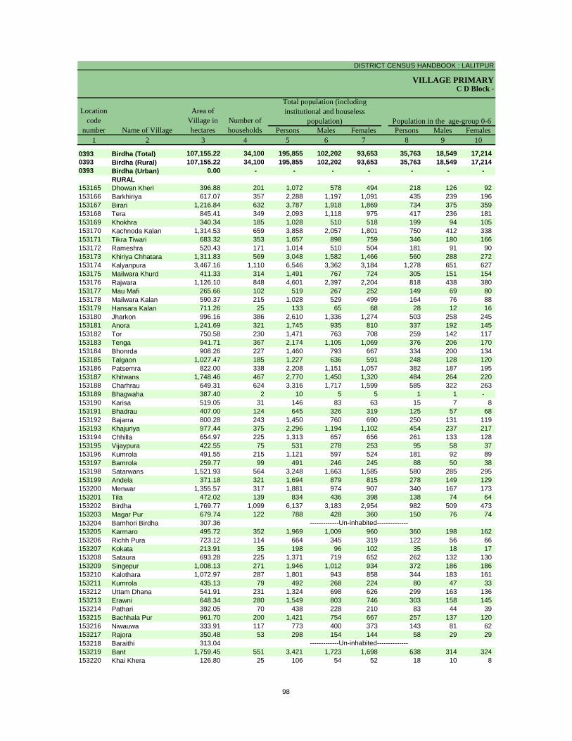
DISTRICT CENSUS HANDBOOK : LALITPUR
VILLAGE PRIMARY
Persons Males Females Persons Males Females1 2 3 4 5 6 7 8 9 10
0393 Birdha (Total) 107,155.22 34,100 195,855 102,202 93,653 35,763 18,549 17,214 0393 Birdha (Rural) 107,155.22 34,100 195,855 102,202 93,653 35,763 18,549 17,214 0393 Birdha (Urban) 0.00 - - - - - - -
RURAL153165 Dhowan Kheri 396.88 201 1,072 578 494 218 126 92 153166 Barkhiriya 617.07 357 2,288 1,197 1,091 435 239 196 153167 Birari 1,216.84 632 3,787 1,918 1,869 734 375 359 153168 Tera 845.41 349 2,093 1,118 975 417 236 181 153169 Khokhra 340.34 185 1,028 510 518 199 94 105 153170 Kachnoda Kalan 1,314.53 659 3,858 2,057 1,801 750 412 338 153171 Tikra Tiwari 683.32 353 1,657 898 759 346 180 166 153172 Rameshra 520.43 171 1,014 510 504 181 91 90 153173 Khiriya Chhatara 1,311.83 569 3,048 1,582 1,466 560 288 272 153174 Kalyanpura 3,467.16 1,110 6,546 3,362 3,184 1,278 651 627 153175 Mailwara Khurd 411.33 314 1,491 767 724 305 151 154 153176 Rajwara 1,126.10 848 4,601 2,397 2,204 818 438 380 153177 Mau Mafi 265.66 102 519 267 252 149 69 80 153178 Mailwara Kalan 590.37 215 1,028 529 499 164 76 88 153179 Hansara Kalan 711.26 25 133 65 68 28 12 16 153180 Jharkon 996.16 386 2,610 1,336 1,274 503 258 245 153181 Anora 1,241.69 321 1,745 935 810 337 192 145 153182 Tor 750.58 230 1,471 763 708 259 142 117 153183 Tenga 941.71 367 2,174 1,105 1,069 376 206 170 153184 Bhonrda 908.26 227 1,460 793 667 334 200 134 153185 Talgaon 1,027.47 185 1,227 636 591 248 128 120 153186 Patsemra 822.00 338 2,208 1,151 1,057 382 187 195 153187 Khitwans 1,748.46 467 2,770 1,450 1,320 484 264 220 153188 Charhrau 649.31 624 3,316 1,717 1,599 585 322 263 153189 Bhagwaha 387.40 2 10 5 5 1 1 - 153190 Karisa 519.05 31 146 83 63 15 7 8 153191 Bhadrau 407.00 124 645 326 319 125 57 68 153192 Bajarra 800.28 243 1,450 760 690 250 131 119 153193 Khajuriya 977.44 375 2,296 1,194 1,102 454 237 217 153194 Chhilla 654.97 225 1,313 657 656 261 133 128 153195 Vijaypura 422.55 75 531 278 253 95 58 37 153196 Kumrola 491.55 215 1,121 597 524 181 92 89 153197 Bamrola 259.77 99 491 246 245 88 50 38 153198 Satarwans 1,521.93 564 3,248 1,663 1,585 580 285 295 153199 Andela 371.18 321 1,694 879 815 278 149 129 153200 Menwar 1,355.57 317 1,881 974 907 340 167 173 153201 Tila 472.02 139 834 436 398 138 74 64 153202 Birdha 1,769.77 1,099 6,137 3,183 2,954 982 509 473 153203 Magar Pur 679.74 122 788 428 360 150 76 74 153204 Bamhori Birdha 307.36153205 Karmaro 495.72 352 1,969 1,009 960 360 198 162 153206 Richh Pura 723.12 114 664 345 319 122 56 66 153207 Kokata 213.91 35 198 96 102 35 18 17 153208 Sataura 693.28 225 1,371 719 652 262 132 130 153209 Singepur 1,008.13 271 1,946 1,012 934 372 186 186 153210 Kalothara 1,072.97 287 1,801 943 858 344 183 161 153211 Kumrola 435.13 79 492 268 224 80 47 33 153212 Uttam Dhana 541.91 231 1,324 698 626 299 163 136 153213 Erawni 648.34 280 1,549 803 746 303 158 145 153214 Pathari 392.05 70 438 228 210 83 44 39 153215 Bachhala Pur 961.70 200 1,421 754 667 257 137 120 153216 Niwauwa 333.91 117 773 400 373 143 81 62 153217 Rajora 350.48 53 298 154 144 58 29 29 153218 Baraithi 313.04153219 Bant 1,759.45 551 3,421 1,723 1,698 638 314 324 153220 Khai Khera 126.80 25 106 54 52 18 10 8
-------------Un-inhabited--------------
-------------Un-inhabited--------------
C D Block -
Population in the age-group 0-6Number of householdsName of Village
Location code
number
Total population (including institutional and houseless
population)Area of
Village in hectares
98

PRIMARY CENSUS ABSTRACT
CENSUS ABSTRACTBirdha
Persons Males Females Persons Males Females Persons Males Females11 12 13 14 15 16 17 18 19 2
41,074 21,487 19,587 15,986 8,234 7,752 99,679 62,940 36,739 Birdha (Total)41,074 21,487 19,587 15,986 8,234 7,752 99,679 62,940 36,739 Birdha (Rural)
- - - - - - - - - Birdha (Urban)RURAL
383 210 173 65 39 26 419 303 116 Dhowan Kheri329 162 167 417 222 195 1,122 690 432 Barkhiriya507 244 263 79 42 37 1,878 1,162 716 Birari498 266 232 - - - 987 610 377 Tera340 186 154 181 89 92 528 306 222 Khokhra467 240 227 145 78 67 1,513 961 552 Kachnoda Kalan333 174 159 219 120 99 948 618 330 Tikra Tiwari37 18 19 18 10 8 486 310 176 Rameshra
823 431 392 491 241 250 1,354 829 525 Khiriya Chhatara1,022 526 496 775 394 381 3,311 2,062 1,249 Kalyanpura
958 485 473 96 53 43 753 478 275 Mailwara Khurd656 324 332 264 142 122 2,330 1,443 887 Rajwara350 169 181 - - - 194 133 61 Mau Mafi492 260 232 51 22 29 611 365 246 Mailwara Kalan- - - 8 4 4 46 31 15 Hansara Kalan536 289 247 198 101 97 1,212 767 445 Jharkon199 109 90 167 87 80 932 589 343 Anora228 123 105 159 89 70 704 449 255 Tor306 167 139 - - - 1,127 688 439 Tenga383 205 178 - - - 637 418 219 Bhonrda394 193 201 - - - 643 423 220 Talgaon845 440 405 - - - 1,173 736 437 Patsemra548 300 248 339 172 167 1,519 950 569 Khitwans848 457 391 28 15 13 1,820 1,147 673 Charhrau- - - - - - 7 4 3 Bhagwaha
4 3 1 - - - 97 73 24 Karisa206 103 103 140 68 72 290 179 111 Bhadrau559 287 272 - - - 825 499 326 Bajarra339 175 164 - - - 1,266 781 485 Khajuriya157 70 87 118 52 66 721 457 264 Chhilla68 39 29 - - - 285 183 102 Vijaypura
100 55 45 - - - 634 410 224 Kumrola289 141 148 - - - 258 156 102 Bamrola577 297 280 - - - 1,653 1,007 646 Satarwans570 292 278 - - - 1,001 640 361 Andela528 272 256 - - - 1,023 618 405 Menwar222 119 103 - - - 415 262 153 Tila740 393 347 - - - 3,654 2,281 1,373 Birdha87 49 38 - - - 438 269 169 Magar Pur
Bamhori Birdha603 312 291 - - - 1,218 702 516 Karmaro48 22 26 - - - 326 218 108 Richh Pura
- - - - - - 94 60 34 Kokata456 228 228 - - - 742 470 272 Sataura280 150 130 - - - 949 599 350 Singepur389 206 183 - - - 947 591 356 Kalothara194 102 92 - - - 276 177 99 Kumrola475 251 224 4 2 2 628 397 231 Uttam Dhana312 163 149 149 74 75 734 470 264 Erawni- - - 74 39 35 157 101 56 Pathari186 85 101 126 72 54 652 460 192 Bachhala Pur403 207 196 - - - 331 225 106 Niwauwa
3 2 1 - - - 85 57 28 RajoraBaraithi
536 275 261 204 111 93 1,706 1,053 653 Bant106 54 52 - - - 69 39 30 Khai Khera
-------------Un-inhabited--------------
-------------Un-inhabited--------------
Scheduled Castes population Scheduled Tribes populationName of Village
Literates
99
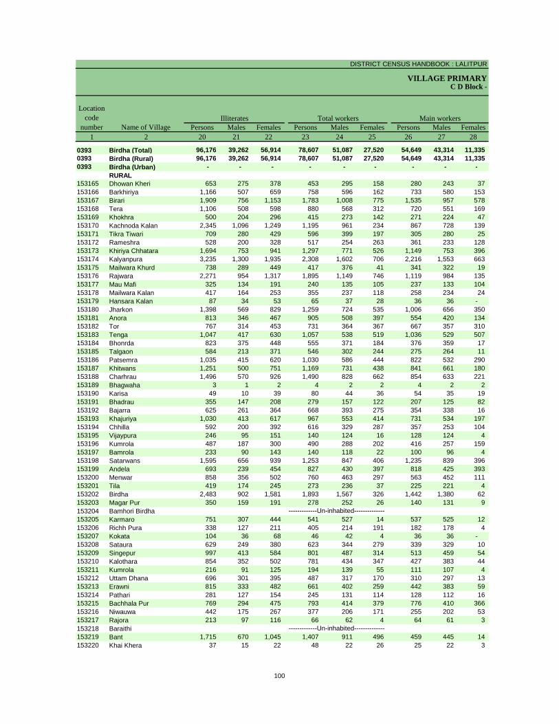
DISTRICT CENSUS HANDBOOK : LALITPUR
VILLAGE PRIMARYC D Block -
Persons Males Females Persons Males Females Persons Males Females1 2 20 21 22 23 24 25 26 27 28
0393 Birdha (Total) 96,176 39,262 56,914 78,607 51,087 27,520 54,649 43,314 11,335 0393 Birdha (Rural) 96,176 39,262 56,914 78,607 51,087 27,520 54,649 43,314 11,335 0393 Birdha (Urban) - - - - - - - - -
RURAL153165 Dhowan Kheri 653 275 378 453 295 158 280 243 37 153166 Barkhiriya 1,166 507 659 758 596 162 733 580 153 153167 Birari 1,909 756 1,153 1,783 1,008 775 1,535 957 578 153168 Tera 1,106 508 598 880 568 312 720 551 169 153169 Khokhra 500 204 296 415 273 142 271 224 47 153170 Kachnoda Kalan 2,345 1,096 1,249 1,195 961 234 867 728 139 153171 Tikra Tiwari 709 280 429 596 399 197 305 280 25 153172 Rameshra 528 200 328 517 254 263 361 233 128 153173 Khiriya Chhatara 1,694 753 941 1,297 771 526 1,149 753 396 153174 Kalyanpura 3,235 1,300 1,935 2,308 1,602 706 2,216 1,553 663 153175 Mailwara Khurd 738 289 449 417 376 41 341 322 19 153176 Rajwara 2,271 954 1,317 1,895 1,149 746 1,119 984 135 153177 Mau Mafi 325 134 191 240 135 105 237 133 104 153178 Mailwara Kalan 417 164 253 355 237 118 258 234 24 153179 Hansara Kalan 87 34 53 65 37 28 36 36 - 153180 Jharkon 1,398 569 829 1,259 724 535 1,006 656 350 153181 Anora 813 346 467 905 508 397 554 420 134 153182 Tor 767 314 453 731 364 367 667 357 310 153183 Tenga 1,047 417 630 1,057 538 519 1,036 529 507 153184 Bhonrda 823 375 448 555 371 184 376 359 17 153185 Talgaon 584 213 371 546 302 244 275 264 11 153186 Patsemra 1,035 415 620 1,030 586 444 822 532 290 153187 Khitwans 1,251 500 751 1,169 731 438 841 661 180 153188 Charhrau 1,496 570 926 1,490 828 662 854 633 221 153189 Bhagwaha 3 1 2 4 2 2 4 2 2 153190 Karisa 49 10 39 80 44 36 54 35 19 153191 Bhadrau 355 147 208 279 157 122 207 125 82 153192 Bajarra 625 261 364 668 393 275 354 338 16 153193 Khajuriya 1,030 413 617 967 553 414 731 534 197 153194 Chhilla 592 200 392 616 329 287 357 253 104 153195 Vijaypura 246 95 151 140 124 16 128 124 4 153196 Kumrola 487 187 300 490 288 202 416 257 159 153197 Bamrola 233 90 143 140 118 22 100 96 4 153198 Satarwans 1,595 656 939 1,253 847 406 1,235 839 396 153199 Andela 693 239 454 827 430 397 818 425 393 153200 Menwar 858 356 502 760 463 297 563 452 111 153201 Tila 419 174 245 273 236 37 225 221 4 153202 Birdha 2,483 902 1,581 1,893 1,567 326 1,442 1,380 62 153203 Magar Pur 350 159 191 278 252 26 140 131 9 153204 Bamhori Birdha153205 Karmaro 751 307 444 541 527 14 537 525 12 153206 Richh Pura 338 127 211 405 214 191 182 178 4 153207 Kokata 104 36 68 46 42 4 36 36 - 153208 Sataura 629 249 380 623 344 279 339 329 10 153209 Singepur 997 413 584 801 487 314 513 459 54 153210 Kalothara 854 352 502 781 434 347 427 383 44 153211 Kumrola 216 91 125 194 139 55 111 107 4 153212 Uttam Dhana 696 301 395 487 317 170 310 297 13 153213 Erawni 815 333 482 661 402 259 442 383 59 153214 Pathari 281 127 154 245 131 114 128 112 16 153215 Bachhala Pur 769 294 475 793 414 379 776 410 366 153216 Niwauwa 442 175 267 377 206 171 255 202 53 153217 Rajora 213 97 116 66 62 4 64 61 3 153218 Baraithi153219 Bant 1,715 670 1,045 1,407 911 496 459 445 14 153220 Khai Khera 37 15 22 48 22 26 25 22 3
-------------Un-inhabited--------------
-------------Un-inhabited--------------
Illiterates Total workers Main workersName of Village
Location code
number
100
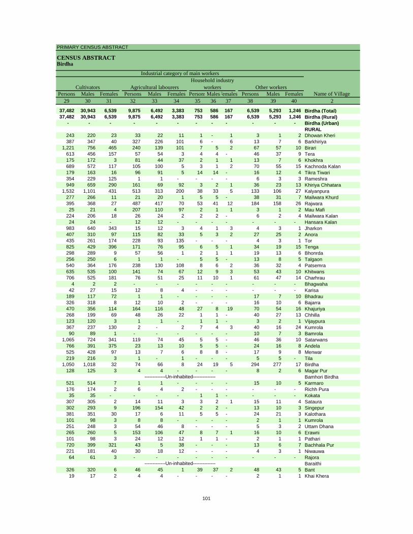
PRIMARY CENSUS ABSTRACT
CENSUS ABSTRACTBirdha
Persons Males Females Persons Males Females PersonsMalesFemales Persons Males Females29 30 31 32 33 34 35 36 37 38 39 40 2
37,482 30,943 6,539 9,875 6,492 3,383 753 586 167 6,539 5,293 1,246 Birdha (Total)37,482 30,943 6,539 9,875 6,492 3,383 753 586 167 6,539 5,293 1,246 Birdha (Rural)
- - - - - - - - - - - - Birdha (Urban)RURAL
243 220 23 33 22 11 1 - 1 3 1 2 Dhowan Kheri387 347 40 327 226 101 6 - 6 13 7 6 Barkhiriya
1,221 756 465 240 139 101 7 5 2 67 57 10 Birari613 456 157 57 54 3 4 4 - 46 37 9 Tera175 172 3 81 44 37 2 1 1 13 7 6 Khokhra689 572 117 105 100 5 3 1 2 70 55 15 Kachnoda Kalan179 163 16 96 91 5 14 14 - 16 12 4 Tikra Tiwari354 229 125 1 1 - - - - 6 3 3 Rameshra949 659 290 161 69 92 3 2 1 36 23 13 Khiriya Chhatara
1,532 1,101 431 513 313 200 38 33 5 133 106 27 Kalyanpura277 266 11 21 20 1 5 5 - 38 31 7 Mailwara Khurd395 368 27 487 417 70 53 41 12 184 158 26 Rajwara25 21 4 207 110 97 2 1 1 3 1 2 Mau Mafi
224 206 18 26 24 2 2 2 - 6 2 4 Mailwara Kalan24 24 - 12 12 - - - - - - - Hansara Kalan
983 640 343 15 12 3 4 1 3 4 3 1 Jharkon407 310 97 115 82 33 5 3 2 27 25 2 Anora435 261 174 228 93 135 - - - 4 3 1 Tor825 429 396 171 76 95 6 5 1 34 19 15 Tenga298 289 9 57 56 1 2 1 1 19 13 6 Bhonrda256 250 6 1 1 - 5 5 - 13 8 5 Talgaon540 364 176 238 130 108 8 6 2 36 32 4 Patsemra635 535 100 141 74 67 12 9 3 53 43 10 Khitwans706 525 181 76 51 25 11 10 1 61 47 14 Charhrau
4 2 2 - - - - - - - - - Bhagwaha42 27 15 12 8 4 - - - - - - Karisa
189 117 72 1 1 - - - - 17 7 10 Bhadrau326 318 8 12 10 2 - - - 16 10 6 Bajarra470 356 114 164 116 48 27 8 19 70 54 16 Khajuriya268 199 69 48 26 22 1 1 - 40 27 13 Chhilla123 120 3 1 1 - 1 1 - 3 2 1 Vijaypura367 237 130 2 - 2 7 4 3 40 16 24 Kumrola90 89 1 - - - - - - 10 7 3 Bamrola
1,065 724 341 119 74 45 5 5 - 46 36 10 Satarwans766 391 375 23 13 10 5 5 - 24 16 8 Andela525 428 97 13 7 6 8 8 - 17 9 8 Menwar219 216 3 1 - 1 - - - 5 5 - Tila
1,050 1,018 32 74 66 8 24 19 5 294 277 17 Birdha128 125 3 4 4 - - - - 8 2 6 Magar Pur
Bamhori Birdha521 514 7 1 1 - - - - 15 10 5 Karmaro176 174 2 6 4 2 - - - - - - Richh Pura35 35 - - - - 1 1 - - - - Kokata
307 305 2 14 11 3 3 2 1 15 11 4 Sataura302 293 9 196 154 42 2 2 - 13 10 3 Singepur381 351 30 17 6 11 5 5 - 24 21 3 Kalothara101 98 3 8 8 - - - - 2 1 1 Kumrola251 248 3 54 46 8 - - - 5 3 2 Uttam Dhana265 260 5 153 106 47 8 7 1 16 10 6 Erawni101 98 3 24 12 12 1 1 - 2 1 1 Pathari720 399 321 43 5 38 - - - 13 6 7 Bachhala Pur221 181 40 30 18 12 - - - 4 3 1 Niwauwa64 61 3 - - - - - - - - - Rajora
Baraithi326 320 6 46 45 1 39 37 2 48 43 5 Bant19 17 2 4 4 - - - - 2 1 1 Khai Khera
-------------Un-inhabited--------------
-------------Un-inhabited--------------
CultivatorsName of Village
Household industry workersAgricultural labourers
Industrial category of main workers
Other workers
101

DISTRICT CENSUS HANDBOOK : LALITPUR
VILLAGE PRIMARYC D Block -
Persons Males Females Persons Males Females Persons Males Females1 2 41 42 43 44 45 46 47 48 49
0393 Birdha (Total) 23,958 7,773 16,185 7,541 1,865 5,676 13,490 4,372 9,118 0393 Birdha (Rural) 23,958 7,773 16,185 7,541 1,865 5,676 13,490 4,372 9,118 0393 Birdha (Urban) - - - - - - - - -
RURAL153165 Dhowan Kheri 173 52 121 156 42 114 14 7 7 153166 Barkhiriya 25 16 9 8 7 1 15 8 7 153167 Birari 248 51 197 154 12 142 73 34 39 153168 Tera 160 17 143 141 9 132 12 3 9 153169 Khokhra 144 49 95 124 43 81 12 2 10 153170 Kachnoda Kalan 328 233 95 75 64 11 169 87 82 153171 Tikra Tiwari 291 119 172 95 49 46 175 55 120 153172 Rameshra 156 21 135 155 21 134 1 - 1 153173 Khiriya Chhatara 148 18 130 55 5 50 83 9 74 153174 Kalyanpura 92 49 43 41 16 25 30 17 13 153175 Mailwara Khurd 76 54 22 17 6 11 26 19 7 153176 Rajwara 776 165 611 337 70 267 392 73 319 153177 Mau Mafi 3 2 1 - - - 1 - 1 153178 Mailwara Kalan 97 3 94 85 1 84 7 1 6 153179 Hansara Kalan 29 1 28 24 - 24 5 1 4 153180 Jharkon 253 68 185 184 48 136 63 16 47 153181 Anora 351 88 263 168 43 125 160 33 127 153182 Tor 64 7 57 4 2 2 49 4 45 153183 Tenga 21 9 12 3 1 2 10 5 5 153184 Bhonrda 179 12 167 168 10 158 8 2 6 153185 Talgaon 271 38 233 154 29 125 110 4 106 153186 Patsemra 208 54 154 130 21 109 65 24 41 153187 Khitwans 328 70 258 215 48 167 104 18 86 153188 Charhrau 636 195 441 159 16 143 448 161 287 153189 Bhagwaha - - - - - - - - - 153190 Karisa 26 9 17 2 1 1 23 7 16 153191 Bhadrau 72 32 40 7 - 7 34 4 30 153192 Bajarra 314 55 259 291 47 244 20 7 13 153193 Khajuriya 236 19 217 55 4 51 143 8 135 153194 Chhilla 259 76 183 66 12 54 173 53 120 153195 Vijaypura 12 - 12 7 - 7 3 - 3 153196 Kumrola 74 31 43 1 1 - 39 21 18 153197 Bamrola 40 22 18 21 15 6 17 6 11 153198 Satarwans 18 8 10 10 3 7 8 5 3 153199 Andela 9 5 4 1 - 1 - - - 153200 Menwar 197 11 186 79 7 72 118 4 114 153201 Tila 48 15 33 - - - 48 15 33 153202 Birdha 451 187 264 63 42 21 332 110 222 153203 Magar Pur 138 121 17 1 - 1 137 121 16 153204 Bamhori Birdha153205 Karmaro 4 2 2 3 1 2 1 1 - 153206 Richh Pura 223 36 187 207 33 174 14 2 12 153207 Kokata 10 6 4 6 5 1 2 1 1 153208 Sataura 284 15 269 12 1 11 272 14 258 153209 Singepur 288 28 260 130 7 123 27 20 7 153210 Kalothara 354 51 303 190 31 159 151 13 138 153211 Kumrola 83 32 51 1 - 1 82 32 50 153212 Uttam Dhana 177 20 157 10 1 9 167 19 148 153213 Erawni 219 19 200 74 5 69 134 11 123 153214 Pathari 117 19 98 112 15 97 5 4 1 153215 Bachhala Pur 17 4 13 11 - 11 4 3 1 153216 Niwauwa 122 4 118 116 2 114 6 2 4 153217 Rajora 2 1 1 1 1 - 1 - 1 153218 Baraithi153219 Bant 948 466 482 268 80 188 628 353 275 153220 Khai Khera 23 - 23 22 - 22 1 - 1
-------------Un-inhabited--------------
-------------Un-inhabited--------------
Location code
number Name of VillageMarginal workers Cultivators Agricultural labourers
Industrial category
102
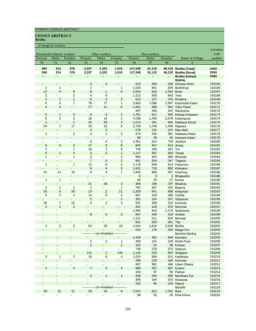
PRIMARY CENSUS ABSTRACT
CENSUS ABSTRACTBirdha
Persons Males Females Persons Males Females Persons Males Females50 51 52 53 54 55 56 57 58 2 1
590 214 376 2,337 1,322 1,015 117,248 51,115 66,133 Birdha (Total) 0393590 214 376 2,337 1,322 1,015 117,248 51,115 66,133 Birdha (Rural) 0393- - - - - - - - - Birdha (Urban) 0393
RURAL- - - 3 3 - 619 283 336 Dhowan Kheri 153165
1 1 - 1 - 1 1,530 601 929 Barkhiriya 15316612 4 8 9 1 8 2,004 910 1,094 Birari 1531672 - 2 5 5 - 1,213 550 663 Tera 1531682 1 1 6 3 3 613 237 376 Khokhra 1531696 5 1 78 77 1 2,663 1,096 1,567 Kachnoda Kalan 1531704 4 - 17 11 6 1,061 499 562 Tikra Tiwari 153171
- - - - - - 497 256 241 Rameshra 1531725 1 4 5 3 2 1,751 811 940 Khiriya Chhatara 1531735 2 3 16 14 2 4,238 1,760 2,478 Kalyanpura 1531741 - 1 32 29 3 1,074 391 683 Mailwara Khurd 153175
24 7 17 23 15 8 2,706 1,248 1,458 Rajwara 153176- - - 2 2 - 279 132 147 Mau Mafi 153177
2 - 2 3 1 2 673 292 381 Mailwara Kalan 153178- - - - - - 68 28 40 Hansara Kalan 153179- - - 6 4 2 1,351 612 739 Jharkon 153180
6 3 3 17 9 8 840 427 413 Anora 1531811 - 1 10 1 9 740 399 341 Tor 1531825 1 4 3 2 1 1,117 567 550 Tenga 1531831 - 1 2 - 2 905 422 483 Bhonrda 153184
- - - 7 5 2 681 334 347 Talgaon 1531851 - 1 12 9 3 1,178 565 613 Patsemra 153186
- - - 9 4 5 1,601 719 882 Khitwans 15318724 14 10 5 4 1 1,826 889 937 Charhrau 153188
- - - - - - 6 3 3 Bhagwaha 1531891 1 - - - - 66 39 27 Karisa 153190
- - - 31 28 3 366 169 197 Bhadrau 1531912 1 1 1 - 1 782 367 415 Bajarra 153192
25 5 20 13 2 11 1,329 641 688 Khajuriya 1531936 2 4 14 9 5 697 328 369 Chhilla 153194
- - - 2 - 2 391 154 237 Vijaypura 15319529 7 22 5 2 3 631 309 322 Kumrola 1531962 1 1 - - - 351 128 223 Bamrola 153197
- - - - - - 1,995 816 1,179 Satarwans 153198- - - 8 5 3 867 449 418 Andela 153199- - - - - - 1,121 511 610 Menwar 153200- - - - - - 561 200 361 Tila 153201
4 2 2 52 33 19 4,244 1,616 2,628 Birdha 153202- - - - - - 510 176 334 Magar Pur 153203
Bamhori Birdha 153204- - - - - - 1,428 482 946 Karmaro 153205- - - 2 1 1 259 131 128 Richh Pura 153206- - - 2 - 2 152 54 98 Kokata 153207- - - - - - 748 375 373 Sataura 153208- - - 131 1 130 1,145 525 620 Singepur 153209
3 1 2 10 6 4 1,020 509 511 Kalothara 153210- - - - - - 298 129 169 Kumrola 153211- - - - - - 837 381 456 Uttam Dhana 153212
4 - 4 7 3 4 888 401 487 Erawni 153213- - - - - - 193 97 96 Pathari 153214- - - 2 1 1 628 340 288 Bachhala Pur 153215- - - - - - 396 194 202 Niwauwa 153216- - - - - - 232 92 140 Rajora 153217
Baraithi 15321826 15 11 26 18 8 2,014 812 1,202 Bant 153219
- - - - - - 58 32 26 Khai Khera 153220
-------------Un-inhabited--------------
-------------Un-inhabited--------------
Non-workers
of marginal workersLocation
code number
Household industry workersName of Village
Other workers
103
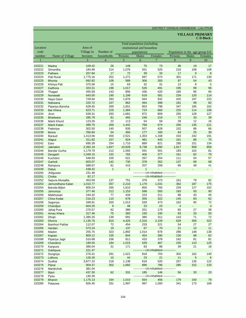
DISTRICT CENSUS HANDBOOK : LALITPUR
VILLAGE PRIMARY
Persons Males Females Persons Males Females1 2 3 4 5 6 7 8 9 10
C D Block -
Population in the age-group 0-6Number of householdsName of Village
Location code
number
Total population (including institutional and houseless
population)Area of
Village in hectares
153221 Madna 109.42 26 148 75 73 36 19 17 153222 Simardha 184.99 214 1,076 551 525 216 108 108 153223 Pathara 207.84 17 72 39 33 17 9 8 153224 Pali Rural 1,775.16 252 1,271 697 574 301 171 130 153225 Bhonta 692.82 109 589 306 283 97 54 43 153226 Khiriya Pali 375.56 15 63 32 31 13 8 5 153227 Kaithora 323.31 196 1,017 526 491 195 99 96 153228 Thagari 455.59 143 856 436 420 185 95 90 153229 Nunawali 643.00 190 1,199 618 581 234 120 114 153230 Naya Gaon 728.94 283 1,876 944 932 420 197 223 153231 Nakwana 220.72 157 862 464 398 181 99 82 153232 Pipariya Bansha 628.45 269 1,651 853 798 347 185 162 153233 Bar Khera 623.71 225 1,384 724 660 220 114 106 153234 Jiron 639.31 293 1,681 872 809 255 128 127 153235 Bhailwara 285.79 81 465 246 219 72 33 39 153236 Mairti Khurd 123.26 22 113 54 59 28 12 16 153237 Mairti Kalan 489.75 269 1,442 768 674 256 135 121 153238 Padoriya 302.50 145 935 507 428 152 86 66 153239 Besra 256.84 54 360 177 183 64 25 39 153240 Baraud 1,413.06 400 2,521 1,353 1,168 433 242 191 153241 Alapur 311.82 157 924 481 443 161 86 75 153242 Earo 695.39 254 1,710 889 821 285 151 134 153243 Jakhalon 2,392.19 1,847 10,828 5,738 5,090 1,817 958 859 153244 Bandar Gurha 1,179.79 212 1,092 591 501 183 102 81 153245 Deogarh 1,049.15 152 783 406 377 161 82 79 153246 Kuchdon 548.93 100 521 267 254 111 54 57 153247 Garholi 603.07 142 730 378 352 137 69 68 153248 Rampura 688.67 81 415 207 208 89 48 41 153249 Datya 438.42 1 1 1 - - - - 153250 Jhilguwan 231.48153251 Choka 82.17153252 Sepura Munjafta 403.09 137 751 378 373 161 79 82 153253 Jamundhana Kalan 1,010.77 357 2,210 1,179 1,031 362 187 175 153254 Baroda Bijlon 809.24 265 1,610 850 760 229 127 102 153255 Jamuniya 377.46 212 1,153 598 555 183 93 90 153256 Maikhuwan 244.32 77 434 223 211 88 43 45 153257 Chira Kodar 216.23 110 678 356 322 145 83 62 153258 Sagoriya 348.91 200 1,012 539 473 162 90 72 153259 Chandpur 604.25 9 46 23 23 4 - 4 153260 Jahaj Pura 270.57 62 380 201 179 65 27 38 153261 Amau Khera 317.46 75 383 193 190 83 33 50 153262 Dhojri 1,390.25 139 691 380 311 143 71 72 153263 Dhorra 1,135.76 810 4,425 2,316 2,109 628 306 322 153264 Bamhori Pathar 112.07 72 454 233 221 54 27 27 153265 Hardari 573.24 19 137 67 70 21 10 11 153266 Madon 255.75 323 1,892 1,014 878 286 148 138 153267 Kapasi 809.12 155 844 454 390 130 68 62 153268 Pipariya Jagir 510.68 156 811 433 378 162 81 81 153269 Chandera 190.50 184 1,015 528 487 235 110 125 153270 Kanpura 386.04 31 171 83 88 39 21 18 153271 Sukhpura 221.47153272 Dungriya 276.31 291 1,521 818 703 302 162 140 153273 Lidhora 126.26 10 44 23 21 11 5 6 153274 Dudhai 3,877.10 218 1,138 618 520 257 135 122 153275 Piprai 904.37 302 1,682 896 786 285 152 133 153276 Manikchok 381.04153277 Bijori 437.30 62 331 185 146 56 33 23 153278 Pyau 140.39153279 Bharon 1,175.13 164 1,010 554 456 179 100 79 153280 Patauwa 826.45 331 1,997 997 1,000 341 173 168
-------------Un-inhabited--------------
-------------Un-inhabited--------------
-------------Un-inhabited--------------
-------------Un-inhabited---------------------------Un-inhabited--------------
104
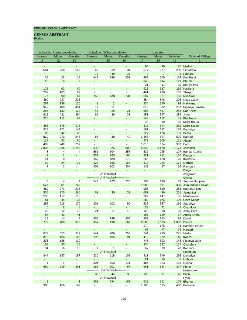
PRIMARY CENSUS ABSTRACT
CENSUS ABSTRACTBirdha
Persons Males Females Persons Males Females Persons Males Females11 12 13 14 15 16 17 18 19 2
Scheduled Castes population Scheduled Tribes populationName of Village
Literates
- - - - - - 64 39 25 Madna504 258 246 63 29 34 577 377 200 Simardha- - - 72 39 33 9 7 2 Pathara35 22 13 447 246 201 463 309 154 Pali Rural18 9 9 - - - 343 214 129 Bhonta
- - - - - - 21 11 10 Khiriya Pali121 61 60 - - - 523 337 186 Kaithora202 103 99 - - - 461 276 185 Thagari177 90 87 269 138 131 507 321 186 Nunawali460 227 233 - - - 854 548 306 Naya Gaon264 138 126 1 1 - 334 240 94 Nakwana942 488 454 17 11 6 819 532 287 Pipariya Bansha266 132 134 46 25 21 685 437 248 Bar Khera815 421 394 69 36 33 951 567 384 Jiron210 111 99 - - - 243 162 81 Bhailwara- - - - - - 48 30 18 Mairti Khurd356 178 178 - - - 813 544 269 Mairti Kalan313 171 142 - - - 561 372 189 Padoriya88 42 46 - - - 227 126 101 Besra
519 273 246 88 39 49 1,367 847 520 Baraud117 57 60 - - - 477 306 171 Alapur492 240 252 - - - 1,016 634 382 Earo
2,835 1,536 1,299 633 325 308 5,649 3,478 2,171 Jakhalon8 4 4 561 304 257 332 225 107 Bandar Gurha1 1 - 331 165 166 321 211 110 Deogarh
14 8 6 362 183 179 206 128 78 Kuchdon62 34 28 322 165 157 418 246 172 Garholi2 2 - 406 202 204 133 97 36 Rampura
- - - - - - - - - DatyaJhilguwanChoka
8 4 4 549 273 276 209 130 79 Sepura Munjafta547 301 246 - - - 1,080 691 389 Jamundhana Kalan489 271 218 - - - 993 610 383 Baroda Bijlon536 270 266 63 30 33 687 436 251 Jamuniya233 117 116 - - - 202 147 55 Maikhuwan81 44 37 - - - 282 176 106 Chira Kodar
386 216 170 201 102 99 526 357 169 Sagoriya5 2 3 - - - 29 21 8 Chandpur
22 12 10 24 11 13 129 90 39 Jahaj Pura84 43 41 - - - 196 129 67 Amau Khera19 14 5 455 249 206 309 213 96 Dhojri
772 400 372 357 190 167 2,585 1,583 1,002 Dhorra- - - - - - 270 176 94 Bamhori Pathar- - - - - - 82 47 35 Hardari672 355 317 544 286 258 744 499 245 Madon313 168 145 196 105 91 412 272 140 Kapasi236 126 110 - - - 445 302 143 Pipariya Jagir168 90 78 - - - 354 237 117 Chandera34 16 18 1 1 - 67 39 28 Kanpura
Sukhpura344 187 157 220 118 102 811 546 265 Dungriya- - - - - - 21 15 6 Lidhora
1 1 - 304 163 141 484 323 161 Dudhai580 319 261 188 101 87 961 584 377 Piprai
Manikchok- - - 82 44 38 136 91 45 Bijori
Pyau1 - 1 363 194 169 529 351 178 Bharon
308 166 142 - - - 1,103 665 438 Patauwa
-------------Un-inhabited--------------
-------------Un-inhabited--------------
-------------Un-inhabited--------------
-------------Un-inhabited---------------------------Un-inhabited--------------
105
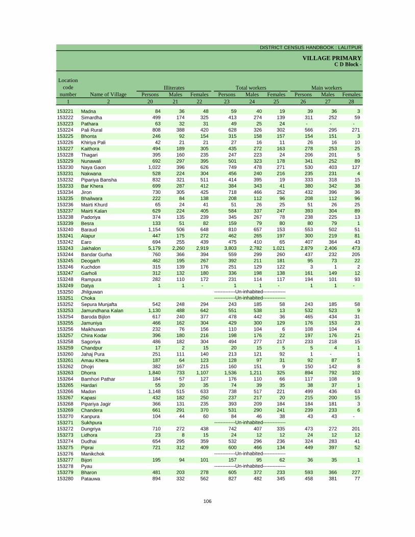
DISTRICT CENSUS HANDBOOK : LALITPUR
VILLAGE PRIMARYC D Block -
Persons Males Females Persons Males Females Persons Males Females1 2 20 21 22 23 24 25 26 27 28
Illiterates Total workers Main workersName of Village
Location code
number
153221 Madna 84 36 48 59 40 19 39 36 3 153222 Simardha 499 174 325 413 274 139 311 252 59 153223 Pathara 63 32 31 49 25 24 - - - 153224 Pali Rural 808 388 420 628 326 302 566 295 271 153225 Bhonta 246 92 154 315 158 157 154 151 3 153226 Khiriya Pali 42 21 21 27 16 11 26 16 10 153227 Kaithora 494 189 305 435 272 163 278 253 25 153228 Thagari 395 160 235 247 223 24 206 201 5 153229 Nunawali 692 297 395 501 323 178 341 252 89 153230 Naya Gaon 1,022 396 626 749 478 271 530 403 127 153231 Nakwana 528 224 304 456 240 216 235 231 4 153232 Pipariya Bansha 832 321 511 414 395 19 333 318 15 153233 Bar Khera 699 287 412 384 343 41 380 342 38 153234 Jiron 730 305 425 718 466 252 432 396 36 153235 Bhailwara 222 84 138 208 112 96 208 112 96 153236 Mairti Khurd 65 24 41 51 26 25 51 26 25 153237 Mairti Kalan 629 224 405 584 337 247 393 304 89 153238 Padoriya 374 135 239 345 267 78 238 225 13 153239 Besra 133 51 82 159 79 80 80 79 1 153240 Baraud 1,154 506 648 810 657 153 553 502 51 153241 Alapur 447 175 272 462 265 197 300 219 81 153242 Earo 694 255 439 475 410 65 407 364 43 153243 Jakhalon 5,179 2,260 2,919 3,803 2,782 1,021 2,879 2,406 473 153244 Bandar Gurha 760 366 394 559 299 260 437 232 205 153245 Deogarh 462 195 267 392 211 181 95 73 22 153246 Kuchdon 315 139 176 251 129 122 3 1 2 153247 Garholi 312 132 180 336 198 138 161 149 12 153248 Rampura 282 110 172 231 114 117 194 101 93 153249 Datya 1 1 - 1 1 - 1 1 - 153250 Jhilguwan153251 Choka153252 Sepura Munjafta 542 248 294 243 185 58 243 185 58 153253 Jamundhana Kalan 1,130 488 642 551 538 13 532 523 9 153254 Baroda Bijlon 617 240 377 478 442 36 465 434 31 153255 Jamuniya 466 162 304 429 300 129 176 153 23 153256 Maikhuwan 232 76 156 110 104 6 108 104 4 153257 Chira Kodar 396 180 216 198 176 22 197 176 21 153258 Sagoriya 486 182 304 494 277 217 233 218 15 153259 Chandpur 17 2 15 20 15 5 5 4 1 153260 Jahaj Pura 251 111 140 213 121 92 1 - 1 153261 Amau Khera 187 64 123 128 97 31 92 87 5 153262 Dhojri 382 167 215 160 151 9 150 142 8 153263 Dhorra 1,840 733 1,107 1,536 1,211 325 894 792 102 153264 Bamhori Pathar 184 57 127 176 110 66 117 108 9 153265 Hardari 55 20 35 74 39 35 38 37 1 153266 Madon 1,148 515 633 738 517 221 499 436 63 153267 Kapasi 432 182 250 237 217 20 215 200 15 153268 Pipariya Jagir 366 131 235 393 209 184 184 181 3 153269 Chandera 661 291 370 531 290 241 239 233 6 153270 Kanpura 104 44 60 84 46 38 43 43 - 153271 Sukhpura153272 Dungriya 710 272 438 742 407 335 473 272 201 153273 Lidhora 23 8 15 24 12 12 24 12 12 153274 Dudhai 654 295 359 532 296 236 324 283 41 153275 Piprai 721 312 409 600 466 134 449 397 52 153276 Manikchok153277 Bijori 195 94 101 157 95 62 36 35 1 153278 Pyau153279 Bharon 481 203 278 605 372 233 593 366 227 153280 Patauwa 894 332 562 827 482 345 458 381 77
-------------Un-inhabited--------------
-------------Un-inhabited--------------
-------------Un-inhabited--------------
-------------Un-inhabited---------------------------Un-inhabited--------------
106
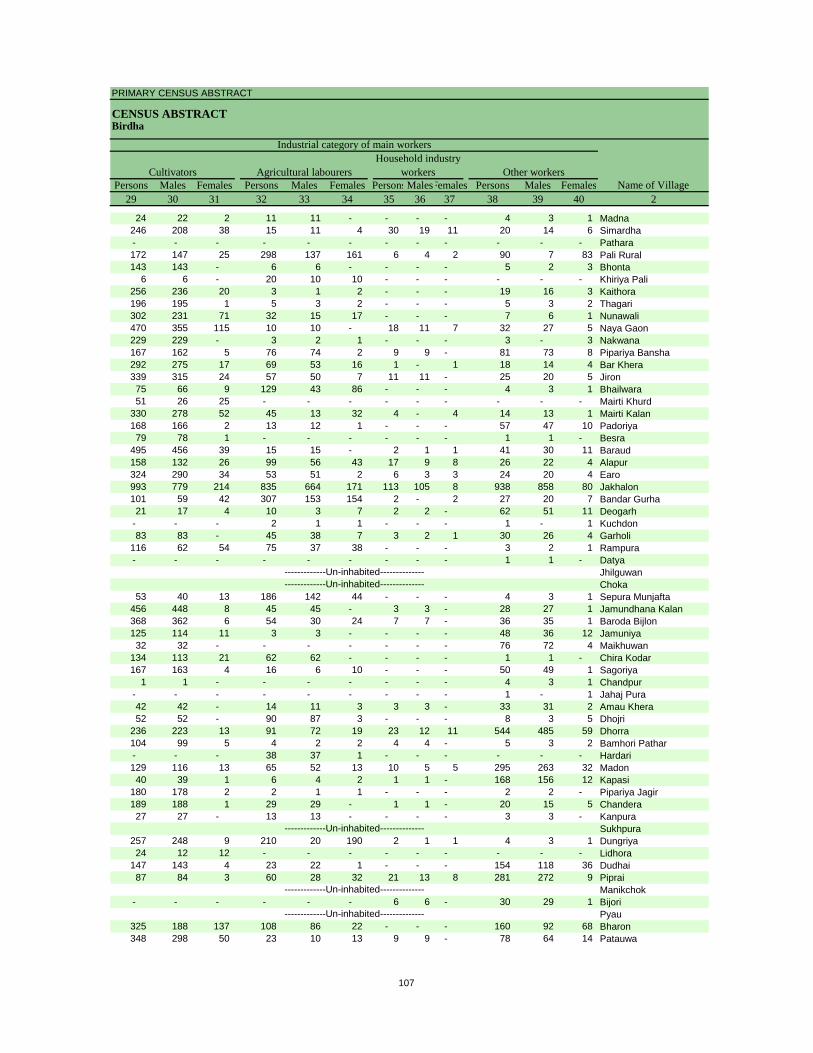
PRIMARY CENSUS ABSTRACT
CENSUS ABSTRACTBirdha
Persons Males Females Persons Males Females PersonsMalesFemales Persons Males Females29 30 31 32 33 34 35 36 37 38 39 40 2
CultivatorsName of Village
Household industry workersAgricultural labourers
Industrial category of main workers
Other workers
24 22 2 11 11 - - - - 4 3 1 Madna246 208 38 15 11 4 30 19 11 20 14 6 Simardha- - - - - - - - - - - - Pathara172 147 25 298 137 161 6 4 2 90 7 83 Pali Rural143 143 - 6 6 - - - - 5 2 3 Bhonta
6 6 - 20 10 10 - - - - - - Khiriya Pali256 236 20 3 1 2 - - - 19 16 3 Kaithora196 195 1 5 3 2 - - - 5 3 2 Thagari302 231 71 32 15 17 - - - 7 6 1 Nunawali470 355 115 10 10 - 18 11 7 32 27 5 Naya Gaon229 229 - 3 2 1 - - - 3 - 3 Nakwana167 162 5 76 74 2 9 9 - 81 73 8 Pipariya Bansha292 275 17 69 53 16 1 - 1 18 14 4 Bar Khera339 315 24 57 50 7 11 11 - 25 20 5 Jiron75 66 9 129 43 86 - - - 4 3 1 Bhailwara51 26 25 - - - - - - - - - Mairti Khurd
330 278 52 45 13 32 4 - 4 14 13 1 Mairti Kalan168 166 2 13 12 1 - - - 57 47 10 Padoriya79 78 1 - - - - - - 1 1 - Besra
495 456 39 15 15 - 2 1 1 41 30 11 Baraud158 132 26 99 56 43 17 9 8 26 22 4 Alapur324 290 34 53 51 2 6 3 3 24 20 4 Earo993 779 214 835 664 171 113 105 8 938 858 80 Jakhalon101 59 42 307 153 154 2 - 2 27 20 7 Bandar Gurha21 17 4 10 3 7 2 2 - 62 51 11 Deogarh
- - - 2 1 1 - - - 1 - 1 Kuchdon83 83 - 45 38 7 3 2 1 30 26 4 Garholi
116 62 54 75 37 38 - - - 3 2 1 Rampura- - - - - - - - - 1 1 - Datya
JhilguwanChoka
53 40 13 186 142 44 - - - 4 3 1 Sepura Munjafta456 448 8 45 45 - 3 3 - 28 27 1 Jamundhana Kalan368 362 6 54 30 24 7 7 - 36 35 1 Baroda Bijlon125 114 11 3 3 - - - - 48 36 12 Jamuniya32 32 - - - - - - - 76 72 4 Maikhuwan
134 113 21 62 62 - - - - 1 1 - Chira Kodar167 163 4 16 6 10 - - - 50 49 1 Sagoriya
1 1 - - - - - - - 4 3 1 Chandpur- - - - - - - - - 1 - 1 Jahaj Pura42 42 - 14 11 3 3 3 - 33 31 2 Amau Khera52 52 - 90 87 3 - - - 8 3 5 Dhojri
236 223 13 91 72 19 23 12 11 544 485 59 Dhorra104 99 5 4 2 2 4 4 - 5 3 2 Bamhori Pathar- - - 38 37 1 - - - - - - Hardari129 116 13 65 52 13 10 5 5 295 263 32 Madon40 39 1 6 4 2 1 1 - 168 156 12 Kapasi
180 178 2 2 1 1 - - - 2 2 - Pipariya Jagir189 188 1 29 29 - 1 1 - 20 15 5 Chandera27 27 - 13 13 - - - - 3 3 - Kanpura
Sukhpura257 248 9 210 20 190 2 1 1 4 3 1 Dungriya24 12 12 - - - - - - - - - Lidhora
147 143 4 23 22 1 - - - 154 118 36 Dudhai87 84 3 60 28 32 21 13 8 281 272 9 Piprai
Manikchok- - - - - - 6 6 - 30 29 1 Bijori
Pyau325 188 137 108 86 22 - - - 160 92 68 Bharon348 298 50 23 10 13 9 9 - 78 64 14 Patauwa
-------------Un-inhabited--------------
-------------Un-inhabited--------------
-------------Un-inhabited--------------
-------------Un-inhabited---------------------------Un-inhabited--------------
107
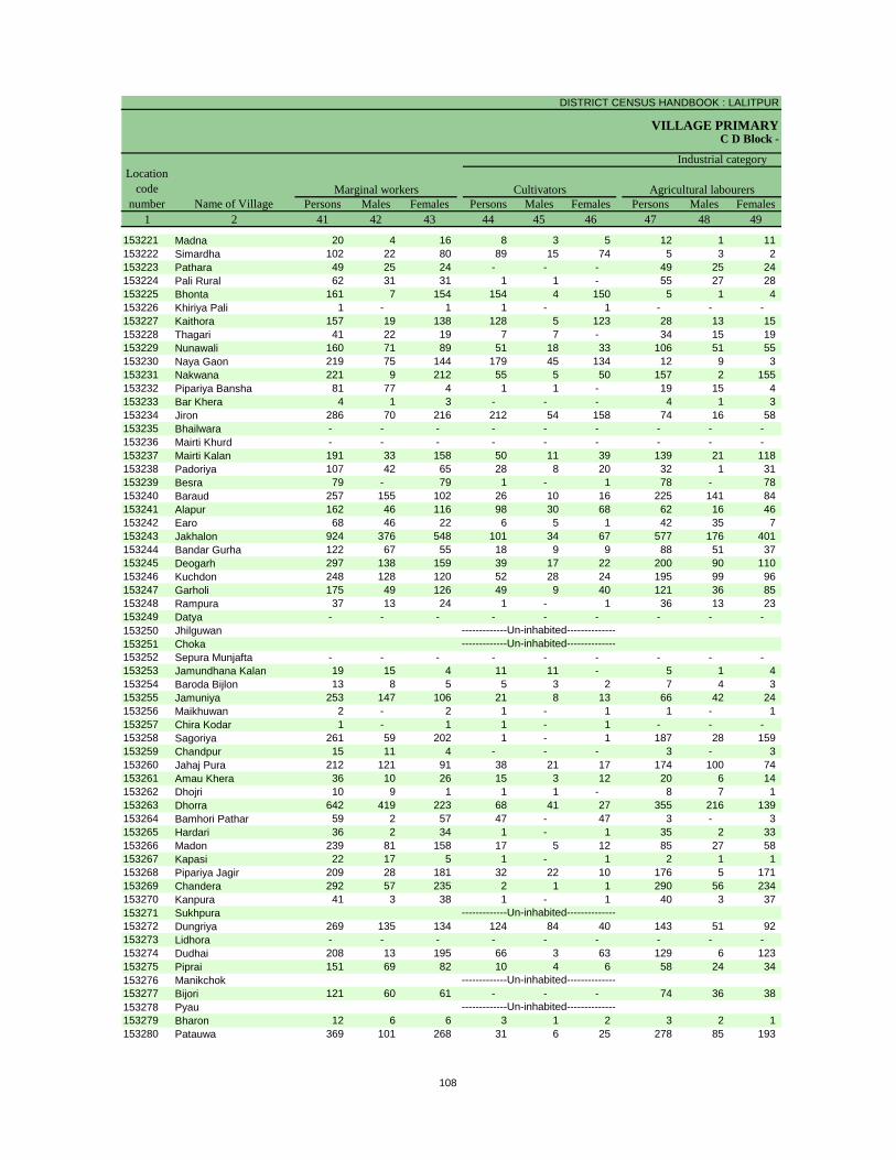
DISTRICT CENSUS HANDBOOK : LALITPUR
VILLAGE PRIMARYC D Block -
Persons Males Females Persons Males Females Persons Males Females1 2 41 42 43 44 45 46 47 48 49
Location code
number Name of VillageMarginal workers Cultivators Agricultural labourers
Industrial category
153221 Madna 20 4 16 8 3 5 12 1 11 153222 Simardha 102 22 80 89 15 74 5 3 2 153223 Pathara 49 25 24 - - - 49 25 24 153224 Pali Rural 62 31 31 1 1 - 55 27 28 153225 Bhonta 161 7 154 154 4 150 5 1 4 153226 Khiriya Pali 1 - 1 1 - 1 - - - 153227 Kaithora 157 19 138 128 5 123 28 13 15 153228 Thagari 41 22 19 7 7 - 34 15 19 153229 Nunawali 160 71 89 51 18 33 106 51 55 153230 Naya Gaon 219 75 144 179 45 134 12 9 3 153231 Nakwana 221 9 212 55 5 50 157 2 155 153232 Pipariya Bansha 81 77 4 1 1 - 19 15 4 153233 Bar Khera 4 1 3 - - - 4 1 3 153234 Jiron 286 70 216 212 54 158 74 16 58 153235 Bhailwara - - - - - - - - - 153236 Mairti Khurd - - - - - - - - - 153237 Mairti Kalan 191 33 158 50 11 39 139 21 118 153238 Padoriya 107 42 65 28 8 20 32 1 31 153239 Besra 79 - 79 1 - 1 78 - 78 153240 Baraud 257 155 102 26 10 16 225 141 84 153241 Alapur 162 46 116 98 30 68 62 16 46 153242 Earo 68 46 22 6 5 1 42 35 7 153243 Jakhalon 924 376 548 101 34 67 577 176 401 153244 Bandar Gurha 122 67 55 18 9 9 88 51 37 153245 Deogarh 297 138 159 39 17 22 200 90 110 153246 Kuchdon 248 128 120 52 28 24 195 99 96 153247 Garholi 175 49 126 49 9 40 121 36 85 153248 Rampura 37 13 24 1 - 1 36 13 23 153249 Datya - - - - - - - - - 153250 Jhilguwan153251 Choka153252 Sepura Munjafta - - - - - - - - - 153253 Jamundhana Kalan 19 15 4 11 11 - 5 1 4 153254 Baroda Bijlon 13 8 5 5 3 2 7 4 3 153255 Jamuniya 253 147 106 21 8 13 66 42 24 153256 Maikhuwan 2 - 2 1 - 1 1 - 1 153257 Chira Kodar 1 - 1 1 - 1 - - - 153258 Sagoriya 261 59 202 1 - 1 187 28 159 153259 Chandpur 15 11 4 - - - 3 - 3 153260 Jahaj Pura 212 121 91 38 21 17 174 100 74 153261 Amau Khera 36 10 26 15 3 12 20 6 14 153262 Dhojri 10 9 1 1 1 - 8 7 1 153263 Dhorra 642 419 223 68 41 27 355 216 139 153264 Bamhori Pathar 59 2 57 47 - 47 3 - 3 153265 Hardari 36 2 34 1 - 1 35 2 33 153266 Madon 239 81 158 17 5 12 85 27 58 153267 Kapasi 22 17 5 1 - 1 2 1 1 153268 Pipariya Jagir 209 28 181 32 22 10 176 5 171 153269 Chandera 292 57 235 2 1 1 290 56 234 153270 Kanpura 41 3 38 1 - 1 40 3 37 153271 Sukhpura153272 Dungriya 269 135 134 124 84 40 143 51 92 153273 Lidhora - - - - - - - - - 153274 Dudhai 208 13 195 66 3 63 129 6 123 153275 Piprai 151 69 82 10 4 6 58 24 34 153276 Manikchok153277 Bijori 121 60 61 - - - 74 36 38 153278 Pyau153279 Bharon 12 6 6 3 1 2 3 2 1 153280 Patauwa 369 101 268 31 6 25 278 85 193
-------------Un-inhabited--------------
-------------Un-inhabited--------------
-------------Un-inhabited--------------
-------------Un-inhabited---------------------------Un-inhabited--------------
108
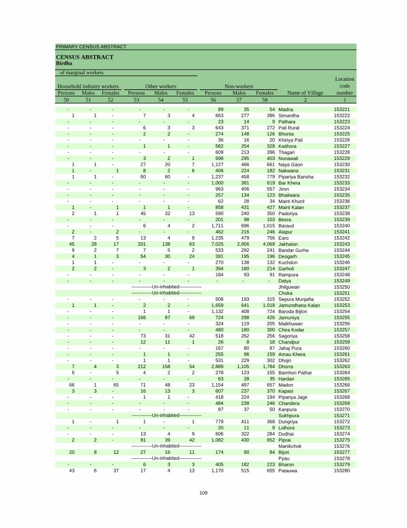
PRIMARY CENSUS ABSTRACT
CENSUS ABSTRACTBirdha
Persons Males Females Persons Males Females Persons Males Females50 51 52 53 54 55 56 57 58 2 1
Non-workers
of marginal workersLocation
code number
Household industry workersName of Village
Other workers
- - - - - - 89 35 54 Madna 1532211 1 - 7 3 4 663 277 386 Simardha 153222
- - - - - - 23 14 9 Pathara 153223- - - 6 3 3 643 371 272 Pali Rural 153224- - - 2 2 - 274 148 126 Bhonta 153225- - - - - - 36 16 20 Khiriya Pali 153226- - - 1 1 - 582 254 328 Kaithora 153227- - - - - - 609 213 396 Thagari 153228- - - 3 2 1 698 295 403 Nunawali 153229
1 1 - 27 20 7 1,127 466 661 Naya Gaon 1532301 - 1 8 2 6 406 224 182 Nakwana 1532311 1 - 60 60 - 1,237 458 779 Pipariya Bansha 153232
- - - - - - 1,000 381 619 Bar Khera 153233- - - - - - 963 406 557 Jiron 153234- - - - - - 257 134 123 Bhailwara 153235- - - - - - 62 28 34 Mairti Khurd 153236
1 - 1 1 1 - 858 431 427 Mairti Kalan 1532372 1 1 45 32 13 590 240 350 Padoriya 153238
- - - - - - 201 98 103 Besra 153239- - - 6 4 2 1,711 696 1,015 Baraud 153240
2 - 2 - - - 462 216 246 Alapur 1532417 2 5 13 4 9 1,235 479 756 Earo 153242
45 28 17 201 138 63 7,025 2,956 4,069 Jakhalon 1532439 2 7 7 5 2 533 292 241 Bandar Gurha 1532444 1 3 54 30 24 391 195 196 Deogarh 1532451 1 - - - - 270 138 132 Kuchdon 1532462 2 - 3 2 1 394 180 214 Garholi 153247
- - - - - - 184 93 91 Rampura 153248- - - - - - - - - Datya 153249
Jhilguwan 153250Choka 153251
- - - - - - 508 193 315 Sepura Munjafta 1532521 1 - 2 2 - 1,659 641 1,018 Jamundhana Kalan 153253
- - - 1 1 - 1,132 408 724 Baroda Bijlon 153254- - - 166 97 69 724 298 426 Jamuniya 153255- - - - - - 324 119 205 Maikhuwan 153256- - - - - - 480 180 300 Chira Kodar 153257- - - 73 31 42 518 262 256 Sagoriya 153258- - - 12 11 1 26 8 18 Chandpur 153259- - - - - - 167 80 87 Jahaj Pura 153260- - - 1 1 - 255 96 159 Amau Khera 153261- - - 1 1 - 531 229 302 Dhojri 153262
7 4 3 212 158 54 2,889 1,105 1,784 Dhorra 1532635 - 5 4 2 2 278 123 155 Bamhori Pathar 153264
- - - - - - 63 28 35 Hardari 15326566 1 65 71 48 23 1,154 497 657 Madon 1532663 3 - 16 13 3 607 237 370 Kapasi 153267
- - - 1 1 - 418 224 194 Pipariya Jagir 153268- - - - - - 484 238 246 Chandera 153269- - - - - - 87 37 50 Kanpura 153270
Sukhpura 1532711 - 1 1 - 1 779 411 368 Dungriya 153272
- - - - - - 20 11 9 Lidhora 153273- - - 13 4 9 606 322 284 Dudhai 153274
2 2 - 81 39 42 1,082 430 652 Piprai 153275Manikchok 153276
20 8 12 27 16 11 174 90 84 Bijori 153277Pyau 153278
- - - 6 3 3 405 182 223 Bharon 15327943 6 37 17 4 13 1,170 515 655 Patauwa 153280
-------------Un-inhabited--------------
-------------Un-inhabited--------------
-------------Un-inhabited--------------
-------------Un-inhabited---------------------------Un-inhabited--------------
109
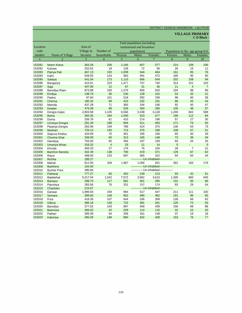
DISTRICT CENSUS HANDBOOK : LALITPUR
VILLAGE PRIMARY
Persons Males Females Persons Males Females1 2 3 4 5 6 7 8 9 10
C D Block -
Population in the age-group 0-6Number of householdsName of Village
Location code
number
Total population (including institutional and houseless
population)Area of
Village in hectares
153281 Neem Khera 363.28 206 1,184 607 577 214 108 106 153282 Kuluwa 202.62 19 128 72 56 26 15 11 153283 Pipriya Pali 467.13 150 1,008 544 464 161 85 76 153284 Kalro 549.55 143 963 491 472 185 95 90 153285 Salaiya 441.04 173 1,110 566 544 202 108 94 153286 Bangariya 415.61 223 1,477 737 740 314 151 163 153287 Saja 407.90 12 67 31 36 11 4 7 153288 Barodiya Raen 873.88 193 1,276 656 620 194 98 96 153289 Emiliya 138.79 36 230 128 102 53 32 21 153290 Padna 97.60 101 518 282 236 98 60 38 153291 Chimna 180.32 69 423 232 191 86 42 44 153292 Mamda 437.28 71 360 194 166 92 45 47 153293 Kewlari 479.38 98 526 260 266 105 48 57 153294 Dongra Kalan 2,803.58 1,105 6,566 3,438 3,128 1,200 602 598 153295 Betna 383.35 194 1,000 523 477 196 112 84 153296 Dorna 206.79 61 410 214 196 57 27 30 153297 Umariya Dongra 281.29 189 994 511 483 171 79 92 153298 Pipariya Dongra 262.96 149 789 414 375 136 63 73 153299 Mudnari 729.10 140 713 375 338 108 57 51 153300 Saipura Khalsa 434.69 70 361 195 166 69 40 29 153301 Chontra Ghat 339.09 60 313 165 148 73 39 34 153302 Hanotiya 763.00 65 356 197 159 60 34 26 153303 Umariya Wiran 316.32 4 25 11 14 5 - 5 153304 Kirroda 455.33 27 176 76 100 28 7 21 153305 Bamhori Bansha 342.49 138 790 419 371 129 67 62 153306 Rasoi 498.00 133 687 365 322 94 50 44 153307 Richha 289.27153308 Maholi 812.00 328 1,987 1,056 931 362 183 179 153309 Barkhera 164.00153310 Byohar Pura 390.84153311 Patharai 777.27 83 452 239 213 93 42 51 153312 Balabehat 5,017.04 1,542 7,572 3,962 3,610 1,305 660 645 153313 Banspur 298.75 117 581 301 280 131 65 66 153314 Piproniya 283.56 76 331 157 174 83 29 54 153315 Chaubaro 215.67153316 Danwar 1,896.83 194 964 517 447 211 111 100 153317 Semara 399.60 148 952 490 462 191 96 95 153318 Pura 416.30 107 644 336 308 128 66 62 153319 Giltora 386.18 126 722 381 341 125 72 53 153320 Barodiya 377.02 143 897 458 439 156 68 88 153321 Bamnora 366.02 42 229 114 115 42 22 20 153322 Pathari 395.09 64 309 161 148 37 19 18 153323 Kakoriya 395.09 148 860 432 428 153 76 77
-------------Un-inhabited--------------
-------------Un-inhabited---------------------------Un-inhabited--------------
-------------Un-inhabited--------------
110
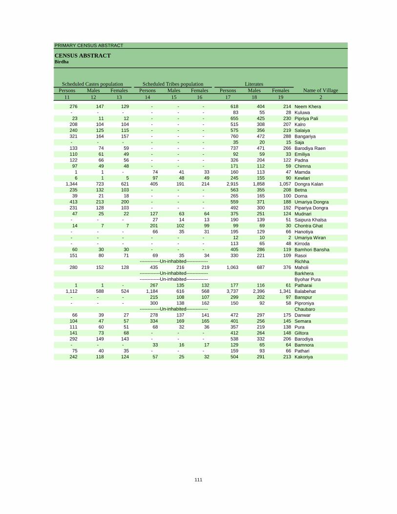
PRIMARY CENSUS ABSTRACT
CENSUS ABSTRACTBirdha
Persons Males Females Persons Males Females Persons Males Females11 12 13 14 15 16 17 18 19 2
Scheduled Castes population Scheduled Tribes populationName of Village
Literates
276 147 129 - - - 618 404 214 Neem Khera- - - - - - 83 55 28 Kuluwa23 11 12 - - - 655 425 230 Pipriya Pali
208 104 104 - - - 515 308 207 Kalro240 125 115 - - - 575 356 219 Salaiya321 164 157 - - - 760 472 288 Bangariya- - - - - - 35 20 15 Saja133 74 59 - - - 737 471 266 Barodiya Raen110 61 49 - - - 92 59 33 Emiliya122 66 56 - - - 326 204 122 Padna97 49 48 - - - 171 112 59 Chimna1 1 - 74 41 33 160 113 47 Mamda6 1 5 97 48 49 245 155 90 Kewlari
1,344 723 621 405 191 214 2,915 1,858 1,057 Dongra Kalan235 132 103 - - - 563 355 208 Betna39 21 18 - - - 265 165 100 Dorna
413 213 200 - - - 559 371 188 Umariya Dongra231 128 103 - - - 492 300 192 Pipariya Dongra47 25 22 127 63 64 375 251 124 Mudnari
- - - 27 14 13 190 139 51 Saipura Khalsa14 7 7 201 102 99 99 69 30 Chontra Ghat
- - - 66 35 31 195 129 66 Hanotiya- - - - - - 12 10 2 Umariya Wiran- - - - - - 113 65 48 Kirroda60 30 30 - - - 405 286 119 Bamhori Bansha
151 80 71 69 35 34 330 221 109 RasoiRichha
280 152 128 435 216 219 1,063 687 376 MaholiBarkheraByohar Pura
1 1 - 267 135 132 177 116 61 Patharai1,112 588 524 1,184 616 568 3,737 2,396 1,341 Balabehat
- - - 215 108 107 299 202 97 Banspur- - - 300 138 162 150 92 58 Piproniya
Chaubaro66 39 27 278 137 141 472 297 175 Danwar
104 47 57 334 169 165 401 256 145 Semara111 60 51 68 32 36 357 219 138 Pura141 73 68 - - - 412 264 148 Giltora292 149 143 - - - 538 332 206 Barodiya- - - 33 16 17 129 65 64 Bamnora75 40 35 - - - 159 93 66 Pathari
242 118 124 57 25 32 504 291 213 Kakoriya
-------------Un-inhabited--------------
-------------Un-inhabited---------------------------Un-inhabited--------------
-------------Un-inhabited--------------
111

DISTRICT CENSUS HANDBOOK : LALITPUR
VILLAGE PRIMARYC D Block -
Persons Males Females Persons Males Females Persons Males Females1 2 20 21 22 23 24 25 26 27 28
Illiterates Total workers Main workersName of Village
Location code
number
153281 Neem Khera 566 203 363 416 295 121 289 279 10 153282 Kuluwa 45 17 28 39 37 2 39 37 2 153283 Pipriya Pali 353 119 234 408 261 147 270 239 31 153284 Kalro 448 183 265 439 257 182 253 243 10 153285 Salaiya 535 210 325 462 294 168 296 289 7 153286 Bangariya 717 265 452 350 346 4 330 326 4 153287 Saja 32 11 21 42 21 21 23 15 8 153288 Barodiya Raen 539 185 354 464 357 107 353 306 47 153289 Emiliya 138 69 69 104 59 45 46 43 3 153290 Padna 192 78 114 133 113 20 121 103 18 153291 Chimna 252 120 132 215 115 100 215 115 100 153292 Mamda 200 81 119 160 83 77 99 83 16 153293 Kewlari 281 105 176 155 112 43 89 78 11 153294 Dongra Kalan 3,651 1,580 2,071 2,621 1,790 831 1,371 1,067 304 153295 Betna 437 168 269 298 239 59 218 194 24 153296 Dorna 145 49 96 95 90 5 88 85 3 153297 Umariya Dongra 435 140 295 441 262 179 218 213 5 153298 Pipariya Dongra 297 114 183 220 203 17 175 167 8 153299 Mudnari 338 124 214 378 202 176 247 184 63 153300 Saipura Khalsa 171 56 115 194 103 91 96 85 11 153301 Chontra Ghat 214 96 118 124 69 55 124 69 55 153302 Hanotiya 161 68 93 179 95 84 103 88 15 153303 Umariya Wiran 13 1 12 14 8 6 5 5 - 153304 Kirroda 63 11 52 89 45 44 45 45 - 153305 Bamhori Bansha 385 133 252 381 217 164 173 141 32 153306 Rasoi 357 144 213 375 199 176 186 184 2 153307 Richha153308 Maholi 924 369 555 903 533 370 418 391 27 153309 Barkhera153310 Byohar Pura153311 Patharai 275 123 152 235 133 102 114 114 - 153312 Balabehat 3,835 1,566 2,269 3,395 2,034 1,361 2,215 1,740 475 153313 Banspur 282 99 183 289 155 134 124 112 12 153314 Piproniya 181 65 116 165 92 73 80 74 6 153315 Chaubaro153316 Danwar 492 220 272 329 263 66 285 239 46 153317 Semara 551 234 317 509 270 239 243 175 68 153318 Pura 287 117 170 315 177 138 49 45 4 153319 Giltora 310 117 193 351 207 144 206 172 34 153320 Barodiya 359 126 233 387 258 129 285 177 108 153321 Bamnora 100 49 51 112 69 43 60 50 10 153322 Pathari 150 68 82 157 82 75 49 45 4 153323 Kakoriya 356 141 215 263 233 30 193 172 21
-------------Un-inhabited--------------
-------------Un-inhabited---------------------------Un-inhabited--------------
-------------Un-inhabited--------------
112
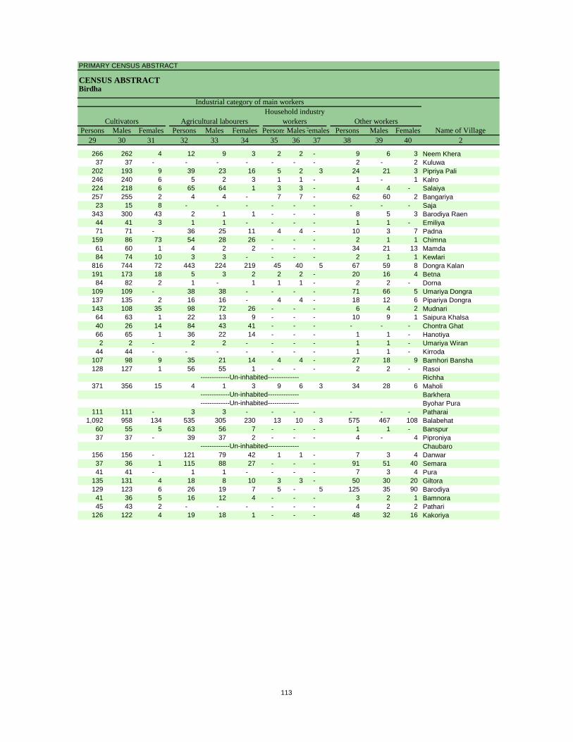
PRIMARY CENSUS ABSTRACT
CENSUS ABSTRACTBirdha
Persons Males Females Persons Males Females PersonsMalesFemales Persons Males Females29 30 31 32 33 34 35 36 37 38 39 40 2
CultivatorsName of Village
Household industry workersAgricultural labourers
Industrial category of main workers
Other workers
266 262 4 12 9 3 2 2 - 9 6 3 Neem Khera37 37 - - - - - - - 2 - 2 Kuluwa
202 193 9 39 23 16 5 2 3 24 21 3 Pipriya Pali246 240 6 5 2 3 1 1 - 1 - 1 Kalro224 218 6 65 64 1 3 3 - 4 4 - Salaiya257 255 2 4 4 - 7 7 - 62 60 2 Bangariya23 15 8 - - - - - - - - - Saja
343 300 43 2 1 1 - - - 8 5 3 Barodiya Raen44 41 3 1 1 - - - - 1 1 - Emiliya71 71 - 36 25 11 4 4 - 10 3 7 Padna
159 86 73 54 28 26 - - - 2 1 1 Chimna61 60 1 4 2 2 - - - 34 21 13 Mamda84 74 10 3 3 - - - - 2 1 1 Kewlari
816 744 72 443 224 219 45 40 5 67 59 8 Dongra Kalan191 173 18 5 3 2 2 2 - 20 16 4 Betna84 82 2 1 - 1 1 1 - 2 2 - Dorna
109 109 - 38 38 - - - - 71 66 5 Umariya Dongra137 135 2 16 16 - 4 4 - 18 12 6 Pipariya Dongra143 108 35 98 72 26 - - - 6 4 2 Mudnari64 63 1 22 13 9 - - - 10 9 1 Saipura Khalsa40 26 14 84 43 41 - - - - - - Chontra Ghat66 65 1 36 22 14 - - - 1 1 - Hanotiya2 2 - 2 2 - - - - 1 1 - Umariya Wiran
44 44 - - - - - - - 1 1 - Kirroda107 98 9 35 21 14 4 4 - 27 18 9 Bamhori Bansha128 127 1 56 55 1 - - - 2 2 - Rasoi
Richha371 356 15 4 1 3 9 6 3 34 28 6 Maholi
BarkheraByohar Pura
111 111 - 3 3 - - - - - - - Patharai1,092 958 134 535 305 230 13 10 3 575 467 108 Balabehat
60 55 5 63 56 7 - - - 1 1 - Banspur37 37 - 39 37 2 - - - 4 - 4 Piproniya
Chaubaro156 156 - 121 79 42 1 1 - 7 3 4 Danwar37 36 1 115 88 27 - - - 91 51 40 Semara41 41 - 1 1 - - - - 7 3 4 Pura
135 131 4 18 8 10 3 3 - 50 30 20 Giltora129 123 6 26 19 7 5 - 5 125 35 90 Barodiya41 36 5 16 12 4 - - - 3 2 1 Bamnora45 43 2 - - - - - - 4 2 2 Pathari
126 122 4 19 18 1 - - - 48 32 16 Kakoriya
-------------Un-inhabited--------------
-------------Un-inhabited---------------------------Un-inhabited--------------
-------------Un-inhabited--------------
113
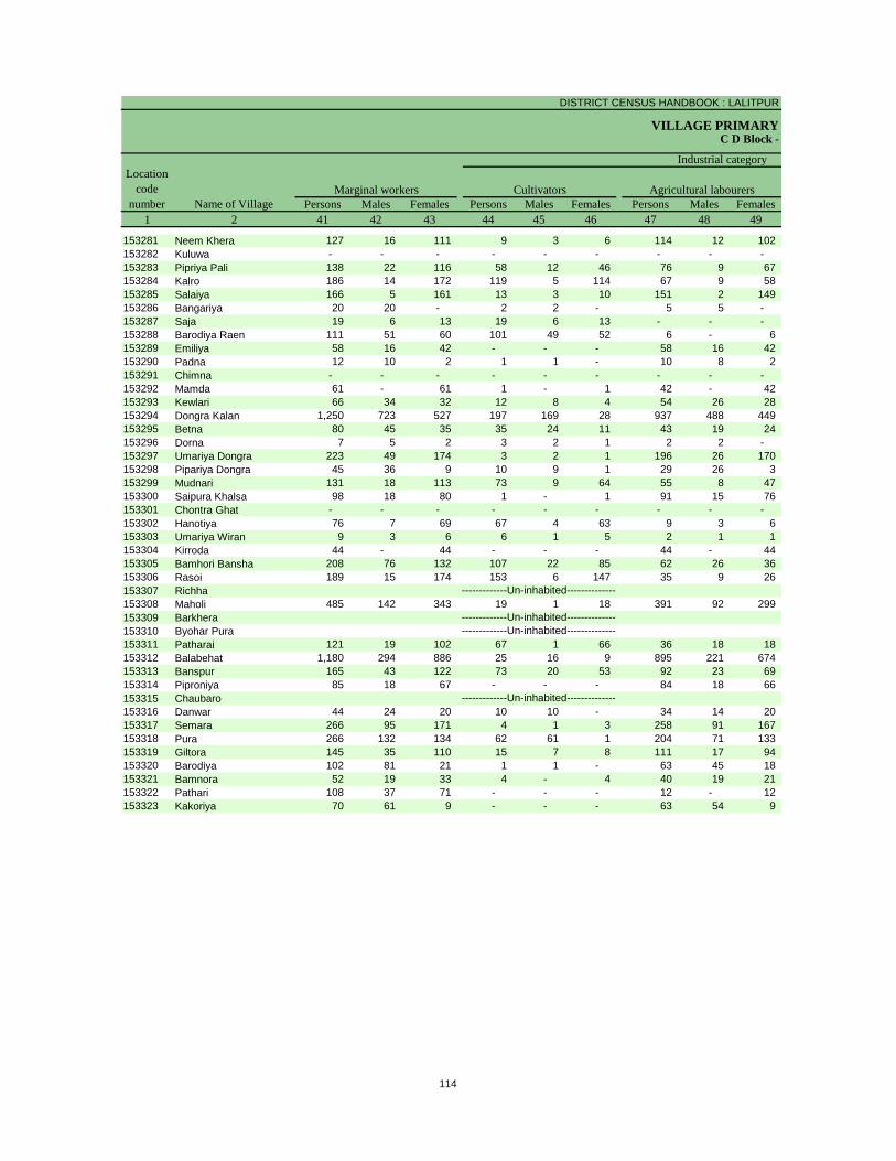
DISTRICT CENSUS HANDBOOK : LALITPUR
VILLAGE PRIMARYC D Block -
Persons Males Females Persons Males Females Persons Males Females1 2 41 42 43 44 45 46 47 48 49
Location code
number Name of VillageMarginal workers Cultivators Agricultural labourers
Industrial category
153281 Neem Khera 127 16 111 9 3 6 114 12 102 153282 Kuluwa - - - - - - - - - 153283 Pipriya Pali 138 22 116 58 12 46 76 9 67 153284 Kalro 186 14 172 119 5 114 67 9 58 153285 Salaiya 166 5 161 13 3 10 151 2 149 153286 Bangariya 20 20 - 2 2 - 5 5 - 153287 Saja 19 6 13 19 6 13 - - - 153288 Barodiya Raen 111 51 60 101 49 52 6 - 6 153289 Emiliya 58 16 42 - - - 58 16 42 153290 Padna 12 10 2 1 1 - 10 8 2 153291 Chimna - - - - - - - - - 153292 Mamda 61 - 61 1 - 1 42 - 42 153293 Kewlari 66 34 32 12 8 4 54 26 28 153294 Dongra Kalan 1,250 723 527 197 169 28 937 488 449 153295 Betna 80 45 35 35 24 11 43 19 24 153296 Dorna 7 5 2 3 2 1 2 2 - 153297 Umariya Dongra 223 49 174 3 2 1 196 26 170 153298 Pipariya Dongra 45 36 9 10 9 1 29 26 3 153299 Mudnari 131 18 113 73 9 64 55 8 47 153300 Saipura Khalsa 98 18 80 1 - 1 91 15 76 153301 Chontra Ghat - - - - - - - - - 153302 Hanotiya 76 7 69 67 4 63 9 3 6 153303 Umariya Wiran 9 3 6 6 1 5 2 1 1 153304 Kirroda 44 - 44 - - - 44 - 44 153305 Bamhori Bansha 208 76 132 107 22 85 62 26 36 153306 Rasoi 189 15 174 153 6 147 35 9 26 153307 Richha153308 Maholi 485 142 343 19 1 18 391 92 299 153309 Barkhera153310 Byohar Pura153311 Patharai 121 19 102 67 1 66 36 18 18 153312 Balabehat 1,180 294 886 25 16 9 895 221 674 153313 Banspur 165 43 122 73 20 53 92 23 69 153314 Piproniya 85 18 67 - - - 84 18 66 153315 Chaubaro153316 Danwar 44 24 20 10 10 - 34 14 20 153317 Semara 266 95 171 4 1 3 258 91 167 153318 Pura 266 132 134 62 61 1 204 71 133 153319 Giltora 145 35 110 15 7 8 111 17 94 153320 Barodiya 102 81 21 1 1 - 63 45 18 153321 Bamnora 52 19 33 4 - 4 40 19 21 153322 Pathari 108 37 71 - - - 12 - 12 153323 Kakoriya 70 61 9 - - - 63 54 9
-------------Un-inhabited--------------
-------------Un-inhabited---------------------------Un-inhabited--------------
-------------Un-inhabited--------------
114
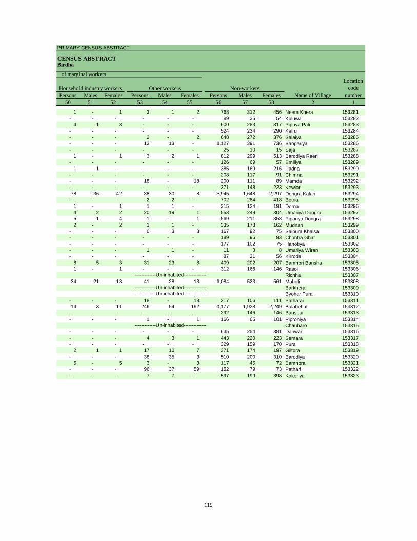
PRIMARY CENSUS ABSTRACT
CENSUS ABSTRACTBirdha
Persons Males Females Persons Males Females Persons Males Females50 51 52 53 54 55 56 57 58 2 1
Non-workers
of marginal workersLocation
code number
Household industry workersName of Village
Other workers
1 - 1 3 1 2 768 312 456 Neem Khera 153281- - - - - - 89 35 54 Kuluwa 153282
4 1 3 - - - 600 283 317 Pipriya Pali 153283- - - - - - 524 234 290 Kalro 153284- - - 2 - 2 648 272 376 Salaiya 153285- - - 13 13 - 1,127 391 736 Bangariya 153286- - - - - - 25 10 15 Saja 153287
1 - 1 3 2 1 812 299 513 Barodiya Raen 153288- - - - - - 126 69 57 Emiliya 153289
1 1 - - - - 385 169 216 Padna 153290- - - - - - 208 117 91 Chimna 153291- - - 18 - 18 200 111 89 Mamda 153292- - - - - - 371 148 223 Kewlari 15329378 36 42 38 30 8 3,945 1,648 2,297 Dongra Kalan 153294
- - - 2 2 - 702 284 418 Betna 1532951 - 1 1 1 - 315 124 191 Dorna 1532964 2 2 20 19 1 553 249 304 Umariya Dongra 1532975 1 4 1 - 1 569 211 358 Pipariya Dongra 1532982 - 2 1 1 - 335 173 162 Mudnari 153299
- - - 6 3 3 167 92 75 Saipura Khalsa 153300- - - - - - 189 96 93 Chontra Ghat 153301- - - - - - 177 102 75 Hanotiya 153302- - - 1 1 - 11 3 8 Umariya Wiran 153303- - - - - - 87 31 56 Kirroda 153304
8 5 3 31 23 8 409 202 207 Bamhori Bansha 1533051 - 1 - - - 312 166 146 Rasoi 153306
Richha 15330734 21 13 41 28 13 1,084 523 561 Maholi 153308
Barkhera 153309Byohar Pura 153310
- - - 18 - 18 217 106 111 Patharai 15331114 3 11 246 54 192 4,177 1,928 2,249 Balabehat 153312
- - - - - - 292 146 146 Banspur 153313- - - 1 - 1 166 65 101 Piproniya 153314
Chaubaro 153315- - - - - - 635 254 381 Danwar 153316- - - 4 3 1 443 220 223 Semara 153317- - - - - - 329 159 170 Pura 153318
2 1 1 17 10 7 371 174 197 Giltora 153319- - - 38 35 3 510 200 310 Barodiya 153320
5 - 5 3 - 3 117 45 72 Bamnora 153321- - - 96 37 59 152 79 73 Pathari 153322- - - 7 7 - 597 199 398 Kakoriya 153323
-------------Un-inhabited--------------
-------------Un-inhabited---------------------------Un-inhabited--------------
-------------Un-inhabited--------------
115
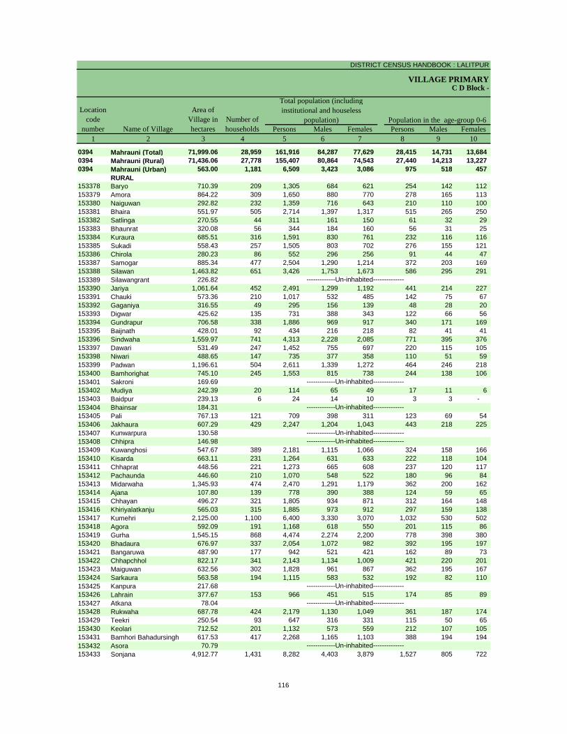
DISTRICT CENSUS HANDBOOK : LALITPUR
VILLAGE PRIMARY
Persons Males Females Persons Males Females1 2 3 4 5 6 7 8 9 10
0394 Mahrauni (Total) 71,999.06 28,959 161,916 84,287 77,629 28,415 14,731 13,684 0394 Mahrauni (Rural) 71,436.06 27,778 155,407 80,864 74,543 27,440 14,213 13,227 0394 Mahrauni (Urban) 563.00 1,181 6,509 3,423 3,086 975 518 457
RURAL153378 Baryo 710.39 209 1,305 684 621 254 142 112 153379 Amora 864.22 309 1,650 880 770 278 165 113 153380 Naiguwan 292.82 232 1,359 716 643 210 110 100 153381 Bhaira 551.97 505 2,714 1,397 1,317 515 265 250 153382 Satlinga 270.55 44 311 161 150 61 32 29 153383 Bhaunrat 320.08 56 344 184 160 56 31 25 153384 Kuraura 685.51 316 1,591 830 761 232 116 116 153385 Sukadi 558.43 257 1,505 803 702 276 155 121 153386 Chirola 280.23 86 552 296 256 91 44 47 153387 Samogar 885.34 477 2,504 1,290 1,214 372 203 169 153388 Silawan 1,463.82 651 3,426 1,753 1,673 586 295 291 153389 Silawangrant 226.82153390 Jariya 1,061.64 452 2,491 1,299 1,192 441 214 227 153391 Chauki 573.36 210 1,017 532 485 142 75 67 153392 Gaganiya 316.55 49 295 156 139 48 28 20 153393 Digwar 425.62 135 731 388 343 122 66 56 153394 Gundrapur 706.58 338 1,886 969 917 340 171 169 153395 Baijnath 428.01 92 434 216 218 82 41 41 153396 Sindwaha 1,559.97 741 4,313 2,228 2,085 771 395 376 153397 Dawari 531.49 247 1,452 755 697 220 115 105 153398 Niwari 488.65 147 735 377 358 110 51 59 153399 Padwan 1,196.61 504 2,611 1,339 1,272 464 246 218 153400 Bamhorighat 745.10 245 1,553 815 738 244 138 106 153401 Sakroni 169.69153402 Mudiya 242.39 20 114 65 49 17 11 6 153403 Baidpur 239.13 6 24 14 10 3 3 - 153404 Bhainsar 184.31153405 Pali 767.13 121 709 398 311 123 69 54 153406 Jakhaura 607.29 429 2,247 1,204 1,043 443 218 225 153407 Kunwarpura 130.58153408 Chhipra 146.98153409 Kuwanghosi 547.67 389 2,181 1,115 1,066 324 158 166 153410 Kisarda 663.11 231 1,264 631 633 222 118 104 153411 Chhaprat 448.56 221 1,273 665 608 237 120 117 153412 Pachaunda 446.60 210 1,070 548 522 180 96 84 153413 Midarwaha 1,345.93 474 2,470 1,291 1,179 362 200 162 153414 Ajana 107.80 139 778 390 388 124 59 65 153415 Chhayan 496.27 321 1,805 934 871 312 164 148 153416 Khiriyalatkanju 565.03 315 1,885 973 912 297 159 138 153417 Kumehri 2,125.00 1,100 6,400 3,330 3,070 1,032 530 502 153418 Agora 592.09 191 1,168 618 550 201 115 86 153419 Gurha 1,545.15 868 4,474 2,274 2,200 778 398 380 153420 Bhadaura 676.97 337 2,054 1,072 982 392 195 197 153421 Bangaruwa 487.90 177 942 521 421 162 89 73 153422 Chhapchhol 822.17 341 2,143 1,134 1,009 421 220 201 153423 Maiguwan 632.56 302 1,828 961 867 362 195 167 153424 Sarkaura 563.58 194 1,115 583 532 192 82 110 153425 Kanpura 217.68153426 Lahrain 377.67 153 966 451 515 174 85 89 153427 Atkana 78.04153428 Rukwaha 687.78 424 2,179 1,130 1,049 361 187 174 153429 Teekri 250.54 93 647 316 331 115 50 65 153430 Keolari 712.52 201 1,132 573 559 212 107 105 153431 Bamhori Bahadursingh 617.53 417 2,268 1,165 1,103 388 194 194 153432 Asora 70.79153433 Sonjana 4,912.77 1,431 8,282 4,403 3,879 1,527 805 722
-------------Un-inhabited--------------
-------------Un-inhabited--------------
-------------Un-inhabited--------------
-------------Un-inhabited---------------------------Un-inhabited--------------
-------------Un-inhabited--------------
-------------Un-inhabited--------------
-------------Un-inhabited--------------
C D Block -
Population in the age-group 0-6Number of householdsName of Village
Location code
number
Total population (including institutional and houseless
population)Area of
Village in hectares
116
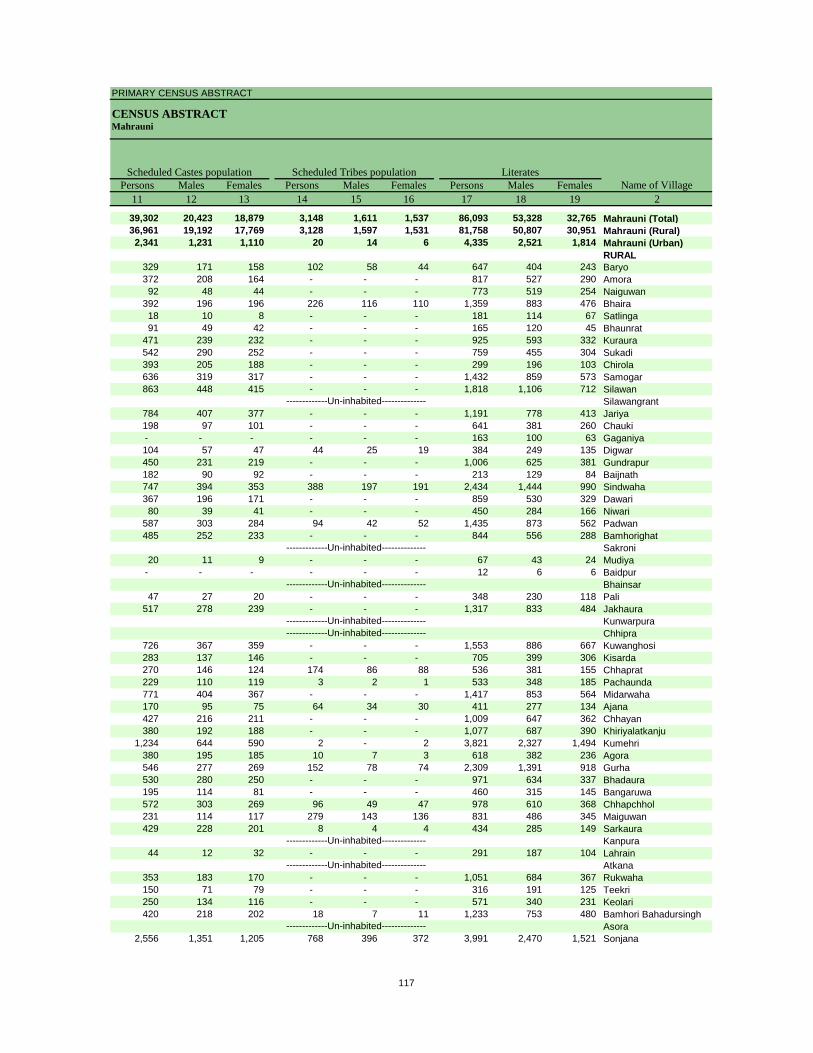
PRIMARY CENSUS ABSTRACT
CENSUS ABSTRACTMahrauni
Persons Males Females Persons Males Females Persons Males Females11 12 13 14 15 16 17 18 19 2
39,302 20,423 18,879 3,148 1,611 1,537 86,093 53,328 32,765 Mahrauni (Total)36,961 19,192 17,769 3,128 1,597 1,531 81,758 50,807 30,951 Mahrauni (Rural)2,341 1,231 1,110 20 14 6 4,335 2,521 1,814 Mahrauni (Urban)
RURAL329 171 158 102 58 44 647 404 243 Baryo372 208 164 - - - 817 527 290 Amora92 48 44 - - - 773 519 254 Naiguwan
392 196 196 226 116 110 1,359 883 476 Bhaira18 10 8 - - - 181 114 67 Satlinga91 49 42 - - - 165 120 45 Bhaunrat
471 239 232 - - - 925 593 332 Kuraura542 290 252 - - - 759 455 304 Sukadi393 205 188 - - - 299 196 103 Chirola636 319 317 - - - 1,432 859 573 Samogar863 448 415 - - - 1,818 1,106 712 Silawan
Silawangrant784 407 377 - - - 1,191 778 413 Jariya198 97 101 - - - 641 381 260 Chauki- - - - - - 163 100 63 Gaganiya104 57 47 44 25 19 384 249 135 Digwar450 231 219 - - - 1,006 625 381 Gundrapur182 90 92 - - - 213 129 84 Baijnath747 394 353 388 197 191 2,434 1,444 990 Sindwaha367 196 171 - - - 859 530 329 Dawari80 39 41 - - - 450 284 166 Niwari
587 303 284 94 42 52 1,435 873 562 Padwan485 252 233 - - - 844 556 288 Bamhorighat
Sakroni20 11 9 - - - 67 43 24 Mudiya
- - - - - - 12 6 6 BaidpurBhainsar
47 27 20 - - - 348 230 118 Pali517 278 239 - - - 1,317 833 484 Jakhaura
KunwarpuraChhipra
726 367 359 - - - 1,553 886 667 Kuwanghosi283 137 146 - - - 705 399 306 Kisarda270 146 124 174 86 88 536 381 155 Chhaprat229 110 119 3 2 1 533 348 185 Pachaunda771 404 367 - - - 1,417 853 564 Midarwaha170 95 75 64 34 30 411 277 134 Ajana427 216 211 - - - 1,009 647 362 Chhayan380 192 188 - - - 1,077 687 390 Khiriyalatkanju
1,234 644 590 2 - 2 3,821 2,327 1,494 Kumehri380 195 185 10 7 3 618 382 236 Agora546 277 269 152 78 74 2,309 1,391 918 Gurha530 280 250 - - - 971 634 337 Bhadaura195 114 81 - - - 460 315 145 Bangaruwa572 303 269 96 49 47 978 610 368 Chhapchhol231 114 117 279 143 136 831 486 345 Maiguwan429 228 201 8 4 4 434 285 149 Sarkaura
Kanpura44 12 32 - - - 291 187 104 Lahrain
Atkana353 183 170 - - - 1,051 684 367 Rukwaha150 71 79 - - - 316 191 125 Teekri250 134 116 - - - 571 340 231 Keolari420 218 202 18 7 11 1,233 753 480 Bamhori Bahadursingh
Asora2,556 1,351 1,205 768 396 372 3,991 2,470 1,521 Sonjana
-------------Un-inhabited--------------
-------------Un-inhabited--------------
-------------Un-inhabited--------------
-------------Un-inhabited---------------------------Un-inhabited--------------
-------------Un-inhabited--------------
-------------Un-inhabited--------------
-------------Un-inhabited--------------
Scheduled Castes population Scheduled Tribes populationName of Village
Literates
117
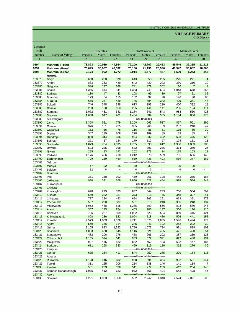
DISTRICT CENSUS HANDBOOK : LALITPUR
VILLAGE PRIMARYC D Block -
Persons Males Females Persons Males Females Persons Males Females1 2 20 21 22 23 24 25 26 27 28
0394 Mahrauni (Total) 75,823 30,959 44,864 72,200 42,767 29,433 48,546 37,335 11,211 0394 Mahrauni (Rural) 73,649 30,057 43,592 70,186 41,190 28,996 46,947 36,082 10,865 0394 Mahrauni (Urban) 2,174 902 1,272 2,014 1,577 437 1,599 1,253 346
RURAL153378 Baryo 658 280 378 643 358 285 275 271 4 153379 Amora 833 353 480 642 420 222 330 310 20 153380 Naiguwan 586 197 389 741 379 362 10 7 3 153381 Bhaira 1,355 514 841 1,353 749 604 1,043 678 365 153382 Satlinga 130 47 83 108 69 39 97 61 36 153383 Bhaunrat 179 64 115 182 92 90 176 90 86 153384 Kuraura 666 237 429 746 404 342 429 381 48 153385 Sukadi 746 348 398 613 393 220 400 382 18 153386 Chirola 253 100 153 285 144 141 235 124 111 153387 Samogar 1,072 431 641 1,184 641 543 988 560 428 153388 Silawan 1,608 647 961 1,454 889 565 1,184 806 378 153389 Silawangrant153390 Jariya 1,300 521 779 1,200 663 537 857 561 296 153391 Chauki 376 151 225 335 266 69 287 240 47 153392 Gaganiya 132 56 76 116 85 31 115 85 30 153393 Digwar 347 139 208 278 189 89 89 85 4 153394 Gundrapur 880 344 536 954 532 422 603 475 128 153395 Baijnath 221 87 134 179 112 67 124 111 13 153396 Sindwaha 1,879 784 1,095 1,705 1,093 612 1,386 1,003 383 153397 Dawari 593 225 368 652 396 256 364 340 24 153398 Niwari 285 93 192 202 178 24 175 163 12 153399 Padwan 1,176 466 710 1,212 673 539 781 636 145 153400 Bamhorighat 709 259 450 839 436 403 559 377 182 153401 Sakroni153402 Mudiya 47 22 25 30 30 - 30 30 - 153403 Baidpur 12 8 4 6 6 - 6 6 - 153404 Bhainsar153405 Pali 361 168 193 459 261 198 442 255 187 153406 Jakhaura 930 371 559 1,086 622 464 928 584 344 153407 Kunwarpura153408 Chhipra153409 Kuwanghosi 628 229 399 837 544 293 766 504 262 153410 Kisarda 559 232 327 373 318 55 348 307 41 153411 Chhaprat 737 284 453 654 363 291 623 351 272 153412 Pachaunda 537 200 337 561 313 248 385 248 137 153413 Midarwaha 1,053 438 615 1,275 709 566 823 580 243 153414 Ajana 367 113 254 403 206 197 306 196 110 153415 Chhayan 796 287 509 1,032 528 504 869 445 424 153416 Khiriyalatkanju 808 286 522 1,004 518 486 596 441 155 153417 Kumehri 2,579 1,003 1,576 2,711 1,676 1,035 1,596 1,424 172 153418 Agora 550 236 314 345 243 102 252 222 30 153419 Gurha 2,165 883 1,282 1,796 1,072 724 991 889 102 153420 Bhadaura 1,083 438 645 1,116 621 495 471 420 51 153421 Bangaruwa 482 206 276 468 266 202 387 259 128 153422 Chhapchhol 1,165 524 641 963 572 391 622 488 134 153423 Maiguwan 997 475 522 882 459 423 632 447 185 153424 Sarkaura 681 298 383 499 319 180 312 276 36 153425 Kanpura153426 Lahrain 675 264 411 544 259 285 270 154 116 153427 Atkana153428 Rukwaha 1,128 446 682 958 594 364 932 591 341 153429 Teekri 331 125 206 284 138 146 141 134 7 153430 Keolari 561 233 328 511 272 239 412 264 148 153431 Bamhori Bahadursingh 1,035 412 623 972 568 404 542 498 44 153432 Asora153433 Sonjana 4,291 1,933 2,358 3,582 2,242 1,340 2,524 2,021 503
-------------Un-inhabited--------------
-------------Un-inhabited--------------
-------------Un-inhabited--------------
-------------Un-inhabited---------------------------Un-inhabited--------------
-------------Un-inhabited--------------
-------------Un-inhabited--------------
-------------Un-inhabited--------------
Illiterates Total workers Main workersName of Village
Location code
number
118
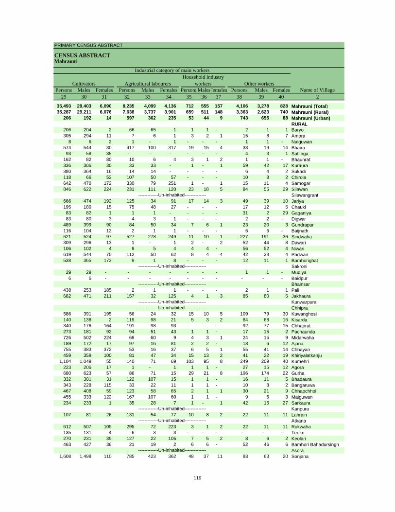
PRIMARY CENSUS ABSTRACT
CENSUS ABSTRACTMahrauni
Persons Males Females Persons Males Females PersonsMalesFemales Persons Males Females29 30 31 32 33 34 35 36 37 38 39 40 2
35,493 29,403 6,090 8,235 4,099 4,136 712 555 157 4,106 3,278 828 Mahrauni (Total)35,287 29,211 6,076 7,638 3,737 3,901 659 511 148 3,363 2,623 740 Mahrauni (Rural)
206 192 14 597 362 235 53 44 9 743 655 88 Mahrauni (Urban)RURAL
206 204 2 66 65 1 1 1 - 2 1 1 Baryo305 294 11 7 6 1 3 2 1 15 8 7 Amora
8 6 2 1 - 1 - - - 1 1 - Naiguwan574 544 30 417 100 317 19 15 4 33 19 14 Bhaira93 58 35 - - - - - - 4 3 1 Satlinga
162 82 80 10 6 4 3 1 2 1 1 - Bhaunrat336 306 30 33 33 - 1 - 1 59 42 17 Kuraura380 364 16 14 14 - - - - 6 4 2 Sukadi118 66 52 107 50 57 - - - 10 8 2 Chirola642 470 172 330 79 251 1 - 1 15 11 4 Samogar846 622 224 231 111 120 23 18 5 84 55 29 Silawan
Silawangrant666 474 192 125 34 91 17 14 3 49 39 10 Jariya195 180 15 75 48 27 - - - 17 12 5 Chauki83 82 1 1 1 - - - - 31 2 29 Gaganiya83 80 3 4 3 1 - - - 2 2 - Digwar
489 399 90 84 50 34 7 6 1 23 20 3 Gundrapur116 104 12 2 1 1 - - - 6 6 - Baijnath621 524 97 527 278 249 11 10 1 227 191 36 Sindwaha309 296 13 1 - 1 2 - 2 52 44 8 Dawari106 102 4 9 5 4 4 4 - 56 52 4 Niwari619 544 75 112 50 62 8 4 4 42 38 4 Padwan538 365 173 9 1 8 - - - 12 11 1 Bamhorighat
Sakroni29 29 - - - - - - - 1 1 - Mudiya6 6 - - - - - - - - - - Baidpur
Bhainsar438 253 185 2 1 1 - - - 2 1 1 Pali682 471 211 157 32 125 4 1 3 85 80 5 Jakhaura
KunwarpuraChhipra
586 391 195 56 24 32 15 10 5 109 79 30 Kuwanghosi140 138 2 119 98 21 5 3 2 84 68 16 Kisarda340 176 164 191 98 93 - - - 92 77 15 Chhaprat273 181 92 94 51 43 1 1 - 17 15 2 Pachaunda726 502 224 69 60 9 4 3 1 24 15 9 Midarwaha189 172 17 97 16 81 2 2 - 18 6 12 Ajana755 383 372 53 16 37 6 5 1 55 41 14 Chhayan459 359 100 81 47 34 15 13 2 41 22 19 Khiriyalatkanju
1,104 1,049 55 140 71 69 103 95 8 249 209 40 Kumehri223 206 17 1 - 1 1 1 - 27 15 12 Agora680 623 57 86 71 15 29 21 8 196 174 22 Gurha332 301 31 122 107 15 1 1 - 16 11 5 Bhadaura343 228 115 33 22 11 1 1 - 10 8 2 Bangaruwa467 408 59 123 58 65 2 1 1 30 21 9 Chhapchhol455 333 122 167 107 60 1 1 - 9 6 3 Maiguwan234 233 1 35 28 7 1 - 1 42 15 27 Sarkaura
Kanpura107 81 26 131 54 77 10 8 2 22 11 11 Lahrain
Atkana612 507 105 295 72 223 3 1 2 22 11 11 Rukwaha135 131 4 6 3 3 - - - - - - Teekri270 231 39 127 22 105 7 5 2 8 6 2 Keolari463 427 36 21 19 2 6 6 - 52 46 6 Bamhori Bahadursingh
Asora1,608 1,498 110 785 423 362 48 37 11 83 63 20 Sonjana
-------------Un-inhabited--------------
-------------Un-inhabited--------------
-------------Un-inhabited--------------
-------------Un-inhabited---------------------------Un-inhabited--------------
-------------Un-inhabited--------------
-------------Un-inhabited--------------
-------------Un-inhabited--------------
CultivatorsName of Village
Household industry workersAgricultural labourers
Industrial category of main workers
Other workers
119
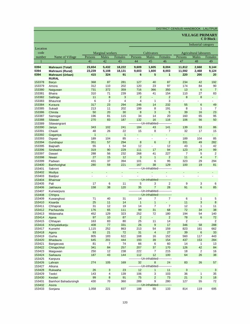
DISTRICT CENSUS HANDBOOK : LALITPUR
VILLAGE PRIMARYC D Block -
Persons Males Females Persons Males Females Persons Males Females1 2 41 42 43 44 45 46 47 48 49
0394 Mahrauni (Total) 23,654 5,432 18,222 9,609 1,605 8,004 11,812 2,668 9,144 0394 Mahrauni (Rural) 23,239 5,108 18,131 9,603 1,600 8,003 11,592 2,468 9,124 0394 Mahrauni (Urban) 415 324 91 6 5 1 220 200 20
RURAL153378 Baryo 368 87 281 127 40 87 234 42 192 153379 Amora 312 110 202 120 23 97 174 84 90 153380 Naiguwan 731 372 359 716 366 350 13 6 7 153381 Bhaira 310 71 239 195 41 154 110 27 83 153382 Satlinga 11 8 3 2 - 2 8 8 - 153383 Bhaunrat 6 2 4 4 1 3 - - - 153384 Kuraura 317 23 294 246 14 232 55 6 49 153385 Sukadi 213 11 202 199 8 191 8 1 7 153386 Chirola 50 20 30 8 3 5 39 16 23 153387 Samogar 196 81 115 34 14 20 160 65 95 153388 Silawan 270 83 187 132 16 116 106 56 50 153389 Silawangrant153390 Jariya 343 102 241 184 43 141 139 53 86 153391 Chauki 48 26 22 15 8 7 32 17 15 153392 Gaganiya 1 - 1 - - - - - - 153393 Digwar 189 104 85 - - - 189 104 85 153394 Gundrapur 351 57 294 8 6 2 331 49 282 153395 Baijnath 55 1 54 12 - 12 43 1 42 153396 Sindwaha 319 90 229 111 17 94 123 24 99 153397 Dawari 288 56 232 268 41 227 7 5 2 153398 Niwari 27 15 12 3 1 2 11 4 7 153399 Padwan 431 37 394 101 6 95 323 29 294 153400 Bamhorighat 280 59 221 167 38 129 100 19 81 153401 Sakroni153402 Mudiya - - - - - - - - - 153403 Baidpur - - - - - - - - - 153404 Bhainsar153405 Pali 17 6 11 5 3 2 9 3 6 153406 Jakhaura 158 38 120 35 7 28 91 6 85 153407 Kunwarpura153408 Chhipra153409 Kuwanghosi 71 40 31 14 7 7 6 1 5 153410 Kisarda 25 11 14 1 1 - 11 3 8 153411 Chhaprat 31 12 19 14 7 7 12 1 11 153412 Pachaunda 176 65 111 99 31 68 72 34 38 153413 Midarwaha 452 129 323 252 72 180 194 54 140 153414 Ajana 97 10 87 2 - 2 78 6 72 153415 Chhayan 163 83 80 25 11 14 2 - 2 153416 Khiriyalatkanju 408 77 331 26 9 17 346 58 288 153417 Kumehri 1,115 252 863 213 54 159 823 161 662 153418 Agora 93 21 72 31 4 27 39 6 33 153419 Gurha 805 183 622 168 16 152 560 117 443 153420 Bhadaura 645 201 444 193 39 154 437 153 284 153421 Bangaruwa 81 7 74 66 6 60 14 1 13 153422 Chhapchhol 341 84 257 207 37 170 126 42 84 153423 Maiguwan 250 12 238 222 7 215 18 2 16 153424 Sarkaura 187 43 144 112 12 100 64 26 38 153425 Kanpura153426 Lahrain 274 105 169 32 8 24 83 26 57 153427 Atkana153428 Rukwaha 26 3 23 12 1 11 3 - 3 153429 Teekri 143 4 139 106 3 103 36 1 35 153430 Keolari 99 8 91 75 2 73 21 3 18 153431 Bamhori Bahadursingh 430 70 360 289 9 280 127 55 72 153432 Asora153433 Sonjana 1,058 221 837 188 55 133 814 119 695
-------------Un-inhabited--------------
-------------Un-inhabited--------------
-------------Un-inhabited--------------
-------------Un-inhabited---------------------------Un-inhabited--------------
-------------Un-inhabited--------------
-------------Un-inhabited--------------
-------------Un-inhabited--------------
Location code
number Name of VillageMarginal workers Cultivators Agricultural labourers
Industrial category
120
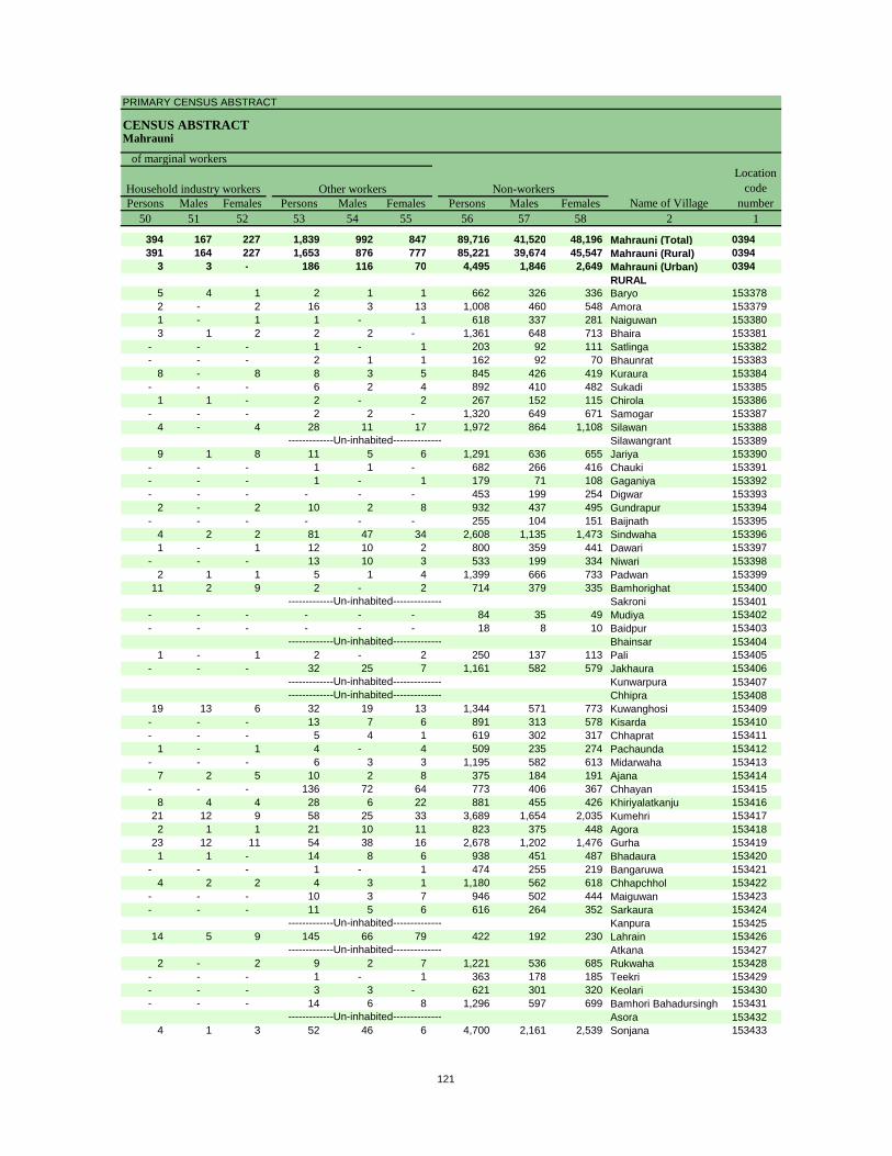
PRIMARY CENSUS ABSTRACT
CENSUS ABSTRACTMahrauni
Persons Males Females Persons Males Females Persons Males Females50 51 52 53 54 55 56 57 58 2 1
394 167 227 1,839 992 847 89,716 41,520 48,196 Mahrauni (Total) 0394391 164 227 1,653 876 777 85,221 39,674 45,547 Mahrauni (Rural) 0394
3 3 - 186 116 70 4,495 1,846 2,649 Mahrauni (Urban) 0394RURAL
5 4 1 2 1 1 662 326 336 Baryo 1533782 - 2 16 3 13 1,008 460 548 Amora 1533791 - 1 1 - 1 618 337 281 Naiguwan 1533803 1 2 2 2 - 1,361 648 713 Bhaira 153381
- - - 1 - 1 203 92 111 Satlinga 153382- - - 2 1 1 162 92 70 Bhaunrat 153383
8 - 8 8 3 5 845 426 419 Kuraura 153384- - - 6 2 4 892 410 482 Sukadi 153385
1 1 - 2 - 2 267 152 115 Chirola 153386- - - 2 2 - 1,320 649 671 Samogar 153387
4 - 4 28 11 17 1,972 864 1,108 Silawan 153388Silawangrant 153389
9 1 8 11 5 6 1,291 636 655 Jariya 153390- - - 1 1 - 682 266 416 Chauki 153391- - - 1 - 1 179 71 108 Gaganiya 153392- - - - - - 453 199 254 Digwar 153393
2 - 2 10 2 8 932 437 495 Gundrapur 153394- - - - - - 255 104 151 Baijnath 153395
4 2 2 81 47 34 2,608 1,135 1,473 Sindwaha 1533961 - 1 12 10 2 800 359 441 Dawari 153397
- - - 13 10 3 533 199 334 Niwari 1533982 1 1 5 1 4 1,399 666 733 Padwan 153399
11 2 9 2 - 2 714 379 335 Bamhorighat 153400Sakroni 153401
- - - - - - 84 35 49 Mudiya 153402- - - - - - 18 8 10 Baidpur 153403
Bhainsar 1534041 - 1 2 - 2 250 137 113 Pali 153405
- - - 32 25 7 1,161 582 579 Jakhaura 153406Kunwarpura 153407Chhipra 153408
19 13 6 32 19 13 1,344 571 773 Kuwanghosi 153409- - - 13 7 6 891 313 578 Kisarda 153410- - - 5 4 1 619 302 317 Chhaprat 153411
1 - 1 4 - 4 509 235 274 Pachaunda 153412- - - 6 3 3 1,195 582 613 Midarwaha 153413
7 2 5 10 2 8 375 184 191 Ajana 153414- - - 136 72 64 773 406 367 Chhayan 153415
8 4 4 28 6 22 881 455 426 Khiriyalatkanju 15341621 12 9 58 25 33 3,689 1,654 2,035 Kumehri 1534172 1 1 21 10 11 823 375 448 Agora 153418
23 12 11 54 38 16 2,678 1,202 1,476 Gurha 1534191 1 - 14 8 6 938 451 487 Bhadaura 153420
- - - 1 - 1 474 255 219 Bangaruwa 1534214 2 2 4 3 1 1,180 562 618 Chhapchhol 153422
- - - 10 3 7 946 502 444 Maiguwan 153423- - - 11 5 6 616 264 352 Sarkaura 153424
Kanpura 15342514 5 9 145 66 79 422 192 230 Lahrain 153426
Atkana 1534272 - 2 9 2 7 1,221 536 685 Rukwaha 153428
- - - 1 - 1 363 178 185 Teekri 153429- - - 3 3 - 621 301 320 Keolari 153430- - - 14 6 8 1,296 597 699 Bamhori Bahadursingh 153431
Asora 1534324 1 3 52 46 6 4,700 2,161 2,539 Sonjana 153433
-------------Un-inhabited--------------
-------------Un-inhabited--------------
-------------Un-inhabited--------------
-------------Un-inhabited---------------------------Un-inhabited--------------
-------------Un-inhabited--------------
-------------Un-inhabited--------------
-------------Un-inhabited--------------
Non-workers
of marginal workersLocation
code number
Household industry workersName of Village
Other workers
121
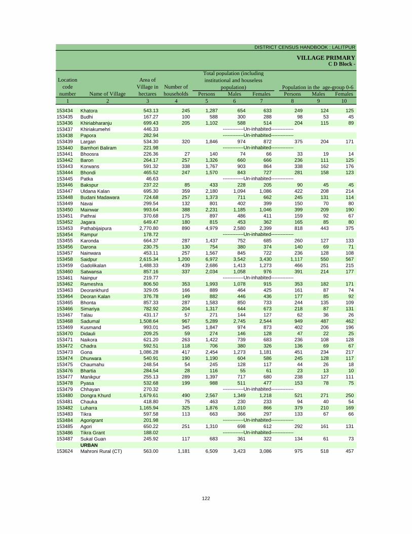
DISTRICT CENSUS HANDBOOK : LALITPUR
VILLAGE PRIMARY
Persons Males Females Persons Males Females1 2 3 4 5 6 7 8 9 10
C D Block -
Population in the age-group 0-6Number of householdsName of Village
Location code
number
Total population (including institutional and houseless
population)Area of
Village in hectares
153434 Khatora 543.13 245 1,287 654 633 249 124 125 153435 Budhi 167.27 100 588 300 288 98 53 45 153436 Khiriabharanju 699.43 205 1,102 588 514 204 115 89 153437 Khiriakumehri 446.33153438 Papora 282.94153439 Largan 534.30 320 1,846 974 872 375 204 171 153440 Bamhori Baliram 221.98153441 Bhoosra 226.36 27 140 74 66 33 19 14 153442 Baron 264.17 257 1,326 660 666 236 111 125 153443 Korwans 591.32 338 1,767 903 864 338 162 176 153444 Bhondi 465.52 247 1,570 843 727 281 158 123 153445 Patka 46.63153446 Bakspur 237.22 85 433 228 205 90 45 45 153447 Uldana Kalan 695.30 359 2,180 1,094 1,086 422 208 214 153448 Budani Madawara 724.68 257 1,373 711 662 245 131 114 153449 Navai 299.54 132 801 402 399 150 70 80 153450 Mainwar 993.64 388 2,231 1,185 1,046 399 209 190 153451 Pathrai 370.68 175 897 486 411 159 92 67 153452 Jagara 649.47 180 815 453 362 165 85 80 153453 Pathabijaipura 2,770.80 890 4,979 2,580 2,399 818 443 375 153454 Rampur 178.72153455 Karonda 664.37 287 1,437 752 685 260 127 133 153456 Darona 230.75 130 754 380 374 140 69 71 153457 Nainwara 453.11 257 1,567 845 722 236 128 108 153458 Saidpur 2,615.34 1,200 6,972 3,542 3,430 1,117 550 567 153459 Gadolikalan 1,488.33 439 2,686 1,413 1,273 466 251 215 153460 Satwansa 857.16 337 2,034 1,058 976 391 214 177 153461 Nainpur 219.77153462 Rameshra 806.50 353 1,993 1,078 915 353 182 171 153463 Deorankhurd 329.05 166 889 464 425 161 87 74 153464 Deoran Kalan 376.78 149 882 446 436 177 85 92 153465 Bhonta 857.33 287 1,583 850 733 244 135 109 153466 Simariya 782.92 204 1,317 644 673 218 87 131 153467 Talau 431.17 57 271 144 127 62 36 26 153468 Sadumal 1,508.64 967 5,289 2,745 2,544 949 487 462 153469 Kusmand 993.01 345 1,847 974 873 402 206 196 153470 Didauli 209.25 59 274 146 128 47 22 25 153471 Naikora 621.20 263 1,422 739 683 236 108 128 153472 Chadra 592.51 118 706 380 326 136 69 67 153473 Gona 1,086.28 417 2,454 1,273 1,181 451 234 217 153474 Dhurwara 540.91 190 1,190 604 586 245 128 117 153475 Chaumahu 248.54 54 245 128 117 44 26 18 153476 Bhartia 284.54 28 116 55 61 23 13 10 153477 Manikpur 255.13 289 1,397 717 680 238 127 111 153478 Pyasa 532.68 199 988 511 477 153 78 75 153479 Chhayan 270.32153480 Dongra Khurd 1,679.61 490 2,567 1,349 1,218 521 271 250 153481 Chauka 418.80 75 463 230 233 94 40 54 153482 Luharra 1,165.94 325 1,876 1,010 866 379 210 169 153483 Tikra 597.58 113 663 366 297 133 67 66 153484 Agorigrant 201.98153485 Agori 650.22 251 1,310 698 612 292 161 131 153486 Tikra Grant 188.02153487 Sukal Guan 245.92 117 683 361 322 134 61 73
URBAN153624 Mahroni Rural (CT) 563.00 1,181 6,509 3,423 3,086 975 518 457
-------------Un-inhabited--------------
-------------Un-inhabited--------------
-------------Un-inhabited--------------
-------------Un-inhabited--------------
-------------Un-inhabited--------------
-------------Un-inhabited--------------
-------------Un-inhabited--------------
-------------Un-inhabited---------------------------Un-inhabited--------------
122

PRIMARY CENSUS ABSTRACT
CENSUS ABSTRACTMahrauni
Persons Males Females Persons Males Females Persons Males Females11 12 13 14 15 16 17 18 19 2
Scheduled Castes population Scheduled Tribes populationName of Village
Literates
263 138 125 - - - 659 414 245 Khatora48 27 21 - - - 337 205 132 Budhi
318 163 155 - - - 614 386 228 KhiriabharanjuKhiriakumehriPapora
179 96 83 - - - 1,110 687 423 LarganBamhori Baliram
- - - - - - 64 40 24 Bhoosra355 175 180 - - - 746 452 294 Baron245 128 117 59 27 32 804 529 275 Korwans501 258 243 - - - 863 527 336 Bhondi
Patka17 9 8 - - - 234 158 76 Bakspur
332 160 172 - - - 1,041 637 404 Uldana Kalan387 199 188 - - - 806 499 307 Budani Madawara174 88 86 - - - 359 203 156 Navai456 242 214 328 162 166 1,149 667 482 Mainwar270 145 125 2 1 1 459 279 180 Pathrai17 9 8 - - - 382 248 134 Jagara
1,259 653 606 - - - 2,798 1,707 1,091 PathabijaipuraRampur
531 279 252 42 23 19 816 545 271 Karonda- - - - - - 380 240 140 Darona562 305 257 - - - 955 614 341 Nainwara
1,380 695 685 114 59 55 3,962 2,403 1,559 Saidpur639 326 313 - - - 1,568 980 588 Gadolikalan763 388 375 - - - 1,204 763 441 Satwansa
Nainpur580 317 263 155 81 74 1,160 731 429 Rameshra301 146 155 - - - 482 317 165 Deorankhurd195 97 98 - - - 437 267 170 Deoran Kalan511 278 233 - - - 972 611 361 Bhonta396 194 202 - - - 724 443 281 Simariya- - - - - - 106 72 34 Talau
1,332 688 644 - - - 3,026 1,898 1,128 Sadumal741 390 351 - - - 626 446 180 Kusmand- - - - - - 111 68 43 Didauli395 212 183 - - - 698 430 268 Naikora119 60 59 - - - 313 184 129 Chadra428 211 217 - - - 1,225 764 461 Gona243 115 128 - - - 564 356 208 Dhurwara88 44 44 - - - 124 71 53 Chaumahu
- - - - - - 68 39 29 Bhartia428 219 209 - - - 785 479 306 Manikpur379 197 182 - - - 564 327 237 Pyasa
Chhayan805 440 365 - - - 935 591 344 Dongra Khurd226 102 124 - - - 201 125 76 Chauka390 207 183 - - - 630 390 240 Luharra288 160 128 - - - 231 152 79 Tikra
Agorigrant337 185 152 - - - 553 321 232 Agori
Tikra Grant170 91 79 - - - 258 172 86 Sukal Guan
URBAN2,341 1,231 1,110 20 14 6 4,335 2,521 1,814 Mahroni Rural (CT)
-------------Un-inhabited--------------
-------------Un-inhabited--------------
-------------Un-inhabited--------------
-------------Un-inhabited--------------
-------------Un-inhabited--------------
-------------Un-inhabited--------------
-------------Un-inhabited--------------
-------------Un-inhabited---------------------------Un-inhabited--------------
123

DISTRICT CENSUS HANDBOOK : LALITPUR
VILLAGE PRIMARYC D Block -
Persons Males Females Persons Males Females Persons Males Females1 2 20 21 22 23 24 25 26 27 28
Illiterates Total workers Main workersName of Village
Location code
number
153434 Khatora 628 240 388 642 323 319 487 322 165 153435 Budhi 251 95 156 280 147 133 146 139 7 153436 Khiriabharanju 488 202 286 401 256 145 213 178 35 153437 Khiriakumehri153438 Papora153439 Largan 736 287 449 846 465 381 594 436 158 153440 Bamhori Baliram153441 Bhoosra 76 34 42 76 38 38 40 37 3 153442 Baron 580 208 372 642 337 305 492 296 196 153443 Korwans 963 374 589 618 478 140 609 477 132 153444 Bhondi 707 316 391 571 425 146 419 313 106 153445 Patka153446 Bakspur 199 70 129 233 118 115 229 118 111 153447 Uldana Kalan 1,139 457 682 856 547 309 572 490 82 153448 Budani Madawara 567 212 355 424 338 86 345 325 20 153449 Navai 442 199 243 387 202 185 155 151 4 153450 Mainwar 1,082 518 564 1,012 610 402 522 486 36 153451 Pathrai 438 207 231 478 267 211 275 260 15 153452 Jagara 433 205 228 421 266 155 234 225 9 153453 Pathabijaipura 2,181 873 1,308 2,418 1,325 1,093 2,259 1,246 1,013 153454 Rampur153455 Karonda 621 207 414 637 407 230 386 366 20 153456 Darona 374 140 234 313 182 131 134 130 4 153457 Nainwara 612 231 381 753 437 316 383 374 9 153458 Saidpur 3,010 1,139 1,871 3,222 1,830 1,392 2,142 1,565 577 153459 Gadolikalan 1,118 433 685 1,414 730 684 725 708 17 153460 Satwansa 830 295 535 924 495 429 537 406 131 153461 Nainpur153462 Rameshra 833 347 486 858 534 324 478 421 57 153463 Deorankhurd 407 147 260 318 220 98 221 214 7 153464 Deoran Kalan 445 179 266 467 237 230 227 224 3 153465 Bhonta 611 239 372 606 443 163 416 390 26 153466 Simariya 593 201 392 610 335 275 300 279 21 153467 Talau 165 72 93 123 62 61 64 61 3 153468 Sadumal 2,263 847 1,416 1,978 1,308 670 1,411 1,165 246 153469 Kusmand 1,221 528 693 935 528 407 449 436 13 153470 Didauli 163 78 85 154 87 67 85 84 1 153471 Naikora 724 309 415 751 393 358 389 366 23 153472 Chadra 393 196 197 351 194 157 174 172 2 153473 Gona 1,229 509 720 1,153 666 487 599 516 83 153474 Dhurwara 626 248 378 631 323 308 345 305 40 153475 Chaumahu 121 57 64 109 64 45 109 64 45 153476 Bhartia 48 16 32 59 29 30 32 28 4 153477 Manikpur 612 238 374 707 348 359 350 329 21 153478 Pyasa 424 184 240 397 250 147 206 201 5 153479 Chhayan153480 Dongra Khurd 1,632 758 874 1,138 653 485 851 637 214 153481 Chauka 262 105 157 123 119 4 123 119 4 153482 Luharra 1,246 620 626 1,021 529 492 702 520 182 153483 Tikra 432 214 218 406 228 178 215 196 19 153484 Agorigrant153485 Agori 757 377 380 419 354 65 403 346 57 153486 Tikra Grant153487 Sukal Guan 425 189 236 330 183 147 187 181 6
URBAN153624 Mahroni Rural (CT) 2,174 902 1,272 2,014 1,577 437 1,599 1,253 346
-------------Un-inhabited--------------
-------------Un-inhabited--------------
-------------Un-inhabited--------------
-------------Un-inhabited--------------
-------------Un-inhabited--------------
-------------Un-inhabited--------------
-------------Un-inhabited--------------
-------------Un-inhabited---------------------------Un-inhabited--------------
124
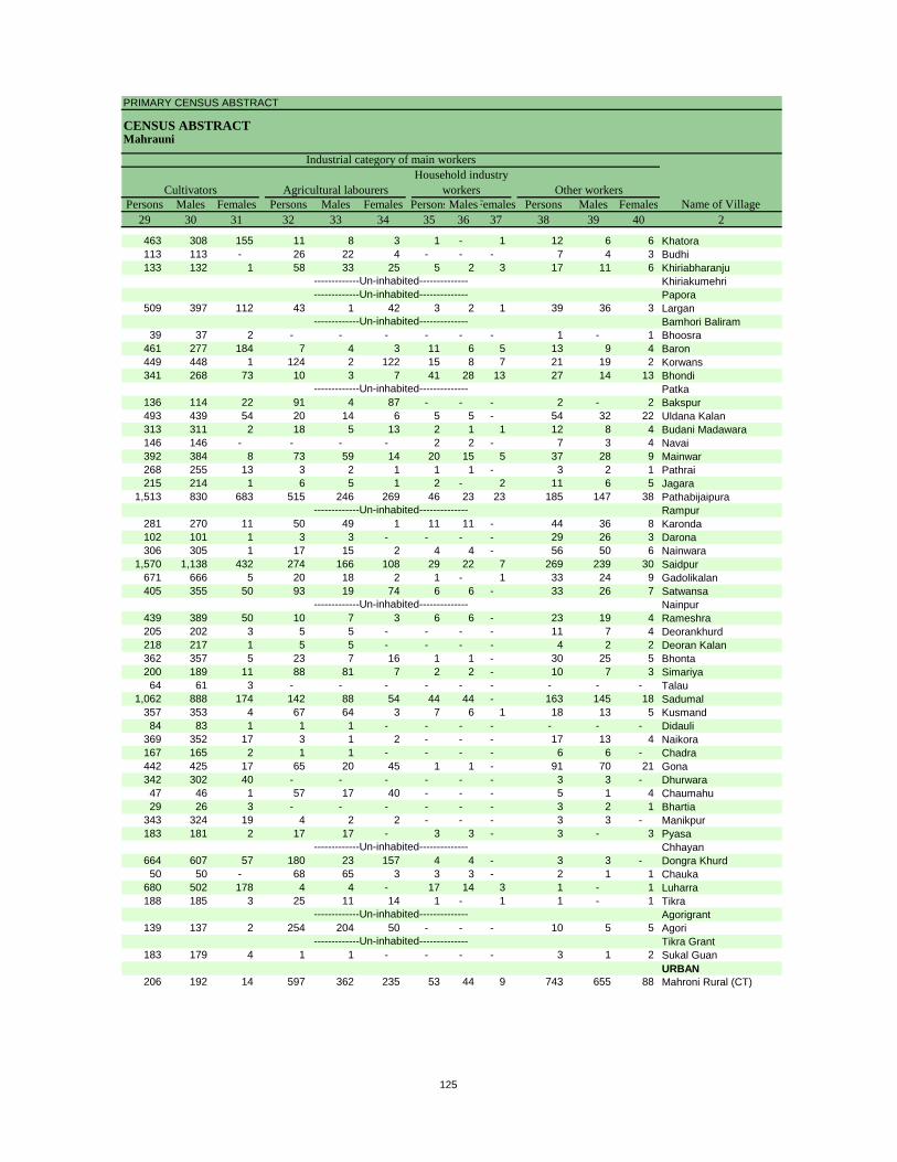
PRIMARY CENSUS ABSTRACT
CENSUS ABSTRACTMahrauni
Persons Males Females Persons Males Females PersonsMalesFemales Persons Males Females29 30 31 32 33 34 35 36 37 38 39 40 2
CultivatorsName of Village
Household industry workersAgricultural labourers
Industrial category of main workers
Other workers
463 308 155 11 8 3 1 - 1 12 6 6 Khatora113 113 - 26 22 4 - - - 7 4 3 Budhi133 132 1 58 33 25 5 2 3 17 11 6 Khiriabharanju
KhiriakumehriPapora
509 397 112 43 1 42 3 2 1 39 36 3 LarganBamhori Baliram
39 37 2 - - - - - - 1 - 1 Bhoosra461 277 184 7 4 3 11 6 5 13 9 4 Baron449 448 1 124 2 122 15 8 7 21 19 2 Korwans341 268 73 10 3 7 41 28 13 27 14 13 Bhondi
Patka136 114 22 91 4 87 - - - 2 - 2 Bakspur493 439 54 20 14 6 5 5 - 54 32 22 Uldana Kalan313 311 2 18 5 13 2 1 1 12 8 4 Budani Madawara146 146 - - - - 2 2 - 7 3 4 Navai392 384 8 73 59 14 20 15 5 37 28 9 Mainwar268 255 13 3 2 1 1 1 - 3 2 1 Pathrai215 214 1 6 5 1 2 - 2 11 6 5 Jagara
1,513 830 683 515 246 269 46 23 23 185 147 38 PathabijaipuraRampur
281 270 11 50 49 1 11 11 - 44 36 8 Karonda102 101 1 3 3 - - - - 29 26 3 Darona306 305 1 17 15 2 4 4 - 56 50 6 Nainwara
1,570 1,138 432 274 166 108 29 22 7 269 239 30 Saidpur671 666 5 20 18 2 1 - 1 33 24 9 Gadolikalan405 355 50 93 19 74 6 6 - 33 26 7 Satwansa
Nainpur439 389 50 10 7 3 6 6 - 23 19 4 Rameshra205 202 3 5 5 - - - - 11 7 4 Deorankhurd218 217 1 5 5 - - - - 4 2 2 Deoran Kalan362 357 5 23 7 16 1 1 - 30 25 5 Bhonta200 189 11 88 81 7 2 2 - 10 7 3 Simariya64 61 3 - - - - - - - - - Talau
1,062 888 174 142 88 54 44 44 - 163 145 18 Sadumal357 353 4 67 64 3 7 6 1 18 13 5 Kusmand84 83 1 1 1 - - - - - - - Didauli
369 352 17 3 1 2 - - - 17 13 4 Naikora167 165 2 1 1 - - - - 6 6 - Chadra442 425 17 65 20 45 1 1 - 91 70 21 Gona342 302 40 - - - - - - 3 3 - Dhurwara47 46 1 57 17 40 - - - 5 1 4 Chaumahu29 26 3 - - - - - - 3 2 1 Bhartia
343 324 19 4 2 2 - - - 3 3 - Manikpur183 181 2 17 17 - 3 3 - 3 - 3 Pyasa
Chhayan664 607 57 180 23 157 4 4 - 3 3 - Dongra Khurd50 50 - 68 65 3 3 3 - 2 1 1 Chauka
680 502 178 4 4 - 17 14 3 1 - 1 Luharra188 185 3 25 11 14 1 - 1 1 - 1 Tikra
Agorigrant139 137 2 254 204 50 - - - 10 5 5 Agori
Tikra Grant183 179 4 1 1 - - - - 3 1 2 Sukal Guan
URBAN206 192 14 597 362 235 53 44 9 743 655 88 Mahroni Rural (CT)
-------------Un-inhabited--------------
-------------Un-inhabited--------------
-------------Un-inhabited--------------
-------------Un-inhabited--------------
-------------Un-inhabited--------------
-------------Un-inhabited--------------
-------------Un-inhabited--------------
-------------Un-inhabited---------------------------Un-inhabited--------------
125

DISTRICT CENSUS HANDBOOK : LALITPUR
VILLAGE PRIMARYC D Block -
Persons Males Females Persons Males Females Persons Males Females1 2 41 42 43 44 45 46 47 48 49
Location code
number Name of VillageMarginal workers Cultivators Agricultural labourers
Industrial category
153434 Khatora 155 1 154 31 - 31 124 1 123 153435 Budhi 134 8 126 95 3 92 35 4 31 153436 Khiriabharanju 188 78 110 13 9 4 168 67 101 153437 Khiriakumehri153438 Papora153439 Largan 252 29 223 200 14 186 23 3 20 153440 Bamhori Baliram153441 Bhoosra 36 1 35 35 1 34 - - - 153442 Baron 150 41 109 21 8 13 - - - 153443 Korwans 9 1 8 1 1 - 8 - 8 153444 Bhondi 152 112 40 11 6 5 131 103 28 153445 Patka153446 Bakspur 4 - 4 2 - 2 2 - 2 153447 Uldana Kalan 284 57 227 12 7 5 249 39 210 153448 Budani Madawara 79 13 66 62 10 52 5 - 5 153449 Navai 232 51 181 40 30 10 181 20 161 153450 Mainwar 490 124 366 6 3 3 400 47 353 153451 Pathrai 203 7 196 168 2 166 32 4 28 153452 Jagara 187 41 146 5 - 5 177 38 139 153453 Pathabijaipura 159 79 80 20 8 12 113 52 61 153454 Rampur153455 Karonda 251 41 210 164 26 138 82 15 67 153456 Darona 179 52 127 97 3 94 20 11 9 153457 Nainwara 370 63 307 113 14 99 230 29 201 153458 Saidpur 1,080 265 815 163 36 127 768 142 626 153459 Gadolikalan 689 22 667 34 9 25 650 11 639 153460 Satwansa 387 89 298 28 8 20 349 77 272 153461 Nainpur153462 Rameshra 380 113 267 134 31 103 142 19 123 153463 Deorankhurd 97 6 91 31 - 31 65 5 60 153464 Deoran Kalan 240 13 227 27 2 25 212 11 201 153465 Bhonta 190 53 137 10 3 7 164 50 114 153466 Simariya 310 56 254 129 10 119 178 45 133 153467 Talau 59 1 58 57 - 57 - - - 153468 Sadumal 567 143 424 232 52 180 290 74 216 153469 Kusmand 486 92 394 354 63 291 116 21 95 153470 Didauli 69 3 66 68 3 65 1 - 1 153471 Naikora 362 27 335 354 26 328 3 1 2 153472 Chadra 177 22 155 165 21 144 2 - 2 153473 Gona 554 150 404 187 14 173 193 32 161 153474 Dhurwara 286 18 268 180 16 164 104 1 103 153475 Chaumahu - - - - - - - - - 153476 Bhartia 27 1 26 27 1 26 - - - 153477 Manikpur 357 19 338 285 15 270 63 2 61 153478 Pyasa 191 49 142 123 10 113 60 34 26 153479 Chhayan153480 Dongra Khurd 287 16 271 260 11 249 22 4 18 153481 Chauka - - - - - - - - - 153482 Luharra 319 9 310 315 9 306 2 - 2 153483 Tikra 191 32 159 165 26 139 24 5 19 153484 Agorigrant153485 Agori 16 8 8 - - - 12 7 5 153486 Tikra Grant153487 Sukal Guan 143 2 141 140 2 138 1 - 1
URBAN153624 Mahroni Rural (CT) 415 324 91 6 5 1 220 200 20
-------------Un-inhabited--------------
-------------Un-inhabited--------------
-------------Un-inhabited--------------
-------------Un-inhabited--------------
-------------Un-inhabited--------------
-------------Un-inhabited--------------
-------------Un-inhabited--------------
-------------Un-inhabited---------------------------Un-inhabited--------------
126
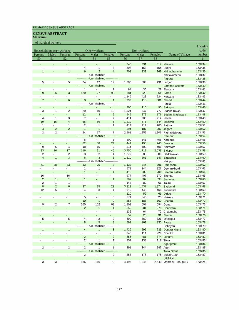
PRIMARY CENSUS ABSTRACT
CENSUS ABSTRACTMahrauni
Persons Males Females Persons Males Females Persons Males Females50 51 52 53 54 55 56 57 58 2 1
Non-workers
of marginal workersLocation
code number
Household industry workersName of Village
Other workers
- - - - - - 645 331 314 Khatora 153434- - - 4 1 3 308 153 155 Budhi 153435
1 - 1 6 2 4 701 332 369 Khiriabharanju 153436Khiriakumehri 153437Papora 153438
5 - 5 24 12 12 1,000 509 491 Largan 153439Bamhori Baliram 153440
- - - 1 - 1 64 36 28 Bhoosra 1534419 6 3 120 27 93 684 323 361 Baron 153442
- - - - - - 1,149 425 724 Korwans 1534437 1 6 3 2 1 999 418 581 Bhondi 153444
Patka 153445- - - - - - 200 110 90 Bakspur 153446
3 1 2 20 10 10 1,324 547 777 Uldana Kalan 153447- - - 12 3 9 949 373 576 Budani Madawara 153448
4 1 3 7 - 7 414 200 214 Navai 15344919 15 4 65 59 6 1,219 575 644 Mainwar 1534501 - 1 2 1 1 419 219 200 Pathrai 1534514 2 2 1 1 - 394 187 207 Jagara 1534522 2 - 24 17 7 2,561 1,255 1,306 Pathabijaipura 153453
Rampur 153454- - - 5 - 5 800 345 455 Karonda 153455- - - 62 38 24 441 198 243 Darona 153456
9 5 4 18 15 3 814 408 406 Nainwara 15345733 16 17 116 71 45 3,750 1,712 2,038 Saidpur 1534582 - 2 3 2 1 1,272 683 589 Gadolikalan 1534594 1 3 6 3 3 1,110 563 547 Satwansa 153460
Nainpur 15346171 38 33 33 25 8 1,135 544 591 Rameshra 153462
- - - 1 1 - 571 244 327 Deorankhurd 153463- - - 1 - 1 415 209 206 Deoran Kalan 15346416 - 16 - - - 977 407 570 Bhonta 1534652 1 1 1 - 1 707 309 398 Simariya 1534662 1 1 - - - 148 82 66 Talau 1534678 2 6 37 15 22 3,311 1,437 1,874 Sadumal 153468
12 5 7 4 3 1 912 446 466 Kusmand 153469- - - - - - 120 59 61 Didauli 153470- - - 5 - 5 671 346 325 Naikora 153471- - - 10 1 9 355 186 169 Chadra 153472
9 2 7 165 102 63 1,301 607 694 Gona 153473- - - 2 1 1 559 281 278 Dhurwara 153474- - - - - - 136 64 72 Chaumahu 153475- - - - - - 57 26 31 Bhartia 153476
5 - 5 4 2 2 690 369 321 Manikpur 153477- - - 8 5 3 591 261 330 Pyasa 153478
Chhayan 1534791 - 1 4 1 3 1,429 696 733 Dongra Khurd 153480
- - - - - - 340 111 229 Chauka 153481- - - 2 - 2 855 481 374 Luharra 153482- - - 2 1 1 257 138 119 Tikra 153483
Agorigrant 1534842 - 2 2 1 1 891 344 547 Agori 153485
Tikra Grant 153486- - - 2 - 2 353 178 175 Sukal Guan 153487
URBAN3 3 - 186 116 70 4,495 1,846 2,649 Mahroni Rural (CT) 153624
-------------Un-inhabited--------------
-------------Un-inhabited--------------
-------------Un-inhabited--------------
-------------Un-inhabited--------------
-------------Un-inhabited--------------
-------------Un-inhabited--------------
-------------Un-inhabited--------------
-------------Un-inhabited---------------------------Un-inhabited--------------
127
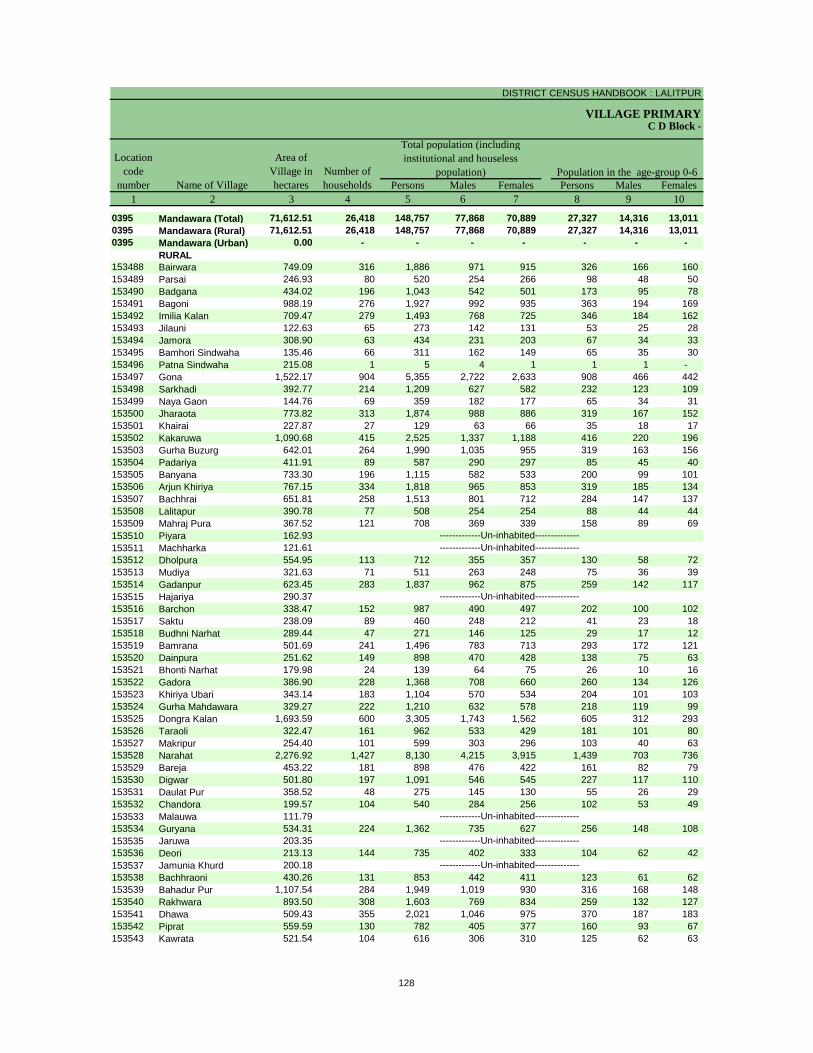
DISTRICT CENSUS HANDBOOK : LALITPUR
VILLAGE PRIMARY
Persons Males Females Persons Males Females1 2 3 4 5 6 7 8 9 10
0395 Mandawara (Total) 71,612.51 26,418 148,757 77,868 70,889 27,327 14,316 13,011 0395 Mandawara (Rural) 71,612.51 26,418 148,757 77,868 70,889 27,327 14,316 13,011 0395 Mandawara (Urban) 0.00 - - - - - - -
RURAL153488 Bairwara 749.09 316 1,886 971 915 326 166 160 153489 Parsai 246.93 80 520 254 266 98 48 50 153490 Badgana 434.02 196 1,043 542 501 173 95 78 153491 Bagoni 988.19 276 1,927 992 935 363 194 169 153492 Imilia Kalan 709.47 279 1,493 768 725 346 184 162 153493 Jilauni 122.63 65 273 142 131 53 25 28 153494 Jamora 308.90 63 434 231 203 67 34 33 153495 Bamhori Sindwaha 135.46 66 311 162 149 65 35 30 153496 Patna Sindwaha 215.08 1 5 4 1 1 1 - 153497 Gona 1,522.17 904 5,355 2,722 2,633 908 466 442 153498 Sarkhadi 392.77 214 1,209 627 582 232 123 109 153499 Naya Gaon 144.76 69 359 182 177 65 34 31 153500 Jharaota 773.82 313 1,874 988 886 319 167 152 153501 Khairai 227.87 27 129 63 66 35 18 17 153502 Kakaruwa 1,090.68 415 2,525 1,337 1,188 416 220 196 153503 Gurha Buzurg 642.01 264 1,990 1,035 955 319 163 156 153504 Padariya 411.91 89 587 290 297 85 45 40 153505 Banyana 733.30 196 1,115 582 533 200 99 101 153506 Arjun Khiriya 767.15 334 1,818 965 853 319 185 134 153507 Bachhrai 651.81 258 1,513 801 712 284 147 137 153508 Lalitapur 390.78 77 508 254 254 88 44 44 153509 Mahraj Pura 367.52 121 708 369 339 158 89 69 153510 Piyara 162.93153511 Machharka 121.61153512 Dholpura 554.95 113 712 355 357 130 58 72 153513 Mudiya 321.63 71 511 263 248 75 36 39 153514 Gadanpur 623.45 283 1,837 962 875 259 142 117 153515 Hajariya 290.37153516 Barchon 338.47 152 987 490 497 202 100 102 153517 Saktu 238.09 89 460 248 212 41 23 18 153518 Budhni Narhat 289.44 47 271 146 125 29 17 12 153519 Bamrana 501.69 241 1,496 783 713 293 172 121 153520 Dainpura 251.62 149 898 470 428 138 75 63 153521 Bhonti Narhat 179.98 24 139 64 75 26 10 16 153522 Gadora 386.90 228 1,368 708 660 260 134 126 153523 Khiriya Ubari 343.14 183 1,104 570 534 204 101 103 153524 Gurha Mahdawara 329.27 222 1,210 632 578 218 119 99 153525 Dongra Kalan 1,693.59 600 3,305 1,743 1,562 605 312 293 153526 Taraoli 322.47 161 962 533 429 181 101 80 153527 Makripur 254.40 101 599 303 296 103 40 63 153528 Narahat 2,276.92 1,427 8,130 4,215 3,915 1,439 703 736 153529 Bareja 453.22 181 898 476 422 161 82 79 153530 Digwar 501.80 197 1,091 546 545 227 117 110 153531 Daulat Pur 358.52 48 275 145 130 55 26 29 153532 Chandora 199.57 104 540 284 256 102 53 49 153533 Malauwa 111.79153534 Guryana 534.31 224 1,362 735 627 256 148 108 153535 Jaruwa 203.35153536 Deori 213.13 144 735 402 333 104 62 42 153537 Jamunia Khurd 200.18153538 Bachhraoni 430.26 131 853 442 411 123 61 62 153539 Bahadur Pur 1,107.54 284 1,949 1,019 930 316 168 148 153540 Rakhwara 893.50 308 1,603 769 834 259 132 127 153541 Dhawa 509.43 355 2,021 1,046 975 370 187 183 153542 Piprat 559.59 130 782 405 377 160 93 67 153543 Kawrata 521.54 104 616 306 310 125 62 63
-------------Un-inhabited--------------
-------------Un-inhabited--------------
-------------Un-inhabited--------------
-------------Un-inhabited--------------
-------------Un-inhabited---------------------------Un-inhabited--------------
C D Block -
Population in the age-group 0-6Number of householdsName of Village
Location code
number
Total population (including institutional and houseless
population)Area of
Village in hectares
128
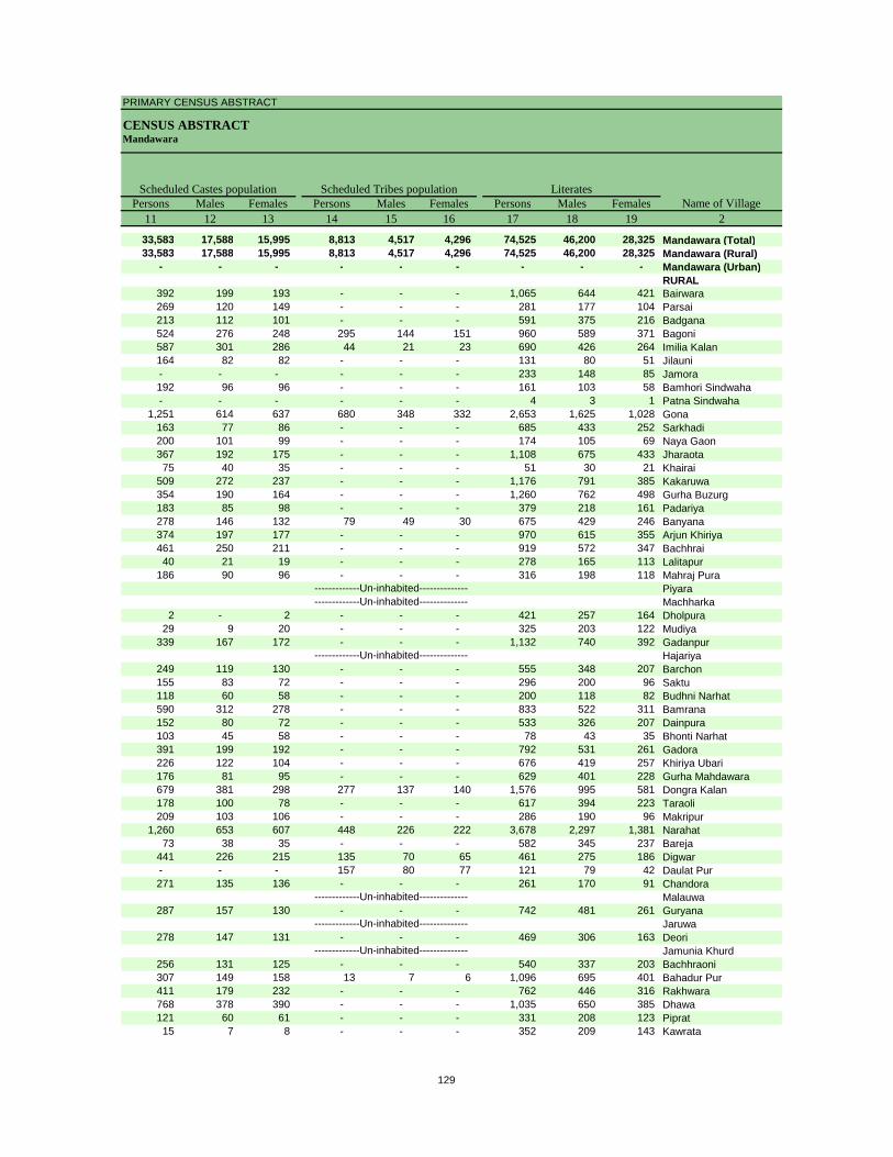
PRIMARY CENSUS ABSTRACT
CENSUS ABSTRACTMandawara
Persons Males Females Persons Males Females Persons Males Females11 12 13 14 15 16 17 18 19 2
33,583 17,588 15,995 8,813 4,517 4,296 74,525 46,200 28,325 Mandawara (Total)33,583 17,588 15,995 8,813 4,517 4,296 74,525 46,200 28,325 Mandawara (Rural)
- - - - - - - - - Mandawara (Urban)RURAL
392 199 193 - - - 1,065 644 421 Bairwara269 120 149 - - - 281 177 104 Parsai213 112 101 - - - 591 375 216 Badgana524 276 248 295 144 151 960 589 371 Bagoni587 301 286 44 21 23 690 426 264 Imilia Kalan164 82 82 - - - 131 80 51 Jilauni- - - - - - 233 148 85 Jamora192 96 96 - - - 161 103 58 Bamhori Sindwaha- - - - - - 4 3 1 Patna Sindwaha
1,251 614 637 680 348 332 2,653 1,625 1,028 Gona163 77 86 - - - 685 433 252 Sarkhadi200 101 99 - - - 174 105 69 Naya Gaon367 192 175 - - - 1,108 675 433 Jharaota75 40 35 - - - 51 30 21 Khairai
509 272 237 - - - 1,176 791 385 Kakaruwa354 190 164 - - - 1,260 762 498 Gurha Buzurg183 85 98 - - - 379 218 161 Padariya278 146 132 79 49 30 675 429 246 Banyana374 197 177 - - - 970 615 355 Arjun Khiriya461 250 211 - - - 919 572 347 Bachhrai40 21 19 - - - 278 165 113 Lalitapur
186 90 96 - - - 316 198 118 Mahraj PuraPiyaraMachharka
2 - 2 - - - 421 257 164 Dholpura29 9 20 - - - 325 203 122 Mudiya
339 167 172 - - - 1,132 740 392 GadanpurHajariya
249 119 130 - - - 555 348 207 Barchon155 83 72 - - - 296 200 96 Saktu118 60 58 - - - 200 118 82 Budhni Narhat590 312 278 - - - 833 522 311 Bamrana152 80 72 - - - 533 326 207 Dainpura103 45 58 - - - 78 43 35 Bhonti Narhat391 199 192 - - - 792 531 261 Gadora226 122 104 - - - 676 419 257 Khiriya Ubari176 81 95 - - - 629 401 228 Gurha Mahdawara679 381 298 277 137 140 1,576 995 581 Dongra Kalan178 100 78 - - - 617 394 223 Taraoli209 103 106 - - - 286 190 96 Makripur
1,260 653 607 448 226 222 3,678 2,297 1,381 Narahat73 38 35 - - - 582 345 237 Bareja
441 226 215 135 70 65 461 275 186 Digwar- - - 157 80 77 121 79 42 Daulat Pur271 135 136 - - - 261 170 91 Chandora
Malauwa287 157 130 - - - 742 481 261 Guryana
Jaruwa278 147 131 - - - 469 306 163 Deori
Jamunia Khurd256 131 125 - - - 540 337 203 Bachhraoni307 149 158 13 7 6 1,096 695 401 Bahadur Pur411 179 232 - - - 762 446 316 Rakhwara768 378 390 - - - 1,035 650 385 Dhawa121 60 61 - - - 331 208 123 Piprat15 7 8 - - - 352 209 143 Kawrata
-------------Un-inhabited--------------
-------------Un-inhabited--------------
-------------Un-inhabited--------------
-------------Un-inhabited--------------
-------------Un-inhabited---------------------------Un-inhabited--------------
Scheduled Castes population Scheduled Tribes populationName of Village
Literates
129
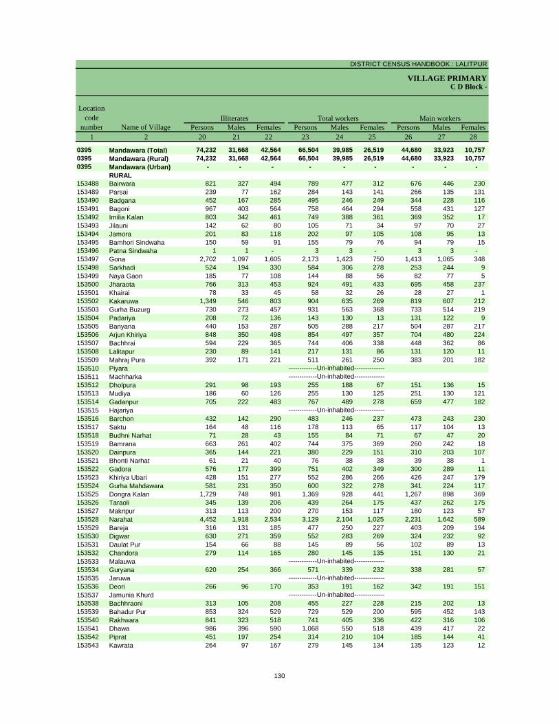
DISTRICT CENSUS HANDBOOK : LALITPUR
VILLAGE PRIMARYC D Block -
Persons Males Females Persons Males Females Persons Males Females1 2 20 21 22 23 24 25 26 27 28
0395 Mandawara (Total) 74,232 31,668 42,564 66,504 39,985 26,519 44,680 33,923 10,757 0395 Mandawara (Rural) 74,232 31,668 42,564 66,504 39,985 26,519 44,680 33,923 10,757 0395 Mandawara (Urban) - - - - - - - - -
RURAL153488 Bairwara 821 327 494 789 477 312 676 446 230 153489 Parsai 239 77 162 284 143 141 266 135 131 153490 Badgana 452 167 285 495 246 249 344 228 116 153491 Bagoni 967 403 564 758 464 294 558 431 127 153492 Imilia Kalan 803 342 461 749 388 361 369 352 17 153493 Jilauni 142 62 80 105 71 34 97 70 27 153494 Jamora 201 83 118 202 97 105 108 95 13 153495 Bamhori Sindwaha 150 59 91 155 79 76 94 79 15 153496 Patna Sindwaha 1 1 - 3 3 - 3 3 - 153497 Gona 2,702 1,097 1,605 2,173 1,423 750 1,413 1,065 348 153498 Sarkhadi 524 194 330 584 306 278 253 244 9 153499 Naya Gaon 185 77 108 144 88 56 82 77 5 153500 Jharaota 766 313 453 924 491 433 695 458 237 153501 Khairai 78 33 45 58 32 26 28 27 1 153502 Kakaruwa 1,349 546 803 904 635 269 819 607 212 153503 Gurha Buzurg 730 273 457 931 563 368 733 514 219 153504 Padariya 208 72 136 143 130 13 131 122 9 153505 Banyana 440 153 287 505 288 217 504 287 217 153506 Arjun Khiriya 848 350 498 854 497 357 704 480 224 153507 Bachhrai 594 229 365 744 406 338 448 362 86 153508 Lalitapur 230 89 141 217 131 86 131 120 11 153509 Mahraj Pura 392 171 221 511 261 250 383 201 182 153510 Piyara153511 Machharka153512 Dholpura 291 98 193 255 188 67 151 136 15 153513 Mudiya 186 60 126 255 130 125 251 130 121 153514 Gadanpur 705 222 483 767 489 278 659 477 182 153515 Hajariya153516 Barchon 432 142 290 483 246 237 473 243 230 153517 Saktu 164 48 116 178 113 65 117 104 13 153518 Budhni Narhat 71 28 43 155 84 71 67 47 20 153519 Bamrana 663 261 402 744 375 369 260 242 18 153520 Dainpura 365 144 221 380 229 151 310 203 107 153521 Bhonti Narhat 61 21 40 76 38 38 39 38 1 153522 Gadora 576 177 399 751 402 349 300 289 11 153523 Khiriya Ubari 428 151 277 552 286 266 426 247 179 153524 Gurha Mahdawara 581 231 350 600 322 278 341 224 117 153525 Dongra Kalan 1,729 748 981 1,369 928 441 1,267 898 369 153526 Taraoli 345 139 206 439 264 175 437 262 175 153527 Makripur 313 113 200 270 153 117 180 123 57 153528 Narahat 4,452 1,918 2,534 3,129 2,104 1,025 2,231 1,642 589 153529 Bareja 316 131 185 477 250 227 403 209 194 153530 Digwar 630 271 359 552 283 269 324 232 92 153531 Daulat Pur 154 66 88 145 89 56 102 89 13 153532 Chandora 279 114 165 280 145 135 151 130 21 153533 Malauwa153534 Guryana 620 254 366 571 339 232 338 281 57 153535 Jaruwa153536 Deori 266 96 170 353 191 162 342 191 151 153537 Jamunia Khurd153538 Bachhraoni 313 105 208 455 227 228 215 202 13 153539 Bahadur Pur 853 324 529 729 529 200 595 452 143 153540 Rakhwara 841 323 518 741 405 336 422 316 106 153541 Dhawa 986 396 590 1,068 550 518 439 417 22 153542 Piprat 451 197 254 314 210 104 185 144 41 153543 Kawrata 264 97 167 279 145 134 135 123 12
-------------Un-inhabited--------------
-------------Un-inhabited--------------
-------------Un-inhabited--------------
-------------Un-inhabited--------------
-------------Un-inhabited---------------------------Un-inhabited--------------
Illiterates Total workers Main workersName of Village
Location code
number
130
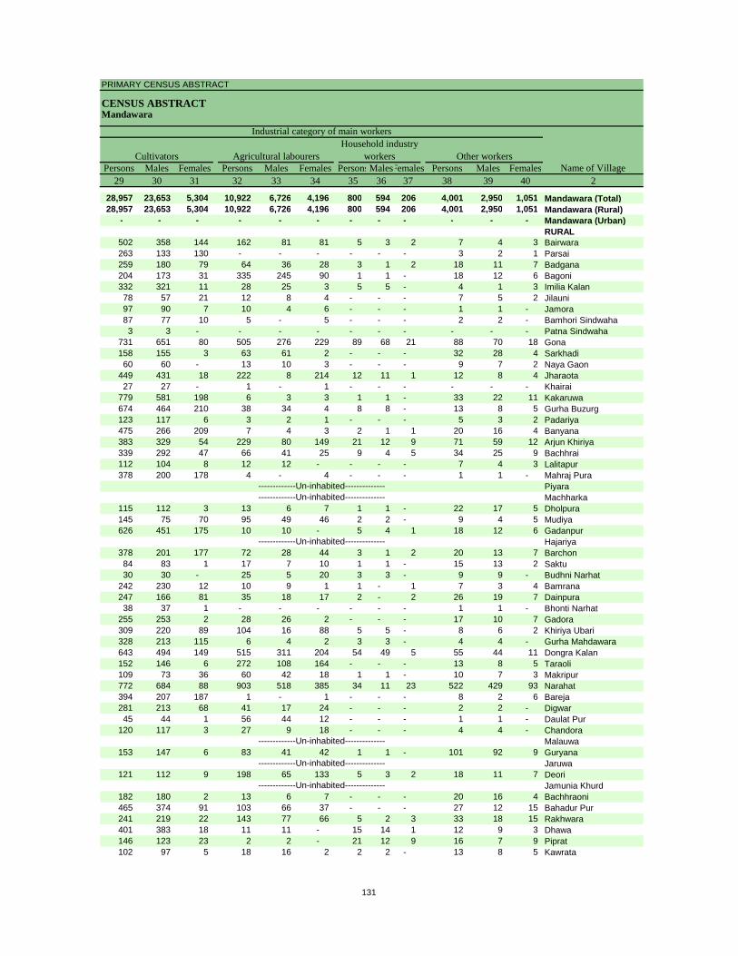
PRIMARY CENSUS ABSTRACT
CENSUS ABSTRACTMandawara
Persons Males Females Persons Males Females PersonsMalesFemales Persons Males Females29 30 31 32 33 34 35 36 37 38 39 40 2
28,957 23,653 5,304 10,922 6,726 4,196 800 594 206 4,001 2,950 1,051 Mandawara (Total)28,957 23,653 5,304 10,922 6,726 4,196 800 594 206 4,001 2,950 1,051 Mandawara (Rural)
- - - - - - - - - - - - Mandawara (Urban)RURAL
502 358 144 162 81 81 5 3 2 7 4 3 Bairwara263 133 130 - - - - - - 3 2 1 Parsai259 180 79 64 36 28 3 1 2 18 11 7 Badgana204 173 31 335 245 90 1 1 - 18 12 6 Bagoni332 321 11 28 25 3 5 5 - 4 1 3 Imilia Kalan78 57 21 12 8 4 - - - 7 5 2 Jilauni97 90 7 10 4 6 - - - 1 1 - Jamora87 77 10 5 - 5 - - - 2 2 - Bamhori Sindwaha3 3 - - - - - - - - - - Patna Sindwaha
731 651 80 505 276 229 89 68 21 88 70 18 Gona158 155 3 63 61 2 - - - 32 28 4 Sarkhadi60 60 - 13 10 3 - - - 9 7 2 Naya Gaon
449 431 18 222 8 214 12 11 1 12 8 4 Jharaota27 27 - 1 - 1 - - - - - - Khairai
779 581 198 6 3 3 1 1 - 33 22 11 Kakaruwa674 464 210 38 34 4 8 8 - 13 8 5 Gurha Buzurg123 117 6 3 2 1 - - - 5 3 2 Padariya475 266 209 7 4 3 2 1 1 20 16 4 Banyana383 329 54 229 80 149 21 12 9 71 59 12 Arjun Khiriya339 292 47 66 41 25 9 4 5 34 25 9 Bachhrai112 104 8 12 12 - - - - 7 4 3 Lalitapur378 200 178 4 - 4 - - - 1 1 - Mahraj Pura
PiyaraMachharka
115 112 3 13 6 7 1 1 - 22 17 5 Dholpura145 75 70 95 49 46 2 2 - 9 4 5 Mudiya626 451 175 10 10 - 5 4 1 18 12 6 Gadanpur
Hajariya378 201 177 72 28 44 3 1 2 20 13 7 Barchon84 83 1 17 7 10 1 1 - 15 13 2 Saktu30 30 - 25 5 20 3 3 - 9 9 - Budhni Narhat
242 230 12 10 9 1 1 - 1 7 3 4 Bamrana247 166 81 35 18 17 2 - 2 26 19 7 Dainpura38 37 1 - - - - - - 1 1 - Bhonti Narhat
255 253 2 28 26 2 - - - 17 10 7 Gadora309 220 89 104 16 88 5 5 - 8 6 2 Khiriya Ubari328 213 115 6 4 2 3 3 - 4 4 - Gurha Mahdawara643 494 149 515 311 204 54 49 5 55 44 11 Dongra Kalan152 146 6 272 108 164 - - - 13 8 5 Taraoli109 73 36 60 42 18 1 1 - 10 7 3 Makripur772 684 88 903 518 385 34 11 23 522 429 93 Narahat394 207 187 1 - 1 - - - 8 2 6 Bareja281 213 68 41 17 24 - - - 2 2 - Digwar45 44 1 56 44 12 - - - 1 1 - Daulat Pur
120 117 3 27 9 18 - - - 4 4 - ChandoraMalauwa
153 147 6 83 41 42 1 1 - 101 92 9 GuryanaJaruwa
121 112 9 198 65 133 5 3 2 18 11 7 DeoriJamunia Khurd
182 180 2 13 6 7 - - - 20 16 4 Bachhraoni465 374 91 103 66 37 - - - 27 12 15 Bahadur Pur241 219 22 143 77 66 5 2 3 33 18 15 Rakhwara401 383 18 11 11 - 15 14 1 12 9 3 Dhawa146 123 23 2 2 - 21 12 9 16 7 9 Piprat102 97 5 18 16 2 2 2 - 13 8 5 Kawrata
-------------Un-inhabited--------------
-------------Un-inhabited--------------
-------------Un-inhabited--------------
-------------Un-inhabited--------------
-------------Un-inhabited---------------------------Un-inhabited--------------
CultivatorsName of Village
Household industry workersAgricultural labourers
Industrial category of main workers
Other workers
131
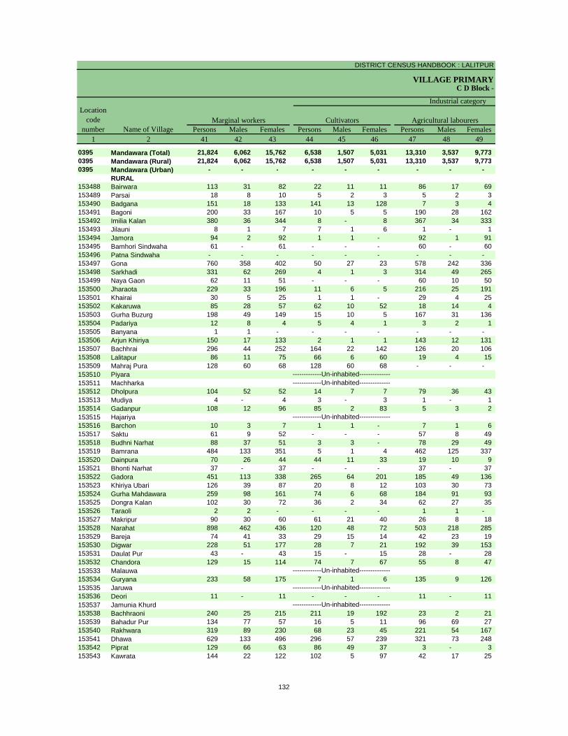
DISTRICT CENSUS HANDBOOK : LALITPUR
VILLAGE PRIMARYC D Block -
Persons Males Females Persons Males Females Persons Males Females1 2 41 42 43 44 45 46 47 48 49
0395 Mandawara (Total) 21,824 6,062 15,762 6,538 1,507 5,031 13,310 3,537 9,773 0395 Mandawara (Rural) 21,824 6,062 15,762 6,538 1,507 5,031 13,310 3,537 9,773 0395 Mandawara (Urban) - - - - - - - - -
RURAL153488 Bairwara 113 31 82 22 11 11 86 17 69 153489 Parsai 18 8 10 5 2 3 5 2 3 153490 Badgana 151 18 133 141 13 128 7 3 4 153491 Bagoni 200 33 167 10 5 5 190 28 162 153492 Imilia Kalan 380 36 344 8 - 8 367 34 333 153493 Jilauni 8 1 7 7 1 6 1 - 1 153494 Jamora 94 2 92 1 1 - 92 1 91 153495 Bamhori Sindwaha 61 - 61 - - - 60 - 60 153496 Patna Sindwaha - - - - - - - - - 153497 Gona 760 358 402 50 27 23 578 242 336 153498 Sarkhadi 331 62 269 4 1 3 314 49 265 153499 Naya Gaon 62 11 51 - - - 60 10 50 153500 Jharaota 229 33 196 11 6 5 216 25 191 153501 Khairai 30 5 25 1 1 - 29 4 25 153502 Kakaruwa 85 28 57 62 10 52 18 14 4 153503 Gurha Buzurg 198 49 149 15 10 5 167 31 136 153504 Padariya 12 8 4 5 4 1 3 2 1 153505 Banyana 1 1 - - - - - - - 153506 Arjun Khiriya 150 17 133 2 1 1 143 12 131 153507 Bachhrai 296 44 252 164 22 142 126 20 106 153508 Lalitapur 86 11 75 66 6 60 19 4 15 153509 Mahraj Pura 128 60 68 128 60 68 - - - 153510 Piyara153511 Machharka153512 Dholpura 104 52 52 14 7 7 79 36 43 153513 Mudiya 4 - 4 3 - 3 1 - 1 153514 Gadanpur 108 12 96 85 2 83 5 3 2 153515 Hajariya153516 Barchon 10 3 7 1 1 - 7 1 6 153517 Saktu 61 9 52 - - - 57 8 49 153518 Budhni Narhat 88 37 51 3 3 - 78 29 49 153519 Bamrana 484 133 351 5 1 4 462 125 337 153520 Dainpura 70 26 44 44 11 33 19 10 9 153521 Bhonti Narhat 37 - 37 - - - 37 - 37 153522 Gadora 451 113 338 265 64 201 185 49 136 153523 Khiriya Ubari 126 39 87 20 8 12 103 30 73 153524 Gurha Mahdawara 259 98 161 74 6 68 184 91 93 153525 Dongra Kalan 102 30 72 36 2 34 62 27 35 153526 Taraoli 2 2 - - - - 1 1 - 153527 Makripur 90 30 60 61 21 40 26 8 18 153528 Narahat 898 462 436 120 48 72 503 218 285 153529 Bareja 74 41 33 29 15 14 42 23 19 153530 Digwar 228 51 177 28 7 21 192 39 153 153531 Daulat Pur 43 - 43 15 - 15 28 - 28 153532 Chandora 129 15 114 74 7 67 55 8 47 153533 Malauwa153534 Guryana 233 58 175 7 1 6 135 9 126 153535 Jaruwa153536 Deori 11 - 11 - - - 11 - 11 153537 Jamunia Khurd153538 Bachhraoni 240 25 215 211 19 192 23 2 21 153539 Bahadur Pur 134 77 57 16 5 11 96 69 27 153540 Rakhwara 319 89 230 68 23 45 221 54 167 153541 Dhawa 629 133 496 296 57 239 321 73 248 153542 Piprat 129 66 63 86 49 37 3 - 3 153543 Kawrata 144 22 122 102 5 97 42 17 25
-------------Un-inhabited--------------
-------------Un-inhabited--------------
-------------Un-inhabited--------------
-------------Un-inhabited--------------
-------------Un-inhabited---------------------------Un-inhabited--------------
Location code
number Name of VillageMarginal workers Cultivators Agricultural labourers
Industrial category
132

PRIMARY CENSUS ABSTRACT
CENSUS ABSTRACTMandawara
Persons Males Females Persons Males Females Persons Males Females50 51 52 53 54 55 56 57 58 2 1
616 212 404 1,360 806 554 82,253 37,883 44,370 Mandawara (Total) 0395616 212 404 1,360 806 554 82,253 37,883 44,370 Mandawara (Rural) 0395- - - - - - - - - Mandawara (Urban) 0395
RURAL3 1 2 2 2 - 1,097 494 603 Bairwara 1534884 2 2 4 2 2 236 111 125 Parsai 1534891 1 - 2 1 1 548 296 252 Badgana 153490
- - - - - - 1,169 528 641 Bagoni 1534914 2 2 1 - 1 744 380 364 Imilia Kalan 153492
- - - - - - 168 71 97 Jilauni 153493- - - 1 - 1 232 134 98 Jamora 153494- - - 1 - 1 156 83 73 Bamhori Sindwaha 153495- - - - - - 2 1 1 Patna Sindwaha 15349641 26 15 91 63 28 3,182 1,299 1,883 Gona 1534971 1 - 12 11 1 625 321 304 Sarkhadi 153498
- - - 2 1 1 215 94 121 Naya Gaon 1534992 2 - - - - 950 497 453 Jharaota 153500
- - - - - - 71 31 40 Khairai 153501- - - 5 4 1 1,621 702 919 Kakaruwa 153502- - - 16 8 8 1,059 472 587 Gurha Buzurg 153503- - - 4 2 2 444 160 284 Padariya 153504- - - 1 1 - 610 294 316 Banyana 153505- - - 5 4 1 964 468 496 Arjun Khiriya 153506
3 1 2 3 1 2 769 395 374 Bachhrai 153507- - - 1 1 - 291 123 168 Lalitapur 153508- - - - - - 197 108 89 Mahraj Pura 153509
Piyara 153510Machharka 153511
- - - 11 9 2 457 167 290 Dholpura 153512- - - - - - 256 133 123 Mudiya 153513
6 1 5 12 6 6 1,070 473 597 Gadanpur 153514Hajariya 153515
- - - 2 1 1 504 244 260 Barchon 1535161 - 1 3 1 2 282 135 147 Saktu 1535173 2 1 4 3 1 116 62 54 Budhni Narhat 153518
12 6 6 5 1 4 752 408 344 Bamrana 1535191 - 1 6 5 1 518 241 277 Dainpura 153520
- - - - - - 63 26 37 Bhonti Narhat 1535211 - 1 - - - 617 306 311 Gadora 1535221 - 1 2 1 1 552 284 268 Khiriya Ubari 1535231 1 - - - - 610 310 300 Gurha Mahdawara 153524
- - - 4 1 3 1,936 815 1,121 Dongra Kalan 153525- - - 1 1 - 523 269 254 Taraoli 153526
1 1 - 2 - 2 329 150 179 Makripur 15352739 14 25 236 182 54 5,001 2,111 2,890 Narahat 153528
- - - 3 3 - 421 226 195 Bareja 153529- - - 8 5 3 539 263 276 Digwar 153530- - - - - - 130 56 74 Daulat Pur 153531- - - - - - 260 139 121 Chandora 153532
Malauwa 15353322 9 13 69 39 30 791 396 395 Guryana 153534
Jaruwa 153535- - - - - - 382 211 171 Deori 153536
Jamunia Khurd 1535371 - 1 5 4 1 398 215 183 Bachhraoni 1535382 - 2 20 3 17 1,220 490 730 Bahadur Pur 1535391 - 1 29 12 17 862 364 498 Rakhwara 1535401 - 1 11 3 8 953 496 457 Dhawa 153541
11 7 4 29 10 19 468 195 273 Piprat 153542- - - - - - 337 161 176 Kawrata 153543
-------------Un-inhabited--------------
-------------Un-inhabited--------------
-------------Un-inhabited--------------
-------------Un-inhabited--------------
-------------Un-inhabited---------------------------Un-inhabited--------------
Non-workers
of marginal workersLocation
code number
Household industry workersName of Village
Other workers
133
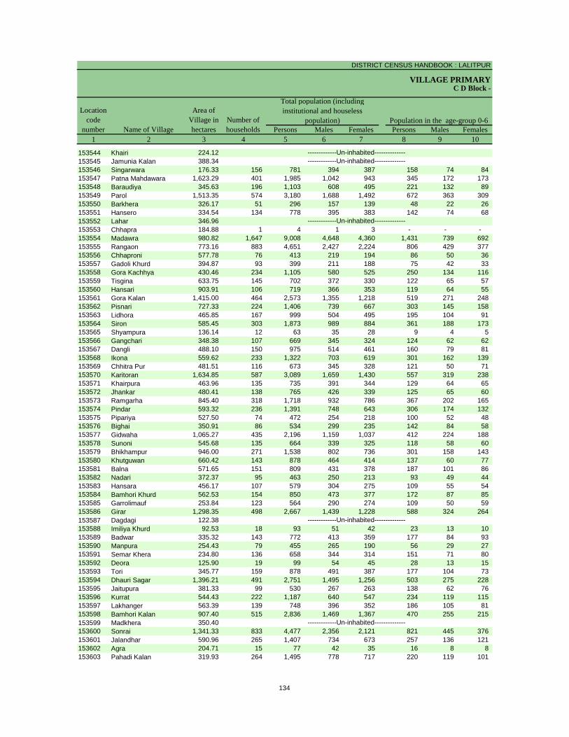
DISTRICT CENSUS HANDBOOK : LALITPUR
VILLAGE PRIMARY
Persons Males Females Persons Males Females1 2 3 4 5 6 7 8 9 10
C D Block -
Population in the age-group 0-6Number of householdsName of Village
Location code
number
Total population (including institutional and houseless
population)Area of
Village in hectares
153544 Khairi 224.12153545 Jamunia Kalan 388.34153546 Singarwara 176.33 156 781 394 387 158 74 84 153547 Patna Mahdawara 1,623.29 401 1,985 1,042 943 345 172 173 153548 Baraudiya 345.63 196 1,103 608 495 221 132 89 153549 Parol 1,513.35 574 3,180 1,688 1,492 672 363 309 153550 Barkhera 326.17 51 296 157 139 48 22 26 153551 Hansero 334.54 134 778 395 383 142 74 68 153552 Lahar 346.96153553 Chhapra 184.88 1 4 1 3 - - - 153554 Madawra 980.82 1,647 9,008 4,648 4,360 1,431 739 692 153555 Rangaon 773.16 883 4,651 2,427 2,224 806 429 377 153556 Chhaproni 577.78 76 413 219 194 86 50 36 153557 Gadoli Khurd 394.87 93 399 211 188 75 42 33 153558 Gora Kachhya 430.46 234 1,105 580 525 250 134 116 153559 Tisgina 633.75 145 702 372 330 122 65 57 153560 Hansari 903.91 106 719 366 353 119 64 55 153561 Gora Kalan 1,415.00 464 2,573 1,355 1,218 519 271 248 153562 Pisnari 727.33 224 1,406 739 667 303 145 158 153563 Lidhora 465.85 167 999 504 495 195 104 91 153564 Siron 585.45 303 1,873 989 884 361 188 173 153565 Shyampura 136.14 12 63 35 28 9 4 5 153566 Gangchari 348.38 107 669 345 324 124 62 62 153567 Dangli 488.10 150 975 514 461 160 79 81 153568 Ikona 559.62 233 1,322 703 619 301 162 139 153569 Chhitra Pur 481.51 116 673 345 328 121 50 71 153570 Karitoran 1,634.85 587 3,089 1,659 1,430 557 319 238 153571 Khairpura 463.96 135 735 391 344 129 64 65 153572 Jhankar 480.41 138 765 426 339 125 65 60 153573 Ramgarha 845.40 318 1,718 932 786 367 202 165 153574 Pindar 593.32 236 1,391 748 643 306 174 132 153575 Pipariya 527.50 74 472 254 218 100 52 48 153576 Bighai 350.91 86 534 299 235 142 84 58 153577 Gidwaha 1,065.27 435 2,196 1,159 1,037 412 224 188 153578 Sunoni 545.68 135 664 339 325 118 58 60 153579 Bhikhampur 946.00 271 1,538 802 736 301 158 143 153580 Khutguwan 660.42 143 878 464 414 137 60 77 153581 Balna 571.65 151 809 431 378 187 101 86 153582 Nadari 372.37 95 463 250 213 93 49 44 153583 Hansara 456.17 107 579 304 275 109 55 54 153584 Bamhori Khurd 562.53 154 850 473 377 172 87 85 153585 Garrolimauf 253.84 123 564 290 274 109 50 59 153586 Girar 1,298.35 498 2,667 1,439 1,228 588 324 264 153587 Dagdagi 122.38153588 Imiliya Khurd 92.53 18 93 51 42 23 13 10 153589 Badwar 335.32 143 772 413 359 177 84 93 153590 Manpura 254.43 79 455 265 190 56 29 27 153591 Semar Khera 234.80 136 658 344 314 151 71 80 153592 Deora 125.90 19 99 54 45 28 13 15 153593 Tori 345.77 159 878 491 387 177 104 73 153594 Dhauri Sagar 1,396.21 491 2,751 1,495 1,256 503 275 228 153595 Jaitupura 381.33 99 530 267 263 138 62 76 153596 Kurrat 544.43 222 1,187 640 547 234 119 115 153597 Lakhanger 563.39 139 748 396 352 186 105 81 153598 Bamhori Kalan 907.40 515 2,836 1,469 1,367 470 255 215 153599 Madkhera 350.40153600 Sonrai 1,341.33 833 4,477 2,356 2,121 821 445 376 153601 Jalandhar 590.96 265 1,407 734 673 257 136 121 153602 Agra 204.71 15 77 42 35 16 8 8 153603 Pahadi Kalan 319.93 264 1,495 778 717 220 119 101
-------------Un-inhabited--------------
-------------Un-inhabited--------------
-------------Un-inhabited--------------
-------------Un-inhabited---------------------------Un-inhabited--------------
134
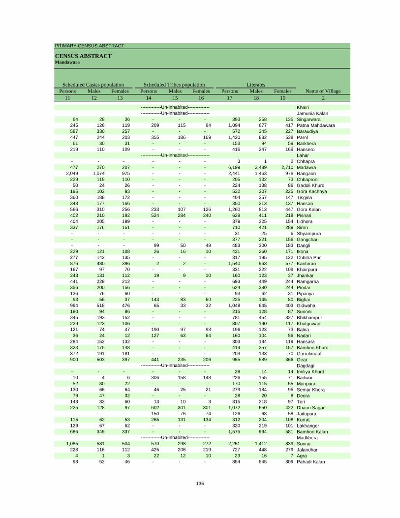
PRIMARY CENSUS ABSTRACT
CENSUS ABSTRACTMandawara
Persons Males Females Persons Males Females Persons Males Females11 12 13 14 15 16 17 18 19 2
Scheduled Castes population Scheduled Tribes populationName of Village
Literates
KhairiJamunia Kalan
64 28 36 - - - 393 258 135 Singarwara245 126 119 209 115 94 1,094 677 417 Patna Mahdawara587 330 257 - - - 572 345 227 Baraudiya447 244 203 355 186 169 1,420 882 538 Parol61 30 31 - - - 153 94 59 Barkhera
219 110 109 - - - 416 247 169 HanseroLahar
- - - - - - 3 1 2 Chhapra477 270 207 - - - 6,199 3,489 2,710 Madawra
2,049 1,074 975 - - - 2,441 1,463 978 Rangaon229 119 110 - - - 205 132 73 Chhaproni50 24 26 - - - 224 138 86 Gadoli Khurd
195 102 93 - - - 532 307 225 Gora Kachhya360 188 172 - - - 404 257 147 Tisgina343 177 166 - - - 350 213 137 Hansari566 310 256 233 107 126 1,260 813 447 Gora Kalan402 210 192 524 284 240 629 411 218 Pisnari404 205 199 - - - 379 225 154 Lidhora337 176 161 - - - 710 421 289 Siron- - - - - - 31 25 6 Shyampura- - - - - - 377 221 156 Gangchari- - - 99 50 49 483 300 183 Dangli229 121 108 26 16 10 431 260 171 Ikona277 142 135 - - - 317 195 122 Chhitra Pur876 480 396 2 2 - 1,540 963 577 Karitoran167 97 70 - - - 331 222 109 Khairpura243 131 112 19 9 10 160 123 37 Jhankar441 229 212 - - - 693 449 244 Ramgarha356 200 156 - - - 624 380 244 Pindar136 76 60 - - - 93 62 31 Pipariya
93 56 37 143 83 60 225 145 80 Bighai994 518 476 65 33 32 1,048 645 403 Gidwaha180 94 86 - - - 215 128 87 Sunoni345 193 152 - - - 781 454 327 Bhikhampur229 123 106 - - - 307 190 117 Khutguwan121 74 47 190 97 93 196 123 73 Balna36 24 12 127 63 64 160 104 56 Nadari
284 152 132 - - - 303 184 119 Hansara323 175 148 - - - 414 257 157 Bamhori Khurd372 191 181 - - - 203 133 70 Garrolimauf900 503 397 441 235 206 955 589 366 Girar
Dagdagi- - - - - - 28 14 14 Imiliya Khurd10 4 6 306 158 148 226 155 71 Badwar52 30 22 - - - 170 115 55 Manpura
130 66 64 46 25 21 279 184 95 Semar Khera79 47 32 - - - 28 20 8 Deora
143 83 60 13 10 3 315 218 97 Tori225 128 97 602 301 301 1,072 650 422 Dhauri Sagar- - - 150 76 74 126 68 58 Jaitupura115 62 53 265 131 134 312 204 108 Kurrat129 67 62 - - - 320 219 101 Lakhanger686 349 337 - - - 1,575 994 581 Bamhori Kalan
Madkhera1,085 581 504 570 298 272 2,251 1,412 839 Sonrai
228 116 112 425 206 219 727 448 279 Jalandhar4 1 3 22 12 10 23 16 7 Agra
98 52 46 - - - 854 545 309 Pahadi Kalan
-------------Un-inhabited--------------
-------------Un-inhabited--------------
-------------Un-inhabited--------------
-------------Un-inhabited---------------------------Un-inhabited--------------
135

DISTRICT CENSUS HANDBOOK : LALITPUR
VILLAGE PRIMARYC D Block -
Persons Males Females Persons Males Females Persons Males Females1 2 20 21 22 23 24 25 26 27 28
Illiterates Total workers Main workersName of Village
Location code
number
153544 Khairi153545 Jamunia Kalan153546 Singarwara 388 136 252 601 312 289 392 211 181 153547 Patna Mahdawara 891 365 526 816 562 254 659 531 128 153548 Baraudiya 531 263 268 427 308 119 300 283 17 153549 Parol 1,760 806 954 1,477 864 613 1,039 663 376 153550 Barkhera 143 63 80 141 91 50 79 69 10 153551 Hansero 362 148 214 294 200 94 211 157 54 153552 Lahar153553 Chhapra 1 - 1 2 1 1 2 1 1 153554 Madawra 2,809 1,159 1,650 3,030 2,257 773 2,470 2,092 378 153555 Rangaon 2,210 964 1,246 1,932 1,201 731 1,126 1,014 112 153556 Chhaproni 208 87 121 218 107 111 107 104 3 153557 Gadoli Khurd 175 73 102 188 96 92 74 71 3 153558 Gora Kachhya 573 273 300 527 281 246 282 276 6 153559 Tisgina 298 115 183 250 190 60 217 184 33 153560 Hansari 369 153 216 295 169 126 51 27 24 153561 Gora Kalan 1,313 542 771 984 678 306 617 542 75 153562 Pisnari 777 328 449 637 351 286 283 267 16 153563 Lidhora 620 279 341 610 300 310 432 264 168 153564 Siron 1,163 568 595 958 501 457 492 452 40 153565 Shyampura 32 10 22 18 18 - 18 18 - 153566 Gangchari 292 124 168 166 156 10 101 98 3 153567 Dangli 492 214 278 360 240 120 174 167 7 153568 Ikona 891 443 448 640 341 299 530 316 214 153569 Chhitra Pur 356 150 206 215 190 25 160 158 2 153570 Karitoran 1,549 696 853 1,613 950 663 1,097 813 284 153571 Khairpura 404 169 235 368 204 164 364 203 161 153572 Jhankar 605 303 302 392 235 157 390 234 156 153573 Ramgarha 1,025 483 542 875 522 353 576 417 159 153574 Pindar 767 368 399 715 412 303 485 411 74 153575 Pipariya 379 192 187 338 183 155 291 158 133 153576 Bighai 309 154 155 203 134 69 140 134 6 153577 Gidwaha 1,148 514 634 931 594 337 633 488 145 153578 Sunoni 449 211 238 364 196 168 197 193 4 153579 Bhikhampur 757 348 409 661 440 221 391 364 27 153580 Khutguwan 571 274 297 221 220 1 221 220 1 153581 Balna 613 308 305 238 230 8 237 229 8 153582 Nadari 303 146 157 208 137 71 115 106 9 153583 Hansara 276 120 156 318 161 157 269 152 117 153584 Bamhori Khurd 436 216 220 402 261 141 316 221 95 153585 Garrolimauf 361 157 204 326 182 144 126 111 15 153586 Girar 1,712 850 862 1,196 715 481 995 670 325 153587 Dagdagi153588 Imiliya Khurd 65 37 28 43 25 18 43 25 18 153589 Badwar 546 258 288 228 209 19 195 193 2 153590 Manpura 285 150 135 350 213 137 271 198 73 153591 Semar Khera 379 160 219 323 176 147 238 141 97 153592 Deora 71 34 37 53 32 21 48 30 18 153593 Tori 563 273 290 462 259 203 286 244 42 153594 Dhauri Sagar 1,679 845 834 1,344 792 552 744 641 103 153595 Jaitupura 404 199 205 236 137 99 99 96 3 153596 Kurrat 875 436 439 572 327 245 401 302 99 153597 Lakhanger 428 177 251 259 207 52 216 185 31 153598 Bamhori Kalan 1,261 475 786 1,277 763 514 760 694 66 153599 Madkhera153600 Sonrai 2,226 944 1,282 2,120 1,199 921 1,172 956 216 153601 Jalandhar 680 286 394 718 387 331 399 255 144 153602 Agra 54 26 28 40 21 19 38 20 18 153603 Pahadi Kalan 641 233 408 745 376 369 430 224 206
-------------Un-inhabited--------------
-------------Un-inhabited--------------
-------------Un-inhabited--------------
-------------Un-inhabited---------------------------Un-inhabited--------------
136
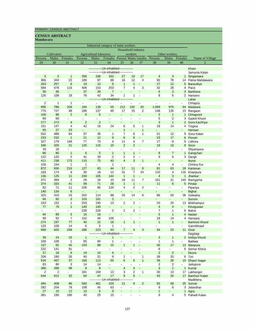
PRIMARY CENSUS ABSTRACT
CENSUS ABSTRACTMandawara
Persons Males Females Persons Males Females PersonsMalesFemales Persons Males Females29 30 31 32 33 34 35 36 37 38 39 40 2
CultivatorsName of Village
Household industry workersAgricultural labourers
Industrial category of main workers
Other workers
KhairiJamunia Kalan
3 2 1 358 196 162 27 10 17 4 3 1 Singarwara366 344 22 185 97 88 16 12 4 92 78 14 Patna Mahdawara263 257 6 19 13 6 1 1 - 17 12 5 Baraudiya594 478 116 406 153 253 7 4 3 32 28 4 Parol36 36 - 37 30 7 - - - 6 3 3 Barkhera
126 108 18 76 42 34 1 1 - 8 6 2 HanseroLahar
2 1 1 - - - - - - - - - Chhapra995 786 209 194 139 55 212 192 20 1,069 975 94 Madawra775 727 48 186 137 49 17 15 2 148 135 13 Rangaon100 98 2 5 5 - - - - 2 1 1 Chhaproni69 69 - - - - - - - 5 2 3 Gadoli Khurd
277 273 4 2 2 - - - - 3 1 2 Gora Kachhya151 147 4 42 18 24 6 5 1 18 14 4 Tisgina50 27 23 - - - 1 - 1 - - - Hansari
552 488 64 37 36 1 7 6 1 21 12 9 Gora Kalan233 232 1 21 12 9 6 6 - 23 17 6 Pisnari327 179 148 77 73 4 11 4 7 17 8 9 Lidhora346 325 21 125 115 10 2 2 - 19 10 9 Siron18 18 - - - - - - - - - - Shyampura86 85 1 6 5 1 1 1 - 8 7 1 Gangchari
122 120 2 41 39 2 2 2 - 9 6 3 Dangli411 238 173 115 75 40 4 3 1 - - - Ikona155 154 1 1 - 1 - - - 4 4 - Chhitra Pur872 656 216 127 83 44 17 11 6 81 63 18 Karitoran183 174 9 30 18 12 31 7 24 120 4 116 Khairpura136 125 11 249 105 144 1 1 - 4 3 1 Jhankar371 369 2 26 16 10 18 11 7 161 21 140 Ramgarha374 333 41 99 71 28 1 1 - 11 6 5 Pindar82 71 11 205 85 120 4 2 2 - - - Pipariya
140 134 6 - - - - - - - - - Bighai325 310 15 202 114 88 20 14 6 86 50 36 Gidwaha94 92 2 103 101 2 - - - - - - Sunoni
153 152 1 203 190 13 2 2 - 33 20 13 Bhikhampur77 76 1 140 140 - - - - 4 4 - Khutguwan
- - - 228 226 2 2 2 - 7 1 6 Balna94 89 5 16 16 - - - - 5 1 4 Nadari99 92 7 152 46 106 - - - 18 14 4 Hansara
274 197 77 40 22 18 1 1 - 1 1 - Bamhori Khurd120 106 14 6 5 1 - - - - - - Garrolimauf668 420 248 286 223 63 7 4 3 34 23 11 Girar
Dagdagi39 24 15 1 - 1 - - - 3 1 2 Imiliya Khurd
109 108 1 85 84 1 - - - 1 1 - Badwar137 92 45 103 88 15 1 1 - 30 17 13 Manpura232 141 91 - - - - - - 6 - 6 Semar Khera27 18 9 19 10 9 - - - 2 2 - Deora
206 180 26 40 31 9 1 - 1 39 33 6 Tori534 497 37 168 113 55 6 5 1 36 26 10 Dhauri Sagar83 80 3 14 14 - - - - 2 2 - Jaitupura
386 288 98 8 8 - 4 4 - 3 2 1 Kurrat2 2 - 181 168 13 3 2 1 30 13 17 Lakhanger
644 612 32 64 47 17 9 9 - 43 26 17 Bamhori KalanMadkhera
494 408 86 584 481 103 11 9 2 83 58 25 Sonrai282 204 78 108 45 63 - - - 9 6 3 Jalandhar27 15 12 10 5 5 - - - 1 - 1 Agra
381 195 186 40 25 15 - - - 9 4 5 Pahadi Kalan
-------------Un-inhabited--------------
-------------Un-inhabited--------------
-------------Un-inhabited--------------
-------------Un-inhabited---------------------------Un-inhabited--------------
137
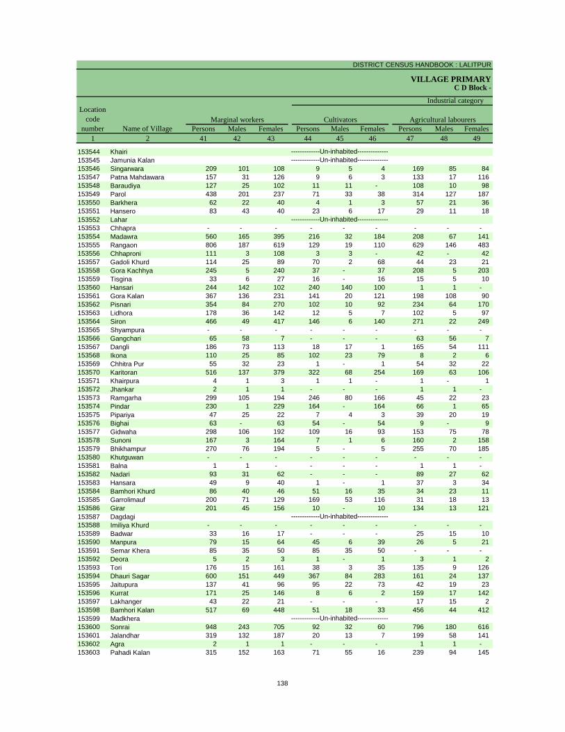
DISTRICT CENSUS HANDBOOK : LALITPUR
VILLAGE PRIMARYC D Block -
Persons Males Females Persons Males Females Persons Males Females1 2 41 42 43 44 45 46 47 48 49
Location code
number Name of VillageMarginal workers Cultivators Agricultural labourers
Industrial category
153544 Khairi153545 Jamunia Kalan153546 Singarwara 209 101 108 9 5 4 169 85 84 153547 Patna Mahdawara 157 31 126 9 6 3 133 17 116 153548 Baraudiya 127 25 102 11 11 - 108 10 98 153549 Parol 438 201 237 71 33 38 314 127 187 153550 Barkhera 62 22 40 4 1 3 57 21 36 153551 Hansero 83 43 40 23 6 17 29 11 18 153552 Lahar153553 Chhapra - - - - - - - - - 153554 Madawra 560 165 395 216 32 184 208 67 141 153555 Rangaon 806 187 619 129 19 110 629 146 483 153556 Chhaproni 111 3 108 3 3 - 42 - 42 153557 Gadoli Khurd 114 25 89 70 2 68 44 23 21 153558 Gora Kachhya 245 5 240 37 - 37 208 5 203 153559 Tisgina 33 6 27 16 - 16 15 5 10 153560 Hansari 244 142 102 240 140 100 1 1 - 153561 Gora Kalan 367 136 231 141 20 121 198 108 90 153562 Pisnari 354 84 270 102 10 92 234 64 170 153563 Lidhora 178 36 142 12 5 7 102 5 97 153564 Siron 466 49 417 146 6 140 271 22 249 153565 Shyampura - - - - - - - - - 153566 Gangchari 65 58 7 - - - 63 56 7 153567 Dangli 186 73 113 18 17 1 165 54 111 153568 Ikona 110 25 85 102 23 79 8 2 6 153569 Chhitra Pur 55 32 23 1 - 1 54 32 22 153570 Karitoran 516 137 379 322 68 254 169 63 106 153571 Khairpura 4 1 3 1 1 - 1 - 1 153572 Jhankar 2 1 1 - - - 1 1 - 153573 Ramgarha 299 105 194 246 80 166 45 22 23 153574 Pindar 230 1 229 164 - 164 66 1 65 153575 Pipariya 47 25 22 7 4 3 39 20 19 153576 Bighai 63 - 63 54 - 54 9 - 9 153577 Gidwaha 298 106 192 109 16 93 153 75 78 153578 Sunoni 167 3 164 7 1 6 160 2 158 153579 Bhikhampur 270 76 194 5 - 5 255 70 185 153580 Khutguwan - - - - - - - - - 153581 Balna 1 1 - - - - 1 1 - 153582 Nadari 93 31 62 - - - 89 27 62 153583 Hansara 49 9 40 1 - 1 37 3 34 153584 Bamhori Khurd 86 40 46 51 16 35 34 23 11 153585 Garrolimauf 200 71 129 169 53 116 31 18 13 153586 Girar 201 45 156 10 - 10 134 13 121 153587 Dagdagi153588 Imiliya Khurd - - - - - - - - - 153589 Badwar 33 16 17 - - - 25 15 10 153590 Manpura 79 15 64 45 6 39 26 5 21 153591 Semar Khera 85 35 50 85 35 50 - - - 153592 Deora 5 2 3 1 - 1 3 1 2 153593 Tori 176 15 161 38 3 35 135 9 126 153594 Dhauri Sagar 600 151 449 367 84 283 161 24 137 153595 Jaitupura 137 41 96 95 22 73 42 19 23 153596 Kurrat 171 25 146 8 6 2 159 17 142 153597 Lakhanger 43 22 21 - - - 17 15 2 153598 Bamhori Kalan 517 69 448 51 18 33 456 44 412 153599 Madkhera153600 Sonrai 948 243 705 92 32 60 796 180 616 153601 Jalandhar 319 132 187 20 13 7 199 58 141 153602 Agra 2 1 1 - - - 1 1 - 153603 Pahadi Kalan 315 152 163 71 55 16 239 94 145
-------------Un-inhabited--------------
-------------Un-inhabited--------------
-------------Un-inhabited--------------
-------------Un-inhabited---------------------------Un-inhabited--------------
138
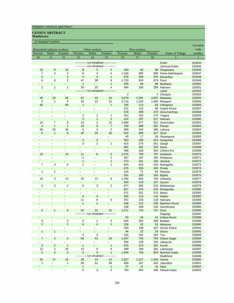
PRIMARY CENSUS ABSTRACT
CENSUS ABSTRACTMandawara
Persons Males Females Persons Males Females Persons Males Females50 51 52 53 54 55 56 57 58 2 1
Non-workers
of marginal workersLocation
code number
Household industry workersName of Village
Other workers
Khairi 153544Jamunia Kalan 153545
23 8 15 8 3 5 180 82 98 Singarwara 1535467 4 3 8 4 4 1,169 480 689 Patna Mahdawara 1535473 - 3 5 4 1 676 300 376 Baraudiya 1535486 3 3 47 38 9 1,703 824 879 Parol 153549
- - - 1 - 1 155 66 89 Barkhera 1535502 1 1 29 25 4 484 195 289 Hansero 153551
Lahar 153552- - - - - - 2 - 2 Chhapra 15355349 23 26 87 43 44 5,978 2,391 3,587 Madawra 1535545 1 4 43 21 22 2,719 1,226 1,493 Rangaon 153555
65 - 65 1 - 1 195 112 83 Chhaproni 153556- - - - - - 211 115 96 Gadoli Khurd 153557- - - - - - 578 299 279 Gora Kachhya 153558- - - 2 1 1 452 182 270 Tisgina 153559- - - 3 1 2 424 197 227 Hansari 15356015 7 8 13 1 12 1,589 677 912 Gora Kalan 1535612 1 1 16 9 7 769 388 381 Pisnari 153562
59 23 36 5 3 2 389 204 185 Lidhora 1535639 1 8 40 20 20 915 488 427 Siron 153564
- - - - - - 45 17 28 Shyampura 153565- - - 2 2 - 503 189 314 Gangchari 153566- - - 3 2 1 615 274 341 Dangli 153567- - - - - - 682 362 320 Ikona 153568- - - - - - 458 155 303 Chhitra Pur 15356914 - 14 11 6 5 1,476 709 767 Karitoran 153570
- - - 2 - 2 367 187 180 Khairpura 153571- - - 1 - 1 373 191 182 Jhankar 153572
7 3 4 1 - 1 843 410 433 Ramgarha 153573- - - - - - 676 336 340 Pindar 153574
1 1 - - - - 134 71 63 Pipariya 153575- - - - - - 331 165 166 Bighai 15357616 3 13 20 12 8 1,265 565 700 Gidwaha 153577
- - - - - - 300 143 157 Sunoni 1535785 3 2 5 3 2 877 362 515 Bhikhampur 153579
- - - - - - 657 244 413 Khutguwan 153580- - - - - - 571 201 370 Balna 153581- - - 4 4 - 255 113 142 Nadari 153582- - - 11 6 5 261 143 118 Hansara 153583- - - 1 1 - 448 212 236 Bamhori Khurd 153584- - - - - - 238 108 130 Garrolimauf 153585
5 1 4 52 31 21 1,471 724 747 Girar 153586Dagdagi 153587
- - - - - - 50 26 24 Imiliya Khurd 1535883 - 3 5 1 4 544 204 340 Badwar 1535892 - 2 6 4 2 105 52 53 Manpura 153590
- - - - - - 335 168 167 Semar Khera 1535911 1 - - - - 46 22 24 Deora 153592
- - - 3 3 - 416 232 184 Tori 1535937 2 5 65 41 24 1,407 703 704 Dhauri Sagar 153594
- - - - - - 294 130 164 Jaitupura 1535953 2 1 1 - 1 615 313 302 Kurrat 153596
12 2 10 14 5 9 489 189 300 Lakhanger 1535975 3 2 5 4 1 1,559 706 853 Bamhori Kalan 153598
Madkhera 15359932 17 15 28 14 14 2,357 1,157 1,200 Sonrai 1536001 - 1 99 61 38 689 347 342 Jalandhar 153601
- - - 1 - 1 37 21 16 Agra 153602- - - 5 3 2 750 402 348 Pahadi Kalan 153603
-------------Un-inhabited--------------
-------------Un-inhabited--------------
-------------Un-inhabited--------------
-------------Un-inhabited---------------------------Un-inhabited--------------
139
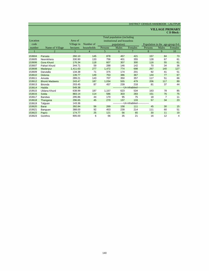
DISTRICT CENSUS HANDBOOK : LALITPUR
VILLAGE PRIMARY
Persons Males Females Persons Males Females1 2 3 4 5 6 7 8 9 10
C D Block -
Population in the age-group 0-6Number of householdsName of Village
Location code
number
Total population (including institutional and houseless
population)Area of
Village in hectares
153604 Parsata 260.10 145 878 457 421 157 84 73 153605 Neemkhera 330.90 133 756 401 355 128 67 61 153606 Gora Khurd 176.34 118 607 307 300 116 55 61 153607 Pahari Khurd 344.71 59 288 146 142 70 34 36 153608 Madanpur 1,411.63 277 1,472 774 698 267 140 127 153609 Darutalla 134.38 71 375 174 201 92 41 51 153610 Didonia 139.77 149 753 386 367 144 77 67 153611 Amoda 289.21 143 707 350 357 117 51 66 153612 Bhonti Madawra 243.47 187 1,034 555 479 206 117 89 153613 Bironda 203.45 87 457 239 218 81 37 44 153614 Hadda 549.38153615 Uldana Khurd 638.99 187 1,157 623 534 163 78 85 153616 Solda 883.14 114 586 303 283 151 76 75 153617 Bandwa 295.86 44 170 95 75 18 7 11 153618 Thangana 296.65 45 270 137 133 57 34 23 153619 Talguan 143.36153620 Barai 392.84 56 269 158 111 45 30 15 153621 Banguan 388.00 92 453 239 214 111 60 51 153622 Papro 174.77 25 121 56 65 30 11 19 153623 Gonthra 905.00 6 56 35 21 16 12 4
-------------Un-inhabited--------------
-------------Un-inhabited--------------
140
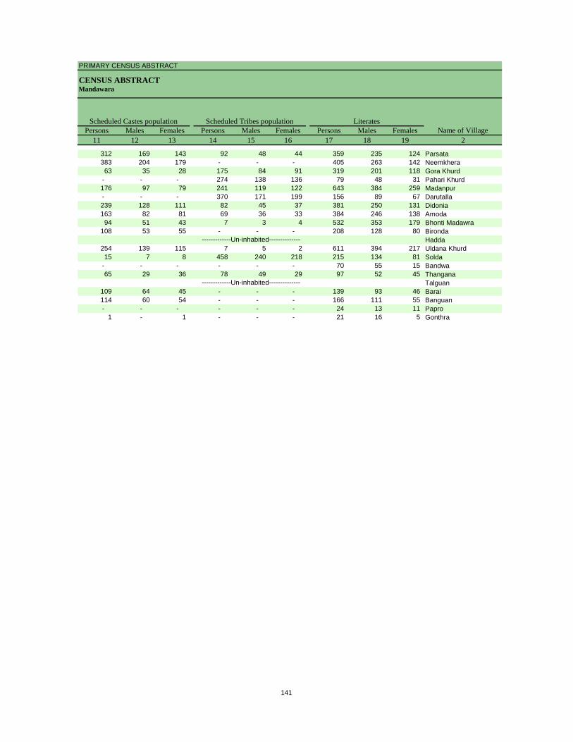
PRIMARY CENSUS ABSTRACT
CENSUS ABSTRACTMandawara
Persons Males Females Persons Males Females Persons Males Females11 12 13 14 15 16 17 18 19 2
Scheduled Castes population Scheduled Tribes populationName of Village
Literates
312 169 143 92 48 44 359 235 124 Parsata383 204 179 - - - 405 263 142 Neemkhera63 35 28 175 84 91 319 201 118 Gora Khurd
- - - 274 138 136 79 48 31 Pahari Khurd176 97 79 241 119 122 643 384 259 Madanpur- - - 370 171 199 156 89 67 Darutalla239 128 111 82 45 37 381 250 131 Didonia163 82 81 69 36 33 384 246 138 Amoda94 51 43 7 3 4 532 353 179 Bhonti Madawra
108 53 55 - - - 208 128 80 BirondaHadda
254 139 115 7 5 2 611 394 217 Uldana Khurd15 7 8 458 240 218 215 134 81 Solda
- - - - - - 70 55 15 Bandwa65 29 36 78 49 29 97 52 45 Thangana
Talguan109 64 45 - - - 139 93 46 Barai114 60 54 - - - 166 111 55 Banguan- - - - - - 24 13 11 Papro
1 - 1 - - - 21 16 5 Gonthra
-------------Un-inhabited--------------
-------------Un-inhabited--------------
141
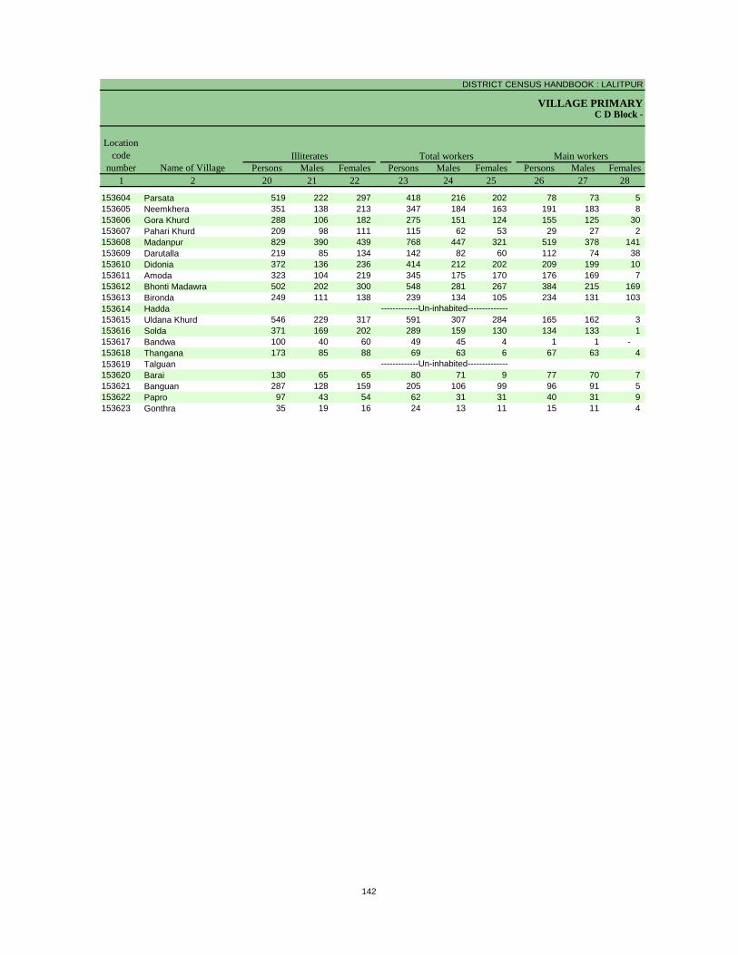
DISTRICT CENSUS HANDBOOK : LALITPUR
VILLAGE PRIMARYC D Block -
Persons Males Females Persons Males Females Persons Males Females1 2 20 21 22 23 24 25 26 27 28
Illiterates Total workers Main workersName of Village
Location code
number
153604 Parsata 519 222 297 418 216 202 78 73 5 153605 Neemkhera 351 138 213 347 184 163 191 183 8 153606 Gora Khurd 288 106 182 275 151 124 155 125 30 153607 Pahari Khurd 209 98 111 115 62 53 29 27 2 153608 Madanpur 829 390 439 768 447 321 519 378 141 153609 Darutalla 219 85 134 142 82 60 112 74 38 153610 Didonia 372 136 236 414 212 202 209 199 10 153611 Amoda 323 104 219 345 175 170 176 169 7 153612 Bhonti Madawra 502 202 300 548 281 267 384 215 169 153613 Bironda 249 111 138 239 134 105 234 131 103 153614 Hadda153615 Uldana Khurd 546 229 317 591 307 284 165 162 3 153616 Solda 371 169 202 289 159 130 134 133 1 153617 Bandwa 100 40 60 49 45 4 1 1 - 153618 Thangana 173 85 88 69 63 6 67 63 4 153619 Talguan153620 Barai 130 65 65 80 71 9 77 70 7 153621 Banguan 287 128 159 205 106 99 96 91 5 153622 Papro 97 43 54 62 31 31 40 31 9 153623 Gonthra 35 19 16 24 13 11 15 11 4
-------------Un-inhabited--------------
-------------Un-inhabited--------------
142
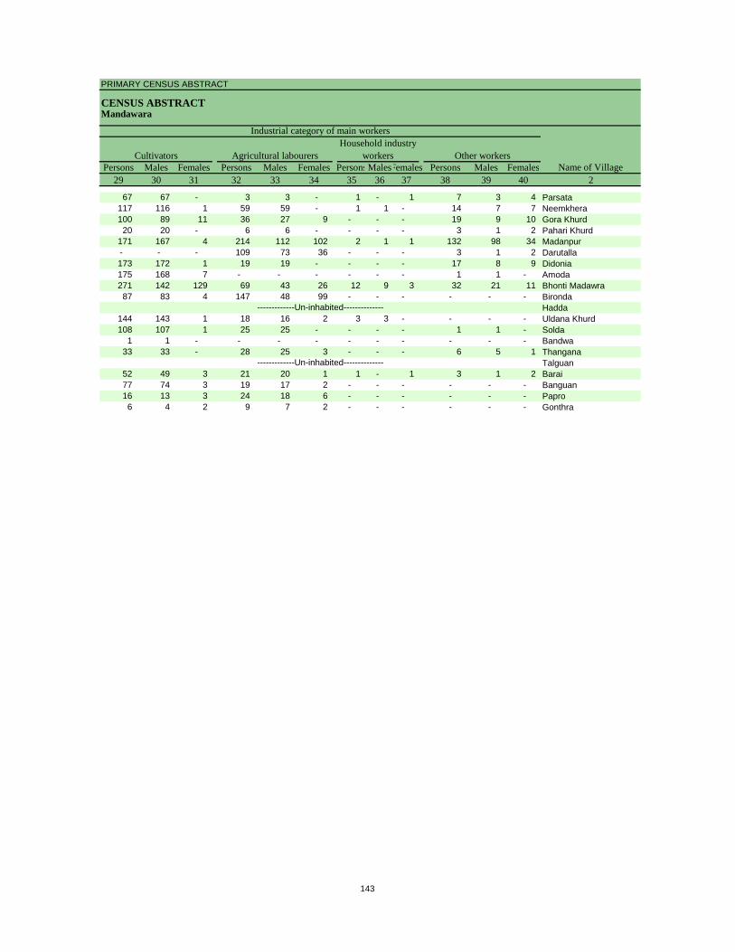
PRIMARY CENSUS ABSTRACT
CENSUS ABSTRACTMandawara
Persons Males Females Persons Males Females PersonsMalesFemales Persons Males Females29 30 31 32 33 34 35 36 37 38 39 40 2
CultivatorsName of Village
Household industry workersAgricultural labourers
Industrial category of main workers
Other workers
67 67 - 3 3 - 1 - 1 7 3 4 Parsata117 116 1 59 59 - 1 1 - 14 7 7 Neemkhera100 89 11 36 27 9 - - - 19 9 10 Gora Khurd20 20 - 6 6 - - - - 3 1 2 Pahari Khurd
171 167 4 214 112 102 2 1 1 132 98 34 Madanpur- - - 109 73 36 - - - 3 1 2 Darutalla173 172 1 19 19 - - - - 17 8 9 Didonia175 168 7 - - - - - - 1 1 - Amoda271 142 129 69 43 26 12 9 3 32 21 11 Bhonti Madawra87 83 4 147 48 99 - - - - - - Bironda
Hadda144 143 1 18 16 2 3 3 - - - - Uldana Khurd108 107 1 25 25 - - - - 1 1 - Solda
1 1 - - - - - - - - - - Bandwa33 33 - 28 25 3 - - - 6 5 1 Thangana
Talguan52 49 3 21 20 1 1 - 1 3 1 2 Barai77 74 3 19 17 2 - - - - - - Banguan16 13 3 24 18 6 - - - - - - Papro6 4 2 9 7 2 - - - - - - Gonthra
-------------Un-inhabited--------------
-------------Un-inhabited--------------
143
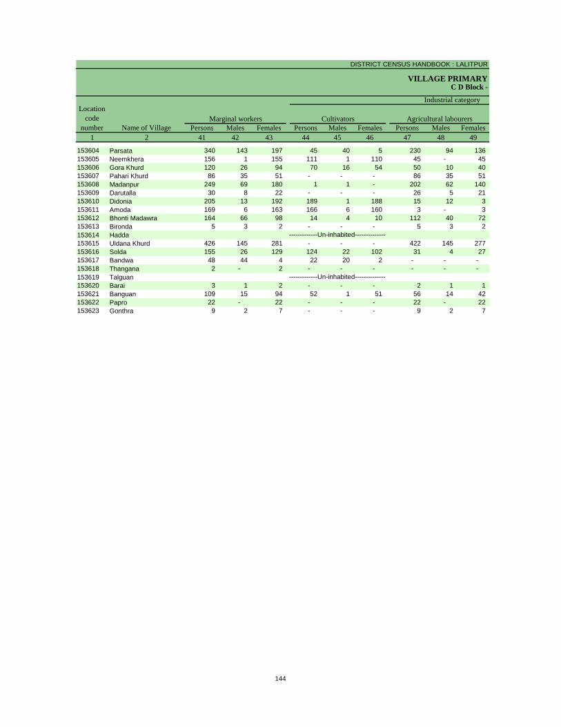
DISTRICT CENSUS HANDBOOK : LALITPUR
VILLAGE PRIMARYC D Block -
Persons Males Females Persons Males Females Persons Males Females1 2 41 42 43 44 45 46 47 48 49
Location code
number Name of VillageMarginal workers Cultivators Agricultural labourers
Industrial category
153604 Parsata 340 143 197 45 40 5 230 94 136 153605 Neemkhera 156 1 155 111 1 110 45 - 45 153606 Gora Khurd 120 26 94 70 16 54 50 10 40 153607 Pahari Khurd 86 35 51 - - - 86 35 51 153608 Madanpur 249 69 180 1 1 - 202 62 140 153609 Darutalla 30 8 22 - - - 26 5 21 153610 Didonia 205 13 192 189 1 188 15 12 3 153611 Amoda 169 6 163 166 6 160 3 - 3 153612 Bhonti Madawra 164 66 98 14 4 10 112 40 72 153613 Bironda 5 3 2 - - - 5 3 2 153614 Hadda153615 Uldana Khurd 426 145 281 - - - 422 145 277 153616 Solda 155 26 129 124 22 102 31 4 27 153617 Bandwa 48 44 4 22 20 2 - - - 153618 Thangana 2 - 2 - - - - - - 153619 Talguan153620 Barai 3 1 2 - - - 2 1 1 153621 Banguan 109 15 94 52 1 51 56 14 42 153622 Papro 22 - 22 - - - 22 - 22 153623 Gonthra 9 2 7 - - - 9 2 7
-------------Un-inhabited--------------
-------------Un-inhabited--------------
144
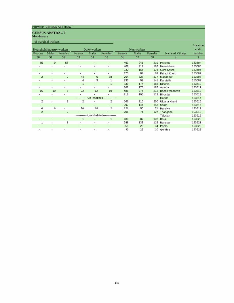
PRIMARY CENSUS ABSTRACT
CENSUS ABSTRACTMandawara
Persons Males Females Persons Males Females Persons Males Females50 51 52 53 54 55 56 57 58 2 1
Non-workers
of marginal workersLocation
code number
Household industry workersName of Village
Other workers
65 9 56 - - - 460 241 219 Parsata 153604- - - - - - 409 217 192 Neemkhera 153605- - - - - - 332 156 176 Gora Khurd 153606- - - - - - 173 84 89 Pahari Khurd 153607
2 - 2 44 6 38 704 327 377 Madanpur 153608- - - 4 3 1 233 92 141 Darutalla 153609- - - 1 - 1 339 174 165 Didonia 153610- - - - - - 362 175 187 Amoda 15361116 10 6 22 12 10 486 274 212 Bhonti Madawra 153612
- - - - - - 218 105 113 Bironda 153613Hadda 153614
2 - 2 2 - 2 566 316 250 Uldana Khurd 153615- - - - - - 297 144 153 Solda 153616
6 6 - 20 18 2 121 50 71 Bandwa 1536172 - 2 - - - 201 74 127 Thangana 153618
Talguan 153619- - - 1 - 1 189 87 102 Barai 153620
1 - 1 - - - 248 133 115 Banguan 153621- - - - - - 59 25 34 Papro 153622- - - - - - 32 22 10 Gonthra 153623
-------------Un-inhabited--------------
-------------Un-inhabited--------------
145


Urban PCA-Town wise Primary Census Abstract
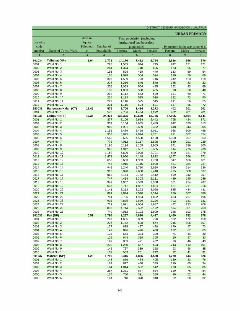
DISTRICT CENSUS HANDBOOK : LALITPUR
URBAN PRIMARY
Persons Males Females Persons Males Females1 2 3 4 5 6 7 8 9 10
801034 Talbehat (NP) 5.04 2,775 14,176 7,452 6,724 1,816 946 870 0001 Ward No. 1 295 1,559 814 745 242 121 121 0002 Ward No. 2 284 1,374 718 656 173 96 77 0003 Ward No. 3 193 898 458 440 113 59 54 0004 Ward No. 4 170 1,078 554 524 130 70 60 0005 Ward No. 5 307 1,539 793 746 242 123 119 0006 Ward No. 6 228 1,216 646 570 165 83 82 0007 Ward No. 7 206 1,059 564 495 152 83 69 0008 Ward No. 8 198 1,003 538 465 98 58 40 0009 Ward No. 9 212 1,112 583 529 131 60 71 0010 Ward No. 10 224 1,113 595 518 122 72 50 0011 Ward No. 11 227 1,110 595 515 111 56 55 0012 Ward No. 12 231 1,115 594 521 137 65 72 153038 Banguwan Kalan (CT) 11.45 576 2,706 1,434 1,272 402 201 201 0001 Ward No. 1 576 2,706 1,434 1,272 402 201 201 801035 Lalitpur (NPP) 17.35 24,424 133,305 69,529 63,776 17,005 8,864 8,141 0001 Ward No. 1 877 5,106 2,664 2,442 795 424 371 0002 Ward No. 2 957 5,104 2,665 2,439 642 329 313 0003 Ward No. 3 900 4,991 2,609 2,382 648 343 305 0004 Ward No. 4 1,156 6,459 3,428 3,031 958 500 458 0005 Ward No. 5 955 5,625 2,894 2,731 721 367 354 0006 Ward No. 6 1,566 8,666 4,538 4,128 1,350 697 653 0007 Ward No. 7 776 4,012 2,117 1,895 530 291 239 0008 Ward No. 8 1,196 6,124 3,169 2,955 641 336 305 0009 Ward No. 9 940 4,942 2,587 2,355 514 275 239 0010 Ward No. 10 1,152 5,699 2,908 2,791 600 321 279 0011 Ward No. 11 1,473 7,960 4,148 3,812 1,167 596 571 0012 Ward No. 12 658 3,603 1,903 1,700 347 186 161 0013 Ward No. 13 745 4,015 2,115 1,900 481 254 227 0014 Ward No. 14 943 5,240 2,710 2,530 650 314 336 0015 Ward No. 15 913 5,098 2,658 2,440 725 388 337 0016 Ward No. 16 965 5,144 2,732 2,412 599 342 257 0017 Ward No. 17 747 4,414 2,303 2,111 489 240 249 0018 Ward No. 18 949 4,907 2,539 2,368 561 274 287 0019 Ward No. 19 637 3,711 1,887 1,824 427 211 216 0020 Ward No. 20 1,141 6,313 3,293 3,020 865 434 431 0021 Ward No. 21 891 4,894 2,520 2,374 756 367 389 0022 Ward No. 22 701 3,736 1,934 1,802 433 237 196 0023 Ward No. 23 902 4,825 2,529 2,296 702 381 321 0024 Ward No. 24 711 3,991 2,054 1,937 442 233 209 0025 Ward No. 25 833 4,714 2,522 2,192 594 331 263 0026 Ward No. 26 740 4,012 2,103 1,909 368 193 175 801036 Pali (NP) 0.51 1,796 9,267 4,830 4,437 1,460 782 678 0001 Ward No. 1 297 1,685 889 796 322 172 150 0002 Ward No. 2 226 1,172 608 564 215 108 107 0003 Ward No. 3 177 885 457 428 170 97 73 0004 Ward No. 4 147 826 426 400 132 67 65 0005 Ward No. 5 134 643 334 309 74 44 30 0006 Ward No. 6 135 643 338 305 80 47 33 0007 Ward No. 7 197 903 471 432 89 46 43 0008 Ward No. 8 232 1,250 657 593 213 112 101 0009 Ward No. 9 142 757 389 368 93 48 45 0010 Ward No. 10 109 503 261 242 72 41 31 801037 Mahroni (NP) 1.28 1,799 9,415 4,865 4,550 1,270 644 626 0001 Ward No. 1 145 839 434 405 159 83 76 0002 Ward No. 2 167 827 438 389 119 65 54 0003 Ward No. 3 184 1,014 502 512 170 85 85 0004 Ward No. 4 287 1,331 677 654 160 76 84 0005 Ward No. 5 134 750 391 359 96 52 44 0006 Ward No. 6 144 718 378 340 62 30 32
Population in the age-group 0-6Number of householdsName of Town/ Ward
Location code
number
Total population (including institutional and houseless
population)
Area in Square
Kilometre
148
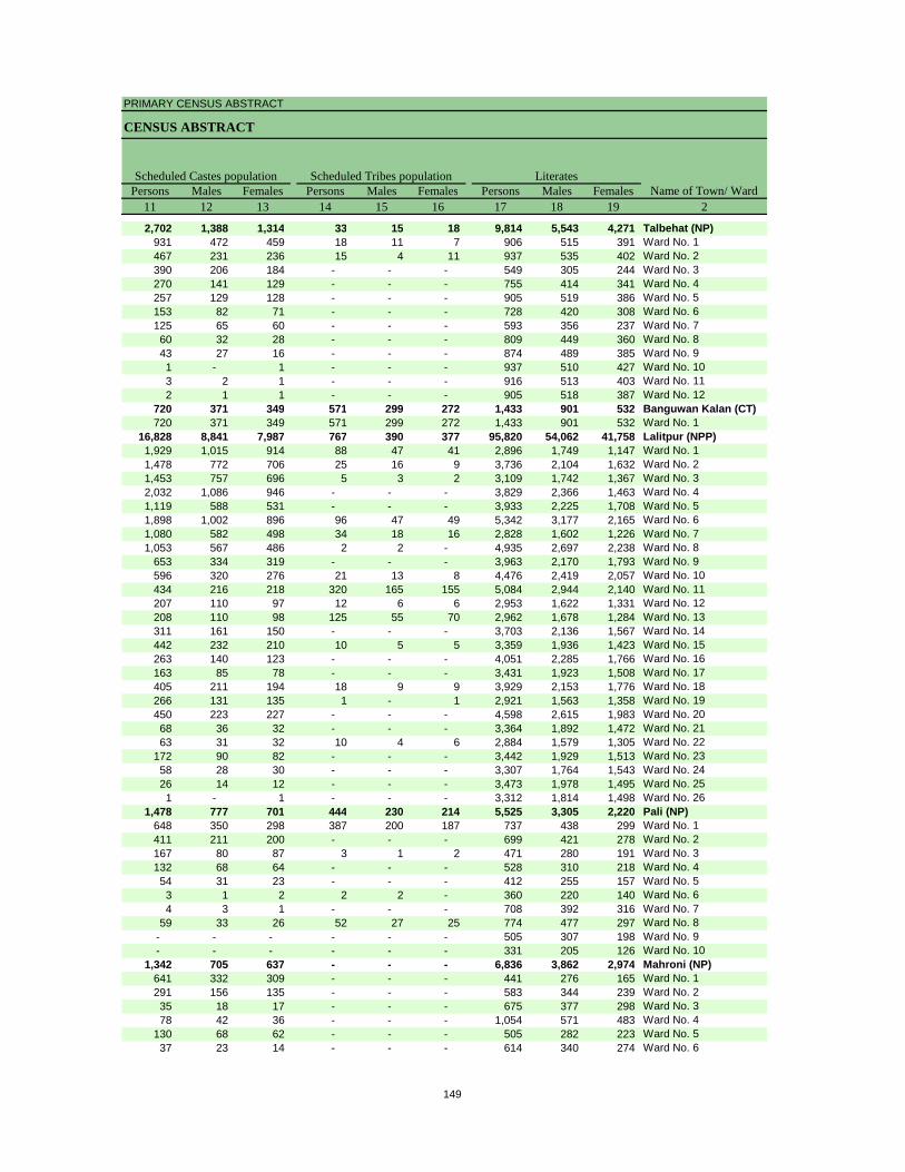
PRIMARY CENSUS ABSTRACT
CENSUS ABSTRACT
Persons Males Females Persons Males Females Persons Males Females11 12 13 14 15 16 17 18 19 2
2,702 1,388 1,314 33 15 18 9,814 5,543 4,271 Talbehat (NP)931 472 459 18 11 7 906 515 391 Ward No. 1467 231 236 15 4 11 937 535 402 Ward No. 2390 206 184 - - - 549 305 244 Ward No. 3270 141 129 - - - 755 414 341 Ward No. 4257 129 128 - - - 905 519 386 Ward No. 5153 82 71 - - - 728 420 308 Ward No. 6125 65 60 - - - 593 356 237 Ward No. 760 32 28 - - - 809 449 360 Ward No. 843 27 16 - - - 874 489 385 Ward No. 91 - 1 - - - 937 510 427 Ward No. 103 2 1 - - - 916 513 403 Ward No. 112 1 1 - - - 905 518 387 Ward No. 12
720 371 349 571 299 272 1,433 901 532 Banguwan Kalan (CT)720 371 349 571 299 272 1,433 901 532 Ward No. 1
16,828 8,841 7,987 767 390 377 95,820 54,062 41,758 Lalitpur (NPP)1,929 1,015 914 88 47 41 2,896 1,749 1,147 Ward No. 11,478 772 706 25 16 9 3,736 2,104 1,632 Ward No. 21,453 757 696 5 3 2 3,109 1,742 1,367 Ward No. 32,032 1,086 946 - - - 3,829 2,366 1,463 Ward No. 41,119 588 531 - - - 3,933 2,225 1,708 Ward No. 51,898 1,002 896 96 47 49 5,342 3,177 2,165 Ward No. 61,080 582 498 34 18 16 2,828 1,602 1,226 Ward No. 71,053 567 486 2 2 - 4,935 2,697 2,238 Ward No. 8
653 334 319 - - - 3,963 2,170 1,793 Ward No. 9596 320 276 21 13 8 4,476 2,419 2,057 Ward No. 10434 216 218 320 165 155 5,084 2,944 2,140 Ward No. 11207 110 97 12 6 6 2,953 1,622 1,331 Ward No. 12208 110 98 125 55 70 2,962 1,678 1,284 Ward No. 13311 161 150 - - - 3,703 2,136 1,567 Ward No. 14442 232 210 10 5 5 3,359 1,936 1,423 Ward No. 15263 140 123 - - - 4,051 2,285 1,766 Ward No. 16163 85 78 - - - 3,431 1,923 1,508 Ward No. 17405 211 194 18 9 9 3,929 2,153 1,776 Ward No. 18266 131 135 1 - 1 2,921 1,563 1,358 Ward No. 19450 223 227 - - - 4,598 2,615 1,983 Ward No. 2068 36 32 - - - 3,364 1,892 1,472 Ward No. 2163 31 32 10 4 6 2,884 1,579 1,305 Ward No. 22
172 90 82 - - - 3,442 1,929 1,513 Ward No. 2358 28 30 - - - 3,307 1,764 1,543 Ward No. 2426 14 12 - - - 3,473 1,978 1,495 Ward No. 251 - 1 - - - 3,312 1,814 1,498 Ward No. 26
1,478 777 701 444 230 214 5,525 3,305 2,220 Pali (NP)648 350 298 387 200 187 737 438 299 Ward No. 1411 211 200 - - - 699 421 278 Ward No. 2167 80 87 3 1 2 471 280 191 Ward No. 3132 68 64 - - - 528 310 218 Ward No. 454 31 23 - - - 412 255 157 Ward No. 53 1 2 2 2 - 360 220 140 Ward No. 64 3 1 - - - 708 392 316 Ward No. 7
59 33 26 52 27 25 774 477 297 Ward No. 8- - - - - - 505 307 198 Ward No. 9- - - - - - 331 205 126 Ward No. 10
1,342 705 637 - - - 6,836 3,862 2,974 Mahroni (NP)641 332 309 - - - 441 276 165 Ward No. 1291 156 135 - - - 583 344 239 Ward No. 235 18 17 - - - 675 377 298 Ward No. 378 42 36 - - - 1,054 571 483 Ward No. 4
130 68 62 - - - 505 282 223 Ward No. 537 23 14 - - - 614 340 274 Ward No. 6
Scheduled Castes population Scheduled Tribes population LiteratesName of Town/ Ward
149
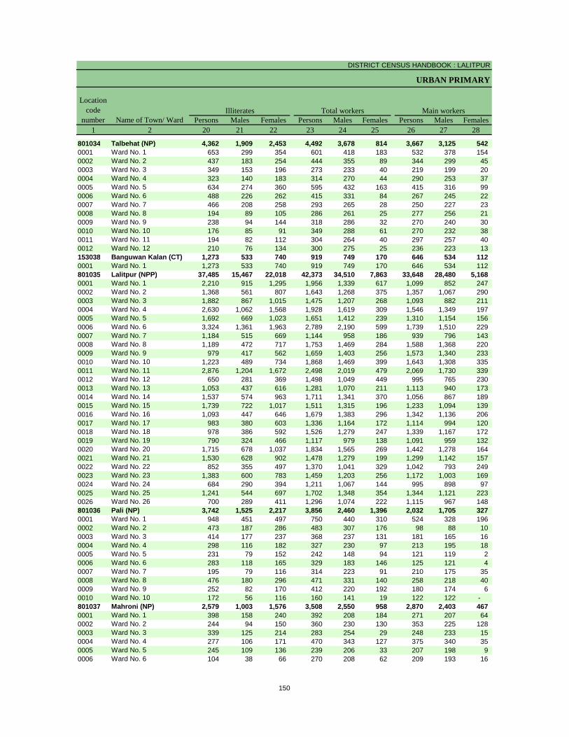
DISTRICT CENSUS HANDBOOK : LALITPUR
URBAN PRIMARY
Persons Males Females Persons Males Females Persons Males Females1 2 20 21 22 23 24 25 26 27 28
801034 Talbehat (NP) 4,362 1,909 2,453 4,492 3,678 814 3,667 3,125 542 0001 Ward No. 1 653 299 354 601 418 183 532 378 154 0002 Ward No. 2 437 183 254 444 355 89 344 299 45 0003 Ward No. 3 349 153 196 273 233 40 219 199 20 0004 Ward No. 4 323 140 183 314 270 44 290 253 37 0005 Ward No. 5 634 274 360 595 432 163 415 316 99 0006 Ward No. 6 488 226 262 415 331 84 267 245 22 0007 Ward No. 7 466 208 258 293 265 28 250 227 23 0008 Ward No. 8 194 89 105 286 261 25 277 256 21 0009 Ward No. 9 238 94 144 318 286 32 270 240 30 0010 Ward No. 10 176 85 91 349 288 61 270 232 38 0011 Ward No. 11 194 82 112 304 264 40 297 257 40 0012 Ward No. 12 210 76 134 300 275 25 236 223 13 153038 Banguwan Kalan (CT) 1,273 533 740 919 749 170 646 534 112 0001 Ward No. 1 1,273 533 740 919 749 170 646 534 112 801035 Lalitpur (NPP) 37,485 15,467 22,018 42,373 34,510 7,863 33,648 28,480 5,168 0001 Ward No. 1 2,210 915 1,295 1,956 1,339 617 1,099 852 247 0002 Ward No. 2 1,368 561 807 1,643 1,268 375 1,357 1,067 290 0003 Ward No. 3 1,882 867 1,015 1,475 1,207 268 1,093 882 211 0004 Ward No. 4 2,630 1,062 1,568 1,928 1,619 309 1,546 1,349 197 0005 Ward No. 5 1,692 669 1,023 1,651 1,412 239 1,310 1,154 156 0006 Ward No. 6 3,324 1,361 1,963 2,789 2,190 599 1,739 1,510 229 0007 Ward No. 7 1,184 515 669 1,144 958 186 939 796 143 0008 Ward No. 8 1,189 472 717 1,753 1,469 284 1,588 1,368 220 0009 Ward No. 9 979 417 562 1,659 1,403 256 1,573 1,340 233 0010 Ward No. 10 1,223 489 734 1,868 1,469 399 1,643 1,308 335 0011 Ward No. 11 2,876 1,204 1,672 2,498 2,019 479 2,069 1,730 339 0012 Ward No. 12 650 281 369 1,498 1,049 449 995 765 230 0013 Ward No. 13 1,053 437 616 1,281 1,070 211 1,113 940 173 0014 Ward No. 14 1,537 574 963 1,711 1,341 370 1,056 867 189 0015 Ward No. 15 1,739 722 1,017 1,511 1,315 196 1,233 1,094 139 0016 Ward No. 16 1,093 447 646 1,679 1,383 296 1,342 1,136 206 0017 Ward No. 17 983 380 603 1,336 1,164 172 1,114 994 120 0018 Ward No. 18 978 386 592 1,526 1,279 247 1,339 1,167 172 0019 Ward No. 19 790 324 466 1,117 979 138 1,091 959 132 0020 Ward No. 20 1,715 678 1,037 1,834 1,565 269 1,442 1,278 164 0021 Ward No. 21 1,530 628 902 1,478 1,279 199 1,299 1,142 157 0022 Ward No. 22 852 355 497 1,370 1,041 329 1,042 793 249 0023 Ward No. 23 1,383 600 783 1,459 1,203 256 1,172 1,003 169 0024 Ward No. 24 684 290 394 1,211 1,067 144 995 898 97 0025 Ward No. 25 1,241 544 697 1,702 1,348 354 1,344 1,121 223 0026 Ward No. 26 700 289 411 1,296 1,074 222 1,115 967 148 801036 Pali (NP) 3,742 1,525 2,217 3,856 2,460 1,396 2,032 1,705 327 0001 Ward No. 1 948 451 497 750 440 310 524 328 196 0002 Ward No. 2 473 187 286 483 307 176 98 88 10 0003 Ward No. 3 414 177 237 368 237 131 181 165 16 0004 Ward No. 4 298 116 182 327 230 97 213 195 18 0005 Ward No. 5 231 79 152 242 148 94 121 119 2 0006 Ward No. 6 283 118 165 329 183 146 125 121 4 0007 Ward No. 7 195 79 116 314 223 91 210 175 35 0008 Ward No. 8 476 180 296 471 331 140 258 218 40 0009 Ward No. 9 252 82 170 412 220 192 180 174 6 0010 Ward No. 10 172 56 116 160 141 19 122 122 - 801037 Mahroni (NP) 2,579 1,003 1,576 3,508 2,550 958 2,870 2,403 467 0001 Ward No. 1 398 158 240 392 208 184 271 207 64 0002 Ward No. 2 244 94 150 360 230 130 353 225 128 0003 Ward No. 3 339 125 214 283 254 29 248 233 15 0004 Ward No. 4 277 106 171 470 343 127 375 340 35 0005 Ward No. 5 245 109 136 239 206 33 207 198 9 0006 Ward No. 6 104 38 66 270 208 62 209 193 16
Illiterates Total workers Main workersName of Town/ Ward
Location code
number
150
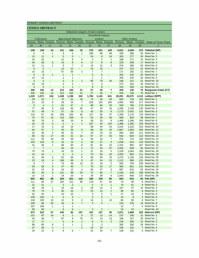
PRIMARY CENSUS ABSTRACT
CENSUS ABSTRACT
Persons Males Females Persons Males Females Persons Males Females Persons Males Females29 30 31 32 33 34 35 36 37 38 39 40 2
149 139 10 121 106 15 376 231 145 3,021 2,649 372 Talbehat (NP)5 4 1 3 2 1 185 86 99 339 286 53 Ward No. 1
12 11 1 5 5 - 24 6 18 303 277 26 Ward No. 216 16 - 12 9 3 3 2 1 188 172 16 Ward No. 334 28 6 14 8 6 17 9 8 225 208 17 Ward No. 412 11 1 9 7 2 15 12 3 379 286 93 Ward No. 55 5 - 12 12 - 13 13 - 237 215 22 Ward No. 6
15 15 - 57 55 2 7 7 - 171 150 21 Ward No. 79 8 1 1 1 - 5 5 - 262 242 20 Ward No. 8
13 13 - 1 1 - 1 1 - 255 225 30 Ward No. 94 4 - 3 2 1 95 79 16 168 147 21 Ward No. 10
19 19 - 3 3 - 3 3 - 272 232 40 Ward No. 115 5 - 1 1 - 8 8 - 222 209 13 Ward No. 12
206 192 14 213 192 21 27 20 7 200 130 70 Banguwan Kalan (CT)206 192 14 213 192 21 27 20 7 200 130 70 Ward No. 1
1,225 1,071 154 1,438 1,196 242 1,784 1,143 641 29,201 25,070 4,131 Lalitpur (NPP)29 22 7 70 51 19 74 45 29 926 734 192 Ward No. 121 15 6 29 22 7 225 125 100 1,082 905 177 Ward No. 25 4 1 61 57 4 98 65 33 929 756 173 Ward No. 3
77 68 9 126 96 30 47 29 18 1,296 1,156 140 Ward No. 457 48 9 37 29 8 43 35 8 1,173 1,042 131 Ward No. 5
115 97 18 208 163 45 127 80 47 1,289 1,170 119 Ward No. 670 57 13 116 108 8 54 28 26 699 603 96 Ward No. 736 33 3 38 29 9 28 20 8 1,486 1,286 200 Ward No. 816 13 3 2 1 1 167 43 124 1,388 1,283 105 Ward No. 917 15 2 16 16 - 68 45 23 1,542 1,232 310 Ward No. 1064 57 7 40 35 5 98 55 43 1,867 1,583 284 Ward No. 1132 30 2 39 32 7 29 19 10 895 684 211 Ward No. 1269 52 17 45 31 14 57 37 20 942 820 122 Ward No. 13
111 93 18 43 39 4 26 19 7 876 716 160 Ward No. 14152 143 9 16 14 2 26 21 5 1,039 916 123 Ward No. 1531 30 1 68 60 8 91 81 10 1,152 965 187 Ward No. 167 7 - 16 15 1 71 34 37 1,020 938 82 Ward No. 17
75 74 1 14 13 1 21 16 5 1,229 1,064 165 Ward No. 1815 15 - 3 2 1 70 50 20 1,003 892 111 Ward No. 1941 36 5 62 56 6 69 50 19 1,270 1,136 134 Ward No. 2023 19 4 108 99 9 47 34 13 1,121 990 131 Ward No. 218 7 1 73 58 15 22 19 3 939 709 230 Ward No. 22
63 59 4 47 40 7 70 53 17 992 851 141 Ward No. 2332 24 8 16 12 4 50 47 3 897 815 82 Ward No. 2445 40 5 121 98 23 72 65 7 1,106 918 188 Ward No. 2514 13 1 24 20 4 34 28 6 1,043 906 137 Ward No. 26
920 852 68 320 201 119 189 109 80 603 543 60 Pali (NP)111 84 27 220 121 99 119 57 62 74 66 8 Ward No. 121 21 - 2 2 - 5 4 1 70 61 9 Ward No. 230 29 1 19 16 3 25 23 2 107 97 10 Ward No. 378 74 4 30 23 7 15 14 1 90 84 6 Ward No. 491 91 - 10 10 - 3 2 1 17 16 1 Ward No. 5
108 106 2 4 4 - 3 3 - 10 8 2 Ward No. 6118 105 13 12 9 3 14 1 13 66 60 6 Ward No. 7106 86 20 16 9 7 3 3 - 133 120 13 Ward No. 8167 166 1 1 1 - - - - 12 7 5 Ward No. 990 90 - 6 6 - 2 2 - 24 24 - Ward No. 10
572 515 57 240 83 157 187 137 50 1,871 1,668 203 Mahroni (NP)101 87 14 6 1 5 27 13 14 137 106 31 Ward No. 143 36 7 87 8 79 27 14 13 196 167 29 Ward No. 217 17 - 5 4 1 8 6 2 218 206 12 Ward No. 388 80 8 2 1 1 3 3 - 282 256 26 Ward No. 437 36 1 1 - 1 10 10 - 159 152 7 Ward No. 524 21 3 6 6 - 41 34 7 138 132 6 Ward No. 6
CultivatorsName of Town/ Ward
Household industry workersAgricultural labourers
Industrial category of main workers
Other workers
151
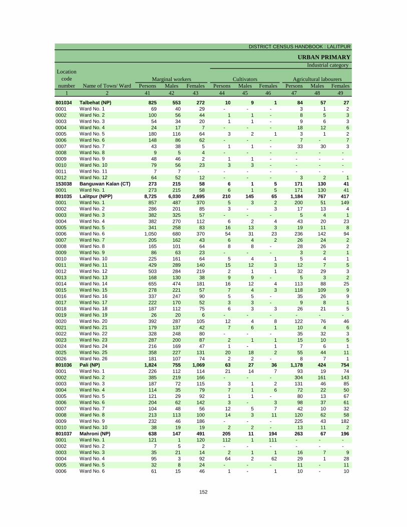
DISTRICT CENSUS HANDBOOK : LALITPUR
URBAN PRIMARY
Persons Males Females Persons Males Females Persons Males Females1 2 41 42 43 44 45 46 47 48 49
801034 Talbehat (NP) 825 553 272 10 9 1 84 57 27 0001 Ward No. 1 69 40 29 - - - 3 1 2 0002 Ward No. 2 100 56 44 1 1 - 8 5 3 0003 Ward No. 3 54 34 20 1 1 - 9 6 3 0004 Ward No. 4 24 17 7 - - - 18 12 6 0005 Ward No. 5 180 116 64 3 2 1 3 1 2 0006 Ward No. 6 148 86 62 - - - 7 - 7 0007 Ward No. 7 43 38 5 1 1 - 33 30 3 0008 Ward No. 8 9 5 4 - - - - - - 0009 Ward No. 9 48 46 2 1 1 - - - - 0010 Ward No. 10 79 56 23 3 3 - - - - 0011 Ward No. 11 7 7 - - - - - - - 0012 Ward No. 12 64 52 12 - - - 3 2 1 153038 Banguwan Kalan (CT) 273 215 58 6 1 5 171 130 41 0001 Ward No. 1 273 215 58 6 1 5 171 130 41 801035 Lalitpur (NPP) 8,725 6,030 2,695 210 145 65 1,184 767 417 0001 Ward No. 1 857 487 370 5 3 2 200 51 149 0002 Ward No. 2 286 201 85 3 - 3 17 13 4 0003 Ward No. 3 382 325 57 - - - 5 4 1 0004 Ward No. 4 382 270 112 6 2 4 43 20 23 0005 Ward No. 5 341 258 83 16 13 3 19 11 8 0006 Ward No. 6 1,050 680 370 54 31 23 236 142 94 0007 Ward No. 7 205 162 43 6 4 2 26 24 2 0008 Ward No. 8 165 101 64 8 8 - 28 26 2 0009 Ward No. 9 86 63 23 - - - 3 2 1 0010 Ward No. 10 225 161 64 5 4 1 5 4 1 0011 Ward No. 11 429 289 140 15 12 3 12 7 5 0012 Ward No. 12 503 284 219 2 1 1 32 29 3 0013 Ward No. 13 168 130 38 9 9 - 5 3 2 0014 Ward No. 14 655 474 181 16 12 4 113 88 25 0015 Ward No. 15 278 221 57 7 4 3 118 109 9 0016 Ward No. 16 337 247 90 5 5 - 35 26 9 0017 Ward No. 17 222 170 52 3 3 - 9 8 1 0018 Ward No. 18 187 112 75 6 3 3 26 21 5 0019 Ward No. 19 26 20 6 - - - - - - 0020 Ward No. 20 392 287 105 12 4 8 122 76 46 0021 Ward No. 21 179 137 42 7 6 1 10 4 6 0022 Ward No. 22 328 248 80 - - - 35 32 3 0023 Ward No. 23 287 200 87 2 1 1 15 10 5 0024 Ward No. 24 216 169 47 1 - 1 7 6 1 0025 Ward No. 25 358 227 131 20 18 2 55 44 11 0026 Ward No. 26 181 107 74 2 2 - 8 7 1 801036 Pali (NP) 1,824 755 1,069 63 27 36 1,178 424 754 0001 Ward No. 1 226 112 114 21 14 7 93 19 74 0002 Ward No. 2 385 219 166 - - - 304 161 143 0003 Ward No. 3 187 72 115 3 1 2 131 46 85 0004 Ward No. 4 114 35 79 7 1 6 72 22 50 0005 Ward No. 5 121 29 92 1 1 - 80 13 67 0006 Ward No. 6 204 62 142 3 - 3 98 37 61 0007 Ward No. 7 104 48 56 12 5 7 42 10 32 0008 Ward No. 8 213 113 100 14 3 11 120 62 58 0009 Ward No. 9 232 46 186 - - - 225 43 182 0010 Ward No. 10 38 19 19 2 2 - 13 11 2 801037 Mahroni (NP) 638 147 491 205 11 194 263 67 196 0001 Ward No. 1 121 1 120 112 1 111 - - - 0002 Ward No. 2 7 5 2 - - - - - - 0003 Ward No. 3 35 21 14 2 1 1 16 7 9 0004 Ward No. 4 95 3 92 64 2 62 29 1 28 0005 Ward No. 5 32 8 24 - - - 11 - 11 0006 Ward No. 6 61 15 46 1 - 1 10 - 10
Location code
number Name of Town/ WardMarginal workers Cultivators Agricultural labourers
Industrial category
152
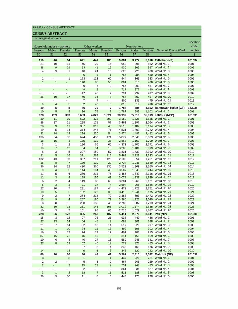
PRIMARY CENSUS ABSTRACT
CENSUS ABSTRACT
Persons Males Females Persons Males Females Persons Males Females50 51 52 53 54 55 56 57 58 2 1
110 46 64 621 441 180 9,684 3,774 5,910 Talbehat (NP) 80103421 10 11 45 29 16 958 396 562 Ward No. 1 000138 9 29 53 41 12 930 363 567 Ward No. 2 00024 3 1 40 24 16 625 225 400 Ward No. 3 0003
- - - 6 5 1 764 284 480 Ward No. 4 00041 - 1 173 113 60 944 361 583 Ward No. 5 00051 1 - 140 85 55 801 315 486 Ward No. 6 0006
- - - 9 7 2 766 299 467 Ward No. 7 0007- - - 9 5 4 717 277 440 Ward No. 8 0008- - - 47 45 2 794 297 497 Ward No. 9 000936 19 17 40 34 6 764 307 457 Ward No. 10 0010
- - - 7 7 - 806 331 475 Ward No. 11 00119 4 5 52 46 6 815 319 496 Ward No. 12 0012
10 5 5 86 79 7 1,787 685 1,102 Banguwan Kalan (CT) 15303810 5 5 86 79 7 1,787 685 1,102 Ward No. 1 0001
678 289 389 6,653 4,829 1,824 90,932 35,019 55,913 Lalitpur (NPP) 80103530 11 19 622 422 200 3,150 1,325 1,825 Ward No. 1 000138 17 21 228 171 57 3,461 1,397 2,064 Ward No. 2 000220 9 11 357 312 45 3,516 1,402 2,114 Ward No. 3 000319 5 14 314 243 71 4,531 1,809 2,722 Ward No. 4 000432 14 18 274 220 54 3,974 1,482 2,492 Ward No. 5 0005
136 54 82 624 453 171 5,877 2,348 3,529 Ward No. 6 000618 15 3 155 119 36 2,868 1,159 1,709 Ward No. 7 00073 1 2 126 66 60 4,371 1,700 2,671 Ward No. 8 0008
19 7 12 64 54 10 3,283 1,184 2,099 Ward No. 9 00098 3 5 207 150 57 3,831 1,439 2,392 Ward No. 10 0010
21 5 16 381 265 116 5,462 2,129 3,333 Ward No. 11 0011132 43 89 337 211 126 2,105 854 1,251 Ward No. 12 001215 8 7 139 110 29 2,734 1,045 1,689 Ward No. 13 001336 14 22 490 360 130 3,529 1,369 2,160 Ward No. 14 00149 4 5 144 104 40 3,587 1,343 2,244 Ward No. 15 0015
11 5 6 286 211 75 3,465 1,349 2,116 Ward No. 16 001611 3 8 199 156 43 3,078 1,139 1,939 Ward No. 17 00176 2 4 149 86 63 3,381 1,260 2,121 Ward No. 18 00185 3 2 21 17 4 2,594 908 1,686 Ward No. 19 0019
27 20 7 231 187 44 4,479 1,728 2,751 Ward No. 20 002010 5 5 152 122 30 3,416 1,241 2,175 Ward No. 21 00219 2 7 284 214 70 2,366 893 1,473 Ward No. 22 0022
13 9 4 257 180 77 3,366 1,326 2,040 Ward No. 23 00238 8 - 200 155 45 2,780 987 1,793 Ward No. 24 0024
32 19 13 251 146 105 3,012 1,174 1,838 Ward No. 25 002510 3 7 161 95 66 2,716 1,029 1,687 Ward No. 26 0026
228 56 172 355 248 107 5,411 2,370 3,041 Pali (NP) 80103615 3 12 97 76 21 935 449 486 Ward No. 1 000127 13 14 54 45 9 689 301 388 Ward No. 2 000221 7 14 32 18 14 517 220 297 Ward No. 3 000311 1 10 24 11 13 499 196 303 Ward No. 4 000416 3 13 24 12 12 401 186 215 Ward No. 5 000587 15 72 16 10 6 314 155 159 Ward No. 6 000610 6 4 40 27 13 589 248 341 Ward No. 7 000727 8 19 52 40 12 779 326 453 Ward No. 8 0008
- - - 7 3 4 345 169 176 Ward No. 9 000914 - 14 9 6 3 343 120 223 Ward No. 10 001080 20 60 90 49 41 5,907 2,315 3,592 Mahroni (NP) 8010378 - 8 1 - 1 447 226 221 Ward No. 1 00012 2 - 5 3 2 467 208 259 Ward No. 2 00022 - 2 15 13 2 731 248 483 Ward No. 3 0003
- - - 2 - 2 861 334 527 Ward No. 4 00043 1 2 18 7 11 511 185 326 Ward No. 5 0005
39 9 30 11 6 5 448 170 278 Ward No. 6 0006
Non-workersLocation
code number
Household industry workersName of Town/ Ward
Other workers
of marginal workers
153
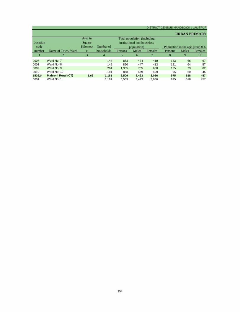
DISTRICT CENSUS HANDBOOK : LALITPUR
URBAN PRIMARY
Persons Males Females Persons Males Females1 2 3 4 5 6 7 8 9 10
Population in the age-group 0-6Number of householdsName of Town/ Ward
Location code
number
Total population (including institutional and houseless
population)
Area in Square
Kilometre
0007 Ward No. 7 144 853 434 419 133 66 67 0008 Ward No. 8 149 860 447 413 121 64 57 0009 Ward No. 9 264 1,355 705 650 155 73 82 0010 Ward No. 10 181 868 459 409 95 50 45 153624 Mahroni Rural (CT) 5.63 1,181 6,509 3,423 3,086 975 518 457 0001 Ward No. 1 1,181 6,509 3,423 3,086 975 518 457
154

PRIMARY CENSUS ABSTRACT
CENSUS ABSTRACT
Persons Males Females Persons Males Females Persons Males Females11 12 13 14 15 16 17 18 19 2
Scheduled Castes population Scheduled Tribes population LiteratesName of Town/ Ward
19 10 9 - - - 583 333 250 Ward No. 7- - - - - - 584 336 248 Ward No. 888 43 45 - - - 1,064 606 458 Ward No. 923 13 10 - - - 733 397 336 Ward No. 10
2,341 1,231 1,110 20 14 6 4,335 2,521 1,814 Mahroni Rural (CT)2,341 1,231 1,110 20 14 6 4,335 2,521 1,814 Ward No. 1
155
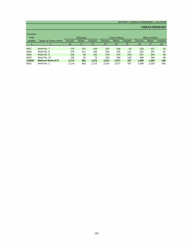
DISTRICT CENSUS HANDBOOK : LALITPUR
URBAN PRIMARY
Persons Males Females Persons Males Females Persons Males Females1 2 20 21 22 23 24 25 26 27 28
Illiterates Total workers Main workersName of Town/ Ward
Location code
number
0007 Ward No. 7 270 101 169 252 209 43 233 207 26 0008 Ward No. 8 276 111 165 342 225 117 187 167 20 0009 Ward No. 9 291 99 192 478 375 103 407 349 58 0010 Ward No. 10 135 62 73 422 292 130 380 284 96 153624 Mahroni Rural (CT) 2,174 902 1,272 2,014 1,577 437 1,599 1,253 346 0001 Ward No. 1 2,174 902 1,272 2,014 1,577 437 1,599 1,253 346
156

PRIMARY CENSUS ABSTRACT
CENSUS ABSTRACT
Persons Males Females Persons Males Females Persons Males Females Persons Males Females29 30 31 32 33 34 35 36 37 38 39 40 2
CultivatorsName of Town/ Ward
Household industry workersAgricultural labourers
Industrial category of main workers
Other workers
57 47 10 7 5 2 - - - 169 155 14 Ward No. 793 87 6 35 25 10 14 12 2 45 43 2 Ward No. 854 46 8 42 26 16 19 17 2 292 260 32 Ward No. 958 58 - 49 7 42 38 28 10 235 191 44 Ward No. 10
206 192 14 597 362 235 53 44 9 743 655 88 Mahroni Rural (CT)206 192 14 597 362 235 53 44 9 743 655 88 Ward No. 1
157
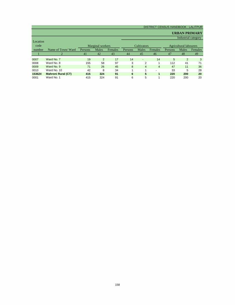
DISTRICT CENSUS HANDBOOK : LALITPUR
URBAN PRIMARY
Persons Males Females Persons Males Females Persons Males Females1 2 41 42 43 44 45 46 47 48 49
Location code
number Name of Town/ WardMarginal workers Cultivators Agricultural labourers
Industrial category
0007 Ward No. 7 19 2 17 14 - 14 5 2 3 0008 Ward No. 8 155 58 97 3 2 1 112 41 71 0009 Ward No. 9 71 26 45 8 4 4 47 11 36 0010 Ward No. 10 42 8 34 1 1 - 33 5 28 153624 Mahroni Rural (CT) 415 324 91 6 5 1 220 200 20 0001 Ward No. 1 415 324 91 6 5 1 220 200 20
158
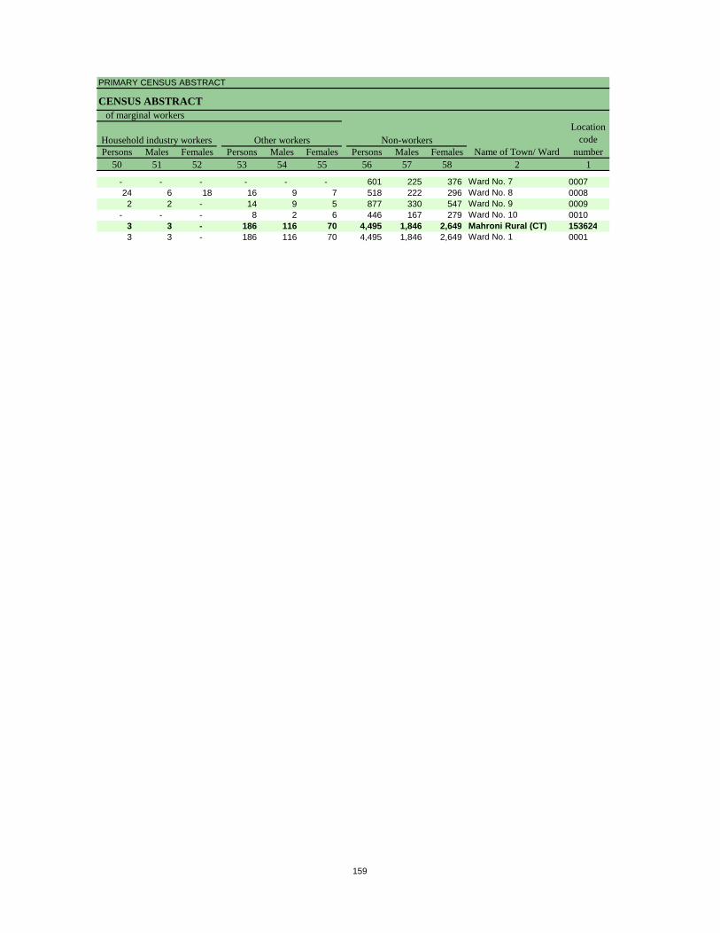
PRIMARY CENSUS ABSTRACT
CENSUS ABSTRACT
Persons Males Females Persons Males Females Persons Males Females50 51 52 53 54 55 56 57 58 2 1
Non-workersLocation
code number
Household industry workersName of Town/ Ward
Other workers
of marginal workers
- - - - - - 601 225 376 Ward No. 7 000724 6 18 16 9 7 518 222 296 Ward No. 8 00082 2 - 14 9 5 877 330 547 Ward No. 9 0009
- - - 8 2 6 446 167 279 Ward No. 10 00103 3 - 186 116 70 4,495 1,846 2,649 Mahroni Rural (CT) 1536243 3 - 186 116 70 4,495 1,846 2,649 Ward No. 1 0001
159

Section – II
Tables based on Households Amenities and Assets
(Rural /Urban) at District and Sub-District level


Total Rural Urban Total Rural Urban Total Rural Urban1 2 3 4 5 6 7 8 9 10 11 12
Owned No exclusive room 2,433 2,210 223 507 480 27 250 247 3One room 62,217 55,949 6,268 16,503 15,160 1,343 9,809 9,525 284Two rooms 71,029 63,116 7,913 16,635 15,267 1,368 3,558 3,474 84Three rooms 32,144 27,842 4,302 6,159 5,542 617 730 700 303+ rooms 41,306 33,883 7,423 5,119 4,436 683 466 440 26
Rented No exclusive room 106 50 56 14 5 9 3 2 1One room 3,227 872 2,355 575 180 395 99 66 33Two rooms 2,316 755 1,561 432 148 284 36 26 10Three rooms 602 211 391 59 27 32 13 9 43+ rooms 457 192 265 56 21 35 6 3 3
Others No exclusive room 65 45 20 8 8 - 7 6 1One room 877 560 317 194 113 81 101 95 6Two rooms 672 514 158 141 125 16 31 31 -Three rooms 226 164 62 55 41 14 10 9 13+ rooms 201 140 61 20 14 6 4 3 1
Total No exclusive room 2,604 2,305 299 529 493 36 260 255 5One room 66,321 57,381 8,940 17,272 15,453 1,819 10,009 9,686 323Two rooms 74,017 64,385 9,632 17,208 15,540 1,668 3,625 3,531 94Three rooms 32,972 28,217 4,755 6,273 5,610 663 753 718 353+ rooms 41,964 34,215 7,749 5,195 4,471 724 476 446 30
Data Source:-Census of India, 2011, HH- series Tables on Houses, Household amenities and assets.
District - Lalitpur (09167)
Table -1: Households by Ownership Status and by Number of Dwelling rooms occupied in the District, 2011
Name of district
Number of householdsTotal Scheduled Castes Scheduled Tribes
Ownership status
Number of dwelling rooms
163
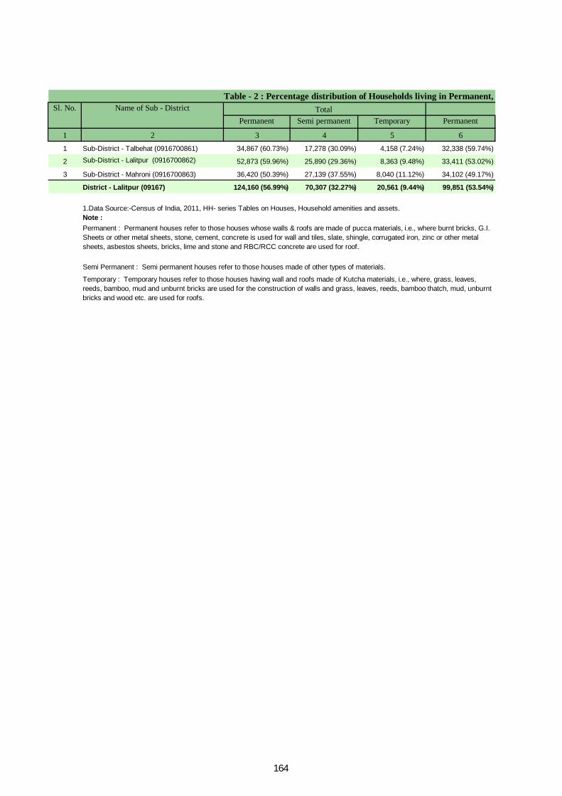
Permanent Semi permanent Temporary Permanent
1 2 3 4 5 61 Sub-District - Talbehat (0916700861) 34,867 (60.73%) 17,278 (30.09%) 4,158 (7.24%) 32,338 (59.74%)
2 Sub-District - Lalitpur (0916700862) 52,873 (59.96%) 25,890 (29.36%) 8,363 (9.48%) 33,411 (53.02%)
3 Sub-District - Mahroni (0916700863) 36,420 (50.39%) 27,139 (37.55%) 8,040 (11.12%) 34,102 (49.17%)
District - Lalitpur (09167) 124,160 (56.99%) 70,307 (32.27%) 20,561 (9.44%) 99,851 (53.54%)
Note : 1.Data Source:-Census of India, 2011, HH- series Tables on Houses, Household amenities and assets.
Permanent : Permanent houses refer to those houses whose walls & roofs are made of pucca materials, i.e., where burnt bricks, G.I. Sheets or other metal sheets, stone, cement, concrete is used for wall and tiles, slate, shingle, corrugated iron, zinc or other metal sheets, asbestos sheets, bricks, lime and stone and RBC/RCC concrete are used for roof.
Semi Permanent : Semi permanent houses refer to those houses made of other types of materials.
Temporary : Temporary houses refer to those houses having wall and roofs made of Kutcha materials, i.e., where, grass, leaves, reeds, bamboo, mud and unburnt bricks are used for the construction of walls and grass, leaves, reeds, bamboo thatch, mud, unburnt bricks and wood etc. are used for roofs.
Table - 2 : Percentage distribution of Households living in Permanent, Sl. No. Name of Sub - District Total
164
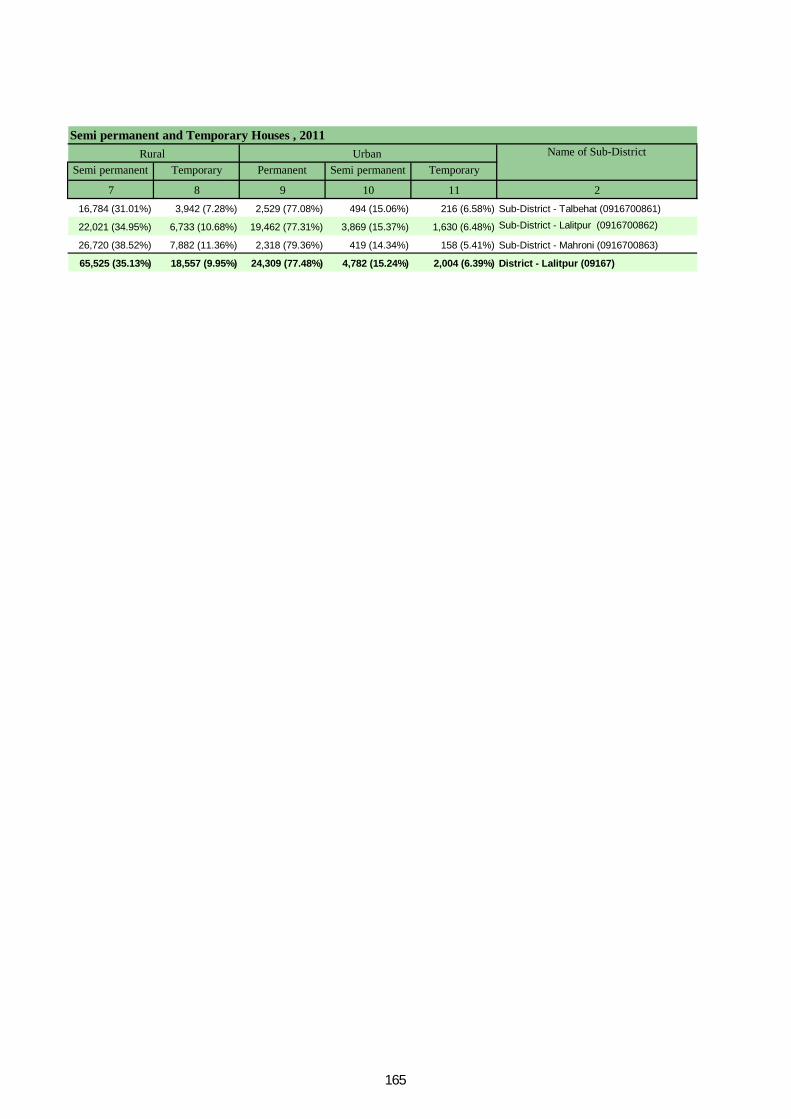
Semi permanent Temporary Permanent Semi permanent Temporary
7 8 9 10 11 216,784 (31.01%) 3,942 (7.28%) 2,529 (77.08%) 494 (15.06%) 216 (6.58%) Sub-District - Talbehat (0916700861)
22,021 (34.95%) 6,733 (10.68%) 19,462 (77.31%) 3,869 (15.37%) 1,630 (6.48%) Sub-District - Lalitpur (0916700862)
26,720 (38.52%) 7,882 (11.36%) 2,318 (79.36%) 419 (14.34%) 158 (5.41%) Sub-District - Mahroni (0916700863)
65,525 (35.13%) 18,557 (9.95%) 24,309 (77.48%) 4,782 (15.24%) 2,004 (6.39%) District - Lalitpur (09167)
Semi permanent and Temporary Houses , 2011Urban Name of Sub-DistrictRural
165
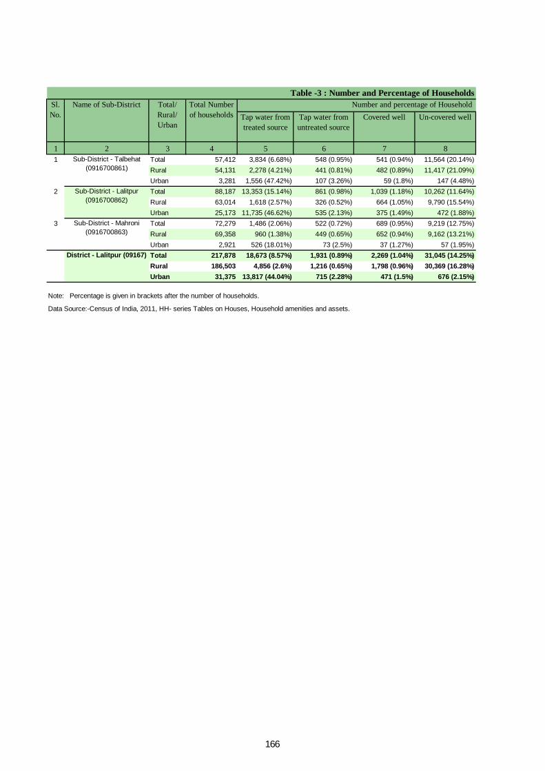
Tap water from treated source
Tap water from untreated source
Covered well Un-covered well
1 2 3 4 5 6 7 81 Total 57,412 3,834 (6.68%) 548 (0.95%) 541 (0.94%) 11,564 (20.14%)
Rural 54,131 2,278 (4.21%) 441 (0.81%) 482 (0.89%) 11,417 (21.09%)Urban 3,281 1,556 (47.42%) 107 (3.26%) 59 (1.8%) 147 (4.48%)
2 Total 88,187 13,353 (15.14%) 861 (0.98%) 1,039 (1.18%) 10,262 (11.64%)Rural 63,014 1,618 (2.57%) 326 (0.52%) 664 (1.05%) 9,790 (15.54%)Urban 25,173 11,735 (46.62%) 535 (2.13%) 375 (1.49%) 472 (1.88%)
3 Total 72,279 1,486 (2.06%) 522 (0.72%) 689 (0.95%) 9,219 (12.75%)Rural 69,358 960 (1.38%) 449 (0.65%) 652 (0.94%) 9,162 (13.21%)Urban 2,921 526 (18.01%) 73 (2.5%) 37 (1.27%) 57 (1.95%)Total 217,878 18,673 (8.57%) 1,931 (0.89%) 2,269 (1.04%) 31,045 (14.25%)Rural 186,503 4,856 (2.6%) 1,216 (0.65%) 1,798 (0.96%) 30,369 (16.28%)Urban 31,375 13,817 (44.04%) 715 (2.28%) 471 (1.5%) 676 (2.15%)
Data Source:-Census of India, 2011, HH- series Tables on Houses, Household amenities and assets.
Table -3 : Number and Percentage of Households Sl. No.
Name of Sub-District Total/ Rural/ Urban
Total Number of households
Number and percentage of Household
Note: Percentage is given in brackets after the number of households.
Sub-District - Talbehat (0916700861)
Sub-District - Lalitpur (0916700862)
Sub-District - Mahroni (0916700863)
District - Lalitpur (09167)
166
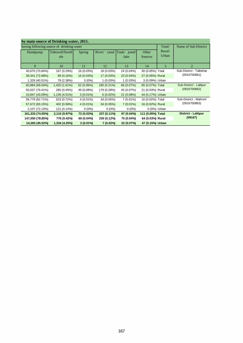
Handpump Tubewell/borehole
Spring River/ canal Tank/ pond/ lake
Other Sources
9 10 11 12 13 14 3 240,670 (70.84%) 167 (0.29%) 16 (0.03%) 18 (0.03%) 24 (0.04%) 30 (0.05%) Total39,341 (72.68%) 89 (0.16%) 16 (0.03%) 17 (0.03%) 23 (0.04%) 27 (0.05%) Rural1,329 (40.51%) 78 (2.38%) 0 (0%) 1 (0.03%) 1 (0.03%) 3 (0.09%) Urban
60,884 (69.04%) 1,420 (1.61%) 52 (0.06%) 185 (0.21%) 66 (0.07%) 65 (0.07%) Total50,037 (79.41%) 285 (0.45%) 49 (0.08%) 179 (0.28%) 45 (0.07%) 21 (0.03%) Rural10,847 (43.09%) 1,135 (4.51%) 3 (0.01%) 6 (0.02%) 21 (0.08%) 44 (0.17%) Urban59,779 (82.71%) 523 (0.72%) 4 (0.01%) 34 (0.05%) 7 (0.01%) 16 (0.02%) Total57,672 (83.15%) 402 (0.58%) 4 (0.01%) 34 (0.05%) 7 (0.01%) 16 (0.02%) Rural2,107 (72.13%) 121 (4.14%) 0 (0%) 0 (0%) 0 (0%) 0 (0%) Urban
161,333 (74.05%) 2,110 (0.97%) 72 (0.03%) 237 (0.11%) 97 (0.04%) 111 (0.05%) Total147,050 (78.85%) 776 (0.42%) 69 (0.04%) 230 (0.12%) 75 (0.04%) 64 (0.03%) Rural14,283 (45.52%) 1,334 (4.25%) 3 (0.01%) 7 (0.02%) 22 (0.07%) 47 (0.15%) Urban
by main source of Drinking water, 2011.Name of Sub-Districthaving following source of drinking water Total/
Rural/ Urban
Sub-District - Talbehat (0916700861)
Sub-District - Lalitpur (0916700862)
Sub-District - Mahroni (0916700863)
District - Lalitpur (09167)
167
Electricity Kerosene Solar
1 2 3 4 5 6 71 Total 57,412 15,336 (26.71%) 41,128 (71.64%) 471 (0.82%)
Rural 54,131 12,820 (23.68%) 40,421 (74.67%) 463 (0.86%)Urban 3,281 2,516 (76.68%) 707 (21.55%) 8 (0.24%)
2 Total 88,187 39,358 (44.63%) 47,349 (53.69%) 1,024 (1.16%)Rural 63,014 19,046 (30.23%) 42,713 (67.78%) 994 (1.58%)Urban 25,173 20,312 (80.69%) 4,636 (18.42%) 30 (0.12%)
3 Total 72,279 22,388 (30.97%) 48,934 (67.7%) 562 (0.78%)Rural 69,358 20,032 (28.88%) 48,371 (69.74%) 560 (0.81%)Urban 2,921 2,356 (80.66%) 563 (19.27%) 2 (0.07%)Total 217,878 77,082 (35.38%) 137,411 (63.07%) 2,057 (0.94%)Rural 186,503 51,898 (27.83%) 131,505 (70.51%) 2,017 (1.08%)Urban 31,375 25,184 (80.27%) 5,906 (18.82%) 40 (0.13%)
Data Source:-Census of India, 2011, HH- series Tables on Houses, Household amenities and assets.
Table- 4 : Number and Percentage of Households Sl. No.
Name of Sub-District Total/ Rural/ Urban
Total number of households
Number and Percentage of households
Note: Percentage is given in brackets after the number of households.
Sub-District - Talbehat (0916700861)
Sub-District - Lalitpur (0916700862)
Sub-District - Mahroni (0916700863)
District - Lalitpur (09167)
168
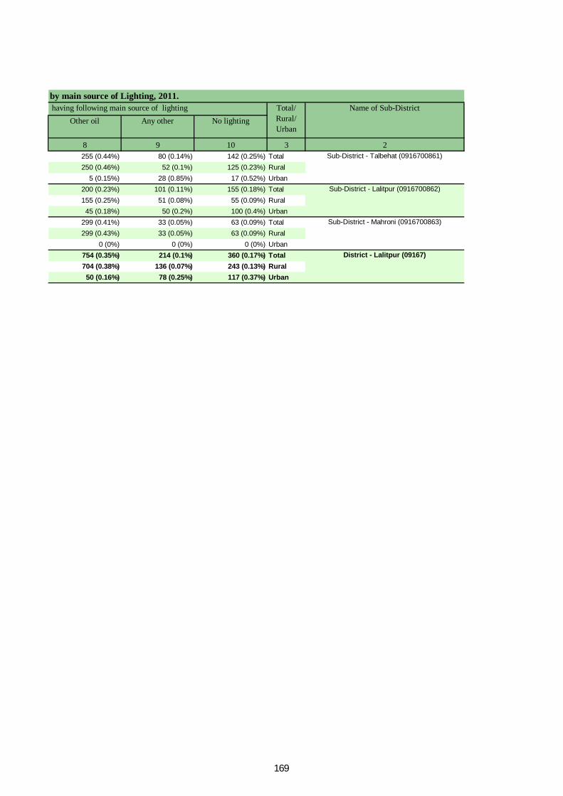
Other oil Any other No lighting
8 9 10 3 2255 (0.44%) 80 (0.14%) 142 (0.25%) Total250 (0.46%) 52 (0.1%) 125 (0.23%) Rural
5 (0.15%) 28 (0.85%) 17 (0.52%) Urban200 (0.23%) 101 (0.11%) 155 (0.18%) Total155 (0.25%) 51 (0.08%) 55 (0.09%) Rural45 (0.18%) 50 (0.2%) 100 (0.4%) Urban
299 (0.41%) 33 (0.05%) 63 (0.09%) Total299 (0.43%) 33 (0.05%) 63 (0.09%) Rural
0 (0%) 0 (0%) 0 (0%) Urban754 (0.35%) 214 (0.1%) 360 (0.17%) Total704 (0.38%) 136 (0.07%) 243 (0.13%) Rural50 (0.16%) 78 (0.25%) 117 (0.37%) Urban
Name of Sub-Districtby main source of Lighting, 2011. having following main source of lighting Total/
Rural/ Urban
Sub-District - Talbehat (0916700861)
Sub-District - Lalitpur (0916700862)
Sub-District - Mahroni (0916700863)
District - Lalitpur (09167)
169
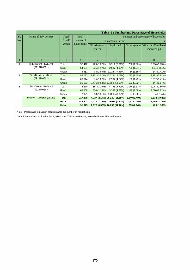
Pit Piped sewer
systemSeptic tank Other system With slab/Ventilated
improved pit
1 2 3 4 5 6 7 81 Total 57,412 729 (1.27%) 3,911 (6.81%) 782 (1.36%) 2,086 (3.63%)
Rural 54,131 635 (1.17%) 2,687 (4.96%) 728 (1.34%) 1,843 (3.4%)Urban 3,281 94 (2.86%) 1,224 (37.31%) 54 (1.65%) 243 (7.41%)
2 Total 88,187 3,151 (3.57%) 16,573 (18.79%) 1,282 (1.45%) 2,481 (2.81%)Rural 63,014 675 (1.07%) 2,984 (4.74%) 1,100 (1.75%) 2,337 (3.71%)Urban 25,173 2,476 (9.84%) 13,589 (53.98%) 182 (0.72%) 144 (0.57%)
3 Total 72,279 857 (1.19%) 4,765 (6.59%) 1,176 (1.63%) 2,067 (2.86%)Rural 69,358 804 (1.16%) 3,339 (4.81%) 1,149 (1.66%) 2,026 (2.92%)Urban 2,921 53 (1.81%) 1,426 (48.82%) 27 (0.92%) 41 (1.4%)Total 217,878 4,737 (2.17%) 25,249 (11.59%) 3,240 (1.49%) 6,634 (3.04%)Rural 186,503 2,114 (1.13%) 9,010 (4.83%) 2,977 (1.6%) 6,206 (3.33%)Urban 31,375 2,623 (8.36%) 16,239 (51.76%) 263 (0.84%) 428 (1.36%)
Data Source:-Census of India, 2011, HH- series Tables on Houses, Household amenities and assets.
Note: Percentage is given in brackets after the number of households.
Sub-District - Talbehat (0916700861)
Sub-District - Lalitpur (0916700862)
Sub-District - Mahroni (0916700863)
District - Lalitpur (09167)
Table -5 : Number and Percentage of Households Sl. No.
Name of Sub-District Total/ Rural/ Urban
Total number of households
Flush/Pour latrine Number and percentage of households
170
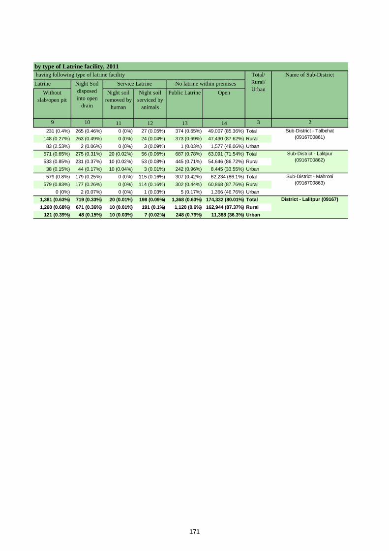
LatrineWithout
slab/open pitNight soil
removed by human
Night soil serviced by
animals
Public Latrine Open
9 10 11 12 13 14 3 2231 (0.4%) 265 (0.46%) 0 (0%) 27 (0.05%) 374 (0.65%) 49,007 (85.36%) Total
148 (0.27%) 263 (0.49%) 0 (0%) 24 (0.04%) 373 (0.69%) 47,430 (87.62%) Rural83 (2.53%) 2 (0.06%) 0 (0%) 3 (0.09%) 1 (0.03%) 1,577 (48.06%) Urban
571 (0.65%) 275 (0.31%) 20 (0.02%) 56 (0.06%) 687 (0.78%) 63,091 (71.54%) Total533 (0.85%) 231 (0.37%) 10 (0.02%) 53 (0.08%) 445 (0.71%) 54,646 (86.72%) Rural38 (0.15%) 44 (0.17%) 10 (0.04%) 3 (0.01%) 242 (0.96%) 8,445 (33.55%) Urban579 (0.8%) 179 (0.25%) 0 (0%) 115 (0.16%) 307 (0.42%) 62,234 (86.1%) Total
579 (0.83%) 177 (0.26%) 0 (0%) 114 (0.16%) 302 (0.44%) 60,868 (87.76%) Rural0 (0%) 2 (0.07%) 0 (0%) 1 (0.03%) 5 (0.17%) 1,366 (46.76%) Urban
1,381 (0.63%) 719 (0.33%) 20 (0.01%) 198 (0.09%) 1,368 (0.63%) 174,332 (80.01%) Total1,260 (0.68%) 671 (0.36%) 10 (0.01%) 191 (0.1%) 1,120 (0.6%) 162,944 (87.37%) Rural
121 (0.39%) 48 (0.15%) 10 (0.03%) 7 (0.02%) 248 (0.79%) 11,388 (36.3%) Urban
Sub-District - Talbehat (0916700861)
Sub-District - Lalitpur (0916700862)
Sub-District - Mahroni (0916700863)
District - Lalitpur (09167)
by type of Latrine facility, 2011Name of Sub-District
No latrine within premisesNight Soil disposed into open
drain
Service Latrine having following type of latrine facility Total/
Rural/ Urban
171
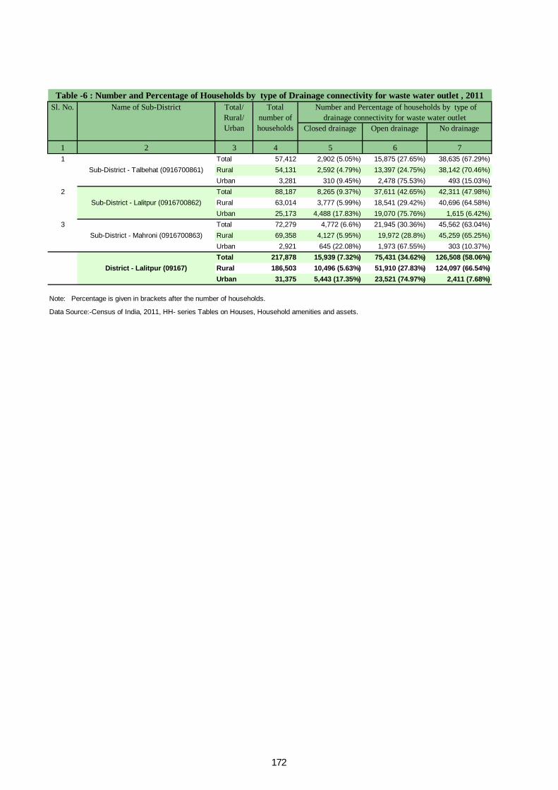
Closed drainage Open drainage No drainage
1 2 3 4 5 6 71 Total 57,412 2,902 (5.05%) 15,875 (27.65%) 38,635 (67.29%)
Rural 54,131 2,592 (4.79%) 13,397 (24.75%) 38,142 (70.46%)Urban 3,281 310 (9.45%) 2,478 (75.53%) 493 (15.03%)
2 Total 88,187 8,265 (9.37%) 37,611 (42.65%) 42,311 (47.98%)Rural 63,014 3,777 (5.99%) 18,541 (29.42%) 40,696 (64.58%)Urban 25,173 4,488 (17.83%) 19,070 (75.76%) 1,615 (6.42%)
3 Total 72,279 4,772 (6.6%) 21,945 (30.36%) 45,562 (63.04%)Rural 69,358 4,127 (5.95%) 19,972 (28.8%) 45,259 (65.25%)Urban 2,921 645 (22.08%) 1,973 (67.55%) 303 (10.37%)Total 217,878 15,939 (7.32%) 75,431 (34.62%) 126,508 (58.06%)Rural 186,503 10,496 (5.63%) 51,910 (27.83%) 124,097 (66.54%)Urban 31,375 5,443 (17.35%) 23,521 (74.97%) 2,411 (7.68%)
Data Source:-Census of India, 2011, HH- series Tables on Houses, Household amenities and assets.
Note: Percentage is given in brackets after the number of households.
Sub-District - Talbehat (0916700861)
Sub-District - Lalitpur (0916700862)
Sub-District - Mahroni (0916700863)
District - Lalitpur (09167)
Table -6 : Number and Percentage of Households by type of Drainage connectivity for waste water outlet , 2011 Sl. No. Name of Sub-District Total/
Rural/ Urban
Total number of households
Number and Percentage of households by type of drainage connectivity for waste water outlet
172

Has kitchen Does not have kitchen
Has kitchen Does not have kitchen
1 2 3 4 5 6 7 8 91 Total 57,412 13,279 (23.13%) 37,608 (65.51%) 1,947 (3.39%) 4,517 (7.87%) 61 (0.11%)
Rural 54,131 11,713 (21.64%) 36,262 (66.99%) 1,848 (3.41%) 4,255 (7.86%) 53 (0.1%)Urban 3,281 1,566 (47.73%) 1,346 (41.02%) 99 (3.02%) 262 (7.99%) 8 (0.24%)
2 Total 88,187 30,286 (34.34%) 51,577 (58.49%) 2,082 (2.36%) 4,110 (4.66%) 132 (0.15%)Rural 63,014 16,479 (26.15%) 41,034 (65.12%) 1,709 (2.71%) 3,736 (5.93%) 56 (0.09%)Urban 25,173 13,807 (54.85%) 10,543 (41.88%) 373 (1.48%) 374 (1.49%) 76 (0.3%)
3 Total 72,279 23,459 (32.46%) 44,882 (62.1%) 1,404 (1.94%) 2,434 (3.37%) 100 (0.14%)Rural 69,358 21,888 (31.56%) 43,620 (62.89%) 1,370 (1.98%) 2,385 (3.44%) 95 (0.14%)Urban 2,921 1,571 (53.78%) 1,262 (43.2%) 34 (1.16%) 49 (1.68%) 5 (0.17%)Total 217,878 67,024 (30.76%) 134,067 (61.53%) 5,433 (2.49%) 11,061 (5.08%) 293 (0.13%)Rural 186,503 50,080 (26.85%) 120,916 (64.83%) 4,927 (2.64%) 10,376 (5.56%) 204 (0.11%)Urban 31,375 16,944 (54%) 13,151 (41.92%) 506 (1.61%) 685 (2.18%) 89 (0.28%)
Data Source:-Census of India, 2011, HH- series Tables on Houses, Household amenities and assets.
Table -7 : Number and Percentage of Households by availablity of Kitchen facility, 2011Sl. No.
Name of Sub-District
Total/ Rural/ Urban
Total number of households
Number and Percentage of households having kitchenCooking inside house Cooking outside house No cooking
Note: Percentage is given in brackets after the number of households.
Sub-District - Talbehat
(0916700861)
Sub-District - Lalitpur
(0916700862)
Sub-District - Mahroni
(0916700863)
District - Lalitpur (09167)
173

Firewood Crop residue Cowdung cake Coal/ lignite/ charcoal
1 2 3 4 5 6 7 81 Total 57,412 49,379 (86.01%) 1,498 (2.61%) 2,868 (5%) 10 (0.02%)
Rural 54,131 47,895 (88.48%) 1,439 (2.66%) 2,727 (5.04%) 8 (0.01%)Urban 3,281 1,484 (45.23%) 59 (1.8%) 141 (4.3%) 2 (0.06%)
2 Total 88,187 62,912 (71.34%) 1,444 (1.64%) 8,702 (9.87%) 99 (0.11%)Rural 63,014 52,222 (82.87%) 1,065 (1.69%) 8,234 (13.07%) 20 (0.03%)Urban 25,173 10,690 (42.47%) 379 (1.51%) 468 (1.86%) 79 (0.31%)
3 Total 72,279 61,510 (85.1%) 1,229 (1.7%) 6,364 (8.8%) 17 (0.02%)Rural 69,358 60,288 (86.92%) 1,201 (1.73%) 6,007 (8.66%) 17 (0.02%)Urban 2,921 1,222 (41.83%) 28 (0.96%) 357 (12.22%) 0 (0%)Total 217,878 173,801 (79.77%) 4,171 (1.91%) 17,934 (8.23%) 126 (0.06%)Rural 186,503 160,405 (86.01%) 3,705 (1.99%) 16,968 (9.1%) 45 (0.02%)Urban 31,375 13,396 (42.7%) 466 (1.49%) 966 (3.08%) 81 (0.26%)
Data Source:-Census of India, 2011, HH- series Tables on Houses, Household amenities and assets.
Number and percentage of households bySl. No.
Name of Sub-District Total/ Rural/ Urban
Total number of households
Table -8 : Number and Percentage of Households
Note: Percentage is given in brackets after the number of households.
Sub-District - Talbehat (0916700861)
Sub-District - Lalitpur (0916700862)
Sub-District - Mahroni (0916700863)
District - Lalitpur (09167)
174

Kerosene LPG/ PNG Electricity Bio-gas Any other No cooking
9 10 11 12 13 14 3 272 (0.13%) 3,443 (6%) 41 (0.07%) 8 (0.01%) 32 (0.06%) 61 (0.11%) Total26 (0.05%) 1,911 (3.53%) 39 (0.07%) 7 (0.01%) 26 (0.05%) 53 (0.1%) Rural46 (1.4%) 1,532 (46.69%) 2 (0.06%) 1 (0.03%) 6 (0.18%) 8 (0.24%) Urban
398 (0.45%) 14,376 (16.3%) 52 (0.06%) 20 (0.02%) 52 (0.06%) 132 (0.15%) Total33 (0.05%) 1,303 (2.07%) 42 (0.07%) 10 (0.02%) 29 (0.05%) 56 (0.09%) Rural
365 (1.45%) 13,073 (51.93%) 10 (0.04%) 10 (0.04%) 23 (0.09%) 76 (0.3%) Urban55 (0.08%) 2,901 (4.01%) 26 (0.04%) 16 (0.02%) 61 (0.08%) 100 (0.14%) Total50 (0.07%) 1,601 (2.31%) 26 (0.04%) 14 (0.02%) 59 (0.09%) 95 (0.14%) Rural5 (0.17%) 1,300 (44.51%) 0 (0%) 2 (0.07%) 2 (0.07%) 5 (0.17%) Urban
525 (0.24%) 20,720 (9.51%) 119 (0.05%) 44 (0.02%) 145 (0.07%) 293 (0.13%) Total109 (0.06%) 4,815 (2.58%) 107 (0.06%) 31 (0.02%) 114 (0.06%) 204 (0.11%) Rural416 (1.33%) 15,905 (50.69%) 12 (0.04%) 13 (0.04%) 31 (0.1%) 89 (0.28%) Urban
by type of fuel used for Cooking, 2011 availability of fuel used for cooking Name of Sub-DistrictTotal/
Rural/ Urban
Sub-District - Talbehat (0916700861)
Sub-District - Lalitpur (0916700862)
Sub-District - Mahroni (0916700863)
District - Lalitpur (09167)
175

Radio/ Transistor Television Computer/ laptop- With Internet
Computer/ laptop- Without Internet
1 2 3 4 5 6 7 8 91 Total 57,412 39,946 (69.58%) 9,056 (15.77%) 10,565 (18.4%) 224 (0.39%) 2,430 (4.23%)
Rural 54,131 37,742 (69.72%) 8,691 (16.06%) 8,489 (15.68%) 165 (0.3%) 2,176 (4.02%)Urban 3,281 2,204 (67.17%) 365 (11.12%) 2,076 (63.27%) 59 (1.8%) 254 (7.74%)
2 Total 88,187 58,203 (66%) 13,642 (15.47%) 28,821 (32.68%) 642 (0.73%) 3,682 (4.18%)Rural 63,014 43,309 (68.73%) 11,304 (17.94%) 12,533 (19.89%) 105 (0.17%) 1,860 (2.95%)Urban 25,173 14,894 (59.17%) 2,338 (9.29%) 16,288 (64.7%) 537 (2.13%) 1,822 (7.24%)
3 Total 72,279 50,577 (69.97%) 16,577 (22.93%) 14,138 (19.56%) 213 (0.29%) 2,715 (3.76%)Rural 69,358 48,297 (69.63%) 15,964 (23.02%) 12,221 (17.62%) 174 (0.25%) 2,619 (3.78%)Urban 2,921 2,280 (78.06%) 613 (20.99%) 1,917 (65.63%) 39 (1.34%) 96 (3.29%)Total 217,878 148,726 (68.26%) 39,275 (18.03%) 53,524 (24.57%) 1,079 (0.5%) 8,827 (4.05%)Rural 186,503 129,348 (69.35%) 35,959 (19.28%) 33,243 (17.82%) 444 (0.24%) 6,655 (3.57%)Urban 31,375 19,378 (61.76%) 3,316 (10.57%) 20,281 (64.64%) 635 (2.02%) 2,172 (6.92%)
Table -9 : Number and Percentage of Households availing Banking services and Total
number of
households
Total number of households
availing banking services
Number and percentage of households Sl. No.
Name of Sub-District
Total/ Rural/ Urban
Data Source:-Census of India, 2011, HH- series Tables on Houses, Household amenities and assets.Note: Percentage is given in brackets after the number of households.
Sub-District - Talbehat
(0916700861)
Sub-District - Lalitpur
(0916700862)
Sub-District - Mahroni
(0916700863)
District - Lalitpur (09167)
176
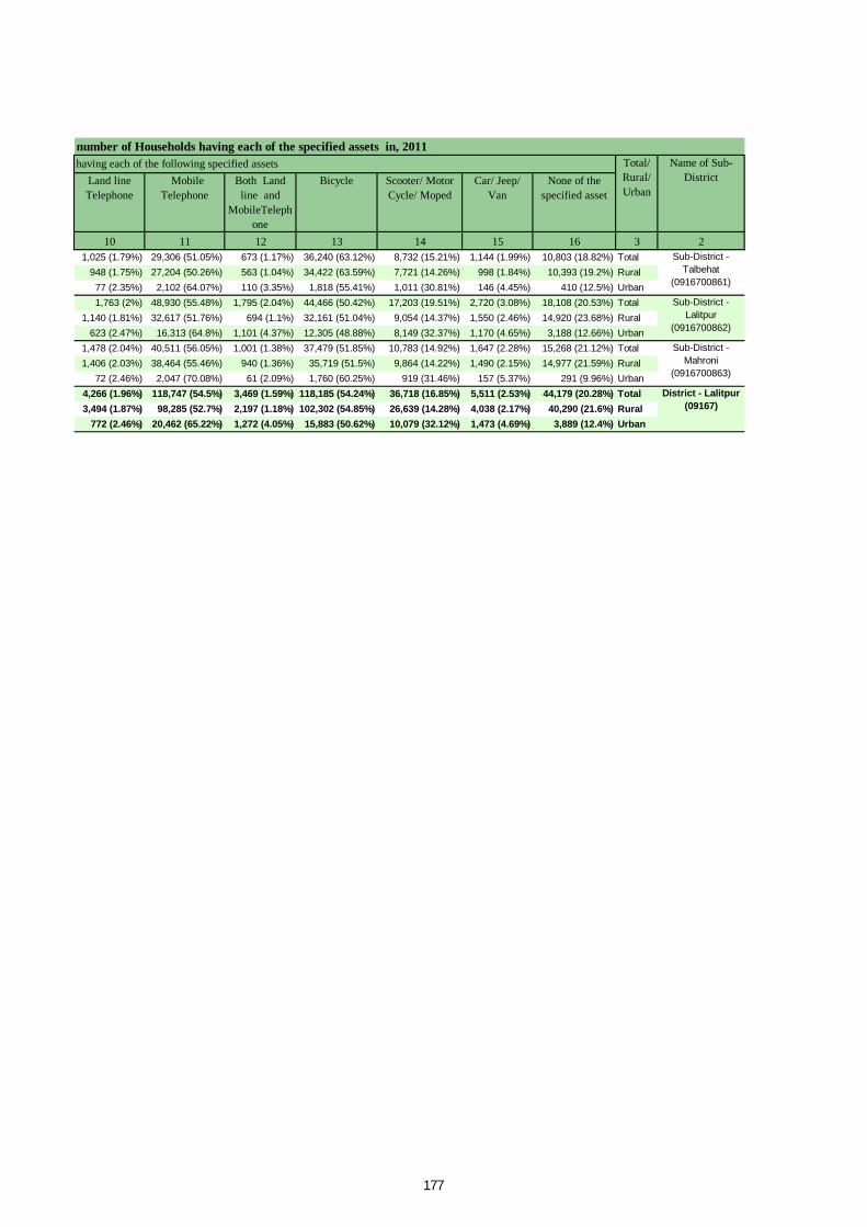
Land line Telephone
Mobile Telephone
Both Land line and
MobileTelephone
Bicycle Scooter/ Motor Cycle/ Moped
Car/ Jeep/ Van
None of the specified asset
10 11 12 13 14 15 16 3 21,025 (1.79%) 29,306 (51.05%) 673 (1.17%) 36,240 (63.12%) 8,732 (15.21%) 1,144 (1.99%) 10,803 (18.82%) Total
948 (1.75%) 27,204 (50.26%) 563 (1.04%) 34,422 (63.59%) 7,721 (14.26%) 998 (1.84%) 10,393 (19.2%) Rural77 (2.35%) 2,102 (64.07%) 110 (3.35%) 1,818 (55.41%) 1,011 (30.81%) 146 (4.45%) 410 (12.5%) Urban1,763 (2%) 48,930 (55.48%) 1,795 (2.04%) 44,466 (50.42%) 17,203 (19.51%) 2,720 (3.08%) 18,108 (20.53%) Total
1,140 (1.81%) 32,617 (51.76%) 694 (1.1%) 32,161 (51.04%) 9,054 (14.37%) 1,550 (2.46%) 14,920 (23.68%) Rural623 (2.47%) 16,313 (64.8%) 1,101 (4.37%) 12,305 (48.88%) 8,149 (32.37%) 1,170 (4.65%) 3,188 (12.66%) Urban
1,478 (2.04%) 40,511 (56.05%) 1,001 (1.38%) 37,479 (51.85%) 10,783 (14.92%) 1,647 (2.28%) 15,268 (21.12%) Total1,406 (2.03%) 38,464 (55.46%) 940 (1.36%) 35,719 (51.5%) 9,864 (14.22%) 1,490 (2.15%) 14,977 (21.59%) Rural
72 (2.46%) 2,047 (70.08%) 61 (2.09%) 1,760 (60.25%) 919 (31.46%) 157 (5.37%) 291 (9.96%) Urban4,266 (1.96%) 118,747 (54.5%) 3,469 (1.59%) 118,185 (54.24%) 36,718 (16.85%) 5,511 (2.53%) 44,179 (20.28%) Total3,494 (1.87%) 98,285 (52.7%) 2,197 (1.18%) 102,302 (54.85%) 26,639 (14.28%) 4,038 (2.17%) 40,290 (21.6%) Rural
772 (2.46%) 20,462 (65.22%) 1,272 (4.05%) 15,883 (50.62%) 10,079 (32.12%) 1,473 (4.69%) 3,889 (12.4%) Urban
number of Households having each of the specified assets in, 2011 having each of the following specified assets Name of Sub-
DistrictTotal/ Rural/ Urban
Sub-District - Talbehat
(0916700861)
Sub-District - Lalitpur
(0916700862)
Sub-District - Mahroni
(0916700863)
District - Lalitpur (09167)
177


ORGI-UTTAR PRADESH English – (10-2011)
Directorate of Census Operations, Uttar Pradesh,Janganana Bhawan
Plot No. CC-I,Sector-G,Aliganj Lucknow - 226024
Email: [email protected] Website: http://www.censusindia.gov.in