Bulletin of the Massachusetts Archaeological Society, Vol. 81 ...
50
Bridgewater State University Bridgewater State University Virtual Commons - Bridgewater State University Virtual Commons - Bridgewater State University Bulletin of the Massachusetts Archaeological Society Journals and Campus Publications 2020 Bulletin of the Massachusetts Archaeological Society, Vol. 81, No. Bulletin of the Massachusetts Archaeological Society, Vol. 81, No. 1-2 1-2 Massachusetts Archaeological Society Follow this and additional works at: https://vc.bridgew.edu/bmas Part of the Archaeological Anthropology Commons Copyright Copyright © 2020 Massachusetts Archaeological Society This item is available as part of Virtual Commons, the open-access institutional repository of Bridgewater State University, Bridgewater, Massachusetts.
-
Upload
khangminh22 -
Category
Documents
-
view
2 -
download
0
Transcript of Bulletin of the Massachusetts Archaeological Society, Vol. 81 ...
Bridgewater State University Bridgewater State University
Virtual Commons - Bridgewater State University Virtual Commons - Bridgewater State University
Bulletin of the Massachusetts Archaeological Society Journals and Campus Publications
2020
Bulletin of the Massachusetts Archaeological Society, Vol. 81, No. Bulletin of the Massachusetts Archaeological Society, Vol. 81, No.
1-2 1-2
Massachusetts Archaeological Society
Follow this and additional works at: https://vc.bridgew.edu/bmas
Part of the Archaeological Anthropology Commons
Copyright Copyright © 2020 Massachusetts Archaeological Society
This item is available as part of Virtual Commons, the open-access institutional repository of Bridgewater State University, Bridgewater, Massachusetts.

PUBLISHED BY THE MASSACHUSETTS ARCHAEOLOGICAL SOCIETY, INC.
THE BULLETINof the Massachusetts Archaeological SocietyVolume 81, Number 1 – 2 Spring–Fall 2020
Bulletin of the Massachusetts Archaeological SocietyOctober 2020 1Vol. 81 (1-2) Bulletin of the Massachusetts Archaeological Society 2020, Vol. 81(1-2)
THE MASSACHUSETTS ARCHAEOLOGICAL SOCIETY, INC.Robbins Museum of Archaeology
www.masarchaeology.orgPhone: (508) 947 9005
E-mail: [email protected]
Position President
Vice PresidentClerk
Treasurer Museum Director
Bulletin Editor Corresponding Secretary
Past President
Term Expires November 2020 November 2020November 2020
November 2020
November 2020 November 2020 November 2020
Term Expires November 2022 November 2022 November 2022 November 2021 November 2021 November 2020 November 2020
MHC RepresentativeNewsletter Editor
Officers Suanna Selby Crowley Victor Mastone Grace Bello
David Burbine Vacant Ryan Wheeler David McKenna Philip Graham
Trustees: Ellen Berkland Eric Lott John Rempelakis Gregory M. Lott Lindsay Randall Alan F. Smith Linda Coombs
Suanna Selby Crowley Philip Graham Laurie Stundis Administrative Assistant
The Bulletin of the Massachusetts Archaeological Society is published semi-annually, with a spring issue (Number 1) and a fall issue (Number 2). Individual memberships in the Society that include the Bulletin are $30. Please visit our website or contact the Massachusetts Archaeological Society, P.O. Box 700, Middleborough MA 02346 (508.947.9005) for information on institutional subscriptions and other special membership rates, as well as requests for back issues of the Bulletin. Send manuscript submissions and comments to the editor, Ryan Wheeler, at [email protected].
Printed by Bookmobile.com ISSN 0148 1886
Bulletin of theMassachusetts Archaeological Society
Volume 81, Number 1 – 2October 2020
Table of Contents
Editor’s Notes Ryan Wheeler ...................................................................................................................................... 2
Rememberance: Frederica Rockefeller Dimmick (1934 - 2019) Tonya Baroody Largy, Ian W. Brown, John Rempelakis, William A. Griswold, William P. Burke, and Philip Graham ................................................................................................... 3
New Directions on Old Roads: A History of Transportation Archaeology in Massachusetts John Rempelakis ................................................................................................................................ 11
Discovery of a Small, Isolated, High-Density Lithic Workshop in Interior Massachusetts Alan E. Strauss ................................................................................................................................... 27
Post-Contact Upland Sites near Lake Chaubunagungamaug Martin G. Dudek ................................................................................................................................ 49
Native Agricultural Villages in Essex County: Archaeological and Ethnohistorical Evidence Mary Ellen Lepionka .......................................................................................................................... 65
Contributors ............................................................................................................................................... 91
Bulletin of the Massachusetts Archaeological Society 32019, Vol. 80(1-2)
Bulletin of the Massachusetts Archaeological Society Vol. 81 (1-2), 20202
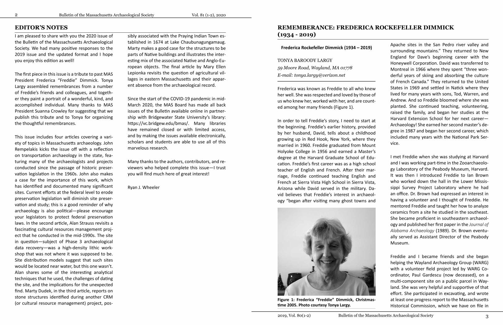
REMEMBERANCE: FREDERICA ROCKEFELLER DIMMICK (1934 - 2019)
Frederica Rockefeller Dimmick (1934 – 2019)
TONYA BAROODY LARGY 59 Moore Road, Wayland, MA 01778 E-mail: [email protected]
Frederica was known as Freddie to all who knew her well. She was respected and loved by those of us who knew her, worked with her, and are count-ed among her many friends (Figure 1).
In order to tell Freddie’s story, I need to start at the beginning. Freddie’s earlier history, provided by her husband, David, tells about a childhood growing up in Red Hook, New York, where they married in 1960. Freddie graduated from Mount Holyoke College in 1956 and earned a Master’s degree at the Harvard Graduate School of Edu-cation. Freddie’s first career was as a high school teacher of English and French. After their mar-riage, Freddie continued teaching English and French at Sierra Vista High School in Sierra Vista, Arizona while David served in the military. Da-vid believes that Freddie’s interest in archaeol-ogy “began after visiting many ghost towns and
Apache sites in the San Pedro river valley and surrounding mountains.” They returned to New England for Dave’s beginning career with the Honeywell Corporation. David was transferred to Montreal in 1966 where they spent “three won-derful years of skiing and absorbing the culture of French Canada.” They returned to the United States in 1969 and settled in Natick where they lived for many years with sons, Tod, Warren, and Andrew. And so Freddie bloomed where she was planted. She continued teaching, volunteering, raised the family, and began her studies at the Harvard Extension School for her next career—Archaeology! She earned her second master’s de-gree in 1987 and began her second career, which included many years with the National Park Ser-vice.
I met Freddie when she was studying at Harvard and I was working part-time in the Zooarchaeolo-gy Laboratory of the Peabody Museum, Harvard. It was then I introduced Freddie to Ian Brown who worked down the hall in the Lower Missis-sippi Survey Project Laboratory where he had an office. Dr. Brown had expressed an interest in having a volunteer and I thought of Freddie. He mentored Freddie and taught her how to analyze ceramics from a site he studied in the southeast. She became proficient in southeastern archaeol-ogy and published her first paper in the Journal of Alabama Archaeology (1989). Dr. Brown eventu-ally served as Assistant Director of the Peabody Museum.
Freddie and I became friends and she began helping the Wayland Archaeology Group (WARG) with a volunteer field project led by WARG Co-ordinator, Paul Gardescu (now deceased), on a multi-component site on a public parcel in Way-land. She was very helpful and supportive of that effort. She participated in excavating, and wrote at least one progress report to the Massachusetts Historical Commission, which we have on file in
EDITOR’S NOTESI am pleased to share with you the 2020 issue of the Bulletin of the Massachusetts Archaeological Society. We had many positive responses to the 2019 issue and the updated format and I hope you enjoy this edition as well!
The first piece in this issue is a tribute to past MAS President Frederica “Freddie” Dimmick. Tonya Largy assembled remembrances from a number of Freddie’s friends and colleagues, and togeth-er they paint a portrait of a wonderful, kind, and accomplished individual. Many thanks to MAS President Suanna Crowley for suggesting that we publish this tribute and to Tonya for organizing the thoughtful remembrances.
This issue includes four articles covering a vari-ety of topics in Massachusetts archaeology. John Rempelakis kicks the issue off with a reflection on transportation archaeology in the state, fea-turing many of the archaeologists and projects conducted since the passage of historic preser-vation legislation in the 1960s. John also makes a case for the importance of this work, which has identified and documented many significant sites. Current efforts at the federal level to erode preservation legislation will diminish site preser-vation and study; this is a good reminder of why archaeology is also political—please encourage your legislators to protect federal preservation laws. In the second article, Alan Strauss revisits a fascinating cultural resources management proj-ect that he conducted in the mid-1990s. The site in question—subject of Phase 3 archaeological data recovery—was a high-density lithic work-shop that was not where it was supposed to be. Site distribution models suggest that such sites would be located near water, but this one wasn’t. Alan shares some of the interesting analytical techniques that he used, the challenges of dating the site, and the implications for the unexpected find. Marty Dudek, in the third article, reports on stone structures identified during another CRM (or cultural resource management) project, pos-
sibly associated with the Praying Indian Town es-tablished in 1674 at Lake Chaubunagungamaug. Marty makes a good case for the structures to be parts of Native buildings and illustrates the inter-esting mix of the associated Native and Anglo-Eu-ropean objects. The final article by Mary Ellen Lepionka revisits the question of agricultural vil-lages in eastern Massachusetts and their appar-ent absence from the archaeological record.
Since the start of the COVID-19 pandemic in mid-March 2020, the MAS Board has made all back issues of the Bulletin available online in partner-ship with Bridgewater State University’s library: https://vc.bridgew.edu/bmas/. Many libraries have remained closed or with limited access, and by making the issues available electronically, scholars and students are able to use all of this marvelous research.
Many thanks to the authors, contributors, and re-viewers who helped complete this issue—I trust you will find much here of great interest!
Ryan J. Wheeler
Figure 1: Frederica “Freddie” Dimmick, Christmas-time 2005. Photo courtesy Tonya Largy.

Bulletin of the Massachusetts Archaeological Society Vol. 81 (1-2), 20204 5 Frederica Rockefeller Dimmick (1934 - 2019)
resources. The consistent theme in all or our re-lationships with Freddie is her kindness and gra-ciousness to everyone she encountered. She is greatly missed.
Recollections of Frederica R. Dimmick at Harvard University’s Peabody Museum of
Archaeology and Ethnology
IAN W. BROWN15 Guildswood Tuscaloosa, AL 35401 E-mail: [email protected]
I first met Freddie in October of 1983 (Figure 2). I was a Research Associate at the Peabody Mu-seum at the time and had just returned from a summer excavating sites in Natchez, Mississippi. In the past, I occasionally took on volunteers in the field and lab, but unfortunately, they seldom worked out. However, when this mature, sophis-ticated woman came into the Lower Mississippi Survey (LMS) office one day and expressed an in-terest in archaeology and a desire to work, I de-cided to sign her on. Every Wednesday afternoon, week after week, Freddie would arrive at the LMS lab ready to have a go at whatever I had on hand for her to do. I had an undergraduate assistant at
the time, Liz Reid (now Dr. Elizabeth Kryder-Reid) so for the first few weeks I just had Freddie team up with her, primarily learning how to sort pot-tery and develop photos. Seldom do volunteers persist for more than a few weeks at this unglam-orous work, but Freddie just kept coming back. In addition to learning how to classify Natchez Indi-an pottery and lithics, I put her on to handling site files, organizing the Louisiana Petite Anse Project type collection, and even translating a French ac-count for a paper that I was writing on Plaque-mine culture architecture. Whatever I gave her to do, she always took on with a relish. In my journal entry for January 5, 1983, I made note, "Hadn’t expected her in today, but it’s always nice to have the help." And indeed it was. I knew that I could always depend on Freddie, even in the first week of a new year.
I remained in my post with the LMS for another year, until becoming Associate Curator of North American Collections at the Peabody, and all through that year Freddie was a constant help. Her energy and dedication led to her taking an-thropology classes in Harvard's Extension School, starting with Stephen Williams’ North Ameri-can Archaeology course. Then she took a couple of classes that I myself taught in the Extension School, at which time she met and teamed up with three other women, all of whom were ex-ploring other career directions. These four wom-en—Penelope (Penny) Drooker, Antoinette (Toni) Wallace, Eva Fridman, and Freddie—became sol-id friends, eventually colleagues, and for many years thereafter attended archaeological confer-ences together and contributed papers. They all wrote Masters theses and received their M.A. de-grees in the Extension School program, and Pen-ny and Eva then went on to earn their doctorates. Freddie, meanwhile, was getting more and more involved in Southeastern archaeology in her role as a Curatorial Research Assistant for me at the Peabody, which she assumed in 1987 and contin-ued until my own curatorial role ended in 1990.
the WARG laboratory. She served as Assistant Coordinator of the Wayland Archaeology Group from 1985-1989.
Freddie also assisted the Medfield, Massachu-setts Historical Commission to learn about their cultural resources as they organized a group of interested citizens to record and safeguard ar-chaeological sites. John Thompson worked with Freddie in Medfield and shared that Freddie “was such a good friend, and so patient teaching us about archaeology. What a thoughtful person she was” (J. Thompson, personal communication). After earning her Master’s degree (A.L.M.) in 1987, Freddie did professional fieldwork and re-search for the Public Archaeology Laboratory, Inc. in Rhode Island.
Freddie had a long career with the National Park Service (NPS). I believe her first experience on an NPS project was working as a volunteer with me, while she was a student at Harvard and also vol-unteering in Wayland and Medfield. In the 1980s, I had an appointment as an on-call field archae-ologist for the National Park Service. In the mid-1980s, Dick Ping-Hsu, then Director of the North-east Regional Office of the National Park Service (retired), assigned me to a project at the Long-fellow House Washington’s Headquarters Nation-al Historic Site on Brattle Street in Cambridge, Massachusetts. I was the sole person doing the project under Dick’s direction and I desired a companion! I asked Dick if I could invite Freddie to help me as a volunteer and he said yes. I don’t believe that would happen today! Freddie came to dig on days when she was available and was a wonderful helper. On those days, we were able to do the work faster together than just one person could do working alone. After her studies, Dick suggested she apply for a position and thus her career began. The next time I worked with her in the field was in 1990, as part of the team exca-vation at the Carns site at the Cape Cod National Seashore, led by Linda Towle and George Stillson (Bradley 2005).
Freddie’s experience and keen interest in archae-ological issues led her to service on the Massa-chusetts Archaeological Society’s (MAS) Board of Trustees. While working at the Cape Cod Na-tional Seashore, in 2009, Freddie followed me as President of the Society and served two three-year terms. Philip Graham, Ph.D., who followed Freddie as MAS President said she “led the MAS through some challenging times, and she did so with a quiet, confident leadership that I very much appreciated as a Board member (P. Gra-ham, personal communication).”
Many people contributed to this tribute to a very special person. I would like to thank Su-anna Crowley, President of the Massachusetts Archaeological Society, who asked me to write this tribute on behalf of the Board of Trustees. Freddie’s husband and colleagues over the years were most helpful to me in sharing information and their remembrances of Freddie. I would like to acknowledge their contributions about her life and career without which this tribute would not be as informative. David Dimmick, Freddie’s husband, told me about Freddie’s early history and their life together. Ian Brown tells us about Freddie’s experience in his laboratory at Har-vard University where he mentored her interest in ceramics, helping her gain expertise in south-eastern archaeology. John Rempelakis shared his early relationship with Freddie as she developed her career and their work together on the Board of the Massachusetts Archaeological Society. Bill Griswold and Bill Burke both shared their memo-ries of working with Freddie on various projects with the National Park Service. Bill Burke close-ly worked with Freddie at the Cape Cod National Seashore for the last fifteen years of her career. Philip Graham is Past President of the Massachu-setts Archaeological Society, and as such worked with Freddie who preceded him. I preceded Fred-die as President of the Society, and we worked together for several years. Both John Thompson and myself knew Freddie “way back when” in the 1980s as she was beginning her career while as-sisting his efforts in Medfield and our efforts in Wayland to learn about and protect our cultural
Figure 2. Ian Brown and Freddie Dimmick (left). Pho-to courtesy Ian Brown.
Bulletin of the Massachusetts Archaeological Society Vol. 81 (1-2), 20206 7 Frederica Rockefeller Dimmick (1934 - 2019)
Frederica Dimmick and the National Park Service
WILLIAM A. GRISWOLD, PH.D.Archeology Branch, Northeast Cultural Re-sources Center, Northeast Region, National Park Service, 115 John Street, Lowell, MA 01852 E-mail: [email protected]
I first met Freddie at the Job Brooks House at Minute Man National Historical Park in Lincoln, Massachusetts in 1993. I had just joined NPS and her warm smile and disarming demeanor put me at ease. Even though I was new to the NPS and to CRM, Freddie graciously accepted me and began to show me the ropes. At that time, we were part of the Cultural Resources Center with our new home in Lowell, Mass. After that initial meeting, I would work with Freddie over the next decade or so on multiple projects all over the northeast.
Some of the most memorable projects that we worked on were at Women’s Rights National His-torical Park. Freddie, myself and Steve Pendery did so much work out in upstate New York in the mid to late 1990s that it almost became our home away from home. Even though this was definitely work and the projects out at WORI were done to aid the park, the projects were “fun” work. We did a whole variety of archaeological projects from testing at the Stanton House, to excavations for reconstruction at the M’Clintock House, to dis-covery of the archaeological foundations of the Chamberlain House. We really enjoyed staying at the Guion House Bed and Breakfast and eating at the Deer Head Inn. Freddie always provided a warm smile, a positive attitude, and pleasant con-versation on these trips. Maybe that’s why I have such fond memories of our time in Seneca Falls.
Freddie loved archaeology and worked in the discipline well later in life than most. Her dedica-tion to NPS projects, and her willingness to be in-volved in projects and meetings outside her NPS employment speaks volumes to her dedication
to the discipline. She served as president of the Massachusetts Archaeological Society. It was be-cause of her dedication to the discipline that she made contacts all over the northeast. While writ-ing a paper or editing a report she would always say, “well, have you talked to” so and so?
More than her archaeology skills (which were considerable), I will remember Freddie as a kind, generous, and thoughtful soul willing to go the extra mile to help out when necessary and make others around her feel comfortable. Her positive attitude and willingness to accept others was tru-ly comforting. Thank you Freddie, for making my entry and time in NPS such a warm experience. We all miss you.
Frederica Dimmick at Cape Cod National Seashore
WILLIAM P. BURKE, M.A.Cape Cod National Seashore, National Park Service, 99 Marconi Site Road, Wellfleet, MA 02667 E-mail: [email protected]
Freddie Dimmick worked for nearly 15 years as Cape Cod National Seashore’s Archeologist. Her primary job was to advise the park superinten-dent on all matters archaeological and to clear areas to be dug up by ground disturbing activi-ties. With over 5 million visitors a year and ex-tensive infrastructure to support those visitors, Freddie played a critical role as “protector” of the ground. Imagine all the fence posts needed, sep-tic systems being replaced, roads and trails being improved or relocated, and countless other new facilities that potentially could damage the rich legacy of sites on the Lower Cape from Chatham to Provincetown. With over 230 know precon-tact, contact and historical sites, and countless other “undiscovered sites,” one can only imagine how many sites Freddie saved from the bulldozer. When a new project was proposed, Freddie was there to review, comment and direct next steps.
During the eight years that Freddie volunteered at the Peabody, in addition to working with me, she volunteered for Richard S. Fuller on the Mor-gan site excavations in coastal Louisiana in 1986 and, with husband David she traveled all through-out central Alabama, familiarizing herself with the landscape for a monograph that she was writ-ing on Creek Indian archaeology. In 1975 I had done a survey of Creek sites along the Tallapoosa and Coosa river drainages that was intended to be the seed for my dissertation. For various rea-sons that seed remained dormant, or at least it did until Freddie came along. Having studied both Mississippi and Louisiana pottery, she was excit-ed to take on an independent study of Alabama material, and I was very grateful for her having done so. The result was her monograph, A Survey of Upper Creek Sites in Central Alabama, which came out in the Journal of Alabama Archaeology in 1989. It was also in 1989 that Freddie joined T. R. Kidder in Louisiana to help in his excavation of the Osceola site, which was the last Peabody Museum project that she participated in.
By the late 1980s, my wife (then Nancy, now called Easty) and I had become fast friends with Freddie and David. Our children knew them well, as we often visited their home in Natick and their wonderful farm in Cataumet on Cape Cod. For the last three decades our paths crossed sever-al times at conferences and in periodic visits that we made to New England, but they didn’t cross nearly enough. When Freddie assumed her po-sition as NPS Staff Archeologist at the Cape Na-tional Seashore in 2001, I could not have been prouder as a teacher, and then when I learned that she was elected President of the Massa-chusetts Archaeological Society I was absolutely beaming with pleasure. I can truthfully say that Freddie Dimmick was the best volunteer I have ever had; moreover, she was one of the sweetest, most gentle persons that I have known. I am so lucky to have had the chance to work with her and to have experienced her excitement, her de-termination, her commitment, and her laugh.
Frederica Dimmick and the Massachusetts Archaeological Society
JOHN REMPELAKIS7 Fairview Farm Road, Haverhill, MA 01832 E-mail: [email protected]
I initially met Freddie through her tutelage under Dr. Ian Brown at the Peabody Museum where we established a friendship that strengthened and flourished throughout the years. Although we had different research interests, we shared ideas on archaeology and a variety of other topics as the years passed. Even as she eventually went to work for the National Park Service and I moved on to administer the Archaeology Program for the Massachusetts Department of Transporta-tion, we often discussed common archaeological and regulatory issues that impacted our respec-tive agencies. Freddie was instrumental in re-cruiting me to join the MAS as a Trustee and we served together on the Board for many years. We collaborated closely in revising the MAS code of ethics and research guidelines a number of years ago. She was such a pleasure to work with. Fred-die always asked questions, not just archaeolog-ical ones, and she was the consummate listener, always willing to hear and understand different perspectives. She was smart, inquisitive, passion-ate about archaeology, education and travel and deeply concerned about the lives of others. Over the years, Freddie got to know my wife, Lynne, and I became friends with her husband, Dave. Freddie was one of a kind, is greatly missed, and will live on in our fondest memories.
Bulletin of the Massachusetts Archaeological Society Vol. 81 (1-2), 20208 9 Frederica Rockefeller Dimmick (1934 - 2019)
and learn from our conversations. I was honored to succeed her as President and attempt to car-ry on the work that she started. Today, she’s still sorely missed on the MAS Board both for her in-sights and for her kindness.
Freddie was loved and respected by those of us who knew her well. She is greatly missed by her family and she is greatly missed as a friend, col-league, and a member of the MAS. Freddie made a lasting impression in all her endeavors. Hers was a life well lived.
References Cited and Select Publications
Bradley, James W.2005 Occasional Publications in Field Archeology Number 3. Northeast Region Archeology Program, National
Park Service, U.S. Department of the Interior.
Dimmick, Frederica R. 1987 Trade Good Use by the Upper Creeks: Seeing Culture Change and Continuity through Documents, Art
and Archaeology. Unpublished M.A. thesis in Extension Studies, Harvard University, Cambridge, Massa-chusetts.
1989 A Survey of Upper Creek Sites in Central Alabama, with a Foreword by Ian W. Brown. Journal of Ala-bama Archaeology 35(2).
1991 Archaeological Investigations off the South Ell of the Golden Ball Tavern, Weston, Massachusetts. Final Report Submitted to the Massachusetts Historical Commission, Boston, Massachusetts.
1994 Creative Farmers of the Northeast: A New View of Indian Maize Horticulture. North American Archaeol-ogist 15(3):235-252.
Dimmick, Frederica R., and Leslie Sampou 1991 Clues to the Past: Archaeology at the Golden Ball Tavern. Preservation Advocate 18(2):8-9. Massachu-
setts Historical Commission, Boston, Massachusetts.
Kelso, Gerald K., Frederica R. Dimmick, David H. Dimmick, and Tonya B. Largy2006 An Ethnopalynological Test of Task-Specific Area Analysis: Bay View Stable, Cataumet, Massachusetts.
Journal of Archaeological Science 33(7):953-960.
Sometimes it meant complete avoidance of an area, or a slight tweaking of a fence alignment, or something in between. Oftentimes she was called on to perform a few test pits to gauge an area’s sensitivity. Sometimes she gave us all the “green light,” sometimes not. Other times she gave us a welcomed “alternative” approach.
Some of the sites she worked on at the Seashore included the Carnes Site, the 1730 Atwood Hig-gins House in Wellfleet, the Payet Cranberry Bog in Truro, the Salt Pond area of Eastham, the fields and swamps of Fort Hill and of course ar-eas around the famed Truro Highlands Historic District. The sites spanned early prehistory as far back as 7,000 BP, and to more recent sites asso-ciated with the Modern House movement of the Outer Cape in the 1950s. Trying to master such a span of history would challenge any archaeol-ogist, and the pressure under which she worked could run high at times as deadlines loomed for important construction projects that would keep Seashore visitors and residents safe, healthy, and satisfied. Freddie was unrelenting as the watch-dog of all the known and unknown underground resources, and she did so with an interesting blend of authority, charm and sincerity.
Yet perhaps Freddie’s greatest gift was her kind-ness, humanity, understanding, good humor and collaborative approach in all that she did. She easily shrugged off the critics and skeptics but she listened to them with respect and patience. She performed physically arduous testing and digging that would have other 20-year-olds huffing and puffing. I could always rely on her to represent the truth, and her integrity when it came to commu-nicating what was reality was unmatched. I can truly say that she earned the respect of all work groups within the park. For the maintenance staff, she told it like it was and never backed down while at the same time finding a path to completion for projects. For the law enforcement personnel, she worked closely on many pot hunting investi-gations, especially at Fresh Brook Village sites in Wellfleet and the Nauset Archeological District
disturbances in Eastham. For the natural resource scientists, she earned their trust by displaying a love and trust in data and the scientific method. And for myself as her supervisor and guide, she gave me what every boss wants: passion for what she did, accuracy in what she accomplished, and dedication to what she believed in. All in a day’s work – thanks Freddie. We all miss you here at the Seashore.
Frederica Dimmick and the Massachusetts Archaeological Society
PHILIP GRAHAM, PH.D.347 Common St, Walpole, MA 02081 E-mail: [email protected]
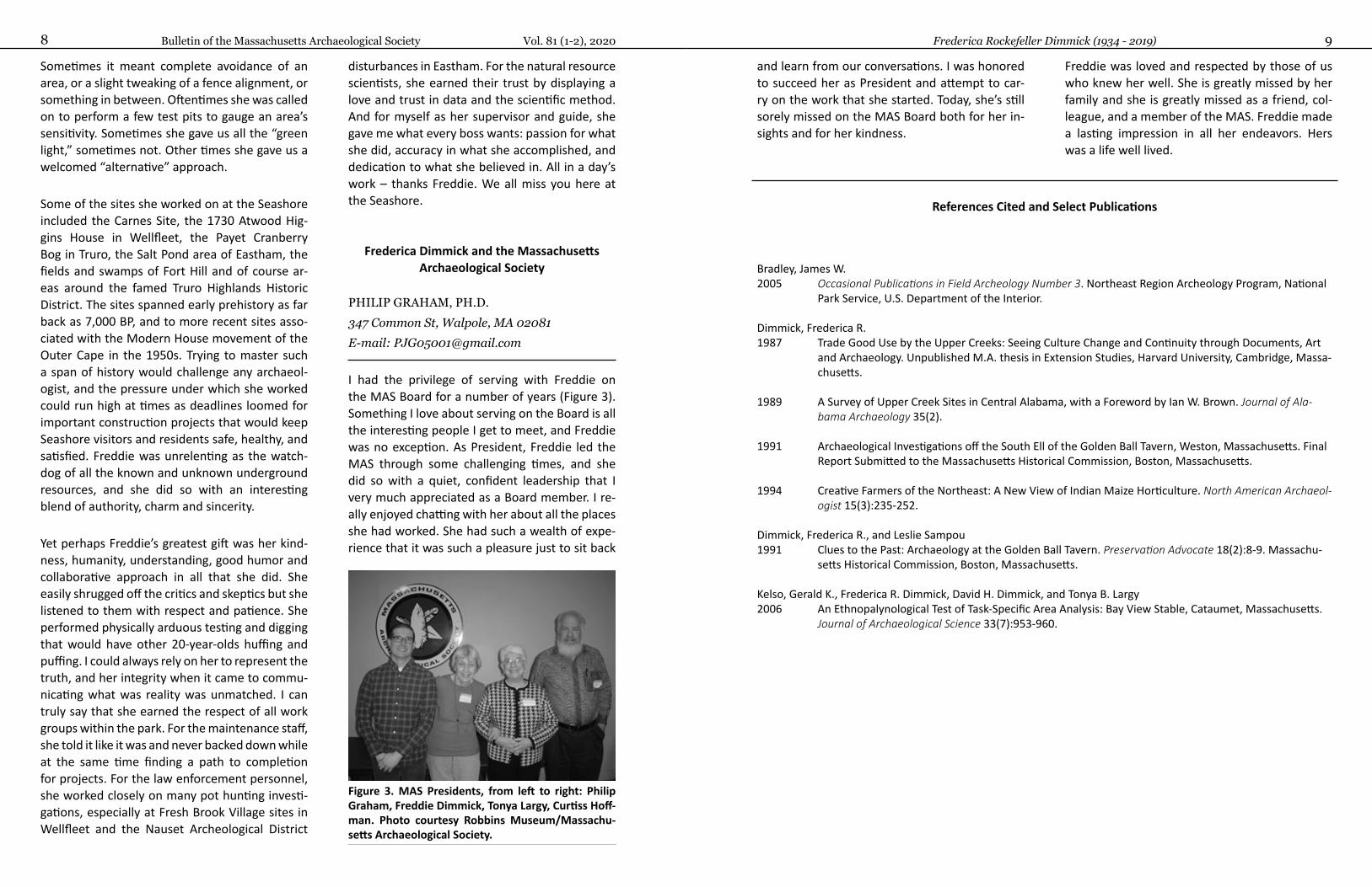
I had the privilege of serving with Freddie on the MAS Board for a number of years (Figure 3). Something I love about serving on the Board is all the interesting people I get to meet, and Freddie was no exception. As President, Freddie led the MAS through some challenging times, and she did so with a quiet, confident leadership that I very much appreciated as a Board member. I re-ally enjoyed chatting with her about all the places she had worked. She had such a wealth of expe-rience that it was such a pleasure just to sit back
Figure 3. MAS Presidents, from left to right: Philip Graham, Freddie Dimmick, Tonya Largy, Curtiss Hoff-man. Photo courtesy Robbins Museum/Massachu-setts Archaeological Society.
Bulletin of the Massachusetts Archaeological SocietyOctober 2020 11Vol. 81 (1-2) Bulletin of the Massachusetts Archaeological Society 2020, Vol. 81(1-2)
NEW DIRECTIONS ON OLD ROADS: A HISTORY OF TRANSPORTATION ARCHAEOLOGY IN MASSACHUSETTS
JOHN REMPELAKIS7 Fairview Farm Road, Haverhill, MA 01832 E-mail: [email protected]
Introduction
The fields of Archaeology and Transportation have been intertwined irrevocably from the mid-1950s. The seeds of this relationship were sown in 1956 by legislative acts under then President Eisenhower for the authorization and funding of the interstate highway system. Construction of the interstate highway system was intended to make all portions of the country easily accessi-ble, defensible and developable. Ironically, the destructive capacity of these interstate highway system projects and their impacts on natural and cultural resources helped spur the passage of federal environmental and historic preservation laws and regulations some 10 years later. These laws and regulations of the late 1960s have made the Federal Highway Administration (FHWA) and state transportation agencies major players in the fields of Archaeology and Cultural Resource Man-agement (CRM). The following serve as examples of the interdependence between Archaeology and Transportation: the establishment of task force committees within FHWA and the Ameri-can Association of State Highway and Transpor-tation Officials (AASHTO) to identify and resolve CRM and archaeological issues; the use of FHWA funds to further archaeological research; the em-ployment within the Advisory Council on Historic Preservation (ACHP) of an FHWA liaison whose sole responsibility is to expedite project reviews and clarify cultural resource issues for FHWA; and the prominent role played by transportation leg-islation in the governmental affairs of the Society for American Archaeology (SAA).
Overview
For convenience, three periods in the evolution of transportation archaeology in Massachusetts have been identified based on the types of trans-portation projects and archaeological research that have been undertaken in the past 40+ years. They are summarized below:
c. 1975 – 1990
This period was characterized by the study of environmental and cultural resource impacts along long, linear transportation corridors asso-ciated with segments of the Interstate Highway System and limited access state highways, such as Route I-495, Route I-391, Route I-93 (Central Artery), Route 44, Route 85, Route 146 and Route 3 North. During this period of interstate highway construction, transportation sponsored archae-ological surveys contributed significantly to the Massachusetts statewide archaeological invento-ry.
During this time, state highway agencies began to hire staff (somewhat reluctantly) to seriously comply with the requirements of Section 106 of the National Historic Preservation Act (NHPA), the National Environmental Policy Act (NEPA) and Section 4(f) of the Department of Transportation Act. These federal laws afforded archaeologists new avenues for employment in the fledgling field of CRM, and universities and emergent firms rode the wave of opportunity. Books devoted to CRM appeared in the archaeological literature (Gumerman and Schiffer 1978; King 1978), and articles devoted to the business and practice of CRM surfaced in American Antiquity (Raab and
Bulletin of the Massachusetts Archaeological Society Vol. 81 (1-2), 202012 13Rempelakis Transportation Archaeology in Massachusetts
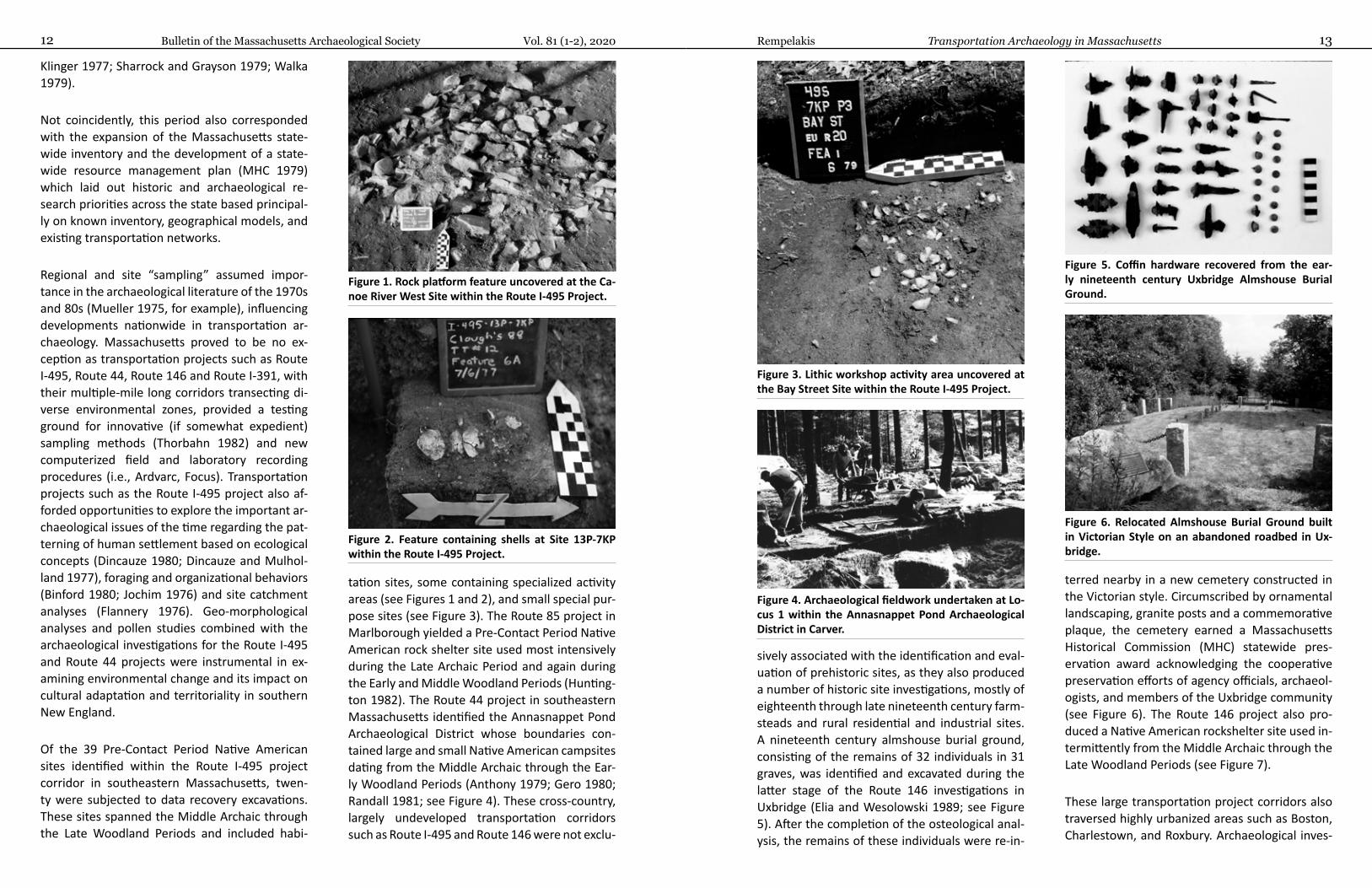
sively associated with the identification and eval-uation of prehistoric sites, as they also produced a number of historic site investigations, mostly of eighteenth through late nineteenth century farm-steads and rural residential and industrial sites. A nineteenth century almshouse burial ground, consisting of the remains of 32 individuals in 31 graves, was identified and excavated during the latter stage of the Route 146 investigations in Uxbridge (Elia and Wesolowski 1989; see Figure 5). After the completion of the osteological anal-ysis, the remains of these individuals were re-in-
terred nearby in a new cemetery constructed in the Victorian style. Circumscribed by ornamental landscaping, granite posts and a commemorative plaque, the cemetery earned a Massachusetts Historical Commission (MHC) statewide pres-ervation award acknowledging the cooperative preservation efforts of agency officials, archaeol-ogists, and members of the Uxbridge community (see Figure 6). The Route 146 project also pro-duced a Native American rockshelter site used in-termittently from the Middle Archaic through the Late Woodland Periods (see Figure 7).
These large transportation project corridors also traversed highly urbanized areas such as Boston, Charlestown, and Roxbury. Archaeological inves-
Klinger 1977; Sharrock and Grayson 1979; Walka 1979).
Not coincidently, this period also corresponded with the expansion of the Massachusetts state-wide inventory and the development of a state-wide resource management plan (MHC 1979) which laid out historic and archaeological re-search priorities across the state based principal-ly on known inventory, geographical models, and existing transportation networks.
Regional and site “sampling” assumed impor-tance in the archaeological literature of the 1970s and 80s (Mueller 1975, for example), influencing developments nationwide in transportation ar-chaeology. Massachusetts proved to be no ex-ception as transportation projects such as Route I-495, Route 44, Route 146 and Route I-391, with their multiple-mile long corridors transecting di-verse environmental zones, provided a testing ground for innovative (if somewhat expedient) sampling methods (Thorbahn 1982) and new computerized field and laboratory recording procedures (i.e., Ardvarc, Focus). Transportation projects such as the Route I-495 project also af-forded opportunities to explore the important ar-chaeological issues of the time regarding the pat-terning of human settlement based on ecological concepts (Dincauze 1980; Dincauze and Mulhol-land 1977), foraging and organizational behaviors (Binford 1980; Jochim 1976) and site catchment analyses (Flannery 1976). Geo-morphological analyses and pollen studies combined with the archaeological investigations for the Route I-495 and Route 44 projects were instrumental in ex-amining environmental change and its impact on cultural adaptation and territoriality in southern New England.
Of the 39 Pre-Contact Period Native American sites identified within the Route I-495 project corridor in southeastern Massachusetts, twen-ty were subjected to data recovery excavations. These sites spanned the Middle Archaic through the Late Woodland Periods and included habi-
tation sites, some containing specialized activity areas (see Figures 1 and 2), and small special pur-pose sites (see Figure 3). The Route 85 project in Marlborough yielded a Pre-Contact Period Native American rock shelter site used most intensively during the Late Archaic Period and again during the Early and Middle Woodland Periods (Hunting-ton 1982). The Route 44 project in southeastern Massachusetts identified the Annasnappet Pond Archaeological District whose boundaries con-tained large and small Native American campsites dating from the Middle Archaic through the Ear-ly Woodland Periods (Anthony 1979; Gero 1980; Randall 1981; see Figure 4). These cross-country, largely undeveloped transportation corridors such as Route I-495 and Route 146 were not exclu-
Figure 1. Rock platform feature uncovered at the Ca-noe River West Site within the Route I-495 Project.
Figure 2. Feature containing shells at Site 13P-7KP within the Route I-495 Project.
Figure 3. Lithic workshop activity area uncovered at the Bay Street Site within the Route I-495 Project.
Figure 4. Archaeological fieldwork undertaken at Lo-cus 1 within the Annasnappet Pond Archaeological District in Carver.
Figure 5. Coffin hardware recovered from the ear-ly nineteenth century Uxbridge Almshouse Burial Ground.
Figure 6. Relocated Almshouse Burial Ground built in Victorian Style on an abandoned roadbed in Ux-bridge.
Bulletin of the Massachusetts Archaeological Society Vol. 81 (1-2), 202014 15Rempelakis Transportation Archaeology in Massachusetts
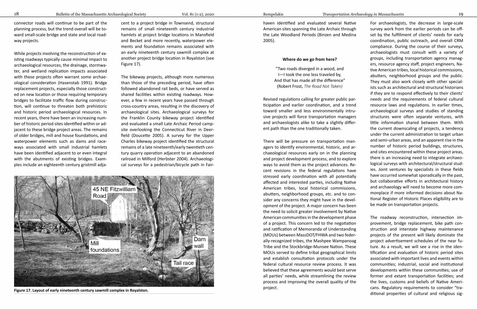
Shrewsbury were integrated into the design and construction of the Kenneth Burns Memorial Bridge over Lake Quinsigamond (see Figure 10). Pedestrians and bicyclists alike can learn about the operation of an early nineteenth century pencil factory as they pass by an interpretive sign near foundation remains along a new shared-use path in Acton. Replacement of the John Green-leaf Whittier Bridge in Amesbury and Newbury-port included the design and installation of an interpretive panel describing Native American life and history along the banks of the Merrimac River. These examples show that Transportation and Archaeology together serve to provide a very visible and powerful forum for informing commu-nities about their histories.
1990 – 2000
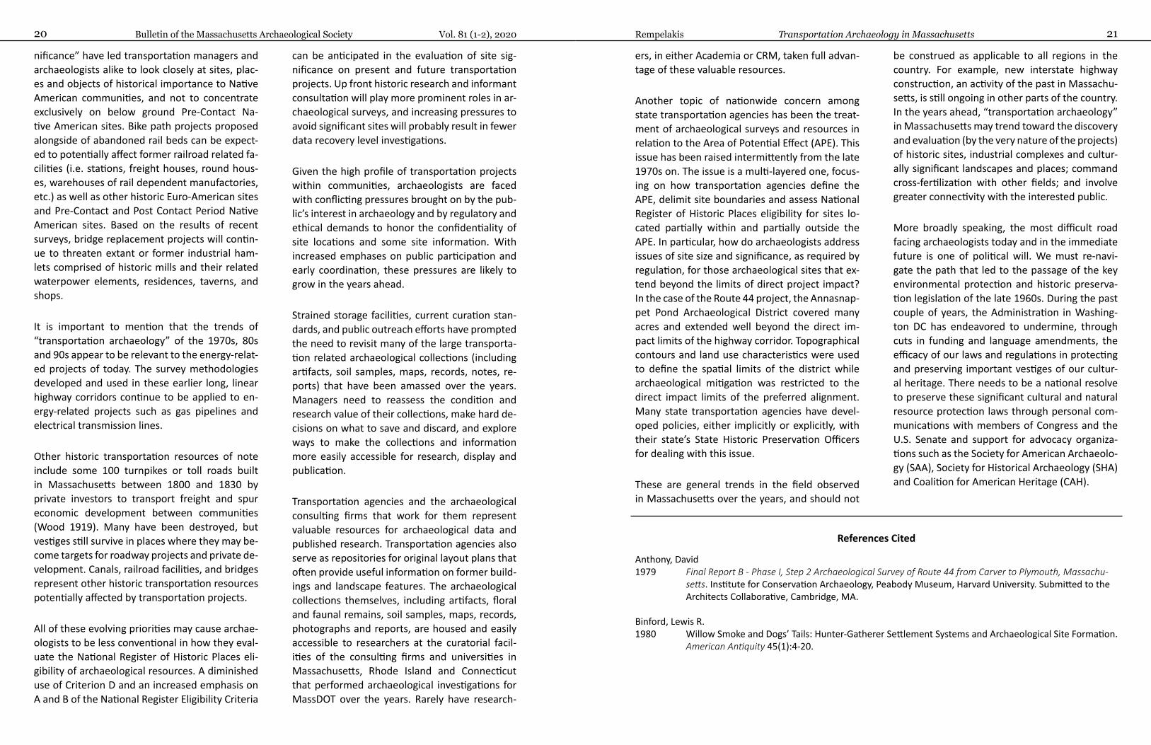
This period witnessed the completion of site ex-amination and data recovery excavations at sites identified within the major project corridors of the preceding period. Archaeological excavations within the Annasnappet Pond Archaeological Dis-trict for the Route 44 project identified the larg-est Middle Archaic Period assemblage and one of the earliest known burials in Massachusetts, and provided valuable information on Middle Archaic lithic technology (see Figures 11 and 12), atlatl use (see Figure 13) and transitional coastal zone/up-
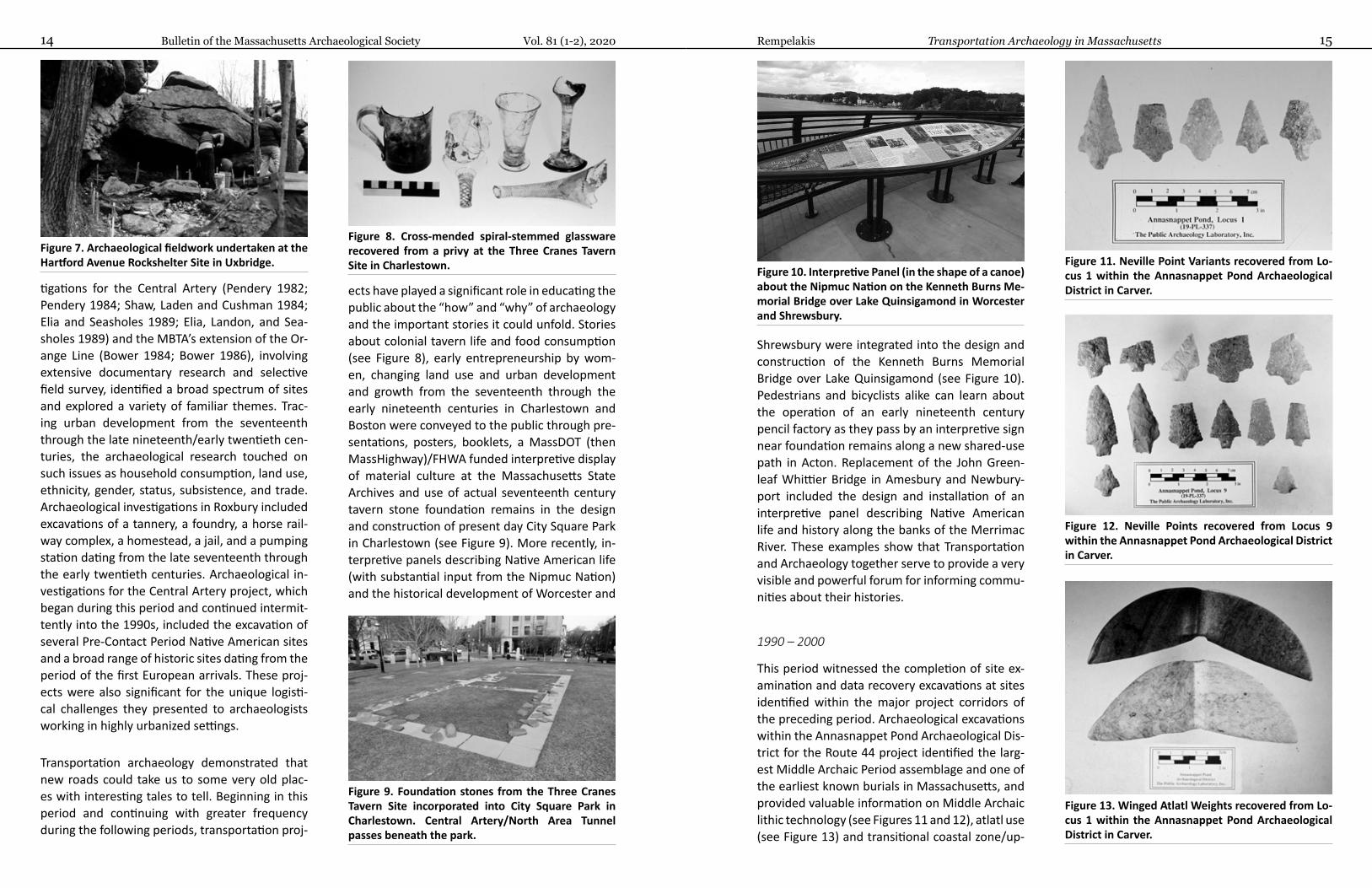
tigations for the Central Artery (Pendery 1982; Pendery 1984; Shaw, Laden and Cushman 1984; Elia and Seasholes 1989; Elia, Landon, and Sea-sholes 1989) and the MBTA’s extension of the Or-ange Line (Bower 1984; Bower 1986), involving extensive documentary research and selective field survey, identified a broad spectrum of sites and explored a variety of familiar themes. Trac-ing urban development from the seventeenth through the late nineteenth/early twentieth cen-turies, the archaeological research touched on such issues as household consumption, land use, ethnicity, gender, status, subsistence, and trade. Archaeological investigations in Roxbury included excavations of a tannery, a foundry, a horse rail-way complex, a homestead, a jail, and a pumping station dating from the late seventeenth through the early twentieth centuries. Archaeological in-vestigations for the Central Artery project, which began during this period and continued intermit-tently into the 1990s, included the excavation of several Pre-Contact Period Native American sites and a broad range of historic sites dating from the period of the first European arrivals. These proj-ects were also significant for the unique logisti-cal challenges they presented to archaeologists working in highly urbanized settings.
Transportation archaeology demonstrated that new roads could take us to some very old plac-es with interesting tales to tell. Beginning in this period and continuing with greater frequency during the following periods, transportation proj-
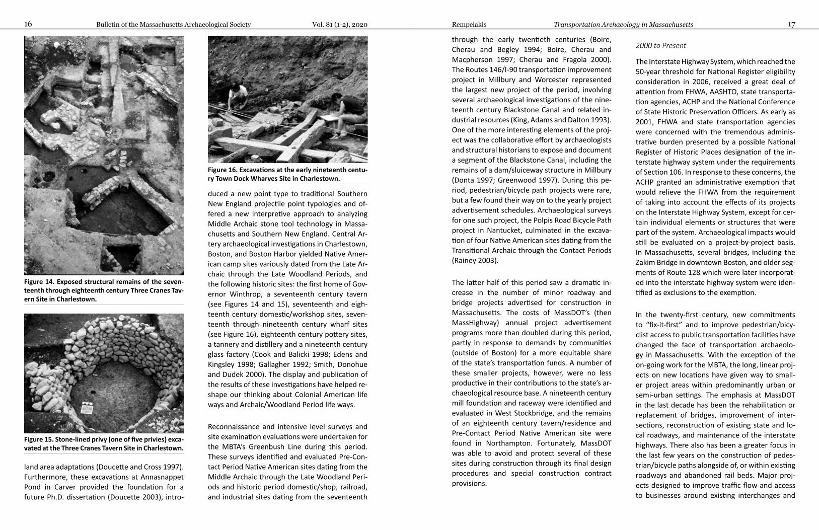
ects have played a significant role in educating the public about the “how” and “why” of archaeology and the important stories it could unfold. Stories about colonial tavern life and food consumption (see Figure 8), early entrepreneurship by wom-en, changing land use and urban development and growth from the seventeenth through the early nineteenth centuries in Charlestown and Boston were conveyed to the public through pre-sentations, posters, booklets, a MassDOT (then MassHighway)/FHWA funded interpretive display of material culture at the Massachusetts State Archives and use of actual seventeenth century tavern stone foundation remains in the design and construction of present day City Square Park in Charlestown (see Figure 9). More recently, in-terpretive panels describing Native American life (with substantial input from the Nipmuc Nation) and the historical development of Worcester and
Figure 7. Archaeological fieldwork undertaken at the Hartford Avenue Rockshelter Site in Uxbridge.
Figure 8. Cross-mended spiral-stemmed glassware recovered from a privy at the Three Cranes Tavern Site in Charlestown.
Figure 9. Foundation stones from the Three Cranes Tavern Site incorporated into City Square Park in Charlestown. Central Artery/North Area Tunnel passes beneath the park.
Figure 10. Interpretive Panel (in the shape of a canoe) about the Nipmuc Nation on the Kenneth Burns Me-morial Bridge over Lake Quinsigamond in Worcester and Shrewsbury.
Figure 11. Neville Point Variants recovered from Lo-cus 1 within the Annasnappet Pond Archaeological District in Carver.
Figure 12. Neville Points recovered from Locus 9 within the Annasnappet Pond Archaeological District in Carver.
Figure 13. Winged Atlatl Weights recovered from Lo-cus 1 within the Annasnappet Pond Archaeological District in Carver.
Bulletin of the Massachusetts Archaeological Society Vol. 81 (1-2), 202016 17Rempelakis Transportation Archaeology in Massachusetts
through the early twentieth centuries (Boire, Cherau and Begley 1994; Boire, Cherau and Macpherson 1997; Cherau and Fragola 2000). The Routes 146/I-90 transportation improvement project in Millbury and Worcester represented the largest new project of the period, involving several archaeological investigations of the nine-teenth century Blackstone Canal and related in-dustrial resources (King, Adams and Dalton 1993). One of the more interesting elements of the proj-ect was the collaborative effort by archaeologists and structural historians to expose and document a segment of the Blackstone Canal, including the remains of a dam/sluiceway structure in Millbury (Donta 1997; Greenwood 1997). During this pe-riod, pedestrian/bicycle path projects were rare, but a few found their way on to the yearly project advertisement schedules. Archaeological surveys for one such project, the Polpis Road Bicycle Path project in Nantucket, culminated in the excava-tion of four Native American sites dating from the Transitional Archaic through the Contact Periods (Rainey 2003).
The latter half of this period saw a dramatic in-crease in the number of minor roadway and bridge projects advertised for construction in Massachusetts. The costs of MassDOT’s (then MassHighway) annual project advertisement programs more than doubled during this period, partly in response to demands by communities (outside of Boston) for a more equitable share of the state’s transportation funds. A number of these smaller projects, however, were no less productive in their contributions to the state’s ar-chaeological resource base. A nineteenth century mill foundation and raceway were identified and evaluated in West Stockbridge, and the remains of an eighteenth century tavern/residence and Pre-Contact Period Native American site were found in Northampton. Fortunately, MassDOT was able to avoid and protect several of these sites during construction through its final design procedures and special construction contract provisions.
2000 to Present
The Interstate Highway System, which reached the 50-year threshold for National Register eligibility consideration in 2006, received a great deal of attention from FHWA, AASHTO, state transporta-tion agencies, ACHP and the National Conference of State Historic Preservation Officers. As early as 2001, FHWA and state transportation agencies were concerned with the tremendous adminis-trative burden presented by a possible National Register of Historic Places designation of the in-terstate highway system under the requirements of Section 106. In response to these concerns, the ACHP granted an administrative exemption that would relieve the FHWA from the requirement of taking into account the effects of its projects on the Interstate Highway System, except for cer-tain individual elements or structures that were part of the system. Archaeological impacts would still be evaluated on a project-by-project basis. In Massachusetts, several bridges, including the Zakim Bridge in downtown Boston, and older seg-ments of Route 128 which were later incorporat-ed into the interstate highway system were iden-tified as exclusions to the exemption.
In the twenty-first century, new commitments to “fix-it-first” and to improve pedestrian/bicy-clist access to public transportation facilities have changed the face of transportation archaeolo-gy in Massachusetts. With the exception of the on-going work for the MBTA, the long, linear proj-ects on new locations have given way to small-er project areas within predominantly urban or semi-urban settings. The emphasis at MassDOT in the last decade has been the rehabilitation or replacement of bridges, improvement of inter-sections, reconstruction of existing state and lo-cal roadways, and maintenance of the interstate highways. There also has been a greater focus in the last few years on the construction of pedes-trian/bicycle paths alongside of, or within existing roadways and abandoned rail beds. Major proj-ects designed to improve traffic flow and access to businesses around existing interchanges and
land area adaptations (Doucette and Cross 1997). Furthermore, these excavations at Annasnappet Pond in Carver provided the foundation for a future Ph.D. dissertation (Doucette 2003), intro-
duced a new point type to traditional Southern New England projectile point typologies and of-fered a new interpretive approach to analyzing Middle Archaic stone tool technology in Massa-chusetts and Southern New England. Central Ar-tery archaeological investigations in Charlestown, Boston, and Boston Harbor yielded Native Amer-ican camp sites variously dated from the Late Ar-chaic through the Late Woodland Periods, and the following historic sites: the first home of Gov-ernor Winthrop, a seventeenth century tavern (see Figures 14 and 15), seventeenth and eigh-teenth century domestic/workshop sites, seven-teenth through nineteenth century wharf sites (see Figure 16), eighteenth century pottery sites, a tannery and distillery and a nineteenth century glass factory (Cook and Balicki 1998; Edens and Kingsley 1998; Gallagher 1992; Smith, Donohue and Dudek 2000). The display and publication of the results of these investigations have helped re-shape our thinking about Colonial American life ways and Archaic/Woodland Period life ways.
Reconnaissance and intensive level surveys and site examination evaluations were undertaken for the MBTA’s Greenbush Line during this period. These surveys identified and evaluated Pre-Con-tact Period Native American sites dating from the Middle Archaic through the Late Woodland Peri-ods and historic period domestic/shop, railroad, and industrial sites dating from the seventeenth
Figure 14. Exposed structural remains of the seven-teenth through eighteenth century Three Cranes Tav-ern Site in Charlestown.
Figure 15. Stone-lined privy (one of five privies) exca-vated at the Three Cranes Tavern Site in Charlestown.
Figure 16. Excavations at the early nineteenth centu-ry Town Dock Wharves Site in Charlestown.
Bulletin of the Massachusetts Archaeological Society Vol. 81 (1-2), 202018 19Rempelakis Transportation Archaeology in Massachusetts
haven identified and evaluated several Native American sites spanning the Late Archaic through the Late Woodland Periods (Binzen and Medina 2005).
Where do we go from here?
“Two roads diverged in a wood, and I—I took the one less traveled by,
And that has made all the difference” (Robert Frost, The Road Not Taken)
Revised regulations calling for greater public par-ticipation and earlier coordination, and a trend toward smaller and less environmentally intru-sive projects will force transportation managers and archaeologists alike to take a slightly differ-ent path than the one traditionally taken.
There will be pressure on transportation man-agers to identify environmental, historic, and ar-chaeological resources early on in the planning and project development process, and to explore ways to avoid them as the project advances. Re-cent revisions in the federal regulations have stressed early coordination with all potentially affected and interested parties, including Native American tribes, local historical commissions, abutters, neighborhood groups, etc. and to con-sider any concerns they might have in the devel-opment of the project. A major concern has been the need to solicit greater involvement by Native American communities in the development phase of a project. This concern led to the negotiation and ratification of Memoranda of Understanding (MOUs) between MassDOT/FHWA and two feder-ally-recognized tribes, the Mashpee Wampanoag Tribe and the Stockbridge-Munsee Nation. These MOUs served to define tribal geographical limits and establish consultation protocols under the federal cultural resource review process. It was believed that these agreements would best serve all parties’ needs, while streamlining the review process and improving the overall quality of the project.
For archaeologists, the decrease in large-scale survey work from the earlier periods can be off-set by the fulfillment of clients’ needs for early coordination, public outreach, and overall CRM compliance. During the course of their surveys, archaeologists must consult with a variety of groups, including transportation agency manag-ers, resource agency staff, project engineers, Na-tive American tribes, local historical commissions, abutters, neighborhood groups and the public. They must also work closely with other special-ists such as architectural and structural historians if they are to respond effectively to their clients’ needs and the requirements of federal cultural resource laws and regulations. In earlier times, archaeological surveys and studies of standing structures were often separate ventures, with little information shared between them. With the current downscaling of projects, a tendency under the current administration to target urban and semi-urban areas, and an apparent rise in the number of historic period buildings, structures, and sites encountered within these project areas, there is an increasing need to integrate archaeo-logical surveys with architectural/structural stud-ies. Joint ventures by specialists in these fields have occurred somewhat sporadically in the past, but collaborative efforts in architectural history and archaeology will need to become more com-monplace if more informed decisions about Na-tional Register of Historic Places eligibility are to be made on transportation projects.
The roadway reconstruction, intersection im-provement, bridge replacement, bike path con-struction and interstate highway maintenance projects of the present will likely dominate the project advertisement schedules of the near fu-ture. As a result, we will see a rise in the iden-tification and evaluation of historic period sites associated with important lives and events within communities; industrial, social and institutional developments within these communities; use of former and extant transportation facilities; and the lives, customs and beliefs of Native Ameri-cans. Regulatory requirements to consider “tra-ditional properties of cultural and religious sig-
connector roads will continue to be part of the planning process, but the trend overall will be to-ward small-scale bridge and state and local road-way projects.
While projects involving the reconstruction of ex-isting roadways typically cause minimal impact to archaeological resources, the drainage, stormwa-ter, and wetland replication impacts associated with these projects often warrant some archae-ological consideration (Hasenstab 1991). Bridge replacement projects, especially those construct-ed on new location or those requiring temporary bridges to facilitate traffic flow during construc-tion, will continue to threaten both prehistoric and historic period archaeological resources. In recent years, there have been an increasing num-ber of historic period sites identified within or ad-jacent to these bridge project areas. The remains of older bridges, mill and house foundations, and waterpower elements such as dams and race-ways associated with small industrial hamlets have been identified adjacent to or even integral with the abutments of existing bridges. Exam-ples include an eighteenth century gristmill adja-
cent to a project bridge in Townsend, structural remains of small nineteenth century industrial hamlets at project bridge locations in Mansfield and Becket and more recently, waterpower ele-ments and foundation remains associated with an early nineteenth century sawmill complex at another project bridge location in Royalston (see Figure 17).
The bikeway projects, although more numerous than those of the preceding period, have often followed abandoned rail beds, or have served as shared facilities within existing roadways. How-ever, a few in recent years have passed through cross-country areas, resulting in the discovery of archaeological sites. Archaeological surveys for the Franklin County bikeway project identified and evaluated a small Late Archaic Period camp-site overlooking the Connecticut River in Deer-field (Doucette 2005). A survey for the Upper Charles bikeway project identified the structural remains of a late nineteenth/early twentieth cen-tury quarry operation adjacent to an abandoned railroad in Milford (Herbster 2004). Archaeologi-cal surveys for a pedestrian/bicycle path in Fair-
Figure 17. Layout of early nineteenth century sawmill complex in Royalston.
Bulletin of the Massachusetts Archaeological Society Vol. 81 (1-2), 202020 21Rempelakis Transportation Archaeology in Massachusetts
ers, in either Academia or CRM, taken full advan-tage of these valuable resources.
Another topic of nationwide concern among state transportation agencies has been the treat-ment of archaeological surveys and resources in relation to the Area of Potential Effect (APE). This issue has been raised intermittently from the late 1970s on. The issue is a multi-layered one, focus-ing on how transportation agencies define the APE, delimit site boundaries and assess National Register of Historic Places eligibility for sites lo-cated partially within and partially outside the APE. In particular, how do archaeologists address issues of site size and significance, as required by regulation, for those archaeological sites that ex-tend beyond the limits of direct project impact? In the case of the Route 44 project, the Annasnap-pet Pond Archaeological District covered many acres and extended well beyond the direct im-pact limits of the highway corridor. Topographical contours and land use characteristics were used to define the spatial limits of the district while archaeological mitigation was restricted to the direct impact limits of the preferred alignment. Many state transportation agencies have devel-oped policies, either implicitly or explicitly, with their state’s State Historic Preservation Officers for dealing with this issue.
These are general trends in the field observed in Massachusetts over the years, and should not
be construed as applicable to all regions in the country. For example, new interstate highway construction, an activity of the past in Massachu-setts, is still ongoing in other parts of the country. In the years ahead, “transportation archaeology” in Massachusetts may trend toward the discovery and evaluation (by the very nature of the projects) of historic sites, industrial complexes and cultur-ally significant landscapes and places; command cross-fertilization with other fields; and involve greater connectivity with the interested public.
More broadly speaking, the most difficult road facing archaeologists today and in the immediate future is one of political will. We must re-navi-gate the path that led to the passage of the key environmental protection and historic preserva-tion legislation of the late 1960s. During the past couple of years, the Administration in Washing-ton DC has endeavored to undermine, through cuts in funding and language amendments, the efficacy of our laws and regulations in protecting and preserving important vestiges of our cultur-al heritage. There needs to be a national resolve to preserve these significant cultural and natural resource protection laws through personal com-munications with members of Congress and the U.S. Senate and support for advocacy organiza-tions such as the Society for American Archaeolo-gy (SAA), Society for Historical Archaeology (SHA) and Coalition for American Heritage (CAH).
References Cited
Anthony, David1979 Final Report B - Phase I, Step 2 Archaeological Survey of Route 44 from Carver to Plymouth, Massachu-
setts. Institute for Conservation Archaeology, Peabody Museum, Harvard University. Submitted to the Architects Collaborative, Cambridge, MA.
Binford, Lewis R.1980 Willow Smoke and Dogs’ Tails: Hunter-Gatherer Settlement Systems and Archaeological Site Formation.
American Antiquity 45(1):4-20.
nificance” have led transportation managers and archaeologists alike to look closely at sites, plac-es and objects of historical importance to Native American communities, and not to concentrate exclusively on below ground Pre-Contact Na-tive American sites. Bike path projects proposed alongside of abandoned rail beds can be expect-ed to potentially affect former railroad related fa-cilities (i.e. stations, freight houses, round hous-es, warehouses of rail dependent manufactories, etc.) as well as other historic Euro-American sites and Pre-Contact and Post Contact Period Native American sites. Based on the results of recent surveys, bridge replacement projects will contin-ue to threaten extant or former industrial ham-lets comprised of historic mills and their related waterpower elements, residences, taverns, and shops.
It is important to mention that the trends of “transportation archaeology” of the 1970s, 80s and 90s appear to be relevant to the energy-relat-ed projects of today. The survey methodologies developed and used in these earlier long, linear highway corridors continue to be applied to en-ergy-related projects such as gas pipelines and electrical transmission lines.
Other historic transportation resources of note include some 100 turnpikes or toll roads built in Massachusetts between 1800 and 1830 by private investors to transport freight and spur economic development between communities (Wood 1919). Many have been destroyed, but vestiges still survive in places where they may be-come targets for roadway projects and private de-velopment. Canals, railroad facilities, and bridges represent other historic transportation resources potentially affected by transportation projects.
All of these evolving priorities may cause archae-ologists to be less conventional in how they eval-uate the National Register of Historic Places eli-gibility of archaeological resources. A diminished use of Criterion D and an increased emphasis on A and B of the National Register Eligibility Criteria
can be anticipated in the evaluation of site sig-nificance on present and future transportation projects. Up front historic research and informant consultation will play more prominent roles in ar-chaeological surveys, and increasing pressures to avoid significant sites will probably result in fewer data recovery level investigations.
Given the high profile of transportation projects within communities, archaeologists are faced with conflicting pressures brought on by the pub-lic’s interest in archaeology and by regulatory and ethical demands to honor the confidentiality of site locations and some site information. With increased emphases on public participation and early coordination, these pressures are likely to grow in the years ahead.
Strained storage facilities, current curation stan-dards, and public outreach efforts have prompted the need to revisit many of the large transporta-tion related archaeological collections (including artifacts, soil samples, maps, records, notes, re-ports) that have been amassed over the years. Managers need to reassess the condition and research value of their collections, make hard de-cisions on what to save and discard, and explore ways to make the collections and information more easily accessible for research, display and publication.
Transportation agencies and the archaeological consulting firms that work for them represent valuable resources for archaeological data and published research. Transportation agencies also serve as repositories for original layout plans that often provide useful information on former build-ings and landscape features. The archaeological collections themselves, including artifacts, floral and faunal remains, soil samples, maps, records, photographs and reports, are housed and easily accessible to researchers at the curatorial facil-ities of the consulting firms and universities in Massachusetts, Rhode Island and Connecticut that performed archaeological investigations for MassDOT over the years. Rarely have research-
Bulletin of the Massachusetts Archaeological Society Vol. 81 (1-2), 202022 23Rempelakis Transportation Archaeology in Massachusetts
Doucette, Dianna L.2003 Unraveling Middle Archaic Expressions: A Multidisciplinary Approach Towards Feature and Material Cul-
ture Recognition in Southeastern New England. Ph.D. dissertation, Harvard University, Cambridge, MA.2005 Intensive (Locational) Survey and Archaeological Site Examination of the Franklin County Bikeway Site,
Deerfield, Massachusetts. The Public Archaeology Laboratory, Inc., Pawtucket, RI. Draft report submit-ted to the Massachusetts Highway Department, Boston, MA.
Doucette, Dianna L., and John R. Cross1997 Route 44 Transportation Improvement Project, Carver to Plymouth, Massachusetts. Annasnappet Pond
Archaeological District: An Archaeological Data Recovery Program, 3 vols. The Public Archaeology Laboratory, Inc. Pawtucket, RI. Report No. 580. Submitted to the Massachusetts Highway Department, Boston, MA.
Edens, Christopher M., and Robert G. Kingsley1998 The Spectacle Island Site: Middle to Late Woodland Adaptations in Boston Harbor, Suffolk County, Mas-
sachusetts, Central Artery/Tunnel Project, Boston, Massachusetts. Two Volumes. Report prepared for the Massachusetts Highway Department and Bechtel/Parsons Brinckerhoff and on file at the Massa-chusetts Historical Commission, Boston, MA.
Elia, Ricardo J., and Nancy S. Seasholes1989 Phase I Archaeological Investigations of the Central Artery/Third Harbor Tunnel Project in Boston, Massa-
chusetts. The Office of Public Archaeology, Boston University, Boston, MA. OPA Report No. 78. Submit-ted to the Massachusetts Department of Public Works, Boston, MA.
Elia, Ricardo J., David B. Landon, and Nancy S. Seasholes1989 Phase II Archaeological Investigations of the Central Artery/Third Harbor Tunnel Project in Boston, Mas-
sachusetts. 2 vols. The Office of Public Archaeology, Boston University, Boston, MA. OPA Report No. 81. Submitted to the Massachusetts Department of Public Works, Boston, MA.
Elia, Ricardo J., and Al B. Wesolowski (editors)1989 Archaeological Excavations at the Uxbridge Almshouse Burial Ground in Uxbridge, Massachusetts. The
Office of Public Archaeology, Boston University, Boston, MA. Submitted to the Massachusetts Depart-ment of Public Works, Boston, MA.
Flannery, Kent V. (editor)1976 The Early Mesoamerican Village. Academic Press, New York.
Gallagher, Joan (editor)1992 Central Artery North Reconstruction Project, Data Recovery Program, Charlestown, Massachusetts. 8
vols. 10 reports. The Public Archaeology Laboratory, Inc. Pawtucket, RI. Submitted to the Massachu-setts Department of Public Works, Boston, MA.
Gero, Joan M.1980 Final Report - Phase II Testing of the Right-of-Way Proposed for the Relocation of Route 44, Carver,
Massachusetts: Prehistoric Sites. Institute for Conservation Archaeology, Peabody Museum, Harvard University. Submitted to the Architects Collaborative, Cambridge, MA.
Greenwood, Richard E.1997 Historic American Engineering Record: Blackstone Canal Worcester-Millbury Segment. HAER No. MA-
147. On file at the Massachusetts State Archives, Boston, MA
Binzen, Timothy, and Antonio Medina2005 Archaeological Site Examination Surveys for the Little Bay Multi-Use Trail, Fairhaven, Massachusetts.
UMASS Archaeological Services, Amherst, MA. Draft report submitted to the Massachusetts Highway Department, Boston, MA.
Boire, Kerrylynn, Suzanne G. Cherau, and William Begley1994 Reconnaissance Survey Archaeological for the Greenbush Line of the Old Colony Railroad Rehabilitation
Project, Cohasset, Hingham, Hull, Scituate, Weymouth, Massachusetts. The Public Archaeology Labora-tory, Inc. Report No. 474-4. Submitted to Sverdrup Civil, Inc., Boston, MA.
Boire, Kerrylynn, Suzanne G. Cherau, and Jennifer Macpherson1997 Intensive Archaeological Survey and Additional Reconnaissance Survey for Proposed Locations Along
the Greenbush Line, Old Colony Railroad Rehabilitation Project, Braintree, Cohasset, Hingham, Scituate, and Weymouth, Massachusetts. The Public Archaeology Laboratory, Inc. Report No. 794. Submitted to Sverdrup Civil, Inc., Boston, MA.
Bower, Beth Ann (editor)1984 Massachusetts Bay Transportation Authority Southwest Corridor Project: Report on the Phase II Archae-
ological Subsurface Testing. 2 vols. The Museum of Afro-American History. Submitted to the Massachu-setts Bay Transportation Authority, Boston, MA.
1986-1987 Massachusetts Bay Transportation Authority Southwest Corridor Project: Report on the Phase III Archae-ological Data Recovery. 5 reports. The Museum of African American History. Submitted to the Massa-chusetts Bay Transportation Authority, Boston, MA.
Cherau, Suzanne G., and Patricia Fragola2000 Additional Archaeological Reconnaissance and Intensive Surveys and Archaeological Site Examinations of
the Litchfield Site (HIN-HA-07), Woodside Site (19-NF-416), and Marshview Site (19-PL-823). The Public Archaeology Laboratory, Inc. Report No. 794-1. Submitted to Sverdrup Civil Inc. and the Massachusetts Bay Transportation Authority, Boston, MA.
Cook, Lauren J., and Joseph Balicki1998 Archaeological Data Recovery: The Paddy’s Alley and Cross Street Back Lot Sites (Bos-HA-12/13), Boston,
Massachusetts. Four Volumes. Report prepared for the Massachusetts Highway Department and Bech-tel/Parsons Brinckerhoff and on file at the Massachusetts Historical Commission, Boston, MA.
Dincauze, Dena F.1980 Research Priorities in Northeastern Prehistory. In Proceedings of the Conference on Northeastern Ar-
chaeology, edited by J. A. Moore, pp. 29-48. Research Report 19, Department of Anthropology, Univer-sity of Massachusetts, Amherst.
Dincauze, Dena F., and Mitchell Mulholland1977 Early and Middle Archaic Site Distributions and Habitats in Southern New England. Annals of the New
York Academy of Sciences 288:439-456. Donta, Christopher L.1997 Archaeological Investigation of the Blackstone Canal Millbury Segment/Spillway Structure, Millbury Mas-
sachusetts. UMASS Archaeological Services, Amherst, MA. Submitted to the Massachusetts Highway Department, Boston, MA.
Bulletin of the Massachusetts Archaeological Society Vol. 81 (1-2), 202024 25Rempelakis Transportation Archaeology in Massachusetts
Randall, Debra1981 Final Report – Phase I. Step 2 Archaeological Survey of the Proposed Relocation of Route 44: Plymouth
and Carver, Massachusetts: 4M5 Alignment and Ramps. Institute for Conservation Archaeology, Pea-body Museum, Harvard University. Submitted to the Massachusetts Department of Public Works, Boston, MA.
Sharrock, Floyd W., and Donald K. Grayson1979 “Significance” in Contract Archaeology. American Antiquity 44(2):327-328.
Shaw, Leslie C., Greg Laden, and David Cushman1984 Final Report: A Study in Prehistoric Adaptations to an Estuarine Environment. Prepared by the Institute
for Conservation Archaeology, Peabody Museum, Harvard University. Submitted to the Massachusetts Department of Public Works, Boston, MA.
Smith, Leith, Barbara Donohue, and Martin Dudek2000 Emergency Archaeological Data Recovery of the South Boston Flint Glass Works and the American Glass
Company (formerly reported as Crown Glass Works), Contingency Plan Implementation Contos Property, Parcel 60-CS-1, Central Artery/Tunnel Project, Boston, Massachusetts. Two Volumes. Report prepared for the Massachusetts Highway Department and Bechtel/Parsons Brinckerhoff and on file at the Mas-sachusetts Historical Commission, Boston, MA.
Thorbahn, Peter (editor)1982 Final Report of the Interstate Highway 495 Archaeological Data Recovery Program. The Public Archaeol-
ogy Laboratory, Brown University, Providence RI. 4 vols. Submitted to the Massachusetts Department of Public Works, Boston, MA.
Walka, Joseph J.1979 Management Methods and Opportunities in Archaeology. American Antiquity 44(3):575-582.
Wood, Frederic J.1919 The Turnpikes of New England. Marshall Jones Company, Boston.
Gumerman, George J., and Michael B. Schiffer1978 Conservation Archaeology: A Guide for Cultural Resource Management Studies. Academic Press, New
York.
Hasenstab, Robert J.1991 Wetlands as a Critical Variable in Predictive Modeling Prehistoric Site Locations: A Case Study from the
Passaic River Basin. Man in the Northeast 42:39-61.
Herbster, Holly2004 Intensive (Locational) Archaeological Survey, MassHighway Assignment #9, Upper Charles Trail, Milford,
Massachusetts. The Public Archaeology Laboratory, Inc., Pawtucket, RI. Report No. 1659. Submitted to the Massachusetts Highway Department, Boston, MA.
Huntington, Frederick W.1982 Preliminary Report on the Excavation of Flagg Swamp Rockshelter. Institute for Conservation Archae-
ology, Peabody Museum, Harvard University. Submitted to the Massachusetts Department of Public Works, Boston, MA.
Jochim, Michael A.1976 Hunter-Gatherer Subsistence and Settlement: A Predictive Model. Academic Press, New York.
King, Marsha K., Virginia H. Adams, and Ronald Dalton1993 Archaeological Site Examinations of Two Blackstone Canal Segments in Worcester and Millbury, Massa-
chusetts and the Mill Brook Sewer Portal in Worcester, Massachusetts. The Public Archaeology Laborato-ry, Inc. Report No. 496-4. Submitted to HNTB, Inc., Boston, MA.
King, Thomas E.1978 The Archaeological Survey: Methods and Uses. Heritage Conservation and Recreation Service. U.S. De-
partment of the Interior, Washington DC. Massachusetts Historical Commission1979 Cultural Resources in Massachusetts: A Model for Management. Prepared under contract to the Depart-
ment of the Interior, Heritage Conservation and Recreation Service.
Mueller, James W. (editor)1975 Sampling in Archaeology. University of Arizona Press, Tucson.
Pendery, Steven R.1982 Phase II Archaeological Site Examination of the Project Area for the Central Artery, North Area, Charles-
town, Massachusetts. Institute for Conservation Archaeology, Peabody Museum, Harvard University. Submitted to the Massachusetts Department of Public Works, Boston, MA.
1984 Phase III Chelsea-Water Streets Connector Project, Charlestown, Massachusetts: Excavations at the Wap-ping Street and Maudlin Street Archaeological Districts. Institute for Conservation Archaeology, Pea-body Museum, Harvard University. Submitted to Zoppo Construction, Inc. Everett, MA.
Raab, Mark, and Timothy C. Klinger1977 A Critical Appraisal of Significance in Contract Archaeology. American Antiquity 42(4):629-634.
Rainey, Mary Lynne2003 Polpis Road Bicycle Path, Archaeological Data Recovery Program: Site 19-NT-50, The Roadkill Site (19-
NT-166), Site 19-NT-68, and the Folger’s Marsh Site (19-NT-180) and Supplemental Site Examination of the Folger’s Marsh Site. 2 vols. The Public Archaeology Laboratory, Inc., Pawtucket, RI. Submitted to the Nantucket County Planning and Economic Development Commission, Nantucket, MA.
Bulletin of the Massachusetts Archaeological SocietyOctober 2020 27Vol. 81 (1-2) Bulletin of the Massachusetts Archaeological Society 2020, Vol. 81(1-2)
DISCOVERY OF A SMALL, ISOLATED, HIGH-DENSITY LITHIC WORKSHOP IN INTERIOR MASSACHUSETTS
ALAN E. STRAUSSCultural Resource Specialists of New England 222 Fourth Street Providence, Rhode Island 02906 [email protected]
Abstract
The Norumbega site is unique in that it represents a single component, possibly Middle Woodland, small short-term usage location. This site sheds light on several important features of small, iso-lated sites in the interior of Massachusetts that are located in low lying rocky areas that are not adjacent to permanent fresh water sources. Ar-chaeologists often overlook these types of sites in the region. Phase I, II, and III archaeological in-vestigations were conducted at the Norumbega site in Weston, Massachusetts as part of the test-ing of proposed water enhancement facilities for the Boston area. The site’s Native American oc-cupants primarily used locally available volcanics from the Boston Basin in a high-density work-shop. Sites from the Middle Woodland period (ca. 1,800 to 1,200 B.P.) in general, are uncommon in the region. Soils from the site were both dry sieved and examined using the wet pipette meth-od to determine the proportions of sand, silt, and clay and grain size and shape. Lithics from the site were studied using petrography, geochemical analysis, and X-ray fluorescence. The site’s hori-zontal boundaries were defined using lithic den-sity maps, isopleth contour density maps, and three-dimensional block diagrams.
Site Models for Interior Massachusetts
Sites in the region area generally located in well-drained level, rock-free terrain adjacent to per-manent water sources. The project area was assessed as having low to moderate resource
potential because it was not situated near a per-manent fresh water source and had rocky with irregular terrain.
Most recorded sites throughout the region are the result of artifact collecting by avocational archaeologists. The site locations are biased to large plowed fields along the flood plain espe-cially on river terraces and adjacent to bodies of water. Very few sites have been identified in the interior of Massachusetts away from the coastal plain. It appears that large multicomponent sites are often situated adjacent to major sources of freshwater. Areas which were located near small brooks or wetlands contained temporary sites and activity areas, particularly from the Middle and Late Archaic periods when seasonal resourc-es were heavily exploited.
Numerous prehistoric sites are located in the Charles River Drainage. Archaeologist Dena Din-cauze indicated that within 600 square miles in the Boston Basin there were 199 recorded sites or one site per three square miles (Dincauze 1974:40). Paleoindian and Early Archaic remains were scarce in the area, although find spots oc-curred on the sandy terraces overlooking the Charles River. Middle Archaic through Late Archa-ic sites were more common and were found in a variety of settings, i.e. wetland margins, ponds, lakes, streamsides, and the Charles River estuary. Only four cultural resource management studies had been completed in Weston at the time of this project (Décima and Putnam 1997; Strauss 1994a, 1994b, 1995). The majority of sites in the

Bulletin of the Massachusetts Archaeological Society Vol. 81 (1-2), 202028 29Strauss High-Density Lithic Workshop
boundaries, to establish a site chronology, deter-mine the cultural affinities of the site, and deter-mine its function. The investigations were also aimed at addressing such questions as (1) site du-ration and seasonality; (2) lithic sources, i.e. local verses exotic; (3) tool manufacturing techniques; (4) group size; and (5) on-site activities (Strauss 1994b:6-7). The site (19-MD-725) was deter-mined to be a high-density lithic workshop com-posed of possibly two cluster areas. Over 2,000 pieces of lithic debitage were recovered from the combined Phase I and II studies. A total of six bro-ken stone tools were found during the site exam-ination. Broken preforms found at the site most closely resembled Middle Woodland varieties (ca. 1,800 to 1,200 B.P.) for the Norumbega Site.
The Norumbega site was considered eligible for listing in the National Register of Historic Plac-es under Criteria A and D, since the site had the potential to provide important data about the
Weston area have no chronological data. Most of the recorded sites are the result of surface finds where no excavations took place.
There are some newly discovered sites in the area, including 19-MD-765, which appears to date to the Middle Archaic period, 19-MD-764, which contained debitage and a biface, and 19-MD-766, which appears to date to the Middle Woodland. Locally available raw materials were used at these sites, which appear to be tempo-rary activity areas where tools were sharpened or manufactured. The Crane Swamp site in the up-lands of Marlborough, Massachusetts consisted of a Late Archaic high-density lithic workshop in a boulder-laden area. The site was approximately 12 by 23 meters in size and contained over 1,600 pieces of debitage (Strauss 1997). The raw mate-rials at the site were derived from the Twin Pine member of the Mattapan Volcanic Complex in Dover and Westwood of the Boston Basin.
Regionally, Early, Middle and Late Woodland sites are less numerous than their antecedent Archaic sites (MHC 1982:20). Dincauze recorded only 11 Early Woodland sites and 17 Middle Woodland sites in her study of the Boston Basin (Dincauze 1974:51). Similarly, the MHC State Survey report for the nearby Arlington Plain found one collec-tion to contain high numbers of Middle Archaic points (Stark: 29) as opposed to lower numbers of Middle Woodland diagnostics (Fox Creek:12) (Anthony et al. 1980:17).
This apparent decrease in Woodland sites has not been fully explained. Dincauze sees this de-crease in sites as a “decline in population and cultural fragmentation,” concomitant with a shift from interior sites to the coastal fringe (Dincauze 1974:50). An alternate hypothesis is that Small Stemmed points, used during the previous Late Archaic period, were also used during the begin-ning of the Woodland and therefore Early Wood-land sites are under-represented, while Late Archaic sites appear to be far more numerous. Consequently, the lack of initial Woodland period
sites may be an archaeological misobservation. Summarizing, the MHC study of the area conclud-ed, “Little is known of the upland (Middle Wood-land) interior locations (MHC 1980:32).”
Most Woodland sites appear as small compo-nents of larger Archaic sites, suggesting reoc-cupation or reutilization of the same sites over hundreds of years. Exclusively Woodland sites without Archaic components are uncommon in the Charles River Drainage. Very few, if any, sin-gle component Middle Woodland sites have been found throughout Massachusetts. Indeed almost all of the Woodland period sites found during the extensive I-495 project were components of oth-er larger multicomponent sites. No single lithic workshops were identified (Duncan Ritchie, per-sonal communication, July 1995).
Site Discovery
Although the project area was assessed as hav-ing a low to moderate archaeological potential, in May of 1993 a Phase I (intensive archaeological survey) investigation was conducted at the Shaft N area, part of the MWRA’s MetroWest Water Supply Tunnel Project in Weston, Massachusetts. Fieldwork for the Phase I consisted of the excava-tion of 87 shovel test pits in the Shaft N area, 32 in the proposed shaft location, 40 in the overall work area, and 15 additional brackets at the site (see Figure 1). Two prehistoric sites were iden-tified in the project area: the Norumbega Site, which contained a high-density of prehistoric debris, and the Seavern’s Brook site, from which three flakes were recovered.
Further investigations at the Norumbega site were conducted for several reasons. The site lo-cation—in the interior, more than 500 feet from a water source—made Norumbega unusual (see Figures 2 and 3). The site also was undisturbed by plowing. Few sites were recorded in Weston, and none had been professionally investigated. The Phase II site examination was designed to de-termine the vertical as well as specific horizontal
Figure 1. Plan of initial archaeological testing at proposed water facilities location.
Figure 2. Location of Norumbega site in Massachu-setts.
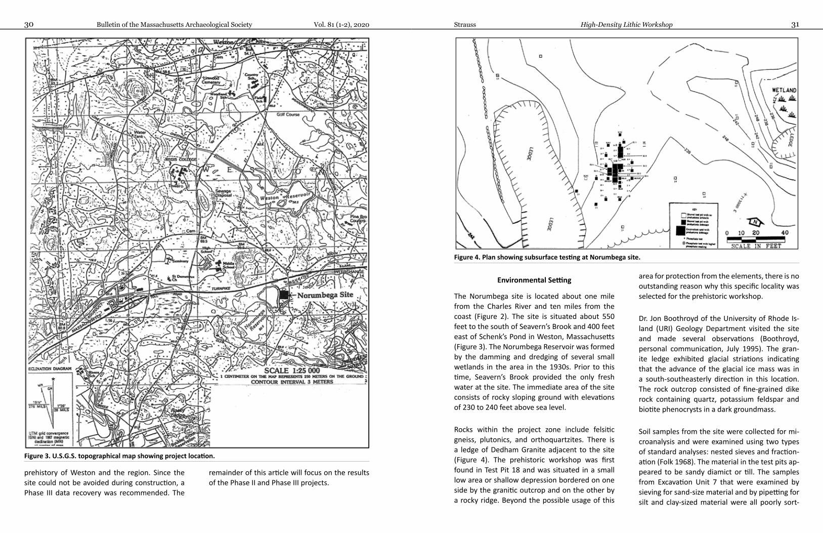
Bulletin of the Massachusetts Archaeological Society Vol. 81 (1-2), 202030 31Strauss High-Density Lithic Workshop
Environmental Setting
The Norumbega site is located about one mile from the Charles River and ten miles from the coast (Figure 2). The site is situated about 550 feet to the south of Seavern’s Brook and 400 feet east of Schenk’s Pond in Weston, Massachusetts (Figure 3). The Norumbega Reservoir was formed by the damming and dredging of several small wetlands in the area in the 1930s. Prior to this time, Seavern’s Brook provided the only fresh water at the site. The immediate area of the site consists of rocky sloping ground with elevations of 230 to 240 feet above sea level.
Rocks within the project zone include felsitic gneiss, plutonics, and orthoquartzites. There is a ledge of Dedham Granite adjacent to the site (Figure 4). The prehistoric workshop was first found in Test Pit 18 and was situated in a small low area or shallow depression bordered on one side by the granitic outcrop and on the other by a rocky ridge. Beyond the possible usage of this
area for protection from the elements, there is no outstanding reason why this specific locality was selected for the prehistoric workshop.
Dr. Jon Boothroyd of the University of Rhode Is-land (URI) Geology Department visited the site and made several observations (Boothroyd, personal communication, July 1995). The gran-ite ledge exhibited glacial striations indicating that the advance of the glacial ice mass was in a south-southeasterly direction in this location. The rock outcrop consisted of fine-grained dike rock containing quartz, potassium feldspar and biotite phenocrysts in a dark groundmass.
Soil samples from the site were collected for mi-croanalysis and were examined using two types of standard analyses: nested sieves and fraction-ation (Folk 1968). The material in the test pits ap-peared to be sandy diamict or till. The samples from Excavation Unit 7 that were examined by sieving for sand-size material and by pipetting for silt and clay-sized material were all poorly sort-
prehistory of Weston and the region. Since the site could not be avoided during construction, a Phase III data recovery was recommended. The
remainder of this article will focus on the results of the Phase II and Phase III projects.
Figure 3. U.S.G.S. topographical map showing project location.
Figure 4. Plan showing subsurface testing at Norumbega site.
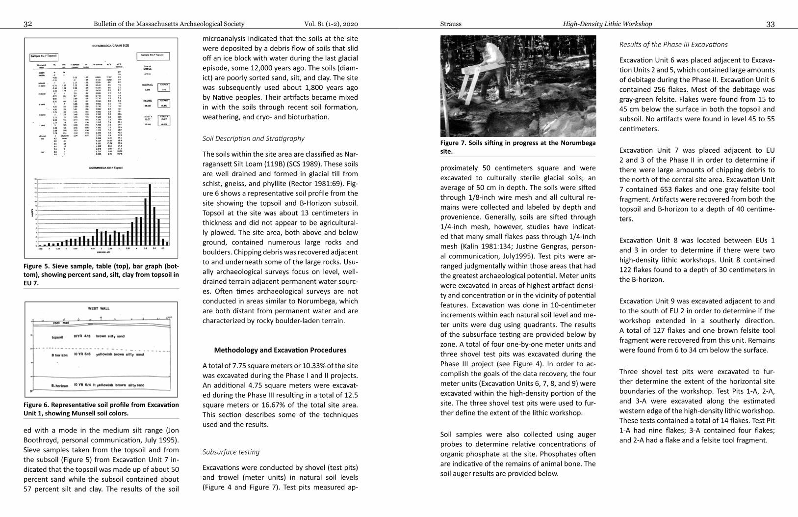
Bulletin of the Massachusetts Archaeological Society Vol. 81 (1-2), 202032 33Strauss High-Density Lithic Workshop
proximately 50 centimeters square and were excavated to culturally sterile glacial soils; an average of 50 cm in depth. The soils were sifted through 1/8-inch wire mesh and all cultural re-mains were collected and labeled by depth and provenience. Generally, soils are sifted through 1/4-inch mesh, however, studies have indicat-ed that many small flakes pass through 1/4-inch mesh (Kalin 1981:134; Justine Gengras, person-al communication, July1995). Test pits were ar-ranged judgmentally within those areas that had the greatest archaeological potential. Meter units were excavated in areas of highest artifact densi-ty and concentration or in the vicinity of potential features. Excavation was done in 10-centimeter increments within each natural soil level and me-ter units were dug using quadrants. The results of the subsurface testing are provided below by zone. A total of four one-by-one meter units and three shovel test pits was excavated during the Phase III project (see Figure 4). In order to ac-complish the goals of the data recovery, the four meter units (Excavation Units 6, 7, 8, and 9) were excavated within the high-density portion of the site. The three shovel test pits were used to fur-ther define the extent of the lithic workshop.
Soil samples were also collected using auger probes to determine relative concentrations of organic phosphate at the site. Phosphates often are indicative of the remains of animal bone. The soil auger results are provided below.
Results of the Phase III Excavations
Excavation Unit 6 was placed adjacent to Excava-tion Units 2 and 5, which contained large amounts of debitage during the Phase II. Excavation Unit 6 contained 256 flakes. Most of the debitage was gray-green felsite. Flakes were found from 15 to 45 cm below the surface in both the topsoil and subsoil. No artifacts were found in level 45 to 55 centimeters.
Excavation Unit 7 was placed adjacent to EU 2 and 3 of the Phase II in order to determine if there were large amounts of chipping debris to the north of the central site area. Excavation Unit 7 contained 653 flakes and one gray felsite tool fragment. Artifacts were recovered from both the topsoil and B-horizon to a depth of 40 centime-ters.
Excavation Unit 8 was located between EUs 1 and 3 in order to determine if there were two high-density lithic workshops. Unit 8 contained 122 flakes found to a depth of 30 centimeters in the B-horizon.
Excavation Unit 9 was excavated adjacent to and to the south of EU 2 in order to determine if the workshop extended in a southerly direction. A total of 127 flakes and one brown felsite tool fragment were recovered from this unit. Remains were found from 6 to 34 cm below the surface.
Three shovel test pits were excavated to fur-ther determine the extent of the horizontal site boundaries of the workshop. Test Pits 1-A, 2-A, and 3-A were excavated along the estimated western edge of the high-density lithic workshop. These tests contained a total of 14 flakes. Test Pit 1-A had nine flakes; 3-A contained four flakes; and 2-A had a flake and a felsite tool fragment.
ed with a mode in the medium silt range (Jon Boothroyd, personal communication, July 1995). Sieve samples taken from the topsoil and from the subsoil (Figure 5) from Excavation Unit 7 in-dicated that the topsoil was made up of about 50 percent sand while the subsoil contained about 57 percent silt and clay. The results of the soil
microanalysis indicated that the soils at the site were deposited by a debris flow of soils that slid off an ice block with water during the last glacial episode, some 12,000 years ago. The soils (diam-ict) are poorly sorted sand, silt, and clay. The site was subsequently used about 1,800 years ago by Native peoples. Their artifacts became mixed in with the soils through recent soil formation, weathering, and cryo- and bioturbation.
Soil Description and Stratigraphy
The soils within the site area are classified as Nar-ragansett Silt Loam (119B) (SCS 1989). These soils are well drained and formed in glacial till from schist, gneiss, and phyllite (Rector 1981:69). Fig-ure 6 shows a representative soil profile from the site showing the topsoil and B-Horizon subsoil. Topsoil at the site was about 13 centimeters in thickness and did not appear to be agricultural-ly plowed. The site area, both above and below ground, contained numerous large rocks and boulders. Chipping debris was recovered adjacent to and underneath some of the large rocks. Usu-ally archaeological surveys focus on level, well-drained terrain adjacent permanent water sourc-es. Often times archaeological surveys are not conducted in areas similar to Norumbega, which are both distant from permanent water and are characterized by rocky boulder-laden terrain.
Methodology and Excavation Procedures
A total of 7.75 square meters or 10.33% of the site was excavated during the Phase I and II projects. An additional 4.75 square meters were excavat-ed during the Phase III resulting in a total of 12.5 square meters or 16.67% of the total site area. This section describes some of the techniques used and the results.
Subsurface testing
Excavations were conducted by shovel (test pits) and trowel (meter units) in natural soil levels (Figure 4 and Figure 7). Test pits measured ap-
Figure 5. Sieve sample, table (top), bar graph (bot-tom), showing percent sand, silt, clay from topsoil in EU 7.
Figure 6. Representative soil profile from Excavation Unit 1, showing Munsell soil colors.
Figure 7. Soils sifting in progress at the Norumbega site.
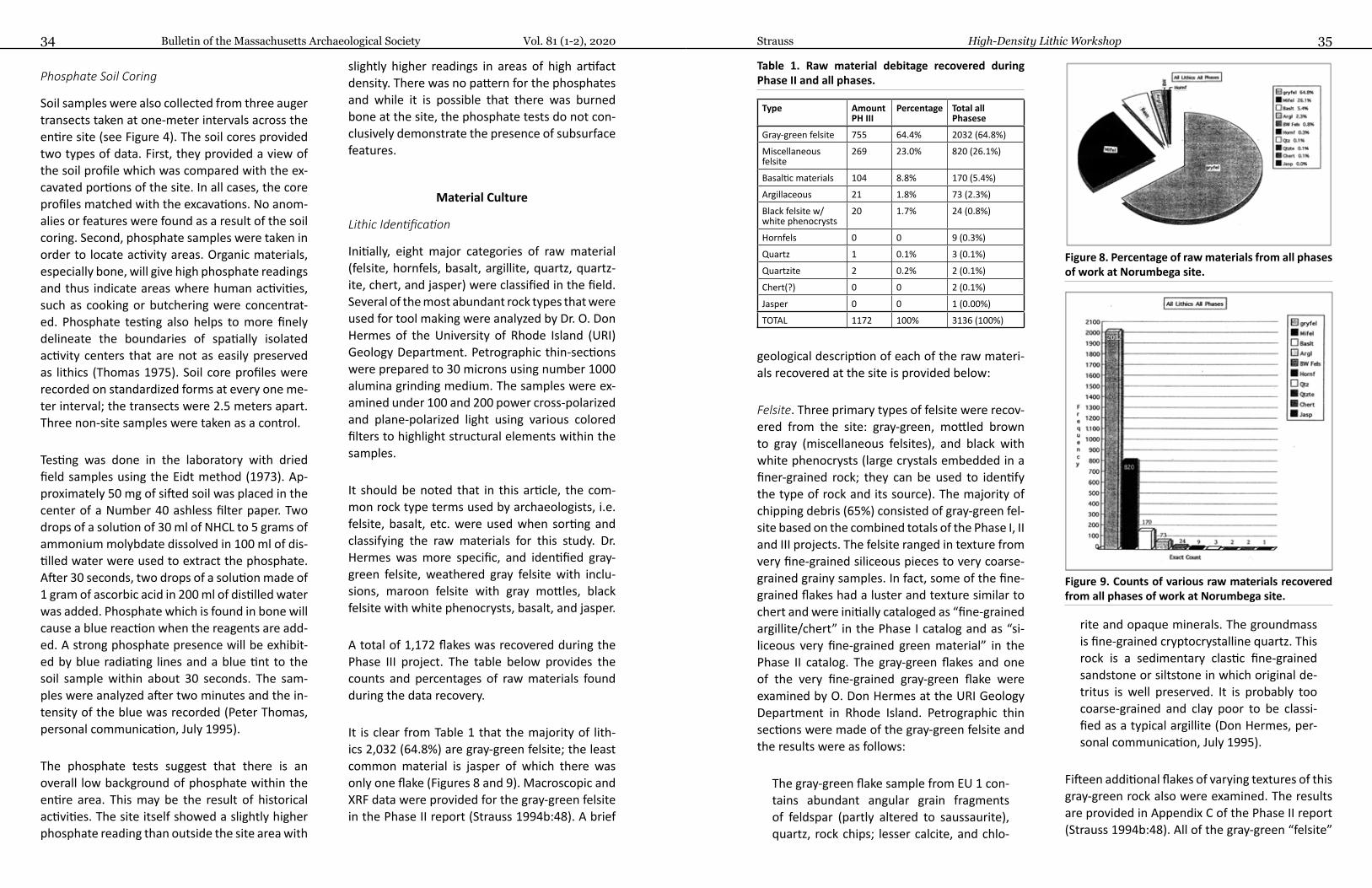
Bulletin of the Massachusetts Archaeological Society Vol. 81 (1-2), 202034 35Strauss High-Density Lithic Workshop
geological description of each of the raw materi-als recovered at the site is provided below:
Felsite. Three primary types of felsite were recov-ered from the site: gray-green, mottled brown to gray (miscellaneous felsites), and black with white phenocrysts (large crystals embedded in a finer-grained rock; they can be used to identify the type of rock and its source). The majority of chipping debris (65%) consisted of gray-green fel-site based on the combined totals of the Phase I, II and III projects. The felsite ranged in texture from very fine-grained siliceous pieces to very coarse-grained grainy samples. In fact, some of the fine-grained flakes had a luster and texture similar to chert and were initially cataloged as “fine-grained argillite/chert” in the Phase I catalog and as “si-liceous very fine-grained green material” in the Phase II catalog. The gray-green flakes and one of the very fine-grained gray-green flake were examined by O. Don Hermes at the URI Geology Department in Rhode Island. Petrographic thin sections were made of the gray-green felsite and the results were as follows:
The gray-green flake sample from EU 1 con-tains abundant angular grain fragments of feldspar (partly altered to saussaurite), quartz, rock chips; lesser calcite, and chlo-
rite and opaque minerals. The groundmass is fine-grained cryptocrystalline quartz. This rock is a sedimentary clastic fine-grained sandstone or siltstone in which original de-tritus is well preserved. It is probably too coarse-grained and clay poor to be classi-fied as a typical argillite (Don Hermes, per-sonal communication, July 1995).
Fifteen additional flakes of varying textures of this gray-green rock also were examined. The results are provided in Appendix C of the Phase II report (Strauss 1994b:48). All of the gray-green “felsite”
Phosphate Soil Coring
Soil samples were also collected from three auger transects taken at one-meter intervals across the entire site (see Figure 4). The soil cores provided two types of data. First, they provided a view of the soil profile which was compared with the ex-cavated portions of the site. In all cases, the core profiles matched with the excavations. No anom-alies or features were found as a result of the soil coring. Second, phosphate samples were taken in order to locate activity areas. Organic materials, especially bone, will give high phosphate readings and thus indicate areas where human activities, such as cooking or butchering were concentrat-ed. Phosphate testing also helps to more finely delineate the boundaries of spatially isolated activity centers that are not as easily preserved as lithics (Thomas 1975). Soil core profiles were recorded on standardized forms at every one me-ter interval; the transects were 2.5 meters apart. Three non-site samples were taken as a control.
Testing was done in the laboratory with dried field samples using the Eidt method (1973). Ap-proximately 50 mg of sifted soil was placed in the center of a Number 40 ashless filter paper. Two drops of a solution of 30 ml of NHCL to 5 grams of ammonium molybdate dissolved in 100 ml of dis-tilled water were used to extract the phosphate. After 30 seconds, two drops of a solution made of 1 gram of ascorbic acid in 200 ml of distilled water was added. Phosphate which is found in bone will cause a blue reaction when the reagents are add-ed. A strong phosphate presence will be exhibit-ed by blue radiating lines and a blue tint to the soil sample within about 30 seconds. The sam-ples were analyzed after two minutes and the in-tensity of the blue was recorded (Peter Thomas, personal communication, July 1995).
The phosphate tests suggest that there is an overall low background of phosphate within the entire area. This may be the result of historical activities. The site itself showed a slightly higher phosphate reading than outside the site area with
slightly higher readings in areas of high artifact density. There was no pattern for the phosphates and while it is possible that there was burned bone at the site, the phosphate tests do not con-clusively demonstrate the presence of subsurface features.
Material Culture
Lithic Identification
Initially, eight major categories of raw material (felsite, hornfels, basalt, argillite, quartz, quartz-ite, chert, and jasper) were classified in the field. Several of the most abundant rock types that were used for tool making were analyzed by Dr. O. Don Hermes of the University of Rhode Island (URI) Geology Department. Petrographic thin-sections were prepared to 30 microns using number 1000 alumina grinding medium. The samples were ex-amined under 100 and 200 power cross-polarized and plane-polarized light using various colored filters to highlight structural elements within the samples.
It should be noted that in this article, the com-mon rock type terms used by archaeologists, i.e. felsite, basalt, etc. were used when sorting and classifying the raw materials for this study. Dr. Hermes was more specific, and identified gray-green felsite, weathered gray felsite with inclu-sions, maroon felsite with gray mottles, black felsite with white phenocrysts, basalt, and jasper.
A total of 1,172 flakes was recovered during the Phase III project. The table below provides the counts and percentages of raw materials found during the data recovery.
It is clear from Table 1 that the majority of lith-ics 2,032 (64.8%) are gray-green felsite; the least common material is jasper of which there was only one flake (Figures 8 and 9). Macroscopic and XRF data were provided for the gray-green felsite in the Phase II report (Strauss 1994b:48). A brief
Table 1. Raw material debitage recovered during Phase II and all phases.
Type Amount PH III
Percentage Total all Phasese
Gray-green felsite 755 64.4% 2032 (64.8%)
Miscellaneous felsite
269 23.0% 820 (26.1%)
Basaltic materials 104 8.8% 170 (5.4%)
Argillaceous 21 1.8% 73 (2.3%)
Black felsite w/ white phenocrysts
20 1.7% 24 (0.8%)
Hornfels 0 0 9 (0.3%)
Quartz 1 0.1% 3 (0.1%)
Quartzite 2 0.2% 2 (0.1%)
Chert(?) 0 0 2 (0.1%)
Jasper 0 0 1 (0.00%)
TOTAL 1172 100% 3136 (100%)
Figure 8. Percentage of raw materials from all phases of work at Norumbega site.
Figure 9. Counts of various raw materials recovered from all phases of work at Norumbega site.

Bulletin of the Massachusetts Archaeological Society Vol. 81 (1-2), 202036 37Strauss High-Density Lithic Workshop
interpretation. Trace elements are within the range observed at a known source site of Melrose Green, and the texture and petrography are simi-lar to some samples observed there. It should be noted that this Melrose source area yields mate-rial of somewhat diverse texture, but similar va-rieties to the site flake do occur there. Also note that it is likely that similar source areas of Mel-rose like material maybe present in the Lynn-Mat-tapan terrain, but are thus far unrecognized. The gray green color may be the most useful property to distinguish this material from other sources within the Lynn-Mattapan sequence of volcanic rocks. “On the basis of petrography, this sample is most likely my specific Melrose samples MG-3, and fine-grained parts of samples MEL-8, MG-4,” (Don Hermes, personal communication, July 1995).
Based on the geological analysis conducted during the Phase II and III studies, it appears that much, if not all of what was called in the field gray-green or green-gray “felsite” may be be geologically Melrose Green rhyolite. In 1994, at the time of the original analysis conducted by Dr. Hermes, the Melrose quarry source was not yet known and therefore our samples could not be compared with it. However, in 1998 when the Phase III samples were examined they could be compared with the Melrose material. The classi-fication of Melrose Green is very difficult in the field, in fact it has been variously classified by archaeologists as felsite, silicified siltstone, and chert (Luedtke et al. 1998:25).
The Melrose Green rhyolite is a material that can be found in the village of Melrose northeast of the Wyoming Cemetery (Luedtke et al. 1998:25-30). The similarity between the Melrose Green rhyolite and samples from the Norumbega site is most striking for the very fine-grained gray-green samples. One Melrose Green prehistoric quarry is located about 14 miles to the northeast of the Norumbega site.
Various other volcanics and felsites were exam-ined for this study; however, spatial constraints limit the amount of geological data that can be pre-sented here. Various colors from gray to brown to almost black, some of which contain phenocrysts or inclusions, others of which are aporphyritic or aphenytic (without phenocrysts) were recovered at the Norumbega site. Because there was such a large variety but not a large quantity of any sin-gle type of these felsites, they were grouped as miscellaneous felsites. These various volcanics made up about 26% of the lithics recovered from the site. For details on the macroscopic analysis, petrography, and geochemistry for the weath-ered gray felsite with inclusions (Hand Sample #4), maroon felsite with gay mottles (Hand Sam-ple #5), and black felsite with white phenocrysts (Hand Sample #1), the reader is directed to the Phase III report (Strauss 1999). The various volca-nic materials were consistent with sources in the Lynn-Mattapan volcanics of the Boston Basin as well as Blue Hill or Spencer Hill volcanics (alka-lic rich), and the Newbury volcanic complex. For more data about the prehistoric use of these var-ious local volcanics to manufacture stone tools, the reader is directed to Anthony et al. (1980) and Johnson and Mahlstedt (1984).
Additional prehistoric debitage found at Norum-bega include argillite, hornfels, basalt, quartz, quartzite, and jasper. Each of these raw materials is described briefly below:
Argillite. Two types of argillaceous material were recovered from the site: green-gray and brown argillite. The greenish material is macroscopically somewhat similar to Narragansett Basin argillite (Strauss 1989). Sample #8, EU 2, 18-28 cm shows a contact of fine-grained siltstone with a fin-er-grained layer perhaps true argillite (Don Her-mes, personal communication, July 1995). Those flakes classified in the field as argillite may also possibly be Melrose Green rhyolite.
Hornfels. Nine hornfels flakes were found during the project. At least one of the flakes contained
have been geologically classified as siltstones with varying grain sizes and are all probably the same rock type from the same source.
In addition, a sample of the material from Exca-vation Unit 1 found at a depth of 18-27 cm was analyzed for trace elements. Trace element anal-ysis is one of the techniques used for identifying possible lithic sources. The results are provided in Appendix C of the Phase II report (Strauss 1994b: 49).
A second sample of the fine-grained gray-green rock from Test Pit 18S-1S was examined for the Phase III study by the URI Geology Department. The results are provided below:
Sample TP 18S-1S (9-25 cm): Very fine grained sugary textured sample. Gray green on weathered surface darker green on fresh surface. Specimen cut by very thin black veinlets. Sparse black mineral inclusions, and scattered spherical to subspherical white clots of material (up to 0.5 mm.) (O. Don Hermes, personal communication, July 1995).
Petrography: “Fine-grained uniformly textured rock consisting mainly of feldspar, quartz, mus-covite, epidote, sphene, and some opaque min-erals. The thin section shows a contrast between extremely fine-grained material and slightly coarser-grained rock of similar mineralogy. Some of the feldspar of euhedral/subhedral and con-sistent with igneous crystallization. Elsewhere there are some regions showing what appears to be elongated quenched crystals that are altered and pseudomorphed; these also are consistent with igneous crystallization. Epidote for euhedral stubby prisms, or anhedral partly altered grains. Chlorite and muscovite appear to be late stage secondary minerals. Some spherical to rounded patches in the rock consist of quartz and feldspar rich regions (slightly coarser textured). These fea-tures most likely represent amygdules or filled
vesicles” (Don Hermes, personal communication, July 1995).
Rock Type: “An igneous origin is favored based on the above thin section description, although neither the textures nor mineralogy is totally sup-portive of such an origin. The lack of phenocrysts and other unequivocal relict igneous textures precludes absolute proof. However, some of the features are consistent with an igneous origin and this is the preferred interpretation here. The rock does not exhibit textural or compositional features typical of chert, and seems distinct from argillite samples familiar to this writer” (Don Her-mes, personal communication, July 1995).
Geochemistry: Trace elements were determined by XRF non-destructive methods on the archaeo-logical flakes (Hermes and Ritchie 1997) (Table 2). While not as accurate as powdered analysis, the results shown below (in parts per million) are in-formative. The results were plotted graphically of various stable elements including zirconium, nio-bium, yttrium, rubidium, cerium, and lanthanum pairs, which represent those that most clearly discriminate among felsitic igneous rocks.
These concentrations of trace elements are con-sistent with those from volcanic rocks from the Lynn-Mattapan Volcanics (Johnson and Mahlst-edt 1984). Hence, these data are supportive of an igneous origin. For more details of the application of XRF analysis to archaeology see (Strauss and Hermes 1996; Strauss and Murray 1988).
Archaeological Source: Based on the sample col-or, petrography, and geochemistry, sample TP 18S-1S is most like the material referred to as Melrose Green, no one single attribute is con-clusive but collectively this seems to be the best
Table 2. Elements found in volcanic rocks at the site from XRF.
Rb Sr Y Zr Nd Ba La Ce Zn
108 224 29 226 11 1745 4 68 56
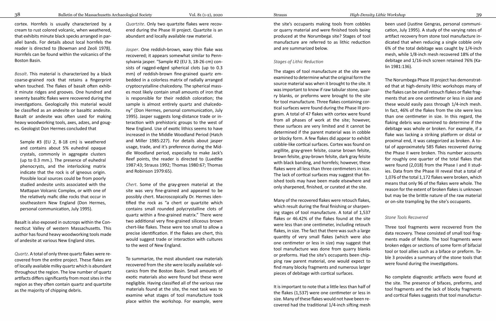
Bulletin of the Massachusetts Archaeological Society Vol. 81 (1-2), 202038 39Strauss High-Density Lithic Workshop
the site’s occupants making tools from cobbles or quarry material and were finished tools being produced at the Norumbega site? Stages of tool manufacture are referred to as lithic reduction and are summarized below.
Stages of Lithic Reduction
The stages of tool manufacture at the site were examined to determine what the original form the source material was when it brought to the site. It was important to know if raw tabular stone, quar-ry blanks, or preforms were brought to the site for tool manufacture. Three flakes containing cor-tical surfaces were found during the Phase III pro-gram. A total of 47 flakes with cortex were found from all phases of work at the site; however, these surfaces are very limited and it cannot be determined if the parent material was in cobble or blocky form. A few flakes did appear to exhibit cobble-like cortical surfaces. Cortex was found on argillite, gray-green felsite, coarse brown felsite, brown felsite, gray-brown felsite, dark gray felsite with black banding, and hornfels; however, these flakes were all less than three centimeters in size. The lack of cortical surfaces may suggest that fin-ished tools may have been made elsewhere and only sharpened, finished, or curated at the site.
Many of the recovered flakes were retouch flakes, which result during the final finishing or sharpen-ing stages of tool manufacture. A total of 1,537 flakes or 46.42% of the flakes found at the site were less than one centimeter, including retouch flakes, in size. The fact that there was such a large quantity of very small flakes (which were also one centimeter or less in size) may suggest that tool manufacture was done from quarry blanks or preforms. Had the site’s occupants been chip-ping raw parent material, one would expect to find many blocky fragments and numerous larger pieces of debitage with cortical surfaces.
It is important to note that a little less than half of the flakes (1,537) were one centimeter or less in size. Many of these flakes would not have been re-covered had the traditional 1/4-inch sifting mesh
been used (Justine Gengras, personal communi-cation, July 1995). A study of the varying rates of artifact recovery from stone tool manufacture in-dicated that when reducing a single cobble only 6% of the total debitage was caught by 1/4-inch mesh, while 1/8-inch mesh recovered 18% of the debitage and 1/16-inch screen retained 76% (Ka-lin 1981:136).
The Norumbega Phase III project has demonstrat-ed that at high-density lithic workshops many of the flakes can be small retouch flakes or flake frag-ments that are one centimeter or less in size and these would easily pass through 1/4-inch mesh. In fact, 46% of the flakes from the site were less than one centimeter in size. In this regard, the flaking debris was examined to determine if the debitage was whole or broken. For example, if a flake was lacking a striking platform or distal or proximal end, it was categorized as broken. A to-tal of approximately 585 flakes recovered during the Phase II were broken. This number accounts for roughly one quarter of the total flakes that were found (2,018) from the Phase I and II stud-ies. Data from the Phase III reveal that a total of 1,076 of the total 1,172 flakes were broken, which means that only 96 of the flakes were whole. The reason for the extent of broken flakes is unknown but may be the brittle nature of the raw material or on-site trampling by the site's occupants.
Stone Tools Recovered
Three tool fragments were recovered from the data recovery. These consisted of small tool frag-ments made of felsite. The tool fragments were broken edges or sections of some form of bifacial tool or tool allies such as a biface or preform. Ta-ble 3 provides a summary of the stone tools that were found during the investigations.
No complete diagnostic artifacts were found at the site. The presence of bifaces, preforms, and tool fragments and the lack of blocky fragments and cortical flakes suggests that tool manufactur-
cortex. Hornfels is usually characterized by a cream to rust colored volcanic, when weathered, that exhibits minute black specks arranged in par-allel bands. For details about local hornfels the reader is directed to (Bowman and Zeoli 1978). Hornfels can be found within the volcanics of the Boston Basin.
Basalt. This material is characterized by a black coarse-grained rock that retains a fingerprint when touched. The flakes of basalt often exhib-it minute ridges and grooves. One hundred and seventy basaltic flakes were recovered during the investigations. Geologically this material would be classified as an andesite or basaltic andesite. Basalt or andesite was often used for making heavy woodworking tools, axes, adzes, and goug-es. Geologist Don Hermes concluded that
Sample #3 (EU 2, 8-18 cm) is weathered and contains about 5% euhedral opaque crystals, commonly in aggregate clusters (up to 0.3 mm.). The presence of euhedral phenocrysts, and the interlocking matrix indicate that the rock is of igneous origin. Possible local sources could be from poorly studied andesite units associated with the Mattapan Volcanic Complex, or with one of the relatively mafic dike rocks that occur in southeastern New England (Don Hermes, personal communication, July 1995).
Basalt is also exposed in outcrops within the Con-necticut Valley of western Massachusetts. This author has found heavy woodworking tools made of andesite at various New England sites.
Quartz. A total of only three quartz flakes were re-covered from the entire project. These flakes are of locally available milky quartz which is abundant throughout the region. The low number of quartz artifacts differs significantly from most sites in the region as they often contain quartz and quartzite as the majority of chipping debris.
Quartzite. Only two quartzite flakes were recov-ered during the Phase III project. Quartzite is an abundant and locally available raw material.
Jasper. One reddish-brown, waxy thin flake was recovered; it appears somewhat similar to Penn-sylvania jasper. “Sample #2 (EU 3, 18-26 cm) con-sists of ragged-edged spherical clots (up to 0.3 mm) of reddish-brown fine-grained quartz em-bedded in a colorless matrix of radially arranged cryptocrystalline chalcedony. The spherical mass-es most likely contain small amounts of iron that is responsible for their reddish coloration; the sample is almost entirely quartz and chalcedo-ny” (Don Hermes, personal communication, July 1995). Jasper suggests long-distance trade or in-teraction with prehistoric groups to the west of New England. Use of exotic lithics seems to have increased in the Middle Woodland Period (Hatch and Miller 1985:227). For details about jasper usage, trade, and it’s preference during the Mid-dle Woodland period, especially to make Jack’s Reef points, the reader is directed to (Luedtke 1987:43; Strauss 1992; Thomas 1980:67; Thomas and Robinson 1979:65).
Chert. Some of the gray-green material at the site was very fine-grained and appeared to be possibly chert. Macroscopically Dr. Hermes iden-tified the rock as “a chert or quartzite which contains small rounded polycrystalline clots of quartz within a fine-grained matrix.” There were two additional very fine-grained siliceous brown chert-like flakes. These were too small to allow a precise identification. If the flakes are chert, this would suggest trade or interaction with cultures to the west of New England.
To summarize, the most abundant raw materials recovered from the site were locally available vol-canics from the Boston Basin. Small amounts of exotic materials also were found but these were negligible. Having classified all of the various raw materials found at the site, the next task was to examine what stages of tool manufacture took place within the workshop. For example, were
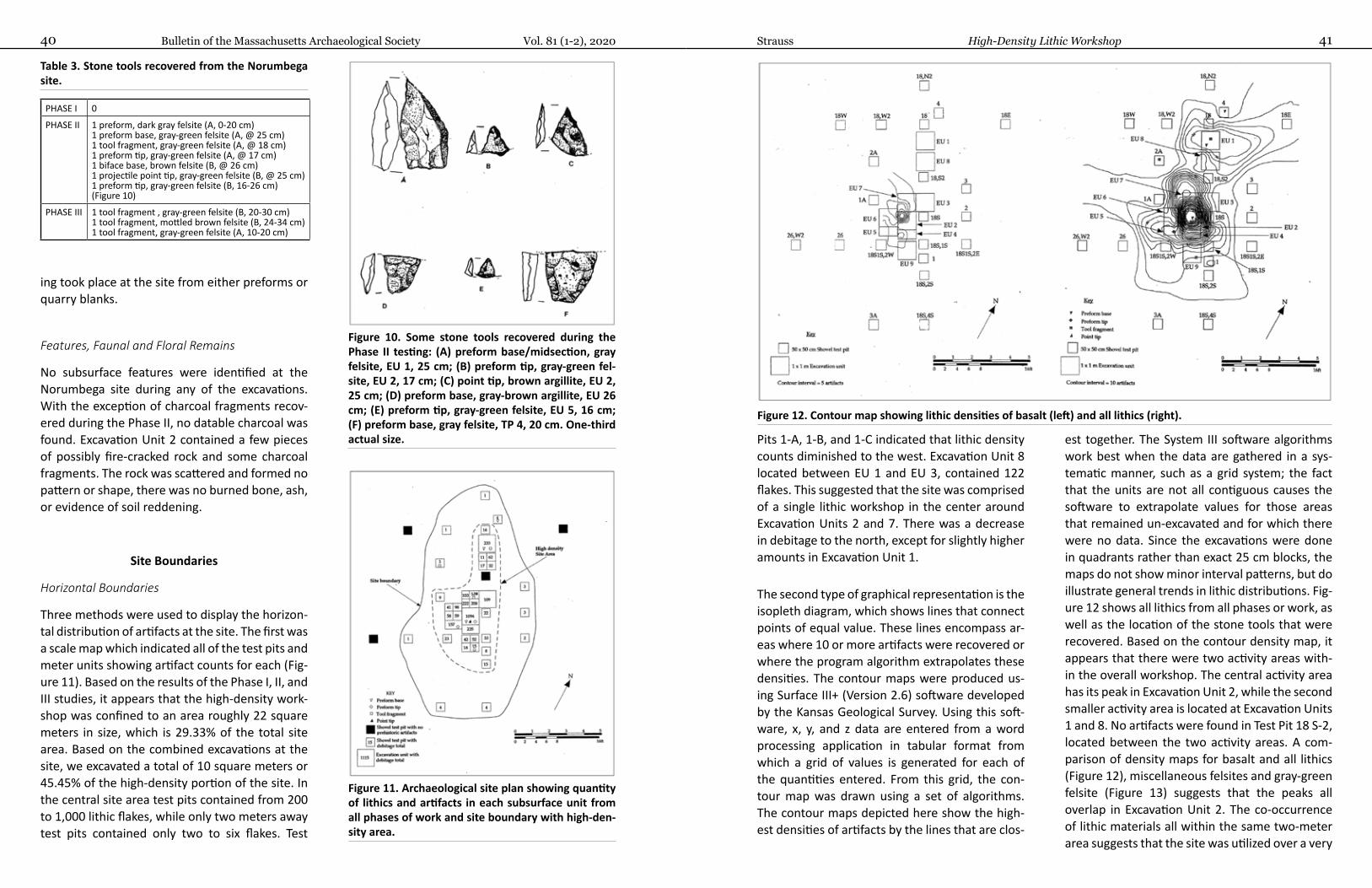
Bulletin of the Massachusetts Archaeological Society Vol. 81 (1-2), 202040 41Strauss High-Density Lithic Workshop
Pits 1-A, 1-B, and 1-C indicated that lithic density counts diminished to the west. Excavation Unit 8 located between EU 1 and EU 3, contained 122 flakes. This suggested that the site was comprised of a single lithic workshop in the center around Excavation Units 2 and 7. There was a decrease in debitage to the north, except for slightly higher amounts in Excavation Unit 1.
The second type of graphical representation is the isopleth diagram, which shows lines that connect points of equal value. These lines encompass ar-eas where 10 or more artifacts were recovered or where the program algorithm extrapolates these densities. The contour maps were produced us-ing Surface III+ (Version 2.6) software developed by the Kansas Geological Survey. Using this soft-ware, x, y, and z data are entered from a word processing application in tabular format from which a grid of values is generated for each of the quantities entered. From this grid, the con-tour map was drawn using a set of algorithms. The contour maps depicted here show the high-est densities of artifacts by the lines that are clos-
est together. The System III software algorithms work best when the data are gathered in a sys-tematic manner, such as a grid system; the fact that the units are not all contiguous causes the software to extrapolate values for those areas that remained un-excavated and for which there were no data. Since the excavations were done in quadrants rather than exact 25 cm blocks, the maps do not show minor interval patterns, but do illustrate general trends in lithic distributions. Fig-ure 12 shows all lithics from all phases or work, as well as the location of the stone tools that were recovered. Based on the contour density map, it appears that there were two activity areas with-in the overall workshop. The central activity area has its peak in Excavation Unit 2, while the second smaller activity area is located at Excavation Units 1 and 8. No artifacts were found in Test Pit 18 S-2, located between the two activity areas. A com-parison of density maps for basalt and all lithics (Figure 12), miscellaneous felsites and gray-green felsite (Figure 13) suggests that the peaks all overlap in Excavation Unit 2. The co-occurrence of lithic materials all within the same two-meter area suggests that the site was utilized over a very
ing took place at the site from either preforms or quarry blanks.
Features, Faunal and Floral Remains
No subsurface features were identified at the Norumbega site during any of the excavations. With the exception of charcoal fragments recov-ered during the Phase II, no datable charcoal was found. Excavation Unit 2 contained a few pieces of possibly fire-cracked rock and some charcoal fragments. The rock was scattered and formed no pattern or shape, there was no burned bone, ash, or evidence of soil reddening.
Site Boundaries
Horizontal Boundaries
Three methods were used to display the horizon-tal distribution of artifacts at the site. The first was a scale map which indicated all of the test pits and meter units showing artifact counts for each (Fig-ure 11). Based on the results of the Phase I, II, and III studies, it appears that the high-density work-shop was confined to an area roughly 22 square meters in size, which is 29.33% of the total site area. Based on the combined excavations at the site, we excavated a total of 10 square meters or 45.45% of the high-density portion of the site. In the central site area test pits contained from 200 to 1,000 lithic flakes, while only two meters away test pits contained only two to six flakes. Test
Figure 10. Some stone tools recovered during the Phase II testing: (A) preform base/midsection, gray felsite, EU 1, 25 cm; (B) preform tip, gray-green fel-site, EU 2, 17 cm; (C) point tip, brown argillite, EU 2, 25 cm; (D) preform base, gray-brown argillite, EU 26 cm; (E) preform tip, gray-green felsite, EU 5, 16 cm; (F) preform base, gray felsite, TP 4, 20 cm. One-third actual size.
Figure 11. Archaeological site plan showing quantity of lithics and artifacts in each subsurface unit from all phases of work and site boundary with high-den-sity area.
Table 3. Stone tools recovered from the Norumbega site.
PHASE I 0
PHASE II 1 preform, dark gray felsite (A, 0-20 cm)1 preform base, gray-green felsite (A, @ 25 cm)1 tool fragment, gray-green felsite (A, @ 18 cm)1 preform tip, gray-green felsite (A, @ 17 cm)1 biface base, brown felsite (B, @ 26 cm)1 projectile point tip, gray-green felsite (B, @ 25 cm)1 preform tip, gray-green felsite (B, 16-26 cm) (Figure 10)
PHASE III 1 tool fragment , gray-green felsite (B, 20-30 cm)1 tool fragment, mottled brown felsite (B, 24-34 cm)1 tool fragment, gray-green felsite (A, 10-20 cm)
Figure 12. Contour map showing lithic densities of basalt (left) and all lithics (right).
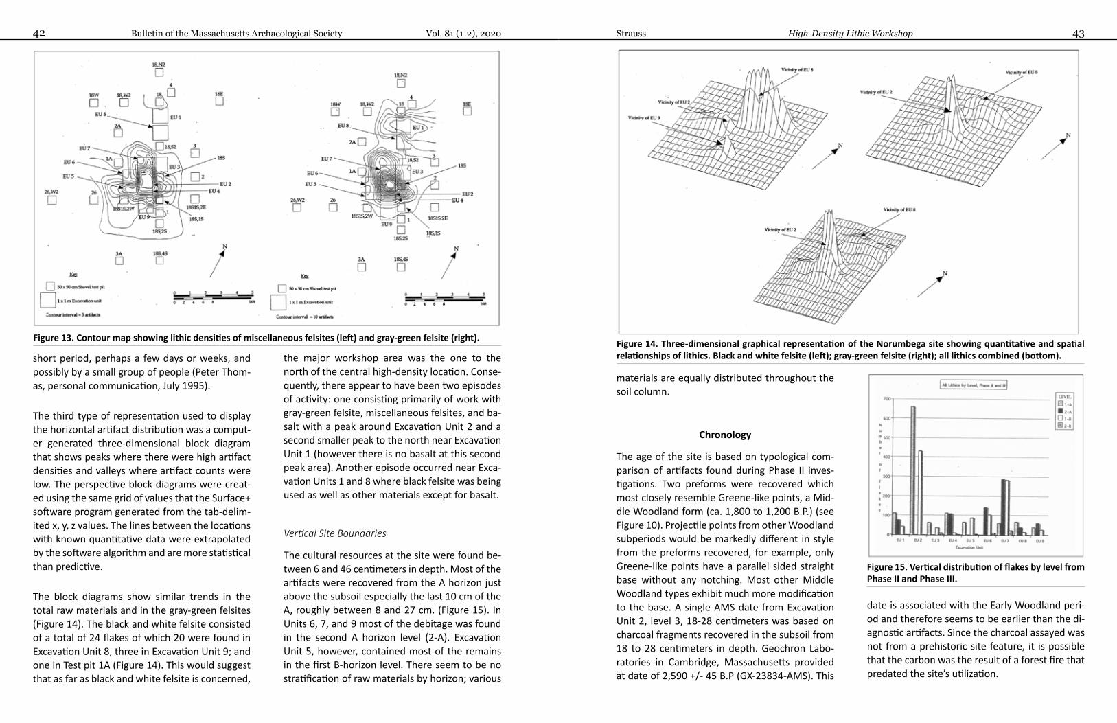
Bulletin of the Massachusetts Archaeological Society Vol. 81 (1-2), 202042 43Strauss High-Density Lithic Workshop
materials are equally distributed throughout the soil column.
Chronology
The age of the site is based on typological com-parison of artifacts found during Phase II inves-tigations. Two preforms were recovered which most closely resemble Greene-like points, a Mid-dle Woodland form (ca. 1,800 to 1,200 B.P.) (see Figure 10). Projectile points from other Woodland subperiods would be markedly different in style from the preforms recovered, for example, only Greene-like points have a parallel sided straight base without any notching. Most other Middle Woodland types exhibit much more modification to the base. A single AMS date from Excavation Unit 2, level 3, 18-28 centimeters was based on charcoal fragments recovered in the subsoil from 18 to 28 centimeters in depth. Geochron Labo-ratories in Cambridge, Massachusetts provided at date of 2,590 +/- 45 B.P (GX-23834-AMS). This
date is associated with the Early Woodland peri-od and therefore seems to be earlier than the di-agnostic artifacts. Since the charcoal assayed was not from a prehistoric site feature, it is possible that the carbon was the result of a forest fire that predated the site’s utilization.
short period, perhaps a few days or weeks, and possibly by a small group of people (Peter Thom-as, personal communication, July 1995).
The third type of representation used to display the horizontal artifact distribution was a comput-er generated three-dimensional block diagram that shows peaks where there were high artifact densities and valleys where artifact counts were low. The perspective block diagrams were creat-ed using the same grid of values that the Surface+ software program generated from the tab-delim-ited x, y, z values. The lines between the locations with known quantitative data were extrapolated by the software algorithm and are more statistical than predictive.
The block diagrams show similar trends in the total raw materials and in the gray-green felsites (Figure 14). The black and white felsite consisted of a total of 24 flakes of which 20 were found in Excavation Unit 8, three in Excavation Unit 9; and one in Test pit 1A (Figure 14). This would suggest that as far as black and white felsite is concerned,
the major workshop area was the one to the north of the central high-density location. Conse-quently, there appear to have been two episodes of activity: one consisting primarily of work with gray-green felsite, miscellaneous felsites, and ba-salt with a peak around Excavation Unit 2 and a second smaller peak to the north near Excavation Unit 1 (however there is no basalt at this second peak area). Another episode occurred near Exca-vation Units 1 and 8 where black felsite was being used as well as other materials except for basalt.
Vertical Site Boundaries
The cultural resources at the site were found be-tween 6 and 46 centimeters in depth. Most of the artifacts were recovered from the A horizon just above the subsoil especially the last 10 cm of the A, roughly between 8 and 27 cm. (Figure 15). In Units 6, 7, and 9 most of the debitage was found in the second A horizon level (2-A). Excavation Unit 5, however, contained most of the remains in the first B-horizon level. There seem to be no stratification of raw materials by horizon; various
Figure 13. Contour map showing lithic densities of miscellaneous felsites (left) and gray-green felsite (right). Figure 14. Three-dimensional graphical representation of the Norumbega site showing quantitative and spatial relationships of lithics. Black and white felsite (left); gray-green felsite (right); all lithics combined (bottom).
Figure 15. Vertical distribution of flakes by level from Phase II and Phase III.
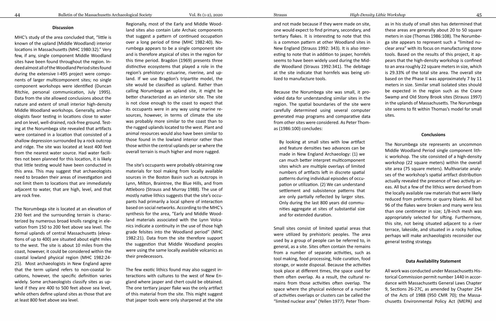
Bulletin of the Massachusetts Archaeological Society Vol. 81 (1-2), 202044 45Strauss High-Density Lithic Workshop
and not made because if they were made on site, one would expect to find primary, secondary, and tertiary flakes. It is interesting to note that this is a common pattern at other Woodland sites in New England (Strauss 1992: 343). It is also inter-esting to note that in addition to jasper, hornfels seems to have been widely used during the Mid-dle Woodland (Strauss 1992:341). The debitage at the site indicate that hornfels was being uti-lized to manufacture tools.
Because the Norumbega site was small, it pro-vided data for understanding similar sites in the region. The spatial boundaries of the site were carefully determined using several computer generated map programs and comparative data from other sites were considered. As Peter Thom-as (1986:100) concludes:
By looking at small sites with low artifact and feature densities two advances can be made in New England Archaeology: (1) we can much better interpret multicomponent sites which are multiple overlays of limited numbers of artifacts left in discrete spatial patterns during individual episodes of occu-pation or utilization. (2) We can understand settlement and subsistence patterns that are only partially reflected by larger sites. Only during the last 800 years did commu-nities aggregate at sites of substantial size and for extended duration.
Small sites consist of limited spatial areas that were utilized by prehistoric peoples. The area used by a group of people can be referred to, in general, as a site. Sites often contain the remains from a number of separate activities, such as tool making, food processing, hide curation, food storage, or waste disposal. Because the activities took place at different times, the space used for them often overlap. As a result, the cultural re-mains from those activities often overlap. The space where the physical evidence of a number of activities overlaps or clusters can be called the “limited nuclear area” (Yellen 1977). Peter Thom-
as in his study of small sites has determined that these areas are generally about 20 to 50 square meters in size (Thomas 1986:108). The Norumbe-ga site appears to represent such a “limited nu-clear area” with its focus on manufacturing stone tools. Based on the results of this project, it ap-pears that the high-density workshop is confined to an area roughly 22 square meters in size, which is 29.33% of the total site area. The overall site based on the Phase II was approximately 7 by 11 meters in size. Similar small isolated sites should be expected in the region such as the Crane Swamp and Old Stony Brook sites (Strauss 1997) in the uplands of Massachusetts. The Norumbega site seems to fit within Thomas’s model for small sites.
Conclusions
The Norumbega site represents an uncommon Middle Woodland Period single component lith-ic workshop. The site consisted of a high-density workshop (22 square meters) within the overall site area (75 square meters). Multivariate analy-ses of the workshop’s spatial artifact distribution actually revealed the presence of two activity ar-eas. All but a few of the lithics were derived from the locally available raw materials that were likely reduced from preforms or quarry blanks. All but 96 of the flakes were broken and many were less than one centimeter in size; 1/8-inch mesh was appropriately selected for sifting. Furthermore, this site, not being situated adjacent to a river terrace, lakeside, and situated in a rocky hollow, perhaps will make archaeologists reconsider our general testing strategy.
Data Availability Statement
All work was conducted under Massachusetts His-torical Commission permit number 1440 in accor-dance with Massachusetts General Laws Chapter 9, Sections 26-27C, as amended by Chapter 254 of the Acts of 1988 (950 CMR 70); the Massa-chusetts Environmental Policy Act (MEPA) and
Discussion
MHC’s study of the area concluded that, “little is known of the upland (Middle Woodland) interior locations in Massachusetts (MHC 1980:32).” Very few, if any, single component Middle Woodland sites have been found throughout the region. In-deed almost all of the Woodland Period sites found during the extensive I-495 project were compo-nents of larger multicomponent sites; no single component workshops were identified (Duncan Ritchie, personal communication, July 1995). Data from the site allowed conclusions about the nature and extent of small interior high-density Middle Woodland workshops. Generally, archae-ologists favor testing in locations close to water and on level, well-drained, rock-free ground. Test-ing at the Norumbega site revealed that artifacts were contained in a location that consisted of a shallow depression surrounded by a rock outcrop and ridge. The site was located at least 400 feet from the nearest water source. Had water facili-ties not been planned for this location, it is likely that little testing would have been conducted in this area. This may suggest that archaeologists need to broaden their areas of investigation and not limit them to locations that are immediately adjacent to water, that are high, level, and that are rock free.
The Norumbega site is located at an elevation of 230 feet and the surrounding terrain is charac-terized by numerous broad knolls ranging in ele-vation from 150 to 200 feet above sea level. The formal uplands of central Massachusetts (eleva-tions of up to 400) are situated about eight miles to the west. The site is about 10 miles from the coast, however, it could be considered within the coastal lowland physical region (MHC 1982:24-25). Most archaeologists in New England agree that the term upland refers to non-coastal lo-cations, however, the specific definition varies widely. Some archaeologists classify sites as up-land if they are 400 to 500 feet above sea level, while others define upland sites as those that are at least 800 feet above sea level.
Regionally, most of the Early and Middle Wood-land sites also contain Late Archaic components that suggest a pattern of continued occupation over a long period of time (MHC 1982:40). No-rumbega appears to be a single component site and is therefore atypical of sites in the region for this time period. Bragdon (1969) presents three distinctive ecosystems that played a role in the region’s prehistory: estuarine, riverine, and up-land. If we use Bragdon’s tripartite model, the site would be classified as upland. Rather than calling Norumbega an upland site, it might be better characterized as an interior site. The site is not close enough to the coast to expect that its occupants were in any way using marine re-sources, however, in terms of climate the site was probably more similar to the coast than to the rugged uplands located to the west. Plant and animal resources would also have been similar to those found in the lowland interior rather than those within the central uplands per se where the overall terrain is much higher and more rugged.
The site’s occupants were probably obtaining raw materials for tool making from locally available sources in the Boston Basin such as outcrops in Lynn, Milton, Braintree, the Blue Hills, and from Attleboro (Strauss and Murray 1988). The use of mostly native lithics suggests that the site’s occu-pants had primarily a local sphere of interaction based on social networks. According to the MHC’s synthesis for the area, “Early and Middle Wood-land materials associated with the Lynn Volca-nics indicate a continuity in the use of those high grade felsites into the Woodland period” (MHC 1982:21). Data from the site therefore support the suggestion that Middle Woodland peoples were using the same locally available volcanics as their predecessors.
The few exotic lithics found may also suggest in-teractions with cultures to the west of New En-gland where jasper and chert could be obtained. The one tertiary jasper flake was the only artifact of this material from the site. This might suggest that jasper tools were only sharpened at the site
Bulletin of the Massachusetts Archaeological Society Vol. 81 (1-2), 202046 47Strauss High-Density Lithic Workshop
Hermes O. Don, and D. Ritchie1998 Nondestructive trace element Analysis of Archaeological Felsite by Energy-Dispersive X-ray Fluores-
cence Spectroscopy. Geoarchaeology 12(1):31-40.
Johnston, Eric, and Thomas Mahlstedt1984 Guide to Prehistoric Site Files and Artifact Classification System. Massachusetts Historical Commission,
Boston.
Kalin, Jeffrey1981 Stem Point Manufacture and Debitage Recovery. Archaeology of Eastern North America 9:134-175.
Luedtke, Barbara1987 The Pennsylvania Connection: Jasper at Massachusetts Sites. Bulletin of the Massachusetts Archaeolog-
ical Society 48(2):37-47.
Luedtke, Barbara, O. Don Hermes, and Duncan Ritchie1998 Rediscovery of the Wyoming Quarry Site in Melrose, Massachusetts. Bulletin of the Massachusetts
Archaeological Society 59(1):25-30.
MHC (Massachusetts Historical Commission)1980 Cultural Resource Management in Massachusetts: A Model for Management. MHC, Boston.1982 Historic and Archaeological Resources of the Boston Area. MHC, Boston.1985 Historic and Archaeological Resources of Southeastern Massachusetts. MHC, Boston.
Munsell Color1992 Munsell Soil Color Charts. Kollmorgen Instruments Corp., New York.
Rector, Dean1981 Soil Survey of Rhode Island. U.S. Dept. of Agriculture, Soil Conservation Service, Washington DC.
Soil Conservation Service1989 Middlesex County Soil Survey: A Resource Planners Guide. U.S. Dept. of Agriculture, Soil Conservation
Service, Acton, MA.
Strauss, Alan E.1989 Narragansett Basin Argillite: Lithology, Chronology, and Prehistoric Tool Manufacture. North American
Archaeologist 10(1):25-37.1992 Jack’s Reef Corner Notched Points in New England: Site Distribution, Raw Material Preference, and
Implications for Trade. North American Archaeologist 13(4):333-350.1994a Intensive Archaeological Survey of the MetroWest Water Supply Tunnel Project. On file at MHC, Boston.1994b Phase II Archaeological Site Examination of the Norumbega Site in Weston, Massachusetts. On file at
MHC, Boston.1995 Intensive Archaeological Survey of the Norumbega Reservoir Project. On file MHC, Boston.1996 Intensive Archaeological Survey of the MWRA Walnut Hill Water Treatment Facilities in Marlborough,
Northborough, and Southborough, Massachusetts. On file at MHC, Boston.1997 Phase II Archaeological Site Examinations at the Crane Swamp Site and Old Stony Brook Sites MWRA
Walnut Hill Water Treatment Facilities Marlborough and Northborough, Massachusetts. On file MHC, Boston.
1999 Phase III Archaeological Data Recovery at the Norumbega Site (19-MD-725) in Weston, Massachusetts. On file at MHC, Boston.
Strauss, Alan E., and O. Don Hermes1996 Anatomy of a Rhyolite Quarry. Archaeology of Eastern North America 24:159-171.
Advisory Council 1980. All artifacts are curated at the archaeological laboratory at the University of Massachusetts in Boston. CRM reports for this project are on file at the Massachusetts Historical Commission (MHC) in Boston and were undertak-en by Boston Affiliates, Inc.
Acknowledgments
The author wishes to thank several people who con-tributed to this project. Mr. Gerald Macomber and Mr. Louis Sardelli of CRS served as field assistants for the project. Mr. Macomber also produced the com-
puter graphics. The staff of Boston Affiliates, Inc., Ms. Pauline Chase-Harrell and Mr. Stanley Moss, provided technical support. Dr. Jon Boothroyd of the University of Rhode Island Geology Department visited the site and conducted the site soil analysis. Dr. O. Don Her-mes also of URI Geology conducted petrography, XRF, and geochemical analysis of the lithics from the site. Geochron Laboratories of Cambridge, Massachusetts provided the AMS radiocarbon date for the site. Dr. Peter Thomas shared his knowledge of conducting phosphate test analysis. The staff of Sverdrup Civil En-gineers, Inc. provided the base maps for the project. Deborah A. Strauss of CRS proofread the draft manu-script. Many thanks to all those individuals who par-ticipated in this study.
References Cited
Advisory Council on Historic Preservation1980 Treatment of Archaeological Properties: A Handbook. Advisory Council on Historic Preservation, Wash-
ington DC.
Anthony, David, Carty, F. and Linda Towle1980 State Survey Project Interim Report, Prehistoric Survey Team. MHC (Massachusetts Historical Commis-
sion), Boston.
Bragdon, Kathleen1996 Native Peoples of Southern New England, 1500-1600. University of Oklahoma Press, Norman.
Bowman, William, and Gerald Zeoli1977 Discovery of a New Major Aboriginal Lithic Source. Bulletin of Massachusetts Archaeological Society
38(3):34-47.
Décima, Elena, and Barbara Putnam1997 Reconnaissance Archaeological Survey of the Weston Aqueduct Supply Mains 1, 2 and 4 Rehabilitation
Project. Weston and Newton. On file at MHC, Boston.
Dincauze, Dena F.1973 Prehistoric Occupation of the Charles River Estuary: A Paleographic Study. Bulletin of the Archaeological
Society of Connecticut 38:25-39.1974 An Introduction to the Archaeology of Greater Boston. Archaeology of Eastern North America 2(1):39-
67.
Eidt, R.C.1973 A Rapid Chemical Field Test for Archaeological Site Survey. American Antiquity 38(2): 206-210.
Folk, Robert1968 The Petrology of Sedimentary Rocks. Hemphil, Austin, TX.
Hatch, James, and P. Miller1985 Procurement, Tool Production, and Sources Research at the Vera Cruz Jasper Quarry in Pennsylvania.
Journal of Field Archaeology 12(2):219-230.

Bulletin of the Massachusetts Archaeological Society 492020, Vol. 81(1-2)
Bulletin of the Massachusetts Archaeological Society Vol. 81 (1-2), 202048
Strauss, Alan E., and Daniel P. Murray1988 A Model for the Distribution of Poor to Moderate Grade Raw Materials from their Sources in South-
eastern New England: The Attleboro Red Felsite Example. Archaeology of Eastern North America 16:43-54.
Thomas, Peter A.1975 Archaeological and Historic Impact Statement Part II: Archaeological Investigation Montague Nuclear
Power Station. On file MHC, Boston.1980 The McNeil Generating Plant Site (VT-CH-93), Burlington, VT. Man in the Northeast 19:57-71.1986 Discerning Some Spatial Characteristics of Small, Short Term, Single Occupation Sites: Implications for
New England Archaeology. Man in the Northeast 31:99-121.
Thomas, Peter A., and Brian Robinson1979 The Missisquoi National Wildlife Refuge: A Cultural Resource Survey. Anthropology Department, Univer-
sity of Vermont, Burlington.
Yellen, J.E.1977 Archaeological Approaches to the Present. Academic Press, New York.
POST-CONTACT UPLAND SITES NEAR LAKE CHAUBUNAGUNGAMAUG
MARTIN G. DUDEKCommonwealth Heritage Group, Inc. 410 Great Rd, B14, Littleton, MA 01460 E-mail: [email protected]
Abstract
An archaeological survey identified three stone structures in bouldery uplands of southern Worcester County near Lake Chaubunagungam-aug. Stone Structures 1 and 2 consist of U-shaped stacks. Stone Structure 3 consists of a collapsed stone stack associated with hand-molded bricks. Judgmentally-placed test pits at Stone Structure 1 did not recover cultural material while testing at Stone Structure 2 identified charcoal-rich soil associated with a green siltstone celt, a quartz bifacial tool, and a wrought/cut nail fragment. All three stone structures are considered to be potentially related to the historic Praying Indian town occupation of the Lake Chaubunagungam-aug area by Native Americans.
Introduction
During an archaeological survey conducted in 2010 by John Milner Associates, Inc. (JMA, now Commonwealth Heritage Group, Inc.) on boul-dery uplands in southern Worcester County near Lake Chaubunagungamaug, Project Archaeologist Alan F. Smith identified three stone structures in the course of conducting archaeological recon-naissance. At least one additional similar stone structure has been identified since then. The stone structures are no longer on private land and are legally protected. Only minimal archae-ological investigation of the stone structures was conducted in 2010 since the structures were pro-tected from potential land clearing operations at that time. Important information on the age and cultural associations of two of the stone struc-tures was attained, despite the minimal nature of the archaeological investigations
The location of the stone structures is within wooded hilly uplands in the town of Douglas, Massachusetts. This is in the general vicinity of Lake Chaubunagungamaug and Badluck Lake, ar-eas of documented historic Nipmuc land use and occupation. JMA conducted an intensive (loca-tional) archaeological survey under permit issued by the State Archaeologist at the Massachusetts Historical Commission (MHC). The work was con-ducted according to the standards outlined in the State Archaeologist’s Permit regulations (950 CMR 70.14 (2)), in compliance with Massachu-setts General Laws Chapter 9, Sections 26-27c (950 CMR 70-71), and reported on (Dudek and Smith 2013).
Reported Native American Sites in the General Area
A review of the site files at the MHC at the time of the survey indicate that 22 Native American ar-chaeological sites are within 7 km of the project area (Table 1).
Of 22 recorded Native American archaeologi-cal sites in Table 1, minimal data are known on most sites, and only two sites have a temporal attribution based on diagnostic artifacts. These sites date from the Late Archaic and Late Archa-ic-Early Woodland. A third site is listed as possibly Late Archaic, but lacks diagnostic artifacts. Three of these sites consist of “Indian cornfields.” The state site files did not describe the Indian corn-fields. If these sites were once Indian cornfields, it would suggest Late Woodland, European Con-tact-period and/or historic use of the fields by Na-tive Americans. Several pieces of chipping debris or tool fragments were recovered from archae-
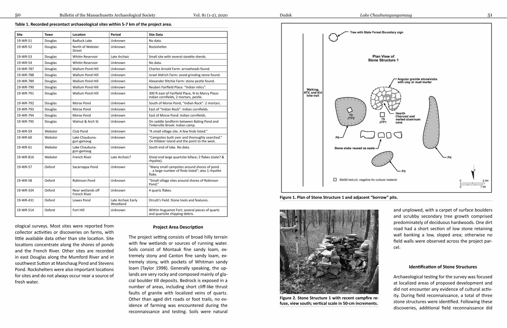
Bulletin of the Massachusetts Archaeological Society Vol. 81 (1-2), 202050 51Dudek Lake Chaubunagungamaug
and unplowed, with a carpet of surface boulders and scrubby secondary tree growth comprised predominately of deciduous hardwoods. One dirt road had a short section of low stone retaining wall banking a low, sloped area; otherwise no field walls were observed across the project par-cel.
Identification of Stone Structures
Archaeological testing for the survey was focused at localized areas of proposed development and did not encounter any evidence of cultural activ-ity. During field reconnaissance, a total of three stone structures were identified. Following these discoveries, additional field reconnaissance did
ological surveys. Most sites were reported from collector activities or discoveries on farms, with little available data other than site location. Site locations concentrate along the shores of ponds and the French River. Other sites are recorded in east Douglas along the Mumford River and in southwest Sutton at Manchaug Pond and Stevens Pond. Rockshelters were also important locations for sites and do not always occur near a source of fresh water.
Project Area Description
The project setting consists of broad hilly terrain with few wetlands or sources of running water. Soils consist of Montauk fine sandy loam, ex-tremely stony and Canton fine sandy loam, ex-tremely stony, with pockets of Whitman sandy loam (Taylor 1998). Generally speaking, the up-lands are very rocky and composed mainly of gla-cial boulder till deposits. Bedrock is exposed in a number of areas, including short cliff-like thrust faults of granite with localized veins of quartz. Other than aged dirt roads or foot trails, no ev-idence of farming was encountered during the reconnaissance and testing. Soils were natural
Table 1. Recorded precontact archaeological sites within 5-7 km of the project area.
Site Town Location Period Site Data
19-WR-51 Douglas Badluck Lake Unknown No data.
19-WR-52 Douglas North of Webster Street
Unknown Rockshelter.
19-WR-53 Douglas Whitin Reservoir Late Archaic Small site with several steatite sherds.
19-WR-54 Douglas Whitin Reservoir Unknown No data.
19-WR-787 Douglas Wallum Pond Hill Unknown Charles Arnold Farm: arrowheads found.
19-WR-788 Douglas Wallum Pond Hill Unknown Israel Aldrich Farm: ovoid grinding stone found.
19-WR-789 Douglas Wallum Pond Hill Unknown Alexander Ritchie Farm: stone pestle found.
19-WR-790 Douglas Wallum Pond Hill Unknown Reuben Fairfield Place: “Indian relics”.
19-WR-791 Douglas Wallum Pond Hill Unknown 300 ft east of Fairfield Place, N to Marcy Place: Indian cornfields, 2 mortars, pestle.
19-WR-792 Douglas Morse Pond Unknown South of Morse Pond, “Indian Rock”: 2 mortars.
19-WR-793 Douglas Morse Pond Unknown East of “Indian Rock”: Indian cornfields.
19-WR-794 Douglas Morse Pond Unknown East of Morse Pond: Indian cornfields.
19-WR-795 Douglas Walnut & Arch St Unknown On saddle landform between Bating Pond and Tinkerville Brook: Indian camp.
19-WR-59 Webster Club Pond Unknown “A small village site. A few finds listed.”
19-WR-60 Webster Lake Chaubuna-gun-gamaug
Unknown “Campsites built over and thoroughly searched.” On Killdeer Island and the point to the west.
19-WR-61 Webster Lake Chaubuna-gun-gamaug
Unknown South end of lake. No data.
19-WR-816 Webster French River Late Archaic? Distal end large quartzite biface; 2 flakes (slate? & rhyolite).
19-WR-57 Oxford Sacarrappa Pond Unknown “Many small campsites around shores of pond . . . a large number of finds listed”; also 1 rhyolite flake.
19-WR-58 Oxford Robinson Pond Unknown “Small village sites around shores of Robinson Pond.”
19-WR-334 Oxford Near wetlands off French River
Unknown 4 quartz flakes.
19-WR-431 Oxford Lowes Pond Late Archaic Early Woodland
Orcutt’s Field. Stone tools and features.
19-WR-514 Oxford Fort Hill Unknown Within Huguenot Fort; several pieces of quartz and quartzite chipping debris.
Figure 1. Plan of Stone Structure 1 and adjacent “borrow” pits.
Figure 2. Stone Structure 1 with recent campfire re-fuse, view south; vertical scale in 50-cm increments.
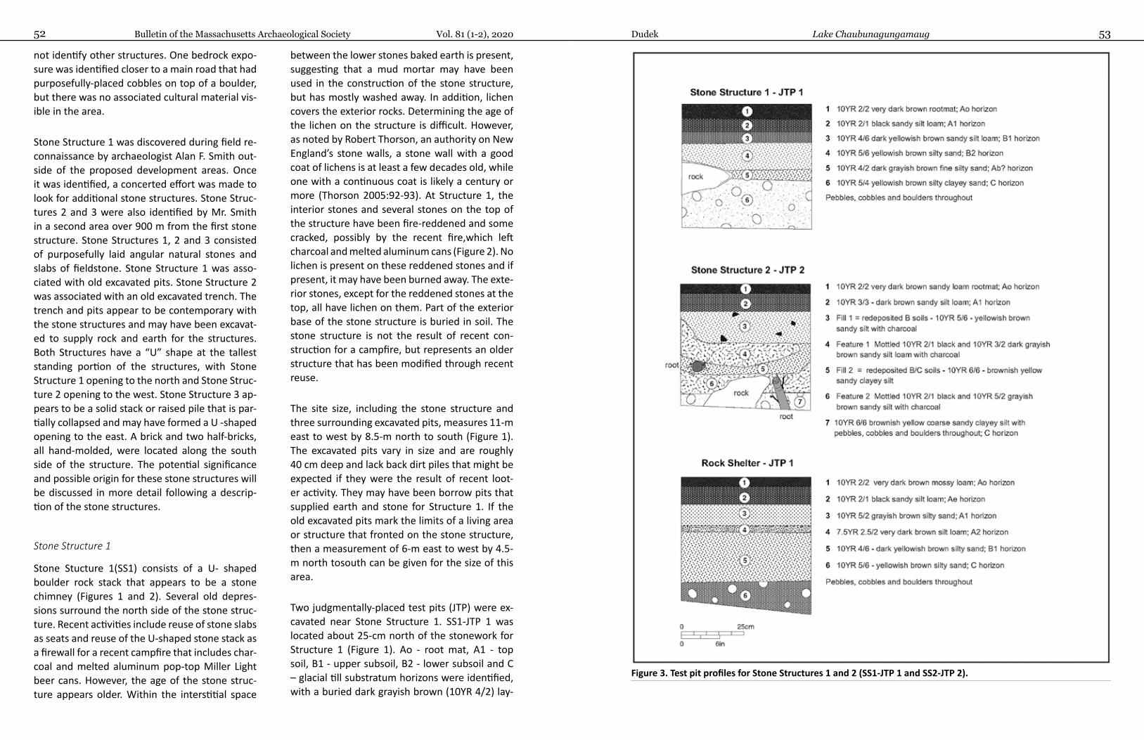
Bulletin of the Massachusetts Archaeological Society Vol. 81 (1-2), 202052 53Dudek Lake Chaubunagungamaug
not identify other structures. One bedrock expo-sure was identified closer to a main road that had purposefully-placed cobbles on top of a boulder, but there was no associated cultural material vis-ible in the area.
Stone Structure 1 was discovered during field re-connaissance by archaeologist Alan F. Smith out-side of the proposed development areas. Once it was identified, a concerted effort was made to look for additional stone structures. Stone Struc-tures 2 and 3 were also identified by Mr. Smith in a second area over 900 m from the first stone structure. Stone Structures 1, 2 and 3 consisted of purposefully laid angular natural stones and slabs of fieldstone. Stone Structure 1 was asso-ciated with old excavated pits. Stone Structure 2 was associated with an old excavated trench. The trench and pits appear to be contemporary with the stone structures and may have been excavat-ed to supply rock and earth for the structures. Both Structures have a “U” shape at the tallest standing portion of the structures, with Stone Structure 1 opening to the north and Stone Struc-ture 2 opening to the west. Stone Structure 3 ap-pears to be a solid stack or raised pile that is par-tially collapsed and may have formed a U -shaped opening to the east. A brick and two half-bricks, all hand-molded, were located along the south side of the structure. The potential significance and possible origin for these stone structures will be discussed in more detail following a descrip-tion of the stone structures.
Stone Structure 1
Stone Stucture 1(SS1) consists of a U- shaped boulder rock stack that appears to be a stone chimney (Figures 1 and 2). Several old depres-sions surround the north side of the stone struc-ture. Recent activities include reuse of stone slabs as seats and reuse of the U-shaped stone stack as a firewall for a recent campfire that includes char-coal and melted aluminum pop-top Miller Light beer cans. However, the age of the stone struc-ture appears older. Within the interstitial space
between the lower stones baked earth is present, suggesting that a mud mortar may have been used in the construction of the stone structure, but has mostly washed away. In addition, lichen covers the exterior rocks. Determining the age of the lichen on the structure is difficult. However, as noted by Robert Thorson, an authority on New England’s stone walls, a stone wall with a good coat of lichens is at least a few decades old, while one with a continuous coat is likely a century or more (Thorson 2005:92-93). At Structure 1, the interior stones and several stones on the top of the structure have been fire-reddened and some cracked, possibly by the recent fire,which left charcoal and melted aluminum cans (Figure 2). No lichen is present on these reddened stones and if present, it may have been burned away. The exte-rior stones, except for the reddened stones at the top, all have lichen on them. Part of the exterior base of the stone structure is buried in soil. The stone structure is not the result of recent con-struction for a campfire, but represents an older structure that has been modified through recent reuse.
The site size, including the stone structure and three surrounding excavated pits, measures 11-m east to west by 8.5-m north to south (Figure 1). The excavated pits vary in size and are roughly 40 cm deep and lack back dirt piles that might be expected if they were the result of recent loot-er activity. They may have been borrow pits that supplied earth and stone for Structure 1. If the old excavated pits mark the limits of a living area or structure that fronted on the stone structure, then a measurement of 6-m east to west by 4.5-m north tosouth can be given for the size of this area.
Two judgmentally-placed test pits (JTP) were ex-cavated near Stone Structure 1. SS1-JTP 1 was located about 25-cm north of the stonework for Structure 1 (Figure 1). Ao - root mat, A1 - top soil, B1 - upper subsoil, B2 - lower subsoil and C – glacial till substratum horizons were identified, with a buried dark grayish brown (10YR 4/2) lay-
Figure 3. Test pit profiles for Stone Structures 1 and 2 (SS1-JTP 1 and SS2-JTP 2).
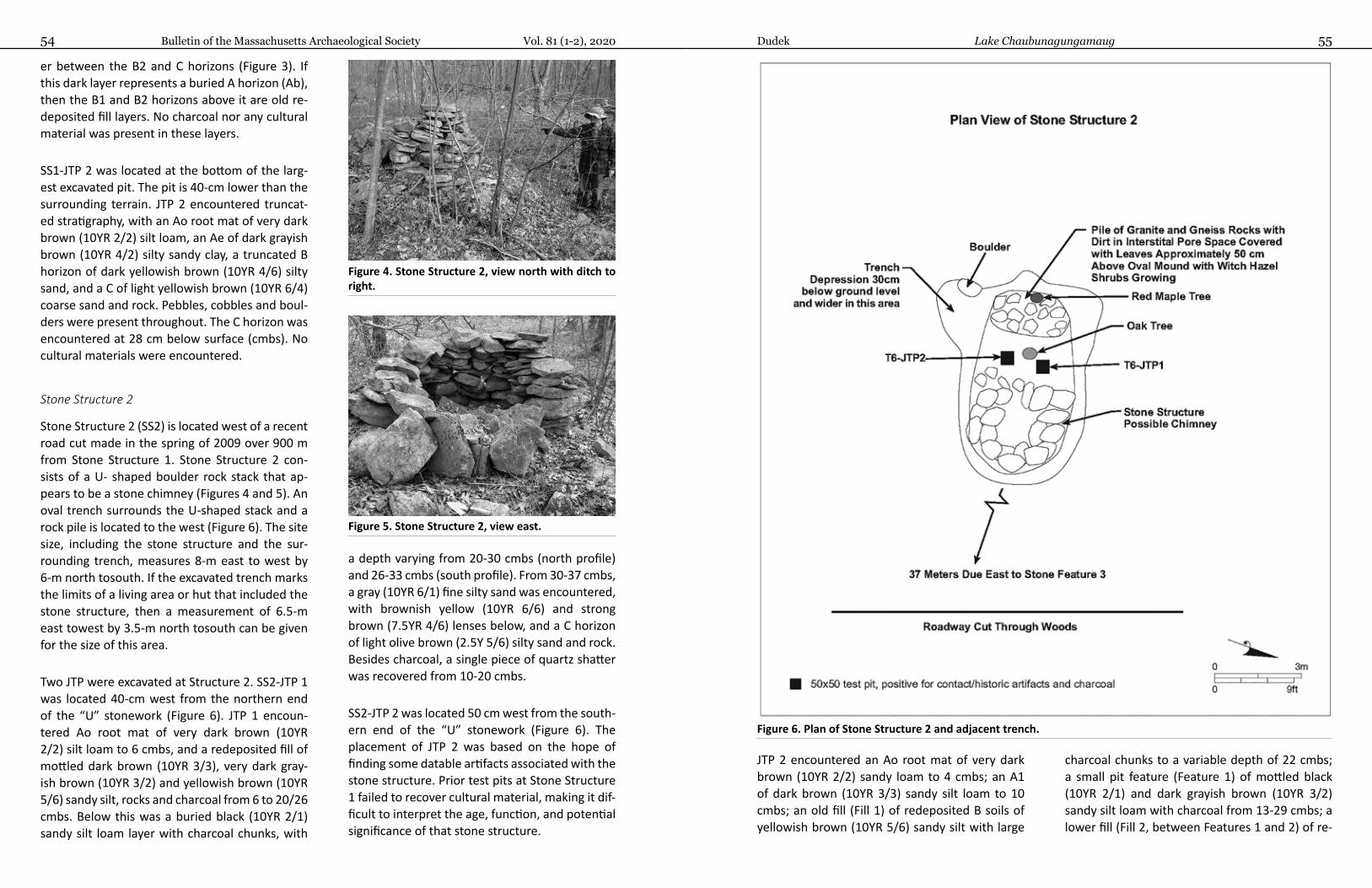
Bulletin of the Massachusetts Archaeological Society Vol. 81 (1-2), 202054 55Dudek Lake Chaubunagungamaug
er between the B2 and C horizons (Figure 3). If this dark layer represents a buried A horizon (Ab), then the B1 and B2 horizons above it are old re-deposited fill layers. No charcoal nor any cultural material was present in these layers.
SS1-JTP 2 was located at the bottom of the larg-est excavated pit. The pit is 40-cm lower than the surrounding terrain. JTP 2 encountered truncat-ed stratigraphy, with an Ao root mat of very dark brown (10YR 2/2) silt loam, an Ae of dark grayish brown (10YR 4/2) silty sandy clay, a truncated B horizon of dark yellowish brown (10YR 4/6) silty sand, and a C of light yellowish brown (10YR 6/4) coarse sand and rock. Pebbles, cobbles and boul-ders were present throughout. The C horizon was encountered at 28 cm below surface (cmbs). No cultural materials were encountered.
Stone Structure 2
Stone Structure 2 (SS2) is located west of a recent road cut made in the spring of 2009 over 900 m from Stone Structure 1. Stone Structure 2 con-sists of a U- shaped boulder rock stack that ap-pears to be a stone chimney (Figures 4 and 5). An oval trench surrounds the U-shaped stack and a rock pile is located to the west (Figure 6). The site size, including the stone structure and the sur-rounding trench, measures 8-m east to west by 6-m north tosouth. If the excavated trench marks the limits of a living area or hut that included the stone structure, then a measurement of 6.5-m east towest by 3.5-m north tosouth can be given for the size of this area.
Two JTP were excavated at Structure 2. SS2-JTP 1 was located 40-cm west from the northern end of the “U” stonework (Figure 6). JTP 1 encoun-tered Ao root mat of very dark brown (10YR 2/2) silt loam to 6 cmbs, and a redeposited fill of mottled dark brown (10YR 3/3), very dark gray-ish brown (10YR 3/2) and yellowish brown (10YR 5/6) sandy silt, rocks and charcoal from 6 to 20/26 cmbs. Below this was a buried black (10YR 2/1) sandy silt loam layer with charcoal chunks, with
a depth varying from 20-30 cmbs (north profile) and 26-33 cmbs (south profile). From 30-37 cmbs, a gray (10YR 6/1) fine silty sand was encountered, with brownish yellow (10YR 6/6) and strong brown (7.5YR 4/6) lenses below, and a C horizon of light olive brown (2.5Y 5/6) silty sand and rock. Besides charcoal, a single piece of quartz shatter was recovered from 10-20 cmbs.
SS2-JTP 2 was located 50 cm west from the south-ern end of the “U” stonework (Figure 6). The placement of JTP 2 was based on the hope of finding some datable artifacts associated with the stone structure. Prior test pits at Stone Structure 1 failed to recover cultural material, making it dif-ficult to interpret the age, function, and potential significance of that stone structure.
Figure 6. Plan of Stone Structure 2 and adjacent trench.
JTP 2 encountered an Ao root mat of very dark brown (10YR 2/2) sandy loam to 4 cmbs; an A1 of dark brown (10YR 3/3) sandy silt loam to 10 cmbs; an old fill (Fill 1) of redeposited B soils of yellowish brown (10YR 5/6) sandy silt with large
charcoal chunks to a variable depth of 22 cmbs; a small pit feature (Feature 1) of mottled black (10YR 2/1) and dark grayish brown (10YR 3/2) sandy silt loam with charcoal from 13-29 cmbs; a lower fill (Fill 2, between Features 1 and 2) of re-
Figure 4. Stone Structure 2, view north with ditch to right.
Figure 5. Stone Structure 2, view east.
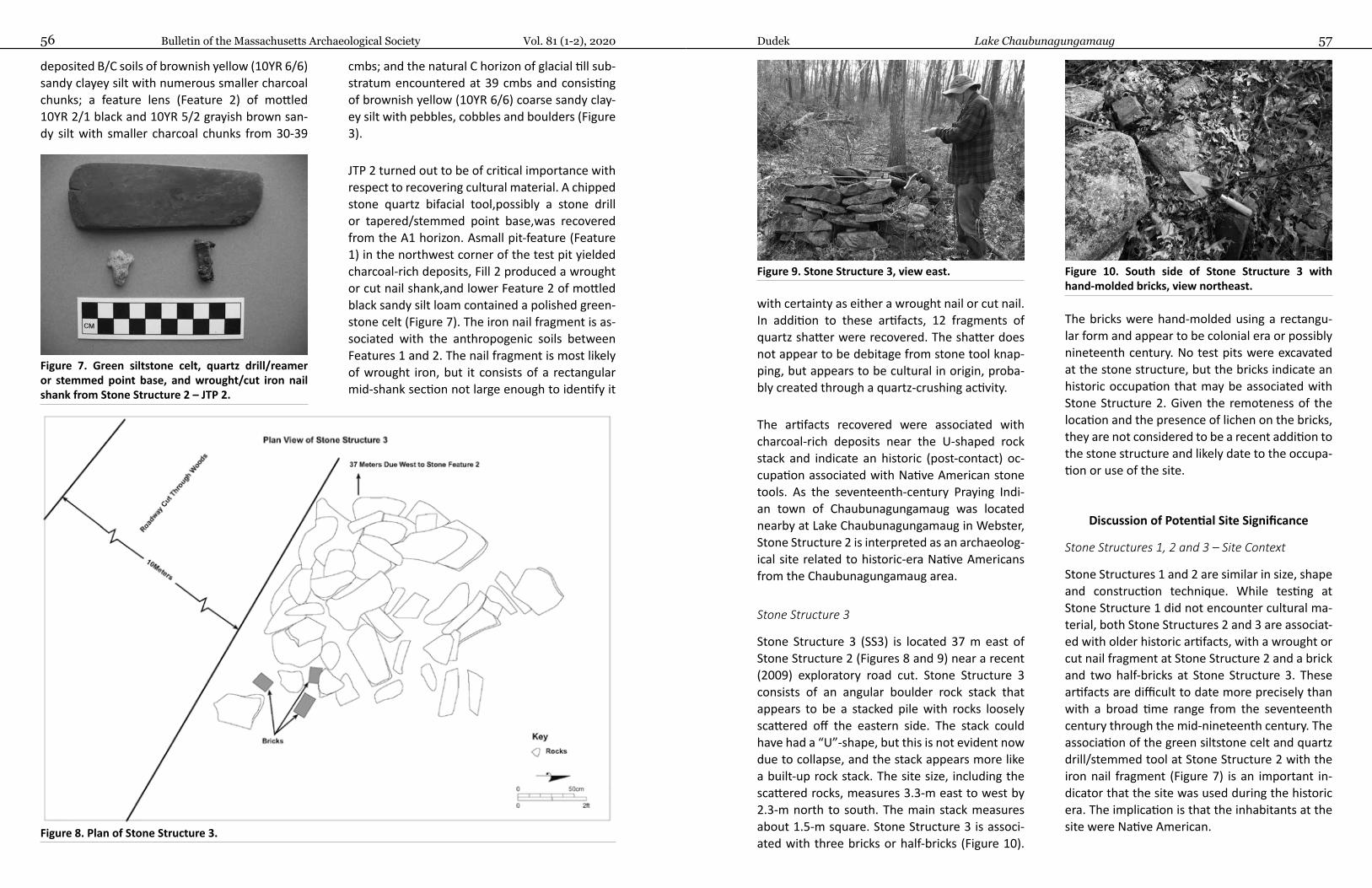
Bulletin of the Massachusetts Archaeological Society Vol. 81 (1-2), 202056 57Dudek Lake Chaubunagungamaug
with certainty as either a wrought nail or cut nail. In addition to these artifacts, 12 fragments of quartz shatter were recovered. The shatter does not appear to be debitage from stone tool knap-ping, but appears to be cultural in origin, proba-bly created through a quartz-crushing activity.
The artifacts recovered were associated with charcoal-rich deposits near the U-shaped rock stack and indicate an historic (post-contact) oc-cupation associated with Native American stone tools. As the seventeenth-century Praying Indi-an town of Chaubunagungamaug was located nearby at Lake Chaubunagungamaug in Webster, Stone Structure 2 is interpreted as an archaeolog-ical site related to historic-era Native Americans from the Chaubunagungamaug area.
Stone Structure 3
Stone Structure 3 (SS3) is located 37 m east of Stone Structure 2 (Figures 8 and 9) near a recent (2009) exploratory road cut. Stone Structure 3 consists of an angular boulder rock stack that appears to be a stacked pile with rocks loosely scattered off the eastern side. The stack could have had a “U”-shape, but this is not evident now due to collapse, and the stack appears more like a built-up rock stack. The site size, including the scattered rocks, measures 3.3-m east to west by 2.3-m north to south. The main stack measures about 1.5-m square. Stone Structure 3 is associ-ated with three bricks or half-bricks (Figure 10).
The bricks were hand-molded using a rectangu-lar form and appear to be colonial era or possibly nineteenth century. No test pits were excavated at the stone structure, but the bricks indicate an historic occupation that may be associated with Stone Structure 2. Given the remoteness of the location and the presence of lichen on the bricks, they are not considered to be a recent addition to the stone structure and likely date to the occupa-tion or use of the site.
Discussion of Potential Site Significance
Stone Structures 1, 2 and 3 – Site Context
Stone Structures 1 and 2 are similar in size, shape and construction technique. While testing at Stone Structure 1 did not encounter cultural ma-terial, both Stone Structures 2 and 3 are associat-ed with older historic artifacts, with a wrought or cut nail fragment at Stone Structure 2 and a brick and two half-bricks at Stone Structure 3. These artifacts are difficult to date more precisely than with a broad time range from the seventeenth century through the mid-nineteenth century. The association of the green siltstone celt and quartz drill/stemmed tool at Stone Structure 2 with the iron nail fragment (Figure 7) is an important in-dicator that the site was used during the historic era. The implication is that the inhabitants at the site were Native American.
deposited B/C soils of brownish yellow (10YR 6/6) sandy clayey silt with numerous smaller charcoal chunks; a feature lens (Feature 2) of mottled 10YR 2/1 black and 10YR 5/2 grayish brown san-dy silt with smaller charcoal chunks from 30-39
cmbs; and the natural C horizon of glacial till sub-stratum encountered at 39 cmbs and consisting of brownish yellow (10YR 6/6) coarse sandy clay-ey silt with pebbles, cobbles and boulders (Figure 3).
JTP 2 turned out to be of critical importance with respect to recovering cultural material. A chipped stone quartz bifacial tool,possibly a stone drill or tapered/stemmed point base,was recovered from the A1 horizon. Asmall pit-feature (Feature 1) in the northwest corner of the test pit yielded charcoal-rich deposits, Fill 2 produced a wrought or cut nail shank,and lower Feature 2 of mottled black sandy silt loam contained a polished green-stone celt (Figure 7). The iron nail fragment is as-sociated with the anthropogenic soils between Features 1 and 2. The nail fragment is most likely of wrought iron, but it consists of a rectangular mid-shank section not large enough to identify it
Figure 9. Stone Structure 3, view east.
Figure 7. Green siltstone celt, quartz drill/reamer or stemmed point base, and wrought/cut iron nail shank from Stone Structure 2 – JTP 2.
Figure 10. South side of Stone Structure 3 with hand-molded bricks, view northeast.
Figure 8. Plan of Stone Structure 3.
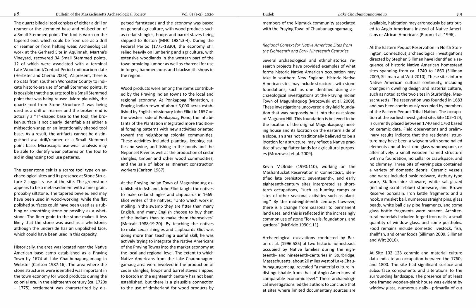
Bulletin of the Massachusetts Archaeological Society Vol. 81 (1-2), 202058 59Dudek Lake Chaubunagungamaug
The quartz bifacial tool consists of either a drill or reamer or the stemmed base and midsection of a Small Stemmed point. The tool is worn on the tapered end, which could be from use as a drill or reamer or from hafting wear. Archaeological work at the Gerhard Site in Aquinnah, Martha’s Vineyard, recovered 34 Small Stemmed points, 12 of which were associated with a terminal Late Woodland/Contact Period radiocarbon date (Herbster and Cherau 2003). At present, there is no data from southern Worcester County to indi-cate historic-era use of Small Stemmed points. It is possible that the quartz tool is a Small Stemmed point that was being reused. More plausibly, the quartz tool from Stone Structure 2 was being used as a drill or reamer and the broken end is actually a “T”-shaped base to the tool; the bro-ken surface is not clearly identifiable as either a midsection-snap or an intentionally shaped tool base. As a result, the artifacts cannot be distin-guished asa drill/reamer or a Small Stemmed point base. Microscopic use-wear analysis may be able to identify wear patterns on the tool to aid in diagnosing tool use patterns.
The greenstone celt is a scarce tool type on ar-chaeological sites and its presence at Stone Struc-ture 2 suggests use at the site. The greenstone appears to be a meta-sediment with a finer grain, probably siltstone. The tapered beveled end may have been used in wood-working, while the flat polished surfaces could have been used as a rub-bing or smoothing stone or possibly as a whet-stone. The finer grain to the stone makes it less likely that the stone was used as a whetstone, although the underside has an unpolished face, which could have been used in this capacity.
Historically, the area was located near the Native American base camp established as a Praying Town by 1674 at Lake Chaubunagungamaug in Webster (Carlson 1987:16). The area where the stone structures were identified was important in the town economy for wood products during the colonial era. In the eighteenth century (ca. 1720s – 1775), settlement was characterized by dis-
persed farmsteads and the economy was based on general agriculture, with wood products such as cedar shingles, hoops and barrel staves being shipped to Boston (MHC 1984:3-4). During the Federal Period (1775-1830), the economy still relied heavily on lumbering and agriculture, with extensive woodlands in the western part of the town providing lumber as well as charcoal for use in forges, hammershops and blacksmith shops in the region.
Wood products were among the items contribut-ed by the Praying Indian towns to the local and regional economy. At Ponkapoag Plantation, a Praying Indian town of about 6,000 acres estab-lished by English missionary John Elliot in 1657 on the western side of Ponkapoag Pond, the inhabi-tants of the Plantation integrated more tradition-al foraging patterns with new activities oriented toward the neighboring colonial communities. These activities included planting, keeping cat-tle and swine, and fishing in the ponds and the Neponset River as well as the production of cedar shingles, timber and other wood commodities, and the sale of labor as itinerant construction workers (Carlson 1987).
At the Praying Indian Town of Magunkaquog es-tablished in Ashland, John Eliot taught the natives to make cedar shingles and clapboards in 1669. Eliot writes of the natives: “Unto which work in moiling in the swamp they are fitter than many English, and many English choose to buy them of the Indians than to make them themselves” (Metcalf 1988:19-20). By teaching the natives to make cedar shingles and clapboards Eliot was doing more than teaching a useful skill; he was actively trying to integrate the Native Americans of the Praying Towns into the market economy at the local and regional level. The extent to which Native Americans from the Lake Chaubunagun-gamaug area were involved in the production of cedar shingles, hoops and barrel staves shipped to Boston in the eighteenth century has not been established, but there is a plausible connection to the use of timberland for wood products by
members of the Nipmuck community associated with the Praying Town of Chaubunagungamaug.
Regional Context for Native American Sites from the Eighteenth and Early Nineteenth Centuries
Several archaeological and ethnohistorical re-search projects have provided examples of what forms historic Native American occupation may take in southern New England. Historic Native American sites may include structures with stone foundations, such as one identified during ar-chaeological investigations at the Praying Indian Town of Magunkaquog (Mrozowski et al. 2009). These investigations uncovered a dry-laid founda-tion that was purposely built into the east slope of Magunco Hill. This foundation is believed to be the location of the original Magunkaquog meet-ing house and its location on the eastern side of a slope, an area not traditionally believed to be a location for a structure, may reflect a Native prac-tice of saving flatter lands for agricultural purpos-es (Mrozowski et al. 2009).
Kevin McBride (1990:110), working on the Mashantucket Reservation in Connecticut, iden-tified late prehistoric, seventeenth-, and early eighteenth-century sites interpreted as short-term occupations, “such as hunting camps or sites of other seasonal activities such as plant-ing.” By the mid-eighteenth century, however, there is a change from seasonal to permanent land uses, and this is reflected in the increasingly common use of stone “for walls, foundations, and gardens” (McBride 1990:111).
Archaeological excavations conducted by Bar-on et al. (1996:585) at two historic homesteads occupied by Native families during the eigh-teenth- and nineteenth-centuries in Sturbridge, Massachusetts, about 20 miles west of Lake Chau-bunagungamaug, revealed “a material culture in-distinguishable from that of Anglo-Americans of comparable economic level.” These archaeologi-cal investigations led the authors to conclude that at sites where limited documentary sources are
available, habitation may erroneously be attribut-ed to Anglo-Americans instead of Native Ameri-cans or African Americans (Baron et al. 1996).
At the Eastern Pequot Reservation in North Ston-ington, Connecticut, archaeological investigations directed by Stephen Silliman have identified a se-quence of historic Native American homestead sites spanning from ca. 1740 to 1860 (Silliman 2009, Silliman and Witt 2010). These sites inform Native American cultural continuity, including changes in dwelling design and material culture, such as noted at the two sites in Sturbridge, Mas-sachusetts. The reservation was founded in 1683 and has been continuously occupied by members of the Eastern Pequot Tribal Nation. The occupa-tion at the earliest investigated site, Site 102–124, is currently placed between 1740 and 1760 based on ceramic data. Field observations and prelim-inary results indicate that the residential struc-ture may have been a wigwam with some nailed elements and at least one glass windowpane, or alternatively, a small wooden framed structure with no foundation, no cellar or crawlspace, and no chimney. Three pits of varying size contained a variety of domestic debris. Ceramic vessels and wares included basic redware, Astbury-type ware, Staffordshire slipware, white salt-glazed (including scratch-blue) stoneware, and Brown Reserve porcelain. Iron kettle fragments and a hook, a musket ball, numerous straight pins, glass beads, white ball clay pipe fragments, and some glass bottle fragments were present. Architec-tural materials included forged iron nails, a small quantity of window glass, and some postholes. Food remains include domestic livestock, fish, shellfish, and other foods (Silliman 2009, Silliman and Witt 2010).
At Site 102–123 ceramic and material culture data indicate an occupation between the 1760s and 1800. The site had significant surface and subsurface components and alterations to the surrounding landscape. The presence of at least one framed wooden-plank house was evident by window glass, numerous nails—primarily of cut
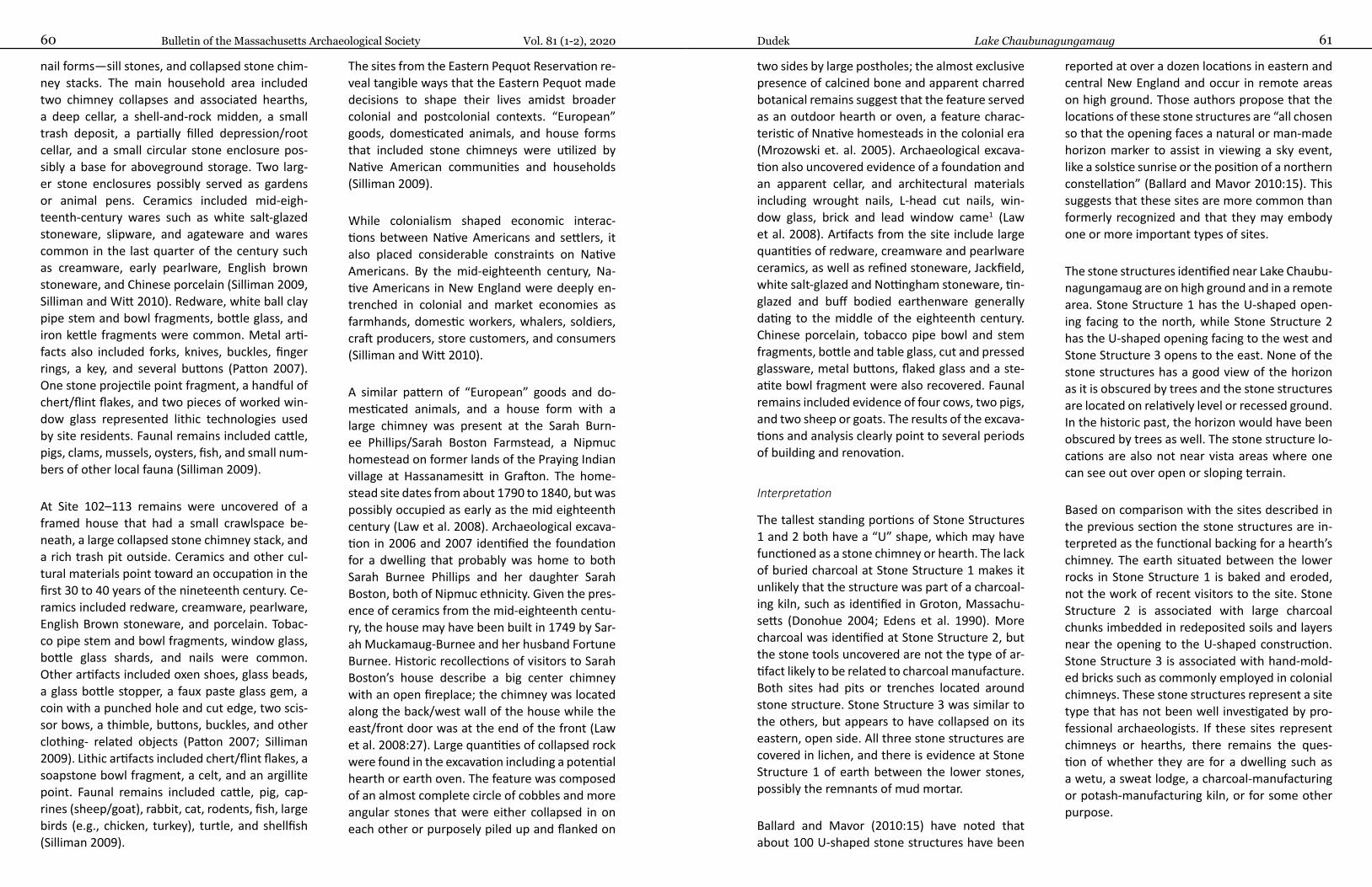
Bulletin of the Massachusetts Archaeological Society Vol. 81 (1-2), 202060 61Dudek Lake Chaubunagungamaug
nail forms—sill stones, and collapsed stone chim-ney stacks. The main household area included two chimney collapses and associated hearths, a deep cellar, a shell-and-rock midden, a small trash deposit, a partially filled depression/root cellar, and a small circular stone enclosure pos-sibly a base for aboveground storage. Two larg-er stone enclosures possibly served as gardens or animal pens. Ceramics included mid-eigh-teenth-century wares such as white salt-glazed stoneware, slipware, and agateware and wares common in the last quarter of the century such as creamware, early pearlware, English brown stoneware, and Chinese porcelain (Silliman 2009, Silliman and Witt 2010). Redware, white ball clay pipe stem and bowl fragments, bottle glass, and iron kettle fragments were common. Metal arti-facts also included forks, knives, buckles, finger rings, a key, and several buttons (Patton 2007). One stone projectile point fragment, a handful of chert/flint flakes, and two pieces of worked win-dow glass represented lithic technologies used by site residents. Faunal remains included cattle, pigs, clams, mussels, oysters, fish, and small num-bers of other local fauna (Silliman 2009).
At Site 102–113 remains were uncovered of a framed house that had a small crawlspace be-neath, a large collapsed stone chimney stack, and a rich trash pit outside. Ceramics and other cul-tural materials point toward an occupation in the first 30 to 40 years of the nineteenth century. Ce-ramics included redware, creamware, pearlware, English Brown stoneware, and porcelain. Tobac-co pipe stem and bowl fragments, window glass, bottle glass shards, and nails were common. Other artifacts included oxen shoes, glass beads, a glass bottle stopper, a faux paste glass gem, a coin with a punched hole and cut edge, two scis-sor bows, a thimble, buttons, buckles, and other clothing- related objects (Patton 2007; Silliman 2009). Lithic artifacts included chert/flint flakes, a soapstone bowl fragment, a celt, and an argillite point. Faunal remains included cattle, pig, cap-rines (sheep/goat), rabbit, cat, rodents, fish, large birds (e.g., chicken, turkey), turtle, and shellfish (Silliman 2009).
The sites from the Eastern Pequot Reservation re-veal tangible ways that the Eastern Pequot made decisions to shape their lives amidst broader colonial and postcolonial contexts. “European” goods, domesticated animals, and house forms that included stone chimneys were utilized by Native American communities and households (Silliman 2009).
While colonialism shaped economic interac-tions between Native Americans and settlers, it also placed considerable constraints on Native Americans. By the mid-eighteenth century, Na-tive Americans in New England were deeply en-trenched in colonial and market economies as farmhands, domestic workers, whal ers, soldiers, craft producers, store customers, and consumers (Silliman and Witt 2010).
A similar pattern of “European” goods and do-mesticated animals, and a house form with a large chimney was present at the Sarah Burn-ee Phillips/Sarah Boston Farmstead, a Nipmuc homestead on former lands of the Praying Indian village at Hassanamesitt in Grafton. The home-stead site dates from about 1790 to 1840, but was possibly occupied as early as the mid eighteenth century (Law et al. 2008). Archaeological excava-tion in 2006 and 2007 identified the foundation for a dwelling that probably was home to both Sarah Burnee Phillips and her daughter Sarah Boston, both of Nipmuc ethnicity. Given the pres-ence of ceramics from the mid-eighteenth centu-ry, the house may have been built in 1749 by Sar-ah Muckamaug-Burnee and her husband Fortune Burnee. Historic recollections of visitors to Sarah Boston’s house describe a big center chimney with an open fireplace; the chimney was located along the back/west wall of the house while the east/front door was at the end of the front (Law et al. 2008:27). Large quantities of collapsed rock were found in the excavation including a potential hearth or earth oven. The feature was composed of an almost complete circle of cobbles and more angular stones that were either collapsed in on each other or purposely piled up and flanked on
two sides by large postholes; the almost exclusive presence of calcined bone and apparent charred botanical remains suggest that the feature served as an outdoor hearth or oven, a feature charac-teristic of Nnative homesteads in the colonial era (Mrozowski et. al. 2005). Archaeological excava-tion also uncovered evidence of a foundation and an apparent cellar, and architectural materials including wrought nails, L-head cut nails, win-dow glass, brick and lead window came1 (Law et al. 2008). Artifacts from the site include large quantities of redware, creamware and pearlware ceramics, as well as refined stoneware, Jackfield, white salt-glazed and Nottingham stoneware, tin-glazed and buff bodied earthenware generally dating to the middle of the eighteenth century. Chinese porcelain, tobacco pipe bowl and stem fragments, bottle and table glass, cut and pressed glassware, metal buttons, flaked glass and a ste-atite bowl fragment were also recovered. Faunal remains included evidence of four cows, two pigs, and two sheep or goats. The results of the excava-tions and analysis clearly point to several periods of building and renovation.
Interpretation
The tallest standing portions of Stone Structures 1 and 2 both have a “U” shape, which may have functioned as a stone chimney or hearth. The lack of buried charcoal at Stone Structure 1 makes it unlikely that the structure was part of a charcoal-ing kiln, such as identified in Groton, Massachu-setts (Donohue 2004; Edens et al. 1990). More charcoal was identified at Stone Structure 2, but the stone tools uncovered are not the type of ar-tifact likely to be related to charcoal manufacture. Both sites had pits or trenches located around stone structure. Stone Structure 3 was similar to the others, but appears to have collapsed on its eastern, open side. All three stone structures are covered in lichen, and there is evidence at Stone Structure 1 of earth between the lower stones, possibly the remnants of mud mortar.
Ballard and Mavor (2010:15) have noted that about 100 U-shaped stone structures have been
reported at over a dozen locations in eastern and central New England and occur in remote areas on high ground. Those authors propose that the locations of these stone structures are “all chosen so that the opening faces a natural or man-made horizon marker to assist in viewing a sky event, like a solstice sunrise or the position of a northern constellation” (Ballard and Mavor 2010:15). This suggests that these sites are more common than formerly recognized and that they may embody one or more important types of sites.
The stone structures identified near Lake Chaubu-nagungamaug are on high ground and in a remote area. Stone Structure 1 has the U-shaped open-ing facing to the north, while Stone Structure 2 has the U-shaped opening facing to the west and Stone Structure 3 opens to the east. None of the stone structures has a good view of the horizon as it is obscured by trees and the stone structures are located on relatively level or recessed ground. In the historic past, the horizon would have been obscured by trees as well. The stone structure lo-cations are also not near vista areas where one can see out over open or sloping terrain.
Based on comparison with the sites described in the previous section the stone structures are in-terpreted as the functional backing for a hearth’s chimney. The earth situated between the lower rocks in Stone Structure 1 is baked and eroded, not the work of recent visitors to the site. Stone Structure 2 is associated with large charcoal chunks imbedded in redeposited soils and layers near the opening to the U-shaped construction. Stone Structure 3 is associated with hand-mold-ed bricks such as commonly employed in colonial chimneys. These stone structures represent a site type that has not been well investigated by pro-fessional archaeologists. If these sites represent chimneys or hearths, there remains the ques-tion of whether they are for a dwelling such as a wetu, a sweat lodge, a charcoal-manufacturing or potash-manufacturing kiln, or for some other purpose.

Bulletin of the Massachusetts Archaeological Society Vol. 81 (1-2), 202062 63Dudek Lake Chaubunagungamaug
Summary
The stone structures identified in the bouldery uplands of southern Worcester County near Lake Chaubunagungamaug represent small structures that do not appear to be associated with many artifacts, unlike the Pequot and Nipmuc home-stead/farmstead sites which had an abundance of ceramics and other artifacts. Therefore, the stone structure sites may be special-purpose sites of short duration use. Occupation at the sites may have been of a repetitive or seasonal nature, but probably not intensive. The hypothesis put for-ward here on the function of these sites is that they were temporary hut/wetu locations possibly utilized seasonally by historic Native Americans, and possibly in the historic wood industry. Stone chimneys and other stonework (e.g., cellars, foundations, outdoor hearth or oven) have been documented from Pequot and Nipmuc sites dat-ing from the second half of the eighteenth centu-ry to the second quarter of the nineteenth cen-tury. These latter sites produced ceramics, nails, brick, window glass, and, also, chipped lithic debitage or tools and/or chipped glass. One site included a stone celt (Pequot Site 102–113). The presence of abundant charcoal buried adjacent to the near-circular stone work of Stone Structure 2 suggests use of the area for a hearth, wheth-er as a chimney attached to a dwelling or as an outdoor hearth or oven. The recovery of a stone celt, a chipped quartz tool and a wrought or cut nail fragment from the same context is consistent with the range of artifacts identified at other eigh-teenth to early nineteenth century Native Ameri-can sites discussed. All three stone structures are considered to be potentially significant archaeo-logical sites that may be related to the historic oc-cupation of the Lake Chaubunagungamaug area in Webster and Douglas by Native Americans. The
sites may be dwelling locations and/or related to the use of the wooded uplands for timber-related products that included cedar shingles, hoops and barrel staves that were supplied to Boston in the eighteenth century. The sites are likely to yield significant information on their association and function with further professional archaeological investigation.
Data Availability Statement
The recovered cultural materials and associated project documents and field data are owned by the Commonwealth of Massachusetts. The col-lection is curated at Commonwealth Heritage Group, Inc., 410 Great Road, Suite B14, Littleton, MA 01460.
The report for the project is on file at the Mas-sachusetts Historical Commission in Boston, MA.
Acknowledgments
The author would like to thank Alan F. Smith for his years of tireless service to the profession of New En-gland archaeology and efforts for land and environ-mental preservation working with land trusts and other non-profit organizations. I have worked with Alan for 20 years, but his involvement at the Massa-chusetts Archaeological Society goes back much fur-ther as does his professional work as an archaeologist. Alan has a knack at locating archaeological sites above and below ground and he has been indispensible on many a project in the field and in the lab.
Note
References Cited
Ballard, Edwin C., and James M. Mavor2010 A Case for the Use of Above-Surface Stone Constructions in a Native American Ceremonial Landscape
in the Northeast. Bulletin of the Massachusetts Archaeological Society 71(1):8-25.
Baron, Donna Keith, J. Edward Hood, and Holly V. Izard1996 They Were Here All Along: The Native American Presence in Lower-Central New England in the Eigh-
teenth and Nineteenth Centuries. The William and Mary Quarterly 53(3):561-586.
Carlson, Catherine C.1987 Archival and Archaeological Research Report on the Configuration of the Seven Original 17th Century
Praying Indian Towns of the Massachusetts Bay Colony. Report on file at the Massachusetts Historical Commission, Boston, MA.
Donohue, Barbara2004 Site Examination Report on the East Groton Charcoaling Area (GRO-HA-12) Groton, Massachusetts. Re-
port on file at the Massachusetts Historical Commission, Boston, MA.
Dudek, Martin G., and Alan F. Smith2013 Archeological Intensive (Locational) Survey for the Douglas Wind Farm Project, Douglas, Massachusetts.
Report on file at the Massachusetts Historical Commission, Boston, MA.
Edens, Christopher, Leith Smith, Jane Carolan, and Michael Roberts1990 Intensive Archaeological Survey of the Proposed East Groton Village, Groton, Massachusetts. Report on
file at the Massachusetts Historical Commission, Boston, MA.
Herbster, Holly, and Suzanne G. Cherau2003 Intensive (Locational) Archaeological Survey and Data Recovery Program, Gerhard Site, Aquinnah, Mas-
sachusetts. Report on file at the Massachusetts Historical Commission, Boston, MA.
Law, Heather, Guido Pezzarossi, and Stephen Mrozowski2008 Archaeological Intensive Excavation, Hassanamesit Woods Property, the Sarah Boston Farmstead, Graf-
ton, Massachusetts. Report on file at the Massachusetts Historical Commission, Boston, MA.
Massachusetts Historical Commission1984 MHC Reconnaissance Survey Town Report: Douglas. Report on file at the Massachusetts Historical Com-
mission, Boston, MA.
McBride, Kevin A.1990 The Historical Archaeology of the Mashantucket Pequots, 1637-1900: A Preliminary Analysis. In The
Pequots in Southern New England: The Rise and Fall of an American Indian Nation, edited by Laurence M. Hauptman and James D. Ferry, pp. 96-116. University of Oklahoma Press, Norman.
Metcalf, Frank J.1988 Indians in Ashland, Mass. Archaeological Quarterly of the W. Elmer Ekblaw Chapter of the Massachu-
setts Archaeological Society 10(1):19-23.
Mrozowski, Stephen A., Holly Herbster, David Brown, and Katherine L. Priddy2005 “Magunkaquoag: Native American Conversion and Cultural Persistence,” in Eighteenth Century Na-
tive Communities of Southern New England in the Colonial Context, edited by Jack Campsi, pp. 57-71, Mashantucket Museum and Research Center Occasional Paper No. 1, Mashantucket, CT.
1 The term “came” refers to lead or wooden strips used to join pieces of glass in a window.
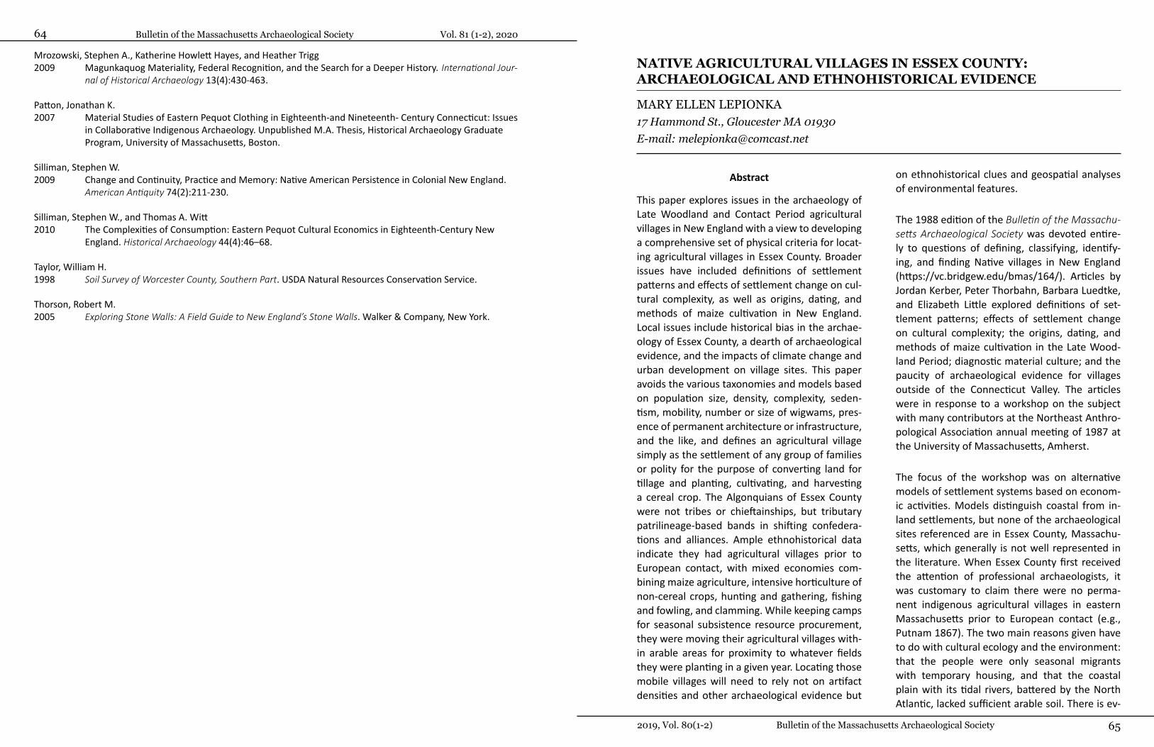
Bulletin of the Massachusetts Archaeological Society 652019, Vol. 80(1-2)
Bulletin of the Massachusetts Archaeological Society Vol. 81 (1-2), 202064
Mrozowski, Stephen A., Katherine Howlett Hayes, and Heather Trigg2009 Magunkaquog Materiality, Federal Recognition, and the Search for a Deeper History. International Jour-
nal of Historical Archaeology 13(4):430-463.
Patton, Jonathan K.2007 Material Studies of Eastern Pequot Clothing in Eighteenth-and Nineteenth- Century Connecticut: Issues
in Collaborative Indigenous Archaeology. Unpublished M.A. Thesis, Historical Archaeology Graduate Program, University of Massachusetts, Boston.
Silliman, Stephen W.2009 Change and Continuity, Practice and Memory: Native American Persistence in Colonial New England.
American Antiquity 74(2):211-230.
Silliman, Stephen W., and Thomas A. Witt2010 The Complexities of Consumption: Eastern Pequot Cultural Economics in Eighteenth-Century New
England. Historical Archaeology 44(4):46–68.
Taylor, William H.1998 Soil Survey of Worcester County, Southern Part. USDA Natural Resources Conservation Service.
Thorson, Robert M.2005 Exploring Stone Walls: A Field Guide to New England’s Stone Walls. Walker & Company, New York.
NATIVE AGRICULTURAL VILLAGES IN ESSEX COUNTY: ARCHAEOLOGICAL AND ETHNOHISTORICAL EVIDENCE
MARY ELLEN LEPIONKA17 Hammond St., Gloucester MA 01930 E-mail: [email protected]
Abstract
This paper explores issues in the archaeology of Late Woodland and Contact Period agricultural villages in New England with a view to developing a comprehensive set of physical criteria for locat-ing agricultural villages in Essex County. Broader issues have included definitions of settlement patterns and effects of settlement change on cul-tural complexity, as well as origins, dating, and methods of maize cultivation in New England. Local issues include historical bias in the archae-ology of Essex County, a dearth of archaeological evidence, and the impacts of climate change and urban development on village sites. This paper avoids the various taxonomies and models based on population size, density, complexity, seden-tism, mobility, number or size of wigwams, pres-ence of permanent architecture or infrastructure, and the like, and defines an agricultural village simply as the settlement of any group of families or polity for the purpose of converting land for tillage and planting, cultivating, and harvesting a cereal crop. The Algonquians of Essex County were not tribes or chieftainships, but tributary patrilineage-based bands in shifting confedera-tions and alliances. Ample ethnohistorical data indicate they had agricultural villages prior to European contact, with mixed economies com-bining maize agriculture, intensive horticulture of non-cereal crops, hunting and gathering, fishing and fowling, and clamming. While keeping camps for seasonal subsistence resource procurement, they were moving their agricultural villages with-in arable areas for proximity to whatever fields they were planting in a given year. Locating those mobile villages will need to rely not on artifact densities and other archaeological evidence but
on ethnohistorical clues and geospatial analyses of environmental features.
The 1988 edition of the Bulletin of the Massachu-setts Archaeological Society was devoted entire-ly to questions of defining, classifying, identify-ing, and finding Native villages in New England (https://vc.bridgew.edu/bmas/164/). Articles by Jordan Kerber, Peter Thorbahn, Barbara Luedtke, and Elizabeth Little explored definitions of set-tlement patterns; effects of settlement change on cultural complexity; the origins, dating, and methods of maize cultivation in the Late Wood-land Period; diagnostic material culture; and the paucity of archaeological evidence for villages outside of the Connecticut Valley. The articles were in response to a workshop on the subject with many contributors at the Northeast Anthro-pological Association annual meeting of 1987 at the University of Massachusetts, Amherst.
The focus of the workshop was on alternative models of settlement systems based on econom-ic activities. Models distinguish coastal from in-land settlements, but none of the archaeological sites referenced are in Essex County, Massachu-setts, which generally is not well represented in the literature. When Essex County first received the attention of professional archaeologists, it was customary to claim there were no perma-nent indigenous agricultural villages in eastern Massachusetts prior to European contact (e.g., Putnam 1867). The two main reasons given have to do with cultural ecology and the environment: that the people were only seasonal migrants with temporary housing, and that the coastal plain with its tidal rivers, battered by the North Atlantic, lacked sufficient arable soil. There is ev-

Bulletin of the Massachusetts Archaeological Society Vol. 81 (1-2), 202066 67Lepionka Native Agricultural Villages in Essex County
idence, however—both archaeological and doc-umentary—for three-season and year-round oc-cupation of village sites with cultivation of maize pre-dating European contact (e.g., Chilton 2006; Little 2002). At those sites the people grew do-mesticated crops through the practice of mobile farming in swiddens in discontinuous patches of arable soils in piedmont terrains, in inland allu-viums, and on terraces above the floodplains of coastal drainages.
Algonquians in Essex County
The Algonquians residing in Essex County, Massa-chusetts, in the 500 to 800 years or more prior to European contact were the Pawtucket, an expan-sion of the Pennacook of the Lower Merrimack Valley of New Hampshire (Stewart-Smith 1998, 1999). The Pentucket around the Merrimack’s es-tuary on the Gulf of Maine were another similar expansion. The very earliest European explorers reported what they took to be well established long-standing Native communities of farmers in
southern New England along major rivers and their estuaries (e.g., Champlain 1607 [1922]; Smith 1616 [1837]). Among the earliest direct references to villages is an anonymous document called “Names of ye Rivers and the Names of ye Sagamores yt Inhabit Upon Them from the River of Quibequissue to the River of Wenesquawam,” written sometime prior to 1610 (Norton and Bak-er 2007).1
Aside from ethnohistorical data, documentary ev-idence includes cartographic entries on the earli-est maps with surviving Algonquian place names. English place names containing reference to “In-dian,” “Sagamore,” “Sachem,” “Wigwam,” “Weir,” and “Castle” also denoted Native sites, but wheth-er they were the sites of pre-Contact indigenous settlements, special purpose sites (such as forts), or post-Contact refuges for displaced communi-ties must be considered on a case by case basis. Archaeological data is often ambiguous. Warren K. Moorehead’s 1931 Merrimack Archaeological Survey, for example, identifies many more villages in Essex County and around the Merrimack estu-
Figure 1. Spread from Moorehead’s Merrimack Archaeological Survey (triangles indicate “villages”).
ary than there is evidence for today (Moorehead and Smith 1931). Furthermore, not all the sites Moorehead designated as “villages”—for exam-ple, those clustered around Plum Island Sound—were occupied year round (Figure 1).
It is known generally that the Algonquians in New England did not specialize in mono-cropping maize (Zea mays), as did other indigenous agri-culturalists, such as the Iroquoians and others, in the interiors (Doughty 2010; Johannessen and Hastorf 1994). But neither were they just hunt-ers and gatherers (Ember 2014). Rather, the Al-gonquians retained a mixed economy, combining farming with hunting, gathering, fishing, fowling, trapping, and shellfish harvesting (e.g., Chilton 2002), which called for “bimodal” (camp and vil-lage) settlement patterns (Farley et al. 2019:274) with both house-lot gardens and “agroecological landscapes” (Doolittle 1992:386-387). This mixed economy was optimal because of the diversity, concentration, and abundance of subsistence resources in their estuarine and wetland ecosys-tems. Almost everything you find in a saltmarsh and a freshwater swamp is edible, medicinal, or useful as fiber, and clam flats and oyster and mussel shoals provided ample year-round access to easily-obtained, high-quality, animal protein (Bragdon 1996a:55-59; 86).
Unlike inland people—in the Connecticut Valley, for example (e.g., Lavin 1988)—coastal people were not able to plant in the alluvial soils of their unpredictably flooding watersheds or in the sa-line flood plains of their tidal rivers, especially at latitudes with cold late springs, but the ocean was no enemy. The coast was actually more habitable in winter than the interior, as the sea surround-ing peninsulas and capes ameliorates weather effects in all seasons, with warmer winters and cooler summers, except, of course, for the dam-aging effects of Nor’easters. Even then, if the maritime-adapted coastal people of the Archaic Period could live year-round among the rocks on the shore for more than 6,000 years, for which there is ample evidence (e.g., Robinson 1985),
why couldn’t the Pawtucket, other Algonquians, and other Eastern Woodland Indians before them have done so as well over the past 3,000 years, especially with such a concentration of secure subsistence resources at hand?
Indigenous people on the Gulf of Maine and Mas-sachusetts Bay interacted with Basque, Breton, and English fishermen and French and Dutch ex-plorers and fur traders during the one hundred years or more prior to English settlement (e.g., Nixon 2011). It has been claimed Algonquian coastal villages arose from this contact stimulus to be nearer to the fruits of trade, in furs for ex-ample, rather than as farming communities (e.g., Snow 1976:3-4). However, the Late Woodland people in southern New England were descen-dants of Middle Woodland people who had been part of an influence sphere and exchange system that included the Mississippi, Ohio, Susquehan-na, and Ottawa valleys, for example, and who had made agricultural settlements before them (e.g., Ritchie 1965; Seeman 1979). Maize was domes-ticated on uplands of northern Mexico between 8,700 and 5,500 years ago (Braun 2009; Yoshihi-ro et al. 2002). Northeastern Algonquian legends tell how the crows carried kernels of corn to them from regions to the southwest of them as a gift from the creator god (Williams 1643:144). Why, therefore, wouldn’t Late Woodland people in New England have made agricultural settlements as well wherever conditions allowed?
If anything, early contact with Europeans led more to depopulation on the coasts than to greater concentrations of population there, the fruits of trade notwithstanding (Crosby 1976; Snow and Lanphear 1988). By 1600, fur-bearing animals in southern New England had been most-ly hunted out and the fur trade was happening north of the 44th parallel. In 1606, Samuel de Champlain complained that the “Almouchiquois” in what would become Massachusetts lacked beavers and seemed to be interested only in fish-ing and farming (Champlain 1607). He sited the capital of New France on the St. Lawrence instead
Bulletin of the Massachusetts Archaeological Society Vol. 81 (1-2), 202068 69Lepionka Native Agricultural Villages in Essex County
as a consequence. By 1610, Europeans were ab-ducting coastal Algonquians for display at home or for the slave trade, and the first major virgin soil epidemic (leptospirosis) was spreading down the coast from the St. Lawrence (Marr and Cathey 2010). Coastal people were abandoning their ag-ricultural villages and going inland.
Arguments denying Native agency in civilization building are holdovers from an earlier epoch when archaeologists spurned low-density New England occupation sites, shell heaps, and unor-namented burials for the monumental architec-tures and exotic grave goods of Mexico and Cen-tral America (e.g., Lothrop 1924; Saville 1919). Early taxonomies based on assumptions about economic correlates of cultural complexity went largely unchallenged before the 1980s and began to change only in the face of mounting archaeo-logical and ethnographic evidence of exceptions (Ryan Wheeler, personal communication, June 2020). Exceptions include culturally “complex” maritime-adapted societies that did not practice agriculture, such as the Calusa of Florida (Mac-Mahon and Marquardt 2004; Marquardt 2004) and peoples of the Pacific Northwest coast (e.g., Maschner 1991 [2015]), as well as comparative-ly “simple” societies that did, including mari-time-adapted Algonquians of the Northeast living below the 50th parallel, such as the Pawtucket of Essex County. For generations, however, “civili-zation” was reserved for early states and did not extend to hunter-fisher seasonal foragers with kitchen gardens and village farms with shifting cultivation, whom one could argue were equally “civilized.”
Agriculture vs. Horticulture
Low artifact density and different definitions of “village” and “sedentary” traditionally have challenged archaeologists attempting to identi-fy village sites (e.g., Kerber 1988; Luedtke 1988; Thorbahn 1988). There is also the debate parsing “agriculture” versus “horticulture.” To be sure, the Algonquians were not practicing intensive
fixed-field agriculture with irrigation, fertilization, and crop rotation, but neither were they just cul-tivating wild grains, pulses, and tubers. “Horticul-ture” is gardening or cultivating specialty plants, such as fruits, vegetables, herbs, trees, or shrubs. “Intensive horticulture” involved cultivating gar-dens or groves in three ways: protecting stands of wild plants; gardening with transplanted young wild plants; and planting roots, cuttings, or seeds from wild plants. These practices often led to “domestication,” in which the survival, selection, and reproduction of a variety or a species is de-termined by human agency rather than by nat-ural selection. “Agriculture” is the cultivation of domesticated grass seed crops for food, and “in-tensive agriculture” is seed crop cultivation on a large scale using irrigation, fertilization, crop rota-tion, and other methods for achieving high yields, using a greater amount of land, labor, and plan-ning than is required for horticulture (Bennett 1955; USDA 2017). Corn, barley, rye, wheat, mil-let, rice, oats, and sorghum are all edible grasses. They were independently domesticated wherev-er found throughout the world during roughly the same time span—wherever humid continen-tal and dry subtropical climates permitted such grasses to spread after the last Ice Age (Diamond 2002).2
The Eastern Woodland Indians practiced intensive horticulture—with nut trees and berry bushes, for example, and squash, pumpkin, beans, peas, cowcumbers (an edible plant in the Cucumis fam-ily, native to New England), groundnuts (Apios americana, a kind of potato), sunflowers, includ-ing Jerusalem artichokes (Helianthus tuberosis), tobacco, and various chenopodiums (goosefoot, quinoa, amaranth)—all of which have varieties native to the Northeast—and they also practiced agriculture based on the domestication and shift-ing cultivation of maize (Smith 1989). They prac-ticed “mobile farming” (Chilton 2010), moving corn crops to new fertile fields roughly every two or three years, as corn is a heavy nitrogen feed-er and quickly depletes the soil. For convenience, they sometimes moved their villages as well to be nearer to wherever crops were planted. Finding
clusters of unoccupied wigwams here and there, colonists often concluded erroneously that the Indians had “abandoned,” rather than moved, their village.
The Algonquians bred an early maturing variety of corn for New England’s comparatively short growing season by successively saving kernels from the first ears to form on the stalks to sow the following year. They also started seeds ear-ly in moist clay in leather bags and planted the seedlings in mounds. Even with early-maturing varieties, soil temperatures must reach 50°F be-fore corn will germinate. The earliest observers reported that the Algonquians sowed successive-ly for early and late harvests, left fields fallow to recover their fertility, planted cover crops, espe-cially canebrake bamboo as habitat for deer, and set fire to fields and forest undergrowth twice a year in spring and fall (e.g., Wood 1634).
Controlled burns were beneficial. They encour-aged the growth of certain food plants and trees, such as blueberry and white pine, and provided new habitat for game animals. Burning creat-ed open forest and parkland environments free of underbrush, making travel, trade, hunting, gathering, and defense easier and safer (Cronon and Demos 2003). Fires are natural disturbanc-es of forest ecosystems, and “slash and burn” is an ancient method of clearing land, practiced worldwide. It returns nutrients (potash) to the soil and is destructive only when forested slopes are “clear-cut” on a large scale, leaving charac-teristically thin forest soils vulnerable to erosion. Through the controlled use of fire, clearings ul-timately grew to parklands and fields devoid of trees. Great patches of the coastal plain were deforested prior to English timbering (Morton 1637a). Europeans were surprised to discover in-digenous plantations in New England. Champlain, for example, commented on them at Cape Ann and nearly everywhere else he made landfall be-tween Piscataqua Harbor in New Hampshire and Nauset Harbor on Cape Cod (Champlain 1607:14, 16, 23):
Before reaching their wigwams we entered a field planted with Indian corn.... The corn was in flower and some five and a half feet in height. There was some less advanced, which they sow later. We saw an abundance of Brazilian [sic] beans, many edible squash-es of various sizes, tobacco, and roots which they cultivate, the latter having the taste of artichoke…. There were also several fields not cultivated, for the reason that the Indi-ans let them lie fallow.
Here there is much cleared land and many little hills, whereon the Indians cultivate corn and other grains on which they live. Here are likewise very fine vines, plenty of nut-trees, oaks, cypresses, and pines. All the inhabitants of this place are much given to agriculture, and lay up a store of Indian corn for the winter….
When they eat Indian corn, they boil it in earthen pots, which they make in a way different from ours. They pound it also in wooden mortars and reduce it to flour, of which they then make cakes…. They gave us a large quantity of tobacco, which they dry and then reduce to powder.
Intentional surpluses of corn and other produce, as well as of seafood and meat, were preserved—dried, smoked, or fermented—and cached un-derground for future use or for trade (Russell 1962). Algonquian trading networks were exten-sive, reaching even Canada, the Great Lakes, and Chesapeake Bay (Axtell 1988). Dried clam meats were delicacies desired by inland trading partners to the west, for example, and corn was in such great demand by people to the north—where corn would not grow—that they annually raided coastal farms to their south to procure it. Rou-tine corn raids on New England by the so-called Tarrantines—Mi’kmaq (Mi’gmaw) of Nova Scotia, Maliseet (Wolastokwewiyik) and Passamaquoddy (Pestomuhkati) of the Canadian Maritimes, and sometimes the Penobscot (Panawahpskek) of

Bulletin of the Massachusetts Archaeological Society Vol. 81 (1-2), 202070 71Lepionka Native Agricultural Villages in Essex County
Maine—are well documented in the earliest liter-atures (e.g., Winslow 1624; Winthrop 1649).
The Algonquians in Essex County were planting companion crops in mounds prepared well in ad-vance of use. As described by the earliest observ-ers, they cleared gentle slopes on forested upland through the cutting of trees and controlled use of fire (Champlain 1613:115), known as “slash and burn” or swiddening. They then constructed mounds of earth and potash among the stumps and roots, which were eventually removed, leav-ing fields with rows of corn mounds. Preserved Native cornfields have been found on Cape Cod, for example (Mrozowski 1994), and in 1940 the avocational archaeologist N. Carleton Phillips re-ported finding preserved corn-planting mounds in a drained swamp behind Coffin’s Beach in Gloucester, now buried under sand dunes and scrub. Cornrows were arranged perpendicular to groundwater flows, which were carefully tracked (and perhaps marked with stones) (Johnson 2012). Mounds were raked up after each rainfall to build depth and conserve moisture in the soil.
The Pawtucket ate their corn green and also dried ears in 12- to 20-bushel heaps on fiber mats. Women pounded it to flour in hollowed tree trunks or ground it in stone corn mills. For future use or for trade they stored flour and cob corn in clay pots and baskets in underground storage pits lined with grasses or cedar boughs to prevent mildew or spoiling. As Thomas Morton observed (Morton 1637b:57):
Their barnes are holes made in the earth, that will hold a Hogshead of corne a peece in them. In these (when their corne is out of the huske and well dried) they lay their store in greate baskets which they make of Sparke [rush]….
Inherited or allocated band or family “home-lands” extended along waterways and overlapped with open resource areas, but all land was used in common (Hannon 2001; Stewart-Smith 2002). To
build up arable soil and as insurance for future harvests, Algonquian farmers cleared much more land than was put into production at any one time, a practice colonists regarded as wasteful or indolent. More than one settler commented that the Indians wasted time being idle (e.g., Lechford 1642:50). The sight of acres of unowned land pre-pared for cultivation but left unproductive often motivated colonists, for whom there could nev-er be too much surplus, to appropriate them. As Francis Higginson wrote at Naumkeag, in North Beverly (Higginson 1629:43):
Great pity it is to see so much good ground for corn and for grass as any is under the heavens, to lie altogether unoccupied, when so many honest men and their fam-ilies in Old England, through the populous-ness thereof, do make very hard shift to live one by the other. The Indians do not object to the coming and planting of the English here, because there is an abundance of ground which the Indians can neither use nor possess. This land is fitted for pasture or for plough or meadow ground.
“Surplus” land was first to be lost to the Europe-ans. “The hoed ground” on Cape Ann, for exam-ple, which John Endicott leased from the Paw-tucket for the New England Company in 1628 (in exchange for annual rents of bushel baskets of “Indian corn”), was surplus land the Pawtuck-et had cleared and tilled but not planted. Land leases were common, and as early as 1622 Indian corn had become a medium of exchange “more precious than silver” (Bradford and Winslow 1622:201). The use of corn as currency is evi-dent in the Book of Indian Records for Their Lands (Massachusetts General Court 1861).
The Pawtucket in Essex County also planted in drained beaver pond muck and transported ara-ble soils in baskets to seasonal sites on the shore to build up planting beds on top of shell depo-sitions. Ten to twelve-inch layers of black earth atop leveled shell middens have been found un-
der sand dunes on Great Neck in Ipswich and Coffin’s Beach in Gloucester, for example (Phillips 1940). The shells served to lime the acidic earth, but fertilizing with fish waste—preferably lobster and horseshoe crab bodies—may not have been as routine as legend would have it, but done only as needed. If fish were always sown with seeds we would expect to find fish bones in excavations of the ancient fields, but we don’t (Ceci 1974). The small size and poor preservation of fish bones in eastern Massachusetts and the difficulty of find-ing Native cornfields help account for the lack of evidence (Jordan Kerber personal communica-tion May 28, 2020). The use of fish guts or slur-ry as fertilizer would have left no evidence, but carrying even abundant fish waste to the fields would have been expensive in time, energy, and resources and thus may not have been routine.
Tisquantum’s (Squanto’s) instructions on ale-wife planting was an expedient solution to help the Mayflower people on the South Shore avoid starvation (Winthrop 1649:114-121). They were late attempting to plant imported barley seed in exhausted glacial till during an exceptionally dry spring, and later complained that the fish attract-ed wolves and other animals that dug up the crop to get at the fish (Bradford and Winslow 1622). Wolf bounties, along with the requirement that fences be erected to keep animals out of the corn fields, were the first laws enacted in the English colonies (Anderson 1994; General Court 1676).
Seasonal Migration vs. Permanent Settlement
It is not difficult to imagine a sequence of events that would have led seasonally migrating hunters and gatherers to undertake farming as well and live in villages (Peterson and Cowie 2002; Hart and Rieth 2002). For a thousand years or more, the seasonal round would have started in spring with setting nets and weirs and planting crops. Algonquian division of labor conveniently gave fishing to men (and everything else to do with animals other than dressing hides) and gardening to women (and everything else to do with plants
other than basket weaving). Thus, both core sub-sistence activities—fishing and planting—could be undertaken simultaneously in separate lo-cations within the same region. Men converted land for tillage through the use of fire, but wom-en had full knowledge of and responsibility for the crops (Williams 1643:37; Merchant 1989; Bragdon 1996b). One consequence was that de-feated warriors enslaved after King Philip’s War did not adapt well to plantation work. Whenev-er possible they were swapped for African slaves and risked execution for refusing to do agricul-tural work (Downing 1645; Gookin 1677 [2003]; Fisher 2017).
Ancient, traditional patterns of seasonal hunting and gathering and special resource procurement (e.g., Binford 1980) continued, but the planting village became the core location. A “nucleated village” settlement pattern emerged in which the planters lacked both high population density and dependence on planting alone. This pattern has been described as a reflection of cultural conser-vatism (Hoffman 1989), but could also be seen as a consequence of economic diversification. As in the Late Woodland loci of the Shattuck Farm site in Andover, settlement sizes varied over the year as groups came together and dispersed seasonal-ly (Luedtke 1985:309)
While not leading to great population, artifact densities, and permanent structures, surpluses nevertheless undoubtedly facilitated increases in population size and stability, which in turn would have stimulated greater production through mo-bile farming on converted forestland. Staple crop cultivation near recurring subsistence resource locations (for example, places for exploiting seasonal fish and eel runs and crossings on the routes of migrating birds and game) would have encouraged permanent year-round settlement as a base, contributing to the maintenance of the diversified economies so characteristic of Algon-quians in New England. Early observers reported that while villages varied in size seasonally by the number of wigwams and residents, they always
Bulletin of the Massachusetts Archaeological Society Vol. 81 (1-2), 202072 73Lepionka Native Agricultural Villages in Essex County
had some people living in them and remained occupied year-round. According to Josselyn, for example (Josselyn 1638:99):
They live for the most part by the Sea-side, especially in the spring and summer quar-ters, in winter many are gone up into the Countrie to hunt Deer and Beaver and the younger ones going with them. Tame Cattle they have none, excepting Lice, and Doggs of a wild breed that they bring up to hunt with.
Locational Criteria
Perhaps the greatest challenge to confirming the locations of indigenous agricultural villages in eastern Massachusetts prior to European con-tact is the paucity of archaeological evidence for them.3 Why is this? There are certainly plenty of pre-colonial and colonial references to them; plenty of hoes, mattocks, pestles, corn abraders, and potsherds (from large pots made for ther-mal stress to boil vegetables in water) in artifact collections; and an array of agriculture-related curiosities such as preserved corn hills and stone
corn mills scattered around the countryside (e.g., Boudillion 2009; Delabarre and Wilder 1920). But artifact densities are low, and the few living floors discovered suggest only small groupings of wig-wams—three to eight, although each may have housed as many as ten people, consistent with what is known or estimated about the sizes of Algonquian bands (Gookin 1674). The Pawtuck-et and Pennacook lived as confederations of in-terrelated patrilineage-based bands, tributary to one another but not organized as tribes (Johnson 1999; Speck 1915; Stewart-Smith 2002).
So, in addition to moving from cornfield to corn-field, villages also grew and shrank seasonally, with more wigwams during growing season. An example is the village of Wonasquam (Wanaskwi-wam) in Riverview, Gloucester, said to have had more than 20 wigwams in season (Pool 1823) and enough surplus land prepared for cultivation in Riverdale that it could be casually rented out to the English (Figure 2). But physical evidence of re-liance on corn is lacking. Teeth from one human skull, representing Late Woodland people on Cape Ann, showed molar wear characteristic of grain eaters (Michèle Morgan, personal communica-tion, August 2013); but what little pot and hearth
Figure 2. Wonasquam (Wenesquawam/Wanaskwiwam) village location in Riverview, Gloucester (central area with ponds on a peninsula between two tidal rivers).
residue analysis has been done there has yielded evidence only of acorn meal and chestnuts along with extensive consumption of white-tailed deer and deep sea fish (Tanya Largy, personal commu-nication, 2015; cf. Chilton et al. 2000).4 Evidence of greater population density is also lacking. Oth-er than midden burials, a burial ground in Annis-quam unearthed in the nineteenth century yield-ed the remains of only ten people (Phillips 1940). Yet, Champlain reported 200 people fishing and farming on Gloucester Harbor alone in 1606 (Sav-ille 1934) (Figure 3). (The Pawtucket sagamore there at the time, Quiohamanek, told him 2,000 more people were coming to meet him, where-upon the French eloped.)5
Absence of evidence is not evidence of absence, however, as the nineteenth-century saying (var-iously attributed) goes. The truth is that there were agricultural villages but they are hard to find now, because they were destroyed (Hasenstab
1999:143). They were destroyed in two ways: by climate change and by European settlement and later urban development. Sources of destruction due to environmental and climate change include ongoing sea level rise and river embayment, the erosion and redeposition of flood plains and beaches, changes in coastal drainage patterns due to continuing post-glacial rebound, and the isolation and reduction of wetland areas as a consequence (e.g., Sanger 1988; Cronin 2013). Algonquian villages were at the water’s edge, or at the bend in the river, or at the outflow of the marsh. In addition, fertile land was the first to be leased, purchased, or appropriated by European settlers, and Europeans controlled the waterways (Leavenworth 1999; Wright 1941). They drained marshes; built dams, causeways, and canals; repurposed indigenous earthworks and stone-works; reduced hills and built up harborsides; and dug the shell middens for lime kilns and con-struction fill (Hasenstab 1999:144). Throughout
Figure 3. Champlain’s 1607 map of Gloucester Harbor showing Pawtucket wigwams with kitchen gardens.
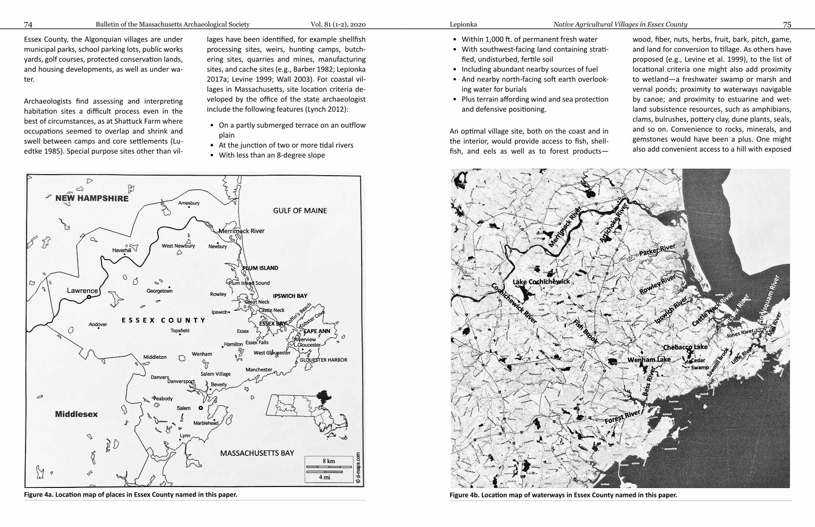
Bulletin of the Massachusetts Archaeological Society Vol. 81 (1-2), 202074 75Lepionka Native Agricultural Villages in Essex County
Essex County, the Algonquian villages are under municipal parks, school parking lots, public works yards, golf courses, protected conservation lands, and housing developments, as well as under wa-ter.
Archaeologists find assessing and interpreting habitation sites a difficult process even in the best of circumstances, as at Shattuck Farm where occupations seemed to overlap and shrink and swell between camps and core settlements (Lu-edtke 1985). Special purpose sites other than vil-
lages have been identified, for example shellfish processing sites, weirs, hunting camps, butch-ering sites, quarries and mines, manufacturing sites, and cache sites (e.g., Barber 1982; Lepionka 2017a; Levine 1999; Wall 2003). For coastal vil-lages in Massachusetts, site location criteria de-veloped by the office of the state archaeologist include the following features (Lynch 2012):
• On a partly submerged terrace on an outflow plain
• At the junction of two or more tidal rivers• With less than an 8-degree slope
• Within 1,000 ft. of permanent fresh water• With southwest-facing land containing strati-
fied, undisturbed, fertile soil• Including abundant nearby sources of fuel• And nearby north-facing soft earth overlook-
ing water for burials• Plus terrain affording wind and sea protection
and defensive positioning.
An optimal village site, both on the coast and in the interior, would provide access to fish, shell-fish, and eels as well as to forest products—
wood, fiber, nuts, herbs, fruit, bark, pitch, game, and land for conversion to tillage. As others have proposed (e.g., Levine et al. 1999), to the list of locational criteria one might also add proximity to wetland—a freshwater swamp or marsh and vernal ponds; proximity to waterways navigable by canoe; and proximity to estuarine and wet-land subsistence resources, such as amphibians, clams, bulrushes, pottery clay, dune plants, seals, and so on. Convenience to rocks, minerals, and gemstones would have been a plus. One might also add convenient access to a hill with exposed
Figure 4a. Location map of places in Essex County named in this paper. Figure 4b. Location map of waterways in Essex County named in this paper.

Bulletin of the Massachusetts Archaeological Society Vol. 81 (1-2), 202076 77Lepionka Native Agricultural Villages in Essex County
bedrock and/or glacial erratics for astronomical reckoning. Algonquians were skywatchers. Opti-mal village locations would have been convenient to locales affording unobstructed views of the sky and landscape features convenient for reckoning astronomical alignments.6
Even with little in situ archaeological evidence, the combined weight of locational, ecological, documentary, linguistic, and ethnohistorical evi-dence for pre-Contact agricultural villages in Es-sex County is overwhelming. Before the time of
European Contact, the Algonquian mixed econ-omy clearly had become agriculture-based. As noted in records of the Plymouth Company, New England Company, Massachusetts Bay Compa-ny, and in the papers of their first governors, the first English settlements in Essex County were explicitly chosen for their proximity to land al-ready cleared and cultivated by the Pawtucket (Leavenworth 1999; McBride 2003; Perley 1912; Wright 1941). Those lands included Gloucester (Wenesquawam/Wonasquam/Wanaskwiwam), Ipswich (Agoaum/Agoamin/Agawam, where
Figure 4c. Locations of Algonquian villages in Essex County described in historical accounts.
Figure 5. Pocket park on Wheeler St. in Riverview, where archaeological evidence of Wonasquam Vil-lage may have survived.
Masconomet gifted his farm on Argilla Road in Ipswich to John Winthrop Jr.), Newbury (Quasca-cuquen/Kwaskwaikikwen), Topsfield (Shenewem-
edy/Shinnewenameti), Andover (Cochichewick/Cochichewicket), and Beverly (Naumkeag/ Na-humkeak) (Figure 4a, 4b, 4c).
“Wonasquam”—with a depth of occupation extending back at least to the Middle Archa-ic Period—was on the peninsula called River-view between the Annisquam and Mill rivers in Gloucester (Lepionka 2017b; Pool 1823)(Figure 5). Satellite settlements were at Wingaersheek (Wingawecheek), including Coffin’s Beach and the Jones River Saltmarsh), on Little River in West Gloucester (Agamenticus), and on Lobster Cove in Annisquam. “Agawam” was in the crook of Castle Neck and the Castle Neck River in Essex Bay in Ips-wich (a site under a sand dune identified today as “Wigwam Hill”) (LeBaron 1874; Davis 1996)(Fig-ure 6).7 “Quascacuquen” was in West Newbury
Figure 6. Detail from LeBaron’s 1874 archaeological map of Agawam Village on Castle Neck River in Ipswich.
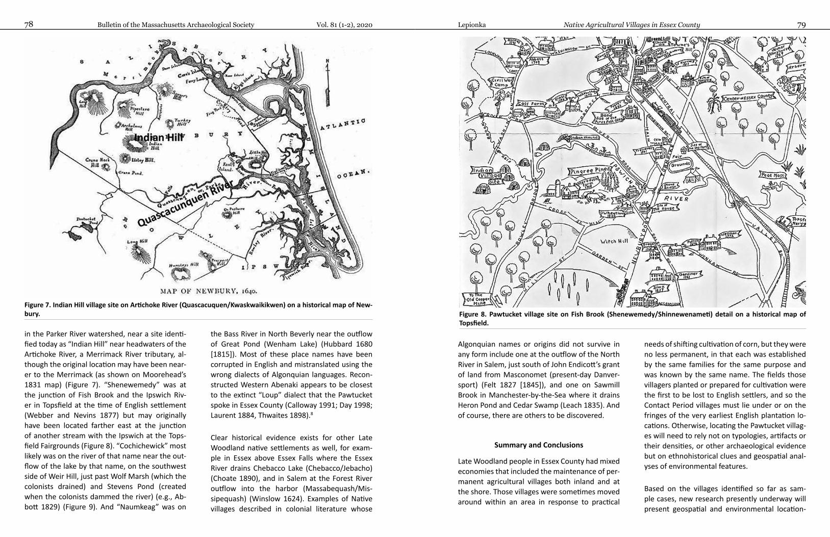
Bulletin of the Massachusetts Archaeological Society Vol. 81 (1-2), 202078 79Lepionka Native Agricultural Villages in Essex County
in the Parker River watershed, near a site identi-fied today as “Indian Hill” near headwaters of the Artichoke River, a Merrimack River tributary, al-though the original location may have been near-er to the Merrimack (as shown on Moorehead’s 1831 map) (Figure 7). “Shenewemedy” was at the junction of Fish Brook and the Ipswich Riv-er in Topsfield at the time of English settlement (Webber and Nevins 1877) but may originally have been located farther east at the junction of another stream with the Ipswich at the Tops-field Fairgrounds (Figure 8). “Cochichewick” most likely was on the river of that name near the out-flow of the lake by that name, on the southwest side of Weir Hill, just past Wolf Marsh (which the colonists drained) and Stevens Pond (created when the colonists dammed the river) (e.g., Ab-bott 1829) (Figure 9). And “Naumkeag” was on
the Bass River in North Beverly near the outflow of Great Pond (Wenham Lake) (Hubbard 1680 [1815]). Most of these place names have been corrupted in English and mistranslated using the wrong dialects of Algonquian languages. Recon-structed Western Abenaki appears to be closest to the extinct “Loup” dialect that the Pawtucket spoke in Essex County (Calloway 1991; Day 1998; Laurent 1884, Thwaites 1898).8
Clear historical evidence exists for other Late Woodland native settlements as well, for exam-ple in Essex above Essex Falls where the Essex River drains Chebacco Lake (Chebacco/Jebacho) (Choate 1890), and in Salem at the Forest River outflow into the harbor (Massabequash/Mis-sipequash) (Winslow 1624). Examples of Native villages described in colonial literature whose
Figure 7. Indian Hill village site on Artichoke River (Quascacuquen/Kwaskwaikikwen) on a historical map of New-bury.
Algonquian names or origins did not survive in any form include one at the outflow of the North River in Salem, just south of John Endicott’s grant of land from Masconomet (present-day Danver-sport) (Felt 1827 [1845]), and one on Sawmill Brook in Manchester-by-the-Sea where it drains Heron Pond and Cedar Swamp (Leach 1835). And of course, there are others to be discovered.
Summary and Conclusions
Late Woodland people in Essex County had mixed economies that included the maintenance of per-manent agricultural villages both inland and at the shore. Those villages were sometimes moved around within an area in response to practical
needs of shifting cultivation of corn, but they were no less permanent, in that each was established by the same families for the same purpose and was known by the same name. The fields those villagers planted or prepared for cultivation were the first to be lost to English settlers, and so the Contact Period villages must lie under or on the fringes of the very earliest English plantation lo-cations. Otherwise, locating the Pawtucket villag-es will need to rely not on typologies, artifacts or their densities, or other archaeological evidence but on ethnohistorical clues and geospatial anal-yses of environmental features.
Based on the villages identified so far as sam-ple cases, new research presently underway will present geospatial and environmental location-
Figure 8. Pawtucket village site on Fish Brook (Shenewemedy/Shinnewenameti) detail on a historical map of Topsfield.
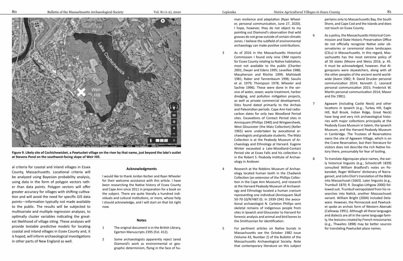
Bulletin of the Massachusetts Archaeological Society Vol. 81 (1-2), 202080 81Lepionka Native Agricultural Villages in Essex County
al criteria for coastal and inland villages in Essex County, Massachusetts. Locational criteria will be analyzed using Bayesian probability analysis, using data in the form of polygon vectors rath-er than data points. Polygon vectors will offer greater accuracy for villages with shifting cultiva-tion and will avoid the need for specific GIS data points—information typically not made available to the public. The results will be subjected to multivariate and multiple regression analyses, to optimally cluster variables indicating the great-est likelihood of village siting. These analyses will provide testable predictive models for locating coastal and inland villages in Essex County and, it is hoped, will inform archaeological investigations in other parts of New England as well.
Acknowledgments
I would like to thank Jordan Kerber and Ryan Wheeler for their welcome assistance with this article. I have been researching the Native history of Essex County and Cape Ann since 2011 in preparation for a book on the subject. There are quite literally a hundred indi-viduals and cultural institutions, or more, whose help I should acknowledge, and I will start on that list right now.
Figure 9. Likely site of Cochichewicket, a Pawtucket village on the river by that name, just beyond the lake’s outlet at Stevens Pond on the southwest-facing slope of Weir Hill.
Notes
1 The original document is in the British Library, Egerton Manuscripts 2395 (Fol. 412).
2 Some archaeologists apparently reject Jared Diamond’s work as environmental or geo-graphic determinism, flying in the face of hu-
man resilience and adaptation (Ryan Wheel-er, personal communication, June 27, 2020). I hope, however, they do not object to my pointing out Diamond’s observation that wild grasses do not grow outside of certain climatic zones. I believe the subfield of environmental archaeology can make positive contributions.
3 As of 2016 in the Massachusetts Historical Commission I found only nine CRM reports for Essex County relating to Native habitation, most not available to the public (Chartier 2001; Dwyer and Edens 1995; Leveillee 1988; Macpherson and Ritchie 1999; Mahlstedt 1981; Raber and Tannenbaum 1996; Savulis et al. 1979; Thompson 1978; Wheeler and Sachiw 1996). These were done in the ser-vice of water, sewer, waste treatment, harbor dredging, and pollution mitigation projects, as well as private commercial development. Sites found dated primarily to the Archaic and Paleoindian periods. Cape Ann had radio-carbon dates for only two Woodland Period sites. Excavations of Contact Period sites in Annisquam (Phillips 1940) and Wingaersheek, West Gloucester (the Matz Collection) (Keller 1965) were undertaken by avocational ar-chaeologists and graduate students. The Matz Collection is at the Peabody Museum of Ar-chaeology and Ethnology at Harvard. Eugene Winter excavated a Late-Woodland-Contact Period site at Essex Falls and his collection is in the Robert S. Peabody Institute of Archae-ology in Andover.
4 Research at the Robbins Museum of Archae-ology located human teeth in the Chadwick Collection (an extension of the Phillips Collec-tion in the Cape Ann Museum), and research at the Harvard Peabody Museum of Archaeol-ogy and Ethnology located a human cranium representing one individual (Annisquam Skull 50-70-10/N7487.0). In 1939-1941 the avoca-tional archaeologist N. Carleton Phillips sent skeletal remains of indigenous people from sites in Ipswich and Gloucester to Harvard for forensic analysis and animal and bird bones to the Smithsonian for identification.
5 For pertinent articles on Native burials in Massachusetts see the October 1982 issue (Volume 43, Number 2) of the Bulletin of the Massachusetts Archaeological Society. Note that contemporary literature on this subject
pertains only to Massachusetts Bay, the South Shore, and Cape Cod and the Islands and does not touch on Essex County.
6 As a policy, the Massachusetts Historical Com-mission and State Historic Preservation Office do not officially recognize Native solar ob-servatories or ceremonial stone landscapes (CSLs) in Massachusetts. In this regard, Mas-sachusetts has the most extreme policy of all 50 states (Moore and Weiss 2016, p. 45. It must be acknowledged, however, that Al-gonquians were skywatchers, along with all the other peoples of the ancient world world-wide (Aveni 1982; R. David Drucker personal communication 2014; Kenneth C. Leonard personal communication 2015; Frederick W. Martin personal communication 2014; Mavor and Dix 1981).
7 Agawam (including Castle Neck) and other locations in Ipswich (e.g., Turkey Hill, Eagle Hill, Bull Brook, Indian Ridge, Great Neck) have long and very rich archaeological histo-ries with major collections principally at the Peabody Essex Museum in Salem, the Ipswich Museum, and the Harvard Peabody Museum in Cambridge. The Trustees of Reservations owns the site of Agawam Village, which is on the Crane Reservation, but their literature for visitors does not describe the rich Native his-tory there, presumably for fear of looting.
8 To translate Algonquian place names, the ear-ly historical linguists (e.g., Schoolcraft 1839) consulted William Bradford’s notes on Po-kanoket, Roger Williams’ dictionary of Narra-ganset, and John Eliot’s translation of the Bible into Massachuset (1663). Later linguists (e.g., Trumbull 1870; R. Douglas-Lithgow 2000) fol-lowed suit. Trumbull extrapolated from his re-searches into Natick, another Masssachuset variant. William Bright (2004) included Dela-ware. However, the Pennacook and Pawtuck-et spoke an archaic form of Western Abenaki (Calloway 1991). Although all these languages and dialects are all in the same language fami-ly, the lexicons created by French missionaries (e.g., Thwaites 1898) may be better sources for translating Pawtucket place names.
Bulletin of the Massachusetts Archaeological Society Vol. 81 (1-2), 202082 83Lepionka Native Agricultural Villages in Essex County
References Cited
Abbott, Abiel1829 History of Andover: From Its Settlement to 1829. Flagg and Gould, Andover, MA.
Aveni, Anthony2008 People and the Sky. Thames & Hudson, London.
Axtell, James1988 At the Water’s Edge: Trading in the Sixteenth Century. In After Columbus: Essays in the Ethnohistory of
Colonial North America, edited by James Axtell, pp.142-188. Oxford University Press, Oxford.
Barber, Russell1982 The Wheeler’s Site: A Specialized Shellfish Processing Station on the Merrimack River. Peabody Museum
Monographs No. 7, Harvard University, Cambridge, MA.
Bennett, M. K.1955 The Food Economy of the New England Indians, 1605-1675. Journal of Political Economy 63(5):369-397.
Binford, Lewis R.1980 Willow Smoke and Dogs' Tails: Hunter-Gatherer Settlement Systems and Archaeological Site Formation.
American Antiquity 45(1):4-20.
Boudillion, Daniel2009 Nashoba Hill: The Hill that Roars (field investigation of corn-planting mounds). http://www.boudillion.
com/nashobahill/nashobahill.htm, accessed fall 2014.
Bradford, William, and Edward Winslow1622 Mourt’s Relation, or Journal of the Plantation at Plymouth. J. K. Wiggin, Boston.
Bragdon, Kathleen1996a Native People of Southern New England 1500-1650, University of Oklahoma Press, Norman.1996b Gender as a Social Category in Native Southern New England. Ethnohistory 43(4):573-574.
Braun, David P. 2009 Corn Domesticated from Mexican Wild Grass 8,700 years ago. National Geographic (March 23, 2009).
http://voices.nationalgeographic.com/2009/03/23/corn_domesticated_8700_years_ago/,last accessed October 2019.
Bright, William2004 Native American Placenames of the United States. University of Oklahoma Press, Norman.
Calloway, Colin G.1991 Dawnland Encounters: Indians and Europeans in northern New England. University Press of New En-
gland, Hanover, NH.
Ceci, Lynn1974 Fish Fertilizer: A Native North American Practice? Science 188(4183):26-60.
Champlain, Samuel de1607 (1922) Les Voyages (Vol. 2, Ch. VII). In The Works of Samuel de Champlain, edited by H.H. Langdon and W. F.
Ganong, translated by H. P. Biggar. The Champlain Society, Toronto, Canada.
Chartier, Craig S.2001 Intensive (Locational) Archaeological Survey for Little River Sewer Project in Gloucester, MA. Massachu-
setts Historical Commission, 2084.
Chilton, Elizabeth S. 2002 ‘Towns They Have None:’ Diverse Subsistence and Settlement Strategies in Native New England. In
Northeast Subsistence-Settlement Change: A.D.700 to A.D. 1700, edited by J. Hart and C. Rieth, pp. 289-300. New York State Museum Bulletin Number 496.
2006 The Origin and Spread of Maize (Zea mays) in New England. In Histories of Maize: Multidisciplinary Approaches to the Prehistory, Linguistics, Biogeography, Domestication, and Evolution of Maize, edited by John Staller, Robert Tykot, and Bruce Benz, pp. 539-547. Academic Press, New York.
2010 Mobile Farmers and Sedentary Models: Horticulture and Cultural Transitions in Late Woodland and Contact Period New England. In Ancient Complexities: New Perspectives in Precolumbian North America, edited by Susan M. Alt, pp. 96-103. University of Utah Press, Salt Lake City.
Chilton, Elizabeth S., Tonya Largy, and Kathryn Curran2000 Evidence for Prehistoric Maize Horticulture at the Pine Hill Site in Deerfield, Massachusetts. Northeast
Anthropology 59:23-46.
Choate, Rufus1890 Indian Life at Chebacco. Essex Echo (July 31, 1890)(note: the Essex Echo was a newspaper published
between 1887 and 1918).
Cronin, Thomas M. 2013 Paleoclimates: Understanding Climate Change Past and Present. Columbia University Press, New York.
Cronon, William2003 Changes in the Land: Indians, Colonists and the Ecology of New England. Hill and Wang, New York.
Crosby, A. W. 1976 Virgin Soil Epidemics as a Factor in the Aboriginal Depopulation in America. William and Mary Quarter-
ly 23(2):289-299.
Davis, Margo1996 Archaeological Potential of the Crane Reservations, Ipswich, Massachusetts. http://www.thetrustees.
org/assets/documents/placestovisit/managementplans/NE_CastleHill_MP2007.pdf, last accessed spring 2016.
Day, Gordon M.1998 In Search of New England’s Native Past, edited by Michael K. Foster and William Cowan. University of
Massachusetts, Amherst.
Delabarre, Edmund B., and Harris H. Wilder1920 Indian Corn-Hills in Massachusetts. American Anthropologist 22(3):203-225.
Diamond, Jared2002 Evolution, Consequences and Future of Plant and Animal Domestication. Nature 418 (6898): 700-7007
(August 8, 2002) http://www.nature.com/nature/journal/v418/n6898/full/nature01019.html, ac-cessed January 19, 2017.
Doughty, Christopher2010 The Development of Agriculture in the Americas: An Ecological Perspective. Ecosphere 1:21.
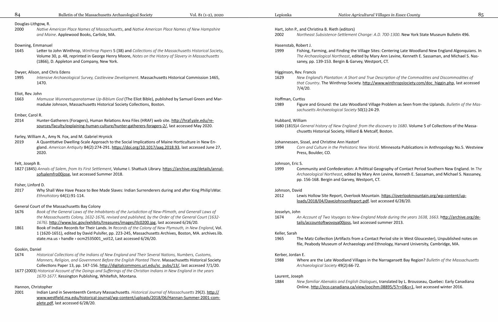
Bulletin of the Massachusetts Archaeological Society Vol. 81 (1-2), 202084 85Lepionka Native Agricultural Villages in Essex County
Douglas-Lithgow, R. 2000 Native American Place Names of Massachusetts, and Native American Place Names of New Hampshire
and Maine. Applewood Books, Carlisle, MA.
Downing, Emmanuel1645 Letter to John Winthrop, Winthrop Papers 5 (38) and Collections of the Massachusetts Historical Society,
Volume 30, p. 48, reprinted in George Henry Moore, Notes on the History of Slavery in Massachusetts (1866), D. Appleton and Company, New York.
Dwyer, Alison, and Chris Edens1995 Intensive Archaeological Survey, Castleview Development. Massachusetts Historical Commission 1465,
1470.
Eliot, Rev. John1663 Mamusse Wunneetupanatamwe Up-Biblum God (The Eliot Bible), published by Samuel Green and Mar-
maduke Johnson, Massachusetts Historical Society Collections, Boston.
Ember, Carol R.2014 Hunter-Gatherers (Foragers), Human Relations Area Files (HRAF) web site. http://hraf.yale.edu/re-
sources/faculty/explaining-human-culture/hunter-gatherers-foragers-2/, last accessed May 2020.
Farley, William A., Amy N. Fox, and M. Gabriel Hrynick2019 A Quantitative Dwelling-Scale Approach to the Social Implications of Maine Horticulture in New En-
gland. American Antiquity 84(2):274-291. https://doi.org/10.1017/aaq.2018.93, last accessed June 27, 2020.
Felt, Joseph B.1827 (1845) Annals of Salem, from Its First Settlement, Volume I. Shattuck Library. https://archive.org/details/annal-
sofsalemfro00jose, last accessed Summer 2018.
Fisher, Linford D.2017 Why Shall Wee Have Peace to Bee Made Slaves: Indian Surrenderers during and after King Philip’sWar.
Ethnohistory 64(1):91-114.
General Court of the Massachusetts Bay Colony1676 Book of the General Laws of the Inhabitants of the Jurisdiction of New-Plimoth, and Generall Laws of
the Massachusetts Colony, 1632-1676, revised and published, by the Order of the General Court (1632-1676). http://www.loc.gov/exhibits/treasures/images/tlc0200.jpg, last accessed 6/26/20.
1861 Book of Indian Records for Their Lands. In Records of the Colony of New Plymouth, in New England, Vol. 1 (1620-1651), edited by David Pulsifer, pp. 223-245, Massachusetts Archives, Boston, MA. archives.lib.state.ma.us › handle › ocm2535001_vol12, Last accessed 6/26/20.
Gookin, Daniel1674 Historical Collections of the Indians of New England and Their Several Nations, Numbers, Customs,
Manners, Religion, and Government Before the English Planted There. Massachusetts Historical Society Collections Paper 13, pp. 147-156. http://digitalcommons.uri.edu/sc_pubs/13/, last accessed 7/1/20.
1677 (2003) Historical Account of the Doings and Sufferings of the Christian Indians in New England in the years 1670-1677. Kessington Publishing, Whitefish, Montana.
Hannon, Christopher 2001 Indian Land in Seventeenth Century Massachusetts. Historical Journal of Massachusetts 29(2). http://
www.westfield.ma.edu/historical-journal/wp-content/uploads/2018/06/Hannan-Summer-2001-com-plete.pdf, last accessed 6/28/20.
Hart, John P., and Christina B. Rieth (editors)2002 Northeast Subsistence-Settlement Change: A.D. 700-1300. New York State Museum Bulletin 496.
Hasenstab, Robert J.1999 Fishing, Farming, and Finding the Village Sites: Centering Late Woodland New England Algonquians. In
The Archaeological Northeast, edited by Mary Ann Levine, Kenneth E. Sassaman, and Michael S. Nas-saney, pp. 139-153. Bergin & Garvey, Westport, CT.
Higginson, Rev. Francis1629 New England’s Plantation: A Short and True Description of the Commodities and Discommodities of
that Country. The Winthrop Society. http://www.winthropsIociety.com/doc_higgin.php, last accessed 7/4/20.
Hoffman, Curtiss1989 Figure and Ground: the Late Woodland Village Problem as Seen from the Uplands. Bulletin of the Mas-
sachusetts Archaeological Society 50(1):24-29.
Hubbard, William1680 (1815) A General history of New England: from the discovery to 1680. Volume 5 of Collections of the Massa-
chusetts Historical Society, Hilliard & Metcalf, Boston.
Johannessen, Sissel, and Christine Ann Hastorf1994 Corn and Culture in the Prehistoric New World. Minnesota Publications in Anthropology No.5. Westview
Press, Boulder, CO.
Johnson, Eric S.1999 Community and Confederation: A Political Geography of Contact Period Southern New England. In The
Archaeological Northeast, edited by Mary Ann Levine, Kenneth E. Sassaman, and Michael S. Nassaney, pp. 156-168. Bergin and Garvey, Westport, CT.
Johnson, David2012 Lewis Hollow Site Report, Overlook Mountain. https://overlookmountain.org/wp-content/up-
loads/2018/04/DaveJohnsonReport.pdf, last accessed 6/28/20.
Josselyn, John1674 An Account of Two Voyages to New-England Made during the years 1638, 1663. http://archive.org/de-
tails/accountoftwovoya00joss, last accessed summer 2013.
Keller, Sarah1965 The Matz Collection (Artifacts from a Contact Period site in West Gloucester), Unpublished notes on
file, Peabody Museum of Archaeology and Ethnology, Harvard University, Cambridge, MA.
Kerber, Jordan E.1988 Where are the Late Woodland Villages in the Narragansett Bay Region? Bulletin of the Massachusetts
Archaeological Society 49(2):66-72.
Laurent, Joseph1884 New familiar Abenakis and English Dialogues, translated by L. Brousseau, Quebec: Early Canadiana
Online. http://eco.canadiana.ca/view/oocihm.08895/5?r=0&s=1, last accessed winter 2016.
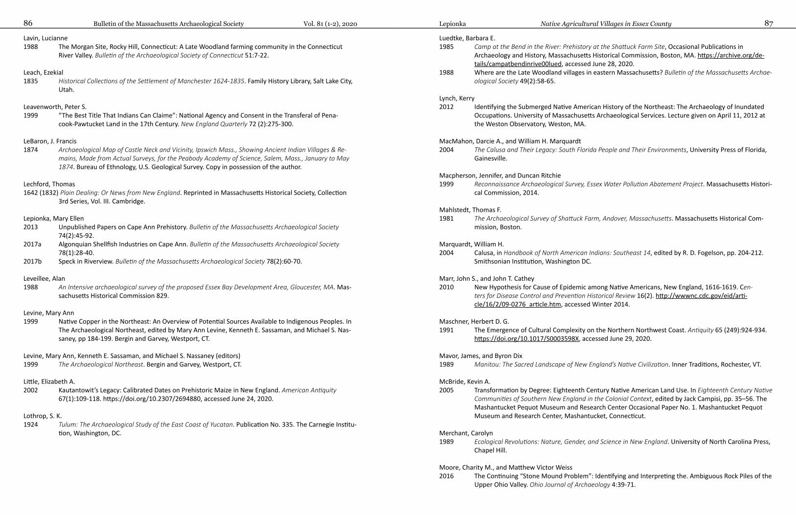
Bulletin of the Massachusetts Archaeological Society Vol. 81 (1-2), 202086 87Lepionka Native Agricultural Villages in Essex County
Lavin, Lucianne1988 The Morgan Site, Rocky Hill, Connecticut: A Late Woodland farming community in the Connecticut
River Valley. Bulletin of the Archaeological Society of Connecticut 51:7-22.
Leach, Ezekial1835 Historical Collections of the Settlement of Manchester 1624-1835. Family History Library, Salt Lake City,
Utah.
Leavenworth, Peter S. 1999 “The Best Title That Indians Can Claime”: National Agency and Consent in the Transferal of Pena-
cook-Pawtucket Land in the 17th Century. New England Quarterly 72 (2):275-300.
LeBaron, J. Francis1874 Archaeological Map of Castle Neck and Vicinity, Ipswich Mass., Showing Ancient Indian Villages & Re-
mains, Made from Actual Surveys, for the Peabody Academy of Science, Salem, Mass., January to May 1874. Bureau of Ethnology, U.S. Geological Survey. Copy in possession of the author.
Lechford, Thomas1642 (1832) Plain Dealing: Or News from New England. Reprinted in Massachusetts Historical Society, Collection
3rd Series, Vol. III. Cambridge.
Lepionka, Mary Ellen2013 Unpublished Papers on Cape Ann Prehistory. Bulletin of the Massachusetts Archaeological Society
74(2):45-92.2017a Algonquian Shellfish Industries on Cape Ann. Bulletin of the Massachusetts Archaeological Society
78(1):28-40.2017b Speck in Riverview. Bulletin of the Massachusetts Archaeological Society 78(2):60-70.
Leveillee, Alan1988 An Intensive archaeological survey of the proposed Essex Bay Development Area, Gloucester, MA. Mas-
sachusetts Historical Commission 829.
Levine, Mary Ann1999 Native Copper in the Northeast: An Overview of Potential Sources Available to Indigenous Peoples. In
The Archaeological Northeast, edited by Mary Ann Levine, Kenneth E. Sassaman, and Michael S. Nas-saney, pp 184-199. Bergin and Garvey, Westport, CT.
Levine, Mary Ann, Kenneth E. Sassaman, and Michael S. Nassaney (editors)1999 The Archaeological Northeast. Bergin and Garvey, Westport, CT.
Little, Elizabeth A.2002 Kautantowit’s Legacy: Calibrated Dates on Prehistoric Maize in New England. American Antiquity
67(1):109-118. https://doi.org/10.2307/2694880, accessed June 24, 2020.
Lothrop, S. K. 1924 Tulum: The Archaeological Study of the East Coast of Yucatan. Publication No. 335. The Carnegie Institu-
tion, Washington, DC.
Luedtke, Barbara E. 1985 Camp at the Bend in the River: Prehistory at the Shattuck Farm Site, Occasional Publications in
Archaeology and History, Massachusetts Historical Commission, Boston, MA. https://archive.org/de-tails/campatbendinrive00lued, accessed June 28, 2020.
1988 Where are the Late Woodland villages in eastern Massachusetts? Bulletin of the Massachusetts Archae-ological Society 49(2):58-65.
Lynch, Kerry2012 Identifying the Submerged Native American History of the Northeast: The Archaeology of Inundated
Occupations. University of Massachusetts Archaeological Services. Lecture given on April 11, 2012 at the Weston Observatory, Weston, MA.
MacMahon, Darcie A., and William H. Marquardt 2004 The Calusa and Their Legacy: South Florida People and Their Environments, University Press of Florida,
Gainesville.
Macpherson, Jennifer, and Duncan Ritchie1999 Reconnaissance Archaeological Survey, Essex Water Pollution Abatement Project. Massachusetts Histori-
cal Commission, 2014.
Mahlstedt, Thomas F. 1981 The Archaeological Survey of Shattuck Farm, Andover, Massachusetts. Massachusetts Historical Com-
mission, Boston.
Marquardt, William H. 2004 Calusa, in Handbook of North American Indians: Southeast 14, edited by R. D. Fogelson, pp. 204-212.
Smithsonian Institution, Washington DC.
Marr, John S., and John T. Cathey2010 New Hypothesis for Cause of Epidemic among Native Americans, New England, 1616-1619. Cen-
ters for Disease Control and Prevention Historical Review 16(2). http://wwwnc.cdc.gov/eid/arti-cle/16/2/09-0276_article.htm, accessed Winter 2014.
Maschner, Herbert D. G.1991 The Emergence of Cultural Complexity on the Northern Northwest Coast. Antiquity 65 (249):924-934.
https://doi.org/10.1017/S0003598X, accessed June 29, 2020.
Mavor, James, and Byron Dix1989 Manitou: The Sacred Landscape of New England’s Native Civilization. Inner Traditions, Rochester, VT.
McBride, Kevin A.2005 Transformation by Degree: Eighteenth Century Native American Land Use. In Eighteenth Century Native
Communities of Southern New England in the Colonial Context, edited by Jack Campisi, pp. 35–56. The Mashantucket Pequot Museum and Research Center Occasional Paper No. 1. Mashantucket Pequot Museum and Research Center, Mashantucket, Connecticut.
Merchant, Carolyn1989 Ecological Revolutions: Nature, Gender, and Science in New England. University of North Carolina Press,
Chapel Hill.
Moore, Charity M., and Matthew Victor Weiss 2016 The Continuing “Stone Mound Problem”: Identifying and Interpreting the. Ambiguous Rock Piles of the
Upper Ohio Valley. Ohio Journal of Archaeology 4:39-71.
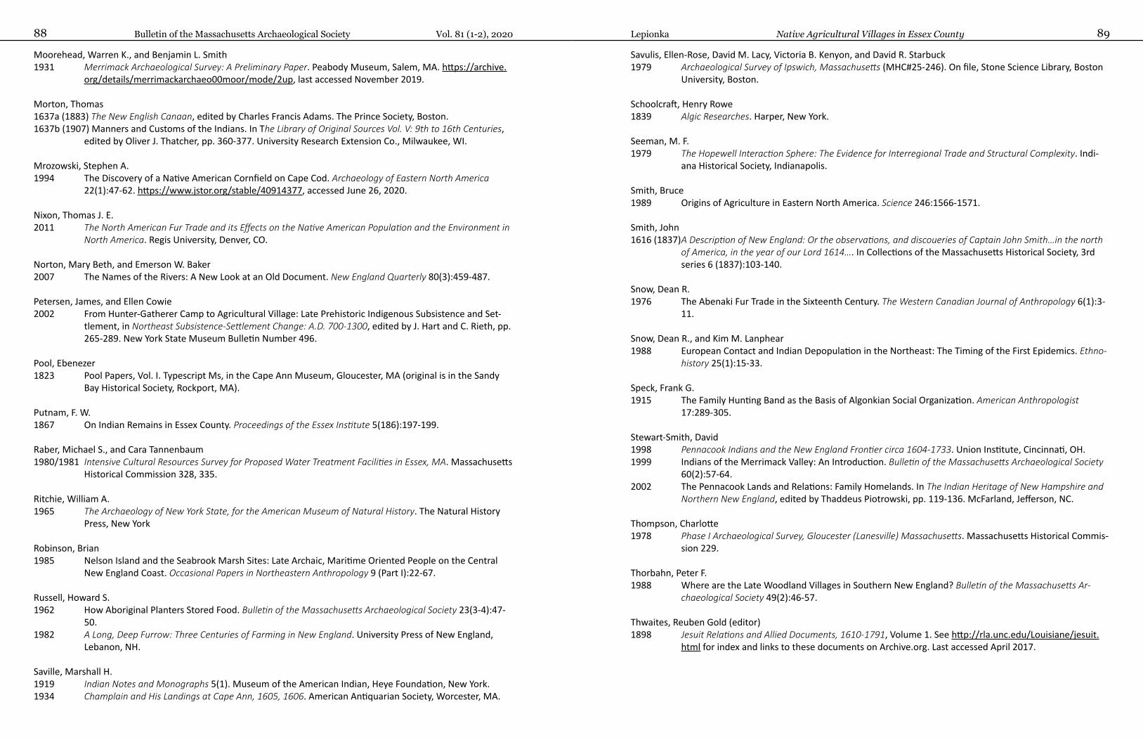
Bulletin of the Massachusetts Archaeological Society Vol. 81 (1-2), 202088 89Lepionka Native Agricultural Villages in Essex County
Moorehead, Warren K., and Benjamin L. Smith 1931 Merrimack Archaeological Survey: A Preliminary Paper. Peabody Museum, Salem, MA. https://archive.
org/details/merrimackarchaeo00moor/mode/2up, last accessed November 2019.
Morton, Thomas1637a (1883) The New English Canaan, edited by Charles Francis Adams. The Prince Society, Boston.1637b (1907) Manners and Customs of the Indians. In The Library of Original Sources Vol. V: 9th to 16th Centuries,
edited by Oliver J. Thatcher, pp. 360-377. University Research Extension Co., Milwaukee, WI.
Mrozowski, Stephen A.1994 The Discovery of a Native American Cornfield on Cape Cod. Archaeology of Eastern North America
22(1):47-62. https://www.jstor.org/stable/40914377, accessed June 26, 2020.
Nixon, Thomas J. E. 2011 The North American Fur Trade and its Effects on the Native American Population and the Environment in
North America. Regis University, Denver, CO.
Norton, Mary Beth, and Emerson W. Baker2007 The Names of the Rivers: A New Look at an Old Document. New England Quarterly 80(3):459-487.
Petersen, James, and Ellen Cowie2002 From Hunter-Gatherer Camp to Agricultural Village: Late Prehistoric Indigenous Subsistence and Set-
tlement, in Northeast Subsistence-Settlement Change: A.D. 700-1300, edited by J. Hart and C. Rieth, pp. 265-289. New York State Museum Bulletin Number 496.
Pool, Ebenezer1823 Pool Papers, Vol. I. Typescript Ms, in the Cape Ann Museum, Gloucester, MA (original is in the Sandy
Bay Historical Society, Rockport, MA).
Putnam, F. W. 1867 On Indian Remains in Essex County. Proceedings of the Essex Institute 5(186):197-199.
Raber, Michael S., and Cara Tannenbaum1980/1981 Intensive Cultural Resources Survey for Proposed Water Treatment Facilities in Essex, MA. Massachusetts
Historical Commission 328, 335.
Ritchie, William A.1965 The Archaeology of New York State, for the American Museum of Natural History. The Natural History
Press, New York
Robinson, Brian 1985 Nelson Island and the Seabrook Marsh Sites: Late Archaic, Maritime Oriented People on the Central
New England Coast. Occasional Papers in Northeastern Anthropology 9 (Part I):22-67.
Russell, Howard S. 1962 How Aboriginal Planters Stored Food. Bulletin of the Massachusetts Archaeological Society 23(3-4):47-
50.1982 A Long, Deep Furrow: Three Centuries of Farming in New England. University Press of New England,
Lebanon, NH.
Saville, Marshall H. 1919 Indian Notes and Monographs 5(1). Museum of the American Indian, Heye Foundation, New York.1934 Champlain and His Landings at Cape Ann, 1605, 1606. American Antiquarian Society, Worcester, MA.
Savulis, Ellen-Rose, David M. Lacy, Victoria B. Kenyon, and David R. Starbuck1979 Archaeological Survey of Ipswich, Massachusetts (MHC#25-246). On file, Stone Science Library, Boston
University, Boston.
Schoolcraft, Henry Rowe1839 Algic Researches. Harper, New York.
Seeman, M. F.1979 The Hopewell Interaction Sphere: The Evidence for Interregional Trade and Structural Complexity. Indi-
ana Historical Society, Indianapolis.
Smith, Bruce1989 Origins of Agriculture in Eastern North America. Science 246:1566-1571.
Smith, John 1616 (1837) A Description of New England: Or the observations, and discoueries of Captain John Smith…in the north
of America, in the year of our Lord 1614…. In Collections of the Massachusetts Historical Society, 3rd series 6 (1837):103-140.
Snow, Dean R.1976 The Abenaki Fur Trade in the Sixteenth Century. The Western Canadian Journal of Anthropology 6(1):3-
11.
Snow, Dean R., and Kim M. Lanphear1988 European Contact and Indian Depopulation in the Northeast: The Timing of the First Epidemics. Ethno-
history 25(1):15-33.
Speck, Frank G. 1915 The Family Hunting Band as the Basis of Algonkian Social Organization. American Anthropologist
17:289-305.
Stewart-Smith, David1998 Pennacook Indians and the New England Frontier circa 1604-1733. Union Institute, Cincinnati, OH.1999 Indians of the Merrimack Valley: An Introduction. Bulletin of the Massachusetts Archaeological Society
60(2):57-64.2002 The Pennacook Lands and Relations: Family Homelands. In The Indian Heritage of New Hampshire and
Northern New England, edited by Thaddeus Piotrowski, pp. 119-136. McFarland, Jefferson, NC.
Thompson, Charlotte1978 Phase I Archaeological Survey, Gloucester (Lanesville) Massachusetts. Massachusetts Historical Commis-
sion 229.
Thorbahn, Peter F. 1988 Where are the Late Woodland Villages in Southern New England? Bulletin of the Massachusetts Ar-
chaeological Society 49(2):46-57.
Thwaites, Reuben Gold (editor)1898 Jesuit Relations and Allied Documents, 1610-1791, Volume 1. See http://rla.unc.edu/Louisiane/jesuit.
html for index and links to these documents on Archive.org. Last accessed April 2017.
Bulletin of the Massachusetts Archaeological Society 912019, Vol. 80(1-2)
Bulletin of the Massachusetts Archaeological Society Vol. 81 (1-2), 202090
Trumbull, J. Hammond1870 The Composition of Indian Geographical Names, Illustrated from the Algonkin Languages. Case, Lock-
wood and Brainard, Hartford, CT. http://www.gutenberg.org/catalog/world/readfile?fk_files=1511626, last accessed February 2017.
United States Department of Agriculture (USDA)2017 Definitions of horticulture, specialty crop, agriculture, etc. www.usda.gov.
Wall, Suzanne2003 Aboriginal Soapstone Workshops at the Skug River II Site, Essex County, MA. Bulletin of the Massachu-
setts Archaeological Society 64(2):30-36.
Webber, Carl, and Winfield S. Nevins1877 Old Naumkeag: An Historical Sketch of the City of Salem, and the Towns of Marblehead, Peabody, Dan-
vers, Wenham, Manchester, Topsfield, and Middleton. A. A. Smith, Salem.
Wheeler, Kathleen, and Myron O. Stachiw1996 Excavations at Cogswell’s Grant in Essex. Massachusetts Historical Commission 1667.
Williams, Roger 1643 A Key into the Language of America. London (Providence, RI: G. Dexter).
Winslow, Edward1624 (1996) Good Newes from New England: A True Relation of Things Very Remarkable at the Plantation of Plimoth
in New England, reprint edition. Applewood Books, Carlisle, MA.
Winthrop, John1649 History of New England 1630-1649, edited by James K. Hosmer. Charles Scribner’s Sons, New York.
Wood, William1634 New England’s Prospect: A True, Lively, and Experimental Description of That Part of America, commonly
called New England (John Dawson, London). http://www.constitution.org/primarysources/wood.html, last accessed January 2018.
Wright, Harry Andrew 1941 The Technique of Seventeenth Century Indian Land Purchases. Essex Institute Historical Collections
77:185-197.
Yoshihiro, Matsuoka, Yves Vigouroux, Major M. Goodman, Jesus Sanchez G., Edward Buckler, and John Doebley2002 A Single Domestication for Maize Shown by Multilocus Microsatellite Genotyping. Proceedings of
the National Academy of Sciences 99(9):6080-6084. http://www.ncbi.nlm.nih.gov/pmc/articles/PMC122905/, accessed Summer 2017.
Contributors
Ian W. Brown is Professor Emeritus at the University of Alabama and Emeritus Curator of Gulf Coast Ar-chaeology at the Alabama Museum of Natural History. He is also a Fellow of the Society of Antiquaries of London. Dr. Brown specializes in the archaeology and history of Southeastern U.S. Indians and has spent over four decades excavating sites in Louisiana, Mississippi, and Alabama and writing about the role of salt in North America, England, and China. He has also written much with regard to gravestones and cemeter-ies.
William Burke is Cultural Resources Program Manager at the Cape Cod National Seashore, National Park Service. He obtained an M.A. in history from The College of William and Mary, which included an appren-ticeship in Historical Archaeology with the Colonial Williamsburg Foundation.
Marty Dudek is principal archaeologist for Commonwealth Heritage Group, Inc. in Littleton, MA and has been doing archaeology in the region for over 30 years. He has a graduate degree in Anthropology from Brandeis University and has worked on archaeological sites ranging from every time period in New En-gland, from the Paleoindian Whipple site in New Hampshire to twentieth century industrial sites.
William A. Griswold, Ph.D., RPA is Archeologist and Interior Region 1 ARPA coordinator for the National Park Service. Bill began his career with the NPS in 1993 and has been with the Archaeology Program, through its various iterations, since that time. He has assumed many roles in his career including archaeological advi-sor, Section 106 reviewer, archaeo-geophysicist, ARPA investigator, ARPA course instructor, SRE for a POW/MIA Accounting Agency project in the UK, and is currently the Interior Region 1 ARPA Coordinator. Bill has co-edited two books on NPS sites including Saugus Iron Works and Saratoga National Historical Park and published several peer-reviewed journal articles and chapters in books.
Philip Graham, Ph.D. has been a Trustee of the Massachusetts Archaeological Society for 6 years and is a Past President of the Society.
Tonya Largy, M.A. is an archaeological consultant in archaeobotany and zooarchaeology. She is also asso-ciated with the Zooarchaeology Laboratory, Peabody Museum, Harvard University. Tonya has been active in Wayland archaeology since the late 1970s and was a co-founder of the Wayland Archaeology Group, an arm of the Wayland Historical Commission of which she is a member. Tonya has been involved in numer-ous excavations in the Sudbury/Assabet/Concord River basin since that time. She also has extensive field experience in the broader northeast with the National Park Service. As a staff member of the Zooarchae-ology Laboratory at Harvard, she also worked at the ancient site of Harappa in Pakistan. Tonya holds a B.A. in Anthropology from UMass Boston, an M.A. in Anthropology from UMass Amherst, and an M.S.W. from Fordham University in New York.
Mary Ellen Lepionka of Gloucester is an independent scholar researching the history of Essex County and Cape Ann from the last Ice Age to around 1750 for a book on the subject. Mary Ellen is a retired college instructor, textbook developer, and author with a Master’s degree in anthropology from Boston University and Ph.D. work at the University of British Columbia. She taught cultural and physical anthropology and world history at Boston University, Vancouver City College, Northeastern University, North Shore Commu-nity College, and Salem State College, participated in salvage archaeology at Great Neck in Ipswich, exca-
October 2020Vol. 81 (1-2) Bulletin of the Massachusetts Archaeological Society
vated an Early Iron Age Bantu refuge site in Botswana, and conducted fieldwork in Riyadh, Saudi Arabia. Mary Ellen also had a career in higher education publishing as a developmental editor of college textbooks. Her book, Writing and Developing Your College Textbook, has been published in a third edition by the Text and Academic Authors Association. Mary Ellen’s articles and essays on the archaeology and indigenous his-tory of Cape Ann have been published in this Bulletin and online at Enduring Gloucester, Historic Ipswich, and capeannhistory.org.
John Rempelakis recently retired after serving as Archaeological Resources Supervisor of the Cultural Re-sources Section. He also served as the Environmental Contract Administrator and Architects & Engineers Review Board Member for the Massachusetts Department of Transportation (MassDOT). John holds Bach-elor's and Master's degrees in Anthropology/Archaeology with over 40 years of combined professional field, research, and administrative experience in the fields of Archaeology and Cultural and Environmental Resource Management and has worked in both public and private settings. John has been a MAS member for many years, having served the last 18 years as a MAS Board Trustee.
Alan Strauss graduated magna cum laude with a Bachelor of Arts degree from the University of Massa-chusetts in Amherst in 1977. In 1979, he completed a Master of Arts degree in Anthropology from SUNY Binghamton. Currently Alan is the director of Cultural Resource Specialists of New England based in Rhode Island.
Notes to Contributors
The Editor solicits for publication original contributions related to the archaeology of Massachusetts. Au-thors of articles submitted to the Bulletin of the Massachusetts Archaeological Society are requested to fol-low the style guide for American Antiquity (https://www.saa.org/publications/american-antiquity). Manu-scripts should be sent to the Editor for evaluation and comment at [email protected]. The Editor will arrange for peer review of all submissions.
All manuscripts should be submitted as electronic files (preferably Microsoft Word .doc or .docx files, or .rtf files). All text should have margins of 1 inch on all edges. In electronic files, do not insert artificial spaces be-tween lines; instead, use the Format/Paragraph/Line Spacing function and select “Double.” Proper heading and bibliographic material must be included.
Bibliographic references should be listed alphabetically by author’s last name and presented as follows:
Gookin, Daniel1970 Historical Collections of the Indians of New England (1674). Jeffrey H. Fiske, annotator. Towtaid, Worces-
ter MA.
Luhman, Hope E.2007 Approaching Relevance: Public Outreach and Education in CRM. Northeast Anthropology 73:33-41.
Several references by the same author should be listed chronologically by year. Multiple references by the same author from the same year should have lower case letters (e.g. “a,” “b”) following the year. Reference citations in the text should include the author’s name, date of publication, and the page or figure number, all enclosed in parentheses, as follows: (Bowman and Zeoli 1973:27) or (Ritchie 1965: Fig. 12). All informa-tion derived from published sources must be cited, whether it is directly quoted or paraphrased.
Please check to make sure that all citations in the text match bibliographical entries, especially dates of publication.
All tables and illustrations, called figures, should be submitted as separate electronic originals. If a large number of figures is involved, authors may use DropBox to send them to the Editor. Tables should be sub-mitted as separate Excel (.xls or .xlsx) spreadsheets and not incorporated into the text. Figures should be submitted as .tif files, high resolution (600 dpi minimum), in greyscale. Each figure should fit within the space available on a Bulletin page, which is 6½ x 9 inches, allowing for margins. Full, half or quarter page figures should be planned carefully. Width dimensions for one-column images are 3.35 inches. Space must be allowed for captions. Captions should be in title case and should accompany the text in a separate sec-tion, in order and numbered to correspond to the figures.
Figures must be referred to in the text and are to be numbered in their order of reference, with their num-ber indicated in the file name. Every item in each figure and each person should be identified. All lettering must be clear and legible. Scales with dimensions, preferably in metric measurements, should be included with all figures for which they are appropriate.
Dimensions and distances should be given in metric units or in metric units and English units, to the same standard of accuracy (e.g., 10 cm or 2.5 inches, not 2.54 inches). Authors should include a brief (one para-graph) biography for the “Contributors” page of the Bulletin issue.
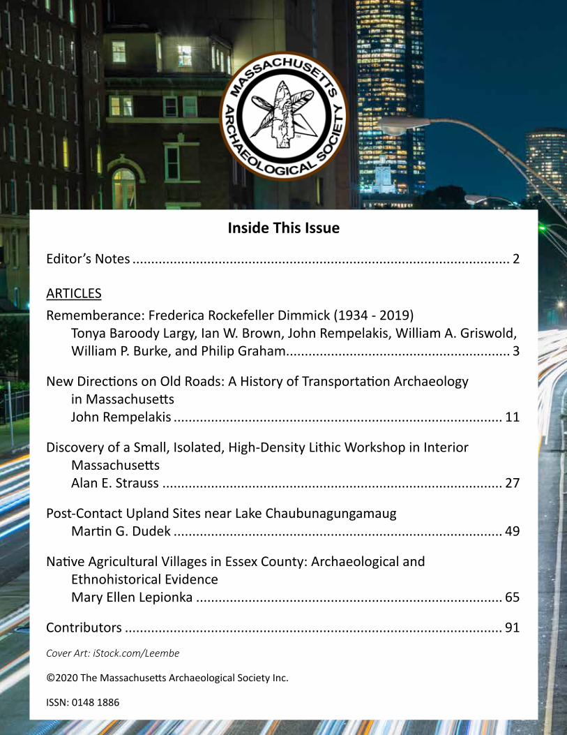
Inside This Issue
Editor’s Notes ..................................................................................................... 2
ARTICLESRememberance: Frederica Rockefeller Dimmick (1934 - 2019)
Tonya Baroody Largy, Ian W. Brown, John Rempelakis, William A. Griswold, William P. Burke, and Philip Graham............................................................ 3
New Directions on Old Roads: A History of Transportation Archaeology in Massachusetts John Rempelakis ........................................................................................ 11
Discovery of a Small, Isolated, High-Density Lithic Workshop in Interior Massachusetts Alan E. Strauss ........................................................................................... 27
Post-Contact Upland Sites near Lake Chaubunagungamaug Martin G. Dudek ........................................................................................ 49
Native Agricultural Villages in Essex County: Archaeological and Ethnohistorical Evidence Mary Ellen Lepionka .................................................................................. 65
Contributors ..................................................................................................... 91
Cover Art: iStock.com/Leembe
©2020 The Massachusetts Archaeological Society Inc.
ISSN: 0148 1886


![IAC 6/29/22 Human Services[441] Ch 81, p.1 CHAPTER 81 ...](https://static.fdokumen.com/doc/165x107/632d92e97ebcbb35180578c4/iac-62922-human-services441-ch-81-p1-chapter-81-.jpg)