Bugis Settlers in East Kalimantan's Kutai National Park
59
BUGIS SETTLERS IN EAST KALIMANTANS KUTAI NATIONAL PARK THEIR PAST AND PRESENT AND SOME POSSIBILITIES FOR THEIR FUTURE Andrew P. Vayda and Ahmad Sahur CIFOR Special Publication CENTER FOR INTERNATIONAL FORESTRY RESEARCH CIFOR
-
Upload
independent -
Category
Documents
-
view
1 -
download
0
Transcript of Bugis Settlers in East Kalimantan's Kutai National Park

BUGIS SETTLERS IN EAST KALIMANTANÕSKUTAI NATIONAL PARK
THEIR PAST AND PRESENTAND SOME POSSIBILITIES FOR THEIR FUTURE
Andrew P. Vayda and Ahmad Sahur
CIFOR Special Publication
CENTER FOR INTERNATIONAL FORESTRY RESEARCH CIFOR
Front pages 6/7/98 8:17 PM Page 1

© 1996 Center for International Forestry Research
Published by
Center for International Forestry Researchmailing address: P.O. Box 6596 JKPWB, Jakarta 10065, Indonesiatel.: +62-251-622622 fax: +62-251-622100e-mail: [email protected]: http://www.cgiar.org/cifor
with support from
UNDP/UNESCO/Government of Indonesia Project INS/93/004on Management Support to Kutai National ParkJl. M.H. Thamrin 14Jakarta Pusat, Indonesia
ISBN 979-8764-12-9
Front pages 6/7/98 8:17 PM Page 2

CONTENTS
Preface v
Introduction 1
Some Teluk Pandan Findings
Amenability to Relocation 7
The Pull of Industry and the Pull of the Forest 8
Compensation for Land 11
Patrons and Clients 15
Willingness to Move in Return only for Compensation 18
Effects of Compensation Expectations onBuying and Using Land 24
Comparisons
Selimpus 27
Sangkimah 33
Bugis Settlers Relocated to Km 24 40
Bugis Settlers Relocated from Bukit Soeharto 43
Concluding Remarks 49
References Cited 52
Front pages 6/7/98 8:17 PM Page 3

PREFACE
This report presents detailed results of human ecology-anthropologicalresearch in a very specific place, with a specific ethnic group, anddeals with a context which a particular national government sees as aspecific ÒproblemÓ. This would seem to make it an unlikely candi-date for publication by CIFOR, an institution mandated and dedicatedto research which is of widespread public benefit.
In fact, there is no such anomaly, and CIFOR is pleased to be ableto widely distribute the results of this research.
This work deals with a specific instance of a very general, wide-spread issue Ð how to determine a balance between the interests ofconservation and protection of biologically significant forests and thedevelopmental well-being and financial interests of the forestsÕ resi-dents (whether they indigenous or immigrants). The ÒYellowstonemodelÓ of national parks in which no people are permitted to reside,reflects a view that local use is incompatible with conservation, andhence current residents must be evicted from any National Park Ð anissue that has been very divisive even within IUCN, for example. Ifrelocation is indeed the strategy that governments choose, under whatcircumstances would current park residents leave voluntarily, andwhere might they go, and what future livelihoods might they pursue?
Related to this is the very general, recurring question of (as theauthors explain) Òwhat makes people change Ð or not change Ð theirresidence and their occupation?Ó A common context in which we findourselves asking this question is when considering the impacts ofindustrial development outside forests on peopleÕs choices of liveli-hood, employment and residence; choices that significantly impactupon their use of forests, particularly when those forests are legallyclassified as ÒProtected AreasÓ.
This research report is very important as an example of method Ðof how to find out what is really going on; how it comes to a com-prehensive understanding of the context in which decisions are beingmade; and how to utilise prior information where appropriate, but yetbreak away from stereotypes and Òconventional wisdomsÓ when theyclearly are not in accordance with the facts of the particular case. For
Front pages 6/7/98 8:17 PM Page 5

example, the generalisation from the World BankÕs EnvironmentDivision (cited on page 23) that a strategy of swapping land for landÒleads to Ôfar superiorÕ results in Ômost situationsÕ of involuntarysettlementÓ may be so in the case of large dams, but is not univer-sally valid Ð as this case study demonstrates convincingly. Similarlyit indicates how misleading it can be to assume that all the occupantsof National Parks are poor, almost destitute and willing to relocate toany alternate farmlands, or that they do not have prior knowledge of(and strategies pertaining to) relocation compensation schemes.
Although many elements of the ÒPeople in Protected AreasÓdilemma may seem (superficially) very similar, part of the interna-tional significance of this study is in reminding us that it is essentialto investigate the specific details of the particular case in order todevelop useful, practical and efficient solutions.
Jeffrey A. SayerDirector General
vi
Front pages 6/7/98 8:17 PM Page 6

Introduction
East KalimantanÕs Kutai National Park now consists of 198,629hectares of lowland rainforest and was first established as a ÒprotectedareaÓ in 1936. Kutai is important for the conservation not only ofplant and animal species but also of water resources for major indus-tries and rapidly growing coastal communities adjacent to the park.The largest of these communities, Bontang, estimated to have morethan 80,000 people, is said to have been a fishing village of about7,000 people before industrial development began in the 1970s.
The park includes some previously logged or mined tracts and anumber of settlements. This report is concerned with the people ofTeluk Pandan, Selimpus/Kandolo and Sangkimah, settlements ofBugis farmers and fishers within the national parkÕs boundaries (seeFigure 1). For the sake of planning long-term park management(which is to be integrated with development planning for the regionas a whole), provincial and regional governmental bodies and parkauthorities favour moving the people in these settlements out of thepark to obviate the need to deal with such problems as controlling thesize of enclave populations, keeping their use of land within perma-nently fixed boundaries, and making sure that they do not engage inlogging, hunting and other prohibited activities. A practical problem
BUGIS SETTLERS IN EAST KALIMANTANÕSKUTAI NATIONAL PARK
THEIR PAST AND PRESENT AND SOME POSSIBILITIES FOR THEIR FUTURE
Andrew P. VaydaCIFOR (Bogor) and Rutgers University (New Brunswick, NJ)
andAhmad Sahur
Hasanuddin University (Ujung Pandang)
text .qxp 6/4/98 5:17 AM Page 1

2
Fig
ure
1. K
utai
Nat
iona
l Par
k (S
ourc
e: F
orm
ulat
ion
Mis
sion
199
1)
text .qxp 6/4/98 5:17 AM Page 2

ensuing from this official position is how to relocate the people botheffectively and equitably. The corresponding research problem isfinding out enough about the people, their present condition, activitiesand aspirations, and their past history to be able to make realisticrecommendations concerning relocation and to assess it as an alter-native to maintaining the status quo with respect to forest settlements.This is the research problem that UNESCOÕs Kutai National ParkManagement Support Project asked us to address. Because of itsinterest in how industrial development affects forest use and manage-ment, CIFOR joined UNESCO in sponsoring our research.
The major part of our three months of socio-economic and his-torical research was centred on settlers in (or from) Teluk Pandan and,accordingly, this report is also focused on them, although comparisonswith other Bugis settlers both inside and outside the national park arepresented as well. Teluk Pandan is the largest of the park settlementsincluded in the research. According to July 1996 census data, it has apopulation of 969 distributed among 184 households. Teluk PandanÕsthree hamlet heads (kepala dusun) and their assistants had beeninstructed by government officials to collect these data in preparationfor IndonesiaÕs presidential election in 1997 (see Table 1 for theseTeluk Pandan data and for data similarly collected from Selimpus/Kandolo and Sangkimah).
Table 1. July 1996 census
Sources: Hamlet Heads of Teluk Pandan, Selimpus and Sangkimah
Reconnaissance trips to Teluk Pandan, Selimpus/Kandolo andSangkimah were made by Vayda and Sahur and then, on 21 May1996, Sahur set up residence in Teluk Pandan for seven weeks. Hedevoted this time first to overcoming peopleÕs distrust of outsiders(generally regarded as ÒagentsÓ of the national park) and then main-
Inhabitants
Settlement Male Female Total Households
Teluk Pandan 498 471 969 184Selimpus 193 159 352 80Sangkimah 251 188 439 90
3
text .qxp 6/4/98 5:17 AM Page 3

ly to participant observation, informal interviewing, and systematicinterviewing of either randomly or purposively selected informantsabout specific questions arising in the course of the research.Subsequently he engaged in the same kind of activities for two weeksin Selimpus/Kandolo and one week in Sangkimah. Because of theirignorance of the Bugis language and the peopleÕs heightened suspi-cions about outsiders who, unlike Sahur, are not themselves Bugis,Vayda and Arief Toengkagie, the Kutai National Park counterpart inthe project, were limited in their ability to conduct fieldwork amongthe people in the park. Accordingly their research consisted mainly ofcollecting statistical and historical data on certain events (such asconstruction of roads and industrial plants) involving or affectingBugis settlers in the national park and on other events (such as pastrelocations of Bugis farmers in East Kalimantan) which might indicatepossibilities for relocating the national park settlers. This researchwas conducted in Bontang and in Samarinda, which, situated 120 kmsouth of Bontang, is the capital of the province of East Kalimantan.
Especially in Teluk Pandan, the apprehensiveness towards out-siders and suspicions about their national park connections are prob-ably a result of past experience with national park consultants andinvestigators; past confrontations with national park officers, who, ina few cases, arrested Teluk Pandan residents for illegal tree-cutting;and a few Teluk Pandan residentsÕ continuing recourse to activitieswhich they know to be prohibited Ð for example, maintaining a singledeer-trap and cutting (and sometimes selling) wood from the forestfor house repairs, house-building and firewood. Apparently the threatof national park sanctions and possibly also the few arrests have hada deterrent effect so that, with the exception of a single person to bediscussed later, Teluk Pandan residents no longer clear forest for agri-culture or for brackish-water shrimp and fish ponds. They claim tohave stopped such clearance soon after the national park ban on itbecame known in the mid-1980s, following the gazetting of what hadbeen the Kutai Wildlife Reserve as a national park in 1984. However,as will be noted later, such banned activities as the clearance of landfor brackish-water ponds have recently resumed in one of the othersettlements, Sangkimah. National park officers have thus far made noarrests either in that settlement or in Selimpus although, about fiveyears ago, a warning was issued to two Selimpus men when theywere found to be cutting mangroves for the purpose of brackish-waterpond construction. The men heeded the warning.
4
text .qxp 6/4/98 5:17 AM Page 4

Vayda and Sahur spent their weekend days (and sometimesnights) in jointly and intensively reviewing and analysing the mater-ial collected and then, for the next weekÕs work, either formulatingnew questions or identifying those requiring further elucidation. Theywere joined in these activities for at least one or two hours each week-end by Toengkagie, whose other national park duties and responsi-bilities kept him from devoting more time to the project. Toengkagieand Vayda, either singly or jointly, also conducted interviews withgovernment officials and with Bugis migrants in settlements outsidethe national park Ð for example, in the relocation area referred to inthe next section. In descriptions of research decisions and activities,the first person plural is used in the rest of this report to refer to whatthe three investigators did either separately or together.
The methods used for data collection were also reviewed andrefined each weekend; they varied, as a rule, with the questions beingasked, who was asking them, and the situations in which they werebeing asked. On the whole, we used the approach advocated inVaydaÕs recent publication (1996a) on methods and explanations insocial science and human ecology, i.e., we were guided in our collec-tion and analysis of data by the goal of showing causal connectionsamong events or answering why-questions about them. Our decisionsabout which events to focus on were made on the basis of our judge-ments of the potential value of knowledge about the causal historiesof those events for the purpose of making realistic recommendationsconcerning relocation of Bugis settlers from Kutai National Park.Examples of events about which we asked why-questions (in otherwords, the events whose causal antecedents we tried to discover) are:
¥ the movement of particular individuals and/or groups from Bugishomelands in South Sulawesi to the Bontang area;
¥ their movement into the national park to open forested land foragriculture;
¥ their cessation of such forest clearance in Teluk Pandan;¥ the switch of many Teluk Pandan farmers from rice cultivation to
other economic activities in 1990;¥ the farmersÕ rejection of particular proposals for relocation from
the national park;¥ the recent clearance of mangroves and construction of nine hectares
of brackish-water fish and shrimp ponds in Sangkimah; and
5
text .qxp 6/4/98 5:17 AM Page 5

¥ the removal of Bugis farmers from another protected forest areain East Kalimantan.
These events are described in the following sections of thisreport, as are other, antecedent or concurrent events about which wesought data because of their possible causal connections to the first-noted events. Some of the more specific research techniques that weused, such as our methods for choosing respondents to answer spe-cific questions, are mentioned in the course of the presentation of ourfindings in the sections that follow.
6
text .qxp 6/4/98 5:17 AM Page 6
SOME TELUK PANDAN FINDINGS
Amenability to Relocation
A question that the UNESCO project asked us expressly to consideris the extent to which the governmentÕs proposed relocation site of10,000 ha of logged-over forest, accessible by means of old timberroads beginning 24 km south of Bontang along the road toSamarinda, would be attractive to settlers. In the research proposaloriginally submitted to UNESCO (Vayda 1996b), it was suggestedthat amenability to relocation may vary significantly within the KutaiNational Park settlements. However, we found no Teluk Pandanresidents at all with any interest in moving to the so-called Òkm 24Ósite if that would require accepting such stipulations as have beenproposed, i.e., land allocations of only 2.25 ha per family; no absenteeownership of land; and no title to land prior to three years of gov-ernment monitoring of performance (see, for example, FakultasPertanian Universitas Mulawarman 1991: 96-104; PT PupukKalimantan Timur 1993). Such stipulations are not unusual in projectsdesigned by IndonesiaÕs Department of Transmigration for stereotyp-ical peasant households, assumed to be eking out their livelihoodsfrom meagre plots of land and therefore apt to regard 2.25 ha as abonanza. Indeed, some of our Teluk Pandan informants, in dismissingthe idea of moving to the km 24 site, said that it is a place forJavanese transmigrants (whom they disdain) and not for people likethemselves. Some, cognisant of the recent relocation of a prostitutesÕcomplex from downtown Bontang to the area, said also that it is aplace for prostitutes.
Initially the lack of interest in the proposed relocation was foundamong all 22 of the male Teluk Pandan heads of households whohave made the religious pilgrimage, or haj, to Mecca. Since thesehaji all have considerably more than 2.25 ha of land in Teluk Pandan Ðin the case of one 43-year old man, 28 ha, including orange groveswith an estimated 2,600 trees, cocoa plantations and 7 ha of rice-fields Ð and, in 17 of the 22 cases, have houses not only in TelukPandan but also in Bontang (including some houses valued atbetween Rp 60,000,000 and Rp 90,000,000, or between US$25,530
text .qxp 6/4/98 5:17 AM Page 7

and $38,300), this lack of interest did not surprise us. However, wesubsequently found the same disinterest among all 30 men who con-stitute a random sample (16%) of Teluk PandanÕs 184 heads ofhouseholds. This sample includes 9 men with 2 ha or less of land.Since, however, each of these 9 men has at least one hectare of hisown land, we decided that it would be useful to have a sample like-ly to include landless men. Accordingly we next surveyed the menwho are sharecropping rice-fields. There are 27 such men in TelukPandan. Although even most of these men turned out to have farm-land of their own Ð between 1 and 2.75 ha each on which they aregrowing oranges and/or cocoa Ð there also are three landless men.It was found that not one of the 27 sharecroppers, interviewed indi-vidually by Sahur, is interested in relocating to km 24. This findingcan be understood if we refer to other questions for which we havefound answers.
The Pull of Industry and the Pull of the Forest
In the proposal submitted to UNESCO (Vayda 1996b), it was statedthat the questions for research are seen as Òquestions about whatmakes people change Ð or not change Ð their residence and occupa-tionsÓ, and it was argued that the history of such changes can help usto predict their responses to new opportunities, such as those forrelocation. Accordingly we devoted substantial research time toobtaining informantsÕ oral histories of why they initially moved fromSouth Sulawesi to the Bontang area and, subsequently, from oneplace to another within that area.
Part of this research effort was directed specifically to seekingevidence for assertions prominently made by some other consultants,namely, that many Bugis settlers in the national park were originallyattracted to Bontang by the prospect of jobs in the townÕs growingindustrial sector and that they encroached and settled in the nationalparkÕs forests only after failing to find industrial employment (Petoczet al. 1990: iv, 12). These assertions contributed to CIFORÕs interestin our proposal; it was hoped that the research would show general-isable interrelations or interactions between industrial developmentand forest encroachments or destruction. However, the oral historiescollected in Teluk Pandan provide little support for the assertions.Instead they indicate that the Bugis who pioneered Teluk Pandansettlement in the mid-1960s had moved from the Bone district of
8
text .qxp 6/4/98 5:17 AM Page 8

South Sulawesi to the Bontang area in the 1950s and early 1960s formainly the same reasons that made many other Bugis move to otherplaces in the same period (including southern Sumatra, as described inLineton 1975a, 1975b, and Vayda 1980, and the vicinity of Samarindain East Kalimantan, as described in Vayda and Sahur 1985). That is tosay, they moved to escape the economic and military disruptionsassociated with Kahar MuzakarÕs Islamic rebellion in South Sulawesiand to take advantage of advice received from relatives or friendsabout one or another location where forested land could be profitablyconverted to farmland.
For eleven couples and their children, who were among the TelukPandan pioneers, their first settlement in the Bontang area was in1956 at Sikattub, now the site of a housing complex for the state-ownedfertiliser company, PT Pupuk Kalimantan Timur (Pupuk Kaltim).After farming and fishing there for about eleven years and beingjoined by another Bone Bugis couple from Samarinda and at leastfifteen other couples directly from Bone, they moved, beginning in1967, to Teluk Pandan because of conflict between them and anotherearly settler (related to some of the pioneers) who had becomeSikattub hamletÕs head and was keeping for himself, instead of dis-tributing among the people, a growing herd of free-ranging cattlewhich were increasingly damaging the pioneersÕ swiddens (ladang)and fields of wet rice (sawah). By the time that BontangÕs two pre-sent major industries first arrived Ð the Badak Liquefied Natural Gasfactory in 1974 and Pupuk Kaltim in the late 1970s Ð Teluk Pandan,with its fertile flood plain for growing rice (see Wirawan 1985: 64),was already a well-established and growing agricultural and fishingcommunity within what was then the Kutai Wildlife Reserve. Muchof the present population is, in fact, said by some informants to be aresult of natural increase from the population of pioneers in the late1960s, although there have also been later migrants who, in manycases, have been the pioneersÕ relatives. From our random sample of30 household heads, 11 had settled in Teluk Pandan in the 1960s, 10in the 1970s, 7 in the 1980s, and one was born to pioneer settlers in1972. Only four of the migrants had sought work in the town ofBontang before they moved to Teluk Pandan.
But if we found no substantiation for assertions about Òendlesswaves of encroachmentÓ in the national park by immigrants attractedto Bontang by its industries (Petocz et al. 1990: iv), is it possible thatthe industries, by hiring workers from settlements like Teluk Pandan,
9
text .qxp 6/4/98 5:17 AM Page 9

have in fact contributed to reducing the impact that the settlementshave on the park? The Teluk Pandan data we were able to obtain toanswer this question are limited. Of the 30 men in the random sample,5 (16.7%) had work experience Ð 2 as drivers, 2 in road construction,and 1 in building construction Ð with Pupuk Kaltim and/or PT Badak,ranging from eight months to almost three years. None in the randomsample had tried and failed to obtain a job with either company, butwe found two other Teluk Pandan men who had. They both attributedtheir failure to their lack of education and the purported preference ofthe particular company, Pupuk Kaltim, for Javanese employees andits discrimination against Bugis. Such discrimination is attributed byother Teluk Pandan residents to the stereotype of Bugis as irascible(cepat marah). In any event, most of the jobs offered by the companiesto those who, like most Teluk Pandan residents, have had no educationbeyond primary school, is temporary and associated with the con-struction of new plants or new roads. Thus, Pupuk Kaltim, whose per-manent payroll staff has remained fairly steadily around 2,500 for thelast ten years, had only 289 temporary workers at the end of 1987 butthe number had jumped to 2,161 by the end of 1988 and to a peak of2,549 by the end of 1990 in connection with new construction. Earliermajor Pupuk Kaltim construction occurred for 32-36 month periodsin 1979-82 and 1982-84 when the first and second Pupuk Kaltimplants were being built, but the company has no available records onthe numbers of temporary workers hired during these periods. As forPT Badak, its peak force of temporary workers during major con-struction periods in the past was (according to data provided to us bythe company): 5,747 men in 1974-77; 7,304 men in 1980-83; 4,300men in 1987-89; and 4,396 men in 1991-93. For new constructionthat has already begun, the number of temporary workers is expectedto reach more than 4,000.
But even if only a few of Teluk PandanÕs present residents havesought or found employment with BontangÕs two big companies,there is one very important way in which Pupuk Kaltim has affectedthe people of Teluk Pandan, their land-use strategies, their aspira-tions, and their amenability to relocation. Overlooked by previousconsultants and investigators using rapid appraisal and standard sur-vey methods and pre-set questionnaires (e.g., Petocz et al. 1990;Pusat Studi Lingkungan Universitas Mulawarman 1993; YayasanDharma Wana Lestari Universitas Mulawarman 1996), this is dis-cussed in the next section.
10
text .qxp 6/4/98 5:17 AM Page 10

Compensation for Land
As Pupuk Kaltim, now IndonesiaÕs largest fertiliser factory, has beenexpanding and diversifying, it has needed more land. In three separateyears, 1978, 1984 and 1990, it has paid compensation to those withclaims to land it was taking over, and, as discussed in a later section,negotiations are currently in progress concerning an additional 100 hain the hamlet of Guntung, which is close to the projected site for afourth Pupuk Kaltim plant. The first three sets of payments were forland in Sikattub, and Teluk Pandan residents, basing their claims onhaving been the pioneers who converted forest there to farmlandbefore moving to Teluk Pandan, were among the recipients of pay-ments in 1978, 1984 and 1990. Our data from Teluk Pandan infor-mants about compensation has been corroborated and amplified bydata we have obtained from Pupuk Kaltim on all the recipients of the1984 and 1990 payments, but the file on 1978 payments could not befound. Of the 136 Sikattub plots for which, according to the PupukKaltim files, compensation was paid in 1984, there are 56 (41%)whose owners we have identified as being from Teluk Pandan. Andof the 290 Sikattub plots for which, according to the files, compensa-tion was paid in 1990, there are 75 (25.9%) whose owners we haveidentified as being from Teluk Pandan. All the amounts paid that year(but not in the earlier years) are also available from the files, indi-cating that the average compensation received per plot for the 75plots was Rp 2,015,923 and that the two Teluk Pandan residentswhose compensation was greatest received much larger totalamounts; one received Rp 23,632,363 for seven plots and anotherreceived Rp 39,135,635 for nine plots. The 1984 and 1990 data allowus to say that at least 48 Teluk Pandan residents (more than 25% ofits household heads) have received compensation from Pupuk Kaltimat least once; if the 1978 data were available, we would know defi-nitely whether the total number ever receiving compensation is higherthan 48. That it may not be the case, is suggested by the fact that all18 of the Teluk Pandan residents who told us they received compen-sation in 1978 were also later compensation recipients.
Teluk Pandan residentsÕ amenability to relocation has been affect-ed in various ways by Pupuk KaltimÕs compensation payments. Oneway has been through the use of the payments to effect certain land-use and occupational changes. The conversion of a portion of the TelukPandan rice fields to mandarin orange groves in 1990 was one of these
11
text .qxp 6/4/98 5:17 AM Page 11

changes. Before that year, there was some income from cocoa, whichmany Teluk Pandan farmers had inter-planted with bananas during the1980s. However, a main source of income for Teluk Pandan residentsbefore 1990 still was the sale of rice produced in their sawah andtaken by boat to Bontang traders. We do not have very reliable esti-mates of the total area in sawah in Teluk Pandan before 1990, but wewere told that 5 ha was the extent of sawah which, as a rule, each ofthe pioneering families of the 1960s had made from previouslyforested land and that the total sawah area before 1990 was at least200 ha, an estimate that corresponds to our own on the basis of seeingthe extent of Teluk Pandan land said to have been formerly sawah.The land now remaining in sawah, estimated by us and our informantsto be about 40 ha, is being used to produce rice either directly for con-sumption in Teluk Pandan or for sale in Teluk Pandan to local con-sumers rather than for sale in Bontang. Of the 67 ha estimated to be inorange groves at present (see Table 2), only 37 ha have been convertedfrom sawah but, significantly, 24 of the 38 men who received compen-sation in 1990 for land in Sikattub took part in the conversion of sawahto orange groves that year. The two men who had initiated the conver-sion and then carried it out on the largest scale Ð involving a total ofseven hectares Ð were among the compensation recipients. These mentold us that, at the time of the conversion, they were looking ahead alsoto the completion of a road through the park Ð the Bontang-Sangattaroad Ð for conveying their oranges to markets in Samarinda andBalikpapan. The start of work on the road was, in fact, at just aboutthe same time as the beginning of the conversion of their rice fields.Later, after the stretch of the road passing through Teluk Pandan wascompleted, more of the rice fields were either converted to orangegroves or banana and cocoa plantations or simply left in fallow (seeTable 2) because, according to our informants, the road, lying justabove the old rice fields, was diverting into the Teluk Pandan Creek agood part of the runoff on which the farmersÕ rain-fed sawah agricul-ture had formerly depended. (The creek is, in fact, said by informantsto be flooding more frequently since completion of the road.) Theexperience of compensation provided a further impetus to convertingsawah to orange or cocoa plantations insofar as it led some of the com-pensation recipients with coconut and jackfruit trees on their Sikattubland to the realisation that, in case of being forced from the nationalpark, more compensation would be received for each plot if it had fruittrees or other perennial crops rather than being used only for rice.
12
text .qxp 6/4/98 5:17 AM Page 12

Some of the orange entrepreneurs are said to be now netting asmuch as Rp 45,000,000 annually from only their oranges, as well ashaving income from other crops like cocoa and bananas. Some obtainincome also from other enterprises like operating taxis in Bontang,running motorised fishing boats out of Teluk Pandan, and sendingfishing teams out to their offshore fishing platforms (bagang). Asnoted earlier, it is no surprise that these men, some of whom spendmore time in Bontang than in Teluk Pandan, are not taken with theidea of being relocated to 2.25 ha sites at km 24 Ð an area which,incidentally, is at least 30 km by road from the sea and is said to bedifferent from Teluk Pandan also in having no suitable soil fororange-growing. (As Wirawan [1985: 64] suggested some time ago inrecommending the maintenance of Teluk Pandan as an enclave with-in the national park, the fertility of its soils may not be readilymatched by those at possible relocation sites. Comparative analysesof soil samples from Teluk Pandan and any sites proposed for reloca-tion would be good to have.)
13
Table 2. Possible compensation for Teluk Pandan land and tree crops (thousands of rupiah)
Compen- Trees Area, Compen- TotalNo Land Category sation per ha ha sation Compen-
per Tree per ha sation
1 Sawah in use - - 40 12 500 500 0002 Sawah not in use - - 139 800 111 2003 Ponds in use - - 20 47 500 950 0004 Disused ponds 17 2 000 34 0005 Orange groves 25 800 67 20 000 1 340 0006 Second-growth
kebun land 80 800 64 0007 Cocoa plantations 337
a. Cocoa trees 4 600 2 400 808 800b. Coconut trees 28 50 1 400 471 800c. Banana trees 2.5 50 125 42 125d. Jackfruit trees 25 32 800 269 400
Total 700 4 591 325
text .qxp 6/4/98 5:17 AM Page 13

Another way in which Pupuk KaltimÕs compensation paymentshave affected Teluk Pandan residentsÕ amenability to relocation hasbeen through providing a model to those who have not yet benefiteddirectly from compensation. Extensive interviews were carried outwith the 27 sawah sharecroppers and with the poorer men in our 30-man random sample in order to test their knowledge of compensation.They did not know such details as how much was received, but theydid know who bought taxis with compensation money, who builthouses in Bontang with it, and who used it for making the haj toMecca. They also knew that compensation is not only per unit of landbut also per tree in the case of perennial crops. In line with suchknowledge, they told us they are working to obtain more land of theirown, which they will plant in oranges and cocoa and which will thenbe their net (jaring) for catching compensation.
Indeed, in addition to acquiring land by means of such share-cropping arrangements as are described in the next section, poorerTeluk Pandan men can hope to obtain more land by buying it with thepay that they receive, often from relatives (see the next section), forperforming various temporary but recurrent jobs. These include:preparing the mounds on which orange trees are to be planted; plant-ing orange and cocoa trees; spraying orange groves with pesticide;transporting harvested fruit from plantations to the roadside for trucksto pick up; clearing farmland overgrown with secondary vegetation;tilling sawah with mattocks before planting; and harvesting ricefrom sawah. The daily pay for these jobs ranges approximately fromRp 5,000 to Rp 12,000 (above East KalimantanÕs official minimumdaily wage of Rp 4,600, or US$1.95, in 1996).
How adequate is such pay for land purchases? Plots of land calledpetak in Indonesian and benrang in Bugis, usually ranging in sizebetween 0.15 and 0.25 ha (but sometimes larger) and without cropsplanted on them, are said to be currently selling in Teluk Pandan forbetween Rp 200,000 and Rp 400,000, depending on such factors asproximity to the road and settlements and the height of undesirablesecond-growth vegetation on the land. Actually, when sales are madeof larger areas of land and are, unlike most petak sales, recorded inregisters maintained by the hamlet heads, the price per hectare is usu-ally considerably less (see below). Although we have seen a few salesreceipts, unfortunately we have no adequate sample of petak sales tobe able to say that the smaller land units do indeed sell at substantiallyhigher rates than those for larger areas. Taking into account this
14
text .qxp 6/4/98 5:17 AM Page 14

uncertainty, we can still say that the wages from about one monthÕswork, or else from considerably less than one monthÕs work, enablea worker to buy a small plot for himself. Indeed, 11 of our sample of33 men, comprising the 24 sawah sharecroppers with land of theirown and the 9 men in the random sample who have only 2 ha or lessof land, told us that part of their land was purchased with money theyhad earned as temporary labourers in Teluk Pandan. At present, 19 ofthe sharecroppers and 7 of the 9 men from the random sample arealready growing oranges on their land. Cocoa is being grown by all33 men, i.e., both by those who are also growing oranges and by thosewho are not. We have visited all of their plots and found the orangetrees, all planted recently, to be well tended but some of the oldercocoa trees seemed, to our inexpert eyes, to be diseased.
In the next section, we will discuss various patron-client arrange-ments that also enable younger and/or poorer persons to earn incomeand sometimes acquire land of their own in Teluk Pandan, as well asin similar Bugis rural communities elsewhere. Ties to a patron asfactors working against amenability to relocation to km 24 will benoted as well.
Patrons and Clients
Important in South-east Asian societies in general (Scott andKerkvliet 1977), patron-client ties have been described as a Òkey ele-mentÓ (unsur kunci) in Bugis and Makassarese society in particular(Pelras n.d., cited in Acciaioli 1989: 170). Characterising the ties asserving to Òassure those below that they will be provided with lifeÕsbasic necessities, including access to land, while providing thoseabove with a supply of followers necessary both as material capital(e.g. as field labourers) utilised for economic endeavours and sym-bolic capital (e.g. as entourage) displayed on festive occasionsÓ,anthropologist Acciaioli (1989: 170-179, citing other anthropologists,especially Mattulada n.d.) notes that Bugis use of such leader-followerrelations, while declining in political and military contexts in thetwentieth century, has persisted in economic contexts. Thus manyBugis entrepreneurs still act not so much as employers dealing withwage-earners in modern capitalist businesses but rather as the headsof traditional families, helping their workers cover, for example,medical or other emergency expenses and some of the expenses ofmeeting ceremonial obligations.
15
text .qxp 6/4/98 5:17 AM Page 15
In a number of the illustrations given by Acciaioli, the abovecharacterisation applies to contemporary relations between Bugisentrepreneurs and non-relatives working for them. The characterisa-tion can be expected to apply all the more in the case of Teluk Pandanenterprises insofar as those regularly working for others in TelukPandan appear to be mostly their poorer and/or younger relatives. Apreference for having relatives as workers was explicitly stated bysome of the Teluk Pandan entrepreneurs, who invoked the followingBugis saying in support of the practice: ÒIf you have a relative workfor you, you are blind in only one eye; with a non-relative, you areblind in bothÓ (cf. Lineton 1975a: 188, who studied Bugis communi-ties in Jambi and South Sulawesi, on the preference for kin as helpersin farming). Of the 27 sawah sharecroppers that we interviewed, onlyone was found not to be related to the sawah owner. In 22 of thecases, the relationship is quite close, being that of a brother in onecase and that of a nephew, brother-in-law or first cousin in 21 cases.The one person sharecropping a non-relativeÕs sawah does have rela-tives in Teluk Pandan, but they have no sawah. He and the sawahowner are from the same village in Bone, and he is one of only fivesawah sharecroppers who co-reside with the sawah owners. Whilethe very limited time available for our research precluded systematicand detailed studies of what Acciaioli (1989: 211) refers to as Òtherole of kinship in enterpriseÓ, our impressions accord in general withthe conclusions that he reached about that role from his study of aBugis migrant community at Lake Lindu in Central Sulawesi, name-ly, that kinship may be said Òto constitute a primary, though not anexclusive, channel of recruitment to structures of co-operation anddependence and to induce a greater degree of loyalty from thosebound in these relationsÓ (Acciaioli 1989: 213).
Teluk PandanÕs present sawah sharecroppers are working underarrangements whereby they are due to receive either three-fourths(bagi empat) or one-third (bagi tiga) of the harvest, depending onwhether they or the sawah owners pay for fertiliser and pesticide andtake care of preparing seedbeds and transplanting from them. Asnoted previously, the rice now produced in Teluk Pandan is for con-sumption by its residents. However, the following practice is reportedby those who say they are now producing rice only for subsistence:if, after a new harvest, rice is still left from the previous yearÕs har-vest, the old rice is taken to Bontang for sale. (The rice is a 6-monthvariety, grown once a year.) Significantly, sharecropping is said to be
16
text .qxp 6/4/98 5:17 AM Page 16

possible with respect to the shrimp and milkfish being grown inbrackish-water ponds and also with respect to commercially valuableperennial crops in Teluk Pandan. Each pond labourer, responsible forguarding and maintaining a pond of approximately 0.25 ha and feed-ing the fish and shrimp in it, may receive about Rp 400,000 everyfour months as his quarter share of the net proceeds from the quar-terly harvest, which may comprise almost 40 kg of tiger shrimp andapproximately 1000 kg of milkfish.
As for the perennial crops, informants told us that there are timeswhen someone who has established a plantation no longer wants towork it himself and therefore gives it to someone else to work; in suchcases, either one-third of the trees is allocated to the worker to harvestfor his own share or else he gets one-third of the total proceeds fromall the trees. Either arrangement is called bagi tiga (Òone-third shareÓ).The fact that Ruf et al. (1995: 353-355) report that, in a pioneeringcocoa-growing area of South-east Sulawesi, Bugis sharecroppersreceive only a one-fourth or one-fifth share from their plantation-owning relatives is probably a reflection of the Sulawesi areaÕs highcocoa yields (averaging about 1500 kg/ha per annum in land newlycleared of primary forest) in comparison with Teluk Pandan yields(averaging only 950 kg/ha). The difference in yields means that theactual crop received as a share and the value of it are roughly the sameper hectare for Sulawesi and Teluk Pandan workers. This supports thesuggestion of Ruf et al. (1995: 355) that share proportions are adjust-ed to provide owners the benefit of high yields and to give workersonly what are reasonable returns in terms of local or regional wagestandards. Consistent with this and also with other observations madeby Acciaioli (1989: 212), Ruf et al. (1995: 355) and us is a pointworth making explicit here: Favouring relatives as workers does notentail treating them differently than unrelated workers would be treat-ed by Bugis patrons or entrepreneurs in such economic matters as theworkersÕ shares of the crop or, when an entrepreneurÕs fishing boat isused, their shares of the catch. This, however, seems not to be a con-cern of the workers. From their standpoint, the important issue maysimply be that they can depend on their patron relatives for work.
Another scenario reported to us in Teluk Pandan is that of landown-ers giving overgrown, former sawah to others, usually relatives, toplant on a 50-50 share (bagi dua) basis. What is to be planted is nego-tiated between the owner and the worker. If, for example, oranges arethe crop, the worker provides all the labour (including preparing the
17
text .qxp 6/4/98 5:17 AM Page 17

planting mounds and then planting the trees), while the owner providesthe trees (purchased from a nursery) and pesticide; then, when the treeshave begun to yield, the land is divided into two and the worker thennot only gets the crop from his half but becomes owner of that half.
There is another possible outcome from the 50-50 arrangement.Before the trees have begun to yield but after they have grown suffi-ciently to show that they will survive and indeed yield, the worker,needing money for some urgent or immediate purpose, may ask theowner to buy his half of the trees back from him. Current prices fororange trees in Teluk Pandan range from Rp 5,000 for trees less thanone year old to Rp 40,000 for trees at least four years old. Our infor-mants had no special name for this buy-back practice and describedit simply as compensation for past labour (ganti kerja).
Regrettably we do not have an adequate sample of cases ofsharecropping of orange groves and/or cocoa plantations to say howcommon such sharecropping is. Some limited data do, however,indicate that it serves at least to some extent as a mechanism where-by successful, entrepreneurial farmers make available to dependantsÐ presumably relatives as a rule Ð opportunities to gain not onlyincome in return for labour in the short run but also land with peren-nial crops producing income over an extended period. Thus, part oftheir own land on which they were growing oranges and/or cocoahad been obtained by means of the 50-50 arrangement by 5 of the 24land-owning sawah sharecroppers and by means of purchase withincome from bagi tiga by 6 of the 9 smallest landholders in our ran-dom sample. Moreover, all 27 of the sawah sharecroppers that weinterviewed and all 9 of the smallest landholders in our random sam-ple did tell us that they regularly depended on a particular patron orentrepreneur (usually referred to as ÒbossÓ) for work. Accordingly wemade these 36 men our sample for asking what they would do if theyhad to leave the national park and if their patrons refused to be relo-cated to km 24. More specifically, we asked whether they wouldchoose to follow their patrons elsewhere or to obtain land of theirown at km 24. All said that they would follow their patrons.
Willingness to Move in Return Only for Compensation
Not wanting to move to km 24 does not mean that Teluk Pandan res-idents do not want to move out of the national park at all. On the con-trary, previous experience of compensation or simply the knowledge
18
text .qxp 6/4/98 5:17 AM Page 18
of it has, as already suggested in the section on ÒCompensation forLandÓ, made many residents eager to move, provided that what theycall Òfair compensationÓ would be paid to them in cash for whateverland and perennial crops they would leave behind. When we askedwhat constitutes fair compensation, we were told that they are therates followed by Pupuk Kaltim in making compensation payments.Accordingly we sought to determine those amounts and learned fromthe company that their currently used rates are the official rates set forKutai District in 1993 (Bupati...Kutai 1993). These rates are higherthan current land prices in Teluk Pandan, and any firm expectation offairly imminent removal from the park could contribute to an infla-tion of land prices (see below).
In order to make some rough calculations of the total compensa-tion that Teluk Pandan residents might be entitled to if these rateswere to be used, we next obtained from Teluk PandanÕs three hamletheads and selected farmers the rough estimates (not based on anycareful measurement) of Teluk PandanÕs total present area in each ofthe following seven categories of land cleared of forest: (1) sawah inuse; (2) sawah not in use; (3) brackish-water ponds (tambak) in use;(4) ponds fallen into disuse; (5) land planted in oranges; (6) land nowin second-growth vegetation (belukar) but suitable for plantations(kebun) of oranges and/or cocoa; and (7) land inter-planted in cocoaand other tree crops (see Table 2). Since categories 3, 4, and 6 areeither not covered clearly or else not covered at all by the lists that weobtained of the official Kutai District rates, we used the lowest pricesfor which land in these categories is currently selling in TelukPandan: Rp 47,500,000/ha for category 3, which is a rate corre-sponding to what Pupuk Kaltim is, according to the land negotiatorreferred to in the next section, offering as compensation for tambakin Guntung; Rp 2,000,000/ha for category 4, also corresponding toPupuk KaltimÕs offers in Guntung; and Rp 800,000/ha for category 6.In the case of categories 5 and 7, compensation would be paid accord-ing to the number of trees per unit of land and the condition of thetrees. Accordingly, for these categories, we accepted Teluk PandanfarmersÕ estimates of the number of trees: the main orange-growersagreed on 800 as the number of trees per hectare (exceeding by morethan 100 trees the highest densities noted by Ashari [1992: 137] formandarin orange orchards), while the average of estimates given bycocoa-growers is 600 trees per hectare (much lower than the densitiesreported by Ruf et al. [1995: 349] from Bugis family smallholdings
19
text .qxp 6/4/98 5:17 AM Page 19

in Sulawesi and by Wood [1985: 145-147] from plantations in WestAfrica, Colombia and elsewhere).
For orange tree compensation, we used the rate of Rp 25,000 pertree, applicable, according to the official lists, to trees that are bearingbut have not yet reached full production. For the cocoa trees, whichvary in age mostly between five and fifteen years in Teluk Pandan, weused the rate of Rp 3,950 per tree, which is an average of the officialrates paid for ÒproductiveÓ trees and those declining in productivity.Since cocoa is always inter-planted with other tree crops such ascoconuts, bananas and jackfruit in Teluk Pandan (as in the nationalparkÕs other Bugis settlements), we used, as a rule, averages of farm-ersÕ estimates of the numbers of these trees per hectare in what, forconvenience, we are designating as cocoa plantations. In the case ofjackfruit (nangka) trees, the estimate is based both on our visualinspection and on the farmersÕ description of their practice of usingthe trees as boundary markers and therefore planting eight of them atthe corners and between the corners of each plot before planting othertree crops in it; we conservatively assumed only four plots per hectarefor the purpose of this estimation. In the case of bananas, officialcompensation is paid per single parent plant and its followers and,accordingly, our estimates refer to the number of such combinations.We regarded all of the estimated non-cocoa trees in cocoa plantationsas being in the ÒproductiveÓ category for purposes of compensation.
The result of our calculations, as indicated in Table 2, is that, ifthe rates and possibly quite inaccurate estimates that we have speci-fied are used, the total amount that would have to be paid as ÒfaircompensationÓ to Teluk Pandan residents is Rp 4,591,325,000 orUS$1,953,755. That this may be a conservative figure is suggested byWirawanÕs (1985: 63) estimate, based on interpretation and measure-ments from 1982 aerial photographs, that Teluk PandanÕs cleared landamounts to 1,570 ha, which is more than double our estimate here of700 ha eligible for compensation. If we extrapolate from the averagearea of 7.87 ha per household in our random sample of 30 TelukPandan households (see Table 3) to the total cleared land held by all184 of Teluk PandanÕs households, the area of 1,448 ha that we obtainis again more than double the estimate of 700 ha that we are usinghere. The discrepancy makes clear that any follow-up to our researchon these matters should include careful counts of trees and measure-ments of plots, along with interpretation and measurements fromnew or, at least, more recent aerial photographs or satellite images.
20
text .qxp 6/4/98 5:17 AM Page 20

21
Table 3. Teluk Pandan landholders (random sample)
Landholdings in hectaresNo Age Cleared Bought Inherited Total
1 55 6 9 152 33 3 - 33 35 3 2 54 33 4 6 105 31 3 5 86 61 5 6 117 54 6 2 88 29 - 4 49 40 2 2 410 24 - - 4 411 30 - 2 212 31 - - 5 5
13 50 4 20 2414 51 5 17 2215 65 2 2 416 43 5 23 2817 33 4 3 7
18 43 5 4 919 30 2 - 220 35 2 - 221 35 2 - 222 37 - 1 123 37 2 - 224 54 4 9 1325 27 - 1 126 37 - 2 227 32 - 1 128 51 4 8 1229 32 2 4 630 63 19 - 19
Mean 40.37 7.87Median 36 5SD 11.53 7.31
text .qxp 6/4/98 5:17 AM Page 21

Regrettably, our project time was insufficient for us to be able tomake such counts, measurements and interpretations ourselves.
Lest it be thought that the idea of moving from the national parkon receipt of fair compensation is simply a product of the experienceor knowledge of compensation for land-pioneering in Sikattub, itshould be noted that neither the idea of moving on when there aremanifest advantages in doing so, nor the idea of compensation forland, is a novelty in Bugis culture. Elsewhere, Vayda (1996a: 5, 21-22)has discussed adventurousness and mobility as values or ideals which,along with a belief in opportunities beyond oneÕs village of residence,are known to be widely held and long persisting among Bugis. Indeedthere were Bugis migrating on their own, roving the seas of South-east Asia, and setting up or joining trading and cash-crop farmingcolonies (which were often impermanent) long before either theDutch colonial or the Indonesian governments had official transmi-gration programmes for resettling people from the over-crowdedislands of Java and Bali to IndonesiaÕs so-called Outer Islands (seeLineton 1975b, Vayda 1980, and, for citations onwards from the six-teenth century concerning Bugis peopleÕs Òaudacious entrepreneurialand martial exploits abroadÓ, Acciaioli 1989: 11-16, 41-59).
As for compensation for land, it should be understood that thefact that Pupuk Kaltim made payments of this to those who hadÒopenedÓ or first cleared the land in Sikattub accords well with Bugisconceptions about making payments when taking over alreadycleared land. The payments may be regarded as compensation to theland-openers for their past labour and/or expenses in clearing the landrather than being regarded strictly as payments for the purchase of theland. This conception of compensation for land clearance has beenreported from other places where Bugis have been pioneers in settlingforested land (e.g., Vayda and Sahur 1985: 101 on pepper-farmingareas south of Samarinda; Acciaioli 1989: 161, 167 [note 17] onLindu in Central Sulawesi) and is, in the minds of at least some of ourinformants, at the basis of the Teluk Pandan land sales previouslyreferred to. According to these informants, when ÒbuyingÓ local land,they are paying what is called ganti rugi merintis in Indonesian andpasselle maÕbela in Bugis, i.e., compensation for the pioneeringlabour whereby that land was cleared of forest. If a particular plot ofland undergoes subsequent transfers, the payments made by laterbuyers to earlier ones may still be thought of as the compensation thathas to be paid whenever cleared land is taken over. However, as in the
22
text .qxp 6/4/98 5:17 AM Page 22

case of conventional land markets, laws of supply and demand oper-ate, so that the payments made when land is transferred in TelukPandan have risen in recent years because of the virtual cessation ofnew land clearance. Thus, it is said that, just before this cessation inthe mid-1980s, a hectare of forested land could be cleared with hiredlabour, consisting usually of groups of 5-7 men working for one ortwo weeks, for between Rp 130,000 and Rp 150,000, but, accordingto the hamlet headsÕ records of land sales for the last three years(1994-96), Rp 500,000 per hectare was the lowest rate at whichunplanted kebun land in second-growth vegetation was bought. Eightsales of such land in 1994-96 are noted in the hamlet headsÕ registers,and the average per hectare price for these sales is Rp 590,000. Theseare sales for which certificates, signed by the buyer, seller, two wit-nesses, and the hamlet head, are issued with the evident approval ofgovernment officials in the town of Sangatta just north of the nationalpark Ð even if not with the approval of park authorities who do notregard land within the park boundaries as subject to sale.
Where would Teluk Pandan residents move if they were toreceive Òfair compensationÓ? A number of those who already havehouses in Bontang said they would become full-time Bontang resi-dents and would start new businesses, like retail stores, in the town.Some without Bontang houses said the same. One man said that hewould return to Sulawesi to buy sawah if he receives enough money.The orange grower with 2,600 trees, possibly the richest man in TelukPandan but with a distaste for urban life, said he would look for andbuy good land elsewhere in East Kalimantan, away from nationalparks and protected forests. All of these respondents said they wouldexpect to be able to provide jobs to any poorer relatives or otherÒclientsÓ who are working for them now in Teluk Pandan and wouldwant to work for them in new locations outside the national park.
A question beyond the scope of our research is whether cash com-pensation of the indicated magnitude should or can be approved andfinanced by governmental bodies and international agencies like theWorld Bank. The findings that have been presented thus far constituteno absolute argument in favour of such cash compensation, but theydo argue for giving to it at least as much consideration in the TelukPandan case as to the Òland for landÓ strategy, notwithstanding thatthe latter, according to the World BankÕs Environment Department(1994: 4/16-17), leads to Òfar superiorÓ results in Òmost situationsÓ ofinvoluntary resettlement.
23
text .qxp 6/4/98 5:17 AM Page 23

Effects of Compensation Expectations on Buying andUsing Land
Some consultants (e.g., Petocz et al. 1990: 12; Formulation Mission1991: 20) and other observers, possibly seeing Teluk Pandan plots inwhich second-growth vegetation was more evident than crops, havesuggested that Bugis settlers in the national park, presumably includingthose in Teluk Pandan, have been hacking plots out of the forest as amatter of land speculation. Indeed the first question put to us in theÒwork assignmentÓ in the contract from UNESCO is the following:ÒHow common is land speculating, that is, people minimally plantingon a plot of land, hoping that it will be excised from the Park and thatthey can sell it?Ó The kind of activity indicated by the question would ofcourse be quite congruent with being willing to move out of the park inreturn for compensation. In Teluk Pandan, however, we found no evi-dence of any activity that can be unequivocally construed in this way.
A motivation for some of Teluk PandanÕs orange-growing pioneersmay, as previously suggested, have been their realisation that highercompensation is paid for land with fruit trees or other perennial cropson it than for land without them. Moreover, they told us that they areaware that the orange trees may no longer yield within 15 years ofplanting because, as they understand it, the orange trees get old.(Actually, mandarin orange trees in South-east Asia sometimes haveto be given up sooner than 15 years after planting Ð sometimes assoon as 8 years Ð because of having been hit by greening and virusdiseases that undermine their tolerance of root rot [Ashari 1992: 137-138; cf. Samson 1986: 120-129].) None of this, however, means thatthe men are not serious about orange growing as an income-generatingenterprise apart from whatever added compensation it may bring tothem in case they have to leave the national park. Indeed the growerwho has 2,600 trees had to invest a total of Rp 8,450,000 in just buy-ing the orange plants (from a Samarinda nursery for Rp 2,000 perplant), preparing planting mounds for them (Rp 1,000 per mound),and then having them planted (Rp 250 per plant). The additional landthat he has bought in Teluk Pandan to accommodate his trees includespurchases of eight separate plots from 1991 to 1995 at a total cost ofRp 6,750,000. Teluk PandanÕs other main orange grower, with a totalof more than 2,000 trees at present, has also bought more land fororange groves in the last few years, including four plots purchased fora total of Rp 5,180,000. Besides these initial costs, others are recur-
24
text .qxp 6/4/98 5:17 AM Page 24

rent after planting and include costs for labour and pesticides. Thatthe growers have been making substantial investments while expect-ing income from the trees for no more than thirteen years (i.e., fromthe third to the fifteenth year after planting) is congruent with the evenshorter periods for which entrepreneurial Bugis farmers elsewherehave invested, e.g., the approximately eight-year periods for whichthe pepper growers whom we studied in 1980 expected profitableyields from their plantations (Vayda and Sahur 1985).
Teluk PandanÕs two main orange growers, along with several otherTeluk Pandan men, have, in fact, made speculative investments in landelsewhere, namely, in and around the hamlet of Guntung which has,for some years, been expected to be where Pupuk Kaltim would nextexpand and pay compensation. The land that the grower with 2,600orange trees has at present in the Guntung area amounts to 23 ha, thelast 2 ha having been acquired as recently as February or March of1996. Nobody in Guntung was willing to sell any more land by thetime of our visit in June. When bought by Teluk Pandan investors dur-ing the last few years for between Rp 200 and Rp 350 per square metrefrom Kutai people who had originally cleared the forest from it, theGuntung land was covered with second growth. However, some of theTeluk Pandan speculators are clearing the plots they have bought andare planning to plant some jackfruit, mangoes and other fruit trees Ðnone of them, unlike orange trees, requiring regular management Ð inorder to enhance the compensation value of the land. Pupuk Kaltimbegan negotiations in 1996 for one-third of the 300 ha of the Guntungland to be taken over and has offered compensation of Rp 4,500 persquare metre, but the Teluk Pandan speculators, among others, areholding out for more. Negotiations for them are being handled by aGuntung man, the local Kutai peopleÕs so-called kepala padang (ÒlandchiefÓ or Òfield chiefÓ), who was interviewed by us and claims to havebeen traditionally in charge of land distribution as well as being thenegotiator for present-day land deals. The Teluk Pandan speculatorshave agreed to give him 2.5% of whatever compensation they receive.
As mentioned earlier, we found that even the Teluk Pandan menwho have relatively little land and have planted only a few orangetrees seem to be taking good care of those trees. There is, however,one 63-year old man whose activities in Teluk Pandan itself, ratherthan in some other place like Guntung, at first might seem to consti-tute the kind of land speculation to which both other consultants andour UNESCO contract have referred. Lest too much be inferred from
25
text .qxp 6/4/98 5:17 AM Page 25

his case about the occurrence of speculative activities in TelukPandan, it may be useful to give some details and some possible inter-pretations of his activities. One of his distinctions is that he is the oneman in Teluk Pandan known to us to have continued to the presenttime to clear primary forest purportedly for agricultural use. He has,in fact, boasted to us that he is the only man strong enough and braveenough to do this in defiance of the national park officers. Since he isone of those who have received some, but not much Pupuk Kaltimcompensation for land cleared at Sikattub (where he had gone fromhis job as a pedicab driver in Samarinda), it is not unreasonable topresume that he is trying to put himself in line for receiving more sub-stantial compensation in case of having to leave the national park.
There may, however, be something else going on here. What he hasactually been doing for almost ten years is an idiosyncratic, minimalversion of clearing land from logged-over, primary forest. Specifically,he has been going off regularly to the forest to mark off plots rangingin approximate size between 0.15 and 0.25 ha (the petak previouslyreferred to), and he has then cut the trees within strips 0.5 to 1 m widealong only the borders of the plots. After finishing the cutting of theborder strips, he has been putting ironwood stakes along them Ðusually four stakes in the corners of each plot and four between thecorners Ð to signify that the land has been cleared by him and is nowhis to dispose of, notwithstanding that all the land except for thecleared borders is still in primary forest. He claims already to have 33ha of such plots, and we have seen three of them. He has offered themfor sale to Teluk Pandan visitors and residents for Rp 100,000 to125,000 each, but there appear to have been no takers yet. The resi-dents who have talked to us about his land-clearing activities regardthem as odd. Some have suggested also that the activities are intendedto show his prowess and contribute to his intimidating image (menun-jukan kehebatan), which he has already used to attain a position ofsome authority in Teluk Pandan despite his illiteracy and lowly origins.
This interpretation of his activities is congruent with the associa-tion between land-opening prowess in particular and high status inother frontier regions settled by Bugis (Lineton 1975b: 194; Acciaioli1989: 55) and suggests that the manÕs unorthodox land clearing may bea perversion of something done as much to gain status as to gain com-pensation for land (cf. Vayda and Sahur 1985: 101 on achieving statusby means of allocating land, sometimes already cleared and some-times not, in a Bugis pepper-farming frontier area in East Kalimantan).
26
text .qxp 6/4/98 5:17 AM Page 26

COMPARISONS
Selimpus
Selimpus is a continuous settlement sometimes designated by thenames of Selimpus and Kandolo for its two parts. For convenience,we will refer to it here simply as Selimpus. Less than 10 km by roadfrom Teluk Pandan, its population of only 352 (distributed among 80households) is much smaller than Teluk PandanÕs 969 and its soil,described by Wirawan (1985: 62) as Òpoor sandy soil which can notsupport food cropsÓ, is much poorer. Moreover, unlike the TelukPandan pioneers, the Bugis migrants from Bone who settledSelimpus in the mid-1970s did not have the good fortune to havepreviously been the clearers of land for which Pupuk Kaltim wouldeventually pay compensation. In the case of Selimpus, the history ofsettlement is, however, relevant in its own way to our seeing possi-bilities for relocation, and more will be said about this shortly.
First, however, it must be noted that the people of Selimpus seemto be just as opposed as those in Teluk Pandan to relocation to km 24.All those whom we have interviewed on the subject, including the 28men who constitute a random sample (35%) of SelimpusÕs 80 house-hold heads, said they do not want to move to the site. As in TelukPandan, informants in Selimpus gave as reasons for their oppositionthe reportedly poor quality of the soil at km 24 and the presence ofJavanese transmigrants and prostitutes. Also the same as in TelukPandan were professions by all of our poorer informants in Selimpusthat, if given a choice between obtaining land for themselves at km24 or following their patrons to work somewhere else outside thenational park, they would opt for the latter. And, like our TelukPandan informants, all the Selimpus informants said they would beready to move somewhere out of the national park if Òfair compensa-tionÓ were to be paid to them in cash for whatever land and perennialcrops they would leave behind. When we asked what constitutes faircompensation, they referred to the compensation payments previouslymade to Teluk Pandan residents by Pupuk Kaltim and they said thatthe rates followed by the company in making compensation paymentsare ÒfairÓ. Accordingly we used the same methods and assumptions
text .qxp 6/4/98 5:17 AM Page 27

in Selimpus as in Teluk Pandan to make some rough calculations ofthe total compensation that Selimpus residents might be entitled to ifthese rates were to be used.
According to these calculations, as indicated in Table 4, the totalamount of cleared Selimpus land eligible for compensation is 275 haand the total amount that would have to be paid as Òfair compensa-tionÓ to Selimpus residents is Rp 1,271,650,000 or US$541,128. Thatthis too, like our Teluk Pandan estimate, may be conservative is sug-gested by WirawanÕs (1985: 63) estimate, based on interpretation andmeasurements from 1982 aerial photographs, that SelimpusÕs clearedland amounts to 1,130 ha, which is approximately four times our esti-mate of 275 ha eligible for compensation. If, however, we extrapolatefrom the average area of 3.81 ha per household in our random sampleof 28 Selimpus households (see Table 5) to the total cleared land heldby all 80 of SelimpusÕs households, the area of 305 ha that we obtainis much closer to the estimate of 275 ha obtained from our rough cal-culations than to WirawanÕs estimate from 1982 aerial photographs.
Compen- Trees Area, Compen- TotalNo Land Category sation per per ha ha sation per Compen-
tree (Rp) ha (Rp) sation(Rp)
1 Sawah in use - - 30 12 500 375 0002 Sawah not in use - - 51 2 000 102 0003 Ponds in use - - - - -4 Disused ponds - - - - -5 Orange groves 25 800 10 20 000 200 0006 Second-growth
kebun land - - 70 800 56 0007 Cocoa plantations 114
a. Cocoa trees 4 600 2 400 273 600b. Coconut trees 28 50 1 400 159 600c. Banana trees 2.5 50 125 14 250d. Jackfruit trees 25 32 800 91 200
Total 275 1 271 650
Table 4. Possible compensation for Selimpus land and tree crops (thousands of rupiah)
28
text .qxp 6/4/98 5:17 AM Page 28

The discrepancy again underscores the need for actual counts of treesand measurements of plots.
There is, however, a significant possibility that Selimpus residentswould settle for much less than even our conservative estimate of faircompensation for them. The possibility is raised by the fact that many
Table 5. Selimpus landholders (random sample)
Landholdings in hectaresNo Age Cleared Bought Inherited Total
1 38 - 0.5 - 0.52 39 2 2.22 - 4.223 29 - - 3 34 42 - 2 - 25 37 2 - - 26 45 5.03 - - 5.037 35 - 2 - 28 61 3.15 - - 3.159 50 - 2 - 210 42 - 2 - 211 48 4 2 - 612 50 4 1 - 513 24 - - 3 314 35 4 1 - 515 37 4 1 - 516 47 - 3 - 317 25 2 - - 218 27 - - 2.5 2.519 47 3.5 - - 3.520 52 2 - - 221 44 - 2.5 - 2.522 37 - 0.5 - 0.523 36 - 2.5 - 2.524 38 2.15 2 - 4.1525 45 - 1 - 126 31 2 1.5 - 3.527 40 4 - - 428 37 21.5 4 - 25.5
Mean 39.93 3.81Median 38.5 3SD 8.57 4.48
29
text .qxp 6/4/98 5:17 AM Page 29
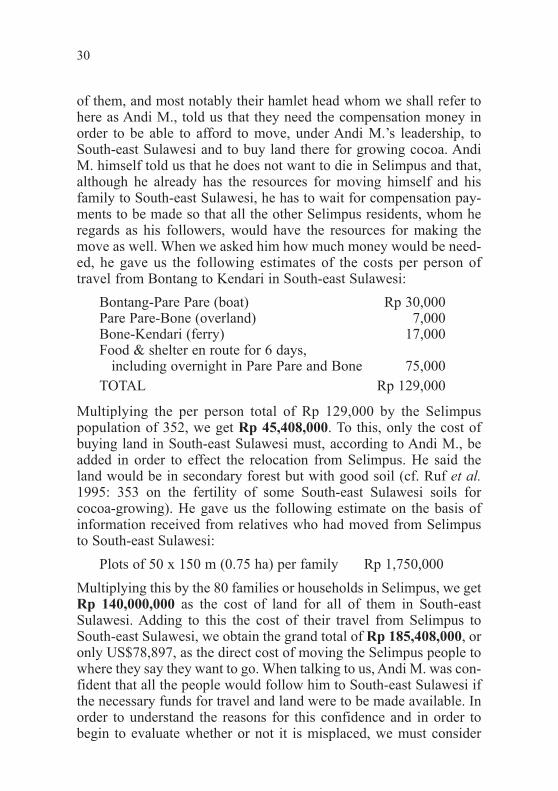
of them, and most notably their hamlet head whom we shall refer tohere as Andi M., told us that they need the compensation money inorder to be able to afford to move, under Andi M.Õs leadership, toSouth-east Sulawesi and to buy land there for growing cocoa. AndiM. himself told us that he does not want to die in Selimpus and that,although he already has the resources for moving himself and hisfamily to South-east Sulawesi, he has to wait for compensation pay-ments to be made so that all the other Selimpus residents, whom heregards as his followers, would have the resources for making themove as well. When we asked him how much money would be need-ed, he gave us the following estimates of the costs per person oftravel from Bontang to Kendari in South-east Sulawesi:
Bontang-Pare Pare (boat) Rp 30,000Pare Pare-Bone (overland) 7,000Bone-Kendari (ferry) 17,000Food & shelter en route for 6 days,
including overnight in Pare Pare and Bone 75,000TOTAL Rp 129,000
Multiplying the per person total of Rp 129,000 by the Selimpuspopulation of 352, we get Rp 45,408,000. To this, only the cost ofbuying land in South-east Sulawesi must, according to Andi M., beadded in order to effect the relocation from Selimpus. He said theland would be in secondary forest but with good soil (cf. Ruf et al.1995: 353 on the fertility of some South-east Sulawesi soils forcocoa-growing). He gave us the following estimate on the basis ofinformation received from relatives who had moved from Selimpusto South-east Sulawesi:
Plots of 50 x 150 m (0.75 ha) per family Rp 1,750,000
Multiplying this by the 80 families or households in Selimpus, we getRp 140,000,000 as the cost of land for all of them in South-eastSulawesi. Adding to this the cost of their travel from Selimpus toSouth-east Sulawesi, we obtain the grand total of Rp 185,408,000, oronly US$78,897, as the direct cost of moving the Selimpus people towhere they say they want to go. When talking to us, Andi M. was con-fident that all the people would follow him to South-east Sulawesi ifthe necessary funds for travel and land were to be made available. Inorder to understand the reasons for this confidence and in order tobegin to evaluate whether or not it is misplaced, we must consider
30
text .qxp 6/4/98 5:17 AM Page 30

both the history of settlement in Selimpus and those elements ofBugis culture whereby Andi M. could take upon himself a special andimportant role in that history.
Andi M. first heard of Selimpus from Teluk Pandan visitors toBone. At the time, the only settlers in Selimpus were three families,who had moved there in 1974 from a pepper-growing area nearMuara Badak (a coastal town 20 km north of the mouth of theMahakam River), and four single men, who had come there in late1974 and in 1975 after hearing in Bone about opportunities in theBontang area. After clearing forest from the land, these pioneers hadfirst planted rice for subsistence, then planted bananas and coconutsand, finally, cocoa underneath the tree crops (cf. Vayda and Sahur1985: 599 on the land-opening strategy used in general by Bugis infrontier areas). Like most subsequent settlers in Selimpus, the pioneerscame originally from Bone but from a different sub-district, KecamatanAwampone, to the one where most Teluk Pandan people originated(Kecamatan Mattiro Bajo).
When Andi M. heard about Selimpus, he was a young nobleattending secondary school in Awampone. In 1977, at the age of 17,he brought together 80 other young, but low-ranking, men from hisAwampone hamlet and organised them for migration to Selimpus forthe purpose of opening up land for cocoa plantations. According tohis own account, he chartered a boat for Rp 760,000 from the Boneport of Bajoe to the Bontang area and he bought two tons of rice inBone to feed the men en route and in Selimpus while they were get-ting settled. To cover these costs, he asked each man to contributeRp 12,500. (In 1977, according to statistics for Kabupaten Kutai, ricewas selling for Rp 141.04/kg and US$1=Rp 415.17; so Andi M. wasdisposing of the equivalent of US$2,408.65 that he had collectedfrom his followers.)
In Selimpus, the newcomers were divided into two 40-man groupsto clear forest collectively. After the clearance, the land was dividedinto two-hectare strips, with each strip being allocated to one man andhis family. (43 of the 80 men were already married when the migrationoccurred, but they did not bring their wives to join them in Selimpusuntil at least seven months had gone by, the first rice harvest hadoccurred, and the men had enough money to pay for the wivesÕ boatpassages; one group of wives was joined in passage by ten more singlemen as migrants to Selimpus.) The men first planted rice, then coconuts,bananas, breadfruit, cassava and cocoa in their two-hectare strips.
31
text .qxp 6/4/98 5:17 AM Page 31

After getting settled, Andi M. sent word back to Bone to his olderbrother, whom we shall refer to here as Andi F. In 1978, Andi F.arrived with 67 additional young men from Awampone (but fromdifferent hamlets and from a different village to the first group),brought under the same arrangements as the original 80. From the 67,another 40-man group was formed to clear another 80 ha of forest,while the 27 other men brought by Andi F. opened land on their own.After about a year, Andi F. himself, evidently regarding Selimpus asbasically his younger brotherÕs enterprise, returned to Bone. From thetime of arrival in Selimpus, Andi M. was regarded as the leader of thesettlement, at first called kepala suku (tribal head) and then, after thenational park was gazetted in 1984, kepala dusun (hamlet head). Thepeople of Selimpus still address him as Puang, a term traditionally usedby lower-ranking Bugis to address their noble patrons. ÒAndiÓ itself aspart of a name was traditionally reserved for aristocrats among Bugis.
When we first met Andi M. as a 37-year old hamlet head, he toldus that young men leading people, as he had, to other lands accordswith Bugis aristocratic tradition. But he also told us that the traditionis now in decline as education and other modern-day skills are moreimportant. In the Bugis migrant community that Acciaioli studied atLake Lindu in Central Sulawesi, there was another Andi Ð to bereferred to here as Andi A. Ð who had led a group of migrants to a newplace. But Acciaioli (1989: 134-135) notes that many of thesemigrants quickly drifted away from Andi A. and that, although stilladdressed as Puang, he did not have the perquisites formerly inher-ing in the title. Indeed, attempts made by him Òto control the decisionsof others were seen as acting arrogantly (takabboroÕ or sombong) orin a ÔswollenÕ (maboro) fashion rather than as the condescendingguidance expected from a nobleÓ.
Questions that must be addressed then are whether Andi M. canindeed be relied on to be speaking for the Selimpus people in gener-al and whether, notwithstanding any professions made to us, theywould indeed follow him to South-east Sulawesi or elsewhere.Having had less than two weeks in the field in Selimpus (as comparedwith AcciaioliÕs more than a year at Lindu), we cannot be sure. AndiM. seemed to us to be indeed acting with gracious concern for othersin Selimpus, but it is also true that many of his original followers hadleft by the time of our research. We do not have detailed historicalinformation on why they left, although it does seem to us that someof the departures could not have been avoided even in more tradi-
32
text .qxp 6/4/98 5:17 AM Page 32

tional times. For example, more than half of the people are said tohave left when the prolonged drought of 1982-83 occurred and firesswept over their plantations. Indeed, WirawanÕs report (1985: 62-63)refers to only 37 families remaining in Selimpus after the fires. AndiM. told us that those who left went to look for employment inBontang, Muara Badak, Samarinda, Sangatta, Balikpapan and evenSouth Sulawesi, and that only those who did not find good enoughwork drifted back beginning in 1985. Others among those who orig-inally came in the 1970s left because of the poor quality of the soil.In fact, Andi M. acknowledged to us that much of the income of thosethat remained, including that which enabled 13 of SelimpusÕs present80 household heads to become haji, came from cutting wood andtaking it by boat for sale in Bontang and Sangatta rather than fromproducing and selling cocoa and other perennial crops. Andi M. toldus also that the four chainsaws that he and his brother had broughtfrom Sulawesi for clearing forest for cocoa plantations were put touse in woodcutting as soon as the income to be obtained from thatactivity was recognised. Before the wildlife reserve became a nationalpark in the mid-1980s, the chainsaws sometimes were also rented toothers for woodcutting. However, at present, there is said to be wood-cutting only on a small scale and for local sales of wood rather thanfor sales outside Selimpus.
Hardly any additional data bearing on Andi MÕs position and hisprofessed ability to lead the Selimpus people out of the national parkcould be found in the limited time that we had for our research.Nevertheless, two recommendations are worth making at this point.One is that there should be follow-up research concerning the mattersdiscussed here. The other is that, depending on the outcome of suchresearch, consideration should be given to working closely with AndiM. as a means of effecting the relocation of the Selimpus people atrelatively low cost and in accord with both their preferred sites forrelocation and some of their known ways of organising themselveswhen moving to new places.
Sangkimah
Our time for research in Sangkimah Ð less than a week Ð was evenshorter than in Selimpus. Nevertheless, the research led to some inter-esting findings, indicative of differences between the settlements intheir amenability to relocation. Sangkimah is the northernmost of the
33
text .qxp 6/4/98 5:17 AM Page 33

three communities that we studied in the national park (see Figure 1).Its present population is 439. Not being accessible by 4-wheel drivevehicles or, except in the dry season, by motorcycles, it is most easilyreached by boat. A likely factor in the relative poverty to be discussedshortly is SangkimahÕs being too far from roads suitable for trucktransport of produce to urban markets. Congruent with this is the factthat no oranges are being grown in Sangkimah, although Wirawan(1985: 64) has described its flood-plain soil as comparable to that ofTeluk Pandan in fertility.
Perhaps most striking of our findings is the fact that, when weinterviewed all 20 men who constitute a random sample (22%) ofSangkimahÕs 90 heads of households, we found that 7 out of the 8 menin their 20s or 30s in that sample said they would move to an officialrelocation site if it had good enough soil. At the same time, none ofthe men in their 40s or older in the sample wanted to be relocated.More will be said about these findings shortly.
First, however, it may be noted that the younger and older menagreed on wanting compensation for their land and crops. Theymade no issue about having to be compensated at the same rate asPupuk Kaltim pays. Nevertheless, for the purpose of comparison, inSangkimah we used the same methods and assumptions as in TelukPandan and Selimpus to make some rough calculations of the totalcompensation that Sangkimah residents might be entitled to if thecompensation rates were to be those used by Pupuk Kaltim.
According to these calculations, as indicated in Table 6, the totalamount of cleared Sangkimah land eligible for compensation is 301ha and the total amount that would have to be paid as Òfair compen-sationÓ to Sangkimah residents is Rp 1,939,525,000 or US$825,330.That this too, like our Teluk Pandan and Selimpus estimates, may beconservative is suggested by WirawanÕs (1985: 63) estimate, basedon interpretation and measurements from 1982 aerial photographs,that SangkimahÕs cleared land amounts to 1,120 ha, which is 3.7times our estimate here of 301 ha eligible for compensation. If, how-ever, we extrapolate from the average area of 4.53 ha per householdin our random sample of 20 Sangkimah households (see Table 7) tothe total cleared land held by all 90 of SangkimahÕs households, thearea of 408 ha that we obtain is closer to the estimate of 301 haobtained from our rough calculations than to WirawanÕs estimatefrom 1982 aerial photographs. As stated previously, we need to usemore precise methods if we want to resolve the discrepancies.
34
text .qxp 6/4/98 5:17 AM Page 34
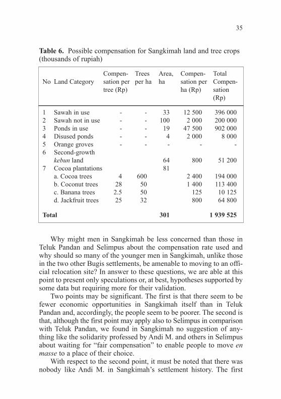
Why might men in Sangkimah be less concerned than those inTeluk Pandan and Selimpus about the compensation rate used andwhy should so many of the younger men in Sangkimah, unlike thosein the two other Bugis settlements, be amenable to moving to an offi-cial relocation site? In answer to these questions, we are able at thispoint to present only speculations or, at best, hypotheses supported bysome data but requiring more for their validation.
Two points may be significant. The first is that there seem to befewer economic opportunities in Sangkimah itself than in TelukPandan and, accordingly, the people seem to be poorer. The second isthat, although the first point may apply also to Selimpus in comparisonwith Teluk Pandan, we found in Sangkimah no suggestion of any-thing like the solidarity professed by Andi M. and others in Selimpusabout waiting for Òfair compensationÓ to enable people to move enmasse to a place of their choice.
With respect to the second point, it must be noted that there wasnobody like Andi M. in SangkimahÕs settlement history. The first
35
Table 6. Possible compensation for Sangkimah land and tree crops (thousands of rupiah)
Compen- Trees Area, Compen- TotalNo Land Category sation per per ha ha sation per Compen-
tree (Rp) ha (Rp) sation(Rp)
1 Sawah in use - - 33 12 500 396 0002 Sawah not in use - - 100 2 000 200 0003 Ponds in use - - 19 47 500 902 0004 Disused ponds - - 4 2 000 8 0005 Orange groves - - - - -6 Second-growth
kebun land 64 800 51 2007 Cocoa plantations 81
a. Cocoa trees 4 600 2 400 194 000b. Coconut trees 28 50 1 400 113 400c. Banana trees 2.5 50 125 10 125d. Jackfruit trees 25 32 800 64 800
Total 301 1 939 525
text .qxp 6/4/98 5:17 AM Page 35

Bugis settlers of Sangkimah, comprising a group of fewer than 10,arrived in 1924 from the Segeri sub-district of South SulawesiÕsPangkep district. At that time, the present site of Sangkimah wasmostly in primary forest, but there were some indigenous shiftingcultivators in the vicinity. Some inter-marriage between these peopleand the Bugis pioneers occurred and helped the latter to gain accessto land previously cleared by the shifting cultivators. For some years,the pioneers likewise practised shifting cultivation. However, when
36
Table 7. Sangkimah landholders (random sample)
Landholdings in hectares
No Age Cleared Bought Inherited Total
1 65 5.5 1 - 6.52 47 5 - - 53 37 - - 2 24 70 5.5 2 - 7.55 48 4 3 - 76 65 3.5 - - 3.57 47 4 - - 48 56 1.5 - - 1.59 35 - - 1.5 1.510 32 - - 3 311 56 3 2 - 512 36 - 1 5 613 61 4 1 - 514 29 3 1.5 4.5 915 56 1.5 - - 1.516 30 - 1 4 517 51 4 - 4 818 61 5 - - 519 63 3 - - 320 35 - 1.5 - 1.5
Mean 49.00 4.53Median 49.5 5SD 13.28 2.33
text .qxp 6/4/98 5:17 AM Page 36

many new migrants from Segeri came between 1954 and 1960 as aresult of the economic and military disruptions associated with KaharMuzakarÕs Islamic rebellion in South Sulawesi and when some ofthese newcomers appropriated old swidden sites for their own use,the old established settlers joined the new ones in planting coconuts,coffee, jackfruit and bananas in swidden fallows in order to securerights to the land. Sawah were made too. The final influx of Bugismigrants, all from Segeri, was in 1960, when 15 families arrived in agroup in February, then 14 more families in June, 8 more in Septemberand, finally, one more in November. That the present-day people ofSangkimah seem much less oriented towards South Sulawesi than dothose of either Selimpus or Teluk Pandan is no doubt related toSangkimahÕs being the oldest of the three Bugis settlements and theone to which migration from Bugis homelands in South Sulawesiceased least recently.
With respect to the first of the points made above, various possi-ble indications of relative poverty and the lack of economic opportu-nities may be noted. For example, the percentage of household headswho are haji is much lower in Sangkimah (5 out of 90, or only 5.5%)than in either Teluk Pandan (22 out of 184, or 12%) or Selimpus (13out of 80, or 16%); the standard cost of making the haj from Indonesiais, at present, almost Rp 8,000,000.
Another possible indication is the markedly skewed sex ratio inSangkimah, with males comprising 57% of the population (251 out of439), compared with 55% in possibly also poor Selimpus (193 out of352) and only 51% in probably much better-off Teluk Pandan (498out of 969). The contrast especially with Teluk Pandan may reflectproblems of Sangkimah men in obtaining wives because of the highcost of Bugis weddings (costing between one and two million rupiahin Teluk Pandan in 1996). Regrettably this is one of those hypothesesthat we cannot test adequately with the data available to us.
Another indication is that people are increasingly either perma-nently leaving Sangkimah or else seeking temporary work elsewhere.Some say that this is happening because rice yields in Sangkimahhave been declining as a result of soil and water pollution caused byoil and coal company operations north-west of the settlement (cf.Pusat Studi Lingkungan 1993: 94-95), but it is not clear whether thishas actually occurred or, if it has, just how it has occurred. In anycase, SangkimahÕs 1987 population was 587 (Formulation Mission1991: 21) compared to 439 at present Ð a 25% decline. Some who
37
text .qxp 6/4/98 5:17 AM Page 37
have left have even done so by joining government-sponsored trans-migration programmes, the most recent being a programme to relocatepeople to a site in Berau district, north of the national park. At leasttwo or three Sangkimah families are said to have joined this pro-gramme in 1995. As for temporary employment outside Sangkimah,many men commute daily to Sangatta to engage in construction work,involving either house building or coal-company (Kaltim PrimaCoal) operations. One-way commuting time between Sangkimah andthe Sangatta workplaces is one hour by bicycle and two hours on foot.Workers told us that wages are Rp 3,000 per day (8 a.m. to 6 p.m.)for ordinary labourers and Rp 6,000 per day for the work supervisors,some of whom are also from Sangkimah. Possibly food is providedin addition to these wages. In any event, the daily wages are less thanthose that we have previously indicated as being paid to temporarylabourers in Teluk Pandan (see above, p. 14 ).
About 1990, some Sangkimah men began also to stay in Bontangduring the week to work in construction and similar jobs (for the samewages as indicated above) and then to return home to Sangkimah forthe weekend (see Formulation Mission 1991: 20). Men making theseweekly trips either walk to catch the Sangatta-Bontang bus at a cost ofRp 3,750 per person or else go by motorised boat at a cost of Rp 5,000per person. The bus ride takes one hour, while the boat ride takes two.The boat, owned by one of Teluk PandanÕs entrepreneurs, is sometimeschartered for the trip to Bontang at a cost of Rp 30,750. It carries upto 10 passengers. While in Bontang, the Sangkimah workers sleep atthe construction sites where they work or else at friendsÕ houses.
Some young Sangkimah men are prepared to go much furtherafield than Bontang for work. This is indicated by the fact that abouta dozen of them told us that they would like to go to Irian, just as oneof their friends had done two years previously. What this man saidabout Irian in a recent letter to his father made migration there attrac-tive to his friends.
Certain recent events of concern to the staff of Kutai NationalPark and other conservationists may also be regarded as possibleindications of relative poverty and the lack of economic opportunitiesin Sangkimah. These events were the clearance of mangroves andconstruction of nine hectares of brackish-water fish and shrimp pondsin Sangkimah in 1995-96. We learned in Sangkimah that the instiga-tors of these events were three separate Bugis entrepreneurs, two ofthem originally from Segeri. Two of these entrepreneurs run stores,
38
text .qxp 6/4/98 5:17 AM Page 38

one in downtown Bontang and the other in Lok Tuan, a largely Bugiscommunity near Bontang. The third man is a seller of constructionmaterials in Bontang. Apparently the three realised that cheaperland and labour in Sangkimah would enable them to become tambakowners there for substantially less money than in Bontang itself.Although Sangkimah men had constructed 14 ha of tambak (10 habeing still in use) beginning in 1970, they knew of national parkopposition to the mangrove destruction called for by tambak and theyconstructed no new ones from 1979 until the first of the outside entre-preneurs arrived in 1995 with a proposal for 4 ha of new tambak. Heand the other two men, who came in 1996, all followed the same pro-cedures: consulting SangkimahÕs tambak pioneers about land suitablefor ponds; meeting with the landowners and the hamlet head toarrange to purchase the land; and then recruiting workers to clear theland and construct the tambak. We were told that four men are able toconstruct the embankments for a one-hectare tambak in about 15days. The following are the estimates we were given of the costs thatthe entrepreneurs had to bear per ha of tambak:
Land purchase Rp 500,000Land clearance 500,000Constructing embankments, at the rate of
Rp 2,500 per metre of length 25,000,000Channel construction 500,000Drainage of embankment-enclosed area and
application of Tiodang pesticide to rid area of predators of fish fry 30,000
Application of lime (kapur) to increase soil pH levels 62,000Application of fertiliser (urea, TSP) 220,000
TOTAL Rp 26,812,000
For the purpose of comparing costs, we talked with a Bugis tam-bak manager in Bontang and learned about some differences. Forexample, the price of land suitable for tambak in the Bontang Kualasection of Bontang is Rp 1,500,000, i.e., three times the Sangkimahprice. And embankments, which are made higher and wider than inSangkimah, cost Rp 15,000 per metre length-wise along the embank-ments. These differences alone bring the cost of preparing tambak toRp 152,812,000 per ha, i.e., 5.7 times as high as in Sangkimah.
39
text .qxp 6/4/98 5:17 AM Page 39

The availability of cheap labour after construction of the tambakmay be a further attraction of Sangkimah to entrepreneurs. As in thecase of Teluk Pandan tambak, there is one labourer per 0.25 ha inSangkimah. In both places, the work involves mainly guarding thetambak, feeding the fish and making tambak repairs. However, work-ers in Sangkimah receive only a one-fifth share (bagi lima) of the pro-ceeds rather than the quarter share (bagi empat) received by workersin Teluk Pandan. The difference may be significant. Let us assume thata one-hectare tambak is stocked with 2,000 milkfish (bandeng) at acost of Rp 250,000 and 4,000 tiger shrimp at a cost of Rp 300,000 andthat the cost of fish food for four months is Rp 200,000. If the loss offish and shrimp before harvest at the end of four months is 25%, theharvest may yield 1,000 kg of milkfish, worth Rp 3,500,000, and 150kg of shrimp, worth Rp 3,750,000. Deducting from the gross proceedsthe cost of stocking the pond and buying the fish food would leaveeach workerÕs share after four months of labour at Rp 406,250 underthe bagi empat arrangement but at only Rp 325,000 under the bagilima arrangement. Even greater is the difference between the bagilima share and what is earned by a tambak worker in four months inBontang where, instead of receiving shares, workers are paid a dailywage of Rp 4,500 (including Rp 1,500 for food). For four months (122days), these wages amount to Rp 549,000. But, despite the greaterincome earned by tambak workers elsewhere, the Sangkimah workerswith whom we talked seemed glad to have their jobs.
Some of the men who had been recruited to construct the ninehectares of tambak in Sangkimah in 1995-96 told us that there maybe more construction (with antecedent mangrove destruction) in thefuture and that they will be ÒcarefulÓ about the construction becauseof national park opposition. Such possibilities, along with Sangkimahyoung menÕs indicated amenability to relocation, argue for actingfairly quickly in the Sangkimah case to find suitable places outsidethe national park for at least the younger people to move to. While wedid not specifically ask whether the older people would join theyounger ones if the latter were to make definite decisions to move,this too is a possibility to be considered.
Bugis Settlers Relocated to km 24
Hearing that some Bugis settlers had been relocated to km 24 fromthe protected forest (hutan lindung) lying between Bontang and the
40
text .qxp 6/4/98 5:17 AM Page 40
Santan River to the south, we decided to devote at least two days tointerviews with the settlers. At the time, we had tentatively identifiedcertain factors, such as relative wealth, substantial entrepreneurialsuccess and patron-client ties, which were making people in TelukPandan and/or Selimpus unreceptive to relocation. So our aim was totest the validity of these identifications by trying to ascertain whetherthe same factors were present or absent among those who had relo-cated. We were initially encouraged in this aim by receiving from thehead of the farmersÕ group (Tani Karya Terpadu) at km 24 a list of 20Bugis families that had moved from the protected forest to a part ofthe relocation site accessible via an old timber road at km 29.However, when we visited this location, we were told that 19 of the20 families had returned to the protected forest and were growingbananas and other crops there. We were told that this was partlybecause of problems with the environment Ð poor soil and crop-destroying wild pigs Ð in the relocation site and partly because ofconflict with another farmersÕ group whose members were makingclaims to the land without having registered, as the group of 20 had,with the farmersÕ group at km 24.
The one Bugis family remaining from the 20 was interviewed. Welearned that the man and his wife, now in their forties, had been grow-ing pepper south of Samarinda (see the next section) when the greatdrought of 1982-83 occurred and fire destroyed their plantations.Because of this event, they and their children moved to Bontang in1983, where the wife had relatives working as healers (dukun).Knowing nobody else in the Bontang area and aiming to start newplantations, they moved into the protected forest and, from 1983 to1992, stayed there, clearing land and growing bananas and othercrops. They said they moved to km 29 in 1992 because of harassmentby national park officers in the protected forest. They are growing aconsiderable variety of crops at present and, to make ends meet, arereceiving financial help from a son who works in construction inSamarinda and from the husbandÕs younger brother, now working asa security guard for Pupuk Kaltim in Bontang.
In addition to this Bugis family, two others interviewed at eitherkm 29 or km 24 had spent time in the protected forest, without everhaving been officially relocated from there. The husband in one ofthese families, still only 38 years old, first moved from Bulukumba inSouth Sulawesi to East Kalimantan in 1975. For two years, he was anunsuccessful clove planter near Balikpapan, then worked as a labourer
41
text .qxp 6/4/98 5:17 AM Page 41

on a truck for three years. From then until 1992, he was either unem-ployed or did construction work in and around Bontang. It was duringthis last period that he moved temporarily to the protected forest andcleared land for a single day before he was caught by national parkofficers and told to stop. He moved to km 29 in 1992 on the adviceof a Javanese friend and now has 1.15 ha planted with various treecrops (coconuts, coffee, cocoa, jackfruit, oranges), as well as bananas,chilli, tomatoes and corn. He also has a water buffalo that he uses fortransporting logs and gets paid Rp 6,000 per day for this. This may behis main economic activity. A number of Bugis spontaneous migrantsfrom South Sulawesi were found to be also engaged in one way oranother in timber exploitation at km 24 or km 29, although they hadcome originally to start cocoa plantations. These migrants were findingsuch activities as cutting trees with rented chainsaws and preparingplanks from them for sale at Rp 150,000 per cubic metre to be morelucrative. (Illegally cut wood is said to be selling in Bontang at presentfor between Rp 250,000 and Rp 275,000, while certified, legally cutwood costs Rp 350,000 per cubic metre.) We found other Bugis spon-taneous migrants who, disappointed in the condition of the bananasand cocoa that they have planted, have turned for their livelihood toquarrying rocks for house- and road-building.
We talked with one other Bugis man who has lived in the pro-tected forest near Bontang. Until 1992, when he was 38 years old,he was making a living by taking eggs produced in Sidrap in SouthSulawesi to sell in Ujung Pandang. In mid-1992, he moved toBalikpapan, where he had relatives. For four months, he sold vegeta-bles there, but business was disappointing. Having relatives in Bontangtoo, he moved there, staying at a divorced womanÕs house and sellingvegetables in downtown Bontang for three months. When the womandemanded that he marry her, he fled with a Butonese friend to the pro-tected forest, where they stayed at the house of a man from Lombok.After about three months there, they were warned by national parkofficers to desist from cutting trees. Hearing about the km 24 site, hethen joined the farmersÕ group there and obtained one hectare ofsecond-growth land and planted cocoa trees on it. Eventually he rentedand then bought more land, which he has used particularly for growingchilli and vegetables. He has been harvesting 20 kg of chilli ten timesa year and selling it for Rp 2,500/kg; so he has been getting Rp500,000 per year from the chilli alone. He also has found a good wifeand has built a good house at km 24. He is, he says, a happy man!
42
text .qxp 6/4/98 5:17 AM Page 42

Only limited inferences are possible from the few interviews thathave been presented here. Certainly they do not provide a systematic,rigorous or statistically adequate test of the validity of our identifica-tion of factors making people in Teluk Pandan and/or Selimpusunreceptive to relocation. It may nevertheless be worth noting thatnone of the factors mentioned at the beginning of this section Ð relativewealth, substantial entrepreneurial success or patron-client ties Ðnoticeably influenced the decisions and events that led those weinterviewed to km 24. (In the case of the last informant, success cameafter rather than before he moved to km 24.) This absence of thefactors in these cases is congruent with our claim that, in other cases,they work against amenability to relocation to sites like km 24.
Bugis Settlers Relocated from Bukit Soeharto
In 1980, some of our research among Bugis pepper farmers wasconducted less than 15 km from Bukit Soeharto, an area mid-waybetween Samarinda and Balikpapan and traversed by the mainSamarinda-Balikpapan road. At the time, Bukit Soeharto had beendesignated a protected area and there already was concern aboutsome Bugis migrants who were living within its boundaries andclearing forest and growing pepper. Subsequently the area wasenlarged to approximately 75,000 ha (stated ÒdefinitivelyÓ to be74,350 ha in 1991 [Departemen Kehutanan ... Kalimantan Timur1992: 1]) and concern grew. Writing in July 1990 as WWF consultantson Kutai National Park planning, exactly ten years after our research,Petocz et al. (1990: 19), noted that a Òfrequently cited...model formoving the settlements from Kutai National ParkÓ was the Òtranslo-cation programme recently initiated in the Bukit Suharto NatureReserveÓ [officially called a Taman Hutan Raya, or Great ForestPark]. However, they also noted the following:
Yet, from the time a strategy was developed for the BukitSuharto reserve, some eight years passed before the first set-tlers were actually moved out of the reserve. A great numberof people still occupy the Bukit Suharto reserve and theprocess of relocating the remainder is far from complete.
When we returned to East Kalimantan in 1996, we heard that theprocess had, in fact, been mostly achieved some years earlier and we
43
text .qxp 6/4/98 5:17 AM Page 43
further heard indirectly from some of the implementing officials thatit went smoothly. This was a challenge to our emerging conclusionsabout the unwillingness of Teluk Pandan residents to be relocated tokm 24. Accordingly we decided to devote some limited time toobtaining additional information about the relocation from BukitSoeharto, with a view to both explaining its alleged success and seeingwhether it might indeed constitute a model for relocation of settlersfrom Kutai National Park.
Unfortunately, because of time constraints and the reticence ofsome of those that we spoke with, we were able at first to obtain onlysketchy information from government offices in Samarinda and fromfour Bugis farmers who were relocated from Bukit Soeharto and fromanother Bugis man who, as a landless agricultural worker not entitledto relocation benefits, moved on his own from Bukit Soeharto, firstfurther north along the Balikpapan-Samarinda road and eventually tothe Bontang area. But even if we are unable to vouch for the completeaccuracy of the account that follows, it is worth presenting in thehope that it will encourage anyone following up our research to elicitbetter and more detailed information.
At first, we thought that an important difference between theBukit Soeharto situation at the time of relocation and the presentTeluk Pandan situation may be with respect to farmersÕ expectationsabout maintaining profitable yields from already planted perennialcrops and from the land on which they are grown. For the TelukPandan case, it should be recalled that orange trees, a main source ofincome, were first planted in 1990 and are Ð perhaps too optimisti-cally (see Ashari 1992: 137-138) Ð expected by the growers to con-tinue to yield until the year 2005, i.e., fifteen years after planting. Thegrowers also expect that, when the trees stop yielding, the relativelyfertile land in which they have been growing will be quickly usableagain. And cocoa trees which, in Teluk Pandan, date partly from themid-1970s but mostly from no earlier than the mid-1980s, are knownto continue to yield well for decades if not unduly affected by pestsor diseases (cf. Lass 1985: 210-211). By contrast, Bukit Soehartofarmers expected that yields from their pepper plantations woulddecline approximately ten years after planting, to the point that theywould soon have to be abandoned (cf. Vayda and Sahur 1985: 94).According to our informants this was, in fact, the condition that mostof the Bukit Soeharto pepper plantations had reached by the time ofrelocation. The youngest pepper plants at that time were seven years
44
text .qxp 6/4/98 5:17 AM Page 44

old, but most were between ten and fifteen years of age. This supportssome conclusions reached in our earlier study of Bugis pepper farm-ers near Bukit Soeharto, namely, that the Òtime they planned to stayin one place was not definite for any longer than the perennials plant-ed there would yield profitablyÓ and that their readiness to movevaries with the age of their pepper plantations (Vayda and Sahur1985: 94, 109). However, we had also stated the following in a reporton our earlier research (Vayda and Sahur 1985: 106):
The use of fertilizer may make it easier for old pepper areas tobe reused, as is done in Sarawak, where much pepper is plant-ed in alang-alang (Imperata cylindrica) grassland that hadbeen the site of plantations twenty or thirty years earlier. Butfor the Bugis migrants who chose to stay in East Kalimantan,including those who had been in the province since the early1950s, land with primary or logged-over forest, which couldbe burned to add nutrient-rich ash to the soil, had always beenavailable when old plantations were to be abandoned and newones begun. Planting in alang-alang is an option that no Bugispepper farmers seem yet to have considered.
When first interviewed, the Bukit Soeharto farmers told us that,at the time of relocation, no more forested land suitable for starting newpepper plantations without the use of fertiliser was available anywherenear where they were living on the east side of the Balikpapan-Samarinda road. However, we subsequently learned that there wassuch land on the west side of the road and that at least some of thefarmers were already planning, before the relocation occurred, tomove there. In light of this, we had to seek further explanation of thealleged success of the relocation, which was relocation to an alang-alang site at Sungai Merdeka (see below).
Subsequent accounts by our Bugis informants about certainevents leading up to the relocation may be relevant. According tothese accounts, government officials came to Bukit Soeharto sometime before the relocation and held a meeting in which a local leader(a deputy hamlet head or wakil dusun) and some of the people weretold that they had to move. The leader then went to houses of thefarmers and asked whether they were ready to move. About a monthbefore the relocation began, more than thirty soldiers with guns, pre-sumably a platoon, marched in Bukit Soeharto, first along the main
45
text .qxp 6/4/98 5:17 AM Page 45

Samarinda-Balikpapan road and then past the Bugis farmersÕ houseson the side roads. Referring to these events, an official in the EastKalimantan governorÕs office told us that it was just a day of trainingfor the soldiers, but one of our Bugis informants referred to it as aÒshow of forceÓ (mempamerkan kekuatan) and said that it was thefirst time it had occurred during all his years at Bukit Soeharto. Afterthe day of training, the local leader again made the rounds of thefarmersÕ houses and found that a consensus had formed in favour ofmoving, whereas many had previously been non-committal. Becausethe leader now owns a motor scooter, a good house and a roadsideeating-place (warung) in a Bugis settlement north of Bukit Soeharto,some of the Bugis farmers believe he was paid by the government forhis co-operation.
The actual relocation continued for an extended period, withsome 500 families being moved, under government supervision, to alocation at Sungai Merdeka, 28 km north of Balikpapan. On his mov-ing day, each family head had to sign an agreement about leavingBukit Soeharto and about the facilities and other benefits to bereceived at the relocation site, which was evidently intended, both bythe government and the farmers, to be used for a continuation ofpepper-farming. However, by the time of our interviews in July 1996,approximately 200 of the original 500 families were reported to haveleft Sungai Merdeka because they had not received some promisedbenefits (e.g., rice allotments, 36 square-metre rather than 12 square-metre houses, and enough pepper plants and ironwood support stakesfor starting plantations on the 1.5 ha of land allocated to each family)and/or not finding the area well suited to pepper-growing. Some ofthese 200 families have simply abandoned their Sungai Merdeka land,while others have sold it for Rp 200,000 - 250,000 per ha to IndonesianChinese businessmen who are using the land for factory-style chickenproduction and other enterprises. Those who have left include somewho have gone back to Sulawesi and others who have remained inEast Kalimantan and have joined Bugis communities near BukitSoeharto and in Samarinda and Muara Badak. We learned also of tenmen who have returned to Bukit Soeharto to clear forest for pepperplantations far enough from the road to be likely to escape detectionby forestry officials or the police. For the time being, however, thesemen are maintaining residence in Sungai Merdeka, where membersof their households are raising chickens and tending such crops ascassava, bananas, green beans and chilli. Others among the remaining
46
text .qxp 6/4/98 5:17 AM Page 46

300 families are growing these crops as well, and only one family issuccessfully growing pepper. The family has 1,500 three year-oldpepper plants and, being relatively wealthy, is using fertiliser.
The foregoing is the story as told by Bugis informants to Sahur.We sought confirmation from official sources and found it, at leastpartially, in a document from the Department of Forestry in Samarinda(Departemen Kehutanan ... Kalimantan Timur 1992). According tothis document (pp. 2, 12), Bukit SoehartoÕs inhabitants and their landwere ÒinventoriedÓ in 1988, and it was found that there were 697families and a plantation area of 1,500 ha, of which 53% or 792.65 hawas in production and that, for various reasons, the families had nointerest in the official plan for their relocation to Sungai Merdeka.Further, according to the document (p. 8), an official agreement wasreached on 22 February 1990 that Bukit Soeharto could be used formilitary training. While the document does not state that trainingbegan soon after this date, it does state (p. 2) that the removal of peo-ple from Bukit Soeharto began on 26 March 1990, when 50 familieswere relocated. This chronology is compatible with that indicated byour Bugis informants who told us that soldiers first marched throughtheir settlements about a month before relocation began. According tothe document (p. 2), more people were relocated on 12 June and 4July 1990 and on 31 January 1991 so that, by the last date, the relo-cation of a total of 500 families had been reached. What made thepeople more amenable to relocation by these dates than they had beenin 1988 is not explicitly considered in the document.
47
text .qxp 6/4/98 5:17 AM Page 47

CONCLUDING REMARKS
Various recommendations have been made in the preceding sections,and some of them will be noted again here. One recommendation thatcannot be emphasised enough is that there should be further studies.The three months that we had both for conducting our studies andwriting this report is inadequate time for giving sure answers to manyof the questions that we have raised, especially when some of thequestions ultimately call for the kinds of careful measurement oflandholdings and counts of trees that we had neither the time nortraining to perform.
However, it should still be clear that, by avoiding the standardsurvey and rapid appraisal methods and pre-set questionnaires usedby previous consultants and investigators and by insisting instead onbeing guided in our collection and analysis of data by the goal ofshowing causal connections among events or answering why-questionsabout them, we were able to begin to answer key questions for nation-al park management planning Ð such questions as why Teluk Pandanand Selimpus people reject proposals for their government-sponsoredrelocation to particular sites, while younger Sangkimah people do notreject them and Bukit Soeharto people did reject them at one time andnot at another time. When we ourselves have not been satisfied withthe answers that we could find in the limited time that we had, wehave indicated our dissatisfaction and have called for further studies.This is so, for example, with respect to our suggestions about theeffects of relative poverty in Sangkimah. Better and more data areneeded both to establish that poverty as a fact and to show whetherthe causes of it lie significantly in oil and coal company pollution ofSangkimah land and water (as alleged by the Sangkimah people), inSangkimahÕs distance from roads suitable for truck transport of suchproduce as oranges to urban markets, and/or in other factors still to beascertained.
When our methods have led to answers with which we have beensatisfied, we have used them as a basis for making recommendations.Examples are our recommendations against relocating Teluk Pandanpeople to 2.25 ha sites at km 24 and in favour of considering the alter-
text .qxp 6/4/98 5:17 AM Page 49

native of cash compensation without relocation to a particular site.These recommendations are made on the basis of our findings abouthow decisions about economic activities are causally connected tosuch past events as receiving compensation payments and establish-ing patron-client ties. Sometimes when our answers to questions havebeen more tentative (because of inadequate time for obtaining moredata), we have nevertheless used the answers for making recommen-dations, but the recommendations are more tentative too. A case inpoint is our suggestion for giving consideration to working closelywith the Ònoble patronÓ in Selimpus as a means of effecting the relo-cation of him and his people at relatively low cost and in accord withboth their preferred sites for relocation in Sulawesi and some of theirknown ways of organising themselves when moving to new places. Itshould be recalled that, in the section on Selimpus, this recommenda-tion was preceded by a call for more thorough studies of the patronÕsinfluence and effectiveness as a leader, both in the past and at present.
As noted earlier, part of our research effort was directed specifi-cally to seeking evidence for assertions prominently made by someother consultants, namely, that many Bugis settlers in the nationalpark were originally attracted to Bontang by the prospect of jobs inthe townÕs growing industrial sector and that they encroached andsettled in the national parkÕs forests only after failing to find industrialemployment (Petocz et al. 1990: iv, 12). We did find a few such set-tlers, but we found more who had come for other reasons, includingthose that made many Bugis move to other places in the 1950s and1960s, i.e., to escape the economic and military disruptions associatedwith Kahar MuzakarÕs Islamic rebellion in South Sulawesi and totake advantage of advice received from relatives or friends about oneor another location where forested land could be profitably convertedto farmland. As has been argued elsewhere (Vayda 1995, 1996a),general knowledge or hypotheses can be useful guides for seeking thecausal antecedents of events, but often we can know little in advanceabout which general knowledge or hypotheses will pertain to thecases at hand. Just as we have found a few cases in accord with thegeneral hypothesis that loss of urban/industrial employment leads toforest destruction, we have found other cases in accord with thegeneral hypothesis that urban/industrial employment relieves pres-sure on forests. Indeed, if the latter is a process now taking place inSangkimah, it parallels such processes in other places at other times(see, for example, Rudel 1995: 502 on reforestation as a result of land
50
text .qxp 6/4/98 5:17 AM Page 50

abandonment by urban-oriented children of small farmers in theTennessee Valley in the USA).
Similarly, consider the implicit hypothesis favoured by manyrelocation planners, i.e., that forest settlers are poor peasants, drivento the forests by desperation and therefore likely to welcome 2.25 haof land at a relocation site. Possibly this does apply to a few settlerswho are growing bananas in the protected forest south of Bontang.But certainly it does not apply to Teluk PandanÕs entrepreneurs, withtheir hectares and hectares of orange groves, cocoa plantations andbrackish-water fish-ponds, as well as, in some cases, their secondhouses in Bontang, their taxi fleets, their motorised fishing boats, andtheir land speculations outside Teluk Pandan.
The fact that all the settlers we studied are Bugis is of courserelevant, and our antecedent knowledge of Bugis history and culturehelped us greatly in making causal connections among events in thecourse of our field work. But, here again, we could not know inadvance just what parts of our knowledge would pertain to the casesat hand. Thus, the patron-client ties described by other anthropolo-gists as a Òkey elementÓ (unsur kunci) in Bugis society were found byus to be important factors for understanding resistance to relocationin Teluk Pandan and Selimpus but not to be significant factors inSangkimah Ð and not to have had much influence on the lives of ourBugis informants at km 24. Even when our antecedent knowledge didseem initially to account for some events, it could later turn out thatit was accounting only partially. This is illustrated by our attempt toexplain Bugis relocation from Bukit Soeharto by citing our owngeneralisations, based on an earlier study, that the time Bugis farmersplan to stay in one place is not definite for any longer than the peren-nials planted there would yield profitably and that the farmersÕ readi-ness to move varies with the age of their plantations. As indicated inthe section on Bukit Soeharto, this was, at best, only a part of thestory, and identifying the factors responsible for the success of therelocation required data on specific historical events Ð like the use ofBukit Soeharto for military training Ð not rooted in either Bugis cultureor previously known Bugis history.
In short then, we are arguing here, much as we have argued else-where (Vayda 1996a), for applying general knowledge in studies suchas ours but also for keeping an open mind about what general knowl-edge is applied as we go about the business of empirically answeringquestions about why things have occurred.
51
text .qxp 6/4/98 5:17 AM Page 51

REFERENCES CITED
Acciaioli, G.L. 1989. Searching for Good Fortune: The Making of aBugis Shore Community at Lake Lindu, Central Sulawesi. Ph.D.dissertation, Australian National University.
Ashari, S. 1992. Citrus reticulata Blanco. In E.W.M. Verheij and R.E.Coronel (eds), Plant Resources of South-East Asia 2: EdibleFruits and Nuts, pp. 135-138. PROSEA (Plant Resources ofSouth-East Asia), Bogor.
Bupati...Kutai. 1993. Harga Dasar Ganti Rugi Tanah dan TanamTumbuh dalam Wilayah Kabupaten Daerah Tingkat II Kutai.Keputusan Bupati ... No. 0803.
Departemen Kehutanan Propinsi Kalimantan Timur. 1992.Pembangunan Taman Hutan Raya Bukit Soeharto. DepartemenKehutanan, Samarinda.
Fakultas Pertanian Universitas Mulawarman. 1991. ÒProjectProposalÓ: Pengembangan Perkebunan Rakyat Wilayah Bontangdengan Pola PIR-Lokal oleh PT Pupuk Kalimantan Timur(Persero) sebagai Bapak Angkat. Faculty of Agriculture,Mulawarman University, Samarinda.
Formulation Mission. 1991. Kutai National Park Developmental Plan1992-1996, Operating Plan 1992, Framework for Management.Directorate General of Forest Protection and Nature Conservation,Ministry of Forestry, Jakarta.
Lass, R.A. 1985. Replanting and rehabilitation of old cocoa farms. In:G.A.R. Wood and R.A. Lass (eds), Cocoa. 4th ed., pp. 210-233.Longman, Essex.
Lineton, J. 1975a. An Indonesian Society and Its Universe: A Studyof the Bugis of South Sulawesi (Celebes) and Their Role within aWider Social and Economic System. Ph.D. dissertation, School ofOriental and African Studies, University of London.
52
text .qxp 6/4/98 5:17 AM Page 52

Lineton, J. 1975b. PasompeÕ UgiÕ: Bugis migrants and wanderers.Archipel 10: 173-201.
Mattulada. n.d. Traditional management among Bugis-Macassarentrepreneurs in South Sulawesi. Unpublished paper presented ata conference on ÒSouth Sulawesi: Trade, Society and Belief,Ósponsored by the Koninklijk Instituut voor Taal-, Land- enVolkenkunde, Leiden, 2-6 November, 1987.
PT Pupuk Kalimantan Timur. 1993. Pengembangan PerkebunanRakyat Pola PIR-Lokal oleh Pemerintah Daerah Tingkat IIKabupaten Kutai Bekerjesama dengan PT Pupuk Kalimantan Timursebagai Bapak Angkat. PT Pupuk Kalimantan Timur, Bontang,and Faculty of Agriculture, Mulawarman University, Samarinda.
Pelras, C. n.d. Hubungan patron-klien dalam masyarakat Bugis danMakassar. Unpublished paper presented at the Social ScienceResearch Council Conference on South Sulawesi, Melbourne, 1981.
Petocz, R., N. Wirawan and K. MacKinnon. 1990. The Kutai NationalPark Planning for Action. World Wide Fund for Nature (WWF),Jakarta.
Pusat Studi Lingkungan Universitas Mulawarman. 1993. Studi SosialAntropologi Masyarakat Pemukim dan Penggarap dalam TamanNasional Kutai. Mulawarman University and Department ofForestry, Samarinda.
Rudel, T.K. 1995. Did TVA make a difference? An organizationaldilemma and reforestation in the Southern Appalachians. Societyand Natural Resources 8: 493-508.
Ruf, F., Jamaluddin, Yoddang and W. Ardby. 1995. The ÒspectacularÓefficiency of cocoa smallholders in Sulawesi: Why? Until when?In: F. Ruf and P.S. Siswoputranto (eds), Cocoa Cycles: TheEconomics of Cocoa Supply, pp. 339-375. Woodhead Publishing,Cambridge, England.
Samson, J.A. 1986. Tropical Fruits, 2nd ed. Longman, Essex.
Scott, J.C. and B.J. Kerkvliet. 1977. How traditional rural patronslose legitimacy: a theory with special reference to Southeast Asia.In: S.W. Schmidt, L. Guasti, C. Lande and J.C. Scott (eds), Friends,Followers, and Factions: A Reader in Political Clientism, pp.439-458. University of California Press, Berkeley.
53
text .qxp 6/4/98 5:17 AM Page 53

Vayda, A.P. 1980. Buginese colonization of SumatraÕs coastalswamplands and its significance for development planning. In:E.C.F. Bird and A. Soegiarto (eds), Proceedings of the JakartaWorkshop on Coastal Resources Management, pp. 80-87. UnitedNations University, Tokyo.
Vayda, A.P. 1995. Failures of explanation in Darwinian ecologicalanthropology: Part II. Philosophy of the Social Sciences 25: 360-375.
Vayda, A.P. 1996a. Methods and Explanations in the Study of HumanActions and Their Environmental Effects. CIFOR/WWF SpecialPublication. Center for International Forestry Research (CIFOR),Bogor.
Vayda, A.P. 1996b. A proposal for socio-economic and historicalresearch concerning settlers in Kutai National Park. Submitted toUNESCO, Jakarta. Typescript.
Vayda, A.P. and A. Sahur. 1985. Forest clearing and pepper farmingby Bugis migrants in East Kalimantan: antecedents and impact.Indonesia 39: 93-110.
Wirawan, N. 1985. Kutai National Park Management Plan 1985 -1990. World Wildlife Fund (WWF), Bogor.
Wood, G.A.R. 1985. Establishment. In: G.A.R. Wood and R.A. Lass(eds), Cocoa. 4th ed., pp. 119-165. Longman, Essex.
World Bank Environment Department. 1994. Resettlement andDevelopment: The Bankwide Review of Projects InvolvingInvoluntary Resettlement 1986-1993. World Bank, Washington,DC.
Yayasan Dharma Wana Lestari Universitas Mulawarman. 1996.Upaya Penanganan Permasalahan Perambah Hutan di PropinsiKalimantan Timur (Taman Nasional Kutai) dan KalimantanSelatan (Sungai Pinang). Mulawarman University and Departmentof Transmigration, Samarinda.
54
text .qxp 6/4/98 5:17 AM Page 54

SUMMARY
What policies should be adopted regarding enclave populations in nationalparks and other protected areas and how should the policies be implemented?These questions are important for protected areas throughout the world.Andrew P. Vayda and Ahmad Sahur report here on socio-economic and his-torical research that they conducted in the rapidly industrialising Indonesianprovince of East Kalimantan to help deal with such questions. They use theirfindings to make practical recommendations about relocating Bugis farmersand fishers from East Kalimantan's Kutai National Park and to assess relo-cation as an alternative to maintaining the status quo with respect to settle-ments within the Park's lowland rainforest. In addition, their findings areused to challenge some widely held generalisations about the impoverishedcondition of forest settlers, the preferability of land to only cash to thosewho might be resettled, and the inter-relations between urban/industrialemployment and forest destruction.
The report is methodologically interesting as well. It shows how datacollection and analysis may be guided by the goal of obtaining causal histo-ries of events (including such events as forest-clearing in particular places atparticular times and past changes in work and residence by settlers in theNational Park). It shows how data collection and analysis, thus guided, maylead to significant research findings not obtained by investigators usingrapid appraisal and standard survey methods and pre-set questionnaires.Also featured in the report are some methodological reflections on the valueand limitations of applying general knowledge and cultural information,and on the need for information about particular historical events, in studieslike Vayda and Sahur's.
In their research in and around Kutai National Park in 1996, Vaydaand Sahur were resuming a collaboration begun in East Kalimantan sixteenyears earlier. Andrew P. Vayda is Professor of Anthropology and Ecologyat Rutgers University in New Brunswick, New Jersey, USA, and was, at thetime of the research reported here, a Distinguished Visiting Scholar atCIFOR. Ahmad Sahur lectures in anthropology at Hasanuddin University,Ujung Pandang, South Sulawesi, Indonesia, and serves there also as anassistant dean.
Summary.qxp 6/7/98 8:50 PM Page 1