Brown Bear Den Habitat and Winter Recreation in South-Central Alaska
8
Management and Conservation Article Brown Bear Den Habitat and Winter Recreation in South-Central Alaska MICHAEL I. GOLDSTEIN, 1 United States Department of Agriculture Forest Service, Alaska Region, Juneau, AK 99802, USA AARON J. POE, United States Department of Agriculture Forest Service, Chugach National Forest, Glacier Ranger District, Girdwood, AK 99587, USA LOWELL H. SURING, Northern Ecologic Limited Liability Company, Boise, ID 83709, USA RYAN M. NIELSON, Western EcoSystems Technology, Incorporated, Cheyenne, WY 82001, USA TRENT L. MCDONALD, Western EcoSystems Technology, Incorporated, Cheyenne, WY 82001, USA ABSTRACT Increasing demand for backcountry recreation opportunities during winter (e.g., snowshoeing, helicopter-assisted skiing, snowmobiling) in steep, high-elevation terrain has elevated concern about disturbance to brown bears (Ursus arctos) denning on the Kenai Peninsula, Alaska, USA. To help identify areas where such conflicts might occur, we developed a spatially explicit model to predict potential den habitat. The model indicated brown bears selected locations for den sites with steep slopes, away from roads and trails. Den sites were associated with habitat high in elevation and away from potential human contact. We then compared areas with the highest probability of providing den habitat with patterns of snowmobile and nonmotorized recreation on a portion of the Kenai Peninsula. We found limited overlap between the 2 recreation activities and potential den habitat for brown bears. At the landscape scale, however, backcountry skiing overlapped more high-quality den habitat than did snowmobile riding. Our results may be used by land management agencies to identify potential conflict sites and to minimize the potential effects of recreation activities on brown bears in dens. KEY WORDS Alaska, brown bear, den, disturbance, habitat, Kenai Peninsula, Ursus arctos, winter recreation. Brown bears (Ursus arctos) move extensively throughout the Kenai Peninsula, Alaska (Kenai), and use a wide array of resources (e.g., areas of early green-up in the spring, riparian areas and fish streams in the summer, upland berry patches in the autumn, and mountainside den sites in the winter). The persistence of brown bear populations depends primarily on habitat quality, human density, and human behavior (Mattson et al. 1996, McLellan 1998, Apps et al. 2004) and all 3 variables have changed on the Kenai. Increasing land development and human activity on the Kenai causes concern about potential impacts to brown bears (Schwartz and Arthur 1997). In 1998 the Alaska Depart- ment of Fish and Game (ADF&G) designated the Kenai brown bear population as one of special concern (Del Frate 1999). Factors that led to this designation included small population size (approx. 275 animals), potential genetic isolation, and human development (e.g., Suring and Del Frate 2002, Suring et al. 2006). The human population on the Kenai increased from about 9,000 in 1960 to .52,000 in 2006 (Camp 2001; United States Census Bureau, unpublished report), and the population of nearby Anchorage increased from about 83,000 in 1960 to .280,000 in 2006. The Kenai has 2 highways, numerous trails, and several major rivers and lakes that support abundant outdoor recreation opportunities (Fig. 1). Road improvements over the past 20 years decreased vehicular access time from Anchorage and increased the number of day trips for Kenai-based recreation. Information on landscape-level patterns of brown bear habitat use and human activity during winter is needed to effectively manage the brown bear population on the Kenai. We were concerned with the potential vulnerability of bears in dens and at den emergence to disturbance from winter recreation activities (Linnell et al. 2000). Generally, on the Kenai, brown bears den between October and May. A pattern of den emergence (M first, followed by F without cubs, followed by F with cubs), consistent with other studies (Schoen et al. 1987, Miller 1990, Linnell et al. 2000), occurs between early April and the end of May. Winter recreation on the Chugach National Forest generally ends in April (United States Department of Agriculture Forest Service [USDA FS] 2002). In this study we describe den-site selection by female brown bears, model den habitat on the Kenai Peninsula, evaluate spatial overlap between winter recreation and den habitat, and recommend ways to mitigate the potential effects of winter recreation on brown bears at den sites. STUDY AREA The 23,000-km 2 Kenai Peninsula sits at approximately 61uN, 149uW. Located in south-central Alaska between Prince William Sound to the east, Cook Inlet to the west, and the Gulf of Alaska to the south (Fig. 1), the Kenai is connected to the Alaska mainland by a narrow isthmus approximately 18 km wide. The rugged, heavily glaciated Kenai Mountain Range rises to 1,990 m and forms the major physiographic landform on the eastern two-thirds of the peninsula. The Kenai lowlands landform, a glaciated plain with limited relief interspersed with numerous lakes, dominates the western third. Many stream systems on the Kenai supported runs of wild salmon (Oncorhynchus spp.). Mean annual precipitation varied from 50 cm to 500 cm, depending on elevation. The Kenai supported typical northern boreal forest tree species, including white spruce (Picea glauca), black spruce 1 E-mail: [email protected] Journal of Wildlife Management 74(1):35–42; 2010; DOI: 10.2193/2008-490 Goldstein et al. N Brown Bear Dens and Winter Recreation 35
Transcript of Brown Bear Den Habitat and Winter Recreation in South-Central Alaska

Management and Conservation Article
Brown Bear Den Habitat and WinterRecreation in South-Central Alaska
MICHAEL I. GOLDSTEIN,1 United States Department of Agriculture Forest Service, Alaska Region, Juneau, AK 99802, USA
AARON J. POE, United States Department of Agriculture Forest Service, Chugach National Forest, Glacier Ranger District, Girdwood,AK 99587, USA
LOWELL H. SURING, Northern Ecologic Limited Liability Company, Boise, ID 83709, USA
RYAN M. NIELSON, Western EcoSystems Technology, Incorporated, Cheyenne, WY 82001, USA
TRENT L. MCDONALD, Western EcoSystems Technology, Incorporated, Cheyenne, WY 82001, USA
ABSTRACT Increasing demand for backcountry recreation opportunities during winter (e.g., snowshoeing, helicopter-assisted skiing,
snowmobiling) in steep, high-elevation terrain has elevated concern about disturbance to brown bears (Ursus arctos) denning on the Kenai
Peninsula, Alaska, USA. To help identify areas where such conflicts might occur, we developed a spatially explicit model to predict potential
den habitat. The model indicated brown bears selected locations for den sites with steep slopes, away from roads and trails. Den sites were
associated with habitat high in elevation and away from potential human contact. We then compared areas with the highest probability of
providing den habitat with patterns of snowmobile and nonmotorized recreation on a portion of the Kenai Peninsula. We found limited overlap
between the 2 recreation activities and potential den habitat for brown bears. At the landscape scale, however, backcountry skiing overlapped
more high-quality den habitat than did snowmobile riding. Our results may be used by land management agencies to identify potential conflict
sites and to minimize the potential effects of recreation activities on brown bears in dens.
KEY WORDS Alaska, brown bear, den, disturbance, habitat, Kenai Peninsula, Ursus arctos, winter recreation.
Brown bears (Ursus arctos) move extensively throughout theKenai Peninsula, Alaska (Kenai), and use a wide array ofresources (e.g., areas of early green-up in the spring, riparianareas and fish streams in the summer, upland berry patchesin the autumn, and mountainside den sites in the winter).The persistence of brown bear populations dependsprimarily on habitat quality, human density, and humanbehavior (Mattson et al. 1996, McLellan 1998, Apps et al.2004) and all 3 variables have changed on the Kenai.Increasing land development and human activity on theKenai causes concern about potential impacts to brown bears(Schwartz and Arthur 1997). In 1998 the Alaska Depart-ment of Fish and Game (ADF&G) designated the Kenaibrown bear population as one of special concern (Del Frate1999). Factors that led to this designation included smallpopulation size (approx. 275 animals), potential geneticisolation, and human development (e.g., Suring and DelFrate 2002, Suring et al. 2006).
The human population on the Kenai increased from about9,000 in 1960 to .52,000 in 2006 (Camp 2001; UnitedStates Census Bureau, unpublished report), and thepopulation of nearby Anchorage increased from about83,000 in 1960 to .280,000 in 2006. The Kenai has 2highways, numerous trails, and several major rivers and lakesthat support abundant outdoor recreation opportunities(Fig. 1). Road improvements over the past 20 yearsdecreased vehicular access time from Anchorage andincreased the number of day trips for Kenai-basedrecreation.
Information on landscape-level patterns of brown bearhabitat use and human activity during winter is needed toeffectively manage the brown bear population on the Kenai.
We were concerned with the potential vulnerability of bearsin dens and at den emergence to disturbance from winterrecreation activities (Linnell et al. 2000). Generally, on theKenai, brown bears den between October and May. Apattern of den emergence (M first, followed by F withoutcubs, followed by F with cubs), consistent with other studies(Schoen et al. 1987, Miller 1990, Linnell et al. 2000), occursbetween early April and the end of May. Winter recreationon the Chugach National Forest generally ends in April(United States Department of Agriculture Forest Service[USDA FS] 2002). In this study we describe den-siteselection by female brown bears, model den habitat on theKenai Peninsula, evaluate spatial overlap between winterrecreation and den habitat, and recommend ways to mitigatethe potential effects of winter recreation on brown bears atden sites.
STUDY AREA
The 23,000-km2 Kenai Peninsula sits at approximately61uN, 149uW. Located in south-central Alaska betweenPrince William Sound to the east, Cook Inlet to the west,and the Gulf of Alaska to the south (Fig. 1), the Kenai isconnected to the Alaska mainland by a narrow isthmusapproximately 18 km wide. The rugged, heavily glaciatedKenai Mountain Range rises to 1,990 m and forms themajor physiographic landform on the eastern two-thirds ofthe peninsula. The Kenai lowlands landform, a glaciatedplain with limited relief interspersed with numerous lakes,dominates the western third. Many stream systems on theKenai supported runs of wild salmon (Oncorhynchus spp.).Mean annual precipitation varied from 50 cm to 500 cm,depending on elevation.
The Kenai supported typical northern boreal forest treespecies, including white spruce (Picea glauca), black spruce1 E-mail: [email protected]
Journal of Wildlife Management 74(1):35–42; 2010; DOI: 10.2193/2008-490
Goldstein et al. N Brown Bear Dens and Winter Recreation 35

(P. mariana), black cottonwood (Populus balsamifera tricho-
carpa), quaking aspen (Populus tremuloides), and paper birch(Betula papyrifera). Mosses and low shrubs dominated otherlowland peat communities. Mature forest vegetation on dryupland sites included white spruce, paper birch, quakingaspen, or some combination of these species; black sprucedominated poorly drained sites. Tundra vegetation in theKenai Mountains predominated above 750 m.
We investigated winter recreation use on approximately5,000 km2 of the northwestern portion of the study area(Fig. 1). The Seward Highway served as the primary roadaccess for the area and the majority of winter recreationoccurred in the general vicinity of this highway corridor.Management prescriptions allowed winter motorized accessto approximately 70–85% of this area, with 100% open tosome form of winter recreation (USDA FS 2002). Theprimary winter recreation season, January through April,occurred when consistent snowfalls, warmer temperatures,and increasing daylight hours facilitated access.
METHODS
We captured, collared, and monitored female brown bearsfor several concurrent population and habitat studies on theKenai Peninsula (e.g., Graves et al. 2006, 2007; Suring et al.2006). We used small, fixed-wing aircraft and conventionalaerial radiotracking procedures (Mech 1983) to obtainmonthly relocations of denned female brown bears fittedwith conventional very high frequency radios. Relocations
occurred during daylight hours during weather favorable forflying. Because of aerial telemetry error (6100 m), we usedthe centroid (geometric center) of multiple relocations todefine individual den sites.
We used a Geographic Information System (GIS) togenerate habitat covariate estimates at each den site and at37,861 additional locations we assumed were not used asden sites but were available to bears to use as den sites(ArcGIS 9.2). We selected the set of available locationsbased on a systematic sample of approximately 350,000locations established on a 200-m 3 200-m grid with arandom start within the known range of brown bears on theKenai. We sampled a very large number of possible availablelocations within the study area, and presumably a relativelysmall number of den sites not identified by radiotelemetry.This ensured that contamination of available locations withsites actually used but unknown by us was extremely low,that the probability of use by bears of any single point in thestudy area was very small, and that the argument of theexponential function was negative (Manly et al. 2002,Johnson et al. 2006).
We obtained values for the following habitat variables ateach den site and each available location: 1) slope (%); 2)elevation (m); 3) distance (km) to nearest salmon spawningstream (ADF&G 1998); 4) distance (km) to nearest road(we merged highways, medium-duty, and unimproved roadsafter an initial evaluation showed no differences); 5)distances (km) to nearest high- and low-use trail (wedesignated recreation trails as high use or low use dependingon accessibility and distance from human populationcenters, as in Suring et al. 2006); 6) land cover type (i.e.,forest, shrub, herbaceous, and a combination of water–snow–ice) from a land cover map of the Kenai (DucksUnlimited and Spatial Solutions 1999); and 7) an index ofsolar radiation (Podruzny et al. 2002, Keating et al. 2007).We derived elevation, slope, and solar radiation metricsfrom a 30-m digital elevation model.
We used a preanalysis correlation screen to identifymulticollinearities (Neter et al. 1985) in the data andremoved correlated variables (r . 0.6). We did not allowdistance to trail and distance to road in the same modelbecause these 2 variables were highly correlated. We usedthe results of the preanalysis screen, and allowed forquadratic terms for elevation, slope, solar radiation, distanceto nearest road, and distances to nearest high- and low-usetrails. We then generated resource-selection function (RSF)models using logistic regression (SAS Institute, Inc., Cary,NC). The RSF models provided an estimate of the relativeprobability of a female brown bear selecting a location for aden given the habitat characteristics at that location. Due tothe exploratory nature of this analysis, we focused on a prioriselection of variables and not on a priori model building(Burnham and Anderson 2002, Stephens et al. 2005).
We followed many of the marked bears for multiple yearsand they often used more than one den site. To avoidproblems with pseudoreplication, we used the individualbear as the experimental unit (n 5 72; Erickson et al. 2001)and bootstrapped (Manly 1997) the bears during the model
Figure 1. Brown bear den sites, 1995–2003, and winter recreation studyarea, 2004–2005, on the Kenai Peninsula, Alaska, USA.
36 The Journal of Wildlife Management N 74(1)

selection process and for estimating model coefficients andstandard errors. To do this, we selected a random samplewith replacement of 72 bears and their associated den sites,combined the sample of den sites with the sample ofavailable locations, and estimated the likelihood andcoefficients for each model. We repeated the procedure1,000 times. Within each bootstrap replication, we calcu-lated model weights using the Bayesian InformationCriterion (BIC; Schwarz 1978, Burnham and Anderson2002), and then we calculated the average BIC weight acrossthe 1,000 bootstrap replications for each model. We rankedand reported the top 10 RSF models by BIC. This modelselection technique is similar to bootstrapping for modelselection frequencies (Burnham and Anderson 2002), butallows for a weighted-average approach to predictingrelative probabilities of resource selection.
In addition to providing comparisons among models, weused the BIC weights to compute and compare the relativeimportance of each variable considered in the model rankingprocess. We calculated importance values for each variableby summing the average BIC weights for all models thatcontained the variable. Thus, we considered variables in theRSF with higher weights relatively more important whencompared to variables in models with less weight. However,even if a variable was not present in the final model, weassigned it some importance if it occurred in other modelsthat had relatively high BIC weights. We estimatedcoefficients for each model by fitting each model to all ofthe bear den data and the sample of unused availablelocations, and we estimated standard errors of modelcoefficients using the standard deviation of the 1,000bootstrap estimates. Because odds ratios cannot be calcu-lated for variables with both linear and quadratic terms in amodel, we did not compare coefficients in this manner.
Following identification of the top 10 models, we used thevalidation technique described by Johnson et al. (2006) toassess the predictive power of our RSF models. Wevalidated models following a traditional k-fold cross-validation (Fielding and Bell 1997), in which we temporarilydropped den locations used by a random sample of 20% ofthe 72 collared bears (i.e., 14 bears) and 20% of the availablelocations (i.e., 7,572 available locations) from the data set.We re-estimated the final model using data from theremaining bears and available locations, repeated thisprocess 40 times, and reported the average slope of the 40validation runs, along with its 95% confidence interval. Anaverage slope 5 1.0 indicated good model performance (i.e.,estimated relative probabilities of use were proportional tothe true probabilities of use). We also calculated theweighted-average prediction from the top 10 models. Topredict relative probability of den-site selection based on thetop 10 models, we scaled average BIC weights for thesemodels to sum to one and calculated the weighted meanprediction.
Following validation of the RSF models, we created apredictive map of den habitat using the coefficients from theaverage weighted prediction from the top 10 RSF modelsand applied them to a 200 3 200-m grid covering the study
area. This map represents the relative probability of a femalebrown bear selecting a point on the landscape for a den site.
We mapped spatial patterns of dispersed winter recreationusing systematic aerial surveys of 69 sub-watershed sampleunits (based on sixth-order hydrologic units; size 1–32 km2)during the winters of 2004 and 2005 (Poe et al. 2006). Westratified sample units by access; 60% of the sub-watershedswere adjacent to accessible parking areas and 40% requiredaccess through adjacent sub-watersheds. We surveyedsample units from aircraft on randomly selected days,stratified by weekend (higher use) or weekday (lower use),between mid-January and mid-April. We mapped pathwaysand destinations used by winter recreationists and locationsof individual recreation parties by user type (snowmobile,skier, snowshoer, and aircraft-supported recreationists) on1:63,560 United States Geological Survey quadrangle maps.We delineated the spatial extent of 16 travel networksrepresenting pathways mapped for snowmobile, backcountryski, and snowshoe use originating from within the surveyedwatersheds. Concurrent with each flight survey, weconducted systematic vehicle counts at 42 parking lots alongthe Seward highway to establish numbers of recreation usersdispersing into the survey area. We developed landscape useprofiles for snowmobile, ski, and snowshoe users based ondata from a recreation behavior study completed within thestudy area during 2005 (Poe et al. 2006).
We synthesized the data from these 3 efforts (aerial surveys,parking lot counts, and landscape use profiles) in an agent-based simulation model (RBSim Version 2, see http://www.srnr.arizona.edu/,gimblett/rbsim.html, accessed 14 Aug2009). In this model, we defined a collection of autonomousdecision-making entities called agents based on the principalsof Individual-based Modeling as described by Huston et al.(1988). RBSim dispersed agents across the landscape on the16 travel networks based on behavioral rules defined by thelandscape use profiles (e.g., Gimblett et al., 2001). RBSimlaunched agents onto travel networks for simulated tripsrepresenting a period between mid-January and mid-April innumbers proportional to those recorded during parking-lotvehicle counts.
During each simulation (n 5 20) of recreation activity onthe 16 networks, RBSim recorded agent-use duration values(min) for all line segments and destination nodes. Weevaluated the mean durations (i.e., z-values) of time spent atnodes and mid-points of line segments using an inversedistance weighted point-interpolation procedure in ArcGIS.We bounded interpolation by an analysis mask of 1 km indiameter centered over each of the linear networks. Thisprevented use interpolation from being predicted .500 mfrom the generalized center for each travel network. Theresulting raster surfaces enabled us to predict the seasonalintensity (a relative index of duration for each 60 3 60-mgrid cell) of landscape use by winter recreation type (i.e.,snowmobile, nonmotorized recreation, and both recreationtypes combined) during a simulated season of winter use,mid-January through mid-April.
We classified the mapped results of the bear-den RSF into5 habitat quality classes, with the high-quality habitat class
Goldstein et al. N Brown Bear Dens and Winter Recreation 37
representing the top 20% of RSF values. We evaluated thetotal amount and extent of high-quality habitat relative tothe extent of the predicted intensity of snowmobilerecreation, nonmotorized recreation, and for all recreationcombined. To calculate the cumulative intensity of recrea-tion overlap with brown bear habitat, we combined theinterpolated intensity values from all raster cells containedwithin each polygon of high-quality habitat and thendivided the summary intensity values by the area of eachhabitat polygon. Using the resulting cumulative intensity/km2 we classified each habitat polygon into 3 classes ofrecreation overlap (i.e., high, medium, and low) with thenatural-breaks classification tool in ArcGIS. We assigned avalue of zero to habitat polygons that did not overlap areaswith predicted recreation. We completed this individuallyfor snowmobile and nonmotorized predicted intensities ofuse, as well as for both types of recreation combined.
RESULTS
We obtained locations for 207 den sites from 72radiomarked female brown bears from October to April,1995–2003. Dens were well-distributed across the studyarea. Distances between capture locations and the firstrecorded den site for each bear were not normallydistributed; they ranged from 0.7 km to 67 km, with amedian distance of 12 km. Dens on the Kenai typically werelocated in remote sites. Of the 207 dens, 52 were located inforest cover, 76 in shrub cover, 72 in herbaceous cover, and 7in permanent snow–ice. Overall, brown bears selectedlocations for den sites with steep slopes (x 5 35.6%), atmoderate-to-substantial distances from roads (x 5 14.0 km)and high-use (x 5 8.7 km) and low-use trails (x 5 7.9 km).This was associated with habitat high in elevation (x 5
646.3 m) and away from potential human contact associatedwith roads and trails (Table 1).
The top individual RSF model had a slightly higherweight of evidence (0.37) compared to the next bestsupported model (0.27; Table 2). However, the evidenceratio (Burnham and Anderson 2002) for model 1 versusmodel 2 was 1.38, indicating relatively weak support for
model 1 compared to model 2. Much of the model weight(88%) was assigned to the top 10 models (Table 2). Each ofthe top 10 models contained a parameter for slope; 8 of thetop 10 models contained a parameter for slope2 and these 2variables received the highest importance values (1.000,0.905). None of the top 10 models contained parameters forelevation, solar radiation, or cover type. The majordifferences among these 10 models were whether theycontained distance to nearest trail or distance to nearest roadcovariates. Based on the top model, the odds of relativeprobability of selection increased by exp (0.0371) 5 1.0378,or 3.78%, for every 1-km increase in distance from high-usetrail. Based on the second best model, the odds of relativeprobability of selection increased by exp (0.0331) 5 1.0336,or 3.36%, for every 1-km increase in distance from road. Yetbased on multimodel inference, both variables had highimportance values.
The top RSF model (validation slope 5 1.06; 95% CI 5
0.95–1.17; n 5 40) and the average weighted RSFprediction (validation slope 5 1.02; 95% CI 5 0.91–1.12;n 5 40; Fig. 2) performed well during model validation.The relationship between rankings of the probability ofhabitat selection based on the weighted-average RSF andthe top individual RSF was r 5 0.94. During validation ofthe RSF models, the average weighted prediction of relativeprobability of den-site selection from the top 10 modelsperformed slightly better than the prediction based solely onthe top RSF model, but both methods showed a near 1:1relationship between observed and expected use. Given therelatively low weight of evidence for the top individualmodel and the high importance values of the distance to trailand distance to road covariates, we felt multimodel inferencewas more appropriate, was more robust across samples, andwould provide more accurate predictions for future data ordata collected in another geographic region with similarresource availability. We used the average weighted RSFprediction to compare brown bear den habitat with humanuse on the Kenai.
The watersheds where we surveyed for winter recreationactivity contained 202 km2 of high-quality brown bear den
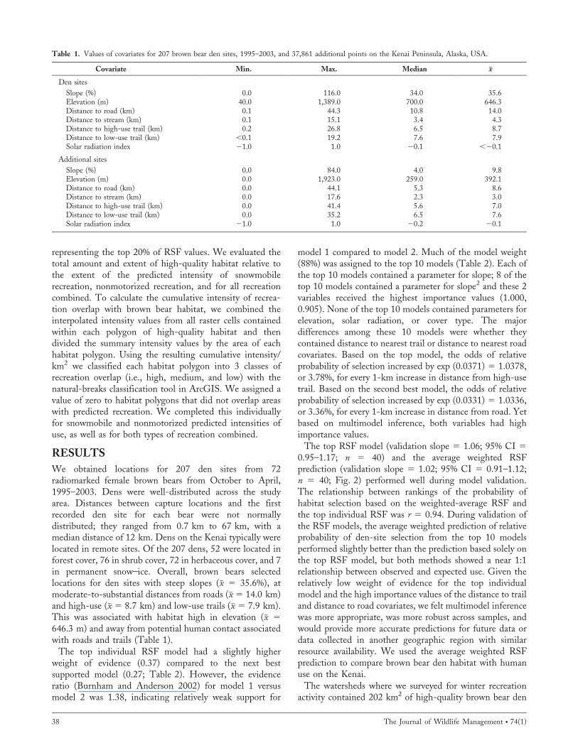
Table 1. Values of covariates for 207 brown bear den sites, 1995–2003, and 37,861 additional points on the Kenai Peninsula, Alaska, USA.
Covariate Min. Max. Median x
Den sites
Slope (%) 0.0 116.0 34.0 35.6Elevation (m) 40.0 1,389.0 700.0 646.3Distance to road (km) 0.1 44.3 10.8 14.0Distance to stream (km) 0.1 15.1 3.4 4.3Distance to high-use trail (km) 0.2 26.8 6.5 8.7Distance to low-use trail (km) ,0.1 19.2 7.6 7.9Solar radiation index 21.0 1.0 20.1 ,20.1
Additional sites
Slope (%) 0.0 84.0 4.0 9.8Elevation (m) 0.0 1,923.0 259.0 392.1Distance to road (km) 0.0 44.1 5.3 8.6Distance to stream (km) 0.0 17.6 2.3 3.0Distance to high-use trail (km) 0.0 41.4 5.6 7.0Distance to low-use trail (km) 0.0 35.2 6.5 7.6Solar radiation index 21.0 1.0 20.2 20.1
38 The Journal of Wildlife Management N 74(1)

habitat. Total predicted winter recreation (motorized andnonmotorized), independent of intensity level, occurred inapproximately 16% (or 32 km2) of this habitat. Half of thisoverlap occurred in the high-intensity recreation class(Table 3). Nonmotorized recreation (19.8 km2) overlappedmore high-quality den habitat than snowmobile recreation(18.9 km2). Much area of high-quality habitat overlappedby nonmotorized use (skiing and snowshoeing) occurred inareas of high intensity (54%), whereas the area of high-quality habitat overlapped by snowmobile activity wasspread evenly across the 3 intensity classes (Table 3).
DISCUSSION
We described and mapped potential brown bear den habitat toidentify where bear–human conflicts may occur so thatmanagement actions may be implemented to minimize effectsof winter recreation on bears. Bias existed in our bear locationdata because we obtained den locations only from female brownbears and only from bears captured as a result of aerial searches.We do not have information on where male brown bears den onthe Kenai Peninsula; males and females may use den sites withdifferent physiographic characteristics (Lindzey and Meslow1976). However, Smith et al. (1994) reported that differences inden characteristics among sex, age, and female reproductiveclasses were generally insignificant. Although captures were notsystematic, brown bear dens were well-distributed across thestudy area. Distances as great as 67 km (median 5 12 km)between capture locations and the first recorded den siteprovided evidence that some bears moved long distances toreach den sites. Thus, we feel confident that our sample of denlocations was not substantially biased by limitations in ourability to capture bears randomly across the landscape.
Similar to other studies (Craighead and Craighead 1972),brown bears denned in areas isolated from human activityand development. Reynolds et al. (1974) suggested thatbears seek out remote, isolated areas and sites that willaccumulate enough snow to insulate them from cold wintertemperatures. In our study, brown bears selected such siteson steep slopes (Fig. 3). This was similar to findingsreported in Van Daele et al. (1990), Groff et al. (1998),Petram et al. (2004), and Garcia et al. (2007), who reportedthat terrain was the most important variable affecting winterden-site selection. The steeper slopes that bears selected forden sites may have reflected selection for sites with limitedpotential for disturbance. However, increased participationin winter recreation, combined with new technologies,facilitates access to areas previously difficult to reach. Thus,the potential for disturbance at these sites exists.
Our model indicated that bears selected den sites awayfrom roads, similar to findings by Huygens et al. (2001),Gaines (2003), Mitchell et al. (2005), Reynolds-Hogland etal. (2007), and Elfstrom et al. (2008). Bears also avoidedplacing dens near recreation trails (Fig. 3), similar to Groffet al. (1998). The difference in the effect of low-use trailscompared to high-use trails on selection of den sites bybrown bears may be related to the intensity of use byhumans on the trails. As distance to low-use trails increased,the effect of the trails decreased (Fig. 3).T
able
2.T
op
10
reso
urc
e-se
lect
ion
mo
del
sfo
rb
row
nb
ear
den
hab
itat
on
the
Ken
aiP
enin
sula
,Ala
ska,
US
A,1
99
5–2
00
3.M
od
elco
effi
cien
ts(S
E)
wer
eb
ased
on
aver
age
Bay
esia
nIn
form
atio
nC
rite
rio
n(B
IC)
wei
ghts
fro
m1
,000
bo
ots
trap
rep
lica
tio
ns.
Ran
k
Mea
nB
IC wt
Dis
tan
ceto
hig
h-
use
trai
lS
E
Dis
tan
ceto
hig
h-
use
trai
l2S
E
Dis
tan
ceto
low
-u
setr
ail
SE
Dis
tan
ceto
low
-use
trai
l2S
ES
lop
eS
ES
lop
e2S
ED
ista
nce
toro
adS
ED
ista
nce
toro
ad2
SE
Dis
tan
ceto
stre
amS
E
10
.369
0.0
371
0.0
243
0.2
285
0.0
95
22
0.0
13
60
.004
60
.032
60
.012
70
.00
06
30
.000
14
20
.268
0.0
313
0.0
129
0.0
00
60
0.0
331
0.0
115
30
.070
0.0
362
0.0
124
0.0
00
57
0.0
001
34
0.0
430
.030
30
.022
50
.213
70
.09
78
20
.01
30
0.0
047
0.0
296
0.0
135
0.0
00
66
0.0
001
50
.045
20
.044
65
0.0
420
.023
50
.023
10
.227
80
.08
99
20
.01
29
0.0
042
0.0
780
0.0
056
60
.020
0.0
297
0.0
134
0.0
00
61
0.0
001
40
.030
70
.011
70
.022
60
.044
87
0.0
190
.031
30
.012
90
.00
06
00
.000
13
0.0
243
0.0
395
20
.00
02
50
.001
18
0.0
172
0.0
03
40
.071
10
.001
96
0.0
03
10
.249
60
.10
45
20
.01
51
0.0
053
0.0
319
0.0
129
0.0
00
64
0.0
001
49
0.0
170
.030
70
.013
10
.00
06
20
.000
14
0.0
648
0.0
449
10
0.0
160
.075
30
.005
60
.030
50
.011
1
To
tal
0.8
81
Goldstein et al. N Brown Bear Dens and Winter Recreation 39

The most widely used den sites were those that were leastaccessible to humans. Although much of the Kenai is anintact ecosystem with relatively little human use overlappinghigh-quality brown bear den habitat, given the long history
of winter recreation in portions of the study area, it ispossible that prior recreation may have displaced denningbrown bears from areas they previously used, leading to thelimited overlap we observed. However, the way bears selectden sites in late autumn may be partially influenced by theirbehavior during the rest of the year (Reynolds-Hogland etal. 2007). Brown bears on the Kenai generally avoided areasin proximity to roads during spring and summer (Suring etal. 2006), likely because of disturbance and high potentialfor mortality. Higher densities of roads and trails resulted inan increased likelihood of brown bear mortality (Suring andDel Frate 2002). These factors may have influencedselection of den sites by bears.
In the portion of the study area where we evaluated humanuse, modeled recreation of any type overlapped a relativelysmall proportion (approx. 16%) of high-quality female brownbear den habitat. In reality, this proportion is probably lower,because our effort to survey human use was stratified to focuson areas likely to have winter recreation activity. Still,although small in total area of overlap, some patches of high-quality habitat for denning bears within the surveyedwatersheds hosted a disproportionate amount of high-intensity recreation. Eight percent of high-quality habitat(i.e., 16.3 km2) located within areas of high-intensityrecreation received .50% of the predicted recreation activity(Table 3). The highest amount of overlap between high-quality brown bear habitat and recreation use occurred inTurnagain Pass, where recreation activity overlapped 47%(2.8 km2 of 5.9 km2) of high-quality habitat (Fig. 4).
As such, the risk of population impacts to brown bearsfrom snowmobilers, skiers, or snowshoers may currently be
Figure 2. Relative probability of brown bear den-site selection based onthe weighted-average predictions using Bayesian Information Criterionweights from top 10 resource-selection function models on the KenaiPeninsula, Alaska, USA, 1995–2003.
Table 3. Overlap of winter recreation activity, 2004–2005, and den habitatfor brown bears, 1995–2003, by recreation user type and intensity ofrecreation use (high, medium, low) on the Kenai Peninsula, Alaska, USA.Den habitat was defined as areas with modeled habitat values in thetop 20%.
User type Area (km2)
% recreationarea
overlappedwith denhabitat
% total denhabitat
overlapped withrecreation area
All recreation
High 16.2 50 8Medium 9.4 29 5Low 6.8 21 3Total overlap 32.3 16Total nonoverlap 170.1 84Total 202.4
Snowmobile
High 6.7 35 3Medium 7.0 37 3Low 5.2 27 3Total overlap 18.9 9Total nonoverlap 183.5 91Total 202.4
Nonmotorized(ski–snowshoe)
High 10.7 54 5Medium 4.9 25 2Low 4.2 21 2Total overlap 19.8 10Total nonoverlap 182.6 90Total 202.4
Figure 3. Plots showing the relative probability of den-site selection,1995–2003, assuming all other variables were held constant at theirrespective median, for the 4 most important variables in the top 2 models.We plotted relative probability of selection for the observed range of eachpredictor variable, scaled so the maximum relative probability of selectionequals one.
40 The Journal of Wildlife Management N 74(1)

relatively low. Given little direct overlap, the greatestpotential for disturbance from snowmobiles may come fromnoise in the vicinity of slopes used by denning bears(Andersen and Aars 2008). However, this has not beenspecifically addressed on the Kenai. Assuming disturbancepotential is greatest in high-intensity use areas, researchefforts investigating disturbance questions could be imple-mented in the Turnagain Pass area, which supports high-intensity use by motorized and nonmotorized recreation inseparate management areas.
Given that we detected approximately 10 times theamount of terrain tracked by snowmobile versus nonmotor-ized (ski and snowshoe) activity during flight surveys, wewere surprised that nonmotorized recreation overlappedhigh-quality brown bear den habitat more than motorizedrecreation. This was true in both total area and proportionof overlap. We found approximately twice as much habitatoverlapped by ski and snowshoe activity in the high-intensity class than in the other 2 use-classes, whichsuggested a greater likelihood of direct overlap amongalpine skiers, snowshoers, and bear dens, a logical conclusionbased on the preference of bears for mid-slope den locationstypical of brown bears elsewhere (e.g., Judd et al. 1986).This finding may or may not be significant. Based on thelow density of dens on the landscape and the smalllikelihood of direct interaction with the den site by winterrecreation users, it is reasonable to assume that the noisefrom nearby snowmobile activity may have greater potential
for disturbance effect (Elowe and Dodge 1989, Andersenand Aars 2008) than noise from skiers. However, if alpineskiers and snowshoers go in groups, take dogs, or wintercamp, they may disturb denning bears. In consideration ofour findings, we recommend measurement of those types ofeffects.
MANAGEMENT IMPLICATIONS
Female brown bears generally denned in isolated sites on steepslopes; this potentially overlapped with terrain selected bybackcountry skiers more than any other user group. Becauseskiers require foot-power from access points, unless additionalaccess is provided, total overlap of this type of recreation withhigh-quality den habitat will be minimal and localized.However, if use disperses further into remote areas as a resultof aircraft-supported access or the addition of backcountryfacilities (e.g., lodges accessible by snow cats or railroad), thenoverlap of backcountry ski use with den habitat will likelyincrease faster than increases in overlap associated withsnowmobiles. Efforts to maintain the suitability of den habitatfor brown bears should include a careful evaluation of theimpacts of nonmotorized user groups (Goodrich and Berger1994) as well as motorized use.
ACKNOWLEDGMENTS
Locations of brown bears and their dens were collected bythe Interagency Brown Bear Study Team (IBBST), acoalition of 4 agencies: ADF&G, USDA FS, United StatesFish and Wildlife Service, and National Park Service. C. C.Schwartz, S. M. Arthur, S. Farley, and G. V. Hilderbrand,all with the ADF&G, were instrumental in the design andimplementation of brown bear studies on the Kenai by theIBBST, including the capture and marking of brown bearsincluded in this study. W. Shuster first suggested the ideafor this analysis. B. A. Brown completed the initial datasynthesis. K. Preston assisted with GIS analyses. Pilots J.DeCreeft and R. Ernst collected most of the point locations.J. W. Schoen, S. Saunders, G. V. Hilderbrand, and theIBBST provided helpful reviews of an earlier draft of thismanuscript, which greatly improved its content. The UnitedStates Forest Service—Chugach National Forest and AlaskaRegional Office provided funding and other resources tosupport this analysis.
LITERATURE CITED
Alaska Department of Fish and Game [ADF&G]. 1998. Catalog of watersimportant for spawning, rearing or migration of anadromous fishes.Alaska Department of Fish and Game, Juneau, USA.
Andersen, M., and J. Aars. 2008. Short-term behavioural response of polarbears (Ursus maritimus) to snowmobile disturbance. Polar Biology31:501–507.
Apps, C. D., B. N. McLellan, J. G. Woods, and M. F. Proctor. 2004.Estimating grizzly bear distribution and abundance relative to habitat andhuman influence. Journal of Wildlife Management 68:138–152.
Burnham, K. P., and D. R. Anderson. 2002. Model selection andmultimodel inference: a practical information-theoretic approach. Secondedition. Springer-Verlag, New York, New York, USA.
Camp, J. 2001. 2000 situations and prospects of the Kenai PeninsulaBorough. Kenai Peninsula Borough, Community Economic Develop-ment Division, Soldotna, Alaska, USA.
Figure 4. The distribution of brown bear habitat, 1995–2003, and itsoverlap with recreation intensity, 2004–2005, in the vicinity of TurnagainPass on the Kenai Peninsula, Alaska, USA.
Goldstein et al. N Brown Bear Dens and Winter Recreation 41

Craighead, F. C., and J. J. Craighead. 1972. Grizzly bear prehibernationand denning activities as determined by radio-tracking. WildlifeMonographs 32.
Del Frate, G. G. 1999. Units 7 and 15 brown bear. Pages 55–65 in M. Hicks,editor. Management report of survey and inventory activities 1 July 1996–30 June 1998. Federal Aid in Wildlife Restoration Project W-24-5 and W-27-1, Study 4.0. Alaska Department of Fish and Game, Juneau, USA.
Ducks Unlimited and Spatial Solutions. 1999. Kenai Peninsula earth coverclassification users guide. Project no. AK-0033-001 and AK-0033-002.Ducks Unlimited, Rancho Cordova, California, USA.
Elfstrom, M., J. E. Swenson, and J. P. Ball. 2008. Selection of denninghabitats by Scandinavian brown bears Ursus arctos. Wildlife Biology14:176–187.
Elowe, K. D., and W. E. Dodge. 1989. Factors affecting black bearreproductive success and cub survival. Journal of Wildlife Management53:962–968.
Erickson, W. P., T. L. McDonald, K. G. Gerow, S. Howlin, and J. W.Kern. 2001. Statistical issues in resource selection studied with radio-marked animals. Pages 209–242 in J. J. Millspaugh and J. M. Marzluff,editors. Radio tracking and animal populations. Academic Press, SanDiego, California, USA.
Fielding, A. L., and J. F. Bell. 1997. A review of methods for assessment ofprediction errors in conservation presence/absence models. Environmen-tal Conservation 24:38–49.
Gaines, W. L. 2003. Black bear, Ursus americanus, denning chronology andden site selection in the northeastern cascades of Washington. CanadianField-Naturalist 117:626–633.
Garcia, P., J. Lastra, J. Marquınez, and C. Nores. 2007. Detailed model ofshelter areas for the Cantabrian brown bear. Ecological Informatics2:297–307.
Gimblett, R., M. Richards, and R. Itami. 2001. RBSim: geographicsimulation of wilderness recreation behavior. Journal of Forestry 99:36–42.
Goodrich, J. M., and J. Berger. 1994. Winter recreation and hibernatingblack bears Ursus americanus. Biological Conservation 67:105–110.
Graves, T. A., S. Farley, M. I. Goldstein, and C. Servheen. 2007. Identificationof functional corridors with movement characteristics of brown bears on theKenai Peninsula, Alaska. Landscape Ecology 22:765–772.
Graves, T. A., S. Farley, and C. Servheen. 2006. Frequency and distributionof highway crossings by Kenai Peninsula brown bears. Wildlife SocietyBulletin 34:800–808.
Groff, C., A. Caliari, E. Dorigatti, and A. Gozzi. 1998. Selection ofdenning caves by brown bears in Trentino, Italy. InternationalConference on Bear Research and Management 10:275–279.
Huston, M., D. DeAngelis, and W. Post. 1988. New computer modelsunify ecological theory. BioScience 38:682–691.
Huygens, O., M. Goto, S. Izumiyama, H. Hayashi, and T. Yoshida. 2001.Denning ecology of two populations of Asiatic black bears in NaganoPrefecture, Japan. Mammalia 65:417–428.
Johnson, C. J., S. E. Nielsen, E. H. Merril, T. L. McDonald, and M. S.Boyce. 2006. Resource selection functions based on use–availability data:theoretical motivation and evaluation methods. Journal of WildlifeManagement 70:347–357.
Judd, S. L., R. R. Knight, and B. M. Blanchard. 1986. Denning of grizzlybears in the Yellowstone National Park area. International Conference onBear Research and Management 6:111–117.
Keating, K. A., P. J. P. Gogan, J. M. Vore, and L. R. Irby. 2007. A simplesolar radiation index for wildlife habitat studies. Journal of WildlifeManagement 71:1344–1348.
Lindzey, F. G., and E. C. Meslow. 1976. Characteristics of black bear denson Long Island, Washington. Northwest Science 50:236–242.
Linnell, J. D. C., J. E. Swenson, R. Andersen, and B. Barnes. 2000. Howvulnerable are denning bears to disturbance? Wildlife Society Bulletin28:400–413.
Manly, B. J. F. 1997. Randomization, bootstrap and Monte Carlo methodsin biology. Second edition. Chapman and Hall, London, UnitedKingdom.
Manly, B. J. F., L. L. McDonald, D. L. Thomas, T. L. McDonald, and W.P. Erickson. 2002. Resource selection by animals: statistical design andanalysis for field studies. Kluwer Academic, Norwell, Massachusetts,USA.
Mattson, D. J., S. Herrero, R. G. Wright, and C. M. Pease. 1996. Scienceand management of Rocky Mountain grizzly bears. Conservation Biology10:1013–1025.
McLellan, B. N. 1998. Maintaining viability of brown bears along thesouthern fringe of their distribution. Ursus 10:607–611.
Mech, L. D. 1983. A handbook of animal radio-tracking. University ofMinnesota Press, Minneapolis, USA.
Miller, S. D. 1990. Denning ecology of brown bears in southcentral Alaskaand comparisons with a sympatric black bear population. InternationalConference on Bear Research and Management 8:279–287.
Mitchell, F. S., D. P. Onorato, E. C. Hellgren, J. R. Skiles, Jr., and L. A.Harveson. 2005. Winter ecology of American black bears in a desertmontane island. Wildlife Society Bulletin 33:164–171.
Neter, J., W. Wasserman, and M. H. Kutner. 1985. Applied linearstatistical models: regression, analysis of variance, and experimentaldesigns. Second edition. Richard D. Irwin, Homewood, Illinois, USA.
Petram, W., F. Knauer, and P. Kaczensky. 2004. Human influence on thechoice of winter dens by European brown bears in Slovenia. BiologicalConservation 119:129–136.
Podruzny, S. R., S. Cherry, C. C. Schwartz, and L. A. Landenburger. 2002.Grizzly bear denning and potential conflict areas in the greaterYellowstone ecosystem. Ursus 13:19–28.
Poe, A. J., R. H. Gimblett, M. I. Goldstein, and P. Guertin. 2006.Evaluating spatiotemporal interactions between winter recreation andwildlife using agent-based simulation modeling on the Kenai Peninsula,Alaska. Pages 311–312 in D. Siegrist, C. Clivaz, M. Hunziker, and S.Iten, editors. Exploring the nature of management. Proceedings of theThird International Conference on Monitoring and Management ofVisitor Flows in Recreational and Protected Areas. University of AppliedSciences, Rapperswil, Switzerland. ,http://www.wsl.ch/mmv-3/call/MMV3_proceedings.pdf.. Accessed 14 Aug 2009.
Reynolds, H. V., J. A. Curatolo, and R. Quimby. 1974. Denning ecology ofgrizzly bears in northeastern Alaska. International Conference of BearResearch and Management 3:403–409.
Reynolds-Hogland, M. J., M. S. Mitchell, R. A. Powell, and D. C. Brown.2007. Selection of den sites by black bears in the Southern Appalachians.Journal of Mammalogy 88:1062–1073.
Schoen, J. W., L. R. Beier, J. W. Lentfer, and L. J. Johnson. 1987. Denningecology of brown bears on Admiralty and Chichagof Islands. Interna-tional Conference on Bear Research and Management 7:293–304.
Schwartz, C. C., and S. M. Arthur. 1997. Cumulative effects modelverification, sustained yield estimation, and population viability manage-ment of the Kenai Peninsula, Alaska brown bear. Federal Aid in WildlifeRestoration Study 4.27. Alaska Department of Fish and Game, Juneau,USA.
Schwarz, G. E. 1978. Estimating the dimension of a model. Annals ofStatistics 6:461–464.
Smith, M. E., J. L. Hechtel, and E. H. Follmann. 1994. Black bear denningecology in Interior Alaska. International Conference on Bear Researchand Management 9:513–522.
Stephens, P. A., S. W. Buskirk, G. D. Hayward, and C. Martınez del Rio.2005. Information theory and hypothesis testing: a call for pluralism.Journal of Applied Ecology 42:4–12.
Suring, L. H., K. R. Barber, C. C. Schwartz, T. N. Bailey, W. C. Shuster,and M. D. Tetreau. 1998. Analysis of cumulative effects on brown bearson the Kenai Peninsula, south-central Alaska. Ursus 10:107–117.
Suring, L. H., and G. Del Frate. 2002. Spatial analysis of locations ofbrown bears killed in defense of life or property on the Kenai Peninsula,Alaska, USA. Ursus 13:237–245.
Suring, L. H., S. D. Farley, G. V. Hilderbrand, M. I. Goldstein, S. Howlin, andW. P. Erickson. 2006. Patterns of landscape use by female brown bears on theKenai Peninsula, Alaska. Journal of Wildlife Management 70:1580–1587.
United States Department of Agriculture Forest Service [USDA FS]. 2002.Final environmental impact statement: Chugach National Forest landmanagement plan revision. U.S. Department of Agriculture ForestService, Alaska Region R10-MB-480d, Chugach National Forest,Anchorage, USA.
Van Daele, L. J., V. G. Barnes, Jr., and R. B. Smith. 1990. Denningcharacteristics of brown bears on Kodiak Island, Alaska. InternationalConference on Bear Research and Management 8:257–267.
Associate Editor: McCorquodale.
42 The Journal of Wildlife Management N 74(1)