Bistatic Measurement System for Characterisation of Aviation Pollutant Concentrations
9
16 th Australian Aerospace Congress, 23-24 February 2015, Melbourne Bistatic Measurement System for Characterisation of Aviation Pollutant Concentrations Alessandro Gardi and Roberto Sabatini School of Aerospace, Mechanical and Manufacturing Engineering, RMIT University Melbourne, VIC 3000, Australia Abstract This paper presents the conceptual design of a low-cost measurement system for the determination of aviation-related pollutant concentrations in dense air traffic areas. The proposed bistatic Light Detection and Ranging (LIDAR) system consists of two non- collocated components. The source component consists of a tuneable laser emitter, which can either be installed on a Remotely Piloted Aircraft System (RPAS) or operated from fixed and movable surface installations. The sensor component is constituted by a target surface calibrated for reflectance and a rail-mounted visible or infrared camera calibrated for radiance. The system performs Differential Absorption LIDAR (DIAL) measurements. The relevant opportunities and challenges, and the viability of the system in the intended operational environments are discussed. Numerical simulation results show promising performances in term of error expected error budget even in degraded meteorological conditions, which are comparable to the more complex and relatively costly monostatic LIDAR techniques currently available. Keywords: Aircraft Emissions, Differential Absorption, DIAL, LIDAR, Pollutant Measurement, Sustainable Aviation. Introduction Current research activities are addressing new sensor technologies and measurement techniques for the determination of aviation pollutant concentrations. The new systems should feature either: greater operational flexibility, better sensitivity, accuracy, precision, reliability, greater spectral/spatial/temporal resolutions, and reduced weight/volume/costs. The research community is interested, in particular, in the spatial and temporal variations of macroscopic observables, and on the microphysical and chemical properties of atmospheric constituents and pollutants, including molecular, aerosol and particulate species [1-3]. An accurate measurement of CO 2 concentration variations in space and time related to aircraft operations is particularly important. The advent of powerful LIDAR systems with low weight and packaged in relatively small casings, makes them well suited for measuring the column densities of various important molecular species, including carbon oxides (CO X ), nitrogen oxides (NO X ), sulphur oxides (SO X ), oxygen (O 2 ) and ozone (O 3 ), both locally and over extended geographic areas [4, 5]. The Near-Infrared (NIR) region of the atmospheric propagation spectrum is dominated by molecular absorption from H 2 O, CO and CO 2 . A comparison with recorded spectra enables the identification of relatively strong and isolated CO and CO 2 transitions for unambiguous species detection [6]. These transitions have formed the basis of NIR sensors for measurements of CO and CO 2 mole fractions in exhaust gases using extraction-sampling techniques and for non-intrusive measurements of CO 2 in high- temperature combustion environments. Based on the demonstrated potential of Differential Absorption LIDAR (DIAL) [7-9], new airborne DIAL systems will greatly benefit from the technological advances in tuneable, compact and low-cost laser emitters enabling further portions of the spectrum to be exploited for multi-species pollutant concentration measurements.
Transcript of Bistatic Measurement System for Characterisation of Aviation Pollutant Concentrations
16th
Australian Aerospace Congress, 23-24 February 2015, Melbourne
Bistatic Measurement System for Characterisation
of Aviation Pollutant Concentrations
Alessandro Gardi and Roberto Sabatini
School of Aerospace, Mechanical and Manufacturing Engineering, RMIT University
Melbourne, VIC 3000, Australia
Abstract
This paper presents the conceptual design of a low-cost measurement system for the
determination of aviation-related pollutant concentrations in dense air traffic areas. The
proposed bistatic Light Detection and Ranging (LIDAR) system consists of two non-
collocated components. The source component consists of a tuneable laser emitter, which can
either be installed on a Remotely Piloted Aircraft System (RPAS) or operated from fixed and
movable surface installations. The sensor component is constituted by a target surface
calibrated for reflectance and a rail-mounted visible or infrared camera calibrated for radiance.
The system performs Differential Absorption LIDAR (DIAL) measurements. The relevant
opportunities and challenges, and the viability of the system in the intended operational
environments are discussed. Numerical simulation results show promising performances in
term of error expected error budget even in degraded meteorological conditions, which are
comparable to the more complex and relatively costly monostatic LIDAR techniques currently
available.
Keywords: Aircraft Emissions, Differential Absorption, DIAL, LIDAR, Pollutant
Measurement, Sustainable Aviation.
Introduction
Current research activities are addressing new sensor technologies and measurement
techniques for the determination of aviation pollutant concentrations. The new systems should
feature either: greater operational flexibility, better sensitivity, accuracy, precision, reliability,
greater spectral/spatial/temporal resolutions, and reduced weight/volume/costs. The research
community is interested, in particular, in the spatial and temporal variations of macroscopic
observables, and on the microphysical and chemical properties of atmospheric constituents
and pollutants, including molecular, aerosol and particulate species [1-3]. An accurate
measurement of CO2 concentration variations in space and time related to aircraft operations
is particularly important. The advent of powerful LIDAR systems with low weight and
packaged in relatively small casings, makes them well suited for measuring the column
densities of various important molecular species, including carbon oxides (COX), nitrogen
oxides (NOX), sulphur oxides (SOX), oxygen (O2) and ozone (O3), both locally and over
extended geographic areas [4, 5]. The Near-Infrared (NIR) region of the atmospheric
propagation spectrum is dominated by molecular absorption from H2O, CO and CO2. A
comparison with recorded spectra enables the identification of relatively strong and isolated
CO and CO2 transitions for unambiguous species detection [6]. These transitions have formed
the basis of NIR sensors for measurements of CO and CO2 mole fractions in exhaust gases
using extraction-sampling techniques and for non-intrusive measurements of CO2 in high-
temperature combustion environments. Based on the demonstrated potential of Differential
Absorption LIDAR (DIAL) [7-9], new airborne DIAL systems will greatly benefit from the
technological advances in tuneable, compact and low-cost laser emitters enabling further
portions of the spectrum to be exploited for multi-species pollutant concentration
measurements.

16th
Australian Aerospace Congress, 23-24 February 2015, Melbourne
Bistatic DIAL Measurement System
The bistatic measurement system was conceptually presented in [10], based on previous
research [2, 3, 11-15]. The proposed system is based on the DIAL technique [16]. The laser
source emits beams at two predefined wavelengths. The first wavelength ( ) is selected in
correspondence of a major vibrational band of the targeted pollutant molecule (on-absorption
line), clear from the transition/vibration spectrum of other atmospheric components. The
second wavelength ( ) is selected in proximity of the first, but outside the vibrational band
(off-absorption line) of the targeted pollutant species, so that the difference in cross-sections,
( ) ( ) is maximised. A number of databases and atmospheric Radiative
Transfer Model (RTM) codes are available and allow an accurate estimation of the
propagation spectrum for identifying the optimal combination of DIAL wavelengths based on
the mentioned criteria. As depicted in Fig. 1, the proposed bistatic DIAL measurement system
consists of a LIDAR emitter installed on a RPAS or on fixed/movable surface installations,
and a sensor component. The sensor component consists of a target surface featuring high and
diffused reflectance and exhibiting Lambertian behaviour, such as Spectralon™, and a
visible/infrared camera mounted on a rail. The RPAS platform flies pre-determined
trajectories based on the required space and time frames of the measurement. The functional
block diagram of the bistatic DIAL measurement system is represented in Fig. 2.
Fig. 1: Representation of the bistatic DIAL system, not to scale [17].

16th
Australian Aerospace Congress, 23-24 February 2015, Melbourne
Fig. 2: Functional block diagram of the bistatic DIAL measurement system [18].
Atmospheric Laser Beam Propagation
The propagation of laser radiation in atmosphere is affected by a number of linear and
nonlinear effects. In [17] we described the following expression for the peak irradiance IP,
accounting for absorption, scattering, diffraction, jitter, atmospheric turbulence and thermal
blooming effects assuming a Gaussian profile of the laser beam at the source and an average
focused irradiance [19, 20]:
( ) ( ) ( ) ( )
( ( )
( ) ( ))
(1)
where z is the linear coordinate along the beam, λ is the wavelength, ( ) is the transmitted
laser power, b is the blooming factor, ( ) is the transmittance coefficient, which accounts
for absorption and scattering associated with all molecular and aerosol species present in the
path. The 1/e beam radiuses associated with diffraction, ( ), beam jitter, ( ), and
turbulence, ( ), can be calculated as [3, 19]:
( )
(2)
( ) ⟨
⟩ (3)
( )
(4)
where Q is the beam quality factor, ao is the beam 1/e radius, ⟨ ⟩ is the variance of the single
axis jitter angle that is assumed to be equal to ⟨ ⟩, and
is the refractive index structure
constant. An empirical model for the blooming factor b(z), which is the ratio of the bloomed
to unbloomed peak irradiance, is:

16th
Australian Aerospace Congress, 23-24 February 2015, Melbourne
( )
( ) (5)
N is the thermal distortion parameter, calculated as:
( )
*
∫
( ) ∫
+ (6)
where vo is the uniform wind velocity in the weak attenuation limit (z << 1), , do , and cp
are, respectively, the coefficients of index change with respect to temperature, density, and
specific heat at constant pressure. The transmittance coefficient τ depends on the integral
effect of absorption and scattering phenomena, both for molecular and aerosol species, on the
entire beam length. The expression of Beer’s law highlighting such dependences can therefore
be written as:
( ) ∫ ( ) ∫ [ ( ) ( ) ( ) ( )]
(7)
where α are the absorption coefficients and β are the scattering coefficients, the subscripts m
and a refer respectively to molecular and aerosol contributions. When referring to the integral
absorption and scattering due to specific molecular species, it is more appropriate to express
the transmittance with the following model:
( ) ∫ ( ) ∫ ∑ [ ( ) ( )]
(8)
where:
( ) = cross-section of the ith
species
= molecular volume density of the ith
species
From Eq. 8, the fraction between the measured incident laser energy associated with the on-
absorption line of pollutant species P and the one associated with the off-absorption line,
can be expressed as [10]:
( )
( )
[ ( ) ( )] ∫ ( )
(9)
where D is the total beam length. The total pollutant column density , which is the integral
of the molecular volume density on the entire beam, is therefore:
∫ ( ) ( )
(10)
The average molecular volume concentration of the pollutant on the path, , is therefore:
( )
(11)
As evident from Eq. 9 to 11, the bistatic DIAL measurement system neglects most of the
parasite phenomena such as atmospheric visibility, particulate, rain and other precipitations,
which would have elsewhere introduced a number of additional uncertainties in the system.
The parasite effects, in fact, are assumed to equally affect the off-absorption and the on-
absorption transmittances.
Aerosol Retrieval
The retrieval of aerosol concentrations was originally examined in [2]. As per eq. 7, both
molecular and aerosol concentrations in the transmission medium (i.e. the atmosphere)
introduce absorption and scattering phenomena that affect the laser beam propagation.
Therefore, the atmospheric transmittance measurement data accumulated in a certain time
16th
Australian Aerospace Congress, 23-24 February 2015, Melbourne
period using passive imaging systems enable the retrieval of aerosol concentrations as well.
The difficulty in developing inversion algorithms lies in the fact that the input optical data are
related to the investigated microphysical parameters through nonlinear integral equations of
the first kind (Fredholm equations), which cannot be solved analytically. The generalised
form of the Fredholm equation for atmospheric data retrieval is:
( ) ( ) ∫ ( ) ( ) (12)
where ( ) ( ) represent the optical data, is the atmospheric kernel function
(containing information on particle size, refractive index etc.) and ( ) is the particle size
distribution. The numerical solution of these equations leads to the so called ill-posed inverse
problem. Such problems are characterised by a strong sensitivity of the solution space toward
uncertainties of the input data, the non-uniqueness of the solution space, and the
incompleteness of the solution space. In fact, the solution space may still be correct in a
mathematical sense, but might not necessarily reflect the physical conditions. As the problem
cannot be entirely defined by the measurements, a priori knowledge of the state vector is
required in order to determine the most probable solution, with a probabilistic Bayesian
approach. Let y be the measurement vector containing the measured radiances, and x be the
concentration of a given constituent, then the general remote sensing equation can be written
as follows [5]:
( ) (13)
where represents the forward transfer function, the other parameters affecting the
measurement, and the measurement noise. In the case of instruments measuring laser
radiance, the vector includes the target surface reflectance and radiance features (BRDF,
reflectivity, emissivity and temperature), the variables describing the atmospheric state
(vertical turbulence profile, temperature, water vapour and other atmospheric constituents,
clouds, aerosols, etc.), and some characteristics of the measurement instruments (spectral
response functions and resolution). The inverse problem consists in retrieving , an estimate
of the true state , from the measurement , and can be expressed as:
( ) ( ( ) ) (14)
where is an estimate of the non-retrieved parameters , and is the inverse transfer
function. This a priori information consists of an a priori state vector and its covariance
matrix , which may be provided by model simulations. Therefore, the inverse problem can
be rewritten as follows:
( ) (15)
Various inversion techniques were proposed. One of the most popular approaches is the
inversion with regularisation, offering the advantage of reducing oscillations in the solution
that are frequently experienced in data retrieved from electro-optical measurements [1, 19].
This approach consists in introducing constraints, such as derivative analysis (smoothness) of
the particle size distribution functions, positive sign of the functions and maximum variations
over time. Using appropriate kernel/base functions, this algorithm can deliver parameters such
as effective (average) particle radius, particle size distribution, total surface-area
concentration, total number/volume concentrations, real and imaginary parts of the refractive
index, single scattering albedo, etc. The base functions are Gaussian fits of the existing
particle concentration data and are used to reconstruct the investigated particle size
distributions. The kernel functions describe the interaction of laser radiation with the
16th
Australian Aerospace Congress, 23-24 February 2015, Melbourne
atmosphere and contain information about the atmospheric transmittance, including scattering
and absorption processes.
Error Estimation
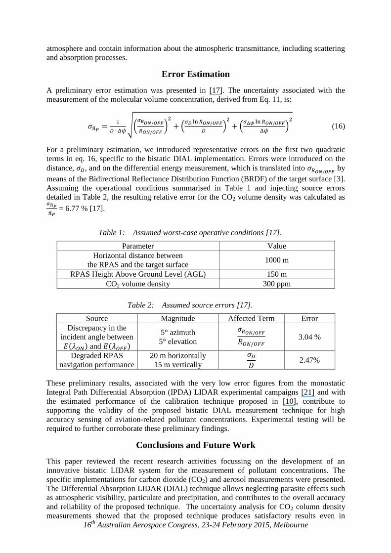
A preliminary error estimation was presented in [17]. The uncertainty associated with the
measurement of the molecular volume concentration, derived from Eq. 11, is:
√(
)
(
)
(
)
(16)
For a preliminary estimation, we introduced representative errors on the first two quadratic
terms in eq. 16, specific to the bistatic DIAL implementation. Errors were introduced on the
distance, , and on the differential energy measurement, which is translated into by
means of the Bidirectional Reflectance Distribution Function (BRDF) of the target surface [3].
Assuming the operational conditions summarised in Table 1 and injecting source errors
detailed in Table 2, the resulting relative error for the CO2 volume density was calculated as
= 6.77 % [17].
Table 1: Assumed worst-case operative conditions [17].
Parameter Value
Horizontal distance between
the RPAS and the target surface 1000 m
RPAS Height Above Ground Level (AGL) 150 m
CO2 volume density 300 ppm
Table 2: Assumed source errors [17].
Source Magnitude Affected Term Error
Discrepancy in the
incident angle between
( ) and ( )
5° azimuth
5° elevation
3.04 %
Degraded RPAS
navigation performance
20 m horizontally
15 m vertically
2.47%
These preliminary results, associated with the very low error figures from the monostatic
Integral Path Differential Absorption (IPDA) LIDAR experimental campaigns [21] and with
the estimated performance of the calibration technique proposed in [10], contribute to
supporting the validity of the proposed bistatic DIAL measurement technique for high
accuracy sensing of aviation-related pollutant concentrations. Experimental testing will be
required to further corroborate these preliminary findings.
Conclusions and Future Work
This paper reviewed the recent research activities focussing on the development of an
innovative bistatic LIDAR system for the measurement of pollutant concentrations. The
specific implementations for carbon dioxide (CO2) and aerosol measurements were presented.
The Differential Absorption LIDAR (DIAL) technique allows neglecting parasite effects such
as atmospheric visibility, particulate and precipitation, and contributes to the overall accuracy
and reliability of the proposed technique. The uncertainty analysis for CO2 column density
measurements showed that the proposed technique produces satisfactory results even in

16th
Australian Aerospace Congress, 23-24 February 2015, Melbourne
degraded meteorological conditions, which are comparable to the more complex and
relatively costly monostatic LIDAR techniques currently available. Current research activities
are investigating the extension of the system to other families of aviation pollutants such as
nitrogen oxides (NOX), sulphur oxides (SOX), and Volatile Organic Compounds (VOC) taking
advantage of the recent availability of tuneable laser emitters for multi-species detection. The
research activities will involve laboratory testing as well as flight testing in various
representative conditions. In particular, the development of the airborne component will
benefit from the concurrent research activities on RPAS-based LIDAR systems [22-24]. The
RPAS will be equipped with Differential GPS-based Time-and-Space-Position-Information
(TSPI) systems that were developed for augmented navigation performance of both manned
and unmanned aircraft [25, 26] in combination with integrity augmentation systems [27-29].
The experimental flight testing activity will be performed in a suitably developed laser test
range in full compliance with eye-safety requirements [3, 13, 30]. The full potential of the
proposed bistatic DIAL measurement system will be exploited through its functional
integration in the next generation of Air Traffic Management (ATM) systems [31-34].
References
1. Rodgers, C. D., Inverse methods for atmospheric sounding: Theory and practice vol. 2:
World scientific Singapore, 2000.
2. Sabatini, R., Richardson, M. A., Jia, H., and Zammit-Mangion, D., "Airborne laser
systems for atmospheric sounding in the near infrared", in proceedings of SPIE 8433,
Laser Sources and Applications, Photonics Europe 2012, Brussels, Belgium, 2012. DOI:
10.1117/12.915718
3. Sabatini, R. and Richardson, M. A., Airborne Laser Systems Testing and Analysis: NATO
Science and Technology Organization, 2010.
4. Veselovskii, I., Kolgotin, A., Griaznov, V., Müller, D., Franke, K., and Whiteman, D. N.,
"Inversion of multiwavelength Raman lidar data for retrieval of bimodal aerosol size
distribution", Applied Optics, vol. 43, pp. 1180-1195, 2004. DOI: 10.1029/2003JD003538
5. Müller, D., Wagner, F., Wandinger, U., Ansmann, A., Wendisch, M., Althausen, D., et
al., "Microphysical particle parameters from extinction and backscatter lidar data by
inversion with regularization: Experiment", Applied Optics, vol. 39, pp. 1879-1892, 2000
6. Kuang, Z., Margolis, J., Toon, G., Crisp, D., and Yung, Y., "Spaceborne measurements of
atmospheric CO2 by high‐resolution NIR spectrometry of reflected sunlight: An
introductory study", Geophysical Research Letters, vol. 29, pp. 11-1, 2002
7. Grant, W. B. and Hake Jr, R. D., "Calibrated remote measurements of SO2 and O3 using
atmospheric backscatter", Journal of Applied Physics, vol. 46, pp. 3019-3023, 1975. DOI:
10.1063/1.321992
8. Grant, W. B., Hake Jr, R. D., Liston, E. M., Robbins, R. C., and Proctor Jr, E. K.,
"Calibrated remote measurement of NO2 using the differential-absorption backscatter
technique", Applied Physics Letters, vol. 24, pp. 550-552, 1974. DOI: 10.1063/1.1655049
9. Schotland, R. M., "Errors in the lidar measurement of atmospheric gases by differential
absorption", Journal of Applied Meteorology, vol. 13, pp. 71-77, 1974
10. Gardi, A., Sabatini, R., and Wild, G., "Unmanned aircraft bistatic lidar for CO2 colum
density determination", in proceedings of IEEE Metrology for Aerospace
(MetroAeroSpace 2014), Benevento, Italy, 2014. DOI:
10.1109/MetroAeroSpace.2014.6865892

16th
Australian Aerospace Congress, 23-24 February 2015, Melbourne
11. Sabatini, R., "Tactical Laser Systems Performance Analysis in Various Weather
Conditions", in RTO-MP-001 - E-O Propagation, Signature and System Performance
under Adverse Meteorological Conditions Considering Out of Area Operations, pp. 29-1
to 29-13, NATO Research and Technology Organization (RTO), Naples, Italy, 1998.
12. Sabatini, R., Guercio, F., and Vignola, S., "Airborne laser systems performance analysis
and mission planning", in RTO-MP-046 - Advanced Mission Management and Systems
Integration Technologies for Improved Tactical Operations, NATO Research and
Technology Organization (RTO), Florence, Italy, 1999.
13. Sabatini, R. and Richardson, M. A., "A new approach to eye-safety analysis for airborne
laser systems flight test and training operations", Optics and Laser Technology, vol. 35,
pp. 191-198, 2003. DOI: 10.1016/S0030-3992(02)00171-8
14. Sabatini, R. and Richardson, M. A., "Innovative methods for planetary atmospheric
sounding by lasers", in proceedings of AIAA Space 2008 Conference, San Diego, CA,
USA, 2008. DOI: 10.2514/6.2008-7670
15. Sabatini, R. and Richardson, M. A., "Airborne Laser Systems Testing, Safety Analysis,
Modelling and Simulation", presented at the 21st Annual Symposium of the Society of
Flight Test Engineers - European Chapter, Vergiate (VA), Italy, 2010.
16. Browell, E. V., Ismail, S., and Grant, W. B., "DIAL", in Encyclopedia of Atmospheric
Sciences, 2003.
17. Gardi, A., Sabatini, R., and Ramasamy, S., "Bistatic LIDAR System for the
Characterisation of Aviation-Related Pollutant Column Densities", Applied Mechanics
and Materials, vol. 629, pp. 257-262, 2014. DOI:
10.4028/www.scientific.net/AMM.629.257
18. Gardi, A., Sabatini, R., and Wild, G., "Conceptual design of an unmanned aircraft laser
system for aviation pollution measurements", in proceedings of Practical Responses to
Climate Change, Engineers Australia Convention 2014 (PRCC 2014), Melbourne,
Australia, 2014. DOI: 10.13140/2.1.3707.5528
19. Gebhardt, F. G., "High Power Laser Propagation", Applied Optics, vol. 15, pp. 1479-1493,
1976
20. Sabatini, R. and Richardson, M. A., "Novel atmospheric extinction measurement
techniques for aerospace laser system applications", Infrared Physics and Technology,
vol. 56, pp. 30-50, 2013. DOI: 10.1016/j.infrared.2012.10.002
21. Abshire, J. B., Riris, H., Weaver, C. J., Mao, J., Allan, G. R., Hasselbrack, W. E., et al.,
"Airborne measurements of CO2 column absorption and range using a pulsed direct-
detection integrated path differential absorption lidar", Applied Optics, vol. 52, pp. 4446-
4461, 2013. DOI: 10.1364/AO.52.004446
22. Sabatini, R., Gardi, A., and Richardson, M. A., "LIDAR Obstacle Warning and
Avoidance System for Unmanned Aircraft", International Journal of Mechanical,
Aerospace, Industrial and Mechatronics Engineering, vol. 8, pp. 62-73, 2014
23. Sabatini, R., Gardi, A., Ramasamy, S., and Richardson, M. A., "A Laser Obstacle
Warning and Avoidance System for Manned and Unmanned Aircraft", in proceedings of
IEEE Metrology for Aerospace (MetroAeroSpace 2014), Benevento, Italy, 2014, pp. 616-
621. DOI: 10.1109/MetroAeroSpace.2014.6865998
24. Sabatini, R., Gardi, A., and Ramasamy, S., "A Laser Obstacle Warning and Avoidance
System for Unmanned Aircraft Sense-and-Avoid", Applied Mechanics and Materials, vol.
629, pp. 355-360, 2014. DOI: 10.4028/www.scientific.net/AMM.629.355

16th
Australian Aerospace Congress, 23-24 February 2015, Melbourne
25. Sabatini, R., "High Precision DGPS and DGPS/INS Positioning for Flight Testing", in
RTO-MP-043 - 6th Saint Petersburg International Conference on Integrated Navigation
Systems, pp. 18-1 to 18-17, NATO Research and Technology Organization (RTO), Saint
Petersburg, Russia, 1999.
26. Sabatini, R. and Palmerini, G. B., Differential Global Positioning System (DGPS) for
Flight Testing: NATO Science and Technology Organization, 2008.
27. Sabatini, R., Moore, T., and Hill, C., "Avionics-based integrity augmentation system for
mission- and safety-critical GNSS applications", in proceedings of 25th International
Technical Meeting of the Satellite Division of the Institute of Navigation (ION GNSS
2012), Nashville, TN, 2012, pp. 743-763
28. Sabatini, R., Moore, T., and Hill, C., "A new avionics-based GNSS integrity augmentation
system: Part 1 - Fundamentals", Journal of Navigation, vol. 66, pp. 363-384, 2013. DOI:
10.1017/S0373463313000027
29. Sabatini, R., Moore, T., and Hill, C., "A new avionics-based GNSS integrity augmentation
system: Part 2 - Integrity flags", Journal of Navigation, vol. 66, pp. 501-522, 2013. DOI:
10.1017/S0373463313000143
30. Sabatini, R., "Innovative Flight Test Instrumentation and Techniques for Airborne Laser
Systems Performance Analysis and Mission Effectiveness Evaluation", in proceedings of
IEEE Metrology for Aerospace (MetroAeroSpace 2014), Benevento, Italy, 2014, pp. 1-17.
DOI: 10.1109/MetroAeroSpace.2014.6865886
31. Gardi, A., Sabatini, R., Ramasamy, S., and de Ridder, K., "4-Dimensional Trajectory
Negotiation and Validation System for the Next Generation Air Traffic Management", in
proceedings of AIAA Guidance, Navigation, and Control Conference 2013 (GNC 2013),
Boston, MA, USA, 2013. DOI: 10.2514/6.2013-4893
32. Gardi, A., Sabatini, R., Ramasamy, S., and Kistan, T., "Real-Time Trajectory
Optimisation Models for Next Generation Air Traffic Management Systems", Applied
Mechanics and Materials, vol. 629, pp. 327-332, 2014. DOI:
10.4028/www.scientific.net/AMM.629.327
33. Ramasamy, S., Sabatini, R., Gardi, A., and Liu, Y., "Novel flight management system for
real-time 4-dimensional trajectory based operations", in proceedings of AIAA Guidance,
Navigation, and Control Conference 2013 (GNC 2013), Boston, MA, USA, 2013. DOI:
10.2514/6.2013-4763
34. Ramasamy, S., Sabatini, R., Gardi, A., and Kistan, T., "Next Generation Flight
Management System for Real-Time Trajectory Based Operations", Applied Mechanics
and Materials, vol. 629, pp. 344-349, 2014. DOI:
10.4028/www.scientific.net/AMM.629.344