Best Practices Guide: TIC and CCI at cultural UNESCO and ...
62
Best Practices Guide: TIC and CCI at cultural UNESCO and greenways www.greenwaysheritage.org DISCLAIMER: “The content of this document represents the views of the author only and it is his/her sole responsibility: it cannot be considered to reflect the views of the Executive Agency of Small and Medium-sized Enterprises or any other body of the European Union. The European Commission and the Agency do not accept any responsibility for the use that may be made of the information it contains”
-
Upload
khangminh22 -
Category
Documents
-
view
6 -
download
0
Transcript of Best Practices Guide: TIC and CCI at cultural UNESCO and ...
Best
Practices
Guide:
TIC and CCI
at cultural
UNESCO
and
greenways
www.greenwaysheritage.org
DISCLAIMER: “The content of this document represents the views of the author onlyand it is his/her sole responsibility: it cannot be considered to reflect the views ofthe Executive Agency of Small and Medium-sized Enterprises or any other body ofthe European Union. The European Commission and the Agency do not accept anyresponsibility for the use that may be made of the information it contains”
This document is part of the Greenways Heritage project, co-funded by the EU
COSME programme. Presented in a basic working edition, in PDF format, the
document has been prepared by the project partner responsible for the deliverable
for the purpose of communicating the project results to a broader audience. Your
efforts to ensure the maximum dissemination of the document are therefore
greatly appreciated.
Copyright: This document may be freely distributed and its contents reprinted,
provided no fee is charged and the source is correctly attributed to the Greenways
Heritage project.
Acronym GREENWAYS HERITAGE.
Title: Development and promotion of a transnational cultural tourism product
linked to greenways and UNESCO cultural sites.
Action Title: "SUPPORTING THE PROMOTION AND DEVELOPMENT OF
TRANSNATIONAL THEMATIC TOURISM PRODUCTS LINKED TO CULTURAL AND
CREATIVE INDUSTRIES" COSME Work Programme [2017]
Lead partner/coordinator:
European Greenways Association (EGWA)
www.aevv-egwa.org
Partners:
Fundación de los Ferrocarriles Españoles (Spain)
Università degli Studi di Milano (Italy)
Latvijas Zalo Celu Asociacija (Latvia)
Provincie Antwerp (Belgium)
Turismo Vivencial (Spain)
Stad Mechelen (Belgium)
Comunidade Intermunicipal do AVE (Portugal)
www.greenwaysheritage.org
Greenways and UNESCO Heritage in Europe:
The high potential of their joint promotion.
Greenways are independent non-motorized routes, mainly using disused railways and canal towpaths. Safe, accessible and very attractive, they give easy access to areas of outstanding natural beauty (e.g. in mountainous areas, by way of tunnels and viaducts). (See Lille Declaration: https://www.aevv-
egwa.org/lille-declaration/)
Greenways are a very appealing destination for active tourists who use non-motorized means of transports as their main way of exploring new territories, urban or rural. Especially for the later, greenways play a highly important role in the local economic development. Nowadays these sustainable itineraries increasingly expand all over the European continent.
They are undoubtedly, historic, cultural and natural assets with a huge tourist attractiveness. The future conversion of undeveloped disused railway lines into greenways represents a major growth potential; not to mention greenways based on canal towpaths, which exploit Europe’s considerable hydraulic engineering heritage.
Cultural tourism linked to UNESCO World Heritage sites, is considered as a key asset for EU tourism. Many Greenways have UNESCO cultural heritage sites nearby although up until now there has been no joint promotional effort for these two important cultural resources to benefit from.
Therefore, the wealth and appeal of UNESCO sites and greenways as separate destinations could be multiplied if those destinations were to be combined. The two resources reflect the history of Europe, a shared identity, and the opportunity to reach a broader segment of tourists.
GREENWAYS HERITAGE:
Tourism product combining greenways and UNESCO sites
The aim of the project is the development and diversification of the European tourism offer by developing new tourism products combining UNESCO + Greenways as common destinations.
A particular emphasis on the use of Cultural and Creative Industries (CCI)-related technologies, linked to greenways and UNESCO sites, is foreseen to better inform the visitors and enhance their experience.
1
Good Practices
All Good Practices identified by a project Greenways Heritage.
The good practise aim is to provide an insight about relevant best practices in the application of new technologies to inform visitors and improve their experience with high-profile examples of UNESCO cultural sites and greenways.
INDEX
Name of the Good Practise Country Prepared by
1
Interpreting prehistory and the origins of
humanity through new technologies in
Atapuerca, a UNESCO site discovered in
the trench of an old railroad (today, the
Sierra de la Demanda Greenway).
Spain
Fundación de los
Ferrocarriles Españoles.
2
From Vizcaya Bridge to the Montes de
Hierro Greenway guided by the Basque
Country public transport system app.
Spain Fundación de los
Ferrocarriles Españoles.
3 Combe Down Tunnel Multi-sensory
Artwork
United Kingdom
European Greenways
Association.
4
Audio guided UNESCO bike tour and
promenade in luxembourg
Grand Duchy of
Luxembourg
European Greenways
Association
5
App to promote the cultural heritage of the
brand new greenway Chinon-Richelieu in
Centre-Val de Loire.
France Leisure Department
Province of Antwerp
6
Eisenstein center for communication in
Ķeipene
Latvia Latvian Greenways
Association
7 Alūksnes Bānītis station Latvia Latvian Greenways
Association
8 ‘Augmented Routes’ – web application Belgium Mechelen
9 “Greenways Heritage” multiplatform
application Italy
University of the
Studies of Milan
10 Route of the Romanesque Portugal Comunidade
Intermunicipal do Ave
2
Greenways Heritage Project Partners:
Good Practice the Sierra de la Demanda Greenway
▪ All good practices identified by a Greenways Heritage project.
▪ In the good practice, the aim is to provide insight about relevant best practices in the application of new technologies to inform visitors and improve their experience with high-profile examples of UNESCO cultural sites and Greenways.
1. General information
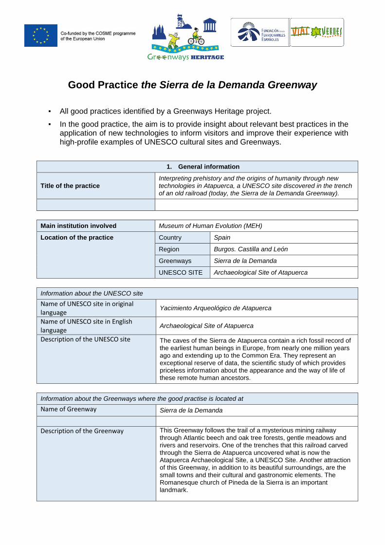
Title of the practice Interpreting prehistory and the origins of humanity through new technologies in Atapuerca, a UNESCO site discovered in the trench of an old railroad (today, the Sierra de la Demanda Greenway).
Main institution involved Museum of Human Evolution (MEH)
Location of the practice Country Spain
Region Burgos. Castilla and León
Greenways Sierra de la Demanda
UNESCO SITE Archaeological Site of Atapuerca
Information about the UNESCO site
Name of UNESCO site in original language
Yacimiento Arqueológico de Atapuerca
Name of UNESCO site in English language
Archaeological Site of Atapuerca
Description of the UNESCO site
The caves of the Sierra de Atapuerca contain a rich fossil record of the earliest human beings in Europe, from nearly one million years ago and extending up to the Common Era. They represent an exceptional reserve of data, the scientific study of which provides priceless information about the appearance and the way of life of these remote human ancestors.
Information about the Greenways where the good practise is located at
Name of Greenway Sierra de la Demanda
Description of the Greenway
This Greenway follows the trail of a mysterious mining railway through Atlantic beech and oak tree forests, gentle meadows and rivers and reservoirs. One of the trenches that this railroad carved through the Sierra de Atapuerca uncovered what is now the Atapuerca Archaeological Site, a UNESCO Site. Another attraction of this Greenway, in addition to its beautiful surroundings, are the small towns and their cultural and gastronomic elements. The Romanesque church of Pineda de la Sierra is an important landmark.
From Arlanzón to Monterrubio de la Demanda (Burgos). Length: 54 km
2. Detailed description
Detailed information on the practice
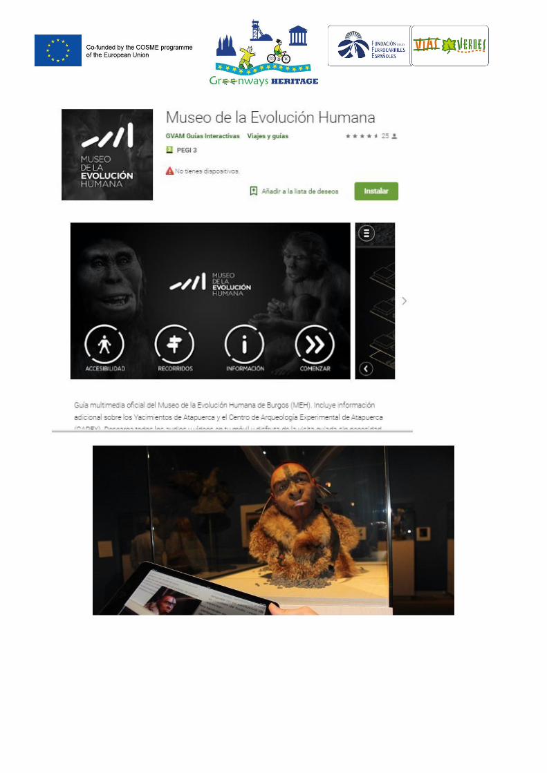
The Museum of Human Evolution (MEH), which offers an extensive interpretation of prehistory and the Atapuerca Archaeological Site (UNESCO), has always been committed to new technologies. It has recently designed interactive postcards for a temporary exhibition and has presented material using new technologies since 2011, also providing important accessible information tools for people with disabilities. With the new interactive postcards, visitors can just scan one of the most symbolic pieces of the museum such as the Feathered Neanderthal using their 'smartphone' or tablet. With the free augmented reality application called 'Layar', they can see and listen to the interactive content on the postcard, which includes a video, MEH activities and access to social networks. It is available for Android and iOS and requires an internet connection. This type of technology is essential for providing augmented reality services and makes it possible to bring real objects such as this sculpture to life and so that visitors can interact with them. In this case, visitors can watch a video in which Juan Luis Arsuaga, scientific director of the Museum, explains the exhibition. They can also access the Museum's activities, social networks and contact the booking centre. The Museum gives these postcards to people who visit one of the five daily micro-explanations about the museum's permanent exhibition or one of the six explanations about the 'Change of Image. A New Vision of the Neanderthals' exhibition. The MEH also uses new technologies for other services:
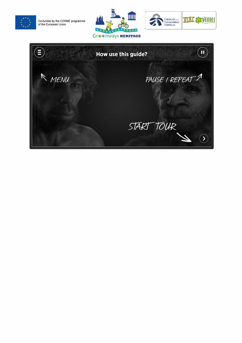
- The MEH app (latest version April 2015), is the official multimedia guide. It includes additional information about the Atapuerca archaeological sites and the Atapuerca Experimental Archaeology Centre (CAREX). Visitors can download all the audio and video material to their mobile device and enjoy a guided tour with no need for an internet connection. It includes games, animation, interactive content, videos and additional information throughout the tour of the museum making it a more interactive and dynamic experience. Also, those who don't have a smartphone can rent a device in the museum for just €3. The content on the application is suitable for visitors of all ages.
Thanks to the support of Fundación Orange and GVAM within the
framework of the Áppside project, this application and all of its content is accessible to people with visual and hearing disabilities, with subtitles, audio descriptions and videos in Spanish Sign Language (LSE). Available for iOS and Android devices in Spanish and English. Free download
- Interactive Teaching Activities 'Digital Art History Projects',
through the Castile and Leon Regional Council Ministry for Development. It offers a series of interactive teaching activities that are installed on various touch terminals on the first floor of the museum for primary school students as well as high school
students and adults. These teaching programmes were created using high-quality 3D digitalisation and high resolution texturing of 40 pieces chosen by the MEH.
- Sign Guides In 2011, the MEH incorporated the sign-guide
service, a tool that aims to bring art and culture to all citizens, including people who are deaf or hearing impaired, so that they can expand their knowledge about the origin and evolution of mankind. These devices utilise technology to enhance accessibility, to eliminate physical and sensory barriers, to provide information and to make the museum more accessible to everyone.
This portable multimedia includes videos with recordings in Spanish sign language and subtitles with explanations. Visitors can navigate through a menu and select each exhibit. They were made by the company 'Mira que te digo', from the Auditory Re-education for the Deaf Association in Burgos.
- All these technologies and services are complemented by the
use of audio-guides in three languages (English, French and Spanish).
It is important to note that the link between the Atapuerca site and the old railroad trenches that led to the discovery of this site is always present in the museum's content and the applications for its interpretation. More than 50 km of this railway, except for part where the Archaeological site is, has been recovered as the Sierra de la Demanda Greenway and is therefore the link that connects the UNESCO site and Greenways.
Please describe why this can be considered as INNOVATIVE way interpretation of heritage
This is considered Innovative because the MEH is an interpretation space for the UNESCO site whose technology has evolved constantly since it opened in 2010 in its search for universally accessible systems and because the museum integrated the declaration of the Atapuerca archaeological sites as a World Heritage Site in 2015, when they were classified by UNESCO as a place of exceptional universal value. Thus, the research and promotion infrastructures associated with the archaeological sites, such as the MEH, were included.
Resources needed
[300 characters] Please specify the amount of funding/financial resources used and/or the human resources required to set up and to run the practice.
As can be seen in the descriptive section, most of the technologies have been designed in partnership with public entities but also with private entities through companies and foundations, and even with support and collaboration from the disability association sector (e.g. Fundación CNSE, State Confederation for the Deaf). All this has led to collaborative projects that have improved visitor experience through new technologies. The investments made into these technological applications are unknown.
Maintenance costs and requirements needed
Not known.
However, the 2017 accounts for the Atapuerca Foundation are published. See>>, As well as the Activities Report of the MEH 2017. See>>
Timescale (start/end date) e.g. June 2012 – May 2014/ongoing
The MEH opened its doors in 2010 and since then new technologies have been used extensively in the exhibition's educational materials and in all the applications and mobile devices. This is especially useful for interpreting and recreating historical and prehistoric eras through the findings discovered in the Atapuerca Archaeological Site.
Evidence of success (results achieved)
The official app of the Museum, the Atapuerca Archaeological Site and CAREX is widely used and greatly valued:
- More than 10,000 downloads - Rating by users: 4.6 (on a scale of 1 to 5) - 25 user comments
Other success data is linked to visits to facilities in the Atapuerca system, for example the spaces linked to the UNESCO Atapuerca Archaeological Site (the museum, the archaeological site and CAREX) according to the latest report published on 2017:
- 625,281 visitors. 5% more than in 2016 o MEH. 376,023 o Archaeological site: 80,601 o Carex: 42,169
- 92,078 followers on social networks - 14 temporary exhibitions
Difficulties encountered/ lessons learned
Lessons learned: Keeping the processes simple makes it easier to implement them and makes communication and information systems based on new technologies more usable. This enables anyone to use them quickly and efficiently. In recent years, new technologies have brought knowledge to groups who previously experienced great difficulties accessing it through traditional systems. Groups of people with disabilities are especially vulnerable. Tools such as audio guides, accessible apps and sign guides are attracting tourists with accessibility needs as well as senior tourists to cultural and knowledge spaces.
Potential for learning or transfer
Although each UNESCO space has its idiosyncrasies, these types of technologies are exportable to other types of resources that recreate historical moments with new and innovative ways of approaching knowledge and recreating past and historical realities. The inclusion of accessible technologies also applies to other similar spaces.
Further information
Download the MEH app:
https://play.google.com/store/apps/details?id=burgos.gvam
Info about MEH. http://www.museoevolucionhumana.com/en/
Info about the Greenway:
http://www.viasverdes.com/en/itineraries/itinerario.asp?id=35
Info about the UNESCO Site:
https://whc.unesco.org/en/list/989
https://www.atapuerca.org/
Please add some pictures of the practice
(See Below)
Video of the good practice ( if applicable)
Sierra de la Demanda Greenway + Atapuerca UNESCO Site video:
Short version (9 min): https://www.youtube.com/watch?v=YgLXCDFARy8
Long version (28 min.): https://www.youtube.com/watch?v=J9SqjQ08OEQ
These videos made by the FFE and with aerial recordings could also be considered a good practice given that both resources are included in the same audio-visual material. To date there has been no audio-visual or other material that jointly promotes both resources.
Atapuerca UNESCO Site video:
https://whc.unesco.org/en/list/989/video
MEH video. https://youtu.be/jzdJmBpkb_0
MEH YouTube Channel (several videos):
https://www.youtube.com/user/museoevolucionhumana?feature=
mhee
Contact details
Name
Museo de la Evolución Humana
Paseo Sierra de Atapuerca s/n.09002 Burgos (España) [email protected] Tel: +34 947 421 000
Organisation
The Museum of Human Evolution of Burgos was created as a modern and excellence bid for Junta de Castilla y León (regional government), Burgos Town Hall and the Atapuerca Research Team to build a new patrimonial infrastructure, appropriate to the findings of Sierra de Atapuerca Site.
The main purpose was to provide Burgos with a modern museum which could hold not only the findings at Atapuerca Sites, but also the scientific disciplines involved and the scientific interpretations and theories drawn form them. Also, this museum tries to offer a holistic vision of human presence on the Earth and give, in the new theories about human evolution, the rightful place for these exceptional sites located in these mountains of Burgos.
But the MEH is not only an exhibition centre, it is also a highly recognized, innovative and appealing centre of scientific divulgation aimed at all audiences. For this reason, it was provided with a spectacular and symbolic architecture. A museography appropriate to the 21st century, the building holding it, the Human Evolution; and with a highly-trained team able to transmit and translate this knowledge.
The MEH was created to become a national and international reference as a museum and centre of scientific divulgation to explain those important issues about our past, present and future as species. Due to this, it is not only a museum of our ancestors, but also a place to reflect on the present of our species Homo sapiens, gifted with abilities which allow us to change the world.
Greenways Heritage project Partner presenting the Good Practice:
Fundación de los Ferrocarriles Españoles. Greenway area.
www.viasverdes.com
[email protected] / [email protected]
Publications regarding the practice (If applicable)
Museum of Human Evolution. 2017 Report.
http://www.museoevolucionhumana.com/media/memoria_2017/
memoria2017.pdf
Good Practice “From Vizcaya Bridge to the Montes de Hierro Greenway
guided by the Basque Country public transport system app.”
▪ All good practices identified by a Greenways Heritage project.
▪ In the good practice, the aim is to provide insight about relevant best practices in the application of new technologies to inform visitors and improve their experience with high-profile examples of UNESCO cultural sites and Greenways.
1. General information
Title of the practice From Vizcaya Bridge to the Montes de Hierro Greenway guided by the Basque Country public transport system app.
Main institution involved BizkaiBus and Enkarterrialde Rural Development Association
Location of the practice Country Spain
Region Bizkaia Basque Country
Greenways Montes de Hierro
UNESCO SITE Puente de Vizcaya
Information about the UNESCO site (add more rows if needed for each UNESCO sites)
The UNESCO site in original language Puente de Vizcaya
Name of UNESCO site in English language
Vizcaya Bridge
Description of the UNESCO site (max. 500 characters, spaces included)
Vizcaya Bridge straddles the mouth of the Ibaizabal Estuary, west of Bilbao. It was designed by the Basque architect Alberto de Palacio and completed in 1893. The 45-m-high bridge with its span of 160 m, merges 19th-century ironworking traditions with the then new lightweight technology of twisted steel ropes. It was the first bridge in the world to carry people and traffic on a high suspended gondola and was used as a model for many similar bridges in Europe, Africa and America only a few of which survive. With its innovative use of lightweight twisted steel cables, it’s regarded as one of the outstanding architectural iron constructions of the Industrial Revolution
Information about the Greenways where the good practise is located at
Name of Greenway Montes de Hierro
Description of the Greenway (max. 500 characters, spaces included)
Montes de Hierro Greenways network is a journey through the underground history of Vizcaya. Because for centuries iron moulded the landscape, the life, and the character of this region, before the alchemy of the Guggenheim museum clad it in shining titanium. This
Greenway network is a must for anyone wishing to discover the roots of our cosmopolitan 21st century Greater Bilbao by following the path of these iron arteries which in bygone days forged the city and its surroundings. These trails whisper to their travellers a mute testimony from centuries gone by, relating legends from the Roman Empire to the Industrial Revolution and revealing like an open book all the secrets of the men and women of iron who were behind them. From Traslaviña (Artzentales) - Kobaron (Muskiz). Vizcaya. Length: 42.5 km
2. Detailed description
Detailed information on the practice
[1500 characters] Please provide information on the practice itself. In particular:
- What is the problem addressed and the context which triggered the introduction of the practice?
- How does the practice reach its objectives and how it is implemented? - Who are the main stakeholders and beneficiaries of the practice?
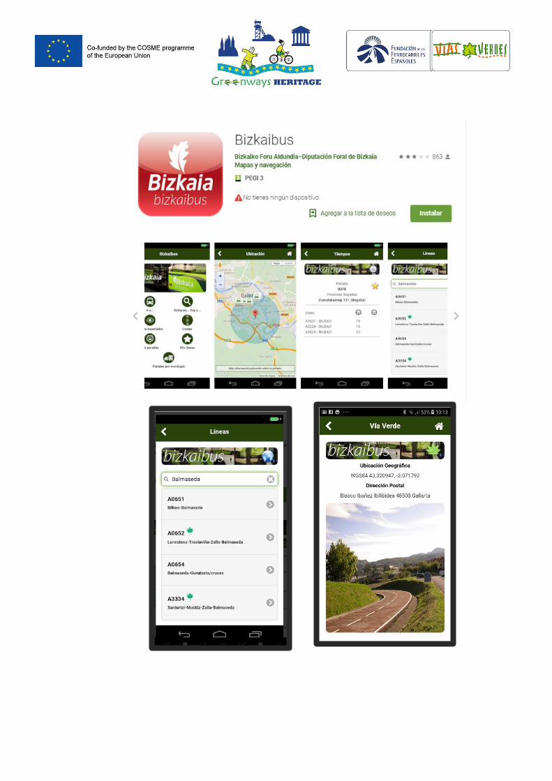
The Basque Country Provincial Council's Department of Transport, Mobility and Cohesion has renewed the app developed by public road transport company Bizkaibus to include access information from Bilbao and the Vizcaya Bridge, UNESCO Heritage to the Montes de Hierro Greenway. Bizkaibus is the public transport service for bus passengers from the Basque Country managed by the department. This provides convenient public transport from this UNESCO site to the Greenway and the app provides details on how to take the bus to any of the access points on this itinerary. The initiative has been developed jointly by the Enkarterrialde Rural Development Association that manages this Greenway and the Basque Country Provincial Council. The initiative arose within the framework of the Greenway's institutional working group in which this provincial administration transport department participates. The free application is available on Android and on iOS devices and all the information is available in Spanish, Basque and English. The best feature is the leaf icon that this app uses to highlight the bus stops with nearest access to the Greenway. There are a total of 17 stops corresponding to 10 Bizkaibus lines that provide access not only from Bilbao and from the UNESCO site but also from several points in the province of Vizcaya, as well as to and from the other two provinces in the Basque Country: Alava and Gipuzkoa. There is also a gallery of images that shows a small route from the selected bus stop to the access to the Greenway. The photographs clearly describe the route from the moment the person gets off the bus up to the access to the Greenway. The green leaf icon indicates that the stop is near the Greenway. Click the icon to find out how to get there. This public transport company joins this initiative to support and promote the Montes de Hierro Greenway and its cultural and environmental resources while promoting the use of public transport (not just on
weekdays) and also to encourage leisure activities and free time on bank holidays. Along the Greenway there are new information panels that have a QR code with which you can access all kinds of information related to the Montes de Hierro Greenway, as well as the location of the nearest bus stops.
Please describe why this can be considered as INNOVATIVE way interpretation of heritage
Fundamentally, it is an innovative and sustainable way to access public transport to visit the UNESCO Site and the Greenway, providing information about it through the App for mobile devices.
Resources needed
[300 characters] Please specify the amount of funding/financial resources used and/or the human resources required to set up and to run the practice.
There have been no direct costs for the development association that manages the Greenway, except for the human resource hours dedicated to finding the information and providing it to the Basque Country Provincial Council's Department of Transport, Mobility and Territorial Cohesion. Enkarterrialde, the Greenway's managing body, has provided the Basque Country Provincial Council's Department of Transport, Mobility and Territorial Cohesion with information on the route that bus travellers in the Basque Country require on bus stops close to the Greenway to be able to access the UNESCO site (Basque Country Suspension Bridge). Lines, stops and schedules and visual documentation was identified. The Basque Country Provincial Council's Department of Transport, Mobility and Territorial Cohesion sent the information to its IT department, who incorporated the information into the Bizkaibus App (public transport for bus passengers in the Basque Country). As previously mentioned, this action was conceived in the Greenway institutional work group, in which the provincial administration participates. It is therefore a participatory and collaborative action.
Maintenance costs and requirements needed
It is important to note that this app is maintained by the public bus company, which means that there no cost for the Greenway management entity (nor for the UNESCO site management entity). The provincial mobility department therefore takes care of any updates required.
Timescale (start/end date)
e.g. June 2012 – May 2014/ongoing
Although there have been previous versions, the App has been operational since April 2017 including information on the connections with the Montes de Hierro Greenway. However, the latest version from September 2018 includes new improvements.
Evidence of success (results achieved)
[500 characters] Why is this practice considered as good? Please provide factual evidence that demonstrates its success or failure (e.g. measurable outputs/results).
The app is extensively used and greatly valued:
- More than 100,000 downloads
- Rating by users: 3.1 (on a scale of 1 to 5) - 861 comments from users
Difficulties encountered/ lessons learned
[300 characters] Please specify any difficulties encountered/lessons learned during the implementation of the practice.
Difficulties: Identifying all the lines and connections with the Greenway and the UNESCO site with georeferencing and the photographic carousel in the application.
Lessons learned:
Keeping the processes simple makes it easier to implement them and makes communication and information systems based on new technologies more usable. This enables anyone to use them quickly and efficiently.
Potential for learning or transfer
[1000 characters] Please explain why you consider this practice (or some aspects of this practice) as being potentially interesting for other regions to learn from. This can be done e.g. through information on key success factors for a transfer or on, factors that can hamper a transfer. Information on transfer(s) that already took place can also be provided (if possible, specify the country, the region – NUTS 2 – and organisation to which the practice was transferred)
[Technical: A good practice be edited throughout a project life time (e.g. to add information on the transfers that have occurred)]
The purpose of this action is to publicise the Greenway and to facilitate the use of sustainable mobility to the UNESCO site by innovating in communication processes through an app and new technologies. These objectives will almost certainly be shared by the mobility and transport areas of the public administrations that manage public transport systems.
Therefore, this good practice can easily be replicated by other public transport companies (private and public) that have itineraries between the UNESCO sites and the Greenways (or from any city or urban or cultural space to non-motorised itineraries). Thus, the information provided to travellers interested in this type of resource (Greenways) will be improved offering more sustainable access to these itineraries. User experience will also be improved.
In many cases, adapting this practice to other places will be easy and will entail adding new functionality to the existing public transport app. This also provides greater interrelation between the Greenway management entities and the transport systems, thereby having a dual purpose.
Further information
Link to where further information on the good practice can be found
Download the app: https://play.google.com/store/apps/details?id=com.lantikdesagmail.com.bizkaibus&hl=es_419
Bizkaibus website: http://web.bizkaia.eus/es/web/bizkaibus
E-mail: [email protected]
Telephone: + 34 946 125 555
Info about the Greenway:
http://www.viasverdes.com/en/itineraries/itinerario.asp?id=109
http://enkarterrialde.eus/Burdinmendi
http://burdinmendi.enkarterrialde.eus/
Info about the UNESCO Site:
https://whc.unesco.org/en/list/1217
https://puente-colgante.com/
Please add some pictures of the practice
(See Below)
Video of the good practice ( if applicable)
Montes de Hierro Greenway video:
http://enkarterrialde.eus/public/video/ENKARTERRI_VIA_VERDE_V3.mp4
Bizkaibus video: http://streaming.bizkaia.eus/Lantik/BIZKAIBUS/BIZKAIBUSWEB.mp4
Vizcaya Bridge UNESCO Site:
https://whc.unesco.org/en/list/1217/video
https://puente-colgante.com/videos/ (several videos)
Contact details
Name
Asociación de Desarrollo Rural Enkarterrialde Barrio San Miguel s/n (Edificio del Ayuntamiento) 48870 Artzentales – Bizkaia. Spain
Telephone: +34 94 610 95 90 Fax: + 3494 610 93 90
Organisation
Enkarterrialde is the rural development association of the Basque Country region of Las Encartaciones. It is a reference for the actions that promote the region's socioeconomic development. Its main objective is to support economic diversification projects in the rural area, thus improving the quality of life of Las Encartaciones citizens.
Email [email protected]
Greenways Heritage project Partner presenting the Good Practice:
Fundación de los Ferrocarriles Españoles. Greenway area.
www.viasverdes.com
[email protected] / [email protected]
Publications regarding the practice (If applicable)
Not applicable
1
Good Practice Combe Down Tunnel Multi-sensory Artwork
All Good Practices identified by a project Greenways Heritage.
The good practise aim is to provide an insight about relevant best practices in the application of new technologies to inform visitors and improve their experience with high-profile examples of UNESCO cultural sites and greenways.
1. General information
Title of the practice Combe Down Tunnel Multi-sensory Artwork
Main institution involved Sustrans developed the greenway route and coordinated the funding partnership with Bath & North East Somerset Council.
Location of the practice Country
United Kingdom
UKK12
Region South West England
Greenways Two Tunnels greenway
UNESCO SITE Bath
Contact of the Good practice managing authority
SUSTRANS :
Email: [email protected]
Address:
Head office
2 Cathedral Square
College Green
Bristol
BS1 5DD
Phone number: Tel: +00 (0)117 926 8893
Information about the UNESCO site (add more rows if its needed for each UNESCO sites)
Name of UNESCO site in original language
City of Bath
Name of UNESCO site in English language
City of Bath
Description of the UNESCO site
Founded by the Romans as a thermal spa, Bath became an important centre of the wool industry in the Middle Ages. In the 18th century, under George III, it developed into an elegant town with neoclassical Palladian buildings, which blend harmoniously with the Roman baths. https://whc.unesco.org/en/list/428
Information about the Greenways where the good practise is located at
Name of Greenway Two Tunnels Greenway
2
Description of the Greenway
The Two Tunnels Greenway connects the city of Bath (UNESCO site) to the village of Midford and the countryside to the south. It is built on a disused railway line, and passes through the UK’s longest walking and cycling tunnel (Combe Down).
However, whilst the tunnels provide the centrepiece for the greenway, the route is much more than just the tunnels. The route is exemplary because there are no compromises along its length, providing continuity at two road crossings in the form of new bridges and the refurbished Tucking Mill viaduct to the south of the scheme.
The greenway is accessible for anyone. As well as being a route for commuting and leisure, the greenway also creates a linear green open space, right in the city centre.
2. Detailed description
Detailed information on the practice
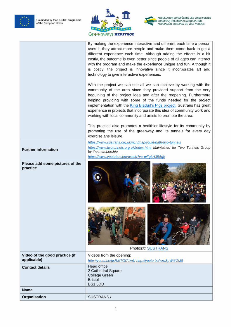
Production of a public artwork consisting in a light and sound art installation in 20 locations in Combe Down Tunnel.
Produced by United Visual Artists, called The Passage, drawing upon the idea of the historic railway, a digital track is weaved through the fabric of the tunnels. As the visitor journeys through the tunnel he/she will discover a series of alcoves that are occupied by guardian objects that resonate light and sound. Each of these independent units has a unique musical and visual score. The installation works on three different levels the unit, together in clusters and all as a whole. Each cluster of 2-3 units has a particular character using frequency, texture and movement. The sound, created by artist Mira Calix, adjust to the speed of the people walking or cycling there making it interactive while giving the user the ability to compose new symphonies each time. Calix composed 16 violas and cello scores that where placed on the 20 recesses along the length of the tunnel. The clusters all together create the overall sound and light-scapewhich covers the central part of the Combe Down Tunnel.
Sustrans has an art programme and is very keen to "customising" through art the new greenways. In addition, Sustrans always works in close collaboration with local communities and volunteers involved in the projects. Since before starting, the tunnels had already a lot of popularity with the community, to make them even more attractive than they already where.
A strong driving force behind the implementation was the Two Tunnels Group, a community organisation set up to promote the route. The Group coordinated a substantial range of fundraising activity. The King Bladud’s Pigs project (http://www.kingbladudspigs.org/ was one of the fundraisers they did to earn money, since the area has a lot of artist, the project got them to help. They created and decorated some pig sculptures that at first where displayed around the city of Bath and then they were auctions and the proceeds went to the project of Two Tunnels. They ended up raising 200.000 pounds with the project. Sustrans in collaboration with local action groups organized visits to collect ideas for the transformation of the tunnel, from the community and by other activities.
Please describe why this can be considered as INNOVATIVE way interpretation of heritage, best accessibility, providing the information about the greenways
Adding this artwork to the tunnel gave the user the experience of the United Kingdom’s rail industry history. The installation provides another unique element to people’s experience of walking and cycling through the UK’s longest walking and cycling tunnel.
3
etc. Since every time you use the tunnel the symphony will change, the person will want to come back to conduct different sounds depending on their speed and presence. The artwork done for the tunnel has converted the tunnel in an attraction in its self, atracting more people.
Resources needed
The total cost of the scheme of the Two Tunnels Greenways is £4,300,000 (€5,018,659)
There is not available information regarding the budget for the Art Work production.
Maintenance costs and requirements needed (if applicable)
Not available information
Timescale (start/end date) Campaign started in 2005 and the greenway opened in April 2013 – April 2019 (ongoing
Evidence of success (results achieved)
On the opening (April, 2013) day demand was so high, that 1,600
people, walking and cycling were counted through the tunnel in the first
hour after opening, and the queue to enter the tunnel remained for over
four hours. The ‘first through’ event included a the community festival
that was attended by approximately 8,000 people.
The Two Tunnels attract and average of 520 daily cycle journeys which
mean they are in constant use and this represent a 2376% increase in
daily cycle traffic on parts of Linear Park.(data 2013).
Since the community had a big part in the project making them feel
more connected to the area.
The project also promotes small business such as pubs and hotels in
the vicinity.
Difficulties encountered/ lessons learned (if applicable)
Works for implementing the project, that included the reopening of the
tunnels, demanded years and a very important budget.
Maintenance is a important issue, specially for tunnels, since they are
vey important infrastructures and maintaining the structure require
specialised personal, survey and works.
Working wiht / and the strong commitment with community, is key for
the success of the project. Money is always a problem we encounter
but when the project is well planned and counts wiht the involvement of
the key stakeholders and the local community the ground for the suces
of the sheme are higher. In this case the community was so proactive
they helped with this issue by stating a fundraiser based on several
activites and specilly the pig sculptures.
A systematic issue is vandalism and to maintain security, there are 3-4
cameras in the area to patrol it.
Potential for learning or transfer (if applicable)
Many areas in Europe and abroad have abandoned railways and
tunnels that can be used as greenways for the surrounding community
as well as tourism. We can use this example and implement it in other
parts of the world that count with abandoned railway tunnels in areas
where cycling and outdoor activities are frequent.
1
Good Practice AUDIO GUIDED UNESCO BIKE TOUR and UNESCO PROMENADE IN LUXEMBOURG
All Good Practices identified by a project Greenways Heritage.
The good practise aim is to provide an insight about relevant best practices in the application of new technologies to inform visitors and improve their experience with high-profile examples of UNESCO cultural sites and greenways.
1. General information
Title of the practice
AUDIO GUIDED UNESCO BIKE TOUR and UNESCO PROMENADE IN LUXEMBOURG
Tours by the National Commission for cooperation with UNESCO
Main institution involved Ministère de la Culture Luxembourg
The Luxembourg Commission for Cooperation with UNESCO
Location of the practice Country Grand Duchy of Luxembourg
Region Luxembourg
Greenways Echternach Greenway
UNESCO SITE Luxembourg City: old neighborhoods and fortifications
Contact of the Good practice managing authority
https://unesco.public.lu/en/structure/commission-nationale.html
Contact information below as published on the web site.
Email: Mail : [email protected]
Address: Adress : Ministère de la Culture
4, blv. Roosevelt L-2450 Luxembourg
Phone number: Phone : (+352) 247-76620
Information about the UNESCO site (add more rows if its needed for each UNESCO sites)
Name of UNESCO site in original language
Ville de Luxembourg : vieux quartiers et fortifications
La procession dansante d’Echternach (inmaterial heritage)
Name of UNESCO site in English language
Luxembourg City: old neighborhoods and fortifications
Hopping procession of Echternach (inmaterial heritage)
Description of the UNESCO site
Because of its strategic position, Luxembourg was, from the 16th century until 1867, when its walls were dismantled, one of Europe's greatest fortified sites. It was repeatedly reinforced as it passed from one great European power to another: the Holy Roman Emperors, the House of Burgundy, the Habsburgs, the French and Spanish kings, and finally the Prussians. Until their partial
2
demolition, the fortifications were a fine example of military architecture spanning several centuries1.
Inscribed in 2010 on the Representative List of the Intangible Cultural Heritage of Humanity. Each year, on the Tuesday of Pentecost (a Christian religious festival), the hopping procession of Echternach (Iechternacher Sprangprëssioun) takes place in the medieval town centre of Echternach, the oldest city in Luxembourg. Documented since the year 1100, the procession is founded on the cult of Saint Willibrord, a monk and founder of the Abbey of Echternach, revered for his missionary activities, his kindness and gift of curing certain illnesses2.
Information about the Greenways where the good practise is located at
Name of Greenway Piste Cyclable d'Echternach
Description of the Greenway
Echternach greenway conects Luxembourg- City with Echternach via Ernster, Junglinster, Bech et Consdorf. It uses uses the track of an old railway line.
The Echternach greenway starts in the country's capital, the City of Luxembourg. From the first rounds of wheels, you will cross the iconic Pont Rouge and enjoy a magnificent view of the Alzette Valley and the old town and its fortifications classified as World Heritage by Unesco.Once the region of the capital left behind you, change of scenery: you enter the heart of the "Little Switzerland Luxembourgeoise". This country is characterized by dense forests crossed by spectacular formations of rocks shaped by erosion. The route ends in Echternach, considered as the historical and cultural capital of the region. Take the time to discover its abbey, its Roman villa, its ramparts and narrow streets that make all the charm of this city that has kept a certain medieval atmosphere.3
This itinerary that connects the Echternach Greenway with the UNESCO heritage area of old Neighborhoods and Fortifications of the city of Luxembourg, has been introduced in the tourism GIS (Geographic Information System) created within the framework of the European project Greenways Heritage co-funded by the EU COSME Programme. See the link here>>
1 www.whc.unesco.org 2 https://ich.unesco.org 3 https://www.visitluxembourg.com/fr/
3
2. Detailed description
Detailed information on the practice
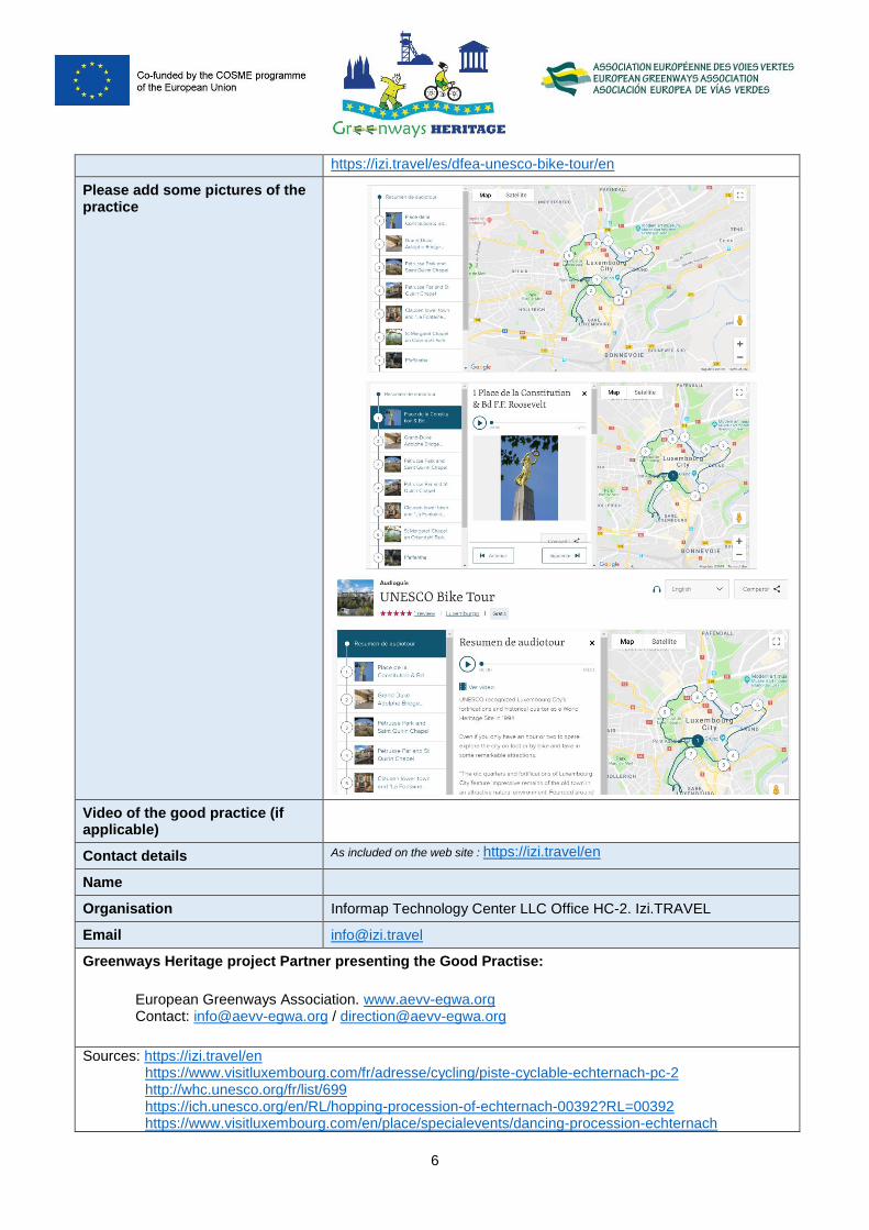
The practice consists in two audio guided tour: UNESCO BIKE TOUR IN LUXEMBOURG and UNESCO PROMENADE, using the online platform Izi.TRAVEL (the storytelling platforme).
Izi.TRAVEL is a global, open and free space, that allows any user to create audio guides. It is one of the most used audio guided platforms. The main motivation of this platform is to connect cities, museums and their stories with travelers from all over the world, in order to get to know beforehand and thus, to take a first contact with the sites that will be later visited in situ; being the cultural, heritage and tourism sectors which have priority to be promoted in this app.
It was developed in 2011 by a team of Dutch innovators who joined forces with a Swiss investor with the aim of connecting cities, museums and their stories with travellers who wanted to explore the world in a brand new, innovative way: via a global, open and free platform. 4
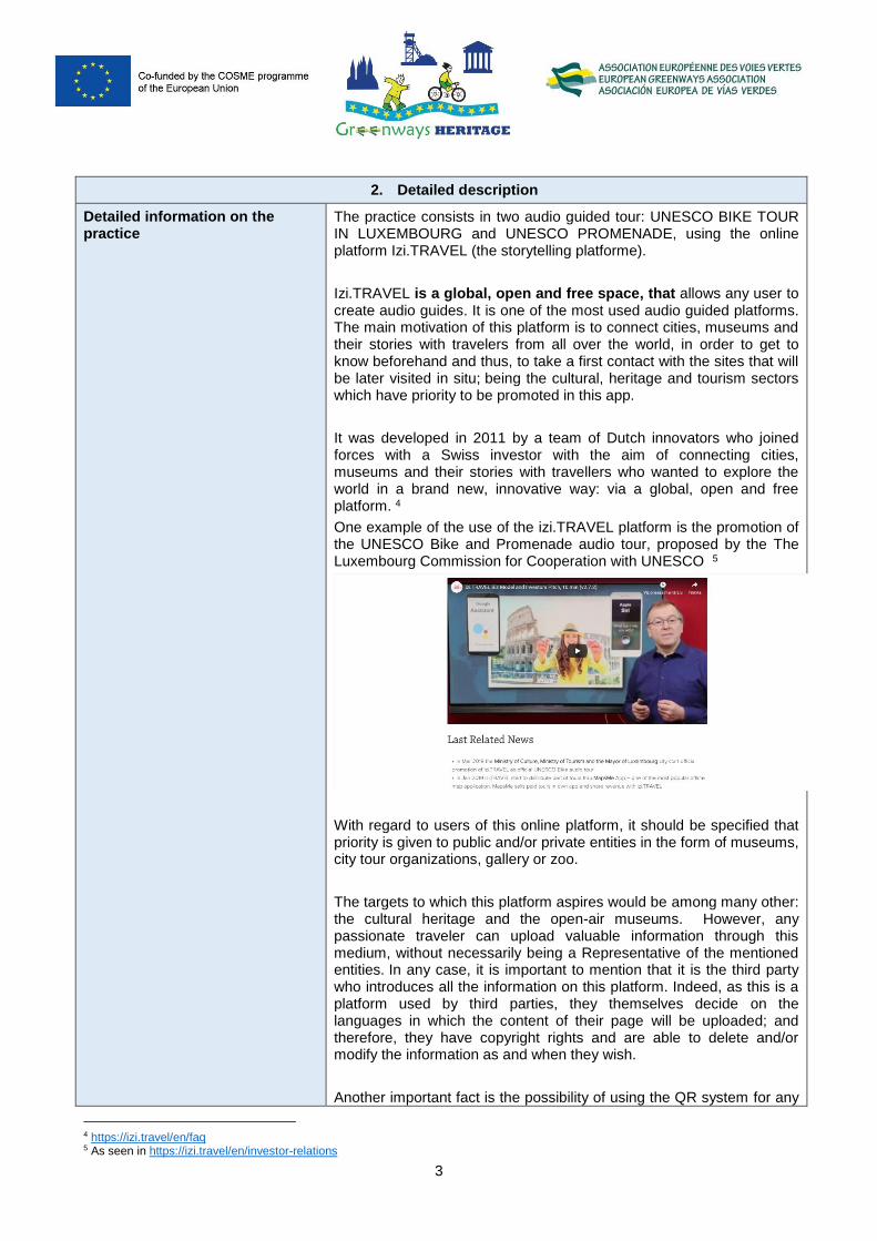
One example of the use of the izi.TRAVEL platform is the promotion of the UNESCO Bike and Promenade audio tour, proposed by the The Luxembourg Commission for Cooperation with UNESCO 5
With regard to users of this online platform, it should be specified that priority is given to public and/or private entities in the form of museums, city tour organizations, gallery or zoo.
The targets to which this platform aspires would be among many other: the cultural heritage and the open-air museums. However, any passionate traveler can upload valuable information through this medium, without necessarily being a Representative of the mentioned entities. In any case, it is important to mention that it is the third party who introduces all the information on this platform. Indeed, as this is a platform used by third parties, they themselves decide on the languages in which the content of their page will be uploaded; and therefore, they have copyright rights and are able to delete and/or modify the information as and when they wish.
Another important fact is the possibility of using the QR system for any
4 https://izi.travel/en/faq 5 As seen in https://izi.travel/en/investor-relations
4
tourist resource which counts with this option, making it easier for the user to connect with all the informations needed.
Please describe why this can be considered as INNOVATIVE way interpretation of heritage, best accessibility, providing the information about the greenways etc.
The market of audio guides used through mobile technology, is still a practice in a state of consolidation but with a lot of potential to increase its number of users. It is worth mentioning that it is being applied mainly in the heritage tourism market and the fact that the Greenways Heritage Project is working intensely in the nexus between the greenways and the destinations that have UNESCO heritage sites, can mean a safe bet to increase the interest between these two tourist destinations. It is a creative and innovative way of bringing the natural and patrimonial heritage closer in a technological way. The use of audio guides, is an easy way of listening to interesting information before or during the trip by bike or on foot. Through the storytelling used by audio guides, tourists can enrich their experiences and receive the information before, when preparing the trip or in real time while passing through those tourist destinations. Also, users can upload videos of the itinerary and share them with the platform’s community, being this another interactive asset to stimulate the decision-making of future travelers to the choosen itineraries. On the other hand, the advantage of including a wide range of languages, makes this platform becoming a global space, used and understood by all, without the need to opt for an international language to enjoy the audio guides. Everyone can do it in their own language.
Resources needed
The use of the platform is free, so there is no cost involved in creating an audio guide by using this specific platform.
Human resources, own staff or external cost, to create the content (e.g. specialists who know the itinerary and its recourses well).
Obviously, the larger and rich in resources itinerary, the more time it takes to dedicate to its implementation on the platform.
Maintenance costs and requirements needed (if applicable)
The cost of using the Izi.TRAVEL platform is free, which implies that there are no hidden costs. There are also no mantainance costs. The information will be updated only when new data is integrated.
Timescale (start/end date) Since March 2019.
Evidence of success (results achieved)
Izi.TRAVEL platform has accumulated over 10.000 free guided tours in
2.250 cities over 100 countries and in 58 languages. The usage of
these guided tours is growing 100% per year organically. In 2015, the
platform reached 1.000.000 downloads, thus becoming the Most
Popular Audio Guide App in the World. That success led to Apple
recently featuring Izi.TRAVEL as one of its "Best New Apps" for
the iPad and iPhone. In the Google Play Store, Izi.TRAVEL has
5
received the 500.000 downloads badge and, as a result, it officially
makes it the most popular audio guide in the world for Android
Users. So much for their success that, more than 460.000 users each
month use the app to enrich their travels.
In addition to all these data of special importance, the platform in
January 2019 started to distribute part of tours through MapsMe App –
one of the most popular offline applications. In addition, on October
2018 the platform won the Hospitality Innovation Award for major
achievements in the International Hospitality Industry from PKF
Hotel Experts.
Difficulties encountered/ lessons learned (if applicable)
Creating audio guides of a tourist itinerary represents an attractive and
comfortable way to publicize the historical-cultural and natural heritage
of a certain territory and offer audio-visual information with the aim of
promoting these tourist resources as well as bring closer the potential
future tourist with all this rich assets.
To facilitate the use of this platform, several easy and quick tutorials
have been created with all the steps to follow. Therefore, the user has
the opportunity to enhance its own experience in creating an audio
guide. Izi.TRAVEL has a YouTube channel where tutorials are being
uploaded along with other interesting and useful data. Users have the
opportunity of leaving comments and interact with each other, sharing
their know-how with others.
Potential for learning or transfer (if applicable)
This practice of promoting the tourist resources of the city of
Luxembourg through an audio guided itinerary is an attractive,
innovative, efficient and effective way to publicize the heritage and
natural assets of the tourist destination. Bearing in mind that the
promoter of this practice is constituted by several public entities of
Luxembourg, and that the platform use does not imply any monetary
cost it can become a practice used by other public entities from other
countries, cities, etc. The transferability of this practice is welcomed for
other public entities that wish to promote their tourist destinations in a
different and attractive way.
It is an easy, quick, comfortable and interactive way to present the
potentials of a tourist destination through the mean of storytelling
(audio guides) platforms. Experts in these territories make their
resources available through audio-visual documents that enrich the
tourist experience. Users can opt for using any language they want in
order to transmit their information through the use of audio guides.
There isn’t any language limit. This permits tourists to enjoy the tours in
their own language making the experience even more enjoyable and
relaxed.
Also, with the help of tutorials, users have the opportunity of learning
how to create an audio guide and follow step by step the instructions
made in a quick and easy way.
Further information
Mail page: https://izi.travel/en Date of query: June 2019
Route itineraries pages:
https://izi.travel/es/1c8e-unesco-promenade/en (
6
https://izi.travel/es/dfea-unesco-bike-tour/en
Please add some pictures of the practice
Video of the good practice (if applicable)
Contact details As included on the web site : https://izi.travel/en
Name
Organisation Informap Technology Center LLC Office HC-2. Izi.TRAVEL
Email [email protected]
Greenways Heritage project Partner presenting the Good Practise:
European Greenways Association. www.aevv-egwa.org Contact: [email protected] / [email protected]
Sources: https://izi.travel/en https://www.visitluxembourg.com/fr/adresse/cycling/piste-cyclable-echternach-pc-2 http://whc.unesco.org/fr/list/699 https://ich.unesco.org/en/RL/hopping-procession-of-echternach-00392?RL=00392 https://www.visitluxembourg.com/en/place/specialevents/dancing-procession-echternach
7
https://www.tout-luxembourg.com/velo-luxembourg-pistes-cyclables
Publications regarding the practice (If applicable)
In March 2019 the Ministry of Culture, Ministry of Tourism and the Mayor of Luxembourg city start official promotion of izi.TRAVEL as official UNESCO Bike audio tour.6
Project Partners:
6 https://izi.travel/en/investor-relations
4
By making the experience interactive and different each time a person
uses it, they attract more people and make them come back to get a
different experience each time. Although adding the effects is a bit
costly, the outcome is even better since people of all ages can interact
with the program and make the experience unique and fun. Although it
is costly, the project is innovative since it incorporates art and
technology to give interactive experiences.
With the project we can see all we can achieve by working with the
community of the area since they provided support from the very
beguining of the project idea and after the reopening. Furthermore
helping providing with some of the funds needed for the project
implementation with the King Bladud’s Pigs project. Sustrans has great
experience in projects that incorporate this idea of community work and
working with local community and artists to promote the area.
This practice also promotes a healthier lifestyle for its community by
promoting the use of the greenway and its tunnels for every day
exercise ans leisure.
Further information
https://www.sustrans.org.uk/ncn/map/route/bath-two-tunnels
https://www.twotunnels.org.uk/index.html Maintained for Two Tunnels Group by the membership
https://www.youtube.com/watch?v=-wFgkH3B5qk
Please add some pictures of the practice
Photos:© SUSTRANS
Video of the good practice (if applicable)
Videos from the opening:
http://youtu.be/gsRMTGI71mU http://youtu.be/wroSpWtYZM8
Contact details Head office 2 Cathedral Square College Green Bristol BS1 5DD
Name
Organisation SUSTRANS /
5
Two Tunnels Group
Email SUSTRANS : [email protected]
Two Tunnels Group: [email protected]
Greenways Heritage project Partner presenting the Good Practice:
European Greenways Association. www.aevv-egwa.org Contact: [email protected] / [email protected]
Publications regarding the practice (If applicable)
Sources: Application for the 6th European Greenways Award 2013 (Sustrans)
http://www.sustrans.org.uk/sites/default/files/images/files/Route-Design-Resources/Inspiring_Infrastructure_BathTwoTunnelsWeb.pdf
https://www.sustrans.org.uk/policy-evidence/the-impact-of-our-work/two-tunnels-greenway-creates-safe-cycling-link-between-bath
https://democracy.bathnes.gov.uk/Executive/wl/2010/100122/02E2061zAppx1TwoTunnelsBusinessCase.pdf
https://www.bathecho.co.uk/news/new-artwork-installation-on-display-for-two-tunnels-51040/
https://road.cc/content/news/984-pigs-fly-auction-raise-cycle-scheme-cash
Greenways Heritage Project Partners:
1
Good Practice App to promote the cultural heritage of the brand
new greenway Chinon-Richelieu in Centre-Val de Loire.
▪ All Good Practices identified by a project Greenways Heritage.
▪ The good practise the aim is to provide an insight about relevant best practices in the application of new technologies to inform visitors and improve their experience with high-profile examples of UNESCO cultural sites and greenways.
1. General information
Title of the practice
App to promote the cultural heritage of the brand new greenway Chinon-Richelieu in
Centre-Val de Loire.
Main institution involved La Communauté de communes Touraine Val de Vienne (CCTVV)
Location of the practice Country France
Region Centre-Val de Loire
departement Indre-et-Loire
Greenways Voie Verte Chinon-Richelieu
UNESCO SITE
The Loire Valley, between Sully-sur-Loire and Chalonnes.
(Chinon is situated in this section)
Contact of the Good practice managing authority
Grégory DURAND, Chargé de mission Sport et
Tourisme
Email: [email protected]
Address: 14 route de Chinon – 37220
PANZOULT
Phone number: Tél. 02 47 58 12 24
Information about the UNESCO site
Name of UNESCO site in original language
Val de Loire entre Sully-sur-Loire et Chalonnes
Name of UNESCO site in English language
The Loire Valley, between Sully-sur-Loire and
Chalonnes.(The village of Chinon is situated in this section)
2
Description of the UNESCO site
The Loire Valley between Sully-sur-Loire and Chalonnes
The Loire Valley is an outstanding cultural landscape of great beauty, containing historic
towns and villages, great architectural monuments (the châteaux), and cultivated lands
formed by many centuries of interaction between their population and the physical environment,
primarily the river Loire itself.
Information about the Greenways where the good practise is located at
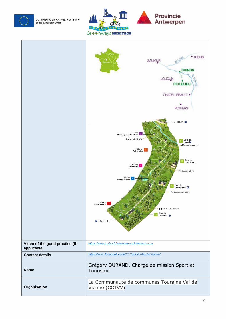
Name of Greenway Greenway (Voie Verte) Chinon - Richelieu
Description of the Greenway
The Voie Verte project consists in the creation of a 20 km pedestrian and bicycle lane between
Chinon and Richelieu, as an extension of the project “Loire by bike”. The intention is to create
a tourist product around heritage, nature and
authenticity. The UNESCO-world heritage site is nearby, because the Loire valley between Sully-
sur-Loire and Chalonnes is protected as UNESCO site.
2. Detailed description
Detailed information on the practice
The Greenway is a path exclusively for pedestrians
and cyclists, accessible to people with reduced mobility, between Richelieu and Chinon-St Lazare.
It was laid out on the route of the old railway line
connecting Richelieu to Chinon.
It will allow:
° Link two cities rich in history: Richelieu and Chinon
° Offer a unique discovery itinerary that blends heritage, terroir and nature.
° Extend the route of the Loire à Vélo
° Include this circuit in the broader context of the
regional pattern of bicycle-roads and greenways.
3
° Create a link between Touraine and Poitou
The cultural and natural richness of the area was
restricted to the tourist cyclist before the project
started.
Now all cycling holiday makers (SME’s) can benefit from this project. New tourists will come to explore
this area, which promotes the local economy. Boat bike tours on the Loire can bring extra groups of
greenway – adepts to this new greenway.
Please describe why this can be considered as INNOVATIVE way interpretation of heritage, best accessibility, providing the information about the greenways etc.
Innovative way – interpretation of heritage
an original scenography for an exceptional iterary:
● a mascot to accompany the visitor along the
route ● an Internet site
● a dedicated application ● animation stations spread over the iterary
● four old renovated train stations to welcome the visitor: a hostel for 21 people in Ligré, an
invitation to the Riveau, art in Champigny sur Veude and the rail memory at Richelieu.
The application will have the following
functionalities:
● The proximity alert feature will need to work
in non-connected mode. ● Access to classic editorial content (texts,
photos) at each station.
● Access to a game / scene of augmented-virtual reality / animation in some stations.
● The possibility to consult in the form of list and map the nearby stations.
● Access to a list of services nearby (bike rental, restaurants, cellars, accommodation,
tourist sites ...). ● Access to a settings page in order to
customize your visit. ● Access to a local news feed of the Greenway
in the form of a list page and a detail page
4
provided by an RSS feed provided by the
website. (texts, visuals, etc ...)
The red line mascot
To animate the app, a mascot was designed that makes it totally cheerful.
In the manner of characters from the animated series "Once upon a time," the mascot uses the
same traits over several historical periods. Character small, healthy, it refers to François
Rabelais and his characters Gargantua and Pantagruel.
The augmented reality app
The app contains an interactive game: an animation of a character related to the stained
glass windows of Champigny-sur-Veude.
This is a modeling of the character mascot rebirth,
in connection with stained glass.
The character must evolve, take a few steps and slight animation movements to go put the last
piece of stained glass missing.
The augmented reality marker will be a stained
glass poster in the old railway station.
Best accessibility
Special trains are organized for bike travelers
during every summer in the Loire Valley, nearby this new greenway. From June 8 to September 29
every cyclist can easily take the train together with his bike along the Loire Valley. Long cycling
distances can be reduced by this way.
To board your bike on these trains: all you need
is a regular ticket. A dedicated staff will store and unload your bike from the "cycle touring van" often
5
located at the front of the train. This service is
free and without reservation.
The capacity on the new trains is 33 to 83 bicycles
per train, bicycles which size does not exceed that of a tandem, i.e. 240 cm including
additional equipment. More details:
https://en.francevelotourisme.com/tips-and-advices/getting-to-and-around-france-with-a-
bicycle/train-velo-loire?fbclid=IwAR0fAyW2mreTYcPUHZFrA9GZuFhEC
tTXZs0tA8giEJnvquwnRwpD__zQnzk
Resources needed
- construction of the greenway (20 km): 10.000.000 euro
- furnishing (renovating) of 4 old railway stations,
shelters and signposts: 2.000.000 euro
- communication and promotion: creation of website and app (including design and styling):
300.000 euro
Maintenance costs and requirements needed (if applicable)
The app produced for the greenway Richelieu-
Chinon will need regularly an update because information about infrastructure like hotels and
points of interest can change frequently.
Timescale (start/end date)
Start: 2015 (making the first design plans)/ End: 2020 (provided opening hostel for cyclists and
hikers in old railway station of Ligré)
Evidence of success (results achieved)
This practice is considered as good example because of the unique combination of the
development of an app and the similar
development of a greenway in combination with the re-use of former railway stations. Measurable
outputs/results are not available on this moment because the project is brand new.
Difficulties encountered/ lessons learned (if applicable)
The project needs a tourism marketing promoter who can lead the target group from the greenways
in the Loire Valley to this connecting area. He/she can also promote it during all seasons by making
6
original arrangements for cycling (and pedestrian)
tourism agencies (SME’s).
Potential for learning or transfer (if applicable)
The development of the app in combination with the re-use of the 4 former railway stations along
the greenway is also applicable in other European countries. It leads to brilliant storytelling by
animating the past through an innovate app with VR/AR-applications.
Further information http://voieverte.dioptase-dev.fr/
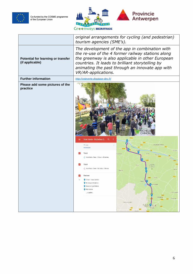
Please add some pictures of the practice
7
Video of the good practice (if applicable)
https://www.cc-tvv.fr/voie-verte-richelieu-chinon/
Contact details https://www.facebook.com/CC.TouraineValDeVienne/
Name
Grégory DURAND, Chargé de mission Sport et
Tourisme
Organisation
La Communauté de communes Touraine Val de
Vienne (CCTVV)
8
Email [email protected]
Greenways Heritage project Partner presenting the Good Practice:
Leisure Department Province of Antwerp Contact: [email protected] www.provincieantwerpen.be
Publications regarding the practice (If applicable)
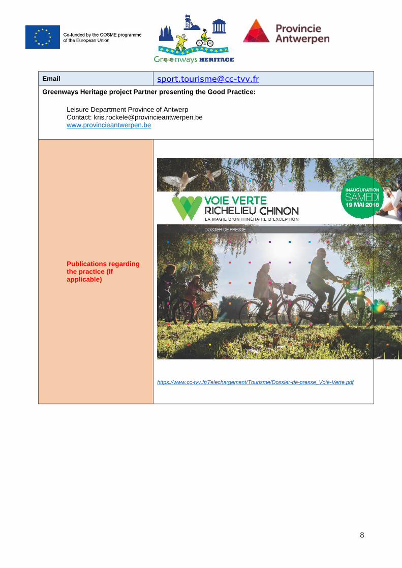
https://www.cc-tvv.fr/Telechargement/Tourisme/Dossier-de-presse_Voie-Verte.pdf
Good Practice
Eisenstein center for communication in Ķeipene
▪ All Good Practices identified by a project Greenways Heritage.
▪ The good practise the aim is to provide an insight about relevant best practices in the application of new technologies to inform visitors and improve their experience with high-profile examples of UNESCO cultural sites and greenways.
1. General information
Title of the practice Eisenstein center for communication in Ķeipene
Main institution involved Ogre municipality
Location of the practice Country Latvia
Region Vidzeme
Greenways Riga - Ērgļi
UNESCO SITE Struve geodetic arc
Information about the UNESCO site (add more rows if its needed for each UNESCO sites)
Name of UNESCO site in original language
Strūves ģeodēziskais loks latvijā
Name of UNESCO site in English language
Struve geodetic arc in Latvia
Description of the UNESCO site
The Struve Geodetic Arc is a chain of survey triangulations stretching from Hammerfest in Norway to the Black Sea, through ten countries and over 2,820 km, which yielded the first accurate measurement of a meridian.
Information about the Greenways where the good practise is located at
Name of Greenway Rīga - Ērgļi
Description of the Greenway
Greenway start/finish at the former railway station Cekule, located right next to the Riga ring road that also leads directly to Vilnius and Tallinn. About 100 km long, the Greenway goes through Vidzeme woodland and landscape areas and is suitable for cyclists, pedestrians and Nordic walkers. Several infrastructure objects such as railway bridges and station buildings have preserved on the Greenway.
2. Detailed description
Detailed information on the practice
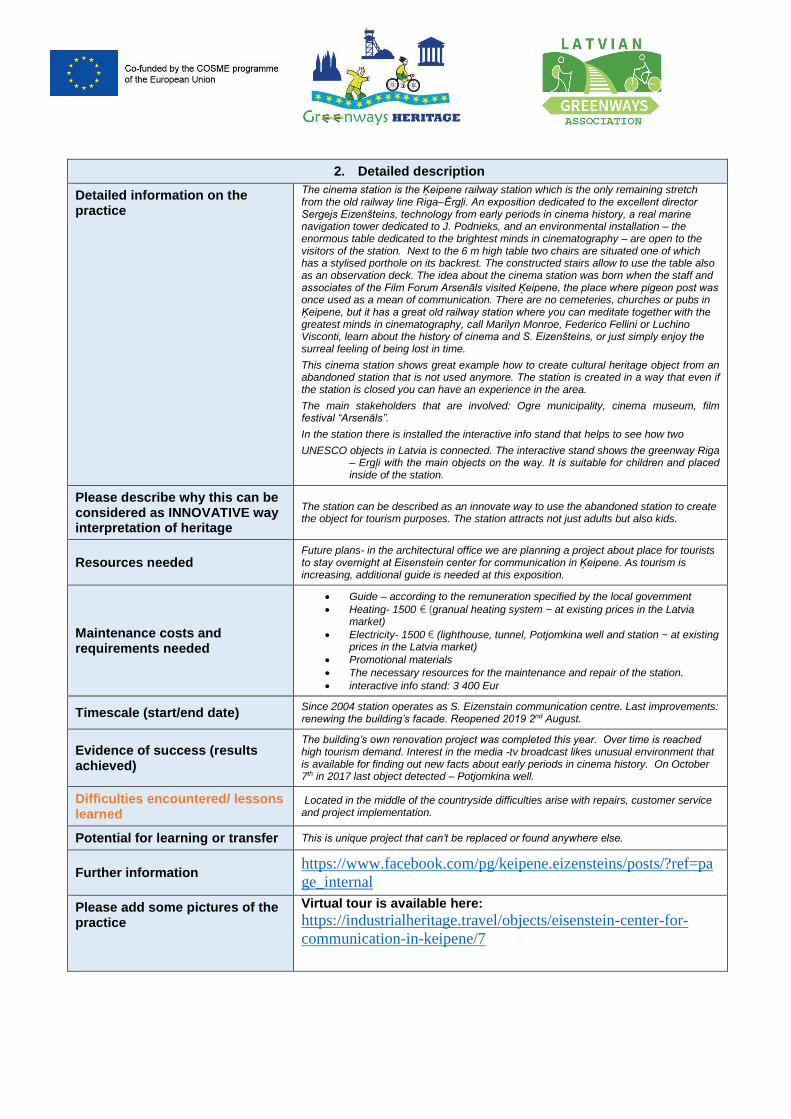
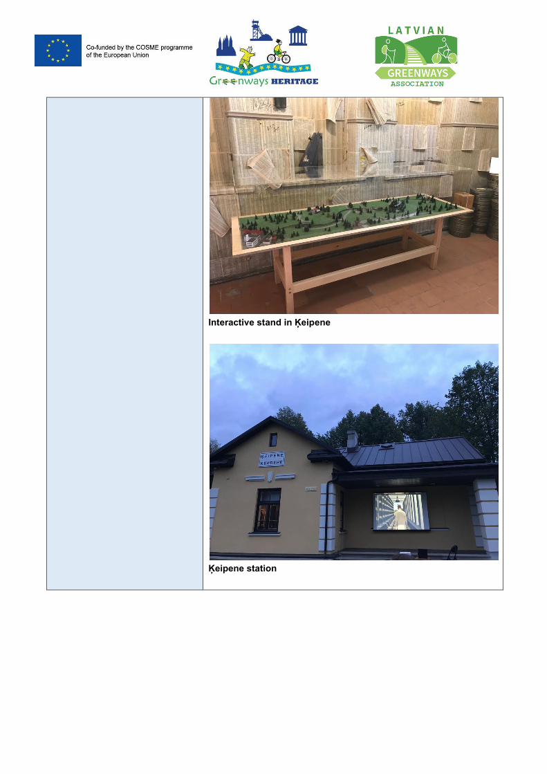
The cinema station is the Ķeipene railway station which is the only remaining stretch from the old railway line Riga–Ērgļi. An exposition dedicated to the excellent director Sergejs Eizenšteins, technology from early periods in cinema history, a real marine navigation tower dedicated to J. Podnieks, and an environmental installation – the enormous table dedicated to the brightest minds in cinematography – are open to the visitors of the station. Next to the 6 m high table two chairs are situated one of which has a stylised porthole on its backrest. The constructed stairs allow to use the table also as an observation deck. The idea about the cinema station was born when the staff and associates of the Film Forum Arsenāls visited Ķeipene, the place where pigeon post was once used as a mean of communication. There are no cemeteries, churches or pubs in Ķeipene, but it has a great old railway station where you can meditate together with the greatest minds in cinematography, call Marilyn Monroe, Federico Fellini or Luchino Visconti, learn about the history of cinema and S. Eizenšteins, or just simply enjoy the surreal feeling of being lost in time.
This cinema station shows great example how to create cultural heritage object from an abandoned station that is not used anymore. The station is created in a way that even if the station is closed you can have an experience in the area.
The main stakeholders that are involved: Ogre municipality, cinema museum, film festival “Arsenāls”.
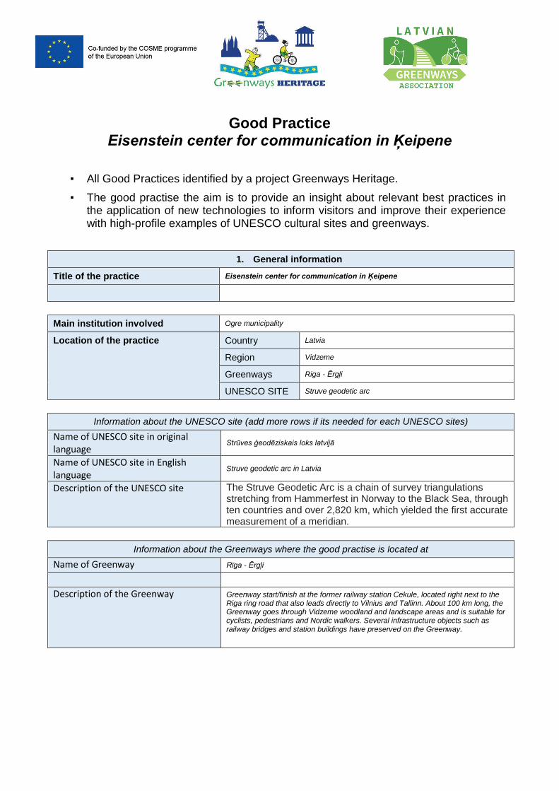
In the station there is installed the interactive info stand that helps to see how two
UNESCO objects in Latvia is connected. The interactive stand shows the greenway Riga – Ergļi with the main objects on the way. It is suitable for children and placed inside of the station.
Please describe why this can be considered as INNOVATIVE way interpretation of heritage
The station can be described as an innovate way to use the abandoned station to create the object for tourism purposes. The station attracts not just adults but also kids.
Resources needed Future plans- in the architectural office we are planning a project about place for tourists to stay overnight at Eisenstein center for communication in Ķeipene. As tourism is increasing, additional guide is needed at this exposition.
Maintenance costs and requirements needed
Guide – according to the remuneration specified by the local government
Heating- 1500 € (granual heating system ~ at existing prices in the Latvia market)
Electricity- 1500 € (lighthouse, tunnel, Potjomkina well and station ~ at existing prices in the Latvia market)
Promotional materials
The necessary resources for the maintenance and repair of the station.
interactive info stand: 3 400 Eur
Timescale (start/end date) Since 2004 station operates as S. Eizenstain communication centre. Last improvements: renewing the building’s facade. Reopened 2019 2nd August.
Evidence of success (results achieved)
The building’s own renovation project was completed this year. Over time is reached high tourism demand. Interest in the media -tv broadcast likes unusual environment that is available for finding out new facts about early periods in cinema history. On October 7th in 2017 last object detected – Potjomkina well.
Difficulties encountered/ lessons learned
Located in the middle of the countryside difficulties arise with repairs, customer service and project implementation.
Potential for learning or transfer This is unique project that can’t be replaced or found anywhere else.
Further information https://www.facebook.com/pg/keipene.eizensteins/posts/?ref=pa
ge_internal
Please add some pictures of the practice
Virtual tour is available here:
https://industrialheritage.travel/objects/eisenstein-center-for-
communication-in-keipene/7
Interactive stand in Ķeipene
Ķeipene station
Video of the good practice ( if applicable)
https://www.youtube.com/watch?v=QXx9l3Iy5zs
https://www.youtube.com/watch?v=5VdIvEVKk7g
https://www.youtube.com/watch?v=QTYS98mjbOE
https://www.youtube.com/watch?v=XHoe5eeVcIM
Contact details
Name Kristīne Antonova
Organisation Ogres municipality
Email [email protected]
Greenways Heritage project Partner presenting the Good Practice:
Latvian Greenways Association. https://greenways.lv/ Contact: [email protected]
Publications regarding the practice (If applicable)
https://ltv.lsm.lv/lv/raksts/24.03.2018-latvijas-
sirdsdziesma.id126743/
http://travelnews.lv/?view=view_images&g_uid=2902&i
mg_id=44577
http://www.culturaltourism-
network.eu/uploads/5/0/6/0/50604825/t.altbergs_railway
_heritage_latvia.pdf
Good Practice
Alūskne Bānītis station
▪ All Good Practices identified by a project Greenways Heritage.
▪ The good practise the aim is to provide an insight about relevant best practices in the application of new technologies to inform visitors and improve their experience with high-profile examples of UNESCO cultural sites and greenways.
1. General information
Title of the practice Alūksne Bānītis station
Main institution involved Alūksne municipality
Location of the practice Country Latvia
Region Vidzeme
Greenways Ape – Alūksne; Ieriķi - Gulbene
UNESCO SITE Struve geodetic arc in Latvia
Information about the UNESCO site (add more rows if its needed for each UNESCO sites)
Name of UNESCO site in original language
Strūves ģeodēziskais loks latvijā
Name of UNESCO site in English language
Struve geodetic arc in Latvia
Description of the UNESCO site
The Struve Geodetic Arc is a chain of survey triangulations stretching from Hammerfest in Norway to the Black Sea, through ten countries and over 2,820 km, which yielded the first accurate measurement of a meridian.
Information about the Greenways where the good practise is located at
Name of Greenway Ieriķi - Gulbene
Description of the Greenway
Ieriķi – Gulbene is greenway that goes though former normal gauge railway line. The greenway is established and signposted since 2018. On the route it is possible to see the former railway stations and bridges. It goes though rural areas with beautiful landscape. The length of the greenways is 101km. From Gulbene towards to Alūksne you can continue your journey within the narrow gauge railway “Bānītis”, .
2. Detailed description
Detailed information on the practice
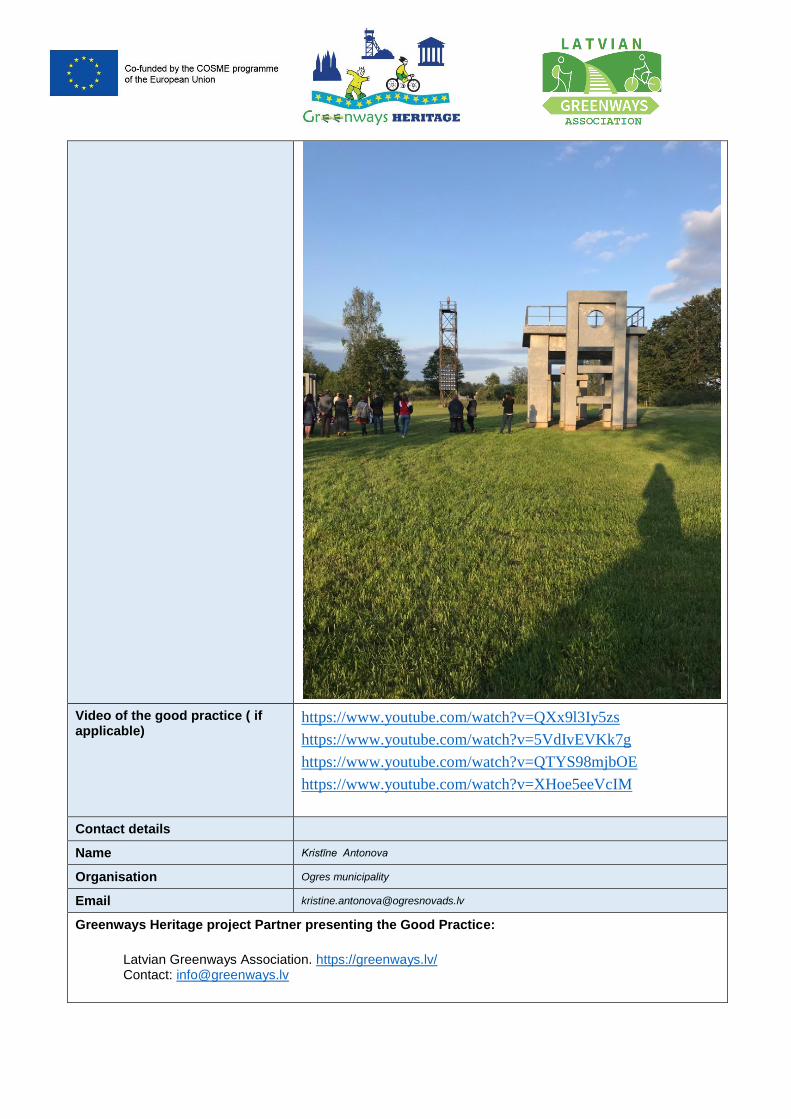
Aluksne Bānītis (Narrow-Gauge train) Station is a modern multimedia exhibition dedicated to the Gulbene-Aluksne narrow gauge railway line - the only one in the Baltic region that still provides regular passenger traffic.
An exhibition is designed as a virtual journey through space and time, recalling that for more than 100 years the railway has been connecting us to Europe and the rest of the world. Through stories of ten stations, the exhibition tells about the Bānītis as an assistant, workplace and source of inspiration. The exhibition is not only a look back in the past, but also promotes the railway culture as traditional but at the same time a modern and sustainable component of lifestyle.
The exhibition was opened on September 1, 2018 and has become a popular tourist destination. Aluksne Bānītis station is only one, but really important part from the whole Europe railway history.
Please describe why this can be considered as INNOVATIVE way interpretation of heritage
Nowadays the former storehouse or baggage shed of the Alūksne railway station houses a modern multimedia exhibition providing the information about the national historical monument – the narrow-gauge railway line from Alūksne to Gulbene – the only operational narrow gauge railway in Baltics. The aim of the exhibition design was to create a virtual trip in a static place revealing the stories of the railway history and its technical details, and highlight the significance of the local industrial heritage in the broader context of the history of transport. The trip reminds that the railway has been our link to Europe and the rest of the world for more than 100 years. The visitors can gain a specific experience through 3D virtual reality which provides an opportunity to see the world in front of the train through the train driver’s eyes as well as get some knowledge in technical aspects to make the train move. The implementation of the project has revived the local stories which substantially supplement the pages of the history of the European railways. During the first few months of its operation, the exhibition has contributed significantly to tourism in the region, improvement of the surroundings and public interest in the industrial heritage. There is storage of memories created for new stories that can supplement the exhibition
Resources needed
Budget:
Renovation of the building 412758,25 with VAT, Source of financing: 85% European regional development background, 15% Aluksne Municipality
Exposition 162902,30 with VAT, Source: Aluksne Municipality
Total: 575660 with VAT
Maintenance costs and requirements needed
Employees that work in the station, buildings consumption fees, security costs.
Timescale (start/end date) Start of the reconstruction 2017.
End 1.09.2018.
Evidence of success (results achieved)
Nominations, evaluation and praise for exhibition and architecture:
Aluksne Bānīša Station receives the Annual Award of the museums association, 2019!
SEGD Global Design Awards theme industry awards – 2019 Global Design Awards/Honor and Best of Show in the US.
Latvian Architecture Annual Award 2019 – “Silver pineapple.”.
Best construction of the year in Latvia. Place II in the nomination “Wood construction”
Difficulties encountered/ lessons learned
It was a hard work to convince the builders that the old stations storage building was worth to keep and renew instead of demolishing it. The house was in very poor condition. The exhibition creators wanted to keep the historical feeling and not to build the new modern house. The results are great and was worth to create it by sustaining the historical values.
Potential for learning or transfer This is success story about how to create new tourism product for the city and to attract the visitors to come and see the newest exhibition. In the first few months after it was
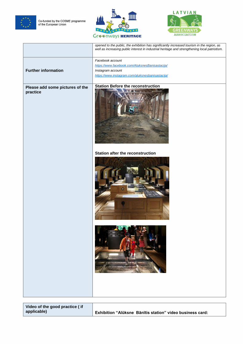
opened to the public, the exhibition has significantly increased tourism in the region, as well as increasing public interest in industrial heritage and strengthening local patriotism.
Further information
Facebook account
https://www.facebook.com/AluksnesBanisastacija/
Instagram account
https://www.instagram.com/aluksnesbanisastacija/
Please add some pictures of the practice
Station Before the reconstruction
Station after the reconstruction
Video of the good practice ( if applicable)
Exhibition “Alūksne Bānītis station” video business card:
https://www.youtube.com/watch?v=5JXleLZCTUI
Architect Ināra Caunīte and designer Holger Eler tells about the process of creating Alūksne Bānītis staton:
https://www.facebook.com/latarh/videos/391766334771525/UzpfSTIwOTc2ODk4OTA1NTA5NzU6MjMwODAwNDA2OTUxOTU1NQ/?epa=SEARCH_BOX
Report about educational projects in “Alūksne Bānītis station”:
https://www.youtube.com/watch?v=SM3bkV7EiGY&t=52s
Contact details
Name Iveta Veļķere, Director of Aluksne Tourism Information center
Organisation Alūksne Tourism Information center
Email [email protected]
Greenways Heritage project Partner presenting the Good Practice:
Latvian Greenways Association. https://greenways.lv/ Contact: [email protected]
Publications regarding the practice (If applicable)
Aluksne Banitis Station Exhibition by H2E https://www.dexigner.com/news/31862
Aluksne Banitis Station: an exhibition as a virtual journey through space and time// The Baltic Times
https://www.baltictimes.com/aluksne_banitis_station__an_exhibition_as_a_virtual_journey_through_space_and_time/
Latvian Architecture Annual Award 2019 “Silver pineapple” https://lvportals.lv/dienaskartiba/304561-aluksnes-banisa-stacija-latvijas-arhitekturas-gada-balva-iegust-sudraba-ananasu-2019
Good Practice template
All Good Practices identified by a project Greenways Heritage.
The good practise the aim is to provide an insight about relevant best practices in the application of new technologies to inform visitors and improve their experience with high-profile examples of UNESCO cultural sites and greenways.
1. General information
Title of the practice ‘Augmented Routes’ – web application
Main institution involved City of Mechelen
Location of the practice Country Belgium
Region Antwerp
Greenways 2: Provinces of Antwerp and Flemish-Brabant
UNESCO SITE 5
Information about the UNESCO site (add more rows if its needed for each UNESCO sites)
Name of UNESCO site in original language
Sint-Romboutstoren
Name of UNESCO site in English language
St Rumbolds’ Tower
Description of the UNESCO site
https://visit.mechelen.be/ascent-of-st-rumbolds-tower
Name of UNESCO site in original language
Groot Begijnhof van Mechelen
Name of UNESCO site in English language
Large Beguinage of Mechelen
Description of the UNESCO site
https://visit.mechelen.be/en/large-beguinage
Name of UNESCO site in original language
Belfort in het Stadhuis
Name of UNESCO site in English language
Belfry of the Town Hall
Description of the UNESCO site
https://visit.mechelen.be/en/town-hall
Name of UNESCO site in original language
Beiaardcultuur
Name of UNESCO site in English language
Carillon Culture
Description of the UNESCO site
https://visit.mechelen.be/carillon-culture
Name of UNESCO site in original language
Brouwcultuur
Name of UNESCO site in English Brewing Culture
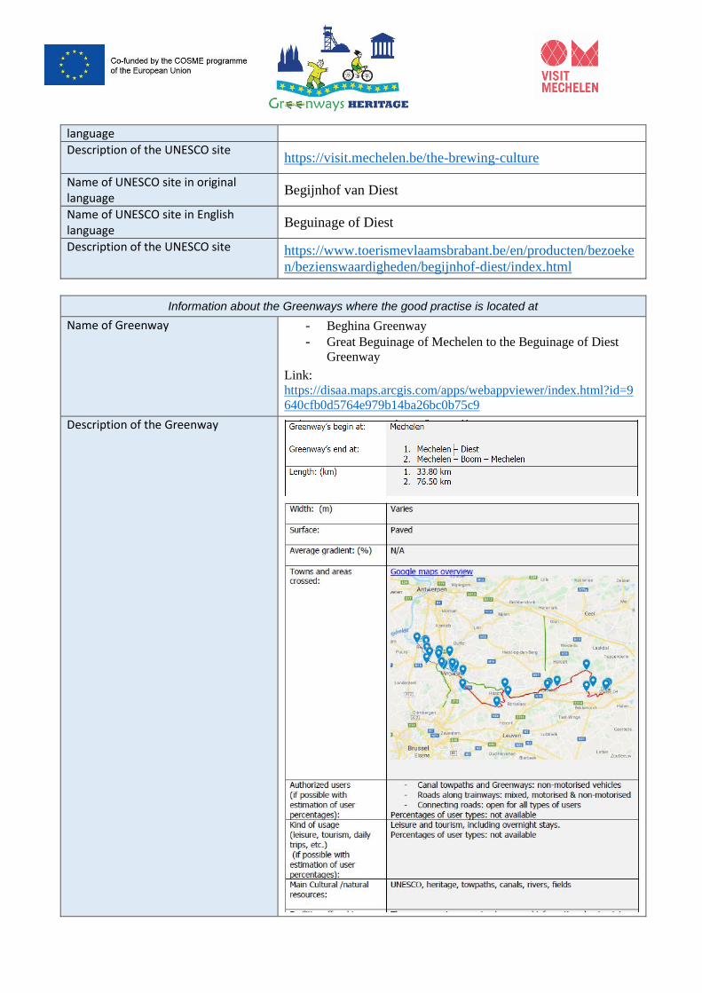
language
Description of the UNESCO site
https://visit.mechelen.be/the-brewing-culture
Name of UNESCO site in original language
Begijnhof van Diest
Name of UNESCO site in English language
Beguinage of Diest
Description of the UNESCO site
https://www.toerismevlaamsbrabant.be/en/producten/bezoeke
n/bezienswaardigheden/begijnhof-diest/index.html
Information about the Greenways where the good practise is located at
Name of Greenway - Beghina Greenway
- Great Beguinage of Mechelen to the Beguinage of Diest
Greenway
Link:
https://disaa.maps.arcgis.com/apps/webappviewer/index.html?id=9
640cfb0d5764e979b14ba26bc0b75c9
Description of the Greenway
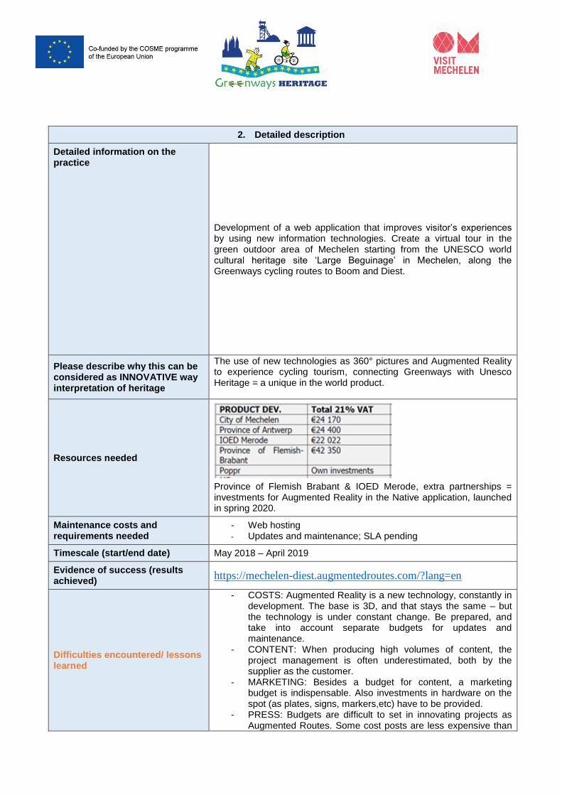
2. Detailed description
Detailed information on the practice
Development of a web application that improves visitor’s experiences by using new information technologies. Create a virtual tour in the green outdoor area of Mechelen starting from the UNESCO world cultural heritage site ‘Large Beguinage’ in Mechelen, along the Greenways cycling routes to Boom and Diest.
Please describe why this can be considered as INNOVATIVE way interpretation of heritage
The use of new technologies as 360° pictures and Augmented Reality to experience cycling tourism, connecting Greenways with Unesco Heritage = a unique in the world product.
Resources needed
Province of Flemish Brabant & IOED Merode, extra partnerships = investments for Augmented Reality in the Native application, launched in spring 2020.
Maintenance costs and requirements needed
- Web hosting - Updates and maintenance; SLA pending
Timescale (start/end date) May 2018 – April 2019
Evidence of success (results achieved)
https://mechelen-diest.augmentedroutes.com/?lang=en
Difficulties encountered/ lessons learned
- COSTS: Augmented Reality is a new technology, constantly in development. The base is 3D, and that stays the same – but the technology is under constant change. Be prepared, and take into account separate budgets for updates and maintenance.
- CONTENT: When producing high volumes of content, the project management is often underestimated, both by the supplier as the customer.
- MARKETING: Besides a budget for content, a marketing budget is indispensable. Also investments in hardware on the spot (as plates, signs, markers,etc) have to be provided.
- PRESS: Budgets are difficult to set in innovating projects as Augmented Routes. Some cost posts are less expensive than
estimated, others are more expensive. To achive a good results, it’s important to not to hold to rigidly to calculations, made before the project started. Also because technology faces big changes in short times (fe. Software to produce XR).
- COLLABORATION: o Foresee an important amount of overhead costs,
related to meetings, reporting etc for an European funded project.
o When working together with different government and private stakeholders, a SPOC is necessary to limit te project management cost.
o In innovating projects, an agile approach in project management is better than a waterfall approach.
List of learnings made in collaboration with subcontractor Poppr, www.poppr.be. More detailed information on how to start an innovative VR/AR project: [email protected].
Potential for learning or transfer In the near future (release spring 2020), the web application will be turned into a native application, downloadable via the Android and iOS stores. New technologies can be implemented.
Further information http://www.greenwaysheritage.org
Please add some pictures of the practice
https://mechelen-diest.augmentedroutes.com/?lang=en
Video of the good practice ( if applicable)
Click here to discover the sneak-pre-movie of the native application, a spin-off of this project, that will be launched in spring 2020.
Contact details
Name Els Van Zele, Destination Marketing Expert, City of Mechelen
Steven Stumpf, General Manager, Poppr
Organisation
City of Mechelen, dept. Visit Mechelen
Vleeshouwersstraat 6, B-2800 Mechelen
www.visitmechelen.be
Poppr, Kleindokkaai 21, B-900 Gent
www.poppr.be
Email [email protected]
Greenways Heritage project Partner presenting the Good Practice:
City of Mechelen, dept. Visit Mechelen (see details above)
Publications regarding the practice (If applicable)
Greenways Heritage Project Partners:
Good Practice “Greenways Heritage” multiplatform application
▪ All Good Practices identified by a project Greenways Heritage.
▪ The good practise the aim is to provide an insight about relevant best practices in the application of new technologies to inform visitors and improve their experience with high-profile examples of UNESCO cultural sites and greenways.
1. General information
Title of the practice “Greenways Heritage” multiplatform application
Main institution involved University of the Studies of Milan
Location of the practice Country Italy
Region Lombardia
Greenways 15 greenways in the European Union
UNESCO SITE 22 UNESCO sites in the European Union
Information about the UNESCO site (add more rows if its needed for each UNESCO sites)
Name of UNESCO site in original language
Name of UNESCO site in English language
Description of the UNESCO site
Information about the Greenways where the good practise is located at
Name of Greenway
Description of the Greenway
2. Detailed description
Detailed information on the practice
Production of a multiplatform Web Application
In Europe there are several greenways that allow to reach wonderful UNESCO sites and discover the natural and cultural heritage in the nearby. However, to date, there is no platform capable of providing exhaustive and detailed information to tourists who want to enjoy these beautiful resources.
In order to fill this gap, the University of Milan, in collaboration with the Greenways Heritage project partners, has created a multiplatform web app. The “Greenways Heritage Application” has been developed using the ArcGIS technology, integrating two distinct configurable web applications development environments.
The first app, developed using the ESRI Web AppBuilder, allows potential tourists to consult (both from home and in mobility, from either a pc or a smartphone) the entire project database and obtain all the information related mapped itineraries. An interactive map shows to users the location of the greenways, the UNESCO sites, the territorial resources and tourist services.
The second app, built on the basis of the ESRI Story Map Tour, shows the territories connected with UNESCO sites and greenways through an immersive and narrative virtual journey. The territory is told through a photographic story that describes the points of interest that tourists can meet near the UNESCO site and along the greenway.
Currently, the “Greenways Heritage application” collects detailed information on 15 greenways and 22 UNESCO sites, but in the future the database can be updated with data from other trails.
Please describe why this can be considered as INNOVATIVE way interpretation of heritage
The “Greenways Heritage web application” is the first portal in Europe to collect detailed information on greenways and UNESCO sites in their vicinity. Its simple and attractive interface allows the user to consult easily the entire database of the project. In addition to a descriptive part, the user can view the multimedia material (photos and videos) present for the mapped resources. For each greenway, there is a Story Map Tour that describes in a more immersive and interesting way the territory crossed and the cultural and natural resources present. Moreover, the application has been integrated with the Virtual Reality Tour realized for the City of Mechelen, as part of the Greenways Heritage project.
Resources needed About 35.000 € for the software licences (“ArcGis Server” and "ArcGis for developer") and for database and application development.
Maintenance costs and requirements needed
Very variable depending on the need to update the database and to maintain the server. Approximately 1000 € per year.
Timescale (start/end date) May 2018 – October 2019
Evidence of success (results achieved)
Difficulties encountered/ lessons learned
The main problem that emerged during the creation of the database has been the lack of geo-referenced data on the greenways, resources and tourist services to be mapped. In addition, one of the main problems concerned the acquisition of good quality photos to be used for web apps. However, thanks to the valuable collaboration of all partners, these issues have been solved. The greenways, the natural and cultural
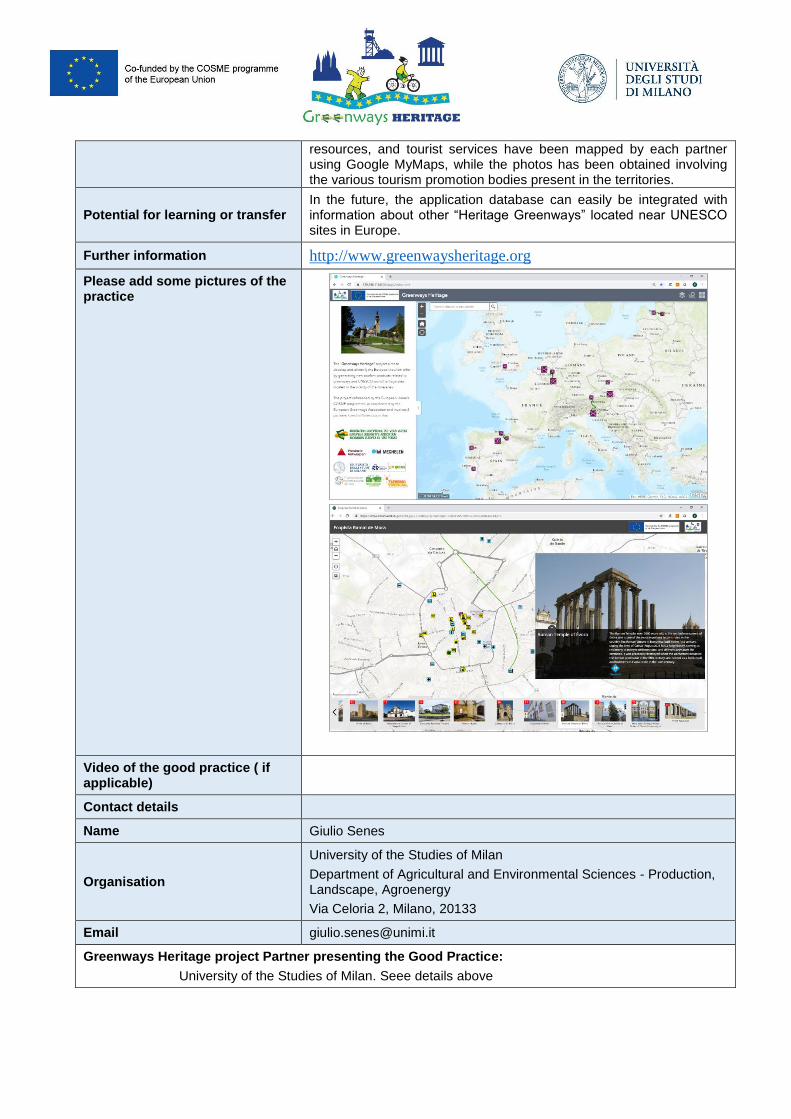
resources, and tourist services have been mapped by each partner using Google MyMaps, while the photos has been obtained involving the various tourism promotion bodies present in the territories.
Potential for learning or transfer In the future, the application database can easily be integrated with information about other “Heritage Greenways” located near UNESCO sites in Europe.
Further information http://www.greenwaysheritage.org
Please add some pictures of the practice
Video of the good practice ( if applicable)
Contact details
Name Giulio Senes
Organisation
University of the Studies of Milan
Department of Agricultural and Environmental Sciences - Production, Landscape, Agroenergy
Via Celoria 2, Milano, 20133
Email [email protected]
Greenways Heritage project Partner presenting the Good Practice:
University of the Studies of Milan. Seee details above
Publications regarding the practice (If applicable)
Greenways Heritage Project Partners:
1
Good Practice Route of the Romanesque
All Good Practices identified by a project Greenways Heritage.
The good practise aim is to provide an insight about relevant best practices in the application of new technologies to inform visitors and improve their experience with high-profile examples of UNESCO cultural sites and greenways.
1. General information
Title of the practice Route of the Romanesque - Bikotels destiny
Main institution involved Route of the Romanesque - Valsousa – Association for the development of the Sousa river basin and Ytravel S.A.
Location of the practice Country
PORTUGAL
Region North of Portugal
Greenways Tâmega Greenway
UNESCO SITE Douro Valley
Contact of the Good practice managing authority
Rota do Românico
Email: [email protected]
Address:
Praça D. António Meireles, 45
4620-130 Lousada, Portugal Tel. | +351 918 116 488
www.rotadoromanico.com
Phone number: Tel: +351 255810706
Information about the UNESCO site
Name of UNESCO site in original language
Alto Douro Vinhateiro
Name of UNESCO site in English language
Alto Douro Wine Region
Description of the UNESCO site
Wine has been produced by traditional landholders in the Alto Douro region for some 2,000 years. Since the 18th century, its main product, port wine, has been world famous. This long tradition of viticulture has produced a cultural landscape of outstanding beauty that reflects its technological, social and economic evolution. The western limits of this UNESCO site touch the Romanesque Route and are space for the identified good practice activities.
https://whc.unesco.org/en/list/1046
2
Information about the Greenways where the good practise is located at
Name of Greenway Tâmega Greenway
Description of the Greenway
The Tâmega Greenway faces the western slopes of the Alvão and the Marão mountains, thus being the closest Greenway both to the UNESCO site of the Douro valley and the Romanesque Touristic and Cultural Route of Tâmega and Sousa. The Greenway departs form Amarante ( one of the main towns of the romanesque route and a door to the Douro region
2. Detailed description
Detailed information on the practice
Bikotels Romaquesque Route is a triple helix joint project, created in the North of Portugal Region, by three elements: a private company, YTravel (a2z), a public touristic cultural route (Route of the Romanesque) a universitarian supplier (Porto University), to provide visitors with the means to know by bicicle the history of some of the most emblematic Romanesque monuments of Tâmega and Sousa and travel back in time to the period of the foundation of Portugal and christian reconquer of the Iberian Peninssula. The monumental richness of the region shows the important role that the territory formerly played in the history of nobility and religious orders in Portugal. At the end of the day, the accommodations where you stay will be a real luxury!
https://www.portugal-a2z.com/en/tours/bike-tour-in-rota-do-romanico-self-guided-1/
https://www.rotadoromanico.com/media/documents/Bikotel-2019-EN_DGbkDC5.pdf
Please describe why this can be considered as INNOVATIVE way interpretation of heritage, best accessibility, providing the information about the greenways etc.
Being a product essencialy designed by the Route of the Romanesque, because it dependes on the existence of 59 recovered and visitable monuments, and also on the network of the bikotels, this is a product that includes SME’s and, although it is self guided, it is fully oriented and closely supported by the SME a2z, The institutional connection allow visitors to have monuments entrance assured and the Universitarian connection a deep insight of the monuments and regional history.
Resources needed
The total cost of the Route of the Romanesque is until now of 16,600.000 € including the cost of universitarian collaborationand the Tâmega and Sousa Greenway, 4,000 000 €, ascending to 20.000.000 of public investment.
Maintenance costs and requirements needed (if applicable)
Information not available.
Timescale (start/end date) Work started in September 1998 for the romanesque route and the
greenway opened on the 30th April 2011.
Evidence of success (results achieved)
More than 6000 people are counted in the Greenway every year since
it opened,.
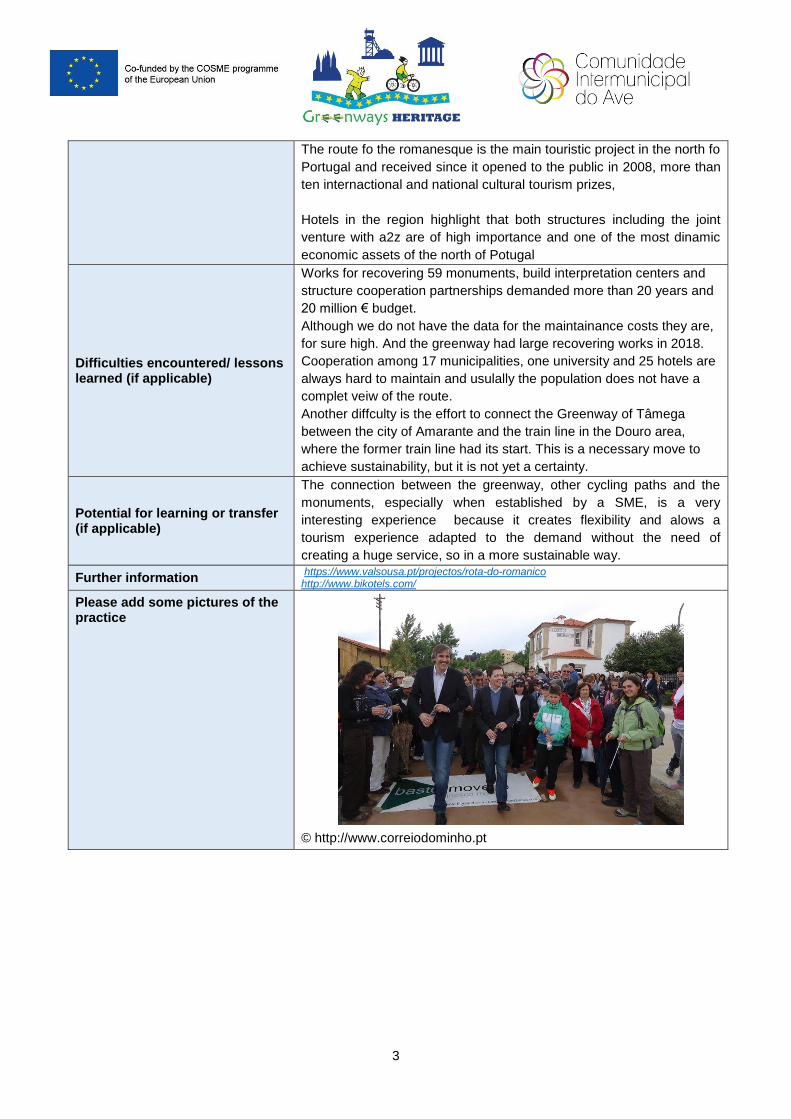
3
The route fo the romanesque is the main touristic project in the north fo
Portugal and received since it opened to the public in 2008, more than
ten internactional and national cultural tourism prizes,
Hotels in the region highlight that both structures including the joint
venture with a2z are of high importance and one of the most dinamic
economic assets of the north of Potugal
Difficulties encountered/ lessons learned (if applicable)
Works for recovering 59 monuments, build interpretation centers and
structure cooperation partnerships demanded more than 20 years and
20 million € budget.
Although we do not have the data for the maintainance costs they are,
for sure high. And the greenway had large recovering works in 2018.
Cooperation among 17 municipalities, one university and 25 hotels are
always hard to maintain and usulally the population does not have a
complet veiw of the route.
Another diffculty is the effort to connect the Greenway of Tâmega
between the city of Amarante and the train line in the Douro area,
where the former train line had its start. This is a necessary move to
achieve sustainability, but it is not yet a certainty.
Potential for learning or transfer (if applicable)
The connection between the greenway, other cycling paths and the
monuments, especially when established by a SME, is a very
interesting experience because it creates flexibility and alows a
tourism experience adapted to the demand without the need of
creating a huge service, so in a more sustainable way.
Further information https://www.valsousa.pt/projectos/rota-do-romanico http://www.bikotels.com/
Please add some pictures of the practice
© http://www.correiodominho.pt
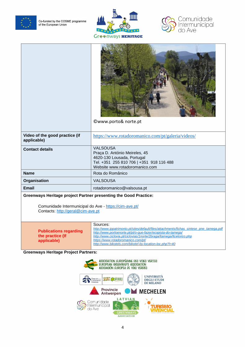
4
©www.porto& norte.pt
Video of the good practice (if applicable)
https://www.rotadoromanico.com/pt/galeria/videos/
Contact details VALSOUSA Praça D. António Meireles, 45 4620-130 Lousada, Portugal Tel. +351 255 810 706 | +351 918 116 488 Website www.rotadoromanico.com
Name Rota do Românico
Organisation VALSOUSA
Email [email protected]
Greenways Heritage project Partner presenting the Good Practice:
Comunidade Intermunicipal do Ave - https://cim-ave.pt/ Contacts: http://[email protected]
Publications regarding the practice (If applicable)
Sources: http://www.ippatrimonio.pt/sites/default/files/attachments/fichas_sintese_pne_tamega.pdf http://www.portoenorte.pt/pt/o-que-fazer/ecopista-do-tamega/ http://www.ciclovia.pt/ciclovias/1norte/2braga/ltamega/ltcelorico.php https://www.rotadoromanico.com/pt/ http://www.bikotels.com/bikotel-by-location-loc.php?l=40
Greenways Heritage Project Partners:
Lead partner/coordinator:European Greenways Association (EGWA)
www.aevv-egwa.org
Partners:Fundación de los Ferrocarriles Españoles (Spain)
Università degli Studi di Milano (Italy)
Latvijas Zalo Celu Asociacija (Latvia)
Provincie Antwerp (Belgium)
Turismo Vivencial (Spain)
Stad Mechelen (Belgium)
Comunidade Intermunicipal do AVE (Portugal)