ATTACHMENT B-2 2012 SUPPLEMENTAL SITING STUDY
300
Boardman to Hemingway Transmission Line Project Exhibit B ATTACHMENT B-2 2012 SUPPLEMENTAL SITING STUDY AMENDED PRELIMINARY APPLICATION FOR SITE CERTIFICATE
-
Upload
khangminh22 -
Category
Documents
-
view
2 -
download
0
Transcript of ATTACHMENT B-2 2012 SUPPLEMENTAL SITING STUDY
Boardman to Hemingway Transmission Line Project Exhibit B
ATTACHMENT B-2 2012 SUPPLEMENTAL SITING STUDY
AMENDED PRELIMINARY APPLICATION FOR SITE CERTIFICATE

Boardman to Hemingway Transmission Line Project Supplemental Siting Study Prepared By
Idaho Power Company 1221 West Idaho Street Boise, ID 83702
June 2012

Supplemental Siting Study Boardman to Hemingway Transmission Line Project
June 2012 iii
Table of Contents 1 INTRODUCTION ................................................................................................................ 1 2 PUBLIC COMMENTS, STAKEHOLDER INTERACTION, AND ONGOING
ENGINEERING.................................................................................................................. 2 2.1 Scoping Comments ................................................................................................... 2 2.2 CAP Siting Comments ............................................................................................... 3 2.3 IPC Developed Changes ........................................................................................... 3
3 ROUTE CHANGES BY COUNTY ...................................................................................... 4 3.1 Morrow County, Oregon............................................................................................. 5
3.1.1 Designation of Southern Alternative as Proposed Route ................................ 5 3.1.2 Elimination of Northern Approach to Grassland and Identification of
Longhorn Route and Substation Alternatives ................................................. 7 3.1.3 Horn Butte Route and Substation Alternatives ............................................... 9 3.1.4 Other Route Adjustments ............................................................................... 9
3.2 Umatilla County, Oregon.......................................................................................... 10 3.2.1 Proposed Route Adjustments ....................................................................... 10
3.3 Union County, Oregon ............................................................................................. 10 3.3.1 Glass Hill Alternatives .................................................................................. 10 3.3.2 Elimination of Blue Mountain Forest State Park Alternative .......................... 15 3.3.3 Elimination of Clover Creek Valley Alternative .............................................. 15 3.3.4 Other Route Adjustments ............................................................................. 19
3.4 Baker County, Oregon ............................................................................................. 19 3.4.1 NHOTIC Alternatives .................................................................................... 19 3.4.2 Burnt River Mountain Alternative .................................................................. 25 3.4.3 Elimination of Weatherby Alternative ............................................................ 25 3.4.4 Other Route Adjustments ............................................................................. 28
3.5 Malheur County, Oregon.......................................................................................... 28 3.5.1 Development of the 2012 Proposed Route ................................................... 29 3.5.2 Elimination of Owyhee River Below Dam Alternative .................................... 33 3.5.3 Double Mountain Alternative ........................................................................ 33 3.5.4 Malheur S Alternative ................................................................................... 35 3.5.5 Malheur A Alternative ................................................................................... 35 3.5.6 Malheur Sage-grouse Alternatives ............................................................... 36 3.5.7 Other Route Adjustments ............................................................................. 40
3.6 Owyhee County, Idaho ............................................................................................ 40 3.6.1 Other Route Adjustments ............................................................................. 40
4 ALTERNATIVES IDENTIFIED FOR DETAILED ANALYSIS IN THE NEPA EIS AND EFSC APPLICATION FOR SITE CERTIFICATION ......................................................... 41
List of Appendices Appendix A 2008 and 2010 Scoping Comments Appendix B CAP Comments Appendix C Landowner and Engineering Changes between 2010 and 2012 Appendix D County Maps Appendix E Constraints Crossed Tables

Supplemental Siting Study Boardman to Hemingway Transmission Line Project
June 2012 iv
List of Tables Table Number Title
Table 2.1-1. Public Scoping Meetings ................................................................................ 2 Table 3-1. Summary of Proposed, Alternative, and Eliminated Routes and
Substations .................................................................................................... 4 Table 3.5-1. Comparison of Proposed and Alternative Routes in the Vicinty of the
Owyhee River .............................................................................................. 29 Table 3.5-2. Comparison of Alternatives in Brogan Vicinity .............................................. 39 Table 4-1. Proposed and Alternative Routes and Substations ....................................... 41
List of Figures Figure Number Title
Figure 3.1-1. 2010 and 2012 Proposed Routes ................................................................... 6 Figure 3.1-2. Longhorn and Horn Butte Route and Substation Alternatives ......................... 8 Figure 3.3-1. CAP Routes in Glass Hill Area ..................................................................... 11 Figure 3.3-2. Proposed Route and Alternative to Avoid Rebarrow Research Forest .......... 13 Figure 3.3-3. Additional Glass Hill Routes Identified through 2010 Scoping and
Citizen Correspondence ............................................................................... 14 Figure 3.3-4. 2012 Glass Hill Proposed and Alternative Routes ........................................ 16 Figure 3.3-5. Proposed Route and Blue Mountain State Park Alternative .......................... 17 Figure 3.3-6. Proposed Route and Clover Creek Alternative ............................................. 18 Figure 3.4-1. NHOTIC Vicinity Proposed and Alternative Routes ...................................... 20 Figure 3.4-2. Powder River and Timber Canyon Alternatives ............................................ 21 Figure 3.4-3. Burnt River Mountain Alternative .................................................................. 26 Figure 3.5-1. Owyhee River Crossings .............................................................................. 30 Figure 3.5-2. 2010 and 2011 Proposed Route Changes ................................................... 31 Figure 3.5-3 Proposed Route, Malheur A and S Alternatives, and Wilderness
Characteristic Areas ..................................................................................... 32 Figure 3.5-4. Double Mountain Alternative ........................................................................ 34 Figure 3.5-5. Sage-grouse Alternatives in Malheur County ............................................... 37

Supplemental Siting Study Boardman to Hemingway Transmission Line Project
June 2012 v
Acronyms and Abbreviations ACEC area of critical environmental concern BLM Bureau of Land Management BPA Bonneville Power Administration CAP Community Advisory Process DoD Department of Defense EFSC Energy Facility Siting Council EFU exclusive farm use EIS environmental impact statement I-84 Interstate 84 IDT interdisciplinary team IPC Idaho Power Company kV kilovolt MP milepost NEPA National Environmental Policy Act NF National Forest NHOTIC National Historic Oregon Trail Interpretive Center ODFW Oregon Department of Fish and Wildlife ODOE Oregon Department of Energy PAT Project Advisory Team PGE Portland General Electric POD Plan of Devlopment Project Boardman to Hemingway Transmission Line Project ROW right-of-way SRMA Special Recreation Management Area USFS U.S. Department of Agriculture Forest Service VQO Visual Quality Objective VRM Visual Resource Management WAGS Washington ground squirrel WMA Wildlife Management Area

Supplemental Siting Study Boardman to Hemingway Transmission Line Project
June 2012 1
1 INTRODUCTION This supplemental Siting Study addresses the changes to the proposed and alternative routes for the Boardman to Hemingway Transmission Line Project (Project) that have been made between August 2010, when the original Siting Study1 was completed, and May 2012. The original Siting Study, covering activities from project inception up to August 2010, is available online at http://www.boardmantohemingway.com/documents.aspx.
The 2010 Siting Study presented the process that evaluated hundreds of miles of routes leading to the selection of an approximately 300-mile long proposed transmission line route with six alternative routes. Since the publication of the 2010 Siting Study, the Project has undergone some major and minor route adjustments. Idaho Power Company (IPC) has added several new alternatives and some of the original alternatives have been modified. Additionally, some of the original IPC alternatives have been eliminated from further consideration because it became clear these routes provided no environmental benefit over the Proposed Route or these alternatives were not feasible from an environmental permitting or engineering perspective. Concurrently, the Bureau of Land Management (BLM) interdisciplinary team (IDT) developed additional alternatives to address issues raised by land management agencies, including the BLM and U.S. Department of Agriculture Forest Service (USFS), state and local agencies, and the public. IPC provided input on the construction difficulty and resources crossed for the BLM-developed alternatives.
As of May 2012, a revised IPC Proposed Route, 10 new alternatives, and one modified original 2010 Siting Study alternative have been identified for detailed study in the environmental impact statement (EIS). The adjustments made to the Proposed Route along with each of the route alternatives and the factors leading to their inclusion in the EIS for further study are described in the following sections.
This supplement is organized in three parts:
• Section 2 – Public comments, stakeholder interaction, and ongoing engineering; • Section 3 – Siting issues by county, including agency and IPC route modifications; and • Section 4 – Alternatives carried forward for detailed analysis in the EIS and alternatives
determined to not warrant further consideration.
1 Idaho Power Company. 2010. Siting Study. Boardman to Hemingway Transmission Line Project. August.

Supplemental Siting Study Boardman to Hemingway Transmission Line Project
June 2012 2
2 PUBLIC COMMENTS, STAKEHOLDER INTERACTION, AND ONGOING ENGINEERING
Changes to the proposed and alternative routes have come about through public scoping in 2008 and 2010, review of all Community Advisory Process (CAP) routes and ongoing route refinements by IPC due to landowner meetings, more detailed engineering analysis, and further coordination with Portland General Electric (PGE) and Bonneville Power Administration (BPA) at the northern terminus of the Project.
2.1 Scoping Comments Scoping for the Project has occurred twice, once in the fall of 2008 and the other in the summer of 2010. In the fall of 2008 the BLM and Oregon Department of Energy (ODOE) held six public scoping meetings and in 2010 a second round of eight public scoping meetings was held throughout the study area at the locations listed in Table 2.1-1.
Table 2.1-1. Public Scoping Meetings Date Location No. of Attendees
2008 October 21 Marsing, Idaho 27 October 22 Ontario, Oregon 85 October 23 Baker City, Oregon 90 October 28 Island City, Oregon 57 October 29 Pendleton, Oregon 20 October 30 Boardman, Oregon 27 2010 August 2 La Grande, Oregon 25 August 3 Baker City, Oregon 41 August 4 Pendleton, Oregon 34 August 5 Mount Vernon, Oregon 21 August 9 Marsing, Idaho 38 August 10 Ontario, Oregon 55 August 11 Boardman, Oregon 24 August 12 Burns, Oregon 3
During scoping in 2008, approximately 244 general and specific comments were received by the BLM and ODOE pertaining to alternatives, while during scoping in 2010 approximately 192 alternative-related comments were received. General comments included siting themes such as avoidance of irrigation districts, and placing routes on federally-owned land or parallel to existing infrastructure. Other comments proposed more specific actions that should be considered such as avoiding sage-grouse leks east of the National Historic Oregon Trail Interpretive Center (NHOTIC) and utilization of designated utility corridors on BLM-managed lands and in Malheur County, to the very specific, with named roads and exact river crossing locations. The complete scoping reports are available at the website identified above.
Appendix A presents the 2008 (Table A-1) and 2010 (Table A-2) scoping comments pertaining to alternatives that were received by the BLM and ODOE. The alternative routes identifed as a result of 2008 scoping were consided during the CAP as described in Section 2.2, CAP Siting Comments.

Supplemental Siting Study Boardman to Hemingway Transmission Line Project
June 2012 3
2.2 CAP Siting Comments In between the 2008 and 2010 scoping periods, IPC implemented the CAP that resulted in IPC’s Proposed Route as described in the 2010 Siting Study. Project Advisory Teams (PATs) representing five geographic areas were convened for the purpose of identifying, developing, and recommending proposed and alternative routes for the Project. PATs developed community criteria for evaluating possible routes and integrated these with regulatory requirements and IPC criteria relating to cost and feasibility. The PATs developed a total of 49 routes or route segments. IPC evaluated all 49 routes or route segments, removing from further consideration those routes that did not meet the community, regulatory, or IPC cost/feasibility criteria, and ultimately identified three routes as most constructable, least difficult to permit, and most likely to incur the lowest overall cost. IPC presented the three routes to the PATs for their comments. The resulting comments showed no clear preference for any one of the three routes. IPC selected the Eastern Route as the Proposed Route. Details of the CAP are documented in the 2010 Siting Study. Appendix B describes consideration of the approximately 499 alternative-related comments received during the CAP.
2.3 IPC Developed Changes Since submittal of the 2010 Siting Study, IPC has engaged in extensive discussions with landowners in an attempt to accommodate requests for route adjustments. IPC has also performed more detailed engineering and constructability analyses that have suggested route adjustments and changes. In addition, in coordination with PGE and BPA, IPC identified alternatives to the northern terminus of the Project. Finally, IPC has proposed to remove approximately 4.8 miles of existing IPC 138-kilovolt (kV) line and build approximately 4.1 miles of the proposed 500-kV line within this right-of-way (ROW). In order to do this, IPC will rebuild approximately 5.0 miles of existing single-circuit 69-kV transmission line onto double-circuit 138/69-kV structures within the existing 69-kV ROW. An additional 0.3 mile of new 138-kV single circuit transmission line will be built to tie the 138-kV part of the double-circuit line back to the existing 138-kV line. These steps have resulted in over 50 adjustments of the proposed and alternative routes and identification of two alternative substation locations as detailed in Sections 3.1 through 3.6 and in table and figure format in Appendix C.

Supplemental Siting Study Boardman to Hemingway Transmission Line Project
June 2012 4
3 ROUTE CHANGES BY COUNTY This section describes changes to IPC’s proposed and alternative routes that have been identified since the Company filed its 2010 Siting Study. These changes include alternatives identified for detailed NEPA analysis and others considered, but eliminated from further study by IPC or the BLM IDT.
The naming convention and map labeling style is to identify the proposed route in red, agency and IPC alternatives in blue, and routes eliminated from detailed analysis in purple (see Table 3-1). In all cases reference points (e.g., MO1, MO2, MO3) were established in text, tables, and maps to aid in identifying route locations. Figure 3-1 shows an overview of route locations and details of the routes with reference points are included in Appendix D, Figures D-1 through D-5.
Table 3-1. Summary of Proposed, Alternative, and Eliminated Routes and Substations
Appendix D Figure County
Route/ Substation
Origin Designation
Reference Nodes for Siting Study
Supplement Routes Eliminated
from Detailed Study D-2 Morrow IPC Grassland Substation MO1 Proposed Substation
D-2 Morrow IPC Longhorn Substation MO4 Alternative Substation
D-2 Morrow IPC Horn Butte Substation MO2 Alternative Substation
D-2 Morrow IPC Proposed Route MO1-MO2-MO3-CL1; CL2-CL3 Proposed Route
D-2 Morrow IPC Longhorn Alternative MO4-MO3 Alternative Route
D-2 Morrow IPC Horn Butte Alternative MO2-MO3 Alternative Route
D-2/D-3 Morrow/Umatilla IPC 2010 Proposed Route MO1-UM1 Eliminated from Detailed
Study
D-3 Umatilla IPC Proposed Route CL1-CL2; CL3-UM1-CL4 Proposed Route
D-4 Union IPC Proposed Route CL4-UN4-UN6-UN1-UN3-UN12-UN7-UN9-CL5
Proposed Route
D-4 Union IPC Glass Hill Alternative UN1-UN2-UN3 Alternative Route
D-4 Union IPC Blue Mountain Forest State Park Alternative UN4-UN5-UN6 Eliminated from Detailed
Study
D-4 Union IPC Clover Creek Valley Alternative UN7-UN8-UN9 Eliminated from Detailed
Study
D-4 Union IPC 2010 Proposed Route UN1-UN13-UN3-UN11-UN7
Eliminated from Detailed Study
D-4 Union IPC 2010 Glass Hill Alternative UN1-UN2-UN12 Eliminated from Detailed
Study
D-4/D-5 Union/Baker BLM Timber Canyon Alternative BA1-CL6-CL7-BA4 Alternative Route
D-5 Baker IPC Proposed Route
CL5-BA1-BA2-BA10-BA3-BA11-BA12-BA4-BA13-BA20-BA16-BA15-BA18-BA21-BA19-CL9
Proposed Route
D-5 Baker IPC Proposed 138/69kV Rebuild BA8-BA17 Proposed Route
D-5 Baker BLM Flagstaff Alternative including 230kV Rebuild
BA2-BA5-BA3; BA6-BA7 Alternative Route
D-5 Baker BLM Burnt River Mountain Alternative BA12-BA20 Alternative Route
D-5 Baker BLM Powder River Alternative
BA1-CL6-UN10-CL8-BA12
Eliminated from Detailed Study

Supplemental Siting Study Boardman to Hemingway Transmission Line Project
June 2012 5
Table 3-1. Summary of Proposed, Alternative, and Eliminated Routes and Substations (continued)
Appendix D Figure County
Route/ Substation
Origin Designation
Reference Nodes for Siting Study
Supplement Route Status
D-5 Baker IPC Virtue Flat Alternative BA10-BA11 Eliminated from Detailed Study
D-5 Baker IPC Weatherby Alternative BA13-BA14-BA15 Eliminated from Detailed Study
D-5/D-6 Baker/Malheur BLM Tub Mountain South
Alternative BA21-CL12-MA15 Alternative Route
D-5/D-6 Baker/Malheur IPC Willow Creek
Alternative BA19-CL11-MA16-MA14 Alternative Route
D-6 Malheur IPC Proposed Route
CL9-MA13-MA14-MA15-MA8-MA1-MA2-MA3-MA4-MA5-CL10
Proposed Route
D-6 Malheur IPC Double Mountain Alternative MA2-MA7-MA3 Alternative Route
D-6 Malheur IPC Malheur S Alternative MA1-MA12-MA6-MA4-MA5 Alternative Route
D-6 Malheur BLM Malheur A Alternative MA1-MA12-MA6-MA9-MA11-MA5 Alternative Route
D-6 Malheur IPC Brogan Alternative MA13-MA16 Eliminated from Detailed Study
D-6 Malheur IPC 2010 Proposed Route MA8-MA6 Eliminated from Detailed Study
D-6 Malheur IPC Owyhee River Below Dam Alternative MA9-MA10-MA11 Eliminated from Detailed
Study D-7 Owyhee IPC Proposed Route CL10-OW1 Proposed Route
D-7 Owyhee IPC Hemingway Substation OW1 Existing Expansion
3.1 Morrow County, Oregon 3.1.1 Designation of Southern Alternative as Proposed Route The northern approach to the Grassland Substation, MO1-UM1, designated the proposed route in the 2010 Siting Study, required crossing several problematic areas including irrigated agriculture, Oregon Department of Fish and Wildlife (ODFW) Category 1 Habitat for Washington ground squirrels (WAGS) and the northern edge of the Naval Weapons Systems Training Facility (see Figure 3.1-1). Although these issues may have proven resolvable, the feasibility of the southern route was confirmed by WAGS field studies and micrositing to avoid landlowner concerns. As a result, the southern approach, described as the Boardman South Alternative (MO1-MO2- MO3-CL1-CL2-CL3-UM1) in the 2010 Siting Study, has been determined to be a better option. IPC redesignated the southern approach as the Proposed Route and the northern approach as the Boardman North Alternative in February 2011.

Supplemental Siting Study Boardman to Hemingway Transmission Line Project
June 2012 6
Figure 3.1-1. 2010 and 2012 Proposed Routes

Supplemental Siting Study Boardman to Hemingway Transmission Line Project
June 2012 7
3.1.2 Elimination of Northern Approach to Grassland and Identification of Longhorn Route and Substation Alternatives
As the Project progressed, IPC learned of BPA’s plans to build the Longhorn Substation east of the city of Boardman to allow for a 230-kV connection to the 500-kV transmission grid. Through discussions with BPA, it was determined that the Project could alternatively terminate at this site while still meeting the Project purpose and need. The Longhorn Substation will be located on private lands just west of the Port of Morrow, due north of the Boardman Bombing Range road, about 0.25 to 0.5 mile north of I-84 (see Figure 3.1-2). The substation will be approximately 33 acres in size. BPA would provide 2 acres within the planned fenced area for the Project to terminate. IPC project facilities would include a line bay in the substation and two breakers. While the Longhorn Substation will be built for other projects regardless of whether the Project is built, BPA has not finalized plans for the substation and consequently IPC is unable to determine if this new facility would be available in time to meet the Project schedule.
Assuming the Longhorn Substation would be available when needed, an alternative connecting the Proposed Route to the Longhorn Substation was sited (MO4-MO3; see Figure 3.1-2). The Longhorn Alternative is an 18.4-mile alternative located entirely on private land in Morrow County. The alternative exits the Longhorn Substation to the southeast, leaving an existing transmission corridor comprising three existing BPA transmission lines, one 500-kV line, and two 230-kV lines. At milepost (MP) 0.5, the Longhorn Alternative continues southeast across the Columbia River Highway (U.S. Highway 730) before proceeding across the West Extension Irrigation Canal at MP 0.7 and along the north side of the Union Pacific Railroad to MP 1.4. At MP 1.4, the Longhorn Alternative turns south and angles across the railroad (MP 1.5) and I-84 (MP 2.0), approximately 1.5 miles east of the Boardman Junction.
The Longhorn Alternative continues almost due south for the next 3.2 miles to MP 5.2 where it turns to the southeast and proceeds 0.4 mile to the south side of an existing farm road (MP 5.6). At this point, the alternative proceeds east to MP 6.1 then turns south, passing between poplar trees and irrigation pivots to MP 7.1. The Longhorn Alternative turns and again proceeds east for approximately one mile before turning southeast and angling across an existing farm road to MP 8.1. From MP 8.1 to 9.0, the Longhorn Alternative proceeds south along the east side of an existing farm road and along the western edge of a dairy farm. At MP 9.0, the alternative turns and proceeds easterly along the north side of Homestead Lane until about MP 9.4 where it angles to the southeast, crossing Homestead Lane, and continues east along the south side of this road to approximately MP 11.0. Turning and proceeding south, the Longhorn Alternative passes east of Sand Lake, stays west of Echo Windfarms, and crosses the Oregon National Historic Trail at MP 16.6. Between MP 8.6 and 11.4, the alternative passes through the Naval Weapons Systems Training Facility (NWSTF) approach zone easement.
The 18.4-mile Longhorn Alternative and Longhorn Substation, when compared to the corresponding segment of the Proposed Route and Grassland Substation, were retained for detailed analysis because the Longhorn Alternative:
• Is 15.7 miles shorter, • Crosses 23.4 fewer miles of high erosion hazard soils, • Crosses 4.7 fewer miles of landslide features, • Does not cross the Blue Mountain Scenic Byway, • Crosses 16.1 fewer miles of prime farmland, • Crosses 13.6 fewer miles of cropland, • Crosses 15.7 fewer miles of exclusive farm use (EFU), and • Crosses 15.7 fewer miles of private land.

Supplemental Siting Study Boardman to Hemingway Transmission Line Project
June 2012 8
Figure 3.1-2. Longhorn and Horn Butte Route and Substation Alternatives

Supplemental Siting Study Boardman to Hemingway Transmission Line Project
June 2012 9
For a complete comparison of resources crossed by the Longhorn Alternative and the comparable segment of the Proposed Route, see Appendix E, Table E-1.
Both the Proposed Route and Longhorn Alternative cross areas with airspace restrictions. IPC continues to consult with the Department of Defense (DoD) on potential tower height and marking requirements. The Longhorn Alternative and Substation site will be studied in detail while the substation plan and schedule are finalized by BPA. At that time, IPC can make a decision whether to continue with the current Proposed Route or whether the Longhorn Alternative should be redesignated as the Proposed Route.
3.1.3 Horn Butte Route and Substation Alternatives Continued coordination with PGE identified the feasibility of terminating the Proposed Route at a new substation site adjacent to PGE’s existing 500-kV Boardman to Slatt transmission line approximately 6.5 miles west of the proposed Grassland Substation along the Proposed Route. The alternative Horn Butte Substation site located just south of MP 6.5 would be located on private lands west of the Boardman Generating Plant, about 1 mile northeast of State Highway 74 (see Figure 3.1-2). The full 20-acre yard would be graded and fenced by IPC, but initially developed with only three fully equipped bays to allow for interconnection of the Project and Boardman to Slatt lines. The section of the Horn Butte Substation used specifically for the Project would cover approximately 6 acres. The undeveloped area would allow future users to tie into the Boardman to Hemingway or Boardman to Slatt line.
The Horn Butte Alternative is a 27.4-mile segment of the Proposed Route in Morrow County. The Horn Butte Alternative departs from the Horn Butte Substation at approximately Proposed Route MP 6.7. It then follows the same alignment as the Proposed Route, heading south along the west side of the Boardman Conservation Area before turning east approximately 1 mile north of Cecil (see Figure 3.1-2). The alternative proceeds easterly along the south side of the Boardman Conservation Area and NWSTF to Proposed Route MP 34.1.
The Horn Butte route (MO2-MO3) and substation (MO2) alternatives, when compared to the corresponding segment of the Proposed Route, were retained for detailed analysis because the Horn Butte Alternative:
• Requires 6.7 fewer miles of ROW, • Crosses 6.8 fewer miles of prime farmland, • Crosses 6.8 fewer miles of EFU zoned land, • Crosses 6.8 fewer miles of private land, and • Crosses 1.8 fewer miles of cropland.
See Appendix E, Table E-1 for a complete comparison of resources crossed by the Horn Butte Alternative, the Longhorn Alternative, and the comparable segment of the Proposed Route.
There are, however, a number of details, such as cutting into the current Boardman to Slatt line, to be considered by both IPC and PGE before this plan could be designated as a part of the Proposed Route. The Horn Butte Alternative also crosses areas with airspace restrictions and IPC is in consultation with the DoD on potential tower height and marking requirements.
3.1.4 Other Route Adjustments In addition to the above mentioned route changes in Morrow County, there have been some minor adjustments to the May 2012 Proposed Route centerline when compared with the 2010 Boardman South

Supplemental Siting Study Boardman to Hemingway Transmission Line Project
June 2012 10
Alternative centerline. Appendix C, Figures C-1 and C-2 along with Table C-1 describe the changes between these alignments in Morrow County.
Between the Grassland Substation and approximately MP 8.0, the Proposed Route has been shifted north to follow the south side of the existing Boardman to Slatt 500-kV transmission line (Appendix C, Figure C-1, ID 1). This adjustment avoids crossing the northern side of The Nature Conservancy Preserve (Boardman Conservation Area) where WAGS colonies are present and minimizes impacts to pivot irrigation in the area. Two other locations along the Proposed Route, MPs 12–18 and MPs 20–23, were adjusted per landowner discussions with IPC (Appendix C, Figure C-1, IDs 4 and 5). The Proposed Route centerline was also shifted north between MPs 33.5 and 39 due to a landowner request to avoid proposed wind turbine sites (Appendix C, Figure C-1, ID 6). ID 11 on Figure C-2 in Appendix C was the result of an engineering assessment to improve constructability.
3.2 Umatilla County, Oregon The Proposed Route in Umatilla County, Oregon (CL1-CL2; CL3-UM1-CL4) is approximately 49.5 miles long and crosses only private land (see Appendix D, Figure D-2). IPC has continued to work with landownersto develop the current alignment across Umatilla County and, as a result, slight centerline adjustments have been made since the 2010 Siting Study. Additionally, approximately 20 miles of the Boardman North Alternative was located within Umatilla County. As discussed above in Section 3.1.2, development of the Longhorn Alternative and Substation eliminated the need for a northern route to the Grassland Substation. There has been no need to develop any other alternatives within Umatilla County.
3.2.1 Proposed Route Adjustments Appendix C, Figures C-1 to C-3 compare the May 2012 Proposed Route with the 2010 Proposed Route in Umatilla County. ID 7 on Figure C-1 in Appendix C is a centerline adjustment made to better follow parcel lines and improve constructability. Between Proposed Route MP 51 and MP 56.5 (ID12), the centerline was shifted to stay along the north side of Slusher Canyon. Three other realignments along the Proposed Route in Umatilla County (IDs 13, 14, and 15) were made due to an engineering assessment to improve constructability, while a fourth adjustment, ID 16, was made based on landowner discussions with IPC. Figure C-3 in Appendix C shows the final two realignments along the Proposed Route in Umatilla County. These two adjustments, IDs 17 and 18, were made to improve route constructability and minimize additional canyon crossings.
3.3 Union County, Oregon The Timber Canyon Alternative is located in both Union and Baker counties. Since its development is most closely associated with resouces in Baker County, it is discussed below in Section 3.4.1, NHOTIC Alternatives.
3.3.1 Glass Hill Alternatives In the Glass Hill area, routing has been very difficult due to competing landowner opinions, environmental resource issues, visual impact concerns, and difficult construction conditions. Initially, two routes were developed in the Glass Hill area by stakeholders during the CAP routing sessions. These CAP alternatives are designated C11 and C21 in Figure 3.3-1.
After the CAP routing sessions the IPC team reviewed each route to identify potential issues that could significantly impact the ability to permit or construct the Proposed Route. During this review, CAP Route C11 appeared to have a critical permitting issue where it crossed the Ladd Marsh Wildlife Management Area (WMA). Under ODOE Energy Facility Siting Council (EFSC) regulations, state wildlife

Supplemental Siting Study Boardman to Hemingway Transmission Line Project
June 2012 11
Figure 3.3-1. CAP Routes in Glass Hill Area

Supplemental Siting Study Boardman to Hemingway Transmission Line Project
June 2012 12
management areas are designated as Protected Areas, which are exclusion areas if other options are feasible. Coupled with this resource issue was the fact that Union County’s main concern was visibility of the transmission line route from La Grande. With CAP Route C21 located over 6 miles from La Grande at its closest point, and the fact that it avoided Ladd Marsh WMA, it was considered the more reasonable route in the Glass Hill vicinity. CAP Route C21 ultimately evolved into the Proposed Route as shown in the 2010 Siting Study.
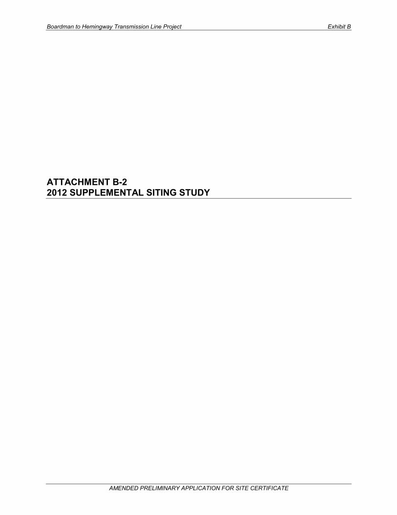
Following the CAP, the Glass Hill Alternative (see Figure 3.3-2) was developed by IPC in April 2010 to avoid the Eastern Oregon University Rebarrow Research Forest at the northern end of Glass Hill. In addition, the Glass Hill Alternative was refined by the IPC engineering team to minimize construction difficulty through the very severe topography found throughout this area.
The BLM Scoping Process in the fall of 2010 generated many stakeholder comments on the proposed and alternative routes in the Glass Hill area. Through the scoping process it became clear that there were many contradictory views regarding the location of the Proposed Route. IPC set up community meetings subsequent to the 2010 Scoping Process to continue to work with landowners in this area.
Figure 3.3-3 shows alternatives submitted through the Scoping Process in blue, and those alternatives developed through citizen correspondence and discussions with IPC in orange. The southern portion of the Glass Hill Alternative, as proposed in the 2010 Siting Study (MP 6-16 on Figure 3.3-3), was eliminated due to environmental resource concerns identified by ODFW during the 2010 scoping process, landowner opposition and environmental habitat concerns. Additional routing suggestions from landowners to evaluate routes south of the 2010 Glass Hill Alternative were assessed by IPC and were determined not to have fewer environmental impacts than the 2010 Glass Hill Alternative and actually crossed more severe terrain.
Several 2010 scoping comment letters asked that alternatives follow the existing utility easements in the Glass Hill area. As previously discussed, analysis of a route parallel to the existing 230-kV transmission line took place during the CAP. At the request of landowners, IPC revisited this analysis and consulted with ODFW. ODFW reported that if an upland route out of the wetland habitat could be developed the agency would consider such a route (ODFW 2011). However IPC again came to the same conclusion that a route in this vicinity would have more potential impact than either the Proposed Route or Glass Hill Alternative due to steep upland terrain and proximity to homes and cabins on the ridge west of La Grande and therefore should not be carried forward for further asssessment.
An alternative following the existing natural gas pipeline in this vicinity also would cross the Ladd Marsh Wildlife Management Area, a Protected Area under EFSC guidelines. IPC put the permitting difficulty of the route aside and conducted an engineering analysis. This analysis found the Proposed Route more favorable than the alternative following the pipeline from an engineering and constructability standpoint.
Supplemental Siting Study Boardman to Hemingway Transmission Line Project
June 2012 13
Figure 3.3-2. Proposed Route and Alternative to Avoid Rebarrow Research Forest

Supplemental Siting Study Boardman to Hemingway Transmission Line Project
June 2012 14
Figure 3.3-3. Additional Glass Hill Routes Identified through 2010 Scoping and Citizen Correspondence

Supplemental Siting Study Boardman to Hemingway Transmission Line Project
June 2012 15
Other alternatives proposed in this vicinity as a result of the 2010 scoping process generally follow a northwest to southeast alignment near the location of the proposed and alternative routes. IPC reviewed the stakeholder concerns and scoping alternatives and attempted to strike a stakeholder, environmental permitting, and constructability balance. During review of the many alternatives, IPC decided to relocate the 2010 Proposed Route approximately 3 miles to the east to an alignment suggested during the scoping process. This decision was made after an engineering review of the area identified this ridgeline, between Rock Creek and Sheep Creek, as providing the best access and terrian for construction and maintainance of a transmission line. IPC decided to keep a segment of the 2010 Proposed Route, adjusted slightly for engineering purposes, as the new (2011) Glass Hill Alterantive (see Figure 3.3-4).
While IPC has identified a Proposed Route (UN1-UN3-UN12-UN7) and alternative route (UN1-UN2-UN3) in the Glass Hill area, landowner concerns have not abated. IPC understands this and plans to continue to work with local residents to improve the alignment of the proposed and alternative routes. For a comparison of the resources crossed by the Glass Hill Alternative relative to the comparable section of the Proposed Route, see Appendix E, Table E-2.
3.3.2 Elimination of Blue Mountain Forest State Park Alternative IPC’s continued analysis of the Proposed Route in late 2010 revealed a crossing of an EFSC-designated Protected Area, the Blue Mountain Forest State Scenic Corridor. This led to the development of the Blue Mountain Forest State Park Alternative (UN4-UN5-UN6), which avoided the State Scenic Corridor (see Figure 3.3-5).
The Blue Mountain Forest State Park Alternative is 3.2 miles long and is located within the Wallowa-Whitman National Forest (NF) utility corridor. The alternative departs from the Proposed Route at MP 101.1 and proceeds easterly, crossing Interstate 84 (I-84) at MP 0.9 before angling southeasterly at MP 1.0 to pass along the eastern edge of a segment of the Blue Moutain Forest State Scenic Corridor. At approximately MP 1.7 the route angles farther to the south, crosses back over I-84, and rejoins the Proposed Route at MP 104.1.
A subsequent engineering evaluation determined it was possible to span the Blue Mountain Forest State Scenic Corridor, thereby minimizing construction and maintenance impacts by eliminating the need for access roads and tower pads on park lands. The potential impacts of the Blue Mountain Forest State Park Alternative were then discussed with ODOE and the Oregon Deparment of Parks and Recreation. Ultimately, it was determined that the alternative would likely result in more impacts than the Proposed Route. For this reason, the Blue Mountain Forest State Park alternative was eliminated from further study.
3.3.3 Elimination of Clover Creek Valley Alternative IPC considered the Clover Creek Valley Alternative (UN7-UN8-UN9) to avoid crossing the northern end of the Clover Creek Valley, which is actively farmed and zoned as EFU. This alternative, while avoiding the farmland by crossing to the north of the valley, would require two crossings of an existing 230-kV line within a stretch of 2.7 miles (Figure 3.3-6). This alternative is described in detail in the 2010 Siting Study, Section 4.2.3.
The Clover Creek Valley Alternative was presented to the public during the fall 2010 scoping process and at various IPC community meetings . Little concern over the location of the Proposed Route in this area or support for the alternative was received and IPC decided to eliminate the alternative due to the need for two crossings of the existing 230-kV line.

Supplemental Siting Study Boardman to Hemingway Transmission Line Project
June 2012 16
Figure 3.3-4. 2012 Glass Hill Proposed and Alternative Routes

Supplemental Siting Study Boardman to Hemingway Transmission Line Project
June 2012 17
Figure 3.3-5. Proposed Route and Blue Mountain State Park Alternative

Supplemental Siting Study Boardman to Hemingway Transmission Line Project
June 2012 18
Figure 3.3-6. Proposed Route and Clover Creek Alternative

Supplemental Siting Study Boardman to Hemingway Transmission Line Project
June 2012 19
3.3.4 Other Route Adjustments In addition to the above mentioned route changes in Union County, there have been some additional centerline adjustments to the Proposed Route. Figures C-3 and C-4 in Appendix C detail the route changes between the 2012 Proposed Route and 2010 Proposed Route. Between MP 100 and 103, the centerline was shifted to avoid a segment of Blue Mountain Forest State Scenic Corridor and also engineered to improve tower locations (Appendix C, Figure C-3, ID 19). Another slight adjustment to the centerline occurred between MPs 106 and 108.5, called out as ID 20 on Figure C-3 in Appendix C. This adjustment was made to follow IPC’s separation guildelines when paralleling existing lines. ID 23, on Figures C-3 and C-4 in Appendix C, identifies a southwest shift of the Proposed Route centerline between MPs 116 and 126. This adjustment shifted the Proposed Route outside the boundary of the Eastern Oregon University Rebarrow Research Forest, accounted for landowner input received, and also significantly improved constructability of the route through the steep terrain in this area. Between MPs 127 and 128, ID 25 on Figure C-4 in Appendix C, the centerline was shifted to avoid crossing an Oregon Department of Transportation gravel pit and blasting area. Slightly farther south, between MPs 130 and 134, the line was engineered per a landowner request to shift the alignment closer to an existing 230-kV line to avoid a potential new structure location (Appendix C, Figure C-4, ID 26).
3.4 Baker County, Oregon The Willow Creek Alternative and the Tub Mountain South Alternative are located in both Baker and Malheur counties. Since development of these routes is most closely associated with resouces in Malheur County, both alternative are discussed below in Sections 3.5.6.1, Willow Creek Alternative and Section 3.5.6.3 Tub Mountain South Alternative.
3.4.1 NHOTIC Alternatives An ongoing concern in Baker County has been the potential for visual impacts to the NHOTIC. Several routes were originally studied in this vicinity, as discussed in Section 3.3.8 of the 2010 Siting Study. In 2008, the Proposed Route was located west of the NHOTIC. Local officials and citizens were concerned about impacting views to the west (across Baker Valley) from this facility. In response to these concerns, IPC the Porposed Route to its current location, about a mile east of the NHOTIC. However, potential visual impacts from the NHOTIC looking east became an issue once the Proposed Route was presented, prompting further study of alternatives in this vicinity. Again, there were many landowner requests to push the Proposed Route farther east of the NHOTIC to reduce visibility. Four alternative routes have been considered in this area; the Flagstaff and Timber Canyon alternatives, which have been retained for detailed analysis in the EIS, and the Virture Flat and Powder River alternatives, which have been eliminated from further study. The locations of these routes are shown on Figures 3.4-1 and 3.4-2.
3.4.1.1 Flagstaff and Timber Canyon Alternatives Proposed for Detailed Analysis
Flagstaff Alternative The BLM identified the Flagstaff Alternative (BA2-BA5-BA3; BA6-BA7), which is 14.1 miles long and is located to the west of the NHOTIC. This alternative would necesitate the relocation of a 0.9-mile segment of the existing 230-kV IPC transmission line (see Figure 3.4-1). The 230-kV line would be relocated slightly to the east between two hilltops just south of State Highway 86.
The Flagstaff Alternative crosses 0.3 miles of Vale District, BLM-managed land, and 13.8 miles of privately owned land. The 230-kV relocation is located on privately owned land. This alternative leaves the Proposed Route at MP 149.7, angling to the southeast across State Highway 203 at MP 0.9.

Supplemental Siting Study Boardman to Hemingway Transmission Line Project
June 2012 20
Figure 3.4-1. NHOTIC Vicinity Proposed and Alternative Routes

Supplemental Siting Study Boardman to Hemingway Transmission Line Project
June 2012 21
Figure 3.4-2. Powder River and Timber Canyon Alternatives

Supplemental Siting Study Boardman to Hemingway Transmission Line Project
June 2012 22
Approximately 0.7 mile beyond this road crossing, this route joins in a corridor with an existing IPC 230-kV wood pole H-frame transmission line proceeding almost due south for 2.0 miles along the eastern edge of agricultural fields to MP 3.6. This alternative continues to follow the existing 230-kV line as it angles to the southwest, crosses State Highway 86 and then proceeds south between two hills. It is between these two hills where the 0.9-mile segment of the existing 230-kV line would be relocated several hundred feet to the east to allow for placement of the 500-kV towers within this valley.
Land use in this segment (3.6 miles) from State Highway 203 to State Highway 86 includes 1.4 miles of irrigated agricultural land and 2.2 miles of rangeland at the eastern edge of the Baker Valley. At MP 2.3 in the vicinity of Prowell Lane, the Flagstaff Alternative passes just east of a farm complex with another farmstead passed near MP 3.5. The alternative passes within 0.2 mile of a segment of the Oregon Trail Area of Critical Environmental Concern (ACEC) and within about 1.0 mile of the NHOTIC.
At MP 4.9, the Flagstaff Alternative crosses the relocated 230-kV line before angling to the southwest to stay in corridor with this existing line. The Flagstaff Alternative then leaves the 230-kV line at MP 5.7 and turns southerly, passing between irrigated agricultural fields. The alternative route then angles to the southwest acrsos rangeland to rejoin the corridor with the existing 230-kV line at MP 7.3. After crossing another 4.4 miles of rangeland, the route joins the transportation/utility corridor with I-84, a 69-kV line, and a 138-kV line, which it parallels to its intersection with the Proposed Route at MP 163.9.
IPC had eliminated the Flagstaff Alternative from further consideration during the CAP process after detailed analysis of this vicinity indicated the current Proposed Route would be less difficult to permit and construct than the Flagstaff Alternative (see 2010 Siting Study, Section 3.3.8, Interpretive Center Region). However, in response to concerns about potential visual impacts to the setting of intact segments of the Oregon National Historic Trail and impacts to sage-grouse core area habitat, the BLM plans to study this alternative in detail in the EIS.,
The Flagstaff Alternative was retained for detailed analysis because when compared to the corresponding segment of the Proposed Route because it :
• Follows an existing 230-kV line for its length, • Avoids creating a new utility corridor in Baker County, • Crosses 11.1 fewer miles of sage-grouse core area, and • Crosses 5.3 fewer miles of Visual Resource Management (VRM) Class II lands.
For a complete comparison of resources crossed by the Flagstaff Alternative and the comparable segment of the Proposed Route, see Appendix E, Table E-3.
Timber Canyon Alternative The Timber Canyon Alternative (BA1-CL6-CL7-BA4) avoids the vicinity of the NHOTIC and Baker City. Additionally it skirts the edges of ODFW-designated core sage-grouse habitat and avoids crossing any occupied 2-mile sage-grouse lek buffers (see Figure 3.4-2). This alternative leaves the Proposed Route near North Powder and heads east, turning southeast near the community of Medical Springs and rejoining the Proposed Route southeast of the town of Durkee. While this route appears to resolve the visual concerns near the NHOTIC and avoids core sage-grouse lek habitat, it would require nearly 62 miles of new ROW, with about 18 miles located on USFS-managed lands in steep terrains and comes within one mile of the community of Medical Springs, where significant landowner concerns were expressed during 2008 siting studies. Additionally, the USFS has concerns with the route as it crosses several miles of lands designated as having visual quality objectives of partial retention and retention as well as lands with historic mining sites.

Supplemental Siting Study Boardman to Hemingway Transmission Line Project
June 2012 23
The Timber Canyon Alternative is 61.6 miles long, of which 13.8 miles are located in Union County and 47.8 miles in Baker County. It traverses 19.6 miles of the Wallowa-Whitman NF, 5.7 miles of Vale District, BLM-managed lands, and 36.3 miles of privately owned lands.
The Timber Canyon Alternative leaves the Proposed Route at MP 137.4 in Baker County and proceeds easterly, crossing an existing 230-kV transmission line at approximately MP 0.4 before crossing from Baker County over the Power River into Union County at approximately MP 1.1. From this point this alternative continues easterly, passing about 0.5 mile north of the Thief Valley Reservoir between MPs 2.0 and 3.0 and angling to the north of Fisk Reservoir across very rugged terrain.
At MP 10.3 this route angles southeast passing just west of the Wallowa-Whitman NF and approximately 1.8 miles farther southeast the alternative route enters the NF for a distance of about 1.7 miles. It crosses private land for the next 0.5 miles, re-entering the NF at MP 14.4 where it remains for the next 16.8 miles, to MP 31.2, having passed into Baker County again at MP 14.9.
The 16.8-mile segment through the Wallowa-Whitman NF crosses primarily forested land with some rangeland. The alternative route crosses several NF Management Areas including areas 1, 1W, 3, and 16. NF Management Area 1, Timber Production Emphasis, is traversed for a total of 8.3 miles and is managed with an emphasis on wood fiber production on suitable timber lands while providing relatively high levels of forage and recreational opportunities. NF Management Area 1W, Timber Management – Winter Range, is crossed for a total of 3.2 miles. NF Management Area 3, Wildlife/Timber: Big Game Winter Range, is crossed for 8.4 miles and has similar management practices as Management Area 1, with emphasis on timber production. Lands within Management Area 16, Administrative and Recreation Site Retention, include areas with sites such as work centers, fire lookouts, ranch headquarters, campgrounds, and other public recreation sites. The Timber Canyon Alternative crosses Management Area 16, known as the Forshey Orchard, for 0.1 mile between MPs 27.8 and 27.9.
In addition to the previous management boundaries, the Wallowa-Whitman NF manages visual resources through standards and guidelines known as Visual Quality Objectives (VQOs). The Timber Canyon Alternative crosses 4.2 miles of the VQO category Maximum Modification, 14.1 miles of the VQO category Modification, 3.5 miles of the VQO category Partial Retention, and 0.4 mile of the VQO category Retention. The alternative also crosses a total of 20 miles of the NF Recreation Opportunity Spectrum category Roaded Natural.
After leaving the NF, the Timber Canyon Alternative passes northeast of the community of Sparta before angling easterly toward Eagle Creek. Proceeding south, west of Eagle Creek and Eagle Valley, the alternative crosses an existing 230kV transmission line at MP 38.2 before angling southwesterly and across State Highway 86, the Hells Canyon Scenic Byway, at MP 40.8. At MP 42.3, the route crosses the Powder River, approximately 3 miles west of the Brownlee Reservoir, where it angles easterly across the northern foothills of Sheep Mountain. At its closest point, the Timber Canyon Alternative comes within 2 miles of the town of Richland.
The alternative turns due south at MP 45.2 and then angles to the west at MP 47.2 where it proceeds across rangeland and forested land for the next 14 miles, passing south of Sheep Mountain and northwest of Big Lookout Mountain, to rejoin with the Proposed Route at its MP 183.8.
In response to concerns about potential visual impacts to the NHOTIC, the setting of intact segments of the Oregon National Historic Trail, and core sage-grouse habitat the BLM plans to study this alternative in detail in the EIS. However, IPC is concerned about developing almost 62 miles of new ROW in a remote area and is not in favor of pursuing the Timber Canyon Alternative.

Supplemental Siting Study Boardman to Hemingway Transmission Line Project
June 2012 24
The Timber Canyon Alternative, when compared to the corresponding segment of the Proposed Route, was retained for detailed analysis because it:
• Avoids the NHOTIC by 15.9 miles, • Crosses 30.2 fewer miles of sage-grouse core area, • Avoids occupied sage-grouse lek buffers, • Avoids crossing intact Oregon Trail segments, • Crosses 1.6 fewer miles within 1,200 feet of historic trails,Crosses 7.2 fewer miles of prime
farmland, • Crosses 17 fewer miles of EFU zoned land, and • Crosses 0.9 fewer miles of VRM Class II lands.
For a complete comparison of resources crossed by the Timber Canyon Alternative and the comparable segment of the Proposed Route, see Appendix E, Table E-4.
3.4.1.2 Elimination of Virtue Flat Alternative and Powder River Alternative The Virtue Flat and Powder River Alternatives were considered by both IPC and the BLM, respectively, because the routes shifted the alignment farther to the east away from the NHOTIC. These alternatives were ultimately deemed infeasible due to the presence of occupied sage-grouse leks and their associated 2-mile exclusion buffers, the core sage-grouse habitat area designation by ODFW and the crossing of an ACEC proposed in the preferred alternative for the Baker Resource Area Draft Resource Management Plan and EIS2.
Virtue Flat Alternative The Virtue Flat Alternative (BA10-BA11) identified by IPC is located east of Baker City and the NHOTIC and crosses several active sage-grouse lek 2-mile buffer zones, designated ODFW Category 1 Habitat (see Figure 3.4-1). IPC had retained this alternative despite it crossing ODFW Category 1 Habitat due to local citizen interest in locating the route farther from the NHOTIC. IPC felt that an evaluation of the Virtue Flat Alternative in conjunction with the Proposed Route would allow for an analysis and balancing of recognized resource issues. The Virtue Flat Alternative is described in detail in the 2010 Siting Study, Section 4.2.4.
Surveys conducted during the 2010 field season found three additional active sage-grouse leks in the Virtue Flat vicinity with 2-mile buffer zones extending across the Virtue Flat Alternative. The potential for environmental impacts along this alternative, as compared with the Proposed Route, are significantly higher and concerns were raised by both BLM and ODFW during field visits. Therefore, despite continued public support for the Virtue Flat Alternative, it was eliminated from further consideration.
Powder River Alternative BLM explored the possibility of a Powder River Alternative (BA1-CL6-UN10-CL8-BA12); a shift even farther east of the NHOTIC than the Virtue Flat Alternative, approximately 8 miles east, to a narrow slot between occupied lek buffers in the vicinity of Keating and the Powder River (Figure 3.4-2).
The Powder River Alternative is 40.7 miles long, crossing 7.5 miles of land managed by the BLM and 33.2 miles of privately owned land. The Powder River Alternative departs from the Proposed Route at
2 Baker Resource Area. 2011. Draft Resource Management Plan and Environmental Impact Statement. Baker Field Office, Vale
District. U.S. Department of the Interior, Bureau of Land Management. Available online at: http://www.blm.gov/or/districts/vale/plans/bakerrmp/draftrmp.php

Supplemental Siting Study Boardman to Hemingway Transmission Line Project
June 2012 25
MP 137.4 and proceeds easterly, crossing an existing 230-kV transmission line at approximately MP 0.4 before crossing from Baker County over the Powder River into Union County at approximately MP 1.1. The route passes about 0.5 mile north of the Thief Valley Reservoir, angles to the north of Fisk Reservoir across very rugged terrain, and proceeds across State Highway 203 at MP 9.9.
At MP 11.0, the Powder River Alternative proceeds south, passing approximately 1,500 feet to the east of the town of Medical Springs. At MP 15.0, the route crosses back into Baker County, passes west of Langrell Gulch and proceeds across the foothills of Sawtooth Ridge. Approximately one mile northeast of Table Mountain (MP 18.0), the route angles and continues to the southeast traversing very rugged terrain.
Between MP 23.0 and 27.0 the route passes approximately 0.8 mile east of the Clover Creek East Valley before crossing the Powder River, State Highway 86 and the Lower Powder Valley between MP 27.8 and 28.7. Proceeding southwesterly from MP 28.7, the route passes approximately 0.6 miles west of Love Reservoir (MP 33.0). At MP 34.9 the Power River Alternative angles south and proceeds in this direction to its intersection with the Proposed Route at MP 171.4.
Through discussions with the ODFW it became clear that the Powder River Alternative was located in an area considered to be prime habitat for the sage-grouse and therefore should not be disturbed by a new transmission corridor. Additionally, through public meetings and outreach it was clear that landowner opposition to a route in this location was extremely high. Therefore, the Powder River Alternative will not be studied in detail by the BLM in the EIS.
3.4.2 Burnt River Mountain Alternative The BLM identified the Burnt River Mounatain Alternative in May 2012 to address sage-grouse core habitat and potential Golden Eagle nest issues along the Proposed Route between MPs 171.4 and 188.2 (see Figure 3.4-3). The Burnt River Mountain Alternative is 16.8 miles long, with 4.6 miles located on BLM-managed land and 12.2 miles on privately owned land.
The alternative departs from the Proposed Route at MP 171.4 where it it immediately angles to the south, across the existing IPC 138-kV and 69-kV transmission lines before crossing the Union Pacific Railroad, I-84, and an existing pipeline corridor. The Burnt River Mountain Alternative proceeds south across rangeland for the next few miles before traversing the western end of the Durkee Valley between MPs 6.7 and 7.0, having crossed the Burnt River at approximately MP 6.9.
At MP 8.0, the alternative angles to the east, passing south of Powell Creek Reservoir before proceeding easterly across the northern foothills of Gold Ridge. At MP 11.6, the Burnt River Mountain Alternative turns southeasterly and begins to parallel the existing 138-kV transmission line, offset approximately 200 feet to the west side. Passing approximately 0.5 mile west of the Ash Grove Cement Plant at MP 12.0, the route proceeds to cross the aggregate source area for the cement plant between MP 12.4 and MP 12.7 before proceeding across Shirttail Creek Road (MP 13.0) and Shirttail Creek (MP 13.4). At MP 15.7, the alternative angles easterly, crossing the Union Pacific Railroad, the Burnt River, I-84, and an existing pipeline before rejoining the Proposed Route near Weatherby at MP 188.2.
The BLM has maintained the Burnt River Mountain Alternative for detailed analysis in the EIS because it avoids impacts to core sage-grouse habitat and maximizes the use of public lands. See Appendix E, Table E-5 for a full comparison of resources crossed by this alternative relative to the comparable segment of the Proposed Route.
3.4.3 Elimination of Weatherby Alternative The Weatherby Alternative (BA13-BA14-BA15) was developed in the event that the corresponding section of the Proposed Route proved infeasible due to construction or other engineering issues along I-84 and the east side of the Weatherby Mountains (Figure 3.4-4). Like the Proposed Route, the Weatherby

Supplemental Siting Study Boardman to Hemingway Transmission Line Project
June 2012 26
Figure 3.4-3. Burnt River Mountain Alternative

Supplemental Siting Study Boardman to Hemingway Transmission Line Project
June 2012 27
Figure 3.4-4. Weatherby Alternative and Proposed Route

Supplemental Siting Study Boardman to Hemingway Transmission Line Project
June 2012 28
Alternative crosses severe terrain with potential construction challenges. Because neither the Proposed Route nor the Weatherby Alternative resolved the terrain challenges of the area, IPC continued to analyze options in this vicinity. The Weatherby Alternative is described in detail in the 2010 Siting Study, Section 4.2.5.
Through continued route evaluation and engineering assessment, IPC developed a new option for passing through the Weatherby Mountain area. The Proposed Route in the 2010 Siting Study proceeded south from Weatherby, paralleling the east side of the existing IPC 138-kV transmission line for approximately one mile before crossing over the existing 138-kV and 69-kV transmission lines, the Burnt River, the Union Pacific Railroad, and I-84 and continuing south along the base of the Weatherby Mountains, parallel to the west side of the existing 138-kV line. IPC’s current proposal locates the 500-kV transmission line within the ROW of the existing 138-kV transmission line for approximately 4.1 miles (BA16-BA18). Proceeding south from Weatherby, the Proposed Route follows the existing 138-kV ROW across the base of the Weatherby Mountains and over to the south side of Dixie Creek. The existing 138-kV line, along with the existing IPC 69-kV line, would be rebuilt as a double-circuit 138/69-kV line within the existing 69-kV ROW for a distance of approximately 5 miles (BA8-BA17). The rebuild will require an additional 0.3-mile segment of new 138-kV line (BA17-BA9) to be built to tie the line back into the existing 138-kV ROW and would require removal of approximately 0.8 mile of the existing 138-kV line between nodes BA8-BA16 and BA18-BA9.
IPC believes this rebuild option is the best solution from both an environmental permitting and engineering perspective, and no longer needs an alternative in the area, causing the Weatherby Alternative to be removed from further consideration.
3.4.4 Other Route Adjustments In addition to the route changes discussed above, seven additional adjustments to the Proposed Route were adopted in Baker County as shown in Appendix C, Figures C-5 and C-6. They are:
• Between MPs 151 and 152 (ID 28), the Proposed Route was adjusted to avoid crossing an occupied sage-grouse lek 2-mile exclusion buffer.
• Between MPs 154 and 157 (ID 29), the Proposed Route was shifted to the east to reduce visbilty from the NHOTIC.
• Between MPs 158.5 and 164 (ID 31), the Proposed Route was shifted slightly east to improve constructability.
• Between MPs 165 and 168 (ID 32), the Proposed Route was shifted slightly to the north to improve crossing of an existing 69-kV transmission line and better utilize existing 138-kV transmission corridor.
• Between MPs 168 and 170 (ID 33), the Proposed Route was shifted south in response to landowner request to shift alignment farther from existing residence.
• Between MPs 180 and 183 (ID 35), the Proposed Route was shifted slightly west in response to landowner discussion concerning avoidance of natural amphitheater.
• Between MPs 186 and 187.5 (ID 36), the Proposed Route was shifted slightly west in response to landowner discussion.
These adjustments are now part of the 2012 Proposed Route, which will be studied in detail in the EIS.
3.5 Malheur County, Oregon This section describes the evolution of the May 2012 routes in Malheur County. This discussion includes an evaluation of the alternative routes and river crossings. Key factors in evaluating the feasibility of

Supplemental Siting Study Boardman to Hemingway Transmission Line Project
June 2012 29
alternative routes in Malheur County were resource and terrain features at and surrounding the Owyhee River. Figure 3.5-1 shows proposed and alternative alignments in the vicinity of the Owyhee River including multiple resource management areas and terrain constructability concerns.Table 3.5-1 provides a comparison of the four river crossings that factored in to the siting discussion below.
Table 3.5-1. Comparison of Proposed and Alternative Routes in the Vicinty of the Owyhee River
Constraint
2010 POD Owyhee River Below Dam Alternative (miles)
2010 POD Proposed Route/Malheur A
Alternative (miles)
Malheur S Alternative
(miles)
2012 Proposed
Route (miles) Area of Critical Environmental Concern 2.9 2.4 1.3 0
Special Recreation Management Area 2.9 2.4 1.3 0
Vale District Utility Corridor 0.6 3.3 0 1.5 BLM Visual Resource Management Class II 2.8 2.3 1.5 0.5
Wilderness Characteristic Unit Meeting Wilderness Criteria
2.7 0 0 0
Suitable Wild and Scenic River: Recreation 0.5 1.1 1.0 1.0
West-wide Energy Corridor 0.7 0.8 0 0
3.5.1 Development of the 2012 Proposed Route In Malheur County, irrigated agricultural fields and EFU zoned lands were and continue to be primary concerns of the county stakeholders. The 2010 Proposed Route (CL9-MA14-MA15-MA8-MA6-MA9-MA11-MA5-CL10) through Malheur County resulting from the CAP addressed these concerns. The Proposed Route entered Malheur County from Baker County and angled west and then south around agricultural fields, thereby minimizing the crossing of EFU-zoned lands and maximizing the use of public lands. The route turned southeasterly in the vicinity of Grassy Mountain and began paralleling the existing Summer Lake to Midpoint 500-kV transmission line east into Idaho and along to the Hemingway Substation (see Figure 3.5-2).
Subsequent engineering analyses found that the 2010 Proposed Route at the Owyhee River crossing/crossing of the Owyhee River Below Dam ACEC/Special Recreation Management Area (SRMA) (see Figure 3.5-1 [A]) could not be substantially located within the utility corridors along the existing Summer Lake to Midpoint 500-kV transmission line designated by the U.S. Department of Energy (West-wide Energy Corridor) and the BLM (Vale District Utility Corridor) due to electrical separation requirements and terrain factors.
Then in late 2010, the Vale District of the BLM conducted a Wilderness Characteristics Inventory for the Malheur Resource Area. Results of this inventory revealed that several miles of the 2010 Proposed Route in Malheur County crossed lands identified as meeting wilderness characteristics criteria (MA8-MA6, Figure 3.5-3). Also, a comment was received during the scoping period suggesting the use of an alternate segment of the Vale District utility corridor located north and east of the 2010 Proposed Route.

Supplemental Siting Study Boardman to Hemingway Transmission Line Project
June 2012 30
Figure 3.5-1. Owyhee River Crossings

Supplemental Siting Study Boardman to Hemingway Transmission Line Project
June 2012 31
Figure 3.5-2. 2010 and 2011 Proposed Route Changes

Supplemental Siting Study Boardman to Hemingway Transmission Line Project
June 2012 32
Figure 3.5-3 Proposed Route, Malheur A and S Alternatives, and Wilderness Characteristic Areas

Supplemental Siting Study Boardman to Hemingway Transmission Line Project
June 2012 33
After analyzing the factors described above, IPC decided to evaluate a new route east of the 2010 Proposed Route between nodes MA8 and MA5 that utilized part of the alternate segment of the BLM utility corridor. This new route segment avoids the ACEC/SRMA at the Owyhee River (see Figure 3.5-1 [B]) and lands with wilderness characteristics, follows the utility corridor, and meets engineering requirements. A one-mile segment of the route in the vicinity of the Owyhee River crossing is located outside of the Vale District Utility Corridor. This decision to deviate from the designated corridor was an attempt to balance several resource issues. The actual Owyhee River crossing occurs outside the Vale District Utility Corridor in order to avoid crossing EFU-zoned private lands, remaining on public, EFU-zoned, though inactively farmed, lands. For these reasons, IPC adopted this route segment as the new (2012) Proposed Route alignment (CL9-MA13-MA14-MA15-MA8-MA1-MA2-MA3-MA4-MA5-CL10).
3.5.2 Elimination of Owyhee River Below Dam Alternative The Owyhee River Below Dam Alternative (Figure 3.5-1 [A] or Figure 3.5-3) was a 3.9-mile segment described in detail in Section 4.2.6 of the 2010 Siting Study that provided an alternate location for the approach to and crossing of the Owyhee River. Such an alternative was needed because, as discussed in Section 3.5.1, the 2010 Proposed Route presented serious engineering and constructability challenges at its crossing of the Owyhee River. Once the results of the Vale District BLM’s wilderness characteristic inventory came out in late 2010, it became clear that this alternative was no longer a viable option. The BLM had found the Sand Hollow and Burnt Mountain Wilderness Units to meet wilderness criteria, essentially designating these areas as exclusion areas from a permitting perspective. The Owyhee River Below Dam Alternative crossed both of these units and, as a result, this alternative was eliminated from further study.
3.5.3 Double Mountain Alternative To maximize the use of public land in Malheur County, IPC developed the Double Mountain Alternative (MA2-MA7-MA3), a 7.4-mile-long alternative located entirely on BLM-managed land. Although the alternative crosses the northern extreme of the Double Mountain Wilderness Characterisitic Unit, it avoids private range and farmland to the northeast. Figure 3.5-4 shows the 2012 Proposed Route and the Double Mountain Alternative.
The Double Mountain Alternative leaves the Proposed Route at MP 244.9 and proceeds southeast across Sand Hollow and an unnamed road at MP 1.5. At MP 1.6 the alternative angles easterly, crosses Rock Canyon between MPs 2.3 and 2.7, and passes north of Bentonite Spring. The alternative then crosses three unnamed roads (MPs 3.7, 5.5, and 5.7) before proceeding across Twin Spring Road at about MP 7.2, an unnamed road, and Cow Hollow to rejoin the proposed route at approximately MP 252.3.
This alternative was retained for detailed analysis because it crosses 6.2 fewer miles of private land, which is an important and significant public concern in Malheur County. See Appendix E, Table E-6 for a full comparison of resources crossed by the Double Mountain Alternative relative to the comparable segment of the Proposed Route.

Supplemental Siting Study Boardman to Hemingway Transmission Line Project
June 2012 34
Figure 3.5-4. Double Mountain Alternative

Supplemental Siting Study Boardman to Hemingway Transmission Line Project
June 2012 35
3.5.4 Malheur S Alternative While IPC adopted a new Proposed Route alignment in Malheur County, it also designated an alternative route called the Malheur S Alternative (MA1-MA12-MA6-MA4-MA5) as shown in Figure 3.5-3. The Malheur S Alternative was sited to maintain an alternative that adhered to the conceptual routes developed during the CAP in this vicinity. The Malheur S Alternative resembles the abandoned segment of the 2010 Proposed Route but avoids wilderness characteristic units meeting wilderness criteria and crosses the Owyhee River to the north of the existing PacifiCorp Summer Lake to Midpoint 500-kV transmission line. The alternative crosses 32.5 miles of BLM-managed land, 0.1 mile of Bureau of Reclamation–managed land, and 1.1 miles of private land.
The Malheur S Alternative departs from the 2012 Proposed Route at MP 242.6 near Vines Hill along U.S. Highway 20 and heads south, passing to the east of the Broken Rim Wilderness Characteristic Unit before turning east and snaking between the Double Mountain and Sourdough Mountain Wilderness Characteristic Units (all found to meet wilderness criteria). The Malheur S Alternative proceeds to the east across the northern end of Grassy Mountain and over the Owyhee River. The Owyhee River is crossed approximately 5 miles downstream from the Owyhee Dam at MP 23.9. In crossing the Owyhee River, the alternative traverses 1.3 miles of the Owyhee River Below the Dam ACEC and SRMA between MPs 22.7 and 24.0.
At MP 25.3, the Malheur S Alternative turns south to join in corridor with the existing 500-kV transmission line. Entering the Vale District utility corridor at MP 25.8, this alternative parallels or is within a West-wide Energy corridor for the next approximately 8 miles. From MP 25.9 to MP 29.6, the Malheur S Alternative parallels the northeast side of the West-wide Energy corridor and from MP 29.6 to its intersection with the Proposed Route it is located within the West-wide Energy corridor.
The Malheur S Alternative was sited with the intention of following the existing 500-kV corridor and making use of the Vale District BLM-designated utility corridor. Therefore, crossing the Owyhee River Below the Dam ACEC/SRMA and a segment of the Wild and Scenic River suitable for recreation designation are unavoidable.
The Malheur S Alternative when compared to the corresponding segment of the Proposed Route was retained for detailed study because it:
• Provides a public land alternative to the Proposed Route, • Crosses 5.3 fewer miles of private land, • Avoids EFU-zoned lands, and • Is similar to the 2010 Proposed Route, but avoids wilderness characteristic areas.
For a complete comparison of resources crossed by the Malheur S Alternative and the comparable segment of the Proposed Route, see Appendix E, Table E-7.
3.5.5 Malheur A Alternative The BLM identified the Malheur A Alternative in early 2011 after learning of IPC’s decision to move a segment of the Proposed Route to the east and cross the Owyhee River along the northern boundary of the Owyhee River Below the Dam ACEC. The Malheur A Alternative is coincident with the Malheur S Alternative until MP 18.4 and from that point until the alternative meets with the 2012 Proposed Route, follows a very similar alignment to the 2010 Proposed Route. At MP 18.4, the Malheur A Alternative turns southeasterly and angles across the Summer Lake to Midpoint 500-kV transmission line before crossing the Owyhee River and paralleling the 500-kV line along its south side (MA1-MA12-MA6-MA9-MA11-MA5).

Supplemental Siting Study Boardman to Hemingway Transmission Line Project
June 2012 36
The Malheur A Alternative is 33.2 miles long and is located almost entirely on BLM-managed land, with 0.4 mile located on Bureau of Reclamation–managed lands and 1.5 miles located on private land. The vast majority of this alternative route traverses large tracts of severe topography, rangeland, and sagebrush with very little or no development. In addition to skirting the wilderness characteristic units mentioned above, the Malheur A Alternative passes along the northern end of the Sand Hollow, Burnt Mountain, and Board Corral Mountain Wilderness Characteristic Units, which were all found to meet wilderness criteria.
At MP 18.4, the Malheur A Alternative angles to the south and enters the Vale District utility corridor at MP 19.9, crossing to the south side of the existing 500-kV line at MP 21.6. At MP 24.0 the alternative exits the utility corridor but parallels its south side for the next 9.2 miles to where the alternative joins with the Proposed Route at MP 273.1. Between MP 18.4 and 33.2, the Malheur A Alternative is located within a West-wide Energy Corridor for 3.4 miles and parallel to it for much of the other 14.8 miles. The alternative crosses the Owyhee River at MP 23.3 approximately 1.8 miles south of the Owyhee Dam (see Figure 3.5-1 [C]). The Owyhee River Below the Dam ACEC/SRMA is crossed by this alternative for a total of 2.4 miles between MP 21.7 and MP 25.0.
Like the Malheur S Alternative, the Malheur A Alternative was sited with the intention of following the existing 500-kV transmission corridor and utilizing the Vale District Utility Corridor. For this reason, crossing the Owyhee River Below the Dam ACEC/SRMA and the Wild and Scenic River suitable for recreation designation are unavoidable. The Malheur A Alternative when compared to the corresponding segment of the Proposed Route was retained for detailed study because it generally follows the original CAP-identified alignment with adjustments made to avoid wilderness characteristic units. For a comparison of resources crossed by the Malheur A Alternative, the Malheur S Alternative, and the comparable segment of the Proposed Route, see Appendix E, Table E-7.
3.5.6 Malheur Sage-grouse Alternatives The Willow Creek Alternative, the Brogan Alternative, and the Tub Mountain South Alternative in northern Malheur County have been sited and analyzed due to sage-grouse lek and core habitat issues along the 2012 Proposed Route.
3.5.6.1 Willow Creek Valley Alternative The Willow Creek Alternative was sited by IPC in late 2011 after meetings with ODFW revealed a potential issue along the Proposed Route. Between MPs 200.4 and 203.7, the Proposed Route crosses the occupied Trail Gulch sage-grouse lek’s associated 2-mile exclusion buffer. Initial siting analysis indicated that existing terrain in the area would screen visibility of the 500-kV towers within the 2-mile lek buffer and therefore not expose the sage-grouse to potential predators who may perch on the lattice towers. ODFW expressed concern that the location of the Proposed Route was cutting across core sage-grouse habitat with active leks along the north and south sides of the proposed route. It was explained that the placement of the route not only negatively impacts the Trail Gulch lek but would bisect prime breeding grounds and habitat for the species and an alternative location should be considered.
The Willow Creek Alternative is 24.6 miles long, with 11.3 miles located on BLM-managed land and 13.3 miles on privately owned land. While part of the alternative still lies within core sage-grouse habitat, the active leks are all north of the route (see Figure 3.5-5). The Willow Creek Alternative leaves the Proposed Route at MP 199.4, approximately 2.5 miles west of Huntington. Proceeding south, the route crosses Durbin Creek at MP 1.0 before passing east of Lost Tom Mountain and across Benson Creek (MP 2.3). Continuing south, the alternative leaves Baker County and enters Malheur County (MP 3.8)

Supplemental Siting Study Boardman to Hemingway Transmission Line Project
June 2012 37
Figure 3.5-5. Sage-grouse Alternatives in Malheur County

Supplemental Siting Study Boardman to Hemingway Transmission Line Project
June 2012 38
where it angles around the east side of Striped Mountain. At MP 5.9, the alternative crosses Birch Creek and then at MP 6.2 angles and proceeds in a southwest manner, passing south of McDowell Butte Reservoir (MP 8.7), across Dry Gulch and Mud Spring (MP 10.5), and over Stone Quarry Gulch (MP 13.4) to MP 13.7.
At MP 15.8, the Willow Creek Alternative enters the Willow Creek Valley, which is zoned EFU and heavily farmed. Proceeding southwest and spanning across irrigated agricultural fields and the Vale Oregon Canal, the alternative angles due south at approximately MP 16.5 and continues across U.S. Highway 26 (MP 16.8) to MP 17.0 where it then angles to the southwest between center pivot irrigation fields. At the closest point, the alternative is approximately one mile northwest of the community of Jamieson.
Southwest of the Willow Creek Valley, the alternative proceeds south across Poison Creek, Turner Creek, and the North and South Fork Little Willow Creeks. The Willow Creek Alternative then passes east of Morrison Reservoir and west of Hope Flat before joining with the Proposed Route at approximately MP 229.6, about 1.3 miles northwest of Hope Butte.
The Willow Creek Alternative, when compared to the corresponding segment of the Proposed Route, was retained for detailed study because it:
• Avoids crossing occupied Sage-grouse lek’s associated 2-mile buffer, and • Crosses 4.9 fewer miles of sage-grouse core habitat
For a complete comparison of resources crossed by the Willow Creek Alternative relative to the comparable segment of the Proposed Route, see Appendix E, Table E-8.
3.5.6.2 Brogan Alternative A key disadvantage of the Willow Creek Alternative is the crossing of actively farmed cropland and EFU-zoned land in the Willow Creek Valley. Recognizing this, IPC briefed Malheur County officials and the Stop Idaho Power group as well as held a public meeting in Brogan to present the Willow Creek Alternative to the public. One objective of the public meeting was to determine an optimum alignment across the actively farmed valley that would minimize agricultural impacts.
The only route suggestion received from meeting participants was to entirely relocate the Willow Creek Alternative out of EFU and agricultural land. As conceived by public meeting attendees, the Brogan Alternative (BA19-CL11-MA16-MA13-MA14) is shown on Figure 3.5-5 as a conceptual route. The Brogan Alternative deviates from the Willow Creek Alternative at MP 11.7, turns northwest and proceeds for about 8.5 miles before joining with the Proposed Route alignment at MP 211.5.
Based on the additional 8.1 miles of length and associated impact of the Brogan Alternative relative to the Proposed Route, and additional 13.7 miles relative to the Willow Creek Alternative, the Brogan Alternative was eliminated from further detailed study. See Table 3.5-2 below for a comparison of the three routes between common points BA19 and MA14.

Supplemental Siting Study Boardman to Hemingway Transmission Line Project
June 2012 39
Table 3.5-2. Comparison of Alternatives in Brogan Vicinity
Resource Name
Proposed Route BA19-CL9-MA13-
MA14
Willow Creek Alternative
BA19-MA16-MA14
Brogan Alternative BA19-MA16-MA13-
MA14 Length in Miles
Total Length 30.2 24.6 38.3 ODFW Sage-grouse Habitat: Core Area 19.6 14.7 27.6 ODFW Sage-grouse Habitat: Core Area Low Density 10.6 2.7 10.6
ODFW Sage-grouse Lek 2-mile Buffer (OR 2011): Occupied Pending 3.2 0.0 0.0
Exclusive Farm Use Zone/Multiple Use Range Zone 5.9 4.7 3.8 USDA Irrigated Cropland 0.0 2.0 0.1 Within 0.5 miles of Residence (Desktop Analysis) 0.0 2.2 0.0 Vale District Utility Corridor 0.7 2.5 2.8 Bureau of Land Management 16.3 11.3 28.3 Private Land 11.0 13.3 10.0 State Land 3.0 0.0 0.0
3.5.6.3 Tub Mountain South Alternative The BLM identified the Tub Mountain South Alternative in May 2012 to address avoidance of ODFW designated core sage-grouse habitat. While the Willow Creek Alternative described in Section 3.5.6.1 above avoids crossing 2-mile sage-grouse lek exclusion zones it does cross within the boundary of the core area habitat. The Tub Mountain South Alternative skirts the perimeter of the core sage-grouse habitat and does not impact any sage-grouse lek sites. The Tub Mountain South Alternative is 34.7 miles long, with 25.6 miles located on BLM-managed lands and 9.1 miles located on privately owned lands.
The alternative angles southeast away from the Proposed Route at MP 198.4, approximately 2 miles northwest of Huntington. The alternative proceeds south along the west side of I-84, crossing Durbin Creek and Durbin Creek Road at MP 1.5. At MP 3.6, the alternative crosses Benson Creek before crossing Chicken Creek and Benson Creek Road at MP 4.1 and entering into Malheur County at MP 5.3. The Tub Mountain South Alternative then crosses three segments of the Oregon Trail between MPs 6.3 and 7.0. Near MP 7.8, the alternative passes within 0.2 mile of the Birch Creek Oregon Trail ACEC before crossing Birch Creek and another segment of the Oregon Trail.
The alternative proceeds south for the next 12 miles, crossing Pine Tree Ridge, passing west of Moores Hollow Reservoir, east of Alkali Reservoir, west of Long Draw Reservoir and over Alkali Gulch to MP 20. Between MPs 10.7 and 20, the alternative passes approximately 2 miles east of the Tub Mountain Oregon Trail ACEC. At MP 20.2, the route angles to the southwest and proceeds across the Oregon Trail at MP 23.8. Between MPs 24 and 27, the alternative angles across the irrigated agricultural fields in the Willow Creek Valley, crossing U.S. Highway 26 at MP 25.1.
Proceeding west from MP 27, the Tub Mountain South Alternative passes north of the Bully Creek Reservoir near MP 32 before joining with the Proposed Route just north of Coyote Springs at MP 232.7.
The BLM has maintained the Tub Mountain South Alternative for detailed analysis in the EIS because it avoids impacts to core sage-grouse habitat. For a complete comparison of resources crossed by the Tub Mountain South Alternative relative to both the Willow Creek Alternative and the comparable segment of the Proposed Route, see Appendix E, Table E-8.

Supplemental Siting Study Boardman to Hemingway Transmission Line Project
June 2012 40
3.5.7 Other Route Adjustments Several additional adjustments to those described in the preceding sections were made to the Proposed Route in Malheur County. Appendix C, Figure C-7 calls out two locations where the centerline was shifted, ID 40 and ID 41. ID 40 identifies a location where the route was shifted for the following reasons: to avoid crossing an occupied sage-grouse lek’s associated 2-mile buffer; to respond to landowner discussions; and to improve constructability across the canyon crossing. ID 41 was a shift of the proposed alignment to the west to avoid crossing a 2-mile lek buffer associated with a new lek identified during 2011 field surveys. ID 44, as shown on Figure C-8 in Appendix C, was a route adjustment made to improve constructability, while ID 45 was a realignment to avoid sensitive resources near the Malheur River. ID 51, shown on Figure C-10 in Appendix C, was an adjustment made to avoid crossing EFU-zoned lands.
3.6 Owyhee County, Idaho The Proposed Route in Owyhee County is 23.8 miles long, with 19.6 miles located on BLM-managed lands, 2.5 miles on Idaho state lands, and 1.8 miles on privately owned land. The route follows the southwest side of the existing Summer Lake to Midpoint 500-kV line except for the last 2.7 miles. This route has had considerable input from Owyhee County, Idaho Department of State Lands, and the local citizens and there has been no need to develop any alternatives along this portion of the route.
3.6.1 Other Route Adjustments Appendix C, Figure C-10 compares the 2010 Siting Study Proposed Route with the 2012 Proposed Route in Owyhee County. ID 52, between MPs 281 and 285, identifies a location where the route was shifted south to avoid private land and maintain Western Electricity Coordinating Council electrical offset requirements. ID 53 identifies a shift in the alignment north between MP 286 and 289.5. This request was made by the Idaho Department of State Lands to decrease the separation between the existing 500-kV line and new proposed 500-kV line across their land.

Supplemental Siting Study Boardman to Hemingway Transmission Line Project
June 2012 41
4 ALTERNATIVES IDENTIFIED FOR DETAILED ANALYSIS IN THE NEPA EIS AND EFSC APPLICATION FOR SITE CERTIFICATION
Based on the results of agency scoping, further stakeholder consultation, including landowners, and ongoing engineering analysis, the substations and alternative routes listed in Table 4-1 were identified by BLM and IPC for detailed analysis in the EIS
Table 4-1. Proposed and Alternative Routes and Substations Appendix D Figure County Designation
Reference Nodes for Siting Study Supplement
NEPA Route Status
EFSC Corridor Status
D-2 Morrow Grassland Substation MO1 Proposed Substation
Proposed Substation
D-2 Morrow Longhorn Substation MO4 Alternative Substation
Alternate Substation
D-2 Morrow Horn Butte Substation MO2 Alternative Substation
Alternate Substation
D-2 Morrow Proposed Route MO1-MO2-MO3-CL1; CL2-CL3 Proposed Route
Proposed Corridor
D-2 Morrow Longhorn Alternative MO4-MO3 Alternative Route
Alternate Corridor
D-2 Morrow Horn Butte Alternative MO2-MO3 Alternative Route
Alternate Corridor
D-3 Umatilla Proposed Route CL1-CL2; CL3-UM1-CL4 Proposed Route
Proposed Corridor
D-4 Union Proposed Route CL4-UN4-UN6-UN1-UN3-UN12-UN7-UN9-CL5
Proposed Route
Proposed Corridor
D-4 Union Glass Hill Alternative UN1-UN2-UN3 Alternative Route
Alternate Corridor
D-4/D-5 Union/Baker Timber Canyon Alternative
BA1-CL6-CL7-BA4 Alternative Route
NA
D-5 Baker Proposed Route CL5-BA1-BA2-BA10-BA3-BA11-BA12-BA4-BA13-BA20-BA16-BA15-BA18-BA21-BA19-CL9
Proposed Route
Proposed Corridor
D-5 Baker Proposed 138/69kV Rebuild
BA8-BA17 Proposed Route
Proposed Corridor
D-5 Baker Flagstaff Alternative including 230kV Rebuild
BA2-BA5-BA3; BA6-BA7 Alternative Route
Alternate Corridor
D-5 Baker Burnt River Mountain Alternative
BA12-BA20 Alternative Route
NA
D-5/D-6 Baker/Malheur Tub Mountain South Alternative
BA21-CL12-MA15 Alternative Route
NA
D-5/D-6 Baker/Malheur Willow Creek Alternative
BA19-CL11-MA16-MA14 Alternative Route
Alternate Corridor
D-6 Malheur Proposed Route CL9-MA13-MA14-MA15-MA8-MA1-MA2-MA3-MA4-MA5-CL10
Proposed Route
Proposed Corridor
D-6 Malheur Double Mountain Alternative
MA2-MA7-MA3 Alternative Route
Alternate Corridor
D-6 Malheur Malheur S Alternative MA1-MA12-MA6-MA4-MA5 Alternative Route
Alternate Corridor
D-6 Malheur Malheur A Alternative MA1-MA12-MA6-MA9-MA11-MA5
Alternative Route
NA
D-7 Owyhee Proposed Route CL10-OW1 Proposed Route
NA
D-7 Owyhee Hemingway Substation OW1 Existing Expansion
NA

Supplemental Siting Study Boardman to Hemingway Transmission Line Project
June 2012 1
APPENDIX A 2008 and 2010 Scoping Comments

APPENDIX A‐1RESPONSE TO 2008 BLM/ODOE SCOPING COMMENTS PERTAINING TO ALTERNATIVES
2008 Letter Number
Date Letter Received Commenter Comment
Scoping Letter
Comment Number
Scoping Comment Category
Routing, Structure, Energy, General
Associated With Route Identified Below
Further Discussion in Siting Study Section(s) Identified
Below
110 10411 12/3/2008 0:00JOHN COLLIER WILLIAMS
T3S R37EThe proposed route visually violates a broad expanse of otherwise pristine landscape. The resulting visual pollution will greatly diminish the featured pristine serenity which is the hallmark or our recreational
endeavors. We would much perefer to see the new power‐line situated on the existing
right‐of‐way, which crosses our property at the northern extent.
1 30 RoutingMost Closely Associated with Siting Study Figure 4‐1, Glass
Hill Alternative Region3 Siting
Analyze Optimized Proposed and Alternative Routes in Glass Hill Area
Suggest IPC follow up; 12‐6 Route bisects commenter's parcel.
114 10417 12/3/2008 0:00 GARTH FULLER
With collaboration from state, fedeml, and private partners and experts, The Conservancy has completed Ecoregional Assessments for
the states of Idaho, Wyoming and Oregon. The portfolio of conservation sites ideotified in the Blue Mountains and Columbia
Plateau Ecoregional Assessments (within which the proposed project falls) represent areas that optimize the conservation potential of
species and habitats that are considered at risk hy the State Heritage Program, Oregon Department of Fish and Wildlife (ODFW), the Bureau of Land Management (BLM), u.S. Forest Service (USFS), and the U.S. Fish and Wildlife Service (USFWS). Avoiding or minimizing impacts on these sites will contribute to the persistence of these imperiled species
and habitats. The Conservancy in Oregon can provide the GIS and summaries of the associated
conservation data to the project team, and would be happy to meet with the BLM, Oregon Department of Energy and Idaho Power to
interpret and discuss key findings and any implications they may have on the proposed project.
1 30 Routing NA 2 Approach to Siting Address in Alternatives Structure Section in EIS Suggest IPC Follow‐up
115 10417 12/3/2008 0:00 GARTH FULLER
If the substation was relocated east or west along the existing transmission grid, it would help to avoid many of the potential
cumulative impacts on the Boardman Conservation Area, the NWSTF, three RNAs, and associated species and
habitats.
5 30 General NA 2 Approach to Siting Address in Alternatives Structure Section in EIS Suggest IPC Follow‐up
210 11628 1/9/2009 0:00CHRISTOPHER HEFFERNAN
We have sufficient acres to facilitate this project without going on to the farm ground (see attached water rights map) and are willing to work with you on this to develop a plan that works for all of us.
1 30 RoutingMost Closely Associated with Siting Study Appendix E, Map
24, Proposed Route MP 132‐134
4.1 Proposed Route Description by County
No Further Action (NFA) Suggest IPC follow up
1 6280 11/10/2009 0:00 FRED GENTILEStick to your original proposal of the Interstate 84 corridor. It is the only route that makes sense or better yet, run the transmission line
primarily in your state‐Idaho.1 30 Routing
Most Closely Associated with Siting Study Figure 3.1‐1, CAP Routes S18, S13, S6, C13, S25
2 Approach to Siting; 3.4 Alternative Routes
Address I‐84 Concept Route as CBE in EIS
3 10069 11/25/2008 0:00 JANET ENYEART
why the lines are not routed through Idaho, since the power is projected for their usage? They could cross the Snake River at several
of their already established crossings(Oxbow Dam?) and go thru Midvale, Idaho.
1 30 RoutingMost Closely Associated with Siting Study Figure 3.1‐1, CAP Routes S18, S13, S6, C13, S25
2 Approach to Siting; 3.4 Alternative Routes
Address I‐84 Concept Route as CBE in EIS
13 10112 11/25/2008 0:00 DIXIE SUTTONif not practical, then along either shoulder of I‐84 from Hemingway to
Boardman.5 30 Routing NA 2 Approach to Siting Address I‐84 Concept Route as CBE in EIS
Federal and State Highway Agencies do not allow longitudinal encroachment of transmission lines
within the interstate right‐of‐ways.
38 10211 11/26/2008 0:00MAURIZIO VALERIO
I feel the a powerline that stays closer to I‐84 makes more sense. 3 30 Routing NA NA Address I‐84 Concept Route as CBE in EIS
39 10216 11/26/2008 12:43TOM
WOODRUFFplease keep it in the 1‐84 corridor that is more sutible for this type of
transmission line.1 30 Routing NA 2 Approach to Siting Address I‐84 Concept Route as CBE in EIS
Orig
inal Seq
. Cmt.
No. Comment
Comments Response to 2008 Scoping ProcessComment
TypeAccounted for in IPC Siting Study
EIS Recommendation
1

APPENDIX A‐1RESPONSE TO 2008 BLM/ODOE SCOPING COMMENTS PERTAINING TO ALTERNATIVES
2008 Letter Number
Date Letter Received Commenter Comment
Scoping Letter
Comment Number
Scoping Comment Category
Routing, Structure, Energy, General
Associated With Route Identified Below
Further Discussion in Siting Study Section(s) Identified
Below
Orig
inal Seq
. Cmt.
No. Comment
Comments Response to 2008 Scoping ProcessComment
TypeAccounted for in IPC Siting Study
EIS Recommendation
41 10223 11/26/2008 12:29 ROSE OWENS
Recommended Route‐follow I‐84 as closely as possible ‐stays in the agricultural area of the Baker Valley instead of in the sagebrush ‐stays as low in elevation as
possible along I‐84 ‐follows existing energy cooridors
19 30 Routing
Most Closely Associated with Siting Study Appendix E, Map 25‐37, north of Proposed Route MP
138‐205
2 Approach to Siting; 4.1 Proposed Route Description by County (Baker County)
Address I‐84 Concept Route as CBE in EIS
It is noted that a logical place to locate the transmission line through Baker Valley would be along
the I‐84 corridor. However, due to additional constraints, including irrigated agriculture, airport
clear zone and residences, paralleling the I‐84 corridor through this area was determined not feasible.
45 10223 11/26/2008 12:29 ROSE OWENS
Hwy 86 to DurkeeWithin the corridor, the closer to I‐84 the better; the west side of the interstate is better than the east side due to sage‐grouse and mule
deer winter range.
17 30 Routing
Most Closely Associated with Siting Study Appendix E, Map 25‐37, north of Proposed Route MP
138‐205
2 Approach to Siting; 4.1 Proposed Route Description by County (Baker County)
Address I‐84 Concept Route as CBE in EIS
It is noted that a logical place to locate the transmission line through Baker Valley would be along
the I‐84 corridor. However, due to additional constraints, including irrigated agriculture, airport
clear zone and residences, paralleling the I‐84 corridor through this area was determined not feasible.
47 10226 12/8/2008 0:00ROBERT W
WIRTH;MARY LOUISE WIRTH
The transmission line should be along already developed areas like I‐84 where you expect.
3 30 RoutingMost Closely Associated with Siting Study Figure 3.4‐6,
Eastern Route2 Approach to Siting Address I‐84 Concept Route as CBE in EIS
69 10277 12/2/2008 0:00JONATHAN WESTFALL
Changing the proposed routing of the 500 KV powerline to the Interstate 84 corridor. He said (at that time) the State of Idaho could potentially lose Federal highway dollars and, in general, the Federal Highway Administration was against it. I did not read anything that would preclude the coexistence of a power line with the freeway.
1 30 Routing NA 2 Approach to Siting Address I‐84 Concept Route as CBE in EISFederal and State Highway Agencies do not allow longitudinal encroachment of transmission lines
within the interstate right‐of‐ways.
116 10421 12/3/2008 0:00MAURIZIO VALERIO
the main transmission line, if a clear need for its contraction is proven, should follow the already developed of i‐84 and not affect new
grounds.1 30 Routing NA 2 Approach to Siting Address I‐84 Concept Route as CBE in EIS
171 10992 12/2/2008 0:00ROGER
FINDLEY;JEAN FINDLEY
this line must be re‐routed away from exelusive farm usezonedland, which it is proposed to cross three times in our area, and moved to federal land managed by the Bureau of Land Management (BLM). The Southeastern Oregon Resource Management Plan and Record of Decision (September, 2002) established utility corridors along the
existing PP&L line and on the limited federal lands along the freeway, 1‐84.
1 30 RoutingMost Closely Associated with Siting Study Appendix E, Maps
39‐51, MP 213‐277
4.1 Proposed Route Description by County
Address I‐84 Concept Route as CBE in EISIPC's 12‐6 Proposed Route is now located west of the
EFU farmland in Malheur County.
222 11659 2/18/2009 0:00 KATIE FITEWe again request that it follow the freeway and not fragment and
destroy new areas.18 30 Routing NA 2 Approach to Siting Address I‐84 Concept Route as CBE in EIS
228 11676 2/19/2009 0:00 MIKE DISTINI'm writing to ask you not to consider routing proposed power lines
anywhere except along the I‐84 corridor.1 30 Routing NA 2 Approach to Siting Address I‐84 Concept Route as CBE in EIS
238 40064 11/13/2008 0:00
REYES JR HERNANDEZ;KRI
STINA HERNANDEZ
As we looked at your Exhibit C‐1, it appears that I‐84 is easily accessible to help in the building and maintenance of the proposed
transmission lines1 30 Routing NA 2 Approach to Siting Address I‐84 Concept Route as CBE in EIS
48 10227 11/26/2008 12:13TAMRA
MABBOTT
One recommendation is to consider locating the transmission line along existing highway right of way. Another recommendation is to move the line to a more southerly route, closer to the City of Ukiah, where several wind project developments are pendin . Merits of a
more southerly route are numerous
1 30 Routing
The City of Ukiah comment would be Most Closely
Associated with Siting Study Figure 3.1‐1, CAP Route N4
2 Approach to Siting, 3.3.5 West of National Forest Utility Corridor Region
1. Address I‐84 Concept Route as CBE in EIS2. NFA relative to City of Ukiah
10 10105 11/25/2008 0:00CHARLES
MICKELSON
area south of Highway 20‐26 in Malheur County...There would be much less impact on private property if the transmission corridor was on BLM ground to the west of Highway 201. There are two existing power transmission lines in this area and I presume existing right of
way or easements that pass near the Owyhee Dam.
2 30 RoutingMost Closely Associated with Siting Study Appendix E, Maps 48, Proposed Route MP 260‐265
2 Approach to SitingAddress in Alternatives Methodology Section in
EIS
IPC'S 12‐6 Proposed Route is now located south of the existing 500kV PP&L line mainly on BLM land and
west of the farmland in Malheur County.
16 10118 11/26/2008 0:00KIM
BUXTON;JIM BUXTON
The Bureau of Land Management and the Malheur County Planning and Zoning Commission have designated utility corridors for this
purpose.1 30 Routing NA 2 Approach to Siting
Address in Alternatives Methodology Section in EIS
2

APPENDIX A‐1RESPONSE TO 2008 BLM/ODOE SCOPING COMMENTS PERTAINING TO ALTERNATIVES
2008 Letter Number
Date Letter Received Commenter Comment
Scoping Letter
Comment Number
Scoping Comment Category
Routing, Structure, Energy, General
Associated With Route Identified Below
Further Discussion in Siting Study Section(s) Identified
Below
Orig
inal Seq
. Cmt.
No. Comment
Comments Response to 2008 Scoping ProcessComment
TypeAccounted for in IPC Siting Study
EIS Recommendation
21 10124 11/11/2008 0:00KENNETH HARRELL
The land to the West belongs to (Inland Forrest‐?) and to the East there is already a transmission line. On behalf of myself and the
property owners listed below we hope you will consider moving the transmission line to the East or to the West.
2 30 Routing
Most Closely Associated with Siting Study Appendix E, Maps 18, west of Proposed Route MP
100 ‐101
4.1 Proposed Route Description by County
Address in Alternatives Methodology Section in EIS
IPC's 12‐6 Proposed Route is constrained in this area due to the location of the Wallowa‐Whitman National Forest Utility Corridor and the Blue Mountain Forest State Scenic Corridor. The route passes northeast of commenter's parcel by approximately 0.5 miles.
22 10130 11/26/2008 0:00
LELAND R MCCALL
(WILD CANYON RANCH,KERBY RANGELAND,
INC)
Please consider alternatives in locating the proposed transmission lines, such as siting the lines along the railroad track or on the northside of the I‐84, where old Idaho Power lines already exist.
4 30 Routing
Most Closely Associated with Siting Study Appendix E, Map
31, south of Proposed Route MP 173
2 Approach to Siting; 4.1 Proposed Route Description
by County
Address in Alternatives Methodology Section in EIS
IPC's 12‐6 Proposed Route no longer crosses lands referenced by commenter. The Proposed Route is nowlocated on the north side of I‐84 and parallel to the
existing transmission lines where possible.
23 10142 11/26/2008 0:00RICHARD W
HOWEP.S. There are sparcely populated areas and vast sagebrush hills where
these obtrusive lines could pass through our county.1 30 Routing
Most Closely Associated with Siting Study Figure 3.1‐1, CAP
oppose Route C3
2 Approach to Siting; 3 Siting
Address in Alternatives Methodology Section in EIS
24 10167 11/26/2008 0:00
MARK A BERTHELSEN;TE
RRI A BERTHELSEN
Please, consider the alternate route in the hills. 4 30 RoutingMost Closely Associated with Siting Study Figure 3.1‐1, CAP
Routes3 Siting
Address in Alternatives Methodology Section in EIS
30 10189 11/26/2008 13:21 MARTHA MASS use an established BLM utility corridor. 12 30 Routing NA 2 Approach to SitingAddress in Alternatives Methodology Section in
EIS
32 10195 11/26/2008 0:00THOMAS E PHILLIPS
Routes which do not include high value farm ground such as class I, II,Ill,IV,V,and VI which have been classified as high value farm ground in Eastern Oregon under Oregon's land use laws, would be better
suited for location of this transmission line.
1 301,400 Routing NA 2 Approach to SitingAddress in Alternatives Methodology Section in
EIS
33 10196 1/9/2009 0:00REID
SAITO;KAYLENE SAITO
There are other routes which will not cross EFU lands. 6 30 General NA 2 Approach to SitingAddress in Alternatives Methodology Section in
EIS
34 10198 11/26/2008 13:11TERRI
SIDDOWAYit should run along the old lines or the railroad track or the north side
of I‐84 where old Idaho Power lines are already in existance.3 30 Routing
Most Closely Associated with Siting Study Appendix E, Map
31, north of Proposed Route MP 170‐171
2 Approach to Siting; 4.1 Proposed Route Description
by County
Address in Alternatives Methodology Section in EIS
IPC's 12‐6 Proposed Route is located approximately 1 mile south of commenter's parcel.
42 10223 11/26/2008 12:29 ROSE OWENSWhere possible, the transmission line, including towers, access roads and other isturbances, should be placed in non‐native habitats to
reduce impacts to native wildlife.23 30 Routing NA 2 Approach to Siting
Address in Alternatives Methodology Section in EIS
43 10223 11/26/2008 12:29 ROSE OWENS
ODFW recommends no power line development within 2 miles of sagegrouse leks and within 1/2 mile of critical broad rearing habitats such as seeps, springs, and wet meadows. Keeping the line west or near I‐84 and west of the eastern edge of Baker Valley would facilitate this.
13 30 Routing NA 2 Approach to SitingAddress in Alternatives Methodology Section in
EIS
It is noted that a logical place to locate the transmission line through Baker Valley would be along
the I‐84 corridor. However, due to additional constraints, including irrigated agriculture, airport
clear zone and residences, paralleling the I‐84 corridor through this area was determined not feasible.
44 10223 11/26/2008 12:29 ROSE OWENS
Union County to Hwy 86‐ The further west the powerline is sited alongthis corrodor the better‐ avoid sagebrush and site in lower elevation, agricultural areas of Baker Valley to minimize impact to sage‐grouse,
big game witner range, and other sagebrush species.
16 30 Routing NA 2 Approach to SitingAddress in Alternatives Methodology Section in
EIS
It is noted that a logical place to locate the transmission line through Baker Valley would be along
the I‐84 corridor. However, due to additional constraints, including irrigated agriculture, airport
clear zone and residences, paralleling the I‐84 corridor through this area was determined not feasible.
46 10223 11/26/2008 12:29 ROSE OWENSLocate line directly adjacent to existing utility or road rights‐of‐way. Locate the line including towers, access roads and other disturbances
in developed areas, agricultural or in non‐native habibtat.1 30 Routing NA 2 Approach to Siting
Address in Alternatives Methodology Section in EIS
3

APPENDIX A‐1RESPONSE TO 2008 BLM/ODOE SCOPING COMMENTS PERTAINING TO ALTERNATIVES
2008 Letter Number
Date Letter Received Commenter Comment
Scoping Letter
Comment Number
Scoping Comment Category
Routing, Structure, Energy, General
Associated With Route Identified Below
Further Discussion in Siting Study Section(s) Identified
Below
Orig
inal Seq
. Cmt.
No. Comment
Comments Response to 2008 Scoping ProcessComment
TypeAccounted for in IPC Siting Study
EIS Recommendation
53 10241 12/1/2008 0:00MICHAEL KURTH
They do not involve exclusive farm use ‐ They will not compromise TMDL water issues ‐ They avoid dwellings, avoiding noise pollution and
health issues.5 30 Routing
Most Closely Associated with Siting Study Figure 3.1‐1, CAP
Routes3 Siting
Address in Alternatives Methodology Section in EIS
54 10242 12/2/2008 8:21SUSAN M KURTH
All other routes be given youf full attention. 4 30 GeneralMost Closely Associated with Siting Study Figure 3.1‐1, CAP
Routes3 Siting
Address in Alternatives Methodology Section in EIS
55 10244 12/2/2008 8:40CRIS
BENT;NANCI BENT
Can you consider paralleling an existing road or expanding the existing infrastructure?
5 30 Routing NA 2 Approach to SitingAddress in Alternatives Methodology Section in
EIS
57 10251 12/2/2008 8:59THOMAS J JR
BRONSON;JOANN L BRONSON
Why not move route to existing utilities row? 6 30 Routing NA 2 Approach to SitingAddress in Alternatives Methodology Section in
EIS
58 10252 12/2/2008 0:00 GARY BOORI urge you to route the lines around as many homes and valuable farm land as possible. I urge you to use S Utility Corridors or ROWs that are already in place, instead of by precedent making new Utility Corridors.
10 30 Routing NA 2 Approach to SitingAddress in Alternatives Methodology Section in
EIS
59 10255 12/2/2008 0:00RUTH W METLEN
Could a right of way you already have be a better way for this project if you doubled up some smaller existing lines (stack them) & replace
with this higher voltage line?What about the placing of the natural gas line ‐ is this being
considered in your plans?
5 30 Energy NA 2 Approach to SitingAddress in Alternatives Methodology Section in
EIS
The current lines are being used at full capacity. The Boardman to Hemingway Project is needed to
increase transmission capacity connecting the Pacific Northwest to the Intermountain Region of
Southwestern Idaho in order to alleviate existing transmission constraints and to ensure sufficient
capacity to meet projected increased system loads. See Purpose and Need Section 2 in POD.
61 10261 12/2/2008 9:22 PETE MORGAN kept to exisiting utility corridors and away from existing farmland 2 30 Routing
Most Closely Associated with Siting Study Appendix E, Maps 48‐55, Proposed Route MP 260‐
300
2 Approach to SitingAddress in Alternatives Methodology Section in
EIS
IPC'S 12‐6 Proposed Route is now located south of the existing 500kV PP&L line mainly on BLM land and
west of the farmland in Malheur County.
62 10266 12/2/2008 9:30 JOHN DEPONTEThis transmission line project should follow the existing line through
the valley1 30 Routing
Most Closely Associated with Siting Study Appendix E, Maps 48‐55, Proposed Route MP 260‐
300
2 Approach to SitingAddress in Alternatives Methodology Section in
EIS
IPC'S 12‐6 Proposed Route is now located south of the existing 500kV PP&L line mainly on BLM land and
west of the farmland in Malheur County.
63 10267 12/2/2008 9:32MATT HANSEN‐
URE
The Vale District Office of the BLM designated utility corridors on their lands in 2002 with the Record of Decision for the Southeastern
OregonResource Management Plan, so why is the proposed power line project not being considered to transverse through them?
3 30 Routing
Most Closely Associated with Siting Study Appendix E, Map 47‐
50, northeast of Proposed Route MP 259‐274
2 Approach to Siting; 4.1 Proposed Route Description
by County
Address in Alternatives Methodology Section in EIS
64 10267 12/2/2008 9:32MATT HANSEN‐
URE
COnsider an alternate corridor, such as alternate project routes on public lands being proposed by private citizens, the Malheur County Court, and Malheur County Planning Department. These routes avoid
EFU (exclusive farm use) lands
16 30 RoutingMost Closely Associated with Siting Study Figure 3.1‐1, CAP
Routes3 Siting
Address in Alternatives Methodology Section in EIS
65 10270 12/2/2008 9:38MANUEL
BORGE;CAROL BORGE
This line should be constructed when there's desert and zero population
3 30 Routing NA 2 Approach to SitingAddress in Alternatives Methodology Section in
EIS
67 10272 12/2/2008 9:40FLOYD
BREACH;KAY BREACH
We would request that towers and lines be placed with consideration of the view‐shed from private property.
2 30 Routing NA 2 Approach to SitingAddress in Alternatives Methodology Section in
EIS
73 10289 12/2/2008 10:42PAUL
KJELLANDER
It is important to avoid fragmentation of large contiguous blocks ofwildlife habitats by transmission corridor construction, operation,
and maintenance.23 30 Routing NA 2 Approach to Siting
Address in Alternatives Methodology Section in EIS
75 10291 12/2/2008 10:51 JOE DOMINICKConsider any other previously existing utility or power transmission
line routes that might be available for this important project.3 30 Routing NA 2 Approach to Siting
Address in Alternatives Methodology Section in EIS
4

APPENDIX A‐1RESPONSE TO 2008 BLM/ODOE SCOPING COMMENTS PERTAINING TO ALTERNATIVES
2008 Letter Number
Date Letter Received Commenter Comment
Scoping Letter
Comment Number
Scoping Comment Category
Routing, Structure, Energy, General
Associated With Route Identified Below
Further Discussion in Siting Study Section(s) Identified
Below
Orig
inal Seq
. Cmt.
No. Comment
Comments Response to 2008 Scoping ProcessComment
TypeAccounted for in IPC Siting Study
EIS Recommendation
89 10322 12/2/2008 0:00RODNEY J
WIRTH;LORI E WIRTH
Keep your lines by the freeway or other powerlines that are running though Baker Valley.
3 30 Routing NA 2 Approach to SitingAddress in Alternatives Methodology Section in
EIS
90 10324 12/2/2008 0:00THEOGENE MBABALIYE
The EIS should include a range of reasonable alternatives that meet the stated purpose and need for the project and that are responsive tothe issues identified during the scoping process. This will ensure that thc EIS provides the public and the decision‐maker with information that sharply defines the issues and identifies a clear basis for choice as
required byNEPA. The Council on Environmental Quality (CEQ) recommends that
all reasonablealternatives should be considered, even if some ofthem could be
outside the capability of the applicant or the jurisdiction of the agcncy preparing the EIS for the proposed project. EPA encourages sclection of feasible alternatives that will minimize cnvironmental degradation.
1 30 RoutingMost Closely Associated with Siting Study Figure 3.1‐1, CAP
Routes2 Approach to Siting
Address in Alternatives Methodology Section in EIS
96 10352 12/2/2008 9:41 THERESE A URE
Much of the land proposed for locating these facilities crosses scenic water ways and corridors, the Oregon Trail, Indian Reservations, and
other protected areas. The siting council and EIS must consider alternate routes to protect these areas, such as routes along existing
highway and interstate corridors.
12 30 RoutingMost Closely Associated with Siting Study Figure 3.1‐1, CAP
Routes2 Approach to Siting
Address in Alternatives Methodology Section in EIS
97 10352 12/2/2008 9:41 THERESE A URE
Placing these lines in highly populated areas greatly hinders and significantly impacts visual values of the land and valley. Alternate
routes that traverse public lands, wherein people do not reside, would have less of an impact on
these resources and must be considered.
16 30,400 Routing NA 2 Approach to SitingAddress in Alternatives Methodology Section in
EIS
99 10392 12/3/2008 0:00TOM
WILKE;JENINE WILKE
Power line right of ways through prime farmland will take prime farmland out
of production and cause economic hardship to both the farmer and those that depend on farm dollars.
3 30 General NA 2 Approach to SitingAddress in Alternatives Methodology Section in
EIS
102 10392 12/3/2008 0:00TOM
WILKE;JENINE WILKE
Locate transmission corridors within transportation corridors. Use established freeway and highway corridors.
7 30 Routing NA 2 Approach to SitingAddress in Alternatives Methodology Section in
EIS
109 10410 12/3/2008 0:00
PATRICIA KENNINGTON;C
LINTON KENNINGTON
Since there is an established BLM corridor along the Pacific Power and Light to Buchanan for Malheur County, high‐voltage transmission lines
should not be sited on private property in Eastern Oregon and especially on land designated Exclusive Farm Use.
1 30 Routing
Most Closely Associated with Siting Study Appendix E,
Maps47‐55 , Proposed Route MP 260‐300
2 Approach to SitingAddress in Alternatives Methodology Section in
EISIPC 12‐6 Proposed Route is now located south of the
existing 500kV PP&L line mainly on BLM lands.
120 10428 12/3/2008 0:00 NED ENYEART Why can't it take in the desert area where we will not be so disrupted? 1 30 Routing NA 2 Approach to SitingAddress in Alternatives Methodology Section in
EISIPC's 12‐6 Proposed Route is now located west of the
farmland in Malheur County
121 10428 12/3/2008 0:00 NED ENYEARTIs it true there are already other corridors set aside for this type of
transport? Can't they share the space?2 30 Routing NA 2 Approach to Siting
Address in Alternatives Methodology Section in EIS
The Vale District has designated Utility Corridors.
124 10429 12/3/2008 0:00 JANET ENYEARTI would prefer the transmission lines be located away from highways, houses and animals. Also, keep the Oregon Trail habitat untouched.
1 30 Routing NA 2 Approach to SitingAddress in Alternatives Methodology Section in
EIS
136 10469 12/3/2008 0:00 ROSS BALLARDFirstly, it ignores an existing power corridor running east to west
approx 11 miles south of Adrian located on BLM land1 30 Routing
Most Closely Associated with Siting Study Appendix E, Map 50, northeast of Proposed
Route MP 271
2 Approach to SitingAddress in Alternatives Methodology Section in
EISIPC 12‐6 Proposed Route is now located south of the
existing 500kV PP&L line mainly on BLM lands.
137 10469 12/3/2008 0:00 ROSS BALLARDSecondly, it ignores Bureau of Reclamation ground that could be
incorporated into a right of way.2 30 Routing
Most Closely Associated with Siting Study Appendix E, Map 50, northeast of Proposed
Route MP 271
2 Approach to SitingAddress in Alternatives Methodology Section in
EISIPC 12‐6 Proposed Route is now located south of the
existing 500kV PP&L line mainly on BLM lands.
5

APPENDIX A‐1RESPONSE TO 2008 BLM/ODOE SCOPING COMMENTS PERTAINING TO ALTERNATIVES
2008 Letter Number
Date Letter Received Commenter Comment
Scoping Letter
Comment Number
Scoping Comment Category
Routing, Structure, Energy, General
Associated With Route Identified Below
Further Discussion in Siting Study Section(s) Identified
Below
Orig
inal Seq
. Cmt.
No. Comment
Comments Response to 2008 Scoping ProcessComment
TypeAccounted for in IPC Siting Study
EIS Recommendation
138 10469 12/3/2008 0:00 ROSS BALLARDLastly, our corridor does not take advantage of BLM ground 1/2‐3/4
mile westof the western edge of the proposed corridor.
3 30 Routing
Most Closely Associated with Siting Study Appendix E, Map 50, northeast of Proposed
Route MP 271
2 Approach to SitingAddress in Alternatives Methodology Section in
EISIPC 12‐6 Proposed Route is now located south of the
existing 500kV PP&L line mainly on BLM lands.
141 10476 12/3/2008 0:00 DAN JOYCE
To meet the standards contained in Oregon statutes and rules pertaining to the siting of utility facilities on EFU land, additional
alternative corridors located on lower value and less intensely farmed land and public lands must be included for review.
3 30 RoutingMost Closely Associated with Siting Study Figure 3.1‐1, CAP
Routes3 Siting
Address in Alternatives Methodology Section in EIS
148 10589 12/3/2008 0:00LES ITO;TONYA
ITO
We encourage Idaho Power to research the many alternative routes that could be used ‐ west of our valley on public BLM land and east of
our valley through Idaho.5 30 Routing
Most Closely Associated with Siting Study Figure 3.1‐1, CAP
Routes3 Siting
Address in Alternatives Methodology Section in EIS
149 10681 12/2/2008 0:00 RENAE CORN Look to the desert to place the proposed Transmission lines. 6 30 Routing NA 2 Approach to SitingAddress in Alternatives Methodology Section in
EIS
152 10717 12/2/2008 0:00GARY
SPARKS;JUDY SPARKS
Other corridors have already been established for this kind of utility structure and should be used. Pacific Power & Light lines which BLM
and rangelands do so without interfering with the uscs in our agricultural valley.
7 30 Routing
Most Closely Associated with Siting Study Appendix E, Maps 50‐55, Proposed Route MP 276‐
300
4.1 Proposed Route Description by County
Address in Alternatives Methodology Section in EIS
IPC's 12‐6 Proposed Route is very similar in concept to commenter's suggestion.
156 10733 12/2/2008 0:00 GARY PEARSONexisting alternative approved utility corridors that would bypass all of
the pitfalls outlined above.12 30 Routing NA 2 Approach to Siting
Address in Alternatives Methodology Section in EIS
158 10761 12/3/2008 0:00SHARON
LAWRENCE
I ask specifically that additional routes not presently proposed by Idaho Power be considered for evaluation in the draft environmental impact statement. currently proposing are limited in scope and should not be considered as a full range of alternatives for consideration in the DEIS. Additional routes that do not cross prime agricultural
farmland should be considered.
1 30 RoutingMost Closely Associated with Siting Study Figure 3.1‐1, CAP
Routes3 Siting
Address in Alternatives Methodology Section in EIS
160 10775 12/3/2008 0:00CAROL
BEAUBIEN;DAN BEAUBIEN
Other utility corridors already exist through BLM properties and rangeland that would be appropriate for this project.
8 30 Routing NA 2 Approach to SitingAddress in Alternatives Methodology Section in
EIS
161 10776 12/3/2008 0:00 KEVIN CLARICHThere are other routes available and we hope that you will consider them as they go through more of the BlM established right of ways
and through areas of sagebrush not through the farm ground.4 30 Routing NA 2 Approach to Siting
Address in Alternatives Methodology Section in EIS
165 10873 12/2/2008 0:00FRED
TRENKEL;PAT TRENKEL
There are other utility corridors which do not cross private agricultural land.
6 30 Routing NA 2 Approach to SitingAddress in Alternatives Methodology Section in
EIS
167 10945 12/3/2008 0:00GARY T
TAYLOR;ELAINE L TAYLOR
The BLM has other utility corridors for projected energy requirements. 5 30 Routing NA 2 Approach to SitingAddress in Alternatives Methodology Section in
EIS
169 10982 12/2/2008 0:00 DAVE DAVISIt makes sense to avoid running lines through private property, farms,
cattle and agriculture lands.2 30 Routing NA 2 Approach to Siting
Address in Alternatives Methodology Section in EIS
176 11530 12/11/2008 0:00 JOANNE VOILE Locate these lines on less populated and less valuable ground 8 30 Routing NA 2 Approach to SitingAddress in Alternatives Methodology Section in
EIS
179 11539 12/11/2008 0:00 PETE MORGAN
Line is kept to existing utility corridors and away from irrigated farmland it would be a good navigational aid to aircraft. This is very helpful around the restricted airspace of the boardman bombing
range.
2 30 Routing NA 2 Approach to SitingAddress in Alternatives Methodology Section in
EIS
194 11598 12/12/2008 0:00 ANN BROWNfollowing existing corridors‐ i.e. follow roads and freeways that have
already impacted the aesthetic quality and also wildlife.1 30 Routing NA 2 Approach to Siting
Address in Alternatives Methodology Section in EIS
205 11620 1/12/2009 0:00 KATHY ALDERIdaho Power use existing corridors and/or public lands to the
maximum extent possible.2 30 Routing NA 2 Approach to Siting
Address in Alternatives Methodology Section in EIS
211 11630 12/16/2008 0:00 ANN BROWNI would like to see the coordiors follow existing freeways, highways and utility structures as much as possible in order to minimize and
confine them to areas that have already been impacted.1 30 Routing NA 2 Approach to Siting
Address in Alternatives Methodology Section in EIS
6

APPENDIX A‐1RESPONSE TO 2008 BLM/ODOE SCOPING COMMENTS PERTAINING TO ALTERNATIVES
2008 Letter Number
Date Letter Received Commenter Comment
Scoping Letter
Comment Number
Scoping Comment Category
Routing, Structure, Energy, General
Associated With Route Identified Below
Further Discussion in Siting Study Section(s) Identified
Below
Orig
inal Seq
. Cmt.
No. Comment
Comments Response to 2008 Scoping ProcessComment
TypeAccounted for in IPC Siting Study
EIS Recommendation
212 11631 1/12/2009 0:00HOLLY
GUSTAFSON
In the final WWEC PEIS it is REALLY clear that the Feds intended the big push on energy issues to be on Federal Land!!! I truly believe the least cost, least impact way to go would be for Idaho Power to utilize
this designated corridor.
1 30 Routing NA 2 Approach to SitingAddress in Alternatives Methodology Section in
EIS
224 11659 2/18/2009 0:00 KATIE FITE
As part of this EIS process, BLM must fully examine the plethora of new coridors/lines/disturbance including natural gas (Ruby, Bronco), DOE corridors and others in the region of Oregon, Idaho, Nevada, Wyoming, California and Utah. ANY new line here should follow the Freeway to the maximum extent possble, or be bundled into existing utility corridor swaths. What are these existing corridors please ‐
provide detailed mapping so this all can be understood.
6 10,30 Routing NA 2 Approach to SitingAddress in Alternatives Methodology Section in
EIS
233 11697 4/6/2009 0:00 REID SAITO
Idaho Power should propose a second corridor, whether on public lands or within Idaho, that takes pains to avoid Exclusive Farm Use Property, as required by Oregon regulatory standards ORS 215.275
and OAR 345‐020‐0011.
1 30 Routing NA2 Approach to Siting ;
Appendix A Constraints and opportunities
Address in Alternatives Methodology Section in EIS
234 11709 3/13/2009 0:00SUZANNE ANDERSON
The Service recommends no power line development within two milesof sage‐grouse leks, or within any of the high and medium viability habitats identified in the ODFW Conservation Assessment and
Strategy (ODFW 2005).
26 30 Routing NA2 Approach to Siting ;
Appendix A Constraints and opportunities
Address in Alternatives Methodology Section in EIS
235 11709 3/13/2009 0:00SUZANNE ANDERSON
Use existing utility corridors and rights‐of‐ways to consolidate activities to reduce habitat loss, degradation, and fragmentation by
new construction. Towers should be sited as close to existing roads/highways as practical.
10 30 Routing NA2 Approach to Siting ;
Appendix A Constraints and opportunities
Address in Alternatives Methodology Section in EIS
236 11709 3/13/2009 0:00SUZANNE ANDERSON
The Project should site its transmission features within existing energy or other right‐of‐way corridors e.g., within the existing I‐84 corridor where the land is already altered or cultivated. Where green field construction is necessary, the Project only should be developed and operated in lower quality habitats. Efforts should be expended to
ensure the transmission alignmentavoids areas occupied by ESA listed species and critical habitats, as well as Candidate species and their habitats and key species of
concern.
1 30 Routing 3.4.3 Eastern Route
2 Approach to Siting: 3.4.3 Eastern Route; Appendix A
Constraints and Opportunities
Address in Alternatives Methodology Section in EIS
68 10276 12/2/2008 9:59EDWARD TSCHIDA
In 1980 a corridor on federal land was evaleated these existing shoul be used for this new power line. How about using interstate 84
Highway corridor1 30 Routing NA 2 Approach to Siting
Address in Alternatives Methodology Section in EIS; Address I‐84 Concept Route as CBE in EIS
17 10118 11/26/2008 0:00KIM
BUXTON;JIM BUXTON
Public lands are readily available to become the home of these giant lattice monsters.
5 30 Routing NA 2 Approach to Siting
Address in Alternatives Methodology Section in EIS; Consider developing a conceptual public land alternative from northern end of Blue Mountains south to Hemingway Substation.
28 10186 11/26/2008 13:24ROBERT KOMOTO
another route through BLM or government property 3 30 Routing NA 2 Approach to Siting
Address in Alternatives Methodology Section in EIS; Consider developing a conceptual public land alternative from northern end of Blue Mountains south to Hemingway Substation.
70 10277 12/2/2008 0:00JONATHAN WESTFALL
There are existing utility corridors designated on Federal lands, those should be used rather than permitting new ones.
2 30 Routing NA 2 Approach to Siting
Address in Alternatives Methodology Section in EIS; Consider developing a conceptual public land alternative from northern end of Blue Mountains south to Hemingway Substation.
108 10409 12/3/2008 0:00ROD NIELSEN(PACE‐NIELSEN FARMS INC)
I would think that the logical routes should be along the interstate, railroad rt of ways, and public lands.
3 30 Routing NA 2 Approach to Siting
Address in Alternatives Methodology Section in EIS; Consider developing a conceptual public land alternative from northern end of Blue Mountains south to Hemingway Substation.
7

APPENDIX A‐1RESPONSE TO 2008 BLM/ODOE SCOPING COMMENTS PERTAINING TO ALTERNATIVES
2008 Letter Number
Date Letter Received Commenter Comment
Scoping Letter
Comment Number
Scoping Comment Category
Routing, Structure, Energy, General
Associated With Route Identified Below
Further Discussion in Siting Study Section(s) Identified
Below
Orig
inal Seq
. Cmt.
No. Comment
Comments Response to 2008 Scoping ProcessComment
TypeAccounted for in IPC Siting Study
EIS Recommendation
143 10478 12/3/2008 0:00WILLIAM
HOLMES;JANET HOLMES
An alternate route would be on state and federal lands where such a project would not directly harm the lives and lively hood of so many
people.5 30 Routing NA 2 Approach to Siting
Address in Alternatives Methodology Section in EIS; Consider developing a conceptual public land alternative from northern end of Blue Mountains south to Hemingway Substation.
147 10589 12/3/2008 0:00LES ITO;TONYA
ITOSurely utility corridors can be sited in this public land or established
corridors on public land can be used.1 30 Routing NA 2 Approach to Siting
Address in Alternatives Methodology Section in EIS; Consider developing a conceptual public land alternative from northern end of Blue Mountains south to Hemingway Substation.
163 10840 12/2/2008 0:00RON
ENGLE;CONNIE ENGLE
It seems there is already public lands that have been used for similar projects that could be earmarked for this project.
1 30 Routing NA 2 Approach to Siting
Address in Alternatives Methodology Section in EIS; Consider developing a conceptual public land alternative from northern end of Blue Mountains south to Hemingway Substation.
164 10840 12/2/2008 0:00RON
ENGLE;CONNIE ENGLE
Please reconsider the location and use as much public land (or all) as you can.
3 30 Routing NA 2 Approach to Siting
Address in Alternatives Methodology Section in EIS; Consider developing a conceptual public land alternative from northern end of Blue Mountains south to Hemingway Substation.
226 11672 2/19/2009 0:00 CANDI FITCHThe power line is for the good of the public and we would ask that
every effort be made to place it on public land.1 30 Routing NA 2 Approach to Siting
Address in Alternatives Methodology Section in EIS; Consider developing a conceptual public land alternative from northern end of Blue Mountains south to Hemingway Substation.
231 11693 4/6/2009 0:00 JUDY GOULD Use existing approved federal corridors to route these lines. 1 30 Routing NA2 Approach to Siting ;
Appendix A Constraints and opportunities
Address in Alternatives Methodology Section in EIS; Consider developing a conceptual public land alternative from northern end of Blue Mountains south to Hemingway Substation.
232 11694 4/6/2009 0:00CHARLES GOULD
Use existing approved federal corridors to route these lines. 1 30 Routing NA2 Approach to Siting ;
Appendix A Constraints and opportunities
Address in Alternatives Methodology Section in EIS; Consider developing a conceptual public land alternative from northern end of Blue Mountains south to Hemingway Substation.
239 40064 11/13/2008 0:00
REYES JR HERNANDEZ;KRI
STINA HERNANDEZ
If these transmission lines can run parallel to each other, why is it not possible for Idaho Power to access existing transmission corridors
located on public land2 30 Routing NA 2 Approach to Siting
Address in Alternatives Methodology Section in EIS; Consider developing a conceptual public land alternative from northern end of Blue Mountains south to Hemingway Substation.
50 10233 12/1/2008 16:41 DICK FLEMINGIf the towers were painted a medium tan. they would be nearly invisible, except for the need to make them visible for aviation.
3 30 Structure NA NA Address in Alternatives Structure Section in EIS
166 10884 12/3/2008 0:00JOHN
BACHELDER
Your construction to maintain a minimum of twenty‐four (4) inches vertical clearence when crossing MCI facilities and sixty (60) inches
horizontal clearence when your running line is parallel to our facilities.1 30 Structure NA NA Address in Alternatives Structure Section in EIS
182 11549 12/11/2008 0:00SANDRA
BOWEN;JEREL BOWEN
Another corridor out thru succor Creek. Is this line being used to capacity? I think there are owned by Pacific Power & Light. Any chance
of renting poles then placing new where7 30 Structure NA 1.3 Project Components Address in Alternatives Structure Section in EIS
IPC does not own the PP&Lline and double‐circuiting 500kV lines is not permitted
due to regulatory criteria requiring separation of high‐voltage lines
(minimum of 1500ft or length of longest span).
8

APPENDIX A‐1RESPONSE TO 2008 BLM/ODOE SCOPING COMMENTS PERTAINING TO ALTERNATIVES
2008 Letter Number
Date Letter Received Commenter Comment
Scoping Letter
Comment Number
Scoping Comment Category
Routing, Structure, Energy, General
Associated With Route Identified Below
Further Discussion in Siting Study Section(s) Identified
Below
Orig
inal Seq
. Cmt.
No. Comment
Comments Response to 2008 Scoping ProcessComment
TypeAccounted for in IPC Siting Study
EIS Recommendation
74 10289 12/2/2008 10:42PAUL
KJELLANDER
Alignment of the Transmission Line to capture renewable resources along the route should be given greater attention. Location of the Transmission Line in potcntial wind energy corridors or too far away
from renewable energy production areas will result in a loss of theability to capture these resources for the benefit of Endowment
Bcneficiaries as well as all residents of Idaho.
7 30 Energy NA NA Address in Chapter 1 in EIS
The purpose of the B2H Project is to increase transmission capacity connecting the Pacific Northwest to the Intermountain Region of
Southwestern Idaho in order to alleviate existing transmission constraints and to ensure sufficient
capacity to meet projected increased system loads. See Purpose and Need Section 2 in POD.
Additional generation facilities, like wind energy facilities, will not provide the regional transmission
connectivity needed, which will allow excess power in the northwest to be efficiently transported to the Southwestern Idaho in times of high demand, and
conversely, allow Southwestern Idaho to send excess power to the northwest grid.
12 10112 11/25/2008 0:00 DIXIE SUTTONI propose that the transmission line be buried in between the north
and southbound lanes of I‐84;4 30 Structure NA NA
Address in Underground Technology Section in EIS
Federal and State Highway Agencies do not allow longitudinal encroachment of transmission lines
within the interstate right‐of‐ways.
27 10182 11/26/2008 13:29MAUREEN JULES
An alternative for a buried transmission line is needed so concerned citizens and the analysis team can grasp the short‐term vs. long‐term
costs of the project and impacts to local economies4 30 Structure NA NA
Address in Underground Technology Section in EIS
31 10194 11/26/2008 0:00
NANCY PEYRON;ELIZABETH PEYRON
(BAIRD RANGELAND, LLC,MOVE
IDAHO POWER)
Unsightly view of power lines ‐ We would like the power lines to be underground, despite the increased cost, because they adversely
impact the scenic view of Baker valley.2 30 Structure NA NA
Address in Underground Technology Section in EIS
36 10200 11/26/2008 13:06 PEGGI TIMMbury all the lines underground between the roadway of 1‐84 Freeway
(out of sight, still providing revenue to the county,4 30 Structure NA 2 Approach to Siting
Address in Underground Technology Section in EIS
Federal and State Highway Agencies do not allow longitudinal encroachment of transmission lines
within the interstate right‐of‐ways.
77 10297 12/2/2008 11:10TONIA R JOHNSON
I would propose underground lines rather than overhead lines. 1 30 Structure NA NAAddress in Underground Technology Section in
EIS
112 10414 12/3/2008 0:00MAUREEN JULES
Please include an alternative which has a buried vs. an above ground transmission line.
7 30 Structure NA NAAddress in Underground Technology Section in
EIS
168 10980 12/2/2008 0:00 LISA DUNNThe obvious alternative routes around Baker would be better or bury
the line so that no one has to look at it.2 30 Structure NA NA
Address in Underground Technology Section in EIS
185 11553 12/12/2008 0:00 ANITA WEST Underground application would be the most appropriate alternative 4 30 Structure NA NAAddress in Underground Technology Section in
EIS
240 300012 12/11/2008 0:00EDNA
HARRELL;BOB HARRELL
bury it or take it around the valley so that we don't have to look at 5 30 StructureMost Closely Associated with Siting Study Figure 3.4‐6,
Western Route/Central Route3.4 Alternative Routes
Address in Underground Technology Section in EIS
241 300013 12/12/2008 0:00WANNIE
MACKENZIE;BETH MACKENZIE
bury it or take it around the valley so that we don't have to look at it 5 30 StructureMost Closely Associated with Siting Study Figure 3.4‐6,
Western Route/Central Route3.4 Alternative Routes
Address in Underground Technology Section in EIS
26 10177 11/26/2008 13:18RICHARD HERIZA
power lines should go through an alternative corridor outside of Baker County
1 30 RoutingMost Closely Associated with Siting Study Figure 3.1‐1, CAP
Routes3 Siting
Address Western Alternative Route as CBE in EIS
9
APPENDIX A‐1RESPONSE TO 2008 BLM/ODOE SCOPING COMMENTS PERTAINING TO ALTERNATIVES
2008 Letter Number
Date Letter Received Commenter Comment
Scoping Letter
Comment Number
Scoping Comment Category
Routing, Structure, Energy, General
Associated With Route Identified Below
Further Discussion in Siting Study Section(s) Identified
Below
Orig
inal Seq
. Cmt.
No. Comment
Comments Response to 2008 Scoping ProcessComment
TypeAccounted for in IPC Siting Study
EIS Recommendation
139 10470 12/3/2008 0:00 BRENT GRASTY
Suggested ALternative:Alternative routes from Marsing grade to run west past Owyhee Darn through the existing authorized corridor and then either) a)North across public lands over Vines Hill and then tie back to I‐84 north of Farewell Bend, or b) the (recognizably more expensive) route west
from Owyhee dam west through the existing corridor, then north fromnear Buchanan. Both of these routes further‐disturb the visual
experience far less than the currently proposed routes, with far less local impact.
2 30 Routing
Most Closely Associated with Siting Study Appendix E, Maps 36‐51, MP 200‐277 and Most Closely Associated with Siting Study Figure 3.4‐6, Western
Route
3.4 Alternative Routes; 4.1 Proposed Route Description
by County
Address Western Alternative Route as CBE in EIS
Commenter's first suggestions is very similar in concept to IPC's 12‐6 Proposed Route.
154 10733 12/2/2008 0:00 GARY PEARSONan approved utility corridor that runs west and south of Adrian all the way to Burns and North to the Columbia River. The land involved is
almost all public land and is managed the BLM.14 30 Routing
Most Closely Associated with Siting Study Figure 3.4‐6,
Western Route3.4 Alternative Routes
Address Western Alternative Route as CBE in EIS
178 11536 12/11/2008 0:00 JOHN DEPONTETransmission line project should follow the existing line through the
valley to the Burns Oregon6 30 Routing
Most Closely Associated with Siting Study Figure 3.4‐6,
Western Route3.4 Alternative Routes
Address Western Alternative Route as CBE in EIS
184 11551 12/12/2008 0:00 GEORGE VOILEA rather asvantageous route would be in the wooded area through
Grant County coming into sandhollow from the west.5 30 Routing
Most Closely Associated with Siting Study Figure 3.4‐6,
Western Route3.4.1 Western Route
Address Western Alternative Route as CBE in EIS
188 11558 12/12/2008 0:00MANUEL
BORGE;CAROL BORGE
This powerline should be located outside of Malheun County. In the desert with near zero population. It going to Nevada the benifactor..
route it through Hanney County to Nevada.4 30 Routing
Most Closely Associated with Siting Study Figure 3.4‐6,
Western Route1.2 Project Overview
Address Western Alternative Route as CBE in EIS
Does not meet Project Purpose and Need, see Section 2 of POD.
199 11619 1/12/2009 0:00ROGER
FINDLEY;JEAN FINDLEY
Alternative 1: Follow the existing utility corridor identified in the SEORMP and Westwide Energy Corridor EIS across Malheur County to Buchanan in the Burns District (BLM) in Harney County, then turn
north and travel through largely uninhabitated forest and grazing land to Boardman. SIP proposes that the route to Sand Hollow Substation
in this alternative be through Idaho exclusively, with a 500 kV transmission line loop ultimately to the Pearl Substation east of
Emmett, Idaho, which is to be built at a later time.
1 30 RoutingMost Closely Associated with Siting Study Figure 3.1‐1, CAP
Route C9
3.3.9 Southwest Region; 3.4.1 Western Route
Address Western Alternative Route as CBE in EIS
Route suggestion no longer applicable as Sand Hollow Substation is no longer a part of the Boardman to
Hemingway Project.
242 300014 12/11/2008 0:00ROGER
FINDLEY;JEAN FINDLEY
Hemingway to Boardman via the existing PP&L corridor established in the Southeastern Oregon Resource Management Plan to Buchanan in
the Burns District, then north to Boardman through the Malheur National Forest and private grazing land. Idaho Power in their Notice of Intent (NOI) identified this corridor (NOI, Exhibit 0‐1) but rejected it
without detailed analysis. However, thisroute appears to bypass almost completely exclusive farm use‐zoned land and inhabited areas. It needs to be analyzed for the comparison of impacts to natural resources versus impacts to inhabited and farm use‐zoned lands in both Malheur and Baker Counties. This proposal also follows for a significant portion the proposed federal Westwide
Energy (WWE) corridor
1 30 RoutingMost Closely Associated with Siting Study Figure 3.4‐6,
Western Route3.4 Alternative Routes
Address Western Alternative Route as CBE in EIS
183 11549 12/11/2008 0:00SANDRA
BOWEN;JEREL BOWEN
Line could be placed on public ground. There is already a line out passed Burns
6 30 RoutingMost Closely Associated with Siting Study Figure 3.4‐6,
Western Route
2 Approach to Siting, 3.4 Alternative Routes
Address Western Alternative Route as CBE in EIS; Consider developing a conceptual public land alternative from northern end of Blue Mountains south to Hemingway Substation.
159 10766 12/3/2008 0:00 BERNT E WHITEThe BLM (Vale District Office) designated utility corridors on their lands not that long ago, so why isn't the power line proposed to go
there?4 30 Routing NA 2 Approach to Siting Analyze Alternative Route in Detail in EIS
2010 Scoping Letter 5224 has suggested a Vale District Utility Corridor Alternative to be studied in
detail in EIS.
10

APPENDIX A‐1RESPONSE TO 2008 BLM/ODOE SCOPING COMMENTS PERTAINING TO ALTERNATIVES
2008 Letter Number
Date Letter Received Commenter Comment
Scoping Letter
Comment Number
Scoping Comment Category
Routing, Structure, Energy, General
Associated With Route Identified Below
Further Discussion in Siting Study Section(s) Identified
Below
Orig
inal Seq
. Cmt.
No. Comment
Comments Response to 2008 Scoping ProcessComment
TypeAccounted for in IPC Siting Study
EIS Recommendation
190 11585 12/12/2008 0:00ROGER
FINDLEY;JEAN FINDLEY
there are two officially recognized "utility corridors" that could be used, as well as other vacant land available that would swing widely
around Vale and go north to connect to Baker County.7 30 Routing
Most Closely Associated with Siting Study Figure 3.3.11‐1 West of Vale Region, support
for Segment MA2‐MA5
3.3.11 West of Vale Region Analyze Alternative Route in Detail in EIS 2010 Scoping Letter 5224 has suggested a Vale
District Utility Corridor Alternative to be studied in detail in EIS.
218 11648 1/23/2009 0:00MATT HANSEN‐
URE;ALICE HANSEN‐URE
please consider strongly the proposed alternative utility corridors that our County government officials and citizen's group (SIP) have
submitted.3 30 Routing
Most Closely Associated with Siting Study Figure 3.1‐1, CAP Route S6, S13, S9, S19, S20, S21
3 Siting Analyze Alternative Route in Detail in EIS 2010 Scoping Letter 5224 has suggested a Vale
District Utility Corridor Alternative to be studied in detail in EIS.
196 11610 12/12/2008 0:00JENNIFER SCHWARTZ
proposed route would simply need to either move slightly to the west of the proposed route where it skirts or goes through the edge of sage grouse habitat on the east side of I‐84, or it could circle around the west side of Baker City as an earlier proposal that is no longer being
considered.
4 30 Routing
Most Closely Associated with Siting Study Figure 3.1‐1, CAP
Route C3, C11, C4; Also associated with Siting Study Appendix E, Map 25‐27,
Proposed Route MP 138‐151
3 SitingAnalyze in Detail Route that Avoids Magpie
Peak ACEC in EIS
81 10304 12/2/2008 0:00 EARL L AYLETT
It would be beneficial ifthe route is moved to the south into the bombing range which hasn't been used for bombing facility activities and has been farmed continuously since 1977 through 2002. This will
avoid intensive irrigated lands.The alternative route will be more suitable and you will bypass me andnumerous other agricultural properties using water from the Columbia
River.
1 30 RoutingMost Closely Associated with
Siting Study Figure 4‐1, Bombing Range South Alternative
3.3.1 Boardman RegionAnalyze Optimized Proposed and Alternative
Bombing Range Routes resulting from Landowner Meetings in Detail in EIS
82 10304 12/2/2008 0:00 EARL L AYLETTGo 250 ft onto Navy's land so we can do intensive farming or go into
the urban growth boundary to go residential.3 30 Routing
Most Closely Associated with Siting Study Appendix E, Maps 3‐4, Proposed Route MP 9‐17
3.3.1 Boardman RegionAnalyze Optimized Proposed and Alternative
Bombing Range Routes resulting from Landowner Meetings in Detail in EIS
IPC has been working with the Department of Defense with regard to locating the line within the northern boundary of the Bombing Range so as to not affect irrigated agricultural practices occurring along the
northern side of the boundary. The Navy has consistently advised that this is not possible.
IPC's 12‐6 Proposed Route is now located south of the Bombing Range.
93 10352 12/2/2008 9:41 THERESE A URE
The main corridor is more appropriate than the alternate area (which is located near Ashheck's home), as the main corridor would
encumber land wherein landowners have chosen to install wind generating farms. Adding high transmission power line to these
landowners' property is appropriate as they will be, of those limited class of persons, benefiting from the transmission lines.
1 30 Routing
Most Closely Associated with Siting Study Figure 4‐1, Bombing Range South Alternative (MP30‐
MP40)
3.3.1 Boardman RegionAnalyze Optimized Proposed and Alternative
Bombing Range Routes resulting from Landowner Meetings in Detail in EIS
IPC's 12‐6 Proposed Route no longer crosses lands referenced by commenter.
174 11003 12/3/2008 8:52MATTHEW P DOHERTY
I believe that the construction of Hwy.82 on the eastern edge of the Umatilla Army Depot has proven to cause no problem and has saved farm land. This same would be true if the proposed alternate route
was placed inside the south edge of the Bombing Range.
1 30 RoutingMost Closely Associated with
Siting Study Figure 4‐1, Bombing Range South Alternative
3 SitingAnalyze Optimized Proposed and Alternative
Bombing Range Routes resulting from Landowner Meetings in Detail in EIS
IPC's 12‐6 route is located south of the Bombing Range. Due to presence of Washington Ground
Squirrel Nests (ODFW Category 1 Habitat for which there is no mitigation), locating the line within the
Bombing Range is not an option.
5 10075 11/25/2008 13:38 BARRY BEYELER
Council's preference for the Boardman to Hemingway Transmission Line to follow an alternate route to the south of the Naval Weapons System Training Facility based upon the city's historical perspective illustrating how existing Bonneville Power Administration lines have
affected development within and urban environment.
1 30 RoutingMost Closely Associated with
Siting Study Figure 4‐1, Bombing Range South Alternative
3.3.1 Boardman RegionAnalyze Optimized Proposed and Alternative
Bombing Range Routes resulting from Landowner Meetings in Detail in EIS
IPC's 12‐6 route is located south of the Bombing Range.
6 10075 11/25/2008 13:38 BARRY BEYELERThe City of Boardman prefers and strongly recommends the choice of an alternate route to the south of the Naval Weapon Systems Training
Facility.3 30 Routing
Most Closely Associated with Siting Study Figure 4‐1, Bombing
Range South Alternative3.3.1 Boardman Region
Analyze Optimized Proposed and Alternative Bombing Range Routes resulting from Landowner Meetings in Detail in EIS
IPC's 12‐6 route is located south of the Bombing Range.
11

APPENDIX A‐1RESPONSE TO 2008 BLM/ODOE SCOPING COMMENTS PERTAINING TO ALTERNATIVES
2008 Letter Number
Date Letter Received Commenter Comment
Scoping Letter
Comment Number
Scoping Comment Category
Routing, Structure, Energy, General
Associated With Route Identified Below
Further Discussion in Siting Study Section(s) Identified
Below
Orig
inal Seq
. Cmt.
No. Comment
Comments Response to 2008 Scoping ProcessComment
TypeAccounted for in IPC Siting Study
EIS Recommendation
15 10115 11/25/2008 14:38ALLISON VALERIO
certainly not the alternate route. The alternate routeneedlessly goes over mountains and affects numerous wildlife habitat
areas and agricultural land2 30 Routing
Route not Identified in IPC Siting Study; Oppose 2008 Keating Valley Alternative which has since been proposed as an alternative through CAP Comment Letter 6170 .
Route not Identified in IPC Siting Study
Consider a Medical Springs/Keating Alternative as part of the Optimized Virtue Flat/Interpretive
Center Alternatives Analysis
This route was not proposed during the CAP. However, CAP Comment Letter Alternative 6170 has suggested similar alternative to be studied in detail in
EIS.
19 10123 11/26/2008 10:34
JOCHEN W HAGBERG;M
ELAINE HAGBERG
It does not make sense to follow the alternative route and move that line around Baker Valley as far out as Keating and Medical Springs.
1 30 Routing
Route not Identified in IPC Siting Study; Oppose 2008 Keating Valley Alternative which has since been proposed as an alternative through CAP Comment Letter 6170 .
Route not Identified in IPC Siting Study
Consider a Medical Springs/Keating Alternative as part of the Optimized Virtue Flat/Interpretive
Center Alternatives Analysis
This route was not proposed during the CAP. However, CAP Comment Letter Alternative 6170 has suggested similar alternative to be studied in detail in
EIS.
60 10260 12/2/2008 9:18 ORRIN D LAYIf the alternate route was running three miles south of here, it would
not impact any of these concerns.11 30 Routing
Route not Identified in IPC Siting Study, However, a similar alternative route has been captured by CAP Comment
Letter 6170.
Route not Identified in IPC Siting Study
Consider a Medical Springs/Keating Alternative as part of the Optimized Virtue Flat/Interpretive
Center Alternatives Analysis
This route was not proposed during the CAP. However, CAP Comment Letter Alternative 6170 has suggested similar alternative to be studied in detail in
EIS. Shifting the line per landowner's suggestion would place the line within a 2‐mile lek buffer, which is Category 1 Habitat and not able to be mitigated. Therefore, this route suggestion is not feasible.
72 10287 12/2/2008 10:35GARTH
JOHNSONIf a transmission line is necessary the Keeting route would preserve
the history of this area.2 30 Routing
Route not Identified in IPC Siting Study, However, a similar alternative route has been captured by CAP Comment
Letter 6170.
Route not Identified in IPC Siting Study
Consider a Medical Springs/Keating Alternative as part of the Optimized Virtue Flat/Interpretive
Center Alternatives Analysis
This route was not proposed during the CAP. However, CAP Comment Letter Alternative 6170 has suggested similar alternative to be studied in detail in
EIS.
113 10415 12/3/2008 0:00LAUREN R
SWARTZ;ANITA L SWARTZ
AS WAS SUGGESTED TO DAVE PERRY DURING THE LA GRANDE MEETING, THE ORIGINAL ROUTE PROPOSED ALONG THE I‐84 CORRIDOR IS THE BEST ROUTE. IF AN ALTERNATIVE ROUTE IS
SELECTED THOUGH THE KEATING VALLEY, IT SHOULD BE CONTINUED NORTHWARD ALONG THE POWDER RIVER ON BLM LAND TO AVOID
THE NUMEROUS PRIVATE LAND OWNERCONFLICTS AROUND THE GREATER MEDICAL SPRINGS AREA. IT
WOULD BE MORE DIRECT, AS WELL.
6 30 Routing
Route not Identified in IPC Siting Study; Oppose 2008 Keating Valley Alternative which has since been proposed as an alternative through CAP Comment Letter 6170 .
2 Approach to Siting; Appendix A Constraints and
Opportunities
Consider a Medical Springs/Keating Alternative as part of the Optimized Virtue Flat/Interpretive
Center Alternatives Analysis
This route suggestion has been reviewed and due to the Powder River's designation as a Wild and Scenic River and an Area of Critical Environmental Concern
this location is not feasible. Additionally, prime agriculture land surrounds the Powder River. Wild and Scenic Rivers, Areas of Critical Environmental Concern and prime farmland are all considered siting exclusion
and/or high avoidance areas.
157 10743 12/2/2008 0:00HOLLY
GUSTAFSONproposed alternate route site map, the dog leg is in an area referred to
as the Park. In it is a still active cemetery, maintained by locals2 30 Routing
Route not Identified in IPC Siting Study, However, a similar alternative route has been captured by CAP Comment
Letter 6170.
2 Approach to SitingConsider a Medical Springs/Keating Alternative as part of the Optimized Virtue Flat/Interpretive
Center Alternatives Analysis
This route was not proposed during the CAP. However, CAP Comment Letter Alternative 6170 has suggested similar alternative to be studied in detail in
EIS.
181 11548 12/11/2008 0:00ED
RAU;AMANDA RAU
We feel the area least likely to interfere with one of the matural beauties if our state would be along the freeway where you would have easy access and it would not violate one more area of pristine
beauty.
5 30 Routing
Route not Identified in IPC Siting Study; Oppose 2008 Keating Valley Alternative which has since been proposed as an alternative through CAP Comment Letter 6170 .
2 Approach to SitingConsider a Medical Springs/Keating Alternative as part of the Optimized Virtue Flat/Interpretive
Center Alternatives Analysis
This route was not proposed during the CAP. However, CAP Comment Letter Alternative 6170 has suggested similar alternative to be studied in detail in
EIS.
12

APPENDIX A‐1RESPONSE TO 2008 BLM/ODOE SCOPING COMMENTS PERTAINING TO ALTERNATIVES
2008 Letter Number
Date Letter Received Commenter Comment
Scoping Letter
Comment Number
Scoping Comment Category
Routing, Structure, Energy, General
Associated With Route Identified Below
Further Discussion in Siting Study Section(s) Identified
Below
Orig
inal Seq
. Cmt.
No. Comment
Comments Response to 2008 Scoping ProcessComment
TypeAccounted for in IPC Siting Study
EIS Recommendation
198 11616 1/9/2009 0:00 TOM NOVAK
alternative path for the power lines that would take them east of Keating Valley, enough of a distance so as not to disturb the peace and
serenity of that lovely valley, and then up one draw or another eventually coming to the area around Thief Valley Reservoir where the
lines would soon enter Union County.Though this still necessitates crossing some beautiful country, at least
the impact to people's homes and their immediate views of the surrounding countryside would be minimal.
1 30,400 Routing
Route not Identified in IPC Siting Study, However, a similar alternative route has been captured by CAP Comment
Letter 6170.
Route not Identified in IPC Siting Study
Consider a Medical Springs/Keating Alternative as part of the Optimized Virtue Flat/Interpretive
Center Alternatives Analysis
This route was not proposed during the CAP. However, CAP Comment Letter Alternative 6170 has suggested similar alternative to be studied in detail in
EIS.
237 11709 3/13/2009 0:00SUZANNE ANDERSON
Project impacts will be much less if the alternative route east of Baker City, OR incorporating the Keating Valley is not constructed due to areas of intact and healthy native habitat and the presence of sage
grouse.
2 30 Routing
Route not Identified in IPC Siting Study; Oppose 2008 Keating Valley Alternative which has since been proposed as an alternative through CAP Comment Letter 6170 .
Route not Identified in IPC Siting Study
Consider a Medical Springs/Keating Alternative as part of the Optimized Virtue Flat/Interpretive
Center Alternatives Analysis
This route was not proposed during the CAP. However, CAP Comment Letter Alternative 6170 has suggested similar alternative to be studied in detail in
EIS.
95 10352 12/2/2008 9:41 THERESE A URE
Specifically evaluating routes where more public lands are crossed andless private land is crossed. Have alternate routes such as over Forest Service or Public Lands been considered? Have alternate routes such as public highway easements, or paralleling highways and interstates
been considered?
22 30 Routing NA 2 Approach to SitingConsider developing a conceptual public land
alternative from northern end of Blue Mountains south to Hemingway Substation.
103 10392 12/3/2008 0:00TOM
WILKE;JENINE WILKE
Utilize public lands for 5OOkV lines. 8 30 Routing NA 2 Approach to SitingConsider developing a conceptual public land
alternative from northern end of Blue Mountains south to Hemingway Substation.
104 10393 12/3/2008 0:00FARRELL LARSON
where possible these lines should be placed on public land where all citizens share in the devalued land values.
3 30 Routing NA 2 Approach to SitingConsider developing a conceptual public land
alternative from northern end of Blue Mountains south to Hemingway Substation.
106 10395 12/3/2008 0:00PATRICK BARFIELD
Surely, within a county that is so rich in public land, a different route could be established that would not have such adverse effects.
2 30 Routing NA 2 Approach to SitingConsider developing a conceptual public land
alternative from northern end of Blue Mountains south to Hemingway Substation.
107 10402 12/3/2008 0:00MARCIA R SMITH
Why don't you stay out in the BLM like you have in the past. 3 30 Routing NA 2 Approach to SitingConsider developing a conceptual public land
alternative from northern end of Blue Mountains south to Hemingway Substation.
133 10461 12/3/2008 0:00 JOHN FAW
6: Alternate routs: I have grown up in this area and know that we havea very adequate supply of Federally owned land that could be utilized
for this project and keep it out of most of the EFU lands and not impact nearly as many UV people or land owners.
6 30 Routing NA 2 Approach to SitingConsider developing a conceptual public land
alternative from northern end of Blue Mountains south to Hemingway Substation.
134 10463 12/3/2008 0:00RICHARD B OWEN
Why is the majority of the route through the Durkee area on private property instead of land owned by the federal government?
1 30 Routing
Most Closely Associated with Siting Study Appendix E, Maps 32‐33, southwest of Proposed
Route MP 176‐185
2 Approach to SitingConsider developing a conceptual public land
alternative from northern end of Blue Mountains south to Hemingway Substation.
IPC's 12‐6 route is now located northeast of the Durkee Valley.
195 11609 12/12/2008 0:00WILLIAM A & VERLEE I CORONA
operate over state and BLM lands 4 30 Routing NA 2 Approach to SitingConsider developing a conceptual public land
alternative from northern end of Blue Mountains south to Hemingway Substation.
213 11632 1/12/2009 0:00 VICKI T WARESIf the line must traverse Baker County for the public good, the line
should be built on public lands.5 30 Routing NA 2 Approach to Siting
Consider developing a conceptual public land alternative from northern end of Blue
Mountains south to Hemingway Substation.
13

APPENDIX A‐1RESPONSE TO 2008 BLM/ODOE SCOPING COMMENTS PERTAINING TO ALTERNATIVES
2008 Letter Number
Date Letter Received Commenter Comment
Scoping Letter
Comment Number
Scoping Comment Category
Routing, Structure, Energy, General
Associated With Route Identified Below
Further Discussion in Siting Study Section(s) Identified
Below
Orig
inal Seq
. Cmt.
No. Comment
Comments Response to 2008 Scoping ProcessComment
TypeAccounted for in IPC Siting Study
EIS Recommendation
216 11639 1/12/2009 0:00THOMAS E PHILLIPS
These lines should be put either on public land where they belong or in Idaho.
7 30 RoutingMost Closely Associated with Siting Study Figure 3.1‐1, CAP
Route S25, C13
2 Approach to Siting; 1.2 Project Overview; 3.4 Alternative Routes
Consider developing a conceptual public land alternative from northern end of Blue
Mountains south to Hemingway Substation.
49 10233 12/1/2008 16:41 DICK FLEMING
I have attached a map showing a proposed alignment from Durkee to the existing powerline alignment in NE Baker Valley. From Durkee to near the Keating Valley in the east end of Virtue Flat, I have tried to stay on BLM as much as possible to reduce total number of land
owners to deal with.
1 30 Routing
Route not Identified in IPC Siting Study, However, a similar alternative route has been captured by 2010 Scoping Comment Letter 5023.
Route not Identified in IPC Siting Study
Consider Optimized Virtue Flat/Interpretive Center Proposed and Alternative Routes in
Detail in EIS
This route was not proposed during the CAP. However, 2010 Scoping Comment Letter Alternative 5023 has suggested similar alternative to be studied in detail in EIS. (The route as drawn on attached map is
not feasible. It would need to be modified to something very similar to Alternative 5023 due to presence of Sage‐grouse 2‐mile lek buffers in the
vicinity.)
84 10308 12/2/2008 0:00 JAMES CARTER
Union Co (N Powder) just NE of the Powder River scenic river coord. and continuing SE just NE of powder river, theif vally and along the
keating vally floor, which will be though mostly grazing land with little effect to land owners.
2 30 RoutingRoute not Identified in IPC Siting
Study
2 Approach to Siting; Appendix A Constraints and
Opportunities
Consider Optimized Virtue Flat/Interpretive Center Proposed and Alternative Routes in
Detail in EIS
This route suggestion has been reviewed and due to the Powder River's designation as a Wild and Scenic River and an Area of Critical Environmental Concern
this location is not feasible. Additionally, prime agriculture land surrounds the Powder River. Wild and Scenic Rivers, Areas of Critical Environmental Concern and prime farmland are all considered siting exclusion
and/or high avoidance areas.
177 11532 12/11/2008 0:00CAMELLA H MILLER
Cutting through some of that BLM ground would be the best route, otherwise if you can't go through Baker Valley the other logical route
is west of the valley through USFS ground.4 30 Routing
Most Closely Associated with Siting Study Figure 3.1‐1, CAP
Route C3, C11, C43 Siting
Consider Optimized Virtue Flat/Interpretive Center Proposed and Alternative Routes in
Detail in EIS
2 10017 11/25/2008 10:18HECTOR
JUAREZ;MARLEE JUAREZ
If the project need is real, please consider the alternate project route being proposed by the Malheur County Court and Planning
Department. It avoids exclusive farm use lands to the most feasible extent.
1 30 RoutingMost Closely Associated with Siting Study Appendix E, Maps
39‐51, MP 213‐277
4.1 Proposed Route Description by County
NFAIPC's 12‐6 Proposed Route is now located west of the
EFU farmland in Malheur County.
4 10072 11/25/2008 0:00 DAN BEAUBIENsuggest moving the proposed corridor away from the airport and
private lands out to public lands where it will be less of a hazard and will not devalue private properties.
7 30 Routing
Most Closely Associated with Siting Study Figure 3.3.14‐1 Snake River Valley Region,
Segment MA3‐MA7
3.3.14 Snake River Valley Region
NFAIPC's 12‐6 Proposed Route is now located west of the
EFU farmland in Malheur County.
7 10077 11/25/2008 0:00CHRISTINA BONADIMAN
I BELIEVE THE PROPOSED SITES CROSSING THE SNAKE RIVER NEAR HUNTINGTON AND MOVING OVER BLM LAND IN IDAHO IS THE BEST SOLUTION... THERE IS ALOT OF BLM LAND ON BOTH SIDES OF THE SNAKE RIVER AWAY FROM HEAVILY POPULATED AREAS.LETS USE IT.
5 30 Routing
Most Closely Associated with Siting Study Figure 3.3.14‐1 Snake River Valley Region,
Segment BA17‐WA1
3.3.14 Snake River Valley Region
NFA
8 10090 11/25/2008 0:00 BRIAN HALCOMAs a property owner I feel that the corridor should be moved west to BLM grazing land and not over prime residential or farming areas. My
property location is 655 Imperial Ave Ontario, OR 979142 30 Routing
Most Closely Associated with Siting Study Appendix E, Maps
39‐51, MP 213‐277
4.1 Proposed Route Description by County
NFAIPC's 12‐6 Proposed Route is now located west of the
EFU farmland in Malheur County.
9 10092 11/25/2008 0:00DEBORAH HOPKINS
Surely we can find a route out in the Owyhees that will not affect us. 3 30 Routing
Most Closely Associated with Siting Study Appendix E, Maps 50‐55, Proposed Route MP 276‐
300
4.1 Proposed Route Description by County
NFAIPC's 12‐6 Proposed Route is very similar in concept to
commenter's suggestion.
11 10109 11/25/2008 14:31BRUCE
PENN;SHARON PENN
On the other hand, other routes available where there would be less of an impact on our lands.
5 30 Routing
Most Closely Associated with Siting Study Figure 3.3.14‐1 Snake River Valley Region,
Segment MA3‐MA7
3.3.14 Snake River Valley Region
NFA
14

APPENDIX A‐1RESPONSE TO 2008 BLM/ODOE SCOPING COMMENTS PERTAINING TO ALTERNATIVES
2008 Letter Number
Date Letter Received Commenter Comment
Scoping Letter
Comment Number
Scoping Comment Category
Routing, Structure, Energy, General
Associated With Route Identified Below
Further Discussion in Siting Study Section(s) Identified
Below
Orig
inal Seq
. Cmt.
No. Comment
Comments Response to 2008 Scoping ProcessComment
TypeAccounted for in IPC Siting Study
EIS Recommendation
14 10113 11/25/2008 0:00BARBARA
TESNOHLIDEK
segment of line from Ontario to Sand Hollow.... I would urge you to reconsider placement of the line through farm and residential land and relocate it through BLM land which is basically unpopulated.
1 30 RoutingMost Closely Associated with Siting Study Appendix E, Maps
39‐51, MP 213‐277
4.1 Proposed Route Description by County
NFAIPC's 12‐6 Proposed Route is now located west of the
EFU farmland in Malheur County.
18 10122 11/26/2008 0:00JAMES R GETTEN
As an agricultural landowner in Malheur county near a proposed high voltage transmission line, I would like to know why this type of power project can not be run across federal land in the designated utilities
corridor and not across private land zoned EFU?... Malheur county has a designated utility corridor in its land use planning system and that is
the only place these types of projects should be sited.
1 30 RoutingMost Closely Associated with Siting Study Appendix E, Maps
39‐51, MP 213‐277
4.1 Proposed Route Description by County
NFAIPC's 12‐6 Proposed Route is now located west of the
EFU farmland in Malheur County.
20 10123 11/26/2008 10:34
JOCHEN W HAGBERG;M
ELAINE HAGBERG
If you must depart from the Traditional Cooridor route to an alternate,it would make more sense to choose a natural route loosely following the powder river drainage from Keating to North Powder instead of
the hilly terrian of the current alternative route.
6 30 RoutingRoute not Identified in IPC Siting
Study
2 Approach to Siting; Appendix A Constraints and
OpportunitiesNFA
This route suggestion has been reviewed and due to the Powder River's designation as a Wild and Scenic River and an Area of Critical Environmental Concern
this location is not feasible. Additionally, prime agriculture land surrounds the Powder River. Wild and Scenic Rivers, Areas of Critical Environmental Concern and prime farmland are all considered siting exclusion
and/or high avoidance areas.
25 10171 11/26/2008 0:00W ANTHONY
CECH
I ask that the parties consider any and all alternate routes that stay away from the prime farmland in the center of this very productive
valley.2 30 Routing
Most Closely Associated with Siting Study Figure 3.3.14‐1 Snake River Valley Region,
Segment MA3‐MA7
3.3.14 Snake River Valley Region
NFAIPC's 12‐6 Proposed Route is now located west of the
EFU farmland in Malheur County.
29 10188 11/26/2008 13:22WYN
LOHNER;ROBIN LOHNER
Take the line through the range land east of Magpie Peak, along the Salt Creek drainage, and then through the uninhabited range land up toward the Keating cutoff. The line can then travel toward Pleasant
Valley
5 30 RoutingMost Closely Associated with Siting Study Figure 4‐1, Virtue
Flat Alternative
3.3.8 Interpretive Center Region
NFA
This route suggestion has been reviewed and due to the Powder River's designation as a Wild and Scenic River and an Area of Critical Environmental Concern and Sage‐grouse lek 2‐mile buffers to the east of
Magpie Peak, this location is not feasible. Additionally,prime agriculture land surrounds the Powder River.
Wild and Scenic Rivers, Areas of Critical EnvironmentalConcern and prime farmland are all considered siting exclusion and/or high avoidance areas. Sage‐grouse lek 2‐mile buffers are ODFW Category 1 Habitat for
which there is no mitigation.
35 10200 11/26/2008 13:06 PEGGI TIMMmove all the towers to the Idaho side of the river and string them to
your hearts content on Idaho property,3 30 Routing
Most Closely Associated with Siting Study Figure 3.1‐1, CAP Routes S18, S13, S6, C13, S25
3 Siting; 3.4 Alternative Routes
NFA
37 10200 11/26/2008 13:06 PEGGI TIMMfollow the map issued at an early January 2008 date from Boardman
to Heppner to Farewell Bend to Boise5 30 Routing
Most Closely Associated with Siting Study Figure 3.1‐1, CAP
Route C6‐N4‐ G1‐S63 Siting NFA
40 10223 11/26/2008 12:29 ROSE OWENS
Durkee to Malhuer County LineWithin the corridor, the closer to I‐84 the better, the west side of the interstate is better than the east side due to sage‐grouse and mule
deer in winter range
18 30 Routing
Most Closely Associated with Siting Study Appendix E, Map 33‐37, north of Proposed Route MP
180‐205
2 Approach to Siting; 4.1 Proposed Route Description
by CountyNFA
IPC's 12‐6 Propose Route follows the I‐84 corridor as closely as possible factoring in existing terrain (construction difficulty) and environmental
constraints.
51 10236 12/1/2008 0:00 HAL D FRANKLINThere is forest service land to the south that this line could be moved
to.4 30 Routing
Most Closely Associated with Siting Study Appendix E, Map 23, west of Proposed Route MP
126
2 Approach to Siting: 4.1 Proposed Route Description
by CountyNFA
IPC 12‐6 Proposed Route approximately 2.3 miles northeast of commenter's parcel.
15

APPENDIX A‐1RESPONSE TO 2008 BLM/ODOE SCOPING COMMENTS PERTAINING TO ALTERNATIVES
2008 Letter Number
Date Letter Received Commenter Comment
Scoping Letter
Comment Number
Scoping Comment Category
Routing, Structure, Energy, General
Associated With Route Identified Below
Further Discussion in Siting Study Section(s) Identified
Below
Orig
inal Seq
. Cmt.
No. Comment
Comments Response to 2008 Scoping ProcessComment
TypeAccounted for in IPC Siting Study
EIS Recommendation
52 10239 12/1/2008 0:00MICKEY
BASSETT;JUDY BASSETT
Malheur County contains much BLM land that could be routed through at no peril to personal real property owners.
6 30 RoutingMost Closely Associated with Siting Study Appendix E, Maps
39‐51, MP 213‐277
4.1 Proposed Route Description by County
NFAIPC's 12‐6 Proposed Route is now located west of the
EFU farmland in Malheur County.
56 10247 12/2/2008 0:00JAMES R
CONANT;JILL ANN CONANT
Surely you can find an alternative route that doesn't go through farm land or ruin our beautiful views of our rivers, mountains and wildlife.
1 30 RoutingMost Closely Associated with Siting Study Appendix E, Maps
39‐51, MP 213‐277
4.1 Proposed Route Description by County
NFAIPC's 12‐6 Proposed Route is now located west of the
EFU farmland in Malheur County.
66 10271 12/2/2008 9:39ROGER
CORRIGALL
viable alternative...This route would travel west from Hemingway along an existing utilities corridor on public lands turning north,
leaving the corridor towards Vines Hill crossing the Malheur River at the narrows just east of Little Valley, Oregon. Then, continuing north staying west of the farm ground in the Willow Creek, Jamison, and
Brogan areas.
6 30 RoutingMost Closely Associated with Siting Study Appendix E, Maps
39‐51, MP 213‐277
4.1 Proposed Route Description by County
NFAIPC's 12‐6 Proposed Route is now located west of the
farmland in Malheur County
71 10281 12/2/2008 10:11 BRIAN HALCOMThe county of Malheim has a proposed alternative corridor that would move the line to the West over BLM grazing land. This is the proposal
that I am recommending.3 30 Routing
Most Closely Associated with Siting Study Figure 3.1‐1, CAP
Route S19, S20
3.3.10 Burnt River Region, 3.3.11 West of Vale Region
NFAIPC's 12‐6 Proposed Route is now located west of the
farmland in Malheur County
76 10292 12/2/2008 10:54 REID SAITO
There are thousands of acres of dry, high desert land surrounding the small pocket of irrigated farm land in Malheur County. The
environmental footprint of a tower located on the desert land is insignificant compared to what it would be if located on the highly
productive irrigated lands.
7 30 RoutingMost Closely Associated with Siting Study Appendix E, Maps
39‐51, MP 213‐277
4.1 Proposed Route Description by County
NFAIPC's 12‐6 Proposed Route is now located west of the
EFU farmland in Malheur County.
78 10299 12/2/2008 0:00 ALAN M INSKOTo place the line along the Southern edge of the corridor would have
the least impact on our or the neighbors1 30 Routing
Most Closely Associated with Siting Study Figure 3.1‐1, CAP
Route N83.3.4 Pilot Rock Region NFA
79 10299 12/2/2008 0:00 ALAN M INSKOTwo interstate fiber optic cables run along the northern edge of your
corridor (world com and level 3)2 30 Routing
Most Closely Associated with Siting Study Figure 3.1‐1, CAP
Route N83.3.4 Pilot Rock Region NFA
80 10299 12/2/2008 0:00 ALAN M INSKOPlacing the line along the Southern edge would have the least esthetic
impact on our property3 30 Routing
Most Closely Associated with Siting Study Figure 3.1‐1, CAP
Route N83.3.4 Pilot Rock Region NFA
83 10306 12/2/2008 0:00 HAL D FRANKLINIf the corridor was moved to either the North or the South, this would
eliminate a lot of worries to half a dozen landowners.3 30 Routing
Most Closely Associated with Siting Study Appendix E, Map 23, west of Proposed Route MP
126
4.1 Proposed Route Description by County
NFAIPC 12‐6 Proposed Route approximately 2.3 miles
northeast of commenter's parcel.
85 10311 12/2/2008 0:00JIM
KIMBERLING
There is a route on the Oregon side that avoids both Malheur Bulle and the valley crossings. Starting at the proposed route's first crossing of the State Line coming from Hemingway, continue paralleling the existing 500 kV line west until after it crosses the Owyhee River, then head northwest to cross Highway 20 at Vines Hill, then continue
northwest along the foot of Cottonwood Mountain to cross Highway 26 at Brogan Hill, then turn northeast to connect to the 1‐84 corridor
in Baker County.
4 30 RoutingMost Closely Associated with Siting Study Appendix E, Maps
36‐51, MP 200‐277
4.1 Proposed Route Description by County
NFAIPC's 12‐6 Proposed Route is very similar in concept to
commenter's suggestion.
86 10311 12/2/2008 0:00JIM
KIMBERLINGsubstation site can yet be found in Malheur County (Succor Creek or
Moores Hollow) or Baker County ( Huntington area) that could5 30 General NA NA NFA
Route suggestion no longer applicable as Sand Hollow Substation is no longer a part of the Boardman to
Hemingway Project.
87 10311 12/2/2008 0:00JIM
KIMBERLING
A route that shifts some of this burden is a combination of going north between Marsing and Lake Lowell directly to Sand Hollow, plus going north from Sand Hollow to the Payette River and then west to Oregon.This eliminates most of the farm land crossings in Oregon, although increasing them in Idaho, and eliminates the Malheur Butte concerns.
It is also about 17 miles shorter than the proposed route
6 30 Routing
Most Closely Associated with Siting Study Figure 3.3.14‐1 Snake River Valley Region,
Segment BA17‐WA1‐PA1‐PA2‐OW2
3.3.14 Snake River Valley Region
NFAThe Sand Hollow Substation is no longer a part of the
Boardman to Hemingway Project.
16

APPENDIX A‐1RESPONSE TO 2008 BLM/ODOE SCOPING COMMENTS PERTAINING TO ALTERNATIVES
2008 Letter Number
Date Letter Received Commenter Comment
Scoping Letter
Comment Number
Scoping Comment Category
Routing, Structure, Energy, General
Associated With Route Identified Below
Further Discussion in Siting Study Section(s) Identified
Below
Orig
inal Seq
. Cmt.
No. Comment
Comments Response to 2008 Scoping ProcessComment
TypeAccounted for in IPC Siting Study
EIS Recommendation
88 10312 12/2/2008 0:00 JOHN PRECHTThe line should be placed on the land on th southern section of the area noted or nearer the existing transmission line as it finds it way
through htis section of Owyhee County1 30 Routing
Most Closely Associated with Siting Study Appendix E, Maps 50‐55, Proposed Route MP 276‐
300
4.1 Proposed Route Description by County
NFAIPC's 12‐6 Proposed Route is very similar in concept to
commenter's suggestion.
91 10326 12/2/2008 0:00WENDY G FRANKLIN
Please consider moving the line to the south to take advantage of public lands and to avoid private parcels
1 30 Routing
Most Closely Associated with Siting Study Appendix E, Map 23, west of Proposed Route MP
126
4.1 Proposed Route Description by County
NFAIPC 12‐6 Proposed Route approximately 2.3 miles
northeast of commenter's parcel.
92 10327 12/2/2008 0:00 RESIDENT
The proposed line is simply not needed in that location. The lines could have been brought across the Snake River near other Idaho Power facilities on the Snake River and taken down the Idaho side
through the Midvale, Idaho, area.8 30 Routing
Most Closely Associated with Siting Study Figure 3.1‐1, CAP
Route S6
3.3.14 Snake River Valley Region; 3.4 Alternative
RoutesNFA
94 10352 12/2/2008 9:41 THERESE A URE
it would be best to place the transmission line in the state easement next to Highway 207, less farm land will be alIected and Ashbeck's
home will not be directly next to the lines.3 30 Routing
Most Closely Associated with Siting Study Figure 4‐1, Bombing Range South Alternative (MP30‐
MP40)
3.3.1 Boardman Region NFA
IPC's 12‐6 Proposed Route no longer crosses lands referenced by commenter. Highway 207 runs north/south, proposed transmission line runs
east/west
98 10387 12/3/2008 0:00 REID SAITO
There are thousands of acres of dry, high desert land surrounding the small pocket of irrigated farm land in Malheur County. We urge you to
look into using existing utility corridors where the impact on the livelihood of our families will not be so detrimentally impacted.
8 30 RoutingMost Closely Associated with Siting Study Appendix E, Maps
39‐51, MP 213‐277
4.1 Proposed Route Description by County
NFAIPC's 12‐6 Proposed Route is now located west of the
EFU farmland in Malheur County.
100 10392 12/3/2008 0:00TOM
WILKE;JENINE WILKE
From the Hemingway Substation run the transmission line north along the existing 230kV transmission line right of way.
5 30 RoutingMost Closely Associated with Siting Study Figure 3.1‐1, CAP
Route S18, S7
3.3.14 Snake River Valley Region
NFA
101 10392 12/3/2008 0:00TOM
WILKE;JENINE WILKE
If Idaho Power elects to follow the PacifiCorp route, they need to traverse the PacifiCorp transmission line to avoid prime farm land,
expensive litigation and expensive right‐of‐way acquisition.6 30 Routing
Most Closely Associated with Siting Study Appendix E, Maps 50‐55, Proposed Route MP 276‐
300
4.1 Proposed Route Description by County
NFA
105 10394 12/3/2008 0:00 ELWOOD WIRTH
I am much opposed to the Alternate route as it passes directly throughthe most developed part of Durkee Valley at the 184 Exit 327
interchange. This area includes the only commercial development in the Durkee community and is also the location of 120 acres of the onlyland zoned for commercial, industrial, or residential development in
the area.
1 30 Routing
Most Closely Associated with Siting Study Appendix E, Maps 32‐33, southwest of Proposed
Route MP 176‐185
2 Approach to Siting NFAIPC's 12‐6 route is now located northeast of the
Durkee Valley.
111 10412 12/3/2008 0:00MATT
FRANKLIN;DAISY FRANKLIN
We employ you to look at moving the lines to the north east, onto public property.
2 30 Routing
Most Closely Associated with Siting Study Appendix E, Map 23, west of Proposed Route MP
126
4.1 Proposed Route Description by County
NFAIPC 12‐6 Proposed Route approximately 2.3 miles
northeast of commenter's parcel.
117 10423 12/3/2008 0:00
VICKI T WARES(DOUBLE DIAMOND RANCH)
The proposed B2H‐IP line will highly impact the Oregon Trail National Interpretive Center and its viewshed. If, however, the proposed route is modified with the short, <2 mile loop under the Interpretive Center,
that impact will be considerably lessened. Many think that the viewshed will remain virtually intact.
7 30 Routing
Most Closely Associated with Siting Study Figure 3.3.8‐1 Interpretive Center Region,
Segment BA4‐BA8
3.3.8 Interpretive Center Region
NFA
Address use of 230kV for short distances in EIS under underground alternatives along with cost, reliability, lack of existing lines and other issues associated with underground 500kV lines in EIS under underground
alternatives.
118 10425 12/3/2008 0:00W. KIRK WILLIAMS
if the proposed power line is placed in the vicinity of and parallel to the existing utility rights‐of‐way that already exist on Map 21 in the red corridor, or easterly therefrom, then no impact will be had on the
Project Site.
2 30 RoutingMost Closely Associated with Siting Study Figure 3.1‐1, CAP
Route S17 (north end)3 Siting NFA
IPC's 12‐6 Proposed Route does not impact T15s, R45E.
119 10425 12/3/2008 0:00W. KIRK WILLIAMS
If the final placement of the power lien right‐of‐way is close to the existing utility corridors that cross the SW corner of parcel
15S45E00900, then the Company would have no objection to the placement of additional power lines.
3 30 RoutingMost Closely Associated with Siting Study Figure 3.1‐1, CAP
Route S17 (north end)3 Siting NFA
IPC's 12‐6 Proposed Route does not impact T15s, R45E.
17
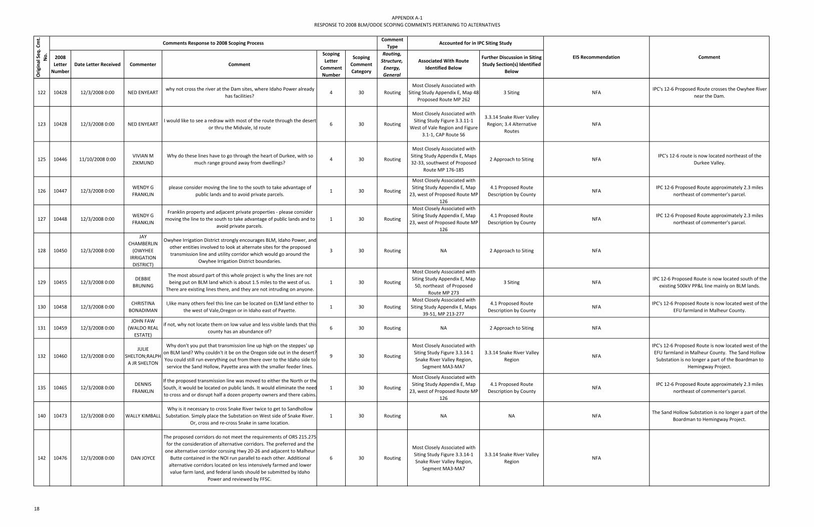
APPENDIX A‐1RESPONSE TO 2008 BLM/ODOE SCOPING COMMENTS PERTAINING TO ALTERNATIVES
2008 Letter Number
Date Letter Received Commenter Comment
Scoping Letter
Comment Number
Scoping Comment Category
Routing, Structure, Energy, General
Associated With Route Identified Below
Further Discussion in Siting Study Section(s) Identified
Below
Orig
inal Seq
. Cmt.
No. Comment
Comments Response to 2008 Scoping ProcessComment
TypeAccounted for in IPC Siting Study
EIS Recommendation
122 10428 12/3/2008 0:00 NED ENYEARTwhy not cross the river at the Dam sites, where Idaho Power already
has facilities?4 30 Routing
Most Closely Associated with Siting Study Appendix E, Map 48
Proposed Route MP 2623 Siting NFA
IPC's 12‐6 Proposed Route crosses the Owyhee River near the Dam.
123 10428 12/3/2008 0:00 NED ENYEARTI would like to see a redraw with most of the route through the desert
or thru the Midvale, Id route6 30 Routing
Most Closely Associated with Siting Study Figure 3.3.11‐1
West of Vale Region and Figure 3.1‐1, CAP Route S6
3.3.14 Snake River Valley Region; 3.4 Alternative
RoutesNFA
125 10446 11/10/2008 0:00VIVIAN M ZIKMUND
Why do these lines have to go through the heart of Durkee, with so much range ground away from dwellings?
4 30 Routing
Most Closely Associated with Siting Study Appendix E, Maps 32‐33, southwest of Proposed
Route MP 176‐185
2 Approach to Siting NFAIPC's 12‐6 route is now located northeast of the
Durkee Valley.
126 10447 12/3/2008 0:00WENDY G FRANKLIN
please consider moving the line to the south to take advantage of public lands and to avoid private parcels.
1 30 Routing
Most Closely Associated with Siting Study Appendix E, Map 23, west of Proposed Route MP
126
4.1 Proposed Route Description by County
NFAIPC 12‐6 Proposed Route approximately 2.3 miles
northeast of commenter's parcel.
127 10448 12/3/2008 0:00WENDY G FRANKLIN
Franklin property and adjacent private properties ‐ please consider moving the line to the south to take advantage of public lands and to
avoid private parcels.1 30 Routing
Most Closely Associated with Siting Study Appendix E, Map 23, west of Proposed Route MP
126
4.1 Proposed Route Description by County
NFAIPC 12‐6 Proposed Route approximately 2.3 miles
northeast of commenter's parcel.
128 10450 12/3/2008 0:00
JAY CHAMBERLIN(OWYHEE IRRIGATION DISTRICT)
Owyhee Irrigation District strongly encourages BLM, Idaho Power, and other entities involved to look at alternate sites for the proposed transmission line and utility corridor which would go around the
Owyhee Irrigation District boundaries.
3 30 Routing NA 2 Approach to Siting NFA
129 10455 12/3/2008 0:00DEBBIE BRUNING
The most absurd part of this whole project is why the lines are not being put on BLM land which is about 1.5 miles to the west of us.
There are existing lines there, and they are not intruding on anyone.1 30 Routing
Most Closely Associated with Siting Study Appendix E, Map 50, northeast of Proposed
Route MP 273
3 Siting NFAIPC 12‐6 Proposed Route is now located south of the
existing 500kV PP&L line mainly on BLM lands.
130 10458 12/3/2008 0:00CHRISTINA BONADIMAN
I,like many others feel this line can be located on ELM land either to the west of Vale,Oregon or in Idaho east of Payette.
1 30 RoutingMost Closely Associated with Siting Study Appendix E, Maps
39‐51, MP 213‐277
4.1 Proposed Route Description by County
NFAIPC's 12‐6 Proposed Route is now located west of the
EFU farmland in Malheur County.
131 10459 12/3/2008 0:00JOHN FAW
(WALDO REAL ESTATE)
if not, why not locate them on low value and less visible lands that thiscounty has an abundance of?
6 30 Routing NA 2 Approach to Siting NFA
132 10460 12/3/2008 0:00JULIE
SHELTON;RALPH A JR SHELTON
Why don't you put that transmission line up high on the steppes' up on BLM land? Why couldn't it be on the Oregon side out in the desert?You could still run everything out from there over to the Idaho side to service the Sand Hollow, Payette area with the smaller feeder lines.
9 30 Routing
Most Closely Associated with Siting Study Figure 3.3.14‐1 Snake River Valley Region,
Segment MA3‐MA7
3.3.14 Snake River Valley Region
NFA
IPC's 12‐6 Proposed Route is now located west of the EFU farmland in Malheur County. The Sand Hollow Substation is no longer a part of the Boardman to
Hemingway Project.
135 10465 12/3/2008 0:00DENNIS FRANKLIN
If the proposed transmission line was moved to either the North or theSouth, it would be located on public lands. It would eliminate the needto cross and or disrupt half a dozen property owners and there cabins.
1 30 Routing
Most Closely Associated with Siting Study Appendix E, Map 23, west of Proposed Route MP
126
4.1 Proposed Route Description by County
NFAIPC 12‐6 Proposed Route approximately 2.3 miles
northeast of commenter's parcel.
140 10473 12/3/2008 0:00 WALLY KIMBALLWhy is it necessary to cross Snake River twice to get to Sandhollow Substation. Simply place the Substation on West side of Snake River.
Or, cross and re‐cross Snake in same location.1 30 Routing NA NA NFA
The Sand Hollow Substation is no longer a part of the Boardman to Hemingway Project.
142 10476 12/3/2008 0:00 DAN JOYCE
The proposed corridors do not meet the requirements of ORS 215.275 for the consideration of alternative corridors. The preferred and the one alternative corridor corssing Hwy 20‐26 and adjacent to Malheur Butte contained in the NOI run parallel to each other. Additional alternative corridors located on less intensively farmed and lower value farm land, and federal lands should be submitted by Idaho
Power and reviewed by FFSC.
6 30 Routing
Most Closely Associated with Siting Study Figure 3.3.14‐1 Snake River Valley Region,
Segment MA3‐MA7
3.3.14 Snake River Valley Region
NFA
18

APPENDIX A‐1RESPONSE TO 2008 BLM/ODOE SCOPING COMMENTS PERTAINING TO ALTERNATIVES
2008 Letter Number
Date Letter Received Commenter Comment
Scoping Letter
Comment Number
Scoping Comment Category
Routing, Structure, Energy, General
Associated With Route Identified Below
Further Discussion in Siting Study Section(s) Identified
Below
Orig
inal Seq
. Cmt.
No. Comment
Comments Response to 2008 Scoping ProcessComment
TypeAccounted for in IPC Siting Study
EIS Recommendation
144 10488 12/3/2008 0:00ROD
PRICE;PATTIE PRICE
Map #1 ‐ suggested route if both substations are deemed necessary due to Idaho growth.
9 30 RoutingMost Closely Associated with Siting Study Figure 3.1‐1, CAP
Route S18, S13, S6
3.3.14 Snake River Valley Region
NFA
145 10488 12/3/2008 0:00ROD
PRICE;PATTIE PRICE
Map # 2 ‐ suggested route if substations are not deemed necessary but allow the line to go close enough to the Wind Farm between Bakerand North Powder, Oregon so it can be used as part of the power grid.
10 30 RoutingMost Closely Associated with Siting Study Figure 3.1‐1, CAP
Route S19, S20
3.3.10 Burnt River Region, 3.3.11 West of Vale Region
NFAThe Sand Hollow Substation is no longer a part of the Boardman to Hemingway Project. IPC's 12‐6 Proposed
Route is similar in concept to Map #2.
146 10525 12/2/2008 0:00MAXINE
TERAMURA;KEN TERAMURA
Consider going over to the eastside of the Malheur Butte or desert land of Idaho with is closer to Sand Hollow exit
2 30 RoutingMost Closely Associated with Siting Study Appendix E, Maps
39‐51, MP 213‐277
4.1 Proposed Route Description by County
NFA
(NOTE: Believe commenter meant "westside" of Malheur Butte)
IPC's 12‐6 Proposed Route is now located west of the EFU farmland in Malheur County. The Sand Hollow Substation is no longer a part of the Boardman to
Hemingway Project.
150 10682 12/2/2008 0:00 BRUCE R CORNThere are alternative routes more suitable located to the west on public ground that would mitigate the damage the proposed route
would cause.12 30 Routing
Most Closely Associated with Siting Study Appendix E, Maps
39‐51, MP 213‐277
4.1 Proposed Route Description by County
NFAIPC's 12‐6 Proposed Route is now located west of the
EFU farmland in Malheur County.
151 10712 12/2/2008 0:00 KEN TERAMURAConsider going over to the eastside of the Malheur Butte or desert
land of Idaho which is closer to Sand Hollow exit.2 30 Routing
Most Closely Associated with Siting Study Appendix E, Maps
39‐51, MP 213‐277
4.1 Proposed Route Description by County
NFA
(NOTE: Believe commenter meant "westside" of Malheur Butte)
IPC's 12‐6 Proposed Route is now located west of the EFU farmland in Malheur County. The Sand Hollow Substation is no longer a part of the Boardman to
Hemingway Project.
153 10717 12/2/2008 0:00GARY
SPARKS;JUDY SPARKS
please consider the alternate project route being proposed by the Malheur County Court and Planning Department. It avoids exclusive
farm use lands to the most feasible extent.8 30 Routing
Most Closely Associated with Siting Study Appendix E, Maps
39‐51, MP 213‐277
4.1 Proposed Route Description by County
NFAIPC's 12‐6 Proposed Route is now located west of the
EFU farmland in Malheur County.
155 10733 12/2/2008 0:00 GARY PEARSON
A corridor could run south and west of Adrian and turn North to Bully Creek and along Cottonwood Mountain on into Forest Service land. Again, this route would be almost all on public land managed by the BLM and would bypass human activity and avoid all of the historical, aesthetic, health, land value, and social elements mentioned above.
15 30 RoutingMost Closely Associated with Siting Study Figure 3.1‐1, CAP
Route C63.4 Alternative Routes NFA
162 10779 12/3/2008 0:00 A FERRERIN Lead this line through Idaho 1 30 RoutingMost Closely Associated with Siting Study Figure 3.1‐1, CAP Routes S18, S13, S6, C13, S25
2 Approach to Siting; 3.4 Alternative Routes
NFA
170 10991 12/2/2008 0:00JEFF
HESS;LINDA HESS
The actual location of the power transmission towers and lines must be moved approximately 1mile west of the westerly corridor border line shown on the Idaho Power map labeled Appendix G‐3 (August 2008) from a point north of the town of Adrian to a point a few miles north of the proposed Hemingway substation. I have attached the
Appendix G∙) with a dashed line delineating the location that would be acceptable. (see letter)
1 30 Routing
Most Closely Associated with Siting Study Figure 3.3.14‐1 Snake River Valley Region,
Segments PA1‐OW1 and MA3‐MA7
3.3.14 Snake River Valley Region
NFAIPC's 12‐6 Proposed Route is now located west of the EFU farmland in Malheur County. At the closest point, IPC's 12‐6 Proposed Route is 9.5 miles south of Adrian.
172 10992 12/2/2008 0:00ROGER
FINDLEY;JEAN FINDLEY
or else a route going west of Vale, Oregon, on BLM‐managed and to the north to connect to Baker County should be used.
2 30 RoutingMost Closely Associated with Siting Study Appendix E, Maps
39‐51, MP 213‐277
4.1 Proposed Route Description by County
NFA
173 10992 12/2/2008 0:00ROGER
FINDLEY;JEAN FINDLEY
We request that BLM work with Idaho Power and local citizens to develop other options for line placement.
3 30 RoutingMost Closely Associated with Siting Study Figure 3.1‐1, CAP
Routes
2 Approach to Siting: 3 Siting
NFA
175 11529 12/11/2008 0:00HAROLD J
BASHAW;PATRICIA R BASHAW
Alternative Route needed‐ south from sand hollow to midvale (not in Oregon pioneer)
1 30 RoutingMost Closely Associated with Siting Study Figure 3.1‐1, CAP
Route S6
3.3.14 Snake River Valley Region; 3.4 Alternative
RoutesNFA
180 11542 12/11/2008 0:00 HAL D FRANKLINProposed route was shifted to the North or to the South, this would eliminate tresspassing concerns. Also if it were shifted, it would be
closer to the FS roads in case of fire or other emergencies2 30 Routing
Most Closely Associated with Siting Study Appendix E, Map 23, west of Proposed Route MP
126
4.1 Proposed Route Description by County
NFAIPC 12‐6 Proposed Route approximately 2.3 miles
northeast of commenter's parcel.
19

APPENDIX A‐1RESPONSE TO 2008 BLM/ODOE SCOPING COMMENTS PERTAINING TO ALTERNATIVES
2008 Letter Number
Date Letter Received Commenter Comment
Scoping Letter
Comment Number
Scoping Comment Category
Routing, Structure, Energy, General
Associated With Route Identified Below
Further Discussion in Siting Study Section(s) Identified
Below
Orig
inal Seq
. Cmt.
No. Comment
Comments Response to 2008 Scoping ProcessComment
TypeAccounted for in IPC Siting Study
EIS Recommendation
186 11553 12/12/2008 0:00 ANITA WESTRoute be at least, moved to the east, to a location behind the
Interpretive Center.5 30 Routing
Most Closely Associated with Siting Study Appendix E, Map
28, Proposed Route MP 153‐157
3.3.8 Interpretive Center Region; 4.1 Proposed Route
Description by CountyNFA
187 11555 12/12/2008 0:00 HAL D FRANKLIN Public land to the South if the lin was moved 3 30 Routing
Most Closely Associated with Siting Study Appendix E, Map 23, west of Proposed Route MP
126
4.1 Proposed Route Description by County
NFAIPC 12‐6 Proposed Route approximately 2.3 miles
northeast of commenter's parcel.
189 11559 12/12/2008 0:00 JAMES CARTERRoute along the E side of the Powder River w/ in a 1 mi corridor of the
scenic river in grazing land2 30 Routing
Route not Identified in IPC Siting Study
2 Approach to Siting; Appendix A Constraints and
OpportunitiesNFA
This route suggestion has been reviewed and due to the Powder River's designation as a Wild and Scenic River and an Area of Critical Environmental Concern this location is not feasible. Additionally, prime
agriculture land surrounds the Powder River. Wild and Scenic Rivers, Areas of Critical Environmental Concern and prime farmland are all considered siting exclusion
and/or high avoidance areas.
191 11587 12/12/2008 0:00 KEVIN CLARICHThere are other routes available and we hope that you will consider them as they go through more of the BLM established right of ways
and through areas of sagebrush not through the farm ground.6 30 Routing
Most Closely Associated with Siting Study Figure 3.3.11‐1 support West of Vale Region
Routes
3.3.11 West of Vale Region NFA
192 11595 12/11/2008 0:00EDWARD G
NICHOLS;SHERRY A NICHOLS
Suggest moving the new line north of the freeway. 1 30 RoutingMost Closely Associated with
Siting Study Appendix E, Map 30‐32, Proposed Route MP 164‐174
3.3.10 Burnt River Region NFA
193 11596 12/11/2008 0:00SUSAN M KURTH
All other routes to be given your full attention! 4 30 RoutingMost Closely Associated with Siting Study Figure 3.1‐1, CAP
Routes3 Siting NFA
197 11615 1/9/2009 0:00 CARLA MCLANE
In a review of both the preferred and alternative routes for the proposed transmission line two other zoning areas in Morrow County could be traversed depending on the final route chosen Space Age Industrial (preferred route) and General Industrial (preferred and
alternative route).
1 30 General NA 3.3.1 Boardman Region NFA
200 11619 1/12/2009 0:00ROGER
FINDLEY;JEAN FINDLEY
Construct the 500 kV line entirely in Idaho for the portions it would have been in Malheur County. We recommend that this alternative, which would have no 500 kV transmission line in Malheur County, Oregon, be analyzed in full. The 500 kV transmission line would
originate in Idaho and stay in Idaho until it would pass into Oregon in the vicinity of Farewell Bend/Huntington. This route also includes
access to Sand Hollow Substation entirely within Idaho, as had been considered by Idaho Power but rejected.
13 30 RoutingMost Closely Associated with Siting Study Figure 3.1‐1, CAP
Route S6, S13
3.3.14 Snake River Valley Region
NFAThe Sand Hollow Substation is no longer a part of the
Boardman to Hemingway Project.
201 11619 1/12/2009 0:00ROGER
FINDLEY;JEAN FINDLEY
...a loop similar to that proposed in the TVEP could be constructed which would put substations in different locations on the perimeter of the loop rather than at Sand Hollow and could avoid the population and farming areas of Canyon and Payette Counties in Idaho and
Malheur County in Oregon.
15 30 General NA NA NFAThe Sand Hollow Substation is no longer a part of the
Boardman to Hemingway Project.
202 11619 1/12/2009 0:00ROGER
FINDLEY;JEAN FINDLEY
SIP recommends a full analysis of an alternative for the B2H transmission line solely in Idaho in order to compare impacts on the
various locations of farm lands.16 30 Routing
Most Closely Associated with Siting Study Figure 3.1‐1, CAP
Route C13, S25
1.2 Project Overview; 3.4 Alternative Routes
NFADoes not meet Project Purpose and Need, see Section
2 of POD.
203 11619 1/12/2009 0:00ROGER
FINDLEY;JEAN FINDLEY
Follow the existing utility corridor identified in the SEORMP to Grassy Mountain, then turn north toward Cottonwood Mountain and
proceed north to Huntington Junction, at which point the line could gonorth through Baker County and bypass entirely the town of Durkee or
could turn east to Interstate 84 and then follow the currently proposed route.
12 30 RoutingMost Closely Associated with Siting Study Appendix E, Maps
36‐51, MP 200‐277
4.1 Proposed Route Description by County
NFAIPC's 12‐6 Proposed Route is very similar in concept to
commenter's suggestion.
20

APPENDIX A‐1RESPONSE TO 2008 BLM/ODOE SCOPING COMMENTS PERTAINING TO ALTERNATIVES
2008 Letter Number
Date Letter Received Commenter Comment
Scoping Letter
Comment Number
Scoping Comment Category
Routing, Structure, Energy, General
Associated With Route Identified Below
Further Discussion in Siting Study Section(s) Identified
Below
Orig
inal Seq
. Cmt.
No. Comment
Comments Response to 2008 Scoping ProcessComment
TypeAccounted for in IPC Siting Study
EIS Recommendation
204 11620 1/12/2009 0:00 KATHY ALDERWe question the need to jut into Canyon County to reach Sand Hollow when it appears more efficient and cost effective to continue the route
straight alone the river south to its destination.1 30 Routing NA NA NFA
Route suggestion no longer applicable as Sand Hollow Substation is no longer a part of the Boardman to
Hemingway Project.
206 11623 1/12/2009 0:00 ROB WAGSTAFF
There are thousands of acres of dry, high desert land surrounding the small pocket of irrigated farm land in Malheur County. We urge you to
look into using existing utility corridors where the impact on the livelihood of our families will not be so detrimentally impacted.
7 30 Routing
Oppose Siting Study Figure 3.3.14‐1 Snake River Valley
Region Routes; Support Figure 3.3.11‐1 West of Vale Region
Routes
3 Siting NFAIPC's 12‐6 Proposed Route mostly avoids irrigated land
in Malheur County.
207 11624 1/12/2009 0:00RICK
MENDIVE;WANETA MENDIVE
I know one area of possibility is the open range desert just a few miles west of where we and most of our neighbors live.
4 30 Routing
Oppose Siting Study Figure 3.3.14‐1 Snake River Valley
Region Routes; Support Figure 3.3.11‐1 West of Vale Region
Routes
3 Siting NFA
208 11627 1/12/2009 0:00ROGER
FINDLEY;JEAN FINDLEY
we suggest that the Sand Hollow Substation be moved, since it has notbeen built yet, from its currently projected location to a new location north of Payette in the uninhabited foothills there. It could easily
connect to the Pearl Substation by going over very little farmland and residences.
1 30 General NA NA NFARoute suggestion no longer applicable as Sand Hollow Substation is no longer a part of the Boardman to
Hemingway Project.
209 11627 1/12/2009 0:00ROGER
FINDLEY;JEAN FINDLEY
We strongly suggest then that the loop on the west side of the valley near Adrian, Nyssa, and Ontario, Oregon, follow the PPG 500 kV line coming out of the Hemingway Substation to Grassy Mountain (10
miles west of Adrian), then turn and go north to Huntington Junction. The transmission line could then go east behind the hills at Weiser andveer south to connect with the re‐located Sand Hollow Substation
north of Payette (see attached map)
2 30 Routing
Most Closely Associated with Siting Study Figure 3.4‐7
Segments MA6‐ MA5‐MA2‐BA16‐BA17‐WA1‐PA1
NA NFARoute suggestion no longer applicable as Sand Hollow Substation is no longer a part of the Boardman to
Hemingway Project.
214 11633 1/12/2009 0:00 VICKI T WARES
It cannot be denied that the proposed B2H‐IP line stands to impact theOregon Trail National Interpretive Center and its viewshed. If,
however, the proposed route is modified with the short, <2 mile loop under the Intepretive Center, that impact will be considerably
lessened.
3 30 Routing
Most Closely Associated with Siting Study Figure 3.3.8‐1 Interpretive Center Region,
Segment BA4‐BA8
3.3.8 Interpretive Center Region
NFA
Address use of 230kV for short distances in EIS under underground alternatives along with cost, reliability, lack of existing lines and other issues associated with underground 500kV lines in EIS under underground
alternatives.
215 11639 1/12/2009 0:00THOMAS E PHILLIPS
The proposed substation at Sand Hollow should be moved to North of Payette, Idaho.
6 30 General NA NA NFAThe Sand Hollow Substation is no longer a part of the
Boardman to Hemingway Project.
217 11642 1/14/2009 0:00VIVIAN M ZIKMUND
consider Morman Basis for an alternative route through Baker County for the Boardman Hemingway project.
The Mormon Basin 7.5 minute quadrangle, Baker and Malhuer Counties, are centered about 25 miles southeast of Baker City, in the southeastern part of the Blue Mountains. Gravel and dirt roads enter the quadrangle from the north,east, and south. The land supports mainly rangeland grasses and brush, and scattered patches of pine and fir trees. Industries in the region are chiefly cattle ranching and
occasional timber production, and placer gold mining.
1 30 RoutingMost Closely Associated with Siting Study Figure 3.4‐7 Segments BA16‐BA20
3 Siting NFABA16‐BA20 while feasible did not connect to other
feasible route alignments such as Onion Creek Region.
219 11655 2/5/2009 0:00 DAN SILVERIA
New transmission line coming from Boardman could go straight south as proposed by the BLM and tie into existing easements, give Idaho
Power the infastructure for the new treasure valley grid, and eliminatemost interference with prime farmland.
3 30 RoutingMost Closely Associated with Siting Study Figure 3.3.14‐1 Snake River Valley Region
3.3.14 Snake River Valley Region
NFAThe Sand Hollow Substation is no longer a part of the
Boardman to Hemingway Project.
220 11655 2/5/2009 0:00 DAN SILVERIAIdaho Power should route their 500 Megawatt line west and south of
prime farmland in Malheur County, thus minimizing economic, environmental, and personal hardship.
4 30 Routing
Most Closely Associated with Siting Study Figure 3.3.11‐1
West of Vale Region, Segment MA2‐MA5
3.3.11 West of Vale Region NFA
221 11657 2/5/2009 0:00FRED
TRENKEL;PAT TRENKEL
New proposal to move the 500kV line west of Vale, then loop up to Wesier and behind Payette to a substation and then over to Emmett
1 30 Routing
Most Closely Associated with Siting Study Figure 3.4‐7
Segments MA5‐MA2‐BA16‐BA17‐WA1‐PA1
NA NFARoute suggestion no longer applicable as Sand Hollow Substation is no longer a part of the Boardman to
Hemingway Project.
21

APPENDIX A‐1RESPONSE TO 2008 BLM/ODOE SCOPING COMMENTS PERTAINING TO ALTERNATIVES
2008 Letter Number
Date Letter Received Commenter Comment
Scoping Letter
Comment Number
Scoping Comment Category
Routing, Structure, Energy, General
Associated With Route Identified Below
Further Discussion in Siting Study Section(s) Identified
Below
Orig
inal Seq
. Cmt.
No. Comment
Comments Response to 2008 Scoping ProcessComment
TypeAccounted for in IPC Siting Study
EIS Recommendation
223 11659 2/18/2009 0:00 KATIE FITE
We have recently received Burley BLM Wind Project (MET tower) scoping documents that appear directl linked to this. It appears this line is being built to facilitate sch projects mapping shows the line
southern path in this area. We again requet that t follow the freeway and not fragment and destroy new areas.
In the vicinity of SE Iaho please consider instead following the freeway to Salt Lake nd then heading north along exisg routes. If the ³Need² is really because there is more demand at certain time then adding more
lines in existing corridors should rectify that
19 30 General NA NA NFADoes not meet Project Purpose and Need, see Section
2 of POD.
225 11667 2/19/2009 0:00JAMES
SMITH;JUDITH SMITH
Instead, route the transmission lines outside of the city of Parma's area of impact so future residential and commercial growth and
development can occur.2 30 Routing
Most Closely Associated with Siting Study Figure 3.3.14‐1 Snake River Valley Region,
Segments PA1‐OW1 and MA3‐MA7
3.3.14 Snake River Valley Region
NFA
227 11673 2/19/2009 0:00ROGER AND MICHELLE REDDING
We strongly urge you to put your efforts into moving this preferred route to the south side of the existing power lines on public property.
1 30 Routing
Most Closely Associated with Siting Study Figure 3.3.14‐1 Snake River Valley Region,
Segments MA7‐OW1
3.3.14 Snake River Valley Region
NFAIPC's 12‐6 Proposed Route is located south of the existing 500kV PacifiCorp line on public land.
229 11677 2/19/2009 0:00 ROGER KIESTER
If the present west corridor line could be moved 2,000 feet or less to the west this would be out of the way of the district and patrons
concerns. The corridor would line up with the west side of the South Canal at the tunnel outlet number five, four miles south of Adrian, Oregon. If the line could stay on the west side of the South Canal it would run 5 miles south and cross the BPL corridor. Following the
south side southeast BPL corridor would eliminate any concerns from the District and in turn eliminate concerns from patrons.
1 30 Routing
Most Closely Associated with Siting Study Figure 3.3.14‐1 Snake River Valley Region,
Segments MA7‐OW1
3.3.14 Snake River Valley Region
NFAIPC's 12‐6 Proposed Route is located south of the existing 500kV PacifiCorp line and almost entirely
south of the South Canal
230 11678 2/19/2009 0:00 ROGER FINDLEY
Alternative 4We are proposing that the portion of the TVEP loop which is shown to pass behind and east of Boise be built to Sand Hollow, with the B2H line then going north through Idaho east of Payette, behind Weiser and over to Oregon. Hemingway Substation would still be built but would connect to Sand Hollow Substation from the east rather then
the west.
1 30 RoutingMost Closely Associated with Siting Study Figure 3.1‐1, CAP
Route S13
3.4 Alternative Routes; 3.3.14 Snake River Valley
RegionNFA
Does not meet Project Purpose and Need, see Section 2 of POD. The Sand Hollow Substation is no longer a
part of the Boardman to Hemingway Project.
243 300014 12/11/2008 0:00ROGER
FINDLEY;JEAN FINDLEY
Hemingway to Boardman via the eXisting PP&L corridor to Grassy Mountain in the Vale District, then north to the base ofCottonwood Mountain, then north to Huntington Junction and to Baker County,
with the most environmentally feasible route to Baker City selected by BLM and Idaho Power. This alternative needs to be analyzed for the
comparison of impacts to natural resources inMalheur County versus impacts to inhabited and farm use‐zoned lands
in the county.
2 30 RoutingMost Closely Associated with Siting Study Appendix E, Maps
36‐51, MP 200‐277
4.1 Proposed Route Description by County
NFAIPC's 12‐6 Proposed Route is very similar in concept to
commenter's suggestion.
244 300014 12/11/2008 0:00ROGER
FINDLEY;JEAN FINDLEY
Hemingway to Sand Hollow to Farewell Bend to Boardman, bypassing Malheur County entirely and keeping the line completely in Idaho to
Farewell Bend.3 30 Routing
Most Closely Associated with Siting Study Figure 3.1‐1, CAP
Route S6, S13
3.3.14 Snake River Valley Region
NFAThe Sand Hollow Substation is no longer a part of the
Boardman to Hemingway Project.
22

APPENDIX A‐2RESPONSE TO 2010 BLM/ODOE SCOPING COMMENTS PERTAINING TO ALTERNATIVES
Letter Number
Commenter Comment Letter
Comment Number
Scoping Report
Comment Category
Routing, Structure, Energy, General
Location Relative to
IPC Proposed Route Mile Postings
Concept ‐ Not
Location Specific
Clearly defined ‐
No Specific Route
Location
Alternate Route
Alignment Submitted/ Suggested
Suggests Micro‐siting
Develop Route from Description
Prepare Figure Map
Prepare Comparative
Table
Suggest IPC Follow Up
1 4005MICHAEL
MCALLISTER
I have attempted to more specifically delineate the two modified C‐21 routes onto three USGS. (1:24,000 scale) topographic quad maps. I have drawn the two routes on as best as I can interpret them.
3 30 GeneralMP 109 ‐ MP 126
N N Y N YFigure 4005
Y Y
Analyze Optimized Proposed and Alternative Routes in Glass Hill
vicinity then Consider in Detail or as CBE in EIS
See Figure 4005 for 2 routes locations in the Glass Hill Vicinity ‐ 4005 NE and 4005 SW.1. 4005 NE route similar to initial CAP Route C11 and considered during Siting. Route eliminated due to need to cross Ladd Marsh WMA when heading south from La Grande vicinity. It is an exclusion area under OR EFSC criteria (See OAR 345‐022‐0040 Protected Areas Standard, letter p). See B2H website: Idaho Power > Community Advisory Process > Maps > Maps Archive; Scroll down to "Initial Proposed Routes ‐ Fall 2009". Select 'Route C11' and 'Route C11 Preliminary Evaluation'. See also Siting Study Figure 3.4‐7 for Permitting Analysis ‐ note segment UN1 ‐ UN3. However, due to multiple comments suggesting a route parallel to the 230kV through Union County southwest of La Grande, include route alternative UN1‐UN3 as CBE in EIS.
See B2H website. Idaho Power > Community Advisory Process >
Maps > Map Archive; Scroll down to heading
"Initial Proposed Routes ‐ Fall 2009";
Select 'Route C11' and 'Route C11 Preliminary
Evaluation'.
10 5023 DICK FLEMING
A power line in a lower valley is less objectionable to people and is less of a threat to the sage grouse.To lessen the impacts on the people and the Sage Grouse, it is necessary to find a reduced visibility alignment. I have attached a map showing an alternative alignment. This alignment from Durkee NNW to near the existing power line on the south side of the Keating Valley minimizes the negative effects on people due to view degradation.
3, 4 30 General NA N N Y N Y Figure 5023
Y Y
Consider Optimized Virtue Flat/Interpretive Center Proposed and Alternative Routes in Detail in
EIS
See response to Letter 5013, Comment 1.
61 5161ROBERT DALE
MILLER
routing the line northerly on Glass Hill until it intercepts with the present Bonneville transmission line. There is an open area that runs northerly which would accommodate this goal. (See Map #2)
7 30 RoutingMP 109 ‐ MP 124
N N Y N YFigure
5161 7‐30Y Y
Analyze Optimized Proposed and Alternative Routes then Consider
in Detail or as CBE in EIS
Map # 2 submitted by commenter georeferenced and digitized. Route alignment avoids Ladd Marsh Wildlife Area but comes into close proximity with many homes.See response to Letter 4005, Comment 3.
68 5175TERRY M
ANDERSON
If the line could be moved one quarter to one half mile south (map 3 of 11, between reference points 84 & 85, TISR33E Sec 12 and TISR34E Sec 7)it would actually be on more accessible terrain with no permament residences impacted.
3 30 RoutingMP 84 ‐ MP 85
N N N Y Y Figure 5175
N YAnalyze Alternative Route in Detail
in EIS
There are no environmental constraints prohibiting the shift of the transmission line south between MP 84 ‐ MP 85 approx 0.25‐‐0.5 miles to maximize distance from residences. IPC should follow up with the landowners in this area.
98 5209
CHUCK BUCHANAN;C
HERYL BUCHANAN
We would like to see the line follow the top of the ridge west of Sisley Creek, between Sisley Creek and Pierce Gulch. It would then cross Plano Road and continue up the ridge through our hill pasture. At the upper, or north end of our fields, which have been in the past, and will be in the future, planted, the line would turn west/northwest and enter property owned by Dick D'Ewart.
1 30 RoutingEast of MP184 ‐ MP 188
N N N Y YFigure 5209
Y Y Pending
Property believed to be 12S44E00900 ‐ located between Pierce Gulch and Sisley Creek under name BUNCH, RODD D ETAL. Route suggestion sketched in.Similar to other routes considered and being considered in this location. Collaborate with IPC on optimized route.
105 5224 ROB ALWARD
include a BLM‐designated right‐of‐way corridor which has been approved in the Vale District's 2002 Southeastern Oregon Resource Management Plan and Record of Decision document. The corridor I speak to traverses the Owyhee River down‐straeam from Owhyee Reservoir Dam at the further‐most northern location of BLM‐administered lands on the river before the river enters large tracts of private lands...IP needs to include this designated corridor ‐‐ or lest part of it ‐‐ in no less than two of its alternatives to be environmentally assessed when required NEPA documentation is conducted regarding its proposed transmission line. It follows, too, this right‐of‐way corridor should be included in IP's application for its proposed transmission line.
1 30 RoutingNorth of MP 250 ‐ MP 273
N N Y N YFigure 5224
Y NAnalyze Alternative Route in Detail
in EIS
Identifies a second utility corridor in Vale District that was not previously analyzed.
Orig
inal Seq
. Cmt. No. Comments in Response to 2010 Scoping
Comment Type
Location
Comment Hyperlink
General RouteRoute Characterization
Analysis
EIS Recommendation
1

APPENDIX A‐2RESPONSE TO 2010 BLM/ODOE SCOPING COMMENTS PERTAINING TO ALTERNATIVES
Letter Number
Commenter Comment Letter
Comment Number
Scoping Report
Comment Category
Routing, Structure, Energy, General
Location Relative to
IPC Proposed Route Mile Postings
Concept ‐ Not
Location Specific
Clearly defined ‐
No Specific Route
Location
Alternate Route
Alignment Submitted/ Suggested
Suggests Micro‐siting
Develop Route from Description
Prepare Figure Map
Prepare Comparative
Table
Suggest IPC Follow Up
Orig
inal Seq
. Cmt. No. Comments in Response to 2010 Scoping
Comment Type
Location
Comment Hyperlink
General RouteRoute Characterization
Analysis
EIS Recommendation
109 5228FOR THE GIRLS LLC
The current primary and alternative routes proposed at the public scoping meetings (specifically near the Glass Hill Alternative in Union County) should be modified to run adjacent to or near the existing power lines and other utility easements between the Grande Ronde River (near I‐84 Hilgard Junction) and La Grande (taking into account the proximity limitations necessitated by applicable regulation)...A map of the proposed route change is attached hereto as a PDF file...This route modification would impact several land parcels held by For The Girls LLC, which already carry numerous utility easements (i.e., Bonneville, Williams Gas, Chevron, Level 3 Communications, Verizon, etc.). For The Girls LLC desires and prefers that the B2H transmission line run along the existing easements on those properties, and is amenable to working with appropriate authorities throughout this process.
1 30 RoutingEast of MP 109 ‐ MP
119N N Y N Y
Figure 5228
Y YAnalyze Optimized Proposed and Alternative Routes then Consider
in Detail or as CBE in EIS
Alternative Route shown on Figure 5228 and others in the Glass Hill Area should be evaluated in the EIS. See response to Letter 4005, Comment 3.
134 5257COLLEEN FAGAN
the Glass Hill alternative route from TM 5 to 10 be revised. ODFW recommends that this alternative route be drawn from the proposed route at TM 117 to the Glass Hill alternative route at TM 10. This alternative pulls the transmission line out of the valley, upper winter range, and the Ladd Marsh Wildlife area and avoids January Meadow and the important wetland lake.
13 30 RoutingGlass Hill Alternative
N N Y N YFigure
5257 13‐30
N Y
Consult with IPC to Determine Optimized Route Given Concern
for Winter Range January Meadow Analyze Optimized Routes in Detail
in EIS
See response to Letter 4005, Comment 3.
136 5257COLLEEN FAGAN
Segment 4‐ Baker CountyThe section of the proposed route from the Union County line to Highway 86 has the potential to negatively impact sage‐grouse. The northern portion of the corridor near Magpie Peak crosses intact sagebrush habitat and is within 2 miles of several sage‐grouse leks. Though the proposed route does follow an existing transmission line from I‐84 south to OR 203, it would be placed outside the existing ROW. Therefore, the further west the power line is sited along this corridor the better. Where possible, the line should be sited to avoid sagebrush and placed in lower elevation, developed areas to minimize impacts to sage‐grouse, big game winter range, and other sagebrush dependent species.
17 30 RoutingMP 137 ‐ MP 157
N N Y N Y Figure 5257 17‐
30Y N
Analyze Route that Avoids Magpie Peak ACEC in EIS
The Baker Valley has many environmental constraints to routing a transmission line, including but not limited to Sage‐grouse leks and sagebrush habitat. Through the CAP process, over 20 routes and/or route segments were evaluated throughout Baker County. See B2H website. Idaho Power > Community Advisory Process > Maps > Map Archive; Scroll down to heading "Initial Proposed Route ‐ Fall 2009". See also Siting Study Section 3 and CAP Routing Presentation (link on B2H website). The most feasible route suggested during the CAP was determined to parallel the existing 230kV line along the west side north of Highway 86. This route minimizes crossing irrigated ag lands, avoids an airport clear zone, follows an existing corridor and minimizes visibility from the Scenic Byways including I‐84, Highway 86, Route 203 and 237 and Highway 30. In compliance with WECC criteria, the 500kV line has been sited 1500ft west of the 230kV line for reliability. Through discussions with ODFW, it was understood that there were a few caveats to the inability to cross a 2‐mile lek buffer. 1.If intervening topography shielded the new towers from being visible from the center of an occupied lek, then the line may be able to be permitted or 2. If the new line were to cross an occupied lek buffer adjacent to an existing line, but further from the lek center than the existing line, then it may be able to be permitted. It was also understood that unoccupied leks were able to be crossed. With regard to caveat number 2, between MP 140 ‐ MP 144, the 3.8 mile stretch of Proposed Route crosses a 2‐mile Sage‐grouse lek buffer west of where the existing 230kV line crosses the lek buffer. Shifting the proposed line further to the west here would result in skylining the towers and would result in increased visibility of the line from I‐84, which is a designated Scenic Byway and from the town of North Powder. If the line were shifted west onto the valley floor, then agricultural practices would be negatively impacted. Similarly to the lek buffer crossing described above, between MP 147 and MP 150, the 2.7 mile stretch across an occupied lek buffer is located to the west of an existing 230kV transmission line that crosses the occupied lek buffer. However, because of ODFW's concern for Magpie Peak ACEC an alternative as described in Comment Letter should be considered.
See B2H website. Idaho Power > Community Advisory Process >
Project Advisory Teams > Central Project
Advisory Team > Fifth Meeting > CAP Routing Presentation (PDF, 2.7
MB)
2

APPENDIX A‐2RESPONSE TO 2010 BLM/ODOE SCOPING COMMENTS PERTAINING TO ALTERNATIVES
Letter Number
Commenter Comment Letter
Comment Number
Scoping Report
Comment Category
Routing, Structure, Energy, General
Location Relative to
IPC Proposed Route Mile Postings
Concept ‐ Not
Location Specific
Clearly defined ‐
No Specific Route
Location
Alternate Route
Alignment Submitted/ Suggested
Suggests Micro‐siting
Develop Route from Description
Prepare Figure Map
Prepare Comparative
Table
Suggest IPC Follow Up
Orig
inal Seq
. Cmt. No. Comments in Response to 2010 Scoping
Comment Type
Location
Comment Hyperlink
General RouteRoute Characterization
Analysis
EIS Recommendation
137 5257COLLEEN FAGAN
Segment 4From TM 152 to 164, ODFW would prefer that the proposed route follow the existing 230 kV transmission line. Following the existing line would locate the proposed route further from sage‐brush breeding and brood rearing areas. It would also place the line further from two burrowing owl nests located approximately 0.5 miles from the proposed route at TM 157, an active Golden eagle nest located on the ridgetop near TM 158 and important sage‐grouse winter habitat in the Lone Pine Mountain area.
18 30 RoutingMP 152 ‐ MP 164
N Y N N Y Figure 5257 18‐
30Y Y
Consider Optimized Virtue Flat/Interpretive Center Proposed and Alternative Routes in Detail in
EIS
1. CAP Initial Proposed Routes C4 and C8 mainly followed the existing 230kV line through the Baker City vicinity. Extensive analysis of this route was performed and it was determined that the current Proposed Route, located to the east of the National Historic Oregon Trail Interpretive Center was the best option. See Siting Study section 3.3.8 Interpretive Center Region. See also B2H website: Idaho Power > Community Advisory Process > Maps > Maps Archive; Scroll down to "Initial Proposed Routes ‐ Fall 2009". Select 'Route C4' or 'Route C8' and 'Route C4/C8 Preliminary Evaluation'. See also Siting Study Figure 3.4‐7 for Permitting Analysis ‐ note segment BA4‐BA8‐BA9. 2. It is important for IPC to follow up with ODFW to obtain the GIS data for the burrowing owl nest locations and the active Golden Eagle nest location. Efforts to avoid impacts to these areas will be taken.Due to several comments suggesting a route parallel to the existing 230kV, west of NHIOTIC, it is recommended that IPC analyze a route west of the Interpretive Center in the EIS.
See B2H website. Idaho Power > Community Advisory Process >
Maps > Map Archive; Scroll down to heading
"Initial Proposed Routes ‐ Fall 2009"; Select 'Route C4/C8' and 'Route C4/C8
Preliminary Evaluation'.
140 5257COLLEEN FAGAN
Segment 4From TM 189 to 198... ODFW recommends that IPC modify this route so that the proposed line is still located within the ROW for the existing 138 kV line, but that the proposed route is sited east of the existing line. Historically, leks were located on top of Table Rock. There are currently no known leks located on Table Rock, but URS surveys did detect sage‐grouse. Follow up ground surveys should be conducted in 2011.
22 30 RoutingMP 189 ‐ MP 198
N Y N N YFigure
5257 22‐30
Y Y No Further Action (NFA)
From MP 189.7 south to approximately MP 193, IPC has proposed to place the 500kV line within the existing 138kV ROW. Since the Scoping Meetings IPC has proposed relocating the existing 138kV line to build a double circuit 69/138kV line within the existing 69kV ROW. An alternative located adjacent to the east side of the exiting 138kV ROW south from MP 193 to MP 198 has been sketched. Consult with IPC as necessary to determine feasibility.
71 5183DAVID
RICHARDS
not seeking permission to place a transmission corridor along the eastern boundary of the Boardman Bombing Range. This would not effect the use of the bombing range by the Air Force and would add an additional safety factor between the bombing range and motor vehicle traffic along Bombing Range Road as well as preserving productive agricultural land.
3 30 RoutingSouth of MP 17‐19
N Y N N Y N N YAnalyze in Detail if Utilities Reach System Reliability Issue Otherwise
Consider as CBE in EIS
An Eastern Route along the Bombing Range has Bombing Range, WGS, and agricultural constraints. However it may provide a routing solution.
2 5000 DON RICEThere could also be a less impacting route north of I 84, then turning south east of the tree farm.
2 30 RoutingMP 19 ‐ MP 25
N N N Y N N N Y No Further Action (NFA)IPC's 12‐6 routes show the Proposed Route south of the Bombing Range. The route the commenter is referring to is now called the Bombing Range North Alternative. The alternative appears to have addressed commenter's issue, and has been shifted to the north side of I‐84 from MP 19 ‐ MP 25.
5 5010BYRON L SCHMIDT
a routing from about 5 miles west of Homedale to about 5 miles west of Ontario then to Brogan along US Highway 26, would keep this infrastructure build from impacting these MTRs and our ability to train our aircrews.
2 30 RoutingMP 213 ‐ MP 272
N N N N N N N Y Pending
IPC's Proposed Route is approximately 10 miles west of Homedale, ID; 25 miles west of Ontario; and approximately 3 miles west of Highway 26 heading north toward Brogan. IPC should meet with this organization, consider MTRs in siting efforts moving forward and report results to BLM.
6 5013LARRY
PEARSON
We feel that the line should definitely be located in the approximate "Virtue Flat Alternative" location, out of sight of Baker City and as far east of the Oregon Trail Interpretive Center as possible (as a minimum, it should be east of the adjacent rifle range).
1 30 RoutingVirtue Flat Alternative
Y N N N N N N Y
Analyze Optimized Proposed and Alternative Routes in Virtue
Flat/Interpretive Center area in Detail in EIS
IPC has identified the Virtue Flat Alternative. Scoping comments have identified alternative routes (see Letter 5023, Comment 3 and 4) and ongoing meetings involving BLM, IPC, ODFW, and Baker County may identify new proposed or alternative routes.
7 5018JOHN
KILKENNY
why would you not place the line right on the south edge of the bombing range instead of one mile south on the Grieb woods road.
1 30 RoutingMP 23 ‐ MP 27
N N N Y N N N Y
Analyze Optimized Proposed and Alternative Routes south of the Bombing Range resulting from Landowner Meetings in Detail in
EIS
Locating the line adjacent to the south side of the Bombing Range is likely not feasible due to presence of Washington Ground Squirrel nests in this vicinity. Ground Squirrel nests and a 750 foot radius buffer are protected by ODFW and considered Category 1 habitat, for which there is no mitigation. See OAR 635‐415‐0000. Actual nest locations will be field verified and the potential to shift the line north to a more suitable area may be possible. IPC should work with this landowner to find a suitable location for the 500kV line.1. Understand issue of crossing irrigated farmland/populated areas with transmission lines. Efforts to avoid impacts to agricultural practices have been made throughout the siting effort and will continue throughout the process. See Siting StudySection 2.2 Constraints and Opportunities.2. IPC's 12‐6 proposed route is now located south of the Bombing Range. In mid‐January 2011, there will be a landowner meeting with IPC to discuss specific alignment issues.
3

APPENDIX A‐2RESPONSE TO 2010 BLM/ODOE SCOPING COMMENTS PERTAINING TO ALTERNATIVES
Letter Number
Commenter Comment Letter
Comment Number
Scoping Report
Comment Category
Routing, Structure, Energy, General
Location Relative to
IPC Proposed Route Mile Postings
Concept ‐ Not
Location Specific
Clearly defined ‐
No Specific Route
Location
Alternate Route
Alignment Submitted/ Suggested
Suggests Micro‐siting
Develop Route from Description
Prepare Figure Map
Prepare Comparative
Table
Suggest IPC Follow Up
Orig
inal Seq
. Cmt. No. Comments in Response to 2010 Scoping
Comment Type
Location
Comment Hyperlink
General RouteRoute Characterization
Analysis
EIS Recommendation
8 5018JOHN
KILKENNY
I would suggest a route on the very north edge of the property, right next to the southern edge of the bombing range. this would have a much smaller impact on our farming practices, and our neighbors to the east, (Griebs) as well.
3 30 RoutingMP 23 ‐ MP 27
N N N Y N N N Y NFA
See response to Letter 5018, Comment 1.
12 5033DOUGLAS J GLASPEY
As alternatives we would recommend an alignment located at least 1/3 mile west or at least 2 miles east of the current alignment as located in Sections 5 and 8, Township 18 South, Range 43 East. Adjusting the new distribution line either west or east of the proposed alignment should avoid the current geothermal development area and potential future expansion.
2 30 RoutingMP 232 ‐ MP 234
N N N Y N N N Y NFA
IPC should follow up with landowner and consider shifting the line 1/3 mile west in sections 5 and 8, in Township 18S, Range 43E as there appear to be no environmental constraints restricting this shift.
13 5035PATRICIA A SMITH
If the line came along the top (South end) and they could keep from putting the lines in our center pivots, we could probably work something out.
2 30 RoutingMP 11 ‐ MP 13
N N N Y N N N Y
Analyze Optimized Proposed and Alternative Routes resulting from Landowner Meetings in Detail in
EIS
IPC should follow up with the landowner to find an agreeable location across their parcel. See response to Letter 5018, Comment 1.
18 5059VERA MAY GROVE
transmission line going too close to my home at 20968 Medical Springs Hwy. I proposed to you that it should be moved up over the hill behind my house. There is actually a large swale over the hill east of our house that runs north and south which would put the line out of sight of Baker Valley and Keating Valley.
1 30 RoutingMP 151 ‐ MP 152
N N Y N N N N Y NFA
Locating the 500kV line along the east side of the existing 230kV transmission line, as commenter suggests, is not feasible due to the presence of lek 2‐mile buffers. The ODFW considers lek buffers Category 1 habitat, for which there is no mitigation. See OAR 635‐415‐0000. However, ODFW indicated if the line is located along the west side of the existing 230kV line, it would be further from the lek center and potentially feasible.
23 5068 PEGGI TIMM
2. Second, follow your latest proposal except move the line further east to 3 miles from the National Historic Oregon Trail Interpretive Center.
2 30 RoutingMP 152 ‐ MP 158
N Y N N N N N Y
Consider Optimized Virtue Flat/Interpretive Center Proposed and Alternative Routes in Detail in
EIS
Due to the presence of Sage‐grouse leks and associated 2‐mile buffer east of the Interpretive Center the line cannot be shifted 3 miles east and still be able to be permitted. The ODFW considers lek buffers Category 1 habitat, for which there is no mitigation. See OAR 635‐415‐0000.The Virtue Flat Alternative represents an option to work with ODFW to find a path through the sage‐grouse leks in this vicinity.See response to Letter 5013, Comment 1.
29 5084 KIRK SCILACCI
I would need the new lines to be east of the 230kv line.
1 30 RoutingMP 142 ‐ MP 147
N N N Y N N N Y NFA
Locating the 500kV line along the east side of the existing 230kV transmission line is not feasible due to the presence of lek 2‐mile buffers. The ODFW considers lek buffers Category 1 habitat, for which there is no mitigation. See OAR 635‐415‐0000. However, ODFW indicated if the line is located along the west side of the existing 230kV line, it would be further from the lekcenter and potentially feasible.Appears IPC has been in contact with commenter and IPC is encouraged to continue to work with this landowner.
34 5094MARIA E
LIEBSCHWAGER
It would be great if it didn't get too close to the houses. On the other side of the canal would be fine.
1 30 RoutingMP 280 ‐ MP 284
N N N Y N N N Y NFA
IPC's 12‐6 route has shifted the proposed route south onto BLM land where possible in this vicinity. Need to avoid VRM Class II and Historic Site 0.5 mile buffer. The line is now located on the south side of the canal.
35 5098KAREN
STEENHOF
A route that follows the existing east/west road shown on the attachment would seem reasonable. This road would cross the canyon about ¼ mile upstream from the 1998 nest, and it would be far enough south of the main nesting cliff to cause problems for eagles
2 30 Routing MP 295 N N N Y N N N Y NFA
KMZ file attached opens to a point file which is assumed to be the 1998 nest site. Letter mentions an attachment showing "Aroute that follows the existing east/west road" not found. Field Surveys will be conducted for species habitat/nesting.
37 5101MARK
THOMSON
There are other options you could exercise without effecting land and home owners. I do not want this going through my property where you propose it...There are plenty of public lands around me you could use and apparently you have chosen not to.
5 30 GeneralMP 215 ‐ MP 216
Y N N Y N N N Y NFA
IPC's 12‐6 Proposed Route has adjusted the location of the line across commenter's parcel, moving the crossing to the very southwest corner of the parcel. If further adjustment is requested, IPC is encouraged to meet with commenter again.
40 5118MARK
BENNETT
Baker County has been working with Idaho Power Corporation, Oregon Department of Fish and Wildlife, community groups and related agencies to develop an acceptable modified ‘Virtue Flat Alternative Route’... The Virtue Flat Alternative will provide the protection intended by Oregon State Land Use Planning Goal 5 to the still visible ruts of the Oregon Trail that are near the National Historic Oregon Trail Interpretive Center.
2 30 RoutingVirtue Flat Alternative
N N Y N N N N Y
Consider Optimized Virtue Flat/Interpretive Center Proposed and Alternative Routes in Detail in
EIS
See response to Letter 5013, Comment 1.
4

APPENDIX A‐2RESPONSE TO 2010 BLM/ODOE SCOPING COMMENTS PERTAINING TO ALTERNATIVES
Letter Number
Commenter Comment Letter
Comment Number
Scoping Report
Comment Category
Routing, Structure, Energy, General
Location Relative to
IPC Proposed Route Mile Postings
Concept ‐ Not
Location Specific
Clearly defined ‐
No Specific Route
Location
Alternate Route
Alignment Submitted/ Suggested
Suggests Micro‐siting
Develop Route from Description
Prepare Figure Map
Prepare Comparative
Table
Suggest IPC Follow Up
Orig
inal Seq
. Cmt. No. Comments in Response to 2010 Scoping
Comment Type
Location
Comment Hyperlink
General RouteRoute Characterization
Analysis
EIS Recommendation
44 5126KENNETH JENSEN
I would like to see the power line moved to the west by straightening the line from MP 217 to 231 for the following reasons...By moving the line to the west, more of the line will be on BLM ground rather than private ground. 3. The line will be further away from agriculture ground and people in the Brogan and Jamison areas.
1 30 RoutingMP 217 ‐ MP 231
N N N Y N N N Y NFA
IPC's 12‐6 route meets most of this objective.
48 5137GARTH
JOHNSON
The line could be shifted to the east if it were possible to thread the line between the sage grouse leks.
3 30 GeneralVirtue Flat Alternative
Y N N N N N N Y
Consider Optimized Virtue Flat/Interpretive Center Proposed and Alternative Routes in Detail in
EIS
See response to Letter 5013, Comment 1.
53 5143 PEGGI TIMM
Again, I ask you to move the transmission back to the east 2 or more miles. This is our heritage. Please go on unproductive public land to build your towers.
2 30 RoutingMP 152 ‐ MP 158
N Y N N N Figure 5023
N Y
Consider Optimized Virtue Flat/Interpretive Center Proposed and Alternative Routes in Detail in
EIS
Due to the presence of Sage‐grouse leks and associated 2‐mile buffer east of the Interpretive Center the line cannot be shifted 2 miles east and still be able to be permitted. The ODFW considers lek buffers Category 1 habitat, for which there is no mitigation. See OAR 635‐415‐0000. See response to Letter 5013, Comment 1.
54 5146 MARK ROYER
By using the “Alternate” corridor, mile marker 5 – 16, instead of “Planned” corridor, mile marker 115 ‐ 127, both parcels would be spared the impact of the 500 kV single‐circuit transmission line.
5 30 RoutingMP 115 ‐ MP 127
N N N N N N N YAnalyze Optimized Proposed and Alternative Routes then Consider
in Detail or as CBE in EIS
See response to Letter 4005, Comment 3.
57 5155LA VELLE HOEFT
I request that you place your line on the boundary of my property rather than through the middle of it.
3 30 RoutingMP 74‐MP75
N N N Y N N N Y NFASuggest IPC work with landowner to revise location where line is currently proposed to a more agreeable location.
62 5162DUNCAN FARRIS
historic Stage Station that is listed on the National Historic Registery... when such a route across BLM group to the south behind the foothills of the Owyhees is wide open.
5 30 RoutingMP 281 ‐ MP 283
N N N Y N N N Y NFA
IPC's 12‐6 Proposed Route has been relocated to avoid crossing within 0.5 miles of the Historic Stage Stop and now is located on BLM land in the foothills of the Owyhee Mountains.
65 5166 CLIFF BENTZ
Baker County support moving the line further east of the Oregon Trail Interpretive Center
1 30 RoutingMP 153 ‐ MP 158
N Y N N N N N Y
Consider Optimized Virtue Flat/Interpretive Center Proposed and Alternative Routes in Detail in
EIS
See response to Letter 5013, Comment 1.
67 5170JANET S ANGLIN
Our other suggestion if double circuiting is not possible then is to take the transmission lines up on top of the hills in BLM land. We know that there are canyons (Jump Creek and Poison Creek canyons) running on top but if the towers and lines are run further back on the BLM land that would not destroy the scenic beauty or damage the property values of my property or that of my neighbors.
8 30 RoutingMP 280 ‐ MP 284
N Y N N N N N Y NFA
IPC's 12‐6 route has shifted the proposed route south onto BLM land where possible. Need to avoid VRM Class II and Historic Site 0.5 mile buffer. Recommend that IPC follow up with landowner.
74 5188MARCIA WIRTH
Keep the towers a reasonable distance from Brogan, or at least three miles in every direction.
9 30 RoutingMP 210 ‐ MP 220
N Y N N N
3 mile Brogan Buffer Map
N Y NFA
While not entirely realigned to be 3 miles from the town of Brogan, IPC's revised proposed scoping route (12‐6) in the Brogan vicinity has been adjusted based on landowner input. At the closest point (southwest of Brogan), the route is 2 miles away from the town of Brogan.
75 5190RICK
SIMMONS
It is our opinion that we need at least a three‐mile exclusion zone around the Brogan township to mitigate ambient noise impact from high wind in the tension lines and girders from three sides around us.
3 30 RoutingMP 210 ‐ MP 220
N Y N N N
3 mile Brogan Buffer Map
N Y NFA
See response to Letter 5188, Comment 9.Noise issues will be addressed in the EIS.
76 5190RICK
SIMMONS
We have been told to expect loud popping noises during rain storms. We know that considerable winds blow almost all the time at 200 feet... This noise issue was not addressed in the meetings we attended. How can we be reassured?
4 30 General NA N N N N N N N Y NFA
Noise issues will be addressed in the EIS.
5

APPENDIX A‐2RESPONSE TO 2010 BLM/ODOE SCOPING COMMENTS PERTAINING TO ALTERNATIVES
Letter Number
Commenter Comment Letter
Comment Number
Scoping Report
Comment Category
Routing, Structure, Energy, General
Location Relative to
IPC Proposed Route Mile Postings
Concept ‐ Not
Location Specific
Clearly defined ‐
No Specific Route
Location
Alternate Route
Alignment Submitted/ Suggested
Suggests Micro‐siting
Develop Route from Description
Prepare Figure Map
Prepare Comparative
Table
Suggest IPC Follow Up
Orig
inal Seq
. Cmt. No. Comments in Response to 2010 Scoping
Comment Type
Location
Comment Hyperlink
General RouteRoute Characterization
Analysis
EIS Recommendation
77 5190RICK
SIMMONS
It is our opinion that we need at least a three‐ mile exclusion zone around the Brogan Township to mitigate the security concerns that these planned towers wrapped around us might be highly potential targets resulting from our country’s ongoing war on terror. We feel that a distance of three miles will diminish this obviously increased security risk to the people of this community now and in the future.
7 30 RoutingMP 210 ‐ MP 220
N Y N N N
3 mile Brogan Buffer Map
N Y NFA
See response to Letter 5188, Comment 9.Safety issues will be further addressed in the EIS.
78 5190RICK
SIMMONS
It is our opinion that we need at least a three‐mile exclusion zone for B2H towers around the Brogan township to mitigate the impact of this negative EMF stigma, real or perceived, at work in the general population of our area.
11 30 RoutingMP 210 ‐ MP 220
N Y N N N
3 mile Brogan Buffer Map
N Y NFA
See response to Letter 5188, Comment 9.EMF will be addressed in the EIS.
79 5190RICK
SIMMONS
It is our opinion that we need at least a three‐mile exclusion zone for B2H towers around the Brogan township to mitigate the B2H tower dominance of the panoramic viewfield around our homes and property.
12 30 RoutingMP 210 ‐ MP 220
N Y N N N
3 mile Brogan Buffer Map
N Y NFA
See response to Letter 5188, Comment 9.The 12‐6 routes were adjusted to minimize impacts, visual impacts included, to the town of Brogan.Visual impacts will be addressed in the EIS.
80 5190RICK
SIMMONS
The present B2H line route would march across the mouth of Brogan Canyon, diagonally up and over the top of the rimrock and put 198‐foot towers along our historic skyline to the north. In our estimation this is too close to Brogan. We request that there be a change in the B2H plan to avoid placing the towers where they are dominating the northern horizon as seen from Brogan. The three‐mile exclusion zone around Brogan would accomplish this.
14 30 RoutingMP 210 ‐ MP 220
N Y N N N
3 mile Brogan Buffer Map
N Y NFA
See response to Letter 5188, Comment 9.The 12‐6 route includes an adjustment to the location of the crossing of the Brogan Canyon. The 12‐6 route now crosses the canyon more than 0.5 miles north of where it was originally proposed, tucking the line behind peaks where possible.Visual impacts will be addressed in the EIS.
81 5190RICK
SIMMONS
A three‐mile exclusion zone for high towers out from Brogan would avoid this historic and cherished public recreational area.
18 30 RoutingMP 210 ‐ MP 220
N Y N N N
3 mile Brogan Buffer Map
N Y NFA
See response to Letter 5188, Comment 9. The 12‐6 routes were adjusted to minimize impacts to the town of Brogan. Impactsto all recreation and historic areas will be addressed in the EIS.
87 5196DONALD R
KINDSFATHER
If a transmission tower is sited in Parcel No. 1N32D00004400 the area closest to Stewart Creek is the area that does not have existing improvements and buildings.
7 30 RoutingSouth of MP 74
N N N Y N N N Y NFA
Route not currently sited across parcel no. 1N32D00004400 south of MP 74. If route location changes, review location duringmicro‐siting for specific tower locations on parcel.
89 5198KIRK SCILACCI(THE DLX LLC)
I would like to see the proposed new line be placed east of the 250kv line. The area east is mostly rocky. Possibly the proposed line could go around the areas that we intend to irrigate.
3 30 RoutingMP 142 ‐ MP147
N N N Y N N N Y CBE
Suggest IPC work with landowner to micro‐site towers around proposed pivots. Locating the line east of existing 230kV not likely an option due to occupied 2‐mi lek buffers. Keeping on west side of existing line, the buffers are crossed but further from lek center, which ODFW has indicated as acceptable.
121 5246 ROSE NADA
minimal impact could be affected by rerouting the proposed line leaving at least a three mile buffer.
3 30 GeneralMP 210 ‐ MP 220
N Y N N N
3 mile Brogan Buffer Map
N Y NFA
See response to Letter 5188, Comment 9. The 12‐6 routes were adjusted to minimize impacts to the town of Brogan.
124 5250ANDREW
STORER;ELVIA STORER
Our 3rd preference is to move the alternative east route further east into unihabited land east of Craig Martell Ranch and west of Love Reservoir.
3 30 RoutingMP 155 ‐ MP 172
N Y N N See 5023 See 5023 See 5023 Y
Consider Optimized Virtue Flat/Interpretive Center Proposed and Alternative Routes in Detail in
EIS
See response to Letter 5013, Comment 1. See also Letter 5023, Comment 3 and 4 for similar alternative suggestion.
133 5257COLLEEN FAGAN
ODFW... believes additional alternatives should be developed and evaluated, as identified and described below. From transmission line mile ™ 97 to 115, ODFW supports the proposed transmission line route. Through TM 109.5, ODFW would like the proposed line to be as close to the existing 230 kV line as possible. Within approximately 2000’ of the proposed line, there is an inactive golden eagle nest at TM 109 between Whiskey Creek and Rock Creek Road.
11 30 RoutingMP 97 ‐ MP 115
N N N Y N N N Y
Consult with IPC to Determine Optimized Route Given Concern for Golden Eagle Nest Analyze
Optimized Routes in Detail in EIS
1. Using existing transmission line corridors is a siting opportunity and efforts to parallel existing lines where possible have been made. However, WECC regulations require a 1500ft offset or the longest span. See Siting Report Section 2.2 Constraintsand Opportunities. 2. Between MP 100 and 108 the route passes through the Wallowa‐Whitman National Forest Utility Corridor where a 230kV transmission line is already located. Keeping the WECC regulations in mind, the boundaries of the utility corridor, the Blue Mountain Forest State Park, visibility from I‐84 (being a scenic area) and the construction difficulties associated with rugged terrain, the route options through this area were limited.3. Discussion with ODFW regarding the specific location of the Golden Eagle Nest near MP 109 should occur and efforts to maximize distance from this location can be made.
6

APPENDIX A‐2RESPONSE TO 2010 BLM/ODOE SCOPING COMMENTS PERTAINING TO ALTERNATIVES
Letter Number
Commenter Comment Letter
Comment Number
Scoping Report
Comment Category
Routing, Structure, Energy, General
Location Relative to
IPC Proposed Route Mile Postings
Concept ‐ Not
Location Specific
Clearly defined ‐
No Specific Route
Location
Alternate Route
Alignment Submitted/ Suggested
Suggests Micro‐siting
Develop Route from Description
Prepare Figure Map
Prepare Comparative
Table
Suggest IPC Follow Up
Orig
inal Seq
. Cmt. No. Comments in Response to 2010 Scoping
Comment Type
Location
Comment Hyperlink
General RouteRoute Characterization
Analysis
EIS Recommendation
138 5257COLLEEN FAGAN
Segment 4If the proposed line cannot be placed in the existing ROW of the 230 kV line, ODFW recommends that IPC investigate an alternate route which would be further west towards the Powder River and I‐84 in the transition area between the valley and sagebrush habitat and skirting the edge of agriculture. Siting the line further west would avoid the Bureau of Land Management’s Area of Critical Environmental Concern on Magpie Peak (TM 146), silvertip sagebrush, and important sage‐grouse habitat. The alternate route should rejoin the proposed route around TM 150 then continue as proposed until approximately TM 179‐181.
19 30 Routing
MP 136 ‐ MP 150 (and
following proposed route to MP 181)
N NSee 5257 17‐
30N
See 5257 17‐30
See 5257 17‐30
See 5257 17‐30
YAnalyze Route that Avoids Magpie
Peak ACEC in EIS
See response to Letter 5257, Comment 17.
149 5258 GARY MILLER
The following are conservation measures we recommend to minimize impacts to Category 2 and lower quality sage‐grouse habitats where impacts cannot be avoided:...• With respect to raptor predation on sage‐grouse, for transmission line towers in areas where leks occur, bird (raptor) deflectors/anti‐perch structures should be constructed to reduce the potential for raptor perching and predation near leks.
17 30 Structure NA N N N N N N N YAddress in Alternatives Structure
Section in EIS
IPC should be consulted to see if they propose to include anti‐perching devices within sage‐grouse habitat as a design feature of the Project. Recommend that it be addressed in the EIS.
152 5277FRANK
LIEBSCHWAGER
our first choice would be to keep it as far up the hill on BLM as possible. 1 30 Routing
MP 280 ‐ MP 284
N N N Y N N N Y PendingIPC's 12‐6 route has shifted the proposed route south onto BLM land where possible. Need to avoid VRM Class II and Historic Site 0.5 mile buffer.IPC continues to consult with landowner.
153 5277FRANK
LIEBSCHWAGER
If it has to go thru my property or my mothers; we would like it staying on the south side of the canal. By going there you would be going over properties that do not have existing homes. You would have to go over the old stage stop but there is nobody living in that structure.
2 30 RoutingMP 280 ‐ MP 284
N N N Y N N N Y Pending
Per Liebschwager 'first choice' an alternative was sketched that avoids Liebschwager property and stays on BLM Land. If unable to keep entirely on BLM lands, then will keep south of Canal. IPC's 12‐6 route has incorporated this line adjustment and the Company's proposed route now stays on the south side of the canal.IPC continues to consult with landowner.
157 5320ROBERT DALE
MILLER
If the proposed route, or one of the identified alternate routes is selected, do you have a suggestion on how best to cross your property with the transmission line?Move the route north so it doesn't go through the timber.
4 30 Routing
NE of MP 112 ‐ MP 115 (Glass
Hill Alternative MP 3.6 ‐ MP 5.2)
N N Y N N N N Y NFA
Commenter also submitted Letter 5161 which included maps and alternative suggestions. IPC's 12‐6 routes show the proposed route no longer crosses commenter's land and the alternative now appears to be located where the commenter indicates. IPC should follow up.
158 5321KENNY
METZGER
Map #10Parcel number(s)23S46E01100, 23S46E01000, 23S346E01200, 23S46E00600Are there any considerations or issues related to your property that you would like Idaho Power to know?Should go southwest of their property and move to BLM land.
2 30 Routing MP 273.4 N N N Y N N N Y NFA
IPC should follow up with landowner and see if the line can be shifted 200ft to the southwest onto BLM land. There do not appear to be any environmental constraints prohibiting this adjustment.
182 40055ROBERT SAVAGE
I do not approve of the location Idaho Power Company wants to place their new high power lines East of the Oregon Trail Interpretive Center in Baker County. The lines location should be moved further to the East to be out of sight of the Center.
1 30 RoutingMP 152 ‐ MP 158
N Y N N N N N Y
Consider Optimized Virtue Flat/Interpretive Center Proposed and Alternative Routes in Detail in
EIS
See response to Letter 5013, Comment 1.
183 40056
SCOTT MORRISON;C
ATHI MORRISON
REQUEST: That the transmission lines not be built where they will affect the viewshed of the Grande Ronde Valley and the city of Union, Oregon
1 30 Routingnortheast of MP 107 ‐ MP 133
N Y N N N N N Y NFA
IPC's 12‐6 proposed route does not appear to impact the viewshed of the Grand Ronde Valley (NE of La Grande) or the City of Union, Oregon. IPC should follow up and this issue should be addressed in the EIS
7

APPENDIX A‐2RESPONSE TO 2010 BLM/ODOE SCOPING COMMENTS PERTAINING TO ALTERNATIVES
Letter Number
Commenter Comment Letter
Comment Number
Scoping Report
Comment Category
Routing, Structure, Energy, General
Location Relative to
IPC Proposed Route Mile Postings
Concept ‐ Not
Location Specific
Clearly defined ‐
No Specific Route
Location
Alternate Route
Alignment Submitted/ Suggested
Suggests Micro‐siting
Develop Route from Description
Prepare Figure Map
Prepare Comparative
Table
Suggest IPC Follow Up
Orig
inal Seq
. Cmt. No. Comments in Response to 2010 Scoping
Comment Type
Location
Comment Hyperlink
General RouteRoute Characterization
Analysis
EIS Recommendation
192 50124ANTHONY M CHAVEZ
alternatives...• The existing transmission line structures appear to be stable and sturdy; would the structures be able bear additional lines necessary for the project?• Underground cable• Underground cable across private property only• BLM land on the bench above private property (requires going out of 4000 ft. corridor)
6 30Structure and Route
MP 281‐ MP 283
Y N N Y N N N Y NFA
1. The existing line is not an IPC line, it is a PP&L 500kV transmission line. Due to WECC guidelines 500kV lines cannot be located within 1500ft (or the length of the longest span) for reliability reasons. The existing structures do not provide a viable option for the B2H Project's 500kV line.2. Underground cable options will be addressed in the EIS section Underground Technology.3. IPC's 12‐6 route has relocated the transmission line onto BLM lands in the vicinity of MP 281 ‐ MP 283. IPC reports it plans to continue working with landowners in this area to come up with a reasonable solution.
84 5192MARK
CERNY;ADELE CERNY
At the local meetings, the use of underground wires has been repeatedly suggested, particularly in the area of the Interpretive Center on the East Route. We were told by IP representatives that it was not a possibility because electricity run underground for long distances becomes uncontrollable. In contrast, research has found that this size wire has been used underground for many miles in a run. Again I question the validity of your information. See attachment.
18 30 Structure NA NA NA NA NA N N N N
Address both 230kV and 500kV in Underground Technology Section Evaluate 230kV Underground
Alternative for Interpretive Center
Attachment shows information on American Superconductor ‐ "Superconductor Electricity Pipelines ‐ Moving Renewable Electricity Across America Out of Sight, Out of Harms Way." http://www.amsc.com/products/powerpipelines/index.htmlAddress use of 230kV for short distances in EIS under underground alternatives along with cost, reliability, lack of existing lines and other issues associated with underground 500kV lines in EIS under underground alternatives. See response to Letter 5013, Comment 1.
123 5250ANDREW
STORER;ELVIA STORER
Our 2nd preference is to use the propsed route and modify towers or bury line to lessen impact on Interpretive Ctr. Viewshed.
2 30 StructureMP 153 ‐ MP 158
N N N N N N N N
Address both 230kV and 500kV in Underground Technology Section Evaluate 230kV Underground
Alternative for Interpretive Center
Alternative structure designs to minimize visibility in scenic areas will be considered. See POD Section 8 Alternative Transmission Structures and Materials considered.At this time, burying a high voltage line like the B2H 500kV line is not a common practice due to high cost and reliability issues. Address use of 230kV for short distances in EIS under underground alternatives along with cost, reliability, lack of existing lines and other issues associated with underground 500kV lines in EIS under underground alternatives. See response to Letter 5013, Comment 1.
30 5088 JIM BENTZ
9‐8‐2010 The power line needs to go north from Harper to Baker City, then to Pendleton
1 30 RoutingMP 73 ‐ MP 244
Y N N N N N N NAddress I‐84 Concept Route as CBE
in EIS
Comment appears to support eastern alternative from Harper to Baker City. North from Baker City to Pendleton it is assumedcommenter means following I‐84. The Proposed Route follows in proximity to I‐84 in much of Baker County, but not in the Pendleton and La Grande areas. Issues following the I‐84 corridor from Boardman vicinity south to Hemingway include urban areas, an Indian Reservation, airport clear zones, residences and industrial zones. Where appropriate, the route has been located in existing corridors, including the I‐84 corridor ‐ heading southeast from Boardman, the USFS Utility Corridor, entering Baker County to North Powder, south of Baker City to Huntington and along an existing 500kV PacifiCorp transmission line. See Siting Study Section 2.2.2 and Section 3.Due to multiple comments suggesting an 'all I‐84' route, it is recommend an all I‐84 alternative be developed and considered as CBE in the EIS to demonstrate impracticality of route concept.
70 5182 DOUG HEIKEN
Between Baker City and North Powder an alternative route should be explored that runs further west (closer to Hwy 84 and hwy 30) which will have fewer wildlife conflicts.
18 30 RoutingWest of MP 139 ‐ MP 160
N N Y N N N N NAddress I‐84 Concept Route as CBE
in EIS
1. See B2H website. Idaho Power > Community Advisory Process > Project Advisory Teams > Central Project Advisory Team. Scroll down to heading “Fifth Meeting” and click “CAP Routing Presentation”. See slide 32. Slide shows a route between UN4 and BA8 which fits concept described. Route was considered but eliminated because would require crossing of the Baker Airport Clear Zone, an exclusion area.2. See also Siting Study Figure 3.4‐7 for Permitting Analysis ‐ note Segment UN4 ‐ BA8.3. See also B2H website: Idaho Power > Community Advisory Process > Maps > Maps Archive; Scroll down to "Initial Proposed Routes ‐ Fall 2009". Select 'Route C11' and 'Route C11 Preliminary Evaluation'.4. See siting Study Appendix C Constraints Crossed ‐ Permitting Difficulty Overview for reference to Airport Exclusion Area Permitting Difficulty. See also response to Letter 5088, Comment 1.
See B2H website. Idaho Power > Community Advisory Process >
Project Advisory Teams > Central Project
Advisory Team > Fifth Meeting > CAP Routing Presentation (PDF, 2.7
MB) > Slide 32
97 5207FRANK GENTILE
It seems to make the most sense economically and environmentally to stick with the proposed I‐84 route.
4 30 Routing NA Y N N N N N N NAddress I‐84 Concept Route as CBE
in EIS
See response to Letter 5088, Comment 1.
99 5212 JIM KENNEDY
We urge Idaho Power to sensibly recognize that the preferred route for the B2H Project is along the I‐84 Corridor.
2 30 Routing NA Y N N N N N N NAddress I‐84 Concept Route as CBE
in EIS
Route Concept considered as part of Siting Criteria. See Siting Study Section 2.2 Constraints and Opportunities; Appendix B Community Criteria; Appendix C Constraints Crossed ‐ Permitting Difficulty OverviewSee response to Letter 5088, Comment 1.
110 5229 MARK TURLEY
I would like to see the transmission line follow (or nearly follow) the existing freeway through Eastern Oregon as it passes by Pendleton, La Grande, and Baker City...It makes more sense to run the line on State or Federal lands in existing corridors as much as possible to minimize wildlife and private timber disruptions.
1 30 Routing NA N Y N N N N N NAddress I‐84 Concept Route as CBE
in EIS
Route Concept considered as part of Siting Criteria. See Siting Study Section 2.2 Constraints and Opportunities; Appendix B Community Criteria; Appendix C Constraints Crossed ‐ Permitting Difficulty OverviewSee response to Letter 5088, Comment 1.
8

APPENDIX A‐2RESPONSE TO 2010 BLM/ODOE SCOPING COMMENTS PERTAINING TO ALTERNATIVES
Letter Number
Commenter Comment Letter
Comment Number
Scoping Report
Comment Category
Routing, Structure, Energy, General
Location Relative to
IPC Proposed Route Mile Postings
Concept ‐ Not
Location Specific
Clearly defined ‐
No Specific Route
Location
Alternate Route
Alignment Submitted/ Suggested
Suggests Micro‐siting
Develop Route from Description
Prepare Figure Map
Prepare Comparative
Table
Suggest IPC Follow Up
Orig
inal Seq
. Cmt. No. Comments in Response to 2010 Scoping
Comment Type
Location
Comment Hyperlink
General RouteRoute Characterization
Analysis
EIS Recommendation
131 5257COLLEEN FAGAN
IPC indicates the most extensive opportunities for siting the transmission line are existing transportation corridors (I‐84), pipelines, transmission lines, and agency designated corridors. The proposed corridor, however, deviates from I‐84 and existing transmission line corridors in a number of places in Baker and Malheur counties. ODFW requests that IPC provide its rationale for siting the proposed line away from these areas identified as opportunities.
5 30 Routing NA Y N N N N N N NAddress I‐84 Concept Route as CBE
in EIS
Constraints and Opportunities, including transportation corridors (I‐84), pipelines, transmission lines, and designated corridors, were discussed with the public during the CAP and specifically during Meeting 3, where CAP members selected route alignments. See Siting Study Appendix A. All CAP routes that met the Project Purpose and Need were then evaluated by IPC for environmental permitting difficulty, construction difficulty and mitigation cost. The CAP was the driving process behind developing the location of the route. See Siting Study Section 3 Siting for detailed discussion on all proposed routes and analyses performed. See also B2H Website> Idaho Power > Community Advisory Process. IPC should meet with ODFW and BLM to discuss siting including why opportunities in Baker and Malheur counties are not followed. See response to Letter 5088, Comment 1.
Idaho Power's Community Advisory
Process (CAP)
142 5257COLLEEN FAGAN
IPC develop an alternative from TM 199 to the Hemingway substation that is very similar to the 2008 proposed route. This route should be sited along I‐84 and pushed against the hillside to avoid agriculture and all Category 1 and 2 sage‐grouse habitat.
29 30 RoutingMP 199 ‐ MP 299
N Y N N N N N NAddress I‐84 Concept Route as CBE
in EIS
1. The location of the 2008 Proposed Route south of MP 199 to the Hemingway Substation was mainly driven by the need forthe Sand Hollow Substation located in the vicinity east of the intersection of Route 20 and Highway 95 in Payette County. IPC has since revised their IRP and determined the substation does not need to be built as a part of the B2H project. With the removal of the need for the Sand Hollow Substation there is no reason to traverse any agricultural lands in the Treasure Valley (see the 2008 Proposed Route) . Additionally, ORS 215.275 states that in order to locate a transmission line within Exclusive Farm Use zoned land (the agricultural lands in Malheur are zoned EFU) all reasonable alternatives must be considered. With this in mind, the 2008 Proposed Route would not meet this criteria as a suitable route as the current Proposed Route is able to avoid almost all EFU zoned lands in Malheur County. See Siting Study Figure 3.3.14‐3.2. CAP Route S7 followed I‐84, a similar path to the 2008 Proposed Route, and was again analyzed as part of the CAP in 2009‐2010. See Siting Study Section 3.3.14 Snake River Valley Region for complete analysis.See response to Letter 5088, Comment 1.
See B2H website. Idaho Power > Community Advisory Process >
Maps > Map Archive; Scroll down to heading
"Initial Proposed Routes ‐ Fall 2009"; Select 'Route S7' and 'Route S7 Preliminary
Evaluation'.
143 5258 GARY MILLER
The Service previously recommended the Project be sited within the existing 1‐84 corridor where the wildlife habitat is already altered or cultivated, thus avoiding significant impact to sage‐grouse (Centrocercus urophasianus) population abundance and habitat.
1 30 Routing NA Y N N N N N N NAddress I‐84 Concept Route as CBE
in EIS
Routing along I‐84 was considered as part of Siting Criteria. See Siting Study Section 2.2 Constraints and Opportunities; Appendix B Community Criteria; Appendix C Constraints Crossed ‐ Permitting Difficulty Overview. See also Siting Study Section 3 for analysis of routes within I‐84 corridor.See response to Letter 5088, Comment 1.
150 5263MARILYN ALLEN
It would be much less costly, more functionally efficient, and much less ecologically destructive if it is constructed in the I‐84 Corridor as opposed to a line through Grant County.
1 30 Routing NA N N Y N N N N NAddress I‐84 Concept Route as CBE
in EIS
Route Concept considered as part of Siting Criteria. See Siting Study Section 2.2 Constraints and Opportunities; Appendix B Community Criteria; Appendix C Constraints Crossed ‐ Permitting Difficulty OverviewIPC's Proposed Route is located along the I‐84 corridor. See Siting Study and POD.See response to Letter 5088, Comment 1.
161 11641STEVEN R
LEWIS;FRANCES R LEWIS
We are opposed to this particular route and feel it would better serve everyone if it were re‐routed to existing BLM land or along the Interstate 84 corridor.
2 30 General NA Y N N N N N N NAddress I‐84 Concept Route as CBE
in EIS
See response to Letter 5038, Comment 1 re Public Land.See response to Letter 5088, Comment 1 re I‐84.
174 40024MARILYN
O'LEARY;CLARENCE O'LEARY
Why not use the already‐established utility corridor along I‐84? That corridor is far less sensitive to wildlife and has already been impacted.
7 30 GeneralMP 1‐MP299
N N N N N N N NAddress I‐84 Concept Route as CBE
in EIS
Existing corridors, including the I‐84 corridor, were considered a siting opportunity. See Siting Study Section 2 Approach to Siting.See response to Letter 5088, Comment 1 .
175 40025ERROL W CLAIRE
This transmission line should only be routed within or adjacent to an already existing utility or highway corridor such as you have in your I‐84 proposal.
9 30 GeneralMP 1‐MP299
N N N N N N N NAddress I‐84 Concept Route as CBE
in EIS
Both highways and existing transmission corridors were considered opportunities in the CAP and were used where feasible.See response to Letter 5088, Comment 1 .
176 40026CHLOE HUGHES
This transmission line should only be routed within or adjacent to an already existing utility or highway corridor such as in the I‐84 proposal.
22 30 GeneralMP 1‐MP299
N N N N N N N NAddress I‐84 Concept Route as CBE
in EIS
Existing corridors, including existing transmission lines and highways, were considered siting opportunities. See Siting Study Section 2 Approach to Siting.See response to Letter 5088, Comment 1 .
177 40033BILLY
BREEDING;MAX BREEDING
Just go up I‐84 and far as I can see you do not need to come this way.
3 30 RoutingMP 1‐MP299
N N N N N N N NAddress I‐84 Concept Route as CBE
in EIS
Existing corridors, including existing transmission lines and highways, were considered siting opportunities. See Siting Study Section 2 Approach to Siting.See response to Letter 5088, Comment 1 .
93 5202GENE E
BRAY;LAIRD J LUCAS
Under NEPA, the EIS may even have to look at alternatives over which theapplicant has no control... As stated in the Van Abbema case, other alternatives for a project cannot be eliminated as non‐feasible simply because the applicant does not now own or lease the site where an alternative location may exist.
11 30 General NA N N N N N N N NAddress in Alternatives
Methodology Section in EIS
To be addressed further in EIS; Siting Study has reviewed alternatives throughout the Study Area, mainly on ROWs not owned by IPC.
96 5203KATHY CLARICH
Put the lines on public ground and leave the private land owners alone
3 30 General NA Y N N N N N N NAddress in Alternatives
Methodology Section in EIS
This suggestion was received during the CAP and captured as a "Community Criteria". It was considered in the siting process but ultimately land ownership was not used to site the line ‐ environmental constraints (including management plan objectives), constructability and mitigation cost were the driving factors. See Siting Study Section 2 Approach to Siting.
9

APPENDIX A‐2RESPONSE TO 2010 BLM/ODOE SCOPING COMMENTS PERTAINING TO ALTERNATIVES
Letter Number
Commenter Comment Letter
Comment Number
Scoping Report
Comment Category
Routing, Structure, Energy, General
Location Relative to
IPC Proposed Route Mile Postings
Concept ‐ Not
Location Specific
Clearly defined ‐
No Specific Route
Location
Alternate Route
Alignment Submitted/ Suggested
Suggests Micro‐siting
Develop Route from Description
Prepare Figure Map
Prepare Comparative
Table
Suggest IPC Follow Up
Orig
inal Seq
. Cmt. No. Comments in Response to 2010 Scoping
Comment Type
Location
Comment Hyperlink
General RouteRoute Characterization
Analysis
EIS Recommendation
102 5219AUDIE
HUBER;ERIC QUAEMPTS
We recommend that alternative routes be considered in the NEPA process so that government to government consultation includes a meaningful discussion of the location of the proposed transmission line rather than simply consultation on whether or not it should be permitted. For example, in developing the proposed route, Idaho Power determined that avoiding crossing federal land was a low priority. The availability of federally owned and managed land is essential to the exercise of treaty rights reserved by the CTUIR, and if the proposed line prevents the use of a substantial amount of federal land for traditional, treaty‐protected activities, the impact to the CTUIR will be significant. Avoiding the Oregon National Historic Trail Interpretive Center was a high priority, but constructing within 500 feet of a cemetery had an avoidance level of moderate. Similarly, avoiding big game winter range was considered a moderate priority. The avoidance of impacts to such areas is a high priority to the CTUIR. There must be an opportunity for the CTUIR and the federal government to work together on our priorities involving the meaningful opportunity to relocate the line when priorities conflict.
1 30 General NA N N N N N N N NAddress in Alternatives
Methodology Section in EIS
Alternative routes will be considered as part of the NEPA process. Will be discussed further in EIS.
103 5222 LARA ROZZELL
The top priority should be to avoid impacts by siting any and all new facilities and structures in previously developed corridors. The second priority should be to minimize impacts by the specific design of features, such as using single pole structures instead of lattice supports.
2 30 Routing NA Y N N N N N N NAddress in Alternatives
Methodology Section in EIS
1. Route Concept considered as part of Siting Criteria. See Siting Study Section 2.2 Constraints and Opportunities; Appendix B Community Criteria; Appendix C Constraints Crossed ‐ Permitting Difficulty Overview2. Single pole structures are part of 'family' of structures proposed by IPC and will be used in special locations, however, lattice will be used predominantly.
111 5231BILLIE K ROBERTS
It is my understanding that there are existing power line routes that could be used as an alternative. A natural gas pipeline route is also nearby and could be utilized.
6 30 RoutingEast of MP
120N Y N N N N N N
Address in Alternatives Methodology Section in EIS
Assumed comment suggests alternative along existing 230kV transmission and pipeline heading into La Grande.See response to Letter 4005, Comment 3.
92 5201JANET
DODSON
If the power line is approved, we expect the choice of structures to be as unobtrusive as possible in all of the wide‐open areas where they can be seen from great distances or up close. In particular, we request use of the mono poles throughout Baker and Union Counties.
4 30 Structure NA NA NA NA NA N N N NAddress in Alternatives Structure
Section in EIS
Address in EIS under structure alternatives.
115 5236
RUSS HOEFLICH;LA
URA HUBBARD
we recommend that you define project requirements, guidelines and protocols for minimizing any remaining impacts. These strategies should include: micro‐siting protocols for towers and roads to reduce direct and indirect impacts on the resources identified above; tower design to avoid raptor mortality, as well as avoiding increasing raptor perching sites that would result in higher mortality of sensitive prey species.
6 30 General N N N N N N N N NAddress in Alternatives
Methodology and Structure Section in EIS
Recommend addressing these mitigation measures in the EIS.
154 5278 TOM RUGG
As there is a significant loss of power in long distance transmission it would seem to be prudent to investigate power generation closer to the Idaho market, especially given the proposed decommissioning of the Boardman generation plant.
4 30 Energy NA NA NA NA NA N N N N Address in Chapter 1 in EIS
Generation alone would not meet purpose and need as B2H is needed to provide regional reliability as well as transmit power. See POD Section 2, Purpose and Need
10

APPENDIX A‐2RESPONSE TO 2010 BLM/ODOE SCOPING COMMENTS PERTAINING TO ALTERNATIVES
Letter Number
Commenter Comment Letter
Comment Number
Scoping Report
Comment Category
Routing, Structure, Energy, General
Location Relative to
IPC Proposed Route Mile Postings
Concept ‐ Not
Location Specific
Clearly defined ‐
No Specific Route
Location
Alternate Route
Alignment Submitted/ Suggested
Suggests Micro‐siting
Develop Route from Description
Prepare Figure Map
Prepare Comparative
Table
Suggest IPC Follow Up
Orig
inal Seq
. Cmt. No. Comments in Response to 2010 Scoping
Comment Type
Location
Comment Hyperlink
General RouteRoute Characterization
Analysis
EIS Recommendation
83 5192MARK
CERNY;ADELE CERNY
Upgrading existing power lines would be a wiser use of resources, as would solar and wind installations, both company and privately owned.
2 30Structure, Energy
NA Y N N N N N N NAddress in Chapter 1 and
Alternatives Methodology Section in EIS
1. Where possible, IPC has located the new line adjacent to existing transmission line corridors and other energy and transportation corridors. Upgrading existing lines cannot be done for reliability reasons.2. Solar and wind projects would not meet purpose and need as B2H is needed to provide regional reliability as well as transmit power. See POD Section 2, Purpose and Need. See also Letter 5004, Comment 2.
94 5202GENE E
BRAY;LAIRD J LUCAS
Accordingly, BLM’s EIS for the proposed B2H transmission line the agencies’NEPA analysis must evaluate whether granting a right‐of‐way is consistent with other applicable law – including the alternative of denying the requested right‐of‐way if these requirements cannot be satisfied.
13 30 General NA N N N N N N N NAddress in No Action Alternative in
EIS
112 5233JOHN COLLIER WILLIAMS
I question if replacing the existing 230 KW powerline (along the same centerline) with a 500KW powerline, however problematic, isn’t a wiser endeavor than the one before you.
2 30 RoutingEast of MP
120Y N N N N N N N
Address in Alternatives Technology Section in EIS
Upgrading existing transmission lines like the 230kV cannot be done for reliability reasons. Recommend that replacing lower voltage lines be addressed in the EIS.
173 40015 DONALD BECK
It is time to replace High Voltage Alternating Current (HVAC) Power and produce High Voltage Direct Current (HVDC) power in long routes of transmission of High Voltage Power.
8 30 Structure NA NA NA NA NA N N N NAddress in Alternatives Technology
Section in EIS
Address in EIS.
28 5083 RICH DANIELSBury the line.
1 30 Structure NA N Y N N N N N NAddress in Underground Technology Section in EIS
Address in EIS.
151 5269 DONALD BECK
Some better and less hazardous and energy efficient alternatives, one being HVDC Underground Transmission lines have been around for decades and are used around the world while being overlooked by Power Companies in this country and our Government. Please read the article below... http://www.renewableenergyworld.com/rea/news/article/2009/03/invisible‐underground‐hvdc‐power‐costs‐no‐more‐than‐ugly‐towers
2 30 Energy NA NA NA NA NA N N N NAddress in Underground Technology Section in EIS
Address in EIS under underground alternatives.
178 40033BILLY
BREEDING;MAX BREEDING
Just put your lines underground.
4 30 Structure NA N Y N N N N N NAddress in Underground Technology Section in EIS
Address in EIS.
189 50106 TOM DIMONDGoing underground or with the new aladoy's that do not require miles and tons of galvanized steel are better bets.
1 30 Structure NA N Y N N N N N NAddress in Underground Technology Section in EIS
Address in EIS.
33 5093
DUNCAN MACKENZIE;B
ETH MACKENZIE
Perhaps Idaho Power, who does want it, could bury it or take it through the Buchanan Route further west where there are few people and acres of rangeland possibilities.
10 30 Routing NA N Y N N N N N N
Address in Underground Technology Section in EIS
Address Western Alternative Route as CBE in EIS
During the CAP routes were considered which headed west along the PP&L 500kV transmission line toward Buchanan, then headed north through Grant County toward Boardman. See B2H website (link at right). A western alternative was carried throughout the CAP. Analysis showed that while there is less population, the environmental issues along this route were more substantial than those along an eastern route due to the remoteness and undisturbed nature of the lands. See Siting Study Section 3 Siting, especially Table 3.4‐1.Address western alternative route as CBE in EIS.
See B2H website. Idaho Power > Community Advisory Process >
Maps > Map Archive; Scroll down to heading
"Initial Proposed Routes ‐ Fall 2009"; Select 'Route C9' and 'Route C9 Preliminary Evaluation'. Also see Routes C18, S29, S23,
S96.
11

APPENDIX A‐2RESPONSE TO 2010 BLM/ODOE SCOPING COMMENTS PERTAINING TO ALTERNATIVES
Letter Number
Commenter Comment Letter
Comment Number
Scoping Report
Comment Category
Routing, Structure, Energy, General
Location Relative to
IPC Proposed Route Mile Postings
Concept ‐ Not
Location Specific
Clearly defined ‐
No Specific Route
Location
Alternate Route
Alignment Submitted/ Suggested
Suggests Micro‐siting
Develop Route from Description
Prepare Figure Map
Prepare Comparative
Table
Suggest IPC Follow Up
Orig
inal Seq
. Cmt. No. Comments in Response to 2010 Scoping
Comment Type
Location
Comment Hyperlink
General RouteRoute Characterization
Analysis
EIS Recommendation
186 50104EDNA
HARRELL;BOB HARRELL JR
Perhaps Idaho Power, who does want it, could bury it or take it through the Buchanan Route further west where there are few people and acres of rangeland possibilities.
5 30Structure
and Routing
NA N Y N N N N N N
Address in Underground Technology Section in EIS
Address Western Alternative Route as CBE in EIS
Address in EIS under underground alternatives. During the CAP routes were considered which headed west along the PP&L 500kV transmission line toward Buchanan, then headed north through Grant County toward Boardman. See B2H website (link at right). A western alternative was carried throughout the CAP. Analysis showed that while there is less population, the environmental issues along this route were more substantial than those along an eastern route due to the remoteness and undisturbed nature of the lands. See Siting Study Section 3 Siting, especially Table 3.4‐1.Address western alternative route as CBE in EIS.
See B2H website. Idaho Power > Community Advisory Process >
Maps > Map Archive; Scroll down to heading
"Initial Proposed Routes ‐ Fall 2009"; Select 'Route C9' and 'Route C9 Preliminary Evaluation'. Also see Routes C18, S29, S23,
S96.
38 5109VICKI T WARES
If, 500kV monstrosities are mandated to Baker County, I cannot rationally believe that they should be any place but on public land or on the I‐84 corridor (and buried near the airport). To place these giants anywhere else fails all social and environmental tests and proves that the siting process is a result of power politics and not rational or scientific routing decisions. This public project belongs on public land! But that argument is given no credence by the federal or state agencies and least of all by Idaho Power.The interstate has already divided Baker Valley, environmentally and visually. We have taken a beautiful valley and built a transport system through it (which, incidentally, I use myself) on some of the best agricultural land in Baker County. Bill boards are spreading like an invasive species and interstate development grows uglier every year.I‐84 very effectively divides ecological systems also. We only have to view the road kills to be convinced of that. The environmental integrity of Baker Valley is already compromised; this is the place to locate the IP right‐of way; why would we extend the destruction to areas still sustaining vestiges of beauty and ecological f ?
1 30 GeneralMP 136 ‐ MP 165
N N Y N N N N NAddress in Underground Technology Section in EIS
CBE
It is noted that a logical place to locate the transmission line through Baker Valley would be along the I‐84 corridor. However,due to additional constraints, including irrigated agriculture, airport clear zone and residences, paralleling the I‐84 corridor through this area was determined not feasible. Underground alternatives will be addressed in the EIS.1. See B2H website. Idaho Power > Community Advisory Process > Project Advisory Teams > Central Project Advisory Team. Scroll down to heading “Fifth Meeting” and click “CAP Routing Presentation”. See slide 32. Slide shows a route between UN4 and BA8 which fits concept described. Route was considered but eliminated because would require crossing of the Baker Airport Clear Zone, an exclusion area.2. See also Siting Study Figure 3.4‐7 for Permitting Analysis ‐ note Segment UN4 ‐ BA8.3. See also B2H website: Idaho Power > Community Advisory Process > Maps > Maps Archive; Scroll down to "Initial Proposed Routes ‐ Fall 2009". Select 'Route C11' and 'Route C11 Preliminary Evaluation'.4. See siting Study Appendix C Constraints Crossed ‐ Permitting Difficulty Overview for reference to Airport Exclusion Area Permitting Difficulty. See response to Letter 5038, Comment 1 re Public Land.See response to Letter 5088, Comment 1 re I‐84.
See B2H website. Idaho Power > Community Advisory Process >
Project Advisory Teams > Central Project
Advisory Team > Fifth Meeting > CAP Routing Presentation (PDF, 2.7
MB) > Slide 32
32 5093
DUNCAN MACKENZIE;B
ETH MACKENZIE
there are BLM lands in near proximity that are obviously a more reasonable location. The feeling of many citizens in Baker is that the line go through the Buchanan Route near Burns.
2 30 Routing NA N Y N N N N N NAddress Western Alternative
Route as CBE in EIS
While BLM lands are found in Baker County, environmental constraints have restricted the ability to permit a 500kV transmission line across much of them. The major environmental constraint in this area is the Sage‐grouse lek 2‐mile buffer sites. The ODFW considers lek buffers Category 1 habitat, for which there is no mitigation. See OAR 635‐415‐0000. During the CAP routes were considered which headed west along the PP&L 500kV transmission line toward Buchanan, then headed north through Grant County toward Boardman. See B2H website (link at right). A western alternative was carried throughout the CAP. Analysis showed that while there is less population, the environmental issues along this route were more substantial than those along an eastern route due to the remoteness and undisturbed nature of the lands. See Siting Study Section 3 Siting, especially Table 3.4‐1.Address western alternative route as CBE in EIS.
See B2H website. Idaho Power > Community Advisory Process >
Maps > Map Archive; Scroll down to heading
"Initial Proposed Routes ‐ Fall 2009"; Select 'Route C9' and 'Route C9 Preliminary Evaluation'. Also see Routes C18, S29, S23,
S96.
72 5186ROJE S GOOTEE
I continue to urge Idaho Power and the reviewing agencies to approve the routing alternative presented in the Notice of Intent that is now under review, and to reject any proposed 'western' alternatives that would route this transmission line through the unfragmented and ecologically irreplaceable terrain of the John Day River system.
1 30 General NA N N Y N N N N NAddress Western Alternative
Route as CBE in EIS
This route is IPC's Proposed Route. See Siting Study and POD.Address western alternative route as CBE in EIS.
12

APPENDIX A‐2RESPONSE TO 2010 BLM/ODOE SCOPING COMMENTS PERTAINING TO ALTERNATIVES
Letter Number
Commenter Comment Letter
Comment Number
Scoping Report
Comment Category
Routing, Structure, Energy, General
Location Relative to
IPC Proposed Route Mile Postings
Concept ‐ Not
Location Specific
Clearly defined ‐
No Specific Route
Location
Alternate Route
Alignment Submitted/ Suggested
Suggests Micro‐siting
Develop Route from Description
Prepare Figure Map
Prepare Comparative
Table
Suggest IPC Follow Up
Orig
inal Seq
. Cmt. No. Comments in Response to 2010 Scoping
Comment Type
Location
Comment Hyperlink
General RouteRoute Characterization
Analysis
EIS Recommendation
181 40050JOHN
ELEY;ESTHER ELEY
(Western route)... it makes no sense whatsoever, in our view, to cross all the difficult terrain, disrupting wildlife, ranches, and homesteads, when there is a corridor already in place that could be used without the negative impact such a huge power transmission line would cause in the pristine forests and unspoiled terrain of the hills. That corridor runs northwest along highway 84.
1 30 GeneralMP 1‐MP299
N N N N N N N NAddress Western Alternative
Route as CBE in EIS
This route is IPC's Proposed Route (eastern alternative). See Siting Study and POD.Address western alternative route as CBE in EIS.
188 50105KATHRYN FRIEDRICH
Evaluating the above comparisons between the I‐84 Route and the Western Route in Grant County suggests choosing I‐84 as the preferred routing for the Boardman to Hemingway Transmission Line would provide a considerable cost savings in terms of monetary expenditures as well as avoiding the considerable cost of environmental damage to Grant County as the following numbers reveal:
3 30 General NA N N N N N N N NAddress Western Alternative
Route as CBE in EIS
Comment noted, through the CAP and subsequent analyses, IPC has selected the eastern alternative over the western alternative. Full discussion of selection process can be found in the Siting Study.Address western alternative route as CBE in EIS.
43 5125 JIM KEY
The best route across Morrow County is the Green or South route. It bypasses all the High Value Irrigated farm land and the higher populated areas, and is the shortest and least costly route. It's time we started thinking and caring more about people, their lives, and their habitats, then about "Rodents"!! It is my understanding, and I could be wrong, but I heard that the Gas pipe line that will run from the mainline to your new Gas Fired Generation Plant will be under Federal Jurisdiction and won't have to abide by the State or Nature Conservatory's wishes. I would look into tying your easment to theirs and avoid that nonsense and wast of money of heading West to go East.
5 30 General
Bombing Range South
Alternative
N N N N N N N N
Analyze Optimized Proposed and Alternative Routes resulting from Landowner Meetings in Detail in
EIS
See response to Letter 5018, Comment 1. EFSC standards apply to all proposed energy facilities. Crossing Category 1 Habitat associated with WGS is prohibited.
58 5157HENRY
LORENZEN
Wood Farm strongly urges Idaho Power Company to locate the transmission line along the Bombing Range South Alternative Route. This alternative would avoid significant interference with a large number of circle pivot irrigation systems and the danger inherent in operating a 500,000 volt transmission near them.
1 30 Routing
Bombing Range South
Alternative
N N N N N N N N
Analyze Optimized Proposed and Alternative Routes resulting from Landowner Meetings in Detail in
EIS
IPC's 12‐6 Proposed Route is now the alignment heading south out of the Grassland Substation and along the southern border of the Bombing Range.See also Letter 5018, Comment 1.
118 5244 EARL L AYLETT
The southern alternative route accomplishes this the best of all routes proposed. The line can run down the border of the conservation leased land to the west, turn and head south east through dry land farming which is not impacted to the degree that irrigated land at the northern route.
1 30 General
Bombing Range South
Alternative
N N N N N N N N
Analyze Optimized Proposed and Alternative Routes resulting from Landowner Meetings in Detail in
EIS
See response to Letter 5125, Comment 5.
36 5100THOMAS
THOMPSON
We would like the see the Class Hill alternative be picked because it avoids our land.
7 30 GeneralGlass Hill Alternative
N N N N N N N NAnalyze Optimized Proposed and Alternative Routes then Consider
in Detail or as CBE in EIS
Comment noted. Alternatives will be studied in detail in the EIS.See response to Letter 4005, Comment 3.
13

APPENDIX A‐2RESPONSE TO 2010 BLM/ODOE SCOPING COMMENTS PERTAINING TO ALTERNATIVES
Letter Number
Commenter Comment Letter
Comment Number
Scoping Report
Comment Category
Routing, Structure, Energy, General
Location Relative to
IPC Proposed Route Mile Postings
Concept ‐ Not
Location Specific
Clearly defined ‐
No Specific Route
Location
Alternate Route
Alignment Submitted/ Suggested
Suggests Micro‐siting
Develop Route from Description
Prepare Figure Map
Prepare Comparative
Table
Suggest IPC Follow Up
Orig
inal Seq
. Cmt. No. Comments in Response to 2010 Scoping
Comment Type
Location
Comment Hyperlink
General RouteRoute Characterization
Analysis
EIS Recommendation
56 5149DR KAREN ANTELL
Our opinion is that every attempt should be made to locate any new transmission lines through Union County along existing corridors, such as I‐84, or the natural gas pipeline.
1 30 RoutingMP 97 ‐ MP 137
Y N N N N N N NAnalyze Optimized Proposed and Alternative Routes then Consider
in Detail or as CBE in EIS
Existing corridors were considered opportunities throughout the initial siting process. See Siting Study Section 2.2 Constraints and Opportunities. From MP 97 south through MP 109, the existing 230kV and I‐84 corridor is followed as best as possible.Between MP 109 and MP 122 a Route alternative parallel to existing 230kV line was considered but eliminated (during CAP process) north of MP 123 due to location of Ladd Marsh Wildlife Management Area. This is an exclusion area under OR EFSC criteria (See OAR 345‐022‐0040 Protected Areas Standard, letter p). See also B2H website: Idaho Power > Community Advisory Process > Maps > Maps Archive; Scroll down to "Initial Proposed Routes ‐ Fall 2009". Select 'Route C11' and 'Route C11 Preliminary Evaluation'. See Siting Study Figure 3.4‐7 for Permitting Analysis ‐ note segment UN1 ‐ UN3.From MP 122 ‐ MP 137 efforts were made to join back up with I‐84 and the existing 230kV where possible while consideration to visual impacts was also a priority.Revised Scoping Route 12‐6 does increase use of pipeline Right‐of‐way in the vicinity of La Grande per a landowner request. See also response to Letter 4005, Comment 3.
See B2H website. Idaho Power > Community Advisory Process >
Maps > Map Archive; Scroll down to heading
"Initial Proposed Routes ‐ Fall 2009";
Select 'Route C11' and 'Route C11 Preliminary
Evaluation'.
59 5158 MATT TURLEY
Common sense would tell me that the best route for this line that would result in the least impact on wildlife and adjacent property owners would be to follow the existing 230 kV electrical line along Ladd Canyon and above Foothill Road until you reach the existing gas pipeline corridor which you could then parrallel until you reach the Grande Ronde River south of Hilgard Park.
3 30 RoutingMP 109 ‐ MP 122
N N Y N N N N NAnalyze Optimized Proposed and Alternative Routes then Consider
in Detail or as CBE in EIS
See response to Letter 4005, Comment 3. See response to Letter 4005, Comment 3.
60 5161ROBERT DALE
MILLER
turning the line northerly one ridge to the east of the proposed route, there is an open ridge that would be more acceptable to me. (See Map #1). This open ridge is land that should lower your present construction costs and also your future maintenance costs.
6 30 Routing
NE of MP 112 ‐ MP 115 (Glass
Hill Alternative MP 3.6 ‐ MP 5.2)
N N Y N N N N NAnalyze Optimized Proposed and Alternative Routes then Consider
in Detail or as CBE in EIS
Map # 1 Submitted by Commenter shows route following the Glass Hill Alternative between MP 3.6 and MP 5.2. The Glass Hill Alternative will be studied in detail in the EIS.See response to Letter 4005, Comment 3.
82 5191THOMAS
THOMPSON
analize another another alternative the would put the Powerline along the existing BPA or Horizon easement so only 1/3 our our property will remain devalued. Our specific area is MP 122 and 123
3 30 RoutingMP 122 ‐ MP 123
N N Y N N N N NAnalyze Optimized Proposed and Alternative Routes then Consider
in Detail or as CBE in EIS
See response to Letter 4005, Comment 3. See response to Letter 4005, Comment 3.
101 5218MARILYN
WEIK;ROBERT A WEIK
follow as closely as possible the existing transmission corridor[ 69KV/ WECC/ BPA] that runs along Doug Beans' property, goes to the edge of LaGrande and on to Island City... If for some reason it is not possible to follow the existing transmission line [ 69KV/WECC/BPA] line all the way to Island City, the next best option is to follow the exisitng line as far as possible along Doug Bean's property and then work with the recommendation of the Idaho Power project engineer for the least environmental and aethsetic impact.
6 30 Routing
East along existing 230kV
from MP 109
N Y N N N N N NAnalyze Optimized Proposed and Alternative Routes then Consider
in Detail or as CBE in EIS
Assumed comment suggests alternative along existing 230kV transmission line heading into La Grande from the west around MP 109 (commenter refers to 69kV, however, we couldn’t find this line and assumed reference was to existing 230kV. See Scoping Alternative 5228 (similar concept but route well defined by commenter, Doug Bean/For the Girls LLC).See also response to Letter 4005, Comment 3.
107 5225BENJAMIN ROYER
I know that there is already a swath cut through the forest just a few miles from our property…would it not suffice to utilize that easement instead?
4 30 RoutingEast of MP
120N Y N N N N N N
Analyze Optimized Proposed and Alternative Routes then Consider
in Detail or as CBE in EIS
Assumed Royer is referring to 230kV east of parcel 04S38E02601. See response to Letter 4005, Comment 3.
114 5235RONNIE BELSMA
Boardman to Hemingway Transmission Line Project's proposed route and the Glass Hill Alternative route on Ronnie Belsma's land in Township 4 South Range 37 East and Township 4 South Range 38 East in Union County, Oregon, southeast of La Grande.I hope you reconsider and select a more northerly route off of my properties that parallels or follows more closely the existing corridor for high voltage power lines used by BPA 230‐k V line near 1‐84 and a more direct route to Hemingway.
1 30 Routing
South of MP 115 ‐ MP 118(Glass Hill Alternative MP 5 ‐ MP
10)
N Y N N N N N NAnalyze Optimized Proposed and Alternative Routes then Consider
in Detail or as CBE in EIS
Proposed Route does not crossing Belsma's property, the Glass Hill alternative does, from MP 5 ‐ MP 10. See response to Letter 4005, Comment 3.
14
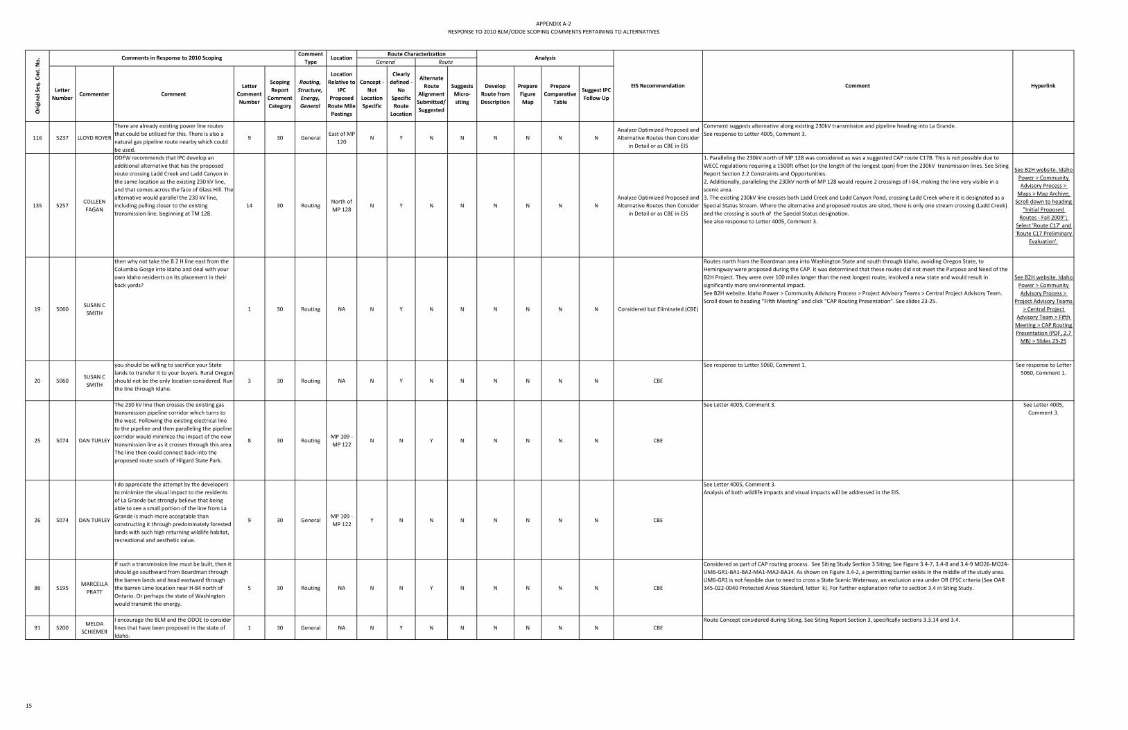
APPENDIX A‐2RESPONSE TO 2010 BLM/ODOE SCOPING COMMENTS PERTAINING TO ALTERNATIVES
Letter Number
Commenter Comment Letter
Comment Number
Scoping Report
Comment Category
Routing, Structure, Energy, General
Location Relative to
IPC Proposed Route Mile Postings
Concept ‐ Not
Location Specific
Clearly defined ‐
No Specific Route
Location
Alternate Route
Alignment Submitted/ Suggested
Suggests Micro‐siting
Develop Route from Description
Prepare Figure Map
Prepare Comparative
Table
Suggest IPC Follow Up
Orig
inal Seq
. Cmt. No. Comments in Response to 2010 Scoping
Comment Type
Location
Comment Hyperlink
General RouteRoute Characterization
Analysis
EIS Recommendation
116 5237 LLOYD ROYER
There are already existing power line routes that could be utilized for this. There is also a natural gas pipeline route nearby which could be used.
9 30 GeneralEast of MP
120N Y N N N N N N
Analyze Optimized Proposed and Alternative Routes then Consider
in Detail or as CBE in EIS
Comment suggests alternative along existing 230kV transmission and pipeline heading into La Grande.See response to Letter 4005, Comment 3.
135 5257COLLEEN FAGAN
ODFW recommends that IPC develop an additional alternative that has the proposed route crossing Ladd Creek and Ladd Canyon in the same location as the existing 230 kV line, and that comes across the face of Glass Hill. The alternative would parallel the 230 kV line, including pulling closer to the existing transmission line, beginning at TM 128.
14 30 RoutingNorth of MP 128
N Y N N N N N NAnalyze Optimized Proposed and Alternative Routes then Consider
in Detail or as CBE in EIS
1. Paralleling the 230kV north of MP 128 was considered as was a suggested CAP route C17B. This is not possible due to WECC regulations requiring a 1500ft offset (or the length of the longest span) from the 230kV transmission lines. See Siting Report Section 2.2 Constraints and Opportunities.2. Additionally, paralleling the 230kV north of MP 128 would require 2 crossings of I‐84, making the line very visible in a scenic area. 3. The existing 230kV line crosses both Ladd Creek and Ladd Canyon Pond, crossing Ladd Creek where it is designated as a Special Status Stream. Where the alternative and proposed routes are sited, there is only one stream crossing (Ladd Creek) and the crossing is south of the Special Status designation.See also response to Letter 4005, Comment 3.
See B2H website. Idaho Power > Community Advisory Process >
Maps > Map Archive; Scroll down to heading
"Initial Proposed Routes ‐ Fall 2009";
Select 'Route C17' and 'Route C17 Preliminary
Evaluation'.
19 5060SUSAN C SMITH
then why not take the B 2 H line east from the Columbia Gorge into Idaho and deal with your own Idaho residents on its placement in their back yards?
1 30 Routing NA N Y N N N N N N Considered but Eliminated (CBE)
Routes north from the Boardman area into Washington State and south through Idaho, avoiding Oregon State, to Hemingway were proposed during the CAP. It was determined that these routes did not meet the Purpose and Need of the B2H Project. They were over 100 miles longer than the next longest route, involved a new state and would result in significantly more environmental impact. See B2H website. Idaho Power > Community Advisory Process > Project Advisory Teams > Central Project Advisory Team. Scroll down to heading “Fifth Meeting” and click “CAP Routing Presentation”. See slides 23‐25.
See B2H website. Idaho Power > Community Advisory Process >
Project Advisory Teams > Central Project
Advisory Team > Fifth Meeting > CAP Routing Presentation (PDF, 2.7 MB) > Slides 23‐25
20 5060SUSAN C SMITH
you should be willing to sacrifice your State lands to transfer it to your buyers. Rural Oregon should not be the only location considered. Run the line through Idaho.
3 30 Routing NA N Y N N N N N N CBE
See response to Letter 5060, Comment 1. See response to Letter 5060, Comment 1.
25 5074 DAN TURLEY
The 230 kV line then crosses the existing gas transmission pipeline corridor which turns to the west. Following the existing electrical line to the pipeline and then paralleling the pipeline corridor would minimize the impact of the new transmission line as it crosses through this area. The line then could connect back into the proposed route south of Hilgard State Park.
8 30 RoutingMP 109 ‐ MP 122
N N Y N N N N N CBE
See Letter 4005, Comment 3. See Letter 4005, Comment 3.
26 5074 DAN TURLEY
I do appreciate the attempt by the developers to minimize the visual impact to the residents of La Grande but strongly believe that being able to see a small portion of the line from La Grande is much more acceptable than constructing it through predominately forested lands with such high returning wildlife habitat, recreational and aesthetic value.
9 30 GeneralMP 109 ‐ MP 122
Y N N N N N N N CBE
See Letter 4005, Comment 3.Analysis of both wildlife impacts and visual impacts will be addressed in the EIS.
86 5195MARCELLA PRATT
If such a transmission line must be built, then it should go southward from Boardman through the barren lands and head eastward through the barren Lime location near H‐84 north of Ontario. Or perhaps the state of Washington would transmit the energy.
5 30 Routing NA N N Y N N N N N CBE
Considered as part of CAP routing process. See Siting Study Section 3 Siting; See Figure 3.4‐7, 3.4‐8 and 3.4‐9 MO26‐MO24‐UM6‐GR1‐BA1‐BA2‐MA1‐MA2‐BA14. As shown on Figure 3.4‐2, a permitting barrier exists in the middle of the study area. UM6‐GR1 is not feasible due to need to cross a State Scenic Waterway, an exclusion area under OR EFSC criteria (See OAR 345‐022‐0040 Protected Areas Standard, letter k). For further explanation refer to section 3.4 in Siting Study.
91 5200MELDA
SCHIEMER
I encourage the BLM and the ODOE to consider lines that have been proposed in the state of Idaho.
1 30 General NA N Y N N N N N N CBERoute Concept considered during Siting. See Siting Report Section 3, specifically sections 3.3.14 and 3.4.
15

APPENDIX A‐2RESPONSE TO 2010 BLM/ODOE SCOPING COMMENTS PERTAINING TO ALTERNATIVES
Letter Number
Commenter Comment Letter
Comment Number
Scoping Report
Comment Category
Routing, Structure, Energy, General
Location Relative to
IPC Proposed Route Mile Postings
Concept ‐ Not
Location Specific
Clearly defined ‐
No Specific Route
Location
Alternate Route
Alignment Submitted/ Suggested
Suggests Micro‐siting
Develop Route from Description
Prepare Figure Map
Prepare Comparative
Table
Suggest IPC Follow Up
Orig
inal Seq
. Cmt. No. Comments in Response to 2010 Scoping
Comment Type
Location
Comment Hyperlink
General RouteRoute Characterization
Analysis
EIS Recommendation
95 5202GENE E
BRAY;LAIRD J LUCAS
Specifically, BLM must evaluate a corridor siting alternative that would avoid crossing public lands in the southern portion of the proposed line, i.e., from Hemingway to Huntington, OR. This alternative site route appears to be both feasible and more desirable from the context of utilizing existing developed corridors and roadways.This alternative route would go from Hemingway to the Bowmont Substation four miles north of Melba, then north to the vicinity of Weiser, all in Idaho; and then go west across the Snake River to Huntington, OR, there joining the currently proposed route.This route is already laced with corridors of various types and has a good road and highway infrastructure that services the largely rural and agriculture‐oriented reach up the east side of the Snake River.There has already been county approval in Owyhee and Canyon Counties in Idaho relative to this project in that there is a functioning tie‐line from Hemingway to Bowmont Substation four miles north of Melba. These robust steel towers get the line over theSnake River and run about ten miles between the two stations. From that line it is about 23
l h h
6 30 RoutingEast of MP 198 ‐ MP
298N N Y N N N N N CBE
Route Concept has been considered during Siting and CAP and eliminated. 1. Initial CAP proposed routes S6, S7, and S13 capture this concept. See B2H website. Idaho Power > Community Advisory Process > Maps > Map Archive; Scroll down to heading "Initial Proposed Routes ‐ Fall 2009"; Select links for S6, S7, and S13.2. See B2H website. Idaho Power > Community Advisory Process > Maps > Map Archive ‐ Under heading "Revised Routes ‐ Detailed Evaluation ‐ Winter 2009/2010" review Segments BA17‐WA1‐PA1‐PA2‐OW2 in Permitting, Constructability and Mitigation Cost Summary Maps; Review also Analysis by Region > Region Maps > South PAT > Snake River Valley map3. See also Siting Study Section 3, specifically sections 3.3.14 and 3.4. Note figure 3.4‐7, 8 and 9. Segments BA17‐WA1‐PA1‐PA2‐OW2 or BA13‐WA1‐PA1‐PA2‐OW2‐OW1 for permitting difficulty analysis.
See B2H website. Idaho Power > Community Advisory Process > Maps > Map Archive
127 5255RORY
WESTBERG
the eastern alignment shown on the resources map would have significantly less impact on views of the trail from the Oregon Trail Interpretive Center at Baker City. It would avoid crossing the historic trail near the interpretive center and intervening topography would hide the transmission line from view of that facility.
3 30 General
Assume virtue flat and add MPs
Y N N N N N CBE
Letter and comments indicate that Lee Kreutzer (on behalf of Rory Westburg) reviewed the April 2010 maps instead of August 2010 maps. The comment refers to Virtue Flat Alternative. See Figure 1.1‐1 and Section 7.4.4 along with Appendix A Maps 66‐68 in POD; See also Siting Study section 4.2.4, Figure 4.1.4‐1 and Appendix E Maps 66‐68; See also NOI Exhibit D6, Figure G‐1‐5.
155 5280DANIELLE MCNAIR
The further west you go, the less people are impacted.
1 30 General NA Y N N N N N N N CBE
Comment noted. Avoiding populated areas like cities, towns and individual homes has been siting criteria from the beginning of routing activity. During the CAP routes were considered which headed south from Boardman, through Grant/Harney/Malheur Counties to the Hemingway Substation. See original CAP routes on B2H website. However the eastern route through the study area was determined to be the most feasible considering permitting and construction difficulty. See Siting Study 3.4 Alternative Routes. Address western alternative route as CBE in EIS.
179 40035RON
GREB;SALLY GREB
the alternative eastern route – I‐84 would be the most logical if there is no other possible site than Oregon...From the mileage standpoint the eastern route would be shorter. It would be less difficult to construct, less invasive for special status streams and pristine national forests
1 30 GeneralMP 1‐MP299
N N N N N N N N CBE
The eastern alternative is IPC's proposed Route. See Siting Study and POD.See response to Letter 5088, Comment 1 .
180 40046GARY
LANGENFELD
If Idaho needs more electricity they should build a power plant in Idaho and not clutter up our beautiful countryside.
3 30 General NA N N N N N N N N CBESee response to Letter 5004, Comment 2.
15 5050BARBARA FLEMING
Dick Fleming has sent a proposal for a more eastern route that would be lower, thus less visible. It would be on BLM property. You moved to BLM in Malheur County, try it in Baker County also.
5 30 General NA Y N N N N N N N
Consider Optimized Virtue Flat/Interpretive Center Proposed and Alternative Routes in Detail in
EIS
Comment noted. See response to Dick Fleming's Letter 5023, Comment 3 and 4. See response to Letter 5013, Comment 1 re Virtue Flat.See response to Letter 5038, Comment 1 re Public Land.
27 5082 BERTHELSON
We do not believe the powerline should be placed anywhere on the west side of the Or. Trail Interpetive Center. Baker City residents have worked hard
1 30 RoutingMP 152 ‐ MP 158
N Y N N N N N N
Consider Optimized Virtue Flat/Interpretive Center Proposed and Alternative Routes in Detail in
EIS
Comment noted. Through the CAP and subsequent analyses, IPC has selected a route placing the B2H line east of the Interpretive Center. See Siting Study section 3.3.8 for further discussion on selection process.See response to 5013, Comment 1.
46 5130
AMANDA WILDE;SCOTT WILDE;OLIVER WILDE;CHRIST
IE WILDE
It is extremely important to us that the Transmission Line is located on public land by the Interpretive Center.
1 30 RoutingMP 152 ‐ MP 159
N Y N N N N N N
Consider Optimized Virtue Flat/Interpretive Center Proposed and Alternative Routes in Detail in
EIS
See response to Letter 5013, Comment 1 re Virtue Flat. See response to Letter 5038, Comment 1 re Public Land.
16

APPENDIX A‐2RESPONSE TO 2010 BLM/ODOE SCOPING COMMENTS PERTAINING TO ALTERNATIVES
Letter Number
Commenter Comment Letter
Comment Number
Scoping Report
Comment Category
Routing, Structure, Energy, General
Location Relative to
IPC Proposed Route Mile Postings
Concept ‐ Not
Location Specific
Clearly defined ‐
No Specific Route
Location
Alternate Route
Alignment Submitted/ Suggested
Suggests Micro‐siting
Develop Route from Description
Prepare Figure Map
Prepare Comparative
Table
Suggest IPC Follow Up
Orig
inal Seq
. Cmt. No. Comments in Response to 2010 Scoping
Comment Type
Location
Comment Hyperlink
General RouteRoute Characterization
Analysis
EIS Recommendation
49 5138 RON ROWAN
We are in favor of the eastern route for the power line so that it is out of site of the OTIC. We realize there are some issues with this route, but feel it is the best alternative we have been given for a power line through Baker County.
2 30 RoutingMP 137‐MP207
N N N N N N N N
Consider Optimized Virtue Flat/Interpretive Center Proposed and Alternative Routes in Detail in
EIS
This route is IPC's proposed Route. See Siting Study and POD.See response to Letter 5013, Comment 1.
50 5139 ANN ROWAN
We are in favor of the eastern route for the power line so that it is out of site of the OTIC. We realize there are some issues with this route, but feel it is the best alternative we have been given for a power line through Baker County.
2 30 RoutingMP 137‐MP 207
N N N N N N N N
Consider Optimized Virtue Flat/Interpretive Center Proposed and Alternative Routes in Detail in
EIS
This route is IPC's proposed Route. See Siting Study and POD.See response to Letter 5013, Comment 1.
108 5226 TI HAYS
Further, we recommend that BLM, to the maximum extent possible, develop alternatives that comply with the management prescriptions contained in the Baker RMP and Vale District’s Oregon NHT Management Plan for the Oregon NHT, including the visual resource management prescriptions applicable to the Oregon Trail ACEC and Oregon Trail Geographic Unit.
5 30 General NA N N N N N N N N
Develop Alternatives as Necessary and Consider in Detail or as CBE in
EIS Depending on Resource Impacts
Any location where VRM I or VRM II is crossed will require an alternative that avoids crossing these VRM Class lands.
128 5257COLLEEN FAGAN
ODFW recommends that IPC meet with ODFW to develop a preferred route.
1 30 General NA NA NA NA NA N N N N Multi Agency Consultation Selection of a preferred route is an outcome of the NEPA process and not the result of a bilateral agreement between ODFW and IPC. Multi agency and IPC meeting would be appropriate.
129 5257COLLEEN FAGAN
Additional constraints for development should include sage‐grouse brood rearing and winter habitat. ODFW’s current policy identifies these habitats as category 2 and recommends no development within .5 miles of these areas. In addition, unimproved roads should be located greater than or equal to 1.0 mile from occupied leks.
3 30 General NA NA NA NA NA N N N N Multi Agency Consultation
1. The IPC Biologist has indicated that no sage‐grouse brood rearing habitat data is available at this time. There has been discussion with ODFW biologist that these areas may be able to be developed through GIS analysis. Should follow up with ODFW.2. The Winter Habitat data is incomplete in the Draft ODFW Greater Sage‐grouse Conservation Assessment and Strategy for Oregon. The draft winter range data has been added as a project constraint and category 2 habitat and development within 0.5 mi of these areas should be noted. 3. For unimproved roads, the ODFW recommendation is only greater than or = to 0.5 mi, not 1.0 miles. Need to follow up. See Recommendations for Greater Sage‐grouse Habitat Classification under ODFW's Fish and Wildlife Habitat Mitigation Policy, August 2009.Should address in EIS.
See ODFW's Sage‐Grouse Habitat Mitigation
Recommendations
130 5257COLLEEN FAGAN
additional terrestrial species should be considered constraints when evaluating potential corridors including state and federal threatened, endangered, and sensitive species (TE&S). 4 30 General NA NA NA NA NA N N N N Multi Agency Consultation
1. Available data for big game winter range, special status streams, Washington ground squirrel and sage‐grouse data was considered throughout the siting process. See Siting Study Section 2 and Appendix A.2. ORNHIC data was considered but much of this data is outdated, inaccurate and/or incomplete for each species. 3. If ODFW has delineated other areas where certain species exist, we could include them in the analysis.4. Biological surveys will be performed to better identify species occurrence and habitat along the Proposed Route. Surveys to be performed are described in the Draft Biological Survey Work Plan, which underwent recent ODFW review and comments are being addressed. This plan with address State and Federal Endangered species as applicable.
132 5257COLLEEN FAGAN
ODFW believes considerations for project routing and selection should also include acreage/miles of Category 1 and Category 2 habitat impacted by the project and the presence of TE&S species and their habitat.
7 30 General NA NA NA NA NA N N N N Multi Agency Consultation
1. The route siting process included consideration of category 1 and 2 habitat as well as mitigation cost analysis performed on all CAP routes. The analysis incorporated biological habitat categories based on available data sources. See Siting Study Figure 3.4‐9 and section 3.3 Regional Analyses. 2. The IPC Proposed Route and Alternatives will undergo a detailed habitat categorization which may result in route realignments. This process will also be applied to NEPA routes on a more qualitative basis. 3. The requested data will be developed and refined through the biological surveys.
145 5258 GARY MILLER
verify with the Idaho Department of Fish and Game that the proposed route does not come within two miles of any known sage‐grouse leks within Owyhee County and reroute further than two miles from any sage‐grouse lek in Idaho.
4 30 RoutingMP 276 ‐ MP 299
N N N Y N N N N Pending
IDFG and Idaho BLM were consulted during the B2H siting process and GIS data for known sage‐grouse leks within Idaho was collected and used as a constraint. See Siting Study Appendix A Constraints and Opportunities. Continue to ensure most current Sage‐grouse data is used. A two‐mile buffer around leks is ODFW's exclusion standard. Idaho has no exclusion standard.
146 5258 GARY MILLER
The Service recommends continued analysis and prioritization of other alternative routes that better avoid sage‐grouse leks and high quality sage‐steppe habitat, and minimize impacts to other trust resources and protected lands.
5 30 General NA N N N N N N N N Pending
Several alternatives will be studied in further detail in the EIS process.See response to Letter 5258, Comment 4.
3 5004 ROBERT HALL
Produce most electricity at the source of its use is a better way to build a power system for the future for your customer energy needs while causing less of a negative impact on the environment and citizens of Eastern Oregon. Pursue solar energy production on roof tops where energy is produced at the source of use eliminating the need for expensive environmental degrading power lines.
2 30 Energy NA N N N N N N N N NFA
The purpose of the B2H Project is to increase transmission capacity connecting the Pacific Northwest to the Intermountain Region of Southwestern Idaho in to alleviate existing transmission constraints and to ensure sufficient capacity to meet projected increased system loads. See Purpose and Need Section 2 in POD. Additional generation facilities, like solar energy, nuclear, and natural gas plants, will not provide the regional transmission connectivity needed, which will allow excess power in the northwest to be efficiently transported to the Southwestern Idaho in times of high demand, and conversely, allow Southwestern Idaho to send excess power to the northwest grid.
17

APPENDIX A‐2RESPONSE TO 2010 BLM/ODOE SCOPING COMMENTS PERTAINING TO ALTERNATIVES
Letter Number
Commenter Comment Letter
Comment Number
Scoping Report
Comment Category
Routing, Structure, Energy, General
Location Relative to
IPC Proposed Route Mile Postings
Concept ‐ Not
Location Specific
Clearly defined ‐
No Specific Route
Location
Alternate Route
Alignment Submitted/ Suggested
Suggests Micro‐siting
Develop Route from Description
Prepare Figure Map
Prepare Comparative
Table
Suggest IPC Follow Up
Orig
inal Seq
. Cmt. No. Comments in Response to 2010 Scoping
Comment Type
Location
Comment Hyperlink
General RouteRoute Characterization
Analysis
EIS Recommendation
4 5004 ROBERT HALLput the line somewhere less populated
4 30 General NA N N N N N N N N NFAComment noted. Avoiding populated areas like cities, towns and individual homes have been siting criteria from the beginning of routing activity.
9 5020REED DEVON
WAITE
I have an existing Idaho Power transmission line through my property. If the proposed line comes through I would like it to go near the existing line so it would not cut my property into more pieces that would make it less usable and less valuable.
1 30 Routing MP 122 N N N Y N N N N NFA
Comment noted; however, for reliability reasons WWEC regulations require a minimum separation of 1500ft between transmission lines (above 230kV) or the length of longest span. IPC's 12‐6 route has been relocated approximately 1 mile west of where the scoping proposed route was located at MP 122. At the current time, the line is no longer on commenter's property.
11 5023 DICK FLEMING
The existing 230 kv line east of town is accepted. If it was replaced with a stacked 500 kv + 230 kv stacked circuits, the visual impact would be minimal. Use corten steel on light painted towers it would be minimally less intrusive
7 30 StructureMP 151 ‐ MP 164
N N Y N N N N N NFA
Double circuit 500kV/ 230kV transmission structures would be significantly taller and more visible than the much shorter existing wood pole H‐frame structures and proposed 500kV lattice structures.Regardless, combining the 230kV and 500kV lines does not meet the WWEC regulatory criteria for reliability which requires a 1500ft separation (or length of longest span) between 230kV and 500kV lines.
14 5038 LIN MITCHELL
I think keeping the project as much as possible on public land is best. Private land has too many obstacles.
1 30 General NA Y N N N N N N N NFA
In order to provide a fair and unbiased assessment of environmental issues, property ownership was a secondary consideration to environmental constraints. Before property ownership was involved with the siting process, the constraints on the land were assessed. Once determined that adjacent private and public parcels were equally constrained, then efforts to place the line on public land rather than private were made. However, environmental constraints played the most significant role in the siting of the route as ultimately the line needs to be permitted.
16 5052LINDA DRISKILL
We work closely with the Hells Canyon Preservation Council to identify and protect core habitat areas with connectivity tin the Blue Mountain Province. In this capacity, we oppose the B2H line going through prime core habitats and connectivity areas.
1 30 General NA Y N N N N N N N NFA
Comment Noted. Wildlife Habitat areas will be surveyed and mitigation measures will be implemented where necessary. Wildlife impacts will be addressed in the EIS.
17 5054 BECKY HOEFTDo you have other options for the line other than private property or other than being so near to homes?
11 30 General NA N N N N N N N N NFAAlternatives throughout the study area have been developed and analyzed. It is unlikely that the route will not affect any private lands, but efforts to maximize distance from residences has been a siting consideration.
21 5061 ED KERSHNER
All lines should be (1) one mile from human habitation and or critical wildlife areas (Snake River Birds of Prey for example).
1 30 Routing NA Y N N N N N N N NFA
Federal and State regulations protect critical wildlife areas and often require minimum setbacks. These requirements must be met in order for a permit to be obtained.Populated areas (i.e. towns, cities) are siting constraints and efforts to avoid impacts to these areas have been taken in sitingthe proposed and alternate routes. See Siting Study, Appendix C. Keeping lines one mile from occupied structures would not be feasible, instead, a minimum setback of 300ft from occupied residences has been applied. However, efforts were made to maximize distance from occupied residences where possible.
22 5068 PEGGI TIMM
1. My first preference is to follow from Boardman thru AMorrow, Grant Malheur counties to Hemingway.
1 30 Routing NA Y N N N N N N N NFA
During the CAP routes were considered which headed south from Boardman, through Grant/Harney/Malheur Counties to the Hemingway Substation. See original CAP routes on B2H website. However the eastern route through the study area was determined to be the most feasible considering permitting and construction difficulty. See Siting Study 3.4 Alternative Routes.
See B2H website. Idaho Power > Community Advisory Process >
Maps > Map Archive; Scroll down to heading
"Initial Proposed Routes ‐ Fall 2009"; Select 'Route C9' and 'Route C9 Preliminary Evaluation'. Also see Routes C18, S29, S23,
S96.
24 5074 DAN TURLEY
Given the numerous adverse impacts that this line will have if it is constructed though predominately forested areas I would hope that every effort would be made to keep the route in predominantly opened areas and that it would follow existing utility corridors as much as possible.
7 30 Routing NA Y N N N N N N N NFA
Efforts to site the line with a minimal impact to the environment has been a siting criteria throughout the B2H Project. The value of forested lands is noted, and existing utility corridors are considered siting opportunities. See Siting Study Section 2 Approach to Siting.The IPC proposed route (eastern alternative) affects the least amount of forest land out of the three major alternative routes evaluated. See Siting Study Table 3.4‐1.
18

APPENDIX A‐2RESPONSE TO 2010 BLM/ODOE SCOPING COMMENTS PERTAINING TO ALTERNATIVES
Letter Number
Commenter Comment Letter
Comment Number
Scoping Report
Comment Category
Routing, Structure, Energy, General
Location Relative to
IPC Proposed Route Mile Postings
Concept ‐ Not
Location Specific
Clearly defined ‐
No Specific Route
Location
Alternate Route
Alignment Submitted/ Suggested
Suggests Micro‐siting
Develop Route from Description
Prepare Figure Map
Prepare Comparative
Table
Suggest IPC Follow Up
Orig
inal Seq
. Cmt. No. Comments in Response to 2010 Scoping
Comment Type
Location
Comment Hyperlink
General RouteRoute Characterization
Analysis
EIS Recommendation
31 5090FAY STEIN‐
SWANSON;ROD SWANSON
We prefer that this transmission line not even come through Union County.
1 30 RoutingMP 97 ‐ MP 137
Y N N N N N N N NFA
Alternatives to siting the transmission line through Union County have been considered through the CAP. See B2H website (link at right). Through analysis of these alternatives, it has been shown that the most feasible route from a permitting and construction difficulty standpoint is an eastern route which runs through Union County. See Siting Study Section 3 Siting.
See B2H website. Idaho Power > Community Advisory Process >
Maps > Map Archive; Scroll down to heading
"Initial Proposed Routes ‐ Fall 2009"; Select 'Route C9' and 'Route C9 Preliminary Evaluation'. Also see Routes C18, S29, S23,
S96.
39 5112VICKI T WARES
Transmission lines have already been constructed here and the B2H‐IP line should be positioned as close to them as safety will allow.
3 30 RoutingMP 137 ‐ MP 199
Y N N N N N N N NFA
Existing transmission lines have been considered a siting opportunity throughout the siting process. See Siting Study Section 2.2.2 Opportunities.The location of the transmission line within Baker County makes the most use of the existing transmission corridors as possible, while still accounting for additional constraints that are nearby. Between MP 137 and MP 151, the line is located adjacent to the existing IPC 230kV ROW. It is necessary to place the 500kV line 1500ft (or the length of the longest span) away from the existing line in order to meet WECC regulations regarding safety and reliability. Between MP 165 and MP 176, the line is again adjacent to the existing transmission line ROW's where feasible. Once south of Durkee, the existing lines are again paralleled where possible, and efforts to use existing ROW's have been made ‐ the existing 69kV and 138kV lines are going to be rebuilt as double circuit lines between MP 188 and MP 193, in order to place the new 500kV line in the existing 138kV ROW, minimizing new impacts.
41 5120JEAN EILEEN BARBER
If the line is for the public good, put it on public land. You can go along existing corridors if necessary
2 30 General NA Y N N N N N N N NFASee response to Letter 5038, Comment 1.
42 5121PETE
MORGANKeep this line on public lands. Not on private lands.
1 30 General NA Y N N N N N N N NFASee response to Letter 5038, Comment 1.
45 5129DAVID
MILDREXLER
Boise should Pursue Conservation and local energy development Conservation measures should be completely exhausted before such large‐scale energy developments are proposed. I see no evidence to suggest that Boise has even partially tapped into the conservation potential in Boise itself. Alternatives such as natural gas plants in or near Boise could also help to meet energy demand and eliminate the need for a transmission line that stretches across 300 miles of the Great Basin and Blue Mountains Ecoregions, of which one‐third is federal land; lands critical for wildlife connectivity...I specifically request that the Agencies analyze an alternative that meets Idaho's energy needs with conservation measures and the potential construction of a natural gas power plant near Boise. This alternative would not include the B2H transmission line.
4 30 Energy NA N N N N N N N N NFA
See response to Letter 5004, Comment 2.The Project as proposed is consistent with IPC's IRP.
47 5135CHLOE HUGHES
The Eastern Route is more developed and already has the necessary access roads and highways, whereas the Western Route will need to survey and build new roads. I am recommending that Idaho Power choose the more developed less expensive and more permit‐able Eastern Route near the I‐84 corridor for the B2H transmission line. This Route already has a sizable utility corridor.
10 30 GeneralMP 1‐MP299
N N N N N N N N NFA
This route is IPC's proposed Route. See Siting Study and POD.
51 5142BILL
RICHARDSON
Whenever possible, place transmission lines in existing energy or transportation right‐of way corridors.
4 30 Routing NA Y N N N N N N N NFARoute Concept considered as part of Siting Criteria. See Siting Study Section 2.2 Constraints and Opportunities; Appendix B Community Criteria; Appendix C Constraints Crossed ‐ Permitting Difficulty Overview
19

APPENDIX A‐2RESPONSE TO 2010 BLM/ODOE SCOPING COMMENTS PERTAINING TO ALTERNATIVES
Letter Number
Commenter Comment Letter
Comment Number
Scoping Report
Comment Category
Routing, Structure, Energy, General
Location Relative to
IPC Proposed Route Mile Postings
Concept ‐ Not
Location Specific
Clearly defined ‐
No Specific Route
Location
Alternate Route
Alignment Submitted/ Suggested
Suggests Micro‐siting
Develop Route from Description
Prepare Figure Map
Prepare Comparative
Table
Suggest IPC Follow Up
Orig
inal Seq
. Cmt. No. Comments in Response to 2010 Scoping
Comment Type
Location
Comment Hyperlink
General RouteRoute Characterization
Analysis
EIS Recommendation
52 5142BILL
RICHARDSON
Avoid constructing transmission lines in undisturbed natural areas. 5 30 General NA Y N N N N N N N NFA
Route Concept considered as part of Siting Criteria. See Siting Study Section 2.2 Constraints and Opportunities; Appendix B Community Criteria; Appendix C Constraints Crossed ‐ Permitting Difficulty Overview
55 5147 TONY ARNETTThere are many other ways to put this line through without going through private land in which dwellings sit on.
3 30 General NA Y N N N N N N N NFAIn the CAP this was considered a routing criteria by local citizens. Dwellings were captured in GIS where visible or noted during CAP meetings. Efforts to maximize distance from an occupied structure were made during the siting effort. See Siting Study Section 2.0 Constraints and Opportunities.
63 5162DUNCAN FARRIS
Please utilize the millions of acres of BLM lands miles to the south. 3 30 General
MP 276 ‐ MP 299
Y N N N N N N N NFAThere are many environmental constraints restricting the location of the transmission line on BLM land along the foothills of the Owyhee Mountains including BLM VRM Class I and II and Areas of Critical Environmental Concern. Much of IPC's 12‐6 Proposed Route is now located on BLM land in Owyhee County.
64 5162DUNCAN FARRIS
Bare minimum the lines could be double circuited on the existing towers already nearby. 1 30 Structure
MP 276 ‐ MP 299
Y N N N N N N N NFAAssume commenter is referring to the PP&L line which runs to the north of the Proposed B2H line. IPC does not own the PP&L line and double‐circuiting 500kV lines is not permitted due to regulatory criteria requiring separation of high‐voltage lines (minimum of 1500ft or length of longest span).
66 5170JANET S ANGLIN
We suggest that if those towers and lines already exist then why is it not possible to double circuit the lines on those towers that are there. Would that not save a huge amount of money while not causing more towers and lines?
7 30 StructureMP 259 ‐ MP 299
N Y N N N N N N NFA
Assume commenter is referring to the PP&L line which runs to the north of the Proposed B2H line. IPC does not own the PP&L line and double‐circuiting 500kV lines is not permitted due to regulatory criteria requiring separation of high‐voltage lines (minimum of 1500ft or length of longest span).
69 5182 DOUG HEIKEN
locating the transmission line on areas that are already significantly modified by human activities, such as highway corridors, agricultural lands, while avoiding less developed and more ecologically intact areas such as native forests and large intact blocks of rangelands.
3 30 Routing NA Y N N N N N N N NFA
Route Concept considered as part of Siting Criteria. See Siting Study Section 2.2 Constraints and Opportunities; Appendix B Community Criteria; Appendix C Constraints Crossed ‐ Permitting Difficulty Overview
73 5186ROJE S GOOTEE
locating the line where it is presently proposed near the I‐84 corridor presents numerous functional and financial advantages. A transmission line near I‐84 will be substantially less expensive to construct, require far less new roading, be easier to access and service, be located more promixally to the communities it is intended to service, and create far less new ecological disturbance of prisine landscapes.
4 30 Routing NA Y N N N N N N N NFA
This route is IPC's Proposed Route and follows I‐84 as much as practicable. See Siting Study and POD.
85 5192MARK
CERNY;ADELE CERNY
utilize pre‐existing right‐of‐ways21 30 Routing NA Y N N N N N N N NFA
Route Concept considered as part of Siting Criteria. See Siting Study Section 2.2 Constraints and Opportunities; Appendix B Community Criteria; Appendix C Constraints Crossed ‐ Permitting Difficulty Overview
88 5197 JAMES WARDI urge you to consider running this line along already opened utility easements. 1 30 Routing NA Y N N N N N N N NFA
Using or paralleling existing utility easements was considered as part of Siting Criteria. See Siting Study Section 2.2 Constraints and Opportunities; Appendix B Community Criteria; Appendix C Constraints Crossed ‐ Permitting Difficulty Overview
90 5199DENNIS BRADLEY
The most logical route to secure for the construction of this line would be the Eastern route, based on the criteria and information presented this route provides the least resource damage, follows 111 miles of existing corridor, allows for the least amount of high construction difficulty and utilizes a 5 mile utility corridor established on the Wallowa Whitman National Forest.
1 30 RoutingMP 1‐MP299
N N N N N N N N NFA
This route is IPC's Proposed Route. See Siting Study and POD.
100 5213 GARY BELL
My input is to use a route where power lines already exist... If it is necessary to come near the Belsma property use lower ground to the north that does not offer the tree cover and habitat that exist in this area.
2 30 Routing
South of MP 115 ‐ MP 118(Glass Hill Alternative MP 5 ‐ MP
10)
N N N N N N N N NFA
1. Route Concept considered as part of Siting Criteria. See Siting Study Section 2.2 Constraints and Opportunities; Appendix B Community Criteria; Appendix C Constraints Crossed ‐ Permitting Difficulty Overview2. IPC's 12‐6 Proposed and Alternative Routes do not cross commenter's property.
20

APPENDIX A‐2RESPONSE TO 2010 BLM/ODOE SCOPING COMMENTS PERTAINING TO ALTERNATIVES
Letter Number
Commenter Comment Letter
Comment Number
Scoping Report
Comment Category
Routing, Structure, Energy, General
Location Relative to
IPC Proposed Route Mile Postings
Concept ‐ Not
Location Specific
Clearly defined ‐
No Specific Route
Location
Alternate Route
Alignment Submitted/ Suggested
Suggests Micro‐siting
Develop Route from Description
Prepare Figure Map
Prepare Comparative
Table
Suggest IPC Follow Up
Orig
inal Seq
. Cmt. No. Comments in Response to 2010 Scoping
Comment Type
Location
Comment Hyperlink
General RouteRoute Characterization
Analysis
EIS Recommendation
104 5222 LARA ROZZELL
alternative route through Owyhee and Canyon Counties which uses existing corridors and may have much lower impact on wildlife habitat, including irreplaceable sage grouse habitat.
27 30 RoutingMP 277‐ MP 299
Y N N N N N N N NFA
1. The current route is located in northern Owyhee County and follows an existing corridor. 2. Initial CAP proposed routes C13, S13, S18, S7 capture this concept. See B2H website. Idaho Power > Community Advisory Process > Maps > Map Archive; Scroll down to heading "Initial Proposed Routes ‐ Fall 2009"; Select links for C13, S13, S18, S7.3. See B2H website. Idaho Power > Community Advisory Process > Maps > Map Archive ‐ Under heading "Revised Routes ‐ Detailed Evaluation ‐ Winter 2009/2010" review Segments PA1‐OW1 and PA2‐OW2 in Permitting, Constructability and Mitigation Cost Summary Maps; Review also Analysis by Region > Region Maps > South PAT > Snake River Valley map4. Routes through Canyon County have been considered but eliminated. See Siting Study Section 3, specifically sections 3.3.14 and 3.4. Note figure 3.4‐7 Segments PA1‐OW1 and PA2‐OW2 for permitting analysis.
See B2H website. Idaho Power > Community Advisory Process > Maps > Map Archive
106 5224 ROB ALWARD
proposed placement of its transmission line within any part of another existing BLM‐designated right‐of‐way corridor (and which presently is partially occupied by one high kilowatt transmission line) which traverses Vale District public lands east‐west, including crossing the Owyhee River below the same dam, but upstream from the other designated corridor which I addressed above. IP needs to include this designated corridor ‐‐ or least part of it ‐‐ in no less than two of its alternatives to be environmentally assessed when required NEPA documentation
2 30 RoutingMP 259 ‐ MP 276
N N Y N N Figure 5224
N N NFA
Proposed route sited (nearly) within Vale District utility corridor ‐ offset 1500ft for reliability from existing 500kV places the line just south of vale corridor.
113 5234ROGER O. EDIGER
When one studies the Summary of Routes Comparisons Sheet one is left with the obvious conclusion that the Eastern Route is by far the most practical, most simple, least costly, and least problematic of the three proposals. With the Eastern Route following existing corridors, having far less forest right‐of‐way clearing, over five times less special fish status stream crossings, and close to 50% less miles of high construction difficulty it becomes extremely difficult for anyone to understand why it, the Eastern Alternative Route, should not be the selected route for your proposed transmission line. When one couples the above noted items with the high degree of difficulty in accessing the Boardman site via the Western Alternative Route there can be no other conclusion but to place the line along the proposed Eastern Alternative Route.
10 30 General NA N N N N N N N N NFA
These are some of the reasons why the Eastern Alternative was selected as the preferred route.See Section 3.4 Alternative Routes for further discussion.
117 5238
STACEY CALLAWAY;LANTHROP D CALLAWAY
We would like to see you double circuiting the lines on the existing tower or place the line further south across the top of the foothills where no one lives instead of ruining this beautiful valley.
7 30 Structure MP 282 N Y N N N N N N NFA
Reliability issues prevent double‐circuiting 230 kV and 500kV transmission lines. WECC regulations require 1500ft offset or minimum length of longest span. IPC's 12‐6 locates the line further into the foothills and away from homes and will be analyzed in the EIS.
119 5244 EARL L AYLETT
It has been purposed to cross the Navy which helps
3 30 GeneralMP 9 ‐ MP
17N N N N N N N N NFA
IPC has been working with the Department of Defense with regard to locating the line within the northern boundary of the Bombing Range so as to not affect irrigated agricultural practices occurring along the northern side of the boundary. The Navy has consistently advised that this is not possible.
120 5245PATRICIA SCOTT
the new lines go on the existing lines1 30 Structures NA Y N N N N N N N NFA
Existing transmission lines are at capacity and cannot support additional lines. Additionally, 500kV lines require larger structures and right‐of‐way than what is currently in place (230kV lines and lower) in the project area.
122 5250ANDREW
STORER;ELVIA STORER
Our 1st preference is to use existing powerline corridors as this is the least invasive and requires the least amount of new roads and the associated habitat loss.
1 30 General NA Y N N N N N N N NFA
Route Concept considered as part of Siting Criteria. See Siting Study Section 2.2 Constraints and Opportunities; Appendix B Community Criteria; Appendix C Constraints Crossed ‐ Permitting Difficulty Overview
21

APPENDIX A‐2RESPONSE TO 2010 BLM/ODOE SCOPING COMMENTS PERTAINING TO ALTERNATIVES
Letter Number
Commenter Comment Letter
Comment Number
Scoping Report
Comment Category
Routing, Structure, Energy, General
Location Relative to
IPC Proposed Route Mile Postings
Concept ‐ Not
Location Specific
Clearly defined ‐
No Specific Route
Location
Alternate Route
Alignment Submitted/ Suggested
Suggests Micro‐siting
Develop Route from Description
Prepare Figure Map
Prepare Comparative
Table
Suggest IPC Follow Up
Orig
inal Seq
. Cmt. No. Comments in Response to 2010 Scoping
Comment Type
Location
Comment Hyperlink
General RouteRoute Characterization
Analysis
EIS Recommendation
125 5251CRAIG
MARTELL
The best route for the transmission line, if it must go through Baker City area at all, is west of the proposed route through areas that already have roadways and powerlines.
2 30 RoutingMP 150 ‐ MP 164
N Y N N N N N N NFA
1. See B2H website. Idaho Power > Community Advisory Process > Project Advisory Teams > Central Project Advisory Team. Scroll down to heading “Fifth Meeting” and click “CAP Routing Presentation”. See slide 32. Slide shows a route between UN4 and BA8 which fits concept described. Route was considered but eliminated because would require crossing of the Baker Airport Clear Zone, an exclusion area.2. See also Siting Study Figure 3.4‐7 for Permitting Analysis ‐ note Segment UN4 ‐ BA8.3. See also B2H website: Idaho Power > Community Advisory Process > Maps > Maps Archive; Scroll down to "Initial Proposed Routes ‐ Fall 2009". Select 'Route C11' and 'Route C11 Preliminary Evaluation'.4. See siting Study Appendix C Constraints Crossed ‐ Permitting Difficulty Overview for reference to Airport Exclusion Area Permitting Difficulty.
See B2H website. Idaho Power > Community Advisory Process >
Project Advisory Teams > Central Project
Advisory Team > Fifth Meeting > CAP Routing Presentation (PDF, 2.7
MB) > Slide 32
126 5252ROBERT LAZINKA
It makes for more economic sense to establish nuclear, natural gas, ect. in Idaho. 2 30 General NA Y N N N N N N N NFA
See response to Letter 5004, Comment 2.
139 5257COLLEEN FAGAN
in the area around Durkee (TL mile 179 to 188), ODFW recommends that IPC develop an alternate route that moves the line further west and along I‐84, avoiding the large irrigated area near Durkee. This alternative would avoid Gold Hill, extremely important big game winter range, and would result in fewer wildlife impacts.
21 30 RoutingMP 179 ‐ MP 188
N Y N N N N N N NFA
Local residents of the community of Durkee were very vocal throughout the CAP with their desire to keep the transmission line out of their small agriculture valley between MP 176 and MP 184. Additionally, due to presence of an existing 69 kV transmission line, agricultural fields and residential structures located along I‐84 between MP 179 ‐184, the option to locate the route adjacent to I‐84 was not feasible. Following I‐84 south of MP 184 to MP 188, the terrain becomes very severe, not allowing for structure placement for a 500kV transmission line according to engineering review.
141 5257COLLEEN FAGAN
ODFW recommends that IPC develop an alternative from TM 199 to the Hemingway substation that is very similar to the 2008 proposed route. The route should avoid all Category 1 and 2 sage‐grouse habitat and avoid agricultural lands.
24 30 RoutingMP 199 ‐ MP 299
N Y N N N N N N NFA
1. The location of the 2008 Proposed Route south of MP 199 to the Hemingway Substation was mainly driven by the need forthe Sand Hollow Substation located in the vicinity east of the intersection of Route 20 and Highway 95 in Payette County. IPC has since revised their IRP and determined the substation does not need to be built as a part of the B2H project. With the removal of the need for the Sand Hollow Substation there is no reason to traverse any agricultural lands in the Treasure Valley (see the 2008 Proposed Route) . Additionally, ORS 215.275 states that in order to locate a transmission line within Exclusive Farm Use zoned land (the agricultural lands in Malheur are zoned EFU) all reasonable alternatives must be considered. With this in mind, the 2008 Proposed Route would not meet this criteria as a suitable route as the current Proposed Route is able to avoid almost all EFU zoned lands in Malheur County. See Siting Study Figure 3.3.14‐3.2. CAP Route S17 followed a similar path to the 2008 Proposed Route from MP 199 ‐ MP 299 and was again analyzed as part of the CAP in 2009‐2010. See Siting Study Section 3.3.14 Snake River Valley Region for complete analysis.
See B2H website. Idaho Power > Community Advisory Process >
Maps > Map Archive; Scroll down to heading
"Initial Proposed Routes ‐ Fall 2009";
Select 'Route S17' and 'Route S17 Preliminary
Evaluation'.
144 5258 GARY MILLER
Removal of the Malheur District of the Brogan to Huntington Survey Area and the Grande Ronde District of the Baker Survey Area (URS 2010 Greater Sage‐grouse surveys) from the proposed route would have the conservation benefit of eliminating the13.2 miles of lek habitat, thus eliminating the construction of transmission line through some of Oregon's remaining high quality sage‐grouse/sage‐steppe habitat
3 30 Routing NA N Y N N N N N N NFA
The Proposed Route avoids most 2‐mile lek buffers and those buffers that it does cross are adjacent to an existing transmission line on the side further away from the lek center or it was determined that the towers along the Proposed Route would not be visible from the lek center. Additionally, route locations were determined through the CAP. See Siting Study for further understanding of route development.
147 5258 GARY MILLER
Under the ODFW Sage‐grouse Conservation Strategy, all Category 1 sage‐grouse habitat needs to be fully avoided. Category 2 sage‐grouse habitat should be avoided to the largest practicable extent, but if the Project must pass through sage‐grouse habitat, Project activities should be targeted in Category 2 and other lower quality sage‐grouse habitats instead of any Category 1 habitat. If Category 2 habitat also cannot be avoided, then impact minimization, habitat restoration, and habitat mitigation for these impacts to Category 2 and lesser quality habitats should be provided.
14 30 Routing NA Y N N N N N N N NFA
Comment Noted. The B2H process included consultation with ODFW and IDFG for input regarding the importance level of many of the sage‐grouse habitat GIS layers. This input was used throughout the siting process; See Siting Study Appendix A Constraints and Opportunities; Appendix C Constraints Crossed ‐ Permitting Difficulty Overview. Category 1 Habitat has been avoided except in very specific circumstances discussed with ODFW.
148 5258 GARY MILLER
We seek avoidance of impact to sage‐grouse on all habitats. If impacts must occur, we recommend they occur in Category 2 and lower quality habitats.
16 30 Routing NA Y N N N N N N N NFA
See response to Letter 5258, Comment 14.
22

APPENDIX A‐2RESPONSE TO 2010 BLM/ODOE SCOPING COMMENTS PERTAINING TO ALTERNATIVES
Letter Number
Commenter Comment Letter
Comment Number
Scoping Report
Comment Category
Routing, Structure, Energy, General
Location Relative to
IPC Proposed Route Mile Postings
Concept ‐ Not
Location Specific
Clearly defined ‐
No Specific Route
Location
Alternate Route
Alignment Submitted/ Suggested
Suggests Micro‐siting
Develop Route from Description
Prepare Figure Map
Prepare Comparative
Table
Suggest IPC Follow Up
Orig
inal Seq
. Cmt. No. Comments in Response to 2010 Scoping
Comment Type
Location
Comment Hyperlink
General RouteRoute Characterization
Analysis
EIS Recommendation
156 5281MICHAEL
MCALLISTER
Have the minimal environmental impact ‐ esp. not invade, disrupt and fragment large areas of contiguous wild lands; Integrate with the existing network of human occupancy and infrastructure across the landscape; Blend into infrastrucure and human viewscapes with a minimum of "undesirable" outcomes.
1 30 General NA Y N N N N N N N NFA
Comment noted. Siting of the line has attempted to minimize wildlife habitat disturbance, co‐locate transmission lines wherepossible and with other utility and transportation corridors. EIS should address these issues in further detail.
159 5322DR KAREN ANTELL
EOU strongly prefers the new "alternative route" that shifts the line to the south of the Rebarrow property.
1 30 RoutingGlass Hill Alternative
N N N N N N N N NFAIPC's 12‐6 Proposed Route has been relocated to avoid crossing the Rebarrow Research Forest.
160 10082DENNIS FRANKLIN
The first is a comment made by a BLM individual at the Island City meeting concerning why the line was not on BLM land. His comment was "We don't want it on BLM land". WHY NOT? If more BLM or public land was utilized, income from right of ways could offset cost of fire fighting, etc
1 30 General NA Y N N N N N N N NFA
See response to Letter 5038, Comment 1.
162 11644
JAMES O STEPHEN;GER
ALDINE STEPHEN
There is already an established utility corridor for this type of utility structure and it should be considered. Pacific Power and Light lines cross BLM and rangelands without interfering with the uses in our agricultural valleys. Three other possible routes have been presented for consideration.
3 30 Routing NA Y N N N N N N N NFA
During the CAP routes were considered which headed west along the PP&L 500kV transmission line toward Buchanan, then headed north through Grant County toward Boardman. See B2H website (link at right). A western alternative was carried throughout the CAP. Analysis showed that while there is less population, the environmental issues along this route were more substantial than those along an eastern route due to the remoteness and undisturbed nature of the lands. See Siting Study Section 3 Siting, especially Table 3.4‐1.Unsure what "Three other possible routes" commenter refers to.IPC's 12‐6 route is located west of much of the irrigated agriculture in Malheur County.
See B2H website. Idaho Power > Community Advisory Process >
Maps > Map Archive; Scroll down to heading
"Initial Proposed Routes ‐ Fall 2009"; Select 'Route C9' and 'Route C9 Preliminary Evaluation'. Also see Routes C18, S29, S23,
S96.
163 11682
JAMES JEFFERIES;FRA
NCES JEFFERIES
Acres and acres of public BLM land are located near Parma‐‐‐a much more suitable location for these lines. Place these gigantic towers and power lines on public lands, NOT ON PRIVATE LAND!
3 30 General NA Y N N N N N N N NFA
See response to Letter 5038, Comment 1.
164 11683JAMES
JEFFERIES
Acres and acres of public BLM land are located near Parma‐‐‐a much more suitable location for these lines. Place these gigantic towers and power lines on public lands, NOT ON PRIVATE LAND!
3 30 General NA Y N N N N N N N NFA
See response to Letter 5038, Comment 1.
165 11684CHERYL SUTTON
Idaho Power has alternatives, including public land that won't have such a devastating outcome for the many property owners in its route.
2 30 General NA Y N N N N N N N NFA
Comment noted. Alternatives will be studied in detail in the EIS.See response to Letter 5038, Comment 1.
166 11688VICKI T WARES
If, however, these 500kV monstrosities are mandated to Baker County, I cannot rationally believe that they should be any place but on public land or on the 1‐5 corridor (and buried near the airport)...This public project belongs on public land!
1 30 GeneralMP 136 ‐ MP 165
N N Y N N N N N NFA
It is noted that a logical place to locate the transmission line through Baker Valley would be along the I‐84 corridor (assumed "I‐5" reference is to I‐84). However, due to additional constraints, including irrigated agriculture, airport clear zone and residences, paralleling the I‐84 corridor through this area was determined not feasible. See response to Letter 5088, Comment 1 re I‐84.See response to Letter 5038, Comment 1 re Public Land.
See B2H website. Idaho Power > Community Advisory Process >
Project Advisory Teams > Central Project
Advisory Team > Fifth Meeting > CAP Routing Presentation (PDF, 2.7
MB) > Slide 32
23

APPENDIX A‐2RESPONSE TO 2010 BLM/ODOE SCOPING COMMENTS PERTAINING TO ALTERNATIVES
Letter Number
Commenter Comment Letter
Comment Number
Scoping Report
Comment Category
Routing, Structure, Energy, General
Location Relative to
IPC Proposed Route Mile Postings
Concept ‐ Not
Location Specific
Clearly defined ‐
No Specific Route
Location
Alternate Route
Alignment Submitted/ Suggested
Suggests Micro‐siting
Develop Route from Description
Prepare Figure Map
Prepare Comparative
Table
Suggest IPC Follow Up
Orig
inal Seq
. Cmt. No. Comments in Response to 2010 Scoping
Comment Type
Location
Comment Hyperlink
General RouteRoute Characterization
Analysis
EIS Recommendation
167 11688VICKI T WARES
The best route is the first alternative proposed by Idaho Power in 2006 ‐ run it north through Idallo. If it must come through 0regon then Baker County votes for the Buchanan alternate‐route.
2 30 General NA N Y N N N N N N NFA
Unclear what route was proposed by Idaho Power in 2006. Project had not started at this time. Routes north from the Boardman area into Washington State and south through Idaho, avoiding Oregon State, to Hemingway were proposed during the CAP. It was determined that these routes did not meet the Purpose and Need of the B2H Project. They were over 100 miles longer than the next longest route, involved a new state and would result in significantly more environmental impact. See B2H website. Idaho Power > Community Advisory Process > Project Advisory Teams > Central Project Advisory Team. Scroll down to heading “Fifth Meeting” and click “CAP Routing Presentation”. See slides 23‐25. During the CAP routes were considered which headed west along the PP&L 500kV transmission line toward Buchanan, then headed north through Grant County toward Boardman. See B2H website (link at right). A western alternative was carried throughout the CAP. Analysis showed that while there is less population, the environmental issues along this route were more substantial than those along an eastern route due to the remoteness and undisturbed nature of the lands. See Siting Study Section 3 Siting, especially Table 3.4‐1.
See B2H website. Idaho Power > Community Advisory Process >
Maps > Map Archive; Scroll down to heading
"Initial Proposed Routes ‐ Fall 2009"; Select 'Route C9' and 'Route C9 Preliminary Evaluation'. Also see Routes C18, S29, S23,
S96.
168 11707VICTORIA A
CASE
If YOU will benefit from this transmission line, put in on public land, not private prime farm ground. If neighboring communities will benefit from this transmission line, put in on public land that is widely available in our state and therefore will not rob private homeowners of our future plans to prosper and watch our families grow. If other states will (and they will) benefit from this proposed transmission line, it should be very obvious and clear to you that it needs to be put on PUBLIC land because it benefits the PUBLIC.
1 30 General NA Y N N N N N N N NFA
See response to Letter 5038, Comment 1.
169 11710NANCY
JOHNSONA perfect alternative would have been to use public lands for such an endeavor,
1 30 General NA Y N N N N N N N NFASee response to Letter 5038, Comment 1.
170 40009
ANGIE LUSCO;ABBY LUSCO;DREW LUSCO;MALLO
RY LUSCO;ANDY
LUSCO
A new transmission line should only be allowed within an existing utility or highway corridor, as the B2H Eastern route most closely follows.
9 30 RoutingMP 1‐MP299
N N N N N N N N NFA
This route is IPC's proposed Route. See Siting Study and POD.
171 40014KATHRYN FRIEDRICH
Would wind power be a viable alternative to the planned 500 kV Boardman to Hemingway transmission line and if not, why not?
1 30 General NA N N N N N N N N NFA
The purpose of the B2H Project is to increase transmission capacity connecting the Pacific Northwest to the Intermountain Region of Southwestern Idaho in order to alleviate existing transmission constraints and to ensure sufficient capacity to meetprojected increased system loads. See Purpose and Need, Section 2 in POD. Additional generation facilities, like solar energy, will not provide the regional transmission connectivity needed, which will allow excess power in the northwest to be efficiently transported to the Southwestern Idaho in times of high demand, and conversely, allow Southwestern Idaho to send excess power to the northwest grid.
172 40015 DONALD BECK
There needs to be more enfaces on locally produced green energy thereby eliminating the waste created by the loss of energy along the route of high voltage power lines.
6 30 General NA N N N N N N N N NFA
The purpose of the B2H Project is to increase transmission capacity connecting the Pacific Northwest to the Intermountain Region of Southwestern Idaho in order to alleviate existing transmission constraints and to ensure sufficient capacity to meetprojected increased system loads. See Purpose and Need Section 2 in POD.
184 40057JULIANNE WILLIAMS
I ask that the towers NOT be placed directly ON the Oregon Trail in Baker County or anywhere else. It is important to preserve our historical heritage. There is enough empty land that towers can be placed on either side of the Trail and not directly on it.
1 30 GeneralMP 1 ‐ MP
299N N N Y N N N N NFA
Comment noted. The Oregon Trail has been a constraint throughout the siting process for the B2H line. Where crossing the trail is necessary, towers will be placed such that the trail will be spanned. See Siting Study Section 2, Appendix C.
185 50104EDNA
HARRELL;BOB HARRELL JR
The location of the proposed transmission line is not logical, as it was mapped to cut through significant portions of agricultural lands. In our area specifically, there are BLM lands in near proximity that are obviously a more reasonable location.
1 30 RoutingMP 145 ‐ MP 177
Y N N N N N N N NFA
The Virtue Flat Alternative appears to cross commenter's land. It should be noted that this is an alternative, and not the proposed route. While BLM lands are found nearby, environmental constraints have restricted the ability to permit a 500kV transmission line across much of them. The major environmental constraint in this area is the Sage‐grouse lek 2‐mile buffer sites. The ODFW considers lek buffers Category 1 habitat, for which there is no mitigation. See OAR 635‐415‐0000.
24

APPENDIX A‐2RESPONSE TO 2010 BLM/ODOE SCOPING COMMENTS PERTAINING TO ALTERNATIVES
Letter Number
Commenter Comment Letter
Comment Number
Scoping Report
Comment Category
Routing, Structure, Energy, General
Location Relative to
IPC Proposed Route Mile Postings
Concept ‐ Not
Location Specific
Clearly defined ‐
No Specific Route
Location
Alternate Route
Alignment Submitted/ Suggested
Suggests Micro‐siting
Develop Route from Description
Prepare Figure Map
Prepare Comparative
Table
Suggest IPC Follow Up
Orig
inal Seq
. Cmt. No. Comments in Response to 2010 Scoping
Comment Type
Location
Comment Hyperlink
General RouteRoute Characterization
Analysis
EIS Recommendation
187 50105KATHRYN FRIEDRICH
The suggestion has been made to Idaho Power to consider wind energy to generate electricity for their future needs. To date, we have had no discussion with them on wind energy, but we feel it's a viable alternative and far preferable to siting their transmission line through Grant County.
2 30 General NA N N N N N N N N NFA
The purpose of the B2H Project is to increase transmission capacity connecting the Pacific Northwest to the Intermountain Region of Southwestern Idaho in order to alleviate existing transmission constraints and to ensure sufficient capacity to meetproject increased system loads. See Purpose and Need section 2 in POD. Additional generation facilities, like wind energy facilities, will not provide the regional transmission connectivity needed, which will allow excess power in the northwest to be efficiently transported to the Southwestern Idaho in times of high demand, and conversely, allow Southwestern Idaho to send excess power to the northwest grid.
190 50116VICKI T WARES
If the line must traverse Baker County for the public good, the line should be built on public lands or on the designated energy use corridor
1 30 GeneralMP 137 ‐ MP 199
Y N N N N N N N NFA
See response to Letter 5038, Comment 1.Existing energy corridors have been considered a siting opportunity and efforts to use them have been made. See Siting Study Section 2.2.2 Opportunities.
191 50123BETTY LEE CLARICH
If this energy is needed for the good of all of the people, let it be locataed on the peoples public land.
1 30 General NA Y N N N N N N N NFAComment Noted. Route Concept considered as part of Siting Criteria. See Siting Study Section 2.2 Constraints and Opportunities; Appendix B Community Criteria
25

Supplemental Siting Study Boardman to Hemingway Transmission Line Project
June 2012 1
APPENDIX B CAP Comments

APPENDIX BRESPONSE TO 2009‐2010 COMMUNITY ADVISORY PROCESS COMMENTS PERTAINING TO ALTERANTIVES
CAP Letter Number
Date CAP Letter Received
Commenter Comment CAP Letter Comment Number
CAP Comment Category
Routing, Structure, Energy, General
Associated With Route Identified Below
Further Discussion in Siting Study Section(s) Identified
Below
5 5321 July 15, 2010KENNY
METZGER
Map #10 Parcel number(s)23S46E01100, 23S46E01000, 23S346E01200, 23S46E00600Are there any considerations or issues
related to your property that you would like Idaho Power to know?Should go southwest of their property and move to BLM land.
2 30 RoutingSee Siting Study Appendix E Map 50, Proposed Route MP
273‐274NA No Further Action (NFA) Suggest IPC follow up.
7 5334 August 10, 2010RICK
SIMMONS
The proposed tall towers surrounding the community only one mile out will greatly diminish our general ambiance of life because OF THE
FOLLOWING;...Our proposed solution is for Idaho power to agree to give the Brogan community a three‐mile exclusion zone for High Tension powerlines now and in the future. Build the powerline three miles out from
Brogan in all directions.
4 30 RoutingSee Siting Study Appendix E Map 39, Proposed Route
NA NFA Suggest IPC follow up.
78 5478 April 28, 2010ALAN M INSKO
Hopefully we can convince you of moving the line across our place (2 ½ mile, map 14‐15, see 7,8,9) about 1000’ south making the job you make in sections 11,1,s34E back in sec 7,1SS33E. Same owners,
moves line farther back away from their farmsteads, still on hillside below ridge line, does not change length of line, does not appear to
change difficulty or number of towers.
1 30 RoutingSee Siting Study Appendix E, Maps 14‐15, Proposed Route
MP 77 ‐ 89NA NFA Micrositing, suggest IPC follow up.
79 5481 May 16, 2010JOE D
RIETMANN
One suggestion to limit‐ impact on farm use, would be to continue the alternative route straight west
from sect10n 27 through section 28, T2N R24E. This would limit the impact on the Doherty farm.
We have enclosed a copy of Map 57 from your web site and indicated the proposed route change, the
proposed change does not impact our farm and is offered as an observation by a farmer as to the impact
on farming operations.
5 30 RoutingSee Siting Study Appendix E, Map 58, Proposed Route MP
15.5 ‐ 17.5NA NFA
Micrositing, suggest IPC follow up. Map attached to Comment Letter 5481.
220 5776 November 19, 2009 MARK CERNYKent, enclosed is my route. I realize it is not a pencil line on a map but a general description on the area I feel it should be built. My
route number is 654.6 30 General
See Siting Study Figure 3.4‐6, opposes Western Route; supports Eastern Route
3.4 Alternative Routes NFANo Map Attached to CAP Letter; Suggest
IPC Follow up
264 5856 August 27, 2009W. KIRK WILLIAMS
A transmission corridor and mining claim is not an unusual multiple use situation.
2 30 Routing NA NA NFA Suggest IPC follow up.
472 6202 July 20, 2010LINDA
DORMAN
Map #7Parcel number(s)
12S44E02300, 12S44E03200, 12S44E03100, 12S44E03600, 13S44E00400...Rather have the line on the alternate (Weatherby
area)
1 30 RoutingSee Siting Study Figure 4‐1,
support Weatherby Alternative4 Proposed and Alternative
RoutesAddress as CBE in EIS Suggest IPC follow up.
37 5383 November 17, 2009 DAWN PENCEAnd if we do then follow the freeway it would be the path of least
resistance and least impact.3 30 Routing NA 3 Siting Address I‐84 Concept Route as CBE in EIS
94 5514 January 13, 2010THOMAS E BROWN
I am wondering why the powerline can't stick to the interstate corridor where such utilities are expected?
1 30 RoutingSee Siting Study Appendix E, Map 34, Proposed Route MP
188‐1892 Approach to Siting Address I‐84 Concept Route as CBE in EIS
144 5656 January 13, 2010
THOMAS E BROWN;THO
MAS E BROWN
powerline simply follow the interstate corridor? 1 30 Routing NA 2 Approach to Siting Address I‐84 Concept Route as CBE in EIS
203 5757 November 19, 2009JERRY
EBELTOFTI‐84 is a real possibility with some mitigation in the La Grande, Baker
City and Ag land in the Ontario area.3 30 Routing
See Siting Study Figure 3.1‐1, CAP Routes
3 Siting Address I‐84 Concept Route as CBE in EIS
237 5806 January 4, 2010JUDGE TERRY TALLMAN
Route along interstate 84 or upgrade existing transmission corridor. 5 30 Routing NA 2 Approach to Siting Address I‐84 Concept Route as CBE in EIS
392 6073 August 25, 2009EDWARD TSCHIDA
Why not use the interstate highway all the way for those power lines + stay away from private property
2 30 Routing NA 2 Approach to SitingAddress I‐84 Concept Route as CBE in EIS; Address in Alternatives Methodology Section in EIS; Consider developing a conceptual public land alternative from
northern end of Blue Mountains south to Hemingway Substation.
221 5777 March 15, 2010 BOB MASON
A route that follows the existing power lines along Interstate Highway 84 would cause the least impacts. It should be positioned to the east of the Oregon Trail Interpretive Center and hidden between
hills as much as possible.
9 30 RoutingSee Siting Study Figure 3.4‐6,
Eastern Route3.4 Alternative Routes
Address I‐84 Concept Route as CBE in EIS; Consider Optimized Virtue Flat/Interpretive Center Proposed and Alternative Routes in Detail in EIS
Orig
inal Seq
. Cmt.
No.
Comments in Response to Community Advisory ProcessComment
TypeAccounted for in IPC CAP Siting Study
EIS Recommendation Comment
1
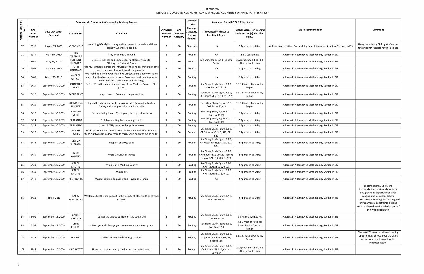
APPENDIX BRESPONSE TO 2009‐2010 COMMUNITY ADVISORY PROCESS COMMENTS PERTAINING TO ALTERANTIVES
CAP Letter Number
Date CAP Letter Received
Commenter Comment CAP Letter Comment Number
CAP Comment Category
Routing, Structure, Energy, General
Associated With Route Identified Below
Further Discussion in Siting Study Section(s) Identified
Below
Orig
inal Seq
. Cmt.
No.
Comments in Response to Community Advisory ProcessComment
TypeAccounted for in IPC CAP Siting Study
EIS Recommendation Comment
97 5516 August 13, 2009 ANONYMOUSUse existing BPA rights of way and/or towers to provide additional
capacity wherever possible.2 30 Structure NA 2 Approach to Siting Address in Alternatives Methodology and Alternative Structure Sections in EIS
Using the existing BPA right of way or towers is not feasible for this project.
11 5345 March 9, 2010KEN
TERAMURAStay clear of EFU ground 1 30 Routing NA 2.2.1 Constraints Address in Alternatives Methodology Section in EIS
23 5361 May 25, 2010LORRAINE HUBBARD
Use existing lines and route...Central alternative route?Skirting the National Forest
1 30 GeneralSee Siting Study 3.4‐6, Central
Route2 Approach to Siting; 3.4
Alternative RoutesAddress in Alternatives Methodology Section in EIS
26 5363 March 9, 2010JOHN
HARTMANthe routes that minimize the intrusion of the line on prime farm land
and city areas of impact, would be preferred.1 30 General NA 2 Approach to Siting Address in Alternatives Methodology Section in EIS
50 5409 March 25, 2010ANDREA OFFICER
We feel that Idaho Power should be using existing energy corridors and using the direct route between Boardman and Hemingway as
their object of study and troubleshooting.1 30 Routing NA 2 Approach to Siting Address in Alternatives Methodology Section in EIS
53 5419 September 30, 2009KENNETH D
PRICES13 to S6 on the Idaho side and away from Malheur County’s EFU
ground.1 30 Routing
See Siting Study Figure 3.1‐1, CAP Route S13, S6,
3.3.14 Snake River Valley Region
Address in Alternatives Methodology Section in EIS
54 5420 September 30, 2009 PATTIE PRICE stays closer to Boise and the population. 1 30 RoutingSee Siting Study Figure 3.1‐1, CAP Route S13, S6,C9, S19, S23
3.3.14 Snake River Valley Region
Address in Alternatives Methodology Section in EIS
55 5421 September 30, 2009NORMA JEAN
LE PRICEstay on the Idaho side to stay away from EFU ground in Malheur
County and farm ground on the Idaho side.1 30 Routing
See Siting Study Figure 3.1‐1 CAP Route S6,s13
3.3.14 Snake River Valley Region
Address in Alternatives Methodology Section in EIS
56 5422 September 30, 2009KAYLENE SAITO
follow existing lines … 3) not going through prime farms 1 30 RoutingSee Siting Study Figure 3.1‐1
CAP Route C92 Approach to Siting Address in Alternatives Methodology Section in EIS
57 5424 September 30, 2009 REID SAITO 1) follow existing lines where possible 1 30 RoutingSee Siting Study Figure 3.1‐1
CAP Route C92 Approach to Siting Address in Alternatives Methodology Section in EIS
58 5424 September 30, 2009 REID SAITO 2) avoid EFU ground and populated areas 2 30 Routing NA 2 Approach to Siting Address in Alternatives Methodology Section in EIS
59 5427 September 30, 2009EVELYN SAYERS
Malheur County EFU land. We would like the intent of the lines to stand but tweaks to allow them to miss exclusion areas would be OK.
1 30 GeneralSee Siting Study Figure 3.1‐1, CAP Routes S6, S13, S18, S21,
S232 Approach to Siting Address in Alternatives Methodology Section in EIS
63 5433 September 30, 2009NORMA BURBANK
Keep off of EFU ground 1 30 RoutingSee Siting Study Figure 3.1‐1, CAP Routes S18,S19,S20, S21,
S232 Approach to Siting Address in Alternatives Methodology Section in EIS
64 5435 September 30, 2009JASON
YOUTSEYAvoid Exclusive Farm Use 1 30 Routing
See Siting Study Figure 3.1‐1, CAP Routes S23‐C9‐S13; second choice S21‐S19‐S13‐C9‐S23
2 Approach to Siting Address in Alternatives Methodology Section in EIS
65 5439 September 30, 2009CAROL KNOTHE
Avoid EFU in Malheur County 1 30 RoutingSee Siting Study Figure 3.1‐1, CAP Routes S19‐S20‐S21
2 Approach to Siting Address in Alternatives Methodology Section in EIS
66 5439 September 30, 2009CAROL KNOTHE
Avoids leks 2 30 RoutingSee Siting Study Figure 3.1‐1, CAP Routes S19‐S20‐S21
2 Approach to Siting Address in Alternatives Methodology Section in EIS
67 5441 September 30, 2009 KEN KNOTHE Most of route is on public land – avoid EFU lands. 1 30 Routing NA 2 Approach to Siting Address in Alternatives Methodology Section in EIS
81 5485 April 4, 2010LARRY
MAPLESDENWestern... Let the line be built in the vicinity of other utilities already
in place.3 30 Routing
See Siting Study Figure 3.4‐6, Western Route
2 Approach to Siting Address in Alternatives Methodology Section in EIS
Existing energy, utility and transportation corridors have been designated as opportunities since routing studies began. Where
reasonable considering the full range of environmental constraints existing
corridors have been included as part of the Proposed Route.
84 5491 September 16, 2009GARTH
JOHNSONutilizes the energy corridor on the south end 3 30 Routing
See Siting Study Figure 3.1‐1, CAP Route C6
3.4 Alternative Routes Address in Alternatives Methodology Section in EIS
88 5495 September 23, 2009CHRIS
BODEWIGno farm ground all range you can weave around crop ground 1 30 Routing
See Siting Study Figure 3.1‐1, CAP Route N4
3.3.5 West of National Forest Utility Corridor
RegionAddress in Alternatives Methodology Section in EIS
105 5534 September 30, 2009 LEE BELT utilize the west‐wide energy corridor 1 30 RoutingSee Siting Study Figure 3.1‐1, support CAP Route S19, S9;
oppose S18
3.3.14 Snake River Valley Region
Address in Alternatives Methodology Section in EIS
The WWECS were considered routing opportunities through out the siting process and used in part by the
Proposed Route.
108 5546 September 30, 2009 VIKKI WYATT Using the existing energy corridor makes perfect sense 1 30 RoutingSee Siting Study Figure 3.1‐1, CAP Route S19‐S21/Central
Corridor
2 Approach to Siting, 3.4 Alternative Routes
Address in Alternatives Methodology Section in EIS
2

APPENDIX BRESPONSE TO 2009‐2010 COMMUNITY ADVISORY PROCESS COMMENTS PERTAINING TO ALTERANTIVES
CAP Letter Number
Date CAP Letter Received
Commenter Comment CAP Letter Comment Number
CAP Comment Category
Routing, Structure, Energy, General
Associated With Route Identified Below
Further Discussion in Siting Study Section(s) Identified
Below
Orig
inal Seq
. Cmt.
No.
Comments in Response to Community Advisory ProcessComment
TypeAccounted for in IPC CAP Siting Study
EIS Recommendation Comment
120 5599 August 19, 2009 ANONYMOUSI would like to see the line used existing pipeline/power corridors
wherever possible. Example is a gas line by Dead Man Page Rest Area with heads toward Baker.
1 30 General NA 2 Approach to Siting Address in Alternatives Methodology Section in EIS
124 5610 September 23, 2009RALPH MORTER
Try to minimize distance to coal plant. Cut across TNC if possible 1 30 RoutingSee Siting Study Figure 3.1‐1,
CAP Route N26, N303.3.1 Boardman Region Address in Alternatives Methodology Section in EIS
125 5614 September 23, 2009 GARY NEAL use NF corridor out of Union County 1 30 RoutingSee Siting Study Figure 3.1‐1,
CAP Route N74 Proposed and Alternative
RoutesAddress in Alternatives Methodology Section in EIS
The Proposed Route uses the utility corridor through theWallowa Whitman
National Forest.
156 5682 December 17, 2009 MAURA KEHRI would recommend using existing routes where high voltage lines
already exist and have been clear cut etc.1 30 General NA 2 Approach to Siting Address in Alternatives Methodology Section in EIS
158 5689 March 20, 2009DICK
FLEMINGminimizes impact on existing high value irrigated farm ground and
on existing development.2 30 General NA 2 Approach to Siting Address in Alternatives Methodology Section in EIS
Irrigated farmland and existing development were constraints in the
siting process.
159 5689 March 20, 2009DICK
FLEMINGIt should be located where the visual impact will be minimized. 3 30 General NA 2 Approach to Siting Address in Alternatives Methodology Section in EIS
Potential visual impact has been considered since the routing process
began. It will be part of the EIS evaluation of the Proposed and
Alternative corridors.
176 5718 November 4, 2009JACK
SOUTHWORTH
Industrial development should be as much as possible in developed areas.
1 30 General NA 2 Approach to Siting Address in Alternatives Methodology Section in EIS
179 5718 November 4, 2009JACK
SOUTHWORTH
Utilize existing corridors, most direct route, avoid National Forests. 5 30 General NA 2 Approach to Siting Address in Alternatives Methodology Section in EIS The proposed route utilizes an existing utility corridor through the national
Forest.
187 5726 September 30, 2009SHARON
LAWRENCEI support building the line in Idaho 2. Do not build the line on
Exclusive Farm Use in Oregon1 30 Routing
See Siting Study Figure 3.1‐1, CAP Route S18‐21, S23, S13 and
S6
2 Approach to Siting; 3 Siting
Address in Alternatives Methodology Section in EIS
EFU land was a siting constraint in the CAP; however it is unavoidable in
routing to the proposed Hemingway (Grassland) Substation
189 5738 November 4, 2009DAN
NICHOLSUse existing corridors when available. 1 30 General NA 2 Approach to Siting Address in Alternatives Methodology Section in EIS
198 5752 November 19, 2009 MAURA KEHRUpgrade existing lines and use clear cut areas already there...We live in Union County primarily and wish the present lines could be used
and improved.1 30 General
See Siting Study Figure 3.4‐6, opposes Western Route
3.4 Alternative Routes Address in Alternatives Methodology Section in EISThe proposed 500 kV line is needed in addition to, not as a replacement or an
upgrade for existing lines.
222 5777 March 15, 2010 BOB MASON The sage grouse leks should also be avoided. 10 30 General NA 2 Approach to Siting Address in Alternatives Methodology Section in EISSage ‐grouse leks are ODFW category I habitat and have been avoided in the
routing process.
226 5783 August 12, 2009 ALVIN WARDGo thro range land as much as possible (or low value land. Try to avoid good farmland, especially row crop land or where it would
interfer with irrigation (mainly cicles + whee lines1 30 General NA 2 Approach to Siting Address in Alternatives Methodology Section in EIS
Farmland including irrigated farmland was a constraint in the CAP.
283 5893 January 21, 2010 KEITH GREEN avoid the major farm areas and the sage grouse areas. 1 30 Routing NA 2 Approach to Siting Address in Alternatives Methodology Section in EIS
285 5895 January 21, 2010BARNEY HARPER
Avoid farm ground. 1 30 Routing NA 2 Approach to Siting Address in Alternatives Methodology Section in EIS
286 5896 May 21, 2009GRANT
KITAMURAI oppose putting the line on exclusive farm use land. 1 30 Routing NA 2 Approach to Siting Address in Alternatives Methodology Section in EIS
289 5898 May 29, 2009MATTHEW P DOHERTY
The siting of easements on Federal Lands including Boardman bombing range and lands managed by nature conservancy should be just practical to consider as any private land when the route is being
planned.
1 30 Routing NA 2 Approach to Siting Address in Alternatives Methodology Section in EIS
Idaho Power has been working with the Department of Defense with regard to locating the line within the northern
boundary of the Bombing Range so as to not affect irrigated agricultural practices occurring along the northern side of the boundary. The Navy has consistently advised that this is not possible.The
Boardman Conservation was determined to be unavailable because
the agreement with land owners prohibits transmission structures.
290 5899 September 30, 2009STEVEN R LEWIS
All routes must avoid EFU land use areas in Oregon. 1 30 Routing NA 2 Approach to Siting Address in Alternatives Methodology Section in EIS
3

APPENDIX BRESPONSE TO 2009‐2010 COMMUNITY ADVISORY PROCESS COMMENTS PERTAINING TO ALTERANTIVES
CAP Letter Number
Date CAP Letter Received
Commenter Comment CAP Letter Comment Number
CAP Comment Category
Routing, Structure, Energy, General
Associated With Route Identified Below
Further Discussion in Siting Study Section(s) Identified
Below
Orig
inal Seq
. Cmt.
No.
Comments in Response to Community Advisory ProcessComment
TypeAccounted for in IPC CAP Siting Study
EIS Recommendation Comment
299 5911 September 30, 2009ROBERTA TRENKEL
It stays off Exclusive farmland. 1 30 RoutingSee Siting Study Figure 3.1‐1, CAP Route C9, S23; C9,s13
2 Approach to Siting Address in Alternatives Methodology Section in EIS
306 5923 September 30, 2009ALICE
HANSEN‐UREAvoid EFU lands or use (all) 2) Pivot irrigation systems... Need to
avoid any areas that our crop dusters need to spray.1 30 Routing
See Siting Study Figure 3.1‐1, CAP Route S23,C9, S18,
S13,S19, S212 Approach to Siting Address in Alternatives Methodology Section in EIS
317 5952 December 8, 2009BRAD
HOLTONacross Exclusive Farm Use & irrigated Agriculture... My preference is
avoid all active farm ground whenever possible.1 30 Routing
See Siting Study Figure 3.1‐1, Opposes CAP Route S7, S18
2 Approach to Siting Address in Alternatives Methodology Section in EIS
321 5957 December 8, 2009 KEITH GREENAs I put powerline in Oregon through farm ground, I did so as the
most direct route to Hemingway.1 30 Routing NA 2 Approach to Siting Address in Alternatives Methodology Section in EIS
325 5972 August 26, 2009JANICE
GEERTSON
Avoid areas providing an agricultural economic ‐‐‐ for our communities, avoid good ‐‐‐ and ‐‐‐ infrastructure. Avoid
municipalities and there areas of import and potential growth. Avoid other community infrastructures, ‐‐‐ roads.
1 30 Routing NA 2 Approach to Siting Address in Alternatives Methodology Section in EIS
326 5972 August 26, 2009JANICE
GEERTSONUse existing corridors as much as possible. Don't neede new ones. 2 30 Routing NA 2 Approach to Siting Address in Alternatives Methodology Section in EIS
329 5975 September 27, 2009
RICK MENDIVE;W
ANETA MENDIVE
We hope to see the transmission line located in unpopulated areas such as BLM and avoid the EFU land completely. As Oregon residents
in EFU areas we are expected to adhere to the strict guidelines established by EFU and we would like to see Idaho Power respect the logic and concept of the EFU restrictions. These restrictions are in
place to preserve the extremely limited farmable land in our area by locating the power lines away from these areas Idaho Power can
help to preserve our incomes and heritage.
3 30 Routing NA 2 Approach to Siting Address in Alternatives Methodology Section in EIS
332 5984 March 24, 2010DALE
CAMPBELL
WESTERN...Is it true that there are already in place easement corridors for the purpose of these lines? If that is the case why would
it not be the least cost approach to utilize existing corridorsfor the purpose of locating these lines? I assume the cost of
construction plus the cost to acuire the land would be less using the existing corridors?
1 30 Routing NA 2 Approach to Siting Address in Alternatives Methodology Section in EIS
338 5992 October 21, 2009 ADELE CERNYWESTERN...I believe that these transmission lines should be sited in
existing high traffic corridors1 30 Routing
See Siting Study Figure 3.4‐6, opposes Western Route, supports Eastern Route
2 Approach to Siting; 3.4 Alternative Routes
Address in Alternatives Methodology Section in EIS
350 6020 October 21, 2009GREG
BOWMAN
Use existing easements and righ of ways: current power lines, interstate highways, state highways. AVOID: Scenic rivers, sensitive
habitat, and wild lands as much as possible.8 30 Routing NA 2 Approach to Siting Address in Alternatives Methodology Section in EIS
354 6029 August 27, 2009DENNIS MOYER
Follow routes through BLM grass lands as much as possible . It is recognized that power needs will be increasing but care is needed in planing to reduce negative impacts that limit land use potential for
cities and private property owners. BLM land uses are already established as open space.
3 30 Routing NA 2 Approach to Siting Address in Alternatives Methodology Section in EIS
371 6051 September 27, 2009THOMAS E PHILLIPS
The majority of the power use from this transmission line is being used by Idaho consumers. The line should be sited as much as
possible in Idaho. Not Oregon.2 30 Routing
See Siting Study Figure 3.1‐1, CAP Routes
2 Approach to Siting Address in Alternatives Methodology Section in EISDoes not meet Project Purpose and
Need, see Section 2 of POD.
372 6052 September 27, 2009AJ MAUPIN,
PE
Idaho Dept. of Transportation is currently looking @ routing US Hiway 95. Have discussion been held with potential parallel corridor
in Idaho w/ITDs activities?4 30 Routing
See Siting Study Figure 3.3.14‐1 Snake River Valley Region
2 Approach to Siting Address in Alternatives Methodology Section in EIS
378 6061 September 27, 2009TERRY E
HERZBERG
Use a route that does not impact first residential areas or prime farm ground, second that does not impact scenic views or "areas with potential for residential and/or business" and third that will not in
any way devalue anyones property.
2 30 Routing NA 2 Approach to Siting Address in Alternatives Methodology Section in EIS
400 6083 August 25, 2009JACOB
ROBINSON
BLM land west of Nyssa and Adrien then south of homdale on BLM land! In the Owyees not any where near are citys of Parma, Nyssa,
Adrian, Homdale and Maring.2 30 Routing NA
4.1 Proposed Route Description by County
Address in Alternatives Methodology Section in EIS
402 6087 August 25, 2009 BILL PAHLIn my perfect world, the line would be routed around major (minor) living areas of people + cross over remote land with lateral lines
penetrating into areas of growth + need.2 30 Routing NA 2 Approach to Siting Address in Alternatives Methodology Section in EIS
Towns, cities and other communities were designated as constraints and avoided in routing. Much of the land along the Proposed Route is remote.
4

APPENDIX BRESPONSE TO 2009‐2010 COMMUNITY ADVISORY PROCESS COMMENTS PERTAINING TO ALTERANTIVES
CAP Letter Number
Date CAP Letter Received
Commenter Comment CAP Letter Comment Number
CAP Comment Category
Routing, Structure, Energy, General
Associated With Route Identified Below
Further Discussion in Siting Study Section(s) Identified
Below
Orig
inal Seq
. Cmt.
No.
Comments in Response to Community Advisory ProcessComment
TypeAccounted for in IPC CAP Siting Study
EIS Recommendation Comment
417 6111 August 25, 2009AARON DANES
I think they should stick to the already alotted corridor for energy... it is very worry some to the home owners what it does to there pocket
book.2 30 Routing NA 2 Approach to Siting Address in Alternatives Methodology Section in EIS
419 6114 August 25, 2009JAY
CHAMBERLIN
Placing it thru prime Ag lands. There must be lower uslue lands To place this lin on. Stay away from EFU Lands, use energy corridors that
are close by.1 30 Routing NA 2 Approach to Siting Address in Alternatives Methodology Section in EIS
422 6119 August 25, 2009BRADFORD BROWN
Use existing corridors as much as possible. Don't neede new ones. 2 30 Routing NA 2 Approach to Siting Address in Alternatives Methodology Section in EIS
425 6122 August 25, 2009JOHN
BECHTEL
I made the trip from Wilder to Murphy today. My thoughts were put that line out there in all of those thousands of miles of bare non‐
productive land; not on the prime land running parral to the desert. There (in my mind) no good reason to incroch on private property.
1 30 Routing NA 2 Approach to Siting Address in Alternatives Methodology Section in EIS
427 6124 October 21, 2009 JIM KENNEDY Route along interstate 84 or upgrade existing transmission corridor. 4 30 RoutingSee Siting Study Figure 3.4‐6,
supports Eastern Route3.4 Alternative Routes Address in Alternatives Methodology Section in EIS
448 6149 August 13, 2009DAVID
WILDMAN
Having said that, if the new proposed lines have to go through we should use existing corridors and not cut new ones just because it is
easier and less expensive.2 30 Routing NA 2 Approach to Siting Address in Alternatives Methodology Section in EIS
452 6153 August 13, 2009GLEN
MCGUIREthe lines should be sited so that they run through sparsely populated
areas.2 30 Routing NA 2 Approach to Siting Address in Alternatives Methodology Section in EIS
454 6155 October 21, 2009ROBIN HEROLD
It should follow the existing power lines. This would minimize the impact to the natural beauty of these counties. Other possibilities
include following the freeways or state hiway corridors.3 30 Routing NA 2 Approach to Siting Address in Alternatives Methodology Section in EIS
456 6156 October 21, 2009 EVA HARRISHaving said that, if the new proposed lines have to go through we should use existing corridors and not cut new ones just because it is
easier and less expensive.2 30 Routing NA 2 Approach to Siting Address in Alternatives Methodology Section in EIS
457 6157 October 21, 2009LENE
HARMONMaintain usage of established corridors, ex: state hwys, freeways ‐
along existing lines3 30 Routing NA 2 Approach to Siting Address in Alternatives Methodology Section in EIS
Existing highway, gas pipeline, transmission and other energy and
utility corridors have been designated as opportunities since routing studies
began. Where reasonable considering the full range of environmental
constraints such corridors have been included as part of the Proposed and
Alternate routes.
469 6185 December 8, 2009MICHAEL R. HAMBY
we encourage you to place the line on a route that uses more public land. We understand that there are proposed routes that run
southwest of the treasure valley that have little impact on wildlife habitat and utilize more public ground. We are in favor of a route
that can achieve these objectives.
4 30 RoutingSee Siting Study Figure 3.1‐1,
support CAP Route S9, S19, S20; oppose S18
3.3.14 Snake River Valley Region
Address in Alternatives Methodology Section in EIS
470 6186 December 8, 2009SID
ANDERSON
Using this section is also more conducive to using the West Wide Energy Corridor that has previously been identified on public lands
and which we strongly encourage using.4 30 Routing
See Siting Study Figure 3.3.14‐1 Snake River Valley Region,
supports Segment OW2‐MA7; opposes CAP Routes S7, S18
3.3.14 Snake River Valley Region
Address in Alternatives Methodology Section in EIS
485 6253 May 21, 2009RICHARD
TERAMURAUse existing corridors as first choice before private lands 2 30 Routing NA 2 Approach to Siting Address in Alternatives Methodology Section in EIS
494 6262 June 4, 2009JOCHEN W HAGBERG
USE Designated Energy corridors ‐ that's what they are for! 9 30 Routing NA 2 Approach to Siting Address in Alternatives Methodology Section in EIS
498 6269 September 30, 2009SHARON PENN
Using existing PP & L at South keeps it off and away from sage grouse and avoids EFU land in Malheur Co.
1 30 RoutingSee Siting Study Figure 3.1‐1, CAP Route C9‐S19, S20, S21;
S13, S6, S233.4 Alternative Routes Address in Alternatives Methodology Section in EIS
71 5452 September 23, 2009KARL D SMITH
cross TNC and bombing range easement to avoid most pivots,... alternate further west, just outside bombing range easement and
directly south1 30 Routing
See Siting Study Figure 3.1‐1, CAP Routes C6‐C18‐C9‐N6
2 Approach to Siting Address in Alternatives Methodology Section in EIS
5

APPENDIX BRESPONSE TO 2009‐2010 COMMUNITY ADVISORY PROCESS COMMENTS PERTAINING TO ALTERANTIVES
CAP Letter Number
Date CAP Letter Received
Commenter Comment CAP Letter Comment Number
CAP Comment Category
Routing, Structure, Energy, General
Associated With Route Identified Below
Further Discussion in Siting Study Section(s) Identified
Below
Orig
inal Seq
. Cmt.
No.
Comments in Response to Community Advisory ProcessComment
TypeAccounted for in IPC CAP Siting Study
EIS Recommendation Comment
396 6077 August 25, 2009KARL J. JINDRA
Use public land when possible ‐ ‐ Humaans are higher priority than some deser rat. Use monolithic poles in areas surrounded by private
land/homes.6 30 Routing NA
Address in Alternatives Methodology Section in EIS;
Consider developing a conceptual public land
alternative from northern end of Blue Mountains south to Hemingway
Substation.
Address in Alternatives Methodology Section in EIS; Address in Alternatives Structure Section in EIS
490 6260 June 4, 2009ELAINE
HAGBERG
I wish Idaho Power could find a way to use a less instrusive way to transmit power through Oregon‐ like DC power or a newer
technology line. Idaho Power would be lauded by the nation and its own bondholders for pushing the envelope towards more green
decisions.
2 30 Energy NA NAAddress in Alternatives Methodology Section in EIS; Address in Alternatives
Structure Section in EIS
493 6262 June 4, 2009JOCHEN W HAGBERG
this energy should be transmitted in DC form; then siting problems would be minor, by comparison.
8 30 Energy NA NAAddress in Alternatives Methodology Section in EIS; Address in Alternatives
Structure Section in EIS
437 6137 September 3, 2010DONALD BECK
It is time to replace High Voltage Alternating Current (HVAC) Power and produce High Voltage Direct Current (HVDC) power in long
routes of transmission of High Voltage Power.10 30 Structure NA NA
Address in Alternatives Methodology Section in EIS; Address in Alternatives Structure Section in EIS
439 6141 October 21, 2009JERRY
EBELTOFT
I‐84 already a blemish on the viewshed, could be the path of the new X‐mission line but instead of going aerial the line could be laid on the ground (not underground, which has a capacitance problem) in 3'
diameter plastic pipes, right along the Interstate, spaced approprately and protected by guard rail or bunkers. The
capacitance issue could be addressed with this method. Actually this could work for the LaGrande Valley also.
3 30 StructureSee Siting Study Figure 3.4‐6,
supports Eastern Route3 Siting
Address in Alternatives Methodology Section in EIS; Address in Alternatives Structure Section in EIS
461 6165 July 29, 2009TOM
WOODRUFF
Is Idaho Power looking into more efficient methods of power transmission? Is underground even a possibility? High efficiency
aluminum units (as in New Zealand and Aus.)?1 30 Structure NA NA
Address in Alternatives Methodology Section in EIS; Address in Alternatives Structure Section in EIS; Address in Underground Technology Section in EIS
8 5337 December 8, 2009 KATHY ALDERYes – Stay on public lands and away from prime farm ground. Avoid
city impact areas1 30 Routing NA 2 Approach to Siting
Address in Alternatives Methodology Section in EIS; Consider developing a conceptual public land alternative from northern end of Blue Mountains south to
Hemingway Substation.
27 5367 March 9, 2010MARGARET M WATSON
support the route that has the largest % of public land. I also support the route which effect the least amount of prime farm ground.
1 30 General NA 2 Approach to Siting Address in Alternatives Methodology Section in EIS; Consider developing a
conceptual public land alternative from northern end of Blue Mountains south to Hemingway Substation.
39 5389 September 30, 2009ALICE
HANSEN‐URE
Need to avoid EFU land or farming use, avoid pivot irrigation system, Stay on BLM or public lands, avoid health issues (noise, medical, etc), need avoid any crop dusting areas. Malheur County does not use as much electricity as much as Idaho does, so it needs to be built in
Idaho kv 500 lines.
1 30 GeneralSee Siting Study Figure 3.1‐1,
CAP Route S23‐C9‐S132 Approach to Siting
Address in Alternatives Methodology Section in EIS; Consider developing a conceptual public land alternative from northern end of Blue Mountains south to
Hemingway Substation.
51 5414 September 30, 2009MILT
OSGOODUse less EFU and prime farmlandPuts line on public land for the
public good1 30 Routing
See Siting Study Figure 3.1‐1, CAP Route C9, S19,S20,S21
2 Approach to Siting Address in Alternatives Methodology Section in EIS; Consider developing a
conceptual public land alternative from northern end of Blue Mountains south to Hemingway Substation.
52 5418 September 30, 2009 LARRY PRICEstay on mostly public landS9 – stays off Oregon EFU ground in
Malheur Co1 30 Routing
See Siting Study Figure 3.1‐1, CAP Route XX
2 Approach to Siting Address in Alternatives Methodology Section in EIS; Consider developing a
conceptual public land alternative from northern end of Blue Mountains south to Hemingway Substation.
60 5429 September 30, 2009RONNEY G
YOSTavoid EFU property as much as possible. Public ground for public
need.1 30 General
See Siting Study Figure 3.1‐1, CAP Routes S19
2 Approach to Siting Address in Alternatives Methodology Section in EIS; Consider developing a
conceptual public land alternative from northern end of Blue Mountains south to Hemingway Substation.
61 5430 September 30, 2009DELORIS C
YOSTavoid EFU property as much as possible. Public ground for public
need.1 30 General
See Siting Study Figure 3.1‐1, CAP Routes S19
2 Approach to Siting Address in Alternatives Methodology Section in EIS; Consider developing a
conceptual public land alternative from northern end of Blue Mountains south to Hemingway Substation.
68 5443 September 30, 2009ROBERT BIVINS
Put on federal corridor. Avoid farmland and homes. 1 30 General NA 2 Approach to Siting Address in Alternatives Methodology Section in EIS; Consider developing a
conceptual public land alternative from northern end of Blue Mountains south to Hemingway Substation.
70 5445 August 12, 2009 ANONYMOUS
Put it on as much public land as possible. Due to the national need for the power grid in the Pacific NW it should be allowed on public land. Fill in the gaps with private land & pay landownders market
value (rather than eminent domain rates).
1 30 Routing NA NAAddress in Alternatives Methodology Section in EIS; Consider developing a
conceptual public land alternative from northern end of Blue Mountains south to Hemingway Substation.
6
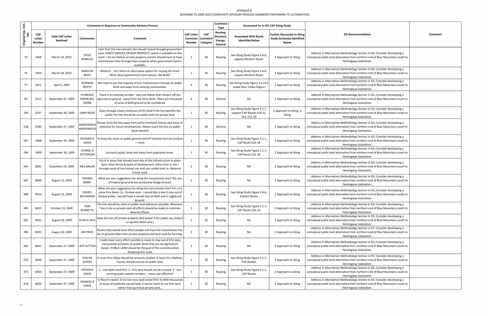
APPENDIX BRESPONSE TO 2009‐2010 COMMUNITY ADVISORY PROCESS COMMENTS PERTAINING TO ALTERANTIVES
CAP Letter Number
Date CAP Letter Received
Commenter Comment CAP Letter Comment Number
CAP Comment Category
Routing, Structure, Energy, General
Associated With Route Identified Below
Further Discussion in Siting Study Section(s) Identified
Below
Orig
inal Seq
. Cmt.
No.
Comments in Response to Community Advisory ProcessComment
TypeAccounted for in IPC CAP Siting Study
EIS Recommendation Comment
73 5458 March 24, 2010STEVE
RONFELD
I feel that this transmission line should routed through government land, FOREST SERVICE OR BLM PROPERTY, which is available on this route. I do not believe private property owners should have to have transmission lines through their property when government land is
available.
1 30 RoutingSee Siting Study Figure 3.4‐6,
oppose Western Route2 Approach to Siting
Address in Alternatives Methodology Section in EIS; Consider developing a conceptual public land alternative from northern end of Blue Mountains south to
Hemingway Substation.
74 5459 March 24, 2010MARILYN BOYD
Western... Isn't there an alternative option for routing the lines? What about government land options, like BLM?
1 30 RoutingSee Siting Study Figure 3.4‐6,
oppose Western Route2 Approach to Siting
Address in Alternatives Methodology Section in EIS; Consider developing a conceptual public land alternative from northern end of Blue Mountains south to
Hemingway Substation.
77 5472 April 5, 2009NORMAN RUETH
We need to put the majority of this Transmission Freeway on public lands and away from existing communities.
3 30 RoutingSee Siting Study Figure 3.3.14‐1
Snake River Valley Region2 Approach to Siting
Address in Alternatives Methodology Section in EIS; Consider developing a conceptual public land alternative from northern end of Blue Mountains south to
Hemingway Substation.
93 5513 September 27, 2009FLORENCE SHENK;BILL SHENK
There is an existing corridor ‐ why not follow that? Keep it off the agricultural ground ‐ away from the farm lands. There are thousands
of acres of BLM ground to be considered.4 30 General NA 2 Approach to Siting
Address in Alternatives Methodology Section in EIS; Consider developing a conceptual public land alternative from northern end of Blue Mountains south to
Hemingway Substation.
109 5547 September 30, 2009 GARY BOORGoes through a bare minimum of EFU land If the line benefits the
public the line should be on public land not private land1 30 Routing
See Siting Study Figure 3.1‐1, support CAP Routes S18‐21,
S23, S13, S6
2 Approach to Siting; 3 Siting
Address in Alternatives Methodology Section in EIS; Consider developing a conceptual public land alternative from northern end of Blue Mountains south to
Hemingway Substation.
118 5590 September 27, 2009ANONYMOUS ANONYMOUS
Please route the line away from prime farmland, homes and areas of potential for future development. Please route the line on public
lands (desert)1 30 General NA 2 Approach to Siting
Address in Alternatives Methodology Section in EIS; Consider developing a conceptual public land alternative from northern end of Blue Mountains south to
Hemingway Substation.
297 5908 September 30, 2009RICHARD D
DAVISTo keep the route on public ground and off of prime farm1st analysis
– route1 30 Routing
See Siting Study Figure 3.1‐1, CAP Route S13, S6
2 Approach to SitingAddress in Alternatives Methodology Section in EIS; Consider developing a
conceptual public land alternative from northern end of Blue Mountains south to Hemingway Substation.
298 5909 September 30, 2009CONNEL R PETTERSON
primarily public lands and away from populated areas. 1 30 RoutingSee Siting Study Figure 3.1‐1,
CAP Route S13, S62 Approach to Siting
Address in Alternatives Methodology Section in EIS; Consider developing a conceptual public land alternative from northern end of Blue Mountains south to
Hemingway Substation.
344 6001 November 19, 2009 NEIL BAUER
Put it in areas that already have lots of this infrastructure in place &/or other forms & styles of development. Either that or site I
through areas of low human use and non usable land, ie. National Forest Land.
2 30 Routing NA 2 Approach to SitingAddress in Alternatives Methodology Section in EIS; Consider developing a
conceptual public land alternative from northern end of Blue Mountains south to Hemingway Substation.
347 6009 August 12, 2009SHAWN BERRY
What are your suggestions for siting the transmission line? The use of Federal ground & low productive Range Ground.
2 30 Routing NA 2 Approach to SitingAddress in Alternatives Methodology Section in EIS; Consider developing a
conceptual public land alternative from northern end of Blue Mountains south to Hemingway Substation.
348 6010 August 12, 2009CHERYL
BUCHANAN
What are your suggestions for siting the transmission line? If it is to come thru Baker Co. ‐Durkee area ‐ I would like to see it stay out of Durkee Valley. I would hope it would stay on BLM and in sagebrush
ground.
1 30 RoutingSee Siting Study Figure 3.4‐6,
Eastern Route2 Approach to Siting
Address in Alternatives Methodology Section in EIS; Consider developing a conceptual public land alternative from northern end of Blue Mountains south to
Hemingway Substation.
349 6019 October 21, 2009RON
BURNETTE
The line should be sited on public land whenever possible. Wherever I has to be on private land all efforts should be made to minimize
adverse effects.1 30 Routing
See Siting Study Figure 3.1‐1, CAP Route C24, C6
2 Approach to SitingAddress in Alternatives Methodology Section in EIS; Consider developing a
conceptual public land alternative from northern end of Blue Mountains south to Hemingway Substation.
355 6031 August 26, 2009 ELIAS D JACAKeep the line off private property (the power is for public use, keep it
on (public) BLM Land.)1 30 Routing NA 2 Approach to Siting
Address in Alternatives Methodology Section in EIS; Consider developing a conceptual public land alternative from northern end of Blue Mountains south to
Hemingway Substation.
358 6035 August 26, 2009 JIM PRICERoutes that would least affect people and have the transmission line be on ground other than private property and land used for farming.
2 30 Routing NA 2 Approach to SitingAddress in Alternatives Methodology Section in EIS; Consider developing a
conceptual public land alternative from northern end of Blue Mountains south to Hemingway Substation.
363 6041 September 27, 2009 JEFF SUTTON
I really hope every effort possible is made to stay out of EFU land, concentrate primarily on public lands that are not agriculture based...PUBLIC LAND should be the goal of this commity when
designing this route
2 30 Routing NA 2 Approach to SitingAddress in Alternatives Methodology Section in EIS; Consider developing a
conceptual public land alternative from northern end of Blue Mountains south to Hemingway Substation.
370 6049 September 27, 2009EVELYN SAYERS
A route thru Idhao should be seriously studied. A route thru Malheur County should only be on public land.
1 30 RoutingSee Siting Study Figure 3.1‐1,
CAP Routes2 Approach to Siting
Address in Alternatives Methodology Section in EIS; Consider developing a conceptual public land alternative from northern end of Blue Mountains south to
Hemingway Substation.
373 6054 September 27, 2009STEVEN R LEWIS
1 ‐ Use Idaho land first. 2 ‐ EFU land should not be crossed. 3 ‐ Use existing public owned corridors… more cost effective!
1 30 RoutingSee Siting Study Figure 3.1‐1,
CAP Routes2 Approach to Siting
Address in Alternatives Methodology Section in EIS; Consider developing a conceptual public land alternative from northern end of Blue Mountains south to
Hemingway Substation.
374 6056 September 27, 2009FRANCES R LEWIS
1) Place in Idaho! 2) Do not cross land zoned EFU! 3) With thousands of acres of publically owned land, it seems smart to use that land
rather than purchase private land…1 30 Routing NA 2 Approach to Siting
Address in Alternatives Methodology Section in EIS; Consider developing a conceptual public land alternative from northern end of Blue Mountains south to
Hemingway Substation.
7

APPENDIX BRESPONSE TO 2009‐2010 COMMUNITY ADVISORY PROCESS COMMENTS PERTAINING TO ALTERANTIVES
CAP Letter Number
Date CAP Letter Received
Commenter Comment CAP Letter Comment Number
CAP Comment Category
Routing, Structure, Energy, General
Associated With Route Identified Below
Further Discussion in Siting Study Section(s) Identified
Below
Orig
inal Seq
. Cmt.
No.
Comments in Response to Community Advisory ProcessComment
TypeAccounted for in IPC CAP Siting Study
EIS Recommendation Comment
375 6057 September 27, 2009GRANT
KITAMURAMy primary suggestion is to place the line on public lands and keep it
off F ‐ 1 farmland in Malheur County.1 30 Routing NA 2 Approach to Siting
Address in Alternatives Methodology Section in EIS; Consider developing a conceptual public land alternative from northern end of Blue Mountains south to
Hemingway Substation.
377 6060 September 27, 2009NORMAN R HOLLARS
Keep away from populated areas, including residential and farm lands. 2) I suggest it be sited primarily on BLM land. Avoid the
Treasure Valley. 3) Probably the best route would be west of Vale on BLM land
8 30 RoutingSee Siting Study Figure 3.1‐1,
CAP Routes2 Approach to Siting; 3
Siting
Address in Alternatives Methodology Section in EIS; Consider developing a conceptual public land alternative from northern end of Blue Mountains south to
Hemingway Substation.
379 6062 September 27, 2009JUDY
HERZBERGI would like to see existing corridors and/or public land receive first
consideration.2 30 Routing NA 2 Approach to Siting
Address in Alternatives Methodology Section in EIS; Consider developing a conceptual public land alternative from northern end of Blue Mountains south to
Hemingway Substation.
381 6065 September 27, 2009 GARY BOORthe siting of the power line on EFU ground. Power that benefits the
public needs to be sited on the public ground.1 30 Routing NA 2 Approach to Siting
Address in Alternatives Methodology Section in EIS; Consider developing a conceptual public land alternative from northern end of Blue Mountains south to
Hemingway Substation.
384 6067 September 27, 2009STACI N TRENKEL
Power lines need to be outside of EFU, and as far away of the population as possible. Public ground!
1 30 Routing NA 2 Approach to SitingAddress in Alternatives Methodology Section in EIS; Consider developing a
conceptual public land alternative from northern end of Blue Mountains south to Hemingway Substation.
387 6070 August 25, 2009CLAYTON WHEELER
Crossing too much farm land and to close to residential housing...Place lines on public land ‐ BLM ‐ Forest service.
1 30 Routing NA 2 Approach to SitingAddress in Alternatives Methodology Section in EIS; Consider developing a
conceptual public land alternative from northern end of Blue Mountains south to Hemingway Substation.
389 6071 August 25, 2009W KEITH VICKERS
Cutting up farm land & going thru areas of impact for Idaho cities. I am for the line, but would insist that all effort is made to put power
lines on public property.1 30 Routing NA 2 Approach to Siting
Address in Alternatives Methodology Section in EIS; Consider developing a conceptual public land alternative from northern end of Blue Mountains south to
Hemingway Substation.
390 6072 August 25, 2009PHYLLIS TURCO
Pursue vigorously putting the majority (if not all) of this line on public land. Siting should be in the least populated or farmed areas.
1 30 Routing NA 2 Approach to SitingAddress in Alternatives Methodology Section in EIS; Consider developing a
conceptual public land alternative from northern end of Blue Mountains south to Hemingway Substation.
395 6076 August 25, 2009 JAMES SMITHUse unproductive Barron, Rugged, wasted land. Use BLM or state land where there are no homes or beautiful Productive Private
farmland.3 30 Routing NA 2 Approach to Siting
Address in Alternatives Methodology Section in EIS; Consider developing a conceptual public land alternative from northern end of Blue Mountains south to
Hemingway Substation.
397 6078 August 25, 2009MARILYN RUSSELL
Put this project out away from our communities on "Public" land...Keep it away from populated areas. It belongs on BLM Land.
None of this needs to be put on land where people live.1 30 Routing NA 2 Approach to Siting
Address in Alternatives Methodology Section in EIS; Consider developing a conceptual public land alternative from northern end of Blue Mountains south to
Hemingway Substation.
401 6086 August 25, 2009 JERRY PAYNEThe Transmission line must not be put on prime farmground it needs to be put on public land.... put the line in Oregon on public land. Best
solution.1 30 Routing NA 2 Approach to Siting
Address in Alternatives Methodology Section in EIS; Consider developing a conceptual public land alternative from northern end of Blue Mountains south to
Hemingway Substation.
405 6091 August 25, 2009 ROD NIELSEN
Stick with Federal corridors. Follow the PP&L line from Hemingway West and where an acceptable route can be found head north to
Boardman. I would think a route along these lines would include an large amount of public property.
3 30 Routing See Siting Study Figure 3.4‐6 2 Approach to SitingAddress in Alternatives Methodology Section in EIS; Consider developing a
conceptual public land alternative from northern end of Blue Mountains south to Hemingway Substation.
407 6096 August 25, 2009THERESA HULBERT
I would definitely like the transmission lines to run primarily through public lands and away from prime farm lands.
1 30 Routing NA 2 Approach to SitingAddress in Alternatives Methodology Section in EIS; Consider developing a
conceptual public land alternative from northern end of Blue Mountains south to Hemingway Substation.
409 6097 August 25, 2009RYAN
HULBERT
What are your suggestions for siting the transmission line?Routes that would least affect people and have the transmission line be on ground other than private property and land used for farming.
2 30 Routing NA 2 Approach to SitingAddress in Alternatives Methodology Section in EIS; Consider developing a
conceptual public land alternative from northern end of Blue Mountains south to Hemingway Substation.
411 6101 August 25, 2009JOHN
HARTMAN
This line should avoid crossing prime farm ground and city areas of Impact. As much as possible site this line in existing federal power line corridors and as much as possible use public lands BLM and
forest service.
1 30 Routing NA 2 Approach to SitingAddress in Alternatives Methodology Section in EIS; Consider developing a
conceptual public land alternative from northern end of Blue Mountains south to Hemingway Substation.
415 6109 August 25, 2009DICK
DICKSTEINKeep it on government land, well away from cities, farms and
airports.3 30 Routing NA 2 Approach to Siting
Address in Alternatives Methodology Section in EIS; Consider developing a conceptual public land alternative from northern end of Blue Mountains south to
Hemingway Substation.
418 6112 August 25, 2009 CAROLE COX
It should not be built on private property or small commercial land. Use public or BLM land to contruct towers on + pass linis over. Isn't there already lines in Owyhee's that are on public land that other
lines can go alongside?
1 30 Routing NA 2 Approach to SitingAddress in Alternatives Methodology Section in EIS; Consider developing a
conceptual public land alternative from northern end of Blue Mountains south to Hemingway Substation.
420 6115 August 25, 2009VERNON E.
CASE
I think the line should be put on BLM ground and not on private property. There is a large line on BLM ground on the South side of
the Snake River now put it there!1 30 Routing NA
2 Approach to Siting; 4.1 Proposed Route Description
by County
Address in Alternatives Methodology Section in EIS; Consider developing a conceptual public land alternative from northern end of Blue Mountains south to
Hemingway Substation.
8

APPENDIX BRESPONSE TO 2009‐2010 COMMUNITY ADVISORY PROCESS COMMENTS PERTAINING TO ALTERANTIVES
CAP Letter Number
Date CAP Letter Received
Commenter Comment CAP Letter Comment Number
CAP Comment Category
Routing, Structure, Energy, General
Associated With Route Identified Below
Further Discussion in Siting Study Section(s) Identified
Below
Orig
inal Seq
. Cmt.
No.
Comments in Response to Community Advisory ProcessComment
TypeAccounted for in IPC CAP Siting Study
EIS Recommendation Comment
484 6251 May 21, 2009KEN
TERAMURAMove towers to BLM land where possible to preserve valuable class I
to IV farm land (EFU)2 30 Routing NA 2 Approach to Siting
Address in Alternatives Methodology Section in EIS; Consider developing a conceptual public land alternative from northern end of Blue Mountains south to
Hemingway Substation.
486 6253 May 21, 2009RICHARD
TERAMURAStay off private land is much as possible and use existing corridors in
as straight a path as possible straight to Hemingway7 30 Routing NA 2 Approach to Siting
Address in Alternatives Methodology Section in EIS; Consider developing a conceptual public land alternative from northern end of Blue Mountains south to
Hemingway Substation.
489 6258 June 4, 2009 DONI CLAIR Keep to fed land as much as possible ‐ mitigate w/ landowners. 5 30 Routing NA 2 Approach to SitingAddress in Alternatives Methodology Section in EIS; Consider developing a
conceptual public land alternative from northern end of Blue Mountains south to Hemingway Substation.
83 5488 September 16, 2009YOGI
HAGBERGit uses more public lands and joins an existing energy corridor. 2 30 Routing
See Siting Study Figure 3.1‐1, CAP Route C6, C9
3.4 Alternative RoutesAddress in Alternatives Methodology Section in EIS; Consider developing a
conceptual public land alternative from northern end of Blue Mountains south to Hemingway Substation.; Address Western Alternative Route as CBE in EIS
49 5403 November 19, 2009MARGARET
CAREY
find a way to celebrate these towers within this theme designing best placement – modify heights where possible? An occasional ground installation? Etc. i.e. Golden Gate Bridge is beauty ain’t it?
1 30 Structure NA NA Address in Alternatives Structure Section in EIS
205 5762 April 27, 2009 KEN ELLIOTTI am hopeful that Idaho Power is taking into consideration the
potential benefits of using ACCC – Aluminum Conductor Composite Core...in the design and upgrading of our transmission grid.
1 30 Structure NA NA Address in Alternatives Structure Section in EIS
206 5762 April 27, 2009 KEN ELLIOTT
Another option to consider in the long‐term transmission system planning is the reconductoring of Idaho Power’s existing
transmission grid by replacing steel core cables with the more efficient ACCC cables.
2 30 Structure NA NA Address in Alternatives Structure Section in EIS
209 5766 March 8, 2010BARRY BEYELER
Collaboration with PGE to establish an acceptable route Is viewed as very positive. It would seem this collaboration should take a long‐term view when assessing routing and if at all possible using towers capable of carrying dual 500 KVA circuits per tower to reduce overall foot prints of transmission lines~ Tower selection allowing for dual
500 KVA circuit would allow for addition of capacity Without establishment of an additional footprint which further restricts use
of the land within an expanded easement.
3 30 Structure NA NA Address in Alternatives Structure Section in EIS
442 6142 January 13, 2010ROBERT STEWART
take existing power lines and upgrade the towers to handle the additional load required.
7 30 Structure NA NA Address in Alternatives Structure Section in EIS
Existing transmission lines are at capacity and cannot support additional lines. Additionally, 500kV lines require larger structures and right‐of‐way than what is currently in place (230kV lines
and lower) in the project area.
416 6110 September 27, 2009DAN R TSCHIDA
We have a lot of technology that we should be able to build nesting stations on or around these poles on government ground. You put poles up to help egels + hawks to nest. Why cant we do the same for
these.
1 30 Structure NA 2 Approach to SitingAddress in Alternatives Structure Section in EIS; Address in Alternatives
Methodology Section in EIS; Consider developing a conceptual public land alternative from northern end of Blue Mountains south to Hemingway Substation.
98 5518 April 1, 2009
DAVE FREEMAN;T
WILA FREEMAN
I would look at placing this line on public lands behind ridges, painting the towers a color to blend in with the environment.
1 30 General NA 2 Approach to SitingAddress in Alternatives Structure Section in EIS; Consider developing a conceptual public land alternative from northern end of Blue Mountains south to Hemingway
Substation.
Topography was considered in the siting process to screen or backdrop the
proposed line. Idaho Power plans to use unpainted structures
24 5361 May 25, 2010LORRAINE HUBBARD
Interpretive Center (but can go underground) 2 30 StructureSee Siting Study 3.4‐6, Eastern
RouteNA Address in Underground Technology Section in EIS
46 5401 November 5, 2009 TIM LILLEBO
Use existing corridors, adjacent to existing major corridors in the I‐84 corridor — bury it under I‐84 Lobby Federal Hiway Commission to
allow lines adjacent to I‐84 in median or adjacent to I‐84. Unacceptable to use the public lands routes in Grant, Harney,
Morrow and SW Baker counties.
2 30 RoutingSee Siting Study Figure 3.4‐6, opposes Western Route, supports Eastern Route
3.4 Alternative Routes Address in Underground Technology Section in EIS
76 5471 March 17, 2009JERRY
WHITAKERWhy not just put your lines underground, problem solved. 1 30 Structure NA NA Address in Underground Technology Section in EIS
9

APPENDIX BRESPONSE TO 2009‐2010 COMMUNITY ADVISORY PROCESS COMMENTS PERTAINING TO ALTERANTIVES
CAP Letter Number
Date CAP Letter Received
Commenter Comment CAP Letter Comment Number
CAP Comment Category
Routing, Structure, Energy, General
Associated With Route Identified Below
Further Discussion in Siting Study Section(s) Identified
Below
Orig
inal Seq
. Cmt.
No.
Comments in Response to Community Advisory ProcessComment
TypeAccounted for in IPC CAP Siting Study
EIS Recommendation Comment
145 5661 March 18, 2010MAX
BREEDINGI do not understand why you can't run your lines up I84.
Please put them underground.3 30 Structure
See Siting Study Figure 3.4‐6, oppose Western Route, support Eastern Route
NA Address in Underground Technology Section in EIS
195 5747 March 29, 2009 RICH DANIELS
Regarding the transmission lines through Baker Valley. Bury the line in the area where people are objecting. The cost difference isn't significant and would likely smooth out the objections so that you
can get the job done.
1 30 Structure NA NA Address in Underground Technology Section in EIS
228 5786 May 25, 2010MARTIN AND CATHERINE MORROW
If this 500kV line had to be built, the only reasonable route is along I‐84. A buried line near the Oregon Trail Interpretive area, or whatever
mitigation is necessary to make this route acceptable to Baker County residents. The only reasonable route is one that is already
disturbed and established, the I‐84 corridor!
3 30 RoutingSee Siting Study Figure 3.4‐6,
supports Eastern Route3.4 Alternative Routes Address in Underground Technology Section in EIS
232 5795 May 25, 2010JAMES G SHELLEY
Eastern alternative route...Interpretive Center but can't a mile or two of underground line addres this problem
3 30 RoutingSee Siting Study Figure 3.4‐6,
Eastern Route3.4 Alternative Routes Address in Underground Technology Section in EIS
276 5876 March 22, 2010 J.C. OLIVER
Grant County ‐ Western Route... Following the original I84 corridor is a more logical and financial advantageous route to go...
In the areas of concern I would suggest putting the line under ground around short areas of concern. (One to two miles stretches)
1 30 RoutingSee Siting Study Figure 3.4‐6, opposes Western Route; supports Eastern Route
3.4 Alternative Routes Address in Underground Technology Section in EIS
336 5988 March 24, 2010ROBERT STEWART
WESTERN...would recommend that Idaho Power take another look at the new underground powerline technology that is now available. The new technology reduces the required right of way down to 25
feet instead of 250ft. This would also remove the visual objections to many on the eastern route.
6 30 Structure NA NA Address in Underground Technology Section in EIS
429 6129 August 13, 2009TOM
DIMONDKeep it underground or don't do it at all. 2 30 Structure NA NA Address in Underground Technology Section in EIS
468 6177 October 21, 2009RUTH MOORE
Can this line be buried? 1 30 Structure NA NA Address in Underground Technology Section in EIS
2 5280 March 3, 2010DANIELLE MCNAIR
The further west you go, the less people are impacted. 1 30 General NA2 Approach to Siting; 3.4
Alternative RoutesAddress Western Alternative Route as CBE in EIS
29 5370 March 3, 2010ALLISON VALERIO
We did not get enough data concerning the reasons certain routes were removed. However, the farthest route to the West GR3 to GR4 East to HA1 ‐ has the least amount of exclusion or high permitting difficulty areas. It also travels in territory that has an existing 500 kV
line
1 30 RoutingSee Siting Study Figure 3.3.9‐1,
Segment GR3‐GR4‐HA13.3.9 Southwest Region Address Western Alternative Route as CBE in EIS
31 5373 November 19, 2009KAREN COULTER
Keep it along I‐84 in highway corridor. 1 30 RoutingSee Siting Study Figure 3.4‐6, opposes Western Route, supports Eastern Route
3.4 Alternative Routes Address Western Alternative Route as CBE in EIS
72 5456 March 24, 2010ROBERT D LYNCH
I believe the western route from Idaho toward Burns and angles northwest to run southwest of Strawberry Mtn. Wilderness then north avoiding the John Day Fossil Beds is the route that should be
chosen.
1 30 RoutingSee Siting Study Figure 3.4‐6, Western Route; opposes
Eastern Route3.4 Alternative Routes Address Western Alternative Route as CBE in EIS
87 5493 September 16, 2009JOHN B MILBERT
Takes advantage of several existing corridors. 1 30 RoutingSee Siting Study Figure 3.1‐1,
CAP Route C183.4 Alternative Routes Address Western Alternative Route as CBE in EIS
Comment in favor of route C18 listing several advantages. C18 (a western route) was considered but eliminated from futher evaluation as a result of the
CAP. See Siting Report Section 3.0.
110 5557 September 30, 2009 ROD PRICETreasure Valley loop... instead of building 2 lines, why not start that
process on the east leg of that loop.1 30 Routing
See Siting Study Figure 3.1‐1, support CAP Route S13 to S6,
C9 to S23
2 Approach to Siting; 3 Siting
Address Western Alternative Route as CBE in EIS
111 5557 September 30, 2009 ROD PRICEfollow the west‐wide energy corridor and then branch north and
avoid EFU ground in Oregon.2 30 Routing
See Siting Study Figure 3.1‐1, support CAP Route S13 to S6,
C9 to S23
2 Approach to Siting; 3 Siting
Address Western Alternative Route as CBE in EIS
Comment supporting a western alternate identified in CAP.This
alternative route was considered in the CAP and eliminated from further
consideration.
112 5560 September 30, 2009MATTHEW EICHER
follows existing utility corridor. 1 30 RoutingSee Siting Study Figure 3.1‐1, CAP Route C9‐S19‐S20‐S21; C9‐
S23; S13; S63 Siting Address Western Alternative Route as CBE in EIS
10
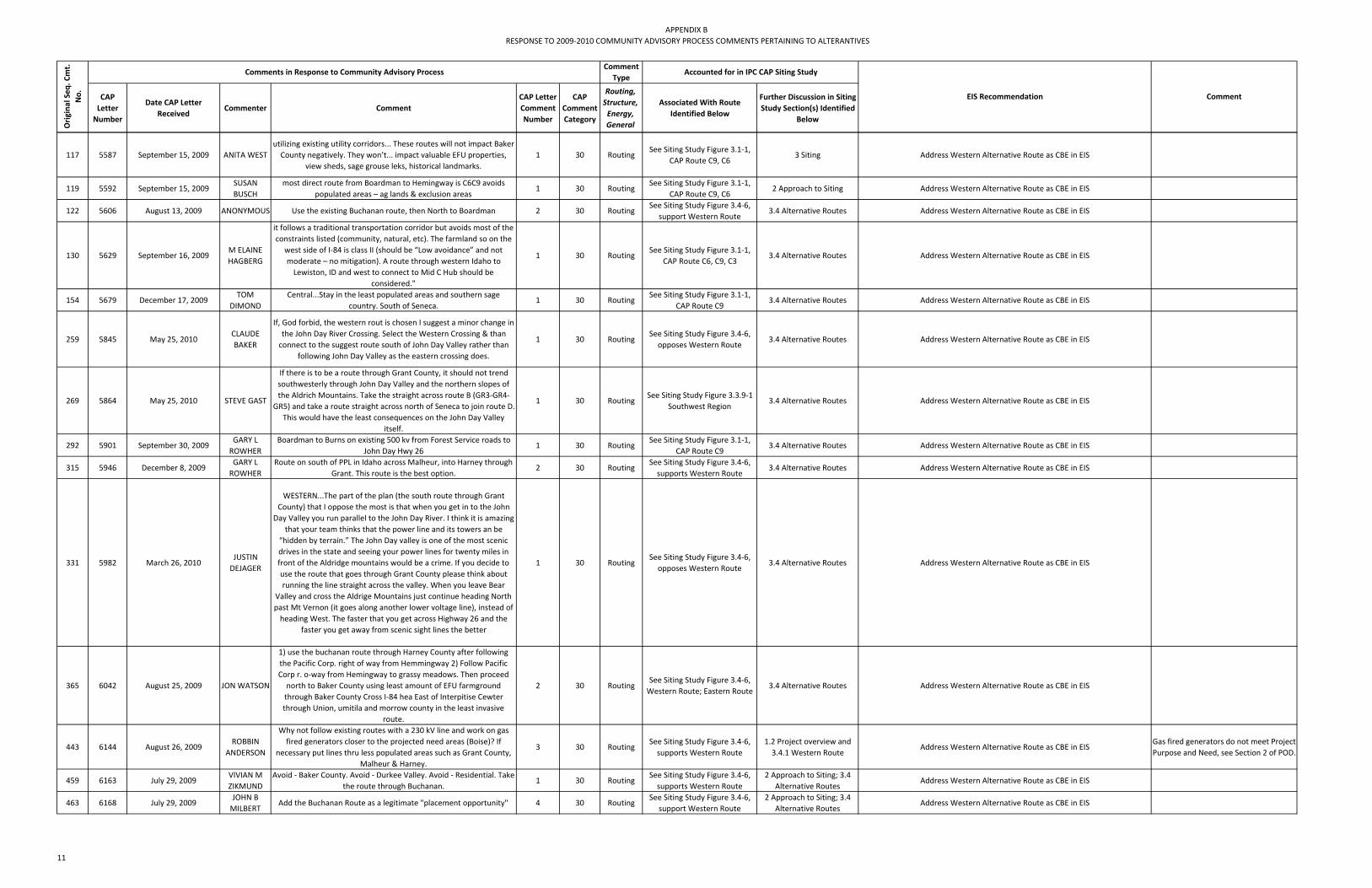
APPENDIX BRESPONSE TO 2009‐2010 COMMUNITY ADVISORY PROCESS COMMENTS PERTAINING TO ALTERANTIVES
CAP Letter Number
Date CAP Letter Received
Commenter Comment CAP Letter Comment Number
CAP Comment Category
Routing, Structure, Energy, General
Associated With Route Identified Below
Further Discussion in Siting Study Section(s) Identified
Below
Orig
inal Seq
. Cmt.
No.
Comments in Response to Community Advisory ProcessComment
TypeAccounted for in IPC CAP Siting Study
EIS Recommendation Comment
117 5587 September 15, 2009 ANITA WESTutilizing existing utility corridors... These routes will not impact Baker County negatively. They won’t... impact valuable EFU properties,
view sheds, sage grouse leks, historical landmarks.1 30 Routing
See Siting Study Figure 3.1‐1, CAP Route C9, C6
3 Siting Address Western Alternative Route as CBE in EIS
119 5592 September 15, 2009SUSAN BUSCH
most direct route from Boardman to Hemingway is C6C9 avoids populated areas – ag lands & exclusion areas
1 30 RoutingSee Siting Study Figure 3.1‐1,
CAP Route C9, C62 Approach to Siting Address Western Alternative Route as CBE in EIS
122 5606 August 13, 2009 ANONYMOUS Use the existing Buchanan route, then North to Boardman 2 30 RoutingSee Siting Study Figure 3.4‐6,
support Western Route3.4 Alternative Routes Address Western Alternative Route as CBE in EIS
130 5629 September 16, 2009M ELAINE HAGBERG
it follows a traditional transportation corridor but avoids most of the constraints listed (community, natural, etc). The farmland so on the
west side of I‐84 is class II (should be “Low avoidance” and not moderate – no mitigation). A route through western Idaho to Lewiston, ID and west to connect to Mid C Hub should be
considered."
1 30 RoutingSee Siting Study Figure 3.1‐1,
CAP Route C6, C9, C33.4 Alternative Routes Address Western Alternative Route as CBE in EIS
154 5679 December 17, 2009TOM
DIMONDCentral...Stay in the least populated areas and southern sage
country. South of Seneca.1 30 Routing
See Siting Study Figure 3.1‐1, CAP Route C9
3.4 Alternative Routes Address Western Alternative Route as CBE in EIS
259 5845 May 25, 2010CLAUDE BAKER
If, God forbid, the western rout is chosen I suggest a minor change in the John Day River Crossing. Select the Western Crossing & than connect to the suggest route south of John Day Valley rather than
following John Day Valley as the eastern crossing does.
1 30 RoutingSee Siting Study Figure 3.4‐6, opposes Western Route
3.4 Alternative Routes Address Western Alternative Route as CBE in EIS
269 5864 May 25, 2010 STEVE GAST
If there is to be a route through Grant County, it should not trend southwesterly through John Day Valley and the northern slopes of the Aldrich Mountains. Take the straight across route B (GR3‐GR4‐
GR5) and take a route straight across north of Seneca to join route D. This would have the least consequences on the John Day Valley
itself.
1 30 RoutingSee Siting Study Figure 3.3.9‐1
Southwest Region3.4 Alternative Routes Address Western Alternative Route as CBE in EIS
292 5901 September 30, 2009GARY L ROWHER
Boardman to Burns on existing 500 kv from Forest Service roads to John Day Hwy 26
1 30 RoutingSee Siting Study Figure 3.1‐1,
CAP Route C93.4 Alternative Routes Address Western Alternative Route as CBE in EIS
315 5946 December 8, 2009GARY L ROWHER
Route on south of PPL in Idaho across Malheur, into Harney through Grant. This route is the best option.
2 30 RoutingSee Siting Study Figure 3.4‐6, supports Western Route
3.4 Alternative Routes Address Western Alternative Route as CBE in EIS
331 5982 March 26, 2010JUSTIN DEJAGER
WESTERN...The part of the plan (the south route through Grant County) that I oppose the most is that when you get in to the John
Day Valley you run parallel to the John Day River. I think it is amazing that your team thinks that the power line and its towers an be
“hidden by terrain.” The John Day valley is one of the most scenic drives in the state and seeing your power lines for twenty miles in front of the Aldridge mountains would be a crime. If you decide to use the route that goes through Grant County please think about running the line straight across the valley. When you leave Bear
Valley and cross the Aldrige Mountains just continue heading North past Mt Vernon (it goes along another lower voltage line), instead of heading West. The faster that you get across Highway 26 and the
faster you get away from scenic sight lines the better
1 30 RoutingSee Siting Study Figure 3.4‐6, opposes Western Route
3.4 Alternative Routes Address Western Alternative Route as CBE in EIS
365 6042 August 25, 2009 JON WATSON
1) use the buchanan route through Harney County after following the Pacific Corp. right of way from Hemmingway 2) Follow Pacific Corp r. o‐way from Hemingway to grassy meadows. Then proceed north to Baker County using least amount of EFU farmground through Baker County Cross I‐84 hea East of Interpitise Cewter through Union, umitila and morrow county in the least invasive
route.
2 30 RoutingSee Siting Study Figure 3.4‐6, Western Route; Eastern Route
3.4 Alternative Routes Address Western Alternative Route as CBE in EIS
443 6144 August 26, 2009ROBBIN
ANDERSON
Why not follow existing routes with a 230 kV line and work on gas fired generators closer to the projected need areas (Boise)? If
necessary put lines thru less populated areas such as Grant County, Malheur & Harney.
3 30 RoutingSee Siting Study Figure 3.4‐6, supports Western Route
1.2 Project overview and 3.4.1 Western Route
Address Western Alternative Route as CBE in EISGas fired generators do not meet Project Purpose and Need, see Section 2 of POD.
459 6163 July 29, 2009VIVIAN M ZIKMUND
Avoid ‐ Baker County. Avoid ‐ Durkee Valley. Avoid ‐ Residential. Take the route through Buchanan.
1 30 RoutingSee Siting Study Figure 3.4‐6, supports Western Route
2 Approach to Siting; 3.4 Alternative Routes
Address Western Alternative Route as CBE in EIS
463 6168 July 29, 2009JOHN B MILBERT
Add the Buchanan Route as a legitimate "placement opportunity" 4 30 RoutingSee Siting Study Figure 3.4‐6,
support Western Route2 Approach to Siting; 3.4
Alternative RoutesAddress Western Alternative Route as CBE in EIS
11

APPENDIX BRESPONSE TO 2009‐2010 COMMUNITY ADVISORY PROCESS COMMENTS PERTAINING TO ALTERANTIVES
CAP Letter Number
Date CAP Letter Received
Commenter Comment CAP Letter Comment Number
CAP Comment Category
Routing, Structure, Energy, General
Associated With Route Identified Below
Further Discussion in Siting Study Section(s) Identified
Below
Orig
inal Seq
. Cmt.
No.
Comments in Response to Community Advisory ProcessComment
TypeAccounted for in IPC CAP Siting Study
EIS Recommendation Comment
495 6263 June 4, 2009JOHN B MILBERT
Use the existing corridor west through Malheur & Harney counties, then north through Grant & Morrow counties.
7 30 RoutingSee Siting Study Figure 3.4‐6, supports Western Route
3.4 Alternative Routes Address Western Alternative Route as CBE in EIS
104 5531 September 30, 2009GARY
PEARSONFollow existing corridors as much as possible 3 30 Routing
See Siting Study Figure 3.1‐1, CAP Route S18‐S13‐S6‐S19‐S20‐S21 S13 S13 to S6S 19 S19 to S20 S19 to S21 C9 to S23
2 Approach to Siting; 3 Siting
Address Western Alternative Route as CBE in EIS; Address in Alternatives Methodology Section in EIS
Existing energy, utility and highway corridors have been designated as opportunities since routing studies
began. Where reasonable considering the full range of environmental
constraints existing corridors have been included as part of the Proposed and
Alternate routes
353 6027 August 12, 2009 TERRY GIRTIf nessasary put lines thru less populated areas such as Grant County,
Malheur & Harney.4 30 Routing
See Siting Study Figure 3.4‐6, supports Western Route
3.4 Alternative RoutesAddress Western Alternative Route as CBE in EIS; Address in Alternatives
Methodology Section in EIS
Many alternates have been considered that go through Grant, Malheur and
Harney counties. Most were eliminated in the CAP siting process as described in
the Siting Report.
446 6146 August 26, 2009MICHELLE REDDING
Stick with Federal corridors. Follow the PP&L line from Hemingway West and where an acceptable route can be found head north to
Boardman. I would think a route along these lines would include an large amount of public property.
2 30 RoutingSee Siting Study Figure 3.4‐6, supports Western Route
2 Approach to Siting and 3.4 Alternative routes
Address Western Alternative Route as CBE in EIS; Address in Alternatives Methodology Section in EIS
482 6241 September 30, 2009RICK
MENDIVEI want it to bypass EFU land in Oregon or Idaho. 1 30 Routing
See Siting Study Figure 3.1‐1, support CAP Route C6, S19, C9,
S96; oppose S17, S183 Siting
Address Western Alternative Route as CBE in EIS; Address in Alternatives Methodology Section in EIS
85 5492 September 16, 2009KRISTEN WARES
looking at low impact factor of hugging freeway on the west of I‐84 to avoid airport and environmental impacts ODFW categories 1 & 2
east of freeway4 30 Routing
See Siting Study Figure 3.1‐1, CAP Route C6, C9, C3, C11
3.4 Alternative RoutesAddress Western Alternative Route as CBE in EIS; Analyze Optimized Proposed and
Alternative Routes in Glass Hill Area
Moving the existing 230 kV line and locating the proposed 500 kV line in its place was considered but eliminated from futher consideration in the CAP. See Siting Report section _______.
107 5545 September 30, 2009JAMES O STEPHEN
Use public land as much as possible – stay away from private farmland and people’s residences.
1 30 RoutingSee Siting Study Figure 3.1‐1, support CAP Routes S18‐21,
S23, S13, S6
2 Approach to Siting; 3 Siting
Address Western Alternative Route as CBE in EIS; Consider developing a conceptual public land alternative from northern end of Blue Mountains south to
Hemingway Substation.
Farmland has been a constraint throughout the siting studies; A minimum setback of 300ft from
occupied residences has been applied. However, efforts were made to maximize distance from occupied
residences where possible.
225 5782 August 27, 2009KEITH G SPIERS
suggestions for siting the transmission line? Route it on buruea of reclamation or federal land + forst service land. Stay off of any efu ground. You could go due west from Hemmingway + north almost
straight to Boardman on almost totally Federal ground.
4 30 RoutingSee Siting Study Figure 3.4‐6,
support Western Route2 Approach to Siting; 3.4
Alternative Routes
Address Western Alternative Route as CBE in EIS; Consider developing a conceptual public land alternative from northern end of Blue Mountains south to
Hemingway Substation.
181 5720 March 21, 2010EVELYN SAYERS
The one that went farthest east around the Interpretive Center (but was on Sage Grouse) looks best to me if it could be made to work.
3 30 RoutingSee Siting Study Figure 3.4‐6, support for Western Route;
Virtue Flat Alternative
3.4 Alternative Routes, 3.3.8 Interpretive Center
Region
Address Western Alternative Route as CBE in EIS; Consider Optimized Virtue Flat/Interpretive Center Proposed and Alternative Routes in Detail in EIS
257 5837 March 9, 2010ROGER FINDLEY
Central alternative route... Go east (way east) of Interpretive Center. 1 30 RoutingSee Siting Study Figure 3.4‐6, supports Western Route
3.4 Alternative RoutesAddress Western Alternative Route as CBE in EIS; Consider Optimized Virtue Flat/Interpretive Center Proposed and Alternative Routes in Detail in EIS
4 5320 July 14, 2010ROBERT DALE
MILLER
If the proposed route, or one of the identified alternate routes is selected, do you have a suggestion on how best to cross your
property with the transmission line?Move the route north so it doesn't go through the timber.
4 30 RoutingSee Siting Study Figure 4‐1,
Glass Hill AlternativeNA Analyze Optimized Proposed and Alternative Routes in Glass Hill Area Parcel Number 4S37E00401
6 5322 September 20, 2010DR KAREN ANTELL
EOU strongly prefers the new "alternative route" that shifts the line to the south of the Rebarrow property.
1 30 RoutingSee Siting Study Figure 4‐1,
Glass Hill AlternativeNA Analyze Optimized Proposed and Alternative Routes in Glass Hill Area
69 5444 August 13, 2009 ANONYMOUS Through unpopulated areas not visible from La Grande. 3 30 RoutingSee Siting Study Figure 4‐1,
Glass Hill AlternativeNA Analyze Optimized Proposed and Alternative Routes in Glass Hill Area
12

APPENDIX BRESPONSE TO 2009‐2010 COMMUNITY ADVISORY PROCESS COMMENTS PERTAINING TO ALTERANTIVES
CAP Letter Number
Date CAP Letter Received
Commenter Comment CAP Letter Comment Number
CAP Comment Category
Routing, Structure, Energy, General
Associated With Route Identified Below
Further Discussion in Siting Study Section(s) Identified
Below
Orig
inal Seq
. Cmt.
No.
Comments in Response to Community Advisory ProcessComment
TypeAccounted for in IPC CAP Siting Study
EIS Recommendation Comment
131 5636 September 15, 2009 DAN WEITZPublic safety, access, taxpayer protection (don’t want taxpayers to foot the bill to protect infrastructure. Want further discussion in
regard to protecting infrastructure.1 30 Routing
See Siting Study Figure 3.1‐1, CAP Routes C11 and C17
3 Siting Analyze Optimized Proposed and Alternative Routes in Glass Hill Area
476 6212 July 14, 2010DOUG
BEAN;WARREN BEAN
Map #4 and 5
Parcel number(s)03S37E03400, 03SE37E02400, 03S37E00500
Has suggested alternate route ‐ go straighter, follow existing Bonneville Power ROW
3 30 RoutingSee Siting Study Figure 4‐1,
Glass Hill Alternative4 Proposed and Alternative
RoutesAnalyze Optimized Proposed and Alternative Routes in Glass Hill Area
See Scoping Comment Letter 5228, Figure 5228
140 5651 March 8, 2010CHET
PHILLIPSEveryone would benefit from Idaho Power and PGE coordinating the
location of their transmission lines and substations.1 30 Routing NA NA
Analyze Optimized Proposed and Alternative Bombing Range Routes resulting from Landowner Meetings in Detail in EIS
IPC currently working with PGE and Morrow County.
141 5651 March 8, 2010CHET
PHILLIPS
If Idaho Power receives an easement from the Navy to access bombing range property at the northern end, they (Idaho Power)
should ask for 1000 feet. The additional feet could be used for future transmission lines. Idaho Power should place the B2H line to the
southern most part of the easement. This energy corridor would run from M02 to M05.
2 30 RoutingSee Siting Study Figure 3.3.1‐1 Boardman Region, Segment
MO2‐MO53.3.1 Boardman Region
Analyze Optimized Proposed and Alternative Bombing Range Routes resulting from Landowner Meetings in Detail in EIS
Idaho Power has been working with the Department of Defense with regard to locating the line within the northern
boundary of the Bombing Range so as to not affect irrigated agricultural practices occurring along the northern side of the boundary.The Navy has consistently advised that this is not possible. As a result Idaho Power's Proposed Route
follows the Southern Alternate south of the Bombing Range.
142 5651 March 8, 2010CHET
PHILLIPS
Another energy corridor to consider is to enter Boardman from the south going from M020 to M013 to MOB to MOe to M01. Then PGE
could connect up to the B2H line at M020 by running their line parallel to the tree farm along M04 to M020. By doing this, there
would still be only one line entering Boardman serving both utility's needs.
3 30 RoutingSee Siting Study Figure 3.1‐1,
CAP Route N262 Approach to Siting; 3.3.1
Boardman RegionAnalyze Optimized Proposed and Alternative Bombing Range Routes resulting
from Landowner Meetings in Detail in EIS
The Navy has consistently advised that this is not possible. As a result Idaho Power's Proposed Route follows the Southern Alternate south of the
Bombing Range.
151 5672 September 23, 2009 ANONYMOUSNorthern alternative. Could take various routes but basically would
travel across the northern edge of the bombing range1 30 Routing
See Siting Study Figure 3.1‐1, CAP Routes N32
3.3.1 Boardman RegionAnalyze Optimized Proposed and Alternative Bombing Range Routes resulting
from Landowner Meetings in Detail in EIS
Routes across the northern edge of the bombing range were studied during CAP and at one time were Part of Proposed Route.Idaho Power has been working with the Department of Defense with regard to locating the line within the northern boundary of the Bombing Range so as to not affect irrigated
agricultural practices occurring along the northern side of the boundary.
234 5798 May 25, 2010KARL D SMITH
From Coyote Springs power plant, the line should run southeast to the east side of the Bombing Range, then south to the southern edge of the Navy bombing range. This would be a very good location for a regional power substation. Then the line should run east (towards Idaho) and west to come around to the Carty Coal Fire plant, and on
west to Salem.
1 30 RoutingSee Siting Study Figure 3.1‐1,
CAP Route N263.3.1 Boardman Region
Analyze Optimized Proposed and Alternative Bombing Range Routes resulting from Landowner Meetings in Detail in EIS
Potential for PGE to review route along eastern edge of Bombing Range for CX
Project.
261 5851 February 10, 2010GERRAL DAVID
a proposed route at the southern boundary of NWSTF Boardman would have the least potential to impact Navy operations.
2 30 RoutingSee Siting Study Figure 4‐1, Bombing Range South
Alternative3.3.1 Boardman Region
Analyze Optimized Proposed and Alternative Bombing Range Routes resulting from Landowner Meetings in Detail in EIS
IPC's 12‐6 Proposed Route is south of the Bombing Range
323 5971 August 26, 2009
HERBERT C MITCHELL;MI
CHAEL RUNYON
Site south of Boardman to minimize impact on Navy operations and our existing + proposed air space
4 30 RoutingSee Siting Study Figure 4‐1, Bombing Range South
Alternative3.3.1 Boardman Region
Analyze Optimized Proposed and Alternative Bombing Range Routes resulting from Landowner Meetings in Detail in EIS
IPC's 12‐6 Proposed Route is south of the Bombing Range
474 6210 July 22, 2010GLENN
CHOWNINGStay south of the freeway 2 30 Routing
See Siting Study Appendix E, Maps 4‐5, Proposed Route
vicinity of MP 19‐22
4.1 Proposed Route Description by County
Analyze Optimized Proposed and Alternative Bombing Range Routes resulting from Landowner Meetings in Detail in EIS
IPC's 12‐6 Proposed Route is south of the Bombing Range
13

APPENDIX BRESPONSE TO 2009‐2010 COMMUNITY ADVISORY PROCESS COMMENTS PERTAINING TO ALTERANTIVES
CAP Letter Number
Date CAP Letter Received
Commenter Comment CAP Letter Comment Number
CAP Comment Category
Routing, Structure, Energy, General
Associated With Route Identified Below
Further Discussion in Siting Study Section(s) Identified
Below
Orig
inal Seq
. Cmt.
No.
Comments in Response to Community Advisory ProcessComment
TypeAccounted for in IPC CAP Siting Study
EIS Recommendation Comment
477 6216 June 26, 2010 BOB LEVYI would encourage your organization to fully explore the southern
route, modification to the southern route and mitigation opportunities for squirrel habitat.
3 30 RoutingSee Siting Study Figure 4‐1,
support Bombing Range South Alternative
3.3.1 Boardman RegionAnalyze Optimized Proposed and Alternative Bombing Range Routes resulting
from Landowner Meetings in Detail in EIS
483 6243 May 29, 2009 DON RICE
Cross the south edge of the navy bombing range ‐ use shortest route when possible ‐locate on public property ‐avoid residential property, developed areas, irrigated agriculture, or mitigate environmental
areas
2 30 RoutingSee Siting Study Figure 4‐1, Bombing Range South
Alternative3.3.1 Boardman Region
Analyze Optimized Proposed and Alternative Bombing Range Routes resulting from Landowner Meetings in Detail in EIS
IPC's 12‐6 Proposed Route is south of the Bombing Range
1 118 August 25, 2009 DENNIS CAINThe pathway for the transmission lines should be on public land not
on private land.2 30 Routing NA 2 Approach to Siting
Consider developing a conceptual public land alternative from northern end of Blue Mountains south to Hemingway Substation.
16 5354 March 9, 2010JEFF
JOHNSONI favor increased usage of public land. 1 30 Routing NA 2 Approach to Siting
Consider developing a conceptual public land alternative from northern end of Blue Mountains south to Hemingway Substation.
17 5355 March 3, 2010GARTH
JOHNSON
The route alternative C6 with some adjustments especially in the Dale‐Ukiah area should be reconsidered. I realize that routes that travel through extensive areas of national forest may require some creative mitigation but this transmission line is to benefit the general
public. Therefore the line should be placed across public lands wherever possible. Also splitting the lines of transmission rather than
grouping them together protects the power sources from the dangers of natural disasters and terrorist activities.
1 30 RoutingSee Siting Study Figure 3.1‐1,
CAP Route C6Approach to Siting and 3.4
Alternative RoutesConsider developing a conceptual public land alternative from northern end of
Blue Mountains south to Hemingway Substation.
20 5359 March 9, 2010SHELBY J HILLIARD
public use public land...The central route is the best route for use when using existing corridor.
1 30 RoutingSee Siting Study 3.4‐6, Central
Route3.4 Alternative Routes
Consider developing a conceptual public land alternative from northern end of Blue Mountains south to Hemingway Substation.
28 5369 March 9, 2010 DICK SYMMSProjects for the public good should be constructed as much as
possible on Govt land1 30 General NA 2 Approach to Siting
Consider developing a conceptual public land alternative from northern end of Blue Mountains south to Hemingway Substation.
30 5372 March 23, 2009JOHNNY KLETKE
The option which I support is the 500,000 volt line to run straight down on BLM land not on private land which would eliminate the aforementioned problems. All support of the BLM route will be
appreciated.
6 30 General NA 2 Approach to SitingConsider developing a conceptual public land alternative from northern end of
Blue Mountains south to Hemingway Substation.
92 5512 September 27, 2009
CASSIE PETTERSON;MICHAEL N PETTERSON
I believe it should be put on public land, B.L.M. land, out where it will not, take the beauty of the area, with the power line towers raising
up in the skyline.2 30 General NA 2 Approach to Siting
Consider developing a conceptual public land alternative from northern end of Blue Mountains south to Hemingway Substation.
96 5515 December 8, 2009 DAN SYMMSMake every effort to avoid private property. Projects for public good
should be on public land.1 30 General
See Siting Study Figure 3.1‐1, oppose CAP Routes S7, S17, S18
2 Approach to Siting; 3 Siting
Consider developing a conceptual public land alternative from northern end of Blue Mountains south to Hemingway Substation.
99 5524 September 27, 2009ANONYMOUS ANONYMOUS
these transmission lines should be placed in Idaho on public lands. If not they should primarily be placed on public lands in Oregon.
1 30 General NA 2 Approach to SitingConsider developing a conceptual public land alternative from northern end of
Blue Mountains south to Hemingway Substation.
100 5525 September 27, 2009HOWARD
WATERMANsiting it should be built on public land 1 30 General NA 2 Approach to Siting
Consider developing a conceptual public land alternative from northern end of Blue Mountains south to Hemingway Substation.
106 5544 September 30, 2009GERALDINE STEPHEN
Stay on public land where possible. 1 30 RoutingSee Siting Study Figure 3.1‐1, support CAP Routes S18‐21,
S23, S13, S6
2 Approach to Siting; 3 Siting
Consider developing a conceptual public land alternative from northern end of Blue Mountains south to Hemingway Substation.
121 5605 March 25, 2010JAMES M. MOORE
A public utility line should be constructed on public land regardless of the time involved in going through the permitting process.
1 30 RoutingSee Siting Study Figure 3.4‐6, opposes Western Route
3.4 Alternative RoutesConsider developing a conceptual public land alternative from northern end of
Blue Mountains south to Hemingway Substation.
146 5662 August 26, 2009 KAREN THEEShould be on BLM land as there power lines are “supposedly”
needed for the public good. Should be built south and west of town of Marsing where current smaller power lines runs.
2 30 General NA 2 Approach to SitingConsider developing a conceptual public land alternative from northern end of
Blue Mountains south to Hemingway Substation.
157 5689 March 20, 2009DICK
FLEMINGThe line should be located on public land as much as possible since it
is a public project.1 30 General NA 2 Approach to Siting
Consider developing a conceptual public land alternative from northern end of Blue Mountains south to Hemingway Substation.
160 5690 March 20, 2009MICHAEL R. HAMBY
place this line on BLM ground where it would be much less intrusive to the residents of Ten Davis and Canyon County.
2 30 General NA2 Approach to Siting; 3
SitingConsider developing a conceptual public land alternative from northern end of
Blue Mountains south to Hemingway Substation.
161 5692 March 23, 2009GERALD HAMBY
it benefits the general public it should be on public land and not on valuables farm properties.
2 30 General NA2 Approach to Siting; 3
SitingConsider developing a conceptual public land alternative from northern end of
Blue Mountains south to Hemingway Substation.
162 5698 August 25, 2009 JANET JONES Use the public land. 2 30 General NA 2 Approach to SitingConsider developing a conceptual public land alternative from northern end of
Blue Mountains south to Hemingway Substation.
163 5700 August 25, 2009UNIVERSITY OF IDAHO
Look + work to put lines through public lands Do your studies + Do it. 1 30 General NA2 Approach to Siting; 3
SitingConsider developing a conceptual public land alternative from northern end of
Blue Mountains south to Hemingway Substation.
14

APPENDIX BRESPONSE TO 2009‐2010 COMMUNITY ADVISORY PROCESS COMMENTS PERTAINING TO ALTERANTIVES
CAP Letter Number
Date CAP Letter Received
Commenter Comment CAP Letter Comment Number
CAP Comment Category
Routing, Structure, Energy, General
Associated With Route Identified Below
Further Discussion in Siting Study Section(s) Identified
Below
Orig
inal Seq
. Cmt.
No.
Comments in Response to Community Advisory ProcessComment
TypeAccounted for in IPC CAP Siting Study
EIS Recommendation Comment
164 5700 August 25, 2009UNIVERSITY OF IDAHO
Place your Transmission Line on Public Property. Between Boardman Ore + Melba Id you can get 90% of your line on Public Lands ‐ You can easily go around Ontario, Nyssa, Parma, Homedale + Marsing.
2 30 General NA2 Approach to Siting; 3
SitingConsider developing a conceptual public land alternative from northern end of
Blue Mountains south to Hemingway Substation.
165 5701 August 25, 2009ANONYMOUS ANONYMOUS
Stay off Farmland. Keep on mostly public land. I think you could use the federal corridor from Hemingway west into Oregon. Staying on south side of existing lines & going north to boardman when possible
1 30 General NA 2 Approach to SitingConsider developing a conceptual public land alternative from northern end of
Blue Mountains south to Hemingway Substation.
The proposed route into Oregon follows the southside of an existing 500 kV line ,
which is also a WWE Corridor into Oregon.
166 5702 August 25, 2009ORVILLE GROVES
object to running the power lines across public land we are land owners in the Parma ID. area and crossing our land would would be disastras to our farming operation. Aug. 25. 2009 Orville Groves
1 30 General NA 2 Approach to SitingConsider developing a conceptual public land alternative from northern end of
Blue Mountains south to Hemingway Substation.Routes in Idaho east of the Snake River
were eliminated in the CAP.
167 5703 August 25, 2009ANONYMOUS ANONYMOUS
It is critical that transmission routes be directed through public lands wherever feasible. Crossing private grounds or lands should only be
done as a last resort.1 30 General NA 2 Approach to Siting
Consider developing a conceptual public land alternative from northern end of Blue Mountains south to Hemingway Substation.
168 5704 August 25, 2009ANONYMOUS ANONYMOUS
It should be on public land as much as possible. 2 30 General NA 2 Approach to SitingConsider developing a conceptual public land alternative from northern end of
Blue Mountains south to Hemingway Substation.
169 5705 August 26, 2009 INEZ JACA Keep the line off Private Property Keep the line South of PPL. 2 30 General NA2 Approach to Siting; 3
SitingConsider developing a conceptual public land alternative from northern end of
Blue Mountains south to Hemingway Substation.
171 5707 August 26, 2009MICHELLE REDDING
South of the existing power line (owyhee county). Public utility, public ground.
2 30 General NA2 Approach to Siting; 3
SitingConsider developing a conceptual public land alternative from northern end of
Blue Mountains south to Hemingway Substation.
183 5722 September 30, 2009 JOHN DAVISIdaho route... on land that is not used for farming or being lived
on...It should be kept on BLM not on land where land prices would be effected.
1 30 RoutingSee Siting Study Figure 3.1‐1,
CAP Route C9‐S23; C9‐S19; S13‐S6
3 SitingConsider developing a conceptual public land alternative from northern end of
Blue Mountains south to Hemingway Substation.
184 5723 September 30, 2009 KAY L DAVISsave our farmland and protect ourselves and our children. The
routes I propose puts the line on public land where families don’t live
1 30 RoutingSee Siting Study Figure 3.1‐1,
CAP Route C9‐S23; C9‐S19; S13‐S6
3 SitingConsider developing a conceptual public land alternative from northern end of
Blue Mountains south to Hemingway Substation.
185 5724 September 30, 2009LARRY J DAVIS
Put it on government land where you don’t destroy people’s lives! 3 30 RoutingSee Siting Study Figure 3.1‐1,
CAP Route C9‐S23; C9‐S19; S13‐S6
3 SitingConsider developing a conceptual public land alternative from northern end of
Blue Mountains south to Hemingway Substation.
186 5725 September 30, 2009KATHY CLARICH
Needed routes that avoid the valuable farm ground need to go through public lands as much as possible.
1 30 Routing
See Siting Study Figure 3.1‐1, CAP Route S13 to S25 to C13, S13 to S6, C9 to S19 to S21 to C24 to C6, C9 to S29 to C9
3 SitingConsider developing a conceptual public land alternative from northern end of
Blue Mountains south to Hemingway Substation..Valuable farmland has been a
constraint throughout the siting process.
188 5731 March 24, 2009BILL
GOTSCH;PAT GOTSCH
This line should without a doubt be routed through public land. 2 30 General NA2 Approach to Siting; 3
SitingConsider developing a conceptual public land alternative from northern end of
Blue Mountains south to Hemingway Substation.
191 5742 November 19, 2009 DAN KEHRShould use state/federal lands & not private due to devaluation of
property.1 30 General NA 2 Approach to Siting
Consider developing a conceptual public land alternative from northern end of Blue Mountains south to Hemingway Substation.
194 5745 November 19, 2009ROBERT STEWART
If I were to choose a route it would boarder the I‐84 corridor but go along the west side of the valley going more on public lands staying
off private lands3 30 Routing
See Siting Study Figure 3.1‐1, CAP Route S96, S29 and S23.
S107
2 Approach to Siting; 3 Siting
Consider developing a conceptual public land alternative from northern end of Blue Mountains south to Hemingway Substation.
197 5750 March 25, 2009
DELL JEMMETT;DO
NNA JEMMETT
Please put the lines for public use on public lands where they belong, not jeopardizing our families lives
2 30 General NA 2 Approach to SitingConsider developing a conceptual public land alternative from northern end of
Blue Mountains south to Hemingway Substation.
208 5765 August 27, 2009
JEAN EILEEN BARBER;CAR
OLYN EDWARDS;MARTIN JACA
If it is for public good, then it should be on public ground. 1 30 General NA 2 Approach to SitingConsider developing a conceptual public land alternative from northern end of
Blue Mountains south to Hemingway Substation.
210 5767 May 5, 2010DICK
FLEMINGThis is a public line and should be on public land. 1 30 General NA 2 Approach to Siting
Consider developing a conceptual public land alternative from northern end of Blue Mountains south to Hemingway Substation.
212 5768 March 30, 2009 JEFF BAROLI it needs to be put on PUBLIC land because it benefits the PUBLIC. 1 30 General NA 2 Approach to SitingConsider developing a conceptual public land alternative from northern end of
Blue Mountains south to Hemingway Substation.
15

APPENDIX BRESPONSE TO 2009‐2010 COMMUNITY ADVISORY PROCESS COMMENTS PERTAINING TO ALTERANTIVES
CAP Letter Number
Date CAP Letter Received
Commenter Comment CAP Letter Comment Number
CAP Comment Category
Routing, Structure, Energy, General
Associated With Route Identified Below
Further Discussion in Siting Study Section(s) Identified
Below
Orig
inal Seq
. Cmt.
No.
Comments in Response to Community Advisory ProcessComment
TypeAccounted for in IPC CAP Siting Study
EIS Recommendation Comment
223 5778 March 19, 2009CHARLES
GOULD;JUDY GOULD
I'm having a hard time understanding why Idaho Power is insisting on placing public utility lines on prime farm land instead of using the
already approved energy corridors on public land.1 30 General NA 2 Approach to Siting
Consider developing a conceptual public land alternative from northern end of Blue Mountains south to Hemingway Substation.
224 5780 March 27, 2009LEONARD
WEBER;BONNIE WEBER
As landowners and Idaho Power customers we oppose this project being placed on private land. Public land should be used for public
utilities.1 30 General NA 2 Approach to Siting
Consider developing a conceptual public land alternative from northern end of Blue Mountains south to Hemingway Substation.
235 5799 August 25, 2009HERBERT
RUETH;KATHLEEN RUETH
What are your suggestions for siting the transmission line?... I would like to see all or most on Public Land.
1 30 Routing NA 2 Approach to SitingConsider developing a conceptual public land alternative from northern end of
Blue Mountains south to Hemingway Substation.
236 5801 August 25, 2009JANALYN GRAMBO
Please go through less populated public lands. 3 30 Routing NA 2 Approach to SitingConsider developing a conceptual public land alternative from northern end of
Blue Mountains south to Hemingway Substation.
238 5809 January 4, 2010 ANONYMOUS Line placement should be on public land where ever possible. 1 30 Routing NA 2 Approach to SitingConsider developing a conceptual public land alternative from northern end of
Blue Mountains south to Hemingway Substation.
251 5828 November 19, 2009 FRANK SILVA Stay up on government property. 1 30 Routing NA 2 Approach to SitingConsider developing a conceptual public land alternative from northern end of
Blue Mountains south to Hemingway Substation.
258 5842 March 9, 2010JAY
CHAMBERLINIt makes much better sense to follow an existing energy corridor
across federal land.1 30 General NA 2 Approach to Siting
Consider developing a conceptual public land alternative from northern end of Blue Mountains south to Hemingway Substation.
260 5848 March 9, 2010BETTY LEE CLARICH
Public us on public land. 1 30 General NA 2 Approach to SitingConsider developing a conceptual public land alternative from northern end of
Blue Mountains south to Hemingway Substation.
282 5892 January 21, 2010 DAN SYMMS Projects like this for the public good should be built on govt. land. 3 30 Routing NA 2 Approach to SitingConsider developing a conceptual public land alternative from northern end of
Blue Mountains south to Hemingway Substation.
284 5894 January 21, 2010BETTY LEE CLARICH
For the good of the people put the transmission line on BLM land! The preferred line should be outside of Idaho.
1 30 Routing NA 2 Approach to SitingConsider developing a conceptual public land alternative from northern end of
Blue Mountains south to Hemingway Substation.
287 5896 May 21, 2009GRANT
KITAMURAWhat are your suggestions for siting the transmission line?
Public Land (BLM)3 30 Routing NA 2 Approach to Siting
Consider developing a conceptual public land alternative from northern end of Blue Mountains south to Hemingway Substation.
288 5897 May 29, 2009KARL D SMITH
Route through federal and state land 3 30 Routing NA 2 Approach to SitingConsider developing a conceptual public land alternative from northern end of
Blue Mountains south to Hemingway Substation.
294 5905 July 21, 2010LA VELLE HOEFT
Why can’t this be put on less productive land as we were told a year ago?? Its for the public and should be on public land.
5 30 Routing NA 2 Approach to SitingConsider developing a conceptual public land alternative from northern end of
Blue Mountains south to Hemingway Substation.
295 5907 September 30, 2009BETTY
THOMAS;ELVIS THOMAS
public land in Oregon 1 30 RoutingSee Siting Study Figure 3.1‐1,
CAP Route S23, C9, S192 Approach to Siting; 3
SitingConsider developing a conceptual public land alternative from northern end of
Blue Mountains south to Hemingway Substation.
296 5907 September 30, 2009BETTY
THOMAS;ELVIS THOMAS
Keep as much in Idaho as possible 2 30 RoutingSee Siting Study Figure 3.1‐1,
CAP Route S18‐S13 2 Approach to Siting
Consider developing a conceptual public land alternative from northern end of Blue Mountains south to Hemingway Substation.
303 5914 September 30, 2009NANCY L SCOTT
Avoid private property, farm ground Use public land because the public benefits from it, not a few individuals.
1 30 RoutingSee Siting Study Figure 3.1‐1, CAP Route S13, S6; C9,S18,S19,
S20, S21,232 Approach to Siting
Consider developing a conceptual public land alternative from northern end of Blue Mountains south to Hemingway Substation.
305 5918 September 30, 2009
JEAN EILEEN BARBER;JOE WHITE;GEORGE L WHITE
JR
all acceptable It keeps it all on federal land. 1 30 RoutingSee Siting Study Figure 3.1‐1, CAP Routes C9,S19,S20, S21; S7
2 Approach to SitingConsider developing a conceptual public land alternative from northern end of
Blue Mountains south to Hemingway Substation.
307 5923 September 30, 2009ALICE
HANSEN‐URENeeds to stay on BLM lands or public lands as much as possible. If it is for the people then it should be on public lands or BLM lands.
2 30 RoutingSee Siting Study Figure 3.1‐1,
CAP Route S23,C9, S18, S13,S19, S21
2 Approach to SitingConsider developing a conceptual public land alternative from northern end of
Blue Mountains south to Hemingway Substation.
313 5943 May 29, 2009DENNIS MYHRUM
the powerline should be sited on public land so the impacts are shared by everyone instead of impacting individual private
landowners. Routing the line through Harney and/or Grant counties where there are more public lands would be a preferred route.
3 30 Routing Supports aestern alternative 2 Approach to SitingConsider developing a conceptual public land alternative from northern end of
Blue Mountains south to Hemingway Substation.
314 5946 December 8, 2009GARY L ROWHER
If for public good, put on public land 1 30 RoutingDrop CAP Routes S7, S17 and
S182 Approach to Siting
Consider developing a conceptual public land alternative from northern end of Blue Mountains south to Hemingway Substation.
16

APPENDIX BRESPONSE TO 2009‐2010 COMMUNITY ADVISORY PROCESS COMMENTS PERTAINING TO ALTERANTIVES
CAP Letter Number
Date CAP Letter Received
Commenter Comment CAP Letter Comment Number
CAP Comment Category
Routing, Structure, Energy, General
Associated With Route Identified Below
Further Discussion in Siting Study Section(s) Identified
Below
Orig
inal Seq
. Cmt.
No.
Comments in Response to Community Advisory ProcessComment
TypeAccounted for in IPC CAP Siting Study
EIS Recommendation Comment
319 5955 December 8, 2009CAROL
HARTMANkeep the power line off private land. 3 30 Routing NA 2 Approach to Siting
Consider developing a conceptual public land alternative from northern end of Blue Mountains south to Hemingway Substation.
320 5956 December 8, 2009MICHAEL R. HAMBY
I believe there are several good routes through public land 1 30 RoutingSee Siting Study Figure 3.1‐1,
CAP Routes S9, S19 and opposes S7,S17, S18
2 Approach to SitingConsider developing a conceptual public land alternative from northern end of
Blue Mountains south to Hemingway Substation.
327 5973 August 26, 2009WES
ANDERSONTry to stay on public land. At least the Right of way would give a little
wood to our mills1 30 Routing NA 2 Approach to Siting
Consider developing a conceptual public land alternative from northern end of Blue Mountains south to Hemingway Substation.
341 5997 May 8, 2009B. FRED LYONS
Canyon County. We want to go on record that we are opposed to running these lines through private property. There is plenty of
public land available that can be utilized.1 30 Routing NA 2 Approach to Siting
Consider developing a conceptual public land alternative from northern end of Blue Mountains south to Hemingway Substation.
342 5998 March 23, 2009MARIA WEBER
It seems to me the original proposed route goes out of its way to be on private land and even further out of the way to detour to the Sand Hallow substation. A much more efficient route would be to
stay to the west on public land where it should be
2 30 Routing NA2 Approach to Siting; 3.4
Alternative RoutesConsider developing a conceptual public land alternative from northern end of
Blue Mountains south to Hemingway Substation.
The Sand Hollow Substation is no longer part of the Boardman to Hemingway
project.
359 6036 August 25, 2009NANCY
ANTHONYPut it on public land as much as possible ‐‐ away from human
development.2 30 Routing NA 2 Approach to Siting
Consider developing a conceptual public land alternative from northern end of Blue Mountains south to Hemingway Substation.
360 6038 August 25, 2009
CLAYTON WHEELER;DE
NISE WHEELER
Use public land for public utilities. Stay off private land. Private land is too easy for Idaho Power and des not account for human cost.
1 30 Routing NA 2 Approach to SitingConsider developing a conceptual public land alternative from northern end of
Blue Mountains south to Hemingway Substation.
361 6039 January 13, 2010
DELL JEMMETT;DO
NNA JEMMETT
Put them on public lands since they are for public use. 4 30 Routing NA 2 Approach to SitingConsider developing a conceptual public land alternative from northern end of
Blue Mountains south to Hemingway Substation.
362 6040 August 25, 2009RONALD
SMITH;MARGARET SMITH
Put the line completely on BLM + Forest Service property...Go thru the process to get it situated on public lands, away from towns +
valuable farm ground.2 30 Routing NA 2 Approach to Siting
Consider developing a conceptual public land alternative from northern end of Blue Mountains south to Hemingway Substation.
364 6042 August 25, 2009 JON WATSON
That the time will be taken to site this line podominally on Public ground with the least amount of Private ground. I have concoius that BLM + USFS have not been willing to establish Federal Corridors in eviromentiy sound routes. As mawduted in the federal energy Act of
2005. This line belongs predominally on Public ground.
1 30 Routing NA 2 Approach to SitingConsider developing a conceptual public land alternative from northern end of
Blue Mountains south to Hemingway Substation.
366 6045 September 27, 2009DELBERT STAFFORD
Put the line on BLM, USFS, or state land away from all farm land. 1 30 Routing NA 2 Approach to SitingConsider developing a conceptual public land alternative from northern end of
Blue Mountains south to Hemingway Substation.
368 6046 September 27, 2009MARSHA A SPIERS
Use the public land for the public good. Leave our struggling farmers & ranches alone.
2 30 Routing NA 2 Approach to SitingConsider developing a conceptual public land alternative from northern end of
Blue Mountains south to Hemingway Substation.
369 6048 September 27, 2009STEVE BASIL
SMITHUse as much as possible public lands. The amount of recriation that it
will affect is a lot less than putting it through our private lands.1 30 Routing NA 2 Approach to Siting
Consider developing a conceptual public land alternative from northern end of Blue Mountains south to Hemingway Substation.
376 6059 September 27, 2009WARREN KELLER
Routing on public land ‐ for public good. Avoid private land. 1 30 Routing NA 2 Approach to SitingConsider developing a conceptual public land alternative from northern end of
Blue Mountains south to Hemingway Substation.
380 6064 September 27, 2009MATTHEW EICHER
It should be on public land! 5 30 Routing NA 2 Approach to SitingConsider developing a conceptual public land alternative from northern end of
Blue Mountains south to Hemingway Substation.
383 6066 August 25, 2009JEFF
JOHNSONWhat are your suggestions for siting the transmission line?
Public land is the best place for this project.5 30 Routing NA 2 Approach to Siting
Consider developing a conceptual public land alternative from northern end of Blue Mountains south to Hemingway Substation.
386 6069 August 25, 2009STEVEN P. THAYN
I would like the lines to be on public as much as possible; not private land.
1 30 Routing NA 2 Approach to SitingConsider developing a conceptual public land alternative from northern end of
Blue Mountains south to Hemingway Substation.
393 6074 August 25, 2009CRAIG
TELFORDPut the transmission line on public property whereever possible. 1 30 Routing NA 2 Approach to Siting
Consider developing a conceptual public land alternative from northern end of Blue Mountains south to Hemingway Substation.
394 6075 August 25, 2009THOMAS J. SMITH
there is plenty of BLM & Forest service Land not being used for anything that this line could pass through & not bother many private
citizens. Leave our farm land & development land alone!!1 30 Routing NA 2 Approach to Siting
Consider developing a conceptual public land alternative from northern end of Blue Mountains south to Hemingway Substation.
398 6079 August 25, 2009GERALD RUSSELL
Put the line on public land as much as can be. If its for the public it should be as much on public land as posible.
2 30 Routing NA 2 Approach to SitingConsider developing a conceptual public land alternative from northern end of
Blue Mountains south to Hemingway Substation.
399 6081 August 25, 2009RAYMOND M
RUETH
My suggestions would be to keep this transmission line predominatly on public lands and national forests. If it is good for the public keep it
predominatly on public land.2 30 Routing NA 2 Approach to Siting
Consider developing a conceptual public land alternative from northern end of Blue Mountains south to Hemingway Substation.
17

APPENDIX BRESPONSE TO 2009‐2010 COMMUNITY ADVISORY PROCESS COMMENTS PERTAINING TO ALTERANTIVES
CAP Letter Number
Date CAP Letter Received
Commenter Comment CAP Letter Comment Number
CAP Comment Category
Routing, Structure, Energy, General
Associated With Route Identified Below
Further Discussion in Siting Study Section(s) Identified
Below
Orig
inal Seq
. Cmt.
No.
Comments in Response to Community Advisory ProcessComment
TypeAccounted for in IPC CAP Siting Study
EIS Recommendation Comment
403 6089 August 25, 2009 JOE OJEDAWhat are your suggestions for siting the transmission line?
Use public land. ‐ BLM ‐ Ground ‐ only.1 30 Routing NA 2 Approach to Siting
Consider developing a conceptual public land alternative from northern end of Blue Mountains south to Hemingway Substation.
404 6090 August 25, 2009HELEN
NOE;JENETTE NOE
Whenever possible the lines should be placed on public lands, uninhabited by citizens and their private property.
4 30 Routing NA 2 Approach to SitingConsider developing a conceptual public land alternative from northern end of
Blue Mountains south to Hemingway Substation.
406 6095 August 25, 2009DOMINIC IADEROSA
What are your suggestions for siting the transmission line?I would highly recommend that most of if be on public land ‐ and not
private land‐1 30 Routing NA 2 Approach to Siting
Consider developing a conceptual public land alternative from northern end of Blue Mountains south to Hemingway Substation.
408 6096 August 25, 2009THERESA HULBERT
What are your suggestions for siting the transmission line?Use public lands rather than private lands.
4 30 Routing NA 2 Approach to SitingConsider developing a conceptual public land alternative from northern end of
Blue Mountains south to Hemingway Substation.
410 6099 September 27, 2009KAREN WIGGINS
If it is for the Public Good then put it on Public Ground!!! 3 30 Routing NA 2 Approach to SitingConsider developing a conceptual public land alternative from northern end of
Blue Mountains south to Hemingway Substation.
412 6102 August 25, 2009MICHAEL R. HAMBY
Site the line predominately on public land. There isn't a good reason to run that line through the middle of private property in Canyon
County.2 30 Routing NA
2 Approach to Siting and 3.3.14 Snake River Valley
Region
Consider developing a conceptual public land alternative from northern end of Blue Mountains south to Hemingway Substation.
413 6103 August 25, 2009 PAT GOTSCH
But as a source of electricity for the entire state & as asset for creating revenue for Idaho Power it should be located on public lands ‐ A public corridore is a feesible route as oppossed to taking private farm ground out of commission. Once again, it should be concentrated on public lands ‐ establish a public corridor which
would also be ther for future ‐‐‐
1 30 Routing NA 2 Approach to SitingConsider developing a conceptual public land alternative from northern end of
Blue Mountains south to Hemingway Substation.
414 6106 August 25, 2009 ONEY EGUIAThis line should be placed on Public land and the minimal usage of
private land.1 30 Routing NA 2 Approach to Siting
Consider developing a conceptual public land alternative from northern end of Blue Mountains south to Hemingway Substation.
421 6117 August 25, 2009
LARRY CARDINALE;P
AM CARDINALE
There are BLM lands that are primarily uninhabited & are mainly sage & desert. These would be preferable to crossing private land &
prime farmland.5 30 Routing NA 2 Approach to Siting
Consider developing a conceptual public land alternative from northern end of Blue Mountains south to Hemingway Substation.
424 6121 September 27, 2009KATRINA TRENKEL
Site it primarily on government owned land. Not private land. 2 30 Routing NA 2 Approach to SitingConsider developing a conceptual public land alternative from northern end of
Blue Mountains south to Hemingway Substation.
435 6133 August 13, 2009BYRON ROVEY
Keep line on Public land as much as possible. If this line is for the good of the public then it should be on public land.
1 30 Routing NA 2 Approach to SitingConsider developing a conceptual public land alternative from northern end of
Blue Mountains south to Hemingway Substation.
445 6146 August 26, 2009MICHELLE REDDING
I would like the line to stay on public property predominantly and only on private property when absolutely necessary.
1 30 Routing NA 2 Approach to SitingConsider developing a conceptual public land alternative from northern end of
Blue Mountains south to Hemingway Substation.
447 6147 August 13, 2009
MATT FRANKLIN;HA
L D FRANKLIN;W
ENDY G FRANKLIN
Shift at least half that line placement to public and BLM lands. Taxpayers already pay for that. Private land owners would then pay
taxes on that and on their own.5 30 Routing NA 2 Approach to Siting
Consider developing a conceptual public land alternative from northern end of Blue Mountains south to Hemingway Substation.
450 6150 August 13, 2009RC
SWANSON;PAT TAKASUGI
The major portion of the transmission line should be on public lands (BLM & USFS) and at 2 minimum on private property.
5 30 Routing NA 2 Approach to SitingConsider developing a conceptual public land alternative from northern end of
Blue Mountains south to Hemingway Substation.
451 6152 August 13, 2010DAVID R SKEEN
Mostly over public forest ‐ not private. 2 30 Routing NA 2 Approach to SitingConsider developing a conceptual public land alternative from northern end of
Blue Mountains south to Hemingway Substation.
453 6154 October 21, 2009PAT
HOLLIDAY;KEN HOLLIDAY
Whenever possible the lines should be placed on public lands, uninhabited by citizens and their private property.
4 30 Routing NA 2 Approach to SitingConsider developing a conceptual public land alternative from northern end of
Blue Mountains south to Hemingway Substation.
480 6234 September 30, 2009HARLEN GARNER
Put it on public land, off private property 1 30 Routing NA 2 Approach to SitingConsider developing a conceptual public land alternative from northern end of
Blue Mountains south to Hemingway Substation.
487 6257 May 21, 2009MATTHEW EICHER
What are your concerns about siting the Boardman to Hemingway transmission line?...Need to locate on public ground
2 30 Routing NA 2 Approach to SitingConsider developing a conceptual public land alternative from northern end of
Blue Mountains south to Hemingway Substation.
491 6260 June 4, 2009ELAINE
HAGBERGPut this transmission line on Public Property since its primary benefit
is for Idaho and the nation as a whole.8 30 Routing NA 2 Approach to Siting
Consider developing a conceptual public land alternative from northern end of Blue Mountains south to Hemingway Substation.
492 6262 June 4, 2009JOCHEN W HAGBERG
What are your concerns about siting the Boardman to Hemingway transmission line?...Not enough use of public land. ‐ If it's for the
public good ‐ use public land!7 30 Routing NA 2 Approach to Siting
Consider developing a conceptual public land alternative from northern end of Blue Mountains south to Hemingway Substation.
18

APPENDIX BRESPONSE TO 2009‐2010 COMMUNITY ADVISORY PROCESS COMMENTS PERTAINING TO ALTERANTIVES
CAP Letter Number
Date CAP Letter Received
Commenter Comment CAP Letter Comment Number
CAP Comment Category
Routing, Structure, Energy, General
Associated With Route Identified Below
Further Discussion in Siting Study Section(s) Identified
Below
Orig
inal Seq
. Cmt.
No.
Comments in Response to Community Advisory ProcessComment
TypeAccounted for in IPC CAP Siting Study
EIS Recommendation Comment
497 6265 September 30, 2009JERRY
GYLLENSKOGI feel the general route should stay on public land as much as
possible1 30 Routing NA 2 Approach to Siting
Consider developing a conceptual public land alternative from northern end of Blue Mountains south to Hemingway Substation.
499 62030 August 26, 2009 LIN MITCHELLIdaho Power needs to use public lands instead of private lands for
their route.2 30 Routing NA 2 Approach to Siting
Consider developing a conceptual public land alternative from northern end of Blue Mountains south to Hemingway Substation.
460 6164 August 13, 2009CAROLYN
EDWARDS;GLEN MCGUIRE
To keep this away from the towns and outlying areas. Keep as much as possible on the public lands and remote country side.
3 30 Routing NA 2 Approach to SitingConsider developing a conceptual public land alternative from northern end of
Blue Mountains south to Hemingway Substation; Address in Alternatives Methodology Section in EIS
12 5347 March 9, 2010RICK
MENDIVEWe would like to see the Baker alternate be pushed further away
from the Interpretive Center if at all possible1 30 Routing
See Siting Study Figure 4‐1, Virtue Flat Alternative
3.3.8 Interpretive Center Region
Consider Optimized Virtue Flat/Interpretive Center Proposed and Alternative Routes in Detail in EIS
80 5482 September 15, 2009FRED
WARNER JRFrom Durkee to Baker – keep route to the east of existing power
lines east of the freeway.1 30 Routing
See Siting Study Figure 3.1‐1, support for CAP Route C8C,
C8B(?), C41
3.3.8 Interpretive Center Region; See also 4.1.4
Segment 4‐Baker County
Consider Optimized Virtue Flat/Interpretive Center Proposed and Alternative Routes in Detail in EIS
See B2H website. Idaho Power > Community Advisory Process > Maps > Map Archive; Scroll down to heading "Initial Proposed Routes ‐ Fall 2009"; Select 'Route C8C' and 'Route C8C
Preliminary Evaluation'.
101 5526 May 24, 2010RICHARD HAINES
if one shrank the OHV area boundary a little to free up a lek area or two, and then put the corridor through another lek or edge of lek with the least impact to that lek as possible...perhaps the net effect might be sustaining suitable lek habitat with no net reduction for ODFW, a continuing OHV area for recreation users, and the power
line further east as noted by some citizens.
1 30 RoutingSee Siting Study Figure 4‐1,
Virtue Flat Alternative3.3.8 Interpretive Center
RegionConsider Optimized Virtue Flat/Interpretive Center Proposed and Alternative
Routes in Detail in EIS
129 5616 September 16, 2009MARK
BENNETTBaker – relocate 230 kV line to east, put 230kV close to rifle range.
Put 500kV in existing 230kV ROW1 30 Routing
See Siting Study Figure 3.1‐1, CAP Route C8
3.3.8 Interpretive Center Region
Consider Optimized Virtue Flat/Interpretive Center Proposed and Alternative Routes in Detail in EIS
211 5767 May 5, 2010DICK
FLEMING
There is an alignment that has not been considered. I have drawn it on the attached map. I have called it the Low Visibility Alignment or the minimum Impact on Humans alignment. From Durkee to the junction of existing power lines about four miles north of the
interpretive center, the line would be more than half on BLM land, and more than a mile from any home. It would be located where the visibility from the Oregon Trail Interpretive Center would be minimal.
2 30 RoutingSee Siting Study Figure 3.3.8‐1 Interpretive Center Region
3.3.8 Interpretive Center Region
Consider Optimized Virtue Flat/Interpretive Center Proposed and Alternative Routes in Detail in EIS
No Map Attached to CAP Letter; See also Scoping Letter 5023, Comment 3, 4
along with Figure 5023.
233 5797 May 25, 2010 LORI SMITHCentral alternative route...The topography allows you to hide parts
of the transmission line in the valleys and trees1 30 Routing
See Siting Study Figure 3.4‐6, Eastern Route
3.4 Alternative RoutesConsider Optimized Virtue Flat/Interpretive Center Proposed and Alternative
Routes in Detail in EIS
245 5817 March 3, 2010ANDREW STORER
If you decide to go through Virute Flat (Baker Alt. #2) I would appreciate seeing it centered evenly between the two homesteads on Virtue Flats...If Alt. #2 is decided on and it is moved west 1‐2 miles from its present location (1.22 miles west of my home) that should mitigate loss of value to my property caused by proximity of power
lines to my home.
2 30 RoutingSee Siting Study Figure 4‐1,
Virtue Flat Alternative3.3.8 Interpretive Center
RegionConsider Optimized Virtue Flat/Interpretive Center Proposed and Alternative
Routes in Detail in EIS
247 5818 March 9, 2010GARY
PEARSONIt is way too close to the Oregon Trail Historical museum and site.
Get it miles east of there somehow!!4 30 Routing
See Siting Study Figure 3.4‐6, Eastern Route
3.3.8 Interpretive Center Region
Consider Optimized Virtue Flat/Interpretive Center Proposed and Alternative Routes in Detail in EIS
273 5868 March 22, 2010 RON ROWANthe next best alternative in my opinion is going east of the
Interpretive Center and avoiding the Baker Valley.1 30 Routing
See Siting Study Figure 4‐1, Virtue Flat Alternative
3.3.8 Interpretive Center Region
Consider Optimized Virtue Flat/Interpretive Center Proposed and Alternative Routes in Detail in EIS
304 5916 July 20, 2010DICK
FLEMINGThe route should be pushed east up Prichard Creek. This would
minimize impact on people.1 30 Routing
See Siting Study Figure 3.3.8‐1 Interpretive Center Region
3.3.8 Interpretive Center Region
Consider Optimized Virtue Flat/Interpretive Center Proposed and Alternative Routes in Detail in EIS
See also Scoping Letter 5023, Comment 3, 4 along with Figure 5023.
19

APPENDIX BRESPONSE TO 2009‐2010 COMMUNITY ADVISORY PROCESS COMMENTS PERTAINING TO ALTERANTIVES
CAP Letter Number
Date CAP Letter Received
Commenter Comment CAP Letter Comment Number
CAP Comment Category
Routing, Structure, Energy, General
Associated With Route Identified Below
Further Discussion in Siting Study Section(s) Identified
Below
Orig
inal Seq
. Cmt.
No.
Comments in Response to Community Advisory ProcessComment
TypeAccounted for in IPC CAP Siting Study
EIS Recommendation Comment
464 6170 March 3, 2010DORTHY WOOTERS
I propose a route to swing east somewhere between North Powder and BA18 on map ‐ ‐ ‐ staying west of Medical Springs and Keating or east ‐ (Maybe about where the 230 kV line now exists. It's hard to tell on your maps with no distinctive roads, topographic features, ets.) Cross extreme norther end of Virtue Flat from West to East, behind hills from views of Interpretive Center, then drop south to come back into near Pleasant Valley, perhaps somewhere near an existing 138 kV line. I've walked from the freeway I‐84 side to the north end of Virtue Flat with no problem so I know IP could punch a line through there and with very few more miles, if any. I have enclosed one of your maps with generally proposed route in yellow and green. From you lek overlay maps, it appears there are several unoccupied leks or
edges of buffer zones, you surely can negotiate through.
1 30 Routing NA NAConsider Optimized Virtue Flat/Interpretive Center Proposed and Alternative
Routes in Detail in EISMap not attached. See Figure 6170, CAP
Comment Letter Alternative 6170
475 6211 July 20, 2010TERRIE
BOETTCHERPlease, if it is the red route, move as far to the west as possible. 3 30 Routing
See Siting Study Figure 4‐1, oppose Virtue Flat Alternative
3.3.8 Interpretive Center Region
Consider Optimized Virtue Flat/Interpretive Center Proposed and Alternative Routes in Detail in EIS
See B2H website. Idaho Power > Community Advisory Process > Project
Advisory Teams > Central Project Advisory Team > Fifth Meeting > CAP Routing Presentation (PDF, 2.7 MB) >
Slide 56‐60
230 5792 May 25, 2010 SARAH RUSSEastern alternative route...suggest reroute underground of 230 kv
line to east side and put 500 kv on the west side (I‐84)4 30 Routing
See Siting Study Figure 3.1‐1, CAP Route C8; See Siting Study Figure 3.3.8‐1 Interpretive
Center Region
3.3.8 Interpretive Center Region
Consider Optimized Virtue Flat/Interpretive Center Proposed and Alternative Routes in Detail in EIS; Address in Underground Technology Section in EIS
89 5496 April 20, 2010DICK
FLEMING
I noticed the alignment is still mostly on private land even though the public lands were not claimed due to a lower perceived value on
those lands when homesteading was allowed. Why are you insisting on runnning the power line on the more valuable land? Why are you insisting on running the power line in a highly visible location when
less obtrusive locations are available.
2 30 Routing NA NAConsider Optimized Virtue Flat/Interpretive Center Proposed and Alternative
Routes in Detail in EIS; Consider developing a conceptual public land alternative from northern end of Blue Mountains south to Hemingway Substation.
See also Scoping Letter 5023, Comment 3, 4 along with Figure 5023.
116 5584 September 15, 2009FRED
WARNER SReast of OT interpretive center and also impacting less private ground
and farm ground1 30 Routing
See Siting Study Figure 3.1‐1, CAP Route C8B
3.3.8 Interpretive Center Region
Consider Optimized Virtue Flat/Interpretive Center Proposed and Alternative Routes in Detail in EIS; Consider developing a conceptual public land alternative
from northern end of Blue Mountains south to Hemingway Substation.
See B2H website. Idaho Power > Community Advisory Process > Maps > Map Archive; Scroll down to heading "Initial Proposed Routes ‐ Fall 2009"; Select 'Route C8B' and 'Route C8B
Preliminary Evaluation'.
3 5281 March 3, 2010MICHAEL
MCALLISTER
Have the minimal environmental impact ‐ esp. not invade, disrupt and fragment large areas of contiguous wild lands; Integrate with the existing network of human occupancy and infrastructure across the landscape; Blend into infrastrucure and human viewscapes with a
minimum of "undesirable" outcomes.
1 30 RoutingSee Siting Study Figure 3.4‐6,
Eastern Route2 Approach to Siting No Further Action (NFA)
9 5338 September 16, 2009ELAINE
HAGBERG
follows a traditional transportation corridor but avoids most of the constraints listed (community, natural, etc). The farmland so on the
west side of I‐84 is class II (should be “Low avoidance” and not moderate – no mitigation) This route can connect with Durkee & La
Grande in some fashion.
1 30 RoutingSee Siting Study Figure 3.1‐1,
Route C3, C6, C93.4 Alternative Routes NFA
10 5338 September 16, 2009ELAINE
HAGBERGMy final comment: A route through western Idaho to Lewiston, ID
and west to connect to Mid C Hub should be considered.2 30 Routing
See Siting Study Figure 3.1‐1, CAP Routes S25, C13
1.2 Project Overview, 3.4 Alternative Routes
NFADoes not meet Project Purpose and
Need, see Section 2 of POD.
13 5350 May 25, 2010LONNIE
LAWRENCE
Eastern alternative route?... There's already a transmission line through there; Less national forest lands to cross and destroy; A utility corridor is already established through the few miles of
national forest that would be crossed;
4 30 RoutingSee Siting Study Figure 3.4‐6,
support Eastern Route3.4 Alternative Routes NFA
14 5351 March 3, 2010DUNCAN
MACKENZIE
Harney County would like to have the line and they have a line that goes through Wheeler County from Harney County marked on their
maps already.1 30 Routing
See Siting Study Figure 3.3.9‐1, Segment GR4‐HA1‐HA2‐MA6
3.3.9 Southwest Region NFA
15 5352 May 25, 2010 ROD KUHN Take your 500 kv line along the I84 route 2 30 RoutingSee Siting Study Figure 3.4‐6,
support Eastern Route3.4 Alternative Routes NFA
20
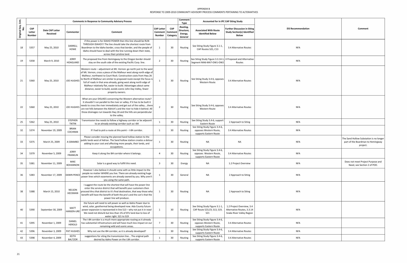
APPENDIX BRESPONSE TO 2009‐2010 COMMUNITY ADVISORY PROCESS COMMENTS PERTAINING TO ALTERANTIVES
CAP Letter Number
Date CAP Letter Received
Commenter Comment CAP Letter Comment Number
CAP Comment Category
Routing, Structure, Energy, General
Associated With Route Identified Below
Further Discussion in Siting Study Section(s) Identified
Below
Orig
inal Seq
. Cmt.
No.
Comments in Response to Community Advisory ProcessComment
TypeAccounted for in IPC CAP Siting Study
EIS Recommendation Comment
18 5357 May 25, 2010DARRELL HOWE
if this power is for IDAHO POWER then this line should be RUN THROUGH IDAHO!!! The line should take the shortest route from
Boardman to the Idaho border, cross that border, and the people of Idaho should have to deal with the line running down their state,
across their pristine land.
1 30 RoutingSee Siting Study Figure 3.1‐1,
CAP Routes S25, C133.4 Alternative Routes NFA
19 5358 March 9, 2010JERRY
HOAGLANDThe proposed line from Hemingway to the Oregon border should
stay on the south side of the existing Pacific Corp. line.2 30 Routing
See Siting Study Figure 3.3.14‐1, Segment MA6‐MA7‐OW1‐OW2
4 Proposed and Alternative Routes
NFA
21 5360 May 25, 2010 JOE HUGHES
Western route – adjustment at Mt. Vernon: go north just to the west of Mt. Vernon, cross a piece of the Malheur west along north edge of Malheur, northwest to Court Rock. Construction costs from Hwy 26 to North of Malheur are similar to proposed route except the focus is full of roads in that area already, going west along north edge of Malheur relatively flat, easier to build. Advantages about same distance, easier to build, avoids scenic John Day Valley, fewer
property owners.
1 30 RoutingSee Siting Study 3.4‐6, opposes
Western Route3.4 Alternative Routes NFA
22 5360 May 25, 2010 JOE HUGHES
What are your DISLIKES concerning the Western alternative route?It shouldn’t run parallel to the river or valley. If it has to be built it
needs to cross the river immediately and get out of the valley....there are not hills between the Aldrich’s and the river to hide it behind. All those drainages run towards Hwy 26 and the hills are perpendicular
to the valley.
2 30 RoutingSee Siting Study 3.4‐6, opposes
Western Route3.4 Alternative Routes NFA
25 5362 May 25, 2010STEPHEN TIKTIN
Transmission line needs to follow a highway corridor or be adjacent to an already existing corridor such as I‐84
1 30 RoutingSee Siting Study 3.4‐6, support
Eastern Route2 Approach to Siting NFA
32 5374 November 19, 2009BRIAN
COCHRANIf I had to pick a route at this point – I‐84 corridor. 1 30 Routing
See Siting Study Figure 3.4‐6, opposes Western Route, supports Eastern Route
3.4 Alternative Routes NFA
33 5375 March 25, 2009 A GRAMBO
Please consider moving the planned Sand hollow station to the public lands west of Adrian. The Sand hollow station creates a detour
adding to your cost and affecting more people, their lands, and occupations.
1 30 Routing NA NA NFAThe Sand Hollow Substation is no longer part of the Boardman to Hemingway
project.
34 5379 November 5, 2009JERRY
FRANKLINKeep it along the I84 corridor where it belongs. 4 30 Routing
See Siting Study Figure 3.4‐6, opposes Western Route, supports Eastern Route
3.4 Alternative Routes NFA
35 5381 November 11, 2009MIKE
BOHANNONSolar is a good way to fulfill this need. 3 30 Energy NA 1.2 Project Overview NFA
Does not meet Project Purpose and Need, see Section 2 of POD.
36 5383 November 17, 2009 DAWN PENCE
However I also believe it should come with as little impact to the people no matter WHERE you live. There are already existing huge power lines which easements are already owned by you. Why aren't
you using the same path.
1 30 General NA 2 Approach to Siting NFA
38 5388 March 15, 2010NELSON HECKMAN
I suggest the route be the shortest that will have the power line enter the service district that will benefit your customers then
proceed thru that district to it's final destination, that way those who benefit will have the benefit of both the pro's and the con's that the
power line will produce.
1 30 Routing NA 2 Approach to Siting NFA
40 5390 September 30, 2009MATT
HANSEN‐URE
the future will need to sell power as well as Idaho Power due to wind, solar, geothermal being developed now. Ada County future power expansion is represented in line S13 – why not put it in now! We need not disturb but less than 1% of EFU land due to loss of
water right. S21 to S19
1 30 RoutingSee Siting Study Figure 3.1‐1, CAP Route S23,C9, S13, S19,
S21
1.2 Project Overview, 3.4 Alternative Routes, 3.3.14 Snake River Valley Region
NFA
41 5395 November 1, 2009DANIEL HEROLD
The I‐84 corridor is a much more appropriate routing as it already has substantial infrastructure and will have much less impact on our
remaining wild and scenic areas.7 30 Routing
See Siting Study Figure 3.4‐6, opposes Western Route, supports Eastern Route
3.4 Alternative Routes NFA
42 5396 November 3, 2009 PAT HUGHES Why not use the I84 corridor, as it is already developed? 1 30 RoutingSee Siting Study Figure 3.4‐6,
supports Eastern Route3.4 Alternative Routes NFA
43 5398 November 4, 2009KEITH
BALTZORsuggestions for siting the transmission line... The original path
desired by Idaho Power on the I.84 corridor.1 30 Routing
See Siting Study Figure 3.4‐6, supports Eastern Route
3.4 Alternative Routes NFA
21

APPENDIX BRESPONSE TO 2009‐2010 COMMUNITY ADVISORY PROCESS COMMENTS PERTAINING TO ALTERANTIVES
CAP Letter Number
Date CAP Letter Received
Commenter Comment CAP Letter Comment Number
CAP Comment Category
Routing, Structure, Energy, General
Associated With Route Identified Below
Further Discussion in Siting Study Section(s) Identified
Below
Orig
inal Seq
. Cmt.
No.
Comments in Response to Community Advisory ProcessComment
TypeAccounted for in IPC CAP Siting Study
EIS Recommendation Comment
44 5400 March 19, 2010FRED
FITZGERALD
The I‐84 corridor has already been desecrated by the existing corridor. Why ruin a beautiful, remote area with (B2H) when an
existing corridor already exists?2 30 Routing
See Siting Study Figure 3.4‐6, supports Eastern Route
3.4 Alternative Routes NFA
45 5401 November 5, 2009 TIM LILLEBO
There are existing corridors and previously developed lands on the routes that generall follow I‐84. ‐ Lobby the Federal Hiway
Commision & put this impactful line next to the Freeway I‐84 or do not build it. The costs are way to high to impact our remaining public lands with your new proposals that were not a part of your original
proposal.
1 30 RoutingSee Siting Study Figure 3.4‐6, opposes Western Route, supports Eastern Route
3.4 Alternative Routes NFA
47 5401 November 5, 2009 TIM LILLEBOInvest the $600,000,000 in renewables rather than build the
powerline.4 30 Energy NA 1.2 Project Overview NFA
Does not meet Project Purpose and Need, see Section 2 of POD.
48 5402 November 19, 2009PAM
CALLAHAN
I like the I‐84 route.... I feel the federal freeway corridor is oldest and has priority just like an airport about expansion. Very limited tree cutting, if any, would be a problem and definitely transportation issues are taken care of. Transportation for supplies, building and maintenance is taken care of. This would cause the least impact to
wildlife, fish, forestry and habitat and housing.
1 30 RoutingSee Siting Study Figure 3.4‐6,
supports Eastern Route3.4 Alternative Routes NFA
62 5432 September 30, 2009JERRY
HOAGLAND
And jog from Hemingway around private and cross Pacific Corp line and stay on south side from there to the Northwest to Oregon
border.1 30 Routing
See Siting Study Figure 3.1‐1, CAP Routes S19,S20
4.1 Proposed Route Description by County
NFA
75 5468 March 19, 2009 SUZAN JONESThrough Malheur county by Malheur reservoir ‐ that area has few
people and its mainly summer range1 30 Routing
See Siting Study Figure 3.4‐6, Eastern Route
3.4 Alternative Routes NFA
82 5488 September 16, 2009YOGI
HAGBERG
traditional transportation corridor ‐ existing lines‐ conscious of controlled airspace‐ behind hill – visibility screened by hill‐ Durkee
area residents can choose route in their vicinity1 30 Routing
See Siting Study Figure 3.1‐1, CAP Route C3; Central Route
2 Approach to Siting; 3.4 Alternative Routes
NFA
86 5492 September 16, 2009KRISTEN WARES
It seems west of the freeway through Baker County has not been adequately surveyed, while it looks like there could be less impact to the west. West of the freeway also avoids a “direct impact” on the
“view” of the Oregon Trail from the interpretive centers... The desert eco‐systems are very fragile while there is potential to skirt farmland
west of the freeway.
5 30 RoutingSee Siting Study Figure 3.1‐1,
CAP Route C33.4 Alternative Routes NFA
Alternative routes west of I‐84 were considered but eliminated from further consideration in the CAP.Issues included farmland, EFU, airport and approach zone and strong opposition from Baker
County.
90 5498 March 10, 2010 JIM SPROULthere are much better areas with less economic and social impacts
located to the east.4 30 General
See Siting Study Figure 3.4‐6, oppose Western Route
3.4 Alternative Routes NFAComment supporting route to the east, which is Idaho Power's Proposed Route.
91 5511 September 27, 2009ROGER
FINDLEY;JEAN FINDLEY
6) We strongly encourage two routes be considered/analyzed in Idaho and two routes in Oregon, at the very least.
1 30 RoutingSee Siting Study Figure 3.1‐1,
CAP Routes3 Siting NFA
Numerous routes have been considered in both states; however, as aresult of the CAP the Proposed and current
alternatives are located predominantly in Oregon.
95 5514 January 13, 2010THOMAS E BROWN
Routing the powerline through the Ash Grove Cement Plant would also improve the chances of another industry replacing the cement plant which is on the verge of closing because of the economy and
mercury pollution. The community of Durkee depends on employment at the Ash Grove location and the powerline would
improve the prospects.
5 30 RoutingSee Siting Study Appendix E, Maps 33‐34, west of Proposed
Route MP 185NA NFA
102 5527 May 25, 2010 STEVE COREY
the route of the transmission line generally should track the area’s transportation corridors, along Interstate 84 north, from the Oregon border with Idaho, to the area of Kamela or Meacham, and then
westerly.
1 30 Routing
See Siting Study Figure 3.3.4‐1 Pilot Rock Region, See Siting Study Figure 3.3.5‐1 West of
National Forest Utility Corridor Region
3.3.4 Pilot Rock Region, 3.3.5 West of National Forest Utility Corridor
Region
NFA
22

APPENDIX BRESPONSE TO 2009‐2010 COMMUNITY ADVISORY PROCESS COMMENTS PERTAINING TO ALTERANTIVES
CAP Letter Number
Date CAP Letter Received
Commenter Comment CAP Letter Comment Number
CAP Comment Category
Routing, Structure, Energy, General
Associated With Route Identified Below
Further Discussion in Siting Study Section(s) Identified
Below
Orig
inal Seq
. Cmt.
No.
Comments in Response to Community Advisory ProcessComment
TypeAccounted for in IPC CAP Siting Study
EIS Recommendation Comment
103 5529 March 10, 2010JIM
HAMMETT;JIM HAMMETT
I am sure you are aware that the 2009 Record of Decision on energy corridors as required by Section 368 of the Energy Policy Act of 2005
designated amost 230,500 acres of land in Oregon as energy transportation corridors. Not one of these acres is in Grant County. However, the multi‐modal corridor 250‐252 contains a large part of the route you are considering down the I‐84 corridor... Seems to me you have a lot of direction and an obligation to use these established corridors, rather than take off on your own and try to establish new
one in a relatively pristine environment like Grant County.
1 30 RoutingSee Siting Study Figure 3.4‐6,
oppose Western Route; support Eastern Route
2 Approach to Siting, 3.4 Alternative Routes
NFA
The WWECs were considered a routing opportunity for all routing activities associated with the B2H Project.
Currently the Eastern Corridor is Idaho Power's Proposed Route.
113 5572 September 15, 2009EDWARD G NICHOLS
Avoid property. Stay on north side of I84. 1 30 RoutingSee Siting Study Figure 3.1‐1,
CAP Route C404.1 Proposed Route Description by County
NFA
114 5576 September 16, 2009DICK
D'EWARTTo avoid houses would like the transmission line to follow the fiber
optic line.1 30 Routing
See Siting Study Figure 3.1‐1, CAP RouteC41
4.1 Proposed Route Description by County
NFA
115 5581 January 19, 2010JERRY
COWGERI strongly prefer a final alternative that utilizes the previously developed areas of the I‐84 corridor as extensively as possible.
1 30 RoutingSee Siting Study Figure 3.4‐6,
support Eastern Route3.4 Alternative Routes NFA
123 5607 March 23, 2010PAULA
LANGENFELD
It doesn't benefit anyone in this county at all and I know there is another area you can put those ugly towers in. Like through the desert south of us or through the US Forest Service North of us. Please find a different area to put your power lines through.
2 30 RoutingSee Siting Study Figure 3.4‐6, opposes Western Route
3.4 Alternative Routes NFA
126 5614 September 23, 2009 GARY NEAL route per landowners interests – some ok w/line, avoid those against 2 30 RoutingSee Siting Study Figure 3.1‐1,
CAP Route N7
3.3.5 West of National Forest Utility Corridor
RegionNFA
127 5614 September 23, 2009 GARY NEALroute south of Pilot Rock – avoid ag lands to north‐avoid pivots, stay south of bombing range, around Nature Conservancy unless can
work a deal w/them3 30 Routing
See Siting Study Figure 3.1‐1, CAP Route N7
3.3.5 West of National Forest Utility Corridor
RegionNFA
128 5615 January 18, 2010MITSIE
WILBURNWESTERN...why aren't the Columbia Gorge and other better suited
areas still being looked at3 30 Routing
See Siting Study Figure 3.4‐6, opposes Western Route
3.4 Alternative Routes NFA
132 5637 September 23, 2009RICHARD MELAAS
Use existing transportation/utility corridor along bombing range road / Bonneville power easement already provided by navy for utilities / transportation if necessary. I consider joint / co‐use of
existing Bonneville Power towers (west side of road) or improvement of existing power line on east side of bombing range road
1 30 RoutingSee Siting Study Figure 3.1‐1,
CAP Route N263.3.1 Boardman Region NFA
IPC currently working with PGE and Morrow County.
133 5637 September 23, 2009RICHARD MELAAS
Use existing utility / transportation corridor along immigrant lane along south boundary of Boardman as much as possible if necessary
2 30 RoutingSee Siting Study Figure 3.1‐1, CAP Route N7, N28, N30
3.3.1 Boardman Region NFAIPC currently working with PGE and
Morrow County.
134 5637 September 23, 2009RICHARD MELAAS
To connect to utility corridors east of Boardman. Consider locating power lines within an easement to permit other co‐use or
transportation infrastructure (road) to be constructed within any newly acquired easement.
3 30 RoutingSee Siting Study Figure 3.1‐1,
CAP Route N262 Approach to Siting; 3.3.1
Boardman RegionNFA
IPC currently working with PGE and Morrow County.
135 5637 September 23, 2009RICHARD MELAAS
Consider join venture utility / transportation easement acquisition strategy with PGE, Morrow County (connector road from bombing
range to immigrant lane) and Idaho Power.4 30 General NA NA NFA
IPC currently working with PGE and Morrow County.
136 5638 September 23, 2009RICK
YARDLEYuse govt lands as opposed to private land 1 30 General
See Siting Study Figure 3.1‐1, CAP Route N6, N10
2 Approach to Siting; 3.3.1 Boardman Region
NFA
137 5639 September 23, 2009 STEVE COREY
I worked with a neighbor and together we revised route N4 to address concerns we now are considering – entering Umatilla County on the USFS corridor, going west at Kamela/Spring Creek across to the north side of Indian Lake, going off the mountain along the
county road (Rocky Ridge Road), staying south of Pilot Rock, staying south of the Cunningham Sheep HQs (West Birch Creek) and south of
the Cunningham Sheep “Cattle” HQs (Butter Creek).
1 30 RoutingSee Siting Study Figure 3.1‐1,
CAP Route N4
3.3.5 West of National Forest Utility Corridor
RegionNFA
23

APPENDIX BRESPONSE TO 2009‐2010 COMMUNITY ADVISORY PROCESS COMMENTS PERTAINING TO ALTERANTIVES
CAP Letter Number
Date CAP Letter Received
Commenter Comment CAP Letter Comment Number
CAP Comment Category
Routing, Structure, Energy, General
Associated With Route Identified Below
Further Discussion in Siting Study Section(s) Identified
Below
Orig
inal Seq
. Cmt.
No.
Comments in Response to Community Advisory ProcessComment
TypeAccounted for in IPC CAP Siting Study
EIS Recommendation Comment
138 5639 September 23, 2009 STEVE COREY
take the line through our pastures near Alkali Canyon, north of Nye Junction and Winsome. We also would consider a re‐focus of the USFS corridor, taking the new line to the Meacham area, then west
on the county road from Meacham to McKay Creek, and then diagonally either west (just south of Pilot Rock), or northwest (just south of Pilot Rock), or northwest (just north of Pilot Rock) to Alkali
Canyon referred to above.
3 30 RoutingSee Siting Study Figure 3.1‐1,
CAP Route N4
3.3.5 West of National Forest Utility Corridor
RegionNFA
139 5649 March 23, 2010STEVE WALKER
This line should be routed through the I‐84 corridor where it was originally proposed and where it belongs.
3 30 RoutingSee Siting Study Figure 3.4‐6, opposes Western Route; supports Eastern Route
3.4 Alternative Routes NFA
143 5651 March 8, 2010CHET
PHILLIPSAdditionally, the southern end of the bombing range could serve for the future hub substation, at least somewhere in the M020 area.
4 30 Routing NA NA NFA
147 5664 September 23, 2009ALAN M INSKO
Appears to be shortest route to connect the Forest Service utility corridor coming from Union County toward Boardman. This line skirts the foothills of the Blue Mountains which have the potential for wind development in many areas.‐This route would provide potential “tie ins” for a wider number of different interests.
1 30 RoutingSee Siting Study Figure 3.1‐1,
CAP Route N83.3 Regional Analyses NFA
148 5665 September 23, 2009 J.R. COOKpush any potential NFO hub to the east of the urban centers of Hermiston, Echo, Stanfield and Umatilla and to the west of
Pendleton and Milton‐Freewater which is preferable.3 30 Routing
See Siting Study Figure 3.1‐1, CAP Route N8, N4, N12
NA NFAThere is no record of a CAP Route N12; Unclear what commenter refers to as
'NFO Hub'.
149 5666 September 23, 2009DAVID R DEMAYO
open country – wheat fields. Dry land wheat farms. 2) avoids the bombing range issue by going west and following the Columbia River
Valley east (for ease of installation excellent!)1 30 Routing
See Siting Study Figure 3.1‐1, CAP Routes N4‐N6
3.3.5 West of National Forest Utility Corridor
RegionNFA
150 5667 September 23, 2009TAMRA
MABBOTTbenefit of proximity to wind farms proposed. 1 30 Routing
See Siting Study Figure 3.1‐1, CAP Routes N4, N16, N8; C13
not feasible3 Siting NFA There is no record of a CAP Route N12
152 5674 January 19, 2010JIM
BELLINGER
The route should follow the shortest route as identified maintenance cost for the next 100 years will be overwhelming of accessing the
line. I‐84 corridor suggest the best & most economical option, terrain is flatter & more cost effective to construct.
1 30 RoutingSee Siting Study Figure 3.4‐6, opposes Western Route, supports Eastern Route
3.4 Alternative Routes NFAThe Navy has consistently advised that
this is not possible.
153 5677 December 8, 2009 PAT TRENKEL South...Analyze the routes east of Boise also. 1 30 RoutingSee Siting Study Figure 3.1‐1,
CAP Route S133.4 Alternative Routes NFA
155 5680 December 17, 2009VERNITA EDIGER
keep lines supplying Idaho are in IDAHO 1 30 RoutingSee Siting Study Figure 3.1‐1,
CAP Route S25, C133.4 Alternative Routes NFA
A number of routes were considered in Idaho, but except for the Proposed Route were eliminated from further
consideration. See Siting Report Section 3, specifically sections 3.3.14 and 3.4.
170 5706 August 26, 2009 MARTIN JACA Stay to the South of the PPL! 2 30 RoutingSee Siting Study Figure 4‐1, Owyhee River Below Dam
Alternative
2 Approach to Siting; 3 Siting
NFA
172 5708 March 22, 2010GREG
SCHMIDT
It seems to me the most appropriate route would be Baker Alt 1 or Baker Alt 2 due to better construction access and probably lower
costs to construct.2 30 Routing
See Siting Study Figure 3.4‐6, opposes Western Route
3.4 Alternative Routes NFA
173 5710 March 23, 2010DENNIS BRADLEY
The City of Mt. Vernon strongly encourages Idaho Power Company to consider its options and select the Eastern route which least effects
our natural resources.3 30 Routing
See Siting Study Figure 3.4‐6, opposes Western Route, supports Eastern Route
3.4 Alternative Routes NFA
174 5717 November 4, 2009 TOM SHARPRouting along I‐84 corridor seems to be the more cost effective,
permittable alternative.1 30 Routing
See Siting Study Figure 3.4‐6, supports Eastern Route
3.4 Alternative Routes NFA
175 5717 November 4, 2009 TOM SHARPIf routed thru Harney County strategic benefit would be accessibility
to southeast Oregon wind energy developments.2 30 General
See Siting Study Figure 3.4‐6, Western Route
1.2 Project Overview NFA
177 5718 November 4, 2009JACK
SOUTHWORTH
I‐84 route w/some variations. 3 30 RoutingSee Siting Study Figure 3.4‐6,
supports Eastern Route3.4 Alternative Routes NFA
24

APPENDIX BRESPONSE TO 2009‐2010 COMMUNITY ADVISORY PROCESS COMMENTS PERTAINING TO ALTERANTIVES
CAP Letter Number
Date CAP Letter Received
Commenter Comment CAP Letter Comment Number
CAP Comment Category
Routing, Structure, Energy, General
Associated With Route Identified Below
Further Discussion in Siting Study Section(s) Identified
Below
Orig
inal Seq
. Cmt.
No.
Comments in Response to Community Advisory ProcessComment
TypeAccounted for in IPC CAP Siting Study
EIS Recommendation Comment
178 5718 November 4, 2009JACK
SOUTHWORTH
W of Treasure Valley & E of National Forests in OR. 4 30 RoutingSee Siting Study Figure 3.4‐6,
supports Eastern Route3.4 Alternative Routes NFA
the Proposed Route is west of the Treasure Valley and east of the National
Forests.
180 5719 March 20, 2010MARK
SYMONDS
(Western)...I am totally against the proposed line being placed in this area and believe it should be located along another pathway such as the central or eastern route. Such routes would appear to have less effect on the number of acres of pristine national forest lands that
currently exist in this region.
2 30 Routing
See Siting Study Figure 3.4‐6, oppose Western Routes, supports Central/Eastern
Routes
3.4 Alternative Routes NFA
182 5721 October 22, 2009KEITH
BALTZOR
The original I‐84 route makes more sense than any of the others for the following reasons 1) Least cost prohibitive 2) Infrastructure
already in place in close proximity (roads, services etc)2 30 Routing
See Siting Study Figure 3.4‐6, supports Eastern Route
3.4 Alternative Routes NFA
190 5739 November 4, 2009JOHN
CLEMENS
The straightest line from point A to B with the minimal amount of enviromental impact. The corridor thru the forest that is already in place is a huge issue and impacts will be minimal to the forest.
2 30 GeneralSee Siting Study Figure 3.4‐6, opposes Western Route, supports Eastern Route
3.4 Alternative Routes NFA
1. Length is always a consideration in selecting a preferred route; however the least amount of environmental impact is more preferable. 2. The proposed route does use the utility corridor through the
national forest.
192 5742 November 19, 2009 DAN KEHRUse I‐84 route which has access & not deface & devalue further
property – both private and public.2 30 Routing
See Siting Study Figure 3.4‐6, opposes Western Route, supports Eastern Route
3.4 Alternative Routes NFA
193 5744 November 19, 2009 LEON SKILESMost direct route with the least impact up the I‐84 corridor. Use
existing energy corridors1 30 Routing
See Siting Study Figure 3.4‐6, opposes Western Route, supports Eastern Route
3.4 Alternative Routes NFA
196 5749 November 19, 2009 TIM LILLEBO I‐84 corridor – easily accessible for construction and maintenance 1 30 RoutingSee Siting Study Figure 3.4‐6,
supports Eastern Route3.4 Alternative Routes NFA
199 5754 November 19, 2009 EVA HARRISthe I‐84 corridor is already developed, it would require the least
alteration to untouched, pristing lands, and probably would be the least costly for Idaho Power.
2 30 RoutingSee Siting Study Figure 3.4‐6, opposes Western Route, supports Eastern Route
3.4 Alternative Routes NFA
200 5756 November 19, 2009 STEVE GAST
If a line is put through this area, the only way to mitigate this would a more vertically situated line that would be the least damaging to this future. If anything it should follow the natural drainage and not cut
across.
4 30 RoutingSee Siting Study Figure 3.1‐1,
CAP Route C183 Siting NFA
201 5756 November 19, 2009 STEVE GAST
preferred route would be I‐84 because of the development that is already existing and the resources that are available to that area.
There are the obvious scenic value of the Elkhorns and the Wallowas but those are better accessed through the many secondary roads in
the area, in especially Baker Co.
5 30 RoutingSee Siting Study Figure 3.4‐6,
supports Eastern Route3.4 Alternative Routes NFA
202 5757 November 19, 2009JERRY
EBELTOFTIf you all could research the line running on the ground (not under)
for part of the visual area that would be great.2 30 Structure NA NA NFA
204 5759 November 19, 2009JERRY
COWGERI 84 – the power corridor is already there – it would cost much less –
it is a more direct route.1 30 Routing
See Siting Study Figure 3.4‐6, opposes Western Route, supports Eastern Route
3.4 Alternative Routes NFA
207 5764 March 24, 2010ROBERT
HALE;CLAUDIA HALE
It seems to us that the most reasonable route through Oregon for the Boardman‐Hemingway Line is along Hwy. 84. The valleys are wide, access roads would be good, the land is mostly flat with the
exception of the Blue Mts.
7 30 RoutingSee Siting Study Figure 3.4‐6, opposes Western Route, supports Eastern Route
3.4 Alternative Routes NFA
We agree with the comment. I‐84 was considered an opportunity for routing throughout the CAP and the Eastern Corridor ,chosen as Idaho Power's
Proposed Route, follows in proximity to I‐84 where other constraints permit in portions of Baker and Union Counties.
213 5770 August 20, 2009DAVID
MILDREXLER
Opportunity exists for increased utilization of solar energy and conservation within Boise. Oregon should not support unsustainable growth in other states by enabling growth that otherwise could not
be supported.
2 30 Energy NA 1.2 Project Overview NFADoes not meet Project Purpose and
Need, see Section 2 of POD.
25

APPENDIX BRESPONSE TO 2009‐2010 COMMUNITY ADVISORY PROCESS COMMENTS PERTAINING TO ALTERANTIVES
CAP Letter Number
Date CAP Letter Received
Commenter Comment CAP Letter Comment Number
CAP Comment Category
Routing, Structure, Energy, General
Associated With Route Identified Below
Further Discussion in Siting Study Section(s) Identified
Below
Orig
inal Seq
. Cmt.
No.
Comments in Response to Community Advisory ProcessComment
TypeAccounted for in IPC CAP Siting Study
EIS Recommendation Comment
214 5770 August 20, 2009DAVID
MILDREXLER
A recent plan being developed by the Northwest Power and Conservation Council shows that 85% of the Northwest's new power needs over the next 20 years can be achieved through conservation. Conservation is the approach that needs to be emphasized. The
Boardman to Hemingway Transmission Line Project instead transfers power over large distances to fuel unsustainable growth. We cannot
afford to pursue growth such as this any longer.
3 30 Energy NA 1.2 Project Overview NFADoes not meet Project Purpose and
Need, see Section 2 of POD.
215 5771 March 11, 2010GLENN E PALMER
Have you considered building a power plant in Hemmingway over the expense of the transmission line...If Hemmingway or Idaho
residents need the additional power, put the power plant in their back yard.
2 30 Energy NA 1.2 Project Overview NFADoes not meet Project Purpose and
Need, see Section 2 of POD.
216 5773 March 15, 2010SANDY
MURRAY;MARK MURRAY
(Western)...Why can’t Idaho Power generate electricity on a more local scale?...The fact is, Idaho Power is building a new power plant
in Mountain Home. So, why can’t they use their own power?4 30 Energy NA 1.2 Project Overview NFA
Does not meet Project Purpose and Need, see Section 2 of POD.
217 5774 November 19, 2009 NEIL BAUER
The I 84 corridor also is a logical choice logistically. The access for construction & future maintainence is already in place...The I 84 also will have the least impact on wildlife habitat & migrations. There are
habitat alterations & migration barriers already there...The vast amount of this land has very limited and minimal use except for the 4 to 6 weeks of the year during the deer & elk seasons. The visual impacts from siting the line on this route is almost negligible.
1 30 RoutingSee Siting Study Figure 3.4‐6,
supports Eastern Route3.4 Alternative Routes NFA
218 5774 November 19, 2009 NEIL BAUER
through the Umatilla & Malheur N. Forests. It is over grown & densly stocked with an early successional forest type. There is very little grasses & other forage species available for the deer & elk & other herbivorous species. Opening up the right of way’s forest floor to sunlight & seeding with native grasses could actually enhance &
increase wildlife populations through the forest.
2 30 RoutingSee Siting Study Figure 3.4‐6, opposes Western Route
3.4 Alternative Routes NFA
219 5776 November 19, 2009 MARK CERNYutilize the existing I‐84 corridor...will cause the least disturbance
possible. It is also the most economic route as well as doing the least damage to the environment.
1 30 RoutingSee Siting Study Figure 3.4‐6,
suports Eastern Route3.4 Alternative Routes NFA
227 5786 May 25, 2010MARTIN AND CATHERINE MORROW
There needs to be more proposals for alternative energy generation with smaller distribution infrastructure.
2 30 Energy NA 1.2 Project Overview NFADoes not meet Project Purpose and
Need, see Section 2 of POD.
229 5786 May 25, 2010MARTIN AND CATHERINE MORROW
Future energy production and transmission needs to invest in renewable production and de‐centralized sources with smaller, more
local infrastructure.4 30 Energy NA 1.2 Project Overview NFA
Does not meet Project Purpose and Need, see Section 2 of POD.
231 5793 May 25, 2010GARY
SCHULTZIdaho Power should seek in state sources of energy; nuclear power
close to where power is needed would be a better choice.1 30 Energy NA 1.2 Project Overview NFA
Does not meet Project Purpose and Need, see Section 2 of POD.
239 5811 March 19, 2010 JERRY RUSSEL
The I‐84 freeway is already an existing modern marvel of man's development. The land area it already consumes must be utilized to its' fullest potential. Maintenance and protection of the highway and
the proposed transmission line from natural disasters as well as human inflicted sabotage and eco‐terrorism is infinitely easier and more cost effective if located along this easily accessible route.
1 30 RoutingSee Siting Study Figure 3.4‐6, opposes Western Route, supports Eastern Route
3.4 Alternative Routes NFA
240 5813 May 25, 2010JANICE O'RORKE
The most logical route is down I‐84. Access is easy with no new roads needed. Repairing problems will be easy because access is quick and
easy – no wilderness to cross or access.1 30 Routing
See Siting Study Figure 3.4‐6, opposes Western Route, supports Eastern Route
3.4 Alternative Routes NFA
26

APPENDIX BRESPONSE TO 2009‐2010 COMMUNITY ADVISORY PROCESS COMMENTS PERTAINING TO ALTERANTIVES
CAP Letter Number
Date CAP Letter Received
Commenter Comment CAP Letter Comment Number
CAP Comment Category
Routing, Structure, Energy, General
Associated With Route Identified Below
Further Discussion in Siting Study Section(s) Identified
Below
Orig
inal Seq
. Cmt.
No.
Comments in Response to Community Advisory ProcessComment
TypeAccounted for in IPC CAP Siting Study
EIS Recommendation Comment
241 5814 January 30, 2010THOMAS E BROWN
Would it not be possible to just add capacity as needed instead of projecting the need so far into an uncertain future? Lower voltage
transmission lines are much less intrusive and building more of those along different routes would incrementally increase capacity as needed, and would provide redundancy in case of earthquake or
other disaster.
3 30 EnergySee Siting Study Figure 3.4‐6,
Eastern Route1.2 Project Overview NFA
Does not meet Project Purpose and Need, see Section 2 of POD.
242 5814 January 30, 2010THOMAS E BROWN
I read that a lower voltage line is half the price per mile, so why not build that line, save some money, and see if another line is needed
later. I realize that as the voltage doubles the power capacity quadruples, but it still seems that four lines built when and if needed
would be a more practical plan.
5 30 EnergySee Siting Study Figure 3.4‐6,
Eastern Route1.2 Project Overview NFA
Does not meet Project Purpose and Need, see Section 2 of POD.
243 5816 January 26, 2010ROSE
HOWE;DARRELL HOWE
When one looks at the routes laid out for consideration, it seems most logical to follow the already established I‐84 interstate route
for the reasons of accessibility which in itself would be a considerable cost savings over carving out a line over the rugged
terrain many of the other proposed routes would require.
1 30 RoutingSee Siting Study Figure 3.4‐6, opposes Western Route, supports Eastern Route
3.4 Alternative Routes NFA
244 5817 March 3, 2010ANDREW STORER
Is there a revised route that you believe is permittable and constructible that should be considered?...Across Malheur and
Harney into Lake County to tie into existing corridors in Christmas Valley area. Less people impacted and better utilization of existing
corridors.
1 30 Routing NA 1.2 Project Overview NFADoes not meet Project Purpose and
Need, see Section 2 of POD.
246 5818 March 9, 2010GARY
PEARSON
I still believe that a route east of Boise and on to I‐84 via Gem, Payette and Washington counties, is a viable, permittable and
constructable route.1 30 Routing
See Siting Study Figure 3.3.14‐1 Snake River Valley Region
3.3.14 Snake River Valley Region
NFA
248 5820 February 23, 2010RONALD H. DONATI
I'm sure you have less expensive and more direct routes along the Columbia River corridor that can meet your ultimate goal. I hope you
come to the same conclusion and leave Grant County's people, ranches and wild‐life with their present environment and without
your intrusion into their lives.
1 30 RoutingSee Siting Study Figure 3.4‐6, opposes Western Route
1.2 Project Overview NFADoes not meet Project Purpose and
Need, see Section 2 of POD.
249 5823 November 30, 2009BRUCE R CORN
I find it very troubling that IP has rejected any line siting east of Boise. Following S13 from my view has the following advantages1. Existing right of way – no easments of new disruption of citizens
2. Boise Ada area is where growth is3. Substations other than Hemingway are not built. – therefore could
be moved to meet route4. Portion TV loop will completed where most needed from
population5. Cost from extra distance falls in OR criteria of resonable especially
when considering not cost for right away as IP has right of way.IP needs to reconsider east Boise route!
1 30 RoutingSee Siting Study Figure 3.1‐1,
CAP Route S131.2 Project Overview; 3
SitingNFA
Does not meet Project Purpose and Need, see Section 2 of POD.
250 5826 November 28, 2009 ANONYMOUSalternative route that avoids EFU and leks, and moves back towards I‐
84.1 30 Routing
See Siting Study Figure 3.1‐1, CAP Route S21‐C6
3 Siting NFA
252 5829 November 19, 2009 ROD KUHNI would say the I84 corridor makes the most sense. Or better would be the route up through Idaho, crossing through S.E. WA. and then
down to Boardman.2 30 Routing
See Siting Study Figure 3.4‐6, opposes Western Route; See Siting Study Figure 3.1‐1, CAP
Route S25
3.4 Alternative Routes NFA
253 5831 November 19, 2009 LARRY VOTEThe most direct route from source to end user should be the primary concern... Route this thru the populated corridor where it belongs.
1 30 RoutingSee Siting Study Figure 3.4‐6, opposes Western Route, supports Eastern Route
3.4 Alternative Routes NFA
254 5832 November 19, 2009CINDY
THOMASWestern... Please go back to more urban, developed routes north of
us.2 30 Routing
See Siting Study Figure 3.4‐6, opposes Western Route
3.4 Alternative Routes NFA
27

APPENDIX BRESPONSE TO 2009‐2010 COMMUNITY ADVISORY PROCESS COMMENTS PERTAINING TO ALTERANTIVES
CAP Letter Number
Date CAP Letter Received
Commenter Comment CAP Letter Comment Number
CAP Comment Category
Routing, Structure, Energy, General
Associated With Route Identified Below
Further Discussion in Siting Study Section(s) Identified
Below
Orig
inal Seq
. Cmt.
No.
Comments in Response to Community Advisory ProcessComment
TypeAccounted for in IPC CAP Siting Study
EIS Recommendation Comment
255 5834 March 3, 2010
YOGI HAGBERG;M
ELAINE HAGBERG
Central alternative route... If there has to be a route, this is the best one if it can be built above the housing developments ion the west side of Baker Valley. I do not agree with others who think the towers will show up more in the trees. The right‐a‐way tree cutting and the towers themselves should be all but invisible with the backdrop of trees that are left. This route also has a good mix of public and
private land.
1 30 RoutingSee Siting Study Figure 3.4‐6,
Central Route3.4 Alternative Routes NFA
256 5835 March 3, 2010
YOGI HAGBERG;M
ELAINE HAGBERG
Route C‐3 around Baker (to the west of I‐84). 1 30 RoutingSee Siting Study Figure 3.1‐1,
CAP Route C33.4 Alternative Routes NFA
262 5853 January 19, 2010CATHERINE MILLER
There is an established utility corridor following the I‐84 that is much better suited to the Idaho Power project. It is the least costly, more direct route. The established corridor is also the least destructive to private property owners and the wilderness areas left in Oregon.
4 30 RoutingSee Siting Study Figure 3.4‐6, opposes Western Route; supports Eastern Route
3.4 Alternative Routes NFA
263 5854 January 19, 2010LARRY MCCOY
Using the established utility corridor following I‐84 corridor is by far the most direct, least costly and least destructive to private property
owners.3 30 Routing
See Siting Study Figure 3.4‐6, opposes Western Route; supports Eastern Route
3.4 Alternative Routes NFA
265 5860 February 4, 2010 BRYAN VOGT
siting the IPC Project along the initial proposed route following the I‐84 corridor, as long as this is done in a manner that does not negatively impact high value agricultural land or other areas of
resource concern.
14 30 RoutingSee Siting Study Figure 3.4‐6, opposes Western Route; supports Eastern Route
3.4 Alternative Routes NFA
266 5862 May 25, 2010KAREN COULTER
better to avoid all these impacts through greater energy conservation... we need to be conserving energy and reducing
existing power use, not building infrastructure for allowing more energy use.
2 30 Energy NA 1.2 Project Overview NFADoes not meet Project Purpose and
Need, see Section 2 of POD.
267 5862 May 25, 2010KAREN COULTER
if new transmission lines go through, you should try to reduce impacts further than is now the case with the eastern route – esp. no crossing of special status streams and proposed wilderness study areas and sage grouse lek buffer areas, close cooperation with
affected farmers.
3 30 RoutingSee Siting Study Figure 3.4‐6,
Eastern Route2 Apprroach to Siting; 3.4
Alternative RoutesNFA
Reducing/ mitigating potential impacts of the proposed transmission facilities is
an ongoing process and will be addressed by Idaho Power, BLM, the
Forest Sevice, ODOE, and other federal, state and local agencies in the NEPA and
EFSC processes to minimize environmental impact to the resources in the area crossed by the Proposed
Route.
268 5863 March 9, 2010 JOHN FAWI still do not see why this cannot stay on the east side of the Snake River as that is the largest service area and where the power will be
needed the most.3 30 Routing
See Siting Study Figure 3.3.14‐1 Snake River Valley Region
3.3.14 Snake River Valley Region
NFA
270 5865 May 25, 2010 SUE GILLILANthe route should be in a majority of the state of Idaho but realize
that is “off the table” in I.P. thoughts.1 30 Routing
See Siting Study Figure 3.1‐1, CAP Route S25, C13
1.2 Project Overview; 3.4 Alternative Routes
NFADoes not meet Project Purpose and
Need, see Section 2 of POD.
271 5866 November 19, 2009CHLOE HUGHES
The power transmission line needs to go through the I‐84 corridor, not Grant County.
1 30 RoutingSee Siting Study Figure 3.4‐6, opposes Western Route; supports Eastern Route
3.4 Alternative Routes NFA
272 5867 November 19, 2009JUSTIN DEJAGER
The only place this line makes sense is close to the interstate and close to where existing lines are already located.
11 30 RoutingSee Siting Study Figure 3.1‐1,
CAP Route C183.4 Alternative Routes NFA
274 5872 March 17, 2010RICHARD NAUMANN
when Louis and Clark were navigating the Columbia River over 200 years ago is unconscionable. The captive reality is that the I‐84 corridor is already environmentally "spoiled", and that is harbors both a major highway and existing power grid and supports energy and transportation needs of the general public utilizing it makes a solid argument that the same public whose objections inspired IP to
look west are the folks benefiting.
3 30 RoutingSee Siting Study Figure 3.4‐6, opposes Western Route; supports Eastern Route
3.4 Alternative Routes NFA
275 5875 March 19, 2010KATHRYN KLOSKE
The I‐84 corridor is the most logical route for this structure. The path is already developed.
1 30 RoutingSee Siting Study Figure 3.4‐6, opposes Western Route; supports Eastern Route
3.4 Alternative Routes NFA
28

APPENDIX BRESPONSE TO 2009‐2010 COMMUNITY ADVISORY PROCESS COMMENTS PERTAINING TO ALTERANTIVES
CAP Letter Number
Date CAP Letter Received
Commenter Comment CAP Letter Comment Number
CAP Comment Category
Routing, Structure, Energy, General
Associated With Route Identified Below
Further Discussion in Siting Study Section(s) Identified
Below
Orig
inal Seq
. Cmt.
No.
Comments in Response to Community Advisory ProcessComment
TypeAccounted for in IPC CAP Siting Study
EIS Recommendation Comment
277 5877 March 22, 2010RICHARD BAUMANN
Idaho Power has to be captive to the facts: the 1‐84 corridor is already host to a major highway and existing power transmission lines, and additionally, those using the corridor for travel are the same folks who benefit from the power and transportation grids.
5 30 RoutingSee Siting Study Figure 3.4‐6, opposes Western Route; supports Eastern Route
3.4 Alternative Routes NFA
278 5878 March 24, 2010
ADELE CERNY;ANNE
TERESE CERNY
The IRP suggests the installation of solar and wind units built near existing facilities to minimize the need for additional transmission
lines. Upgrading existing power lines would be a wiser use of resources, as would solar and wind installations, both company and privately owned. Continuing to develop localized resources will minimize transmission needs. Conservation and energy efficient
construction is an area that your IRP is severely lacking. Idaho Power is currently building a power plant in Mountain Home, Idaho. It
would make more sense to increase the size to this facility, as well as build additional solar units and wind turbines in that area. This environmentally sound action would eliminate the need for transmission line through a pristine area of the Northwest.
2 30 Energy NA 1.2 Project Overview NFADoes not meet Project Purpose and
Need, see Section 2 of POD.
279 5878 March 24, 2010
ADELE CERNY;ANNE
TERESE CERNY
The obvious solution is to locate the energy source in close proximity to the energy need; and not traverse hundreds of miles across
country.20 30 Energy NA 1.2 Project Overview NFA
Does not meet Project Purpose and Need, see Section 2 of POD.
280 5878 March 24, 2010
ADELE CERNY;ANNE
TERESE CERNY
it is evident that a number of solutions exist that would:a) be cheaper in the long run
b) utilize pre‐existing right‐of‐waysc) preserve the economies and sustain the communities that
otherwise would be negatively impacted by the current proposald) preserve and respect the land.
e) would coalesce with new green technologies
24 30 Energy NA1.2 Project Overview; 2 Approach to Siting
NFADoes not meet Project Purpose and
Need, see Section 2 of POD.
281 5880 March 25, 2010THOMAS STECK
Grant County... The route that seems to make the most sense is along the 1‐84 corridor. Consider the ease of building and
maintenance that the 1‐84 route offers opposed to transiting pristine areas of Grant County that do not offer any collateral infrastructural
support.
5 30 RoutingSee Siting Study Figure 3.4‐6, opposes Western Route; supports Eastern Route
3.4 Alternative Routes NFA
291 5900 September 30, 2009KEN
TERAMURA
Preferencedoes not affect farming. Do not want S17I farm 400 ac and own 400 ac which S17 crosses on hwy 20‐26 by Cario Junction. We grow and ship onions in USA so 900,000 50# sacks. We cannot have curtailment of ag practices because of added costs, we need to use
routes that do not affect intensive ag ground.
1 30 RoutingSee Siting Study Figure 3.1‐1,
CAP Route S173.3.14 Snake River Valley
RegionNFA
293 5904 July 20, 2010DAVE
FREEMANWhy don’t you build an atomic plant where the power is needed! 1 30 Energy NA 1.2 Project Overview NFA
Does not meet Project Purpose and Need, see Section 2 of POD.
300 5911 September 30, 2009ROBERTA TRENKEL
It will go on the Idaho side and benefit the Idaho users. 2 30 RoutingSee Siting Study Figure 3.1‐1,
CAP Route S13, S62 Approach to Siting NFA
Does not meet Project Purpose and Need, see Section 2 of POD.
301 5912 September 30, 2009ANNE
CORRIGALLpreferable because it avoids most Malheur County farmland and can
be tied easily into an energy loop around the Treasure Valley.1 30 Routing
See Siting Study Figure 3.1‐1, CAP Routes S13, S6; C9,S18,S19,
S20, S21
2 Approach to Siting; 3.4 Alternative Routes
NFA
302 5913 September 30, 2009ROGER
CORRIGALL
I prefer route... because it avoids most farm ground in Malheur County and it also ties into an energy loop around Treasure Valley. It
also avoids populated areas.1 30 Routing
See Siting Study Figure 3.1‐1, CAP Routes S13, S6; C9,S18,S19,
S20, S21,S23
2 Approach to Siting; 3.4 Alternative Routes
NFA
308 5923 September 30, 2009ALICE
HANSEN‐UREIf Idaho uses the most power than Malheur County then it should be
on Idaho lands.3 30 Routing
See Siting Study Figure 3.1‐1, CAP Route S23,C9, S18,
S13,,S19, S212 Approach to Siting NFA
Does not meet Project Purpose and Need, see Section 2 of POD.
309 5928 January 19, 2010 LEON SKILESGR proposed by Judge Webb. Would prefer the route up I‐84. But if
you must have one through Grant County use GR.1 30 Routing
See Siting Study Figure 3.1‐1 and Figure 3.4‐6, CAP Routes
G1,G2, G3 and support Eastern Route
3.4 Alternative Routes NFA
310 5929 January 19, 2010 FRANK SILVA wants you to go back to the I‐84 Route, and stay out of Grant County. 1 30 RoutingSee Siting Study Figure 3.4‐6, supports Eastern Route
3.4 Alternative Routes NFA
29

APPENDIX BRESPONSE TO 2009‐2010 COMMUNITY ADVISORY PROCESS COMMENTS PERTAINING TO ALTERANTIVES
CAP Letter Number
Date CAP Letter Received
Commenter Comment CAP Letter Comment Number
CAP Comment Category
Routing, Structure, Energy, General
Associated With Route Identified Below
Further Discussion in Siting Study Section(s) Identified
Below
Orig
inal Seq
. Cmt.
No.
Comments in Response to Community Advisory ProcessComment
TypeAccounted for in IPC CAP Siting Study
EIS Recommendation Comment
311 5938 January 19, 2010LARRY MCCOY
The I‐84 corridor makes the best sense – it follows the most direct, flat and buildable route.
1 30 RoutingSee Siting Study Figure 3.4‐6,
supports Eastern Route3.4 Alternative Routes NFA
312 5941 January 19, 2010DOUG
HIGHLANDI back the line that closely follows the I‐84 corridor. 1 30 Routing
See Siting Study Figure 3.4‐6, supports Eastern Route
3.4 Alternative Routes NFA
316 5948 December 8, 2009
RICK MENDIVE;W
ANETA MENDIVE
we would like to see power primarily for Idaho located in Idaho 2 30 RoutingSee Siting Study Figure 3.1‐1,
CAP Route S6, S17, S182 Approach to Siting NFA
Does not meet Project Purpose and Need, see Section 2 of POD.
318 5953 December 8, 2009JERRY
HOAGLAND
Just to make sure the Hemingway to the Oregon state line is south of the existing Pacific Corp line and... a pivot on the south side of the
Pacific Corp northwest of Jump Creek ACEC.1 30 Routing
See Siting Study Figure 3.3.14‐1 Snake River Valley Region,
Segment XX3.4 Alternative Routes NFA
There does not appear to be any impacts to any pivots east of the OR/ID state line and northwest of Jump Creek
ACEC.
322 5959 July 28, 2009
CLINTON KENNINGTON;PATRICIA
KENNINGTON
when the question was asked, how a spur line might join B2H with a possible Sand Hollow substation built at a later date, the answer from Idaho Power was that it would go from Boardman south
through Idaho counties. This should be a current option.
1 30 Routing NA NA NFAThe Sand Hollow Substation is no longer part of the Boardman to Hemingway
project.
324 5971 August 26, 2009
HERBERT C MITCHELL;MI
CHAEL RUNYON
Provide opportunity for direct D.C. solar or AC solar turbines ‐‐‐ arch. We would consider allocating land + providing R + D + testing of
elect. powered vehicles.5 30 General NA 1.2 Project Overview NFA
Does not meet Project Purpose and Need, see Section 2 of POD.
328 5974 August 27, 2009 PAT TRENKEL
Our preferred route is in Idaho as this alternative would be most likely to preserve our farmland and home, there would also be less chance of having to go through this time‐consuming procedure again should Oregon's EFU laws come into play, or should Idaho Power decide they need another route to connect Idaho to an Oregon
route, A secondary alternative would be Jean Findley's route near Buchanan.
4 30 Routing See Siting Study Figure 3.1‐1, 3.3.14 Snake River Valley
RegionNFA
330 5981 August 27, 2009PATRICIA PHILLIPS
Why can't this line go from Baker Co into Idaho 1 30 Routing See Siting Study Figure 3.3.13.3.14 Snake River Valley
RegionNFA
333 5986 March 26, 2010RICHARD
HAINES;LINDA HAINES
CENTRAL...I feel the most appropriate corridor that should be considered is the existing right of way through the Baker Valley that I understand Idaho Power has legal right to. While there are issues with this right of way, I would suggest that energy be applied to
effective mitigation of those concerns.
10 30 RoutingSee Siting Study Figure 3.4‐6,
oppose Central Route3.4 Alternative Routes NFA
334 5987 March 25, 2010MARK BAGETT
If a transmission line must be erected through eastern Oregon, the Aldrich Mountains Working Group challenges Idaho Power to select the route with the fewest ecological consequences— preferably within a corridor already impacted by (and being mitigated for)
development.
10 30 NSee Siting Study Figure 3.4‐6,
oppose Western Route2 Approach to Siting; 3.4
Alternative RoutesNFA
335 5988 March 24, 2010ROBERT STEWART
WESTERN...The use of the existing establsiher corrider in the north section of the line would be one of the best draws for that route
8 30 RoutingSee Siting Study Figure 3.4‐6,
oppose Western Route, support Eastern Route
2 Approach to Siting; 3.4 Alternative Routes
NFA
337 5988 March 24, 2010ROBERT STEWART
WESTERN...Idaho Power needs to look at the newer smaller nuclear power plant technology being designed by Babcock and Wilcox. By
placing these small units that are the size of railroad cars next to high demand customers they will reduce powerline building costs,
enviromental mitigations, private land owner litigation, and public anger at visual objections. Recyling the spent waste into new fuel
rods could also cut costs
7 30 Energy 1.2 Project Overview NFADoes not meet Project Purpose and
Need, see Section 2 of POD.
339 5992 October 21, 2009 ADELE CERNY
WESTERN...Let's concentrate unsightliness in areas of existing transmission paths & piggback on them. The Idaho Power rep.
explained that he believed that is not a good option becaue if one transmission was impacted by snow, fire, or windstorms. It is unlikely that both would fail. 2) Site along major highways and cities; eg I‐84
5 30 RoutingSee Siting Study Figure 3.4‐6, opposes Western Route, supports Eastern Route
2 Approach to Siting; 3.4 Alternative Routes
NFA
30

APPENDIX BRESPONSE TO 2009‐2010 COMMUNITY ADVISORY PROCESS COMMENTS PERTAINING TO ALTERANTIVES
CAP Letter Number
Date CAP Letter Received
Commenter Comment CAP Letter Comment Number
CAP Comment Category
Routing, Structure, Energy, General
Associated With Route Identified Below
Further Discussion in Siting Study Section(s) Identified
Below
Orig
inal Seq
. Cmt.
No.
Comments in Response to Community Advisory ProcessComment
TypeAccounted for in IPC CAP Siting Study
EIS Recommendation Comment
340 5996 January 7, 2010JEFF
JOHNSON
If the Sand Hollow substation drives part of the route in Oregon (forexample, if it precludes following the existing PPL line to the south of
Malheur valley) then the application must demonstrate that the substation is essential to the project and cannot be relocated
someplace that allowsavoidance of the EFU zone in Malheur County."
2 30 RoutingSee Siting Study Figure 3.1‐1, opposes CAP Route S18; supports H7, H8, S19
3.3.14 Snake River Valley Region
NFAThe Sand Hollow Substation is no longer part of the Boardman to Hemingway
project.
343 5999 March 27, 2010JAN
BAUER;NEIL BAUER
WESTERN...Idaho has wind. Well then, take your trans Oregon investment dollars and invest them into windmill power units and put them and your electrical monsters on your own residents’
properties.
1 30 EnergySee Siting Study Figure 3.4‐6, opposes Western Route
1.2 Project Overview NFADoes not meet Project Purpose and
Need, see Section 2 of POD.
345 6002 October 21, 2009JIM
HAMMETT
Use existing transportation and transmission corridors. I‐84 is the logical location for this line. There may be short deviations to avoid
critical areas, but that general corridor should be used.4 30 Routing
See Siting Study Figure 3.4‐6, support Eastern Route
3.4 Alternative Routes NFA
346 6003 March 2, 2010MARILYN ALLEN
If there must be a transmission line I would suggest the I‐84 corridor. 5 30 RoutingSee Siting Study Figure 3.4‐6,
support Eastern Route3.4 Alternative Routes NFA
351 6021 October 21, 2009CHRIS BECKER
Use existing corridors, where highways and power lines already exist, or at least areas that are less pristine
2 30 RoutingSee Siting Study Figure 3.1‐1,
CAP Route C9, C62 Approach to Siting; 3
SitingNFA
352 6027 August 12, 2009 TERRY GIRTWhy not follow existing routes with a 230 kV line and work on gas
fired generators closer to the projected need areas (Boise)?3 30 Energy NA 1.2 Project Overview NFA
Does not meet Project Purpose and Need, see Section 2 of POD.
356 6031 August 26, 2009 ELIAS D JACA Keep it south of the existing PPL line. 2 30 RoutingSee Siting Study Appendix E, Maps 51‐55, Proposed Route
and Alternative Routes
4.1 Proposed Route Description by County
NFA
357 6032 August 26, 2009 INEZ L. JACA Keep the line off Private Property Keep the line South of PPL. 2 30 RoutingSee Siting Study Appendix E, Maps 51‐55, Proposed Route
and Alternative Routes
4.1 Proposed Route Description by County
NFA
367 6045 September 27, 2009DELBERT STAFFORD
Probably best route would be west of Vale on BLM land 4 30 Routing See Siting Study Figure 3.3‐1 3 Siting NFA
382 6065 September 27, 2009 GARY BOOR Use one of Stop Idaho Power suggested routes. 2 30 RoutingSee Siting Study Figure 3.1‐1,
CAP Routes3 Siting NFA
385 6068 September 27, 2009 BRUCE PENNAll for energy use in Idaho. I think this route should run through
Idaho + not Malheur County...Route from Baker Co into Idaho. We need an Idaho route ‐ they will benefit the most
2 30 RoutingSee Siting Study Figure 3.1‐1,
CAP Route S6 3.3.14 Snake River Valley
RegionNFA
388 6070 August 25, 2009CLAYTON WHEELER
Build nucular plants close to high use areas 2 30 Energy NA 1.2 Project Overview NFADoes not meet Project Purpose and
Need, see Section 2 of POD.
391 6073 August 25, 2009EDWARD TSCHIDA
Why wait one year too build that electric plant at Langley Gulch if Boise needs more power for growth why not boild another gas fired
plant south of Boise the Snake River is right there for water1 30 Energy NA 1.2 Project Overview NFA
Does not meet Project Purpose and Need, see Section 2 of POD.
423 6120 August 25, 2009DOROTHY E
BIVINS
BLM land that lies east of the Nu Acres area ‐ on up to the Wwsel area and then cross the river animal life on the expanse of BLM land can more easily be avoided and protected than human life scattered
in a random manner around the Nu Acres area.
4 30 RoutingSee Siting Study Figure 3.1‐1,
CAP Route S6, S133.3.14 Snake River Valley
RegionNFA
426 6123 October 21, 2009 ROD KUHN(Western)... follow the I‐84 route where there is already plenty of
development.2 30 Routing
See Siting Study Figure 3.4‐6, supports Eastern Route
3.4 Alternative Routes NFA
428 6128 August 13, 2009
KRIS KELLER;GORD
ON D. RUMMOND
Transporting power this far is rediculious. How about thinking of power producers that can live in Idaho country? Put up windmills...I
know there is wind4 30 Energy NA 1.2 Project Overview NFA
Does not meet Project Purpose and Need, see Section 2 of POD.
430 6130 August 13, 2009LYNDA DELORE
conservation could provide 85% of power‐possibly personal elec. Generation‐smaller windmill generation personal elec. Solar‐ Also education of general public in conserving our resources...If the
studies by NW Power & Conservation are acted upon would there still be a need for the transmition line.
1 30 General NA 1.2 Project Overview NFADoes not meet Project Purpose and
Need, see Section 2 of POD.
31

APPENDIX BRESPONSE TO 2009‐2010 COMMUNITY ADVISORY PROCESS COMMENTS PERTAINING TO ALTERANTIVES
CAP Letter Number
Date CAP Letter Received
Commenter Comment CAP Letter Comment Number
CAP Comment Category
Routing, Structure, Energy, General
Associated With Route Identified Below
Further Discussion in Siting Study Section(s) Identified
Below
Orig
inal Seq
. Cmt.
No.
Comments in Response to Community Advisory ProcessComment
TypeAccounted for in IPC CAP Siting Study
EIS Recommendation Comment
431 6130 August 13, 2009LYNDA DELORE
Maybe tax incentives for conservation ideas‐. Channel time, effort, money towards education toward conservation.
4 30 General NA 1.2 Project Overview NFADoes not meet Project Purpose and
Need, see Section 2 of POD.
432 6131 August 13, 2009
LAUNA G FRAHM;ROD
ERICK FRAHM;JOHN B MILBERT
Go south of Adrian + you can go through BLM in the desert...there is plenty of arid ground in Eastern Oregon that is not useful or
populated.2 30 Routing NA
2 Approach to Siting; 4.1 Proposed Route Description
by CountyNFA
433 6131 August 13, 2009
LAUNA G FRAHM;ROD
ERICK FRAHM;JOHN B MILBERT
have property owners use more solar + the need for .5 growth will stabilize. Since air conditioning is a big problem ‐ we know there is
plenty of sun light to draw from in the summer.4 30 Energy NA 1.2 Project Overview NFA
Does not meet Project Purpose and Need, see Section 2 of POD.
434 6132 October 21, 2009CHARLIE
O'RORKE;JANICE O'RORKE
My suggestion is that it into S. Washington and over and down into Idaho. After all it is to benefit Boise and Idaho communities
3 30 RoutingSee Siting Study Figure 3.1‐1,
CAP Route S25 and C133.4 Alternative Routes NFA
Does not meet Project Purpose and Need, see Section 2 of POD.
436 6137 September 3, 2010DONALD BECK
There needs to be more enfaces on locally produced green energy thereby eliminating the waste created by the loss of energy along
the route of high voltage power lines...Therefore every effort should be on locally produced energy....Where is the Green we all here
about or conservation and efficiency when it comes down to reality?
8 30 Energy NA 1.2 Project Overview NFADoes not meet Project Purpose and
Need, see Section 2 of POD.
438 6141 October 21, 2009JERRY
EBELTOFTThen there is the concern about conservation as a real possibility instead of expanding the grid ‐ has this really been looked at?
2 30 Energy NA 1.2 Project Overview NFADoes not meet Project Purpose and
Need, see Section 2 of POD.
440 6141 October 21, 2009JERRY
EBELTOFT
Another possible for the Baker area would be to follow the Power River from North Power south to Hwy 86 and then cut back to I‐84
and continue (there are no trees to deal with in this area).4 30 Routing NA 2 Approach to Siting NFA
Siting a transmission line adjacent to a river is not a recommend siting
approach. Operation and maintenance of the line would have substantial impact on the quality and habitat
surrounding the river. Additionally, a 10 mile segment of the Powder River
between North Powder and Highway 86 is designated a Wild and Scenic River, which is a protected area. Much of this Wild and Scenic Designation is also classified as an Area of Critical
Environmental Concern, an exclusion area under EFSC regulations. Also, this region (east of the existing 230kV line
between North Powder and Highway 86) is prime Sage‐grouse habitat and 2‐mile lek buffers (exclusion areas under EFSC
regulations) are prevalent.
441 6142 January 13, 2010ROBERT STEWART
Upgrade existing power grid down I‐84 with substation at end 8 30 RoutingSee Siting Study Figure 3.4‐6,
support Eastern Route3.4 Alternative Routes NFA
444 6144 August 26, 2009ROBBIN
ANDERSONLook at smaller energy producing facilities closer to your projected
needs.4 30 Energy NA 1.2 Project Overview NFA
Does not meet Project Purpose and Need, see Section 2 of POD.
449 6149 August 13, 2009DAVID
WILDMANefficiency needs to be improved by the consumers. 3 30 Energy NA 1.2 Project Overview NFA
Does not meet Project Purpose and Need, see Section 2 of POD.
455 6156 October 21, 2009 EVA HARRISI would like to see more study done on the concept of developing
more localized power generation and using existing local distribution lines, thus reducing the need for such large distribution lines.
1 30 Energy NA 1.2 Project Overview NFADoes not meet Project Purpose and
Need, see Section 2 of POD.
32

APPENDIX BRESPONSE TO 2009‐2010 COMMUNITY ADVISORY PROCESS COMMENTS PERTAINING TO ALTERANTIVES
CAP Letter Number
Date CAP Letter Received
Commenter Comment CAP Letter Comment Number
CAP Comment Category
Routing, Structure, Energy, General
Associated With Route Identified Below
Further Discussion in Siting Study Section(s) Identified
Below
Orig
inal Seq
. Cmt.
No.
Comments in Response to Community Advisory ProcessComment
TypeAccounted for in IPC CAP Siting Study
EIS Recommendation Comment
458 6158 October 21, 2009MARGARET COREY
innovative conservation and potential local energy strategies are implemented...Put these billion and brain resources into: recycling entire Idaho area affeted (as a new world demo project) into a "state of the art" hi tech irrigation and air conditioning/tree and street and roof landscape design project...i.e. conserve, rethink, redesign our systems ‐ rethink how we spend our collectively hard earned billions
for the future.
1 30 Energy NA 1.2 Project Overview NFADoes not meet Project Purpose and
Need, see Section 2 of POD.
462 6166 July 29, 2009NANCY PEYRON
Should be discussing alternative energy besides huge towers & 500kV power lines. ‐ This is important & should be added,
technology is catching up1 30 Energy NA 1.2 Project Overview NFA
Does not meet Project Purpose and Need, see Section 2 of POD.
465 6173 October 29, 2009 S. RUSS[Western route] If need is due to increased computer use large TV sets perhaps the need for more power could be offset by consumer
reduction in demand.2 30 Routing
See Siting Study Figure 3.4‐6, opposes Western Route, supports Eastern Route
1.2 Project Overview; 3.4 Alternative Routes
NFADoes not meet Project Purpose and
Need, see Section 2 of POD.
466 6175 August 13, 2009MARY
MCCRACKEN
I support investments in conservation, local generation & less long distance major transmission. Power loss en rute is massive. I feel this is outdated technology. *Especially not thro public lands or critial habitat & corridors. Summer increased demand? Local solar!
1 30 Energy NA 1.2 Project Overview NFADoes not meet Project Purpose and
Need, see Section 2 of POD.
467 6176 October 21, 2009 SUE PORTER
The I‐84 corridor is clearly the logical, practical choice for citing this line. The freeway and attendant building and development have
already established the infrastructure for building and maintaining a new transmission line. The impact on private and protected lands
has already taken place.
1 30 RoutingSee Siting Study Figure 3.4‐6, opposes Western Route, supports Eastern Route
3.4 Alternative Routes NFA
471 6189 May 25, 2010CHLOE HUGHES
An alternative to running the line along the flanks of Aldrich Mt (high construction difficulty, in full view from the “Journey through time” Scenic Byway for 10 to 13 miles) Bring the line south then east. It
could reconnect to the Western Route.
1 30 RoutingSee Siting Study Figure 3.4‐6, opposes Western Route, supports Eastern Route
3.4 Alternative Routes NFA
473 6204 November 19, 2009SHARILYN COXEN
Please use I84 corridor or NE corner of OR. 1 30 RoutingSee Siting Study Figure 3.4‐6,
oppose Western Route, support Eastern Route
3.4 Alternative Routes NFA
478 6228 July 15, 2010 KEITH GREEN
Map #11
Parcel number(s)RP02N05W161801A, RP02N05W161802A
Move line further south to avoid private property.
1 30 RoutingSee Siting Study Appendix E, Maps 51‐52, Proposed Route
MP 281‐283NA NFA
IPC's 12‐6 Proposed Route has been moved south onto BLM land where
possible
479 6231 January 19, 2010RALPH MILLER
Using the established utility corridor following I‐84 corridor 3 30 RoutingSee Siting Study Figure 3.4‐6, opposes Western Route, supports Eastern Route
3.4 Alternative Routes NFA
481 6235 September 30, 2009 BILL CLARICHBoardman to Burns on existing 500 kv from first service roads to John
Day Hwy1 30 Routing
See Siting Study Figure 3.1‐1, CAP Route C9, C18, S96, S23
3.3.9 Southwest Region NFA
488 6258 June 4, 2009 DONI CLAIRWhat are your concerns about siting the Boardman to Hemingway transmission line?... Instead of ""building plants"" help to finance
private ""green"" energy ‐ solar, wind, low velocity hydro4 30 Energy NA 1.2 Project Overview NFA
Does not meet Project Purpose and Need, see Section 2 of POD.
496 6264 September 30, 2009 JOHN LAXYou also could go further east towards Elmore County so you
wouldn’t have view shed problems in the Boise area.1 30 Routing
See Siting Study Figure 3.1‐1, CAP Route S13
3.4 Alternative Routes NFA
33

Supplemental Siting Study Boardman to Hemingway Transmission Line Project
June 2012
APPENDIX C Landowner and Engineering Changes between 2010 and 2012
Proposed and Alternative Routes

Supplemental Siting Study Boardman to Hemingway Transmission Line Project
June 2012 C-1
Table C-1. Proposed and Alternative Route Adjustments
Map Label ID
Map Number Reference
from Appendix C
Approximate Milepost Location relative to 2012 Proposed and Alternative Routes
IPC Route Change Description IPC Basis for Route Change
1 Map 1 Grassland Substation – Proposed Route MP 8.8
Proposed Route shifted north to follow Boardman to Slatt Existing Line
Avoids crossing north edge of The Nature Conservancy with Washington Ground Squirrel (WAGS) colonies
2 Map 1 Proposed Route MP 6.5 Added Horn Butte Substation as Potential Project termination and interconnection to Boardman to Slatt existing transmission line
Shortens overall length of transmission line and avoids WAGS colonies
3 Map 1 Proposed Route MP 6.5 –34.1
Added Horn Butte Alternative Connect to Alternative Substation
4 Map 1 Proposed Route MP 12-18 Shifted Proposed Route to stay closer to Property Boundary/TNC Boundary
Adjusted route per landowner discussion
5 Map 1 Proposed Route MP 20-23 Shifted Proposed Route to stay on Property Boundary
Adjusted route per landowner discussion
6 Map 1 Proposed Route MP 33.5-39
Proposed Route Centerline Adjustment
Landowner request to shift around proposed wind turbines
7 Map 1-2 Proposed Route MP 39-43 Proposed Route Centerline Adjustment
Avoid Pivot Irrigation; Property line offset adjustments; Maximize structure offset distances, tower spotting analysis/engineering assessment to improve constructability
8 Map 1-2 Grassland Substation - Proposed Route MP 56.5
Eliminated Segment of 2010 Proposed Route (Northern Approach to Grassland Substation)
2011 surveys identified potential effects to WAGS colonies; alternative Longhorn Substation would preclude need to have a northern route to the proposed Grassland Substation
9 Map 1 Longhorn Alternative MP 0 Added Longhorn Substation as Potential Project termination and interconnection to Slatt to McNary existing transmission line
Alternative Longhorn Substation would preclude need to have a northern route to the proposed Grassland Substation
10 Map 1 Longhorn Alternative MP 0-18.4
Added Longhorn Alternative Connect to Alternative Substation
11 Map 2 Proposed Route MP 44-50 Proposed Route Centerline Adjustment
Engineering assessment to improve constructability
12 Map 2 Proposed Route MP 51-56.5
Shifted Proposed Route to stay on north side of Slusher Canyon
Avoids crossing Slusher Canyon twice and stream crossings
13 Map 2 Proposed Route MP 63-67 Proposed Route Centerline Adjustment
Engineering assessment to improve constructability
14 Map 2 Proposed Route MP 68-70 Proposed Route Centerline Adjustment
Engineering assessment to improve constructability
15 Map 2 Proposed Route MP 74-76 Proposed Route Centerline Adjustment
Engineering assessment to improve constructability
16 Map 2-3 Proposed Route MP 78-85 Shifted Proposed Route South Landowner request to avoid homes, avoids difficult terrain, less access roads, avoids access off of Indian Reservation
17 Map 3 Proposed Route MP 86-91 Shifted Proposed Route North Adjusted to avoid canyon crossings 18 Map 3 Proposed Route MP 93-
96.5 Proposed Route Centerline Adjustment
Better use of existing access roads, engineering assessment to improve constructability

Supplemental Siting Study Boardman to Hemingway Transmission Line Project
June 2012 C-2
Table C-1. Proposed and Alternative Route Adjustments (continued)
Map Label ID
Map Number Reference
from Appendix C
Approximate Milepost Location relative to 2012 Proposed and Alternative Routes
IPC Route Change Description IPC Basis for Route Change
19 Map 3 Proposed Route MP 100-103
Proposed Route Centerline Adjustment
Avoid State Park, engineering assessment to improve tower locations
20 Map 3 Proposed Route MP 106-108.5
Proposed Route Centerline Adjustment
Adjust alignment to follow WECC offset criteria from existing lines
21 Map 3 Proposed Route MP 109-116
Proposed Route shifted east ~3 miles
Adjusted line route to follow existing BPA line route and utilize existing access roads per landowner request, avoid adding access roads in timbered areas
22 Map 3-4 Glass Hill MP 5 – Proposed MP 124
Eliminated portion of Glass Hill Alternative
Difficult terrain forced alternative to tie back into Proposed Route at earlier point
23 Map 3-4 Proposed Route MP 116-126
Shifted Proposed Route Southwest
Avoid OSU Research Forest, adjusted per landowner discussions, difficult terrain, engineering assessment to improve constructability
24 Map 4 Proposed Route MP 126-130
Eliminated Clover Creek Valley Alternative
No environmental advantage to alternative which also requires 2 crossings of existing 230-kV line
25 Map 4 Proposed Route MP 127-128
Proposed Route Centerline Adjustment
Avoid crossing ODOT gravel pit/blasting area
26 Map 4 Proposed Route MP 130-134
Shifted Proposed Route North landowner request to shift alignment to avoid potential new structure location
27 Map 4-7 Timber Canyon MP 0 - 61.5
Added Timber Canyon Alternative
Agency Alternative
28 Map 5 Proposed Route MP 151-152
Proposed Route Centerline Adjustment
Avoid crossing occupied Sage-grouse lek 2-mile buffers
29 Map 5 Proposed Route MP 154-157
Shifted Proposed Route East Adjusted route to reduce visibility from NHOTIC
30 Map 5 Proposed Route MP 154-170
Eliminated Virtue Flat Alternative
Alternative could not be sited to avoid occupied Sage-grouse lek 2-mile buffers
31 Map 5 Proposed Route MP 158.5-164
Proposed Route Centerline Adjustment
Engineering assessment to improve constructability
32 Map 5 Proposed Route MP 165-168
Proposed Route Centerline Adjustment
Improve crossing of 69kV and better utilize existing 138kV corridor
33 Map 5 Proposed Route MP 168-170
Shifted Proposed Route South Landowner request to shift alignment farther from existing residence
34 Map 5 Flagstaff Alternative MP 0 - 14.1
Added Flagstaff Alternative Agency Alternative
35 Map 6 Proposed Route MP 180-183
Proposed Route Centerline Adjustment
Adjusted per landowner discussion concerning avoidance of natural amphitheater
36 Map 6 Proposed Route MP 186-187.5
Proposed Route Centerline Adjustment
Adjusted route per landowner discussion
37 Map 6 Proposed Route MP 186-191
Eliminated Weatherby Alternative
Difficult terrain, Proposed 138-69kV Rebuild a better option

Supplemental Siting Study Boardman to Hemingway Transmission Line Project
June 2012 C-3
Table C-1. Proposed and Alternative Route Adjustments (continued)
Map Label ID
Map Number Reference
from Appendix C
Approximate Milepost Location relative to 2012 Proposed and Alternative Routes
IPC Route Change Description IPC Basis for Route Change
38 Map 6 Proposed Route MP 188-194
Added Proposed Double Circuit 138/69kV Rebuild. 500kV line to be built within existing 138kV ROW; existing 138kV and 69kV lines to be rebuilt as double circuit structures in existing 69kV ROW
Difficult terrain
39 Map 6 Burnt River Mountain MP 0 - 16.8
Added Burnt River Mountain Alternative
Agency Alternative
40 Map 7 Proposed Route MP 205.5-216
Shifted Proposed Route North and West
Avoid crossing occupied Sage-grouse lek 2-mile buffers, adjusted per landowner discussions, engineering assessment to improve constructability across canyon
41 Map 7-8 Proposed Route MP 216-229.5
Shifted Proposed Route West Avoid crossing occupied Sage-grouse lek 2-mile buffer identified in 2011 survey season
42 Map 7-8 Willow Creek Alternative MP 0 - 24.6
Added Willow Creek Alternative
Avoid crossing occupied Trail Gulch Sage-grouse lek 2-mile buffer
43 Map 7-8 Tub Mountain South Alternative MP 0 - 34.7
Added Tub Mountain South Alternative
Agency Alternative
44 Map 8 Proposed Route MP 233-238
Shifted Proposed Route West Engineering assessment to improve constructability
45 Map 8 Proposed Route MP 238-240
Proposed Route Realignment across Malheur River
Avoid sensitive resource areas, including Golden Eagle nest found during 2011 surveys
46 Map 8-9 Proposed Route MP 240-273
Shifted Proposed Route East Avoid areas inventoried as having wilderness characteristics, avoid ACEC, follow Vale District Utility Corridor
47 Map 8-9 Malheur S Alternative MP 0 - 33.6
Added Malheur S Alternative Avoid areas inventoried as having wilderness characteristics, minimizes ACEC crossing
48 Map 8-9 Malheur A Alternative MP 0 - 33.2
Added Malheur A Alternative Agency Alternative
49 Map 8-9 Double Mountain Alternative MP 0 - 7.4
Added Double Mountain Alternative
Avoid private land/stay on BLM-managed land
50 Map 9 South of Malheur A Alternative MP 19.5-24
Eliminated Owyhee River Below Dam Alternative
Relocation of Proposed Route – no need for alternative
51 Map 10 Proposed Route MP 275-277
Shifted Proposed Route South Avoid crossing EFU zoned land
52 Map 10 Proposed Route MP 281-285
Shifted Proposed Route South Avoid private land, follow WECC offset criteria from existing lines
53 Map 10 Proposed Route MP 286-289.5
Shifted Proposed Route North Idaho Department of Lands request to reduce offset to existing 500-kV line
ACEC – Area of Critical Environmental Concern BPA – Bonneville Power Administration EFU – exclusive farm use IPC – Idaho Power Company kV – kilovolt MP – milepost
NHOTIC – National Historic Oregon Trail Interpretive Center POD – Plan of Development ROW – right-of-way TNC – The Nature Conservancy WECC – Western Electricity Coordinating Council

^
^
!
!
!
!
!
!
!
!
!
!
!
!
!
!!
!
!
!!
!!
!!
!!
!!
!!
!!
!!
!!
!!
!!
!!
!
!!
!!
!!
!
!!!
!
!!!!!!!!!!!!!!!!!!!!!!
!
!
!
!
!
!
!
!
!
!
!!!!!!!!!
! ! ! ! ! ! ! ! !
!!
!!
!!
!
!
!
!
!
!
#0
#0
#0
!A
!A
!A
!A
!A
!A
!A
!A
!A
!A
!A
!A
!A
!A
!A
!A
!A
!A
!A
!A
!A
!A
!A
!A
!A
!A
!A
!A
!A
!A
!A
!A
!A
!A
!A
!A
!A
!A
!A
!A
!A
!A
!A
!A
!A
!A
!A
!A
!A
!A
!A
!A
!A
!A
!A
!A
!A
!A
!A
!A
!A
!A
!A
!A
!A
!A
!A
!A
!A
!P
!P
!P
!P
!P
!P ID 4
ID 8
ID 8
ID 6
ID 10
Naval Weapons Systems Training
Facility
ID 2
ID 9
Umatilla ArmyDepot
ID 5
ID 1
ID 3
ID 3
ID 7
ID 11
O R E G O N
W A S H I N G T O N
UV207
UV207
UV14
UV74
£¤395
£¤395
£¤395£¤730
§̈¦82
§̈¦82
§̈¦84§̈¦84
M O R R O WC O U N T Y
U M A T I L L AC O U N T Y
B E N T O NC O U N T YK L I C K I T A T
C O U N T Y
CECIL
BOARDMANLONGHORNSUBSTATION
HORN BUTTESUBSTATION
GRASSLANDSUBSTATION
13
42
31
12
41
19
6
11
29
18
5
18
28
17
4
8
27
16
3
7
26
15
2
6
25
14
1
5
13
4
12
3
39
11
2
38
1
37
9
9
36
8
17
35
24
7
16
34
23
15
44
33
22
14
43
32
21
MP 20
MP 30MP 40
MP 10
MP 10
230k
V
69kV
6 9k V
69kV
°June 2012
Boardman to HemingwayTransmission Line ProjectOregon - Idaho
Route & Substation Changes
0 1 2 3
Miles
IDAHOOREGON
WASHINGTON1
23
456789
10
2012 Proposed Route
" 2012 Proposed Rebuild
2012 Alternative Route
2010 Proposed Route
2010 Alternative Route
!P 2012 Ten Mile Marker!A 2012 Mile Marker
#0 Proposed Substation
#0 Alternative Substation! ! Existing Transmission Line
^ City/Town
State Boundary
County Boundary
Indian Reservation
Bureau of Land Management
Bureau of Reclamation
Department of Defense
National Park Service
Other Federal
Private
State
State Fish & Wildlife/Parks & Rec
U.S. Fish and Wildlife Service
U.S. Forest Service
2012 Siting Study Supplement Routes vs 2010 Siting Study Routes
Map 1 of 10
\GIS_B2H\Spatial\MXD\2011_SitingStudySupplement\AppendixC_RouteChanges_August2010_April2012.mxd
Map 1 of 10
Figure C-1

^
^
!!
!!
!!
!!
!!
!!
!!
!!
!!
!!
!!
!!
!
!A
!A
!A
!A
!A
!A
!A
!A
!A
!A
!A!A
!A
!A
!A
!A
!A
!A
!A
!A
!A
!A
!A
!A
!A!A
!A
!A
!A
!A
!A
!A
!A
!A
!A
!A
!A
!A
!A
!A
!A
!A
!A
!A
!A
!A
!A
!P
!P
!P
!P
!P
ID 8
ID 16
Confederated Tribesof the Umatilla Indian
ReservationID 12 ID 13
ID 14
ID 15ID 16
ID 7
ID 11
O R E G O N
UV331
UV11UV207
UV74
UV74
UV74
£¤395£¤30 £¤30
£¤30
£¤395
§̈¦84
§̈¦84
§̈¦84
M O R R O WC O U N T Y
U M A T I L L AC O U N T Y
PILOTROCK
PENDLETON
77
56
42
76
55
75
74
7369 72
68
54
71
67
53
66
52
65
51
64
84
63
49
83
62
48
82
61
47
81
46
59
45
79
58
44
78
57
43
MP 70
MP 50
MP 60
MP 80
69kV
°June 2012
Boardman to HemingwayTransmission Line ProjectOregon - Idaho
Route & Substation Changes
0 1 2 3
Miles
IDAHOOREGON
WASHINGTON1
23
456789
10
2012 Proposed Route
" 2012 Proposed Rebuild
2012 Alternative Route
2010 Proposed Route
2010 Alternative Route
!P 2012 Ten Mile Marker!A 2012 Mile Marker
#0 Proposed Substation
#0 Alternative Substation! ! Existing Transmission Line
^ City/Town
State Boundary
County Boundary
Indian Reservation
Bureau of Land Management
Bureau of Reclamation
Department of Defense
National Park Service
Other Federal
Private
State
State Fish & Wildlife/Parks & Rec
U.S. Fish and Wildlife Service
U.S. Forest Service
2012 Siting Study Supplement Routes vs 2010 Siting Study Routes
Map 2 of 10
\GIS_B2H\Spatial\MXD\2011_SitingStudySupplement\AppendixC_RouteChanges_August2010_April2012.mxd
Map 2 of 10
Figure C-2

^
!!
!
!
!
!
!
!
!
!!
!
!
!
!
!
!
!
!
!
!
!
!
!
!
!
!
!
!
!
!
!
!
!
!
!
!
!
!
!
!
!
!
!
!
!
!
!
!
!
!
!
!
!
!!
!
!!
!
!
!
!
!
!
!
!
!
!
!
!
!!
!
!!
!!
!
!
!
!
!
!
!
!
!
!
!
!
!
!
!
!
!
!
!
!
!
!
!
!
!
!
!
!
!!
!!
!
!
!
!
!
! ! ! ! ! !
!
!
!
!
!
!
!
!
!
!
!
!
!
!
!
!
!!
!!
!!
!!
!
!!
!!
!!
!
!
!
!
!
!
!
!
!
!
!
!
!
!
!
!
!
!
!
!
!
!
!
!
!
!
!
!
!
!
!
!
!
!
!
!
!
!
!
!
!!
!!
!!
!
!
!
!
!
!
!
!
!
!
!
!
!
!
!
!
!
! ! ! ! !!
!!
!!
!!
!!
! !
!
!
!
!
!
!!
!!
!
!
!
!
!
!
!
!
!
!
! ! ! ! ! ! !
!
!
!
!
!
!
!
!
!
!
!
!
!
!
!
!
!
!
!
!
!
!
!
!
!
!
!
!
!
!
!
!
!
!
!
!
!
!
!
!
!
!
!
!
!
!
!
!
!
!
!
!
!
!
!
!
!
!
!!
!
!!
!A
!A
!A
!A
!A
!A
!A
!A
!A
!A
!A
!A
!A
!A
!A
!A
!A
!A
!A
!A
!A
!A
!A
!A
!A
!A!A
!A
!A
!A
!A
!A
!A
!A
!A
!A
!A
!A
!A
!A
!A
!A
!A
!A
!A
!A
!A
!A
!P
!P
!P
!P
ID 20
ID 16
Confederated Tribesof the Umatilla Indian
Reservation
Wallowa-WhitmanNational Forest
Wallowa-WhitmanNational Forest
ID 16
ID 17
ID 18
ID 21
ID 19
ID 22
ID 22
ID 23
ID 23
O R E G O N
UV82
UV237
UV203
UV237
UV82
UV244
£¤30
§̈¦84
§̈¦84
U M A T I L L AC O U N T Y
U N I O NC O U N T Y
LA GRANDE
102
96
2
117
101
95
1
116
94
115
93
92
114
91
113
112
89
111
8887
6
109
8684
5
108
8583
4
107
3
106
105
99
104
98
7
103
97
118
MP 100
MP 90
MP 110
69kV
69kV
230kV
69kV
69kV
°June 2012
Boardman to HemingwayTransmission Line ProjectOregon - Idaho
Route & Substation Changes
0 1 2 3
Miles
IDAHOOREGON
WASHINGTON1
23
456789
10
2012 Proposed Route
" 2012 Proposed Rebuild
2012 Alternative Route
2010 Proposed Route
2010 Alternative Route
!P 2012 Ten Mile Marker!A 2012 Mile Marker
#0 Proposed Substation
#0 Alternative Substation! ! Existing Transmission Line
^ City/Town
State Boundary
County Boundary
Indian Reservation
Bureau of Land Management
Bureau of Reclamation
Department of Defense
National Park Service
Other Federal
Private
State
State Fish & Wildlife/Parks & Rec
U.S. Fish and Wildlife Service
U.S. Forest Service
2012 Siting Study Supplement Routes vs 2010 Siting Study Routes
Map 3 of 10
\GIS_B2H\Spatial\MXD\2011_SitingStudySupplement\AppendixC_RouteChanges_August2010_April2012.mxd
Map 3 of 10
Figure C-3

^
!!
!
!
!
!
!
!
!
!!
!
!
!
!
!
!
!
!
!
!
!
!
!
!
!
!
!
!
!
!
!
!
!
!
!
!
!
!
!
!
!
!
!
!
!
!
!
!
!
!
!
!
!
!!
!
!!
!
!
!
!
!
!
!
!
!
!
!
!
!!
!
!
!
!
!
!
! ! ! ! ! !
!
!
!
!
!
!
!
!
!
!
!
!
!
!
!
!
!!
!!
!!
!!
!
!!
!!
!!
!
!
!
!
!
!
!
!
!
!
!
!
!
!
!
!
!
!
!
!!
!!
!!
!!
!!
!!
!!
!!
!!
!
!
!
!
!
!
!
!
!
!
!
!
!
!
!
!
!
!
!
!
!
!
!
!
!
!
!
!
!
!
!A
!A
!A
!A
!A
!A
!A
!A
!A
!A
!A
!A
!A
!A
!A
!A
!A
!A
!A
!A
!A
!A
!A
!A
!A
!A
!A
!A
!A
!A
!A
!A
!A
!A
!A
!A
!A
!A
!A
!A
!A
!A
!A
!A
!A
!A
!A
!A
!A
!A
!A
!A
!A
!A
!A
!A
!A
!P
!P
!P
!P
!P
ID 24
Wallowa-WhitmanNational Forest
Wallowa-WhitmanNational Forest
ID 21
ID 22
ID 22
ID 23
ID 23
ID 26
ID 25
ID 27
Wallowa-WhitmanNational Forest
O R E G O N
UV237
UV237
UV203
£¤30
§̈¦84
§̈¦84
B A K E RC O U N T Y
U N I O NC O U N T Y
W A L L O W AC O U N T Y
NORTHPOWDER
9
134
8
133
7
132
6
131
5
22
4
21
129
3
128
2
19
127
1
18
126
143
17
125
142
16
124
141
15
123
14
122
139
13
121
138
12137
11
119
136
118
135
MP 130
MP 20
MP 140
MP 120
MP 10
69kV 69kV
69kV
230kV
°June 2012
Boardman to HemingwayTransmission Line ProjectOregon - Idaho
Route & Substation Changes
0 1 2 3
Miles
IDAHOOREGON
WASHINGTON1
23
456789
10
2012 Proposed Route
" 2012 Proposed Rebuild
2012 Alternative Route
2010 Proposed Route
2010 Alternative Route
!P 2012 Ten Mile Marker!A 2012 Mile Marker
#0 Proposed Substation
#0 Alternative Substation! ! Existing Transmission Line
^ City/Town
State Boundary
County Boundary
Indian Reservation
Bureau of Land Management
Bureau of Reclamation
Department of Defense
National Park Service
Other Federal
Private
State
State Fish & Wildlife/Parks & Rec
U.S. Fish and Wildlife Service
U.S. Forest Service
2012 Siting Study Supplement Routes vs 2010 Siting Study Routes
Map 4 of 10
\GIS_B2H\Spatial\MXD\2011_SitingStudySupplement\AppendixC_RouteChanges_August2010_April2012.mxd
Map 4 of 10
Figure C-4

^
^
!!
!
!
!
!
!
!
!
!!
!
!
!
!
!
!
!
!
!
!
!
!
!
!
!
!
!
!
!
!
!
!
!
!
!
!
!
!
!
!
!
!
!
!
!
!
!
!
!
!
!
!
!
!!
!
!!
!
!
!
!
!
!
!
!
!
!
!
!
!!
!
!!
!!
!
!!
!!
!
!
!
!
!!
!
!!
!!
!
! ! ! ! ! !!
! ! ! ! ! ! ! ! ! ! ! ! ! ! ! ! ! !!
!!
!!
!!
!!
!!
!!
!
!
!
! ! ! ! !
!
!!
!!
!
!
!
!
! ! ! ! ! ! ! ! ! ! ! ! ! ! ! ! ! ! ! !!
!
!!
!
!
!
!
!
!! ! !
!
!
!
!
!
!
!
!
!
!
!!!!!!!!!!!
!
!!!
!!
!!!!!!
!
!
!
!
!!!!!!!!!!!!!!!!!!!!!!!!!!!
!
!
!
!
!
!
!
!
!
!
!
!
!
!
!
!
!
!
!
!
!
!
!
!
!
!
!!!
!
!
!
!
!
!
!!
!
!
!
!
!
!
!
!
!
!
!
!
!
!
!
!
!
!
!
!
!
!!
!!
!!
!!
!
!
!
!!
!
!!
!
!!
!
!
!
!
!
!
!
!
!
!
!
!
!
!!
!!
!!
!!
!!
!!
!!
!
!
!
!
!
!
!
!
!
!
!
!
!
!
!
!
!
!
!
!
!
!
!
!
!
!
!
!
!
!
!
!
!
!
!
!
!
!
!
!
!
!
!
!
!
!
!
!
!
!!
!
!
!
!
!
!
!
!
!
!
!
!
!
!
!
!
!
!
!
!
!!!!!!!!!!!!
!
!
!
!
!
!
!
!
!
!
!
!
!
!
!
!
!
!
!
!
!
!
!
!
!
!
!
!
!
!
!
!
!
!
!
!
!!
!
!
!
!
!
!
!
!
!
!
!
!
!
!
!
!!
!
!
!
!
!
!
!
!
!
!
!
!
!
!
!
!
!
!
!!
!!
!!
!!
!!
!!
!!
!!
!!
!A
!A !A
!A
!A
!A
!A !A
!A
!A
!A
!A !A
!A
!A
!A
!A
!A
!A
!A
!A
!A
!A
!A
!A
!A
!A
!A
!A
!A
!A
!A
!A
!A
!A
!A
!A
!A
!A
!A
!A
!A
!A
!A
!A
!A
!A
!A
!A
!A
!A
!A
!A
!A
!A
!A
!A
!A
!A
!A
!A
!A
!A
!A
!A
!A
!A
!A
!A
!A
!A
!A
!A
!A
!A
!A
!A!A
!A
!A
!A
!A
!P
!P
!P !P
!P
!P
!P
!P
!.ID 30
ID 29
ID 31
ID 32
ID 28
ID 33
ID 27
ID 34
Wallowa-WhitmanNational Forest
O R E G O N
UV86
UV7
UV7
UV203
UV86
£¤30§̈¦84
§̈¦84
B A K E RC O U N T Y
BAKERCITY
KEATING
42
159 41
25
6
14
158
24
5
13
157 39
23
4
12
15638
22
11
155
37154
36153
35152
169
144
34151
168
33
167
32
49
149
166
9
31
48
3
148
165
8
47
2
147
164
7
29
46
1
146
163
28
45
145
162
27
44161
26
43
MP 40
MP 170MP 50
MP 150
MP 10
MP 30
MP 160
NHOTIC
69kV
69kV
138kV
230kV
69kV
230kV
138kV
230kV
°June 2012
Boardman to HemingwayTransmission Line ProjectOregon - Idaho
Route & Substation Changes
0 1 2 3
Miles
IDAHOOREGON
WASHINGTON1
23
456789
10
2012 Proposed Route
" 2012 Proposed Rebuild
2012 Alternative Route
2010 Proposed Route
2010 Alternative Route
!P 2012 Ten Mile Marker!A 2012 Mile Marker
#0 Proposed Substation
#0 Alternative Substation! ! Existing Transmission Line
^ City/Town
State Boundary
County Boundary
Indian Reservation
Bureau of Land Management
Bureau of Reclamation
Department of Defense
National Park Service
Other Federal
Private
State
State Fish & Wildlife/Parks & Rec
U.S. Fish and Wildlife Service
U.S. Forest Service
2012 Siting Study Supplement Routes vs 2010 Siting Study Routes
Map 5 of 10
\GIS_B2H\Spatial\MXD\2011_SitingStudySupplement\AppendixC_RouteChanges_August2010_April2012.mxd
Map 5 of 10
Figure C-5

^
^
^
^
!
!
!
!
!
!
!
!
!
!
!
!
!
!
!
!
!
!!!!!!!!!!!
!
!!!
!!
!!!!!!
!
!
!
!
!!!!!!!!!!!!!!!!!!!!!!!!!!!
!
!
!
!
!
!
!
!
!
!
!
!
!
!
!
!
!
!
!
!
!
!
!
!
!
!
!!!
!
!
!
!
!
!
!!
!
!
!
!
!
!
!
!
!
!
!
!
!
!
!
!
!
!
!
!
!
!!
!!
!!
!!
!
!
!
!!
!
!!
!
!!
!
!
!
!
!
!
!
!
!
!
!
!
!
!!
!!
!!
!!
!!
!!
!!
!
!
!
!
!
!
!
!
!
!
!
!
!
!
!
!
!
!
!
!
!
!
!
!
!
!
!
!
!
!
!
!
!
!
!
!
!
!
!
!
!
!
!
!
!
!
!
!
!
!!
!!
!!
!!
!
!
!
!
!
!
!
!
!
!!
!
!
!
!
! !
!
!
!
!
!
!
!
!
!
!
!
!
!
!
!
!
!
!
!
!
!
!
!
!
!
!
!
!
!
!
!!
!
!
!
!
!
!
!
! !
!
!
!
!
!
!
!
!
!
!
!
!
!
!
!
!
!
!
!
!
!
!
!
!
!
!!
!!
!
!!
!!
!
!
!
!
!
!
!
!
!
!
!
!
!
!!
!!
!!
!!
!! !
!
!
!
!
!
!
!
!
!
! !!
!!
!!
!!
!!
!!
!
!
!
!
!
!
!
!
!
!
!
!
!
!
!
!
!
!
!
!
!
!
!
!
!
!
!
!
!
!
!
!!
!
!
!
!
!
!
!
!
!
!
!
!
!
!!
!
!
!
!
!
!
!
!!
!!
!
!
!
!
!
!
!
!
!!
!
!
!
!!
!!
!
!!
!
!
!
!
!!
""
""
""
"
""
""
!A
!A
!A
!A
!A
!A
!A
!A
!A
!A
!A
!A
!A
!A
!A
!A
!A
!A
!A
!A
!A
!A
!A
!A
!A
!A
!A
!A
!A
!A
!A
!A
!A
!A
!A
!A
!A
!A
!A
!A
!A
!A
!A
!A
!A
!A
!A
!A
!A
!A
!A
!A
!A
!A
!A
!A
!A
!A
!A
!A
!A
!A
!A
!A
!A
!A
!A
!A
!A
!A
!A
!A
!P
!P
!P
!P
!P
!P
ID 37
ID 36
ID 35
ID 32
ID 38
ID 33
ID 27
ID 39
I D A H OO R E G O N
£¤30
§̈¦84
§̈¦84
W A S H I N G T O NC O U N T Y
B A K E RC O U N T Y
M A L H E U RC O U N T Y
MINERAL
LIME
WEATHERBY
DURKEE
186
185
175
184
174
183
173
55
182
172
54
181
171
53
52
61
179
196
51
178
195
59
5
177
194
58
4
176
193
57
3
192
56
2
191
1 189
188
187
4
8
3
7
2
6
1
16
15
14
13
1211
5
9
MP 180
MP 60
MP 190
MP 10
69kV
138kV
138k
V
138kV
°June 2012
Boardman to HemingwayTransmission Line ProjectOregon - Idaho
Route & Substation Changes
0 1 2 3
Miles
IDAHOOREGON
WASHINGTON1
23
456789
10
2012 Proposed Route
" 2012 Proposed Rebuild
2012 Alternative Route
2010 Proposed Route
2010 Alternative Route
!P 2012 Ten Mile Marker!A 2012 Mile Marker
#0 Proposed Substation
#0 Alternative Substation! ! Existing Transmission Line
^ City/Town
State Boundary
County Boundary
Indian Reservation
Bureau of Land Management
Bureau of Reclamation
Department of Defense
National Park Service
Other Federal
Private
State
State Fish & Wildlife/Parks & Rec
U.S. Fish and Wildlife Service
U.S. Forest Service
2012 Siting Study Supplement Routes vs 2010 Siting Study Routes
Map 6 of 10
\GIS_B2H\Spatial\MXD\2011_SitingStudySupplement\AppendixC_RouteChanges_August2010_April2012.mxd
Map 6 of 10
Figure C-6

^
^
^
!
!
!
!
!
!
!
!
!
!
!!!!!!!!!!!
!
!!!
!!
!!!!!!
!
!
!
!
!!!!!!!!!!!!!!!!!!!!!!!!!!!
!
!
!
!
!
!
!
!
!
!
!
!
!
!
!
!
!
!
!
!
!
!
!
!
!
!
!!!
!
!
!
!
!
!
!!
!
!
!
!
!
!
!
!
!
!
!
!
!
!
!
!
!
!
!
!
!
!!
!!
!!
!!
!
!
!
!!
!
!!
!
!!
!
!
!
!
!
!
!
!
!
!
!
!
!
!!
!!
!!
!!
!!
!!
!!
!
!
!
!
!
!
!
!!
!!
!!
!
!
!
!
!
!
!
!
!
!!
!
!
!
!
! !
!
!
!
!
!
!
!
!
!
!
!
!
!
!
!
!
!
!
!
!
!
!
!
!
!
!
!
!
!
!!
!!
!
!
!
!
!
!
! !
!
!
!
!
!
!
!
!
!
!
!
!
!
!
!
!
!
!
!
!
!
!
!
!
!
!!
!!
!
!!
!!
!
!
!
!
!
!
!
!
!
!
!
!
!
!!
!!
!!
!!
!! !
!
!
!
!
!
!
!
!
!
! !!
!!
!!
!!
!!
!!
!
!
!
!
!
!
!
!
!
!
!
!!
!
!
!
!
!
!
!!
!
!!
!
!
!
!
!!
!
!
!
!
!
!
!
!
!!
!!
!
! ! ! ! ! !
!
!
! !
!
!
!
!
!
!
!
!
!
!
!
!
!
!
!
!
!
!
!
!
!
!
!
!
!
!
!
!
!
!
!
!
!
!
!
!
!
!
!!
!!
!!
!
!!
!
!A
!A
!A
!A
!A
!A
!A
!A
!A
!A
!A
!A
!A
!A
!A
!A!A
!A
!A
!A
!A
!A
!A
!A
!A
!A
!A
!A
!A
!A
!A
!A
!A
!A
!A
!A
!A
!A
!A
!A
!A
!A
!A
!A
!A
!A
!A
!A
!A
!A
!A
!A
!A
!A
!A
!A
!A
!A
!A
!A
!A
!A
!A
!A
!A
!A
!A
!A
!A
!A
!A
!A
!A
!A
!A
!A
!A
!A
!A
!A
!A
!A
!P
!P
!P
!P
!P
!P
!P
ID 40
ID 41
ID 41
ID 42
ID 42
ID 43
ID 43
I D A H O
O R E G O NUV201
£¤30
£¤26
§̈¦84
§̈¦84
W A S H I N G T O NC O U N T Y
B A K E RC O U N T Y
M A L H E U RC O U N T Y
BROGAN
HUNTINGTON
LIME
222
16
203
221
15
202
14
201
219
13218
12
199
21711
198
216
197
215
9
196
214
8
195
213
7
212
6
211 5
22
227
4
21
209
226
3
208
225
2
207
224
1
18
205206
223
17
204
9
7
5
6
14
13
1
12
3
11
2
18
17
16
15
8
4
MP 220
MP 200
MP 10
MP 210
MP 10
69kV
69kV
69kV
138kV
°June 2012
Boardman to HemingwayTransmission Line ProjectOregon - Idaho
Route & Substation Changes
0 1 2 3
Miles
IDAHOOREGON
WASHINGTON1
23
456789
10
2012 Proposed Route
" 2012 Proposed Rebuild
2012 Alternative Route
2010 Proposed Route
2010 Alternative Route
!P 2012 Ten Mile Marker!A 2012 Mile Marker
#0 Proposed Substation
#0 Alternative Substation! ! Existing Transmission Line
^ City/Town
State Boundary
County Boundary
Indian Reservation
Bureau of Land Management
Bureau of Reclamation
Department of Defense
National Park Service
Other Federal
Private
State
State Fish & Wildlife/Parks & Rec
U.S. Fish and Wildlife Service
U.S. Forest Service
2012 Siting Study Supplement Routes vs 2010 Siting Study Routes
Map 7 of 10
\GIS_B2H\Spatial\MXD\2011_SitingStudySupplement\AppendixC_RouteChanges_August2010_April2012.mxd
Map 7 of 10
Figure C-7

^
^
^
!
!
! ! ! ! ! !
!!
!
!
!
!
!
!
!
!
!
!
!
!
!
!
!
!
!
!
!
!
!
!
!!
!!
!!
!!
!!
!
!
!
!
!
!
!
!!
!!
!!
!!
!
!
!
!
!
!
!
!
!
!
!
!
!
!
!
!
!
!
!
!
!
!
!
!
!
!
!
!
!
!
!
!
!
!
!
!
!
!
!
!
!
!
!
!
!
!
!
!
!
!
!
!!
!
!
!
!
!!
!
!
!
!
!
!
!
!
!
!
!
!
!
!
!
!
!
!
!
!
!
!
!
!
!
!
!
!
!
!
!
!
!
!
!
!
!
!
!
!
!
!
!
!
!
!
!
!
!
!
!!
!!
!!
!!
!!!
!
!
!!
!!
!!
!
!
!!
!!
!!
!!
!!
!!
!!
!!
!!
!!
!!
!!
!!
!
!!
!
!!
!!
!! ! !
!
!
!
!
!
!
!
!
!
!! ! ! ! ! !
!! ! ! ! ! !
!
!
!
!
!!
!
!
!
!
!
!
!
!
!
!
!
!
!
!
!
!
!
!
!
!
!
!
!
!
!
!
!
!
!
!
!
!
!
!
!
!
!
!
!
!
!
!
!
!
!
!
!
!
!
!
!
!
!
!
!
!
!
!
!
!
!
!
!
!
!
!
!
!!
!!
!!
!!
!!
!!
!!
!!
!!
!!
!!
!
!
!!
!!
!!
!!
!!
!!
!!
!!
!!
!!
!!
!!
!!
!!
!!
!!
!!
!!
!!
!!
!
!
!
!!
!
!
!
!!
!
!
!
!
!
!
!
! ! ! !!
!
!
!
!
!
!
!
!
!
!
!
!
!
!
!
!
!!
! ! ! ! ! ! !
! ! !
!
!
!
!!
!!
! ! ! ! ! ! ! ! ! ! ! !
!
!
!
!
!
!
!
!
!
!!
!!
!! ! ! ! ! !
!
!
! !
!
!
!
!
!
!
!
!
!
!
!
!
!
!
!
!
!
!
!
!
!
!
!
!
!
!
!
!
!
!
!
!
!
!
!
!
!
!
!!
!!
!!
!
!!
!
!A
!A
!A
!A
!A
!A
!A
!A
!A
!A
!A
!A
!A
!A
!A
!A
!A
!A
!A
!A
!A
!A
!A
!A
!A
!A
!A
!A
!A
!A
!A
!A
!A
!A
!A
!A
!A
!A
!A
!A
!A
!A
!A
!A
!A
!A
!A
!A
!A
!A
!A
!A
!A
!A
!A
!A
!A
!A
!A
!A
!A
!A
!A
!A
!A
!A !A
!A
!A
!A
!A
!A
!A
!A
!A
!A
!P
!P
!P
!P
!P
!P
ID 46
ID 45
ID 49ID 47/48
ID 41
ID 44
ID 42
ID 43
O R E G O N
UV201
UV201
UV201
£¤20
£¤26
£¤20
§̈¦84
§̈¦84
M A L H E U RC O U N T Y
HARPER
VALE
WESTFALL
241
239
238
237
235
236
253
234
252
233
3
5
1
251
232
4
231
249
24
248
229
23
247
228
22
246
227
2 245
226
1
2
5
244
74
243
6
3
242
19
25
34
24
33
2322
29 28 27
26
3231
21
MP 240
MP 250
MP 230
MP 30
MP 20
69kV
69kV
69kV
°June 2012
Boardman to HemingwayTransmission Line ProjectOregon - Idaho
Route & Substation Changes
0 1 2 3
Miles
IDAHOOREGON
WASHINGTON1
23
456789
10
2012 Proposed Route
" 2012 Proposed Rebuild
2012 Alternative Route
2010 Proposed Route
2010 Alternative Route
!P 2012 Ten Mile Marker!A 2012 Mile Marker
#0 Proposed Substation
#0 Alternative Substation! ! Existing Transmission Line
^ City/Town
State Boundary
County Boundary
Indian Reservation
Bureau of Land Management
Bureau of Reclamation
Department of Defense
National Park Service
Other Federal
Private
State
State Fish & Wildlife/Parks & Rec
U.S. Fish and Wildlife Service
U.S. Forest Service
2012 Siting Study Supplement Routes vs 2010 Siting Study Routes
Map 8 of 10
\GIS_B2H\Spatial\MXD\2011_SitingStudySupplement\AppendixC_RouteChanges_August2010_April2012.mxd
Map 8 of 10
Figure C-8

^
^
!
!!
!!
!!
!
!
!!
!
!
!!
!!
!
!
!
!
!!
!!
!
!
!
!
!
!
!
!
!
!
!
!
!
!
!
!
!
!
!
!
!
!
!
!
!
!
!
!!
!!
!
!
!
!
!
!
!
!
!
!
!
!
!
!
!
!
!
!
!
!
!
!
!
!
!
!
!
!
!
!
!
!
!
!
!
!
!!
!
!!
!!
!!
!
!
!
!
!
!
!
!
!
!
!
!
!
!
!
!
!
!
!
!
!
!
!
!
!
!
!
!
!
!
!
!
!
!
!
!
!
!
!
!
!
!
!
!
!
!
!
!
!
!
!
!
!
!
!
!
!
!
!
!
!
!
!
!
!
!
!
!
!
!
!
!
!
!
!
!
!
!
!
!
!
!
!
!
!
!
!
!
!
!
!
!
!!
!!
!!
!
!!!!
!
!!
!!
!!
!!
!
!
!
!
!
!
!
!
!
!
!
!
!
!
!
!
!
!
!
!
!
!
!
!
!
!
!
!
!
!
!
!
!
!
!
!
!
!
!
!
!
!
!
!
!
!
!
!
!
!
!
!!
!!
!
!
!
!
!
!
!
!
!
!
!
!
!
!
!
!
!
!
!
!
!
!
!
!
!
!
!
!
!
!
!
!
!
!
!
!
!
!
!
!
!
!
!
!
!
!
!
!
!
!
!!
!!
!!
!!
!!
!!
!!
!!
!!
! ! !
!
!
!
!
!
!
!
!
!
!! ! ! ! ! !
!
! ! ! ! ! !
!
!
!
!
!!
!
!
!
!
!
!
!
!
!
!
!
!
!
!
!
!
!
!
!
!
!
!
!
!
!
!
!
!
!
!
!
!
!
!
!
!
!
!
!
!
!
!
!
!
!
!
!
!
!
!
!
!
!
!
!
!
!
!
!
!
!
!
!
!
!
!! !
! !
!
!
!
!
!
!
!
!!
!!
!!
!!
!!
!
!!
!!
!!
!!
!!
!!
!!
!!
!!
!!
!
!
!
!
!
!
!
!
!
!
!
!
!
!
!
!
!
!
!
!
!
!
!
!
!
!
!
!
!
!
!
!
!
!
!
!
!
!
!
!
!
!
!
!
!
!
!
!
!
!
!
!
!
!
!
!
!
!
!
!
!
!
!
!
!
!
!
!
!
!
!
!
!
!
!
!
!
!
!
!
!
!
!
!
!
!
!
!
!
!
!
!
!
!
!
!
!
!
!!!
!
!!
!
!
!
!
!
!
!
!
!
!
!
!
!
!
!
!
!
!
!
!
!
!
!
!
!
!
!
!
!!!!!!!!!!!!!
!
!
!
!
!
!
!!
!!
!!
!!!!!!!!!!!!!!!
!!!!!!!!!!!!!!
!!
!!!
!!
!!
!
!
!
!!!
!!
!
!
!
!
!
!!
!!
!!
!
!
!
!
!
!
!!!!!!!!!!!
!
!
!
!
!
!
!
!
!
!
!
!
!!
!!
!!
!!
!!
!!!!!!!!!!!!!!!!!!!!!!!!!!!!!!
!!
!!
!!
!!
!
!
!
!
!
!
!
!
!
!
!
!
!
!
!
!
!
!
!
!
!
!
!
!
!
!
!
!
!A
!A
!A
!A
!A
!A
!A
!A
!A
!A
!A
!A
!A
!A
!A
!A
!A
!A
!A
!A
!A
!A
!A
!A
!A
!A
!A
!A
!A
!A
!A
!A
!A
!A
!A
!A
!A
!A
!A
!A
!A
!A
!A
!A
!A
!A
!A
!A
!A
!A
!A
!A
!A
!A
!A
!A
!A
!A
!A
!A
!A
!A
!A
!A
!A
!A
!A
!A
!A
!A
!A
!A
!A
!A
!A
!A
!A
!A
!A
!A
!A
!A
!A
!A
!A
!A
!A
!A
!A
!A
!A
!A
!A
!A
!A
!A
!A
!A
!A
!A
!P
!P
!P
!P
!P
!P
!P
!P
!P
!P
ID 46 ID 49ID 47/48
ID 47/48
ID 51
ID 50
ID 46
ID 47
ID 48
I D A H OO R E G O N
UV19
UV19
UV201
£¤20£¤20
£¤20
£¤20
£¤95
C A N Y O NC O U N T Y
O W Y H E EC O U N T Y
M A L H E U RC O U N T Y
PARMA
ADRIAN
17
268
258
22
16 19
267
257
15
18
256
14
255
13
33
254
12
32
253
21
11
31
33
19
29
32
28
276
266
31
27
9
275
265
26
8
274
264
29
28
25
7
273
263
27
24
6
272
262
26
23
5
271
261
25
22
24
21
269
259
23
MP 20
MP 20
MP 30
MP 10
MP 30
MP 270
MP 260
69kV
69kV
69kV
69kV
500kV
°June 2012
Boardman to HemingwayTransmission Line ProjectOregon - Idaho
Route & Substation Changes
0 1 2 3
Miles
IDAHOOREGON
WASHINGTON1
23
456789
10
2012 Proposed Route
" 2012 Proposed Rebuild
2012 Alternative Route
2010 Proposed Route
2010 Alternative Route
!P 2012 Ten Mile Marker!A 2012 Mile Marker
#0 Proposed Substation
#0 Alternative Substation! ! Existing Transmission Line
^ City/Town
State Boundary
County Boundary
Indian Reservation
Bureau of Land Management
Bureau of Reclamation
Department of Defense
National Park Service
Other Federal
Private
State
State Fish & Wildlife/Parks & Rec
U.S. Fish and Wildlife Service
U.S. Forest Service
2012 Siting Study Supplement Routes vs 2010 Siting Study Routes
Map 9 of 10
\GIS_B2H\Spatial\MXD\2011_SitingStudySupplement\AppendixC_RouteChanges_August2010_April2012.mxd
Map 9 of 10
Figure C-9

^
^
!
!
!
!
!
!
!
!
!
!
!
!
!
!
!
!
!
!
!
!
!
!
!
!
!
!
!
!
!
!
!
!
!
!
!
!
!
!
!
!
!
!
!
!
!
!
!
!
!
!
!
!
!
!
!
!
!
!
!
!
!
!
!
!
!
!
!
!
!
!
!
!
!
!
!
!
!
!
!
!
!
!
!
!
!
!
!
!
!
!
!
!
!!
!!
!!
!!!!
!
!!
!!
!!
!
!
!!
!
!
!!
!!
!
!
!
!
!!
!!
!
!
!
!
!
!
!
!
!
!
!
!
!
!
!
!
!
!
!
!
!
!
!
!
!
!
!
!!
!!
!
!
!
!
!
!
!
!
!
!
!
!
!
!
!
!
!
!
!
!
!
!
!
!
!
!
!
!
!
!
!
!
!
!
!
!
!
!!
!!
!!
!
!!
!
!
!
!
!
!
!
!
!
!
!
!
!
!
!
!
!
!
!
!
!
!
!
!
!
!
!
!
!
!
!
!
!
!
!
!
!
!
!
!
!
!
!
!
!
!
!
!
!
!
!
!
!
!
!
!
!
!
!
!
!
!
!
!
!
!
!
!
!
!
!
!
!
!
!
!
!
!
!
!
!
!
!
!
!
!
!
!
!
!
!
!!
!!
!!
!
!!!!
!
!
!
!
!
!
!
!
!
!
!
!
!
!
!
!
!
!
!
!
!
!
!
!
!
!
!
!
!
!
!
!
!
!
!
!
!
!
!
!
!
!
!
!
!
!!
! !! !
!
!
! !! !
!
!
!
!
!
!
!
!
!
!!
!!
!
!
!
!
!
!
!
!
!
!
!
!
!
!
!
!
!
!
!
!
!
!
!
!
!
!
!
!
!
!!
!
!
!
!
!
!
!
!
!
!
!
!
!
!
!
!!
!!
!!
!
!
!
!
!
!
!
!
!
!
!
!!
!!
!!
!!
!
!
!
!!
!!
!
!
!
!
!
!
!
!!!
!
!
!
!
!
!
!!!!
!
!
!!
!!
!!
!!
!
!!
!!
!!
!
!
!
!
!
!
!!
!!
!
!
! ! ! ! ! ! ! ! ! ! ! !!
!
!
!
!
!
!
! !
!
!!
!!
!!
!!
! !
!
!
! !
! ! ! ! ! ! ! ! ! ! !
!
!
!
!
!
!
!
!
!
!
!
!
!
!
!
!
!
!
!
!
!
!
!
!
!
!
!
!
!
!
!
!
!
!
!
!
!
!
!
!
!
!
!
!
!
!!
!!
!!
!!
! ! ! ! ! ! ! ! ! ! ! ! ! ! ! ! ! ! ! ! ! !
!!
!!
!!
!!
!!
!!
!
!!!!!
!!
!!
!
!
!
!!
!!
!!
!!!!!!
!!
!!!!!!
!
!
!
!
!
!
!
!
!
!
! !! ! ! ! ! ! ! ! !
!
!
!
!
!
!
!
!
!
!
!
!
!
!
!
!
!
!
!
!
! ! ! ! ! ! ! ! ! ! ! ! ! ! ! ! ! ! ! ! ! ! ! ! ! ! ! ! ! ! ! ! ! ! ! ! ! ! !!
!
!
!
!
!
!
!
!
!
!
!
!
!
!
!
!
!
!
!
!
!
!
!
!
!
!
!
!
!
!
!
!
!
!
!
!
!
!
!
!
!
!
!
!
!
!
!
!
!
!
!
!
!
!
!
!
!
!
!
!
!
!
!
!
!
!
!
!
!
!
!
!
!
!
!
!
!
!
!
!
!
!
!
!
!
!
!!!
!
!!
!
!
!
!
!
!
!
!
!
!
!
!
!
!
!
!
!
!
!
!
!
!
!
!
!
!
!
!
!!!!!!!!!!!!!
!
!
!
!
!
!
!
!!
!!
!!!!!!!!!!!!!!!
!!
!!!!!!!!!!!!!!
!!
!!!!!!
!
!
!
!!!
!!
!
!
!
!
!
!!
!!
!!
!
!
!
!
!
!
!!!!!!!!!!!
!
!
!
!
!
!
!
!
!
!
!
!
!!
!!
!!
!!
!!
!!!!!!!!!!!!!!!!!!!!!!!!!!!!!!
!!
!!
!!
!!
!
!
!
!
!
!
!
!
!
!
!
!
!
!
!
!
!
!
!
!
!
!
!
!
!
!
!
!
#0
!A
!A
!A
!A
!A
!A
!A
!A
!A
!A
!A
!A
!A
!A
!A
!A
!A
!A
!A
!A
!A
!A
!A
!A
!A
!A
!A
!A
!A
!A
!A
!A
!P
!P
!P
ID 51
ID 52
ID 53
I D A H OO R E G O N
UV55
UV45
UV78£¤95
C A N Y O NC O U N T Y
O W Y H E EC O U N T Y
M A L H E U RC O U N T Y
MELBA
MARSING
HEMINGWAYSUBSTATION
285
299
284
298
283
297
282
281
279
296
278
295
277
294
276
293
275
292
291
289
288
287
301
286
MP 300
MP 280
MP 290
138kV
138kV69kV
69kV
138kV
46kV
138k
V
138kV
69kV
138kV138kV500kV
138k
V
69kV
°June 2012
Boardman to HemingwayTransmission Line ProjectOregon - Idaho
Route & Substation Changes
0 1 2 3
Miles
IDAHOOREGON
WASHINGTON1
23
456789
10
2012 Proposed Route
" 2012 Proposed Rebuild
2012 Alternative Route
2010 Proposed Route
2010 Alternative Route
!P 2012 Ten Mile Marker!A 2012 Mile Marker
#0 Proposed Substation
#0 Alternative Substation! ! Existing Transmission Line
^ City/Town
State Boundary
County Boundary
Indian Reservation
Bureau of Land Management
Bureau of Reclamation
Department of Defense
National Park Service
Other Federal
Private
State
State Fish & Wildlife/Parks & Rec
U.S. Fish and Wildlife Service
U.S. Forest Service
2012 Siting Study Supplement Routes vs 2010 Siting Study Routes
Map 10 of 10
\GIS_B2H\Spatial\MXD\2011_SitingStudySupplement\AppendixC_RouteChanges_August2010_April2012.mxd
Map 10 of 10
Figure C-10

Supplemental Siting Study Boardman to Hemingway Transmission Line Project
June 2012
APPENDIX D County Maps

#0
#0
#0
#0
A D AC O U N T Y
A D A M SC O U N T Y
B O I SEC O U N T Y
C A N Y O NC O U N T Y
CL EARWAT ERCO UN TY
C U S T E RC O U N TY
EL M O R EC O U N T Y
G E MC O U N T Y
ID A H OC O U N T Y
L E W I SC O U N T Y
N EZ PE R C EC O U N T Y
O W Y H E EC O U N T Y
PAYETTECOUNTY
VAL L EYCO UN T Y
WA S HI NG T O NCO U N T Y
EL K OC O U N T Y
H U M B O L D TC O U N T YWA SH O E
CO U NT Y
B A K E RC O U N T Y
C R O O KC O U N T Y
DESCH UTESCOUN TY
G I LL IA MCO UN TY
G R A N TC O U N T Y
H A R N E YC O U N T Y
L A K EC O U N T Y
M A L H E U RC O U N T Y
M O R R O WC O U N T Y
UM AT IL L ACO U N T Y
U N IO NC O U N T Y
WAL L OWACO UNT Y
W H E E L E RC O U N T Y
A SO T I NC O U N T YBE N T O N
CO U N T Y
C O L U M B IAC O U N T YF R A N K L I N
C O U N T Y
G A R F IE L DC O U N T Y
KLI CK ITATCO UN TY
WA L L AWA L L A
C O U N T Y
WHI TMANCOUNTY
YAKIM ACO UNT Y
I D A H O
N E V A D A
O R E G O N
W A S H I N G T O N
HEMINGWAYSUBSTATION
GRASSLANDSUBSTATION
Boardman to HemingwayTransmission Line ProjectOregon - Idaho
June 2012
Figure D-1County Key Map
P:\GatewayWest\GIS_B2H\Spatial\MXD\2011_SitingStudySupplement\Appendix D County Maps\
0 20 40
Miles
#0 Proposed Substation
#0 Alternative Substation
2012 Proposed Route
2012 Alternative Route
Considered but Eliminated Route
°

!A
!A
!A
!A
!A
!A
!A
!A
#0
#0
#0
§̈¦82
§̈¦84
UV221
UV207
UV320
UV207
UV206
UV37
UV207
UV74
UV14 £¤395
£¤730
G I L L I A MC O U N T Y
GR A N TC O U N T Y
M OR R OWC O U N T Y
UM ATILL ACO U N TY
W H E E L E RC O U N T Y
B E N TO NC O U N T YKLICK ITAT
COUN TY
O R E G O N
W A S H I N G T O N
GRASSLANDSUBSTATION
LONGHORNSUBSTATION
HORN BUTTESUBSTATION
MO1
CL1CL2
CL3
MO3
MO2
MO4
UM1
Boardman to HemingwayTransmission Line ProjectOregon - Idaho
June 2012
P:\GatewayWest\GIS_B2H\Spatial\MXD\2011_SitingStudySupplement\Appendix D County Maps\
0 3.5 7
Miles
#0 Proposed Substation
#0 Alternative Substation
!A Reference Node
2012 Proposed Route
2012 Alternative Route
Considered but Eliminated Route
State Boundary
County Boundary
Bureau of Land Management
Indian Reservation
Department of Defense
Private
State
U.S. Forest Service
°
\GIS_B2H\Spatial\MXD\2011_SitingStudySupplement\Appendix D County Maps\County_Mapbook.mxd
Figure D-2Morrow County, OR

!A!A
!A
!A
!A
!A
!A!A
!A
!A
!A
!A !A
!A
!A!A
!A
!A
!A
!A
§̈¦82
§̈¦84
UV37
UV240
UV207
UV331
UV125
UV320
UV397
UV220
UV339
UV334
UV237
UV203
UV14
UV335
UV124
UV11
UV82
UV74
UV204
UV244
£¤395
£¤30
£¤395
£¤30
£¤30
£¤12
£¤730
£¤12
£¤395
B A K E RC O U N T Y
GR A N TC O U N T Y
M OR R OWC O U N T Y
UM ATILL ACO U N TY
U N IO NC O U N T Y
WALLOWACOUNTY
B E N TO NC O U N T Y
C O L U M B IAC O U N T Y
FR A N K L I NC O U N T Y
WA L L AWA L L A
C O U N T Y
O R E G O N
W A S H I N G T O N
CL1CL2
CL3
CL4
UN1UN2 UN3
UM1
UN4UN5
UN6
UN7 UN8UN9
UN11UN12
UN13
Boardman to HemingwayTransmission Line ProjectOregon - Idaho
June 2012
P:\GatewayWest\GIS_B2H\Spatial\MXD\2011_SitingStudySupplement\Appendix D County Maps\
0 5 10
Miles
#0 Proposed Substation
#0 Alternative Substation
!A Reference Node
2012 Proposed Route
2012 Alternative Route
Considered but Eliminated Route
State Boundary
County Boundary
Bureau of Land Management
Indian Reservation
Department of Defense
Private
State
U.S. Forest Service
°
\GIS_B2H\Spatial\MXD\2011_SitingStudySupplement\Appendix D County Maps\County_Mapbook.mxd
Figure D-3Umatilla County, OR

!A
!A
!A!A
!A
!A
!A
!A!A
!A
!A
!A
!A
!A !A
!A
!A!A
!A
!A
!A
!A
!A
!A
!A
!A
!A
§̈¦84
UV129
UV331
UV82
UV339
UV82
UV334
UV125
UV335
UV220
UV7
UV11
UV237
UV82
UV244
UV86
UV204
UV3
UV203
£¤30
£¤30
£¤12
£¤30
B A K E RC O U N T Y
GR A N TC O U N T Y
UM ATILL ACO U N TY
U N IO NC O U N T Y
WALLOWACOUN TY
A S O T I NC O U N T Y
C O L U M B I AC O U N T Y
GARFI ELDCOUNTYWA L L A
WA L L AC O U N T Y
O R E G O N
W A S H I N G T O N
CL4
UN1
UN2 UN3
CL5
BA2
BA3
BA6BA7
BA1
BA5
CL6CL7
UN4UN5
UN6
UN7 UN8UN9
UN10
BA10
UN11UN12
UN13
CL8
Boardman to HemingwayTransmission Line ProjectOregon - Idaho
June 2012
P:\GatewayWest\GIS_B2H\Spatial\MXD\2011_SitingStudySupplement\Appendix D County Maps\
0 5 10
Miles
#0 Proposed Substation
#0 Alternative Substation
!A Reference Node
2012 Proposed Route
2012 Alternative Route
Considered but Eliminated Route
State Boundary
County Boundary
Bureau of Land Management
Indian Reservation
Department of Defense
Private
State
U.S. Forest Service
°
\GIS_B2H\Spatial\MXD\2011_SitingStudySupplement\Appendix D County Maps\County_Mapbook.mxd
Figure D-4Union County, OR

!A
!A
!A!A
!A
!A
!A
!A!A
!A
!A
!A
!A
!A !A
!A
!A
!A
!A
!A
!A
!A !A
!A
!A!A
!A
!A
!A
!A!A
!A
!A
!A
!A
!A
!A
!A
!A
!A!A
!A
!A
!A
!A
!A
!A
!A
!A !A
!A
§̈¦84
£¤26
£¤30
£¤26
£¤30
£¤30
£¤20
£¤30
£¤95
£¤20
£¤26
ADAMSCOUNTY
C A N Y O NC O U N T Y
PAYETTECOUNTY
WA S H IN GTONC OU N T Y
B A K E RC O U N T Y
GR A N TC O U N T Y
H A R N E YC O U N T Y
M A L H E U RC O U N T Y
UM ATIL LACO U N TY
U N IO NC O U N T Y
WA LLOWACOUN TY
I D A H O
O R E G O N
CL4
UN1
UN2 UN3
CL5
BA2
BA3
BA6BA7
BA8
BA9
CL9
MA2
MA7MA3
BA1
BA4
MA1
BA5
CL6 CL7
UN4UN5
UN6
UN7 UN8UN9
UN10
BA10
BA11BA12
BA13
BA15BA14
MA8
UN11UN12
UN13
BA16
BA18BA17
MA13
BA19
MA14
CL8
BA20
BA21
MA15
CL11 CL12
MA16
Boardman to HemingwayTransmission Line ProjectOregon - Idaho
June 2012
P:\GatewayWest\GIS_B2H\Spatial\MXD\2011_SitingStudySupplement\Appendix D County Maps\
0 5.5 11
Miles
#0 Proposed Substation
#0 Alternative Substation
!A Reference Node
2012 Proposed Route
2012 Alternative Route
Considered but Eliminated Route
State Boundary
County Boundary
Bureau of Land Management
Indian Reservation
Department of Defense
Private
State
U.S. Forest Service
°
\GIS_B2H\Spatial\MXD\2011_SitingStudySupplement\Appendix D County Maps\County_Mapbook.mxd
Figure D-5Baker County, OR

!A
!A
!A
!A
!A !A
!A
!A
!A
!A
!A!A
!A
!A
!A
!A
!A
!A!A !A
!A
!A!A
!A
!A
!A
!A
!A
!A
!A
!A !A
!A
#0
§̈¦84
§̈¦184
£¤30
£¤20
£¤26
£¤395
£¤95
£¤26
£¤20
£¤95
A D AC O U N T Y
A D A M SC O U N T Y
B O I S EC O U N T Y
C A N Y ONC O U N T Y
GE MC O U N T Y
OW Y H E EC O U N T Y
PAYETTECOUNTY
WA S H I N GTONC OU N T Y
E L K OC O U N T Y
H U M B O L D TC O U N T Y
B A K E RC O U N T Y
GR A N TC O U N T Y
H A R N E YC O U N T Y
M A L H E U RC O U N T Y
I D A H O
N E V A D A
O R E G O N
HEMINGWAYSUBSTATION
BA8BA9
CL9
MA2
MA7MA3
CL10
OW1
BA4
MA1
MA4MA5
MA6
BA13
BA15BA14
MA8
MA9MA10
MA11
BA16
BA18BA17
MA12
MA13BA19
MA14
BA20
BA21
MA15
CL11CL12
MA16
Boardman to HemingwayTransmission Line ProjectOregon - Idaho
June 2012
P:\GatewayWest\GIS_B2H\Spatial\MXD\2011_SitingStudySupplement\Appendix D County Maps\
0 8.5 17
Miles
#0 Proposed Substation
#0 Alternative Substation
!A Reference Node
2012 Proposed Route
2012 Alternative Route
Considered but Eliminated Route
State Boundary
County Boundary
Bureau of Land Management
Indian Reservation
Department of Defense
Private
State
U.S. Forest Service
°
\GIS_B2H\Spatial\MXD\2011_SitingStudySupplement\Appendix D County Maps\County_Mapbook.mxd
Figure D-6Malheur County, OR

!A
!A
!A!A
#0
§̈¦84
§̈¦84
§̈¦184
£¤30
£¤30£¤26
£¤20
£¤20£¤95
A D AC O U N T Y
B L A IN EC O U N TY
B O I S EC O U N T Y
CA M A SCO UN TY
C A N Y ONC O U N T Y
E L M O R EC O U N T Y
GE MC O U N T Y
GO ODI NGCOU NT Y
OW Y H E EC O U N T Y
PAYETTECOUNTY
TW INFAL L S
CO U NT Y
E L K OC O U N T Y
H U M B O L D TC O U N T Y
M A L H E U RC O U N T Y
I D A H O
N E V A D A
HEMINGWAYSUBSTATION
CL10
OW1
MA4MA5
Boardman to HemingwayTransmission Line ProjectOregon - Idaho
June 2012
P:\GatewayWest\GIS_B2H\Spatial\MXD\2011_SitingStudySupplement\Appendix D County Maps\
0 7 14
Miles
#0 Proposed Substation
#0 Alternative Substation
!A Reference Node
2012 Proposed Route
2012 Alternative Route
Considered but Eliminated Route
State Boundary
County Boundary
Bureau of Land Management
Indian Reservation
Department of Defense
Private
State
U.S. Forest Service
°
\GIS_B2H\Spatial\MXD\2011_SitingStudySupplement\Appendix D County Maps\County_Mapbook.mxd
Figure D-7Owyhee County, ID

Supplemental Siting Study Boardman to Hemingway Transmission Line Project
June 2012
APPENDIX E Constraints Crossed Tables

Supplemental Siting Study Boardman to Hemingway Transmission Line Project
June 2012 Page E-1
Table E-1. Constraints Crossed – Proposed Compare to Segment and Longhorn/Horn Butte Alternatives
Resource Group Resource Name
Proposed Compare to Horn Butte/Longhorn
Alternatives (MO1-MO2-MO3)
Horn Butte Alternative (MO2-MO3)
Longhorn Alternative (MO4-MO3)
Length in Miles Total Length 34.1 27.4 18.4
1 Cultural Resources
Within 1200ft Historic Trail Buffer 0.9 0.9 0.5
2 Cultural Resources
Intact Oregon Trail Segment (OR BLM)
0.5
3 Cultural Resources
Oregon Trail Brochure - Trailrut 0.5
4 Fish and Wildlife USU Mule Deer Year Round Population
34.1 27.4 18.4
5 Fish and Wildlife ODFW Conservation Opportunity Area
15.8 15.8
6 Fish and Wildlife 2011 WAGS Field Survey 785ft Colony Buffer
1.1 1.1
7 Land Use DOD NWSTF Approach Zone Easement
2.9
8 Land Use DOD Proposed Special Use Airspace 5.6 9 Land Use DOD Special Use Airspace - MOA US
01110 24.5 17.7 17.5
10 Land Use DOD Special Use Airspace - R5701 A 0.2 11 Land Use DOD Special Use Airspace - R5701 B 7.5 12 Land Use DOD Special Use Airspace - R5701 C 0.2 13 Land Use DOD Special Use Airspace - R5701 D 1.6 0.7 14 Land Use DOD Special Use Airspace - R5701 E 10.0 4.1 15 Land Use DOD Special Use Airspace - R5706 6.6 16 Land Use Exclusive Farm Use Zone/Multiple
Use Range Zone 34.1 27.4 18.4
17 Land Use USDA Cropland 22.7 20.8 9.1 18 Land Use The Nature Conservancy: Portfolio 34.1 27.4 18.4 19 Land Use Wind Farm Boundary 9.0 9.0 20 Land Use Within 500ft of Wind Turbine 0.7 0.7 0.5 21 Land Use Wildland Urban Interface (OR) 9.6 22 Land Use Fire Management Unit (OR) 34.1 27.4 18.4 23 Land Use Fire Management Zone (OR) 34.1 27.4 18.4 24 Ownership Bureau of Land Management 0.0 25 Ownership Private Land 34.1 27.4 18.4 26 Geological
Resources Erosion Hazard: High (NRCS Soil Data)
24.3 24.3 0.8
27 Geological Resources
Erosion Hazard: Moderate (NRCS Soil Data)
9.1 2.3 7.2
28 Geological Resources
Erosion Hazard: Low (NRCS Soil Data)
0.7 0.7 10.4
29 Geological Resources
Oregon Landslide Feature: Fan 4.7 4.7
30 Geological Resources
Prime Farmland/Arable Land: Soils Class 1-4
33.3 26.6 17.2
31 Geological Resources
OR Subsurface Rights - ALL 2.5 0.5 5.6
32 Geological Resources
OR Subsurface Rights - NON 31.6 26.9 12.8
33 Other Features Within 500ft of Pipeline 0.3 0.3 0.2 34 Visual Resources BLM Visual Resource Management
Class 3 - OR 0.0

Supplemental Siting Study Boardman to Hemingway Transmission Line Project
June 2012 Page E-2
Table E-1. Constraints Crossed – Proposed Compare to Segment and Longhorn/Horn Butte Alternatives (continued)
Resource Group Resource Name
Proposed Compare to Horn Butte/Longhorn
Alternatives (MO1-MO2-MO3)
Horn Butte Alternative (MO2-MO3)
Longhorn Alternative (MO4-MO3)
Length in Miles 35 Visual Resources Within 1200ft Nationally Designated
Scenic Byway 1.0 1.0
36 Water and Wetlands
Oregon Wetland 0.1 0.1 0.1
37 Water and Wetlands
Floodplain: Not in Flood Zone 33.2 26.4 17.3
38 Water and Wetlands
Floodplain: Zone A 1.0 1.0 1.1
39 Oregon Zoning Zoning: Agriculture 34.1 27.4 18.4 40 Morrow County,
OR Zoning Morrow County: Exclusive Farm Use 33.9 27.1 17.7
41 Morrow County, OR Zoning
Morrow County: Port Industrial 0.5

Supplemental Siting Study Boardman to Hemingway Transmission Line Project
June 2012 Page E-3
Table E-2. Constraints Crossed – Proposed Compare to Segment and Glass Hill Alternative
Resource Group Resource Name
Proposed Compare to Glass Hill Alternative
(UN1-UN3)
Glass Hill Alternative
(UN1-UN2-UN3) Length in Miles
Total Length 7.5 7.5 1 Fish and Wildlife ODFW Big Game Deer Winter Range 7.5 7.5 2 Fish and Wildlife ODFW Big Game Elk Winter Range 7.5 7.5 3 Fish and Wildlife USU Mule Deer Summer Range 1.0 3.4 4 Fish and Wildlife USU Mule Deer Winter Concentration 6.5 4.2 5 Fish and Wildlife USU Mule Deer Year Round Population 6.5 4.2 6 Fish and Wildlife USFS Elk Summer Range Habitat 7.5 7.5 7 Fish and Wildlife USFS Elk Winter Range Habitat 7.5 7.5 8 Fish and Wildlife Within 0.75mi USFW Oregon GOEA 0.1 0.1 9 Land Use Grazing Allotment (OR Mgmt Category: C) 0.7 1.6 10 Land Use Wildland Urban Interface (OR) 1.5 0.2 11 Land Use Fire Management Unit (OR) 7.5 7.5 12 Land Use Fire Management Zone (OR) 7.5 7.5 13 Ownership Bureau of Land Management 0.7 0.4 14 Ownership Private Land 6.8 7.1 15 Geological Resources Erosion Hazard: Moderate (NRCS Soil Data) 2.9 5.1 16 Geological Resources Erosion Hazard: Low (NRCS Soil Data) 2.5 0.9 17 Geological Resources Oregon Landslide Feature: Landslide 0.2 18 Geological Resources Prime Farmland/Arable Land: Soils Class 1-4 4.3 4.8 19 Geological Resources OR Subsurface Rights - ALL 0.7 0.4 20 Geological Resources OR Subsurface Rights - NON 6.8 7.1 21 Other Features Within 500ft of Pipeline 0.6 22 Visual Resources BLM Visual Resource Management Class 3 -
OR 0.7 0.4
23 Water and Wetlands Oregon Wetland 0.0 0.0 24 Water and Wetlands Oregon Wetland Soils 0.5 2.2 25 Water and Wetlands Floodplain: Not in Flood Zone 7.5 7.5 26 Oregon Zoning Zoning: Forest 7.5 7.5 27 Union County, OR
Zoning Union County: Timber Grazing A-4 7.5 7.5

Supplemental Siting Study Boardman to Hemingway Transmission Line Project
June 2012 Page E-4
Table E-3. Constraints Crossed – Proposed Compare to Segment and Flagstaff Alternative
Resource Group Resource Name
Proposed Compare to Flagstaff Alternative
(BA2-BA10-BA3)
Flagstaff Alternative and 230kV Rebuild (BA2-BA5-BA3;
BA6-BA7) Length in Miles
Total Length 14.2 15 1 Cultural Resources Within 1200ft Historic Trail Buffer 0.5 0.5 2 Cultural Resources Intact Oregon Trail Segment (OR BLM) 0.5 0.5 3 Cultural Resources Oregon Trail Brochure - Trailrut 0.5 4 Fish and Wildlife ODFW Sage-grouse Habitat: Core Area 13.6 2.5 5 Fish and Wildlife ODFW Sage-grouse Habitat: Core Area Low
Density 0.5 1.1
6 Fish and Wildlife ODFW Sage-grouse Lek 2-mile Buffer (OR 2011): Unoccupied Pending
0.6 0.1
7 Fish and Wildlife ORBIC Sage-grouse 0.5 8 Fish and Wildlife ODFW Big Game Deer Winter Range 1.0 4.6 9 Fish and Wildlife USU Mule Deer Year Round Population 13.1 11.2 10 Fish and Wildlife ODFW wildlife linkage range buffers -
Pronghorn Antelope 1.1 1.1
11 Fish and Wildlife ODFW wildlife linkage priority total rank - 0 1.1 12 Fish and Wildlife ODFW wildlife linkage priority total rank - 1 0.9 13 Fish and Wildlife ODFW wildlife linkage priority total rank - 2 0.2 14 Fish and Wildlife Sage-grouse Action Area: Baker 14.2 5.1 15 Fish and Wildlife ORBIC Golden Eagle Nest 2.3 1.0 16 Fish and Wildlife Within 0.25mi USFW Oregon GOEA 1.7 0.2 17 Fish and Wildlife Within 0.75mi USFW Oregon GOEA 8.0 7.3 18 Fish and Wildlife ODFW Conservation Opportunity Area 0.1 5.0 19 Land Use Exclusive Farm Use Zone/Multiple Use Range
Zone 14.2 15.0
20 Land Use USDA Cropland 0.0 2.0 21 Land Use The Nature Conservancy: Portfolio 2.4 22 Land Use Virtue Flat OHV Park 0.1 23 Land Use Grazing Allotment (OR Mgmt Category: C) 5.4 7.4 24 Land Use Grazing Allotment (OR Mgmt Category: I) 2.7 25 Land Use Grazing Allotment (OR Mgmt Category: M) 4.0 26 Land Use Fire Management Unit (OR) 14.2 15.0 27 Land Use Fire Management Zone (OR) 14.2 15.0 28 Ownership Bureau of Land Management 5.5 0.3 29 Ownership Private Land 8.7 14.7 30 Geological Resources Erosion Hazard: High (NRCS Soil Data) 0.4 0.0 31 Geological Resources Erosion Hazard: Moderate (NRCS Soil Data) 11.6 11.7 32 Geological Resources Erosion Hazard: Low (NRCS Soil Data) 2.2 3.3 33 Geological Resources Prime Farmland/Arable Land: Soils Class 1-4 9.7 10.7 34 Geological Resources OR Subsurface Rights - ALL 9.6 2.2 35 Geological Resources OR Subsurface Rights - NON 4.7 12.8 36 Visual Resources BLM Visual Resource Management Class 2 -
OR 5.5 0.3
37 Visual Resources Within 1200ft Nationally Designated Scenic Byway
1.1 1.5
38 Visual Resources Proposed Baker County Viewshed Overlay 2.6 2.5 39 Water and Wetlands Oregon Wetland 0.0 0.4 40 Oregon Zoning Zoning: Agriculture 14.2 15.0 41 Baker County, OR
Zoning Baker County: Exclusive Farm Use 14.2 15.0
42 Baker County, OR Zoning
Baker County: Mining Extraction 0.3

Supplemental Siting Study Boardman to Hemingway Transmission Line Project
June 2012 Page E-5
Table E-4. Constraints Crossed – Proposed Compare to Segment and Timber Canyon Alternative
Resource Group Resource Name
Proposed Compare to Timber Canyon
Alternative (BA1-BA2-BA10-BA3-
BA11-BA12-BA4)
Timber Canyon Alternative
(BA1-CL6-CL7-BA4)
Length in Miles Total Length 46.3 61.6
1 Cultural Resources Vale District BLM Cultural Site 0.1 2 Cultural Resources Within 1200ft Historic Trail Buffer 1.8 0.2 3 Cultural Resources Intact Oregon Trail Segment (OR BLM) 1.0 4 Cultural Resources Oregon Trail Brochure - Trailrut 0.5 5 Fish and Wildlife 2011 SAGR Field Survey Lek 2-miles Buffer:
Occupied Pending 2.9
6 Fish and Wildlife ODFW Sage-grouse Habitat: Core Area 30.2 7 Fish and Wildlife ODFW Sage-grouse Habitat: Core Area Low
Density 15.7 23.6
8 Fish and Wildlife ODFW Sage-grouse Lek 2-mile Buffer (OR 2011): Occupied Pending
3.8
9 Fish and Wildlife ODFW Sage-grouse Lek 2-mile Buffer (OR 2011): Unoccupied Pending
9.2
10 Fish and Wildlife ORBIC Sage-grouse 1.8 11 Fish and Wildlife ODFW Big Game Deer Winter Range 17.5 28.7 12 Fish and Wildlife ODFW Big Game Elk Winter Range 41.5 13 Fish and Wildlife USU Mule Deer Summer Range 32.0 14 Fish and Wildlife USU Mule Deer Winter Concentration 5.1 8.4 15 Fish and Wildlife USU Mule Deer Winter Range 13.0 18.0 16 Fish and Wildlife USU Mule Deer Year Round Population 28.8 11.6 17 Fish and Wildlife USFS Elk Crucial Winter Range Habitat 1.2 18 Fish and Wildlife USFS Elk Summer Range Habitat 4.0 39.7 19 Fish and Wildlife USFS Elk Winter Range Habitat 14.0 20 Fish and Wildlife ODFW wildlife linkage range buffers - Mule
Deer 1.1
21 Fish and Wildlife ODFW wildlife linkage range buffers - Pronghorn Antelope
1.1
22 Fish and Wildlife ODFW wildlife linkage priority total rank - 0 1.1 23 Fish and Wildlife ODFW wildlife linkage priority total rank - 3 1.1 24 Fish and Wildlife Sage-grouse Action Area: Baker 46.3 30.9 25 Fish and Wildlife ORBIC Golden Eagle Nest 3.1 0.8 26 Fish and Wildlife Within 0.25mi USFW Oregon GOEA 2.6 27 Fish and Wildlife Within 0.75mi USFW Oregon GOEA 14.3 0.4 28 Fish and Wildlife ODFW Conservation Opportunity Area 2.2 2.6 29 Land Use Exclusive Farm Use Zone/Multiple Use Range
Zone 46.3 29.3
30 Land Use USDA Cropland 0.3 1.7 31 Land Use Military Training Route 10.5 5.7 32 Land Use The Nature Conservancy: Portfolio 4.1 6.3 33 Land Use Virtue Flat OHV Park 0.1 34 Land Use Grazing Allotment (OR Mgmt Category: C) 19.0 22.3 35 Land Use Grazing Allotment (OR Mgmt Category: I) 4.6 5.3 36 Land Use Grazing Allotment (OR Mgmt Category: M) 7.5 37 Land Use WWNF Management Area 1: Timber Production 8.3 38 Land Use WWNF Management Area 1W: Timber
Management - Winter Range 3.2
39 Land Use WWNF ROS Roaded Natural 20.0 40 Land Use WWNF Management Area 3: Wildlife/Timber:
Big Game Winter Range 8.4

Supplemental Siting Study Boardman to Hemingway Transmission Line Project
June 2012 Page E-6
Table E-4. Constraints Crossed – Proposed Compare to Segment and Timber Canyon Alternative (continued)
Resource Group Resource Name
Proposed Compare to Timber Canyon
Alternative (BA1-BA2-BA10-BA3-
BA11-BA12-BA4)
Timber Canyon Alternative
(BA1-CL6-CL7-BA4)
Length in Miles 41 Land Use WWNF Management Area 16: Administrative
and Recreation Site Retention: Forshey Orchard 0.1
42 Land Use Wildland Urban Interface (OR) 11.7 43 Land Use Fire Management Unit (OR) 46.3 61.6 44 Land Use Fire Management Zone (OR) 46.3 61.6 45 Land Use Fire Management Zone (USFS) 19.6 46 Ownership Bureau of Land Management 12.4 5.7 47 Ownership Private Land 34.0 36.3 48 Ownership U.S. Forest Service 19.6 49 Geological Resources Erosion Hazard: High (NRCS Soil Data) 3.5 3.2 50 Geological Resources Erosion Hazard: Moderate (NRCS Soil Data) 33.4 14.9 51 Geological Resources Erosion Hazard: Low (NRCS Soil Data) 9.4 19.9 52 Geological Resources Oregon Landslide Feature: Landslide 2.8 53 Geological Resources Oregon Landslide Feature: Talus-Colluvium 0.9 54 Geological Resources Prime Farmland/Arable Land: Soils Class 1-4 33.7 26.5 55 Geological Resources OR Subsurface Rights - ALL 18.0 30.9 56 Geological Resources OR Subsurface Rights - GEO 0.3 57 Geological Resources OR Subsurface Rights - NON 28.4 29.6 58 Geological Resources OR Subsurface Rights - OGE 0.7 59 Visual Resources BLM Visual Resource Management Class 2 -
OR 6.6 5.7
60 Visual Resources BLM Visual Resource Management Class 3 - OR
5.8
61 Visual Resources Within 1200ft Nationally Designated Scenic Byway
1.1 1.0
62 Visual Resources National Forest Visual Quality Objective: Maximum Modification
4.2
63 Visual Resources National Forest Visual Quality Objective: Modification
14.1
64 Visual Resources National Forest Visual Quality Objective: Partial Retention
3.5
65 Visual Resources National Forest Visual Quality Objective: Retention
0.4
66 Visual Resources Proposed Baker County Viewshed Overlay 2.6 67 Water and Wetlands Oregon Wetland 0.2 0.7 68 Water and Wetlands Oregon Wetland Soils 0.8 69 Water and Wetlands Oregon Watershed Restoration Inventory Project
Area 2.1
70 Water and Wetlands Floodplain: Not in Flood Zone 13.7 71 Water and Wetlands Floodplain: Zone A 0.1 72 Oregon Zoning Zoning: Agriculture 46.3 37.0 73 Oregon Zoning Zoning: Forest 24.6 74 Union County, OR
Zoning Union County: Agriculture Grazing A-2 7.6
75 Union County, OR Zoning
Union County: Timber Grazing A-4 6.1
76 Baker County, OR Zoning
Baker County: Exclusive Farm Use 46.4 29.2
77 Baker County, OR Zoning
Baker County: Mining Extraction 0.3
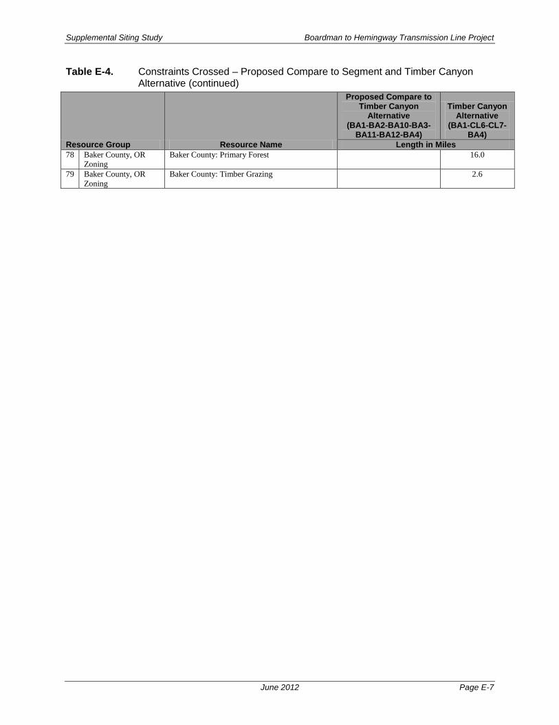
Supplemental Siting Study Boardman to Hemingway Transmission Line Project
June 2012 Page E-7
Table E-4. Constraints Crossed – Proposed Compare to Segment and Timber Canyon Alternative (continued)
Resource Group Resource Name
Proposed Compare to Timber Canyon
Alternative (BA1-BA2-BA10-BA3-
BA11-BA12-BA4)
Timber Canyon Alternative
(BA1-CL6-CL7-BA4)
Length in Miles 78 Baker County, OR
Zoning Baker County: Primary Forest 16.0
79 Baker County, OR Zoning
Baker County: Timber Grazing 2.6

Supplemental Siting Study Boardman to Hemingway Transmission Line Project
June 2012 Page E-8
Table E-5. Constraints Crossed – Proposed Compare to Segment and Burnt River Mountain Alternative
Resource Group Resource Name
Proposed Compare to Burnt River Mountain
Alternative (BA12-BA4-BA13-BA20)
Burnt River Mountain
Alternative (BA12-BA20)
Length in Miles Total Length 16.8 16.8
1 Cultural Resources Within 1200ft Historic Trail Buffer 1.9 1.2 2 Fish and Wildlife ODFW Sage-grouse Habitat: Core Area 8.6 3 Fish and Wildlife ODFW Sage-grouse Habitat: Core Area Low
Density 4.3 1.1
4 Fish and Wildlife ODFW Sage-grouse Lek 2-mile Buffer (OR 2011): Unoccupied Pending
1.0
5 Fish and Wildlife ODFW Big Game Deer Winter Range 13.3 16.8 6 Fish and Wildlife ODFW Big Game Elk Winter Range 2.7 7 Fish and Wildlife USU Mule Deer Summer Range 2.4 8 Fish and Wildlife USU Mule Deer Winter Concentration 9.2 10.7 9 Fish and Wildlife USU Mule Deer Winter Range 16.8 14.4 10 Fish and Wildlife USFS Elk Summer Range Habitat 5.2 11 Fish and Wildlife USFS Elk Winter Range Habitat 5.1 12 Fish and Wildlife ODFW wildlife linkage range buffers - Mule
Deer 1.6 1.0
13 Fish and Wildlife ODFW wildlife linkage priority total rank - 4 0.2 0.2 14 Fish and Wildlife ODFW wildlife linkage priority total rank - 5 0.7 0.6 15 Fish and Wildlife ODFW wildlife linkage priority total rank - 6 0.5 16 Fish and Wildlife ODFW wildlife linkage priority total rank - 7 0.3 0.2 17 Fish and Wildlife Sage-grouse Action Area: Baker 16.8 2.5 18 Fish and Wildlife ORBIC Golden Eagle Nest 0.8 19 Fish and Wildlife Within 0.25mi USFW Oregon GOEA 0.5 20 Fish and Wildlife Within 0.75mi USFW Oregon GOEA 3.9 1.2 21 Fish and Wildlife ODFW Conservation Opportunity Area 1.0 1.5 22 Land Use Exclusive Farm Use Zone/Multiple Use
Range Zone 16.8 16.1
23 Land Use USDA Cropland 0.3 0.4 24 Land Use Military Training Route 15.0 15.0 25 Land Use The Nature Conservancy: Portfolio 0.5 26 Land Use Grazing Allotment (OR Mgmt Category: C) 7.5 2.9 27 Land Use Grazing Allotment (OR Mgmt Category: I) 2.6 4.6 28 Land Use Grazing Allotment (OR Mgmt Category: M) 1.8 0.9 29 Land Use Fire Management Unit (OR) 16.8 16.8 30 Land Use Fire Management Zone (OR) 16.8 16.8 31 Ownership Bureau of Land Management 6.3 4.6 32 Ownership Private Land 10.5 12.2 33 Geological Resources Erosion Hazard: High (NRCS Soil Data) 4.2 34 Geological Resources Erosion Hazard: Moderate (NRCS Soil Data) 8.9 8.3 35 Geological Resources Erosion Hazard: Low (NRCS Soil Data) 3.7 8.4 36 Geological Resources Oregon Landslide Feature: Fan 0.4 37 Geological Resources Oregon Landslide Feature: Talus-Colluvium 1.3 1.5 38 Geological Resources Prime Farmland/Arable Land: Soils Class 1-
4 14.3 10.4
39 Geological Resources OR Subsurface Rights - ALL 8.9 6.3 40 Geological Resources OR Subsurface Rights - NON 7.9 10.6 41 Other Features West-wide Energy Corridor 0.3 0.2 42 Other Features Within 500ft of Pipeline 0.2 2.0 43 Visual Resources BLM Visual Resource Management Class 2 -
OR 1.6
44 Visual Resources BLM Visual Resource Management Class 3 - OR
6.3 3.0

Supplemental Siting Study Boardman to Hemingway Transmission Line Project
June 2012 Page E-9
Table E-5. Constraints Crossed – Proposed Compare to Segment and Burnt River Mountain Alternative (continued)
Resource Group Resource Name
Proposed Compare to Burnt River Mountain
Alternative (BA12-BA4-BA13-BA20)
Burnt River Mountain
Alternative (BA12-BA20)
Length in Miles 45 Water and Wetlands Oregon Wetland 0.1 0.3 46 Water and Wetlands Oregon Wetland Soils 0.4 47 Water and Wetlands Oregon Watershed Restoration Inventory
Project Area 0.1 0.4
48 Oregon Zoning Zoning: Agriculture 16.8 16.1 49 Oregon Zoning Zoning: Rural Industrial 0.7 50 Baker County, OR
Zoning Baker County: Exclusive Farm Use 16.8 16.8
51 Baker County, OR Zoning
Baker County: Industrial 0.8

Supplemental Siting Study Boardman to Hemingway Transmission Line Project
June 2012 Page E-10
Table E-6. Constraints Crossed – Proposed Compare to Segment and Double Mountain Alternative
Resource Group Resource Name
Proposed Compare to Double Mountain
Alternative (MA2-MA3)
Double Mountain
Alternative (MA2-MA7-MA3)
Length in Miles Total Length 7.4 7.4
1 Fish and Wildlife ODFW Big Game Deer Winter Range 1.3 0.2 2 Fish and Wildlife USU Mule Deer Limited Range 2.7 3.8 3 Fish and Wildlife USU Mule Deer Year Round Population 4.7 3.5 4 Land Use USDA Cropland 0.0 5 Land Use Military Training Route 5.2 1.5 6 Land Use Grazing Allotment (OR Mgmt Category: M) 7.1 7.4 7 Land Use SEORMP ROS Rural 6.2 8 Land Use SEORMP ROS Semiprimitive Motorized 0.0 4.5 9 Land Use SEORMP ROS Semiprimitive Non-
motorized 1.1 2.8
10 Land Use Proposed Wilderness Study Area (ONDA) 0.0 3.7 11 Land Use Vale District Wilderness Characteristic Unit:
Meets Criteria 4.6
12 Land Use Wildland Urban Interface (OR) 7.4 7.4 13 Land Use Fire Management Unit (OR) 7.4 7.4 14 Land Use Fire Management Zone (OR) 7.4 7.4 15 Ownership Bureau of Land Management 1.2 7.4 16 Ownership Private Land 6.2 17 Geological
Resources OR Subsurface Rights - ALL 4.1 6.5
18 Geological Resources
OR Subsurface Rights - ALX 0.2
19 Geological Resources
OR Subsurface Rights - NON 3.0 0.9
20 Visual Resources BLM Visual Resource Management Class 4 - OR
1.2 7.4
21 Water and Wetlands Oregon Wetland 0.1 0.0 22 Oregon Zoning Zoning: Agriculture (Range) 7.4 7.4 23 Malheur County, OR
Zoning Malheur County: Agriculture (Range) 7.4 7.4

Supplemental Siting Study Boardman to Hemingway Transmission Line Project
June 2012 Page E-11
Table E-7. Constraints Crossed – Proposed Compare to Segment and Malheur S / A Alternatives
Resource Group Resource Name
Proposed Compare to
Malheur S & A Alternatives
(MA1-MA2-MA3-MA4-MA5)
Malheur S Alternative
(MA1-MA12-MA6-MA4-
MA5)
Malheur A Alternative
(MA1-MA12-MA6-MA9-
MA11-MA5) Length in Miles
Total Length 30.5 33.6 33.2 1 Fish and Wildlife ODFW Sage-grouse Habitat: Core
Area Low Density 5.4 5.4
2 Fish and Wildlife ODFW Sage-grouse Lek 2-mile Buffer (OR 2011): Unoccupied Pending
3.8
3 Fish and Wildlife ODFW Big Game Deer Winter Range
19.8 15.8 15.1
4 Fish and Wildlife USU Mule Deer Limited Range 9.9 20.1 19.9 5 Fish and Wildlife USU Mule Deer Year Round
Population 20.6 13.5 13.3
6 Fish and Wildlife ODFW wildlife linkage range buffers - Mule Deer
1.0 1.0 1.0
7 Fish and Wildlife ODFW wildlife linkage priority total rank - 6
0.2 0.2 0.2
8 Fish and Wildlife ODFW wildlife linkage priority total rank - 7
0.8 0.8 0.8
9 Fish and Wildlife Sage-grouse Action Area: Crowley 5.0 5.0 10 Fish and Wildlife ORBIC Golden Eagle Nest 1.3 1.0 11 Fish and Wildlife Within 0.25mi USFW Oregon GOEA 0.6 0.3 12 Fish and Wildlife Within 0.75mi USFW Oregon GOEA 4.6 4.6 13 Fish and Wildlife ODFW Conservation Opportunity
Area 8.3 8.2 7.7
14 Land Use Area of Critical Environmental Concern
1.3 2.4
15 Land Use Exclusive Farm Use Zone/Multiple Use Range Zone
1.2
16 Land Use USDA Cropland 0.1 17 Land Use Military Training Route 28.4 19.1 25.5 18 Land Use Special Recreation Management Area
(Malheur RA, Vale District, OR) 1.3 2.4
19 Land Use The Nature Conservancy: Portfolio 8.8 13.6 12.9 20 Land Use Grazing Allotment (OR Mgmt
Category: C) 2.4
21 Land Use Grazing Allotment (OR Mgmt Category: I)
10.2 16.6 15.1
22 Land Use Grazing Allotment (OR Mgmt Category: M)
17.1 17.0 18.1
23 Land Use SEORMP ROS Roaded Natural 3.5 4.0 4.1 24 Land Use SEORMP ROS Rural 6.3 0.1 0.1 25 Land Use SEORMP ROS Semiprimitive
Motorized 18.4 21.4 20.3
26 Land Use SEORMP ROS Semiprimitive Non-motorized
2.3 8.1 8.7
27 Land Use Vale District Off-Highway Vehicle: Limited to Designated Routes
1.0 1.4 4.0
28 Land Use Vale District Off-Highway Vehicle: Limited to Existing Routes
10.8 9.4 7.4
29 Land Use Proposed Wilderness Study Area (ONDA)
2.2 11.3 12.0
30 Land Use Wildland Urban Interface (OR) 30.5 33.6 33.2

Supplemental Siting Study Boardman to Hemingway Transmission Line Project
June 2012 Page E-12
Table E-7. Constraints Crossed – Proposed Compare to Segment and Malheur S / A Alternatives s (continued)
Resource Group Resource Name
Proposed Compare to
Malheur S & A Alternatives
(MA1-MA2-MA3-MA4-MA5)
Malheur S Alternative
(MA1-MA12-MA6-MA4-
MA5)
Malheur A Alternative
(MA1-MA12-MA6-MA9-
MA11-MA5) Length in Miles
31 Land Use Fire Management Unit (OR) 30.5 33.6 33.2 32 Land Use Fire Management Zone (OR) 30.5 33.6 33.2 33 Ownership Bureau of Land Management 23.7 32.5 31.2 34 Ownership Bureau of Reclamation 0.4 0.1 0.4 35 Ownership Private Land 6.4 1.1 1.5 36 Ownership Water 0.0 0.1 37 Geological Resources Oregon Landslide Feature: Landslide 0.1 1.2 38 Geological Resources U.S. Geological Survey Active
Mining Area 0.2
39 Geological Resources OR Subsurface Rights - ALL 27.2 29.3 28.9 40 Geological Resources OR Subsurface Rights - ALX 0.2 41 Geological Resources OR Subsurface Rights - NON 3.0 4.3 4.3 42 Geological Resources OR Subsurface Rights - UND 0.0 0.1 43 Other Features Vale District Utility Corridor 12.2 7.1 3.9 44 Other Features West-wide Energy Corridor 0.7 3.4 3.4 45 Visual Resources BLM Visual Resource Management
Class 2 - OR 0.5 1.5 2.3
46 Visual Resources BLM Visual Resource Management Class 3 - OR
2.8 2.5 2.5
47 Visual Resources BLM Visual Resource Management Class 4 - OR
18.4 26.8 26.0
48 Water and Wetlands NHD Stream/River 0.0 49 Water and Wetlands Oregon Wetland 0.2 0.2 0.1 50 Water and Wetlands Wild and Scenic River - Suitable 1.0 1.0 1.1 51 Oregon Zoning Zoning: Agriculture 1.2 52 Oregon Zoning Zoning: Agriculture (Range) 29.3 33.6 33.2 53 Malheur County, OR
Zoning Malheur County: Agriculture 1.2
54 Malheur County, OR Zoning
Malheur County: Agriculture (Range) 29.3 33.6 33.2

Supplemental Siting Study Boardman to Hemingway Transmission Line Project
June 2012 Page E-13
Table E-8. Constraints Crossed – Proposed Compare to Segment and Willow Creek and Tub Mountain South Alternatives
Resource Group Resource Name
Proposed Compare to Willow Creek
and Tub Mountain South Alternatives (BA21-BA19-CL9-
MA13-MA14-MA15)
Willow Creek Alternative
(BA21-BA19-CL11-MA16-MA14-MA15)
Tub Mountain South
Alternative (BA21-CL12-
MA15) Length in Miles
Total Length 34.3 28.7 34.7 1 Cultural Resources Within 1200ft Historic Trail Buffer 2.7 2 Cultural Resources Intact Oregon Trail Segment (OR
BLM) 2.9
3 Cultural Resources Oregon Trail Brochure - Trailrut 0.5 4 Fish and Wildlife ODFW Sage-grouse Habitat: Core
Area 20.4 15.5 6.7
5 Fish and Wildlife ODFW Sage-grouse Habitat: Core Area Low Density
13.9 6.0 1.9
6 Fish and Wildlife ODFW Sage-grouse Lek 2-mile Buffer (OR 2011): Occupied Pending
3.2
7 Fish and Wildlife ORBIC Sage-grouse 3.6 8 Fish and Wildlife ODFW Big Game Deer Winter
Range 20.2 23.6 31.2
9 Fish and Wildlife ODFW Big Game Elk Winter Range 29.6 19.7 18.3 10 Fish and Wildlife USU Mule Deer Winter
Concentration 0.6 0.6 1.6
11 Fish and Wildlife USU Mule Deer Winter Range 0.6 0.6 10.0 12 Fish and Wildlife USU Mule Deer Year Round
Population 33.8 28.2 24.7
13 Fish and Wildlife ODFW wildlife linkage range - Whitetailed Jackrabbit
10.6
14 Fish and Wildlife ODFW wildlife linkage range buffers - Elk
1.6
15 Fish and Wildlife ODFW wildlife linkage range buffers - Mule Deer
1.6 1.1 1.1
16 Fish and Wildlife ODFW wildlife linkage range buffers - Pronghorn Antelope
1.6
17 Fish and Wildlife ODFW wildlife linkage range buffers - White-tailed Jackrabbit
1.6
18 Fish and Wildlife ODFW wildlife linkage priority total rank - 4
1.1
19 Fish and Wildlife ODFW wildlife linkage priority total rank - 5
1.6 1.1
20 Fish and Wildlife Sage-grouse Action Area: Bully Creek
16.0 4.8 1.4
21 Fish and Wildlife Sage-grouse Action Area: Cow Valley
16.9 12.6
22 Land Use Exclusive Farm Use Zone/Multiple Use Range Zone
6.9 5.7 8.3
23 Land Use USDA Cropland 0.0 2.0 2.8 24 Land Use Military Training Route 4.6 25 Land Use The Nature Conservancy: Portfolio 3.2 2.3 12.9 26 Land Use Grazing Allotment (OR Mgmt
Category: C) 10.0 3.8 1.9
27 Land Use Grazing Allotment (OR Mgmt Category: I)
10.1 14.0 19.7
28 Land Use Grazing Allotment (OR Mgmt Category: M)
9.3 0.8 5.4

Supplemental Siting Study Boardman to Hemingway Transmission Line Project
June 2012 Page E-14
Table E-8. Constraints Crossed – Proposed Compare to Segment and Willow Creek and Tub Mountain South Alternatives (continued)
Resource Group Resource Name
Proposed Compare to Willow Creek
and Tub Mountain South Alternatives (BA21-BA19-CL9-
MA13-MA14-MA15)
Willow Creek Alterantive
(BA21-BA19-CL11-MA16-MA14-MA15)
Tub Mountain South
Alternative (BA21-CL12-
MA15) Length in Miles
29 Land Use SEORMP ROS Roaded Natural 2.8 0.8 30 Land Use SEORMP ROS Rural 2.4 12.0 3.5 31 Land Use SEORMP ROS Semiprimitive
Motorized 13.8 10.9 21.8
32 Land Use SEORMP ROS Semiprimitive Non-motorized
8.4 2.9
33 Land Use Vale District Off-Highway Vehicle: Limited to Existing Routes
7.3 14.7
34 Land Use Wildland Urban Interface (ID) 2.8 35 Land Use Wildland Urban Interface (OR) 27.4 23.9 29.4 36 Land Use Fire Management Unit (OR) 34.3 28.7 34.7 37 Land Use Fire Management Zone (OR) 34.3 28.7 34.7 38 Ownership Bureau of Land Management 19.4 14.5 25.6 39 Ownership Private Land 12.0 14.3 9.1 40 Ownership State Land 3.0 41 Geological Resources Erosion Hazard: High (NRCS Soil
Data) 0.5 1.7 3.6
42 Geological Resources Erosion Hazard: Moderate (NRCS Soil Data)
2.2 1.2 2.9
43 Geological Resources Erosion Hazard: Low (NRCS Soil Data)
4.3 2.9 1.6
44 Geological Resources Oregon Landslide Feature: Landslide
1.3
45 Geological Resources Prime Farmland/Arable Land: Soils Class 1-4
2.0 2.9 6.5
46 Geological Resources OR Subsurface Rights - ALL 25.2 18.3 23.7 47 Geological Resources OR Subsurface Rights - ALX 1.9 48 Geological Resources OR Subsurface Rights - NON 9.1 10.4 9.1 49 Other Features Vale District Utility Corridor 1.7 3.5 10.0 50 Other Features West-wide Energy Corridor 4.2 51 Other Features Within 500ft of Pipeline 1.4 52 Visual Resources BLM Visual Resource Management
Class 3 - OR 1.0 1.3 9.1
53 Visual Resources BLM Visual Resource Management Class 4 - OR
18.4 9.7 14.8
54 Water and Wetlands Oregon Wetland 0.2 0.1 0.3 55 Water and Wetlands Oregon Wetland Soils 0.1 56 Water and Wetlands Oregon Watershed Restoration
Inventory Project Area 0.3
57 Oregon Zoning Zoning: Agriculture 6.9 5.7 8.3 58 Oregon Zoning Zoning: Agriculture (Range) 27.4 23.0 26.4 59 Baker County, OR
Zoning Baker County: Exclusive Farm Use 6.9 4.8 5.3
60 Malheur County, OR Zoning
Malheur County: Agriculture 1.0 3.0
61 Malheur County, OR Zoning
Malheur County: Agriculture (Range)
27.4 23.0 26.4

Boardman to Hemingway Transmission Line Project Exhibit B
ATTACHMENT B-3 COMPARISON OF WESTERN, CENTRAL, AND EASTERN CORRIDORS
AMENDED PRELIMINARY APPLICATION FOR SITE CERTIFICATE

Boardman to Hemingway Transmission Line Project Exhibit B
Table B-3-1. Western, Central, and Eastern Resource Comparisons
Resource Group Regulatory Criteria Description Permitting Difficulty1
Potential OAR 345-021-
0010(1)(b)(D) Factors
Western Route
Central Route
Eastern Route
Length in Miles TOTAL LENGTH 275.1 281.9 298.8
1 Cultural Resources
Burns District Archaeological Site Avoidance High vi 0.1 - - 2 Within 1200ft Historic Trail Buffer Avoidance Mod vi 0.5 0.7 5.1 3 Within .5 mi National Register Historic Place Buffer Avoidance High vi 0.8 0.8 0.8 4 Intact Oregon Trail Segment (OR BLM) Avoidance High vi 0.5 0.3 0.5 5 Oregon Trail Brochure – Trail rut Avoidance High vi - - 0.5 6 Visual Resources Viewshed Area (Baker County) Avoidance High O2 - - 4.9 7 Within 1200ft Nationally Designated Scenic Byway Avoidance Mod O 2.0 2.7 2.0 8 National Forest Visual Quality Objective: Maximum
Modification Opportunity O 5.3 - -
9 National Forest Visual Quality Objective: Modification Avoidance Mod O - 7.7 0.4 10 National Forest Visual Quality Objective: Partial
Retention Avoidance High O 5.3 20.5 3.6
11 National Forest Visual Quality Objective: Retention Exclusion O 0.2 1.4 1.4 12 BLM Visual Resource Management Class 2 Avoidance High O 3.6 3.6 3.6 13 BLM Visual Resource Management Class 3 Avoidance Mod O 4.9 4.7 4.7 14 BLM Visual Resource Management Class 4 Avoidance Low O 48.4 35.7 36.3 15 Fish and Wildlife ODFW Conservation Opportunity Area Avoidance Low ii 22.4 40.1 36.3 16 IDFG Focal Area Avoidance Low ii 11.0 11.0 11.0 17 ODFW Big Game Deer Winter Range Avoidance Mod ii 104.9 101.9 114.7 18 ODFW Big Game Elk Winter Range Avoidance Mod ii 105.4 92.9 68.6 19 Pronghorn Antelope Habitat (Boise District, ID) Avoidance Mod ii 23.8 23.8 23.8 20 Prineville District Fish Restoration Area Avoidance Mod ii 2.1 - - 21 Prineville District Wildlife Habitat Seasonal Closure
Area Avoidance Mod ii 49.0 - -
AMENDED PRELIMINARY APPLICATION FOR SITE CERTIFICATE B-3-1

Boardman to Hemingway Transmission Line Project Exhibit B
Resource Group Regulatory Criteria Description Permitting Difficulty1
Potential OAR 345-021-
0010(1)(b)(D) Factors
Western Route
Central Route
Eastern Route
Length in Miles 22 Fish and Wildlife
(cont.) Sage-grouse Core Area 1: Sagebrush Habitat (Oregon)
Avoidance Mod ii 28.2 37.1 56.9
23 Sage-grouse Core Area 2: Potential Habitat (Oregon) Avoidance Low ii 117.6 105.6 148.9 24 Sage-grouse Core Area 3: Non-Sagebrush Shrublands
and Grasslands (Oregon) Avoidance Low ii 65.6 59.2 17.8
25 Within 2-mile Oregon Sage-grouse Lek Buffer (Occupied but Permittable)
Avoidance Mod ii - - 10.0
26 Within 2-mile Oregon Sage-grouse Lek Buffer (Unoccupied)
Avoidance Low ii - - 5.4
27 Within 300ft Special Status Stream: Bull Trout Avoidance Mod i 0.4 (3
crossings)
1.0 (8
crossings)
0.1 (1
crossing) 28 Within 300ft Special Status Stream: Chinook Salmon Avoidance Mod i 0.2
(2 crossings)
0.1 (1
crossing)
0.1 (1
crossing) 29 Within 300ft Special Status Stream: Coho Salmon Avoidance Mod i - 0.1
(1 crossing)
0.1 (1
crossing) 30 Within 300ft Special Status Stream: Cutthroat Trout Avoidance Mod i 0.5
(4 crossings)
- -
31 Within 300ft Special Status Stream: Red Band Trout Avoidance Mod i 2.5 (19
crossings)
- -
32 Within 300ft Special Status Stream: Steelhead Avoidance Mod i 2.4 (18
crossings)
0.4 (3
crossings)
0.6 (5
crossings) 33 Wild Horse and Burro Area (OR BLM) Avoidance Low i 5.3 - -
AMENDED PRELIMINARY APPLICATION FOR SITE CERTIFICATE B-3-2

Boardman to Hemingway Transmission Line Project Exhibit B
Resource Group Regulatory Criteria Description Permitting Difficulty1
Potential OAR 345-021-
0010(1)(b)(D) Factors
Western Route
Central Route
Eastern Route
Length in Miles 34 Land Use Cropland/Irrigated Agriculture Avoidance High o 9.8 9.2 17.8 35 Exclusive Farm Use Zone/Multiple Use Range Zone Avoidance High viii 105.5 103.3 162.9 36 Grazing Allotment – ID Avoidance Low NA3 20.1 20.1 20.1 37 Grazing/Pasture – OR Avoidance Low O 92.5 90.7 114.3 38 Naval Weapons System Training Facility Avoidance Mod O - - 9.1 39 Forested Land: Private Avoidance Mod O 19.5 29.3 17.9 40 Forested Land: Public Avoidance Mod O 38.4 28.9 4.3 41 National Forest Old Growth Forest Stand Exclusion ii 2.7 - - 42 Area of Critical Environmental Concern Avoidance High v 3.7 3.7 3.7 43 Prineville District Lands Proposed for Acquisition by
BLM Avoidance Low O 12.5 - -
44 Prineville District Noxious Weeds Avoidance Low O 2.7 - - 45 Prineville District Off-Highway Vehicle: Limited Use Avoidance Low O 3.2 - - 46 Vale District Off-Highway Vehicle: Limited to
Designated Routes Avoidance Low O 5.4 5.4 5.4
47 Vale District Off-Highway Vehicle: Limited to Existing Routes
Avoidance Low O 11.6 8.6 8.6
48 Oregon State Park Exclusion v - 0.2 0.2 49 Morrow County Park Exclusion v 0.5 - - 50 Virtue Flat OHV Park Avoidance Mod v - - 0.1 51 Special Recreation Management Area (Malheur
Resource Management Area, Vale District, OR) Avoidance Mod v 3.7 3.7 3.7
52 Prineville District Special Recreation Management Area
Avoidance Mod O 4.9 - -
53 The Nature Conservancy: Portfolio Avoidance Mod O 75.5 83.6 86.1 54 Wind Farm Boundary Avoidance High O 1.3 1.3 - 55 Wind Turbine 1200ft Buffer Zone Avoidance Mod O 0.3 0.3 -
AMENDED PRELIMINARY APPLICATION FOR SITE CERTIFICATE B-3-3

Boardman to Hemingway Transmission Line Project Exhibit B
Resource Group Regulatory Criteria Description Permitting Difficulty1
Potential OAR 345-021-
0010(1)(b)(D) Factors
Western Route
Central Route
Eastern Route
Length in Miles 56 Land Use (cont.) Proposed Wilderness Study Area (ONDA) Avoidance Mod O 45.4 15.0 15.0 57 Lands with Wilderness Characteristics (OR BLM) Avoidance Mod O 5.0 - - 58 Ownership Bureau of Land Management Avoidance Low O 67.6 54.3 63.6 59 Bureau of Reclamation Avoidance Low O 0.3 0.3 0.3 60 Military Land Avoidance Low O - - 8.1 61 Private Avoidance Low O 137.6 173.6 197.6 62 State Land Avoidance Low O 2.2 - 0.1 63 U.S. Forest Service Avoidance Low O 43.5 29.9 5.4 64 Geological
Resources Erosion Hazard: High (Prineville District, OR) Avoidance Mod vii 24.4 - -
65 Erosion Hazard: High (NRCS Soil Data – Grant Co, OR data NA)
Avoidance Mod vii 31.9 53.4 39.3
66 Erosion Hazard: Moderate (NRCS Soil Data – Grant Co, OR data NA)
Avoidance Mod vii 22.9 39.3 88.9
67 Erosion Hazard: Low (NRCS Soil Data – Grant Co, OR data NA)
Avoidance Low vii 37.6 41.7 75.2
68 Idaho Landslide Susceptibility: Low Avoidance Low vii 23.8 23.8 23.8 69 Within 500ft of Fault Line Avoidance Low vii 13.6 11.5 13.6 70 U.S. Geological Survey Active Mining Area Avoidance High vii 0.2 - 0.1 71 Prime Farmland/Arable Land: Soils Class 1-4 Avoidance Mod vii 62.7 125.9 155.7 72 Oregon Landslide Feature: Fan Avoidance Mod vii - 5.3 - 73 Oregon Landslide Feature: Landslide Avoidance Mod vii 11.4 5.7 4.2 74 Oregon Landslide Feature: Talus-Colluvium Avoidance Mod vii 5.5 3.2 1.4 75 Slope Slope 0-15% Opportunity vii 152.3 177.0 215.7 76 Slope 15-25% Avoidance Low vii 63.8 48.8 48.3 77 Slope 25-35% Avoidance Mod vii 35.4 28.1 19.8 78 Slope >35% Avoidance High vii 23.5 28.0 14.9
AMENDED PRELIMINARY APPLICATION FOR SITE CERTIFICATE B-3-4

Boardman to Hemingway Transmission Line Project Exhibit B
Resource Group Regulatory Criteria Description Permitting Difficulty1
Potential OAR 345-021-
0010(1)(b)(D) Factors
Western Route
Central Route
Eastern Route
Length in Miles 79 Water and
Wetlands Floodplain: Area Not Mapped Avoidance Low i 3.6 41.5 54.0
80 Floodplain: Not in Flood Zone Avoidance Low i 60.6 82.3 83.2 81 Floodplain: Zone A Avoidance Mod i 0.7 1.2 0.3 82 National Wetland Inventory Avoidance Mod i 0.4 0.7 0.7 83 Oregon Watershed Restoration Inventory Project
(within 500ft Buffer of linear feature) Avoidance Mod i 0.5 - -
84 Oregon Watershed Restoration Inventory Project Area Avoidance Low i 3.0 - 2.2 85 Other Features Within 200ft of Existing Pipeline Opportunity O 0.1 1.2 1.7 86 Vale District Utility Corridor Opportunity iii 3.1 5.9 3.4 87 West-wide Energy Corridor Opportunity iii 19.9 19.9 19.9 88 National Forest Utility Corridor Opportunity iii - 5.4 5.4 89 Parallel to Existing Transmission Line Opportunity iii 46.3 58.4 105.0 Notes: 1 For explanation of Permitting Difficulty categories, see Attachment B-1, Section 3.1, Table 3.1-1. 2 O – Other than one of the eight factors under OAR 345-021-0010(1)(b)(D) 3 NA – Not Applicable BLM – Bureau of Land Management; ft – foot; NRCS – Natural Resources Conservation Service; OAR – Oregon Administrative Rules; Oregon Natural Desert Association
AMENDED PRELIMINARY APPLICATION FOR SITE CERTIFICATE B-3-5

Boardman to Hemingway Transmission Line Project Exhibit B
ATTACHMENT B-4 2015 SUPPLEMENTAL SITING STUDY
AMENDED PRELIMINARY APPLICATION FOR SITE CERTIFICATE

Boardman to Hemingway Transmission Line Project 2015 Supplemental Siting Study
Prepared By
Idaho Power Company 1221 West Idaho Street Boise, ID 83702
November 2015

2015 Supplemental Siting Study Boardman to Hemingway Transmission Line Project
November 2015 iii
Table of Contents 1 INTRODUCTION ................................................................................................................ 1
2 REASONS FOR FURTHER SITING STUDY ...................................................................... 1
2.1 BLM’s Environmentally and Agency Preferred Alternative ......................................... 1 2.2 Oregon Department of Fish and Wildlife Comments .................................................. 2 2.3 IPC Developed Changes ........................................................................................... 2
3 ROUTE MODIFICATIONS ................................................................................................. 2
3.1 Macro Changes by County ........................................................................................ 2 3.1.1 Morrow County, Oregon ................................................................................. 3 3.1.2 Union County, Oregon.................................................................................... 6 3.1.3 Baker County, Oregon.................................................................................... 8 3.1.4 Malheur County, Oregon .............................................................................. 11 3.1.5 Owyhee County, Idaho ................................................................................. 15
3.2 Micro Corridor Adjustments ..................................................................................... 15
4 REFERENCES ................................................................................................................. 16
List of Appendices
Appendix A ODFW Letter
Appendix B Table of Micro Corridor Adjustments between 2012 and 2015

2015 Supplemental Siting Study Boardman to Hemingway Transmission Line Project
November 2015 iv
List of Tables
Table 3.1-1. Summary of the EFSC and NEPA Status of the Routes and Stations Considered in the pASC or Amended pASC .................................................. 1
Table 3.1-2. Comparison of Constraints Between the Proposed Route and Double Mountain Alternative in Malheur County ..................................................... 146
Table 3.2-1. Summary of Micro Corridor Adjustments by County between 2012 and 2015. ...... 17
List of Figures
Figure 3.1-1. Changes in Morrow County Between 2012 and 2015............................................. 6
Figure 3.1-2. Changes in Union County Between 2012 and 2015 (Glass Hill Alternate Corridor Segment). ......................................................................................... 7
Figure 3.1-3. Changes in Baker County Between 2012 and 2015 (Timber Canyon Alternative, and Virtue Flat and Durkee Alternative Corridor Segments) ...... 10
Figure 3.1-4. Changes in Malheur County Between 2012 and 2015 .......................................... 15

2015 Supplemental Siting Study Boardman to Hemingway Transmission Line Project
November 2015 v
Acronyms and Abbreviations
ACEC area of critical environmental concern
BLM Bureau of Land Management
Bombing Range Naval Weapons System Training Area
BPA Bonneville Power Administration
CAP Community Advisory Process
DEIS Draft Environmental Impact Statement
EBRR Route East of Bombing Range Road Alternative
EFSC Energy Facility Siting Council
IPC Idaho Power Company
kV kilovolt
NHOTIC National Historic Oregon Trail Interpretive Center
ODFW Oregon Department of Fish and Wildlife
pASC preliminary Application for Site Certificate
PGE Portland General Electric
PPH Preliminary Preferred Habitat
Project Boardman to Hemingway Transmission Line Project
RMP Resource Management Plan
ROW right-of-way
USFS U.S. Department of Agriculture Forest Service
WAGS Washington ground squirrel
WBRR Route West of Bombing Range Road Route

2015 Supplemental Siting Study Boardman to Hemingway Transmission Line Project
November 2015 1
1 INTRODUCTION
This 2015 Supplemental Siting Study addresses the changes to the proposed and alternate routes for the Boardman to Hemingway Transmission Line Project (Project) that have been developed since May 2012, when Idaho Power Company (IPC) completed its 2012 Supplemental Siting Study. The 2012 Supplemental Siting Study formed the basis for IPC’s preliminary Application for Site Certificate (pASC) in February 2013. Since the 2012 Supplemental Siting Study and filing of the pASC, the Project has undergone some macro (major) and micro (minor) route adjustments. The macro changes include the addition of alternates and the determination not to carry some alternates and stations forward into the Amended pASC; the micro changes include making minor line and road location adjustments to avoid sensitive resources, reduce redundancy of project features, and improve the preliminary engineering design. Section 2 explains why IPC modified the Project following filing of its 2013 pASC. Section 3 describes the macro changes (Section 3.1) and the micro changes (Section 3.2)
2 REASONS FOR FURTHER SITING STUDY
After filing the pASC for the Project in 2013, IPC performed additional analysis and revision to the Project. The primary factors driving the need for modifying the Project included:
The Bureau of Land Management’s (BLM) identification of an environmentally- and agency-preferred alternative that included several segments not analyzed in the pASC;
Formal guidance from the Oregon Department of Fish and Wildlife (ODFW) regarding its interpretation of its Habitat Mitigation policy and sage-grouse guidance;
Further coordination with stakeholders in the Boardman, Oregon area;
Continued engineering to minimize impacts and improve design;
Response to agency comments; and
Route refinements by IPC due to engineering analysis and further coordination with partners regarding the northern terminus of the Project.
2.1 BLM’s Environmentally and Agency Preferred Alternative
In December 2014, BLM released its Draft Environmental Impact Statement (DEIS), identifying its Environmentally Preferred Alternative and Agency Preferred Alternative, both of which were the same alignment (outlined in Table 3.1-1). The key resource criteria BLM identified were:
Cultural resources, including historic trails, visual impacts on historic properties, and prehistoric archaeological sites
Fish presence and stream crossings
Native vegetation and forest and riparian habitats;
Overall visibility from key observations points, and BLM and U.S. Department of Agriculture Forest Service (USFS) visual management objectives and criteria
Greater sage-grouse, big-game winter range, raptors, special status species, and sensitive species
BLM selected the Agency Preferred Alternative that it believed will fulfill the statutory mission and responsibilities of the relevant agencies, including giving consideration to economic,

2015 Supplemental Siting Study Boardman to Hemingway Transmission Line Project
November 2015 2
environmental, technical, and other factors. In addition to the resource criteria listed above, BLM considered the following:
Certain sensitive areas (Areas of Critical Environmental Concern, lands with wilderness characteristics, and wild and scenic suitable rivers);
Agriculture;
Use of corridors (West-wide Energy Corridor, BLM Vale District corridor, and USFS corridors; proximity to existing roads including Interstate 84; adjacency to existing transmission lines);
Socioeconomics; and
Technical and other considerations (military operations, constructability, and Resource Management Plan (RMP) and USFS plan conformance)
2.2 Oregon Department of Fish and Wildlife Comments
By letter dated August 23, 2013, ODFW raised concerns regarding certain portions of the Project set forth in the pASC that impacted Category 1 sage-grouse habitat, including the Community Advisory Process (CAP)-developed Virtue Flat, Brogan, and Durkee routes. Due to ODFW’s concerns and other considerations, those three segments are not carried forward in the Amended pASC.
2.3 IPC Developed Changes
Since submittal of the pASC, IPC performed more detailed engineering analyses that resulted in route adjustments and changes to avoid sensitive resources as well as improve constructability. In coordination with permitting partners PacifiCorp and Bonneville Power Administration (BPA) and other stakeholders, IPC also added a new route to the northern terminus of the Project, and eliminated the Grassland and Horn Butte stations (and the routes that led to those stations) because they no longer meet the objectives of the Project.
3 ROUTE MODIFICATIONS
3.1 Macro Changes by County
This section describes changes to the proposed corridor and alternate corridor segments by county that have been identified since the 2012 Supplemental Siting Study.
The naming convention and map labeling identifies IPC’s EFSC Proposed Route and BLM’s preferred alternative in red, IPC’s EFSC alternate route segments in green, the BLM alternatives not selected by the agency in blue, and routes that will not be analyzed in the Amended pASC in purple (see Table 3.1-1). Figures in this section show an overview of the route locations and details of the route adjustments between 2012 and 2015. Tables in this section compare the constraints between the Proposed Route and alternate route segments.

2015 Supplemental Siting Study Boardman to Hemingway Transmission Line Project
November 2015 1
Table 3.1-1. Summary of the EFSC and NEPA Status of the Routes and Stations Considered in the pASC or Amended pASC
Route/Station Originator
Route/Station Designation
EFSC Status Status in DEIS
Morrow County
IPC
Proposed Route (includes West of Bombing Range Road Route and Longhorn Station)
Proposed Route and Station
The portion of the Proposed Route on the west side of Bombing Range Road was not considered in the DEIS; however, the southern portion of the Proposed Route from approximately Bombing Range Road to the Umatilla County border was included as part of BLM’s Preferred Alternative. Longhorn Station was also part of BLM’s Preferred Alternative
IPC
East of Bombing Range Road Route and Longhorn Station/Longhorn Variation
Not Analyzed in Amended pASC
BLM’s Preferred Alternative
IPC Longhorn Alternative and Longhorn Station
Not Analyzed in Amended pASC
Considered But Not Selected by BLM
IPC
Grassland Route and Grassland Station (formerly the Proposed Route)
Not Analyzed in Amended pASC
Considered But Not Selected by BLM
IPC Horn Butte Alternative and Horn Butte Station
Not Analyzed in Amended pASC
Considered But Not Selected by BLM
Umatilla County
IPC Proposed Route Proposed Route BLM’s Preferred Alternative
Union County
IPC Proposed Route Proposed Route BLM’s Preferred Alternative
BLM Timber Canyon Alternative
Not Analyzed in Amended pASC
Considered But Not Selected by BLM
IPC Glass Hill Alternative Not Analyzed in Amended pASC
Considered But Not Selected by BLM

2015 Supplemental Siting Study Boardman to Hemingway Transmission Line Project
November 2015 2
Route/Station Originator
Route/Station Designation
EFSC Status Status in DEIS
Baker County
IPC
Proposed Route (includes 138/69-kv Rebuild, Burnt River Mountain Alternative, Flagstaff Alternative and 230-kV Rebuild, and Tub Mountain Alternative)
Proposed Route BLM’s Preferred Alternative
BLM Timber Canyon Alternative
Not Analyzed in Amended pASC
Considered But Not Selected by BLM
BLM Flagstaff Alternative including 230-kV Rebuild
Proposed Route BLM’s Preferred Alternative
IPC Virtue Flat Route (formerly the Proposed Route)
Not Analyzed in Amended pASC
Considered But Not Selected by BLM
BLM Burnt River Mountain Alternative
Proposed Route BLM’s Preferred Alternative
IPC Durkee Route (formerly the Proposed Route)
Not Analyzed in Amended pASC
Considered But Not Selected by BLM
IPC 138/69-kV Rebuild Proposed Route BLM’s Preferred Alternative
BLM Tub Mountain South Alternative
Proposed Route BLM’s Preferred Alternative
IPC Brogan Route (formerly the Proposed Route)
Not Analyzed in Amended pASC
Considered But Not Selected by BLM
IPC Willow Creek Alternative
Not Analyzed in Amended pASC
Considered But Not Selected by BLM
Malheur County
IPC Proposed Route Proposed Route BLM’s Preferred Alternative
IPC Brogan Route (formerly the Proposed Route)
Not Analyzed in Amended pASC
Considered But Not Selected by BLM
IPC Willow Creek Alternative
Not Analyzed in Amended pASC
Considered But Not Selected by BLM
IPC Double Mountain Alternative
Alternate Route Segment
Considered But Not Selected by BLM
BLM Malheur A Alternative Not Analyzed in Amended pASC
Considered But Not Selected by BLM
IPC Malheur S Alternative Corridor
Not Analyzed in Amended pASC
Considered But Not Selected by BLM
Owyhee County, Idaho
IPC Proposed Route and Substation
N/A (outside EFSC jurisdiction)
Preferred Alternative
BLM – Bureau of Land Management EFSC – Energy Facility Siting Council IPC – Idaho Power Company N/A – not applicable NEPA – National Environmental Policy Act pASC – preliminary Application for Site Certificate

2015 Supplemental Siting Study Boardman to Hemingway Transmission Line Project
November 2015 3
3.1.1 Morrow County, Oregon
3.1.1.1 Proposed Station and Route
The Proposed Route and termination point in Morrow County consists of the West of Bombing Range Road Route and Longhorn Station, respectively. IPC is not proposing in the Amended pASC any alternate routes in Morrow County.
3.1.1.1.1 Proposed Longhorn Station
The termination point for the Project is the proposed Longhorn Station in the Boardman area (Figure 3.1-1). The Longhorn Station will be located on land zoned for Port Industrial use near existing transmission lines, between multiple interconnected stations and large generation sources. The Longhorn Station will provide interconnection into the existing transmission system providing access into the Mid-Columbia market. The Amended pASC contemplates that BPA or IPC would develop the Longhorn Station.
3.1.1.1.2 West of Bombing Range Road Route
The Proposed Route, also referred to as the West of Bombing Range Road Route (WBRR Route), is IPC’s Proposed Route through Morrow County. The WWRR Route is located along the eastern edge of the Naval Weapons Systems Training Facility Boardman (Bombing Range) and the western edge of Bombing Range Road. Heading south and west out away from the Longhorn Station, the WBRR Route crosses onto the Bombing Range to the west side of Bombing Range Road at approximately transmission line milepost 2.7, and runs parallel to Bombing Range Road on the west side for 9.4 miles. The WBRR Route then crosses the Bombing Range Road again to the east and then turns south for approximately 3.8 miles. The WBRR Route is partially located on land owned by the Department of the Navy and may impact Washington ground squirrel (WAGS) habitat. The Proposed Route then continues south and east toward Umatilla County (Figure 3.1-1).
The path to the Longhorn Station is highly constrained with significant agricultural operations, WAGS colonies and habitat, and Department of the Navy-managed lands and avigation easement restrictions in the vicinity. The WBRR Route was sited to minimize impacts to agriculture and included micrositing to avoid WAGS and other existing infrastructure (a buried water pipeline, two existing transmission lines, and the Bombing Range flight operations). Due to these constraints, the preferred right-of-way (ROW) for the WBRR Route is to be built in the existing BPA 69-kilovolt (kV) transmission line ROW. The existing 69-kV line will be removed, and UEC and BPA have agreed in principle to develop a strategy to maintain electric service to the area. The site boundary for the WBRR Route includes land on the east side of Bombing Range Road, extending approximately 250 feet east from the eastern edge of the road.

2015 Supplemental Siting Study Boardman to Hemingway Transmission Line Project
November 2015 4
Figure 3.1-1. Changes in Morrow County Between 2012 and 2015

2015 Supplemental Siting Study Boardman to Hemingway Transmission Line Project
November 2015 5
3.1.1.2 Routes Not Included in the Amended pASC
3.1.1.2.1 Grassland and Horn Butte Station Routes
At the time of the pASC, other transmission development projects were being proposed in the Pacific Northwest that influenced IPC’s northern terminus location options for the Project. Portland General Electric’s (“PGE”) Cascade Crossing 500-kV project was of particular note. In fact, in 2008, Idaho Power and PGE executed a Memorandum of Understanding concerning Boardman Area transmission development, with the intent of sharing development plans and developing facilities collaboratively to assist each company in fulfilling their respective service and system reliability obligations. The proposed Grassland Station was contemplated as an interconnection point between the two projects that could help each company with their respective project objectives. The proposed Horn Butte Station was introduced as an alternative location to connect to the Cascade Crossing project.
However, since the pASC, the transmission development landscape has changed. Several of the development projects under consideration during the time of pASC have subsequently been cancelled. Notably, in 2013, PGE indefinitely suspended the Cascade Crossing project.
In the absence of Cascade Crossing, the Grassland and Horn Butte station routes do not meet the Project objectives. Neither the Grassland nor Horn Butte stations would provide the required approximate 1,000 MW of bi-directional capacity and up to 1,500 MW of actual power flow capability. Therefore, the Grassland and Horn Butte station routes are not analyzed in the Amended pASC.
3.1.1.2.2 Longhorn Alternative
The Longhorn Alternative, leading to the Longhorn Station, was developed as an alternative to the Grassland and Horn Butte stations and routes. Because BLM did not choose the Longhorn Alternative as the agency’s preferred alternative route leading to the Longhorn Station, the Longhorn Alternative is not analyzed in the Amended pASC.
3.1.1.2.3 East of Bombing Range Road Route/Longhorn Variation
The East of Bombing Range Road Route (EBRR Route) or Longhorn Variation is a 9.4-mile segment located predominantly on private land in Morrow County. Heading south and west out away from the termination point at the Longhorn Station, the EBRR Route departs from the WBRR Route at approximately transmission line milepost 2.7 and continues along the east side of Bombing Range Road. The EBRR Route parallels Bombing Range Road for 9.4 miles before it rejoins the WBRR Route (Figure 3.1-1). The EBRR Routee is located predominantly on private land, will have agricultural impacts, and may impact WAGS habitat. The EBRR Route was chosen by BLM in the Draft EIS as part of the Agency and Environmentally Preferred Alternatives.
Since the pASC, IPC engaged with the local community regarding potential impacts to agricultural operations and flight operations at the Bombing Range regarding the EBRR Route. IPC determined that the WBRR Route, and not the EBRR Route, is the company’s preferred route to the Longhorn Station. Accordingly, the EBRR Route, as it was proposed in the pASC, is not analyzed in the Amended pASC. Even so, the site boundary for the WBRR Route includes land on the east side of Bombing Range Road (see Section 3.1.1.1.2 above). Umatilla County, Oregon
The portion of the Proposed Route occurring in Umatilla County was selected in the Draft EIS as part of BLM’s Agency and Environmentally Preferred Alternatives. That portion of the Project

2015 Supplemental Siting Study Boardman to Hemingway Transmission Line Project
November 2015 6
has not changed since the pASC. IPC is not proposing in the Amended pASC any alternate routes in Umatilla County.
3.1.2 Union County, Oregon
3.1.2.1 Proposed Route
The portion of the Proposed Route located in Union County was selected as part of BLM’s Agency and Environmentally Preferred Alternatives. IPC is not proposing in the Amended pASC any alternate routes in Union County.
3.1.2.2 Routes Not Included in the Amended pASC
3.1.2.2.1 Glass Hill Alternative
The Glass Hill Alternative is not being carried forward from the pASC into the Amended pASC because the Proposed Route has fewer deep drainages and stream crossings than the Glass Hill Alternative and parallels an existing 230-kV transmission line with an existing developed road system (see Figure 3.1-2). Additionally, the Glass Hill Alternative has steep terrain and would require the development of a new road system.
3.1.2.2.2 Timber Canyon Alternative
The Timber Canyon Alternative, which was to occur in Union and Baker counties, also will not be carried forward into the Amended pASC. Since it was most closely associated with resources in Baker County, it is discussed in more detail below in Section 3.1.4.

2015 Supplemental Siting Study Boardman to Hemingway Transmission Line Project
November 2015 7
Figure 3.1-2. Changes in Union County Between 2012 and 2015 (Glass Hill Alternative)

2015 Supplemental Siting Study Boardman to Hemingway Transmission Line Project
November 2015 8
3.1.3 Baker County, Oregon
3.1.3.1 Proposed Route
The portion of the Proposed Route located in Baker County was selected as part of BLM’s Agency and Environmentally Preferred Alternatives and includes the Flagstaff Alternative, Burnt River Mountain Alternative, and Tub Mountain South Alternative. IPC is not proposing in the Amended pASC any alternate routes in Baker County.
3.1.3.1.1 Flagstaff Alternative
The Proposed Route in Baker County includes the Flagstaff Alternative, which is 14.1 miles long and located to the west of the National Historic Oregon Trail Interpretive Center (NHOTIC). The Flagstaff Alternative will necessitate the relocation of a 0.9-mile segment of the existing 230-kV IPC transmission line slightly to the east between two hilltops just south of State Highway 86. The 230-kV relocation is located on privately-owned land. The Flagstaff Alternative crosses 0.3 miles of BLM-managed land and 13.8 miles of privately owned land. The BLM identified the Flagstaff Alternative as part of its Agency and Environmentally Preferred Alternatives.
IPC initially developed a route similar to the Flagstaff Alternative to be located on the valley floor just west of the NHOTIC in Baker City, Oregon, for its 2008 Notice of Intent to Apply for a Site Certificate and federal ROW application. Members of the public in the Baker Valley area raised serious concerns about the proposed location of the Project in the scenic viewshed looking west from NHOTIC. During the CAP, the public identified the BLM-managed lands east of NHOTIC as an alternative location for the Project that would minimize impacts to both the NHOTIC viewshed and irrigated agriculture on the Baker Valley floor. Based on this input from the CAP, IPC developed the Virtue Flat Route as discussed in the 2012 Supplemental Siting Study.
In mid-2013, the BLM identified the Flagstaff Alternative as its preliminary Environmentally Preferred Alternative in the Baker Valley. BLM developed the Flagstaff Alternative to address effects on greater sage-grouse Preliminary Preferred Habitat (PPH) and visual impacts to the NHOTIC, Oregon Trail segments, and the Baker Valley.
3.1.3.1.2 Burnt River Mountain Alternate Proposed Corridor Segment
The Burnt River Mountain Alternative is part of the Proposed Route in Baker County. It was developed by BLM as a sage-grouse habitat avoidance route. BLM selected the Burnt River Mountain Alternative as part of its Agency and Environmentally Preferred Alternatives.
3.1.3.1.3 Tub Mountain South Alternative
Since the Tub Mountain Alternative is most closely associated with resources in Malheur County, it is discussed below in Section 3.1.5.
3.1.3.2 Routes Not Included in the Amended pASC
3.1.3.2.1 Virtue Flat Route
The Virtue Flat Route crosses BLM-managed sagebrush steppe to the east of the NHOTIC in Baker City, Oregon.
From the outset, IPC has known that the route through Baker and other Oregon counties would need to be consistent with the Energy Facility Siting Council (EFSC or Council) fish and wildlife habitat standard, providing that the Project need avoid impacts to “Category 1” fish and wildlife habitat. When the route was developed in 2010, the ODFW policy regarding sage-grouse habitat designated leks and 2-mile “lek buffers” as Category 1 habitat, and the Virtue Flat Route was developed to avoid the viewshed to the west of the NHOTIC while skirting the edge of

2015 Supplemental Siting Study Boardman to Hemingway Transmission Line Project
November 2015 9
Category 1 sage-grouse habitat (2-mile lek buffers) immediately to the east of the NHOTIC. Since IPC identified the Virtue Flat Route as its Proposed Route in the pASC, several significant changes in sage-grouse policy have occurred on both the state and federal level:
Oregon Department of Energy/ODFW
ODFW designated a vast expanse of land, including much of the area affected by the Virtue Flat Route east of the NHOTIC, as Category 1 Core Area, requiring avoidance under the EFSC fish and wildlife habitat standard.
BLM
BLM designated much of the Core Area identified by ODFW as PPH for sage-grouse. The BLM is still in the process of evaluating whether it may grant ROW authorizations on PPH and, if so, how much disturbance may be authorized. BLM guidance should be finalized once a record of decision is made on the proposed resource management plan amendment. See the Oregon Sub-Region Greater Sage-Grouse Final Resource Management Plan Amendment/EIS (BLM 2013; comment period closed June 29, 2015).
BLM has indicated to IPC that there is virtually no possibility that BLM would grant a ROW authorization for the Virtue Flat Route. BLM did not select the Virtue Flat Route as the Agency or Environmentally Preferred Alternative.
For the foregoing reasons, the Virtue Flat Route will not be analyzed in the Amended pASC.
3.1.3.2.2 Timber Canyon Alternative
IPC did not analyze the Timber Canyon Alternative in the pASC. BLM developed the Timber Canyon Alternative to avoid ODFW-designated Core Area sage-grouse habitat (Figure 3.1-3) in Baker and Union counties. The Timber Canyon Alternative leaves the Proposed Route near North Powder and heads east, turning southeast near the community of Medical Springs and rejoining the Proposed Route southeast of the town of Durkee. While this alternative appears to resolve the visual concerns near the NHOTIC and avoids Core Area sage-grouse habitat, it would require nearly 62 miles of new ROW, with about 18 miles located on USFS-managed lands in steep terrains and would come within one mile of the community of Medical Springs, where significant landowner concerns have been expressed. The USFS has concerns with the route because it crosses several miles of lands designated as having visual quality objectives of partial retention and retention, big game winter range, and lands with historic mining sites. BLM did not choose the Timber Canyon Alternative as the Agency or Environmentally Preferred Alternative. The Timber Canyon Alternative will not be analyzed in the Amended pASC.
3.1.3.2.3 Durkee Route
The Durkee Route was initially developed with the intention of aggregating disturbance from the Project transmission line with existing transmission lines on the north side of Interstate 84 (see Figure 3.1-3). The Durkee Route had 6.9 miles of transmission line and new or improved access road occurring within sage-grouse Core Area habitat. BLM developed the Burnt River Mountain Alternative as an alternative to the Durkee Route to avoid sage-grouse Core Area Habitat. BLM selected the Burnt River Mountain Alternative over the Durkee Route as part of its Agency and Environmentally Preferred Alternatives. The Durkee Route will not be analyzed in the Amended pASC.
3.1.3.2.4 Willow Creek Alternative
The Willow Creek Alternative is most closely associated with resources in Malheur County. Therefore, it is discussed below in Section 3.1.5.

2015 Supplemental Siting Study Boardman to Hemingway Transmission Line Project
November 2015 10
Figure 3.1-3. Changes in Baker County Between 2012 and 2015 (Timber Canyon Alternative, Virtue Flat Route, and Durkee Route)

2015 Supplemental Siting Study Boardman to Hemingway Transmission Line Project
November 2015 11
3.1.4 Malheur County, Oregon
3.1.4.1 Proposed Route
The portion of the Proposed Route located in Malheur County was selected as part of BLM’s Agency and Environmentally Preferred Alternatives and includes the Tub Mountain South Alternative. The Double Mountain Alternative is presented in the Amended pASC as an alternate to the Proposed Route in Malheur County.
3.1.4.1.1 Tub Mountain South Alternative
The Proposed Route in Malheur County includes the Tub Mountain South Alternative, which was developed by BLM in May of 2012 to address avoidance of ODFW designated core sage-grouse habitat. The Tub Mountain South Alternative skirts the perimeter of sage-grouse Core Area habitat and does not impact any sage-grouse lek sites. BLM selected the Tub Mountain South Alternative as part of its Agency and Environmentally Preferred Alternatives.
3.1.4.2 Double Mountain Alternative
The Double Mountain Alternative is presented in the Amended pASC as an alternate to the Proposed Route in Malheur County. The Double Mountain Alternative was initially developed in response to community concerns and requests from the public to maximize the use of public land. The Double Mountain Alternative crosses 6.2 fewer miles of private land; however, the public land that it crosses includes a wilderness characteristic unit. Although BLM did not select the Double Mountain Alternative as its Agency or Environmentally Preferred Alternative, BLM indicated in a January 30, 2014 meeting that it is still considering the Double Mountain Alternative for ROW authorization. Accordingly, IPC will analyze the Double Mountain Alternative in the Amended pASC. Table 3.1-2 compares the Double Mountain Alternative to the Proposed Route.
3.1.4.3 Routes Not Included in the Amended pASC
3.1.4.3.1 Brogan Route
The Brogan Route was sited to avoid known sage-grouse leks. When the route was originally developed in 2010, ODFW policy regarding sage-grouse habitat required avoidance of leks and a 2-mile lek buffer. Field surveys conducted in 2010 for sage-grouse documented the occurrence of additional lek sites within 2 miles of the Brogan Route. In 2011, ODFW developed a new conservation plan for the protection of sage-grouse and their habitat within Oregon (ODFW 2011). The plan utilizes a Core Area approach to protect sage-grouse habitats by establishing Core Areas and Low-Density Areas of habitat. The plan defined Core Areas as Category 1 habitat under ODFW’s Fish and Wildlife Habitat Mitigation Policy (Oregon Administrative Rules 635-415-0025). The BLM did not select the Brogan Alternative as the Agency or Environmentally Preferred Alternative because of the potential impact to sage-grouse Core Area habitat. The Brogan Route will not be analyzed in the Amended pASC (Figure 3.1-4).
3.1.4.4 Willow Creek Alternative
The Willow Creek Alternative was developed in response to the ODFW request that IPC identify an alternate to the Brogan Route that avoided sage-grouse habitat. When the Willow Creek Alternative was developed in 2010, ODFW policy regarding sage-grouse habitat required avoidance of leks and 2-mile lek buffers. The Willow Creek Alternative was developed to skirt the edges of the 2-mile lek buffers and to pass through the narrowest section of irrigated farm land while also avoiding to the greatest extent possible, occupied residential structures along the Brogan Valley. In 2011, ODFW developed a new conservation plan for the protection of sage-grouse and their habitat within Oregon that identified sage-grouse Core Area habitat along

2015 Supplemental Siting Study Boardman to Hemingway Transmission Line Project
November 2015 12
portions of the Willow Creek Alternative (see Section 3.1.5.2.1). BLM did not select the Willow Creek Alternative as part of the Agency or Environmentally Preferred Alternative because of the potential impact to sage-grouse Core Area habitat. The Willow Creek Alternative will not be analyzed in the Amended pASC (Figure 3.1-4).
3.1.4.5 Malheur S Alternative
The Malheur S Alternative was initially developed during the CAP. The route was developed to follow the BLM Vale District utility corridor and to be sited parallel and to the north of the existing PacifiCorp Hemingway to Summer Lake 500-kV transmission line. The Malheur S Alternative was developed as a “public land” alternate to the Proposed Route, and crosses 32.5 miles of BLM-managed land, 0.1 mile of Bureau of Reclamation-managed land, and 1.1 miles of private land. The Malheur S Alternative would also cross the Owyhee River Below the Dam Area of Critical Environmental Concern (ACEC), which is a “Protected Area” per the EFSC Standards. BLM did not select the Malheur S Alternative as part of the Agency or Environmentally Preferred Alternative. The Malheur S Alternative will not be analyzed in the Amended pASC (Figure 3.1-4).
3.1.4.6 Malheur A Alternative
The BLM identified the Malheur A Alternative in early 2011 after learning of IPC’s decision to move a segment of the Proposed Route to the east and cross the Owyhee River along the northern boundary of the Owyhee River Below the Dam ACEC. The majority of this alternate corridor would have traversed severe topography, rangeland, and sagebrush with very little or no current development. In addition to traversing the Owyhee River Below the Dam ACEC boundary, the Malheur A Alternative would have passed along the northern end of the Sand Hollow, Burnt Mountain, and Board Corral Mountain Wilderness Characteristic Units.
Like the Malheur S Alternative, the Malheur A Alternative was sited with the intention of following the existing 500-kV transmission corridor and utilizing the BLM Vale District utility corridor. For this reason, crossing the Owyhee River Below the Dam ACEC/Special Recreation Management Area and the Wild and Scenic River suitable for recreation designation was unavoidable. BLM did not select the Malheur A Alternative as part of the Agency or Environmentally Preferred Alternative. The Malheur A Alternative will not be analyzed in the Amended pASC (Figure 3.1-4).

2015 Supplemental Siting Study Boardman to Hemingway Transmission Line Project
November 2015 13
Figure 3.1-4. Changes in Malheur County Between 2012 and 2015

2015 Supplemental Siting Study Boardman to Hemingway Transmission Line Project
November 2015 14
Table 3.1-2. Comparison of Constraints Between the Proposed Route and Double Mountain Alternative in Malheur County
Resource Group/ Resource Name
Proposed Route Double Mountain
Alternative
Length (miles) 7.4 7.4
Fish and Wildlife
Big Game Deer Winter Range (ODFW) 1.3 0.2
Mule Deer Limited Range (USU) 2.7 3.8
Mule Deer Year Round Population (USU) 4.7 3.6
Land Use
Exclusive Farm Use Zone / Multiple Use Range Zone
7.4 7.4
Fire Management Unit (OR) 7.4 7.4
Fire Management Zone (OR) 7.4 7.4
Goal 5 Resources 7.4 7.4
Grazing Allotment (OR Mgmt Category: M) 7.1 7.4
Military Training Route 5.3 1.5
Proposed Wilderness Study Area (ONDA) -- 3.7
SEORMP ROS Rural 6.2 --
SEORMP ROS Semi-Primitive Motorized -- 4.5
SEORMP ROS Semi-Primitive Non-motorized 1.1 2.9
Vale District Wilderness Characteristic Unit: Meets Criteria
1.2 7.4
Wildland Urban Interface (OR) 7.4 7.4
Ownership
Bureau of Land Management 1.2 7.4
Private 6.2 --
Visual Resources
BLM VRM Class 4 1.2 7.4
Water and Wetlands
Wetlands 0.1 --
Zoning
Agriculture 7.4 7.4
ALX – all minerals with some fractional exception ODFW – Oregon Department of Fish and Wildlife ONDA – Oregon Natural Desert Association ROS – Recreation Opportunity Spectrum SEORMP – Southeast Oregon Resource Management Plan USU – Utah State University VRM – Visual Resource Management

2015 Supplemental Siting Study Boardman to Hemingway Transmission Line Project
November 2015 15
3.1.5 Owyhee County, Idaho
The Proposed Route in Owyhee County is 23.8 miles long, with 19.6 miles located on BLM-managed lands, 2.5 miles on Idaho state lands, and 1.8 miles on privately owned land. The route follows the southwest side of the existing Summer Lake to Midpoint 500-kV line except for the last 2.7 miles. This route has had considerable input from Owyhee County, Idaho Department of State Lands, and the local citizens and there has been no need to develop any alternates along this portion of the route. There have been no macro project changes within Owyhee County.
3.2 Micro Corridor Adjustments
In addition to the macro corridor changes discussed above, there have been many micro adjustments to the Project centerline to avoid sensitive resources and improve constructability. In general, the types of sensitive resources that were “microsited” around were:
Cultural resources
Visual resources
Noise receptors
Wetlands/streams
Floodways or floodzones
Rare plants
Special status animals
The micro corridor adjustments are summarized by county in Table 3.2-1. For a more complete description of the micro corridor adjustments, see Appendix B, Table B-1.
Table 3.2-1. Summary of Micro Corridor Adjustments by County between 2012 and 2015.
Category Number of Micro Corridor Adjustments
Total Morrow Umatilla Union Baker Malheur Owyhee
Access Roads -- 9 2 13 7 1 32
Cultural Resources
3 11 16 42 69 26 167
Engineering -- -- 1 5 2 -- 8
Existing Infrastructure Conflict
-- -- 8 15 3 -- 26
Flood Zones -- -- -- 3 3 -- 6
Land Use/ Ownership
1 4 8 3 3 -- 19
Noise -- 3 9 5 17 -- 34
Rare Plants -- 3 1 21 16 4 45
Visual -- -- 2 2 2 1 7
Wetlands/Streams
9 26 30 52 57 -- 174
Wildlife - SAGR
-- -- -- 17 1 -- 18

2015 Supplemental Siting Study Boardman to Hemingway Transmission Line Project
November 2015 16
Wildlife - WAGS
2 1 -- -- -- -- 3
Zoning -- 2 2 -- -- -- 4
SAGR – sage-grouse WAGS – Washington ground squirrel
4 REFERENCES
Adams, Todd. 2014. Personal communication with Todd Adams, Idaho Power Company Project
Manager concerning the definition of transmission line blow out. October 13, 2014.
BLM (U.S. Department of the Interior, Bureau of Land Management). 2013. Oregon Sub-Region Greater Sage-Grouse Draft Resource Management Plan Amendment and Environmental Impact Statement. BLM/OR/WA/PL-14/004+1792. Available online at:
http://www.blm.gov/or/energy/opportunity/sagebrush.php
BLM. 2014. Draft Environmental Impact Statement and Land Use Plan Amendments for the Boardman To Hemingway Transmission Line Project. DOI-BLM-OR-V000-2012-016-EIS. Vale District Office, Vale, OR. December. Available online at:
http://boardmantohemingway.com/documents.aspx
ODFW (Oregon Department of Fish and Wildlife). 2011. Greater Sage-Grouse Conservation Assessment and Strategy for Oregon: A Plan to Maintain and Enhance Populations and Habitat.

2015 Supplemental Siting Study Boardman to Hemingway Transmission Line Project
November 2015
APPENDIX A ODFW Letter


2015 Supplemental Siting Study Boardman to Hemingway Transmission Line Project
November 2015
APPENDIX B Table of Micro Route Adjustments between 2012 and 2015

2015 Supplemental Siting Study Boardman to Hemingway Transmission Line Project
November 2015 Page B-1
Table B-1. Micro Route Adjustments by County between 2012 and 2015
Corridor Category Issue Action Taken
Global Changes
Global Engineering Communication sites located on BLM land
Design revised to shift communication sites off of BLM land and into ROW
Morrow County
West Bombing Range
Cultural Resources Cultural resource impact
Design revised to avoid impact
West Bombing Range
Cultural Resources Cultural resource impact
Design revised to avoid impact
West Bombing Range
Wetlands/Streams Impact to wetlands and/or waters
Design revised to avoid impact
West Bombing Range
Wetlands/Streams Impact to wetlands and/or waters
Design revised to avoid impact
West Bombing Range
Wetlands/Streams Impact to wetlands and/or waters
Design revised to avoid impact
West Bombing Range
Wetlands/Streams Impact to wetlands and/or waters
Design revised to avoid impact
West Bombing Range
Wildlife - WAGS Cat 1 Habitat (WAGS) impact
Design revised to avoid impact
West Bombing Range
Land Use/Ownership Site boundary impacts to NWSTF
Design revised and site boundary clipped to minimize impacts
Proposed Cultural Resources Cultural resource impact
Design revised to minimize impact
Proposed Wetlands/Streams Impact to wetlands and/or waters
Design revised to avoid impact
Proposed Wetlands/Streams Impact to wetlands and/or waters
Design revised to minimize impact
Proposed Wetlands/Streams Impact to wetlands and/or waters
No change at this time, utilizes established crossing
Proposed Wetlands/Streams Impact to wetlands and/or waters
Design revised to avoid impact
Proposed Wetlands/Streams Impact to wetlands and/or waters
Design revised to avoid impact
Proposed Wildlife - WAGS Cat 1 Habitat (WAGS) impact
Design revised to avoid impact
Umatilla County
Proposed Access Roads Engineering design refinement
Design revised to utilize existing road
Proposed Access Roads Engineering design refinement
No change at this time, current design acceptable
Proposed Access Roads Engineering design refinement
Design revised to utilize existing road

2015 Supplemental Siting Study Boardman to Hemingway Transmission Line Project
November 2015 Page B-2
Corridor Category Issue Action Taken
Proposed Access Roads Redundant access road
Eliminated redundant access road
Proposed Access Roads Redundant access road
Eliminated redundant access road
Proposed Access Roads Redundant access road
Eliminated redundant access road
Proposed Access Roads Redundant access road
Eliminated redundant access road
Proposed Access Roads Redundant access road
Eliminated redundant access road
Proposed Access Roads Redundant access road
Eliminated redundant access road
Proposed Cultural Resources Cultural resource impact
Design revised to avoid impact
Proposed Cultural Resources Cultural resource impact
Design revised to minimize impact
Proposed Cultural Resources Cultural resource impact
No change at this time, flag and avoid during construction to minimize impact
Proposed Cultural Resources Cultural resource impact
Design revised to avoid impact
Proposed Cultural Resources Cultural resource impact
Design revised to avoid impact
Proposed Cultural Resources Cultural resource impact
Design revised to minimize impact
Proposed Cultural Resources Cultural resource impact
Design revised to avoid impact
Proposed Cultural Resources Cultural resource impact
Design revised to minimize impact
Proposed Cultural Resources Cultural resource impact
Design revised to avoid impact
Proposed Cultural Resources Cultural resource impact
Design revised to avoid impact
Proposed Cultural Resources Cultural resource impact
Design revised to minimize impact
Proposed Land Use/Ownership Site boundary in Morrow and Umatilla County
No change at this time, OK as-is
Proposed Land Use/Ownership Site boundary impacts to CTUIR
Design revised and site boundary clipped to avoid impacts
Proposed Land Use/Ownership Site boundary impacts to CTUIR
Design revised and site boundary clipped to avoid impacts
Proposed Land Use/Ownership Site boundary impacts to CTUIR
Design revised and site boundary clipped to avoid impacts

2015 Supplemental Siting Study Boardman to Hemingway Transmission Line Project
November 2015 Page B-3
Corridor Category Issue Action Taken
Proposed Noise Potential noise impact
No change at this time, micro-site or amend application as needed
Proposed Noise Noise exceedance No current action proposed
Proposed Noise Noise exceedance No current action proposed
Proposed Rare Plants Impact to identified rare plant community
Design revised to avoid impact
Proposed Rare Plants Impact to identified rare plant community
Design revised to minimize impact
Proposed Rare Plants Impact to identified rare plant community
Design revised to minimize impact
Proposed Wetlands/Streams Impact to wetlands and/or waters
Design revised to avoid impact
Proposed Wetlands/Streams Impact to wetlands and/or waters
Design revised to avoid impact
Proposed Wetlands/Streams Impact to wetlands and/or waters
Design revised to avoid impact
Proposed Wetlands/Streams Impact to wetlands and/or waters
Design revised to avoid impact
Proposed Wetlands/Streams Impact to wetlands and/or waters
Design revised to avoid impact
Proposed Wetlands/Streams Impact to wetlands and/or waters
Design revised to avoid impact
Proposed Wetlands/Streams Impact to wetlands and/or waters
Design revised to avoid impact
Proposed Wetlands/Streams Impact to wetlands and/or waters
Design revised to minimize impact
Proposed Wetlands/Streams Impact to wetlands and/or waters
Design revised to avoid impact
Proposed Wetlands/Streams Impact to wetlands and/or waters
Design revised to avoid impact
Proposed Wetlands/Streams Impact to wetlands and/or waters
Design revised to avoid impact
Proposed Wetlands/Streams Impact to wetlands and/or waters
Design revised to avoid impact
Proposed Wetlands/Streams Impact to wetlands and/or waters
Design revised to avoid impact
Proposed Wetlands/Streams Impact to wetlands and/or waters
Design revised to avoid impact
Proposed Wetlands/Streams Impact to wetlands and/or waters
Design revised to minimize impact
Proposed Wetlands/Streams Impact to wetlands and/or waters
No change at this time, utilizes established crossing

2015 Supplemental Siting Study Boardman to Hemingway Transmission Line Project
November 2015 Page B-4
Corridor Category Issue Action Taken
Proposed Wetlands/Streams Impact to wetlands and/or waters
No change at this time, utilizes existing crossing
Proposed Wetlands/Streams Impact to wetlands and/or waters
Design revised to avoid impact
Proposed Wetlands/Streams Impact to wetlands and/or waters
Design revised to avoid impact
Proposed Wetlands/Streams Impact to wetlands and/or waters
No change at this time, no impact to s
Proposed Wetlands/Streams Impact to wetlands and/or waters
Design revised to avoid impact
Proposed Wetlands/Streams Impact to wetlands and/or waters
Design revised to avoid impact
Proposed Wetlands/Streams Impact to wetlands and/or waters
Design revised to avoid impact
Proposed Wetlands/Streams Impact to wetlands and/or waters
Design revised to avoid impact
Proposed Wetlands/Streams Impact to wetlands and/or waters
Design revised to minimize impact
Proposed Wetlands/Streams Impact to wetlands and/or waters
Design revised to avoid impact
Proposed Wildlife - WAGS Cat 1 Habitat (WAGS) impact
Design revised to avoid impact
Proposed Zoning Zoning impact Design revised to avoid impact
Proposed Zoning Goal 4 impact Design revised to avoid impact
Union County
Proposed Access Roads Redundant access road
Eliminated redundant access road
Proposed Access Roads Redundant access road
Eliminated redundant access road
Proposed Cultural Resources Cultural resource impact
Design revised to minimize impact
Proposed Cultural Resources Cultural resource impact
Design revised to minimize impact
Proposed Cultural Resources Cultural resource impact
Design revised to minimize impact
Proposed Cultural Resources Cultural resource impact
Design revised to minimize impact
Proposed Cultural Resources Cultural resource impact
Design revised to minimize impact
Proposed Cultural Resources Cultural resource impact
Design revised to avoid impact
Proposed Cultural Resources Cultural resource impact
Design revised to minimize impact
Proposed Cultural Resources Cultural resource impact
Design revised to minimize impact

2015 Supplemental Siting Study Boardman to Hemingway Transmission Line Project
November 2015 Page B-5
Corridor Category Issue Action Taken
Proposed Cultural Resources Cultural resource impact
Design revised to minimize impact
Proposed Cultural Resources Cultural resource impact
Design revised to minimize impact
Proposed Cultural Resources Cultural resource impact
No change at this time, further evaluation or mitigation required
Proposed Cultural Resources Cultural resource impact
Design revised to avoid impact
Proposed Cultural Resources Cultural resource impact
No change at this time, utilizes existing road no improvements
Proposed Cultural Resources Cultural resource impact
No change at this time, further evaluation or mitigation required
Proposed Cultural Resources Cultural resource impact
Design revised to minimize impact
Proposed Cultural Resources Cultural resource impact
Design revised to avoid impact
Proposed Engineering Steep slope Design revised to avoid steep slope
Proposed Existing Infrastructure Conflict
Impact to road ROW Design revised to avoid impact to road ROW
Proposed Existing Infrastructure Conflict
Impact to existing pipeline
No change at this time, no impacts to existing pipeline
Proposed Existing Infrastructure Conflict
Impact to existing pipeline
Design revised to avoid impact to existing pipeline
Proposed Existing Infrastructure Conflict
Impact to existing pipeline
Design revised to avoid impact to existing pipeline
Proposed Existing Infrastructure Conflict
Impact to railroad No change at this time, no impacts to railroad
Proposed Existing Infrastructure Conflict
Impact to railroad No change at this time, no impacts to railroad
Proposed Existing Infrastructure Conflict
Impact to railroad No change at this time, no impacts to railroad
Proposed Existing Infrastructure Conflict
Impact to existing pipeline
Design revised to avoid impact to existing pipeline

2015 Supplemental Siting Study Boardman to Hemingway Transmission Line Project
November 2015 Page B-6
Corridor Category Issue Action Taken
Proposed Land Use/Ownership Site boundary impacts to state park
Reclassified road type to no improvement
Proposed Land Use/Ownership Site boundary impacts to state park
Design revised and site boundary clipped to avoid impacts to state park
Proposed Land Use/Ownership Site boundary impacts to state park
Design revised and site boundary clipped to avoid impacts to state park
Proposed Land Use/Ownership Impact to private land use
Design revised to minimize impacts to existing stock pond
Proposed Land Use/Ownership Impact to irrigated agriculture
No change at this time, micro-site as needed
Proposed Land Use/Ownership Impact to irrigated agriculture
Design revised to avoid land use impact
Proposed Land Use/Ownership Impact to private land use
No change at this time at this time
Proposed Land Use/Ownership Communication site located on BLM land
Design revised to shift communication sites off of BLM land and into ROW
Proposed Noise Noise exceedance No current action proposed
Proposed Noise Noise exceedance No current action proposed
Proposed Noise Noise exceedance No current action proposed
Proposed Noise Noise exceedance No current action proposed
Proposed Noise Noise exceedance No current action proposed
Proposed Noise Noise exceedance No current action proposed
Proposed Noise Noise exceedance No current action proposed
Proposed Noise Noise exceedance No current action proposed
Proposed Noise Noise exceedance No current action proposed
Proposed Rare Plants Impact to identified rare plant community
Design revised to avoid impact

2015 Supplemental Siting Study Boardman to Hemingway Transmission Line Project
November 2015 Page B-7
Corridor Category Issue Action Taken
Proposed Visual Visual impact No change at this time, pending visual expert review
Proposed Visual Visual impact No change at this time, recommend vegetative screen
Proposed Wetlands/Streams Impact to wetlands and/or waters
Design revised to avoid impact
Proposed Wetlands/Streams Impact to wetlands and/or waters
Design revised to minimize impact
Proposed Wetlands/Streams Impact to wetlands and/or waters
Design revised to avoid impact
Proposed Wetlands/Streams Impact to wetlands and/or waters
Design revised to avoid impact
Proposed Wetlands/Streams Impact to wetlands and/or waters
Design revised to avoid impact
Proposed Wetlands/Streams Impact to wetlands and/or waters
Design revised to avoid impact
Proposed Wetlands/Streams Impact to wetlands and/or waters
Design revised to avoid impact
Proposed Wetlands/Streams Impact to wetlands and/or waters
Design revised to avoid impact
Proposed Wetlands/Streams Impact to wetlands and/or waters
Design revised to minimize impact
Proposed Wetlands/Streams Impact to wetlands and/or waters
No change at this time, utilizes established crossing
Proposed Wetlands/Streams Impact to wetlands and/or waters
Design revised to avoid impact
Proposed Wetlands/Streams Impact to wetlands and/or waters
Design revised to avoid impact
Proposed Wetlands/Streams Impact to wetlands and/or waters
Design revised to avoid impact
Proposed Wetlands/Streams Impact to wetlands and/or waters
Design revised to avoid impact
Proposed Wetlands/Streams Impact to wetlands and/or waters
Design revised to minimize impact
Proposed Wetlands/Streams Impact to wetlands and/or waters
Design revised to minimize impact
Proposed Wetlands/Streams Impact to wetlands and/or waters
No change at this time, impact unavoidable
Proposed Wetlands/Streams Impact to wetlands and/or waters
No change at this time, impact unavoidable
Proposed Wetlands/Streams Impact to wetlands and/or waters
Design revised to avoid impact

2015 Supplemental Siting Study Boardman to Hemingway Transmission Line Project
November 2015 Page B-8
Corridor Category Issue Action Taken
Proposed Wetlands/Streams Impact to wetlands and/or waters
No change at this time, utilizes established road
Proposed Wetlands/Streams Impact to wetlands and/or waters
Design revised to minimize impact
Proposed Wetlands/Streams Impact to wetlands and/or waters
No change at this time, utilizes established road
Proposed Wetlands/Streams Impact to wetlands and/or waters
No change at this time, utilizes established road
Proposed Wetlands/Streams Impact to wetlands and/or waters
Design revised to minimize impact
Proposed Wetlands/Streams Impact to wetlands and/or waters
No change at this time, utilizes established road
Proposed Wetlands/Streams Impact to wetlands and/or waters
Design revised to avoid impact
Proposed Wetlands/Streams Impact to wetlands and/or waters
Design revised to avoid impact
Proposed Wetlands/Streams Impact to wetlands and/or waters
Design revised to avoid impact
Proposed Wetlands/Streams Impact to wetlands and/or waters
Design revised to avoid impact
Proposed Wetlands/Streams Impact to wetlands and/or waters
No change at this time, utilizes established road
Proposed Zoning Engineering design refinement
New work area added to design
Proposed Zoning Goal 4 impact Design revised to avoid impact
Baker County
Burnt River Access Roads Engineering design refinement
Design revised to extend access road to Hwy 30
Burnt River Cultural Resources Cultural resource impact
Design revised to minimize impact
Burnt River Cultural Resources Cultural resource impact
Design revised to minimize impact
Burnt River Cultural Resources Cultural resource impact
Design revised to minimize impact
Burnt River Cultural Resources Cultural resource impact
Design revised to minimize impact
Burnt River Cultural Resources Cultural resource impact
Design revised to avoid impact
Burnt River Cultural Resources Cultural resource impact
Design revised to avoid impact

2015 Supplemental Siting Study Boardman to Hemingway Transmission Line Project
November 2015 Page B-9
Corridor Category Issue Action Taken
Burnt River Cultural Resources Cultural resource impact
Design revised to avoid impact
Burnt River Cultural Resources Cultural resource impact
Design revised to minimize impact
Burnt River Cultural Resources Cultural resource impact
Design revised to minimize impact
Burnt River Cultural Resources Cultural resource impact
Design revised to avoid impact
Burnt River Cultural Resources Cultural resource impact
Design revised to minimize impact
Burnt River Cultural Resources Cultural resource impact
Design revised to minimize impact
Burnt River Existing Infrastructure Conflict
Impact to existing pipeline
Design revised to avoid impact
Burnt River Existing Infrastructure Conflict
Impact to existing pipeline
No change at this time, no impact
Burnt River Existing Infrastructure Conflict
Impact to road ROW Design revised to avoid impact
Burnt River Existing Infrastructure Conflict
Impact to existing pipeline
Design revised to avoid impact
Burnt River Existing Infrastructure Conflict
Impact to existing pipeline
Design revised to avoid impacts
Burnt River Flood Zones Within 100-year flood zone
No change at this time, no net fill expected
Burnt River Noise Noise exceedance No current action proposed
Burnt River Wetlands/Streams Impact to wetlands and/or waters
Design revised to avoid impact
Burnt River Wetlands/Streams Impact to wetlands and/or waters
Design revised to avoid impact
Burnt River Wetlands/Streams Impact to wetlands and/or waters
Design revised to minimize impact
Burnt River Wetlands/Streams Impact to wetlands and/or waters
Design revised to minimize impact
Burnt River Wetlands/Streams Impact to wetlands and/or waters
Design revised to minimize impact
Burnt River Wetlands/Streams Impact to wetlands and/or waters
Design revised to minimize impact
Burnt River Wetlands/Streams Impact to wetlands and/or waters
Design revised to minimize impact
Burnt River Wetlands/Streams Impact to wetlands and/or waters
Design revised to avoid impact
Burnt River Wetlands/Streams Impact to wetlands and/or waters
Design revised to avoid impact
Burnt River Wetlands/Streams Impact to wetlands and/or waters
No change at this time, utilizes established road

2015 Supplemental Siting Study Boardman to Hemingway Transmission Line Project
November 2015 Page B-10
Corridor Category Issue Action Taken
Flagstaff Access Roads Redundant access road
Eliminated redundant access road
Flagstaff Access Roads Engineering design refinement
Design revised to utilize existing road apron
Flagstaff Cultural Resources Cultural resource impact
Design revised to minimize impact
Flagstaff Cultural Resources Cultural resource impact
Design revised to minimize impact
Flagstaff Cultural Resources Cultural resource impact
Design revised to minimize impact
Flagstaff Cultural Resources Cultural resource impact
Design revised to avoid impact
Flagstaff Cultural Resources Cultural resource impact
Design revised to avoid impact
Flagstaff Cultural Resources Cultural resource impact
Design revised to avoid impact
Flagstaff Cultural Resources Cultural resource impact
Design revised to avoid impact
Flagstaff Cultural Resources Cultural resource impact
Design revised to avoid impact
Flagstaff Cultural Resources Cultural resource impact
No change at this time, utilizes existing road
Flagstaff Cultural Resources Cultural resource impact
Design revised to avoid impact
Flagstaff Engineering Engineering design refinement
No change at this time, included in previous design
Flagstaff Engineering Engineering design refinement
New work area added to design
Flagstaff Land Use/Ownership Impact to ODOT material site
Design revised to avoid impact
Flagstaff Land Use/Ownership Impact to existing building
Design revised to minimize impact
Flagstaff Noise Noise exceedance No current action proposed
Flagstaff Noise Noise exceedance No current action proposed
Flagstaff Noise Noise exceedance No current action proposed
Flagstaff Visual Visual impact No change at this time, pending visual expert review
Flagstaff Wetlands/Streams Impact to wetlands and/or waters
Design revised to minimize impact
Flagstaff Wetlands/Streams Impact to wetlands and/or waters
Design revised to avoid impact

2015 Supplemental Siting Study Boardman to Hemingway Transmission Line Project
November 2015 Page B-11
Corridor Category Issue Action Taken
Flagstaff Wetlands/Streams Impact to wetlands and/or waters
Design revised to minimize impact
Flagstaff Wetlands/Streams Impact to wetlands and/or waters
No change at this time, utilizes established road
Flagstaff Wetlands/Streams Impact to wetlands and/or waters
No change at this time, utilizes established road
Flagstaff Wetlands/Streams Impact to wetlands and/or waters
Design revised to avoid impact
Flagstaff Wetlands/Streams Impact to wetlands and/or waters
No change at this time, utilizes established road
Flagstaff Wetlands/Streams Impact to wetlands and/or waters
Design revised to avoid impact
Flagstaff Wetlands/Streams Impact to wetlands and/or waters
Design revised to avoid impact
Flagstaff Wetlands/Streams Impact to wetlands and/or waters
Design revised to minimize impact
Flagstaff Wildlife - SAGR Cat 1 Habitat (SAGR) impact
Design revised to avoid impact
Flagstaff Wildlife - SAGR Cat 1 Habitat (SAGR) impact
Design revised to avoid impact
Flagstaff Wildlife - SAGR Cat 1 Habitat (SAGR) impact
Design revised to avoid impact
Flagstaff Wildlife - SAGR Cat 2 Habitat Reclassified (SAGR) impact
Design revised to minimize impact
Flagstaff Wildlife - SAGR Cat 1 Habitat (SAGR) impact
Design revised to avoid impact
Flagstaff Wildlife - SAGR Cat 1 Habitat (SAGR) impact
No change at this time, balancing authority should remedy issue
Proposed Access Roads Redundant access road
Eliminated redundant access road
Proposed Access Roads Engineering design refinement
Design revised to extend existing road no improvements
Proposed Access Roads Engineering design refinement
Design revised to avoid direct access from Interstate 84
Proposed Access Roads Engineering design refinement
Design revised to avoid direct access from Interstate 84
Proposed Access Roads Engineering design refinement
No change at this time, coordinate access with ODOT

2015 Supplemental Siting Study Boardman to Hemingway Transmission Line Project
November 2015 Page B-12
Corridor Category Issue Action Taken
Proposed Access Roads Engineering design refinement
Design revised to avoid direct access from Interstate 84
Proposed Access Roads Redundant access road
Eliminated redundant access road
Proposed Access Roads Redundant access road
Eliminated redundant access road
Proposed Access Roads Redundant access road
Eliminated redundant access road
Proposed Access Roads Engineering design refinement
Design revised to avoid direct access from Interstate 84
Proposed Cultural Resources Cultural resource impact
Design revised to minimize impact
Proposed Cultural Resources Cultural resource impact
Design revised to minimize impact
Proposed Cultural Resources Cultural resource impact
Design revised to avoid impact
Proposed Cultural Resources Cultural resource impact
Design revised to minimize impact
Proposed Cultural Resources Cultural resource impact
Design revised to minimize impact
Proposed Cultural Resources Cultural resource impact
Design revised to minimize impact
Proposed Cultural Resources Cultural resource impact
Design revised to minimize impact
Proposed Cultural Resources Cultural resource impact
Design revised to avoid impact
Proposed Cultural Resources Cultural resource impact
Design revised to minimize impact
Proposed Cultural Resources Cultural resource impact
No change at this time, exact location of NHT unknown
Proposed Cultural Resources Cultural resource impact
Design revised to avoid impact
Proposed Cultural Resources Cultural resource impact
Design revised to avoid impact
Proposed Cultural Resources Cultural resource impact
No change at this time, no impact to
Proposed Cultural Resources Cultural resource impact
Design revised to minimize impact
Proposed Cultural Resources Cultural resource impact
Design revised to minimize impact
Proposed Engineering Include route(s) in application
Work areas for existing 138-kV removal added to design

2015 Supplemental Siting Study Boardman to Hemingway Transmission Line Project
November 2015 Page B-13
Corridor Category Issue Action Taken
Proposed Engineering Poor ground clearance
No change at this time, clearance acceptable
Proposed Existing Infrastructure Conflict
Impact to road ROW Design revised to avoid impact
Proposed Existing Infrastructure Conflict
Impact to road ROW
No change at this time, micro-site or amend application as needed
Proposed Existing Infrastructure Conflict
Impact to road ROW No change at this time at this time
Proposed Existing Infrastructure Conflict
Impact to existing transmission line
Design revised to avoid impact
Proposed Existing Infrastructure Conflict
Impact to railroad Design revised to avoid impact
Proposed Existing Infrastructure Conflict
Impact to railroad Design revised to avoid impact
Proposed Existing Infrastructure Conflict
Impact to existing transmission lines and pipeline
Design revised to avoid impact
Proposed Existing Infrastructure Conflict
Impact to existing pipeline
Design revised to avoid impact
Proposed Existing Infrastructure Conflict
Impact to railroad Design revised to avoid impact
Proposed Flood Zones Within 100-year flood zone
No change at this time, no net fill expected
Proposed Flood Zones Within 100-year flood zone
Design revised to minimize impacts
Proposed Land Use/Ownership Impact to Baker No Access WUS
Design revised to minimize impact
Proposed Rare Plants Impact to identified rare plant community
Design revised to avoid impact
Proposed Rare Plants Impact to identified rare plant community
Design revised to avoid impact
Proposed Rare Plants Impact to identified rare plant community
Design revised to avoid impact
Proposed Rare Plants Impact to identified rare plant community
Design revised to avoid impact
Proposed Rare Plants Impact to identified rare plant community
Design revised to minimize impact
Proposed Rare Plants Impact to identified rare plant community
Design revised to minimize impact
Proposed Rare Plants Impact to identified rare plant community
Design revised to avoid impact
Proposed Rare Plants Impact to identified rare plant community
Design revised to minimize impact

2015 Supplemental Siting Study Boardman to Hemingway Transmission Line Project
November 2015 Page B-14
Corridor Category Issue Action Taken
Proposed Rare Plants Impact to identified rare plant community
Design revised to avoid impact
Proposed Rare Plants Impact to identified rare plant community
Design revised to avoid impact
Proposed Rare Plants Impact to identified rare plant community
Design revised to avoid impact
Proposed Rare Plants Impact to identified rare plant community
Design revised to minimize impact
Proposed Rare Plants Impact to identified rare plant community
Design revised to avoid impact
Proposed Rare Plants Impact to identified rare plant community
Design revised to minimize impact
Proposed Rare Plants Impact to identified rare plant community
Design revised to avoid impact
Proposed Rare Plants Impact to identified rare plant community
Design revised to avoid impact
Proposed Rare Plants Impact to identified rare plant community
Design revised to avoid impact
Proposed Rare Plants Impact to identified rare plant community
Design revised to avoid impact
Proposed Rare Plants Impact to identified rare plant community
Design revised to minimize impact
Proposed Visual Visual impact No change at this time, pending visual expert review
Proposed Wetlands/Streams Impact to wetlands and/or waters
Design revised to avoid impact
Proposed Wetlands/Streams Impact to wetlands and/or waters
Design revised to minimize impact
Proposed Wetlands/Streams Impact to wetlands and/or waters
Design revised to minimize impact
Proposed Wetlands/Streams Impact to wetlands and/or waters
Design revised to avoid impact
Proposed Wetlands/Streams Impact to wetlands and/or waters
Design revised to minimize impact
Proposed Wetlands/Streams Impact to wetlands and/or waters
Design revised to avoid impact
Proposed Wetlands/Streams Impact to wetlands and/or waters
Design revised to minimize impact
Proposed Wetlands/Streams Impact to wetlands and/or waters
Design revised to avoid impact
Proposed Wetlands/Streams Impact to wetlands and/or waters
Design revised to avoid impact
Proposed Wetlands/Streams Impact to wetlands and/or waters
Design revised to avoid impact
Proposed Wetlands/Streams Impact to wetlands and/or waters
Design revised to avoid impact

2015 Supplemental Siting Study Boardman to Hemingway Transmission Line Project
November 2015 Page B-15
Corridor Category Issue Action Taken
Proposed Wetlands/Streams Impact to wetlands and/or waters
Design revised to avoid impact
Proposed Wetlands/Streams Impact to wetlands and/or waters
No change at this time, utilizes established road
Proposed Wetlands/Streams Impact to wetlands and/or waters
Design revised to avoid impact
Proposed Wetlands/Streams Impact to wetlands and/or waters
Design revised to avoid impact
Proposed Wetlands/Streams Impact to wetlands and/or waters
Design revised to avoid impact
Proposed Wetlands/Streams Impact to wetlands and/or waters
Design revised to avoid impact
Proposed Wetlands/Streams Impact to wetlands and/or waters
Design revised to avoid impact
Proposed Wetlands/Streams Impact to wetlands and/or waters
Design revised to minimize impact
Proposed Wetlands/Streams Impact to wetlands and/or waters
Design revised to minimize impact
Proposed Wetlands/Streams Impact to wetlands and/or waters
Design revised to avoid impact
Proposed Wetlands/Streams Impact to wetlands and/or waters
Design revised to minimize impact
Proposed Wetlands/Streams Impact to wetlands and/or waters
Design revised to minimize impact
Proposed Wetlands/Streams Impact to wetlands and/or waters
No change at this time, unable to avoid impact
Proposed Wetlands/Streams Impact to wetlands and/or waters
Design revised to avoid impact
Proposed Wetlands/Streams Impact to wetlands and/or waters
No change at this time, utilizes established road
Proposed Wetlands/Streams Impact to wetlands and/or waters
Design revised to avoid impact
Proposed Wetlands/Streams Impact to wetlands and/or waters
No change at this time, utilizes established road
Proposed Wetlands/Streams Impact to wetlands and/or waters
Design revised to avoid impact
Proposed Wetlands/Streams Impact to wetlands and/or waters
Design revised to avoid impact
Proposed Wildlife - SAGR Cat 1 Habitat (SAGR) impact
Design revised to avoid impact
Proposed Wildlife - SAGR Cat 1 Habitat (SAGR) impact
No change at this time, balancing authority should remedy issue

2015 Supplemental Siting Study Boardman to Hemingway Transmission Line Project
November 2015 Page B-16
Corridor Category Issue Action Taken
Proposed Wildlife - SAGR Cat 1 Habitat (SAGR) impact
Design revised to avoid impact
Proposed Wildlife - SAGR Cat 1 Habitat (SAGR) impact
Design revised to avoid impact
Proposed Wildlife - SAGR Cat 1 Habitat (SAGR) impact
No change at this time, balancing authority should remedy issue
Proposed Wildlife - SAGR Cat 1 Habitat (SAGR) impact
Design revised to minimize impact
Proposed Wildlife - SAGR Cat 1 Habitat (SAGR) impact
No change at this time, impact unavoidable
Proposed Wildlife - SAGR Cat 1 Habitat (SAGR) impact
Design revised to minimize impact
Proposed/Burnt River Existing Infrastructure Conflict
Impact to railroad No change at this time, no impacts to railroad
Tub Mountain Cultural Resources Cultural resource impact
Design revised to avoid impact
Tub Mountain Cultural Resources Cultural resource impact
Design revised to avoid impact
Tub Mountain Cultural Resources Cultural resource impact
Design revised to avoid impact
Tub Mountain Cultural Resources Cultural resource impact
Design revised to avoid impact
Tub Mountain Cultural Resources Cultural resource impact
Design revised to avoid impact
Tub Mountain Engineering Engineering design refinement
New work area added to design
Tub Mountain Noise Potential noise impact
Design revised to avoid potential impact
Tub Mountain Rare Plants Impact to identified rare plant community
Design revised to avoid impact
Tub Mountain Rare Plants Impact to identified rare plant community
Design revised to avoid impact
Tub Mountain Wetlands/Streams Impact to wetlands and/or waters
Design revised to avoid impact
Tub Mountain Wetlands/Streams Impact to wetlands and/or waters
Design revised to avoid impact
Tub Mountain Wildlife - SAGR Cat 1 Habitat (SAGR) impact
No change at this time, reclassified to Cat 2 Habitat (SAGR)
Tub Mountain Wildlife - SAGR Cat 1 Habitat (SAGR) impact
Design revised to avoid impact
Tub Mountain Wildlife - SAGR Cat 1 Habitat (SAGR) impact
Design revised to avoid impact

2015 Supplemental Siting Study Boardman to Hemingway Transmission Line Project
November 2015 Page B-17
Corridor Category Issue Action Taken
Malheur County
Double Mountain Land Use/Ownership Impact to existing fence
Design revised to avoid impact
Double Mountain Wetlands/Streams Impact to wetlands and/or waters
Design revised to minimize impact
Double Mountain Wetlands/Streams Impact to wetlands and/or waters
Design revised to minimize impact
Double Mountain Wetlands/Streams Impact to wetlands and/or waters
No change at this time, unable to avoid impact
Double Mountain Wetlands/Streams Impact to wetlands and/or waters
No change at this time, unable to avoid impact
Double Mountain Wetlands/Streams Impact to wetlands and/or waters
No change at this time, unable to avoid impact
Double Mountain Wetlands/Streams Impact to wetlands and/or waters
No change at this time, impact unavoidable
Double Mountain Wetlands/Streams Impact to wetlands and/or waters
No change at this time, impact unavoidable
Proposed Access Roads Redundant access road
Eliminated redundant access road
Proposed Access Roads Redundant access road
Eliminated redundant access road
Proposed Access Roads Redundant access road
Eliminated redundant access road
Proposed Access Roads Engineering design refinement
Reclassified road type to limited improvement
Proposed Access Roads Engineering design refinement
Reclassified road type to limited improvement
Proposed Access Roads Engineering design refinement
Reclassified road type to limited improvement
Proposed Access Roads Engineering design refinement
Reclassified road type to limited improvement
Proposed Cultural Resources Cultural resource impact
Design revised to minimize impact
Proposed Cultural Resources Cultural resource impact
Design revised to avoid impact
Proposed Cultural Resources Cultural resource impact
Design revised to avoid impact
Proposed Cultural Resources Cultural resource impact
Design revised to minimize impact

2015 Supplemental Siting Study Boardman to Hemingway Transmission Line Project
November 2015 Page B-18
Corridor Category Issue Action Taken
Proposed Cultural Resources Cultural resource impact
Design revised to avoid impact
Proposed Cultural Resources Cultural resource impact
Design revised to avoid impact
Proposed Cultural Resources Cultural resource impact
Design revised to minimize impact
Proposed Cultural Resources Cultural resource impact
Design revised to minimize impact
Proposed Cultural Resources Cultural resource impact
Design revised to avoid impact
Proposed Cultural Resources Cultural resource impact
Design revised to avoid impact
Proposed Cultural Resources Cultural resource impact
Design revised to avoid impact
Proposed Cultural Resources Cultural resource impact
Design revised to avoid impact
Proposed Cultural Resources Cultural resource impact
Design revised to avoid impact
Proposed Cultural Resources Cultural resource impact
Design revised to minimize impact
Proposed Cultural Resources Cultural resource impact
Design revised to minimize impact
Proposed Cultural Resources Cultural resource impact
No change at this time, micro-site or amend application as needed
Proposed Cultural Resources Cultural resource impact
Design revised to avoid impact
Proposed Cultural Resources Cultural resource impact
Design revised to avoid impact
Proposed Cultural Resources Cultural resource impact
Design revised to avoid impact
Proposed Cultural Resources Cultural resource impact
Design revised to avoid impact
Proposed Cultural Resources Cultural resource impact
Design revised to avoid impact
Proposed Cultural Resources Cultural resource impact
Design revised to avoid impact
Proposed Cultural Resources Cultural resource impact
Design revised to avoid impact
Proposed Cultural Resources Cultural resource impact
No change at this time, included in previous design
Proposed Cultural Resources Cultural resource impact
Design revised to minimize impact
Proposed Cultural Resources Cultural resource impact
Design revised to avoid impact

2015 Supplemental Siting Study Boardman to Hemingway Transmission Line Project
November 2015 Page B-19
Corridor Category Issue Action Taken
Proposed Cultural Resources Cultural resource impact
Design revised to minimize impact
Proposed Cultural Resources Cultural resource impact
Design revised to avoid impact
Proposed Cultural Resources Cultural resource impact
Design revised to avoid impact
Proposed Cultural Resources Cultural resource impact
Design revised to avoid impact
Proposed Cultural Resources Cultural resource impact
Design revised to avoid impact
Proposed Cultural Resources Cultural resource impact
Design revised to avoid impact
Proposed Cultural Resources Cultural resource impact
Design revised to avoid impact
Proposed Cultural Resources Cultural resource impact
No change at this time, included in previous design
Proposed Cultural Resources Cultural resource impact
Design revised to minimize impact
Proposed Engineering Extend site boundary to Oregon/Idaho state line
Site boundary extended to Oregon/Idaho state line
Proposed Engineering Engineering design refinement
New work area added to design
Proposed Existing Infrastructure Conflict
Impact to road ROW Design revised to avoid impact
Proposed Existing Infrastructure Conflict
Impact to existing transmission line
No change at this time, no conflict with existing transmission line
Proposed Existing Infrastructure Conflict
Impact to railroad Design revised to avoid impact

2015 Supplemental Siting Study Boardman to Hemingway Transmission Line Project
November 2015 Page B-20
Corridor Category Issue Action Taken
Proposed Flood Zones Within 100-year flood zone
No change at this time, no net fill expected
Proposed Flood Zones Within 100-year flood zone
Design revised to minimize impacts
Proposed Land Use/Ownership Site boundary impacts to WCU
Design revised and site boundary clipped to avoid impacts
Proposed Land Use/Ownership Impact to private land use
Design revised to minimize impact
Proposed Rare Plants Impact to identified rare plant community
Design revised to avoid impact
Proposed Rare Plants Impact to identified rare plant community
Design revised to avoid impact
Proposed Rare Plants Impact to identified rare plant community
Design revised to avoid impact
Proposed Rare Plants Impact to identified rare plant community
Design revised to avoid impact
Proposed Rare Plants Impact to identified rare plant community
Design revised to minimize impact
Proposed Rare Plants Impact to identified rare plant community
Design revised to avoid impact
Proposed Rare Plants Impact to identified rare plant community
Design revised to avoid impact
Proposed Rare Plants Impact to identified rare plant community
Design revised to avoid impact
Proposed Rare Plants Impact to identified rare plant community
Design revised to minimize impact
Proposed Rare Plants Impact to identified rare plant community
Design revised to minimize impact
Proposed Rare Plants Impact to identified rare plant community
Design revised to avoid impact
Proposed Rare Plants Impact to identified rare plant community
Design revised to avoid impact
Proposed Visual Visual impact Design revised to minimize impacts
Proposed Wetlands/Streams Impact to wetlands and/or waters
Design revised to minimize impact
Proposed Wetlands/Streams Impact to wetlands and/or waters
Design revised to avoid impact
Proposed Wetlands/Streams Impact to wetlands and/or waters
Design revised to avoid impact
Proposed Wetlands/Streams Impact to wetlands and/or waters
Design revised to avoid impact
Proposed Wetlands/Streams Impact to wetlands and/or waters
Design revised to avoid impact
Proposed Wetlands/Streams Impact to wetlands and/or waters
Design revised to minimize impact

2015 Supplemental Siting Study Boardman to Hemingway Transmission Line Project
November 2015 Page B-21
Corridor Category Issue Action Taken
Proposed Wetlands/Streams Impact to wetlands and/or waters
Design revised to avoid impact
Proposed Wetlands/Streams Impact to wetlands and/or waters
Design revised to avoid impact
Proposed Wetlands/Streams Impact to wetlands and/or waters
Design revised to avoid impact
Proposed Wetlands/Streams Impact to wetlands and/or waters
Design revised to avoid impact
Proposed Wetlands/Streams Impact to wetlands and/or waters
Design revised to avoid impact
Proposed Wetlands/Streams Impact to wetlands and/or waters
Design revised to avoid impact
Proposed Wetlands/Streams Impact to wetlands and/or waters
Design revised to minimize impact
Proposed Wetlands/Streams Impact to wetlands and/or waters
Design revised to avoid impact
Proposed Wetlands/Streams Impact to wetlands and/or waters
Design revised to minimize impact
Proposed Wetlands/Streams Impact to wetlands and/or waters
Design revised to minimize impact
Proposed Wetlands/Streams Impact to wetlands and/or waters
No change at this time, unable to avoid impact
Proposed Wetlands/Streams Impact to wetlands and/or waters
Design revised to minimize impact
Proposed Wetlands/Streams Impact to wetlands and/or waters
Design revised to minimize impact
Proposed Wetlands/Streams Impact to wetlands and/or waters
Design revised to minimize impact
Proposed Wetlands/Streams Impact to wetlands and/or waters
Design revised to avoid impact
Proposed Wetlands/Streams Impact to wetlands and/or waters
Design revised to minimize impact
Proposed Wetlands/Streams Impact to wetlands and/or waters
No change at this time, unable to avoid impact
Proposed Wetlands/Streams Impact to wetlands and/or waters
No change at this time, utilizes established road
Proposed Wetlands/Streams Impact to wetlands and/or waters
Design revised to minimize impact
Proposed Wetlands/Streams Impact to wetlands and/or waters
No change at this time, unable to avoid impact
Proposed Wetlands/Streams Impact to wetlands and/or waters
No change at this time, utilizes established road

2015 Supplemental Siting Study Boardman to Hemingway Transmission Line Project
November 2015 Page B-22
Corridor Category Issue Action Taken
Proposed Wetlands/Streams Impact to wetlands and/or waters
Design revised to avoid impact
Proposed Wetlands/Streams Impact to wetlands and/or waters
Design revised to avoid impact
Proposed Wetlands/Streams Impact to wetlands and/or waters
Design revised to avoid impact
Proposed Wetlands/Streams Impact to wetlands and/or waters
Design revised to minimize impact
Proposed Wetlands/Streams Impact to wetlands and/or waters
Design revised to avoid impact
Proposed Wetlands/Streams Impact to wetlands and/or waters
Design revised to avoid impact
Proposed Wetlands/Streams Impact to wetlands and/or waters
Design revised to avoid impact
Proposed Wetlands/Streams Impact to wetlands and/or waters
Design revised to avoid impact
Proposed Wetlands/Streams Impact to wetlands and/or waters
Design revised to avoid impact
Proposed Wetlands/Streams Impact to wetlands and/or waters
Design revised to avoid impact
Proposed Wetlands/Streams Impact to wetlands and/or waters
No change at this time, impact unavoidable
Proposed Wetlands/Streams Impact to wetlands and/or waters
No change at this time, impact unavoidable
Proposed Wetlands/Streams Impact to wetlands and/or waters
Design revised to minimize impact
Proposed Wetlands/Streams Impact to wetlands and/or waters
No change at this time, impact unavoidable
Proposed Wetlands/Streams Impact to wetlands and/or waters
No change at this time, impact unavoidable
Proposed Wetlands/Streams Impact to wetlands and/or waters
No change at this time, impact unavoidable
Proposed Wetlands/Streams Impact to wetlands and/or waters
No change at this time, impact unavoidable
Proposed Wildlife - SAGR Cat 1 Habitat (SAGR) impact
Design revised to avoid impact
Proposed/Double Mountain
Rare Plants Impact to identified rare plant community
Design revised to avoid impact
Tub Mountain Cultural Resources Cultural resource impact
Design revised to avoid impact
Tub Mountain Cultural Resources Cultural resource impact
Design revised to avoid impact

2015 Supplemental Siting Study Boardman to Hemingway Transmission Line Project
November 2015 Page B-23
Corridor Category Issue Action Taken
Tub Mountain Cultural Resources Cultural resource impact
Design revised to minimize impact
Tub Mountain Cultural Resources Cultural resource impact
Design revised to minimize impact
Tub Mountain Cultural Resources Cultural resource impact
Design revised to avoid impact
Tub Mountain Cultural Resources Cultural resource impact
Design revised to avoid impact
Tub Mountain Cultural Resources Cultural resource impact
Design revised to avoid impact
Tub Mountain Cultural Resources Cultural resource impact
Design revised to avoid impact
Tub Mountain Cultural Resources Cultural resource impact
Design revised to minimize impact
Tub Mountain Cultural Resources Cultural resource impact
Design revised to minimize impact
Tub Mountain Cultural Resources Cultural resource impact
Design revised to avoid impact
Tub Mountain Cultural Resources Cultural resource impact
Design revised to minimize impact
Tub Mountain Cultural Resources Cultural resource impact
Design revised to avoid impact
Tub Mountain Cultural Resources Cultural resource impact
Design revised to minimize impact
Tub Mountain Cultural Resources Cultural resource impact
Design revised to avoid impact
Tub Mountain Cultural Resources Cultural resource impact
Design revised to minimize impact
Tub Mountain Cultural Resources Cultural resource impact
Design revised to minimize impact
Tub Mountain Cultural Resources Cultural resource impact
No change at this time, flag and avoid during construction to minimize impact
Tub Mountain Cultural Resources Cultural resource impact
No change at this time, flag and avoid during construction to minimize impact
Tub Mountain Cultural Resources Cultural resource impact
Design revised to avoid impact
Tub Mountain Cultural Resources Cultural resource impact
Design revised to avoid impact
Tub Mountain Cultural Resources Cultural resource impact
Design revised to avoid impact
Tub Mountain Cultural Resources Cultural resource impact
Design revised to avoid impact
Tub Mountain Cultural Resources Cultural resource impact
Design revised to minimize impact

2015 Supplemental Siting Study Boardman to Hemingway Transmission Line Project
November 2015 Page B-24
Corridor Category Issue Action Taken
Tub Mountain Cultural Resources Cultural resource impact
Design revised to minimize impact
Tub Mountain Cultural Resources Cultural resource impact
Design revised to avoid impact
Tub Mountain Cultural Resources Cultural resource impact
Design revised to avoid impact
Tub Mountain Flood Zones Within 100-year flood zone
Design revised to avoid impact
Tub Mountain Noise Potential noise impact
No change at this time, current design acceptable
Tub Mountain Noise Noise exceedance No current action proposed
Tub Mountain Noise Noise exceedance No current action proposed
Tub Mountain Noise Noise exceedance No current action proposed
Tub Mountain Noise Noise exceedance No current action proposed
Tub Mountain Noise Noise exceedance No current action proposed
Tub Mountain Noise Noise exceedance No current action proposed
Tub Mountain Noise Noise exceedance No current action proposed
Tub Mountain Noise Noise exceedance No current action proposed
Tub Mountain Noise Noise exceedance No current action proposed
Tub Mountain Noise Noise exceedance No current action proposed
Tub Mountain Noise Noise exceedance No current action proposed
Tub Mountain Noise Noise exceedance No current action proposed
Tub Mountain Noise Noise exceedance No current action proposed
Tub Mountain Noise Noise exceedance No current action proposed
Tub Mountain Noise Noise exceedance No current action proposed
Tub Mountain Noise Noise exceedance No current action proposed
Tub Mountain Rare Plants Impact to identified rare plant community
Design revised to avoid impact
Tub Mountain Rare Plants Impact to identified rare plant community
Design revised to avoid impact

2015 Supplemental Siting Study Boardman to Hemingway Transmission Line Project
November 2015 Page B-25
Corridor Category Issue Action Taken
Tub Mountain Rare Plants Impact to identified rare plant community
Design revised to minimize impact
Tub Mountain Visual Visual impact No change at this time, pending visual expert review
Tub Mountain Wetlands/Streams Impact to wetlands and/or waters
Design revised to minimize impact
Tub Mountain Wetlands/Streams Impact to wetlands and/or waters
No change at this time, utilizes established road
Tub Mountain Wetlands/Streams Impact to wetlands and/or waters
Design revised to minimize impact
Tub Mountain Wetlands/Streams Impact to wetlands and/or waters
Design revised to avoid impact
Tub Mountain Wetlands/Streams Impact to wetlands and/or waters
Design revised to avoid impact
Tub Mountain Wetlands/Streams Impact to wetlands and/or waters
Design revised to avoid impact
Owyhee County
Proposed Access Roads Engineering design refinement
Reclassified road type to no improvement
Proposed Cultural Resources Cultural resource impact
No change at this time, further evaluation or mitigation required
Proposed Cultural Resources Cultural resource impact
No change at this time, further evaluation or mitigation required
Proposed Cultural Resources Cultural resource impact
Design revised to avoid impact
Proposed Cultural Resources Cultural resource impact
No change at this time, further evaluation or mitigation required
Proposed Cultural Resources Cultural resource impact
No change at this time, further evaluation or mitigation required
Proposed Cultural Resources Cultural resource impact
No change at this time, further evaluation or mitigation required
Proposed Cultural Resources Cultural resource impact
No change at this time, further evaluation or mitigation required

2015 Supplemental Siting Study Boardman to Hemingway Transmission Line Project
November 2015 Page B-26
Corridor Category Issue Action Taken
Proposed Cultural Resources Cultural resource impact
Design revised to avoid impact
Proposed Cultural Resources Cultural resource impact
Design revised to minimize impact
Proposed Cultural Resources Cultural resource impact
No change at this time, flag and avoid during construction to minimize impact
Proposed Cultural Resources Cultural resource impact
No change at this time, flag and avoid during construction to minimize impact
Proposed Cultural Resources Cultural resource impact
No change at this time, further evaluation or mitigation required
Proposed Cultural Resources Cultural resource impact
Design revised to avoid impact
Proposed Cultural Resources Cultural resource impact
Design revised to minimize impact
Proposed Cultural Resources Cultural resource impact
No change at this time, flag and avoid during construction to minimize impact
Proposed Cultural Resources Cultural resource impact
No change at this time, flag and avoid during construction to minimize impact
Proposed Cultural Resources Cultural resource impact
Design revised to avoid impact
Proposed Cultural Resources Cultural resource impact
No change at this time, flag and avoid during construction to minimize impact
Proposed Cultural Resources Cultural resource impact
Design revised to avoid impact
Proposed Cultural Resources Cultural resource impact
Design revised to avoid impact
Proposed Cultural Resources Cultural resource impact
No change at this time, flag and avoid during construction to minimize impact
Proposed Cultural Resources Cultural resource impact
No change at this time, flag and avoid during construction to minimize impact
Proposed Cultural Resources Cultural resource impact
Design revised to avoid impact

2015 Supplemental Siting Study Boardman to Hemingway Transmission Line Project
November 2015 Page B-27
Corridor Category Issue Action Taken
Proposed Cultural Resources Cultural resource impact
Design revised to avoid impact
Proposed Cultural Resources Cultural resource impact
Design revised to avoid impact
Proposed Cultural Resources Cultural resource impact
No change at this time, flag and avoid during construction to minimize impact
Proposed Rare Plants Impact to identified rare plant community
Design revised to minimize impact
Proposed Rare Plants Impact to identified rare plant community
Design revised to minimize impact
Proposed Rare Plants Impact to identified rare plant community
Design revised to avoid impact
Proposed Rare Plants Impact to identified rare plant community
No change at this time at this time, micro-site or amend application as needed
Proposed Visual Visual impact
No change at this time, micro-site to match existing transmission line from KOP as needed
BLM – Bureau of Land Management
CTUIR – Confederated Tribes of the Umatilla Indian Reservation
NWSTF – Naval Weapons System Training Facility
ODOT – Oregon Department of Transportation
ROW – right-of-way
SAGR – sage-grouse
WAGS – Washington Ground Squirrel

Boardman to Hemingway Transmission Line Project Exhibit B
ATTACHMENT B-5 ROAD CLASSIFICATION GUIDE AND ACCESS CONTROL PLAN
AMENDED PRELIMINARY APPLICATION FOR SITE CERTIFICATE

Boardman to Hemingway Transmission Line Project Road Classification Guide and Access Control Plan Prepared By
1221 West Idaho Street Boise, Idaho 83702 Mark Stokes, Project Leader Zach Funkhouser, Permitting (208) 388-2483 (208) 388-5375 [email protected] [email protected]
June 2017

Road Classification Guide and Access Control Plan Boardman to Hemingway Transmission Line Project
TABLE OF CONTENTS 1.0 INTRODUCTION ............................................................................................................... 1
1.1 Plan Purpose ............................................................................................................ 1 1.2 Regulatory Framework ............................................................................................. 1
1.2.1 Federal ......................................................................................................... 2 1.2.2 State ............................................................................................................. 2 1.2.3 County and Other Agencies ......................................................................... 4
2.0 ACCESS ROAD CLASSIFICATION.................................................................................. 4 2.1 Definitions ................................................................................................................ 4 2.2 Access Road Classification Methodology ................................................................ 8
2.2.1 Identifying Road Segments .......................................................................... 8 2.2.2 Classifying Road Segments ......................................................................... 8
2.3 Access Control ....................................................................................................... 10 3.0 ACCESS ROAD DIRECT IMPACT CALCULATIONS AND INDIRECT IMPACT
DESIGNATION ............................................................................................................... 11 3.1 Example of Road Segments................................................................................... 15
4.0 ACCESS ROAD SUMMARY ........................................................................................... 19
LIST OF TABLES
Table 1. Summary of Access Road Classifications ...................................................................... 8 Table 2. Access Road GIS Attributes ......................................................................................... 12 Table 3. Attribute Table for Road Segment Example ................................................................. 17
LIST OF FIGURES
Figure 1. Road Prism Typical Crown Section ............................................................................... 5 Figure 2. Road Prism Typical Outsloped Section ......................................................................... 6 Figure 3. Road Prism Typical Through-Cut Section ..................................................................... 6 Figure 4. Road Prism Typical Primitive Road Section .................................................................. 7 Figure 5. Road Segment Diagram ................................................................................................ 7 Figure 6. Typical Gate ................................................................................................................. 11 Figure 7. Indirect Impact Flowchart ............................................................................................. 14 Figure 8. Road Segment Example .............................................................................................. 16
LIST OF APPENDICES
Appendix A – Access Road Segments Attribute Table Appendix B – Access Road Mapbook
June 2017 Page iii

Road Classification Guide and Access Control Plan Boardman to Hemingway Transmission Line Project
ACRONYMS AND ABBREVIATIONS BLM United States Department of the Interior, Bureau of Land Management EFSC Energy Facility Siting Council GIS Geographical Information System IPC Idaho Power Company OAR Oregon Administrative Rules ODFW Oregon Department of Fish and Wildlife ORS Oregon Revised Statute Plan Road Classification Guide and Access Control Plan Project Boardman to Hemingway Transmission Line Project pASC preliminary Application for Site Certificate ROW right-of-way USFS United States Department of Agriculture, Forest Service
June 2017 Page iv

Road Classification Guide and Access Control Plan Boardman to Hemingway Transmission Line Project
1.0 INTRODUCTION 1
This Road Classification Guide and Access Control Plan (Plan) for the Boardman to Hemingway 2 Transmission Line Project (Project) provides detailed information regarding proposed access 3 roads. This Plan has been prepared as an attachment to Exhibit B of the Amended preliminary 4 Application for Site Certificate (Amended pASC). Construction and operation of access roads 5 described in this Plan will adhere to applicable site certificate conditions. 6
1.1 Plan Purpose 7
The purpose of this Plan is to define which Project roads are included in the Site Boundary, to 8 classify each access road by the type and amount of disturbance, and to determine which 9 Project roads are included in the indirect impacts calculations performed for Rocky Mountain elk 10 (Cervus canadensis nelsonii) and greater sage-grouse (Centrocercus urophasianus) to 11 supplement the analysis in Exhibit P2 and Exhibit P3. Neither resource-specific nor Project-wide 12 analyses on the type and amount (acres) of impacts from roads are presented in this Plan. That 13 level of analysis occurs in the Exhibits of the Amended pASC. This Plan focuses instead on how 14 each access road segment is defined in preparation for inclusion in impact analyses. 15
1.2 Regulatory Framework 16
A number of agencies have jurisdiction over the access and transportation related components 17 of the Project. These include the United States Department of the Interior, Bureau of Land 18 Management (BLM), the United States Department of Agriculture Forest Service (USFS), 19 Oregon Department of Transportation, Idaho Transportation Department, Federal Highway 20 Administration, local law enforcement and road departments, and local highway districts in the 21 counties crossed by the Project. The Project will comply with applicable federal, state, and local 22 transportation regulations. IPC will impose on its construction contractor(s) the responsibility to 23 meet all applicable legal requirements. Regulations related to the construction, operation, and 24 maintenance of roads are described in detail in Attachment U-2 to Exhibit U. The following list 25 describes the responsibilities of IPC and its construction contractor for implementing road work: 26
• Physical Improvements – IPC’s construction contractor will need to improve some local 27 roads to accommodate oversize truck deliveries. This work will involve improvements to 28 road segments, intersections, and bridges, as needed. Any responsibility for IPC or 29 IPC’s construction contractors to rehabilitate or reconstruct roadways and structures 30 during and after use will be stipulated in road-use permits or similar documents; 31
• Construction Permits and Property Agreements – The construction contractor will obtain 32 encroachment permits or similar legal agreements from the public agencies responsible 33 for affected roadways and other applicable rights-of-way. IPC will require its construction 34 contractor(s) to ensure that all suppliers of Project equipment and materials obtain 35 applicable oversize and overweight permits and comply with all permit requirements. 36 Timber harvest during right-of-way (ROW) clearing in forested areas will comply with all 37 Oregon Department of Forestry or USFS standards and policies; and 38
• Road Standards and Maintenance – For new access roads, the design of higher-39 standard roads will conform to the most current edition of the American Association of 40 State Highway and Transportation Officials’ Guidelines for Geometric Design of Very 41 Low-Volume Local Roads, for Access Roads with an Anticipated Average Daily Traffic of 42 Less than 400 Vehicles. Roads will meet USFS and BLM standards for roads that will be 43 added to federal jurisdiction. Existing USFS and BLM roads that cannot be used in their 44
June 2017 Page 1

Road Classification Guide and Access Control Plan Boardman to Hemingway Transmission Line Project
existing condition will be brought up to these standards. For roads on state forest land, 1 IPC will work with Oregon Department of Transportation, Oregon Department of 2 Forestry, and other agencies to ensure compliance with applicable road standards and 3 to obtain any necessary special approvals. Roads that remain in IPC’s jurisdiction may 4 not be designed to all federal standards. 5
1.2.1 Federal 6
BLM resource management plans and USFS land and resource management plans provide 7 direction on road management along with other resources that govern road construction and 8 use on federal lands. Both the USFS and BLM have access and travel management plans that 9 designate areas for motorized use, prohibit some uses to protect resources, or limit road use to 10 certain times of the year for resource protection. Off-highway vehicle use is further discussed in 11 Amended pASC Exhibit T. 12
IPC and its contractor(s) will comply with applicable standards and guidelines described in this 13 section and Attachment U-2 to Exhibit U, except where IPC requests Project-specific 14 amendments to those standards. New roads that do not become BLM or USFS roads and 15 remain under IPC’s or private landowner jurisdiction may not be constructed to all BLM and 16 USFS standards. 17
1.2.2 State 18
In Idaho, the Idaho Transportation Department Guide for Utility Management will be adhered to 19 for the permit, encroachment, and occupancy requirements for construction and operations 20 activities. 21
In Oregon, activities on non-federal forest lands must also comply with the Oregon Forest 22 Practices Act rules, Oregon Revised Statute (ORS) 527 and its attendant rules, and Oregon 23 Administrative Rules (OAR) Chapter 629, Divisions 605 through 665. These rules will apply to 24 portions of the Project that cross forest lands. 25
Where a road must cross a fish-bearing stream, bridges will be engineered to comply with the 26 Oregon Department of Fish and Wildlife’s (ODFW) Fish Passage Program to allow fish passage 27 and to pass flood flows without damage. Project crossings are presented in the Fish Passage 28 Plans and Designs (Exhibit BB, Attachment BB-3). 29
The Site Boundary for an Energy Facility Siting Council (Council or EFSC) project must cover, 30 among other things, certain road access associated with the project (see OAR 345-001-31 0010(55) and -0010(51)). Not all roads used to access the project must be included in the Site 32 Boundary. Rather, the relevant OARs provide the Site Boundary must include only the new 33 roads constructed for the project and the existing roads that will be substantially modified for 34 access to the project (see ORS 496.300(24); OAR 345-001-0010(51)). 35
Except under certain circumstances, no facility shall be constructed without a site certificate 36 issued by the Council (see OAR 345-021-0000(1)). In this context, the term “facility” applies to 37 energy facilities together with any “related or supporting facilities” (ORS 496.300(14); see also 38 OAR 345-001-0010(21)). “Related or supporting facilities” means “any structure, proposed by 39 the applicant, to be constructed or substantially modified in connection with the construction of 40 an energy facility, including associated . . . road . . . access . . . .” (ORS 496.300(24)). The 41 Council interprets the terms “proposed to be built in connection with” as meaning “that a 42 structure is a related or supporting facility if it would not be built but for construction or operation 43 of the energy facility” (OAR 345-001-0010(51)). Further, related or supporting facilities “does not 44 include any structure existing prior to construction of the energy facility, unless such structure 45
June 2017 Page 2

Road Classification Guide and Access Control Plan Boardman to Hemingway Transmission Line Project
must be significantly modified solely to serve the energy facility” (Id.). The Site Boundary for an 1 EFSC project must include the perimeter of the energy facility and its related and supporting 2 facilities (see OAR 345-001-0010(55)). 3
The information in this Plan provides details on access roads to meet the requirements of 4 Exhibits B, C, and P of this Amended pASC. Access roads are considered a “related or 5 supporting facility” under this ASC. This Plan provides information required to be consistent with 6 the following OARs: 7
• OAR 345-021-0010(1)(b)(B) – provides that Exhibit B to an ASC must include a 8 “description of major components, structures, and systems of each related or supporting 9 facility”. This Plan describes each road segment (supporting facility) within the Site 10 Boundary in terms of the road classifications defined in Section 2. 11
• OAR 345-021-0010(1)(c)(B) – provides that Exhibit C must include a “description of the 12 location of the…proposed site of each related or supporting facility and areas of 13 temporary disturbance, including the total land area (in acres) within the proposed site 14 boundary, the total area of permanent disturbance, and the total area of temporary 15 disturbance.” This Plan includes: a description of the methods applied to determine if a 16 road segment is included in the site boundary; a detailed set of maps showing the 17 location of each road segment; and a description of each road segment in terms of 18 width, length, and total area within temporary and permanent disturbances. 19
• OAR 345-021-0010(1)(p)(F) – provides that Exhibit P must include a “description of the 20 nature, extent, and duration of potential adverse impacts on the habit…” and (G) a 21 “description of any measures proposed by the application to avoid, reduce or mitigate 22 the potential adverse impacts described in (F) in accordance with the ODFW mitigation 23 goals described in OAR 635-415-0025.” Application of the methods in this Plan creates a 24 road disturbance dataset that provides information regarding the nature, extent, and 25 duration of road impacts as well as identifies which roads are included in indirect impact 26 calculations. In addition, the Plan includes proposed locations of access control 27 structures. The Plan defines each road segments’ disturbance acreages that inform the 28 impact analysis in multiple exhibits and ultimately are used in development of mitigation. 29 This Plan, along with information provided in Exhibits P1, P2, P3, and Q, provides the 30 Council with adequate information to determine that the Project meets the Fish and 31 Wildlife Habitat Standard (OAR 345-022-0060). The standard requires the Project be 32 consistent with ODFW’s fish and wildlife habitat mitigation goals and standards (OAR 33 635-415-0025). 34
• OAR 635-140-0025 – Mitigation Hierarchy of Impacts in Sage-grouse Core, Low 35 Density, and General Habitats. This rule reads “Adverse impacts in sage-grouse core, 36 low density, and general habitat from development actions must be mitigated by the 37 developer for both direct and indirect adverse impacts to sage-grouse and their habitats. 38 When ascertaining direct and indirect adverse impacts from development actions, the 39 Department will use the most current and best available science related to sage-grouse 40 biology and habitat conservation, including the March 20, 2012 Mitigation Framework for 41 Sage-Grouse Habitats. Mitigation is comprised, in hierarchal order, of avoidance, 42 minimization, and compensatory mitigation.” This Plan defines the amount of direct 43 impacts associated with the Project’s road segments and identifies which road segments 44 will be included in the indirect impact analysis in sage-grouse habitat per ODFW 45 guidance. 46
June 2017 Page 3

Road Classification Guide and Access Control Plan Boardman to Hemingway Transmission Line Project
1.2.3 County and Other Agencies 1
Counties and other public agencies typically require that the placement of any structures on, 2 over, or under roads require an encroachment permit, road-use permits, or other appropriate 3 license for ROW occupancy. 4
In addition, an encroachment permit or similar authorization will be required from the applicable 5 jurisdictional agency at locations where construction activities will occur within or above the 6 public-road ROW. The specific requirements of the encroachment permit from the applicable 7 transportation agencies are determined on a project-by-project basis. 8
2.0 ACCESS ROAD CLASSIFICATION 9
Construction of the Project will require vehicle, truck, and crane access to all construction areas. 10 Existing roads will be used as the main access road network. IPC assumes that existing paved 11 roads and bridges were designed to meet Oregon Department of Transportation and Idaho 12 Transportation Department and other applicable standards and will therefore not require 13 improvements prior to Project construction. Access to construction sites will require 14 improvements to existing unpaved roads and construction of new access roads. Construction of 15 new access roads will be required only as necessary to access structure sites lacking direct 16 access from existing roads, or where topographic conditions such as steep terrain, rocky 17 outcrops, and drainages prohibit safe overland access to the Project. Most construction areas 18 will be accessed using low-standard roads including those owned by private parties, counties, 19 and state and federal agencies. 20
2.1 Definitions 21
The following definitions and figures are provided for clarification: 22
Access Road: A linear travel route designated to support construction, operation, and 23 maintenance of the transmission line. 24
Bladed Road: Roads constructed using heavy equipment and designed to support 25 vehicular traffic. Bladed road features typically include cuts and/or fills to 26 construct a smooth travel surface and manage surface water drainage and 27 include the manipulation or creation of a road prism and profile. Bladed 28 roads are used where side slope is over 8 percent or over rough and 29 uneven terrain. Typical construction disturbance is 16 feet wide, but can be 30 up to 35 feet wide as dictated by terrain and soil condition. The operational 31 width is 14 feet. 32
Primitive Road: Commonly called a “two track” or “overland travel” road, a primitive road is 33 a road created by the operator’s direct vehicle use with little or no grading 34 and includes overland routes within a defined travel corridor that leave no 35 defined roadway beyond crushed vegetation. Clearing of woody vegetation 36 and other obstruction will commonly occur along the travel way to allow 37 safe vehicular travel. Drainage must be maintained, where appropriate, to 38 avoid erosion or the creation of a muddy, braided road. Primitive roads or 39 routes necessitate low vehicle speed and are typically limited to four-wheel 40 drive or high clearance vehicles. Primitive roads are not intended for use 41 as all-weather roads. 42
Road Alignment: The series of horizontal curves and tangents that define the travel path. 43
June 2017 Page 4

Road Classification Guide and Access Control Plan Boardman to Hemingway Transmission Line Project
Road Prism: The area consisting of the road surface and any cut slope, fill slope and 1 contiguous drainage features (Figures 1, 2, and 3). For primitive roads, the 2 road prism is defined as the travel surface and extent of clearing 3 necessary for horizontal clearance or the extent of modification from the 4 natural condition, whichever is greater (Figure 4). 5
Road Profile: The trace of a vertical plane intersecting the surface along the longitudinal 6 centerline of the roadbed. 7
Road Segment: The section of road between nodes of a road network (Figure 5). Nodes 8 occur at one of the following three points: 9
• Intersections/splits in the road network; 10
• Points where new roads (bladed or primitive) meet existing roads 11 (substantial modification or no substantial modification); or 12
• Points where new bladed roads meet new primitive roads. 13
Road Surface: The surface of the road on which vehicles would travel. 14
15
Figure 1. Road Prism Typical Crown Section 16
June 2017 Page 5

Road Classification Guide and Access Control Plan Boardman to Hemingway Transmission Line Project
1
Figure 2. Road Prism Typical Outsloped Section 2
3
Figure 3. Road Prism Typical Through-Cut Section 4
June 2017 Page 6

Road Classification Guide and Access Control Plan Boardman to Hemingway Transmission Line Project
1
Figure 4. Road Prism Typical Primitive Road Section 2
3
Figure 5. Road Segment Diagram 4
June 2017 Page 7

Road Classification Guide and Access Control Plan Boardman to Hemingway Transmission Line Project
2.2 Access Road Classification Methodology 1
2.2.1 Identifying Road Segments 2
As a first step, IPC identified each of the roads that will be used to access the transmission line 3 and its related and supporting facilities. Next, IPC segmented the roads so that each segment 4 could be classified. The endpoints (also referred to as nodes) of each road segment were 5 located at the following points: 6
• Intersections/splits in the road network; 7
• Points where new roads (bladed or primitive) meet existing roads (substantial 8 modification or no substantial modification); or 9
• Points where new bladed roads meet new primitive roads. 10
2.2.2 Classifying Road Segments 11
IPC classified each road segment based upon the type of repair or level of disturbance that will 12 be needed to make the roads usable for construction and operation of the Project. Each road 13 segment was placed into one of the following three classifications: (i) new roads constructed for 14 the Project; (ii) existing roads that will be substantially modified; and (iii) existing roads that will 15 not be substantially modified.1 The classifications are described in detail in Sections 2.2.2.1 16 through 2.2.2.3, and summarized in Table 1 below. 17
Table 1. Summary of Access Road Classifications 18
Access Road Classification
Site Boundary
Construction Disturbance
Operations Disturbance
Road Prism or Profile
Changes Extent of Work
New Roads
Primitive 200 feet 16 feet 10 feet Yes
Clearing of vegetation or obstructions. Create roads by direct vehicle travel.
Bladed 200 feet 16–35 feet 14 feet Yes
Clearing of vegetation or obstructions. Create roads by cutting/filling existing terrain.
Existing Roads - Substantial Modification
Substantial Modification, 21-70% Improved
100 feet 16 feet 14 feet Yes
Reconstruct portions of existing road to improve road function. Possible road prism widening, profile adjustments, horizontal curve adjustments, or material placement.
1 IPC reserves the right to request that ODOE acknowledge the reclassification of the road segments based on the final Project design and construction—for example, if the construction contractor determines that a road segment identified as requiring substantial modification needs no or limited improvements, IPC may request that the road segment be reclassified as “no substantial modification.”
June 2017 Page 8

Road Classification Guide and Access Control Plan Boardman to Hemingway Transmission Line Project
Access Road Classification
Site Boundary
Construction Disturbance
Operations Disturbance
Road Prism or Profile
Changes Extent of Work
Substantial Modification, 71-100% Improved
100 feet 16–30 feet 14 feet Yes
Reconstruct portions of existing road to improve road function. Possible road prism widening, profile adjustments, horizontal curve adjustments, or material placement.
Existing Roads – No Substantial Modification
No Substantial Modification, 0-20% Improved
NA1 NA1 NA1 No
Repair of existing road to maintain original road function. No betterment of existing road function or design.
1 Existing roads with no substantial modifications are not included in the Site Boundary and do not have an operation 1 or construction disturbance width assigned to them. 2
2.2.2.1 New Roads 3
New Primitive Roads. New primitive roads are characterized as follows: 4
• Created by direct vehicle travel over native material and existing vegetation. 5
• Disturbance may include clearing of large woody vegetation and other obstructions to 6 ensure safe vehicle operation. 7
• Will generally be present on the landscape as two-track roads leaving no disturbance 8 beyond the edge of the travel surface. 9
• May require intermittent maintenance work to support continued safe vehicle passage 10 during construction. 11
• Typical construction disturbance is 16 feet wide. The operational width is 10 feet. The 12 Site Boundary for a new primitive road will be 200 feet wide (100 feet each side of 13 centerline). 14
New Bladed Roads. New bladed roads are characterized as follows: 15
• Construction of new road prism across side slope over 8 percent or over rough and 16 uneven terrain. 17
• Typical construction disturbance is 16 feet wide, but can be up to 35 feet wide as 18 dictated by terrain and soil conditions. The operational width is 14 feet. The Site 19 Boundary for a new bladed road will be 200 feet wide (100 feet each side of centerline). 20
New roads are identified as being primitive or bladed for purposes of describing the disturbance 21 width. The disturbance width may affect the Project’s impact analysis elsewhere in the 22 application, but it does not affect the classification of the roads for purposes of determining 23 whether they are included in the Site Boundary. All new roads—primitive or bladed—are 24 considered related or supporting facilities and are included in the Site Boundary. 25
June 2017 Page 9

Road Classification Guide and Access Control Plan Boardman to Hemingway Transmission Line Project
2.2.2.2 Existing Roads – Substantial Modification 1
To determine whether existing roads will require improvements, IPC conducted field 2 reconnaissance and surveyed aerial photos of existing road segments. If IPC determined 3 improvements to an existing road will involve one or more of the following activities, the road 4 segment was classified as requiring substantial improvements: (1) increasing the width of the 5 existing road prism, (2) changing the existing road alignment, (3) using materials inconsistent 6 with the existing road surface, (4) changing the existing road profile, or (5) involving repairs to 7 more than 20 percent of the road surface area defined by road prism width and longitudinal 8 distance over a defined road segment. 9
Existing roads that will require substantial modification are characterized as follows: 10
• Typical construction disturbance is 16 feet wide, but can be up to 30 feet wide when 11 road modification exceeds 70 percent. The operational width is 14 feet. The Site 12 Boundary for a substantial modification existing road will be 100 feet wide (50 feet each 13 side of centerline). 14
Existing roads requiring substantial modification are identified as requiring 21–70 percent 15 improvements or 71–100 percent improvements. The distinction between the two improvement 16 categories may affect the Project’s impact analysis in other sections of the application, but it 17 does not affect the classification of the roads for purposes of determining whether they are 18 included in the site boundary. Each existing road requiring improvements to more than 20 19 percent of the road is considered a related or supporting facility and is included in the site 20 boundary. 21
2.2.2.3 Existing Roads – No Substantial Modification. 22
IPC classified existing road segments as requiring no substantial improvements if the road 23 segments will meet each of the following criteria: 24
1. Road maintenance activities will be limited to repair of the road prism to (i) produce a 25 stable operating surface, (ii) ensure proper drainage and erosion control, and (iii) 26 establish horizontal clearance; 27
2. Proposed repair and/or construction activities will not (i) increase the width of the 28 existing road prism, (ii) change the existing road alignment, (iii) use materials 29 inconsistent with the existing road surface, and/or (iv) change the existing road profile; 30 and 31
3. Repairs will be limited to 20 percent or less of the road surface area defined by the road 32 prism width and longitudinal distance over a defined road segment. 33
2.3 Access Control 34
Access control will be implemented where agencies and landowners have concern about 35 increased or unauthorized access to lands. Access control will also be implemented to minimize 36 the effects that roads have on wildlife and wildlife habitat. These effects are discussed in 37 Exhibits P1, P2, P3, and Q. This Plan only identifies potential access control locations for road 38 segments within elk and sage-grouse habitat, access control on road segments outside of elk 39 and sage-grouse habitat are yet to be determined. Access control locations have not been 40 reviewed with interested parties and are considered preliminary. Proposed access control 41 locations will be vetted with landowners and agencies and field verifications will need to occur 42 prior to installation. 43
June 2017 Page 10

Road Classification Guide and Access Control Plan Boardman to Hemingway Transmission Line Project
Many of the proposed locations for access control occur in locations where it is anticipated that 1 some level of access control is already present, such as fence lines, property boundaries, and 2 private driveways. Therefore, some of the proposed access control locations are likely already 3 providing sufficient access control and little to no improvement of those access controls would 4 be required to maintain effectiveness. IPC developed this Plan in consideration of ORS 105.700 5 regarding prohibiting public access to private land, and ORS 164.245 regarding criminal 6 trespass. This Plan assumes that access control on private property is effective because of 7 these statutes. Placement of access control on private parcels was reviewed for the ingress and 8 egress required to support construction and operation of the Project. 9
This Plan does not propose any access control for existing roads on public land. Access control 10 for new roads on public lands depends on how those lands are designated within the respective 11 agency’s travel management plan. Access control is not proposed for any Project roads on 12 public lands that are designated as open. Access control is proposed for all new roads on public 13 lands that are designated as limited, except where multiple existing roads cross the proposed 14 new road making access control a burden and unlikely to be effective. No Project roads occur 15 within public lands designated as closed. 16
Specific types of access control are not proposed in this Plan; however, they would typically 17 involve fencing, gates, barriers, and/or signage as preferred by the landowner or agency while 18 maintaining effectiveness. Figure 6 shows a typical gate found on public land that would limit 19 motorized access. 20
21
Figure 6. Typical Gate 22
3.0 ACCESS ROAD DIRECT IMPACT CALCULATIONS AND INDIRECT 23 IMPACT DESIGNATION 24
The Project layout is maintained within a Geographical Information System (GIS) for analysis 25 during Project permitting. Access roads are maintained within their own dataset within the GIS. 26 Within the access road dataset each road segment has its own entry (row) where attributes 27 (columns) are maintained that provide information on the nature, extent, and duration of 28 impacts. 29
June 2017 Page 11

Road Classification Guide and Access Control Plan Boardman to Hemingway Transmission Line Project
All ground disturbance associated with road segments within the Site Boundary will have direct 1 impacts on wildlife habitat, and those impacts are part of the analysis discussed in Exhibits P1, 2 P2, P3, and Q. Ground-disturbing activities can also have indirect impacts on wildlife habitat. 3 Indirect impacts are those that are caused by the direct impact but occur later in time or farther 4 removed in distance. Specific examples of indirect impacts on wildlife habitat are presented in 5 Exhibits P2 and P3. 6
The nature of the impact is defined by the road classification attributed to each road segment 7 (i.e., definition of substantial modification or primitive or bladed roads). The extent of the impact 8 for direct impacts is defined by the construction and operational widths as described in the road 9 classifications and the length of each road segment which is generated by default within the 10 GIS. The duration of the impacts depends on whether the road disturbance is attributed as 11 temporary or permanent. The definition of temporary and permanent impacts and their duration 12 can be found in Exhibit P1. The extent of indirect impacts depends on guidance provided by 13 ODFW and is detailed in Exhibits P1, P2, and P3. 14
Table 2 defines each attribute found within the access road GIS dataset and included in 15 Appendix A. These attributes describe the amount of direct impacts associated with ground 16 disturbance that is anticipated for each road segment. Attributes are also considered when 17 determining if a road segment will be included in the calculation of indirect impacts. A flowchart 18 was developed (Figure 7) to make the determination whether to include a road in the indirect 19 impact analysis. To justify the determination displayed in Figure 7, IPC proposes the following 20 condition in the site certificate: 21
Fish and Wildlife Condition X: To quantify the Project’s effects on traffic rates 22 on existing public roads, a traffic study will be conducted. Traffic volume will be 23 measured on a sample of existing public roads that will not have access control 24 for one year in the year prior to construction and for one year in the second year 25 of operation. The timing of the study will best represent traffic conditions 26 immediately prior to construction and after traffic has normalized to represent life-27 of-Project traffic. 28
Table 2. Access Road GIS Attributes 29
Attribute Definition
Unique ID
The unique identification for each road segment. The identification contains a two-letter acronym for the county where it occurs (BA=Baker, MA=Malheur, etc.), and a sequential number based on the northing coordinate of the midpoint of the road segment (ordered from north to south). Example: BA-126.
Route Identifies which route the road segment is accessing (i.e., Proposed Route, Double Mountain Alternative, or Morgan Lake Alternative).
Road Classification
Road classification based on Section 2.2. Example: Existing Road, Substantial Modification, 21-70% Improved.
Ownership
The land owner at the midpoint of the road segment. PV = private; DOD = Department of Defense; BLM = Bureau of Land Management; USFS = U.S. Forest Service; STATE = State of Oregon/Idaho; and BOR = Bureau of Reclamation.
Map Page Reference to the specific map tile or page number of mapbook located in Appendix B where the road segment can be viewed.
June 2017 Page 12

Road Classification Guide and Access Control Plan Boardman to Hemingway Transmission Line Project
Attribute Definition
Access Control
Is access control present on the road segment? Yes or No (or NA if outside sage-grouse and/or elk habitat). If access control placed on another road segment is effectively controlling access to this segment then the cell will be populated with Other. This directs the reader to the Other column where the location of the effective access control is described.
Other This cell will identify the Unique ID of the road segment where access control has been placed and is influencing traffic volume on this segment.
Percent Modification
Percent of road modification. Estimated linear feet to be modified/total linear feet in road segment.
Road Length Total length of road segment in linear feet. Construction Width
Width of construction disturbance in feet (default value based on Road Classification definition).
Operation Width
Operational width of road segment in feet (default value based on Road Classification definition).
Construction Acres
Acres of construction disturbance; includes both the operational road segment area (permanent impact) and the temporary impact outside of the operational road. (Percent Modification x (Road Length x Construction Width))/43,560 square feet.
Operation Acres
Acres of operation disturbance, aka "permanent impacts" (Percent Modification x (Road Length x Operation Width))/43,560 square feet.
Temporary Acres Acres of "temporary impacts" (Construction Acres – Operation Acres).
Spur Road
Is the road a “spur road”? Yes or No (or NA if outside sage-grouse and/or elk habitat). A spur road is one that ends at a structure and whose endpoint is visible from the point of departure. This consideration is part of the indirect impact flowchart (Figure 7). A spur road is assumed to have no increase in traffic regardless of access control.
Traffic Volume Increase
Is there an anticipated increase in traffic volume? Yes or No (or NA if outside sage-grouse and/or elk habitat). (Figure 7)
Wildlife Does the road segment overlap elk winter/summer range or sage-grouse habitat? Yes or No.
Include in Indirect
Will the road be included in indirect impacts calculation? Yes or No. (If ‘Traffic Volume Increase’ = Yes and ‘Wildlife’ = Yes, then ‘Include in Indirect Impacts Mitigation’ = Yes; otherwise = No). (Figure 7).
June 2017 Page 13

Road Classification Guide and Access Control Plan Boardman to Hemingway Transmission Line Project
1
Figure 7. Indirect Impact Flowchart 2
June 2017 Page 14

Road Classification Guide and Access Control Plan Boardman to Hemingway Transmission Line Project
3.1 Example of Road Segments 1
Figure 8 shows an example of the Project road segment classification and access control. 2 Table 3 shows the attribute table for the road segments in the example. The table only shows 3 construction impacts attributes for ease of explanation. 4
Road segment UN-102 is an existing road with substantial modification (21-70 percent 5 improvements) on USFS land within elk winter range. No access control is proposed for this 6 road or any existing roads on USFS- or BLM-managed lands. Modifications would provide 7 improved access; therefore, an increase in traffic volume is assumed. Since the road segment is 8 within elk winter range and an increase in traffic is assumed, UN-102 will be included in indirect 9 impact calculations for elk. It will result in 0.636 acre of direct impact during construction. 10
Road segment UN-105 is a new, bladed road on USFS land within elk winter range. No access 11 control is proposed for this road segment. This road segment is considered a spur road (Figure 12 7); therefore, no increase in traffic volume is assumed. UN-105 will not be included in indirect 13 impact calculations for elk. It will result in 0.261 acre of direct impacts during construction. 14
Road segment UN-106 is an existing road with substantial modification (21-70 percent 15 improvements) on both USFS (0.087 acre of direct impact) and private land (0.173 acre of direct 16 impact) within elk winter range. Access control is proposed for this road segment at the property 17 line shared with the USFS. The portion of UN-106 on USFS land will be included in the indirect 18 impact calculations for elk. The portion of the road segment on private land has access control 19 and will not be included in indirect impact calculations for elk. 20
Road segments UN-112 (0.338 acre of direct impact) and UN-116 (0.383 acre of direct impact) 21 are existing roads with substantial modification (21-70 percent improvements) on private land 22 within elk winter range. Access control for both road segments occurs on road segment UN-106; 23 therefore, neither road segment is included in the indirect impact calculations for elk. 24
Road segments Un-111 (0.041 acre), UN-113 (0.250 acre), UN-114 (0.100 acre), UN-115 25 (0.365 acre), UN-117 (0.527 acre), and UN-128 (1.627 acres) are all new road segments on 26 private land within elk winter range. UN-128 is a new bladed road segment while the others are 27 new primitive road segments. UN-111 and UN-114 are both considered spur roads. All of these 28 road segments are access controlled at road segment UN-106 and not included in the indirect 29 impact calculation for elk. 30
June 2017 Page 15

Road Classification Guide and Access Control Plan Boardman to Hemingway Transmission Line Project
1
Figure 8. Road Segment Example 2
June 2017 Page 16

Road Classification Guide and Access Control Plan Boardman to Hemingway Transmission Line Project
Table 3. Attribute Table for Road Segment Example
Unique ID
Map Page Route
Road Classification Owner
Access Control Other
Direct Impact Calculation Indirect Impact Consideration
Percent Modification
Road Length
(ft) Construction
Width (ft) Construction
Acres Spur Road
Traffic Volume Increase Wildlife
Include in
Indirect UN-102 61 Proposed
Route Existing Road,
Substantial Modification,
21-70% Improvements
USFS No NA 0.7 2474.67 16 0.636 No Yes Yes Yes
UN-105 61 Proposed Route
New Road, Bladed
USFS No NA 1.0 325.08 35 0.261 Yes No Yes No
UN-106 61 Proposed Route
Existing Road, Substantial
Modification, 21-70%
Improvements
PV Yes NA 0.7 671.70 16 0.173 No No Yes No
UN-106 61 Proposed Route
Existing Road, Substantial
Modification, 21-70%
Improvements
USFS No NA 0.7 338.89 16 0.087 No Yes Yes Yes
UN-109 61 Proposed Route
New Road, Primitive
PV Other UN-106 1.0 192.57 16 0.071 No No Yes No
UN-109 61 Morgan Lake Alt.
New Road, Primitive
PV Other UN-106 1.0 192.57 16 0.071 No No Yes No
UN-111 61 Proposed Route
New Road, Primitive
PV Other UN-106 1.0 111.43 16 0.041 Yes No Yes No
UN-111 61 Morgan Lake Alt.
New Road, Primitive
PV Other UN-106 1.0 111.43 16 0.041 Yes No Yes No
UN-112 61 Proposed Route
Existing Road, Substantial
Modification, 21-70%
Improvements
PV Other UN-106 0.7 1316.03 16 0.338 No No Yes No
UN-113 61 Morgan Lake Alt.
New Road, Primitive
PV Other UN-106 1.0 680.01 16 0.250 No No Yes No
UN-114 61 Proposed Route
New Road, Primitive
PV Other UN-106 1.0 273.40 16 0.100 Yes No Yes No
UN-115 61 Morgan Lake Alt.
New Road, Primitive
PV Other UN-106 1.0 994.42 16 0.365 No No Yes No
June 2017 Page 17

Road Classification Guide and Access Control Plan Boardman to Hemingway Transmission Line Project
Unique ID
Map Page Route
Road Classification Owner
Access Control Other
Direct Impact Calculation Indirect Impact Consideration
Percent Modification
Road Length
(ft) Construction
Width (ft) Construction
Acres Spur Road
Traffic Volume Increase Wildlife
Include in
Indirect UN-116 61 Proposed
Route Existing Road,
Substantial Modification,
21-70% Improvements
PV Other UN-106 0.7 1490.65 16 0.383 No No Yes No
UN-117 61 Morgan Lake Alt.
New Road, Primitive
PV Other UN-106 1.0 1433.49 16 0.527 No No Yes No
UN-128 61 Morgan Lake Alt.
New Road, Bladed
PV Other UN-106 1.0 2025.16 35 1.627 No No Yes No
June 2017 Page 18

Road Classification Guide and Access Control Plan Boardman to Hemingway Transmission Line Project
4.0 ACCESS ROAD SUMMARY 1
Classification of Project access roads follows the methods shown in Section 3. A complete list of 2 all Project road segments is provided in Appendix A. The location of each access road segment 3 is displayed on maps in Appendix B. The maps display each road segment, preliminary access 4 control locations, ownership, and elk and sage-grouse habitat. A discussion on the type and 5 amount (acres) of impact associated with roads are not presented in this Plan. The road impacts 6 are part of the analysis performed within other Exhibits throughout the Amended pASC. The 7 following is a summary of miles of road segments according to their road classification and 8 access control status. 9
Vehicular traffic associated with construction and operation of the Proposed Route in Oregon 10 will require access to 670 miles of new and existing roads including: 11
• 241 miles of existing roads with no substantial improvements; 12
• 150 miles of existing roads with 21-70 percent improvement; 13
• 73 miles of existing roads with 71-100 percent improvement; 14
• 89 miles of new bladed roads; and 15
• 117 miles of new primitive roads. 16
Of the 429 miles of existing roads requiring improvement, and new roads associated with the 17 Proposed Route in Oregon: 18
• 125 miles occur within elk habitat outside of elk de-emphasis areas (includes the 19 Columbia Basin and East Beulah Wildlife Management Units); 20
• 91 miles of the 125 miles within elk habitat are access controlled; 21
• 31 miles are identified for inclusion in the indirect impact analysis for elk (Exhibit P3); 22
• 89 miles occur within sage-grouse habitat; 23
• 59 miles of the 89 miles within sage-grouse habitat are access controlled; 24
• 27 miles are identified for inclusion in the indirect impact analysis for sage-grouse 25 (Exhibit P2). 26
Vehicular traffic associated with construction and operation of the Double Mountain Alternative 27 in Oregon will require access to 23 miles of new and existing roads including: 28
• 6 miles of existing roads with no substantial improvements; 29
• 1 mile of existing roads with 21-70 percent improvement; 30
• 4 miles of existing roads with 71-100 percent improvement; 31
• 8 miles of new bladed roads; and 32
• 4 miles of new primitive roads. 33
Of the 17 miles of existing roads requiring improvement, and new roads associated with the 34 Double Mountain Alternative: 35
• 0 miles occur within elk habitat; and 36
• 0 miles occur within sage-grouse habitat. 37
June 2017 Page 19

Road Classification Guide and Access Control Plan Boardman to Hemingway Transmission Line Project
Vehicular traffic associated with construction and operation of the Morgan Lake Alternative in 1 Oregon will require access to 62 miles of new and existing roads including: 2
• 31 miles of existing roads with no substantial improvements; 3
• 13 miles of existing roads with 21-70 percent improvement; 4
• 3 miles of existing roads with 71-100 percent improvement; 5
• 6 miles of new bladed roads; and 6
• 9 miles of new primitive roads. 7
Of the 31 miles of existing roads requiring improvement, and new roads associated with the 8 Morgan Lake Alternative: 9
• All 31 miles occur within elk habitat; 10
• 22 miles are access controlled; 11
• 8 miles are identified for inclusion in the indirect impact analysis for elk; and 12
• 0 miles occur within sage-grouse habitat. 13
Vehicular traffic associated with construction and operation of the West of Bombing Range 14 Road Alternative 1 in Oregon will require access to 4 miles of new and existing roads including: 15
• 1 mile of existing roads with no substantial improvements; 16
• 1 mile of existing roads with 21-70 percent improvement; 17
• 0 miles of existing roads with 71-100 percent improvement; 18
• 0 miles of new bladed roads; and 19
• 2 miles of new primitive roads. 20
Of the 3 miles of existing roads requiring improvement, and new roads associated with the West 21 of Bombing Range Road Alternative 1: 22
• 0 miles occur within elk habitat; and 23
• 0 miles occur within sage-grouse habitat. 24
Vehicular traffic associated with construction and operation of the West of Bombing Range 25 Road Alternative 2 in Oregon will require access to 6 miles of new and existing roads including: 26
• 3 miles of existing roads with no substantial improvements; 27
• 1 mile of existing roads with 21-70 percent improvement; 28
• 0 miles of existing roads with 71-100 percent improvement; 29
• 0 miles of new bladed roads; and 30
• 2 miles of new primitive roads. 31
Of the 3 miles of existing roads requiring improvement, and new roads associated with the West 32 of Bombing Range Road Alternative 2: 33
• 0 miles occur within elk habitat; and 34
• 0 miles occur within sage-grouse habitat. 35
June 2017 Page 20

Road Classification Guide and Access Control Plan Boardman to Hemingway Transmission Line Project
APPENDIX A ACCESS ROAD SEGMENTS ATTRIBUTE TABLE
June 2017

Road Classification Guide and Access Control Plan Boardman to Hemingway Transmission Line Project
Unique IDMapbook
Page Route Road Classification Ownership Access Control Other Percent Modification Road LengthConstruction
WidthOperation
WidthConstruction
AcresOperation
AcresTemporary
AcresSpur Road
Traffic Volume Increase Wildlife
Include in Indirect
Sage-grouse Elk
MO‐001 1 Proposed Route Existing Road, No Substantial Modification, 0-20% Improvements PV NA NA 0.0 2725.95 0 0 0 0 0 NA NA No No No NoMO‐002 1 Proposed Route Existing Road, No Substantial Modification, 0-20% Improvements PV NA NA 0.0 107.35 0 0 0 0 0 NA NA No No No NoMO‐003 1 Proposed Route Existing Road, No Substantial Modification, 0-20% Improvements PV NA NA 0.0 4792.97 0 0 0 0 0 NA NA No No No NoMO‐004 1 Proposed Route Existing Road, No Substantial Modification, 0-20% Improvements PV NA NA 0.0 159.03 0 0 0 0 0 NA NA No No No NoMO‐005 1 Proposed Route Existing Road, No Substantial Modification, 0-20% Improvements PV NA NA 0.0 558.56 0 0 0 0 0 NA NA No No No NoMO‐006 1 Proposed Route Existing Road, No Substantial Modification, 0-20% Improvements PV NA NA 0.0 984.41 0 0 0 0 0 NA NA No No No NoMO‐007 1 Proposed Route Existing Road, No Substantial Modification, 0-20% Improvements PV NA NA 0.0 223.60 0 0 0 0 0 NA NA No No No NoMO‐008 1 Proposed Route Existing Road, No Substantial Modification, 0-20% Improvements PV NA NA 0.0 1061.04 0 0 0 0 0 NA NA No No No NoMO‐009 1 Proposed Route Existing Road, No Substantial Modification, 0-20% Improvements PV NA NA 0.0 559.16 0 0 0 0 0 NA NA No No No NoMO‐010 1 Proposed Route Existing Road, No Substantial Modification, 0-20% Improvements PV NA NA 0.0 180.95 0 0 0 0 0 NA NA No No No NoMO‐011 1 Proposed Route Existing Road, No Substantial Modification, 0-20% Improvements PV NA NA 0.0 229.66 0 0 0 0 0 NA NA No No No NoMO‐012 1 Proposed Route Existing Road, No Substantial Modification, 0-20% Improvements PV NA NA 0.0 1939.15 0 0 0 0 0 NA NA No No No NoMO‐013 1 Proposed Route Existing Road, No Substantial Modification, 0-20% Improvements PV NA NA 0.0 506.73 0 0 0 0 0 NA NA No No No NoMO‐014 1 Proposed Route Existing Road, No Substantial Modification, 0-20% Improvements PV NA NA 0.0 10146.95 0 0 0 0 0 NA NA No No No NoMO‐015 1 Proposed Route Existing Road, No Substantial Modification, 0-20% Improvements PV NA NA 0.0 1093.09 0 0 0 0 0 NA NA No No No NoMO‐016 2 Proposed Route Existing Road, No Substantial Modification, 0-20% Improvements PV NA NA 0.0 570.95 0 0 0 0 0 NA NA No No No NoMO‐017 2 Proposed Route New Road, Primitive PV NA NA 1.0 287.52 16 10 0.106 0.066 0.040 NA NA No No No NoMO‐018 2 Proposed Route Existing Road, No Substantial Modification, 0-20% Improvements PV NA NA 0.0 512.63 0 0 0 0 0 NA NA No No No NoMO‐019 2 Proposed Route Existing Road, No Substantial Modification, 0-20% Improvements PV NA NA 0.0 1522.41 0 0 0 0 0 NA NA No No No NoMO‐020 2 Proposed Route Existing Road, No Substantial Modification, 0-20% Improvements PV NA NA 0.0 239.50 0 0 0 0 0 NA NA No No No NoMO‐021 2 Proposed Route New Road, Primitive PV NA NA 1.0 361.30 16 10 0.133 0.083 0.050 NA NA No No No NoMO‐022 2 Proposed Route Existing Road, No Substantial Modification, 0-20% Improvements PV NA NA 0.0 694.96 0 0 0 0 0 NA NA No No No NoMO‐023 2 Proposed Route Existing Road, No Substantial Modification, 0-20% Improvements PV NA NA 0.0 622.51 0 0 0 0 0 NA NA No No No NoMO‐024 2 Proposed Route Existing Road, No Substantial Modification, 0-20% Improvements PV NA NA 0.0 1267.39 0 0 0 0 0 NA NA No No No NoMO‐025 2 Proposed Route Existing Road, No Substantial Modification, 0-20% Improvements PV NA NA 0.0 562.27 0 0 0 0 0 NA NA No No No NoMO‐026 2 Proposed Route Existing Road, No Substantial Modification, 0-20% Improvements PV NA NA 0.0 27.86 0 0 0 0 0 NA NA No No No NoMO‐027 2 Proposed Route Existing Road, No Substantial Modification, 0-20% Improvements PV NA NA 0.0 25.90 0 0 0 0 0 NA NA No No No NoMO‐028 2 Proposed Route Existing Road, No Substantial Modification, 0-20% Improvements PV NA NA 0.0 587.06 0 0 0 0 0 NA NA No No No NoMO‐029 2 Proposed Route Existing Road, No Substantial Modification, 0-20% Improvements PV NA NA 0.0 53.44 0 0 0 0 0 NA NA No No No NoMO‐030 2 Proposed Route New Road, Primitive PV NA NA 1.0 1568.75 16 10 0.576 0.360 0.216 NA NA No No No NoMO‐031 2 Proposed Route Existing Road, No Substantial Modification, 0-20% Improvements PV NA NA 0.0 930.28 0 0 0 0 0 NA NA No No No NoMO‐032 2 Proposed Route New Road, Primitive PV NA NA 1.0 326.03 16 10 0.120 0.075 0.045 NA NA No No No NoMO‐033 2 Proposed Route Existing Road, No Substantial Modification, 0-20% Improvements PV NA NA 0.0 4570.55 0 0 0 0 0 NA NA No No No NoMO‐034 2 Proposed Route New Road, Primitive PV NA NA 1.0 68.82 16 10 0.025 0.016 0.009 NA NA No No No NoMO‐035 2 Proposed Route New Road, Primitive PV NA NA 1.0 928.81 16 10 0.341 0.213 0.128 NA NA No No No NoMO‐036 2 Proposed Route Existing Road, No Substantial Modification, 0-20% Improvements PV NA NA 0.0 1226.09 0 0 0 0 0 NA NA No No No NoMO‐037 3 Proposed Route New Road, Primitive PV NA NA 1.0 184.85 16 10 0.068 0.042 0.025 NA NA No No No NoMO‐038 3 Proposed Route Existing Road, No Substantial Modification, 0-20% Improvements PV NA NA 0.0 111.08 0 0 0 0 0 NA NA No No No NoMO‐039 3 Proposed Route Existing Road, No Substantial Modification, 0-20% Improvements PV NA NA 0.0 1189.72 0 0 0 0 0 NA NA No No No NoMO‐040 3 Proposed Route New Road, Primitive PV NA NA 1.0 561.17 16 10 0.206 0.129 0.077 NA NA No No No NoMO‐041 3 Proposed Route Existing Road, No Substantial Modification, 0-20% Improvements PV NA NA 0.0 874.95 0 0 0 0 0 NA NA No No No NoMO‐042 3 Proposed Route Existing Road, No Substantial Modification, 0-20% Improvements PV NA NA 0.0 51.81 0 0 0 0 0 NA NA No No No NoMO‐043 3 Proposed Route Existing Road, No Substantial Modification, 0-20% Improvements PV NA NA 0.0 31.81 0 0 0 0 0 NA NA No No No NoMO‐044 3 Proposed Route Existing Road, No Substantial Modification, 0-20% Improvements PV NA NA 0.0 396.61 0 0 0 0 0 NA NA No No No NoMO‐045 3 Proposed Route Existing Road, No Substantial Modification, 0-20% Improvements PV NA NA 0.0 1333.23 0 0 0 0 0 NA NA No No No NoMO‐046 3 Proposed Route New Road, Primitive PV NA NA 1.0 997.00 16 10 0.366 0.229 0.137 NA NA No No No NoMO‐047 3 Proposed Route Existing Road, No Substantial Modification, 0-20% Improvements PV NA NA 0.0 73.41 0 0 0 0 0 NA NA No No No NoMO‐048 3 Proposed Route Existing Road, No Substantial Modification, 0-20% Improvements PV NA NA 0.0 50.98 0 0 0 0 0 NA NA No No No NoMO‐050 5 Proposed Route Existing Road, Substantial Modification, 21-70% Improvements DOD NA NA 0.7 9552.34 16 14 2.456 2.149 0.307 NA NA No No No NoMO‐051 5 Proposed Route Existing Road, No Substantial Modification, 0-20% Improvements DOD NA NA 0.0 9539.33 0 0 0 0 0 NA NA No No No NoMO‐053 5 Proposed Route Existing Road, No Substantial Modification, 0-20% Improvements DOD NA NA 0.0 18943.29 0 0 0 0 0 NA NA No No No NoMO‐054 5 Proposed Route Existing Road, Substantial Modification, 21-70% Improvements DOD NA NA 0.7 57.57 16 14 0.015 0.013 0.002 NA NA No No No NoMO‐055 6 Proposed Route Existing Road, Substantial Modification, 21-70% Improvements DOD NA NA 0.7 7152.79 16 14 1.839 1.609 0.230 NA NA No No No NoMO‐056 6 Proposed Route Existing Road, No Substantial Modification, 0-20% Improvements DOD NA NA 0.0 7152.59 0 0 0 0 0 NA NA No No No NoMO‐057 6 Proposed Route Existing Road, Substantial Modification, 21-70% Improvements DOD NA NA 0.7 58.81 16 14 0.015 0.013 0.002 NA NA No No No NoMO‐058 6 Proposed Route Existing Road, Substantial Modification, 21-70% Improvements DOD NA NA 0.7 2252.45 16 14 0.579 0.507 0.072 NA NA No No No NoMO‐059 6 Proposed Route Existing Road, No Substantial Modification, 0-20% Improvements DOD NA NA 0.0 2251.71 0 0 0 0 0 NA NA No No No NoMO‐060A 7 Proposed Route Existing Road, No Substantial Modification, 0-20% Improvements DOD NA NA 0.0 67.98 0 0 0 0 0 NA NA No No No NoMO‐060B 7 Proposed Route Existing Road, No Substantial Modification, 0-20% Improvements DOD NA NA 0.0 39.19 0 0 0 0 0 NA NA No No No NoMO‐061 7 Proposed Route Existing Road, Substantial Modification, 21-70% Improvements DOD NA NA 0.7 2457.79 16 14 0.632 0.553 0.079 NA NA No No No NoMO‐062 8 Proposed Route Existing Road, No Substantial Modification, 0-20% Improvements DOD NA NA 0.0 18174.59 0 0 0 0 0 NA NA No No No NoMO‐063 8 Proposed Route Existing Road, No Substantial Modification, 0-20% Improvements DOD NA NA 0.0 21938.69 0 0 0 0 0 NA NA No No No NoMO‐064 8 Proposed Route New Road, Primitive DOD NA NA 1.0 19484.15 16 10 7.157 4.473 2.684 NA NA No No No NoMO‐065 9 West of Bombing Range Road Alternative 2 New Road, Primitive DOD NA NA 1.0 66.04 16 10 0.024 0.015 0.009 NA NA No No No NoMO‐067 9 West of Bombing Range Road Alternative 2 Existing Road, No Substantial Modification, 0-20% Improvements DOD NA NA 0.0 912.61 0 0 0 0 0 NA NA No No No NoMO‐068 9 West of Bombing Range Road Alternative 1 New Road, Primitive PV NA NA 1.0 879.36 16 10 0.323 0.202 0.121 NA NA No No No NoMO‐069 9 West of Bombing Range Road Alternative 2 New Road, Primitive DOD NA NA 1.0 77.52 16 10 0.028 0.018 0.011 NA NA No No No NoMO‐070 9 West of Bombing Range Road Alternative 1 Existing Road, Substantial Modification, 21-70% Improvements DOD NA NA 0.7 55.57 16 14 0.014 0.013 0.002 NA NA No No No NoMO‐071 9 West of Bombing Range Road Alternative 1 Existing Road, Substantial Modification, 21-70% Improvements PV NA NA 0.7 83.97 16 14 0.022 0.019 0.003 NA NA No No No NoMO‐072 9 West of Bombing Range Road Alternative 2 Existing Road, No Substantial Modification, 0-20% Improvements DOD NA NA 0.0 811.03 0 0 0 0 0 NA NA No No No NoMO‐074 9 West of Bombing Range Road Alternative 1 New Road, Primitive PV NA NA 1.0 2319.08 16 10 0.852 0.532 0.319 NA NA No No No NoMO‐075 9 West of Bombing Range Road Alternative 2 New Road, Primitive DOD NA NA 1.0 95.18 16 10 0.035 0.022 0.013 NA NA No No No NoMO‐076 9 West of Bombing Range Road Alternative 2 Existing Road, No Substantial Modification, 0-20% Improvements DOD NA NA 0.0 933.44 0 0 0 0 0 NA NA No No No NoMO‐079 9 West of Bombing Range Road Alternative 2 New Road, Primitive DOD NA NA 1.0 73.94 16 10 0.027 0.017 0.010 NA NA No No No NoMO‐080 10 West of Bombing Range Road Alternative 2 Existing Road, No Substantial Modification, 0-20% Improvements DOD NA NA 0.0 753.73 0 0 0 0 0 NA NA No No No NoMO‐082 10 West of Bombing Range Road Alternative 1 Existing Road, Substantial Modification, 21-70% Improvements PV NA NA 0.7 267.52 16 14 0.069 0.060 0.009 NA NA No No No NoMO‐083 10 West of Bombing Range Road Alternative 2 New Road, Primitive DOD NA NA 1.0 54.41 16 10 0.020 0.012 0.007 NA NA No No No NoMO‐084 10 West of Bombing Range Road Alternative 2 Existing Road, No Substantial Modification, 0-20% Improvements DOD NA NA 0.0 727.94 0 0 0 0 0 NA NA No No No NoMO‐086 10 Proposed Route New Road, Primitive DOD NA NA 1.0 52.33 16 10 0.019 0.012 0.007 NA NA No No No NoMO‐087 10 West of Bombing Range Road Alternative 1 Existing Road, Substantial Modification, 21-70% Improvements DOD NA NA 0.7 54.37 16 14 0.014 0.012 0.002 NA NA No No No NoMO‐088 10 West of Bombing Range Road Alternative 1 Existing Road, Substantial Modification, 21-70% Improvements PV NA NA 0.7 677.66 16 14 0.174 0.152 0.022 NA NA No No No NoMO‐089 10 Proposed Route Existing Road, No Substantial Modification, 0-20% Improvements DOD NA NA 0.0 1410.66 0 0 0 0 0 NA NA No No No NoMO‐091 10 West of Bombing Range Road Alternative 2 New Road, Primitive DOD NA NA 1.0 48.69 16 10 0.018 0.011 0.007 NA NA No No No NoMO‐092 10 West of Bombing Range Road Alternative 2 Existing Road, No Substantial Modification, 0-20% Improvements DOD NA NA 0.0 582.11 0 0 0 0 0 NA NA No No No No
Indirect Impact ConsiderationDirect Impacts Calculation
May 2017 Page A-1

Road Classification Guide and Access Control Plan Boardman to Hemingway Transmission Line Project
Unique IDMapbook
Page Route Road Classification Ownership Access Control Other Percent Modification Road LengthConstruction
WidthOperation
WidthConstruction
AcresOperation
AcresTemporary
AcresSpur Road
Traffic Volume Increase Wildlife
Include in Indirect
Sage-grouse Elk
Indirect Impact ConsiderationDirect Impacts Calculation
MO‐094 10 West of Bombing Range Road Alternative 1 New Road, Primitive PV NA NA 1.0 772.18 16 10 0.284 0.177 0.106 NA NA No No No NoMO‐095 10 West of Bombing Range Road Alternative 2 New Road, Primitive DOD NA NA 1.0 59.24 16 10 0.022 0.014 0.008 NA NA No No No NoMO‐096 10 West of Bombing Range Road Alternative 2 Existing Road, No Substantial Modification, 0-20% Improvements DOD NA NA 0.0 655.73 0 0 0 0 0 NA NA No No No NoMO‐098 10 Proposed Route Existing Road, No Substantial Modification, 0-20% Improvements DOD NA NA 0.0 498.30 0 0 0 0 0 NA NA No No No NoMO‐098 10 Proposed Route Existing Road, No Substantial Modification, 0-20% Improvements PV NA NA 0.0 498.30 0 0 0 0 0 NA NA No No No NoMO‐098 10 West of Bombing Range Road Alternative 1 Existing Road, No Substantial Modification, 0-20% Improvements DOD NA NA 0.0 34.45 0 0 0 0 0 NA NA No No No NoMO‐098 10 West of Bombing Range Road Alternative 1 Existing Road, No Substantial Modification, 0-20% Improvements PV NA NA 0.0 34.45 0 0 0 0 0 NA NA No No No NoMO‐100 10 West of Bombing Range Road Alternative 1 Existing Road, No Substantial Modification, 0-20% Improvements PV NA NA 0.0 123.57 0 0 0 0 0 NA NA No No No NoMO‐102 10 West of Bombing Range Road Alternative 1 Existing Road, No Substantial Modification, 0-20% Improvements PV NA NA 0.0 340.28 0 0 0 0 0 NA NA No No No NoMO‐104 10 West of Bombing Range Road Alternative 1 Existing Road, Substantial Modification, 21-70% Improvements DOD NA NA 0.7 59.92 16 14 0.015 0.013 0.002 NA NA No No No NoMO‐105 10 West of Bombing Range Road Alternative 1 New Road, Primitive PV NA NA 1.0 94.71 16 10 0.035 0.022 0.013 NA NA No No No NoMO‐106 10 Proposed Route Existing Road, No Substantial Modification, 0-20% Improvements DOD NA NA 0.0 2649.14 0 0 0 0 0 NA NA No No No NoMO‐108 10 West of Bombing Range Road Alternative 1 Existing Road, Substantial Modification, 21-70% Improvements PV NA NA 0.7 741.15 16 14 0.191 0.167 0.024 NA NA No No No NoMO‐109 10 West of Bombing Range Road Alternative 2 New Road, Primitive DOD NA NA 1.0 47.66 16 10 0.018 0.011 0.007 NA NA No No No NoMO‐110 10 Proposed Route New Road, Primitive DOD NA NA 1.0 4064.19 16 10 1.493 0.933 0.560 NA NA No No No NoMO‐111 10 West of Bombing Range Road Alternative 2 Existing Road, No Substantial Modification, 0-20% Improvements DOD NA NA 0.0 687.71 0 0 0 0 0 NA NA No No No NoMO‐113 10 West of Bombing Range Road Alternative 2 New Road, Primitive DOD NA NA 1.0 52.48 16 10 0.019 0.012 0.007 NA NA No No No NoMO‐114 10 West of Bombing Range Road Alternative 2 Existing Road, No Substantial Modification, 0-20% Improvements DOD NA NA 0.0 675.37 0 0 0 0 0 NA NA No No No NoMO‐116 10 West of Bombing Range Road Alternative 2 New Road, Primitive DOD NA NA 1.0 57.87 16 10 0.021 0.013 0.008 NA NA No No No NoMO‐117 10 West of Bombing Range Road Alternative 1 New Road, Primitive PV NA NA 1.0 940.81 16 10 0.346 0.216 0.130 NA NA No No No NoMO‐118 10 West of Bombing Range Road Alternative 2 Existing Road, No Substantial Modification, 0-20% Improvements DOD NA NA 0.0 680.17 0 0 0 0 0 NA NA No No No NoMO‐120 10 West of Bombing Range Road Alternative 2 New Road, Primitive DOD NA NA 1.0 70.11 16 10 0.026 0.016 0.010 NA NA No No No NoMO‐121 10 West of Bombing Range Road Alternative 2 Existing Road, No Substantial Modification, 0-20% Improvements DOD NA NA 0.0 84.36 0 0 0 0 0 NA NA No No No NoMO‐123 10 Proposed Route Existing Road, No Substantial Modification, 0-20% Improvements PV NA NA 0.0 673.21 0 0 0 0 0 NA NA No No No NoMO‐123 10 West of Bombing Range Road Alternative 1 Existing Road, No Substantial Modification, 0-20% Improvements PV NA NA 0.0 127.25 0 0 0 0 0 NA NA No No No NoMO‐123 10 West of Bombing Range Road Alternative 2 Existing Road, No Substantial Modification, 0-20% Improvements PV NA NA 0.0 127.25 0 0 0 0 0 NA NA No No No NoMO‐126 10 West of Bombing Range Road Alternative 1 Existing Road, No Substantial Modification, 0-20% Improvements PV NA NA 0.0 545.96 0 0 0 0 0 NA NA No No No NoMO‐126 10 West of Bombing Range Road Alternative 2 Existing Road, No Substantial Modification, 0-20% Improvements PV NA NA 0.0 545.96 0 0 0 0 0 NA NA No No No NoMO‐129 10 Proposed Route Existing Road, Substantial Modification, 21-70% Improvements DOD NA NA 0.7 243.04 16 14 0.062 0.055 0.008 NA NA No No No NoMO‐130 10 Proposed Route Existing Road, Substantial Modification, 21-70% Improvements DOD NA NA 0.7 185.21 16 14 0.048 0.042 0.006 NA NA No No No NoMO‐131 10 West of Bombing Range Road Alternative 2 Existing Road, No Substantial Modification, 0-20% Improvements DOD NA NA 0.0 716.68 0 0 0 0 0 NA NA No No No NoMO‐133 10 West of Bombing Range Road Alternative 1 New Road, Primitive PV NA NA 1.0 1294.62 16 10 0.476 0.297 0.178 NA NA No No No NoMO‐133 10 West of Bombing Range Road Alternative 2 New Road, Primitive PV NA NA 1.0 1294.62 16 10 0.476 0.297 0.178 NA NA No No No NoMO‐135 10 West of Bombing Range Road Alternative 2 New Road, Primitive DOD NA NA 1.0 63.69 16 10 0.023 0.015 0.009 NA NA No No No NoMO‐136 10 Proposed Route Existing Road, Substantial Modification, 21-70% Improvements DOD NA NA 0.7 3557.40 16 14 0.915 0.800 0.114 NA NA No No No NoMO‐137 10 Proposed Route New Road, Primitive DOD NA NA 1.0 541.43 16 10 0.199 0.124 0.075 NA NA No No No NoMO‐138 11 West of Bombing Range Road Alternative 2 Existing Road, No Substantial Modification, 0-20% Improvements PV NA NA 0.0 4781.96 0 0 0 0 0 NA NA No No No NoMO‐140 11 West of Bombing Range Road Alternative 1 New Road, Primitive PV NA NA 1.0 1310.42 16 10 0.481 0.301 0.180 NA NA No No No NoMO‐140 11 West of Bombing Range Road Alternative 2 New Road, Primitive PV NA NA 1.0 1310.42 16 10 0.481 0.301 0.180 NA NA No No No NoMO‐142 11 Proposed Route Existing Road, Substantial Modification, 21-70% Improvements DOD NA NA 0.7 1126.64 16 14 0.290 0.253 0.036 NA NA No No No NoMO‐143 11 West of Bombing Range Road Alternative 1 Existing Road, Substantial Modification, 21-70% Improvements PV NA NA 0.7 649.02 16 14 0.167 0.146 0.021 NA NA No No No NoMO‐143 11 West of Bombing Range Road Alternative 2 Existing Road, Substantial Modification, 21-70% Improvements PV NA NA 0.7 649.02 16 14 0.167 0.146 0.021 NA NA No No No NoMO‐145 11 Proposed Route Existing Road, No Substantial Modification, 0-20% Improvements DOD NA NA 0.0 85.51 0 0 0 0 0 NA NA No No No NoMO‐146 11 West of Bombing Range Road Alternative 1 Existing Road, Substantial Modification, 21-70% Improvements PV NA NA 0.7 1042.88 16 14 0.268 0.235 0.034 NA NA No No No NoMO‐146 11 West of Bombing Range Road Alternative 2 Existing Road, Substantial Modification, 21-70% Improvements PV NA NA 0.7 1042.88 16 14 0.268 0.235 0.034 NA NA No No No NoMO‐148 11 West of Bombing Range Road Alternative 1 Existing Road, Substantial Modification, 21-70% Improvements PV NA NA 0.7 2105.96 16 14 0.541 0.474 0.068 NA NA No No No NoMO‐148 11 West of Bombing Range Road Alternative 2 Existing Road, Substantial Modification, 21-70% Improvements PV NA NA 0.7 2105.96 16 14 0.541 0.474 0.068 NA NA No No No NoMO‐150 11 Proposed Route Existing Road, Substantial Modification, 21-70% Improvements DOD NA NA 0.7 1250.57 16 14 0.322 0.281 0.040 NA NA No No No NoMO‐151 11 West of Bombing Range Road Alternative 1 New Road, Primitive PV NA NA 1.0 790.45 16 10 0.290 0.181 0.109 NA NA No No No NoMO‐151 11 West of Bombing Range Road Alternative 2 New Road, Primitive PV NA NA 1.0 790.45 16 10 0.290 0.181 0.109 NA NA No No No NoMO‐153 11 Proposed Route Existing Road, No Substantial Modification, 0-20% Improvements PV NA NA 0.0 15713.74 0 0 0 0 0 NA NA No No No NoMO‐154 11 Proposed Route Existing Road, No Substantial Modification, 0-20% Improvements DOD NA NA 0.0 6803.34 0 0 0 0 0 NA NA No No No NoMO‐155 11 West of Bombing Range Road Alternative 1 New Road, Primitive PV NA NA 1.0 3344.67 16 10 1.229 0.768 0.461 NA NA No No No NoMO‐155 11 West of Bombing Range Road Alternative 2 New Road, Primitive PV NA NA 1.0 3344.67 16 10 1.229 0.768 0.461 NA NA No No No NoMO‐157 11 Proposed Route Existing Road, No Substantial Modification, 0-20% Improvements DOD NA NA 0.0 5799.57 0 0 0 0 0 NA NA No No No NoMO‐158 11 West of Bombing Range Road Alternative 1 Existing Road, No Substantial Modification, 0-20% Improvements PV NA NA 0.0 917.32 0 0 0 0 0 NA NA No No No NoMO‐158 11 West of Bombing Range Road Alternative 2 Existing Road, No Substantial Modification, 0-20% Improvements PV NA NA 0.0 917.32 0 0 0 0 0 NA NA No No No NoMO‐160 11 West of Bombing Range Road Alternative 1 Existing Road, No Substantial Modification, 0-20% Improvements PV NA NA 0.0 851.71 0 0 0 0 0 NA NA No No No NoMO‐160 11 West of Bombing Range Road Alternative 2 Existing Road, No Substantial Modification, 0-20% Improvements PV NA NA 0.0 851.71 0 0 0 0 0 NA NA No No No NoMO‐162 12 West of Bombing Range Road Alternative 1 New Road, Primitive PV NA NA 1.0 153.88 16 10 0.057 0.035 0.021 NA NA No No No NoMO‐162 12 West of Bombing Range Road Alternative 2 New Road, Primitive PV NA NA 1.0 153.88 16 10 0.057 0.035 0.021 NA NA No No No NoMO‐164 12 West of Bombing Range Road Alternative 1 Existing Road, Substantial Modification, 21-70% Improvements PV NA NA 0.7 269.39 16 14 0.069 0.061 0.009 NA NA No No No NoMO‐164 12 West of Bombing Range Road Alternative 2 Existing Road, Substantial Modification, 21-70% Improvements PV NA NA 0.7 269.39 16 14 0.069 0.061 0.009 NA NA No No No NoMO‐166 12 West of Bombing Range Road Alternative 1 Existing Road, No Substantial Modification, 0-20% Improvements PV NA NA 0.0 825.29 0 0 0 0 0 NA NA No No No NoMO‐166 12 West of Bombing Range Road Alternative 2 Existing Road, No Substantial Modification, 0-20% Improvements PV NA NA 0.0 825.29 0 0 0 0 0 NA NA No No No NoMO‐170 12 Proposed Route Existing Road, No Substantial Modification, 0-20% Improvements PV NA NA 0.0 732.80 0 0 0 0 0 NA NA No No No NoMO‐170A 12 West of Bombing Range Road Alternative 1 Existing Road, No Substantial Modification, 0-20% Improvements PV NA NA 0.0 287.07 0 0 0 0 0 NA NA No No No NoMO‐170A 12 West of Bombing Range Road Alternative 2 Existing Road, No Substantial Modification, 0-20% Improvements PV NA NA 0.0 287.07 0 0 0 0 0 NA NA No No No NoMO‐170B 12 West of Bombing Range Road Alternative 1 Existing Road, No Substantial Modification, 0-20% Improvements PV NA NA 0.0 263.48 0 0 0 0 0 NA NA No No No NoMO‐170B 12 West of Bombing Range Road Alternative 2 Existing Road, No Substantial Modification, 0-20% Improvements PV NA NA 0.0 263.48 0 0 0 0 0 NA NA No No No NoMO‐171 12 West of Bombing Range Road Alternative 1 New Road, Primitive PV NA NA 1.0 64.49 16 10 0.024 0.015 0.009 NA NA No No No NoMO‐171 12 West of Bombing Range Road Alternative 2 New Road, Primitive PV NA NA 1.0 64.49 16 10 0.024 0.015 0.009 NA NA No No No NoMO‐173 12 Proposed Route Existing Road, No Substantial Modification, 0-20% Improvements PV NA NA 0.0 775.90 0 0 0 0 0 NA NA No No No NoMO‐174 12 Proposed Route Existing Road, No Substantial Modification, 0-20% Improvements PV NA NA 0.0 440.56 0 0 0 0 0 NA NA No No No NoMO‐174 12 West of Bombing Range Road Alternative 1 Existing Road, No Substantial Modification, 0-20% Improvements PV NA NA 0.0 440.56 0 0 0 0 0 NA NA No No No NoMO‐174 12 West of Bombing Range Road Alternative 2 Existing Road, No Substantial Modification, 0-20% Improvements PV NA NA 0.0 440.56 0 0 0 0 0 NA NA No No No NoMO‐175 12 Proposed Route New Road, Primitive PV NA NA 1.0 292.87 16 10 0.108 0.067 0.040 NA NA No No No NoMO‐175 12 West of Bombing Range Road Alternative 1 New Road, Primitive PV NA NA 1.0 292.87 16 10 0.108 0.067 0.040 NA NA No No No NoMO‐175 12 West of Bombing Range Road Alternative 2 New Road, Primitive PV NA NA 1.0 292.87 16 10 0.108 0.067 0.040 NA NA No No No NoMO‐178 12 Proposed Route Existing Road, No Substantial Modification, 0-20% Improvements PV NA NA 0.0 2211.94 0 0 0 0 0 NA NA No No No NoMO‐179 12 Proposed Route New Road, Primitive PV NA NA 1.0 133.18 16 10 0.049 0.031 0.018 NA NA No No No NoMO‐180 12 Proposed Route Existing Road, No Substantial Modification, 0-20% Improvements PV NA NA 0.0 106.69 0 0 0 0 0 NA NA No No No NoMO‐181 12 Proposed Route Existing Road, No Substantial Modification, 0-20% Improvements PV NA NA 0.0 573.79 0 0 0 0 0 NA NA No No No NoMO‐182 12 Proposed Route Existing Road, No Substantial Modification, 0-20% Improvements PV NA NA 0.0 1686.03 0 0 0 0 0 NA NA No No No No
May 2017 Page A-2

Road Classification Guide and Access Control Plan Boardman to Hemingway Transmission Line Project
Unique IDMapbook
Page Route Road Classification Ownership Access Control Other Percent Modification Road LengthConstruction
WidthOperation
WidthConstruction
AcresOperation
AcresTemporary
AcresSpur Road
Traffic Volume Increase Wildlife
Include in Indirect
Sage-grouse Elk
Indirect Impact ConsiderationDirect Impacts Calculation
MO‐183 12 Proposed Route Existing Road, No Substantial Modification, 0-20% Improvements PV NA NA 0.0 2213.00 0 0 0 0 0 NA NA No No No NoMO‐184 12 Proposed Route Existing Road, No Substantial Modification, 0-20% Improvements PV NA NA 0.0 1255.82 0 0 0 0 0 NA NA No No No NoMO‐185 12 Proposed Route New Road, Primitive PV NA NA 1.0 556.90 16 10 0.205 0.128 0.077 NA NA No No No NoMO‐186 12 Proposed Route Existing Road, No Substantial Modification, 0-20% Improvements PV NA NA 0.0 178.63 0 0 0 0 0 NA NA No No No NoMO‐187 12 Proposed Route Existing Road, Substantial Modification, 21-70% Improvements PV NA NA 0.7 328.57 16 14 0.084 0.074 0.011 NA NA No No No NoMO‐188 12 Proposed Route Existing Road, No Substantial Modification, 0-20% Improvements PV NA NA 0.0 3776.25 0 0 0 0 0 NA NA No No No NoMO‐189 13 Proposed Route New Road, Primitive PV NA NA 1.0 119.21 16 10 0.044 0.027 0.016 NA NA No No No NoMO‐190 13 Proposed Route Existing Road, Substantial Modification, 21-70% Improvements PV NA NA 0.7 1543.80 16 14 0.397 0.347 0.050 NA NA No No No NoMO‐191 13 Proposed Route Existing Road, No Substantial Modification, 0-20% Improvements PV NA NA 0.0 927.63 0 0 0 0 0 NA NA No No No NoMO‐192 13 Proposed Route Existing Road, Substantial Modification, 21-70% Improvements PV NA NA 0.7 2261.20 16 14 0.581 0.509 0.073 NA NA No No No NoMO‐193 13 Proposed Route Existing Road, Substantial Modification, 21-70% Improvements PV NA NA 0.7 1736.03 16 14 0.446 0.391 0.056 NA NA No No No NoMO‐194 13 Proposed Route New Road, Primitive PV NA NA 1.0 100.09 16 10 0.037 0.023 0.014 NA NA No No No NoMO‐195 13 Proposed Route Existing Road, Substantial Modification, 21-70% Improvements PV NA NA 0.7 58.50 16 14 0.015 0.013 0.002 NA NA No No No NoMO‐196 13 Proposed Route New Road, Primitive PV NA NA 1.0 4468.94 16 10 1.641 1.026 0.616 NA NA No No No NoMO‐197 13 Proposed Route Existing Road, No Substantial Modification, 0-20% Improvements PV NA NA 0.0 902.96 0 0 0 0 0 NA NA No No No NoMO‐198 13 Proposed Route Existing Road, No Substantial Modification, 0-20% Improvements PV NA NA 0.0 768.52 0 0 0 0 0 NA NA No No No NoMO‐199 14 Proposed Route New Road, Primitive PV NA NA 1.0 9179.66 16 10 3.372 2.107 1.264 NA NA No No No NoMO‐200 15 Proposed Route Existing Road, No Substantial Modification, 0-20% Improvements PV NA NA 0.0 367.30 0 0 0 0 0 NA NA No No No NoMO‐201 15 Proposed Route Existing Road, No Substantial Modification, 0-20% Improvements PV NA NA 0.0 468.40 0 0 0 0 0 NA NA No No No NoMO‐202 17 Proposed Route Existing Road, No Substantial Modification, 0-20% Improvements PV NA NA 0.0 1271.72 0 0 0 0 0 NA NA No No No NoMO‐203 16 Proposed Route New Road, Primitive PV NA NA 1.0 2958.52 16 10 1.087 0.679 0.408 NA NA No No No NoMO‐204 16 Proposed Route New Road, Primitive PV NA NA 1.0 556.35 16 10 0.204 0.128 0.077 NA NA No No No NoMO‐205 17 Proposed Route Existing Road, Substantial Modification, 21-70% Improvements PV NA NA 0.7 6517.02 16 14 1.676 1.466 0.209 NA NA No No No NoMO‐206 16 Proposed Route Existing Road, Substantial Modification, 21-70% Improvements PV NA NA 0.7 957.35 16 14 0.246 0.215 0.031 NA NA No No No NoMO‐207 16 Proposed Route New Road, Primitive PV NA NA 1.0 451.07 16 10 0.166 0.104 0.062 NA NA No No No NoMO‐208 19 Proposed Route Existing Road, No Substantial Modification, 0-20% Improvements PV NA NA 0.0 1252.85 0 0 0 0 0 NA NA No No No NoMO‐209 16 Proposed Route Existing Road, Substantial Modification, 21-70% Improvements PV NA NA 0.7 1504.82 16 14 0.387 0.339 0.048 NA NA No No No NoMO‐210 16 Proposed Route Existing Road, No Substantial Modification, 0-20% Improvements PV NA NA 0.0 279.20 0 0 0 0 0 NA NA No No No NoMO‐211 16 Proposed Route New Road, Primitive PV NA NA 1.0 139.65 16 10 0.051 0.032 0.019 NA NA No No No NoMO‐212 16 Proposed Route Existing Road, No Substantial Modification, 0-20% Improvements PV NA NA 0.0 26.27 0 0 0 0 0 NA NA No No No NoMO‐213 16 Proposed Route Existing Road, Substantial Modification, 21-70% Improvements PV NA NA 0.7 107.00 16 14 0.028 0.024 0.003 NA NA No No No NoMO‐214 16 Proposed Route New Road, Primitive PV NA NA 1.0 179.85 16 10 0.066 0.041 0.025 NA NA No No No NoMO‐215 16 Proposed Route New Road, Primitive PV NA NA 1.0 7615.95 16 10 2.797 1.748 1.049 NA NA No No No NoMO‐216 16 Proposed Route Existing Road, Substantial Modification, 21-70% Improvements PV NA NA 0.7 1316.94 16 14 0.339 0.296 0.042 NA NA No No No NoMO‐217 16 Proposed Route Existing Road, No Substantial Modification, 0-20% Improvements PV NA NA 0.0 206.90 0 0 0 0 0 NA NA No No No NoMO‐218 16 Proposed Route Existing Road, Substantial Modification, 21-70% Improvements PV NA NA 0.7 1428.27 16 14 0.367 0.321 0.046 NA NA No No No NoMO‐219 17 Proposed Route Existing Road, No Substantial Modification, 0-20% Improvements PV NA NA 0.0 285.13 0 0 0 0 0 NA NA No No No NoMO‐220 19 Proposed Route Existing Road, Substantial Modification, 21-70% Improvements PV NA NA 0.7 2677.10 16 14 0.688 0.602 0.086 NA NA No No No NoMO‐221 17 Proposed Route Existing Road, No Substantial Modification, 0-20% Improvements PV NA NA 0.0 247.34 0 0 0 0 0 NA NA No No No NoMO‐222 17 Proposed Route New Road, Primitive PV NA NA 1.0 3791.58 16 10 1.393 0.870 0.522 NA NA No No No NoMO‐223 17 Proposed Route Existing Road, No Substantial Modification, 0-20% Improvements PV NA NA 0.0 157.64 0 0 0 0 0 NA NA No No No NoMO‐224 17 Proposed Route Existing Road, Substantial Modification, 21-70% Improvements PV NA NA 0.7 291.73 16 14 0.075 0.066 0.009 NA NA No No No NoMO‐225 17 Proposed Route Existing Road, No Substantial Modification, 0-20% Improvements PV NA NA 0.0 391.67 0 0 0 0 0 NA NA No No No NoMO‐226 17 Proposed Route New Road, Primitive PV NA NA 1.0 1897.84 16 10 0.697 0.436 0.261 NA NA No No No NoMO‐227 17 Proposed Route Existing Road, No Substantial Modification, 0-20% Improvements PV NA NA 0.0 381.55 0 0 0 0 0 NA NA No No No NoMO‐228 17 Proposed Route New Road, Primitive PV NA NA 1.0 5677.01 16 10 2.085 1.303 0.782 NA NA No No No NoMO‐229 19 Proposed Route Existing Road, Substantial Modification, 21-70% Improvements PV NA NA 0.7 5369.22 16 14 1.381 1.208 0.173 NA NA No No No NoMO‐230 18 Proposed Route New Road, Primitive PV NA NA 1.0 12889.41 16 10 4.734 2.959 1.775 NA NA No No No NoMO‐231 18 Proposed Route Existing Road, No Substantial Modification, 0-20% Improvements PV NA NA 0.0 148.74 0 0 0 0 0 NA NA No No No NoMO‐232 18 Proposed Route New Road, Primitive PV NA NA 1.0 354.32 16 10 0.130 0.081 0.049 NA NA No No No NoMO‐233 18 Proposed Route Existing Road, No Substantial Modification, 0-20% Improvements PV NA NA 0.0 160.24 0 0 0 0 0 NA NA No No No NoMO‐234 19 Proposed Route New Road, Primitive PV NA NA 1.0 2742.69 16 10 1.007 0.630 0.378 NA NA No No No NoMO‐235 19 Proposed Route New Road, Primitive PV NA NA 1.0 910.45 16 10 0.334 0.209 0.125 NA NA No No No NoMO‐236 19 Proposed Route Existing Road, No Substantial Modification, 0-20% Improvements PV NA NA 0.0 8004.93 0 0 0 0 0 NA NA No No No NoMO‐237 19 Proposed Route New Road, Primitive PV NA NA 1.0 1124.73 16 10 0.413 0.258 0.155 NA NA No No No NoMO‐238 19 Proposed Route New Road, Primitive PV NA NA 1.0 1408.33 16 10 0.517 0.323 0.194 NA NA No No No NoMO‐239 19 Proposed Route Existing Road, Substantial Modification, 21-70% Improvements PV NA NA 0.7 1177.38 16 14 0.303 0.265 0.038 NA NA No No No NoMO‐240 19 Proposed Route New Road, Primitive PV NA NA 1.0 3279.58 16 10 1.205 0.753 0.452 NA NA No No No NoMO‐241 19 Proposed Route Existing Road, Substantial Modification, 71-100% Improvements PV NA NA 1.0 2083.11 30 14 1.435 0.670 0.765 NA NA No No No NoMO‐242 19 Proposed Route New Road, Primitive PV NA NA 1.0 195.93 16 10 0.072 0.045 0.027 NA NA No No No NoMO‐243 19 Proposed Route Existing Road, Substantial Modification, 21-70% Improvements PV NA NA 0.7 1100.34 16 14 0.283 0.248 0.035 NA NA No No No NoMO‐244 19 Proposed Route New Road, Primitive PV NA NA 1.0 95.65 16 10 0.035 0.022 0.013 NA NA No No No NoMO‐245 19 Proposed Route Existing Road, Substantial Modification, 21-70% Improvements PV NA NA 0.7 1220.70 16 14 0.314 0.275 0.039 NA NA No No No NoMO‐246 19 Proposed Route New Road, Primitive PV NA NA 1.0 108.13 16 10 0.040 0.025 0.015 NA NA No No No NoMO‐247 19 Proposed Route Existing Road, Substantial Modification, 21-70% Improvements PV NA NA 0.7 1413.32 16 14 0.363 0.318 0.045 NA NA No No No NoMO‐248 20 Proposed Route Existing Road, Substantial Modification, 21-70% Improvements PV NA NA 0.7 2108.72 16 14 0.542 0.474 0.068 NA NA No No No NoMO‐249 19 Proposed Route Existing Road, No Substantial Modification, 0-20% Improvements PV NA NA 0.0 249.04 0 0 0 0 0 NA NA No No No NoMO‐250 19 Proposed Route New Road, Primitive PV NA NA 1.0 332.53 16 10 0.122 0.076 0.046 NA NA No No No NoMO‐251 20 Proposed Route Existing Road, Substantial Modification, 21-70% Improvements PV NA NA 0.7 2605.15 16 14 0.670 0.586 0.084 NA NA No No No NoMO‐252 20 Proposed Route New Road, Primitive PV NA NA 1.0 1132.76 16 10 0.416 0.260 0.156 NA NA No No No NoMO‐253 20 Proposed Route Existing Road, Substantial Modification, 21-70% Improvements PV NA NA 0.7 1110.50 16 14 0.286 0.250 0.036 NA NA No No No NoMO‐254 20 Proposed Route Existing Road, Substantial Modification, 21-70% Improvements PV NA NA 0.7 573.39 16 14 0.147 0.129 0.018 NA NA No No No NoMO‐255 20 Proposed Route New Road, Primitive PV NA NA 1.0 143.26 16 10 0.053 0.033 0.020 NA NA No No No NoMO‐256 21 Proposed Route Existing Road, Substantial Modification, 21-70% Improvements PV NA NA 0.7 8013.69 16 14 2.060 1.803 0.258 NA NA No No No NoMO‐257 20 Proposed Route New Road, Primitive PV NA NA 1.0 4490.96 16 10 1.650 1.031 0.619 NA NA No No No NoMO‐258 21 Proposed Route Existing Road, Substantial Modification, 21-70% Improvements PV NA NA 0.7 1956.90 16 14 0.503 0.440 0.063 NA NA No No No NoMO‐259 21 Proposed Route Existing Road, Substantial Modification, 21-70% Improvements PV NA NA 0.7 969.83 16 14 0.249 0.218 0.031 NA NA No No No NoMO‐260 21 Proposed Route New Road, Primitive PV NA NA 1.0 2301.83 16 10 0.845 0.528 0.317 NA NA No No No NoMO‐261 20 Proposed Route New Road, Primitive PV NA NA 1.0 648.35 16 10 0.238 0.149 0.089 NA NA No No No NoMO‐262 21 Proposed Route Existing Road, Substantial Modification, 21-70% Improvements PV NA NA 0.7 2595.16 16 14 0.667 0.584 0.083 NA NA No No No NoMO‐263 21 Proposed Route New Road, Primitive PV NA NA 1.0 2222.71 16 10 0.816 0.510 0.306 NA NA No No No NoMO‐264 20 Proposed Route Existing Road, Substantial Modification, 21-70% Improvements PV NA NA 0.7 701.85 16 14 0.180 0.158 0.023 NA NA No No No NoMO‐265 20 Proposed Route New Road, Primitive PV NA NA 1.0 455.75 16 10 0.167 0.105 0.063 NA NA No No No NoMO‐266 20 Proposed Route Existing Road, Substantial Modification, 21-70% Improvements PV NA NA 0.7 1270.38 16 14 0.327 0.286 0.041 NA NA No No No No
May 2017 Page A-3

Road Classification Guide and Access Control Plan Boardman to Hemingway Transmission Line Project
Unique IDMapbook
Page Route Road Classification Ownership Access Control Other Percent Modification Road LengthConstruction
WidthOperation
WidthConstruction
AcresOperation
AcresTemporary
AcresSpur Road
Traffic Volume Increase Wildlife
Include in Indirect
Sage-grouse Elk
Indirect Impact ConsiderationDirect Impacts Calculation
MO‐267 20 Proposed Route Existing Road, Substantial Modification, 21-70% Improvements PV NA NA 0.7 1770.50 16 14 0.455 0.398 0.057 NA NA No No No NoMO‐268 21 Proposed Route New Road, Primitive PV NA NA 1.0 779.09 16 10 0.286 0.179 0.107 NA NA No No No NoMO‐269 20 Proposed Route New Road, Primitive PV NA NA 1.0 277.51 16 10 0.102 0.064 0.038 NA NA No No No NoMO‐270 20 Proposed Route New Road, Primitive PV NA NA 1.0 184.91 16 10 0.068 0.042 0.025 NA NA No No No NoMO‐271 21 Proposed Route New Road, Primitive PV NA NA 1.0 209.07 16 10 0.077 0.048 0.029 NA NA No No No NoMO‐272 21 Proposed Route New Road, Primitive PV NA NA 1.0 1607.91 16 10 0.591 0.369 0.221 NA NA No No No NoMO‐273 20 Proposed Route New Road, Primitive PV NA NA 1.0 2239.34 16 10 0.823 0.514 0.308 NA NA No No No NoMO‐274 21 Proposed Route Existing Road, Substantial Modification, 21-70% Improvements PV NA NA 0.7 2507.12 16 14 0.645 0.564 0.081 NA NA No No No NoMO‐275 21 Proposed Route New Road, Bladed PV NA NA 1.0 356.14 35 14 0.286 0.114 0.172 NA NA No No No NoMO‐276 21 Proposed Route Existing Road, No Substantial Modification, 0-20% Improvements PV NA NA 0.0 4070.91 0 0 0 0 0 NA NA No No No NoMO‐277 21 Proposed Route Existing Road, No Substantial Modification, 0-20% Improvements PV NA NA 0.0 117.75 0 0 0 0 0 NA NA No No No NoMO‐278 21 Proposed Route Existing Road, Substantial Modification, 71-100% Improvements PV NA NA 1.0 6047.91 30 14 4.165 1.944 2.221 NA NA No No No NoMO‐279 22 Proposed Route New Road, Primitive PV NA NA 1.0 421.70 16 10 0.155 0.097 0.058 NA NA No No No NoMO‐280 22 Proposed Route Existing Road, Substantial Modification, 71-100% Improvements PV NA NA 1.0 384.68 30 14 0.265 0.124 0.141 NA NA No No No NoMO‐281 22 Proposed Route New Road, Primitive PV NA NA 1.0 1357.78 16 10 0.499 0.312 0.187 NA NA No No No NoMO‐282 22 Proposed Route Existing Road, Substantial Modification, 71-100% Improvements PV NA NA 1.0 1697.48 30 14 1.169 0.546 0.623 NA NA No No No NoMO‐283 22 Proposed Route Existing Road, Substantial Modification, 71-100% Improvements PV NA NA 1.0 1338.55 30 14 0.922 0.430 0.492 NA NA No No No NoMO‐284 22 Proposed Route New Road, Primitive PV NA NA 1.0 1460.75 16 10 0.537 0.335 0.201 NA NA No No No NoMO‐285 22 Proposed Route New Road, Bladed PV NA NA 1.0 843.42 35 14 0.678 0.271 0.407 NA NA No No No NoMO‐286 22 Proposed Route New Road, Primitive PV NA NA 1.0 1088.03 16 10 0.400 0.250 0.150 NA NA No No No NoMO‐287 22 Proposed Route New Road, Bladed PV NA NA 1.0 342.36 35 14 0.275 0.110 0.165 NA NA No No No NoMO‐288 24 Proposed Route New Road, Primitive PV NA NA 1.0 7250.94 16 10 2.663 1.665 0.999 NA NA No No No NoMO‐289 24 Proposed Route New Road, Primitive PV NA NA 1.0 227.55 16 10 0.084 0.052 0.031 NA NA No No No NoMO‐290 24 Proposed Route New Road, Primitive PV NA NA 1.0 1922.37 16 10 0.706 0.441 0.265 NA NA No No No NoMO‐291 24 Proposed Route New Road, Primitive PV NA NA 1.0 424.61 16 10 0.156 0.097 0.058 NA NA No No No NoMO‐292 24 Proposed Route New Road, Primitive PV NA NA 1.0 867.97 16 10 0.319 0.199 0.120 NA NA No No No NoMO‐293 24 Proposed Route New Road, Primitive PV NA NA 1.0 204.59 16 10 0.075 0.047 0.028 NA NA No No No NoMO‐294 25 Proposed Route New Road, Primitive PV NA NA 1.0 4944.41 16 10 1.816 1.135 0.681 NA NA No No No NoMO‐295 25 Proposed Route New Road, Primitive PV NA NA 1.0 114.43 16 10 0.042 0.026 0.016 NA NA No No No NoMO‐296 25 Proposed Route New Road, Primitive PV NA NA 1.0 3558.46 16 10 1.307 0.817 0.490 NA NA No No No NoMO‐297 25 Proposed Route New Road, Primitive PV NA NA 1.0 231.22 16 10 0.085 0.053 0.032 NA NA No No No NoMO‐298 25 Proposed Route New Road, Primitive PV NA NA 1.0 1272.41 16 10 0.467 0.292 0.175 NA NA No No No NoMO‐299 25 Proposed Route New Road, Primitive PV NA NA 1.0 384.02 16 10 0.141 0.088 0.053 NA NA No No No NoMO‐300 26 Proposed Route New Road, Primitive PV NA NA 1.0 1280.83 16 10 0.470 0.294 0.176 NA NA No No No NoMO‐301 26 Proposed Route New Road, Primitive PV NA NA 1.0 360.09 16 10 0.132 0.083 0.050 NA NA No No No NoMO‐302 26 Proposed Route New Road, Primitive PV NA NA 1.0 1084.74 16 10 0.398 0.249 0.149 NA NA No No No NoMO‐303 26 Proposed Route New Road, Primitive PV NA NA 1.0 339.82 16 10 0.125 0.078 0.047 NA NA No No No NoMO‐304 26 Proposed Route New Road, Primitive PV NA NA 1.0 1175.25 16 10 0.432 0.270 0.162 NA NA No No No NoMO‐305 26 Proposed Route New Road, Primitive PV NA NA 1.0 345.62 16 10 0.127 0.079 0.048 NA NA No No No NoMO‐306 26 Proposed Route New Road, Primitive PV NA NA 1.0 4828.04 16 10 1.773 1.108 0.665 NA NA No No No NoMO‐307 26 Proposed Route New Road, Primitive PV NA NA 1.0 713.00 16 10 0.262 0.164 0.098 NA NA No No No NoMO‐308 26 Proposed Route New Road, Bladed PV NA NA 1.0 663.54 35 14 0.533 0.213 0.320 NA NA No No No NoMO‐309 26 Proposed Route New Road, Primitive PV NA NA 1.0 1441.35 16 10 0.529 0.331 0.199 NA NA No No No NoMO‐310 27 Proposed Route New Road, Primitive PV NA NA 1.0 1379.90 16 10 0.507 0.317 0.190 NA NA No No No NoMO‐311 27 Proposed Route New Road, Primitive PV NA NA 1.0 475.01 16 10 0.174 0.109 0.065 NA NA No No No NoMO‐312 27 Proposed Route New Road, Primitive PV NA NA 1.0 744.04 16 10 0.273 0.171 0.102 NA NA No No No NoMO‐313 27 Proposed Route New Road, Primitive PV NA NA 1.0 618.95 16 10 0.227 0.142 0.085 NA NA No No No NoMO‐314 27 Proposed Route New Road, Primitive PV NA NA 1.0 979.81 16 10 0.360 0.225 0.135 NA NA No No No NoMO‐315 27 Proposed Route New Road, Primitive PV NA NA 1.0 1235.48 16 10 0.454 0.284 0.170 NA NA No No No NoMO‐316 27 Proposed Route New Road, Primitive PV NA NA 1.0 2999.98 16 10 1.102 0.689 0.413 NA NA No No No NoMO‐317 27 Proposed Route New Road, Primitive PV NA NA 1.0 67.63 16 10 0.025 0.016 0.009 NA NA No No No NoMO‐318 27 Proposed Route New Road, Primitive PV NA NA 1.0 748.11 16 10 0.275 0.172 0.103 NA NA No No No NoMO‐319 27 Proposed Route Existing Road, Substantial Modification, 71-100% Improvements PV NA NA 1.0 3583.03 30 14 2.468 1.152 1.316 NA NA No No No NoMO‐320 27 Proposed Route New Road, Bladed PV NA NA 1.0 953.67 35 14 0.766 0.307 0.460 NA NA No No No NoMO‐321 27 Proposed Route New Road, Primitive PV NA NA 1.0 931.64 16 10 0.342 0.214 0.128 NA NA No No No NoMO‐322 27 Proposed Route New Road, Primitive PV NA NA 1.0 519.89 16 10 0.191 0.119 0.072 NA NA No No No NoMO‐323 28 Proposed Route New Road, Primitive PV NA NA 1.0 220.31 16 10 0.081 0.051 0.030 NA NA No No No NoMO‐324 28 Proposed Route New Road, Primitive PV NA NA 1.0 337.36 16 10 0.124 0.077 0.046 NA NA No No No NoMO‐325 28 Proposed Route New Road, Primitive PV NA NA 1.0 260.06 16 10 0.096 0.060 0.036 NA NA No No No NoMO‐326 28 Proposed Route New Road, Primitive PV NA NA 1.0 1126.49 16 10 0.414 0.259 0.155 NA NA No No No NoMO‐327 28 Proposed Route New Road, Primitive PV NA NA 1.0 550.40 16 10 0.202 0.126 0.076 NA NA No No No NoMO‐328 28 Proposed Route New Road, Bladed PV NA NA 1.0 1264.48 35 14 1.016 0.406 0.610 NA NA No No No NoMO‐329 28 Proposed Route New Road, Bladed PV NA NA 1.0 1346.86 35 14 1.082 0.433 0.649 NA NA No No No NoMO‐330 28 Proposed Route New Road, Primitive PV NA NA 1.0 3362.64 16 10 1.235 0.772 0.463 NA NA No No No NoMO‐331 28 Proposed Route Existing Road, Substantial Modification, 21-70% Improvements PV NA NA 0.7 1427.91 16 14 0.367 0.321 0.046 NA NA No No No NoMO‐332 28 Proposed Route New Road, Primitive PV NA NA 1.0 72.16 16 10 0.027 0.017 0.010 NA NA No No No NoMO‐333 28 Proposed Route New Road, Primitive PV NA NA 1.0 5144.02 16 10 1.889 1.181 0.709 NA NA No No No NoMO‐334 28 Proposed Route Existing Road, Substantial Modification, 71-100% Improvements PV NA NA 1.0 18274.83 30 14 12.586 5.873 6.713 NA NA No No No NoMO‐335 31 Proposed Route New Road, Bladed PV NA NA 1.0 1494.00 35 14 1.200 0.480 0.720 NA NA No No No NoMO‐336 28 Proposed Route Existing Road, Substantial Modification, 71-100% Improvements PV NA NA 1.0 3264.33 30 14 2.248 1.049 1.199 NA NA No No No NoMO‐337 31 Proposed Route New Road, Primitive PV NA NA 1.0 1387.32 16 10 0.510 0.318 0.191 NA NA No No No NoMO‐338 28 Proposed Route Existing Road, Substantial Modification, 71-100% Improvements PV NA NA 1.0 2309.20 30 14 1.590 0.742 0.848 NA NA No No No NoMO‐339 31 Proposed Route New Road, Primitive PV NA NA 1.0 262.88 16 10 0.097 0.060 0.036 NA NA No No No NoMO‐340 31 Proposed Route New Road, Primitive PV NA NA 1.0 1864.73 16 10 0.685 0.428 0.257 NA NA No No No NoMO‐341 31 Proposed Route New Road, Primitive PV NA NA 1.0 238.89 16 10 0.088 0.055 0.033 NA NA No No No NoMO‐342 34 Proposed Route Existing Road, No Substantial Modification, 0-20% Improvements PV NA NA 0.0 878.00 0 0 0 0 0 NA NA No No No NoMO‐343 31 Proposed Route New Road, Primitive PV NA NA 1.0 3591.32 16 10 1.319 0.824 0.495 NA NA No No No NoMO‐344 34 Proposed Route Existing Road, No Substantial Modification, 0-20% Improvements PV NA NA 0.0 733.03 0 0 0 0 0 NA NA No No No NoMO‐345 34 Proposed Route Existing Road, Substantial Modification, 71-100% Improvements PV NA NA 1.0 1700.35 30 14 1.171 0.546 0.625 NA NA No No No NoMO‐345 34 Proposed Route Existing Road, Substantial Modification, 71-100% Improvements PV NA NA 1.0 1193.90 30 14 0.822 0.384 0.439 NA NA No No No NoMO‐346 31 Proposed Route Existing Road, Substantial Modification, 71-100% Improvements PV NA NA 1.0 415.66 30 14 0.286 0.134 0.153 NA NA No No No NoMO‐347 29 Proposed Route Existing Road, No Substantial Modification, 0-20% Improvements PV NA NA 0.0 279.23 0 0 0 0 0 NA NA No No No NoMO‐348 31 Proposed Route New Road, Primitive PV NA NA 1.0 1151.56 16 10 0.423 0.264 0.159 NA NA No No No NoMO‐349 31 Proposed Route New Road, Primitive PV NA NA 1.0 1256.27 16 10 0.461 0.288 0.173 NA NA No No No No
May 2017 Page A-4

Road Classification Guide and Access Control Plan Boardman to Hemingway Transmission Line Project
Unique IDMapbook
Page Route Road Classification Ownership Access Control Other Percent Modification Road LengthConstruction
WidthOperation
WidthConstruction
AcresOperation
AcresTemporary
AcresSpur Road
Traffic Volume Increase Wildlife
Include in Indirect
Sage-grouse Elk
Indirect Impact ConsiderationDirect Impacts Calculation
MO‐350 31 Proposed Route New Road, Primitive PV NA NA 1.0 1269.64 16 10 0.466 0.291 0.175 NA NA No No No NoMO‐351 29 Proposed Route Existing Road, No Substantial Modification, 0-20% Improvements PV NA NA 0.0 191.90 0 0 0 0 0 NA NA No No No NoMO‐352 31 Proposed Route Existing Road, Substantial Modification, 71-100% Improvements PV NA NA 1.0 390.21 30 14 0.269 0.125 0.143 NA NA No No No NoMO‐353 31 Proposed Route New Road, Primitive PV NA NA 1.0 3231.94 16 10 1.187 0.742 0.445 NA NA No No No NoMO‐354 34 Proposed Route New Road, Primitive PV NA NA 1.0 1100.11 16 10 0.404 0.253 0.152 NA NA No No No NoMO‐354 34 Proposed Route New Road, Primitive PV NA NA 1.0 409.54 16 10 0.150 0.094 0.056 NA NA No No No NoMO‐355 32 Proposed Route Existing Road, Substantial Modification, 71-100% Improvements PV NA NA 1.0 3197.15 30 14 2.202 1.028 1.174 NA NA No No No NoMO‐356 32 Proposed Route Existing Road, Substantial Modification, 71-100% Improvements PV NA NA 1.0 3402.73 30 14 2.343 1.094 1.250 NA NA No No No NoMO‐357 29 Proposed Route Existing Road, Substantial Modification, 21-70% Improvements PV NA NA 0.7 14623.49 16 14 3.760 3.290 0.470 NA NA No No No NoMO‐358 32 Proposed Route Existing Road, Substantial Modification, 71-100% Improvements PV NA NA 1.0 4988.84 30 14 3.436 1.603 1.832 NA NA No No No NoMO‐359 32 Proposed Route New Road, Primitive PV NA NA 1.0 1140.88 16 10 0.419 0.262 0.157 NA NA No No No NoMO‐360 32 Proposed Route New Road, Primitive PV NA NA 1.0 7250.90 16 10 2.663 1.665 0.999 NA NA No No No NoMO‐361 32 Proposed Route Existing Road, Substantial Modification, 21-70% Improvements PV NA NA 0.7 7147.16 16 14 1.838 1.608 0.230 NA NA No No No NoMO‐362 30 Proposed Route Existing Road, No Substantial Modification, 0-20% Improvements PV NA NA 0.0 350.27 0 0 0 0 0 NA NA No No No NoMO‐363 30 Proposed Route Existing Road, No Substantial Modification, 0-20% Improvements PV NA NA 0.0 233.68 0 0 0 0 0 NA NA No No No NoMO‐364 33 Proposed Route Existing Road, Substantial Modification, 71-100% Improvements PV NA NA 1.0 4044.55 30 14 2.786 1.300 1.486 NA NA No No No NoMO‐365 33 Proposed Route Existing Road, No Substantial Modification, 0-20% Improvements PV NA NA 0.0 1035.36 0 0 0 0 0 NA NA No No No NoMO‐366 33 Proposed Route Existing Road, No Substantial Modification, 0-20% Improvements PV NA NA 0.0 2715.49 0 0 0 0 0 NA NA No No No NoMO‐367 33 Proposed Route Existing Road, No Substantial Modification, 0-20% Improvements PV NA NA 0.0 1465.90 0 0 0 0 0 NA NA No No No NoUM‐001 4 Proposed Route Existing Road, No Substantial Modification, 0-20% Improvements PV NA NA 0.0 483.63 0 0 0 0 0 NA NA No No No NoUM‐002 23 Proposed Route Existing Road, No Substantial Modification, 0-20% Improvements PV NA NA 0.0 716.16 0 0 0 0 0 NA NA No No No NoUM‐003 51 Proposed Route Existing Road, No Substantial Modification, 0-20% Improvements PV NA NA 0.0 16579.43 0 0 0 0 0 NA NA No No No NoUM‐004 52 Proposed Route Existing Road, No Substantial Modification, 0-20% Improvements PV NA NA 0.0 24481.50 0 0 0 0 0 NA NA No No No NoUM‐005 52 Proposed Route Existing Road, No Substantial Modification, 0-20% Improvements PV NA NA 0.0 842.69 0 0 0 0 0 NA NA No No No NoUM‐006 52 Proposed Route Existing Road, No Substantial Modification, 0-20% Improvements PV NA NA 0.0 6801.46 0 0 0 0 0 NA NA No No No NoUM‐007 50 Proposed Route Existing Road, No Substantial Modification, 0-20% Improvements PV NA NA 0.0 3980.24 0 0 0 0 0 NA NA No No No NoUM‐008 51 Proposed Route Existing Road, Substantial Modification, 21-70% Improvements PV Yes NA 0.7 3867.70 16 14 0.994 0.870 0.124 No No Yes No No YesUM‐009 51 Proposed Route Existing Road, No Substantial Modification, 0-20% Improvements PV NA NA 0.0 26.08 0 0 0 0 0 NA NA No No No NoUM‐010 51 Proposed Route Existing Road, No Substantial Modification, 0-20% Improvements PV NA NA 0.0 630.25 0 0 0 0 0 NA NA No No No NoUM‐011 51 Proposed Route Existing Road, Substantial Modification, 21-70% Improvements PV Other UM-008 0.7 1510.68 16 14 0.388 0.340 0.049 No No Yes No No YesUM‐012 51 Proposed Route Existing Road, Substantial Modification, 21-70% Improvements PV Other UM-008 0.7 753.22 16 14 0.194 0.169 0.024 No No Yes No No YesUM‐013 51 Proposed Route Existing Road, Substantial Modification, 21-70% Improvements PV Other UM-008 0.7 1858.82 16 14 0.478 0.418 0.060 No No Yes No No YesUM‐014 51 Proposed Route New Road, Primitive PV Other UM-028 1.0 508.30 16 10 0.187 0.117 0.070 Yes No Yes No No YesUM‐015 51 Proposed Route Existing Road, No Substantial Modification, 0-20% Improvements PV NA NA 0.0 658.20 0 0 0 0 0 NA NA No No No NoUM‐016 50 Proposed Route Existing Road, Substantial Modification, 21-70% Improvements PV Other UM-028 0.7 2877.50 16 14 0.740 0.647 0.092 No No Yes No No YesUM‐017 51 Proposed Route New Road, Primitive PV Other UM-008 1.0 368.75 16 10 0.135 0.085 0.051 Yes No Yes No No YesUM‐018 51 Proposed Route New Road, Primitive PV Other UM-008 1.0 310.98 16 10 0.114 0.071 0.043 Yes No Yes No No YesUM‐019 51 Proposed Route New Road, Primitive PV Other UM-008 1.0 129.47 16 10 0.048 0.030 0.018 Yes No Yes No No YesUM‐020 51 Proposed Route Existing Road, Substantial Modification, 71-100% Improvements PV Other UM-008 1.0 127.50 30 14 0.088 0.041 0.047 No No Yes No No YesUM‐021 51 Proposed Route Existing Road, No Substantial Modification, 0-20% Improvements PV NA NA 0.0 2373.25 0 0 0 0 0 NA NA No No No NoUM‐022 51 Proposed Route New Road, Bladed PV Other UM-008 1.0 2079.94 35 14 1.671 0.668 1.003 No No Yes No No YesUM‐023 51 Proposed Route Existing Road, Substantial Modification, 21-70% Improvements PV Other UM-008 0.7 1174.79 16 14 0.302 0.264 0.038 No No Yes No No YesUM‐024 53 Proposed Route Existing Road, No Substantial Modification, 0-20% Improvements PV NA NA 0.0 9051.42 0 0 0 0 0 NA NA No No No NoUM‐025 50 Proposed Route Existing Road, No Substantial Modification, 0-20% Improvements PV NA NA 0.0 5101.15 0 0 0 0 0 NA NA No No No NoUM‐026 51 Proposed Route Existing Road, Substantial Modification, 21-70% Improvements PV Other UM-008 0.7 268.78 16 14 0.069 0.060 0.009 No No Yes No No YesUM‐027 51 Proposed Route Existing Road, Substantial Modification, 71-100% Improvements PV Other UM-008 1.0 138.58 30 14 0.095 0.045 0.051 No No Yes No No YesUM‐028 50 Proposed Route New Road, Bladed PV Yes NA 1.0 287.52 35 14 0.231 0.092 0.139 No No Yes No No YesUM‐029 51 Proposed Route Existing Road, No Substantial Modification, 0-20% Improvements PV NA NA 0.0 258.32 0 0 0 0 0 NA NA No No No NoUM‐030 51 Proposed Route Existing Road, No Substantial Modification, 0-20% Improvements PV NA NA 0.0 1085.28 0 0 0 0 0 NA NA No No No NoUM‐031 51 Proposed Route New Road, Bladed PV Other UM-008 1.0 987.43 35 14 0.793 0.317 0.476 Yes No Yes No No YesUM‐032 51 Proposed Route Existing Road, No Substantial Modification, 0-20% Improvements PV NA NA 0.0 3686.27 0 0 0 0 0 NA NA No No No NoUM‐033 50 Proposed Route Existing Road, Substantial Modification, 21-70% Improvements PV Other UM-028 0.7 1022.89 16 14 0.263 0.230 0.033 No No Yes No No YesUM‐034 50 Proposed Route Existing Road, No Substantial Modification, 0-20% Improvements PV NA NA 0.0 1387.86 0 0 0 0 0 NA NA No No No NoUM‐035 50 Proposed Route New Road, Primitive PV Yes NA 1.0 892.93 16 10 0.328 0.205 0.123 Yes No Yes No No YesUM‐036 53 Proposed Route Existing Road, No Substantial Modification, 0-20% Improvements PV NA NA 0.0 1467.67 0 0 0 0 0 NA NA No No No NoUM‐037 51 Proposed Route New Road, Bladed PV Other UM-024 1.0 1055.04 35 14 0.848 0.339 0.509 No No Yes No No YesUM‐038 51 Proposed Route New Road, Bladed PV Other UM-024 1.0 101.26 35 14 0.081 0.033 0.049 No No Yes No No YesUM‐039 50 Proposed Route Existing Road, Substantial Modification, 21-70% Improvements PV Yes NA 0.7 2005.38 16 14 0.516 0.451 0.064 No No Yes No No YesUM‐039 50 Proposed Route Existing Road, Substantial Modification, 21-70% Improvements PV NA NA 0.7 2005.56 16 14 0.516 0.451 0.064 NA NA No No No NoUM‐040 53 Proposed Route New Road, Bladed PV Other UM-024 1.0 3695.28 35 14 2.969 1.188 1.781 No No Yes No No YesUM‐041 50 Proposed Route New Road, Primitive PV Other UM-028 1.0 2397.91 16 10 0.881 0.550 0.330 No No Yes No No YesUM‐042 50 Proposed Route New Road, Primitive PV Other UM-039 1.0 439.66 16 10 0.161 0.101 0.061 Yes No Yes No No YesUM‐043 53 Proposed Route Existing Road, No Substantial Modification, 0-20% Improvements PV NA NA 0.0 3765.90 0 0 0 0 0 NA NA No No No NoUM‐044 50 Proposed Route Existing Road, Substantial Modification, 21-70% Improvements PV Other UM-039 0.7 2333.59 16 14 0.600 0.525 0.075 No No Yes No No YesUM‐045 53 Proposed Route Existing Road, No Substantial Modification, 0-20% Improvements PV NA NA 0.0 693.98 0 0 0 0 0 NA NA No No No NoUM‐046 53 Proposed Route New Road, Bladed PV Other UM-024 1.0 1842.37 35 14 1.480 0.592 0.888 No No Yes No No YesUM‐047 53 Proposed Route Existing Road, No Substantial Modification, 0-20% Improvements PV NA NA 0.0 330.17 0 0 0 0 0 NA NA No No No NoUM‐048 53 Proposed Route Existing Road, No Substantial Modification, 0-20% Improvements PV NA NA 0.0 3695.77 0 0 0 0 0 NA NA No No No NoUM‐049 53 Proposed Route Existing Road, Substantial Modification, 21-70% Improvements PV Other UM-024 0.7 1058.06 16 14 0.272 0.238 0.034 No No Yes No No YesUM‐050 53 Proposed Route Existing Road, No Substantial Modification, 0-20% Improvements PV NA NA 0.0 1330.68 0 0 0 0 0 NA NA No No No NoUM‐051 53 Proposed Route Existing Road, No Substantial Modification, 0-20% Improvements PV NA NA 0.0 2818.35 0 0 0 0 0 NA NA No No No NoUM‐052 53 Proposed Route New Road, Bladed PV Other UM-024 1.0 518.22 35 14 0.416 0.167 0.250 No No Yes No No YesUM‐053 50 Proposed Route New Road, Primitive PV Other UM-039 1.0 153.15 16 10 0.056 0.035 0.021 Yes No Yes No No YesUM‐054 53 Proposed Route Existing Road, Substantial Modification, 21-70% Improvements PV Other UM-024 0.7 3352.28 16 14 0.862 0.754 0.108 No No Yes No No YesUM‐055 50 Proposed Route Existing Road, Substantial Modification, 21-70% Improvements PV Other UM-039 0.7 1568.66 16 14 0.403 0.353 0.050 No No Yes No No YesUM‐056 43 Proposed Route Existing Road, No Substantial Modification, 0-20% Improvements PV NA NA 0.0 338.98 0 0 0 0 0 NA NA No No No NoUM‐057 53 Proposed Route New Road, Primitive PV Other UM-024 1.0 745.75 16 10 0.274 0.171 0.103 No No Yes No No YesUM‐058 43 Proposed Route Existing Road, No Substantial Modification, 0-20% Improvements PV NA NA 0.0 888.27 0 0 0 0 0 NA NA No No No NoUM‐059 53 Proposed Route New Road, Bladed PV Other UM-024 1.0 685.15 35 14 0.551 0.220 0.330 No No Yes No No YesUM‐060 54 Proposed Route Existing Road, Substantial Modification, 21-70% Improvements PV Other UM-024 0.7 301.99 16 14 0.078 0.068 0.010 No No Yes No No YesUM‐061 54 Proposed Route Existing Road, No Substantial Modification, 0-20% Improvements PV NA NA 0.0 8877.98 0 0 0 0 0 NA NA No No No NoUM‐062 54 Proposed Route Existing Road, Substantial Modification, 71-100% Improvements PV Other UM-024 1.0 989.49 30 14 0.681 0.318 0.363 No No Yes No No YesUM‐063 54 Proposed Route New Road, Bladed PV Other UM-024 1.0 1028.80 35 14 0.827 0.331 0.496 No No Yes No No YesUM‐064 54 Proposed Route Existing Road, No Substantial Modification, 0-20% Improvements PV NA NA 0.0 3706.29 0 0 0 0 0 NA NA No No No No
May 2017 Page A-5

Road Classification Guide and Access Control Plan Boardman to Hemingway Transmission Line Project
Unique IDMapbook
Page Route Road Classification Ownership Access Control Other Percent Modification Road LengthConstruction
WidthOperation
WidthConstruction
AcresOperation
AcresTemporary
AcresSpur Road
Traffic Volume Increase Wildlife
Include in Indirect
Sage-grouse Elk
Indirect Impact ConsiderationDirect Impacts Calculation
UM‐065 54 Proposed Route Existing Road, Substantial Modification, 71-100% Improvements PV Other UM-024 1.0 1106.14 30 14 0.762 0.356 0.406 No No Yes No No YesUM‐066 54 Proposed Route Existing Road, Substantial Modification, 21-70% Improvements PV No NA 0.7 5014.94 16 14 1.289 1.128 0.161 No Yes Yes Yes No YesUM‐067 54 Proposed Route New Road, Bladed PV Yes NA 1.0 258.53 35 14 0.208 0.083 0.125 No No Yes No No YesUM‐067 54 Proposed Route New Road, Bladed PV No NA 1.0 186.71 35 14 0.150 0.060 0.090 No Yes Yes Yes No YesUM‐068 49 Proposed Route New Road, Primitive PV Other UM-039 1.0 5513.19 16 10 2.025 1.266 0.759 No No Yes No No YesUM‐069 54 Proposed Route Existing Road, Substantial Modification, 21-70% Improvements PV No NA 0.7 149.74 16 14 0.038 0.034 0.005 No Yes Yes Yes No YesUM‐070 54 Proposed Route Existing Road, Substantial Modification, 21-70% Improvements PV No NA 0.7 1224.57 16 14 0.315 0.276 0.039 No Yes Yes Yes No YesUM‐071 54 Proposed Route Existing Road, Substantial Modification, 71-100% Improvements PV No NA 1.0 783.76 30 14 0.540 0.252 0.288 Yes No Yes No No YesUM‐072 54 Proposed Route New Road, Primitive PV No NA 1.0 133.10 16 10 0.049 0.031 0.018 Yes No Yes No No YesUM‐073 54 Proposed Route Existing Road, Substantial Modification, 21-70% Improvements PV No NA 0.7 968.10 16 14 0.249 0.218 0.031 No Yes Yes Yes No YesUM‐074 54 Proposed Route Existing Road, Substantial Modification, 21-70% Improvements PV No NA 0.7 6244.33 16 14 1.606 1.405 0.201 No Yes Yes Yes No YesUM‐075 54 Proposed Route New Road, Primitive PV No NA 1.0 172.65 16 10 0.063 0.040 0.024 Yes No Yes No No YesUM‐076 49 Proposed Route New Road, Primitive PV Other UM-039 1.0 139.19 16 10 0.051 0.032 0.019 Yes No Yes No No YesUM‐077 49 Proposed Route New Road, Primitive PV Other UM-039 1.0 1118.20 16 10 0.411 0.257 0.154 No No Yes No No YesUM‐078 54 Proposed Route Existing Road, No Substantial Modification, 0-20% Improvements PV NA NA 0.0 1898.00 0 0 0 0 0 NA NA No No No NoUM‐079 54 Proposed Route Existing Road, No Substantial Modification, 0-20% Improvements PV NA NA 0.0 6763.68 0 0 0 0 0 NA NA No No No NoUM‐080 54 Proposed Route Existing Road, No Substantial Modification, 0-20% Improvements PV NA NA 0.0 1514.95 0 0 0 0 0 NA NA No No No NoUM‐081 49 Proposed Route Existing Road, No Substantial Modification, 0-20% Improvements PV NA NA 0.0 2257.17 0 0 0 0 0 NA NA No No No NoUM‐082 54 Proposed Route New Road, Bladed PV No NA 1.0 662.65 35 14 0.532 0.213 0.319 Yes No Yes No No YesUM‐083 54 Proposed Route Existing Road, Substantial Modification, 71-100% Improvements PV No NA 1.0 724.93 30 14 0.499 0.233 0.266 No Yes Yes Yes No YesUM‐084 54 Proposed Route Existing Road, Substantial Modification, 71-100% Improvements PV No NA 1.0 2620.96 30 14 1.805 0.842 0.963 No Yes Yes Yes No YesUM‐085 54 Proposed Route Existing Road, Substantial Modification, 71-100% Improvements PV No NA 1.0 455.43 30 14 0.314 0.146 0.167 No Yes Yes Yes No YesUM‐086 54 Proposed Route Existing Road, Substantial Modification, 71-100% Improvements PV No NA 1.0 538.23 30 14 0.371 0.173 0.198 No Yes Yes Yes No YesUM‐087 48 Proposed Route Existing Road, No Substantial Modification, 0-20% Improvements PV NA NA 0.0 370.16 0 0 0 0 0 NA NA No No No NoUM‐088 48 Proposed Route Existing Road, Substantial Modification, 21-70% Improvements PV Other UM-081 0.7 688.91 16 14 0.177 0.155 0.022 No No Yes No No YesUM‐089 55 Proposed Route Existing Road, No Substantial Modification, 0-20% Improvements PV NA NA 0.0 2559.52 0 0 0 0 0 NA NA No No No NoUM‐090 55 Proposed Route Existing Road, No Substantial Modification, 0-20% Improvements PV NA NA 0.0 386.84 0 0 0 0 0 NA NA No No No NoUM‐091 55 Proposed Route New Road, Bladed PV No NA 1.0 2331.15 35 14 1.873 0.749 1.124 No Yes Yes Yes No YesUM‐092 48 Proposed Route New Road, Primitive PV Other UM-081 1.0 7129.24 16 10 2.619 1.637 0.982 No No Yes No No YesUM‐093 55 Proposed Route Existing Road, No Substantial Modification, 0-20% Improvements PV NA NA 0.0 5091.82 0 0 0 0 0 NA NA No No No NoUM‐094 48 Proposed Route New Road, Primitive PV Other UM-081 1.0 242.20 16 10 0.089 0.056 0.033 Yes No Yes No No YesUM‐095 40 Proposed Route Existing Road, No Substantial Modification, 0-20% Improvements PV NA NA 0.0 444.04 0 0 0 0 0 NA NA No No No NoUM‐096 55 Proposed Route Existing Road, No Substantial Modification, 0-20% Improvements PV NA NA 0.0 1644.38 0 0 0 0 0 NA NA No No No NoUM‐097 48 Proposed Route New Road, Primitive PV Other UM-081 1.0 2296.87 16 10 0.844 0.527 0.316 No No Yes No No YesUM‐098 44 Proposed Route Existing Road, Substantial Modification, 71-100% Improvements PV No NA 1.0 28189.62 30 14 19.414 9.060 10.354 No Yes Yes Yes No YesUM‐099 48 Proposed Route New Road, Primitive PV Other UM-081 1.0 199.67 16 10 0.073 0.046 0.028 Yes No Yes No No YesUM‐100 48 Proposed Route New Road, Primitive PV Other UM-081 1.0 768.93 16 10 0.282 0.177 0.106 No No Yes No No YesUM‐101 48 Proposed Route New Road, Primitive PV Other UM-081 1.0 559.84 16 10 0.206 0.129 0.077 Yes No Yes No No YesUM‐102 55 Proposed Route Existing Road, No Substantial Modification, 0-20% Improvements PV NA NA 0.0 358.04 0 0 0 0 0 NA NA No No No NoUM‐103 55 Proposed Route Existing Road, Substantial Modification, 71-100% Improvements PV No NA 1.0 119.21 30 14 0.082 0.038 0.044 Yes No Yes No No YesUM‐104 48 Proposed Route New Road, Primitive PV Other UM-081 1.0 2116.68 16 10 0.777 0.486 0.292 No No Yes No No YesUM‐105 55 Proposed Route Existing Road, No Substantial Modification, 0-20% Improvements PV NA NA 0.0 1011.29 0 0 0 0 0 NA NA No No No NoUM‐106 48 Proposed Route New Road, Primitive PV Other UM-081 1.0 1786.91 16 10 0.656 0.410 0.246 No No Yes No No YesUM‐107 55 Proposed Route New Road, Primitive PV No NA 1.0 135.02 16 10 0.050 0.031 0.019 Yes No Yes No No YesUM‐108 40 Proposed Route Existing Road, No Substantial Modification, 0-20% Improvements PV NA NA 0.0 4580.19 0 0 0 0 0 NA NA No No No NoUM‐109 48 Proposed Route New Road, Primitive PV Other UM-081 1.0 135.32 16 10 0.050 0.031 0.019 Yes No Yes No No YesUM‐110 48 Proposed Route Existing Road, Substantial Modification, 71-100% Improvements PV Other UM-081 1.0 638.62 30 14 0.440 0.205 0.235 No No Yes No No YesUM‐111 55 Proposed Route Existing Road, No Substantial Modification, 0-20% Improvements PV NA NA 0.0 770.08 0 0 0 0 0 NA NA No No No NoUM‐112 48 Proposed Route Existing Road, Substantial Modification, 71-100% Improvements PV Other UM-081 1.0 1271.83 30 14 0.876 0.409 0.467 No No Yes No No YesUM‐113 48 Proposed Route Existing Road, Substantial Modification, 71-100% Improvements PV Other UM-081 1.0 2906.51 30 14 2.002 0.934 1.068 No No Yes No No YesUM‐114 55 Proposed Route New Road, Primitive PV No NA 1.0 176.25 16 10 0.065 0.040 0.024 Yes No Yes No No YesUM‐115 47 Proposed Route New Road, Primitive PV Other UM-081 1.0 140.11 16 10 0.051 0.032 0.019 Yes No Yes No No YesUM‐116 47 Proposed Route Existing Road, Substantial Modification, 71-100% Improvements PV Other UM-081 1.0 1087.30 30 14 0.749 0.349 0.399 No No Yes No No YesUM‐117 47 Proposed Route New Road, Primitive PV Other UM-081 1.0 50.87 16 10 0.019 0.012 0.007 Yes No Yes No No YesUM‐118 55 Proposed Route Existing Road, No Substantial Modification, 0-20% Improvements PV NA NA 0.0 2725.68 0 0 0 0 0 NA NA No No No NoUM‐119 47 Proposed Route Existing Road, Substantial Modification, 71-100% Improvements PV Other UM-081 1.0 1193.85 30 14 0.822 0.384 0.439 No No Yes No No YesUM‐120 55 Proposed Route New Road, Bladed PV No NA 1.0 232.40 35 14 0.187 0.075 0.112 Yes No Yes No No YesUM‐121 35 Proposed Route Existing Road, No Substantial Modification, 0-20% Improvements PV NA NA 0.0 369.54 0 0 0 0 0 NA NA No No No NoUM‐122 55 Proposed Route Existing Road, No Substantial Modification, 0-20% Improvements PV NA NA 0.0 474.60 0 0 0 0 0 NA NA No No No NoUM‐123 40 Proposed Route Existing Road, Substantial Modification, 21-70% Improvements PV NA NA 0.7 13143.00 16 14 3.379 2.957 0.422 NA NA No No No NoUM‐124 47 Proposed Route New Road, Primitive PV Other UM-081 1.0 218.25 16 10 0.080 0.050 0.030 Yes No Yes No No YesUM‐125 35 Proposed Route Existing Road, No Substantial Modification, 0-20% Improvements PV NA NA 0.0 306.09 0 0 0 0 0 NA NA No No No NoUM‐126 35 Proposed Route Existing Road, Substantial Modification, 71-100% Improvements PV NA NA 1.0 2368.16 30 14 1.631 0.761 0.870 NA NA No No No NoUM‐127 47 Proposed Route Existing Road, Substantial Modification, 71-100% Improvements PV Other UM-081 1.0 1176.55 30 14 0.810 0.378 0.432 No No Yes No No YesUM‐128 47 Proposed Route New Road, Primitive PV Other UM-081 1.0 291.51 16 10 0.107 0.067 0.040 Yes No Yes No No YesUM‐129 56 Proposed Route Existing Road, No Substantial Modification, 0-20% Improvements PV NA NA 0.0 2256.21 0 0 0 0 0 NA NA No No No NoUM‐130 47 Proposed Route Existing Road, Substantial Modification, 71-100% Improvements PV Other UM-081 1.0 1377.25 30 14 0.949 0.443 0.506 No No Yes No No YesUM‐131 56 Proposed Route Existing Road, Substantial Modification, 21-70% Improvements PV No NA 0.7 237.42 16 14 0.061 0.053 0.008 Yes No Yes No No YesUM‐132 47 Proposed Route New Road, Primitive PV Other UM-081 1.0 404.27 16 10 0.148 0.093 0.056 Yes No Yes No No YesUM‐133 47 Proposed Route New Road, Primitive PV Other UM-081 1.0 632.60 16 10 0.232 0.145 0.087 No No Yes No No YesUM‐134 47 Proposed Route New Road, Primitive PV Other UM-081 1.0 57.92 16 10 0.021 0.013 0.008 Yes No Yes No No YesUM‐135 47 Proposed Route New Road, Primitive PV Other UM-081 1.0 97.96 16 10 0.036 0.022 0.013 Yes No Yes No No YesUM‐136 47 Proposed Route Existing Road, Substantial Modification, 71-100% Improvements PV Other UM-081 1.0 1886.68 30 14 1.299 0.606 0.693 No No Yes No No YesUM‐137 47 Proposed Route Existing Road, Substantial Modification, 71-100% Improvements PV Other UM-081 1.0 700.98 30 14 0.483 0.225 0.257 No No Yes No No YesUM‐138 47 Proposed Route Existing Road, Substantial Modification, 71-100% Improvements PV Other UM-081 1.0 1927.04 30 14 1.327 0.619 0.708 No No Yes No No YesUM‐139 40 Proposed Route Existing Road, Substantial Modification, 71-100% Improvements PV NA NA 1.0 7256.30 30 14 4.997 2.332 2.665 NA NA No No No NoUM‐140 56 Proposed Route Existing Road, No Substantial Modification, 0-20% Improvements PV NA NA 0.0 1664.10 0 0 0 0 0 NA NA No No No NoUM‐141 56 Proposed Route Existing Road, Substantial Modification, 21-70% Improvements PV No NA 0.7 144.49 16 14 0.037 0.033 0.005 Yes No Yes No No YesUM‐144 35 Proposed Route New Road, Primitive PV NA NA 1.0 2938.81 16 10 1.079 0.675 0.405 NA NA No No No NoUM‐145 47 Proposed Route New Road, Primitive PV Other UM-174 1.0 272.26 16 10 0.100 0.063 0.038 Yes No Yes No No YesUM‐146 34 Proposed Route Existing Road, Substantial Modification, 71-100% Improvements PV NA NA 1.0 5083.42 30 14 3.501 1.634 1.867 NA NA No No No NoUM‐147 34 Proposed Route New Road, Bladed PV NA NA 1.0 563.86 35 14 0.453 0.181 0.272 NA NA No No No NoUM‐148 34 Proposed Route New Road, Primitive PV NA NA 1.0 944.64 16 10 0.347 0.217 0.130 NA NA No No No NoUM‐150 47 Proposed Route Existing Road, Substantial Modification, 71-100% Improvements PV Other UM-174 1.0 1081.52 30 14 0.745 0.348 0.397 No No Yes No No Yes
May 2017 Page A-6

Road Classification Guide and Access Control Plan Boardman to Hemingway Transmission Line Project
Unique IDMapbook
Page Route Road Classification Ownership Access Control Other Percent Modification Road LengthConstruction
WidthOperation
WidthConstruction
AcresOperation
AcresTemporary
AcresSpur Road
Traffic Volume Increase Wildlife
Include in Indirect
Sage-grouse Elk
Indirect Impact ConsiderationDirect Impacts Calculation
UM‐151 47 Proposed Route Existing Road, Substantial Modification, 71-100% Improvements PV Other UM-174 1.0 888.29 30 14 0.612 0.285 0.326 No No Yes No No YesUM‐152 47 Proposed Route New Road, Primitive PV Other UM-174 1.0 90.89 16 10 0.033 0.021 0.013 Yes No Yes No No YesUM‐153 47 Proposed Route Existing Road, Substantial Modification, 71-100% Improvements PV Other UM-174 1.0 1152.08 30 14 0.793 0.370 0.423 No No Yes No No YesUM‐154 47 Proposed Route New Road, Primitive PV Other UM-174 1.0 108.05 16 10 0.040 0.025 0.015 Yes No Yes No No YesUM‐155 47 Proposed Route Existing Road, Substantial Modification, 71-100% Improvements PV Other UM-174 1.0 998.91 30 14 0.688 0.321 0.367 No No Yes No No YesUM‐156 47 Proposed Route New Road, Primitive PV Other UM-174 1.0 103.53 16 10 0.038 0.024 0.014 Yes No Yes No No YesUM‐157 47 Proposed Route New Road, Primitive PV Other UM-174 1.0 271.54 16 10 0.100 0.062 0.037 Yes No Yes No No YesUM‐158 47 Proposed Route Existing Road, Substantial Modification, 71-100% Improvements PV Other UM-174 1.0 2672.53 30 14 1.841 0.859 0.982 No No Yes No No YesUM‐159 47 Proposed Route New Road, Primitive PV Other UM-174 1.0 100.54 16 10 0.037 0.023 0.014 Yes No Yes No No YesUM‐160 35 Proposed Route New Road, Primitive PV NA NA 1.0 507.63 16 10 0.186 0.117 0.070 NA NA No No No NoUM‐161 35 Proposed Route New Road, Primitive PV NA NA 1.0 1362.69 16 10 0.501 0.313 0.188 NA NA No No No NoUM‐163 34 Proposed Route New Road, Bladed PV NA NA 1.0 828.89 35 14 0.666 0.266 0.400 NA NA No No No NoUM‐164 34 Proposed Route New Road, Primitive PV NA NA 1.0 3340.11 16 10 1.227 0.767 0.460 NA NA No No No NoUM‐165 34 Proposed Route New Road, Primitive PV NA NA 1.0 1504.13 16 10 0.552 0.345 0.207 NA NA No No No NoUM‐166 34 Proposed Route New Road, Primitive PV NA NA 1.0 2070.71 16 10 0.761 0.475 0.285 NA NA No No No NoUM‐167 34 Proposed Route New Road, Primitive PV NA NA 1.0 1670.17 16 10 0.613 0.383 0.230 NA NA No No No NoUM‐168 34 Proposed Route New Road, Primitive PV NA NA 1.0 587.82 16 10 0.216 0.135 0.081 NA NA No No No NoUM‐169 39 Proposed Route Existing Road, No Substantial Modification, 0-20% Improvements PV NA NA 0.0 9969.70 0 0 0 0 0 NA NA No No No NoUM‐170 34 Proposed Route New Road, Primitive PV NA NA 1.0 1135.22 16 10 0.417 0.261 0.156 NA NA No No No NoUM‐171 35 Proposed Route New Road, Primitive PV NA NA 1.0 666.81 16 10 0.245 0.153 0.092 NA NA No No No NoUM‐172 35 Proposed Route New Road, Primitive PV NA NA 1.0 965.21 16 10 0.355 0.222 0.133 NA NA No No No NoUM‐173 35 Proposed Route New Road, Primitive PV NA NA 1.0 486.69 16 10 0.179 0.112 0.067 NA NA No No No NoUM‐174 47 Proposed Route Existing Road, Substantial Modification, 71-100% Improvements PV Yes NA 1.0 1716.18 30 14 1.182 0.552 0.630 No No Yes No No YesUM‐175 35 Proposed Route New Road, Bladed PV NA NA 1.0 614.19 35 14 0.493 0.197 0.296 NA NA No No No NoUM‐176 47 Proposed Route New Road, Primitive PV No NA 1.0 146.42 16 10 0.054 0.034 0.020 Yes No Yes No No YesUM‐177 34 Proposed Route Existing Road, Substantial Modification, 71-100% Improvements PV NA NA 1.0 901.54 30 14 0.621 0.290 0.331 NA NA No No No NoUM‐178 35 Proposed Route New Road, Primitive PV NA NA 1.0 218.14 16 10 0.080 0.050 0.030 NA NA No No No NoUM‐179 35 Proposed Route New Road, Bladed PV NA NA 1.0 254.24 35 14 0.204 0.082 0.123 NA NA No No No NoUM‐180 36 Proposed Route Existing Road, No Substantial Modification, 0-20% Improvements PV NA NA 0.0 1249.45 0 0 0 0 0 NA NA No No No NoUM‐181 35 Proposed Route New Road, Primitive PV NA NA 1.0 102.52 16 10 0.038 0.024 0.014 NA NA No No No NoUM‐182 35 Proposed Route New Road, Primitive PV NA NA 1.0 5775.62 16 10 2.121 1.326 0.796 NA NA No No No NoUM‐183 35 Proposed Route New Road, Primitive PV NA NA 1.0 5594.88 16 10 2.055 1.284 0.771 NA NA No No No NoUM‐184 36 Proposed Route Existing Road, Substantial Modification, 21-70% Improvements PV NA NA 0.7 834.71 16 14 0.215 0.188 0.027 NA NA No No No NoUM‐185 36 Proposed Route Existing Road, Substantial Modification, 21-70% Improvements PV NA NA 0.7 1288.53 16 14 0.331 0.290 0.041 NA NA No No No NoUM‐186 36 Proposed Route New Road, Primitive PV NA NA 1.0 80.17 16 10 0.029 0.018 0.011 NA NA No No No NoUM‐187 36 Proposed Route Existing Road, Substantial Modification, 21-70% Improvements PV NA NA 0.7 1522.12 16 14 0.391 0.342 0.049 NA NA No No No NoUM‐188 36 Proposed Route Existing Road, Substantial Modification, 21-70% Improvements PV NA NA 0.7 1377.66 16 14 0.354 0.310 0.044 NA NA No No No NoUM‐189 35 Proposed Route New Road, Primitive PV NA NA 1.0 1902.23 16 10 0.699 0.437 0.262 NA NA No No No NoUM‐190 36 Proposed Route Existing Road, Substantial Modification, 21-70% Improvements PV NA NA 0.7 706.05 16 14 0.182 0.159 0.023 NA NA No No No NoUM‐191 36 Proposed Route New Road, Primitive PV NA NA 1.0 79.80 16 10 0.029 0.018 0.011 NA NA No No No NoUM‐192 36 Proposed Route Existing Road, Substantial Modification, 21-70% Improvements PV NA NA 0.7 1701.80 16 14 0.438 0.383 0.055 NA NA No No No NoUM‐193 36 Proposed Route Existing Road, Substantial Modification, 21-70% Improvements PV NA NA 0.7 971.47 16 14 0.250 0.219 0.031 NA NA No No No NoUM‐194 36 Proposed Route New Road, Primitive PV NA NA 1.0 107.75 16 10 0.040 0.025 0.015 NA NA No No No NoUM‐195 36 Proposed Route Existing Road, Substantial Modification, 21-70% Improvements PV NA NA 0.7 922.90 16 14 0.237 0.208 0.030 NA NA No No No NoUM‐196 36 Proposed Route New Road, Primitive PV NA NA 1.0 174.88 16 10 0.064 0.040 0.024 NA NA No No No NoUM‐197 36 Proposed Route Existing Road, Substantial Modification, 21-70% Improvements PV NA NA 0.7 1322.30 16 14 0.340 0.297 0.042 NA NA No No No NoUM‐198 36 Proposed Route New Road, Primitive PV NA NA 1.0 211.12 16 10 0.078 0.048 0.029 NA NA No No No NoUM‐199 34 Proposed Route Existing Road, Substantial Modification, 71-100% Improvements PV NA NA 1.0 1257.44 30 14 0.866 0.404 0.462 NA NA No No No NoUM‐200 36 Proposed Route New Road, Primitive PV NA NA 1.0 195.12 16 10 0.072 0.045 0.027 NA NA No No No NoUM‐201 36 Proposed Route Existing Road, No Substantial Modification, 0-20% Improvements PV NA NA 0.0 658.20 0 0 0 0 0 NA NA No No No NoUM‐202 46 Proposed Route New Road, Bladed PV Other UM-223 1.0 169.73 35 14 0.136 0.055 0.082 Yes No Yes No No YesUM‐203 42 Proposed Route New Road, Primitive PV Yes NA 1.0 814.21 16 10 0.299 0.187 0.112 Yes No Yes No No YesUM‐204 42 Proposed Route New Road, Primitive PV Other UM-203 1.0 2577.05 16 10 0.947 0.592 0.355 No No Yes No No YesUM‐205 34 Proposed Route Existing Road, No Substantial Modification, 0-20% Improvements PV NA NA 0.0 379.41 0 0 0 0 0 NA NA No No No NoUM‐206 34 Proposed Route Existing Road, No Substantial Modification, 0-20% Improvements PV NA NA 0.0 393.06 0 0 0 0 0 NA NA No No No NoUM‐207 42 Proposed Route Existing Road, Substantial Modification, 71-100% Improvements PV No NA 1.0 962.72 30 14 0.663 0.309 0.354 No Yes Yes Yes No YesUM‐208 37 Proposed Route New Road, Primitive PV NA NA 1.0 3918.49 16 10 1.439 0.900 0.540 NA NA No No No NoUM‐209 42 Proposed Route New Road, Primitive PV Other UM-203 1.0 224.44 16 10 0.082 0.052 0.031 No No Yes No No YesUM‐210 46 Proposed Route New Road, Bladed PV Other UM-223 1.0 394.90 35 14 0.317 0.127 0.190 Yes No Yes No No YesUM‐211 46 Proposed Route New Road, Primitive PV Other UM-223 1.0 2653.94 16 10 0.975 0.609 0.366 No No Yes No No YesUM‐212 37 Proposed Route New Road, Primitive PV NA NA 1.0 1365.00 16 10 0.501 0.313 0.188 NA NA No No No NoUM‐213 42 Proposed Route New Road, Primitive PV Yes NA 1.0 75.76 16 10 0.028 0.017 0.010 Yes No Yes No No YesUM‐214 46 Proposed Route New Road, Primitive PV Other UM-223 1.0 88.94 16 10 0.033 0.020 0.012 No No Yes No No YesUM‐215 42 Proposed Route New Road, Primitive PV Other UM-203 1.0 373.54 16 10 0.137 0.086 0.051 Yes No Yes No No YesUM‐216 37 Proposed Route New Road, Primitive PV NA NA 1.0 1790.00 16 10 0.657 0.411 0.247 NA NA No No No NoUM‐217 37 Proposed Route New Road, Bladed PV NA NA 1.0 1606.82 35 14 1.291 0.516 0.775 NA NA No No No NoUM‐218 46 Proposed Route New Road, Primitive PV Yes NA 1.0 803.20 16 10 0.295 0.184 0.111 No No Yes No No YesUM‐219 39 Proposed Route New Road, Primitive PV NA NA 1.0 3174.16 16 10 1.166 0.729 0.437 NA NA No No No NoUM‐220 37 Proposed Route New Road, Primitive PV NA NA 1.0 1252.84 16 10 0.460 0.288 0.173 NA NA No No No NoUM‐221 46 Proposed Route New Road, Primitive PV Yes NA 1.0 820.78 16 10 0.301 0.188 0.113 No No Yes No No YesUM‐222 34 Proposed Route Existing Road, Substantial Modification, 71-100% Improvements PV NA NA 1.0 10431.83 30 14 7.184 3.353 3.832 NA NA No No No NoUM‐223 46 Proposed Route New Road, Primitive PV Yes NA 1.0 915.27 16 10 0.336 0.210 0.126 No No Yes No No YesUM‐224 42 Proposed Route New Road, Primitive PV Other UM-203 1.0 662.30 16 10 0.243 0.152 0.091 No No Yes No No YesUM‐225 37 Proposed Route New Road, Bladed PV NA NA 1.0 886.79 35 14 0.713 0.285 0.428 NA NA No No No NoUM‐226 36 Proposed Route Existing Road, Substantial Modification, 21-70% Improvements PV NA NA 0.7 13144.50 16 14 3.380 2.957 0.422 NA NA No No No NoUM‐227 46 Proposed Route Existing Road, Substantial Modification, 71-100% Improvements PV No NA 1.0 5971.02 30 14 4.112 1.919 2.193 No Yes Yes Yes No YesUM‐228 46 Proposed Route Existing Road, Substantial Modification, 71-100% Improvements PV No NA 1.0 1861.17 30 14 1.282 0.598 0.684 No Yes Yes Yes No YesUM‐229 37 Proposed Route New Road, Primitive PV NA NA 1.0 535.31 16 10 0.197 0.123 0.074 NA NA No No No NoUM‐230 42 Proposed Route New Road, Bladed PV Other UM-203 1.0 1162.11 35 14 0.934 0.373 0.560 Yes No Yes No No YesUM‐231 37 Proposed Route New Road, Primitive PV NA NA 1.0 5647.15 16 10 2.074 1.296 0.778 NA NA No No No NoUM‐232 46 Proposed Route Existing Road, Substantial Modification, 71-100% Improvements PV No NA 1.0 1643.21 30 14 1.132 0.528 0.604 No Yes Yes Yes No YesUM‐233 39 Proposed Route New Road, Primitive PV NA NA 1.0 1993.09 16 10 0.732 0.458 0.275 NA NA No No No NoUM‐234 39 Proposed Route Existing Road, Substantial Modification, 21-70% Improvements PV NA NA 0.7 1054.47 16 14 0.271 0.237 0.034 NA NA No No No NoUM‐235 46 Proposed Route Existing Road, Substantial Modification, 71-100% Improvements PV No NA 1.0 2045.03 30 14 1.408 0.657 0.751 No Yes Yes Yes No Yes
May 2017 Page A-7

Road Classification Guide and Access Control Plan Boardman to Hemingway Transmission Line Project
Unique IDMapbook
Page Route Road Classification Ownership Access Control Other Percent Modification Road LengthConstruction
WidthOperation
WidthConstruction
AcresOperation
AcresTemporary
AcresSpur Road
Traffic Volume Increase Wildlife
Include in Indirect
Sage-grouse Elk
Indirect Impact ConsiderationDirect Impacts Calculation
UM‐236 38 Proposed Route New Road, Primitive PV NA NA 1.0 1023.48 16 10 0.376 0.235 0.141 NA NA No No No NoUM‐237 37 Proposed Route New Road, Primitive PV NA NA 1.0 877.85 16 10 0.322 0.202 0.121 NA NA No No No NoUM‐238 38 Proposed Route Existing Road, No Substantial Modification, 0-20% Improvements PV NA NA 0.0 323.48 0 0 0 0 0 NA NA No No No NoUM‐239 38 Proposed Route New Road, Bladed PV NA NA 1.0 1842.93 35 14 1.481 0.592 0.888 NA NA No No No NoUM‐240 38 Proposed Route New Road, Primitive PV NA NA 1.0 628.56 16 10 0.231 0.144 0.087 NA NA No No No NoUM‐241 42 Proposed Route New Road, Primitive PV Other UM-203 1.0 4488.59 16 10 1.649 1.030 0.618 No No Yes No No YesUM‐242 38 Proposed Route New Road, Primitive PV NA NA 1.0 1401.67 16 10 0.515 0.322 0.193 NA NA No No No NoUM‐243 38 Proposed Route New Road, Primitive PV NA NA 1.0 4709.32 16 10 1.730 1.081 0.649 NA NA No No No NoUM‐244 42 Proposed Route New Road, Primitive PV Other UM-203 1.0 215.93 16 10 0.079 0.050 0.030 Yes No Yes No No YesUM‐245 42 Proposed Route New Road, Primitive PV Other UM-203 1.0 2498.89 16 10 0.918 0.574 0.344 No No Yes No No YesUM‐246 42 Proposed Route New Road, Primitive PV Other UM-203 1.0 1413.88 16 10 0.519 0.325 0.195 Yes No Yes No No YesUM‐247 39 Proposed Route New Road, Primitive PV NA NA 1.0 240.77 16 10 0.088 0.055 0.033 NA NA No No No NoUM‐248 39 Proposed Route New Road, Primitive PV NA NA 1.0 901.16 16 10 0.331 0.207 0.124 NA NA No No No NoUM‐249 42 Proposed Route New Road, Primitive PV Other UM-203 1.0 2008.29 16 10 0.738 0.461 0.277 No No Yes No No YesUM‐250 39 Proposed Route New Road, Primitive PV NA NA 1.0 659.35 16 10 0.242 0.151 0.091 NA NA No No No NoUM‐251 39 Proposed Route New Road, Primitive PV Other UM-139 1.0 387.60 16 10 0.142 0.089 0.053 Yes No Yes No No YesUM‐252 38 Proposed Route New Road, Bladed PV NA NA 1.0 1227.72 35 14 0.986 0.395 0.592 NA NA No No No NoUM‐253 38 Proposed Route Existing Road, No Substantial Modification, 0-20% Improvements PV NA NA 0.0 949.75 0 0 0 0 0 NA NA No No No NoUM‐254 38 Proposed Route New Road, Primitive PV NA NA 1.0 3381.31 16 10 1.242 0.776 0.466 NA NA No No No NoUM‐255 37 Proposed Route New Road, Primitive PV NA NA 1.0 3793.36 16 10 1.393 0.871 0.523 NA NA No No No NoUM‐256 38 Proposed Route Existing Road, Substantial Modification, 71-100% Improvements PV NA NA 1.0 1128.82 30 14 0.777 0.363 0.415 NA NA No No No NoUM‐257 39 Proposed Route New Road, Primitive PV Other UM-139 1.0 861.03 16 10 0.316 0.198 0.119 No No Yes No No YesUM‐258 39 Proposed Route New Road, Bladed PV Other UM-139 1.0 461.94 35 14 0.371 0.148 0.223 Yes No Yes No No YesUM‐259 39 Proposed Route New Road, Primitive PV Other UM-139 1.0 279.79 16 10 0.103 0.064 0.039 Yes No Yes No No YesUM‐260 41 Proposed Route New Road, Primitive PV Other UM-203 1.0 3285.34 16 10 1.207 0.754 0.453 No No Yes No No YesUM‐261 38 Proposed Route New Road, Primitive PV NA NA 1.0 2042.07 16 10 0.750 0.469 0.281 NA NA No No No NoUM‐262 38 Proposed Route Existing Road, No Substantial Modification, 0-20% Improvements PV NA NA 0.0 749.80 0 0 0 0 0 NA NA No No No NoUM‐263 39 Proposed Route Existing Road, No Substantial Modification, 0-20% Improvements PV NA NA 0.0 2977.23 0 0 0 0 0 NA NA No No No NoUM‐264 39 Proposed Route New Road, Primitive PV Other UM-139 1.0 1745.03 16 10 0.641 0.401 0.240 No No Yes No No YesUM‐265 38 Proposed Route Existing Road, No Substantial Modification, 0-20% Improvements PV NA NA 0.0 272.97 0 0 0 0 0 NA NA No No No NoUM‐266 38 Proposed Route Existing Road, Substantial Modification, 71-100% Improvements PV NA NA 1.0 3475.33 30 14 2.393 1.117 1.277 NA NA No No No NoUM‐267 39 Proposed Route New Road, Bladed PV Other UM-139 1.0 859.56 35 14 0.691 0.276 0.414 Yes No Yes No No YesUM‐268 41 Proposed Route New Road, Primitive PV Other UM-139 1.0 1878.33 16 10 0.690 0.431 0.259 No No Yes No No YesUM‐269 41 Proposed Route New Road, Primitive PV Other UM-139 1.0 4542.71 16 10 1.669 1.043 0.626 No No Yes No No YesUM‐270 41 Proposed Route New Road, Primitive PV Other UM-273 1.0 1337.73 16 10 0.491 0.307 0.184 Yes No Yes No No YesUM‐271 41 Proposed Route New Road, Primitive PV Other UM-273 1.0 289.82 16 10 0.106 0.067 0.040 Yes No Yes No No YesUM‐272 41 Proposed Route New Road, Primitive PV Other UM-139 1.0 1105.89 16 10 0.406 0.254 0.152 No No Yes No No YesUM‐273 41 Proposed Route Existing Road, Substantial Modification, 21-70% Improvements PV Yes NA 0.7 5838.06 16 14 1.501 1.313 0.188 No No Yes No No YesUM‐274 41 Proposed Route New Road, Primitive PV Other UM-139 1.0 6075.23 16 10 2.231 1.395 0.837 No No Yes No No YesUM‐275 38 Proposed Route New Road, Primitive PV NA NA 1.0 4040.10 16 10 1.484 0.927 0.556 NA NA No No No NoUM‐276 41 Proposed Route New Road, Primitive PV Other UM-273 1.0 811.24 16 10 0.298 0.186 0.112 No No Yes No No YesUM‐277 46 Proposed Route Existing Road, No Substantial Modification, 0-20% Improvements PV NA NA 0.0 744.72 0 0 0 0 0 NA NA No No No NoUM‐278 38 Proposed Route Existing Road, Substantial Modification, 71-100% Improvements PV NA NA 1.0 4923.34 30 14 3.391 1.582 1.808 NA NA No No No NoUM‐279 41 Proposed Route Existing Road, Substantial Modification, 71-100% Improvements PV Other UM-139 1.0 3087.44 30 14 2.126 0.992 1.134 No No Yes No No YesUN‐001 56 Proposed Route Existing Road, No Substantial Modification, 0-20% Improvements PV NA NA 0.0 3682.40 0 0 0 0 0 NA NA No No No NoUN‐002 56 Proposed Route Existing Road, No Substantial Modification, 0-20% Improvements PV NA NA 0.0 1082.58 0 0 0 0 0 NA NA No No No NoUN‐002 56 Proposed Route Existing Road, No Substantial Modification, 0-20% Improvements PV NA NA 0.0 2950.28 0 0 0 0 0 NA NA No No No NoUN‐003 56 Proposed Route Existing Road, No Substantial Modification, 0-20% Improvements PV NA NA 0.0 468.13 0 0 0 0 0 NA NA No No No NoUN‐004 56 Proposed Route Existing Road, No Substantial Modification, 0-20% Improvements PV NA NA 0.0 963.89 0 0 0 0 0 NA NA No No No NoUN‐004 56 Proposed Route Existing Road, No Substantial Modification, 0-20% Improvements PV NA NA 0.0 2876.18 0 0 0 0 0 NA NA No No No NoUN‐005 56 Proposed Route Existing Road, No Substantial Modification, 0-20% Improvements PV NA NA 0.0 1164.44 0 0 0 0 0 NA NA No No No NoUN‐006 56 Proposed Route Existing Road, Substantial Modification, 71-100% Improvements PV No NA 1.0 844.41 30 14 0.582 0.271 0.310 No Yes Yes Yes No YesUN‐007 56 Proposed Route Existing Road, No Substantial Modification, 0-20% Improvements PV NA NA 0.0 885.18 0 0 0 0 0 NA NA No No No NoUN‐008 56 Proposed Route Existing Road, No Substantial Modification, 0-20% Improvements PV NA NA 0.0 2999.45 0 0 0 0 0 NA NA No No No NoUN‐009 56 Proposed Route New Road, Bladed PV No NA 1.0 1300.56 35 14 1.045 0.418 0.627 No Yes Yes Yes No YesUN‐010 56 Proposed Route New Road, Bladed PV No NA 1.0 182.44 35 14 0.147 0.059 0.088 Yes No Yes No No YesUN‐011 56 Proposed Route Existing Road, No Substantial Modification, 0-20% Improvements PV NA NA 0.0 138.31 0 0 0 0 0 NA NA No No No NoUN‐012 56 Proposed Route New Road, Primitive PV No NA 1.0 108.62 16 10 0.040 0.025 0.015 Yes No Yes No No YesUN‐013 56 Proposed Route New Road, Primitive PV No NA 1.0 171.46 16 10 0.063 0.039 0.024 Yes No Yes No No YesUN‐014 56 Proposed Route New Road, Primitive PV No NA 1.0 157.56 16 10 0.058 0.036 0.022 Yes No Yes No No YesUN‐015 56 Proposed Route Existing Road, No Substantial Modification, 0-20% Improvements PV NA NA 0.0 854.40 0 0 0 0 0 NA NA No No No NoUN‐016 56 Proposed Route Existing Road, No Substantial Modification, 0-20% Improvements PV NA NA 0.0 1551.60 0 0 0 0 0 NA NA No No No NoUN‐017 56 Proposed Route Existing Road, No Substantial Modification, 0-20% Improvements PV NA NA 0.0 170.86 0 0 0 0 0 NA NA No No No NoUN‐018 56 Proposed Route Existing Road, Substantial Modification, 21-70% Improvements PV No NA 0.7 1901.03 16 14 0.489 0.428 0.061 No Yes Yes Yes No YesUN‐019 56 Proposed Route Existing Road, Substantial Modification, 21-70% Improvements PV No NA 0.7 487.53 16 14 0.125 0.110 0.016 No Yes Yes Yes No YesUN‐020 56 Proposed Route Existing Road, Substantial Modification, 21-70% Improvements PV No NA 0.7 6588.25 16 14 1.694 1.482 0.212 No Yes Yes Yes No YesUN‐021 56 Proposed Route Existing Road, Substantial Modification, 21-70% Improvements PV No NA 0.7 2293.78 16 14 0.590 0.516 0.074 No Yes Yes Yes No YesUN‐022 56 Proposed Route New Road, Bladed BLM No NA 1.0 1646.37 35 14 1.323 0.529 0.794 No Yes Yes Yes No YesUN‐023 56 Proposed Route New Road, Primitive PV No NA 1.0 84.11 16 10 0.031 0.019 0.012 Yes No Yes No No YesUN‐024 56 Proposed Route Existing Road, Substantial Modification, 21-70% Improvements PV No NA 0.7 2007.47 16 14 0.516 0.452 0.065 No Yes Yes Yes No YesUN‐025 56 Proposed Route Existing Road, No Substantial Modification, 0-20% Improvements PV NA NA 0.0 11491.71 0 0 0 0 0 NA NA No No No NoUN‐026 56 Proposed Route New Road, Bladed PV No NA 1.0 201.32 35 14 0.162 0.065 0.097 Yes No Yes No No YesUN‐027 56 Proposed Route Existing Road, Substantial Modification, 21-70% Improvements PV No NA 0.7 454.68 16 14 0.117 0.102 0.015 No Yes Yes Yes No YesUN‐028 56 Proposed Route Existing Road, Substantial Modification, 21-70% Improvements PV No NA 0.7 1520.04 16 14 0.391 0.342 0.049 No Yes Yes Yes No YesUN‐029 57 Proposed Route Existing Road, Substantial Modification, 21-70% Improvements PV No NA 0.7 692.53 16 14 0.178 0.156 0.022 No Yes Yes Yes No YesUN‐030 57 Proposed Route New Road, Bladed PV No NA 1.0 115.47 35 14 0.093 0.037 0.056 Yes No Yes No No YesUN‐031 57 Proposed Route Existing Road, Substantial Modification, 71-100% Improvements PV No NA 1.0 1755.45 30 14 1.209 0.564 0.645 No Yes Yes Yes No YesUN‐032 57 Proposed Route Existing Road, Substantial Modification, 21-70% Improvements PV No NA 0.7 1081.96 16 14 0.278 0.243 0.035 No Yes Yes Yes No YesUN‐033 57 Proposed Route New Road, Bladed PV No NA 1.0 102.63 35 14 0.082 0.033 0.049 Yes No Yes No No YesUN‐034 57 Proposed Route Existing Road, No Substantial Modification, 0-20% Improvements USFS NA NA 0.0 1090.80 0 0 0 0 0 NA NA No No No NoUN‐035 57 Proposed Route New Road, Bladed USFS No NA 1.0 1798.78 35 14 1.445 0.578 0.867 No Yes Yes Yes No YesUN‐036 57 Proposed Route Existing Road, Substantial Modification, 21-70% Improvements PV No NA 0.7 291.96 16 14 0.075 0.066 0.009 No Yes Yes Yes No YesUN‐037 57 Proposed Route New Road, Primitive PV No NA 1.0 104.81 16 10 0.038 0.024 0.014 Yes No Yes No No YesUN‐038 57 Proposed Route Existing Road, Substantial Modification, 21-70% Improvements PV No NA 0.7 1228.83 16 14 0.316 0.276 0.039 No Yes Yes Yes No Yes
May 2017 Page A-8

Road Classification Guide and Access Control Plan Boardman to Hemingway Transmission Line Project
Unique IDMapbook
Page Route Road Classification Ownership Access Control Other Percent Modification Road LengthConstruction
WidthOperation
WidthConstruction
AcresOperation
AcresTemporary
AcresSpur Road
Traffic Volume Increase Wildlife
Include in Indirect
Sage-grouse Elk
Indirect Impact ConsiderationDirect Impacts Calculation
UN‐039 57 Proposed Route New Road, Primitive USFS NA NA 1.0 138.08 16 10 0.051 0.032 0.019 NA NA No No No NoUN‐040 57 Proposed Route Existing Road, Substantial Modification, 21-70% Improvements PV NA NA 0.7 610.02 16 14 0.157 0.137 0.020 NA NA No No No NoUN‐041 57 Proposed Route New Road, Bladed USFS NA NA 1.0 2124.26 35 14 1.707 0.683 1.024 NA NA No No No NoUN‐042 57 Proposed Route New Road, Primitive USFS NA NA 1.0 68.52 16 10 0.025 0.016 0.009 NA NA No No No NoUN‐043 57 Proposed Route New Road, Bladed USFS NA NA 1.0 988.80 35 14 0.794 0.318 0.477 NA NA No No No NoUN‐044 57 Proposed Route New Road, Bladed USFS NA NA 1.0 1035.57 35 14 0.832 0.333 0.499 NA NA No No No NoUN‐045 57 Proposed Route New Road, Bladed USFS NA NA 1.0 708.12 35 14 0.569 0.228 0.341 NA NA No No No NoUN‐046 58 Proposed Route Existing Road, Substantial Modification, 71-100% Improvements USFS NA NA 1.0 864.67 30 14 0.595 0.278 0.318 NA NA No No No NoUN‐047 58 Proposed Route New Road, Bladed USFS NA NA 1.0 242.77 35 14 0.195 0.078 0.117 NA NA No No No NoUN‐048 58 Proposed Route Existing Road, Substantial Modification, 71-100% Improvements USFS NA NA 1.0 1060.26 30 14 0.730 0.341 0.389 NA NA No No No NoUN‐049 58 Proposed Route New Road, Bladed USFS NA NA 1.0 172.24 35 14 0.138 0.055 0.083 NA NA No No No NoUN‐050 58 Proposed Route Existing Road, Substantial Modification, 71-100% Improvements USFS No NA 1.0 3813.23 30 14 2.626 1.226 1.401 No Yes Yes Yes No YesUN‐051 58 Proposed Route Existing Road, No Substantial Modification, 0-20% Improvements PV NA NA 0.0 22072.91 0 0 0 0 0 NA NA No No No NoUN‐052 58 Proposed Route New Road, Bladed USFS No NA 1.0 102.36 35 14 0.082 0.033 0.049 Yes No Yes No No YesUN‐053 58 Proposed Route Existing Road, Substantial Modification, 71-100% Improvements USFS No NA 1.0 2745.27 30 14 1.891 0.882 1.008 No Yes Yes Yes No YesUN‐054 59 Proposed Route Existing Road, Substantial Modification, 21-70% Improvements USFS No NA 0.7 550.10 16 14 0.141 0.124 0.018 Yes No Yes No No YesUN‐055 59 Proposed Route Existing Road, Substantial Modification, 71-100% Improvements USFS No NA 1.0 1395.09 30 14 0.961 0.448 0.512 No Yes Yes Yes No YesUN‐056 59 Proposed Route New Road, Bladed USFS No NA 1.0 99.26 35 14 0.080 0.032 0.048 Yes No Yes No No YesUN‐057 59 Proposed Route Existing Road, No Substantial Modification, 0-20% Improvements USFS NA NA 0.0 938.50 0 0 0 0 0 NA NA No No No NoUN‐058 59 Proposed Route Existing Road, Substantial Modification, 71-100% Improvements USFS NA NA 1.0 1726.81 30 14 1.189 0.555 0.634 NA NA No No No NoUN‐059 59 Proposed Route New Road, Bladed USFS No NA 1.0 1651.79 35 14 1.327 0.531 0.796 No Yes Yes Yes No YesUN‐060 59 Proposed Route Existing Road, Substantial Modification, 71-100% Improvements USFS No NA 1.0 1358.49 30 14 0.936 0.437 0.499 No Yes Yes Yes No YesUN‐061 59 Proposed Route Existing Road, No Substantial Modification, 0-20% Improvements USFS NA NA 0.0 867.54 0 0 0 0 0 NA NA No No No NoUN‐062 59 Proposed Route New Road, Bladed USFS NA NA 1.0 442.17 35 14 0.355 0.142 0.213 NA NA No No No NoUN‐063 59 Proposed Route Existing Road, No Substantial Modification, 0-20% Improvements USFS NA NA 0.0 4489.18 0 0 0 0 0 NA NA No No No NoUN‐064 59 Proposed Route New Road, Primitive USFS No NA 1.0 235.19 16 10 0.086 0.054 0.032 Yes No Yes No No YesUN‐065 59 Proposed Route Existing Road, No Substantial Modification, 0-20% Improvements USFS NA NA 0.0 1152.26 0 0 0 0 0 NA NA No No No NoUN‐066 59 Proposed Route New Road, Bladed USFS No NA 1.0 279.94 35 14 0.225 0.090 0.135 Yes No Yes No No YesUN‐067 59 Proposed Route Existing Road, No Substantial Modification, 0-20% Improvements USFS NA NA 0.0 1166.22 0 0 0 0 0 NA NA No No No NoUN‐068 59 Proposed Route New Road, Primitive USFS No NA 1.0 219.00 16 10 0.080 0.050 0.030 Yes No Yes No No YesUN‐069 59 Proposed Route Existing Road, No Substantial Modification, 0-20% Improvements USFS NA NA 0.0 1108.02 0 0 0 0 0 NA NA No No No NoUN‐070 59 Proposed Route Existing Road, No Substantial Modification, 0-20% Improvements USFS NA NA 0.0 853.09 0 0 0 0 0 NA NA No No No NoUN‐071 59 Proposed Route Existing Road, No Substantial Modification, 0-20% Improvements USFS NA NA 0.0 998.71 0 0 0 0 0 NA NA No No No NoUN‐072 59 Proposed Route New Road, Primitive USFS No NA 1.0 649.07 16 10 0.238 0.149 0.089 Yes No Yes No No YesUN‐073 59 Proposed Route Existing Road, No Substantial Modification, 0-20% Improvements USFS NA NA 0.0 2861.70 0 0 0 0 0 NA NA No No No NoUN‐074 59 Proposed Route Existing Road, No Substantial Modification, 0-20% Improvements USFS NA NA 0.0 521.25 0 0 0 0 0 NA NA No No No NoUN‐075 59 Proposed Route New Road, Primitive USFS No NA 1.0 193.56 16 10 0.071 0.044 0.027 Yes No Yes No No YesUN‐076 59 Proposed Route New Road, Primitive USFS No NA 1.0 107.75 16 10 0.040 0.025 0.015 Yes No Yes No No YesUN‐077 59 Proposed Route Existing Road, Substantial Modification, 21-70% Improvements USFS No NA 0.7 213.29 16 14 0.055 0.048 0.007 No Yes Yes Yes No YesUN‐078 59 Proposed Route Existing Road, Substantial Modification, 21-70% Improvements USFS No NA 0.7 946.81 16 14 0.243 0.213 0.030 No Yes Yes Yes No YesUN‐079 59 Proposed Route New Road, Primitive USFS No NA 1.0 371.84 16 10 0.137 0.085 0.051 Yes No Yes No No YesUN‐080 60 Proposed Route Existing Road, Substantial Modification, 21-70% Improvements USFS No NA 0.7 1298.45 16 14 0.334 0.292 0.042 No Yes Yes Yes No YesUN‐081 60 Proposed Route New Road, Primitive USFS No NA 1.0 292.11 16 10 0.107 0.067 0.040 Yes No Yes No No YesUN‐082 60 Proposed Route Existing Road, Substantial Modification, 21-70% Improvements USFS No NA 0.7 874.26 16 14 0.225 0.197 0.028 No Yes Yes Yes No YesUN‐083 60 Proposed Route Existing Road, Substantial Modification, 21-70% Improvements USFS No NA 0.7 479.19 16 14 0.123 0.108 0.015 No Yes Yes Yes No YesUN‐084 60 Proposed Route New Road, Primitive USFS No NA 1.0 322.18 16 10 0.118 0.074 0.044 Yes No Yes No No YesUN‐085 60 Proposed Route Existing Road, Substantial Modification, 21-70% Improvements USFS No NA 0.7 3434.94 16 14 0.883 0.773 0.110 No Yes Yes Yes No YesUN‐086 60 Proposed Route New Road, Primitive USFS No NA 1.0 229.00 16 10 0.084 0.053 0.032 Yes No Yes No No YesUN‐087 60 Proposed Route Existing Road, Substantial Modification, 21-70% Improvements USFS No NA 0.7 1295.38 16 14 0.333 0.291 0.042 No Yes Yes Yes No YesUN‐088 60 Proposed Route Existing Road, Substantial Modification, 21-70% Improvements USFS No NA 0.7 251.36 16 14 0.065 0.057 0.008 No Yes Yes Yes No YesUN‐089 60 Proposed Route Existing Road, Substantial Modification, 21-70% Improvements USFS No NA 0.7 305.95 16 14 0.079 0.069 0.010 No Yes Yes Yes No YesUN‐090 60 Proposed Route New Road, Primitive USFS No NA 1.0 117.54 16 10 0.043 0.027 0.016 Yes No Yes No No YesUN‐091 60 Proposed Route Existing Road, Substantial Modification, 21-70% Improvements USFS No NA 0.7 959.26 16 14 0.247 0.216 0.031 No Yes Yes Yes No YesUN‐091 60 Proposed Route Existing Road, Substantial Modification, 21-70% Improvements PV Yes NA 0.7 523.50 16 14 0.135 0.118 0.017 No No Yes No No YesUN‐092 60 Proposed Route New Road, Primitive PV Other UN-091 1.0 275.00 16 10 0.101 0.063 0.038 Yes No Yes No No YesUN‐093 60 Proposed Route Existing Road, Substantial Modification, 21-70% Improvements USFS No NA 0.7 730.42 16 14 0.188 0.164 0.023 No Yes Yes Yes No YesUN‐093 60 Proposed Route Existing Road, Substantial Modification, 21-70% Improvements PV Yes NA 0.7 483.09 16 14 0.124 0.109 0.016 No No Yes No No YesUN‐094 60 Proposed Route Existing Road, Substantial Modification, 21-70% Improvements USFS No NA 0.7 316.38 16 14 0.081 0.071 0.010 No Yes Yes Yes No YesUN‐095 60 Proposed Route New Road, Primitive USFS No NA 1.0 93.21 16 10 0.034 0.021 0.013 Yes No Yes No No YesUN‐096 60 Proposed Route Existing Road, Substantial Modification, 21-70% Improvements USFS No NA 0.7 1447.88 16 14 0.372 0.326 0.047 No Yes Yes Yes No YesUN‐097 60 Proposed Route New Road, Primitive USFS No NA 1.0 229.92 16 10 0.084 0.053 0.032 Yes No Yes No No YesUN‐098 61 Proposed Route Existing Road, Substantial Modification, 21-70% Improvements PV Yes NA 0.7 1369.42 16 14 0.352 0.308 0.044 No No Yes No No YesUN‐098 60 Proposed Route Existing Road, Substantial Modification, 21-70% Improvements USFS No NA 0.7 380.85 16 14 0.098 0.086 0.012 No Yes Yes Yes No YesUN‐098 61 Proposed Route Existing Road, Substantial Modification, 21-70% Improvements USFS No NA 0.7 124.34 16 14 0.032 0.028 0.004 No Yes Yes Yes No YesUN‐099 61 Proposed Route Existing Road, No Substantial Modification, 0-20% Improvements PV NA NA 0.0 267.85 0 0 0 0 0 NA NA No No No NoUN‐099 61 Morgan Lake Alternative Existing Road, No Substantial Modification, 0-20% Improvements PV NA NA 0.0 267.85 0 0 0 0 0 NA NA No No No NoUN‐101 61 Proposed Route New Road, Bladed USFS No NA 1.0 70.50 35 14 0.057 0.023 0.034 Yes No Yes No No YesUN‐102 61 Proposed Route Existing Road, Substantial Modification, 21-70% Improvements USFS No NA 0.7 2474.67 16 14 0.636 0.557 0.080 No Yes Yes Yes No YesUN‐103 61 Proposed Route Existing Road, No Substantial Modification, 0-20% Improvements PV NA NA 0.0 9259.52 0 0 0 0 0 NA NA No No No NoUN‐103 61 Morgan Lake Alternative Existing Road, No Substantial Modification, 0-20% Improvements PV NA NA 0.0 9259.52 0 0 0 0 0 NA NA No No No NoUN‐105 61 Proposed Route New Road, Bladed USFS No NA 1.0 325.08 35 14 0.261 0.104 0.157 Yes No Yes No No YesUN‐106 61 Proposed Route Existing Road, Substantial Modification, 21-70% Improvements PV Yes NA 0.7 671.70 16 14 0.173 0.151 0.022 No No Yes No No YesUN‐106 61 Proposed Route Existing Road, Substantial Modification, 21-70% Improvements USFS No NA 0.7 338.89 16 14 0.087 0.076 0.011 No Yes Yes Yes No YesUN‐107 61 Proposed Route Existing Road, No Substantial Modification, 0-20% Improvements PV NA NA 0.0 3945.15 0 0 0 0 0 NA NA No No No NoUN‐107 61 Morgan Lake Alternative Existing Road, No Substantial Modification, 0-20% Improvements PV NA NA 0.0 3945.15 0 0 0 0 0 NA NA No No No NoUN‐109 61 Proposed Route New Road, Primitive PV Other UN-106 1.0 192.57 16 10 0.071 0.044 0.027 No No Yes No No YesUN‐109 61 Morgan Lake Alternative New Road, Primitive PV Other UN-106 1.0 192.57 16 10 0.071 0.044 0.027 No No Yes No No YesUN‐111 61 Proposed Route New Road, Primitive PV Other UN-106 1.0 111.43 16 10 0.041 0.026 0.015 Yes No Yes No No YesUN‐111 61 Morgan Lake Alternative New Road, Primitive PV Other UN-106 1.0 111.43 16 10 0.041 0.026 0.015 Yes No Yes No No YesUN‐112 61 Proposed Route Existing Road, Substantial Modification, 21-70% Improvements PV Other UN-106 0.7 1316.03 16 14 0.338 0.296 0.042 No No Yes No No YesUN‐113 61 Morgan Lake Alternative New Road, Primitive PV Other UN-106 1.0 680.01 16 10 0.250 0.156 0.094 No No Yes No No YesUN‐114 61 Proposed Route New Road, Primitive PV Other UN-106 1.0 273.40 16 10 0.100 0.063 0.038 Yes No Yes No No YesUN‐115 61 Morgan Lake Alternative New Road, Primitive PV Other UN-106 1.0 994.42 16 10 0.365 0.228 0.137 No No Yes No No YesUN‐116 61 Proposed Route Existing Road, Substantial Modification, 21-70% Improvements PV Other UN-106 0.7 1490.65 16 14 0.383 0.335 0.048 No No Yes No No Yes
May 2017 Page A-9

Road Classification Guide and Access Control Plan Boardman to Hemingway Transmission Line Project
Unique IDMapbook
Page Route Road Classification Ownership Access Control Other Percent Modification Road LengthConstruction
WidthOperation
WidthConstruction
AcresOperation
AcresTemporary
AcresSpur Road
Traffic Volume Increase Wildlife
Include in Indirect
Sage-grouse Elk
Indirect Impact ConsiderationDirect Impacts Calculation
UN‐117 61 Morgan Lake Alternative New Road, Primitive PV Other UN-106 1.0 1433.49 16 10 0.527 0.329 0.197 No No Yes No No YesUN‐118 61 Proposed Route Existing Road, No Substantial Modification, 0-20% Improvements PV NA NA 0.0 392.02 0 0 0 0 0 NA NA No No No NoUN‐118 61 Morgan Lake Alternative Existing Road, No Substantial Modification, 0-20% Improvements PV NA NA 0.0 392.02 0 0 0 0 0 NA NA No No No NoUN‐120 61 Proposed Route Existing Road, No Substantial Modification, 0-20% Improvements PV NA NA 0.0 833.70 0 0 0 0 0 NA NA No No No NoUN‐120 61 Morgan Lake Alternative Existing Road, No Substantial Modification, 0-20% Improvements PV NA NA 0.0 833.70 0 0 0 0 0 NA NA No No No NoUN‐122 61 Proposed Route Existing Road, Substantial Modification, 21-70% Improvements PV Yes NA 0.7 45.19 16 14 0.012 0.010 0.001 No No Yes No No YesUN‐124 61 Proposed Route Existing Road, Substantial Modification, 21-70% Improvements PV Other UN-122 0.7 188.56 16 14 0.048 0.042 0.006 No No Yes No No YesUN‐125 61 Morgan Lake Alternative Existing Road, No Substantial Modification, 0-20% Improvements PV NA NA 0.0 497.11 0 0 0 0 0 NA NA No No No NoUN‐126 61 Proposed Route Existing Road, No Substantial Modification, 0-20% Improvements PV NA NA 0.0 1381.82 0 0 0 0 0 NA NA No No No NoUN‐128 61 Morgan Lake Alternative New Road, Bladed PV Other UN-106 1.0 2025.16 35 14 1.627 0.651 0.976 No No Yes No No YesUN‐129 61 Proposed Route New Road, Primitive PV Other UN-122 1.0 1596.99 16 10 0.587 0.367 0.220 No No Yes No No YesUN‐130 61 Proposed Route Existing Road, No Substantial Modification, 0-20% Improvements PV NA NA 0.0 3872.25 0 0 0 0 0 NA NA No No No NoUN‐132 61 Proposed Route Existing Road, No Substantial Modification, 0-20% Improvements PV NA NA 0.0 1433.21 0 0 0 0 0 NA NA No No No NoUN‐133 61 Proposed Route New Road, Primitive PV Other UN-132 1.0 237.36 16 10 0.087 0.054 0.033 Yes No Yes No No YesUN‐134 61 Proposed Route Existing Road, No Substantial Modification, 0-20% Improvements PV NA NA 0.0 3020.79 0 0 0 0 0 NA NA No No No NoUN‐134 61 Morgan Lake Alternative Existing Road, No Substantial Modification, 0-20% Improvements PV NA NA 0.0 3020.79 0 0 0 0 0 NA NA No No No NoUN‐136 61 Proposed Route Existing Road, Substantial Modification, 21-70% Improvements PV Other UN-132 0.7 1286.13 16 14 0.331 0.289 0.041 No No Yes No No YesUN‐137 61 Proposed Route New Road, Primitive PV Other UN-132 1.0 331.05 16 10 0.122 0.076 0.046 Yes No Yes No No YesUN‐138 61 Morgan Lake Alternative Existing Road, No Substantial Modification, 0-20% Improvements PV NA NA 0.0 5884.33 0 0 0 0 0 NA NA No No No NoUN‐139 61 Proposed Route Existing Road, Substantial Modification, 21-70% Improvements PV Other UN-132 0.7 1345.18 16 14 0.346 0.303 0.043 No No Yes No No YesUN‐140 61 Proposed Route New Road, Primitive PV Other UN-132 1.0 233.76 16 10 0.086 0.054 0.032 Yes No Yes No No YesUN‐141 61 Proposed Route Existing Road, Substantial Modification, 21-70% Improvements PV Other UN-132 0.7 969.60 16 14 0.249 0.218 0.031 No No Yes No No YesUN‐142 61 Proposed Route New Road, Bladed PV Other UN-132 1.0 145.00 35 14 0.117 0.047 0.070 Yes No Yes No No YesUN‐143 62 Proposed Route New Road, Primitive PV No NA 1.0 86.84 16 10 0.032 0.020 0.012 Yes No Yes No No YesUN‐144 61 Morgan Lake Alternative Existing Road, No Substantial Modification, 0-20% Improvements PV NA NA 0.0 5961.90 0 0 0 0 0 NA NA No No No NoUN‐145 62 Morgan Lake Alternative New Road, Bladed PV Other UN-190 1.0 1077.89 35 14 0.866 0.346 0.520 No No Yes No No YesUN‐146 62 Proposed Route Existing Road, No Substantial Modification, 0-20% Improvements PV NA NA 0.0 348.92 0 0 0 0 0 NA NA No No No NoUN‐146 62 Morgan Lake Alternative Existing Road, No Substantial Modification, 0-20% Improvements PV NA NA 0.0 7424.35 0 0 0 0 0 NA NA No No No NoUN‐148 62 Proposed Route Existing Road, Substantial Modification, 21-70% Improvements PV Other UN-132 0.7 1031.35 16 14 0.265 0.232 0.033 No No Yes No No YesUN‐149 62 Proposed Route Existing Road, No Substantial Modification, 0-20% Improvements PV NA NA 0.0 78.80 0 0 0 0 0 NA NA No No No NoUN‐150 62 Proposed Route New Road, Bladed PV Other UN-103 1.0 172.05 35 14 0.138 0.055 0.083 Yes No Yes No No YesUN‐151 62 Morgan Lake Alternative New Road, Bladed PV Other UN-190 1.0 196.97 35 14 0.158 0.063 0.095 Yes No Yes No No YesUN‐152 62 Proposed Route Existing Road, Substantial Modification, 21-70% Improvements PV Other UN-103 0.7 1918.05 16 14 0.493 0.432 0.062 No No Yes No No YesUN‐154 62 Proposed Route Existing Road, No Substantial Modification, 0-20% Improvements PV NA NA 0.0 908.20 0 0 0 0 0 NA NA No No No NoUN‐154 62 Morgan Lake Alternative Existing Road, No Substantial Modification, 0-20% Improvements PV NA NA 0.0 908.20 0 0 0 0 0 NA NA No No No NoUN‐156 62 Proposed Route New Road, Bladed PV Other UN-103 1.0 216.56 35 14 0.174 0.070 0.104 Yes No Yes No No YesUN‐157 62 Proposed Route New Road, Primitive PV Other UN-103 1.0 217.22 16 10 0.080 0.050 0.030 Yes No Yes No No YesUN‐158 63 Proposed Route Existing Road, Substantial Modification, 21-70% Improvements PV Other UN-103 0.7 647.79 16 14 0.167 0.146 0.021 No No Yes No No YesUN‐159 63 Proposed Route Existing Road, Substantial Modification, 21-70% Improvements PV Other UN-103 0.7 1547.82 16 14 0.398 0.348 0.050 No No Yes No No YesUN‐161 63 Proposed Route Existing Road, Substantial Modification, 21-70% Improvements PV Other UN-209 0.7 1796.90 16 14 0.462 0.404 0.058 No No Yes No No YesUN‐162 63 Proposed Route New Road, Primitive PV Other UN-209 1.0 340.55 16 10 0.125 0.078 0.047 Yes No Yes No No YesUN‐163 63 Proposed Route Existing Road, Substantial Modification, 21-70% Improvements PV Other UN-103 0.7 619.57 16 14 0.159 0.139 0.020 No No Yes No No YesUN‐163 63 Morgan Lake Alternative Existing Road, Substantial Modification, 21-70% Improvements PV Other UN-103 0.7 7813.41 16 14 2.009 1.758 0.251 No No Yes No No YesUN‐165 63 Proposed Route Existing Road, Substantial Modification, 21-70% Improvements PV Other UN-103 0.7 616.96 16 14 0.159 0.139 0.020 No No Yes No No YesUN‐166 63 Proposed Route Existing Road, Substantial Modification, 21-70% Improvements PV Other UN-209 0.7 1737.57 16 14 0.447 0.391 0.056 No No Yes No No YesUN‐167 63 Proposed Route New Road, Bladed PV Other UN-209 1.0 370.94 35 14 0.298 0.119 0.179 Yes No Yes No No YesUN‐168 63 Morgan Lake Alternative Existing Road, Substantial Modification, 21-70% Improvements PV Other UN-103 0.7 3561.80 16 14 0.916 0.801 0.114 No No Yes No No YesUN‐170 62 Morgan Lake Alternative New Road, Bladed PV Other UN-190 1.0 2839.03 35 14 2.281 0.912 1.369 No No Yes No No YesUN‐171 63 Proposed Route New Road, Primitive PV Other UN-209 1.0 152.79 16 10 0.056 0.035 0.021 Yes No Yes No No YesUN‐172 63 Proposed Route New Road, Primitive PV Other UN-209 1.0 400.39 16 10 0.147 0.092 0.055 Yes No Yes No No YesUN‐173 63 Proposed Route Existing Road, Substantial Modification, 21-70% Improvements PV Other UN-209 0.7 989.65 16 14 0.254 0.223 0.032 No No Yes No No YesUN‐174 62 Morgan Lake Alternative New Road, Bladed BLM No NA 1.0 112.84 35 14 0.091 0.036 0.054 Yes No Yes No No YesUN‐175 62 Morgan Lake Alternative Existing Road, Substantial Modification, 21-70% Improvements PV Other UN-190 0.7 1891.18 16 14 0.486 0.425 0.061 No No Yes No No YesUN‐176 62 Morgan Lake Alternative New Road, Primitive BLM No NA 1.0 1045.12 16 10 0.384 0.240 0.144 No Yes Yes Yes No YesUN‐177 62 Morgan Lake Alternative New Road, Bladed BLM No NA 1.0 445.67 35 14 0.358 0.143 0.215 No Yes Yes Yes No YesUN‐178 62 Morgan Lake Alternative Existing Road, No Substantial Modification, 0-20% Improvements BLM NA NA 0.0 40.80 0 0 0 0 0 NA NA No No No NoUN‐179 62 Morgan Lake Alternative New Road, Primitive BLM No NA 1.0 725.26 16 10 0.266 0.166 0.100 No Yes Yes Yes No YesUN‐180 63 Proposed Route Existing Road, Substantial Modification, 21-70% Improvements PV Other UN-209 0.7 2922.02 16 14 0.751 0.657 0.094 No No Yes No No YesUN‐181 62 Morgan Lake Alternative New Road, Primitive BLM No NA 1.0 668.00 16 10 0.245 0.153 0.092 No Yes Yes Yes No YesUN‐182 62 Morgan Lake Alternative Existing Road, No Substantial Modification, 0-20% Improvements BLM NA NA 0.0 709.51 0 0 0 0 0 NA NA No No No NoUN‐184 62 Morgan Lake Alternative New Road, Primitive BLM No NA 1.0 1195.20 16 10 0.439 0.274 0.165 No Yes Yes Yes No YesUN‐184 62 Morgan Lake Alternative New Road, Primitive PV Yes NA 1.0 971.20 16 10 0.357 0.223 0.134 No No Yes No No YesUN‐185 63 Proposed Route New Road, Primitive PV Other UN-209 1.0 349.91 16 10 0.129 0.080 0.048 Yes No Yes No No YesUN‐186 63 Proposed Route Existing Road, Substantial Modification, 21-70% Improvements PV Other UN-209 0.7 1566.17 16 14 0.403 0.352 0.050 No No Yes No No YesUN‐187 63 Proposed Route New Road, Primitive PV Other UN-209 1.0 240.60 16 10 0.088 0.055 0.033 Yes No Yes No No YesUN‐188 62 Morgan Lake Alternative Existing Road, No Substantial Modification, 0-20% Improvements PV NA NA 0.0 364.55 0 0 0 0 0 NA NA No No No NoUN‐189 62 Morgan Lake Alternative Existing Road, No Substantial Modification, 0-20% Improvements BLM NA NA 0.0 2260.93 0 0 0 0 0 NA NA No No No NoUN‐190 62 Morgan Lake Alternative New Road, Bladed BLM Yes NA 1.0 701.13 35 14 0.563 0.225 0.338 No No Yes No No YesUN‐191 63 Proposed Route New Road, Primitive PV Other UN-209 1.0 206.79 16 10 0.076 0.047 0.028 Yes No Yes No No YesUN‐192 62 Morgan Lake Alternative New Road, Bladed PV No NA 1.0 122.53 35 14 0.098 0.039 0.059 Yes No Yes No No YesUN‐193 63 Proposed Route Existing Road, Substantial Modification, 21-70% Improvements PV Other UN-209 0.7 1610.15 16 14 0.414 0.362 0.052 No No Yes No No YesUN‐194 62 Morgan Lake Alternative Existing Road, No Substantial Modification, 0-20% Improvements PV NA NA 0.0 2690.34 0 0 0 0 0 NA NA No No No NoUN‐195 63 Morgan Lake Alternative New Road, Bladed PV Other UN-103 1.0 1226.74 35 14 0.986 0.394 0.591 No No Yes No No YesUN‐196 63 Proposed Route Existing Road, Substantial Modification, 21-70% Improvements PV Other UN-209 0.7 1519.54 16 14 0.391 0.342 0.049 No No Yes No No YesUN‐197 63 Proposed Route New Road, Primitive PV Other UN-209 1.0 221.88 16 10 0.081 0.051 0.031 Yes No Yes No No YesUN‐198 63 Morgan Lake Alternative New Road, Bladed PV Other UN-253 1.0 212.63 35 14 0.171 0.068 0.103 Yes No Yes No No YesUN‐199 64 Proposed Route New Road, Primitive PV Other UN-209 1.0 454.22 16 10 0.167 0.104 0.063 Yes No Yes No No YesUN‐200 64 Proposed Route Existing Road, Substantial Modification, 21-70% Improvements PV Other UN-209 0.7 997.16 16 14 0.256 0.224 0.032 No No Yes No No YesUN‐201 64 Proposed Route New Road, Bladed PV Other UN-209 1.0 257.26 35 14 0.207 0.083 0.124 Yes No Yes No No YesUN‐202 64 Proposed Route New Road, Primitive PV Other UN-209 1.0 208.97 16 10 0.077 0.048 0.029 Yes No Yes No No YesUN‐203 64 Proposed Route Existing Road, Substantial Modification, 21-70% Improvements PV Other UN-209 0.7 1136.53 16 14 0.292 0.256 0.037 No No Yes No No YesUN‐204 64 Proposed Route Existing Road, Substantial Modification, 21-70% Improvements PV Other UN-209 0.7 568.27 16 14 0.146 0.128 0.018 No No Yes No No YesUN‐205 64 Proposed Route New Road, Primitive PV Other UN-209 1.0 656.35 16 10 0.241 0.151 0.090 Yes No Yes No No YesUN‐206 64 Proposed Route Existing Road, Substantial Modification, 21-70% Improvements PV Other UN-209 0.7 1552.56 16 14 0.399 0.349 0.050 No No Yes No No Yes
May 2017 Page A-10

Road Classification Guide and Access Control Plan Boardman to Hemingway Transmission Line Project
Unique IDMapbook
Page Route Road Classification Ownership Access Control Other Percent Modification Road LengthConstruction
WidthOperation
WidthConstruction
AcresOperation
AcresTemporary
AcresSpur Road
Traffic Volume Increase Wildlife
Include in Indirect
Sage-grouse Elk
Indirect Impact ConsiderationDirect Impacts Calculation
UN‐207 63 Morgan Lake Alternative New Road, Bladed PV Other UN-236 1.0 1273.66 35 14 1.023 0.409 0.614 No No Yes No No YesUN‐208 63 Morgan Lake Alternative New Road, Bladed PV Other UN-103 1.0 990.15 35 14 0.796 0.318 0.477 Yes No Yes No No YesUN‐209 64 Proposed Route Existing Road, Substantial Modification, 21-70% Improvements PV Yes NA 0.7 3745.72 16 14 0.963 0.843 0.120 No No Yes No No YesUN‐210 64 Proposed Route New Road, Bladed PV Other UN-209 1.0 471.21 35 14 0.379 0.151 0.227 Yes No Yes No No YesUN‐211 64 Proposed Route Existing Road, Substantial Modification, 21-70% Improvements PV Other UN-209 0.7 2768.75 16 14 0.712 0.623 0.089 No No Yes No No YesUN‐212 62 Morgan Lake Alternative Existing Road, Substantial Modification, 21-70% Improvements PV Yes NA 0.7 5443.56 16 14 1.400 1.225 0.175 No No Yes No No YesUN‐212 62 Morgan Lake Alternative Existing Road, Substantial Modification, 21-70% Improvements BLM No NA 0.7 1081.60 16 14 0.278 0.243 0.035 No Yes Yes Yes No YesUN‐213 64 Proposed Route New Road, Primitive PV Other UN-209 1.0 757.70 16 10 0.278 0.174 0.104 Yes No Yes No No YesUN‐214 63 Morgan Lake Alternative New Road, Bladed PV Other UN-236 1.0 434.18 35 14 0.349 0.140 0.209 Yes No Yes No No YesUN‐215 64 Proposed Route Existing Road, Substantial Modification, 21-70% Improvements PV Other UN-209 0.7 774.19 16 14 0.199 0.174 0.025 No No Yes No No YesUN‐216 63 Morgan Lake Alternative New Road, Bladed PV Other UN-236 1.0 620.09 35 14 0.498 0.199 0.299 No No Yes No No YesUN‐217 63 Morgan Lake Alternative New Road, Bladed PV Other UN-236 1.0 104.95 35 14 0.084 0.034 0.051 Yes No Yes No No YesUN‐218 64 Proposed Route Existing Road, Substantial Modification, 21-70% Improvements PV Other UN-209 0.7 2079.34 16 14 0.535 0.468 0.067 No No Yes No No YesUN‐219 64 Proposed Route New Road, Primitive PV Other UN-209 1.0 204.04 16 10 0.075 0.047 0.028 No No Yes No No YesUN‐220 63 Morgan Lake Alternative Existing Road, Substantial Modification, 21-70% Improvements PV Other UN-236 0.7 649.09 16 14 0.167 0.146 0.021 No No Yes No No YesUN‐221 63 Morgan Lake Alternative New Road, Bladed PV Other UN-236 1.0 2654.58 35 14 2.133 0.853 1.280 No No Yes No No YesUN‐222 63 Morgan Lake Alternative New Road, Bladed PV Other UN-236 1.0 905.55 35 14 0.728 0.291 0.437 No No Yes No No YesUN‐223 64 Proposed Route New Road, Bladed PV Other UN-209 1.0 1105.26 35 14 0.888 0.355 0.533 Yes No Yes No No YesUN‐224 63 Morgan Lake Alternative New Road, Primitive PV Other UN-236 1.0 1430.68 16 10 0.526 0.328 0.197 No No Yes No No YesUN‐225 63 Morgan Lake Alternative New Road, Primitive PV Other UN-236 1.0 294.29 16 10 0.108 0.068 0.041 Yes No Yes No No YesUN‐226 63 Morgan Lake Alternative New Road, Primitive PV Other UN-236 1.0 473.16 16 10 0.174 0.109 0.065 No No Yes No No YesUN‐227 63 Morgan Lake Alternative New Road, Bladed PV Other UN-236 1.0 992.43 35 14 0.797 0.319 0.478 Yes No Yes No No YesUN‐228 63 Morgan Lake Alternative Existing Road, Substantial Modification, 71-100% Improvements PV Other UN-253 1.0 10248.72 30 14 7.058 3.294 3.764 No No Yes No No YesUN‐229 64 Proposed Route New Road, Primitive PV Other UN-231 1.0 857.80 16 10 0.315 0.197 0.118 No No Yes No No YesUN‐230 64 Proposed Route New Road, Primitive PV Other UN-231 1.0 290.33 16 10 0.107 0.067 0.040 Yes No Yes No No YesUN‐231 64 Proposed Route New Road, Primitive PV Yes NA 1.0 1398.10 16 10 0.514 0.321 0.193 No No Yes No No YesUN‐232 65 Morgan Lake Alternative Existing Road, No Substantial Modification, 0-20% Improvements PV NA NA 0.0 13117.82 0 0 0 0 0 NA NA No No No NoUN‐233 67 Proposed Route New Road, Primitive PV Other UN-261 1.0 525.31 16 10 0.193 0.121 0.072 Yes No Yes No No YesUN‐234 67 Proposed Route Existing Road, No Substantial Modification, 0-20% Improvements PV NA NA 0.0 8182.56 0 0 0 0 0 NA NA No No No NoUN‐235 67 Proposed Route Existing Road, No Substantial Modification, 0-20% Improvements PV NA NA 0.0 3878.78 0 0 0 0 0 NA NA No No No NoUN‐236 66 Morgan Lake Alternative New Road, Primitive PV Yes NA 1.0 5899.44 16 10 2.167 1.354 0.813 No No Yes No No YesUN‐237 66 Morgan Lake Alternative New Road, Bladed PV Yes NA 1.0 4751.00 35 14 3.817 1.527 2.290 No No Yes No No YesUN‐238 67 Proposed Route New Road, Bladed ST Other UN-261 1.0 59.65 35 14 0.048 0.019 0.029 Yes No Yes No No YesUN‐239 68 Proposed Route Existing Road, No Substantial Modification, 0-20% Improvements PV NA NA 0.0 7649.79 0 0 0 0 0 NA NA No No No NoUN‐240 67 Proposed Route Existing Road, No Substantial Modification, 0-20% Improvements ST NA NA 0.0 1350.50 0 0 0 0 0 NA NA No No No NoUN‐241 66 Morgan Lake Alternative Existing Road, No Substantial Modification, 0-20% Improvements PV NA NA 0.0 2056.67 0 0 0 0 0 NA NA No No No NoUN‐242 66 Morgan Lake Alternative Existing Road, No Substantial Modification, 0-20% Improvements PV NA NA 0.0 11937.38 0 0 0 0 0 NA NA No No No NoUN‐243 66 Morgan Lake Alternative Existing Road, No Substantial Modification, 0-20% Improvements PV NA NA 0.0 578.99 0 0 0 0 0 NA NA No No No NoUN‐244 67 Proposed Route Existing Road, No Substantial Modification, 0-20% Improvements ST NA NA 0.0 3874.84 0 0 0 0 0 NA NA No No No NoUN‐245 67 Proposed Route New Road, Primitive ST Other UN-261 1.0 75.57 16 10 0.028 0.017 0.010 Yes No Yes No No YesUN‐246 66 Morgan Lake Alternative Existing Road, No Substantial Modification, 0-20% Improvements PV NA NA 0.0 1100.51 0 0 0 0 0 NA NA No No No NoUN‐247 67 Proposed Route Existing Road, No Substantial Modification, 0-20% Improvements ST NA NA 0.0 1034.62 0 0 0 0 0 NA NA No No No NoUN‐248 66 Morgan Lake Alternative Existing Road, No Substantial Modification, 0-20% Improvements PV NA NA 0.0 4623.55 0 0 0 0 0 NA NA No No No NoUN‐249 67 Proposed Route New Road, Bladed ST Other UN-261 1.0 229.81 35 14 0.185 0.074 0.111 Yes No Yes No No YesUN‐250 66 Morgan Lake Alternative New Road, Primitive PV Other UN-275 1.0 549.68 16 10 0.202 0.126 0.076 Yes No Yes No No YesUN‐251 66 Morgan Lake Alternative Existing Road, No Substantial Modification, 0-20% Improvements PV NA NA 0.0 805.01 0 0 0 0 0 NA NA No No No NoUN‐252 67 Proposed Route Existing Road, No Substantial Modification, 0-20% Improvements ST NA NA 0.0 836.74 0 0 0 0 0 NA NA No No No NoUN‐253 65 Morgan Lake Alternative Existing Road, No Substantial Modification, 0-20% Improvements PV NA NA 0.0 3388.41 0 0 0 0 0 NA NA No No No NoUN‐254 67 Proposed Route New Road, Bladed ST Other UN-261 1.0 676.42 35 14 0.543 0.217 0.326 Yes No Yes No No YesUN‐255 67 Proposed Route Existing Road, No Substantial Modification, 0-20% Improvements ST NA NA 0.0 1178.94 0 0 0 0 0 NA NA No No No NoUN‐256 70 Proposed Route New Road, Primitive PV Other UN-261 1.0 1136.38 16 10 0.417 0.261 0.157 Yes No Yes No No YesUN‐257 70 Proposed Route Existing Road, No Substantial Modification, 0-20% Improvements ST NA NA 0.0 3139.68 0 0 0 0 0 NA NA No No No NoUN‐258 70 Proposed Route Existing Road, Substantial Modification, 21-70% Improvements ST Other UN-261 0.7 1751.58 16 14 0.450 0.394 0.056 No No Yes No No YesUN‐259 69 Morgan Lake Alternative Existing Road, No Substantial Modification, 0-20% Improvements PV NA NA 0.0 4658.41 0 0 0 0 0 NA NA No No No NoUN‐260 70 Proposed Route New Road, Bladed PV Other UN-261 1.0 474.79 35 14 0.381 0.153 0.229 Yes No Yes No No YesUN‐261 70 Proposed Route Existing Road, No Substantial Modification, 0-20% Improvements ST NA NA 0.0 1814.43 0 0 0 0 0 NA NA No No No NoUN‐262 70 Proposed Route Existing Road, Substantial Modification, 21-70% Improvements PV Other UN-261 0.7 974.03 16 14 0.250 0.219 0.031 No No Yes No No YesUN‐263 70 Proposed Route New Road, Primitive PV Other UN-261 1.0 72.27 16 10 0.027 0.017 0.010 Yes No Yes No No YesUN‐264 70 Proposed Route Existing Road, Substantial Modification, 21-70% Improvements PV Other UN-261 0.7 1909.12 16 14 0.491 0.430 0.061 No No Yes No No YesUN‐265 71 Proposed Route Existing Road, Substantial Modification, 21-70% Improvements PV Other UN-261 0.7 615.87 16 14 0.158 0.139 0.020 Yes No Yes No No YesUN‐266 70 Proposed Route Existing Road, No Substantial Modification, 0-20% Improvements PV NA NA 0.0 191.66 0 0 0 0 0 NA NA No No No NoUN‐267 71 Proposed Route New Road, Bladed PV Other UN-261 1.0 690.38 35 14 0.555 0.222 0.333 Yes No Yes No No YesUN‐268 71 Proposed Route Existing Road, Substantial Modification, 21-70% Improvements PV Other UN-261 0.7 1537.85 16 14 0.395 0.346 0.049 No No Yes No No YesUN‐269 71 Proposed Route Existing Road, Substantial Modification, 21-70% Improvements PV Other UN-261 0.7 2028.58 16 14 0.522 0.456 0.065 No No Yes No No YesUN‐270 71 Proposed Route New Road, Bladed PV Other UN-261 1.0 653.96 35 14 0.525 0.210 0.315 Yes No Yes No No YesUN‐271 71 Proposed Route New Road, Primitive PV Other UN-261 1.0 446.66 16 10 0.164 0.103 0.062 Yes No Yes No No YesUN‐272 71 Proposed Route Existing Road, Substantial Modification, 21-70% Improvements PV Other UN-261 0.7 1528.47 16 14 0.393 0.344 0.049 No No Yes No No YesUN‐273 71 Proposed Route New Road, Primitive PV Other UN-261 1.0 496.29 16 10 0.182 0.114 0.068 Yes No Yes No No YesUN‐274 71 Proposed Route New Road, Primitive PV Other UN-261 1.0 444.24 16 10 0.163 0.102 0.061 Yes No Yes No No YesUN‐275 70 Morgan Lake Alternative New Road, Primitive PV Yes NA 1.0 12998.69 16 10 4.775 2.984 1.790 No No Yes No No YesUN‐276 71 Proposed Route Existing Road, Substantial Modification, 21-70% Improvements PV Other UN-261 0.7 1534.17 16 14 0.394 0.345 0.049 No No Yes No No YesUN‐277 71 Proposed Route New Road, Bladed PV Other UN-293 1.0 420.13 35 14 0.338 0.135 0.203 No No Yes No No YesUN‐278 71 Proposed Route Existing Road, Substantial Modification, 21-70% Improvements PV Other UN-293 0.7 1135.26 16 14 0.292 0.255 0.036 No No Yes No No YesUN‐279 71 Proposed Route New Road, Bladed PV Other UN-293 1.0 516.74 35 14 0.415 0.166 0.249 No No Yes No No YesUN‐280 71 Proposed Route Existing Road, Substantial Modification, 21-70% Improvements PV Other UN-293 0.7 2234.09 16 14 0.574 0.503 0.072 No No Yes No No YesUN‐281 71 Proposed Route New Road, Bladed PV Other UN-293 1.0 634.98 35 14 0.510 0.204 0.306 No No Yes No No YesUN‐282 70 Morgan Lake Alternative Existing Road, No Substantial Modification, 0-20% Improvements ST NA NA 0.0 6193.22 0 0 0 0 0 NA NA No No No NoUN‐283 71 Proposed Route Existing Road, Substantial Modification, 21-70% Improvements PV Other UN-293 0.7 1203.17 16 14 0.309 0.271 0.039 No No Yes No No YesUN‐284 72 Morgan Lake Alternative New Road, Primitive ST Yes NA 1.0 469.91 16 10 0.173 0.108 0.065 No No Yes No No YesUN‐285 73 Proposed Route New Road, Bladed PV Other UN-293 1.0 449.83 35 14 0.361 0.145 0.217 No No Yes No No YesUN‐286 72 Morgan Lake Alternative New Road, Bladed ST Other UN-284 1.0 129.05 35 14 0.104 0.041 0.062 Yes No Yes No No YesUN‐287 72 Morgan Lake Alternative New Road, Primitive ST Other UN-284 1.0 1112.09 16 10 0.408 0.255 0.153 No No Yes No No YesUN‐288 73 Proposed Route Existing Road, Substantial Modification, 21-70% Improvements PV Other UN-293 0.7 1388.21 16 14 0.357 0.312 0.045 No No Yes No No YesUN‐289 72 Morgan Lake Alternative New Road, Primitive ST Other UN-284 1.0 141.56 16 10 0.052 0.032 0.019 Yes No Yes No No Yes
May 2017 Page A-11

Road Classification Guide and Access Control Plan Boardman to Hemingway Transmission Line Project
Unique IDMapbook
Page Route Road Classification Ownership Access Control Other Percent Modification Road LengthConstruction
WidthOperation
WidthConstruction
AcresOperation
AcresTemporary
AcresSpur Road
Traffic Volume Increase Wildlife
Include in Indirect
Sage-grouse Elk
Indirect Impact ConsiderationDirect Impacts Calculation
UN‐290 73 Proposed Route New Road, Bladed PV Other UN-293 1.0 274.40 35 14 0.220 0.088 0.132 No No Yes No No YesUN‐291 72 Morgan Lake Alternative Existing Road, No Substantial Modification, 0-20% Improvements ST NA NA 0.0 3779.47 0 0 0 0 0 NA NA No No No NoUN‐292 73 Proposed Route Existing Road, Substantial Modification, 21-70% Improvements PV Other UN-293 0.7 631.47 16 14 0.162 0.142 0.020 No No Yes No No YesUN‐293 73 Proposed Route Existing Road, No Substantial Modification, 0-20% Improvements PV NA NA 0.0 3082.71 0 0 0 0 0 NA NA No No No NoUN‐294 72 Morgan Lake Alternative New Road, Primitive ST Other UN-284 1.0 2783.52 16 10 1.022 0.639 0.383 No No Yes No No YesUN‐295 73 Proposed Route Existing Road, Substantial Modification, 21-70% Improvements PV Other UN-293 0.7 1014.89 16 14 0.261 0.228 0.033 No No Yes No No YesUN‐296 73 Proposed Route New Road, Primitive PV Other UN-293 1.0 92.61 16 10 0.034 0.021 0.013 No No Yes No No YesUN‐297 72 Morgan Lake Alternative Existing Road, Substantial Modification, 21-70% Improvements ST Other UN-284 0.7 367.84 16 14 0.095 0.083 0.012 Yes No Yes No No YesUN‐298 72 Morgan Lake Alternative New Road, Primitive ST Other UN-284 1.0 229.85 16 10 0.084 0.053 0.032 Yes No Yes No No YesUN‐299 72 Morgan Lake Alternative Existing Road, Substantial Modification, 21-70% Improvements ST Other UN-284 0.7 1927.49 16 14 0.496 0.434 0.062 No No Yes No No YesUN‐300 72 Morgan Lake Alternative Existing Road, Substantial Modification, 21-70% Improvements ST Other UN-284 0.7 1651.59 16 14 0.425 0.372 0.053 No No Yes No No YesUN‐301 73 Proposed Route Existing Road, Substantial Modification, 21-70% Improvements PV Other UN-293 0.7 2054.10 16 14 0.528 0.462 0.066 No No Yes No No YesUN‐302 73 Proposed Route New Road, Primitive PV Other UN-293 1.0 254.21 16 10 0.093 0.058 0.035 No No Yes No No YesUN‐303 72 Morgan Lake Alternative Existing Road, Substantial Modification, 71-100% Improvements PV Other UN-319 1.0 1163.44 30 14 0.801 0.374 0.427 No No Yes No No YesUN‐304 73 Proposed Route Existing Road, Substantial Modification, 21-70% Improvements PV Other UN-293 0.7 1219.40 16 14 0.314 0.274 0.039 No No Yes No No YesUN‐305 72 Morgan Lake Alternative Existing Road, Substantial Modification, 21-70% Improvements PV Other UN-319 0.7 1994.05 16 14 0.513 0.449 0.064 No No Yes No No YesUN‐306 72 Morgan Lake Alternative Existing Road, Substantial Modification, 71-100% Improvements PV Other UN-319 1.0 515.88 30 14 0.355 0.166 0.189 Yes No Yes No No YesUN‐307 73 Proposed Route New Road, Primitive PV Other UN-293 1.0 309.79 16 10 0.114 0.071 0.043 No No Yes No No YesUN‐308 72 Morgan Lake Alternative New Road, Primitive PV Other UN-319 1.0 149.35 16 10 0.055 0.034 0.021 Yes No Yes No No YesUN‐309 73 Proposed Route Existing Road, Substantial Modification, 21-70% Improvements PV Other UN-293 0.7 827.67 16 14 0.213 0.186 0.027 No No Yes No No YesUN‐310 72 Morgan Lake Alternative Existing Road, Substantial Modification, 71-100% Improvements PV Other UN-319 1.0 652.24 30 14 0.449 0.210 0.240 No No Yes No No YesUN‐311 73 Proposed Route New Road, Bladed PV Other UN-293 1.0 291.15 35 14 0.234 0.094 0.140 No No Yes No No YesUN‐312 72 Morgan Lake Alternative Existing Road, Substantial Modification, 21-70% Improvements PV Other UN-319 0.7 738.66 16 14 0.190 0.166 0.024 No No Yes No No YesUN‐313 73 Proposed Route Existing Road, Substantial Modification, 21-70% Improvements PV Other UN-293 0.7 830.61 16 14 0.214 0.187 0.027 No No Yes No No YesUN‐314 72 Morgan Lake Alternative Existing Road, Substantial Modification, 71-100% Improvements PV Other UN-319 1.0 799.66 30 14 0.551 0.257 0.294 Yes No Yes No No YesUN‐315 75 Proposed Route New Road, Bladed PV Other UN-293 1.0 220.32 35 14 0.177 0.071 0.106 No No Yes No No YesUN‐316 74 Morgan Lake Alternative Existing Road, Substantial Modification, 21-70% Improvements PV Other UN-319 0.7 1428.09 16 14 0.367 0.321 0.046 No No Yes No No YesUN‐317 74 Morgan Lake Alternative New Road, Primitive PV Other UN-319 1.0 269.01 16 10 0.099 0.062 0.037 Yes No Yes No No YesUN‐318 75 Proposed Route Existing Road, No Substantial Modification, 0-20% Improvements PV NA NA 0.0 3672.58 0 0 0 0 0 NA NA No No No NoUN‐319 74 Morgan Lake Alternative Existing Road, Substantial Modification, 21-70% Improvements PV No NA 0.7 1012.02 16 14 0.260 0.228 0.033 No Yes Yes Yes No YesUN‐319 74 Morgan Lake Alternative Existing Road, Substantial Modification, 21-70% Improvements PV Yes NA 0.7 322.62 16 14 0.083 0.073 0.010 No No Yes No No YesUN‐320 74 Morgan Lake Alternative New Road, Primitive PV No NA 1.0 434.63 16 10 0.160 0.100 0.060 Yes No Yes No No YesUN‐321 75 Proposed Route New Road, Bladed PV Other UN-328 1.0 296.20 35 14 0.238 0.095 0.143 Yes No Yes No No YesUN‐322 74 Morgan Lake Alternative Existing Road, Substantial Modification, 21-70% Improvements PV No NA 0.7 931.59 16 14 0.240 0.210 0.030 No Yes Yes Yes No YesUN‐323 75 Proposed Route Existing Road, Substantial Modification, 21-70% Improvements PV Other UN-328 0.7 1058.99 16 14 0.272 0.238 0.034 No No Yes No No YesUN‐324 74 Morgan Lake Alternative New Road, Primitive PV No NA 1.0 314.72 16 10 0.116 0.072 0.043 Yes No Yes No No YesUN‐325 75 Proposed Route New Road, Bladed PV Other UN-328 1.0 272.21 35 14 0.219 0.087 0.131 Yes No Yes No No YesUN‐326 74 Morgan Lake Alternative Existing Road, Substantial Modification, 21-70% Improvements PV No NA 0.7 1037.21 16 14 0.267 0.233 0.033 No Yes Yes Yes No YesUN‐327 75 Proposed Route Existing Road, Substantial Modification, 21-70% Improvements PV Other UN-328 0.7 1022.48 16 14 0.263 0.230 0.033 No No Yes No No YesUN‐328 75 Proposed Route Existing Road, No Substantial Modification, 0-20% Improvements PV NA NA 0.0 4225.68 0 0 0 0 0 NA NA No No No NoUN‐329 74 Morgan Lake Alternative New Road, Bladed PV No NA 1.0 288.97 35 14 0.232 0.093 0.139 Yes No Yes No No YesUN‐330 75 Proposed Route New Road, Bladed PV Other UN-328 1.0 311.10 35 14 0.250 0.100 0.150 Yes No Yes No No YesUN‐331 74 Morgan Lake Alternative Existing Road, Substantial Modification, 21-70% Improvements PV No NA 0.7 698.64 16 14 0.180 0.157 0.022 No Yes Yes Yes No YesUN‐332 75 Proposed Route New Road, Bladed PV Other UN-328 1.0 916.71 35 14 0.737 0.295 0.442 No No Yes No No YesUN‐333 74 Morgan Lake Alternative Existing Road, Substantial Modification, 21-70% Improvements PV No NA 0.7 514.93 16 14 0.132 0.116 0.017 No Yes Yes Yes No YesUN‐334 74 Morgan Lake Alternative New Road, Bladed PV No NA 1.0 159.29 35 14 0.128 0.051 0.077 Yes No Yes No No YesUN‐335 75 Proposed Route New Road, Primitive PV Other UN-328 1.0 218.80 16 10 0.080 0.050 0.030 Yes No Yes No No YesUN‐336 75 Proposed Route New Road, Primitive PV Other UN-328 1.0 758.52 16 10 0.279 0.174 0.104 No No Yes No No YesUN‐337 74 Morgan Lake Alternative Existing Road, Substantial Modification, 21-70% Improvements PV No NA 0.7 1062.35 16 14 0.273 0.239 0.034 No Yes Yes Yes No YesUN‐338 75 Proposed Route New Road, Primitive PV Other UN-328 1.0 469.25 16 10 0.172 0.108 0.065 Yes No Yes No No YesUN‐339 74 Morgan Lake Alternative New Road, Bladed PV No NA 1.0 150.88 35 14 0.121 0.048 0.073 Yes No Yes No No YesUN‐340 74 Morgan Lake Alternative Existing Road, Substantial Modification, 21-70% Improvements PV No NA 0.7 515.37 16 14 0.133 0.116 0.017 No Yes Yes Yes No YesUN‐341 75 Proposed Route Existing Road, Substantial Modification, 21-70% Improvements PV Yes NA 0.7 7433.96 16 14 1.911 1.672 0.239 No No Yes No No YesUN‐342 74 Morgan Lake Alternative Existing Road, Substantial Modification, 21-70% Improvements PV No NA 0.7 6000.90 16 14 1.543 1.350 0.193 No Yes Yes Yes No YesUN‐343 74 Morgan Lake Alternative New Road, Primitive PV No NA 1.0 2461.09 16 10 0.904 0.565 0.339 No Yes Yes Yes No YesUN‐344 76 Proposed Route New Road, Bladed PV Other UN-341 1.0 621.44 35 14 0.499 0.200 0.300 Yes No Yes No No YesUN‐345 76 Morgan Lake Alternative New Road, Bladed PV No NA 1.0 69.54 35 14 0.056 0.022 0.034 Yes No Yes No No YesUN‐346 76 Morgan Lake Alternative Existing Road, Substantial Modification, 21-70% Improvements PV No NA 0.7 596.32 16 14 0.153 0.134 0.019 No Yes Yes Yes No YesUN‐347 76 Morgan Lake Alternative Existing Road, Substantial Modification, 21-70% Improvements PV No NA 0.7 45.92 16 14 0.012 0.010 0.001 Yes No Yes No No YesUN‐348 77 Proposed Route New Road, Primitive PV Other UN-341 1.0 503.92 16 10 0.185 0.116 0.069 Yes No Yes No No YesUN‐349 76 Proposed Route Existing Road, Substantial Modification, 21-70% Improvements PV Other UN-341 0.7 3214.18 16 14 0.826 0.723 0.103 No No Yes No No YesUN‐350 76 Morgan Lake Alternative Existing Road, Substantial Modification, 21-70% Improvements PV No NA 0.7 1120.67 16 14 0.288 0.252 0.036 No Yes Yes Yes No YesUN‐351 77 Proposed Route New Road, Primitive PV Other UN-341 1.0 597.15 16 10 0.219 0.137 0.082 Yes No Yes No No YesUN‐352 76 Morgan Lake Alternative New Road, Primitive PV No NA 1.0 374.51 16 10 0.138 0.086 0.052 Yes No Yes No No YesUN‐353 76 Morgan Lake Alternative Existing Road, Substantial Modification, 21-70% Improvements PV No NA 0.7 1146.01 16 14 0.295 0.258 0.037 No Yes Yes Yes No YesUN‐354 76 Morgan Lake Alternative New Road, Primitive PV No NA 1.0 313.88 16 10 0.115 0.072 0.043 Yes No Yes No No YesUN‐355 76 Morgan Lake Alternative Existing Road, Substantial Modification, 21-70% Improvements PV No NA 0.7 5468.85 16 14 1.406 1.230 0.176 No Yes Yes Yes No YesUN‐356 76 Morgan Lake Alternative Existing Road, Substantial Modification, 21-70% Improvements PV No NA 0.7 873.62 16 14 0.225 0.197 0.028 No Yes Yes Yes No YesUN‐357 76 Morgan Lake Alternative New Road, Primitive PV No NA 1.0 121.09 16 10 0.044 0.028 0.017 Yes No Yes No No YesUN‐358 76 Morgan Lake Alternative Existing Road, Substantial Modification, 21-70% Improvements PV No NA 0.7 1104.69 16 14 0.284 0.249 0.036 No Yes Yes Yes No YesUN‐359 77 Proposed Route New Road, Bladed PV Other UN-378 1.0 78.16 35 14 0.063 0.025 0.038 Yes No Yes No No YesUN‐360 77 Proposed Route New Road, Primitive PV Other UN-378 1.0 327.83 16 10 0.120 0.075 0.045 No No Yes No No YesUN‐361 76 Morgan Lake Alternative New Road, Primitive PV No NA 1.0 122.44 16 10 0.045 0.028 0.017 Yes No Yes No No YesUN‐362 77 Proposed Route Existing Road, Substantial Modification, 21-70% Improvements PV Other UN-378 0.7 538.28 16 14 0.138 0.121 0.017 No No Yes No No YesUN‐363 77 Proposed Route Existing Road, Substantial Modification, 21-70% Improvements PV Other UN-378 0.7 349.55 16 14 0.090 0.079 0.011 No No Yes No No YesUN‐364 76 Morgan Lake Alternative Existing Road, Substantial Modification, 21-70% Improvements PV No NA 0.7 969.89 16 14 0.249 0.218 0.031 No Yes Yes Yes No YesUN‐365 77 Proposed Route New Road, Bladed PV Other UN-378 1.0 370.64 35 14 0.298 0.119 0.179 Yes No Yes No No YesUN‐366 76 Morgan Lake Alternative Existing Road, Substantial Modification, 21-70% Improvements PV No NA 0.7 257.79 16 14 0.066 0.058 0.008 No Yes Yes Yes No YesUN‐367 76 Morgan Lake Alternative New Road, Primitive PV No NA 1.0 302.70 16 10 0.111 0.069 0.042 Yes No Yes No No YesUN‐368 76 Morgan Lake Alternative Existing Road, No Substantial Modification, 0-20% Improvements PV NA NA 0.0 7265.25 0 0 0 0 0 NA NA No No No NoUN‐369 77 Proposed Route Existing Road, Substantial Modification, 21-70% Improvements PV Other UN-378 0.7 1017.62 16 14 0.262 0.229 0.033 No No Yes No No YesUN‐370 78 Proposed Route New Road, Primitive PV Other UN-378 1.0 317.51 16 10 0.117 0.073 0.044 Yes No Yes No No YesUN‐371 76 Morgan Lake Alternative Existing Road, Substantial Modification, 21-70% Improvements PV No NA 0.7 1962.37 16 14 0.505 0.441 0.063 No Yes Yes Yes No YesUN‐372 78 Proposed Route Existing Road, Substantial Modification, 21-70% Improvements PV Other UN-378 0.7 1359.76 16 14 0.350 0.306 0.044 No No Yes No No Yes
May 2017 Page A-12

Road Classification Guide and Access Control Plan Boardman to Hemingway Transmission Line Project
Unique IDMapbook
Page Route Road Classification Ownership Access Control Other Percent Modification Road LengthConstruction
WidthOperation
WidthConstruction
AcresOperation
AcresTemporary
AcresSpur Road
Traffic Volume Increase Wildlife
Include in Indirect
Sage-grouse Elk
Indirect Impact ConsiderationDirect Impacts Calculation
UN‐373 76 Morgan Lake Alternative Existing Road, No Substantial Modification, 0-20% Improvements PV NA NA 0.0 1171.35 0 0 0 0 0 NA NA No No No NoUN‐374 78 Morgan Lake Alternative New Road, Primitive PV No NA 1.0 187.05 16 10 0.069 0.043 0.026 Yes No Yes No No YesUN‐375 78 Morgan Lake Alternative Existing Road, Substantial Modification, 21-70% Improvements PV No NA 0.7 1688.51 16 14 0.434 0.380 0.054 No Yes Yes Yes No YesUN‐376 78 Morgan Lake Alternative Existing Road, Substantial Modification, 21-70% Improvements PV No NA 0.7 719.36 16 14 0.185 0.162 0.023 No Yes Yes Yes No YesUN‐377 78 Proposed Route New Road, Primitive PV Other UN-378 1.0 170.27 16 10 0.063 0.039 0.023 Yes No Yes No No YesUN‐378 78 Proposed Route Existing Road, No Substantial Modification, 0-20% Improvements PV NA NA 0.0 7728.30 0 0 0 0 0 NA NA No No No NoUN‐379 78 Morgan Lake Alternative Existing Road, No Substantial Modification, 0-20% Improvements PV NA NA 0.0 10074.33 0 0 0 0 0 NA NA No No No NoUN‐380 78 Proposed Route Existing Road, Substantial Modification, 21-70% Improvements PV Other UN-378 0.7 655.96 16 14 0.169 0.148 0.021 No No Yes No No YesUN‐381 78 Morgan Lake Alternative Existing Road, Substantial Modification, 21-70% Improvements PV No NA 0.7 617.78 16 14 0.159 0.139 0.020 No Yes Yes Yes No YesUN‐382 78 Proposed Route New Road, Bladed PV Other UN-378 1.0 192.68 35 14 0.155 0.062 0.093 No No Yes No No YesUN‐383 78 Morgan Lake Alternative New Road, Primitive PV No NA 1.0 408.21 16 10 0.150 0.094 0.056 No Yes Yes Yes No YesUN‐384 78 Morgan Lake Alternative Existing Road, Substantial Modification, 21-70% Improvements PV No NA 0.7 743.39 16 14 0.191 0.167 0.024 Yes No Yes No No YesUN‐385 78 Morgan Lake Alternative Existing Road, Substantial Modification, 21-70% Improvements PV Other UN-397 0.7 5704.35 16 14 1.467 1.283 0.183 No No Yes No No YesUN‐386 78 Morgan Lake Alternative Existing Road, Substantial Modification, 21-70% Improvements PV No NA 0.7 1913.57 16 14 0.492 0.431 0.062 No Yes Yes Yes No YesUN‐387 78 Morgan Lake Alternative New Road, Bladed PV No NA 1.0 811.25 35 14 0.652 0.261 0.391 No Yes Yes Yes No YesUN‐388 78 Proposed Route Existing Road, No Substantial Modification, 0-20% Improvements PV NA NA 0.0 428.71 0 0 0 0 0 NA NA No No No NoUN‐389 78 Morgan Lake Alternative New Road, Bladed PV No NA 1.0 1006.17 35 14 0.808 0.323 0.485 No Yes Yes Yes No YesUN‐390 78 Morgan Lake Alternative Existing Road, Substantial Modification, 21-70% Improvements PV Other UN-399 0.7 1091.57 16 14 0.281 0.246 0.035 No No Yes No No YesUN‐391 78 Morgan Lake Alternative Existing Road, Substantial Modification, 21-70% Improvements PV Other UN-399 0.7 1617.61 16 14 0.416 0.364 0.052 No No Yes No No YesUN‐392 78 Morgan Lake Alternative New Road, Bladed PV No NA 1.0 500.37 35 14 0.402 0.161 0.241 No Yes Yes Yes No YesUN‐393 78 Morgan Lake Alternative Existing Road, No Substantial Modification, 0-20% Improvements PV NA NA 0.0 616.06 0 0 0 0 0 NA NA No No No NoUN‐394 78 Morgan Lake Alternative New Road, Primitive PV No NA 1.0 1404.64 16 10 0.516 0.322 0.193 No Yes Yes Yes No YesUN‐395 78 Morgan Lake Alternative New Road, Primitive PV Other UN-399 1.0 451.98 16 10 0.166 0.104 0.062 No No Yes No No YesUN‐396 78 Morgan Lake Alternative Existing Road, Substantial Modification, 21-70% Improvements PV No NA 0.7 633.21 16 14 0.163 0.142 0.020 No Yes Yes Yes No YesUN‐397 79 Morgan Lake Alternative Existing Road, No Substantial Modification, 0-20% Improvements PV NA NA 0.0 9575.30 0 0 0 0 0 NA NA No No No NoUN‐398 78 Morgan Lake Alternative New Road, Bladed PV Other UN-399 1.0 1468.61 35 14 1.180 0.472 0.708 No No Yes No No YesUN‐399 78 Morgan Lake Alternative Existing Road, Substantial Modification, 21-70% Improvements PV Yes NA 0.7 1538.23 16 14 0.396 0.346 0.049 No No Yes No No YesUN‐400 78 Morgan Lake Alternative Existing Road, No Substantial Modification, 0-20% Improvements PV NA NA 0.0 3032.42 0 0 0 0 0 NA NA No No No NoUN‐401 78 Proposed Route New Road, Primitive PV Other UN-408 1.0 1116.26 16 10 0.410 0.256 0.154 No No Yes No No YesUN‐402 78 Morgan Lake Alternative Existing Road, No Substantial Modification, 0-20% Improvements PV NA NA 0.0 10409.44 0 0 0 0 0 NA NA No No No NoUN‐403 78 Proposed Route New Road, Primitive PV Other UN-408 1.0 365.38 16 10 0.134 0.084 0.050 Yes No Yes No No YesUN‐404 79 Proposed Route Existing Road, No Substantial Modification, 0-20% Improvements PV NA NA 0.0 8428.53 0 0 0 0 0 NA NA No No No NoUN‐405 78 Morgan Lake Alternative Existing Road, No Substantial Modification, 0-20% Improvements PV NA NA 0.0 6745.51 0 0 0 0 0 NA NA No No No NoUN‐406 78 Morgan Lake Alternative New Road, Primitive PV Other UN-399 1.0 1381.50 16 10 0.507 0.317 0.190 No No Yes No No YesUN‐407 78 Proposed Route New Road, Primitive PV Other UN-408 1.0 1503.32 16 10 0.552 0.345 0.207 No No Yes No No YesUN‐408 79 Proposed Route Existing Road, Substantial Modification, 21-70% Improvements PV NA NA 0.7 2128.54 16 14 0.547 0.479 0.068 NA NA No No No NoUN‐409 79 Proposed Route Existing Road, Substantial Modification, 21-70% Improvements PV Other UN-408 0.7 1034.71 16 14 0.266 0.233 0.033 No No Yes No No YesUN‐410 79 Morgan Lake Alternative New Road, Primitive PV Other UN-399 1.0 747.03 16 10 0.274 0.171 0.103 Yes No Yes No No YesUN‐411 79 Proposed Route New Road, Primitive PV Other UN-408 1.0 402.43 16 10 0.148 0.092 0.055 Yes No Yes No No YesUN‐412 79 Proposed Route Existing Road, Substantial Modification, 21-70% Improvements PV Other UN-408 0.7 280.47 16 14 0.072 0.063 0.009 No No Yes No No YesUN‐413 79 Proposed Route Existing Road, No Substantial Modification, 0-20% Improvements PV NA NA 0.0 3303.38 0 0 0 0 0 NA NA No No No NoUN‐415 79 Morgan Lake Alternative Existing Road, No Substantial Modification, 0-20% Improvements PV NA NA 0.0 2385.75 0 0 0 0 0 NA NA No No No NoUN‐416 79 Proposed Route Existing Road, Substantial Modification, 21-70% Improvements PV Other UN-408 0.7 745.77 16 14 0.192 0.168 0.024 No No Yes No No YesUN‐417 79 Proposed Route New Road, Bladed PV Other UN-408 1.0 289.48 35 14 0.233 0.093 0.140 Yes No Yes No No YesUN‐418 79 Proposed Route Existing Road, Substantial Modification, 21-70% Improvements PV Other UN-408 0.7 1064.78 16 14 0.274 0.240 0.034 No No Yes No No YesUN‐419 79 Morgan Lake Alternative New Road, Primitive PV Other UN-426 1.0 463.53 16 10 0.170 0.106 0.064 Yes No Yes No No YesUN‐420 79 Morgan Lake Alternative New Road, Primitive PV Other UN-426 1.0 837.88 16 10 0.308 0.192 0.115 No No Yes No No YesUN‐423 79 Proposed Route New Road, Bladed PV Other UN-408 1.0 295.66 35 14 0.238 0.095 0.143 Yes No Yes No No YesUN‐424 79 Morgan Lake Alternative New Road, Primitive PV Other UN-426 1.0 746.56 16 10 0.274 0.171 0.103 Yes No Yes No No YesUN‐425 79 Proposed Route Existing Road, Substantial Modification, 21-70% Improvements PV Other UN-408 0.7 2475.76 16 14 0.637 0.557 0.080 No No Yes No No YesUN‐426 79 Morgan Lake Alternative New Road, Primitive PV No NA 1.0 1741.69 16 10 0.640 0.400 0.240 No Yes Yes Yes No YesUN‐426 79 Morgan Lake Alternative New Road, Primitive PV Yes NA 1.0 331.39 16 10 0.122 0.076 0.046 No No Yes No No YesUN‐427 79 Morgan Lake Alternative New Road, Bladed PV Other UN-431 1.0 955.39 35 14 0.768 0.307 0.461 No No Yes No No YesUN‐428 79 Morgan Lake Alternative Existing Road, No Substantial Modification, 0-20% Improvements PV NA NA 0.0 8189.26 0 0 0 0 0 NA NA No No No NoUN‐429 79 Morgan Lake Alternative Existing Road, No Substantial Modification, 0-20% Improvements PV NA NA 0.0 1299.60 0 0 0 0 0 NA NA No No No NoUN‐430 79 Proposed Route New Road, Primitive PV Other UN-408 1.0 1610.68 16 10 0.592 0.370 0.222 No No Yes No No YesUN‐431 79 Morgan Lake Alternative New Road, Primitive PV Yes NA 1.0 522.80 16 10 0.192 0.120 0.072 No No Yes No No YesUN‐431 79 Morgan Lake Alternative New Road, Primitive PV No NA 1.0 361.22 16 10 0.133 0.083 0.050 No Yes Yes Yes No YesUN‐432 79 Proposed Route Existing Road, Substantial Modification, 71-100% Improvements PV Other UN-408 1.0 1968.02 30 14 1.355 0.633 0.723 No No Yes No No YesUN‐433 79 Proposed Route New Road, Bladed PV Other UN-408 1.0 520.35 35 14 0.418 0.167 0.251 Yes No Yes No No YesUN‐434 79 Morgan Lake Alternative New Road, Bladed PV Other UN-431 1.0 2472.98 35 14 1.987 0.795 1.192 No No Yes No No YesUN‐435 79 Proposed Route Existing Road, Substantial Modification, 71-100% Improvements PV Other UN-458 1.0 3188.32 30 14 2.196 1.025 1.171 No No Yes No No YesUN‐436 79 Proposed Route New Road, Primitive PV Other UN-408 1.0 491.45 16 10 0.181 0.113 0.068 No No Yes No No YesUN‐437 80 Proposed Route New Road, Primitive PV Other UN-408 1.0 371.48 16 10 0.136 0.085 0.051 No No Yes No No YesUN‐438 80 Proposed Route New Road, Primitive PV Other UN-408 1.0 194.56 16 10 0.071 0.045 0.027 No No Yes No No YesUN‐439 80 Proposed Route New Road, Bladed PV Other UN-408 1.0 211.09 35 14 0.170 0.068 0.102 Yes No Yes No No YesUN‐440 80 Proposed Route New Road, Primitive PV Other UN-408 1.0 456.77 16 10 0.168 0.105 0.063 No No Yes No No YesUN‐441 80 Proposed Route New Road, Bladed PV Other UN-408 1.0 336.31 35 14 0.270 0.108 0.162 No No Yes No No YesUN‐442 80 Proposed Route New Road, Bladed PV Other UN-458 1.0 644.04 35 14 0.517 0.207 0.310 No No Yes No No YesUN‐443 80 Proposed Route Existing Road, Substantial Modification, 71-100% Improvements PV Other UN-458 1.0 1051.70 30 14 0.724 0.338 0.386 No No Yes No No YesUN‐444 80 Morgan Lake Alternative New Road, Bladed PV Other UN-458 1.0 853.71 35 14 0.686 0.274 0.412 No No Yes No No YesUN‐445 80 Morgan Lake Alternative New Road, Bladed PV Other UN-458 1.0 741.88 35 14 0.596 0.238 0.358 No No Yes No No YesUN‐446 80 Proposed Route New Road, Primitive PV Other UN-458 1.0 67.42 16 10 0.025 0.015 0.009 No No Yes No No YesUN‐447 80 Proposed Route Existing Road, Substantial Modification, 71-100% Improvements PV Other UN-458 1.0 85.53 30 14 0.059 0.027 0.031 No No Yes No No YesUN‐448 80 Proposed Route New Road, Primitive PV Other UN-458 1.0 61.04 16 10 0.022 0.014 0.008 No No Yes No No YesUN‐449 80 Proposed Route New Road, Primitive PV Other UN-458 1.0 304.65 16 10 0.112 0.070 0.042 No No Yes No No YesUN‐450 80 Morgan Lake Alternative Existing Road, No Substantial Modification, 0-20% Improvements PV NA NA 0.0 348.53 0 0 0 0 0 NA NA No No No NoUN‐451 80 Proposed Route Existing Road, Substantial Modification, 21-70% Improvements PV Other UN-458 0.7 958.26 16 14 0.246 0.216 0.031 No No Yes No No YesUN‐452 80 Proposed Route New Road, Primitive PV Other UN-458 1.0 251.15 16 10 0.092 0.058 0.035 No No Yes No No YesUN‐453 80 Proposed Route Existing Road, Substantial Modification, 21-70% Improvements PV Other UN-458 0.7 584.64 16 14 0.150 0.132 0.019 No No Yes No No YesUN‐454 80 Proposed Route New Road, Primitive PV Other UN-458 1.0 480.84 16 10 0.177 0.110 0.066 No No Yes No No YesUN‐455 80 Proposed Route Existing Road, No Substantial Modification, 0-20% Improvements PV NA NA 0.0 2508.34 0 0 0 0 0 NA NA No No No NoUN‐456 80 Proposed Route Existing Road, Substantial Modification, 21-70% Improvements PV Other UN-458 0.7 1516.53 16 14 0.390 0.341 0.049 No No Yes No No YesUN‐457 80 Proposed Route New Road, Primitive PV Other UN-458 1.0 395.32 16 10 0.145 0.091 0.054 No No Yes No No Yes
May 2017 Page A-13

Road Classification Guide and Access Control Plan Boardman to Hemingway Transmission Line Project
Unique IDMapbook
Page Route Road Classification Ownership Access Control Other Percent Modification Road LengthConstruction
WidthOperation
WidthConstruction
AcresOperation
AcresTemporary
AcresSpur Road
Traffic Volume Increase Wildlife
Include in Indirect
Sage-grouse Elk
Indirect Impact ConsiderationDirect Impacts Calculation
UN‐458 80 Proposed Route Existing Road, No Substantial Modification, 0-20% Improvements PV NA NA 0.0 6660.12 0 0 0 0 0 NA NA No No No NoUN‐460 80 Proposed Route Existing Road, Substantial Modification, 21-70% Improvements PV Other UN-458 0.7 1138.22 16 14 0.293 0.256 0.037 No No Yes No No YesUN‐461 80 Morgan Lake Alternative Existing Road, No Substantial Modification, 0-20% Improvements PV NA NA 0.0 6861.62 0 0 0 0 0 NA NA No No No NoUN‐462 80 Proposed Route Existing Road, No Substantial Modification, 0-20% Improvements PV NA NA 0.0 337.59 0 0 0 0 0 NA NA No No No NoUN‐464 80 Proposed Route Existing Road, Substantial Modification, 21-70% Improvements PV NA NA 0.7 2772.34 16 14 0.713 0.624 0.089 NA NA No No No NoUN‐465 81 Proposed Route New Road, Primitive PV Other UN-458 1.0 3254.90 16 10 1.196 0.747 0.448 No No Yes No No YesUN‐466 81 Proposed Route New Road, Primitive PV NA NA 1.0 189.14 16 10 0.069 0.043 0.026 NA NA No No No NoUN‐467 81 Proposed Route Existing Road, Substantial Modification, 21-70% Improvements PV Other UN-464 0.7 1155.43 16 14 0.297 0.260 0.037 No No Yes No No YesUN‐468 81 Proposed Route Existing Road, Substantial Modification, 21-70% Improvements PV Other UN-464 0.7 1245.25 16 14 0.320 0.280 0.040 No No Yes No No YesUN‐469 81 Proposed Route New Road, Primitive PV Other UN-464 1.0 540.28 16 10 0.198 0.124 0.074 Yes No Yes No No YesUN‐470 81 Proposed Route New Road, Primitive PV Other UN-464 1.0 458.62 16 10 0.168 0.105 0.063 Yes No Yes No No YesUN‐471 81 Proposed Route New Road, Primitive PV Other UN-473 1.0 2074.46 16 10 0.762 0.476 0.286 No No Yes No No YesUN‐472 82 Proposed Route New Road, Bladed PV Other UN-473 1.0 4140.82 35 14 3.327 1.331 1.996 No No Yes No No YesUN‐473 82 Proposed Route Existing Road, Substantial Modification, 71-100% Improvements PV Yes NA 1.0 3428.63 30 14 2.361 1.102 1.259 No No Yes No No YesUN‐474 82 Proposed Route New Road, Bladed PV Other UN-473 1.0 3212.63 35 14 2.581 1.033 1.549 No No Yes No No YesUN‐475 82 Proposed Route Existing Road, No Substantial Modification, 0-20% Improvements PV NA NA 0.0 3094.91 0 0 0 0 0 NA NA No No No NoUN‐476 82 Proposed Route New Road, Primitive PV Other UN-473 1.0 1442.32 16 10 0.530 0.331 0.199 No No Yes No No YesUN‐477 82 Proposed Route Existing Road, Substantial Modification, 21-70% Improvements PV Other UN-473 0.7 2073.67 16 14 0.533 0.467 0.067 No No Yes No No YesUN‐478 82 Proposed Route Existing Road, No Substantial Modification, 0-20% Improvements PV NA NA 0.0 372.04 0 0 0 0 0 NA NA No No No NoUN‐479 82 Proposed Route New Road, Bladed PV Other UN-490 1.0 486.70 35 14 0.391 0.156 0.235 No No Yes No No YesUN‐480 82 Proposed Route Existing Road, No Substantial Modification, 0-20% Improvements PV NA NA 0.0 562.15 0 0 0 0 0 NA NA No No No NoUN‐481 82 Proposed Route Existing Road, Substantial Modification, 21-70% Improvements PV Other UN-490 0.7 985.23 16 14 0.253 0.222 0.032 No No Yes No No YesUN‐482 82 Proposed Route New Road, Primitive PV Other UN-490 1.0 1131.60 16 10 0.416 0.260 0.156 Yes No Yes No No YesUN‐483 82 Proposed Route New Road, Bladed PV Other UN-490 1.0 649.09 35 14 0.522 0.209 0.313 Yes No Yes No No YesUN‐484 82 Proposed Route Existing Road, Substantial Modification, 21-70% Improvements PV Other UN-490 0.7 1935.60 16 14 0.498 0.435 0.062 No No Yes No Yes YesUN‐485 82 Proposed Route Existing Road, Substantial Modification, 21-70% Improvements PV Other UN-490 0.7 1076.50 16 14 0.277 0.242 0.035 No No Yes No No YesUN‐486 83 Proposed Route New Road, Primitive PV Other UN-490 1.0 630.01 16 10 0.231 0.145 0.087 Yes No Yes No No YesUN‐487 83 Proposed Route Existing Road, No Substantial Modification, 0-20% Improvements PV NA NA 0.0 1049.88 0 0 0 0 0 NA NA No No No NoUN‐488 83 Proposed Route New Road, Primitive PV Other UN-490 1.0 1986.81 16 10 0.730 0.456 0.274 Yes No Yes No No YesUN‐489 83 Proposed Route Existing Road, Substantial Modification, 21-70% Improvements PV Other UN-490 0.7 2458.90 16 14 0.632 0.553 0.079 No No Yes No Yes YesUN‐490 83 Proposed Route Existing Road, Substantial Modification, 21-70% Improvements PV Yes NA 0.7 532.59 16 14 0.137 0.120 0.017 No No Yes No Yes YesUN‐491 83 Proposed Route Existing Road, Substantial Modification, 21-70% Improvements PV Other UN-490 0.7 2027.93 16 14 0.521 0.456 0.065 No No Yes No Yes YesUN‐492 83 Proposed Route New Road, Bladed PV Other UN-490 1.0 984.45 35 14 0.791 0.316 0.475 Yes No Yes No No YesUN‐493 83 Proposed Route New Road, Primitive PV Other UN-490 1.0 468.02 16 10 0.172 0.107 0.064 Yes No Yes No No YesUN‐494 83 Proposed Route New Road, Primitive PV Other UN-490 1.0 1499.99 16 10 0.551 0.344 0.207 Yes No Yes No No YesUN‐495 83 Proposed Route Existing Road, No Substantial Modification, 0-20% Improvements PV NA NA 0.0 6642.70 0 0 0 0 0 NA NA No No No NoUN‐496 83 Proposed Route New Road, Bladed PV Other UN-501 1.0 595.14 35 14 0.478 0.191 0.287 Yes No Yes No No YesUN‐497 83 Proposed Route Existing Road, Substantial Modification, 71-100% Improvements PV Other UN-501 1.0 516.48 30 14 0.356 0.166 0.190 No No Yes No No YesUN‐498 83 Proposed Route New Road, Bladed PV Other UN-501 1.0 253.17 35 14 0.203 0.081 0.122 Yes No Yes No No YesUN‐499 83 Proposed Route Existing Road, Substantial Modification, 71-100% Improvements PV Other UN-501 1.0 875.77 30 14 0.603 0.281 0.322 No No Yes No No YesUN‐500 83 Proposed Route New Road, Primitive PV Other UN-501 1.0 1396.15 16 10 0.513 0.321 0.192 No No Yes No No YesUN‐501 83 Proposed Route Existing Road, Substantial Modification, 71-100% Improvements PV Yes NA 1.0 2496.42 30 14 1.719 0.802 0.917 No No Yes No No YesUN‐502 84 Proposed Route Existing Road, No Substantial Modification, 0-20% Improvements PV NA NA 0.0 933.19 0 0 0 0 0 NA NA No No No NoUN‐503 84 Proposed Route New Road, Primitive PV Other UN-504 1.0 231.33 16 10 0.085 0.053 0.032 Yes No Yes No No YesUN‐504 84 Proposed Route Existing Road, Substantial Modification, 71-100% Improvements PV Yes NA 1.0 4374.22 30 14 3.013 1.406 1.607 No No Yes No Yes YesUN‐505 84 Proposed Route New Road, Primitive PV Other UN-522 1.0 182.49 16 10 0.067 0.042 0.025 Yes No Yes No No YesUN‐506 84 Proposed Route Existing Road, Substantial Modification, 21-70% Improvements PV Other UN-522 0.7 1385.84 16 14 0.356 0.312 0.045 No No Yes No No YesUN‐507 84 Proposed Route Existing Road, No Substantial Modification, 0-20% Improvements PV NA NA 0.0 12226.77 0 0 0 0 0 NA NA No No No NoUN‐508 84 Proposed Route New Road, Primitive PV Other UN-522 1.0 202.84 16 10 0.075 0.047 0.028 Yes No Yes No No YesUN‐509 84 Proposed Route Existing Road, Substantial Modification, 21-70% Improvements PV Other UN-522 0.7 1140.93 16 14 0.293 0.257 0.037 No No Yes No No YesUN‐510 84 Proposed Route New Road, Primitive PV Other UN-522 1.0 207.40 16 10 0.076 0.048 0.029 Yes No Yes No No YesUN‐511 84 Proposed Route Existing Road, Substantial Modification, 21-70% Improvements PV Other UN-522 0.7 1123.88 16 14 0.289 0.253 0.036 No No Yes No No YesUN‐512 84 Proposed Route New Road, Primitive PV Other UN-522 1.0 181.70 16 10 0.067 0.042 0.025 Yes No Yes No No YesUN‐513 84 Proposed Route Existing Road, Substantial Modification, 21-70% Improvements PV Other UN-522 0.7 784.99 16 14 0.202 0.177 0.025 No No Yes No No YesUN‐514 84 Proposed Route Existing Road, Substantial Modification, 21-70% Improvements PV Other UN-522 0.7 2615.84 16 14 0.673 0.589 0.084 No No Yes No No YesUN‐515 84 Proposed Route New Road, Primitive PV Other UN-522 1.0 636.96 16 10 0.234 0.146 0.088 Yes No Yes No No YesUN‐516 84 Proposed Route Existing Road, Substantial Modification, 21-70% Improvements PV Other UN-522 0.7 946.59 16 14 0.243 0.213 0.030 No No Yes No No YesUN‐517 85 Proposed Route New Road, Primitive PV Other UN-522 1.0 193.67 16 10 0.071 0.044 0.027 No No Yes No No YesUN‐518 84 Proposed Route New Road, Primitive PV Other UN-522 1.0 375.60 16 10 0.138 0.086 0.052 Yes No Yes No No YesUN‐519 85 Proposed Route New Road, Primitive PV Other UN-522 1.0 757.39 16 10 0.278 0.174 0.104 No No Yes No No YesUN‐520 85 Proposed Route New Road, Primitive PV Other UN-522 1.0 145.99 16 10 0.054 0.034 0.020 Yes No Yes No No YesUN‐521 85 Proposed Route New Road, Primitive PV Other UN-522 1.0 1097.54 16 10 0.403 0.252 0.151 No No Yes No No YesUN‐522 85 Proposed Route Existing Road, Substantial Modification, 21-70% Improvements PV Yes NA 0.7 5481.89 16 14 1.409 1.233 0.176 No No Yes No Yes YesUN‐523 85 Proposed Route Existing Road, Substantial Modification, 21-70% Improvements PV Yes NA 0.7 297.01 16 14 0.076 0.067 0.010 No No Yes No No YesUN‐524 85 Proposed Route New Road, Primitive PV Other UN-523 1.0 156.55 16 10 0.058 0.036 0.022 Yes No Yes No No YesUN‐525 85 Proposed Route Existing Road, No Substantial Modification, 0-20% Improvements PV NA NA 0.0 2196.04 0 0 0 0 0 NA NA No No No NoUN‐526 85 Proposed Route New Road, Primitive PV Other UN-528 1.0 373.61 16 10 0.137 0.086 0.051 Yes No Yes No No YesUN‐527 85 Proposed Route Existing Road, Substantial Modification, 21-70% Improvements PV Other UN-528 0.7 684.13 16 14 0.176 0.154 0.022 No No Yes No No YesUN‐528 85 Proposed Route Existing Road, No Substantial Modification, 0-20% Improvements PV NA NA 0.0 2704.36 0 0 0 0 0 NA NA No No No NoUN‐529 85 Proposed Route Existing Road, No Substantial Modification, 0-20% Improvements PV NA NA 0.0 487.92 0 0 0 0 0 NA NA No No No NoUN‐530 85 Proposed Route New Road, Primitive PV Other UN-528 1.0 197.48 16 10 0.073 0.045 0.027 Yes No Yes No No YesUN‐531 85 Proposed Route Existing Road, No Substantial Modification, 0-20% Improvements PV NA NA 0.0 1216.76 0 0 0 0 0 NA NA No No No NoUN‐532 85 Proposed Route Existing Road, No Substantial Modification, 0-20% Improvements PV NA NA 0.0 324.76 0 0 0 0 0 NA NA No No No NoUN‐533 85 Proposed Route New Road, Bladed PV Other UN-528 1.0 417.84 35 14 0.336 0.134 0.201 No No Yes No No YesUN‐534 85 Proposed Route New Road, Bladed PV Other UN-528 1.0 17.44 35 14 0.014 0.006 0.008 No No Yes No No YesUN‐535 86 Proposed Route New Road, Primitive PV Other UN-528 1.0 210.08 16 10 0.077 0.048 0.029 Yes No Yes No No YesUN‐536 86 Proposed Route Existing Road, Substantial Modification, 21-70% Improvements PV Other UN-528 0.7 1500.45 16 14 0.386 0.338 0.048 No No Yes No No YesUN‐537 86 Proposed Route New Road, Primitive PV Other UN-528 1.0 224.54 16 10 0.082 0.052 0.031 Yes No Yes No No YesUN‐538 86 Proposed Route Existing Road, Substantial Modification, 21-70% Improvements PV Other UN-528 0.7 1350.95 16 14 0.347 0.304 0.043 No No Yes No Yes YesUN‐539 86 Proposed Route New Road, Primitive PV Other UN-528 1.0 277.44 16 10 0.102 0.064 0.038 Yes No Yes No Yes YesUN‐540 88 Proposed Route Existing Road, No Substantial Modification, 0-20% Improvements PV NA NA 0.0 713.43 0 0 0 0 0 NA NA No No No NoBA‐001 86 Proposed Route New Road, Bladed PV Other BA-031 1.0 125.02 35 14 0.100 0.040 0.060 Yes No Yes No Yes NoBA‐002 86 Proposed Route Existing Road, Substantial Modification, 21-70% Improvements PV Other BA-031 0.7 1319.83 16 14 0.339 0.297 0.042 No No Yes No Yes NoBA‐003 86 Proposed Route New Road, Primitive PV Other BA-031 1.0 295.64 16 10 0.109 0.068 0.041 Yes No Yes No Yes No
May 2017 Page A-14

Road Classification Guide and Access Control Plan Boardman to Hemingway Transmission Line Project
Unique IDMapbook
Page Route Road Classification Ownership Access Control Other Percent Modification Road LengthConstruction
WidthOperation
WidthConstruction
AcresOperation
AcresTemporary
AcresSpur Road
Traffic Volume Increase Wildlife
Include in Indirect
Sage-grouse Elk
Indirect Impact ConsiderationDirect Impacts Calculation
BA‐004 86 Proposed Route Existing Road, Substantial Modification, 21-70% Improvements PV Other BA-031 0.7 1505.82 16 14 0.387 0.339 0.048 No No Yes No Yes NoBA‐005 86 Proposed Route New Road, Primitive PV Other BA-031 1.0 513.05 16 10 0.188 0.118 0.071 Yes No Yes No Yes NoBA‐006 86 Proposed Route Existing Road, Substantial Modification, 21-70% Improvements PV Other BA-031 0.7 2148.02 16 14 0.552 0.483 0.069 No No Yes No Yes NoBA‐007 87 Proposed Route New Road, Primitive PV Other BA-031 1.0 417.60 16 10 0.153 0.096 0.058 Yes No Yes No Yes NoBA‐008 87 Proposed Route Existing Road, Substantial Modification, 21-70% Improvements PV Other BA-031 0.7 58.40 16 14 0.015 0.013 0.002 No No Yes No Yes NoBA‐009 87 Proposed Route Existing Road, No Substantial Modification, 0-20% Improvements PV NA NA 0.0 657.72 0 0 0 0 0 NA NA No No No NoBA‐010 87 Proposed Route New Road, Primitive PV Other BA-031 1.0 125.65 16 10 0.046 0.029 0.017 Yes No Yes No Yes NoBA‐011 87 Proposed Route Existing Road, Substantial Modification, 21-70% Improvements PV Other BA-031 0.7 1760.84 16 14 0.453 0.396 0.057 No No Yes No Yes NoBA‐012 87 Proposed Route New Road, Primitive PV Other BA-031 1.0 328.76 16 10 0.121 0.075 0.045 Yes No Yes No Yes NoBA‐013 87 Proposed Route Existing Road, Substantial Modification, 21-70% Improvements PV Other BA-031 0.7 601.40 16 14 0.155 0.135 0.019 No No Yes No Yes NoBA‐014 87 Proposed Route New Road, Primitive PV Other BA-031 1.0 711.42 16 10 0.261 0.163 0.098 Yes No Yes No Yes NoBA‐015 87 Proposed Route Existing Road, Substantial Modification, 21-70% Improvements PV Other BA-031 0.7 1989.41 16 14 0.512 0.448 0.064 No No Yes No Yes NoBA‐016 87 Proposed Route New Road, Primitive PV Other BA-031 1.0 343.53 16 10 0.126 0.079 0.047 Yes No Yes No Yes NoBA‐017 87 Proposed Route Existing Road, Substantial Modification, 21-70% Improvements PV Other BA-031 0.7 1295.54 16 14 0.333 0.291 0.042 No No Yes No Yes NoBA‐018 87 Proposed Route Existing Road, No Substantial Modification, 0-20% Improvements PV NA NA 0.0 105.72 0 0 0 0 0 NA NA No No No NoBA‐019 87 Proposed Route Existing Road, No Substantial Modification, 0-20% Improvements PV NA NA 0.0 408.67 0 0 0 0 0 NA NA No No No NoBA‐020 87 Proposed Route New Road, Primitive PV Other BA-031 1.0 116.47 16 10 0.043 0.027 0.016 Yes No Yes No Yes NoBA‐021 87 Proposed Route Existing Road, No Substantial Modification, 0-20% Improvements PV NA NA 0.0 406.29 0 0 0 0 0 NA NA No No No NoBA‐022 87 Proposed Route Existing Road, No Substantial Modification, 0-20% Improvements PV NA NA 0.0 445.89 0 0 0 0 0 NA NA No No No NoBA‐023 87 Proposed Route Existing Road, No Substantial Modification, 0-20% Improvements PV NA NA 0.0 424.66 0 0 0 0 0 NA NA No No No NoBA‐024 87 Proposed Route New Road, Primitive PV Other BA-031 1.0 748.37 16 10 0.275 0.172 0.103 Yes No Yes No Yes NoBA‐025 87 Proposed Route Existing Road, No Substantial Modification, 0-20% Improvements PV NA NA 0.0 1671.44 0 0 0 0 0 NA NA No No No NoBA‐026 89 Proposed Route New Road, Primitive PV Other BA-031 1.0 367.30 16 10 0.135 0.084 0.051 Yes No Yes No Yes NoBA‐027 89 Proposed Route Existing Road, No Substantial Modification, 0-20% Improvements PV NA NA 0.0 2268.04 0 0 0 0 0 NA NA No No No NoBA‐028 89 Proposed Route New Road, Primitive PV Other BA-031 1.0 376.54 16 10 0.138 0.086 0.052 Yes No Yes No Yes NoBA‐029 89 Proposed Route Existing Road, No Substantial Modification, 0-20% Improvements PV NA NA 0.0 923.98 0 0 0 0 0 NA NA No No No NoBA‐030 89 Proposed Route New Road, Primitive PV Other BA-031 1.0 150.68 16 10 0.055 0.035 0.021 Yes No Yes No Yes NoBA‐031 89 Proposed Route Existing Road, No Substantial Modification, 0-20% Improvements PV NA NA 0.0 1669.58 0 0 0 0 0 NA NA No No No NoBA‐032 89 Proposed Route New Road, Primitive PV Yes NA 1.0 276.42 16 10 0.102 0.063 0.038 Yes No Yes No Yes NoBA‐033 89 Proposed Route Existing Road, No Substantial Modification, 0-20% Improvements PV NA NA 0.0 1023.20 0 0 0 0 0 NA NA No No No NoBA‐034 89 Proposed Route Existing Road, No Substantial Modification, 0-20% Improvements PV NA NA 0.0 1285.90 0 0 0 0 0 NA NA No No No NoBA‐035 89 Proposed Route New Road, Primitive PV Yes NA 1.0 216.18 16 10 0.079 0.050 0.030 Yes No Yes No Yes NoBA‐036 89 Proposed Route Existing Road, No Substantial Modification, 0-20% Improvements PV NA NA 0.0 806.52 0 0 0 0 0 NA NA No No No NoBA‐037 89 Proposed Route Existing Road, Substantial Modification, 21-70% Improvements PV Yes NA 0.7 585.66 16 14 0.151 0.132 0.019 No No Yes No Yes NoBA‐038 89 Proposed Route Existing Road, No Substantial Modification, 0-20% Improvements PV NA NA 0.0 1606.86 0 0 0 0 0 NA NA No No No NoBA‐039 89 Proposed Route Existing Road, No Substantial Modification, 0-20% Improvements PV NA NA 0.0 5293.20 0 0 0 0 0 NA NA No No No NoBA‐040 89 Proposed Route New Road, Primitive PV Other BA-037 1.0 535.97 16 10 0.197 0.123 0.074 Yes No Yes No Yes NoBA‐041 89 Proposed Route Existing Road, No Substantial Modification, 0-20% Improvements PV NA NA 0.0 270.38 0 0 0 0 0 NA NA No No No NoBA‐042 89 Proposed Route Existing Road, No Substantial Modification, 0-20% Improvements PV NA NA 0.0 8211.66 0 0 0 0 0 NA NA No No No NoBA‐043 90 Proposed Route Existing Road, Substantial Modification, 21-70% Improvements PV Yes NA 0.7 2857.84 16 14 0.735 0.643 0.092 No No Yes No Yes NoBA‐044 90 Proposed Route New Road, Primitive PV Other BA-043 1.0 2276.42 16 10 0.836 0.523 0.314 No No Yes No Yes NoBA‐045 90 Proposed Route Existing Road, Substantial Modification, 21-70% Improvements PV Other BA-043 0.7 514.92 16 14 0.132 0.116 0.017 No No Yes No Yes NoBA‐046 90 Proposed Route New Road, Primitive PV Other BA-043 1.0 374.78 16 10 0.138 0.086 0.052 Yes No Yes No Yes NoBA‐047 90 Proposed Route Existing Road, Substantial Modification, 21-70% Improvements PV Other BA-054 0.7 1159.20 16 14 0.298 0.261 0.037 No No Yes No Yes NoBA‐048 90 Proposed Route Existing Road, No Substantial Modification, 0-20% Improvements PV NA NA 0.0 8837.86 0 0 0 0 0 NA NA No No No NoBA‐049 90 Proposed Route New Road, Primitive PV Other BA-054 1.0 97.58 16 10 0.036 0.022 0.013 Yes No Yes No Yes NoBA‐050 90 Proposed Route Existing Road, Substantial Modification, 21-70% Improvements PV Other BA-054 0.7 1298.09 16 14 0.334 0.292 0.042 No No Yes No Yes NoBA‐051 90 Proposed Route New Road, Primitive PV Other BA-054 1.0 151.15 16 10 0.056 0.035 0.021 Yes No Yes No Yes NoBA‐052 90 Proposed Route Existing Road, Substantial Modification, 21-70% Improvements PV Other BA-054 0.7 176.07 16 14 0.045 0.040 0.006 No No Yes No Yes NoBA‐053 90 Proposed Route Existing Road, Substantial Modification, 21-70% Improvements PV Other BA-054 0.7 568.92 16 14 0.146 0.128 0.018 No No Yes No Yes NoBA‐054 90 Proposed Route Existing Road, No Substantial Modification, 0-20% Improvements PV NA NA 0.0 3924.54 0 0 0 0 0 NA NA No No No NoBA‐055 90 Proposed Route New Road, Primitive PV Other BA-054 1.0 2798.12 16 10 1.028 0.642 0.385 No No Yes No Yes NoBA‐056 101 Proposed Route Existing Road, No Substantial Modification, 0-20% Improvements PV NA NA 0.0 2719.91 0 0 0 0 0 NA NA No No No NoBA‐057 101 Proposed Route New Road, Primitive PV Other BA-059 1.0 154.45 16 10 0.057 0.035 0.021 Yes No Yes No Yes NoBA‐058 101 Proposed Route Existing Road, Substantial Modification, 71-100% Improvements PV Other BA-059 1.0 1533.20 30 14 1.056 0.493 0.563 No No Yes No Yes NoBA‐059 101 Proposed Route Existing Road, No Substantial Modification, 0-20% Improvements PV NA NA 0.0 5550.88 0 0 0 0 0 NA NA No No No NoBA‐060 101 Proposed Route New Road, Primitive PV Other BA-059 1.0 402.68 16 10 0.148 0.092 0.055 Yes No Yes No Yes NoBA‐061 101 Proposed Route New Road, Primitive PV Other BA-072 1.0 348.21 16 10 0.128 0.080 0.048 Yes No Yes No Yes NoBA‐062 101 Proposed Route Existing Road, Substantial Modification, 21-70% Improvements PV Other BA-072 0.7 1048.24 16 14 0.270 0.236 0.034 No No Yes No Yes NoBA‐063 101 Proposed Route Existing Road, No Substantial Modification, 0-20% Improvements PV NA NA 0.0 9141.69 0 0 0 0 0 NA NA No No No NoBA‐064 101 Proposed Route New Road, Primitive PV Other BA-072 1.0 264.52 16 10 0.097 0.061 0.036 Yes No Yes No Yes NoBA‐065 101 Proposed Route Existing Road, Substantial Modification, 21-70% Improvements PV Other BA-072 0.7 1264.95 16 14 0.325 0.285 0.041 No No Yes No Yes YesBA‐066 101 Proposed Route New Road, Primitive PV Other BA-072 1.0 275.96 16 10 0.101 0.063 0.038 Yes No Yes No Yes YesBA‐067 101 Proposed Route Existing Road, Substantial Modification, 21-70% Improvements PV Other BA-072 0.7 1241.97 16 14 0.319 0.279 0.040 No No Yes No Yes YesBA‐068 102 Proposed Route New Road, Primitive PV Other BA-072 1.0 263.22 16 10 0.097 0.060 0.036 Yes No Yes No Yes NoBA‐069 102 Proposed Route Existing Road, Substantial Modification, 21-70% Improvements PV Other BA-072 0.7 1471.93 16 14 0.378 0.331 0.047 No No Yes No Yes NoBA‐070 102 Proposed Route New Road, Primitive PV Other BA-072 1.0 142.93 16 10 0.053 0.033 0.020 Yes No Yes No Yes NoBA‐071 102 Proposed Route Existing Road, No Substantial Modification, 0-20% Improvements PV NA NA 0.0 8474.67 0 0 0 0 0 NA NA No No No NoBA‐072 102 Proposed Route Existing Road, Substantial Modification, 21-70% Improvements PV Yes NA 0.7 2308.27 16 14 0.593 0.519 0.074 No No Yes No Yes NoBA‐073 102 Proposed Route New Road, Primitive PV Other BA-075 1.0 428.90 16 10 0.158 0.098 0.059 Yes No Yes No Yes NoBA‐074 102 Proposed Route Existing Road, Substantial Modification, 21-70% Improvements PV No NA 0.7 2558.05 16 14 0.658 0.576 0.082 No Yes Yes Yes Yes NoBA‐075 102 Proposed Route Existing Road, Substantial Modification, 21-70% Improvements PV Yes NA 0.7 650.72 16 14 0.167 0.146 0.021 No No Yes No Yes NoBA‐076 102 Proposed Route Existing Road, No Substantial Modification, 0-20% Improvements PV NA NA 0.0 4893.22 0 0 0 0 0 NA NA No No No NoBA‐077 102 Proposed Route Existing Road, Substantial Modification, 21-70% Improvements PV No NA 0.7 855.50 16 14 0.220 0.192 0.027 No Yes Yes Yes Yes NoBA‐078 102 Proposed Route New Road, Primitive PV No NA 1.0 267.05 16 10 0.098 0.061 0.037 Yes No Yes No Yes NoBA‐079 102 Proposed Route Existing Road, Substantial Modification, 21-70% Improvements PV No NA 0.7 1636.91 16 14 0.421 0.368 0.053 No Yes Yes Yes Yes NoBA‐080 102 Proposed Route New Road, Primitive PV No NA 1.0 239.63 16 10 0.088 0.055 0.033 Yes No Yes No Yes NoBA‐081 102 Proposed Route Existing Road, Substantial Modification, 21-70% Improvements PV No NA 0.7 1617.97 16 14 0.416 0.364 0.052 No Yes Yes Yes Yes NoBA‐082 103 Proposed Route New Road, Primitive PV No NA 1.0 462.78 16 10 0.170 0.106 0.064 Yes No Yes No Yes NoBA‐083 103 Proposed Route Existing Road, Substantial Modification, 21-70% Improvements PV No NA 0.7 755.98 16 14 0.194 0.170 0.024 No Yes Yes Yes Yes NoBA‐084 103 Proposed Route New Road, Primitive PV No NA 1.0 535.24 16 10 0.197 0.123 0.074 Yes No Yes No Yes NoBA‐085 103 Proposed Route Existing Road, Substantial Modification, 21-70% Improvements PV No NA 0.7 2463.11 16 14 0.633 0.554 0.079 No Yes Yes Yes Yes NoBA‐086 103 Proposed Route New Road, Primitive PV No NA 1.0 297.12 16 10 0.109 0.068 0.041 Yes No Yes No Yes NoBA‐087 103 Proposed Route Existing Road, Substantial Modification, 21-70% Improvements PV No NA 0.7 1561.70 16 14 0.402 0.351 0.050 No Yes Yes Yes Yes No
May 2017 Page A-15

Road Classification Guide and Access Control Plan Boardman to Hemingway Transmission Line Project
Unique IDMapbook
Page Route Road Classification Ownership Access Control Other Percent Modification Road LengthConstruction
WidthOperation
WidthConstruction
AcresOperation
AcresTemporary
AcresSpur Road
Traffic Volume Increase Wildlife
Include in Indirect
Sage-grouse Elk
Indirect Impact ConsiderationDirect Impacts Calculation
BA‐088 103 Proposed Route New Road, Primitive PV No NA 1.0 253.61 16 10 0.093 0.058 0.035 Yes No Yes No Yes NoBA‐089 103 Proposed Route Existing Road, Substantial Modification, 21-70% Improvements PV No NA 0.7 1193.78 16 14 0.307 0.269 0.038 No Yes Yes Yes Yes NoBA‐090 103 Proposed Route New Road, Primitive PV No NA 1.0 247.17 16 10 0.091 0.057 0.034 Yes No Yes No Yes NoBA‐091 103 Proposed Route Existing Road, Substantial Modification, 21-70% Improvements PV No NA 0.7 831.47 16 14 0.214 0.187 0.027 No Yes Yes Yes Yes NoBA‐092 103 Proposed Route New Road, Primitive PV No NA 1.0 291.70 16 10 0.107 0.067 0.040 Yes No Yes No Yes NoBA‐093 103 Proposed Route Existing Road, Substantial Modification, 21-70% Improvements PV No NA 0.7 1227.72 16 14 0.316 0.276 0.039 No Yes Yes Yes Yes NoBA‐094 104 Proposed Route New Road, Primitive BLM No NA 1.0 603.31 16 10 0.222 0.139 0.083 Yes No Yes No Yes NoBA‐095 104 Proposed Route Existing Road, Substantial Modification, 21-70% Improvements BLM No NA 0.7 738.25 16 14 0.190 0.166 0.024 No Yes Yes Yes Yes NoBA‐096 104 Proposed Route New Road, Primitive BLM No NA 1.0 600.17 16 10 0.220 0.138 0.083 Yes No Yes No Yes NoBA‐097 104 Proposed Route New Road, Bladed BLM No NA 1.0 192.54 35 14 0.155 0.062 0.093 Yes No Yes No Yes NoBA‐098 104 Proposed Route Existing Road, Substantial Modification, 21-70% Improvements PV No NA 0.7 2403.40 16 14 0.618 0.541 0.077 No Yes Yes Yes Yes NoBA‐099 104 Proposed Route New Road, Primitive PV No NA 1.0 255.69 16 10 0.094 0.059 0.035 Yes No Yes No Yes NoBA‐100 104 Proposed Route Existing Road, Substantial Modification, 21-70% Improvements PV No NA 0.7 557.42 16 14 0.143 0.125 0.018 No Yes Yes Yes Yes NoBA‐101 104 Proposed Route Existing Road, Substantial Modification, 21-70% Improvements PV Yes NA 0.7 715.69 16 14 0.184 0.161 0.023 No No Yes No Yes NoBA‐102 104 Proposed Route New Road, Primitive PV Other BA-101 1.0 239.54 16 10 0.088 0.055 0.033 Yes No Yes No Yes NoBA‐103 104 Proposed Route Existing Road, No Substantial Modification, 0-20% Improvements PV NA NA 0.0 9159.07 0 0 0 0 0 NA NA No No No NoBA‐104 104 Proposed Route Existing Road, Substantial Modification, 21-70% Improvements PV Other BA-101 0.7 1541.50 16 14 0.396 0.347 0.050 No No Yes No Yes NoBA‐105 104 Proposed Route New Road, Primitive PV Other BA-101 1.0 299.10 16 10 0.110 0.069 0.041 Yes No Yes No Yes NoBA‐106 104 Proposed Route Existing Road, Substantial Modification, 21-70% Improvements PV Other BA-101 0.7 1272.36 16 14 0.327 0.286 0.041 No No Yes No Yes NoBA‐107 104 Proposed Route New Road, Primitive PV Other BA-101 1.0 218.40 16 10 0.080 0.050 0.030 Yes No Yes No Yes NoBA‐108 104 Proposed Route Existing Road, Substantial Modification, 21-70% Improvements PV Other BA-101 0.7 1305.41 16 14 0.336 0.294 0.042 No No Yes No Yes NoBA‐109 104 Proposed Route New Road, Primitive PV Other BA-101 1.0 246.88 16 10 0.091 0.057 0.034 Yes No Yes No Yes NoBA‐110 105 Proposed Route Existing Road, Substantial Modification, 21-70% Improvements PV Other BA-101 0.7 1367.75 16 14 0.352 0.308 0.044 No No Yes No Yes NoBA‐111 105 Proposed Route New Road, Primitive PV Other BA-114 1.0 300.90 16 10 0.111 0.069 0.041 Yes No Yes No Yes NoBA‐112 105 Proposed Route Existing Road, Substantial Modification, 21-70% Improvements PV Other BA-114 0.7 1369.59 16 14 0.352 0.308 0.044 No No Yes No Yes NoBA‐113 105 Proposed Route New Road, Primitive PV Other BA-114 1.0 299.93 16 10 0.110 0.069 0.041 Yes No Yes No Yes NoBA‐114 105 Proposed Route Existing Road, Substantial Modification, 21-70% Improvements PV Yes NA 0.7 2612.90 16 14 0.672 0.588 0.084 No No Yes No Yes NoBA‐115 105 Proposed Route New Road, Primitive PV Other BA-118 1.0 145.24 16 10 0.053 0.033 0.020 Yes No Yes No Yes NoBA‐116 105 Proposed Route Existing Road, Substantial Modification, 21-70% Improvements PV Other BA-118 0.7 333.10 16 14 0.086 0.075 0.011 Yes No Yes No Yes NoBA‐117 105 Proposed Route Existing Road, No Substantial Modification, 0-20% Improvements PV NA NA 0.0 3682.66 0 0 0 0 0 NA NA No No No NoBA‐118 105 Proposed Route Existing Road, Substantial Modification, 21-70% Improvements PV Yes NA 0.7 1253.38 16 14 0.322 0.282 0.040 No No Yes No Yes NoBA‐119 105 Proposed Route Existing Road, Substantial Modification, 21-70% Improvements PV Other BA-118 0.7 1173.07 16 14 0.302 0.264 0.038 No No Yes No Yes NoBA‐120 105 Proposed Route New Road, Primitive PV Other BA-118 1.0 234.85 16 10 0.086 0.054 0.032 Yes No Yes No Yes NoBA‐121 105 Proposed Route Existing Road, Substantial Modification, 21-70% Improvements PV Other BA-118 0.7 1208.26 16 14 0.311 0.272 0.039 No No Yes No Yes NoBA‐122 105 Proposed Route New Road, Primitive PV Other BA-118 1.0 205.91 16 10 0.076 0.047 0.028 Yes No Yes No Yes NoBA‐123 105 Proposed Route Existing Road, Substantial Modification, 21-70% Improvements PV Other BA-118 0.7 833.11 16 14 0.214 0.187 0.027 No No Yes No Yes NoBA‐124 105 Proposed Route New Road, Primitive PV Other BA-118 1.0 278.79 16 10 0.102 0.064 0.038 Yes No Yes No Yes NoBA‐125 106 Proposed Route Existing Road, Substantial Modification, 21-70% Improvements PV Other BA-118 0.7 1645.53 16 14 0.423 0.370 0.053 No No Yes No Yes NoBA‐126 106 Proposed Route Existing Road, No Substantial Modification, 0-20% Improvements PV NA NA 0.0 6686.87 0 0 0 0 0 NA NA No No No NoBA‐127 106 Proposed Route New Road, Primitive PV Other BA-118 1.0 295.21 16 10 0.108 0.068 0.041 Yes No Yes No Yes NoBA‐128 106 Proposed Route Existing Road, Substantial Modification, 21-70% Improvements PV Other BA-118 0.7 848.24 16 14 0.218 0.191 0.027 No No Yes No Yes NoBA‐129 106 Proposed Route New Road, Primitive PV Other BA-118 1.0 224.17 16 10 0.082 0.051 0.031 Yes No Yes No Yes NoBA‐130 106 Proposed Route Existing Road, Substantial Modification, 21-70% Improvements PV Other BA-133 0.7 949.38 16 14 0.244 0.214 0.031 No No Yes No Yes NoBA‐131 106 Proposed Route New Road, Primitive PV Other BA-133 1.0 259.11 16 10 0.095 0.059 0.036 Yes No Yes No Yes NoBA‐132 106 Proposed Route Existing Road, Substantial Modification, 21-70% Improvements PV Other BA-133 0.7 983.85 16 14 0.253 0.221 0.032 No No Yes No Yes NoBA‐133 106 Proposed Route New Road, Primitive PV Yes NA 1.0 2495.80 16 10 0.917 0.573 0.344 No No Yes No Yes NoBA‐134 106 Proposed Route Existing Road, Substantial Modification, 21-70% Improvements PV Other BA-133 0.7 355.86 16 14 0.091 0.080 0.011 No No Yes No Yes NoBA‐135 106 Proposed Route Existing Road, No Substantial Modification, 0-20% Improvements PV NA NA 0.0 733.73 0 0 0 0 0 NA NA No No No NoBA‐136 106 Proposed Route New Road, Primitive PV Other BA-133 1.0 230.91 16 10 0.085 0.053 0.032 Yes No Yes No Yes NoBA‐137 106 Proposed Route Existing Road, Substantial Modification, 21-70% Improvements PV Other BA-133 0.7 643.16 16 14 0.165 0.145 0.021 No No Yes No Yes NoBA‐138 106 Proposed Route New Road, Primitive PV Other BA-133 1.0 426.40 16 10 0.157 0.098 0.059 No No Yes No Yes NoBA‐139 106 Proposed Route New Road, Bladed PV Yes NA 1.0 4335.28 35 14 3.483 1.393 2.090 No No Yes No Yes NoBA‐140 107 Proposed Route Existing Road, No Substantial Modification, 0-20% Improvements PV NA NA 0.0 6903.96 0 0 0 0 0 NA NA No No No NoBA‐141 107 Proposed Route Existing Road, No Substantial Modification, 0-20% Improvements PV NA NA 0.0 398.40 0 0 0 0 0 NA NA No No No NoBA‐142 107 Proposed Route Existing Road, No Substantial Modification, 0-20% Improvements PV NA NA 0.0 4291.99 0 0 0 0 0 NA NA No No No NoBA‐143 107 Proposed Route New Road, Primitive PV Yes NA 1.0 1937.62 16 10 0.712 0.445 0.267 No No Yes No Yes NoBA‐144 107 Proposed Route New Road, Bladed PV Other BA-153 1.0 3408.85 35 14 2.739 1.096 1.643 No No Yes No Yes NoBA‐145 107 Proposed Route New Road, Primitive PV Other BA-153 1.0 274.70 16 10 0.101 0.063 0.038 Yes No Yes No Yes NoBA‐146 107 Proposed Route Existing Road, Substantial Modification, 21-70% Improvements PV Other BA-153 0.7 1056.40 16 14 0.272 0.238 0.034 No No Yes No Yes NoBA‐147 107 Proposed Route New Road, Primitive PV Other BA-153 1.0 335.70 16 10 0.123 0.077 0.046 Yes No Yes No Yes NoBA‐148 107 Proposed Route Existing Road, Substantial Modification, 21-70% Improvements PV Other BA-153 0.7 236.32 16 14 0.061 0.053 0.008 No No Yes No Yes NoBA‐149 108 Proposed Route Existing Road, Substantial Modification, 21-70% Improvements PV Other BA-153 0.7 1346.37 16 14 0.346 0.303 0.043 No No Yes No Yes NoBA‐150 108 Proposed Route New Road, Primitive PV Other BA-153 1.0 264.53 16 10 0.097 0.061 0.036 Yes No Yes No Yes NoBA‐151 108 Proposed Route Existing Road, No Substantial Modification, 0-20% Improvements PV NA NA 0.0 1155.15 0 0 0 0 0 NA NA No No No NoBA‐152 108 Proposed Route Existing Road, Substantial Modification, 71-100% Improvements PV Other BA-153 1.0 459.44 30 14 0.316 0.148 0.169 No No Yes No Yes NoBA‐153 108 Proposed Route Existing Road, No Substantial Modification, 0-20% Improvements PV NA NA 0.0 1436.04 0 0 0 0 0 NA NA No No No NoBA‐154 108 Proposed Route New Road, Primitive PV Other BA-153 1.0 263.24 16 10 0.097 0.060 0.036 Yes No Yes No Yes NoBA‐155 108 Proposed Route Existing Road, Substantial Modification, 71-100% Improvements PV Other BA-153 1.0 1164.59 30 14 0.802 0.374 0.428 No No Yes No Yes NoBA‐156 108 Proposed Route New Road, Primitive PV NA NA 1.0 365.72 16 10 0.134 0.084 0.050 NA NA No No No NoBA‐157 108 Proposed Route Existing Road, Substantial Modification, 71-100% Improvements PV NA NA 1.0 947.78 30 14 0.653 0.305 0.348 NA NA No No No NoBA‐158 108 Proposed Route New Road, Primitive PV NA NA 1.0 244.03 16 10 0.090 0.056 0.034 NA NA No No No NoBA‐159 108 Proposed Route Existing Road, Substantial Modification, 71-100% Improvements PV NA NA 1.0 1208.68 30 14 0.832 0.388 0.444 NA NA No No No NoBA‐160 108 Proposed Route New Road, Bladed PV NA NA 1.0 388.72 35 14 0.312 0.125 0.187 NA NA No No No NoBA‐161 108 Proposed Route Existing Road, Substantial Modification, 71-100% Improvements PV NA NA 1.0 1057.97 30 14 0.729 0.340 0.389 NA NA No No No NoBA‐162 108 Proposed Route New Road, Primitive PV NA NA 1.0 59.36 16 10 0.022 0.014 0.008 NA NA No No No NoBA‐163 108 Proposed Route Existing Road, Substantial Modification, 71-100% Improvements PV NA NA 1.0 71.48 30 14 0.049 0.023 0.026 NA NA No No No NoBA‐164 108 Proposed Route Existing Road, Substantial Modification, 71-100% Improvements PV NA NA 1.0 1140.94 30 14 0.786 0.367 0.419 NA NA No No No NoBA‐165 108 Proposed Route New Road, Primitive PV NA NA 1.0 403.30 16 10 0.148 0.093 0.056 NA NA No No No NoBA‐166 108 Proposed Route Existing Road, Substantial Modification, 71-100% Improvements PV NA NA 1.0 1165.64 30 14 0.803 0.375 0.428 NA NA No No No NoBA‐167 109 Proposed Route New Road, Primitive PV NA NA 1.0 389.44 16 10 0.143 0.089 0.054 NA NA No No No NoBA‐168 109 Proposed Route Existing Road, Substantial Modification, 71-100% Improvements PV NA NA 1.0 601.38 30 14 0.414 0.193 0.221 NA NA No No No NoBA‐169 109 Proposed Route New Road, Primitive PV NA NA 1.0 144.07 16 10 0.053 0.033 0.020 NA NA No No No NoBA‐170 109 Proposed Route Existing Road, Substantial Modification, 71-100% Improvements PV NA NA 1.0 1161.28 30 14 0.800 0.373 0.427 NA NA No No No NoBA‐171 109 Proposed Route New Road, Primitive PV NA NA 1.0 187.92 16 10 0.069 0.043 0.026 NA NA No No No No
May 2017 Page A-16

Road Classification Guide and Access Control Plan Boardman to Hemingway Transmission Line Project
Unique IDMapbook
Page Route Road Classification Ownership Access Control Other Percent Modification Road LengthConstruction
WidthOperation
WidthConstruction
AcresOperation
AcresTemporary
AcresSpur Road
Traffic Volume Increase Wildlife
Include in Indirect
Sage-grouse Elk
Indirect Impact ConsiderationDirect Impacts Calculation
BA‐172 109 Proposed Route Existing Road, Substantial Modification, 71-100% Improvements PV Other BA-185 1.0 1129.12 30 14 0.778 0.363 0.415 No No Yes No Yes NoBA‐173 109 Proposed Route New Road, Primitive PV NA NA 1.0 359.92 16 10 0.132 0.083 0.050 NA NA No No No NoBA‐174 109 Proposed Route Existing Road, Substantial Modification, 71-100% Improvements PV NA NA 1.0 1360.53 30 14 0.937 0.437 0.500 NA NA No No No NoBA‐175 109 Proposed Route New Road, Primitive PV NA NA 1.0 278.20 16 10 0.102 0.064 0.038 NA NA No No No NoBA‐176 109 Proposed Route Existing Road, Substantial Modification, 71-100% Improvements PV NA NA 1.0 1304.65 30 14 0.899 0.419 0.479 NA NA No No No NoBA‐177 109 Proposed Route New Road, Primitive PV NA NA 1.0 549.82 16 10 0.202 0.126 0.076 NA NA No No No NoBA‐178 109 Proposed Route Existing Road, Substantial Modification, 21-70% Improvements PV NA NA 0.7 198.16 16 14 0.051 0.045 0.006 NA NA No No No NoBA‐179 109 Proposed Route New Road, Primitive PV NA NA 1.0 431.10 16 10 0.158 0.099 0.059 NA NA No No No NoBA‐180 109 Proposed Route Existing Road, No Substantial Modification, 0-20% Improvements PV NA NA 0.0 549.36 0 0 0 0 0 NA NA No No No NoBA‐181 109 Proposed Route Existing Road, No Substantial Modification, 0-20% Improvements PV NA NA 0.0 637.17 0 0 0 0 0 NA NA No No No NoBA‐182 109 Proposed Route New Road, Primitive PV NA NA 1.0 129.34 16 10 0.048 0.030 0.018 NA NA No No No NoBA‐183 109 Proposed Route New Road, Primitive PV NA NA 1.0 400.19 16 10 0.147 0.092 0.055 NA NA No No No NoBA‐184 109 Proposed Route Existing Road, No Substantial Modification, 0-20% Improvements PV NA NA 0.0 680.20 0 0 0 0 0 NA NA No No No NoBA‐185 109 Proposed Route Existing Road, No Substantial Modification, 0-20% Improvements PV NA NA 0.0 3160.41 0 0 0 0 0 NA NA No No No NoBA‐186 109 Proposed Route Existing Road, No Substantial Modification, 0-20% Improvements PV NA NA 0.0 2831.91 0 0 0 0 0 NA NA No No No NoBA‐187 109 Proposed Route Existing Road, Substantial Modification, 71-100% Improvements PV NA NA 1.0 425.18 30 14 0.293 0.137 0.156 NA NA No No No NoBA‐188 109 Proposed Route New Road, Bladed PV NA NA 1.0 215.03 35 14 0.173 0.069 0.104 NA NA No No No NoBA‐189 109 Proposed Route New Road, Bladed PV NA NA 1.0 1143.49 35 14 0.919 0.368 0.551 NA NA No No No NoBA‐190 109 Proposed Route Existing Road, Substantial Modification, 71-100% Improvements PV NA NA 1.0 975.49 30 14 0.672 0.314 0.358 NA NA No No No NoBA‐191 109 Proposed Route Existing Road, Substantial Modification, 71-100% Improvements PV NA NA 1.0 414.10 30 14 0.285 0.133 0.152 NA NA No No No NoBA‐192 109 Proposed Route Existing Road, Substantial Modification, 71-100% Improvements PV NA NA 1.0 117.61 30 14 0.081 0.038 0.043 NA NA No No No NoBA‐193 109 Proposed Route Existing Road, Substantial Modification, 71-100% Improvements PV NA NA 1.0 331.44 30 14 0.228 0.107 0.122 NA NA No No No NoBA‐194 109 Proposed Route Existing Road, Substantial Modification, 71-100% Improvements PV NA NA 1.0 181.82 30 14 0.125 0.058 0.067 NA NA No No No NoBA‐195 109 Proposed Route Existing Road, No Substantial Modification, 0-20% Improvements PV NA NA 0.0 738.25 0 0 0 0 0 NA NA No No No NoBA‐196 109 Proposed Route New Road, Primitive PV NA NA 1.0 52.34 16 10 0.019 0.012 0.007 NA NA No No No NoBA‐197 109 Proposed Route Existing Road, Substantial Modification, 71-100% Improvements PV NA NA 1.0 1057.99 30 14 0.729 0.340 0.389 NA NA No No No NoBA‐198 109 Proposed Route Existing Road, No Substantial Modification, 0-20% Improvements PV NA NA 0.0 365.29 0 0 0 0 0 NA NA No No No NoBA‐199 109 Proposed Route Existing Road, Substantial Modification, 71-100% Improvements PV No NA 1.0 1258.39 30 14 0.867 0.404 0.462 No Yes Yes Yes Yes NoBA‐200 109 Proposed Route New Road, Primitive PV NA NA 1.0 157.76 16 10 0.058 0.036 0.022 NA NA No No No NoBA‐201 109 Proposed Route Existing Road, Substantial Modification, 71-100% Improvements PV NA NA 1.0 197.87 30 14 0.136 0.064 0.073 NA NA No No No NoBA‐202 109 Proposed Route New Road, Primitive PV NA NA 1.0 325.51 16 10 0.120 0.075 0.045 NA NA No No No NoBA‐203 109 Proposed Route New Road, Primitive PV NA NA 1.0 30.43 16 10 0.011 0.007 0.004 NA NA No No No NoBA‐204 109 Proposed Route Existing Road, Substantial Modification, 71-100% Improvements PV NA NA 1.0 357.47 30 14 0.246 0.115 0.131 NA NA No No No NoBA‐205 109 Proposed Route Existing Road, Substantial Modification, 71-100% Improvements PV No NA 1.0 246.04 30 14 0.169 0.079 0.090 No Yes Yes Yes Yes NoBA‐206 110 Proposed Route Existing Road, Substantial Modification, 21-70% Improvements PV No NA 0.7 272.19 16 14 0.070 0.061 0.009 No Yes Yes Yes Yes NoBA‐207 110 Proposed Route Existing Road, No Substantial Modification, 0-20% Improvements PV NA NA 0.0 3814.88 0 0 0 0 0 NA NA No No No NoBA‐208 110 Proposed Route Existing Road, No Substantial Modification, 0-20% Improvements PV NA NA 0.0 840.55 0 0 0 0 0 NA NA No No No NoBA‐209 110 Proposed Route New Road, Primitive PV No NA 1.0 208.19 16 10 0.076 0.048 0.029 Yes No Yes No Yes NoBA‐210 110 Proposed Route Existing Road, No Substantial Modification, 0-20% Improvements PV NA NA 0.0 1197.11 0 0 0 0 0 NA NA No No No NoBA‐211 110 Proposed Route Existing Road, Substantial Modification, 71-100% Improvements PV Yes NA 1.0 306.70 30 14 0.211 0.099 0.113 No No Yes No Yes NoBA‐212 110 Proposed Route New Road, Primitive PV Other BA-211 1.0 93.18 16 10 0.034 0.021 0.013 Yes No Yes No Yes NoBA‐213 110 Proposed Route Existing Road, Substantial Modification, 71-100% Improvements PV Other BA-211 1.0 1351.28 30 14 0.931 0.434 0.496 No No Yes No Yes NoBA‐214 110 Proposed Route New Road, Primitive PV Other BA-211 1.0 147.25 16 10 0.054 0.034 0.020 Yes No Yes No Yes NoBA‐215 110 Proposed Route Existing Road, Substantial Modification, 71-100% Improvements PV Other BA-211 1.0 1034.52 30 14 0.712 0.332 0.380 No No Yes No Yes NoBA‐216 110 Proposed Route Existing Road, Substantial Modification, 71-100% Improvements PV Other BA-211 1.0 224.86 30 14 0.155 0.072 0.083 Yes No Yes No Yes NoBA‐217 110 Proposed Route New Road, Primitive PV Other BA-211 1.0 135.45 16 10 0.050 0.031 0.019 Yes No Yes No Yes NoBA‐218 110 Proposed Route Existing Road, Substantial Modification, 71-100% Improvements PV Other BA-211 1.0 2109.51 30 14 1.453 0.678 0.775 No No Yes No Yes NoBA‐219 111 Proposed Route Existing Road, No Substantial Modification, 0-20% Improvements PV NA NA 0.0 41.92 0 0 0 0 0 NA NA No No No NoBA‐220 110 Proposed Route Existing Road, No Substantial Modification, 0-20% Improvements PV NA NA 0.0 6693.21 0 0 0 0 0 NA NA No No No NoBA‐221 110 Proposed Route Existing Road, Substantial Modification, 71-100% Improvements PV Other BA-220 1.0 4284.04 30 14 2.950 1.377 1.574 No No Yes No Yes NoBA‐222 110 Proposed Route Existing Road, Substantial Modification, 71-100% Improvements PV Other BA-211 1.0 983.68 30 14 0.677 0.316 0.361 No No Yes No Yes NoBA‐223 110 Proposed Route New Road, Primitive PV Other BA-211 1.0 84.37 16 10 0.031 0.019 0.012 Yes No Yes No Yes NoBA‐224 110 Proposed Route Existing Road, Substantial Modification, 21-70% Improvements PV NA NA 0.7 835.72 16 14 0.215 0.188 0.027 NA NA No No No NoBA‐225 110 Proposed Route New Road, Primitive PV Other BA-220 1.0 975.70 16 10 0.358 0.224 0.134 Yes No Yes No Yes NoBA‐226 110 Proposed Route Existing Road, Substantial Modification, 71-100% Improvements PV Other BA-220 1.0 3602.05 30 14 2.481 1.158 1.323 No No Yes No Yes NoBA‐227 111 Proposed Route Existing Road, No Substantial Modification, 0-20% Improvements PV NA NA 0.0 2528.54 0 0 0 0 0 NA NA No No No NoBA‐228 110 Proposed Route Existing Road, Substantial Modification, 21-70% Improvements PV NA NA 0.7 1773.27 16 14 0.456 0.399 0.057 NA NA No No No NoBA‐229 111 Proposed Route Existing Road, No Substantial Modification, 0-20% Improvements PV NA NA 0.0 453.83 0 0 0 0 0 NA NA No No No NoBA‐230 111 Proposed Route Existing Road, No Substantial Modification, 0-20% Improvements PV NA NA 0.0 372.69 0 0 0 0 0 NA NA No No No NoBA‐231 111 Proposed Route Existing Road, No Substantial Modification, 0-20% Improvements PV NA NA 0.0 502.85 0 0 0 0 0 NA NA No No No NoBA‐232 111 Proposed Route Existing Road, No Substantial Modification, 0-20% Improvements PV NA NA 0.0 3463.08 0 0 0 0 0 NA NA No No No NoBA‐233 111 Proposed Route Existing Road, No Substantial Modification, 0-20% Improvements PV NA NA 0.0 1315.04 0 0 0 0 0 NA NA No No No NoBA‐234 112 Proposed Route New Road, Primitive PV Other BA-220 1.0 1320.93 16 10 0.485 0.303 0.182 Yes No Yes No Yes NoBA‐235 111 Proposed Route Existing Road, No Substantial Modification, 0-20% Improvements PV NA NA 0.0 27.47 0 0 0 0 0 NA NA No No No NoBA‐236 112 Proposed Route Existing Road, Substantial Modification, 21-70% Improvements PV Other BA-220 0.7 2023.75 16 14 0.520 0.455 0.065 No No Yes No Yes NoBA‐237 112 Proposed Route New Road, Primitive PV Other BA-220 1.0 296.20 16 10 0.109 0.068 0.041 Yes No Yes No Yes NoBA‐238 112 Proposed Route Existing Road, Substantial Modification, 21-70% Improvements PV NA NA 0.7 3046.23 16 14 0.783 0.685 0.098 NA NA No No No NoBA‐239 112 Proposed Route New Road, Primitive PV Other BA-220 1.0 582.83 16 10 0.214 0.134 0.080 Yes No Yes No Yes NoBA‐240 112 Proposed Route New Road, Primitive PV NA NA 1.0 613.28 16 10 0.225 0.141 0.084 NA NA No No No NoBA‐241 112 Proposed Route Existing Road, Substantial Modification, 21-70% Improvements PV NA NA 0.7 1267.87 16 14 0.326 0.285 0.041 NA NA No No No NoBA‐242 112 Proposed Route New Road, Primitive PV NA NA 1.0 454.49 16 10 0.167 0.104 0.063 NA NA No No No NoBA‐243 112 Proposed Route Existing Road, Substantial Modification, 21-70% Improvements PV NA NA 0.7 1344.05 16 14 0.346 0.302 0.043 NA NA No No No NoBA‐244 112 Proposed Route New Road, Primitive PV NA NA 1.0 425.19 16 10 0.156 0.098 0.059 NA NA No No No NoBA‐245 112 Proposed Route Existing Road, Substantial Modification, 21-70% Improvements PV NA NA 0.7 1355.13 16 14 0.348 0.305 0.044 NA NA No No No NoBA‐246 112 Proposed Route New Road, Primitive PV NA NA 1.0 373.47 16 10 0.137 0.086 0.051 NA NA No No No NoBA‐247 113 Proposed Route Existing Road, Substantial Modification, 21-70% Improvements PV NA NA 0.7 1171.52 16 14 0.301 0.264 0.038 NA NA No No No NoBA‐248 113 Proposed Route New Road, Primitive PV NA NA 1.0 511.00 16 10 0.188 0.117 0.070 NA NA No No No NoBA‐249 113 Proposed Route Existing Road, Substantial Modification, 71-100% Improvements PV NA NA 1.0 547.22 30 14 0.377 0.176 0.201 NA NA No No No NoBA‐250 113 Proposed Route Existing Road, Substantial Modification, 71-100% Improvements PV NA NA 1.0 324.35 30 14 0.223 0.104 0.119 NA NA No No No NoBA‐251 113 Proposed Route New Road, Primitive PV NA NA 1.0 484.88 16 10 0.178 0.111 0.067 NA NA No No No NoBA‐252 113 Proposed Route Existing Road, Substantial Modification, 71-100% Improvements PV NA NA 1.0 1863.67 30 14 1.284 0.599 0.685 NA NA No No No NoBA‐253 113 Proposed Route New Road, Bladed PV NA NA 1.0 362.69 35 14 0.291 0.117 0.175 NA NA No No No NoBA‐254 113 Proposed Route Existing Road, Substantial Modification, 71-100% Improvements PV NA NA 1.0 774.79 30 14 0.534 0.249 0.285 NA NA No No No NoBA‐255 113 Proposed Route Existing Road, Substantial Modification, 71-100% Improvements PV NA NA 1.0 142.76 30 14 0.098 0.046 0.052 NA NA No No No No
May 2017 Page A-17

Road Classification Guide and Access Control Plan Boardman to Hemingway Transmission Line Project
Unique IDMapbook
Page Route Road Classification Ownership Access Control Other Percent Modification Road LengthConstruction
WidthOperation
WidthConstruction
AcresOperation
AcresTemporary
AcresSpur Road
Traffic Volume Increase Wildlife
Include in Indirect
Sage-grouse Elk
Indirect Impact ConsiderationDirect Impacts Calculation
BA‐256 113 Proposed Route New Road, Primitive PV NA NA 1.0 73.34 16 10 0.027 0.017 0.010 NA NA No No No NoBA‐257 113 Proposed Route Existing Road, Substantial Modification, 71-100% Improvements PV NA NA 1.0 1609.68 30 14 1.109 0.517 0.591 NA NA No No No NoBA‐258 113 Proposed Route New Road, Primitive PV NA NA 1.0 310.61 16 10 0.114 0.071 0.043 NA NA No No No NoBA‐259 113 Proposed Route Existing Road, Substantial Modification, 71-100% Improvements PV NA NA 1.0 919.92 30 14 0.634 0.296 0.338 NA NA No No No NoBA‐260 113 Proposed Route New Road, Primitive PV NA NA 1.0 65.06 16 10 0.024 0.015 0.009 NA NA No No No NoBA‐261 113 Proposed Route Existing Road, Substantial Modification, 71-100% Improvements PV NA NA 1.0 1399.19 30 14 0.964 0.450 0.514 NA NA No No No NoBA‐262 113 Proposed Route New Road, Primitive PV NA NA 1.0 278.12 16 10 0.102 0.064 0.038 NA NA No No No NoBA‐263 113 Proposed Route Existing Road, Substantial Modification, 71-100% Improvements PV NA NA 1.0 1384.99 30 14 0.954 0.445 0.509 NA NA No No No NoBA‐264 114 Proposed Route New Road, Primitive PV NA NA 1.0 166.77 16 10 0.061 0.038 0.023 NA NA No No No NoBA‐265 114 Proposed Route Existing Road, Substantial Modification, 71‐100% Improvements PV NA NA 1.0 1564.18 30 14 1.077 0.503 0.575 NA NA No No No NoBA‐266 114 Proposed Route New Road, Primitive PV NA NA 1.0 61.27 16 10 0.023 0.014 0.008 NA NA No No No NoBA‐267 114 Proposed Route Existing Road, Substantial Modification, 21‐70% Improvements PV NA NA 0.7 1447.43 16 14 0.372 0.326 0.047 NA NA No No No NoBA‐268 114 Proposed Route New Road, Primitive PV NA NA 1.0 1028.52 16 10 0.378 0.236 0.142 NA NA No No No NoBA‐269 114 Proposed Route New Road, Primitive PV NA NA 1.0 201.41 16 10 0.074 0.046 0.028 NA NA No No No NoBA‐270 114 Proposed Route New Road, Primitive PV NA NA 1.0 1534.30 16 10 0.564 0.352 0.211 NA NA No No No NoBA‐271 114 Proposed Route Existing Road, Substantial Modification, 21‐70% Improvements PV NA NA 0.7 6050.54 16 14 1.556 1.361 0.194 NA NA No No No NoBA‐272 114 Proposed Route New Road, Primitive PV NA NA 1.0 1984.60 16 10 0.729 0.456 0.273 NA NA No No No NoBA‐273 115 Proposed Route New Road, Bladed PV NA NA 1.0 125.63 35 14 0.101 0.040 0.061 NA NA No No No NoBA‐274 115 Proposed Route Existing Road, Substantial Modification, 21‐70% Improvements PV NA NA 0.7 223.93 16 14 0.058 0.050 0.007 NA NA No No No NoBA‐275 115 Proposed Route Existing Road, No Substantial Modification, 0‐20% Improvements PV NA NA 0.0 419.29 0 0 0 0 0 NA NA No No No NoBA‐276 115 Proposed Route Existing Road, No Substantial Modification, 0‐20% Improvements PV NA NA 0.0 819.55 0 0 0 0 0 NA NA No No No NoBA‐277 115 Proposed Route Existing Road, No Substantial Modification, 0‐20% Improvements PV NA NA 0.0 1413.55 0 0 0 0 0 NA NA No No No NoBA‐278 115 Proposed Route New Road, Primitive PV NA NA 1.0 420.89 16 10 0.155 0.097 0.058 NA NA No No No NoBA‐279 115 Proposed Route Existing Road, No Substantial Modification, 0‐20% Improvements PV NA NA 0.0 1780.13 0 0 0 0 0 NA NA No No No NoBA‐280 115 Proposed Route New Road, Primitive PV NA NA 1.0 82.17 16 10 0.030 0.019 0.011 NA NA No No No NoBA‐281 115 Proposed Route Existing Road, No Substantial Modification, 0‐20% Improvements PV NA NA 0.0 1087.16 0 0 0 0 0 NA NA No No No NoBA‐282 115 Proposed Route Existing Road, Substantial Modification, 21‐70% Improvements PV NA NA 0.7 400.58 16 14 0.103 0.090 0.013 NA NA No No No NoBA‐283 115 Proposed Route Existing Road, No Substantial Modification, 0‐20% Improvements PV NA NA 0.0 233.62 0 0 0 0 0 NA NA No No No NoBA‐284 115 Proposed Route New Road, Primitive PV NA NA 1.0 182.88 16 10 0.067 0.042 0.025 NA NA No No No NoBA‐285 115 Proposed Route Existing Road, No Substantial Modification, 0‐20% Improvements PV NA NA 0.0 1421.32 0 0 0 0 0 NA NA No No No NoBA‐286 115 Proposed Route Existing Road, No Substantial Modification, 0‐20% Improvements PV NA NA 0.0 332.20 0 0 0 0 0 NA NA No No No NoBA‐287 115 Proposed Route Existing Road, Substantial Modification, 21‐70% Improvements PV NA NA 0.7 1062.47 16 14 0.273 0.239 0.034 NA NA No No No NoBA‐288 115 Proposed Route Existing Road, No Substantial Modification, 0‐20% Improvements PV NA NA 0.0 2007.07 0 0 0 0 0 NA NA No No No NoBA‐289 115 Proposed Route New Road, Primitive PV NA NA 1.0 356.66 16 10 0.131 0.082 0.049 NA NA No No No NoBA‐290 115 Proposed Route Existing Road, Substantial Modification, 21‐70% Improvements PV NA NA 0.7 1292.62 16 14 0.332 0.291 0.042 NA NA No No No NoBA‐291 115 Proposed Route New Road, Bladed PV NA NA 1.0 145.42 35 14 0.117 0.047 0.070 NA NA No No No NoBA‐292 115 Proposed Route Existing Road, Substantial Modification, 21‐70% Improvements PV NA NA 0.7 1270.89 16 14 0.327 0.286 0.041 NA NA No No No NoBA‐293 115 Proposed Route New Road, Primitive PV NA NA 1.0 1471.91 16 10 0.541 0.338 0.203 NA NA No No No NoBA‐294 116 Proposed Route Existing Road, Substantial Modification, 21‐70% Improvements PV Other BA‐300 0.7 1576.51 16 14 0.405 0.355 0.051 No No Yes No Yes NoBA‐295 116 Proposed Route New Road, Primitive PV No NA 1.0 209.84 16 10 0.077 0.048 0.029 Yes No Yes No Yes NoBA‐296 116 Proposed Route Existing Road, Substantial Modification, 21‐70% Improvements PV Other BA‐300 0.7 1248.71 16 14 0.321 0.281 0.040 No No Yes No Yes NoBA‐297 116 Proposed Route Existing Road, Substantial Modification, 21‐70% Improvements PV NA NA 0.7 627.29 16 14 0.161 0.141 0.020 NA NA No No No NoBA‐298 116 Proposed Route Existing Road, No Substantial Modification, 0‐20% Improvements PV NA NA 0.0 291.47 0 0 0 0 0 NA NA No No No NoBA‐299 116 Proposed Route Existing Road, Substantial Modification, 21‐70% Improvements PV NA NA 0.7 714.37 16 14 0.184 0.161 0.023 NA NA No No No NoBA‐300 116 Proposed Route New Road, Bladed PV Yes NA 1.0 4470.90 35 14 3.592 1.437 2.155 No No Yes No Yes NoBA‐301 116 Proposed Route Existing Road, Substantial Modification, 21‐70% Improvements PV NA NA 0.7 2377.66 16 14 0.611 0.535 0.076 NA NA No No No NoBA‐302 116 Proposed Route Existing Road, Substantial Modification, 21‐70% Improvements PV Other BA‐301 0.7 926.83 16 14 0.238 0.209 0.030 No No Yes No Yes NoBA‐303 116 Proposed Route Existing Road, Substantial Modification, 21‐70% Improvements PV NA NA 0.7 2430.29 16 14 0.625 0.547 0.078 NA NA No No No NoBA‐304 116 Proposed Route Existing Road, Substantial Modification, 21‐70% Improvements PV Other BA‐301 0.7 1348.17 16 14 0.347 0.303 0.043 No No Yes No Yes NoBA‐305 116 Proposed Route New Road, Bladed PV Other BA‐304 1.0 456.18 35 14 0.367 0.147 0.220 Yes No Yes No Yes NoBA‐306 116 Proposed Route Existing Road, Substantial Modification, 21‐70% Improvements PV Other BA‐304 0.7 378.67 16 14 0.097 0.085 0.012 No No Yes No Yes NoBA‐307 116 Proposed Route Existing Road, No Substantial Modification, 0‐20% Improvements PV NA NA 0.0 147.44 0 0 0 0 0 NA NA No No No NoBA‐308 116 Proposed Route Existing Road, No Substantial Modification, 0‐20% Improvements PV NA NA 0.0 144.00 0 0 0 0 0 NA NA No No No NoBA‐309 116 Proposed Route Existing Road, Substantial Modification, 21‐70% Improvements PV NA NA 0.7 299.64 16 14 0.077 0.067 0.010 NA NA No No No NoBA‐310 116 Proposed Route New Road, Bladed PV Other BA‐304 1.0 5075.95 35 14 4.078 1.631 2.447 No No Yes No Yes NoBA‐311 116 Proposed Route Existing Road, No Substantial Modification, 0‐20% Improvements PV NA NA 0.0 1139.68 0 0 0 0 0 NA NA No No No NoBA‐312 116 Proposed Route Existing Road, No Substantial Modification, 0‐20% Improvements PV NA NA 0.0 198.08 0 0 0 0 0 NA NA No No No NoBA‐313 116 Proposed Route New Road, Primitive PV Other BA‐315 1.0 114.75 16 10 0.042 0.026 0.016 Yes No Yes No Yes NoBA‐314 116 Proposed Route Existing Road, No Substantial Modification, 0‐20% Improvements PV NA NA 0.0 1129.25 0 0 0 0 0 NA NA No No No NoBA‐315 116 Proposed Route Existing Road, Substantial Modification, 21‐70% Improvements PV Yes NA 0.7 1452.52 16 14 0.373 0.327 0.047 No No Yes No Yes NoBA‐316 116 Proposed Route New Road, Primitive PV Other BA‐315 1.0 1920.07 16 10 0.705 0.441 0.264 No No Yes No Yes NoBA‐317 116 Proposed Route Existing Road, No Substantial Modification, 0‐20% Improvements PV NA NA 0.0 1534.17 0 0 0 0 0 NA NA No No No NoBA‐318 117 Proposed Route New Road, Primitive PV Yes NA 1.0 1208.55 16 10 0.444 0.277 0.166 No No Yes No Yes NoBA‐318 117 Proposed Route New Road, Primitive BLM No NA 1.0 450.72 16 10 0.166 0.103 0.062 No Yes Yes Yes Yes NoBA‐319 117 Proposed Route New Road, Primitive PV Other BA‐315 1.0 38.42 16 10 0.014 0.009 0.005 Yes No Yes No Yes NoBA‐320 117 Proposed Route New Road, Bladed PV Other BA‐318 1.0 769.74 35 14 0.618 0.247 0.371 No No Yes No Yes NoBA‐321 117 Proposed Route New Road, Primitive BLM No NA 1.0 279.74 16 10 0.103 0.064 0.039 Yes No Yes No Yes NoBA‐322 117 Proposed Route Existing Road, No Substantial Modification, 0‐20% Improvements PV NA NA 0.0 1948.51 0 0 0 0 0 NA NA No No No NoBA‐323 117 Proposed Route New Road, Primitive PV Other BA‐337 1.0 2612.26 16 10 0.960 0.600 0.360 No No Yes No Yes NoBA‐324 117 Proposed Route New Road, Bladed BLM No NA 1.0 986.62 35 14 0.793 0.317 0.476 No Yes Yes Yes Yes NoBA‐325 117 Proposed Route New Road, Bladed PV Other BA‐337 1.0 844.63 35 14 0.679 0.271 0.407 No No Yes No Yes NoBA‐326 117 Proposed Route New Road, Primitive PV No NA 1.0 829.39 16 10 0.305 0.190 0.114 No Yes Yes Yes Yes NoBA‐327 117 Proposed Route Existing Road, No Substantial Modification, 0‐20% Improvements BLM NA NA 0.0 5381.59 0 0 0 0 0 NA NA No No No NoBA‐328 117 Proposed Route Existing Road, No Substantial Modification, 0‐20% Improvements PV NA NA 0.0 2489.85 0 0 0 0 0 NA NA No No No NoBA‐329 117 Proposed Route Existing Road, No Substantial Modification, 0‐20% Improvements PV NA NA 0.0 1321.56 0 0 0 0 0 NA NA No No No NoBA‐330 117 Proposed Route New Road, Bladed PV No NA 1.0 460.92 35 14 0.370 0.148 0.222 No Yes Yes Yes Yes NoBA‐331 117 Proposed Route Existing Road, No Substantial Modification, 0‐20% Improvements PV NA NA 0.0 764.80 0 0 0 0 0 NA NA No No No NoBA‐332 117 Proposed Route Existing Road, Substantial Modification, 21‐70% Improvements PV Other BA‐337 0.7 2275.38 16 14 0.585 0.512 0.073 No No Yes No Yes NoBA‐333 117 Proposed Route New Road, Bladed PV Other BA‐337 1.0 240.79 35 14 0.193 0.077 0.116 Yes No Yes No Yes NoBA‐334 118 Proposed Route New Road, Bladed PV Other BA‐348 1.0 901.24 35 14 0.724 0.290 0.434 No No Yes No Yes NoBA‐335 117 Proposed Route Existing Road, No Substantial Modification, 0‐20% Improvements PV NA NA 0.0 1275.20 0 0 0 0 0 NA NA No No No NoBA‐336 118 Proposed Route Existing Road, No Substantial Modification, 0‐20% Improvements PV NA NA 0.0 1395.50 0 0 0 0 0 NA NA No No No NoBA‐337 117 Proposed Route Existing Road, Substantial Modification, 21‐70% Improvements PV Yes NA 0.7 108.33 16 14 0.028 0.024 0.003 No No Yes No Yes NoBA‐338 117 Proposed Route Existing Road, Substantial Modification, 21‐70% Improvements PV Other BA‐337 0.7 3589.76 16 14 0.923 0.808 0.115 No No Yes No Yes No
May 2017 Page A-18

Road Classification Guide and Access Control Plan Boardman to Hemingway Transmission Line Project
Unique IDMapbook
Page Route Road Classification Ownership Access Control Other Percent Modification Road LengthConstruction
WidthOperation
WidthConstruction
AcresOperation
AcresTemporary
AcresSpur Road
Traffic Volume Increase Wildlife
Include in Indirect
Sage-grouse Elk
Indirect Impact ConsiderationDirect Impacts Calculation
BA‐339 118 Proposed Route Existing Road, Substantial Modification, 71‐100% Improvements PV Other BA‐348 1.0 1831.22 30 14 1.261 0.589 0.673 No No Yes No Yes NoBA‐340 118 Proposed Route New Road, Primitive PV Other BA‐346 1.0 1843.92 16 10 0.677 0.423 0.254 No No Yes No Yes NoBA‐341 118 Proposed Route New Road, Bladed PV Other BA‐346 1.0 1233.41 35 14 0.991 0.396 0.595 No No Yes No Yes NoBA‐342 118 Proposed Route New Road, Primitive PV Other BA‐346 1.0 1331.32 16 10 0.489 0.306 0.183 No No Yes No Yes NoBA‐343 118 Proposed Route Existing Road, No Substantial Modification, 0‐20% Improvements PV NA NA 0.0 3012.61 0 0 0 0 0 NA NA No No No NoBA‐344 118 Proposed Route New Road, Primitive PV Other BA‐346 1.0 632.81 16 10 0.232 0.145 0.087 No No Yes No Yes NoBA‐345 118 Proposed Route New Road, Primitive PV Other BA‐346 1.0 228.92 16 10 0.084 0.053 0.032 Yes No Yes No Yes NoBA‐346 118 Proposed Route Existing Road, No Substantial Modification, 0‐20% Improvements PV NA NA 0.0 1166.31 0 0 0 0 0 NA NA No No No NoBA‐347 118 Proposed Route Existing Road, No Substantial Modification, 0‐20% Improvements PV NA NA 0.0 218.33 0 0 0 0 0 NA NA No No No NoBA‐348 118 Proposed Route Existing Road, No Substantial Modification, 0‐20% Improvements PV NA NA 0.0 4333.85 0 0 0 0 0 NA NA No No No NoBA‐349 118 Proposed Route New Road, Primitive PV Yes NA 1.0 1399.34 16 10 0.514 0.321 0.193 No No Yes No Yes NoBA‐350 119 Proposed Route New Road, Bladed BLM Yes NA 1.0 1917.14 35 14 1.540 0.616 0.924 No No Yes No Yes NoBA‐351 118 Proposed Route New Road, Primitive PV Other BA‐349 1.0 126.56 16 10 0.046 0.029 0.017 Yes No Yes No Yes NoBA‐352 119 Proposed Route Existing Road, Substantial Modification, 21‐70% Improvements BLM No NA 0.7 2361.26 16 14 0.607 0.531 0.076 No Yes Yes Yes Yes NoBA‐353 118 Proposed Route New Road, Primitive PV Other BA‐349 1.0 139.76 16 10 0.051 0.032 0.019 No No Yes No Yes NoBA‐354 118 Proposed Route Existing Road, No Substantial Modification, 0‐20% Improvements PV NA NA 0.0 5795.13 0 0 0 0 0 NA NA No No No NoBA‐355 118 Proposed Route Existing Road, Substantial Modification, 21‐70% Improvements PV Other BA‐349 0.7 936.42 16 14 0.241 0.211 0.030 No No Yes No Yes NoBA‐356 118 Proposed Route New Road, Bladed PV Other BA‐349 1.0 1198.62 35 14 0.963 0.385 0.578 No No Yes No Yes NoBA‐357 119 Proposed Route New Road, Primitive PV Yes NA 1.0 2109.25 16 10 0.775 0.484 0.291 No No Yes No Yes NoBA‐358 118 Proposed Route Existing Road, No Substantial Modification, 0‐20% Improvements BLM NA NA 0.0 6565.41 0 0 0 0 0 NA NA No No No NoBA‐359 118 Proposed Route New Road, Primitive PV Other BA‐349 1.0 591.54 16 10 0.217 0.136 0.081 No No Yes No Yes NoBA‐360 119 Proposed Route New Road, Primitive BLM Other BA‐365 1.0 423.69 16 10 0.156 0.097 0.058 Yes No Yes No Yes NoBA‐361 119 Proposed Route New Road, Primitive BLM No NA 1.0 1314.41 16 10 0.483 0.302 0.181 No Yes Yes Yes Yes NoBA‐362 119 Proposed Route New Road, Primitive BLM Other BA‐365 1.0 1101.89 16 10 0.405 0.253 0.152 No No Yes No Yes NoBA‐363 118 Proposed Route Existing Road, No Substantial Modification, 0‐20% Improvements PV NA NA 0.0 1487.95 0 0 0 0 0 NA NA No No No NoBA‐364 119 Proposed Route New Road, Primitive PV Other BA‐370 1.0 871.46 16 10 0.320 0.200 0.120 No No Yes No Yes NoBA‐365 119 Proposed Route New Road, Bladed PV Yes NA 1.0 665.21 35 14 0.534 0.214 0.321 No No Yes No Yes NoBA‐366 119 Proposed Route New Road, Primitive PV Other BA‐370 1.0 1229.39 16 10 0.452 0.282 0.169 No No Yes No Yes NoBA‐367 119 Proposed Route New Road, Primitive PV Other BA‐370 1.0 1054.13 16 10 0.387 0.242 0.145 No No Yes No Yes NoBA‐368 119 Proposed Route New Road, Bladed PV Other BA‐370 1.0 510.98 35 14 0.411 0.164 0.246 No No Yes No Yes NoBA‐369 119 Proposed Route New Road, Primitive PV Other BA‐373 1.0 1325.49 16 10 0.487 0.304 0.183 No No Yes No Yes NoBA‐370 120 Proposed Route Existing Road, No Substantial Modification, 0‐20% Improvements PV NA NA 0.0 6674.00 0 0 0 0 0 NA NA No No No NoBA‐371 120 Proposed Route New Road, Bladed PV Other BA‐373 1.0 4700.70 35 14 3.777 1.511 2.266 No No Yes No Yes NoBA‐372 120 Proposed Route New Road, Bladed PV Other BA‐373 1.0 3981.52 35 14 3.199 1.280 1.919 No No Yes No Yes NoBA‐373 120 Proposed Route Existing Road, No Substantial Modification, 0‐20% Improvements PV NA NA 0.0 623.98 0 0 0 0 0 NA NA No No No NoBA‐374 120 Proposed Route Existing Road, No Substantial Modification, 0‐20% Improvements PV NA NA 0.0 216.79 0 0 0 0 0 NA NA No No No NoBA‐375 120 Proposed Route Existing Road, No Substantial Modification, 0‐20% Improvements PV NA NA 0.0 168.05 0 0 0 0 0 NA NA No No No NoBA‐376 120 Proposed Route Existing Road, No Substantial Modification, 0‐20% Improvements PV NA NA 0.0 211.68 0 0 0 0 0 NA NA No No No NoBA‐377 120 Proposed Route New Road, Primitive BLM No NA 1.0 250.78 16 10 0.092 0.058 0.035 Yes No Yes No Yes NoBA‐378 120 Proposed Route Existing Road, No Substantial Modification, 0‐20% Improvements BLM NA NA 0.0 702.86 0 0 0 0 0 NA NA No No No NoBA‐379 120 Proposed Route Existing Road, No Substantial Modification, 0‐20% Improvements PV NA NA 0.0 453.36 0 0 0 0 0 NA NA No No No NoBA‐380 120 Proposed Route Existing Road, No Substantial Modification, 0‐20% Improvements PV NA NA 0.0 330.05 0 0 0 0 0 NA NA No No No NoBA‐381 120 Proposed Route New Road, Bladed BLM NA NA 1.0 414.55 35 14 0.333 0.133 0.200 NA NA No No No NoBA‐382 120 Proposed Route Existing Road, No Substantial Modification, 0‐20% Improvements PV NA NA 0.0 1560.77 0 0 0 0 0 NA NA No No No NoBA‐383 120 Proposed Route Existing Road, No Substantial Modification, 0‐20% Improvements PV NA NA 0.0 1058.96 0 0 0 0 0 NA NA No No No NoBA‐384 120 Proposed Route Existing Road, No Substantial Modification, 0‐20% Improvements PV NA NA 0.0 466.76 0 0 0 0 0 NA NA No No No NoBA‐385 120 Proposed Route Existing Road, No Substantial Modification, 0‐20% Improvements PV NA NA 0.0 4899.66 0 0 0 0 0 NA NA No No No NoBA‐386 121 Proposed Route New Road, Bladed PV NA NA 1.0 9757.94 35 14 7.840 3.136 4.704 NA NA No No No NoBA‐387 121 Proposed Route New Road, Bladed BLM NA NA 1.0 4187.22 35 14 3.364 1.346 2.019 NA NA No No No NoBA‐388 121 Proposed Route Existing Road, Substantial Modification, 21‐70% Improvements BLM NA NA 0.7 1747.15 16 14 0.449 0.393 0.056 NA NA No No No NoBA‐389 122 Proposed Route New Road, Bladed BLM NA NA 1.0 316.11 35 14 0.254 0.102 0.152 NA NA No No No NoBA‐390 122 Proposed Route New Road, Bladed BLM NA NA 1.0 1404.50 35 14 1.129 0.451 0.677 NA NA No No No NoBA‐391 122 Proposed Route Existing Road, Substantial Modification, 21‐70% Improvements BLM NA NA 0.7 3322.83 16 14 0.854 0.748 0.107 NA NA No No No NoBA‐392 122 Proposed Route New Road, Bladed BLM NA NA 1.0 1107.70 35 14 0.890 0.356 0.534 NA NA No No No NoBA‐393 122 Proposed Route New Road, Bladed BLM NA NA 1.0 4534.36 35 14 3.643 1.457 2.186 NA NA No No No NoBA‐394 122 Proposed Route New Road, Bladed BLM NA NA 1.0 482.47 35 14 0.388 0.155 0.233 NA NA No No No NoBA‐395 122 Proposed Route New Road, Bladed BLM NA NA 1.0 606.90 35 14 0.488 0.195 0.293 NA NA No No No NoBA‐396 122 Proposed Route Existing Road, Substantial Modification, 21‐70% Improvements BLM NA NA 0.7 11882.13 16 14 3.055 2.673 0.382 NA NA No No No NoBA‐397 122 Proposed Route Existing Road, Substantial Modification, 21‐70% Improvements BLM NA NA 0.7 956.98 16 14 0.246 0.215 0.031 NA NA No No No NoBA‐398 123 Proposed Route New Road, Primitive BLM NA NA 1.0 677.75 16 10 0.249 0.156 0.093 NA NA No No No NoBA‐399 123 Proposed Route Existing Road, Substantial Modification, 21‐70% Improvements BLM NA NA 0.7 915.40 16 14 0.235 0.206 0.029 NA NA No No No NoBA‐400 123 Proposed Route Existing Road, Substantial Modification, 71‐100% Improvements BLM NA NA 1.0 942.41 30 14 0.649 0.303 0.346 NA NA No No No NoBA‐401 123 Proposed Route New Road, Primitive BLM NA NA 1.0 226.80 16 10 0.083 0.052 0.031 NA NA No No No NoBA‐402 123 Proposed Route Existing Road, Substantial Modification, 21‐70% Improvements BLM NA NA 0.7 210.91 16 14 0.054 0.047 0.007 NA NA No No No NoBA‐403 123 Proposed Route New Road, Primitive BLM NA NA 1.0 554.71 16 10 0.204 0.127 0.076 NA NA No No No NoBA‐404 123 Proposed Route Existing Road, Substantial Modification, 21‐70% Improvements BLM NA NA 0.7 6258.49 16 14 1.609 1.408 0.201 NA NA No No No NoBA‐405 123 Proposed Route New Road, Primitive BLM NA NA 1.0 136.31 16 10 0.050 0.031 0.019 NA NA No No No NoBA‐406 123 Proposed Route Existing Road, No Substantial Modification, 0‐20% Improvements BLM NA NA 0.0 251.26 0 0 0 0 0 NA NA No No No NoBA‐407 123 Proposed Route Existing Road, No Substantial Modification, 0‐20% Improvements BLM NA NA 0.0 7940.22 0 0 0 0 0 NA NA No No No NoBA‐408 123 Proposed Route Existing Road, Substantial Modification, 71‐100% Improvements PV NA NA 1.0 2129.32 30 14 1.466 0.684 0.782 NA NA No No No NoBA‐409 123 Proposed Route Existing Road, No Substantial Modification, 0‐20% Improvements BLM NA NA 0.0 1323.91 0 0 0 0 0 NA NA No No No NoBA‐410 123 Proposed Route New Road, Primitive PV NA NA 1.0 605.83 16 10 0.223 0.139 0.083 NA NA No No No NoBA‐411 123 Proposed Route Existing Road, No Substantial Modification, 0‐20% Improvements BLM NA NA 0.0 329.28 0 0 0 0 0 NA NA No No No NoBA‐412 123 Proposed Route Existing Road, No Substantial Modification, 0‐20% Improvements BLM NA NA 0.0 356.47 0 0 0 0 0 NA NA No No No NoBA‐413 123 Proposed Route Existing Road, Substantial Modification, 71‐100% Improvements BLM NA NA 1.0 1056.57 30 14 0.728 0.340 0.388 NA NA No No No NoBA‐414 123 Proposed Route Existing Road, No Substantial Modification, 0‐20% Improvements PV NA NA 0.0 572.46 0 0 0 0 0 NA NA No No No NoBA‐415 123 Proposed Route New Road, Primitive BLM NA NA 1.0 1348.95 16 10 0.495 0.310 0.186 NA NA No No No NoBA‐416 125 Proposed Route Existing Road, No Substantial Modification, 0‐20% Improvements PV NA NA 0.0 1706.91 0 0 0 0 0 NA NA No No No NoBA‐417 125 Proposed Route Existing Road, No Substantial Modification, 0‐20% Improvements PV NA NA 0.0 11813.77 0 0 0 0 0 NA NA No No No NoBA‐418 124 Proposed Route New Road, Bladed PV NA NA 1.0 2694.29 35 14 2.165 0.866 1.299 NA NA No No No NoBA‐419 124 Proposed Route Existing Road, No Substantial Modification, 0‐20% Improvements PV NA NA 0.0 2101.53 0 0 0 0 0 NA NA No No No NoBA‐420 124 Proposed Route New Road, Primitive PV NA NA 1.0 3952.82 16 10 1.452 0.907 0.544 NA NA No No No NoBA‐421 124 Proposed Route New Road, Primitive PV NA NA 1.0 5718.13 16 10 2.100 1.313 0.788 NA NA No No No NoBA‐422 125 Proposed Route Existing Road, Substantial Modification, 21‐70% Improvements PV NA NA 0.7 11046.11 16 14 2.840 2.485 0.355 NA NA No No No No
May 2017 Page A-19

Road Classification Guide and Access Control Plan Boardman to Hemingway Transmission Line Project
Unique IDMapbook
Page Route Road Classification Ownership Access Control Other Percent Modification Road LengthConstruction
WidthOperation
WidthConstruction
AcresOperation
AcresTemporary
AcresSpur Road
Traffic Volume Increase Wildlife
Include in Indirect
Sage-grouse Elk
Indirect Impact ConsiderationDirect Impacts Calculation
BA‐423 124 Proposed Route New Road, Primitive PV NA NA 1.0 2988.59 16 10 1.098 0.686 0.412 NA NA No No No NoBA‐424 126 Proposed Route Existing Road, Substantial Modification, 71‐100% Improvements BLM NA NA 1.0 924.94 30 14 0.637 0.297 0.340 NA NA No No No NoBA‐425 126 Proposed Route New Road, Primitive BLM NA NA 1.0 142.53 16 10 0.052 0.033 0.020 NA NA No No No NoBA‐426 126 Proposed Route Existing Road, Substantial Modification, 71‐100% Improvements BLM NA NA 1.0 345.15 30 14 0.238 0.111 0.127 NA NA No No No NoBA‐427 126 Proposed Route Existing Road, Substantial Modification, 71‐100% Improvements PV NA NA 1.0 13950.41 30 14 9.608 4.484 5.124 NA NA No No No NoBA‐428 126 Proposed Route New Road, Primitive PV NA NA 1.0 2080.57 16 10 0.764 0.478 0.287 NA NA No No No NoBA‐429 126 Proposed Route Existing Road, Substantial Modification, 21‐70% Improvements PV NA NA 0.7 5333.57 16 14 1.371 1.200 0.171 NA NA No No No NoBA‐430 126 Proposed Route New Road, Primitive PV NA NA 1.0 75.24 16 10 0.028 0.017 0.010 NA NA No No No NoBA‐431 126 Proposed Route Existing Road, Substantial Modification, 71‐100% Improvements PV NA NA 1.0 1425.61 30 14 0.982 0.458 0.524 NA NA No No No NoBA‐432 127 Proposed Route Existing Road, Substantial Modification, 21‐70% Improvements PV NA NA 0.7 2647.86 16 14 0.681 0.596 0.085 NA NA No No No NoBA‐433 127 Proposed Route New Road, Bladed PV NA NA 1.0 1112.29 35 14 0.894 0.357 0.536 NA NA No No No NoBA‐434 127 Proposed Route Existing Road, Substantial Modification, 71‐100% Improvements PV NA NA 1.0 7115.14 30 14 4.900 2.287 2.613 NA NA No No No NoBA‐435 127 Proposed Route Existing Road, Substantial Modification, 71‐100% Improvements PV NA NA 1.0 4473.39 30 14 3.081 1.438 1.643 NA NA No No No NoBA‐436 127 Proposed Route New Road, Bladed PV NA NA 1.0 1387.68 35 14 1.115 0.446 0.669 NA NA No No No NoBA‐437 127 Proposed Route New Road, Bladed PV NA NA 1.0 252.86 35 14 0.203 0.081 0.122 NA NA No No No NoBA‐438 127 Proposed Route Existing Road, Substantial Modification, 21‐70% Improvements PV Other BA‐441 0.7 6150.44 16 14 1.581 1.384 0.198 No No Yes No No YesBA‐439 127 Proposed Route New Road, Primitive PV Other BA‐441 1.0 2146.78 16 10 0.789 0.493 0.296 Yes No Yes No No YesBA‐440 127 Proposed Route New Road, Primitive PV Other BA‐441 1.0 1110.34 16 10 0.408 0.255 0.153 Yes No Yes No No YesBA‐441 128 Proposed Route Existing Road, Substantial Modification, 21‐70% Improvements BLM No NA 0.7 5173.89 16 14 1.330 1.164 0.166 No Yes Yes Yes No YesBA‐441 128 Proposed Route Existing Road, Substantial Modification, 21‐70% Improvements PV Yes NA 0.7 5001.84 16 14 1.286 1.125 0.161 No No Yes No No YesBA‐442 127 Proposed Route New Road, Primitive PV Other BA‐441 1.0 192.77 16 10 0.071 0.044 0.027 Yes No Yes No No YesBA‐443 127 Proposed Route New Road, Primitive PV Other BA‐441 1.0 880.10 16 10 0.323 0.202 0.121 Yes No Yes No No YesBA‐444 128 Proposed Route Existing Road, Substantial Modification, 21‐70% Improvements PV Other BA‐441 0.7 2846.97 16 14 0.732 0.641 0.092 No No Yes No No YesBA‐445 128 Proposed Route Existing Road, Substantial Modification, 21‐70% Improvements BLM No NA 0.7 5761.10 16 14 1.481 1.296 0.185 No Yes Yes Yes No YesBA‐445 128 Proposed Route Existing Road, Substantial Modification, 21‐70% Improvements PV Yes NA 0.7 1025.72 16 14 0.264 0.231 0.033 No No Yes No No YesBA‐446 128 Proposed Route New Road, Primitive PV Other BA‐445 1.0 863.62 16 10 0.317 0.198 0.119 No No Yes No No YesBA‐447 128 Proposed Route New Road, Bladed PV Other BA‐445 1.0 1542.36 35 14 1.239 0.496 0.744 No No Yes No No YesBA‐448 128 Proposed Route New Road, Primitive PV Other BA‐445 1.0 596.20 16 10 0.219 0.137 0.082 Yes No Yes No No YesBA‐449 129 Proposed Route Existing Road, Substantial Modification, 21‐70% Improvements PV Yes NA 0.7 3885.34 16 14 0.999 0.874 0.125 No No Yes No No YesBA‐449 128 Proposed Route Existing Road, Substantial Modification, 21‐70% Improvements BLM No NA 0.7 3735.75 16 14 0.961 0.840 0.120 No Yes Yes Yes No YesBA‐450 128 Proposed Route New Road, Bladed BLM Other BA‐445 1.0 360.97 35 14 0.290 0.116 0.174 No No Yes No No YesBA‐451 128 Proposed Route New Road, Primitive BLM Other BA‐445 1.0 990.01 16 10 0.364 0.227 0.136 No No Yes No No YesBA‐452 128 Proposed Route New Road, Primitive BLM Other BA‐445 1.0 348.39 16 10 0.128 0.080 0.048 Yes No Yes No No YesBA‐453 128 Proposed Route New Road, Primitive PV Other BA‐445 1.0 1384.95 16 10 0.509 0.318 0.191 No No Yes No No YesBA‐454 128 Proposed Route Existing Road, Substantial Modification, 21‐70% Improvements PV Other BA‐445 0.7 240.47 16 14 0.062 0.054 0.008 Yes No Yes No No YesBA‐455 128 Proposed Route New Road, Primitive PV Other BA‐445 1.0 106.66 16 10 0.039 0.024 0.015 Yes No Yes No No YesBA‐456 128 Proposed Route New Road, Primitive BLM Other BA‐445 1.0 1220.62 16 10 0.448 0.280 0.168 No No Yes No No YesBA‐457 128 Proposed Route New Road, Primitive BLM Other BA‐445 1.0 186.48 16 10 0.068 0.043 0.026 Yes No Yes No No YesBA‐458 128 Proposed Route New Road, Primitive BLM Other BA‐445 1.0 1214.65 16 10 0.446 0.279 0.167 No No Yes No No YesBA‐459 129 Proposed Route Existing Road, No Substantial Modification, 0‐20% Improvements PV NA NA 0.0 2493.45 0 0 0 0 0 NA NA No No No NoBA‐460 128 Proposed Route New Road, Primitive PV Other BA‐445 1.0 260.13 16 10 0.096 0.060 0.036 Yes No Yes No No YesBA‐461 128 Proposed Route New Road, Primitive PV Other BA‐445 1.0 978.56 16 10 0.359 0.225 0.135 No No Yes No No YesBA‐462 129 Proposed Route New Road, Primitive PV Yes NA 1.0 712.39 16 10 0.262 0.164 0.098 Yes No Yes No No YesBA‐463 129 Proposed Route Existing Road, No Substantial Modification, 0‐20% Improvements PV NA NA 0.0 624.99 0 0 0 0 0 NA NA No No No NoBA‐464 129 Proposed Route New Road, Primitive PV Other BA‐469 1.0 919.80 16 10 0.338 0.211 0.127 No No Yes No No YesBA‐465 129 Proposed Route Existing Road, No Substantial Modification, 0‐20% Improvements PV NA NA 0.0 2765.93 0 0 0 0 0 NA NA No No No NoBA‐466 129 Proposed Route New Road, Bladed PV Other BA‐469 1.0 261.03 35 14 0.210 0.084 0.126 No No Yes No No YesBA‐467 129 Proposed Route New Road, Bladed PV Other BA‐469 1.0 2165.57 35 14 1.740 0.696 1.044 No No Yes No No YesBA‐468 129 Proposed Route New Road, Bladed PV Other BA‐469 1.0 84.72 35 14 0.068 0.027 0.041 Yes No Yes No No YesBA‐469 129 Proposed Route New Road, Bladed PV Yes NA 1.0 1137.25 35 14 0.914 0.366 0.548 No No Yes No No YesBA‐470 129 Proposed Route New Road, Bladed PV Yes NA 1.0 4083.96 35 14 3.281 1.313 1.969 No No Yes No No YesBA‐471 130 Proposed Route New Road, Primitive PV Other BA‐470 1.0 105.02 16 10 0.039 0.024 0.014 Yes No Yes No No YesBA‐472 130 Proposed Route New Road, Bladed PV Other BA‐470 1.0 1703.93 35 14 1.369 0.548 0.821 No No Yes No No YesBA‐473 130 Proposed Route New Road, Bladed PV Other BA‐470 1.0 1386.97 35 14 1.114 0.446 0.669 No No Yes No No YesBA‐474 130 Proposed Route New Road, Primitive PV Other BA‐470 1.0 565.11 16 10 0.208 0.130 0.078 No No Yes No No YesBA‐475 130 Proposed Route Existing Road, Substantial Modification, 71‐100% Improvements PV Other BA‐487 1.0 1724.28 30 14 1.188 0.554 0.633 No No Yes No No YesBA‐475 130 Proposed Route Existing Road, Substantial Modification, 71‐100% Improvements BLM No NA 1.0 1135.58 30 14 0.782 0.365 0.417 No Yes Yes Yes No YesBA‐475 130 Proposed Route Existing Road, Substantial Modification, 71‐100% Improvements PV NA NA 1.0 2860.10 30 14 1.970 0.919 1.051 NA NA No No No NoBA‐476 130 Proposed Route New Road, Primitive PV Other BA‐470 1.0 53.05 16 10 0.019 0.012 0.007 No No Yes No No YesBA‐477 130 Proposed Route Existing Road, Substantial Modification, 71‐100% Improvements PV Other BA‐487 1.0 4529.06 30 14 3.119 1.456 1.664 No No Yes No No YesBA‐478 130 Proposed Route New Road, Primitive PV Yes NA 1.0 377.08 16 10 0.139 0.087 0.052 No No Yes No No YesBA‐479 130 Proposed Route New Road, Bladed PV Other BA‐470 1.0 4552.21 35 14 3.658 1.463 2.195 No No Yes No No YesBA‐480 130 Proposed Route Existing Road, Substantial Modification, 71‐100% Improvements BLM No NA 1.0 1237.69 30 14 0.852 0.398 0.455 No Yes Yes Yes No YesBA‐481 130 Proposed Route Existing Road, Substantial Modification, 71‐100% Improvements BLM No NA 1.0 990.88 30 14 0.682 0.318 0.364 No Yes Yes Yes No YesBA‐482 130 Proposed Route New Road, Bladed BLM No NA 1.0 148.48 35 14 0.119 0.048 0.072 No Yes Yes Yes No YesBA‐483 130 Proposed Route New Road, Primitive PV Other BA‐487 1.0 1831.32 16 10 0.673 0.420 0.252 No No Yes No No YesBA‐483 130 Proposed Route New Road, Primitive BLM No NA 1.0 1300.97 16 10 0.478 0.299 0.179 No Yes Yes Yes No YesBA‐484 130 Proposed Route New Road, Primitive BLM No NA 1.0 1028.80 16 10 0.378 0.236 0.142 No Yes Yes Yes No YesBA‐485 130 Proposed Route Existing Road, Substantial Modification, 71‐100% Improvements PV Other BA‐487 1.0 2341.04 30 14 1.612 0.752 0.860 No No Yes No No YesBA‐486 130 Proposed Route New Road, Primitive PV Other BA‐487 1.0 1816.41 16 10 0.667 0.417 0.250 No No Yes No No YesBA‐487 131 Proposed Route Existing Road, Substantial Modification, 71‐100% Improvements PV Yes NA 1.0 9140.73 30 14 6.295 2.938 3.357 No No Yes No No YesBA‐487 131 Proposed Route Existing Road, Substantial Modification, 71‐100% Improvements BLM No NA 1.0 3070.99 30 14 2.115 0.987 1.128 No Yes Yes Yes No YesBA‐488 131 Proposed Route New Road, Primitive PV Other BA‐487 1.0 2314.20 16 10 0.850 0.531 0.319 No No Yes No No YesBA‐489 130 Proposed Route New Road, Bladed PV Other BA‐487 1.0 597.72 35 14 0.480 0.192 0.288 No No Yes No No YesBA‐490 131 Proposed Route New Road, Primitive PV Other BA‐487 1.0 568.66 16 10 0.209 0.131 0.078 Yes No Yes No No YesBA‐491 131 Proposed Route New Road, Primitive PV Other BA‐487 1.0 949.22 16 10 0.349 0.218 0.131 Yes No Yes No No YesBA‐492 131 Proposed Route New Road, Primitive PV Other BA‐505 1.0 880.48 16 10 0.323 0.202 0.121 No No Yes No No YesBA‐493 131 Proposed Route Existing Road, Substantial Modification, 71‐100% Improvements PV Other BA‐505 1.0 4476.64 30 14 3.083 1.439 1.644 No No Yes No No YesBA‐494 131 Proposed Route New Road, Primitive PV Other BA‐505 1.0 83.16 16 10 0.031 0.019 0.011 Yes No Yes No No YesBA‐495 131 Proposed Route Existing Road, Substantial Modification, 71‐100% Improvements PV Other BA‐505 1.0 1394.28 30 14 0.960 0.448 0.512 No No Yes No No YesBA‐496 131 Proposed Route Existing Road, Substantial Modification, 21‐70% Improvements PV Other BA‐505 0.7 1517.01 16 14 0.390 0.341 0.049 No No Yes No No YesBA‐496 131 Proposed Route Existing Road, Substantial Modification, 21‐70% Improvements PV No NA 0.7 993.67 16 14 0.255 0.224 0.032 No Yes Yes Yes No YesBA‐496 131 Proposed Route Existing Road, Substantial Modification, 21‐70% Improvements PV NA NA 0.7 2511.53 16 14 0.646 0.565 0.081 NA NA No No No NoBA‐497 131 Proposed Route Existing Road, Substantial Modification, 71‐100% Improvements PV No NA 1.0 497.47 30 14 0.343 0.160 0.183 No Yes Yes Yes No Yes
May 2017 Page A-20

Road Classification Guide and Access Control Plan Boardman to Hemingway Transmission Line Project
Unique IDMapbook
Page Route Road Classification Ownership Access Control Other Percent Modification Road LengthConstruction
WidthOperation
WidthConstruction
AcresOperation
AcresTemporary
AcresSpur Road
Traffic Volume Increase Wildlife
Include in Indirect
Sage-grouse Elk
Indirect Impact ConsiderationDirect Impacts Calculation
BA‐498 131 Proposed Route New Road, Bladed PV No NA 1.0 825.20 35 14 0.663 0.265 0.398 Yes No Yes No No YesBA‐499 101 Proposed Route Existing Road, Substantial Modification, 71‐100% Improvements PV No NA 1.0 1586.60 30 14 1.093 0.510 0.583 No Yes Yes Yes No YesBA‐500 101 Proposed Route New Road, Bladed BLM No NA 1.0 1215.40 35 14 0.977 0.391 0.586 No Yes Yes Yes No YesBA‐501 101 Proposed Route New Road, Bladed BLM No NA 1.0 255.27 35 14 0.205 0.082 0.123 Yes No Yes No No YesBA‐502 101 Proposed Route New Road, Primitive BLM No NA 1.0 1631.59 16 10 0.599 0.375 0.225 No Yes Yes Yes No YesBA‐503 101 Proposed Route New Road, Primitive BLM No NA 1.0 2373.43 16 10 0.872 0.545 0.327 No Yes Yes Yes No YesBA‐504 101 Proposed Route New Road, Primitive BLM No NA 1.0 452.40 16 10 0.166 0.104 0.062 Yes No Yes No No YesBA‐505 101 Proposed Route Existing Road, Substantial Modification, 21‐70% Improvements BLM No NA 0.7 4149.93 16 14 1.067 0.934 0.133 No Yes Yes Yes No YesBA‐505 101 Proposed Route Existing Road, Substantial Modification, 21‐70% Improvements PV Yes NA 0.7 1938.97 16 14 0.499 0.436 0.062 No No Yes No No YesBA‐506 101 Proposed Route Existing Road, Substantial Modification, 21‐70% Improvements PV Yes NA 0.7 4624.86 16 14 1.189 1.040 0.149 No No Yes No No YesBA‐506 101 Proposed Route Existing Road, Substantial Modification, 21‐70% Improvements PV No NA 0.7 4023.26 16 14 1.034 0.905 0.129 No Yes Yes Yes No YesBA‐507 101 Proposed Route New Road, Primitive BLM No NA 1.0 635.46 16 10 0.233 0.146 0.088 Yes No Yes No No YesBA‐508 101 Proposed Route New Road, Bladed BLM No NA 1.0 239.70 35 14 0.193 0.077 0.116 Yes No Yes No No YesBA‐509 101 Proposed Route New Road, Primitive BLM No NA 1.0 2427.11 16 10 0.891 0.557 0.334 No Yes Yes Yes No YesBA‐510 101 Proposed Route New Road, Primitive BLM No NA 1.0 180.39 16 10 0.066 0.041 0.025 Yes No Yes No No YesBA‐511 101 Proposed Route New Road, Bladed BLM No NA 1.0 525.34 35 14 0.422 0.169 0.253 Yes No Yes No No YesBA‐512 101 Proposed Route Existing Road, No Substantial Modification, 0‐20% Improvements BLM NA NA 0.0 269.16 0 0 0 0 0 NA NA No No No NoBA‐513 101 Proposed Route Existing Road, No Substantial Modification, 0‐20% Improvements BLM NA NA 0.0 3211.45 0 0 0 0 0 NA NA No No No NoBA‐514 101 Proposed Route New Road, Primitive BLM No NA 1.0 2234.43 16 10 0.821 0.513 0.308 No Yes Yes Yes No YesBA‐514 101 Proposed Route New Road, Primitive PV Other BA‐506 1.0 1243.99 16 10 0.457 0.286 0.171 No No Yes No No YesBA‐515 101 Proposed Route New Road, Bladed PV Other BA‐506 1.0 675.95 35 14 0.543 0.217 0.326 No No Yes No No YesBA‐516 132 Proposed Route New Road, Primitive PV Other BA‐506 1.0 249.74 16 10 0.092 0.057 0.034 Yes No Yes No No YesBA‐517 132 Proposed Route Existing Road, No Substantial Modification, 0‐20% Improvements PV NA NA 0.0 155.28 0 0 0 0 0 NA NA No No No NoBA‐518 132 Proposed Route Existing Road, No Substantial Modification, 0‐20% Improvements PV NA NA 0.0 453.40 0 0 0 0 0 NA NA No No No NoBA‐519 132 Proposed Route New Road, Primitive PV Other BA‐525 1.0 272.15 16 10 0.100 0.062 0.037 No No Yes No No YesBA‐520 132 Proposed Route Existing Road, Substantial Modification, 71‐100% Improvements PV Other BA‐525 1.0 578.41 30 14 0.398 0.186 0.212 No No Yes No No YesBA‐521 132 Proposed Route New Road, Bladed PV Other BA‐525 1.0 177.63 35 14 0.143 0.057 0.086 Yes No Yes No No YesBA‐522 132 Proposed Route New Road, Bladed PV Other BA‐525 1.0 687.26 35 14 0.552 0.221 0.331 No No Yes No No YesBA‐523 132 Proposed Route Existing Road, Substantial Modification, 71‐100% Improvements PV Other BA‐525 1.0 707.19 30 14 0.487 0.227 0.260 No No Yes No No YesBA‐524 132 Proposed Route New Road, Primitive PV Other BA‐525 1.0 452.41 16 10 0.166 0.104 0.062 Yes No Yes No No YesBA‐525 132 Proposed Route Existing Road, Substantial Modification, 71‐100% Improvements BLM No NA 1.0 846.48 30 14 0.583 0.272 0.311 No Yes Yes Yes No YesBA‐525 132 Proposed Route Existing Road, Substantial Modification, 71‐100% Improvements PV Yes NA 1.0 789.44 30 14 0.544 0.254 0.290 No No Yes No No YesBA‐526 132 Proposed Route New Road, Primitive BLM No NA 1.0 328.61 16 10 0.121 0.075 0.045 Yes No Yes No No YesBA‐527 132 Proposed Route Existing Road, Substantial Modification, 71‐100% Improvements BLM No NA 1.0 868.67 30 14 0.598 0.279 0.319 No Yes Yes Yes No YesBA‐528 132 Proposed Route New Road, Primitive BLM No NA 1.0 228.38 16 10 0.084 0.052 0.031 Yes No Yes No No YesBA‐529 133 Proposed Route New Road, Bladed BLM No NA 1.0 1504.58 35 14 1.209 0.484 0.725 No Yes Yes Yes Yes YesBA‐530 133 Proposed Route Existing Road, Substantial Modification, 21‐70% Improvements BLM No NA 0.7 343.36 16 14 0.088 0.077 0.011 No Yes Yes Yes Yes YesBA‐531 133 Proposed Route New Road, Primitive BLM No NA 1.0 313.19 16 10 0.115 0.072 0.043 Yes No Yes No Yes YesBA‐532 133 Proposed Route Existing Road, Substantial Modification, 21‐70% Improvements BLM No NA 0.7 620.19 16 14 0.159 0.140 0.020 No Yes Yes Yes Yes YesBA‐533 133 Proposed Route Existing Road, No Substantial Modification, 0‐20% Improvements PV NA NA 0.0 1425.67 0 0 0 0 0 NA NA No No No NoBA‐534 133 Proposed Route Existing Road, No Substantial Modification, 0‐20% Improvements BLM NA NA 0.0 11873.87 0 0 0 0 0 NA NA No No No NoBA‐535 133 Proposed Route New Road, Primitive PV No NA 1.0 328.60 16 10 0.121 0.075 0.045 Yes No Yes No Yes YesBA‐536 133 Proposed Route Existing Road, No Substantial Modification, 0‐20% Improvements PV NA NA 0.0 2326.94 0 0 0 0 0 NA NA No No No NoBA‐537 133 Proposed Route Existing Road, No Substantial Modification, 0‐20% Improvements PV NA NA 0.0 903.53 0 0 0 0 0 NA NA No No No NoBA‐538 133 Proposed Route New Road, Primitive PV No NA 1.0 309.54 16 10 0.114 0.071 0.043 Yes No Yes No Yes YesBA‐539 133 Proposed Route Existing Road, No Substantial Modification, 0‐20% Improvements PV NA NA 0.0 1642.88 0 0 0 0 0 NA NA No No No NoBA‐540 133 Proposed Route New Road, Primitive PV No NA 1.0 378.47 16 10 0.139 0.087 0.052 Yes No Yes No Yes YesBA‐541 133 Proposed Route Existing Road, No Substantial Modification, 0‐20% Improvements PV NA NA 0.0 894.53 0 0 0 0 0 NA NA No No No NoBA‐542 134 Proposed Route Existing Road, Substantial Modification, 21‐70% Improvements PV Other BA‐541 0.7 331.91 16 14 0.085 0.075 0.011 Yes No Yes No Yes YesBA‐543 134 Proposed Route New Road, Primitive PV Other BA‐541 1.0 264.05 16 10 0.097 0.061 0.036 Yes No Yes No Yes YesBA‐544 134 Proposed Route Existing Road, Substantial Modification, 21‐70% Improvements PV Other BA‐541 0.7 3560.58 16 14 0.915 0.801 0.114 No No Yes No Yes YesBA‐545 134 Proposed Route New Road, Bladed PV Other BA‐541 1.0 126.16 35 14 0.101 0.041 0.061 No No Yes No Yes YesBA‐546 134 Proposed Route Existing Road, No Substantial Modification, 0‐20% Improvements PV NA NA 0.0 3994.37 0 0 0 0 0 NA NA No No No NoBA‐547 134 Proposed Route New Road, Primitive PV Other BA‐565 1.0 106.63 16 10 0.039 0.024 0.015 Yes No Yes No Yes YesBA‐548 134 Proposed Route Existing Road, No Substantial Modification, 0‐20% Improvements PV NA NA 0.0 1440.38 0 0 0 0 0 NA NA No No No NoBA‐549 134 Proposed Route New Road, Primitive PV Other BA‐565 1.0 331.93 16 10 0.122 0.076 0.046 Yes No Yes No Yes YesBA‐550 134 Proposed Route Existing Road, No Substantial Modification, 0‐20% Improvements PV NA NA 0.0 1349.04 0 0 0 0 0 NA NA No No No NoBA‐551 134 Proposed Route New Road, Primitive PV Other BA‐565 1.0 326.15 16 10 0.120 0.075 0.045 Yes No Yes No Yes YesBA‐552 134 Proposed Route Existing Road, No Substantial Modification, 0‐20% Improvements PV NA NA 0.0 888.26 0 0 0 0 0 NA NA No No No NoBA‐553 134 Proposed Route New Road, Primitive PV Other BA‐565 1.0 387.44 16 10 0.142 0.089 0.053 Yes No Yes No Yes YesBA‐554 135 Proposed Route Existing Road, No Substantial Modification, 0‐20% Improvements PV NA NA 0.0 2136.23 0 0 0 0 0 NA NA No No No NoBA‐555 135 Proposed Route New Road, Primitive PV Other BA‐565 1.0 446.26 16 10 0.164 0.102 0.061 Yes No Yes No Yes YesBA‐556 135 Proposed Route Existing Road, No Substantial Modification, 0‐20% Improvements PV NA NA 0.0 2068.54 0 0 0 0 0 NA NA No No No NoBA‐557 135 Proposed Route New Road, Primitive PV Other BA‐565 1.0 295.72 16 10 0.109 0.068 0.041 Yes No Yes No Yes YesBA‐558 135 Proposed Route Existing Road, No Substantial Modification, 0‐20% Improvements PV NA NA 0.0 940.15 0 0 0 0 0 NA NA No No No NoBA‐559 135 Proposed Route New Road, Primitive PV Other BA‐565 1.0 284.69 16 10 0.105 0.065 0.039 Yes No Yes No Yes YesBA‐560 135 Proposed Route Existing Road, No Substantial Modification, 0‐20% Improvements PV NA NA 0.0 1135.01 0 0 0 0 0 NA NA No No No NoBA‐561 135 Proposed Route New Road, Primitive PV Other BA‐565 1.0 191.15 16 10 0.070 0.044 0.026 Yes No Yes No Yes YesBA‐562 135 Proposed Route Existing Road, No Substantial Modification, 0‐20% Improvements PV NA NA 0.0 1799.98 0 0 0 0 0 NA NA No No No NoBA‐563 135 Proposed Route Existing Road, No Substantial Modification, 0‐20% Improvements PV NA NA 0.0 243.55 0 0 0 0 0 NA NA No No No NoBA‐564 135 Proposed Route Existing Road, No Substantial Modification, 0‐20% Improvements PV NA NA 0.0 273.28 0 0 0 0 0 NA NA No No No NoBA‐565 135 Proposed Route Existing Road, No Substantial Modification, 0‐20% Improvements PV NA NA 0.0 1301.25 0 0 0 0 0 NA NA No No No NoBA‐566 135 Proposed Route Existing Road, No Substantial Modification, 0‐20% Improvements PV NA NA 0.0 1431.95 0 0 0 0 0 NA NA No No No NoBA‐567 135 Proposed Route New Road, Bladed PV Other BA‐565 1.0 850.22 35 14 0.683 0.273 0.410 No No Yes No Yes YesBA‐568 135 Proposed Route New Road, Primitive PV Other BA‐565 1.0 1570.21 16 10 0.577 0.360 0.216 No No Yes No Yes YesBA‐569 135 Proposed Route New Road, Primitive PV Other BA‐565 1.0 307.44 16 10 0.113 0.071 0.042 Yes No Yes No Yes YesBA‐570 135 Proposed Route Existing Road, Substantial Modification, 71‐100% Improvements PV Other BA‐565 1.0 1566.26 30 14 1.079 0.503 0.575 No No Yes No Yes YesBA‐571 136 Proposed Route Existing Road, Substantial Modification, 71‐100% Improvements PV Other BA‐565 1.0 1488.01 30 14 1.025 0.478 0.547 No No Yes No Yes YesBA‐572 136 Proposed Route New Road, Bladed PV Other BA‐565 1.0 1048.56 35 14 0.843 0.337 0.506 No No Yes No Yes YesBA‐573 136 Proposed Route New Road, Primitive PV Other BA‐565 1.0 257.71 16 10 0.095 0.059 0.035 Yes No Yes No Yes YesBA‐574 136 Proposed Route New Road, Primitive PV Other BA‐565 1.0 716.01 16 10 0.263 0.164 0.099 No No Yes No Yes YesBA‐575 136 Proposed Route New Road, Bladed PV Other BA‐565 1.0 898.17 35 14 0.722 0.289 0.433 Yes No Yes No Yes YesBA‐576 136 Proposed Route Existing Road, No Substantial Modification, 0‐20% Improvements PV NA NA 0.0 2217.84 0 0 0 0 0 NA NA No No No NoBA‐577 136 Proposed Route Existing Road, No Substantial Modification, 0‐20% Improvements PV NA NA 0.0 816.82 0 0 0 0 0 NA NA No No No No
May 2017 Page A-21

Road Classification Guide and Access Control Plan Boardman to Hemingway Transmission Line Project
Unique IDMapbook
Page Route Road Classification Ownership Access Control Other Percent Modification Road LengthConstruction
WidthOperation
WidthConstruction
AcresOperation
AcresTemporary
AcresSpur Road
Traffic Volume Increase Wildlife
Include in Indirect
Sage-grouse Elk
Indirect Impact ConsiderationDirect Impacts Calculation
BA‐578 136 Proposed Route Existing Road, No Substantial Modification, 0‐20% Improvements PV NA NA 0.0 8043.69 0 0 0 0 0 NA NA No No No NoBA‐579 136 Proposed Route New Road, Bladed BLM Yes NA 1.0 5081.20 35 14 4.083 1.633 2.450 No No Yes No Yes YesBA‐580 137 Proposed Route Existing Road, Substantial Modification, 21‐70% Improvements PV No NA 0.7 1079.10 16 14 0.277 0.243 0.035 No Yes Yes Yes Yes NoBA‐581 137 Proposed Route Existing Road, No Substantial Modification, 0‐20% Improvements PV NA NA 0.0 1530.02 0 0 0 0 0 NA NA No No No NoBA‐582 137 Proposed Route Existing Road, No Substantial Modification, 0‐20% Improvements BLM NA NA 0.0 325.66 0 0 0 0 0 NA NA No No No NoBA‐583 137 Proposed Route Existing Road, No Substantial Modification, 0‐20% Improvements BLM NA NA 0.0 144.55 0 0 0 0 0 NA NA No No No NoBA‐584 137 Proposed Route New Road, Bladed BLM Yes NA 1.0 8328.09 35 14 6.692 2.677 4.015 No No Yes No Yes NoBA‐584 137 Proposed Route New Road, Bladed BLM No NA 1.0 781.30 35 14 0.628 0.251 0.377 No Yes Yes Yes Yes NoBA‐585 138 Proposed Route New Road, Primitive PV Other BA‐586 1.0 788.73 16 10 0.290 0.181 0.109 Yes No Yes No Yes NoBA‐586 138 Proposed Route Existing Road, No Substantial Modification, 0‐20% Improvements PV NA NA 0.0 3610.32 0 0 0 0 0 NA NA No No No NoBA‐587 138 Proposed Route Existing Road, No Substantial Modification, 0‐20% Improvements PV NA NA 0.0 324.29 0 0 0 0 0 NA NA No No No NoBA‐588 138 Proposed Route Existing Road, No Substantial Modification, 0‐20% Improvements PV NA NA 0.0 357.09 0 0 0 0 0 NA NA No No No NoBA‐589 138 Proposed Route Existing Road, No Substantial Modification, 0‐20% Improvements PV NA NA 0.0 2076.71 0 0 0 0 0 NA NA No No No NoBA‐590 138 Proposed Route New Road, Primitive PV Other BA‐592 1.0 1452.19 16 10 0.533 0.333 0.200 No No Yes No Yes NoBA‐591 138 Proposed Route Existing Road, No Substantial Modification, 0‐20% Improvements PV NA NA 0.0 1887.64 0 0 0 0 0 NA NA No No No NoBA‐592 138 Proposed Route New Road, Bladed PV Yes NA 1.0 662.61 35 14 0.532 0.213 0.319 No No Yes No Yes NoBA‐593 138 Proposed Route Existing Road, No Substantial Modification, 0‐20% Improvements PV NA NA 0.0 864.36 0 0 0 0 0 NA NA No No No NoBA‐594 138 Proposed Route New Road, Primitive PV Yes NA 1.0 1616.44 16 10 0.594 0.371 0.223 No No Yes No Yes NoBA‐595 138 Proposed Route New Road, Bladed PV Yes NA 1.0 3340.63 35 14 2.684 1.074 1.610 No No Yes No Yes NoBA‐596 139 Proposed Route New Road, Bladed PV Other BA‐595 1.0 177.53 35 14 0.143 0.057 0.086 Yes No Yes No Yes NoBA‐597 139 Proposed Route New Road, Bladed BLM Other BA‐595 1.0 2527.44 35 14 2.031 0.812 1.218 No No Yes No Yes NoBA‐598 139 Proposed Route New Road, Bladed BLM Other BA‐595 1.0 817.39 35 14 0.657 0.263 0.394 Yes No Yes No Yes NoMA‐001 139 Proposed Route Existing Road, No Substantial Modification, 0‐20% Improvements PV NA NA 0.0 3740.02 0 0 0 0 0 NA NA No No No NoMA‐002 139 Proposed Route New Road, Bladed BLM Other BA‐595 1.0 1025.88 35 14 0.824 0.330 0.495 No No Yes No Yes NoMA‐002 139 Proposed Route New Road, Bladed PV Other MA‐028 1.0 3607.68 35 14 2.899 1.159 1.739 No No Yes No Yes NoMA‐002 139 Proposed Route New Road, Bladed BLM Yes NA 1.0 2116.24 35 14 1.700 0.680 1.020 No No Yes No Yes NoMA‐003 139 Proposed Route New Road, Primitive PV Other MA‐028 1.0 749.10 16 10 0.275 0.172 0.103 Yes No Yes No Yes NoMA‐004 139 Proposed Route New Road, Primitive PV Other MA‐028 1.0 283.48 16 10 0.104 0.065 0.039 Yes No Yes No Yes NoMA‐005 139 Proposed Route New Road, Primitive PV Other MA‐028 1.0 653.78 16 10 0.240 0.150 0.090 Yes No Yes No Yes NoMA‐006 139 Proposed Route New Road, Primitive PV Other MA‐028 1.0 336.20 16 10 0.123 0.077 0.046 Yes No Yes No Yes NoMA‐007 139 Proposed Route New Road, Primitive PV Other MA‐028 1.0 55.80 16 10 0.020 0.013 0.008 Yes No Yes No Yes NoMA‐008 139 Proposed Route New Road, Bladed PV Other MA‐028 1.0 375.48 35 14 0.302 0.121 0.181 No No Yes No Yes NoMA‐009 139 Proposed Route New Road, Bladed PV Other MA‐028 1.0 114.39 35 14 0.092 0.037 0.055 No No Yes No Yes NoMA‐010 139 Proposed Route Existing Road, Substantial Modification, 71‐100% Improvements PV Other MA‐028 1.0 153.58 30 14 0.106 0.049 0.056 No No Yes No Yes NoMA‐011 139 Proposed Route Existing Road, No Substantial Modification, 0‐20% Improvements PV NA NA 0.0 133.20 0 0 0 0 0 NA NA No No No NoMA‐012 139 Proposed Route Existing Road, No Substantial Modification, 0‐20% Improvements PV NA NA 0.0 157.06 0 0 0 0 0 NA NA No No No NoMA‐013 139 Proposed Route Existing Road, No Substantial Modification, 0‐20% Improvements PV NA NA 0.0 90.97 0 0 0 0 0 NA NA No No No NoMA‐014 139 Proposed Route Existing Road, No Substantial Modification, 0‐20% Improvements PV NA NA 0.0 638.88 0 0 0 0 0 NA NA No No No NoMA‐015 139 Proposed Route New Road, Primitive PV Other MA‐028 1.0 1007.43 16 10 0.370 0.231 0.139 No No Yes No Yes NoMA‐016 139 Proposed Route New Road, Primitive PV Other MA‐028 1.0 647.22 16 10 0.238 0.149 0.089 Yes No Yes No Yes NoMA‐017 139 Proposed Route Existing Road, Substantial Modification, 21‐70% Improvements PV Other MA‐028 0.7 1951.73 16 14 0.502 0.439 0.063 No No Yes No Yes NoMA‐018 140 Proposed Route New Road, Primitive PV Other MA‐028 1.0 451.46 16 10 0.166 0.104 0.062 No No Yes No Yes NoMA‐019 140 Proposed Route Existing Road, No Substantial Modification, 0‐20% Improvements PV NA NA 0.0 2852.18 0 0 0 0 0 NA NA No No No NoMA‐020 140 Proposed Route New Road, Primitive PV Other MA‐028 1.0 152.81 16 10 0.056 0.035 0.021 Yes No Yes No Yes NoMA‐021 140 Proposed Route New Road, Primitive PV Other MA‐028 1.0 82.38 16 10 0.030 0.019 0.011 Yes No Yes No Yes NoMA‐022 140 Proposed Route New Road, Primitive PV Other MA‐028 1.0 654.69 16 10 0.240 0.150 0.090 No No Yes No Yes NoMA‐023 140 Proposed Route New Road, Primitive PV Other MA‐028 1.0 158.31 16 10 0.058 0.036 0.022 Yes No Yes No Yes NoMA‐024 140 Proposed Route Existing Road, Substantial Modification, 21‐70% Improvements PV Other MA‐028 0.7 617.70 16 14 0.159 0.139 0.020 No No Yes No Yes NoMA‐025 140 Proposed Route New Road, Primitive PV Other MA‐028 1.0 504.23 16 10 0.185 0.116 0.069 No No Yes No Yes NoMA‐026 140 Proposed Route New Road, Primitive PV Other MA‐028 1.0 44.89 16 10 0.016 0.010 0.006 Yes No Yes No Yes NoMA‐027 140 Proposed Route New Road, Primitive PV Other MA‐028 1.0 300.59 16 10 0.110 0.069 0.041 No No Yes No Yes NoMA‐028 140 Proposed Route Existing Road, Substantial Modification, 21‐70% Improvements PV Yes NA 0.7 874.81 16 14 0.225 0.197 0.028 No No Yes No Yes NoMA‐029 140 Proposed Route Existing Road, No Substantial Modification, 0‐20% Improvements PV NA NA 0.0 589.02 0 0 0 0 0 NA NA No No No NoMA‐030 140 Proposed Route Existing Road, Substantial Modification, 21‐70% Improvements PV Yes NA 0.7 1315.52 16 14 0.338 0.296 0.042 No No Yes No Yes NoMA‐031 140 Proposed Route Existing Road, Substantial Modification, 21‐70% Improvements PV NA NA 0.7 253.28 16 14 0.065 0.057 0.008 NA NA No No No NoMA‐032 140 Proposed Route New Road, Primitive PV Other MA‐030 1.0 240.73 16 10 0.088 0.055 0.033 Yes No Yes No Yes NoMA‐033 140 Proposed Route Existing Road, No Substantial Modification, 0‐20% Improvements PV NA NA 0.0 1930.17 0 0 0 0 0 NA NA No No No NoMA‐034 140 Proposed Route New Road, Primitive PV NA NA 1.0 420.06 16 10 0.154 0.096 0.058 NA NA No No No NoMA‐035 140 Proposed Route Existing Road, Substantial Modification, 21‐70% Improvements PV Other MA‐030 0.7 586.90 16 14 0.151 0.132 0.019 No No Yes No Yes NoMA‐036 140 Proposed Route New Road, Primitive PV NA NA 1.0 262.98 16 10 0.097 0.060 0.036 NA NA No No No NoMA‐037 140 Proposed Route Existing Road, Substantial Modification, 21‐70% Improvements PV NA NA 0.7 444.56 16 14 0.114 0.100 0.014 NA NA No No No NoMA‐038 140 Proposed Route Existing Road, Substantial Modification, 21‐70% Improvements PV NA NA 0.7 568.15 16 14 0.146 0.128 0.018 NA NA No No No NoMA‐039 140 Proposed Route New Road, Primitive PV NA NA 1.0 294.90 16 10 0.108 0.068 0.041 NA NA No No No NoMA‐040 140 Proposed Route Existing Road, Substantial Modification, 21‐70% Improvements PV NA NA 0.7 776.07 16 14 0.200 0.175 0.025 NA NA No No No NoMA‐041 140 Proposed Route New Road, Primitive PV NA NA 1.0 50.95 16 10 0.019 0.012 0.007 NA NA No No No NoMA‐042 140 Proposed Route Existing Road, No Substantial Modification, 0‐20% Improvements PV NA NA 0.0 599.57 0 0 0 0 0 NA NA No No No NoMA‐043 140 Proposed Route New Road, Primitive PV NA NA 1.0 875.63 16 10 0.322 0.201 0.121 NA NA No No No NoMA‐044 140 Proposed Route New Road, Primitive BLM NA NA 1.0 187.81 16 10 0.069 0.043 0.026 NA NA No No No NoMA‐045 140 Proposed Route Existing Road, Substantial Modification, 21‐70% Improvements BLM NA NA 0.7 865.78 16 14 0.223 0.195 0.028 NA NA No No No NoMA‐046 140 Proposed Route Existing Road, Substantial Modification, 21‐70% Improvements BLM NA NA 0.7 500.39 16 14 0.129 0.113 0.016 NA NA No No No NoMA‐047 141 Proposed Route Existing Road, Substantial Modification, 21‐70% Improvements BLM NA NA 0.7 2133.04 16 14 0.548 0.480 0.069 NA NA No No No NoMA‐048 141 Proposed Route New Road, Primitive BLM NA NA 1.0 1656.43 16 10 0.608 0.380 0.228 NA NA No No No NoMA‐049 141 Proposed Route Existing Road, Substantial Modification, 21‐70% Improvements BLM NA NA 0.7 1615.84 16 14 0.415 0.364 0.052 NA NA No No No NoMA‐050 141 Proposed Route New Road, Bladed BLM NA NA 1.0 1003.83 35 14 0.807 0.323 0.484 NA NA No No No NoMA‐051 141 Proposed Route New Road, Primitive BLM NA NA 1.0 913.42 16 10 0.336 0.210 0.126 NA NA No No No NoMA‐052 141 Proposed Route Existing Road, No Substantial Modification, 0‐20% Improvements PV NA NA 0.0 271.22 0 0 0 0 0 NA NA No No No NoMA‐053 141 Proposed Route Existing Road, Substantial Modification, 21‐70% Improvements BLM NA NA 0.7 741.62 16 14 0.191 0.167 0.024 NA NA No No No NoMA‐054 141 Proposed Route New Road, Primitive BLM NA NA 1.0 1338.21 16 10 0.492 0.307 0.184 NA NA No No No NoMA‐055 141 Proposed Route Existing Road, No Substantial Modification, 0‐20% Improvements PV NA NA 0.0 167.94 0 0 0 0 0 NA NA No No No NoMA‐056 141 Proposed Route New Road, Primitive BLM NA NA 1.0 553.55 16 10 0.203 0.127 0.076 NA NA No No No NoMA‐057 141 Proposed Route Existing Road, No Substantial Modification, 0‐20% Improvements PV NA NA 0.0 91.76 0 0 0 0 0 NA NA No No No NoMA‐058 141 Proposed Route New Road, Primitive BLM NA NA 1.0 698.55 16 10 0.257 0.160 0.096 NA NA No No No NoMA‐059 141 Proposed Route Existing Road, No Substantial Modification, 0‐20% Improvements PV NA NA 0.0 227.57 0 0 0 0 0 NA NA No No No NoMA‐060 141 Proposed Route Existing Road, No Substantial Modification, 0‐20% Improvements PV NA NA 0.0 2746.93 0 0 0 0 0 NA NA No No No No
May 2017 Page A-22

Road Classification Guide and Access Control Plan Boardman to Hemingway Transmission Line Project
Unique IDMapbook
Page Route Road Classification Ownership Access Control Other Percent Modification Road LengthConstruction
WidthOperation
WidthConstruction
AcresOperation
AcresTemporary
AcresSpur Road
Traffic Volume Increase Wildlife
Include in Indirect
Sage-grouse Elk
Indirect Impact ConsiderationDirect Impacts Calculation
MA‐061 141 Proposed Route Existing Road, Substantial Modification, 21‐70% Improvements BLM NA NA 0.7 4150.30 16 14 1.067 0.934 0.133 NA NA No No No NoMA‐062 141 Proposed Route Existing Road, Substantial Modification, 21‐70% Improvements BLM NA NA 0.7 445.82 16 14 0.115 0.100 0.014 NA NA No No No NoMA‐063 141 Proposed Route Existing Road, No Substantial Modification, 0‐20% Improvements PV NA NA 0.0 1517.57 0 0 0 0 0 NA NA No No No NoMA‐064 141 Proposed Route Existing Road, No Substantial Modification, 0‐20% Improvements PV NA NA 0.0 5773.11 0 0 0 0 0 NA NA No No No NoMA‐065 141 Proposed Route Existing Road, No Substantial Modification, 0‐20% Improvements BLM NA NA 0.0 1247.76 0 0 0 0 0 NA NA No No No NoMA‐066 141 Proposed Route New Road, Bladed BLM NA NA 1.0 4401.22 35 14 3.536 1.415 2.122 NA NA No No No NoMA‐067 142 Proposed Route Existing Road, Substantial Modification, 21‐70% Improvements BLM NA NA 0.7 4084.19 16 14 1.050 0.919 0.131 NA NA No No No NoMA‐068 142 Proposed Route New Road, Bladed BLM NA NA 1.0 1957.27 35 14 1.573 0.629 0.944 NA NA No No No NoMA‐069 142 Proposed Route New Road, Bladed BLM NA NA 1.0 212.12 35 14 0.170 0.068 0.102 NA NA No No No NoMA‐070 142 Proposed Route Existing Road, No Substantial Modification, 0‐20% Improvements BLM NA NA 0.0 11847.48 0 0 0 0 0 NA NA No No No NoMA‐071 142 Proposed Route New Road, Bladed BLM NA NA 1.0 4081.38 35 14 3.279 1.312 1.968 NA NA No No No NoMA‐072 143 Proposed Route New Road, Bladed BLM NA NA 1.0 836.73 35 14 0.672 0.269 0.403 NA NA No No No NoMA‐073 143 Proposed Route Existing Road, Substantial Modification, 21‐70% Improvements BLM NA NA 0.7 1495.48 16 14 0.385 0.336 0.048 NA NA No No No NoMA‐074 143 Proposed Route Existing Road, No Substantial Modification, 0‐20% Improvements PV NA NA 0.0 616.09 0 0 0 0 0 NA NA No No No NoMA‐075 143 Proposed Route New Road, Bladed PV NA NA 1.0 6619.86 35 14 5.319 2.128 3.191 NA NA No No No NoMA‐076 143 Proposed Route New Road, Bladed PV NA NA 1.0 200.22 35 14 0.161 0.064 0.097 NA NA No No No NoMA‐077 144 Proposed Route New Road, Bladed PV NA NA 1.0 8768.16 35 14 7.045 2.818 4.227 NA NA No No No NoMA‐078 144 Proposed Route Existing Road, Substantial Modification, 21‐70% Improvements BLM NA NA 0.7 1773.72 16 14 0.456 0.399 0.057 NA NA No No No NoMA‐079 144 Proposed Route Existing Road, Substantial Modification, 21‐70% Improvements BLM NA NA 0.7 6814.95 16 14 1.752 1.533 0.219 NA NA No No No NoMA‐080 144 Proposed Route New Road, Bladed BLM NA NA 1.0 1607.05 35 14 1.291 0.516 0.775 NA NA No No No NoMA‐081 145 Proposed Route New Road, Bladed BLM NA NA 1.0 2350.39 35 14 1.889 0.755 1.133 NA NA No No No NoMA‐082 145 Proposed Route Existing Road, Substantial Modification, 21‐70% Improvements BLM NA NA 0.7 4822.35 16 14 1.240 1.085 0.155 NA NA No No No NoMA‐083 145 Proposed Route Existing Road, No Substantial Modification, 0‐20% Improvements BLM NA NA 0.0 1152.52 0 0 0 0 0 NA NA No No No NoMA‐084 145 Proposed Route Existing Road, No Substantial Modification, 0‐20% Improvements BLM NA NA 0.0 2979.45 0 0 0 0 0 NA NA No No No NoMA‐085 145 Proposed Route New Road, Primitive BLM NA NA 1.0 544.89 16 10 0.200 0.125 0.075 NA NA No No No NoMA‐086 145 Proposed Route New Road, Bladed BLM NA NA 1.0 6660.16 35 14 5.351 2.141 3.211 NA NA No No No NoMA‐087 146 Proposed Route New Road, Bladed BLM NA NA 1.0 182.02 35 14 0.146 0.059 0.088 NA NA No No No NoMA‐088 146 Proposed Route New Road, Bladed BLM NA NA 1.0 5747.39 35 14 4.618 1.847 2.771 NA NA No No No NoMA‐089 146 Proposed Route New Road, Bladed BLM NA NA 1.0 120.54 35 14 0.097 0.039 0.058 NA NA No No No NoMA‐090 146 Proposed Route Existing Road, No Substantial Modification, 0‐20% Improvements BLM NA NA 0.0 19259.94 0 0 0 0 0 NA NA No No No NoMA‐091 146 Proposed Route New Road, Bladed BLM NA NA 1.0 10475.68 35 14 8.417 3.367 5.050 NA NA No No No NoMA‐092 147 Proposed Route Existing Road, No Substantial Modification, 0‐20% Improvements BLM NA NA 0.0 2593.91 0 0 0 0 0 NA NA No No No NoMA‐093 147 Proposed Route New Road, Bladed BLM NA NA 1.0 477.68 35 14 0.384 0.154 0.230 NA NA No No No NoMA‐094 147 Proposed Route New Road, Primitive BLM NA NA 1.0 1472.01 16 10 0.541 0.338 0.203 NA NA No No No NoMA‐095 148 Proposed Route New Road, Bladed BLM NA NA 1.0 9345.19 35 14 7.509 3.004 4.505 NA NA No No No NoMA‐096 148 Proposed Route Existing Road, No Substantial Modification, 0‐20% Improvements BLM NA NA 0.0 1440.01 0 0 0 0 0 NA NA No No No NoMA‐097 148 Proposed Route New Road, Bladed BLM NA NA 1.0 808.56 35 14 0.650 0.260 0.390 NA NA No No No NoMA‐098 149 Proposed Route Existing Road, No Substantial Modification, 0‐20% Improvements BLM NA NA 0.0 9365.59 0 0 0 0 0 NA NA No No No NoMA‐099 149 Proposed Route New Road, Bladed BLM NA NA 1.0 4236.80 35 14 3.404 1.362 2.043 NA NA No No No NoMA‐100 149 Proposed Route New Road, Bladed BLM NA NA 1.0 238.34 35 14 0.192 0.077 0.115 NA NA No No No NoMA‐101 149 Proposed Route New Road, Bladed BLM NA NA 1.0 382.61 35 14 0.307 0.123 0.184 NA NA No No No NoMA‐102 149 Proposed Route New Road, Bladed BLM NA NA 1.0 971.33 35 14 0.780 0.312 0.468 NA NA No No No NoMA‐103 149 Proposed Route New Road, Bladed BLM NA NA 1.0 1331.89 35 14 1.070 0.428 0.642 NA NA No No No NoMA‐104 150 Proposed Route Existing Road, No Substantial Modification, 0‐20% Improvements PV NA NA 0.0 18792.57 0 0 0 0 0 NA NA No No No NoMA‐105 149 Proposed Route New Road, Primitive BLM NA NA 1.0 285.93 16 10 0.105 0.066 0.039 NA NA No No No NoMA‐106 149 Proposed Route New Road, Bladed BLM NA NA 1.0 622.72 35 14 0.500 0.200 0.300 NA NA No No No NoMA‐107 149 Proposed Route New Road, Primitive BLM NA NA 1.0 1854.64 16 10 0.681 0.426 0.255 NA NA No No No NoMA‐108 150 Proposed Route New Road, Bladed BLM NA NA 1.0 7055.29 35 14 5.669 2.268 3.401 NA NA No No No NoMA‐109 151 Proposed Route Existing Road, No Substantial Modification, 0‐20% Improvements PV NA NA 0.0 4113.07 0 0 0 0 0 NA NA No No No NoMA‐110 150 Proposed Route Existing Road, No Substantial Modification, 0‐20% Improvements PV NA NA 0.0 4114.88 0 0 0 0 0 NA NA No No No NoMA‐111 150 Proposed Route New Road, Bladed BLM NA NA 1.0 9888.43 35 14 7.945 3.178 4.767 NA NA No No No NoMA‐112 151 Proposed Route Existing Road, No Substantial Modification, 0‐20% Improvements PV NA NA 0.0 2614.14 0 0 0 0 0 NA NA No No No NoMA‐113 151 Proposed Route Existing Road, No Substantial Modification, 0‐20% Improvements PV NA NA 0.0 445.62 0 0 0 0 0 NA NA No No No NoMA‐114 151 Proposed Route Existing Road, No Substantial Modification, 0‐20% Improvements PV NA NA 0.0 263.11 0 0 0 0 0 NA NA No No No NoMA‐115 151 Proposed Route Existing Road, No Substantial Modification, 0‐20% Improvements PV NA NA 0.0 939.67 0 0 0 0 0 NA NA No No No NoMA‐116 151 Proposed Route New Road, Primitive PV NA NA 1.0 1029.97 16 10 0.378 0.236 0.142 NA NA No No No NoMA‐117 151 Proposed Route Existing Road, No Substantial Modification, 0‐20% Improvements PV NA NA 0.0 1465.64 0 0 0 0 0 NA NA No No No NoMA‐118 151 Proposed Route New Road, Primitive PV NA NA 1.0 106.56 16 10 0.039 0.024 0.015 NA NA No No No NoMA‐119 151 Proposed Route New Road, Primitive PV NA NA 1.0 3043.07 16 10 1.118 0.699 0.419 NA NA No No No NoMA‐120 151 Proposed Route New Road, Primitive PV NA NA 1.0 284.74 16 10 0.105 0.065 0.039 NA NA No No No NoMA‐121 151 Proposed Route Existing Road, No Substantial Modification, 0‐20% Improvements PV NA NA 0.0 2439.70 0 0 0 0 0 NA NA No No No NoMA‐122 151 Proposed Route Existing Road, Substantial Modification, 21‐70% Improvements PV NA NA 0.7 1323.16 16 14 0.340 0.298 0.043 NA NA No No No NoMA‐123 151 Proposed Route New Road, Primitive PV NA NA 1.0 1411.07 16 10 0.518 0.324 0.194 NA NA No No No NoMA‐124 151 Proposed Route Existing Road, No Substantial Modification, 0‐20% Improvements PV NA NA 0.0 678.65 0 0 0 0 0 NA NA No No No NoMA‐125 151 Proposed Route Existing Road, No Substantial Modification, 0‐20% Improvements PV NA NA 0.0 3150.92 0 0 0 0 0 NA NA No No No NoMA‐126 151 Proposed Route Existing Road, No Substantial Modification, 0‐20% Improvements PV NA NA 0.0 2915.63 0 0 0 0 0 NA NA No No No NoMA‐127 151 Proposed Route New Road, Primitive PV NA NA 1.0 1470.04 16 10 0.540 0.337 0.202 NA NA No No No NoMA‐128 151 Proposed Route Existing Road, No Substantial Modification, 0‐20% Improvements PV NA NA 0.0 1058.33 0 0 0 0 0 NA NA No No No NoMA‐129 151 Proposed Route New Road, Primitive PV NA NA 1.0 448.11 16 10 0.165 0.103 0.062 NA NA No No No NoMA‐130 151 Proposed Route Existing Road, No Substantial Modification, 0‐20% Improvements PV NA NA 0.0 2929.82 0 0 0 0 0 NA NA No No No NoMA‐131 151 Proposed Route New Road, Primitive PV NA NA 1.0 370.04 16 10 0.136 0.085 0.051 NA NA No No No NoMA‐132 156 Proposed Route Existing Road, No Substantial Modification, 0‐20% Improvements BLM NA NA 0.0 11440.42 0 0 0 0 0 NA NA No No No NoMA‐133 151 Proposed Route New Road, Primitive PV NA NA 1.0 1317.07 16 10 0.484 0.302 0.181 NA NA No No No NoMA‐134 151 Proposed Route Existing Road, No Substantial Modification, 0‐20% Improvements PV NA NA 0.0 4468.69 0 0 0 0 0 NA NA No No No NoMA‐135 151 Proposed Route Existing Road, No Substantial Modification, 0‐20% Improvements PV NA NA 0.0 592.00 0 0 0 0 0 NA NA No No No NoMA‐136 151 Proposed Route New Road, Bladed PV NA NA 1.0 101.03 35 14 0.081 0.032 0.049 NA NA No No No NoMA‐137 151 Proposed Route New Road, Primitive PV NA NA 1.0 97.13 16 10 0.036 0.022 0.013 NA NA No No No NoMA‐138 152 Proposed Route Existing Road, No Substantial Modification, 0‐20% Improvements PV NA NA 0.0 282.06 0 0 0 0 0 NA NA No No No NoMA‐139 152 Proposed Route Existing Road, No Substantial Modification, 0‐20% Improvements PV NA NA 0.0 2651.05 0 0 0 0 0 NA NA No No No NoMA‐140 151 Proposed Route Existing Road, No Substantial Modification, 0‐20% Improvements PV NA NA 0.0 1196.09 0 0 0 0 0 NA NA No No No NoMA‐141 151 Proposed Route Existing Road, No Substantial Modification, 0‐20% Improvements PV NA NA 0.0 721.95 0 0 0 0 0 NA NA No No No NoMA‐142 151 Proposed Route Existing Road, No Substantial Modification, 0‐20% Improvements PV NA NA 0.0 207.29 0 0 0 0 0 NA NA No No No NoMA‐143 151 Proposed Route Existing Road, No Substantial Modification, 0‐20% Improvements PV NA NA 0.0 476.43 0 0 0 0 0 NA NA No No No NoMA‐144 151 Proposed Route Existing Road, No Substantial Modification, 0‐20% Improvements PV NA NA 0.0 3428.00 0 0 0 0 0 NA NA No No No No
May 2017 Page A-23
Road Classification Guide and Access Control Plan Boardman to Hemingway Transmission Line Project
Unique IDMapbook
Page Route Road Classification Ownership Access Control Other Percent Modification Road LengthConstruction
WidthOperation
WidthConstruction
AcresOperation
AcresTemporary
AcresSpur Road
Traffic Volume Increase Wildlife
Include in Indirect
Sage-grouse Elk
Indirect Impact ConsiderationDirect Impacts Calculation
MA‐145 151 Proposed Route Existing Road, No Substantial Modification, 0‐20% Improvements PV NA NA 0.0 54.68 0 0 0 0 0 NA NA No No No NoMA‐146 151 Proposed Route Existing Road, No Substantial Modification, 0‐20% Improvements PV NA NA 0.0 98.18 0 0 0 0 0 NA NA No No No NoMA‐147 151 Proposed Route Existing Road, No Substantial Modification, 0‐20% Improvements PV NA NA 0.0 579.51 0 0 0 0 0 NA NA No No No NoMA‐148 151 Proposed Route New Road, Primitive PV NA NA 1.0 1448.13 16 10 0.532 0.332 0.199 NA NA No No No NoMA‐149 152 Proposed Route Existing Road, No Substantial Modification, 0‐20% Improvements PV NA NA 0.0 2431.16 0 0 0 0 0 NA NA No No No NoMA‐150 151 Proposed Route Existing Road, No Substantial Modification, 0‐20% Improvements PV NA NA 0.0 1782.60 0 0 0 0 0 NA NA No No No NoMA‐151 152 Proposed Route New Road, Primitive PV NA NA 1.0 968.46 16 10 0.356 0.222 0.133 NA NA No No No NoMA‐152 152 Proposed Route Existing Road, No Substantial Modification, 0‐20% Improvements PV NA NA 0.0 797.34 0 0 0 0 0 NA NA No No No NoMA‐153 152 Proposed Route New Road, Bladed BLM Other MA‐159 1.0 2986.63 35 14 2.400 0.960 1.440 No No Yes No Yes NoMA‐154 152 Proposed Route New Road, Primitive BLM Other MA‐159 1.0 142.29 16 10 0.052 0.033 0.020 Yes No Yes No Yes NoMA‐155 152 Proposed Route New Road, Bladed BLM Other MA‐159 1.0 370.47 35 14 0.298 0.119 0.179 No No Yes No Yes NoMA‐156 155 Proposed Route Existing Road, Substantial Modification, 21‐70% Improvements BLM No NA 0.7 946.65 16 14 0.243 0.213 0.030 No Yes Yes Yes Yes NoMA‐157 155 Proposed Route New Road, Primitive BLM NA NA 1.0 436.58 16 10 0.160 0.100 0.060 NA NA No No No NoMA‐158 152 Proposed Route New Road, Primitive BLM Yes NA 1.0 2945.58 16 10 1.082 0.676 0.406 No No Yes No Yes NoMA‐159 152 Proposed Route New Road, Primitive BLM Yes NA 1.0 1715.74 16 10 0.630 0.394 0.236 No No Yes No Yes NoMA‐160 152 Proposed Route New Road, Bladed BLM No NA 1.0 3595.84 35 14 2.889 1.156 1.734 No Yes Yes Yes Yes NoMA‐161 152 Proposed Route Existing Road, Substantial Modification, 21‐70% Improvements BLM No NA 0.7 526.95 16 14 0.135 0.119 0.017 No Yes Yes Yes Yes NoMA‐162 155 Proposed Route New Road, Primitive BLM No NA 1.0 184.81 16 10 0.068 0.042 0.025 Yes No Yes No Yes NoMA‐163 155 Proposed Route Existing Road, Substantial Modification, 21‐70% Improvements BLM No NA 0.7 785.33 16 14 0.202 0.177 0.025 No Yes Yes Yes Yes NoMA‐164 155 Proposed Route New Road, Primitive BLM No NA 1.0 208.81 16 10 0.077 0.048 0.029 Yes No Yes No Yes NoMA‐165 155 Proposed Route New Road, Primitive BLM No NA 1.0 438.03 16 10 0.161 0.101 0.060 Yes No Yes No Yes NoMA‐166 155 Proposed Route New Road, Bladed BLM No NA 1.0 1581.45 35 14 1.271 0.508 0.762 No Yes Yes Yes Yes NoMA‐167 155 Proposed Route New Road, Bladed BLM No NA 1.0 2134.87 35 14 1.715 0.686 1.029 No Yes Yes Yes Yes NoMA‐168 155 Proposed Route Existing Road, Substantial Modification, 21‐70% Improvements BLM No NA 0.7 888.88 16 14 0.229 0.200 0.029 No Yes Yes Yes Yes NoMA‐169 155 Proposed Route Existing Road, Substantial Modification, 21‐70% Improvements BLM No NA 0.7 1333.95 16 14 0.343 0.300 0.043 No Yes Yes Yes Yes NoMA‐170 155 Proposed Route New Road, Bladed BLM NA NA 1.0 487.79 35 14 0.392 0.157 0.235 NA NA No No No NoMA‐171 155 Proposed Route New Road, Bladed BLM NA NA 1.0 326.48 35 14 0.262 0.105 0.157 NA NA No No No NoMA‐172 155 Proposed Route New Road, Bladed BLM Yes NA 1.0 1929.96 35 14 1.551 0.620 0.930 No No Yes No Yes NoMA‐173 155 Proposed Route Existing Road, No Substantial Modification, 0‐20% Improvements BLM NA NA 0.0 3482.86 0 0 0 0 0 NA NA No No No NoMA‐174 152 Proposed Route Existing Road, Substantial Modification, 21‐70% Improvements PV No NA 0.7 4385.62 16 14 1.128 0.987 0.141 No Yes Yes Yes Yes NoMA‐175 155 Proposed Route New Road, Bladed BLM Other MA‐172 1.0 1759.14 35 14 1.413 0.565 0.848 No No Yes No Yes NoMA‐176 155 Proposed Route New Road, Primitive BLM Other MA‐172 1.0 192.98 16 10 0.071 0.044 0.027 Yes No Yes No Yes NoMA‐177 155 Proposed Route New Road, Bladed BLM Yes NA 1.0 3857.02 35 14 3.099 1.240 1.859 No No Yes No Yes NoMA‐178 155 Proposed Route Existing Road, Substantial Modification, 21‐70% Improvements BLM NA NA 0.7 2178.80 16 14 0.560 0.490 0.070 NA NA No No No NoMA‐179 155 Proposed Route New Road, Primitive BLM Other MA‐172 1.0 381.99 16 10 0.140 0.088 0.053 No No Yes No Yes NoMA‐180 155 Proposed Route New Road, Bladed BLM Other MA‐172 1.0 452.64 35 14 0.364 0.145 0.218 No No Yes No Yes NoMA‐181 155 Proposed Route New Road, Primitive BLM Other MA‐172 1.0 349.48 16 10 0.128 0.080 0.048 Yes No Yes No Yes NoMA‐182 157 Proposed Route Existing Road, Substantial Modification, 21‐70% Improvements BLM No NA 0.7 5580.98 16 14 1.435 1.256 0.179 No Yes Yes Yes Yes NoMA‐183 157 Proposed Route New Road, Primitive BLM NA NA 1.0 1051.19 16 10 0.386 0.241 0.145 NA NA No No No NoMA‐184 157 Proposed Route New Road, Bladed BLM NA NA 1.0 1023.68 35 14 0.823 0.329 0.494 NA NA No No No NoMA‐185 157 Proposed Route New Road, Bladed BLM NA NA 1.0 3861.09 35 14 3.102 1.241 1.861 NA NA No No No NoMA‐186 157 Proposed Route New Road, Bladed BLM NA NA 1.0 664.96 35 14 0.534 0.214 0.321 NA NA No No No NoMA‐187 158 Proposed Route Existing Road, Substantial Modification, 21‐70% Improvements BLM No NA 0.7 1616.66 16 14 0.416 0.364 0.052 No Yes Yes Yes Yes NoMA‐188 154 Proposed Route Existing Road, No Substantial Modification, 0‐20% Improvements BLM NA NA 0.0 4567.81 0 0 0 0 0 NA NA No No No NoMA‐189 158 Proposed Route Existing Road, Substantial Modification, 21‐70% Improvements BLM No NA 0.7 1448.33 16 14 0.372 0.326 0.047 Yes No Yes No Yes NoMA‐190 158 Proposed Route Existing Road, Substantial Modification, 21‐70% Improvements BLM No NA 0.7 1038.87 16 14 0.267 0.234 0.033 Yes No Yes No Yes NoMA‐191 157 Proposed Route New Road, Bladed BLM Yes NA 1.0 6396.27 35 14 5.139 2.056 3.084 No No Yes No Yes NoMA‐192 158 Proposed Route Existing Road, Substantial Modification, 71‐100% Improvements BLM No NA 1.0 359.82 30 14 0.248 0.116 0.132 No Yes Yes Yes Yes NoMA‐193 158 Proposed Route Existing Road, Substantial Modification, 21‐70% Improvements BLM No NA 0.7 1194.94 16 14 0.307 0.269 0.038 No Yes Yes Yes Yes NoMA‐194 158 Proposed Route New Road, Bladed BLM Yes NA 1.0 886.76 35 14 0.713 0.285 0.428 Yes No Yes No Yes NoMA‐195 158 Proposed Route New Road, Primitive BLM No NA 1.0 212.66 16 10 0.078 0.049 0.029 Yes No Yes No Yes NoMA‐196 158 Proposed Route New Road, Bladed BLM Yes NA 1.0 1437.87 35 14 1.155 0.462 0.693 Yes No Yes No Yes NoMA‐197 158 Proposed Route New Road, Bladed BLM No NA 1.0 2112.16 35 14 1.697 0.679 1.018 No Yes Yes Yes Yes NoMA‐198 154 Proposed Route Existing Road, No Substantial Modification, 0‐20% Improvements BOR NA NA 0.0 534.30 0 0 0 0 0 NA NA No No No NoMA‐199 154 Proposed Route Existing Road, No Substantial Modification, 0‐20% Improvements BOR NA NA 0.0 803.63 0 0 0 0 0 NA NA No No No NoMA‐200 158 Proposed Route Existing Road, Substantial Modification, 21‐70% Improvements BLM No NA 0.7 1359.66 16 14 0.350 0.306 0.044 No Yes Yes Yes Yes NoMA‐201 154 Proposed Route Existing Road, No Substantial Modification, 0‐20% Improvements PV NA NA 0.0 12850.53 0 0 0 0 0 NA NA No No No NoMA‐202 158 Proposed Route New Road, Bladed BLM Yes NA 1.0 1002.46 35 14 0.805 0.322 0.483 Yes No Yes No Yes NoMA‐203 158 Proposed Route Existing Road, Substantial Modification, 21‐70% Improvements BLM No NA 0.7 2153.97 16 14 0.554 0.485 0.069 No Yes Yes Yes Yes NoMA‐204 158 Proposed Route Existing Road, No Substantial Modification, 0‐20% Improvements PV NA NA 0.0 4960.03 0 0 0 0 0 NA NA No No No NoMA‐205 158 Proposed Route New Road, Bladed PV No NA 1.0 265.03 35 14 0.213 0.085 0.128 Yes No Yes No Yes NoMA‐206 158 Proposed Route New Road, Bladed BLM No NA 1.0 792.22 35 14 0.637 0.255 0.382 Yes No Yes No Yes NoMA‐207 158 Double Mountain Alternative New Road, Bladed PV No NA 1.0 235.71 35 14 0.189 0.076 0.114 Yes No Yes No Yes NoMA‐208 158 Proposed Route Existing Road, Substantial Modification, 21‐70% Improvements BLM No NA 0.7 1501.70 16 14 0.386 0.338 0.048 No Yes Yes Yes Yes NoMA‐209 158 Proposed Route Existing Road, No Substantial Modification, 0‐20% Improvements PV NA NA 0.0 1755.86 0 0 0 0 0 NA NA No No No NoMA‐210 158 Proposed Route Existing Road, No Substantial Modification, 0‐20% Improvements PV NA NA 0.0 1147.30 0 0 0 0 0 NA NA No No No NoMA‐211 158 Proposed Route New Road, Bladed PV Other MA‐210 1.0 568.39 35 14 0.457 0.183 0.274 Yes No Yes No Yes NoMA‐212 159 Proposed Route Existing Road, No Substantial Modification, 0‐20% Improvements PV NA NA 0.0 6134.40 0 0 0 0 0 NA NA No No No NoMA‐213 159 Proposed Route Existing Road, Substantial Modification, 21‐70% Improvements PV Other MA‐210 0.7 2640.91 16 14 0.679 0.594 0.085 No No Yes No Yes NoMA‐214 159 Proposed Route Existing Road, Substantial Modification, 21‐70% Improvements PV Other MA‐210 0.7 146.71 16 14 0.038 0.033 0.005 No No Yes No Yes NoMA‐215 153 Proposed Route Existing Road, No Substantial Modification, 0‐20% Improvements PV NA NA 0.0 337.40 0 0 0 0 0 NA NA No No No NoMA‐216 153 Proposed Route Existing Road, No Substantial Modification, 0‐20% Improvements PV NA NA 0.0 741.51 0 0 0 0 0 NA NA No No No NoMA‐217 159 Proposed Route New Road, Primitive PV Other MA‐210 1.0 692.07 16 10 0.254 0.159 0.095 Yes No Yes No Yes NoMA‐218 159 Proposed Route Existing Road, Substantial Modification, 21‐70% Improvements PV Other MA‐210 0.7 1447.62 16 14 0.372 0.326 0.047 No No Yes No Yes NoMA‐219 160 Proposed Route New Road, Bladed PV Other MA‐210 1.0 3875.90 35 14 3.114 1.246 1.869 No No Yes No Yes NoMA‐220 160 Proposed Route New Road, Primitive PV No NA 1.0 2244.00 16 10 0.824 0.515 0.309 No Yes Yes Yes Yes NoMA‐221 161 Proposed Route Existing Road, Substantial Modification, 71‐100% Improvements BLM No NA 1.0 25928.76 30 14 17.857 8.333 9.524 No Yes Yes Yes Yes NoMA‐222 160 Proposed Route New Road, Bladed BLM NA NA 1.0 3879.30 35 14 3.117 1.247 1.870 NA NA No No No NoMA‐223 162 Proposed Route New Road, Bladed BLM NA NA 1.0 4676.13 35 14 3.757 1.503 2.254 NA NA No No No NoMA‐224 162 Proposed Route Existing Road, Substantial Modification, 21‐70% Improvements BLM NA NA 0.7 3816.51 16 14 0.981 0.859 0.123 NA NA No No No NoMA‐225 162 Proposed Route Existing Road, Substantial Modification, 71‐100% Improvements BLM NA NA 1.0 493.63 30 14 0.340 0.159 0.181 NA NA No No No NoMA‐226 161 Proposed Route Existing Road, No Substantial Modification, 0‐20% Improvements PV NA NA 0.0 1908.63 0 0 0 0 0 NA NA No No No NoMA‐227 162 Proposed Route New Road, Bladed BLM NA NA 1.0 1354.19 35 14 1.088 0.435 0.653 NA NA No No No NoMA‐228 162 Proposed Route New Road, Primitive BLM NA NA 1.0 610.54 16 10 0.224 0.140 0.084 NA NA No No No No
May 2017 Page A-24

Road Classification Guide and Access Control Plan Boardman to Hemingway Transmission Line Project
Unique IDMapbook
Page Route Road Classification Ownership Access Control Other Percent Modification Road LengthConstruction
WidthOperation
WidthConstruction
AcresOperation
AcresTemporary
AcresSpur Road
Traffic Volume Increase Wildlife
Include in Indirect
Sage-grouse Elk
Indirect Impact ConsiderationDirect Impacts Calculation
MA‐229 162 Proposed Route New Road, Primitive BLM NA NA 1.0 807.88 16 10 0.297 0.185 0.111 NA NA No No No NoMA‐230 162 Proposed Route Existing Road, Substantial Modification, 71‐100% Improvements BLM NA NA 1.0 332.60 30 14 0.229 0.107 0.122 NA NA No No No NoMA‐231 162 Proposed Route New Road, Bladed BLM NA NA 1.0 596.94 35 14 0.480 0.192 0.288 NA NA No No No NoMA‐232 163 Proposed Route New Road, Primitive BLM NA NA 1.0 653.39 16 10 0.240 0.150 0.090 NA NA No No No NoMA‐233 163 Proposed Route New Road, Bladed BLM NA NA 1.0 1170.39 35 14 0.940 0.376 0.564 NA NA No No No NoMA‐234 163 Proposed Route New Road, Bladed BLM NA NA 1.0 2340.43 35 14 1.881 0.752 1.128 NA NA No No No NoMA‐235 163 Proposed Route New Road, Bladed BLM NA NA 1.0 792.94 35 14 0.637 0.255 0.382 NA NA No No No NoMA‐236 163 Proposed Route New Road, Bladed BLM NA NA 1.0 974.99 35 14 0.783 0.313 0.470 NA NA No No No NoMA‐237 163 Proposed Route Existing Road, No Substantial Modification, 0‐20% Improvements PV NA NA 0.0 9383.31 0 0 0 0 0 NA NA No No No NoMA‐238 163 Proposed Route Existing Road, Substantial Modification, 21‐70% Improvements BOR NA NA 0.7 2750.62 16 14 0.707 0.619 0.088 NA NA No No No NoMA‐239 163 Proposed Route New Road, Primitive PV NA NA 1.0 131.50 16 10 0.048 0.030 0.018 NA NA No No No NoMA‐240 163 Proposed Route Existing Road, No Substantial Modification, 0‐20% Improvements PV NA NA 0.0 260.97 0 0 0 0 0 NA NA No No No NoMA‐241 163 Proposed Route Existing Road, No Substantial Modification, 0‐20% Improvements PV NA NA 0.0 252.81 0 0 0 0 0 NA NA No No No NoMA‐242 164 Proposed Route Existing Road, No Substantial Modification, 0‐20% Improvements PV NA NA 0.0 6086.15 0 0 0 0 0 NA NA No No No NoMA‐243 165 Proposed Route New Road, Bladed BLM Yes NA 1.0 4260.68 35 14 3.423 1.369 2.054 No No Yes No Yes NoMA‐244 165 Proposed Route Existing Road, No Substantial Modification, 0‐20% Improvements PV NA NA 0.0 4123.90 0 0 0 0 0 NA NA No No No NoMA‐245 164 Proposed Route Existing Road, No Substantial Modification, 0‐20% Improvements PV NA NA 0.0 1220.99 0 0 0 0 0 NA NA No No No NoMA‐246 165 Proposed Route Existing Road, Substantial Modification, 71‐100% Improvements BLM No NA 1.0 3261.24 30 14 2.246 1.048 1.198 No Yes Yes Yes Yes NoMA‐247 164 Proposed Route Existing Road, No Substantial Modification, 0‐20% Improvements PV NA NA 0.0 2398.95 0 0 0 0 0 NA NA No No No NoMA‐248 165 Proposed Route Existing Road, Substantial Modification, 71‐100% Improvements BLM No NA 1.0 2226.68 30 14 1.534 0.716 0.818 No Yes Yes Yes Yes NoMA‐249 165 Proposed Route New Road, Primitive BLM No NA 1.0 713.58 16 10 0.262 0.164 0.098 No Yes Yes Yes Yes NoMA‐250 165 Proposed Route Existing Road, Substantial Modification, 21‐70% Improvements PV No NA 0.7 1076.65 16 14 0.277 0.242 0.035 No Yes Yes Yes Yes NoMA‐251 165 Proposed Route Existing Road, Substantial Modification, 21‐70% Improvements PV No NA 0.7 729.63 16 14 0.188 0.164 0.023 No Yes Yes Yes Yes NoMA‐252 165 Proposed Route Existing Road, No Substantial Modification, 0‐20% Improvements PV NA NA 0.0 1086.50 0 0 0 0 0 NA NA No No No NoMA‐253 165 Proposed Route New Road, Primitive BLM Yes NA 1.0 1291.62 16 10 0.474 0.297 0.178 No No Yes No Yes NoMA‐254 165 Proposed Route Existing Road, No Substantial Modification, 0‐20% Improvements BLM NA NA 0.0 650.01 0 0 0 0 0 NA NA No No No NoMA‐255 165 Proposed Route Existing Road, No Substantial Modification, 0‐20% Improvements BLM NA NA 0.0 2178.24 0 0 0 0 0 NA NA No No No NoMA‐256 165 Proposed Route New Road, Primitive BLM No NA 1.0 131.53 16 10 0.048 0.030 0.018 Yes No Yes No Yes NoMA‐257 165 Proposed Route Existing Road, No Substantial Modification, 0‐20% Improvements BLM NA NA 0.0 1128.92 0 0 0 0 0 NA NA No No No NoMA‐258 165 Proposed Route New Road, Bladed BLM No NA 1.0 186.21 35 14 0.150 0.060 0.090 Yes No Yes No Yes NoMA‐259 165 Proposed Route Existing Road, No Substantial Modification, 0‐20% Improvements BLM NA NA 0.0 1505.70 0 0 0 0 0 NA NA No No No NoMA‐260 166 Proposed Route New Road, Primitive BLM No NA 1.0 162.63 16 10 0.060 0.037 0.022 Yes No Yes No Yes NoMA‐261 166 Proposed Route Existing Road, No Substantial Modification, 0‐20% Improvements BLM NA NA 0.0 1305.40 0 0 0 0 0 NA NA No No No NoMA‐262 166 Proposed Route New Road, Primitive BLM No NA 1.0 240.91 16 10 0.088 0.055 0.033 Yes No Yes No Yes NoMA‐263 166 Proposed Route Existing Road, No Substantial Modification, 0‐20% Improvements BLM NA NA 0.0 1023.42 0 0 0 0 0 NA NA No No No NoMA‐264 166 Proposed Route New Road, Primitive BLM No NA 1.0 100.10 16 10 0.037 0.023 0.014 Yes No Yes No Yes NoMA‐265 166 Proposed Route Existing Road, No Substantial Modification, 0‐20% Improvements BLM NA NA 0.0 930.45 0 0 0 0 0 NA NA No No No NoMA‐266 168 Proposed Route Existing Road, No Substantial Modification, 0‐20% Improvements PV NA NA 0.0 876.80 0 0 0 0 0 NA NA No No No NoMA‐267 166 Proposed Route New Road, Bladed BLM Yes NA 1.0 2183.24 35 14 1.754 0.702 1.053 No No Yes No Yes NoMA‐268 168 Proposed Route Existing Road, No Substantial Modification, 0‐20% Improvements PV NA NA 0.0 959.58 0 0 0 0 0 NA NA No No No NoMA‐269 166 Proposed Route New Road, Bladed BLM Yes NA 1.0 427.77 35 14 0.344 0.137 0.206 Yes No Yes No Yes NoMA‐270 166 Proposed Route Existing Road, Substantial Modification, 71‐100% Improvements BLM No NA 1.0 760.64 30 14 0.524 0.244 0.279 No Yes Yes Yes Yes NoMA‐271 166 Proposed Route New Road, Bladed BLM Yes NA 1.0 499.47 35 14 0.401 0.161 0.241 Yes No Yes No Yes NoMA‐272 167 Proposed Route Existing Road, Substantial Modification, 71‐100% Improvements BLM No NA 1.0 842.49 30 14 0.580 0.271 0.309 No Yes Yes Yes Yes NoMA‐273 167 Proposed Route Existing Road, Substantial Modification, 21‐70% Improvements BLM No NA 0.7 9254.54 16 14 2.379 2.082 0.297 No Yes Yes Yes Yes NoMA‐274 167 Proposed Route New Road, Bladed BLM Yes NA 1.0 1268.08 35 14 1.019 0.408 0.611 Yes No Yes No Yes NoMA‐275 167 Proposed Route Existing Road, No Substantial Modification, 0‐20% Improvements BLM NA NA 0.0 8216.58 0 0 0 0 0 NA NA No No No NoMA‐276 167 Proposed Route Existing Road, Substantial Modification, 71‐100% Improvements BLM No NA 1.0 2913.71 30 14 2.007 0.936 1.070 No Yes Yes Yes Yes NoMA‐277 167 Proposed Route Existing Road, No Substantial Modification, 0‐20% Improvements BLM NA NA 0.0 2289.79 0 0 0 0 0 NA NA No No No NoMA‐278 167 Proposed Route Existing Road, Substantial Modification, 21‐70% Improvements BLM No NA 0.7 60.63 16 14 0.016 0.014 0.002 No Yes Yes Yes Yes NoMA‐279 169 Proposed Route Existing Road, No Substantial Modification, 0‐20% Improvements BLM NA NA 0.0 21447.46 0 0 0 0 0 NA NA No No No NoMA‐280 167 Proposed Route New Road, Bladed BLM No NA 1.0 1897.16 35 14 1.524 0.610 0.915 No Yes Yes Yes Yes NoMA‐281 170 Proposed Route Existing Road, No Substantial Modification, 0‐20% Improvements BLM NA NA 0.0 3174.21 0 0 0 0 0 NA NA No No No NoMA‐282 170 Proposed Route Existing Road, No Substantial Modification, 0‐20% Improvements BLM NA NA 0.0 489.76 0 0 0 0 0 NA NA No No No NoMA‐283 170 Proposed Route Existing Road, Substantial Modification, 21‐70% Improvements BLM No NA 0.7 2828.25 16 14 0.727 0.636 0.091 No Yes Yes Yes Yes NoMA‐284 170 Proposed Route Existing Road, No Substantial Modification, 0‐20% Improvements BLM NA NA 0.0 2638.11 0 0 0 0 0 NA NA No No No NoMA‐285 170 Proposed Route New Road, Bladed BLM NA NA 1.0 4750.50 35 14 3.817 1.527 2.290 NA NA No No No NoMA‐286 171 Proposed Route New Road, Bladed BLM NA NA 1.0 965.09 35 14 0.775 0.310 0.465 NA NA No No No NoMA‐287 170 Proposed Route Existing Road, No Substantial Modification, 0‐20% Improvements BLM NA NA 0.0 9482.86 0 0 0 0 0 NA NA No No No NoMA‐288 171 Proposed Route New Road, Bladed BLM NA NA 1.0 571.63 35 14 0.459 0.184 0.276 NA NA No No No NoMA‐289 176 Proposed Route Existing Road, No Substantial Modification, 0‐20% Improvements PV NA NA 0.0 22709.43 0 0 0 0 0 NA NA No No No NoMA‐289 176 Double Mountain Alternative Existing Road, No Substantial Modification, 0‐20% Improvements PV NA NA 0.0 23248.97 0 0 0 0 0 NA NA No No No NoMA‐290 171 Proposed Route New Road, Bladed BLM NA NA 1.0 4468.48 35 14 3.590 1.436 2.154 NA NA No No No NoMA‐292 170 Proposed Route New Road, Bladed BLM NA NA 1.0 6357.60 35 14 5.108 2.043 3.065 NA NA No No No NoMA‐293 171 Double Mountain Alternative New Road, Bladed BLM NA NA 1.0 6466.44 35 14 5.196 2.078 3.117 NA NA No No No NoMA‐294 173 Proposed Route New Road, Bladed PV NA NA 1.0 9615.00 35 14 7.726 3.090 4.635 NA NA No No No NoMA‐295 171 Proposed Route New Road, Bladed PV NA NA 1.0 8609.66 35 14 6.918 2.767 4.151 NA NA No No No NoMA‐296 171 Double Mountain Alternative New Road, Bladed BLM NA NA 1.0 418.77 35 14 0.336 0.135 0.202 NA NA No No No NoMA‐297 173 Proposed Route Existing Road, No Substantial Modification, 0‐20% Improvements PV NA NA 0.0 205.77 0 0 0 0 0 NA NA No No No NoMA‐298 173 Proposed Route Existing Road, No Substantial Modification, 0‐20% Improvements PV NA NA 0.0 201.98 0 0 0 0 0 NA NA No No No NoMA‐299 173 Proposed Route New Road, Bladed PV NA NA 1.0 199.35 35 14 0.160 0.064 0.096 NA NA No No No NoMA‐300 173 Proposed Route Existing Road, No Substantial Modification, 0‐20% Improvements PV NA NA 0.0 1202.62 0 0 0 0 0 NA NA No No No NoMA‐301 171 Double Mountain Alternative New Road, Bladed BLM NA NA 1.0 8100.80 35 14 6.509 2.604 3.905 NA NA No No No NoMA‐302 173 Proposed Route New Road, Bladed PV NA NA 1.0 939.74 35 14 0.755 0.302 0.453 NA NA No No No NoMA‐303 173 Proposed Route Existing Road, No Substantial Modification, 0‐20% Improvements PV NA NA 0.0 2480.31 0 0 0 0 0 NA NA No No No NoMA‐304 173 Proposed Route New Road, Bladed PV NA NA 1.0 4336.95 35 14 3.485 1.394 2.091 NA NA No No No NoMA‐305 172 Double Mountain Alternative Existing Road, Substantial Modification, 71‐100% Improvements PV NA NA 1.0 4629.23 30 14 3.188 1.488 1.700 NA NA No No No NoMA‐306 173 Proposed Route New Road, Bladed PV NA NA 1.0 3055.68 35 14 2.455 0.982 1.473 NA NA No No No NoMA‐307 173 Proposed Route New Road, Bladed PV NA NA 1.0 1279.49 35 14 1.028 0.411 0.617 NA NA No No No NoMA‐308 173 Proposed Route Existing Road, Substantial Modification, 21‐70% Improvements PV NA NA 0.7 754.05 16 14 0.194 0.170 0.024 NA NA No No No NoMA‐309 173 Proposed Route Existing Road, No Substantial Modification, 0‐20% Improvements PV NA NA 0.0 528.84 0 0 0 0 0 NA NA No No No NoMA‐310 173 Proposed Route Existing Road, No Substantial Modification, 0‐20% Improvements PV NA NA 0.0 524.62 0 0 0 0 0 NA NA No No No NoMA‐311 173 Proposed Route New Road, Bladed PV NA NA 1.0 83.19 35 14 0.067 0.027 0.040 NA NA No No No NoMA‐312 173 Proposed Route New Road, Bladed PV NA NA 1.0 167.19 35 14 0.134 0.054 0.081 NA NA No No No No
May 2017 Page A-25

Road Classification Guide and Access Control Plan Boardman to Hemingway Transmission Line Project
Unique IDMapbook
Page Route Road Classification Ownership Access Control Other Percent Modification Road LengthConstruction
WidthOperation
WidthConstruction
AcresOperation
AcresTemporary
AcresSpur Road
Traffic Volume Increase Wildlife
Include in Indirect
Sage-grouse Elk
Indirect Impact ConsiderationDirect Impacts Calculation
MA‐313 173 Proposed Route New Road, Bladed PV NA NA 1.0 201.13 35 14 0.162 0.065 0.097 NA NA No No No NoMA‐314 172 Double Mountain Alternative Existing Road, Substantial Modification, 21‐70% Improvements BLM NA NA 0.7 6212.37 16 14 1.597 1.398 0.200 NA NA No No No NoMA‐315 173 Proposed Route Existing Road, No Substantial Modification, 0‐20% Improvements PV NA NA 0.0 1256.76 0 0 0 0 0 NA NA No No No NoMA‐316 172 Double Mountain Alternative Existing Road, Substantial Modification, 71‐100% Improvements PV NA NA 1.0 829.37 30 14 0.571 0.267 0.305 NA NA No No No NoMA‐317 173 Proposed Route New Road, Bladed PV NA NA 1.0 222.95 35 14 0.179 0.072 0.107 NA NA No No No NoMA‐318 177 Proposed Route Existing Road, No Substantial Modification, 0‐20% Improvements PV NA NA 0.0 1085.98 0 0 0 0 0 NA NA No No No NoMA‐319 172 Double Mountain Alternative New Road, Primitive BLM NA NA 1.0 631.40 16 10 0.232 0.145 0.087 NA NA No No No NoMA‐320 177 Proposed Route New Road, Primitive PV NA NA 1.0 1973.53 16 10 0.725 0.453 0.272 NA NA No No No NoMA‐321 172 Double Mountain Alternative New Road, Primitive BLM NA NA 1.0 3843.70 16 10 1.412 0.882 0.529 NA NA No No No NoMA‐322 177 Proposed Route New Road, Bladed PV NA NA 1.0 3218.81 35 14 2.586 1.035 1.552 NA NA No No No NoMA‐323 172 Double Mountain Alternative New Road, Primitive BLM NA NA 1.0 207.77 16 10 0.076 0.048 0.029 NA NA No No No NoMA‐324 172 Double Mountain Alternative New Road, Primitive BLM NA NA 1.0 3244.10 16 10 1.192 0.745 0.447 NA NA No No No NoMA‐325 172 Double Mountain Alternative Existing Road, Substantial Modification, 71‐100% Improvements BLM NA NA 1.0 1425.65 30 14 0.982 0.458 0.524 NA NA No No No NoMA‐326 174 Double Mountain Alternative New Road, Bladed BLM NA NA 1.0 3620.27 35 14 2.909 1.164 1.745 NA NA No No No NoMA‐327 177 Proposed Route New Road, Bladed PV NA NA 1.0 4001.10 35 14 3.215 1.286 1.929 NA NA No No No NoMA‐328 174 Double Mountain Alternative New Road, Primitive BLM NA NA 1.0 2272.07 16 10 0.835 0.522 0.313 NA NA No No No NoMA‐329 177 Proposed Route Existing Road, No Substantial Modification, 0‐20% Improvements BLM NA NA 0.0 539.54 0 0 0 0 0 NA NA No No No NoMA‐330 177 Proposed Route Existing Road, No Substantial Modification, 0‐20% Improvements BLM NA NA 0.0 3481.09 0 0 0 0 0 NA NA No No No NoMA‐330 177 Double Mountain Alternative Existing Road, No Substantial Modification, 0‐20% Improvements BLM NA NA 0.0 3481.09 0 0 0 0 0 NA NA No No No NoMA‐332 174 Double Mountain Alternative New Road, Bladed BLM NA NA 1.0 3344.42 35 14 2.687 1.075 1.612 NA NA No No No NoMA‐333 177 Proposed Route Existing Road, No Substantial Modification, 0‐20% Improvements BLM NA NA 0.0 357.48 0 0 0 0 0 NA NA No No No NoMA‐333 177 Double Mountain Alternative Existing Road, No Substantial Modification, 0‐20% Improvements BLM NA NA 0.0 357.48 0 0 0 0 0 NA NA No No No NoMA‐334 174 Double Mountain Alternative New Road, Primitive BLM NA NA 1.0 4456.64 16 10 1.637 1.023 0.614 NA NA No No No NoMA‐335 177 Proposed Route Existing Road, No Substantial Modification, 0‐20% Improvements BLM NA NA 0.0 359.08 0 0 0 0 0 NA NA No No No NoMA‐335 177 Double Mountain Alternative Existing Road, No Substantial Modification, 0‐20% Improvements BLM NA NA 0.0 359.08 0 0 0 0 0 NA NA No No No NoMA‐337 177 Proposed Route Existing Road, No Substantial Modification, 0‐20% Improvements PV NA NA 0.0 2017.38 0 0 0 0 0 NA NA No No No NoMA‐338 177 Proposed Route Existing Road, No Substantial Modification, 0‐20% Improvements BLM NA NA 0.0 269.11 0 0 0 0 0 NA NA No No No NoMA‐338 177 Double Mountain Alternative Existing Road, No Substantial Modification, 0‐20% Improvements BLM NA NA 0.0 269.11 0 0 0 0 0 NA NA No No No NoMA‐339 174 Double Mountain Alternative New Road, Bladed BLM NA NA 1.0 1915.83 35 14 1.539 0.616 0.924 NA NA No No No NoMA‐340 178 Proposed Route New Road, Bladed PV NA NA 1.0 1715.57 35 14 1.378 0.551 0.827 NA NA No No No NoMA‐341 174 Double Mountain Alternative New Road, Bladed BLM NA NA 1.0 2265.88 35 14 1.821 0.728 1.092 NA NA No No No NoMA‐342 174 Double Mountain Alternative New Road, Bladed BLM NA NA 1.0 978.79 35 14 0.786 0.315 0.472 NA NA No No No NoMA‐343 174 Double Mountain Alternative New Road, Bladed BLM NA NA 1.0 190.45 35 14 0.153 0.061 0.092 NA NA No No No NoMA‐344 174 Double Mountain Alternative New Road, Primitive BLM NA NA 1.0 1801.16 16 10 0.662 0.413 0.248 NA NA No No No NoMA‐345 174 Double Mountain Alternative New Road, Bladed BLM NA NA 1.0 3517.11 35 14 2.826 1.130 1.696 NA NA No No No NoMA‐346 174 Double Mountain Alternative Existing Road, Substantial Modification, 71‐100% Improvements BLM NA NA 1.0 868.62 30 14 0.598 0.279 0.319 NA NA No No No NoMA‐347 178 Double Mountain Alternative Existing Road, No Substantial Modification, 0‐20% Improvements PV NA NA 0.0 3544.51 0 0 0 0 0 NA NA No No No NoMA‐348 174 Double Mountain Alternative New Road, Bladed BLM NA NA 1.0 1416.05 35 14 1.138 0.455 0.683 NA NA No No No NoMA‐349 178 Double Mountain Alternative New Road, Bladed BLM NA NA 1.0 4616.68 35 14 3.709 1.484 2.226 NA NA No No No NoMA‐350 174 Double Mountain Alternative New Road, Bladed BLM NA NA 1.0 1554.13 35 14 1.249 0.499 0.749 NA NA No No No NoMA‐351 178 Double Mountain Alternative New Road, Bladed BLM NA NA 1.0 1571.89 35 14 1.263 0.505 0.758 NA NA No No No NoMA‐352 178 Double Mountain Alternative New Road, Bladed BLM NA NA 1.0 182.00 35 14 0.146 0.058 0.088 NA NA No No No NoMA‐353 178 Proposed Route New Road, Primitive BLM NA NA 1.0 938.94 16 10 0.345 0.216 0.129 NA NA No No No NoMA‐354 178 Proposed Route Existing Road, Substantial Modification, 21‐70% Improvements BLM NA NA 0.7 7775.04 16 14 1.999 1.749 0.250 NA NA No No No NoMA‐355 178 Double Mountain Alternative New Road, Primitive BLM NA NA 1.0 2299.93 16 10 0.845 0.528 0.317 NA NA No No No NoMA‐356 178 Proposed Route Existing Road, Substantial Modification, 21‐70% Improvements BLM No NA 0.7 1352.99 16 14 0.348 0.304 0.043 No Yes Yes Yes Yes NoMA‐357 178 Double Mountain Alternative Existing Road, Substantial Modification, 71‐100% Improvements BLM NA NA 1.0 2004.24 30 14 1.380 0.644 0.736 NA NA No No No NoMA‐358 178 Proposed Route New Road, Bladed BLM Yes NA 1.0 155.14 35 14 0.125 0.050 0.075 Yes No Yes No Yes NoMA‐359 178 Proposed Route Existing Road, Substantial Modification, 21‐70% Improvements BLM No NA 0.7 1319.62 16 14 0.339 0.297 0.042 No Yes Yes Yes Yes NoMA‐360 178 Double Mountain Alternative Existing Road, Substantial Modification, 71‐100% Improvements BLM NA NA 1.0 10246.83 30 14 7.057 3.293 3.764 NA NA No No No NoMA‐361 178 Proposed Route New Road, Bladed BLM No NA 1.0 2711.23 35 14 2.178 0.871 1.307 No Yes Yes Yes Yes NoMA‐362 178 Proposed Route Existing Road, Substantial Modification, 21‐70% Improvements BLM NA NA 0.7 2286.15 16 14 0.588 0.514 0.073 NA NA No No No NoMA‐363 178 Proposed Route Existing Road, Substantial Modification, 21‐70% Improvements BLM NA NA 0.7 85.29 16 14 0.022 0.019 0.003 NA NA No No No NoMA‐364 178 Proposed Route New Road, Bladed BLM NA NA 1.0 939.49 35 14 0.755 0.302 0.453 NA NA No No No NoMA‐365 178 Proposed Route New Road, Bladed BLM NA NA 1.0 1170.55 35 14 0.941 0.376 0.564 NA NA No No No NoMA‐366 179 Proposed Route Existing Road, No Substantial Modification, 0‐20% Improvements BLM NA NA 0.0 3133.25 0 0 0 0 0 NA NA No No No NoMA‐367 179 Proposed Route New Road, Bladed BLM NA NA 1.0 1711.74 35 14 1.375 0.550 0.825 NA NA No No No NoMA‐368 179 Proposed Route Existing Road, No Substantial Modification, 0‐20% Improvements BLM NA NA 0.0 1528.25 0 0 0 0 0 NA NA No No No NoMA‐369 179 Proposed Route New Road, Bladed BLM NA NA 1.0 194.71 35 14 0.156 0.063 0.094 NA NA No No No NoMA‐370 179 Proposed Route Existing Road, No Substantial Modification, 0‐20% Improvements BLM NA NA 0.0 1039.96 0 0 0 0 0 NA NA No No No NoMA‐371 179 Proposed Route New Road, Bladed BLM NA NA 1.0 134.79 35 14 0.108 0.043 0.065 NA NA No No No NoMA‐372 179 Proposed Route Existing Road, Substantial Modification, 21‐70% Improvements BLM NA NA 0.7 1061.00 16 14 0.273 0.239 0.034 NA NA No No No NoMA‐373 179 Proposed Route New Road, Bladed BLM NA NA 1.0 228.08 35 14 0.183 0.073 0.110 NA NA No No No NoMA‐374 179 Proposed Route Existing Road, Substantial Modification, 21‐70% Improvements BLM NA NA 0.7 1054.36 16 14 0.271 0.237 0.034 NA NA No No No NoMA‐375 179 Proposed Route New Road, Bladed BLM NA NA 1.0 355.40 35 14 0.286 0.114 0.171 NA NA No No No NoMA‐376 179 Proposed Route Existing Road, Substantial Modification, 21‐70% Improvements BLM NA NA 0.7 1252.87 16 14 0.322 0.282 0.040 NA NA No No No NoMA‐377 180 Proposed Route New Road, Bladed BLM NA NA 1.0 571.06 35 14 0.459 0.184 0.275 NA NA No No No NoMA‐378 180 Proposed Route Existing Road, Substantial Modification, 21‐70% Improvements BLM NA NA 0.7 270.10 16 14 0.069 0.061 0.009 NA NA No No No NoMA‐379 180 Proposed Route Existing Road, Substantial Modification, 21‐70% Improvements BLM NA NA 0.7 1158.30 16 14 0.298 0.261 0.037 NA NA No No No NoMA‐380 180 Proposed Route New Road, Bladed BLM NA NA 1.0 576.91 35 14 0.464 0.185 0.278 NA NA No No No NoMA‐381 180 Proposed Route Existing Road, Substantial Modification, 21‐70% Improvements BLM NA NA 0.7 674.73 16 14 0.173 0.152 0.022 NA NA No No No NoMA‐382 180 Proposed Route New Road, Bladed BLM NA NA 1.0 242.22 35 14 0.195 0.078 0.117 NA NA No No No NoMA‐383 180 Proposed Route Existing Road, Substantial Modification, 21‐70% Improvements BLM NA NA 0.7 3806.94 16 14 0.979 0.856 0.122 NA NA No No No NoMA‐384 180 Proposed Route New Road, Primitive BLM NA NA 1.0 1998.54 16 10 0.734 0.459 0.275 NA NA No No No NoMA‐385 180 Proposed Route Existing Road, Substantial Modification, 21‐70% Improvements BLM NA NA 0.7 749.60 16 14 0.193 0.169 0.024 NA NA No No No NoMA‐386 180 Proposed Route Existing Road, Substantial Modification, 21‐70% Improvements BLM NA NA 0.7 2256.67 16 14 0.580 0.508 0.073 NA NA No No No NoMA‐387 180 Proposed Route New Road, Primitive BLM NA NA 1.0 2506.35 16 10 0.921 0.575 0.345 NA NA No No No NoMA‐388 180 Proposed Route Existing Road, Substantial Modification, 21‐70% Improvements BLM NA NA 0.7 2676.73 16 14 0.688 0.602 0.086 NA NA No No No NoMA‐389 180 Proposed Route Existing Road, Substantial Modification, 71‐100% Improvements BLM NA NA 1.0 2135.38 30 14 1.471 0.686 0.784 NA NA No No No NoMA‐390 181 Proposed Route New Road, Primitive BLM NA NA 1.0 1111.33 16 10 0.408 0.255 0.153 NA NA No No No NoMA‐391 181 Proposed Route Existing Road, Substantial Modification, 21‐70% Improvements BLM No NA 0.7 11622.06 16 14 2.988 2.615 0.374 No Yes Yes Yes Yes NoMA‐392 181 Proposed Route Existing Road, Substantial Modification, 21‐70% Improvements BLM NA NA 0.7 2543.13 16 14 0.654 0.572 0.082 NA NA No No No NoMA‐393 181 Proposed Route New Road, Bladed BLM NA NA 1.0 3413.97 35 14 2.743 1.097 1.646 NA NA No No No NoMA‐394 181 Proposed Route Existing Road, No Substantial Modification, 0‐20% Improvements BLM NA NA 0.0 6994.64 0 0 0 0 0 NA NA No No No No
May 2017 Page A-26

Road Classification Guide and Access Control Plan Boardman to Hemingway Transmission Line Project
Unique IDMapbook
Page Route Road Classification Ownership Access Control Other Percent Modification Road LengthConstruction
WidthOperation
WidthConstruction
AcresOperation
AcresTemporary
AcresSpur Road
Traffic Volume Increase Wildlife
Include in Indirect
Sage-grouse Elk
Indirect Impact ConsiderationDirect Impacts Calculation
MA‐395 181 Proposed Route Existing Road, Substantial Modification, 71‐100% Improvements BLM No NA 1.0 3521.35 30 14 2.425 1.132 1.293 No Yes Yes Yes Yes NoMA‐396 181 Proposed Route New Road, Bladed BLM Yes NA 1.0 3562.60 35 14 2.863 1.145 1.718 No No Yes No Yes NoMA‐397 181 Proposed Route Existing Road, No Substantial Modification, 0‐20% Improvements BLM NA NA 0.0 281.27 0 0 0 0 0 NA NA No No No NoMA‐398 182 Proposed Route Existing Road, No Substantial Modification, 0‐20% Improvements BLM NA NA 0.0 7755.21 0 0 0 0 0 NA NA No No No NoMA‐399 182 Proposed Route Existing Road, No Substantial Modification, 0‐20% Improvements BLM NA NA 0.0 541.42 0 0 0 0 0 NA NA No No No NoMA‐400 182 Proposed Route New Road, Bladed BLM Yes NA 1.0 447.24 35 14 0.359 0.144 0.216 Yes No Yes No Yes NoMA‐401 182 Proposed Route Existing Road, Substantial Modification, 21‐70% Improvements BLM No NA 0.7 1141.29 16 14 0.293 0.257 0.037 No Yes Yes Yes Yes NoMA‐402 182 Proposed Route New Road, Bladed BLM Yes NA 1.0 379.04 35 14 0.305 0.122 0.183 Yes No Yes No Yes NoMA‐403 182 Proposed Route Existing Road, Substantial Modification, 21‐70% Improvements BLM No NA 0.7 1247.73 16 14 0.321 0.281 0.040 No Yes Yes Yes Yes NoMA‐404 182 Proposed Route New Road, Bladed BLM Yes NA 1.0 2050.51 35 14 1.648 0.659 0.989 No No Yes No Yes NoMA‐405 182 Proposed Route Existing Road, Substantial Modification, 21‐70% Improvements BLM No NA 0.7 426.52 16 14 0.110 0.096 0.014 No Yes Yes Yes Yes NoMA‐406 182 Proposed Route New Road, Bladed BLM Other MA‐407 1.0 148.05 35 14 0.119 0.048 0.071 Yes No Yes No Yes NoMA‐407 182 Proposed Route New Road, Bladed BLM Yes NA 1.0 1760.78 35 14 1.415 0.566 0.849 No No Yes No Yes NoMA‐408 183 Proposed Route New Road, Bladed BLM Other MA‐407 1.0 5577.03 35 14 4.481 1.792 2.689 No No Yes No Yes NoMA‐409 183 Proposed Route New Road, Bladed BLM Other MA‐407 1.0 505.19 35 14 0.406 0.162 0.244 Yes No Yes No Yes NoMA‐410 183 Proposed Route New Road, Bladed BLM Other MA‐407 1.0 3504.07 35 14 2.815 1.126 1.689 No No Yes No Yes NoMA‐411 183 Proposed Route New Road, Primitive BLM Yes NA 1.0 1173.52 16 10 0.431 0.269 0.162 No No Yes No Yes NoMA‐411 183 Proposed Route New Road, Primitive BLM No NA 1.0 249.73 16 10 0.092 0.057 0.034 No Yes Yes Yes Yes NoMA‐412 183 Proposed Route New Road, Primitive BLM No NA 1.0 239.62 16 10 0.088 0.055 0.033 No Yes Yes Yes Yes NoMA‐413 183 Proposed Route New Road, Primitive PV Other MA‐420 1.0 1351.20 16 10 0.496 0.310 0.186 No No Yes No Yes NoMA‐414 183 Proposed Route Existing Road, No Substantial Modification, 0‐20% Improvements PV NA NA 0.0 460.55 0 0 0 0 0 NA NA No No No NoMA‐415 183 Proposed Route New Road, Primitive PV Yes NA 1.0 488.91 16 10 0.180 0.112 0.067 Yes No Yes No Yes NoMA‐416 183 Proposed Route Existing Road, Substantial Modification, 21‐70% Improvements BLM No NA 0.7 526.09 16 14 0.135 0.118 0.017 No Yes Yes Yes Yes NoMA‐417 183 Proposed Route Existing Road, Substantial Modification, 21‐70% Improvements BLM NA NA 0.7 849.11 16 14 0.218 0.191 0.027 NA NA No No No NoMA‐418 183 Proposed Route Existing Road, Substantial Modification, 21‐70% Improvements PV NA NA 0.7 56.98 16 14 0.015 0.013 0.002 NA NA No No No NoMA‐419 183 Proposed Route Existing Road, Substantial Modification, 21‐70% Improvements PV NA NA 0.7 1310.30 16 14 0.337 0.295 0.042 NA NA No No No NoMA‐420 183 Proposed Route Existing Road, Substantial Modification, 21‐70% Improvements PV Yes NA 0.7 2608.94 16 14 0.671 0.587 0.084 No No Yes No Yes NoMA‐421 183 Proposed Route Existing Road, No Substantial Modification, 0‐20% Improvements PV NA NA 0.0 3003.14 0 0 0 0 0 NA NA No No No NoMA‐422 183 Proposed Route New Road, Primitive PV NA NA 1.0 290.59 16 10 0.107 0.067 0.040 NA NA No No No NoMA‐423 183 Proposed Route Existing Road, Substantial Modification, 21‐70% Improvements PV NA NA 0.7 4129.60 16 14 1.062 0.929 0.133 NA NA No No No NoMA‐424 183 Proposed Route New Road, Bladed PV NA NA 1.0 142.31 35 14 0.114 0.046 0.069 NA NA No No No NoMA‐425 183 Proposed Route Existing Road, Substantial Modification, 71‐100% Improvements PV NA NA 1.0 1824.13 30 14 1.256 0.586 0.670 NA NA No No No NoMA‐426 183 Proposed Route New Road, Primitive PV NA NA 1.0 937.01 16 10 0.344 0.215 0.129 NA NA No No No NoMA‐427 183 Proposed Route Existing Road, Substantial Modification, 71‐100% Improvements PV NA NA 1.0 1683.07 30 14 1.159 0.541 0.618 NA NA No No No NoMA‐428 184 Proposed Route Existing Road, No Substantial Modification, 0‐20% Improvements BLM NA NA 0.0 8949.72 0 0 0 0 0 NA NA No No No NoMA‐429 184 Proposed Route New Road, Primitive BLM NA NA 1.0 90.18 16 10 0.033 0.021 0.012 NA NA No No No NoMA‐430 184 Proposed Route Existing Road, Substantial Modification, 21‐70% Improvements BLM NA NA 0.7 623.59 16 14 0.160 0.140 0.020 NA NA No No No NoMA‐431 184 Proposed Route Existing Road, No Substantial Modification, 0‐20% Improvements BLM NA NA 0.0 1195.35 0 0 0 0 0 NA NA No No No NoMA‐432 184 Proposed Route New Road, Primitive PV NA NA 1.0 95.11 16 10 0.035 0.022 0.013 NA NA No No No NoMA‐433 184 Proposed Route Existing Road, No Substantial Modification, 0‐20% Improvements BLM NA NA 0.0 439.47 0 0 0 0 0 NA NA No No No NoMA‐434 184 Proposed Route Existing Road, Substantial Modification, 21‐70% Improvements BLM NA NA 0.7 3441.07 16 14 0.885 0.774 0.111 NA NA No No No NoMA‐435 184 Proposed Route New Road, Primitive BLM NA NA 1.0 398.08 16 10 0.146 0.091 0.055 NA NA No No No NoMA‐436 184 Proposed Route Existing Road, Substantial Modification, 21‐70% Improvements BLM NA NA 0.7 466.10 16 14 0.120 0.105 0.015 NA NA No No No NoMA‐437 184 Proposed Route New Road, Primitive BLM NA NA 1.0 267.35 16 10 0.098 0.061 0.037 NA NA No No No NoMA‐438 184 Proposed Route Existing Road, Substantial Modification, 21‐70% Improvements BLM NA NA 0.7 941.80 16 14 0.242 0.212 0.030 NA NA No No No NoMA‐439 184 Proposed Route New Road, Primitive BLM NA NA 1.0 173.88 16 10 0.064 0.040 0.024 NA NA No No No NoMA‐440 184 Proposed Route Existing Road, Substantial Modification, 21‐70% Improvements BLM NA NA 0.7 466.33 16 14 0.120 0.105 0.015 NA NA No No No NoMA‐441 184 Proposed Route Existing Road, Substantial Modification, 21‐70% Improvements BLM NA NA 0.7 11871.25 16 14 3.052 2.671 0.382 NA NA No No No NoMA‐442 184 Proposed Route New Road, Primitive BLM NA NA 1.0 2583.79 16 10 0.949 0.593 0.356 NA NA No No No NoMA‐443 186 Proposed Route Existing Road, No Substantial Modification, 0‐20% Improvements BLM NA NA 0.0 1656.64 0 0 0 0 0 NA NA No No No NoMA‐444 186 Proposed Route New Road, Primitive BLM NA NA 1.0 2267.00 16 10 0.833 0.520 0.312 NA NA No No No NoMA‐445 185 Proposed Route Existing Road, No Substantial Modification, 0‐20% Improvements PV NA NA 0.0 257.53 0 0 0 0 0 NA NA No No No NoMA‐446 186 Proposed Route Existing Road, Substantial Modification, 21‐70% Improvements BLM NA NA 0.7 2247.28 16 14 0.578 0.506 0.072 NA NA No No No NoMA‐447 186 Proposed Route New Road, Primitive BLM NA NA 1.0 447.51 16 10 0.164 0.103 0.062 NA NA No No No NoMA‐448 186 Proposed Route Existing Road, Substantial Modification, 71‐100% Improvements BLM NA NA 1.0 4142.27 30 14 2.853 1.331 1.521 NA NA No No No NoMA‐449 186 Proposed Route New Road, Primitive BLM NA NA 1.0 1017.00 16 10 0.374 0.233 0.140 NA NA No No No NoMA‐450 186 Proposed Route Existing Road, Substantial Modification, 21‐70% Improvements BLM NA NA 0.7 3450.70 16 14 0.887 0.776 0.111 NA NA No No No NoMA‐451 186 Proposed Route New Road, Primitive BLM NA NA 1.0 325.23 16 10 0.119 0.075 0.045 NA NA No No No NoMA‐452 187 Proposed Route Existing Road, Substantial Modification, 21‐70% Improvements BLM NA NA 0.7 3670.19 16 14 0.944 0.826 0.118 NA NA No No No NoMA‐453 187 Proposed Route New Road, Primitive BLM NA NA 1.0 106.75 16 10 0.039 0.025 0.015 NA NA No No No NoMA‐454 187 Proposed Route Existing Road, Substantial Modification, 21‐70% Improvements BLM NA NA 0.7 1370.08 16 14 0.352 0.308 0.044 NA NA No No No NoMA‐455 187 Proposed Route New Road, Primitive BLM NA NA 1.0 820.47 16 10 0.301 0.188 0.113 NA NA No No No NoMA‐456 187 Proposed Route Existing Road, Substantial Modification, 71‐100% Improvements BLM NA NA 1.0 1272.52 30 14 0.876 0.409 0.467 NA NA No No No NoMA‐457 187 Proposed Route New Road, Bladed BLM NA NA 1.0 1113.94 35 14 0.895 0.358 0.537 NA NA No No No NoMA‐458 187 Proposed Route Existing Road, Substantial Modification, 71‐100% Improvements BLM NA NA 1.0 2202.02 30 14 1.517 0.708 0.809 NA NA No No No NoMA‐459 188 Proposed Route New Road, Bladed BLM NA NA 1.0 1633.77 35 14 1.313 0.525 0.788 NA NA No No No NoMA‐460 188 Proposed Route New Road, Bladed BLM NA NA 1.0 1577.05 35 14 1.267 0.507 0.760 NA NA No No No NoMA‐461 188 Proposed Route New Road, Bladed BLM NA NA 1.0 564.75 35 14 0.454 0.182 0.272 NA NA No No No NoMA‐462 188 Proposed Route Existing Road, Substantial Modification, 71‐100% Improvements BLM NA NA 1.0 1481.69 30 14 1.020 0.476 0.544 NA NA No No No NoMA‐463 188 Proposed Route Existing Road, No Substantial Modification, 0‐20% Improvements PV NA NA 0.0 8426.58 0 0 0 0 0 NA NA No No No NoMA‐464 188 Proposed Route New Road, Bladed BLM NA NA 1.0 2557.37 35 14 2.055 0.822 1.233 NA NA No No No NoMA‐465 188 Proposed Route Existing Road, Substantial Modification, 71‐100% Improvements BLM NA NA 1.0 5579.95 30 14 3.843 1.793 2.050 NA NA No No No NoMA‐466 188 Proposed Route New Road, Bladed BLM NA NA 1.0 335.24 35 14 0.269 0.108 0.162 NA NA No No No NoMA‐467 188 Proposed Route New Road, Bladed BLM NA NA 1.0 920.87 35 14 0.740 0.296 0.444 NA NA No No No NoMA‐468 188 Proposed Route Existing Road, Substantial Modification, 71‐100% Improvements BLM NA NA 1.0 2549.92 30 14 1.756 0.820 0.937 NA NA No No No NoMA‐469 189 Proposed Route Existing Road, Substantial Modification, 21‐70% Improvements BLM NA NA 0.7 2349.05 16 14 0.604 0.528 0.075 NA NA No No No NoMA‐470 189 Proposed Route New Road, Bladed BLM NA NA 1.0 861.47 35 14 0.692 0.277 0.415 NA NA No No No NoMA‐471 189 Proposed Route Existing Road, Substantial Modification, 21‐70% Improvements BLM NA NA 0.7 3841.41 16 14 0.988 0.864 0.123 NA NA No No No NoMA‐472 189 Proposed Route Existing Road, No Substantial Modification, 0‐20% Improvements BLM NA NA 0.0 220.09 0 0 0 0 0 NA NA No No No NoMA‐473 189 Proposed Route New Road, Bladed BLM NA NA 1.0 6756.89 35 14 5.429 2.172 3.257 NA NA No No No NoMA‐474 189 Proposed Route Existing Road, No Substantial Modification, 0‐20% Improvements BOR NA NA 0.0 10784.08 0 0 0 0 0 NA NA No No No NoMA‐475 189 Proposed Route New Road, Bladed BLM NA NA 1.0 2594.06 35 14 2.084 0.834 1.251 NA NA No No No NoMA‐476 190 Proposed Route New Road, Primitive BLM NA NA 1.0 1065.60 16 10 0.391 0.245 0.147 NA NA No No No NoMA‐477 190 Proposed Route New Road, Primitive BLM NA NA 1.0 334.08 16 10 0.123 0.077 0.046 NA NA No No No No
May 2017 Page A-27

Road Classification Guide and Access Control Plan Boardman to Hemingway Transmission Line Project
Unique IDMapbook
Page Route Road Classification Ownership Access Control Other Percent Modification Road LengthConstruction
WidthOperation
WidthConstruction
AcresOperation
AcresTemporary
AcresSpur Road
Traffic Volume Increase Wildlife
Include in Indirect
Sage-grouse Elk
Indirect Impact ConsiderationDirect Impacts Calculation
MA‐478 190 Proposed Route Existing Road, No Substantial Modification, 0‐20% Improvements PV NA NA 0.0 410.19 0 0 0 0 0 NA NA No No No NoMA‐479 190 Proposed Route Existing Road, Substantial Modification, 21‐70% Improvements BLM NA NA 0.7 1130.85 16 14 0.291 0.254 0.036 NA NA No No No NoMA‐480 190 Proposed Route Existing Road, Substantial Modification, 21‐70% Improvements BLM NA NA 0.7 1636.67 16 14 0.421 0.368 0.053 NA NA No No No NoMA‐481 190 Proposed Route Existing Road, Substantial Modification, 21‐70% Improvements PV NA NA 0.7 758.04 16 14 0.195 0.171 0.024 NA NA No No No NoMA‐482 190 Proposed Route Existing Road, Substantial Modification, 21‐70% Improvements PV NA NA 0.7 826.23 16 14 0.212 0.186 0.027 NA NA No No No NoMA‐483 190 Proposed Route Existing Road, Substantial Modification, 21‐70% Improvements PV NA NA 0.7 339.15 16 14 0.087 0.076 0.011 NA NA No No No NoMA‐484 190 Proposed Route Existing Road, Substantial Modification, 21‐70% Improvements PV NA NA 0.7 305.72 16 14 0.079 0.069 0.010 NA NA No No No NoMA‐485 190 Proposed Route Existing Road, Substantial Modification, 21‐70% Improvements PV NA NA 0.7 132.19 16 14 0.034 0.030 0.004 NA NA No No No NoMA‐486 190 Proposed Route New Road, Primitive PV NA NA 1.0 1416.54 16 10 0.520 0.325 0.195 NA NA No No No NoMA‐487 190 Proposed Route Existing Road, Substantial Modification, 21‐70% Improvements PV NA NA 0.7 183.31 16 14 0.047 0.041 0.006 NA NA No No No NoMA‐488 190 Proposed Route New Road, Primitive BLM NA NA 1.0 1818.64 16 10 0.668 0.418 0.251 NA NA No No No NoMA‐489 190 Proposed Route New Road, Bladed BLM NA NA 1.0 945.09 35 14 0.759 0.304 0.456 NA NA No No No NoMA‐490 190 Proposed Route New Road, Primitive BLM NA NA 1.0 4123.67 16 10 1.515 0.947 0.568 NA NA No No No NoMA‐491 190 Proposed Route New Road, Primitive BLM NA NA 1.0 919.61 16 10 0.338 0.211 0.127 NA NA No No No NoMA‐492 190 Proposed Route New Road, Primitive BLM NA NA 1.0 948.54 16 10 0.348 0.218 0.131 NA NA No No No NoMA‐493 190 Proposed Route Existing Road, No Substantial Modification, 0‐20% Improvements BLM NA NA 0.0 756.56 0 0 0 0 0 NA NA No No No NoMA‐494 190 Proposed Route New Road, Primitive BLM NA NA 1.0 770.08 16 10 0.283 0.177 0.106 NA NA No No No NoMA‐495 191 Proposed Route Existing Road, No Substantial Modification, 0‐20% Improvements PV NA NA 0.0 8048.06 0 0 0 0 0 NA NA No No No NoMA‐496 190 Proposed Route Existing Road, Substantial Modification, 21‐70% Improvements BLM NA NA 0.7 2289.67 16 14 0.589 0.515 0.074 NA NA No No No NoMA‐497 190 Proposed Route New Road, Bladed BLM NA NA 1.0 1096.80 35 14 0.881 0.353 0.529 NA NA No No No NoMA‐498 190 Proposed Route New Road, Primitive BLM NA NA 1.0 1210.60 16 10 0.445 0.278 0.167 NA NA No No No NoMA‐499 192 Proposed Route Existing Road, No Substantial Modification, 0‐20% Improvements BLM NA NA 0.0 2577.67 0 0 0 0 0 NA NA No No No NoMA‐500 192 Proposed Route Existing Road, No Substantial Modification, 0‐20% Improvements BLM NA NA 0.0 2449.75 0 0 0 0 0 NA NA No No No NoMA‐501 192 Proposed Route New Road, Bladed BLM NA NA 1.0 1280.77 35 14 1.029 0.412 0.617 NA NA No No No NoMA‐502 192 Proposed Route Existing Road, No Substantial Modification, 0‐20% Improvements BLM NA NA 0.0 406.32 0 0 0 0 0 NA NA No No No NoMA‐503 192 Proposed Route Existing Road, No Substantial Modification, 0‐20% Improvements BLM NA NA 0.0 1648.64 0 0 0 0 0 NA NA No No No NoMA‐504 192 Proposed Route New Road, Bladed BLM NA NA 1.0 830.82 35 14 0.668 0.267 0.401 NA NA No No No NoMA‐505 192 Proposed Route Existing Road, No Substantial Modification, 0‐20% Improvements BLM NA NA 0.0 1723.16 0 0 0 0 0 NA NA No No No NoMA‐506 192 Proposed Route Existing Road, No Substantial Modification, 0‐20% Improvements BLM NA NA 0.0 5073.34 0 0 0 0 0 NA NA No No No NoMA‐507 192 Proposed Route New Road, Primitive BLM NA NA 1.0 82.75 16 10 0.030 0.019 0.011 NA NA No No No NoMA‐508 192 Proposed Route Existing Road, No Substantial Modification, 0‐20% Improvements BLM NA NA 0.0 1040.00 0 0 0 0 0 NA NA No No No NoMA‐509 192 Proposed Route New Road, Bladed BLM NA NA 1.0 491.22 35 14 0.395 0.158 0.237 NA NA No No No NoMA‐510 192 Proposed Route Existing Road, No Substantial Modification, 0‐20% Improvements BLM NA NA 0.0 737.01 0 0 0 0 0 NA NA No No No NoMA‐511 192 Proposed Route New Road, Bladed BLM NA NA 1.0 837.43 35 14 0.673 0.269 0.404 NA NA No No No NoMA‐512 192 Proposed Route Existing Road, No Substantial Modification, 0‐20% Improvements BLM NA NA 0.0 536.88 0 0 0 0 0 NA NA No No No NoMA‐513 192 Proposed Route Existing Road, No Substantial Modification, 0‐20% Improvements BLM NA NA 0.0 1102.67 0 0 0 0 0 NA NA No No No NoMA‐514 192 Proposed Route New Road, Primitive BLM NA NA 1.0 380.80 16 10 0.140 0.087 0.052 NA NA No No No NoMA‐515 193 Proposed Route New Road, Primitive BLM NA NA 1.0 189.33 16 10 0.070 0.043 0.026 NA NA No No No NoMA‐516 193 Proposed Route Existing Road, No Substantial Modification, 0‐20% Improvements PV NA NA 0.0 8650.46 0 0 0 0 0 NA NA No No No NoMA‐517 193 Proposed Route Existing Road, No Substantial Modification, 0‐20% Improvements PV NA NA 0.0 686.55 0 0 0 0 0 NA NA No No No NoMA‐518 193 Proposed Route New Road, Primitive PV NA NA 1.0 461.54 16 10 0.170 0.106 0.064 NA NA No No No NoMA‐519 193 Proposed Route Existing Road, No Substantial Modification, 0‐20% Improvements PV NA NA 0.0 591.40 0 0 0 0 0 NA NA No No No NoMA‐520 193 Proposed Route New Road, Primitive PV NA NA 1.0 66.38 16 10 0.024 0.015 0.009 NA NA No No No NoMA‐521 193 Proposed Route Existing Road, Substantial Modification, 21‐70% Improvements PV NA NA 0.7 9551.30 16 14 2.456 2.149 0.307 NA NA No No No NoMA‐522 193 Proposed Route Existing Road, No Substantial Modification, 0‐20% Improvements PV NA NA 0.0 3746.94 0 0 0 0 0 NA NA No No No NoMA‐523 193 Proposed Route Existing Road, No Substantial Modification, 0‐20% Improvements BOR NA NA 0.0 5379.37 0 0 0 0 0 NA NA No No No NoMA‐524 193 Proposed Route New Road, Primitive PV NA NA 1.0 139.84 16 10 0.051 0.032 0.019 NA NA No No No NoMA‐525 193 Proposed Route Existing Road, Substantial Modification, 21‐70% Improvements PV NA NA 0.7 4049.59 16 14 1.041 0.911 0.130 NA NA No No No NoMA‐526 193 Proposed Route New Road, Bladed BLM NA NA 1.0 2602.20 35 14 2.091 0.836 1.255 NA NA No No No NoMA‐527 193 Proposed Route Existing Road, Substantial Modification, 21‐70% Improvements PV NA NA 0.7 347.05 16 14 0.089 0.078 0.011 NA NA No No No NoMA‐528 193 Proposed Route New Road, Primitive PV NA NA 1.0 1561.68 16 10 0.574 0.359 0.215 NA NA No No No NoMA‐529 193 Proposed Route New Road, Primitive PV NA NA 1.0 458.00 16 10 0.168 0.105 0.063 NA NA No No No NoMA‐530 193 Proposed Route New Road, Primitive PV NA NA 1.0 588.20 16 10 0.216 0.135 0.081 NA NA No No No NoMA‐531 193 Proposed Route Existing Road, Substantial Modification, 21‐70% Improvements PV NA NA 0.7 2016.47 16 14 0.518 0.454 0.065 NA NA No No No NoMA‐532 193 Proposed Route New Road, Primitive PV NA NA 1.0 2785.93 16 10 1.023 0.640 0.384 NA NA No No No NoMA‐533 194 Proposed Route New Road, Primitive PV NA NA 1.0 2813.85 16 10 1.034 0.646 0.388 NA NA No No No NoMA‐534 194 Proposed Route New Road, Primitive PV NA NA 1.0 398.27 16 10 0.146 0.091 0.055 NA NA No No No NoMA‐535 194 Proposed Route Existing Road, Substantial Modification, 71‐100% Improvements PV NA NA 1.0 1126.39 30 14 0.776 0.362 0.414 NA NA No No No NoMA‐536 194 Proposed Route New Road, Bladed PV NA NA 1.0 442.18 35 14 0.355 0.142 0.213 NA NA No No No NoMA‐538 194 Proposed Route Existing Road, Substantial Modification, 21‐70% Improvements BLM NA NA 0.7 8180.85 16 14 2.103 1.841 0.263 NA NA No No No NoMA‐539 194 Proposed Route Existing Road, Substantial Modification, 21‐70% Improvements BLM NA NA 0.7 1249.83 16 14 0.321 0.281 0.040 NA NA No No No NoMA‐540 194 Proposed Route Existing Road, Substantial Modification, 21‐70% Improvements BLM NA NA 0.7 150.81 16 14 0.039 0.034 0.005 NA NA No No No NoMA‐541 195 Proposed Route Existing Road, Substantial Modification, 21‐70% Improvements BLM NA NA 0.7 591.38 16 14 0.152 0.133 0.019 NA NA No No No NoMA‐542 195 Proposed Route New Road, Bladed BLM NA NA 1.0 1783.97 35 14 1.433 0.573 0.860 NA NA No No No NoMA‐544 195 Proposed Route Existing Road, Substantial Modification, 21‐70% Improvements BLM NA NA 0.7 6125.38 16 14 1.575 1.378 0.197 NA NA No No No NoMA‐544 195 Proposed Route Existing Road, Substantial Modification, 21‐70% Improvements BLM NA NA 0.7 6125.38 16 14 1.575 1.378 0.197 NA NA No No No NoMA‐544 195 Proposed Route Existing Road, Substantial Modification, 21‐70% Improvements BLM NA NA 0.7 266.05 16 14 0.068 0.060 0.009 NA NA No No No NoMA‐544 195 Proposed Route Existing Road, Substantial Modification, 21‐70% Improvements BLM NA NA 0.7 266.05 16 14 0.068 0.060 0.009 NA NA No No No No
May 2017 Page A-28

Road Classification Guide and Access Control Plan Boardman to Hemingway Transmission Line Project
APPENDIX B ACCESS ROAD MAPBOOK
June 2017

Boardman to Hemingway Transmission Line Project Exhibit B
ATTACHMENT B-6 2017 SUPPLEMENTAL SITING STUDY
AMENDED PRELIMINARY APPLICATION FOR SITE CERTIFICATE

Boardman to Hemingway Transmission Line Project 2017 Supplemental Siting Study Prepared By
Idaho Power Company 1221 West Idaho Street Boise, ID 83702
June 2017

2017 Supplemental Siting Study Boardman to Hemingway Transmission Line Project
Table of Contents 1 INTRODUCTION .................................................................................................................. 1 2 REASONS FOR FURTHER SITING STUDY ....................................................................... 1
2.1 BLM’s Agency Preferred Alternative ........................................................................... 1 2.2 IPC Route Modifications .............................................................................................. 2
3 ROUTE MODIFICATIONS ................................................................................................... 2 3.1 Overview ..................................................................................................................... 2 3.2 Changes by County ..................................................................................................... 4
3.2.1 Morrow County, Oregon .................................................................................. 4 3.2.2 Umatilla County ............................................................................................... 7 3.2.3 Union County, Oregon ..................................................................................... 9 3.2.4 Baker County, Oregon ................................................................................... 12 3.2.5 Malheur County, Oregon ............................................................................... 14 3.2.6 Owyhee County, Idaho .................................................................................. 16
List of Tables Table 2.1-1. Miles of Route Modifications as a Result of the BLM Agency Preferred
Alternative ........................................................................................................ 1 Table 3.1-1. Summary of the EFSC and NEPA Status of the Routes and Stations
Considered in the Amended pASC .................................................................. 3 Table 3.2-1. Comparison of Constraints between the Proposed Route and West of
Bombing Range Road Alternatives 1 and 2 in Morrow County ....................... 6 Table 3.2-2. Comparison of Constraints between the Mill Creek Route and the
Morgan Lake Alternative in Union County ....................................................... 9 Table 3.2-3. Comparison of Constraints Between the Proposed Route and Double
Mountain Alternative in Malheur County ........................................................ 16
List of Figures Figure 3.2-1. Changes in Morrow County Between 2016 and 2017 ..................................... 5 Figure 3.2-2. Changes in Umatilla County Between 2016 and 2017 .................................... 8 Figure 3.2-3. Changes in Union County Between 2016 and 2017 ...................................... 11 Figure 3.2-4. Changes in Baker County Between 2016 and 2017 ...................................... 13 Figure 3.2-5. Changes in Malheur County Between 2016 and 2017 .................................. 15
June 2017 iii

2017 Supplemental Siting Study Boardman to Hemingway Transmission Line Project
Acronyms and Abbreviations BLM Bureau of Land Management BPA Bonneville Power Administration EFSC Energy Facility Siting Council HMA Habitat Management Area IPC Idaho Power Company kV kilovolt NEPA National Environmental Policy Act NWSTF Naval Weapons System Training Facility pASC preliminary Application for Site Certificate Project Boardman to Hemingway Transmission Line Project RNA–B Research Natural Area–B ROW right-of-way USFS United States Department of Agriculture Forest Service WBRR West of Bombing Range Road
June 2017 iv

2017 Supplemental Siting Study Boardman to Hemingway Transmission Line Project
1 INTRODUCTION This 2017 Supplemental Siting Study addresses changes to the proposed and alternative routes for the Boardman to Hemingway Transmission Line Project (Project) that have been developed since June 2016, when Idaho Power Company (IPC) submitted its Draft Amended preliminary Application for Site Certificate (Draft Amended pASC), which contained the 2015 supplemental siting study. Since the 2015 Supplemental Siting Study and filing of the Draft Amended pASC, the Project has undergone many route adjustments. The changes include the addition of alternatives and changes to the Proposed Route including major line and road location adjustments as well as minor adjustments to avoid sensitive resources, reduce redundancy of Project features, and improve the preliminary engineering design. Section 2 explains why IPC modified the Project following the submittal of its 2016 Draft Amended pASC, and Section 3 describes the specific route modifications. Exhibit C contains a detailed description and map sets documenting the location of the proposed and alternative routes that will be included in the Amended pASC.
2 REASONS FOR FURTHER SITING STUDY After filing the Draft Amended pASC for the Project in 2016, IPC performed additional analysis and revision to the Project. The primary factors driving the need for modifying the Project were:
• The Bureau of Land Management’s (BLM) identification of an agency-preferred alternative that included several alternatives not analyzed in the Draft Amended pASC;
• Further coordination with the Department of Defense and project stakeholders in the Boardman, Oregon area;
• Further coordination with land owners; and • Route refinements by IPC due to continued engineering to avoid sensitive resources and
improve design.
2.1 BLM’s Agency Preferred Alternative In March of 2016, the BLM requested additional input from stakeholders on the alternatives being considered in the National Environmental Policy Act (NEPA) process. The BLM took the information provided by the stakeholders and developed a revised Agency Preferred Alternative. The revised BLM Agency Preferred Alternative resulted in 147.4 miles of route modifications to the IPC Proposed Route as presented in the Draft Amended pASC. The majority of the route modifications occurred in Morrow, Umatilla, Union, and Baker counties (Table 2.1-1).
Table 2.1-1. Miles of Route Modifications as a Result of the BLM Agency Preferred Alternative
County Alternatives Miles of Route Modifications Morrow Sand Hollow/Whittaker Flats 31.4 Umatilla Sand Hollow/Whittaker Flats 30.5 Union Mill Creek and Magpie Peak Collocation with
Existing 230-kilovolt transmission lines 32.3
Baker Magpie Peak, Flagstaff Gulch, Lone Pine Mountain, West Durkee, and Table Mountain
47.2
Malheur Owyhee River Crossing 6.0 Total 147.4
June 2017 Page 1

2017 Supplemental Siting Study Boardman to Hemingway Transmission Line Project
The BLM identified the Agency Preferred Alternative that it believed will fulfill the statutory mission and responsibilities of the relevant agencies, including giving consideration to economic, environmental, and other factors, including:
• Cultural resources, including historic trails, visual impacts on historic properties, and prehistoric archaeological sites;
• Fish presence and stream crossings; • Native vegetation and forest and riparian habitats; • Overall visibility from key observations points, and BLM and United States Department
of Agriculture Forest Service (USFS) visual management objectives and criteria; and • Greater sage-grouse, big-game winter range, raptors, special status species, and
sensitive species.
• Certain sensitive areas including Areas of Critical Environmental Concern, lands with wilderness characteristics, and wild and scenic suitable rivers;
• Agriculture; • Use of corridors including the West-wide Energy Corridor, BLM Vale District utility
corridor, and USFS utility corridor; proximity to existing roads including Interstate 84; and adjacency to existing transmission lines;
• Socioeconomics; and • Technical and other considerations (military operations, constructability, and Resource
Management Plan and USFS plan conformance).
2.2 IPC Route Modifications IPC made minor changes to the sections of the Proposed Route submitted in the Draft Amended pASC that were not eliminated by the new BLM Agency Preferred Alternative. These included minor line and road location adjustments as well as adjustments to avoid sensitive resources, reduce redundancy of project features, and improve the preliminary engineering design. In addition, in coordination with permitting partners PacifiCorp and Bonneville Power Administration (BPA) and other stakeholders, IPC also added two alternatives in Morrow County and one alternative in Union County.
3 ROUTE MODIFICATIONS
3.1 Overview This section describes changes to the Proposed Route and alternatives by county that have been identified since the last Supplemental Siting Study submitted as Exhibit B, Attachment B-4, 2015 Supplemental Siting Study.
The naming convention and map labeling identifies IPC’s Energy Facility Siting Council (EFSC) Proposed Route and BLM’s Agency Preferred Alternative in red, IPC’s EFSC alternative segments in green, routes that were not be analyzed in the Draft Amended pASC in purple, and routes that were not analyzed in the Final Environmental Impact Statement in blue (see Table 3.1-1). Figures in this section show an overview of the route locations and of the route adjustments between 2016 and 2017. Tables in this section compare the constraints between the Proposed Route and alternatives.
June 2017 Page 2

2017 Supplemental Siting Study Boardman to Hemingway Transmission Line Project
Table 3.1-1. Summary of the EFSC and NEPA Status of the Routes and Stations Considered in the Amended pASC
Route Originator Route Designation EFSC Status Status in FEIS Morrow County
IPC Proposed Route (includes West of Bombing Range Road Route and Longhorn Station)
Proposed Route and Longhorn Station.
BLM’s Agency Preferred Alternative in the FEIS.
IPC West of Bombing Range Road Alternatives 1 and 2
IPC Alternative Routes in the Amended pASC.
Not Analyzed in the FEIS
BLM Sand Hollow/Whittaker Flats Alternative
Not Analyzed in the Draft Amended pASC. Proposed Route in the Amended pASC.
BLM’s Agency Preferred Alternative in the FEIS.
Umatilla County
IPC Proposed Route Proposed Route in the Amended pASC.
BLM’s Agency Preferred Alternative in the FEIS.
BLM Sand Hollow/Whittaker Flats Alternative
Not Analyzed in the Draft Amended pASC. Proposed Route in the Amended pASC.
BLM’s Agency Preferred Alternative in the FEIS.
Union County
IPC Proposed Route Proposed Route in the Amended pASC.
BLM’s Agency Preferred Alternative in the FEIS.
IPC Morgan Lake
Not Analyzed in the Draft Amended pASC. IPC Alternative Route in the Amended pASC.
Not Analyzed in the FEIS.
BLM Mill Creek
Not Analyzed in the Draft Amended pASC. Proposed Route in the Amended pASC.
BLM’s Agency Preferred Alternative in the FEIS.
BLM Magpie Peak
Not Analyzed in the Draft Amended pASC. Proposed Route in the Amended pASC.
BLM’s Agency Preferred Alternative in the FEIS.
Baker County
BLM Magpie Peak, Flagstaff Gulch, Lone Pine Peak
Not Analyzed in the Draft Amended pASC. Proposed Route in the Amended pASC.
BLM’s Agency Preferred Alternative in the FEIS.
BLM Durkee West
Not Analyzed in the Draft Amended pASC. Proposed Route in the Amended pASC.
BLM’s Agency Preferred Alternative in the FEIS.
BLM Table Mountain
Not Analyzed in the Draft Amended pASC. Proposed Route in the Amended pASC.
BLM’s Agency Preferred Alternative in the FEIS.
June 2017 Page 3

2017 Supplemental Siting Study Boardman to Hemingway Transmission Line Project
Route Originator Route Designation EFSC Status Status in FEIS Malheur County
IPC Birch Creek North
Not Analyzed in Draft Amended pASC. Proposed Route in the Amended pASC.
Not Analyzed in the FEIS.
IPC Proposed Route Proposed Route in the Amended pASC.
BLM’s Agency Preferred Alternative in the FEIS.
BLM Owyhee River Crossing
Not Analyzed in the Draft Amended pASC. Proposed Route in the Amended pASC.
BLM’s Agency Preferred Alternative in the FEIS.
IPC Double Mountain Alternative IPC Alternative Route in the Amended pASC.
Considered but not Selected by the BLM.
Owyhee County, Idaho
IPC Proposed Route and Substation
N/A (outside EFSC jurisdiction).
BLM’s Agency Preferred Alternative in the FEIS.
Amended pASC – Amended preliminary Application for Site Certificate BLM – Bureau of Land Management EFSC – Energy Facility Siting Council FEIS – Final Environmental Impact Statement IPC – Idaho Power Company N/A – not applicable NEPA – National Environmental Policy Act pASC – Preliminary Application for Site Certificate
3.2 Changes by County 3.2.1 Morrow County, Oregon The Project’s northern termination point is Longhorn Station and the Proposed Route includes West of Bombing Range Road and Sand Hollow/Whitaker Flats Routes in Morrow County.
3.2.1.1 West of Bombing Range Road Route The West of Bombing Range Road (WBRR) Route was included as IPC’s Proposed Route in Draft Amended pASC submitted in 2016. IPC has made minor modifications to the route since 2016 in an effort to improve engineering and reduce the Project footprint. IPC has also developed two short alternatives to the WBRR Route that are described below and compared in Table 3.2-1.
The WBRR Route is located along the eastern edge of the Naval Weapons Systems Training Facility (NWSTF) Boardman and the western edge of Bombing Range Road. Heading south and west away from the Longhorn Station, the WBRR Route crosses onto the Bombing Range to the west side of Bombing Range Road at approximately transmission line milepost 3.0, and runs parallel to and on the west side of Bombing Range Road for 11.9 miles. The WBRR Route continues along the NWSTF Boardman for another 1.7 miles before angling to the southeast (Figure 3.2-1).
June 2017 Page 4

2017 Supplemental Siting Study Boardman to Hemingway Transmission Line Project
Figure 3.2-1. Changes in Morrow County Between 2016 and 2017
June 2017 Page 5

2017 Supplemental Siting Study Boardman to Hemingway Transmission Line Project
The WBRR Route path from the Longhorn Station is highly constrained with significant agricultural operations, Washington ground squirrel colonies and habitat, and Department of the Navy-managed lands and avigation easement restrictions in the vicinity. The WBRR Route was sited to minimize impacts to agriculture and included micrositing to avoid Washington ground squirrel habitat and other existing infrastructure (a buried water pipeline, two existing transmission lines, and the Bombing Range flight operations). Due to these constraints, the preferred right-of-way (ROW) for the WBRR Route is to be built in the existing BPA 69-kilovolt (kV) transmission line ROW. The existing 69-kV line will be removed, and the Umatilla Electric Cooperative and BPA have agreed in principle to develop a strategy to maintain electric service to the area. The site boundary for the WBRR Route includes land on both the east and west side of Bombing Range Road.
3.2.1.2 IPC Proposed Alternative Routes Morrow County West of Bombing Range Road Alternative 1
West of Bombing Range Road Alternative 1 is 3.7 miles in length and was developed to avoid Project-related impacts to the NWSTF Boardman Research Natural Area–B (RNA–B) and the Boardman Habitat Management Area (HMA). The Boardman RNA was established in 1978 as part of a federal government system established for research and educational purposes. It is co-managed by the Navy and The Nature Conservancy. The Boardman HMA was established in 2016 as mitigation for training impacts to the Washington ground squirrel. This alternative will result in some impacts to agricultural operations that occur along east side of Bombing Range Road.
West of Bombing Range Road Alternative 2
West of Bombing Range Road Alternative 2 is also 3.7 miles in length but differs from West of Bombing Range Road Alternative 1 in that it makes use of an alternative Y-frame structure type that eliminates direct impacts to the NWSTF Boardman RNA-B. It also avoids Project-related impacts to the NWSTF Boardman HMA. This alternative will also result in some impacts to agricultural operations that occur along east side of Bombing Range Road but will be less than those expected under Bombing Range Road Alternative 1.
Table 3.2-1. Comparison of Constraints between the Proposed Route and West of Bombing Range Road Alternatives 1 and 2 in Morrow County
Resource Group/ Resource Name
Proposed Route
West of Bombing Range Road Alternative 1
West of Bombing Range Road Alternative 2
Length (miles) 3.7 3.7 3.7 Fish and Wildlife Mule Deer Year-Round Population (USU) 3.7 3.7 3.7 Washington Ground Squirrels CAT 2 Habitat 0.8 0.3 0.3 Land Use Exclusive Farm Use 0.1 3.6 2.0 Fire Management Unit 3.7 3.7 3.7 Fire Management Zone 3.7 3.7 3.7 Naval Weapons Systems Training Facility (NWSTF) Boardman 3.6 0.1 1.8
NWSTF Habitat Management Area 1.8 – – NWSTF Research Natural Area 0.4 – –
June 2017 Page 6

2017 Supplemental Siting Study Boardman to Hemingway Transmission Line Project
Resource Group/ Resource Name
Proposed Route
West of Bombing Range Road Alternative 1
West of Bombing Range Road Alternative 2
Oregon National Historic Trail Intact Segment (1/4-mile buffer) 0.5 0.4 0.4
Sand Hollow Canyon TCP 2.3 2.3 2.3 Sisupa TCP 3.4 3.4 3.4 Wildland Urban Interface (ODF) 3.7 3.7 3.7 Ownership Military Reservation/Corps of Engineers 3.7 0.1 – Private – 3.6 3.7 Water and Wetlands Wetlands (ONHIC) – – – Zoning Exclusive Farm Use 0.1 3.6 2.0 Public 3.6 0.1 1.7 NWSTF – Naval Weapons System Training Facility ODF – Oregon Department of Forestry ONHIC – Oregon Natural Heritage Information Center TCP – Tribal Consultation Policy area (Umatilla Tribe) USU – Utah State University
3.2.1.3 Sand Hollow/Whitaker Flats Route The Sand Hollow/Whitaker Flats Route is part of the Proposed Route in Morrow and Umatilla counties. It was developed by the BLM with input from Morrow and Umatilla counties as a route that would help to avoid agricultural and residential areas. In Morrow County, this route replaced 31.4 miles of the Proposed Route that was included in the Draft Amended pASC. A total of 16.1 miles of the Proposed Route that was included in the Draft Amended pASC is being carried forward in the Amended pASC (see Figure 3.2-1).
3.2.2 Umatilla County In Umatilla County, the Proposed Route includes the Sand Hollow/Whitaker Flats and a portion of the Proposed Route that was included with the Draft Amended pASC.
3.2.2.1 Sand Hollow/Whitaker Flats The Sand Hollow/Whitaker Flats Route is part of the Proposed Route in Morrow and Umatilla counties. It was developed by the BLM with input from Morrow and Umatilla counties as a route that would avoid agricultural and residential areas. In Umatilla County, the Sand Hollow/Whittaker Flats route replaced 39.1 miles of the Proposed Route that was included in the Draft Amended pASC (see Figure 3.2-2). Only 10.4 miles of the Proposed Route that was included in the Draft Amended pASC is being carried forward into the Amended pASC. This portion of the Draft Amended pASC route is located in the Blue Mountains in the vicinity of the towns of Kamela and Meacham.
June 2017 Page 7

2017 Supplemental Siting Study Boardman to Hemingway Transmission Line Project
Figure 3.2-2. Changes in Umatilla County Between 2016 and 2017
June 2017 Page 8

2017 Supplemental Siting Study Boardman to Hemingway Transmission Line Project
3.2.3 Union County, Oregon In Union County, the Proposed Route includes portions of the Proposed Route that were included in the Draft Amended pASC and the Mill Creek Route that was developed by the BLM. In addition, the BLM also developed routes that collocated the Project with the existing La Grande to Quartz 230-kV transmission line. IPC also developed the Morgan Lake Alternative to the Mill Creek Route.
3.2.3.1 The Proposed Route The Proposed Route (Mill Creek Route and the collocated route) are part of the Proposed Route in Union County. These routes were developed by the BLM with input from Union County. In Union County, the Mill Creek Route and the Magpie Peak Route replaced 32.3 miles of the Proposed Route that was included in the Draft Amended pASC. Only 7.6 miles of the Proposed Route was included in the Draft Amended pASC and is being carried forward into the Amended pASC. This portion of the Draft Amended pASC route is located in the Blue Mountains between Kamela and Hilgard (see Figure 3.2-3).
3.2.3.2 Magpie Peak Route The BLM developed the Magpie Peak Route in Union and Baker counties to collocate the Project with the existing Quartz to La Grande 230-kV transmission line. Where possible, the Project was located within 250 feet of the existing transmission line. See Section 3.1.1.2 of Exhibit B for a detailed discussion of extra high voltage transmission line separation criteria.
3.2.3.3 IPC’s Morgan Lake Alternative The Morgan Lake Alternative was developed by IPC with input from local land owners. The Morgan Lake Alternative crosses fewer parcels with residences, does not cross the Ladd Marsh Wildlife Management Area, does not cross Interstate 84, and is 0.5 miles shorter than the corresponding section of the Proposed Route (Mill Creek Route; see Table 3.2-2).
Table 3.2-2. Comparison of Constraints between the Mill Creek Route and the Morgan Lake Alternative in Union County
Resource Group/ Resource Name
Mill Creek Route (miles)
Morgan Lake Alternative (miles)
Length 19.0 18.5 Fish and Wildlife Big Game Deer Winter Range (ODFW) 19.0 15.3 Big Game Elk Winter Range (ODFW) 19.0 16.5 Elk Summer Range (USFS) 6.1 15.6 Elk Winter Range (USFS) 17.0 16.3 Elk Winter Range Concentration (USFS) 8.7 3.2 Mule Deer Summer Range (USU) 2.7 7.8 Mule Deer Winter Concentration (USU) 16.4 10.7 Mule Deer Year Round Population (USU) 16.4 10.7 Land Use Fire Management Unit 19.0 18.5 Fire Management Zone 19.0 18.5 Grazing Allotment (OR Mgmt Category: C) 1.9 6.9 Recreation Opportunity Spectrum – 0.8
June 2017 Page 9

2017 Supplemental Siting Study Boardman to Hemingway Transmission Line Project
Resource Group/ Resource Name
Mill Creek Route (miles)
Morgan Lake Alternative (miles)
Wildland Urban Interface (ODF) 4.2 4.6 Ownership Bureau of Land Management – 0.8 Private 19.0 17.7 Visual Resources BLM VRM Class 3 – 0.8 Water and Wetlands Wetlands (ONHIC) 0.2 <0.1 Zoning Agriculture-Grazing 1.7 1.3 Timber-Grazing 17.3 17.2 ODF – Oregon Department of Forestry ODFW – Oregon Department of Fish and Wildlife ONHIC – Oregon Natural Heritage Information Center USU – Utah State University USFS – United States Department of Agriculture Forest Service VRM – Visual Resource Management
June 2017 Page 10
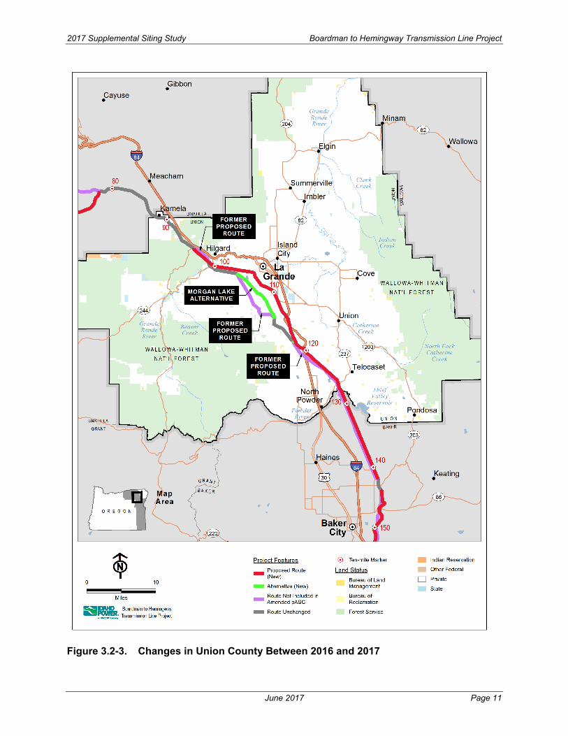
2017 Supplemental Siting Study Boardman to Hemingway Transmission Line Project
Figure 3.2-3. Changes in Union County Between 2016 and 2017
June 2017 Page 11

2017 Supplemental Siting Study Boardman to Hemingway Transmission Line Project
3.2.4 Baker County, Oregon The portion of the Proposed Route located in Baker County was selected as part of the BLM’s Agency Preferred Alternative and includes the Magpie Peak Route, Flagstaff Gulch-Lone Pine Mountain Route, and the West Durkee-Table Rock Route (see Figure 3.2-4). IPC is not proposing any alternatives in Baker County in the Amended pASC. The BLM developed routes replaced 47.2 miles of the Proposed Route that was included in the Draft Amended pASC. A total of 22.1 miles of the Proposed Route that was included in the Draft Amended pASC is being carried forward into the Amended pASC.
3.2.4.1 Magpie Peak Route The Magpie Peak Route is part of the Proposed Route in Baker County. The Magpie Peak Route was developed by the BLM as a route that would, where possible, collocate the Project with the existing Quartz to La Grande 230-kV transmission line. See Section 3.1.1.2 of Exhibit B for a detailed discussion of extra high voltage transmission line separation criteria.
3.2.4.2 Flagstaff Gulch-Lone Pine Mountain Route The Flagstaff Gulch-Lone Pine Mountain Route is part of the Proposed Route in Baker County. The Flagstaff Gulch portion was developed by the BLM with input from Baker County as a route that would avoid agricultural areas in the Baker Valley. The Lone Pine Mountain portion was developed by the BLM as a route that would, where possible, collocate the Project with the existing Quartz to La Grande 230-kV transmission line. The Flagstaff Gulch Route, located to the west of the National Historic Oregon Trail Interpretive Center. The Flagstaff Gulch Route will necessitate the rebuilding of a 0.9-mile segment of the existing 230-kV IPC transmission line slightly to the east between two hilltops just south of State Highway 86. The 230-kV rebuild is located on privately owned land. As shown in Exhibit B, Figure B-2, the existing 230-kV line will be shifted to the west and rebuilt to facilitate placing the 500-kV line into the existing 230-kV ROW. This will allow the use of typical height 500-kV towers and reduce visual impacts to the National Historic Oregon Trail Interpretive Center. If the 230-kV line were not shifted to the west, the 500-kV line would require taller structures with longer spans to cross over the existing 230-kV line, which potentially would have greater visual impacts to the Interpretive Center.
3.2.4.3 West Durkee-Table Rock Route The West Durkee-Table Rock Route is part of the Proposed Route in Baker County. It was developed by the BLM with input from Baker County as a route that would avoid agricultural areas in the Durkee Valley. The Table Rock portion of the route was developed by the BLM as a route that would collocate the Project, where possible, with the existing Quartz to Weiser 138-kV transmission line.
June 2017 Page 12

2017 Supplemental Siting Study Boardman to Hemingway Transmission Line Project
Figure 3.2-4. Changes in Baker County Between 2016 and 2017
June 2017 Page 13

2017 Supplemental Siting Study Boardman to Hemingway Transmission Line Project
3.2.5 Malheur County, Oregon In Malheur County the majority of the Proposed Route was included in the Draft Amended pASC. The BLM developed a New Owyhee River Crossing Route and IPC developed the North Birch Creek Route. In addition, IPC has maintained the Double Mountain Alternative in the Amended pASC as an Alternative to the Proposed Route in Malheur County.
3.2.5.1 Birch Creek North Route As part of the Proposed Route, IPC developed the Birch Creek North Route. The Birch Creek North Route includes the rebuild of 1.1 miles of the existing Quartz to Weiser 138-kV transmission line and the siting of the Project transmission line within the existing 138-kV ROW. Between milepost 197.6 and milepost 198.8, the Proposed Route will be located in the existing IPC 138-kV transmission line ROW for 0.8 mile. The 138-kV transmission line will be rebuilt to the southwest of the Proposed Route in a new ROW for 1.1 miles. This is being done to reduce visual impacts to the Oregon Trail Birch Creek Area of Critical Environmental Concern (see Figure 3.2-5).
3.2.5.2 New Owyhee River Crossing Route The New Owyhee River Crossing Route is part of the Proposed Route in Malheur County. The New Owyhee River Crossing Route was developed by the BLM as a route that would avoid crossing the Lower Owyhee River Wild and Scenic River Study Area. The New Owyhee River Crossing Route moved the Project into the BLM Vale District Utility Corridor. This route also moved the Project from public land to private land (see Figure 3.2-5).
3.2.5.3 Double Mountain Alternative The Double Mountain Alternative is 7.4 miles in length and is presented in the Amended pASC as an alternate to the Proposed Route in Malheur County. The Double Mountain Alternative was initially developed in response to community concerns and requests from the public to maximize the use of public land. The Double Mountain Alternative crosses 6.2 fewer miles of private land; however, the public land that it crosses includes a wilderness characteristic unit. Although the BLM did not select the Double Mountain Alternative as its Agency Preferred Alternative, BLM indicated in a January 30, 2014, meeting that it is still considering the Double Mountain Alternative for ROW authorization. Accordingly, IPC is including the Double Mountain Alternative in the Amended pASC. Table 3.2-3 compares the Double Mountain Alternative to the corresponding portion of the Proposed Route (see Figure 3.2-5).
June 2017 Page 14

2017 Supplemental Siting Study Boardman to Hemingway Transmission Line Project
Figure 3.2-5. Changes in Malheur County Between 2016 and 2017
June 2017 Page 15

2017 Supplemental Siting Study Boardman to Hemingway Transmission Line Project
Table 3.2-3. Comparison of Constraints Between the Proposed Route and Double Mountain Alternative in Malheur County
Resource Group/ Resource Name Proposed Route
Double Mountain Alternative
Length (miles) 7.4 7.4 Fish and Wildlife Big Game Deer Winter Range (ODFW) 1.3 0.2 Mule Deer Limited Range (USU) 2.7 3.8 Mule Deer Year Round Population (USU) 4.7 3.6 Land Use Exclusive Farm Use Zone/Multiple Use Range Zone 7.4 7.4 Fire Management Unit (Oregon) 7.4 7.4 Fire Management Zone (Oregon) 7.4 7.4 Goal 5 Resources 7.4 7.4 Grazing Allotment (Oregon Mgmt. Category: M) 7.1 7.4 Military Training Route 5.3 1.5 Proposed Wilderness Study Area (ONDA) – 3.7 SEORMP ROS Rural 6.2 – SEORMP ROS Semi-Primitive Motorized – 4.5 SEORMP ROS Semi-Primitive Non-motorized 1.1 2.9 Vale District Wilderness Characteristic Unit: Meets Criteria 1.2 7.4 Wildland Urban Interface (Oregon) 7.4 7.4 Ownership Bureau of Land Management 1.2 7.4 Private 6.2 – Visual Resources BLM VRM Class 4 1.2 7.4 Water and Wetlands Wetlands 0.1 – Zoning Agriculture 7.4 7.4 ODFW – Oregon Department of Fish and Wildlife ONDA – Oregon Natural Desert Association ROS – Recreation Opportunity Spectrum SEORMP – Southeast Oregon Resource Management Plan USU – Utah State University VRM – Visual Resource Management
3.2.6 Owyhee County, Idaho The Proposed Route in Owyhee County is 23.8 miles long, with 19.6 miles located on BLM-managed lands, 2.5 miles on Idaho state lands, and 1.8 miles on privately owned land. The route follows the southwest side of the existing Summer Lake to Midpoint 500-kV line except for the last 2.7 miles. This route had considerable input from Owyhee County, Idaho Department of State Lands, and the local citizens and there has been no need to develop any alternatives along this portion of the route.
June 2017 Page 16