Atlantic Sunrise Project – PA DEP Chapter 105 Joint Permit ...
76
Atlantic Sunrise Project – PA DEP Chapter 105 Joint Permit Application Transcontinental Gas Pipe Line Company, LLC Wyoming County Attachment L – Environmental Assessment Enclosure D – Description of Impacts 1 ENCLOSURE D PROJECT IMPACTS A. Impacts on Designated Resources Construction and operation of linear infrastructure Projects, including the proposed Atlantic Sunrise Project (Project) inevitably impact designated resources, including wetlands and waterbodieswatercourses. The Project has been designed to avoid and minimize impacts to environmental as well as recreational resources. The following discussion, as well as the Alternatives Analysis provided in Attachment P-1, details the Project’s potential impacts and the avoidance and minimization measures that Transco has taken thus far and will take in during construction and operation of the Project to protect designated resources. Additionally, the Comprehensive Environmental Evaluation for the Central Penn Line provided in Appendix L-1 presents a summary of the alternatives analysis for the Project as whole. Transco has sited the proposed compressor, meter and regulating stations, and other minor aboveground appurtenances, such as main line valves (MLVs) and pig launcher and receiver facilities and communications towers, outside of wetlands and waterbodieswatercourses. Therefore, no direct impacts or losses to wetlands or waterbodies watercourses are expected to result from construction and operation of the aboveground facilities. Potential impacts associated with the Project on national and/or state forests, park lands, wildlife refuges, game lands, and/or wildlife sanctuaries were identified for the construction and operation of the Project within Wyoming County. Information regarding potential impacts to national, state, or local historic sites and cultural or archaeological landmarks within the Project area was coordinated through the Pennsylvania Historical Museum Commission (PHMC). Threatened and endangered species coordination effort was conducted through the applicable federal and state agencies. Field studies were conducted within 100 percent of the Project area in Wyoming County on the portions of the line for which survey access was granted by landowners. Additional portions of the line, which are currently designated as no-access parcels, will be surveyed in the future.
-
Upload
khangminh22 -
Category
Documents
-
view
0 -
download
0
Transcript of Atlantic Sunrise Project – PA DEP Chapter 105 Joint Permit ...
Atlantic Sunrise Project – PA DEP Chapter 105 Joint Permit Application Transcontinental Gas Pipe Line Company, LLC Wyoming County Attachment L – Environmental Assessment Enclosure D – Description of Impacts
1
ENCLOSURE D PROJECT IMPACTS
A. Impacts on Designated Resources Construction and operation of linear infrastructure Projects, including the proposed Atlantic
Sunrise Project (Project) inevitably impact designated resources, including wetlands and
waterbodieswatercourses. The Project has been designed to avoid and minimize impacts
to environmental as well as recreational resources. The following discussion, as well as the
Alternatives Analysis provided in Attachment P-1, details the Project’s potential impacts
and the avoidance and minimization measures that Transco has taken thus far and will
take in during construction and operation of the Project to protect designated resources.
Additionally, the Comprehensive Environmental Evaluation for the Central Penn Line
provided in Appendix L-1 presents a summary of the alternatives analysis for the Project
as whole.
Transco has sited the proposed compressor, meter and regulating stations, and other
minor aboveground appurtenances, such as main line valves (MLVs) and pig launcher and
receiver facilities and communications towers, outside of wetlands and
waterbodieswatercourses. Therefore, no direct impacts or losses to wetlands or
waterbodies watercourses are expected to result from construction and operation of the
aboveground facilities.
Potential impacts associated with the Project on national and/or state forests, park
lands, wildlife refuges, game lands, and/or wildlife sanctuaries were identified for the
construction and operation of the Project within Wyoming County. Information regarding
potential impacts to national, state, or local historic sites and cultural or archaeological
landmarks within the Project area was coordinated through the Pennsylvania Historical
Museum Commission (PHMC). Threatened and endangered species coordination effort
was conducted through the applicable federal and state agencies. Field studies were
conducted within 100 percent of the Project area in Wyoming County on the portions of the line for which survey access was granted by landowners. Additional portions of the line, which are currently designated as no-access parcels, will be surveyed in the future.
Atlantic Sunrise Project – PA DEP Chapter 105 Joint Permit Application Transcontinental Gas Pipe Line Company, LLC Wyoming County Attachment L – Environmental Assessment Enclosure D – Description of Impacts
2
A1. National, State or Local Park, Forest or Recreation Area No impacts to National, State or Local Park, Forest or Recreation Areas are expected to
occur within Wyoming County.
A2. Natural, Wild, or Wilderness Area No impacts to Natural, Wild or Wilderness Areas are expected to occur within Wyoming
County. A3. National, State, or Local Historic Site Section A6 provides a summary of potential impacts to historic, cultural and archaeological
resources.
A4. National Natural Landmark There will be no impacts to national natural landmarks as a result of the portion of the
Project within Wyoming County.
A5. National Wildlife Refuge There will be no impacts to national wildlife refuges as a result of the portion of the Project
within Wyoming County.
A6. Cultural or Archeological Landmarks On May 1, 2014, Transco met with staff of the PHMC to discuss the Project, cultural
resource impacts, and proposed cultural resources investigations. Transco also requested
that for the purpose of facilitating review of archaeological resources, a process developed
for other natural gas Projects in Pennsylvania, aimed at providing regular Determinations
of Eligibility (DOEs) for archaeological resources, be implemented. This process involves
routine updates on the eligibility status of archaeological resources identified during Phase
I surveys. Since this initial meeting, Transco’s coordination and consultation with the
PHMC has been on-going.
Atlantic Sunrise Project – PA DEP Chapter 105 Joint Permit Application Transcontinental Gas Pipe Line Company, LLC Wyoming County Attachment L – Environmental Assessment Enclosure D – Description of Impacts
3
A Transco-sponsored open house for the Project in Wyoming County was held at Keystone College on June 3, 2014. Public comment from several landowners was received on potential cultural issues, all of which were examined and addressed during the cultural resources field reconnaissance for the Project. In addition to the open house, consultation was initiated with the Endless Mountain Heritage Region and the Lake Winola Cottagers Association concerning cultural resources in Wyoming County. The Lake Winola Cottagers Association had no comment on the Project. No response to consultation request was received from the Endless Mountain Heritage Region. Transco-sponsored open houses were held for the Project facilities in Wyoming County at Millersville University on June 11, 2014 and at the Acorn Farms Reception & Conference Center on July 29, 2014. Public comments were received from several landowners and interested members of the public raising concerns about the increased potential for Project-related impacts on cultural resources in Wyoming County, particularly with regard to 17th and 18th century prehistoric and contact period resources and the 19th/20th century historic-era occupation of the county. These concerns were examined and addressed during the cultural resources field reconnaissance and archival research conducted for the Project. Field surveys for cultural resources were conducted from May-December 2014 and resumed in March 2015. The Phase I archaeological field reconnaissance of the CPL-North study corridor in Wyoming County resulted in the identification of 21 archaeological resources. Seventeen of these resources have been recommended as Not Eligible for the National Register of Historic Places (NRHP). Three sites, 36WO0121, 36WO0108, and 36WO0117, have been considered Potentially Eligible. The PHMC has determined one site, 36WO0115, to be NRHP Eligible. Site 36WO0115 is a subsurface, multicomponent, prehistoric site situated within a floodplain of Tunkhannock Creek. Deep testing of this site was conducted in 2015, and an Impact Minimization Plan was approved by the PHMC. Phase I archaeological field reconnaissance was conducted in Wyoming County and focused on the proposed pipeline alignment.
Atlantic Sunrise Project – PA DEP Chapter 105 Joint Permit Application Transcontinental Gas Pipe Line Company, LLC Wyoming County Attachment L – Environmental Assessment Enclosure D – Description of Impacts
4
The field survey investigated a 300-foot-wide study corridor, in addition to full survey coverage of ancillary work areas, which resulted in the examination of 15,337 study locations (SL) in Wyoming County. The field survey recorded 2,076 SL as occurring on steep slopes, 389 SL as wet (in either a waterbody or wetland), 5,347 SL within agricultural fields displaying sufficient ground surface visibility to meet PHMC guidelines, and 1,196 SL were determined to have been subjected to modern ground disturbance (most commonly underground pipeline utilities). The field crew also visually inspected 129 SL in residential properties. The visual inspection was supplemented by the hand excavation of 6,238 shovel tests. These investigations resulted in the identification of 74 archaeological resources within the limits of the field survey, as outlined in the section below. A total of 62 aboveground resources were identified during the Architectural History survey conducted for Project land requirements in Wyoming County; 52 of these resources are currently located within the Project, while an additional 10 resources were identified on parcels subsequently removed from the Project Area of Potential Effects (due primarily to changes in the Project alignment). One resource has been previously determined Eligible by PHMC, while one additional resource was considered to be a rural historic district identified by Transco. The Nesbitt Estate Rural Historic District was determined Eligible by the PHMC, and the Project represented an Adverse Effect to contributing rock walls and other stone features, as well as the forest setting. The rural historic district crosses into Luzerne County as well, and so is counted as a resource for both Wyoming and Luzerne counties. Transco recommended one additional resource as Eligible for the NRHP, and PHMC review concluded that the resource was Eligible and would also present an Adverse Effect to the contributing rock walls. PHMC also determined that 31 of the 52 resources were Not Eligible. No anticipated effects were determined for the remaining 18 resources as a result of the Project. Attachments D-1 and D-2 provide a summary of consultation with PHMC and copies of correspondence, respectively. The architectural history field reconnaissance of the Project in Wyoming County resulted in the identification of 117 historic-era aboveground resources located within the viewshed of the Project, as indicated in Table D-1 located in Attachment
Atlantic Sunrise Project – PA DEP Chapter 105 Joint Permit Application Transcontinental Gas Pipe Line Company, LLC Wyoming County Attachment L – Environmental Assessment Enclosure D – Description of Impacts
5
D. The geomorphological desktop study identified three drainage crossings in Wyoming County which displayed a high potential for deeply-buried cultural deposits: the Conestoga River, Chiques Creek and Swatara Creek. Geomorphological fieldwork was completed at these locations in the summer of 2015, and the results are pending review by PHMC. The Phase I archaeological field reconnaissance of the CPL-South study corridor in Wyoming County resulted in the identification of 74 archaeological resources. One of these resources, 36LA0001, represents additional materials found in association with a previously-identified eligible resource, while two sites encountered during the archaeological fieldwork have subsequently been recommended as potentially eligible for the NRHP; all three of these resources will be avoided by construction. The remaining 71 archaeological resources have been recommended as not eligible for the NRHP; the PHMC concurred that no additional archaeological investigations would be warranted at 36 of these locations, with the remainder pending formal review by the PHMC (as indicated in Table D-1 in Attachment D). A total of 117 aboveground resources were identified during the historic architecture survey conducted for Project land requirements in Wyoming County. Two resources had been previously determined eligible by PHMC. Transco’s consultant, AECOM recommended 28 of the 117 resources as potentially eligible for the NRHP. PHMC review concluded that only 19 resources were potentially eligible for the NRHP and additional documentation was requested for those 19 resources. One resource is currently under review by PHMC but was recommended not eligible for the NRHP. PHMC also determined there were no anticipated effects to the remaining 97 resources as a result of the Project. Attachment D further describes these efforts and findings. A7. State Game Lands There will be no anticipated impacts to state game lands as a result of the portion of the
Project within Wyoming County.
Atlantic Sunrise Project – PA DEP Chapter 105 Joint Permit Application Transcontinental Gas Pipe Line Company, LLC Wyoming County Attachment L – Environmental Assessment Enclosure D – Description of Impacts
6
A8. Federal, State, Local or Private Plant or Wildlife Sanctuaries There will be no anticipated impacts to federal, state, local or private plant or wildlife
sanctuaries as a result of the portion of the Project within Wyoming County.
A9. Areas Identified as Prime Farmland In an effort to identify the extent and location of important farmlands, the Natural Resource Conservation Service (NRCS), in cooperation with other interested federal,
state, and local government organizations, has inventoried land that can be used for
production of the nation's food supply. Important farmlands consist of prime farmland,
unique farmland, and farmland of statewide or local importance. It should be noted that not
all important farmland soils are used for farming. NRCS makes important farmland
designations based on soil properties, not on current or past use.
Unique farmland is land other than prime farmland that is used for the production of
specific high-value food and fiber crops, (e.g., tree nuts, cranberries, and other fruits and
vegetables). It has the unique combination of soil quality, growing season, moisture supply,
temperature, humidity, air drainage, elevation, and aspect needed for the soil to
economically produce sustainable high yields of these crops when properly managed.
Farmlands of statewide importance generally include those areas of soils that nearly meet
the requirements for prime farmland and that economically produce high yields of crops
when treated and managed according to acceptable farming methods. Farmland locations
that are not identified as having national or statewide importance can be designated by
local agricultural agencies as farmland of local importance for the production of food, feed,
fiber, forage, and oilseed crops.
Approximately 11.110.9 miles of the Project will cross Prime Farmlands or Farmlands of
Statewide Importance in Wyoming County. Pipeline construction may result in temporarily
removing farmland soils from agricultural production if construction occurs during the
growing season. Pipeline construction and operation will not result in any long-term loss of
prime and important farmland. Soils that are currently designated as prime farmland and
farmland of statewide importance will retain their designation both during and after
Atlantic Sunrise Project – PA DEP Chapter 105 Joint Permit Application Transcontinental Gas Pipe Line Company, LLC Wyoming County Attachment L – Environmental Assessment Enclosure D – Description of Impacts
7
construction. Effects on agricultural soils, including prime and important farmland soils, will
be mitigated according to the Agricultural Plan and the Transco Plan, provided respectively
as Attachments 6 and 17 of the Transco Environmental Construction Plan (ECP)
(Attachment M). While some short-term decreases in agricultural productivity may result
because of the disturbance of soil during construction, those effects can be mitigated over
time by the restoration measures previously discussed and by resumption of proper soil
management by landowners.
There will be impacts to 21.9 acres of Prime Farmland Soils from Compressor Station 605
and 3.1 acres from the Springville Meter Station which will be permanent and will not be
mitigated.
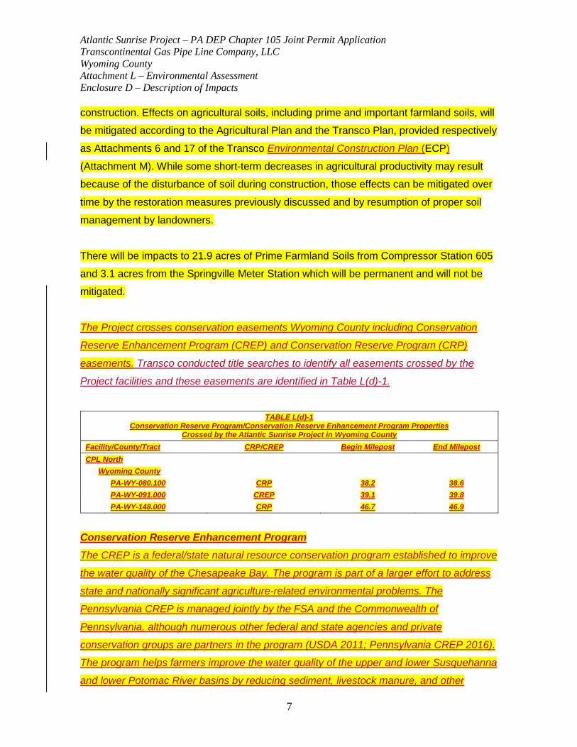
The Project crosses conservation easements Wyoming County including Conservation
Reserve Enhancement Program (CREP) and Conservation Reserve Program (CRP)
easements. Transco conducted title searches to identify all easements crossed by the
Project facilities and these easements are identified in Table L(d)-1.
TABLE L(d)-1
Conservation Reserve Program/Conservation Reserve Enhancement Program Properties Crossed by the Atlantic Sunrise Project in Wyoming County
Facility/County/Tract CRP/CREP Begin Milepost End Milepost CPL North
Wyoming County PA-WY-080.100 CRP 38.2 38.6 PA-WY-091.000 CREP 39.1 39.8 PA-WY-148.000 CRP 46.7 46.9
Conservation Reserve Enhancement Program The CREP is a federal/state natural resource conservation program established to improve
the water quality of the Chesapeake Bay. The program is part of a larger effort to address
state and nationally significant agriculture-related environmental problems. The
Pennsylvania CREP is managed jointly by the FSA and the Commonwealth of
Pennsylvania, although numerous other federal and state agencies and private
conservation groups are partners in the program (USDA 2011; Pennsylvania CREP 2016).
The program helps farmers improve the water quality of the upper and lower Susquehanna
and lower Potomac River basins by reducing sediment, livestock manure, and other
Atlantic Sunrise Project – PA DEP Chapter 105 Joint Permit Application Transcontinental Gas Pipe Line Company, LLC Wyoming County Attachment L – Environmental Assessment Enclosure D – Description of Impacts
8
nutrient runoff to the Chesapeake Bay. These efforts help to lower water temperatures,
increase dissolved oxygen levels, and provide additional wildlife habitat in the Chesapeake
Bay and its watershed (USDA 2011).
CREP was authorized under the Food Security Act of 1985, as amended, and was first
announced in April 2000. The program initially targeted a total voluntary enrollment of
100,000 acres of land in 20 counties in the lower Susquehanna and Potomac River basins,
including lands in Columbia, Lancaster, Lebanon, Northumberland, and Schuylkill counties.
The program has expanded to include an additional 100,000 acres in 23 northern tier
counties in Pennsylvania, including Luzerne, Lycoming, Susquehanna, and Wyoming
counties (USDA 2011). Through CREP, program participants receive financial incentives
from the U.S. Department of Agriculture to voluntarily enroll in the program for contracts of
10 to 15 years. Participants remove cropland or marginal pastureland from agricultural
production and convert the land to native grasses, trees, and other vegetation (USDA
2011; Pennsylvania CREP 2016).
Conservation Reserve Program
The CRP is a land conservation program administered by the FSA. In exchange for a
yearly rental payment, farmers enrolled in the program agree to remove environmentally
sensitive land from agricultural production and plant species that will improve
environmental health and quality. Contracts for land enrolled in CRP are 10 to 15 years in
length. The long term goal of the program is to re-establish valuable land cover to help
improve water quality, prevent soil erosion, and reduce loss of wildlife habitat (USDA
2014).
Properties enrolled in the CREP/CRP Programs crossed by the Project in Wyoming
County are identified in Table L(d)-1. Transco is working with the NRCS, local FSA agents,
and landowners to obtain information on CREP/CRP properties in the Project area. Where
the ROW crosses CREP/CRP acreage, Transco will reseed based on each landowner’s
conservation plan filed at the local NRCS office. Seeding rates and species selection for
CRP acreage will be determined based on the each conservation plan. Transco will work
with the NRCS and landowners to make sure that all CRP acreage is identified and that

Atlantic Sunrise Project – PA DEP Chapter 105 Joint Permit Application Transcontinental Gas Pipe Line Company, LLC Wyoming County Attachment L – Environmental Assessment Enclosure D – Description of Impacts
9
the appropriate seed mix is planted on individual acreage.
Transco will restore agricultural properties with conservation easements in accordance
with the methods described the Transco Agricultural Plan provided as Attachment 6 of the
Transco ECP (Attachment M).
B. Impacts on the Aquatic Environment B1. Aquatic Habitats All temporary impacts to aquatic resources are related to the construction of the pipeline.
All permanent impacts to aquatic resources are related to the removal of vegetative cover
for operation. No fill or impervious cover will be added to aquatic resources as part of this
Project. Operational right-of-way (ROW) will be maintained for a width of 10-feet at
waterbody watercourse approaches and through palustrine emergent (PEM) and
palustrine scrub-shrub (PSS) wetlands, and for a width of 30-feet through palustrine forested (PFO) wetlands. Transco is proposing the construction ROW widths to provide
for safe and efficient construction of large-diameter pipeline facilities in accordance with
OSHA Occupational Safety and Health Administration (OSHA) regulations (29 CFR
1926.650-1926.652, Subpart P) and Interstate Natural Gas Association of America’s
(INGAA) workspace guidelines (INGAA 1999). Reductions of the construction ROWs will
be made, where practicable, at various locations to address specific environmental or
residential issues along the proposed pipelines. The impact analysis included in this
section is related to resources associated with the Pennsylvania Department of Environmental Protection (PA DEP) Chapter 105 jurisdictional areas.
The proposed Project extends through 46 special protection watersheds (e.g., High Quality
or Exceptional Value) and watersheds that are considered siltation impaired. As a result,
an anti-degradation analysis was prepared for the Project and a detailed listing of each
watershed, cause of siltation, and location it will be crossed is provided for Wyoming
County within Attachment M. Additionally, the Comprehensive Environmental Evaluation
for the Central Penn Line provided in Appendix L-1 presents a summary of the anti-
degradation consistency analysis for the Project as whole.

Atlantic Sunrise Project – PA DEP Chapter 105 Joint Permit Application Transcontinental Gas Pipe Line Company, LLC Wyoming County Attachment L – Environmental Assessment Enclosure D – Description of Impacts
10
The Project will affect 29 46 streams, 27 38 floodways, and 37 4934 wetlands within
Wyoming County. Per PA DEP guidance, the installation of a pipe under streams is
considered a permanent impact. Please note that the total count of wetlands affected is based on cover types, such that a single wetland complex could have multiple wetland counts. For example, a single wetland complex comprised of PEM, PSS, and PFO cover types was counted as three wetland crossings for the purpose of
impact presentation in this Application. Tables summarizing the overall impacts on
waterbodies and wetlands for the Project as a whole are included in the Comprehensive Environmental Evaluation for the Central Penn Line in Appendix L-1.
Through the implementation of the Environmental Construction Plan (ECP), including
the Best Management Practices (BMPs), water quality impacts are expected to be
minimized to the extent practicable during construction, and no long term water quality
impacts are expected to occur. Prior to conducting any in-stream work, all associated
BMPs shall be installed and functional. BMPs will be installed at the edge of work areas, as
necessary, to prevent siltation into wetlands in the vicinity of construction activities and will
be maintained throughout the period of the construction activities. Wetland and waterbody
watercourse boundaries will be clearly marked prior to construction activities.
Restoration of streams will involve, at a minimum, restoring each stream to
pre-construction contours and revegetating surface water banks and riparian areas in accordance with the riparian plantings along the stream banks. Riparian Area Impact Assessment and Restoration Plan for the Project area in Wyoming County provided in Appendix L-2. In wetland areas, restoration activities will involve returning wetlands to pre-construction
contours and seeding in non-inundated areas with an approved wetland seed mix. In
general, hydrologic conditions are not anticipated to be impacted as a result of Project
construction.
Atlantic Sunrise Project – PA DEP Chapter 105 Joint Permit Application Transcontinental Gas Pipe Line Company, LLC Wyoming County Attachment L – Environmental Assessment Enclosure D – Description of Impacts
11
Transco has incorporated the following avoidance and minimization measures to reduce
impacts to aquatic resources.
Erosion and Sediment Controls
Construction activities can disturb surface soils and cause subsequent sediment transport
into adjacent wetlands. Sedimentation will be minimized by the installation of temporary
sediment control measures between the upland construction areas and the wetlands.
Permanent erosion controls, including slope breakers, trench breakers, and vegetative
cover, will be used in adjacent upland areas to minimize long-term sedimentation into the
wetlands. Energy dissipation devices may be installed at the down-slope end of slope
breakers to minimize erosion of soil off the ROW into wetlands. Trench plugs will be
installed in upland slopes adjacent to wetlands to prevent trench erosion. Trench plugs
also will be spaced in accordance with the applicable state and federal regulations and
installed at the edges of the wetland and on either side of waterbody watercourse
crossings to prevent subsurface drainage along the pipeline.
To minimize erosion and promote revegetation within the wetland, removal of the root mats
for woody vegetation will be allowed only directly over the trench area or where required to
ensure safe working conditions. This serves to enhance regeneration of vegetation on the
construction and permanent ROW. Permanent erosion control structures that could alter
hydrology (e.g., slope breakers) will not be installed within wetlands, but these structures
will be used in the adjacent upland areas to control erosion and sedimentation. Transco
will employ BMPs as specified in erosion and sediment control permits and approved by
PA DEP to further minimize the potential for soil compaction.
Turbidity and sedimentation could result from in-stream construction activities, trench
dewatering, and/or construction-related stormwater runoff. In slow-moving waters,
increases in suspended sediments could increase the biological oxygen demand and
reduce levels of dissolved oxygen in localized areas during construction. Suspended
sediments also could alter the chemical and physical characteristics of the water column
on a temporary basis.
Atlantic Sunrise Project – PA DEP Chapter 105 Joint Permit Application Transcontinental Gas Pipe Line Company, LLC Wyoming County Attachment L – Environmental Assessment Enclosure D – Description of Impacts
12
Transco will cross surface waters with flowing water present at the time of construction
using dry-ditch construction methods to the greatest extent practicable. Dry-ditch crossing
and trenchless waterbody watercourse crossing methods can dramatically reduce
downstream sediment transport effects compared to wet open-cut crossings (Reid and
Anderson 1999; Reid et al. 2002). Transco will employ best management practices (BMPs) as specified in its Erosion and Sediment Control General Permit 2 (ESCGP-2)
application, which contains a site-specific erosion and sediment control plan to further
minimize the potential for soil compaction (see Attachment M - provided under separate cover).
Transco will also install temporary equipment bridges across surface waters to reduce the
potential for turbidity caused by movement of construction equipment and vehicular traffic.
Equipment bridges will be constructed of clean rock or gravel and culverts, timber mats, or portable prefabricated bridges, depending on surface water conditions (e.g., if
excessively soft soils are encountered in the surface water bed, or if high water flows
occur, portable bridges will be used at minor surface water crossings instead of rock and culverts). Typical drawings for equipment bridges are provided in Attachment 2 of the
Transco ECP (Attachment M). Equipment bridges will be maintained until the pipe is
installed and they are no longer needed. The bridges will then be removed. Equipment
bridges will be designed to accommodate normal to high surface water flow and will be
maintained to prevent flow restriction during the period of time the bridge is in use during
construction.
To minimize sedimentation during pipeline construction across
waterbodieswatercourses, trench spoil will be placed at least 10 feet away from water’s
edge, unless impractical due to topography, as specified in the Transco Project-specific
Wetland and Waterbody Construction and Mitigation Procedures (Transco Procedures)
(Attachment 18 of the Transco ECP [Attachment M]). Erosion controls will be placed
around spoil piles to prevent sediment from flowing into surface waters. Additional
Temporary Workspace (ATWS) will typically be set back 50 feet from the water’s edge
unless otherwise approved by the Federal Energy Regulatory Commission (FERC) and
Atlantic Sunrise Project – PA DEP Chapter 105 Joint Permit Application Transcontinental Gas Pipe Line Company, LLC Wyoming County Attachment L – Environmental Assessment Enclosure D – Description of Impacts
13
the United States Army Corps of Engineers (USACE) (see Attachment P-1, Appendix P-1).
Once the pipe is placed in the trench, the excavated material will be replaced immediately,
and the surface water banks and bed will be restored to preconstruction contours. To
stabilize the banks, the surface water banks and riparian areas will be revegetated using
approved seed mixes and/or erosion control blankets or matting in accordance with the
Riparian Area Impact Assessment and Restoration Plan for Wyoming County within
Appendix L-2.
Compaction
Compaction of wetland soils and rutting within wetlands will be minimized by using low-
ground-pressure equipment and temporary equipment mats. In general, rutting of soils,
which is a sign of compaction, in wetlands or in other areas during wet conditions will be
avoided or minimized through the use of timber mats as deemed necessary during
construction or by postponing work until soils have dried. In addition, Transco will minimize
compaction of soils within agricultural lands, residential areas, and not saturated or
inundated wetlands by stripping, segregating, and stockpiling topsoil separately from
subsoil during construction. The Transco Procedures (ECP Attachment 18, provided within Attachment M of this Application) (Transco Procedures) and Agricultural and Construction Monitoring Plan (ECP Attachment 6, provided within Attachment M of this Application) indicate that the top 12 inches of topsoil from wetland and agricultural areas disturbed by trenching will be segregated from subsoil, except in areas where standing water is present, soils are saturated, or where shallow depth to bedrock conditions exist. These exceptions will be identified via visual assessment during grading and documented in the field with the Environmental and/or Agricultural Inspector. Immediately after backfilling is complete, the segregated topsoil will be restored to its original horizon location. Transco will segregate 12 inches of topsoil or the entire topsoil layer if it is less than 12 inches. Restoration of the soil surface elevations and contours and revegetation will be performed
in accordance with Transco’s ECP (Attachment M). In areas where topsoil has been segregated, the subsoil will be placed back in the trench first and the topsoil will be
Atlantic Sunrise Project – PA DEP Chapter 105 Joint Permit Application Transcontinental Gas Pipe Line Company, LLC Wyoming County Attachment L – Environmental Assessment Enclosure D – Description of Impacts
14
placed over the subsoil. Backfilling will occur to approximate grade; however, a soil
crown may be placed above the trench to accommodate future soil settling.
If compaction occurs during construction, Transco will also use subsurface decompaction
techniques, as described in the Transco Draft Agricultural Construction and Monitoring
Plan within Attachment 6 of Transco’s ECP (Attachment M). Transco will employ BMPs as
specified in erosion and sediment control permits and approved by the PA DEP to further
minimize the potential for soil compaction.
Hydrology
Stream crossings are to be performed during low flow conditions with oversight from an environmental inspector. Storm event weather forecasts will be monitored prior to and during the stream crossing. The contractor will be required to maintain an adequate number of pumps on-site to facilitate an unanticipated increase in stream flow.
Per the Transco Procedures, provided as Attachment 18 of the ECP (Attachment M), the
following additional measures for dam-and-pump waterbody watercourse crossings will
be implemented:
• Use sufficient Sufficient pumps, including on-site backup pumps, will be used to
maintain downstream flows;
• Pumps will be properly aligned to prevent surface water bed scour at the pump
discharge;
• Dams will be constructed with materials that prevent sediment and other pollutants
from entering the waterbodywatercourse;
• Pump intakes will be screened to minimize entrainment of fish; and,
• Dams and pumps will be continuously monitored to ensure proper operation
throughout the waterbody watercourse crossing.
Per the Transco Procedures, provided as Attachment 18 of the Transco ECP (Attachment M), the following additional measures for wet open-cut crossings of minor and intermediate surface waters will be implemented:
Atlantic Sunrise Project – PA DEP Chapter 105 Joint Permit Application Transcontinental Gas Pipe Line Company, LLC Wyoming County Attachment L – Environmental Assessment Enclosure D – Description of Impacts
15
• In-stream construction activities (including trenching, pipe installation, backfilling, and surface water bed restoration) will be completed within 24 to 48 hours, except for areas that require blasting or other rock-breaking measures; and,
• Operation of equipment in the surface water will be limited to that needed to construct the crossing.
Per the Transco Procedures, provided as Attachment 18 of the ECP (Volume 3Attachment M), the following additional measures for flume crossings of waterbodies watercourses will
be conducted:
• Sand bags, sand bag and plastic sheeting diversion structures, or the equivalent will
be used to develop an effective seal and to divert stream flow through the flume pipe;
• Flume pipes will remain in place until trenching, pipe laying, backfilling, and initial
streambed restoration efforts are complete;
• Flume pipes will be properly aligned to prevent bank erosion and streambed scour;
and
• All flume pipes and dams that are not part of the equipment bridge will be removed
as soon as final cleanup of the streambed and bank is complete.
Permanent changes in surface and subsurface hydrology along the pipeline alignment
through a wetland can have a long-term effect on hydrology and associated function and
value. Trench plugs will be installed at the entrance and exit of the pipeline through each
wetland to ensure that the subsurface hydrology remains intact. Restoration of each
wetland will include returning contours to preconstruction levels (within 6 inches) and
removing temporary erosion control measures.
Trench Dewatering
During construction, the open trench could accumulate water, either from the seepage of
groundwater or from precipitation. This water must be removed from the trench to allow
construction to proceed. During trench dewatering, water will be pumped from the trench
Atlantic Sunrise Project – PA DEP Chapter 105 Joint Permit Application Transcontinental Gas Pipe Line Company, LLC Wyoming County Attachment L – Environmental Assessment Enclosure D – Description of Impacts
16
and discharged into vegetated upland areas after first being filtered through a straw bale
structure and/or filter bag. The rate of flow from the pump will be regulated to prevent
scouring from runoff. Dewatering will be conducted in a manner designed to prevent the
flow of heavily silt-laden water directly into adjacent surface waters or wetlands and will be
performed in accordance with the PA DEP and USACE permit requirements and the FERC
Order.
Blasting
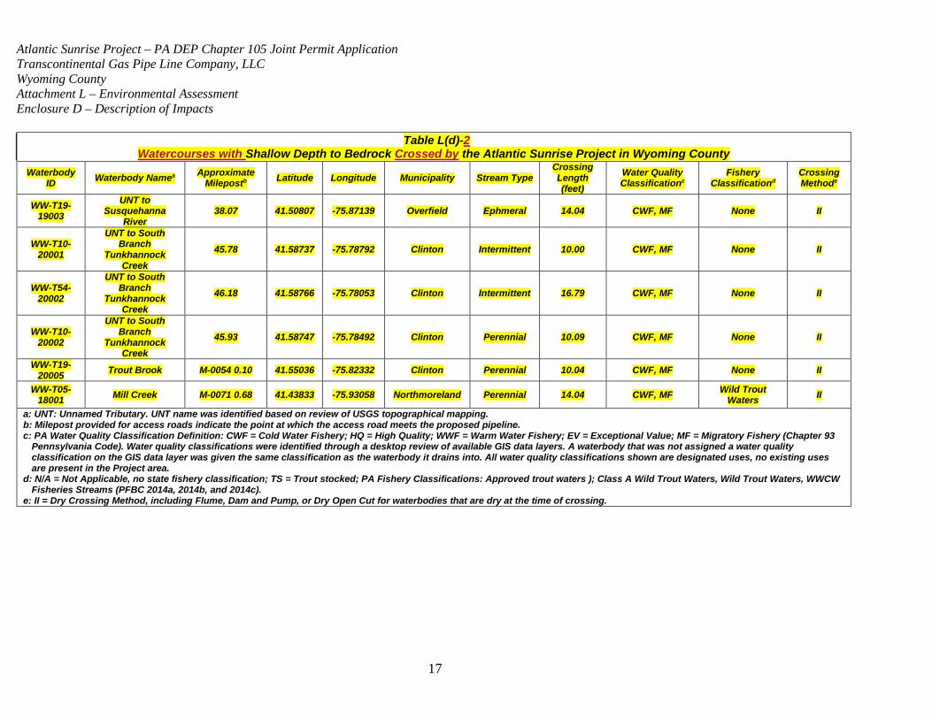
Transco does not anticipates the use of blasting in bodies of water or watercourses; however, Transco will not know for certain until construction activities commence. Watercourses with a higher potential for blasting are those with shallow depth to bedrock, as presented within Table L(d)-2. Transco’s construction contractor will be required to demonstrate that blasting is necessary by first attempting to remove bedrock material using mechanical means, such as a hydraulic ram or splitter, rock trenching machine, or rock saw. Transco has submitted an Application for use of Explosives in Commonwealth Waters to the Pennsylvania Fish and Boat Commission (PFBC) for each proposed stream crossing in the event that blasting of bedrock is required to properly install the pipe.
Atlantic Sunrise Project – PA DEP Chapter 105 Joint Permit Application Transcontinental Gas Pipe Line Company, LLC Wyoming County Attachment L – Environmental Assessment Enclosure D – Description of Impacts
17
Table L(d)-2 Watercourses with Shallow Depth to Bedrock Crossed by the Atlantic Sunrise Project in Wyoming County
Waterbody ID Waterbody Namea Approximate
Milepostb Latitude Longitude Municipality Stream Type Crossing Length (feet)
Water Quality Classificationc
Fishery Classificationd
Crossing Methode
WW-T19-19003
UNT to Susquehanna
River 38.07 41.50807 -75.87139 Overfield Ephmeral 14.04 CWF, MF None II
WW-T10-20001
UNT to South Branch
Tunkhannock Creek
45.78 41.58737 -75.78792 Clinton Intermittent 10.00 CWF, MF None II
WW-T54-20002
UNT to South Branch
Tunkhannock Creek
46.18 41.58766 -75.78053 Clinton Intermittent 16.79 CWF, MF None II
WW-T10-20002
UNT to South Branch
Tunkhannock Creek
45.93 41.58747 -75.78492 Clinton Perennial 10.09 CWF, MF None II
WW-T19-20005 Trout Brook M-0054 0.10 41.55036 -75.82332 Clinton Perennial 10.04 CWF, MF None II
WW-T05-18001 Mill Creek M-0071 0.68 41.43833 -75.93058 Northmoreland Perennial 14.04 CWF, MF Wild Trout
Waters II
a: UNT: Unnamed Tributary. UNT name was identified based on review of USGS topographical mapping. b: Milepost provided for access roads indicate the point at which the access road meets the proposed pipeline. c: PA Water Quality Classification Definition: CWF = Cold Water Fishery; HQ = High Quality; WWF = Warm Water Fishery; EV = Exceptional Value; MF = Migratory Fishery (Chapter 93
Pennsylvania Code). Water quality classifications were identified through a desktop review of available GIS data layers. A waterbody that was not assigned a water quality classification on the GIS data layer was given the same classification as the waterbody it drains into. All water quality classifications shown are designated uses, no existing uses are present in the Project area.
d: N/A = Not Applicable, no state fishery classification; TS = Trout stocked; PA Fishery Classifications: Approved trout waters ); Class A Wild Trout Waters, Wild Trout Waters, WWCW Fisheries Streams (PFBC 2014a, 2014b, and 2014c).
e: II = Dry Crossing Method, including Flume, Dam and Pump, or Dry Open Cut for waterbodies that are dry at the time of crossing.
Atlantic Sunrise Project – PA DEP Chapter 105 Joint Permit Application Transcontinental Gas Pipe Line Company, LLC Wyoming County Attachment L – Environmental Assessment Enclosure D – Description of Impacts
18
Transco will make every effort to remove rock using mechanical means and avoid blasting within surface water crossings; however, if conditions are encountered that warrant the use of controlled blasting, the appropriate permits and approvals will be obtained and regulatory requirements will be met prior to blasting. In general, if blasting is required at a waterbody watercourse crossing, the preparation of
the rock for blasting (i.e., drilling shot holes) will not cause sufficient disturbance to
displace most aquatic organisms from the immediate vicinity of the blast and will
nottemporarily increase surface water turbidity, since dry crossing methods will be utilized
at each crossing. If in-water blasting is deemed necessary, Transco will implement its
Blasting Plan, provided as Attachment 10 of the Transco ECP (Attachment M), and the
site-specific blasting plan that will be produced for each area requiring blasting, which
specifically addresses in-water blasting. In addition, Transco will obtain the required
permits, licenses, and approvals and notify agencies in accordance with permit
requirements. The Blasting Plan outlines proper precautions and necessary pre-blast
planning to be implemented to minimize potential effects. Transco’s contractor will also
create a detailed, site-specific blasting plan for each area proposed for blasting; each site-
specific blasting plan will be consistent with the provisions of the Project-specific Blasting
Plan. Immediately following blasting, Transco will remove rock that impedes surface water
flow. Furthermore, Transco will implement a two-foot depth of cover within consolidated rock to minimize the amount of blasting required and the duration of construction activity within the affected watercourse.These steps will minimize the effects of blasting on aquatic organisms.
Spill Control
Inadvertent spills of fluids used during construction, such as fuels, lubricants, and solvents,
could contaminate wetland soils and have adverse impacts on wetland vegetation. The
Spill Plan for Oil and Hazardous Materials (Transco Spill Plan), provided as Attachment 9
of the Transco ECP (Attachment M), will be implemented to minimize the potential for spills
and minimize effects from spills. In general, storage of equipment, hazardous materials,
chemicals, fuels, lubricating oils, will occur at least 100 feet from wetlands, and waterbodieswatercourses, and bodies of water. The Horizontal Directional Drill
Atlantic Sunrise Project – PA DEP Chapter 105 Joint Permit Application Transcontinental Gas Pipe Line Company, LLC Wyoming County Attachment L – Environmental Assessment Enclosure D – Description of Impacts
19
(HDD) Contingency Plan in Attachment 3 of the ECP (Attachment M) addresses inadvertent returns.
Fuel spills that occur during construction, although unlikely, could result in toxicity to
aquatic organisms and associated modifications of aquatic habitat, as well as decreased
oxygen concentrations. Transco has developed a Spill Plan for Oil and Hazardous Materials (Transco Spill Plan), included as Attachment 9 of the ECP (Attachment M), thatThe Transco Spill Plan describes measures that will be implemented by Transco
personnel and its contractors to prevent and, if necessary, control any inadvertent spill of
hazardous materials that could affect water quality. The Transco Spill Plan for Oil and Hazardous Materials will be updated with site-specific information prior to the initiation of
construction activities. Hazardous materials, chemicals, lubricating oils, and fuels used
during construction will be stored in upland areas at least 100 feet from surface waters
unless otherwise approved by applicable regulatory agencies, and refueling of construction
equipment will be conducted at least 100 feet from surface waters unless otherwise
approved by applicable regulatory agencies. Additional precautions such as continual
monitoring of fuel transfer and use of spill kits will be employed. Disposal of hazardous
materials will also be conducted in accordance with the Transco Spill Plan for Oil and Hazardous Materials.
Revegetation
Some wetland vegetation will be cut, removed, or crushed during construction. After the
completion of construction, wetland areas within the ROW will be restored to
preconstruction contours and revegetated with annual ryegrass where standing water is
not present to stabilize disturbed soils. For the pipeline construction ROW and ancillary facilities, Transco proposes to utilize either winter wheat or annual ryegrass as a nurse crop on the ROW from January 1 through May 15 and August 15 through December 31. During the summer months (May 15 through August 15), it is recommended that browntop millet be utilized as the nurse crop. The use of cereal (winter) rye is highly discouraged due to the allopathic effects it could have on the establishment of the permanent crop. It is recommended that annual rye be planted
Atlantic Sunrise Project – PA DEP Chapter 105 Joint Permit Application Transcontinental Gas Pipe Line Company, LLC Wyoming County Attachment L – Environmental Assessment Enclosure D – Description of Impacts
20
at a nurse rate of 4 pounds per acre and winter wheat at a rate of 10 pounds per acre, individually. Browntop millet should be seeded at a rate of 5 pounds per acre. Annual ryegrass, winter wheat, and browntop millet are is intended to be a temporary
cover to enhance soil stability. In wetland areas, restoration activities will involve returning
wetlands to pre-construction contours and seeding in non-inundated areas with an
approved wetland seed mix. The seed mixes proposed for the Project are included within the Riparian Area Impact Assessment and Restoration Plan for Wyoming County (Appendix L-2), and in the BMPs and Quantities Plan Set, included within Attachment M of the revised Application. Affected wetland areas will be allowed to revegetate naturally from existing adjacent seed banks. PEM wetlands, dominated
primarily by low-growing sedges, rushes, and other herbaceous vegetation will revert to
emergent vegetation following construction, resulting in no permanent change to wetland
type. Wetland areas will not be amended with fertilizer, lime, or mulch unless required by
applicable federal and state agencies.
Wetlands will be monitored post-construction in accordance with the Transco Procedures
(Attachment 18 of the Transco ECP [Attachment M]). Wetlands will be monitored for a period of 3 to 5 years after the completion of construction to ensure successful revegetation of the Project area. Revegetation will be considered successful when the
vegetative cover returns to at least 80 percent of the type, density, and distribution of the
native vegetation in adjacent, undisturbed portions of the wetland. Within three years after
construction, Transco will file a report with FERC identifying the status of the wetland
revegetation efforts and documenting success as defined in the Transco Procedures.
For any wetland where revegetation is not successful at the end of three years after
construction, Transco will develop and implement (in consultation with a professional
wetland ecologist) a remedial revegetation plan to actively revegetate wetlands. Transco
will continue revegetation efforts and file a report annually documenting progress in these
wetlands until wetland revegetation is successful.
Additional avoidance and minimization measures are described in the Transco
Procedures, which is included as Attachment 18 of the Transco ECP (Attachment M). To
Atlantic Sunrise Project – PA DEP Chapter 105 Joint Permit Application Transcontinental Gas Pipe Line Company, LLC Wyoming County Attachment L – Environmental Assessment Enclosure D – Description of Impacts
21
minimize adverse impacts at waterbody watercourse crossings, the Transco Procedures
will be implemented during construction, post-construction restoration, and operation of the
Project. In addition, construction activities at waterbody watercourse crossings will be
performed in accordance with the USACE permit requirements, PA DEP permit
requirements, and the FERC Order. The Transco Procedures also outline the plan for correction of deficiencies identified during post-construction monitoring. Cleanup and Restoration
Upon completion of wetland crossings, Transco will promptly restore wetlands to their
original configurations and contours and promptly stabilize disturbed adjacent upland
areas. Final wetland elevations will be determined using civil survey (sub-centimeter accuracy) data collected prior to construction. Through these activities, Transco seeks
to protect wetlands from sediment transport and restore as quickly as possible. Following
construction, Transco will monitor disturbed wetlands and adjacent uplands until
restoration and long-term stabilization is documented.
Upon completion of in-stream construction, Transco will stabilize restore the surface waterstream bed and banks to minimize erosion, and washouts and associated turbidity
and sedimentation. Transco will stabilize the stream bed and banks to preconstruction
contours such that they are similar to banks at the limits of disturbance. Transco will also
utilize pre-construction photographs. Depending on surface water conditions, the banks and bed may be stabilized using erosion control fabric, clean fill or native cobbles, riprap, and/or permanent slope breakers. Banks will be stabilized using
geotextile fabric. Appendix L-3, Table 1 identifies each watercourse and the stream
restoration detail to be utilized on either bank. A typical detail for streambed restoration is included in the BMPs and Quantities Plan Set within Attachment M. The streambed will be restored to grade using native streambed material. To further
stabilize the surface water banks, Transco will re-vegetate the banks and riparian areas
using approved seed mixes in accordance with the Riparian Area Impact Assessment and
Restoration Plan for Wyoming County within Appendix L-2. The temporary vegetation will
stabilize the area until indigenous riparian species are re-established. If inclement weather
limits the effectiveness of reseeding efforts, temporary erosion control measures will be

Atlantic Sunrise Project – PA DEP Chapter 105 Joint Permit Application Transcontinental Gas Pipe Line Company, LLC Wyoming County Attachment L – Environmental Assessment Enclosure D – Description of Impacts
22
implemented to minimize erosion until conditions are suitable for reseeding. The temporary
erosion control measures will be monitored and maintained until conditions are suitable for
completion of restoration. No fertilizers, lime, or mulch will be utilized in riparian areas
unless required in writing by the PA DEP and USACE permit requirements and the FERC
Order.
Following construction, disturbed areas will be reseeded with approved seed mixes in
accordance with the Transco Project-specific Upland Erosion Control, Revegetation, and
Maintenance Plan (Transco Plan), the and Transco Procedures (Attachments 17 and 18
of the Transco ECP (Attachment M)), and the Riparian Area Impact Assessment and
Restoration Plan for Wyoming County (Appendix L-2). Trees and other woody vegetation
will be allowed to reestablish naturally within the temporary ROWs and other temporary
workspaces that were cleared for construction of the pipeline. The use of soil conservation
techniques will avoid and/or minimize erosion and runoff that could potentially affect
surface water quality.
Temporary alteration of the ROWs and construction areas is expected to be relatively
insignificant compared to the size of drainage areas and sub-watersheds of surface water
systems across the Project area. Considering the Project’s BMPs for erosion and sediment
control measures provided in Attachment 2 of the Transco ECP (Attachment M), such as
the use of slope breakers, silt fence, and sediment traps, site stabilization during
construction, and revegetation, changes in the type of the vegetative cover and shading of
surface waters will vary by crossing. Areas with forested riparian zones may experience
temporary or permanent reduction/loss of shading and thermal effects in the vicinity of
areas where tree clearing occurs. The construction ROWs will be as narrow as practicable
to construct safely, and the area of increased light penetration and increased water
temperatures should will be limited to a relatively short length of the surface water;
therefore, habitat changes within the channel will be minimal. In areas where the forested
buffer can regenerate naturally (in the construction ROW outside the permanent ROW),
the effect will decrease over time as trees grow and mature and shading increases.
Wetlands
Atlantic Sunrise Project – PA DEP Chapter 105 Joint Permit Application Transcontinental Gas Pipe Line Company, LLC Wyoming County Attachment L – Environmental Assessment Enclosure D – Description of Impacts
23
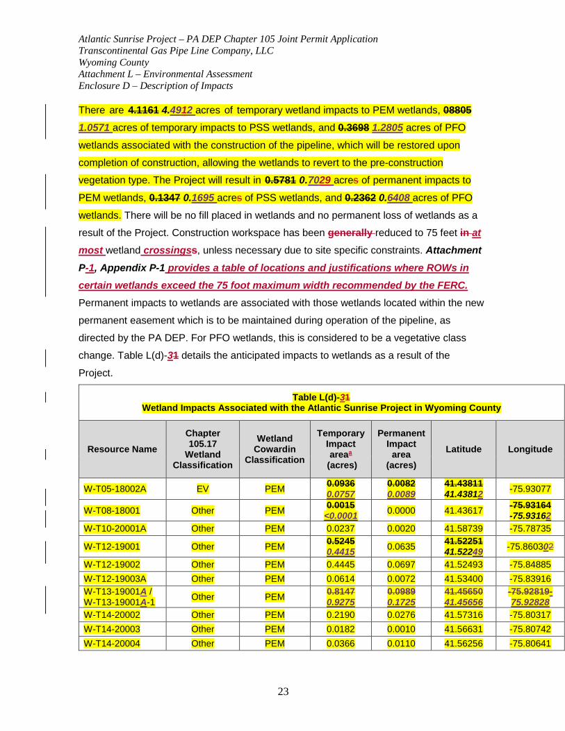
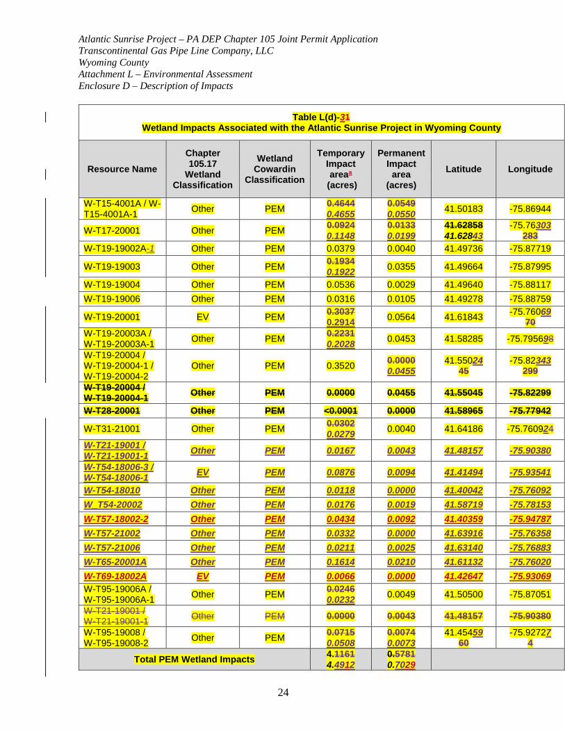
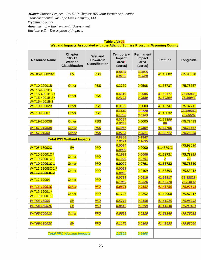
There are 4.1161 4.4912 acres of temporary wetland impacts to PEM wetlands, 08805
1.0571 acres of temporary impacts to PSS wetlands, and 0.3698 1.2805 acres of PFO
wetlands associated with the construction of the pipeline, which will be restored upon
completion of construction, allowing the wetlands to revert to the pre-construction
vegetation type. The Project will result in 0.5781 0.7029 acres of permanent impacts to
PEM wetlands, 0.1347 0.1695 acres of PSS wetlands, and 0.2362 0.6408 acres of PFO
wetlands. There will be no fill placed in wetlands and no permanent loss of wetlands as a
result of the Project. Construction workspace has been generally reduced to 75 feet in at most wetland crossingss, unless necessary due to site specific constraints. Attachment P-1, Appendix P-1 provides a table of locations and justifications where ROWs in certain wetlands exceed the 75 foot maximum width recommended by the FERC. Permanent impacts to wetlands are associated with those wetlands located within the new
permanent easement which is to be maintained during operation of the pipeline, as
directed by the PA DEP. For PFO wetlands, this is considered to be a vegetative class
change. Table L(d)-31 details the anticipated impacts to wetlands as a result of the
Project.
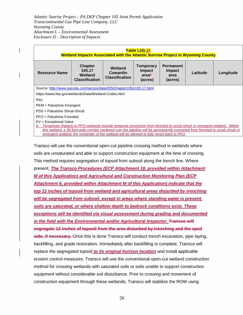
Table L(d)-31 Wetland Impacts Associated with the Atlantic Sunrise Project in Wyoming County
Resource Name Chapter 105.17
Wetland Classification
Wetland Cowardin
Classification
Temporary Impact areaa
(acres)
Permanent Impact
area (acres)
Latitude Longitude
W-T05-18002A EV PEM 0.0936 0.0757
0.0082 0.0089
41.43811 41.43812 -75.93077
W-T08-18001 Other PEM 0.0015 <0.0001 0.0000 41.43617 -75.93164
-75.93162 W-T10-20001A Other PEM 0.0237 0.0020 41.58739 -75.78735
W-T12-19001 Other PEM 0.5245 0.4415 0.0635 41.52251
41.52249 -75.860302
W-T12-19002 Other PEM 0.4445 0.0697 41.52493 -75.84885 W-T12-19003A Other PEM 0.0614 0.0072 41.53400 -75.83916 W-T13-19001A / W-T13-19001A-1 Other PEM 0.8147
0.9275 0.0989 0.1725
41.45650 41.45656
-75.92819-75.92828
W-T14-20002 Other PEM 0.2190 0.0276 41.57316 -75.80317 W-T14-20003 Other PEM 0.0182 0.0010 41.56631 -75.80742 W-T14-20004 Other PEM 0.0366 0.0110 41.56256 -75.80641
Atlantic Sunrise Project – PA DEP Chapter 105 Joint Permit Application Transcontinental Gas Pipe Line Company, LLC Wyoming County Attachment L – Environmental Assessment Enclosure D – Description of Impacts
24
Table L(d)-31 Wetland Impacts Associated with the Atlantic Sunrise Project in Wyoming County
Resource Name Chapter 105.17
Wetland Classification
Wetland Cowardin
Classification
Temporary Impact areaa
(acres)
Permanent Impact
area (acres)
Latitude Longitude
W-T15-4001A / W-T15-4001A-1 Other PEM 0.4644
0.4655 0.0549 0.0550 41.50183 -75.86944
W-T17-20001 Other PEM 0.0924 0.1148
0.0133 0.0199
41.62858 41.62843
-75.76303 283
W-T19-19002A-1 Other PEM 0.0379 0.0040 41.49736 -75.87719
W-T19-19003 Other PEM 0.1934 0.1922 0.0355 41.49664 -75.87995
W-T19-19004 Other PEM 0.0536 0.0029 41.49640 -75.88117 W-T19-19006 Other PEM 0.0316 0.0105 41.49278 -75.88759
W-T19-20001 EV PEM 0.3037 0.2914 0.0564 41.61843 -75.76069
70 W-T19-20003A / W-T19-20003A-1 Other PEM 0.2231
0.2028 0.0453 41.58285 -75.795698
W-T19-20004 / W-T19-20004-1 / W-T19-20004-2
Other PEM 0.3520 0.0000 0.0455
41.55024 45
-75.82343 299
W-T19-20004 / W-T19-20004-1 Other PEM 0.0000 0.0455 41.55045 -75.82299
W-T28-20001 Other PEM <0.0001 0.0000 41.58965 -75.77942
W-T31-21001 Other PEM 0.0302 0.0279 0.0040 41.64186 -75.760924
W-T21-19001 / W-T21-19001-1 Other PEM 0.0167 0.0043 41.48157 -75.90380
W-T54-18006-3 / W-T54-18006-1 EV PEM 0.0876 0.0094 41.41494 -75.93541
W-T54-18010 Other PEM 0.0118 0.0000 41.40042 -75.76092 W_T54-20002 Other PEM 0.0176 0.0019 41.58719 -75.78153 W-T57-18002-2 Other PEM 0.0434 0.0092 41.40359 -75.94787 W-T57-21002 Other PEM 0.0332 0.0000 41.63916 -75.76358 W-T57-21006 Other PEM 0.0211 0.0025 41.63140 -75.76883 W-T65-20001A Other PEM 0.1614 0.0210 41.61132 -75.76020 W-T69-18002A EV PEM 0.0066 0.0000 41.42647 -75.93069 W-T95-19006A / W-T95-19006A-1 Other PEM 0.0246
0.0232 0.0049 41.50500 -75.87051
W-T21-19001 / W-T21-19001-1 Other PEM 0.0000 0.0043 41.48157 -75.90380
W-T95-19008 / W-T95-19008-2 Other PEM 0.0715
0.0508 0.0074 0.0073
41.45459 60
-75.92727 4
Total PEM Wetland Impacts 4.1161 4.4912
0.5781 0.7029
Atlantic Sunrise Project – PA DEP Chapter 105 Joint Permit Application Transcontinental Gas Pipe Line Company, LLC Wyoming County Attachment L – Environmental Assessment Enclosure D – Description of Impacts
25
Table L(d)-31 Wetland Impacts Associated with the Atlantic Sunrise Project in Wyoming County
Resource Name Chapter 105.17
Wetland Classification
Wetland Cowardin
Classification
Temporary Impact areaa
(acres)
Permanent Impact
area (acres)
Latitude Longitude
W-T05-18002B-1 EV PSS 0.0162 0.0156
0.0015 0.0020 41.43802 -75.93070
W-T10-20001B Other PSS 0.2779 0.0508 41.58737 -75.78757 W-T15-4001B / W-T15-4001B-1 / W-T15-4001B-2 / W-T15-4001B-3
Other PSS 0.4319 0.4128
0.0605 0.0589
41.50177 41.50204
-75.86936-75.86947
W-T19-19002B Other PSS 0.0050 0.0000 41.49747 -75.87711
W-T19-19007 Other PSS 0.1442 0.1333
0.0220 0.0203 41.49032 -75.89583-
75.89581
W-T19-20003B Other PSS 0.0054 0.0033 0.0000 41.58390
89 -75.79493
W-T57-21003B Other PSS 0.1957 0.0364 41.63766 -75.76567 W-T57-21004 Other PSS 0.0135 0.0011 41.63717 -75.76668
Total PSS Wetland Impacts 0.8806 1.0571
0.1347 0.1695
W-T05-18002C EV PFO 0.0024 0.0005 0.0000 41.437912 -75.93090
2 W-T10-20001C / W-T10-20001C-1 Other PFO 0.1633
0.1392 0.0000 0.0791
41.58731 2
-75.78819 20
W-T10-20001C-1 Other PFO 0.0000 0.0791 41.58732 -75.78820 W-T12-19003C-1 / W-T12-19003C-2 Other PFO 0.0062
0.0058 0.0109 41.53393 -75.83912
W-T12-19004 Other PFO 0.0752 0.1089
0.0610 0.0626
41.53517 41.53518
-75.83828-75.83832
W-T13-19001C Other PFO 0.0871 0.0157 41.45755 -75.92841 W-T19-19001 / W-T19-19001-1 Other PFO 0.1228 0.0852 41.49900 -75.87417
W-T54-18005 EV PFO 0.5716 0.2150 41.41015 -75.94242 W-T54-18007C EV PFO 0.0642 0.0799 41.41630 -75.93481
W-T65-20001C Other PFO 0.0628 0.0119 41.61149 -75.76031
W-T69-18002C EV PFO 0.1176 0.0805 41.42633 -75.93060
Total PFO Wetland Impacts 1.2805 0.6408
Atlantic Sunrise Project – PA DEP Chapter 105 Joint Permit Application Transcontinental Gas Pipe Line Company, LLC Wyoming County Attachment L – Environmental Assessment Enclosure D – Description of Impacts
26
Table L(d)-31 Wetland Impacts Associated with the Atlantic Sunrise Project in Wyoming County
Resource Name Chapter 105.17
Wetland Classification
Wetland Cowardin
Classification
Temporary Impact areaa
(acres)
Permanent Impact
area (acres)
Latitude Longitude
Source: http://www.pacode.com/secure/data/025/chapter105/s105.17.html https://www.fws.gov/wetlands/Data/Wetland-Codes.html Key: PEM = Palustrine Emergent PSS = Palustrine Shrub-Shrub PFO = Palustrine Forested EV = Exceptional Value a: Temporary impacts to PFO wetlands include temporal conversion from forested to scrub-shrub or emergent wetland. Within
this wetland, a 30-foot-wide corridor centered over the pipeline will be permanently converted from forested to scrub-shrub or emergent wetland; the remainder of the wetland will be allowed to fully revert back to PFO.
Transco will use the conventional open-cut pipeline crossing method in wetlands where
soils are unsaturated and able to support construction equipment at the time of crossing.
This method requires segregation of topsoil from subsoil along the trench line. Where
present, The Transco Procedures (ECP Attachment 18, provided within Attachment M of this Application) and Agricultural and Construction Monitoring Plan (ECP Attachment 6, provided within Attachment M of this Application) indicate that the top 12 inches of topsoil from wetland and agricultural areas disturbed by trenching will be segregated from subsoil, except in areas where standing water is present, soils are saturated, or where shallow depth to bedrock conditions exist. These exceptions will be identified via visual assessment during grading and documented in the field with the Environmental and/or Agricultural Inspector. Transco will segregate 12 inches of topsoil from the area disturbed by trenching and the spoil side, if necessary. Once this is done Transco will conduct trench excavation, pipe laying,
backfilling, and grade restoration. Immediately after backfilling is complete, Transco will
replace the segregated topsoil to its original horizon location and install applicable
erosion control measures. Transco will use the conventional open-cut wetland construction
method for crossing wetlands with saturated soils or soils unable to support construction
equipment without considerable soil disturbance. Prior to crossing and movement of
construction equipment through these wetlands, Transco will stabilize the ROW using
Atlantic Sunrise Project – PA DEP Chapter 105 Joint Permit Application Transcontinental Gas Pipe Line Company, LLC Wyoming County Attachment L – Environmental Assessment Enclosure D – Description of Impacts
27
equipment mats to allow for a stable, safe working condition and to prevent significant
rutting/soil disturbance. Transco will temporarily store trench spoil in a ridge along the
pipeline trench, leaving gaps as appropriate intervals to provide for natural circulation or
drainage of water. Topsoil will not be segregated where standing water is present or soils
are saturated.
While excavating the trench, Transco will attempt to assemble the pipeline in a staging
area located in an upland area unless the wetland is dry enough to support skids and pipe.
Transco will then move the pipe to the ROW. Pipe stringing and fabrication may occur
within the wetland adjacent to the trench or adjacent to the wetland in an approved ATWS.
After lowering the pipeline into the trench, Transco will work from equipment mats to
perform backfilling, final cleanup, and grading.
Construction in inundated wetland areas may require the push-pull technique. The push-
pull technique can be used in large inundated wetland areas (>300 feet crossing length)
where sufficient water is present to float the pipeline in the trench and where grade
elevation over the length of the push-pull area will not require damming to maintain
adequate water levels for flotation of the pipe. Transco will use this technique when
inundated conditions prevent the use of conventional open-cut wetland construction
techniques.
Operation of construction equipment through wetlands will be limited to only that necessary
for each stage of pipeline installation (e.g., clearing, trenching). Topsoil segregation
techniques will be used in wetlands that are not saturated or inundated to preserve the
seed bank and to facilitate successful restoration. Wetland crossing methods will be
determined based on site-specific conditions at the time of crossing. Wetlands with soils
that can support construction equipment may be crossed using the conventional open-cut
method, as described below, with the use of timber mats to prevent soil rutting. In forested
wetlands, Transco will minimize tree clearing to the extent practicable while maintaining
safe construction conditions. Typical drawings for the wetland crossings are provided in
Attachment 2 of the Transco ECP (Attachment M).
Atlantic Sunrise Project – PA DEP Chapter 105 Joint Permit Application Transcontinental Gas Pipe Line Company, LLC Wyoming County Attachment L – Environmental Assessment Enclosure D – Description of Impacts
28
Some wetland vegetation will be cut, removed, or crushed during construction. After the
completion of construction, wetland areas within the ROW will be restored to
preconstruction contours and revegetated with annual ryegrass where standing water is
not present to stabilize disturbed soils. Annual ryegrass is intended to be a temporary
cover to enhance soil stability. In wetland areas, restoration activities will involve returning
wetlands to pre-construction contours and seeding in non-inundated areas with an
approved wetland seed mix.. Affected wetland areas will be allowed to revegetate naturally from existing adjacent seed banks. PEM wetlands, dominated primarily by
low-growing sedges, rushes, and other herbaceous vegetation will revert to emergent
vegetation following construction, resulting in no permanent change to wetland type.
Wetland areas will not be amended with fertilizer, lime, or mulch unless required by
appropriate federal and state agencies.
Upon completion of wetland crossings, Transco will restore wetlands to their original
configurations and contours and stabilize disturbed adjacent upland areas. Through these
activities, Transco seeks to protect wetlands from sediment transport and restore native
hydrophytic vegetation as quickly as possible. Following construction, Transco will monitor
disturbed wetlands and adjacent uplands until restoration and long-term stabilization is
documented per the requirements of the FERC Order and other applicable regulatory
approvals.
Revegetation will be considered successful when the vegetative cover returns to at least
80 percent of the type, density, and distribution of the native vegetation in adjacent,
portions of the wetland not disturbed by construction of the Project.
Additional wetland avoidance and minimization measures are described in the Transco
Procedures, which is included as Attachment 18 of the Transco ECP (Attachment M) as
well as the Alternatives Analysis for this application (Attachment P-1).
Compensatory Mitigation for Wetland Impacts
No permanent fill will be placed in wetlands as a result of this Project. However, there will be permanent conversion of PFO wetlands to PEM or PSS vegetation
Atlantic Sunrise Project – PA DEP Chapter 105 Joint Permit Application Transcontinental Gas Pipe Line Company, LLC Wyoming County Attachment L – Environmental Assessment Enclosure D – Description of Impacts
29
types within the permanent ROW; therefore all PFO wetland impacts not classified as Exceptional Value (EV) are being compensated for at a ratio of 2:1, while EV wetlands will be compensated for at a 2.5:1 ratio. Construction and operation of the Project will impact 0.6060 acres of other PFO wetlands which will be compensated for at the Briar Creek and Towanda Creek Mitigation Sites as detailed in Attachment Q. Additionally, 0.0024 acres of EV PFO wetland impacts have been identified in Wyoming County. Off-site mitigation will be provided for a total of 1.2134 acres of PFO wetlands affected in Wyoming County. The mitigation sites are oversized to account for potential Project-related wetland impacts within parcels that currently do not have access for surveys. [(0.6060 acres*2 ratio = 1.2120 acres) + (0.0024 acres*2.5 ratio = 0.0060 acres) = 1.2180 acres]
No permanent fill will be placed in wetlands as a result of this Project. Mitigation will be required for permanent conversion of vegetation cover type for PFO and PSS wetlands and for temporary conversion of vegetation cover type for PFO wetlands. The following impact mitigation ratios were determined in coordination with the PA DEP and USACE: 2.5:1 for EV PFO wetlands, 2:1 for non-EV PFO wetlands, 1.75:1 for EV PSS wetlands, and 1.5:1 for non-EV PSS wetlands.
The Project will result in 1.13 acres of impacts to EV PFO wetlands, 0.79 acre of impacts to non-EV PFO wetlands, and 0.17 acre of permanent impacts to non-EV PSS wetlands in Wyoming County. Impact totals in Wyoming County were aggregated and rounded to two significant digits to determine mitigation needs. Therefore while 0.0020 acre of permanent EV PSS impact is proposed, this impact amount rounds to 0.00 and is not reflected in the mitigation totals. Mitigation will be required for 2.09 acres of wetland impacts within Wyoming County which will be mitigated for at the Towanda Creek and Briar Creek Permittee Responsible Mitigation (PRM) sites as detailed in Attachments Q-1 and Q-2. Transco proposes to provide offsite mitigation for [(1.13 acres*2.5 ration = 2.83) + (0.79 acre* 2.0 = 1.58 acres) + (0.17 acre* 1.5 = 0.26 acre) = 4.67 acres]. The mitigation sites will provide sufficient acreage to compensate for the above-listed impacts, with
Atlantic Sunrise Project – PA DEP Chapter 105 Joint Permit Application Transcontinental Gas Pipe Line Company, LLC Wyoming County Attachment L – Environmental Assessment Enclosure D – Description of Impacts
30
additional ecological benefits beyond the required mitigation. Some of the temporary and permanent PFO impact areas are also being replanted on-site, providing double mitigation for these areas.
Transco has provided a Mitigation Master Plan and a Site Specific Mitigation Plan for the Towanda Creek PRM site in Bradford County and the Briar Creek PRM site in Columbia County. Under the authorization of this Chapter 105 permit application, Transco is seeking authorization to construct the Mitigation Site for this Project. There is a permanent wetland impact of 0.01-acre associated with improvements to agricultural crossing for the farmer, associated with the construction of this site. Total mitigation needed has been adjusted to account for 0.01-acre of proposed permanent impact to PEM Wetland W-2 within the Saddle Swamp easement area as a result of proposed upgrades/improvements to a permanent agricultural crossing at the PRM site. The USACE Highway Methodology Workbook Supplement: Wetland Functions and Values (Supplement, 1993) was used to evaluate the functions and values of the wetlands at the impact site and the PRM sites. The Supplement is a qualitative approach to describing the physical characteristics of and identifying the functions and values exhibited by a wetland. The Wetland Function-Value Evaluation Form in the Supplement was completed at the PRM Sites in order to capture the existing or pre-restoration conditions at the PRM Sites as well as the anticipated ecological lift the site will experience as a result of the restoration activities. The baseline conditions of the existing wetlands at the PRM Sites already represent a functional uplift with respect to the functions and values as compared to the impacted wetlands for which the PRM Sites will be providing mitigation. The functional uplift will further be improved through the proposed restoration efforts. The wetland functions and values assessments performed at the Project impact locations and the PRM Sites indicate that the mitigation site, once restored, will compensate for and replace the functions and values impacted as a result of the Project by providing improved wildlife habitat,
Atlantic Sunrise Project – PA DEP Chapter 105 Joint Permit Application Transcontinental Gas Pipe Line Company, LLC Wyoming County Attachment L – Environmental Assessment Enclosure D – Description of Impacts
31
flood flow alteration, and nutrient removal/retention (the top three functions and values lost as a result of Project construction) at comparatively high levels (see Attachment Q-1). Towanda Creek PRM Site Currently, the existing condition of the land within the proposed Towanda Creek PRM Site exists in a degraded state. Environmental resources including wetlands and waters within the PRM Site are currently surrounded by active agricultural land and continue to be degraded by the surrounding landscape uses. Over time, agricultural practices have filled in and disconnected hydrology to historic headwater wetland areas. Existing vegetation includes non-native Eurasian pasture grasses and invasive multiflora rose (Rosa multiflora). Based on the USACE Supplement methodology for identifying wetland functions and values, the wetlands within the PRM Site are currently collectively suitable for eight functions and values (Attachment Q-2, Appendix F: Wetland Functions and Values Assessment Forms). Given the current degraded state of the aquatic resources on-site, only four of the eight collective suitable functions and values (including groundwater recharge/discharge, flood flow alteration, sediment/toxicant retention, and wildlife habitat) are considered principal functions across the larger system. Post restoration, it is anticipated that the wetlands within the PRM Site will be collectively suitable for nine functions and values, of which six will be performing at principal levels (these include the four that were assessed as being principal prior to restoration activities, in addition to nutrient removal and sediment/shoreline stabilization). As such, the PRM Site will exhibit an ecological uplift that will not only enhance the existing principal functions and values, but will also provide additional principal functions and values. Ecological functionality is therefore expected to improve considerably as a result of the proposed restoration efforts. Farming activities such as yearly discing and associated soil erosion have caused soil to slump off of steeper convex hill slope areas into the toe of slope concave areas where the eroded sediment has settled out. Grading in the proposed wetland
Atlantic Sunrise Project – PA DEP Chapter 105 Joint Permit Application Transcontinental Gas Pipe Line Company, LLC Wyoming County Attachment L – Environmental Assessment Enclosure D – Description of Impacts
32
re-establishment areas will remove this accumulated soil from the relatively flat valley bottom back towards the concave toe of slopes, re-establishing grades consistent with the grades of the existing wetland resources. This should ensure that the re-established headwaters’ depressional wetlands have adequate hydrology while also optimizing storm water infiltration and storage in this headwaters system, improving the groundwater recharge/discharge and floodflow alteration functions. Over time as the re-established wetlands mature into a forested state, they will restore additional sediment/toxicant retention, nutrient removal, and sediment stabilization functionality to the system. The on-site stream will be planted with live stakes to provide stream bank stabilization and vegetative enhancement, further improving sediment/toxicant removal and sediment stabilization function to on-site aquatic resources as the live stakes develop into mature trees. Removing invasive and non-native vegetation and re-planting the PRM Site with a native-community will increase the vegetative diversity and density of the PRM Site, enhancing the quality and quantity of wildlife habitat available within the PRM Site. Native plantings and seeding proposed across the entire PRM Site will improve the effectiveness of the wetlands and reduce flood damage by improving water retention for prolonged periods following precipitation events and gradually releasing floodwaters. Increased vegetative diversity, and density will facilitate the retention of greater volumes of water, sediment, nutrients and pathogens than under normal or average rainfall conditions, supporting additional stability and buffering capacity of the wetland ecological system. Post restoration, the PRM Site wetlands will be significantly more effective in nutrient removal/retention/transformation as they will be better able to trap nutrients from surface runoff and process them into other forms or trophic levels. Enhancement plantings will include larger trees and shrubs, which will more effectively withstand larger flood events and erosive stresses. The post-restoration wetland system will exhibit a diverse plant community structure and will offer a greater and wider range of usable products for wildlife, improving production export functionality. Although the PRM Site is located on private land and will not likely be accessible to the public, Towanda Creek is classified as a trout-stocked migratory fishery, with a portion of the creek upstream
Atlantic Sunrise Project – PA DEP Chapter 105 Joint Permit Application Transcontinental Gas Pipe Line Company, LLC Wyoming County Attachment L – Environmental Assessment Enclosure D – Description of Impacts
33
of the PRM Site designated as approved trout waters. The PRM Site therefore plays an important role in the greater ecological system and watershed. Transco’s subcontractor evaluated the functions and values of the pre- and post-restoration functions and values of the PRM Site, and applied a ratio-based methodology to ensure that the PRM Site will provide sufficient acreages of mitigation to meet the functional replacement needs of the Project. The wetland functions and values assessments performed at the Project impact locations and the Towanda PRM Site indicate that the mitigation site, once restored, will replace the primary functions and values impacted as a result of the Project by providing improved wildlife habitat, flood flow alteration, and nutrient removal at high levels. In addition to replacing the impacted functions and values, the Towanda Creek PRM Site will provide three additional functions and values – groundwater recharge/discharge, sediment/toxicant removal, and sediment/shoreline stabilization. Briar Creek PRM Site Currently, the existing condition of the land within the proposed Briar Creek PRM Site exists in a degraded state. Environmental resources including wetlands and waters within the Briar Creek PRM Site are currently surrounded by active agricultural land and continue to be degraded by the surrounding landscape uses. The majority of the Briar Creek PRM Site is heavily colonized by invasive and/or non-native species including reed canary grass (Phalaris arundinacea) Japanese stiltgrass (Microstegium vimineum), multiflora rose (Rosa multiflora), and oriental bittersweet (Celastrus orbiculatus). In the uplands surrounding the Briar Creek PRM Site, invasive and/or non-native species threatening the site include garlic-mustard (Alliaria petiolata), multiflora rose, border privet (Ligustrum obtusifolium), and reed canary grass. By following the USACE Supplement for identifying wetland functions and values, it was determined that the complex of hydrologically connected wetlands identified within the PRM Site are currently collectively suitable for eight functions and values (Appendix F: Wetland Function and Values Assessment Forms).
Atlantic Sunrise Project – PA DEP Chapter 105 Joint Permit Application Transcontinental Gas Pipe Line Company, LLC Wyoming County Attachment L – Environmental Assessment Enclosure D – Description of Impacts
34
Given the current degraded state of the wetland complex and its immediate surroundings, only six of the eight collective suitable functions and values (of which include flood flow alteration, fish and shellfish habitat, sediment/toxicant retention, sediment stabilization, and wildlife habitat) are considered principal functions across the larger wetland complex. Post restoration, it is anticipated that the wetlands within PRM Site will be collectively suitable for eleven functions and values, of which eight of those will be performing at principal levels (these include the six that are principal prior to restoration activities, in addition to the following: nutrient removal, production export, and uniqueness/heritage). As such, PRM Site will exhibit an ecological uplift that will not only enhance the existing principal functions and values, but will also allow the wetland to exhibit additional principal functions and values. Current functionality is expected to improve considerably as a result of restoration efforts. Removing invasive and non-native vegetation and re-planting the PRM Site with a native-community will increase the vegetative diversity and density of the PRM Site. This restoration activity proposed for the PRM Site will most notably enhance the quality and quantity of wildlife habitat available within the PRM Site. Native plantings and seeding proposed across the entire PRM Site will improve the effectiveness of the wetland in reducing flood damage by increasing water retentions for prolonged periods following precipitations events and the gradual release of floodwaters. Increased vegetative diversity, including plant community structure, and density will be able to retain higher volumes of water than under normal or average rainfall conditions, supporting additional stability of the wetland ecological system and its buffering characteristics, and thereby providing social and economic value related to erosion and flood prone areas. Sources of excess sediment exist surrounding the wetland, and with the proposed restoration activities, this wetland will be better capable of reduces or preventing degradation of water quality as it will act as a trap for sediments, toxicants and/or pathogens in runoff in runoff water. Post-restoration, wetlands at the PRM Site will become significantly more effective for
Atlantic Sunrise Project – PA DEP Chapter 105 Joint Permit Application Transcontinental Gas Pipe Line Company, LLC Wyoming County Attachment L – Environmental Assessment Enclosure D – Description of Impacts
35
nutrient removal/retention/transformation as they will be better able to trap nutrients in runoff water and process then into other forms or trophic levels. The enhancement and establishment of improved vegetative density and diversity will be enable the wetland to utilize the nutrients. Enhancement of the wetland and riparian habitats surrounding the waters within the PRM Site will improve the effectiveness as a streambank stabilizer, complete with large trees and shrubs that post-restoration, will be more effectively able to withstand larger flood events or erosive incidents. Post restoration, the wetland will exhibit a higher degree of plant community structure, density and diversity, and will offer greater usable products for living organism, thereby improving production export functionality. Although the PRM Site is located on private land and will likely not be accessible to the public, the PRM Site is associated with special value streams (naturally reproducing trout streams, trout stocked streams) and thereby plays an important role in the ecological system of the areas. Waterbodies Watercourses and Bodies of Water Twenty-nine Forty-six waterbodies watercourses will be crossed during construction of
the pipeline in Wyoming County. The centerline of the pipeline will cross each waterbody watercourse utilizing the construction method indicated in the table below. Temporary
construction bridges will be used to cross the streams with equipment, as necessary,
during construction. Temporary stream impacts total 0.7273 1.9228 acres of perennial
streams, and approximately 0.1685 0.2827 acres of intermittent and ephemeral streams.
Permanent stream impacts are defined by the placement of the pipeline and permanent
operation easement as directed by PA DEP, and total 0.2722 0.3276 acres of perennial
streams and 0.0234 0.0339 acres of intermittent and ephemeral streams. Transco is
proposing to cross watercourses using the dam-and-pump, flume, or HDD construction
method (see also Attachment P-1, Appendix P-1).
No fill or water obstructions will be added to streams as a part of this Project, therefore no
loss of stream functions and values is expected to occur. Impacts are detailed in Table
L(d)-42.

Atlantic Sunrise Project – PA DEP Chapter 105 Joint Permit Application Transcontinental Gas Pipe Line Company, LLC Wyoming County Attachment L – Environmental Assessment Enclosure D – Description of Impacts
36
Table L(d)-42 Stream Impacts Associated with the Atlantic Sunrise Project in Wyoming County
Resource ID
Resource Name
Chapter 93 Classificationa Stream Type Stream PFBC
Trout Status
Temporary Impact Dimensions (Length x
Width) Temporary Impact area
Permanent Impact Dimensions (Length x Width)
Permanent Impact area Latitude Longitude
Waterbody Watercourse
Crossing Method (Feet)b (Acres) (Feet)b (Acres)
WW-T05-18001 Mill Creek CWF, MF Perennial Wild Trout
Waters 104.57 120.68
16.34 15.94
0.0383 0.0432
14.04 13.58
16.34 15.94
0.0038 0.0037
41.43833 41.43843
-75.93058 -75.93066 Dam-and-Pump
WW-T10-20002
UNT to South Branch
Tunkhannock Creek
CWF, MF Perennial Approved Trout WatersNone
70.68 80.87 38.59 0.0585
0.0662 10.09 38.59 0.0089 41.58747 41.58748 -75.78492 Dam-and-Pump
WW-T10-20003
UNT to South Branch
Tunkhannock Creek
CWF, MF Perennial Approved Trout WatersNone
80.62 91.78 27.08 0.0390
0.0441 11.08 27.08 0.0062 41.59244 41.59247 -75.77701 Dam-and-Pump
WW-T12-19002
UNT to Beaver Creek CWF, MF Perennial None 78.51 10.32 0.0142 10.80 10.32 0.0024 41.52496 -75.84858 Dam-and-Pump
WW-T14-20002
UNT to South Branch
Tunkhannock Creek
CWF, MF Perennial
Approved Trout Waters; Trout
Stocked StreamApproved
Trout Waters
121.44 17.46 0.0298 15.68 17.46 0.0040 41.57307 -75.80321 Dam-and-Pump
WW-T14-20002A
UNT to South Branch
Tunkhannock Creek
CWF, MF Perennial
Approved Trout Waters; Trout
Stocked StreamApproved
Trout Waters
127.59 5.74 0.0125 15.10 5.74 0.0013 41.57335 -75.80305 Dam-and-Pump
WW-T14-20003
South Branch Tunkhannock
Creek TSF, MF Perennial
Approved Trout Waters; Trout
Stocked Stream 84.72 105.38 0.1768 10.10 105.38 0.0242 41.56393 -75.80648 Dam-and-Pump
WW-T19-20001
UNT to Tunkhannock
Creek CWF, MF Perennial None 75.18 24.71 0.0397 11.83 24.71 0.0057 41.61876 -75.76078 Dam-and-Pump
WW-T19-20003
UNT to South Branch
Tunkhannock Creek
CWF, MF Perennial Approved Trout WatersNone
70.73 80.88 71.79 0.1004
0.1137 10.04 71.79 0.0164 41.59895 -75.76909 Dam-and-Pump
WW-T19-20004
UNT to South Branch
Tunkhannock Creek
CWF, MF Perennial Approved Trout Waters
77.02 90.13 17.20 0.0354
0.0401 10.23 17.20 0.0040 41.58400 -75.79482 Dam-and-Pump
WW-T19-20005 Trout Brook CWF, MF Perennial None 75.81
90.94 19.71 0.0382 0.0456 10.04 19.71 0.0045 41.55036
41.55037 -75.82332 -75.82341 Dam-and-Pump
WW-T21-19001
Susquehanna River WWF, MF Perennial
WWCW Fisheries Streams
116.28 59.75
798.73 47.29
0.0277 0.0408
0010.12 0.00
0.00 00798.73
0.0000 0.1834
41.47986 41.48041
-75.90611 -75.90561 HDDN/A
WW-T21-19001
Susquehanna River WWF, MF Perennial
WWCW Fisheries Streams
40.49 798.73 0.7300 10.12 798.73 0.1834 41.48052 -75.90543 HDD

Atlantic Sunrise Project – PA DEP Chapter 105 Joint Permit Application Transcontinental Gas Pipe Line Company, LLC Wyoming County Attachment L – Environmental Assessment Enclosure D – Description of Impacts
37
Table L(d)-42 Stream Impacts Associated with the Atlantic Sunrise Project in Wyoming County
Resource ID
Resource Name
Chapter 93 Classificationa Stream Type Stream PFBC
Trout Status
Temporary Impact Dimensions (Length x
Width) Temporary Impact area
Permanent Impact Dimensions (Length x Width)
Permanent Impact area Latitude Longitude
Waterbody Watercourse
Crossing Method (Feet)b (Acres) (Feet)b (Acres)
WW-T21-19002
UNT to Susquehanna
River CWF, MF Perennial None 65.60 18.57 0.0272
0.0280 10.09 18.57 0.0043 41.49028 -75.89612 Dam-and-Pump
WW-T24-19001
UNT to Susquehanna
River CWF, MF Perennial None 86.98
95.92 9.15 0.0169 11.77 12.92 9.15 0.0021 41.50281 -75.86953 Wet open-
cutFlume
WW-T24-19001A
UNT to Susquehanna
River CWF, MF Perennial None 16.43
28.71 18.52 0.0076 0.00 0.00 0.0000 41.50292 -75.86968 Temporary
Construction CrossingN/A
WW-T24-19001B
UNT to Susquehanna
River CWF, MF Perennial None 4.51 4.99 0.0005 0.0000 0.000 0.000 41.50239 -75.86966 N/A
W-T54-18002
Whitelock Creek CWF, MF Perennial Wild Trout
Waters 87.36 30.15 0.0247 10.26 30.15 0.0067 41.41001 -75.94270 Dam-and-Pump
WW-T54-18002B
UNT to Whitelock
Creek CWF, MF Perennial Wild Trout
Waters 29.48 5.32 0.0035 0.00 0.00 0.0000 41,40985 -75.94306 N/A
WW-T54-18003
UNT to Whitelock
Creek CWF, MF Perennial Wild Trout
Waters 76.47 16.37 0.0285 10.42 16.37 0.0038 41.41575 -75.93509 Dam-and-Pump
WW-T54-19001
UNT to Mill Run CWF, MF Perennial Wild Trout
Waters 77.74 24.15 0.0383 11.52 24.15 0.0055 41.51478 -75.87106 Dam-and-Pump
WW-T54-21001
Tunkhannock Creek TSF, MF Perennial
Approved Trout Waters; WWCW
Fisheries Stream
142.23 115.08 0.3552 10.14 115.08 0.0263 41.62682 -75.76035 Dam-and-Pump
WW-T57-21003
UNT to Tunkhannock
Creek CWF, MF Perennial None 67.39 11.10 0.0146 10.57 11.10 0.0025 41.63712 -75.76663 Dam-and-
Pump
WW-T69-18002
UNT to Whitelock
Creek CWF, MF Perennial Wild Trout
Waters 106.81 34.29 0.0401 18.96 34.29 0.0084 41.42615 -75.93067 Dam-and-Pump
WW-T69-18004
UNT to Whitelock
Creek CWF, MF Perennial Wild Trout
Waters 81.27 8.23 0.0140 10.92 8.23 0.0020 41.42643 -75.93056 Dam-and-Pump
WW-T92-19002
UNT to Martin Creek CWF, MF Perennial None 25.37 5.78 0.0031 0.00000 0.00000 0.0000 41.45682 -75.92859 N/A
WW-T93-20002
UNT to Trout Brook CWF, MF Perennial None 70.74 5.36 0.0081 10.75 5.36 0.0012 41.53402 -75.83910 Dam-and-Pump
Perennial Stream Impacts 1.9228 0.7273 0.3276
0.2722

Atlantic Sunrise Project – PA DEP Chapter 105 Joint Permit Application Transcontinental Gas Pipe Line Company, LLC Wyoming County Attachment L – Environmental Assessment Enclosure D – Description of Impacts
38
Table L(d)-42 Stream Impacts Associated with the Atlantic Sunrise Project in Wyoming County
Resource ID
Resource Name
Chapter 93 Classificationa Stream Type Stream PFBC
Trout Status
Temporary Impact Dimensions (Length x
Width) Temporary Impact area
Permanent Impact Dimensions (Length x Width)
Permanent Impact area Latitude Longitude
Waterbody Watercourse
Crossing Method (Feet)b (Acres) (Feet)b (Acres)
WW-T10-20001
UNT to South Branch
Tunkhannock Creek
CWF, MF Intermittent Approved Trout WatersNone
101.35 118.56 6.72 0.0106
0.0131 10.00 6.72 0.0015 41.58737 41.58738
-75.78792 -75.78795 Dam-and-Pump
WW-T10-20001
UNT to South Branch
Tunkhannock Creek
CWF, MF Intermittent None 58.45 6.72 0.0071 0.00 00
0.0000 0.00 0.0000 41.58758 -75.78822 Culvert
WW-T13-19001
UNT to Martin Creek CWF, MF Ephemeral Approved Trout
WatersNone 88.32 100.97
17.73 17.39
0.0278 0.0317
13.73 13.65
17.73 17.39 0.0041 41.45496
41.45497 -75.92753 Dam-and-Pump
WW-T13-19002
UNT to Martin Creek CWF, MF Intermittent Approved Trout
WatersNone 81.66 102.53
5.24 5.25
0.0138 0.0171 10.53 5.24
5.25 0.0012 41.45737 -75.92839 -75.92841
Dam-and-PumpFlume
WW-T13-19003
UNT to Martin Creek CWF, MF Intermittent Approved Trout
WatersNone 71.48 82.12
12.68 12.58
0.0146 0.0163 10.02 12.68
12.58 0.0030 41.45817 -75.92797 -75.92796
Dam-and-PumpFlume
WW-T14-20004
UNT South Branch
Tunkhannock Creek
TSF, MF Ephemeral Approved Trout Waters 81.94 8.90 0.0076 0.00 0.00 0.0000 41.56270 -75.80662
Temporary Construction
Crossing
WW-T15-4001
UNT to Susquehanna
River CWF, MF Ephemeral None 70.94 6.06 0.0088 13.16 6.06 0.0014 41.49901 -75.87408 Dam-and-
PumpFlume
WW-T15-4002
UNT to Susquehanna
River CWF, MF Ephemeral None 79.09 8.80 0.0132 13.76 8.80 0.0020 41.49913 -75.87382 Dam-and-
PumpFlume
WW-T19-19001
UNT to Susquehanna
River CWF, MF Ephemeral None 79.43
88.45 10.26 0.0150 10.81 10.26 0.0023 41.49733 -75.87724 Dam-and-Pump
WW-T19-19002
UNT to Susquehanna
River CWF, MF Ephemeral None 77.18
89.40 8.87 0.0126 0.0149 12.35 8.87 0.0020 41.49616 -75.88179 Dam-and-Pump
WW-T19-19003
UNT to Susquehanna
River CWF, MF Ephemeral None 82.11
92.92 8.40 0.0124 0.0139 14.04 8.40 0.0022 41.50807 -75.87139
-75.87140 Dam-and-
PumpFlume
WW-T19-20002
UNT to South Branch
Tunkhannock Creek
CWF, MF Ephemeral Approved Trout WatersNone
70.72 80.75 5.14 0.0081
0.0092 10.32 5.14 0.0012 41.59568 -75.77292 Dam-and-Pump
WW-T54-18002A
UNT to Whitelock
Creek CWF, MF Intermittent Wild Trout
Waters 88.90 6.85 0.0143 10.01 6.85 0.0016 0.0143 41.40992 -75.94286 Dam-and-Pump
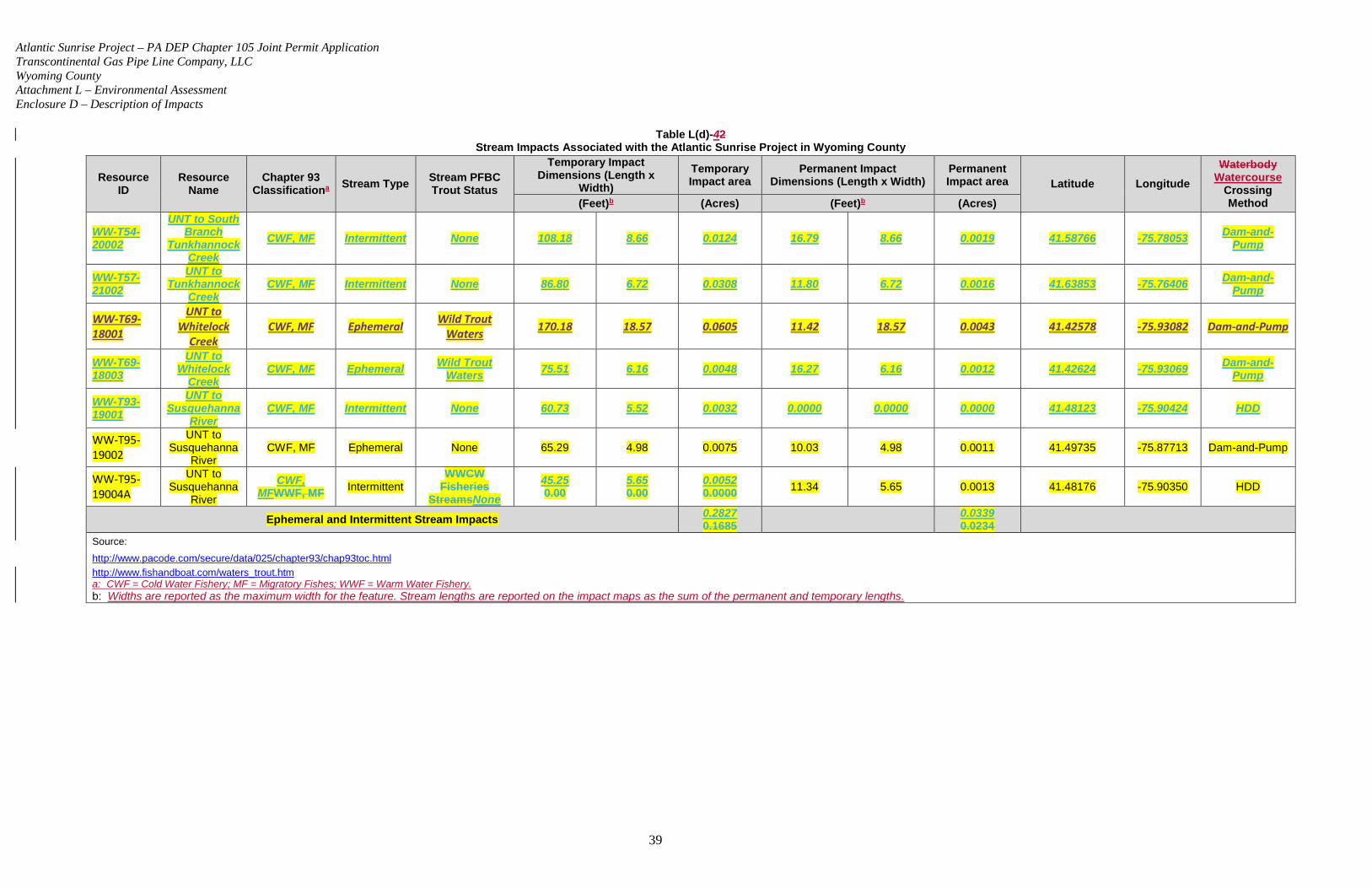
Atlantic Sunrise Project – PA DEP Chapter 105 Joint Permit Application Transcontinental Gas Pipe Line Company, LLC Wyoming County Attachment L – Environmental Assessment Enclosure D – Description of Impacts
39
Table L(d)-42 Stream Impacts Associated with the Atlantic Sunrise Project in Wyoming County
Resource ID
Resource Name
Chapter 93 Classificationa Stream Type Stream PFBC
Trout Status
Temporary Impact Dimensions (Length x
Width) Temporary Impact area
Permanent Impact Dimensions (Length x Width)
Permanent Impact area Latitude Longitude
Waterbody Watercourse
Crossing Method (Feet)b (Acres) (Feet)b (Acres)
WW-T54-20002
UNT to South Branch
Tunkhannock Creek
CWF, MF Intermittent None 108.18 8.66 0.0124 16.79 8.66 0.0019 41.58766 -75.78053 Dam-and-Pump
WW-T57-21002
UNT to Tunkhannock
Creek CWF, MF Intermittent None 86.80 6.72 0.0308 11.80 6.72 0.0016 41.63853 -75.76406 Dam-and-
Pump
WW-T69-18001
UNT to Whitelock
Creek CWF, MF Ephemeral Wild Trout
Waters 170.18 18.57 0.0605 11.42 18.57 0.0043 41.42578 -75.93082 Dam-and-Pump
WW-T69-18003
UNT to Whitelock
Creek CWF, MF Ephemeral Wild Trout
Waters 75.51 6.16 0.0048 16.27 6.16 0.0012 41.42624 -75.93069 Dam-and-Pump
WW-T93-19001
UNT to Susquehanna
River CWF, MF Intermittent None 60.73 5.52 0.0032 0.0000 0.0000 0.0000 41.48123 -75.90424 HDD
WW-T95-19002
UNT to Susquehanna
River CWF, MF Ephemeral None 65.29 4.98 0.0075 10.03 4.98 0.0011 41.49735 -75.87713 Dam-and-Pump
WW-T95-19004A
UNT to Susquehanna
River
CWF, MFWWF, MF Intermittent
WWCW Fisheries
StreamsNone 45.25 0.00
5.65 0.00
0.0052 0.0000 11.34 5.65 0.0013 41.48176 -75.90350 HDD
Ephemeral and Intermittent Stream Impacts 0.2827 0.1685 0.0339
0.0234
Source:
http://www.pacode.com/secure/data/025/chapter93/chap93toc.html
http://www.fishandboat.com/waters_trout.htm a: CWF = Cold Water Fishery; MF = Migratory Fishes; WWF = Warm Water Fishery. b: Widths are reported as the maximum width for the feature. Stream lengths are reported on the impact maps as the sum of the permanent and temporary lengths.
Atlantic Sunrise Project – PA DEP Chapter 105 Joint Permit Application Transcontinental Gas Pipe Line Company, LLC Wyoming County Attachment L – Environmental Assessment Enclosure D – Description of Impacts
40
Transco is proposing to cross waterbodies using either a dam-and-pump or flume construction method, except for the Susquehanna River which will be crossed by HDD., and . Aan unnamed tributary to the Susquehanna River, which is proposed to be crossed utilizing wet-open cut construction. The justification for use of the wet-open cutis method is detailed in the Construction Methods Section of the Alternatives Analysis (Attachment P).
Dam-and-Pump Crossing Method
The dam-and-pump method for crossing surface waters temporarily diverts flow around the
construction workspace while maintaining downstream flow. Transco will install dams
upstream and downstream of the proposed trench and then use pumps and hoses to
convey flow around the in-stream workspace to create a dry work area. The pumped water
will be discharged downstream of the construction workspace. Pumps will be sized to
accommodate flow based on the size of the tributary watershed. Spare pumps will be on-
site for use in case the in-use pump mechanically fails during construction. Once the dam-
and-pump equipment is in place and active, Transco will excavate the trench and install
the pipeline in the dry ditch.
Flume Crossing Method
When using a flume crossing, Transco will install flume pipe(s) over the crossing location
prior to trenching. Transco will maintain these pipes until restoration of the watercourse is
complete. Transco will use flumes of a size and quantity sufficient to maintain the
maximum anticipated downstream flows per the applicable regulations. Transco will then
thread the natural gas pipe under the flume pipe(s), and backfill the ditch while flows are
maintained through the flume pipe(s) and downstream.
Unless otherwise approved, Transco will adhere to time of year restrictions on in-stream
construction for those streams with trout designations as set by the PFBC. For streams
identified by PFBC for having stocked sections within the Project, no in-stream work will
occur from March 1 to June 15. For wild trout waters, no in-stream work will occur between
October 1 and December 1. Transco is coordinatinghas coordinated with the PFBC to
Atlantic Sunrise Project – PA DEP Chapter 105 Joint Permit Application Transcontinental Gas Pipe Line Company, LLC Wyoming County Attachment L – Environmental Assessment Enclosure D – Description of Impacts
41
confirm the time of year restrictions that are applicable to the streams crossed by the
Project.
Horizontal Directional Drill Crossing Method (HDD)
The only HDD crossing proposed for the Project within Wyoming County is for the crossing
of the Susquehanna River. The HDD method allows for trenchless construction across an
area by drilling a hole significantly below conventional pipeline depth, and pulling the pipe
through the predrilled hole. HDD is typically used to install pipeline in areas where
traditional open-cut excavations are not feasible due to sensitive resource areas or logistical
reasons. While overall disturbance within a sensitive area may be minimized by HDD, a
greater amount of equipment staging is typically required. The amount of workspace at the
drill entry and exit locations can vary significantly based on site-specific conditions. The
entry side of the drill usually consists of the drilling rig and entry hole, control cab, drill string
pipe storage, site office and storage trailers, power generators, bentonite storage, bentonite
slurry mixing equipment, slurry pump, cuttings separation equipment, cutting
return/settlement pit, water trucks and water storage, and the heavy construction equipment
necessary to support the operation.
The exit side consists of the exit hole and slurry containment pit, cuttings return/settlement
pit, cuttings separation and slurry reclamation equipment, drill string pipe storage, and
heavy construction equipment necessary to support the operation. In addition to the drilling
operations to be conducted within the exit side workspace, ATWS is often needed adjacent
to the construction ROW to provide a straight corridor for handling pipe at HDD locations
where the ROW changes direction. This allows the pipe to be prefabricated into one or
more sections in preparation of the pull-back operation. Once assembled, the pipe is placed
on rollers so it can be conveyed into the drill hole.
To facilitate HDD, an electric guide wire coil is typically placed along the ground surface
between each HDD entry and exit point, where possible. This guide wire is used to assist in
tracking the location of the down-hole drilling equipment and to determine steering inputs
during advancement of the pilot bore. Wireline guidance systems typically require two guide
Atlantic Sunrise Project – PA DEP Chapter 105 Joint Permit Application Transcontinental Gas Pipe Line Company, LLC Wyoming County Attachment L – Environmental Assessment Enclosure D – Description of Impacts
42
wires for HDD crossings that parallel the centerline of an installation, with a variable spacing
or offset on each side of the centerline, depending on the depth of the HDD installation.
Following completion of the pilot hole, reaming tools are used to enlarge the hole to
accommodate the pipe diameter. The reaming tools are attached to the drill string at the exit
point and then rotated and drawn back to incrementally enlarge the pilot hole. During this
process, drilling mud consisting of bentonite clay and water is continuously pumped into the
pilot hole to remove cuttings and maintain the integrity of the hole. When the hole has been
sufficiently enlarged, a prefabricated segment of pipe is attached behind the reaming tool on
the exit side of the crossing and pulled back through the drill hole towards the drill rig.
During construction, Transco will not clear any trees between the workspaces for HDD entry and exit sites. The only planned activity between HDD entry and exit points would be foot traffic to place electric guide wires that would be used to track the progress of the drilling operation. During operation Transco will not conduct any routine vegetation maintenance between HDD entry and exit sites.
If the HDD is unsuccessful, Transco will implement its HDD Contingency Plan for the
Susquehanna River, which is included in Attachment 3 of the Transco ECP (Attachment M).
Waterbody Watercourse Restoration and Compensatory Mitigation
Upon completion of in-stream construction, Transco will stabilize restore the stream bed
and banks to minimize erosion, washouts, and associated turbidity and sedimentation.
Transco will stabilize the stream bed and bankssurface water banks and bed to
preconstruction contours such that they are similar to banks at the limits of disturbance.
Transco will also utilize pre-construction photographs. Depending on surface water conditions, the banks and bed may be stabilized using erosion control fabric, clean fill or native cobbles, and/or permanent slope breakers. Banks will be stabilized using
geotextile fabric. Appendix L-3, Table 1 identifies each watercourse and the stream restoration detail to be utilized on either bank. A typical detail for streambed restoration is included in the BMPs and Quantities Plan Set within Attachment M. The streambed will be restored to grade using native streambed material. To further
Atlantic Sunrise Project – PA DEP Chapter 105 Joint Permit Application Transcontinental Gas Pipe Line Company, LLC Wyoming County Attachment L – Environmental Assessment Enclosure D – Description of Impacts
43
stabilize the surface water banks, Transco will revegetate the banks and riparian areas
using approved seed mixesin accordance with the Riparian Area Impact Assessment
and Restoration Plan for Wyoming County within Appendix L-2. The temporary vegetation will stabilize the area until indigenous riparian species are re-established. If inclement weather limits the effectiveness of reseeding efforts, temporary
erosion control measures will be implemented to minimize erosion until conditions are
suitable for reseeding. The temporary erosion control measures will be monitored and
maintained until conditions are suitable for completion of restoration. No fertilizers, lime, or
mulch will be utilized in riparian areas unless required in writing by the PA DEP and
USACE permit requirements and the FERC order.DEP.
Following construction, disturbed areas adjacent to waterbodies watercourses and bodies of water will be reseeded with approved seed mixes in accordance with the
Transco Project-specific Upland Erosion Control, Revegetation, and Maintenance Plan (Plan) and Transco Procedures (Attachments 17 and 18 of the Transco ECP (Attachment M)).Riparian Area Impact Assessment and Restoration Plan for Wyoming
County within Appendix L-2. Trees and other woody vegetation will be allowed to
reestablish naturally within the temporary ROWs and other temporary workspaces that
were cleared for construction of the pipeline. The use of soil conservation techniques will
avoid and/or minimize erosion and runoff that could potentially affect surface water quality.
No permanent fill will be placed in any waterbodies watercourses as a result of this
Project, and no stream relocation is expected. Therefore, no stream mitigation is proposed
for this Project.
Floodplains
Mill Creek, UNT to South Branch Tunkhannock Creek, Trout Brook, Susquehanna River, and theUNT to Susquehanna River, and Tunkhannock Creek have Federal
Emergency Management Agency (FEMA) designated floodplains that are located within
the construction workspace. PA DEP defines a regulatory floodway as a 50-foot buffer,
which is established 50 feet from the delineated boundary of streams that do not have
FEMA mapped 100-year floodplains (32 P.S. § 679.302 Chapter 106). Temporary
Atlantic Sunrise Project – PA DEP Chapter 105 Joint Permit Application Transcontinental Gas Pipe Line Company, LLC Wyoming County Attachment L – Environmental Assessment Enclosure D – Description of Impacts
44
impacts to floodways are expected from construction activities, but there will be no
permanent loss of flood storage capacity as all pre-construction surface elevations will be
re-established during restoration. Temporary floodway impacts will be 7.428213.4187
acres. Of the total temporary impacts, 4.07318.3745 will be to FEMA mapped floodplains.
Permanent floodway impacts will be 0.68841.2254 acres as a result of operation of the
pipeline ROW. Of the total permanent impacts, 0.72849 0.6373 will be to FEMA mapped
floodplains. These impacts are associated with vegetation management only and do not
represent a permanent modification of ground elevation or loss of flood storage capacity.
Impact details are included in Table L(d)-53. As stated above, a Riparian Area Impact Assessment and Restoration Plan for the Project area in Wyoming County is provided in Appendix L-2. The Riparian Area Impact Assessment and Restoration Plan for Wyoming County includes measures for replanting and reestablishing the riparian buffer within the regulated floodplain (Federal Emergency Management Agency [FEMA] mapped 100-year floodplain or 50-foot-wide floodway if no FEMA-mapped floodplain is present, whichever is greater) (see Appendix L-2).
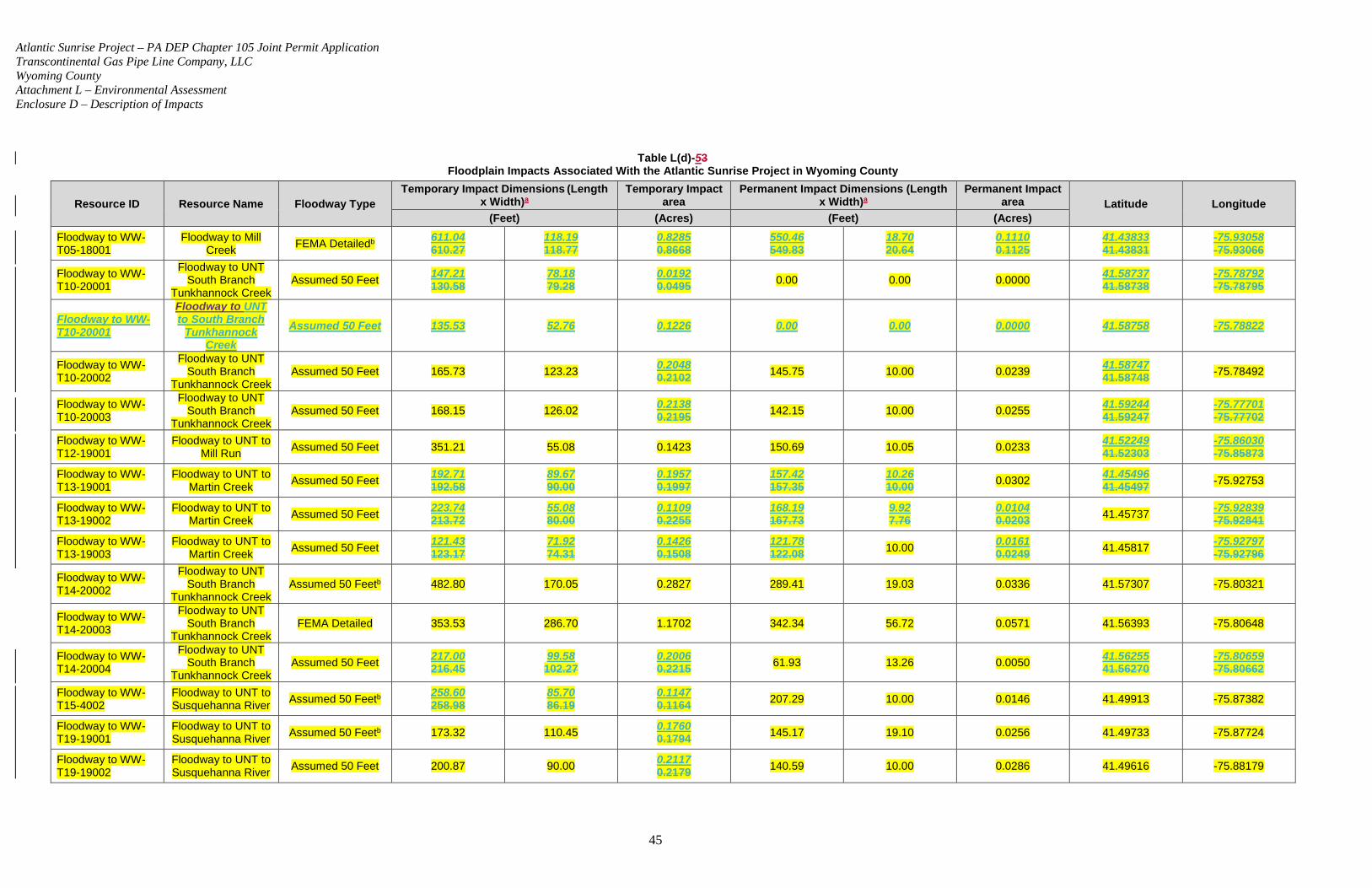
Atlantic Sunrise Project – PA DEP Chapter 105 Joint Permit Application Transcontinental Gas Pipe Line Company, LLC Wyoming County Attachment L – Environmental Assessment Enclosure D – Description of Impacts
45
Table L(d)-53 Floodplain Impacts Associated With the Atlantic Sunrise Project in Wyoming County
Resource ID Resource Name Floodway Type Temporary Impact Dimensions (Length
x Width)a Temporary Impact
area Permanent Impact Dimensions (Length
x Width)a Permanent Impact
area Latitude Longitude (Feet) (Acres) (Feet) (Acres)
Floodway to WW-T05-18001
Floodway to Mill Creek FEMA Detailedb 611.04
610.27 118.19 118.77
0.8285 0.8668
550.46 549.83
18.70 20.64
0.1110 0.1125
41.43833 41.43831
-75.93058 -75.93066
Floodway to WW-T10-20001
Floodway to UNT South Branch
Tunkhannock Creek Assumed 50 Feet 147.21
130.58 78.18 79.28
0.0192 0.0495 0.00 0.00 0.0000 41.58737
41.58738 -75.78792 -75.78795
Floodway to WW-T10-20001
Floodway to UNT to South Branch
Tunkhannock Creek
Assumed 50 Feet 135.53 52.76 0.1226 0.00 0.00 0.0000 41.58758 -75.78822
Floodway to WW-T10-20002
Floodway to UNT South Branch
Tunkhannock Creek Assumed 50 Feet 165.73 123.23 0.2048
0.2102 145.75 10.00 0.0239 41.58747 41.58748 -75.78492
Floodway to WW-T10-20003
Floodway to UNT South Branch
Tunkhannock Creek Assumed 50 Feet 168.15 126.02 0.2138
0.2195 142.15 10.00 0.0255 41.59244 41.59247
-75.77701 -75.77702
Floodway to WW-T12-19001
Floodway to UNT to Mill Run Assumed 50 Feet 351.21 55.08 0.1423 150.69 10.05 0.0233 41.52249
41.52303 -75.86030 -75.85873
Floodway to WW-T13-19001
Floodway to UNT to Martin Creek Assumed 50 Feet 192.71
192.58 89.67 90.00
0.1957 0.1997
157.42 157.35
10.26 10.00 0.0302 41.45496
41.45497 -75.92753
Floodway to WW-T13-19002
Floodway to UNT to Martin Creek Assumed 50 Feet 223.74
213.72 55.08 80.00
0.1109 0.2255
168.19 167.73
9.92 7.76
0.0104 0.0203 41.45737 -75.92839
-75.92841
Floodway to WW-T13-19003
Floodway to UNT to Martin Creek Assumed 50 Feet 121.43
123.17 71.92 74.31
0.1426 0.1508
121.78 122.08 10.00 0.0161
0.0249 41.45817 -75.92797 -75.92796
Floodway to WW-T14-20002
Floodway to UNT South Branch
Tunkhannock Creek Assumed 50 Feetb 482.80 170.05 0.2827 289.41 19.03 0.0336 41.57307 -75.80321
Floodway to WW-T14-20003
Floodway to UNT South Branch
Tunkhannock Creek FEMA Detailed 353.53 286.70 1.1702 342.34 56.72 0.0571 41.56393 -75.80648
Floodway to WW-T14-20004
Floodway to UNT South Branch
Tunkhannock Creek Assumed 50 Feet 217.00
216.45 99.58 102.27
0.2006 0.2215 61.93 13.26 0.0050 41.56255
41.56270 -75.80659 -75.80662
Floodway to WW-T15-4002
Floodway to UNT to Susquehanna River Assumed 50 Feetb 258.60
258.98 85.70 86.19
0.1147 0.1164 207.29 10.00 0.0146 41.49913 -75.87382
Floodway to WW-T19-19001
Floodway to UNT to Susquehanna River Assumed 50 Feetb 173.32 110.45 0.1760
0.1794 145.17 19.10 0.0256 41.49733 -75.87724
Floodway to WW-T19-19002
Floodway to UNT to Susquehanna River Assumed 50 Feet 200.87 90.00 0.2117
0.2179 140.59 10.00 0.0286 41.49616 -75.88179
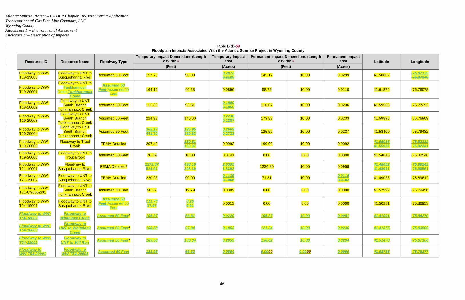
Atlantic Sunrise Project – PA DEP Chapter 105 Joint Permit Application Transcontinental Gas Pipe Line Company, LLC Wyoming County Attachment L – Environmental Assessment Enclosure D – Description of Impacts
46
Table L(d)-53 Floodplain Impacts Associated With the Atlantic Sunrise Project in Wyoming County
Resource ID Resource Name Floodway Type Temporary Impact Dimensions (Length
x Width)a Temporary Impact
area Permanent Impact Dimensions (Length
x Width)a Permanent Impact
area Latitude Longitude (Feet) (Acres) (Feet) (Acres)
Floodway to WW-T19-19003
Floodway to UNT to Susquehanna River Assumed 50 Feet 157.75 90.00 0.2072
0.2125 145.17 10.00 0.0299 41.50807 -75.87139 -75.87140
Floodway to WW-T19-20001
Floodway to UNT to Tunkhannock
CreekTunkhannock Creek
Assumed 50 Feet3Assumed 50
Feet 164.16 46.23 0.0896 58.79 10.00 0.0110 41.61876 -75.76078
Floodway to WW-T19-20002
Floodway to UNT South Branch
Tunkhannock Creek Assumed 50 Feet 112.36 93.51 0.1809
0.1855 110.07 10.00 0.0236 41.59568 -75.77292
Floodway to WW-T19-20003
Floodway to UNT South Branch
Tunkhannock Creek Assumed 50 Feet 224.92 140.00 0.2236
0.2287 173.83 10.00 0.0233 41.59895 -75.76909
Floodway to WW-T19-20004
Floodway to UNT South Branch
Tunkhannock Creek Assumed 50 Feet 365.17
441.79 185.95 189.53
0.2669 0.2731 125.59 10.00 0.0237 41.58400 -75.79482
Floodway to WW-T19-20005
Floodway to Trout Brook FEMA Detailed 207.43 150.51
150.37 0.0993 199.90 10.00 0.0092 41.55036 41.55037
-75.82332 -75.82341
Floodway to WW-T19-20006
Floodway to UNT to Trout Brook Assumed 50 Feet 76.39 16.00 0.0141 0.00 0.00 0.0000 41.54816 -75.82546
Floodway to WW-T21-19001
Floodway to Susquehanna River FEMA Detailedb 1379.57
524.91 498.19 308.39
2.0395 1.8302 1234.80 10.00 0.0958 41.48052
41.48041 -75.90543 -75.90561
Floodway to WW-T21-19002
Floodway to UNT to Susquehanna River FEMA Detailed 220.23 90.00 0.1135
0.1066 71.81 10.00 0.0119 0.0102 41.49028 -75.89612
Floodway to WW-T21-CS605Zi01
Floodway to UNT to South Branch
Tunkhannock Creek Assumed 50 Feet 90.27 19.79 0.0309 0.00 0.00 0.0000 41.57999 -75.79456
Floodway to WW-T24-19001
Floodway to UNT to Susquehanna River
Assumed 50 Feet3Assumed 50
Feet
211.73 17.57
8.26 5.51 0.0013 0.00 0.00 0.0000 41.50281 -75.86953
Floodway to WW-T54-18002
Floodway to Whitelock Creek Assumed 50 Feetb 106.97 56.61 0.0220 106.27 10.00 0.0051 41.41001 -75.94270
Floodway to WW-T54-18003
Floodway to UNT to Whitelock
Creek Assumed 50 Feetb 168.58 97.84 0.1853 121.34 10.00 0.0236 41.41575 -75.93509
Floodway to WW-T54-19001
Floodway to UNT to Mill Run Assumed 50 Feetb 189.58 106.34 0.2059 158.62 10.00 0.0294 41.51478 -75.87106
Floodway to WW-T54-20001
Floodway to WW-T54-20001 Assumed 50 Feet 123.95 66.32 0.0854 0.0000 0.0000 0.0000 41.58735 -75.78177
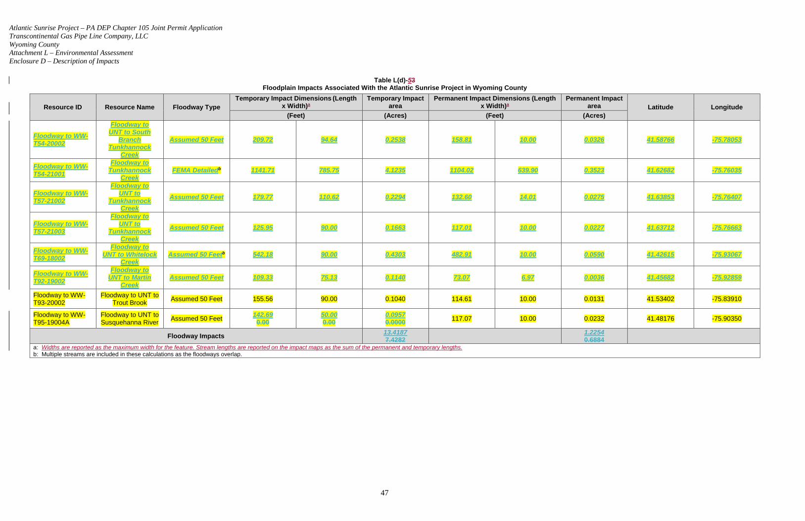
Atlantic Sunrise Project – PA DEP Chapter 105 Joint Permit Application Transcontinental Gas Pipe Line Company, LLC Wyoming County Attachment L – Environmental Assessment Enclosure D – Description of Impacts
47
Table L(d)-53 Floodplain Impacts Associated With the Atlantic Sunrise Project in Wyoming County
Resource ID Resource Name Floodway Type Temporary Impact Dimensions (Length
x Width)a Temporary Impact
area Permanent Impact Dimensions (Length
x Width)a Permanent Impact
area Latitude Longitude (Feet) (Acres) (Feet) (Acres)
Floodway to WW-T54-20002
Floodway to UNT to South
Branch Tunkhannock
Creek
Assumed 50 Feet 209.72 94.64 0.2538 158.81 10.00 0.0326 41.58766 -75.78053
Floodway to WW-T54-21001
Floodway to Tunkhannock
Creek FEMA Detailedb 1141.71 785.75 4.1235 1104.02 639.90 0.3523 41.62682 -75.76035
Floodway to WW-T57-21002
Floodway to UNT to
Tunkhannock Creek
Assumed 50 Feet 179.77 110.62 0.2294 132.60 14.01 0.0275 41.63853 -75.76407
Floodway to WW-T57-21003
Floodway to UNT to
Tunkhannock Creek
Assumed 50 Feet 125.95 90.00 0.1663 117.01 10.00 0.0227 41.63712 -75.76663
Floodway to WW-T69-18002
Floodway to UNT to Whitelock
Creek Assumed 50 Feetb 542.18 90.00 0.4303 482.91 10.00 0.0590 41.42615 -75.93067
Floodway to WW-T92-19002
Floodway to UNT to Martin
Creek Assumed 50 Feet 109.33 75.13 0.1140 73.07 6.97 0.0036 41.45682 -75.92859
Floodway to WW-T93-20002
Floodway to UNT to Trout Brook Assumed 50 Feet 155.56 90.00 0.1040 114.61 10.00 0.0131 41.53402 -75.83910
Floodway to WW-T95-19004A
Floodway to UNT to Susquehanna River Assumed 50 Feet 142.69
0.00 50.00 0.00
0.0957 0.0000 117.07 10.00 0.0232 41.48176 -75.90350
Floodway Impacts 13.4187 7.4282 1.2254
0.6884 a: Widths are reported as the maximum width for the feature. Stream lengths are reported on the impact maps as the sum of the permanent and temporary lengths. b: Multiple streams are included in these calculations as the floodways overlap.
Atlantic Sunrise Project – PA DEP Chapter 105 Joint Permit Application Transcontinental Gas Pipe Line Company, LLC Wyoming County Attachment L – Environmental Assessment Enclosure D – Description of Impacts
48
B1a. Food Chain Production Most of the waterbodies watercourses crossed by the Atlantic Sunrise Project are minor and
intermediate streams, which have food chains that are driven by detrital input from riparian
vegetation, rather than phytoplankton. Therefore, temporary increases in sediment load will not
have an adverse effect on the trophic structure of the streams. It is unlikely that temporary
increases in turbidity will have an adverse effect on aquatic biota of the area, especially since
many of these waterbodies watercourses may already be turbid and/or are subjected to
higher turbidity levels from precipitation-based run-off. As such, the existing in-stream
communities are adapted to living in turbid conditions. Oxygen levels will begin to return to
normal within hours of the completion of in-stream construction as the sediment settles. Effects
will generally be limited to the short period of in-stream construction, and conditions are
expected to return to normal following stream restoration activities. To minimize these effects,
Transco will implement BMPs to control erosion and sediment run-off from workspaces.
In particular, the following measures specific to waterbody watercourse crossings will be
implemented, as appropriate:
• Sediment barriers will be installed across the entire construction ROW at all waterbody watercourse crossings where necessary to prevent the flow of sediments into the
waterbodywatercourse. In the travel lane, these may consist of removable sediment
barriers or drivable berms. Removable sediment barriers may be removed during the
construction day, but will be re-installed after construction has stopped for the day or
when heavy precipitation is imminent;
• Where waterbodies watercourses are adjacent to the construction ROW, sediment
barriers will be installed along the edge of the construction ROW as necessary to contain
spoil and sediment within the construction ROW;
• Trench plugs will be used at all waterbody watercourse crossings as necessary to
prevent diversion of water into upland portions of the pipeline trench and to keep any
accumulated trench water out of the waterbodywatercourse, unless otherwise
approved by the on-site environmental inspector to allow natural flow of water into the
waterbodywatercourse; and
• Applicable waterbody watercourse setbacks will be maintained until construction-
related ground- disturbing activities are complete. The setback distances vary based on
Atlantic Sunrise Project – PA DEP Chapter 105 Joint Permit Application Transcontinental Gas Pipe Line Company, LLC Wyoming County Attachment L – Environmental Assessment Enclosure D – Description of Impacts
49
the type of activity being performed, but all will be clearly marked in the field with signs
and/or highly visible flagging prior to pipeline construction.
B1b. General Habitat (including Nesting, Spawning, Rearing, Resting, Migration, Feeding, and Escape Cover) Within the Atlantic Sunrise Project area throughout Pennsylvania, general temporary
construction-related impacts on wildlife species will be related to habitat disturbance and human
activities, while permanent impacts are those associated with the conversion of forest habitats
to open or scrub-shrub areas because of construction and maintenance of the permanent ROW.
Indirect impacts on wildlife include those associated with increased human activity. Construction
of the Project likely will result in the temporary displacement of or stress on animals in areas
adjacent to construction and cause movement of some wildlife away from the Project area.
Stress on wildlife could affect general health, reproduction, and viability of young, depending on
the sensitivity of a particular species, season of the year, and other factors. Other temporary
impacts on wildlife species include those from pipeline trenching activities and associated spoil
piles, which could result in a short-term barrier to movement to some species. During clearing
and grading activities, more mobile wildlife species (e.g., larger mammals, birds, and reptiles)
will be able to avoid the construction area, and many are expected to leave the area during
construction. Construction activity will be temporary and will stay in a given area for only a few
weeks, at most. Habitat recovery will occur to the maximum extent possible, aided by the use of
the impact minimization and restoration measures outlined in the ECP (Attachment M).
Direct and long-term impacts on wildlife habitat resulting from construction and operation of the
proposed Project will include the clearing of uplands, wetlands, and riparian areas required for
temporary workspace and new permanent easement. Where feasible, Transco has routed the
pipeline to follow existing corridors (and thus follow existing forest edges). The direct removal of
vegetation has the potential to reduce the amount of available habitat, food resources, and
cover. An important effect of vegetation removal is habitat fragmentation. Habitat fragmentation
occurs as larger areas of habitat are reduced and/or split into smaller non-contiguous areas by
development. Besides the direct loss of habitat, habitat fragmentation can also cause change in
habitat vegetation composition (which could include the introduction of noxious and/or invasive
species). It is not anticipated that wildlife populations that utilize the Project area will be
Atlantic Sunrise Project – PA DEP Chapter 105 Joint Permit Application Transcontinental Gas Pipe Line Company, LLC Wyoming County Attachment L – Environmental Assessment Enclosure D – Description of Impacts
50
permanently adversely affected by the proposed Project. While temporary impacts on food,
cover, and water sources may occur, none of the species located within the Project area are
specialized in such a way that construction of the Project will inhibit the overall fitness or
reproductive output of the populations as a whole.
Temporary habitat alteration at the crossing location, and increased suspended solids
concentrations and sedimentation downstream from the crossing may temporarily degrade fish
spawning and nursery areas, resulting in a temporary reduction in reproductive potential.
Transco expects these effects to be temporary in nature because the suspended sediments will
be flushed by the existing currents or settle out, and aquatic communities will subsequently
recolonize the affected area.
Permanent impacts to spawning, however, are not anticipated as a result of this Project.
Impacts to spawning should be mitigated by timing construction outside of the restricted period
for activities within Wild Trout streams. There are no Class A Wild Trout streams crossed by the
Project within Wyoming County. Transco is coordinatinghas coordinated with the PFBC to
confirm the time of year restrictions that are applicable to the streams crossed by the Project.
B1c. Habitat for Threatened and Endangered Plant and Animal Species Transco has consulted with the PA Department of Conservation and Natural Resources, PA Game Commission, PFBC, and United States Fish and Wildlife Service regarding federal and state-listed threatened and endangered species in the Project area. A summary of this correspondence is included in Attachment G of this permit application package.As previously discussed, Transco is coordinating with the PA DCNR, PGC, PFBC, and USFWS. Resource agency coordination resulted in the identification of several species as potentially occurring in the Project area. A list of these species is provided in Table L(c)-1in Enclosure C. A final determination of impacts, avoidance, and mitigation measures have not been finalized with all agencies for all species at this time.
B1d. Environmental Study Areas The Project will not affect any locations in which environmental studies are known to be taking
place.

Atlantic Sunrise Project – PA DEP Chapter 105 Joint Permit Application Transcontinental Gas Pipe Line Company, LLC Wyoming County Attachment L – Environmental Assessment Enclosure D – Description of Impacts
51
B1d1. Sanctuaries The Project will not affect sanctuaries in Wyoming County.
B1d2. Refuges The Project will not affect refuges in Wyoming County.
B2. Water Quantity and Streamflow B2a. Natural Drainage Patterns It is anticipated that the Project will not impact natural drainage patterns. The stormwater
management controls included in the Project (discussed in Attachment M - ECP) have been
designed to maintain natural or current drainage characteristics, as appropriate.
B2b. Flushing Characteristics It is not anticipated that the Project will impact flushing characteristics.
B2c. Current Patterns The Project may have minor, localized temporary effects on current patterns in the immediate
vicinity of the proposed stream crossings during construction but will be minimized where
possible through the appropriate implementation of BMPs based upon calculations completed in
accordance with PA DEP Chapter 102. Permanent impacts to current patterns are not
anticipated as all disturbed areas will be restored to pre-construction conditions.
B2d and e. Groundwater Discharge for Baseflow and Natural Recharge Area for Ground and Surface Waters The Project is not expected to impact any potable water intakes or public water supplies which
rely on groundwater recharge. Transco identified potable and non-potable surface water intake structures in proximity to the Project using eMapPA. Across the Project, nineteen surface water intakes were identified less than 3 miles downstream of Project watercourse crossings using eMapPA. Of the 19 surface water intakes identified, the primary uses were identified as agriculture (12), commercial (1), industrial (2), mineral (1),
Atlantic Sunrise Project – PA DEP Chapter 105 Joint Permit Application Transcontinental Gas Pipe Line Company, LLC Wyoming County Attachment L – Environmental Assessment Enclosure D – Description of Impacts
52
and oil/gas (3). Based on their primary uses, it is unlikely that the 18 non-commercial surface water intakes are used for potable water. Transco verified that these 18 intakes are not listed in Pennsylvania’s Drinking Water Reporting System, indicating these intakes are not public water supplies and are not used as community potable water sources. The single commercial surface water intake is Scranton Canoe Club, located in Wyoming County. As shown on the updated Project Location Map, the Scranton Canoe Club commercial intake (PWSID 2660825) is located on the shore of Lake Winola, which is approximately 0.5 miles south of CPL North MP 39.6. This intake is classified as a transient non-community water supply. Transient water supplies do not provide consistent long-term drinking water for any population (Dressler 2015). One watercourse crossing, an unnamed tributary to Beaver Creek (WW-T12-19002), is located 0.7 miles upstream of this intake. Transco proposes crossing this unnamed tributary to Beaver Creek using the dam-and-pump method. Transco has prepared a notification plan to be used in the event of a spill upstream from the Scranton Canoe Club water intake. The Scranton Canoe Club Notification Plan details Transco’s procedures in the event of a spill, including emergency response and reporting. Transco provided a copy of the notification plan to Scranton Canoe Club on October 18, 2016. Additionally, Transco requested information from the PADEP Northeastern Regional Office regarding surface water intakes. The PADEP Northeastern Region’s response did not identify additional public water supplies within the vicinity of the Project and did not identify public water supplies with Zone A Source Water Protection Areas crossed by the Project (Ostir 2014).
Potential impacts to the Scranton Canoe Club water intake will be avoided by
implementing Transco’s Spill Plan (ECP Attachment 9, provided within Attachment M of this Application) and the Scranton Canoe Club Notification Plan in the event of a spill upstream from the intake. Transco will follow the spill prevention practices enumerated
Atlantic Sunrise Project – PA DEP Chapter 105 Joint Permit Application Transcontinental Gas Pipe Line Company, LLC Wyoming County Attachment L – Environmental Assessment Enclosure D – Description of Impacts
53
in the Spill Plan, which include proper container and tank storage and inspection instructions, loading/unloading procedures, and spill response kit specifications.
Refueling and transferring of liquids will occur only in pre-designated locations that are
on level ground and at least 100 feet from any wetland or waterway, thereby preventing contamination of watercourses. As stated in the Spill Plan, Transco will maintain and immediately respond to spills as appropriate to the situation, with responses ranging from the use of absorbent pads to the employment of an emergency spill response contractor.
Transco will avoid potential impacts to distal public water supplies within Wyoming County by using dry-ditch crossing methods and implementation of all erosion and sediment control plans as specified in the Transco Procedures. During construction, Transco will adhere to all measures in the Transco Procedures (ECP Attachment 18, provided within Attachment M of this Application), which will minimize sedimentation and turbidity, minimize streambed and bank disturbance, and limit the time it takes to complete in-stream construction. Transco will cross watercourses with flowing water present at the time of construction using dry-ditch or trenchless construction methods to the greatest extent practicable. To minimize sedimentation during pipeline construction across each watercourse, trench spoil will be placed at least 10 feet away from water’s edge, unless impractical due to topography. Erosion controls will be placed around spoil piles to prevent sediment from flowing into watercourses. B2f. Storm and Flood Water Storage and Control It is not anticipated that the Project will adversely impact storm and flood water storage and
control. Transco has developed a Post Construction Stormwater Management Plan in
accordance with PA DEP Chapter 102 to prevent impacts to stormwater discharges and control.
There will be no loss of flood storage capacity within designated floodways as pre-construction
surface contours will be restored.
B3. Water Quality
Atlantic Sunrise Project – PA DEP Chapter 105 Joint Permit Application Transcontinental Gas Pipe Line Company, LLC Wyoming County Attachment L – Environmental Assessment Enclosure D – Description of Impacts
54
B3a. Preventing Pollution Construction activities can disturb surface soils and cause subsequent sediment transport into
adjacent wetlands. Sedimentation will be minimized by the installation of temporary sediment
control measures between the upland construction areas and the wetlands. Permanent erosion
controls, including slope breakers, trench breakers, and vegetative cover, will be used in
adjacent upland areas to minimize long-term sedimentation into the wetlands. Energy
dissipation devices may be installed at the down-slope end of slope breakers to minimize
erosion of soil off the ROW into wetlands. Trench plugs will be installed in upland slopes
adjacent to wetlands to prevent trench erosion and siltation
To minimize erosion and promote revegetation within the wetland, removal of the root mats for
woody vegetation will be allowed only directly over the trench area or where required to ensure
safe working conditions. This serves to enhance regeneration of vegetation on the construction
and permanent ROW. Permanent erosion control structures that could alter hydrology (e.g.,
slope breakers) will not be installed within wetlands, but these structures will be used in the
adjacent upland areas to control erosion and sedimentation. Transco will employ BMPs as
specified in erosion and sediment control permits and approved by PA DEP to further minimize
the potential for soil compaction.
Turbidity and sedimentation could result from in-stream construction activities, trench
dewatering, and/or construction-related stormwater runoff. In slow-moving waters, increases in
suspended sediments could increase the biological oxygen demand and reduce levels of
dissolved oxygen in localized areas during construction. Suspended sediments also could alter
the chemical and physical characteristics of the water column on a temporary basis.
Transco will cross surface waters with flowing water present at the time of construction using
dry-ditch construction methods to the greatest extent practicable. Dry-ditch crossing methods
can dramatically reduce downstream sediment transport effects compared to wet open-cut
crossings. Transco will employ BMPs as specified in Transco’s Erosion and Sediment Control
General Permit 2 (ESCGP-2) application, which contains site-specific erosion and sediment
control plan to further minimize the potential for soil compaction.
Atlantic Sunrise Project – PA DEP Chapter 105 Joint Permit Application Transcontinental Gas Pipe Line Company, LLC Wyoming County Attachment L – Environmental Assessment Enclosure D – Description of Impacts
55
Transco will also install temporary equipment bridges across surface waters to reduce the
potential for turbidity caused by movement of construction equipment and vehicular traffic.
Equipment bridges will be constructed of clean rock or gravel and culverts, timber mats, or
portable prefabricated bridges, depending on surface water conditions (e.g., if excessively soft
soils are encountered in the surface water bed, or if high water flows occur, portable bridges will
be used at minor surface water crossings instead of rock and culverts). Typical drawings for
equipment bridges are provided in Attachment 2 of the Transco ECP (Attachment M).
Equipment bridges will be maintained until the pipe is installed and they are no longer needed.
The bridges will then be removed. Equipment bridges will be designed to accommodate normal
to high surface water flow and will be maintained to prevent flow restriction during the period of
time the bridge is in use during construction.
To minimize sedimentation during pipeline construction across each waterbody watercourse,
trench spoil will be placed at least 10 feet away from water’s edge, unless impractical due to
topography, as specified in the Transco Procedures (Attachment 18 of the Transco ECP
(Attachment M)). Erosion controls will be placed around spoil piles to prevent sediment from
flowing into surface waters. ATWS will typically be set back 50 feet from the water’s edge unless
otherwise approved by applicable regulatory agencies.
Once the pipe is placed in the trench, the excavated material will be replaced immediately, and
the surface water banks and bed will be restored to preconstruction contours. To stabilize the
banks, the surface water banks and riparian areas will be revegetated using approved seed
mixes and/or erosion control blankets or matting in accordance with the Riparian Area Impact
Assessment and Restoration Plan for Wyoming County within Appendix L-2.
B3b. Sedimentation Control and Patterns The Project ECP and associated plans describe techniques that will be used to minimize
erosion and release of sediments during and following Project construction. The ECP is
included as Attachment M.

Atlantic Sunrise Project – PA DEP Chapter 105 Joint Permit Application Transcontinental Gas Pipe Line Company, LLC Wyoming County Attachment L – Environmental Assessment Enclosure D – Description of Impacts
56
Post-construction stormwater management measures will also be implemented for water
quality in areas where it is required. For the pipeline portion of the Project, no new impervious
surfaces are proposed. The Post Construction Stormwater Management Plan is designed to
manage stormwater runoff associated with new impervious areas (gravel) for the proposed
aboveground facilities. With the implementation of the E&S Pollution Control Plan and the
stormwater management measures, water quality impacts are not anticipated.
B3c. Salinity Distribution This section is not applicable to the proposed Project in Wyoming County.
B3d. Natural Water Filtration Waterbodies Watercourses and wetlands in the Project area have some function in water
filtration; however, impacts to these features will be temporary and natural water filtration
capabilities will be restored.
B4. Recreation B4a and b. Game and Non-Game Species Within the Atlantic Sunrise Project area throughout Pennsylvania, construction of the pipeline
facilities will negatively affect wildlife and wildlife habitat short-term within the immediate vicinity
of open land along the pipeline route, which predominantly consists of existing ROWs. Effects
will include disturbance due to clearing and trench excavation. This will affect less mobile
species, including those that hide within burrows along the route, to a greater degree than those
that can quickly flee the Project area. Following construction activities, the existing ROWs will
be restored to preconstruction conditions to the extent practicable, and it is expected that wildlife
will quickly return to the vicinity of the ROWs, using them as corridors for travel, refuge,
foraging, and nesting. Following construction, these ROWs will be maintained in a manner
similar to current conditions.
Construction within forested land will cause temporary effects on local wildlife populations,
because forested habitat will be converted to successional stages of open herbaceous and
scrub-shrub habitat for several years to decades until a mature forest community redevelops.
Atlantic Sunrise Project – PA DEP Chapter 105 Joint Permit Application Transcontinental Gas Pipe Line Company, LLC Wyoming County Attachment L – Environmental Assessment Enclosure D – Description of Impacts
57
During this time there is a risk of intrusion by invasive or noxious species. To mitigate against
this risk, Transco will manage invasive and noxious species according to the Noxious and
Invasive Management Plan included as Attachment 11 of the ECP (Attachment M). Some wildlife species that rely on forested habitat may be negatively affected by the temporary loss of forest. Removal of vegetation within forested land could cause long-term displacement of some local wildlife populations. However, any such impacts, while adverse, are expected to be highly localized and unlikely to have any population-level impacts based on the presence of suitable adjacent habitat for use. In addition, other wildlife species that prefer open land and scrub-shrub habitat will benefit from the temporary habitat conversion. As referenced in Attachment L, Enclosure C, Section A2a through A2g, Transco is developing a Memorandum of Agreement (MOA) with the United States Fish and Wildlife Service addressing conservation measures for migratory birds in the Project area. The MOA includes mitigation for removal of upland forest and forest fragmentation. Some wildlife species that rely on forested habitat may be negatively affected by the loss of forest, while other species that prefer open land and scrub-shrub habitat will benefit from the temporary habitat conversion.
Transco does not expect significant direct mortality of wildlife to occur as a result of construction
activities. Transco anticipates that the majority of wildlife will disperse from the vicinity of
construction activities in response to disturbance from construction vehicles and equipment.
Construction vehicles will adhere to low speed limits along all access roads to avoid wildlife
mortality.
Following construction, the temporary workspaces outside the aboveground facility fence lines
will be maintained in a manner similar to preconstruction conditions. Therefore, effects on
wildlife in agricultural lands and open lands that are within temporary workspaces for
aboveground facilities will be temporary, and these habitats are expected to recover within
weeks to months following construction.
Atlantic Sunrise Project – PA DEP Chapter 105 Joint Permit Application Transcontinental Gas Pipe Line Company, LLC Wyoming County Attachment L – Environmental Assessment Enclosure D – Description of Impacts
58
B4c. Fishing Temporary impacts to streams during construction activities may temporarily affect fishing
opportunities; however, no permanent impacts are anticipated within Wyoming County.
B4d and e. Hiking and Observation (wildlife) No impacts to hiking or observation are expected as the Project does not cross any recreational
properties within Wyoming County.
B4f. Other Transco has initiated coordination with PFBC regarding the need to prepare site-specific Aids to
Navigation (ATON) plans for each of the crossings which have been identified by PFBC as
being recreationally navigable. Within the Project limits of Wyoming County, these include: the
Susquehanna River, Tunkhannock Creek and South Branch Tunkhannock Creek. Transco will prepared ATON plans in accordance with PFBC guidelines including the use of buoys, signage,
and portage, as necessary. Transco submitted the ATON plans to PFBC on October 4 and October 10th, 2016 and will provide copies of the ATON approvals to PA DEP as received. Transco will implement the approved plans during construction to minimize impacts to
recreational boaters within the Project area.
B5. Upstream and Downstream Property The implementation of the Project-specific ECP will minimize the impacts to properties upstream
and downstream of the Project. The ECP is included in Section M.
B6. Other Environmental Factors Selection of the proposed pipeline route was partially based on landowner preference, as well
as avoidance of environmental impacts to resources such as waterbodies watercourses and
wetlands. The route minimized impacts to these features as much as possible and still fulfills the
purpose and needs of the Project. Specific routing criteria is discussed in the Alternatives
Analysis (Attachment P-1).
Atlantic Sunrise Project – PA DEP Chapter 105 Joint Permit Application Transcontinental Gas Pipe Line Company, LLC Wyoming County Attachment L – Environmental Assessment Enclosure D – Description of Impacts
59
C. Environmental Impacts on Other Adjacent Land and Water Resources Construction impacts to adjacent properties and water resources will be minimized through the
use of the Project-specific ECP. This plan will conform to federal, state, and local regulations
and prevent movement of sediment off the construction site. Stormwater generated on-site
during construction will also be managed and released in a manner that conforms to applicable
federal, state, and local regulations.
D. Cumulative Environmental Impacts Cumulative effects may result when the environmental effects associated with construction and
operation of a proposed Project are added to the environmental effects of other Projects or
activities occurring in the same area. The United States Environmental Protection Agency (USEPA) guidelines state:
“Cumulative impacts result when the effects of an action are added to
or interact with other effects in a particular place and within a particular
time. It is the combination of these effects, and any resulting
environmental degradation, that should be the focus of cumulative
impact analysis. While impacts can be differentiated by direct, indirect,
and cumulative, the concept of cumulative impacts takes into account
all disturbances since cumulative impacts result in the compounding of
the effects of all actions over time.” (USEPA 1999).
To identify and assess potential cumulative effects of the Project, Transco is considering other
past, present, and reasonably foreseeable Projects and other human-related activities near the
Project facilities. The Comprehensive Environmental Evaluation for the Central Penn Line
provided in Appendix L-1 includes a summary of cumulative impacts for the Project as whole.
The existing conditions in the Project area reflect changes from past and present activities.
Although much of the area is rural and relatively undeveloped, substantial alterations to the
natural environment have occurred due to agriculture, mining, transportation Projects, and other
development. The potential for cumulative effects from the Project exists for the following
resources: groundwater, consumptive water use, surface water, vegetation, wildlife (federally
Atlantic Sunrise Project – PA DEP Chapter 105 Joint Permit Application Transcontinental Gas Pipe Line Company, LLC Wyoming County Attachment L – Environmental Assessment Enclosure D – Description of Impacts
60
and state-protected species of flora and fauna), cultural resources, socioeconomics, geology,
soils, land use, air quality, and noise.
Transco has identified past, present, and reasonably foreseeable Projects and other human-
related activities occurring in the vicinity of the Project (within 10 miles) that may result in
cumulative effects when combined with the effects of the Project. Transco consulted with the
affected municipal and county planning agencies to identify Projects in the vicinity of the
Project. Transco also identified other activities, such as residential Projects located within a 0.5-
mile radius of the Project, as well as transportation and energy development Projects located
within a 10-mile radius of the Project.
The assessment of cumulative effects assumes that Project effects are minimized by the
successful implementation of the environmental protection and mitigation measures described
in the Transco ECP and compliance with applicable standard practices and federal, state, and
local regulations and permit requirements.
The assessment area for potential cumulative effects includes the area directly affected by
construction of the Project facilities in addition to the anticipated area of effect the Project may
have on each resource. This assessment area varies for each resource, based on the potential
for effects to extend beyond the area of direct effect. For example, effects on air quality have the
potential to extend beyond the Project boundaries, but effects on geologic and soil resources
would likely not extend beyond the construction boundaries. Cumulative effects are considered
in the context of the appropriate geographic area of potential effect (e.g., watershed boundaries
for water quality and use, and county boundaries for socioeconomics).
Water Use and Quality
This section addresses past, present, and reasonably foreseeable actions that, when taken into
consideration with the Project, could result in cumulative effects on water quality and use.
Potentially affected water resources include groundwater, surface water crossings, groundwater
and surface water withdrawals, waterbodies watercourses, and wetlands. The geographic
area considered in the evaluation includes the watershed basin within the Project effect area.
Atlantic Sunrise Project – PA DEP Chapter 105 Joint Permit Application Transcontinental Gas Pipe Line Company, LLC Wyoming County Attachment L – Environmental Assessment Enclosure D – Description of Impacts
61
Potential cumulative effects resulting from construction activities and operations and
maintenance have been considered as part of this analysis.
This analysis considered effects from other Projects within the same watershed (8-digit
Hydrologic Unit Code [HUC]) and within 10 miles of the Project activities. The Project pipeline
facilities cross two major watershed subregions (i.e., 4-digit HUCs) as defined by the United States Geological Survey (USGS) (USGS 2013): the Susquehanna River subregion in
Pennsylvania and the Potomac River subregion in Virginia. The Project pipeline facilities cross
four major watershed basins (i.e., 6- digit HUCs): the Upper Susquehanna, the Lower
Susquehanna, and the West Branch Susquehanna in Pennsylvania, and the Potomac in
Virginia. The Project pipeline facilities cross eight watershed subbasins (i.e., 8-digit HUCs): the
Upper Susquehanna-Lackawanna, the Upper Susquehanna-Tunkhannock, the Lower
Susquehanna, the Lower Susquehanna- Swatara, the Lower Susquehanna-Penns, the Middle
West Branch Susquehanna, and the Lower West Branch Susquehanna in Pennsylvania, and
the Middle Potomac-Anacostia- Occoquan in Virginia.
Shallow (perched) aquifers could sustain effects from temporary changes in overland water flow
and recharge caused by clearing and grading of the ROWs and temporary workspaces. In
forested areas, water infiltration, which is normally enhanced by vegetation, will be reduced until
vegetation is reestablished. In areas where groundwater is encountered within the open trench,
dewatering may result in a minor, temporary fluctuation in local groundwater levels. On
occasion, blasting can cause adverse effects on groundwater flow and potentially reduce or
eliminate the amount of groundwater supplied to nearby wells and/or springs.
To minimize potential effects associated with construction, Transco will implement mitigation
measures during construction, including those described in the Transco Plan and the Transco
Procedures, state-guidelines, and public and private well monitoring pre- and post-construction
upon landowner request. For instance, waterbars will direct stormwater runoff from the
construction ROW to well-vegetated areas or in accordance with state BMPs. Transco will also
use sediment control measures such as filter bags, silt fences, and dewatering structures during
dewatering and hydrostatic test water discharge activities. Where blasting is required, Transco
will develop a site-specific blasting plan in addition to the general Blasting Plan provided in
Atlantic Sunrise Project – PA DEP Chapter 105 Joint Permit Application Transcontinental Gas Pipe Line Company, LLC Wyoming County Attachment L – Environmental Assessment Enclosure D – Description of Impacts
62
Attachment 10 of the Transco ECP (Attachment M) prior to blasting activities, and will conduct
full-scale blast tests where recommended by Transco’s Project Engineer. If any wells are
affected by construction activities, Transco will repair them and/or compensate landowners for
Project-related damage to wells.
Implementation of the comprehensive BMPs presented in Attachment 2 of the Transco ECP
(Attachment M) will ensure the Project-related effects on groundwater are temporary and occur
within or very near the construction ROW. Based on Transco’s review, none of the Projects
identified will overlap the construction ROW during the time of the Project’s influence on
groundwater. Therefore, the Project will not cause a significant measurable cumulative effect on
groundwater resources when considered in addition to other past, present, and reasonably
foreseeable actions.
Surface water resources may be affected during various stages of construction. Clearing and
grading of stream banks, in-stream trenching, trench dewatering, and backfilling, could result in
temporary modification of aquatic habitat, increased sedimentation, turbidity, decreased
dissolved oxygen concentrations, releases of chemical and nutrient pollutants from sediments,
thermal effects, modification of riparian areas, and introduction of chemical contaminants such
as fuel and lubricants.
The Project facilities cross or are located within two major watershed sub-regions as defined by
the USGS (USGS 2013). Transco will use waterbody watercourse crossing methods based
on site-specific conditions and resource sensitivity, which include dry-ditch, trenchless, and
open-cut. Transco has routed the proposed pipeline facilities to avoid and minimize effects on
waterbodies watercourses and bodies of water to the greatest extent practicable while
maintaining engineering standards and safety. Transco completed field routing surveys within a
600-foot-wide study corridor to identify a preferred alignment that, among other factors, avoided
and minimized waterbody watercourse effects. Environmental criteria used during the routing
surveys specific to waterbodies watercourses included: (1) crossing waterbodies watercourses at 90 degree angles to minimize in-stream disturbance whenever practicable;
and (2) avoiding or minimizing crossings of major waterbodieswatercourses and bodies of water). Construction of the Project across waterbodies watercourses may result in temporary
Atlantic Sunrise Project – PA DEP Chapter 105 Joint Permit Application Transcontinental Gas Pipe Line Company, LLC Wyoming County Attachment L – Environmental Assessment Enclosure D – Description of Impacts
63
adverse effects as a result of in-stream construction activities or construction on slopes adjacent
to stream channels. Clearing and grading of stream banks, blasting, in-stream trenching, trench
dewatering, and backfilling could result in temporary modification of aquatic habitat, increased
sedimentation, turbidity, decreased dissolved oxygen concentrations, releases of chemical and
nutrient pollutants from sediments, thermal effects, modification of riparian areas, and
introduction of chemical contaminants such as fuel and lubricants.
Transco developed the ECP (Attachment M), including the Transco Procedures (Attachment 18
of the Transco ECP), in part to address temporary waterbody watercourse effects associated
with construction of the Project. The Transco ECP is intended to satisfy the waterbody watercourse restoration requirements of resource protection agencies with applicable federal
jurisdiction over areas affected by the Project. Construction activities at stream crossings will
also comply with any additional measures detailed in applicable federal stream crossing
permits.
Drilling for natural gas reserves in Pennsylvania is currently underway in several of the counties
affected by the Project. Effects from drilling activities are associated with well pad development
and improvement of existing dirt and paved roads. Similarly, several gathering line and natural
gas well interconnect pipeline construction Projects were recently completed or are ongoing
within the same watersheds crossed by the Project in Pennsylvania. Information on the exact
locations and construction schedules for these Projects was not readily available; however,
based on the general location of these Projects and the ongoing nature of their development,
the potential exists for cumulative effects on surface waters affected within the same
watersheds crossed by the Project.
Implementation of the Transco Procedures will limit the effects of crossings in duration and
distance and limit the effect of construction activities to the stream being crossed. None of the
other activities identified during the cumulative effect analysis will also affect the same
waterbodies watercourses in the same timeframe as the Project; therefore Transco believes
there will be no significant measurable cumulative effects on these resources.
Atlantic Sunrise Project – PA DEP Chapter 105 Joint Permit Application Transcontinental Gas Pipe Line Company, LLC Wyoming County Attachment L – Environmental Assessment Enclosure D – Description of Impacts
64
Surface water withdrawals will be required for hydrostatic testing and HDD activities for the Project in Wyoming County. All water withdrawals will be completed in compliance with the Susquehanna River Basin Commission (SRBC) docket or a metering plan that is approved by the SRBC. Two water withdrawal sites are planned for Wyoming County: (1) Susquehanna River and (2) Tunkhannock Creek. The SRBC approved the docket for the Susquehanna River water withdrawal location on September 8, 2016. Because of the expected low withdrawal rates for Tunkhannock Creek (i.e., below SRBC docket thresholds), a docket is not required for this water source. Allowable withdrawal rates and a metering plan were developed for the water source in conjunction with the SRBC. The location of the water withdrawal equipment relative to wetlands, streams, floodways, and floodplains are captured within the revised Application (see Attachment H-2). Water withdrawals from Susquehanna River and Tunkhannock Creek will be completed in compliance with the SRBC docket and metering plan and Tunkhannock Creek metering plan, respectively. The SRBC docket and metering plans provide details regarding the methods to be used to withdraw water. The equipment will remain in place only as long as is necessary to complete the water withdrawals. All equipment will be overland and temporary. The intake structure and piping will be located in the floodway. The pump and other equipment will be kept out of the floodway. No piping will be placed in existing stream culverts. Cross sections, profiles, and hydraulic analysis of piping to be placed in stream channels were completed for the SRBC docket and metering plan, respectively. This information is provided in Appendix L-4 and Appendix L-5. To conduct the hydrostatic testing for the Project facilities, Transco will obtain applicable regulatory approvals for water withdrawals, which will be based on regulatory withdrawal rates, volumes, and passby flow restrictions, prior to commencing surface water withdrawals. Up to 61 million gallons of water is anticipated to be withdrawn from surface waterbodies within the Project area for use in hydrostatic testing. Transco will use withdrawal methods that will not reduce water flow to a point that will substantially affect base flow conditions, fish habitat and other aquatic wildlife or recreational uses. Transco will coordinate with local and state agencies, as necessary, to conduct water withdrawals in a manner that will not reduce water availability to a point that will affect public usage.
Atlantic Sunrise Project – PA DEP Chapter 105 Joint Permit Application Transcontinental Gas Pipe Line Company, LLC Wyoming County Attachment L – Environmental Assessment Enclosure D – Description of Impacts
65
Transco does not anticipate any significant water quality effects resulting from discharge of hydrostatic test water. New pipeline facilities will consist of new steel pipe, coated internally, that will be free of chemicals and lubricant, and Transco does not propose to use antifreeze or any chemical additives for drying or other purposes. Transco will consult with the PADEP for a PAG-10 Hydrostatic Test Water Discharge Permit. As stated above, Transco received water withdrawal permits on September 8, 2016 from the SRBC for the Susquehanna River in Eaton Township and Tunkhannock Creek in Nicholson Township, Wyoming County. Site Plans and Cross Sections of the withdrawal locations are found in Appendix L-4. To conduct the hydrostatic testing for the Project facilities, Transco will obtain applicable regulatory approvals for water withdrawals, which will be based on regulatory withdrawal rates, volumes, and passby flow restrictions, prior to commencing surface water withdrawals. Up to 61 million gallons of water is anticipated to be withdrawn from surface waterbodies within the Project area for use in hydrostatic testing. Transco will use withdrawal methods that will not reduce water flow to a point that will substantially affect base flow conditions, fish habitat and other aquatic wildlife or recreational uses. Transco will coordinate with local and state agencies, as necessary, to conduct water withdrawals in a manner that will not reduce water availability to a point that will affect public usage. Transco does not anticipate any significant water quality effects resulting from discharge of hydrostatic test water. New pipeline facilities will consist of new steel pipe, coated internally, that will be free of chemicals and lubricant, and Transco does not propose to use antifreeze or any chemical additives for drying or other purposes. Transco will consult with the PA DEP and the Susquehanna River Basin Commission regarding hydrostatic test water withdrawal and discharge permits within the jurisdictional areas of each agency. Transco will continue to update FERC on the progress of agency consultation and permit applications.
HDDs will require the use of water during operation of the drill to cool the drill head, seal the
walls of the hole, and process returns. For specific waterbody watercourse crossings, where
feasible and approved by the applicable regulatory agencies, Transco will draw the required
water from the waterbody watercourse that is being crossed via HDD. Withdrawal locations
will be selected to minimize effects on waterbodies watercourses in a similar manner as
Atlantic Sunrise Project – PA DEP Chapter 105 Joint Permit Application Transcontinental Gas Pipe Line Company, LLC Wyoming County Attachment L – Environmental Assessment Enclosure D – Description of Impacts
66
described above. Where drawing water from the waterbody watercourse is unavailable,
Transco will obtain water from an approved off-site source.
The state water withdrawal permitting processes ensure that concurrent Projects involving water
withdrawals from the river basins crossed by the Project do not exceed acceptable levels or
result in significant cumulative effects. Based on the temporary, localized effect of drawdown
due to the relatively small quantities of water required for the Project, Transco expects that the
hydrostatic testing and construction dewatering activities planned for the Project will not
contribute to measurable cumulative effects on these water resources.
There will be no permanent loss of wetland area from construction of the Project. The Project
will have temporary effects on palustrine emergent (PEM) and palustrine scrub-shrub (PSS) wetlands and result in permanent conversion of palustrine forested (PFO) wetlands to PSS or
PEM wetlands in proposed new permanent pipeline ROW. Transco is proposing compensatory
off-site mitigation for Project-related impacts to PFO wetlands for temporal conversion of PFO
wetlands within the temporary construction easement and permanent conversion of PFO
wetlands to PEM wetlands within a 15-foot wide operation and maintenance corridor on either
side of the pipeline centerline within the permanent easement. Off-site mitigation will also
provide compensation for temporal conversion of PSS wetlands to PEM wetlands within a 10-
foot wide operation and maintenance corridor centered over the pipeline within the permanent
easement. Transco will restore temporarily disturbed PEM and PSS wetlands. PFO wetlands within temporary construction workspace will be temporarily converted to PEM wetlands and will return to their original state over time. Within the 10-foot-wide operation corridor, PFO wetlands will be permanently converted to PEM or PSS wetlands. In addition, Transco will permanently maintain a 30-foot-wide corridor through PFO wetlands where trees taller than 15 feet will be selectively cut and removed. Additionally, Transco is providing off-site compensatory mitigation for PFO wetland impacts.
Transco has routed the proposed pipeline facilities and associated workspaces to avoid and
minimize effects on wetlands while maintaining engineering standards and safety. Transco
completed field routing surveys within a 600-foot wide-corridor to identify proposed pipeline
alignments that, among other factors, avoided or minimized wetland effects to the extent
Atlantic Sunrise Project – PA DEP Chapter 105 Joint Permit Application Transcontinental Gas Pipe Line Company, LLC Wyoming County Attachment L – Environmental Assessment Enclosure D – Description of Impacts
67
practicable. Environmental criteria used during the routing surveys specific to wetlands included:
(1) minimizing effects at any single wetland crossing to 1 acre or less wheneverwetland crossings to the maximum extent practicable; and (2) avoiding or minimizing effects on
forested wetlands.
Transco will implement the measures in its Procedures to minimize effects on wetlands from
Project activities during the construction, post-construction restoration, and operation phases of
the Project. In addition, the Project construction activities at wetland crossings will be performed
in accordance with applicable federal regulatory requirements, such as the use of specialized
construction techniques designed to minimize effects and reduce workspace area.
Implementing these measures will help to limit adverse effects on wetlands from the Project to
the construction ROW in each wetland. The Transco Procedures will result in no net loss of
wetlands, although there will be some conversion of wetland value and type.
Based on the above analysis, Transco believes there will be no significant measurable
cumulative effects from the Project on wetlands.
Fish, Vegetation and Wildlife
This section addresses past, present, and reasonably foreseeable actions that, when taken into
consideration with the Project, could result in cumulative effects on fish, vegetation and wildlife.
The geographic area considered in the evaluation of potential vegetation effects included the
ecosystem within 0.5 mile of the Project effect area.
The majority of effects associated with Project pipeline construction will be temporary
disturbances associated primarily with clearing the construction workspace of vegetation.
Temporary effects will either be short-term, where restoration to preconstruction conditions will
be completed following construction, or long-term, where restoration to preconstruction
conditions will take place over several growing seasons and may result in a permanent change
in the vegetation structure. Long-term, temporary disturbances will be associated primarily with
areas where forested land is cleared within temporary workspaces. Construction of the new
aboveground facilities and expansion of some existing facilities will result in the permanent loss
of vegetation communities that are cleared and replaced with impervious surfaces or converted
Atlantic Sunrise Project – PA DEP Chapter 105 Joint Permit Application Transcontinental Gas Pipe Line Company, LLC Wyoming County Attachment L – Environmental Assessment Enclosure D – Description of Impacts
68
from upland forest to open land. A summary of the temporary and permanent land that will be
disturbed by the Project is provided as Attachment J.
Following construction, temporary workspaces on open land and agricultural land will be
restored according to the Transco Plan (Attachment M). During operation, Transco will maintain
a 50-foot-wide permanent ROW along CPL North. In accordance with the Transco Plan,
maintenance will include mowing the permanent ROW no more than once every 3 years.
However, a 10-foot-wide corridor centered over the pipeline will be maintained annually in an
herbaceous state that facilitates visual inspections. This maintenance will result in permanent
conversion of existing upland and wetland forested areas to herbaceous or scrub-shrub
vegetation communities.
Transco will implement specific measures to reduce these effects, including: (1) minimizing the
footprint of the proposed work activities and the duration of disturbances to the extent
practicable, (2) protecting topsoil in agricultural areas and mitigating subsoil compaction, (3)
adhering to the Noxious and Invasive Species Management Plan (Attachment 11 of the Transco
ECP (Volume 3Attachment M)), (4) co-locating with existing ROWs to the extent practicable,
(5) installing erosion controls to prevent the loss of soils and reseeding to stabilize the soils and
speed revegetation, and (6) monitoring the success of revegetation efforts and taking
appropriate action to address areas that have not been fully revegetated with native seed mix.
The development Projects identified during the cumulative effects analysis are relatively small
and in various stages of planning and completion. Therefore, Transco believes there will be no
significant measurable cumulative effects on vegetation.
Also reviewed were past, present, and reasonably foreseeable actions that, when taken into
consideration with the Project, could result in cumulative effects on wildlife, including threatened
and endangered species and fisheries. The geographic area considered in the evaluation
includes vegetative habitats that are used by wildlife (breeding grounds, migratory routes,
range, etc.) within the Project area. These include forested areas, herbaceous habitats,
wetlands, and other similar vegetative habitats used by wildlife and protected species. Potential
Atlantic Sunrise Project – PA DEP Chapter 105 Joint Permit Application Transcontinental Gas Pipe Line Company, LLC Wyoming County Attachment L – Environmental Assessment Enclosure D – Description of Impacts
69
cumulative effects resulting from construction activities and operation and maintenance have
been considered as part of this analysis.
Construction of the Project facilities has the potential to negatively affect wildlife and wildlife
habitat within the immediate vicinity of the pipeline route and locations of the aboveground
facilities. Effects may include disturbance due to clearing and trench excavation. Transco does
not expect significant direct mortality of wildlife to occur as a result of construction activities.
Transco anticipates that the majority of wildlife will disperse from the vicinity of construction
activities in response to disturbance from construction vehicles and equipment, but limited
mortality of slow-moving or sessile organisms could occur within the footprint of the
aboveground facilities, partly as a result of construction vehicle traffic. Noise and ground
disturbance generated by pipeline construction activities may temporarily affect wildlife behavior
in the immediate vicinity of the facilities.
Following construction activities, the existing ROWs will be restored to preconstruction
conditions to the extent practicable, and it is expected that wildlife will quickly return to the
vicinity of the ROWs, using them as corridors for travel, refuge, foraging, and nesting. Following
construction, these ROWs will be maintained in a manner similar to current conditions. Transco
will also restore temporary workspaces outside agricultural areas using an herbaceous seed mix
that will minimize competition with native woody plant species while offering additional wildlife
habitat and food sources, or another type of seed mix agreed upon with the applicable agencies
and the landowner. Habitat fragmentation and conversion of forested lands will occur as a result
of this Project and the other Projects that involve clearing of forested land during construction
and/or operation. However, Transco has sought to avoid and minimize forest clearing, to the
extent practicable, through co-location with other utility corridors and long-term maintenance of
ROW widths in forested wetlands. Restoration of vegetation in Project construction areas will be
ensured by adherence to the Transco Plan and Procedures (Attachments 17 and 18 of the
Transco ECP (Attachment M)), and other applicable federal permit conditions. Other than the
occasional presence of vehicles during inspections and maintenance, Transco does not
anticipate any other disturbance to wildlife along the pipeline ROWs during operation. Similarly,
operation of the aboveground facilities is not expected to adversely affect wildlife populations.
Atlantic Sunrise Project – PA DEP Chapter 105 Joint Permit Application Transcontinental Gas Pipe Line Company, LLC Wyoming County Attachment L – Environmental Assessment Enclosure D – Description of Impacts
70
Because the pipeline ROW will be revegetated and useable by wildlife following construction,
and important habitats have been avoided to the greatest extent practicable, long-term effects
on wildlife habitats will be minimized and avoided. Transco expects that similar restoration
activities would be employed for the Projects identified in the cumulative effects analysis as well,
along with the implementation of BMPs and other effect avoidance measures. Based on this,
Transco believes there will be no significant measurable cumulative effects of the Project on
wildlife.
Transco completed surveys for threatened and endangered species through the Project area and developed suitable avoidance, minimization, and mitigation measures to prevent adverse effects. Transco believes that through these agency consultations cumulative effects will behave been appropriately addressed. initiated surveys for species with federal protection (or candidacy for federal-level protection). These surveys will be continued in 2015, as necessary.
Transco will continue to consult with the applicable agencies to identify and develop avoidance and mitigation measures to implement during construction if areas are identified as providing habitat for federally and state-listed species. Use of avoidance, minimization and mitigation measures would be expected to prevent adverse effects on threatened and endangered and other sensitive species.
Transco consulted with the Pennsylvania Fish and Boat Commission (PFBC) to identify both
game and non-game fishery species and determine fishery classifications for waterbodies watercourses crossed by the proposed pipeline. Due to the Project route and location and the
presence of downstream dams, Transco determined that consultation with NOAA Fisheries was
not necessary for the Project.
Construction of the Project may include temporary effects on waterbodieswatercourses and
associated fisheries crossed by the Project. Temporary effects on fisheries include disturbance
of waterbody watercourse banks, removal of bank vegetation, and in some instances,
modification of flow during dry-crossing construction. Transco will minimize effects resulting
from construction through adherence to the Transco Procedures in the ECP (Attachment M).
Atlantic Sunrise Project – PA DEP Chapter 105 Joint Permit Application Transcontinental Gas Pipe Line Company, LLC Wyoming County Attachment L – Environmental Assessment Enclosure D – Description of Impacts
71
Transco is also consulting with the PFBC on these and other fishery effect minimization and
mitigation measures. No waterbodies watercourses or fishery resources will be affected by
construction of new and modified existing aboveground facilities. Transco does not anticipate
that the operation and maintenance of the pipeline or aboveground facilities will have adverse
effects on fishery resources.
The Project effect on fisheries will be similar to that described for surface waters.
Implementation of the Transco Procedures will limit the effects of crossings in duration and
distance and limit the effect of construction activities to the stream, and fishery, being crossed.
None of the other activities identified in the cumulative effects analysis will also affect the same
streams or fisheries within the same timeframe as the Project; therefore, there is no potential for
cumulative effect on these fisheries.
Cultural Resources
Transco is currently consultinghas consulted with the Pennsylvania Historical and Museum Commission (PHMC) and applicable Tribal Historic Preservation Offices regarding
potential effects on cultural resources resulting from the Project. Beginning in May 2014,
Transco commenced with Phase I cultural resources surveys in Pennsylvania, and continued surveys into 2016 in Pennsylvania. Transco completed surveys for cultural resources through the majority of the Project area and developed suitable avoidance, minimization, and mitigation measures to prevent adverse effects (see Attachment D-1 and D-2). Use of avoidance and mitigation measures would be expected to prevent adverse effects. Transco believes that through these agency consultations cumulative effects have been appropriately addressed.. Survey in Pennsylvania will continue in 2015.
As part of the Section 106 review process, Transco will work with the PHMC on the appropriate avoidance or mitigation efforts for any identified resource listed or potentially eligible for listing on the National Register of Historic Places (NRHP). Where practicable, NRHP cultural resources will be avoided during construction of the Project. Where unavoidable, these resources will be addressed in accordance with review and approval from the state SHPOs for excavation, management, and mitigation.
Atlantic Sunrise Project – PA DEP Chapter 105 Joint Permit Application Transcontinental Gas Pipe Line Company, LLC Wyoming County Attachment L – Environmental Assessment Enclosure D – Description of Impacts
72
Transco will continue to consult with the PHMC to identify and develop avoidance and mitigation measures including the implementation of its Unanticipated Discovery Plans if listed or eligible sites are identified. Use of avoidance and mitigation measures would be expected to prevent adverse effects. Transco believes through agency consultations cumulative effects will be appropriately addressed.
Land Use, Recreation and Aesthetics
The geographic area considered in the evaluation of land use includes the community,
metropolitan area, county, state, or region within the Project effect area. For recreation, the
geographic area considered in this analysis includes rivers, lakes, geographic areas, or land
management units within the Project effect area. For visual resources, the geographic area
would be the viewshed within 0.5 mile of the Project study area. Potential cumulative effects
resulting from construction activities and operations and maintenance have been considered as
part of this analysis.
The primary pipeline-related effects on existing land uses for the Project will be associated with
vegetation clearing during construction. Agricultural lands crossed by the Project include large
tracts of row and field crops such as corn, soybeans, wheat, and hay. No commercial silviculture
(i.e., timber production) operations have been identified along the pipeline route. A majority of
the commercial and industrial land crossed by the Project is not currently in use and is located
within contractor/pipe yards. Open land (e.g., nonforested and undeveloped land not classified
for another use, including land maintained as utility ROWs) is also crossed by the Project.
Transco will allow forested areas affected within the temporary construction ROWs and other
temporary workspaces to revert to forest through natural successional processes after
construction. Within the permanent ROW, Transco will maintain currently forested upland areas
in an herbaceous vegetation state to facilitate inspection and operation of the Project facilities.
Transco will acquire road and railroad crossing permits from the appropriate state or local
jurisdiction, as required by state and/or local road encroachment permits and regulations. By
complying with these permits, Transco will not permanently affect any roads or railroads.
Transco proposes to construct its pipeline facilities within or adjacent to existing utility corridors
Atlantic Sunrise Project – PA DEP Chapter 105 Joint Permit Application Transcontinental Gas Pipe Line Company, LLC Wyoming County Attachment L – Environmental Assessment Enclosure D – Description of Impacts
73
where practicable. Where co-located with existing corridors, Transco will seek to overlap the
construction ROWs with existing utility ROWs to minimize new disturbance.
Transco identified public land, conservation land, recreational areas, and other designated or
special use areas in the vicinity of the Project and obtained additional information for these
areas by consulting with federal, state, county, and local agencies and private landowners;
reviewing aerial photographs and maps of the Project area; and through field surveys conducted
in 2014 through 2016. Transco is coordinatinghas coordinated with appropriate federal, state,
and municipal agencies on proposed crossings on public lands to minimize effects on
recreation.
Land use effects resulting from transportation and residential/commercial developments in the
vicinity of the Project are expected to be minimal due to the scope and nature of the work (as in
the case of the transportation Projects) or because of the minimal or lack of activity (as in the
residential/commercial developments). Land use effects associated with other natural gas
pipelines would be similar to those for the Project, with similar mitigation measures and effect
avoidance measures being implemented. Based on the above analysis, Transco believes there
will be no significant measurable cumulative effects of the Project on land use.
Visual effects associated with construction activities will result from the removal of vegetation,
particularly in forested areas. These effects will be observed where the pipeline parallels or
crosses roads and where vegetation is removed between the ROWs and residences. Potential
mitigation measures may include planting visual screens along roadways and in residential
areas in coordination with regulatory agencies, as necessary. While temporary visual effects on
the landscape will occur during Project construction due to clearing, grading, and construction
activities, Transco will restore disturbed areas in accordance with the Transco Plan and Transco
Procedures (Attachments 17 and 18 of the Transco ECP (Attachment M)).
In summary, Transco believes there will be no significant measurable cumulative effects of the
Project on land use, recreation, or visual resources.
Atlantic Sunrise Project – PA DEP Chapter 105 Joint Permit Application Transcontinental Gas Pipe Line Company, LLC Wyoming County Attachment L – Environmental Assessment Enclosure D – Description of Impacts
74
E. Other Impacts to Water Resources Required to fulfill the Purposes of the Project As described in Attachment J – Project Description, the Atlantic Sunrise Project involves water
obstructions and encroachments in 10 counties: Clinton, Lycoming, Susquehanna, Wyoming,
Luzerne, Columbia, Northumberland, Schuylkill, Lebanon and Lancaster counties. This permit
application package identifies the water obstructions and encroachments required in Wyoming
County on parcels that are accessible to date. Transco is submitting separate applications
that will identify the water obstructions and encroachments in the other counties, as applicable.
F. References Commonwealth of Pennsylvania, Department of Conservation and Natural Resources.
Bureau of Topographic and Geologic Survey. Available online at www.dcnrstate.pa.us/topogeo/. Accessed March 2014.
Cowardin LM, Carter V, Golet FC, LaRoe ET. 1979. Classification of wetlands and
deepwater habitats of the United States. U.S. Fish & Wildlife Service Pub. FWS/OBS-79/31, Washington, DC.
Moyer, D.L., and Hyer, K.E., 2009, Continuous turbidity monitoring in the Indian Creek
watershed, Tazewell County, Virginia, 2006–08: U.S. Geological Survey Scientific Investigations Report 2009–5085, 42 p.
Interstate Natural Gas Association of America (INGAA). 1999. Temporary Right-of-Way Width Requirements for Pipeline Construction. Available at: http://www.ingaa.org/File.aspx?id=19105. Accessed on April 25, 2014.
Ostir, Todd. 2014. PADEP North Eastern Regional Office. Personal Correspondence via e-
mail. August 20, 2014. Pennsylvania Conservation Reserve Enhancement Program (CREP). 2016. “What is
CREP?”. Available at: http://www.creppa.org/about/. Accessed on November 3, 2016.
Atlantic Sunrise Project – PA DEP Chapter 105 Joint Permit Application Transcontinental Gas Pipe Line Company, LLC Wyoming County Attachment L – Environmental Assessment Enclosure D – Description of Impacts
75
Pennsylvania Fish and Boat Commission. 2014a. Class A Wild Trout Waters. Bureau of Fisheries
website: http://www.fish.state.pa.us/classa.pdf. Accessed February 2015 and reviewed
with PFBC.
Pennsylvania Fish and Boat Commission. 2014b. Regional Listings of Approved Trout Waters.
Available from http://www.fish.state.pa.us/fishpub/summary/troutwaters.html. Accessed
February 2015 and reviewed with PFBC.
Pennsylvania Fish and Boat Commission. 2014c. Stream Section That Supports Natural
Reproduction of Trout. March 2015. Available from:
http://www.fish.state.pa.us/trout_repro.htm. Accessed February 2015 and reviewed with
PFBC.
Reid, S.M., and P.G. Anderson. 1999. Effects of sediment released during open-cut pipeline
water crossings on stream and river ecosystems. Canadian Water Resources Journal
24:23-39.
The Pennsylvania Code. Title 25 Environmental Protection, Chapter 93. Water Quality Standards.
Available online at http://www.pacode.com/secure/data/025/chapter 93/chap93toc.html/.
March 2014.
United States Department of Agriculture (USDA). 2011. Conservation Reserve Enhancement
Program – Pennsylvania. Fact Sheet, United States Department of Agriculture, Farm
Services Agency (March 2011). Available at:
http://www.fsa.usda.gov/Internet/FSA_File/crep_penn_mar2011.pdf. Accessed on
November 3, 2016.
U.S. Department of Agriculture (USDA). 2014. Conservation Reserve Program. Available online
at: http://www.fsa.usda.gov/FSA/webapp?area=home&subject=copr&topic=crp.
Accessed on October 16, 2014.
Atlantic Sunrise Project – PA DEP Chapter 105 Joint Permit Application Transcontinental Gas Pipe Line Company, LLC Wyoming County Attachment L – Environmental Assessment Enclosure D – Description of Impacts
76
United States Geological Survey (USGS). 2013. Watershed Boundary Dataset Facts. Available
at: http://nhd.usgs.gov/wbd_facts.html. Accessed on July 10, 2014.
Waters, T. F. 1995. Sediment in streams: sources, biological effects and control. American Fisheries Society Monograph 7:1-251.