Assessment of Masacpasac Water Supply Source: A Technical Study
10
Assessment of Masacpasac Water Supply Source: A Technical Study Felisa E. Gomba 1 , Ronald L. Orale 2 , Introduction The availability of water in water supply system is essential in the delivery of the required volume of water to the serviced community. Philippine urban water supply is mainly provided by about 612 water districts under the authority of Local Water Utilities Administration, or by more than 1000 local government-operated water utilities that lack skills in handling new water supply projects (ADB Review 2006). Water supply scarcity is experienced in most water districts in the country especially during the period of dry season that they could not deliver the required water volume consumption of the human society. The world projections virtually show that all of the countries’ available water resources could be exploited by 2030(Basson, et.al,, 1997). Thus, there is a need to develop strategies for sustaining the water resources for distribution and this requires intensive management tools, physical understanding of hydrological nature that affect the water availability, and engineering concepts/processes to enhance the water resources supply. The Catbalogan water supply source is Masacpasac spring has been established as early as 1945, which was discovered by the Americans. Masacpasac water supply source is located in Barangay Cawayan in a mountainous terrain. It has been the major source of water for Catbalogan and has been 1 Associate Professor, College of Engineering, Samar State University, Catbalogan City, Samar. 2 Instructor, College of Engineering, Samar State University, Catbalogan City, Samar. 1
Transcript of Assessment of Masacpasac Water Supply Source: A Technical Study

Assessment of Masacpasac Water Supply Source: A TechnicalStudy
Felisa E. Gomba1, Ronald L. Orale2,
Introduction
The availability of water in water supply system is
essential in the delivery of the required volume of water to
the serviced community. Philippine urban water supply is
mainly provided by about 612 water districts under the
authority of Local Water Utilities Administration, or by
more than 1000 local government-operated water utilities
that lack skills in handling new water supply projects (ADB
Review 2006). Water supply scarcity is experienced in most
water districts in the country especially during the period
of dry season that they could not deliver the required water
volume consumption of the human society. The world
projections virtually show that all of the countries’
available water resources could be exploited by 2030(Basson,
et.al,, 1997). Thus, there is a need to develop strategies
for sustaining the water resources for distribution and this
requires intensive management tools, physical understanding
of hydrological nature that affect the water availability,
and engineering concepts/processes to enhance the water
resources supply.
The Catbalogan water supply source is Masacpasac spring
has been established as early as 1945, which was discovered
by the Americans. Masacpasac water supply source is located
in Barangay Cawayan in a mountainous terrain. It has been
the major source of water for Catbalogan and has been1 Associate Professor, College of Engineering, Samar State University, Catbalogan City, Samar.2 Instructor, College of Engineering, Samar State University, CatbaloganCity, Samar.
1
utilized since 1945. There were several developments and
structures installed in the source, but there were no basic
properties of the water source such as minimum and maximum
flow, depth, and other relevant properties. These properties
are necessary data for planning and sustainable development
for the Masacpasac water supply source.
In this context, the Catbalogan Water District through
its Board of Directors requested Samar State University to
conduct a technical study at the Masacpasac water supply to
evaluate its technical status relative to water supply
source of Catbalogan and to determine the sustainable
strategies for the Catbalogan Water District Operations. In
February 3, 2007, the Catbalogan Water District and Samar
State University signed a Memorandum of Agreement for the
conduct of the technical study of the Masacpasac water
supply source.
Objectives
The technical study is guided by the following objectives:
1. to conduct on-site technical evaluation;
2. to assess and evaluate the sources of water losses
along the distribution lines from the water source to the
water treatment site (kulador); and
3. to develop and come up the following:
3.1 technical report;
3.2 water protection plans and design concepts; and
3.3 water quality monitoring program.
Materials and Methods
The technical study was conducted on –site from the month of
March, April, and May 2007. The methodologies were: on-site
evaluation and assessment at Masacapasac sub surface channel;
2
topographic survey from Masacpasac water source to Kulador; and
water quality analysis.
On-site evaluation and assessment of Masacpasac sub-surface channel. The
team conducted this activity to determine the volume of the
water. A hydrographic survey within the channel was conducted to
identify the dimensions of the channel. The materials of the
channel bed were evaluated through disturbed soil sampling
techniques at random point of sampling. The soil samples were
brought to the SSU Soils and Materials Testing Laboratory for
analysis. The variability of the depths and water quantity were
observed from 4:00 AM to 4:00 PM based on continuous water
sampling techniques. The streamflow records were established at
different variations of time.
Topographic Survey from Masacpasac to Kulador. A topographic survey
was conducted from Masacpasac to Kulador to determine the
elevation and profile of the pipelines. The survey (using
Theodolite) was conducted in a 50-meter radius from Masacpasac to
Kulador.
Water Quality Analysis. The water quality at the Masacpasac
source was analyzed. Water samples were collected using water
grab sampling techniques in two different periods(AM and PM). The
water samples were brought to SSU for further analysis.
Materials and Instruments. The activity utilized the equipment and
surveying instruments of the Samar State University College of
Engineering. One theodolite was dedicated to the extension
services on the assessment and technical study of the Masacpasac
water source
Results and Discussions:
The section presents the results of the technical study
which is presented in three sub sections, namely: Masacpasac
water supply source; pipeline system from Masacpasac to Kulador;
and Kulador site(treatment).
Masacpasac Water Supply Source
3

This is located at Barangay Cawayan, Catbalogan City, Samar.
It is a sub surface channel with a length of 50 meters from the
outflow pipe to the end of the channel, mean width 8.0 meters,
and mean depth of water of 2.20 m. It has a computed area of
185.2 square meters with an elevation of 155 m above sea level.
It is approximately 4.5 kilometers from the city proper of
Catbalogan.
Fig 1. The areal view of Catbalogan Fig. 2. The insideview of the sub-surface and Masacpsac water supply source channel atMasacpasac
Status of the immediate environment. The Masacpasac source is
located along a mountainous and rocky terrain with degraded
vegetation along 100 meter radius. There is a massive illegal and
indiscriminate cutting of new growth trees. Small tributaries or
water ways exists along the sides of the sub surface channel. The
small tributaries have sufficient water that can be utilized as
Masacpasac Water supply source
Catbalogan Proper
4
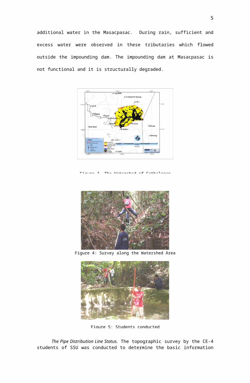
additional water in the Masacpasac. During rain, sufficient and
excess water were observed in these tributaries which flowed
outside the impounding dam. The impounding dam at Masacpasac is
not functional and it is structurally degraded.
Figure 4: Survey along the Watershed Area
The Pipe Distribution Line Status. The topographic survey by the CE-4students of SSU was conducted to determine the basic information
Figure 3. The Watershed of Catbalogan
Figure 5: Students conducted
5
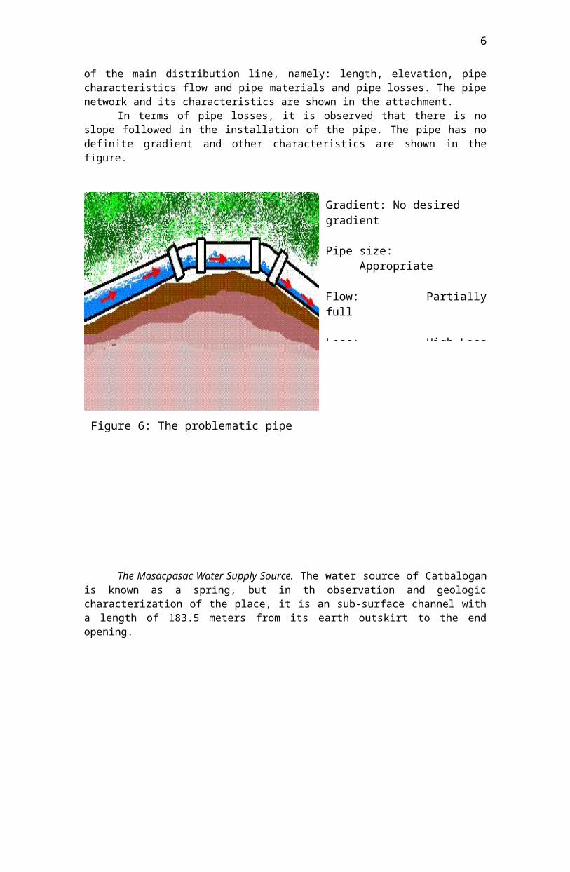
of the main distribution line, namely: length, elevation, pipecharacteristics flow and pipe materials and pipe losses. The pipenetwork and its characteristics are shown in the attachment.
In terms of pipe losses, it is observed that there is noslope followed in the installation of the pipe. The pipe has nodefinite gradient and other characteristics are shown in thefigure.
The Masacpasac Water Supply Source. The water source of Catbaloganis known as a spring, but in th observation and geologiccharacterization of the place, it is an sub-surface channel witha length of 183.5 meters from its earth outskirt to the endopening.
Gradient: No desired gradient
Pipe size: Appropriate
Flow: Partiallyfull
Loss: High Loss
Figure 6: The problematic pipe network
6
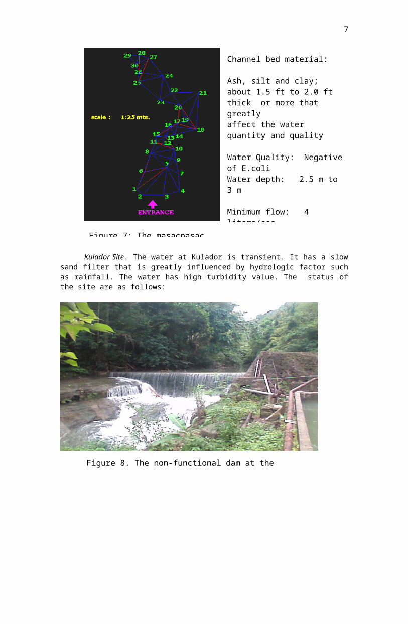
Kulador Site. The water at Kulador is transient. It has a slowsand filter that is greatly influenced by hydrologic factor suchas rainfall. The water has high turbidity value. The status ofthe site are as follows:
Channel bed material:
Ash, silt and clay; about 1.5 ft to 2.0 ft thick or more that greatly affect the water quantity and quality
Water Quality: Negativeof E.coli Water depth: 2.5 m to 3 m
Minimum flow: 4 liters/sec
Figure 8. The non-functional dam at theKulador
Figure 7: The masacpasac
7
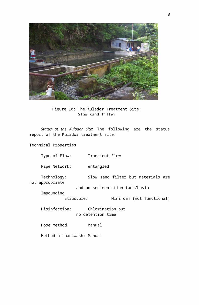
Status at the Kulador Site: The following are the statusreport of the Kulador treatment site.
Technical Properties
Type of Flow: Transient Flow
Pipe Network: entangled
Technology: Slow sand filter but materials arenot appropriate
and no sedimentation tank/basinImpounding
Structure: Mini dam (not functional)
Disinfection: Chlorination but no detention time
Dose method: Manual
Method of backwash: Manual
Figure 10: The Kulador Treatment Site:Slow sand filter
8
Recommendations:
The following are the engineering recommendations:
1. Improve the sub-surface channel bed. Replace theash, silt and clay with permeable material toincrease the water level.
2. Provide fish way at the sub-surface channel.
3. Provide a well-designed protection cover.
4. Lower to 1-meter the intake pipe.
5. Install primary treatment structure at the intake.
6. Construct water impounding structure at Masacpasacsite to store excess water during rainy season.
7. Set an average gradient from Masacpasac source toKulador based on the actual topographic records.
8. Lower the existing pipe to conform the designedgradient.
9. Replace damaged pipes.
10. Avoid minor losses. Minimize bends, obsructionsand unnecessary joints
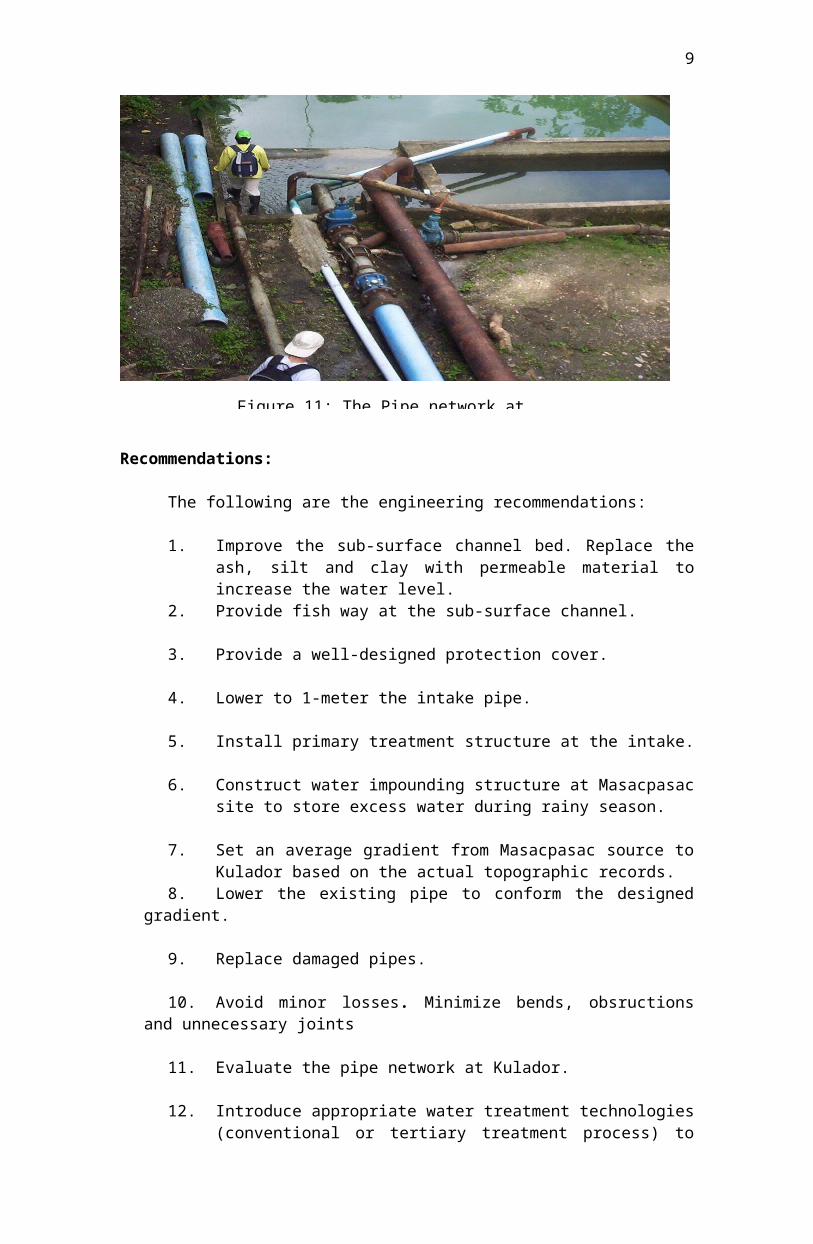
11. Evaluate the pipe network at Kulador.
12. Introduce appropriate water treatment technologies(conventional or tertiary treatment process) to
Figure 11: The Pipe network at
9

solve the turbidity problem of the water supply.This will require big budget for the structures tobe used.
13. Construct sedimentation basin after filtrationprocess to provide settling time for the dissolvedsolids water particles.
14. Construct water impounding structures by utilizingthe existing impounding dam located along the eastside of Kulador.
10