Plana Water Supply – Medieval Technical Enterprise
35
Transcript of Plana Water Supply – Medieval Technical Enterprise


ARHEOTEHNOLOGIJA: proučavanje tehnologije od praistorije
do srednjeg veka
Urednici: Selena Vitezović
Dragana Antonović
Beograd, 2014

ARCHAEOTECHNOLOGY: studying technology from prehistory
to the Middle Ages
Editors: Selena Vitezović
Dragana Antonović
Belgrade, 2014
Published by / IzdavačSrpsko arheološko društvoBeograd, Čika-Ljubina 18-20
For the publisher / Za izdavačaDragana Antonović
Editors / UredniciSelena Vitezović Dragana Antonović
Reviewed by / RecenzentiMarkó András (Hungary), Dragana Antonović, Krum Bacvarov (Bulgaria), Jacqueline Balen (Hrvatska), Marija Buzov (Hrvatska), Heidi Luik (Estonia), Ina Miloglav (Hrvatska), Dubravka Nikolić, Ben Roberts (United Kingdom), Perica Špehar
Translation and proofreading / Prevod i lektura Ivan Bugarski, Jelena Vitezović, Selena Vitezović and individual authors
Graphic layout / Grafička opremaKristijan Relić
Cover / KoricaMihajlo Vitezović
Printed by / Štampa DC Grafički centarSavski nasip 7, 11070 Novi Beograd
Print run / Tiraž 100
This book is published with the financial support of the Ministry of Education, Science and Technological Development of the Republic of Serbia.
CONTENTSSADRŽAJ
Archaeotechnology: Studying Technology from Prehistory to the Middle Ages (S. Vitezović, D. Antonović) .................................................................. 7
D. Antonović: Examination Methodology for Ground Stone Artefacts ........ 13
M. Lopičić: Wasted Skill: The Chunk Phenomenon ...................................... 29
V. Dimitrovska: Ground and Abrasive Stone Tools from Viničko Kale ......... 57
D. Antonović: Manufacturing of Stone Axes and Adzes in Vinča Culture ... 77
D. Rajković, T. Hršak, H. Posilović, K. Kos: A Case Analysis of the Operational Sequence for the Production of Polished Stone Tools at the Selci Đakovački – Kaznica–Rutak Site .......................................................... 89
C. Beldiman, D.-M. Sztancs, I. A. Bărbat: Bone and Antler Artefacts Dated from Starčevo-Criş Culture from Transylvania, Romania: Recent Discoveries and Microscopic Analyses ................................................................................ 113
D.-M. Sztancs, C. Beldiman, C. Ilie: Starčevo-Criş Osseous Materials Industry from Southern Moldova, Romania. The Negrileşti Site, Galaţi County ............................................................................................................. 135
S. Vitezović: Antler as Raw Material in the Starčevo Culture ....................... 151
J. Vuković: Archaeological Evidence of Pottery Forming Sequence: Traces of Manufacture in Late Neolithic Vinča Assemblage ................................... 177
I. Atanasova: Early Eneolithic Figurines from the Site of St. Atanas near V. Spančevo – Kočani: A Study of the Manufacturing Technology .............. 199
V. Bikić: The Study of Pottery Technology in Serbia: First Experiences ...... 221

M. Radivojević, T. Rehren, J. Kuzmanović-Cvetković, M. Jovanović: Why Are There Tin Bronzes in the 5th Millenium BC Balkans? ........................... 235
A. Đuričić: The Construction and Usage of the Neolithic Oven: Experimental Archaeology ............................................................................. 257
G. Jeremić: The Technology of Making Floor Mosaic Substructures in Late Antiquity in Provinces of Dacia Mediterranea and Dacia Ripensis .............. 277
T. Mihailović: Plana Water Supply – Medieval Technical Enterprise ........... 295
List of Contributors ........................................................................................ 315

7–12.
ARCHAEOTECHNOLOGY: STUDYING TECHNOLOGY FROM PREHISTORY TO THE MIDDLE AGES
Technology is a fascinating material expression of human culture, commonly regarded as an evidence of human triumph over nature. The hu-man past was seen as a constant progress from “primitive” to “technologi-cally advanced”, and even classified after what is thought to be a dominat-ing technique in a given period (e. g. Childe 1944, see also Greene 2006). Technological innovations were considered the main, if not the only driving forces that shape societies and cultures (cf. Pfaffenberger 1988).
Technology, as a conceptual approach to material culture studies, derived from the Greek word τέχνη, meaning skill, implies all human ac-tions upon a matter (Inizan et al. 1995: 13). Everything is technological around us, and this includes not only artefacts, but all structures, buildings, and even nature modified by human hand (cf. Lemonnier 1992b, Greene 2006). The term technology includes a full range of topics from those re-lated to individual level (body gestures, embodied knowledge in crafting) to social and cultural settings of production.
Archaeological studies are indistinguishable from studies of tech-nology; material remains constitute the core of archaeological evidence, regardless of the period, region, methodological approaches or theoreti-cal frameworks, and even studies in beliefs, religion, etc., rely on analy-ses of diverse artefacts. Artefacts represent our source for “reading” past lives – by studying them, we can make conclusion about people who made them and used them, what their meaning and value were, how they were used, reused and discarded. They may have both functional and symbolic roles, and a special meaning for the society or individuals within it, that may change and/or became more complex over time. During its lifetime, an object can be used in many different contexts and have diverse, even contradictory meanings and values. Objects can also be rare and luxury, or occasional, craft-produced objects, or common, functional, mass-produced industrial objects; furthermore, one class of artefacts may have examples of rare, crafted and mass-produced specimens (cf. Caple 2006, Miller 2007).
Ideas from social anthropology had an important influence on the theoretical advances in studies of technology. The work of Malinowski and Radcliffe-Brown, for example, showed that a complex social structure was invariably reflected within objects (cf. Caple 2006). Theories of a French anthropologist Marcel Mauss, who was interested in how culture (as op-posed to nature) influences and shapes human behaviour, are particularly important as well. His starting point was that something generally per-

Archaeotechnology: studying technology from prehistory to the Middle Ages
8
ceived as natural (for example, body posture, way of walking, etc.), was in fact cultural. The way a person eats, walks, sleeps, even holds and uses tools, differs, depends on their culture, age and sex. The accent of these studies is on the impact of a group on individuals, their relationships, as well as the questioning of the cultural and the natural in human behaviour (Deliège 2012 [2006]: 82-84, Lévi-Strauss 1982 [1973]: 13-15, cf. also Ini-zan et al. 1995: 14).
A wider concept of technology, which goes beyond artefact analy-ses, which regards technology as a practice, as ways of doing or making something, which also includes social and cultural components into the studies, is more and more accepted by many researchers. Henry Hodges (1976) distinguished technology from the study of stylistic details of arte-facts, implying that technology was about the process of production rather than the endpoint (objects).
Ursula Franklin (1992) understood technology as ways of doing something rather than simply ways of making (creating) something (an object), so that there are technologies of prayer and of storytelling as well as of pottery production and weaving, while for Robert Merrill (1977: vi) technology is “the culture surrounding the actions or activities involved in making or doing things”. For M.-A. Dobres and C. Hoffman (1999) technol-ogy is “an ever unfolding process”, and their view of technology “stresses the dynamic, ongoing and socially constituted nature of sociotechnical ac-tivities” (Dobres & Hoffman 1999: 3).
Heather Miller, in her book dealing with archaeological approaches to technology, defined it as a “set of actions and relationships: from pro-duction itself, to the organization of the production process, to the entire cultural system of processes and practices associated with production and consumption” (Miller 2007: 4). Furthermore, she defines the production as “the actual process of fabrication or creation, including both the material objects and the techniques and gestures used”, organization of production as “the organizational arrangement within which production takes place”, and the technological system as an active system of interconnections be-tween people and objects during the creation of an object, its distribution, and to some extent its use and disposal. In other words, technology or tech-nological systems can be roughly described as processes and practices as-sociated with production and consumption, from design to discard (Miller 2007: 5).
Diverse concepts have been developed, and probably the most im-portant contribution to the study of technology was the work of André Le-roi-Gourhan (1964, 1965, 1971), who created the concept of chaîne opéra-

9
Archaeotechnology: studying technology from prehistory to the Middle Ages
toire (see also Lemonnier 1992a). This is an analytical tool for studying the mode of creating, using and discarding an artefact, starting with raw mate-rial acquisition, mode of manufacture, final form, use (including caching, breaking and repairing) up to final discarding, with the main goal of recon-structing the organization of a technological system and of describing and understanding all cultural transformations that a specific raw material had had to go through. It is a chronological segmentation of actions and mental processes required in the manufacture of an artefact and its maintenance in the technical system of a prehistoric group (Inizan et al. 1995: 14, cf. also Sellet 1993). The concept is not only about reconstructing the algorithmic sequence of operations in creating one object, but it is a complex analysis of operational chain within one society, which includes the analysis of tech-nological choices. The analyses of technologies today include a variety of different approaches, most of them putting the emphasis on cultural and social aspects of technology.
Methodology also went through significant changes, especially in the field of interdisciplinary and experimental work. Studies of diverse ar-tefacts, such as stone, flint or metal, cannot be imagined without careful identification and detailed analyses of raw material origin. Interdiscipli-nary researches became particularly emphasized by the processual archae-ology since the 1960s, and today they constitute an integral part of almost every archaeological research, regardless of the chronological period. They are irreplaceable for the determination of raw material origins and can also contribute to identifying diverse transformative processes certain raw ma-terial had undergone.
Experimental and ethnoarchaeological studies also constitute a very important segment of technological studies. Although present in ar-chaeological research since its early days (e.g., Martin 1910), they are more diverse, more common and more scientifically based since the mid-20th century. Again, processual archaeology and its demands for scientific rigor contributed greatly in developing new methods, but the work of soviet ar-chaeologist Sergei A. Semenov has the most prominent place in the history of experimental archaeology, due to the diversity of research questions he dealt with and the wide range of chronological periods and materials he covered (Семенов 1957, 1968, Semenov 1976; cf. Korobkova 2008 for an overview, also Skakun & Longo eds. 2008 for an overview of current re-search in this field).
Most archaeological technology studies focus on an individual tech-nology – flint knapping, metallurgy, etc. Archaeologists usually classify technologies into “crafts” or “industries” based on material or end-product

Archaeotechnology: studying technology from prehistory to the Middle Ages
10
type: clay (pottery) production, metal working, basket making, stone ob-ject (lithics) production, woodworking, textile manufacture. Such material groupings are very useful from both the theoretical as well as a practical perspective, however, they may be counterproductive sometimes (cf. Miller 2007), or better put, the study should not end with analyses of a single tech-nology only. Although this is necessary for a deeper understanding of par-ticular technologies, given the complexity of the topics, a wider approach is needed, namely a multiple technologies perspective (Lemonnier 1992b, 1993, see also Inizan et al. 1995).
All techniques in a given society refer to one another – they can share the same resources, same knowledge, same tools, same actors. More-over, some techniques use the products of others, as well as the existence of operational sequences or technical principles in common, creating multiple relations of interdependence, which gives them a systemic character. All technologies have systemic aspects, and we can talk about technological systems in the same way as, for example, ethnologists talk about kinship systems. Technological systems can be analysed on three levels. Firstly, we can discuss how these five components interact with each other to form a technology. Secondly, if we consider all the technologies of a given society, we can analyse how they are interrelated. And finally, the third level of dis-cussion is the relation between technologies and other social phenomena. Analyses of multiple technologies, therefore, can expand the range of stud-ied cultural phenomena and at the same time provide a better understand-ing of a given culture and society (Lemonnier 1992b, 1993).
* * *
This book is a result of a session organized at the XXXVI Annual meeting of the Serbian Archaeological Society, held in Novi Sad, from 30th May to 1st June 2013. The aim of the session was to promote the technologi-cal perspective on different aspects of material culture and to encourage multiple technology studies. Papers include studies on artefacts from stone (M. Lopičić, D. Antonović, D. Rajković et al., V. Dimitrovska), bone (C. Beld-iman et al., D.-M. Sztancs et al., S. Vitezović), clay (I. Atanasova, J. Vuković, V. Bikić) and metal (M. Radivojević et al.), but also include more complex technologies, such as constructions of thermic structures (A. Đuričić), the making of mosaic substructures (G. Jeremić) and water supply systems (T. Mihailović). Also, studies cover a large time span, from Late Palaeolithic/Mesolithic to the Middle Ages.

11
Archaeotechnology: studying technology from prehistory to the Middle Ages
We would like to thank all the participants of the session and the audience as well, the contributors of the book, reviewers, and, last but not least, to Jelena Vitezović and Ivan Bugarski for their help with English translations and proofreading.
Selena Vitezović, Dragana Antonović
References
Childe, G. 1944. Archaeological ages as technological stages. The Journal of the Royal Anthropological Institute of Great Britain and Ireland 74, 1/2: 7–24.Deliège, R.,006. Une histoire de l’anthropologie. Écoles, auteurs, théories. Éditions de Seuil, Paris. (Serbian translation: Istorija antropologije. Škole, pisci, teorije. XX vek, Beograd)Dobres, M.-A., Hoffman, C. R. 1999. Introduction. In: Dobres, M.-A., Hoffman, C. R. (Eds.): The Social dynamics of Technology: practice, politics and world views. Washington and London: Smithsonian Institution Press: 1-19.Franklin, U., 1992. The real world of technology. Canadian Broadcasting Corpora-tion (CBC) Massey Lecture Series. Originally published in 1990 by CBC Enterpris-es. Concord, ON: House of Anansi Press Ltd.Greene, K., 2006. Archaeology and technology. In: Bintliff, J. (ed.): A Companion to archeology. Blackwell Publishing, Oxford : 155–173. Inizan, M-L., Reduron-Ballinger, M., Roche, H., Tixier, J. 1995. Technologie de la pierre taillée. CNRS et Université de Paris, Paris.Korobkova, G., 2008. S. A. Semenov and new perspectives on the experimental-traceological method. In: Longo, L., Skakun, N. (eds.): ‘Prehistoric technology’ 40 years later: Functional studies and the Russian legacy. Archaeopress, Oxford: 3–8. Lemonnier, P., 1992a. Leroi-Gourhan, ethnologue des techniques. Les Nouvelles d’Archéologie, 48/49: 13 –17. Lemonnier, P., 1992b. Elements for and anthropology of technology. Ann Arbor, Michigan.Lemonnier, P., 1993. Introduction. In: P. Lemonier (Ed.): Technological choices: transformation in material cultures since the Neolithic. Routdledge, London: 1–35.Leroi-Gourhan, A., 1964. Le geste et la parole. Éditions Albin Michel, Paris. Leroi-Gourhan, A., 1965. Évolution et techniques 1: L’homme et la matière. Éditions Albin Michel, Paris. Leroi-Gourhan, A., 1971. Évolution et techniques 2: Milieu et techniques. Éditions Albin Michel, Paris.Longo, L., Skakun, N. (Eds.), 2008. ‘Prehistoric technology’ 40 years later: Func-tional studies and the Russian legacy. Archaeopress, Oxford. Mauss, M. 1973. Sociologie et anthropologie. Presses Universitaires de France, Par-is. (Serbian translation: Sociologija i antropologija I. Prosveta, Beograd)

Archaeotechnology: studying technology from prehistory to the Middle Ages
12
Merill, R. S. 1977. Preface. In: Lechtman, H., Merrill, R. S. (eds.): Material culture: styles, organization and dynamics of technology. Proceedings of the American Ethno-logical Society, West Publishing Co., St. Paul: v–vii. Miller, H. M.-L., 2007. Archaeological approaches to technology. Academic Press, Elsevier, Oxford.Pfaffenberger, B., 1988. Festishized objects and humanized nature: toward an an-thropology of technology. Man 23: 236–52. Pfaffenberger, B., 1992. Social anthropology of technology. Annual review of an-thropology, 21: 491 –516. Sellet, F., 1993. Chaîne opératoire: the concept and its applications. Lithic techno-logy 18, 1–2: 106–112.Семенов, С. A., 1957. Первобитная техника. Материалы и исследования по ар-хеологии СССР, Но. 54, Издательство АН СССР, Москва, Ленинград. Семенов, С. A., 1968. Развитие техники в каменом веке. Наука, Лениград. Semenov, S. A., 1976. Prehistoric technology. An experimental study of the oldest tools and artefacts from traces of manufacture and wear. Barnes and Noble, Wiltshire.

295–314.
PLANA WATER SUPPLY – MEDIEVAL TECHNICAL ENTERPRISE
Tatjana MihailovićNational museum Kraljevo
Abstract: Medieval town of Plana was from XIII until the en of XV century the center of medieval mining and metallurgical activities, with three large mining are that en-compassed over 20 km. Until today, 58 smelteries were discovered, and in them were produced gold in powder, plain silver and argentum de glama, lead, copper and iron.This large economic center created a large hydro-technical system, whose purpose was to enable the water supply at 750-1100 m high points, where gold was extracted and washed out. At the same time, it also enabled drinking and technical water. It was made as a pipeline from clay pipes, with protective stone covering, and it passed the water from Kolska river along the 12 km long line, for which 25-30 000 pipes were used. Parallel to it was a open canal for technical water necessary for ore washing out and work of smelteries. At the location called Probijeno brdo in 2011 construction machines have exposed the water supply in situ, in the road profile, near its source at Kolska river. Na-tional museum in Kraljevo carried out the research in 2012 and 2013, and the results are presented in this paper.
Key words: medieval Serbia, Plana, mining and metallurgy, Željin, Kopaonik, water supply syste, hydro-technical system
Apstrakt: Srednjovekovni trg Plana, bio je od XIII do kraja XV veka centar kopaonič-kog rudarstva i metalurgije, sa tri velika rudna revira u dužini od 20 km. Do sada je dokumentovano 58 topionica, koje su proizvodile zlato u prahu, obično i glamsko sre-bro, olovo, bakar i gvožđe. Ovaj veliki privredni centar realizovao je veliki hidrotehnički sistem, čija je svrha bila da omogući neophodni dotok vode na velike nadmorske visine od 750-1100 m na kojima se iskopavalo zlato i omogući ispiranje zemlje. Ovo je bilo složeno hidrotehničko postrojenje za pitku i tehničku vodu istovremeno. Realizovano je kao cevovod od glinenih cevi, pokriven zaštitnim pokrivačem od kamena, koji je vodu iz Kolske reke sprovodio trasom dugom oko 12 km, za šta je bilo upotrebljeno 25-30 000 cevi. Paralelno ga je pratila otvorena vada-kanal za tehničku vodu neophodnu za ispiranje rude i rad topionica. Na mestu Probijeno brdo 2011. godine radom buldožera otkriven je vodovod in situ u profilu puta, u blizini njegovog izvorišta na Kolskoj reci. Narodni muzej u Kraljevu je istražio vodovod u toku 2012. i 2013. godine, i rezultati su prikazani u ovom radu.
Ključne reči: Srednjovekovna Srbija, Plana, rudarstvo i metalurgija, Željin, Kopaonik, vodovod, hidrotehnički sistem

Archaeotechnology: studying technology from prehistory to the Middle Ages
296
Introduction. The town of Plana as a mining and metallurgical center
Plana was in the period from XIII until XV century the center of the mining activity in the Kopaonik area and it belonged to the type of settlement called trg (Lat. forum мercatum) in Serbian medieval countries (Јиричек 1952: 269). Plana is situated on the south-western slopes of the mountain of Željin, on the border with Kopaonik mountain, which is faced south, and Plana’s medieval area extended on both mountains (fig. 1). In the vicinity of Plana there were three large mining compound areas: the first one is Ceovište in the very vicinity of Plana, placed 2 km to the east, on the Željin mountain, second was Razlečje-Vučak north from Plana riv-er, also on the Željin mountain, and the third one was Vlah-Orlje-Murča, south from Plana. This was a mountain slope within Kopaonik massive, which extends in north-south direction along the Kovači village and ends in the hamlet of Pope, where large areas for gold washing were situated, on Ravnište and Glave. Mining and metallurgical activity area of Plana reached up to 20 km in length.
Fig. 1 The Map of Plana with mining areasSl. 1 Karta Plane sa rudnim revirima
297
T. Mihailović Plana Water Supply – Medieval Technical Enterprise
Plana was probably in the beginning a typical settlement of mining economy, but with time, i. e., as mining and metallurgy works expanded and the economic power was rising, the town enlarged to up to 500 house-holds, densely placed one next to the other along the streets, with mining tower, whose eastern part was researched and its dimensions 12,5х20 m (Kovačević 2008: 81). Up today, two churches were discovered, therefore Plana may be considered as open town, and the estimated number of inhab-itants is up to 3000 (Simić V. 1955-1957: 3). As on most trade centres and mining settlements, in Plana were also inhabited people from Dubrovnik, among them patricians (catholic church is mentioned in the written sourc-es for the first time in 1346) (Simić 1955-1957, 1). The place Carina, near which Carinski stream passes by, is an area that could have take up to 500 horses, and it testifies on explicit trade aspect that Plana gained over time, thanks to the metal production. Around the town were settlements of min-ers, smelters and blacksmiths, organized around their working places, therefore the number of inhabitants estimated by V. Simić at 10-15 000, probably is not exaggerated (Simić 1955-1957: 3).
Over 2700 traces of mining working activity were noted, which puts Plana before Trepča or Belo Brdo. Until today, 58 smelteries were discov-ered, and in them were produced gold in powder, plain silver and argen-tum de glama, lead, copper and iron (Simić 1955-1957: 8). Plana also had a coin mint, labelled in written sources “grossi de Plana“ (Blagojević 1981, 50-52), and nobleman Nikola Altomanović and prince Lazar minted their coins here (Dimitrijević 1968, 129; Ivanišević 2001, 163). Numerous con-temporary toponyms around Plana are indirect evidence for this economic center: Rudnjak (ruda – ore; it has traces of old mining activity of iron ore and smelteries, situated north from Plana, center of exploitation of iron containing nickel), Kovači (kovač – blacksmith; center of blacksmithing production at Kopaonik, south from Plana), Ceovi, Ceovište, (from German Zeche), main mining area, under which is a stream Plakaonica (derived from the archaic word for washing); also there are metallurgic toponyms Ma-jdanska brazda, Kolska reka, Kola, Šljaknište in Plana (Simić 1956). Trade-related toponyms were noted as well – Pazarište (pazar – market place) and Carine (customs), suggesting two important aspects – mining market place, within Ceovište, where mining guilds were selling their ores directly, and a market palce for diverse products located on the plateau immediately above the town on Pazarište, where were also large lead smelteries.
This was one complex system, that included a large number of peo-ple of different professions, specializations, religious orientations, all of them concentrated on production, processing and trade, primarily of pre-
Archaeotechnology: studying technology from prehistory to the Middle Ages
298
cious, but also other metals, that had influence on monetary system and international trade. At the same time, this must have been a well-organized system, whose mutually dependent segments had inviolable mutual inter-ests. One of them was certainly water supplying system, since without it the key technological process of gold washing, rinsing of excavated ores and the work of smelteries (Mišić 2007, 129-138), but is also important for supply-ing hundreds of workers with drinking water.
Gold-bearing terrains were on higher altitudes, from 730-1100 m. On Ceovište the gold arrived with pyrite in the phase of silicification and pyritification of andenzite, and later, during the process of forming of ore veins, as a result of oxidation of silicified and gold-bearing pyrites a porous mass remained, with unwashed limonite in lower parts, where the largest quantity of gold leaflets and granules can be found (Симић 1955-1957, 6). Shallow shafts were used to dig into quartz-limonite masses, and the ore was taken out, crushed, minced and washed out. These masses were located at altitude at 1100 m. Another gold zone was in Pope (Kovači), on Ravnište and on Glave, exclusively at delluvial deposits 5 m thick, at altitude of 730-850 m (Симић 1955-1957, 15). Just the washed soil from medieval times covers the area of approximately 40 hectares. In these circumstances the main technological challenge was to enable a continuous water flow at al-titude of 1100 m, that will connect the main zones of gold exploitation and enable filling of basins at Glave designed for washing out. Mining and met-allurgy of lead, zinc and silver belonged to the second phase of exploitation and processing in Plane, and is characteristic for the XIV century. Obvi-ously the gold was the initial work, around which the market place emerged and motivated this community to create a huge water supply system, that represents a large technological project. Namely, a solution to this problem in the times when only gravitational water supply was possible, was discov-ered at high Željin mountain, on attitudes that surpass 1300 m, on a water rich Kolska river. At the same time, this meant to find a solution for the water supply line over 10 km long, in the main water supply prong.
Water supply system – discovery and description
The team from the National museum went for the first time to visit the location Probijeno brdo in August 2011, where the construction works on the crossroad of forest path and road Plana – Sutelica, the root of the medieval water supply was cut, and was visible in the profile above the road (fig. 2). This place is at 400-500 m distance from Kolska river on the north and about 500 m east from the Lajštak hilltop (at 1312 m), in the

299
T. Mihailović Plana Water Supply – Medieval Technical Enterprise
inhabited part of Željin (fig. 1). Such a situation, with in situ dis-covered water supply and with a possibility for investigation, can be encountered very rarely. Also, it was important that this loca-tion was in the vicinity of the very beginning of the water sup-ply system.
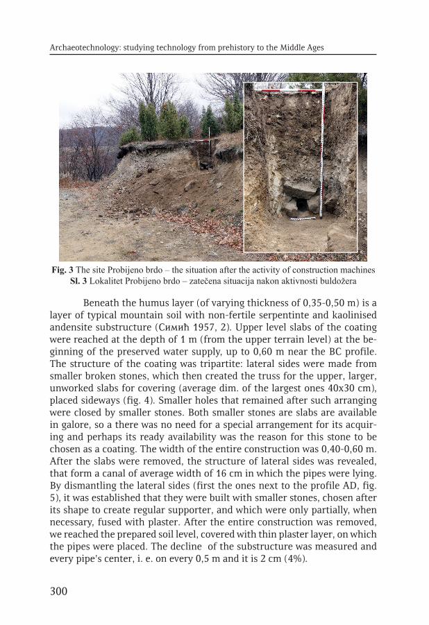
Until now, the pipes were discovered mainly in Pla-na itself, at Ceovište and south from Plana, in the region of the third mining region on Murča. Now we have reached the part of the water supply system for which was assumed that is tak-ing the water on the source of the Kolska river or in its vicinity (Симић 1957: 11). We decided to start small sondage excava-tions in length of 2 m, with main goal to discover the water supply structure. At the same time, this should have enabled to remove and transpose the discovered segment into the museum.1
The line of the water supply was cut vertically, in order to expose its entire structure (the pipe was in a stone protective coating) in the cross-section. It was positioned on a virgin soil at the depth of 1,35 m from the upper level of the terrain, but only about 0,90 m above the road level. Such a clear position of the struc-ture enabled simple and precise positioning of the sondage-trench, dim. 2,40 х 1,10 m, which included already cleared area of 0,40 m in front of the water supply2 (fig. 3).
1 Short sondage excavations were carried out from 28-30th November 2012 (the director of the excavations was Tatjana Mihailović, museum advisor).2 The area was created when road workers tried to pull out the pipes, after the protective coating was demolished, so a flattened area remained, formed by original hydrotechnicians while constructing the water supply system.
Fig. 2 Re-designed situation plan of Plana region after V. Simić (Simić V. 1955-1957, 2, fig. 1) with inserted location of Probijeno
brdoSl. 2 Redizajnirani situacioni plan reona Plane prema V. Simiću (Simić V. 1955-1957, 2, sl.
1) sa unetom lokacijom Probijenog brda
Archaeotechnology: studying technology from prehistory to the Middle Ages
300
Beneath the humus layer (of varying thickness of 0,35-0,50 m) is a layer of typical mountain soil with non-fertile serpentinte and kaolinised andensite substructure (Симић 1957, 2). Upper level slabs of the coating were reached at the depth of 1 m (from the upper terrain level) at the be-ginning of the preserved water supply, up to 0,60 m near the BC profile. The structure of the coating was tripartite: lateral sides were made from smaller broken stones, which then created the truss for the upper, larger, unworked slabs for covering (average dim. of the largest ones 40х30 cm), placed sideways (fig. 4). Smaller holes that remained after such arranging were closed by smaller stones. Both smaller stones are slabs are available in galore, so a there was no need for a special arrangement for its acquir-ing and perhaps its ready availability was the reason for this stone to be chosen as a coating. The width of the entire construction was 0,40-0,60 m. After the slabs were removed, the structure of lateral sides was revealed, that form a canal of average width of 16 cm in which the pipes were lying. By dismantling the lateral sides (first the ones next to the profile AD, fig. 5), it was established that they were built with smaller stones, chosen after its shape to create regular supporter, and which were only partially, when necessary, fused with plaster. After the entire construction was removed, we reached the prepared soil level, covered with thin plaster layer, on which the pipes were placed. The decline of the substructure was measured and every pipe’s center, i. e. on every 0,5 m and it is 2 cm (4%).
Fig. 3 The site Probijeno brdo – the situation after the activity of construction machinesSl. 3 Lokalitet Probijeno brdo – zatečena situacija nakon aktivnosti buldožera

301
T. Mihailović Plana Water Supply – Medieval Technical Enterprise
In the trench after the coating was removed, in situ were discovered three ceramic water pipes (fig. 6). The pipes were positioned with the help of smaller stones and also placed to have a decline of 2%. The pipes were made from clay that contained sand, baked in the light red colour. On the outer surface they had traces of thin green glaze, but sporadically, not on the entire surface. They contained no glaze in the interior. The pipes had one end conically narrowed, thus enabling the joining with the next one. On the opposite end, the pipe is shaped in such a way to join easily with the previous one. In the table are given their technical traits.
Fig. 4 The site Probijeno brdo: trench 1, water supply in situ in its complete form
with coveringSl. 4 Lokalitet Probijeno brdo: sonda
1, vodovod in situ u potpunoj formi sa pokrivačem
Fig. 5 Discovering the water supply: a) protective covering (from above), b) water pipes in the canal formed by covering sides, c) water pipes in situ,
after the removal of the coveringSl. 5 Otkrivanje vodovoda: a) zaštitni
pokrivač (snimak odozgo), b) vodovodne cevi u kanalu koji su formirale bočne
strane pokrivača, c) vodovodne cevi in situ, nakon uklanjanja pokrivača

Archaeotechnology: studying technology from prehistory to the Middle Ages
302
Pipes/
Cevi
Length/
Dužina
Weigth/
Težina
Circumfer./
Obim
Outer/
Spolj. R
Inner/
Unutr.
R
Opening/
Otvor. R
Juncture/
Spoj
P-1 (I) 39 cm 1846 gr. 31 cm 10,7 cm 8, 7 cm
P-2(II) 41 cm 1912 gr. 32 cm 10,3 cm 7, 8 cm 5,6 cm 4,5 cm
P-3(III) 39 cm 1571 gr. 32 cm 9,5 cm 7,4 cm 5,1 cm 4,5 cm
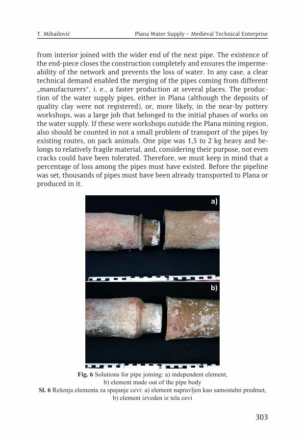
The first pipe, that was at the beginning of the construction, as it was pulled out, the joining part was broken, therefore only pipes 2 and 3 are complete. However, we encounter here two different types, or, more precisely, we have here two different solutions for pipe joining. Indirectly, this situations shows clearly placed technical demands that encompass nec-essary standards for the water supply system realisation, i. e., the technical demands must have been clearly formulated and submitted to one or more pottery workshops. In this case, we have two solutions: one simpler – when one element was made by sculpting from the pipe’s body into a slightly con-ical shape 4,5 cm long. In that case the flat rim of the opening is reclining on the pipe’s shoulder. In the other case, this element was made separately, and later binded with the body of the pipe. It was also conical in shape, 4,5 cm long. At the opposite end the plastic band 1,4 cm wide, was made, horizontally flattened on the place it is linking with the pipe body. In this way was created an end-piece that is reclining on horizontally flattened rim of the next pipe, with adequate width of 1,4 cm. This independent element was also glazed before it was joined with the pipes.
When we compare the technical traits of the pipes 2 and 3 and all the above-mentioned details, we may perceive all the fixed elements of this technical demands: the diameter of the pipes, inner diameters of the wider and narrower ends, length of the conical joining segments, the total length of the pipes. The diameter of the pipes and the length of the joining parts are identical, the pipe length differs for 2 cm, and the diameters of the opening parts up to 0,5 cm. If we take into consideration that these ceramic pipes were handmade, the difference in the diameter can be negligible. The differences exist evidently among the elements that were not standardized, such as the weight of the pipes, which were left to the potter himself to decide. It may be noted that the pipe no. 3 was in any case a better solu-tion; not only that it is 350 gr lighter, but it also shows higher quality of the joining of the two elements. This is particularly evident during the joining of the two pipes, since the junctures are secured by limestone plaster. The narrow part of the pipe was completely covered by plaster (4,5 cm) and
303
T. Mihailović Plana Water Supply – Medieval Technical Enterprise
from interior joined with the wider end of the next pipe. The existence of the end-piece closes the construction completely and ensures the imperme-ability of the network and prevents the loss of water. In any case, a clear technical demand enabled the merging of the pipes coming from different „manufacturers“, i. e., a faster production at several places. The produc-tion of the water supply pipes, either in Plana (although the deposits of quality clay were not registered), or, more likely, in the near-by pottery workshops, was a large job that belonged to the initial phases of works on the water supply. If these were workshops outside the Plana mining region, also should be counted in not a small problem of transport of the pipes by existing routes, on pack animals. One pipe was 1,5 to 2 kg heavy and be-longs to relatively fragile material, and, considering their purpose, not even cracks could have been tolerated. Therefore, we must keep in mind that a percentage of loss among the pipes must have existed. Before the pipeline was set, thousands of pipes must have been already transported to Plana or produced in it.
Fig. 6 Solutions for pipe joining: a) independent element, b) element made out of the pipe body
Sl. 6 Rešenja elementa za spajanje cevi: a) element napravljen kao samostalni predmet, b) element izveden iz tela cevi

Archaeotechnology: studying technology from prehistory to the Middle Ages
304
What is important for the water supply network, is her solidity, which is visible through her mechanical resilience towards inner and outer pressure (Јовић 2008, 16). In our case, it may be evaluated on the basis of the quality of the protective coating, and after the traits of the ceramic from which the pipes were made, which determine the impedance towards fraying. The composition of clay with admixtures of finer and coarser sand, with wall thickness of 14 mm, makes them robust and resistant, which, on the other side, also makes them heavy. However, this makes the very network stable, with excellent and thorough protection by the coating. The joinings are secured by plaster, which ensures the networks impermeability and prevents water loss. Furthermore, the pipes were dug deep enough, at 0,90-0,80 cm, as visible at layer 2, that belongs to medieval period, which provides complete protection to the water in the pipes from freezing.
The second problem is the reconstruction of possible watergate or reservoir from which the water supply departed, for which it was always known it was at Kolska river. Probijeno brdo is only 1,3 km from this river, i. e., its left prong, which merges 2 km lower with Kriva river into the main course of Kolska river. Along all these courses were concentrated 34 smelt-eries of lead and one for iron (Simić V. 1955-1957, 9), which is confirmed by toponyms – the river is called Kolska and the region between Kola (kolo - wheel), since the wheels were necessary to make smelteries work.
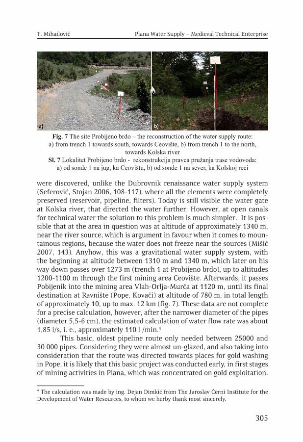
Field survey was conducted in spring 2013, in order to investigate further this hydrotechnical system. From the trench 1 at Probijeno brdo, as a marked place from which the water system continues, its route is clearly visible as a formed horizontal level cut into the slope (fig. 7).3 We followed this level, shaped into a path 1-1,5 m wide, at some places damaged by erosion and ravines, but may be followed all the way to the Kolska river at altitude of 1310 m. The entire area is in thick beech forest, and on the final part of the route there are cast down large timbers, especially at the very ending in the river.
One of the essential questions that are not possible to solve at this moment is how the water was transmitted from the river into the pipeline system. It is certain that this was a gravitational water supply system (based on free fall), so the spot at adequate altitude was looked up, to supply with water the mining areas that were mainly at altitudes of 1100 m. Before be-ing conducted into the pipes, the water should have been filtrated, meaning, it was passed through some porous filters into the accumulative reservoir (Jović 2008, 11); however, no material remains of any such constructions
3 We used markers with tables for input of the distances, during the recording the possible water system route, to make them more visible through the woods and clearer in the space.
305
T. Mihailović Plana Water Supply – Medieval Technical Enterprise
were discovered, unlike the Dubrovnik renaissance water supply system (Seferović, Stojan 2006, 108-117), where all the elements were completely preserved (reservoir, pipeline, filters). Today is still visible the water gate at Kolska river, that directed the water further. However, at open canals for technical water the solution to this problem is much simpler. It is pos-sible that at the area in question was at altitude of approximately 1340 m, near the river source, which is argument in favour when it comes to moun-tainous regions, because the water does not freeze near the sources (Mišić 2007, 143). Anyhow, this was a gravitational water supply system, with the beginning at altitude between 1310 m and 1340 m, which later on his way down passes over 1273 m (trench 1 at Probijeno brdo), up to altitudes 1200-1100 m through the first mining area Ceovište. Afterwards, it passes Pobijenik into the mining area Vlah-Orlja-Murča at 1120 m, until its final destination at Ravnište (Pope, Kovači) at altitude of 780 m, in total length of approximately 10, up to max. 12 km (fig. 7). These data are not complete for a precise calculation, however, after the narrower diameter of the pipes (diameter 5,5-6 cm), the estimated calculation of water flow rate was about 1,85 l/s, i. e., approximately 110 l /min.4
This basic, oldest pipeline route only needed between 25000 and 30 000 pipes. Considering they were almost un-glazed, and also taking into consideration that the route was directed towards places for gold washing in Pope, it is likely that this basic project was conducted early, in first stages of mining activities in Plana, which was concentrated on gold exploitation.
4 The calculation was made by ing. Dejan Dimkić from The Jaroslav Černi Institute for the Development of Water Resources, to whom we herby thank most sincerely.
Fig. 7 The site Probijeno brdo – the reconstruction of the water supply route: a) from trench 1 towards south, towards Ceovište, b) from trench 1 to the north,
towards Kolska river Sl. 7 Lokalitet Probijeno brdo - rekonstrukcija pravca pružanja trase vodovoda:
a) od sonde 1 na jug, ka Ceovištu, b) od sonde 1 na sever, ka Kolskoj reci
Archaeotechnology: studying technology from prehistory to the Middle Ages
306
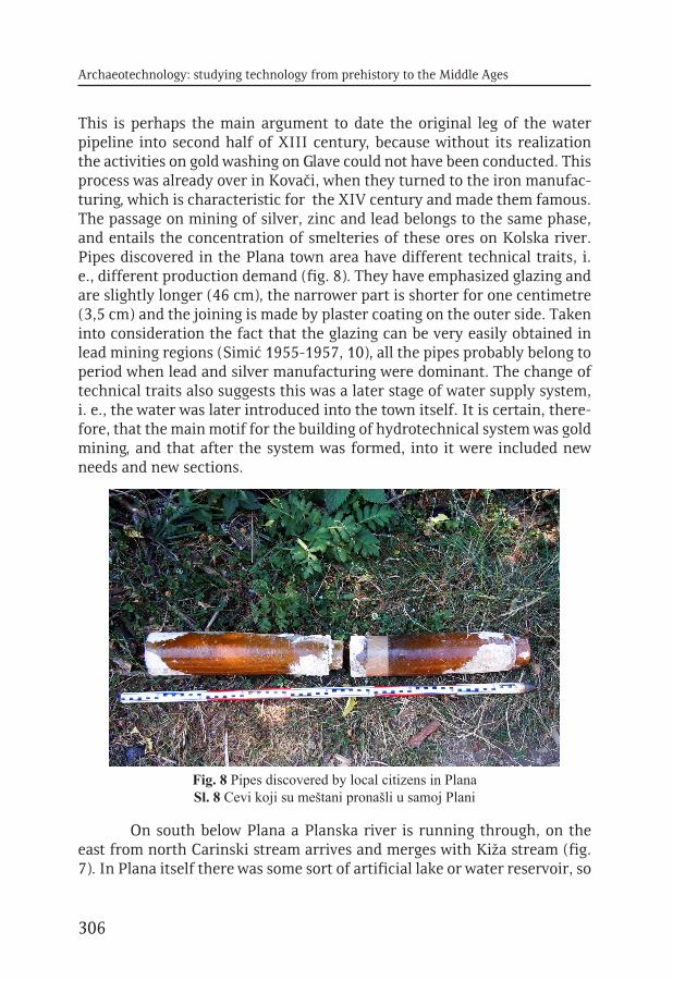
This is perhaps the main argument to date the original leg of the water pipeline into second half of XIII century, because without its realization the activities on gold washing on Glave could not have been conducted. This process was already over in Kovači, when they turned to the iron manufac-turing, which is characteristic for the XIV century and made them famous. The passage on mining of silver, zinc and lead belongs to the same phase, and entails the concentration of smelteries of these ores on Kolska river. Pipes discovered in the Plana town area have different technical traits, i. e., different production demand (fig. 8). They have emphasized glazing and are slightly longer (46 cm), the narrower part is shorter for one centimetre (3,5 cm) and the joining is made by plaster coating on the outer side. Taken into consideration the fact that the glazing can be very easily obtained in lead mining regions (Simić 1955-1957, 10), all the pipes probably belong to period when lead and silver manufacturing were dominant. The change of technical traits also suggests this was a later stage of water supply system, i. e., the water was later introduced into the town itself. It is certain, there-fore, that the main motif for the building of hydrotechnical system was gold mining, and that after the system was formed, into it were included new needs and new sections.
On south below Plana a Planska river is running through, on the east from north Carinski stream arrives and merges with Kiža stream (fig. 7). In Plana itself there was some sort of artificial lake or water reservoir, so
Fig. 8 Pipes discovered by local citizens in Plana Sl. 8 Cevi koji su meštani pronašli u samoj Plani

307
T. Mihailović Plana Water Supply – Medieval Technical Enterprise
there is a question was there a need to bring the water by pipeline system. It is possible that the development of mining and metallurgy of lead water became polluted, since there were pits below the town on the southern side. Also, the number of inhabitants increased, which were the reasons to sup-ply the town with water from the already existing system.
A special part of the system are „vade“ – open channels for water flow for ore wash-out („plakaonica“) and smelteries, that follow the pipe-line by one leg and branch out on the second. The well-known „Roman or Majdan furrow“ (fig. 9) 6 km long, which took water at 1340 m and ena-bled the work of large lead smelteries at Pazarište and copper smelteries at Čaušice, to the west from Pazarište. The construction of the canal was of such extraordinary quality when it comes to the 1% fall and usage of natural terrain configuration, that it was restored without any problems in 1950’s, when the water began to run once again for the Plana inhabit-ants, this time for irrigation. The second (main) canal follows the pipeline all along and brings the water to Ceovište and region Vlah-Orlja-Murča, thus enabling the wash-out of ores immediately below the pits and digging places at 1100 m. The depression in ravine near Pobijenik the canal passes through dug-in piles (Simić 1955-1957, 11).
Fig. 9 The route of reconstructed „Roman trench“ at Pazarište Sl. 9 Trasa rekonstruisane „Rimske brazde“ na Pazarištu

Archaeotechnology: studying technology from prehistory to the Middle Ages
308
Discussion
Hydrotechnical enterprise implemented in Plana as an economic centre, represents a complex system, designed to enable functioning of large mining-metallurgical zones, which spread for kilometres, and in that aspect suggest high organization of Plana authorities and well developed and well regulated all social relations of its members. The Renaissance wa-ter supply system from Dubrovnik, built from June 1436. until October 1437. (Seferović, Stojan 2006, 105), is certainly younger than the one from Plana, and complete preservation of all the structural elements from one side, as well as completely preserved historical written sources from the other side reveal a complete insight into method of its realization as con-struction and social project of the Dubrovnik Republic. Indirectly, this anal-ogy, when it comes to social realization, points to series of problems that the Plana government must have encountered. Therefore, open questions remain the following: who were, or at least, where did they came from, the engineers and constructionists (in Dubrovnik these were two Italians, one from Apulia, other from Naples), the financial limits of these construction works (in Dubrovnik the entire job was paid 8250 gold Venetian ducats, in rates), how many workers were involved (in Dubrovnik there were about 30 masons from Italy and about 100 domestic workers), how long did it take to construct the main leg (in Dubrovnik this lasted 15 months). The contract that was signed between the Dubrovnik Republic and the constructionists noted precisely: the water supply length, condition that the amount of wa-ter that enters at source must flow in the town, timeframe of construction, all technical traits of the water supply system, dynamics of payment, etc. The written sources demonstrate that all this paragraphs from the contract were honoured by both parties, and that the water supply system was con-sidered as precious, so severe punishments were set for anyone who would use the water unauthorized (Seferović R., Stojan M. 2006). These informa-tion how complex the entire project was, which as a common good of one community lasted through centuries up to modern time an may be consid-ered as important heritage and cultural achievement.
One of the oldest medieval water supply systems in Serbia, discov-ered in Studenica monastery (fig. 10) is dated into the period when the monastery was built, in XII century (Radan-Jovin M. 1969, 66). However, this was not a pipeline, but here the blocks of Studenica marble (35 cm) where used to form a canal for water, 12 cm in diameter, 5 cm deep, which represents functionally longitudinally split pipe. It was covered by stones connected by limestone plaster (70 cm wide). On the covering rectangular

309
T. Mihailović Plana Water Supply – Medieval Technical Enterprise
openings were placed (20х21 cm), probably on predetermined distances, with the function of maintaining the water supply, which must have had lids. The water was purified by subsidence.
This water supply system was never investigated systematically, but in segments, when and where it appeared during different stages of the research of the monastery and its surrounding. However, it belongs to a completely different type of water supply systems and demonstrates that the choice of a specific type was determined by locally available material, to which the method of water supplying was adjusted. Open quarries at Radočel, used for building of the church by župan Nemanja, offered the most convenient solution, since the marble is impermeable, so the hydrau-lic plaster was not needed. Besides, at Studenica monastery at the time a large number of stonemasons was present, which were engaged on church building and shaped the stone. From the Dubrovnik example we can see it was an expensive investment, and the above mentioned circumstances reduced the costs considerably. But, the Studenica water supply, with the high quality of its technical characteristics, also testifies not only on good knowledge on water supplying in Serbia in this period, but also on impor-tance that was given to solution of such problems, as one of important ele-ments of culture and hygiene in a certain newly-formed environment, such as Studenica in its beginning. Or, seen from a different angle, to Studenica
Fig. 10 Fragment of the water supply system of the monastery Studenica (second half of XII century)
Sl. 10 Fragment vodovoda manastira Studenica (dr. polovina XII veka)

Archaeotechnology: studying technology from prehistory to the Middle Ages
310
were intended all the highest cultural achievements of the time, water sup-ply system included. In any case, the culture of water supplying before the realization of the Plana water system was already present in Serbia and was on a high level.
Our water supply system had somewhat different character and purpose than these two examples, and chronologically is probably in be-tween them. It appears as a system that, after the positioning the main leg, i. e., after the basic principle of water supplying was established, developed further, following the emerging new needs and was directed into new ar-eas. This may suggest that the task of maintaining and developing, i. e., the knowledge of water supply systems, became a part of Plana system, thus enabling further development of mining and metallurgy and making it independent from natural water flows. Large lead smelteries at Pazarište, below Vučak mountain, at open area highly convenient for work, whose extraordinary amounts of slag demonstrate this was the main smelting cen-tre of Plana, could have worked only thanks to the “Majdan furrow”. This canal brought the water from the distance of 6 km, and, speaking in mod-ern terms, there must have been a maintenance service that would keep in work such an open canal year-round and was capable to fix any problem at the pipeline.
Our water supply system with its construction elements reminds the most to water supply systems from Antique times, such as one discov-ered in Rakovac in Srem (Veselinović 1952, 127), where we have ceramic pipes covered by brick coating. The type of stone, that was readily available, could have been used for covering only, while the pipes were the only pos-sible solution in Plana, giving the natural circumstances. The extent of this hydraulic system, its buildinig, developing and adjusting to the economic needs of the center, suggest one very organised community with highly developed specializations, financially strong and capable od successful re-solving of difficult technical tasks and long-term planning.
References
Dimitrijević, S. 1968. Nova serija novih vrsta srpskog srednjovekovnog novaca, Starinar XVIII, 119-138Blagojević, M. 1981. Perpera i litra u doba kneza Lazara, Istorijski glasnik 1-2, 47-61Ivanišević, V. 2001. Novčarstvo srednjovekovne Srbije, BeogradJiriček, К. 1952. Istorija Srba I, BeogradJović, D. 2008. Stari dubrovački vodovod, Završni ispit na Građevinskom fakultetu Sveučilišta u Zagrebu, Zagreb

311
T. Mihailović Plana Water Supply – Medieval Technical Enterprise
Kovačević, M. 2008. Srednjovekovno rudarsko naselje Plana, Glasnik Društva kon-zervatora Srbije 32, 80-85Radan-Jovin, M. 1969. Odnos utvrđenja i objekata u kompleksu manastira Stude-nice, Saopštenja VIII, 63-80Mišić, S. 2007. Korišćenje unutrašnjih voda u srpskim zemljama srednjeg veka, BeogradSeferović, R., Stojan, M. 2006. Čudo vode: prolegomena za ranorenesanski vodo-vod u Dubrovniku, Anali Dubrovnik 44, 95-137Simić, V. 1955-1957. Plana, Srednjovekovno naselje rudarske privrede, Glasnik Et-nografskog instituta SANU knj. IV-VI, 1-18Simić, V. 1956. Rudarstvo u toponomastici kopaničke oblasti, Glasnik Prirodnjač-kog muzeja Srpske zemlje, Serija A, Knjiga 7, Sveska 3, BeogradVeselinović, L. R. 1952. Nalazi iz Rakovca u Sremu, Rad vojvođanskih muzeja 1, Novi Sad, 127-129

Archaeotechnology: studying technology from prehistory to the Middle Ages
312
Tatjana Mihailović Narodni muzej Kraljevo
VODOVOD PLANE – SREDNJOVEKOVNI TEHNIČKI PODUHVAT
Srednjovekovni trg Plana, bio je od XIII do kraja XV veka centar kopaoničkog rudarstva i metalurgije, sa tri velika rudna revira u dužini od 20 km. U samom gradu bilo je oko 500 kuća, sa rudarskom kulom, dve crkve i prostorom carine, dok su oko grada u prostranom privrednom arealu bila naselja rudara, topioničara i kovača. Snimljeno je 2700 rudarskih radova, što je preko 20% svih radova na Kopaoniku i time Plana nadmašuje Trepču ili Belo Brdo. Do sada je dokumentovano 58 topionica, koje su proizvodile zlato u prahu, obično i glamsko srebro, olovo, bakar i gvožđe. U Plani je bila i kovnica novca koji se nazivaju u izvorima „grossi de Plana“.
Ovaj veliki privredni centar u svojoj ranoj fazi koncentrisanoj na rudarstvo i preradu zlata, realizovao je veliki hidrotehnički sistem. Njegova svrha je bila da omogući kontinuirani dotok vode na velike nadmorske visine od 750-1100 m, poveže glavne zone eksloatacije zlata i obezbediti punjenje bazena na Glavama (najudaljenijem prostoru revira), koji su namenjeni ispiranju.
Na mestu Probijeno brdo 2011. godine radom buldožera otkriven je vodovod in situ u profilu puta, u blizini njegovog izvorišta na Kolskoj reci. Narodni muzej u Kraljevu je u novembru sledeće godine preduzeo sondiranje vodovoda u dužini od 2 m, radi otkrivanja njegove strukture. U proleće 2013. godine nastavljeno je istraživanje hidrotehničkog sistema. Reč je o složenom postrojenju za pitku i tehničku vodu istovremeno. Realizovano je kao cevovod od glinenih cevi, pokriven zaštitnim pokrivačem od kamena, koji je vodu iz Kolske reke sprovodio trasom dugom oko 12 km, za šta je bilo upotrebljeno 25-30 000 cevi. Paralelno ga je pratila otvorena vada-kanal za tehničku vodu neophodnu za ispiranje rude i rad topionica. Iskopavanje vodovoda in situ pokazalo je da se sastoji od keramičkih cevi koje su zaštićene pokrivačem, čije su bočne strane izgrađene od sitnijeg lomljenog kamena koje nose veće ploče za pokrivanje, ređanim nasatično. Ispod su keramičke cevi prosečne dužine oko 40 cm, čiji prečnik merodavan za protok vode je od 5,5-6 cm. Pad cevi je 2% i u uslovima gravitacionog vodovoda proračun protoka vode, na bazi postojećih podataka, je oko 1,85 l/s odnosno 110 l/min. Postojanje različitih tipova cevi ukazuje na jedinstveni tehnički nalog izdat većem broju keramičkih radionica, koje su različito rešile osnove elemente poštujući zadate tehničke mere, što

313
T. Mihailović Plana Water Supply – Medieval Technical Enterprise
omogućava njihovo nesmetano spajanje. Za osnovni krak vodovoda bilo je potrebno 25-30 000 cevi, što otvara pitanje njihove proizvodnje i transporta u pripremnoj fazi rada na vodovodu.
Nerešeno pitanje je sam početak vodovoda koji podrazumeva prečišćavanje vode i rezervar u koji se sabira pre puštanja u cevi. Na Kolskoj reci nema tragova takvog postrojenja. U samoj Plani pronalažene su cevi drugačijih tehničkih karakteristika, pre svega izrazito gleđosane, koje ukazuju na poznije uvođenje vode u grad. Slično je i sa otvorenim kanalima za vodu, od kojih je najstarija glavna vada koja je pratila glavni krak cevovoda omogućujući rad u revirima zlata. U pozijoj fazi karakterističnoj za XIV vek, kada dominira rudarstvo i metalurgija cinka, olova i srebra, realizovana je velika „rimska ili majdanska brazda“ (duga 6 km), koja je omogućila formiranje velikih topionica olova na Pazištu ispod Vučaka. Hidrotehnički sistem je poslužio razvijanju metalurgije nezavisno od prirodnih tokova reka, koje su kao Kolska u jednom trenutku postale pregusto eksploatisane.
Dobro očuvani stari vodovodni sistem, poput dubrovačkog renesanskog vodovoda sa jedne strane, ukazuje kao analogija, na izgradnju vodovoda i kao tehničkog i kao društvenog poduhvata, koji podrazumeva visoku organizovanost i kvalitetan način uprave. Takođe svedoče o skupoj investiciji i visokoj svesti o zajedničkom interesu. Sa druge strane tu je stariji primer vodovoda iz same Srbije, iz manastira Studenice (dr. polovina XII veka), koji je istražen u manjoj meri, ali koji svedoči o visokim standardima tehničkog izvođenja i baštinjenje znanja o vodosnabdevanju. Vodovod Plane, njegov najstariji deo, mogao bi se datovati u drugu polovinu XIII veka i vezati za prvu fazu, rudarstvo i metalurgiju zlata. Tokom sledećeg perioda on se razvija u skladu sa novim potrebama, a znanje o vodosnabdevanju postalo je trajno prisutno u Plani.
Obim ovog hidrotehničkog sistema, njegovo građenje, razvijanje i prilogođavanje privrednim potrebama centra, ukazuje na jednu dobro organizovanu zajednicu, razvijenih specijalizacija, finansijski snažnu, sposobnu da uspešno rešava teške tehničke zadatke i planira dugoročno.


CIP - Каталогизација у публикацијиНародна библиотека Србије, Београд
903/904:005.745(4-12)(082)902.3(4-12)(082)
ARCHAEOTECHNOLOGY: Studying Technology from Prehistory to the Middle Ages /urednici Selena Vitezović, Dragana Antonović;
[prevod, translation Ivan Bugarski, Jelena Vitezović, Selena Vitezović]. - Beograd : Srpsko arheološko društvo, 2014
(Beograd : DC grafički centar). - 316 str. : ilustr. ; 25 cmNa spor. nasl. str.: Arheotehnologija. - Tiraž 100. - Bibliografija uz svaki rad.
ISBN 978-86-913229-7-71. Витезовић, Селена [уредник] 2. Антоновић, Драгана [уредник]
a) Археолошка истраживања - Методологија - Југоисточна Европа - Зборници b) Археолошки налази - Оруђа - Југоисточна Европа - Зборници
COBISS.SR-ID 209433356