ASSESSING IMPACTS OF THE MEKONG DEVELOPMENT IN THE TONLE SAP LAKE
10
ASSESSING IMPACTS OF THE MEKONG DEVELOPMENT IN THE TONLE SAP LAKE: Kummu M. et al. ASSESSING IMPACTS OF THE MEKONG DEVELOPMENT IN THE TONLE SAP LAKE Matti Kummu 1) , Jorma Koponen 2) and Juha Sarkkula 3) 1) Water Resources Laboratory, Helsinki University of Technology, Tietotie 1E 02150 Espoo, Finland 2) Environmental Impact Assessment Centre of Finland Ltd., Tekniikantie 21 B, 02150 Espoo, Finland 3) Finnish Environment Institute, Mechelininkatu 34a, 00260 Helsinki, Finland E-mail of Corresponding author: [email protected] ABSTRACT Natural resources are vital to people along the Mekong as the livelihood of most of the people depend to large extent on natural ecosystems, especially in the poorest countries Cambodia and Lao PDR. One of the most important parts of the Mekong system is the Tonle Sap Lake in Cambodia being the main source of animal protein for Cambodia and working as a natural reservoir for the Lower Mekong Basin. The Tonle Sap is also a significant breeding ground for many of the Mekong fish species. The Tonle Sap’s ecosystem is vulnerable to impacts of development at the local and regional level. Understanding of the ecosystem functions and tools for predicting the development impacts are essential for integrated water resources management, as well as for sustainable basin wide planning, and national and regional policy making. Six basin wide development scenarios have been set up by the Mekong River Commission (MRC) Basin Development Plan (BDP) and Water Utilization Program (WUP) Core Programs. The impacts of the scenarios have been studied by the MRC DSF (Decision Support Framework) including hydrological, hydrodynamic and water resources models and impact analysis tools. In this paper, the EIA 3D hydrodynamic and water quality model has been used to analyse the impacts of upstream development on Tonle Sap Lake based on these DSF scenarios. Changes in parameters as flood duration, flood arrival time, oxygen levels and sedimentation are analysed. The 3D system is a complementary component of the DSF and is being applied for instance to erosion, water quality management, hydrology and habitat analysis in Thailand, Lao PDR, Cambodia and Vietnam. INTRODUCTION Integrated Water Resources Management aims at developing democratic and participating governance practices and promotes the balanced development of water resources for poverty reduction, social equity, economic growth and environmental sustainability (e.g. Varis, 2005). To find balance between economic and social developments, and maintenance of productive, healthy ecosystems is one of the greatest challenges of our time. It is also the overall aim of the Mekong River Commission (MRC) activities. The focus of this paper is to present some of the tools and results of impact analysis work in the Tonle Sap Lake (WUP-FIN, 2003). The impact analysis were done for the lake using the basin wide development scenarios produced by MRC (World Bank, 2004) describing the possible changes in flow regime caused by upstream developments (Fig. 1) The Tonle Sap is among the most productive freshwater ecosystems in the world (e.g. Bonheur, 2001; Lamberts, 2001; van Zalinge et al., 2003). Its high productivity depends on the flood pulse from the Mekong which transfers terrestrial primary products into the aquatic phase during flooding (e.g. Lamberts, 2001). However, the lack of ecological understanding is acute in the Mekong basin (Campbell, 2005), and Role of Water Sciences in Transboundary River Basin Management, Thailand, 2005 1
-
Upload
independent -
Category
Documents
-
view
3 -
download
0
Transcript of ASSESSING IMPACTS OF THE MEKONG DEVELOPMENT IN THE TONLE SAP LAKE

ASSESSING IMPACTS OF THE MEKONG DEVELOPMENT IN THE TONLE SAP LAKE: Kummu M. et al.
ASSESSING IMPACTS OF THE MEKONG DEVELOPMENT IN THE TONLE SAP
LAKE
Matti Kummu1), Jorma Koponen2) and Juha Sarkkula3)
1) Water Resources Laboratory,
Helsinki University of Technology, Tietotie 1E 02150 Espoo, Finland
2) Environmental Impact Assessment Centre of Finland Ltd., Tekniikantie 21 B,
02150 Espoo, Finland 3) Finnish Environment Institute,
Mechelininkatu 34a, 00260 Helsinki, Finland
E-mail of Corresponding author: [email protected]
ABSTRACT
Natural resources are vital to people along the Mekong as the livelihood of most of the people depend to large extent on natural ecosystems, especially in the poorest countries Cambodia and Lao PDR. One of the most important parts of the Mekong system is the Tonle Sap Lake in Cambodia being the main source of animal protein for Cambodia and working as a natural reservoir for the Lower Mekong Basin. The Tonle Sap is also a significant breeding ground for many of the Mekong fish species.
The Tonle Sap’s ecosystem is vulnerable to impacts of development at the local and regional level. Understanding of the ecosystem functions and tools for predicting the development impacts are essential for integrated water resources management, as well as for sustainable basin wide planning, and national and regional policy making.
Six basin wide development scenarios have been set up by the Mekong River Commission (MRC) Basin Development Plan (BDP) and Water Utilization Program (WUP) Core Programs. The impacts of the scenarios have been studied by the MRC DSF (Decision Support Framework) including hydrological, hydrodynamic and water resources models and impact analysis tools. In this paper, the EIA 3D hydrodynamic and water quality model has been used to analyse the impacts of upstream development on Tonle Sap Lake based on these DSF scenarios. Changes in parameters as flood duration, flood arrival time, oxygen levels and sedimentation are analysed. The 3D system is a complementary component of the DSF and is being applied for instance to erosion, water quality management, hydrology and habitat analysis in Thailand, Lao PDR, Cambodia and Vietnam.
INTRODUCTION Integrated Water Resources Management aims at developing democratic and participating governance practices and promotes the balanced development of water resources for poverty reduction, social equity, economic growth and environmental sustainability (e.g. Varis, 2005). To find balance between economic and social developments, and maintenance of productive, healthy ecosystems is one of the greatest challenges of our time. It is also the overall aim of the Mekong River Commission (MRC) activities.
The focus of this paper is to present some of the tools and results of impact analysis work in the Tonle Sap Lake (WUP-FIN, 2003). The impact analysis were done for the lake using the basin wide development scenarios produced by MRC (World Bank, 2004) describing the possible changes in flow regime caused by upstream developments (Fig. 1)
The Tonle Sap is among the most productive freshwater ecosystems in the world (e.g. Bonheur, 2001; Lamberts, 2001; van Zalinge et al., 2003). Its high productivity depends on the flood pulse from the Mekong which transfers terrestrial primary products into the aquatic phase during flooding (e.g. Lamberts, 2001). However, the lack of ecological understanding is acute in the Mekong basin (Campbell, 2005), and
Role of Water Sciences in Transboundary River Basin Management, Thailand, 2005 1

ASSESSING IMPACTS OF THE MEKONG DEVELOPMENT IN THE TONLE SAP LAKE: Kummu M. et al
the impacts of various development scenarios on the ecosystem and, ultimately, on the people’s livelihoods, are poorly understood.
IWRM calls for an integrated analytical approach. This approach needs analytical tools to be used in solving real management problems. Mathematical models, in this case hydrological and hydrodynamic models, are among those tools. While such models are useful in themselves, their full potential is only realised when linked with social, economic and policy issues. In the WUP-FIN project’s first phase “Tonle Sap Modelling Project”, this integrated modelling approach was applied to Tonle Sap Lake. The project aims at creating a means to understand physical, chemical and biological processes in the Tonle Sap and to assist in maintenance of sustainable conditions in the lake and associated wetlands. Extensive physical, chemical, biological and socio-economic primary data collection was carried out (WUP-FIN, 2003). This paper is closely linked with the other paper presented in this symposium by the same project (Keskinen and Varis, 2005). Keskinen and Varis (2005) present in their paper the socio-economic part of the project and how the model results and socio-economic data have been integrated. Objectives of this paper are to
present the current understanding of Tonle Sap Lake’s ecosystem; introduce the impact analysis modelling tools developed for the Tonle Sap Lake, which are aimed
to increase the understanding of ecosystem processes and possible impacts of basin wide and local developments
present the results of the impacts of upstream development on the Tonle Sap Lake
Fig. 1: Tonle Sap Lake and its floodplains (Kummu et al., 2005b).
ENVIRONMENTAL IMPACT ASSESSMENT TOOLS The integrated modelling approach developed for Tonle Sap Lake is based on the hydrodynamic model that is connected to socio-economic data through ecological links. GIS tools and analysis are used extensively in the work. Data and modelling products, and experience and knowledge, are used as integration methods. Integrated modelling The approach for integration in Tonle Sap Lake relies on three concepts, namely on substance, methodologies and context. The core of the framework is the actual substance that consists of socio-economy, ecology and hydrology. The integration between these can be carried out with two different methodologies that are based on data and on experience. Finally, the context of the integration consists of geographical area (Tonle Sap) and of a specific analysis tool (GIS) coupled with the model results.
2 Role of Water Sciences in Transboundary River Basin Management, Thailand, 2005

ASSESSING IMPACTS OF THE MEKONG DEVELOPMENT IN THE TONLE SAP LAKE: Kummu M. et al
EIA 3D Model The mathematical flow models applied to the Tonle Sap Lake are a three dimensional (3D) EIA Flow Model for the detailed hydrodynamic studies, and 3D EIA Water Quality Model for calculating the transport and concentrations of a selected water quality parameters and hazardous materials (Koponen et al., 2004; 2003). Available model output for scenarios includes e.g.
tributary inflows (from the hydrological models) 3D flow speed and direction flooding characteristics as flood arrival date, flood duration and flood depth dissolved oxygen concentrations suspended sediment concentrations and net sedimentation larvae and juvenile fish drift pollution transport and dispersion, e.g. from floating villages or mines
Socio-economic analysis The model was complemented with extensive socio-economic analysis for the Tonle Sap Area. The analysis consisted of three main components: 1) analysis of the databases and creation of a GIS-based socio-economic database; 2) participatory village surveys and their analysis; and 3) analysis of other sources of information (Keskinen, 2005). The focus of the socio-economic analysis was on water-related livelihoods and trends of natural resources (Keskinen et al., 2005). Additionally a policy analysis based on Bayesian Causal Networks was conducted (Varis and Keskinen, 2005).
TONLE SAP ECOSYSTEM The Tonle Sap Lake in Cambodia is the largest permanent freshwater body in Southeast Asia. The basic hydrological and limnological processes, such as sediment transport and dissolved oxygen levels, are now adequately documented (e.g. Bonheur, 2001; Carbonnel and Guiscafre, 1963; Koponen et al., 2004; Kummu et al., 2005a; Lamberts, 2001; Penny et al., 2005; Sarkkula et al., 2003; Tsukawaki, 1997; WUP-FIN, 2003), but the status and dynamics of biological productivity within the lake are not well studied. This is a major shortcoming in the understanding of the lake’s ecological system. Nonetheless, what is well identified about the Tonle Sap ecosystem is the concept of flood pulse (Lamberts, 2001). The concept was developed in Amazon basin by Junk (1997), and should be utilized in Tonle Sap studies. Hydrological regime and pulsing system In the wet season, flooding in the Mekong River causes the Tonle Sap River to change its direction and flow northwest (upstream) into the Tonle Sap Lake. The area of the lake varies between dry and wet season from 2500 km2 up to about 15 000 km2, while the depth of the lake increases from less than 1 m to 6 - 9 m. During the wet season, the volume of the lake increases from about 1.3 km3 up to 60-70 km3, depending of the flood intensity. The lake, therefore, functions as a natural floodwater reservoir for the Mekong system during the wet season. Equally, the slow release of floodwaters from the lake is a very important source of water for the Mekong delta during the dry season.
Ecosystems that experience fluctuations between terrestrial and aquatic conditions are called pulsing ecosystems, and fall within the domain of the flood pulse concept (Junk, 1997). According to Junk (1997) aquatic organisms can use directly biomass produced during the terrestrial phase. Organisms living during the terrestrial phase make use of the stranded aquatic material and of the nutrients released by them during decomposition. This nutrient cycle in form of exchange of energy and nutrients between the two phases by different groups of organisms is the principal reason for high productivity of most floodplain systems. Sediment dynamics and oxygen levels Suspended sediment flux from Mekong River during the flood season dominates the sediment transportation dynamics of the Tonle Sap System. The Mekong River is responsible for the majority (ca. 75%) of the sediment delivered to the Tonle Sap Lake (Kummu et al., 2005b). The average suspended sediment flux into the Tonle Sap Lake from Mekong and lake’s tributaries is 7 million tons (MT) and 2 MT, respectively (Kummu et al., 2005a). The outflow flux from the lake is only 1.6 MT and thus more than 80% of the sediment remains at the lake and its floodplains (Fig. 2). The nutrients carried by the sediments are important for the system productivity, especially to maintain its long term sustainability.
Role of Water Sciences in Transboundary River Basin Management, Thailand, 2005 3

ASSESSING IMPACTS OF THE MEKONG DEVELOPMENT IN THE TONLE SAP LAKE: Kummu M. et al
Fig. 2: Monthly average flows, sediment fluxes and sediment concentrations in Prek Kdam (1993-2003). Positive = inflow to the Tonle Sap Lake and negative values = outflow (Kummu et al., 2005a). In fig., SS
and TSL mean suspended sediment and Tonle Sap Lake, respectively. It is often claimed by local people and international organizations alike that the lake is rapidly filling up with sediment as a result of increasing sediment yields from the catchment. However, rapid rates of infilling often cited in the literature have not been demonstrated, and recent sedimentation studies show that net sedimentation within the Tonle Sap Lake proper has been in the range of 0.1-0.16 mm/year since ca. 5500 years before present (Penny et al., 2005; Tsukawaki, 1997).
Dissolved oxygen is naturally one of the most important parameter for the life of the lake and its floodplain. In this sense the Tonle Sap Lake and the floodplain differ greatly. The lake is typically well oxygenated from surface to bottom. On the contrary, most part of the floodplain is highly hypoxic or anoxic for the most of the flood period (Lamberts, 2001; WUP-FIN, 2003). This gradient of oxygen levels between lake proper and floodplain divides the fish into two groups as to their movement: white fish that lives in the lake and its vicinity, with good enough oxygen conditions, and black fish that can tolerate less favourable oxygen conditions of the floodplain (Lamberts, 2001). The 3D water quality model calculates the oxygen dynamics in various parts of the lake and floodplain system. Furthermore, it combines this information with other parameters like sedimentation and nutrient input to the different ecosystem compartment and creates a basic matrix for living and growing conditions for the fish in the system.
UPSTREAM DEVELOPMENT SCENARIOS Rapid economic growth, especially in countries such as China and Thailand, has increased the pressure to increase hydropower production. Thus, China has already finished two hydropower dams for the Mekong mainstream and six more are under construction or projected (Dore and Yu, 2004; Plinston and He, 1999). Also, Thailand, Laos, and Vietnam have built and planned several dams on the Mekong tributaries, and China in collaboration with Thailand and Laos is blasting rapids for a planned shipping channel. An increasing number of irrigation structures in the tributaries and mainstream have been constructed and projected, by Thailand mainly, but also by Laos and Vietnam (Hori, 2000).
Thus, wide range of development is taking place in the Mekong Basin in the coming two decades. This will have an impact on the hydrology and flood regime, especially in Lower Mekong Basin. Changes in the natural regime may have impacts on the ecosystem and biodiversity and thus onwards for e.g. fisheries. Many people, especially in Cambodia and Lao PDR, are heavily dependent on the natural resources. Thus, the impacts of the development should be well understood and the development managed in integrated and sustainable way.
MRC is developing Decision Support Framework (DSF) (MRC, 2004). The hydrological component is already in place and has been approved by the MRC (World Bank, 2004). During that project
4 Role of Water Sciences in Transboundary River Basin Management, Thailand, 2005

ASSESSING IMPACTS OF THE MEKONG DEVELOPMENT IN THE TONLE SAP LAKE: Kummu M. et al
six development scenarios have been selected to provide a perspective on development opportunities and their impacts (Table 1).
Table 1: MRC Basin wide scenarios.
In this paper, the data from DSF-scenarios have been used as a boundary condition for the EIA 3D Hydrodynamic and Water Quality model for Tonle Sap Lake. The relative changes in the flow to the lake are used for years 1997 representing an average flood year and 1998 representing a dry year (Fig. 3). The impacts of the high development scenario on parameters such as flooding characteristics, oxygen levels and sedimentation are studied. The dams in the main stream and tributaries will also trap sediments. Thus, in this scenario run the sediment flux from Mekong was halved to roughly estimate the impacts of the worst scenario in sediment trapping (Kummu et al., 2004).
outflow decreases
inflow decreases
Fig. 3: Tonle Sap discharge change in the high development scenario compared to the baseline one.
Positive values signify decreased outflow from Tonle Sap Lake during the receding flood.
MODEL RESULTS The model results are presented here as differences between the baseline and high development scenarios. Differences between those simulations are analysed for some of the model output parameters.
In Fig. 4 the flood duration differences between baseline and high development scenarios for years 1997 and 1998 are presented. In the high development case flood duration decreases in the upper and
Role of Water Sciences in Transboundary River Basin Management, Thailand, 2005 5
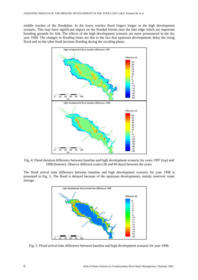
ASSESSING IMPACTS OF THE MEKONG DEVELOPMENT IN THE TONLE SAP LAKE: Kummu M. et al
middle reaches of the floodplain. In the lower reaches flood lingers longer in the high development scenario. This may have significant impact on the flooded forests near the lake edge which are important breeding grounds for fish. The effects of the high development scenario are more pronounced in the dry year 1998. The changes in flooding times are due to the fact that upstream developments delay the rising flood and on the other hand increase flooding during the receding phase.
Fig. 4: Flood duration difference between baseline and high development scenario for years 1997 (top) and
1998 (bottom). Observe different scales (30 and 60 days) between the years. The flood arrival time difference between baseline and high development scenario for year 1998 is presented in Fig. 5. The flood is delayed because of the upstream developments, mainly reservoir water storage.
Fig. 5: Flood arrival time difference between baseline and high development scenario for year 1998.
6 Role of Water Sciences in Transboundary River Basin Management, Thailand, 2005

ASSESSING IMPACTS OF THE MEKONG DEVELOPMENT IN THE TONLE SAP LAKE: Kummu M. et al
In Fig. 6 the average surface oxygen concentration difference between baseline and high development scenario for year 1998 is presented. Development scenario causes only small average impacts on the oxygen concentration. However, the oxygen concentrations are decreased significantly during the rising flood and increased during the receding flood (fig. 7 dissolved oxygen time-series from the floodplain). The decrease may be harmful for the fish, especially for the juveniles.
Fig. 6: Surface oxygen concentration difference between baseline and high development scenario for year
1998.
Fig. 7: Surface oxygen concentration difference between baseline and high development scenario for year 1998. The impact of the high development scenario on sedimentation in 1997 is shown in fig. 8. Sedimentation is decreased significantly in the lake and the floodplain. The exception is flooded forest near the lake edge which is the main sedimentation area. The increase in flooding time in the high development scenario compensates for the decreased sediment input into the lake. Suspended solids time-series are presented in the figure 9 from floodplain and lake proper near the lake edge. Thick line is for the baseline simulation and thin line for the high development one. The sediment concentrations are quite different in the floodplain and lake proper because of the efficient sedimentation in the floodplain. The significant decrease in sediment concentration and sedimentation affects adversely productivity of the system.
Role of Water Sciences in Transboundary River Basin Management, Thailand, 2005 7

ASSESSING IMPACTS OF THE MEKONG DEVELOPMENT IN THE TONLE SAP LAKE: Kummu M. et al
Fig. 8: The difference in sedimentation in Tonle Sap Lake and floodplain in 1997 under the high development scenario compared to the baseline scenario.
Fig. 9: Suspended sediment concentrations in the baseline (thick line) and high development (thin line) scenarios. Left floodplain (Lake Chma) and right lake proper near the lake edge (Kampong Loung).
Simulation year is 1997.
Table 2 present the differences in some of the simulated parameters between baseline and high development scenarios for years 1997 and 1998. The simulated parameters are flood duration, flood arrival time, surface oxygen concentration, and net sedimentation. The impacts are classified according to the elevation zones. Zone 1 is the lake proper, zone 2 is 2 meters up from the lake edge etc. It should be noted that the values are averages over large areas and long time periods and may hide significant spatial and temporal variations that can be seen in the graphical presentations of the model results (figures 4 – 9). Table 2: Differences in model output parameters between baseline and high development scenario for years
1997 and 1998.
8 Role of Water Sciences in Transboundary River Basin Management, Thailand, 2005

ASSESSING IMPACTS OF THE MEKONG DEVELOPMENT IN THE TONLE SAP LAKE: Kummu M. et al
CONCLUSIONS The modelling results show that the upstream developments can have a significant impact on the Tonle Sap Lake and floodplain. However, the development scenario used in the study was extreme. Work is ongoing to include also other scenarios in the study.
Both the flood and water quality characteristics in the Tonle Sap Lake and floodplain are affected by the development scenarios. The effects are most pronounced in dry years such as 1998 – 1999. This is because the relative changes in the flow regimes are then largest.
The inundation times near the lake edge are increased appreciably and this may have a negative impact on the survival of the narrow strip of the actual flooded forest. On the other hand, flooding times in the upper reaches of the floodplain are reduced appreciably. Floods are delayed from few days to few weeks depending on the zone and year, and on the other hand linger longer near the lake proper.
Oxygen levels are changed only slightly in the lake proper. In the floodplain, development scenarios have a negative impact on the oxygen levels especially during the rising flood. This may have some negative impact on the fish breeding in the flood plains.
Impacts on the Mekong sediment concentrations are estimated from existing dams. There may be some compensation from land use changes and increased channel and bank erosion, but probably the most fertile sediments which are also efficiently trapped are entering to the Mekong from China. Sediment concentrations and sedimentation are reduced appreciably especially during the rising flood. This may have significant consequences to the fisheries and agricultural productivity of the Tonle Sap system.
ACKNOWLEDGEMENTS The work presented in this paper is part of Lower Mekong Modelling Project under Mekong River Commission (MRCS/WUP-FIN) funded by Development Cooperation Department of the Ministry of Foreign Affairs of Finland. The authors would like to acknowledge all of the WUP-FIN team, particularly Seppo Hellsten, Marko Keskinen, Mikko Kiirikki, Mira Käkönen, Jussi Nikula, Olli Varis, Markku Virtanen, and all of the Cambodian co-workers, especially Mao Hak and Yin Than, and trainees. Professor Pertti Vakkilainen is equally acknowledged.
REFERENCES
Bonheur, N. (2001) Tonle Sap Ecosystem and Value, Technical Coordination Unit for Tonle Sap, Ministry of Environment, Phnom Penh, Cambodia.
Campbell, I.C. (2005) Integrated Water Resources Management for the Mekong River Basin. In: A.K. Biswas, O. Varis and C. Tortajada (Editors), Integrated Water Resources Management in South and South-East Asia. Oxford University Press, New Delhi, pp. 353.
Carbonnel, J.P. and Guiscafre, J. (1963) Sedimentologie et Hydrologie. Grand Lac Du Cambodge, Ministere Des Affaires Étrangères, Comite Du Mekong et du Gouvernment Royal Du Cambodge.
Dore, J. and Yu, X. (2004) Yunnan hydropower expansion - Update on China's energy industry reforms & the Nu, Lancang & Jinsha hydropower dams, Chiang Mai University's Unit for Social and Environmental Research & Green Watershed, Kunming, PR of China.
Hori, H. (2000) The Mekong: Environment and Development. United Nations University Press, 398 pp. Junk, W.J., 1997. The Central Amazon Floodplain. Springer, Berlin. Keskinen, M. (2005) The Lake with Floating Villages: A socio-economic analysis of the villages around
the Tonle Sap Lake. International Journal of Water Resources Development, Submitted. Keskinen, M., Koponen, J., Kummu, M., Nikula, J. and Sarkkula, J. (2005) Integration of Socio-economic
and Hydrological data in the Tonle Sap Lake, Cambodia. In: V. Kachitvichyanukul, U. Purintrapiban and P. Utayopas (Editors), Proceedings of the 2005 International Conference on Simulation & Modeling, SimMod'05. Bangkok, Thailand.
Keskinen, M. and Varis, O. (2005) Socio-economic impact assessment of the Mekong development - case Tonle Sap Lake. International Symposium of Role of water sciences in Transboundary River Basin Management. Ubon Ratchatani, Thailand.
Role of Water Sciences in Transboundary River Basin Management, Thailand, 2005 9

ASSESSING IMPACTS OF THE MEKONG DEVELOPMENT IN THE TONLE SAP LAKE: Kummu M. et al
Koponen, J., Kummu, M. and Sarkkula, J. (2004) Modelling Tonle Sap Lake Environmental Change. SIL XXIX International Congress of Limnology. Lahti, Finland.
Koponen, J., Virtanen, M., Lauri, H., van Zallinge, N. and Sarkkula, J. (2003) Modelling Tonle Sap Basin for Sustainable Resources Management. The 1st Yellow River Conference. China.
Kummu, M., Koponen, J. and Sarkkula, J. (2005a) Modelling Sediment Transportation in Tonle Sap Lake for Impact Assessment. In: V. Kachitvichyanukul, U. Purintrapiban and P. Utayopas (Editors), Proceedings of the 2005 International Conference on Simulation & Modeling, SimMod'05. Bangkok, Thailand.
Kummu, M., Sarkkula, J., Koponen, J. and Nikula, J. (2005b) Ecosystem management of Tonle Sap Lake: integrated modelling approach. International Journal of Water Resources Development, Submitted.
Kummu, M., Sarkkula, J. and Varis, O. (2004) Sedimentation and Mekong Upstream Development: Impacts to the Lower Mekong Basin. Geomorphology, Submitted.
Lamberts, D. (2001) Tonle Sap fisheries: a case study on floodplain gillnet fisheries in Siem Reap, Cambodia. FAO Regional Office for Asia and the Pacific, Bangkok, Thailand. RAP Publication 2001/11, 133 p.
MRC. (2004) Decision Support Framework. Water Utilisation Programme Component A: Final Report. Volume No1 DSF 100 Main Report, Mekong River Commission, Phnom Penh, Cambodia.
Penny, D, Cook, G. and Sok, S.I. (2005) Long-term rates of sediment accumulation in the Tonle Sap, Cambodia: a threat to ecosystem health. Journal of Paleolimnology, 33 (1): 95-103.
Plinston, D. and He, D. (1999) Water resources and hydropower. ADB TA-3139 Policies and Strategies for Sustainable Development of the Lancang River Basin, Asian Development Bank, Manila.
Sarkkula, J., Kiirikki, M., Koponen, J. and Kummu, M. (2003) Ecosystem processes of the Tonle Sap Lake. Ecotone II - 1 workshop. Phnom Penh/Siem Reap, Cambodia.
Tsukawaki, S. (1997) Lithological features of cored sediments from the northern part of The Tonle Sap Lake, Cambodia. The International Conference on Stratigraphy and Tectonic Evolution of Southeast Asia and the South Pacific. Bangkok, Thailand, 19-24 August, 1997.
van Zalinge, N., Loeung, D., Pengbun, N., Sarkkula, J. and Koponen, J. (2003) Mekong flood levels and Tonle Sap fish catches. Second International Symposium on the Management of Large Rivers for Fisheries. Phnom Penh, Cambodia, 11-14 February 2003.
Varis, O. (2005) Externalities of Integrated Water Resources Management in South and South-east Asia. In: A.K. Biswas, O. Varis and C. Tortajada (Editors), Integrated Water Resources Management in South and South-East Asia. Oxford University Press, New Delhi, pp. 1-38.
Varis, O. and Keskinen, M. (2005) Policy Analysis for the Tonle Sap Lake, Cambodia - A Bayesian network model approach. International Journal of Water Resources Development, Submitted.
World Bank, (2004) Modelled Observations on Development Scenarios in the Lower Mekong Basin. Mekong Regional Water Resources Assistance Strategy, Prepared for the World Bank with Mekong River Commission cooperation.
WUP-FIN, (2003) Modelling Tonle Sap for Environmental Impact Assessment and Management Support. MRCS / WUP-FIN Project, Final Report, Mekong River Commission, Phnom Penh.
10 Role of Water Sciences in Transboundary River Basin Management, Thailand, 2005