Distribution of melt beneath Mount St Helens and Mount Adams inferred from magnetotelluric data

Introduction
Mountains play a crucial role in the supply of freshwa-ter to humankind, both in the mountains and the low-lands. More than half of humanity relies on the fresh-water that accumulates in mountains—for drinking,domestic use, livestock, irrigation, hydropower, indus-
try, and transportation. Mountain areas constitute a rel-atively small proportion of river basins, yet they providethe greater part of river flow downstream. Case studiesillustrate that mountains in humid areas provide30–60% of downstream freshwater, while this figure ris-es to 70–95% in semiarid to arid environments (Linigeret al 1998b; Liniger and Weingartner 2000; Viviroli et al2003). As the demand on water resources increases, thepotential for conflict over the use of mountain watergrows. Careful management and negotiation of moun-tain water resources must therefore become a priorityin order to mitigate growing water crises and conflictsat the local, national, and international levels.
Mount Kenya and the adjacent Upper Ewaso Ng’iroBasin form a highland–lowland system in whichimproved management of mountain water resourcesand mitigation of water-related conflicts deserve thehighest priority. The characteristics of this highland–lowland system and its dynamics and complexity arecomparable to and illustrative of many regions in East-ern and Southern Africa (Liniger 1995; Ojany and Wies-mann 1998) and other parts of the world.
Mount Kenya forms a resource-rich island in asavanna-dominated environment, especially to the northand west of this volcanic massif (Liniger et al 1998a).The lowlands—consisting of the semiarid LaikipiaPlateau and the dry Samburu Plains—are highlydependent on the water that comes from the mountainand its various ecological zones, in particular the forestbelt (Decurtins 1992; Gichuki et al 1998a). Land use inthe footzone and the semiarid plateau is very dynamic.It changed from pastoralist use at the beginning of the20th century to large-scale farming and ranching (so-called White Highlands) during colonial times (Kohler1987). After Independence in 1963, agropastoral com-munities immigrated into the region, causing popula-tion to increase by a factor of 10 over the next 40 years(Wiesmann 1998). At the same time small and mediumurban centers grew in importance (Leiser 1994), and inrecent years large-scale horticulture enterprises havebeen established in the footzone (Schuler 2004). Thesesocioeconomic and land use dynamics (Kiteme et al1998a), coupled with inadequate policies, planning, andmanagement (Kiteme et al 1998b; Wiesmann andKiteme 1998), led to a broad range of problems relatedto natural resource use (Liniger et al 1998a), the mostimportant being over-exploitation of river waterresources (Gichuki et al 1998a). Downstream popula-tions, livelihoods, economies, and ecological systemshave been heavily affected, leading to a broad range ofincreasing conflicts (Wiesmann et al 2000).
Against this well-documented background, the pres-ent paper aims to show the efforts made in the regionto assess scarce water resources and manage them sus-tainably. It examines the importance of long-term moni-
Mountains play acrucial role in thesupply of freshwaterto humankind, inhighland and lowlandareas alike. Increas-ing demand urgentlyrequires carefulmanagement ofmountain waterresources in order to
mitigate growing water crises and conflicts. Monitoredriver flow was analyzed for 3 selected catchments(Timau, Burguret, and Likii) on the slopes of MountKenya from 1960 to 2004. In the 10 years from 1995to 2004, the extreme low flow (Q95) of the rivers wasfound to have been reduced to 10%, 23%, and 71%,respectively, of the values for the decade from 1961 to1970. Water awareness creation campaigns in 1997and 2004 revealed that the number of abstractionpoints had more than doubled, and that there was atwo- to eightfold increase in the amount of river waterabstracted.
The present article documents increasing waterabstraction and the difficulties in establishing limits forlow flows such as the Q80 value (flow available on 80%of the days per year). The article also presents the roleof Water Users’ Associations (WUAs) in mitigating waterconflicts related to over-abstraction. Evaluation of theactivities of 13 WUAs showed that they solved 45 of 52conflicts. WUAs are also involved in activities such asenvironmental education, awareness creation, improvedirrigation practices, afforestation, and regulating water.The recent restructuring of the government ministryresulted in a formalized role for WUAs. Long-term dataon availability, abstraction, and use of water are neededto mitigate water conflicts within and between WUAs,negotiate water allocation, and establish allocationthresholds.
Keywords: Water abstraction; monitoring; allocationthresholds; water users’ associations; conflict mitiga-tion; sustainable regional development; highland–low-land system; Kenya.
Peer reviewed: January 2005 Accepted: March 2005
Assessing and Managing Scarce Tropical MountainWater ResourcesThe Case of Mount Kenya and the Semiarid Upper Ewaso Ng’iro Basin
Hanspeter Liniger, John Gikonyo, Boniface Kiteme, and Urs Wiesmann
163
Mountain Research and Development Vol 25 No 2 May 2005: 163–173

Hanspeter Liniger, John Gikonyo, Boniface Kiteme, and Urs Wiesmann
Mountain Research and Development Vol 25 No 2 May 2005
164
toring of the availability and use of river waterresources, and the use of this information for the devel-opment of a decision support tool for water manage-ment. In particular, it elaborates on the assessment oflow flows in order to establish thresholds for water use,and on the role of water users and related institutionsin resolving conflicts at different sub-basin levels.
Methodology
This study builds on long-term integrated and collabo-rative research efforts in the region which date back tothe mid 1970s and deal with environmental, land use,and socioeconomic dynamics, with a focus on more sus-tainable development in this highland–lowland system(Ojany and Wiesmann 1998). At the core of theseefforts stands a natural resource monitoring network(Gichuki et al 1998b) that covers the whole Upper Ewa-so Ng’iro Basin to Archers Post (Figure 1) and has pro-vided river and rainfall data for the 3 selected catch-ments presented in the first part of this paper (Bur-
guret, Likii, and Timau; Figures 1 and 2). The data arebased on recordings from meteorological stations daily-measured rainfall stations, and river gauge stations thathave been collected daily since 1960, and with chartrecorders since the early 1980s. In the 3 catchmentsfrom the upper part of Mt Kenya selected to present thechange of water availability and use since 1960, moni-toring of river flow was carried out using OTT R16water level recorders, from which daily discharge valueswere calculated using discharge rating curves(Decurtins 1992; NRMT 2004). All data are stored in adatabase; the analysis was done using standard hydro-logical statistical methods (NRMT 2004).
Whereas the monitoring network provides informa-tion on changes in the water balance, water abstractionassessment campaigns in selected catchments were usedto establish detailed information about river water use(Aeschbacher et al 2005, in this issue). These cam-paigns were carried out in 1997 and in 2002/2004, withthe aim of inventorying water abstraction points, waterinfrastructure and equipment, management, and types
FIGURE 1 Monitoring network in the Ewaso Ng’iro Basin northwest of Mt Kenya, and overview of the study area. (Source: NRMT 2004; map by Gudrun Schwilch)

Research
165
of water use, and assessing the amount of waterabstracted at each abstraction point. The campaignswere carried out by teams of researchers and staff of theMinistry of Water, in partnership with the local WaterUsers’ Associations (WUAs), with a view to buildingtheir capacity in water management. All along the riverfrom the up- to the downstream areas, each abstractionpoint and its particulars were systematically inventoriedand subsequently entered into the NRMT database. Forthe present study the full inventory of three rivers—Likii, Burguret, and Nanyuki—was evaluated, covering92 abstraction points in 1997 and 224 abstraction pointsin 2002/2004 (Figure 1).
With a view to establishing the grassroots-basedpotential for improved management of scarce waterresources and endogenous conflict resolution, all 13existing WUAs in the Upper Ewaso Ng’iro Basin werestudied during a field investigation in 2003. This inves-tigation was part of a larger study carried out with 227respondents (a structured random sample of popula-tion in all the sub-catchments of the Upper EwasoNg’iro Basin). It looked at water management informa-tion needs and development priorities in the basin,and at the role, effectiveness and sustainability of localinstitutions in promoting conflict resolution and moresustainable development. Structured questionnairesand open interviews were used to gather informationon the history, composition, functions, activities, opin-ions, and roles of the 13 existing WUAs, and the natureof the conflicts they addressed. The investigation alsocovered the WUAs in the 4 catchments—Timau, Likii,Nanyuki, Burguret—that are at the core of this study(Figure 1).
Long-term trends in river water resources
Figures 3a and 3b present the results of river monitor-ing since 1960 in the selected Burguret, Likii andTimau catchments of Mt Kenya. Figure 3a shows thatrainfall from 1960 to 2002 for a 3-month period—fromthe end of the short rains in December to the driestmonth of February—varied considerably in all 3 catch-ment areas. From 1989 to 1998, December to Februaryrainfall seems to have been above average, although notrends can be observed. This corresponds to the resultsof a detailed rainfall analysis (Gichuki et al 1998a;Sturm 2002) that showed periods of above- and below-average rainfall without long-term trends.
Contrary to rainfall, the Timau River shows clearlydecreasing flow over the entire period from 1961 to2002, which indicates that the change in river flowcannot primarily be attributed to a change in rainfall.The Burguret shows severe low values from 1980 to1985, then a period of increased flows till 1994, fol-lowed by a heavy decline, especially for the very lowflows. The Likii had very low flows during and afterthe severe dry years from 1980 to 1988. Several peaksin the February flows during high rainfall seasons canbe observed. The last extreme event was recorded dur-ing the El Niño year (end of 1997 to early 1998). How-ever, all 3 rivers show decreasing minimum flows overthe study period from 1960 to 2002, except for theThe Likii River, where the flows in 1981 and from 1985to 1988 were the lowest.
Figure 3b depicts the change in river flow forextreme low flows (Q95), low flows (Q80) reached on80% of the days, the median flow (Q50), high flows(Q20), and flood flows (Q5). It illustrates that the
FIGURE 2 The upper Timau catchmentnorth of Mt Kenya, with the forest belt whereriver water is generated, and the large-scaleand small-scale farming area where water isabstracted and used. (Photo by HP Liniger;end of dry season, 27 March 1997)

Hanspeter Liniger, John Gikonyo, Boniface Kiteme, and Urs Wiesmann
Mountain Research and Development Vol 25 No 2 May 2005
166
worst decline compared with the period 1961–1970was in extreme low flows. The Q95 flow available inthe last 10 years from 1995 to 2004 was reduced to10%, 23%, and 71% of the values in 1961–1970 for theTimau, Burguret, and Likii rivers, respectively. For theLikii River, Q80 and Q95 first had a strong decreasefrom the 1960s to the 1980s, and then a slight increasein the most recent decade. The reasons could not beestablished. One possible explanation is that rating
curves for the low flows in the natural riverbed of theLikii River were not updated regularly, and that con-siderable measuring errors can occur during low flows.There were far fewer changes in flood flows than inlow flows. Flood flows in the last decade were still87%, 76%, and 98%, respectively, of the flows record-ed from 1961 to 1970. Whereas river water decline isdramatic during the low flows, the potential to usefloodwater is still high.
FIGURES 3A AND 3B Low flow during the month of February and rainfall from 1960 to 2002 (A), and change in low flows Q95 andQ80, median flow Q50 and high flow Q20, and flood flow Q5 for 3 decades (1961–1970, 1981–1990 and 1995–2004), for Burguret(west of Mt Kenya), Likii (northwest) and Timau (north). (Source: NRMT 2004)

Research
167
River water abstractions: the main cause oflow flows
Table 1 shows river water abstractions (withdrawals)for 1997 and 2002/04. The number of portable pumpabstraction systems is high and has been increasingextremely fast. Operation of portable pumps variesgreatly in time and space, making an accurate assess-ment of water resource use difficult. However, thesepumps account for only 2–22% of the total abstrac-tions for the different rivers. Piped gravity conveyancesystems, predominantly in community water supplyprojects, account for 30–70% of total dry season waterabstractions. Furrows are the biggest water abstractors.Their number has decreased along the Burguret Riverbut increased on the Nanyuki. Total river waterabstraction has increased dramatically in the past 7years. The number of abstractors (abstraction points)for the 3 rivers presented above has more than dou-bled in all cases. The amount of water used also showsa two- to eightfold increase in 7 years (Aeschbacher2003).
The vicious cycle of Q80 abstraction permits
The fast-growing river water abstractions partly explainthe extreme reductions in the low flows, Q80 and Q95,shown in Figures 3a and 3b. As most water use is forirrigation, the highest abstraction rates occur duringthe dry season, when river flows are low. Thus Q80 wasreduced from the 1960s to the period from 1995 to2004 to about half for the Burguret and a quarter forthe Timau River. Q95 flow has even declined to a quar-ter and less than a tenth for the two rivers. Furtherinvestigations are needed to explain the increase ofLikii River flow in the last decade, as compared to the1980s.
Water abstractions have also reduced flood flowssince the 1960s, however to a much lesser extent thanduring low flows. The reasons are lower water demandduring flood flows and little to no water storage indams. The Timau River showed an increase in floodflow in the last decade, from 1995 to 2004 (Figure 3b),after a heavy decline from the 1960s to the 1980s. Thiscould be explained by land use change in the uppercatchment, where the entire forest belt at 2800–3000 mhas been converted to cropland. After this change sev-eral floods occurred where floods had not been record-ed before. The impact of ground cover and land usechange on river flow has been investigated using testplots, catchment studies and modeling (Liniger andThomas 1998; Notter 2003; MacMillan and Liniger2005) and might require more detailed analysis of therainfall–land use–river flow relationship.
In order to assess how much water is available inthe rivers and determine the amount that can be allo-cated without threatening the minimal residual dis-charge necessary for downstream users and for ecologi-cal functions (eg in the National Parks and GameReserves in the Archers Post area, which are of nationaland international importance), there is a need to setcriteria for thresholds of water abstraction. One criteri-on often used by water authorities is that the Q80 valueshould be guaranteed. This means that water shouldonly be abstracted when the flow exceeds the dischargereached on 80% of the days in a year.
As illustrated in Figure 3b, assessing Q80 (or anyother threshold value) is rather problematic. In thecase of the Burguret, Q80 for the period 1961–1970 was329 l/s, whereas it was about half (159 l/s) for the past10 years. The Q80 value for the period 1961–1970 wasonly reached in about half of the days from 1995 to2004. For the Timau River, the assessment of Q80 for1995–2004 gives a threshold value of 45 l/s that should
Type of system
Likii Burguret Nanyuki
1997 2002/4 1997 2002/4 1997 2002/4
Fixed pump 1 4 5 10 22
Furrow 2 1 5 2 2 6
Furrow to pipe 1
Gravity pipe 3 11 2 4 5 12
Hydram 2 2
Portable pump 9 19 36 100 17 33
Total number of abstraction points 15 38 43 113 34 73
Total abstraction amount in l/s 43 343 113 240 123 197
TABLE 1 Number of abstraction points according to type of system, and total dry season water abstraction amounts for selected rivers in the study area. (Source:NRMT 2004)

Hanspeter Liniger, John Gikonyo, Boniface Kiteme, and Urs Wiesmann
Mountain Research and Development Vol 25 No 2 May 2005
168
remain in the river. However, as illustrated in Figure 4,for the monitoring period from 1961 to 1970, Q80would have given a threshold value of 169 l/s, ie almost4 times more. From 1995 to 2004, this amount wasreached during less than 30% of the year.
If the threshold for water abstractions had beenfixed for the period 1961–1970 when only little waterwas abstracted, water abstraction would be permittedonly during 30% of the year. In other words, if Q80 iscalculated including more and more abstractions, thethreshold value becomes smaller and smaller. Thismeans continuous reduction of guaranteed river flowsand an increase in “justifiable” water allocations forabstraction—a vicious cycle.
In order to establish the threshold for river wateruse, long-term data are needed to assess climatic vari-ability and the flow regime of the rivers. In the MtKenya region, where rainfall is very erratic and highlyvariable, there is an even greater need for a sufficienttime span and for quality data. Additionally, if a statis-tical value like Q80 is used as a threshold for alloca-tion of water, amounts of water abstracted from therivers above the measuring and monitoring sitesshould be taken into account, and the water abstract-ed should be added to the measured river flows inorder to make a statistical analysis. This process isreferred to as “naturalizing river flow.” This naturaliz-ing allows a more appropriate and valid Q80 assess-ment, even when the data are only available for a lim-ited time span.
These reflections show the need for a wateraccounting system with real-time information abouttotal water use and availability, and for a decision sup-port tool to set limits for water abstractions. Due to rap-id land use change and increasing water abstraction,these data need to be updated regularly in order to
reflect the current situation and recent trends. They areneeded to determine river flow conditions—the indis-pensable basis for informed water management anddetermining water abstraction limits, and for WUAnegotiation processes. This has become even moreurgent with the recent development of irrigated export-oriented horticulture since 1993 (Schuler 2004). Thegrowing pressure on water resources has increased theneed to clarify the situation regarding availability, theamount of water use, and allocation and procedures forguaranteeing low flows for downstream users.
Emerging Water Users’ Associations (WUAs)
In addition to knowledge-based control, managementand conflict resolution based on institutions and organ-izations rooted in the concerned communities andinvolving all major stakeholders, are important compo-nents in a strategy for more sustainable water use andmanagement in the region.
Such grassroots-based organizations have emergedin the form of WUAs formed at the sub-basin level, cov-ering catchments of tributaries of the Ewaso Ng’iro.WUAs are a relatively new strategy for water resourcemanagement in Kenya (Kiteme and Gikonyo 2002).They were established as a follow-up to recommenda-tions developed during an intensive water awarenesscreation campaign (conducted by CETRAD, NRMT,and 6 government ministries) among all the water-relat-ed stakeholders in the Upper Ewaso Ng’iro Basin in thefirst half of the 1990s (Kiteme and Gikonyo 2002).
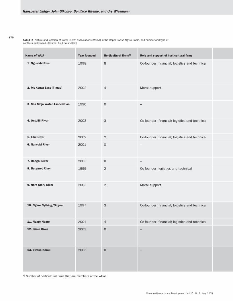
The first WUA was founded shortly after the con-cluding event in a water awareness creation campaignin early 1997, and was based on a former self-helpgroup. Subsequently, WUAs were established in theEwaso Ng’iro Basin in most of the Mt Kenya catch-ments, but only one was established in the AberdareMountains (Figure 1). Table 2 reflects this strongerinfluence of the awareness creation campaign on theMt Kenya side, and the role of horticultural firms withlarge-scale irrigation, which were instrumental in initi-ating many of the associations (6 of 13 WUAs were co-founded by horticultural firms, and these firms areinvolved in 2 others). The heavy involvement of largefirms was in most cases motivated by the need to main-tain access to water resources without facing conflictswith neighboring smallholder communities. By the endof 2003, 13 WUAs had been established, 9 of them(69%) within the last 2 years (Table 2). The reasons giv-en for their formation were:
a) Persistent water shortage and attendant conflictsduring the dry spell (9 of the 13 WUAs; 69%);
b) Water pollution and catchment degradation (31%);and
FIGURE 4 Flow duration curve for the Timau river for different decades:1961–1970, 1981–1990 and 1995–2004. Percentile curves indicate on howmany days a value is reached or exceeded (eg for Q80, on 80% of all days peryear). (Source: NRMT 2004)

Research
169
c) Creation of a platform for local resource mobiliza-tion to support community water projects (15%).
However, until very recently, WUAs had not been for-malized in legislation or in water policy in Kenya. Thisexplains why only 2 associations were founded as aresult of changed legislation, whereas all the otherswere formed on a purely voluntary basis.
Conflict resolution through Water Users’ AssociationsA wide range of conflicts occur in catchments cov-ered by the WUAs. Most common are conflicts thatinvolve aspects of water shortage and increased com-petition among users (such conflicts are reported in12 out of 13 associations), resulting in manipulationor destruction of river courses, water intakes, fur-rows, and pipes. Illegal and/or over-abstraction ofriver water is the second major cause of conflict(occurring in 7 WUAs), as individual users competeto meet needs and expectations. Table 2 illustratesthat WUAs have developed great skills and efficiencyin addressing these water-related conflicts. Nine ofthe 13 WUAs had dealt with more than 52 differentcases of conflict by the end of 2003, mainly througharbitration and negotiations between the conflictingusers (conflicts taken to the WUA for arbitration).87% (45 cases) were successfully addressed, with theremaining 13% (7 cases) waiting for further attentionfrom either the Executive Committees of the WUAsor a court of law.
However, the interviews revealed that WUAs didnot limit their operations to solving water conflicts.They have also emerged as important grassroots insti-tutions with a broad range of additional activities.54% of WUAs engage in activities such as environ-mental education and awareness creation; 46% inwater conservation through better irrigation practicessuch as drip irrigation, rainwater harvesting, andimproved river water storage; and 23% in catchmentprotection through afforestation. The WUAs them-selves consider these interventions to be remarkablecontributions to:
• Reducing water use conflicts and wasteful water uti-lization (in 62% of the WUAs);
• Enhancing catchment protection (38%); • Regulating river flow to ensure availability of water
to all, especially during the dry spells (23%); and • Raising general awareness about the water resource
situation in their respective catchment areas (23%).
WUAs see their potential limited by constraining factorssuch as lack of finances (83%), technical skills andmeans (31%), logistical support (31%), and limitedmanagerial and leadership capacities (31%).
The changing policy and legislativeenvironment
The national government recently introduced new insti-tutional arrangements for water resource management.These include a government policy shift from deliver-ing water infrastructure to the communities, to anemphasis on regulatory and enabling functions—ieimproving overall conditions and ensuring availabilityof the means to develop and implement legislation. Thegovernment thus clearly promotes integrated approach-es and supports the private sector as well as communityparticipation in the management of water resources inthe country (GoK 1999).
Based on the substantial restructuring of the min-istries’ functions and institutions (GoK 2002a, 2002b,2002c), WUAs have been formally recognized since2004 as institutions dealing with water resource man-agement at the grassroots level. Although this recogni-tion does not confer any explicit legal power to theWUAs, it nevertheless gives them motivation to operateand, more importantly, obligates and encourages theirformation. Legitimacy and guaranteed facilitation bythe government will officially establish the WUAs’ activi-ties and consolidate the results elaborated in the pre-ceding discussions, in the interest of promoting long-term sustainability. It can therefore be assumed thattheir role in awareness creation and conflict resolutionwill be enhanced beyond the promising initial experi-ences in the Mt Kenya region.
Conclusion
As river water abstractions continue to increase, waterresources are becoming scarcer and conflicts overwater resources are growing. In a dry environmentwith erratic and poorly distributed rainfall, there isneed for proper monitoring of water availability andaccounting of water use as a basis for more equitablesharing of water. However, defining criteria for waterallocation and thresholds still poses a challenge toresearch and to water users. Long-term monitoringhas revealed the great importance of sound, long-termdata and information as the basis for developing path-ways to more sustainable water management in theregion. These pathways require adequate institutionsfor monitoring and transfer of information, especiallyas a basis for conflict resolution at the level of actualwater users. WUAs can provide such an institutionalbasis. They have shown positive overall results in theMt Kenya region, not only in relation to resolvingwater use conflicts but also in promoting a broadrange of community- and catchment-related functions.It must also be noted, however, that the compositionof many WUAs includes a significant power imbalance
Hanspeter Liniger, John Gikonyo, Boniface Kiteme, and Urs Wiesmann
Mountain Research and Development Vol 25 No 2 May 2005
170
Name of WUA Year founded Horticultural firmsa) Role and support of horticultural firms
1. Ngusishi River 1998 8 Co-founder; financial; logistics and technical
2. Mt Kenya East (Timau) 2002 4 Moral support
3. Mia Moja Water Association 1990 0 –
4. Ontulili River 2003 3 Co-founder; financial; logistics and technical
5. Likii River 2002 2 Co-founder; financial; logistics and technical
6. Nanyuki River 2001 0 –
7. Rongai River 2003 0 –
8. Burguret River 1999 2 Co-founder; logistics and technical
9. Naro Moru River 2003 2 Moral support
10. Ngare Nything/Sirgon 1997 3 Co-founder; financial; logistics and technical
11. Ngare Ndare 2001 4 Co-founder; financial; logistics and technical
12. Isiolo River 2003 0 –
13. Ewaso Narok 2003 0 –
a) Number of horticultural firms that are members of the WUAs.
TABLE 2 Nature and location of water users’ associations (WUAs) in the Upper Ewaso Ng’iro Basin, and number and type ofconflicts addressed. (Source: field data 2003)

Research
171
Cases of conflicts handled by WUA: number and status; causesof conflict
Location within the Upper Ewaso Ng’iro Basin; major land useand water users
20 cases, all solvedWater shortage (water rationing program, timing of abstrac-tion among different user groups, issuing water use guide-lines), pollution; splinter groups; destruction of vegetationcover.
Location: Upper reaches of the Upper Ewaso Ng’iro Basin,side of Mt Kenya, covering zones from alpine zone to foot-slopes of Mt KenyaUse: Large-scale horticultural irrigation; small-scale horticul-tural out-growers; agropastoralists, including major urbansettlements in the catchment.
4 cases, 3 solvedDiversion of water by individual water users; destruction byother users.
5 cases, 4 solvedIllegal abstraction; blocking of canals; gravity leveling; inter-ference by non-members.
2 cases, all solvedOver-abstraction leading to water shortage; destruction ofwater catchment.
None
Approximately 8, all cases solvedWater shortage and scarcity problems during the dry spellin combination with over-abstraction.
None
5 cases, 4 solvedOver-abstraction; blocking of furrows; pollution; destructionof abstraction; irrigation issues.
3 cases, all solvedDownstream water shortage due to over-abstraction; mem-bers felling trees along the river; illegal car wash contami-nating the river.
10 cases, 9 solvedMembers using different pipe sizes (leading to over-abstraction); water shortage.
Location: Middle reaches of the Upper Ewaso Ng’iro Basin,side of Mt Kenya, covering footzones and semiarid savanna.Use: Large-scale commercial ranching and horticulturalfirms; smallholder agropastoralists and pastoralists.
None
3 cases; all pendingWasteful water use (leading to over-abstraction); felling ofindigenous trees.
Location: Lower parts of the Upper Ewaso Ng’iro Basin, sideof Mt Kenya: savannaUse: Recently settled smallholder agropastoralists; pastoral-ists and small-scale horticultural irrigation.
None Location: Middle reaches covering savanna and swamps;only WUA on the side of Nyandarua Ranges!Use: Smallholder agropastoralists; pastoralists; medium-scale horticultural irrigation; large-scale commercial ranch-ing. Specific focus on wetland management.

Hanspeter Liniger, John Gikonyo, Boniface Kiteme, and Urs Wiesmann
Mountain Research and Development Vol 25 No 2 May 2005
172
between large-scale horticultural firms and agropas-toral smallholders. To some extent this can be seen aspositive, as the large-scale firms are instrumental indeveloping WUAs. On the other hand, this imbalancecould lead to dependencies and unbalanced negotia-tion processes that might jeopardize the sustainabilityof conflict resolution. At present it is not possible todetermine whether the new legislation, with its formalrecognition of WUAs, will attenuate or increase poten-tial power conflicts within and among the variouscatchments in the highland–lowland system of MtKenya.
While WUAs have made a contribution to solvingwater disputes among the members of a WUA, there isstill a need to address conflicts and problems that occurbetween different catchments, and between upstreamand downstream parts of the basin and downstreamusers in cases where users are not yet organized inWUAs. Further research is needed to support WUAs inthe monitoring and use of water resources, and inaddressing allocation procedures and limits, as well as inmitigating water-related conflicts. This can only be donethrough integrated transdisciplinary approaches at mul-tiple scales involving multiple stakeholders and actors.
AUTHORS
Hanspeter Liniger, Urs WiesmannCentre for Development and Environment (CDE), Institute of Geography,University of Berne, Steigerhubelstrasse 3, 3008 Berne, [email protected]; [email protected]
John GikonyoNatural Resource Management Trust, Nanyuki, PO Box 297, Nanyuki,[email protected]
Boniface KitemeCentre for Training and Integrated Research in ASAL Development, PO Box144, Nanyuki, [email protected]
ACKNOWLEDGMENTS
The present study was carried out within the framework of the SwissNational Centre for Competence in Research (NCCR) North–South, as acollaborative effort between the Centre for Development and Environment(CDE) of the University of Berne, Switzerland, and the Natural ResourceManagement Trust (NRMT) and Centre for Training and Integrated Researchin Arid and Semi-arid Lands Development (CETRAD), both in Nanyuki,Kenya. The study also builds on earlier projects, in particular the LaikipiaResearch Programme (LRP), the Natural Resource Monitoring, Modellingand Management (NRM3) project, and the Actors’ Strategies and Percep-tions (ASP) project. All these projects were funded or supported by theSwiss Agency for Development and Cooperation (SDC), the Swiss NationalScience Foundation (SNSF), the Rockefeller Foundation, and USAID. Theauthors would also like to thank all the unnamed persons who worked inthese projects, the Kenyan authorities, and the local population.
REFERENCES
Aeschbacher J. 2003. Development of Water Use and Water Shortage in theNaro Moru Catchment (Upper Ewaso Ng’iro Basin, Kenya) [MSc thesis]. Pub-likationen Gewässerkunde 300. Berne, Switzerland: Institute of Geography,University of Berne.Aeschbacher J, Liniger HP, Weingartner R. 2005. River water shortage in ahighland–lowland system: A case study of the impacts of water abstraction inthe Mount Kenya region. Mountain Research and Development 25(2):155–162Decurtins S. 1992. Hydrogeographical Investigations in the Mount KenyaSubcatchment of the Ewaso Ng’iro River. African Studies Series A10.Berne, Switzerland: Geographica Bernensia.Gichuki FN, Liniger HP, MacMillan L, Schwilch G, Gikonyo G. 1998a.Scarce water: Exploring resource availability, use and improved manage-ment. Eastern and Southern Africa Geographical Journal 8, Special Num-ber:15–28.Gichuki FN, Liniger HP, Schwilch G. 1998b. Knowledge about highland–low-land interactions: The role of a natural resource information system. East-ern and Southern Africa Geographical Journal 8, Special Number:5–14.GoK [Government of Kenya]. 1999. Sessional Paper No. 1 of 1999 onNational Policy on Water Resources Management and Development. Nairobi,Kenya: Ministry of Water Resources.GoK [Government of Kenya]. 2002a. Country Strategy on Integrated WaterResources Management. Nairobi, Kenya: Ministry of Environment and Natur-al Resources.GoK [Government of Kenya]. 2002b. Country Strategy on Water and SanitationServices. Nairobi, Kenya: Ministry of Environment and Natural Resources.GoK [Government of Kenya]. 2002c. Water Act 2002. Kenya Gazette Supple-ment. Nairobi, Kenya: Government Printer.
Kiteme BP, Gikonyo J. 2002. Preventing and resolving water use conflictsin the Mount Kenya highland–lowland system through water users’ associa-tions. Mountain Research and Development 22(4):332–337.Kiteme BP, Künzi E, Mathuva JM, Wiesmann U. 1998a. A highland–lowlandsystem under transitional pressure: A spatio-temporal analysis. Easternand Southern Africa Geographical Journal 8, Special Number:45–54.Kiteme BP, Künzi E, Mathuva JM, Wiesmann U. 1998b. Multi-level approachfor enhancing ecological sustainability: Applications within a dynamicregional context. Eastern and Southern Africa Geographical Journal 8, Spe-cial Number:91–96.Kohler T. 1987. Land-use in Transition. African Studies Series A5. Berne,Switzerland: Geographica Bernensia.Leiser F. 1994. Central Places and the Transportation System in LaikipiaDistrict, Kenya. Laikipia–Mt Kenya Papers D-18. Nanyuki, Kenya: LaikipiaResearch Project.Liniger HP. 1995. Endangered Water: A Global Overview of Degradation,Conflicts and Strategies for Improvement. Development and EnvironmentReports 12. Berne, Switzerland: Centre for Development and Environ-ment.Liniger HP, Gichuki FN, Kironchi G, Njeru L. 1998a. Pressure on land: Thesearch for sustainable use in a highly diverse environment. Eastern andSouthern Africa Geographical Journal 8, Special Number:29–44.Liniger HP, Thomas DB. 1998. GRASS: Ground cover for the restoration ofthe arid and semi-arid soils. Advances in GeoEcology 31:1167–1178.Liniger HP, Weingartner R. 2000. Mountain forests and their role in provid-ing freshwater resources. In: Price MF, Butt N, editors. Forests in Sustain-able Mountain Development: A State of Knowledge Report for 2000. Walling-

Research
173
ford, UK, and New York, USA: CABI Publishing, in association with IUFRO[International Union for Forestry Research Organizations], pp 370–380.Liniger HP, Weingartner R, Grosjean M, Kull C, MacMillan L, Messerli B,Bisaz A, Lutz U. 1998b. Mountains of the World: Water Towers for the 21stCentury—A Contribution to Global Freshwater Management. Berne, Switzer-land: Mountain Agenda.MacMillan L, Liniger HP. 2005. Monitoring and modeling for the sustain-able management of water resources in tropical mountain basins: TheMount Kenya example. In: Huber UM, Bugmann HKM, Reasoner MA, edi-tors. Global Change and Mountain Regions: An Overview of Current Knowl-edge. Dordrecht, The Netherlands: Springer, pp 605–616.Notter B. 2003. Rainfall–Runoff Modelling of Meso-scale Catchments in the Upper Ewaso Ng’iro Basin, Kenya [MSc thesis]. PublikationenGewässerkunde 308. Berne, Switzerland: Institute of Geography, Universityof Berne.NRMT [Natural Resource Management Trust]. 2004. [Regularly updateddatabase of the Natural Resource Management Trust. Formerly: NaturalResource Monitoring, Modelling and Management and Laikipia ResearchProject.] Nanyuki, Kenya: NRMT.Ojany F, Wiesmann U. 1998. Resources, actors and policies: Towards sus-tainable regional development in the highland–lowland system of Mount
Kenya. Eastern and Southern Africa Geographical Journal 8, Special Num-ber:1–14.Schuler R. 2004. Commercial Horticulture Northwest of Mt. Kenya: A SectorAnalysis with Emphasis on Implications on River Water Resources of theUpper Ewaso Ng’iro Basin [MSc thesis]. Berne, Switzerland: University ofBerne.Sturm B. 2002. Development and Use of Long- and Short-Term PrecipitationInterpolation Models in the Ewaso Ng’iro Basin (Kenya) [MSc thesis]. Berne,Switzerland: University of Berne.Viviroli D, Weingartner R, Messerli B. 2003. Assessing the hydrological sig-nificance of the world’s mountains. Mountain Research and Development23(1):32–40.Wiesmann U. 1998. Sustainable Regional Development in Rural Africa: Con-ceptual Framework and Case Studies from Kenya. African Studies 14.Berne, Switzerland: Geographica Bernensia.Wiesmann U, Kiteme BP. 1998. Balancing ecological sustainability andshort-term needs: A regional approach to water supply planning. Easternand Southern Africa Geographical Journal 8, Special Number:77–90.Wiesmann U, Gichuki FN, Kiteme BP, Liniger HP. 2000. Mitigating conflictsover scarce water resources in the highland–lowland system of MountKenya. Mountain Research and Development 20(1):10–15.
Copyright © 2022 FDOKUMEN