Arnoldus-Huyzendveld, Antonia, Citter, Carlo 2014. Site location and resources exploitation:...
19
CULTURA MATERIALE INSEDIAMENTI TERRITORIO
Transcript of Arnoldus-Huyzendveld, Antonia, Citter, Carlo 2014. Site location and resources exploitation:...

€ 60,00
ISSN 0390-0592ISBN 978-88-7814-616-7
CULTURA MATERIALE
INSEDIAMENTI
TERRITORIO

archeologia medievaleCultura materiale. Insediamenti. Territorio.
xLI2014
All’Insegna del Giglio
INDICE
ARCHEOLOGIA GLOBALE, a cura di Gian Pietro Brogiolo, Enrico GiannicheddaGian Pietro Brogiolo
Nuovi sviluppi nell’archeologia dei paesaggi: l’esempio del progetto APSAT (2008-2013) 11Juan Antonio Quirós Castillo
Oltre la frammentazione postprocessualista. Archeologia agraria nel Nordovest della Spagna 23Giuliano Volpe, Roberto Goffredo
La pietra e il ponte. Alcune considerazioni sull’archeologia globale dei paesaggi 39Luca Maria Olivieri, Massimo Vidale
An ethno-historical and ethno-archaeological look to the off-site archaeological locations of the Swat valley (Khyber Pakhtunkhwa, Pakistan) 55
Antonia Arnoldus-Huyzendveld, Carlo CitterSite location and resources exploitation: predictive models for the plain of Grosseto 65
Enrico GiannicheddaChi ha paura dei manufatti? Gli archeologi hanno paura dei manufatti? 79
Elisabetta NeriLe parole e le cose. La trasmissione del sapere e l’archeologia. Riflessioni ed esempi 95
Marco MilaneseDal progetto di ricerca alla valorizzazione. Biddas – Museo dei Villaggi Abbandonati della Sardegna (un museo open, un museo per tutti) 115
Marco ValentiL’archeologia come servizio (attraverso l’impiego degli strumenti tecnologici) 127
Daniele ManacordaArcheologia globale e sistema della tutela 141
NOTIZIE SCAVI E LAVORI SUL CAMPONotizie dall’ItaliaNicola Mancassola, Andrea Augenti, Mattia Francesco Antonio Cantatore, Stefano Degli Esposti,
Enrico Marchesi, Federico ZoniRicerche archeologiche sulla Pietra di Bismantova (RE). Il Castello medievale. Campagna di scavo 2012 151
Fabio Redi, Alfonso Forgione, Francesca Savini, Angelo Russi, Enrico Siena, Alessia de IureAmiternum (AQ). Scavo archeologico in località “Campo S. Maria”. Relazione preliminare, scavo 2013 171
Nicola Busino, Marielva Torino, Danilo LupoRicerche archeologiche nella chiesa di San Pietro di Aldifreda a Caserta. Dati archeologici ed antropologici 195
NOTIZIE SCAVI E LAVORI SUL CAMPONotizie dal bacino del MediterraneoMassimiliano Munzi, Fabrizio Felici, Isabella Sjöström, Andrea Zocchi
La Tripolitania rurale tardoantica, medievale e ottomana alla luce delle recenti indagini archeologiche territoriali nella regione di Leptis Magna 215
Schede 2013-2014, a cura di S Nepoti 247Aggiornamento schede 1971-2012, a cura di S Nepoti 252
NOTE E DISCUSSIONIRoberta Conversi, Eleonora Destefanis
Bobbio e il territorio piacentino tra VI e VII secolo: questioni aperte e nuove riflessioni alla luce dei dati archeologici 289Santa Frescura Nepoti
Fossati, palancati e mura: le fortificazioni di Bologna tra l’inizio dell’XI secolo e la fine del XIII 313Claudia Pizzinato
Focolari domestici, forni e piani di cottura dell’Italia medievale. Un primo bilancio 335

Esther Travé Allepuz, Mª Dolores López Pérez, Karen Álvaro RuedaTecnología de producción y organización de los alfares de cerámica culinaria en la Cataluña medieval: una aproximación a la implantación y transmisión de técnicas 349
Victoria Amorós Ruiz, Victor Cañavate Castejón, Sonia Gutiérrez LloretTapaderas articuladas tipo K de El Tolmo De Minateda (Hellín, Albacete, España): un ejemplo del comercio en el Altomedievo mediterráneo 369
Sauro GelichiQuesto Museo ‘non s’ha da fare’: peripezie archeologiche nella laguna di Comacchio 387
Recensioni
D Alexandre-Bidon, Dans l’atelier de l’apothicaire. Histoire et archéologie des pots de pharmacie XIIIe-XVIe siècle (E Giannichedda), p 397

65
XLI, 2014, pp. 65-78
Antonia Arnoldus-Huyzendveld*, Carlo Citter**
SITE LOCATION AND RESOURCES EXPLOITATION: PREDICTIVE MODELS FOR THE PLAIN OF GROSSETO
1. RESEARCH QUESTIONS
We wish to continue with the estimation of the most favourable areas for salt winning in the plain of Grosseto, which was a lagoon until the 14th century, when it turned into a marsh. We shift from the southern to the northern portion of it. We combine archaeological data and literary sources to provide an overview to compare with the environmental asset of the region.
What we present here is essentially a predictive model, since it answers the question: where do we have to look for eventual relics of the salt-works of Giuncarico. This model can be tested through excavation or geophysical investigation. Such an approach is similar to the predictive archaeology in search of hitherto unknown sites, through the application of the inductive or deductive approach or combinations of the two (references in Citter 2012a and Citter, Arnoldus-Huyzendveld, Maccani 2013). Our theoretical framework will be expanded in the conclusions, where we propose to use the term “predictivity” when one tries to “forecast” the location of a site, a quarry, a salt-work, or a mine. In addition, we suggest to use the word “postdictivity” when one tries to uncover the reasons why that site is there, that road is running that way, or why did they exploit the land for pasture, while it would be suitable for vineyards.
2. SALT WINNING AND COASTAL REGIONS
Salt has always been an important product of the Mediterranean coastal areas (see Carusi 2008; Alexianu, Weller, Curcă 2011). It’s a historically known fact that there have been salt works along the coast of Tuscany during the Early Middle Ages (Wickham 2001; Farinelli 2007, p. 87; Citter, Arnoldus-Huyzendveld 2012). In particular, we know that there should have been salt works in the neighbourhood of Giuncarico, but they were never found. One of the reasons for that is the intensive land reclamation to which this area has been subject, by applying the technique of the “colmata”, meaning the raising of the surface with sediment derived from the rivers through a channel (Ministero 1904; Randone 1995). This renders almost useless any surface survey and the use of the aerial photographs. In addition, the traces from salt works are generally ephemeral (Arnoldus-Huyzendveld et al. 2009).
In the Mediterranean countries, the hot summers allow salt production through the evaporation of brackish or salt water
in flat coastal areas. We know two techniques: the isolation of a natural indenture of a lagoon by damming it off, and then regulating the influx of salt water through canals (Maccarese, Latium: Morelli et al. 2011), and the construction of a com-plex series of basins in the coastal plain, also connected to the sea (Agricola 1556; the salt works of La Trappola, in use between the XV and XVIII century (Zagli 2007, pp. 89-90).
A probable isolation of a lagoon bay by means of a transverse dam, in analogy with the Imperial-age dam of Maccarese, was accepted for the modelling of the Roman and earlier salt works near Grosseto (Citter, Arnoldus-Huyzendveld 2012). But in the present case we have pre-sumed the construction of a series of basins, similar to the La Trappola salt work, due to the more recent age and the different environmental conditions. In fact, it is a rather nar-row valley floor and a segment of the lagoon under the direct influence of river input. Of course, this is just an hypothesis, and the supposition of an artificial barrier would not change substantially the procedure, nor the results.
In practice, we used contour lines and soil characteristics for the landscape definition. The results of that first approach were so evident that they allowed a direct confrontation with the other data, without the necessity to develop a more sophisticated GIS model.
3. LANDSCAPE CHARACTERISTICS
Giuncarico and Vetulonia are located in a hilly area composed of formations of the Secondary and Tertiary age (Servizio Geologico d’Italia, sheet 128, Grosseto), at an elevation of 200-300 m a.s.l. (fig. 1). These are separated by Pleistocene terraces from the valley floor of the Bruna river and the former lagoon of Grosseto. The Bruna, with its tributary the Sovata, is only the lesser river reaching this plain when compared to the Ombrone, the second river of Tuscany, running more to the east. The rate of average water discharge between the two is about 1:10 (Benvenuti et al. 1971). The maximum width of the lower Bruna-Sovata valley floor is, below Vetulonia, about 3.5 km.
The recent geological evolution of this area was studied and summarized by Citter, Arnoldus-Huyzendveld 2007. The plain is composed of a now reclaimed lagoon, which was more or less isolated from the sea by sandy coastal barriers. During the Holocene, due to the post-glacial sea level rising, the plain has been subject to intensive changes, like the gradual infill and restriction of the lagoon by flood-ing sediments and the seaward expansion of the dune belt
* Geoarchaeologist, Digiter S.r.l., Rocca di Papa.** Researcher University of Siena.

66
A. Arnoldus-Huyzendveld, C. Citter
fig. 1 – Location and general topography of the study area.
fig. 2 – Land Units, derived from the semi-detailed soil maps.
(Bellotti et al. 1999, 2004). More recent changes include the artificial infill of the lower areas of the plain during the 20th century land reclamation (Randone 1995), which further reduced the remaining lagoon and, moreover, a considerable retreat of the coastline (Bellotti et al. 1999). The courses of the Bruna and Sovata have been canalized during several land reclamations, first by Ximenes (references in Citter, Arnoldus-Huyzendveld 2011, pp. 24-25), then during the land reclamations of the late 19th century (Ministero 1904) and the 20th century. The channels directly along the western hills go back to these late periods.
For the present purpose, it seems particular relevant that the lagoon was naturally divided into sub-basins, at least during the Holocene, through slightly elevated areas (ridges) radially extending from the Grosseto terrace (Citter, Arnoldus-Huyzendveld 2007, tav. 2.8). Such a morphol-ogy must have determined the selection of the areas suitable for salt winning and for the creation of channels connecting the salt pans to the sea.
Grosseto’s territory is covered by semi-detailed soil maps (van Berghem et al. 1991; Sevink, Beemster, van Stiphout 1986), from which we derived a Land Units map. It is a thematic map that provides useful information for the inte-gration of physical landscape data and archaeological data (Sombroek, Sims 1995; Arnoldus-Huyzendveld 2007).

67
Site location and reSourceS exploitation: predictive modelS for the plain of GroSSeto
The original soil maps distinguished, for the valley floors and reclaimed plains, between the textural composition of the deeper and the surface horizons, the latter being generally slightly coarser (loamier), which is presumably due to their origin as “colmata” sediments. Since we are using this map for historical purposes, we selected from the soil characteristics those of the subsurface layers. Fig. 2 is an excerpt of the Land Units map pertaining to our study area, measuring ca. 11×14 km, including the lower Bruna and Sovata courses and the surrounding reliefs.
The hypothesis on the extension of the lagoon in Roman times, presented in Arnoldus-Huyzendveld 2007, tav. 2.9 and Citter, Arnoldus-Huyzendveld 2012, p. 32, was based upon the following three data: 1) the 3rd century BC datum from a drilling in the Ombrone valley floor in the south-eastern part of the lagoon (Biserni, van Geel 2005), which has yielded a depth for the Roman level of ca. 3.5 m (including the land reclamation layers) from the present surface; 2) the 5th century AD level at Spolverino near the lagoon lying some 2.2 m below the present level (references in Citter, Arnoldus-Huyzendveld 2012, p. 5); 3) according to geophysical survey, the pavement of the Roman villa of Aiali, located upon the Grosseto terrace, beyond the realm of the river influence, lying at a depth of less than 100 cm (Goodman, Piro 2009, p. 298). Therefore, at the time we presumed that the rising of the surface since Roman times would have been ca. 3.5 m in the realm of the Ombrone and ca. 2.5 in the area under the influence of the (smaller) Bruna river. We did not take into account a possible lower sea level in Roman times (Leoni, Dai Pra 1997).
4. CALCULATION PROCEDURE FOR THE SALT-WORKS LOCATION
We applied the same procedure as applied formerly for the Roman age to the collection of elevation points derived from the CTR 1:10.000 (Regione Tuscany), after eliminating the disturbances. Considering that our area is completely within the realm of the Bruna floodings, we considered a rising of the plain surface of 2.0 m since the early medieval period, due to, both, natural accumulation and “colmata”. This value is an approximation, based upon the known thickness of the local “colmata” layers (ca. 0.5 m), and in analogy with the irregular velocity of the dune belt expansion (Bellotti et al. 1999; Bellotti 2000): less in the second half of the first millennium and more for the second millennium. Thus, in this area the natural surface increase during the Early Middle Ages was considered on average 0.5 m and in the second millennium 1.0 m. Probably these values are too high for the northern part of our area. In analogy, for the area within the realm of the Ombrone river the average overall surface increase was estimated at 2.5 m. It is justified to consider the sea level for that period more or less similar to the present one (Leoni, Dai Pra 1997).
The quoted points were then subjected to interpolation, in order to create a DEM and contour lines. We created the contour lines of the elevations through an isotropic ordinary kriging procedure (details in Citter 2012b). Generally speak-ing, kriging produces a more reliable contour map, because
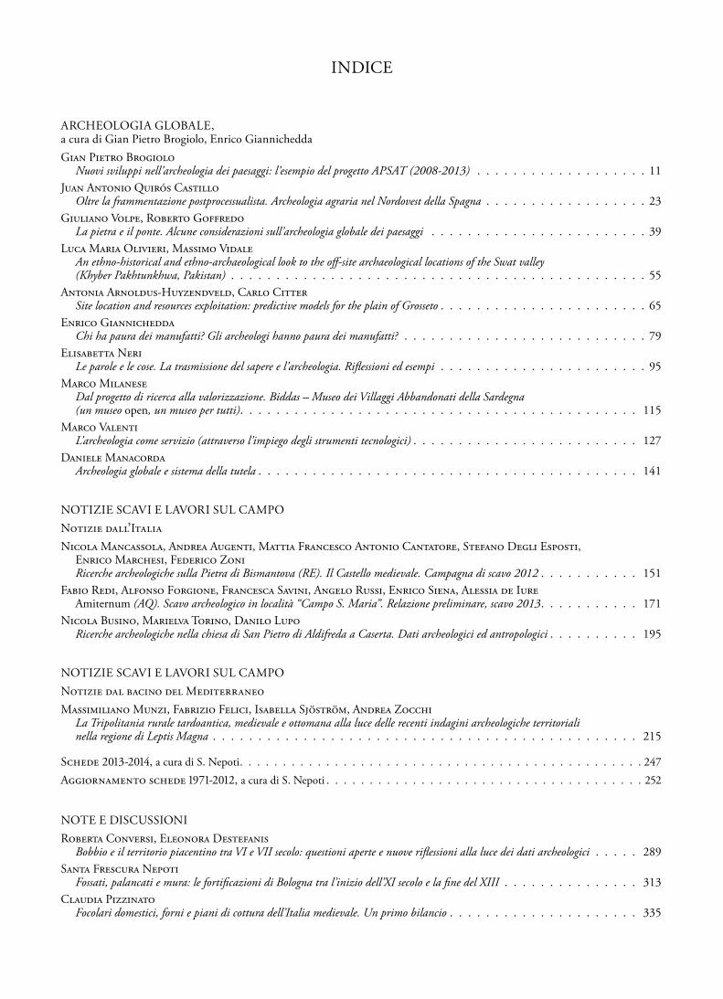
it considers the spatial autocorrelation of the elevations. In fig. 3 we show the results of the operations. One notices that the outline of the early medieval lagoon based upon this procedure is slightly smaller than accepted formerly.
We indicated on the map the contour lines of -0.5, 0 and +0.5 m, presumably covering the peri-lagoonal areas suitable for salt winning, according to the prescriptions of Georgius Agricola (book XII, p. 546 – AD 1556). Although the author is not explicit about levels, it is stated that «Near that part of the seashore where there is a quiet pool, and there are wide, level plains which the inundations of the sea do not overflow, three, four, five, or six trenches are dug six feet wide, twelve feet deep, and six hundred feet long (…)». The relevant part of this text is that the strip of land destined to salt pans should be close to sea level: high enough to stay dry in summer and low enough to permit water inlet in other seasons.
The deepest point of the lagoon in our area reached in this model is -2.5 m (not indicated on the map).
In fig. 3, the contours are overlaid on a map derived from the Land Units map, showing the “accessibility” of the various parts of the plain, especially in the wet season, as expressed by soil drainage class and texture. It is immediately evident that the areas classified as “very difficult to access” coincide acceptably well with the extension of the lagoon as hypothesized, both formerly and now. We also indicated on the map the contours of +5 and +10 m. Their position in the plain more to the north implies that salt winning would have been impossible in those areas, due to the height of the terrain with respect to the lagoon and the sea.
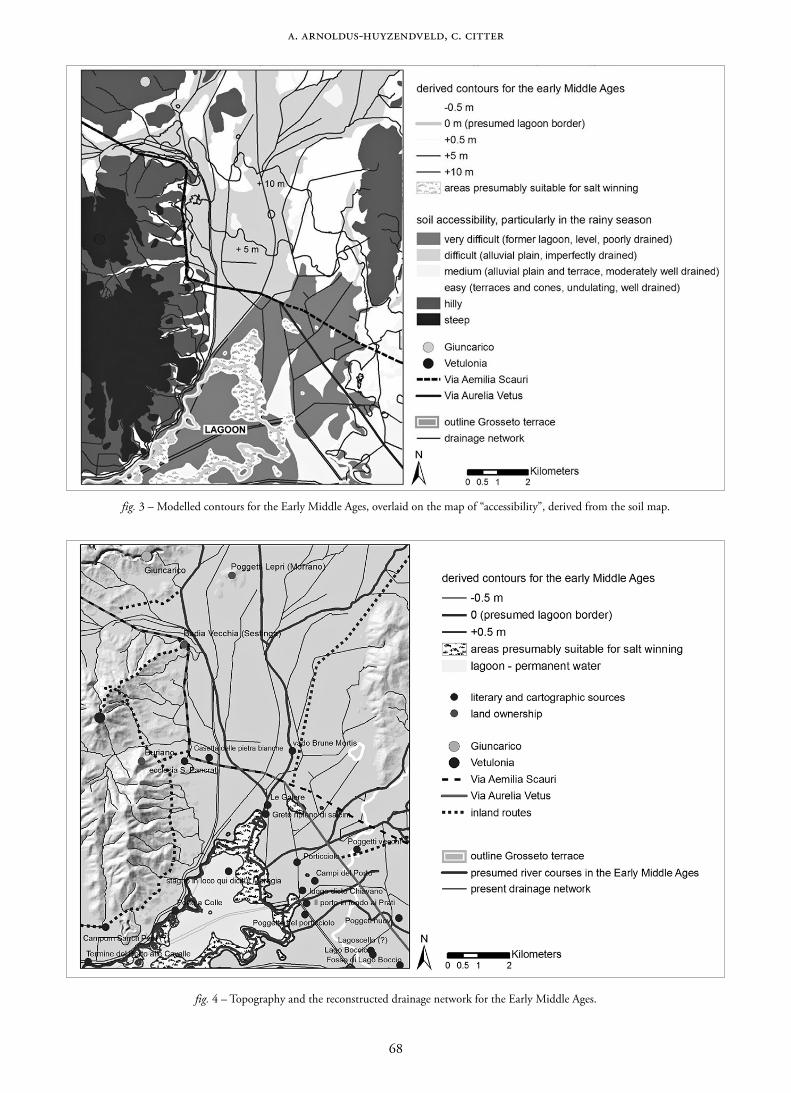
The apparent impossibility to lay out salt pans closer to Giuncarico, due to environmental limitations, has consid-erable consequences for the interpretation of the regional historical events. In fig. 4 we present a reconstruction of the overall hydrographical conditions.
There must have been a relationship between the river Bruna and the road-inn or crossing of Salebrone/Saleborna mentioned in Roman itineraries (Citter 2007d, p. 188). In fact, the latter can derive from *sala, which is a pre-indoeuro-pean word for marsh, or, from the Indoeuropean *sals, which means, both, salt and sea. The second part, brona, possibly comes from labro, the name of contemporary Livorno, but also a bowl for must. A further explanation can be from the Latin word salebra, which means roughness, unfavourable landscape, difficult to walk through. All these fit well with the palaeo-environment we reconstructed. The first mention of the river is in a chart of AD 790 (MDL IV/1, 107). Here the boundaries of a large estate centred on the cahagio of Colomnata reach the river Brona and, on the opposite side, the via publica, which should be the Aurelia/Aemilia running just there. An agreement between the Lambardi of Buriano and the abbot of S. Bartolomeo of Sestinga signed in AD 1253 mentions the «curia et districtu castelli S. Michaelis», which is a small relief just south of the first abbey of S. Bartolomeo of Sestinga, overlooking the via Aurelia vetus (Farinelli 2007 – archive 10.1). Its district reached the river “Brona viva”. Thus, we have another quote that proves the changing course of the river. It must have been a Brona morta somewhere in the neighbourhood, long before it was constrained into a channel through the centre of the lagoon as shown in the 18th
68
A. Arnoldus-Huyzendveld, C. Citter
fig. 3 – Modelled contours for the Early Middle Ages, overlaid on the map of “accessibility”, derived from the soil map.
fig. 4 – Topography and the reconstructed drainage network for the Early Middle Ages.

69
Site location and reSourceS exploitation: predictive modelS for the plain of GroSSeto
century map of Leonardo Ximenes and, later, in AD 1823 cadastre (references in Citter, Arnoldus-Huyzendveld 2011, pp. 24-25). In the first of these two maps we have also a «greto ripieno di salcini» that could be a former course of the Bruna which had destroyed part of the via Aemilia Scauri or Aurelia vetus. As opposed to a Brona viva an AD 1226 source mentions a «vado Brune mortis» (Citter 2007d, p. 183).
5. THE HISTORICAL AND ARCHAEOLOGICAL FRAMEWORK: TERRITORIES, OWNERS, SETTLEMENTS, AND RESOURCE EXPLOITATION
The area we selected for this paper constitutes the eastern portion of the territory of the Etruscan town of Vetulonia, at the border with the territory of Roselle (fig. 5). The last mention of Vetulonia as a town comes from a 3rd century AD inscription (Celuzza, Fentress 1994, p. 612), though archaeological data sketch a different picture. Excavations in the Roman town proved a frequentation until the mid 5th century AD still connected to the Mediterranean trade routes (Cygielman et al. 2006; Cygielman, Millemaci, Catani 2008). In the same period, the Church established the bishoprics network in this region (Citter 2007b), but Vetulonia should have been no more a relevant settlement to host a numerous Christian community. In fact, the bishopric and the civil district of Roselle incorporated the territory of Vetulonia (Id. 2007b).
Despite the scarcity of early medieval literary sources, the northern side of the plain between Roselle and Vetulonia is well documented. The first main source is the 814 AD Ludwig I privilege to the Abbey of S. Antimo. Then, we have the so-called Deusdedit Canon. They were both written in the 12th century, relying on earlier documents, as all scholars agree (detailed refer-ences and discussion of both in Id. 2005, pp. 75-78). Then, we have two charts from the abbey of S. Salvatore al Monte Amiata
(CDA, I, 19 and 20). The section of the Deusdedit Canon which mentions properties in the territory of Roselle originates from a request the Pope made in the early 8th century to have back a large series of estates along the Thyrrenian coast. It is likely the Papacy profited of a brief moment of peace to ask back what the Church owned before the Lombard invasion in AD 569. The Lombard kings did not seem to have answered. In fact, the Pope repeated his request by the end of the 8th century. It should have been part of the apparently good relationship between the papacy and Charlemagne.
From these two charts we get a quite clear picture of the possible events having occurred during the late antiq-uity and the Early Middle Ages in this area (fig. 6). These charts suggest that the Papacy owned the whole area of the lagoon and the lower portion of the Ombrone valley after Constantine I and before the end of the Roman west in the late 5th century AD. An abrupt break occurred between AD 569-593, when the Lombards conquered the Byzantine strongholds in southern Tuscany (details in Kurze, Citter 1995). Moving from Lucca southward, they settled in the plain between Roselle and Vetulonia. It seems they arrived after the Lombards moving from Chiusi, who settled in Giuncarico and Castiglione della Pescaia (we shall refer to this later). The AD 814 privilege shows that the town itself owned the southern portion of the former territory of Vetulonia. Thus, the papacy lost the major portion of the lagoon and its resources by the end of the 6th century. It is questionable, whether it could really return all its estates. However, strong links between Buriano, the abbey of S. Pancratius and other places in this region with Rome prove at least the papacy did not completely step down. We proposed that the building of the church dedicated to St. Peter in Grosseto at the end of the 8th century could be a further detail (Citter 2005).
It is intriguing to wonder why the three most powerful actors of central Italy between 6th and 8th centuries had so
fig. 5 – The selected area at the border between the former terri-tories of Vetulonia and Roselle.

70
A. Arnoldus-Huyzendveld, C. Citter
fig. 6 – Landowners and place names around the lagoon in the 8th and 9th centuries AD.
close and overlapping interests in the lagoon of Grosseto. A possible explanation is the control of salt exploitation. It is also worth mentioning that all the estates are near the major Roman roads, whose courses have been reconstructed from different sources (Citter 2007d).
The AD 814 chart gives us further useful information. We have discussed those related to the south-eastern portion of the lagoon in a previous paper (Citter, Arnoldus-Huyzendveld 2012). Here we wish to stress that the de-scription of the boundaries of the property starts with the eastern side of the lagoon. The document tells: «… id est per confinia et loca denominanda: ab oriente stagno in loco qui dicitur Moregia, ubi est ecclesia S. Pancratii exinde pervenit per campum S. Petri per medium montem super Cordoliano …». We do not know where the campum Sancti Petri could be, but we know that the monte super Cordoliano must be the hill over the Cortigliano, a small still existing stream, that flows into the former lagoon right in between Buriano and Castiglione della Pescaia. We have also indications of the location of the ecclesia S. Pancratii whose connection with Rome the via Aurelia, and the Benedictine monasteries is tempting (we thank Francesca Romana Stasolla for this information). Before its shifting south-east to Badiola al Fango, it is generally fixed at Le Querciolaie (Citter 2007d, p. 214). Thus, the eastern portion of the lagoon (stagno) is well delimited, and the geoarchaeological analysis gives us a more detailed outline of it. In addition, it has a feature so
clearly standing out to be an unquestionable marker for a boundary. Moregia, or muriccia, as this place is mentioned in AD 1253 and AD 1455 (Cardarelli 1932, p. 211) can be either the ruins of a Roman villa built on the lagoon coast-line, a salt work, a fishery or even a long dike. We have no more precise indication, whether it was in the middle of the water or near the foothills. However, it should have been an outstanding mark for that period. Which period? Though all agree the boundary derives from an original document, some of the places included in the 12th century version could be added to fulfil the needs of a more accurate description of that topographical setting. However, for the goal of this paper, if there was a lagoon in the 12th century, it should have been so also five centuries before. The same for the ruins.
The archaeological record proves that at least three vil-lages were settled in the plain between AD 450 and 550: Le Paduline, Badiola, Aiali (Vaccaro 2011, pp. 32-39). These data are relevant, due to the depth of the deposit provoked by the natural accumulation and the land reclamation. The northern portion of the lagoon was settled too, as the village of San Martino de Plano proves. Villages were the best way to manage the vanishing social system of the late Roman empire, and southern Tuscany produces several case studies (Citter 2008). Chronologies cannot be more precise, because they are based upon the dates of late Roman amphorae and fine wares, which have been recently questioned, at least for Rome (Panella et al. 2010).

71
Site location and reSourceS exploitation: predictive modelS for the plain of GroSSeto
The last two relevant 8th century charts come from the Abbey of San Salvatore al Monte Amiata, founded in the western portion of the territory of Chiusi with a consider-able amount of properties in southern Tuscany and north-ern Lazio. They refer to a noble Lombard man of Chiusi, Guntifrid, who confirms two tenants (Auderad and the freeman Teutpert) in two houses of the curtis of Iuncarico. We can interpret the word casa as farmsteads, or mansus (for more details see Farinelli 2007, pp. 48-49). They both have to bring to Chiusi each summer 10 modii of salt (if it is the Roman measure, then they had to transport 20 modii, or 280 Kg of salt – see Moinier 2011, p. 138). The two documents are identical apart from the references to the two tenants. Thus, it is likely that 20 modii was the owner’s revenue of that salt work, belonging to the curtis of Iuncarico the two tenants had to give. We don’t know, whether they produced more, if the curtis used to have other tenants obliged to the same duties in other salt works, whose charts are not pre-served. Obviously, there should have been several salt works in the area. The documents show a typical early medieval estate – curtis – well set up before the Carolingians conquered Lombard Italy. Thus, they question the long lasting debate whether they imported the villa-model with its bipartite system of management, or whether the Lombards had already experimented this way of exploitation and social relationship (Pasquali 2002). The two charts clearly show that there is a dominico – the reservoir – and at least two farmsteads hired by two men (usually mentioned as massaricium): only one is said to be a freeman. They have to work in the dominico each third week – the so-called angaria – and, seasonally, they have to work in the salt works. As the environmental analysis shows, there is no possibility to locate the salt works close to the high medieval Giuncarico castle’s hill. The straight distance to the nearest place where they could be is more than 10 km southward. Thus, this is a further proof of the early medieval estates’ fragmentation. Another remark is that they signed the two charts in San Donato of Morrano, which is a nearby estate owned by the bishop of Lucca (Farinelli 2007 – archive 18.5). We must remember that Chiusi was facing a slowdown since the foundation of the Abbey of San Salvatore which established a strong power controlling the western portion of its territory and things did not get better in the 9th century under the Carolingians (Kurze 2002). Lucca had to face some problems with the Carolingians too, but its connection with the territory of Roselle and Vetulonia was still strong, as the charts prove (Farinelli 2007, pp. 76-90). In addition, the bishop of Lucca tried to secure the southern portion of his estates by giving them to the first ever known Aldobrandeschi in AD 803.
It is worth mentioning that a chart written in AD 762 mentions a place named Colomnata, probably present Incoronata (MDL IV/1, 56). It relates to land properties in a place, whose significant name is “casale episcopi”. The ten-ant Boniperto has to provide several goods to the owner, the powerful bishop of Lucca Peredeo, and has to do angaria. In AD 831 we are informed that there was a curtis centred on Colomnata, and it used to be a relevant topographical feature until the 11th century. Only few decades before, in AD 790 (MDL IV/1, 108), in the area of Colomnata a piece of land,
a cahagium, was sold for the relevant amount of thirty solidi (being a farmstead with orchard, well, and barn usually estimated twenty solidi). The high price can be explained by the apparent large extension of the lot, although in the chart it is mentioned as petio de terra. In fact, it has one side on the via publica, such as the Aurelia/Aemilia, and the op-posite on river Brona. In between, the notary records fruit trees, other unspecified trees, and a fossa (ditch) that could be the Sovata or a ditch to prevent fresh water polluting the saltwarks. Because the location of Colomnata seems correct, we can argue the Lombards of Lucca wanted to secure the control of this portion of territory by creating a series of es-tates along the main routes encircling the curtis of Iuncarico as fig. 6 clearly shows. This suggests they came after the Lombards of Chiusi.
The Lombards from Lucca seemed to have been stopped for a while north of Giuncarico, probably because the Byzantines had a few strongholds. But the arrival of Lombards from Chiusi could have vanished these defences, and opened the way south to Lucca (Kurze 2002, pp. 167-168).
The agreement between king Agilulf and pope Gregory I in AD 593 must have been the deadline for the military action of Chiusi and Lucca in the region. The possible cre-ation of a gastaldus in Roselle was both a way to secure the management of public properties now pertaining to the king, and to control the two powerful duchies (Citter 2007c, pp. 451-452). In addition, to S. Martino is dedicated the cathedral of Lucca. It is, thus, tempting to connect the place name San Martino de Plano with other places with the same name in Colonnata, Vetulonia, and near Grosseto on the site of a late Roman villa and road-inn (Id. 2005). Moreover, the hill where they built the first monastery of Sestinga in the 11th century is part of a curtis with the relevant name of Sancti Frediani (AD 1032 – Farinelli 2007 – archive 10.4). S. Frediano is the patron of Lucca and one of the most out-standing churchmen of the 6th century, mentioned by pope Gregory I too. The small hill, where they found gold coins (possibly a late antique hoard), overlooks the valley where the Aurelia vetus used to run and, possibly, also the road-inn or crossroad of Salebrone (Citter 2007d, p. 188).
There are no later mentions of salt works in the area of Giuncarico. This can be related to the changed conditions of the lagoon, which hampered salt winning in the inner part of it. We still find salt works westward, in correspondence to the new abbey of S. Pancratius built on the so-called “isola clodia”. Due to an erroneous reading of a Cicero’s letter it has been identified as the site of the villa of Clodius (Id. 2007c, p. 219).
We wish to add some more remarks about the curtis of Iuncarico. First of all the name. It is related to iuncus (italian giunco), a plant that grows usually close to permanent water, also marsh. It is not a suitable name for a hilltop settlement. Thus, we wonder whether the dominico was positioned already on the hilltop, where later we find the castle of Giuncarico (first mention AD 1031 – Farinelli 2007 archive – 18.5), or if it was still on the plain. This question is relevant because it relates with the so-called “Tuscan model” of settlement pattern and changes between the late antiquity and the Early Middle Ages. It assigns to the 7th century a major shift of the rural set-

72
A. Arnoldus-Huyzendveld, C. Citter
tlements from the plain to the hilltops, leaded by the peasants, due to the end of the late Roman land exploitation system (Francovich, Hodges 2003). Present data prove that the plains were not fully abandoned, and that some of the hilltops were not settled until the 11th century with towers and small clusters, but not villages (Citter 2009, pp. 195-199; Id. 2011, pp. 50-52; Vaccaro 2011, pp. 199-200). However, we often excavated only the hilltops of permanent settlements, which frequently have a lower plateau enclosed in the 13th century circuit wall. The high and late medieval stone made buildings could have cancelled any trace of previous wooden features. In addition, we never intensively excavated castles that were not abandoned at the and of the middle ages. Therefore, did we find portions of early medieval hilltop villages, or just one or two farmsteads laying on the upper plateau? On the contrary, can we exclude the presence of a village in the lower plateau, just because we found nothing on the upper one? Moreover, Frans Theuws’ study in Toxandria alerts about the apparent contem-poraneity of wooden huts, even when we have 14C data, which is not always the case in Tuscany (Theuws 2008). Therefore, because we have no dendrocronological data, nearly no large excavations, and not a full agreement on the chronology of early medieval coarse wares, we should be even more cautious. Sometimes the huts on the hilltop could be part of a village, sometimes they could be the barn of the owner’s revenues. But one should not exclude other functions (a critical revision for the territory of Roselle in Citter 2011, p. 49). The two tenants of Iuncarico had to work arable land in the dominico both by hand and with boves (cows) each third week. This statement can be related to the presence of heavy soils of the northern side of the plain. Thus, wherever the two farmsteads were, the dominico seems to have its arable land and the salt works on the plain. In this context a name related to plants growing near marshes fits well. There is no excavation in the high medieval castle of Giuncarico, thus, we do not know whether they used to store the revenues on the hilltop, but we should not exclude the possibility that the direction centre of the curtis was on the plain. If so, it should not be so far from the place where they wrote the chart, and one wonders why they did not do it right in the dominico of Iuncarico. The presence of a church can be only one of the possible explanations.
It is not unusual to find a castle with the same name of the former estate, mentioned within the same document. The first mention of a castle in Giuncarico deserves to be quoted: «curte … domnicata qui esse videtur im loco et finibus Guncharicho cum mea portione quod est quartam portionem de castello et ecclesia cui vocabulum est beate Sancte Marie». Thus, the curtis still existed in the 11th century, and a castle is built within its properties. However, it was no more owned by a noble man of Chiusi, but by a man connected with the Aldobrandeschi. A similar situation occurred in the nearby hill of Sestinga. The first mention of AD 996 shows that the bishop of Lucca gave part of his estates as a gift to the church of the town. In particular «casa et domnicata in loco et finibus Sestinghe» with «medietate de castello et ecclesia illa, cui vocabu-lum est beate sancte Marie, qui ad ipsa curte pertene» (Farinelli 2007 – archive 10.4). Thus, there is another castle built within the properties of a curtis, just near Giuncarico. These are not exceptional cases (ibid., p. 104). We must also remember that
a curtis should not have looked like a present day large estate. The fragmentation was the rule, not the exception (Citter 2008, pp. 756-759). These charts tell us the curtis was a large estate including the hill of the later castle, arable lands on the plain, pasture with sheep, vineyards, woodland, and uncultivated areas. It should not be a coherent area: a large strip of territory from west to east belonged to the cahagium of Columnata. The estates centred on San Donato of Morrano and Sestinga should have had pieces of land too. Finally, the salt works were undoubtedly far south of the core of the estate.
In addition, the curtis had metalwork tools as part of its equipment (eramen, ferro), which is not common. Thus, this estate is a relevant land-exploitation centre, there is an actor, who presumably controlled the work, and the agrarian activities were integrated by salt exploitation in summer. Metalwork tools are not the rule, in fact, we find a mention only in a handful of charts of the same period.
After the end of the Lombard kingdom, the power of Chiusi in this area slowed down in favour of Lucca, being the Papacy only able to request former estates without great success. By the end of the 11th century the Aldobrandeschi had a solid power base on the whole plain.
Archaeological data give us new suggestions. During the Lombard period a series of small cemeteries or even single tombs are spread throughout the whole plain of Grosseto and around the lagoon (Id. 2007b). In addition, a scramasax a round female fibula, and a piece of belt buckel found in Porto a Colle (Vaccaro 2011, p. 38 now in the Museo Archeologico e d’Arte della Maremma), attests at least the presence of im-portant persons in a crucial area connected to a landing inside the lagoon, as the name suggests. Our environmental eval-uation indicates that it is not located in the most profitable strip of land for salt winning. This find has been connected with the villa of Fattoria Badiola (ibid., p. 39), and with the small cemetery in Castiglione della Pescaia as relics of the control of Chiusi over this area. Other significant findings are related to the routes connecting the Aurelia to the inland (Chiusi and Siena). However, we must point out that there is no archaeological indicator of the presence of noblemen of Chiusi in the territory of Roselle and Vetulonia, because we have no unquestionable objects made in Chiusi in that period. On the contrary, the circular female fibulae found in Roselle, Grancia, La Pescaia, and Porto a Colle suggest that if there was a connection, it was with the town of Roselle, where the bishop and, later, the Aldobrandeschi used to rule.
Archaeology proves that the plains were not completely abandoned as we presumed decades ago. But there is an unquestionable weak knowledge of the 8th and 9th century. Usually, we ascribe it to a lack of research, or to the absence of excavations, or to the missing of well dated pottery. This is certainly not the case for this region. Small scale excavations, both south and north of Grosseto, now give evidence of a sequence that seems to break but, in some cases, only weaken, during the 8th and 9th centuries. A large excavation in Grosseto provides only one hut, whose date is ensured by 14C dating, and few other features: not much for a village that by the end of the 8th century used to have at least two churches. North of Grosseto the villa of Aiali seems to have a time gap too, though not excavated, but things do not differ in San Martino

73
Site location and reSourceS exploitation: predictive modelS for the plain of GroSSeto
fig. 7 – Map of the land use potential.
de Plano where excavations gave only a few potsherds related to this period. If we move to the north, the village of Tabbiano follows this rule (for this site see Vaccaro 2011, pp. 222 and 192). Thus, it is likely that there was no break at all. The partial substitution of pottery with other perishable materials like wood, that are not preserved in the archaeological record could help to explain some – though not all – of these cases.
Therefore, we could ask whether is there any relationship between the weakening in the archaeological sequence of San Martino de Plano between the 8th and 9th centuries, and the emergence of the curtis of Iuncarico. The settlements are lo-cated on the opposite sides of the Bruna valley. As we noticed, the former is a place name connected to the Lombards of Lucca. We have no direct evidence of a connection between the structuring of the curtis of Iuncarico which is not a new founded estate in AD 772, and the gap in San Martino del Plano, but we cannot exclude it.
We can also ask whether there is a connection between the emergence of the Aldobrandeschi, since AD 857 earls of the most part of southern Tuscany, including Roselle (Collavini 1998, pp. 54-56), and the new foundations or reoccupation of classical settlements, both on the plain and on the hilltops, that archaeology can date no earlier than the end of the 9th century.
The archaeological evidence, though caution is always welcome, suggests an increasing reoccupation of the country-side started under the Carolingians and increasing even more under the Ottonians, by reusing, both, former late Roman and early medieval settlements and by founding new ones. The sites of Poggio Cavolo, Aiali, San Martino de Plano, and Tabbiano cross from south to north the whole territory
of Roselle east of the lagoon (Citter 2007d, pp. 141-142; Id. 2011, pp. 49-50, Vaccaro 2011, p. 193). We can add the growing village of Grosseto (Citter 2007a). Other hilltops surrounding the lagoon like Poggio Calvello, Castellaccio del Prile, and Poggettone (within the Etruscan walls of Vetulonia) have pottery of late 9th to 10th century (Vaccaro 2011, p. 195). Earlier occupations of the hilltops from the 5th to the 7th century are attested too, but not in this area, with the only exception of Castiglione della Pescaia (Citter 1995). How did these settlements exploit the agrarian resources?
The land suitability map (fig. 7) is a useful tool to investigate the resource exploitation. We derived it from the land units map, by assigning to each land unit the cultivation potential. We must point out that peasants and owners were not con-strained by land suitability in their decision making process. For instance, a soil with moderate or even strong limitations for ploughing could be more attractive than one without lim-itations, because of its vicinity to the farm. Better field could be owned by opponent owners, crop production could not be the main activity, and so on.
Thus, we have to be careful to ascribe any sort of automatic response to environmental opportunities. Being aware of these limitations, we overlaid the maps of the archaeological settle-ments of the three periods we analysed (5th-6th, 7th-8th, 9th-10th centuries) on the land suitability map (fig. 8). We evaluated which class covers the major portion of a 200 m buffer area from each settlement. The results are visualised in the chart in the upper left corner of fig. 8.
Due to the number of still not excavated hilltop settle-ments, those of the 7th-8th centuries related to unsuitable

74
A. Arnoldus-Huyzendveld, C. Citter
fig. 8 – The archaeological settlements attested from 5th to 10th century AD in the plain of Grosseto. Top left: the same data in relationship to the land suitability visualised on a chart. On the X axis the suitability classes for the three phases: we grouped classes 4 to 6. On the Y axis the percentage of settlements of each phase falling into each class. To avoid distortions because of scale factor, we considered a 200 m buffer centred
on each settlement, and we evaluated which of the classes had the major percentage of the area within it.
classes for crop cultivation (3 to 6) could be underestimated. Thus, we must notice that the 9th-10th centuries settlements seem to have a closer relationship with the best arable land than those of 5th-6th. Moreover, they seem to be distributed among the classes. It would be tempting to ascribe this result to the landowning strategy of the Aldobrandeschi. It could also reflect a demographic growth around year 1000.
Historical routes deserve a final remark (fig. 9). The northern side of the lagoon is a natural crossing between the S-N route that in the Roman period was defined as Aurelia vetus and Aemilia Scauri (Citter 2007c), and at least two major connection with the inland. The two major Roman roads were still attractors at a local scale in the Early Middle Ages, as literary sources and archaeological data now prove at least in the territory of Roselle both south and north of the Ombrone river (ibid., p. 214).
The crossing of Paganico, though witnessed only in the Middle Ages, is a crucial point for those coming from Chiusi who aimed to reach the coast. Because this town had a sort of supremacy on Roselle at least from the Etruscans to the Lombards (Citter, Arnoldus-Huyzendveld 2012, p. 3), a route is supposed to connect the two towns.
Archaeological researches prove the existence of another route departing from the Aurelia/Aemilia just in the area we
are studying for this paper (Vaccaro 2011, pp. 190-192). It goes straight to the inland. The tombs at La Torraccia and La Pescaia witness an interest in the Lombard period, though the road existed long before, as the excavations in San Martino de Plano show. All available data suggest the routes network we show in fig. 9 was already in use around AD 100, but some of the paths were in use even before.
6. CONCLUSIONS AND DISCUSSION
We started asking whether salt winning could have been one of the main activities in the plain of Grosseto before the first mention in AD 1152. In the first study, we evaluated the envi-ronmental context, we compared literary sources, and archae-ological data. Finally, we made several cost surfaces to simulate the most potential areas for salt winning from the Etruscans to the Aldobrandeschi (Citter, Arnoldus-Huyzendveld 2012). In this second study we shifted north-west of Grosseto, an area that, on the contrary, has a direct mention of salt works in AD 772 belonging to the curtis of Iuncarico. The questions are similar, but we applied a different method.
According to the “Tuscan model” of settlement, the centre of the curtis (the dominico) should have been under the high medieval still standing castle. However, the environmental

75
Site location and reSourceS exploitation: predictive modelS for the plain of GroSSeto
fig. 9 – Early medieval settlements, major landowners and roads around the lagoon.
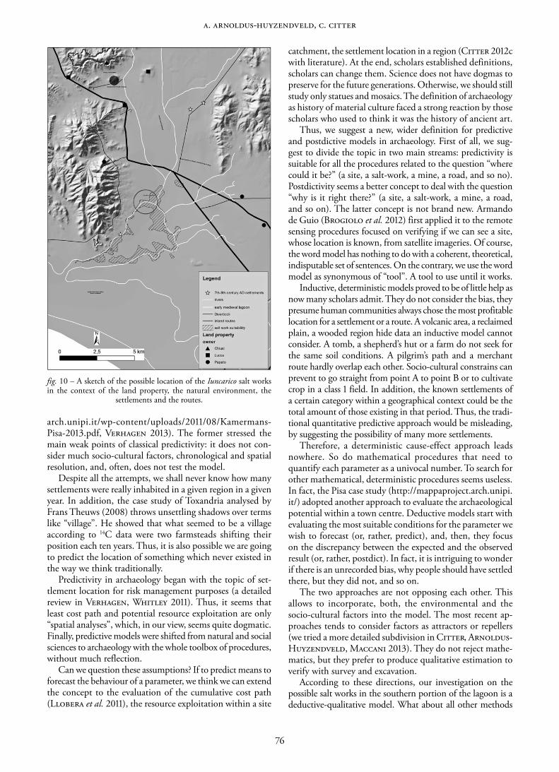
analysis proved the salt works could not be on its foothill, but only further south, at least 10 km. Moreover, the arable lands of the dominico and the two tenants farmsteads fits better on the plain than on the hilltop, not to mention the place-name connected to marshes. We have no data from the hilltop, nor have there been made new surveys in the plain just south of the hill. For these reasons we cannot exclude the centre of the dominico could be on the hilltop, nor that it was within one of the Roman villas in the plain. Fig. 10 is a sketch of what we think could have happened in the selected area in the 8th century AD. Because it seems the Lombard of Chiusi first conquered the former territory of Vetulonia, whose bound-ary was the river Bruna, it is possible the properties of the curtis of Iuncarico fall west of the river. A possible location of the salt works before the outflow of the Bruna-Sovata in the lagoon seems more favourable, but is not necessarily the only one. A system of ditches and/or dikes must have been put in place to separate the fresh water (from the rivers) from the salt water inflow. Traces thereof are our main hope in the case of future investigations. The mention of a fossa in AD 790 could be related to this.
In this case we had no need to make a cumulative cost surface, because the interpolation to evaluate the most likely coastline of the early medieval lagoon and the land units map were sufficient. Thus, we adopted a flexible strategy: two different approaches for a similar question.
Can we ascribe these methods to the family of “predictive models”? What is, essentially, a predictive model? What does “to predict” mean for an archaeologist? The verb in Latin means “to say before”. The Oxford dictionary quotes: «say or estimate that (a specified thing) will happen in the future or will be a consequence of something». Thus, theoretically speaking, prediction has nothing to do with archaeology, because everything we wish to investigate has already hap-pened. In practice it has been used for predicting the density and location of sites not yet discovered.
Predictivity is a toolbox scientists produced to forecast the behaviour of a parameter in the future or to estimate the like-lihood of an existing phenomenon based on a sample of cases or a theoretical assumption. We can forecast the impact of an increasing mean temperature on the sea level, by assuming a cause-effect relationship among all the factors involved in the prediction. We can also use more sophisticated algorithms to forecast the customer satisfaction of a new product. All these methods have three key assumptions in common: they are inductive, deterministic, and researchers can verify their reliability, because they can compare the prediction with the result to refine the former. There are further deductive approaches, but in archaeology the inductive models prevail.
And archaeology is different. Recently, Hans Kamermans and Philp Verhagen made a critical review of nearly thirty years of predictivity in archaeology (http://mappaproject.
76
A. Arnoldus-Huyzendveld, C. Citter
fig. 10 – A sketch of the possible location of the Iuncarico salt works in the context of the land property, the natural environment, the
settlements and the routes.
arch.unipi.it/wp-content/uploads/2011/08/Kamermans-Pisa-2013.pdf, Verhagen 2013). The former stressed the main weak points of classical predictivity: it does not con-sider much socio-cultural factors, chronological and spatial resolution, and, often, does not test the model.
Despite all the attempts, we shall never know how many settlements were really inhabited in a given region in a given year. In addition, the case study of Toxandria analysed by Frans Theuws (2008) throws unsettling shadows over terms like “village”. He showed that what seemed to be a village according to 14C data were two farmsteads shifting their position each ten years. Thus, it is also possible we are going to predict the location of something which never existed in the way we think traditionally.
Predictivity in archaeology began with the topic of set-tlement location for risk management purposes (a detailed review in Verhagen, Whitley 2011). Thus, it seems that least cost path and potential resource exploitation are only “spatial analyses”, which, in our view, seems quite dogmatic. Finally, predictive models were shifted from natural and social sciences to archaeology with the whole toolbox of procedures, without much reflection.
Can we question these assumptions? If to predict means to forecast the behaviour of a parameter, we think we can extend the concept to the evaluation of the cumulative cost path (Llobera et al. 2011), the resource exploitation within a site
catchment, the settlement location in a region (Citter 2012c with literature). At the end, scholars established definitions, scholars can change them. Science does not have dogmas to preserve for the future generations. Otherwise, we should still study only statues and mosaics. The definition of archaeology as history of material culture faced a strong reaction by those scholars who used to think it was the history of ancient art.
Thus, we suggest a new, wider definition for predictive and postdictive models in archaeology. First of all, we sug-gest to divide the topic in two main streams: predictivity is suitable for all the procedures related to the question “where could it be?” (a site, a salt-work, a mine, a road, and so no). Postdictivity seems a better concept to deal with the question “why is it right there?” (a site, a salt-work, a mine, a road, and so on). The latter concept is not brand new. Armando de Guio (Brogiolo et al. 2012) first applied it to the remote sensing procedures focused on verifying if we can see a site, whose location is known, from satellite imageries. Of course, the word model has nothing to do with a coherent, theoretical, indisputable set of sentences. On the contrary, we use the word model as synonymous of “tool”. A tool to use until it works.
Inductive, deterministic models proved to be of little help as now many scholars admit. They do not consider the bias, they presume human communities always chose the most profitable location for a settlement or a route. A volcanic area, a reclaimed plain, a wooded region hide data an inductive model cannot consider. A tomb, a shepherd’s hut or a farm do not seek for the same soil conditions. A pilgrim’s path and a merchant route hardly overlap each other. Socio-cultural constrains can prevent to go straight from point A to point B or to cultivate crop in a class 1 field. In addition, the known settlements of a certain category within a geographical context could be the total amount of those existing in that period. Thus, the tradi-tional quantitative predictive approach would be misleading, by suggesting the possibility of many more settlements.
Therefore, a deterministic cause-effect approach leads nowhere. So do mathematical procedures that need to quantify each parameter as a univocal number. To search for other mathematical, deterministic procedures seems useless. In fact, the Pisa case study (http://mappaproject.arch.unipi.it/) adopted another approach to evaluate the archaeological potential within a town centre. Deductive models start with evaluating the most suitable conditions for the parameter we wish to forecast (or, rather, predict), and, then, they focus on the discrepancy between the expected and the observed result (or, rather, postdict). In fact, it is intriguing to wonder if there is an unrecorded bias, why people should have settled there, but they did not, and so on.
The two approaches are not opposing each other. This allows to incorporate, both, the environmental and the socio-cultural factors into the model. The most recent ap-proaches tends to consider factors as attractors or repellers (we tried a more detailed subdivision in Citter, Arnoldus-Huyzendveld, Maccani 2013). They do not reject mathe-matics, but they prefer to produce qualitative estimation to verify with survey and excavation.
According to these directions, our investigation on the possible salt works in the southern portion of the lagoon is a deductive-qualitative model. What about all other methods

77
Site location and reSourceS exploitation: predictive modelS for the plain of GroSSeto
that do not produce a cumulative cost surface? Is the evaluation we presented in this paper a predictive model? We think it is.
The question is: do we always have to use all the avail-able tools? Or, rather, shall we select the most useful one? Sometimes, we do not need to use the more sophisticated. We had no chance to establish where salt winning could have taken place in the south-eastern portion of the lagoon, unless we evaluated a cumulative cost surface, to draw potential natural basins. On the contrary, in the northern portion, the evaluation of the available landscape data allowed to read literary sources and archaeological data under a new perspective to provide a new insight. We think we should escape from a dogmatic approach to predictivity/postdictivity in archaeology and include in the concept all the tools we can use to forecast the behaviour of a parameter.
REFERENCES
Agricola, Georgius, 1556, De Re Metallica, traduzione Inglese dal sito http://www.farlang.com/gemstones/agricola-metallica/page_001/.
Alexianu M., Weller O., Curcă R.G. (eds.), 2011, Archaeology and Anthropology of Salt: a diachronic approach, proceedings of the international colloquium, Iaşi, 2008, BAR International Series 2198, Oxford.
Arnoldus-Huyzendveld A., 2007, Le trasformazioni dell’ambiente na-turale della pianura grossetana, in Citter, Arnoldus-Huyzendveld 2007, pp. 41-61.
Arnoldus-Huyzendveld et al. 2009 = Arnoldus-Huyzendveld A., Citro D., Facciolo A., Gala M., Grossi M.C., Morelli C., Rinaldi M.L., Ruggeri D., Sivilli S., The Lagoon of Maccarese (Rome-Fiumicino): environmental and archaeological developments over the last 3000 years, poster presented to the conference organised from the Genua UV Wetlands as archives of the cultural landscapes: from research to management, Genova.
Bellotti P., 2000, Il modello morfo-sedimentario dei maggiori delta tirrenici italiani, «Bollettino della Società Geologica Italiana», 119, pp. 777-792.
Bellotti et al. 1999 = Bellotti P., Caputo C., Davoli L., Evangeli-sta S., Valeri P., Lineamenti morfologici e sedimentologici della piana deltizia del Fiume Ombrone (Toscana Meridionale), «Bollettino della Società Geologica Italiana», 118, pp. 141-148.
Bellotti et al. 2004 = Bellotti P., Caputo C., Davoli L., Evangeli-sta S., Pugliese F., Morphosedimentary characteristics and Holocene evolution of the emergent part of the Ombrone River Delta (souther Tuscany), «Geomorphology», 61, pp. 71-90.
Benvenuti et al. 1971 = Benvenuti G., Brondi M., Dall’Aglio M., Da Roit R., De Cassan P., Ghiara E., Gigli C., Marinelli G., Martini M., Gragnani R., Orlandi C., Paganin G., L’idrologia, in AA.VV., La Toscana meridionale. Fondamenti geologico-minerari per una prospettiva di valorizzazione delle risorse naturali, «Rendiconti della Società Italiana di Mineralogia e Petrologia», vol. XXVII. Fascicolo speciale, Milano, pp. 211-316.
Biserni G., van Geel B., 2005, Reconstruction of Holocene palaeoen-vironment and sedimentation history of the Ombrone alluvial plain (South Tuscany, Italy), «Review of Palaeobotany and Palynology», 136, pp. 16-28.
Brogiolo et al. 2012 = Brogiolo G.P., De Guio A., Fasson E., Betto A., Nebbia M., Cartografia storica e remote sensing (LIDAR) nello studio dei paesaggi di Monte grotto Terme, in M. Bassani, M. Bressan, F. Ghedini (eds.), Aquae Patavinae. Montegrotto e il ter-malismo in Italia. Aggiornamenti e nuove prospettive di valorizzazione, Atti del II Convegno nazionale (Padova 2011), Antenor Quaderni, 26, Padova, pp. 15-55.
Cardarelli R., 1932, Studi sulla topografia medievale dell’antico terri-torio vetuloniese, «Studi Etruschi», VI, pp. 145-240.
Carusi C., 2008, Il sale nel mondo greco (VI a.C.-III d.C.) Luoghi di produzione, circolazione commerciale, regimi di sfruttamento nel contesto del Medietrraneo, Pragmateiai, 15. Bari.
CDA = Codex Diplomaticus Amiatinus, W. Kurze (ed.), 1974-1982, voll. I and II, Tubingen.
Celuzza M.G., Fentress E., 1994, La Toscana centro-meridionale: I casi di Cosa-Ansedonia e Roselle, in R. Francovich, G. Noyè (eds.), La storia dell’altomedioevo italiano (VI-X secolo) alla luce dell’archeologia, Atti del Convegno (Certosa di Pontignano [SI] 1992), Biblioteca di Archeologia Medievale, 11, Firenze, pp. 601-606.
Citter C., 1995, Il rapporto fra Bizantini, Germani e Romani nella Maremma toscana attraverso lo studiuo della dinamica del popola-mento – il caso rosellano, in E. Boldrini, R. Francovich (a cura di), Acculturazione e mutamenti. Prospettive nell’archeologia medievale del Mediterraneo, Atti del congresso italo-spagnolo di archeologia medievale, VI ciclo di lezioni sulla ricerca applicata in archeologia. Certosa di Pontignano (Siena) 1993. Quaderni del Dipartimento di Archeologia e Storia delle Arti – sezione archeologia – Università di Siena 38-39, Firenze, pp. 201-222.
Citter C., 2005, L’origine di Grosseto: alcune ipotesi, in C. Citter (a cura di), Lo scavo della chiesa di S. Pietro a Grosseto. Nuovi dati sull’o-rigine e lo sviluppo di una città medievale, Quaderni del Dipartimento di Archeologia e Storia delle Arti – sezione archeologia – Università di Siena 62, Firenze, pp. 72-84.
Citter C. (a cura di), 2007a, Archeologia urbana a Grosseto. Origine e sviluppo di una città medievale nella “Toscana delle città deboli”. Le ricerche 1997-2005. II: edizione degli scavi urbani 1998-2005. Biblioteca del Dipartimento di Archeologia e Storia delle Arti – sezione archeologica, Università di Siena 16. Firenze.
Citter C., 2007b, Gli edifici religiosi tardoantichi e altomedievali nelle diocesi di Roselle e Sovana: il dato archeologico e i problemi in agenda, «Archeologia Medievale», XXXIV, pp. 239-245.
Citter C., 2007c, Il caso di Grosseto nel quadro dell’urbanesimo medieva-le in Toscana alla luce dell’archeologia, in Citter 2007, pp. 444-462.
Citter C., 2007d, La città di Grosseto nel quadro della viabilità ro-mana e medievale della bassa valle dell’Ombrone, in C. Citter, A. Arnoldus-Huyzendveld (eds.), pp. 156-198.
Citter C., 2008, Late antique and early medieval hilltop settlements in central Italy: state of research and interpretations, in H. Steuer, V. Bierbrauer (eds.), Höhensiedlungen zwischen Antike und Mittelalter von den Ardennen bis zur Adria, Proceedings of the international conference, Freiburg im Breisgau, 2004, Lexikon für germanischen Altertumskunde, Ergänzungsband, 58, Berlin-New York, pp. 749-764.
Citter C., 2009, Conclusioni: lo scavo di Castel di Pietra nel contesto del dibattito sulla formazione e dissoluzione dei paesaggi medievali: venti anni dopo il convegno di Siena, in C. Citter (a cura di), Dieci anni di ricerche a Castel di Pietra. Edizione degli scavi 1997-2007, Firenze, pp. 180-210.
Citter C., 2011, Dati archeologici: insediamenti, viabilità, sfruttamento delle risorse, in C. Citter, A. Arnoldus-Huyzendveld, Uso del suolo e sfruttamento delle risorse nella pianura grossetana nel Medioevo verso una storia del parcellario e del paesaggio agrario, Confronti, 1, Roma, pp. 41-54.
Citter C., 2012a, Modelli predittivi e archeologia postclassica: vecchi strumenti e nuove prospettive, in F. Redi, A. Forgione (a cura di), VI Congresso Nazionale di Archeologia Medievale (L’Aquila 2012), Firenze, pp. 12-15.
Citter C., 2012b, Townscape-Landscape. The shaping of the medieval town of Grosseto and its territory (AD 600-1400), «Post-Classical Archaeologies», 2, pp. 167-200.
Citter C., 2012c, Archeologia delle città toscane nel medioevo (V-XV secolo). Fotogrammi di una complessità, Documenti di Archeologia, 53. Mantova.
Citter C., Arnoldus-Huyzendveld A. (a cura di), 2007, Archeologia urbana a Grosseto. Origine e sviluppo di una città medievale nella “Toscana delle città deboli”. Le ricerche 1997-2005. I: la città di Grosseto nel contesto geografico della bassa valle dell’Ombrone, Biblio-teca del Dipartimento di Archeologia e Storia delle Arti – sezione archeologica, Università di Siena 16. Firenze.
Citter C., Arnoldus-Huyzendveld A., 2011, Uso del suolo e sfrut-tamento delle risorse nella pianura grossetana nel Medioevo, verso una storia del parcellario e del paesaggio agrario, Confronti, 1, Roma.
Citter C., Arnoldus-Huyzendveld A., 2012, New approaches to old issues: the application of predictive maps in archaeology. A case study: modelling the location of Grosseto’s salt works from 900 BC to AD 1200, «Medieval Settlement Research», 26, pp. 1-11.

78
A. Arnoldus-Huyzendveld, C. Citter
Citter C., Arnoldus-Huyzendveld A., Maccani C., 2013, Predic-ting site location through cost surfaces. A case study and a proposal, in M.L. Gualandi et al. (eds.), Opening the past, Atti del convegno, Pisa, pp. 5-10.
Collavini 1998, Honorabilis domus et spetiosissimus comitatus. Gli Aldobrandeschi da “conti” a “principi territoriali” (secoli IX-XIII), Studi Medievali, 6, Pisa.
Cygielman M., Millemaci M., Catani E., 2008, Castiglione della Pescaia (GR). Vetulonia: la domus di via Garibaldi, scavi 2008, «Notiziario Toscana», 4, pp. 336-342.
Cygielman et al. 2006 = Cygielman, M., Catani E., Millemaci C., Tuci D., Castiglione della Pescaia (GR). Vetulonia: indagini archeo-logiche nell’abitato, scavi 2006. Notizia preliminare, «Notiziario Toscana», 2, pp. 336-344.
Farinelli R., 2007, I castelli nella Toscana delle città deboli. Dinamiche del popolamento e del potere rurale nella Toscana meridionale (secoli VII-X), Biblioteca del Dipartimento di Archeologia e Storia delle Arti – sezione archeologica, Università di Siena, 15. Firenze.
Francovich R., Hodges R., 2003, Villa to village, Duckworth debates in archaeology, London.
Goodman D., Piro S., 2009, Ground penetrating radar (GPR) surveys at Aiali (Grosseto), in S. Campana, S. Piro (eds.), Seeing the unseen. Geophysics and landscape archaeology, proceedings of the internatio-nal summer school (Siena 2006), Boca Raton, pp. 297-302.
Kurze W. 2002, Il monastero di San Salvatore al Monte Amiata e la sua proprietà terriera, in W. Kurze, Studi toscani. Storia e archeologia, Biblioteca della miscellanea storica della Valdelsa, 17, pp. 361-395.
Kurze W., Citter C., 1995, La Toscana, in G.P. Brogiolo (ed.), Città, castelli, campagne nei territori di frontiera, atti del 5° semina-rio di Monte Barro, Monte Barro, Documenti di Archeologia, 6, Mantova, pp. 159-186.
Leoni G., Dai Pra G., 1997. Variazioni del livello del mare nel tardo Olocene (ultimi 2500 anni), lungo la costa del Lazio, in base ad indicatori geo-archeologici, interazioni fra neotettonica, eustatismo e clima, ENEA, Dipartimento Ambiente, Centro Ricerche Casaccia, Roma, RT/AMB/97/8.
Llobera M., Fábrega-Álvarez P., Parcero Oubiña C., 2011. Order in movement: a GIS approach to accessibility, «Journal of Archaeological Science», 38, pp. 843-851.
MDL IV/1 – Bertini D., 1818-1836, Memorie e documenti per servire all’istoria del ducato di Lucca, tomo IV, 1-2, Lucca.
Ministero 1904 = Ministero di Agricoltura, Industria e Commercio, Carta idrografica d’Italia. Fiora, Chiarone, Albegna, Osa, Ombrone, Bruna, Pecora, Cornia, Fossa Calda e Cecina, Roma.
Moinier B., 2011, Salt in the antiquity: a quantification essay, in Alexianu, Weller, Curcă 2013, pp. 137-148.
Morelli et al. 2011 = Morelli C., Carbonara A., Forte V., Grossi M.C., Arnoldus-Huyzendveld A., La topografia romana dell’Agro Portuense alla luce delle nuove indagini, in S. Keay, L. Paroli (eds.), Portus and its Hinterland, recent archaeological research, Archaeological Monographs of the British School at Rome, 18, London, pp. 261-285.
Panella et al. 2010 = Panella C., Saguì L., Casalini M., Coletti F., Contesti tardoantichi di Roma: una rilettura alla luce di nuovi dati, in S. Menchelli, S. Santoro, M. Pasquinucci, G. Guiducci (eds.), LRCW3. Late Roman Coarse Wares, Cooking Wares and Amphorae in the Mediterranean Archaeology and archaeometry Comparison between western and eastern Mediterranean, Proceedings of the conference, Parma-Pisa, 2008, British Archaeological Reports, i.s. 2185, Oxford, pp. 57-78.
Pasquali G., 2002, L’azienda curtense e l’economia rurale dei secoli VI-XI, in A. Cortonesi, G. Pasquali, G. Piccinni, Uomini e campagne nell’Italia medievale, Roma-Bari 2002, pp. 3-71.
Randone S., 1995, La bonifica nel comprensorio della Maremma gros-setana. Dagli interventi dei Medici alla “bonifica integrale” di Pietro Leopoldo (1555-1790), Tesi di Laurea dell’Università di Pisa, Facoltà di Economia e Commercio, Dipartimento di Scienze Economiche, a.a. 1994-95. Digital version in www.gol.grosseto.it.
Servizio Geologico d’Italia – Carta Geologica d’Italia alla scala 1:100.000, Foglio 128 Grosseto.
Sevink J., Beemster T., van Stiphout T., 1986, Soil Survey and Land Evaluation of the Grosseto area, Internal report of the University of Amsterdam for Regione Toscana, maps in scale 1:50.000.
Sombroek, W.G., Sims D., 1995, Planning for Sustainable Use of Land Resources: Toward a New Approach (FAO Land and Water Bulletin 2). Rome, Food and Agriculture Organization of the United Nations.
Theuws F., 2008, Settlement research and the process of manorialization in northern Austrasia, in S. Gasparri (ed.), 774: ipotesi su una tran-sizione, atti del I seminario (Poggibonsi 2006), Seminari del centro interuniversitario per la storia e l’archeologia dell’alto Medioevo, 1, Turnhout, pp. 199-220.
Vaccaro E., 2011, Sites and pots: settlement and economy in southern Tu-scany (AD 300-900), British Archaeological Reports, i.s. 2191. Oxford.
van Berghem J.W., Meijvogel T., Windmeijer P.N., 1991, La valle dell’Albegna: pedologia e valutazione del territorio, Firenze.
Verhagen P., 2013, On the Road to Nowhere? Least Cost Paths, Accessibility and the Predictive Modelling Perspective, in F. Contreras et al. (eds.), Fusion of cultures, proceedings of the 38th Annual Conference on Computer Applications and Quantitative Methods in Archaeology, Granada, 2010, British Archaeological Reports S2494, Oxford.
Verhagen P., Witley T.G., 2011, Integrating Archaeological Theory and Predictive Modeling: a Live Report from the Scene, «Journal of Archaeological Method and Theory», february 2011.
Wickham C., 2001, Paludi e miniere nella Maremma toscana, in J.M. Martin (ed.), Zones côtières litorales dans le monde méditerranéen au moyen age: défense, peuplement, mise en valeur, Proceedings of the International Conference (Roma 1996), Collection de l’École française de Rome, 105, Castrum 7, Roma-Madrid, pp. 451-466.
Zagli A., 2007, Breve storia di Grosseto, Pisa.
SummaryThis paper focuses on a small area north-west of Grosseto, near
the central western Italian coast, and on a short time-span: the early middle ages (6th to 10th centuries AD). We compare and integrate literary sources, archaeological data and the environmental context to study the settlement pattern and the resource exploitation. In particular, our goal was to investigate the presence of salt extraction activity. This paper is a follow up of Citter, Arnoldus-Huyzendveld 2012, where we studied the south-eastern portion of the plain. In this case, we have the same goal, but we shall apply a different method and refer to a shorter time-span. The environmental analysis puts literary sources and archaeological data in their proper context, raising more questions than before. In the conclusion, we shall outline some general remarks about the concept of predictive models in landscape archaeology. We propose a broader and more flexible definition, focused more on the questions and goals than on the procedures and the methods applied. This allows us to avoid the constraints of inductive-quantitative approaches, which have proved to be of limited practical use for landscape archaeology.Key words: saltworks, palaeoenvironment, manorial system, spatial analyses, Early Middle Ages.
RiassuntoLocalizzazione dei siti e sfruttamento delle risorse: modelli pre-
dittivi per la pianura di Grosseto.Questo contributo è centrato su una piccola area a nordovest di
Grosseto in prossimità della costa occidentale al centro dell’Italia e su un limitato periodo di tempo: l’alto Medioevo (VI-X secolo). Si con-frontano e integrano fra loro fonti scritte, archeologiche e il contesto ambientale per studiare le dinamiche insediative e lo sfruttamento delle risorse. In particolare il nostro obiettivo è indagare la possibilità di estrazione del sale. Questo articolo è il seguito di Citter, Arnoldus-Huyzendveld 2012 dove abbiamo studiato la porzione sudorientale della pianura. Qui abbiamo lo stesso obiettivo, ma applicheremo un metodo differente e su un arco cronologico più ristretto. L’analisi ambientale colloca le citazioni documentarie e i dati archeologici nel loro proprio contesto, suscitando più domande che in passato. Nelle conclusioni faremo alcune osservazioni generali sul concetto di modello predittivo in archeologia dei paesaggi. Proponiamo una definizione più ampia e flessibile, centrata più sulle domande e gli obiettivi, che sulle procedure e i metodi applicati. Ciò consente di evitare i vincoli degli approcci induttivi-quantitativi, che hanno mostrato di essere scarsamente ap-plicabili nell’archeologia dei paesaggi.Parole chiave: saline, paleoambiente, sistema curtense, analisi spaziali, alto Medioevo.

€ 60,00
ISSN 0390-0592ISBN 978-88-7814-616-7
CULTURA MATERIALE
INSEDIAMENTI
TERRITORIO